State- vs. community-led land tenure regularization in Tanzania
113
State- vs. community-led land tenure regularization in Tanzania The case of Dar es Salaam City Emmanuel P. Ooko Midheme March, 2007
-
Upload
khangminh22 -
Category
Documents
-
view
0 -
download
0
Transcript of State- vs. community-led land tenure regularization in Tanzania

State- vs. community-led land tenure regularization in Tanzania
The case of Dar es Salaam City
Emmanuel P. Ooko Midheme
March, 2007
State- vs. community-led land tenure regularization in Tanzania:
The case of Dar es Salaam City
by
Emmanuel P. Ooko Midheme
Thesis submitted to the International Institute for Geo-information Science and Earth Observation in partial fulfilment of requirements for award of the degree of
Master of Science in Urban Planning and Land Administration Thesis Assessment Board: Chairman: Prof. Ir. P. van der Molen External Examiner: Prof. Dr. E. Schmidt-Kallert First Supervisor: Drs. J. C. de Meijere Second Supervisor: Dr. R. V. Sliuzas
INTERNATIONAL INSTITUTE FOR GEO-INFORMATION SCIENCE AND EARTH OBSERVATION ENSCHEDE, THE NETHERLANDS

Disclaimer
This document describes work undertaken as part of a programme of study at the International Institute for Geo-information Science and Earth Observation (ITC). All views and opinions expressed therein however
remain the sole responsibility of the author, and do not necessarily represent those of the Institute.

�
��������������� �������������������������������������������
����������������������������������������������� �����������
�������������������� �������
�
�
�
�
�
�
�
�
�
�
�
�
�
�
�
�����������������������
i
Abstract
The importance of security and certainty of land tenure among the urban poor cannot be overemphasised. A key justification for it is that tenure security provides incentives for investment in land and hence an impetus for improving economic opportunities and family livelihoods. In Dar es Salaam, restrictive formal property rights and tenure systems emanating from past land policies have consigned the majority of households to life within the informal urban settlements. Land rights in these areas are not recognised by Government authorities, meaning residents find it more difficult to access benefits enjoyed by inhabitants of the formally planned areas. Such benefits include access to municipal infrastructure and services, and the use of landholdings as collateral against loans from the formal financial institutions. Tenure regularization is believed to create many opportunities that can improve the lives of residents in these informal settlements. However, regularization equally presents unique challenges for various agents involved in the process.
Employing the case study approach, this study presents efforts by both State and community agencies to undertake tenure regularization projects within the framework of the recent land law reforms in Tanzania. The study reveals that the objectives pursued in the State-led regularization projects are fraught with several difficulties. In most informal settlements of Dar es Salaam, the feeling of insecurity is hardly existent, as past Government actions have served to create some form of de facto tenure security over landholdings. The supposed upgrade in tenure security through award of ‘Residential Licenses’ thus fails to recognise the prevailing perceptions of tenure security and may instead beset household efforts at settlement improvement owing to the limited duration and benefits bestowed by the licenses awarded under the 1999 Land Act.
On the other hand, community-led regularization schemes present residents with the opportunity to acquire Certificates of Occupancy, which offer higher levels of security and more benefits in comparison to the licenses. These schemes however suffer from unclear policy guidelines and direction from the concerned Government agencies, denying them the much needed technical support and other forms of facilitation necessary to accomplish the task.
It is argued that the rules and standards imposed under the State-led approach may unwittingly impede the operations of the informal land market that has been the main supplier of buildable urban land in the city for decades. Furthermore, the lukewarm support accorded to community initiatives by the State machinery, may serve to inhibit self-improvement even in communities where such potentials exist. It is concluded that the task of addressing informal urbanisation cannot be entrusted with any single actor in the urban development process. Accordingly, the study recommends the adoption of guidelines that create synergy among State, community and other actors in the regularization process. This is necessary not only in reducing the present extent of informal urban developments in Dar es Salaam, but also in forestalling their future expansion, in the face of spiralling urbanisation. Keywords: land tenure; tenure regularization; tenure security; property rights; informal settlements.

ii
Acknowledgements
Many individuals and organisations have contributed to the fruition of my MSc studies, and to them I owe a debt of thanks for their support – material, moral or otherwise – in seeing me through. First and foremost, I am indebted to Nuffic, the Dutch organization for international co-operation in higher education, for awarding me a study scholarship towards the pursuit of this programme. My sincere gratitude is equally extended to the staff of ITC, and particularly to my lecturers in the UPLA Programme. Thanks to Drs. Emile Dopheide, the Programme Director, for his guidance at the formative stages of the research pursuit. Drs. Johan C. de Meijere and Dr. Richard V. Sliuzas deserve special mention for their supervision and mentorship during the entire period of writing this thesis. Similar sentiments are due to Ir. Frans van den Bosch, for his unrelenting support with the technical logistics.
The support received from staff of the University College of Lands and Architectural Studies (UCLAS) is immensely appreciated. Particularly, Prof. L. Kironde, Prof. W. Kombe, Dr. A. Kyessi, Dr. N. Mushi and Dr. A. Lupala deserve special thanks for their ideas and advice during the field work period in Dar es Salaam. I am equally grateful to the residents and community leaders of Ubungo Darajani and Midizini settlements of Dar es Salaam, and to officials in various Government departments and other organisations, who gladly shared with me their valuable time and information that have collectively led to the successful completion of this study. Dr. and Mrs. A. Kyessi deserve further shukrani for the kind hospitality extended to me and my colleagues while in Dar es Salaam.
I must also thank the current and former staff of the Town Planning Department at the Municipal Council of Kisumu, Kenya, for the support extended to me towards the pursuit of this course. I am particularly indebted to Mr. P. S. Adolwa and Mr. J. Abuya for their facilitation and encouragement at the formative stages of the process. Thanks are also due to Mr. R. Ogeda and Mrs. J. Otieno of Maseno University; and to Mr. W. Alando and family, for their role in seeing me started on this long journey.
The whole session would have been unbearable without the support and encouragement of friends and colleagues in the UPLA Programme (2005 – 2007). Thanks are due to D. Tugume and M. Namala (Uganda), M. Wanjohi (Kenya), S. Ramadhani (Tanzania) and A. Mudalige (Sri Lanka) for their support and ideas during the fieldwork session in Dar es Salaam. To the rest of my UPLA friends – D. Abate (Ethiopia), J. P. Bizimana and V. Munyaburanga (Rwanda), J. Caranza (Chile), B. Kajtazi (Kosovo), M. Kamruzaman (Bangladesh), G. Jacome (Ecuador), N. Quang (Vietnam) and A. Dewi (Indonesia) – with whom I shared ideas, experiences, jokes and frustrations during the entire period, I say thanks a lot, for such a wonderful company.
To the Kenyan friends and colleagues at ITC, with whom I shared news, views and jokes about our motherland, thank you all for re-creating home away from home. This list is by no means exhaustive, in which case I would like to thank all those whose names do not appear here but did assist nonetheless, in one way or another.
Finally, sincere thanks are due to my family, for their support, encouragement and perseverance during the entire length of my absence from home.
Emmanuel P. Ooko Midheme Enschede, March 2007

iii
Table of contents
�������� ����������������������������������������������������������������������������������������������������������������
���� ����������� ����������������������������������������������������������������������������������������������
����� �� ������ ������������������������������������������������������������������������������������������������
��� ���������������������������������������������������������������������������������������������������������������
��� ������� ��������������������������������������������������������������������������������������������������������
��� ���� ������������� �����������������������������������������������������������������������
��� ��������������������������������������������������������������������������������������������� ��
���� ����� ������������ ��� ������������ �������������������������������������������� �
���� �������� ��������������� ������������������������������������������������������������������� �
���� ���������!�������� ������� ��������������� �������������������������������� �
��"� ����� ������������ ������ �����#������������������������������������������ �
��"��� $�%���������� ��� �����#�������������������������������������������������������� �
��"��� &������#�� �%� '���������������� ����������������������������������������������� "
��(� )� ���������*�� ��������%���������'������� ������������������������������ "
��+� �����������������%� ���� ������������������������������������������������������������������ (
��,� &������� �'������������������������������������������������������������������������������������������ (
��-� &�������.���� �� ����������������������������������������������������������������������������������� (
��/� &������������������������������������������������������������������������������������ +
�� ����������������������������� ������������������������������������������� ��
���� &������#�� ��%���%������������������������������������������������������������������������� -
������ ��������� ����0�������!�������������������������������������������������������� -
������ &������#�� ����������� �������� %����% �������������������������������� -
���� ��� ������� ���%��������������������#�� ���������������������������������� /
������ &������#�� ����������������������������������������������������������������������������������������� /
������ �������������#�� � �������������������������������������������������������������������������� �1
������ ��������������������������������������������������������������������������������������������������� �1
����"� ��������%����������� � ������������������������������������������������������������������� �1
����(� ����� ���������%��������� ������������������ ������������������ ��
����+� 2������%���%� %�������������������������������������������������������������������������� ��
����,� ����� ������% ���������������������������������������������������������������������������� ��
����-� ���� ���%� ��������������������������������������������������������������������������� ��
���� ������ ����� ��������#�� ������������������������������������������������������� �"
��"� �����3������������������ ����� �� ���� �4����.�������������� �(
��(� � %5� ������ �� � 5�%�%%� ������ �������#�� ����������������������������� �+
��(��� ��������� ������� ������������#�� ������������������������������������ �-
��� ����������������� �����������������������������������������������������
���� 6����� ���� ���������������������������� ������������������������������������ �/
������ ���% ��5���%������������������������������������������������������������������������ �/
���� ����������% ��������� ��� �������������������������������������������������� ��
������ ���7�� �������) ���*�//( ����������������������������������������������������������� ��

iv
������ �����������*�///���������������������������������������������������������������������������� ��
������ ���7�� ���8�������������������� %����) ���*�111��������������� ��
���� 9 ��������� �����������������������#�� �% ��������� ��������� ��
�� !��"���������#��$��������������������������������������������������������������� �
"��� ������ ������������ ������������������������������������������������������������������������ �"
"����� ��� �����������5�%�������������������������������������������������������������������������� �"
"����� :����#�� ����) %���� ��� ��� ��������������������������������������������������� �(
"����� 9�������3���� ��� ����� ��������� %���� ��������������������������������� �(
"���"� ;� ��� � ��� ��������� %���������������������������������������������������������� �(
"��� 9��������� ��� �� ������������������������������������������������������������������������������� �,
"����� < �#������������������������������������������������������������������������������������������������� �,
"����� :���� ����'�� ��������������������������������������������������������������������������������� �/
%�� ��$����#�� ��#���������������������������������������������������������������������������
(��� &����������������������������������������������������������������������������������������� ��
(����� ����� ����'������� � ��������������%%� ��� ����������������������� ��
(��� ������ � ������������� ���������������������������������������������������������������������� ��
(����� ���� %5� ������������������������������������������������������������������������������������� ��
(����� ���� �� � 5�%��������������������������������������������������������������������������������� ��
(��� ����� ����� �%� � � �� ������������������������������������������������������������������������� ��
(����� )������ ������� ����������������������������������������������������������������������������� ��
(����� $�������� �������������������������������������������������������������������������������������������� ��
(����� =��5�� ���������������������������������������������������������������������������������� ��
(���"� 8 ���� ���������� �������������������������������������������������������������������������� �"
(�"� >��������.������ ��� ���������������������������������������������������������������������� �+
(�(� ����%� �������������������������������������������������������������������������������������������� �+
(�+� �� ��� �� ���������� ����� ����� �� �������������������������������������������� �,
&�� '����$�$��������$������������� ���������$����������������������������������������
+��� �����5��������������#�� ��< �#��������������������������������������������������� �-
+����� ����������������������� ������������������������������������������������������������������� �-
+����� $������ ������������ ������ ����#�� � �������������������������������� "�
+��� $�%�������� � ����&���������������)� '������������������������������������ "�
+����� $������ ������5�%������������������������������������������������������������������������������ "�
+����� ���%� '����%�������� �%� ���� ���������������������������������������������������� "�
+��� $�������������� � ��������5���%� '������������������������������������������������� "+
+����� < ���� ��� ����%� '��� ������������������������������������������������������������������� "+
+����� )� '��� �'������ ��������������������������������������������������������������������������������� "+
+����� ������ ������ ����������� ����%� '����%�������� �������������� ",
+���"� ���&���������������������������������������������������������������������� "-
+���(� )� '���%� ���������2�� ���*�11+ ��������������������������������������������������� (�
+���+� )� '�������������� ��������������������������������������������������������������������������� (�
+���,� )� '����%�������� ��������� ��������������������������������������������������������� (+
+�"� 9 ������5��������������#�� ��:���� ����'�� ������������������������� (-

v
+�"��� ����������������������� ������������������������������������������������������������������� (-
+�"��� $������ ������������ ������ ����#�� ��������������������������������� +1
+�"��� �������'���������#�� �%� ���� ���������������������������������������������������� +�
+�(� $�������������� � �������'���������#�� �%� '��� ����������������������� +(
+�(��� < ���� ��� ����%� '��� ������������������������������������������������������������������� +(
+�(��� ������ ������ ����������� ��� ������������������������������������������������������ +,
+�(��� )� '�������������� ��������������������������������������������������������������������������� +/
+�(�"� )� '����%�������� ��������� ��������������������������������������������������������� ,�
(�� )� � �������������$�������$���$��������� � �������$��������������(%�
,��� $��� ���� ��������������������������������������������������������������������������������������������� ,(
,��� ������� ������� ������������������������������������������������������������������������������� ,(
,����� ��?2�������� ������ �%%� ������ �������#�� ������������������� ,-
,��� 9 ����� �� �������������������������������������������������������������������������������������������� ,/
,�"� &�� ������� ������������������������������������������������������������������������������������� -�
���������$������������������������������������������������������������������������������������������������� �%�
'�������$������������������������������������������������������������������������������������������������ ���

vi
List of figures
Figure 1-1: Components of the research design..................................................................................... 6 Figure 2-1: The main entities, relationships and questions in the creation of property rights............ 12 Figure 4-1: Administrative divisions of Dar es Salaam and its location in the national context* ...... 24 Figure 4-2: The extent of unplanned developments in Dar es Salaam, 2005....................................... 26 Figure 4-3: Location of Manzese and Ubungo wards within Kinondoni municipality ........................ 28 Figure 4-4: Location of Manzese showing Midizini sub-ward............................................................. 28 Figure 4-5: Location of Ubungo Darajani ........................................................................................... 30 Figure 5-1: Sampled plots in Darajani (L) and Midizini ..................................................................... 35 Figure 6-1: A typical housing cluster in a consolidated informal settlement in Dar........................... 39 Figure 6-2: Floor plan of a typical Swahili house ............................................................................... 39 Figure 6-3: A cluster showing the Swahili house type ......................................................................... 39 Figure 6-4: A typical old Swahili house in Midizini............................................................................. 39 Figure 6-5: New high-rise commercial developments along Morogoro Rd......................................... 40 Figure 6-6: Midizini plot sizes by MLHSD’s minimum standards ....................................................... 41 Figure 6-7: Spatial distribution of Midizini plots by size..................................................................... 41 Figure 6-8: Identified properties linked to attribute data in a GIS environment ................................. 44 Figure 6-9: Photo and details of plot owners linked to property particulars in USP-Leseni .............. 45 Figure 6-10: End result: landholders with newly issued Residential Licenses.................................... 45 Figure 6-11: Stages and actors in the State-led regularization project ............................................... 45 Figure 6-12: Rights, obligations and restrictions under the Residential License ................................ 49 Figure 6-13: Spatial contents of the RL Project’s database ................................................................ 50 Figure 6-14: Reasons for taking up RLs in Midizini ............................................................................ 50 Figure 6-15: Residents' opinions on land rent ..................................................................................... 57 Figure 6-16: Residents' reasons for discontent with the project .......................................................... 57 Figure 6-17: Ample space in Darajani facilitates tree-planting, gardening and poultry-keeping ...... 59 Figure 6-18: Spatial organization in a typical housing cluster in Ubungo ......................................... 59 Figure 6-19: Darajani plot sizes by MLHSD's minimum standards .................................................... 60 Figure 6-20: Spatial distribution of Darajani plots by size ................................................................. 60 Figure 6-21: A portion of the Darajani community regularization plan ............................................. 63 Figure 6-22: A portion of Darajani before and after layout planning ................................................. 64 Figure 6-23: Justification of the Darajani project costs in relation to respondent incomes ............... 67 Figure 6-24: Actors and their roles in the Darajani project ................................................................ 67 Figure 6-25: Views of the Landmark Hotel from Mandela Rd. ............................................................ 70 Figure 6-26: A summary of expected project benefits, Drajani ........................................................... 70 Figure 6-27: A section of Darajani after the community layout planning phase................................. 73 Figure 6-28: A section of Darajani depicting contents of the Government project database ............. 73 Figure 7-1: Comparative monthly household incomes, Midizini and Darajani................................... 75

vii
List of tables
Table 2-1: Tools in tenure regularization .............................................................................................10 Table 4-1: The administrative divisions of Dar es Salaam...................................................................25 Table 4-2: Distribution of population in Dar es Salaam, 2002 ............................................................25 Table 6-1: Level of education among surveyed household heads in Midizini ......................................38 Table 6-2: Percentage of Midizini plots by land use type.....................................................................40 Table 6-3: Distribution of plot sizes (m2) in Midizini ...........................................................................41 Table 6-4: Number of identified properties per municipality ...............................................................44 Table 6-5: Projected revenues from Phase I of the Residential Licenses project ................................52 Table 6-6: The proportion of properties with unclear ownership status ..............................................53 Table 6-7: Level of education among surveyed household heads, Darajani ........................................58 Table 6-8: Distribution of plot sizes (m2), Darajani .............................................................................60 Table 6-9: Distribution of Darajani plots by land use type ..................................................................60 Table 6-10: Some standards adopted in the Darajani community regularization scheme...................63 Table 7-1: A summary of short-term cost implications under each approach to regularization .........78 Table 7-2: SWOT summary of the Residential Licenses process ..........................................................79 Table 7-3: SWOT summary of the community regularization process .................................................79

viii
List of acronyms and Swahili words
Balozi An official in charge of a Ten-Cell
CBD Central Business District
CBO Community-Based Organization
CCM Chama Cha Mapinduzi (The Revolutionary Party)
CIUP Community Infrastructure Upgrading Programme
CRDB Cooperative and Rural Development Bank
DAWASA Dar es Salaam Water and Sewerage Authority
DCC Dar es Salaam City Council
FINCA Foundation for International Community Assistance
HNCDA Hana Nasif Community Development Association
KMC Kinondoni Municipal Council
MDC Mtaa Development Committee
Mjumbe A grassroots leader elected at the Mtaa level
MKURABITA Mpango wa Kurasilimisha Mali na Biashara za Wanyonge Tanzania
MLHSD Ministry of Lands and Human Settlements Development
Mtaa The smallest administrative unit within the urban setting in Tanzania; a sub-ward
NGO Non-Governmental Organization
NHSDP National Human Settlements Development Policy
RL Residential License
SWOT Strengths, Weaknesses, Opportunities and Threats (Analysis)
Ten-Cell A group of 20 – 30 households under the leadership of a Balozi
T&CPA Town & Country Planning Act, Cap 355 of 1961
UCLAS University College of Lands and Architectural Studies
UDADEFU Ubungo Darajani Development Fund
UDASEDA Ubungo Darajani Settlement Development Association
Upatu A revolving fund scheme operated mainly by women in Dar es Salaam
USAID United States Agency for International Development
WAT-HST Women Advancement Trust-Human Settlements Trust
WEO Ward Executive Officer
STATE- VS. COMMUNITY-LED LAND TENURE REGULARIZATION IN TANZANIA
INTERNATIONAL INSTITUTE FOR GEO-INFORMATION SCIENCE AND EARTH OBSERVATION 1
1. Introduction
1.1. The global challenge of informal urbanisation
That the future of the world is decidedly urban is no longer in doubt. Urbanisation rates recorded in the recent past are simply unprecedented in human history. According to UN-Habitat (2004a), 80% of the world’s population growth in the 1990 – 2000 decade occurred in urban areas. Moreover, virtually all the population growth expected at the world level during the period 2000 – 2030 will be largely urban, with 95% of this projected population destined for the urban areas of the less developed regions. The population of the developing world alone is expected to rise from approximately 2 billion in 2000, to just under 4 billion in 2030.
One distinctive characteristic of this massive bulge in urban population figures has been the concomitant rise in urban poverty levels; partly due to the influx of poor rural folks into urban areas in search of better opportunities on the one hand; and partly due to high rates of natural growth of the already impoverished urban population on the other. All this is happening against a backdrop of dwindling resources on the part of the urban authorities to finance the requisite urban services and infrastructure to accompany the growth in urban population (UNDP, 2005). A corollary of these trends has been the increasing inability of the formal channels of land supply in cities of the developing world to avail buildable land at rates commensurate with housing demand and at locations and prices that the poor can afford. Consequently, informal land delivery channels have sprung up to fill this deficit in land supply, catering specifically for the needs of the urban poor and low-income groups.
That the informal channels of land delivery are vibrant is manifest in the proliferation of informal settlements that provide shelter opportunities for the urban poor, albeit outside the framework of formally sanctioned city development. For example, Kombe (2005) reports that between 1970 and 2000 alone, over 70% of all the new housing built in the cities of the South was either provided in unplanned areas or on land procured through the informal land market. But despite being regarded as informal by the authorities, studies have increasingly shown that these processes have continued to enjoy a high degree of social legitimacy among the users, particularly in the absence of affordable formal options (Kombe, 1995; Kombe and Kreibich, 2000; Payne, 2002b; Fernandes, 2002a; UN-Habitat, 2003; UNDP, 2005).
1.2. Defining informal settlements
Deprived low-income urban settlements have indiscriminately been referred to simply as slums and squatter settlements. But several other nomenclatures abound, ranging from informal, illegal, spontaneous and irregular settlements, to unplanned settlements and shanty towns. Generally though, the term slum refers to neighbourhoods characterised by old dilapidated buildings, high population densities and poor services. They are often old inner-city neighbourhoods that may have been once planned but have since deteriorated over time due to neglect or obsolescence of structures and

STATE- VS. COMMUNITY-LED LAND TENURE REGULARIZATION IN TANZANIA
2 INTERNATIONAL INSTITUTE FOR GEO-INFORMATION SCIENCE AND EARTH OBSERVATION
services. Squatter settlements on the other hand are mainly uncontrolled low-income residential settlements typified by ambiguous legal status regarding tenancy. They are invariably built by the inhabitants themselves and are poorly supplied with urban services and utilities (Cheema, 1987).
Durand-Lasserve and Clerc (1996) group informal settlements into three broad categories: (a) irregular sub-divisions, (b) squatter settlements, and (c) occupation of (dilapidated) buildings in inner city areas. Irregular sub-divisions generally occupy privately-owned or communal land, which has been divided up into plots and subsequently sold or rented out. Such sub-divisions and the subsequent sale or rental may have been carried out by the land owner or by an intermediary holding his brief. The informality here arises in the fact that such developments are not sanctioned by the planning authorities whose standards they seldom meet. This is the predominant type of informal settlements in the peri-urban areas of sub-Saharan Africa, where cities have expanded onto land previously held under customary tenure regimes (Kironde, 2005).
Squatter settlements, sensu stricto, refer to settlements on land occupied without the owner’s permission. The land in question may be public or private. Occupation can be progressive or via organised ‘invasion’. The informality however lies in the lack of consent of the legal owner prior to occupation of such land or property. Dilapidated quarters on their part are typically rental units whose irregularity lies mainly in the status of the tenants (e.g. lack of a lease, verbal contracts with no guarantees etc.); or non-compliance with health and sanitation norms (drainage, density of occupation); and safety (dilapidated structures)(Durand-Lasserve and Clerc, 1996).
Another definition of informality worth considering is that offered by the UN-Habitat (2004a). The agency broadly conceives of an informal settlement as one lacking in any of the following conditions: (a) access to adequate water supply; (b) access to adequate sanitation facilities; (c) sufficient living area; (d) structural quality/durability of dwellings; and (e) security of tenure. It is the last component of this definition – tenure security – that will form the core of discussion in the present study.
1.3. Governments’ attitude towards informal settlements
Despite their crucial role in catering for the shelter needs of the poor, the attitude of most governments towards informal settlements has ranged from utter hostility to benign neglect (Fekade, 2000; Kombe and Kreibich, 2000). While some governments have applied stringent regulations to exclude such settlements from infrastructure extension plans, others have ordered their outright demolition while in yet other cases, the poor inhabitants of such settlements have simply remained unrecognised as genuine citizens within the host cities (UNDP, 2005). Such settlements have thus been considered an aberration on the urban landscape. To most planners and other urban land managers, the mere fact that informal settlements were not reflected on ‘formal’ city plans simply meant such settlements ‘did not exist’, regardless of the situation that obtained on the ground (Sliuzas, 2004).
However, observers report that beginning in the 1970s, the attitude of most governments in the developing world began to change from hostility towards seeing informal house owners as indispensable builders of cities (Angel et al., 1983; Cheema, 1987; Fekade, 2000). This recognition has nonetheless remained only tacit to a large extent, with residents of informal settlements in many jurisdictions still being subjected to precarious tenure situations (UN-Habitat, 2004a; UNDP, 2005).

STATE- VS. COMMUNITY-LED LAND TENURE REGULARIZATION IN TANZANIA
INTERNATIONAL INSTITUTE FOR GEO-INFORMATION SCIENCE AND EARTH OBSERVATION 3
The plight of residents of the informal areas has been highlighted in many arguments. Because they cannot guarantee long-term occupation of their dwellings, inhabitants of spontaneous urban settlements lack the incentive to invest in housing improvements (Angel et al., 1983; UN-Habitat, 2006). Moreover, their land holdings are not fungible, since these are considered informal. Neither can such land be used as collateral against bank loans to finance housing retrofits and other financial investments (de Soto, 2000). This is further exacerbated by their continued exclusion from basic municipal services, against a backdrop of deteriorating environmental conditions that not only pose health risks but also inhibit any economic investments, however meagre (UNDP, 2005).
At the global policy level, the United Nations Millennium Declaration has described the growth of informal settlements as the global challenge of the new millennium, and set a rather ambitious target of achieving a significant improvement in the lives of at least 100 million slum dwellers by the year 2020 (UN-Habitat, 2004a). One clear way of meeting this target is through securing tenure for those already living in informal settlements in which property holding rights have remained invariably precarious. Because the poor can only rely on the informal land delivery channels to supply land for their housing, it is imperative that the vague tenure currently conferred by such channels are recognised and subsequently legitimised. It is only then that this significant majority can become legitimate players in the urban economy.
1.4. The informal urbanisation situation in Tanzania
According to recent estimates, 50 to 80% of Tanzania’s urban population resides in informal settlements (World Bank, 2002; Kombe, 2005; Kironde, 2005). The country has been experiencing urbanization rates as high as 8% per annum over the past few decades, a development that has been attributed to natural causes and increased rural urban-migration following independence (MLHSD, 2006). In the face of limited resources to finance planned urban expansion on the part of the authorities, the bulk of urban residents have only been able to find alternative accommodation within the unplanned areas.
In Dar es Salaam, the country’s premier city, over 70% of the estimated 2.8 million inhabitants1 live in informal settlements, with informal housing constituting more than 50% of the existing urban housing stock (Kombe, 2005; Kironde, 2005). The picture is equally bleak in other major towns. Mwanza – the second largest city in the country – has about 70.4% of its population residing in unplanned settlements (Malele, 2004). The situation is bound to deteriorate even further, as the national urban population is projected to grow from 21.7 million in 2004 to 40.3 million in 2012. It is estimated that the projected growth shall have generated some 1.6 million new urban households by the end of 2013 (UCLAS, 2002). Due to the paucity of resources on the part of the authorities to plan, survey and service plots for allocation to urban residents, it is evident that the majority of these people will only find accommodation within the unplanned settlements of their respective host cities.
1.4.1. Implementing a solution in Tanzania
Available literature on Dar es Salaam largely acknowledges the fact that spontaneous development has always been part of informal urbanisation in the city, particularly owing to the fact that the
1 Based on estimates by the Tanzania National Bureau of Statistics, 2005.
STATE- VS. COMMUNITY-LED LAND TENURE REGULARIZATION IN TANZANIA
4 INTERNATIONAL INSTITUTE FOR GEO-INFORMATION SCIENCE AND EARTH OBSERVATION
government has since the early 1970s shied away from outright slum clearance (Kombe and Kreibich, 2000; Lupala, 2002a; Kironde, 2005), thereby according some measure of de facto tenure security to dwellers of informal settlements. The rights of landholders within these areas have however remained cloudy as their legal tenancy remained unrecognised by Government authorities.
A recent policy shift has finally signalled explicit Government recognition of the significance of informal settlements within the major urban areas. The new land policy promulgated in 1995 not only recognises the status of such settlements, but also sets the stage for their systematic regularization. The declarations contained in the policy document have since been incorporated into a new land law which came into force in June 1999. The Land Act No. 4 of 1999 (sec. 23 (2)) provides for the issuance of ‘derivative rights of occupancy’ to residents of informal settlements in the form of ‘Residential Licenses’ tenable for a specified period of time (URT, 1997; URT, 1999). The law therefore sets out to clear the hitherto ambiguous tenure situation that has obtained within the informal settlements since the colonial regime.
1.4.2. Regularization projects in Dar es Salaam
Emboldened by these new developments, a couple of regularization projects have since been implemented in Dar es Salaam both by the State and on the initiative of organised communities. The State rolled out an ambitious ‘Residential Licenses’ project in 2004, in which it sought to register all land lying within the informal settlements of Dar es Salaam. The implementation of the project by the State is based on the understanding that security of tenure is fundamental in stimulating residents’ initiative that will lead to an incremental improvement in dwellings, infrastructure and eventually, the entire neighbourhood environment. The self-regularizing communities are on their part motivated by the need to protect the housing investments they have already made over time, in the face of ambivalent Government attitude towards their occupancy.
Although premised on disparate objectives and initiated by different actors, the ultimate aim of each approach remains to augment the poor’s access to land and shelter as would never be possible through the formal land and housing market. And in doing this, each approach works towards achieving tenure security for the residents as the ultimate aim.
1.5. Prior research, knowledge gaps and study justification
Land regularization is not entirely a novel idea in Dar es Salaam. The first regularization schemes were implemented in Kariakoo in 1914, and later on, in Upanga and Shariff Shamba areas in the 1950s by the colonial Government (Kironde, 1995b; Kyessi, 2002; Kessy, 2005). Similar attempts were replicated by the State after independence under the slum upgrading projects of the 1970s and early 1980s (URT, 2000). However, securing land tenure as an explicit objective has never been the core objective of such projects (Kironde, 1995b; 2005). The uniqueness of the current regularization drives in Dar es Salaam lies in their preoccupation with and explicit focus on land tenure issues as the overriding principle in the regularization process (Kessy, 2005).
Several studies have underscored the important role played by the informal sector in land delivery in Dar es Salaam (see for example Kombe, 1995; 2005; Kombe and Kreibich, 2000; Lupala, 2002a), while others have concentrated on the ingenuity of the residents of such settlements in ameliorating

STATE- VS. COMMUNITY-LED LAND TENURE REGULARIZATION IN TANZANIA
INTERNATIONAL INSTITUTE FOR GEO-INFORMATION SCIENCE AND EARTH OBSERVATION 5
their living conditions through housing consolidation (Nguluma, 2003) and infrastructure improvements (Kyessi, 2002). More recently, Magigi (2004) and Malele (2004) have documented the extent of community involvement in regularization schemes premised on the new land policy. But their focus has been on the overall settlement planning process and only accorded a fleeting attention to the issue of land tenure security and the role it played in such schemes, particularly its centrality as an objective which regularization projects expressly set out to achieve.
The present study therefore sought to assess how the issue of land tenure is addressed in the regularization process, in terms of what rights are bestowed in the process and how the residents of the regularizing communities perceive of changes in their tenure situation following the implementation of land tenure regularization projects.
1.6. Defining the research problem
While de facto recognition by authorities has seen informal settlements grow unabated in Dar es Salaam over the past three decades, the State has never recognised the tenure situation in which property within such settlements are held. A deliberate attempt at formalising holding rights through tenure regularization as provided for in the new land law is therefore a new development in Dar es Salaam and a lot has remained unclear on what should inform actual project execution in this regard, whether this is initiated from above or from below. Specifically it is not clearly understood:-
• what settlement characteristics, community organization and socio-economic circumstances exist within various settlements that may trigger or facilitate bottom-up tenure regularization, and how these can be facilitated within the current policy framework;
• at what point the authorities should intervene in those areas where improvement is desirous but where spontaneous regularization is not forthcoming; and
• whether both the State and the community hold similar objectives in doing regularization and whether such objectives eventually benefit the inhabitants of the regularizing settlements.
1.7. Research objective
The main objective of the present work was to study the process of land tenure regularization within State- and community-led projects in Dar es Salaam. More specifically, the research sought to achieve the following sub-objectives:
1. To identify settlement characteristics and development control mechanisms that exist within the informal settlements of Dar es Salaam;
2. To document the process of tenure regularization in State- and community-led projects in Dar; 3. To assess the impact of each approach to regularization in terms of development control, costs
and opportunities accruing to intended beneficiaries; and, 4. To evaluate policy implications of each approach to tenure regularization.
1.8. Research questions
In order to achieve the above objectives, the study sought answers to the following questions:

STATE- VS. COMMUNITY-LED LAND TENURE REGULARIZATION IN TANZANIA
6 INTERNATIONAL INSTITUTE FOR GEO-INFORMATION SCIENCE AND EARTH OBSERVATION
1. What types of spatial, socio-economic and organizational characteristics exist within the informal settlements?
2. What development control measures exist within the informal settlements and how do these change under each approach to regularization?
3. What are the motives behind each approach to tenure regularization and who are the stakeholders involved in their implementation?
4. What costs, responsibilities and benefits are associated with each approach to regularization? 5. What are the implications of the current approaches to tenure regularization in the light of the
contemporary policy framework?
1.9. Research design and thesis structure
This study combines a theoretical review of the concept of tenure security as it relates to regularization projects in informal urban areas, with an empirical account of actual project execution in the city of Dar es Salaam, Tanzania. The overall study design is depicted in Figure 1-1. The research outcome is presented in seven chapters as outlined in the following paragraphs.
In this chapter has been presented an introduction to the global problem of informal urbanisation. The situation in Tanzania has been highlighted as well attempts to stem the problem. The chapter has proceeded to define the research problem and present the research objectives and questions pursued in this study.
The next chapter outlines the theoretical framework for the current research. The key concepts underlying tenure regularization are presented together with key debates from the literature. Definitions of key concepts in land tenure regularization are presented. Particular attention is paid to the concept of tenure security and the top-down versus bottom-up approaches to achieving it.
In Chapter three, a description of the land tenure situation in Tanzania is presented as it has evolved over space and time. Informal systems of land delivery and tenure in Tanzania are introduced, together with the ambiguity that has surrounded land holdings within the unplanned urban areas. Particular attention is paid to the recent land law reforms that have laid the trajectory upon which tenure regularization in urban Tanzania are now being launched.
Figure 1-1: Components of the research design
STATE- VS. COMMUNITY-LED LAND TENURE REGULARIZATION IN TANZANIA
INTERNATIONAL INSTITUTE FOR GEO-INFORMATION SCIENCE AND EARTH OBSERVATION 7
Chapter four provides a background to the study location. It gives an overview of the informal development situation in Dar es Salaam in general and focuses on the situation in the two case settlements – Midizini and Ubungo Darajani – by detailing their origins and past efforts at settlement improvement.
Chapter five presents the methodology adopted in the current study. The chapter explains the methodological approach and field data collection methods employed in seeking answers to the research questions. It also details the limitations encountered in the course of executing the current study.
In Chapter six is presented the methods used for data analysis and the results of that analysis. From these are drawn study findings. The chapter then delves into the policy implications of the study findings.
Lastly, Chapter seven presents conclusions and recommendations arising from the results of the study.
STATE- VS. COMMUNITY-LED LAND TENURE REGULARIZATION IN TANZANIA
8 INTERNATIONAL INSTITUTE FOR GEO-INFORMATION SCIENCE AND EARTH OBSERVATION
2. Regularization and urban development policy
2.1. Regularization in perspective
When the phenomenon of informal urban development first attracted the attention of Government authorities, their first reaction was to adopt a slum clearance policy in which all spontaneous settlements were simply razed and in their place new public housing provided to accommodate the victims of such demolitions (Angel et al., 1983). The policy was however paradoxical as the extent of such demolitions far often outweighed any new constructions, leading commentators to remark that governments were destroying more low-income housing than they were building (Werlin, 1999 in Kagawa, 2000). �
2.1.1. The advent of the ‘enabling’ shelter strategies
It was the works of John Turner, Charles Abrams and others, that first significantly influenced the opinions of housing technocrats and international aid groups on the housing debate (Kagawa, 2000). In his book Housing by People, for example, Turner had argued that the State should only remain a facilitator in the housing process, with inhabitants being given controls over the building and managing of their dwelling environments. He further suggested the enactment of legislative controls to facilitate the supply of affordable land, credit and technology to low-income groups; the adoption of minimum standards and procedures; the provision of security of tenure to residents; and the nurturing and encouragement of informal sector activities in such settlements as a way of boosting livelihood opportunities (Cheema, 1987). In essence, Turner and those allied to his views proposed replacing centrally-controlled administrative systems of shelter provision with a multiplicity of locally-nurtured self-governing sub-systems, a process that later came to be labelled ‘the enabling approach’ or ‘aided self-help’ (Cheema, 1987; Kagawa, 2000). �
Turner’s views did not escape criticism nonetheless, and one of his fiercest critics was Rod Burgess. In dismissing Turner’s account, Burgess had argued that housing problems of the South could only be understood as a product of the general conditions of capitalist development, rather than particular technological or organizational systems as the theories of the Turner type would have wanted us to believe. In his opinion, self-help housing schemes would never be successful as they were essentially a technical attempt to level out symptoms of a structural malaise and to maintain the status quo of a botched process (Cheema, 1987). Burgess further argued that formalisation would facilitate the penetration of commercial interests into regularised settlements, displacing in its wake the original residents as a result of ‘down-raiding’ by higher-income groups (Varley, 2002).
2.1.2. Regularization and international development policy
Despite the criticism, Turner’s arguments that security of tenure would encourage people to improve their housing led international agencies, notably the World Bank, to recommend property titling as a means of stimulating investment in housing consolidation. Varley (2002) notes that tenure regularization increasingly became a key element in the World Bank’s strategy of ‘enabling markets to work’ and formed the core of the Bank’s development lending policy for decades. The Bank’s

STATE- VS. COMMUNITY-LED LAND TENURE REGULARIZATION IN TANZANIA
INTERNATIONAL INSTITUTE FOR GEO-INFORMATION SCIENCE AND EARTH OBSERVATION 9
assistance for shelter projects became based on the ‘Progressive Development Model’, in which the provision of secure tenure was believed to spur dwellers to improve their housing through self-help financing and construction (Cheema, 1987). �
In recent times, the regularization debate has resurfaced in the international arena following the adoption of the Millennium Development Programme and its emphasis on improving the conditions of the urban poor taking a centre stage in the UN agenda. The international ambitions in this respect have been specifically formulated in Goal 7, Target 11 as ‘to have achieved by 2020, a significant improvement in the lives of at least 100 million slum dwellers’ (UNDP, 2005). In order to measure the progress made towards achieving target 11 – also called the ‘Cities without Slums’ target – the single indicator adopted by UN-Habitat is stated as: ‘the proportion of households with access to secure tenure’ (UN-Habitat, 2006) �
A further contribution to the latter-day debate on tenure regularization has been the publication of the works of the Peruvian economist, Hernando de Soto. De Soto’s main thesis has been that statutory tenure, if granted to informal landholders, would spur investment in housing within informal neighbourhoods (De Soto, 1989). In his more recent work, De Soto goes a step further to claim that the lack of formal titling is perhaps the key reason why the poor in the South are not able to turn their assets into ‘live’ capital. Property titling, he argues, provides the security to enable the poor improve their informal settlements and the collateral necessary to mobilise fixed assets for loans (De Soto, 2000). His theories have since found form in a massive State-sponsored regularization project in his native Peru. Despite criticisms levelled against his ideas, particularly by academics (see for example Fernandes, 2002c; 2002b; Varley, 2002; Kagawa and Turkstra, 2002; Payne, 2002a), De Soto’s ideas continue to draw wide acclaim from international institutions, particularly the World Bank and USAID (Manji, 2006). His ideas are critical in the present discussion as the State-led regularization project in Dar es Salaam had, at least in part, to do with De Soto’s counsel following his invitation to Tanzania in 2003 by the then President of the country.
2.2. Theories and concepts in land tenure regularization
The foregoing discussion underscores the utility of regularization as a viable strategy towards ameliorating conditions that obtain in informal urban settlements. In order to establish the nexus between regularization and land tenure security, a brief exposition on the concepts relevant to the process of land tenure regularization will now be presented.
2.2.1. Regularization
Regularization can be thought of as a deliberate process aimed at bringing the informal and unauthorised settlements within the official, legal and administrative systems of land management. The process consists of two main approaches: the juridical (or tenure regularization) and the physical (or material regularization) (Mertins et al., 1998, in Lamba, 2005), though a comprehensive regularization scheme may include components of both approaches. The physical approach involves the spatial reorganization of informal settlements so as to allow for the material creation and/or improvement of physical infrastructure, including dwelling structures; basic urban services such as water and sanitation facilities; social amenities like schools and health facilities, etc. The physical approach to regularization is sometimes referred to as physical upgrading (see for example Cheema,
STATE- VS. COMMUNITY-LED LAND TENURE REGULARIZATION IN TANZANIA
10 INTERNATIONAL INSTITUTE FOR GEO-INFORMATION SCIENCE AND EARTH OBSERVATION
1987; Abbott, 2002; Mukhija, 2002; World Bank, 2002) . Within the context of the current study, the focus is on the legal as opposed to the physical approach to regularization. A further exposition on the former is thus provided hereunder.
2.2.2. Tenure regularization
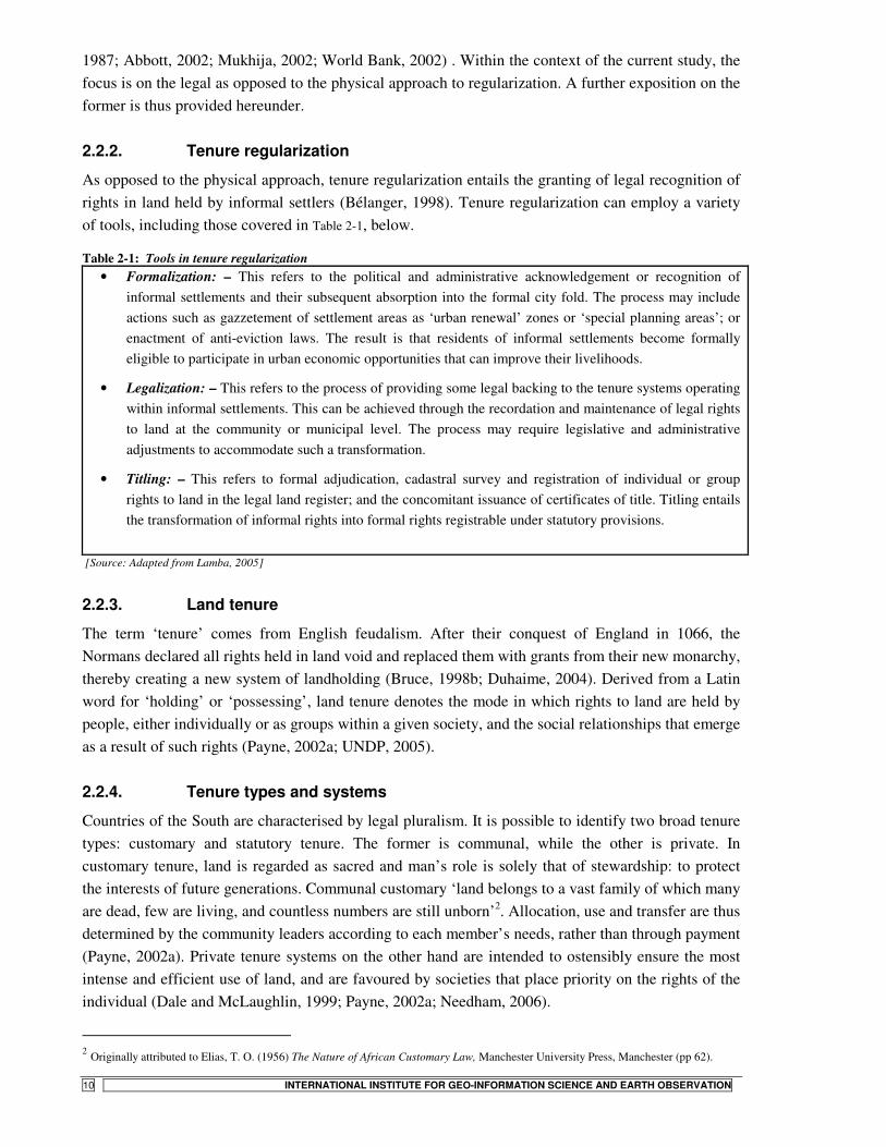
As opposed to the physical approach, tenure regularization entails the granting of legal recognition of rights in land held by informal settlers (Bélanger, 1998). Tenure regularization can employ a variety of tools, including those covered in Table 2-1, below.
Table 2-1: Tools in tenure regularization • Formalization: – This refers to the political and administrative acknowledgement or recognition of
informal settlements and their subsequent absorption into the formal city fold. The process may include actions such as gazzetement of settlement areas as ‘urban renewal’ zones or ‘special planning areas’; or enactment of anti-eviction laws. The result is that residents of informal settlements become formally eligible to participate in urban economic opportunities that can improve their livelihoods.
• Legalization: – This refers to the process of providing some legal backing to the tenure systems operating within informal settlements. This can be achieved through the recordation and maintenance of legal rights to land at the community or municipal level. The process may require legislative and administrative adjustments to accommodate such a transformation.
• Titling: – This refers to formal adjudication, cadastral survey and registration of individual or group rights to land in the legal land register; and the concomitant issuance of certificates of title. Titling entails the transformation of informal rights into formal rights registrable under statutory provisions.
[Source: Adapted from Lamba, 2005]
2.2.3. Land tenure
The term ‘tenure’ comes from English feudalism. After their conquest of England in 1066, the Normans declared all rights held in land void and replaced them with grants from their new monarchy, thereby creating a new system of landholding (Bruce, 1998b; Duhaime, 2004). Derived from a Latin word for ‘holding’ or ‘possessing’, land tenure denotes the mode in which rights to land are held by people, either individually or as groups within a given society, and the social relationships that emerge as a result of such rights (Payne, 2002a; UNDP, 2005).
2.2.4. Tenure types and systems
Countries of the South are characterised by legal pluralism. It is possible to identify two broad tenure types: customary and statutory tenure. The former is communal, while the other is private. In customary tenure, land is regarded as sacred and man’s role is solely that of stewardship: to protect the interests of future generations. Communal customary ‘land belongs to a vast family of which many are dead, few are living, and countless numbers are still unborn’2. Allocation, use and transfer are thus determined by the community leaders according to each member’s needs, rather than through payment (Payne, 2002a). Private tenure systems on the other hand are intended to ostensibly ensure the most intense and efficient use of land, and are favoured by societies that place priority on the rights of the individual (Dale and McLaughlin, 1999; Payne, 2002a; Needham, 2006).
2 Originally attributed to Elias, T. O. (1956) The Nature of African Customary Law, Manchester University Press, Manchester (pp 62).

STATE- VS. COMMUNITY-LED LAND TENURE REGULARIZATION IN TANZANIA
INTERNATIONAL INSTITUTE FOR GEO-INFORMATION SCIENCE AND EARTH OBSERVATION 11
According to Bruce (1998b), a land tenure system is ‘all the types of tenure recognised by a national and/ or local system of law taken together’. Tenure systems are an outcome of historical and cultural forces and reflect the relationships between people and the land on which they live (Bruce, 1998b; Needham, 2006).
2.2.5. The choice between private and communal tenure systems
Both private and communal systems have their unique advantages and limitations. It has been observed, for example, that land nationalisation premised on communal modes of tenure often resulted in bureaucratic inertia, clientelism and corruption in the allocative machinery (Kironde, 2005). Moreover, with time customary tenure becomes susceptible to commercial pressures that erode the social cohesion from which it derives its legitimacy in the first place (Kombe and Kreibich, 2000; Payne, 2002a). Private tenure systems on their part have the benefit of transparency and efficiency (Dale and McLaughlin, 1999), but have proved singularly weak in enabling the poor to obtain land and shelter (Durand-Lasserve and Clerc, 1996; Payne, 2002b; UNDP, 2005).
Nonetheless, while no single tenure system provides advantages without major limitations, it is clear that globalisation has tended to reinforce statutory tenure systems based on western preoccupations with the rights of the individual (Tsikata, 2001; Kironde, 2005; Abdulai, 2006). Those that are unable to meet the conditions imposed by commercial land markets offering individual titles are therefore forced into various non-formal solutions. In cities where the formal land market (or the State allocative machinery like in Tanzania) has proved prohibitive to the poor, people have gone ahead to purchase land on the peri-urban fringe from farmers and developed land that is legally theirs by acquisition, save for the fact that such land was not in locations approved for residential development. Such processes have since become commercialised and entry only made possible at a cost determined by the informal land market (Payne, 2002b; Kironde, 2005).
2.2.6. Ownership and property
The legality of rights held in land can be traced back to two broad legal traditions. Law codes such as those prevalent in continental Europe, and which take their cue from the dominium of Roman law, conceive of ownership as resting in a thing of which land in the purely physical sense is an example. A man has rights of property on land because he is the owner of it. He can use it, enjoy it and dispose of it ‘de la manière la plus absolue’3. It follows from this that the owner has an absolute title and may enter into agreements and contracts with others to give them permission to use land in various ways – agreements which bind the parties person to person but which do not burden the land with rights of ownership other than those vesting in the owner who initiates the agreement. In essence, ownership attaches to the land itself (Denman and Prodano, 1972; Needham, 2006).
These ideas differ radically from those professed by the Anglo-American jurisprudence, commonly known as the English common law. Here, the doctrine of ‘tenures’ and that of ‘estates’ provide the basic principles of real property law. The concept of property being in rights over land and not in land itself is therefore fundamental to common law traditions. In this formulation, one does not own land, but only an estate in it, giving him the right to hold it for a given period of time. A man thus does not
3 Code Civil de Napolèon, 1804. Article 544, cited in Denman and Prodano (1972).
STATE- VS. COMMUNITY-LED LAND TENURE REGULARIZATION IN TANZANIA
12 INTERNATIONAL INSTITUTE FOR GEO-INFORMATION SCIENCE AND EARTH OBSERVATION
have property rights over land because he owns the physical thing – the soil; ‘he owns an interest or estate in the land because he owns a bundle of property rights over it. Ownership is thus in the rights and is not the origin of them’ (Denman and Prodano, 1972:21).
These traditions have led to different ways of defining what is meant by property. The situation in which all possible rights in land are held by one (legal) person is described by the Roman concept of ‘dominium’ and is what is referred to as full ownership in the Continental tradition. In the Anglo-American tradition, one owns one or more rights in a piece of land, not the land itself. And a situation where one owns all the possible rights in a bundle relating to a given piece of land is referred to as fee simple (Needham, 2006). It is therefore normal to think of a parcel of land in the realm of common law as being criss-crossed by a labyrinth of rights, which are each, the property of the person holding them (Dale and McLaughlin, 1999; Needham, 2006).
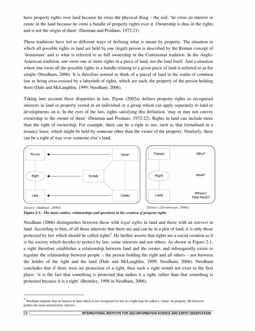
Taking into account these disparities in law, Payne (2002a) defines property rights as recognised interests in land or property vested in an individual or a group which can apply separately to land or developments on it. In the eyes of the law, rights satisfying this definition ‘may or may not convey ownership to the owner of them’ (Denman and Prodano, 1972:22). Rights in land can include more than the right of ownership. For example, there can be a right to use, such as that formalised in a tenancy lease, which might be held by someone other than the owner of the property. Similarly, there can be a right of way over someone else’s land.
[Source: (Stubkjær, 2006)]
[Source: (Zevenbergen, 2006)]
Figure 2-1: The main entities, relationships and questions in the creation of property rights
Needham (2006) distinguishes between those with legal rights in land and those with an interest in land. According to him, of all those interests that there are and can be in a plot of land, it is only those protected by law which should be called rights4. He further asserts that rights are a social creation as it is the society which decides to protect by law, some interests and not others. As shown in Figure 2-1, a right therefore establishes a relationship between land and the owner, and subsequently exists to regulate the relationship between people – the person holding the right and all others – not between the holder of the right and the land (Dale and McLaughlin, 1999; Needham, 2006). Needham concludes that if there were no protection of a right, then such a right would not exist in the first place: ‘it is the fact that something is protected that makes it a right, rather than that something is protected because it is a right’ (Bromley, 1998 in Needham, 2006).
4 Needham explains that an interest in land which is not recognised by law as a right may be called a ‘claim’ on property. He however prefers the more neutral term ‘interest’.
STATE- VS. COMMUNITY-LED LAND TENURE REGULARIZATION IN TANZANIA
INTERNATIONAL INSTITUTE FOR GEO-INFORMATION SCIENCE AND EARTH OBSERVATION 13
2.2.7. Legal ownership of land
What bundle of rights is it necessary to own before one can be regarded as the owner under common law? In the Continental tradition, the owner of the rights can split off and transfer to others rights over the land. But how many rights can one owner dish out to others before he effectively ceases to be the owner? In attempting to answer this question, Needham explains that under Roman law, ownership in its complete form includes three fundamental rights:-
• The right to use (usus); • The right to the fruits [of one’s labour upon the land] (fructus); and, • The right to disposal (abusus) (Needham, 2006)
And the law states that the owner can part with the first two and still remain owner, provided control over the right of disposal is retained (Carrey-Miller, 2002 in Needham, 2006). A complimentary requirement for ownership of a thing, adds Needham (ibid.) is that the right is for an indefinite period. For example, fee simple lasts until the owner has no heirs to take it over, at which point it escheats back to the supreme granting authority.
Within the context of Tanzania, definition of ownership takes an interest meaning. Section 4 (1) of the Land Act, 1999 declares all land in the country owned by the public and vested in the president as a trustee for all citizens. Anyone holding interests in land in Tanzania is therefore at most a legal occupier of such land, as ownership vests in the State. Rights in land are held through a ‘right of occupancy – defined as the right to occupy and use land. Accordingly, land holding in Tanzania only bestows usufruactuary rights upon the holder, as dispositions are subject to State sanction. Although costmary rights of occupancy may remain tenable for an indefinite period of time, the radical title5 in all land remains vested in the presidency. A further exposition on the land tenure system in Tanzania is provided in Chapter 3.
2.2.8. The concept of tenure security
It is widely acknowledged that for the poor urban informal dwellers, access to secure shelter is something of a precondition for attaining access to other benefits of urban life. Secure tenure is thus one necessary foundation for all endeavours to improve the living conditions of the urban poor (Payne, 2002b; Berger, 2006). But what exactly is tenure security?
According to Bruce and Migot-Adholla (1993), security of land tenure is said to exist when individuals or groups perceive that they have the right to a piece of land on a continuous basis, free from imposition or interference by outside sources, as well as the ability to reap the benefits of labour and capital invested in such land, either in use or upon transfer to another holder. It is therefore the level of guarantee by right holders that their rights will be valid as long as they are not extinguished in an acceptably procedural and fair manner.
Bruce (1998b) further distinguishes three uses of ‘tenure security’ as a concept. The first and most basic is that security of tenure indicates the restrictions on the State or other private individuals in interfering with the landholder’s possession or use of their land. The tenure itself may be short, for instance a lease of one month, but if the leaseholders can be certain that they will keep the land for
5 The radical title is the highest interest in land and is equated with ownership of the land (Tsikata, 2001).

STATE- VS. COMMUNITY-LED LAND TENURE REGULARIZATION IN TANZANIA
14 INTERNATIONAL INSTITUTE FOR GEO-INFORMATION SCIENCE AND EARTH OBSERVATION
that one month, then the tenure is secure. This implies confidence in the legal system and lack of worry about loss of one’s rights. This is the narrowest use of the term common among legal professionals.
The second use of the term is that employed by economists – to encompass the confidence factor explained above, together with a second component: long duration. Accordingly, one month would be insecure because it is so brief. This relates to incentives for investment. The reason people with a one year lease will not plant trees is that they have no expectations of being able to use the wood or harvest the fruits. Security of tenure thus relates to the time needed to recover the cost of an investment, and when tenure is too short or too uncertain for most investments, economists say that the landholder lacks security of tenure. This argument will be revisited in subsequent sections when we discuss the benefits of the ‘Residential Licenses’ awarded under the on-going State-led regularization process in Dar es Salaam.
The third way the term tenure security is employed, according to Bruce (ibid.), adds another element to the two explained above: a requirement of full ownership of rights in the land. In this usage, even if tenure is secure for the lifetime of the holder and inheritable by the children, it may be insecure, for example, if it cannot be freely bought or sold. Here the term means full private ownership. This usage is common among staunch advocates of private ownership. Again this meaning may have limited application in Tanzania as land essentially belongs to the public, and dispositions are subject to stringent State sanctions.
Frequently, a connection is made between the lack of official recognition of dwellers by the authorities, and insecurity of tenure. It is important to note though, that informality does not automatically spell a lack of secure tenure. In countries such as Tanzania where informal land delivery channels are literally the rule rather than the exception (see accounts in Kironde, 2005), secure tenure can exist even without formal recognition by State authorities. This is due to the fact that acceptance and acknowledgement by community institutions may in fact be valued more for fostering a feeling of tenure security among property owners, than the formal recognition through titles granted by the State (McAuslan, 2002; Kombe, 2005).
2.3. The rationale for regularization and titling
It will suffice to note here that tenure regularization as advocated by the World Bank and other major donor agencies, almost always meant the award of individual titles on property originally deemed informal. Projects implemented under this approach invariably had the following key objectives:
• To provide settlers with the most secure form of tenure available; • To enable households to use their property titles as collateral in obtaining loans from formal
sector finance institutions in order to carry out dwelling retrofits or develop businesses; • To help local authorities increase the proportion of planned urban land and provide services
more efficiently; • To enable governments integrate informal settlements into the land tax system; and • To improve the efficiency of urban land and property markets (Payne, 2002a).

STATE- VS. COMMUNITY-LED LAND TENURE REGULARIZATION IN TANZANIA
INTERNATIONAL INSTITUTE FOR GEO-INFORMATION SCIENCE AND EARTH OBSERVATION 15
The purpose of land titling in this formulation is to transfer land occupied by informal settlers from the informal to the formal land market and to transform informally occupied land into private property, fully commodified and free from hindrances and encumbrances which supposedly impede its optimal utilisation (Bélanger, 1998). To a large extent, the rationale and assumptions that underlie regularization in this context betray a negative perception of the unofficial nature of the informal land market and fit well within the current trends of neo-liberalism, which advocates the individualisation of land and property ownership as espoused in the works of Mr. De Soto (op. cit.).
Although earlier discussions in the housing debate as contained in the works of John Turner had focused on regularization as key to housing improvement by merely fostering that feeling of safety, the current debate, particularly as a sequel to De Soto’s work, has gradually shifted the emphasis to the use of property titles – the end result of regularization – as collateral for loans to finance housing consolidation. Logically, titles would additionally be used to secure loans for other purposes, such as setting up or expanding small businesses by beneficiaries of legalisation. It is on this basis that De Soto makes his claim for the formalization of property as the key to overcoming the failure of capitalism in the South (Payne, 2002a; Varley, 2002).
2.4. The nexus between titling and housing consolidation: a critique
Generally, the academic debate on land titling; particularly on its impacts on housing consolidation seem to have taken a less than optimistic tone. Following the initial doubts voiced by Burgess over the ingenuity of titling, authors who do not regard regularization as necessarily harmful have increasingly questioned whether titling was needed at all, since housing improvement could anyway occur even without titling, where there was high de facto security of tenure (Varley, 1987; 2002; Bélanger, 1998).
In her empirical analysis of the relationship between land titling and housing consolidation in Mexico City, Varley (1987) presents a seminal piece in this field by demonstrating that tenure status made little difference on housing investment behaviour. Similar results have since been reported from Peru following evaluations done on the massive State-sponsored regularization programme implemented on account of De Soto’s counsel (Kagawa, 2000; Kagawa and Turkstra, 2002; McKechnie, 2005). More recent assessments of the situation in sub-Saharan Africa (Abdulai, 2006) suggest that tenure security may not be a sufficient condition for dwelling improvements at all, a position echoed by Fernandes’ (2002a; 2002c) assessment of Brazil and the wider Latin American region. �
Even more critically, academics have began to point out a number of possible negative consequences that tenure regularization could visit upon the poor as a ramification of bringing their land holdings into the formal land market. Reports from Trinidad and Tobago (Bélanger, 1998) and Zimbabwe (Ewing, 2004) seem to concur that regularization programmes could indeed leave the intended beneficiaries worse off, particularly owing to the fact that such settlements invariably occupied prime locations whose commodified land values would simply succumb to the market forces, triggering massive gentrification and attendant land use succession. Similarly, while playing down the supposed benefits of regularization, Ewing (2004) sees in its wake a dissipation of community consensus owing to individualisation of households once they attained private titles. Similar observations have been reported by Bassett (2005) following her assessment of a Kenyan community land trust (CLT) scheme implemented in Voi town. Owing to the significance of social networks as a coping strategy among
STATE- VS. COMMUNITY-LED LAND TENURE REGULARIZATION IN TANZANIA
16 INTERNATIONAL INSTITUTE FOR GEO-INFORMATION SCIENCE AND EARTH OBSERVATION
the poor in informal settlements, it is only imperative that any policy that besets the social capital existing within poor neighbourhoods be thought through more carefully.
The foregoing bears out observations that regularization also entails certain costs that are often overlooked by project planners. The financial, administrative and legal costs associated with titling schemes are high and when they cannot be borne by the residents, they must be heavily subsidised by the State (Varley, 1987). Furthermore, residents are likely to become subject to land and building taxes which could increase the costs of living in regularised settlements to the point where the poorest residents may be pushed out, triggering beneficiary turn-over. In fact, she observes that some residents in Mexico declined the opportunity to have their land regularized on this very ground (ibid.). Downward raiding – otherwise known as gentrification – is likely to set in, leading to a systematic buy-out of targeted beneficiaries by higher income classes. It is even observed that tenure regularization may encourage further squatting on the assumption that precarious tenure will be subsequently regularised (Bélanger, 1998).
Observers have even gone ahead to caution against the promise of titling, arguing that they derive from dualistic and simplistic conceptualisations of ‘illegal’ and ‘legal’ that are so prevalent in Western thought (Varley, 2002; McAuslan, 2002). Varley, for example, has questioned legalisation as an engine of change, not only because she finds the distinctions between legality and illegality tenuous and often transcending the socio-spatial hierarchies assigned to them as in the case of Mexico, but also because legalization brings no guarantee that the urban poor are protected from other private forces, and even neighbours, from future (market) evictions (Varley, 2002).
Recent reviews of urban land tenure policy premised on titling (see Payne, 2002b; and Abdulai, 2006, for example ) suggest that titling has not achieved its intended objectives and is of doubtful benefit to the poor. The studies suggest that the urban poor may have to contend with a pattern of land ownership that is more rigid, more regulated, better enforced and hence considerably less affordable than was the case with the informal arrangements that attracted them into informality in the first place.
2.5. Top-down vs. bottom-up approaches to regularization
Much of the regularization literature dwell on State-led projects: a top-down response designed and implemented from top echelons of government, with little or no participation at all from the intended beneficiaries. Where the Government is not directly involved, they are implemented by State-sponsored agencies whose objectives are normally expressed in terms of ‘so-many titles’ within a given time frame. The best example is the case of COFOPRI in Peru (Kagawa and Turkstra, 2002).���
An alternative, which is becoming increasingly widespread, is some form of self-regulation initiated by community organisations and self-interest groups within informal settlements. While most local authorities may generally not favour this form of metamorphosis, they quite often accept that they have little alternative but to tolerate it as their own interventions have largely had little impact. Additionally, where local politicians are democratically elected, local political establishments recognise that large numbers of their potential voters are residents of informal settlements, and by lobbying their local politicians, community leaders are quite often able to squeeze concessions out of local authorities (Angel et al., 1983). �

STATE- VS. COMMUNITY-LED LAND TENURE REGULARIZATION IN TANZANIA
INTERNATIONAL INSTITUTE FOR GEO-INFORMATION SCIENCE AND EARTH OBSERVATION 17
Self-regulation can be considered a bottom-up response towards improvement in informal settlements. Musyoka (2004) presents the case of a community in Eldoret, Kenya that organised themselves to acquire, subdivide and seek registration of their plots all on their own. The inhabitants largely determined land sub-divisions, layout of roads and even building set-backs. They later successfully petitioned the local authority to supply them with municipal services.
Residents have also been known to initiate installation of services and infrastructure – sometimes by lobbying local authorities and NGOs or even donors directly for their provision. Residents will in some cases even volunteer guidance to fellow householders undertaking housing construction and retrofits. Organised community groups are equally crucial to this process, involved as they are in the establishment of self-help savings and credit schemes which are critical in mobilising finances for retrofits and other investments. Usually, the bottom-up perspective is much broader in scope and looks beyond just tenure security provision to incorporate critical components of settlement servicing and livelihood betterment (Musyoka, 2004).
It must be pointed out from the outset however, that hardly can a process of land development be termed entirely a community affair, not least when the question of land regularization is involved. This is particularly so in societies where land ownership is centralised in the State, as is the case in Tanzania (Refer to discussions in Chapter 3). Because the legitimacy of a regularization process can only draw from the blessings of and final approval from the State, such projects, in as much as they are initiated by the community, cannot flourish without the nod of the relevant State agencies. The community initiatives must thus not be seen as competing the State mechanism, but rather as complementing it.
In the case of Dar es Salaam, the State has declared its intention to eradicate informal settlements in the city. But given the paucity of resources at its disposal, among other handicaps, it only becomes pragmatic that the authorities recognise the contributions made by self-regularizing communities and accord them the necessary support needed to accomplish such a task. Moreover, the quest of riding the city of spontaneous developments is one that demands a multi-pronged approach, which in its very nature calls for a multitude of actors, including community institutions and NGOs, in addition to the conventional State machinery.
A model partnership, bringing together community and State institutions has already recorded a lot of success in the form of the Community Infrastructure Upgrading Project (CIUP) implemented in Hanna Nassif settlement in Dar es Salaam. CIUP has been a major watershed in community participation in urban planning and development within Dar es Salaam (Kyessi, 2002). The main target of CIUP is to upgrade infrastructure and service within low-income settlements as part of the community’s increased involvement in the urban development process. The overriding principle is that infrastructure investments should be demand-driven and only be made when local users accept to bear the costs of operation and maintenance. The planning standards adopted in the process are adapted to suit the existing situation within the informal settlements, emphasising minimal structure demolitions (URT, 2004; Kessy, 2005). Unfortunately, land tenure issues have not been at the core of the CIUP initiative. �

STATE- VS. COMMUNITY-LED LAND TENURE REGULARIZATION IN TANZANIA
18 INTERNATIONAL INSTITUTE FOR GEO-INFORMATION SCIENCE AND EARTH OBSERVATION
2.5.1. State and community motives in regularization
Whereas the central focus of the bottom-up approach is mainly to improve housing and livelihood opportunities by consolidating occupants who have made considerable investments which they would want to secure, the top-down approach seems to be chiefly motivated by the authorities’ interest in arresting deteriorating physical conditions in informal areas. The aim is to bring the so regularized settlements under formal checks of development control; activate land markets and levy land rates, and eventually, to achieve the socio-spatial integration of informal communities into the broader urban structure and society (Fernandes, 2002b). �
The context and design of the community-initiated approach largely follows Turner’s original proposition that inhabitants will always invest in the land they occupy and only later do they seek security of tenure in order to protect whatever investments they have made over time (Varley, 2002). Security thus only becomes necessary after investments have been made.
The opposite is true of the top-down approach. The reasoning here is that residents will not invest in the land they occupy if no tenure security is guaranteed. The remedy therefore lies in granting titles or other levels of tenure security to residents so as to spur housing consolidation and other economic investments. This is largely the line of reasoning espoused by De Soto and is the main formulation along which the Residential Licenses project in Dar es Salaam has been modelled. We return to the issue of State vs. community motives in regularization when the actual process of regularization in Dar es Salaam is presented in Chapter 6. Before then, we delve into the existing land tenure regime in Tanzania, next. ��
�
�
��
�
�
�
�
�
�
�
�
�
�
�
�
�
�
�
�
�

STATE- VS. COMMUNITY-LED LAND TENURE REGULARIZATION IN TANZANIA
INTERNATIONAL INSTITUTE FOR GEO-INFORMATION SCIENCE AND EARTH OBSERVATION 19
3. Land tenure, informality and regularization in Tanzania
3.1. Background to the current tenure arrangements
Like elsewhere in sub-Saharan Africa, the customary tenure practices that characterised pre-colonial Tanzania did not survive the ravages of colonial rule. The German Administration passed legislation in 1895 declaring all land ‘crown land’ vested in the German Empire. This state of affairs was later to be reinforced when the British Administration, after it assumed control in 1919, passed the Land Ordinance No. 3 of 1923, making all land in Tanzania, occupied or otherwise, public land under the control of the Governor. The Ordinance in effect introduced the concept of ‘rights of occupancy’ in the colony. Consequently, no occupation of land was valid without the Governor’s consent. He reserved the powers to award the ‘granted right of occupancy’ – defined as the right to occupy and use land for a period of up to 99 years (Tsikata, 2001). In an attempt to protect native rights in land, the right of occupancy was later redefined in 1928 to subsume ‘the right of a native community lawfully using or occupying land in accordance with customary law’ (URT, 1997:7), thus introducing in effect, a second tenure type: the ‘deemed rights of occupancy’ (Kironde, 1995a; Tsikata, 2001). It is however argued that this development failed to defend the native rights in land as it remained merely declaratory, and hence of minimal value in practice (URT, 1997).
Within the colonial statutory land regime, a minority held granted rights of occupancy while the rest had their landholdings under the deemed rights regime. But there were differences in what these two interests conferred upon their respective holders. The granted rights of occupancy were written grants of use rights by the Government to non-customary holders, which were like leases. Conversely, the deemed rights of occupancy were simply a general recognition of right under custom, without any documentary proof in the individual case (Bruce, 1998a). Whereas the customary right holders could go to traditional courts for redress, such institutions remained subordinate to the colonial State executive. A significant development in this period was the creation and encouragement of individualised freeholds, which were considered a superior replacement for customary land rights (Tsikata, 2001).
3.1.1. The post-independence regime
Independence in 1961 saw the subsequent nationalisation of land. But the independent Government maintained the colonial structure of land tenure. Gradually however, its attitude shifted from trusteeship to ownership of the land. Freeholds were abolished and converted into Government leases under the Freehold Titles (Conversion) and Government Lease Act, Cap 523 of 1963. The leaseholds were later to be degraded into rights of occupancy under the Government Leaseholds (Conversion of Rights of Occupancy) Act No. 44 of 1969. These policies were justified as an attempt to prevent the creation of a landless class, and in keeping with the principle that land could be secured with use (Tsikata, 2001). The Post-colonial State inherited the radical title in land and this was justified on streamlining development and nation-building in the newly-independent economy (ibid.).
STATE- VS. COMMUNITY-LED LAND TENURE REGULARIZATION IN TANZANIA
20 INTERNATIONAL INSTITUTE FOR GEO-INFORMATION SCIENCE AND EARTH OBSERVATION
From 1968, development proceeded through grouping of rural communities in Ujamaa (familyhood) villages. This otherwise well-intentioned resettlement policy increased human population in nucleated settlements, destroying in its wake, the hitherto well-established traditional tenure systems. Accordingly, Ujamaa inhibited the development of the customary system as a viable living law and a system of land relations, resulting instead in ‘intensification of insecurity of tenure in rural Tanzania; paralysis of land development in both rural and urban areas; and weakening of social and production relations’ (Dalal-Clayton and Dent, 2001:296). The policy was however implicitly justified on the State’s ownership of land (Tsikata, 2001). Both villagisation and nationalisation of land did in effect reduce the status of landowners, both rural and urban into that of mere land occupants (Dalal-Clayton and Dent, 2001).
Whereas rural land and land within planned urban areas were catered for under the statutory dispensation, the fate of land within the unplanned urban areas and urban fringes remained unclear as it fell in neither of these two broad categories of ‘granted’ and ‘deemed’ rights regimes. Yet these areas remained under intense pressure of urbanisation. The declaration of such areas as planning areas immediately brought about an uncertain tenurial status as far as the parent customary tenure therein remained unextinguished at law. In the mindset of the colonial administration though, customary tenure had been construed to be abrogated on the declaration of planning areas on land previously held under such tenure. In deed, it had issued a circular in 1953 stating just as much (Kironde, 2005).
The situation was not helped by a 1985 high court ruling (Nyirabu vs Nyagwasa, 1985) that declared that the rights of customary landholders were not extinguished merely upon the declaration of an area a planning area. This ruling was upheld in a subsequent case (Kakubukubu vs. Kasubi, 1991). In both cases, the courts had argued that in the absence of due process as to rightful compensation among other obligations during the process of ‘taking’ such land, the mere declaration of planning areas could not be deemed to have abrogated the customary rights legally bestowed upon the original holders of such land (Kironde, 1995a; 2005).
Meanwhile, urban expansion and declaration of peri-urban or village lands as planning areas have moved on apace. The boundary of the city of Dar es Salaam today has some forty registered villages within it (Kironde, 2005). There are in addition many areas which were formerly villages but which have since witnessed high densities on the basis of what Kironde (ibid.) calls ‘neo-customary’ tenure transactions. In the peri-urban areas, indigenous inhabitants occupying farmland are rapidly being edged out, expelled by the pressure of urbanisation as inhabitants from the city acquire land there, usually through purchase from the original inhabitants. Legally, therefore, squatting in urban Tanzania is restricted only to those occupying Government lands without permission – and these would be few in deed, since Government land in urban areas had all but been exhausted by the time of independence (Kironde, 1995a).
Studies have shown that most people in these settlements derive their security of tenure from actual development and recognition through informal arrangements sanctioned by social institutions developed over time within local neighbourhoods (Kombe, 1995; Kombe and Kreibich, 2000; Lupala, 2002a). In the eyes of Government authorities however, these areas remain irregular as their tenurial status is not legally defined and land developments not sanctioned by the city authorities (URT, 1997). Nevertheless, landholders are not precluded from obtaining individual land titles. In fact,

STATE- VS. COMMUNITY-LED LAND TENURE REGULARIZATION IN TANZANIA
INTERNATIONAL INSTITUTE FOR GEO-INFORMATION SCIENCE AND EARTH OBSERVATION 21
where plot owners arrange for the cadastral surveying of their plots under standards laid down by the authorities, they have been granted 33-year occupancy rights.
3.2. The changing policy framework for land tenure
To deal with the chaotic tenure situation in Tanzania, a Presidential Commission of Inquiry into Land Matters (The Shivji Commission) was appointed in 1991 and tasked with exploring ways for a new land policy. Among the list of justifications for a new land policy were the impacts of villagisation; the development of informal land markets; the evolution of customary land tenure towards individualised ownership (especially in the peri-urban fringe); the adoption of legal pluralism and recent court of appeal decisions affirming customary tenure rights within informal settlements (Tsikata, 2001). The recommendations of the commission gave the input for the formulation of the 1995 land policy.
3.2.1. The National Land Policy, 1995
Based on the public debate and consultations that ensued over the Commission’s recommendations, a national land policy document was crafted and later promulgated in 1995. The policy retained four central land tenure tenets in a modified form: (a) land is publicly owned and vested in the President of the Republic; (b) the rights of occupancy under both statutory and customary law would be the only recognised interests in land; (c) land administration would remain under the State executive; and (d) land rights would be based mainly on use and occupation (Tsikata, 2001). According to the land policy document, the objectives of the policy are ‘to promote and ensure a secure land tenure system; to encourage the optimal use of land resources; and to facilitate broad-based social and economic development without upsetting the ecological balance of the environment’ (URT, 1997:5).
The National Land Policy recognises a dual system of land tenure made up of customary and statutory rights of occupancy, both of which are to be equal in law. It also provides for the registration of titles, both customary and statutory. The document further declares that the term of tenure for statutory rights of occupancy shall not exceed 99 years, while customary rights of occupancy shall have no term limits. The policy finally acknowledges the indefeasibility of customary rights by the mere declaration of planning areas and provides that that due process must be followed in extinguishing such rights. Concerning the plight of unplanned settlements, the document declares that existing unplanned areas shall not be cleared but instead undergo regularization. In doing so, the document emphasises the role of community organisations in the preparation and implementation of regularization schemes.
3.2.2. The Land Acts, 1999
The National Land Policy provided the basis for the drafting of a new land law. The Lands Acts, 1999 are made up of two pieces of legislation, the Village Land Act No. 5 of 1999, which governs land within villages, and the Land Act No. 4 of 1999, which covers all other land in mainland Tanzania. In keeping with the land policy document, all lands remain vested in the President of the Republic as a trustee on behalf of all citizens. Use and occupation of land continues to be through granted and customary rights of occupancy, the two types of occupancy being at the same level at law. Land under the Acts is categorized into three classes – general, reserved and village land – all three categories being under the ultimate administration of the Commissioner for Lands. Thus the administration, management and allocation of land are maintained under the State executive.
STATE- VS. COMMUNITY-LED LAND TENURE REGULARIZATION IN TANZANIA
22 INTERNATIONAL INSTITUTE FOR GEO-INFORMATION SCIENCE AND EARTH OBSERVATION
Although commentators have since observed that the contents of the land policy document and the resultant land acts did not adequately address the recommendations of the Shivji Commission in many respects, particularly with regard to the divestiture of the radical title from the State (see for example Tsikata, 2001; Shivji, 2006; Manji, 2006), it is evident that the new dispensation did address most of the concerns of the pre-reform agenda.
3.2.3. The National Human Settlements Development Policy, 2000
This document, promulgated in 2000, addresses most of the issues pertinent to human settlements development in Tanzania. By declaring that sustainable development within any society is reflected in the level of growth and management of its human settlements, the document reiterates the Government’s resolve to steer the physical, socioeconomic and environmental development of human settlements in both rural and urban areas. One way it proposes to do this is by liberalising the planning process so as to provide for the active participation of the masses. The human settlements policy in effect goes a step further in clarifying and putting into their proper context, broad policy statements in the national land policy which relate specifically to human settlements development.
Among policy statements in the document is the reaffirmation that unplanned settlements shall be upgraded by their inhabitants through the support of CBOs and NGOs, with the Government divesting into a more facilitative role in the whole process. In order to forestall further informal developments, the Government undertakes to ensure timely surveying and servicing of land ripe for urban development within the peri-urban areas, and to designate special areas for low-income residential development.
3.3. Community efforts and the current regularization policy framework
The process of land regularization operates within the framework of the Town and Country Planning Act, Cap 355 (URT, 1961) (now under review), and the National Land Act No. 4 of 1999. Both statutes spell out the contents of such schemes. Whereas the Town and Country Planning Act (T&CPA) lays emphasis on the spatial layout and reorganization of the land during the scheme preparation, the 1999 law goes further to provide for the adjudication, classification and recordation of rights in such land prior to the preparation of the regularization scheme. It thus explicitly addresses the question of land tenure in regularization schemes. Both statutes however underscore the involvement of the resident community in the process of preparing such schemes. The T&CPA in particular provides under section 24 that prior to the preparation of a scheme, the preparatory authority shall:
‘serve a six months' notice on the land owners concerned, of its intention to prepare such a scheme; and allow during that period, an opportunity for the land owners concerned to prepare their own scheme and submit it to the Preparatory Authority…The Preparatory Authority may then, between the material date and the coming into effect of a general planning scheme, adopt, with or without modification, a detailed scheme prepared by a land owner or group of land owners in respect of the land comprised therein’.
The Land Act No. 4, 1999 defines the purpose of regularization as being to ‘facilitate the recording, adjudication, classification and registration of the occupation and use of land by those persons living and working in an area declared by sections 56 to 60 of this Act to be subject to a scheme of

STATE- VS. COMMUNITY-LED LAND TENURE REGULARIZATION IN TANZANIA
INTERNATIONAL INSTITUTE FOR GEO-INFORMATION SCIENCE AND EARTH OBSERVATION 23
regularization’ [s. 57 (1)]. It further goes ahead to define the conditions under which a scheme of regularization may be declared in an area. Essentially, regard is paid to whether the:
• area is substantially used for habitation in dwellings put up by the residents themselves; • residents appear to have no lawful title to the land, not withstanding that they may have paid
for, or are paying for the land they are occupying and manage such land in accordance with rules generally recognised within the area;
• land is occupied under customary land law and the area is substantially built-up; • area has been, or is likely to be declared a planning area under the T&CPA; • area has a substantial number of residents who have lived there for a substantial period of time
so that the area is well established and settled from a social point of view; • there is evidence that despite the lack of any security of tenure for the persons living in
the area, a considerable number of such persons appear to be investing in their houses and businesses and attempting to improve the area through their own initiatives;
• area hosts a substantial number of people and community-based organisations who indicate that they wish to participate in a scheme of regularization [s. 57 (2)]
In recognition of the fact that informal settlements often exhibit little spatial order, the 1999 Act provides under sub-part 2, the prospect for a better layout of plots at the time of validating occupation rights of residents. Similar provisions are made under sections 27 and 28 of the T&CPA, which spell out the need for the redistribution of land and adjustment of boundaries in the course of preparing the planning schemes, should such an eventuality become necessary.
As the foregoing aptly demonstrates, the two statues put local residents at the core of the regularization process. Moreover, both the 1995 National Land Policy (s. 6.4.1 and 6.8.1) and the Human Settlements Development Policy of 2000 (s. 4.1.4) make it clear that residents shall be fully involved in the preparation of regularization schemes. Whether the recent regularization projects have lived up to these expectations is what forms the crux of the discussion in Chapter six.

STATE- VS. COMMUNITY-LED LAND TENURE REGULARIZATION IN TANZANIA
24 INTERNATIONAL INSTITUTE FOR GEO-INFORMATION SCIENCE AND EARTH OBSERVATION
4. Background to the study area
4.1. The city of Dar es Salaam
Dar es Salaam is the largest urban agglomeration in Tanzania. The city stretches along the coast of the Indian Ocean for about 100 Km, from the mouth of Mpiji River in the north to Mbezi River in the South. The administrative area of the city includes some 8 offshore islands. It has a total area of about 1400 Km2 of which 12.5% is densely built upon, accommodating over 90% of the city’s population estimated at 2.8 million people. The rural part of the city comprises more than 40 villages which are increasingly witnessing the pressure of urbanisation (Kironde, 2005).
Figure 4-1: Administrative divisions of Dar es Salaam and its location in the national context* [*Source: University of Texas’ Map Collection, 2006]
With its major highways radiating from the city centre, the shape of Dar es Salaam on a map gives the impression of a huge cobweb (Figure 4-1). The major highways have in turn influenced residential development patterns, with areas of high accessibility being densely populated. A primate city, Dar es Salaam is seven times the size of the next largest city (Mwanza) in population, and continues to attract the majority of urban immigrants (World Bank, 2002). It is still the de facto seat of Government, despite the declaration of the inland town of Dodoma as the country’s capital since 1973. Dar es Salaam remains the chief commercial, economic, industrial, educational, transportation and cultural centre, as well as the country’s chief port. It is connected by a network of roads, railways, and waterways not only to the rest of the country but also to the neighbouring countries of Kenya, Uganda, Rwanda, Burundi, DRC, Zambia and Malawi (Figure 4-1).
4.1.1. Administrative set-up
Administratively, the city has (a) a regional administration headed by a Regional Commissioner; and (b) four civic authorities, namely the Dar es Salaam City Council (DCC) and the three municipalities

STATE- VS. COMMUNITY-LED LAND TENURE REGULARIZATION IN TANZANIA
INTERNATIONAL INSTITUTE FOR GEO-INFORMATION SCIENCE AND EARTH OBSERVATION 25
of Kinondoni, Ilala and Temeke. All the four civic authorities are headed by mayors and directors as the political and executive officers, respectively. The three municipalities are co-terminus with the three districts of Dar es Salaam region, each headed by a District Commissioner and bearing the same names as the municipalities (DCC, 2004).
The Dar es Salaam City Council is headed by the mayor of Dar es Salaam, who is elected by the full Council from among 20 councillors forming the City Council. Each of the three municipal councils is similarly headed by a mayor. The DCC and the three municipalities operate in the same geographical areas, but each of them within its jurisdictional precincts demarcated by an administrative order. The City Council performs a co-ordinating role on cross-cutting issues traversing the three municipalities such as health services, fire and rescue, transportation, and other city-wide projects like the current regularization programme (ibid.). The city is further subdivided into smaller administrative units as shown in Table 4-1.
Table 4-1: The administrative divisions of Dar es Salaam ����������� �� ��� ������ ��� ��������� �������
������ ��� ��� �� �
�� ���� ��� �� ��� ���
���������� �� ���� ��� ���
����� ��� ���� ��� ��
[Source: DCC Profile, 2004]
4.1.2. Urbanization and Population growth
It is estimated that Dar es Salaam currently accommodates nearly 30% of the national population and continues to record growth rates as high as 8 % p.a. (MLHSD, 2006). Kinondoni municipality hosts the largest share of the city’s population as indicated in Table 4-2.
Table 4-2: Distribution of population in Dar es Salaam, 2002 ����������� ������� !������� ����� "#� ����$����$������%��
���������� ��������� ������ ���������� ����
�������� ������ ������ ����� ���
�� ���� ������� ������� ������� ����
����� &�� &�'(� &���&���� �&')�&)'*� '+��
[Source: Population and Housing Census, 2002]
4.1.3. Current extent of informal housing development
Over 70% of the city’s inhabitants currently reside in informal settlements (Kironde, 2005). As of 1992, the planned residential areas accounted for only 30% of the housing stock but constituted 50% of the residential land in the city. The rest of the population was then accommodated in several unplanned settlements scattered all over the city (Kyessi, 2002). Figure 4-2 gives an indication of the current extent of informal development in Dar es Salaam as depicted in a recent report by the on-going Property and Business Formalization Programme (MKURABITA in Swahili) being undertaken by the Office of the President (URT, 2005).
4.1.4. Evolution of informal developments
Up to the 1950’s the dominant ethnic group around Dar es Salaam was mainly the Zaramo (Kombe and Kreibich, 2000). Nonetheless, due to intense pressure of urbanization over the years, the natives
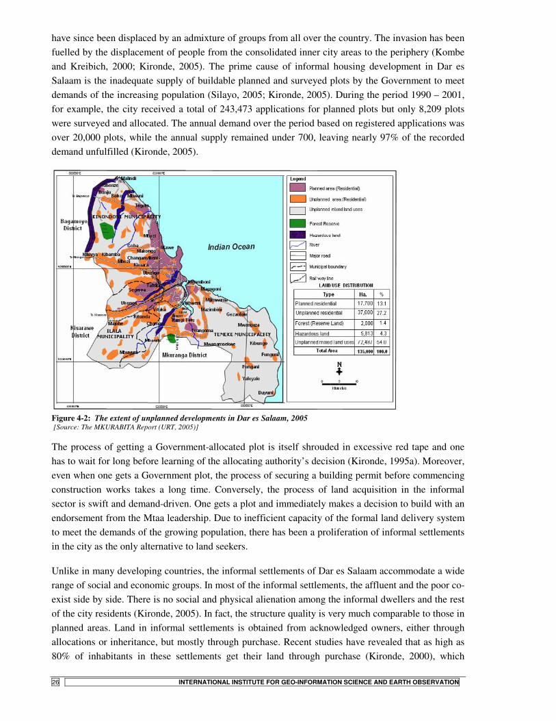
STATE- VS. COMMUNITY-LED LAND TENURE REGULARIZATION IN TANZANIA
26 INTERNATIONAL INSTITUTE FOR GEO-INFORMATION SCIENCE AND EARTH OBSERVATION
have since been displaced by an admixture of groups from all over the country. The invasion has been fuelled by the displacement of people from the consolidated inner city areas to the periphery (Kombe and Kreibich, 2000; Kironde, 2005). The prime cause of informal housing development in Dar es Salaam is the inadequate supply of buildable planned and surveyed plots by the Government to meet demands of the increasing population (Silayo, 2005; Kironde, 2005). During the period 1990 – 2001, for example, the city received a total of 243,473 applications for planned plots but only 8,209 plots were surveyed and allocated. The annual demand over the period based on registered applications was over 20,000 plots, while the annual supply remained under 700, leaving nearly 97% of the recorded demand unfulfilled (Kironde, 2005).
Figure 4-2: The extent of unplanned developments in Dar es Salaam, 2005 [Source: The MKURABITA Report (URT, 2005)]
The process of getting a Government-allocated plot is itself shrouded in excessive red tape and one has to wait for long before learning of the allocating authority’s decision (Kironde, 1995a). Moreover, even when one gets a Government plot, the process of securing a building permit before commencing construction works takes a long time. Conversely, the process of land acquisition in the informal sector is swift and demand-driven. One gets a plot and immediately makes a decision to build with an endorsement from the Mtaa leadership. Due to inefficient capacity of the formal land delivery system to meet the demands of the growing population, there has been a proliferation of informal settlements in the city as the only alternative to land seekers.
Unlike in many developing countries, the informal settlements of Dar es Salaam accommodate a wide range of social and economic groups. In most of the informal settlements, the affluent and the poor co-exist side by side. There is no social and physical alienation among the informal dwellers and the rest of the city residents (Kironde, 2005). In fact, the structure quality is very much comparable to those in planned areas. Land in informal settlements is obtained from acknowledged owners, either through allocations or inheritance, but mostly through purchase. Recent studies have revealed that as high as 80% of inhabitants in these settlements get their land through purchase (Kironde, 2000), which

STATE- VS. COMMUNITY-LED LAND TENURE REGULARIZATION IN TANZANIA
INTERNATIONAL INSTITUTE FOR GEO-INFORMATION SCIENCE AND EARTH OBSERVATION 27
implies that informal settlement in Dar es Salaam can hardly be regarded as being illegal sensu stricto. In fact illegal land occupation in Tanzania is not a major problem in urban areas as people mainly occupy land acquired through purchase or inheritance, as opposed to squatting (Kironde, 2005).
4.2. Case study locations
The case studies documented herein were carried out in settlements located within Kinondoni municipality. The municipality is divided into 27 wards, 113 sub-wards and 14 villages (Table 4-1) and had a total population of about 1,088,800 people at the 2002 national census. It executes its administrative tasks through the Municipal Council; Ward Development Committees (WDCs), under the chairmanship of the councillor; Sub-ward Development Committees, under the chairmanship of Mtaa Chairperson; and the Village governments. Alongside these political organs are executive officers – Municipal Director, Ward Executive Officer, and Mtaa Executive Officer, respectively – on whose shoulders the responsibility of implementing municipal policies at each level rests.
The case studies were undertaken in Midizini and Ubungo Darajani, being representative of the top-down and the bottom-up cases, respectively (refer to Chapter 5). The two settlements are found in Manzese and Ubungo wards, respectively. Figure 4-3 shows the location of the two wards within Kinondoni municipality.
4.2.1. Midizini
Midizini is one of the 6 sub-wards of Manzese ward, the others being Mnazi Mmoja, Kilimani, Muungano, Uzuri and Mvuleni (Figure 4-4). The settlement covers 39 Ha and lies approximately 7 Km away from the CBD. Midizini sprang up around 1945 and has since experienced rapid urbanization (URT, 2004). Until the implementation of the Residential Licenses project, the majority of property owners in Midizini held their land informally, without any Government recognition. Only a few residents are in possession of 33-year certificates of occupancy over their plots. To put into proper context the events leading to the implementation of the Midizini project, a brief background of the wider Manzese will now be provided, next. �
Origins and growth
Manzese is the largest informal settlement in Dar es Salaam, both in area and population (Kironde, 1995b). It is located some 6 – 8 Km from the city centre and straddles Morogoro Road. It is bounded to the west by the Ubungo industrial area, to the South by Mburahati Road and to the East by River Luhanga and Kagera Road. To the west of Manzese is the Sinza sites-and-service scheme, which was designated to accommodate the surplus population as Manzese underwent upgrading in the 1970s. The two halves of Manzese dissected by Morogoro Rd. are conveniently referred to as Manzese ‘A’ (south of Morogoro Rd.) and ‘B’ (north of the road) – refer to Figure 4-4.
In the early 1940s, Manzese was a rural settlement outside the city boundaries. By 1957, the settlement had partially been subsumed into the city boundaries. Part of Manzese had then been acquired by the State but remained undeveloped (Kironde, 1995b). Following independence in 1961 and the subsequent nationalisation of landed interests, the land fell under nobody’s care in particular. It hence ‘reverted’ to de facto customary tenure despite having been acquired by the State.

STATE- VS. COMMUNITY-LED LAND TENURE REGULARIZATION IN TANZANIA
28 INTERNATIONAL INSTITUTE FOR GEO-INFORMATION SCIENCE AND EARTH OBSERVATION
Meanwhile, the rest of Manzese was still owned and occupied by the natives under customary arrangements (ibid.).
Figure 4-3: Location of Manzese and Ubungo wards within Kinondoni municipality
Figure 4-4: Location of Manzese showing Midizini sub-ward
Manzese was later fully included within the city boundaries following extensions in 1968. With the establishment of the Ubungo Industrial Area, the settlement developed very rapidly but devoid of any planning control. This growth was mainly through infill rather than areal expansion. This is reflected in building densities which increased from an average of 22 houses/Ha in 1967 to 32.5 houses/Ha in 1980 (Kironde, 1995b). Today, there are hardly any open spaces in Manzese as all open land has been built upon.
To ameliorate conditions in the settlement, the Government implemented an upgrading project in Manzese in the 1970s (Kessy, 2005). In the process, some space was created for the establishment of schools, health facilities, access roads and communal water points. Most of the public space secured during the project was however not taken care of subsequently and has since been encroached by new developments. Besides, most of the facilities like roads and storm sewers have since fallen into disrepair. There has been a wave of commercial developments in the area lately, particularly along the major roads.
In the upgrading process, house owners were not issued with titles since only block, and not individual plot surveys were carried out. Consequently, most people bear no proof of official tenure of their plots. The question of land tenure and land use control was left vague so that subdivisions, densification and encroachment on open spaces continued unabated (Kironde, 1995b). In 1993, MLHSD prepared planning schemes for Manzese which were availed to plot owners who wished to have their plots surveyed for purposes of title registration. The schemes were however prepared without consultation with the settlers and surveys based on them carried out sporadically on demand

STATE- VS. COMMUNITY-LED LAND TENURE REGULARIZATION IN TANZANIA
INTERNATIONAL INSTITUTE FOR GEO-INFORMATION SCIENCE AND EARTH OBSERVATION 29
(ibid.). As a result, those who benefited from the schemes were well off landholders who were able to contract private surveyors to do the job, and those who had targeted the use of such titles in securing financial credit. There were therefore fears that the poor households who had neither the wherewithal to enlist services of private surveyors nor the drive to acquire loans would be adversely affected by the upgrading schemes. The schemes had themselves been based on 1982 aerial photos and as such could not reflect reality on the ground as at 1993, given the high rates of development in Manzese. Moreover, the boundaries in these schemes had been arbitrarily determined without any adjudication to classify rights on the ground (Kironde, 1995b).
At the time of conducting this study, a minority in Midizini held certificates of occupancy over their land. A few more had received Residential Licenses under the current Government regularization scheme, while the bulk majority still held their land without any statutory proof of landholding.
4.2.2. Ubungo Darajani
Ubungo Darajani lies 9 Km away from the city centre at the confluence of Morogoro and Mandela roads. Administratively, the settlement is part of Ubungo Kisiwani sub-ward, which is physically divided into two halves by the Kibangu River (Figure 4-5). Darajani occupies the southern half of Ubungo Kisiwani, while Ubungo Maziwa lies north of the river. The settlement is bordered to the West and south by Ubungo Kibangu, and to the east by Mabibo ward. The name Darajani emanates from the Swahili word daraja for bridge, denoting the two bridges (one on Mandela Rd. and the other on Mandela-Maziwa Rd.) which bind the settlement on its two extremes along the length of Kibangu River. The settlement covers 26 Ha of land and had a total of 849 households (4,245 people) at the 2002 national census (Magigi, 2004).
Origins and growth
The area currently occupied by Darajani was a sparsely populated settlement in the 1970s. Its population began to grow owing to the existence of employment centres and other income earning opportunities in the vicinity, including the University of Dar es Salaam, nearby Government and parastatal offices, as well as the Ubungo Industrial Area. In the 1979 Dar es Salaam Master Plan, the area had been zoned for light industrial development (Kironde, 1995b; Magigi, 2004). With the completion of Mandela Road in 1980, the City Council was keen to see the proposed light industries established. The 1979 Master Plan had reserved some 0.7 Km strip on both sides of the road for the planned industrial development (Kironde, 1995b). This means the proposed industrial zone would cover part of the present-day Ubungo Darajani to the north, and Ubungo Kibangu settlement to the south of Mandela Rd (Figure 4-5).
As the area continued to grow in the late 1970s and early ’80s residents included university dons, various high ranking Government officials and businessmen in addition to more ordinary citizens (Kironde, 1995b). At the 2002 national census, Ubungo Darajani had some 4,245 residents distributed among 849 households (Magigi, 2004).
Kironde (1995b) reports that in 1980, the City Council had issued a stop order against development in the area (covering Ubungo Darajani and part of Ubungo Kibangu), pending assessment for compensation and demolition, so that the area could be put to its planned use. The residents however

STATE- VS. COMMUNITY-LED LAND TENURE REGULARIZATION IN TANZANIA
30 INTERNATIONAL INSTITUTE FOR GEO-INFORMATION SCIENCE AND EARTH OBSERVATION
appealed to the then ruling party and the Central Government, who took sides with them, quashing the stop order.
In May 1986, the Council made another attempt at removing the residents. This time they had even stronger arguments against removal. They cited, inter alia, previous attempts to remove them, failure of which they had invested substantially in developing their land. Some of them cited Tanzania Housing Development Bank loans which they had acquired towards housing consolidation, and which had been sanctioned by the local administrative officers – including the ward, district and city authorities – thus condoning residential development in the area. They even cited primary schools in the area that had been constructed by the City Council itself. Finally they argued that the proposed industrial developments would pollute the nearby residences and that their houses were new and well above the compensation rates floated by the authorities. This second attempt at removing the residents was once again stopped by the Government (Kironde, 1995b; Lupala, 2002b).
At the time of conducting this study, a total of 32 landholders already had their plots surveyed and issued with Certificates of Occupancy. Those who had not done so have now teamed up and formed a CBO to champion this cause. The actual process of community mobilisation and project execution towards the pursuit of securing certificates of title is comprehensively discussed in Chapter 6.
Figure 4-5: Location of Ubungo Darajani

STATE- VS. COMMUNITY-LED LAND TENURE REGULARIZATION IN TANZANIA
INTERNATIONAL INSTITUTE FOR GEO-INFORMATION SCIENCE AND EARTH OBSERVATION 31
5. Research methodology
5.1. Research strategy and design
The current study followed a two-stage process: a more general city-wide survey aimed at collecting general information at the city level; and a more comprehensive case study at the settlement level.
5.1.1.1. City-wide survey
The city-wide survey sought to establish the present level of informal settlement development in Dar es Salaam. More specifically, this phase aimed at: a) gaining a working knowledge of the socio-spatial characteristics of informal settlements in Dar es Salaam; b) identifying the existing land tenure arrangements, the perceptions of tenure (in)security and past interventions at altering the status quo; c) identifying stakeholder institutions in land tenure regularization, their roles in the regularization process, and a sample of cases in which regularization projects have already been carried out.
This undertaking was realised through two main ways. First, it involved a series of plenary discussions and interviews with various key respondents. Several local experts in urban planning and land management at UCLAS were interviewed. Similarly, interviews were carried out with officials at the MLHSD, DCC and KMC. Ward administrative officers in Manzese and Ubungo were interviewed as were officials at the sub-wards of Kilimani (Manzese ward), Ubungo Kibangu (Makuburi ward) and Hanna Nassif settlements. Also interviewed were officials at the WAT Human Settlements Trust, a local NGO active in the field of human settlements development within Dar es Salaam.
The second method employed in this phase was literature search and documentary review. Several policy documents, pieces of legislation and project documents were reviewed as were scholarly publications from the UCLAS library.
5.1.1.2. Case study
The aim of case study in this research was to facilitate the documentation of the actual process of land tenure regularization within the confines of a well-defined community unit in Dar es Salaam. For purposes of this study, the boundaries of such cases were taken to be those delimited by the administrative extents of the sub-ward (Mtaa) – the smallest administrative unit within the urban setting in Tanzania. �
5.1.2. Definition and justification of the case study approach
Yin (1994), defines the case study method as an empirical inquiry that investigates a contemporary phenomenon within its real-life context; when the boundaries between the phenomenon and its context are not clearly evident; and in which multiple sources of evidence are used. This description aptly fits the current. According to Kumar, the case study ‘approach rests on the assumption that the case being studied is typical of cases of a certain type so that, through intensive analysis, generalisations may be made that will be applicable to other cases of the same type’ (Kumar, 2005:113). It is therefore hoped that the findings emanating from the present study will find application in settlements with similar characteristics to those studied.
STATE- VS. COMMUNITY-LED LAND TENURE REGULARIZATION IN TANZANIA
32 INTERNATIONAL INSTITUTE FOR GEO-INFORMATION SCIENCE AND EARTH OBSERVATION
Furthermore, in executing research, ‘What’ and ‘How many’ type of questions are best answered by survey research. Conversely, ‘What’, ‘Why’, ‘How’ and ‘Who’ questions are more amenable to case studies (Yin, 1994). The present study seeks answers to questions in the domain of the second category of inquiry and hence the adoption of the case study approach to investigation.
5.2. Selection of the study area
From the preliminary enquiries conducted during the city-wide survey, a list of settlements was compiled out of which it would be possible to carry out subsequent detailed analysis. Different criteria were subsequently devised in selecting cases typical of both the top-down (State-led) and the bottom-up (community-led) approaches to tenure regularization.
5.2.1. The top-down case
The State-led Residential Licenses project began in Manzese ward, within Kinondoni municipality. Mitaa within Manzese were thus considered information-rich cases as the project was already completed there, with many residents having acquired Residential Licenses as the end product of the State-led regularization project. Manzese also had one of the highest number of property owners who had taken up Residential Licenses at the time of conducting this study. However, prior to the initiation of the Residential Licenses Project in Manzese, a different project, the Community Infrastructure Upgrading Project (CIUP) had been implemented here, covering all the sub-wards in Manzese ‘B’ (north of Morogoro Road) – Refer to Figure 4-4, above.
Although not directly concerned with tenure regularization, the CIUP project had put in place several institutions, notably the Community Planning Teams (CPTs), whose operations greatly influenced the subsequent implementation of the Residential Licenses Project in these settlements6. The sub-wards in Manzese ‘B’ were thus not considered viable for the present study. A pilot study to test the survey instruments was conducted in Mnazi Mmoja, while the actual case study was implemented in Midizini sub-ward. The characteristics of these two settlements and the procedures and institutions employed in implementation of the regularization project were however very similar and whichever choice would have sufficed for analysis as the top-down case.
5.2.2. The bottom-up case
In selecting the community-led case study project, the following criteria were taken into account:
• Settlements in which there have been active community initiatives aimed at improving the tenure situation;
• Settlements in which such initiatives have been recognised and supported by the State agencies and other stakeholders in the urban development arena;
• Settlements with strong community institutions and active participation at the household level; • Settlements within the same administrative jurisdiction as Manzese – in order to satisfy
logistical constraints during the fieldwork session.
6 Discussions with the Manzese Ward Executive Officer, September 2006

STATE- VS. COMMUNITY-LED LAND TENURE REGULARIZATION IN TANZANIA
INTERNATIONAL INSTITUTE FOR GEO-INFORMATION SCIENCE AND EARTH OBSERVATION 33
All factors considered, Ubungo Darajani presented the best bottom-up case given the level of activities there, strong institutions of project implementation, clarity of vision and achievements so far made with respect to securing tenure for property owners within the settlement, and its proximity to Manzese. It was therefore picked for detailed analysis for purposes of this study.
5.3. Data collection protocols
The information presented herein has been realised through the use of both primary and secondary data sources. Secondary information was obtained through literature review, mainly to (a) establish the existing knowledge base with respect to research issue at hand, and (b) supplement primary data collected during the fieldwork. It was therefore used to corroborate, critique and fill knowledge gaps in areas not sufficiently covered by the primary data sources. Primary data collection was done during a fieldwork session between September and October 2006 and employed multiple data collection techniques of both qualitative and quantitative nature. A discussion of the methods employed in primary data collection is presented in the following section. �
5.3.1. Physical observation
Direct observation constituted a major data collection tool both at the reconnaissance stage and during actual survey. To facilitate rapid interpretation of observed features, observations were aided by aerial photographs and base maps of the case settlements printed at a scale of 1:2,500. Observed data was recorded by taking oblique photographs and field sketching. Estimation of road widths, building set-backs and plot frontages was achieved through pacing where necessary.
5.3.2. Interviews
Interviews of various types were conducted during the fieldwork session, including interviews with key informants, focus groups, community leaders, and households within the selected case settlements. Given the nature of urban development, the interviews conducted covered a wide range of stakeholders, including representatives of public institutions, the private sector, the popular sector (civil society), as well as opinion leaders in academia. The following is an exposition of the type of interviews conducted together with the kind of information sought in those interviews.
5.3.3. Key-informant interviews
Key-informant interviews covered land management professionals at UCLAS, Government officials at MLHSD, DCC, KMC, community leaders, officials at WAT Human Settlements Trust and officials of the Dar es Salaam Water and Sewerage Authority (DAWASA).
Discussions with respondents from UCLAS sought to clarify issues on the policy framework behind the Residential Licenses Project, community initiatives at tenure regularization in Dar es Salaam and the legal framework within which settlement upgrading through tenure regularization is currently being executed in Tanzania. At the end of these discussions, several settlements were short-listed as possible areas for conducting field studies and from these the final case studies subsequently chosen. Interviews at the MLHSD were carried out with the Residential Licenses Project Co-ordinator, the staff in charge of project data management at the Surveys and Mapping Division, as well as with officers in charge of policy and settlement development planning at the Ministry. The aim of these

STATE- VS. COMMUNITY-LED LAND TENURE REGULARIZATION IN TANZANIA
34 INTERNATIONAL INSTITUTE FOR GEO-INFORMATION SCIENCE AND EARTH OBSERVATION
interviews was to collect information on the Ministry’s motivation and role in the implementation of the residential licences project. �
At KMC, the Municipal Planning Officer was interviewed as were the Lands Officer, the Municipal Valuer, and the Registrar in charge of Residential Licenses. Also interviewed were the Ward Executive Officers of Manzese and Ubungo wards as well as Community Development Officers in each of the two wards. Interviews there were aimed at collecting data on the Council’s role in implementation of regularization schemes; municipal vision and policies on future growth of informal settlements; rationale in the selection of those settlements covered under the Residential Licenses Project; impacts of regularization projects on the spatial organization of target settlements; and the institutional capacity of the Council to implement development control within the regularizing settlements (Refer to sample questionnaire in Appendix 2). �
At the community level, chairmen of Midizini and Mnazi Mmoja sub-wards were interviewed as were several grassroots leaders and operatives of the Mtaa Chairmen locally known as wajumbe. Interviews in Ubungo Darajani targeted the Mtaa Chairman and the Mtaa Executive Officer, in addition to some wajumbe. Offcials of the Ubungo Darajani Development Fund (UDADEFU) were also interviewed. A focused group discussion was also arranged with committee members of the CBO.
From the NGO sector, interviews were carried out with the Director and Housing Development Officer at WAT Human Settlements Trust. The aim was to establish the role of the NGO in the settlement development process and particularly the role it is currently playing in improving tenure security and other aspects of settlement development within Dar es Salaam, particularly its role in the on-going Hanna Nassif community titling project. At DAWASA, interviews were meant to obtain information on what the authority’s policy was with regard to water and sewerage service provision in informal settlements; the role it played in settlement regularization; the level of co-ordination between the authority and the municipality in terms of planning and servicing of new and regularizing settlements; as well as the authority’s vision with regard to future service provision in the face of rapidly expanding informal developments.
Interview schedules used on key-informants carried largely similar questions and were only modified to reflect the role of the respondent where this was necessary.
5.3.4. Household interviews
In order to collect data on the socio-economic characteristics of households resident within the two case settlements; to gauge their opinions and views on rationale, arrangement and execution of the regularization projects in their respective settlements; and to get a glimpse of the impacts these projects have had on various households, it was necessary to conduct a household survey on a select number of households drawn from the study cases. Such household interviews employed structured questionnaires and targeted the household head as a source of information on each household. Whenever the head was not available, the questionnaire was administered on the spouse or on any other adult member of knowledgeable status.
While executing the Residential Licenses project, MLHSD had administered a detailed questionnaire on all property owners within the project areas two years prior to conducting this study. The data

STATE- VS. COMMUNITY-LED LAND TENURE REGULARIZATION IN TANZANIA
INTERNATIONAL INSTITUTE FOR GEO-INFORMATION SCIENCE AND EARTH OBSERVATION 35
collected included household characteristics, expenditure and income data, housing conditions and level of services, among others. Because the database realised from this survey was available, the current study only sought to ask question as were necessary to supplement the existing database (Refer to Appendix 1 for sample household questionnaire). The household questionnaires were administered with the help of research assistants – two recent university graduates in urban planning and land surveying, natives of Dar es Salaam and fluent speakers of Kiswahili. They had conducted similar surveys during the residential licences project and were thus not only familiar with the study area and the socio-economic characteristics of its residents, but also conversant with the type of questions posed and the kinds of responses elicited. Despite their familiarity with the tenets of the study, the assistants were nonetheless given a structured orientation prior to the actual exercise. To facilitate easier and faster execution of the survey, the original questionnaire was translated into Kiswahili. The questionnaire was subsequently administered on a pilot basis on a small sample in Mnazi Mmoja and appropriate adjustments made before the final version was ultimately deployed in the household survey proper. �
5.3.4.1. Sampling procedure
In drawing samples, care was taken to include respondents who had received the Residential License as well as those who had not. To do this, a spatial data set obtained from the Project secretariat was employed in the sampling process. Sampling aimed at a spatial coverage of the entire settlement. A 100m x 100m grid was drawn over the study area, realising clusters of 1 Ha each. A maximum of four respondents were then chosen from each square, two being those with Residential Licenses and the rest those without.
Figure 5-1: Sampled plots in Darajani (L) and Midizini
The questionnaire was then administered on households regardless of whether they rented or owned the property. This was done to capture the involvement in the regularization process as well as the impacts the process had on both owner and renter households. A total of 66 respondents were interviewed in Midizini, while 55 interviews were conducted in Ubungo Darajani. Where the grid cut

STATE- VS. COMMUNITY-LED LAND TENURE REGULARIZATION IN TANZANIA
36 INTERNATIONAL INSTITUTE FOR GEO-INFORMATION SCIENCE AND EARTH OBSERVATION
across a property, it was included in the grid with the larger share of the property in question. Figure 5-1 shows the properties on which household interviews were conducted.
5.4. Validity and quality control
In conducting this study, conscious attempts were made to produce reliable and valid information that can contribute to the building of knowledge in a sound and scientific manner. To achieve this, the study employed various control checks. �
Triangulation – the use of multiple sources of data that confirm or corroborate same piece of information (Lupala, 2002a) – was employed. For example, whatever was captured through household surveys was cross-checked through key-informant interviews or focus group discussions. If data obtained through field observations concurs with those obtained from key-informant interviews as well as those obtained from household surveys, then one is safe to conclude that such data is reliable. Additionally, the conduct of this research benefited from a group effort which included five other colleagues doing their research on related topics within the same study area. Notes were therefore often compared and emerging findings shared in discussions with colleagues. During the preparatory stages of this research, the data collection tools, especially the questionnaires were shared with colleagues and their comments and criticisms incorporated in later versions. �
In some cases, the short-hand notes made during interviews and discussions with respondents were transcribed and the resultant write-up submitted to the respondent for proof-reading and validation. This was necessary to correct mistakes, particularly where figures denoting amounts of money were involved. Again, whenever appropriate, recourse was often made to secondary data sources on the topics and location of the current study in order to iron out doubts. �
The field data collection session also benefited from the presence of the thesis supervisor on the ground. His advice and critical comments helped in arriving at the most appropriate data to collect, where to collect such data and how to go about collecting it. Besides, the researcher worked with a dedicated team of local supervisors drawn from UCLAS for the entire fieldwork period. Their critical comments and advice grounded on local knowledge of the study area and topic of investigation ensured that the research focused on the most appropriate themes and employed the best tools in doing so. By clearly detailing the methods adopted, the type of data collected and their sources, it is hoped that the study satisfies requirements of replicability. �
5.5. Data processing
The data collected by questionnaires was subsequently coded and entered into a spreadsheet using SPSS software. It was then checked for irregularities and inconsistencies by running preliminary descriptive statistics. A spatial connection with the spatial database obtained from MLHSD was then established by converting the spreadsheet into a dBase file before linking in ArcGIS. It was then possible to check spatial distribution of surveyed plots and any inconsistencies therein. Prior to data entry, it was ensured that all submitted questionnaires were fully filled in and responses consistent. In case of anomalies, follow-ups and corrections were made immediately. Final data analysis and presentation was done in SPSS, Excel and ArcGIS. �
STATE- VS. COMMUNITY-LED LAND TENURE REGULARIZATION IN TANZANIA
INTERNATIONAL INSTITUTE FOR GEO-INFORMATION SCIENCE AND EARTH OBSERVATION 37
5.6. Limitations of field data collection methods
Some respondents expressed indifference during the household interviews, citing the fact that they have had to contend with several studies of a similar kind in the past and never saw the benefit of such investigations. It was therefore necessary to enlist the services of a local operative (mjumbe) as a guide throughout the household survey session. In such a situation, it is likely that the responses given were bent on pleasing this local official and not necessarily on the genuine statement of facts.
Secondly, several interviews involved officials in public offices. Such offices normally pursue certain policy lines. It is therefore likely that some respondents may have chosen to deliberately give responses that were inconsistent with their actual beliefs, attitudes or intentions. This is highly probable in situations where respondents were familiar with the objectives of the research and strove to give answers that they deemed consistent with the research objectives, rather than the actual facts on the ground.
The stated limitations not withstanding, enough caution was exercised in collecting the most appropriate data as was possible within the constraints of the research environment. The analysis and results emanating from that data is presented in Chapter six, next.

STATE- VS. COMMUNITY-LED LAND TENURE REGULARIZATION IN TANZANIA
38 INTERNATIONAL INSTITUTE FOR GEO-INFORMATION SCIENCE AND EARTH OBSERVATION
6. Analysis, findings and policy implications
6.1. State-led land regularization in Midizini
6.1.1. Settlement characteristics
According to the MLHSD database7, Midizini accommodates approximately 3,350 households, with an occupancy rate of 13.5 people per house. The population is approximately equally distributed between males and females (URT, 2004). About 70% of the household heads are self-employed in the informal sector, while the rest have some formal employment with regular income. Most of the informal livelihood activities are undertaken along Morogoro and Tip Top roads. These are of a varied nature and include selling of foodstuff and second-hand garments, running retail shops and kiosks, carpentry, barber shops and welding workshops. Incomes among the surveyed households ranged from TSh 16,000 to 180,000, with the median monthly income being TSh 68,0008. This compares favourably with the TShs 65,000 reported for Manzese in the CIUP upgrading plans (URT, 2004).
The average household size in the settlement is 7.5 people. Only 23.5% of the households are owner-occupiers, the rest being tenants (75.88%) and others – relatives, caretakers (0.62%), respectively. Up to 75% of landholders interviewed acquired their property through purchase, with the rest getting theirs as gifts or inherited estate. The majority of the surveyed household heads have some primary or secondary level of education. As Table 6-1 indicates, at least 40% of the surveyed household heads have secondary level of education or higher. However, up to 18% of the household heads reported having not been to school at all.
Table 6-1: Level of education among surveyed household heads in Midizini Level of education Frequency Percent Cumulative Percent Tertiary 2 3.0 3.0
Secondary 26 39.4 42.4
Primary/Madrasa 26 39.4 81.8
No schooling 12 18.2 100.0 Total 66 100.0
Spatial characteristics Midizini, as is the case with the wider Manzese, is a spontaneous settlement well into the saturation stage of informal settlement evolution (Kombe, 1995; Lupala, 2002b). The overall spatial structure exhibits a highly densified settlement, with up to 41 buildings/Ha (URT, 2004). Except for houses along the main access roads, most of the dwelling units are located haphazardly, rarely in physical harmony with the neighbouring buildings. A number of structures, including pit latrines and business kiosks have protruded into walkways, sometimes blocking the passages. Most of the access paths in the settlement are non-motorable, as they are hardly a metre in width. Moreover, some of the footpaths and narrow passages between houses have become dumping grounds for domestic waste, making accessibility a big problem particularly in rainy weather. Figure 6-1 shows typical densities
7 The database was compiled from the field surveys with respect to the Residential Licenses Project, conducted in 2004 8 The Tanzanian Shilling (TSh) exchanged at 16,000 to the Euro (€) in October 2006

STATE- VS. COMMUNITY-LED LAND TENURE REGULARIZATION IN TANZANIA
INTERNATIONAL INSTITUTE FOR GEO-INFORMATION SCIENCE AND EARTH OBSERVATION 39
and spatial organization common within the saturated inner city settlements of Dar es Salaam. Similar scenarios obtain in Midizini.
Figure 6-1: A typical housing cluster in a consolidated informal settlement in Dar [Source: Lupala, 2002b]
Figure 6-3: A cluster showing the Swahili house type
Figure 6-2: Floor plan of a typical Swahili house [Source: Nguluma, 2003]
Figure 6-4: A typical old Swahili house in Midizini
Most of the dwellings in Midizini are old single-storey Swahili type houses (Figures 6-2 to 6-4). The characteristics of this house are a central passage leading from a veranda facing a street to a backyard with outbuildings and private rooms on each side. The corridor culminates into semi-private spaces in the backyard. The number of private rooms in the main house can range from four to twelve rooms, including backyard rooms (Nguluma, 2003). The individual rooms, being independent of each other,
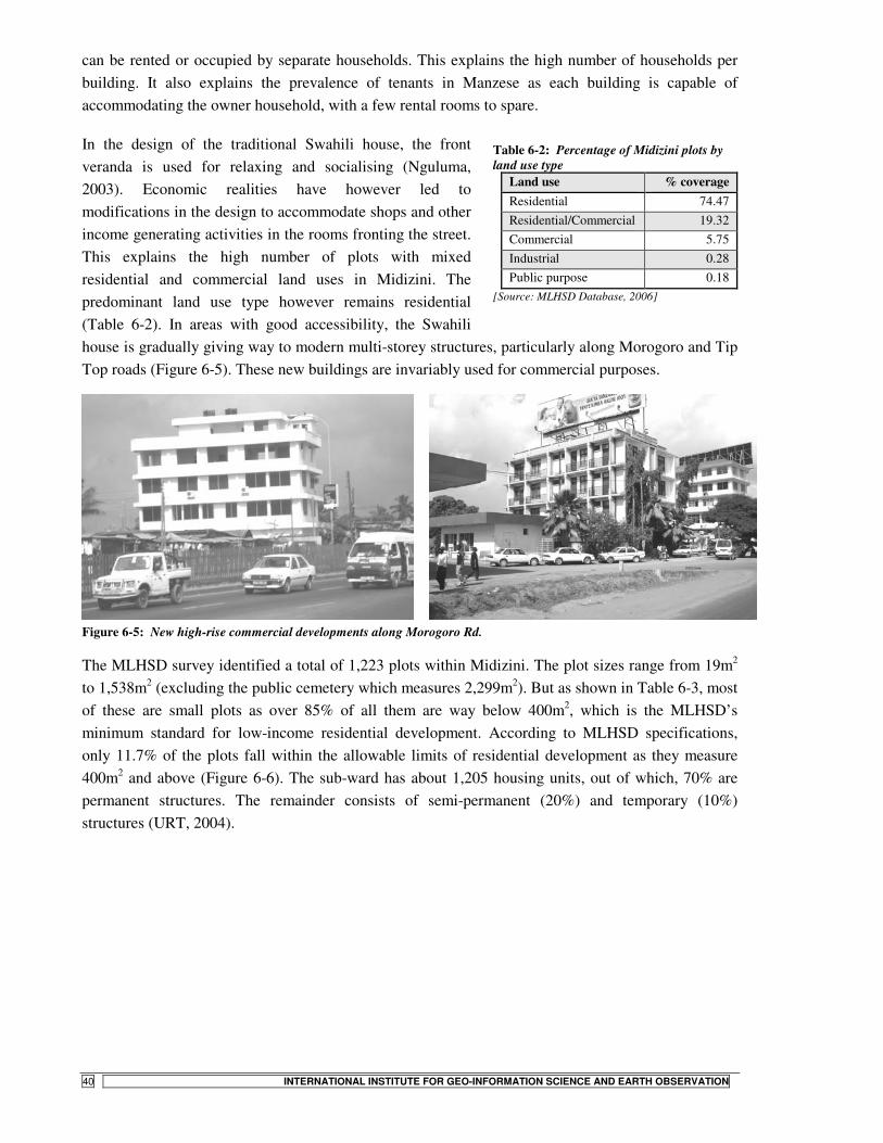
STATE- VS. COMMUNITY-LED LAND TENURE REGULARIZATION IN TANZANIA
40 INTERNATIONAL INSTITUTE FOR GEO-INFORMATION SCIENCE AND EARTH OBSERVATION
can be rented or occupied by separate households. This explains the high number of households per building. It also explains the prevalence of tenants in Manzese as each building is capable of accommodating the owner household, with a few rental rooms to spare.
In the design of the traditional Swahili house, the front veranda is used for relaxing and socialising (Nguluma, 2003). Economic realities have however led to modifications in the design to accommodate shops and other income generating activities in the rooms fronting the street. This explains the high number of plots with mixed residential and commercial land uses in Midizini. The predominant land use type however remains residential (Table 6-2). In areas with good accessibility, the Swahili house is gradually giving way to modern multi-storey structures, particularly along Morogoro and Tip Top roads (Figure 6-5). These new buildings are invariably used for commercial purposes.
Figure 6-5: New high-rise commercial developments along Morogoro Rd.
The MLHSD survey identified a total of 1,223 plots within Midizini. The plot sizes range from 19m2 to 1,538m2 (excluding the public cemetery which measures 2,299m2). But as shown in Table 6-3, most of these are small plots as over 85% of all them are way below 400m2, which is the MLHSD’s minimum standard for low-income residential development. According to MLHSD specifications, only 11.7% of the plots fall within the allowable limits of residential development as they measure 400m2 and above (Figure 6-6). The sub-ward has about 1,205 housing units, out of which, 70% are permanent structures. The remainder consists of semi-permanent (20%) and temporary (10%) structures (URT, 2004).
Table 6-2: Percentage of Midizini plots by land use type
[Source: MLHSD Database, 2006]
Land use % coverage Residential 74.47 Residential/Commercial 19.32 Commercial 5.75 Industrial 0.28 Public purpose 0.18

STATE- VS. COMMUNITY-LED LAND TENURE REGULARIZATION IN TANZANIA
INTERNATIONAL INSTITUTE FOR GEO-INFORMATION SCIENCE AND EARTH OBSERVATION 41
Table 6-3: Distribution of plot sizes (m2) in Midizini
N Valid 1223
Missing 0
Mean 265.33
Median 244.00
Minimum 19
Maximum 2299
Percentiles 25 167.00
50 244.00
75 326.00
85 373.00
[Source: MLHSD Database, 2006]
88.3
10.61.1
010
2030
405060
7080
90100
0 - 399 400 - 799 800 and above
Plot size (sq.m)
Pro
port
ion
of p
lots
(%)
Figure 6-6: Midizini plot sizes by MLHSD’s minimum standards
Figure 6-7 gives an indication of the spatial distribution of plots in Midizini by size, and with respect to the type of access for each individual plot. According to the MLHSD database, the majority of the plots are accessible via internal tertiary roads (49.1%). A further 34.1% are accessible via footpaths, while secondary and primary roads cater for 11.6% and 3.8%, respectively. The remaining 1.5% of total plots have no means of direct public access.
6.1.2. Institutional issues and community organization
The supreme decision-making organ in Midizini is the Mtaa Development Committee (MDC), chaired by the Mtaa Chairman – an elected representative at the Mtaa level. The membership of the committee includes five other elected members and the Mtaa Executive Officer – a municipal appointee. The sub-ward works through a system of sub-committees, including (a) security, (b) health and environment (c) social services, and (d) HIV/Aids control sub-committees. In addition to these sub-
Figure 6-7: Spatial distribution of Midizini plots by size

STATE- VS. COMMUNITY-LED LAND TENURE REGULARIZATION IN TANZANIA
42 INTERNATIONAL INSTITUTE FOR GEO-INFORMATION SCIENCE AND EARTH OBSERVATION
committees, others may be created ‘as need arises’ to address specific development issues9. There exists no active community based-organization within Midizini which is of relevance to the question of land regularization and settlement development.
Prior to the Residential Licenses project, routine land administration issues within the Mtaa were overseen by the Mtaa Chairman. These included facilitating land transfers and boundary dispute resolution. With the help of Ten-Cell leaders10, the Chairman also acts as a development control officer within the Mtaa. In this role, his main task involves ensuring that no new developments block existing access routes. In the event of a new construction encroaching on public space, the Chairman will instruct the concerned developer to stop the construction, failure of which the Chairman will report the matter to the municipal authorities. The local authority is then expected to issue a stop-order compelling the developer to cease the construction. But as the Midizini Chairman explained during the field interviews, his has been a difficult task as:
‘There exists no particular provision that empowers us to undertake this task. It all depends on community goodwill to have such matters brought to our attention. And even when we get to know, we cannot do much but report to the Municipal Council. Most of the time, the Council will not act immediately, unless the case is channelled through the area Councillor. It is difficult to control building development here as there is no guideline to facilitate such an effort’
6.2. Implementation of the Residential Licenses Project11
6.2.1. Institutional set-up
The lead agency in the implementation of the Government regularization project was MLHSD. Execution was however done in close collaboration with DCC and KMC, both of which had representatives in the project administrative committees. The project was spearheaded by a Project Steering Committee chaired by the Permanent Secretary, MLHSD. Members of the committee included the City Director and all Municipal Directors, the Regional Administrative Secretary and the Commissioner of Lands. Also included were the directors of Surveys and Mapping; Policy and Planning; and Human Settlements Development divisions of MLHSD (MLHSD, 2006).
Besides the steering committee was the Technical Committee, drawing its membership from heads of town planning departments from the four civic authorities, all District Administrative Secretaries and all Directors at the MLHSD. Additionally, there was the Task Force Committee, with representatives from various municipalities across the country and all departments at the MLHSD. The inclusion of representatives from outside Dar es Salaam owed to the project’s focus on building capacities at this pilot phase so as to enable replication and scaling-up in other locations at a later date. The municipal representatives were thus included in the working groups as focal persons from their respective duty stations.
9 Interviews with Mtaa Chair, Midizini; Manzese Ward Executive Officer (WEO) and Ward Development Officer, October 2006. 10 These are the ruling party, CCM’s grassroots operatives, usually in charge of a group of 20 to 30 households within the Mtaa. 11 The official name of the project, according to MLHSD, is the Unplanned Settlements Project, however, for the sake of clarity in the present discussion, the project is referred to as the ‘Residential Licences Project’

STATE- VS. COMMUNITY-LED LAND TENURE REGULARIZATION IN TANZANIA
INTERNATIONAL INSTITUTE FOR GEO-INFORMATION SCIENCE AND EARTH OBSERVATION 43
6.2.2. The project implementation process
a) Identification of unplanned settlements The first step in project execution was to identify the major unplanned settlements within the city in order to gauge the magnitude of the work. The city hosts about 54 such areas counting by large settlements (refer to discussions in Chapter 4).
b) Awareness campaigns The next activity involved conducting public awareness campaigns as a means of eliciting participation from various stakeholders in project implementation. The project was introduced to different stakeholders through meetings and consultative workshops held at different levels of the administrative hierarchy. At the Regional level, such sessions were chaired by the Regional Commissioner who extended invitation to all regional leaders including District Commissioners, Members of Parliament, Municipal Directors, Regional and District Secretaries. At the municipal level, departmental heads and divisional officers were all part of the team. In order to mobilise resident’s support at the ward level, the area Councillor, ward executive officer and extension personnel all formed critical grassroots contacts. At the Mtaa level, the Mtaa Chair, the secretary and the local wajumbe were all involved in taking the message to residents. Running parallel to these groundwork campaigns were advertisements in the mass media aimed at creating public awareness on project intent (Kyessi and Kyessi, 2006).
c) Preparation of area base maps Recent satellite images covering the greater Dar es Salaam area were employed in this phase for purposes of property identification on the ground. These were QuickBird images dated December 2003 – January 2004, with 0.6m resolution and covering approx. 498 Km2 of the Phase I area. The image resolution meant most features on the ground could be discerned with relative ease.
d) Property identification Next, working groups composed of town planners and other land professionals with knowledge in aerial photo interpretation and map reading were formed. The groups had para-professionals in cognate disciplines as assistants in field data collection. A total of 40 field teams, each composed of 4 people were then deployed, returning an average output of 45 questionnaires /group/day. The coverage translated into about 1,800 properties being identified per day12.
The images mentioned previously were used in identifying properties on the ground as well as in delineating ‘hazardous’ areas which would be exempted from licensing. The main physical objects mapped included road networks, footpaths, open spaces, power lines, and water courses. In collaboration with property owners or their agents, boundaries of land parcels were delineated on image print-outs to which was appended the name of the property owner. From these were realised entity polygons, to which unique identification numbers denoting the District, Ward, Mtaa, Block and the Parcel number, were assigned. The delineated polygons were later fed into a database via on-screen digitising in a GIS environment. Figure 6-8 shows a sample of identified properties linked to attribute details in a GIS environment.
12 Discussions with the Project Co-ordinator

STATE- VS. COMMUNITY-LED LAND TENURE REGULARIZATION IN TANZANIA
44 INTERNATIONAL INSTITUTE FOR GEO-INFORMATION SCIENCE AND EARTH OBSERVATION
Figure 6-8: Identified properties linked to attribute data in a GIS environment [Source: MLHSD, 2006]
Property identification began in Midizini in October 2004. By the end of June 2005, a total of 1,223 plots had been identified in the settlement. A summary of plot identification breakdown per municipality for the entire first phase of the project is given in Table 6-4, below.
Table 6-4: Number of identified properties per municipality Municipality Wards Sub-wards Identified owners Owners yet to be identified Total plots identified
Kinondoni 18 68 49, 821 12, 668 62, 489
Ilala 10 37 37, 332 15, 556 52, 888
Temeke 15 75 73, 178 28, 852 102, 030
Total 43 180 160, 331 57, 076 217, 407
[Source: MLHSD, 2006]
e) Socio-economic survey The attribute data and information concerning each identified parcel was collected through a questionnaire survey targeting owner households. In case of absentee landlords, a notification was left behind for the property owners to present themselves for the interview. The information collected included household characteristics, expenditure patterns and income data, housing conditions, level of services etc. The data so collected was then structured in a database management system (SQL Server 2000) and linked to the spatial dataset realised in the previous stages to form a comprehensive property database (see Figure 6-8).
f) Preparation and verification of property registers With a comprehensive database in place, it became possible to query and display information concerning every plot covered in the project. This information was then used to produce parcel maps underlain by the satellite image of the relevant area, together with a register of property owners. The registers and maps so prepared were subsequently displayed at the Ward and Mtaa offices for verification by concerned residents. The period dedicated for verification was 14 days, within which complaints were received and necessary corrections affecting individual plots made in the parent database. The corrected database was then handed over to the respective municipalities for the day-to-day administration of the land registers and issuance of Residential Licenses. Meanwhile, for daily land administration tasks at the grassroots level, hard copies of registers and maps of the respective areas were deposited at the Mtaa and Ward offices.

STATE- VS. COMMUNITY-LED LAND TENURE REGULARIZATION IN TANZANIA
INTERNATIONAL INSTITUTE FOR GEO-INFORMATION SCIENCE AND EARTH OBSERVATION 45
g) Issuance of Residential Licenses Having put the register in place, property owners were then invited to apply for Residential Licenses. The process involves the landholder filling in a prescribed form obtained from the Mtaa Office. Based on the records kept at their offices, the Mtaa Chairperson and the Ward Executive Officer then sign the forms to authenticate ownership details. The applicant then files the signed form with the respective municipal land registry together with the following fees in TShs:
• Application fee 1,000/= • Preparation fee 3,000/= • Registration fee 1,000/= • Stamp duty 600/= • Annual land rent for the current year, which depends on the size and use of the plot in
question.
Figure 6-9: Photo and details of plot owners linked to property particulars in USP-Leseni [Source: MLHSD, 2006]
Figure 6-10: End result: landholders with newly issued Residential Licenses [Source: MLHSD, 2006]
On payment of the above fees, a digital photo of the applicant is taken and uploaded onto a custom-built computer programme (USP-Leseni) used in license processing. Linked to the applicant’s photo is the information contained in the application form (Figure 6-9). After carefully verifying all the details of each applicant, a license print-out is produced and signed by the Assistant Register. The license is then ready for collection by the licensee (Figure 6-10). The license document contains details of the parcel in question together with particulars and photo of the licensee (Appendix 3). To this is attached a parcel map of the plot in question showing its location and those of contiguous parcels. The whole process of license preparation lasts around five working days.
��������
����
�� �
� �� ����
�� �
���������
�����������
��� �����
������
��������
�����
����������������
�������
Figure 6-11: Stages and actors in the State-led regularization project

STATE- VS. COMMUNITY-LED LAND TENURE REGULARIZATION IN TANZANIA
46 INTERNATIONAL INSTITUTE FOR GEO-INFORMATION SCIENCE AND EARTH OBSERVATION
The entire process of the Government regularization project is summarised in Figure 6-11. Alongside the major stages in the project are shown the respective actors involved.
6.3. Issues emerging from the State-led project
6.3.1. Motivations for the project
The State-led regularization project was initiated in 2004. It sought to regularise the tenure situation within all informal settlements of Dar es Salaam, by awarding derivative rights of occupancy known as Residential Licenses to property owners resident in these areas. The implementation of the project derives directly from the provisions of the Land Policy 1995, the Land Acts of 1999 and the Human Settlements Policy, 2000 (refer to discussions in Chapter 3). The project also had a political backing in the ruling party, CCM’s election Manifesto 2000 that had sought to commit the Government to the creation of a conducive environment for Tanzanians to own land and participate more actively in economic investments (MLHSD, 2006). The project’s formulation also had the input of De Soto’s counsel, having been invited by the president of Tanzania in 2003 to share his experiences from Peru and advice on how best to transform the assets in the Tanzanian informal sector into ‘live’ capital. In general, the project was implemented within the wider goal of poverty reduction currently being pursued by the State (MLHSD, 2006).
It may also be argued that the project took cue from lessons learnt in the 20,000 plots project implemented by MLHSD in 2002. This was the first land delivery project modelled along the concept of land values as provided for in the new land policy13. With a loan from the Treasury, the Ministry had then set out to acquire, plan, survey and service 20,000 residential plots for subsequent sale to developers at market rates. Due to its cost recovery component, the project was able to surpass its original target, delivering in excess of 30,600 plots and repaying the seed capital from the Treasury in record time (MLHSD, 2006). For the first time, the Government realised it could make money from land, and the cost recovery component was later to constitute a central component of the Residential Licenses project.
6.3.2. Project objectives
The Residential Licenses project had an overall goal of creating a comprehensive land and property register showing the status of every individual plot of land within the unplanned settlements of Dar es Salaam. Specific objectives included to:
a) Identify ownership of individual properties in the unplanned settlement and prepare property registers;
b) Give legal status to land owners in the existing unplanned settlements by issuing Residential Licenses, hence increasing the economic value of land and buildings for use as collateral;
c) Increase Government revenue through the collection of land rent from the unplanned settlements;
d) Create a comprehensive database for efficient land administration; and e) Build capacity within the Ministry to undertake such projects in other urban centres (MLHSD,
2006).
13 Discussions with Prof. Kironde, September 2006

STATE- VS. COMMUNITY-LED LAND TENURE REGULARIZATION IN TANZANIA
INTERNATIONAL INSTITUTE FOR GEO-INFORMATION SCIENCE AND EARTH OBSERVATION 47
6.3.3. Stakeholder involvement and roles in project implementation
The main stakeholders involved in the project can be categorised into two broad groups: Government agencies and community institutions. The former includes the Central Government, the Ministry and the Municipal Council. Under community institutions is subsumed the local community (Mtaa) leadership, community organisations and individual households within Midizini.
Government agencies The role of the Central Government was that of policy implementation. The State had sought to implement the provisions of the new policies and legislation concerning land as discussed previously. Being the line ministry, MLHSD is the major State agency in the implementation of land-related policies. It therefore played a pivotal part in the project under review. Its role chiefly revolved around co-ordination between the central and municipal governments. It therefore hosted the project secretariat. Its other roles included resource mobilisation, technical backstopping and administration of revenues realised from the award of Residential Licenses (RLs). The role of the project co-ordinator – an employee of the Ministry – included project initiation by way of writing letters to the Municipal Directors informing them of MLHSD’s intention to implement the project within their jurisdictions. It then fell within the purview of each municipality to nominate which settlements to have covered in the project, based on the municipality’s planning outlook14.
The municipality’s major role was grassroots implementation of the project, including nomination of candidate settlements for regularization, drawing out conditions for issuance of RLs and development control within the settlements, subsequent upon regularization. The local authority also undertook the day-to-day administration of the land registries and forwarded periodic updates to the Ministry regarding transactions on RLs. The municipality was also critical in the sensitisation campaigns. Municipal community extension officers were deployed to sensitise local residents at the initiation stage. These officers normally work at ward level and are well known among local communities, hence the decision to deploy them to ‘sell’ the project15.
Community institutions The mitaa leadership played a critical role in property identification. All data collection teams moved around with a local mjumbe or balozi, who introduced them to residents. The Mtaa leadership also vetted applications for licenses. They vouched for plot ownership and identified plots situated in the so-called ‘hazardous’ areas, before applications for RLs could be processed. During project implementation, project officials held regular discussions and workshops with mitaa leaders in order to review progress in their respective areas. The local leaders were collectively mandated to guard against issuance of licenses to landholders who had constructed on storm water drainage courses or sand excavation pits, among other ‘hazardous’ lands and restricted areas.
The role of individual households in the entire project was restricted to helping the project teams in property boundary identification on the ground and participating in household surveys meant to collect attribute data for identified plots. The other significant role played by the residents was payments for the Residential Licenses. A few household members attended sensitisation meetings but made little contribution in project design and execution.
14 Discussions with the Project Co-ordinator, October, 2006 15 Ibid.

STATE- VS. COMMUNITY-LED LAND TENURE REGULARIZATION IN TANZANIA
48 INTERNATIONAL INSTITUTE FOR GEO-INFORMATION SCIENCE AND EARTH OBSERVATION
Summary of stakeholder roles As is typical of most Government projects, the Midizini project was conceived and planned without much consultation with residents of the concerned settlements. Sensitisation campaigns were carried out. But this was only after the project planners had laid down elaborate implementation procedures to the exclusion of residents. What was done subsequently was not community consultation but ‘sensitisation’ in order to have residents embrace the project. All important decisions regarding the project planning and execution were made by Government and municipal officials as discussed in the foregoing sections.
Project initiation and design lay with MLHSD, as was co-ordination of all the major stages in the project execution. The municipality only became responsible for the administration of the database and issuance of RLs after the property registers had been put in place. To date, the parent database is still kept at the project secretariat at the Ministry, although the municipalities are responsible for the award of the RLs. In the current arrangement, all transactions conducted at the municipal land registry are reported to MLHSD on a weekly basis for updating tasks on the parent database.
As already noted, the role of individual households in the entire project remained passive. A few household members attended sensitisation meetings but made little contributions to project design or execution. Generally, community institutions may have been involved in the project implementation but their participation was overshadowed by the presence of Government officials in key decision-making organs. This lone-ranger style of project implementation seems to beset the reassurance nurtured by past Government-community partnerships in urban development projects, such as the Community Infrastructure Project implemented in Hanna Nassif (Kyessi, 2002)
6.3.4. The Residential License and tenure security
Rights and responsibilities bestowed by the license The Residential License is a derivative right created out of a parent right of occupancy – in this case deemed to be a customary right of occupancy – and issued under sec. 23 of the 1999 Land Act. Like any other right of occupancy in Tanzania, it bestows upon the holder the right to occupy and use the land in question, albeit for a limited period of time – being not less than six months and not more than two years [LA, sec. 23 (3) (b)]. The term of the license is however renewable upon expiry. Additionally, the license holder is entitled to compensation in the event of any acquisitions executed under the Land Acquisition Act of 1967. It may be used as security against bank loans, as a bond in court or in securing higher education loans from the Government, in addition to any other legal transactions.
An important feature of the RL is that it is upgradeable into a Certificate of Occupancy, upon carrying out cadastral surveys and monumentation in the manner approved by MLHSD. However the term of such a Certificate of Occupancy can only last for up to 33 years. This term limit is interesting as long-term Government leases usually come in durations of 33, 66 or 99 years. Asked why landholders within the unplanned settlements had a caveat of 33-year lease term, the Kinondoni Municipal Planning Officer explained that:
‘Most of these settlements are too close to the CBD. Besides, the land use there is already mixed and so dynamic that one cannot tell what the predominant land use will be in 10 to 20 years. The issuing

STATE- VS. COMMUNITY-LED LAND TENURE REGULARIZATION IN TANZANIA
INTERNATIONAL INSTITUTE FOR GEO-INFORMATION SCIENCE AND EARTH OBSERVATION 49
of 33-year titles has the advantage of allowing property owners to invest and modernise like you can now see in Manzese, while also providing the Council a clear mandate for re-designating land uses according to urban development trends and public needs. It would be too expensive, both to the developer and the society generally, if say a 99-year lease term were to be terminated midstream because of a new zoning plan’16.
Besides the rights outlined in the foregoing, the license also comes with restrictions and responsibilities. It imposes upon the holder the duty to pay fees and charges as may be prescribed by the granting authority. The license is not assignable by the licensee [LA sec. 23 (4)], which means it may not be transferred to an agent or assign for purposes of administration. Furthermore, the license itself, together with the parcel map attachments are not in themselves conclusive evidence of property boundaries – which boundaries can only be confirmed upon cadastral surveying, monumentation and registration of title as explained previously. The license prohibits the subdivision of plots where the resultant plots are likely to be less than 400m2 in size. Additionally any dispositions in respect of the license can only be made with the permission of the registrar. Any developments on the plot can only be carried out with permission of the Municipal Council through the MDCs. The rights, obligations and restrictions bestowed by the Residential License are summarised in Figure 6-12.
One condition of the Residential License is particularly tricky to enforce. It is the requirement that the licensee preserves the rights of way existing at the time of issuance of the license (see sample in Appendix 3). The efficacy of this provision is marred by the fact that as at the time of data collection, the project team mapped roads and footpaths on ‘as-is’ basis, with some access routes traversing private plots. It is not clear how the plot owners would now be stopped from interfering with such paths, if they chose to develop plots that they now legally own, on the strength of the RL. A quick look at the project database reveals that the project focused on delineating private plots, with roads and other public spaces only depicted as remnant patches or leftovers where the situation allowed. Worse still, unlike the private parcels, these remnant public spaces are not recorded as such in
the database. They are thus not secure from further encroachment by future developments. Figure 6-13, below illustrates the ‘left-over patches’ of public space, plots traversed by access routes and plots without any public access as recorded in the MLHSD’s database.
According to the Project Co-ordinator, the project focus at this stage was not on planning. All that was important was the collection of data that would facilitate planning and infrastructure provision in subsequent phases of settlement upgrading. The argument may sound logical prima facie, but the whole process squanders the crucial benefits accorded by the regularization process as provided for in
16 Interview with the Kinondoni Municipal Planner
Figure 6-12: Rights, obligations and restrictions under the Residential License [Source: Adapted from (Henssen, 1995)]

STATE- VS. COMMUNITY-LED LAND TENURE REGULARIZATION IN TANZANIA
50 INTERNATIONAL INSTITUTE FOR GEO-INFORMATION SCIENCE AND EARTH OBSERVATION
sections 56 – 60 of the 1999 Land Act. The new land law, in recognition of the chaotic situation that often obtains in informal settlements, does provide for planning as a pivotal component of the regularization process. Planning was neglected in the current project. And as findings from other settlements covered in the project already indicate, most landholders would have preferred to see access roads secured during the regularization process. Some even indicated willingness to donate part of their land for such an undertaking. However, because this opportunity was not utilised and people already hold legal papers to their land, landholders now report that they will only be willing to give out land for public space in exchange for compensation at market rates.17
Figure 6-13: Spatial contents of the RL Project’s database
Change in tenure security Ordinarily, a regularization scheme principally sets out to instil the feeling of tenure security among residents; which feeling then logically translates into other benefits, among them the use of property as collateral.
In the case of Midizini, the feeling of insecurity was hardly there to begin with. Over 90% of the surveyed households reported being aware that their residency was considered informal by the authorities prior to the project. In fact, they readily accept the fact that they occupy makazi holela
(unplanned settlements). But only a negligible 2% of the surveyed householders were bothered about their tenure security prior to the project. Asked why they never felt insecure despite their informal status, 46% of the respondents reported that there has never been any threat of eviction. A further 36% stated that everyone knew they owned what they occupied (referring to their immediate
17 Findings from a research by Tugume, D., conducted in Ubungo Kibo during the same period as this.
9%
31%
60%
Legal security on property
Use of property as collateral
Just a government project
Figure 6-14: Reasons for taking up RLs in Midizini

STATE- VS. COMMUNITY-LED LAND TENURE REGULARIZATION IN TANZANIA
INTERNATIONAL INSTITUTE FOR GEO-INFORMATION SCIENCE AND EARTH OBSERVATION 51
neighbours and Mtaa leadership), while the rest 18% responded that there were so many other unplanned settlements in Dar es Salaam, meaning theirs was not a special case.
Figure 6-14 gives a summary of reasons among the surveyed households for participating in the project (through license uptake). It is evident that the majority took up licenses just because it was a Government project. Furthermore, the project was mainly marketed as a means to acquiring documentary proof of property ownership, with which landholders could secure financial credit. This explains the 31% of the households who had hoped to use their property as collateral against bank loans.
With regard to changes in tenure security, up to 91% of the respondents reported no change for the better following the project. In fact, some respondents have made sober assessments and concluded that the project may exacerbate their prior status. Asked if there was any change in his status, a respondent had this to say:
‘I have lived here for the last 30 years without any threat of eviction. Suddenly someone comes and tells me I have two years to live here. If I were ever going to talk about change in my [tenure] status, it is change for the worse: I feel more insecure now than I did before’ (Interview with a Midizini resident, October 2006).
This statement is worth considering in the light of the definition of tenure security presented in Chapter 2. As Bruce (1998b) posits, tenure security goes beyond just the legal surety on what one holds. It encompasses the time duration necessary to enable meaningful economic investments on the plot. It is not feasible for one to carry out any meaningful investment on the plot if they know they are only going to stay on for two years. Granted, the licenses are renewable, but this is at the discretion of the Government. One wonders what amount of money a licensee would get from a bank on the strength of a Residential License tenable for two years. The risks inherent in such an arrangement are so apparent that hardly any bank would entertain such a deal in the absence of other demonstrable means of amortising the loan. The quote above reflects the feeling most landholders harbour against the project. Most of these feelings have in turn impacted overall project progress and achievements as discussed next.
6.3.5. Project progress as at October, 2006
The project planners had hoped to make the project self-sustaining. They had hoped to raise enough money from the award of Residential Licenses in the first phase, which money would subsequently be ploughed back to fund the second phase. Table 6-5 below indicates an estimate of revenue the project planners had hoped to collect from Phase I. These estimates were however based on the assumption that all the owners of the identified property would take up licenses. This however has not been the case since out of the 220,000 properties registered in Phase I, only 50,000 owners have so far taken up the licenses. As such, the projected revenue collections have remained elusive, putting the second phase of the project in jeopardy. The whole project had originally been envisaged to end in 2006. It now remains unclear when the second phase will kick off.

STATE- VS. COMMUNITY-LED LAND TENURE REGULARIZATION IN TANZANIA
52 INTERNATIONAL INSTITUTE FOR GEO-INFORMATION SCIENCE AND EARTH OBSERVATION
Table 6-5: Projected revenues from Phase I of the Residential Licenses project Municipality No. of properties Land rent Preparation fees Stamp duty Ilala 52,888 142,797,600 264,440,000 31,732,800 Kinondoni 62,489 168,720,300 312,445,000 37,493,400 Temeke 102,030 275,481,000 510,150,000 61,218,000 Total 220,000 586,998,900 1,087,035,000 130,761,600 [Source: MLHSD, 2006]
There are several reasons as to why license uptake has been rather low. To begin with, there is the issue of poverty. It costs anything in excess of TShs 6,000 to acquire the Residential License. Looked at against the backdrop of the household incomes reported above, this forms a huge chunk of some households’ incomes and some may genuinely lack the resources to meet such costs. Again, the rallying call for the introduction of the project had been that licensees would be able to use their property as collateral. Several licensees did present their documents to the banks for loans immediately on receipt, but were turned away by the banks as they could not demonstrate any means of repaying the loans. This development demoralised prospective licensees, some of whom decided not to go for the licenses after all. The following quote from a respondent explains the predicament of most residents with regard to loan acquisition:
‘They [the project team] came here and told us that we would secure bank loans on account of residential licences. I dutifully paid up for my license. When I presented the license to the bank, I was turned away because I had no regular source of income. I feel cheated’ (interview with a Midizini Residential License holder, October, 2006).
Several residents reported similar experiences with the banks. Accordingly, several landholders cited inadmissibility of licenses for loans as the main drawback of the project. Another reason cited by respondents was the restrictions on sale and subdivision of land imposed by the license. All licensees are prohibited from sub-dividing their land where the resultant plots are likely to be less than 400m2 in size18. That essentially means a plot must be 800m2 and above to be able to undergo subdivision. Given the plot sizes in Midizini, just 12 plots (1% of total plots) would meet such standards (Refer to Figure 6-6, above).
The license uptake was also beset by the fact that not all properties identified automatically became eligible for licensing. Among the properties identified were those whose owners could not be traced as they lived elsewhere. There were also cases of some owners deliberately giving wrong information during property identification as they remained suspicious of the whole exercise. Some unscrupulous tenants also decided to register property under their own names where the landlord lived outside Dar es Salaam. All these cases gave rise to inconsistencies which had to be resolved before any licenses could be issued, slowing license uptake as a consequence.
Another reason behind the dismal project earnings is attributable to the fact that among the identified plots were those that could not be licensed on account of being in areas declared ‘hazardous’ under sec. 7 of the Land Act, 1999. Accordingly, all plots within close proximity to water courses and high tension power lines are exempt from licensing.
18 Discussions with the Project Co-ordinator and Municipal Planner, October 2006

STATE- VS. COMMUNITY-LED LAND TENURE REGULARIZATION IN TANZANIA
INTERNATIONAL INSTITUTE FOR GEO-INFORMATION SCIENCE AND EARTH OBSERVATION 53
Out of the 1,223 plots in Midizini, only 393 owners had taken up licenses as at October 2006. This means revenue on 68% of the plots has not been realised. The reason is that 71 plot owners are yet to be identified, 12 plots are public purpose plots on which rates are not payable, 2 are hazard plots, while the remaining 743 (61%) plot owners are yet to take up their licenses. As Table 6-6 below illustrates, up to 25% of properties in the entire project’s first phase are yet to have their identity cleared before licenses can be issued on them. Revenue from such plots will thus not accrue in the short term.
Table 6-6: The proportion of properties with unclear ownership status Municipality No. of properties identified Identified owners Owners yet to be identified Ilala 52,888 37,332 15,556 Kinondoni 62,489 49,821 12,668 Temeke 102,030 73,178 28,852 Total 220,000 160,331 57,076
[Source: MLHSD, 2006]
6.3.6. Project achievements
a) Realisation of Government revenue from land rent The main achievement of the project on the part of the Government remains the ability to collect land revenue from the hitherto untapped informal land sector. Under the current arrangements, a successful application for a RL yields a minimum of TSh 6,000 in land rent to the authorities. The accrued collections are then apportioned on a 21, 63.2 and 15.8% basis, with respect to the Treasury, Ministry and Municipality in that order. The actual allocation is done in the following manner: All the revenues collected by the municipalities are forwarded to MLHSD. The Ministry in turn forwards the entire sum to the Treasury (Ministry of Finance). The Treasury then remits 79% of the collections back to MLHSD and retains the rest as core Government revenue. Out of the total remittals from the Treasury, MLHSD forwards 20% to the responsible municipality and keeps 80% as a retention budget allocated by the Treasury19.
It is clear from the foregoing that the bulk of the earnings from land rent goes to the Central Government and not the local authority, as the latter receives less than 16% of the total revenue. The Ministry’s budget ceiling on the other hand, depends on the amount of land revenue collected, which in turn determines the retention quota allocated by the Treasury each financial year. It is thus in the interest of the Ministry to maximize land rent collections. It will suffice to note here that land rent is essentially a direct revenue source for the Central Government. The Treasury should have done the collection itself (as is the case with plots in planned areas), but has chosen instead to appoint the Ministry of Lands to do the job on its behalf. The Ministry has in turn appointed the respective municipalities to carry out actual collection on the ground. Consequently, what the municipalities and the Ministry earn at the end of the day are agency fees for doing work originally supposed to have been done by the Treasury. This explains the latter’s lion’s share in land revenue apportionment.
The land rent payable within the regularizing settlements is pegged at TShs 7.5 per square metre. This is half the rates currently charged for plots in planned low-income residential neighbourhoods. But the minimal quota received by municipalities from the total land rent collections means they cannot do much in terms of service provision within the regularizing settlements. As such it may take long for

STATE- VS. COMMUNITY-LED LAND TENURE REGULARIZATION IN TANZANIA
54 INTERNATIONAL INSTITUTE FOR GEO-INFORMATION SCIENCE AND EARTH OBSERVATION
residents to record any meaningful improvements in municipal services following regularization. There have been concerns that the current fees charged for RLs are too low compared to project resource inputs, leading to suggestions that the fees may be revised upwards in the near future20. However such a move may not be welcome by residents if the current collections do not translate into tangible service improvements within their immediate neighbourhoods.
In addition to the land rent levied under the Residential License project, the municipality has been levying property tax within these settlements long before regularization began. Unlike the land rent, property tax goes directly to the local authority coffers. Nonetheless, property tax has a direct relationship with service delivery, as people tend to invest more where new roads are opened up, piped water supplied and solid waste collection services extended (McCluskey et al., 2003). As long as regularizing settlements remain out of reach of essential services like roads, water and electricity, investments on new buildings and improvements on existing ones will be minimal, particularly owing to inadmissibility of RLs for loans. The less the investments carried out on property improvements, the less direct revenue the local authorities stand to collect from property taxes.
b) Computerization of land information Computerisation of land information has been another major achievement of the project. This has made it easy to search information on land ownership and land transactions from the municipal land registries. This information is poised to facilitate municipal efforts at planning and development control within the regularizing settlements. There have also been efforts by the Ministry to rope in other potential clients who are likely to use this information in their operations, notably utility providers and banks. The Ministry has organised a couple of workshops in order to make presentations to such stakeholders on what kind of information they have and what kind of use this information can be put to.
c) Development control The municipal authorities hope to harness the opportunity occasioned by the project to reduce the rate of subdivisions in already densely-developed settlements in a bid to prevent further densification. Though not expressly spelt out in the law, this is one of the reasons why the authorities are insisting that everyone picks up a Residential License. As a matter of policy, RLs are only supposed to be issued on plots measuring 400m2 and above. However, given the conditions prevailing within most settlements at the time of the project, this condition would not be tenable as most plots were smaller than this standard. As such a decision was made to license all plots ‘as-is’ but ensure that future RLs are only issued on plots meeting this size requirement, hence putting a caveat on future plot subdivisions.
The 400m2 standard derives from the current national planning standards for low income residential plots. The standard can be criticised for being unrealistically high considering the average plot sizes within the informal settlements. It is even higher than the 288m2 minimum standards adopted in the 1970s’ site-and-service schemes like Sinza and Mwenge (Mchome, 2004). The high standards on plot sizes mean plots will become more expensive to acquire and service. As such, fewer people will be
19 Discussions with the Project Co-ordinator 20 Ibid.
STATE- VS. COMMUNITY-LED LAND TENURE REGULARIZATION IN TANZANIA
INTERNATIONAL INSTITUTE FOR GEO-INFORMATION SCIENCE AND EARTH OBSERVATION 55
able to own plots.21 The size limitation is likely to seriously affect the overall informal land delivery system, especially on the urban fringe where city residents are increasingly acquiring land from customary holders. The municipal planners however argue that based on experiences with overcrowding and sanitation problems learnt from the earlier site-and-service schemes, the 400m2 standard was the most appropriate in areas not served by a trunk sewer system like the regularizing settlements. Furthermore, the aim of the planning authorities to regularise all informal settlements essentially means wiping out the informal land delivery sector. Effective land delivery will thus solely be carried out by the State as the regulator of all land transactions. It is however instructive to note that this very arrangement had failed initially giving the impetus for the growth of informal settlements currently being regularised. Whether it will work this time round remains a question that interested stakeholders are now asking22.
For a long time, development control within the informal settlements has been the responsibility of the mitaa chairmen (Kombe and Kreibich, 2000; Lupala, 2002a). They kept registers of all property within the Mtaa together with the residents therein. In this way, the Mtaa leadership was able to carry out land dispute resolution and vouch for property ownership during land transfers. It is apparent that these roles are not going to change following regularization. Up to 86% of the respondents surveyed in Midizini believe that the role of the Mtaa leadership in routine land administration still remains pertinent after regularization. These roles include overseeing land transfers, land dispute resolution and building development control within the Mtaa.
The increased role of the Mtaa Chair in development control is even given more prominence by the municipalities themselves. The civic authorities are presently working on a by-law to facilitate a more effective development control mechanism within regularizing settlements23. The by-law, if passed, will for the first time spell out responsibility of mitaa leaders with regard to development control in their respective areas. The only problem in the new role of the mitaa chairmen however remains that of remuneration. Despite the land management roles they played in the past, there existed no explicit remuneration arrangements for these community officials (Kombe and Kreibich, 2000). To make ends meet, the officials have resorted to levying unofficial fees on services rendered to residents. For instance, to have a letter signed, the Mtaa Chair will charge between TShs 2,000 and 5,000, depending on the importance of the letter24. Such occurrences have raised complaints of impropriety on the part of these grassroots leaders. It is hoped that the new terms of service will come with a remuneration package for these officials.
The latest development has been the decision by municipalities to employ mitaa executive officers or secretaries. These new officials have then been posted to work alongside mitaa chairmen but without any clearly-defined separation of duties between the two. A case in point has been municipalities wanting the RLs application forms to be signed by the executive officers, a move that has been vehemently opposed by the mitaa chairmen. The reason for this animosity is that the Mtaa Chairman receives from the municipality TSh 250 for every successful application that results in a RL. Ceding
21 Discussions with Prof. Kombe, September 2006 22 Ibid. 23 Discussions with the Kinondoni Municipal Planner, October 2006 24 Informal field discussions in Midizini and Darajani, October 2006

STATE- VS. COMMUNITY-LED LAND TENURE REGULARIZATION IN TANZANIA
56 INTERNATIONAL INSTITUTE FOR GEO-INFORMATION SCIENCE AND EARTH OBSERVATION
the signing of forms to the Mtaa Executive Officer would mean foregoing this amount. As a result, there has been some antagonism between the two officials.
6.3.7. Project implementation setbacks
The biggest setback realised in the project was financial constraints. As already discussed, there are already fears that the rates charged may not be sufficient to recover the costs incurred in project execution. According to the Project Co-odinator, the process is labour-intensive and requires skilled human resource. In the face of low RLs uptake, the project has run into visible financial difficulties, leaving the fate of the second phase unknown. There have also been problems related to property identification owing to absentee landlords and dishonest tenants. These have shrunk the project earnings further.
To boost project earnings, the authorities have resorted to massive campaigns to have landholders take up Residential Licenses. Residents have in turn construed this to mean being coerced by the authorities into taking up licenses (Figure 6-15). Residents reported being threatened with fines if they failed to pick up their licenses. The local Mtaa Chairman explained that because one objective of the Government project was to collect revenue through award of licenses, residents were being ‘encouraged’ to pick up licenses so as to boost project revenues. The coercion to take up licenses is confirmed by a notice by Ilala Municipality carried in a local daily (Mwananchi, 30th September 2006) directing property holders who had not picked licenses to do so or face legal consequences, including a fine of up to 25% of the fees payable (Refer to Appendix 4).
The problem with such actions by the authorities is that no law exists that compels landholders to take up these licenses25. Additionally, the fact that mitaa chairmen are the agents used in effecting these orders is in itself telling as these leaders are an interested party in the licensing process – for every single RL processed, the Mtaa Chairman stands to receive TShs 250 as his emolument for facilitating the registration process. Generally, the efforts to boost license uptake are aimed at boosting Government revenue from the Residential Licenses. It does not bear any reflection of feeling of insecurity among licensees. Moreover, up to 60% of those interviewed in Midizini reported that the current land rates currently levied on them are not justified. Figure 6-15 gives a breakdown of the reasons given for this.
There has also been a problem with the assignability clause as contained in the Land Act. According to the Act, ‘a Residential License shall not be assignable by the licensee’ [s. 23 (4)]. Ordinarily, the clause had been construed by various stakeholders as ruling out dispositions on land subject to RLs. Land sales and transfers would then be rendered impossible. This interpretation made people wary of obtaining RLs. The banks even saw in it attempts to outlaw foreclosure on defaulting borrowers. But according to the Kinondoni Municipal Land Officer, the intended meaning of assignability as used in the Act is not to prevent property sales, but rather to obviate the incidence of land owners having others as overseers over their property, usually with the aim of avoiding paying land rates. The aim is to curb the problem of absentee landlordism26. This clarification was however only made after a series of workshops and meetings between project officials and other stakeholders. 25 Personal communication with Prof. Kironde, October 2006
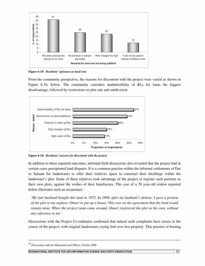
STATE- VS. COMMUNITY-LED LAND TENURE REGULARIZATION IN TANZANIA
INTERNATIONAL INSTITUTE FOR GEO-INFORMATION SCIENCE AND EARTH OBSERVATION 57
41
2523
12
0
5
1015
20
25
3035
40
45
We were coerced intopaying for our land
No services to warrantpayments
Rent charged too high It will not be used toimprove conditions here
Reasons for land rent not being justified
% o
f res
pond
ents
Figure 6-15: Residents' opinions on land rent
From the community perspective, the reasons for discontent with the project were varied as shown in Figure 6-16, below. The community considers inadmissibility of RLs for loans the biggest disadvantage, followed by restrictions on plot sale and subdivision.
14%
15%
20%
24%
27%
0% 5% 10% 15% 20% 25% 30%
High costs of RLs
Short duraton of RLs
Coercion to take up RLs
Restrictions on sale/subdivision
Inadmissibility of RLs for loans
Rea
son
sta
ted
Proportion of respondents
Figure 6-16: Residents' reasons for discontent with the project
In addition to these reported outcomes, informal field discussions also revealed that the project had in certain cases precipitated land disputes. It is a common practise within the informal settlements of Dar es Salaam for landowners to offer their relatives space to construct their dwellings within the landowner’s plot. Some of these relatives took advantage of the project to register such portions as their own plots, against the wishes of their benefactors. The case of a 70 year-old widow reported below illustrates such an occurrence:
‘My late husband bought this land in 1972. In 1989, after my husband’s demise, I gave a portion of the plot to my nephew, Omari to put up a house. This was on the agreement that the land would remain mine. When the project team came around, Omari registered the plot as his own, without any reference to me’.
Discussions with the Project Co-ordinator confirmed that indeed such complaints have arisen in the course of the project, with original landowners crying foul over lost property. This practise of hosting
26 Discussions with the Municipal Land Officer, October 2006
STATE- VS. COMMUNITY-LED LAND TENURE REGULARIZATION IN TANZANIA
58 INTERNATIONAL INSTITUTE FOR GEO-INFORMATION SCIENCE AND EARTH OBSERVATION
relatives and the subdivision of old plots to accommodate heirs upon succession partly explains land fragmentation that has given rise to the small sizes of plots recorded in Midizini.
Concluding remarks on the Government regularization process Whatever its setbacks, the government-led initiative still seems to enjoy high political will. This will may however last only for a little while, should the project earnings fail to improve in the near future. One opportunity that the initiative presents is that of arresting the pace of densification within the regularizing settlements should the authorities institute effective development control in the sequel to regularization. The initiative however faces threats in the apparent lack of tenure insecurity among residents of the informal settlements, and even more so, in the residents’ confidence in the well established ‘informal’ institutions of land administration.
6.4. Community-led land regularization in Ubungo Darajani
6.4.1. Settlement characteristics
Ubungo Darajani had a total of 849 households (4, 245 people) at the 2002 national census. According to the MLHSD database, 55% of the household heads are in formal employment, with the rest engaged in informal employment in and around the settlement. Economic and income generating activities within the settlement include business activities like retail shops, mechanical garages, hotels and restaurants, poultry keeping and kitchen-gardening along Kibangu River.
From the field surveys, household incomes range from TShs 50,000 to 250,000, with a monthly median income of around TSh 96,000. Up to 86% of the households are owner-occupiers, with the remaining being tenants (12%) and others (2%), respectively. Among the landholders, 88% acquired their property through purchase. The rest obtained theirs through gifts (7%), and inheritance (5%). Educational levels in the settlement are significantly higher than they are in Midizini. As Table 6-7 below indicates, up to 76% of the surveyed household heads have a minimum of secondary level education.
Table 6-7: Level of education among surveyed household heads, Darajani Frequency Percent Cumulative Percent Tertiary 12 21.8 21.8
Secondary 30 54.5 76.4
Primary/Madrasa 11 20.0 96.4
No schooling 2 3.6 100.0 Total 55 100.0
Spatial characteristics Ubungo Darajani is a spontaneous settlement well into the intermediate phase of informal settlement evolution (see discussion in Lupala, 2002b). The settlement still exhibits modest densification levels, with housing density standing at approximately 11 houses/Ha. Population densities are equally lower, at about 163 people/Ha. The average household size in the settlement is about 5 persons.
Unlike in Midizini, where the Swahili house type predominates, Darajani is characterised by modern single-storey detached dwelling types. The settlement portrays varied characters in terms of house forms, plot sizes, density and space uses. The relatively low plot coverage has facilitated possibilities
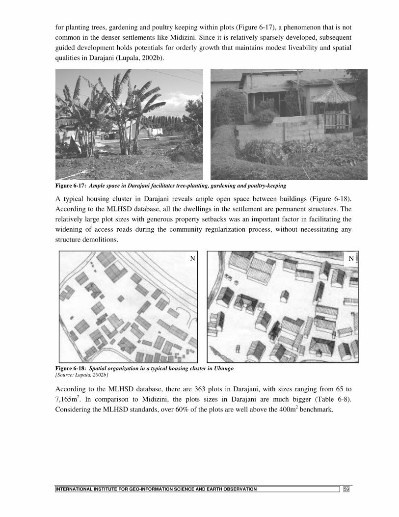
STATE- VS. COMMUNITY-LED LAND TENURE REGULARIZATION IN TANZANIA
INTERNATIONAL INSTITUTE FOR GEO-INFORMATION SCIENCE AND EARTH OBSERVATION 59
for planting trees, gardening and poultry keeping within plots (Figure 6-17), a phenomenon that is not common in the denser settlements like Midizini. Since it is relatively sparsely developed, subsequent guided development holds potentials for orderly growth that maintains modest liveability and spatial qualities in Darajani (Lupala, 2002b).
Figure 6-17: Ample space in Darajani facilitates tree-planting, gardening and poultry-keeping
A typical housing cluster in Darajani reveals ample open space between buildings (Figure 6-18). According to the MLHSD database, all the dwellings in the settlement are permanent structures. The relatively large plot sizes with generous property setbacks was an important factor in facilitating the widening of access roads during the community regularization process, without necessitating any structure demolitions.
Figure 6-18: Spatial organization in a typical housing cluster in Ubungo [Source: Lupala, 2002b]
According to the MLHSD database, there are 363 plots in Darajani, with sizes ranging from 65 to 7,165m2. In comparison to Midizini, the plots sizes in Darajani are much bigger (Table 6-8). Considering the MLHSD standards, over 60% of the plots are well above the 400m2 benchmark.
N N
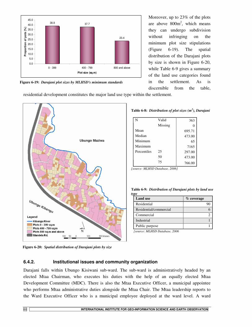
STATE- VS. COMMUNITY-LED LAND TENURE REGULARIZATION IN TANZANIA
60 INTERNATIONAL INSTITUTE FOR GEO-INFORMATION SCIENCE AND EARTH OBSERVATION
Moreover, up to 23% of the plots are above 800m2, which means they can undergo subdivision without infringing on the minimum plot size stipulations (Figure 6-19). The spatial distribution of the Darajani plots by size is shown in Figure 6-20, while Table 6-9 gives a summary of the land use categories found in the settlement. As is discernible from the table,
residential development constitutes the major land use type within the settlement.
Table 6-8: Distribution of plot sizes (m2), Darajani
Valid 363 N Missing 0
Mean 695.71 Median 473.00 Minimum 65 Maximum 7165
25 297.00 50 473.00
Percentiles
75 766.00 [source: MLHSD Database, 2006]
Figure 6-20: Spatial distribution of Darajani plots by size
Table 6-9: Distribution of Darajani plots by land use type
Land use % coverage Residential 90 Residential/commercial 6 Commercial 2 Industrial 1 Public purpose 1
[source: MLHSD Database, 2006
6.4.2. Institutional issues and community organization
Darajani falls within Ubungo Kisiwani sub-ward. The sub-ward is administratively headed by an elected Mtaa Chairman, who executes his duties with the help of an equally elected Mtaa Development Committee (MDC). There is also the Mtaa Executive Officer, a municipal appointee who performs Mtaa administrative duties alongside the Mtaa Chair. The Mtaa leadership reports to the Ward Executive Officer who is a municipal employee deployed at the ward level. A ward
38.8 37.7
23.4
0.0
5.0
10.0
15.0
20.0
25.0
30.0
35.0
40.0
45.0
0 - 399 400 - 799 800 and above
Plot size (sq.m)
Pro
port
ion
of p
ots
(%)
Figure 6-19: Darajani plot sizes by MLHSD's minimum standards

STATE- VS. COMMUNITY-LED LAND TENURE REGULARIZATION IN TANZANIA
INTERNATIONAL INSTITUTE FOR GEO-INFORMATION SCIENCE AND EARTH OBSERVATION 61
Councillor elected by residents of the ward represents ward affairs at the Kinondoni Municipal Council (KMC).
Like in Midizini, the supreme decision-making organ in Ubungo Darajani is the MDC. The committee works through several sub-committees similar to those in Midizini. Of particular importance to our discussion however is the Land Development Committee, formed specifically to steer the affairs of the regularization project under review. The major responsibility of the MDC is to identify community problems, prioritise, plan, implement and co-ordinate all development projects within the Mtaa. Land administration and development control issues within the Mtaa are mainly the role of the Mtaa Chairman. These duties are executed in a fashion similar to that discussed under Midizini, above.
There are several voluntary associations and benevolent schemes operating within Ubungo Darajani, but which are specific to predefined socio-cultural groups. A couple of credit and savings institutions, namely the Foundation for International Community Assistance (FINCA) and Upatu are also active in the settlement. The most important community institution for our context however is the Ubungo Darajani Development Fund (UDADEFU), a CBO charged with the responsibility of overseeing the implementation of the community land regularization project.
6.4.3. The Darajani regularization process
a) Community mobilisation and project initiation The idea of community land regularization in Darajani was mooted by one Cosmas Msisi, a long-term resident who had himself fallen prey to unscrupulous land surveyors in his earlier attempts at securing an individual title27. After consultations with the Mtaa Chair and other community leaders, Msisi mobilised community members to the first general meeting held in March 1996. The meeting resulted in the formation of Ubungo Darajani Development Association, UDASEDA – the forerunner of the present day UDADEFU. UDASESDA then became the lead agency in steering the land regularization process. Msisi was elected the first Chairman of the CBO.
Sourcing technical expertise After the formation of the CBO, the community approached KMC seeking its support and advice in having their plots surveyed and registered. The Council remained noncommittal on the matter and referred the community to MLHSD instead. According to Magigi (2004), the Council may have been hesitant to provide the community with the go-ahead due to unclear policy issues regarding the appropriate standards to adopt in the proposed regularization scheme as well as handling of compensation matters. But it is also safe to conclude that this referral had to do with the provisions of the Land Act No. 4 of 1999, which bestows the onus of declaring regularization schemes upon the Minister, and not the local authority.
After scrutinising their request, the Ministry verbally advised the community to contact UCLAS for technical assistance with the process. Magigi (ibid.) opines that the Ministry officials may have been hesitant to commit themselves in writing due to their inability to ascertain the community’s capacity to mobilise resources to implement the scheme. Field interviews with officials both at MLHSD and KMC did reveal however that there exist no explicit guidelines regarding the implementation of

STATE- VS. COMMUNITY-LED LAND TENURE REGULARIZATION IN TANZANIA
62 INTERNATIONAL INSTITUTE FOR GEO-INFORMATION SCIENCE AND EARTH OBSERVATION
regularization schemes initiated by community groups. It is therefore probable that this lacuna in policy direction may have militated against any commitments on the part of both MLHSD and KMC. Nonetheless the community contacted UCLAS in 1998 as advised by MLHSD officials. Acting as a consultant, UCLAS, agreed to produce the community regularization plan at a modest fee of TShs. 1,260,000 (Magigi and Majani, 2006).
b) Land adjudication and community layout planning In approaching their work, the consultant established a planning team consisting of experienced planners and assistants capable of carrying out the task. After briefings with community officials, a community general assembly was convened during which the whole process of land regularization was explained to community members, together with its cost implications. The following items were identified as the main outputs of the community layout planning phase28:
a) an updated base map showing the existing development as at 2000; b) a housing register showing names of property owners, status of occupancy, available services
and building use; c) a general community plan that would form the basis for infrastructure planning and design. The
plan would indicate future location of infrastructure services and community facilities like solid waste collection points, etc.; and
d) a detailed layout plan showing both private and public property boundaries. The layout plan would subsequently form the basis for cadastral surveys.
Once in agreement, the consultant set out to work and the community members resolved to make financial contributions towards the project. It was agreed that each landholder contributes TShs 6,000 towards the plan preparation. The payments would be made in instalments. The first task for the consultant entailed preparing community base maps, on which were reflected all existing structures and major physical features. With the help of 1992 aerial photographs, base maps were produced at scales of 1:2,500 and 1:1,250. Also prepared at this stage were property registration and negotiation forms for use in the property adjudication process, together with the identification of public space (Magigi, 2004).
Base map updating and property registration A group of field assistants conducted both base map updates and property registration. Updates were made on the larger base map (1:1,250). Among the features mapped included buildings, roads, footpaths, big trees, electricity lines, and water drainage courses. In addition to the mapping, property particulars were entered in the predefined registration forms. Data of interest in this exercise included building (property tax) number, owner’s details, number and status of occupants, number of habitable rooms, building and plot use, building materials used, construction level, and level of utility services. From this data, an updated community map was prepared and presented to members for discussion in a plenary session.
Community layout planning Based on the existing situation, the consultant worked out planning standards for infrastructure and community facilities to be applied in formulating a community general plan. In doing this,
27 Discussions with UDADEFU officials and the Ubungo Kisiwani Mtaa Chaiman, September 2006 28 Interviews with UDADEFU officials; Kisiwani Mtaa Chairman, October 2006
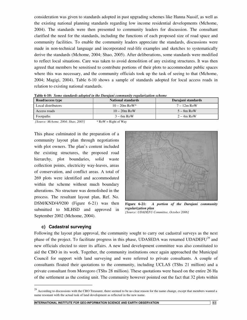
STATE- VS. COMMUNITY-LED LAND TENURE REGULARIZATION IN TANZANIA
INTERNATIONAL INSTITUTE FOR GEO-INFORMATION SCIENCE AND EARTH OBSERVATION 63
consideration was given to standards adopted in past upgrading schemes like Hanna Nassif, as well as the existing national planning standards regarding low income residential developments (Mchome, 2004). The standards were then presented to community leaders for discussion. The consultant clarified the need for the standards, including the functions of each proposed size of road space and community facilities. To enable the community leaders appreciate the standards, discussions were made in non-technical language and incorporated real-life examples and sketches to systematically derive the standards (Mchome, 2004; Shao, 2005). After deliberations, some standards were modified to reflect local situations. Care was taken to avoid demolition of any existing structures. It was then agreed that members be sensitised to contribute portions of their plots to accommodate public spaces where this was necessary, and the community officials took up the task of seeing to that (Mchome, 2004; Magigi, 2004). Table 6-10 shows a sample of standards adopted for local access roads in relation to existing national standards.
Table 6-10: Some standards adopted in the Darajani community regularization scheme Road/access type National standards Darajani standards Local distributors 10 – 20m RoW* 7 – 12m RoW Access roads 10 – 20m RoW 5 – 8m RoW Footpaths 3 – 6m RoW 2 – 4m RoW
[Source: Mchome, 2004; Shao, 2005] * RoW = Right of Way
This phase culminated in the preparation of a community layout plan through negotiations with plot owners. The plan’s content included the existing structures, the proposed road hierarchy, plot boundaries, solid waste collection points, electricity way-leaves, areas of conservation, and conflict areas. A total of 269 plots were identified and accommodated within the scheme without much boundary alterations. No structure was demolished in the process. The resultant layout plan, Ref. No. DSM/KND/4/9200 (Figure 6-21) was then submitted to MLHSD and approved in September 2002 (Mchome, 2004).
c) Cadastral surveying Following the layout plan approval, the community sought to carry out cadastral surveys as the next phase of the project. To facilitate progress in this phase, UDASEDA was renamed UDADEFU29 and new officials elected to steer its affairs. A new land development committee was also constituted to aid the CBO in its work. Together, the community institutions once again approached the Municipal Council for support with land surveying and were referred to private consultants. A couple of consultants floated their quotations to the community, including UCLAS (TShs 21 million) and a private consultant from Morogoro (TShs 28 million). These quotations were based on the entire 26 Ha of the settlement as the costing unit. The community however pointed out the fact that 32 plots within
29 According to discussions with the CBO Treasurer, there seemed to be no clear reason for the name change, except that members wanted a name resonant with the actual task of land development as reflected in the new name.
Figure 6-21: A portion of the Darajani community regularization plan [Source: UDADEFU Committee, October 2006]

STATE- VS. COMMUNITY-LED LAND TENURE REGULARIZATION IN TANZANIA
64 INTERNATIONAL INSTITUTE FOR GEO-INFORMATION SCIENCE AND EARTH OBSERVATION
the settlement had already undergone cadastral surveys at the time. They therefore bargained for cheaper rates that would exclude the already surveyed plots. On this premise, the community managed to squeeze a concession from a private consultant (Survey Consults), who agreed to undertake the cadastral surveys at a much cheaper cost of about TShs 4.1 million. After site inspections, the consultant advised the community leaders to seek survey instructions from KMC before the work could commence. Magigi and Majani (2006) report that the process of issuing the survey instruction by the KMC again dragged for a whole 9 months (from February to October 2003).
The cadastral surveys finally began in February 2004. The community leaders, once again mobilised contributions from members. Each landholder was to contribute TShs 30,000 towards financing this phase of the project. Again it was resolved that this be done in instalments. A bank account was opened and contributions deposited there, with the CBO officials being signatory thereof. Figure 6-22 below shows a portion of Darajani at different stages of the regularization process.
Figure 6-22: A portion of Darajani before and after layout planning
d) Award of Letters of Offer and Certificates of Occupancy The survey plan was subsequently submitted to MLHSD and final approval received in late 2004. The next phase is to have Letters of Offer issued to landholders, detailing conditions of award of titles, including development standards to be observed in subsequent land development (Refer to Appendix 5 for a sample). On receipt of the letters of offer, the property owners are expected to formally accept the same and pay the requisite fees before the final certificates of occupancy can be issued.
But just before the residents could receive the Letters of Offer, MLHSD mooted the Residential Licenses scheme and the Darajani project has since been put on hold. The residents are still waiting for the letters of offer which should ultimately give way for the award Certificates of Occupancy as the end product of the regularization process (see sample in Appendix 6). Meanwhile, the Government authorities have gone ahead and implemented the Residential Licenses project in

STATE- VS. COMMUNITY-LED LAND TENURE REGULARIZATION IN TANZANIA
INTERNATIONAL INSTITUTE FOR GEO-INFORMATION SCIENCE AND EARTH OBSERVATION 65
Darajani. This is despite the advanced achievements already recorded towards securing certificates of title, which offer more benefits in comparison to the Residential License.
6.5. Issues emerging from the Darajani regularization project
6.5.1. Motivations for the project
Community mobilisation towards the Darajani project began with a residents’ general meeting held in March 1996 to deliberate on the land development affairs within the settlement. As discussed previously, the meeting culminated in the formation of UDASEDA. The association specifically had at its formation, the following objectives:-
1. To ensure that land within Ubungo Darajani was planned and surveyed for residential use; 2. To enable landholders within the settlement acquire certificates of title with which to secure
financial credit; 3. To guide, direct and control land development within the settlement, in collaboration with
other community institutions; and 4. To improve infrastructure facilities and utility supply within the settlement (Magigi, 2004).
From the above objectives, and bearing in mind past Government attempts to evict residents from the settlement (refer to discussions in Chapter 4), the feeling of tenure insecurity seems to have been a major driving force in project implementation. According to Magigi and Majani (2006), the main objective of the Darajani project was to ward off Government intentions to evict residents from the settlement in order to make room for the implementation of the industrial development scheme, in accordance with the 1979 Master Plan.
However several factors seem to point towards other reasons for the implementation of the project. As discussed elsewhere in this document, residents within the informal settlements of Dar es Salaam are generally not precluded from obtaining titles to their landholdings, where such land has undergone cadastral surveys to the satisfaction of MLHSD. It was therefore possible for landholders in Darajani, like elsewhere, to organise for private cadastral surveys over their plots. In fact, up to 32 landholders held titles to their land at the commencement of the community regularization project.
The fact that some landholders had already acquired titles for residential use of their plots does not seem to bear out Magigi and Majani’s assertion that the residents were still under threat of eviction at the time of the commencement of the community regularization project. One may argue that titles were issued by MLHSD and did not necessarily have to conform to the zoning rules of the local authority, on account of poor co-ordination that typifies the operations of these two State agencies (Kironde, 1995b). But the local authority itself had in 1990 prepared a layout scheme for the settlement (Plan Drawing No. TP/1/654/1990), in which the land use had been declared residential (Shao, 2005). After these actions by Government agencies, there is no reason to believe that residents would still feel the threat of eviction from the settlement as at 1996 when the regularization project was initiated.
What then was the motivation behind the project? The reason seems to lie in the manner in which the Council’s 1990 layout planning process was carried out. To begin with, the layout plan had been prepared without any input from residents. The plan did not reflect the existing situation on the
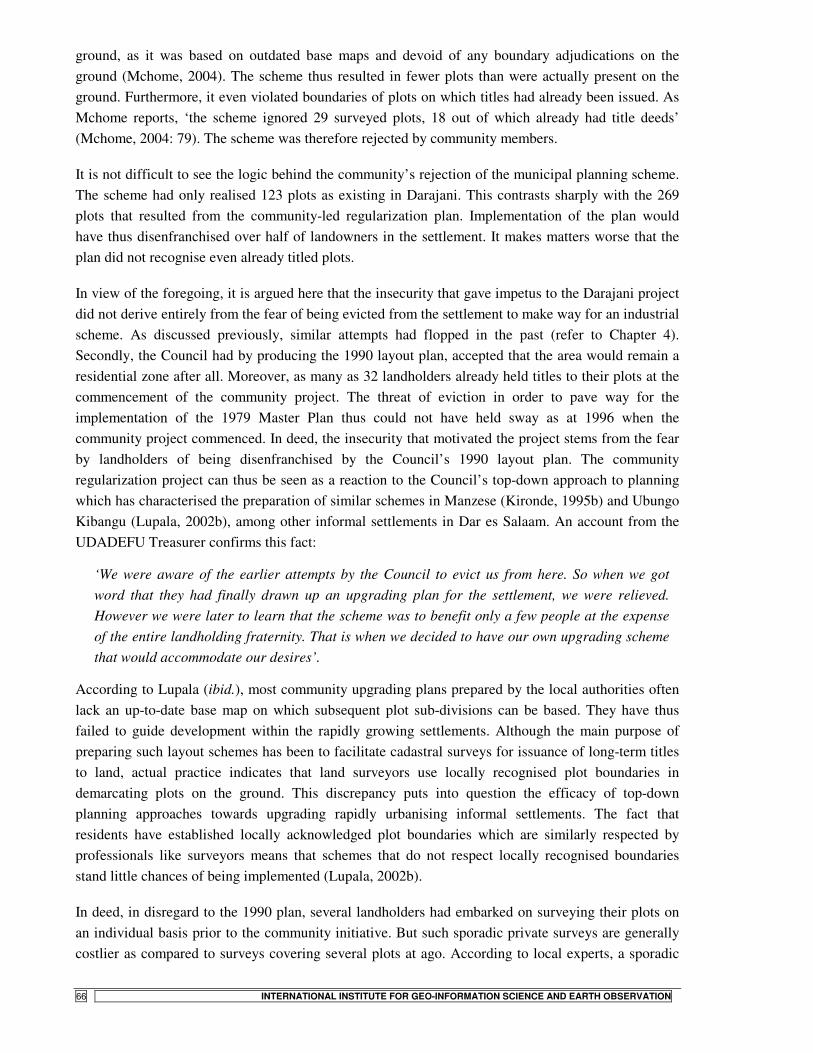
STATE- VS. COMMUNITY-LED LAND TENURE REGULARIZATION IN TANZANIA
66 INTERNATIONAL INSTITUTE FOR GEO-INFORMATION SCIENCE AND EARTH OBSERVATION
ground, as it was based on outdated base maps and devoid of any boundary adjudications on the ground (Mchome, 2004). The scheme thus resulted in fewer plots than were actually present on the ground. Furthermore, it even violated boundaries of plots on which titles had already been issued. As Mchome reports, ‘the scheme ignored 29 surveyed plots, 18 out of which already had title deeds’ (Mchome, 2004: 79). The scheme was therefore rejected by community members.
It is not difficult to see the logic behind the community’s rejection of the municipal planning scheme. The scheme had only realised 123 plots as existing in Darajani. This contrasts sharply with the 269 plots that resulted from the community-led regularization plan. Implementation of the plan would have thus disenfranchised over half of landowners in the settlement. It makes matters worse that the plan did not recognise even already titled plots.
In view of the foregoing, it is argued here that the insecurity that gave impetus to the Darajani project did not derive entirely from the fear of being evicted from the settlement to make way for an industrial scheme. As discussed previously, similar attempts had flopped in the past (refer to Chapter 4). Secondly, the Council had by producing the 1990 layout plan, accepted that the area would remain a residential zone after all. Moreover, as many as 32 landholders already held titles to their plots at the commencement of the community project. The threat of eviction in order to pave way for the implementation of the 1979 Master Plan thus could not have held sway as at 1996 when the community project commenced. In deed, the insecurity that motivated the project stems from the fear by landholders of being disenfranchised by the Council’s 1990 layout plan. The community regularization project can thus be seen as a reaction to the Council’s top-down approach to planning which has characterised the preparation of similar schemes in Manzese (Kironde, 1995b) and Ubungo Kibangu (Lupala, 2002b), among other informal settlements in Dar es Salaam. An account from the UDADEFU Treasurer confirms this fact:
‘We were aware of the earlier attempts by the Council to evict us from here. So when we got word that they had finally drawn up an upgrading plan for the settlement, we were relieved. However we were later to learn that the scheme was to benefit only a few people at the expense of the entire landholding fraternity. That is when we decided to have our own upgrading scheme that would accommodate our desires’.
According to Lupala (ibid.), most community upgrading plans prepared by the local authorities often lack an up-to-date base map on which subsequent plot sub-divisions can be based. They have thus failed to guide development within the rapidly growing settlements. Although the main purpose of preparing such layout schemes has been to facilitate cadastral surveys for issuance of long-term titles to land, actual practice indicates that land surveyors use locally recognised plot boundaries in demarcating plots on the ground. This discrepancy puts into question the efficacy of top-down planning approaches towards upgrading rapidly urbanising informal settlements. The fact that residents have established locally acknowledged plot boundaries which are similarly respected by professionals like surveyors means that schemes that do not respect locally recognised boundaries stand little chances of being implemented (Lupala, 2002b).
In deed, in disregard to the 1990 plan, several landholders had embarked on surveying their plots on an individual basis prior to the community initiative. But such sporadic private surveys are generally costlier as compared to surveys covering several plots at ago. According to local experts, a sporadic

STATE- VS. COMMUNITY-LED LAND TENURE REGULARIZATION IN TANZANIA
INTERNATIONAL INSTITUTE FOR GEO-INFORMATION SCIENCE AND EARTH OBSERVATION 67
survey on an isolated piece of land of about one hectare may cost as much as $ 500 (TShs 500,000) instead of the same amount for surveying say 5 similar adjoining units in one go (Silayo, 2005). Figure 6-23 gives a summary of the respondents’ justification of project costs in relation to their monthly household incomes. It is evident that the poorer members valued the subsidies extended to them by the more affluent members in meeting community contributions towards the project. The latter on the other hand justified the project costs on account that the payments made were commensurate with the benefits expected from titling.
Apart from the cost implications, several landholders had in the past fallen prey to unscrupulous land surveyors when they attempted to carry out sporadic surveys on an individual basis. All these contributed to the joining of forces among residents to have all properties surveyed under one scheme.
The community’s desire to carry out land regularization can also be seen in the light of the provisions of the Land Act, 1999 (sections 56 – 60). Although project initiation predates the coming into force of the statute, it can be argued that the Act’s promulgation gave impetus to the whole process, particularly owing to the
relatively higher educational levels of most household heads resident within Darajani. The higher education levels must have contributed to higher degrees of awareness among residents with regard to land development matters. Added to this is the fact that most residents in Darajani are landowners as opposed to tenants. The majority therefore stood to benefit directly through collective action to improve conditions within the settlement.
6.5.2. Stakeholder involvement and roles
The actors in the Darajani project can be grouped into three broad categories: community institutions, Government agencies, and consultants (Figure. 6-24). To this main groups can be added credit and saving institutions.
�����
��������
Figure 6-24: Actors and their roles in the Darajani project
0
20
40
60
80
100
120
0 - 50000 50001 - 100000 100001 - 150000 150001 - 200000 200001 - 250000
Respondent's monthly income catogory
Pro
port
ion
of r
espo
nden
ts (%
)
Payments comensurate with benefits expectedRates cheaper than seeking registration individuallyPayments made in installmentsSubsidies for poorer members
Figure 6-23: Justification of the Darajani project costs in relation to respondent incomes

STATE- VS. COMMUNITY-LED LAND TENURE REGULARIZATION IN TANZANIA
68 INTERNATIONAL INSTITUTE FOR GEO-INFORMATION SCIENCE AND EARTH OBSERVATION
Community institutions As the basic unit of community institutions, households were involved in the contribution of information and ideas during consultative meetings and during household interviews conducted by the project consultants. They also helped in information dissemination. More importantly, households made contributions in cash and labour to facilitate different phases of the project. They were actively involved in deliberations regarding planning standards adopted in the project. Some households donated land to make room for access roads and other public space, while others got involved in arbitration of boundary disputes that arose during the adjudication phase. Households were also involved in signing boundary agreement forms during land adjudication, a process witnessed by the Mtaa Chair.
The most important platform for household deliberations were the community meetings. Such meetings were convened by the CBO officials (and later in conjunction with the LDC). All households, community leaders and consultants were participants in such meetings, under the chairmanship of the Mtaa Chairman. The CBO secretary took minutes and disseminated these in subsequent sittings.
The whole process of steering the project fell upon the CBO leadership. They not only convened meetings and carried out community resolutions. They also carried out daily management issues, boundary conflict resolution, community sensitisation and resource mobilisation. They remained the main link between the community and external institutions – the project consultants and Government agencies. The CBO leadership maintained a good link with other community institutions, namely the Ten-Cell and Mtaa leadership. The Ten-Cell leaders were particularly helpful in mobilising residents to attend meetings and make contributions. The Mtaa Chair actively participated in the affairs of the project right from its inception. This was despite the fact that he did not stand to benefit directly from the project as an individual as he lived in Maziwa and not in Darajani. Furthermore, he is among the few individuals who already hold certificates of title to their plots30.
Unlike in Midizini, tenants in Darajani were actively involved in the whole process of regularization. They attended community meetings, contributed cash and volunteered labour at various phases of the project. In the case of absentee landlords, it fell upon their tenants to do briefings on project progress status. The participation of tenants can be attributed to the fact that most of the problems identified in Ubungo were common to both tenants and landlords: lack of waste disposal sites, flooding during the rainy season, and poor vehicular access affected both owners and renters alike.
One notable achievement of the Darajani project was the ability of the more affluent members of the community to make contributions that were over and above the agreed target for each landholder. For example, despite the contributions from each household towards community layout planning being pegged at TShs 6,000, Magigi and Majani (2006) report that some landholders contributed as much as TShs 36,000 apiece towards the process. In this way, subsidies were extended to the poorer members who could not afford to meet the household targets set by the community.
The community layout plan was prepared based on the agreed boundaries as realised through the signing of boundary agreement forms by landholders. But signing of these forms did generate disputes
30 Discussions with the Kisiwani Mtaa Chairman, October 2006
STATE- VS. COMMUNITY-LED LAND TENURE REGULARIZATION IN TANZANIA
INTERNATIONAL INSTITUTE FOR GEO-INFORMATION SCIENCE AND EARTH OBSERVATION 69
at times, with some members alleging loss of land to their neighbours. An arbitration taskforce was thus constituted under the guidance of the Mtaa Chair, with membership drawn from CBO officials and LDC membership. In this way, most of the conflicts were amicably resolved. The layout plan resulting from the process was then deposited with the Mtaa Chair and the Ubungo WEO for subsequent land administration tasks.
Government agencies Although initiated by the community, all processes pertaining to land development only derive their legitimacy after endorsement by the responsible State agencies, in this case KMC and MLHSD. The new land Act empowers the Minister to initiate regularization schemes, while the local authority is tasked with facilitating community initiatives towards regularization. The performance of these two institutions in the Darajani project was however fraught with delays and indecision, particularly at the initiation stages. This can be attributed to the fact that there exist no clear procedures to guide the conduct of regularization schemes initiated by community organizations. In fact, the Darajani scheme was the first scheme being implemented purely on the initiative of community institutions.
Consultants The conduct of a regularization scheme requires specialized technical expertise. Where this expertise cannot be provided by the relevant Government agencies, it must be sought from elsewhere at the expense of the proponents of the regularization project. The new land law details the role of the Ministry in preparing such schemes. But this is only limited to those schemes initiated by the Ministry. Where, as in the case of Darajani and Hanna Nassif, the scheme is initiated by community institutions, the community must bear the cost of technical consultants. In this particular case, the consultants were responsible for the preparation of the community layout plan and the survey plan documents and negotiating their approval with the authorities on behalf of the community.
Credit institutions Cash contributions towards the project were mainly made in instalments. Apart from own sources, some households obtained credit from FINCA and Upatu. The credit so obtained was used by member households to finance contributions to the project. Upatu is a women-group revolving fund financed through member savings. It allows group members to pool their meager savings in a way that facilitates one-time big investments by members. Magigi and Majani (2006) cite their cheaper interest rates and lenient lending conditions as the main reason why community members sought credit from these micro-credit institutions, as opposed to mainstream commercial banks.
6.5.3. Project achievements
The main aim of getting individual titles is not yet achieved. But as the foregoing discussion illustrates, major strides towards this end have been made. The community has done all that is within its mandate. Whatever remains to be done – the award of letters of offer and certificates of titles – lays with MLHSD. However, it will suffice to mention briefly some of the benefits and responsibilities that the expected certificates of title will bestow upon the beneficiaries.
Rights and responsibilities expected from the Certificates of Occupancy The Certificate of Occupancy is a granted right of occupancy issued under section 29 of the Land Act No. 4 of 1999. Like any other right of occupancy in Tanzania, it bestows upon the holder the right to occupy and use the land in question for a specified duration of time. It is a long term Government

STATE- VS. COMMUNITY-LED LAND TENURE REGULARIZATION IN TANZANIA
70 INTERNATIONAL INSTITUTE FOR GEO-INFORMATION SCIENCE AND EARTH OBSERVATION
lease and is usually offered for periods of 33, 66, or 99 years. The lease term is renewable, although this is at the discretion of the granting authority (the President). Additionally, the license holder is entitled to compensation in the event of any acquisitions executed under the Land Acquisition Act of 1967. It may be used as security against bank loans, or in any other legal transactions.
However, the Certificate of Occupancy imposes upon the holder the duty to pay land rent as may be revised from time to time by the granting authority. The certificate limits the use of the land in question to the user specified at the time of grant. A residential user may only construct one dwelling on the plot and the construction of such buildings may only commence upon the approval of building plans by the relevant local authority. Additionally, such buildings may only be of permanent materials and their construction must commence six months subsequent upon the grant of the Certificate of Occupancy. The right may not be assigned within three years of grant and any dispositions thereafter can only be effected with the approval of the Commissioner for Lands (Refer to sample Letter of Offer and Certificate of Occupancy in Appendices 5 and 6).
Figure 6-25: Views of the Landmark Hotel from Mandela Rd.
If awarded ultimately, the Certificates of Occupancy will bestow Government leases tenable for 33 years. Apart from the enhanced legal security, the longer term (in comparison to the RL) accorded by the title lends the titled property for use as collateral against bank loans.
The respondents also see in the project the opportunity to maintain orderly development within the neighbourhood. Among the landholders who already hold titles to their properties, some have been able to secure bank loans with which substantial investments have been financed. An example is
52%
28%
20%
0%
10%
20%
30%
40%
50%
60%
Legal surety on propertyownership
Ability to draw mortgages onproperty
Improved accessibility andordered development
Benefit
Pro
port
ion
of r
espo
nden
ts
Figure 6-26: A summary of expected project benefits, Drajani
STATE- VS. COMMUNITY-LED LAND TENURE REGULARIZATION IN TANZANIA
INTERNATIONAL INSTITUTE FOR GEO-INFORMATION SCIENCE AND EARTH OBSERVATION 71
the imposing Landmark Hotel31 at the north-western tip of the settlement (Figure 6-25). A summary of expected project benefits as given by respondents is presented in Figure 6-26. It is evident that the residents expect to secure financial credit with the titles. They are also keen on maintaining orderly development within the neighbourhood, over and above the legal security bestowed by the Certificate of Occupancy.
6.5.4. Project implementation setbacks
There were a number of problems which constrained progress from time to time. Respondents reported that a small section of residents had doubts about the project at its initiation. They believed the project would not succeed and did not want to entrust the officials with their monetary contributions towards the scheme. This attitude changed nonetheless when the regularization plan prepared in the first phase gained approval of the authorities. Consequently, all members participated in the ensuing stages and all monies contributed were deposited in the CBO’s bank account to obviate fears of impropriety on the part of the officials.
As already pointed out in the foregoing, the biggest setback reported during the interviews (up to 78% of respondents) is the delays that characterised the approval process by the authorities. The local authority’s reluctance to endorse the project at its initiation may have had to do with the fact that the Council had wanted to hold on to its 1990 layout scheme. Endorsing the present project would have been a tacit admission of failure of the scheme. But there are other factors which contributed to this dithering as well. Although matters of planning are the responsibility of KMC, the award of titles as was the express objective of the community, fell within the purview of MLHSD and the Council could not give any endorsement before seeking the authority of MLHSD. However, even after initial go-ahead had been received from the authorities, the approval of both the layout and survey plans dragged for too long (Magigi and Majani, 2006). As already indicated, despite the approvals on the scheme received in 2004, the Ministry is yet to issue letters of offer to the residents in order to pave way for the ultimate award of titles. These long delays did come out during field interviews as the biggest project drawback.
The long delays however must be considered within the context of the lengthy process that typifies the official land administration bureaucracy in Tanzania. As Silayo (2005) notes, the formal land delivery process goes through a labyrinth of lengthy and costly procedures which can be quite intimidating to the developer (see Appendix 8 for example).
There arose a few cases of conflicts regarding property boundaries occasioned by the adjudication exercise. The resolution of such disputes fell upon neighbouring property owners, CBO officials, the Land Development Committee and the Mtaa Chairman. Most of these conflicts were however amicably resolved.
One big problem that seems to have afflicted the Darajani project is the apparent lack of co-ordination between the key actors in the land development process: the Ministry, the Council and the community. This seems to have been the main reason behind the delays reported. To begin with, the Council’s 1990 plan was prepared without any reference to community aspirations at all. It thus failed to reflect 31 Discussions with the Kisiwani Mtaa Chair, October 2006

STATE- VS. COMMUNITY-LED LAND TENURE REGULARIZATION IN TANZANIA
72 INTERNATIONAL INSTITUTE FOR GEO-INFORMATION SCIENCE AND EARTH OBSERVATION
the actual state of landholding and developments on the ground. It is not difficult to see that the implementation of this plan would have given rise to serious boundary conflicts among landholders, a factor that precipitated the plan’s rejection by residents.
Whereas the preparation of community plans is the responsibility of the local authority, the award of titles realised from such plans is the responsibility of the Ministry. There seems to be a lack of co-ordination between these two agencies as actual survey plans are not based on boundaries indicated on municipal layout plans, but rather on boundaries recognised by landholders on the ground. The result is that the municipal plans serve no real purpose in guiding development within the settlements. This is an occurrence that has been reported in several other settlements, as discussed previously.
Another incidence of lack of co-ordination stems from the fact that despite discernible achievements on the community regularization scheme, the Government agencies still went ahead to implement the Residential Licenses project in Darajani. In an interview with the Project Co-ordinator at MLHSD, the indication was that Darajani had not been covered in the State-led Residential Licenses project. The response to the question had been that:
‘We did not implement the [Residential Licenses] project in Darajani and Hanna Nassif because we were aware of the community titling initiatives that are currently being implemented there. It does not make sense to award Residential Licenses to those who are already working towards acquiring titles, because our ultimate aim is that the Residential Licenses are themselves eventually upgraded into certificates of title’.
This assertion of course did not match what was on the ground as Darajani had been covered under the Residential Licenses project and several landholders had even obtained the licenses to their plots at the time of conducting field interviews. What is even more striking is the fact that the Residential Licenses project team did not adopt the provisions for circulation and other public spaces reflected on the community regularization scheme. One finds it difficult to understand why the team could not adopt the boundaries already negotiated under the community regularization scheme.
The duplication of efforts at Darajani is a classic example of lack of co-ordination between the Ministry and the local authority. Although the Ministry spearheaded the implementation of the RLs project, selection of settlements to be covered under the project within each local authority lay with each municipality as the planning authority within its civic jurisdiction. Thus the inclusion of Darajani in the RL project was a decision taken by Kinondoni Municipal Council and not the Ministry. But why would the Council register plots which had already undergone cadastral surveys in readiness for titling? The answer seems to lie in some administrative technicality. The award of titles is the prerogative of MLHSD. As long as actual certificates of title remained unawarded in Darajani, the Council would still consider the settlement informal, advances towards securing titles not withstanding. Since the residential project targeted all informal settlements, KMC considered Darajani one of such settlements within its jurisdiction.
Whatever reasoning may have been behind the implementation of The RL project in Darajani however, it does not exonerate the Residential Licenses project team from failing to adopt boundaries established under the community regularization scheme. As indicated by the resultant products, there is apparent disparity between the aims of the two approaches to regularization. Whereas the community scheme meets basic planning criteria, by for example ensuring public access to all plots

STATE- VS. COMMUNITY-LED LAND TENURE REGULARIZATION IN TANZANIA
INTERNATIONAL INSTITUTE FOR GEO-INFORMATION SCIENCE AND EARTH OBSERVATION 73
within the settlement and creating rights of way for roads and other public spaces (Refer to Figure 6-27), the Residential Licenses scheme seems to have put emphasis on registering private property, without any attempts at securing public space for internal circulation and future infrastructure installations. Access roads are registered ‘as-is’, leading to disjointed circulation networks (Figure 6-28). A closer look reveals that some mapped footpaths virtually traverse private plots, making it difficult to enforce one of the conditions of the RL, which requires plot owners to preserve existing access routes in their future developments.
Figure 6-27: A section of Darajani after the community layout planning phase
Figure 6-28: A section of Darajani depicting contents of the Government project database
According to officials of UDADEFU, residents received the Government project with mixed feelings, whereas some thought acquiring the Residential License would speed up the process of granting titles, others flatly dismissed the project as tantamount to derailing the investments already made towards securing titles. Being a Government project, several respondents admitted having had no other choice but to participate in it by going for the licenses.
As was the case in Midizini, some residents in Darajani reported having been coerced into taking the Residential License. Their pleas to the effect that they were awaiting the award of Certificates of Occupancy went unheeded. As explained previously, most residents within the informal settlements of Dar es Salaam do not feel insecure in their tenure status. Even in Darajani, where past attempts at eviction had been witnessed, subsequent Government actions as captured in the foregoing discussion have served to create a substantial degree of tenure security, obviating the fear of any forced evictions.
STATE- VS. COMMUNITY-LED LAND TENURE REGULARIZATION IN TANZANIA
74 INTERNATIONAL INSTITUTE FOR GEO-INFORMATION SCIENCE AND EARTH OBSERVATION
Concluding remarks on the community regularization process Generally, the community approach presents a process whose outcomes are more likely to resonate with most residents, considering the benefits that landholders stand to gain from a successful regularization scheme. Again, given that residents consciously make the decision to go for the project, they are more prepared to meet the costs involved in achieving their stated aim. The community-led approach is likely to be take root in several of the informal settlements on the city fringe such as Kimara, where spatial densities remain similar to or even sparser than those in Darajani. Even where they do not exist as yet, potentials exists among such settlements for the formation of robust community-based organizations capable of steering the regularization process. The potentials for community initiated regularization are greatly bolstered by the provisions of the new land law which bestows on residents the initiative to commence the regularization process. This is further buttressed by fledgling partnerships bringing together communities, NGOs and technical consultants. The on-going community regularization process in Hanna Nassif where WAT-Human Settlement Trust is involved, aptly demonstrates the success of such a partnership.
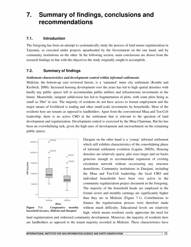
STATE- VS. COMMUNITY-LED LAND TENURE REGULARIZATION IN TANZANIA
INTERNATIONAL INSTITUTE FOR GEO-INFORMATION SCIENCE AND EARTH OBSERVATION 75
7. Summary of findings, conclusions and recommendations
7.1. Introduction
The foregoing has been an attempt to systematically study the process of land tenure regularization in Tanzania, as executed under projects spearheaded by the Government on the one hand, and by community institutions on the other. In the following section, main conclusions are drawn from the research findings in line with the objectives the study originally sought to accomplish.
7.2. Summary of findings
Settlement characteristics and development control within informal settlements Midizini, the bottom-up case reviewed herein, is a ‘saturated’ inner city settlement (Kombe and Kreibich, 2000). Increased housing development over the years has led to high spatial densities with hardly any public spaces left to accommodate public utilities and infrastructure investments in the future. Meanwhile, rampant subdivision has led to fragmentation of plots, with some plots being as small as 20m2 in size. The majority of residents do not have access to formal employment and the major means of livelihood is trading and other small-scale investments by households. Most of the residents here are tenants as opposed to landholders. Apart from the conventional Mtaa and Ten-Cell leadership, there is no active CBO in the settlement that is relevant to the question of land development and regularization. Development control is exercised by the Mtaa Chairman. But his has been an overwhelming task, given the high rates of development and encroachment on the remaining public spaces.
Darajani on the other hand is a ‘young’ informal settlement which still exhibits characteristics of the consolidating phase of informal settlement evolution (Lupala, 2002b). Housing densities are relatively sparse, plot sizes larger and set backs generous enough to accommodate expansion of existing circulation network without occasioning any structure demolitions. Community institutions in Darajani, including the Mtaa and Ten-Cell leadership, the local CBO and individual households have been very active in the community regularization project document in the foregoing. The majority of the household heads are employed in the formal sector and monthly earnings are significantly higher than they are in Midizini (Figure 7-1). Contributions to finance the regularization process were therefore made without much difficulty. Educational levels are relatively high, which means residents easily appreciate the need for
land regularization and orderered community development. Moreover, the majority of residents here are landholders as opposed to the tenant majority recorded in Midizini. These characteristics have
MidiziniDarajani
Mtaa
250000
200000
150000
100000
50000
0
HH
Inco
me 150000
250000
200000
180000
Figure 7-1: Comparative monthly household incomes, Midizini and Darajani
STATE- VS. COMMUNITY-LED LAND TENURE REGULARIZATION IN TANZANIA
76 INTERNATIONAL INSTITUTE FOR GEO-INFORMATION SCIENCE AND EARTH OBSERVATION
nurtured a conducive atmosphere that has in turn facilitated success in the community regularization process in Darajani (Kessy, 2005; Magigi and Majani, 2006).
Development control within both settlements is carried out by local community leaders, notably the Mtaa Chairman and the Ten-Cell leadership. In both approaches, the central role played by community institutions in development control and land administration remains pertinent long after project implementation. In the Government-led process, the enactment of by-laws to facilitate development control by mitaa leaders even ensures an increased role of community institutions in development control in the sequel to regularization.
The findings with regard to settlement characteristics and development control generally resonate with the model put forward by Kombe and Kreibich (2000), Kyessi (2002) and Nguluma (2003) with regard to the overall process of informal settlement evolution within Dar es Salaam (summarised in Appendix 7). In their discussions on the developmental stages of informal settlements, the authors posit that such areas mainly pass through three distinct phases of consolidation. In the infancy stage, when the settlement commences, the area exhibits sparse densities with land use still incorporating strong elements of agriculture. The intermediate phase is the consolidating stage when land use becomes predominantly residential; the settlement acquires a distinctive spatial structure with buildings invariably positioned with regard to some form of access routes and central public spaces; social organization is strong as collective responsibility still overrides individual economic pursuits. The last phase is the saturated stage when over-densification leads to blurred spatial organization; conflicts escalate as land markets ‘heat up’ and buildable space becomes scarce, pitting collective responsibility against private livelihood pursuits. Encroachment in public space increases and institutions of social organization developed in the previous phases weaken considerably. Kombe and Kreibich (2000) capture this deterioration of affairs in the saturation stage thus:
‘…at [the saturation]stage of settlement growth, informal sector institutions at the grassroots are no longer efficient tools for adjudicating interests and rights in land and ensuring tenure security…… This is the stage where the need for public intervention becomes critical. Beyond a certain level of settlement density, which corresponds to a high competition for building land, contentious issues or open conflicts between private or market interests and communal needs become so frequent and intensive and the local informal institutions so weak that in the absence of public intervention, the communal interests have to yield to the power of the market. …Over time the market, in reaction to changes in the socio-economic environment generates new demands, values and forces which not only challenge, but may erode the old structures [of social organization]’ (Kombe and Kreibich, 2000:151).
Their discussion suggests that any meaningful attempts at community-initiated regularization can only succeed where the settlements still exhibit characteristics of the infancy or the consolidating phase of development. Attempts at latter stages are bound to be constrained by the less favourable conditions captured in the above quote. Citing Platteau (1995), the authors argue that it is at this critical stage that governments ought to step in ‘when uncertainties and tensions persist that cannot be effectively resolved by local community institutions’ (Kombe and Kreibich, 2000:151).
In a true reflection of the foregoing account, Ubungo Darajani was a ‘young’ informal settlement, still at the early consolidation phase (Lupala, 2002b) when the community-led project was initiated. The

STATE- VS. COMMUNITY-LED LAND TENURE REGULARIZATION IN TANZANIA
INTERNATIONAL INSTITUTE FOR GEO-INFORMATION SCIENCE AND EARTH OBSERVATION 77
strong social networks and high degrees of co-operation among residents there have greatly contributed to the project’s success (Magigi and Majani, 2006). Conversely, in ‘saturated’ inner-city settlements like Midizini, where collective action have since waned in favour of private livelihood pursuits (Kombe and Kreibich, 2000), the possibility of having a regularization process initiated entirely by the community members is highly unlikely, as the majority of the residents there are tenants to begin with. It is improvement of conditions in such settlements that should then define the focus of the State-led initiatives. Meanwhile neighbourhoods in which self-regularization is likely to occur, as is likely to be the case in most of the settlements on the city’s fringes, may only need a bit of facilitation on the part of the authorities in order to get the community regularization initiatives started.
Motivation for regularization Both approaches to regularization principally aim at delivering legally recognised rights in land. However, the Government approach is based on the reasoning that landholders need security before they can invest in their dwellings and other livelihood opportunities. As the foregoing has shown, the misjudgment of the existing level of tenure insecurity among residents by the project planners has been the main reason for disappointing project results.
On the other hand, the community initiative is premised on landholders need to protect the investments they have already made on their property. The legal security sought through land registration is thus not principally to open avenues for investment, but rather to protect whatever has been invested already.
There is also a difference in the benefits bestowed under each approach. The Government project delivers a derivative right which bestows a limited lease period of two years. This short lease term in turn limits the amount of benefits that one can enjoy from the rights, particularly with regard to economic investments on the plot. Although the RL is upgradeable into a Certificate of Occupancy, this possibility only comes at an extra expense on the landholder in order to meet surveying and registration costs. The community-led process on its part delivers the highest level of land rights in Tanzania – the Certificate of Occupancy. The right is tenable for a longer period of time, making it an incentive for investments on the plot and a better candidate for use as collateral against bank loans.
Stakeholder involvement and roles in regularization The Government approach is a typical top-down initiative. There is very little consultation with the community who are expected to be the long-term project beneficiaries. Neither were there any serious engagements with the banks at project initiation although the licensees were scheduled to source credit from there eventually. The community approach on its part requires strong community institutions, dedicated leadership by community officials and active participation from individual households. Besides, an active link must be maintained between the community and the Government agencies. In the absence of technical assistance from the State, the community must turn to technical consultants. The result is that the project costs increase considerably. Had such expertise come as a Government contribution towards the community initiative, the costs would reduce and the whole process of scheme approvals would proceed relatively faster as it would then require less time to make follow-ups and scrutinise the documents involved. As the case of regularization in Ibungilo settlement (in Mwanza city) demonstrates, strategic partnerships between the community and local authorities not only helps in creating commitment among both parties, it also hastens the whole process of

STATE- VS. COMMUNITY-LED LAND TENURE REGULARIZATION IN TANZANIA
78 INTERNATIONAL INSTITUTE FOR GEO-INFORMATION SCIENCE AND EARTH OBSERVATION
regularization as the schemes take a shorter time to approve, given that the authorities are involved in their preparation (Malele, 2004).
Project benefits and costs associated with each approach The costs associated with each approach to regularization are significantly different. In the short run, the community project entails higher costs on the part of the individual landholder. But this is as a result of the community planning and cadastral surveying components that do not form part of the Residential License process. Assuming a plot size of about 400m2 and based on the actual cots met by landholders in the two cases under review, Table 7-1 presents a summary of the cost obligations a landholder would have to meet under each approach to regularization.
In order to appreciate the true implications of the costs however, one has to bear in mind the fact that the Certificate of Ocupancy received under community regularization is a long-term lease, the benefits of which are tenable for a minimum period of 33 years and are thereafter renewable for a similar term period. Conversely, the Residential License is only valid for two years, at the expiry of which one has to contend with the renewal process. It was not possible to get information on the costs implications associated with renewing the RL. Nonetheless, the renewal of the RL after every two years is at the sole discretion of the local authority. Should a licensee choose to upgrade his RL into a Certificate of Occupancy, he is obliged to undergo the whole process of cadastral surveying on an individual basis, a fact that considerably inflates the costs of registration. All factors considered, the RL process becomes a more expensive affair in the longer term, particularly where one hopes to upgrade into a Certificate of Occupancy. In the upshot, the fact that one has to live with the uncertainty of what will transpire at the expiry of his RL term, and the limited benefits bestowed by the document in terms of sourcing formal financial credit means that the seemingly higher costs incurred under the community process are actually cheaper in the longer term, in comparison to the costs under the RL process.
7.2.1. A SWOT summary of the two approaches to regularization
Following discussions in the foregoing sections, a summary of strengths, weaknesses, opportunities and threats (SWOT) of each approach to tenure regularization is presented in Table 7-2 and Table 7-3, for the State- and community-led approaches to regularization, respectively. It will be apparent from these summaries that both approaches have great potentials of succeeding in future, but not in the isolated manner of implementation that presently characterises their design and execution. It is on the basis of this SWOT summary that the recommendations put forth at the end of this work are drawn.
Table 7-1: A summary of short-term cost implications under each approach to regularization
*Based on information in Appendix5
Community Regularization
Residential License
Vote head Amount (TShs) Amount (TShs) Plan preparation 6,000 - Cadastral surveys 30,000 - Title* (RL) application fee 1,000 1,000 Title* (RL) preparation fee 3,000 3,000 Title* (RL) registration fee 1,250 1,000 Stamp duty 1,000 600 Annual land rent 6,000 3,000 Total 48,250 8,600

STATE- VS. COMMUNITY-LED LAND TENURE REGULARIZATION IN TANZANIA
INTERNATIONAL INSTITUTE FOR GEO-INFORMATION SCIENCE AND EARTH OBSERVATION 79
Table 7-2: SWOT summary of the Residential Licenses process Strengths Weaknesses • New revenue source to the Government • Computerization of land information • Wide spatial coverage
• Short duration of lease • Lack of physical planning • Overemphasis on breadth at the expense of depth
Opportunities Threats • Development control within the regularizing settlements • Implementation of the new land law • High political will
• Inexistence of tenure insecurity among landholders • Confidence in the ‘informal’ institutions of land
administration • Inadmissibility of RLs for loans
Table 7-3: SWOT summary of the community regularization process Strengths Weaknesses • Community involvement and project ownership • Lower long-tem costs of regularization • Planning at the core of process • Longer lease term
• Limited spatial coverage • Only likely in ‘young’ informal settlements
Opportunities Threats • Provisions of the 1999 Land Act (s. 56 – 60); Town &
Country Planning Act (s. 24). • Existence of robust community institutions • Fledgling community partnerships with NGOs and
technical consultants
• Lack of guidelines in the implementation of community-initiated regularization (delays in scheme approvals)
• Poor co-ordination between State agencies • Lack of technical support to the community by
responsible Government agencies
7.3. Conclusions
(i) State-led land regularization The State-led approach to land regularization in Tanzania is couched within the broader goal of poverty eradication currently being pursued by the Government (MLHSD, 2006; Kyessi and Kyessi, 2006). The main reasoning is that by awarding Residential Licenses to landholders, the licensees are transformed into prospective borrowers of financial credit from banks. The credit so obtained would then find use in livelihood-earning investments, in addition to dwelling improvements. The aim is aptly captured in the project slogan: ‘Pata leseni ya makazi uondoe umaskini’ (Get a Residential License and eradicate poverty – see Appendix 4).
The system works by establishing a register of properties currently existing within informal settlements. From the records, a right in the form of a Residential License is then created and issued to the landholder, transforming his hitherto informal right into a formally recognised right. It is this newly-created right that is supposed to deliver benefits both to the State and the individual landholder by: a) creating taxable value in the registered land, thereby opening avenues for the generation of Government revenue; and b) creating the legal security necessary for landholdings to function as collateral against bank loans.
Nevertheless, the performance of the project on both fronts has remained less than sanguine. To begin with, the tenure insecurity on whose pedestal the Government project planners rode in formulating the project does not seem to exist, as past Government actions have served to create some measure of de facto sense of tenure security. Residents thus do not feel the threat of eviction from their dwellings. Even where they initially did like in Ubungo Darajani, subsequent Government actions such as the preparation of upgrading plans; granting of Certificates of Occupancy to some residents; and the

STATE- VS. COMMUNITY-LED LAND TENURE REGULARIZATION IN TANZANIA
80 INTERNATIONAL INSTITUTE FOR GEO-INFORMATION SCIENCE AND EARTH OBSERVATION
levying of property taxes, only served to allay any fears of impending evictions over time. Accordingly, only 25% of the property owners whose plots were registered in the project have taken up RLs. As a result, project revenues have dwindled considerably, forcing the authorities to device other means to compel landholders to pick up the licenses. Moreover, a further 25% of owners of properties identified in the entire project are yet to show up for interviews before such properties can grace the land registers as complete entries. Thus the ‘good news’ of having identified a total of 220,000 properties does not paint the entire picture as the land records remain incomplete without the ownership attributes of this fraction of unidentified plot owners (refer to Table 6-6).
In the absence of tenure insecurity on the part of landholders, the only other plausible reason for taking up RLs is to facilitate loan acquisition from banks. In fact, the project itself had been marketed as a ‘ticket’ to bank loans. But this possibility has also melted away as banks continue turning away licensees seeking loans, on account of lack of demonstrable means to amortise such loans. The increasing number of those turned away from the banks has itself led to the dying out of the alacrity with which the project was initially received by landholders. It is not difficult to understand the banks’ action. Banks keep deposits from savers that are loaned to others through the process of credit creation. Most banks will thus only loan money to those who have contributed to the loanable pool by saving with the bank. But even where the bank does not require one to be a saver before they can draw loans, a borrower still has to meet stringent conditions of credit appraisal. These are summarised in what Kironde calls the 3Cs of credit appraisal32 – the character of the prospective borrower; their capacity to amortise the borrowed sum; and their credit history. Collateral, according to Kironde, comes a distant fourth in this hierarchy and cannot suffice in the absence of the aforementioned requirements. Besides, the two-year term limit on the RL is simply too short to warrant any substantial amounts in loans from the banks. In the face of these realities, the number of those turned away by the banks has been increasing and with it, the loss of credibility in the RL as a ticket to bank loans.
But it is also crucial to consider the type of investments that would require people to seek financial credit from the mainstream commercial banks. The majority of inhabitants of the inner city informal settlements depend on small-scale investments like running food kiosks or selling second-hand clothes. For these types of investments, they hardly need the legal security bestowed by the RL, nor loans from the mainstream commercial banks. They instead rely on micro-credit financial institutions like Upatu, FINCA and WAT-Savings Trust for credit to prop their operations. The collateral one needs to acquire loans from these institutions is membership in an organised group, not ownership of real property33. As demonstrated by the case of Ubungo Darajani, it is from such micro-credit institutions that the low-income majority resident within the informal settlements will seek financial credit, and not from the mainstream commercial banks.
Another critical observation on the State-led regularization process is that it may have been a bit over-ambitious in its spatial coverage. Statements like ‘aiming to register all property lying within the informal settlements of Dar es Salaam’ and ‘a total of 220,000 plots identified in Phase I’ betray a process that is more preoccupied with breadth (numbers) at the expense of depth (impact). In the ensuing arrangement, the focus has been on covering as many settlements and awarding as many RLs as possible without commensurate focus on taking stock of project achievements in fighting poverty
32 Personal communication with Prof. Kironde, September 2006 33 Interviews with officials of WAT Human Settlements Trust

STATE- VS. COMMUNITY-LED LAND TENURE REGULARIZATION IN TANZANIA
INTERNATIONAL INSTITUTE FOR GEO-INFORMATION SCIENCE AND EARTH OBSERVATION 81
as was the original intention. Probably it may have created a greater impact had the project planners elected to concentrate on a few settlements with varying characteristics and administer the project on a pilot basis. This would have afforded the proponents the opportunity to gauge the stakeholder responses to the RL and the real benefits it delivers to both the Government and the intended beneficiaries living within the informal settlements, particularly with regard to livelihood opportunities and overall settlement improvements.
Again, there was over-ambition in the prospects of having licensees secure loans from banks. One clear issue is that the banks were not fully engaged in project design. It is now that the Government authorities are negotiating with individual banks such as CRDB Bank, the possibility of creating special arrangements for licensees to acquire credit34. It would have made a whole difference had such negotiations been done in the build up to project implementation. The banks would have then become key stakeholders right from project initiation.
Under current arrangements, the financial responsibilities that come with the RL are too great on poor landholders: They have to pay land rent and contend with renewals after every two years. Meanwhile, disposition of their property is severely restricted and they are unable to acquire formal credit from banks as they lack the wherewithal to show for it. It is thus not surprising that some residents consider themselves worse off with the document than they were without it.
(ii) Community-led land regularization The community-led approach may be more limited in its geographical scope as it only functions within the borders of a small community whose members exhibit a strong sense of co-operation and commitment to improving conditions within their neighbourhood as a group. But as the objectives of the Darajani project indicate, the focus goes beyond the mere receipt of legal rights to land to include basic concerns for orderly community development in the sequel to regularization. As such, physical planning is very much part of the whole process. Because of the commitment shown by community members in realising their mission, the modest planning standards adopted are capable of ensuring orderly future development. It is argued here that due to the generally weak capacity of the local authorities in development control, the community approach presents a promising strategy of ensuring that future development control within the settlement is carried out with the help of community institutions which remain operational long after the project’s immediate goals have been achieved.
However, the community initiative requires a technical input that must be sourced beyond the community borders – particularly expertise in plan preparation and cadastral surveys. The immediate source of such technical support should have logically been the Government agencies involved in human settlements development – the local authority and the Ministry. However, the support has not been forthcoming and the only option has been for the community to seek the critical technical input from private consultants, of course with great cost implications.
Another crippling encounter in the community approach is the delays that characterised Government approval processes. Such delays were a demoralizing factor in project implementation in Darajani. Apparently there exist no clear guidelines to support projects initiated by communities. However, having been the trailblazer in community-led regularization in Dar es Salaam, the Darajani project has
34 Interviews with Project Co-ordinator and the Kinondoni Municipal Lands Officer

STATE- VS. COMMUNITY-LED LAND TENURE REGULARIZATION IN TANZANIA
82 INTERNATIONAL INSTITUTE FOR GEO-INFORMATION SCIENCE AND EARTH OBSERVATION
presented a rich learning experience for the authorities, and one expects that similar community initiatives like the current titling project in Hanna Nassif, will run more smoothly.
7.4. Recommendations
In the light of the foregoing findings and conclusions, the following recommendations are put forth:
� Establish synergies between top-down and bottom-up approaches to regularization The current arrangements seem to work in such a way that State-led regularization projects are typically a Government affair, with the community being a mere recipient of decisions made by Government agencies. On the other hand, community-led regularization has only drawn passive participation from the concerned Government agencies, mainly through the plan approval process. As such, there is a wide gap between State-led and community initiated projects. It is recommended that this gap be eliminated by eliciting active participation in regularization from both the State and the community, regardless of who initiates the process.
A prerequisite with respect to community-led regularization would be the development of proper guidelines by the State agencies to help facilitate community initiatives towards regularization. The local authority in consultation with MLHSD, should devise flexible planning standards capable of accommodating the realities within the regularizing settlements. As its contribution to community regularization initiatives, the Council should avail the expertise necessary to facilitate the preparation of community layout plans and cadastral surveys. The preparation of such plans however must adopt the participatory approach applied by the consultants in Darajani. Such an arrangement would greatly reduce costs and hasten the regularization process, in addition to boosting the sense of ownership of projects by the community as the long-term beneficiaries.
This recommendation is premised on the fact that a task like settlement development cannot be left to any single stakeholder, be it the community of the conventional State machinery. There is even more need for the inclusion of other stakeholders like NGOs to help bridge the gap between the community and Government agencies, both in terms of technical and material resources necessary to effectively carry out regularization. The case of Hanna Nassif, where WAT Human Settlements Trust is currently involved in a community regularization scheme aptly demonstrates the effectiveness of such a synergy. An even broader partnership, bringing together community institutions, MLHSD, the local authority and consultants has been successfully implemented in Mwanza (Malele, 2004). There is no reason why such a framework should not succeed in Dar es Salaam.
� Apply strategies commensurate with settlement circumstances The Government approach to regularization seems to focus on covering all settlements using the same approach, regardless of settlement characteristics obtaining within a given area. But findings from past studies (Kombe and Kreibich, 2000; Kyessi, 2002; Lupala, 2002b; Nguluma, 2003) show that informal settlements exhibit varying characteristics, both in spatial and socio-economic terms. The difference in settlement characteristics means that there are settlements in which the existing circumstances harbour potentials for bottom-up initiatives to regularization. It would be beneficial if the State agencies and NGOs found ways of nurturing these nascent community initiatives through effective organization and facilitation. In this way, the resources mobilised at the local level would be

STATE- VS. COMMUNITY-LED LAND TENURE REGULARIZATION IN TANZANIA
INTERNATIONAL INSTITUTE FOR GEO-INFORMATION SCIENCE AND EARTH OBSERVATION 83
crucial in supplementing the dwindling public resources allocated to conventional settlement planning and development within the rapidly urbanising metropolis.
As findings by Kyessi (2002) indicate, grassroots institutions such as Mtaa leadership, CBOs, and even some influential individuals within informal settlements have enormous capacities in influencing the course of regularization. However, they need to be mobilised and accorded some start-up support. Experience from the Community Infrastructure Upgrading project in Hanna Nassif and the current titling project going on there, are sure indicators that grassroots institutions are willing and ready to take part in settlement improvement projects, but they need some facilitation. Kyessi (ibid.) notes that community participation, self-help and voluntary contributions considerably bring down costs of development projects. For example, land contribution towards public amenities obviates the need for conventional land acquisition, hastening as a result, the whole process of regularization and infrastructure provision.
� Focus on depth rather than breadth during regularization Similarly, it is recommended that future Government initiatives at regularization should focus more on depth rather than breadth. In stead of large scale coverage of all informal settlements, the emphasis should be on a few areas, particularly those within the consolidated inner-city areas where, according to Kombe and Kreibich (2000), community initiatives towards regularization are likely to be less forthcoming. Such a strategy, if combined with effective facilitation of community-led regularization in areas where such potentials already exist, would spare the Government authorities the trouble of spreading their resources too thin and instead allow them to concentrate on those settlements where their input is really needed. It would also provide the lessons necessary for project replication and scaling up in other areas in and beyond Dar es Salaam.
� Incorporate basic planning in the regularization process The State-led regularization approach is based on the delimitation and recordation of rights to land on ‘as-is’ basis. In the process, no attempts at planning are made during the regularization process. It is recommended that basic planning be an integral part of the regularization process as per the provisions of the Land Act, 1999 (s. 56 – 60). The reasoning is that such a move would: a) enhance land values of the regularized properties (e.g. by ensuring public access to every plot); b) obviate the need of acquiring public space at greater costs in future (as these can be acquired through cheaper concessions with land owners during the regularization process); c) and ensure orderly development in the sequel to regularization. As Kessy (2005) observes, the advantage of planning before any upgrading of infrastructure and services can take place is that community members generally commit themselves to boundaries created out of such a process. Additionally, space for community facilities can easily be negotiated at this stage and even sometimes traded off for payments in respect of the project.
This recommendation is made in recognition of the fact that for any orderly urban development to take place within the newly regularized settlements, planning remains a critical tool to be relied upon in guiding the ensuing spatial structure. The arguments by planning technocrats interviewed during this study seem to suggest that planning would only become necessary at a later stage, when carrying out infrastructure investments in these areas. But this need not necessarily be so. A stroll within the neighbourhoods of Dar es Salaam quickly reveals that the distinguishing factor between the so-called ‘planned’ and ‘informal’ settlements is not the level of service provision in the former. Rather, it is

STATE- VS. COMMUNITY-LED LAND TENURE REGULARIZATION IN TANZANIA
84 INTERNATIONAL INSTITUTE FOR GEO-INFORMATION SCIENCE AND EARTH OBSERVATION
the fact that within the ‘planned’ settlements (particularly the newly opened up areas such as Bunju), conscious planning provisions (of public space) have been made to facilitate future provision of infrastructure such as roads, water and electricity. The need for similar provisions within the regularizing settlements cannot be emphasised more.
� Decentralize regularization tasks to the municipal level One reason the community project in Darajani has taken so long is the time it takes MLHSD to approve plans realised in the regularization process. Devolution of powers to approve schemes of regularization to the municipalities is likely to speed up the process of regularization. Additionally, this will enable each local authority to devise its own ‘regularization outlook’ within which facilitative programmes can be put in place to give start-up support to communities where potentials for self-regularization exist. Such a move will also make it possible for the local authorities to designate ‘special planning and regularization areas’ within their jurisdictions, as proposed in the Human Settlements Development Policy, 2000. The Ministry would then concentrate on broader tasks such as devising more appropriate policies and outlines to facilitate housing development by the poor.
The implementation of these recommendations it is hoped, would bring the stakeholders in the urban development process closer to achieving some of the commitments the Government undertakes in the Human Settlements Development Policy, 2000. Critical in achieving this goal however remains the need for the creation of the right synergies among the various stakeholders in the urban development process. This is necessary not only in reducing the present extent of informal urban developments in Dar es Salaam, but also in forestalling their future expansion, in the face of spiralling urbanisation.

STATE- VS. COMMUNITY-LED LAND TENURE REGULARIZATION IN TANZANIA
INTERNATIONAL INSTITUTE FOR GEO-INFORMATION SCIENCE AND EARTH OBSERVATION 85
References
Abbott, J. (2002) An analysis of informal settlement upgrading and critique of existing methodological approaches. Habitat International 26 (2002) 303–315.
Abdulai, R. T. (2006) Is land title registration the answer to insecure and uncertain property rights in sub-Saharan Africa? RICS Research paper series Volume 6, Number 6, London: RICS.
Angel, S., R. W. Archer, S. Tanphiphat and E. A. Wegelin (eds.) (1983) Land for housing the poor. Bangkok: Select Books.
Bassett, E. M. (2005) Tinkering with tenure: The community land trust experiment in Voi, Kenya Habitat International 29, 375–398.
Bélanger, V. (1998) Regularization of tenure and housing investment: The missing link? A case study of two squatter settlements in Trinidad and Tobago. Unpublished LLM Thesis. Montreal: McGill University.
Berger, T. (2006) Slum areas and insecure tenure in urban sub-Saharan Africa: A conceptual review of African best practices. MSc Thesis. Institute for Housing and Urban Research, Uppsala: Uppsala Universitet.
Bruce, J. W. (1998a) Country profiles of land tenure: Africa, 1996. Land Tenure Centre, University of Wisconsin, Madison.
Bruce, J. W. (1998b) Review of tenure terminology. Tenure Brief No. 1, July 1998. The Land Tenure Centre, University of Wisconsin, Madison.
Bruce, J. W. and S. E. Migot-Adholla (1993) Searching for land tenure security in Africa. . Iowa: Kendall/Hunt Publishing Company.
Cheema, G. S. (1987) Urban shelter and services: Public policies and management approaches. New York: Praeger.
Dalal-Clayton, B. and D. Dent (2001) Knowledge of the land: Land resources information and its use in rural development Oxford: Oxford University Press.
Dale, P. F. and J. D. McLaughlin (1999) Land administration. New York: Oxford University Press. DCC, (Dar es Salaam City Council) (2004) Dar es Salaam City Profile. Dar es Salaam: Dar es Salaam City
Council. de Soto, H. (2000) The mystery of capital: Why capitalism triumphs in the west and fails everywhere else. New
York: Basic Books. Denman, D.R. and S. Prodano (1972) Land use: An introduction to proprietary land use analysis. London:
George Allen & Unwin. Duhaime (2004) Duhaime Law. Retrieved December 2006 from: http://www.duhaime.org Durand-Lasserve, A. and V. Clerc (1996) Regularization and integration of irregular settlements: Lessons from
experience. UNDP/UN-Habitat/World Bank (The Urban Management Programme). Ewing, K. (2004) Perceptions of secure life space: Socio-spatial change of informal households in urban
Zimbabwe. PhD Thesis Mackintosh School of Architecture, Glasgow: University of Glasgow. Fekade, W. (2000) Deficits of formal urban land management and informal responses under rapid urban growth:
An international perspective. Habitat International 24, 127 - 150. Fernandes, E. (2002a) Combining tenure policies, urban planning and city management in Brazil. In G. Payne
(ed.), Land, rights and innovation: Improving tenure security for the urban poor, London: ITDG Publishing.
Fernandes, E. (2002b) The influence of de Soto’s ‘The Mystery of Capital'. Land Lines January 2002, Vol. 14 No. 1.
Fernandes, E. (2002c) Land tenure regularization in Latin America: a critical assessment of de Soto's The mystery of capital. Unisa Latin American Report Vol.18 (No.1), 24 - 29.
Henssen, J. (1995) Basic principles of the main cadastral systems of the world. Proceedings of a one day Seminar on. Modern Cadastres and Cadastral Innovations Delft, May 16th 1995.
Kagawa, A. (2000) Measuring the measure: The effects of land tenure regularisation policy in Peru. Unpublished MSc Thesis Enschede: International Institute for Geo-information Science and Earth Observation.
Kagawa, A. and J. Turkstra (2002) The process of urban land tenure formalization in Peru. In G. Payne (ed.), Land, rights and innovation: Improving tenure security for the urban poor, London: ITDG Publishing.
Kessy, J. D. (2005) Land regularisation through participatory approach in Tanzania: The Case of Ubungo Darajani, Dar es Salaam. Unpublished MSc Thesis. Dar es Salaam: Open University of Tanzania.
Kironde, J. M. L. (1995a) Access to land by the urban poor in Tanzania: Some findings from Dar es Salaam. Environment and Urbanization 7(1), 77 - 95.
Kironde, J. M. L. (1995b) The evolution of the land use structure of Dar es Salaam, 1890 - 1990: A study in the effects of land policy. PhD Thesis. Department of Land Development, Nairobi: University of Nairobi.
Kironde, J. M. L. (2000) Understanding land markets in African urban areas: the case of Dar es Salaam, Tanzania. Habitat International 24, 151-165.
STATE- VS. COMMUNITY-LED LAND TENURE REGULARIZATION IN TANZANIA
86 INTERNATIONAL INSTITUTE FOR GEO-INFORMATION SCIENCE AND EARTH OBSERVATION
Kironde, J. M. L. (2005) Current changes in customary land delivery systems in sub-Saharan African cities: The case of Dar es Salaam city. Retrieved November 2006 from http://www.ucl.ac.uk/ dpu/research/housing/Tanzania%20Final.pdf.
Kombe, W. J. (1995) Formal and informal land management in Tanzania: The case of Dar es Salaam city. PhD Thesis. SPRING, Dortmund: University of Dortmund.
Kombe, W. J. (2005) Land use dynamics in peri-urban areas and their implications on the urban growth and form: The case of Dar es Salaam, Tanzania. Habitat International 24, 113 - 135.
Kombe, W. J. and V. Kreibich (2000) Informal land management in Tanzania. Dortmund: SPRING. Kumar, R (2005) Research methodology: A step-by-step guide to beginners (2nd Ed). London: Sage
Publications. Kyessi, A. G. (2002) Community participation in urban infrastructure provision: Servicing informal settlements
in Dar es Salaam, Tanzania. PhD Thesis. SPRING, Dortmund: University of Dortmund. Kyessi, S. A. and A. G. Kyessi (2006) Formalisation of land property rights in unplanned settlements: The case
of Dar es Salaam. Lamba, A. O. (2005) Land tenure management systems in informal settlements: A case study in Nairobi.
Unpublished MSc Thesis. Enschede: ITC. Lupala, A. (2002a) Peri-uran land management for rapid urbanisation: The case of Dar es Salaam. PhD Thesis.
SPRING, Dortmund: University of Dortmund. Lupala, J. M. (2002b) Urban types in rapidly urbanizing cities: Analysis of formal and informal settlements in
Dar es Salaam, Tanzania. PhD Thesis. Department of Infrastructure and Planning, Stockholm: Royal Institute of Technology, KTH.
Magigi, W and B. B. K. Majani (2006) Community involvement in land regularization for informal settlements in Tanzania: A strategy for enhancing security of tenure in residential neighborhoods Habitat International, Volume 30, Issue 4, December 2006, Pages 1066-1081.
Magigi, W. (2004) Community involvement in land development and management in Tanzania: The case of Ubungo Darajani informal settlement in Dar es Salaam city. Unpublished MSc Thesis. Urban and Regional Planning Department, Dar es Salaam: University College of Lands and Architectural Studies.
Malele, B. F. (2004) Facilitating community initiatives in human settlements planning and management: The case of Mwanza city, Tanzania. Unpublished MSc Thesis. Urban and Regional Planning Department, Dar es Salaam: University College of Lands and Architectural Studies.
Manji, A. (2006) The politics of land reform in Africa: From communal tenure to free markets. London & New York: Zed Books.
McAuslan, P. (2002) Tenure and the law: The legality of illegality and the illegality of legality. In G. Payne (ed.), Land, rights and innovation, London: ITDG Publishing.
McCluskey, W., R. Franzsen, T. Johnstone and D. Johnstone (2003) Property tax reform: the experience of Tanzania. Our Common Estate Paper Series, London: RICS Foundation.
Mchome, E. E. (2004) Developing satandards for upgrading informal settlements: The case of Dar es Salaam City, Tanzania. MSc Thesis. Dar es Salaam: UCLAS.
McKechnie, L. (2005) Property rights reform in Peru: Why titles do not increase access to micro-credit Journal of Development and Social Transformation Vol. 2 November, 2005; 51 – 60.
MLHSD (2006) The unplanned settlements project: Phase one progress report. Dar es Salaam: Ministry of Lands & Human Settlements Development.
Mukhija, V. (2002) An analytical framework for urban upgrading:property rights, property values and physical attributes. Habitat International 26 (2002) 553–570.
Musyoka, R. (2004) Informal land delivery processes and access to land for the poor in Eldoret, Kenya Informal land delivery processes in African cities (Working paper No. 4), Birmingham: University of Birmingham.
Needham, B. (2006) Planning, law and economics. The rules we make for using land. London: Routledge. Nguluma, H. M. (2003) Housing Themselves: Transformations, modernisation and spatial qualities in informal
settlements in Dar es Salaam, Tanzania. PhD Thesis. Built Environment Analysis, Stockholm: Royal Institute of Technology, KTH.
Payne, G. (2002a) Introduction. In G. Payne (ed.), Land, rights and innovation: Improving tenure security for the urban poor, London: ITDG Publishing.
Payne, G. (ed.) (2002b) Land, rights and innovation: Improving tenure security for the urban poor. London: ITDG Publishing.
Shao, L. F. (2005) Facilitating plot development standards formulation process for informal settlements improvement in Tanzania. Dar es Salaam: UCLAS.
Shivji, I. G. (2006) Lawyers in neoliberalism: Authority’s professional supplicants or society’s amateurish conscience? Valedictory lecture at the University of Dar es Salaam 15th July, 2006

STATE- VS. COMMUNITY-LED LAND TENURE REGULARIZATION IN TANZANIA
INTERNATIONAL INSTITUTE FOR GEO-INFORMATION SCIENCE AND EARTH OBSERVATION 87
Silayo, E. H. (2005) Searching for an affordable and acceptable cadastral survey method. FIG Working Week 2005 and GSDI-8, April 16-21, 2005, Cairo, Egypt.
Sliuzas, R. V. (2004) Managing informal settlements: A study using geo-information in Dar es Salaam, Tanzania. PhD Thesis. Enschede: International Institute of Geo-Information Science and Earth Observation.
Stubkjær, E. (2006) A theoretical base for cadastral development. Lecture Material. KTH, Stockholm, 2006. Retrieved December 2006 from: http://www.plan.aau.dk/~est/Undervisning/KTH/ KTH06/KTH1_CadastralDevelopment_Introduction2006.pdf.
Tsikata, D. (2001) Land tenure reforms and women’s land rights: Recent debates in Tanzania. Paper prepared for the UNRISD Project on Agrarian Change, Gender and Land Rights. Geneva: UNRISD.
UCLAS (2002) National Housing Development Programme. Dar es Salaam: University College of Lands and Architectural Studies.
UN-Habitat (2003) Handbook on best practices: security of tenure and access to land. Nairobi: UN-Habitat. UN-Habitat (2004a) Global campaign for secure tenure: A tool for advocating the provision of adequate shelter
for the urban poor. Nairobi: UN-Habitat. UN-Habitat (2006) Enabling shelter strategies: A review of experience from two decades of implementation.
Nairobi: UN-Habitat. UNDP (2005) A home in the city: UN Milennium Project task force on improving the lives of slum dwellers.
London: Earthscan. URT (1961) The Town and Country Planning Act. Dar es Salaam: Government Printer. URT (1997) National land policy (2nd Ed.). Dar es Salaam: Ministry of Lands & Human Settlements
Development. URT (1999) The Land Act No. 4 of 1999. Dar es Salaam: Government Printer. URT (2000) National human settlements development policy. Dar es Salaam: Ministry of Lands and Human
Settlements Development. URT (2004) The community infrastructure upgrading project. Community upgrading plans, Kinondoni
municipality. URT (2005) Property and business formalisation programme (MKURABITA). Retrieved November 2006 from:
http://www.tanzania.go.tz/mkurabita/mkurabita_report_index.html. Varley, A. (1987) The relationship between tenure legalization and housing improvements: Evidence from
Mexico city Development and Change Vol. 18 463-481. Varley, A. (2002) Private or public: Debating the meaning of tenure legalization. International Journal of Urban
and Regional Research Volume 26 Issue 3, 449 - 461. World Bank, The (2002) Upgrading low-income settlements: Tanzania country assessment report. The World
Bank. Yin, R. K. (1994) Case study research: Design and methods (2nd ed.). Newbury Park, CA.: Sage Publications. Zevenbergen, J. (2006) Trustworthiness of land records: The basis of land administration systems. GIS
Development June 2006: Vol. 10, Issue 6, 30 - 33

STATE- VS. COMMUNITY-LED LAND TENURE REGULARIZATION IN TANZANIA
88 INTERNATIONAL INSTITUTE FOR GEO-INFORMATION SCIENCE AND EARTH OBSERVATION
Appendices
Appendix 1: Sample household questionnaire
HOUSEHOLD QUESTIONNAIRE - (MIDIZINI)
PART ONE (BASE DATA) A. META DATA
,�� #���� -������.�
/����0���� #���.� ������0���� #���.�
���������������.� �� ������.�
������ ��1���2.� 3�������4������5�+�
�
B. HOUSEHOLD DATA Tick the appropriate box for the right response* �
�� ������������������� ������������!������"����#���� ���������������������$ �!��� ����������������%�������!�����������&&&&&&&&��
�� #�'� ��(� ������� ����! ��������!������)��&&&&&&&&&&&&&&&&&&���
� *������������!������� � +���������� ������ ����� ��� ������ ������������������������������������ ������� �������������� ��������������������������������������������������
5�+� ��6� 7�� ��0�
�� $�
���$�����#����0�
������������������
8��������
���� �
,������
�1,����$�2�
,�������� ��
1��4����9�4���$2�
###� � � � � � �
��� � � � � � �
�� � � � � � �
��� � � � � � �
��� � � � � � �
��� � � � � � �
�� � � � � � �
��� � � � � � ��
�� *����������!��������'�����������������!��)�������%'�� �� ���,����
[If owned, proceed to Q. 5, otherwise go to Q. 9]* �
C. PROPERTY DETAILS
�� -���� ���� (�!� �./!���� ����� �� ���()�&&&&&&&&&&&&&&&&&&&&&&&&&��
�
�� 0(�'���� ���������(�!��./!�������� �� ���()�������0!(��1� �������2���� � ���������������.�� �������%������3�������&&&&�
� -����'���������4��� ��������!��������� ������������� ������./!�������)������0!���� � ��#���5+!����� � ��6�.����
�
�� 7�����'�������!�����1�������(�!����������� �� ���()�� ���8�������������������������� �����&&&&&�����,�����������8�.����� � ���%������

STATE- VS. COMMUNITY-LED LAND TENURE REGULARIZATION IN TANZANIA
INTERNATIONAL INSTITUTE FOR GEO-INFORMATION SCIENCE AND EARTH OBSERVATION 89
PART TWO (TENURE REGULARIZATION)
D. IMPLEMENTATION
�� ����������� ��������+����.�4�����!�����������51���1�,�����������8�.������ ��9�.���-����'������� ���������������� �� �����1����� ��9�.��������������)���������'�������������������4�.�������� ����������� ����
� �����.!�����4��� �����������(� ���������� ������+�����4��� ������������ �������������.��������!������ �� ���(����.�����������1������+����������
�������'�����2�4��� ���� ��9�.�����'��.��'��������� ����.� ����
� %��������������&&&&&&&&&&&&&&&&&&&&&&&&&&&&��
��� -�������������(�!:(�!����!������� ��(�������� ��9�.�)�������������������������������;���������������������� �����1�� � ���<�����+!����.���� � �
���#�� ���'���� ������ ��.������ � ���%�������������&&&&&&&&&��
��� #�4��(�!���.��4�����,�����������8�.����)������=��� �� ���>����
��� ���������4��(�!�� �����������,�����������8�.����)������=��� ����>���
�� ������� ��.��������������.���������+���� �����'����������������������������� �(��1��������)�&&&���
��� *���(�!����!������� ������(� ������(�.�����+!������������� ��9�.�)������=����������>���[If no, go to question Q.18] �
��� -�������� �!���.�����+!����9!�������)���������=���� � ���>����������������������������������������������������������������������������������������������������������������������������������������������������������������������������������������������������������
��� ��������? �����'�(�&&&&&&&&&&&&&&&&&&&&&&&&&&&&&���
�� @�� �'������!�.�������(�!������.��������.�����+!�����)����%'����4��1�� � � � ���8������� �������������������4��� �
���8������� � �.��5�����.��������!������ ���8������� �.������.�5� �����4���� �
���8������� �.� ��.����+������ ������ ���%�������������&&&&&&&��
��� ;���(�!��'�������������,�����������8�.�����'�������(������������ ����������'��(����)����=���� ���� � ���>���
�
��� -����'����(�!����'���������'�5(���� �����������������.������? ����)������'��������'���� � �����'���� �4������'����&&&&&&&&&��
���>����!��� � � �����������A�� �����������'� �� ������(�+����1������
� %����&&&&&&&&&&&&&&&&&&&&&&&&&&&&&&&&��
��� 2�4�����.���.���'�!���(�!�1�����������1������ ������������'�5(���� �����)�����=���� ���� � ���>���
��� ��������? �����'�(&&&&&&&&&&&&&&&&&&&&&&&&&&&&&&��
��� -�!���(�!�+�� �� �������� �(���������.��������!�4�(��1��������!��.�������<������.�������%..! ��.(����(�!�� �� ���()����=���� ���� � ���>��
�
E. IMPACTS
�� 0���������� ��9�.�������(�!�������������������!����������.����������(�!���������.(������!���'�!�)��� �����=���� �������������������������������>�� � ������������>����!���
��� -��������(�!�������������)��������0�������������1������ � ���;������������1���������B!���'�������� ��9�.��'���+�1�����1����%�������������&&&&&�
��� *������������!��+������(�!��������!������)� �������=��� � � ���>���

STATE- VS. COMMUNITY-LED LAND TENURE REGULARIZATION IN TANZANIA
90 INTERNATIONAL INSTITUTE FOR GEO-INFORMATION SCIENCE AND EARTH OBSERVATION
�
��� ������� �? �����'�(&&&&&&&&&&&&&&&&&&&&&&&&&&&&&&&&���
�
�� >�'������ �� ���(���1��������������+����������������� ������ ��������(�!��������(��������������(�!������!�)����������=��� � � �������>�� � � ���������������
�
��� ���(����'���� �����������������.�)�&&&&&&&&&&&&&&&&&&&&&&&&&&��
��� >�'������ �� ���(���1������������������1� ��.���������������� ��������(�!������������������4�.�:��� ���������������������'������1������������ ������)�� � ���=��� � � ���>���
�
�� ���(����.��.�����1�'�������!������(�!��������������������� :��4�.�)����8������������� � ���8������� !��������!�����
���%�����3� �.��(C&&&&&&&&&&&&&&&&����
�� �������������(���������4���������'������1������������ ��������������������� ����������)��������=���� �������������������������������>��� �
�
�� ��������? �����'�(&&&&&&&&&&&&&&&&&&&&&&&&&&&&&&&����
� #�4��(�!� ������(�������������������2�4��� �������.��(�!���.��4�������,�����������8�.����)� ��� ����=��� � � ���>�� � �� �
�� ���(��������(�!������������������9!������+��)�����=��� � ���>�� ��
�� ��������? �����'�(&&&&&&&&&&&&&&&&&&&&&&&&&&&&&&&&���
�� -��������+�������� ������4����1���������,�����������8�.������ ��9�.������)�&&&&&&&&&&��
�
� -���� ���� +���� ���� ���� �����4����1�� ��� ���� ��9�.�)�&&&&&&&&&&&&&&&&&&&�
�
�
�$��9����#� ����$�0� ��� ��������������� ����:�

STATE- VS. COMMUNITY-LED LAND TENURE REGULARIZATION IN TANZANIA
INTERNATIONAL INSTITUTE FOR GEO-INFORMATION SCIENCE AND EARTH OBSERVATION 91
Appendix 2: Sample key informant questionnaire �
�
,�� #������$������0� �$��;�������������������<����� ��
=��� �����0� �����.�
�� -�����������<�!�.�������1�������!����������+���������������������)�-���� ���.����������� ��.��������!����..������������������!���1�+(����� ����'������.��()�
�� ,�.���� ���.(���4��� �����������D�����3���������� �!����"��������#�����$�����������%�����������&���������������'��( �)���� ��&��������"���*+,C� ��4�������������������������������� ������1!����D������+(���������������'�����?��������������<�!�.�����.���������!.����4��4� ����'����� ������������������5��1!����D�������?���)�
� ���!�����1!����D��������������.������(�� ���.�����������1�'�����������!���������� ��������� ������'���� ���.����������� ��.��������!���������!.�������� ��������������4��� ��1������������!�!��)�
�� -�����������'�����1������������ �+��'����(�!������.�� ���������������� �����.���� ����������� ��������� ������ ����.!����(�'������1�������������� ������������ ������)�#�'���4��������.���1���!�������1!����D�����)�
�
���� ��>����� �%�����
���������������( ���������
�� -����'�������<�!�.��A�� ���4�����������1!����D������� ��������� �����!���������E,�����������8�.����A��.�� �)��
�� ������������4���������� ��������� ���������������������'� ��(���4���������!����1������1!����D�����)�;���(�!�1���1������1!����D������������ )�-����'����(�!��.�����������������.������1�'��.����������������'���)�
� *�� (�!� ��4�� .�����(� �������� ��.��!���� ���� !���������1� ��1!����D������ ��9�.��� ���������� +(� ����.� !���(�������������������7+!�1��*��9���)�-�����������������������<�!�.�������!.�� ��9�.��)�
�� ����� ��9�.�����(���.!����������!����;��������� ���������?����������� ���4�.��� ������.��������������������� ����������������������+�� ��4�����+(������������������ ���4��)��
�� -�����������(���1������������� �������1!����D����������������������������4��1�������������� ��4����������������� ���� �.����������������� !+��.���.�������)�
�� -����������1!����D�������������� ��� ������ ��������*���� ���������� ���� �!.�� ������ ����� ������'�.� ��1� !����� ���� � +��� ��� ��4��� ���� .������� +(� (�!�� *� ��� ���)� ��� ���� ��� (�!� ��4�� ������.�����(�.� �.��(������*� ��� ������������.����4��� ����.���������������������)�
� F��(����������� �������� ��� ������ ����� .���(��!��4����!�� ��.� �51��������1� �.��4������ '������������ �� �����'��.�� �(�+����.� ���+���'�������� �� ��(������������������!���������������������'�����(�!�1���1���������'�����!.�������� �������4��� ����.�������'���������������1�+�!������)�
�� *�� (�!� ��4�� ��(� � �.���.� �.����� �� ��� ���!��� ����� +!�����1� ���������� ���� ������ ��4��� ����.������� ���!����'��������1!����D��1������� ��������������������� ��������������������������������!.�������� ����)�
�� -�������(�!��� ����������+�������� �����.���4� ����������� ��9�.��'������1�������/!����(������������������������ ����)�-����(�!�����1������+9�.��4����.���4��)�
��� -���� ��+�� ������(�!��? �����.���������� �� ���������������� ��9�.�)���� -�����������<�!�.��A�� ��������'������1�������$����5��������.� !���(5����������� ���.����������!���
��1!����D�����)��
�
�$��9����#� ����$�0� ��� ��������������� ����:�
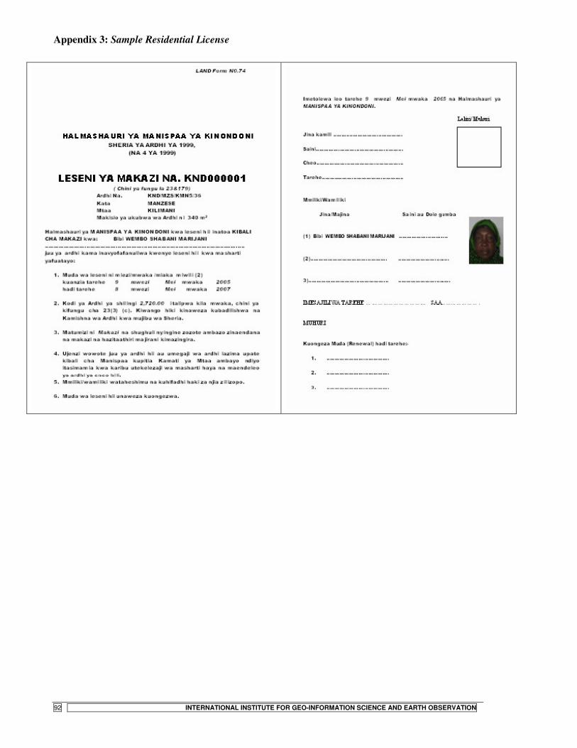
STATE- VS. COMMUNITY-LED LAND TENURE REGULARIZATION IN TANZANIA
92 INTERNATIONAL INSTITUTE FOR GEO-INFORMATION SCIENCE AND EARTH OBSERVATION
Appendix 3: Sample Residential License

STATE- VS. COMMUNITY-LED LAND TENURE REGULARIZATION IN TANZANIA
INTERNATIONAL INSTITUTE FOR GEO-INFORMATION SCIENCE AND EARTH OBSERVATION 93
Appendix 4: A newspaper notice advising landholders to collect Residential Licenses

STATE- VS. COMMUNITY-LED LAND TENURE REGULARIZATION IN TANZANIA
94 INTERNATIONAL INSTITUTE FOR GEO-INFORMATION SCIENCE AND EARTH OBSERVATION
Appendix 5: Sample Letter of Offer of Right of Occupancy
�

STATE- VS. COMMUNITY-LED LAND TENURE REGULARIZATION IN TANZANIA
INTERNATIONAL INSTITUTE FOR GEO-INFORMATION SCIENCE AND EARTH OBSERVATION 95

STATE- VS. COMMUNITY-LED LAND TENURE REGULARIZATION IN TANZANIA
96 INTERNATIONAL INSTITUTE FOR GEO-INFORMATION SCIENCE AND EARTH OBSERVATION
Appendix 6: Sample Certificate of Occupancy

STATE- VS. COMMUNITY-LED LAND TENURE REGULARIZATION IN TANZANIA
INTERNATIONAL INSTITUTE FOR GEO-INFORMATION SCIENCE AND EARTH OBSERVATION 97

STATE- VS. COMMUNITY-LED LAND TENURE REGULARIZATION IN TANZANIA
98 INTERNATIONAL INSTITUTE FOR GEO-INFORMATION SCIENCE AND EARTH OBSERVATION
Appendix 7: Generalised model for informal settlement evolution in Dar es Salaam Phase Name Example Main characteristics
I
Manzese in 1967
• Development in the urban periphery
• Agriculture predominates • Land predominantly a social asset
among natives (customary tenure) • Advent of residential land use due
to influx of land buyers from outside
II
Manzese in 1975
• Booming phase – rampant change from agriculture to residential land use
• Commodification of land (emergence of informal land markets)
• Emergence of a distinctive spatial structure of development
• Development of strong social networks among settlers
III
Manzese in 1987
• Land markets ‘heat up’ • Rampant densification through
infill development & encroachment on ‘public’ space – blurred spatial order
• Dissipation of social co-existence as private livelihood pursuits override collective responsibility
[Source: Adapted from Nguluma, 2003]
Infancy Stage
Consolidation Stage
Saturation Stage
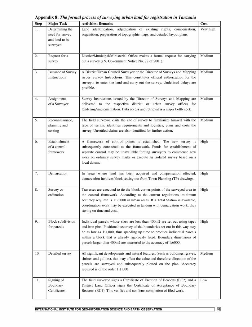
STATE- VS. COMMUNITY-LED LAND TENURE REGULARIZATION IN TANZANIA
INTERNATIONAL INSTITUTE FOR GEO-INFORMATION SCIENCE AND EARTH OBSERVATION 99
Appendix 8: The formal process of surveying urban land for registration in Tanzania Step Major Task Activities; Remarks Cost 1. Determining the
need for survey and land to be surveyed
Land identification, adjudication of existing rights, compensation, acquisition, preparation of topographic maps, and detailed layout plans.
Very high
2. Request for a survey
District/Municipal/Ministerial Office makes a formal request for carrying out a survey (s.9, Government Notice No. 72 of 2001).
Medium
3. Issuance of Survey Instructions
A District/Urban Council Surveyor or the Director of Surveys and Mapping issues Survey Instructions. This constitutes official authorization for the surveyor to enter the land and carry out the survey. Undefined delays are possible.
Medium
4. Assignment of a Surveyor
Survey Instructions issued by the Director of Surveys and Mapping are delivered to the respective district or urban survey offices for tendering/implementation. Data access and retrieval is a major bottleneck.
Medium
5. Reconnaissance, planning and costing
The field surveyor visits the site of survey to familiarize himself with the type of terrain, identifies requirements and logistics, plans and costs the survey. Unsettled claims are also identified for further action.
Medium
6. Establishment of a control framework
A framework of control points is established. The new survey is subsequently connected to the framework. Funds for establishment of separate control may be unavailable forcing surveyors to commence new work on ordinary survey marks or execute an isolated survey based on a local datum.
High
7. Demarcation In areas where land has been acquired and compensation effected, demarcation involves block setting out from Town Planning (TP) drawings.
High
8. Survey co-ordination
Traverses are executed to tie the block corner points of the surveyed area to the control framework. According to the current regulations, minimum accuracy required is 1: 6,000 in urban areas. If a Total Station is available, coordination work may be executed in tandem with demarcation work, thus saving on time and cost.
High
9. Block subdivision for parcels
Individual parcels whose sizes are less than 400m2 are set out using tapes and iron pins. Positional accuracy of the boundaries set out in this way may be as low as 1:1,000, thus speeding up time to produce individual parcels within a block that is already rigorously fixed. Boundary dimensions of parcels larger than 400m2 are measured to the accuracy of 1:6000.
High
10. Detailed survey
All significant developments and natural features, (such as buildings, graves, shrines and gullies), that may affect the value and therefore allocation of the parcels are surveyed and subsequently plotted on the plan. Accuracy required is of the order 1:1,000
Medium
11. Signing of Boundary Certificates
The field surveyor signs a Certificate of Erection of Beacons (BC2) and a District Land Officer signs the Certificate of Acceptance of Boundary Beacons (BC1). This verifies and confirms completion of filed work.
Low

STATE- VS. COMMUNITY-LED LAND TENURE REGULARIZATION IN TANZANIA
100 INTERNATIONAL INSTITUTE FOR GEO-INFORMATION SCIENCE AND EARTH OBSERVATION
12. Data processing and compilation
Survey data abstraction, computation and compilation of the documents in a set file format. Both manual and computer assisted techniques are used.
Medium
13. Drafting of the Cadastral plan
A cadastral plan is prepared for every new survey. The plan depicts for each parcel, its number, spatial location, size, shape and contiguous land. A copy of the plan is made; on it the methods used to fix the various block/parcel boundary corners are depicted. This copy, called a Working Diagram, is a guide for subsequent checking of the survey file.
Medium
14. Preparation of Cadastral Survey Report
The report on a cadastral survey is prepared in a standard form and format, outlining the method of survey used, problems encountered and how they were overcome.
Low
15. Independent checking of plan and job file
A surveyor who was not involved in the execution of the work checks the file (i.e. field notes, computations, and report) and plans to ensure completeness and compliance with both legal and technical requirements. Mistakes/errors discovered in the field data are corrected by a field re-measurement while computational ones are simply corrected on the file or plan.
Medium
16. Submission of Survey to the Director of Surveys and Mapping
The plan and the file containing the original data are submitted to the office of the Director of Surveys and Mapping for further scrutiny and approval.
Low
17. Approval of survey
The office of the Director of Surveys and Mapping causes a thorough quality re-examination of the file and plan. If these are flawless the survey is approved, otherwise the file and plan are returned to the field office of origin for extra fieldwork. Backlog of incoming jobs may be a great cause for delays of approval or rejection of received jobs.
Medium
18. Filing of approved work, or Return of Rejected work.
The approved survey documents are filed as property of Government [section 13(1) and 17(3), Cap 390]. The plan and the other records may henceforth be used for parcel registration and most importantly for the preparation of Certificate of Titles of the individual parcels.
Nil
19. Submission of copy of survey plan to allocation committee
Each district has a Land Allocation Committee, which allocates land to successful applicants. A copy of the approved plan is availed to the Committee.
Low
20. Request for Deed Plans
A deed plan is prepared for every parcel on the plan for purposes of title registration. Delays can be caused by backlog of such plans to be prepared.
Low
[Source: Silayo, 2006]

STATE- VS. COMMUNITY-LED LAND TENURE REGULARIZATION IN TANZANIA
INTERNATIONAL INSTITUTE FOR GEO-INFORMATION SCIENCE AND EARTH OBSERVATION 101