
Staged Overview of Assessment Report
83
Staged Overview of Assessment Report Date: 28/05/21 Status: A1 APPROVED - PUBLISHED
-
Upload
khangminh22 -
Category
Documents
-
view
0 -
download
0
Transcript of Staged Overview of Assessment Report

Staged Overview of Assessment Report
Date: 28/05/21
Status: A1 APPROVED - PUBLISHED

M5 Junction 10 Improvements Scheme Staged Overview of Assessment Report
Security Classification - Low GCCM5J10-ATK-GEN-XX-RP-CX-000002 | C03 |
Page 2 of 83
Notice
This document and its contents have been prepared and are intended solely for the Client’s information and use in relation to M5 Junction 10 Improvements Scheme.
Atkins Limited assumes no responsibility to any other party in respect of or arising out of or in connection with this document and/or its contents.
Document history
Revision Status Purpose description
Originated Checked Reviewed Authorised Date
C03 A1 Issue following HE comments
CCR TT AM HC 28/05/21
C02 A1 Updated for GCC and HE comments
CCR TT AM HC 11/05/21
C01 A1 Draft CG CCR AM HC 19/03/21
Client signoff Client Gloucestershire County Council
Project M5 Junction 10 Improvements Scheme
Job number 5197035
Client signature / date
Accessible alternativesIf you need to access this report in a different format like accessible PDF, large print, easy read,audio recording or braille, please get in touch with our team who will do their best to assist.You can contact us by email on [email protected], leave us a voicemail on 01454667900 or write to us at M5 Junction 10 Team, Atkins, 500 Park Avenue, Bristol, BS32 4RZ.You can also view Gloucestershire County Council’s Accessibility Statement on our website:Accessibility-Gloucestershire County Council.

M5 Junction 10 Improvements Scheme Staged Overview of Assessment Report
Security Classification - Low GCCM5J10-ATK-GEN-XX-RP-CX-000002 | C03 |
Page 3 of 83
Contents
Chapter Page
1 Introduction 9 1.1 Scheme background and need for the scheme 9 1.2 Historical context 10 1.3 Previous M5 Junction 10 studies 11 1.4 West Cheltenham Link Road options 12 1.5 Homes England Bid concept options 12 1.6 Purpose of this report 12 1.7 Structure of this report 13
2 Summary of the Current and Future Conditions 14 2.1 Location of the scheme 14 2.2 Description of the locality 15 2.3 Existing highway network 15 2.4 Current issues at M5 Junction 10 16 2.5 Existing traffic conditions 16 2.6 Future traffic conditions 19 2.7 Existing environment 21 2.8 Environmental opportunities and constraints 22
3 The Need for an Intervention and Scheme Objectives 23 3.1 The need for an intervention 23 3.2 Scheme Objectives 23 3.3 Programme 24
4 Geographic, demographic, planning and policy contexts 25 4.1 Geographical area of impact 25 4.2 Demographics 25 4.3 National and local policy 27
5 Summary of Options 31 5.1 Overview 31 5.2 M5 Junction 10 – Option identification and sifting process 31 5.3 Description of options carried forward for appraisal 33 5.4 A4019 - Option identification and sifting process 36 5.5 West Cheltenham Link Road – Route Assessment 37
6 Summary of design and analysis 40 6.1 Introduction 40 6.2 Summary of road layout and standards 40 6.3 Overview of engineering assessments for the options 41 6.4 Overview of safety assessment of the options 41 6.5 Overview of operational assessment of the options 42 6.6 Overview of structures assessment for the options 43 6.7 Overview of road pavement assessment for the options 45 6.8 Overview of technology assessment for the options 45 6.9 Overview of public utilities assessment for the options 46 6.10 Overview of drainage assessment for the options 46 6.11 Overview of lighting assessment for the options 47 6.12 Overview of maintenance assessment for the options 48 6.13 Overview of traffic analysis for the options 49

M5 Junction 10 Improvements Scheme Staged Overview of Assessment Report
Security Classification - Low GCCM5J10-ATK-GEN-XX-RP-CX-000002 | C03 |
Page 4 of 83
6.14 Overview of economic assessment for the options (TAR section 11) 49 6.15 Overview of environmental impacts for the options 51 6.16 Options taken forward to public consultation 52
7 Summary of stakeholder engagement and public consultation 54 7.1 Introduction 54 7.2 Presented options 54 7.3 Consultation arrangements 54 7.4 Effectiveness of public consultation 56 7.5 Survey response analysis 59 7.6 Stakeholder responses 62 7.7 Conclusion 62
8 Summary of design development since public consultation 63 8.1 Introduction 63 8.2 M5 Junction 10 merge and diverge layouts 63 8.3 Walking, cycling and horse-riding facilities 64 8.4 Amendments to West Cheltenham Link Road 64 8.5 A4019 widening at Uckington 65 8.6 Public transport strategy 67 8.7 Elm Park development accesses 67
9 Conclusions and recommendations 68 9.2 Economic assessment 68 9.3 Environment 69 9.4 Options taken forward to public consultation 69 9.5 Bridge Assessment since the Public Consultation 69 9.6 Recommendations 70
List of references 71
Glossary 72
Appendix A. Option Drawings 75
Appendix B. Plan Showing Design Developments Since Public Consultation 81

M5 Junction 10 Improvements Scheme Staged Overview of Assessment Report
Security Classification - Low GCCM5J10-ATK-GEN-XX-RP-CX-000002 | C03 |
Page 5 of 83
Tables
Table 1-1 – Summary of BCR, VfM and Option Costs for M5 Junction 10 Improvements Scheme ... 7 Table 2-1 – Forecast peak hour traffic flows in 2041 in vehicles ...................................................... 20 Table 3-1 - Key programme dates ..................................................................................................... 24 Table 4-1 - Demographic profile of wards in the Scheme area ......................................................... 26 Table 4-2 - General health of residents in the Scheme area ............................................................ 26 Table 4-3 - Health limited activity in the Scheme area ...................................................................... 27 Table 6-1 - Summary of road layout and standards .......................................................................... 40 Table 6-2 – Structures comparison of the scheme options ............................................................... 44 Table 6-3 - Overview of lighting assessment for Options 1A and 5 .................................................. 47 Table 6-4 - Overview of lighting assessment for Options 2, 2A and 2B ............................................ 48 Table 6-5 – Comparison of benefits for M5 Junction 10 Improvements Scheme options (£millions PV, 2018 prices) ................................................................................................................................ 50 Table 6-6 – Comparison of cost-benefit analysis for M5 Junction 10 Improvements Scheme options (£millions PV, 2018 prices) ................................................................................................................ 51 Table 6-7 - Environmental assessments that do not the support the schemes on-line options ........ 52 Table 7-1 – Summary of options presented at consultation .............................................................. 54 Table 7-2 – Questions asked to help us find out who we engaged with ........................................... 57 Table 8-1 – Proposed M5 Junction 10 merge and diverge layouts ................................................... 63 Table 9-1 – Estimated option costs ................................................................................................... 68 Table 9-2 – Summary comparison of BCR and VfM assessments ................................................... 68
Figures
Figure 1-1 – Location of the M5 Junction 10 Improvements scheme elements and safeguarded land at West and North West Cheltenham ................................................................................................ 10 Figure 1-2 - Scheme history .............................................................................................................. 11 Figure 2-1 – Location of the Scheme ................................................................................................ 14 Figure 2-2 – Location of Collisions (1 of 2)........................................................................................ 17 Figure 2-3 – Location of Collisions (2 of 2)........................................................................................ 18 Figure 5-1- West Cheltenham Link Road Route Corridors ............................................................... 37 Figure 5-2 – Link Road alignment options within Corridor 3 ............................................................. 39 Figure 7-1 – A section of the Home page of the pinpoint consultation website ................................ 56 Figure 7-2 – Overview of stakeholder response during the 6-week consultation period .................. 56 Figure 7-3 – Level of agreement that the proposals will achieve objectives 1-5 .............................. 58 Figure 7-4 – Question 3: Which is your preferred option for M5 Junction 10?.................................. 59 Figure 7-5 – Question 7: To what extent do you agree the proposals are required for the A38/A4019 Junction Improvements at Coombe Hill? ........................................................................................... 60 Figure 7-6 – Question 8: To what extent do you agree or disagree with the following comments on facilities for pedestrians/cyclists/horse riders at the A38/A4019 Coombe Hill junction? ................... 60 Figure 7-7 – Question 11: To what extent do you agree the proposals are required for the A4019?61 Figure 7-8 – Question 12: To what extent do you agree or disagree with the following comments on facilities for pedestrians/cyclists/horse riders on the A4019?............................................................ 61

M5 Junction 10 Improvements Scheme Staged Overview of Assessment Report
Security Classification - Low GCCM5J10-ATK-GEN-XX-RP-CX-000002 | C03 |
Page 6 of 83
Executive Summary
Introduction
Gloucestershire faces significant challenges to achieve its vision for economic growth. A Joint Core Strategy (JCS) – a partnership between Gloucester City Council, Cheltenham Borough Council and Tewkesbury Borough Council was formed to produce a co-ordinated strategic development plan to show how the region will develop during the period up to 2041. This includes a shared spatial vision targeting 35,175 new homes and 39,500 new jobs by 2041.
To unlock the housing and job opportunities, a highways network is needed that has the capacity to accommodate the increased traffic it will generate, within a sustainable transport context. A Bid was submitted in March 2019 to the Housing Infrastructure Fund (HIF), wherein an investment case was made for the following infrastructure improvements, which together make up the M5 Junction 10 Improvements Scheme:
• An all-movements junction at M5 Junction 10;
• A new West Cheltenham Link Road connecting the A4019 and the B4634;
• Widening of the A4019 to the East of the Link Road;
• A38/A4019 junction improvements at Coombe Hill; and
• Extension to Arle Court Park and Interchange.
Akins have been commissioned by Gloucestershire County Council to develop scheme proposals for the following elements of the scheme which are related to the changes to the strategic road network:
• An all-movements junction at M5 Junction 10;
• A new West Cheltenham Link Road connecting the A4019 and the B4634; and
• Widening of the A4019 to the East of the Link Road.
The A38/A4019 junction improvements at Coombe Hill; and extension to Arle Court Park and Interchange are geographically located away from the M5 Junction 10 improvements and are within Gloucestershire County Council’s (GCC) road network. These elements of the scheme have not been assessed as part of the M5 Junction 10 improvements.
The M5 Junction 10 is located approximately 48 miles to the south of Birmingham and 40 miles to the north of Bristol.
Purpose of this report
This report contains a non-technical overview of the existing and future conditions, the assessment of options for the M5 Junction 10 Improvements Scheme, and the results of the non-statutory Public Consultation. It recommends a preferred option to be taken forward into the next stage of scheme development, Preliminary Design.
Scheme objectives
Reflecting key elements of the Bid objectives for this report, the following objectives were further refined and updated for the Public Consultation:
• Provide the transport connections and network capacity in west and north-west Cheltenham to facilitate the delivery of housing and economic development sites allocated or safeguarded in the Joint Core Strategy;
• Provide a transport network in the west and north-west Cheltenham area with the levels of service, safety and accessibility to meet current and future needs;
• Provide greater connectivity between Highway England’s strategic road network, specifically the M5 and the transport network in west and north-west Cheltenham;

M5 Junction 10 Improvements Scheme Staged Overview of Assessment Report
Security Classification - Low GCCM5J10-ATK-GEN-XX-RP-CX-000002 | C03 |
Page 7 of 83
• Provide a more integrated transport network by providing opportunities to switch to more sustainable transport modes within and to west, north-west and central Cheltenham; and
• Deliver a package of measures which is in keeping with the local environment and minimises any adverse environmental impacts.
M5 Junction 10 option identification
Five options for improving the existing M5 Junction 10, including local road improvements to provide access to the JCS dvelopment sites, were developed and assessed in autumn 2020 and informed Public Consultation, These were:
• Option 1A – New Junction North of Existing;
• Option 2 – Upgrade Existing Junction with Gyratory Roundabout;
• Option 2A - Upgrade Existing Junction with Gyratory Roundabout offset to the north;
• Option 2B – Upgrade Existing Junction with Gyratory Roundabout offset to the south; and
• Option 5 - New Junction North of Existing (in alternative position to Option 1A).
Assessment of options
All five options were considered to be capable of delivering the infrastructure improvements required to provide the additional capacity that would unlock the housing and job opportunities included in the Joint Core Strategy.
The estimated total scheme cost for each option alongside the Benefit to Cost Ratio (BCR) and corresponding Value for Money (VfM) category are shown in Table 1-1 below:
Table 1-1 – Summary of BCR, VfM and Option Costs for M5 Junction 10 Improvements Scheme
Option BCR, with benefits from accident
savings applied
VfM Category Total Scheme Cost (£)*
Option 1A 1.72 Medium 305,578,943
Option 2 2.28 High 254,734,725
Option 2A 2.52 High 229,652,417
Option 2B 2.36 High 245,578,691
Option 5 1.83 Medium 294,077,040
* includes £24m for Coombe Hill & Arle Court Transport Hub
The overall conclusions from an assessment of the environmental impacts of the options found that the on-line options (2, 2A and 2B) offer a better solution than Options 1A and 5.
Following the Technical and Environmental assessments of the five options, it was concluded that Options 1A and 5 should not be taken further forward and that Options 2, 2A and 2B should be presented at a public consulation.
Stakeholder engagement and Public Consultation
The Public Consultation ran for six weeks from 14 October to 25 November 2020.
The Public Consultation demonstrated that there is a level of support for all of the M5 Junction 10 Improvements Scheme elements. Of the three options presented during the Public Consultation, the preferred option was shown to be Option 2 (37%), followed by Option 2A (28%). The lowest level of preference was for Option 2B (6%). Responses regarding the preference for Stakeholders followed a similar trend, although the majority (67%) did not state a preference at this stage.

M5 Junction 10 Improvements Scheme Staged Overview of Assessment Report
Security Classification - Low GCCM5J10-ATK-GEN-XX-RP-CX-000002 | C03 |
Page 8 of 83
Design development since Public Consultation
Further assessment and design development work has been carried out since the Public Consultation was held. This has taken into account feedback received during the Public Consultation and the results of ongoing survey and assessment work. This included:
• Amendments to the proposed M5 Junction 10 merge and diverge layouts;
• Improved walking, cycling and horse-riding facilities;
• Amendments to the alignment and cross section of the proposed West Cheltenham Link Road;
• Amendments to the proposed A4019 widening alignment at Uckington;
• Amendments to the provision and locations of bus stops on the A4019; and
• Inclusion of the access to the Elm Park Development from the A4019 at the eastern end of the proposed A4019 proposals.
• Structural Assessment of the existing A4019 Piffs Elm bridge over the M5
Conclusions and recommendations
Given that the Engineering, Economic and Environmental assessments of the options, 2, 2A and 2B were all very similar, and the findings of the recent structural assessment of the existing Piffs Elm bridge, it is recommended that the preferred option from the Public Consultation, Option 2 – a junction centralised on the existing A4019 with two new bridges over the motorway, with the modifications resulting from the further design development, should be taken forward as the Preferred Route. This recommended option would also include the common elements of the three options, these being the widening of the A4019, the proposed West Cheltenham link Roads, and their associated junctions.

M5 Junction 10 Improvements Scheme Staged Overview of Assessment Report
Security Classification - Low GCCM5J10-ATK-GEN-XX-RP-CX-000002 | C03 |
Page 9 of 83
1 Introduction
1.1 Scheme background and need for the scheme
1.1.1 Gloucestershire faces significant challenges to achieve its vision for economic growth. A Joint Core Strategy (JCS) – a partnership between Gloucester City Council, Cheltenham Borough Council and Tewkesbury Borough Council was formed to produce a co-ordinated strategic development plan to show how the region will develop during the period up to 2041. This includes a shared spatial vision targeting 35,175 new homes and 39,500 new jobs by 2041.
1.1.2 New housing and employment sites are proposed for development to the west of Cheltenham. To unlock these housing and job opportunities, Gloucestershire County Council (GCC) needs to ensure that there is sufficient highway capacity to accommodate the increased motorised traffic and non-motorised users it will generate.
1.1.3 An all movements junction has been identified as a key infrastructure requirement to enable the housing and economic development proposed by the Gloucestershire Local Enterprise Partnership's (GFirst LEP) Strategic Economic Plan and is central to the transport network sought by the council in the adopted Gloucestershire Local Transport Plan. The planned housing and economic growth have been included by Cheltenham Borough, Tewkesbury Borough and Gloucester City Councils in the adopted Joint Core Strategy (JCS).
1.1.4 Highways England also identified that improvements to M5 Junction 10 are a critical requirement to maintain the safe and efficient operation of the M5 corridor in their Birmingham to Exeter Route Strategy, whilst enabling the planned development and economic growth around Cheltenham, Gloucester and Tewkesbury.
1.1.5 A Bid was submitted in March 2019 to Homes England to the Housing Infrastructure Fund (HIF), wherein an investment case was made for the following infrastructure improvements, which together make up the M5 Junction 10 Improvements Scheme:
• Scheme element 1: Improvements to Junction 10 on the M5 and a new road linking Junction 10 to west Cheltenham;
• Scheme element 2: A38/A4019 Junction Improvements at Coombe Hill; and
• Scheme element 3: A4019 widening, east of Junction 10.
1.1.6 Figure 1-1 below displays the location of each of the scheme elements, as well as the locations of relevant planned development sites under the JCS.

M5 Junction 10 Improvements Scheme Staged Overview of Assessment Report
Security Classification - Low GCCM5J10-ATK-GEN-XX-RP-CX-000002 | C03 |
Page 10 of 83
Figure 1-1 – Location of the M5 Junction 10 Improvements scheme elements and safeguarded land at West and North West Cheltenham
1.1.7 Funding was successfully awarded by Homes England in March 2020.
1.1.8 An upgrade to Arle Court Park and Ride (now known as Arle Court Transport Hub) was also included as part of the package of improvements funded by Homes England. Gloucestershire County Council has decided to take this forward separately in order to accelerate the programme for this element of the scheme.
1.2 Historical context
1.2.1 Proposals for the improvement of the M5 junction 10, the A4019 and a new West Cheltenham Link Road have been the subject of since 2012. A number of these reports have informed the process of option generation for the M5 Junction 10. An Options Assessment Report was produced which draws upon and summarises the body of existing work and reviews options proposed to provide an upgrade of Junction 10 on the M5. A Technical Appraisal Report was then produced into the options carried forward.

M5 Junction 10 Improvements Scheme Staged Overview of Assessment Report
Security Classification - Low GCCM5J10-ATK-GEN-XX-RP-CX-000002 | C03 |
Page 11 of 83
1.2.2 The main recent events relating to the scheme are listed in Figure 1-2 below and described in this section.
Figure 1-2 - Scheme history
1.3 Previous M5 Junction 10 studies
1.3.1 Previous study work was undertaken by Highways England in July 2012 and February 2018.
1.3.2 Between 2015 and the adoption of the JCS in 2017, a range of infrastructure options were considered in relation to the required housing numbers and whether these met the high-level social, economic and political goals expected of the JCS. These were tested using a traffic model to determine their efficacy:
• Do minimum - delivering only the committed network improvements to 2031. This option failed to support the required JCS housing growth;
• DS1 (Do Something 1) - a low-cost transport solution, primarily schemes fully within existing highway boundaries. This scenario also failed to support the required housing delivery;
• DS2 to DS6a which introduced increasing levels of investment alongside demand management interventions. DS6 introduced the ‘all movements’ Junction 10 which was shown to meet the needs of the JCS site allocations in W and NW Cheltenham (ie those which are the subject of the Homes England Bid) but not to the wider demands; and
• DS7, incorporating J10 Improvements, plus additional schemes not within the scope of this Bid. This was the scenario accepted by the Inspector at the Examination in Public.
1.3.3 The final option (DS7) enabled delivery of 5,212 homes up to 2031 on the West and North-West Cheltenham Strategic Allocation sites. Note that did not incorporate the housing and employment on the additional ‘safeguarded’ land which was identified in the JCS but not formally allocated for development. In addition, DS7 was tested only to 2031 and no assessment of housing or employment delivery beyond 2031 was included.
1.3.4 JMP Consultants Ltd produced a report in July 2012 titled “M5 Junction 10 – Feasibility Study of conversion to an all movements junction”. This considered four options for converting the existing junction into an all movements junction. All options proposed to keep the existing northbound entry slip loop and avoid any impact on the commercial properties in the north west quadrant. They also sought to minimise the impacts on the residential
2012• Highways England / JMP - M5 Junction 10 – Feasibility Study of conversion to an all movements junction (2012).
2018• Highways England / AECOM - Option Assessment Report – M5 Junction 10 and access to the Cyber Park Access Road (2018 - Draft, incomplete)
2018• GCC / Amey Consulting - Six outline options for a proposed West Cheltenham Link Road and improved or new M5 Junction (2018)
2019• GCC / Amey Consulting - Three concept options developed and included in Homes England Business Case for funding (2019).
2020
• GCC / Atkins - Options Appraisal Report (2020) and Technical Appraisal Report (2020) into options for providing:
• An all-movements junction at M5 Junction 10
• A new West Cheltenham Link Road from J10
▪ Widening of the A4019 to the East of the Link Road
Non-Statutory Public Consultation into options carried forward from Technical Appraisal Report

M5 Junction 10 Improvements Scheme Staged Overview of Assessment Report
Security Classification - Low GCCM5J10-ATK-GEN-XX-RP-CX-000002 | C03 |
Page 12 of 83
properties on Withybridge Gardens. Because of this, all four options included at least one signalised slip road junction with the A4019.
1.3.5 An incomplete draft report produced by AECOM in February 2018 titled “Option Assessment Report – M5 Junction 10 and access to the Cyber Park Access Road” identifies several options including improvements to the M5 Junction 10 and various modelling scenarios.
1.4 West Cheltenham Link Road options
1.4.1 Six outline options for a proposed West Cheltenham Link Road and improved or new M5 Junction 10 were developed by Amey Consulting in July 2018. These included various options of all movements junctions at M5 Junction 10, to the south, to the north and at its existing location. A comparison of the options led to the development of three Concept Options included in the Homes England Bid.
1.5 Homes England Bid concept options
1.5.1 Amey Consulting developed the three Concept Options which were included and assessed in the Homes England Bid for funding in March 2019. These were:
• Concept Option 1 – M5 Junction 10 moved north of its existing location;
• Concept Option 2 – Upgrade the existing M5 Junction 10; and
• Concept Option 3 – M5 Junction 10 moved south of its existing location.
1.6 Purpose of this report
1.6.1 This Staged Overview of Assessment Report (SOAR) gives an overview of the development of the M5 Junction 10 Improvements Scheme (the Scheme). It summarises the underlying technical work behind the development of the shortlisted options included in the:
• Options Assessment Report1
• Technical Appraisal Report (TAR)2,
• Technical Appraisal Report: A4019 and Coombe Hill Junction (TAR A4019) 3,
• West Cheltenham Link Road Route Assessment Report4, and
• the comments and views expressed during the public consultation exercise.
1.6.2 It provides the basis for recommending the preferred option for:
• Providing an all-movements junction at M5 Junction 10 (scheme element 1);
• Providing a new West Cheltenham Link Road connecting the A4019 and the B4634 (scheme element 1); and
• Widening of the A4019 to the East of the Link Road (scheme element 3).
1.6.3 The Preferred Option will be the scheme that Gloucestershire County Council considers should be taken forward to an application for statutory powers to construct.
1.6.4 GCC will now be progressing scheme element 2 (A38/A4019 Junction Improvements at Coombe Hill) as a separate scheme in order to accelerate its delivery programme, and as such it is not included within the main assessments of this SOAR. It was however included as a scheme element for the public consultation held in late 2020 and is therefore referenced in section 7 of this report.
1 M5 Junction 10 Improvements Scheme, Options Assessment Report (OAR), November 2020 2 M5 Junction 10 Improvements Scheme, Technical Appraisal Report (TAR), September 2020 3 M5 Junction 10 Improvements Scheme, Technical Appraisal Report A4019 and Coombe Hill Junction, September 2020 4 M5 Junction 10 Improvements Scheme, West Cheltenham Link Road Route Assessment Report

M5 Junction 10 Improvements Scheme Staged Overview of Assessment Report
Security Classification - Low GCCM5J10-ATK-GEN-XX-RP-CX-000002 | C03 |
Page 13 of 83
1.7 Structure of this report
1.7.1 The report is structured into the following chapters:
• Chapter 2 provides a summary of the current and future conditions in the study area;
• Chapter 3 presents the scheme objectives;
• Chapter 4 provides the geographic, demographic, planning and policy contexts;
• Chapter 5 provides a summary of the options generated and sifted;
• Chapter 6 provides a summary of the design and analysis for the shortlisted options;
• Chapter 7 provides a summary of stakeholder engagement and public consultation;
• Chapter 8 provides a summary of design developments since public consultation; and
• Chapter 9 provides conclusions and recommendations on the comparative performance of the options.

M5 Junction 10 Improvements Scheme Staged Overview of Assessment Report
Security Classification - Low GCCM5J10-ATK-GEN-XX-RP-CX-000002 | C03 |
Page 14 of 83
2 Summary of the Current and Future Conditions
2.1 Location of the scheme
2.1.1 M5 Junction 10 is located 48 miles to the south of Birmingham, 40 miles to the north of Bristol, 5 miles to the south of Tewkesbury, 4 miles to the north-west of Cheltenham, and 8 miles to the north-east of Gloucester. It is the northernmost of four junctions serving the Gloucester and Cheltenham urban areas.
2.1.2 The junction is in a strategically important location for the region, particularly as northern and western Cheltenham are the sites of a number of large retail parks and employment areas, and the location of planned future housing and nationally significant business development.
2.1.3 The location of M5 Junction 10 is shown in Figure 2-1 below:
Figure 2-1 – Location of the Scheme
The locations of the proposed infrastructure improvements that make up the M5 Junction 10
Improvements Scheme (and collectively make up the Scheme area), the Joint Core Strategy
allocation areas and the two safeguarded sites to the north-west and west of Cheltenham are
illustrated in Figure 1-1

M5 Junction 10 Improvements Scheme Staged Overview of Assessment Report
Security Classification - Low GCCM5J10-ATK-GEN-XX-RP-CX-000002 | C03 |
Page 15 of 83
2.2 Description of the locality
2.2.1 The Scheme lies within Severn and Avon Vales National Character Area5. The character is broadly defined as low lying agricultural vale landscape. It comprises of soft, gently undulating to flat landscape, but with intermittent locally elevated areas that project above the otherwise flatter landform. It has limited woodland cover with mature hedgerow trees.
2.2.2 The M5 passes through the vale, aligned north to south, beyond which is a network of local roads and lanes linking villages and hamlets. The most notable urban area is the city of Cheltenham located south-east of M5 Junction 10 and accessed from the M5 via the A4019. Most of the area covered by the Scheme lies within land designated as Green Belt and consists mainly of agricultural and pastureland. The A4019 becomes gradually more urban as it approaches the edge of Cheltenham.
2.3 Existing highway network
2.3.1 The M5 Junction 10 was originally opened in March 1971 as part of the section of motorway between Tewkesbury and south Gloucester (Junctions 9-12).
2.3.2 It provides free-flow links from the southbound M5 to the A4019 towards Cheltenham and for traffic heading west from Cheltenham to join the northbound M5. The A4019 passes over the M5 on a dual carriageway overbridge.
2.3.3 The A4019 links Cheltenham with the A38 at Coombe Hill, crossing the M5 via an overbridge.
2.3.4 The A4019 connects with the A38 at Coombe Hill, west of the M5. With a 50mph speed limit throughout, the A4019 starts as a single carriageway. Approximately 600m either side of the M5 overbridge the A4019 is a two-lane dual carriageway, before reverting into a single carriageway up to the signalised junction with the B4634. From this junction the A4019 continues as a two-lane dual carriageway up to the roundabout junction with Princess Elizabeth Way, Kingsditch Lane and Tewksbury Road. Along the length of the A4019 from M5 Junction 10 to the signalised junction with the B4634 there are several crossings providing access to both the north and south.
2.3.5 Sections of the old A4019 prior to construction of the M5 have been retained, with the section to the east of the M5 forming Withybridge Gardens. The section to the west provides access to agricultural and other businesses and residences.
2.3.6 A pedestrian footway follows the northbound carriageway along much of the A4019. At the western end of the M5 overbridge the footway ends and becomes a grass verge. It is evident from observations that the verge is used by pedestrians up to the junction of the M5 southern slip road, pedestrians then continuing along the footway towards Cheltenham.
2.3.7 The properties in close proximity of the A4019 are accessed via side/access roads, however within the dual carriageway section at M5 Junction 10 there are two properties and a farm track which are accessed directly from the A4019 via the pedestrian footway.
2.3.8 To the south east of M5 Junction 10 is the turning for Withybridge Lane. Withybridge Lane is a 50mph single carriageway with property and field accesses located to both sides of carriageway throughout. To the north and within close proximity to its junction with the A4019 is the junction of Withybridge Gardens.
2.3.9 Withybridge Gardens runs parallel with the A4019 between Withybridge Lane and the M5. Fourteen residential properties are located to the south of Withybridge Gardens. There is a pedestrian footway in front of the houses with a pedestrian access ramp leading to the overbridge of the M5. To the north of the carriageway is a small retaining wall which supports the embankment for the A4019. On the opposite side of the A4019, there are two more
5 Natural England, National Character Areas. Available at: http://publications.naturalengland.org.uk/publication/1831421?map=true&category=587130 [Accessed: 02/09/19].

M5 Junction 10 Improvements Scheme Staged Overview of Assessment Report
Security Classification - Low GCCM5J10-ATK-GEN-XX-RP-CX-000002 | C03 |
Page 16 of 83
residential properties located near the merging point of the M5 southbound to A4019 slip road.
2.3.10 To the north west of the M5 Junction 10 are three residential properties and the Sheldon Nurseries business. Bank Farm buildings and yard are adjacent to the M5 northbound boundary approximately 0.9 km north of the existing A4019.
2.4 Current issues at M5 Junction 10
2.4.1 The key issues at the existing M5 Junction 10 are:
• M5 Junction 10 is of restricted format and only provides slip roads from the north and to the north, with no southern access slip roads provided. This means that traffic from Cheltenham must access the southbound M5 via either Junctions 9 or 11. This puts increased pressure on already congested local roads and particularly on Junction 11, which provides access to and from southern Cheltenham on the A40;
• M5 Junction 10 restricts emergency service operations on and off the M5 due to the junction not having any southern access slip roads;
• The current M5 Junction 10 layout would not be able to fully support the proposed level of housing and industrial development as outlined in the JCS; and
• The existing Piffs Elm Interchange bridge over the motorway requires remedial works and the headroom over the M5 is the minimum allowed before it is considered a low bridge.
2.5 Existing traffic conditions
2.5.1 This section summarises the existing traffic conditions around M5 junction 10 by using existing data sources and previously commissioned, collected, and analysed data for the development of the 2013 Central Severn Vale (CSV) traffic model, which was the best model available at the time of carrying out this analysis to inform Stage 2 TAR. Gloucestershire traffic model GCTM, which will be used for future stages of the scheme development.
2.5.2 The peak hours, which are the hours during which traffic volumes are greatest, were determined during the development of the CSV model using existing traffic count data. Peak hours were found to be 08:00 – 09:00 in the morning and 17:00 – 18:00 in the evening peak. Inter-peak refers to the hours between 10:00-16:00 and inter-peak flows are an average hour of this inter-peak period.
2.5.3 Traffic count data from 2019 shows that peak hour average flows on the M5 mainline north of Junction 10 (between Junction 10 and Junction 9) are in the range of 2,900 to 4,000 vehicles, with the northbound direction in the AM peak featuring the lowest flows and in the PM peak featuring the highest. Further details are provided in the TAR.
2.5.4 For the M5 mainline south of Junction 10 (between Junction 10 and Junction 11), peak hour average flows are in the range of 2,500 to 3,400 vehicles, with the northbound direction in the AM peak featuring the lowest flows and in the PM peak featuring the highest flows.
2.5.5 In terms of the change in traffic volumes in recent years, specifically between 2013 (from the CSV base year model) and 2019, AM peak volumes have decreased by 10 - 11% northbound and 4-6% in the southbound direction. The PM peaks remain relatively consistent between years with only a slight increase in the volume of traffic. The inter-peak volumes follow a different trend, with volumes consistently increasing up to 25%.
2.5.6 The current traffic volume along the M5 mainline is less than 60% of capacity along both sections, in both directions and in all three time periods. Thus, it can be concluded that the M5 mainline in 2019 is operating within the capacity.
2.5.7 A4019 traffic count data from 2013 shows peak hour directional flows to the East of M5 Junction 10 range between 700 to 1,200 vehicles. Flows to the West of M5 Junction 10 are much lower. The maximum volume is approaching the point at which delays may be

M5 Junction 10 Improvements Scheme Staged Overview of Assessment Report
Security Classification - Low GCCM5J10-ATK-GEN-XX-RP-CX-000002 | C03 |
Page 17 of 83
experienced; however, it is unlikely that on an average day this volume would cause significant congestion.
2.5.8 The traffic flow analysis suggests that there is a tidal flow of commuter traffic accessing Cheltenham via the A4019 and M5 Junction 10 in the morning and leaving via the same route in the evening peak.
Queueing
2.5.9 Queue data for November 2017 was available from an earlier study6 carried out by Highways England. The maximum queue length observed at M5 Junction 10 southbound off-slip was only 39 meters which is much shorter than the length of the slip road itself. Thus, any queue on the slip road doesn’t extend to the motorway and is not a safety concern at present. The data also shows queues further to the east of the off-slip along the A4019 approach to the Tewkesbury Road/Princess Elizabeth Way Roundabout. This indicates that, at this junction, the A4019 experiences significant congestion in both eastbound and westbound direction approaching the junction.
Collisions
2.5.10 The collision data for the five-year period from 1 July 2014 to 30 June 2019 was obtained from Gloucestershire County Council, covering the area around M5 Junction 10 and the A4019. During this period 55 personal injury collisions (PICs) were recorded. Of these 26% (14 of 55) resulted in serious injury whilst the remaining 74.5% (41 of 55) were slight injury collisions. No fatalities were recorded in the five-year period.
2.5.11 The locations of these collisions are shown on Figure 2-2 and Figure 2-3 below
Figure 2-2 – Location of Collisions (1 of 2)
6 M5 J10 – J11 Paramics Model Validation Report, 2018

M5 Junction 10 Improvements Scheme Staged Overview of Assessment Report
Security Classification - Low GCCM5J10-ATK-GEN-XX-RP-CX-000002 | C03 |
Page 18 of 83
Figure 2-3 – Location of Collisions (2 of 2)
2.5.12 The highest hourly number of collisions on the M5 occurred between 17:00 and 18:00 whilst collision rates peaked along the A4019 between 08:00 and 09:00. These results indicate that collisions on the motorway are more likely to occur in the evening peak and collisions are most likely to occur on the A4019 in the morning peak.
2.5.13 The majority of the collisions recorded within the study area involved motorised vehicles. 9.1% (5 of 55) of all collisions involved powered two-wheelers, 7.3% (4) involved pedestrians and 3.6% (2) involved pedal cyclists. In total, less than 11% of the collisions (6) involved vulnerable road users (pedestrians and cyclists). Unsurprisingly all of the collisions involving pedestrians and cyclists were on the A4019 and made up 18% (6 of 34) of the total number of A4019 collisions.
2.5.14 40.0% (22 of 55) of collisions occurred at junctions (uncontrolled or signal controlled). Just one of these junction collisions was assigned to the M5 whilst the remaining were assigned to the A4019. 72.7% of collisions (16 of 22) which occurred at junctions took place at uncontrolled junction layouts whilst just 27.2% (6 of 22) of junction collisions occurred at signal-controlled layouts. These statistics show that in terms of collision numbers (not rate), there are more collisions at the uncontrolled junctions along the A4019, than at signal-controlled junctions.
2.5.15 Along the M5 on the approach to the southbound off-slip, eight collisions were recorded, two of which resulted in serious injury. Collisions at this location account for 38.1% (8 of 21) of all the motorway collisions in the study area. 50% (4 of 8) of these collisions were nose-to-tail shunts suggesting there may be queuing or slow-moving traffic along the motorway through the junction. 37.5% (3 of 8) of the collisions involved vehicles swerving, drifting or changing lanes into the path of another vehicle.
2.5.16 Two collision hotspots7 were identified, accounting for 41.2% (14 of 34) of all collisions along the A4019. These were at the junction of the A4019 with Stoke Road at the Gloucester Old Spot public house, and at the junction of the A4019 with Withybridge Lane. Eight collisions were recorded at the first location, all of which resulted in slight injury, while six collisions were recorded at the second location and of these 50% (3 of 6) resulted in serious injury. Two of the collisions involved pedestrians (who were crossing the A4019) and one involved a cyclist (who collided with a vehicle exiting the M5 southbound off-slip) possibly indicating
7 Locations where an average of one or more collisions have been recorded per year

M5 Junction 10 Improvements Scheme Staged Overview of Assessment Report
Security Classification - Low GCCM5J10-ATK-GEN-XX-RP-CX-000002 | C03 |
Page 19 of 83
a need for improved facilities for vulnerable road users. The road layout between the M5 offslip and Withybridge Lane is somewhat complicated with three gaps in the central reserve in close proximity to one another to facilitate right turn movements at Withybridge Lane, a field access, access to properties along the north side of the A4019 and a travellers site at the southbound M5 offslip merges with the A4019.
Journey time reliability
2.5.17 Highways England’s journey time database (HE JTDB) was used to calculate average and median journey times between M5 Junction 9–10 and Junction 10–11 for neutral weekdays in 2019.
2.5.18 When considering southbound in the AM peak Junction 9–10 shows a significantly larger 95th percentile journey time than the 75th and median, indicating that this section experiences significant delays and is less resilient than the others. Closer inspection of the dataset showed that the exceptionally high 95th percentile journey times were due to one specific day where it is likely an incident occurred. Thus, there was no conclusive evidence to suggest whether this section of the M5 has a problem with incident related reliability.
2.5.19 Overall, it was observed that the day to day reliability along the M5 mainline is good, as the time difference between the 25th and 75th percentile journey times for Junction 9-10 and Junction 10-11 sections does not exceed 7%. This indicates that the journey times along these sections are predictable for road users.
2.6 Future traffic conditions
Forecast traffic models
2.6.1 Traffic forecasts for the years 2021, 2036 and 2041 were developed for the M5 Junction 10 Improvements Scheme using an available traffic model8, which also supported the HIF Bid. These traffic forecasts informed the design as well as assessment of environmental and economic impacts of the various scheme options.
2.6.2 Traffic modelling of the scheme options as described in section 5.3 was undertaken. Only one variation of option 2 was modelled, as the differences between options 2, 2A and 2B in terms of traffic operations were considered insignificant.
2.6.3 Two sets of the future trip demand scenarios were produced for testing the scheme. Full details of the forecasting approach and scenarios is provided in the TAR.
2.6.4 The future developments, their size, land use details and likelihood are available included in the HIF Traffic Forecasting Report9.
Traffic forecast results
2.6.5 There is substantial growth in traffic levels in the modelled area by 2041. For each of the three modelled time periods i.e., morning, noon and evening, the traffic is expected to grow between 5% to 7% by 2021, 18% to 20% by 2036 and 22% to 24% by 2041.
2.6.6 The traffic demand above is based on the housing and development delivery trajectory provided by GCC.
2.6.7 The new developments in the local area in the future years leads to the additional traffic both along the M5 corridor and the Gloucester and Cheltenham urban areas connecting slip roads.
2.6.8 Table 2-1 presents a comparison summary of the peak hour traffic flow at M5 Junction 10 and A4019 for various options, in future year 2041. No scheme option excludes the HIF unlocked housing as well as any associated improvements to the local roads and junctions.
8 Central Severn Vale (CSV) traffic model having a base year of 2013 owned by GCC. 9 Traffic Forecasting Report, M5 Junction 10 Improvements – HIF OBC, dated 04/03/2019

M5 Junction 10 Improvements Scheme Staged Overview of Assessment Report
Security Classification - Low GCCM5J10-ATK-GEN-XX-RP-CX-000002 | C03 |
Page 20 of 83
Table 2-1 – Forecast peak hour traffic flows in 2041 in vehicles
AM (Options) PM (Options)
No
Scheme 1 2 5
No Scheme
1 2 5
M5 Junction 10 SB offslip
657 777 924 768 510 598 638 579
M5 Junction 10 NB onslip
399 397 567 403 658 886 886 866
M5 Junction 10 NB offslip
NA 456 1,006 502 NA 397 734 372
M5 Junction 10 SB onslip
NA 450 834 436 NA 739 1,048 726
A4019 Coombe Hill EB
638 864 717 885 483 604 580 640
A4019 Coombe Hill WB
421 466 437 497 722 875 727 893
A4019 east of M5 Junction 10 (new link road) EB
911 1,905 1,602 1,797 791 1,426 1,196 1,284
A4019 east of M5 Junction 10 (new link road) WB
593 1,041 1,093 1,011 1,121 1,883 1,682 1,865
2.6.9 From Table 2-1, it is clear that option 2 draws the most traffic onto the motorway slip roads when compared to the other options. This is because it provides a more direct route connection A4019 on both the sides.
2.6.10 On the A4019 near Coombe Hill, all the options cater for similar traffic flows which are marginally higher than the ‘no scheme’ scenario due to unlocked developments.
2.6.11 Westbound traffic on A4019 further east of new link road is substantially higher in all the options though overall flows for Option 2 are slightly lower.
2.6.12 All three options show a significant increase in flow along the M5 between Junction 10 and Junction 11 in both directions and in both peaks, implying that this section will be key to facilitating trips generated by the new housing developments. This is also reflected in usage of the new south facing slip roads in all the options.
2.6.13 Generally, as would be expected given the additional demand present from the unlocked developments in all the scheme options there is additional traffic both along the M5 corridor and the Gloucester/Cheltenham urban areas.
2.6.14 All three options show a significant increase in flow along the M5 between Junction 10 and Junction 11 in both directions and in both peaks, implying that this section will be key to facilitating trips generated by the new housing developments which form the JCS allocations.
2.6.15 From consideration of traffic patterns, volumes, differences in flows along the key links and the global network statistics, it can be concluded that the network performance would not differ significantly between the scheme options. All the schemes options perform better than ‘no scheme’ option although, M5 Junction 10 would attract more traffic, with the provision of the south facing slip roads. Flows between M5 Junction 9 and M5 Junction 10 are similar with or without the scheme, which is expected as connecting slips to M5 Junction 10 are available in no option scenario as well.

M5 Junction 10 Improvements Scheme Staged Overview of Assessment Report
Security Classification - Low GCCM5J10-ATK-GEN-XX-RP-CX-000002 | C03 |
Page 21 of 83
2.7 Existing environment
2.7.1 This section provides a summary of the existing environment(s) within the Scheme area, and the notable environments surrounding it (such as sites designated for ecological or landscape value). Further information on the existing environment is available in the Preliminary Environmental Assessment of Options Report (PEAOR)10, which was also produced at Stage 2.
2.7.2 The Scheme area is predominantly rural, with the land-use being a combination of arable and areas of grazing pasture (of excellent to moderate agricultural value). Traditional orchards are widespread, and the area also contains important areas of lowland meadow and floodplain grazing marsh. The Cotswolds Area of Outstanding Natural Beauty (AONB) is located 6 km to the east of M5 Junction 10.
2.7.3 Multiple watercourses cross the Scheme area, (notably the River Chelt, Leigh Brook, and River Swilgate) running from east-west as eventual tributaries to the River Severn, at least 7.5 km downstream of the Scheme. The Severn Estuary is a further 33 km downstream. The Severn Estuary is designated as a Special Area of Conservation (SAC), Special Protection Area (SPA), Ramsar and Site of Special Scientific Interest (SSSI), reflecting its international biodiversity value and protecting it as an estuarine habitat supporting a wide range of important habitats and birds.
2.7.4 The area to the north of the A4019 and east of the M5 is affected by surface water and river flooding. Land just south of the A4019 and extending either side of the existing M5 Junction 10 is essentially floodplain for the River Chelt and falls within Flood Zones 2 and 3, where medium and high probability of flooding is recognised. To the immediate north of the A4019 is the floodplain of the Leigh Brook, an ordinary watercourse. This is not included in Flood Zone 3 but is known to flood. There is also land in Flood Zone 3 near Stoke Orchard, to the north-east of M5 Junction 10, associated with the River Swilgate and its tributary Dean Brook.
2.7.5 There are two groundwater bodies (designated under the Water Framework Directive) within the study area.
2.7.6 The dominant arable and grassland habitats are interspersed with pockets of other terrestrial habitats, notably broadleaved and mixed plantation woodland, traditional orchards, and unimproved and semi-improved neutral grassland. Along with the watercourses, these areas provide the sites of greater nature conservation value within the Scheme area. There are two SPAs within the National Character Area (Severn Estuary SPA and Walmore Common SPA), designated for their internationally important populations of wintering wildfowl, including Bewick’s swan and shelduck.
2.7.7 Bredon Hill, to the east of the M5 Junction 10 Improvements Scheme is designated as a SAC for its internationally important population of violet click beetle; and the Wye Valley and Forest of Dean SAC is designated for bats. Coombe Hill SSSI (a disused canal designated for its groups of nationally rare and scarce invertebrates and nationally scarce plants, is located 1.9 km west of the A38 (to the west of M5 Junction 10). At least five species of bat have been recorded within the Scheme area11. Preliminary studies have identified bat roosting sites in buildings and trees within the Scheme area.
2.7.8 There is one area of known historic landfill within the Scheme area, at Colmans Farm, located to the north of the M5 Junction 10 adjacent to the motorway.
2.7.9 There are 31 designated heritage assets within the Scheme area and a further 65 non-designated heritage assets. The most notable of these are the Moat House moated site on the A4019 which is a Scheduled Monument (SM), and the Grade 1 listed Chapel of St James the Great in Stoke Orchard. Previous investigations have identified the likelihood of buried archaeology across the M5 Junction 10 Improvements Scheme area.
10 M5 Junction 10 Improvements Scheme, Preliminary Environmental Assessment of Options Report (PEAOR), December 2019 11 GCER (Gloucestershire County Environmental Records).

M5 Junction 10 Improvements Scheme Staged Overview of Assessment Report
Security Classification - Low GCCM5J10-ATK-GEN-XX-RP-CX-000002 | C03 |
Page 22 of 83
2.7.10 The greatest concentrations of private dwellings and community facilities relative to the Scheme options are found in the main settlements of Gloucester and Cheltenham and there are no large settlements in the study area. The smaller villages of Staverton and Boddington to the west, Hayden to the east and Staverton Bridge to the south are the largest settlements within the study area, with the Hamlet of Uckington spread either side of the A4019 in a key location for the scheme. There are several isolated properties and farmsteads in the rural areas between these settlements. Notably, there is a cluster of 14 properties at Withybridge Gardens, adjacent to the existing M5 Junction 10.
2.7.11 Whilst there are some public rights of way (PRoW) within and through the Scheme area, the M5 and A4019 currently act as barriers, limiting or funnelling movement for walkers, cyclists and horse riders (WCH). Access across these transport corridors is therefore interrupted and the position of existing crossing infrastructure, which includes footbridges and subways, is likely to have shaped the preferred routes of WCH for recreation and commuting within the study area. There is little public green space due to the prominence of agricultural activity in the rural parts of the study area and much of the land is designated as Green Belt.
2.7.12 The climate of the Scheme area is typified by relatively mild winters and warm summers with higher than UK average mean and maximum monthly temperatures. The long-term average monthly rainfall is lower than the UK average (based on 1981 – 2010 data), as are the average number of days in which heavy rainfall was experienced. In the future it is projected that, on average, the Scheme area is likely to experience hotter, drier summers and warmer, wetter winters. Alongside these changes in the average conditions, it is likely that climate change will increase the frequency and severity of extreme weather events such as heavy rainfall, storms and heatwaves.
2.8 Environmental opportunities and constraints
2.8.1 The Scheme area includes a variety of different land uses, and whilst predominantly rural there are clusters of residential properties throughout. Many of these are located within existing Noise Important Areas (NIAs) which have been designated due to traffic on the A4019.
2.8.2 There are two air quality management areas (AQMAs) in proximity to the Scheme (Tewkesbury Town Centre, and Cheltenham Borough). Opportunities to change traffic flows through west Cheltenham as a result of the Scheme and thereby alter the air quality impacts, and also the noise and vibration impacts associated with traffic.
2.8.3 There is confirmed evidence and records for the presence of protected and notable species within the Scheme area, including bats, badgers, otter, great crested newts, terrestrial invertebrates and 31 species of birds. Opportunities available therefore to enhance the value of land within the Scheme area for biodiversity.
2.8.4 The low lying nature of the Scheme area and the presence of multiple watercourses means that much of the area is floodplain and subject to numerous flood risk issues. All Scheme route options are likely to have an element of exacerbated flood risk and will require appropriate mitigation in the design.
2.8.5 There are known above ground structures of historic importance within the Scheme area, and the potential for buried archaeology. Opportunities are available as a result of the Scheme to improve current understanding of the buried archaeology within the Scheme area as a consequence of the further investigation work that will be conducted in advance of construction works.

M5 Junction 10 Improvements Scheme Staged Overview of Assessment Report
Security Classification - Low GCCM5J10-ATK-GEN-XX-RP-CX-000002 | C03 |
Page 23 of 83
3 The Need for an Intervention and Scheme Objectives
3.1 The need for an intervention
3.1.1 Gloucestershire faces significant challenges to achieve its vision for economic growth. Over the next 20 years the county expects to establish 100,000 jobs but during the same period only 7,000 more people of working age are predicted. There is a growing older population, while 400 more young people leave the county than move in, each year. To address this, a shift in the demographic profile is required to increase the working age population, especially in favour of new starters and intermediaries.
3.1.2 Housing is key to this, and large-scale developments are required. Garden communities that enable place making, offer jobs alongside integrated services and that are sustainable. Major development of new housing (c.9,000 homes) and employment land (c.100ha) is proposed in strategic and safeguarded allocations in the West and North West of Cheltenham.
3.1.3 This, in turn, is linked to wider economic investment, including a government supported and nationally significant Cyber Park2 adjacent to GCHQ, predicted to generate c.7,000 jobs.
3.1.4 To enable this growth in housing and jobs, Gloucester County Council submitted a Bid in March 2019 to Homes England to the Housing Infrastructure Fund (HIF), wherein an investment case was made for the following infrastructure improvements, which together make up the M5 Junction 10 Improvements Scheme:
• Scheme element 1: Improvements to Junction 10 on the M5 and a new road linking Junction 10 to west Cheltenham;
• Scheme element 2: A38/A4019 Junction Improvements at Coombe Hill; and
• Scheme element 3: A4019 widening, east of Junction 10.
3.2 Scheme Objectives
3.2.1 Objectives for the technical appraisal of the Scheme options were identified in the TAR, from the Homes England Bid. These were further refined and updated for the Public Consultation into the Scheme Objectives as follows:
• Provide the transport connections and network capacity in west and north-west Cheltenham to facilitate the delivery of housing and economic development sites allocated or safeguarded in the Joint Core Strategy;
• Provide a transport network in the west and north-west Cheltenham area with the levels of service, safety and accessibility to meet current and future needs;
• Provide greater connectivity between Highway England’s strategic road network (M5) and the transport network in west and north-west Cheltenham;
• Provide a more integrated transport network by providing opportunities to switch to more sustainable transport modes within and to west, north-west and central Cheltenham; and
• Deliver a package of measures which is in keeping with the local environment and minimises any adverse environmental impacts.

M5 Junction 10 Improvements Scheme Staged Overview of Assessment Report
Security Classification - Low GCCM5J10-ATK-GEN-XX-RP-CX-000002 | C03 |
Page 24 of 83
3.3 Programme
3.3.1 The current key programme dates for the scheme to meet the proposed delivery programme conditions are shown in Table 3-1.
Table 3-1 - Key programme dates
Milestone Date
Preferred Route Announcement Summer 2021
Statutory Community Consultation Autumn 2021
Commencement of Statutory Planning Process Spring 2022
Determination of Statutory Planning Autumn 2022
Start of Construction Spring 2023
3.3.2 It is anticipated that the construction period will be approximately 18 months.

M5 Junction 10 Improvements Scheme Staged Overview of Assessment Report
Security Classification - Low GCCM5J10-ATK-GEN-XX-RP-CX-000002 | C03 |
Page 25 of 83
4 Geographic, demographic, planning and policy contexts
4.1 Geographical area of impact
4.1.1 M5 Junction 10 and the associated highway works to the A4019 and the link road are located five miles to the south of Tewkesbury, four miles to the north-west of Cheltenham, and eight miles to the north-east of Gloucester. It is one of several motorway junctions serving the Gloucester and Cheltenham urban areas.
4.1.2 The Scheme is largely within the Green Belt, as is land to the south and west of the junction and lies within the National Character Area (NCA) 106 Severn and Avon Vales, which is broadly defined as low lying agricultural vale landscape.
4.1.3 The greatest concentrations of private dwellings and community facilities relative to the Scheme are the villages of Staverton and Boddington to the west, Hayden to the east and Staverton Bridge to the south are the largest settlements within the study area, with the Hamlet of Uckington spread either side of the A4019 in a key location for the scheme. There are several isolated properties and farmsteads in the rural areas between these settlements. Notably, there is a cluster of 14 properties at Withybridge Gardens, adjacent to the existing M5 Junction 10.
4.1.4 Whilst there are some public rights of way (PRoW) within and through the Scheme area, the M5 and A4019 currently act as barriers, limiting or funnelling movement for walkers, cyclists and horse riders (WCH). Access across these transport corridors is therefore interrupted and the position of existing crossing infrastructure, which includes footbridges and subways, is likely to have shaped the preferred routes of WCH for recreation and commuting within the study area. There is little public green space due to the prominence of agricultural activity in the rural parts of the study area and much of the land is designated as Green Belt.
4.1.5 M5 Junction 10 is a strategically important junction, the improvement of which has been identified as being fundamental to economic growth in the county of Gloucestershire. Northern and western Cheltenham are connected to the M5 northbound at Junction 10, and southbound at either Junction 9 to the north, or Junction 11 to the south; a number of large retail parks and employment areas occupy this part of Cheltenham Borough, which is also the location of planned future housing and nationally-significant business development.
4.1.6 Key routes for traffic between selected key locations were set out within the traffic model. These include:
• Gloucester and Evesham;
• Gloucester and Worcester;
• Cheltenham and Tewkesbury; and
• Cheltenham and Worcester.
4.2 Demographics
4.2.1 The Population and Human Health assessment undertaken at Stage 2 has identified the baseline scenario for major groups who are affected by the Scheme. The population assessment has outlined particular community groups which are currently experiencing issues such as severance, as well as groups which rely on specific assets within the defined community. Furthermore, the Human Health assessment has outlined the communities in proximity to the Scheme, by ward level, in order to set out the health profile for the wider study area.
4.2.2 The Community Impact Assessment process requires all reasonably foreseeable future projects (RFFPs) to be identified along with a timeline for their construction and

M5 Junction 10 Improvements Scheme Staged Overview of Assessment Report
Security Classification - Low GCCM5J10-ATK-GEN-XX-RP-CX-000002 | C03 |
Page 26 of 83
implementation, relative to that of the construction of the Scheme. The impact of the Scheme and future development will therefore be captured in the assessment itself in terms of operational effects of the Scheme on committed developments
4.2.3 Due to the isolated nature of M5 Junction 10, there are few key settlements of note located in and around the study area, with the exception of Cheltenham, which is located directly east of the Scheme.
4.2.4 The route options fall into the following two electoral wards (based on the 2011 Census datasets – it is noted that the ward boundaries changed in 2019):
• Coombe Hill; and
• Badgeworth.
4.2.5 Coombe Hill ward is located largely to the north of Gloucester and to the west of Cheltenham. The A38 runs through the ward and provides access from Gloucester to Tewkesbury. The ward is predominantly rural with small settlements across the ward.
4.2.6 Badgeworth ward is located directly south of the study area and covers a large section of the study area south of M5 Junction 10. This ward also covers a largely rural area with small settlements across the ward...
Demographic profile
4.2.7 Coombe Hill and Badgeworth wards have an older population on average, which could be construed as increased susceptibility to health issues from development when compared to the national average. The elderly are more susceptible to health issues and have a heavier reliance on primary healthcare. They also have greater needs in terms of social infrastructure, and tend to have greater reliance on public transport, walking and cycling. Table 4-1 outlines the demographic profile of the wards in the Scheme area compared to the profile in England.
Table 4-1 - Demographic profile of wards in the Scheme area
Geography Population % Under 15 % Over 65
Coombe Hill Ward 4,561 12.9% 19.1%
Badgeworth Ward 2,113 12.3% 29%
England 53,012,456 18.9% 16.4%
General health of residents
4.2.8 In 2011 there were reasonably similar levels of health in both wards in 2011, reasonably comparable to the national average. It is noted that Badgeworth has marginally worse health statistics than Coombe Hill. The overall health profile of both wards in the Scheme area and England is displayed in Table 4-2 below.
Table 4-2 - General health of residents in the Scheme area
Geography Very good
health Good health
Fair health Bad health Very bad health
Coombe Hill Ward 46.7% 36.4% 12.5% 3.4% 1%
Badgeworth Ward 44.3% 34.5% 14.8% 5.3% 1.1%
England 47.2% 34.2% 13.1% 4.2% 0.9%
Health limited activity
4.2.9 Badgeworth has worse than average health statistics and this could be attributed to the fact that 29% of the Badgeworth population is over 65, when compared to the national average of 16.4%. Coombe Hill’s statistics are closer to the national average and this again reflects

M5 Junction 10 Improvements Scheme Staged Overview of Assessment Report
Security Classification - Low GCCM5J10-ATK-GEN-XX-RP-CX-000002 | C03 |
Page 27 of 83
the proportion of the population who are over 65. Table 4-3 outlines the health limited activity in the Scheme area alongside the England average.
Table 4-3 - Health limited activity in the Scheme area
Geography Day-to-day
activities limited a lot
Day-to-day activities limited a
little
Day-to-day activities not
limited
Coombe Hill Ward 6.7% 9.5% 83.8%
Badgeworth Ward 10.3% 11.0% 78.7%
England 8.3% 9.3% 82.4%
4.3 National and local policy
4.3.1 A key part of the Stage 2 assessment included the identification of key national and local planning policy which has influenced the Scheme, in relation to key environmental and transport planning requirements. The key policy documents are set out in this section.
National policy
National Policy Statement for National Networks (NPS NN, 2014)
4.3.2 The NPS NN is directly relevant to highway infrastructure projects on the national road network that are defined as NSIPs. The Scheme will support the objectives within the PS NN which will form a material consideration in the preparation of a DCO for projects relating to highway infrastructure on the national network in England that will be consented under the Town and Country Planning Act 1990 (NPS NN paragraph 1.4).
4.3.3 The NPS NN outlines the national importance of ‘creating a more accessible and inclusive transport network that provides a range of opportunities and choices for people to connect with jobs, services and friends and family.’ The policy document also sets out the role the strategic road network plays in driving prosperity by ‘supporting new and existing development, encouraging trade and attracting investment.’
4.3.4 Paragraph 2.16 states that traffic congestion constrains the economy and impacts negatively on quality of life by:
• Constraining existing economic activity as well as economic growth. The operational Scheme will improve connectivity and journey times related to economic activity, both at the local and strategic level;
• Leading to a marked deterioration in the experience of road users. Reduced journey times and reduced delays will largely improve the experience of road users.
• Constraining job opportunities as workers have more difficulty accessing labour markets. The operational Scheme will improve connectivity and journey times to employment sites. Cheltenham will also be a more desirable destination for organisations looking for new premises, due to accessibility and capacity improvements linked to travel into Cheltenham and
• Causing more environmental problems, with more emissions per vehicle and greater problems of blight and intrusion for people nearby. Vehicles travelling at more reliable speeds in and around M5 J10 will improve amenity for residents, as well as physical health resulting from less vehicle emissions caused by delays.
4.3.5 The above considerations ensure that the Scheme aligns with all elements of this policy
4.3.6 Paragraph 2.22 states that ‘without improving the road network, including its performance, it will be difficult to support further economic development, employment and housing and this will impede economic growth and reduce people's quality of life. The Government has therefore concluded that at a strategic level there is a compelling need for development of the national road network.’ The operational Scheme will improve connectivity to key

M5 Junction 10 Improvements Scheme Staged Overview of Assessment Report
Security Classification - Low GCCM5J10-ATK-GEN-XX-RP-CX-000002 | C03 |
Page 28 of 83
employment and housing sites both within and beyond the study area as a result of the increased capacity on the road network. The Scheme is therefore considered to align with this policy.
4.3.7 Paragraph 2.23 sets out the Government’s vision and strategic objectives for the national networks, which include improving overall quality of life, journey quality, reliability and safety and linking up communities. Junction improvement is cited as a measure which that will be used to enhance the existing national road network towards this vision. The Scheme seeks to provide an all-movements junction which will contribute towards unlocking housing and job opportunities in and around Cheltenham. The planned 35,175 new homes and 39,500 new jobs by 2031 are required to meet housing need and will improve the quality of life within and around Cheltenham, and Scheme will increase the capacity of the highways network, ensuring that the infrastructure is in place to enable these housing and economic developments. The Scheme is therefore considered to align with this policy.
4.3.8 Paragraph 3.3 establishes the expectation that delivery of new schemes will improve quality of life and avoid and mitigate environmental and social impacts in line with the principles set out in the NPPF and the Government’s planning guidance. Furthermore, paragraph 3.19 states that schemes will be expected to improve accessibility and inclusivity and reduce community severance, to contribute to a network that provides a range of opportunities and choices for people to connect with jobs, services and friends and family. The Scheme design has been progressed after an option assessment process whereby the most favourable option from an environmental perspective has been taken forward. Where adverse environmental and social impacts have been anticipated, appropriate mitigation has been included to ensure that any significant adverse effects are minimised. The Scheme therefore conforms with this policy.
National Planning Policy Framework (NPPF, 2019)
4.3.9 The NPPF establishes national planning policy to achieve sustainable development, through themes that include promoting sustainable transport, supporting a prosperous rural economy and promoting healthy communities, with a presumption in favour of sustainable development.
4.3.10 Paragraph 80 states that planning decisions should help create the conditions in which ‘businesses can invest, expand and adapt.’ Furthermore, planning policies and decisions should aim to achieve healthy, inclusive and safe places that:
• Promote social interaction. The Scheme will seek to preserve and enhance the network of PRoW in proximity to the works which provide access to community, open space, sport and recreation facilities;
• Are safe and accessible. The Scheme will give careful consideration of the positioning of crossing facilities, focusing on known or anticipated desire lines in the interests of encouraging their use and enhancing safety for all users; and
• Enable and support healthy lifestyles. The Scheme will provide a new PRoW at the revised Junction 10, and the Scheme will seek to preserve and enhance the network of PRoW in proximity to the works which provide access to open space, sport and recreation facilities both within and beyond the study area.
4.3.11 Paragraph 97 recognises that access to a network of high quality open spaces and opportunities for sport and physical activity is important for the health and well-being of communities. As such, ‘existing open space, sports and recreational buildings and land, including playing fields, should not be built on.’ The Scheme does not involve any land take of public open space, sports or recreational facilities. The Scheme therefore aligns with this policy
4.3.12 Paragraph 146 outlines types of development which are ‘not inappropriate in the Green Belt provided they preserve its openness and do not conflict with the purposes of including land within it.’ These include ‘local transport infrastructure which can demonstrate a requirement for a Green Belt location.’

M5 Junction 10 Improvements Scheme Staged Overview of Assessment Report
Security Classification - Low GCCM5J10-ATK-GEN-XX-RP-CX-000002 | C03 |
Page 29 of 83
4.3.13 The Scheme seeks to improve the capacity of existing transport infrastructure, rather than create a new facility. The Scheme will directly unlock housing and employment allocations in proximity to the junction, as well as provide a key improvement to the road network at a strategic level. The location of the Scheme is considered to be appropriate, with its location with the Green Belt accepted. The Scheme is considered to align with this policy.
4.3.14 Paragraph 150 states that new development should ‘help to reduce greenhouse gas emissions, such as through its location, orientation and design. Any local requirements for the sustainability of buildings should reflect the Government’s policy for national technical standards.’ Furthermore, plans should ‘avoid increased vulnerability to the range of impacts arising from climate change. When new development is brought forward in areas which are vulnerable, care should be taken to ensure that risks can be managed through suitable adaptation measures, including through the planning of green infrastructure.’
Local policy
4.3.15 The local planning policy documents include sites that are either allocated or safeguarded in policy for future employment or housing development. Three of the sites identified in the JCS could be directly or indirectly affected by the Scheme route options. These are set out below.
Area of Restraint Safeguarded Area east of M5 Junction 10
4.3.16 The safeguarded area boundary relates to land that extends to the east of the existing M5 Junction 10, towards Elmstone Hardwicke, which is currently undeveloped and predominantly in agricultural use. The site is being considered as part of the JCS review, which commenced recently. Consequently, policy for the safeguarded area is yet to be incorporated into the JCS; however, there is early engagement between the three authorities responsible for authorising the JCS and a developer. The publicly available information indicates that the earliest development at the site could commence in 2024, on the assumption that an M5 Junction 10 improvements scheme will have been completed in advance.
North West Cheltenham allocation
4.3.17 The North West Cheltenham allocation site abuts the ‘Area of Restraint Safeguarded Area’ and extends eastwards. The allocation is located off the A4019 Tewkesbury Road at Uckington, just east of M5 Junction 10. Kingsditch Trading Estate and Swindon Village lie on its eastern boundary, as does the Bristol to Birmingham main line railway line. JCS Policy A4 relates to this site and indicates that the land is earmarked for a residential-led mixed use development. The potential development quantities and types referenced in the JCS are:
• 4,285 new homes;
• Over 20 hectares of employment generating land, including a 10-hectare B-class office park and 13 hectares of land, to create a local centre to include retail, healthcare and community facilities;
• New primary and secondary education schools and facilities;
• 100-hectare green infrastructure network, to conserve the River Swilgate and Hyde Brook corridors, protecting important trees and hedgerows; and
• High quality public transport facilities and connections within and adjacent to the site, including a multi-use transport hub with c. 350 parking spaces.
West Cheltenham allocation
4.3.18 The West Cheltenham allocation site is located to the south of the M5 Junction 10 and the A4019. The site is bounded by Old Gloucester Road to the north, Hayden Lane to the east and Pheasant Lane to the south. JCS Policy A7 relates to this site and indicates that the land is earmarked for employment-led development with a supporting residential element. The potential development quantities and types referenced in the JCS are:

M5 Junction 10 Improvements Scheme Staged Overview of Assessment Report
Security Classification - Low GCCM5J10-ATK-GEN-XX-RP-CX-000002 | C03 |
Page 30 of 83
• Approximately 45 hectares of B-class led employment land, to be focussed upon a cyber security hub and other high technology and high ‘Gross Value Added’ generating development and ancillary employment uses;
• 1,100 new homes, to be delivered in tandem with employment development; and
• Vehicle accesses from Fiddlers Green Lane and B4634 Old Gloucester Road and facilitation of links to the M5 Junction 10, for strategic movements to and from the site.
Green Belt
4.3.19 The fundamental aim of the green belt designation is to prevent urban sprawl by keeping land permanently open, therefore the essential characteristics of green belts are their openness and permanence. The Gloucester green belt is therefore intended to preserve a sense of openness through development restraint between the urban areas of Cheltenham and Gloucester.

M5 Junction 10 Improvements Scheme Staged Overview of Assessment Report
Security Classification - Low GCCM5J10-ATK-GEN-XX-RP-CX-000002 | C03 |
Page 31 of 83
5 Summary of Options
5.1 Overview
5.1.1 This chapter outlines the process of identifying and sifting of options within the three scheme elements – the M5 Junction 10, the A4019 and the West Cheltenham Link Road and the West Cheltenham Link Road Route Assessment Report. The resulting shortlisted options appraised in the TAR and A4019 TAR are the subject of the design and analysis in Chapter 6 of this SOAR.
5.2 M5 Junction 10 – Option identification and sifting process
5.2.1 Nine options to upgrade the M5 junction 10 to an all movements junction were identified from the three previous studies at the initial option identification stage. These were:
5.2.2 The process of how these options were analysed, refined and sifted down to those presented at Public Consultation and ultimately a recommended Preferred Route is shown in the flowchart below:
• JMP Option 1 - incorporated loop slip roads with southbound on and off-slips as a mirror image of the proposed north facing slips
• JMP Option 2 - incorporated parallel slip roads
• JMP Option 3 - incorporated a new eastern roundabout on the A4019
• JMP Option 4 - incorporated a new eastern signalised junction on the A4019
• AECOM Option 1 - incorporated an upgrade of the existing M5 Junction 10 to an all movement roundabout interchange
• AECOM Option 2 – incorporated an upgrade of the existing M5 Junction 10 to an all movement dumb-bell interchange
• Amey Concept 1 – Junction 10 moved north of its current location
• Amey Concept 2 – Upgrade to the existing Junction 10
• Amey Concept 3 – Junction 10 moved south of its current location

M5 Junction 10 Improvements Scheme Staged Overview of Assessment Report
Security Classification - Low GCCM5J10-ATK-GEN-XX-RP-CX-000002 | C03 |
Page 32 of 83
5.2.3 The TAR Option Development Workshop was attended by specialists in engineering, environmental and traffic modelling, to consider all previous options and to identify potential new options. The advantages and disadvantages of each option in relation to known constraints were discussed and recorded. The options that were considered most likely to
OAR Option Identification
• Nine options to upgrade the M5 junction 10 to an all movements junction were identified from the three previous studies at the initial option identification stage.
OAR Long List Sifting
• The four contained in the JMP report options were sifted out as they were considered to be ineffective and not support the achievement of the transport objectives.
OAR Short List Sifting
• Considered that an emerging preferred scheme would be a combination of one of the two scheme layout designs (AECOM) and one of the three strategic locations (Amey).
• All five options on the short list sift were selected for further development and appraisal.
TAR Option Development
Workshop
• Workshop held, attended by specialists in engineering, environmental and traffic modelling, to consider all previous options and to identify potential new options.
• See below for details of the options discussed during this workshop.
Further Sifting of concept
options
• Qualitative assessment carried out using Economic/Engineering, Environmental and Social/Cultural criteria.
• Two options sifted out but one further option identified.
Technical Appraisal
Report(TAR)
• Six options from the five concept options carried forward to appraisal in Technical Appraisal Report.
• Three options recommended for Public Consultation.
Public Consultation
• Results included in Public Consultation Report.
Staged Overview of Assessment
Report
• Summarises TAR and Public Consultation Report.
Preferred Route Announcement

M5 Junction 10 Improvements Scheme Staged Overview of Assessment Report
Security Classification - Low GCCM5J10-ATK-GEN-XX-RP-CX-000002 | C03 |
Page 33 of 83
provide the benefits required and have the least impact on known constraints were considered to be:
• Option 1A – As per Concept Option 1, but with M5 Junction 10 roundabout configuration amended to an elongated junction – New junction north of existing;
• Option 2 – As per Concept Option 2 – Upgrade existing M5 Junction 10 with gyratory roundabout;
• Option 2A – As per Concept Option 2, but the Junction moved slightly north to enable the retention of the existing bridge as the southern part of the gyratory carriageway;
• Option 3 – As per Concept Option 3 – New junction South of existing;
• Option 4 – As per Concept Option 2, but with a dumbbell roundabout arrangement instead of a gyratory roundabout; and
• Option 5 –As per Concept Option 1, but with the junction located not as far north of the existing Junction 10.
5.2.4 All options included the widening of the A4019 and a new road link to the West Cheltenham Development site.
Sifting of M5 Junction 10 options
5.2.5 A sifting exercise was undertaken on the above 6 concept options. A qualitative assessment was carried out using a range of Economic/Engineering, Environmental and Social/Cultural criteria.
5.2.6 Option 3 was considered to have unacceptable impacts on the River Chelt floodplain and Option 4 were considered to have lesser benefits in terms of traffic capacity relative to the other options and were therefore sifted out at this stage.
5.2.7 As part of this process, it became apparent that there was a further sub-option of Option 2, which was similar to Option 2A, but moved the junction slightly south, to enable the retention of the existing bridge as the northern part of the gyratory carriageway. This layout was called Option 2B.
5.2.8 The options carried forward to the appraisal stage were therefore:
• Option 1A – New junction North of existing;
• Option 2 – Upgrade existing M5 Junction 10 with gyratory roundabout;
• Option 2A - Upgrade existing M5 Junction 10 with gyratory roundabout offset to the north;
• Option 2B – Upgrade existing M5 Junction 10 with gyratory roundabout offset to the south; and
• Option 5 - New junction north of existing (in alternative position to Option 1A).
5.2.9 A copy of the assessment table showing the relative scoring of each option is contained in Appendix C of the TAR.
5.3 Description of options carried forward for appraisal
Option 1A – New Junction North of Existing
5.3.1 Option 1A included a new M5 gyratory roundabout junction with two new overbridges, replacing the existing Hardwicke Elmstone Hard Bridge approximately 1250m north of the existing M5 Junction 10. This junction included access to the M5 in all directions, as a result the existing northbound on-slip and south bound off-slip at M5 Junction 10 would no longer be required.
5.3.2 A plan of Option 1A is shown in Appendix A.

M5 Junction 10 Improvements Scheme Staged Overview of Assessment Report
Security Classification - Low GCCM5J10-ATK-GEN-XX-RP-CX-000002 | C03 |
Page 34 of 83
5.3.3 A new 50mph two-lane dual carriageway was included to connect the new M5 junction with the A4019 Tewkesbury Road by means of a new gyratory roundabout junction approximately 650m east of the M5. From this junction, the new dual carriageway continued south, passing over the River Chelt before tying into the B4634 Gloucester Road approximately 300m east of the existing Withybridge Lane Junction. This section of dual carriageway would provide access from the M5 to the West Cheltenham development site.
5.3.4 In addition to the new sections of dual carriageway, it was also proposed that the A4019 Tewkesbury Road, between the new gyratory roundabout and the signalised B4634 junction, be widened to provide a two lane dual carriageway. New signalised junctions would also be required at the staggered crossroads of The Green and Moat Lane in Uckington and at Homecroft Drive junction.
5.3.5 As part of the improvement works, the existing Green Farm Access Bridge would be demolished and replaced at the same location with a new, longer overbridge spanning the new slip road tapers. Another new bridge was proposed approximately 400m south to replace the demolished Hardwicke-Elmstone Hard Bridge.
Option 2 – Upgrade Existing Junction with Gyratory Roundabout
5.3.6 Option 2 included the demolition of the existing M5 Junction 10 overbridge and a new elongated oval shaped roundabout junction to be constructed over the M5, centred either side of the existing overbridge. To construct this roundabout and to tie into the existing A4019, properties to the north and south of the A4019 carriageway would need to be demolished. Slip roads connecting Junction 10 to the M5 would provide access in all directions.
5.3.7 A plan of Option 2 is shown in Appendix A.
5.3.8 This option included the widening of connecting sections of the A4019 from the new Junction to both the east and west, the west tying in approximately 250m west of the M5 Junction 10, and the east tying in to a new A4019 gyratory roundabout junction approximately 650m east of the Junction. A connection stub to the north would provide access for potential future development. From this roundabout a proposed new 50mph dual carriageway continued south, passing over the River Chelt before tying into the B4634 Gloucester Road with a new gyratory roundabout approximately 300m east of the existing Withybridge Lane Junction. This section of dual carriageway would provide access from the M5 to the West Cheltenham development site.
5.3.9 In addition to the new sections of dual carriageway, it was also proposed that the A4019 Tewkesbury Road, between the new gyratory roundabout and the signalised B4634 junction, be widened to provide a two lane dualled carriageway. New signalised Junctions would also be required at the staggered crossroads of The Green and Moat Lane in Uckington and at Homecroft Drive Junction.
5.3.10 This option would impact upon all fourteen of the residential properties at Withybridge Gardens, the two properties on the A4019, a large proportion of the buildings at Sheldon Nurseries and the three properties nearby, and approximately a third of the Barn Farm storage area.
Option 2A – Upgrade Existing Junction with Gyratory Roundabout offset to the north
5.3.11 Option 2A included the upgrading of the existing M5 Junction 10 to a gyratory roundabout junction, utilising the M5 overbridge and constructing one new overbridge north of the A4019. To construct the gyratory roundabout and tie Junction 10 into the existing A4019, the properties to the north of the carriageway, both east of west of the M5 would need to be demolished. Slip roads connecting Junction 10 to the M5 were included, providing access in all directions.
5.3.12 A plan of Option 2A is shown in Appendix A.
5.3.13 As well as the M5 Junction 10 improvements, this option also included the following:

M5 Junction 10 Improvements Scheme Staged Overview of Assessment Report
Security Classification - Low GCCM5J10-ATK-GEN-XX-RP-CX-000002 | C03 |
Page 35 of 83
• Widening of connecting sections of the A4019 from the new M5 Junction 10 to both the east and west;
• A new A4019 gyratory roundabout junction approximately 650m east of M5 Junction 10. A connection stub to the north would provide access for potential future development;
• A proposed new 50mph dual carriageway West Cheltenham Link Road to the south, passing over the River Chelt before tying into the B4634 Gloucester Road with a new gyratory roundabout. This section of dual carriageway would provide access from the M5 to the West Cheltenham development site;
• Upgrading the existing A4019 to a two lane dualled carriageway west of the West Cheltenham Link Road / A4019 roundabout, as the signalised B4634 (Hayden Road) junction; and
• New signalised junctions at the staggered crossroads of The Green and Moat Lane in Uckington and at Homecroft Drive junction.
5.3.14 This option would impact upon four of the residential properties at Withybridge Gardens, the two properties on the A4019, a large proportion of the buildings at Sheldon Nurseries and the three properties nearby, and approximately a third of the Barn Farm storage area.
Option 2B – Upgrade Existing Junction with Gyratory Roundabout offset to the south
5.3.15 Option 2B included the upgrading of the existing M5 Junction 10 to a gyratory roundabout junction, utilising the M5 overbridge and constructing one new overbridge south of the A4019. To construct the gyratory roundabout and tie the Junction into the existing A4019, the properties to the south of the carriageway would need to be demolished. Slip roads connecting Junction 10 to the M5 were included, providing access in all directions.
5.3.16 A plan of Option 2B is shown in Appendix A.
5.3.17 As well as the M5 Junction 10 improvements, this option also included the following:
• Widening of connecting sections of the A4019 from the new M5 Junction 10 to both the east and west;
• A new A4019 gyratory roundabout junction approximately 650m east of M5 Junction 10. A connection stub to the north would provide access for potential future development;
• A proposed new 50mph dual carriageway West Cheltenham Link Road to the south, passing over the River Chelt before tying into the B4634 Gloucester Road with a new gyratory roundabout. This section of dual carriageway would provide access from the M5 to the West Cheltenham development site;
• Upgrading the existing A4019 to a two lane dualled carriageway west of the West Cheltenham Link Road / A4019 roundabout, as the signalised B4634 (Hayden Road) junction; and
• New signalised junctions at the staggered crossroads of The Green and Moat Lane in Uckington and at Homecroft Drive junction.
5.3.18 This option would impact upon all fourteen of the residential properties at Withybridge Gardens, a large proportion of the buildings at Sheldon Nurseries and two of the properties nearby, and approximately a third of the Barn Farm storage area.
Option 5 - New Junction North of Existing (in alternative position to Option 1A)
5.3.19 Option 5 included a new M5 gyratory roundabout junction with two new overbridges approximately 1000m north of the existing M5 Junction 10, and south of the existing Hardwicke Elmstone Hard Bridge which would be demolished. This junction included

M5 Junction 10 Improvements Scheme Staged Overview of Assessment Report
Security Classification - Low GCCM5J10-ATK-GEN-XX-RP-CX-000002 | C03 |
Page 36 of 83
access to the M5 in all directions, as a result the existing northbound on-slip and south bound off-slip at M5 Junction 10 would no longer be required. To accommodate the new M5 junction, some buildings at Barn Farm would also have to be demolished and the existing access road to the farm realigned.
5.3.20 A plan of Option 5 is shown in Appendix A.
5.3.21 A new 50mph two-lane dual carriageway was included to connect the new M5 junction with the A4019 Tewkesbury Road by means of a new gyratory roundabout junction, approximately 650m east of the M5. From this junction the new 50mph dual carriageway continued south, passing over the River Chelt before tying into the B4634 Gloucester Road approximately 300m east of the existing Withybridge Lane Junction. This section of dual carriageway would provide access from the M5 to the West Cheltenham development site
5.3.22 In addition to the new sections of dual carriageway, it was also proposed that the A4019 Tewkesbury Road, between the new gyratory roundabout and signalised B4634 junction, be widened to provide a two lane dualled carriageway. New signalised junctions would also be required at the staggered crossroads of The Green and Moat Lane in Uckington and at Homecroft Drive junction.
5.3.23 The existing Green Farm Accommodation Bridge would be retained.
5.3.24 This option would not impact upon any of the residential properties at Withybridge Gardens, the two properties on the A4019, Sheldon Nurseries and the three properties nearby. However, it would affect all buildings and storage areas at Barn Farm.
5.4 A4019 - Option identification and sifting process
5.4.1 Improvements to the A4019 were first identified in the August 2016 Transport Assessment as part of the Elms Park (North West Cheltenham) development application which included plans to improve the A4019 over the approximate extents from the Fire Station to its junction with the B4633 Gloucester Road.
5.4.2 Following this development application, Amey Consulting developed a Concept Option for extending the proposed improvements of the A4019 to the west to link to the proposed M5 Junction 10 and West Cheltenham Link Road improvements. These proposed improvements included the widening and upgrade of the existing A4019 to dual carriageway standard with improvements to existing junctions. The Concept Option was included and assessed in the Homes England Bid for funding in March 2019.
5.4.3 Following submission of the Homes England Bid a review was undertaken to consider the Concept Option included with the submission and to identify potential new options. The advantages and disadvantages of each option in relation to known constraints were considered and reported in the Technical Appraisal Report (TAR) A4019 and Coombe Hill Junction, September 2020.
5.4.4 The options for the cross section of the A4019, that were considered most likely to provide the required benefits and have the least impact on known constraints, were:
• Option 1 – Standard dual carriageway cross section (D2UAP)
• Option 2 – Reduced central reserve width dual carriageway cross section
• Option 3 – No central reserve dual carriageway cross section
5.4.5 A sifting exercise was undertaken on the above three concept options based on an assessment of their ability to provide the benefits required. With the reduced central reserve width in Option 2 and no central reserve in Option 3 a vehicle restraint system would not be able to be provided between opposing traffic flows. This would result in the safety of the options being compromised. Partial mitigation for this would be to reduce the speed limit to 40mph. However, even with a reduced speed limit it is considered that neither of these options would be as safe as Option 1. Neither do they significantly reduce the impact on land and properties to the north of the A4019. Therefore Options 2 and 3 were sifted out at this stage on safety grounds.

M5 Junction 10 Improvements Scheme Staged Overview of Assessment Report
Security Classification - Low GCCM5J10-ATK-GEN-XX-RP-CX-000002 | C03 |
Page 37 of 83
5.4.6 Option1, a standard dual carriageway with an active travel corridor on the northern side of the A4019 was therefore carried forward into all M5 Junction scheme options.
5.5 West Cheltenham Link Road – Route Assessment
5.5.1 The Bid to Homes England identified the need for a new road to connect the proposed West Cheltenham development site to the M5 junction 10. The West Cheltenham Link Route Assessment Report contains an operational and environmental assessment of route options and identifies and recommends the most appropriate route.
5.5.2 A key consideration of the link road was to be as direct as practical while avoiding key environmental, social and economic impacts, which include flooding, loss of property, noise and environmental constraints.
5.5.3 The assessment was carried out in two stages – a route corridor assessment and an assessment of route options within those corridors taken forward.
5.5.4 The Route Corridor Assessment identified and assessed four distinct route corridors shown in Figure 5-1 below:
Figure 5-1- West Cheltenham Link Road Route Corridors
5.5.5 The assessment of the route corridors was carried out using the following main assessment categories;
• Impact on floodplain;
• Directness of route from M5 Junction 10;
• Impact on properties; and
• Impact on Environment.
5.5.6 Corridor 1 had the greatest impact on floodplain and Corridor 4 was the least direct. These two corridors were therefore discounted from further consideration.
5.5.7 Overall, it was found that Corridor 3 was the most direct, had least impact on properties, second least impact on floodplain and generally the scale of environmental impacts was less than the other corridors.

M5 Junction 10 Improvements Scheme Staged Overview of Assessment Report
Security Classification - Low GCCM5J10-ATK-GEN-XX-RP-CX-000002 | C03 |
Page 38 of 83
5.5.8 Corridor 2 was the second-best performing corridor and contains existing highway infrastructure in the form of Withybridge Lane.
5.5.9 The merits of routes within Corridors 2 and 3 were therefore considered further.
Route Corridor 2
5.5.10 Corridor 2 was identified as the second-best performing corridor as part of the initial route corridor assessment. This corridor contains existing highway infrastructure in the form of Withybridge Lane. The suitability of the existing Withybridge Lane route as an alternative to constructing a new link road was investigated.
5.5.11 In addition, two options were investigated for upgrading the existing Withybridge Lane to provide enhanced highway standards including segregated facilities for pedestrians and cyclists and improved resilience to flooding.
Suitability of Withybridge Lane
5.5.12 The assessment of the existing Withybridge Lane layout concluded that this is unlikely to be suitable to cater for future traffic and walking, cycling and horse-riding demand after the scheme and surrounding developments are in place due to the existing alignment and cross sectional restrictions.
Corridor 2 Option 1
5.5.13 Corridor 2 Option 1 was developed as a ‘do minimum’ option to address the highway layout and cross section deficiencies within the current layout. This option was developed following existing road levels as much as possible in order to minimise land, property and environmental impacts. However, the flooding assessment has shown that the road, retained at existing levels, is likely to suffer from flooding during the 1% annual exceedance probability event (1 in 100-year return period). As a primary access route into new development sites this amount of flooding would not be appropriate and measures would be required to protect the road, reduce the risk for users, and better afford safe access and egress to the land served by the road. The environmental assessment of this option also concluded that there would be significant loss of hedgerows on at least one side of the lane and potential direct impacts on the Grade II listed buildings at Millhouse Farm.
Corridor 2 Option 2
5.5.14 Corridor 3 Option 2 was then developed to address concerns raised from the flooding assessment and improve the route’s resilience to flooding. However, the elevation of the route would introduce greater environmental impacts than Option 1 including greater loss of existing floodplain, hedgerows and trees and the likelihood of more severe direct impacts on the Grade II listed buildings at Millhouse Farm.
Route Corridor 3
5.5.15 Route Corridor 3 was taken forward for consideration of route options as it was the most direct, has least impact on properties, second least impact on floodplain and generally the scale of environmental impacts would be less than the other corridors.
5.5.16 Five route options were identified and assessed for the proposed Link Road within Route Corridor 3, which can be seen in Figure 5-2 below.

M5 Junction 10 Improvements Scheme Staged Overview of Assessment Report
Security Classification - Low GCCM5J10-ATK-GEN-XX-RP-CX-000002 | C03 |
Page 39 of 83
Figure 5-2 – Link Road alignment options within Corridor 3
5.5.17 The assessment of the five route options identified little differentiation between the routes for many of the assessment categories. The largest differentiator was the need for an engineered river channel due to the bend at the River Chelt bridge location within Options 2, 4 and 5. This would likely give rise to the following issues:-
• Environment Agency permits and approvals would be required for the works, including a Flood Risk Activity Permit;
• Hard engineering of the bend to prevent scour would need to be enhanced with softer features to maintain riparian habitats;
• Additional land would be required to provide the realignment work; and
• Expected that mitigation (for the engineered river channel) would be required in the form of the creation of replacement meander or backwater section.
5.5.18 Based on the above issues it was considered that Options 2, 4 and 5 should be sifted out from selection.
5.5.19 Of Options 1 and 3, Option 3 was considered to have a slightly more efficient use of land and was therefore considered to be the best performing option within route corridor 3.
5.5.20 It was therefore recommended that Option 3 from route corridor 3 is taken forward as the preferred option for connectivity between the M5 Junction 10 and the West Cheltenham development Site.

M5 Junction 10 Improvements Scheme Staged Overview of Assessment Report
Security Classification - Low GCCM5J10-ATK-GEN-XX-RP-CX-000002 | C03 |
Page 40 of 83
6 Summary of design and analysis
6.1 Introduction
6.1.1 The five options for the M5 Junction 10 and the single options for the A4019 and the West Cheltenham Link that resulted from the early studies and Bid (refer to Section 1) and the Option Identification and Sifting process (refer to Section 5) were carried forward into the further design and analysis stage.
6.1.2 This chapter presents the summary of design and assessment for M5 Junction 10 Options 1A, 2, 2A, 2B and 5,
6.1.3 Each of these options included the single A4019 and West Cheltenham Link Road options resulting from the options assessments described in Section 5.
6.1.4 Further detail on the assessments undertaken, and the basis for the conclusions presented below, is available in the TAR and PEAOR documents.
6.1.5 The design at this stage was for the purposes of option assessment and selection, and was therefore outline in nature. It was generally based upon desk-top information, but surveyed data was used where available. Further preliminary and detailed design of any chosen options based upon more detailed surveyed and modelling information will take place in future stages of the scheme development.
6.2 Summary of road layout and standards Table 6-1 - Summary of road layout and standards
Road Layout and Standards
Description
M5 Merge/Diverge Layouts
A merge and diverge layout assessment was undertaken for Options 1A, 2, 2A, 2B and 5, using predicted traffic figures.
A conservative approach was taken and the next higher level of merge/diverge provision than the minimum was included in the conceptual designs to account for any potential increases in traffic flows determined by traffic modelling in future stages of design.
Detailed assessments of the merge and diverge layouts, can be found in section 9.8 of the TAR.
M5 Gantries Gantries carrying lane destination signs were considered not to be required as part of the conceptual design options, as the proportion of HGV traffic was predicted to be lower that the criteria for their provision. However, the requirement for gantries will be reassessed during the preliminary design stage alongside finalisation of the merge/diverge types
Highway Cross-sections
All options would retain the existing M5 mainline cross-section of a dual 3 lane motorway with hard shoulders in both directions.
The proposed slip road cross-sections were assessed using a conservative approach at this stage and included two lanes on all merge and diverge slip roads. The merges were therefore designed with two 3.65m lanes plus a 3.30m nearside hard shoulder and a 1m offside hard strip. The diverges were designed with two 3.65m lanes plus nearside and offside 1m hard strips.
The minimum standard headroom of 5.3m for overbridges (with additional clearance for structures on a sag curve where necessary) was included at all new structures. For options where the existing M5 Junction 10 bridge would

M5 Junction 10 Improvements Scheme Staged Overview of Assessment Report
Security Classification - Low GCCM5J10-ATK-GEN-XX-RP-CX-000002 | C03 |
Page 41 of 83
Road Layout and Standards
Description
be retained, the existing minimum maintained headroom of 5.03m would remain.
Highway Geometric Departures from Standard
No high-level highway geometric Departures from Standard (DfS) were identified for any of the options due to the conceptual nature of the design. A more detailed DfS identification will be undertaken in future stages of the design as it is further developed.
6.3 Overview of engineering assessments for the options
6.3.1 The following sections Technical Appraisal Report (TAR) summarise the engineering assessments undertaken for each of the options. Overviews of each of these assessments are included in Sections 6.4 to 6.15 below
• Safety Assessment (TAR section 12);
• Operational Assessment (TAR section 13);
• Structures Assessment (TAR section 14);
• Road Pavement Assessment (TAR section 15);
• Technology Assessment (TAR section 16);
• Public Utilities Assessment (TAR section 17);
• Drainage Assessment (TAR section 18);
• Lighting Assessment (TAR section 19); and
• Maintenance Assessment (TAR section 20).
6.4 Overview of safety assessment of the options
Impact on road user
6.4.1 All five design options introduce a new major junction and new sections of carriageway. The restricted traffic movements at the existing junction are likely to supress the number of collisions occurring at the junction. The introduction of a new junction, which allows all movements, is likely to lead to an increase in the number of collisions occurring. Similarly, the introduction of the new West Cheltenham Link Road is likely to lead to an increase in the number of collisions within the scheme extents as a whole.
6.4.2 All options involve the introduction of a roundabout on the A4019. Although more collisions occur at junctions than along links due to increasing the number of conflict points, the improvements along the A4019 could see fewer link collisions. Option 5 does not involve the introduction of any improvements to the section of the A4019 to the east of the existing junction until the new roundabout junction with the West Cheltenham Link Road. The collision record at this location would therefore not be addressed, although the new roundabout may help to reduce vehicle speed along this section.
6.4.3 The introduction of a roundabout to allow new movements at the junction is likely to displace the traffic which had previously left or joined the M5 at Junction 11 to the new junction. This displacement of traffic could lead to a reduction in collisions at Junction 11 but an increase in collisions at M5 Junction 10.
6.4.4 It will be important in future safety studies to take into consideration the wider effects of the scheme. Safety benefits are likely to be realised at neighbouring junctions on the M5 and on the local road network, as traffic is routed through the new junction.

M5 Junction 10 Improvements Scheme Staged Overview of Assessment Report
Security Classification - Low GCCM5J10-ATK-GEN-XX-RP-CX-000002 | C03 |
Page 42 of 83
Construction (Design and Management) Regulations 2015
6.4.5 A risk register for each option identified hazards and assessed their risk prior to construction, during construction and during the maintenance period. These risk registers will be developed further as the scheme progresses through future stages.
6.4.6 All options were found to have similar risks in respect of construction over high-pressure gas mains, construction adjacent to live traffic and under high voltage electrical cables. However, Option 2A and 2B would not require the need to demolish any existing bridges over the M5 motorway (in the short term) compared to one bridge demolition for Option 2 and two for Options 1A and 5, and therefore would involve a lesser amount of risk.
6.4.7 All options would have the same operation and maintenance requirements as would be expected by an all-purpose trunk road, dual carriageway or motorway and as currently experienced with the existing layout.
6.5 Overview of operational assessment of the options
Operating regime
6.5.1 All five options would involve the removal of the existing M5 northbound on-slip loop and M5 southbound off-slip and the creation of a new large grade separated roundabout. All five options would also involve the construction of new sections of carriageway running parallel to the M5 and linked to the B4634. Option 2B would address the access arrangements to residential properties and travellers’ site.
6.5.2 The construction of new carriageway will impact on winter maintenance services with additional quantities of salt required. This may impact on the winter maintenance depot’s requirements to store the additional salt required. Additional depot requirements due to this improvement scheme have not yet been confirmed by either Highways England or GCC.
6.5.3 The incorporation of roundabouts into the scheme options creates turnaround areas for gritters should this be required to avoid maintenance vehicles travelling extended distances to turn around.
6.5.4 The Traffic Officer Service (TOS) patrols the M5 but does not cover the remaining elements of the scheme. It is not envisaged that their operations will change or that more resource will be required as a result of the improvements scheme.
6.5.5 An existing CCTV camera is located on the M5 northbound at marker post 77/4 to the north of M5 Junction 10. CCTV will be required at the new motorway junction at strategic points around the roundabout (in whatever form it takes depending on which is the preferred option).
6.5.6 During construction of the new junction the different options present their own separate issues. Considering options 2, 2A and 2B which involve the provision of a new junction at the same location as the existing junction, the Temporary Traffic Management (TTM) required would be more onerous as the junction would need to be closed to allow works to take place. However, some of the construction works for Options 1 and 5 could take place without requiring a motorway closure and whilst keeping M5 Junction 10 open.
Driver compliance
6.5.7 The M5 is subject to the national speed limit and this will remain the case under all five options. The A4019 is subject to a 50mph speed limit reducing to 40mph at the eastern extents of the scheme. A 50mph speed limit operates along the B4634.
6.5.8 The proposed M5 slip roads would be subject to national speed limit. The speed limit through the roundabout will be 50mph. There are currently no proposals to change the speed limit along the A4019 and B4634 or to provide camera enforcement. The proposed West Cheltenham Link Road would be proposed to have a 50mph speed limit.

M5 Junction 10 Improvements Scheme Staged Overview of Assessment Report
Security Classification - Low GCCM5J10-ATK-GEN-XX-RP-CX-000002 | C03 |
Page 43 of 83
6.6 Overview of structures assessment for the options
6.6.1 Thaumasite Sulphate Attack is known to be a problem for substructures in this area, and it has already led to remedial works to Piffs Elm Interchange Bridge. All new structures would need to be designed with this risk in mind. Protective measures such as additional concrete cover to bridge foundations will be considered following the ground investigation.
6.6.2 Works to demolish existing and construct new bridges over the M5 motorway are inherently hazardous and disruptive to traffic. Measures to minimise risks and disruption, including precast elements and off-site fabrication, will be considered at preliminary design. Simultaneous works on multiple bridges could help to make effective use of traffic management and full closures of the M5 motorway.
6.6.3 The West Cheltenham Link Road structures will need to be discussed with the Environment Agency, taking account of updated flood modelling as it becomes available. It is assumed they would be constructed in the summer months when flood risk is lowest.
6.6.4 Table 6-2 provided overleaf gives a relative comparison of the advantages and disadvantages of the options in regard to structures only. Green shading represents a relative advantage, amber is neutral and red represents a relative disadvantage. Costs, environmental impacts and other non-structures issues (e.g. land take) are considered elsewhere in this report.

M5 Junction 10 Improvements Scheme Staged Overview of Assessment Report
Security Classification - Low GCCM5J10-ATK-GEN-XX-RP-CX-000002 | C03 |
Page 44 of 83
Table 6-2 – Structures comparison of the scheme options12
Topic Option 1A Option 2 Option 2A Option 2B Option 5
Extent of major structures works
Two overbridges demolished, four new overbridges and three new Link Road structures.
One overbridge demolished, two new overbridges and two new Link Road structures. Culvert extensions.
No overbridge demolition, one new overbridge and two new Link Road structures. Culvert extensions.
No overbridge demolition, one new overbridge and two new Link Road structures. Culvert extensions.
One overbridge demolished, three new overbridges and three new Link Road structures.
Safety during construction, maintenance and operation
Piers in slip road nosings hazardous for maintenance. Demolition of post-tensioned concrete and Freyssinet hinges.
Demolition of post-tensioned concrete and potential collapse of the existing bridge during demolition. The building of two overbridges is a standard construction operation
No particular issues Repair and strengthening of the existing bridge will be required with live traffic on M5. Standard H&S consideration of working over live motorway.
No particular issues Repair and strengthening of the existing bridge will be required with live traffic on M5. Standard H&S consideration of working over live motorway.
Demolition of post-tensioned concrete and Freyssinet hinges.
Traffic Management
Temporary diversion required for Green Farm Access Bridge. Possible M5 narrow lanes to construct piers in slip road nosings.
M5 Junction 10 northbound slip road to be closed during roundabout bridge works
M5 Junction 10 northbound slip road to be closed during north roundabout bridge works
M5 Junction 10 northbound slip road to be closed (perhaps partially) during south roundabout bridge works
Short term night-closures of the M5 will be required for the demolition of Hardwicke-Elmstone Hard bridge. No long term closures required.
Services (utilities) Water main and comms diversions at Hardwicke-Elmstone Hard Bridge
Significant service diversions at Piffs Elm Service Culvert
Significant service diversions at Piffs Elm Service Culvert
Significant service diversions at Piffs Elm Service Culvert
Water main and comms diversions at Hardwicke-Elmstone Hard Bridge
Piffs Elm Interchange Bridge
Retention of Piffs Elm Interchange Bridge; ongoing maintenance liability, borderline headroom and hampers renewal of redundant NB on slip road area
Removal of Piffs Elm Interchange Bridge as an ongoing maintenance liability and bridge strike risk
Retention of Piffs Elm Interchange Bridge; ongoing maintenance liability increasing whole life costs; minimum allowable headroom impacts on future resurfacing work to M5; vertical alignment difficulties to tie in with higher r/bout and A4019; and hampers renewal of redundant NB on slip road area
Retention of Piffs Elm Interchange Bridge; ongoing maintenance liability increasing whole life costs; minimum allowable headroom impacts on future resurfacing work to M5; vertical alignment difficulties to tie in with higher r/bout and A4019; and hampers renewal of redundant NB on slip road area
Retention of Piffs Elm Interchange Bridge; ongoing maintenance liability, borderline headroom and hampers renewal of redundant NB on slip road area
12 Note on colours: Green shading represents a relative advantage, amber is neutral and red represents a relative disadvantage.

M5 Junction 10 Improvements Scheme Staged Overview of Assessment Report
Security Classification - Low GCCM5J10-ATK-GEN-XX-RP-CX-000002 | C03 |
Page 45 of 83
6.7 Overview of road pavement assessment for the options
6.7.1 All route options would provide new pavement construction of the two-lane dual carriageway West Cheltenham Link Road.
6.7.2 In addition, all options would include widening to the A4019 Tewkesbury Road, between the new gyratory roundabout and traffic signalised junction near Cheltenham.
6.7.3 Option 2 offers the maximum potential to re-use the existing pavement as part of the proposed carriageway and at the same time has the least length of new pavement construction. This is subject to confirmation of suitability of the existing pavement to be used as part of the proposed carriageway through pavement investigations. Therefore, Option 2 could provide the most cost-effective option with programme benefits.
6.7.4 Options 2A and 2B would also utilise the existing pavement between the new gyratory roundabout and the existing M5 Junction 10. However, both options would introduce more longitudinal joints between the existing pavement and the proposed pavement compared to Option 2. This may result in reconstruction to parts of the existing pavement to ensure the joints are located outside the wheel tracks zones. Moreover, there is likely to be narrow pavement widening sections as a result of the proposed alignment changes.
6.7.5 Options 1A and 5 would involve new pavement construction between the new roundabout on the A4019 and the new M5 Junction 10 gyratory, north of the existing M5 Junction 10. This would increase the extent of pavement works relative to the other proposed options.
6.7.6 Option 1A would have more pavement works than Option 5 as the new M5 gyratory roundabout junction in Option 1A would be located further toward the North.
6.7.7 The pavement design standards adopted for the project will vary depending on the requirements of the Overseeing Authority (Highways England or Gloucestershire County Council).
6.8 Overview of technology assessment for the options
General
6.8.1 All options would create a new junction that should meet current standards for technology provision. The technology implications focus on meeting these standards and ensuring that existing Intelligent Transport Systems (ITS) are operable, and provide a similar level of service, during and following construction of the selected scheme. This would result in:
• Relocation of existing equipment impacted by changes to the highway layout;
• Provision of new equipment as required by revised highway layout to meet current standards of provision and/or operational assessments within this report;
• Preservation of Uckington Transmission Station (TS) facilities during construction works along with maintenance access on a 24/7 basis;
• Provision of a temporary bypass cable route to protect the operation of the NRTS network during construction; and
• Provision of new cable, cabinets, ducts, chambers, electrical interfaces and associated hardstanding and access facilities where required to facilitate new and/or relocated technology equipment.
6.8.2 The following impacts are common to all options:
• Removal of MS1s deployed in the central reserve at MP79/2B (single sided), MP77/4A & B (double sided) and associated cabinets to meet current requirements that MS1s shall not be deployed in the central reserve. The customer information provided by these will be replaced (and enhanced) by Variable Message Signs (VMS) as below;
• VMS will be required on the approaches to the new junction. A primary, secondary, and final VMS will be required on both the southbound and northbound carriageways.

M5 Junction 10 Improvements Scheme Staged Overview of Assessment Report
Security Classification - Low GCCM5J10-ATK-GEN-XX-RP-CX-000002 | C03 |
Page 46 of 83
The location of the primary and secondary VMS will be related to the location of Advance Direction Signs. The final VMS will be within the junction, downstream from the exit slip on that carriageway. The VMS will be verge mounted MS4s;
• MIDAS (Motorway Incident Detection and Automatic Signalling) between approximately MP75/0 and MP79/0. This will require installation of loop detectors in the carriageways or radar detectors adjacent to the carriageway. Detectors will be at approximately 500m intervals;
• Existing CCTV camera at MP77/4 and associated cabinets will need to be relocated to an appropriate position;
• New CCTV will be required around the junction in accordance with the operational assessment given within of Section 15 of this report;
• New Electrical Interfaces (EI) will be required to provide power for relocated and new equipment;
• Local cabling and associated ducts, chambers, cabinets and associated hardstanding and access facilities for all new ITS equipment inclusive of VMS/CCTV bases and/or any required retaining walls;
• NRTS (longitudinal) cable and associated ducts, chambers, cabinets and associated hardstanding and access facilities will require relocation and re-routing. This will include crossing new slip roads and routing through the new junction. The approximate extents of the relocation for each option are stated within the specific analysis;
• Access will need to be preserved to Uckington TS. An alternative temporary facility may be possible;
• Temporary NRTS bypass cable route will be required to enable the existing NRTS network to operate as usual during construction. The approximate extents for each option are stated within the specific analysis;
• Temporary power supply solutions may be required if the construction method will result in the interruption of existing supplies. The approximate extents for each option are stated within the specific analysis; and
• Changes to SWRCC control systems data will be required to reflect on road changes.
6.9 Overview of public utilities assessment for the options
6.9.1 For each option, the affected statutory utility apparatus were identified based on the plans provided by the statutory undertakers. Details of any diversionary or protective works to statutory utility apparatus and associated budgetary estimates will determined once a preferred option is identified.
6.9.2 A summary of the statutory utility apparatus affected by each option is listed below. For full details and locations of the affected utility apparatus please refer to section 17 of the TAR.
• Option 1A – Western Power overhead, GIGACLEAR Fibre Optic network, Severn Trent Water mains, British Telecom (BT) network, High and Medium pressure gas;
• Options 2, 2A & 2B – British Telecom (BT) network, High/Medium/Low pressure gas mains, water mains and sewers, underground and overhead electricity, communications networks; and
• Option 5 – Western Power overhead, GIGACLEAR Fibre Optic network, Severn Trent Water mains, British Telecom (BT) network, High and Medium pressure gas.
6.10 Overview of drainage assessment for the options
6.10.1 All options would represent an increase in the impermeable footprint of the highway, which will create greater amounts of surface water runoff compared to the current situation. Therefore, the proposed surface water drainage strategy will seek to replicate the site’s

M5 Junction 10 Improvements Scheme Staged Overview of Assessment Report
Security Classification - Low GCCM5J10-ATK-GEN-XX-RP-CX-000002 | C03 |
Page 47 of 83
existing hydrology through Sustainable Drainage Systems (SuDS) principles, where feasible. The drainage design for the upgraded and new carriageway sections would consist of gravity drainage networks, which will convey flows to suitable outfalls.
6.10.2 It would be the intention to re-use as much as possible of the existing drainage, including outfalls. Ongoing design in subsequent stages would involve reviewing the existing drainage within the scheme and confirm its compliance with current design standards. It may be necessary to replace or make improvements to the existing assets.
6.10.3 Key constraints and assumptions identified at this stage are:
• Works within flood zones and safeguarded areas;
• Access tracks to ponds are indicative and detailed analysis including turning heads and vehicular track analysis are to be made at further design stages;
• Land required for the ditches needs to be considered. Ideally a corridor of 13m from the toe of embankment should be kept reserved for the ditches plus a maintenance track;
• Ponds have been sized to store all generated runoff from the catchments for a 1 in 100-year event plus 40% for climate change, with a safety factor of 2. This will be revisited at later stages once further site information is obtained; and
• Other relevant constraints shall be identified and included on the GA drawings as they become known.
6.10.4 Preliminary design of ponds has been carried out and included on the general arrangement drawings. Please refer to tables 18-1 to 18-5 in the TAR for the drainage details for each highway design option.
6.11 Overview of lighting assessment for the options
Options 1A and 5
6.11.1 The below table (Table 6-3) outlines an overview of the lighting assessment for Options 1A and 5.
Table 6-3 - Overview of lighting assessment for Options 1A and 5
Road Link Assessment Overview
M5 Junction 10 There is no existing lighting within the extents of the proposed highway works. If consideration were to be given to providing lighting to the proposed junction an assessment of need would be required.
M5 Junction 10 to A4019 Link Road and West Cheltenham Link Road
The proposed link roads would require lighting to be considered and an assessment of the need to light would be carried out at later stages.
B4634 There is no existing lighting within the extents of the proposed highway works. As with the M5, if lighting is to be considered, an assessment should be carried out to determine the need to light.
A4019 The proposed widening of the A4019 will require replacement of the existing road lighting. Consideration would be given to increasing the lighting extents to include the currently unlit gap between Homecroft Drive and Hayden Road, and extending the lighting westwards to tie-in with any lighting that may be proposed for the West Cheltenham link road roundabout.

M5 Junction 10 Improvements Scheme Staged Overview of Assessment Report
Security Classification - Low GCCM5J10-ATK-GEN-XX-RP-CX-000002 | C03 |
Page 48 of 83
Options 2, 2A and 2B
6.11.2 The below table (Table 6-4) outlines an overview of the lighting assessment for Options 2, 2A and 2B.
Table 6-4 - Overview of lighting assessment for Options 2, 2A and 2B
Road Link Assessment Overview
M5 Junction 10 The proposed works would require removal of the single lighting column at M5 Junction 10. If consideration were to be given to providing lighting to the proposed junction an assessment of need would be required.
West Cheltenham Link Road
The proposed link roads would require lighting to be considered and an assessment of the need to light would be carried out at later stages.
B4634 There is no existing lighting within the extents of the proposed highway works. As with the M5, if lighting is to be considered, an assessment should be carried out to determine the need to light.
A4019 The proposed widening of the A4019 will require replacement of the existing road lighting. Consideration would be given to increasing the lighting extents to include the currently unlit gap between Homecroft Drive and Hayden Road, and extending the lighting westwards to tie-in with any lighting that may be proposed for the West Cheltenham link road roundabout.
6.12 Overview of maintenance assessment for the options
6.12.1 Maintenance of assets along the M5 will not change significantly. Where new assets are provided their maintenance demand will be evaluated to minimise road worker exposure and risk and steps taken to provide off-network access where possible. The hard shoulder will continue to be used as and when required for maintenance purposes.
6.12.2 Where new technology is implemented on the motorway, safe access will be provided inclusive of any necessary access steps and handrails. If safe access cannot be provided from the hard shoulder (or off-motorway) it may also be necessary to provide parking areas.
6.12.3 Under Option 2, 2A and 2B the Uckington Transmission Station could require relocation or protection by means of retaining walls. A new Transmission Station would need to be constructed in the locality of the current one with parking space and safe access for maintainers (on or off motorway).
6.12.4 During the construction phase, technology maintainers may require access to operational technology (including the Transmission Station) on a 24-hour basis.
6.12.5 New signing and lighting will be required on the slip roads and at the roundabout and the maintenance of these items will need to be considered. Laybys are likely to be required both on the slip roads and on the roundabout, which could be used to maintain multiple assets grouped together where possible.
6.12.6 The West Cheltenham Link Road will require maintenance, and the maintenance of new assets such as new lighting and signs along these routes will need to be considered. Off-network access would be provided wherever possible and laybys or areas of hardstanding incorporated into the scheme. Any new assets would be designed to minimise maintenance demand.
6.12.7 Where new structures such as bridges are being provided, consideration will be given to the types of material used in construction to minimise weathering and maintenance requirements. Two new bridges will be required for four out of the five options along West Cheltenham Link Road. Option 1A would also involve the construction of a viaduct over a floodplain to the north of the A4019.

M5 Junction 10 Improvements Scheme Staged Overview of Assessment Report
Security Classification - Low GCCM5J10-ATK-GEN-XX-RP-CX-000002 | C03 |
Page 49 of 83
6.12.8 All of the options being considered would involve some civil infrastructure and technology works and would require comprehensive monitoring, inspection and maintenance plans to be developed so that they remain in service for their expected design life and beyond.
6.12.9 The options all involve lengths of new highways, new junctions, earthworks, drainage and other items of highways infrastructure including structural and electrical systems. All of these would require a programme of maintenance and periodic renewals.
6.13 Overview of traffic analysis for the options
Traffic modelling results
6.13.1 The network characteristics which indicate the presence of congestion (e.g. overcapacity queues) are predicted to improve for all options compared to the do – nothing scenario. Travel times decrease, speeds increase and delay per vehicle decrease between the two scenarios.
6.13.2 Comparison between the scheme options shows similar results. This is not surprising considering that all the new options are designed to ensure enhanced capacity to cater for the additional demand created by the developments without undue delays. Subtle differences in network performance aren’t noticeable directly at the junction or adjacent networks but can be captured through journey time benefits.
6.13.3 Generally, as would be expected given the additional demand present from the proposed developments in the do-something scenarios, there is additional traffic both along the M5 corridor and the Gloucester and Cheltenham urban areas connecting slip roads.
6.13.4 All five options show a significant increase in flow along the M5 between Junction 10 and Junction 11 in both directions and in both peaks, implying that this section will be key to facilitating trips generated by the new housing developments which form the JCS allocations.
6.13.5 The scheme primarily facilitates the traffic from the south and Gloucester, with a smaller number of trips present between the new developments and Bishops Cleeve to the north of Cheltenham.
6.13.6 From consideration of traffic patterns, volumes, differences in flows along the key links and the global network statistics, it can be interpreted that network performance doesn’t differ significantly between scheme options. All the schemes options perform better than do-minimum and attract more traffic from the south and Gloucester. Flows between M5 Junction 9 and Junction 10 are similar with or without the scheme, which is expected as slips to M5 Junction 10 are available in the do-minimum scenario as well.
6.14 Overview of economic assessment for the options (TAR section 11)
6.14.1 For full details of the Economic Assessment undertaken for the options, please refer to the PCF2 Economic Appraisal Package Report (GCCM5J10-ATK-HTA-XX-RP-TB-00001). A summary is provided below.
6.14.2 The economic appraisal undertaken for the M5 Junction 10 Improvements Scheme consists of understanding the:
• Monetised benefits for transport users;
• Monetised benefits for society, specifically those related to accidents;
• Monetised benefits for environment, specifically those related to noise and air quality;
• The benefit value of the development which is reliant on the scheme; and
• Scheme option costs.
6.14.3 The calculation of economic impacts for the scheme were determined from the outputs of the modelling covered in Section 6.13. It therefore follows that a single option representing

M5 Junction 10 Improvements Scheme Staged Overview of Assessment Report
Security Classification - Low GCCM5J10-ATK-GEN-XX-RP-CX-000002 | C03 |
Page 50 of 83
Options 2, 2A and 2B was used to estimate common impacts for the three options, albeit with different scheme costs affecting the overall Value for Money (VfM). In line with DfT guidance, all impacts of the scheme have been calculated in Present Value Benefits (PVB).
6.14.4 Whole lifetime scheme cost estimates for the five M5 Junction 10 options were calculated. In line with DfT guidance, for use in appraisal the base year costs were converted to Present Value Costs (PVC).
6.14.5 In line with TAG guidelines two scenario comparisons were made for each of the M5 Junction 10 scheme options:
• To understand the impact of additional demand generated by the linked development on existing users Scenario S (With scheme, without development) was compared against Scenario R (With scheme, with development):
o This commonly results in a disbenefit as existing users are negatively impacted by new users and is known as Transport External Cost; and
o Transport external costs are added to the value of development generated to calculate the Net Social Value of Development.
• To understand the impact of the transport scheme on existing users Scenario P (Without scheme and without development) was compared against Scenario S (With scheme, without development)
o This will commonly result in a benefit as existing users have more route choice; and
o This is referred to as the Transport Economic Efficiency.
6.14.6 The PVB and PVC have been compared to understand the relative economic performance of each scheme option. Two values are presented:
• The Net Present Value (NPV) which is the difference between benefits and cost (PVB-PVC); and
• The Benefit Cost Ratio (BCR) which is the ratio of benefits to cost (PVB/PVC).
Economic assessment results
6.14.7 Table 6-5 provides a summary of the benefit generation for the five M5 Junction 10 Improvements Scheme options.
6.14.8 The three Option 2 variants results in the highest overall benefit. Whilst the benefits achieved from the development are broadly consistent across all options, Option 2 performs almost twice as well as the other options for Transport Economic Efficiency. This suggests that the transport interventions in Option 2 allow for quicker or shorter journeys for more users of the network than the other options.
Table 6-5 – Comparison of benefits for M5 Junction 10 Improvements Scheme options (£millions PV, 2018 prices)
Category Option 1A
Option 2 Option 2A
Option 2B
Option 5
(1) Net Social Value of Developments
£488 £494 £494 £494 £517
(2) Transport Economic Efficiency £87 £145 £145 £145 £80
(3) Transport Environmental Impact
-£0.02 -£0.02 -£0.02 -£0.02 -£0.02
(4) Social Impact (Safety Impact) -£34 -£27 -£27 -£27 -£26
(5) Affordable Housing Health Benefit
£6 £6 £6 £6 £6
Present Value Benefits (PVB) £547 £602 £602 £602 £561

M5 Junction 10 Improvements Scheme Staged Overview of Assessment Report
Security Classification - Low GCCM5J10-ATK-GEN-XX-RP-CX-000002 | C03 |
Page 51 of 83
6.14.9 Table 6-6 provides a summary of the cost-benefit analysis for the five M5 Junction 10 Improvements Scheme options.
6.14.10 Estimated Scheme Costs used in the calculation of the Present Value of Costs are shown in section 9.1.2.
6.14.11 All options, including the variants of Option 2, provide a positive NPV. In all five cases, this positive NPV results from a significantly positive Net Social Value of Developments (Housing and Commercial), largely driven by very high Net Private Values of Development. Each option also features positive Transport Economic Efficiency results, relating to the transport scheme-only impacts on existing transport users, although these are offset by the significant negative Transport External Costs resulting from the dependent developments.
6.14.12 Option 2A is the lowest cost option at £239m (PV), and when compared to its benefit results in the highest BCR of all options at 2.52. Using the DfT Value for Money criteria, with a BCR of between 2 and 4, Option 2A is classified as having a High Value for Money when considering only monetised costs and benefits.
6.14.13 Options 2 and 2B also offer High Value for Money, due to BCRs of 2.28 and 2.36 respectively.
6.14.14 Option 1 has the lowest scheme BCR of 1.72, due to having both the highest cost of £318m (PV) and lowest benefit of £547m (PV). This equates to a Medium Value for Money as the BCR is between 1.5 and 2 in the DfT category definition.
Table 6-6 – Comparison of cost-benefit analysis for M5 Junction 10 Improvements Scheme options (£millions PV, 2018 prices)
Category Option 1A Option 2 Option 2A Option 2B Option 5
Present Value Benefits (PVB)
£547 £602 £602 £602 £561
Present Value Costs (PVC)
£318 £265 £239 £255 £306
Net Present Value (NPV)
£229 £338 £364 £347 £255
Benefit/Cost Ratio (BCR)
1.72 2.28 2.52 2.36 1.83
6.15 Overview of environmental impacts for the options
6.15.1 The following presents the conclusions made by the environmental assessments undertaken for each of the options, both in construction and operation. The summary refers to Options 2, 2A and 2B collectively as the ‘online options’ as they represent adaptation of the existing M5 Junction 10. Further detail on the assessments undertaken, and the basis for the conclusions presented below, is available in the PEAOR document.
The majority of assessments undertaken for the environmental topics concur that adaptation of the
existing M5 Junction 10 is preferable to construction of a replacement junction in a new location to
the north. This means that on-line options generally perform favourably to Options 1 and 5 in the
comparative assessment by topic. Notable exceptions are outlined in Table 6-7 below.

M5 Junction 10 Improvements Scheme Staged Overview of Assessment Report
Security Classification - Low GCCM5J10-ATK-GEN-XX-RP-CX-000002 | C03 |
Page 52 of 83
Table 6-7 - Environmental assessments that do not the support the schemes on-line options
Factor Assessment
Noise During construction the qualitative noise assessment identifies a greater number of existing sensitive receptors in proximity to the on-line options and therefore states a preference for Options 1A and 5. However, it should be noted that construction effects are temporary in nature and consideration needs to be given to the medium to longer term scenarios to reach a balanced conclusion. In this instance, the conclusions relating to traffic noise arising from predicted traffic redistribution are relevant and arguably, the preference for the online options in the operational phase outweighs the preference for Options 1A and 5 in the temporary construction phase.
Flooding Whilst both Options 1A and 5 involve crossing a greater amount of floodplain than the online options, the preliminary design incorporates embedded measures that limit physical loss of floodplain, in the form of a structure for the link road. Of the options 2 variants, Option 2A presents the smallest area footprint in the floodplain and displaces the least volume of floodwater (25,100m3/s) . Option 2B the has the largest impact on both measures (41,600m3/s) being some 65% more than Option 2A. The depth of floodwater being displaced in all options is over 750mm.
Population This assessment explores how existing residents and users of the study area will experience the Scheme during its construction. Disruption to movement patterns and perceived levels of nuisance are key influencing factors. This results in a slight preference for Options 1A and 5 as they are further from existing receptors than the online options; and the existing M5 Junction 10 can operate in its current state until the replacement junctions open, resulting in less traffic disturbance and general disruption; as well as avoiding demolition of properties at Withybridge Lane and Sheldon Nurseries.
6.15.2 The operational assessment notes no significant adverse residual effects for any of the Scheme options; and two areas of potentially significant benefits. Options 1A and 5 are noted as offering an additional benefit over the online options as they include a new road that will provide access into and through a strategic safeguarded allocation, which could better catalyse development within a shorter timeframe than Options 2, 2A and 2B, although this in itself could be mitigated if the new Uckington Roundabout under an Online Option constructed an exit into the safeguarded land.
6.16 Options taken forward to public consultation
6.16.1 Following the assessment of Options 1A, 2, 2A, 2B and 5 (all including the A4019 widening and West Cheltenham Link Road) within the TAR and PEAOR documents, it was found that all options were compatible with the objectives of the Bid and provide an integrated scheme of transport infrastructure improvements that can facilitate the planned housing and economic development.
6.16.2 The Environmental Assessment concluded that, the adaptation of the existing M5 Junction 10 (Options 2, 2A or 2B) was generally preferable to construction of a replacement junction in a new location to the north (Options 1A and 5). All five Options are likely to have a positive impact on people and communities. Options 2, 2A and 2B would have benefits in terms air quality, noise and vibration, and generally performed favourably to Options 1A and 5 in the comparative assessment by topic.
6.16.3 Options 1A and 5 were estimated to cost between approximately £40m and £76m greater than Options 2, 2A and 2B. Subsequently, the economic analysis showed that Options 2, 2A and 2B all achieved a “High” Value for Money category, but Options 1A and 5 achieved a “Medium” Value for Money category.
6.16.4 It was therefore concluded that Options 1A and 5 should not be taken further forward, due to affordability, value for money and environmental reasons.
6.16.5 It was found that Options 2, 2A and 2B would all meet the scheme objectives, and there was marginal difference in overall benefits or disadvantage of these three options when

M5 Junction 10 Improvements Scheme Staged Overview of Assessment Report
Security Classification - Low GCCM5J10-ATK-GEN-XX-RP-CX-000002 | C03 |
Page 53 of 83
compared with each other. A preferred solution was not recommended as part of the TAR and therefore, Options 2, 2A and 2B, with the A4019 widening and West Cheltenham Link Road, were taken forward to public consultation.

M5 Junction 10 Improvements Scheme Staged Overview of Assessment Report
Security Classification - Low GCCM5J10-ATK-GEN-XX-RP-CX-000002 | C03 |
Page 54 of 83
7 Summary of stakeholder engagement and public consultation
7.1 Introduction
7.1.1 This chapter provides a summary of the options consultation which ran for six weeks from 14 October to 25 November 2020. The purpose of the consultation was to:
• Identify a preferred option for a new M5 Junction 10 design and a new link road to West Cheltenham, and
• Ensure that the proposed improvements at Coombe Hill and along the A4019 work for the local community and people who use the local road network.
7.1.2 The findings from the options consultation have helped to contribute to the scheme’s Preferred Route Announcement (PRA) and will continue to shape preliminary designs for the scheme.
7.2 Presented options
7.2.1 The three options for M5 Junction 10 brought forward from the sifting and assessment process together with a new link road to West Cheltenham (refer to Sections 5 and 6), and one option for both the A38/A4019 Junction Improvements at Coombe Hill and the A4019 widening were presented. These are displayed in Table 7-1.
Table 7-1 – Summary of options presented at consultation
Scheme element 1: Improvements to M5 Junction 10 and a new road linking M5 Junction 10 to West Cheltenham
• Option 2: Upgrade existing junction with grade separated roundabout centred on the existing junction
• Option 2A: Upgrade existing junction with grade separated roundabout offset to the north
• Option 2B: Upgrade existing junction with grade separated roundabout offset to the south
Scheme element 2: A38/A4019 Junction Improvements at Coombe Hill
• Option 3: the existing left turn lane from the A38 onto the A4019 is replaced with a longer traffic-light controlled left turn lane. Pedestrian crossing facilities are improved, and on-carriageway cycle lead-in lanes may be provided. Road lighting provision may be increased to improve safety.
Scheme element 3: A4019 widening, east of M5 Junction 10
• Option 1: the existing single carriageway would be converted to a dual carriageway by widening the road, mostly on the northern side. We are also looking at providing a segregated footway and cycleway to the north of the A4019 with appropriate crossing facilities to connect to properties to the south of the A4019.
7.3 Consultation arrangements
7.3.1 The M5 Junction 10 Improvements Scheme consultation ran for six weeks from 14 October to 25 November 2020. During a typical consultation, several engagement events would be held locally, allowing stakeholders to learn more about the proposals and to ask the project team questions. Due to the COVID-19 pandemic, no face to face engagement took place; this was in line with government guidelines in place at the time of consultation. Instead, all direct engagement was conducted virtually, overseen by the project’s stakeholder engagement team and undertaken by technical experts and project managers for the scheme elements.

M5 Junction 10 Improvements Scheme Staged Overview of Assessment Report
Security Classification - Low GCCM5J10-ATK-GEN-XX-RP-CX-000002 | C03 |
Page 55 of 83
7.3.2 Virtual meetings were limited to Tier 1 stakeholders (individuals, groups or organisations identified as having a direct influence or interest in the scheme’s design and progression, including impacted landowners). In addition to engagement through the promotion and production of consultation materials, queries raised by the wider public were responded to via telephone and email.
7.3.3 A range of consultation materials were produced to provide detailed information about the proposals:
• Consultation brochure (hard copy and digital);
• Consultation website;
• Scheme webpage on GCC Highways website;
• Stakeholder pack (hard copy and digital);
• Talking Heads videos which can be found at: https://youtu.be/lxVjRfCL6oI ; and
• Technical Appraisal Reports (TARs).
7.3.4 Promotion of the scheme and materials included:
• A targeted leaflet-drop for residents within 500m of the scheme providing a reminder of the commencing consultation;
• A-frames and Variable Message Signs promoting the scheme and consultation to road users;
• Briefings held with several local councils to update scheme and consultation progression;
• Letters or emails sent to individuals and organisations that had registered for scheme updates;
• Posters located at Cheltenham Borough Council, Tewkesbury Borough Council, Cheltenham West Community Fire and Rescue Station and local libraries;
• Press releases, and
• Social media posts.
7.3.5 A Pinpoint consultation website served as the focal point of the consultation by hosting copies of all consultation materials, however hard copies as well as digital copies of consultation brochures, surveys, stakeholder packs and Technical Appraisal Reports were available through request and free of charge in order to be accessible to all. The link to the Pinpoint consultation website was removed from GCCs main M5 Junction 10 webpage at the end of the consultation. However, all hard copy reports are still available on GCCs main M5 Junction 10 webpage13.
7.3.6 A section of the Pinpoint consultation website homepage which was used during the consultation period is illustrated in Figure 7-1. Examples of the additional consultation materials created are within the appendices of the RPC and still available on GCCs main M5 Junction 10 webpage.
13 Gloucestershire County Council, M5 Junction 10 Improvements Scheme. Available at: https://www.gloucestershire.gov.uk/highways/major-projects-list/m5-junction-10-improvements-scheme/

M5 Junction 10 Improvements Scheme Staged Overview of Assessment Report
Security Classification - Low GCCM5J10-ATK-GEN-XX-RP-CX-000002 | C03 |
Page 56 of 83
Figure 7-1 – A section of the Home page of the pinpoint consultation website
7.4 Effectiveness of public consultation
7.4.1 A high-level summary of the engagement achieved during the 6-week consultation period is presented in Figure 7-2. Of the 440 responses received during the consultation period, 425 were submitted online and 15 were submitted via hardcopy.
Figure 7-2 – Overview of stakeholder response during the 6-week consultation period
7.4.2 In addition to the engagement summarised in Figure 7-2, the project team provided all Tier 1 Stakeholders with regular consultation updates prior to, and during, the consultation and met with 49 Landowners and four Parish Councils.
7.4.3 Website analytics and consultation responses were compiled on a weekly basis throughout the consultation period to monitor the level of engagement and assess the effectiveness of publicity activities. Key observations include:
• Over the entire period there were 3,508 unique visitors;
• The highest level of activity was recorded during the first week (1,590 unique visitors), reducing to 287 in week four. Weekly views then gradually increased through weeks five (355) and six (493); and
• Users accessed the website by following social media posts (11%), directly (85%) by using a known web link (e.g. copied from posters, leaflets, emails, letters), or were

M5 Junction 10 Improvements Scheme Staged Overview of Assessment Report
Security Classification - Low GCCM5J10-ATK-GEN-XX-RP-CX-000002 | C03 |
Page 57 of 83
referred to the site (4%) by following a link from another page. Less than 1% of site users resorted to manual web searches to access the site.
7.4.4 Throughout the consultation period, members of the public were also able to submit enquires through the contact form on the consultation website or contact the team directly via the M5 Junction 10 mailbox and designated telephone helpline. This was a valuable point of contact with our stakeholders and useful tool to understanding the effectiveness of our engagement activities.
7.4.5 Equality monitoring questions were asked as part of the consultation survey. This is to identify which communities or groups participants might belong to, to enable equality monitoring. Equality monitoring is used to gain an understanding of whether a service is performing well for all users, or whether there is any difference of opinion or experience between different Protected Characteristic Groups (PCGs), defined by the Equality Act 201014.
7.4.6 Weekly summaries of consultation responses were used to assess the overall number of participants and the level of engagement by key social groups. Targeted engagement, through direct email to organisations linked to underrepresented groups, was conducted mid-way through the consultation to increase engagement from young people and ethnic minorities, as these were identified as being underrepresented early in the process. This targeted approach was effective in increasing the overall response rate and responses by key social groups.
7.4.7 Analysis of responses to the monitoring questions included in the consultation survey in Table 7-2 helped determine who the consultation engaged with.
Table 7-2 – Questions asked to help us find out who we engaged with
Question Number Question Description
Question 1 How often do you currently use M5 Junction 10?
Question 5 How often do you currently use the A38/A4019 junction at Coombe Hill?
Question 6 Do you live close to the A38/A4019 junction at Coombe Hill?
Question 9 How often do you currently use the A4019?
Question 10 Do you live on the A4019?
Question 21-29 About you & equality monitoring
7.4.8 Responses to the questions outlined in Table 7-2 suggest the survey was successful in capturing:
• A wide range of users from those who never travel on the local network, through to those who use it daily, and is therefore likely to include commuters15;
• Individuals who live locally, with the most common postcodes stated by participants being within GL51 (31%);
• A small sample of participants residing further from the scheme extent area with BS (Bristol), WR (Worcester) and HR (Hereford) postcodes;
14 Gloucestershire County Council, Equalities monitoring. Available at: https://www.gloucestershire.gov.uk/council-and-democracy/equalities-and-our-duties-under-the-equality-act-2010/equalities-monitoring/ 15 It is assumed that a majority of commuter users would be daily users of the network, during peak periods. The number of
participants who stated that they are daily peak period users was between 10-22%, depending on the area of the local network and the time of say. It is noted that may have changed their travel behaviour at the time of the consultation, due to COVID-19 restrictions. The sample representing commuters may be lower than expected due to the reduced the potential for A frame and VMS signs to act as a means for publicising the consultation to these users.

M5 Junction 10 Improvements Scheme Staged Overview of Assessment Report
Security Classification - Low GCCM5J10-ATK-GEN-XX-RP-CX-000002 | C03 |
Page 58 of 83
• Individuals living in very close proximity to both the A4019 and Coombe Hill Junction (likely to be landowners); and
• Representatives of most social groups in the area including ethnic minorities and young people.
7.4.9 Whilst the overall consultation process was deemed effective in targeting all social groups and users, there is room for improvement in regard to stakeholder approval on the consultation process. There was evidence of frustration regarding the lack of live events with divided views over the effectiveness of the web platform. However, in line with government guidelines and to ensure public safety, it was not possible to hold face to face events. The team will implement a number of lessons learnt during the next consultation, in order to improve the consultation experience for our stakeholders and the public.
Option objectives
7.4.10 Overall, analysis of the responses to the consultation showed that there is a high level of agreement on the need for the scheme. More than 80% of survey respondents agree or strongly agree that an upgrade to M5 Junction 10 and a new link road to West Cheltenham the scheme is necessary and more than 70% of respondents support the junction upgrade at Coombe Hill and the widening of the A4019.
7.4.11 Respondents were asked for their views on whether the overall scheme would achieve the following objectives:
• Objective 1 - Provide the transport connections and network capacity in west and northwest Cheltenham to facilitate the delivery of housing and economic development sites allocated or safeguarded in the Joint Core Strategy;
• Objective 2 - Provide a transport network in the west and northwest Cheltenham area with the levels of service, safety and accessibility to meet current and future needs;
• Objective 3 - Provide greater connectivity between the Strategic Road Network and the local transport network in west and northwest Cheltenham;
• Objective 4 - Provide a more integrated transport network by providing opportunities to switch to more sustainable transport modes within and to west, northwest and central Cheltenham; and
• Objective 5 - Deliver a package of measures which is in keeping with the local environment and minimises any adverse environmental impact.
7.4.12 Generally, there is high confidence in the scheme’s potential to deliver all five of the proposed objectives (Figure 7-3). This is especially true for Objectives 1-3, whereas participants have marginally lower confidence in Objectives 4 and 5.
Figure 7-3 – Level of agreement that the proposals will achieve objectives 1-5

M5 Junction 10 Improvements Scheme Staged Overview of Assessment Report
Security Classification - Low GCCM5J10-ATK-GEN-XX-RP-CX-000002 | C03 |
Page 59 of 83
7.5 Survey response analysis
Scheme element 1: Improvements to M5 Junction 10 on the M5 and a new road linking M5 Junction 10 to Cheltenham
7.5.1 Based on the consultation survey alone, Option 2 was identified as the preferred alignment for M5 Junction 10, followed by Option 2A as illustrated in Figure 7-4.
Figure 7-4 – Question 3: Which is your preferred option for M5 Junction 10?
7.5.2 Of those that selected none of the above to the options presented, a majority of comments identified general agreement/disagreement with all options as a reason for lack of preference. Other comments suggested a lack of information clarity and disparity between options made the options hard to differentiate. Finally, some respondents simply stated that their preference lay with options not presented within the consultation.
7.5.3 Two questions allowed respondents to give their general feedback, suggestions and any comments they had around the scheme. Each comment was directed to GCC or the M5 Technical Team who provided an official response. All feedback will be reviewed and will be used, in combination with further engineering and environmental information, to decide on a preferred option for the junction improvement. A sample of some of the comments received are provided here.
“I don’t mind any of the 3 options, as long as it is done”
“Any of the options are preferable as this junction desperately needs upgrading.”
“Improvements to Junction 10 and the A4019 are something that have been required for a long time. Locals and visitors find it very frustrating that you have to travel up to Junction 9 or 11. This will also ease pressure on local roads.”
“I like the partial re-use of the existing junction infrastructure and the reduced costs associated with that”
“I appreciate the rejected options cost too much, but it would be much more efficient in the long run and it would avoid the need of home owners losing their own homes plus the businesses that operate in the units having to close or relocate.”
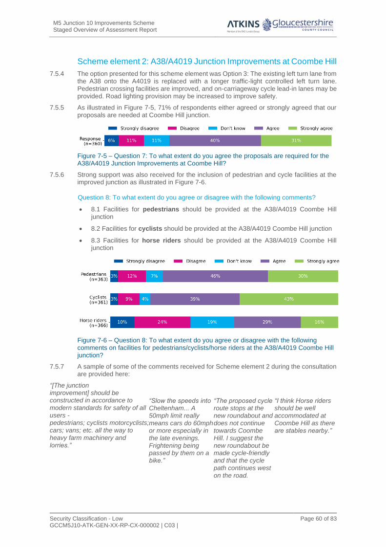
M5 Junction 10 Improvements Scheme Staged Overview of Assessment Report
Security Classification - Low GCCM5J10-ATK-GEN-XX-RP-CX-000002 | C03 |
Page 60 of 83
Scheme element 2: A38/A4019 Junction Improvements at Coombe Hill
7.5.4 The option presented for this scheme element was Option 3: The existing left turn lane from the A38 onto the A4019 is replaced with a longer traffic-light controlled left turn lane. Pedestrian crossing facilities are improved, and on-carriageway cycle lead-in lanes may be provided. Road lighting provision may be increased to improve safety.
7.5.5 As illustrated in Figure 7-5, 71% of respondents either agreed or strongly agreed that our proposals are needed at Coombe Hill junction.
Figure 7-5 – Question 7: To what extent do you agree the proposals are required for the A38/A4019 Junction Improvements at Coombe Hill?
7.5.6 Strong support was also received for the inclusion of pedestrian and cycle facilities at the improved junction as illustrated in Figure 7-6.
Question 8: To what extent do you agree or disagree with the following comments?
• 8.1 Facilities for pedestrians should be provided at the A38/A4019 Coombe Hill junction
• 8.2 Facilities for cyclists should be provided at the A38/A4019 Coombe Hill junction
• 8.3 Facilities for horse riders should be provided at the A38/A4019 Coombe Hill junction
Figure 7-6 – Question 8: To what extent do you agree or disagree with the following comments on facilities for pedestrians/cyclists/horse riders at the A38/A4019 Coombe Hill junction?
7.5.7 A sample of some of the comments received for Scheme element 2 during the consultation are provided here:
“[The junction improvement] should be constructed in accordance to modern standards for safety of all users - pedestrians; cyclists motorcyclists; cars; vans; etc. all the way to heavy farm machinery and lorries.”
“Slow the speeds into Cheltenham... A 50mph limit really means cars do 60mph or more especially in the late evenings. Frightening being passed by them on a bike.”
“The proposed cycle route stops at the new roundabout and does not continue towards Coombe Hill. I suggest the new roundabout be made cycle-friendly and that the cycle path continues west on the road.
“I think Horse riders should be well accommodated at Coombe Hill as there are stables nearby.”

M5 Junction 10 Improvements Scheme Staged Overview of Assessment Report
Security Classification - Low GCCM5J10-ATK-GEN-XX-RP-CX-000002 | C03 |
Page 61 of 83
Scheme element 3: A4019 widening, east of M5 Junction 10
7.5.8 The option presented for this scheme element was Option 1 (standard dual carriageway): The existing single carriageway would be converted to a dual carriageway by widening the road, mostly on the northern side. We are also looking at providing a segregated footway and cycleway to the north of the A4019 with appropriate crossing facilities to connect to properties to the south of the A4019.
7.5.9 As illustrated in Figure 7-7, 78% of respondents either agreed or strongly agreed that our proposals are needed for widening the A4019.
Figure 7-7 – Question 11: To what extent do you agree the proposals are required for the A4019?
7.5.10 Strong support was also received for the inclusion of pedestrian and cycle facilities along the road as illustrated in Figure 7-8.
Question 12: To what extent do you agree or disagree with the following comments?
• 12.1 Facilities for pedestrians should be provided on the A4019.
• 12.2 Facilities for cyclists should be provided on the A4019.
• 12.3 Facilities for horse riders should be provided on the A4019.
Figure 7-8 – Question 12: To what extent do you agree or disagree with the following comments on facilities for pedestrians/cyclists/horse riders on the A4019?
7.5.11 A sample of some of the comments received for Scheme element 3 during the consultation are provided here:
“An uninterrupted cycle path down the whole A4019 would be amazing.”
“It needs to take into account roads that connect to the A4019 such as the Boddington Lane, Stoke Orchard Road.”
“At the existing layby [on the A4019] there needs to be a safe way to cross the road for pedestrians and cyclists.”
“Delivering active travel links along these new core West Cheltenham links will be critical to a sustainable future modal mix, and achieving the council’s stated Climate emergency net zero target.”

M5 Junction 10 Improvements Scheme Staged Overview of Assessment Report
Security Classification - Low GCCM5J10-ATK-GEN-XX-RP-CX-000002 | C03 |
Page 62 of 83
7.6 Stakeholder responses
7.6.1 Highways England identifies stakeholders as those which may have an interest in or are otherwise affected by a proposed scheme. The stakeholders identified for the M5 Junction 10 scheme include local councils, Joint Core Strategy partners, relevant council teams, Members of Parliament, Statutory Environmental Bodies (SEBs), delivery partners, local land agents, landowners and tenants directly affected by the scheme, Parish Councils and others (GFirst LEP and Government Communication Headquarters (GCHQ)). Some of these stakeholders chose to send in long form letter responses to raise their thoughts or concerns rather than completing the survey.
7.6.2 18 written responses were received from stakeholders with the following key themes:
• Access - creating / maintaining access to safeguarded land including the proposed Elms Park Development;
• Climate change - how the scheme aligns with GCC’s climate emergency;
• Consultation - the extent and reach of consultation;
• Design - the location of the link road and improvements to the A4019, west of M5 Junction 10;
• Environment - wildlife and flooding mitigation measures;
• Traffic - the impacts of an increase in traffic on the local road network; and
• Walking, Cycling and Horse-riding facilities - the quality of facilities and local connectivity.
7.6.3 Of the 18 responses received, 50% were supportive of the scheme, 44% were mixed and 6% were neutral. 67% of stakeholder responses did not state a preference for the M5 Junction 10 upgrade, whilst 17% supported Option 2 and another 17% supported Option 2A. Stakeholder preference is largely in line with public feedback on the preferred option.
7.7 Conclusion
7.7.1 Consultation survey participants expressed a high level of support for the scheme, with 84% agreeing that the proposals for M5 Junction 10 and a link road to West Cheltenham are required. Of the three options presented during the public consultation, the preferred option for the improvements at Junction 10 was shown to be Option 2 (37%), followed by Option 2A (28%). The lowest level of preference was for Option 2B (6%). Responses regarding the preference between Junction 10 options for key stakeholders followed a similar trend, although the majority (67%) did not state a preference at this stage.
7.7.2 There is confidence that the scheme will achieve its objectives, however there are some concerns around the scheme and the general feedback highlight a strong desire to ensure:
• There is effective integration of sustainable travel and WCH facilities;
• Access to the surrounding network and communities is maintained;
• Implications on traffic levels on the surrounding network are suitable mitigated;
• The new design is safe for all users and designed to a high quality;
• Impacts on the surrounding environment are minimised; and
• The construction programme is panned such that disruption is minimised.

M5 Junction 10 Improvements Scheme Staged Overview of Assessment Report
Security Classification - Low GCCM5J10-ATK-GEN-XX-RP-CX-000002 | C03 |
Page 63 of 83
8 Summary of design development since public consultation
8.1 Introduction
8.1.1 Further assessment and design development work has been carried out since the Public Consultation was held. This has taken into account feedback received during the Public Consultation and the results of ongoing survey and assessment work.
8.1.2 This section describes the areas of the scheme where further work has been undertaken and the potential changes to the design that could be incorporated into a future Preferred Route, and therefore developed further in future design stages.
8.1.3 The locations of these potential future design developments are shown on drawing number GCCM5J10-ATK-HML-ZZ-DR-CH-000006 in Appendix B.
8.2 M5 Junction 10 merge and diverge layouts
8.2.1 The merge and diverge layouts included in the conceptual designs of the options included in the TAR were based upon preliminary traffic data. A conservative approach was taken in assessing the types of merges and diverges required, and the next higher level of merge/diverge provision was included in the conceptual designs to account for any potential increases in traffic flows determined by traffic modelling in future stages of design.
8.2.2 The types of merges and diverges were reassessed following updates to the traffic modelling work. The proposed layouts following this latest assessment are summarised in Table 8-1.
Table 8-1 – Proposed M5 Junction 10 merge and diverge layouts
Location Merge / Diverge Type Proposed
SB Merge Layout B – parallel merge
NB Merge Layout B – parallel merge
SB Diverge
Layout A option 1 – taper diverge (2 lanes)

M5 Junction 10 Improvements Scheme Staged Overview of Assessment Report
Security Classification - Low GCCM5J10-ATK-GEN-XX-RP-CX-000002 | C03 |
Page 64 of 83
NB Diverge
Layout A option 1 – taper diverge (2 lanes)
8.2.3 The layouts were based on updated traffic modelling undertaken since the TAR. This resulted in a lower level of provision than those included in the conceptual designs in the TAR, but would not require any Departures from Standards.
8.2.4 However, future updates to the traffic modelling will be undertaken, which might require different merge and diverge layouts to be provided. If this is the case, then the merge and diverge layouts, operation and any associated departures from standards will be assessed and developed during future preliminary design.
8.3 Walking, cycling and horse-riding facilities
8.3.1 The walking and cycling facilities proposed in the options submitted for public consultation included a two-way 4m wide cycle track and a 2m wide footway on the northern side of the A4019 between the proposed roundabout at the junction of the A4019 and the proposed West Cheltenham Link Road (east of M5 Junction 10) and the eastern tie-in point on the A4019. These facilities were proposed to promote alternative modes of transport between the development sites/safeguarded land and Cheltenham.
8.3.2 Following feedback received as part of the public consultation, the proposed footway and cycle track for Options 2, 2A and 2B have been extended to the west of the M5 Junction 10 roundabout, to the tie-in point at Stanboro Lane.
8.3.3 The 2m footway and 4m two-way cycle track will continue on the northern side of the A4019 to the proposed M5 Junction 10 roundabout. Facilities to enable walkers, cyclists and horse riders to safely cross the M5 will be developed at the preliminary design stage in consultation with appropriate user groups, council officers and Highways England.
8.3.4 Signalised pedestrian and cyclist crossing facilities will also be included at the A4019 junction at Uckington as part of the signalisation of the junction. This will include a staggered pedestrian crossing between the northern and southern sides of the A4019 to ensure connectivity between the footway on the southern side and the proposed cycle and pedestrian facilities on the northern side.
8.3.5 It is also proposed that a 2m footway and 4m cycle track is provided on the western side of the proposed West Cheltenham Link Road between the A4019 and the B463. Previously, the conceptual design of the Link Road, considered as part of the public consultation, did not include pedestrian or cycle facilities. Continuation of the facilities from the A4019 to the B463 is now proposed to encourage use of alternative modes of transport between the development sites.
8.4 Amendments to West Cheltenham Link Road
8.4.1 Each of the M5 Junction 10 design options (2, 2A and 2B) considered in the public consultation, included a new link road between the future development sites accessed from the A4019 and the B4634.
8.4.2 Following the public consultation, additional assessment was carried out for the link road to optimise is alignment and minimise its impacts.

M5 Junction 10 Improvements Scheme Staged Overview of Assessment Report
Security Classification - Low GCCM5J10-ATK-GEN-XX-RP-CX-000002 | C03 |
Page 65 of 83
Alignment
8.4.3 Five variations of the route shown at the Public Consultation were developed and assessed against a number of different categories including highway standards, land take/severance, flooding, drainage, structures, and environmental.
8.4.4 It was assumed for all route options that the proposed roundabouts on the A4019 and B4634 would be in a very similar location with only minor amendments required to accommodate the variance in alignments.
8.4.5 Option 1 was the alignment option included as part of the public consultation process. Options 2, 4 and 5 considered alignments to the east of Option 1, including an alternative crossing point over the River Chelt, to the east of the that included in Option 1. Option 3 followed a very similar alignment to Option 1, including the point at which it crosses the River Chelt, but south of the river bridge followed an alignment slightly further to the west.
8.4.6 The assessment of the five route options identified limited differentiation between the routes for many of the assessment categories. The largest differentiator was the need for an engineered river channel due to the bend at the River Chelt bridge location within Options 2, 4 and 5. This was considered likely to give rise to a number of issues, so these options were sifted out from selection.
8.4.7 From the remaining Options 1 and 3, Option 3 was slightly preferential from a land impact perspective and it was therefore recommended that Option 3 is progressed into preliminary design.
8.4.8 Therefore, the main difference to the design of the route of the West Cheltenham Link Road to that shown at Public Consultation would be a slight realignment to the west, south of the River Chelt.
Cross section
8.4.9 The proposed Link Road cross-section considered in the public consultation was a two-lane dual carriageway for its full extent.
8.4.10 The Link Road cross section has been reassessed following the receipt of updated traffic flows.
8.4.11 It was found that the estimated peak traffic flows in both directions would be within the capacity of a single lane, and therefore a single carriageway layout would provide sufficient capacity for the forecast flows.
8.4.12 There are two main options for a single carriageway layout. These are an S2 layout for a rural all-purpose road or a SU2 for an urban all-purpose road. As the proposed West Cheltenham Link Road does not carry traffic directly towards Cheltenham and links to the rural B4634, it is considered that a S2 layout would be the most appropriate cross section standard for this link. The main difference between a rural and an urban single carriageway is the inclusion of 1m wide hardstrips at the edge of the carriageway.
8.4.13 It was also suggested that pedestrian and cycling facilities are designed along this route to provide continuity with the proposals along the A4019. A proposed 4m cycle track and 2m footway is therefore proposed on the western side of the Link Road.
8.5 A4019 widening at Uckington
8.5.1 Details of the proposed A4019 widening, east of M5 Junction 10, were included under scheme element 3 in the public consultation. This included widening of the A4019 to dual-carriageway, mainly to the northern side of the A4019.
8.5.2 The widening to the northern side of the A4019 at the Uckington junction retained the existing boundary features to the residential properties to the southern side of the A4019, located to the east of Moat Lane. Some agricultural land take would be required on the southern side, mainly to the west of Moat Lane, but would not require the potential demolition of any buildings on the southern side.

M5 Junction 10 Improvements Scheme Staged Overview of Assessment Report
Security Classification - Low GCCM5J10-ATK-GEN-XX-RP-CX-000002 | C03 |
Page 66 of 83
8.5.3 Widening to the north would, however, impact on eleven separate plots on the northern side of the A4019 at Uckington, including the potential requirement to demolish at least two residential properties and result in the significant loss of frontages to six residential properties. Land take would be required in nine separate plots to achieve the widening to the northern side at Uckington.
8.5.4 A review was undertaken into the implications of widening to the north at Uckington and consider alternative options to minimise impact to the existing properties located at the Uckington junction. The potential impact on statutory utility apparatus at the junction was also considered as part of the review.
8.5.5 In addition to the impacts to the properties on the northern side, the review also identified that widening to the north at Uckington would not allow any scope for design development and further widening of the A4019, such as for the introduction of pedestrian crossings on the A4019 at the junction discussed in Section 8.3 previously, without increasing impacts to all the properties, including the potential need to demolish a further two residential properties.
8.5.6 The review also identified that the majority of existing statutory utility apparatus is located within the northern side of the A4019 at Uckington, and as such, widening to the northern side would likely have a larger impact on the existing utilities and may require greater diversionary or protection works.
8.5.7 The alternative option of widening to the southern side of A4019 at Uckington was considered. Under this option, the existing property/plot boundaries to the northern side of the A4019 at Uckington would be retained.
8.5.8 Widening into the southern side of the A4019 would impact on six separate plots located to the south of the A4019, three of which are currently owned by GCC. This option would, therefore, impact less plots compared with the option to widen to the north.
8.5.9 Widening to the south would, however, require the potential demolition of three residential properties. Of these three properties, one is owned by GCC and is rented to the current occupants. It would also require the potential demolition of a farm building located to the west of Moat Lane, which is located within a plot of land owned by GCC.
8.5.10 The eleven plots located on the northern side of the A4019 at the Uckington junction would not be impacted under this option. No land take would be required to the north of the A4019 at the junction location and all boundary features would be retained in the current position, meaning no loss to any property frontages. A service road to these properties from the A4019 Uckington Junction via The Green would be created, allowing access to these properties from both the west and the east.
8.5.11 Widening to the south would also allow for a greater scope for design development. Further widening to allow the introduction of pedestrian crossings on the A4019 at the junction would be less constrained to the south and would not result in the demolition of additional properties.
8.5.12 Widening to the southern side of the A4019 would mean that the majority of utility apparatus would have the potential to remain in their current positions and would be located underneath the proposed footway/cycleway or verge. As such, it is likely that less diversions will be required compared with widening the A4019 to the north.
8.5.13 Another alternative option was considered of widening on both the northern and southern sides of the A4019 at the Uckington junction. Although this option appeared possible, it would require land take within at least fifteen separate plots, effecting almost every plot bounding the A4019 at the Uckington junction. This option would result in the loss of frontages to eleven properties and require the potential demolition of a farm building located within a plot owned by GCC. It would impact more of the surrounding properties compared to widening to the north or south only and would not allow any scope for design development, such as the introduction of pedestrian crossings on the A4019 at the junction, without further impact on properties including the need for demolition. This option was therefore ruled out.

M5 Junction 10 Improvements Scheme Staged Overview of Assessment Report
Security Classification - Low GCCM5J10-ATK-GEN-XX-RP-CX-000002 | C03 |
Page 67 of 83
8.5.14 The review concluded that widening to the southern side of the A4019 at Uckington would be the preferable option, as it would impact a lesser number of plots/properties, allow for a greater scope for design development, including the introduction of pedestrian crossings on the A4019 at the junction, and would present a lower risk for statutory utility diversions.
8.5.15 The next stage of the design development will therefore include widening of the A4019 to the south at Uckington, instead of to the north.
8.6 Public transport strategy
8.6.1 There is currently a total of eight existing bus stops located within the extents of the proposed improvements to the A4019 as part of this scheme. These are located as follows:-
• Piff Elms, Stanboro Lodge (Eastbound);
• Stanboro Lodge (Westbound);
• Withybridge Gardens (Eastbound);
• Withybridge Gardens (Westbound);
• Cooks Lane (Eastbound);
• Cooks Lane (Westbound);
• Moat Lane (Eastbound); and
• Moat Lane (Westbound).
8.6.2 The proposals for the above bus stops were to relocate each bus stop as close as possible to their current locations in all the options in the public consultation. Following the public consultation, a review of the public transport strategy and provision of replacement bus stops for the scheme was undertaken.In summary, the following recommendations were made based on an assessment which considered safety, proximity to original bus stop, proximity to retained dwellings and connectivity to footways and crossings:
• The two bus stops near Stanboro Lane should be re-provided;
• The two bus stops near Withybridge Gardens should not be re-provided due to the removal of the properties that these serve;
• The two bus stops near Cooks Lane should be re-provided slightly to the east to minimise land/property impacts; and,
• The two bus stops at Uckington should be re-provided in combination with the relocated Cooks Lane bus stops as these would be close to Uckington.
8.6.3 The recommendations are to be discussed and agreed with GCC and bus operators prior to development as part of the next stage of design.
8.7 Elm Park development accesses
8.7.1 The improvement of the A4019 to further east of the scheme (as far as the Hayden Road junction) will be added to the scheme to include the accesses to the future Elm Park Development site.

M5 Junction 10 Improvements Scheme Staged Overview of Assessment Report
Security Classification - Low GCCM5J10-ATK-GEN-XX-RP-CX-000002 | C03 |
Page 68 of 83
9 Conclusions and recommendations 9.1.1 Five options for improving the existing M5 Junction 10, including local road improvements
to provide access to the JCS dvelopment sites, were developed and assessed in autumn 2020 and informed Public Consultation, These were:
• Option 1A – New Junction North of Existing;
• Option 2 – Upgrade Existing Junction with Gyratory Roundabout;
• Option 2A - Upgrade Existing Junction with Gyratory Roundabout offset to the north;
• Option 2B – Upgrade Existing Junction with Gyratory Roundabout offset to the south; and
• Option 5 - New Junction North of Existing (in alternative position to Option 1A).
9.1.2 All five options were considered to be capable of delivering the infrastructure improvements required to provide the additional capacity that would unlock the housing and job opportunities included in the Joint Core Strategy.
9.1.3 Table 9-1 shows the estimated total scheme cost for each option.
Table 9-1 – Estimated option costs
Option Total Scheme Cost (£)
Option 1A 305,578,943
Option 2 254,734,725
Option 2A 229,652,417
Option 2B 245,578,691
Option 5 294,077,040
Note: These costs include £24m attributed to Coombe Hill and Arle Court Transport Hub
9.1.4 Options 1A and 5 involved the construction of new junctions located to the north of the existing M5 Junction 10, and therefore included additional elements of infrastructure to be constructed to connect back to the existing highway network. They were therefore estimated to be more costly.
9.2 Economic assessment
9.2.1 Table 9-2 summarises the Benefit to Cost Ratio (BCR) and corresponding (Value for Money) VfM category for each option.
Table 9-2 – Summary comparison of BCR and VfM assessments
Option BCR, with benefits from accident savings applied
VfM Category
Option 1A 1.72 Medium
Option 2 2.28 High
Option 2A 2.52 High
Option 2B 2.36 High
Option 5 1.83 Medium

M5 Junction 10 Improvements Scheme Staged Overview of Assessment Report
Security Classification - Low GCCM5J10-ATK-GEN-XX-RP-CX-000002 | C03 |
Page 81 of 95
9.3 Environment
9.3.1 The overall conclusions from an environmental perspective are that the on-line options (2,
2A and 2B) offer a better solution than Options 1A and 5. In many cases, the predicted
category of impact and overall assessment of significance prior to mitigation is the same for
all three of the on-line options across the environmental topic assessments.
9.3.2 There will be a requirement for financial compensation for these online options for certain
unavoidable environmental effects, encompassing property demolition, land take and
severance
9.3.3 The adaptation of the existing M5 Junction 10 (Options 2, 2A or 2B) is generally preferable
to construction of a replacement junction in a new location to the north (Options 1 and 5).
The on-line options generally performed favourably to Options 1 and 5 in the comparative
assessment by topic.
9.4 Options taken forward to public consultation
9.4.1 Following the Technical and Environmental assessments of Options 1A, 2, 2A, 2B and 5
within the TAR and PEAOR documents, it was concluded that Options 1A and 5 should not
be taken further forward.
9.4.2 Although Options 2, 2A and 2B would all meet the scheme objectives fully, there was
marginal difference in overall benefits or disadvantage of these three options when
compared with each other. Due to the varying degrees the options comply with the scheme
objectives and marginal difference in benefits and disadvantages, a preferred solution was
not recommended as part of the TAR. Options 2, 2A and 2B were therefore taken forward
to public consultation.
9.4.3 The public consultation demonstrated that there is a level of support for all scheme
elements. Of the three options presented during the public consultation, the preferred option
for scheme element 1 was shown to be Option 2 (37%), followed by Option 2A (28%). The
lowest level of preference was for Option 2B (6%). Responses regarding the preference for
Stakeholders followed a similar trend, although the majority (67%) did not state a preference
at this stage.
9.4.4 Highways England response to the public consultation expressed support for Option 2 from
the basis of a maintenance perspective, that this option requires the demolition of Piffs Elm
Interchange Overbridge which is currently in poor condition and requires substantive
improvements. Therefore, the removal of this bridge and the construction of two new
structures is preferred by Highways England.
9.5 Bridge Assessment since the Public Consultation
9.5.1 Since the Public Consultation, Atkins has undertaken a structural assessment of the Piffs
Elm Interchange Overbridge (refer to Assessment Report of Piffs Elm Interchange Bridge).
This assessment found the structure to fail under serviceable limits in the deck above the
piers. This means that potential cracking to these locations could occur which could affect
the structures durability over time. The worst case would be accelerated deterioration of the
structure and requirement for strengthening in the future.
9.5.2 Retaining the structure and possible refurbishment could be undertaken in the short term.
However, it is unlikely that a refurbished bridge would provide the same 120-year design
life of a new structure. In addition, the existing bridge headroom above the M5 provides

M5 Junction 10 Improvements Scheme Staged Overview of Assessment Report
Security Classification - Low GCCM5J10-ATK-GEN-XX-RP-CX-000002 | C03 |
Page 82 of 95
minimum allowable clearance and is below current design guidelines. In summary, retaining
the structure is considered to result in increased whole life (long term) costs.
9.5.3 The preferred solution is to demolish the existing bridge and construct a new bridge to match
the additional new bridge which is required as part of the enlarged junction.
9.5.4 This would therefore reduce the differences between Options 2A and 2B (the options which
retained the existing bridge) and Option 2, which removed the existing bridge.
9.6 Recommendations
9.6.1 It is recommended that Option 2, a junction centralised on the existing A4019 with two new
bridges over the motorway, should be taken forward as the Preferred Route, with the design
developments ongoing since the public consultation, for the following reasons:
• it was the most favoured option from the Public Consultation;
• the retention and refurbishment of the existing Piffs Elm Interchange Bridge has since been found to be only a short term measure, reducing the advantages that Option 2A and 2B had in retaining the existing bridge;
• it would reduce the long term maintenance liability and whole life costs of retaining the existing bridge under Option 2As and 2B.
9.6.2 This recommended option would also include the common elements of the three options,
these being the widening of the A4019 and the proposed West Cheltenham Link Road.

M5 Junction 10 Improvements Scheme Staged Overview of Assessment Report
Security Classification - Low GCCM5J10-ATK-GEN-XX-RP-CX-000002 | C03 |
Page 71 of 83
List of references M5 Junction 10 Improvements Scheme, Preliminary Environmental Assessment of Options Report
(PEAOR), December 2019
M5 Junction 10 Improvements Scheme, Options Assessment Report (OAR), November 2020
M5 Junction 10 Improvements Scheme, Technical Appraisal Report (TAR), September 2020
M5 Junction 10 Improvements Scheme, Technical Appraisal Report (TAR) A4019 and Coombe Hill
Junction, September 2020
M5 Junction 10 Improvements Scheme, Report on Public Consultation, February 2021
M5 Junction 10 Improvements Scheme, West Cheltenham Link Road Route Assessment Report 2021 M5 Junction 10 – J11 Paramics Model Validation Report, 2018
M5 Junction 10 – Assessment Report of Piffs Elm Interchange Bridge, 2021
Natural England, National Character Areas. Available at:
http://publications.naturalengland.org.uk/publication/1831421?map=true&category=587130
[Accessed: 02/09/19].
Central Severn Vale (CSV) traffic model having a base year of 2013 owned by GCC.
Traffic Forecasting Report, M5 Junction 10 Improvements – HIF OBC, dated 04/03/2019
GCER (Gloucestershire County Environmental Records).
Gloucestershire County Council, Equalities monitoring. Available at:
https://www.gloucestershire.gov.uk/council-and-democracy/equalities-and-our-duties-under-the-equality-act-
2010/equalities-monitoring/
Gloucestershire County Council, M5 Junction 10 Improvements Scheme. Available at:
https://www.gloucestershire.gov.uk/highways/major-projects-list/m5-junction-10-improvements-
scheme/

M5 Junction 10 Improvements Scheme Staged Overview of Assessment Report
Security Classification - Low GCCM5J10-ATK-GEN-XX-RP-CX-000002 | C03 |
Page 72 of 83
Glossary
Abbreviation Term
AADT Annual Average Daily Traffic
ALC Agricultural Land Classification
AONB Area of Outstanding Natural Beauty
AQMA Air Quality Management Area
ARN Affected Road Network
ASR Appraisal Specification Report
AST Appraisal Summary Table
BCR Benefit/Cost Ratio
BMV Best and Most Versatile
CBC Cheltenham Borough Council
CCTV Close Circuit Television
CDM Construction Design Management
CEMP Construction Environmental Management Plan
CFHN Colman’s Farm Habitat Network
CO2e Carbon Dioxide Equivalent
CSV Central Severn Vale
DCO Development Consent Order
DEFRA Department for Environment Food and Rural Affairs
DfT Department for Transport
DMRB Design Manual for Road and Bridges
EA Environmental Agency
ELPV Enhanced Longitudinal Profile Variance
ERTs Emergency Response Telephones
ES Environmental Statement
ESR Environmental Study Report
GCC Gloucestershire County Council
GHG Green House Gases
HE DDMS Highways England Drainage Data Management System
HAPMS Highways Agency Pavement Management System
HE Highways England
HIF Housing Infrastructure Fund
INNS Invasive Non-native Species
IP Inter-Peak
IPPC Integrated Pollution Prevention and Control
ITS Intelligent Transport Systems

M5 Junction 10 Improvements Scheme Staged Overview of Assessment Report
Security Classification - Low GCCM5J10-ATK-GEN-XX-RP-CX-000002 | C03 |
Page 73 of 83
Abbreviation Term
JCS Joint Core Strategy
LAPPC Local Authority Pollution Prevention and Control
LCA Landscape Character Area
LGF Local Growth Fund
LWS Local Wildlife Site
MIDAS Motorway Incident Detection and Automatic Signalling
NIA Noise Important Area
NPPF National Planning Policy Framework
NPS National Policy Statement
NRSWA New Roads and Streetworks Act
NPV Net Present Value
NTM National Transport Model
OEMP Operational Environmental Management Plan
PEAOR Preliminary Environmental Assessment of Options Report
PICs Personal Injury Collisions
PRoW Public Right of Way
PVB Present Value of Benefits
PVC Present Value of Costs
RofSW Risk of Flooding from Surface Water
SAC Special Area of Conservation
SGAR Stage Gate Assessment Review
SOAR Staged Overview of Assessment Report
SPA Special Protection Area
SRN Strategic Road Network
SSSI Site of Special Scientific Interest
SuDS Sustainable Drainage System
SWMP Site Waste Management Plan
TAR Technical Appraisal Report
TBC Tewkesbury Borough Council
TEE Transport Economic Efficiency
TS Transport System
TTM Temporary Traffic Management
VfM Value for Money
WCH Walkers, Cyclists and Horse-riders
WebTAG WebTAG (DfT’s on line) Transport Analysis Guidance
WEEE Waste Electrical and Electronic Equipment
WFD Water Framework Directive

Security Classification - Low GCCM5J10-ATK-GEN-XX-RP-CX-000002 | C03 |
Page 74 of 83
Appendices

M5 Junction 10 Improvements Scheme Staged Overview of Assessment Report
Security Classification - Low GCCM5J10-ATK-GEN-XX-RP-CX-000002 | C03 |
Page 75 of 83
Appendix A. Option Drawings
• Option 1A
• Option 2
• Option 2A
• Option 2B
• Option 5

B
T
-
U
G
BT
-U
G
B
T
-
U
G
B
T
-U
G
B
T
-U
G
BT
-UG
BT-UG
B
T
-
U
G
B
T
-
U
G
B
T
-U
G
BT
-U
G
B
T
-
U
G
B
T
-
U
G
B
T
-
U
G
B
T
-
U
G
B
T
-
U
G
B
T
-
U
G
B
T
-
U
G
B
T
-
U
G
B
T
-
U
G
B
T
-
U
G
B
T
-
U
G
B
T
-
U
G
B
T
-
U
G
B
T
-U
G
B
T
-
U
G
B
T
-
U
G
B
T
-
U
G
B
T
-
U
G
B
T
-U
G
B
T-U
G
W
A
TE
R
W
A
T
E
R
WA
TE
R
W
A
T
E
R
W
A
T
E
R
W
A
T
E
R
W
A
T
E
R
WA
TE
R
W
A
T
E
R
W
AT
ER
WA
TE
R
W
A
T
E
R
G
A
S
-
H
P
G
A
S
-
H
P
G
A
S
-
H
P
G
A
S
-
H
P
G
A
S
-
H
P
G
A
S
-
H
P
G
A
S
-
H
P
G
A
S
-
H
P
1
3
2
K
V
-
O
H
1
3
2
K
V
-O
H
1
3
2
K
V
-O
H
1
3
2
K
V
-O
H
1
3
2
K
V
-O
H
1
3
2
K
V
-O
H
1
3
2
K
V
-O
H
1
3
2
K
V
-
O
H
1
3
2
K
V
-
O
H
1
3
2
K
V
-
O
H
1
3
2
K
V
-
O
H
1
3
2
K
V
-O
H
1
3
2
K
V
-O
H
1
3
2
K
V
-
O
H
1
3
2
K
V
-
O
H
1
3
2
K
V
-
O
H
B
T
-
U
G
B
T
-
U
G
W
A
T
E
R
W
A
T
E
R
M5 JUNCTION 10
MILLHOUSE
FARM
BUTLER'S
COURT
PILGROVE
FARM
SHELDON
NURSERIES
ORCHARD
HOUSE
HAYDEN FARM
BARN FARM
PIFFS ELM
O
L
D
G
L
O
U
C
E
S
T
E
R
R
O
A
D
M
5
UCKINGTON
ELMSTONE
HARDWICKE
A
4
0
1
9
A
4
0
1
9
T
O
W
A
R
D
S
C
H
E
L
T
E
N
H
A
M
T
O
W
A
R
D
S
M
5
J
1
1
T
O
W
A
R
D
S
M
5
J
9
THE GLOUCESTER OLD
SPOT (PH)
GREEN FARM ACCESS BRIDGE TO
BE DEMOLISH AND REPLACED
DUAL 2 LANE
CARRIAGEWAY
NEW RIVER CHELT BRIDGE
(30m SPAN)
WITHY BRIDGE
STAVERTON TWIN CULVERT
MP
79/0A
RIVER CHELT CULVERT
R
IV
E
R
C
H
E
L
T
NEW 200m VIADUCT
ACROSS FLOOD PLAIN
MP
78/0A
BARN FARM CULVERT TO BE
WIDENED ONBOTH SIDES
MP
77/0A
HISTORICAL
LANDFILL SITE
MP
76/0A
PIFFS ELM INTERCHANGE BRIDGE
A
4
0
1
9
B
4
6
3
4
NEW 100m VIADUCT ACROSS FLOOD PLAIN
EXISTING SLIP ROADS
STOPPED UP
ACCESS TO BARN
FARM REALIGNED
HARDWICKE-ELMSTONE HARD
BRIDGE TO BE DEMOLISHED
PROPOSED M5 J10
NEW OVERBRIDGE TO REPLACE
DEMOLISHED HARDWICKE-ELMSTONE
HARD BRIDGE
M
5
R
I
V
E
R
C
H
E
L
T
NEW INTERCHANGE
BRIDGES
A4019 T
OW
AR
DS
CO
OM
BE
H
ILL
BODDINGTON
STANBORO
MP
79/0
MP
78/0
MP
77/0
MP
76/0
T
E
W
K
E
S
B
U
R
Y
R
O
A
D
PIFFS ELM CULVERT
PIFFS ELM SERVICE CULVERT
CANTILEVER GANTRY
HAYDEN
HILL
WITHYBRIDGE
GARDENS
CCTV MAST TO BE
RELOCATED
L
E
IG
H
B
R
O
O
K
L
E
I
G
H
B
R
O
O
K
R
I
V
E
R
S
W
I
L
G
A
T
E
WITHYBRIDGE GARDENS
RETAINING STRUCTURE
W
I
T
H
Y
B
R
I
D
G
E
L
A
N
E
SAFETY, HEALTH AND ENVIRONMENTAL
INFORMATION
In addition to the hazards/risks normally associated with the types of work
detailed on this drawing, note the following significant residual risks
(Reference shall also be made to the design hazard log).
Construction
Maintenance / Cleaning
Use
Decommissioning / Demolition
TO
WA
RD
S
M5
J1
1T
OW
AR
DS
M5 J9
COOMBE HILL
CHELTENHAM
1
M5 JUNCTION 10
SHEET LAYOUT
N.T.S
Copyright C Atkins Limited (2019)
Drawing Title
Project TitleDrawing Suitability
DO
N
OT
S
CA
LE
Client
Status
Millim
etres
10
010
0
Drawing Number
Project Originator Volume
Location Type RoleNumber
-
- - -
--
A1
Scale:
Original
Size:
Rev:
Project
Ref. No:
of
Sheet:
Revision Checked AuthorisedStatus ReviewedDrawn Issue Date
Description
Revision Checked AuthorisedStatus ReviewedDrawn Issue Date
Description
Revision Checked AuthorisedStatus ReviewedDrawn Issue Date
Description
Revision Checked AuthorisedStatus ReviewedDrawn Issue Date
Description
Revision Checked AuthorisedStatus ReviewedDrawn Issue Date
Description
This Drawing is saved on ProjectWise. Plotted: 29/11/2019 12:46:09 By: MPAR2993
www.atkinsglobal.com
5th Floor, Block 5
Shire Hall
Bearland
Gloucester
GL1 2TH
Tel : 08000 514514
A1APPROVED - PUBLISHED M5 Junction 10 Improvement
M5 J10 ALL MOVEMENTS LAYOUT
OPTION 1A
1:5000
CCR
1
PM
1
JA SB 28/11/19
GCCM5J10 ATK HGN
OP1A_ML_Z DR CH 000016
C01C01A1
FIRST ISSUE
CCRPM JA --- 27/11/19P02S3
FIRST ISSUE
CCRPM JA --- 21/11/19P01S3
FIRST ISSUE
5188483
Scale 1:5000
100m 0m 100m 200m 300m
WATERCOURSE
PUBLIC RIGHT OF WAY
KEY:
CULVERT
BRIDGE PARAPET
EXISTING HIGHWAYS ENGLAND BOUNDARY
PROPOSED HIGHWAY BOUNDARY
GCC BOUNDARY (TENTATIVE)
MARKER POST REFERENCE
MP
XX/X
PROPOSED STRUCTURES
BRIDGE / CULVERT
RETAINING STRUCTURE
BT-UG
BT UNDERGROUND
132KV-OH
WPD HV 132KV OVERHEAD LINES AND PYLONS
GAS-HPGAS HIGH PRESSURE UNDERGROUND (W&WU)
WATER
SEVERN TRENT WATER TRUNK MAIN
EXISTING STRUCTURES
SAFEGUARDED AREA BOUNDARY
TRAVELLERS SITE
PROPOSED POND WITH POND ACCESS TRACK
MAJOR EXISTING UTILITIES
NOTES:
1. ALL DIMENSIONS ARE IN METRES UNLESS OTHERWISE STATED.
2. FOR MORE DETAILS ON EXISTING STRUCTURES REFER TO DRAWING No.
GCCM5J10-ATK-SGN-XX-DR-CB-000001 TO 000004.
3. FOR MORE DETAILS ON EXISTING UTILITIES AND HAZARD PLAN REFER TO
DRAWING No. GCCM5J10-ATK-HGN-XX_ML_Z-DR-CH-000051 TO 000055.
4. VERGE WIDTHS AND VERGE BUILD-OUT REQUIREMENTS TO ACCOMMODATE
PROPOSED ROAD FURNITURE AND TECHNOLOGY SITES ARE NOT
CONSIDERED AT THIS STAGE.
EXTENT OF MAIN HIGHWAY WORKS
This map is based on Ordnance Survey material with the
permission of Ordnance Survey on behalf of the Controller
of Her Majesty's Stationery Office. You are not permitted to
copy, sub-license, distribute or sell any of this data to third
parties in any form. © Crown Copyright and database
rights 2019, Ordnance Survey 100019134.

B
T
-
U
G
B
T
-
U
G
W
A
T
E
R
W
A
T
E
R
B
T
-
U
G
BT
-U
G
B
T
-
U
G
B
T
-U
G
B
T
-U
G
BT
-UG
BT-UG
B
T
-
U
G
B
T
-
U
G
B
T
-U
G
BT
-U
G
B
T
-
U
G
B
T
-
U
G
B
T
-
U
G
B
T
-
U
G
B
T
-
U
G
B
T
-
U
G
B
T
-
U
G
B
T
-
U
G
B
T
-
U
G
B
T
-
U
G
B
T
-
U
G
B
T
-
U
G
B
T
-
U
G
B
T
-U
G
B
T
-
U
G
B
T
-
U
G
B
T
-
U
G
B
T
-
U
G
B
T
-U
G
B
T-U
G
W
A
T
E
R
W
A
T
E
R
WA
TE
R
W
A
T
E
R
W
A
T
E
R
W
A
T
E
R
W
A
T
E
R
WA
TE
R
W
A
T
E
R
W
AT
ER
WA
TE
R
W
A
T
E
R
G
A
S
-
H
P
G
A
S
-
H
P
G
A
S
-
H
P
G
A
S
-
H
P
G
A
S
-
H
P
G
A
S
-
H
P
G
A
S
-
H
P
G
A
S
-
H
P
1
3
2
K
V
-
O
H
1
3
2
K
V
-O
H
1
3
2
K
V
-O
H
1
3
2
K
V
-O
H
1
3
2
K
V
-O
H
1
3
2
K
V
-O
H
1
3
2
K
V
-O
H
1
3
2
K
V
-
O
H
1
3
2
K
V
-
O
H
1
3
2
K
V
-O
H
1
3
2
K
V
-O
H
1
3
2
K
V
-
O
H
1
3
2
K
V
-O
H
1
3
2
K
V
-
O
H
1
3
2
K
V
-
O
H
1
3
2
K
V
-
O
H
M5 JUNCTION 10
MILLHOUSE
FARM
BUTLER'S
COURT
PILGROVE
FARM
BODDINGTON
SHELDON
NURSERIES
B
4
6
3
4
ORCHARD
HOUSE
HAYDEN FARM
BARN FARM
W
I
T
H
Y
B
R
I
D
G
E
L
A
N
E
PIFFS ELM
UCKINGTON
R
I
V
E
R
C
H
E
L
T
M
5
A
4
0
1
9
A
4
0
1
9
T
O
W
A
R
D
S
C
H
E
L
T
E
N
H
A
M
T
O
W
A
R
D
S
M
5
J
1
1
A
4
0
1
9
T
O
W
A
R
D
SC
O
O
M
B
E
H
IL
L
THE GLOUCESTER OLD
SPOT (PH)
GREEN FARM ACCESS
BRIDGE
T
O
W
A
R
D
S
M
5
J
9
HARDWICKE-ELMSTONE HARD BRIDGE
DUAL 2 LANE
CARRIAGEWAY
WITHY BRIDGE
EXISTING SLIP ROADS STOPPED UP
RIVER CHELT CULVERT TO BE
WIDENED ON BOTH SIDES
RIV
ER
C
HE
LT
NEW 200m VIADUCT
ACROSS FLOOD PLAIN
BARN FARM CULVERT TO BE
WIDENED ON BOTH SIDES
HISTORICAL
LANDFILL SITE
PIFFS ELM INTERCHANGE
BRIDGE TO BE DEMOLISHED
NEW INTERCHANGE BRIDGES
NEW RIVER CHELT BRIDGE
(30m SPAN)
POTENTIAL CONNECTION TO
FUTURE LAND DEVELOPMENT
STAVERTON TWIN CULVERT
PROPOSED BUS STOP
LOCATION
EXISTING BUS STOP REMOVED
AND RELOCATED
EXISTING BUS STOP REMOVED AND
RELOCATED
M
5
PROPOSED BUS STOP
LOCATION
A
4
0
1
9
O
L
D
G
L
O
U
C
E
S
T
E
R
R
O
A
D
MP
79/0A
MP
78/0A
MP
77/0A
MP
76/0A
MP
79/0
MP
78/0
MP
77/0
MP
76/0
T
E
W
K
E
S
B
U
R
Y
R
O
A
D
ELMSTONE
HARDWICKE
PIFFS ELM CULVERT
TO BE WIDENED ON
BOTH SIDES
PIFFS ELM SERVICE CULVERT
TO BE REPLACED OR ABANDONED.
SERVICE DIVERSIONS REQUIRED
R
I
V
E
R
S
W
I
L
G
A
T
E
HAYDEN
HILL
WITHYBRIDGE
GARDENS
WITHYBRIDGE GARDENS
RETAINING STRUCTURE
TO BE DEMOLISHED
CCTV MAST TO BE
RELOCATED
L
E
IG
H
B
R
O
O
K
L
E
I
G
H
B
R
O
O
K
STANBORO
SAFETY, HEALTH AND ENVIRONMENTAL
INFORMATION
In addition to the hazards/risks normally associated with the types of work
detailed on this drawing, note the following significant residual risks
(Reference shall also be made to the design hazard log).
Construction
Maintenance / Cleaning
Use
Decommissioning / Demolition
TO
WA
RD
S
M5
J1
1T
OW
AR
DS
M5 J9
COOMBE HILL
CHELTENHAM
1
M5 JUNCTION 10
SHEET LAYOUT
N.T.S
Copyright C Atkins Limited (2019)
Drawing Title
Project TitleDrawing Suitability
DO
N
OT
S
CA
LE
Client
Status
Millim
etres
10
010
0
Drawing Number
Project Originator Volume
Location Type RoleNumber
-
- - -
--
A1
Scale:
Original
Size:
Rev:
Project
Ref. No:
of
Sheet:
Revision Checked AuthorisedStatus ReviewedDrawn Issue Date
Description
Revision Checked AuthorisedStatus ReviewedDrawn Issue Date
Description
Revision Checked AuthorisedStatus ReviewedDrawn Issue Date
Description
Revision Checked AuthorisedStatus ReviewedDrawn Issue Date
Description
Revision Checked AuthorisedStatus ReviewedDrawn Issue Date
Description
This Drawing is saved on ProjectWise. Plotted: 11/12/2019 14:11:07 By: MPAR2993
www.atkinsglobal.com
5th Floor, Block 5
Shire Hall
Bearland
Gloucester
GL1 2TH
Tel : 08000 514514
A1APPROVED - PUBLISHED M5 Junction 10 Improvement
M5 J10 ALL MOVEMENTS LAYOUT
OPTION 2
1:5000
CCR
1
PM
1
JA SB 28/11/19
GCCM5J10 ATK HGN
OP2_ML_Z DR CH 000016
C01C01A1
FIRST ISSUE
CCRPM JA --- 27/11/19P02S3
FIRST ISSUE
CCRPM JA --- 21/11/19P01
FIRST ISSUE
5188483
Scale 1:5000
100m 0m 100m 200m 300m
This map is based on Ordnance Survey material with the
permission of Ordnance Survey on behalf of the Controller
of Her Majesty's Stationery Office. You are not permitted to
copy, sub-license, distribute or sell any of this data to third
parties in any form. © Crown Copyright and database
rights 2019, Ordnance Survey 100019134.
WATERCOURSE
PUBLIC RIGHT OF WAY
KEY:
CULVERT
BRIDGE PARAPET
EXISTING HIGHWAYS ENGLAND BOUNDARY
PROPOSED HIGHWAY BOUNDARY
GCC BOUNDARY (TENTATIVE)
MARKER POST REFERENCE
MP
XX/X
PROPOSED STRUCTURES
BRIDGE / CULVERT
RETAINING STRUCTURE
BT-UG
BT UNDERGROUND
132KV-OH
WPD HV 132KV OVERHEAD LINES AND PYLONS
GAS-HPGAS HIGH PRESSURE UNDERGROUND (W&WU)
WATER
SEVERN TRENT WATER TRUNK MAIN
EXISTING STRUCTURES
SAFEGUARDED AREA BOUNDARY
TRAVELLERS SITE
PROPOSED POND WITH POND ACCESS TRACK
MAJOR EXISTING UTILITIES
NOTES:
1. ALL DIMENSIONS ARE IN METRES UNLESS OTHERWISE STATED.
2. FOR MORE DETAILS ON EXISTING STRUCTURES REFER TO DRAWING No.
GCCM5J10-ATK-SGN-XX-DR-CB-000001 TO 000004.
3. FOR MORE DETAILS ON EXISTING UTILITIES AND HAZARD PLAN REFER TO
DRAWING No. GCCM5J10-ATK-HGN-XX_ML_Z-DR-CH-000051 TO 000055.
4. VERGE WIDTHS AND VERGE BUILD-OUT REQUIREMENTS TO ACCOMMODATE
PROPOSED ROAD FURNITURE AND TECHNOLOGY SITES ARE NOT
CONSIDERED AT THIS STAGE.
EXTENT OF MAIN HIGHWAY WORKS

B
T
-
U
G
BT
-U
G
B
T
-
U
G
B
T
-U
G
B
T
-U
G
BT
-UG
BT-UG
B
T
-
U
G
B
T
-
U
G
B
T
-U
G
BT
-U
G
B
T
-
U
G
B
T
-
U
G
B
T
-
U
G
B
T
-
U
G
B
T
-
U
G
B
T
-
U
G
B
T
-
U
G
B
T
-
U
G
B
T
-
U
G
B
T
-
U
G
B
T
-
U
G
B
T
-
U
G
B
T
-
U
G
B
T
-U
G
B
T
-
U
G
B
T
-
U
G
B
T
-
U
G
B
T
-
U
G
B
T
-U
G
B
T-U
G
W
A
T
E
R
W
A
T
E
R
WA
TE
R
W
A
T
E
R
W
A
T
E
R
W
A
T
E
R
W
A
T
E
R
WA
TE
R
W
A
T
E
R
W
AT
ER
WA
TE
R
W
A
T
E
R
G
A
S
-
H
P
G
A
S
-
H
P
G
A
S
-
H
P
G
A
S
-
H
P
G
A
S
-
H
P
G
A
S
-
H
P
G
A
S
-
H
P
G
A
S
-
H
P
1
3
2
K
V
-
O
H
1
3
2
K
V
-O
H
1
3
2
K
V
-O
H
1
3
2
K
V
-O
H
1
3
2
K
V
-O
H
1
3
2
K
V
-O
H
1
3
2
K
V
-O
H
1
3
2
K
V
-
O
H
1
3
2
K
V
-
O
H
1
3
2
K
V
-O
H
1
3
2
K
V
-O
H
1
3
2
K
V
-
O
H
1
3
2
K
V
-O
H
1
3
2
K
V
-
O
H
1
3
2
K
V
-
O
H
1
3
2
K
V
-
O
H
B
T
-
U
G
B
T
-
U
G
W
A
T
E
R
W
A
T
E
R
M5 JUNCTION 10
MILLHOUSE
FARM
BUTLER'S
COURT
PILGROVE
FARM
BODDINGTON
SHELDON
NURSERIES
B
4
6
3
4
ORCHARD
HOUSE
HAYDEN FARM
BARN FARM
W
I
T
H
Y
B
R
I
D
G
E
L
A
N
E
PIFFS ELM
UCKINGTON
ELMSTONE HARDWICKE
R
I
V
E
R
C
H
E
L
T
M
5
M
5
A
4
0
1
9
A
4
0
1
9
T
O
W
A
R
D
S
C
H
E
L
T
E
N
H
A
M
T
O
W
A
R
D
S
M
5
J
1
1
A4019 T
OW
AR
DS
CO
OM
BE
H
ILL
THE GLOUCESTER OLD
SPOT (PH)
GREEN FARM ACCESS
BRIDGE
T
O
W
A
R
D
S
M
5
J
9
HARDWICKE-ELMSTONE HARD BRIDGE
DUAL 2 LANE
CARRIAGEWAY
WITHY BRIDGE
EXISTING SLIP ROADS STOPPED UP
RIVER CHELT CULVERT TO BE
WIDENED ON BOTH SIDES
RIV
ER
C
HE
LT
NEW 200m VIADUCT
ACROSS FLOOD PLAIN
BARN FARM CULVERT TO BE
WIDENED ON BOTH SIDES
HISTORICAL
LANDFILL SITE
PIFFS ELM INTERCHANGE
BRIDGE TO BE RETAINED
NEW INTERCHANGE BRIDGE
NEW RIVER CHELT BRIDGE
(30m SPAN)
POTENTIAL CONNECTION TO
FUTURE LAND DEVELOPMENT
STAVERTON TWIN CULVERT
PROPOSED BUS STOP
LOCATION
EXISTING BUS STOP REMOVED AND
RELOCATED
PROPOSED BUS STOP
LOCATION
EXISTING BUS STOP REMOVED AND
RELOCATED
A
4
0
1
9O
L
D
G
L
O
U
C
E
S
T
E
R
R
O
A
D
MP
79/0A
MP
78/0A
MP
77/0A
MP
76/0A
MP
79/0
MP
78/0
MP
77/0
MP
76/0
T
E
W
K
E
S
B
U
R
Y
R
O
A
D
PIFFS ELM SERVICE CULVERT
TO BE REPLACED OR ABANDONED.
SERVICE DIVERSIONS REQUIRED
CANTILEVER GANTRY
CCTV MAST TO BE
RELOCATED
PIFFS ELM CULVERT
TO BE WIDENED ON
BOTH SIDES
L
E
IG
H
B
R
O
O
K
L
E
I
G
H
B
R
O
O
K
WITHYBRIDGE GARDENS
RETAINING STRUCTURE
TO BE PARTIALLY DEMOLISHED
AND REPLACED ON NEW
ALIGNMENT
WITHYBRIDGE
GARDENS
STANBORO
R
IV
E
R
S
W
IL
G
A
T
E
SAFETY, HEALTH AND ENVIRONMENTAL
INFORMATION
In addition to the hazards/risks normally associated with the types of work
detailed on this drawing, note the following significant residual risks
(Reference shall also be made to the design hazard log).
Construction
Maintenance / Cleaning
Use
Decommissioning / Demolition
Copyright C Atkins Limited (2019)
Drawing Title
Project TitleDrawing Suitability
DO
N
OT
S
CA
LE
Client
Status
Millim
etres
10
010
0
Drawing Number
Project Originator Volume
Location Type RoleNumber
-
- - -
--
A1
Scale:
Original
Size:
Rev:
Project
Ref. No:
of
Sheet:
Revision Checked AuthorisedStatus ReviewedDrawn Issue Date
Description
Revision Checked AuthorisedStatus ReviewedDrawn Issue Date
Description
Revision Checked AuthorisedStatus ReviewedDrawn Issue Date
Description
Revision Checked AuthorisedStatus ReviewedDrawn Issue Date
Description
Revision Checked AuthorisedStatus ReviewedDrawn Issue Date
Description
This Drawing is saved on ProjectWise. Plotted: 29/11/2019 12:38:28 By: MPAR2993
www.atkinsglobal.com
5th Floor, Block 5
Shire Hall
Bearland
Gloucester
GL1 2TH
Tel : 08000 514514
TO
WA
RD
S
M5
J1
1T
OW
AR
DS
M5 J9
COOMBE HILL
CHELTENHAM
1
M5 JUNCTION 10
SHEET LAYOUT
N.T.S
A1APPROVED - PUBLISHED M5 Junction 10 Improvement
M5 J10 ALL MOVEMENTS LAYOUT
OPTION 2A
1:5000
CCR
1
PM
1
JA SB 28/11/19
GCCM5J10 ATK HGN
OP2A_ML_Z DR CH 000016
C01C01A1
FIRST ISSUE
CCRPM JA --- 27/11/19P02S3
FIRST ISSUE
CCRPM JA --- 21/11/19P01S3
FIRST ISSUE
5188483
Scale 1:5000
100m 0m 100m 200m 300m
WATERCOURSE
PUBLIC RIGHT OF WAY
KEY:
CULVERT
BRIDGE PARAPET
EXISTING HIGHWAYS ENGLAND BOUNDARY
PROPOSED HIGHWAY BOUNDARY
GCC BOUNDARY (TENTATIVE)
MARKER POST REFERENCE
MP
XX/X
PROPOSED STRUCTURES
BRIDGE / CULVERT
RETAINING STRUCTURE
BT-UG
BT UNDERGROUND
132KV-OH
WPD HV 132KV OVERHEAD LINES AND PYLONS
GAS-HPGAS HIGH PRESSURE UNDERGROUND (W&WU)
WATER
SEVERN TRENT WATER TRUNK MAIN
EXISTING STRUCTURES
SAFEGUARDED AREA BOUNDARY
TRAVELLERS SITE
PROPOSED POND WITH POND ACCESS TRACK
MAJOR EXISTING UTILITIES
NOTES:
1. ALL DIMENSIONS ARE IN METRES UNLESS OTHERWISE STATED.
2. FOR MORE DETAILS ON EXISTING STRUCTURES REFER TO DRAWING No.
GCCM5J10-ATK-SGN-XX-DR-CB-000001 TO 000004.
3. FOR MORE DETAILS ON EXISTING UTILITIES AND HAZARD PLAN REFER TO
DRAWING No. GCCM5J10-ATK-HGN-XX_ML_Z-DR-CH-000051 TO 000055.
4. VERGE WIDTHS AND VERGE BUILD-OUT REQUIREMENTS TO ACCOMMODATE
PROPOSED ROAD FURNITURE AND TECHNOLOGY SITES ARE NOT
CONSIDERED AT THIS STAGE.
EXTENT OF MAIN HIGHWAY WORKS
This map is based on Ordnance Survey material with the
permission of Ordnance Survey on behalf of the Controller
of Her Majesty's Stationery Office. You are not permitted to
copy, sub-license, distribute or sell any of this data to third
parties in any form. © Crown Copyright and database
rights 2019, Ordnance Survey 100019134.

B
T
-
U
G
B
T
-
U
G
W
A
T
E
R
W
A
T
E
R
B
T
-
U
G
BT
-U
G
B
T
-
U
G
B
T
-U
G
B
T
-U
G
BT
-UG
BT-UG
B
T
-
U
G
B
T
-
U
G
B
T
-U
G
BT
-U
G
B
T
-
U
G
B
T
-
U
G
B
T
-
U
G
B
T
-
U
G
B
T
-
U
G
B
T
-
U
G
B
T
-
U
G
B
T
-
U
G
B
T
-
U
G
B
T
-
U
G
B
T
-
U
G
B
T
-
U
G
B
T
-
U
G
B
T
-U
G
B
T
-
U
G
B
T
-
U
G
B
T
-
U
G
B
T
-
U
G
B
T
-U
G
B
T-U
G
W
A
T
E
R
W
A
T
E
R
WA
TE
R
W
A
T
E
R
W
A
T
E
R
W
A
T
E
R
W
A
T
E
R
WA
TE
R
W
A
T
E
R
W
AT
ER
WA
TE
R
W
A
T
E
R
G
A
S
-
H
P
G
A
S
-
H
P
G
A
S
-
H
P
G
A
S
-
H
P
G
A
S
-
H
P
G
A
S
-
H
P
G
A
S
-
H
P
G
A
S
-
H
P
1
3
2
K
V
-
O
H
1
3
2
K
V
-O
H
1
3
2
K
V
-O
H
1
3
2
K
V
-O
H
1
3
2
K
V
-O
H
1
3
2
K
V
-O
H
1
3
2
K
V
-O
H
1
3
2
K
V
-
O
H
1
3
2
K
V
-
O
H
1
3
2
K
V
-O
H
1
3
2
K
V
-O
H
1
3
2
K
V
-
O
H
1
3
2
K
V
-O
H
1
3
2
K
V
-
O
H
1
3
2
K
V
-
O
H
1
3
2
K
V
-
O
H
M5 JUNCTION 10
MILLHOUSE
FARM
BUTLER'S
COURT
PILGROVE FARM
BODDINGTON
SHELDON
NURSERIES
B
4
6
3
4
ORCHARD
HOUSE
HAYDEN FARM
BARN FARM
W
I
T
H
Y
B
R
I
D
G
E
L
A
N
E
PIFFS ELM
M
5
UCKINGTON
ELMSTONE HARDWICKE
R
I
V
E
R
C
H
E
L
T
A
4
0
1
9
A
4
0
1
9
T
O
W
A
R
D
S
C
H
E
L
T
E
N
H
A
M
T
O
W
A
R
D
S
M
5
J
1
1
M
5
A4019 T
OW
AR
DS
CO
OM
BE
H
ILL
THE GLOUCESTER OLD
SPOT (PH)
T
O
W
A
R
D
S
M
5
J
9
R
I
V
E
R
C
H
E
L
T
NEW 200m VIADUCT
ACROSS FLOOD PLAIN
HISTORICAL
LANDFILL SITE
GREEN FARM ACCESS BRIDGE
HARDWICKE-ELMSTONE HARD BRIDGE
POTENTIAL CONNECTION TO
FUTURE LAND DEVELOPMENT
DUAL 2 LANE
CARRIAGEWAY
NEW RIVER CHELT BRIDGE
(30m SPAN)
WITHY BRIDGE
EXISTING SLIP ROADS STOPPED UP
STAVERTON TWIN CULVERT
TO BE RETAINED.
NO WIDENING REQUIRED
RIVER CHELT CULVERT TO BE
WIDENED ON BOTH SIDES
BARN FARM CULVERT TO BE
WIDENED ON BOTH SIDES
PIFFS ELM INTERCHANGE
BRIDGE TO BE RETAINED
NEW INTERCHANGE BRIDGE
A
4
0
1
9
PROPOSED BUS STOP
LOCATION
EXISTING BUS STOP
REMOVED AND RELOCATED
EXISTING BUS STOP
REMOVED AND RELOCATED
PROPOSED BUS
STOP LOCATION
EXISTING BUS
STOP RETAINED
PROPOSED ACCESS
TO PROPERTIES AND
TRAVELLERS SITE
EXISTING BUS STOP
REMOVED AND
RELOCATED
ACCESS TO TRAVELERS
SITE REALIGNED
O
L
D
G
L
O
U
C
E
S
T
E
R
R
O
A
D
MP
79/0A
MP
78/0A
MP
77/0A
MP
76/0A
MP
79/0
MP
78/0
MP
77/0
MP
76/0
T
E
W
K
E
S
B
U
R
Y
R
O
A
D
PIFFS ELM CULVERT
TO BE WIDENED ON
BOTH SIDES
PIFFS ELM SERVICE CULVERT
TO BE REPLACED OR ABANDONED.
SERVICE DIVERSIONS REQUIRED
CANTILEVER GANTRY
L
E
IG
H
B
R
O
O
K
L
E
I
G
H
B
R
O
O
K
CCTV MAST TO BE
RELOCATED
WITHYBRIDGE GARDENS
RETAINING STRUCTURE
TO BE DEMOLISHED
WITHYBRIDGE
GARDENS
STANBORO
SAFETY, HEALTH AND ENVIRONMENTAL
INFORMATION
In addition to the hazards/risks normally associated with the types of work
detailed on this drawing, note the following significant residual risks
(Reference shall also be made to the design hazard log).
Construction
Maintenance / Cleaning
Use
Decommissioning / Demolition
TO
WA
RD
S
M5
J1
1T
OW
AR
DS
M5 J9
COOMBE HILL
CHELTENHAM
1
M5 JUNCTION 10
SHEET LAYOUT
N.T.S
Copyright C Atkins Limited (2019)
Drawing Title
Project TitleDrawing Suitability
DO
N
OT
S
CA
LE
Client
Status
Millim
etres
10
010
0
Drawing Number
Project Originator Volume
Location Type RoleNumber
-
- - -
--
A1
Scale:
Original
Size:
Rev:
Project
Ref. No:
of
Sheet:
Revision Checked AuthorisedStatus ReviewedDrawn Issue Date
Description
Revision Checked AuthorisedStatus ReviewedDrawn Issue Date
Description
Revision Checked AuthorisedStatus ReviewedDrawn Issue Date
Description
Revision Checked AuthorisedStatus ReviewedDrawn Issue Date
Description
Revision Checked AuthorisedStatus ReviewedDrawn Issue Date
Description
This Drawing is saved on ProjectWise. Plotted: 29/11/2019 12:45:03 By: MPAR2993
www.atkinsglobal.com
5th Floor, Block 5
Shire Hall
Bearland
Gloucester
GL1 2TH
Tel : 08000 514514
A1APPROVED - PUBLISHED M5 Junction 10 Improvement
M5 J10 ALL MOVEMENTS LAYOUT
OPTION 2B
1:5000
CCR
1
PM
1
JA SB 28/11/19
GCCM5J10 ATK HGN
OP2B_ML_Z DR CH 000016
C01C01A1
FIRST ISSUE
CCRPM JA --- 27/11/19P02S3
FIRST ISSUE
CCRPM JA --- 21/11/19P01S3
FIRST ISSUE
5188483
Scale 1:5000
100m 0m 100m 200m 300m
WATERCOURSE
PUBLIC RIGHT OF WAY
KEY:
CULVERT
BRIDGE PARAPET
EXISTING HIGHWAYS ENGLAND BOUNDARY
PROPOSED HIGHWAY BOUNDARY
GCC BOUNDARY (TENTATIVE)
MARKER POST REFERENCE
MP
XX/X
PROPOSED STRUCTURES
BRIDGE / CULVERT
RETAINING STRUCTURE
BT-UG
BT UNDERGROUND
132KV-OH
WPD HV 132KV OVERHEAD LINES AND PYLONS
GAS-HPGAS HIGH PRESSURE UNDERGROUND (W&WU)
WATER
SEVERN TRENT WATER TRUNK MAIN
EXISTING STRUCTURES
SAFEGUARDED AREA BOUNDARY
TRAVELLERS SITE
PROPOSED POND WITH POND ACCESS TRACK
MAJOR EXISTING UTILITIES
NOTES:
1. ALL DIMENSIONS ARE IN METRES UNLESS OTHERWISE STATED.
2. FOR MORE DETAILS ON EXISTING STRUCTURES REFER TO DRAWING No.
GCCM5J10-ATK-SGN-XX-DR-CB-000001 TO 000004.
3. FOR MORE DETAILS ON EXISTING UTILITIES AND HAZARD PLAN REFER TO
DRAWING No. GCCM5J10-ATK-HGN-XX_ML_Z-DR-CH-000051 TO 000055.
4. VERGE WIDTHS AND VERGE BUILD-OUT REQUIREMENTS TO ACCOMMODATE
PROPOSED ROAD FURNITURE AND TECHNOLOGY SITES ARE NOT
CONSIDERED AT THIS STAGE.
EXTENT OF MAIN HIGHWAY WORKS
This map is based on Ordnance Survey material with the
permission of Ordnance Survey on behalf of the Controller
of Her Majesty's Stationery Office. You are not permitted to
copy, sub-license, distribute or sell any of this data to third
parties in any form. © Crown Copyright and database
rights 2019, Ordnance Survey 100019134.

B
T
-
U
G
BT
-U
G
B
T
-
U
G
B
T
-U
G
B
T
-U
G
BT
-UG
BT-UG
B
T
-
U
G
B
T
-
U
G
B
T
-U
G
BT
-U
G
B
T
-
U
G
B
T
-
U
G
B
T
-
U
G
B
T
-
U
G
B
T
-
U
G
B
T
-
U
G
B
T
-
U
G
B
T
-
U
G
B
T
-
U
G
B
T
-
U
G
B
T
-
U
G
B
T
-
U
G
B
T
-
U
G
B
T
-U
G
B
T
-
U
G
B
T
-
U
G
B
T
-
U
G
B
T
-
U
G
B
T
-U
G
B
T-U
G
W
A
T
E
R
WA
TE
R
W
A
T
E
R
W
A
T
E
R
W
A
T
E
R
W
A
T
E
R
WA
TE
R
W
A
T
E
R
W
AT
ER
WA
TE
R
W
A
T
E
R
G
A
S
-
H
P
G
A
S
-
H
P
G
A
S
-
H
P
G
A
S
-
H
P
G
A
S
-
H
P
G
A
S
-
H
P
G
A
S
-
H
P
G
A
S
-
H
P
1
3
2
K
V
-
O
H
1
3
2
K
V
-O
H
1
3
2
K
V
-O
H
1
3
2
K
V
-O
H
1
3
2
K
V
-O
H
1
3
2
K
V
-O
H
1
3
2
K
V
-O
H
1
3
2
K
V
-
O
H
1
3
2
K
V
-
O
H
1
3
2
K
V
-
O
H
1
3
2
K
V
-
O
H
1
3
2
K
V
-O
H
1
3
2
K
V
-O
H
1
3
2
K
V
-
O
H
1
3
2
K
V
-
O
H
1
3
2
K
V
-
O
H
B
T
-
U
G
B
T
-
U
G
W
A
T
E
R
W
A
T
E
R
W
A
T
E
R
G
A
S
-
H
P
M5 JUNCTION 10
MILLHOUSE
FARM
BUTLER'S
COURT
PILGROVE
FARM
BODDINGTON
SHELDON
NURSERIES
ORCHARD
HOUSE
HAYDEN FARM
BARN FARM
W
I
T
H
Y
B
R
I
D
G
E
L
A
N
E
PIFFS ELM
O
L
D
G
L
O
U
C
E
S
T
E
R
R
O
A
D
UCKINGTON
ELMSTONE HARDWICKE
R
I
V
E
R
C
H
E
L
T
M
5
M
5
A
4
0
1
9
A
4
0
1
9
T
O
W
A
R
D
S
C
H
E
L
T
E
N
H
A
M
T
O
W
A
R
D
S
M
5
J
1
1
A
4
0
1
9
T
O
W
A
R
D
S
C
O
O
M
B
E
H
IL
L
GREEN FARM ACCESS BRIDGE
T
O
W
A
R
D
S
M
5
J
9
DUAL 2 LANE
CARRIAGEWAY
NEW RIVER CHELT BRIDGE
(30m SPAN)
WITHY BRIDGE
STAVERTON TWIN CULVERT
RIVER CHELT CULVERT
RIV
ER
C
HE
LT
NEW 200m VIADUCT
ACROSS FLOOD PLAIN
BARN FARM CULVERT TO BE
WIDENED ON BOTH SIDES
HISTORICAL
LANDFILL SITE
PIFFS ELM INTERCHANGE BRIDGE
A
4
0
1
9
B
4
6
3
4
NEW 100m VIADUCT ACROSS FLOOD PLAIN
EXISTING SLIP ROADS STOPPED UP
ACCESS TO TRAVELERS SITE
REALIGNED
ACCESS TO BARN FARM
REALIGNED
HARDWICKE-ELMSTONE HARD
BRIDGE TO BE DEMOLISHED
PROPOSED M5 J10
NEW OVERBRIDGE TO REPLACE
DEMOLISHED HARDWICKE-ELMSTONE
HARD BRIDGE
NEW INTERCHANGE
BRIDGES
MP
79/0A
MP
78/0A
MP
77/0A
MP
76/0A
MP
79/0
MP
78/0
MP
77/0
MP
76/0
T
E
W
K
E
S
B
U
R
Y
R
O
A
D
PIFFS ELM CULVERT
PIFFS ELM SERVICE CULVERT
CCTV MAST TO BE
RELOCATED
HAYDEN
HILL
L
E
IG
H
B
R
O
O
K
L
E
I
G
H
B
R
O
O
K
R
I
V
E
R
S
W
I
L
G
A
T
E
STANBOROSTANBORO
L
E
IG
H
B
R
O
O
K
L
E
I
G
H
B
R
O
O
K
WITHYBRIDGE GARDENS
RETAINING STRUCTURE
SAFETY, HEALTH AND ENVIRONMENTAL
INFORMATION
In addition to the hazards/risks normally associated with the types of work
detailed on this drawing, note the following significant residual risks
(Reference shall also be made to the design hazard log).
Construction
Maintenance / Cleaning
Use
Decommissioning / Demolition
TO
WA
RD
S
M5
J1
1T
OW
AR
DS
M5 J9
COOMBE HILL
CHELTENHAM
1
M5 JUNCTION 10
SHEET LAYOUT
N.T.S
Copyright C Atkins Limited (2019)
Drawing Title
Project TitleDrawing Suitability
DO
N
OT
S
CA
LE
Client
Status
Millim
etres
10
010
0
Drawing Number
Project Originator Volume
Location Type RoleNumber
-
- - -
--
A1
Scale:
Original
Size:
Rev:
Project
Ref. No:
of
Sheet:
Revision Checked AuthorisedStatus ReviewedDrawn Issue Date
Description
Revision Checked AuthorisedStatus ReviewedDrawn Issue Date
Description
Revision Checked AuthorisedStatus ReviewedDrawn Issue Date
Description
Revision Checked AuthorisedStatus ReviewedDrawn Issue Date
Description
Revision Checked AuthorisedStatus ReviewedDrawn Issue Date
Description
This Drawing is saved on ProjectWise. Plotted: 29/11/2019 12:42:06 By: MPAR2993
www.atkinsglobal.com
5th Floor, Block 5
Shire Hall
Bearland
Gloucester
GL1 2TH
Tel : 08000 514514
A1APPROVED - PUBLISHED M5 Junction 10 Improvement
M5 J10 ALL MOVEMENTS LAYOUT
OPTION 5
1:5000
CCR
1
PM
1
JA SB 28/11/19
GCCM5J10 ATK HGN
OP5_ML_Z DR CH 000016
C01C01A1
FIRST ISSUE
CCRPM JA --- 27/11/19P02S3
FIRST ISSUE
CCRPM JA --- 21/11/19P01S3
FIRST ISSUE
5188483
Scale 1:5000
100m 0m 100m 200m 300m
WATERCOURSE
PUBLIC RIGHT OF WAY
KEY:
CULVERT
BRIDGE PARAPET
EXISTING HIGHWAYS ENGLAND BOUNDARY
PROPOSED HIGHWAY BOUNDARY
GCC BOUNDARY (TENTATIVE)
MARKER POST REFERENCE
MP
XX/X
PROPOSED STRUCTURES
BRIDGE / CULVERT
RETAINING STRUCTURE
BT-UG
BT UNDERGROUND
132KV-OH
WPD HV 132KV OVERHEAD LINES AND PYLONS
GAS-HPGAS HIGH PRESSURE UNDERGROUND (W&WU)
WATER
SEVERN TRENT WATER TRUNK MAIN
EXISTING STRUCTURES
SAFEGUARDED AREA BOUNDARY
TRAVELLERS SITE
PROPOSED POND WITH POND ACCESS TRACK
MAJOR EXISTING UTILITIES
NOTES:
1. ALL DIMENSIONS ARE IN METRES UNLESS OTHERWISE STATED.
2. FOR MORE DETAILS ON EXISTING STRUCTURES REFER TO DRAWING No.
GCCM5J10-ATK-SGN-XX-DR-CB-000001 TO 000004.
3. FOR MORE DETAILS ON EXISTING UTILITIES AND HAZARD PLAN REFER TO
DRAWING No. GCCM5J10-ATK-HGN-XX_ML_Z-DR-CH-000051 TO 000055.
4. VERGE WIDTHS AND VERGE BUILD-OUT REQUIREMENTS TO ACCOMMODATE
PROPOSED ROAD FURNITURE AND TECHNOLOGY SITES ARE NOT
CONSIDERED AT THIS STAGE.
EXTENT OF MAIN HIGHWAY WORKS
This map is based on Ordnance Survey material with the
permission of Ordnance Survey on behalf of the Controller
of Her Majesty's Stationery Office. You are not permitted to
copy, sub-license, distribute or sell any of this data to third
parties in any form. © Crown Copyright and database
rights 2019, Ordnance Survey 100019134.

M5 Junction 10 Improvements Scheme Staged Overview of Assessment Report
Security Classification - Low GCCM5J10-ATK-GEN-XX-RP-CX-000002 | C03 |
Page 81 of 83
Appendix B. Plan Showing Design
Developments Since Public
Consultation

ORCHARD HOUSE
HAYDEN HILL
PILGROVE FARM
ARLE NURSERY
OLD GLOUCES
TER R
OAD
TEWKESBURY ROAD
A4019
B4634
WIT
HY
BRID
GE L
AN
E
MILLHOUSE FARM
OLD GLOUCESTER ROAD
B463
4
A4019
WIT
HY
BRID
GE L
AN
E
M5 JUNCTION 10
A4019 M5
STANBORO
PIFFS ELM
BARN FARM
M5
BUTLER'S COURT
SLIGHTLY REALIGNED SOUTH OF THE RIVER CHELT
WEST CHELTENHAM LINK ROAD ALIGNMENT
USER ROUTE ALONG WESTERN SIDE
SINGLE CARRIAGEWAY WITH NON-MOTORISED
WEST CHELTENHAM LINK ROAD CHANGED TO
SUBJECT TO SEPARATE PLANNING APPLICATION
ACCESS TO ELM PARK DEVELOPMENT SITE
THROUGH UCKINGTON JUNCTION
A4019 WIDENING ON SOUTH SIDE
TYPES AMENDED
NB MERGE AND SB DIVERGE
M5 MAINLINE TO BE DEVELOPED IN FUTURE STAGES
APPROACHES OF JUNCTION 10. NMU CROSSING OVER
NON-MOTORISED USER ROUTE ADDED ON THE
TYPES AMENDED
SB MERGE AND NB DIVERGE W
ES
T C
HE
LTE
NH
AM LIN
K R
OA
D
UCKINGTON
Drawing Title
Project Title
Drawing Suitability
DO N
OT S
CA
LE
Status
Millim
etres
100
10
0
Drawing Number
Project Originator Volume
Location Type Role Number
-
- - -
--
A1 Scale:Size:
Original Rev:
Ref. No:
Project ofSheet:
Client
Revision Checked AuthorisedStatus ReviewedDrawn Issue Date
Description
Revision Checked AuthorisedStatus ReviewedDrawn Issue Date
Description
Revision Checked AuthorisedStatus ReviewedDrawn Issue Date
Description
Revision Checked AuthorisedStatus ReviewedDrawn Issue Date
Description
Revision Checked AuthorisedStatus ReviewedDrawn Issue Date
Description
SING5990 By: 14/07/2020 14:55:32This Drawing is saved on ProjectWise. Plotted:
Copyright C Atkins Limited (2020)
GL1 2TH
Gloucester
Bearland
Shire Hall
5th Floor, Block 5
Tel : 08000 514514
26.4m
(PH)
GP
28.5m
26.9m
Elm Cottage
26.4m
LB
Orchard House
Hayden Hill
GP
30.5m
27.0m
WIT
HY
BRID
GE L
AN
E
OLD GLOUCES
TER R
OAD
House in the Tree
26.5m
Path (u
m)
ETL
ETL
Path (u
m)
Subw
ay
Butler's
The
Barn Close
SM
Drain
2
LB
Sluice
Coach
35.0m
ETL
Drain
Cottage
ETL
Hill Farm
Butlerscourt
Hayden Hill
The
Path (um)
Mill
Hayden
Pond
Brow
Court
SM
Path (um)
WIT
HY
BRID
GE L
AN
E
39.3mFruit Farm
House
M 5
1Cottages
River Chelt
Stanboro
WITHYBRIDG
E GARDENS
M 5
13
WIT
HY
BRID
GE L
AN
E
1
1
A 4019
Wayside
Bridge House
Path
2
Barn Farm C
ottage
Lodge
A 4019
Laburnum
7
LB
Sheldon Cottages
Withy Bridge
Issues
15
10
GR
OVE
12
Drain
43
6
9
24
WHEATLAN
D
to
24
16
RSH
11a
11
42
40
2
15
14
15
26
3
20
16
11
41
2
2
33
1
2
23
SPRIN
GBAN
K W
AY
41
38
15
11
WATE
RM
OO
R C
LO
SE
6
16
15
32
14
46
27
15
4
HARR
Y Y
ATES W
AY
11
DS C
L
11
110
5
8
17
36
1
1
8
14
29
36
RO
AD
34
6
THIS
TLE
DO
WN C
LOSE
28
8
23
18
25
2
15
2
28
DRIVE
CL15
1
18
2
41
4
1
25
1
1
SHEPH
22
29
56
11
34
DRIV
E
1
11
55
36
26
39
29
35
38
35
32
442
8
31
CAR
LYLE GR
OVE
Westhaven
8
2
30
HAZLITT C
ROFT
11
2
27
SOMER
50
5
ER
11
12
2
10
12
2
31
12
27
19
3
4
17
15
HA
ZLE
DE
AN
36
51
45
34
15
2
9
15
WHEATLA
ND D
RIV
E
30
12
26
10
22
Oakland
4
12
43
10
14
1
WHIT
E
21
7
11
1
ROAD
2
17
1
Drain
15
9
5
15
HO
NE
YB
OU
RN
E D
RIV
E
MA
9
11
3
16
WILLOWBROOK DRIVE
MAYTHORN
4
3
11
15
26
16
9
10
1
GATE
37
CARR
OL
12
1
8
18
6
19
Drain
Hope Farm
Path (u
m)
3
Holly Bank
1
Cottage
A 4019
The Row
Spring
Farm
Hasfield
The Gre
en
Manor Farm
TCB
2
1
Elton Lawn
Farm
Moat Cottage
Linton
River Chelt
34.1m
Post Box
Pigeon House
6
Lodge
Pond
MOAT LANE
Uckington
River Chelt
Drain
Moat
War Meml
Cremyll
LB
Landean
1
Newhouse
Farmhouse
Dunvegan
River Chelt
Path (um)
Path (um)
Pond
Pond
Old Hall
Tank
Mayville
The Nook
Cooks
15
AV
EN
UE
2
11
14
GRIST
14
1
15
Issues
CL
OS
E
GO
UG
H
10
11
Posts
1
2
3
1
2
26
Area
2
21
Pond
20
11
11
CLOSE
33
25
15
1
MILL CLOSE
31
16
7
Play
35
10
20
17
1
BridgeCORNMEADOW
12
1
15
BUSHY WAY
RYE
DRIVE
HALL
ME
AD
PIL
GR
OV
E W
AY
Pumping
1
12
15
23
8
2
7
Pilgrove
2
16
1
12
8
WIL
LIA
M
14
Station
21
2
28
2
18
26
12
44
1
25
13
21
36
Path (um)
Hayden Hill
Pilgrove Cottage
Path (um)
Piggery
43.4m
LB
35.7m
41.1m
43.9m
Tra
ck
The Orchards
40.0m
Haydon
House
OLD GLOUCESTER
1
Rose Cottage
View
A 4019
Tra
ck
Little Orchard
Cottage
House
Tra
ck
Church
29.5m
Lay-by
2
Forge
Path (um)
Path (u
m)
27.8m
Path (u
m)
Uckington
Track
Westwall
Uckington Farm
33.4m
Chestnut Farm
Smithy
Church Lane
8
1
Track
Baptist
Church
A 4019
30.0m
FB
River C
helt
FB
SM
SM
ET
L
River C
helt
36
21
29
32
540
Def
1.2
2m R
H
CR
Def
CR
CD
Def
1.22m RH
Def
Def
Def
Def
Def
1.2
2m R
H
1.22
m R
H
1.22m RH
Def
1.22m R
H
Def
1.2
2m T
k H
Co C
onst, C
P & E
D B
dy
Boro C
onst
Bdy
Def
Co Const, CP & ED Bdy
CRBoro
Const Bdy
Co Const, CP & ED BdyCR
CR
Boro Const Bdy
1.22m RH
Def
CR
CR
Def
Def
CR
CS
BP
Co C
onst, C
P & E
D B
dy
Boro C
onst Bdy
Def
FW
Def
Def
1.22m FF
1.22m RH
1.22m R
H
1.22m R
H
1.22m R
H
1.22m RH
1.22m R
H
Def
M 5
Barn Farm
ET
L
20.4m
The Old School House
The Bungalow
30.7m
Small Elms
Church
Kuisha
The Firs
M 5
Pond
Sunnyside Bungalow
Karneil
Running Perry
31.6m
Letter Box
Old Spot
ShelterPavilion
20.6m
Pond
The Gloucester
(PH)
Pond
21.1m
Grasmere
Cricket Ground
GP
A 4019
Aelmundestan
Cottage
CR
Def
1.22m R
H
Und
102
15
68
42
74
12
31
28
36
50
VIL
LA
GE R
OA
D
45
39
54
128
15
102
16
75
47
37
7
80
43
115
22
15
Posts
92
111
34
34
64
11
69
25
32
33
9
123
49
76
26
El Sub Sta
21
5
41
17
72
33
19
47
44
4
86
71
42
56
11
7
52
114
27
46
BARLOW ROAD
23
82
112
70
76
48
1
WELC
H R
OAD
58
2
Arlestone
41
134
27
HO
WELL R
OA
D
29
30
40.4m
31
25
90
20
133
53
21
51
40.4m
36
45
55
73
26
65
107
32
66
165
40.9m
32
1
24
43
100
2
29
18
23
91
The Gables
10
3
120
78
40
105
38
GEO
RGE READING
S WAY
KINGSMEAD CLOSE
23
56
26
LB
171
1
14
35
87
33
14
67
96
39
8
84
41.3m
25
37
20
27
77
12
2
14
4
1 to 27
PENNELL
33
CLOSE
92
27
CR
OFT
11
1
BLAKE 11
House
1
21
BO
DN
AM
18
8
72
48
17
11
3
15
80
19
64
Surgery
3
37
11
24
37
HO
WELL R
OA
D
1
27
7
1
23
83
2
45
33
10
RO
AD
2
33
15
10
2
Pavilion
PETER
32
38
19
61
6
12
24
2
4
6
12
10
15
16
Springfield
29
17
9
11
15
21
82
1
9
27
15
25
7
5
79
26
ETL
Pond
Pond
The
2
Blenhiem
Tir-Conaill
Hilary
View
1
Issues
3
Haven
Cotswold
6
4
Cedars
35.1m
Rosneath
33
Holmlea
23
7
32
15
5
16
Pond
Ponds
24
8
The
Meadowcote
Troodos
26
155
43
120
48
1a
9
11
Posts
to
El Sub Sta
27
3
99
14
171
21
to
64
41
50
151
137
83
15
SU
MM
ER
FIE
LD C
LO
SE
(Inn)
TCBs
1
39.7m
Gara
56
14
47 to
90
27
117
144
145
1
Close
24
15
95
to
15
to
51
Posts
116
133
81
44
1
Swindon Gardens
COPPIC
E G
ATE
19
26
138
2
148
5 to 11
77
62
40 61
ETL
110
16
69
HAYDEN ROAD
Posts
to
57
72
161
10
57
68
to
LEYS
3
F
1
68
16
106
52
to
121
Cross Hands
8
3
1
to
F1
20
Posts
23
80
21
40
54
135
168
45
Orc
hard L
eig
h
8
Posts
11
13
10 to 20
84
Posts
163
38
22
28 to
29 to
Track
127
19
to
28
40.3m
6
2a
to
27
Barbizon
to
6
20
1
WALDRIST CLOSE
GLYNBRIDGE GARDENS
3a
163
14
2
to
to
2
2
15,1
7
23
1
17
11
5
Way
Mill
1
2
4
10
19
TEW
KESBUR
Y R
OAD
to
23
1
167
to
164
to9
RIVER
PATTE
RD
ALE C
LO
SE
154
2
11
149
7
5
98
3 to 7
12
65
Isis
Caltra
58
2
to
149
53
9
39
10
19
CLOSE
19 to 22
6
12
26
2
1
BLAISDON WAY
7
CLO
SE
PIL
GR
OVE W
AY
BARNETT
Club
11
El Sub Sta
16
1
14
15 to 1
8
Willowbank
Riverside House
15
15
SE
ABRIG
HT
18
2
11
17
20
17
8
Mye Waye
3
2
1
River
Church
Fayre Oakes
Path (u
m)
Pond
DO
G B
AR
K L
AN
E (T
rack)
35.6m
Path (um)
Track
Path (um)
Pond
FarmPond
Track
Path (um
)
37.5m Chosen View Farm
59
77
LB
Warehouse
15
44
1
30
79
FR
AN
K B
RO
OKES R
OA
D
GEO
RGE R
EADIN
GS W
AY
74
105
46
2
32
93
PRIN
CESS E
LIZ
ABETH W
AY
37
25
El Sub Sta
O'B
RIE
N R
OA
D
18
64
16
54
46
43
61
11
Swindon Farm
Dog Bark L
ane
Pond
Furzen Lea
3
40.8m
5
31
40.9m
RUTHERFORD W
AY
42
MACKENZIE W
AY
GARDENS
K
57
30
7
MA
NO
R R
OA
D
GLYNBRIDGE
69
1
El Sub Sta
56
43
54
33
1
Drain
Drain
Path (u
m)
FB
2
Boundary House
Ty Ni
The Maples
The Riverside
Villa
Tsavo
Woodbine Gardens
House
Riparian8
26
14
15 11
7
5
3
8
1
KINGFISHER DRIVE
10
6
2
6
14
1a
5
1c
12
2
16
1b
25
The Gables
18
12
2
2
20
6
1115 5
21
23
9
1
Kingfisher Court
1
1
8
11
NE
WL
AN
D VIE
W
1
DU
NELM
CLO
SE
91a
Ps
165a
165b
2
31
49
57
67
37
93a
20
1
8
12
7
38
32
11 15
14
2
24
16
CP & E
D B
dy
1.22
m R
H
Def
1.2
2m R
H
Def
Def
Def
1.2
2m R
H
1.2
2m R
H
CP & E
D B
dy
Und
1.2
2m R
H
CP & ED
CR
Co Const, CP & ED Bdy
CR
CP & E
D B
dy
1.2
2m R
H
CR
Boro Const
Bdy
Co Const
Bdy
Post
Path (u
m)
Homeville
Kirkside
Bochym
Byw
ays
Ivy Cottage
Greystones
End
Byfield
33.6
m
St Mary Magdalene's
Clover Mead
Edendale
Orchard
Guide
Church
DO
G B
AR
K L
AN
E (T
rack)
28.2m
Orotava
CH
1.22
m R
H
CS
CF
CS
CR
HO
ME
CR
OFT D
RIV
E
1 to 4
5 to 7
Green Steps
3
4
5
6
Arle Nursery
37
19
16
6
8
Field
Court
1
3
7
11
1
15
73
2
69
1
PERSIM
MO
N G
AR
DENS
6
25
31
41
43
27
23
58
1 to 9
45
53
48
20
12
Nurseries
Sheldon
Moat House
Ascot
Hayden Hill
House
Mast
Mast
Cherry Orchard
Def
Mast
Park
Car
ETL
Allotment Gardens
The Fosse
PILGROVE WAY
Village M
ews
18
PERSIM
MO
N G
AR
DENS
24
40
38
32
28
83
75
8 to 1
2a
14
15
8
10
28
Tank
Bdy
Def
Tra
ck
Hillview Farm
Toujours
ROSEBAY GARDENS
2019
5
12 to 18
1
6 to 11
El
Sta
Sub
FULBROOKCLOSE
PILG CLO
SE
ROVE
River C
helt
BARLE
Y
OLD GLOUCESTER ROAD
CLOSE
OLD GLOUCES
TER R
OAD
27
1a 1b
Co C
onst, C
P & E
D B
dy
121
Walk
5 to 8
1 to 4
Godwin
Fisher
Court
KINGSM
EAD ROAD
CA
RT
ER R
OA
D
Fisher Walk
Mary
Track
Tennis Courts Walton
TEWKESBURY RO
AD
118
B1
12
VIL
LA
GE R
OA
D
10
14
A
River Chelt
8
8
ATTWOOD CLOSE
B
C
Keirle Walk
Fisher
Walk
G
6
OLD GLOUCESTER ROAD
River Chelt
Swilg
ate
River
326
Mallard Close
1
Def
B 4634
B 463
4
ROAD
Farm
Ascot
House
Farm
Barn
The Grange
Old
Cart
The Stables
10a
11 9a
87a8a
11a
76a910
6
RIVERVIEW W
AY
11
Keirle W
alk
JO
YN
ER R
OA
D
15
4
TEW
KESBUR
Y R
OAD
9
2
J
30
Slurry Pit
Forg
e
Bedla
m
Swilgate
58
50
85
87
89
34 to 48
3
4
Dairy
The
Old
The
SISKIN DRIVE
Pintail Close
4b4a
8b8a
Piff's Elm
Cottage
Stanboro
Elm Tree
Cottage
Home Cottage
The
Wigwam
38
35
8
12
14
16
LB
29
22
17
18 to 2
1
51 to 5
8
Millhouse Farm
The Hayloft
Mill House
Hayden Hill
HAYDEN ROAD
30
1
3
APP
LE
YA
RD
CL
OS
E
Withybridge
End
2a
Pheonix
Sta
Ppg
All Saints' Academy
Hall
Fire Station
63
Ward Bdy
Ward Bdy
Ward Bdy
Ward Bdy
Ward B
dy
Co Const, ED & Ward Bdy
ED &
Co Const,
Boro Const Bdy
Def
Co Const & Ward Bdy
Co Const, ED & Ward Bdy
Ward Bdy
Co C
onst &
Ward B
dy
Co Const &
Boro Const
Ward Bdy
Bdy
Co C
onst &
Boro C
onst
Ward B
dy
Bdy
Boro C
onst
Bdy
ED Bd
y
ED Bdy
ED Bdy
ED Bdy
ED Bdy
ED B
dy
ED Bdy
Pond
Auto Village
Track
Pilgrove
Farm
Track
Mast
Mill House
The GranaryThe Coach
House
Track
Track
Track
Track
Drain
Drain
Path (um)
Drain
FB
Pigeon Farm Barns
Stanboro
The Stables
FB
CG
The Paddocks
Tank
LO
WDIL
OW L
ANE
Elmstone
House
Pump
Hardwicke
FB
House
ESS
Springbank Community
Resource CentreETL
2
2a
23a
7a
Karinya
1
10
Mill Barn
Pond
Villa Farm
Paul Karen
Elmstone
Business
Park
Footbridge
Footbridges
Ppg Sta
Track
Path (u
m)
Drain
Footbridge
K2
Ruins
22
14
19
18
NEWDAWN PLACE
26
GRAVNEYC
OURT
36a
HA
RV
ES
TG
RO
VE
Fairfield
31
The White House
SA
ND
PIP
ER D
RIV
E
Play Area
APP
LE
YA
RD C
LO
SE
Withy Bridge
Play Area
Play Area
Sports Facility
Tank
ESS
Posts
Path (u
m)
ESS
Mast (Telecommunication)
Path (u
m)
Pond
Mast
Balancing
Tank
Shelter
Tank
Mast
(Telecommunication)(Telecommunication)
Track
Shelters
Tank
ESS
YE
EN
D C
LO
SE
Retail Park
76
El
ESS
Gas Valve Compound
Gallagher
Und
Grey Squirrels
Path
Tank
The Willows
73
Rosedale
GG
Sub Sta
Boro C
onst B
dy
9 to 23
to
Greenroofs
Le Chalet
Lyncroft
St Leonards
L
ESS
Posts
Def
Balancing Pond
Gas Gov
Balancing Pond
Pond
ESS
Sports Facility
Tank
Shelter
Balancing Pond
Def
Drain
Co C
onst, ED & W
ard Bdy
Shelters
Balancing Pond
Def
Ponds
FB Shelter
Boro Const Bdy
Gas Gov
150
Tree
Court
Orchard Park
The
10
Yew Cottage
Posts
Boro Const
& Ward B
dy
32
Def
ESS
CR
21
TCB
House
Boro Const Bdy
26
Cottage
Path
El Sub S
ta
11
Boro Const Bdy
Arle Cottages
25
12
Springfields Park
Coach
ESS
ROSEBAY GARDENS
School House
Apple
CR
Warehouse
WentworthPosts
Boro Const Bdy
16
ROAD
Arle Cottages
11
(Recn Gd)
GRENADIER
Sorrel
Def
ESS
RIVER CHELT
RIVER
CHELT
RIV
ER C
HELT
J1
J2
BUSONLY
BUSSTOP
BUSLANE
BUSLANE
BUSLANE
BUSLANE
BUSLANE
BUS
STOP
BUSSTOP
BUS
LANE
J1
J2
BUSONLY
BUSONLY
PLANNING APPLICATION
A4019 IMPROVEMENTS SUBJECT TO SEPARATE
A1APPROVED - PUBLISHED
M5 J10 Improvements Scheme
AMSB NKRP HC 19/03/21A1
First Issue
---
DESIGN DEVELOPMENTS SINCE
PUBLIC CONSULTATION
1:5000 1 1
GCCM5J10 ATK HML
ZZ DR CH 000006
C015197035
NOTES
1. ALL DIMENSIONS ARE IN METRES UNLESS OTHERWISE
STATED.
rights 2020, Ordnance Survey 100019134.
parties in any form. © Crown Copyright and database
copy, sub-license, distribute or sell any of this data to third
of Her Majesty's Stationery Office. You are not permitted to
permission of Ordnance Survey on behalf of the Controller
This map is based on Ordnance Survey material with the
Scale 1:5000
100m 0m 100m 200m 300m
KEY
PROPOSED BUS STOP

M5 Junction 10 Improvements Scheme Staged Overview of Assessment Report
Security Classification - Low GCCM5J10-ATK-GEN-XX-RP-CX-000002 | C03 |
Page 83 of 83
5th Floor, Block 5 Shire Hall Bearland Gloucester GL1 2TH Tel: +44 (0) 8000 514 514
© Atkins Limited except where stated otherwise