Spruce Ridge ESA, Rev. 0
265
! ? ! ? ! ? ! ? ! ? ! ? ! . ! . ! . BWBSmw BWBSmw BWBSmw BWBSwk2 DP17038 DP17039 DP17040 KP 11 KP 11.5 KP 12 KP 12.5 KP 13 KP 13.135 563500 563500 564000 564000 564500 564500 565000 565000 565500 565500 566000 566000 566500 566500 567000 567000 6312000 6312500 6312500 6313000 6313000 6313500 6313500 9-2 S pect r a Ener gy T r ans mi s s i on S pr uce R i d ge P r ogr am Env i r onm ent a l andSoci o- Economi c As s es s m e nt Notes S : \ 1232\p r oj ect s \ 123220782\ f i gu r es \r epor t s \es a\ fi g _123220782_e s a_veg_9_2_Ve ge t at i on andWe t l andEc ol ogi ca l Com m uni t i es of I nt er es t _ a i t ken_m ap b ook_ s heet _ 1 - 4 of 13 . mxd Rev i s ed: 2017 - 10 - 13 By: np u r e wa l ( $ $ ¯ Nor t h- Eas t er n B r i t i s h Co l umbi a Aitken Creek NPS 24 Loop Vegetation and Wetland Site Inspection Locations and Ecological Communities of Interest Sheet P r oj ect L oc at i on C l i e nt / P r oj ect F i gu r e No . T i t l e L oos e Road Rough Road Cu t l i ne or S ei s mi c L i ne Wat er c ou r s e F r es hw at er At l as We t l and ! ? K i l omet r e Pos t ( KP ) P r op os e dL oop P r op os e dR i ght of Way P r op os e dWo r ks pace P r op os e dL og Dec k L oc a l As s es s m e nt Ar ea ! . Ve ge t at i on P l ot B i ogeoc l i mat i c Zone B i ogeoc l i mat i c Zone Uni t BWBSmw Mo i s t Wa r m Bor ea l Whi t e andB l ack S pr uce BWBSwk2 - Gr aham We t Cool Bor ea l B l ack andWhi t e S pr uce Ecological Communities of B l ue- l i s t ed B l ue- l i s t e dWe t l and B l ue- l i s t ed; We t l and; B l ue- l i s t e dWe t l and We t l and We t l and; B l ue- l i s t ed We t l and; B l ue- l i s t e dWe t l and 0 0 . 1 0 . 2 0 . 3 0 . 4 0 . 5 km 1 : 10 , 000 ( At or i gi na l d oc um ent s i ze of 11x17 ) £ ¤ 97 ( $ $ ¯ 1 : 400 , 000 123220782 P r ep ar e db y S UN on 13 / 10/ 2017 D i s ci pl i ne Rev i ew MO NE I L on 13/ 10/ 2017 GI S Rev i ew NPUREWAL on 13/ 10/ 2017 4 of 13 D i s cl a i mer : S t ant ec as s um es no r es p ons i bi l i t y for d at a s uppl i e di n el ect r oni c for mat . T he r eci pi ent accept s fu l l r es p ons i bi l i t y fo r ver i fy i ng t he accu r ac y and compl et enes s of t he dat a . T he r eci pi ent r el eas es S t ant ec, i t s o ff i cer s , empl oye e s , c ons u l t ant s andag e nt s , fr o many an da l l cl a i ms ar i s i ng i n any w ay fr omt he c ont ent or pr ov i s i on of t he dat a . 1 . Coo r di nat e S ys t em : NAD 1983 UT M Zone 10N 2 . Dat a S ou r ce: Dat aBC, Gove r nm e nt of B r i t i s h Co l umbi a; Nat u r a l Res ou r ces Canad a 3 . T hi s d oc um ent i s pr ov i d e dfor us e by t he i nt end edr eci pi e nt onl y. T hi s i nfor mat i on i s c onf i d e nt i a l andp r op r i et ar y, an di s not t o be pr ov i d edt o an y ot he r r eci pi ent wi t hou t wr i t t en c ons ent . I t i s not t o be us e dfor l ega l , engi neer i ng or s u r vey i ng pu r p os es , nor fo r d oi ng any wor k on or ar oundp i pel i nes andfac i l i t i es , a l l of whi ch r eq u i r e pr i or wr i t t en appr ova l .
-
Upload
khangminh22 -
Category
Documents
-
view
1 -
download
0
Transcript of Spruce Ridge ESA, Rev. 0
!?!? !?
!? !?
!?
!.
!.
!.
BWBSmw
BWBSmw
BWBSmw
BWBSwk2
DP17038
DP17039
DP17040
KP 11 KP 11.5 KP 12 KP 12.5 KP 13
KP 13.135
563500563500
564000
564000
564500
564500
565000
565000
565500
565500
566000
566000
566500
566500
567000
567000 6312000
6312500
6312500
6313000
6313000
6313500
6313500
9-2
Sp e c tra Energy Transm issionSp ruc e Rid ge ProgramEnvironm e ntal and Soc io-Ec onom ic Assessm e nt
Notes
S:\1232\projects\123220782\figures\reports\esa\fig_123220782_esa_veg_9_2_Vegetation and Wetland Ecological Communities of Interest _aitken_mapbook_sheet_1-4 of 13.mxd Revised: 2017-10-13 By: npurewal
($$¯
North-Easte rn British Colum b ia
Aitken Creek NPS 24 LoopVegetation and Wetland Site Inspection Locationsand Ecological Communities of InterestSheet
Proje c t Loc ation
Clie nt/Proje c t
Figure No.
Title
Loose RoadRough RoadCutline or Se ism ic LineWaterc ourseFreshwater Atlas Wetland
!? Kilom etre Post (KP)Prop ose d LoopProp ose d Right of WayProp ose d Worksp ac eProp ose d Log De c kLoc al Assessm e nt Area
!. Ve getation PlotBioge oc lim atic Zone
Bioge oc lim atic Zone UnitBWBSm w – Moist WarmBoreal White and Blac kSp ruc eBWBSwk2 - Graham Wet CoolBoreal Blac k and WhiteSp ruc e
Ecological Communities ofBlue-liste dBlue-liste d WetlandBlue-liste d ; Wetland ; Blue-liste d WetlandWetlandWetland ; Blue-liste dWetland ; Blue-liste d Wetland
0 0.1 0.2 0.3 0.4 0.5km
1:10,000 (At original d oc um e nt size of 11x17)
£¤97
($$¯
1:400,000
123220782Pre p are d b y SSUN on 13/10/2017
Disc ip line Re vie w MO NEIL on 13/10/2017GIS Re vie w NPUREWAL on 13/10/2017
4 of 13Disc laim e r: Stante c assum es no re sp onsib ility for d ata sup p lie d in e le c tronic form at. The re c ip ie nt ac c e p ts full resp onsib ility for verifying the ac c urac y and c om p lete ness of the d ata. The re c ip ie nt re le ases Stante c , its offic e rs, e m p loye es, c onsultants and age nts, from any and all c laim s arising in any way from the c onte nt or p rovision of the d ata.
1. Coord inate Syste m : NAD 1983 UTM Zone 10N2. Data Sourc e : DataBC, Gove rnm e nt of British Colum b ia; Natural Resourc es Canad a3. This d oc um e nt is p rovid e d for use b y the inte nd e d re c ip ie nt only. This inform ation is c onfid e ntial and p ro p rietary, and is not to b ep rovid e d to any othe r re c ip ie nt without writte n c onse nt. It is not to b e use d for le gal, e ngine ering or surveying p urp ose s, nor for d oingany work on or around p ip e lines and fac ilities, all of whic h re q uire p rior writte n ap p roval.
!!
!!
!!
!
!!
!!
!!
!!
!!
!!
!!
!!
!!
!!
!!
!
!!
!!
!
!!
!
!!
!!
!!
!!
!!
!!
!
!?
!?
!?
!?
!?
!?
!?
!?
!?
!?
!?
!?
!.!.
!.
!.
!. !.
!.
!.
!.!.
!.!.
!.
!.
!.
!.
!.
!.
!.
!.
!.
!.
!.
!.
!.
!.
!.
!.
!.
!.
!.
!.
Campbell Road
West Fraser Road
35th Street Northeast
Campbell Roa d No rt heas t
Wilkie Creek
Centurion Creek
BWBSmw
KP 0
KP 0.5
KP 1
KP 1.5
KP 2
KP 2.5
KP 3
KP 3.5
KP 4
KP 4.5
DP17010
DP17015DP17016
DP17017 DP17018
DP17019
DP17042
DP17043
DP17044DP17045
DP17046
DP17047
DP17048
DP17049
DP17050
DP17051DP17052
DP17053
DP17054
DP17055DP17056
DP17057
DP17058
DP17059
DP17060
DP17061
589500589500
590000590000
590500590500
591000
591000
591500
591500
592000
592000
6173000
6173000
6173500
6173500
6174000
6174000
6174500 6175000
6175000 6175500
6176000
6176000
6176500 6177000
6177000
9-2
Sp e c tra Energy Transm issionSp ruc e Rid ge ProgramEnvironm e ntal and Soc io-Ec onom ic Assessm e nt
Notes
S:\1232\projects\123220782\figures\reports\esa\fig_123220782_esa_veg_9_2_Vegetation and Wetland Ecological Communities of Interest _chetwynd_mapbook_sheet_5-11 of 13.mxd Revised: 2017-10-13 By: npurewal
($
$¯
North-Easte rn British Colum b ia
Chetwynd NPS 36 LoopVegetation and Wetland Site Inspection Locationsand Ecological Communities of InterestSheet 5 of 13
Proje c t Loc ation
Clie nt/Proje c t
Figure No.
Title
Loose RoadRough RoadRailwayCutline or Se ism ic Line
! ! Transm ission LineWaterc ourseFreshwater Atlas Wetland
!? Kilom etre Post (KP)Prop ose d LoopProp ose d Right of WayProp ose d Worksp ac eProp ose d Log De c kLoc al Assessm e nt Area
!. Ve getation PlotBioge oc lim atic Zone
Biogeoclimatic Zone UnitBWBSm w – Moist Warm BorealWhite and Blac k Sp ruc e
Ecological Communities of InterestBlue-liste dBlue-liste d WetlandWetlandWetland ; Blue-liste dWetland ; Blue-liste d WetlandWetland ; O ther
0 0.1 0.2 0.3 0.4 0.5km
1:10,000 (At original d oc um e nt size of 11x17)
"
"
"
DokieTwidwellBend
Chetwynd
£¤29
£¤97
($$¯
1:400,000
123220782Pre p are d b y SSUN on 13/10/2017
Disc ip line Re vie w MO NEIL on 13/10/2017GIS Re vie w NPUREWAL on 13/10/2017
Disc laim e r: Stante c assum es no re sp onsib ility for d ata sup p lie d in e le c tronic form at. The re c ip ie nt ac c e p ts full resp onsib ility for verifying the ac c urac y and c om p lete ness of the d ata. The re c ip ie nt re le ases Stante c , its offic e rs, e m p loye es, c onsultants and age nts, from any and all c laim s arising in any way from the c onte nt or p rovision of the d ata.
1. Coord inate Syste m : NAD 1983 UTM Zone 10N2. Data Sourc e : DataBC, Gove rnm e nt of British Colum b ia; Natural Resourc es Canad a3. This d oc um e nt is p rovid e d for use b y the inte nd e d re c ip ie nt only. This inform ation is c onfid e ntial and p ro p rietary, and is not to b ep rovid e d to any othe r re c ip ie nt without writte n c onse nt. It is not to b e use d for le gal, e ngine ering or surveying p urp ose s, nor for d oingany work on or around p ip e lines and fac ilities, all of whic h re q uire p rior writte n ap p roval.
!!
!!
!!
!
!!
!!
!!
!!
!!
!!
!!
!!
!!
!!
!!
!
!!
!!
!
!!
!
!
!!
!!
!!
!!
!!
!!
!!
!
!!
!!
!!
!!
!!
!!
!!
!!
!
!?
!?
!?
!?
!?
!?
!?
!?
!?
!?
!?
!.
!.
!.
!.
!.
!.
!.
!.
!.
!.
!.
!.
!.
!.
!.
!.
!.
!.!.!.!.!.
£¤29
£¤97
£¤97
52a Avenue
44a S
treet 44
Stree
t
45a Str
eet
Campbell Road
43 Str
eet
52 Avenue
51 Avenue
53 Avenue
39 Str
eet
45 Street
41 Str
eet
42 Str
eet
40 Str
eet
Girwin Road
Campbell Road Northeast
Weiland Road
35th S
treet N
ortheas
t
Old Hart Wabi Road
BWBSmw
KP 4.5
KP 5
KP 5.5
KP 6
KP 6.5
KP 7
KP 7.5
KP 8
KP 8.5
DP17011
DP17020
DP17060
DP17061DP17062
DP17063
DP17064
DP17065
DP17066
DP17067DP17068
DP17069
DP17070
DP17071
DP17072DP17073DP17074
SO CT SH WG PS BT
PS CT BT
OD CT SH
CT
PS OD
CT
PS
PS
CTOD BT
SH ASSH OD
AS SO SH
BT CT SH
ASSH CT OD
SH
587000587000
587500587500
588000
588000
588500
588500
589000
589000
589500
589500 590000
590000
590500
590500
6170500
6170500
6171000
6171000
6171500
6171500
6172000
6172000
6172500 6173000
6173000
6173500
6173500
6174000
9-2
Sp e c tra Energy Transm issionSp ruc e Rid ge ProgramEnvironm e ntal and Soc io-Ec onom ic Assessm e nt
Notes
S:\1232\projects\123220782\figures\reports\esa\fig_123220782_esa_veg_9_2_Vegetation and Wetland Ecological Communities of Interest _chetwynd_mapbook_sheet_5-11 of 13.mxd Revised: 2017-10-13 By: npurewal
( $$¯
North-Easte rn British Colum b ia
Chetwynd NPS 36 LoopVegetation and Wetland Site Inspection Locationsand Ecological Communities of InterestSheet 6 of 13
Proje c t Loc ation
Clie nt/Proje c t
Figure No.
Title
Pave d RoadLoose RoadRough RoadRailwayCutline or Se ism ic Line
! ! Transm ission LineWaterc ourse
!? Kilom etre Post (KP)Prop ose d LoopProp ose d Right of WayProp ose d Worksp ac eProp ose d Log De c kLoc al Assessm e nt Area
!. Ve getation PlotInvasive Alie n Plant SiteBioge oc lim atic Zone
Biogeoclimatic Zone UnitBWBSm w – Moist Warm BorealWhite and Blac k Sp ruc e
Ecological Communities of InterestBlue-liste dBlue-liste d WetlandWetlandWetland ; Blue-liste d
0 0.1 0.2 0.3 0.4 0.5km
1:10,000 (At original d oc um e nt size of 11x17)
"
"
"
DokieTwidwellBend
Chetwynd
£¤29£¤97
($$¯
1:400,000
123220782Pre p are d b y SSUN on 13/10/2017
Disc ip line Re vie w MO NEIL on 13/10/2017GIS Re vie w NPUREWAL on 13/10/2017
Disc laim e r: Stante c assum es no re sp onsib ility for d ata sup p lie d in e le c tronic form at. The re c ip ie nt ac c e p ts full resp onsib ility for verifying the ac c urac y and c om p lete ness of the d ata. The re c ip ie nt re le ases Stante c , its offic e rs, e m p loye es, c onsultants and age nts, from any and all c laim s arising in any way from the c onte nt or p rovision of the d ata.
1. Coord inate Syste m : NAD 1983 UTM Zone 10N2. Data Sourc e : DataBC, Gove rnm e nt of British Colum b ia; Natural Resourc es Canad a3. This d oc um e nt is p rovid e d for use b y the inte nd e d re c ip ie nt only. This inform ation is c onfid e ntial and p ro p rietary, and is not to b ep rovid e d to any othe r re c ip ie nt without writte n c onse nt. It is not to b e use d for le gal, e ngine ering or surveying p urp ose s, nor for d oingany work on or around p ip e lines and fac ilities, all of whic h re q uire p rior writte n ap p roval.
!
!
!
!
!
!
!
!
!
!
!
!
!
!
!
!
!
!
!!
!
!
!
!
!
!
!!
!!
!!
!!
!
!
!
!
!
!
!
!!
!!
!
!
!!
!
!!
!
!
!
!
!
!
!
!
!
!
!
!
!
!
!
!
!
!
!
!
!
!
!
!
!
!
!
!
!
!
!
!
!
!!
!
!!
!!
!!
!!
!
!!
!!
!!
!
!
!
!
!
!
!
!
!
!
!
!
!!
!?!?
!?
!?
!?
!?
!?
!?
!?
!?
!.!.
!.
!.
!.
!.
!.!.
!.
!.!.
!.!.
!. !.
£¤29
Girwin Road 45a Street
Centurion Creek
Fernan do Creek
PineRiver
BWBSmwKP 8.5
KP 9
KP 9.5KP 10
KP 10.5
KP 11KP 11.5
KP 12
KP 12.5
DP17072
DP17073
DP17074
DP17075
DP17076
DP17077DP17078
DP17079
DP17080DP17081
DP17082DP17083
DP17084 DP17085
GS
GS
GS
GS
GS
PS CT BT SH
584000
584000
584500
584500
585000
585000
585500
585500
586000
586000
586500
586500
587000
587000
587500
587500
6170000
6170000
6170500
6170500
6171000
6171000
6171500
6171500
6172000
9-2
Sp e c tra Energy Transm issionSp ruc e Rid ge ProgramEnvironm e ntal and Soc io-Ec onom ic Assessm e nt
Notes
S:\1232\projects\123220782\figures\reports\esa\fig_123220782_esa_veg_9_2_Vegetation and Wetland Ecological Communities of Interest _chetwynd_mapbook_sheet_5-11 of 13.mxd Revised: 2017-10-13 By: npurewal
($$¯
North-Easte rn British Colum b ia
Chetwynd NPS 36 LoopVegetation and Wetland Site Inspection Locationsand Ecological Communities of InterestSheet 7 of 13
Proje c t Loc ation
Clie nt/Proje c t
Figure No.
Title
Pave d RoadLoose RoadRough RoadRailwayCutline or Se ism ic Line
! ! Transm ission LineWaterc ourseFreshwater Atlas Wetland
!? Kilom etre Post (KP)Prop ose d LoopProp ose d Right of WayProp ose d Worksp ac eProp ose d Log De c kLoc al Assessm e nt Area
!. Ve getation PlotO ld Growth Manage m e nt Zone(O GMA – Le gal)Invasive Alie n Plant SiteBioge oc lim atic Zone
Biogeoclimatic Zone UnitBWBSm w – Moist Warm BorealWhite and Blac k Sp ruc e
Ecological Communities of InterestBlue-liste dBlue-liste d ; O therWetlandWetland ; Blue-liste d
0 0.1 0.2 0.3 0.4 0.5km
1:10,000 (At original d oc um e nt size of 11x17)
"
"
"
DokieTwidwellBend
Chetwynd
£¤29£¤97
($$¯
1:400,000
123220782Pre p are d b y SSUN on 13/10/2017
Disc ip line Re vie w MO NEIL on 13/10/2017GIS Re vie w NPUREWAL on 13/10/2017
Disc laim e r: Stante c assum es no re sp onsib ility for d ata sup p lie d in e le c tronic form at. The re c ip ie nt ac c e p ts full resp onsib ility for verifying the ac c urac y and c om p lete ness of the d ata. The re c ip ie nt re le ases Stante c , its offic e rs, e m p loye es, c onsultants and age nts, from any and all c laim s arising in any way from the c onte nt or p rovision of the d ata.
1. Coord inate Syste m : NAD 1983 UTM Zone 10N2. Data Sourc e : DataBC, Gove rnm e nt of British Colum b ia; Natural Resourc es Canad a3. This d oc um e nt is p rovid e d for use b y the inte nd e d re c ip ie nt only. This inform ation is c onfid e ntial and p ro p rietary, and is not to b ep rovid e d to any othe r re c ip ie nt without writte n c onse nt. It is not to b e use d for le gal, e ngine ering or surveying p urp ose s, nor for d oingany work on or around p ip e lines and fac ilities, all of whic h re q uire p rior writte n ap p roval.
!
!
!
!
!
!!
!
!
!
!
!
!
!
!
!!
!!
!!
!!
!!
!!
!!
!!
!!
!!
!!
!!
!!
!
!
!
!
!
!
!?
!?!?
!?
!?
!?
!?!?
!?!?
!?
!.!.
!.!.
!.
!. !.
!.
!.!.!.!.
!. !. !.
!.
!.
!.
!.
!.!.
!.!.
Wildm
areRo
ad
Wildmare Road
Wildmare Creek
Pine Rive
r
BWBSmw
KP 12.5KP 13
KP 13.5KP 14
KP 14.5KP 15
KP 15.5DP17012
DP17013
DP17014
DP17083DP17086DP17087DP17088DP17089DP17090 DP17091 DP17092
DP17097DP17101DP17102
DP17103
OD SH
BT
CTGS
GS GS GSGS GS GS
PS SH CT SO
580500580500
581000581000
581500
581500
582000
582000
582500
582500
583000
583000
583500
583500 584000
584000
584500
584500
6168000
6168000 6168500
6169000
6169000
6169500
6169500
6170000
6170000
6170500
6170500
6171000 6171500
6171500
9-2
Sp e c tra Energy Transm issionSp ruc e Rid ge ProgramEnvironm e ntal and Soc io-Ec onom ic Assessm e nt
Notes
S:\1232\projects\123220782\figures\reports\esa\fig_123220782_esa_veg_9_2_Vegetation and Wetland Ecological Communities of Interest _chetwynd_mapbook_sheet_5-11 of 13.mxd Revised: 2017-10-13 By: npurewal
( $$¯
North-Easte rn British Colum b ia
Chetwynd NPS 36 LoopVegetation and Wetland Site Inspection Locationsand Ecological Communities of InterestSheet 8 of 13
Proje c t Loc ation
Clie nt/Proje c t
Figure No.
Title
Loose RoadRough RoadRailwayCutline or Se ism ic LineWaterc ourseFreshwater Atlas Wetland
!? Kilom etre Post (KP)Prop ose d LoopProp ose d Right of WayProp ose d Worksp ac eProp ose d Log De c kLoc al Assessm e nt Area
!. Ve getation PlotO ld Growth Manage m e nt Zone(O GMA – Le gal)Invasive Alie n Plant SiteBioge oc lim atic Zone
Biogeoclimatic ZoneBWBSm w – Moist Warm BorealWhite and Blac k Sp ruc e
Ecological Communities ofBlue-liste dWetlandWetland ; Blue-liste dWetland ; Blue-liste d WetlandWetland ; Blue-liste d Wetland ;O therWetland ; O ther
0 0.1 0.2 0.3 0.4 0.5km
1:10,000 (At original d oc um e nt size of 11x17)
"
"
"
DokieTwidwellBend
Chetwynd
£¤29£¤97
($$¯
1:400,000
123220782Pre p are d b y SSUN on 13/10/2017
Disc ip line Re vie w MO NEIL on 13/10/2017GIS Re vie w NPUREWAL on 13/10/2017
Disc laim e r: Stante c assum es no re sp onsib ility for d ata sup p lie d in e le c tronic form at. The re c ip ie nt ac c e p ts full resp onsib ility for verifying the ac c urac y and c om p lete ness of the d ata. The re c ip ie nt re le ases Stante c , its offic e rs, e m p loye es, c onsultants and age nts, from any and all c laim s arising in any way from the c onte nt or p rovision of the d ata.
1. Coord inate Syste m : NAD 1983 UTM Zone 10N2. Data Sourc e : DataBC, Gove rnm e nt of British Colum b ia; Natural Resourc es Canad a3. This d oc um e nt is p rovid e d for use b y the inte nd e d re c ip ie nt only. This inform ation is c onfid e ntial and p ro p rietary, and is not to b ep rovid e d to any othe r re c ip ie nt without writte n c onse nt. It is not to b e use d for le gal, e ngine ering or surveying p urp ose s, nor for d oingany work on or around p ip e lines and fac ilities, all of whic h re q uire p rior writte n ap p roval.
!
!
!
!
!
!
!
!
!
!
!
!
!
!
!!
!
!
!
!
!!
!
!
!
!
!
!
!
!
!!
!!
!!
!!
!!
!!!
!!
!!
!!!!
!!
!!
!!
!!
!!
!!
!!
!!
!!
!!
!!
!!
!!
!!
!!
!
!?!?
!?
!?
!?!?!?!?
!?
!?
!?
!.
!.
!.!.
!. !.
!.
!.
!.
!.
!.
!.
!.!.
!. !. !.
!.!.!.
!.
!.
!.
!.
Dokie
£¤97
£¤97
Dokkie Subdivision
Dokkie Access
Nelso
n Road
Laws Ro
ad
Dokki
e Fron
t
Dokki
e Drive
Bissett Creek
Pine R
i ver
BWBSmw
KP 16
KP 16.5
KP 17KP 17.5KP 18KP 18.5
KP 19
KP 19.5
DP17004
DP17005
DP17006DP17007DP17008 DP17009
DP17025
DP17026
DP17027
DP17093DP17094
DP17095
DP17096DP17097
DP17098
DP17099 DP17100
DP17104
DP17105
YH OD
BT
BTCT BT CT BT
GSGS GS
GS
OD
OD
OD
OD
PS SH
PS
PS
PS
OD SH
CT
578000578000
578500578500
579000
579000
579500
579500
580000
580000
580500
580500 581000
581000
581500
581500
6166000
6166000
6166500
6166500
6167000 6167500
6167500 6168000
6168500
6169000
9-2
Sp e c tra Energy Transm issionSp ruc e Rid ge ProgramEnvironm e ntal and Soc io-Ec onom ic Assessm e nt
Notes
S:\1232\projects\123220782\figures\reports\esa\fig_123220782_esa_veg_9_2_Vegetation and Wetland Ecological Communities of Interest _chetwynd_mapbook_sheet_5-11 of 13.mxd Revised: 2017-10-13 By: npurewal
( $$¯
North-Easte rn British Colum b ia
Chetwynd NPS 36 LoopVegetation and Wetland Site Inspection Locationsand Ecological Communities of InterestSheet 9 of 13
Proje c t Loc ation
Clie nt/Proje c t
Figure No.
Title
Pave d RoadLoose RoadRough RoadRailwayCutline or Se ism ic Line
! ! Transm ission LineWaterc ourseFreshwater Atlas Wetland
!? Kilom etre Post (KP)Prop ose d LoopProp ose d Right of WayProp ose d Worksp ac eProp ose d Log De c kLoc al Assessm e nt Area
!. Ve getation PlotInvasive Alie n Plant SiteBioge oc lim atic Zone
Biogeoclimatic Zone UnitBWBSm w – Moist Warm BorealWhite and Blac k Sp ruc e
Ecological Communities ofBlue-liste dBlue-liste d WetlandBlue-liste d ; O therWetlandWetland ; Blue-liste dWetland ; Blue-liste d WetlandWetland ; O ther
0 0.1 0.2 0.3 0.4 0.5km
1:10,000 (At original d oc um e nt size of 11x17)
"
"
"
DokieTwidwellBend
Chetwynd
£¤29£¤97
($$¯
1:400,000
123220782Pre p are d b y SSUN on 13/10/2017
Disc ip line Re vie w MO NEIL on 13/10/2017GIS Re vie w NPUREWAL on 13/10/2017
Disc laim e r: Stante c assum es no re sp onsib ility for d ata sup p lie d in e le c tronic form at. The re c ip ie nt ac c e p ts full resp onsib ility for verifying the ac c urac y and c om p lete ness of the d ata. The re c ip ie nt re le ases Stante c , its offic e rs, e m p loye es, c onsultants and age nts, from any and all c laim s arising in any way from the c onte nt or p rovision of the d ata.
1. Coord inate Syste m : NAD 1983 UTM Zone 10N2. Data Sourc e : DataBC, Gove rnm e nt of British Colum b ia; Natural Resourc es Canad a3. This d oc um e nt is p rovid e d for use b y the inte nd e d re c ip ie nt only. This inform ation is c onfid e ntial and p ro p rietary, and is not to b ep rovid e d to any othe r re c ip ie nt without writte n c onse nt. It is not to b e use d for le gal, e ngine ering or surveying p urp ose s, nor for d oingany work on or around p ip e lines and fac ilities, all of whic h re q uire p rior writte n ap p roval.
!
!!
!
!
!
!
!
!
!
!
!
!
!
!!
!
!
!
!
!
!
!!
!!
!!
!!
!
!?!?
!?!?
!?
!?
!?
!?
!?
!?
!.
!.
!.
!.!.
!.
!.!.!.
!.!.
!.!.
!.!.
!.!.
£¤97
£¤97
£¤97
Pine River
BWBSmw
SBSwk2SBSwk2
SBSwk2
KP 19.5
KP 20
KP 20.5
KP 21
KP 21.5
KP 22KP 22.5KP 23
DP17001
DP17002DP17003
DP17106
DP17107DP17108DP17109
DP17110DP17111
DP17112DP17113DP17114DP17115
DP17116 YH OD CT BT
BT
GS
GSGS
GS
GS
GSGS
AS CT SHOD TH SH
OD
OD CT
PS
PS
PS CT BT
CT OD
OD
574500574500
575000575000
575500
575500
576000
576000
576500
576500
577000
577000
577500
577500
578000
578000 578500
578500
6164500
6164500
6165000
6165000 6165500
6166000
6166000
6166500
6166500
6167000
6167000
9-2
Sp e c tra Energy Transm issionSp ruc e Rid ge ProgramEnvironm e ntal and Soc io-Ec onom ic Assessm e nt
Notes
S:\1232\projects\123220782\figures\reports\esa\fig_123220782_esa_veg_9_2_Vegetation and Wetland Ecological Communities of Interest _chetwynd_mapbook_sheet_5-11 of 13.mxd Revised: 2017-10-13 By: npurewal
($$¯
North-Easte rn British Colum b ia
Chetwynd NPS 36 LoopVegetation and Wetland Site Inspection Locationsand Ecological Communities of InterestSheet 10 of 13
Proje c t Loc ation
Clie nt/Proje c t
Figure No.
Title
Pave d RoadLoose RoadRough RoadRailwayCutline or Se ism ic Line
! ! Transm ission LineWaterc ourseFreshwater Atlas Wetland
!? Kilom etre Post (KP)Prop ose d LoopProp ose d Right of WayProp ose d Worksp ac eProp ose d Log De c kLoc al Assessm e nt Area
!. Ve getation PlotInvasive Alie n Plant SiteBioge oc lim atic Zone
Biogeoclimatic ZoneBWBSm w – Moist Warm BorealWhite and Blac k Sp ruc eSBSwk2 - Finlay-Peac e Wet CoolSub -Boreal Sp ruc e
Ecological Communities ofBlue-liste dBlue-liste d ; O therWetlandWetland ; Blue-liste d
0 0.1 0.2 0.3 0.4 0.5km
1:10,000 (At original d oc um e nt size of 11x17)
"
"
"
DokieTwidwellBend
Chetwynd
£¤29£¤97
($$¯
1:400,000
123220782Pre p are d b y SSUN on 13/10/2017
Disc ip line Re vie w MO NEIL on 13/10/2017GIS Re vie w NPUREWAL on 13/10/2017
Disc laim e r: Stante c assum es no re sp onsib ility for d ata sup p lie d in e le c tronic form at. The re c ip ie nt ac c e p ts full resp onsib ility for verifying the ac c urac y and c om p lete ness of the d ata. The re c ip ie nt re le ases Stante c , its offic e rs, e m p loye es, c onsultants and age nts, from any and all c laim s arising in any way from the c onte nt or p rovision of the d ata.
1. Coord inate Syste m : NAD 1983 UTM Zone 10N2. Data Sourc e : DataBC, Gove rnm e nt of British Colum b ia; Natural Resourc es Canad a3. This d oc um e nt is p rovid e d for use b y the inte nd e d re c ip ie nt only. This inform ation is c onfid e ntial and p ro p rietary, and is not to b ep rovid e d to any othe r re c ip ie nt without writte n c onse nt. It is not to b e use d for le gal, e ngine ering or surveying p urp ose s, nor for d oingany work on or around p ip e lines and fac ilities, all of whic h re q uire p rior writte n ap p roval.
!?
!?!?!?!?
!.!.!.!.
!.!.!.
£¤97
£¤97
£¤97Stone Creek Subdivision
Stone Creek
Pine River
BWBSmw
SBSwk2
SBSwk2
KP 23.5KP 24KP 24.5KP 24.52DP17116DP17117DP17118DP17119DP17120
BT
BT CTBT CT
BT CT
BT
SH YH SK
GS HA
GS
OD TH SH
PS
CT SHCT
CT
CT BT ODSH CT OD
571500571500
572000572000
572500
572500
573000
573000
573500
573500
574000
574000
574500
574500 575000
575000
575500
575500
6163000
6163500
6164000
6164500
6165000
6165500
9-2
Sp e c tra Energy Transm issionSp ruc e Rid ge ProgramEnvironm e ntal and Soc io-Ec onom ic Assessm e nt
Notes
S:\1232\projects\123220782\figures\reports\esa\fig_123220782_esa_veg_9_2_Vegetation and Wetland Ecological Communities of Interest _chetwynd_mapbook_sheet_5-11 of 13.mxd Revised: 2017-10-13 By: npurewal
($$¯
North-Easte rn British Colum b ia
Chetwynd NPS 36 LoopVegetation and Wetland Site Inspection Locationsand Ecological Communities of InterestSheet 11 of 13
Proje c t Loc ation
Clie nt/Proje c t
Figure No.
Title
Pave d RoadLoose RoadRough RoadRailwayCutline or Se ism ic LineWaterc ourseFreshwater Atlas Wetland
!? Kilom etre Post (KP)Prop ose d LoopProp ose d Right of WayProp ose d Worksp ac eLoc al Assessm e nt Area
!. Ve getation PlotInvasive Alie n Plant SiteBioge oc lim atic Zone
Biogeoclimatic ZoneBWBSm w – Moist Warm BorealWhite and Blac k Sp ruc eSBSwk2 - Finlay-Peac e Wet CoolSub -Boreal Sp ruc e
Ecological Communities ofWetland
0 0.1 0.2 0.3 0.4 0.5km
1:10,000 (At original d oc um e nt size of 11x17)
"
"
"
DokieTwidwellBend
Chetwynd
£¤29£¤97
($$¯
1:400,000
123220782Pre p are d b y SSUN on 13/10/2017
Disc ip line Re vie w MO NEIL on 13/10/2017GIS Re vie w NPUREWAL on 13/10/2017
Disc laim e r: Stante c assum es no re sp onsib ility for d ata sup p lie d in e le c tronic form at. The re c ip ie nt ac c e p ts full resp onsib ility for verifying the ac c urac y and c om p lete ness of the d ata. The re c ip ie nt re le ases Stante c , its offic e rs, e m p loye es, c onsultants and age nts, from any and all c laim s arising in any way from the c onte nt or p rovision of the d ata.
1. Coord inate Syste m : NAD 1983 UTM Zone 10N2. Data Sourc e : DataBC, Gove rnm e nt of British Colum b ia; Natural Resourc es Canad a3. This d oc um e nt is p rovid e d for use b y the inte nd e d re c ip ie nt only. This inform ation is c onfid e ntial and p ro p rietary, and is not to b ep rovid e d to any othe r re c ip ie nt without writte n c onse nt. It is not to b e use d for le gal, e ngine ering or surveying p urp ose s, nor for d oingany work on or around p ip e lines and fac ilities, all of whic h re q uire p rior writte n ap p roval.
555500
555500
556000
556000
556500
556500
557000
557000
557500
557500
558000
558000
6230
000
6230
000
6230
500
6230
500
6231
000
6231
000
6231
500
6231
500
6232
000
6232
000
S:\12
32\p
rojec
ts\12
3220
782\
figur
es\re
ports
\esa
\fig_
1232
2078
2_es
a_ve
g_9_
2_ch
etwy
nd_c
ompr
esso
r_sta
tion_
N5_sh
eet 1
2 of 1
3.mxd
R
evise
d: 20
17-10
-13 By
: npu
rewa
l
($$¯
0 100 200 300 400m
1:15,000 (at original document size of 8.5x11)
123220782
North-Eastern British Columbia
Prepared by SSUN on 13/10/2017Discipline Review MONEIL on 13/10/2017
GIS Review NPUREWAL on 13/10/2017
Notes
Figure No.
Title
Project Location
Client/Project
Loose RoadRough RoadCutline or Seismic LineWatercourseFreshwater Atlas Wetland
Compressor Station BoundaryLocal Assessment AreaRegional Assessment Area
Aitken Creek NPS 24 Loop
N5
CS2
CS16 ChetwyndNPS 36 Loop
B CB C
£¤97
£¤29
Fort St.John
Sukunka RiverMurray River
PeaceRiver
H a lfway River
Kiska
tinaw
River
Pine River
Graham Riv er
Bea ttonR iver
WillistonLake
WillistonLake
¯
1:5,000,000
9-2
Spectra Energy TransmissionSpruce Ridge ProgramEnvironmental and Socio-Economic Assessment
Compressor Station N5Vegetation and Wetland Site Inspection Locationsand Ecological Communities of InterestSheet 12 of 13
1. Coordinate System: NAD 1983 UTM Zone 10N2. Data Source: DataBC, Government of British Columbia; Natural Resources Canada3. This document is provided for use by the intended recipient only. This information is confidential andproprietary, and is not to be provided to any other recipient without written consent. It is not to be used for legal,engineering or surveying purposes, nor for doing any work on or around pipelines and facilities, all of whichrequire prior written approval.
Disclaimer: Stantec assumes no responsibility for data supplied in electronic format. The recipient accepts full responsibility for verifying the accuracy and completeness of the data. The recipient releases Stantec, its officers, employees, consultants and agents, from any and all claims arising in any way from the content or provision of the data.
548500
548500
549000
549000
549500
549500
550000
550000
550500
550500
551000
551000
6166
000
6166
000
6166
500
6166
500
6167
000
6167
000
6167
500
6167
500
6168
000
6168
000
S:\12
32\p
rojec
ts\12
3220
782\
figur
es\re
ports
\esa
\fig_
1232
2078
2_es
a_ve
g_9_
2_ch
etwy
nd_c
ompr
esso
r_sta
tion_
CS2_
shee
t 13 o
f 13.m
xd
Rev
ised:
2017
-10-13
By: n
pure
wal
($$¯
0 100 200 300 400m
1:15,000 (at original document size of 8.5x11)
9-2
123220782
Spectra Energy TransmissionSpruce Ridge ProgramEnvironmental and Socio-Economic Assessment
North-Eastern British Columbia
Prepared by SSUN on 13/10/2017Discipline Review MONEIL on 13/10/2017
GIS Review NPUREWAL on 13/10/2017
Compressor Station 2Vegetation and Wetland Site Inspection Locationsand Ecological Communities of InterestSheet 13 of 13
Notes
Figure No.
Title
Project Location
Client/Project
Paved RoadLoose RoadRough RoadRailwayCutline or Seismic LineExisting PipelineWatercourseFreshwater Atlas Wetland
Compressor Station BoundaryLocal Assessment AreaRegional Assessment Area
!. Ground Site Inspection
Aitken Creek NPS 24 Loop
N5
CS2
CS16 ChetwyndNPS 36 Loop
B CB C
£¤97
£¤29
Fort St.John
PeaceRiver
H a lfway River
Kiska
tinaw
River
Pine River
Graham Riv er
Bea ttonR iver
Sukunka RiverMurray RiverWilliston
Lake
WillistonLake
¯
1:5,000,000
1. Coordinate System: NAD 1983 UTM Zone 10N2. Data Source: DataBC, Government of British Columbia; Natural Resources Canada3. This document is provided for use by the intended recipient only. This information is confidential andproprietary, and is not to be provided to any other recipient without written consent. It is not to be used for legal,engineering or surveying purposes, nor for doing any work on or around pipelines and facilities, all of whichrequire prior written approval.
Disclaimer: Stantec assumes no responsibility for data supplied in electronic format. The recipient accepts full responsibility for verifying the accuracy and completeness of the data. The recipient releases Stantec, its officers, employees, consultants and agents, from any and all claims arising in any way from the content or provision of the data.
SPRUCE RIDGE PROGRAM
Assessment of Potential Effects on Vegetation and Wetlands October 17, 2017
9.57
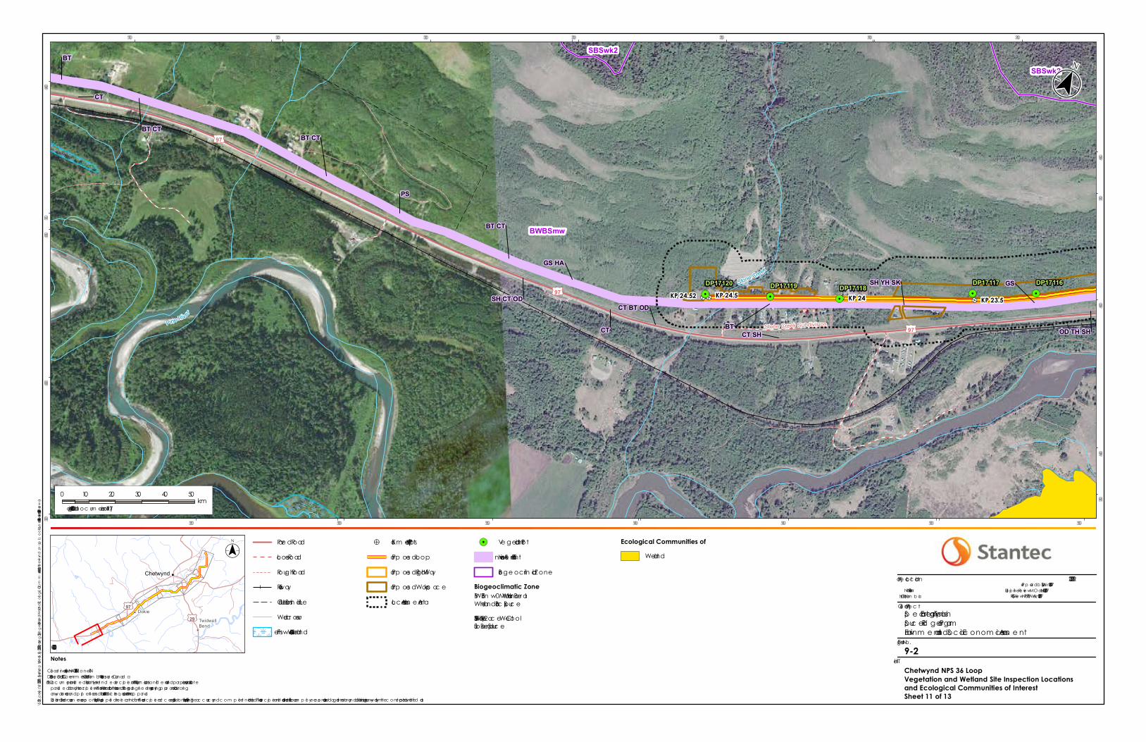
9.4.2.3.1 Chetwynd Loop
In total, 12.3 ha of ecological communities at risk were mapped in the Chetwynd Loop LAA (Table 9-9). Of this total, 3.1 ha are blue-listed upland forest communities, 7.1 ha are blue-listed wetlands and 2.1 ha is a blue-listed riparian community. Construction activities will result in the direct loss of 2.4 ha of ecological communities at risk in the Chetwynd Loop PDA (Table 9-9). Of this, 0.7 ha are blue-listed upland forests, 1.4 ha are blue-listed wetlands and 0.2 ha is covered by the blue-listed riparian community. As a result of construction activities, 18.4% of the mapped ecological communities at risk in the LAA will be affected. Over time, during operations and beyond, the residual effect on ecological communities at risk as a result of vegetation clearing may be reduced as ecological communities recover through natural regeneration or re-planting. Wetlands will be left to naturally revegetate. TWS areas on untenured Crown land that are naturally forested will be re-planted following construction activities (Appendix A-1).
Wetlands in the Chetwynd Loop LAA total 21.5 ha; 3.7 ha of bog, 5.1 ha of marsh, 10.3 ha of swamp, and 2.3 ha of shallow open water wetlands (Table 9-10). Construction activities will result in the direct loss of 3.0 ha of wetlands in the Chetwynd Loop PDA, comprising 14.0% of the wetlands in the LAA and 1.1% of the 272.9 ha in the Chetwynd Loop RAA. Of the 3.0 ha of wetland affected by the PDA, 2.2 ha are located in TWS. Over time during operations and beyond, the residual effect on wetlands as a result of vegetation clearing will be reduced as wetlands naturally revegetate following construction activities.
Direct losses to old forest communities as a result of Project construction are estimated based on an intersection of the PDA with BC OGC ABA data (BC OGC 2017b). Based on this analysis, old forest area within the Chetwynd Loop LAA is estimated at 25.2 ha (Table 9-11). Vegetation clearing for Project construction will result in a direct loss of 4.1 ha of deciduous-leading old forest area in the PDA, comprising a 16.3% change from the baseline LAA and a 1.0% change from the baseline RAA (Table 9-11). The Project-related loss of old forest will not bring the percentage of old forest in the Boreal Plains below the target of 17% (BC OGC 2017b). The Chetwynd Loop LAA does not overlap any legal OGMAs.
The direct loss of ecological communities of interest (ecological communities at risk, wetlands, and old forest) in the Chetwynd Loop PDA from construction is considered adverse, moderate magnitude, restricted to the PDA, occurs as a single event, and is partially reversible in the long-term (approximately 100 to 140 years after the end of construction for TWS and 100 to 140 years after the end of operations for the maintained ROW). Effects to ecological communities at risk may be permanent, particularly under the maintained ROW.
The loss of ecological communities of interest in the Chetwynd Loop PDA during operations is related to brushing in the maintained portion of the ROW. This disturbance will suppress trees and taller shrubs and will delay recovery of treed communities and old forest to baseline conditions. This loss is adverse, low magnitude, restricted to the PDA, will occur as multiple irregular events, and is reversible in the long-term (up to 140 years following the end of operations for old forest).
SPRUCE RIDGE PROGRAM
Assessment of Potential Effects on Vegetation and Wetlands October 17, 2017
9.58
9.4.2.3.2 Aitken Creek Loop
In total, 24.0 ha of ecological communities at risk were mapped in the Aitken Creek Loop LAA (Table 9-9). Of this total, 20.8 ha are blue-listed upland forest communities, and 3.2 ha are blue-listed wetlands. Construction activities will result in the direct loss of 4.5 ha of ecological communities at risk in the Aitken Creek Loop PDA (Table 9-9). Of this, 4.2 ha are blue-listed upland forests, and 0.3 ha are blue-listed wetlands. As a result of construction activities, 18.5% of the mapped ecological communities at risk in the LAA will be affected. Over time during operations and beyond, the residual effect on ecological communities at risk resulting from vegetation clearing may be reduced as TWS and wetlands are left to naturally regenerate after construction activities.
Wetlands in the Aitken Creek Loop LAA total 5.6 ha; 3.2 ha of bog, 1.1 ha of fen, 0.1 ha of marsh, 1.0 ha of swamp, and 0.2 ha of shallow open water wetlands (Table 9-10). Construction activities will result in the direct loss of 0.4 ha of wetlands in the Aitken Creek Loop PDA, comprising 8.1% of the wetlands in the LAA and 0.4% of the 118.8 ha in the Aitken Creek Loop RAA. Of the 0.4 ha of wetland affected by the PDA, 0.2 ha are located in TWS. Over time, during operations and beyond, the residual effect on wetlands resulting from vegetation clearing will be reduced as wetlands are left to naturally revegetate following construction activities.
Old forest area within the Aitken Creek Loop LAA is estimated at 37.5 ha. Vegetation clearing for Project construction will result in a direct loss of 7.6 ha of old forest in the PDA consisting of coniferous-leading, deciduous-leading, and mixedwood stands, comprising a 20.3% change from the baseline LAA and a 1.5% change from the baseline RAA (Table 9-11). The Project-related loss of old forest will not bring the percentage of old forest in the Boreal Plains below the target of 17% (BC OGC 2017b). The Aitken Creek Loop LAA does not overlap any legal OGMAs.
The direct loss of ecological communities of interest during construction in the Aitken Creek Loop PDA is considered adverse, low magnitude, restricted to the PDA, occurs as a single event, and is reversible to partially reversible in the long-term (approximately 100 to 140 years after the end of construction for TWS) and 100 to 140 years after the end of operations for the maintained ROW). Effects to ecological communities at risk resulting from construction may be permanent, particularly under the maintained ROW.
The loss of ecological communities of interest in the Aitken Creek Loop PDA during operations is related to brushing in the maintained portion of the ROW. This disturbance will suppress trees and taller shrubs and will delay recovery of treed communities and old forest to baseline conditions. This loss is adverse, low magnitude, restricted to the PDA, will occur as multiple irregular events, and is reversible in the long-term (up to 140 years following the end of operations for old forest).
SPRUCE RIDGE PROGRAM
Assessment of Potential Effects on Vegetation and Wetlands October 17, 2017
9.59
9.4.2.3.3 Combined Effect
As no residual Project effects are expected from the CS2 and CSN5 Expansions, the combined effects are limited to the Chetwynd Loop and Aitken Creek Loop LAAs (referred to below as the “combined LAA”). These LAAs, when combined, contain 37.3 ha of ecological communities at risk comprised of blue-listed upland forest, blue-listed wetlands, and blue-listed riparian communities (Table 9-9). Construction activities will result in the direct loss of 6.9 ha of ecological communities at risk in the combined Project PDA (Table 9-9) representing 18.5% of the mapped ecological communities at risk in the combined LAA. Over time, during operations and beyond, the residual effect on ecological communities at risk resulting from vegetation clearing will be reduced as ecological communities at risk in TWS, and wetlands revegetate after construction activities. Loss of ecological communities at risk in the maintained portion of the ROW may be permanent; though vegetation will recover following operations, it is uncertain whether the ecological communities at risk will re-establish.
Wetlands in the combined LAA total 27.0 ha; 6.9 ha of bog, 1.1 ha of fen, 5.2 ha of marsh, 11.3 ha of swamp, and 2.5 ha of shallow open water wetlands (Table 9-10). Construction activities will result in the direct loss of 3.5 ha of wetlands in the combined Project PDA, comprising 12.8% of the wetlands in the LAA and 0.9% of the 391.6 ha in the combined Project RAA. Of the 3.5 ha of wetland affected by the combined PDA, 2.4 ha are located in TWS. Over time, during operations and beyond, the residual effect on wetlands resulting from vegetation clearing may be reduced as wetlands naturally revegetate following construction activities.
Direct losses to old forest communities resulting from Project construction are estimated based on BC OGC ABA. Based on this analysis, old forest area within the combined LAA is estimated at 62.7 ha. Vegetation clearing for Project construction will result in a direct loss of 11.6 ha of old forest area in the PDA (Table 9-11). Old forest in the combined LAA is within the Boreal Plains NDU, which is above the 17% old forest target. The loss of old forest will not bring the old forest area below the threshold. The combined LAA does not overlap any legal OGMAs.
The direct loss of ecological communities of interest during construction of the combined loop PDA is considered adverse, low to moderate magnitude, restricted to the PDA, occurs as a single event, and is partially reversible in the long-term (though up to approximately 100 to 140 years after the end of construction for old forest in TWS, 100 to 140 years after the end of operations for old forest in the maintained portion of the ROW, and irreversible for ecological communities at risk in the ROW).
The loss of ecological communities of interest during operations in the combined Project PDA is related to brushing of the maintained portion of the ROW. This disturbance will suppress trees and taller shrubs and will delay recovery of treed communities and old forest to baseline conditions. This loss is adverse, low magnitude, restricted to the PDA, will occur as multiple irregular events, and is reversible in the long-term (up to 140 years following the end of operations for old forest).
SPRUCE RIDGE PROGRAM
Assessment of Potential Effects on Vegetation and Wetlands October 17, 2017
9.60
9.4.3 Change in Wetland Functions
Wetlands provide a number of ecosystem functions and are important areas for biological diversity and wildlife habitat. Wetlands present in the LAA include swamps, marshes, fens, bogs, and shallow open water wetlands. Wetland functions can vary between and amongst wetland classes depending on their position in the landscape, their chemical and physical properties and vegetation composition and cover.
9.4.3.1 Effect Pathways
Project construction has the potential to affect the hydrological, biogeochemical and habitat functions of wetlands in the Project LAA. The loss of wetland functions associated with new cut has been reduced by the routing of the Project adjacent to existing ROWs (see details in Section 2.1).
Wetlands provide hydrologic functions by moderating water flows and storing water. They may also provide protection from sedimentation and erosion by slowing water velocities and capturing sediments among wetland vegetation. Removal of vegetation cover may interrupt hydrological functions in the short- to medium-term for wetlands affected by the Chetwynd or Aitken Creek Loop PDA TWS. Effects to hydrological functions under any hard infrastructure in the CSN5 Expansion footprint would be long-term in duration. Soil disturbance during activities such as grading, trenching, and backfilling may cause disruption of surface and groundwater flows, resulting in effects such as wetlands flooding or dewatering.
Wetlands provide biogeochemical functions, including sediment retention, nutrient cycling, and carbon sequestration. Biogeochemical functions may be impacted by physical activities during construction including vegetation clearing and grubbing, disturbance of soils during topsoil salvage, grading, trenching, and vehicle watercourse crossings. There is also potential for the flow of surface water and/or shallow groundwater to a wetland to be altered by construction activities (e.g., grading, trenching, and backfilling).
With respect to both hydrologic and biogeochemical functions, the goal of cleanup and reclamation will be to restore surface water drainage patterns. During operations, vegetation maintenance will prevent tree cover from recovering in the maintained ROW.
Habitat functions may be lost or altered by clearing and grubbing of vegetation during construction and vegetation maintenance during operations through a change in structure (e.g., removal of trees and/or shrubs). These changes will affect species that depend on wetlands to provide some habitat function. A discussion of the change in habitat availability for selected focus species is presented in Section 10.4.1 and Table 10-13.
Many of these potential effects can be mitigated by proper application of construction mitigation and subsequent adaptive management measures, where required.

SPRUCE RIDGE PROGRAM
Assessment of Potential Effects on Vegetation and Wetlands October 17, 2017
9.61
9.4.3.2 Mitigation
Standard industry practices and avoidance measures, as well as resource-specific mitigation, will be implemented during construction and operation, as identified in the EPPs (Appendix A-1 and A-2) and the EMCPC (Spectra 2014). Table 9-12 contains key mitigation measures for change wetland functions.

SPRUCE RIDGE PROGRAM
Assessment of Potential Effects on Vegetation and Wetlands October 17, 2017
9.63
Table 9-12 Mitigation Measures for Change in Wetlands Functions
Potential Effect
Effect Pathway
Mitigation Measures
Applicable Component
Chetwynd Loop
Aitken Creek Loop
CSN5 Expansion
Change in wetland functions Project activities may result in a change in the abundance of wetland communities or a change in wetland soils, hydrology or vegetation that may affect the potential for a wetland to provide a certain ecological function.
Construction will avoid wetlands, to the extent practical.
The boundaries of wetlands in proximity of planned disturbances will be clearly delineated to facilitate avoidance during construction.
Buffers prescribed in Section 7-3 of the EPP will be applied to wetland crossings (in accordance with the OGAA EPMR); where practical, a 20 m buffer will be established in natural areas adjacent to wetlands and riparian areas where a buffer is not specified by the watercourse and wetlands crossing table.
Unnecessary vegetation loss in areas around the PDA will be avoided by adhering closely to construction plans and limiting off-site machine use to defined areas.
The extent of grubbing and clearing of shrubs and herbaceous species will be limited wherever practical.
Topsoil will be stripped from ROW or other work areas, stored and returned during clean-up in accordance with mitigation measures outlined in the EPPs.
Project activities may result in a change in the abundance of wetland communities or a change in wetland soils, hydrology or vegetation that may affect the potential for a wetland to provide a certain ecological function. (cont’d)
Refueling and lubrication of equipment will be conducted a minimum of 30 m away from any wetlands where practical.
Extra work areas (such as staging areas and additional spoil storage) will be limited in wetlands.
Bell holes will be pumped onto stable well-vegetated areas or constructed containment areas in a manner that does not cause erosion or sedimentation of a wetland. Discharge locations will be pre-determined and monitored by the EI to limit the potential for flooding or erosion.
Post-construction monitoring will be conducted after the final clean-up as stated in the EPPs.
NOTES: = Specified mitigation will be employed for this component. – = Specified mitigation will not be employed for this component.
SPRUCE RIDGE PROGRAM
Assessment of Potential Effects on Vegetation and Wetlands October 17, 2017
9.65
9.4.3.3 Residual Effects
The following sections discuss residual Project effects on the abundance and condition of wetlands for each Project component, followed by the combined effect for the Project as a whole (Figure 9-2). Residual Project effects on wetlands are quantified in Table 9-10.
9.4.3.3.1 Chetwynd Loop
Wetlands present in the Chetwynd Loop LAA and PDA include four of the five wetland classes: bogs, swamps, marshes and shallow open water wetlands. Of the 272.9 ha of wetlands in the RAA, 21.5 ha occur in the Chetwynd Loop LAA (refer to Section 9.1.2.2, Table 9-10). Construction activities will result in the disturbance of 3.0 ha of wetland area including 0.3 ha of bog, 0.4 ha of marsh, 2 ha of swamp and 0.3 ha of shallow open water wetlands; the disturbance affects about 1.1% of the total wetland area present in the Chetwynd Loop RAA.
9.4.3.3.2 Aitken Creek Loop
The Aitken Creek Loop LAA includes all five wetland classes: bogs, fens, swamps, marshes, and shallow open water wetlands. Of the 118.8 ha of wetlands in the RAA, 5.6 ha occur in the Aitken Creek Loop LAA (see Section 9.1.2.2, Table 9-10). Construction activities will result in the disturbance of 0.4 ha of wetland area including 0.2 ha of bog, 0.1 ha of fen, and 0.1 ha of swamp; the disturbance affects approximately 0.4% of the total wetland area present in the Aitken Creek Loop RAA.
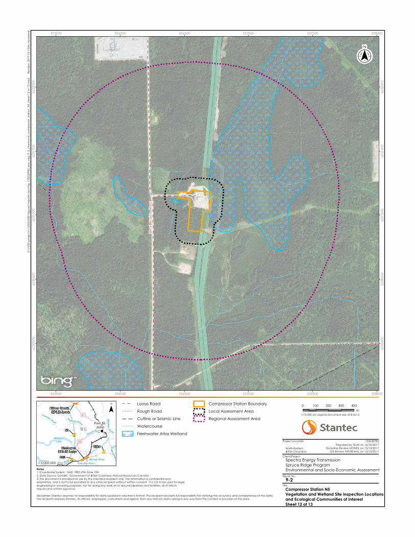
9.4.3.3.3 Compressor Station N5 Expansion
Based on the results of a desktop review, the CSN5 Expansion will not involve direct disturbance to wetlands. There is a small wetland adjacent to the compressor station access road that will be upgraded as part of the CSN5 Expansion. With the implementation of post-construction monitoring to manage indirect effects, no residual Project effects are expected.
9.4.3.3.4 Combined Effect
As no residual Project effects to wetlands are expected from the CS2 and CSN5 Expansions, the combined effects are limited to the Chetwynd Loop and Aitken Creek Loop LAAs (referred to below as the “combined LAA”). Wetlands present in the combined LAA include all five wetland classes: bogs, fens, swamps, marshes and shallow open water wetlands. Of the 392 ha of wetlands in the RAA, 27 ha occur in the combined Project LAA (refer to Section 9.1.2.2, Table 9-10). Construction activities will result in the disturbance of 3.5 ha of wetland area including 0.5 ha of bog, 0.1 ha of fen, 0.4 ha of marsh, 2.1 ha of swamp and 0.3 ha of shallow open water wetlands; the disturbance affects about 0.9% of the total wetland area present in the RAA.
Project construction has the potential to affect hydrological, biogeochemical and habitat functions. Wetland functions can vary between and amongst wetland classes depending on their position in the landscape, their chemical and physical properties and vegetation composition and cover. Bog, fen, swamp, marsh and open water wetlands provide hydrologic
SPRUCE RIDGE PROGRAM
Assessment of Potential Effects on Vegetation and Wetlands October 17, 2017
9.66
function by moderating water flows and storing water. Some wetland classes such as swamps, marshes, and shallow open water may also provide protection from sedimentation and erosion by slowing water velocities and capturing sediments among wetland vegetation. Removal of vegetation cover may interrupt hydrological functions in the short- to medium-term.
Biogeochemical functions may be impacted by the removal of vegetation, disturbance of soils and change to water storage capabilities (e.g., depth) within a wetland system. There is also potential for the flow of surface water and/or shallow groundwater to a wetland to be altered by construction activities (e.g., grading; trenching).
Clearing of vegetation will alter habitat functions through a loss of habitat and/or a change in structure (e.g., removal of shrubs). These changes will affect species that depend on wetlands to provide some habitat function. A discussion of the change in habitat availability for selected focus species is presented in Section 10.4.1.
While construction activities will result in the removal of vegetation during clearing and grubbing, the implementation of subsequent clean-up and reclamation measures as prescribed in the EPPs are expected to create conditions suitable for re-establishment of wetland vegetation associated with wet mineral soils. Since the wetland classes and site associations disturbed by construction are generally associated with mineral soils (with and without organic veneers) (MacKenzie and Moran 2004), marshes and shrub swamps have the potential to re-establish in the medium to long-term. Some hydrological functions would also be restored with establishment of wetland graminoid and/or shrub vegetation in the medium-term.
The change in loss of wetland habitat will be limited by paralleling the existing ROW, limiting vegetation clearing within wetlands associated with stream crossings and by encouraging natural revegetation in wetlands following disturbance. In addition, changes to habitat function of wetlands are further limited because a small area of treed wetlands (0.6 ha of wetland structural stage 4 or above) are affected by the Project. Some habitat function will also return following the establishment of hydrological function (e.g., presence of standing water for amphibians in marshes) and the re-establishment of vegetation. The implementation of the Project mitigation measures is anticipated to allow for the restoration of hydrological, biogeochemical and habitat functions in the marsh and shrub swamp wetlands in the medium- to long-term.
Indirect effects from construction activities may affect wetlands in the LAA by potentially altering their hydrological balance through changes in surface and groundwater flows and soil sedimentation. During the operations phase of the Project, no additional direct impacts to wetlands are predicted. However, there is some potential for indirect effects on wetland functions for the 27.0 ha identified in the LAA. Many of the wetlands in the LAA have been disturbed to some extent by the existing ROW and/or agriculture.
Indirect effects to wetland functions will most likely occur during the construction period; however, surface water drainage patterns and revegetation are to be restored during clean-up and reclamation. The indirect effects on wetland functions will be limited by implementing mitigation
SPRUCE RIDGE PROGRAM
Assessment of Potential Effects on Vegetation and Wetlands October 17, 2017
9.67
measures outlined in Section 9.4.3.2, as well as measures described in the EPPs, including post-construction monitoring and corrective measures applied as needed (Appendix A-1 and A-2).
With the implementation of the EPPs, residual Project effects on wetland functions are characterized as adverse in direction, low in magnitude, limited to the PDA for direct effects but may occur in the LAA (indirect effects), and short- to medium-term in duration for the shrubby and herbaceous wetlands found within the TWS, and long-term for treed wetlands or those in the portion of the ROW maintained through operations. The effects are partially reversible through adaptive management during operations. The residual effects to wetland area and wetland functions occur in a disturbed ecological context.
9.4.4 Summary of Residual Effects
Residual effects on Vegetation and Wetlands are summarized in Table 10-23. Residual effects for changes in the abundance of plant species of interest, changes in ecological communities of interest, and changes in wetland functions are expected to be adverse during construction and operations. Adverse residual effects during construction are predicted to be low to moderate in magnitude; to occur within the PDA to LAA for change in the abundance of plant species of interest, limited to the PDA for change in abundance of ecological communities of interest, and within the LAA for change in wetland functions (although direct effects are only expected to occur within the PDA). Changes in the abundance of plant species of interest will be medium to long term and reversible, changes in the abundance of ecological communities of interest are predicted to be long term in duration and reversible to irreversible, and changes in wetland functions are predicted to be short to long term in duration and partially reversible for effects during construction and reversible for effects during operations.
SPRUCE RIDGE PROGRAM
Assessment of Potential Effects on Vegetation and Wetlands October 17, 2017
9.68
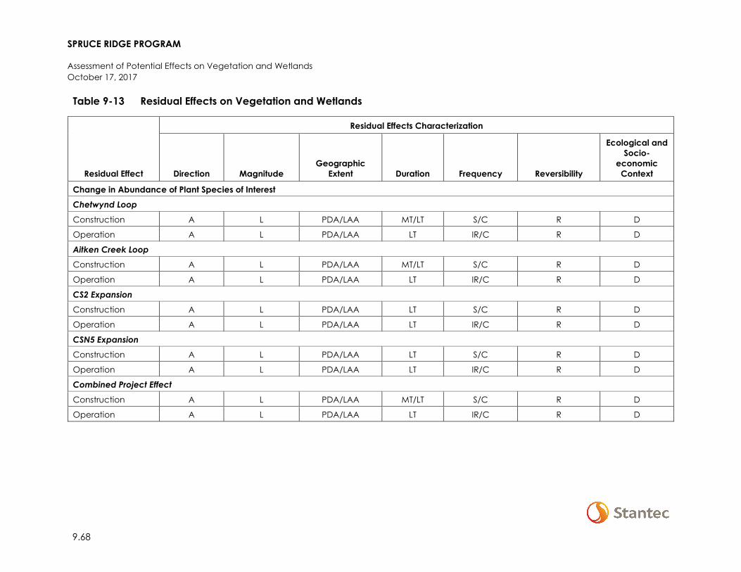
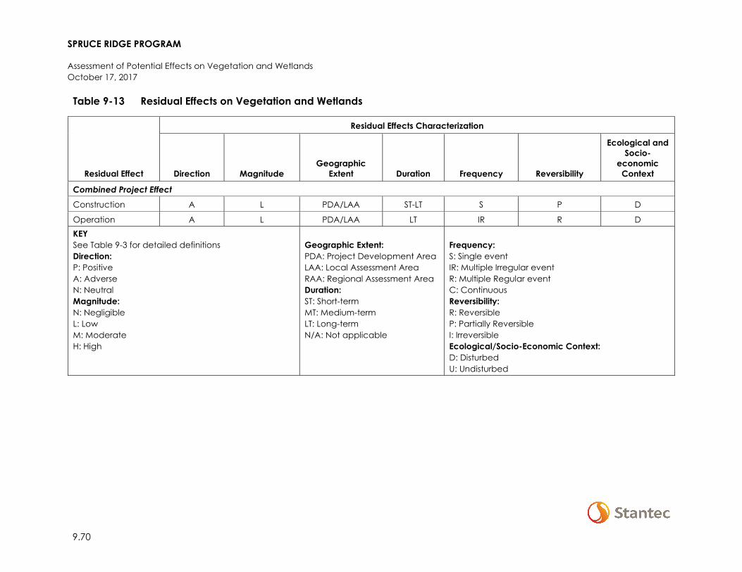
Table 9-13 Residual Effects on Vegetation and Wetlands
Residual Effect
Residual Effects Characterization
Direction Magnitude Geographic
Extent Duration Frequency Reversibility
Ecological and Socio-
economic Context
Change in Abundance of Plant Species of Interest Chetwynd Loop
Construction A L PDA/LAA MT/LT S/C R D
Operation A L PDA/LAA LT IR/C R D
Aitken Creek Loop Construction A L PDA/LAA MT/LT S/C R D
Operation A L PDA/LAA LT IR/C R D
CS2 Expansion Construction A L PDA/LAA LT S/C R D
Operation A L PDA/LAA LT IR/C R D
CSN5 Expansion Construction A L PDA/LAA LT S/C R D
Operation A L PDA/LAA LT IR/C R D
Combined Project Effect
Construction A L PDA/LAA MT/LT S/C R D
Operation A L PDA/LAA LT IR/C R D
SPRUCE RIDGE PROGRAM
Assessment of Potential Effects on Vegetation and Wetlands October 17, 2017
9.69
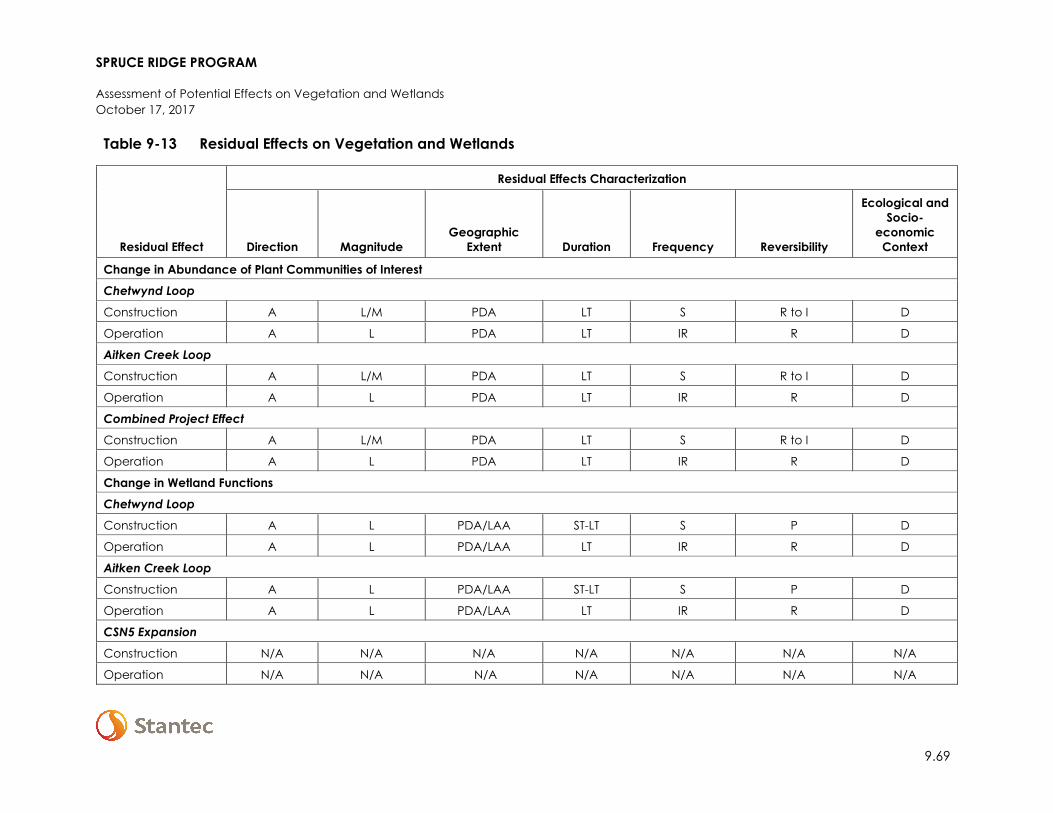
Table 9-13 Residual Effects on Vegetation and Wetlands
Residual Effect
Residual Effects Characterization
Direction Magnitude Geographic
Extent Duration Frequency Reversibility
Ecological and Socio-
economic Context
Change in Abundance of Plant Communities of Interest Chetwynd Loop
Construction A L/M PDA LT S R to I D
Operation A L PDA LT IR R D
Aitken Creek Loop Construction A L/M PDA LT S R to I D
Operation A L PDA LT IR R D
Combined Project Effect Construction A L/M PDA LT S R to I D
Operation A L PDA LT IR R D
Change in Wetland Functions Chetwynd Loop Construction A L PDA/LAA ST-LT S P D
Operation A L PDA/LAA LT IR R D
Aitken Creek Loop Construction A L PDA/LAA ST-LT S P D
Operation A L PDA/LAA LT IR R D
CSN5 Expansion
Construction N/A N/A N/A N/A N/A N/A N/A
Operation N/A N/A N/A N/A N/A N/A N/A
SPRUCE RIDGE PROGRAM
Assessment of Potential Effects on Vegetation and Wetlands October 17, 2017
9.70
Table 9-13 Residual Effects on Vegetation and Wetlands
Residual Effect
Residual Effects Characterization
Direction Magnitude Geographic
Extent Duration Frequency Reversibility
Ecological and Socio-
economic Context
Combined Project Effect Construction A L PDA/LAA ST-LT S P D
Operation A L PDA/LAA LT IR R D KEY See Table 9-3 for detailed definitions Direction: P: Positive A: Adverse N: Neutral Magnitude: N: Negligible L: Low M: Moderate H: High
Geographic Extent: PDA: Project Development Area LAA: Local Assessment Area RAA: Regional Assessment Area Duration: ST: Short-term MT: Medium-term LT: Long-term N/A: Not applicable
Frequency: S: Single event IR: Multiple Irregular event R: Multiple Regular event C: Continuous Reversibility: R: Reversible P: Partially Reversible I: Irreversible Ecological/Socio-Economic Context: D: Disturbed U: Undisturbed
SPRUCE RIDGE PROGRAM
Assessment of Potential Effects on Vegetation and Wetlands October 17, 2017
9.85
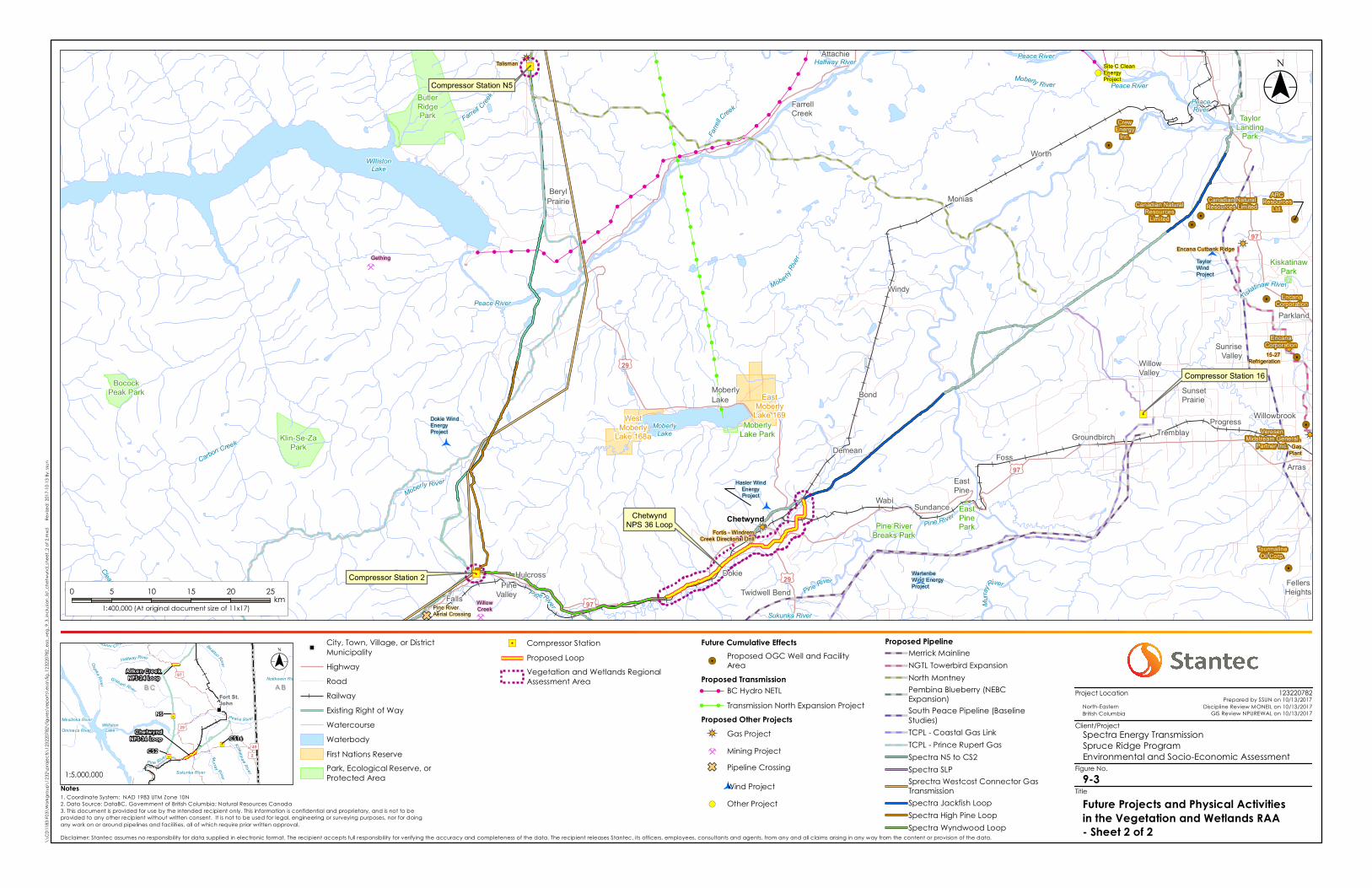
9.5 ASSESSMENT OF CUMULATIVE ENVIRONMENTAL EFFECTS ON VEGETATION AND WETLANDS
As discussed in Section 4.7, the approach used in the assessment of cumulative effects involves the identification of projects and activities within the RAA that may overlap and act cumulatively with the Project. Furthermore, it considers the predicted residual effects of the Project in combination with the potential residual effects of other past, present or reasonably foreseeable future activities. The following sections present the cumulative effects assessment for Vegetation and Wetlands.
9.5.1 Residual Project Effects Likely to Interact Cumulatively
Where residual environmental effects from the Project (Table 10-23) act cumulatively with residual effects from other projects and physical activities, a cumulative effects assessment is undertaken to determine their significance.
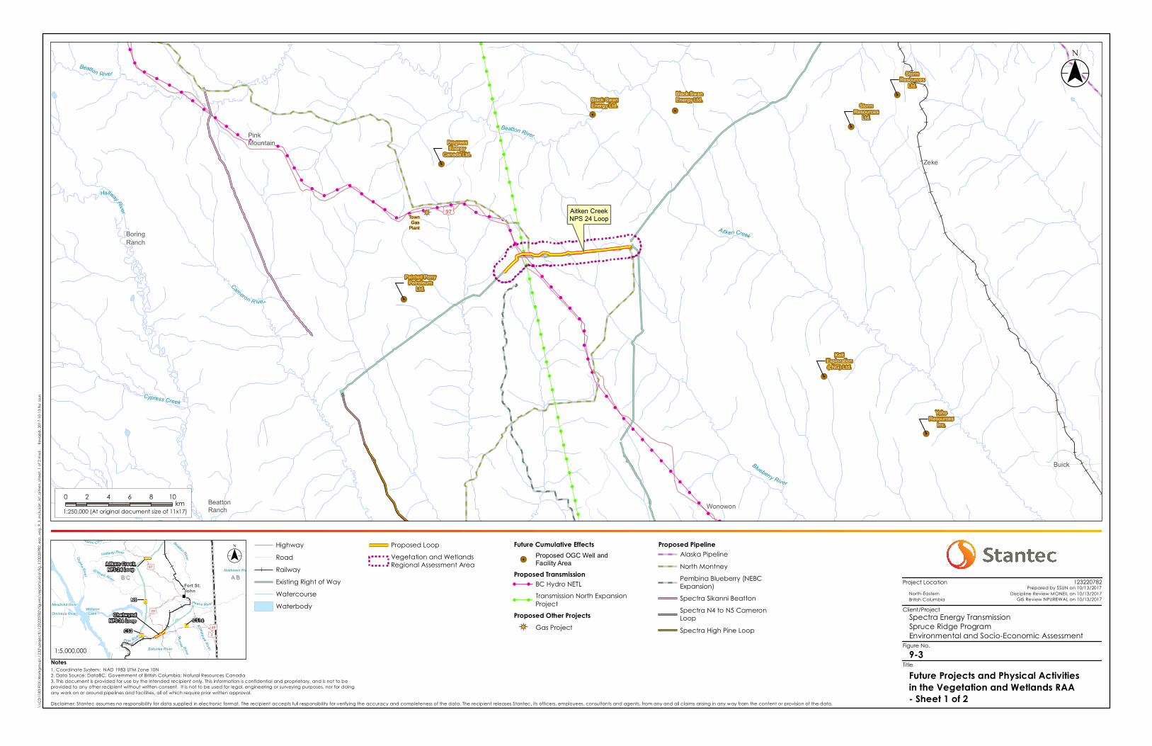
The identification of residual effects on Vegetation and Wetlands that are likely to interact cumulatively with past, existing, and foreseeable future activities, and the rationale for their selection is presented in Table 9-14. Section 4.7, Environmental Assessment Methods, presents the project and physical activities inclusion list, which identifies other projects and physical activities that might act cumulatively with the Project. Existing projects and physical activities are captured in baseline disturbance mapping and future projects and physical activities within the vegetation and wetlands RAA are displayed in
SPRUCE RIDGE PROGRAM
Assessment of Potential Effects on Vegetation and Wetlands October 17, 2017
9.73
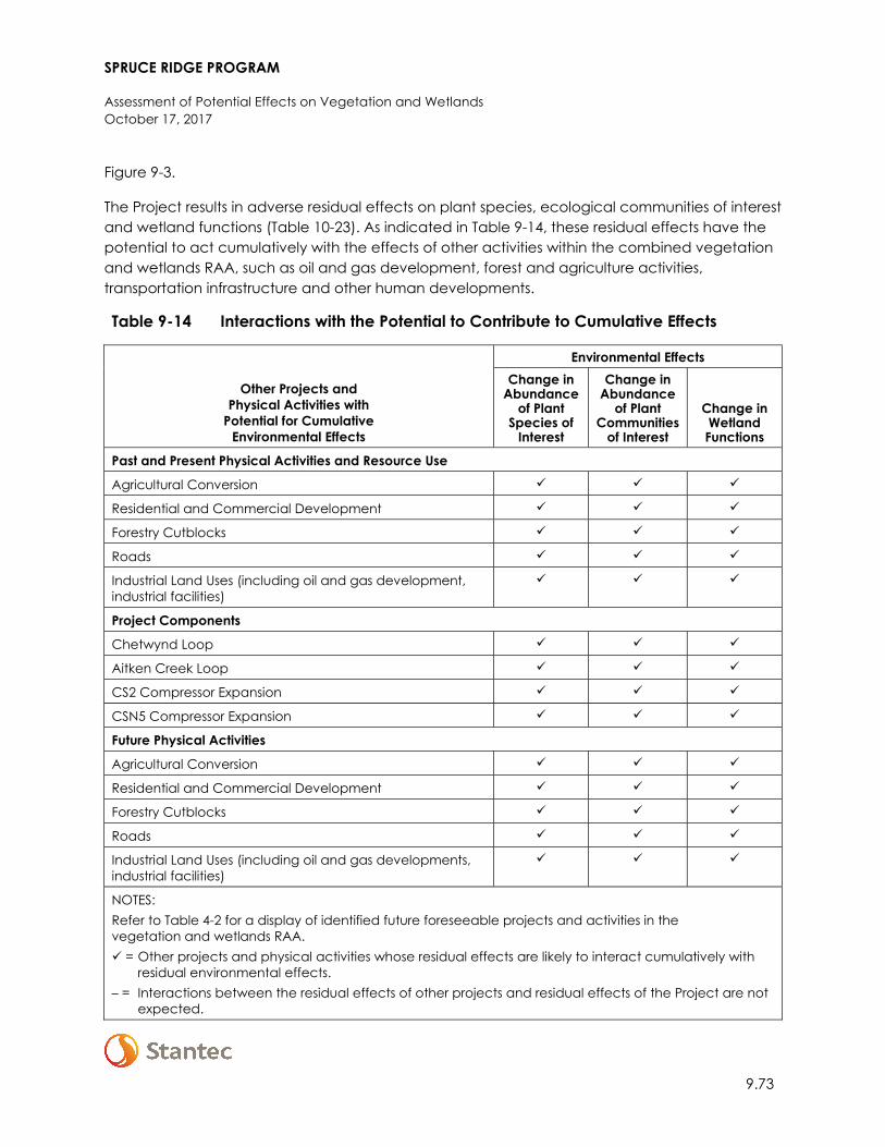
Figure 9-3.
The Project results in adverse residual effects on plant species, ecological communities of interest and wetland functions (Table 10-23). As indicated in Table 9-14, these residual effects have the potential to act cumulatively with the effects of other activities within the combined vegetation and wetlands RAA, such as oil and gas development, forest and agriculture activities, transportation infrastructure and other human developments.
Table 9-14 Interactions with the Potential to Contribute to Cumulative Effects
Other Projects and Physical Activities with
Potential for Cumulative Environmental Effects
Environmental Effects Change in
Abundance of Plant
Species of Interest
Change in Abundance
of Plant Communities
of Interest
Change in Wetland Functions
Past and Present Physical Activities and Resource Use
Agricultural Conversion
Residential and Commercial Development
Forestry Cutblocks
Roads
Industrial Land Uses (including oil and gas development, industrial facilities)
Project Components
Chetwynd Loop
Aitken Creek Loop
CS2 Compressor Expansion
CSN5 Compressor Expansion
Future Physical Activities
Agricultural Conversion
Residential and Commercial Development
Forestry Cutblocks
Roads
Industrial Land Uses (including oil and gas developments, industrial facilities)
NOTES: Refer to Table 4-2 for a display of identified future foreseeable projects and activities in the vegetation and wetlands RAA. = Other projects and physical activities whose residual effects are likely to interact cumulatively with
residual environmental effects.– = Interactions between the residual effects of other projects and residual effects of the Project are not
expected.
! ! ! ! ! !!
!
!
!
!
!
!
!
!
!
!
!
!
!
!
!!
!!
!!
!!
!!
!
!
!
!
!
!
!
!
!
!!
!!
!!
!!
!
!
!
!
!!
!!
!!
!!
!!
!!
!!
!!
!!
!!
!!
!!
!
!
! ! ! ! ! ! ! !
!
!
!
!
!
!
!! ! !
!
!
!
!
!
!
!
!
!
!
!
!
!
!
!!
!!
!!
!
!
!
!
!
!
!
!
!
!
!
!
!
!
!
!
!
!
!
!
!
!
!
!
!
!
!
!
!
!!
!!
!
!
!
!
!
!
!
!
!
!
!!!!
!
!!
!
!
!
!
!
!
!!
!
!
!
!
!
!
!
!
!
!
!
!
!
!
!
!!
!!
!
!
!
!
!
!
!
!
!
!!
!
!!!
!!
!
!
!
!
!!
!
!
!
!
!
!!
!!
!
!
!
!
!
!
!
!
!!
!!
!
!
!
!
!!
!
!
!
!
!
!
!
!
!
!!
!!
!!
!!
!!
!
!
!
!
!
!
!!
!!
!!
!!
!!
!!
!!
!!
!!
!!
!
!
!
!
!
!
!
!
!
!
!!
!!
!!
!
!
!
!!
!!
!
!
!
!
!
!
!!
!!
!!
!!
!!
!!
!
!
!
!
!
!
!
!
!
!
!
!
!
!
!
!
!
!
!
!
!
!!
!!
!!
!!
!!
!!
!!
!
!
!!
!!
!!
!!
!!
!!
!!
!!
!!
!!
!!
!
!
!
! ! ! ! !!
!
!
!
!!
!!
!!
!!
!!
!!
!!
!!
!!
!!
!!
!!
!!
!!
!
!
!
!
!!
!!
!!
!!
!!
!!
!!
!!
!!
!!
!!
!!
!!
!!
!
!!
!!
!!
!!
!!
!!
!!
!!
!!
!!
!!
!!
!!
!!
!!
!!
!!
!!
!!
!!
!!
!!
!!
!!
!!
!!
!!
!!
!!
!!
!!
!!
!!
!!
!!
!!
!!
!!
!!
!!
!!
!!
!!
!!
!!
!!
!!
!!
!!
!!
!!
!!
!!
!!
!!
!!
!!
!!
!!
!!
!!
!!
!!
!!
!!
!!
!!
!!
!!
!!
!!
!!
!!
!!
!!
!!
!!
!!
!!
!!
!!
!!
!!
!!
!!
!!
!!
!!
!!
!!
!!
!!
!!
!!
!!
!!
!!
!!
!!
!!
!!
!!
!!
!!
!!
!!
!!
!!
!!
!!
!!
!!
!!
!!
!!
)È
!5
!5
!5
!5
!5
!5
!5
!5
BoringRanch
BeattonRanch
Zeke
Buick
Wonowon
PinkMountain
£¤97
Beatton River
Cypress Creek
Blueberry River
Aitken Creek
Cameron R iver
Beatton River
HalfwayRiver
TownGas
Plant
Black SwanEnergy Ltd.
StormResources
Ltd.
ProgressEnergy
Canada Ltd.
YohoResources
Inc.
StormResources
Ltd.
Black SwanEnergy Ltd.
Painted PonyPetroleum
Ltd.
KeltExploration(LNG) Ltd.
9-3
Spectra Energy TransmissionSpruce Ridge ProgramEnvironmental and Socio-Economic Assessment
Notes
\\CD
1183
-F03\
Wor
kgro
up\1
232\
proje
cts\
1232
2078
2\fig
ures\
repo
rts\e
sa\fi
g_12
3220
782_
esa_
veg_
9_3_
inclus
ion_lis
t_aitk
en_sh
eet_1
of 2
.mxd
R
evise
d: 20
17-10
-13 By
: ssu
n
($$¯
North-Eastern British Columbia
Future Projects and Physical Activitiesin the Vegetation and Wetlands RAA- Sheet 1 of 2
Project Location
Client/Project
Figure No.
Title
HighwayRoadRailwayExisting Right of WayWatercourseWaterbody
Proposed LoopVegetation and WetlandsRegional Assessment Area
Future Cumulative Effects!5
Proposed OGC Well andFacility Area
Proposed Transmission! ! BC Hydro NETL! !
Transmission North ExpansionProject
Proposed Other Projects)È Gas Project
Proposed PipelineAlaska PipelineNorth MontneyPembina Blueberry (NEBCExpansion)Spectra Sikanni BeattonSpectra N4 to N5 CameronLoopSpectra High Pine Loop
0 2 4 6 8 10km
1:250,000 (At original document size of 11x17)
123220782Prepared by SSUN on 10/13/2017
Discipline Review MONEIL on 10/13/2017GIS Review NPUREWAL on 10/13/2017
Aitken Creek NPS 24 Loop
N5
CS2 CS16
ChetwyndNPS 36 Loop
B CB C A BA B£¤97
£¤2
£¤29
£¤49
Fort St.John
Peace River
Pine River
Halfway River
Mu rra y River
Sikanni Chief River
Ospika Rive r
Graham River
Kiskatinaw River
Beatton River
Sukunka River
Mesilinka River
Notikewin River
Omineca RiverWilliston
Lake
($$¯
1:5,000,000
Aitken CreekNPS 24 Loop
Disclaimer: Stantec assumes no responsibility for data supplied in electronic format. The recipient accepts full responsibility for verifying the accuracy and completeness of the data. The recipient releases Stantec, its officers, employees, consultants and agents, from any and all claims arising in any way from the content or provision of the data.
1. Coordinate System: NAD 1983 UTM Zone 10N2. Data Source: DataBC, Government of British Columbia; Natural Resources Canada3. This document is provided for use by the intended recipient only. This information is confidential and proprietary, and is not to beprovided to any other recipient without written consent. It is not to be used for legal, engineering or surveying purposes, nor for doingany work on or around pipelines and facilities, all of which require prior written approval.
"
! ! ! ! !
!
!
!
!
!
!
!
!
!
!!
!!
!
!
!
!
!
!
!
!!
!!
!!
!
!
!!
!!
!!
!!
!!
!!
!!
!
!
! ! ! ! !
!
!
!
!
! !!
!
!
!
!
!
!
!
!
!!
!!
!
!
!
!
!
!
!
!
!
!
!
!
!
!
!
!
!
!
!!
!
!
!
!
!
!
!
!!!
!
!
!
!
!
!!
!
!
!
!
!
!
!
!
!!
!
!
!
!
!
!
!
!
!!!
!!
!
!
!
!
!
!!
!
!
!
!
!
!
!!
!
!
!!
!
!
!
!
!
!
!!
!!
!!
!
!
!
!
!!
!!
!!
!!
!!
!!
!
!
!
!
!
!
!
!!
!!
!
!!
!!
!
!
!!
!!
!!
!!
!
!
!
!
!
!
!
!
!
!
!
!
!
!!
!!
!!
!!
!
!
!!
!!
!!
!!
!!
!!
!!
!
!! ! !
!
!
!!
!!
!!
!!
!!
!!
!!
!!
!!
!
!
!!
!!
!!
!!
!!
!!
!!
!!
!!
!!
!!
!!
!!
!!
!!
!!
!!
!!
!!
!!
!!
!!
!!
!!
!!
!!
!!
!!
!!
!!
!!
!!
!!
!!
!!
!!
!!
!!
!!
!!
!!
!!
!!
!!
!!
!!
!!
!!
!!
!!
!!
!!
!!
!!
!!
!!
!!
!!
!!
!!
!!
!!
!!
!!
!!
!!
!!
!!
!!
!!
!!
!!
!!
!!
!!
!!
!!
!!
!!
!!
!!
Ì
Ì
)È
)È
)È
)È
)È
!(
!(
)È
GF
!5!5!5
!5
!5
!5
!5
!5
"/
"/
"/
Compressor Station 16
ChetwyndNPS 36 Loop
Compressor Station 2
Compressor Station N5
Bond
BerylPrairie
Falls
Hulcross Dokie
Willowbrook
FellersHeights
Monias
Windy
Demean Foss
SundanceWabi
Tremblay
Worth
EastPine
Groundbirch
MoberlyLake
Arras
Attachie
FarrellCreek
SunriseValley
SunsetPrairie
Parkland
Progress
WillowValley
Twidwell BendPineValley
EastMoberly
Lake 169WestMoberly
Lake 168a
EastPinePark
MoberlyLake Park
KiskatinawPark
TaylorLanding
Park
Pine RiverBreaks Park
Klin-Se-ZaPark
BocockPeak Park
ButlerRidgePark
Chetwynd
£¤97
£¤29
£¤29
£¤97
£¤97
Moberly River
Mobe rlyRiv
er
Moberly River
P ineRiver
Clearwater Creek Murra
yRiver
Carbon Creek
Pine River
Farrell Creek
Kiskatinaw Rive r
Pine River
Farre
llCreek
Peace River
Sukunka River
Halfway River
WillistonLake
MoberlyLake
Peace River
PeaceRiver
Peace River
Site C CleanEnergyProject
Hasler WindEnergyProject
Dokie WindEnergyProject
WartenbeWind EnergyProject
TaylorWindProject
Pine RiverAerial Crossing
Talisman
DawsonGas
Plant
15-27Refrigeration
Encana Cutbank Ridge
Fortis - WindremCreek Directional Drill
Gething
WillowCreek
ARCResources
Ltd.Canadian NaturalResources
Limited
Canadian NaturalResources Limited
EncanaCorporation
CrewEnergy
Inc.
TourmalineOil Corp.
EncanaCorporation
VeresenMidstream General
Partner Inc.
9-3
Spectra Energy TransmissionSpruce Ridge ProgramEnvironmental and Socio-Economic Assessment
Notes
\\CD
1183
-F03\
Wor
kgro
up\1
232\
proje
cts\
1232
2078
2\fig
ures\
repo
rts\e
sa\fi
g_12
3220
782_
esa_
veg_
9_3_
inclus
ion_lis
t_che
twyn
d_sh
eet_2
of 2
.mxd
R
evise
d: 20
17-10
-13 By
: ssu
n
($$¯
North-Eastern British Columbia
Future Projects and Physical Activitiesin the Vegetation and Wetlands RAA- Sheet 2 of 2
Project Location
Client/Project
Figure No.
Title
"City, Town, Village, or DistrictMunicipalityHighwayRoadRailwayExisting Right of WayWatercourseWaterbodyFirst Nations ReservePark, Ecological Reserve, orProtected Area
"/ Compressor StationProposed LoopVegetation and Wetlands RegionalAssessment Area
Future Cumulative Effects!5
Proposed OGC Well and FacilityArea
Proposed Transmission! ! BC Hydro NETL! ! Transmission North Expansion ProjectProposed Other Projects)È Gas ProjectÌ Mining Project
GF Pipeline Crossing
Wind Project!( Other Project
0 5 10 15 20 25km
1:400,000 (At original document size of 11x17)
123220782Prepared by SSUN on 10/13/2017
Discipline Review MONEIL on 10/13/2017GIS Review NPUREWAL on 10/13/2017
Aitken Creek NPS 24 Loop
N5
CS2 CS16
ChetwyndNPS 36 Loop
B CB C A BA B£¤97
£¤2
£¤29
£¤49
Fort St.John
Peace River
Pine River
Halfway River
Mu rra y River
Sikanni Chief River
Ospika Rive r
Graham River
Kiskatinaw River
Beatton River
Sukunka River
Mesilinka River
Notikewin River
Omineca RiverWilliston
Lake
($$¯
1:5,000,000
Disclaimer: Stantec assumes no responsibility for data supplied in electronic format. The recipient accepts full responsibility for verifying the accuracy and completeness of the data. The recipient releases Stantec, its officers, employees, consultants and agents, from any and all claims arising in any way from the content or provision of the data.
1. Coordinate System: NAD 1983 UTM Zone 10N2. Data Source: DataBC, Government of British Columbia; Natural Resources Canada3. This document is provided for use by the intended recipient only. This information is confidential and proprietary, and is not to beprovided to any other recipient without written consent. It is not to be used for legal, engineering or surveying purposes, nor for doingany work on or around pipelines and facilities, all of which require prior written approval.
Proposed PipelineMerrick MainlineNGTL Towerbird ExpansionNorth MontneyPembina Blueberry (NEBCExpansion)South Peace Pipeline (BaselineStudies)TCPL - Coastal Gas LinkTCPL - Prince Rupert GasSpectra N5 to CS2Spectra SLPSprectra Westcost Connector GasTransmissionSpectra Jackfish LoopSpectra High Pine LoopSpectra Wyndwood Loop
SPRUCE RIDGE PROGRAM
Assessment of Potential Effects on Vegetation and Wetlands October 17, 2017
9.77
9.5.2 Change in the Abundance of Plant Species of Interest
9.5.2.1 Cumulative Effect Pathways
No Project-related residual effects are predicted for plant species at risk, therefore plant species at risk will not be assessed further. The primary cumulative effect pathways for change in the abundance of plant species of interest within the RAA are removal of traditionally used plants and the spread and introduction of invasive plants. The residual effect on plant species of interest from all Project components will interact cumulatively with past, present, and future physical activities that affect plant species of interest.
Vegetation removal is permanent when it is associated with conversion of land to non-native vegetation for agricultural uses (i.e., for cropland or improved pasture or hayland), or residential and commercial uses (i.e., lawns), or when land is covered by hard infrastructure such as roads, railroad, buildings, or industrial facilities. Vegetation removal is temporary when associated with cutblocks, pipeline ROWs, or transmission lines.
Activities and land uses that disturb the ground have the potential to introduce non-native invasive plant species or noxious weeds to the RAA. Invasive plants tend to readily invade disturbed areas and may spread into adjacent undisturbed habitats to the extent that they can change native plant species assemblages.
9.5.2.2 Mitigation for Cumulative Effects
Mitigation measures addressing change in abundance of plant species of interest are provided in Section 9.4.1.2, the EPPs (Appendix A-1 and A-2) and the EMCPC (Spectra 2014). It is expected that existing developments and future developments will be implementing similar measures in accordance with industry and regulatory guidelines and regulations for management of Vegetation and Wetlands. With respect to traditional use plants, no mitigation measures beyond those included in this ESA, EPPs, and the EMCPC are predicted to be necessary for mitigation of cumulative effects.
Westcoast is a stakeholder/member of the PRRD’s Strategic Plan and Profile of the Invasive Plants Monitoring Committee (PRRD 2016). The purpose of the committee is to “act as a forum to network and provide feedback to the IPC PRRD regarding:
• Strategic Plan and Profile of Invasive Plants • effects of noxious/invasive plants in the region • Advice regarding best practices for industries operating within the Region • Noxious/invasive plant occurrences • Information on matters referred by the IPC PRRD • Any other matters related to noxious/invasive plants (IPC PRRD 2016)

SPRUCE RIDGE PROGRAM
Assessment of Potential Effects on Vegetation and Wetlands October 17, 2017
9.78
9.5.2.3 Residual Cumulative Effects
Existing conditions in the combined RAA are moderately disturbed. Of the 9,277.1 ha of total land area associated with the combined RAA, 3,834.6 ha, or 41.3%, of the land base is either sparsely vegetated or anthropogenic (Table 9-4). The Chetwynd Loop RAA is more disturbed than the Aitken Creek Loop RAA, with nearly half of the Chetwynd Loop RAA land base sparsely vegetated or anthropogenic (Table 9-4), largely due to conversion of the land base to agricultural purposes. However, most traditional use plant species are commonly associated with deciduous seral forests and young to mature conifer forests found in the RAA. The long-term viability of the traditionally used plant species listed in Section 9.2.2 is potentially threatened within the RAA.
Anthropogenic disturbances (particularly ground disturbance) can increase vulnerability to invasive plants. The Chetwynd Loop RAA is affected by invasive plants to a greater degree than the Aitken Creek Loop RAA. The IAPP dataset documents 160 invasive plant locations in the Chetwynd Loop, CS2, and CSN5 RAAs, and field studies documented 27 locations (Appendix F-2, Section 4.1). The IAPP dataset documents six locations of invasive plant species in the Aitken Creek RAA, and field studies did not observe any invasive plants (Appendix F-1, Section 4.1).
With the addition of residual effects and the residual effects of other projects to existing conditions, cumulative change in the abundance of plant species of interest will remain moderate in magnitude. Some of the existing cumulative effects represent irreversible changes (e.g., agricultural conversion) and some of the existing cumulative effects are reversible in the medium- to long-term (e.g., forestry cutblocks, TWS for pipeline construction). It is expected that future development will follow industry best practices and regulations to limit effects on ecological communities of interest and limit invasive plant establishment.
The Project contribution to cumulative effects is small and has been reduced by the routing of the pipeline loops adjacent to existing ROWs (see details in Section 2.1). Approximately 122.5 ha of new clearing which might support traditional use plant species habitat is approximately 2.3% of vegetated upland and wetland communities in the combined Project RAA. Much of the Project’s contribution to this cumulative effect will be medium-term in duration and reversible upon the completion of construction in TWS and for species that can persist in the maintained ROW. The only predicted long-term loss of vegetation associated with the Project is the loss attributed to the compressor stations. Therefore, the Project’s contribution to cumulative environmental effects is not expected to further affect the long-term viability of plant species of interest in the RAA.

SPRUCE RIDGE PROGRAM
Assessment of Potential Effects on Vegetation and Wetlands October 17, 2017
9.79
9.5.3 Change in Abundance of Ecological Communities of Interest
9.5.3.1 Cumulative Effect Pathways
The primary cumulative effect pathway for change in the abundance of ecological communities of interest within the combined RAA is vegetation removal. The residual effect on ecological communities of interest from the Chetwynd Loop and Aitken Creek Loop will interact cumulatively with past, present, and foreseeable future physical activities, affecting ecological communities at risk, wetlands, and old forest. The compressor stations do not affect ecological communities of interest and therefore do not contribute to cumulative effects.
The removal of vegetation associated with ecological communities of interest is permanent when it is associated with conversion of land to non-native vegetation for agricultural uses (i.e., for cropland or improved pasture or hayland), or residential and commercial uses (i.e., lawns), or when the land is covered by hard infrastructure such as roads, railroad, buildings, or industrial facilities. The removal of vegetation associated with ecological communities of interest is largely temporary when associated with cutblocks, pipeline ROWs, or transmission lines. However, the effects may be permanent for ecological communities at risk because it is uncertain whether ecological communities at risk will re-establish following disturbance.
9.5.3.2 Mitigation for Cumulative Effects
Mitigation measures addressing change in abundance of ecological communities of interest are provided in Section 9.4.2.2, the EPPs (Appendix A-1 and A-2) and the EMCPC (Spectra 2014). It is expected that existing and future developments will implement similar measures in accordance with industry and provincial regulatory guidelines for management of Vegetation and Wetlands. No mitigation measures beyond those included in this ESA, the EPPs, and the EMCPC are predicted to be necessary for mitigation of cumulative effects to change in abundance of ecological communities of interest.
9.5.3.3 Residual Cumulative Effects
Approximately 3,834.6 ha or 41.3% of the existing land base is either sparsely vegetated or does not currently provide habitat for ecological communities at risk (Table 9-4). Blue-listed ecological communities at risk occupy 37.3 ha of the 1,032.4 ha combined loop LAA, representing 3.6% of existing LAA area. The Aitken Creek Loop LAA contains more ecological communities at risk than the Chetwynd Loop LAA (24.0 ha representing 7.4% of the Aitken Creek Loop LAA, compared to 12.3 ha representing 1.9% of the Chetwynd Loop LAA). Based on magnitude definitions presented in Table 8-2, existing land use activities have collectively had a moderate magnitude effect on the abundance of ecological communities of interest in the RAA, which may pose a threat to the long-term viability, reflected by the blue-listed status of several ecological communities.
SPRUCE RIDGE PROGRAM
Assessment of Potential Effects on Vegetation and Wetlands October 17, 2017
9.80
Existing wetlands occupy 391.6 ha of the 9,277.1 ha combined loop RAA according to ecosystem mapping (Table 9-10), representing 4.2% of RAA area. According to Environment Canada (2014), the RAA is located in an area of regional and continental significance to migratory birds, but is not identified as an area where wetland loss has reached critical levels. As such, past and current effects on wetlands represent a moderate magnitude effect.
Existing old forest occupies 983.8 ha of the combined loop RAA according to the BC OGC ABA dataset (Table 9-11), representing 10.6% of RAA area. The Chetwynd Loop and Aitken Creek Loop RAAs are within the Boreal Plains NDU, which has an old forest retention target of 17%. The current status of old forest in the Boreal Plains is above the target (BC OGC 2017b). Area Based Analysis allows for regional-level cumulative effects planning for oil and gas developments in the north-east of British Columbia. Existing effect to old forest represent a low magnitude effect, which is unlikely to pose a threat to the long-term viability of old forest within the RAA.
With the addition of Project effects and those of other projects to existing conditions, cumulative change in the abundance of ecological communities of interest are expected to remain low to moderate in magnitude. Cumulative effects to ecological communities of interest may be irreversible. Some cumulative effects to wetlands are permanent and some are reversible in the medium- to long-term. Cumulative effects to old forest are reversible in the long term with a return to forested land use. It is expected that future development will follow industry best practices and regulations to minimize effects on ecological communities of interest.
There is no reasonable expectation that the Project’s incremental contribution to cumulative effects will further affect the long-term viability of ecological communities of interest in the RAA for the following reasons:
• Ecological communities of interest disturbed by the Project are expected to partially recoverduring the operation phase as the TWS revegetate within the PDA. Certain wetland functionsare anticipated to recover on the permanent ROW to the extent practical givenmaintenance requirements, providing that hydrological conditions are maintained at similarconditions to the existing.
• No OGMAs are affected by the Project PDA.• No red-listed ecological communities at risk will be affected by the Project PDA.• The residual loss of ecological communities of interest is 18.5% of the total mapped in the
LAA (6.9 ha) and 0.1% of the total area capable of supporting these communities in the RAA(area of vegetated uplands and wetlands); the individual loss of area of any singlecommunity ranges between less than 0.1% and 25.8% of those mapped in the LAA. While thefull extent of ecological communities in the RAA (especially upland communities) is notknown, these communities will persist in the LAA, and therefore the RAA followingconstruction of the Project.
• The residual loss of 3.5 ha of wetlands representing 0.9% of the wetland area present in thecombined loop RAA; this loss includes 0.5 ha of bog, 0.1 ha of fen, 0.4 ha of marsh, 2.1 ha ofswamp, and less than 0.3 ha of shallow open water wetlands.
• Much of the Project’s contribution to this cumulative effect will be medium-term in durationand reversible upon the completion of construction in TWS and for species that can persist inthe maintained ROW.
SPRUCE RIDGE PROGRAM
Assessment of Potential Effects on Vegetation and Wetlands October 17, 2017
9.81
Therefore, the Project’s contribution to cumulative environmental effects is not expected to further affect the long-term viability of ecological communities of interest in the RAA.
9.5.4 Change in Wetland Functions
9.5.4.1 Cumulative Effect Pathways
The primary cumulative effect pathways for change in the wetland functions within the combined RAA are vegetation removal and ground disturbance. The residual effect on wetland functions from the Chetwynd Loop and Aitken Creek Loop will interact cumulatively with past, present, and future physical activities that affect the biogeochemical, hydrological, and habitat functions of wetlands. The compressor stations will not directly affect wetlands and indirect effects are expected to be managed through post-construction monitoring. Therefore, the compressor stations do not contribute to cumulative effects.
Change in wetland functions is permanent when it is associated with conversion of land to non-native vegetation for agricultural uses (i.e., for cropland or improved pasture or hayland), or residential and commercial uses (i.e., lawns), or when the land is covered by hard infrastructure such as roads, railroad, buildings, or industrial facilities. The removal of wetland vegetation and effects to wetland functions associated with ground disturbance may be temporary when associated with cutblocks, pipeline ROWs, or transmission lines.
9.5.4.2 Mitigation for Cumulative Effects
Mitigation measures addressing change in wetland functions are provided in Section 9.4.3.2, the EPPs (Appendix A-1 and A-2) and the EMCPC (Spectra 2014). It is expected that existing developments are implementing similar measures in accordance with industry and provincial regulatory guidelines for management of wetlands. No mitigation measures beyond those included in this ESA, the EPPs, and the EMCPC are predicted to be necessary for mitigation of cumulative effects related to wetland functions.
9.5.4.3 Residual Cumulative Effects
At baseline, approximately 391.6 ha (4.2%) of the combined RAA is represented by wetland communities (Table 9-10). Conversion of land from native communities to agriculture, along with past projects, has already had a moderate magnitude effect on wetland functions as it has likely reduced abundance of wetland communities and affected wetland functions in the RAA.
Effects of the Project on wetland communities and associated changes in wetland habitat functions will act cumulatively with those of past, present, and future projects within the RAA. According to Environment Canada (2014), the RAA is located in an area of significance to migratory birds, but is not identified as an area where wetland loss has reached critical levels. As such, past and current effects on wetlands represent a moderate magnitude effect.
SPRUCE RIDGE PROGRAM
Assessment of Potential Effects on Vegetation and Wetlands October 17, 2017
9.82
With the effects of existing and other future projects, the cumulative effect on wetland classes and functions will remain moderate in magnitude. For future linear developments, it can be anticipated that those projects will be subjected to the same types of policies and legislation, and will have the same mitigation options (e.g., routing adjustments) as the Project, in order to reduce effects on wetland resources. Therefore, the incremental effects on wetlands from these projects is unlikely to threaten the long-term viability of wetland classes or functions within the RAA.
There is no reasonable expectation that the Project’s incremental contribution to cumulative effects will affect the sustainability of wetland functions within the RAA for the following reasons:
• Hydrological and biogeochemical functions are unlikely to be affected by the Project withthe application of appropriate mitigation measures
• The incremental Project effect on 3.5 ha of wetland communities represents a smalldisturbance to wetlands in the RAA (0.9% of wetlands in the RAA), and these effects wouldnot eliminate any wetland classes (and their respective habitat functions) from the RAA.
• The area of wetlands disturbed by the Project is expected to partially recover during theoperation phase of the Project, as the TWS revegetates. Certain wetland functions areanticipated to recover on the permanent ROW to the extent practical, given ROWmaintenance requirements.
9.5.5 Summary of Residual Cumulative Effects
Table 9-14 summarizes cumulative environmental effects on Vegetation and Wetlands.
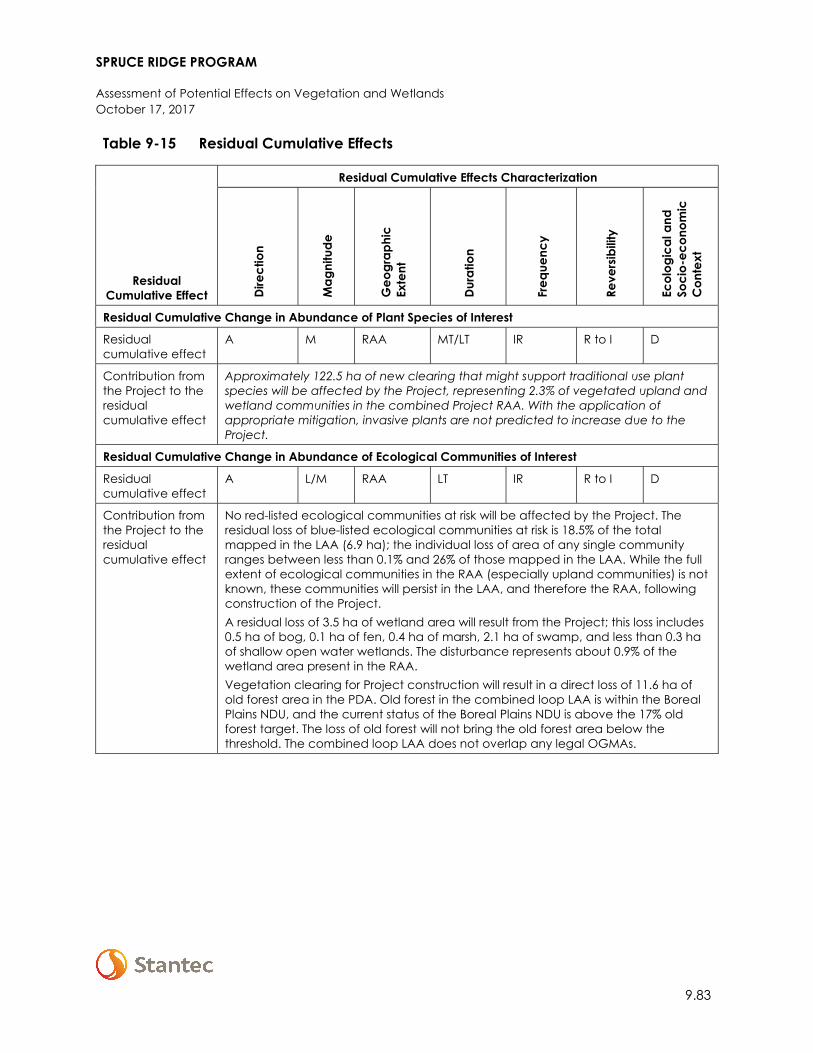
SPRUCE RIDGE PROGRAM
Assessment of Potential Effects on Vegetation and Wetlands October 17, 2017
9.83
Table 9-15 Residual Cumulative Effects
Residual Cumulative Effect
Residual Cumulative Effects Characterization
Dire
ctio
n
Mag
nitu
de
Geo
grap
hic
Exte
nt
Dura
tion
Freq
uenc
y
Reve
rsib
ility
Ecol
ogic
al a
nd
Soci
o-ec
onom
ic
Con
text
Residual Cumulative Change in Abundance of Plant Species of Interest
Residual cumulative effect
A M RAA MT/LT IR R to I D
Contribution from the Project to the residual cumulative effect
Approximately 122.5 ha of new clearing that might support traditional use plant species will be affected by the Project, representing 2.3% of vegetated upland and wetland communities in the combined Project RAA. With the application of appropriate mitigation, invasive plants are not predicted to increase due to the Project.
Residual Cumulative Change in Abundance of Ecological Communities of Interest
Residual cumulative effect
A L/M RAA LT IR R to I D
Contribution from the Project to the residual cumulative effect
No red-listed ecological communities at risk will be affected by the Project. The residual loss of blue-listed ecological communities at risk is 18.5% of the total mapped in the LAA (6.9 ha); the individual loss of area of any single community ranges between less than 0.1% and 26% of those mapped in the LAA. While the full extent of ecological communities in the RAA (especially upland communities) is not known, these communities will persist in the LAA, and therefore the RAA, following construction of the Project. A residual loss of 3.5 ha of wetland area will result from the Project; this loss includes 0.5 ha of bog, 0.1 ha of fen, 0.4 ha of marsh, 2.1 ha of swamp, and less than 0.3 ha of shallow open water wetlands. The disturbance represents about 0.9% of the wetland area present in the RAA. Vegetation clearing for Project construction will result in a direct loss of 11.6 ha of old forest area in the PDA. Old forest in the combined loop LAA is within the Boreal Plains NDU, and the current status of the Boreal Plains NDU is above the 17% old forest target. The loss of old forest will not bring the old forest area below the threshold. The combined loop LAA does not overlap any legal OGMAs.
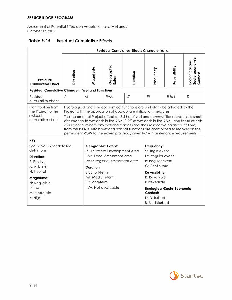
SPRUCE RIDGE PROGRAM
Assessment of Potential Effects on Vegetation and Wetlands October 17, 2017
9.84
Table 9-15 Residual Cumulative Effects
Residual Cumulative Effect
Residual Cumulative Effects Characterization
Dire
ctio
n
Mag
nitu
de
Geo
grap
hic
Exte
nt
Dura
tion
Freq
uenc
y
Reve
rsib
ility
Ecol
ogic
al a
nd
Soci
o-ec
onom
ic
Con
text
Residual Cumulative Change in Wetland Functions
Residual cumulative effect
A M RAA LT IR R to I D
Contribution from the Project to the residual cumulative effect
Hydrological and biogeochemical functions are unlikely to be affected by the Project with the application of appropriate mitigation measures. The incremental Project effect on 3.5 ha of wetland communities represents a small disturbance to wetlands in the RAA (0.9% of wetlands in the RAA), and these effects would not eliminate any wetland classes (and their respective habitat functions) from the RAA. Certain wetland habitat functions are anticipated to recover on the permanent ROW to the extent practical, given ROW maintenance requirements.
KEY See Table 8-2 for detailed definitions
Direction: P: Positive A: Adverse N: Neutral
Magnitude: N: Negligible L: Low M: Moderate H: High
Geographic Extent: PDA: Project Development Area LAA: Local Assessment Area RAA: Regional Assessment Area
Duration: ST: Short-term; MT: Medium-term LT: Long-term N/A: Not applicable
Frequency: S: Single event IR: Irregular event R: Regular event C: Continuous
Reversibility: R: Reversible I: Irreversible
Ecological/Socio-Economic Context: D: Disturbed U: Undisturbed
SPRUCE RIDGE PROGRAM
Assessment of Potential Effects on Vegetation and Wetlands October 17, 2017
9.85
9.6 DETERMINATION OF SIGNIFICANCE AND PREDICTION CONFIDENCE
9.6.1 Significance of Residual Project Effects
The assessment of residual Project effects on plant species of interest, ecological communities of interest and wetland functions considered changes to measurable parameters both quantitatively and qualitatively based on field data and observations, existing vegetation information, and spatial analyses of mapped ecosystems. In the context of sustaining healthy and diverse plant species, ecological communities, and wetland functions within the RAA, the determination of significance is based on the residual environmental Project effects characterization and significance thresholds (refer to Section 9.1.4 and 9.1.5).
The residual effects on plant species of interest are predicted to be not significant with the implementation of mitigation measures to limit impacts to traditional use plant species and to control noxious weeds and invasive plants. Confidence in this prediction is high because the effects mechanism is clearly understood (i.e., clearing of vegetated ecosystems in the PDA) and because traditional use plants are expected to be common within the ecosystems found within the LAA (and by extension the RAA) following Project construction. In addition, it is expected that some traditional use species will re-establish and persist in the ROW following Project construction. Therefore, the incremental loss of lands supporting traditional use plants is not expected to affect the long-term persistence or viability of traditional use plants in the RAA.
Residual effects on ecological communities at risk are predicted to be not significant in the context of the RAA. The direct loss of 6.9 ha of blue-listed ecological communities at risk within the PDA results is an 18.5% reduction in the areas of ecological communities of interest within the LAA. Since the incremental loss of any ecological community of interest with the LAA ranges from less than 0.1% to 25.8%, the remaining areas of these communities are expected to persist in the undisturbed portions of the LAA following Project construction. Based on the continued presence in the LAA the disturbance of ecological communities of interest will not compromise the long-term sustainability of these communities in the RAA.
The direct loss of 11.6 ha of old forest within the PDA results in a 1.2% reduction in available old forest area in the RAA. This incremental loss is not predicted to compromise the long term viability of old forest ecosystems in the RAA. Further, the BC OGC’s ABA old forest layer shows the status of old forest in the Boreal Plains and Boreal Foothills to be in normal status (above the 17% target for the Boreal Plains, and above the 33% target for Boreal Foothills). The Project’s residual effect on old forest will not tip these areas below the threshold. In addition, none of the Project components will result in an incursion into an OGMA.
SPRUCE RIDGE PROGRAM
Assessment of Potential Effects on Vegetation and Wetlands October 17, 2017
9.86
The disturbance of 3.5 ha of wetland ecosystems within the PDA results in a potential loss of about 0.9% of the total wetland area present in the RAA. As described in Section 9.4.3, wetland plant species are anticipated to re-establish within the PDA following construction. A loss of wetland functions within the wetlands intersected by the PDA in the long-term is not expected following implementation of the Project mitigation measures. Therefore, the residual effect on wetland functions is predicted to be not significant.
Prediction confidence in the assessment of Project effects on the change in abundance or condition of ecological communities of interest and wetland functions are considered high due to professional experience in the identification and understanding of these ecological communities in the region.
With mitigation and environmental protection measures, the residual environmental effects on vegetation and wetlands are predicted to be not significant.
9.6.2 Significance of Residual Cumulative Effects
Though vegetation and wetlands in the RAA are already adversely affected by existing projects and activities, past, present, and reasonably foreseeable future effects do not represent a clear threat to the long-term viability of those resources in the RAA. Cumulative effects are not anticipated to exceed regulatory limits for old forest. With mitigation and environmental protection measures, the residual cumulative environmental effects on vegetation and wetlands are predicted to be not significant.
9.7 FOLLOW-UP AND MONITORING
Westcoast has committed to a number of monitoring activities as part of the proposed mitigation for the pre-construction, construction and operations phases of the Project (see the EPPs in Appendix A-1 and A-2). Westcoast will implement an environmental inspection program during construction in accordance with the EMCPC (Spectra 2014). Qualified EIs will work onsite during construction to verify that all construction activities are in compliance with regulatory commitments and mitigation measures as outlined in the EPPs (Appendix A-1 and A-2).
Westcoast will also implement post-construction monitoring, as per the EMCPC (Spectra 2014). Residual effects or other issues that are identified following construction will be addressed with remedial actions and appropriate documentation. Outstanding ROW issues arising after construction will be identified through Westcoast’s continuous monitoring of all aspects of ROW integrity and addressed, if warranted.
No additional vegetation-specific monitoring or follow-up programs beyond those described in the EPPs and EMCPC (Spectra 2014) are proposed.
SPRUCE RIDGE PROGRAM
Assessment of Potential Effects on Wildlife and Wildlife Habitat October 17, 2017
10.1
10 ASSESSMENT OF POTENTIAL EFFECTS ON WILDLIFE AND WILDLIFE HABITAT
Wildlife and Wildlife Habitat was selected as a VC because of the potential to interact with Project activities and because it is considered by the proponent, the public, Aboriginal Groups, the scientific community, and government agencies to have ecological, aesthetic, recreational, economic, and cultural importance.
The Project will interact directly and indirectly with wildlife and wildlife habitat. Potential effects include direct and indirect change to habitat availability, change to mortality risk, and change to movement.
The wildlife and wildlife habitat assessment is linked to the assessments for other VCs, including Atmospheric Environment (Section 5), Acoustic Environment (Section 6), Fish and Fish Habitat (Section 8), and Vegetation and Wetlands (Section 9). The wildlife and wildlife habitat assessment is informed by the descriptions of the existing (baseline) conditions for these VCs, and the residual effects predictions for these VCs are evaluated for their potential to affect wildlife and wildlife habitat. Information on wildlife and wildlife habitat is also relevant to Land and Resource Use (Section 12).
10.1 SCOPE OF ASSESSMENT
This section describes the scope of the wildlife and wildlife habitat assessment as follows: regulatory and policy setting; influence of consultation and engagement on the assessment; potential effects, pathways, and measurable parameters; boundaries; residual effects characterization; and significance definition.
10.1.1 Regulatory and Policy Setting
Federal and provincial legislation and policy applicable to wildlife and wildlife habitat are described in the following sections. The regulatory and policy setting for woodland caribou (Rangifer tarandus caribou) is described separately because of its complexity.
10.1.1.1 Federal
Project effects on wildlife and wildlife habitat are subject to regulatory requirements under the National Energy Board Act as described in Table A-2 of the NEB Filing Manual (NEB 2017a).
SPRUCE RIDGE PROGRAM
Assessment of Potential Effects on Wildlife and Wildlife Habitat October 17, 2017
10.2
Some wildlife species in Canada are afforded federal protection through two pieces of legislation: Migratory Birds Convention Act (MBCA) and Species at Risk Act (SARA). The MBCA applies to migratory bird species that are identified in the Act and occur on federal, provincial, and private lands. The MBCA prohibits the disturbance, destruction, or possession of migratory birds, and their nests or eggs (section 5[9]). ECCC provides guidance on how applicants and permit holders protect migratory birds and avoid the risk of disturbance or destruction of birds, and their nests or eggs (ECCC 2017a).
SARA applies to species that are listed on Schedule 1 of SARA. Under SARA, it is prohibited to kill, harm, harass, capture or take an individual designated as extirpated, endangered, or threatened (section 32[1]). SARA requires the Government of Canada to produce recovery strategies for species on Schedule 1 that are listed as threatened, endangered, or extirpated. Federal recovery strategies are required to identify critical habitat for listed species and SARA prohibits the destruction of critical habitat.
The following federal recovery strategies are applicable to the Project:
• Recovery Strategy for the Woodland Caribou, Southern Mountain population (Rangifer tarandus caribou) in Canada (Environment Canada 2014)
• Recovery Strategy for the Common Nighthawk (Chordeiles minor) in Canada (Environment Canada 2016a).
• Recovery Strategy for the Olive-sided Flycatcher (Contopus cooperi) in Canada (Environment Canada 2016b)
• Recovery Strategy for the Canada Warbler (Cardellina canadensis) in Canada (Environment Canada 2016c)
• Recovery Strategy for Little Brown Myotis (Myotis lucifugus), Northern Myotis (Myotis septentrionalis), and Tri-colored Bat (Perimyotis subflavus) in Canada [Proposed] (Environment Canada 2015)
Among these federal recovery strategies, only that for woodland caribou has identified critical habitat that overlaps with the Project (see Section 10.1.1.3).
Environment and Climate Change Canada may consider conservation allowances for projects with potential adverse effects on species at risk (ECCC 2017b). For NEB-regulated projects, the NEB will determine whether proposed mitigation measures for a project will adequately mitigate project effects.
SPRUCE RIDGE PROGRAM
Assessment of Potential Effects on Wildlife and Wildlife Habitat October 17, 2017
10.3
10.1.1.2 Provincial
Management of wildlife on public lands in BC occurs primarily through the provincial Wildlife Act. Under this legislation, provincial biologists manage wildlife populations by regulating and restricting the harvest of individuals. The Wildlife Act prohibits the killing, capture, and harassment of native wildlife, except where a permit or regulation allows these activities. Similar to the MBCA, section 34 of the Wildlife Act specifically prohibits disturbance or destruction of any bird or its egg. It is also an offence to destroy the nests of certain species, regardless of the time of year. Within the Project area, these species are bald eagle (Haliaeetus leucocephalus) and osprey (Pandion haliaetus).
Section 103 of the provincial OGAA explains that certain wildlife or wildlife habitat may be subject to specific environmental protection and management regulations. These apply only to Crown land. Specifically, section 6 of the EPMR relates to the management and protection of wildlife and wildlife habitat values, such as designated wildlife habitats, wildlife trees, and wildlife habitat features. Oil and gas activities must be planned and undertaken in accordance with section 6 of the EPMR.
The EPMR applies to ungulate winter ranges (UWRs) and wildlife habitat areas (WHAs), which have been designated under the Forest Practices Code and subsequently adopted under the Forest and Range Practices Act. Those UWRs and WHAs that were legally established under that Act have been continued by Order to apply under the OGAA and EPMR. Under the OGAA, effective management of the WHAs and UWRs is the direct responsibility of the BC OGC, which determines whether to issue a permit for an oil and gas activity based on whether that activity would cause a material adverse effect. Subsequently, oil and gas activity may be subject to General Wildlife Measures prescribed within the legal Order for UWRs and WHAs, or other measures prescribed by the BC OGC as a condition of approval.
The BC OGC has established the Environmental Protection and Management Guideline (BC OGC 2017) applicable to oil and gas activities to assist applicants and permit holders to understand the requirements of the EPMR. This guideline outlines mitigation planning for WHAs, UWRs, high priority wildlife, caribou, wildlife tree retention areas, and wildlife habitat features.
SPRUCE RIDGE PROGRAM
Assessment of Potential Effects on Wildlife and Wildlife Habitat October 17, 2017
10.4
The BC Ministry of Environment and Climate Change Strategy has developed two guidance documents that provide a framework for mitigating potential adverse effects of projects on the environment. These include a Policy for Mitigating Impacts on Environmental Values (BC MOE 2014a) and an accompanying Procedure for Mitigating Impacts on Environmental Values (BC MOE 2014b). These documents are designed to provide guidance for the selection and implementation of mitigation measures. BC MOE (2014a,b) outlines a mitigation hierarchy that provides a framework for limiting impacts on environmental values. The four levels of the mitigation hierarchy are:
• Avoid: Project-related impacts on environmental values can be completely avoided byadjusting the location of an activity, using alternative methods, adjusting the timing orschedule of an activity or by ceasing an activity altogether.
• Minimize: If avoidance is not possible, project-related impacts on environmental values maybe partially avoided by adjusting the location of an activity, using alternative methods, oradjusting the timing or schedule of an activity.
• Restore on site: If disturbance of an environmental value cannot be avoided or minimized toan acceptable level, restoration of the value in the project area will be considered.Restoration aims to recover the function, integrity, resiliency, and self-sustainability of thedisturbed value.
• Offset (off site or on site): If, after measures to avoid, minimize, and restore on site have beenapplied and residual impacts are predicted to remain, offsets may be required. Provincialpolicy requires an assessment of ecological equivalency of any remaining impacts, andconsideration and selection of measures to offset impacts on environmental values.
Land and resource management plans relevant to the Project components are discussed in Section 12 (Land and Resource Use).
10.1.1.3 Woodland Caribou
The CS2 and CSN5 Expansions are the only Project components that overlap with government-designated southern mountain caribou range; the Aitken Creek and Chetwynd Loops, and the CS16 Modifications component, do not overlap with caribou range. The CS2 and CSN5 Expansions will collectively interact directly, and potentially indirectly, with two caribou subpopulations (i.e., herds)—Moberly/Klinse-Za and Graham. The following sections describe the regulatory and policy framework applicable to southern mountain caribou.
10.1.1.3.1 Federal
The goal of the federal recovery strategy for southern mountain caribou is to achieve self-sustaining populations in all local population units (LPUs) within their current distribution (Environment Canada 2014). The Moberly/Klinse-Za subpopulation is part of the Pine River LPU, and the Graham subpopulation is its own LPU.
Critical habitat necessary to achieve population and distribution objectives is described and partially mapped for these two LPUs (Environment Canada 2014). Critical habitat is identified as

SPRUCE RIDGE PROGRAM
Assessment of Potential Effects on Wildlife and Wildlife Habitat October 17, 2017
10.5
the habitat possessing biophysical attributes required by southern mountain caribou to carry out life processes; those biophysical attributes include low predation risk, access to lichens, low sensory disturbance, and minimal physical obstructions (Environment Canada 2014).
There are four types of critical habitat relevant to the Pine River or Graham LPUs:
1. High elevation winter and/or summer range – within the Pine River and Graham LPUboundaries
2. Low elevation summer range – within the Graham LPU boundary3. Type 1 Matrix range – within the Pine River and Graham LPU boundaries, defined as:
• Those areas not mapped as high or low summer or winter range• Areas with an ongoing recruitment and retirement habitat cycle that maintains a
minimum of 65% undisturbed habitat4. Type 2 Matrix range – outside of the LPU boundaries, and provides:
• Low predation risk, defined by population densities of less than 3 wolves/1000 km2
The CS2 Expansion overlaps Type 1 Matrix range in the Moberly/Klinse-Za subpopulation, and the CSN5 Expansion overlaps Type 1 Matrix range in the Graham subpopulation.
Environment and Climate Change Canada is currently in the process of amending the 2014 recovery strategy to include comprehensive mapping of critical habitat categories, with the goal of making them as accurate and detailed as possible with respect to the location and type of critical habitat (ECCC 2017c,d). With current capacity and direction, ECCC expects to post this update for a 60-day public comment period as required by SARA, and finalize the amended recovery strategy, by the end of 2017 (ECCC 2017c).
The NEB expects restoration and offsets measures as a means of mitigating residual environmental effects of a Project on caribou critical habitat (NEB 2017b). For recent NEB-regulated pipeline projects that interact with caribou habitat (e.g., Westcoast’s Wyndwood and High Pine Expansion projects, and the 2BL Crossover Assemblies Replacement project), the NEB was of the view that residual effects on critical habitat should be fully compensated for, with the goal of no net loss of critical habitat. As such, the NEB imposed conditions requiring a caribou habitat restoration plan, an offsets measures plan, and a restoration and offsets measures monitoring plan.
10.1.1.3.2 Provincial
The key ways the Province manages industrial development within southern mountain caribou range are through legislation, the Implementation Plan for the Ongoing Management of South Peace Northern Caribou (Rangifer tarandus caribou pop. 15) in British Columbia (Implementation Plan, BC MOE 2013a), and policy.
Under the Wildlife Act, southern mountain caribou is protected from capture and killing. Hunting of southern mountain caribou is currently prohibited under the Hunting Regulations issued under the Wildlife Act.
SPRUCE RIDGE PROGRAM
Assessment of Potential Effects on Wildlife and Wildlife Habitat October 17, 2017
10.6
Under the OGAA, the BC OGC is responsible for the protection and management of caribou UWRs, WHAs, and important habitat features (e.g., mineral licks).
The Implementation Plan details the Province’s approach to caribou conservation in response to direction from the Natural Resource Board (BC MOE 2013b). The Implementation Plan includes the seven herds in the South Peace region: Graham, Moberly/Klinse-Za, Scott, Burnt Pine, Kennedy Siding, Quintette, and Narraway (BC MOE 2013a). One of the key objectives of the Implementation Plan is to manage the industrial footprint in caribou herd range to reduce disturbance and habitat alteration (BC MOE 2013a).
To support the Implementation Plan, the Province has prepared Guidance for the Development of Caribou Mitigation and Monitoring Plans for South Peace Northern Caribou (BC MOE 2013c). These plans are required from proponents with proposed industrial developments that adversely affect high elevation winter range. The Project does not overlap high elevation winter range. Currently, provincial policy does not require offsets for effects on caribou habitat outside of high elevation winter range (BC MOE 2013c).
The Province has also developed draft South Peace Northern Caribou Standardized Industry Management Practices (BC MFLNRO and BC MOE 2016) to manage industrial development in caribou habitat. In addition, the Province has developed a compendium of wildlife guidelines for industrial development in northern BC (BC MFLNRO 2014), which includes specific guidance pertaining to caribou.
10.1.2 Potential Effects, Pathways and Measurable Parameters
Potential effects on wildlife and wildlife habitat are change to habitat availability, change to mortality risk, and change to movement. These potential effects, their effect pathways, and their selected measurable parameters are provided in Table 10-1. The potential effects and effects pathways are applicable to both the construction and operation phases of the Project.
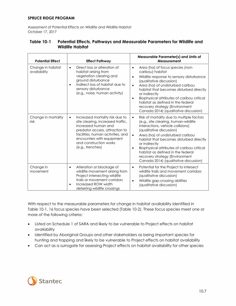
SPRUCE RIDGE PROGRAM
Assessment of Potential Effects on Wildlife and Wildlife Habitat October 17, 2017
10.7
Table 10-1 Potential Effects, Pathways and Measurable Parameters for Wildlife and Wildlife Habitat
Potential Effect Effect Pathway Measurable Parameter(s) and Units of
Measurement
Change in habitat availability
• Direct loss or alteration ofhabitat arising fromvegetation clearing andground disturbance
• Indirect loss of habitat due tosensory disturbance(e.g., noise, human activity)
• Area (ha) of focus species (non-caribou) habitat
• Wildlife response to sensory disturbance(qualitative discussion)
• Area (ha) of undisturbed caribouhabitat that becomes disturbed directlyor indirectly
• Biophysical attributes of caribou criticalhabitat as defined in the federalrecovery strategy (EnvironmentCanada 2014) (qualitative discussion)
Change in mortality risk
• Increased mortality risk due tosite clearing, increased traffic,increased human andpredator access, attraction tofacilities, human activities, andencounters with equipmentand construction works(e.g., trenches)
• Risk of mortality due to multiple factors(e.g., site clearing, human-wildlifeinteractions, vehicle collisions)(qualitative discussion)
• Area (ha) of undisturbed caribouhabitat that becomes disturbed directlyor indirectly
• Biophysical attributes of caribou criticalhabitat as defined in the federalrecovery strategy (EnvironmentCanada 2014) (qualitative discussion)
Change in movement
• Alteration or blockage ofwildlife movement arising fromProject intersecting wildlifetrails or movement corridors
• Increased ROW widthdeterring wildlife crossings
• Potential for the Project to intersectwildlife trails and movement corridors(qualitative discussion)
• Wildlife gap-crossing abilities(qualitative discussion)
With respect to the measurable parameters for change in habitat availability identified in Table 10-1, 16 focus species have been selected (Table 10-2). These focus species meet one or more of the following criteria:
• Listed on Schedule 1 of SARA and likely to be vulnerable to Project effects on habitatavailability
• Identified by Aboriginal Groups and other stakeholders as being important species forhunting and trapping and likely to be vulnerable to Project effects on habitat availability
• Can act as a surrogate for assessing Project effects on habitat availability for other species
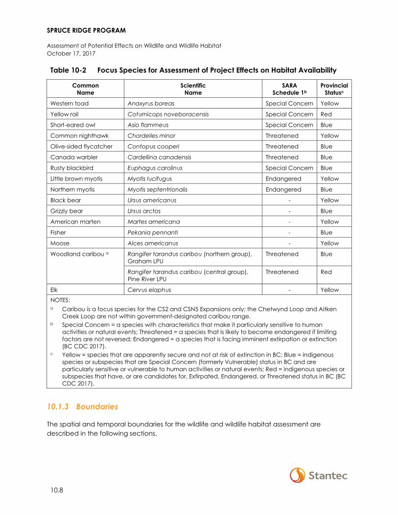
SPRUCE RIDGE PROGRAM
Assessment of Potential Effects on Wildlife and Wildlife Habitat October 17, 2017
10.8
Table 10-2 Focus Species for Assessment of Project Effects on Habitat Availability
Common Name
Scientific Name
SARA Schedule 1b
Provincial Statusc
Western toad Anaxyrus boreas Special Concern Yellow
Yellow rail Coturnicops noveboracensis Special Concern Red
Short-eared owl Asio flammeus Special Concern Blue
Common nighthawk Chordeiles minor Threatened Yellow
Olive-sided flycatcher Contopus cooperi Threatened Blue
Canada warbler Cardellina canadensis Threatened Blue
Rusty blackbird Euphagus carolinus Special Concern Blue
Little brown myotis Myotis lucifugus Endangered Yellow
Northern myotis Myotis septentrionalis Endangered Blue
Black bear Ursus americanus - Yellow
Grizzly bear Ursus arctos - Blue
American marten Martes americana - Yellow
Fisher Pekania pennanti - Blue
Moose Alces americanus - Yellow
Woodland caribou a Rangifer tarandus caribou (northern group), Graham LPU
Threatened Blue
Rangifer tarandus caribou (central group), Pine River LPU
Threatened Red
Elk Cervus elaphus - Yellow
NOTES: a Caribou is a focus species for the CS2 and CSN5 Expansions only; the Chetwynd Loop and Aitken
Creek Loop are not within government-designated caribou range. b Special Concern = a species with characteristics that make it particularly sensitive to human
activities or natural events; Threatened = a species that is likely to become endangered if limiting factors are not reversed; Endangered = a species that is facing imminent extirpation or extinction (BC CDC 2017).
c Yellow = species that are apparently secure and not at risk of extinction in BC; Blue = indigenous species or subspecies that are Special Concern (formerly Vulnerable) status in BC and are particularly sensitive or vulnerable to human activities or natural events; Red = indigenous species or subspecies that have, or are candidates for, Extirpated, Endangered, or Threatened status in BC (BC CDC 2017).
10.1.3 Boundaries
The spatial and temporal boundaries for the wildlife and wildlife habitat assessment are described in the following sections.
SPRUCE RIDGE PROGRAM
Assessment of Potential Effects on Wildlife and Wildlife Habitat October 17, 2017
10.9
10.1.3.1 Spatial Boundaries
Three spatial boundaries are defined for the wildlife and wildlife habitat assessment and are described in the following sections.
10.1.3.1.1 Project Development Area
The PDA is the area in which direct effects on wildlife and wildlife habitat can be measured. There are five PDAs defined for the Project; these are described in detail in Section 2. In brief, they are:
• Chetwynd Loop PDA, 136.7 ha, comprised of TWS (including log decks) and a 24.5 km permanent ROW
• Aitken Creek Loop PDA, 49.0 ha, comprised of TWS (including log decks) and a 13.1 km permanent ROW
• CS2 Expansion PDA, 5.4 ha, comprised of laydown and facility areas• CSN5 Expansion PDA, 4.5 ha, comprised of road upgrades, and laydown and facility areas• CS16 Modifications, no additional area required, impellers on the existing compressors will be
replaced to accommodate revised flow rates
The CS16 Modifications component is not expected to interact with wildlife and wildlife habitat because:
• No TWS outside the existing facility boundaries will be required, and no new facilities will beconstructed (see Section 2.4.1.3)
• Following the modification, the operation of CS16 will not be materially different from currentoperations (see Section 2.4.2)
Therefore, assessment areas were not defined for CS16 Modifications.
10.1.3.1.2 Local Assessment Area
The LAA is the area in which direct and indirect Project effects on wildlife and wildlife habitat can be predicted or measured with a level of confidence that allows for assessment, and there is reasonable expectation that those potential effects will be of concern. The wildlife LAAs are defined as the component PDA plus a 1-km buffer, as follows:
• Chetwynd Loop LAA (Figure 10-1), 5,458 ha• Aitken Creek Loop LAA (Figure 10-2), 2,968 ha• CS2 Expansion LAA (Figure 10-1), 432 ha• N5 Expansion LAA (Figure 10-1), 420 ha
SPRUCE RIDGE PROGRAM
Assessment of Potential Effects on Wildlife and Wildlife Habitat October 17, 2017
10.10
For the effects assessment for caribou (CS2 and CSN5 Expansions only), the LAA is defined as the component PDA plus a 1-km buffer that overlaps with government-designated caribou habitat. The portion of the LAA that overlaps with caribou habitat is 432 ha (100%) for the CS2 Expansion and 359 ha (86%) for the CSN5 Expansion.
10.1.3.1.3 Regional Assessment Area
The RAA is the area in which potential cumulative effects are assessed and provides the context for determining the significance of Project and cumulative effects on wildlife and wildlife habitat. The wildlife RAAs are defined as the component PDA plus a 15-km buffer; thereby, encompassing the LAA as well. This definition is based on boundaries used for other NEB-regulated project assessments in the Peace Region, and takes into consideration the larger home ranges of species such as moose (Alces americanus) and grizzly bear (Ursus arctos). The wildlife RAAs are:
• Chetwynd Loop RAA (Figure 10-1), 139,345 ha • Aitken Creek Loop RAA (Figure 10-2), 108,305 ha • CS2 Expansion RAA (Figure 10-1), 72,303 ha • CSN5 Expansion RAA (Figure 10-1), 72,137 ha
The Chetwynd Loop and CS2 Expansion RAAs partially overlap, but are considered as separate entities in this assessment.
For the cumulative effects assessment on caribou (CS2 and CSN5 Expansions only), the RAA is defined as the component PDA plus a 15-km buffer that overlaps with government-designated caribou habitat (i.e., within caribou herd range and Type 2 Matrix range [habitat outside of LPU boundaries]). The portion of the RAA that overlaps caribou habitat is 66,918 ha (93%) for the CS2 Expansion and 30,439 ha (42%) for the CSN5 Expansion.
"/
"/
"/
Compressor Station 16
ChetwyndNPS 36 Loop
Compressor Station 2
Compressor Station N5
BondKilkerran
BerylPrairie
Garbitt
FallsHulcross
Dokie
Willowbrook
FellersHeights
Iracard
Monias
Windy
Demean Foss
SundanceWabi
Tremblay
Worth
EastPine
Groundbirch
MoberlyLake
Arras
Attachie
LonePrairie
Farmington
FarrellCreek
SunriseValley
SunsetPrairie
ParklandSweetwater
DoeRiver
SevenMileCorner
SouthDawson
Rolla
Progress
WillowValley
ValleyView
Twidwell Bend
UpperCutbank
Bessborough
CecilLake
Pine Valley
EastMoberly
Lake 169WestMoberly
Lake 168a
Pine RiverBreaks Park
Pine Le Moray Park
Klin-Se-ZaPark
Peace RiverCorridor Park
BocockPeak Park
Heather -Dina Lakes
Park
ButlerRidge Park
GwillimLake Park
CharlieLakePark
BeattonRiverPark
EastPine Park
Patsuk CreekEcologicalReserve
MoberlyLake Park
KiskatinawPark
KiskatinawRiver Park
Heather LakeEcologicalReserve
BeattonPark
TaylorLanding
Park
DawsonCreek Pouce
Coupe
Chetwynd
Fort St.John
£¤97
£¤97
£¤29
£¤2
£¤29
£¤49
£¤97
S uku
nkaRiv
er
Moberly River
Moberly River
NabescheRiver
Clearwater Creek
M urrayRiv erCarbon Creek
Pine River
Farrel
l Creek
Alces River
Beatton River
Pine Riv er
KiskatinawRiver
Kisk atinawRiver
Halfway RiverNation River
Peace River
Graham River
Pouce Coupé River
Graham
BurntPine
KennedySiding
Quintette
Scott
Moberly/Klinse-Za
WillistonLake
WillistonLake
Moberly Lake
PeaceRiver
CharlieLake
10-1
Spectra Energy TransmissionSpruce Ridge ProgramEnvironmental and Socio-Economic Assessment
Notes
S:\12
32\p
rojec
ts\12
3220
782\
figur
es\re
ports
\esa
\fig_
1232
2078
2_es
a_wi
ldlife
_10_
1_ch
etwy
nd_a
ssessm
ent_a
rea.m
xd
Rev
ised:
2017
-10-16
By: n
pure
wal
($$¯
North-Eastern British Columbia
Wildlife and Wildlife Habitat Assessment Areas –Chetwynd Loop , Comp ressor Station 2 Exp ansion,and Comp ressor Station N5 Exp ansion
Project Location
Client/Project
Figure No.
Title
"City, Town, Village, or DistrictMunicipalityHighwayRoadRailwayWatercourseWaterbodyFirst Nations ReservePark, Ecological Reserve, orProtected Area
Existing Right of WayJackfish LoopHigh Pine LoopWyndwood LoopCaribou HerdMatrix Habitat Within CaribouHerd Range (i.e. Type 1 Matrix)Matrix Habitat Outside CaribouHerd Range (i.e. Type 2 Matrix)High Elevation Winter RangeHigh Elevation Summer Range
"/ Compressor StationProposed LoopLocal Assessment AreaRegional Assessment Area
0 10 20 30km
1:550,000 (At original document size of 11x17)
123220782Prepared by SSUN on 16/10/2017
Discipline Review JPRESTON on 16/10/2017GIS Review NPUREWAL on 16/10/2017
Aitken Creek NPS 24 Loop
N5
CS2 CS16
ChetwyndNPS 36 Loop
B CB C A BA B£¤97
£¤2
£¤29
£¤49
Fort St.John
Sukunka River
Mesilinka River
Notikewin River
Omineca River
Peace River
Pine River
Halfway River
Mu rra y River
Sikanni Chief River
Ospika Rive r
Graham River
Kiskatinaw River
Beatton River
WillistonLake
($$¯
1:5,000,000
Disclaimer: Stantec assumes no responsibility for data supplied in electronic format. The recipient accepts full responsibility for verifying the accuracy and completeness of the data. The recipient releases Stantec, its officers, employees, consultants and agents, from any and all claims arising in any way from the content or provision of the data.
1. Coordinate System: NAD 1983 UTM Zone 10N2. Data Source: DataBC, Government of British Columbia; Natural Resources Canada3. This document is provided for use by the intended recipient only. This information is confidential and proprietary, and is not to beprovided to any other recipient without written consent. It is not to be used for legal, engineering or surveying purposes, nor for doingany work on or around pipelines and facilities, all of which require prior written approval.
BoringRanch
LexauRanch
BeattonRanch
HickethierRanch
WagnerRanch
McKearneyRanch Simpson
Ranch
McLeanRanch
Zeke
SikanniChief
Murdale
Buick
Altona
Montney
Prespatou
RosePrairie
Wonowon
PinkMountain
HalfwayRiver 168
DoigRiver206
BlueberryRiver
No. 205Beaton River
No. 204,North Half
BeatonRiver 204,South Half
PinkMountain
Park
SikanniChief Falls
Protected Area
Graham -LaurierPark
£¤97
Sikan n i Chief River
Graham River
Doig River
Beatto
n River
Graham River
Cameron River
Ca meronRiver
Chowade River
Cypress Creek
Millig
anCr
eek
Halfway River
Halfway River
Aitken Creek BeattonR iver
B eatton
River
Sikan n i Chief River
Blueberry River
Osborn River
G rewatsch Creek Black Creek
PinkMountain
Graham
Chinchaga
10-2
Spectra Energy TransmissionSpruce Ridge ProgramEnvironmental and Socio-Economic Assessment
Notes
S:\12
32\p
rojec
ts\12
3220
782\
figur
es\re
ports
\esa
\fig_
1232
2078
2_es
a_wi
ldlife
_10_
2_ait
ken_
asse
ssmen
t_are
a.m
xd
Rev
ised:
2017
-10-10
By: n
pure
wal
($$¯
North-Eastern British Columbia
Wildlife and Wildlife Habitat Assessment AreasAitken Creek Loop
Project Location
Client/Project
Figure No.
Title
HighwayRoadRailwayExisting Right of WayWatercourseWaterbodyFirst Nations ReservePark, Ecological Reserve, orProtected Area
Caribou HerdMatrix Habitat Within CaribouHerd Range (i.e. Type 1 Matrix)Matrix Habitat Outside CaribouHerd Range (i.e. Type 2 Matrix)High Elevation Winter RangeHigh Elevation Summer Range
Proposed LoopLocal Assessment AreaRegional Assessment Area
0 10 20 30km
1:500,000 (At original document size of 11x17)
123220782Prepared by SSUN on 10/10/2017
Discipline Review JPRESTON on 10/10/2017GIS Review NPUREWAL on 10/10/2017
Aitken Creek NPS 24 Loop
N5
CS2 CS16
ChetwyndNPS 36 Loop
B CB C A BA B£¤97
£¤2
£¤29
£¤49
Fort St.John
Sukunka River
Mesilinka River
Notikewin River
Omineca River
Peace River
Pine River
Halfway River
Mu rra y River
Sikanni Chief River
Ospika Rive r
Graham River
Kiskatinaw River
Beatton River
WillistonLake
($$¯
1:5,000,000
Aitken CreekNPS 24 Loop
Disclaimer: Stantec assumes no responsibility for data supplied in electronic format. The recipient accepts full responsibility for verifying the accuracy and completeness of the data. The recipient releases Stantec, its officers, employees, consultants and agents, from any and all claims arising in any way from the content or provision of the data.
1. Coordinate System: NAD 1983 UTM Zone 10N2. Data Source: DataBC, Government of British Columbia; Natural Resources Canada3. This document is provided for use by the intended recipient only. This information is confidential and proprietary, and is not to beprovided to any other recipient without written consent. It is not to be used for legal, engineering or surveying purposes, nor for doingany work on or around pipelines and facilities, all of which require prior written approval.
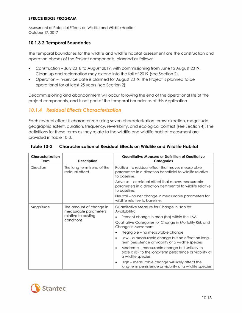
SPRUCE RIDGE PROGRAM
Assessment of Potential Effects on Wildlife and Wildlife Habitat October 17, 2017
10.13
10.1.3.2 Temporal Boundaries
The temporal boundaries for the wildlife and wildlife habitat assessment are the construction and operation phases of the Project components, planned as follows:
• Construction – July 2018 to August 2019, with commissioning from June to August 2019. Clean-up and reclamation may extend into the fall of 2019 (see Section 2).
• Operation – In-service date is planned for August 2019. The Project is planned to be operational for at least 25 years (see Section 2).
Decommissioning and abandonment will occur following the end of the operational life of the project components, and is not part of the temporal boundaries of this Application.
10.1.4 Residual Effects Characterization
Each residual effect is characterized using seven characterization terms: direction, magnitude, geographic extent, duration, frequency, reversibility, and ecological context (see Section 4). The definitions for these terms as they relate to the wildlife and wildlife habitat assessment are provided in Table 10-3.
Table 10-3 Characterization of Residual Effects on Wildlife and Wildlife Habitat
Characterization Term Description
Quantitative Measure or Definition of Qualitative Categories
Direction The long-term trend of the residual effect
Positive – a residual effect that moves measurable parameters in a direction beneficial to wildlife relative to baseline. Adverse – a residual effect that moves measurable parameters in a direction detrimental to wildlife relative to baseline. Neutral – no net change in measurable parameters for wildlife relative to baseline.
Magnitude
The amount of change in measurable parameters relative to existing conditions
Quantitative Measure for Change in Habitat Availability: • Percent change in area (ha) within the LAA Qualitative Categories for Change in Mortality Risk and Change in Movement: • Negligible – no measurable change • Low – a measurable change but no effect on long-
term persistence or viability of a wildlife species • Moderate – measurable change but unlikely to
pose a risk to the long-term persistence or viability of a wildlife species
• High – measurable change will likely affect the long-term persistence or viability of a wildlife species
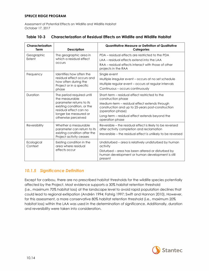
SPRUCE RIDGE PROGRAM
Assessment of Potential Effects on Wildlife and Wildlife Habitat October 17, 2017
10.14
Table 10-3 Characterization of Residual Effects on Wildlife and Wildlife Habitat
Characterization Term Description
Quantitative Measure or Definition of Qualitative Categories
Geographic Extent
The geographic area in which a residual effect occurs
PDA – residual effects are restricted to the PDA LAA – residual effects extend into the LAA RAA – residual effects interact with those of other projects in the RAA
Frequency Identifies how often the residual effect occurs and how often during the Project or in a specific phase
Single event Multiple irregular event – occurs at no set schedule Multiple regular event – occurs at regular intervals Continuous – occurs continuously
Duration The period required until the measurable parameter returns to its existing condition, or the residual effect can no longer be measured or otherwise perceived
Short-term – residual effect restricted to the construction phase Medium-term – residual effect extends through construction and up to 25-years post-construction (operation phase) Long-term – residual effect extends beyond the operation phase
Reversibility Whether a measurable parameter can return to its existing condition after the Project activity ceases
Reversible – the residual effect is likely to be reversed after activity completion and reclamation Irreversible – the residual effect is unlikely to be reversed
Ecological Context
Existing condition in the area where residual effects occur
Undisturbed – area is relatively undisturbed by human activity Disturbed – area has been altered or disturbed by human development or human development is still present
10.1.5 Significance Definition
Except for caribou, there are no prescribed habitat thresholds for the wildlife species potentially affected by the Project. Most evidence supports a 30% habitat retention threshold (i.e., maximum 70% habitat loss) at the landscape level to avoid rapid population declines that could lead to regional extirpation (Andrén 1994; Fahrig 1997; Swift and Hannon 2010). However, for this assessment, a more conservative 80% habitat retention threshold (i.e., maximum 20% habitat loss) within the LAA was used in the determination of significance. Additionally, duration and reversibility were taken into consideration.
SPRUCE RIDGE PROGRAM
Assessment of Potential Effects on Wildlife and Wildlife Habitat October 17, 2017
10.15
Again, except for caribou, there are no prescribed thresholds for the qualitative assessment of project effects on mortality risk and movement; therefore, determination of significance is based on logical reasoning and professional judgment. In addition to magnitude and duration, considerations include status, population size, and distribution and range of the affected wildlife species, broad-scale habitat conditions, and area-specific policies for land use and species management.
In the case of caribou, the federal recovery strategy identifies a threshold of 65% undisturbed habitat within low elevation and Type 1 Matrix range (Environment Canada 2014). The Pine River LPU is below this threshold (62.6%, ECCC 2017d). The existing condition for the Graham LPU relative to this threshold is unknown, but for the purposes of this assessment is assumed to be under 65% (as recent census data suggest the population is declining [Seip and Jones 2017]). Given both LPUs are below the threshold, existing conditions already have a significant effect on caribou; therefore, a residual project effect on caribou habitat availability, mortality risk, or movement is assumed to be significant.
10.2 EXISTING CONDITIONS FOR WILDLIFE AND WILDLIFE HABITAT
Residual effects are measured and characterized relative to existing (baseline) conditions. This section presents an overview of existing conditions for wildlife and wildlife habitat within the Project component LAAs and RAAs. Details to supplement this overview are provided in the Aitken Creek Loop Wildlife Technical Memo (Appendix G-1) and the Chetwynd Loop, CS2 Expansion, and CSN5 Expansion Technical Memo (Appendix G-2).
Existing conditions are not described for the CS16 Modifications component because it does not interact with wildlife and wildlife habitat (Section 10.1.3.1).
10.2.1 Methods
The description of existing conditions is based on a review of existing information, results of the 2017 baseline wildlife field program, and habitat mapping. These information sources and data collection methods are outlined in the following sections.
10.2.1.1 Review of Existing Information
A review of existing information, including provincial and other agency spatial data layers and databases, technical data reports for other oil and gas projects, scientific literature, and available traditional ecological knowledge and traditional land use information, was completed to inform the description of existing conditions for wildlife and wildlife habitat within the LAAs and RAAs. Details on the scope of this review are provided in the Aitken Creek Loop Wildlife Technical Memo (Appendix G-1) and the Chetwynd Loop, CS2 Expansion, and CSN5 Expansion Wildlife Technical Memo (Appendix G-2).
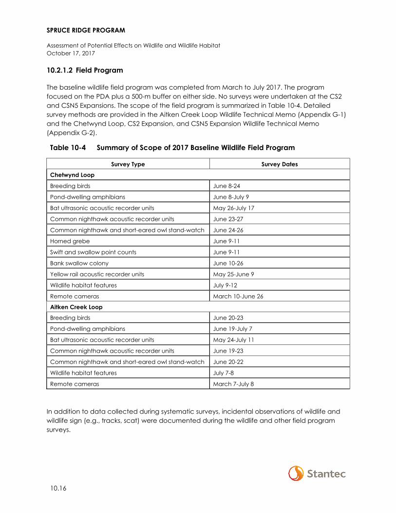
SPRUCE RIDGE PROGRAM
Assessment of Potential Effects on Wildlife and Wildlife Habitat October 17, 2017
10.16
10.2.1.2 Field Program
The baseline wildlife field program was completed from March to July 2017. The program focused on the PDA plus a 500-m buffer on either side. No surveys were undertaken at the CS2 and CSN5 Expansions. The scope of the field program is summarized in Table 10-4. Detailed survey methods are provided in the Aitken Creek Loop Wildlife Technical Memo (Appendix G-1) and the Chetwynd Loop, CS2 Expansion, and CSN5 Expansion Wildlife Technical Memo (Appendix G-2).
Table 10-4 Summary of Scope of 2017 Baseline Wildlife Field Program
Survey Type Survey Dates
Chetwynd Loop
Breeding birds June 8-24
Pond-dwelling amphibians June 8-July 9
Bat ultrasonic acoustic recorder units May 26-July 17
Common nighthawk acoustic recorder units June 23-27
Common nighthawk and short-eared owl stand-watch June 24-26
Horned grebe June 9-11
Swift and swallow point counts June 9-11
Bank swallow colony June 10-26
Yellow rail acoustic recorder units May 25-June 9
Wildlife habitat features July 9-12
Remote cameras March 10-June 26
Aitken Creek Loop
Breeding birds June 20-23
Pond-dwelling amphibians June 19-July 7
Bat ultrasonic acoustic recorder units May 24-July 11
Common nighthawk acoustic recorder units June 19-23
Common nighthawk and short-eared owl stand-watch June 20-22
Wildlife habitat features July 7-8
Remote cameras March 7-July 8
In addition to data collected during systematic surveys, incidental observations of wildlife and wildlife sign (e.g., tracks, scat) were documented during the wildlife and other field program surveys.
SPRUCE RIDGE PROGRAM
Assessment of Potential Effects on Wildlife and Wildlife Habitat October 17, 2017
10.17
10.2.1.3 Habitat Mapping
Two mapping products were used to inform the description of existing conditions for wildlife habitat:
• land cover class mapping (for focus species other than caribou) • habitat range and disturbance mapping for caribou
These mapping products are described in the following sections.
10.2.1.3.1 Land Cover Class Mapping
Land cover class mapping was used to identify habitats within the LAAs and to assess Project effects on habitat availability for focus species (non-caribou) (see Section 10.1.2).
The methods for the development of the land cover class mapping are described in detail for the RAAs for the Vegetation and Wetlands VC in Section 9. The vegetation and wetlands RAAs are the same as the LAAs for wildlife and wildlife habitat. Spatial layers of existing disturbance (e.g., roads, oil and gas development, cutblocks) were applied to the mapped areas as described in Section 9. For the Chetwynd and Aitken Creek Loops, the land cover class mapping was supplemented with detailed wetland mapping. Definitions of the land cover and disturbance classes are provided in Appendix F-3. One land cover class, herb, was modified for the Chetwynd Loop to distinguish between areas mapped as herb that were predominately cropland and pasture, and areas mapped as herb that appeared to be natural ecosystems.
A key life requisite and season was selected for each focus species (non-caribou); the habitat attributes for each species/life requisite combination are summarized in Table 10-5. Based on this information, and knowledge of local conditions and the characteristics of the land cover classes3, the linkages between land cover classes and the species/life requisite combinations were identified (Table 10-6). These linkages were used to quantify the amount of habitat available within the Project component LAAs for each focus species (non-caribou), under existing conditions.
3 Some species-specific attributes (e.g., coarse woody debris, snags, understory shrub and ground cover)
could not be factored into the determination of available habitat due to the broad nature of the land cover class descriptions (see Appendix F-3)
SPRUCE RIDGE PROGRAM
Assessment of Potential Effects on Wildlife and Wildlife Habitat October 17, 2017
10.18
Table 10-5 Habitat Attributes for Selected Life Requisites for Focus Species (Non-Caribou)
Species Life Requisite (Season) Habitat Attributes Source
Western toad Breeding (spring/summer) • Natural or artificial wetlands with sandy bottom • Ponds, bogs, fens, river back eddies and oxbow
lakes, lake margins • Road ditches and ruts • Shallow water (< 30 cm) • Submergent vegetation
COSEWIC 2002a; Matsuda et al. 2006
Yellow rail Breeding (spring/summer) • Small (< 20 ha), shallow sedge wetlands • Meadows, fens, bogs, wet hayfields, floodplains • Emergent-dominated wetlands with sedges or
grasses
Bookhout 1995; Wilson 2005; COSEWIC 2009; Environment Canada 2012
Short-eared owl Breeding (spring/summer) • Open country with short vegetation • Grassland, rangeland, marshes, forest clearings,
scrubland • Abundance of prey (voles)
Cooper and Beauchesne 2004; Wiggins et al. 2006; COSEWIC 2008
Common nighthawk Breeding (spring/summer) • Open, sparsely vegetated ground • Clearings, gravel ground, rocky outcrops • Pasture and natural grassland • Forest cutblocks and burns
Environment Canada 2016a
Olive-sided flycatcher Breeding (spring/summer) • Old coniferous or mixedwood forest • Snags or residual live trees • Canopy openings or edge habitat • Often close to water
Environment Canada 2016b
Canada warbler Breeding (spring/summer) • Moist forests with dense, deciduous shrub layer and complex understory
• Young and mature aspen-dominated forest
Environment Canada 2016c
Rusty blackbird Breeding (spring/summer) • Coniferous forest wetlands • Bogs, fens, muskegs, swamps, wet shrubby
meadows, lake margins with trees or tall shrubs
Campbell et al. 2001; COSEWIC 2006; Powell et al. 2010
Little brown myotis Roosting (non-winter) • Dead or living large trees with sloughing bark, fissures, or cavities
Environment Canada 2015; BC MOE 2016
Northern myotis Roosting (non-winter) • Dead or living large trees with sloughing bark, fissures, or cavities
Environment Canada 2015; BC MOE 2016
SPRUCE RIDGE PROGRAM
Assessment of Potential Effects on Wildlife and Wildlife Habitat October 17, 2017
10.19
Table 10-5 Habitat Attributes for Selected Life Requisites for Focus Species (Non-Caribou)
Species Life Requisite (Season) Habitat Attributes Source
Black bear General living (non-winter) • Mosaic of forested and open habitats • Meadows, forest openings, wetlands, riparian areas
for feeding • Mature and old forest for cover • Abundance of berry-producing shrubs, grasses,
sedges
Blood and Paquet 2001; Hatler et al. 2008
Grizzly bear General living (non-winter) • Mosaic of forested and open habitats • Meadows, forest openings, wetlands, floodplains,
riparian areas • Abundance of berry-producing shrubs, grasses,
sedges
COSEWIC 2002b; BC MWLAP 2004; Gyug et al. 2004
American marten General living (year-round) • Mature and old coniferous forest • Spruce and fir dominated • Closed canopy • Abundant coarse woody debris
Buskirk and Powell 1994; Buskirk and Ruggiero 1994; Hatler et al. 2008
Fisher General living (year-round) • Mature and old forest with complex structure and dense canopy
• Large, old cottonwood trees • Major riparian corridors
Badry 2004; Hatler et al. 2008; Weir et al. 2011
Moose General living (year-round) • Mosaic of mature forest, shrubby openings, and riparian areas and wetlands
• Willow-dominated wetlands with high shrub abundance
• River valleys and floodplains
Blood 2000; Gillingham and Parker 2008a,b
Elk General living (year-round) • Mosaic of open mature forest, primarily broadleaf, and open habitats
• Floodplains, grassland, meadows, open low shrub
BC MELP 2000; Shackleton 2013
SPRUCE RIDGE PROGRAM
Assessment of Potential Effects on Wildlife and Wildlife Habitat October 17, 2017
10.20
Table 10-6 Land Cover Class and Life Requisite Associations for Focus Species (Non-Caribou)
Land Cover Class
General Living (non-winter)
General Living (year-round) Breeding (spring/summer)
Roosting (non-winter)
Griz
zly b
ear
Blac
k be
ar
Elk
Moo
se
Am
eric
an
mar
ten
Fish
er
Shor
t-ea
red
owl
Com
mon
ni
ghth
awk
Oliv
e-sid
ed
flyca
tche
r
Can
ada
war
bler
Yello
w ra
il
Rust
y bl
ackb
ird
Wes
tern
to
ad
Little
bro
wn
myo
tis
Nor
ther
n m
yotis
Exposed/Barren Land
Shrub Tall
Shrub Low
Wetland-Treed
Wetland-Shrub a
Wetland-Herb b b
Wetland-Open Water c
Water d
Herb-Natural e
Herb-Unnatural f
Grassland g
Coniferous Dense
Coniferous Open
Coniferous Sparse
Broadleaf Dense
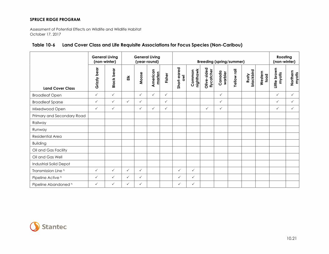
SPRUCE RIDGE PROGRAM
Assessment of Potential Effects on Wildlife and Wildlife Habitat October 17, 2017
10.21
Table 10-6 Land Cover Class and Life Requisite Associations for Focus Species (Non-Caribou)
Land Cover Class
General Living (non-winter)
General Living (year-round) Breeding (spring/summer)
Roosting (non-winter)
Griz
zly b
ear
Blac
k be
ar
Elk
Moo
se
Am
eric
an
mar
ten
Fish
er
Shor
t-ea
red
owl
Com
mon
ni
ghth
awk
Oliv
e-sid
ed
flyca
tche
r
Can
ada
war
bler
Yello
w ra
il
Rust
y bl
ackb
ird
Wes
tern
to
ad
Little
bro
wn
myo
tis
Nor
ther
n m
yotis
Broadleaf Open
Broadleaf Sparse
Mixedwood Open
Primary and Secondary Road
Railway
Runway
Residential Area
Building
Oil and Gas Facility
Oil and Gas Well
Industrial Solid Depot
Transmission Line h
Pipeline Active h
Pipeline Abandoned h
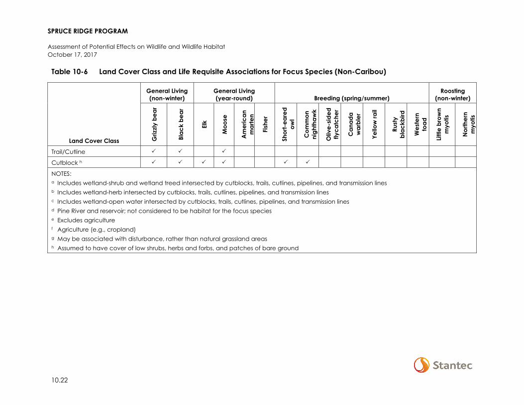
SPRUCE RIDGE PROGRAM
Assessment of Potential Effects on Wildlife and Wildlife Habitat October 17, 2017
10.22
Table 10-6 Land Cover Class and Life Requisite Associations for Focus Species (Non-Caribou)
Land Cover Class
General Living (non-winter)
General Living (year-round) Breeding (spring/summer)
Roosting (non-winter)
Griz
zly b
ear
Blac
k be
ar
Elk
Moo
se
Am
eric
an
mar
ten
Fish
er
Shor
t-ea
red
owl
Com
mon
ni
ghth
awk
Oliv
e-sid
ed
flyca
tche
r
Can
ada
war
bler
Yello
w ra
il
Rust
y bl
ackb
ird
Wes
tern
to
ad
Little
bro
wn
myo
tis
Nor
ther
n m
yotis
Trail/Cutline
Cutblock h
NOTES: a Includes wetland-shrub and wetland treed intersected by cutblocks, trails, cutlines, pipelines, and transmission lines b Includes wetland-herb intersected by cutblocks, trails, cutlines, pipelines, and transmission lines c Includes wetland-open water intersected by cutblocks, trails, cutlines, pipelines, and transmission lines d Pine River and reservoir; not considered to be habitat for the focus species e Excludes agriculture f Agriculture (e.g., cropland) g May be associated with disturbance, rather than natural grassland areas h Assumed to have cover of low shrubs, herbs and forbs, and patches of bare ground
SPRUCE RIDGE PROGRAM
Assessment of Potential Effects on Wildlife and Wildlife Habitat October 17, 2017
10.23
10.2.1.3.2 Habitat Range and Disturbance Mapping for Caribou
As described in Section 10.1.1.3, critical habitat has been defined for the Pine River and Graham LPUs. Within low elevation and Type 1 Matrix range, critical habitat includes that which is currently undisturbed, as well as disturbed habitats that over time would contribute to the attainment of 65% undisturbed habitat (Environment Canada 2014).
The federal recovery strategy (Environment Canada 2014) delineates and quantifies disturbance mapping for low elevation and Type 1 Matrix range within the Southern Mountain caribou LPUs by using anthropogenic disturbance footprints and fire to determine ‘direct effects’, and a 500-m buffer around anthropogenic disturbances to determine ‘indirect effects’. Disturbances that are visible on Landsat 2010 imagery at a 1:50,000 scale are mapped. Based on research findings for other caribou populations, ECCC considers a 500-m buffer for anthropogenic disturbance types to be a suitable zone of influence for the preliminary disturbance mapping for the Southern Mountain caribou LPUs (Environment Canada 2012). Environment and Climate Change Canada cautions that the disturbance mapping may not be a complete measure of the spatial extent of impact of anthropogenic habitat change on caribou, and that the increased risk of predation resulting from cumulative effects of habitat alteration may extend beyond the 500-m buffers; therefore, ECCC’s analysis does not fully address predation risk (Environment Canada 2012).
Following discussion between Westcoast and ECCC in October 2017, it was agreed that the assessment should use the best available information for quantifying disturbance (i.e., information more recent than what was included in ECCC’s disturbance analysis [ECCC 2012]). Therefore, Westcoast prepared its own detailed disturbance layer for the portion of the CS2 Expansion and CSN5 Expansion LAAs and RAAs that overlap with government-designated caribou habitat. The baseline disturbance layer was created using current imagery and available spatial data from public sources (e.g., CanVec v.12; DataBC, including fire; TRIM). The size of the LAAs (and RAAs for cumulative effects) allow for the quantification of indirect effects that result from applying a 500-m buffer to existing anthropogenic disturbance features and the PDA for each Project component. Fire data for the past 40 years (1976–2016) was also included. Mapped anthropogenic disturbances that were more than 40 years old and visibly revegetated on imagery (i.e., Google Earth) were not included in the disturbance layer, per the federal recovery strategy (Environment Canada 2014). Also, mapped disturbances that appear undisturbed (e.g., planned cutblocks or retired planned cutblocks) in imagery were also not included in the disturbance layer.
Disturbances were classed as either temporary or permanent. Temporary disturbances are those that can reasonably recover in the short term (i.e., 40 years or less), and permanent disturbances are those areas that are not likely to recover within 40 years. Temporary disturbances include forest cutblocks, seismic lines, and burned areas. Permanent disturbances include pipelines, transmission lines, roads, compressor stations, oil and gas facilities, well sites, agriculture/cropland, buildings, and settlements.
SPRUCE RIDGE PROGRAM
Assessment of Potential Effects on Wildlife and Wildlife Habitat October 17, 2017
10.24
Effects associated with temporary and permanent disturbance were also classed as direct or indirect effects. Direct effects are based on the areal representation of disturbance footprints, and indirect effects are based on the areal representation of a 500-m buffer around those footprints. Burned areas that are 40 years old or less are included as a temporary disturbance feature, but these areas are not buffered by 500 m as per methods used in the federal recovery strategy (Environment Canada 2014). Disturbances are organized hierarchically by effect duration (i.e., permanent or temporary), and effect type (i.e., direct or indirect), as follows:
10.2.2 Overview
The following is an overview of existing conditions relevant to the effects being assessed for wildlife and wildlife habitat and the measurable parameters selected for the assessment (see Section 10.1.2). The overview is structured by Project component and focuses on the LAAs, but provides general information on conditions within the RAAs as context. For a detailed overview of existing conditions for Vegetation and Wetlands and Land and Resource Use related to the Project see Section 9 and Section 12 respectively.
10.2.2.1 Chetwynd Loop
The LAA and RAA do not overlap any Important Bird Areas (IBAs), ecological reserves, or conservancies. The RAA overlaps the Pine River Breaks Provincial Park and Moberly Lake Provincial Park, but the LAA does not. The RAA overlaps one UWR for elk (Cervus elaphus), moose, and mule deer (Odocoileus hemionus); this UWR is 4.3 km from the LAA. The western portion of the RAA overlaps with Type 1 and Type 2 Matrix range for the Pine River LPU; however, the LAA does not overlap with government-designated caribou range. The RAA and LAA overlap the Moberly and Hart Grizzly Bear Population Units; both units are considered viable, but the Moberly unit is not open to hunting (BC MOE 2012). East of Chetwynd, the grizzly bear population is considered extirpated (BC MOE 2012).
1 • Permanent - Direct
2• Permanent - Indirect
3• Temporary - Direct
4• Temporary - Indirect
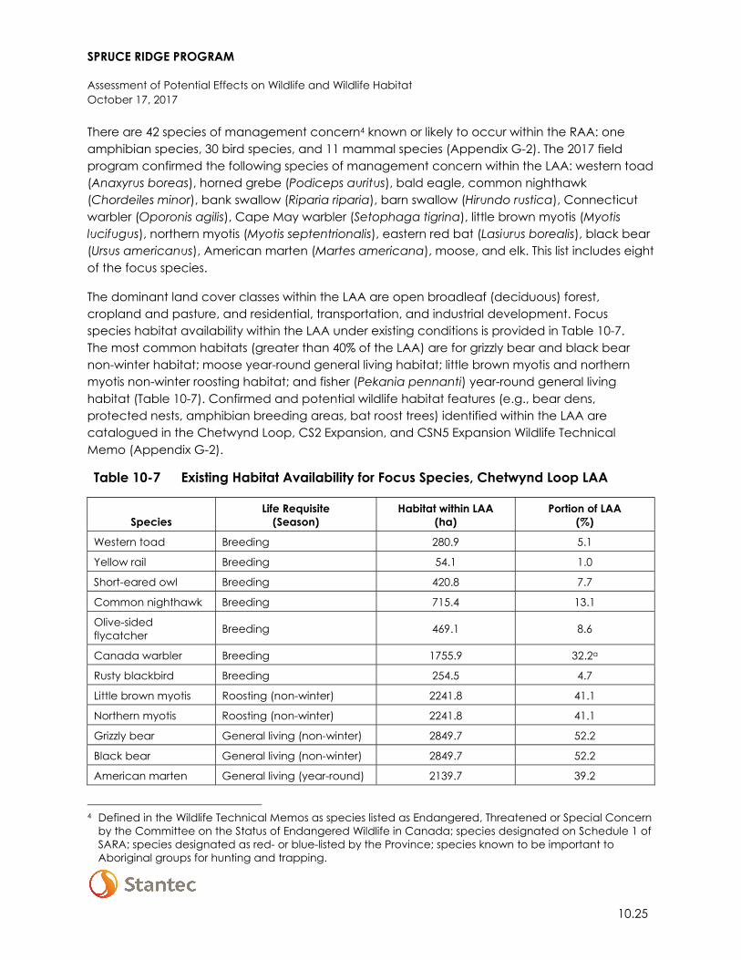
SPRUCE RIDGE PROGRAM
Assessment of Potential Effects on Wildlife and Wildlife Habitat October 17, 2017
10.25
There are 42 species of management concern4 known or likely to occur within the RAA: one amphibian species, 30 bird species, and 11 mammal species (Appendix G-2). The 2017 field program confirmed the following species of management concern within the LAA: western toad (Anaxyrus boreas), horned grebe (Podiceps auritus), bald eagle, common nighthawk (Chordeiles minor), bank swallow (Riparia riparia), barn swallow (Hirundo rustica), Connecticut warbler (Oporonis agilis), Cape May warbler (Setophaga tigrina), little brown myotis (Myotis lucifugus), northern myotis (Myotis septentrionalis), eastern red bat (Lasiurus borealis), black bear (Ursus americanus), American marten (Martes americana), moose, and elk. This list includes eight of the focus species.
The dominant land cover classes within the LAA are open broadleaf (deciduous) forest, cropland and pasture, and residential, transportation, and industrial development. Focus species habitat availability within the LAA under existing conditions is provided in Table 10-7. The most common habitats (greater than 40% of the LAA) are for grizzly bear and black bear non-winter habitat; moose year-round general living habitat; little brown myotis and northern myotis non-winter roosting habitat; and fisher (Pekania pennanti) year-round general living habitat (Table 10-7). Confirmed and potential wildlife habitat features (e.g., bear dens, protected nests, amphibian breeding areas, bat roost trees) identified within the LAA are catalogued in the Chetwynd Loop, CS2 Expansion, and CSN5 Expansion Wildlife Technical Memo (Appendix G-2).
Table 10-7 Existing Habitat Availability for Focus Species, Chetwynd Loop LAA
Species Life Requisite
(Season) Habitat within LAA
(ha) Portion of LAA
(%)
Western toad Breeding 280.9 5.1
Yellow rail Breeding 54.1 1.0
Short-eared owl Breeding 420.8 7.7
Common nighthawk Breeding 715.4 13.1
Olive-sided flycatcher Breeding 469.1 8.6
Canada warbler Breeding 1755.9 32.2a
Rusty blackbird Breeding 254.5 4.7
Little brown myotis Roosting (non-winter) 2241.8 41.1
Northern myotis Roosting (non-winter) 2241.8 41.1
Grizzly bear General living (non-winter) 2849.7 52.2
Black bear General living (non-winter) 2849.7 52.2
American marten General living (year-round) 2139.7 39.2
4 Defined in the Wildlife Technical Memos as species listed as Endangered, Threatened or Special Concern
by the Committee on the Status of Endangered Wildlife in Canada; species designated on Schedule 1 of SARA; species designated as red- or blue-listed by the Province; species known to be important to Aboriginal groups for hunting and trapping.
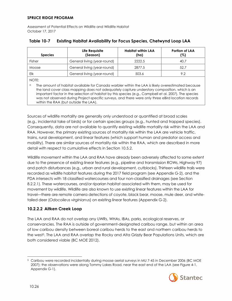
SPRUCE RIDGE PROGRAM
Assessment of Potential Effects on Wildlife and Wildlife Habitat October 17, 2017
10.26
Table 10-7 Existing Habitat Availability for Focus Species, Chetwynd Loop LAA
Species Life Requisite
(Season) Habitat within LAA
(ha) Portion of LAA
(%)
Fisher General living (year-round) 2222.5 40.7
Moose General living (year-round) 2877.5 52.7
Elk General living (year-round) 503.6 9.2
NOTE: a The amount of habitat available for Canada warbler within the LAA is likely overestimated because
the land cover class mapping does not adequately capture understory composition, which is an important factor in the selection of habitat by this species (e.g., Campbell et al. 2007). The species was not observed during Project-specific surveys, and there were only three eBird location records within the RAA (but outside the LAA).
Sources of wildlife mortality are generally only understood or quantified at broad scales (e.g., incidental take of birds) or for certain species groups (e.g., hunted and trapped species). Consequently, data are not available to quantify existing wildlife mortality risk within the LAA and RAA. However, the primary existing sources of mortality risk within the LAA are vehicle traffic, trains, rural development, and linear features (which support human and predator access and mobility). There are similar sources of mortality risk within the RAA, which are described in more detail with respect to cumulative effects in Section 10.5.2.
Wildlife movement within the LAA and RAA have already been adversely affected to some extent due to the presence of existing linear features (e.g., pipeline and transmission ROWs, Highway 97) and patch disturbances (e.g., urban and rural development, cutblocks). Thirteen wildlife trails were recorded as wildlife habitat features during the 2017 field program (see Appendix G-2), and the PDA intersects with 18 classified watercourses and four non-classified drainages (see Section 8.2.2.1). These watercourses, and/or riparian habitat associated with them, may be used for movement by wildlife. Wildlife are also known to use existing linear features within the LAA for travel—there are remote camera detections of coyote, black bear, moose, mule deer, and white-tailed deer (Odocoileus virginianus) on existing linear features (Appendix G-2).
10.2.2.2 Aitken Creek Loop
The LAA and RAA do not overlap any UWRs, WHAs, IBAs, parks, ecological reserves, or conservancies. The RAA is outside of government-designated caribou range, but within an area of low caribou density between boreal caribou herds to the east and northern caribou herds to the west5. The LAA and RAA overlap the Rocky and Alta Grizzly Bear Populations Units, which are both considered viable (BC MOE 2012).
5 Caribou were recorded incidentally during moose aerial surveys in MU 7-45 in December 2006 (BC MOE
2007); the observations were along Tommy Lakes Road, near the east end of the LAA (see Figure 4-1, Appendix G-1).
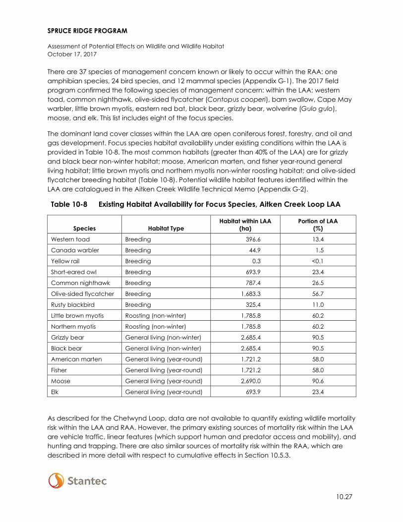
SPRUCE RIDGE PROGRAM
Assessment of Potential Effects on Wildlife and Wildlife Habitat October 17, 2017
10.27
There are 37 species of management concern known or likely to occur within the RAA: one amphibian species, 24 bird species, and 12 mammal species (Appendix G-1). The 2017 field program confirmed the following species of management concern: within the LAA: western toad, common nighthawk, olive-sided flycatcher (Contopus cooperi), barn swallow, Cape May warbler, little brown myotis, eastern red bat, black bear, grizzly bear, wolverine (Gulo gulo), moose, and elk. This list includes eight of the focus species.
The dominant land cover classes within the LAA are open coniferous forest, forestry, and oil and gas development. Focus species habitat availability under existing conditions within the LAA is provided in Table 10-8. The most common habitats (greater than 40% of the LAA) are for grizzly and black bear non-winter habitat; moose, American marten, and fisher year-round general living habitat; little brown myotis and northern myotis non-winter roosting habitat; and olive-sided flycatcher breeding habitat (Table 10-8). Potential wildlife habitat features identified within the LAA are catalogued in the Aitken Creek Wildlife Technical Memo (Appendix G-2).
Table 10-8 Existing Habitat Availability for Focus Species, Aitken Creek Loop LAA
Species Habitat Type Habitat within LAA
(ha) Portion of LAA
(%)
Western toad Breeding 396.6 13.4
Canada warbler Breeding 44.9 1.5
Yellow rail Breeding 0.3 <0.1
Short-eared owl Breeding 693.9 23.4
Common nighthawk Breeding 787.4 26.5
Olive-sided flycatcher Breeding 1,683.3 56.7
Rusty blackbird Breeding 325.4 11.0
Little brown myotis Roosting (non-winter) 1,785.8 60.2
Northern myotis Roosting (non-winter) 1,785.8 60.2
Grizzly bear General living (non-winter) 2,685.4 90.5
Black bear General living (non-winter) 2,685.4 90.5
American marten General living (year-round) 1,721.2 58.0
Fisher General living (year-round) 1,721.2 58.0
Moose General living (year-round) 2,690.0 90.6
Elk General living (year-round) 693.9 23.4
As described for the Chetwynd Loop, data are not available to quantify existing wildlife mortality risk within the LAA and RAA. However, the primary existing sources of mortality risk within the LAA are vehicle traffic, linear features (which support human and predator access and mobility), and hunting and trapping. There are also similar sources of mortality risk within the RAA, which are described in more detail with respect to cumulative effects in Section 10.5.3.

SPRUCE RIDGE PROGRAM
Assessment of Potential Effects on Wildlife and Wildlife Habitat October 17, 2017
10.28
Wildlife movement within the LAA and RAA have already been adversely affected to some extent due to the presence of linear features (e.g., industrial ROWs, roads) and patch disturbances (e.g., cutblocks, industrial facilities). No wildlife trails were recorded during the 2017 field program; however, trails are likely present within the LAA and wildlife are known to use the existing ROW for travel—there are remote camera detections of Canada lynx (Lynx canadensis), coyote, grey wolf (Canis lupus), black bear, grizzly bear, moose, and elk on the existing ROW (Appendix G-1). The PDA intersects 10 classified watercourses and two non-classified drainages (see Section 8.2.2.2). These watercourses, or the riparian habitat associated with them, may be used for movement by wildlife.
10.2.2.3 CS2 Expansion
The LAA and RAA do not overlap any IBAs, parks, ecological reserves, or conservancies. The RAA overlaps three WHAs (one for black-throated green warbler [Setophaga virens], and two for caribou) and one UWR (for caribou and mountain goat [Oreamnos americanus]); the nearest of these areas (WHA 9-053 and UWR u-9-002) are 10.7 km from the LAA. As described in Section 10.1.1.3, this Project component is located within the Pine River LPU. The LAA is entirely within Type 1 Matrix range and the eastern portion of the RAA overlaps Type 2 Matrix range. The RAA and LAA overlap the Moberly and Hart Grizzly Bear Population Units; both units are considered viable (BC MOE 2012).
There are 42 species of management concern known or likely to occur within the RAA: one amphibian species, 28 bird species, and 13 mammal species (Appendix G-2).
The dominant land cover classes within the LAA are open broadleaf forest and forestry. Focus species (non-caribou) habitat availability within the LAA under existing conditions is provided in Table 10-9. The most common habitats (greater than 40% of the LAA) are for grizzly and black bear non-winter habitat; moose, marten, and fisher year-round general living habitat; little brown myotis and northern myotis non-winter roosting habitat, and Canada warbler breeding habitat (Table 10-9). The lack of western toad and rusty blackbird habitat within the LAA (Table 10-9) is consistent with Section 9.2 (Vegetation and Wetlands), which reports no wetlands within that RAA. However, it is presumed this is a function of the broad nature of the land cover class mapping and that some western toad breeding habitat may be present (e.g., small non-classified wetlands or ephemeral pools).
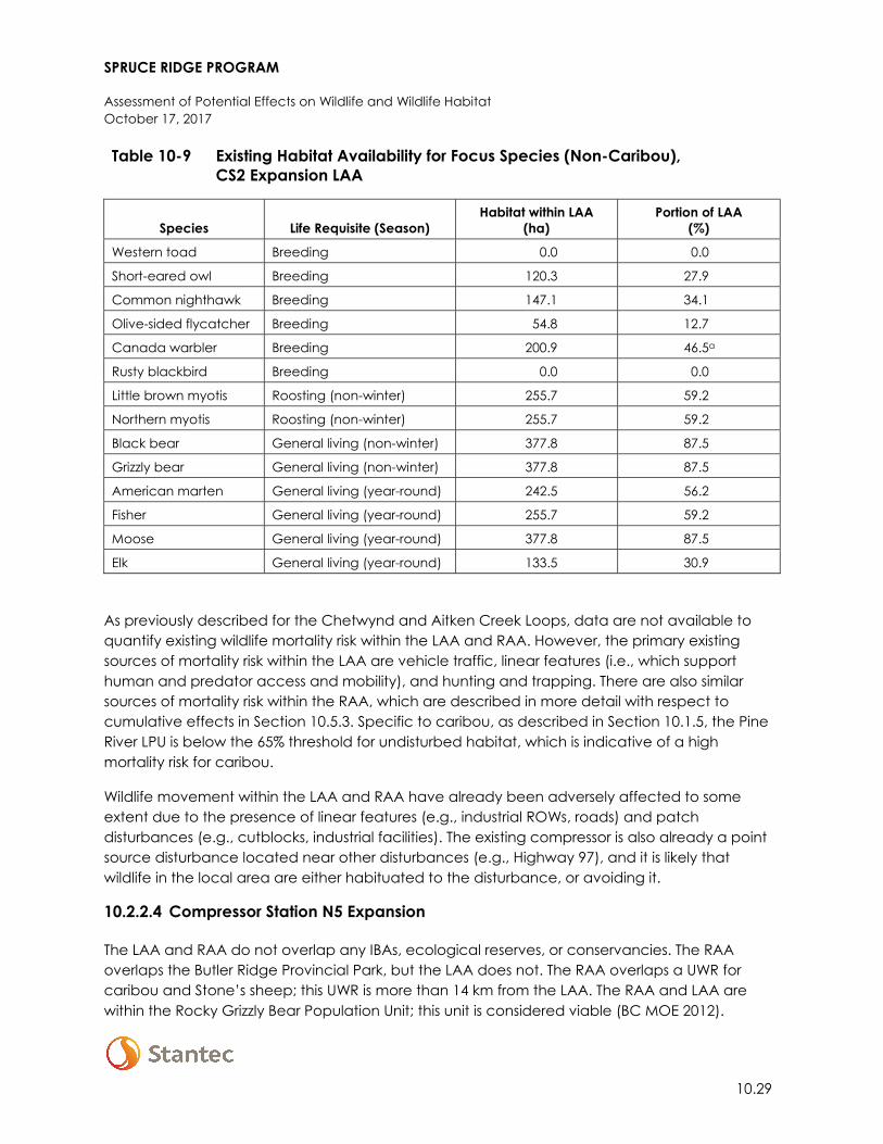
SPRUCE RIDGE PROGRAM
Assessment of Potential Effects on Wildlife and Wildlife Habitat October 17, 2017
10.29
Table 10-9 Existing Habitat Availability for Focus Species (Non-Caribou), CS2 Expansion LAA
Species Life Requisite (Season) Habitat within LAA
(ha) Portion of LAA
(%)
Western toad Breeding 0.0 0.0
Short-eared owl Breeding 120.3 27.9
Common nighthawk Breeding 147.1 34.1
Olive-sided flycatcher Breeding 54.8 12.7
Canada warbler Breeding 200.9 46.5a
Rusty blackbird Breeding 0.0 0.0
Little brown myotis Roosting (non-winter) 255.7 59.2
Northern myotis Roosting (non-winter) 255.7 59.2
Black bear General living (non-winter) 377.8 87.5
Grizzly bear General living (non-winter) 377.8 87.5
American marten General living (year-round) 242.5 56.2
Fisher General living (year-round) 255.7 59.2
Moose General living (year-round) 377.8 87.5
Elk General living (year-round) 133.5 30.9
As previously described for the Chetwynd and Aitken Creek Loops, data are not available to quantify existing wildlife mortality risk within the LAA and RAA. However, the primary existing sources of mortality risk within the LAA are vehicle traffic, linear features (i.e., which support human and predator access and mobility), and hunting and trapping. There are also similar sources of mortality risk within the RAA, which are described in more detail with respect to cumulative effects in Section 10.5.3. Specific to caribou, as described in Section 10.1.5, the Pine River LPU is below the 65% threshold for undisturbed habitat, which is indicative of a high mortality risk for caribou.
Wildlife movement within the LAA and RAA have already been adversely affected to some extent due to the presence of linear features (e.g., industrial ROWs, roads) and patch disturbances (e.g., cutblocks, industrial facilities). The existing compressor is also already a point source disturbance located near other disturbances (e.g., Highway 97), and it is likely that wildlife in the local area are either habituated to the disturbance, or avoiding it.
10.2.2.4 Compressor Station N5 Expansion
The LAA and RAA do not overlap any IBAs, ecological reserves, or conservancies. The RAA overlaps the Butler Ridge Provincial Park, but the LAA does not. The RAA overlaps a UWR for caribou and Stone’s sheep; this UWR is more than 14 km from the LAA. The RAA and LAA are within the Rocky Grizzly Bear Population Unit; this unit is considered viable (BC MOE 2012).
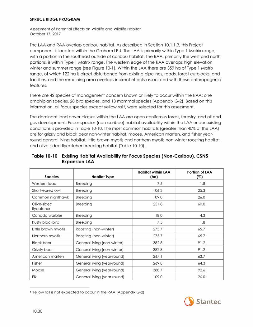
SPRUCE RIDGE PROGRAM
Assessment of Potential Effects on Wildlife and Wildlife Habitat October 17, 2017
10.30
The LAA and RAA overlap caribou habitat. As described in Section 10.1.1.3, this Project component is located within the Graham LPU. The LAA is primarily within Type 1 Matrix range, with a portion in the southeast outside of caribou habitat. The RAA, primarily the west and north portions, is within Type 1 Matrix range. The western edge of the RAA overlaps high elevation winter and summer range (see Figure 10-1). Within the LAA there are 359 ha of Type 1 Matrix range, of which 122 ha is direct disturbance from existing pipelines, roads, forest cutblocks, and facilities, and the remaining area overlaps indirect effects associated with these anthropogenic features.
There are 42 species of management concern known or likely to occur within the RAA: one amphibian species, 28 bird species, and 13 mammal species (Appendix G-2). Based on this information, all focus species except yellow rail6, were selected for this assessment.
The dominant land cover classes within the LAA are open coniferous forest, forestry, and oil and gas development. Focus species (non-caribou) habitat availability within the LAA under existing conditions is provided in Table 10-10. The most common habitats (greater than 40% of the LAA) are for grizzly and black bear non-winter habitat; moose, American marten, and fisher year-round general living habitat; little brown myotis and northern myotis non-winter roosting habitat, and olive-sided flycatcher breeding habitat (Table 10-10).
Table 10-10 Existing Habitat Availability for Focus Species (Non-Caribou), CSN5 Expansion LAA
Species Habitat Type Habitat within LAA
(ha) Portion of LAA
(%)
Western toad Breeding 7.5 1.8
Short-eared owl Breeding 106.3 25.3
Common nighthawk Breeding 109.0 26.0
Olive-sided flycatcher
Breeding 251.8 60.0
Canada warbler Breeding 18.0 4.3
Rusty blackbird Breeding 7.5 1.8
Little brown myotis Roosting (non-winter) 275.7 65.7
Northern myotis Roosting (non-winter) 275.7 65.7
Black bear General living (non-winter) 382.8 91.2
Grizzly bear General living (non-winter) 382.8 91.2
American marten General living (year-round) 267.1 63.7
Fisher General living (year-round) 269.8 64.3
Moose General living (year-round) 388.7 92.6
Elk General living (year-round) 109.0 26.0
6 Yellow rail is not expected to occur in the RAA (Appendix G-2)
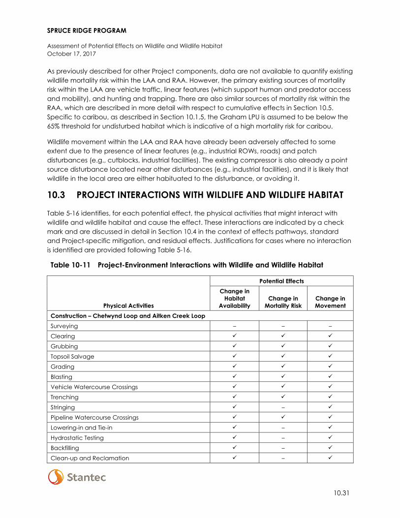
SPRUCE RIDGE PROGRAM
Assessment of Potential Effects on Wildlife and Wildlife Habitat October 17, 2017
10.31
As previously described for other Project components, data are not available to quantify existing wildlife mortality risk within the LAA and RAA. However, the primary existing sources of mortality risk within the LAA are vehicle traffic, linear features (which support human and predator access and mobility), and hunting and trapping. There are also similar sources of mortality risk within the RAA, which are described in more detail with respect to cumulative effects in Section 10.5. Specific to caribou, as described in Section 10.1.5, the Graham LPU is assumed to be below the 65% threshold for undisturbed habitat which is indicative of a high mortality risk for caribou.
Wildlife movement within the LAA and RAA have already been adversely affected to some extent due to the presence of linear features (e.g., industrial ROWs, roads) and patch disturbances (e.g., cutblocks, industrial facilities). The existing compressor is also already a point source disturbance located near other disturbances (e.g., industrial facilities), and it is likely that wildlife in the local area are either habituated to the disturbance, or avoiding it.
10.3 PROJECT INTERACTIONS WITH WILDLIFE AND WILDLIFE HABITAT
Table 5-16 identifies, for each potential effect, the physical activities that might interact with wildlife and wildlife habitat and cause the effect. These interactions are indicated by a check mark and are discussed in detail in Section 10.4 in the context of effects pathways, standard and Project-specific mitigation, and residual effects. Justifications for cases where no interaction is identified are provided following Table 5-16.
Table 10-11 Project-Environment Interactions with Wildlife and Wildlife Habitat
Physical Activities
Potential Effects Change in
Habitat Availability
Change in Mortality Risk
Change in Movement
Construction – Chetwynd Loop and Aitken Creek Loop Surveying – – –
Clearing
Grubbing
Topsoil Salvage
Grading
Blasting
Vehicle Watercourse Crossings
Trenching
Stringing –
Pipeline Watercourse Crossings
Lowering-in and Tie-in –
Hydrostatic Testing –
Backfilling –
Clean-up and Reclamation –
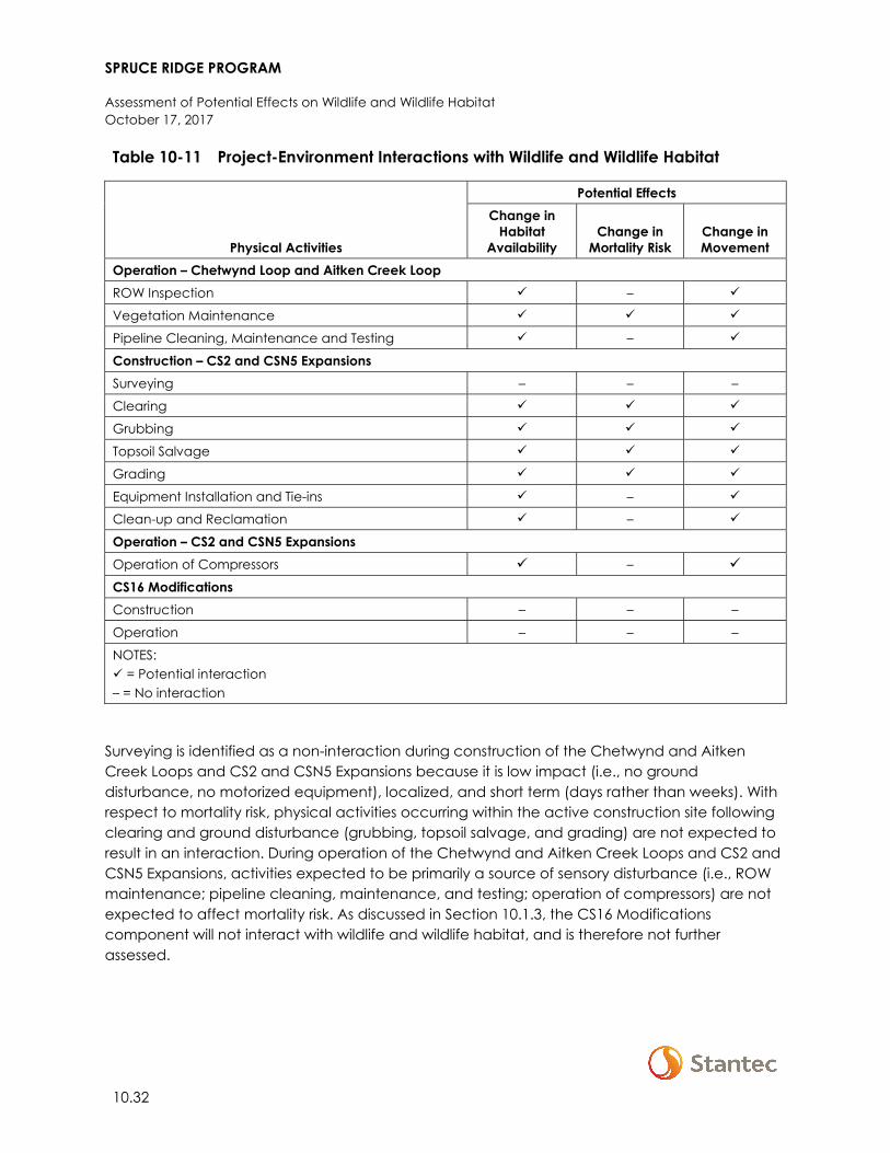
SPRUCE RIDGE PROGRAM
Assessment of Potential Effects on Wildlife and Wildlife Habitat October 17, 2017
10.32
Table 10-11 Project-Environment Interactions with Wildlife and Wildlife Habitat
Physical Activities
Potential Effects Change in
Habitat Availability
Change in Mortality Risk
Change in Movement
Operation – Chetwynd Loop and Aitken Creek LoopROW Inspection –
Vegetation Maintenance
Pipeline Cleaning, Maintenance and Testing –
Construction – CS2 and CSN5 Expansions Surveying – – –
Clearing
Grubbing
Topsoil Salvage
Grading
Equipment Installation and Tie-ins –
Clean-up and Reclamation –
Operation – CS2 and CSN5 Expansions Operation of Compressors –
CS16 Modifications Construction – – –
Operation – – –
NOTES: = Potential interaction – = No interaction
Surveying is identified as a non-interaction during construction of the Chetwynd and Aitken Creek Loops and CS2 and CSN5 Expansions because it is low impact (i.e., no ground disturbance, no motorized equipment), localized, and short term (days rather than weeks). With respect to mortality risk, physical activities occurring within the active construction site following clearing and ground disturbance (grubbing, topsoil salvage, and grading) are not expected to result in an interaction. During operation of the Chetwynd and Aitken Creek Loops and CS2 and CSN5 Expansions, activities expected to be primarily a source of sensory disturbance (i.e., ROW maintenance; pipeline cleaning, maintenance, and testing; operation of compressors) are not expected to affect mortality risk. As discussed in Section 10.1.3, the CS16 Modifications component will not interact with wildlife and wildlife habitat, and is therefore not further assessed.
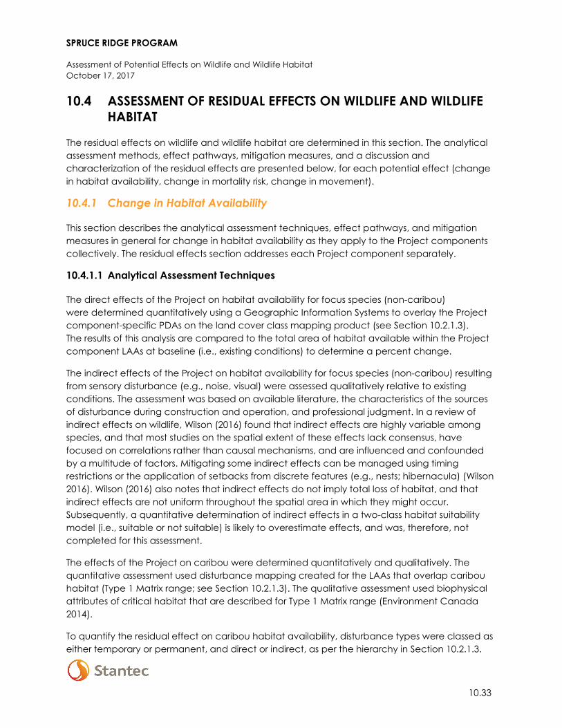
SPRUCE RIDGE PROGRAM
Assessment of Potential Effects on Wildlife and Wildlife Habitat October 17, 2017
10.33
10.4 ASSESSMENT OF RESIDUAL EFFECTS ON WILDLIFE AND WILDLIFE HABITAT
The residual effects on wildlife and wildlife habitat are determined in this section. The analytical assessment methods, effect pathways, mitigation measures, and a discussion and characterization of the residual effects are presented below, for each potential effect (change in habitat availability, change in mortality risk, change in movement).
10.4.1 Change in Habitat Availability
This section describes the analytical assessment techniques, effect pathways, and mitigation measures in general for change in habitat availability as they apply to the Project components collectively. The residual effects section addresses each Project component separately.
10.4.1.1 Analytical Assessment Techniques
The direct effects of the Project on habitat availability for focus species (non-caribou) were determined quantitatively using a Geographic Information Systems to overlay the Project component-specific PDAs on the land cover class mapping product (see Section 10.2.1.3). The results of this analysis are compared to the total area of habitat available within the Project component LAAs at baseline (i.e., existing conditions) to determine a percent change.
The indirect effects of the Project on habitat availability for focus species (non-caribou) resulting from sensory disturbance (e.g., noise, visual) were assessed qualitatively relative to existing conditions. The assessment was based on available literature, the characteristics of the sources of disturbance during construction and operation, and professional judgment. In a review of indirect effects on wildlife, Wilson (2016) found that indirect effects are highly variable among species, and that most studies on the spatial extent of these effects lack consensus, have focused on correlations rather than causal mechanisms, and are influenced and confounded by a multitude of factors. Mitigating some indirect effects can be managed using timing restrictions or the application of setbacks from discrete features (e.g., nests; hibernacula) (Wilson 2016). Wilson (2016) also notes that indirect effects do not imply total loss of habitat, and that indirect effects are not uniform throughout the spatial area in which they might occur. Subsequently, a quantitative determination of indirect effects in a two-class habitat suitability model (i.e., suitable or not suitable) is likely to overestimate effects, and was, therefore, not completed for this assessment.
The effects of the Project on caribou were determined quantitatively and qualitatively. The quantitative assessment used disturbance mapping created for the LAAs that overlap caribou habitat (Type 1 Matrix range; see Section 10.2.1.3). The qualitative assessment used biophysical attributes of critical habitat that are described for Type 1 Matrix range (Environment Canada 2014).
To quantify the residual effect on caribou habitat availability, disturbance types were classed as either temporary or permanent, and direct or indirect, as per the hierarchy in Section 10.2.1.3.
SPRUCE RIDGE PROGRAM
Assessment of Potential Effects on Wildlife and Wildlife Habitat October 17, 2017
10.34
This hierarchy provides an accurate accounting of residual effects when the Project footprint and its 500-m buffer are overlaid on existing disturbance footprints and their associated buffers. The CS2 and CSN5 Expansion PDAs are considered permanent disturbances because there will be a fence surrounding the workspace that will be in place for the duration of operations (anticipated to be at least 25 years). Therefore, indirect effects of these Project components are also considered permanent.
10.4.1.2 Effect Pathways
Two effect pathways for change in habitat availability are identified in Table 10-1 (Section 10.1.2): direct loss or alteration of habitat arising from vegetation clearing and ground disturbance; and indirect loss due to sensory disturbance (e.g., noise, visual). Site clearing and sensory disturbance from construction activities are the primary effect mechanisms for change in habitat availability. The primary effect mechanism for change in habitat availability during operation of the Chetwynd and Aitken Creek Loops is sensory disturbance from ROW inspection and maintenance. The compressor stations will be a source of continuous sensory disturbance (noise and visual) throughout the operation phase; however, the existing compressor station at each location is already a source of continuous sensory disturbance (see Section 6).
10.4.1.3 Mitigation
Standard industry practices and avoidance measures, specific mitigation measures from the Environmental Manual for Construction Projects in Canada (EMCPC) (Spectra 2014), and resource-specific mitigation measures as identified in the Pipelines EPP (Appendix A-1) and Compressor Stations EPP (Appendix A-2) will be implemented during construction.
Table 10-12 provides the wildlife-specific mitigation measures for change in habitat availability; the applicability of each measure to the different Project components is also provided in this table. These measures are described in greater detail in the Project component wildlife management plans in the EPPs (i.e., Section 6.1 of the Pipelines EPP [Appendix A-1] and Section 6.1 of the Compressor Stations EPP [Appendix A-2]), except where noted otherwise.
SPRUCE RIDGE PROGRAM
Assessment of Potential Effects on Wildlife and Wildlife Habitat October 17, 2017
10.35
Table 10-12 Mitigation Measures for Change in Habitat Availability
Potential Effect Effect Pathway Mitigation Measures
Applicable Component
Che
twyn
d
Loop
Aitk
en C
reek
Lo
op
CS2
Exp
ansio
n
CSN
5 Ex
pans
ion
Change in habitat availability
• Direct loss or alteration of habitat arising from vegetation clearing and ground disturbance
• Indirect loss of habitat due to sensory disturbance
For identified wildlife habitat features, Westcoast will maintain setbacks and adhere to timing windows consistent with BC MFLNRO (2014), BC OGC (2017), and ECCC (2017a) to the extent practical. In cases where adherence to these guidelines is not possible, Westcoast will consult with a qualified biologist and/or the appropriate regulatory agency on alternate feature-specific mitigation.
Setbacks/buffers for wildlife habitat features will be clearly delineated prior to clearing and construction (and identified on Environmental Alignment Sheets where applicable)
Where practical, a setback buffer of at least 30 m will be implemented around, or on the construction side of, western toad breeding wetlands, consistent with BC MFLNRO (2014). If such a setback cannot be implemented, Westcoast will consult with a qualified biologist and BC MFLNRORD to discuss alternate mitigation.
Wildlife habitat features discovered during Project construction will be reported to the EI, and feature-specific mitigation will be implemented per guidelines or best practices to the extent practical.
If large mammals are observed at active blasting sites, blasting will be delayed until the individuals have moved away
– –
Caribou-specific mitigation measures (per the Compressor Stations EPP) and a Caribou Habitat Restoration and Offset Measures Plan (see Section 10.7) to address direct and indirect effects on caribou habitat
– –
NOTES: = Specified mitigation will be employed for this component – = Specified mitigation will not be employed for this component
SPRUCE RIDGE PROGRAM
Assessment of Potential Effects on Wildlife and Wildlife Habitat October 17, 2017
10.36
10.4.1.4 Residual Effect
Discussion and characterization of the residual effects for each Project component are presented in the following sections.
10.4.1.4.1 Chetwynd Loop
The Chetwynd Loop will result in the direct loss of habitat ranging from 0.4 to 69.2 ha, depending on the focus species (Table 10-13). This direct loss of habitat is no greater than 4.5% of the habitat available within the LAA for any focus species (range 0.3 to 4.5%, Table 10-13).
Table 10-13 Change in Habitat Availability for Focus Species, Chetwynd Loop LAA
Species Life Requisite
Habitat within LAA at Baseline
(ha)
Habitat Affected by Construction
(ha)
Change in Habitat Availability
within LAA (%)
Grizzly bear General living (non-winter)
2849.7 68.9 -2.4
Black bear General living (non-winter)
2849.7 68.9 -2.4
Elk General living (year-round)
503.6 14.9 -3.0
Moose General living (year-round)
2877.5 69.2 -2.4
American marten General living (year-round)
2139.7 50.6 -2.4
Fisher General living (year-round)
2222.5 51.1 -2.3
Little brown myotis Roosting (non-winter)
2241.8 51.2 -2.3
Northern myotis Roosting (non-winter)
2241.8 51.2 -2.3
Short-eared owl Breeding 420.8 14.5 -3.4
Common nighthawk Breeding 715.4 32.0 -4.5
Olive-sided flycatcher Breeding 469.1 1.3 -0.3
Canada warbler Breeding 1755.9 49.7 -2.8
Yellow rail Breeding 54.1 0.4 -0.7
Rusty blackbird Breeding 254.5 3.2 -1.3
Western toad Breeding 280.9 3.7 -1.3
SPRUCE RIDGE PROGRAM
Assessment of Potential Effects on Wildlife and Wildlife Habitat October 17, 2017
10.37
The analysis assumes the entire PDA will be non-habitat for wildlife for the life of this Project component. However, as described in Section 2.4, reclamation (seeding) and natural regeneration of TWS will be initiated following completion of construction, and the permanent ROW will be partially maintained in early seral condition (low shrubs, grasses, herbs) for the life of the Project component. Therefore, over time, areas within the PDA may be used for travel, foraging, and nesting by species that prefer early seral habitats or have broader or more opportunistic habitat preferences, and are more tolerant of human disturbance (e.g., deer, elk, moose, coyote (Canis latrans), black bear, some birds). The direct and indirect effects of the Chetwynd Loop on wildlife habitat will be most pronounced for species that require mature forest for key life requisites (e.g., American marten, fisher, woodpeckers, Canada warbler, olive-sided flycatcher, bats) or are less tolerant of human disturbance (e.g., grizzly bear).
Indirect effects of the Chetwynd Loop will be greatest during the construction phase. During operation, the indirect effects resulting from presence of the ROW, as well as ROW maintenance and inspection, are predicted to be comparable to existing conditions; 55% of the proposed alignment parallels existing linear disturbance, including existing active pipeline ROW, a highway, or a rail line, and an additional 35% of the proposed alignment traverses agricultural fields. Seventy-five percent of the PDA occurs in agricultural land reserve (see Section 2.1.1).
With mitigation, the direct residual effect on habitat availability for the Chetwynd Loop is characterized as adverse, moderate magnitude (construction) to low magnitude (operation), limited to the LAA, long term, and reversible. The direct residual effect is characterized as a single event for construction and a multiple irregular event (ROW maintenance and inspection) for operation.
With mitigation, the indirect residual effect on habitat availability for the Chetwynd Loop is characterized as adverse, moderate magnitude (construction) to low magnitude (operation), limited to the LAA, short term (construction) to medium term (operation), and reversible. The direct residual effect is characterized as a single event for construction and a multiple regular event (inspection, maintenance) for operation. The direct and indirect residual effects occur within a disturbed ecological context.
10.4.1.4.2 Aitken Creek Loop
The Aitken Creek Loop will result in the direct loss of habitat ranging from 0.0 to 44.5 ha, depending on the focus species (Table 10-14). This direct loss of habitat is less than 2.0% of the habitat available within the LAA for any focus species (range 0.0 to 1.8%, Table 10-14).
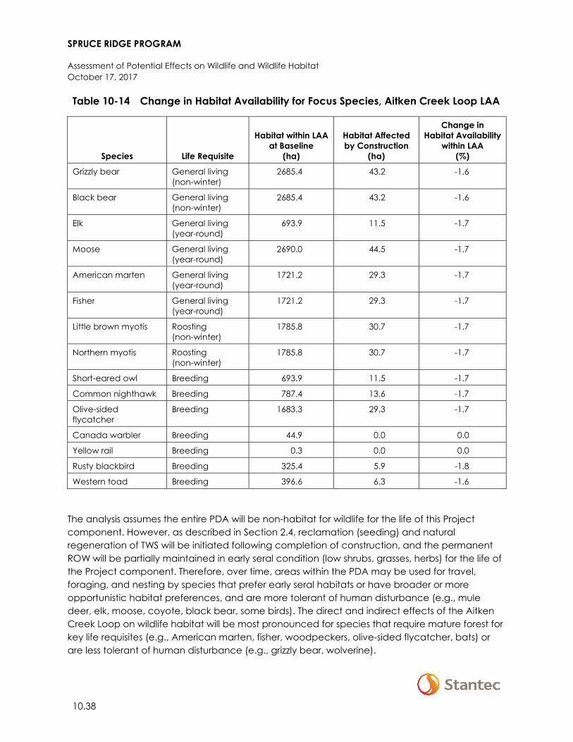
SPRUCE RIDGE PROGRAM
Assessment of Potential Effects on Wildlife and Wildlife Habitat October 17, 2017
10.38
Table 10-14 Change in Habitat Availability for Focus Species, Aitken Creek Loop LAA
Species Life Requisite
Habitat within LAA at Baseline
(ha)
Habitat Affected by Construction
(ha)
Change in Habitat Availability
within LAA (%)
Grizzly bear General living (non-winter)
2685.4 43.2 -1.6
Black bear General living (non-winter)
2685.4 43.2 -1.6
Elk General living (year-round)
693.9 11.5 -1.7
Moose General living (year-round)
2690.0 44.5 -1.7
American marten General living (year-round)
1721.2 29.3 -1.7
Fisher General living (year-round)
1721.2 29.3 -1.7
Little brown myotis Roosting (non-winter)
1785.8 30.7 -1.7
Northern myotis Roosting (non-winter)
1785.8 30.7 -1.7
Short-eared owl Breeding 693.9 11.5 -1.7
Common nighthawk Breeding 787.4 13.6 -1.7
Olive-sided flycatcher
Breeding 1683.3 29.3 -1.7
Canada warbler Breeding 44.9 0.0 0.0
Yellow rail Breeding 0.3 0.0 0.0
Rusty blackbird Breeding 325.4 5.9 -1.8
Western toad Breeding 396.6 6.3 -1.6
The analysis assumes the entire PDA will be non-habitat for wildlife for the life of this Project component. However, as described in Section 2.4, reclamation (seeding) and natural regeneration of TWS will be initiated following completion of construction, and the permanent ROW will be partially maintained in early seral condition (low shrubs, grasses, herbs) for the life of the Project component. Therefore, over time, areas within the PDA may be used for travel, foraging, and nesting by species that prefer early seral habitats or have broader or more opportunistic habitat preferences, and are more tolerant of human disturbance (e.g., mule deer, elk, moose, coyote, black bear, some birds). The direct and indirect effects of the Aitken Creek Loop on wildlife habitat will be most pronounced for species that require mature forest for key life requisites (e.g., American marten, fisher, woodpeckers, olive-sided flycatcher, bats) or are less tolerant of human disturbance (e.g., grizzly bear, wolverine).
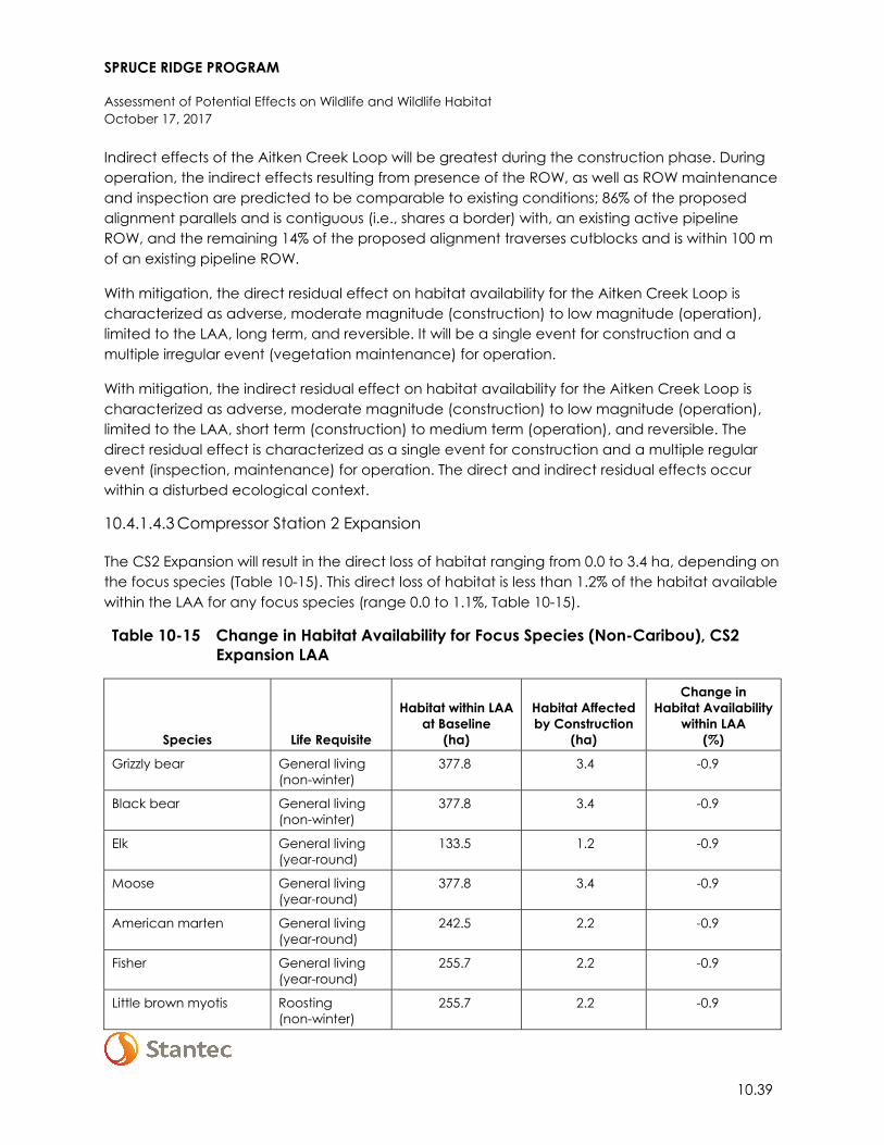
SPRUCE RIDGE PROGRAM
Assessment of Potential Effects on Wildlife and Wildlife Habitat October 17, 2017
10.39
Indirect effects of the Aitken Creek Loop will be greatest during the construction phase. During operation, the indirect effects resulting from presence of the ROW, as well as ROW maintenance and inspection are predicted to be comparable to existing conditions; 86% of the proposed alignment parallels and is contiguous (i.e., shares a border) with, an existing active pipeline ROW, and the remaining 14% of the proposed alignment traverses cutblocks and is within 100 m of an existing pipeline ROW.
With mitigation, the direct residual effect on habitat availability for the Aitken Creek Loop is characterized as adverse, moderate magnitude (construction) to low magnitude (operation), limited to the LAA, long term, and reversible. It will be a single event for construction and a multiple irregular event (vegetation maintenance) for operation.
With mitigation, the indirect residual effect on habitat availability for the Aitken Creek Loop is characterized as adverse, moderate magnitude (construction) to low magnitude (operation), limited to the LAA, short term (construction) to medium term (operation), and reversible. The direct residual effect is characterized as a single event for construction and a multiple regular event (inspection, maintenance) for operation. The direct and indirect residual effects occur within a disturbed ecological context.
10.4.1.4.3 Compressor Station 2 Expansion
The CS2 Expansion will result in the direct loss of habitat ranging from 0.0 to 3.4 ha, depending on the focus species (Table 10-15). This direct loss of habitat is less than 1.2% of the habitat available within the LAA for any focus species (range 0.0 to 1.1%, Table 10-15).
Table 10-15 Change in Habitat Availability for Focus Species (Non-Caribou), CS2 Expansion LAA
Species Life Requisite
Habitat within LAA at Baseline
(ha)
Habitat Affected by Construction
(ha)
Change in Habitat Availability
within LAA (%)
Grizzly bear General living (non-winter)
377.8 3.4 -0.9
Black bear General living (non-winter)
377.8 3.4 -0.9
Elk General living (year-round)
133.5 1.2 -0.9
Moose General living (year-round)
377.8 3.4 -0.9
American marten General living (year-round)
242.5 2.2 -0.9
Fisher General living (year-round)
255.7 2.2 -0.9
Little brown myotis Roosting (non-winter)
255.7 2.2 -0.9
SPRUCE RIDGE PROGRAM
Assessment of Potential Effects on Wildlife and Wildlife Habitat October 17, 2017
10.40
Table 10-15 Change in Habitat Availability for Focus Species (Non-Caribou), CS2 Expansion LAA
Species Life Requisite
Habitat within LAA at Baseline
(ha)
Habitat Affected by Construction
(ha)
Change in Habitat Availability
within LAA (%)
Northern myotis Roosting (non-winter)
255.7 2.2 -0.9
Short-eared owl Breeding 120.3 1.2 -1.0
Common nighthawk Breeding 147.1 1.3 -0.9
Olive-sided flycatcher Breeding 54.8 0.0 0.0
Canada warbler Breeding 200.9 2.2 -1.1
Yellow rail Breeding 0.0 0.0 0.0
Rusty blackbird Breeding 0.0 0.0 0.0
Western toad Breeding 0.0 0.0 0.0
The analysis assumes the entire PDA will be non-habitat for wildlife for the life of this Project component. Although some of the disturbed area may regenerate during operation, those areas are assumed to be unavailable to most wildlife because of fencing, noise, and the proximity of the existing facility and associated human activities. Indirect effects are expected to be greatest during the construction phase because of increased worker and equipment activity, although indirect effects will persist through operation. The increase in indirect effects is likely negligible relative to existing indirect effects because Project indirect effects will overlap with existing indirect disturbance. Therefore, additional indirect effects are not expected to have the same magnitude of effect as would be expected if this was a new disturbance in the area. During operation, indirect effects of the compressor expansion are predicted to be additive, but generally similar, to existing conditions.
The Project will result in a change in caribou habitat of 2.5 ha within Type 1 Matrix range (Table 10-17). This will be a conversion from permanent indirect disturbance to permanent direct disturbance as a result of clearing of vegetation for the PDA. The Project may result in a change in biophysical attributes of critical habitat Type 1 Matrix range; however, the effect is negligible.
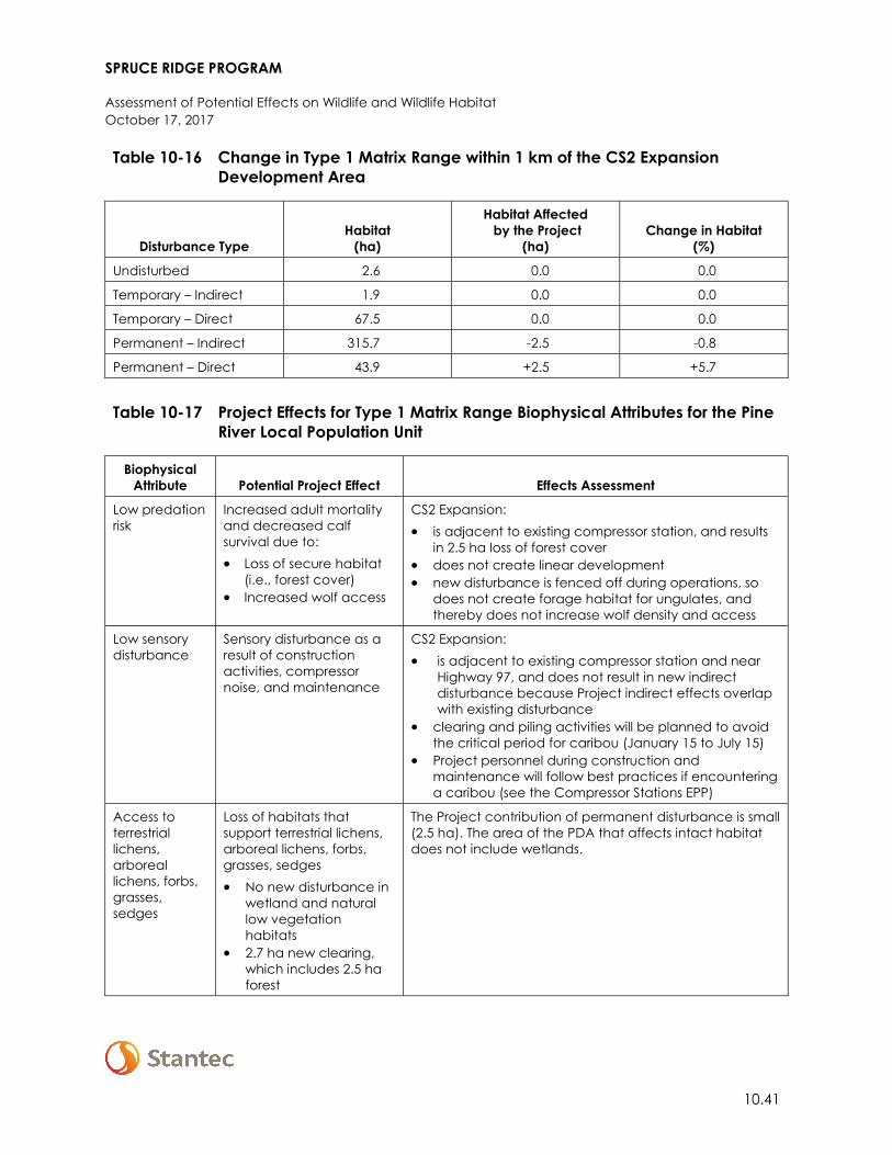
SPRUCE RIDGE PROGRAM
Assessment of Potential Effects on Wildlife and Wildlife Habitat October 17, 2017
10.41
Table 10-16 Change in Type 1 Matrix Range within 1 km of the CS2 Expansion Development Area
Disturbance Type Habitat
(ha)
Habitat Affected by the Project
(ha) Change in Habitat
(%)
Undisturbed 2.6 0.0 0.0
Temporary – Indirect 1.9 0.0 0.0
Temporary – Direct 67.5 0.0 0.0
Permanent – Indirect 315.7 -2.5 -0.8
Permanent – Direct 43.9 +2.5 +5.7
Table 10-17 Project Effects for Type 1 Matrix Range Biophysical Attributes for the Pine
River Local Population Unit
Biophysical Attribute Potential Project Effect Effects Assessment
Low predation risk
Increased adult mortality and decreased calf survival due to: • Loss of secure habitat
(i.e., forest cover) • Increased wolf access
CS2 Expansion: • is adjacent to existing compressor station, and results
in 2.5 ha loss of forest cover • does not create linear development • new disturbance is fenced off during operations, so
does not create forage habitat for ungulates, and thereby does not increase wolf density and access
Low sensory disturbance
Sensory disturbance as a result of construction activities, compressor noise, and maintenance
CS2 Expansion: • is adjacent to existing compressor station and near
Highway 97, and does not result in new indirect disturbance because Project indirect effects overlap with existing disturbance
• clearing and piling activities will be planned to avoid the critical period for caribou (January 15 to July 15)
• Project personnel during construction and maintenance will follow best practices if encountering a caribou (see the Compressor Stations EPP)
Access to terrestrial lichens, arboreal lichens, forbs, grasses, sedges
Loss of habitats that support terrestrial lichens, arboreal lichens, forbs, grasses, sedges • No new disturbance in
wetland and natural low vegetation habitats
• 2.7 ha new clearing, which includes 2.5 ha forest
The Project contribution of permanent disturbance is small (2.5 ha). The area of the PDA that affects intact habitat does not include wetlands.
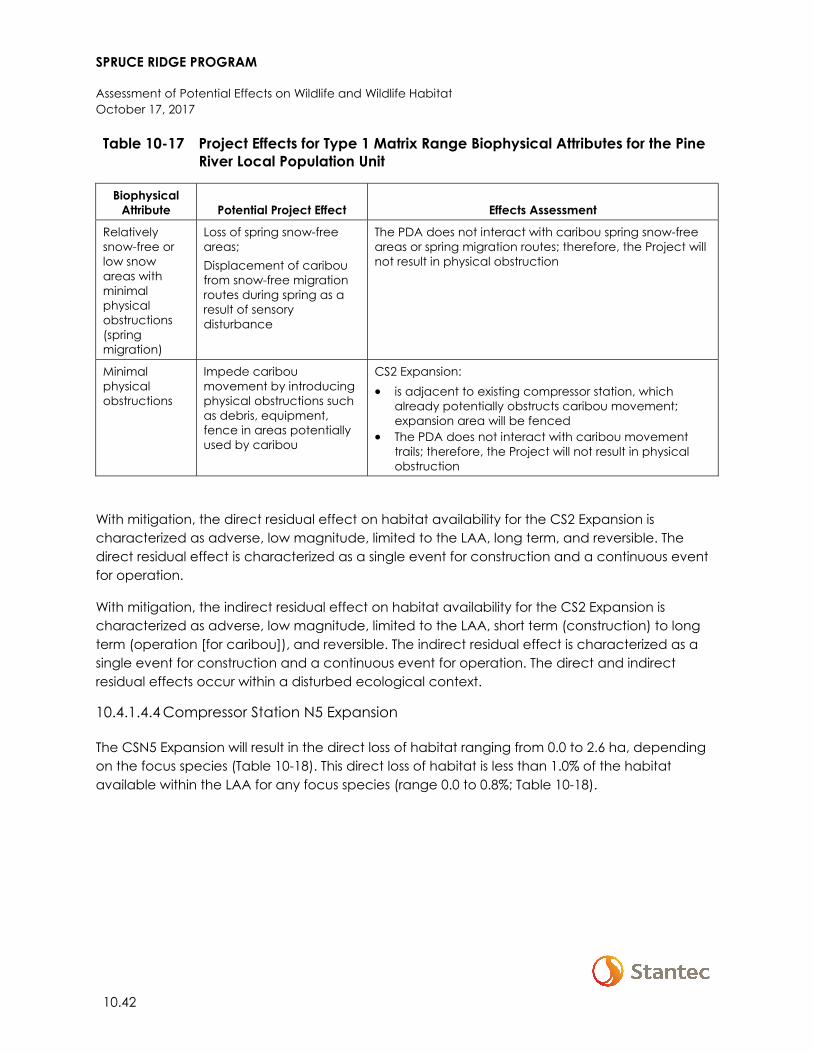
SPRUCE RIDGE PROGRAM
Assessment of Potential Effects on Wildlife and Wildlife Habitat October 17, 2017
10.42
Table 10-17 Project Effects for Type 1 Matrix Range Biophysical Attributes for the Pine River Local Population Unit
Biophysical Attribute Potential Project Effect Effects Assessment
Relatively snow-free or low snow areas with minimal physical obstructions (spring migration)
Loss of spring snow-free areas; Displacement of caribou from snow-free migration routes during spring as a result of sensory disturbance
The PDA does not interact with caribou spring snow-free areas or spring migration routes; therefore, the Project will not result in physical obstruction
Minimal physical obstructions
Impede caribou movement by introducing physical obstructions such as debris, equipment, fence in areas potentially used by caribou
CS2 Expansion: • is adjacent to existing compressor station, which
already potentially obstructs caribou movement; expansion area will be fenced
• The PDA does not interact with caribou movement trails; therefore, the Project will not result in physical obstruction
With mitigation, the direct residual effect on habitat availability for the CS2 Expansion is characterized as adverse, low magnitude, limited to the LAA, long term, and reversible. The direct residual effect is characterized as a single event for construction and a continuous event for operation.
With mitigation, the indirect residual effect on habitat availability for the CS2 Expansion is characterized as adverse, low magnitude, limited to the LAA, short term (construction) to long term (operation [for caribou]), and reversible. The indirect residual effect is characterized as a single event for construction and a continuous event for operation. The direct and indirect residual effects occur within a disturbed ecological context.
10.4.1.4.4 Compressor Station N5 Expansion
The CSN5 Expansion will result in the direct loss of habitat ranging from 0.0 to 2.6 ha, depending on the focus species (Table 10-18). This direct loss of habitat is less than 1.0% of the habitat available within the LAA for any focus species (range 0.0 to 0.8%; Table 10-18).
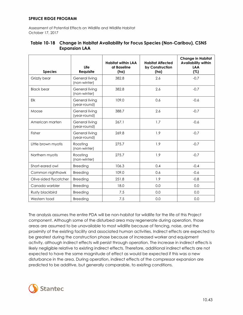
SPRUCE RIDGE PROGRAM
Assessment of Potential Effects on Wildlife and Wildlife Habitat October 17, 2017
10.43
Table 10-18 Change in Habitat Availability for Focus Species (Non-Caribou), CSN5 Expansion LAA
Species Life
Requisite
Habitat within LAA at Baseline
(ha)
Habitat Affected by Construction
(ha)
Change in Habitat Availability within
LAA (%)
Grizzly bear General living (non-winter)
382.8 2.6 -0.7
Black bear General living (non-winter)
382.8 2.6 -0.7
Elk General living (year-round)
109.0 0.6 -0.6
Moose General living (year-round)
388.7 2.6 -0.7
American marten General living (year-round)
267.1 1.7 -0.6
Fisher General living (year-round)
269.8 1.9 -0.7
Little brown myotis Roosting (non-winter)
275.7 1.9 -0.7
Northern myotis Roosting (non-winter)
275.7 1.9 -0.7
Short-eared owl Breeding 106.3 0.4 -0.4
Common nighthawk Breeding 109.0 0.6 -0.6
Olive-sided flycatcher Breeding 251.8 1.9 -0.8
Canada warbler Breeding 18.0 0.0 0.0
Rusty blackbird Breeding 7.5 0.0 0.0
Western toad Breeding 7.5 0.0 0.0
The analysis assumes the entire PDA will be non-habitat for wildlife for the life of this Project component. Although some of the disturbed area may regenerate during operation, those areas are assumed to be unavailable to most wildlife because of fencing, noise, and the proximity of the existing facility and associated human activities. Indirect effects are expected to be greatest during the construction phase because of increased worker and equipment activity, although indirect effects will persist through operation. The increase in indirect effects is likely negligible relative to existing indirect effects. Therefore, additional indirect effects are not expected to have the same magnitude of effect as would be expected if this was a new disturbance in the area. During operation, indirect effects of the compressor expansion are predicted to be additive, but generally comparable, to existing conditions.
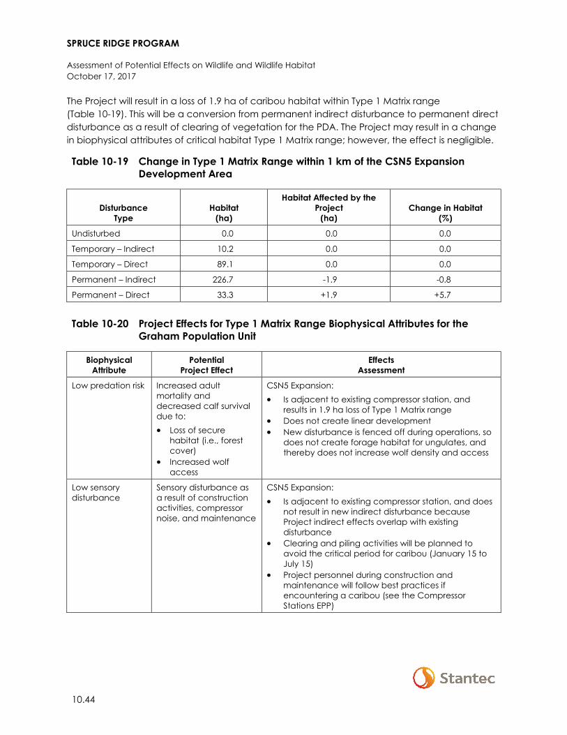
SPRUCE RIDGE PROGRAM
Assessment of Potential Effects on Wildlife and Wildlife Habitat October 17, 2017
10.44
The Project will result in a loss of 1.9 ha of caribou habitat within Type 1 Matrix range (Table 10-19). This will be a conversion from permanent indirect disturbance to permanent direct disturbance as a result of clearing of vegetation for the PDA. The Project may result in a change in biophysical attributes of critical habitat Type 1 Matrix range; however, the effect is negligible.
Table 10-19 Change in Type 1 Matrix Range within 1 km of the CSN5 Expansion Development Area
Disturbance Type
Habitat (ha)
Habitat Affected by the Project
(ha) Change in Habitat
(%)
Undisturbed 0.0 0.0 0.0
Temporary – Indirect 10.2 0.0 0.0
Temporary – Direct 89.1 0.0 0.0
Permanent – Indirect 226.7 -1.9 -0.8
Permanent – Direct 33.3 +1.9 +5.7
Table 10-20 Project Effects for Type 1 Matrix Range Biophysical Attributes for the
Graham Population Unit
Biophysical Attribute
Potential Project Effect
Effects Assessment
Low predation risk Increased adult mortality and decreased calf survival due to: • Loss of secure
habitat (i.e., forest cover)
• Increased wolf access
CSN5 Expansion: • Is adjacent to existing compressor station, and
results in 1.9 ha loss of Type 1 Matrix range • Does not create linear development • New disturbance is fenced off during operations, so
does not create forage habitat for ungulates, and thereby does not increase wolf density and access
Low sensory disturbance
Sensory disturbance as a result of construction activities, compressor noise, and maintenance
CSN5 Expansion: • Is adjacent to existing compressor station, and does
not result in new indirect disturbance because Project indirect effects overlap with existing disturbance
• Clearing and piling activities will be planned to avoid the critical period for caribou (January 15 to July 15)
• Project personnel during construction and maintenance will follow best practices if encountering a caribou (see the Compressor Stations EPP)
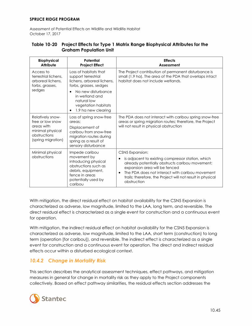
SPRUCE RIDGE PROGRAM
Assessment of Potential Effects on Wildlife and Wildlife Habitat October 17, 2017
10.45
Table 10-20 Project Effects for Type 1 Matrix Range Biophysical Attributes for the Graham Population Unit
Biophysical Attribute
Potential Project Effect
Effects Assessment
Access to terrestrial lichens, arboreal lichens, forbs, grasses, sedges
Loss of habitats that support terrestrial lichens, arboreal lichens, forbs, grasses, sedges • No new disturbance
in wetland and natural low vegetation habitats
• 1.9 ha new clearing
The Project contribution of permanent disturbance is small (1.9 ha). The area of the PDA that overlaps intact habitat does not include wetlands.
Relatively snow-free or low snow areas with minimal physical obstructions (spring migration)
Loss of spring snow-free areas; Displacement of caribou from snow-free migration routes during spring as a result of sensory disturbance
The PDA does not interact with caribou spring snow-free areas or spring migration routes; therefore, the Project will not result in physical obstruction
Minimal physical obstructions
Impede caribou movement by introducing physical obstructions such as debris, equipment, fence in areas potentially used by caribou
CSN5 Expansion: • is adjacent to existing compressor station, which
already potentially obstructs caribou movement; expansion area will be fenced
• The PDA does not interact with caribou movement trails; therefore, the Project will not result in physical obstruction
With mitigation, the direct residual effect on habitat availability for the CSN5 Expansion is characterized as adverse, low magnitude, limited to the LAA, long term, and reversible. The direct residual effect is characterized as a single event for construction and a continuous event for operation.
With mitigation, the indirect residual effect on habitat availability for the CSN5 Expansion is characterized as adverse, low magnitude, limited to the LAA, short term (construction) to long term (operation [for caribou]), and reversible. The indirect effect is characterized as a single event for construction and a continuous event for operation. The direct and indirect residual effects occur within a disturbed ecological context.
10.4.2 Change in Mortality Risk
This section describes the analytical assessment techniques, effect pathways, and mitigation measures in general for change in mortality risk as they apply to the Project components collectively. Based on effect pathway similarities, the residual effects section addresses the
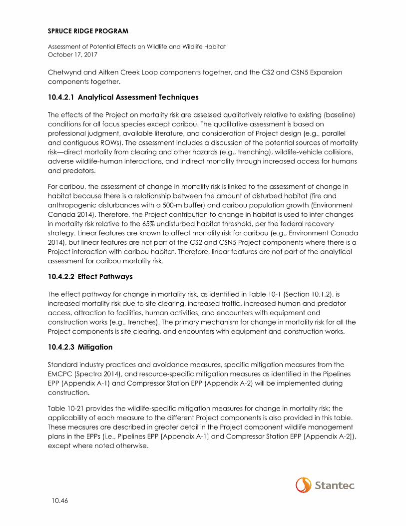
SPRUCE RIDGE PROGRAM
Assessment of Potential Effects on Wildlife and Wildlife Habitat October 17, 2017
10.46
Chetwynd and Aitken Creek Loop components together, and the CS2 and CSN5 Expansion components together.
10.4.2.1 Analytical Assessment Techniques
The effects of the Project on mortality risk are assessed qualitatively relative to existing (baseline) conditions for all focus species except caribou. The qualitative assessment is based on professional judgment, available literature, and consideration of Project design (e.g., parallel and contiguous ROWs). The assessment includes a discussion of the potential sources of mortality risk—direct mortality from clearing and other hazards (e.g., trenching), wildlife-vehicle collisions, adverse wildlife-human interactions, and indirect mortality through increased access for humans and predators.
For caribou, the assessment of change in mortality risk is linked to the assessment of change in habitat because there is a relationship between the amount of disturbed habitat (fire and anthropogenic disturbances with a 500-m buffer) and caribou population growth (Environment Canada 2014). Therefore, the Project contribution to change in habitat is used to infer changes in mortality risk relative to the 65% undisturbed habitat threshold, per the federal recovery strategy. Linear features are known to affect mortality risk for caribou (e.g., Environment Canada 2014), but linear features are not part of the CS2 and CSN5 Project components where there is a Project interaction with caribou habitat. Therefore, linear features are not part of the analytical assessment for caribou mortality risk.
10.4.2.2 Effect Pathways
The effect pathway for change in mortality risk, as identified in Table 10-1 (Section 10.1.2), is increased mortality risk due to site clearing, increased traffic, increased human and predator access, attraction to facilities, human activities, and encounters with equipment and construction works (e.g., trenches). The primary mechanism for change in mortality risk for all the Project components is site clearing, and encounters with equipment and construction works.
10.4.2.3 Mitigation
Standard industry practices and avoidance measures, specific mitigation measures from the EMCPC (Spectra 2014), and resource-specific mitigation measures as identified in the Pipelines EPP (Appendix A-1) and Compressor Station EPP (Appendix A-2) will be implemented during construction.
Table 10-21 provides the wildlife-specific mitigation measures for change in mortality risk; the applicability of each measure to the different Project components is also provided in this table. These measures are described in greater detail in the Project component wildlife management plans in the EPPs (i.e., Pipelines EPP [Appendix A-1] and Compressor Station EPP [Appendix A-2]), except where noted otherwise.
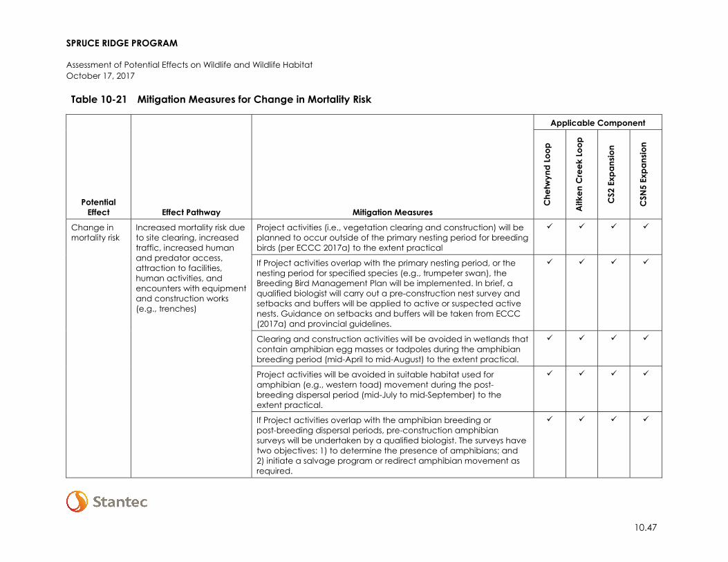
SPRUCE RIDGE PROGRAM
Assessment of Potential Effects on Wildlife and Wildlife Habitat October 17, 2017
10.47
Table 10-21 Mitigation Measures for Change in Mortality Risk
Potential Effect Effect Pathway Mitigation Measures
Applicable Component
Che
twyn
d Lo
op
Aitk
en C
reek
Loo
p
CS2
Exp
ansio
n
CSN
5 Ex
pans
ion
Change in mortality risk
Increased mortality risk due to site clearing, increased traffic, increased human and predator access, attraction to facilities, human activities, and encounters with equipment and construction works (e.g., trenches)
Project activities (i.e., vegetation clearing and construction) will be planned to occur outside of the primary nesting period for breeding birds (per ECCC 2017a) to the extent practical
If Project activities overlap with the primary nesting period, or the nesting period for specified species (e.g., trumpeter swan), the Breeding Bird Management Plan will be implemented. In brief, a qualified biologist will carry out a pre-construction nest survey and setbacks and buffers will be applied to active or suspected active nests. Guidance on setbacks and buffers will be taken from ECCC (2017a) and provincial guidelines.
Clearing and construction activities will be avoided in wetlands that contain amphibian egg masses or tadpoles during the amphibian breeding period (mid-April to mid-August) to the extent practical.
Project activities will be avoided in suitable habitat used for amphibian (e.g., western toad) movement during the post-breeding dispersal period (mid-July to mid-September) to the extent practical.
If Project activities overlap with the amphibian breeding or post-breeding dispersal periods, pre-construction amphibian surveys will be undertaken by a qualified biologist. The surveys have two objectives: 1) to determine the presence of amphibians; and 2) initiate a salvage program or redirect amphibian movement as required.
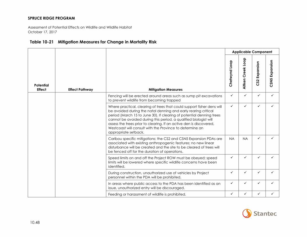
SPRUCE RIDGE PROGRAM
Assessment of Potential Effects on Wildlife and Wildlife Habitat October 17, 2017
10.48
Table 10-21 Mitigation Measures for Change in Mortality Risk
Potential Effect Effect Pathway Mitigation Measures
Applicable Component
Che
twyn
d Lo
op
Aitk
en C
reek
Loo
p
CS2
Exp
ansio
n
CSN
5 Ex
pans
ion
Fencing will be erected around areas such as sump pit excavations to prevent wildlife from becoming trapped
Where practical, clearing of trees that could support fisher dens will be avoided during the natal denning and early rearing critical period (March 15 to June 30). If clearing of potential denning trees cannot be avoided during this period, a qualified biologist will assess the trees prior to clearing. If an active den is discovered, Westcoast will consult with the Province to determine an appropriate setback.
Caribou specific mitigations: the CS2 and CSN5 Expansion PDAs are associated with existing anthropogenic features; no new linear disturbance will be created and the site to be cleared of trees will be fenced off for the duration of operations.
NA NA
Speed limits on and off the Project ROW must be obeyed; speed limits will be lowered where specific wildlife concerns have been identified.
During construction, unauthorized use of vehicles by Project personnel within the PDA will be prohibited.
In areas where public access to the PDA has been identified as an issue, unauthorized entry will be discouraged.
Feeding or harassment of wildlife is prohibited.
SPRUCE RIDGE PROGRAM
Assessment of Potential Effects on Wildlife and Wildlife Habitat October 17, 2017
10.49
Table 10-21 Mitigation Measures for Change in Mortality Risk
Potential Effect Effect Pathway Mitigation Measures
Applicable Component
Che
twyn
d Lo
op
Aitk
en C
reek
Loo
p
CS2
Exp
ansio
n
CSN
5 Ex
pans
ion
Project personnel are not permitted to have pets on site, or in Project vehicles.
Firearms are not permitted on site unless Company policy allows (e.g., where there is a risk of bear attack).
Project-related wildlife deaths and conflict animals will be reported as required to appropriate authorities.
NOTES: = Specified mitigation will be employed for this component – = Specified mitigation will not be employed for this component
SPRUCE RIDGE PROGRAM
Assessment of Potential Effects on Wildlife and Wildlife Habitat October 17, 2017
10.50
10.4.2.4 Residual Effects
Discussion and characterization of residual effects are presented for the Chetwynd and Aitken Creek Loop components together, and for the CS2 and CSN5 Expansion components together, in the following sections.
10.4.2.4.1 Chetwynd Loop and Aitken Creek Loop
An increase in mortality risk for birds and amphibians is predicted in association with vegetation clearing during construction and vegetation management activities (e.g., ROW maintenance) during operation. However, this increased risk can be avoided or reduced with the application of mitigation (see Section 10.4.2.3). As limited new linear disturbance is being created (i.e., the Project ROW parallels, and is primarily contiguous with, existing disturbances such as existing ROW), increased mortality risk because of increased human and predator access is predicted to be negligible. As well, where a new linear disturbance is being created (e.g., between KP 0 and KP 6 along the Chetwynd Loop), the majority (KP 0 to 4.75) of the ROW is within a developed context consisting primarily of agriculture.
With mitigation, the residual effect on mortality risk for the Chetwynd and Aitken Creek Loops is characterized as adverse, low magnitude, limited to the LAA, short term (construction) to long term (operation), and reversible. The residual effect is characterized as a continuous event for construction and operation. The residual effect occurs within a disturbed ecological context.
10.4.2.4.2 CS2 and CSN5 Expansions
An increase in mortality risk for birds is predicted in association with vegetation clearing during construction. However, this increased risk can be avoided or reduced with the application of mitigation (see Section 10.4.2.3). As no new access is being developed for either Project component, and as the expanded portions of the facilities are directly adjacent to existing facilities of the same type, no increase in mortality risk during operation is expected for wildlife. An increase in mortality risk for caribou is predicted to be low, as a result of no new access and no new early seral habitat being created during construction and operations that could be available to ungulates.
With mitigation, the residual effect on mortality risk for the CS2 and CSN5 Expansions is characterized as adverse, negligible magnitude (non-caribou wildlife) to low magnitude (caribou), limited to the LAA, short term (construction) to long term (operation), and reversible. The residual effect is characterized as a single event for construction and a continuous event for operation. The residual effect occurs within a disturbed ecological context.
SPRUCE RIDGE PROGRAM
Assessment of Potential Effects on Wildlife and Wildlife Habitat October 17, 2017
10.51
10.4.3 Change in Movement
This section describes the analytical assessment techniques, effect pathways, and mitigation measures in general for change in movement as they apply to the Project components collectively. Based on effect pathway similarities, the residual effects section addresses the Chetwynd and Aitken Creek Loop components together, and the CS2 and CSN5 Expansion components together.
10.4.3.1 Analytical Assessment Techniques
The effects of the Project on movement are assessed qualitatively relative to existing (baseline) conditions, and are based on professional judgment, available literature, and consideration of Project design (e.g., parallel and contiguous ROWs). The assessment includes a discussion of the potential effects of the Project components on the integrity of known wildlife trails and potential movement corridors identified by specific topographic features (e.g., riparian corridors, ridges) and relatively large areas (in the context of home range sizes for ungulates and medium- to large-sized carnivores) of intact habitat.
10.4.3.2 Effect Pathways
Two effect pathways for change in movement are identified in Table 10-1 (Section 10.1.2): alteration or blockage of wildlife movement arising from the PDA intersecting wildlife trails or movement corridors; and increased ROW width deterring wildlife crossings. The primary mechanism for change in movement is associated with the presence of the ROW. Wildlife may avoid crossing a ROW for various reasons including the width of the opening, lack of security cover (i.e., perceived predation risk), and deep snow (Gilbert et al. 1970; Wallmo and Gill 1971; Lima and Dill 1990; Bélisle and St. Clair 2001; Bayne et al. 2005). In addition, sensory disturbance from pre-construction, construction, inspection, and maintenance activities may alter wildlife movement across the ROW (as a function of avoidance, see Section 10.4.1). The deterrent effect would also vary with time of day, season, species, age and sex class; for example, individuals may readily cross the ROW at night, but avoid doing so during the day when construction activity is most intense. Trenching and stockpiling may also provide a temporary barrier to the movements of some wildlife (e.g., ungulates).
Given the nature of the CS2 and CSN5 Expansions (i.e., expansion of an existing patch disturbance), the effect of these Project components on wildlife movement is predicted to be primarily related to increased avoidance during construction rather than displacement or disruption of existing movement patterns over the long term.
SPRUCE RIDGE PROGRAM
Assessment of Potential Effects on Wildlife and Wildlife Habitat October 17, 2017
10.52
10.4.3.3 Mitigation
Standard industry practices and avoidance measures, specific mitigation measures from the EMCPC (Spectra 2014), and resource-specific mitigation measures as identified in the Pipelines EPP (Appendix A-1) and Compressor Stations EPP (Appendix A-2) will be implemented during construction.
Table 10-22 provides the wildlife-specific mitigation measures for change in movement; the applicability of each measure to the different Project components is also provided in this table. These measures are described in greater detail in the Project component wildlife management plans in the EPPs (i.e., Pipelines EPP [Appendix A-1] and Compressor Station EPP [Appendix A-2]), except where noted otherwise.
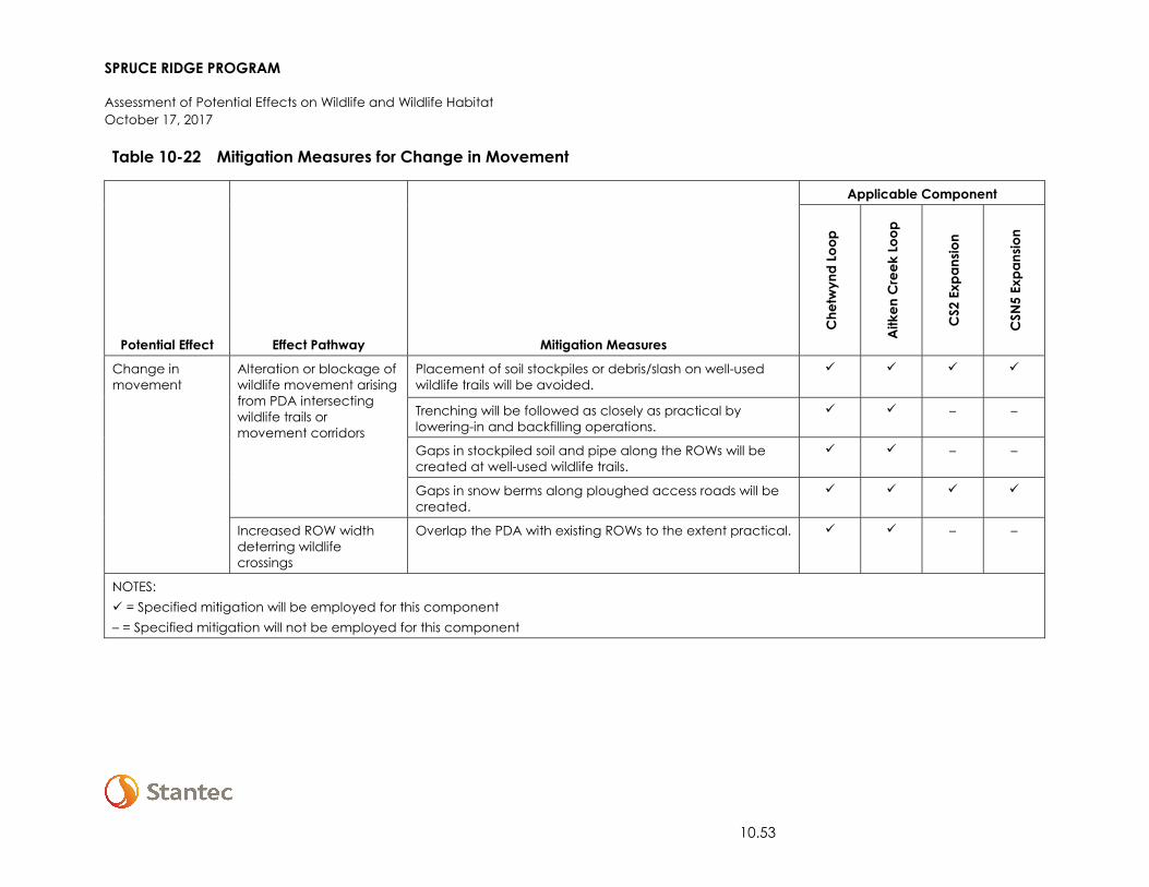
SPRUCE RIDGE PROGRAM
Assessment of Potential Effects on Wildlife and Wildlife Habitat October 17, 2017
10.53
Table 10-22 Mitigation Measures for Change in Movement
Potential Effect Effect Pathway Mitigation Measures
Applicable Component
Che
twyn
d Lo
op
Aitk
en C
reek
Loo
p
CS2
Exp
ansio
n
CSN
5 Ex
pans
ion
Change in movement
Alteration or blockage of wildlife movement arising from PDA intersecting wildlife trails or movement corridors
Placement of soil stockpiles or debris/slash on well-used wildlife trails will be avoided.
Trenching will be followed as closely as practical by lowering-in and backfilling operations.
– –
Gaps in stockpiled soil and pipe along the ROWs will be created at well-used wildlife trails.
– –
Gaps in snow berms along ploughed access roads will be created.
Increased ROW width deterring wildlife crossings
Overlap the PDA with existing ROWs to the extent practical. – –
NOTES: = Specified mitigation will be employed for this component – = Specified mitigation will not be employed for this component
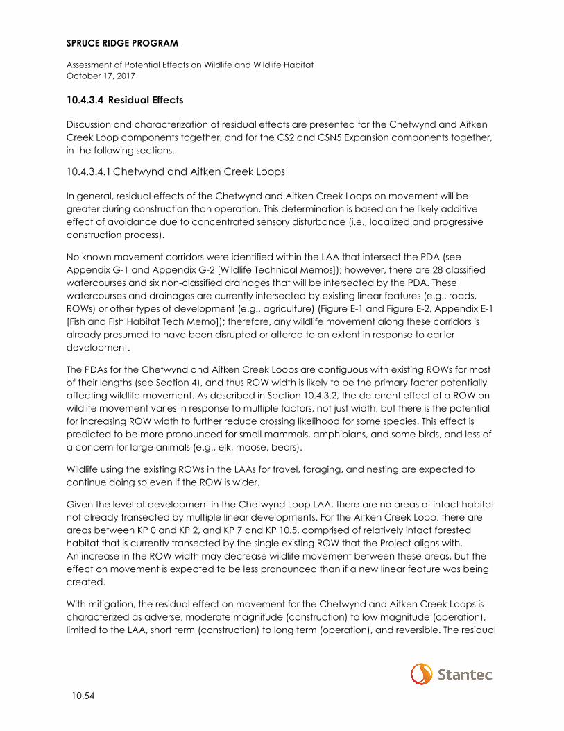
SPRUCE RIDGE PROGRAM
Assessment of Potential Effects on Wildlife and Wildlife Habitat October 17, 2017
10.54
10.4.3.4 Residual Effects
Discussion and characterization of residual effects are presented for the Chetwynd and Aitken Creek Loop components together, and for the CS2 and CSN5 Expansion components together, in the following sections.
10.4.3.4.1 Chetwynd and Aitken Creek Loops
In general, residual effects of the Chetwynd and Aitken Creek Loops on movement will be greater during construction than operation. This determination is based on the likely additive effect of avoidance due to concentrated sensory disturbance (i.e., localized and progressive construction process).
No known movement corridors were identified within the LAA that intersect the PDA (see Appendix G-1 and Appendix G-2 [Wildlife Technical Memos]); however, there are 28 classified watercourses and six non-classified drainages that will be intersected by the PDA. These watercourses and drainages are currently intersected by existing linear features (e.g., roads, ROWs) or other types of development (e.g., agriculture) (Figure E-1 and Figure E-2, Appendix E-1 [Fish and Fish Habitat Tech Memo]); therefore, any wildlife movement along these corridors is already presumed to have been disrupted or altered to an extent in response to earlier development.
The PDAs for the Chetwynd and Aitken Creek Loops are contiguous with existing ROWs for most of their lengths (see Section 4), and thus ROW width is likely to be the primary factor potentially affecting wildlife movement. As described in Section 10.4.3.2, the deterrent effect of a ROW on wildlife movement varies in response to multiple factors, not just width, but there is the potential for increasing ROW width to further reduce crossing likelihood for some species. This effect is predicted to be more pronounced for small mammals, amphibians, and some birds, and less of a concern for large animals (e.g., elk, moose, bears).
Wildlife using the existing ROWs in the LAAs for travel, foraging, and nesting are expected to continue doing so even if the ROW is wider.
Given the level of development in the Chetwynd Loop LAA, there are no areas of intact habitat not already transected by multiple linear developments. For the Aitken Creek Loop, there are areas between KP 0 and KP 2, and KP 7 and KP 10.5, comprised of relatively intact forested habitat that is currently transected by the single existing ROW that the Project aligns with. An increase in the ROW width may decrease wildlife movement between these areas, but the effect on movement is expected to be less pronounced than if a new linear feature was being created.
With mitigation, the residual effect on movement for the Chetwynd and Aitken Creek Loops is characterized as adverse, moderate magnitude (construction) to low magnitude (operation), limited to the LAA, short term (construction) to long term (operation), and reversible. The residual
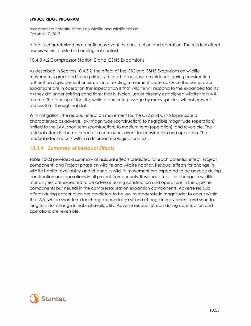
SPRUCE RIDGE PROGRAM
Assessment of Potential Effects on Wildlife and Wildlife Habitat October 17, 2017
10.55
effect is characterized as a continuous event for construction and operation. The residual effect occurs within a disturbed ecological context.
10.4.3.4.2 Compressor Station 2 and CSN5 Expansions
As described in Section 10.4.3.2, the effect of the CS2 and CSN5 Expansions on wildlife movement is predicted to be primarily related to increased avoidance during construction rather than displacement or disruption of existing movement patterns. Once the compressor expansions are in operation the expectation is that wildlife will respond to the expanded facility as they did under existing conditions; that is, typical use of already established wildlife trails will resume. The fencing of the site, while a barrier to passage by many species, will not prevent access to or through habitat.
With mitigation, the residual effect on movement for the CS2 and CSN5 Expansions is characterized as adverse, low magnitude (construction) to negligible magnitude (operation), limited to the LAA, short term (construction) to medium term (operation), and reversible. The residual effect is characterized as a continuous event for construction and operation. The residual effect occurs within a disturbed ecological context.
10.4.4 Summary of Residual Effects
Table 10-23 provides a summary of residual effects predicted for each potential effect, Project component, and Project phase on wildlife and wildlife habitat. Residual effects for change in wildlife habitat availability and change in wildlife movement are expected to be adverse during construction and operations in all project components. Residual effects for change in wildlife mortality risk are expected to be adverse during construction and operations in the pipeline components but neutral in the compressor station expansion components. Adverse residual effects during construction are predicted to be low to moderate in magnitude; to occur within the LAA; will be short term for change in mortality risk and change in movement, and short to long term for change in habitat availability. Adverse residual effects during construction and operations are reversible.
SPRUCE RIDGE PROGRAM
Assessment of Potential Effects on Wildlife and Wildlife Habitat October 17, 2017
10.56
Table 10-23 Residual Effects on Wildlife and Wildlife Habitat
Residual Effect
Residual Effects Characterization
Direction Magnitude Geographic
Extent Duration Frequency Reversibility Ecological
Context
Change in Habitat Availability
Chetwynd Loop
Construction A M LAA LT/ST S R D
Operation A L LAA LT/MT MI/MR R D
Aitken Creek Loop
Construction A M LAA LT/ST S R D
Operation A L LAA LT/MT MI/MR R D
CS2 Expansion
Construction A L LAA LT/ST S R D
Operation A L LAA LT/MT C R D
CSN5 Expansion
Construction A L LAA LT/ST S R D
Operation A L LAA LT/MT C R D
Change in Mortality Risk
Chetwynd Loop
Construction A L LAA ST C R D
Operation A L LAA LT C R D
SPRUCE RIDGE PROGRAM
Assessment of Potential Effects on Wildlife and Wildlife Habitat October 17, 2017
10.57
Table 10-23 Residual Effects on Wildlife and Wildlife Habitat
Residual Effect
Residual Effects Characterization
Direction Magnitude Geographic
Extent Duration Frequency Reversibility Ecological
Context
Aitken Creek Loop
Construction A L LAA ST C R D
Operation A L LAA LT C R D
CS2 Expansion
Construction N N-L LAA ST S R D
Operation N N-L LAA LT C R D
CSN5 Expansion
Construction N N-L LAA ST S R D
Operation N N-L LAA LT C R D
Change in Movement
Chetwynd Loop
Construction A M LAA ST C R D
Operation A L LAA LT C R D
Aitken Creek Loop
Construction A M LAA ST C R D
Operation A L LAA LT C R D
CS2 Expansion
Construction A L LAA ST C R D
Operation A N LAA MT C R D
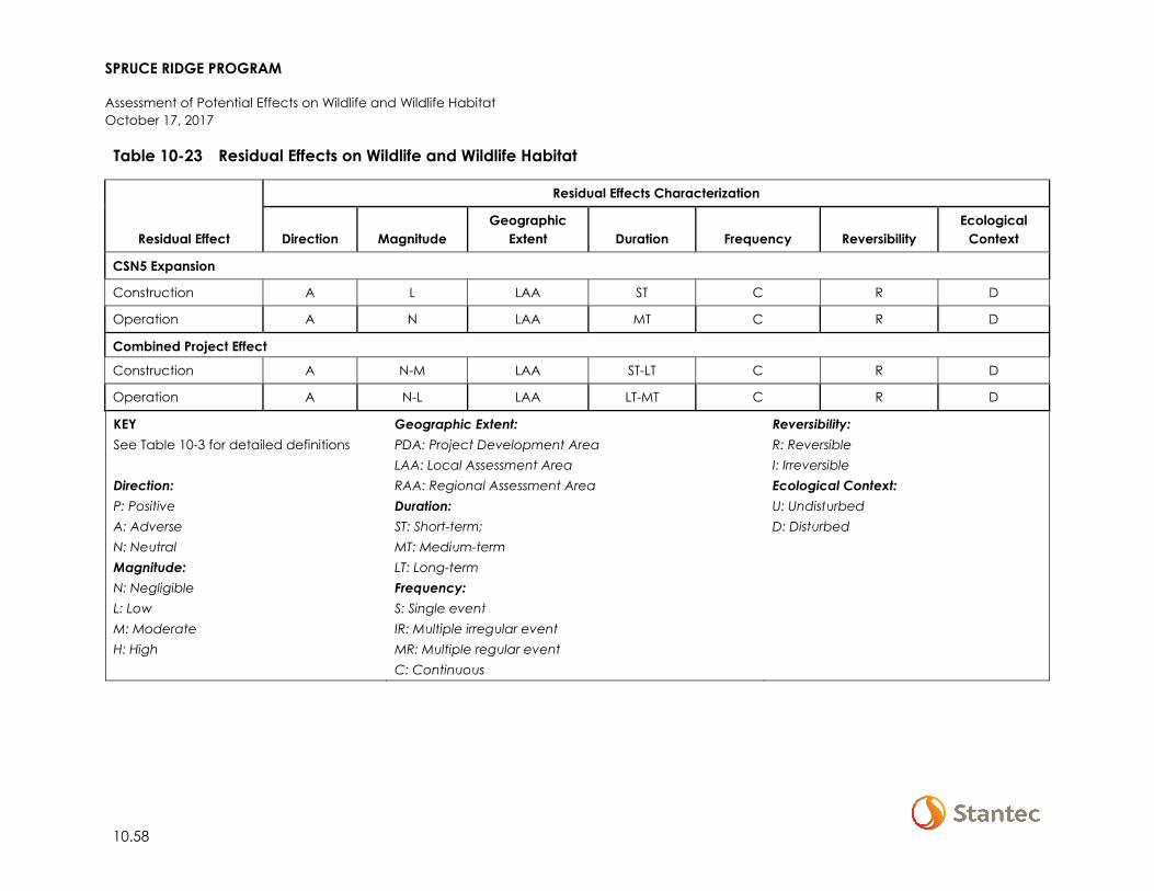
SPRUCE RIDGE PROGRAM
Assessment of Potential Effects on Wildlife and Wildlife Habitat October 17, 2017
10.58
Table 10-23 Residual Effects on Wildlife and Wildlife Habitat
Residual Effect
Residual Effects Characterization
Direction Magnitude Geographic
Extent Duration Frequency Reversibility Ecological
Context
CSN5 Expansion
Construction A L LAA ST C R D
Operation A N LAA MT C R D
Combined Project Effect
Construction A N-M LAA ST-LT C R D
Operation A N-L LAA LT-MT C R D
KEY See Table 10-3 for detailed definitions Direction: P: Positive A: Adverse N: Neutral Magnitude: N: Negligible L: Low M: Moderate H: High
Geographic Extent: PDA: Project Development Area LAA: Local Assessment Area RAA: Regional Assessment Area Duration: ST: Short-term; MT: Medium-term LT: Long-term Frequency: S: Single event IR: Multiple irregular event MR: Multiple regular event C: Continuous
Reversibility: R: Reversible I: Irreversible Ecological Context: U: Undisturbed D: Disturbed
SPRUCE RIDGE PROGRAM
Assessment of Potential Effects on Wildlife and Wildlife Habitat October 17, 2017
10.59
10.5 ASSESSMENT OF CUMULATIVE EFFECTS ON WILDLIFE AND WILDLIFE HABITAT
Existing conditions reflect the cumulative effects from past and existing physical activities. The cumulative effects assessment is focused on future conditions which reflect the addition of the Project-specific residual effects and those of other reasonably foreseeable future physical activities to the existing conditions for wildlife and wildlife habitat.
As described in Section 4, the assessment of cumulative effects is initiated with a determination of whether two conditions exist:
1. there are residual effects on the VC; and 2. the residual effects could act cumulatively with residual effects of other past, present, or
reasonably foreseeable future physical activities.
For wildlife and wildlife habitat, these two conditions do exist—the Project components are anticipated to have adverse residual effects on wildlife and wildlife habitat (see Section 10.4); and there is potential for the residual effects of the Project components to act cumulatively with residual effects of other past, present, or reasonably foreseeable future physical activities.
The Project-specific residual effects on wildlife and wildlife habitat described in Section 10.4 that are likely to interact cumulatively with the residual effects of other past, present, or reasonably foreseeable future physical activities are identified in this section and the resulting cumulative effects are assessed qualitatively. This is followed by a discussion of the Project component contributions to the overall cumulative effects on wildlife and wildlife habitat.
As described in Section 10.1.3.1, the RAAs are the areas within which potential for cumulative effects of the Project components in combination with other past, present, or reasonably foreseeable future physical activities are considered.
10.5.1 Residual Project Effects Likely to Interact Cumulatively
General categories of past, present, and reasonably foreseeable future physical activities within the wildlife RAAs are provided in Table 10-24. The categories of physical activities are assumed to be the same for the four Project components, although some activities might not occur within a given RAA. The Project components are predicted to have an adverse residual effect on habitat availability, mortality risk, and movement (Section 10.4). Table 10-24 identifies where these Project-specific residual effects are likely to interact cumulatively with the residual effects from other physical activities within the RAAs. Based on the information presented in Table 10-24, a cumulative effects assessment is required for the three residual effects on wildlife and wildlife habitat.
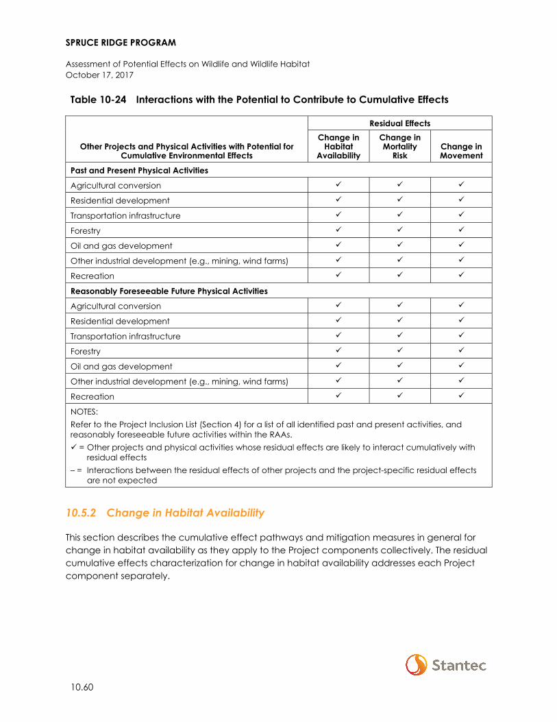
SPRUCE RIDGE PROGRAM
Assessment of Potential Effects on Wildlife and Wildlife Habitat October 17, 2017
10.60
Table 10-24 Interactions with the Potential to Contribute to Cumulative Effects
Other Projects and Physical Activities with Potential for Cumulative Environmental Effects
Residual Effects Change in
Habitat Availability
Change in Mortality
Risk Change in Movement
Past and Present Physical Activities
Agricultural conversion
Residential development
Transportation infrastructure
Forestry
Oil and gas development
Other industrial development (e.g., mining, wind farms)
Recreation
Reasonably Foreseeable Future Physical Activities
Agricultural conversion
Residential development
Transportation infrastructure
Forestry
Oil and gas development
Other industrial development (e.g., mining, wind farms)
Recreation
NOTES: Refer to the Project Inclusion List (Section 4) for a list of all identified past and present activities, and reasonably foreseeable future activities within the RAAs. = Other projects and physical activities whose residual effects are likely to interact cumulatively with
residual effects – = Interactions between the residual effects of other projects and the project-specific residual effects
are not expected
10.5.2 Change in Habitat Availability
This section describes the cumulative effect pathways and mitigation measures in general for change in habitat availability as they apply to the Project components collectively. The residual cumulative effects characterization for change in habitat availability addresses each Project component separately.
SPRUCE RIDGE PROGRAM
Assessment of Potential Effects on Wildlife and Wildlife Habitat October 17, 2017
10.61
10.5.2.1 Cumulative Effect Pathways
The primary cumulative effect pathway for change in habitat availability within the RAAs is vegetation conversion or removal. The residual effect on habitat availability from the Chetwynd and Aitken Creek Loops, and CS2 and CSN5 Expansions, will interact cumulatively with future physical activities (see Table 10-24) through this mechanism.
10.5.2.2 Mitigation for Cumulative Effects
Mitigation measures and regional initiatives applicable to limiting cumulative effects on habitat within the RAAs include, but are not limited to, the following:
• The Pipelines EPP (Appendix A-1) and Compressor Station EPP (Appendix A-2) • Application of guidelines and best practices across industrial sectors (e.g., BC MFLNRO 2014;
BC MFLNRO and BC MOE 2016; BC OGC 2017) • Active management of forest harvest by operators that overlap with the RAAs • Fisheries Act requirements related to stream and riparian habitat • Caribou habitat management and restoration measures applied by industry (i.e., Caribou
Mitigation and Monitoring Plans, Caribou Habitat Restoration Plans, Caribou Offset Measures Plans)
• Wetland function monitoring and offsetting measures applied to industry • The Peace Northern Caribou Committee, a collaborative group that includes First Nations,
corporations, government agencies, and community groups, is working on recovery initiatives for the Moberly/Klinse-Za herd, including wolf control and maternal penning
• Designation of, and regulations related to, WHAs and UWRs • Identification and protection of critical habitat as part of existing and future federal species
at risk federal recovery strategies
10.5.2.3 Residual Cumulative Effects
The following sections discuss and characterize the overall residual cumulative effect on habitat availability within each RAA with the addition of Project component-specific residual effects, and residual effects from reasonably foreseeable physical activities, to existing conditions.
Past and existing human development (e.g., rural development, forestry, and oil and gas development) has resulted in habitat loss and alteration within all Project component RAAs. The primary contributors to future cumulative effects on habitat availability, across all Project components, are oil and gas development and forestry.
SPRUCE RIDGE PROGRAM
Assessment of Potential Effects on Wildlife and Wildlife Habitat October 17, 2017
10.62
10.5.2.3.1 Chetwynd Loop RAA
Habitat availability within this RAA has been affected by disturbed areas associated with human settlement, agriculture, industrial development, and regenerating harvested areas. These latter areas retain some value as wildlife habitat, particularly for early seral and shrub-associated species. Habitat loss and alteration within this RAA has adversely affected wildlife, and the existing condition is at a level likely to have adversely affected the sustainability of some wildlife species (e.g., grizzly bear).
Given that there is already substantial and diverse disturbance within this RAA, the contributions of future physical activities to change in habitat availability are predicted to be additive, but minor relative to existing conditions. However, as the existing conditions are likely to have already affected the sustainability of some wildlife species, the addition of future activities is expected to exacerbate the situation.
With mitigation, the overall cumulative effect on habitat availability (future condition) is characterized as adverse, negligible magnitude to high magnitude (depending on focus species), defined by the RAA, long term, continuous, and partially reversible (i.e., there are some permanent effects, such as urban development and road networks, that are unlikely to be reversed). The overall cumulative effect occurs within a disturbed ecological context.
10.5.2.3.2 Aitken Creek Loop RAA
Habitat availability within this RAA has been affected by disturbed areas associated with oil and gas activities and forest harvest activities. These latter areas retain some value as wildlife habitat, particularly for early seral and shrub-associated species. Habitat loss and alteration within this RAA has adversely affected wildlife, and the existing condition is at a level likely to have adversely affected the sustainability of some wildlife species (e.g., grizzly bear).
Relative to the Chetwynd Loop RAA, the level of existing development is less within the Aitken Creek Loop RAA. In this context, the contributions of future physical activities to change in habitat availability are predicted to be additive, but more pronounced relative to the existing conditions. Furthermore, as existing conditions are already likely to have affected sustainability of some wildlife within the RAA, the addition of future activities are expected to exacerbate the situation.
With mitigation, the overall cumulative effect on habitat availability (future condition) is characterized as adverse, negligible magnitude to moderate magnitude (depending on focus species), defined by the RAA, long term, continuous, and partially reversible (i.e., there are some permanent effects, such as road networks, that are unlikely to be reversed). The overall cumulative effect occurs within a disturbed ecological context.
SPRUCE RIDGE PROGRAM
Assessment of Potential Effects on Wildlife and Wildlife Habitat October 17, 2017
10.63
10.5.2.3.3 CS2 Expansion RAA
Habitat availability within this RAA has been affected by disturbed areas associated with human settlement, industrial development, and regenerating harvested areas. These latter areas retain some value as wildlife habitat, particularly for early seral and shrub-associated species. Habitat loss and alteration within this RAA has adversely affected wildlife, and the existing condition is at a level likely to have adversely affected the sustainability of some wildlife species (e.g., caribou).
Relative to the Chetwynd Loop RAA, the level of existing development is less within the CS2 Expansion RAA. In this context, the contributions of future physical activities to change in habitat availability are predicted to be additive, but more pronounced relative to the existing conditions. Furthermore, as existing conditions are already likely to have affected sustainability of some wildlife (i.e., caribou) within the RAA, the addition of future activities are expected to exacerbate the situation.
With mitigation, the overall cumulative effect on habitat availability (future condition) is characterized as adverse, negligible magnitude to moderate magnitude (depending on focus species), defined by the RAA, long term, and partially reversible (i.e., there are some permanent effects, such as Highway 97, that are unlikely to be reversed). The overall cumulative effect occurs within a disturbed ecological context.
10.5.2.3.4 Compressor Station N5 Expansion RAA
Habitat availability within this RAA has been affected by disturbed areas associated with agriculture, oil and gas development, and regenerating harvested areas. These latter areas retain some value as wildlife habitat, particularly for early seral and shrub-associated species. The eastern half of the RAA has more recent and ongoing development than the western half. Habitat loss and alteration within this RAA has adversely affected wildlife, and the existing condition is at a level likely to have adversely affected the sustainability of some wildlife species (e.g., caribou).
Relative to the Chetwynd Loop RAA, the level of existing development is less within the CSN5 Expansion RAA. In this context, the contributions of future physical activities to change in habitat availability are predicted to be additive, but more pronounced relative to the existing conditions. Furthermore, as existing conditions are already likely to have affected the sustainability of some wildlife (i.e., caribou) within the RAA, the addition of future activities is expected to exacerbate the situation.
With mitigation, the overall cumulative effect on habitat availability (future condition) is characterized as adverse, negligible magnitude to moderate magnitude (depending on focus species), defined by the RAA, long term, continuous, and partially reversible (i.e., there are some permanent effects, such as rural development and road networks, that are unlikely to be reversed). The overall cumulative effect occurs within a disturbed ecological context.
SPRUCE RIDGE PROGRAM
Assessment of Potential Effects on Wildlife and Wildlife Habitat October 17, 2017
10.64
10.5.3 Change in Mortality Risk
This section describes the cumulative effect pathways and mitigation measures in general for change in mortality risk as they apply to the Project components collectively. The residual cumulative effects characterization for change in mortality risk addresses each Project component separately.
10.5.3.1 Cumulative Effect Pathways
The primary cumulative effect pathways for change in mortality risk within the RAAs are site clearing, vehicle collisions, and human and predator access. The residual effect on mortality risk from the Chetwynd and Aitken Creek Loops, and CS2 and CSN5 Expansions, will interact cumulatively with future physical activities (Table 10-24) through these mechanisms.
10.5.3.2 Mitigation for Cumulative Effects
Mitigation measures and regional initiatives applicable to limiting cumulative effects on mortality risk within the RAAs include, but are not limited to, the following:
• The Pipelines EPP (Appendix A-1) and Compressor Station EPP (Appendix A-2) • Application of guidelines and best practices across industrial sectors (e.g., BC MFLNRO 2014;
BC MFLNRO and BC MOE 2016; BC OGC 2017) • The Province’s active management of wildlife harvest (hunting and trapping) within the
Ministry of Environment and Climate Change Strategy wildlife management units (WMU) that overlap the RAAs
• Implementation of the Provincial Framework for Moose Management in British Columbia (BC MFLNRO 2015) to address concerns about declining moose populations
• The Wildlife Collision Prevention Program7 is an initiative to reduce wildlife vehicle collisions throughout BC. This program has a working group focused specifically on northern BC
• Caribou habitat management and restoration measures applied by industry (i.e., Caribou Mitigation and Monitoring Plans, Caribou Habitat Restoration Plans, Caribou Offset Measures Plans)
10.5.3.3 Residual Cumulative Effects
The following sections discuss and characterize the overall residual cumulative effect on mortality risk within each RAA with the addition of Project component-specific residual effects, and residual effects from reasonably foreseeable physical activities, to existing conditions.
7 http://www.wildlifecollisions.ca/Default.aspx
SPRUCE RIDGE PROGRAM
Assessment of Potential Effects on Wildlife and Wildlife Habitat October 17, 2017
10.65
The most common existing sources of mortality risk for wildlife8 within the Project component RAAs are vehicle traffic9, backcountry access development (e.g., logging roads), other linear feature development (i.e., pipelines, transmission lines, seismic lines), and hunting and trapping10. The primary contributors to future cumulative effects on mortality risk, across all Project components, are predicted to be oil and gas development and forestry. Mortality risk associated with these activities will peak during site clearing, particularly for logging, but will persist long term where new access is created.
10.5.3.3.1 Chetwynd Loop RAA
Existing sources of mortality risk for wildlife within this RAA are vehicle traffic, trains, wind turbines, urban and rural development, backcountry access development, other linear feature development, and hunting and trapping. There have also been past short-term activities, such as forest harvesting, that have intermittently affected wildlife mortality risk over time within this RAA. Considering the sources collectively, there is an elevated level of mortality risk within this RAA, particularly for large mammals such as moose and deer (vehicle collisions), and black and grizzly bears (human access); the existing condition is at a level likely to have adversely affected the sustainability of some wildlife species (e.g., grizzly bear).
Given that there is an elevated level of mortality risk (relative to a less developed or undeveloped landscape) within this RAA, the contributions of future physical activities to change in mortality risk are predicted to be additive, but minor relative to existing conditions. However, as the existing conditions are likely to have already affected the sustainability of some wildlife species, the addition of future activities is expected to exacerbate the situation.
With mitigation, the overall cumulative effect on mortality risk (future condition) is characterized as adverse, negligible magnitude to high magnitude (depending on focus species), defined by the RAA, long term, continuous, and partially reversible (i.e., there are some permanent effects, such as urban development and road networks, that are unlikely to be reversed). The overall cumulative effect occurs within a disturbed ecological context.
10.5.3.3.2 Aitken Creek Loop RAA
Existing sources of mortality risk for wildlife within this RAA are vehicle traffic, backcountry access development, other linear feature development, and hunting and trapping. There have also been past short-term activities, such as forest harvesting, that have intermittently affected wildlife mortality risk over time within this RAA. Considering the sources collectively, there is an elevated level of mortality risk within this RAA, particularly for large mammals such as moose and deer (vehicle collisions), and black and grizzly bears (human access). However, the existing
8 White-nose syndrome (bats) has not yet been detected in BC (BC BAT and BC MOE 2017). 9 Deer and moose are the most commonly reported wildlife-vehicle collision in the Peace Region (Road
Health-University Wildlife Collision Mitigation Research Team 2006). 10 See Section 12 for a description of existing conditions for hunting and trapping in relation to the Project
components.
SPRUCE RIDGE PROGRAM
Assessment of Potential Effects on Wildlife and Wildlife Habitat October 17, 2017
10.66
condition is unlikely to have adversely affected the sustainability of wildlife species within this RAA.
Relative to the Chetwynd Loop RAA, the existing level of mortality risk is less within the Aitken Creek Loop RAA. In this context, the contributions of future physical activities to change in mortality risk are predicted to be additive, but more pronounced relative to existing conditions. The existing conditions are unlikely to have affected sustainability of wildlife within the RAA; however, the addition of future activities may advance conditions further on that trajectory for some species (e.g., grizzly bear).
With mitigation, the overall cumulative effect on mortality risk (future condition) is characterized as adverse, negligible magnitude to low magnitude (depending on focus species), defined by the RAA, long term, continuous, and partially reversible (i.e., there are some permanent effects, such as road networks, that are unlikely to be reversed). The overall cumulative effect occurs within a disturbed ecological context.
10.5.3.3.3 CS2 Expansion RAA
Existing sources of mortality risk for wildlife within this RAA are vehicle traffic, trains, rural development, backcountry access development, other linear feature development, and hunting and trapping. There have also been past short-term activities, such as forest harvesting, that have intermittently affected wildlife mortality risk over time within this RAA. Considering the sources collectively, there is an elevated level of mortality risk within this RAA, particularly for large mammals such as moose and deer (vehicle collisions), black and grizzly bears (human access), and caribou (wolf predation). The existing condition is likely to have adversely affected the sustainability of some wildlife species (e.g., caribou).
Relative to the Chetwynd Loop RAA the existing level of mortality risk is less within the CS2 Expansion RAA. In this context, the contributions of future physical activities to change in mortality risk are predicted to be additive, but more pronounced relative to existing conditions. Further, as existing conditions are already likely to have affected sustainability of some wildlife (i.e., caribou) within this RAA, the addition of future activities is expected to exacerbate the situation.
With mitigation, the overall cumulative effect on mortality risk (future condition) is characterized as adverse, negligible to high magnitude (depending on focus species), defined by the RAA, long term, continuous, and partially reversible (i.e., there are some permanent effects, such as Highway 97, that are unlikely to be reversed). The overall cumulative effect occurs within a disturbed ecological context.
10.5.3.3.4 Compressor Station N5 Expansion RAA
Existing sources of mortality risk for wildlife within this RAA are rural development, backcountry access development, other linear feature development, and hunting and trapping. There have also been past short-term activities, such as forest harvesting, that have intermittently affected
SPRUCE RIDGE PROGRAM
Assessment of Potential Effects on Wildlife and Wildlife Habitat October 17, 2017
10.67
wildlife mortality risk over time within this RAA. Considering the sources collectively, there is an elevated level of mortality risk within the RAA, particularly for large mammals such as caribou (wolf predation), moose (vehicle collisions), and black and grizzly bears (human access). The existing condition is likely to have adversely affected the sustainability of some wildlife species within the RAA (e.g., caribou).
Relative to the Chetwynd Loop RAA the existing level of mortality risk is less within the CSN5 Expansion RAA. In this context, the contributions of future physical activities to change in mortality risk are predicted to be additive, but more pronounced relative to existing conditions. Further, as existing conditions are already likely to have affected sustainability of some wildlife (i.e., caribou) within this RAA, the addition of future activities would likely exacerbate the situation.
With mitigation, the overall cumulative effect on mortality risk (future condition) is characterized as adverse, negligible magnitude to high magnitude (depending on focus species), defined by the RAA, long term, continuous, and partially reversible (i.e., there are some permanent effects, such as road networks, that are unlikely to be reversed). The overall cumulative effect occurs within a disturbed ecological context.
10.5.4 Change in Movement
This section describes the cumulative effect pathways and mitigation measures in general for change in movement as they apply to the Project components collectively. The residual cumulative effects characterization for change in movement addresses each Project component separately.
10.5.4.1 Cumulative Effect Pathways
The primary cumulative effect pathway for change in movement within the RAAs is habitat fragmentation. The residual effect on movement from the Chetwynd and Aitken Creek Loops, and the C2S and CSN5 Expansions, will interact cumulatively with future physical activities (Table 10-24) through this mechanism.
10.5.4.2 Mitigation for Cumulative Effects
Mitigation measures and regional initiatives applicable to limiting cumulative effects on movement within the RAAs include, but are not limited to, the following:
• The Pipelines EPP (Appendix A-1) and Compressor Station EPP (Appendix A-2) • Application of guidelines and best practices across industrial sectors (e.g., BC MFLNRO 2014;
BC MFLNRO and BC MOE 2016; BC OGC 2017) • Active management of forest harvest by operators that overlap with the RAA
SPRUCE RIDGE PROGRAM
Assessment of Potential Effects on Wildlife and Wildlife Habitat October 17, 2017
10.68
10.5.4.3 Residual Cumulative Effects
The following sections discuss and characterize the overall residual effects cumulative on movement within each RAA with the addition of Project component-specific residual effects, and residual effects from reasonably foreseeable physical activities, to existing conditions.
Past and existing human development (e.g., forest harvesting, linear features, roads, agricultural development) has resulted in habitat fragmentation and an associated disruption and alteration of wildlife movement within all Project component RAAs. The primary contributors to future cumulative effects on movement are predicted to be oil and gas development (linear features) and forestry (patch creation and new roads).
10.5.4.3.1 Chetwynd Loop RAA
Within this RAA, the major drivers of change in wildlife movement are urban and agricultural development, Highway 97, and a railway. Most wildlife species are highly mobile and able to adjust their movement in response to changes in habitat configuration and potential barrier effects. On this basis, while disruption of movement within the RAA has likely affected wildlife, the existing condition, on its own, is unlikely to have adversely affected the sustainability of wildlife species within the RAA.
Given that there is already substantial disturbance within this RAA, the contributions of future physical activities to change in movement are predicted to be additive, but minor relative to existing conditions. The existing conditions are unlikely to have affected sustainability of wildlife within the RAA, and while the addition of future activities may exacerbate the situation for some wildlife (e.g., small mammals, amphibians), it is likely that most species within this RAA will modify, or establish new, movement patterns in response to future physical activities, particularly in cases where sensory disturbance abates or revegetation occurs.
With mitigation, the overall cumulative effect on movement (future conditions) is characterized as adverse, negligible magnitude to moderate magnitude (depending on focus species), defined by the RAA, long term, continuous, and partially reversible (i.e., there are some permanent effects, such as urban and rural development and road networks, that are unlikely to be reversed). The overall cumulative effect occurs within a disturbed ecological context.
10.5.4.3.2 Aitken Creek Loop RAA
Within this RAA, the major drivers of change in wildlife movement are forest harvesting (and associated road development) and oil and gas development. Most wildlife species are highly mobile and able to adjust their movement patterns in response to changes in habitat configuration and potential barrier effects. On this basis, while disruption of movement within the RAA has likely affected wildlife, the current condition, on its own, is unlikely to have adversely affected the sustainability of wildlife species within this RAA.
SPRUCE RIDGE PROGRAM
Assessment of Potential Effects on Wildlife and Wildlife Habitat October 17, 2017
10.69
Relative to the Chetwynd Loop RAA the existing level of habitat fragmentation is less within the Aitken Creek Loop RAA. In this context, the contributions of future physical activities to change in movement are predicted to be additive, but more pronounced relative to existing conditions. The existing conditions are unlikely to have affected sustainability of wildlife within the RAA, and while the addition of future activities may exacerbate the situation for some wildlife (e.g., small mammals, amphibians), it is likely that most species within this RAA will modify, or establish new, movement patterns in response to future physical activities, particularly in cases where sensory disturbance abates or revegetation occurs.
With mitigation, the overall cumulative effect on movement (future condition) is characterized as adverse, negligible to low magnitude (depending on focus species), defined by the RAA, long term, continuous, and partially reversible (i.e., there are some permanent effects, such as road networks, that are unlikely to be reversed). The overall cumulative effect occurs within a disturbed ecological context.
10.5.4.3.3 CS2 Expansion RAA
Within this RAA, the major drivers of change in wildlife movement within this RAA are forest harvesting and associated road development. Most wildlife species are highly mobile and able to adjust their movement in response to changes in habitat configuration and potential barrier effects. On this basis, while disruption of movement within the RAA has likely affected wildlife, the current condition, on its own, is unlikely to have adversely affected the sustainability of wildlife species within the RAA.
Relative to the Chetwynd Loop RAA the existing level of habitat fragmentation is less within the CS2 Expansion RAA. In this context, the contributions of future physical activities to change in movement are predicted to be additive, but more pronounced relative to existing conditions. The existing conditions are unlikely to have affected the sustainability of wildlife within the RAA, and while the addition of future activities may exacerbate the situation for some wildlife (e.g., small mammals, amphibians), it is likely that most species within this RAA will establish modify, or establish new, movement patterns in response to future physical activities, particularly in cases where sensory disturbance abates or revegetation occurs.
With mitigation, the overall cumulative effect on movement (future condition) is characterized as adverse, negligible magnitude to low magnitude (depending on focus species), defined by the RAA, long term, continuous, and partially reversible (i.e., there are some permanent effects, such as road networks, that are unlikely to be reversed). The overall cumulative effect occurs within a disturbed ecological context.
10.5.4.3.4 Compressor Station N5 Expansion RAA
Within this RAA, the major drivers of change in wildlife movement are forest harvesting and associated road development, oil and gas activities, and rural development. Most wildlife species are highly mobile and able to adjust their movement patterns in response to changes in habitat configuration and potential barrier effects. On this basis, while disruption of movement
SPRUCE RIDGE PROGRAM
Assessment of Potential Effects on Wildlife and Wildlife Habitat October 17, 2017
10.70
within the RAA has likely affected wildlife, the current condition, on its own, is unlikely to have adversely affected the sustainability of wildlife species within the RAA.
Relative to the Chetwynd Loop RAA, the existing level of habitat fragmentation is less within the CSN5 Expansion RAA. In this context, the contributions of future physical activities to change in movement are predicted to be additive, but more pronounced relative to existing conditions. The existing conditions are unlikely to have affected sustainability of wildlife within the RAA, and while the addition of future activities may exacerbate the situation for some wildlife (e.g., small mammals, amphibians), it is likely that most species within this RAA will modify, or establish new, movement patterns in response to future physical activities, particularly in cases where sensory disturbance abates or revegetation occurs.
With mitigation, the overall cumulative effect on movement (future condition) is characterized as adverse, negligible magnitude to low magnitude (depending on focus species), defined by the RAA, long term, continuous, and partially reversible (i.e., there are some permanent effects, such as road networks, that are unlikely to be reversed). The overall cumulative effect occurs within a disturbed ecological context.
10.5.5 Summary of Residual Cumulative Effects
Table 10-25 provides a summary of the overall residual cumulative effects for each potential effect and Project component RAA. Table 10-25 also describes the Project component contributions to the overall residual cumulative effects within each RAA.
SPRUCE RIDGE PROGRAM
Assessment of Potential Effects on Wildlife and Wildlife Habitat October 17, 2017
10.71
Table 10-25 Residual Cumulative Effects on Wildlife and Wildlife Habitat
Residual Cumulative Effect
Residual Cumulative Effects Characterization
Direction Magnitude Geographic
Extent Duration Frequency Reversibility Ecological Context
Change in Habitat Availability
Chetwynd Loop RAA
Overall residual cumulative effect A N-H RAA LT C R/I D
Contribution from the Chetwynd Loop to the overall residual cumulative effect
Project contribution is small relative to the RAA; there is less than 0.1% direct loss of habitat for the focus species (see Table 10-13, relative to RAA size of 139,345 ha)
Aitken Creek Loop RAA
Overall residual cumulative effect A N-M RAA LT C R/I D
Contribution from the Aitken Creek Loop to the overall residual cumulative effect
Project contribution is small relative to the RAA; there is less than 0.1% direct loss of habitat for the focus species (see Table 10-14, relative to RAA size of 108,305 ha)
CS2 Expansion RAA
Overall residual cumulative effect A N-M RAA LT C R/I D
Contribution from the CS2 Expansion to the overall residual cumulative effect
Project contribution is small relative to the RAA; there is less than 0.1% direct loss of habitat for the focus species (non-caribou) (see Table 10-15, relative to RAA size of 72,303 ha). For caribou, the project contribution is also small relative to the RAA (less than 0.1% change, see Table 10-16 relative to RAA size of 66,918 ha), but significant.
CSN5 Expansion RAA
Overall residual cumulative effect A N-M RAA LT C R/I D
Contribution from the CSN5 Expansion to the overall residual cumulative effect
Project contribution is small relative to the RAA; there is less than 0.1% direct loss of habitat for the focus species (non-caribou) (see Table 10-18, relative to RAA size of 72,137 ha). For caribou, the project contribution is also small relative to the RAA (less than 0.1% change, see Table 10-19, relative to RAA size of 30,439 ha), but significant.
SPRUCE RIDGE PROGRAM
Assessment of Potential Effects on Wildlife and Wildlife Habitat October 17, 2017
10.72
Table 10-25 Residual Cumulative Effects on Wildlife and Wildlife Habitat
Residual Cumulative Effect
Residual Cumulative Effects Characterization
Direction Magnitude Geographic
Extent Duration Frequency Reversibility Ecological Context
Combined Cumulative Effects on Change in Habitat Availability
Overall residual cumulative effect A N-M RAA LT C R/I D
Contribution from the project components to the overall residual cumulative effect
The combined project contribution is small relative to the RAA. For caribou, the combined project contribution is very small relative to the RAA, but significant
Change in Mortality Risk
Chetwynd Loop RAA
Overall residual cumulative effect A N-H RAA LT C R/I D
Contribution from the Chetwynd Loop to the overall residual cumulative effect
Project contribution is primarily associated with vegetation clearing during construction, for which mitigation will be applied to avoid or reduce increased mortality risk; little to no new access is being developed (see Section 10.4.2.4.1).
Aitken Creek Loop RAA
Overall residual cumulative effect A N-L RAA LT C R/I D
Contribution from the Aitken Creek Loop to the overall residual cumulative effect
Project contribution is primarily associated with vegetation clearing during construction, for which mitigation will be applied to avoid or reduce increased mortality risk; little to no new access is being developed (see Section 10.4.2.4.1).
CS2 Expansion RAA
Overall residual cumulative effect A N-H RAA LT C R/I D
Contribution from the CS2 Expansion to the overall residual cumulative effect
Project contribution is primarily associated with vegetation clearing during construction, for which mitigation will be applied to avoid or reduce increased mortality risk; no new access is being developed (see Section 10.4.2.4.2). For caribou, the Project contribution is low as no new access is created and no new early seral habitat will be available to ungulates because of fencing.
SPRUCE RIDGE PROGRAM
Assessment of Potential Effects on Wildlife and Wildlife Habitat October 17, 2017
10.73
Table 10-25 Residual Cumulative Effects on Wildlife and Wildlife Habitat
Residual Cumulative Effect
Residual Cumulative Effects Characterization
Direction Magnitude Geographic
Extent Duration Frequency Reversibility Ecological Context
CSN5 Expansion RAA
Overall residual cumulative effect A N-H RAA LT C R/I D
Contribution from the CSN5 Expansion to the overall residual cumulative effect
Project contribution is primarily associated with vegetation clearing during construction, for which mitigation will be applied to avoid or reduce increased mortality risk; no new access is being developed (see Section 10.4.2.4.2). For caribou, the Project contribution is low as no new access is created and no new early seral habitat will be available to ungulates because of fencing.
Combined Cumulative Effects on Change in Mortality Risk
Overall residual cumulative effect A N-H RAA LT C R/I D
Contribution from the project components to the overall residual cumulative effect
Project contribution is primarily associated with vegetation clearing during construction, for which mitigation will be applied to avoid or reduce increased mortality risk. For caribou, the Project contribution is low as no new access is created and no new early seral habitat will be available to ungulates because of fencing
Change in Movement
Chetwynd Loop RAA
Overall residual cumulative effect A N-M RAA LT C R/I D
Contribution from the Chetwynd Loop to the overall residual cumulative effect
Project contribution is primarily associated with sensory disturbance during construction and increased ROW width (as a result of contiguity with existing ROWs); little to no new access is being developed and there are no new intersections with known or potential movement corridors (see Section 10.4.3.4.1).
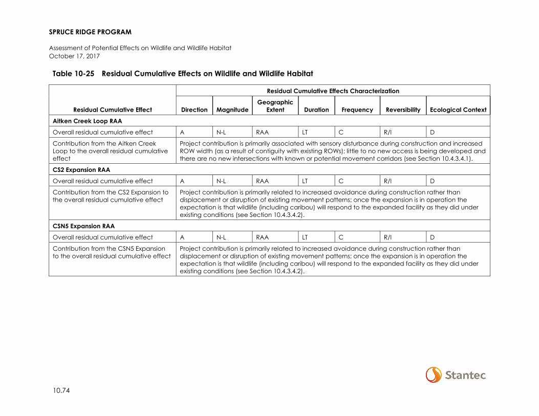
SPRUCE RIDGE PROGRAM
Assessment of Potential Effects on Wildlife and Wildlife Habitat October 17, 2017
10.74
Table 10-25 Residual Cumulative Effects on Wildlife and Wildlife Habitat
Residual Cumulative Effect
Residual Cumulative Effects Characterization
Direction Magnitude Geographic
Extent Duration Frequency Reversibility Ecological Context
Aitken Creek Loop RAA
Overall residual cumulative effect A N-L RAA LT C R/I D
Contribution from the Aitken Creek Loop to the overall residual cumulative effect
Project contribution is primarily associated with sensory disturbance during construction and increased ROW width (as a result of contiguity with existing ROWs); little to no new access is being developed and there are no new intersections with known or potential movement corridors (see Section 10.4.3.4.1).
CS2 Expansion RAA
Overall residual cumulative effect A N-L RAA LT C R/I D
Contribution from the CS2 Expansion to the overall residual cumulative effect
Project contribution is primarily related to increased avoidance during construction rather than displacement or disruption of existing movement patterns; once the expansion is in operation the expectation is that wildlife (including caribou) will respond to the expanded facility as they did under existing conditions (see Section 10.4.3.4.2).
CSN5 Expansion RAA
Overall residual cumulative effect A N-L RAA LT C R/I D
Contribution from the CSN5 Expansion to the overall residual cumulative effect
Project contribution is primarily related to increased avoidance during construction rather than displacement or disruption of existing movement patterns; once the expansion is in operation the expectation is that wildlife (including caribou) will respond to the expanded facility as they did under existing conditions (see Section 10.4.3.4.2).
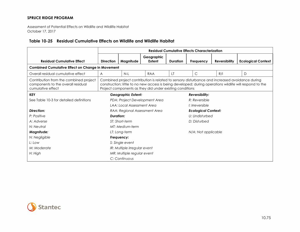
SPRUCE RIDGE PROGRAM
Assessment of Potential Effects on Wildlife and Wildlife Habitat October 17, 2017
10.75
Table 10-25 Residual Cumulative Effects on Wildlife and Wildlife Habitat
Residual Cumulative Effect
Residual Cumulative Effects Characterization
Direction Magnitude Geographic
Extent Duration Frequency Reversibility Ecological Context
Combined Cumulative Effect on Change in Movement
Overall residual cumulative effect A N-L RAA LT C R/I D
Contribution from the combined project components to the overall residual cumulative effect
Combined project contribution is related to sensory disturbance and increased avoidance during construction; little to no new access is being developed; during operations wildlife will respond to the Project components as they did under existing conditions
KEY See Table 10-3 for detailed definitions Direction: P: Positive A: Adverse N: Neutral Magnitude: N: Negligible L: Low M: Moderate H: High
Geographic Extent: PDA: Project Development Area LAA: Local Assessment Area RAA: Regional Assessment Area Duration: ST: Short-term MT: Medium-term LT: Long-term Frequency: S: Single event IR: Multiple irregular event MR: Multiple regular event C: Continuous
Reversibility: R: Reversible I: Irreversible Ecological Context: U: Undisturbed D: Disturbed N/A: Not applicable
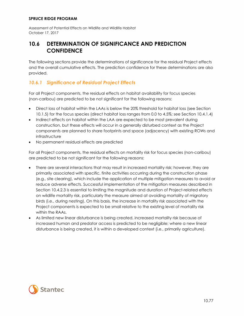
SPRUCE RIDGE PROGRAM
Assessment of Potential Effects on Wildlife and Wildlife Habitat October 17, 2017
10.77
10.6 DETERMINATION OF SIGNIFICANCE AND PREDICTION CONFIDENCE
The following sections provide the determinations of significance for the residual Project effects and the overall cumulative effects. The prediction confidence for these determinations are also provided.
10.6.1 Significance of Residual Project Effects
For all Project components, the residual effects on habitat availability for focus species (non-caribou) are predicted to be not significant for the following reasons:
• Direct loss of habitat within the LAAs is below the 20% threshold for habitat loss (see Section 10.1.5) for the focus species (direct habitat loss ranges from 0.0 to 4.5%; see Section 10.4.1.4)
• Indirect effects on habitat within the LAA are expected to be most prevalent during construction, but these effects will occur in a generally disturbed context as the Project components are planned to share footprints and space (adjacency) with existing ROWs and infrastructure
• No permanent residual effects are predicted
For all Project components, the residual effects on mortality risk for focus species (non-caribou) are predicted to be not significant for the following reasons:
• There are several interactions that may result in increased mortality risk; however, they are primarily associated with specific, finite activities occurring during the construction phase (e.g., site clearing), which include the application of multiple mitigation measures to avoid or reduce adverse effects. Successful implementation of the mitigation measures described in Section 10.4.2.3 is essential to limiting the magnitude and duration of Project-related effects on wildlife mortality risk, particularly the measure aimed at avoiding mortality of migratory birds (i.e., during nesting). On this basis, the increase in mortality risk associated with the Project components is expected to be small relative to the existing level of mortality risk within the RAAs.
• As limited new linear disturbance is being created, increased mortality risk because of increased human and predator access is predicted to be negligible; where a new linear disturbance is being created, it is within a developed context (i.e., primarily agriculture).
SPRUCE RIDGE PROGRAM
Assessment of Potential Effects on Wildlife and Wildlife Habitat October 17, 2017
10.78
For all Project components, the residual effects on movement for focus species (non-caribou) are predicted to be not significant for the following reasons:
• There are no new intersections with known or potential movement corridors (e.g., riparian corridors) within the LAAs
• The effect of increased ROW width on movement is predicted to be low magnitude. There is little empirical evidence suggesting that wildlife movement across utility ROWs is limiting to populations, although some species (such as western toad) could be susceptible to desiccation as exposure potentially increases with width. Similarly, species that prefer to move under cover, such as some small mammals, may initially be reluctant to cross wide ROWs until some vegetation recovery has occurred.
With respect to caribou, the locations and plans for the CS2 and CSN5 Expansions conform to some of the provincial management practices for reducing effects on caribou (i.e., BC MFLNRO and BC MOE 2016); specifically, the Project component activities:
• Limit the amount of new clearing by incorporating an existing footprint into planning; • Are located outside of high value habitat (i.e., high elevation winter range, low elevation
winter range, high elevation summer range); • Are associated with existing anthropogenic features; and • Are located on the periphery of caribou ranges where they are not adjacent to other
caribou ranges.
After implementing mitigation, the CS2 and CSN5 Expansions will still have a direct effect on caribou habitat (see Section 10.4.1.4), and the affected LPUs will remain at or below the 65% undisturbed habitat threshold identified in the federal recovery strategy (see Section 10.1.5). Therefore, the residual effects on caribou habitat, mortality risk, and movement resulting from the CS2 and CSN5 Expansions, on their own and collectively, are predicted to be significant.
With mitigation and environmental protection measures, the residual effects of the Project on wildlife and wildlife habitat are predicted to be not significant except for caribou. Cumulative effects on caribou habitat are significant at baseline, and the delivery of habitat restoration and offset measures (see Section 10.7) to address project residual effects are expected to have a long temporal delay in terms of achieving a no net loss objective. Therefore, the residual effects of the Project on caribou are predicted to be significant.
The prediction confidence for these significance determinations is high as the effects are generally well understood for the focus species, the mitigation measures are comprehensive and supported by provincial and federal guidance and best practices, and the caribou assessment methods are consistent with the federal recovery strategy.
10.6.2 Significance of Residual Cumulative Effects
The Chetwynd Loop, Aitken Creek Loop, CS2 Expansion, and CSN5 Expansion RAAs are within a region for which development has been identified as one of the factors adversely affecting the sustainability of some wildlife species (e.g., Apps 2014; Environment Canada 2014). For example,
SPRUCE RIDGE PROGRAM
Assessment of Potential Effects on Wildlife and Wildlife Habitat October 17, 2017
10.79
the effects of cumulative disturbance to date (i.e., baseline) within the LPUs of the southern mountain population of woodland caribou are considered significant (Environment Canada 2014). Therefore, by association, the residual cumulative effects within the CS2 and CSN5 Expansion RAAs are significant at baseline, and likely to remain significant under future conditions until habitat is sufficiently restored to support self-sustaining LPUs.
Collectively, the Project contributions to cumulative effects are small (see Table 10-25) and, except for caribou, are not predicted to cause a change in the overall cumulative effect that could affect the long-term persistence or viability of wildlife species within the RAAs.
The prediction confidence for this significance determination is moderate as cumulative effects are not well understood for most species, except for caribou.
10.7 FOLLOW-UP AND MONITORING
Westcoast is committed to follow-up and monitoring activities as part of the EPP for the pre-construction and construction phases of the Project. Westcoast will implement an environmental inspection program during construction in accordance with the EMCPC (Spectra 2014). Qualified EIs will work onsite during construction to verify that all construction activities comply with regulatory commitments and mitigation measures as outlined in the EPPs (Appendix A-1 and A-2). Wildlife-specific follow-up will include the following:
• Where construction activities occur around active wildlife habitat features, breeding amphibians, and bird nests, the Westcoast EI will verify that appropriate setbacks and timing windows are implemented per the EPP or as determined by a qualified biologist.
• If amphibian salvage is undertaken, Westcoast will verify that salvage and relocation comply with the BC amphibian protocol and permit requirements.
Westcoast will implement a Post-Construction Monitoring Program following construction, according to the EPP and EMCPC. Wildlife-specific monitoring will include the following:
• Where habitat restoration and revegetation is planned post-construction (e.g., on Crown land, TWS will be revegetated with native tree seedlings suited to site conditions, and seeded with native seed mix; see the Pipelines EPP [Appendix A-1]). Westcoast will monitor the progress of restoration of wildlife habitat.
• Where wetland and watercourse restoration is planned post-construction, Westcoast will monitor the effectiveness of restored wetland function as wildlife habitat at watercourses and wetlands.
Because there is predicted to be a loss of caribou critical habitat associated with the CS2 and CSN5 Expansions, and habitat will not be restored on site, Westcoast will prepare a combined Caribou Habitat Restoration and Offset Measures Plan. The objective of the combined plan will be to achieve no net loss of caribou habitat through offsite habitat restoration and other offset measures (e.g., financial mechanisms).
SPRUCE RIDGE PROGRAM
Assessment of Potential Effects on Heritage Resources October 17, 2017
11.1
11 ASSESSMENT OF POTENTIAL EFFECTS ON HERITAGE RESOURCES
Landsong Heritage Consulting Ltd, (Landsong) conducted archaeological impact assessments (AIA) of the Chetwynd and Aitken Creek Loops between June and September 2017. In addition, AIAs were conducted for Compressor Station 2 and Compressor Station N5. Fieldwork was conducted at CS2 on August 14, 2017 and at CSN5 August 15, 2017.
The AIA reports for the Chetwynd and Aitken Loops are currently under review with the BC Archaeology Branch and are included in Appendix H. AIA reports for CS2 and CSN5 will be included in subsequent filings. Key findings from these AIAs are summarized below.
Landsong conducted the AIA of the Chetwynd Loop on July 4–13, 2017. Key findings are:
• The Chetwynd Loop is located on private land holdings and Crown Land within Treaty No.8 (1899) British Columbia.
• An archaeological site file search was conducted prior to the field assessments utilizing Remote Access to Archaeological Data (RAAD). The search identified six previously recorded archaeological sites, GjRk-1, GjRk-3, GjRl-1, GkRj-1, GkRj-2 and GkRj-3, within 2,000 m of the Project. As none of these sites are located within 200 m of the Project, they were not subject to revisit as per permit methods.
• A pre-field archaeological desktop overview was conducted to assess archaeological potential prior to fieldwork. It included a review of available Project area mapping, such as draft Project plans, topographic maps and orthophotography, and analysis of the Archaeological Overview Assessment Potential Model in RAAD and the Peace District Potential Model. This review indicated a number of areas predicted to exhibit higher archaeological potential. Analysis of potential modelling indicated that the Project was located within areas exhibiting low to high archaeological potential.
• Ground reconnaissance consisted of pedestrian traverse within and adjacent to the development area. A total of 739 subsurface tests were conducted at 41 areas of moderate to high archaeological potential.
• No previously unrecorded archaeological sites were identified during the AIA. • No culturally modified trees (CMTs) were identified during the AIA.
SPRUCE RIDGE PROGRAM
Assessment of Potential Effects on Heritage Resources October 17, 2017
11.2
Landsong conducted the AIA of the Aitken Creek Loop on June 22–30, July 2–12, 14–16 and September 13, 2017. Key findings are:
• The Aitken Loop is located on Crown Land within Treaty No.8 (1899) British Columbia. • An archaeological site file search was conducted prior to the field assessments utilizing
RAAD. The search identified 46 previously recorded archaeological sites within 2,000 m of the Project: HfRl-1, HfRl-2, HfRl-4, HfRl-5, HfRl-6, HfRl-7, HfRl-9, HfRl-10, HfRl-15, HfRl-17, HfRl-18, HfRl-19, HfRl-21, HfRl-22, HfRl-24, HfRl-25, HfRl-26, HfRl-32, HfRl-33, HfRl-37, HfRm-1, HfRm-8, HfRm-9, HfRm-10, HfRm-11, HfRm-12, HfRm-13, HfRm-14, HfRm-16, HfRm-19, HfRm-23, HfRm-24, HfRm-25, HfRm-26, HfRm-27, HfRm-28, HfRm-39, HfRm-40, HfRm-41, HfRm-44, HfRm-45, HfRm-46, HfRm-47, HfRm-52, HfRm-53 and HfRm-54. Of these sites, 22 are located within 200 m of the Project and were therefore revisited during the AIA as per permit methods. Of these 22 sites, six sites require mitigation in association with the Project: − Site HfRl-26 is located within the Project boundaries, but will be avoided by utilizing a
planned HDD of two unnamed streams. Additional recommendations for HfRl-26 include installation of temporary fencing prior to construction along the boundaries of the pipeline ROW and TWS in closest proximity to the site. Following construction, the fencing should be removed and the site reflagged.
− HfRl-32, HfRm-19, HfRm-40, HfRm-45 and HfRm-46 require installation of temporary fencing prior to construction along the boundaries of the pipeline ROW and TWS in closest proximity to each site. Following construction, the fencing should be removed and the sites reflagged. Fencing installation and removal, and archaeological site reflagging must be overseen by a qualified archaeologist.
• A pre-field desktop archaeological overview was conducted to assess archaeological potential prior to fieldwork. It included a review of available Project area mapping, such as draft Project plans, topographic maps and orthophotography, and analysis of the Archaeological Overview Assessment Potential Model in RAAD and the Peace District Potential Model. This review indicated a number of areas predicted to exhibit higher archaeological potential. Analysis of potential modelling indicated that the Project was located within areas exhibiting low to high archaeological potential.
• Ground reconnaissance consisted of pedestrian traverse within and adjacent to the PDA. A total of 1591 subsurface tests were conducted at 41 areas of moderate to high archaeological potential.
• Four previously unrecorded archaeological sites, HfRm-0058, HfRl-0044, HfRl-0045 and HfRl-0046, were identified during the AIA. All four sites have been avoided by Project redesign, but require installation of temporary fencing prior to construction along the boundaries of the pipeline ROW and TWS in closest proximity to each site. Following construction, the fencing should be removed and the sites reflagged. Fencing installation and removal, and archaeological site reflagging must be overseen by a qualified archaeologist.
• No CMTs were identified during the AIA.
SPRUCE RIDGE PROGRAM
Assessment of Potential Effects on Heritage Resources October 17, 2017
11.3
Landsong conducted the AIA of the CS2 Expansion on August 14, 2017. Key findings are:
• The CS2 Expansion is located on private land holdings. • An archaeological site file search was conducted prior to the field assessments utilizing
RAAD. The search identified six previously recorded archaeological sites, GjRn-1, GjRn-3, GjRn-4, GkRn-5, GkRn-6 and GkRn-7, within 2,000 m of the Project. As none of these sites are located within 200 m of the Project, they were not subject to revisit as per permit methods.
• A pre-field archaeological desktop overview was conducted to assess archaeological potential prior to fieldwork. It included a review of available Project area mapping, such as draft Project plans, topographic maps and orthophotography, and analysis of the Archaeological Overview Assessment Potential Model in RAAD and the Peace District Potential Model. This review indicated a number of areas predicted to exhibit higher archaeological potential. Analysis of potential modelling indicated that the Project was located within areas exhibiting low to high archaeological potential.
• Ground reconnaissance consisted of pedestrian traverse within and adjacent to the development area. No areas of moderate to very high archaeological potential were identified.
• No previously unrecorded archaeological sites were identified during the AIA. • No CMTs were identified during the AIA.
Landsong conducted the AIA of the CSN5 Expansion on August 15, 2017. Key findings are:
• The CSN5 Expansion is located on private land holdings. • An archaeological site file search was conducted prior to the field assessments utilizing
RAAD. The search identified three previously recorded archaeological sites, HbRm-9, HbRm-12 and HbRm-13, within 2,000 m of the Project. As none of these sites are located within 200 m of the Project, they were not subject to revisit as per permit methods.
• A pre-field archaeological desktop overview was conducted to assess archaeological potential prior to fieldwork. It included a review of available Project area mapping, such as draft Project plans, topographic maps and orthophotography, and analysis of the Archaeological Overview Assessment Potential Model in RAAD and the Peace District Potential Model. This review indicated a number of areas predicted to exhibit higher archaeological potential. Analysis of potential modelling indicated that the Project was located within areas exhibiting low to high archaeological potential.
• Ground reconnaissance consisted of pedestrian traverse within and adjacent to the development area. No areas of moderate to very high archaeological potential were identified.
• No previously unrecorded archaeological sites were identified during the AIA. • No CMTs were identified during the AIA.
SPRUCE RIDGE PROGRAM
Assessment of Potential Effects on Heritage Resources October 17, 2017
11.4
11.1 TRADITIONAL KNOWLEDGE
Traditional knowledge and traditional land use information is held by local communities. As part of the consultation program, Westcoast has worked with local Aboriginal communities and, where appropriate, supported community led Traditional Land Use (TLU) studies. These studies are ongoing and results will be shared at the discretion of the community to inform the consultation process and discussion around mitigation.
In addition, a Traditional Ecological Knowledge (TEK) Site Field Survey was conducted by Landsong on behalf of Westcoast on the Crown land portions of the Chetwynd and Aitken Creek Loops to gather information about sites that may have ecological or traditional importance within the Project footprint. This work was completed with participation from local Aboriginal communities, but is not intended to represent the traditional knowledge of a community. Instead the value is in identifying site-specific VCs which may not be captured by other environmental or heritage resource studies, and to complement community led TLU studies. Participation included a monitor or participant chosen by the community in the field studies and an opportunity to review and discuss the data and proposed mitigation by the lands department.
Key findings of the TEK are summarized below:
• The Aitken Creek Loop and portions of the Chetwynd Loop occupies Crown land within Treaty No.8 (1899) of British Columbia.
• The primary objectives of the TEK Survey were to identify and document past and current TEK site information at both a site-specific and landscape-level within the PDA, document Project related concerns, develop mitigation measures, and to maintain a community-based approach with local Aboriginal groups. Basic non-confidential information is provided to the proponent and detailed information is provided to Aboriginal communities to inform Project discussions regarding Aboriginal community concerns and to manage TEK impacts during the life of the Project.
• A total of 84 specific TEK sites were recorded and three landscape-level recommendations were made during the Chetwynd Loop TEK Survey. Westcoast is currently in discussion with Aboriginal communities to develop mitigation and reclamation measures for these sites and resources.
• A total of 115 specific TEK sites were recorded and 4 landscape-level recommendations were made during the Aitken Creek Loop TEK Survey. Westcoast is currently in discussion with Aboriginal communities to develop mitigation and reclamation measures for these sites and resources.
As this TEK study was conducted by Landsong on behalf of Westcoast, it did not include knowledge holder interviews and/or community roundtable discussions. Additional TLU studies conducted by individual Aboriginal communities completed under their own terms of reference may compliment this study.
SPRUCE RIDGE PROGRAM
Assessment of Potential Effects on Land and Resource Use October 17, 2017
12.1
12 ASSESSMENT OF POTENTIAL EFFECTS ON LAND AND RESOURCE USE
12.1 SCOPE OF ASSESSMENT
This section defines and describes the scope of the assessment of potential effects on land and resource use. This VC was selected because the Spruce Ridge Program (the Project) construction and operation have the potential to affect the use of private lands and remove Crown lands used for agriculture, forestry, oil and gas and other industrial uses; and potentially affect fishing, hunting, trapping, and recreational activities, either temporarily or for an extended period.
The following sections of the Application address effects that influence or are influenced by effects on Land and Resource Use:
• Acoustic Environment (Section 6) • Soil and Soil Productivity (Section 7) • Fish and Fish Habitat (Section 8) • Vegetation and Wetlands (Section 9) • Wildlife and Wildlife Habitat (Section 10) • Employment and Economy (Section 14)
12.1.1 Regulatory and Policy Setting
The scope of this section takes into consideration guidance provided by the NEB Filing Manual NEB (2017), specifically Table A-3 which includes details on assessing socio-economic elements such as land and resource use.
In BC management of provincial Crown Land and resources is guided by the Agricultural Land Commission Act, the Land Act, the Oil and Gas Activities Act, the Wildlife Act, the Forest Act, the Forest & Range Practices Act, the Mineral Tenure Act and the Park Act.
At the municipal government level, land use policies are enacted through the Community Charter Act and the Local Government Act. These Acts give municipalities, regional governments, and improvement districts powers to create Official Community Plans (OCPs) or bylaws, which are developed in consideration of regional land use planning objectives.
12.1.2 Potential Effects, Pathways and Measurable Parameters
Potential effects of the Project were identified through public and regulatory consultations with stakeholders, past experience, and professional judgment (see Section 3). During the preparation of this assessment, Westcoast notified the First Nations and Métis communities listed in Section 3.2.2 regarding areas that could be affected by the Project and provided information on project activities.
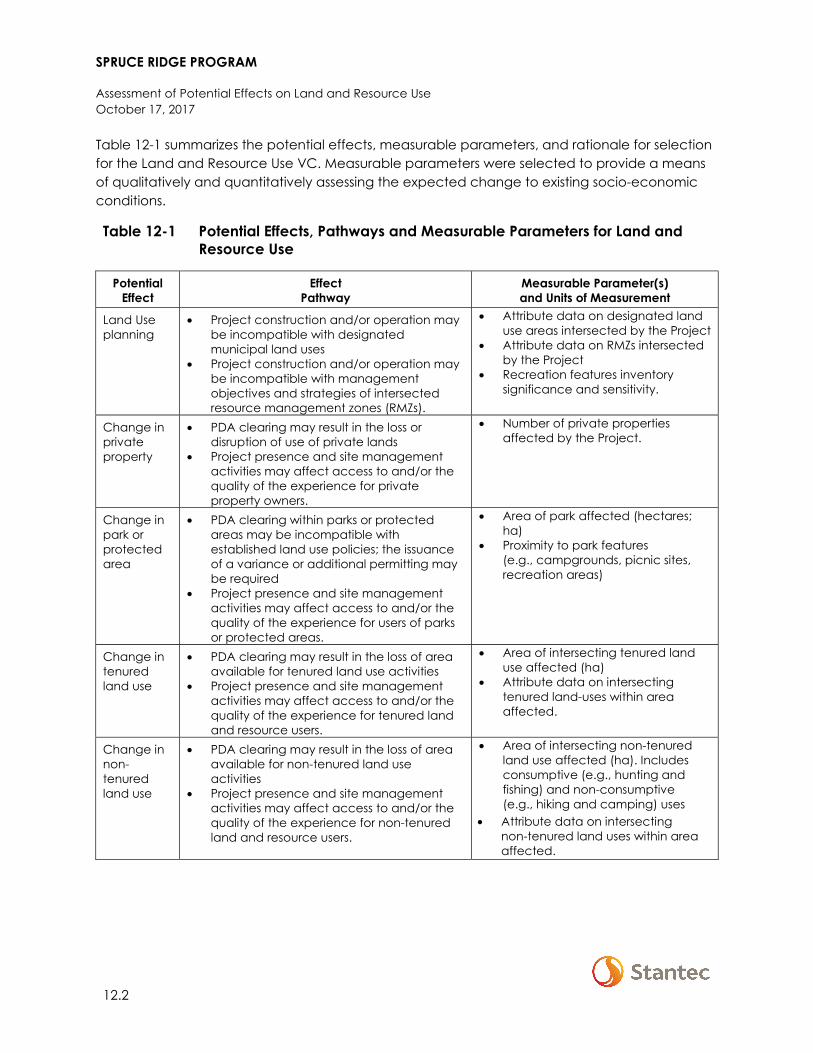
SPRUCE RIDGE PROGRAM
Assessment of Potential Effects on Land and Resource Use October 17, 2017
12.2
Table 12-1 summarizes the potential effects, measurable parameters, and rationale for selection for the Land and Resource Use VC. Measurable parameters were selected to provide a means of qualitatively and quantitatively assessing the expected change to existing socio-economic conditions.
Table 12-1 Potential Effects, Pathways and Measurable Parameters for Land and Resource Use
Potential Effect
Effect Pathway
Measurable Parameter(s) and Units of Measurement
Land Use planning
• Project construction and/or operation may be incompatible with designated municipal land uses
• Project construction and/or operation may be incompatible with management objectives and strategies of intersected resource management zones (RMZs).
• Attribute data on designated land use areas intersected by the Project
• Attribute data on RMZs intersected by the Project
• Recreation features inventory significance and sensitivity.
Change in private property
• PDA clearing may result in the loss or disruption of use of private lands
• Project presence and site management activities may affect access to and/or the quality of the experience for private property owners.
• Number of private properties affected by the Project.
Change in park or protected area
• PDA clearing within parks or protected areas may be incompatible with established land use policies; the issuance of a variance or additional permitting may be required
• Project presence and site management activities may affect access to and/or the quality of the experience for users of parks or protected areas.
• Area of park affected (hectares; ha)
• Proximity to park features (e.g., campgrounds, picnic sites, recreation areas)
Change in tenured land use
• PDA clearing may result in the loss of area available for tenured land use activities
• Project presence and site management activities may affect access to and/or the quality of the experience for tenured land and resource users.
• Area of intersecting tenured land use affected (ha)
• Attribute data on intersecting tenured land-uses within area affected.
Change in non-tenured land use
• PDA clearing may result in the loss of area available for non-tenured land use activities
• Project presence and site management activities may affect access to and/or the quality of the experience for non-tenured land and resource users.
• Area of intersecting non-tenured land use affected (ha). Includes consumptive (e.g., hunting and fishing) and non-consumptive (e.g., hiking and camping) uses
• Attribute data on intersecting non-tenured land uses within area affected.
SPRUCE RIDGE PROGRAM
Assessment of Potential Effects on Land and Resource Use October 17, 2017
12.3
12.1.3 Boundaries
12.1.3.1 Spatial Boundaries
The spatial boundaries for the assessment of land and resource use include areas that might interact directly or indirectly with the Project. Physical work associated with the expansion of CS2 and CSN5, as well as modification of CS16 will be largely restricted to privately held land by Westcoast. As such, these three compressor stations are not included in the spatial boundaries used to assess effects on Land and Resource Use. The following spatial boundaries were used to assess Project and cumulative effects on land and resource use.
The PDA includes all lands subject to direct disturbance from the footprint of the Chetwynd Loop (approximately 137ha of disturbance) and the Aitken Creek Loop (approximately 48 ha of disturbance). The total size of the PDA is roughly 185 ha. Areas occupied by the PDA are broken down as follows:
• Proposed ROW (permanent)—approximately 64 ha (40 ha Chetwynd Loop, 24 ha Aitken Creek Loop).
• Proposed workspace (temporary)—approximately 121 ha (97 ha Chetwynd Loop, 24 ha Aitken Creek Loop).
The LAA encompasses the physical area in which Project activities and facilities could have direct or indirect effects on land and resource use. The LAA includes the PDA and a 1 km buffer either side of the ROW. This totals approximately 8,463 ha, consisting of 5,477 ha for the Chetwynd Loop, and 2,986 ha for the Aitken Creek Loop.
The RAA is used as context to determine the significance of Project-specific effects on land and resource use and for the cumulative effects assessment. The RAA includes the PDA and a 15-km buffer on either side of the ROW. This totals approximately 247,955 ha, consisting of 139,417 ha for the Chetwynd Loop, and 108,538 ha for the Aitken Creek Loop.
12.1.3.2 Temporal Boundaries
See Section 2.3 for the Project schedule and temporal boundaries for this VC.
12.1.4 Residual Effects Characterization
Table 8-2 presents the criteria used to characterize residual effects on land and resource use.
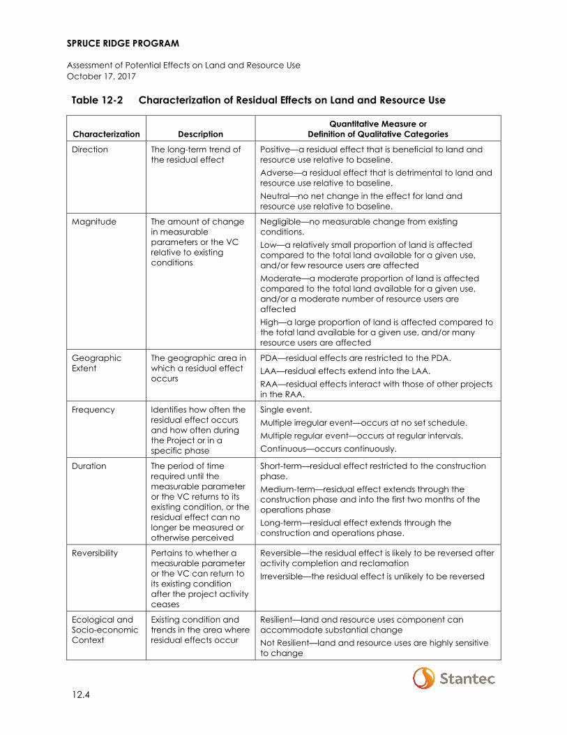
SPRUCE RIDGE PROGRAM
Assessment of Potential Effects on Land and Resource Use October 17, 2017
12.4
Table 12-2 Characterization of Residual Effects on Land and Resource Use
Characterization Description Quantitative Measure or
Definition of Qualitative Categories
Direction The long-term trend of the residual effect
Positive—a residual effect that is beneficial to land and resource use relative to baseline. Adverse—a residual effect that is detrimental to land and resource use relative to baseline. Neutral—no net change in the effect for land and resource use relative to baseline.
Magnitude The amount of change in measurable parameters or the VC relative to existing conditions
Negligible—no measurable change from existing conditions. Low—a relatively small proportion of land is affected compared to the total land available for a given use, and/or few resource users are affected Moderate—a moderate proportion of land is affected compared to the total land available for a given use, and/or a moderate number of resource users are affected High—a large proportion of land is affected compared to the total land available for a given use, and/or many resource users are affected
Geographic Extent
The geographic area in which a residual effect occurs
PDA—residual effects are restricted to the PDA. LAA—residual effects extend into the LAA. RAA—residual effects interact with those of other projects in the RAA.
Frequency Identifies how often the residual effect occurs and how often during the Project or in a specific phase
Single event. Multiple irregular event—occurs at no set schedule. Multiple regular event—occurs at regular intervals. Continuous—occurs continuously.
Duration The period of time required until the measurable parameter or the VC returns to its existing condition, or the residual effect can no longer be measured or otherwise perceived
Short-term—residual effect restricted to the construction phase. Medium-term—residual effect extends through the construction phase and into the first two months of the operations phase Long-term—residual effect extends through the construction and operations phase.
Reversibility Pertains to whether a measurable parameter or the VC can return to its existing condition after the project activity ceases
Reversible—the residual effect is likely to be reversed after activity completion and reclamation Irreversible—the residual effect is unlikely to be reversed
Ecological and Socio-economic Context
Existing condition and trends in the area where residual effects occur
Resilient—land and resource uses component can accommodate substantial change Not Resilient—land and resource uses are highly sensitive to change
SPRUCE RIDGE PROGRAM
Assessment of Potential Effects on Land and Resource Use October 17, 2017
12.5
12.1.5 Significance Definition
A significant adverse residual effect on land resource use is defined as one where:
• The Project does not comply with established federal, provincial, or municipal/regional land use plans, policies, or by-laws, and of which a variance cannot be obtained; and/or
• The Project will create a change or disruption that restricts or degrades present land use capability to a point where the activities cannot continue at or near current levels and where compensation is not possible.
12.2 EXISTING CONDITIONS FOR LAND AND RESOURCE USE
This section first describes methods used to identify the existing conditions, and then provides an overview of the existing conditions for land and resource use.
12.2.1 Methods
The following data sources were used to collect information on the existing conditions:
• Spatial information and metadata for land tenure, land use, and visual quality from government databases (e.g., the Province of British Columbia’s data warehouse, DataBC, the Integrated Land Management Bureau’s data warehouse, the BC ALC, BC Ministry of Municipal Affairs and Housings [MAH], BC Ministry of Energy, Mines and Petroleum Resources [MEMPR], MFLNRORD, and the BC OGC)
• The District of Chetwynd’s Official Community Plan, Bylaw number 1030, 2017 (District of Chetwynd OCP)
The information above has been supplemented by primary data collection in the form of the Project’s consultation record. Relevant traditional knowledge obtained from sources discussed in Section 11.1 was also used.
12.2.2 Overview
12.2.2.1 Property Ownership
Ownership of properties overlapped by the Project PDA by premises identification number (PID) is provided in Table 12-3.
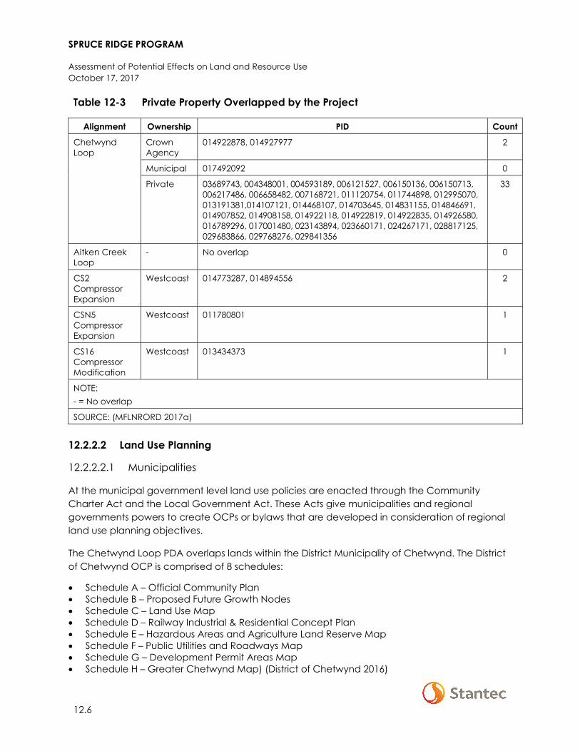
SPRUCE RIDGE PROGRAM
Assessment of Potential Effects on Land and Resource Use October 17, 2017
12.6
Table 12-3 Private Property Overlapped by the Project
Alignment Ownership PID Count
Chetwynd Loop
Crown Agency
014922878, 014927977 2
Municipal 017492092 0
Private 03689743, 004348001, 004593189, 006121527, 006150136, 006150713, 006217486, 006658482, 007168721, 011120754, 011744898, 012995070, 013191381,014107121, 014468107, 014703645, 014831155, 014846691, 014907852, 014908158, 014922118, 014922819, 014922835, 014926580, 016789296, 017001480, 023143894, 023660171, 024267171, 028817125, 029683866, 029768276, 029841356
33
Aitken Creek Loop
- No overlap 0
CS2 Compressor Expansion
Westcoast 014773287, 014894556 2
CSN5 Compressor Expansion
Westcoast 011780801 1
CS16 Compressor Modification
Westcoast 013434373 1
NOTE: - = No overlap
SOURCE: (MFLNRORD 2017a)
12.2.2.2 Land Use Planning
12.2.2.2.1 Municipalities
At the municipal government level land use policies are enacted through the Community Charter Act and the Local Government Act. These Acts give municipalities and regional governments powers to create OCPs or bylaws that are developed in consideration of regional land use planning objectives.
The Chetwynd Loop PDA overlaps lands within the District Municipality of Chetwynd. The District of Chetwynd OCP is comprised of 8 schedules:
• Schedule A – Official Community Plan • Schedule B – Proposed Future Growth Nodes • Schedule C – Land Use Map • Schedule D – Railway Industrial & Residential Concept Plan • Schedule E – Hazardous Areas and Agriculture Land Reserve Map • Schedule F – Public Utilities and Roadways Map • Schedule G – Development Permit Areas Map • Schedule H – Greater Chetwynd Map) (District of Chetwynd 2016)
SPRUCE RIDGE PROGRAM
Assessment of Potential Effects on Land and Resource Use October 17, 2017
12.7
As established in Schedule A (and illustrated in Schedule C), there are nine land use designations within the District of Chetwynd (Agriculture, Residential, Town Centre—Commercial, Highway—Commercial, Industrial, Institutional, Parks, Trails and Greenspace, Hazardous Areas, and Aggregate Deposits) (District of Chetwynd 2016, 2017a). Section 2.2 of the District of Chetwynd’s OCP, provides policy direction on the type, density and siting of residential developments (District of Chetwynd 2016). Section 2.7 of the OCP provides policy direction on the acquisition, development, siting, and maintenance of parks, trails, and greenspace, as well as procedures to be followed with respect to residential development on designated parkland. However, the OCP does not provide policy guidance on oil and gas developments within residential areas, parks, trails, or greenspaces. Sections 3.1 and 3.7 provide policy direction targeted at increasing community well-being with respect to housing and parks and recreation; however, there is no mention of oil and gas and resource development (District of Chetwynd 2016).
Under Section 5.0 of the District of Chetwynd’s OCP the entire municipality is designated as a temporary commercial use permit area (except for ALR and land outside the authority of the District of Chetwynd). As such, temporary commercial use permits may be issued where:
• The permit is temporary in nature • Proposed land is deemed suitable for the proposed temporary use • Proposed temporary use is in the public interest • Suitable plans regarding the removal of temporary equipment and structures as well as
restoration of lands is provided • The applicant has complied or demonstrated that compliance with applicable legislation,
bylaws and enactments will occur (District of Chetwynd 2016)
The Chetwynd Loop PDA overlaps 3 ha (2 ha proposed ROW; 1 ha proposed Workspace)of District of Chetwynd municipal lands (District of Chetwynd 2017b; MAH 2017). KP 6 to KP 6.5 and KP 10.9 to KP 11.1 of the PDA overlaps lands designated as “residential” and “parks, trails and greenspace” within the District of Chetwynd’s OCP (District of Chetwynd 2016, 2017a). KP 7.5 to KP 8.5 of the PDA also abuts the southern boundary of lands designated as agriculture (District of Chetwynd 2016, 2017a; MAH 2017). No development permit areas (per Section 4.0 and Schedule G of District of Chetwynd’s OCP) are overlapped by the Chetwynd Loop PDA (District of Chetwynd 2016, 2017b).
The Chetwynd Loop LAA intersects 520 ha of municipal land (District of Chetwynd) while the RAA intersects 4,556 ha (MAH 2017; District of Chetwynd 2017c). The LAA and RAA intersects numerous designated land use areas. The Aitken Loop PDA, LAA and RAA do not intersect any municipal lands (MAH 2017).
12.2.2.2.2 Crown Land Use Planning
Sustainable management of Crown land within British Columbia is guided by legislation (see Section 12.1.1), as well as through a policy framework established through land use plans and leave orders. The Project occurs within the Dawson Creek Land and Resource Management Plan (LRMP) area and the Fort St. John LRMP area.
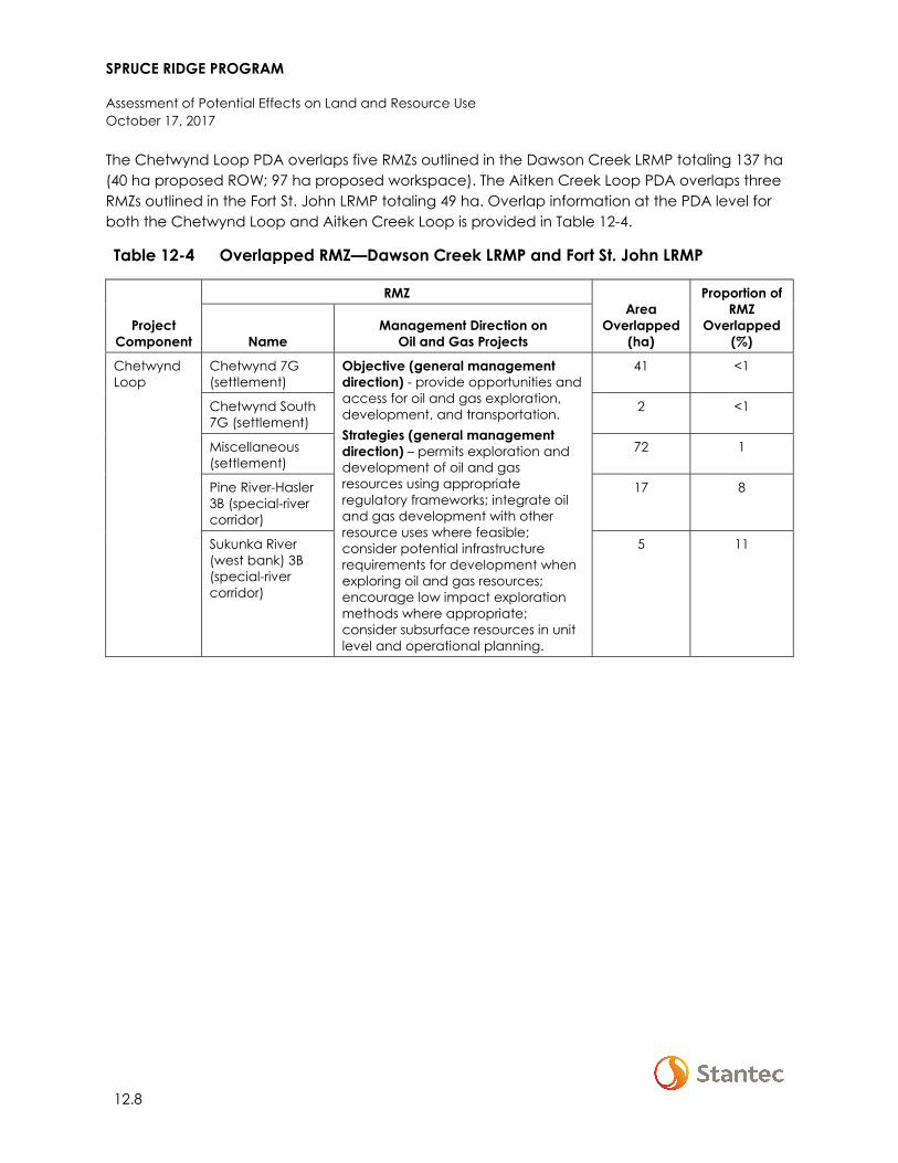
SPRUCE RIDGE PROGRAM
Assessment of Potential Effects on Land and Resource Use October 17, 2017
12.8
The Chetwynd Loop PDA overlaps five RMZs outlined in the Dawson Creek LRMP totaling 137 ha (40 ha proposed ROW; 97 ha proposed workspace). The Aitken Creek Loop PDA overlaps three RMZs outlined in the Fort St. John LRMP totaling 49 ha. Overlap information at the PDA level for both the Chetwynd Loop and Aitken Creek Loop is provided in Table 12-4.
Table 12-4 Overlapped RMZ—Dawson Creek LRMP and Fort St. John LRMP
Project Component
RMZ Area
Overlapped (ha)
Proportion of RMZ
Overlapped (%) Name
Management Direction on Oil and Gas Projects
Chetwynd Loop
Chetwynd 7G (settlement)
Objective (general management direction) - provide opportunities and access for oil and gas exploration, development, and transportation. Strategies (general management direction) – permits exploration and development of oil and gas resources using appropriate regulatory frameworks; integrate oil and gas development with other resource uses where feasible; consider potential infrastructure requirements for development when exploring oil and gas resources; encourage low impact exploration methods where appropriate; consider subsurface resources in unit level and operational planning.
41 <1
Chetwynd South 7G (settlement)
2 <1
Miscellaneous (settlement)
72 1
Pine River-Hasler 3B (special-river corridor)
17 8
Sukunka River (west bank) 3B (special-river corridor)
5 11
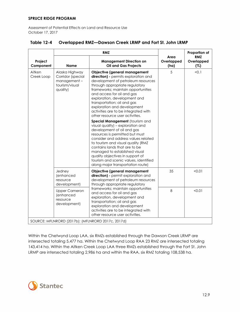
SPRUCE RIDGE PROGRAM
Assessment of Potential Effects on Land and Resource Use October 17, 2017
12.9
Table 12-4 Overlapped RMZ—Dawson Creek LRMP and Fort St. John LRMP
Project Component
RMZ Area
Overlapped (ha)
Proportion of RMZ
Overlapped (%) Name
Management Direction on Oil and Gas Projects
Aitken Creek Loop
Alaska Highway Corridor (special management – tourism/visual quality)
Objective (general management direction) - permits exploration and development of petroleum resources through appropriate regulatory frameworks; maintain opportunities and access for oil and gas exploration, development and transportation; oil and gas exploration and development activities are to be integrated with other resource user activities. Special Management (tourism and visual quality) – exploration and development of oil and gas resources is permitted but must consider and address values related to tourism and visual quality (RMZ contains lands that are to be managed to established visual quality objectives in support of tourism and scenic values, identified along major transportation route)
5 <0.1
Jedney (enhanced resource development)
Objective (general management direction) - permit exploration and development of petroleum resources through appropriate regulatory frameworks; maintain opportunities and access for oil and gas exploration, development and transportation; oil and gas exploration and development activities are to be integrated with other resource user activities.
35 <0.01
Upper Cameron (enhanced resource development)
8 <0.01
SOURCE: MFLNRORD (2017b); (MFLNRORD 2017c, 2017d)
Within the Chetwynd Loop LAA, six RMZs established through the Dawson Creek LRMP are intersected totaling 5,477 ha. Within the Chetwynd Loop RAA 23 RMZ are intersected totaling 143,414 ha. Within the Aitken Creek Loop LAA three RMZs established through the Fort St. John LRMP are intersected totaling 2,986 ha and within the RAA, six RMZ totaling 108,538 ha.
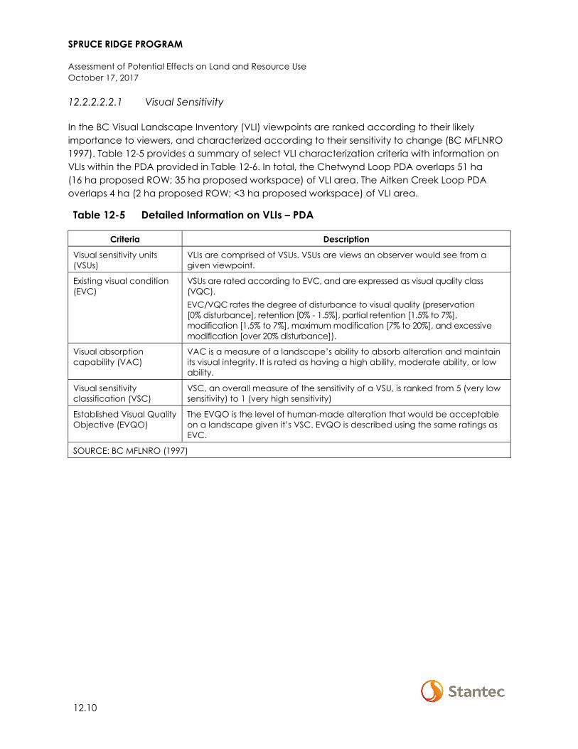
SPRUCE RIDGE PROGRAM
Assessment of Potential Effects on Land and Resource Use October 17, 2017
12.10
12.2.2.2.2.1 Visual Sensitivity
In the BC Visual Landscape Inventory (VLI) viewpoints are ranked according to their likely importance to viewers, and characterized according to their sensitivity to change (BC MFLNRO 1997). Table 12-5 provides a summary of select VLI characterization criteria with information on VLIs within the PDA provided in Table 12-6. In total, the Chetwynd Loop PDA overlaps 51 ha (16 ha proposed ROW; 35 ha proposed workspace) of VLI area. The Aitken Creek Loop PDA overlaps 4 ha (2 ha proposed ROW; <3 ha proposed workspace) of VLI area.
Table 12-5 Detailed Information on VLIs – PDA
Criteria Description
Visual sensitivity units (VSUs)
VLIs are comprised of VSUs. VSUs are views an observer would see from a given viewpoint.
Existing visual condition (EVC)
VSUs are rated according to EVC, and are expressed as visual quality class (VQC). EVC/VQC rates the degree of disturbance to visual quality (preservation [0% disturbance], retention [0% - 1.5%], partial retention [1.5% to 7%], modification [1.5% to 7%], maximum modification [7% to 20%], and excessive modification [over 20% disturbance]).
Visual absorption capability (VAC)
VAC is a measure of a landscape’s ability to absorb alteration and maintain its visual integrity. It is rated as having a high ability, moderate ability, or low ability.
Visual sensitivity classification (VSC)
VSC, an overall measure of the sensitivity of a VSU, is ranked from 5 (very low sensitivity) to 1 (very high sensitivity)
Established Visual Quality Objective (EVQO)
The EVQO is the level of human-made alteration that would be acceptable on a landscape given it’s VSC. EVQO is described using the same ratings as EVC.
SOURCE: BC MFLNRO (1997)
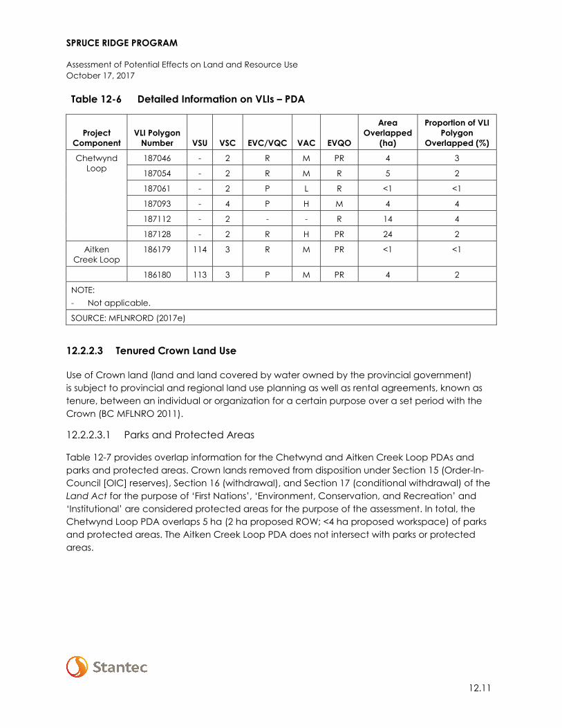
SPRUCE RIDGE PROGRAM
Assessment of Potential Effects on Land and Resource Use October 17, 2017
12.11
Table 12-6 Detailed Information on VLIs – PDA
Project Component
VLI Polygon Number VSU VSC EVC/VQC VAC EVQO
Area Overlapped
(ha)
Proportion of VLI Polygon
Overlapped (%)
Chetwynd Loop
187046 - 2 R M PR 4 3
187054 - 2 R M R 5 2
187061 - 2 P L R <1 <1
187093 - 4 P H M 4 4
187112 - 2 - - R 14 4
187128 - 2 R H PR 24 2
Aitken Creek Loop
186179 114 3 R M PR <1 <1
186180 113 3 P M PR 4 2
NOTE: - Not applicable.
SOURCE: MFLNRORD (2017e)
12.2.2.3 Tenured Crown Land Use
Use of Crown land (land and land covered by water owned by the provincial government) is subject to provincial and regional land use planning as well as rental agreements, known as tenure, between an individual or organization for a certain purpose over a set period with the Crown (BC MFLNRO 2011).
12.2.2.3.1 Parks and Protected Areas
Table 12-7 provides overlap information for the Chetwynd and Aitken Creek Loop PDAs and parks and protected areas. Crown lands removed from disposition under Section 15 (Order-In-Council [OIC] reserves), Section 16 (withdrawal), and Section 17 (conditional withdrawal) of the Land Act for the purpose of ‘First Nations’, ‘Environment, Conservation, and Recreation’ and ‘Institutional’ are considered protected areas for the purpose of the assessment. In total, the Chetwynd Loop PDA overlaps 5 ha (2 ha proposed ROW; <4 ha proposed workspace) of parks and protected areas. The Aitken Creek Loop PDA does not intersect with parks or protected areas.
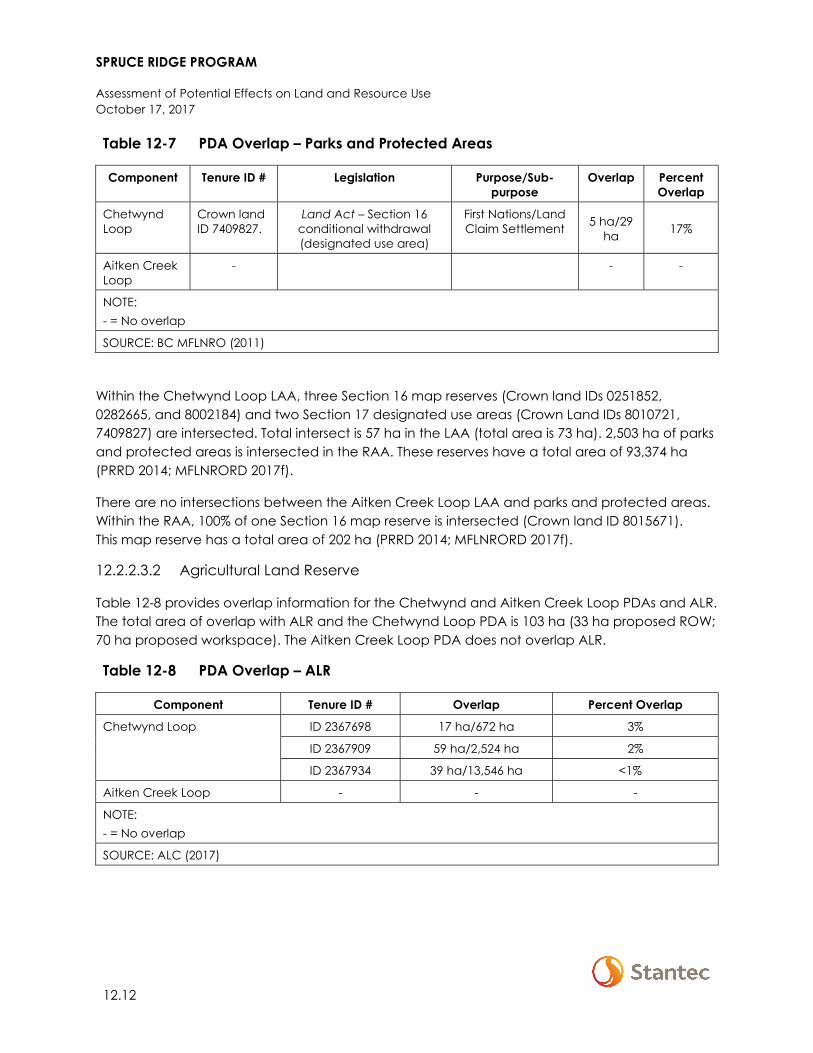
SPRUCE RIDGE PROGRAM
Assessment of Potential Effects on Land and Resource Use October 17, 2017
12.12
Table 12-7 PDA Overlap – Parks and Protected Areas
Component Tenure ID # Legislation Purpose/Sub-purpose
Overlap Percent Overlap
Chetwynd Loop
Crown land ID 7409827.
Land Act – Section 16 conditional withdrawal (designated use area)
First Nations/Land Claim Settlement 5 ha/29
ha 17%
Aitken Creek Loop
- - -
NOTE: - = No overlap
SOURCE: BC MFLNRO (2011)
Within the Chetwynd Loop LAA, three Section 16 map reserves (Crown land IDs 0251852, 0282665, and 8002184) and two Section 17 designated use areas (Crown Land IDs 8010721, 7409827) are intersected. Total intersect is 57 ha in the LAA (total area is 73 ha). 2,503 ha of parks and protected areas is intersected in the RAA. These reserves have a total area of 93,374 ha (PRRD 2014; MFLNRORD 2017f).
There are no intersections between the Aitken Creek Loop LAA and parks and protected areas. Within the RAA, 100% of one Section 16 map reserve is intersected (Crown land ID 8015671). This map reserve has a total area of 202 ha (PRRD 2014; MFLNRORD 2017f).
12.2.2.3.2 Agricultural Land Reserve
Table 12-8 provides overlap information for the Chetwynd and Aitken Creek Loop PDAs and ALR. The total area of overlap with ALR and the Chetwynd Loop PDA is 103 ha (33 ha proposed ROW; 70 ha proposed workspace). The Aitken Creek Loop PDA does not overlap ALR.
Table 12-8 PDA Overlap – ALR
Component Tenure ID # Overlap Percent Overlap
Chetwynd Loop ID 2367698 17 ha/672 ha 3%
ID 2367909 59 ha/2,524 ha 2%
ID 2367934 39 ha/13,546 ha <1%
Aitken Creek Loop - - -
NOTE: - = No overlap
SOURCE: ALC (2017)

SPRUCE RIDGE PROGRAM
Assessment of Potential Effects on Land and Resource Use October 17, 2017
12.13
Within the Chetwynd Loop LAA, 3,529 ha of ALR is intersected over seven polygons (IDs 2367680, 2367691, 2367694, 2367698, 2367909, 2367919, 2367934). These polygons have a total area of 20,319 ha. Within the RAA, 22,910 ha of ALR is intersected over 28 ALR polygons. These polygons have a total area of 156,889 ha (ALC 2017).
There are no intersections between the ALR and the Aitken Creek Loop LAA. Within the RAA, 4,260 ha over seven ALR polygons is intersected. These polygons have a total area of 13,205 ha (ALC 2017).
12.2.2.3.3 Range Tenure
There are no overlaps with range tenure in the Chetwynd Loop PDA or intersections in the LAA. Within the RAA, 12,303 ha over 11 range tenures is intersected. These tenures have a total area of 24,022 ha (MFLNRORD 2017g).
There are no overlaps with range tenure in the Aitken Creek Loop PDA or intersections in the LAA. Within the RAA, 1,727 ha over two range tenures is intersected. These tenures have a total area of 10,333 ha (MFLNRORD 2017g).
12.2.2.3.4 Timber Supply Area
Table 12-9 provides overlap information for the Chetwynd and Aitken Creek Loop PDAs and TSA. The total area of overlap with TSA and the Chetwynd Loop PDA is 137 ha (40 ha proposed ROW; 97 ha proposed workspace). The total area of PDA overlap with TSA and the Aitken Creek Loop PDA is 48 ha (24 ha proposed ROW; 25 ha proposed workspace).
Table 12-9 PDA Overlap – TSA
Component Tenure ID# Overlap Percent Overlap
Chetwynd Loop Block 41D 137 ha/1,084,798 ha <0.1%
Aitken Creek Loop Block 40B 13 ha/486,412 ha <0.01%
Block 40C 36 ha/939,396 ha <0.01%
SOURCE: MFLNRORD (2017h)
Within the Chetwynd Loop LAA, 5,410 ha of TSA block 41D is intersected. Within the RAA, 93,392 ha are interested. The total area of TSA block 41D is 1,084,798 ha (MFLNRORD 2017h).
Within the LAA, 787 ha of TSA Block 40 B and 2,199 ha of TSA block 40C are intersected. Within the RAA, intersection is 41,019 ha and 67, 519 ha respectively.. The total area of these TSA blocks is 1,425,808 (MFLNRORD 2017h).
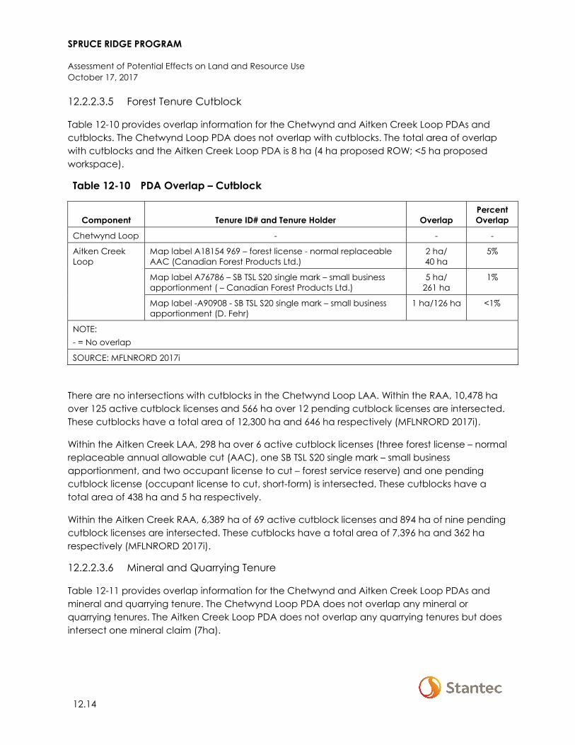
SPRUCE RIDGE PROGRAM
Assessment of Potential Effects on Land and Resource Use October 17, 2017
12.14
12.2.2.3.5 Forest Tenure Cutblock
Table 12-10 provides overlap information for the Chetwynd and Aitken Creek Loop PDAs and cutblocks. The Chetwynd Loop PDA does not overlap with cutblocks. The total area of overlap with cutblocks and the Aitken Creek Loop PDA is 8 ha (4 ha proposed ROW; <5 ha proposed workspace).
Table 12-10 PDA Overlap – Cutblock
Component Tenure ID# and Tenure Holder Overlap Percent Overlap
Chetwynd Loop - - -
Aitken Creek Loop
Map label A18154 969 – forest license - normal replaceable AAC (Canadian Forest Products Ltd.)
2 ha/ 40 ha
5%
Map label A76786 – SB TSL S20 single mark – small business apportionment ( – Canadian Forest Products Ltd.)
5 ha/ 261 ha
1%
Map label -A90908 - SB TSL S20 single mark – small business apportionment (D. Fehr)
1 ha/126 ha <1%
NOTE: - = No overlap
SOURCE: MFLNRORD 2017i
There are no intersections with cutblocks in the Chetwynd Loop LAA. Within the RAA, 10,478 ha over 125 active cutblock licenses and 566 ha over 12 pending cutblock licenses are intersected. These cutblocks have a total area of 12,300 ha and 646 ha respectively (MFLNRORD 2017i).
Within the Aitken Creek LAA, 298 ha over 6 active cutblock licenses (three forest license – normal replaceable annual allowable cut (AAC), one SB TSL S20 single mark – small business apportionment, and two occupant license to cut – forest service reserve) and one pending cutblock license (occupant license to cut, short-form) is intersected. These cutblocks have a total area of 438 ha and 5 ha respectively.
Within the Aitken Creek RAA, 6,389 ha of 69 active cutblock licenses and 894 ha of nine pending cutblock licenses are intersected. These cutblocks have a total area of 7,396 ha and 362 ha respectively (MFLNRORD 2017i).
12.2.2.3.6 Mineral and Quarrying Tenure
Table 12-11 provides overlap information for the Chetwynd and Aitken Creek Loop PDAs and mineral and quarrying tenure. The Chetwynd Loop PDA does not overlap any mineral or quarrying tenures. The Aitken Creek Loop PDA does not overlap any quarrying tenures but does intersect one mineral claim (7ha).
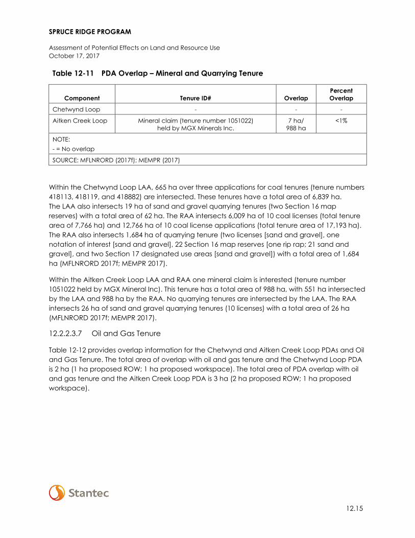
SPRUCE RIDGE PROGRAM
Assessment of Potential Effects on Land and Resource Use October 17, 2017
12.15
Table 12-11 PDA Overlap – Mineral and Quarrying Tenure
Component Tenure ID# Overlap Percent Overlap
Chetwynd Loop - - -
Aitken Creek Loop Mineral claim (tenure number 1051022) held by MGX Minerals Inc.
7 ha/ 988 ha
<1%
NOTE: - = No overlap
SOURCE: MFLNRORD (2017f); MEMPR (2017)
Within the Chetwynd Loop LAA, 665 ha over three applications for coal tenures (tenure numbers 418113, 418119, and 418882) are intersected. These tenures have a total area of 6,839 ha. The LAA also intersects 19 ha of sand and gravel quarrying tenures (two Section 16 map reserves) with a total area of 62 ha. The RAA intersects 6,009 ha of 10 coal licenses (total tenure area of 7,766 ha) and 12,766 ha of 10 coal license applications (total tenure area of 17,193 ha). The RAA also intersects 1,684 ha of quarrying tenure (two licenses [sand and gravel], one notation of interest [sand and gravel], 22 Section 16 map reserves [one rip rap; 21 sand and gravel], and two Section 17 designated use areas [sand and gravel]) with a total area of 1,684 ha (MFLNRORD 2017f; MEMPR 2017).
Within the Aitken Creek Loop LAA and RAA one mineral claim is interested (tenure number 1051022 held by MGX Mineral Inc). This tenure has a total area of 988 ha, with 551 ha intersected by the LAA and 988 ha by the RAA. No quarrying tenures are intersected by the LAA. The RAA intersects 26 ha of sand and gravel quarrying tenures (10 licenses) with a total area of 26 ha (MFLNRORD 2017f; MEMPR 2017).
12.2.2.3.7 Oil and Gas Tenure
Table 12-12 provides overlap information for the Chetwynd and Aitken Creek Loop PDAs and Oil and Gas Tenure. The total area of overlap with oil and gas tenure and the Chetwynd Loop PDA is 2 ha (1 ha proposed ROW; 1 ha proposed workspace). The total area of PDA overlap with oil and gas tenure and the Aitken Creek Loop PDA is 3 ha (2 ha proposed ROW; 1 ha proposed workspace).

SPRUCE RIDGE PROGRAM
Assessment of Potential Effects on Land and Resource Use October 17, 2017
12.16
Table 12-12 PDA Overlap – Oil and Gas Tenure
Component Tenure ID# Overlap Percent Overlap
Chetwynd Loop
Crown Land ID 0208753 – ROW held by Westcoast
1 ha/38 ha 3%
Crown Land ID 0234950 – ROW held by Westcoast
<1 ha/1 ha 100%
Crown Land ID 9000003 – ROW held by Westcoast
<1 ha/88 ha <1%
Aitken Creek Loop1 Crown Land ID 8011972 – ROW held by Aitken Creek Gas Storage
<1 ha/2.5 ha 2%
Crown Land ID 8009793 – ROW held by Westcoast
<1 ha/2.2 ha 2%
Crown Land ID 8012212 – ROW held by Aitken Creek Gas Storage
<1 ha/3.38 ha 1%
Crown Land ID 9604525 – ROW held by Canadian Natural Resources
1 ha/1.99 ha 2%
Crown Land ID 9705969 – ROW held by Progress Energy Canada
<1 ha/1.55 ha 3%
Crown Land ID 9705969 – ROW held by Progress Energy Canada
<1 ha/4.08 ha 1%
Crown Land ID 9708430 – ROW held by Progress Energy Canada
<1 ha/4.52 ha 1%
Crown Land ID 9708836 – ROW held by Spectra Energy Midstream
<1 ha/8.59 ha 1%
NOTES: - = No overlap 1 The PDA overlaps 2 ha of 27 oil and gas tenures, eight of which are associated with Westcoast, four with Canadian Natural Resource Ltd., four with Progress Energy Canada, three with Spectra Energy Midstream, three with Aitken Creek Gas Storage, two with Black Swan Energy Ltd, two with Nova Gas Transmission Ltd, and one with Alliance Pipeline. Eighteen of the overlap affect less than 1% of interested tenure area; detailed information regarding these overlaps is not provided here.
SOURCE: MFLNRORD (2017f); BC OGC (2017a, 2017b)
The Chetwynd Loop LAA intersects 42 ha of four oil and gas tenures (tenure type - ROW) with a total area of 308 ha. Two oil and gas facilities are also intersected by the LAA. Within the RAA, 7,021 ha of 54 oil and gas tenures (one inventory, seven licenses, two notations of interest, and 44 ROWs) are interested. These tenures have a total area of 134,029 ha. Twenty-four oil and gas facilities are also intersected by the RAA (MFLNRORD 2017f; BC OGC 2017a, 2017b).
Within the Aitken Creek Loop LAA 305 ha of 95 oil and gas tenures (one lease, six licenses, and 88 ROWs) with a total area of 1,309 ha are intersected. There are 21 oil and gas facilities within the LAA. Within the RAA 3,825 ha of 794 oil and gas tenures (four lease, 65 licenses, four permits,
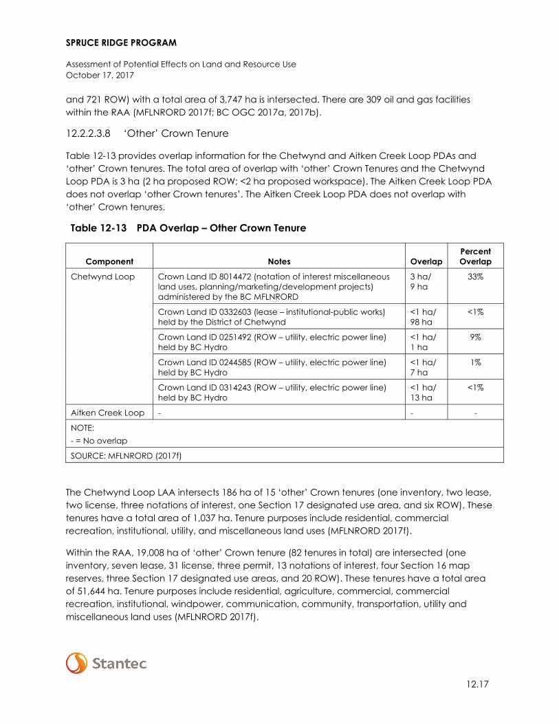
SPRUCE RIDGE PROGRAM
Assessment of Potential Effects on Land and Resource Use October 17, 2017
12.17
and 721 ROW) with a total area of 3,747 ha is intersected. There are 309 oil and gas facilities within the RAA (MFLNRORD 2017f; BC OGC 2017a, 2017b).
12.2.2.3.8 ‘Other’ Crown Tenure
Table 12-13 provides overlap information for the Chetwynd and Aitken Creek Loop PDAs and ‘other’ Crown tenures. The total area of overlap with ‘other’ Crown Tenures and the Chetwynd Loop PDA is 3 ha (2 ha proposed ROW; <2 ha proposed workspace). The Aitken Creek Loop PDA does not overlap ‘other Crown tenures’. The Aitken Creek Loop PDA does not overlap with ‘other’ Crown tenures.
Table 12-13 PDA Overlap – Other Crown Tenure
Component Notes Overlap Percent Overlap
Chetwynd Loop Crown Land ID 8014472 (notation of interest miscellaneous land uses, planning/marketing/development projects) administered by the BC MFLNRORD
3 ha/ 9 ha
33%
Crown Land ID 0332603 (lease – institutional-public works) held by the District of Chetwynd
<1 ha/ 98 ha
<1%
Crown Land ID 0251492 (ROW – utility, electric power line) held by BC Hydro
<1 ha/ 1 ha
9%
Crown Land ID 0244585 (ROW – utility, electric power line) held by BC Hydro
<1 ha/ 7 ha
1%
Crown Land ID 0314243 (ROW – utility, electric power line) held by BC Hydro
<1 ha/ 13 ha
<1%
Aitken Creek Loop - - -
NOTE: - = No overlap
SOURCE: MFLNRORD (2017f)
The Chetwynd Loop LAA intersects 186 ha of 15 ‘other’ Crown tenures (one inventory, two lease, two license, three notations of interest, one Section 17 designated use area, and six ROW). These tenures have a total area of 1,037 ha. Tenure purposes include residential, commercial recreation, institutional, utility, and miscellaneous land uses (MFLNRORD 2017f).
Within the RAA, 19,008 ha of ‘other’ Crown tenure (82 tenures in total) are intersected (one inventory, seven lease, 31 license, three permit, 13 notations of interest, four Section 16 map reserves, three Section 17 designated use areas, and 20 ROW). These tenures have a total area of 51,644 ha. Tenure purposes include residential, agriculture, commercial, commercial recreation, institutional, windpower, communication, community, transportation, utility and miscellaneous land uses (MFLNRORD 2017f).
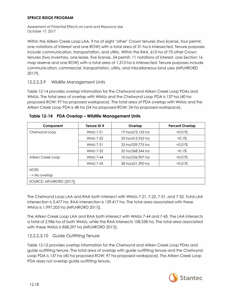
SPRUCE RIDGE PROGRAM
Assessment of Potential Effects on Land and Resource Use October 17, 2017
12.18
Within the Aitken Creek Loop LAA, 9 ha of eight ‘other’ Crown tenures (two license, four permit, one notations of interest and one ROW) with a total area of 31 ha is intersected. Tenure purposes include communication, transportation, and utility. Within the RAA, 615 ha of 75 other Crown tenures (two inventory, one lease, five license, 54 permit, 11 notations of interest, one Section 16 map reserve and one ROW) with a total area of 1,313 ha is intersected. Tenure purposes include communication, commercial, transportation, utility, and miscellaneous land uses (MFLNRORD 2017f).
12.2.2.3.9 Wildlife Management Units
Table 12-14 provides overlap information for the Chetwynd and Aitken Creek Loop PDAs and WMUs. The total area of overlap with WMUs and the Chetwynd Loop PDA is 137 ha (40 ha proposed ROW; 97 ha proposed workspace). The total area of PDA overlap with WMUs and the Aitken Creek Loop PDA is 48 ha (24 ha proposed ROW; 24 ha proposed workspace).
Table 12-14 PDA Overlap – Wildlife Management Units
Component Tenure ID # Overlap Percent Overlap
Chetwynd Loop WMU 7-21 19 ha/673,133 ha <0.01%
WMU 7-22 53 ha/415,952 ha <0.1%
WMU 7-31 33 ha/539,775 ha <0.01%
WMU 7-32 32 ha/368,344 ha <0.1%
Aitken Creek Loop WMU 7-44 10 ha/236,907 ha <0.01%
WMU 7-45 38 ha/621,390 ha <0.01%
NOTE: - = No overlap
SOURCE: MFLNRORD (2017j)
The Chetwynd Loop LAA and RAA both intersect with WMUs 7-21, 7-22, 7-31, and 7-32. Total LAA intersection is 5,477 ha, RAA intersection is 139,417 ha. The total area associated with these WMUs is 1,997,205 ha (MFLNRORD 2017j).
The Aitken Creek Loop LAA and RAA both intersect with WMUs 7-44 and 7-45. The LAA intersects a total of 2,986 ha of both WMUs, while the RAA intersects 108,538 ha. The total area associated with these WMUs is 858,297 ha (MFLNRORD 2017j).
12.2.2.3.10 Guide Outfitting Tenure
Table 12-15 provides overlap information for the Chetwynd and Aitken Creek Loop PDAs and guide outfitting tenure. The total area of overlap with guide outfitting tenure and the Chetwynd Loop PDA is 137 ha (40 ha proposed ROW; 97 ha proposed workspace). The Aitken Creek Loop PDA does not overlap guide outfitting tenure.
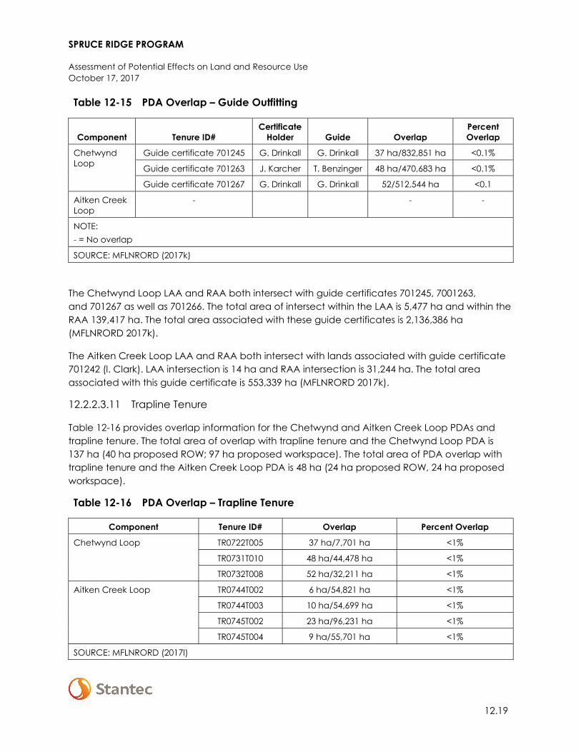
SPRUCE RIDGE PROGRAM
Assessment of Potential Effects on Land and Resource Use October 17, 2017
12.19
Table 12-15 PDA Overlap – Guide Outfitting
Component Tenure ID# Certificate
Holder Guide Overlap Percent Overlap
Chetwynd Loop
Guide certificate 701245 G. Drinkall G. Drinkall 37 ha/832,851 ha <0.1%
Guide certificate 701263 J. Karcher T. Benzinger 48 ha/470,683 ha <0.1%
Guide certificate 701267 G. Drinkall G. Drinkall 52/512,544 ha <0.1
Aitken Creek Loop
- - -
NOTE: - = No overlap
SOURCE: MFLNRORD (2017k)
The Chetwynd Loop LAA and RAA both intersect with guide certificates 701245, 7001263, and 701267 as well as 701266. The total area of intersect within the LAA is 5,477 ha and within the RAA 139,417 ha. The total area associated with these guide certificates is 2,136,386 ha (MFLNRORD 2017k).
The Aitken Creek Loop LAA and RAA both intersect with lands associated with guide certificate 701242 (l. Clark). LAA intersection is 14 ha and RAA intersection is 31,244 ha. The total area associated with this guide certificate is 553,339 ha (MFLNRORD 2017k).
12.2.2.3.11 Trapline Tenure
Table 12-16 provides overlap information for the Chetwynd and Aitken Creek Loop PDAs and trapline tenure. The total area of overlap with trapline tenure and the Chetwynd Loop PDA is 137 ha (40 ha proposed ROW; 97 ha proposed workspace). The total area of PDA overlap with trapline tenure and the Aitken Creek Loop PDA is 48 ha (24 ha proposed ROW, 24 ha proposed workspace).
Table 12-16 PDA Overlap – Trapline Tenure
Component Tenure ID# Overlap Percent Overlap
Chetwynd Loop TR0722T005 37 ha/7,701 ha <1%
TR0731T010 48 ha/44,478 ha <1%
TR0732T008 52 ha/32,211 ha <1%
Aitken Creek Loop TR0744T002 6 ha/54,821 ha <1%
TR0744T003 10 ha/54,699 ha <1%
TR0745T002 23 ha/96,231 ha <1%
TR0745T004 9 ha/55,701 ha <1%
SOURCE: MFLNRORD (2017l)
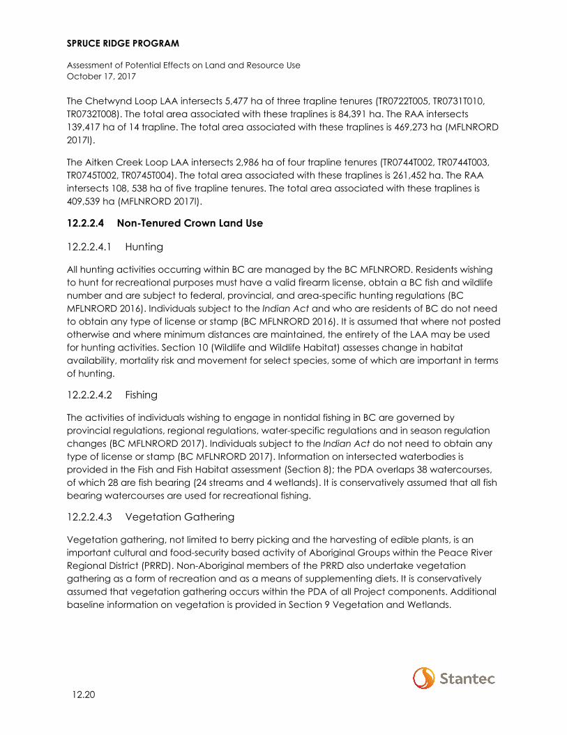
SPRUCE RIDGE PROGRAM
Assessment of Potential Effects on Land and Resource Use October 17, 2017
12.20
The Chetwynd Loop LAA intersects 5,477 ha of three trapline tenures (TR0722T005, TR0731T010, TR0732T008). The total area associated with these traplines is 84,391 ha. The RAA intersects 139,417 ha of 14 trapline. The total area associated with these traplines is 469,273 ha (MFLNRORD 2017l).
The Aitken Creek Loop LAA intersects 2,986 ha of four trapline tenures (TR0744T002, TR0744T003, TR0745T002, TR0745T004). The total area associated with these traplines is 261,452 ha. The RAA intersects 108, 538 ha of five trapline tenures. The total area associated with these traplines is 409,539 ha (MFLNRORD 2017l).
12.2.2.4 Non-Tenured Crown Land Use
12.2.2.4.1 Hunting
All hunting activities occurring within BC are managed by the BC MFLNRORD. Residents wishing to hunt for recreational purposes must have a valid firearm license, obtain a BC fish and wildlife number and are subject to federal, provincial, and area-specific hunting regulations (BC MFLNRORD 2016). Individuals subject to the Indian Act and who are residents of BC do not need to obtain any type of license or stamp (BC MFLNRORD 2016). It is assumed that where not posted otherwise and where minimum distances are maintained, the entirety of the LAA may be used for hunting activities. Section 10 (Wildlife and Wildlife Habitat) assesses change in habitat availability, mortality risk and movement for select species, some of which are important in terms of hunting.
12.2.2.4.2 Fishing
The activities of individuals wishing to engage in nontidal fishing in BC are governed by provincial regulations, regional regulations, water-specific regulations and in season regulation changes (BC MFLNRORD 2017). Individuals subject to the Indian Act do not need to obtain any type of license or stamp (BC MFLNRORD 2017). Information on intersected waterbodies is provided in the Fish and Fish Habitat assessment (Section 8); the PDA overlaps 38 watercourses, of which 28 are fish bearing (24 streams and 4 wetlands). It is conservatively assumed that all fish bearing watercourses are used for recreational fishing.
12.2.2.4.3 Vegetation Gathering
Vegetation gathering, not limited to berry picking and the harvesting of edible plants, is an important cultural and food-security based activity of Aboriginal Groups within the Peace River Regional District (PRRD). Non-Aboriginal members of the PRRD also undertake vegetation gathering as a form of recreation and as a means of supplementing diets. It is conservatively assumed that vegetation gathering occurs within the PDA of all Project components. Additional baseline information on vegetation is provided in Section 9 Vegetation and Wetlands.
SPRUCE RIDGE PROGRAM
Assessment of Potential Effects on Land and Resource Use October 17, 2017
12.21
12.2.2.4.4 Recreational Trails and Sites
The PDA, LAA and RAA do not intersect provincial or federal parks. Within the PRRD there are numerous recreation sites and trails (public campgrounds and trails located on Crown land outside of national, provincial, and regional parks and settled areas). These sites and trails are managed by Recreation Sites and Trails BC (RST BC) under BC MFLNRORD (RST BC 2017). Recreation Sites and Trails are designated under two acts, the Forests Act and the Range Act, as map reserves (either recreational reserves or public access/public trails reserves) (MFLNRORD 2017f; BC Ministry of Forests 2000). The PDA and LAA does not intersect with any Recreation Sites and Trails (RST) BC map reserves or recreation reserves (MFLNRORD 2017m). The RAA (Chetwynd Loop) intersects approximately 9 ha (100%) of the Johnsen Creek recreation site and 21 ha (100%) of the Sundance Lake recreation site (MFLNRORD 2017m).
In addition to hiking and backcountry recreation afforded through designated parks, recreational areas, and RST BC map reserves and recreation reserves, residents, and visitors to the LAA may choose to use non-designated areas, trails, and standalone outdoor recreation features. Within the PRRD there are numerous non-designated trails used for hiking, mountain biking, snowshoeing, cross-country skiing, dog sledding, snowmobiling and all-terrain vehicle (ATV) and utility task vehicle (UTV) use (PRRD 2014). Trails often lead to recreational features of interest, such as waterfalls, caves, alpine vistas, lakes, and other geological formations (PRRD 2014). Trails not within designated areas are often managed by individuals, societies, and recreational groups (PRRD 2014). Existing land use policies established by Westcoast and other oil and gas proponents within the LAA and RAA prohibit/discourage the operation of recreational vehicles (e.g., ATVs, dirt bikes, and snowmobiles) along pipeline ROWs. As such, Westcoast is unaware of any use of existing pipeline ROWs that parallel the Project by operators of recreational vehicles.
It is conservatively assumed that a variety of recreational sites and trails exist within the LAA that, at the time of writing, are unknown to Westcoast.
12.3 PROJECT INTERACTIONS WITH LAND AND RESOURCE USE
Table 12-17 identifies, for each potential effect, the physical activities that might interact with the VC and result in the identified environmental effect. These interactions are indicated by a check mark and are discussed in detail in Section 12.4, in the context of effects pathways, standard and project-specific mitigation/enhancement, and residual effects. A justification for no effect is provided following the table.
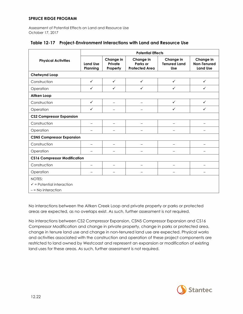
SPRUCE RIDGE PROGRAM
Assessment of Potential Effects on Land and Resource Use October 17, 2017
12.22
Table 12-17 Project-Environment Interactions with Land and Resource Use
Physical Activities
Potential Effects
Land Use Planning
Change in Private
Property
Change in Parks or
Protected Area
Change in Tenured Land
Use
Change in Non-Tenured
Land Use
Chetwynd Loop
Construction
Operation
Aitken Loop
Construction – –
Operation – –
CS2 Compressor Expansion
Construction – – – – –
Operation – – – – –
CSN5 Compressor Expansion
Construction – – – – –
Operation – – – – –
CS16 Compressor Modification
Construction – – – – –
Operation – – – – –
NOTES: = Potential interaction – = No interaction
No interactions between the Aitken Creek Loop and private property or parks or protected areas are expected, as no overlaps exist. As such, further assessment is not required.
No interactions between CS2 Compressor Expansion, CSN5 Compressor Expansion and CS16 Compressor Modification and change in private property, change in parks or protected area, change in tenure land use and change in non-tenured land use are expected. Physical works and activities associated with the construction and operation of these project components are restricted to land owned by Westcoast and represent an expansion or modification of existing land uses for these areas. As such, further assessment is not required.
SPRUCE RIDGE PROGRAM
Assessment of Potential Effects on Land and Resource Use October 17, 2017
12.23
12.4 ASSESSMENT OF RESIDUAL EFFECTS ON LAND AND RESOURCE USE
The residual effects on land and resource use are determined in this section. The analytical methods, effects pathways, mitigation measures, and a discussion and characterization of the residual effects are presented below, for each of the potential effects.
12.4.1 Analytical Assessment Techniques
Potential Project effects are quantified using a GIS based analysis of spatial overlap, and analysis of change in non-spatial metrics. Spatial analysis was used to estimate the reduction of land available for land and resource use within the Project PDA and LAA. This information was supplemented with previous research (i.e., publicly available information and stakeholder engagement) to compare the reduction of available land to existing conditions to help estimate the magnitude of change associated with the Project.
The assessment of potential Project effects on land and resource use activities also considers interactions between the Project and the natural environment VCs, identified in Section 12.1. For example, for the assessment of Project effects on non-tenured consumptive recreation (e.g., recreational hunting and fishing), residual effects on fish and wildlife habitats are incorporated as Project mechanisms. This integration of effects allows for full consideration of the pathways that have the potential to result in a residual effect.
12.4.2 Land Use Planning
12.4.2.1 Effect Pathways
Effect pathways for land use planning are as follows:
• Project construction and/or operation may be incompatible with designated municipal land uses
• Project construction and/or operation may be incompatible with LRMP RMZ objectives and strategies.
12.4.2.2 Mitigation
Standard industry practices and avoidance measures, as well as resource-specific mitigation will be implemented during construction and operation, as identified in the Environmental Protection Plans (EPPs; Appendix A-1 and Appendix A-2). Table 12-18 contains key mitigation for land use planning.
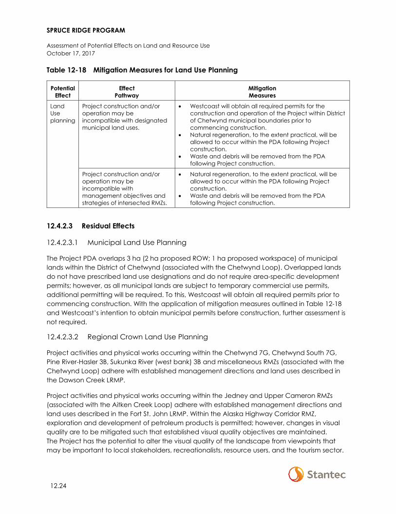
SPRUCE RIDGE PROGRAM
Assessment of Potential Effects on Land and Resource Use October 17, 2017
12.24
Table 12-18 Mitigation Measures for Land Use Planning
Potential Effect
Effect Pathway
Mitigation Measures
Land Use planning
Project construction and/or operation may be incompatible with designated municipal land uses.
• Westcoast will obtain all required permits for the construction and operation of the Project within District of Chetwynd municipal boundaries prior to commencing construction.
• Natural regeneration, to the extent practical, will be allowed to occur within the PDA following Project construction.
• Waste and debris will be removed from the PDA following Project construction.
Project construction and/or operation may be incompatible with management objectives and strategies of intersected RMZs.
• Natural regeneration, to the extent practical, will be allowed to occur within the PDA following Project construction.
• Waste and debris will be removed from the PDA following Project construction.
12.4.2.3 Residual Effects
12.4.2.3.1 Municipal Land Use Planning
The Project PDA overlaps 3 ha (2 ha proposed ROW; 1 ha proposed workspace) of municipal lands within the District of Chetwynd (associated with the Chetwynd Loop). Overlapped lands do not have prescribed land use designations and do not require area-specific development permits; however, as all municipal lands are subject to temporary commercial use permits, additional permitting will be required. To this, Westcoast will obtain all required permits prior to commencing construction. With the application of mitigation measures outlined in Table 12-18 and Westcoast’s intention to obtain municipal permits before construction, further assessment is not required.
12.4.2.3.2 Regional Crown Land Use Planning
Project activities and physical works occurring within the Chetwynd 7G, Chetwynd South 7G, Pine River-Hasler 3B, Sukunka River (west bank) 3B and miscellaneous RMZs (associated with the Chetwynd Loop) adhere with established management directions and land uses described in the Dawson Creek LRMP.
Project activities and physical works occurring within the Jedney and Upper Cameron RMZs (associated with the Aitken Creek Loop) adhere with established management directions and land uses described in the Fort St. John LRMP. Within the Alaska Highway Corridor RMZ, exploration and development of petroleum products is permitted; however, changes in visual quality are to be mitigated such that established visual quality objectives are maintained. The Project has the potential to alter the visual quality of the landscape from viewpoints that may be important to local stakeholders, recreationalists, resource users, and the tourism sector.

SPRUCE RIDGE PROGRAM
Assessment of Potential Effects on Land and Resource Use October 17, 2017
12.25
Of concern are potential adverse effects on visual resources classified within the BC VLI and that fall within the Alaska-Highway Corridor RMZ and have VQCs of preservation and retention. To address potential effects on visual quality, mitigation measures outlined in Table 12-18 will be implemented.
With the application of mitigation measures and in consideration of the siting of the Project PDA (largely paralleling existing pipeline ROWs), the relatively small area of PDA overlap with the Alaska Highway Corridor RMZ (5 ha or <0.1% of total RMZ area), and because pipeline developments are often not visible from similar elevation viewpoints due to vegetation and topographical shielding, residual effects on visual quality (i.e., changes in established visual quality objectives) are predicted to be of low magnitude. Adverse effects are limited to the PDA because land outside the PDA will not be developed. Adverse effects will occur continuously over the long term lasting the duration of Project operations with changes in visual quality more prominent during construction (due to the presence of workers and machinery and prior to revegetation of the ROW). Adverse effects are reversible following reclamation of the PDA and occur with a resilient socio-economic context (oil and gas development is permitted and regularly occurs within the Alaska Highway Corridor RMZ as characterized by existing conditions within the LAA).
12.4.3 Change in Private Property
12.4.3.1 Effect Pathways
Effect pathways for change in private property are as follows:
• PDA clearing may result in the loss or disruption of use of private lands • Project presence and site management activities may affect access to and/or the quality of
the experience for private property owners.
12.4.3.2 Mitigation
Standard industry practices and avoidance measures, as well as resource-specific mitigation will be implemented during construction and operation, as identified in the EPPs (Appendix A1 and Appendix A-2). Table 12-19 contains key mitigation for change in private property.

SPRUCE RIDGE PROGRAM
Assessment of Potential Effects on Land and Resource Use October 17, 2017
12.26
Table 12-19 Mitigation Measures for Change in Private Property
Potential Effect
Effect Pathway
Mitigation Measures
Change in private property
PDA clearing may result in the loss or disruption of use of private lands
• Westcoast will establish land use agreements and where appropriate compensate private property holders.
• Westcoast will develop a Stakeholder Engagement Plan. The plan will facilitate communication channels with affected stakeholders over the operational life of the Project to resolve issues that may arise.
• Existing disturbed areas (e.g., roads, logged areas) will be used to the extent practical to reduce the area of new clearing required
• Natural regeneration, to the extent practical, will be allowed to occur within the PDA following Project construction.
Project presence and site management activities may affect access to and/or the quality of the experience for private property owners
• A Worker Management Strategy (inclusive of a Project-specific orientation) will be developed to establish guidelines for Project workers to follow while onsite. During working hours, and while housed in Project sponsored accommodations (including existing camps and commercial accommodations), Project personnel will be prohibited from hunting, fishing, and using recreational vehicles within a buffer zone to be determined prior to construction.
• A Traffic and Access Management Plan will be developed to support safe driving practices and reduce impacts to landowners, residents, and local communities and to communicate and manage changes in access. The Plan will require that appropriate signage be posted in advance and during construction, indicating access restrictions.
• Waste and debris will be removed from the PDA following Project construction.
12.4.3.3 Residual Effects
Westcoast is in the process of consulting with private landowners along the PDA of the Chetwynd Loop to understand use constraints, obtain land-use agreements and where appropriate provide compensation. Upon successful agreement and implementation of mitigation measures (see Table 12-19), it is expected that adverse residual effects on private property will be reduced to negligible levels.
12.4.4 Change in Park or Protected Area
12.4.4.1 Effect Pathways
Effect pathways for change in park or protected area are as follows:
• PDA clearing within parks or protected areas may be incompatible with established land use policies; the issuance of a variance or additional permitting may be required.
• Project presence and site management activities may affect access to and/or the quality of the experience for users of parks or protected area.
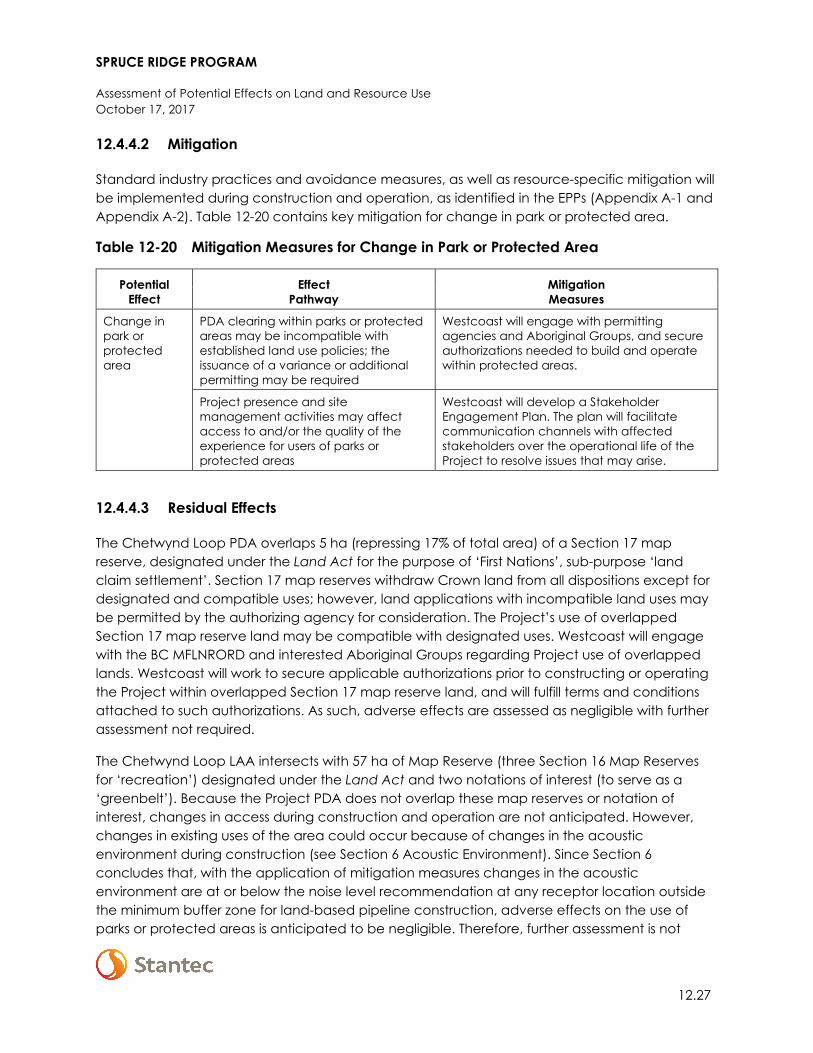
SPRUCE RIDGE PROGRAM
Assessment of Potential Effects on Land and Resource Use October 17, 2017
12.27
12.4.4.2 Mitigation
Standard industry practices and avoidance measures, as well as resource-specific mitigation will be implemented during construction and operation, as identified in the EPPs (Appendix A-1 and Appendix A-2). Table 12-20 contains key mitigation for change in park or protected area.
Table 12-20 Mitigation Measures for Change in Park or Protected Area
Potential Effect
Effect Pathway
Mitigation Measures
Change in park or protected area
PDA clearing within parks or protected areas may be incompatible with established land use policies; the issuance of a variance or additional permitting may be required
Westcoast will engage with permitting agencies and Aboriginal Groups, and secure authorizations needed to build and operate within protected areas.
Project presence and site management activities may affect access to and/or the quality of the experience for users of parks or protected areas
Westcoast will develop a Stakeholder Engagement Plan. The plan will facilitate communication channels with affected stakeholders over the operational life of the Project to resolve issues that may arise.
12.4.4.3 Residual Effects
The Chetwynd Loop PDA overlaps 5 ha (repressing 17% of total area) of a Section 17 map reserve, designated under the Land Act for the purpose of ‘First Nations’, sub-purpose ‘land claim settlement’. Section 17 map reserves withdraw Crown land from all dispositions except for designated and compatible uses; however, land applications with incompatible land uses may be permitted by the authorizing agency for consideration. The Project’s use of overlapped Section 17 map reserve land may be compatible with designated uses. Westcoast will engage with the BC MFLNRORD and interested Aboriginal Groups regarding Project use of overlapped lands. Westcoast will work to secure applicable authorizations prior to constructing or operating the Project within overlapped Section 17 map reserve land, and will fulfill terms and conditions attached to such authorizations. As such, adverse effects are assessed as negligible with further assessment not required.
The Chetwynd Loop LAA intersects with 57 ha of Map Reserve (three Section 16 Map Reserves for ‘recreation’) designated under the Land Act and two notations of interest (to serve as a ‘greenbelt’). Because the Project PDA does not overlap these map reserves or notation of interest, changes in access during construction and operation are not anticipated. However, changes in existing uses of the area could occur because of changes in the acoustic environment during construction (see Section 6 Acoustic Environment). Since Section 6 concludes that, with the application of mitigation measures changes in the acoustic environment are at or below the noise level recommendation at any receptor location outside the minimum buffer zone for land-based pipeline construction, adverse effects on the use of parks or protected areas is anticipated to be negligible. Therefore, further assessment is not

SPRUCE RIDGE PROGRAM
Assessment of Potential Effects on Land and Resource Use October 17, 2017
12.28
required. Changes in use of parks or protected areas during operations are not anticipated, so further assessment is not required.
Noted in Section 12.3, no interactions between the Aitken Creek Loop and parks or protected areas are expected as no overlaps exist. As such, further assessment is not required.
12.4.5 Change in Tenured Land Use
12.4.5.1 Effect Pathways
Effect pathways for change in tenured land use are as follows:
• PDA clearing may result in the loss of area available for tenured land use activities • Project presence and site management activities may affect access to and/or the quality of
the experience for tenure land and resource holders.
12.4.5.2 Mitigation
Standard industry practices and avoidance measures, as well as resource-specific mitigation will be implemented during construction and operation, as identified in the EPPs (Appendix A-1 and Appendix A-2). Table 12-21 contains key mitigation for change in tenured land use.
Table 12-21 Mitigation Measures for Change in Tenured Land Use
Potential Effect
Effect Pathway
Mitigation Measures
Change in tenured land use
PDA clearing may result in the loss of area available for tenured land use activities
• Westcoast will develop a Stakeholder Engagement Plan. The plan will facilitate communication channels with affected stakeholders over the operational life of the Project to resolve issues that may arise.
• Westcoast will work with tenure holders to limit interference with existing uses.
• Scheduling of construction activities will consider appropriate timing to limit disruption of wildlife during sensitive periods.
• Existing disturbed areas (e.g., roads, logged areas) will be used to the extent practical to reduce the area of new clearing required.
• Registered outfitters and trapline holders will be notified prior to construction.
• Trapline holders will be compensated, where appropriate, in accordance with the BC Registered Trapper and Petroleum Industry Agreement on Notification and Compensation.
• A Timber Salvage Plan will be developed. • Natural regeneration, to the extent practical, will be allowed to
occur within the PDA following Project construction.
SPRUCE RIDGE PROGRAM
Assessment of Potential Effects on Land and Resource Use October 17, 2017
12.29
Table 12-21 Mitigation Measures for Change in Tenured Land Use
Potential Effect
Effect Pathway
Mitigation Measures
Change in tenured land use (cont’d)
Project presence and site management activities may affect access to and/or the quality of the experience for tenure land and resource users
• A Worker Management Strategy (inclusive of a Project-specific orientation) will be developed to establish guidelines for Project workers to follow while onsite. During working hours, and while housed in Project sponsored accommodations (including existing camps and commercial accommodations), Project personnel will be prohibited from hunting, fishing, and using recreational vehicles within a buffer zone to be determined prior to construction.
• A Traffic and Access Management Plan will be developed to support safe driving practices and reduce impacts to landowners, residents, and local communities and to communicate and manage changes in access. The Plan will require that appropriate signage be posted in advance and during construction, indicating access restrictions.
• Waste and debris will be removed from the PDA following Project construction.
12.4.5.3 Residual Effects
12.4.5.3.1 ALR and Range Tenure
The PDA of the Chetwynd Loop overlaps three ALR polygons totaling 103 ha. This represents a total of 0.6% of the 16,739 ha of combined total area associated with these ALR polygons (IDs 2367698, 2367909 and 2367934). There are no overlaps of the Chetwynd Loop PDA with range tenure. During construction, use of ALR lands will be restricted in the PDA. Once construction activities have been completed, the land will be restored to its original capabilities. There will be a time lag between the disturbance and time when reclamation activities are completed. Where the PDA and ALR overlap (either on Crown land or private property), mitigation measures such as land use agreements, and compensation, where applicable, will lower the magnitude of adverse effects on land owners. Residual Project effects are adverse in direction, low in magnitude, and will occur within the PDA. Project effects are predicted to be short-term in duration because ALR and range lands can be restored to their original function after construction. Project effect will occur in a single event, and the effects are reversible once the land has been reclaimed. The socio-economic context is resilient.
The PDA of the Aitken Creek Loop does not overlap with any ALR polygons or range tenure. As there is no overlap of the PDA of the Aitken Creek Loop with ALR polygons or range tenure, there are no Project effects.
SPRUCE RIDGE PROGRAM
Assessment of Potential Effects on Land and Resource Use October 17, 2017
12.30
12.4.5.3.2 Forestry Tenure
The PDA of the Chetwynd Loop overlaps with 137 ha of the Dawson Creek TSA, totaling less than 0.01% of the total area of the TSA. There are no overlaps with forest tenure cutblocks.
The PDA of the Aitken Creek Loop overlaps with two blocks of the Fort St. John TSA, totaling 48 ha, and less than 1% of the total area of the two blocks. The PDA overlaps three active license cutblocks totaling 8 ha, or 2% of the total area. The estimated volume (net merchantable) of wood to be removed from the PDA of the Aitken Creek Loop is 3,623 m3 of coniferous wood, and 373 m3 of deciduous wood (Industrial Forestry Services 2017).
Construction will require removal of trees from the PDA, and operational maintenance of the ROW will prevent trees from re-establishing. This could result in potential adverse effects on licensees, and will take away from the AAC. A timber salvage plan, ongoing negotiation and engagement with licensees will help to reduce adverse residual effects. Residual adverse effects are limited to the PDA during construction and the ROW during operations. As tree removal will be required and trees cannot be reestablished, the residual adverse effects are long-term in duration, extending through the Project operations phase.
Residual Project effects (for both the Chetwynd and Aitken Creek Loops) are adverse, and negligible. Residual adverse effects are limited to the PDA during construction and the ROW during operations, and will occur in a single event. As tree removal will be required and trees cannot be re-established, the residual adverse effects are long-term in duration, extending through the Project operations phase. Potential adverse effects are reversible upon Project closure. Forestry tenures are resilient to these effects.
12.4.5.3.3 Mining Tenure
There is no overlap between the Chetwynd Loop PDA and mining tenures. As a result, there are no Project effects. The PDA of the Aitken Creek Loop overlaps with 7 ha of one mineral claim (<1% of total claim area). There are no quarrying tenures overlapped by the Aitken Creek Loop PDA. There is potential for adverse effects on mineral claim holders during Project construction and operations as access and use of areas that overlap with the PDA will be restricted during construction and discouraged during operations. Engagement and negotiation will help to mitigate potential adverse effects on the claim holder. If appropriate, compensation may be considered.
Residual adverse effects on mining tenures could extend into the LAA, as access restrictions in the PDA could interfere with mineral extraction operations in the remaining portions of the overlapped claim. Effects are expected to be long-term in duration, as access to the PDA will be discouraged during operations. Project effects will occur in a single event, and are reversible with Project closure. With the implementation of mitigation measures, and the small percent of overlap with mining tenures, residual adverse effects are predicted to be negligible.
SPRUCE RIDGE PROGRAM
Assessment of Potential Effects on Land and Resource Use October 17, 2017
12.31
12.4.5.3.4 Oil and Gas Tenure
The PDA of the Chetwynd Loop overlaps three oil and gas tenures, totaling 2 ha, or 2% of the tenures. Westcoast holds these overlapped tenures.
The PDA of the Aiken Creek Loop overlaps 27 oil and gas tenures; of which eight are held by Westcoast and three by Spectra Energy Midstream. Adverse effects on these eleven overlapped tenures are negligible, as Westcoast will manage overlap with their own and affiliated (i.e., Spectra Energy Midstream) infrastructure.
The 16-remaining oil and gas tenures (3 ha) overlapped by the Aitken Creek Loop PDA are held by other companies. Access and use of these oil and gas tenures will be restricted during construction due to safety considerations. Short-term adverse effects on licensees of oil and gas infrastructure deemed to have compatible land uses with that of the Project (e.g., pipelines) are not anticipated. Where overlapping oil and gas infrastructure is deemed incompatible (e.g., wellsites), adverse effects are expected to extend into operation. Engagement and negotiation will help to mitigate potential adverse effects on licensees during all Project phases. Where appropriate, compensation will be considered, to move existing infrastructure. Residual effects on oil and gas tenures extend to the LAA as existing infrastructure, such as pipelines, will need to be relocated to outside of the PDA. Long-term effects on the functionality of infrastructure are not expected. Project effects are short-term in duration, and will occur in a single event. With the implementation of mitigation measures, residual effects on oil and gas tenures are predicted to be low. Residual effects are reversible upon Project closure.
12.4.5.3.5 Other Crown Tenures
The PDA of the Chetwynd Loop overlaps with five other Crown tenures, one held by the District of Chetwynd (lease – public works), one administered by the BC MFLNRORD (notation of interest – planning/marketing/development projects) and three held by BC Hydro (electric power line). The PDA of the Aitken Creek Loop does not overlap any other Crown tenures. As there is no overlap of the PDA of the Aitken Creek Loop with other Crown tenures, there are no Project effects.
Where conflicting uses exist between the Chetwynd Loop and existing land uses (e.g., electric power lines and public works), adverse effects on licensees will be mitigated through engagement and negotiation, and if appropriate, through compensation to move existing infrastructure. Where existing land uses may be compatible with the Project (e.g., areas under a notation of interest for planning/marketing/development projects) BMPs and requirements regarding the construction of pipelines, as well as engagement and negotiation with licensees will reduce the magnitude of potential adverse effects.
Project effects are predicted to be adverse, low in magnitude and will occur in a single event. Residual effects on other Crown tenures could extend into the LAA, because access to the PDA will be restricted during construction. As the land uses of the other Crown tenures are currently

SPRUCE RIDGE PROGRAM
Assessment of Potential Effects on Land and Resource Use October 17, 2017
12.32
unknown, the Project effects are long-term in duration, as it is assumed that access to the PDA will be restricted until Project closure. The effects are reversible upon Project closure.
12.4.5.3.6 Trapping and Guide Outfitting
The PDA of the Chetwynd Loop overlaps with 137 ha of three guide outfitter tenures, totaling less than 0.1% of the guide outfitter tenures overlapped. The PDA also overlaps with 137 ha of trapline tenures, totaling less than 1% of the trapline tenures overlapped. The PDA of the Aitken Creek Loop does not overlap with any guide outfitting tenures, but does overlap with 48 ha of four trapline tenures. The PDA overlaps with less than 1% of the overlapped trapline tenures.
Prior to application submission registered outfitters and trapline holders were notified of the Project with mailed information packages that included the Project fact sheet, mapping, and the NEB brochure “Information for Proposed Pipeline or Powerline Project: What you Need to Know”. Registered outfitters and trapline holders were then notified of Westcoast’s Project application submission with a letter referencing the NEB website and directing any concerns or comments to Westcoast and the NEB. Following receipt of regulatory approvals, licensees will be notified of regulatory decisions and construction schedule (prior to construction) through mail, email or phone calls.
Land access and use of overlapped areas within the PDA will be restricted during construction and discouraged during operations, leading to potential adverse effects on licensees. Negotiations and engagement will reduce adverse effects on licensees, and compensation may be considered. Project construction and operation could affect availability of wildlife habitat, movement patterns and mortality risk (see Section 10 Wildlife and Wildlife Habitat). These potential effects will be mitigated through the measures identified in Section 10 (Wildlife and Wildlife Habitat).
Residual effects are adverse, and low in magnitude. The potential effects could extend into the LAA as changes to access may affect other parts of the tenures. In addition, change in habitat availability, movement patterns and mortality risk may affect wildlife outside the PDA and into the LAA. Potential effects are long-term in duration, and will occur in a single event. Adverse effects are considered reversible upon Project closure.
12.4.5.3.7 Summary
In summary, with the mitigation measures identified above, residual effects on tenured land use during Project construction and operation will be adverse in direction, negligible to low in magnitude, are limited to the PDA and LAA and are short- to long-term in duration. All effects occur as a single event and are reversible upon Project closure.
SPRUCE RIDGE PROGRAM
Assessment of Potential Effects on Land and Resource Use October 17, 2017
12.33
12.4.6 Change in Non-Tenured Land Use
12.4.6.1 Effect Pathways
Effect pathways for change in non-tenured land use are as follows:
• PDA clearing may result in the loss of area available for non-tenured land use activities • Project presence and site management activities may affect access to and/or the quality of
the experience for non-tenure land and resource users.
12.4.6.2 Mitigation
Standard industry practices and avoidance measures, as well as resource-specific mitigation, will be implemented during construction and operation, as identified in the EPPs (Appendix A-1 and Appendix A-2). Table 12-22 contains key mitigation for change in non-tenured land use.
Table 12-22 Mitigation Measures for Change in Non-Tenured Land Use and Private Property
Potential Effect
Effect Pathway
Mitigation Measures
Change in non-tenured land use
PDA clearing may result in the loss of area available for non-tenured land use activities
• Westcoast will develop a Stakeholder Engagement Plan. The plan will facilitate communication channels with affected stakeholders over the operational life of the Project to resolve issues that may arise.
• Scheduling of construction activities will consider appropriate timing to limit disruption of wildlife during sensitive periods.
• Existing disturbed areas (e.g., roads, logged areas) will be used to the extent practical to reduce the area of new clearing required.
• Natural regeneration, to the extent practical, will be allowed to occur within the PDA following Project construction.
Project presence and site management activities may affect access to and/or the quality of the experience for non-tenured land and resources users
• A Worker Management Strategy (inclusive of a Project-specific orientation) will be developed to establish guidelines for Project workers to follow while onsite. During working hours, and while housed in Project sponsored accommodations (including existing camps and commercial accommodations), Project personnel will be prohibited from hunting, fishing, and using recreational vehicles within a buffer zone to be determined prior to construction.
• A Traffic and Access Management Plan will be developed to support safe driving practices and reduce impacts to landowners, residents, and local communities and to communicate and manage changes in access. The Plan will require that appropriate signage be posted in advance and during construction, indicating access restrictions.
• Waste and debris will be removed from the PDA following Project construction.
SPRUCE RIDGE PROGRAM
Assessment of Potential Effects on Land and Resource Use October 17, 2017
12.34
12.4.6.3 Residual Effect
12.4.6.3.1 Consumptive Recreation
12.4.6.3.1.1 Hunting
The PDA of the Chetwynd Loop overlaps with 19 ha (less than 0.01% of the total area) of WMU 7-21; 53 ha (less than 0.01% of the total area) of WMU 7-22; 33 ha (less than 0.01% of the total area) of WMU 7-31; and 32 ha (less than 0.01% of the total area) of WMU 7-32 in which hunting activities could occur. The PDA of the Aitken Creek Loop overlaps with 10 ha (less than 0.01% of the total area) of WMU 7-44 and 38 ha (less than 0.01% of the total area) of WMU 7-45 in which hunting activities could occur.
The Project has the potential to affect habitat availability, movement patterns and mortality risk to wildlife. The mitigation measures provided in Section 10 (Wildlife and Wildlife Habitat) and Table 12-22 will help to reduce potential adverse effects on hunting. Access will be restricted during construction and discouraged during operations, and temporary changes in the presence of game animals will likely occur during construction. As such, the Project is predicted to have a low magnitude adverse effect on hunting. Though land use within the remainder of the LAA (outside the PDA) will not be affected by the Project, use of areas requiring access across the Project ROW could be affected. Additionally, the presence of game animals may change temporarily or permanently due to sensory disturbance within the LAA. The Project effect on hunting will be long-term in duration as access to the PDA will be discouraged during operation. Project effects on hunting will be continuous, and are reversible at Project closure. It is acknowledged that should areas overlapped by the PDA be regarded as preferred hunting locations (at the time of writing preferred sites have not been identified), alternative hunting locations within the LAA may not be a substitute for those affected by the Project.
12.4.6.3.1.2 Fishing
The Chetwynd Loop PDA overlaps with 17 fish bearing watercourses, including 16 streams and one wetland. The Aitken Creek Loop PDA overlaps with 11 fish bearing watercourses, including eight streams and three wetlands. Access to a portion of the fish bearing watercourses will be restricted during construction and discouraged during operations. These watercourses represent a small percentage of the potential areas where fishing activities could occur within the LAA. It is acknowledged that should the Project overlap preferred fishing locations (at the time of writing preferred sites have not been identified), alternative fishing locations within the LAA may not represent substitutes for those affected by the Project. The Project could also affect access to fishing location within the LAA if access across the Project ROW is required. The mitigation measures provided in Section 8 (Fish and Fish Habitat) and Table 12-22 will help to reduce potential adverse effects on fishing. The residual effects on fishing are adverse in direction, and low in magnitude. Access to the PDA will be restricted over the long-term with effects extending to the LAA. Project effects on fishing will be continuous, and are reversible upon Project closure.
SPRUCE RIDGE PROGRAM
Assessment of Potential Effects on Land and Resource Use October 17, 2017
12.35
12.4.6.3.1.3 Vegetation Gathering
It is conservatively assumed that vegetation gathering occurs throughout the PDA. As with hunting and fishing, access to the PDA will be restricted during construction and discouraged during operations. While the total area of PDA overlap relative to that assumed to be available within the LAA for vegetation gathering is small, the Project could affect preferred harvesting locations within areas overlapped by the PDA (at the time of writing preferred sites have not been identified). With respect to effects on preferred harvesting locations, the availability of alternative harvesting locations within the LAA may not represent a true substitute to those affected by the Project. The Project could also affect access to other locations within the LAA if access across the Project ROW is required. The mitigation measures provided in Section 9 (Vegetation and Wetlands) and Table 12-22 will help to reduce potential adverse effects on vegetation gathering. The Project’s residual effects on vegetation gathering are predicted to be adverse in direction, and low in magnitude. Access to the PDA will be restricted over the long-term with effects potentially extending to the LAA with changes in access. Project effects on vegetation gathering will be continuous, and are reversible upon Project closure.
12.4.6.3.2 Non-Consumptive Recreation
12.4.6.3.2.1 Recreational Sites and Trails
There are no RST BC map reserves or recreational sites that overlap with the PDA of the Chetwynd Loop or the Aitken Creek Loop. To be conservative, it is assumed that non-designated recreational sites and trails occur within lands overlapped by the PDA. Access to the PDA will be restricted during construction and discouraged during operation; potential adverse effects on users of non-designated recreational sites and trails may occur. The effects are predicted to be low in magnitude, given that engagement with stakeholders will occur, and notification of changes in access will occur. Residual effects occur continuously over the long-term, extend to the LAA (were access across the Project ROW is required), and are reversible upon Project closure.
12.4.6.3.3 Summary
In summary, with the mitigation measures identified above, residual effects on non-tenured land use during Project construction and operation will be adverse in direction, low in magnitude, and are limited to the PDA and LAA. All effects occur continuously over the long-term and are reversible upon Project closure.
12.4.7 Summary of Residual Effects
Residual effects on land and resource use are summarized in Table 14-16. Residual adverse effects are not predicted for change in private property or change in park or protected area. Adverse effects on land use planning are low in magnitude, extend to the PDA and are continuous over the short-term during construction and long-term during operations. Effects are reversible and occur within a resilient socio-economic context. Adverse effects on change in
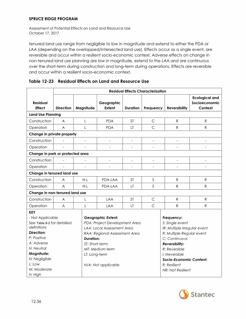
SPRUCE RIDGE PROGRAM
Assessment of Potential Effects on Land and Resource Use October 17, 2017
12.36
tenured land use range from negligible to low in magnitude and extend to either the PDA or LAA (depending on the overlapped/intersected land use). Effects occur as a single event, are reversible and occur within a resilient socio-economic context. Adverse effects on change in non-tenured land use planning are low in magnitude, extend to the LAA and are continuous over the short-term during construction and long-term during operations. Effects are reversible and occur within a resilient socio-economic context.
Table 12-23 Residual Effects on Land and Resource Use
Residual Effect
Residual Effects Characterization
Direction Magnitude Geographic
Extent Duration Frequency Reversibility
Ecological and Socioeconomic
Context
Land Use Planning
Construction A L PDA ST C R R
Operation A L PDA LT C R R
Change in private property
Construction - - - - - - -
Operation - - - - - - -
Change in park or protected area
Construction - - - - - - -
Operation - - - - - - -
Change in tenured land use
Construction A N-L PDA-LAA ST S R R
Operation A N-L PDA-LAA LT S R R
Change in non-tenured land use
Construction A L LAA ST C R R
Operation A L LAA LT C R R
KEY - Not Applicable See Table 8-2 for detailed definitions Direction: P: Positive A: Adverse N: Neutral Magnitude: N: Negligible L: Low M: Moderate H: High
Geographic Extent: PDA: Project Development Area LAA: Local Assessment Area RAA: Regional Assessment Area Duration: ST: Short-term; MT: Medium-term LT: Long-term N/A: Not applicable
Frequency: S: Single event IR: Multiple Irregular event R: Multiple Regular event C: Continuous Reversibility: R: Reversible I: Irreversible Socio-Economic Context: R: Resilient NR: Not Resilient
SPRUCE RIDGE PROGRAM
Assessment of Potential Effects on Land and Resource Use October 17, 2017
12.37
12.5 ASSESSMENT OF CUMULATIVE ENVIRONMENTAL EFFECTS ON LAND AND RESOURCE USE
The Project’s residual effects described in Section 12.4 are likely to interact cumulatively with residual environmental effects from other physical activities (past, present and reasonably foreseeable). The resulting cumulative environmental effects are assessed. This is followed by an analysis of the Project contribution to cumulative effects. Future projects and activities that are reasonably foreseeable are defined as those that (a) have been publicly announced with a defined project execution period and with sufficient details that allow for a meaningful assessment, (b) are currently undergoing an environmental assessment or (c) are in a permitting process.
The assessment of cumulative effects is initiated with a determination of whether two conditions exist:
• The Project has residual environmental effects on the VC • The residual effects could act cumulatively with residual effects of other past, present, or
reasonably foreseeable future physical activities.
If either condition is not met, the assessment of cumulative effects concludes with a statement that further assessment of cumulative effects is not warranted because the Project does not interact cumulatively with other projects or activities.
12.5.1 Residual Effects Likely to Interact Cumulatively
In Section 4.7.1, Environmental Assessment Methods, presents the project and physical activities inclusion list, which identifies other projects and physical activities that might act cumulatively with the Project. Where residual environmental effects from the Project act cumulatively with residual effects from other projects and physical activities (Table 12-24), a cumulative effects assessment is undertaken to determine their significance.
All past, present, and reasonably foreseeable projects and physical activities presented in Section 4.7.1 overlap with the Project. Together, these projects and physical activities will interact with land use planning and tenured and non-tenured land use. The assessment of the cumulative environmental effects that are likely to result from the Project in combination with these projects and physical activities are discussed in subsequent sections.
12.5.2 Analytical Assessment Techniques
Analytical assessment techniques described in Section 12.4.1 are applied in the cumulative case in consideration of methods described at the beginning of Section 12.5. Spatial information for reasonable foreseeable projects and physical activities within the RAA is limited to that available through the BC government’s Crown Land Registry (Tantalis) database. As such, areal and percent-overlapped/intersected figures for total cumulative overlap are underrepresented for any given land use where reasonably foreseeable projects or physical activities are not
SPRUCE RIDGE PROGRAM
Assessment of Potential Effects on Land and Resource Use October 17, 2017
12.38
associated with an issued or pending Crown tenure. Where spatial data is not available for a reasonably foreseeable project or physical activity, it is conservatively assumed that these projects/physical activities will overlap with a given land use. It is further assumed that some of these projects/physical activities will be compatible with established land uses at varying stages of their construction and operation while others are not compatible.
12.5.3 Land Use Planning
12.5.3.1 Cumulative Effect Pathways
Cumulative effect pathways for land use planning are as follows:
• Construction and/or operation of the Project and projects and physical activities identified as having and interaction with the Project may be incompatible with designated municipal land uses within the RAA.
• Construction and/or operation of the Project and projects and physical activities identified as having and interaction with the Project may be incompatible with LRMP RMZ objectives and strategies within the RAA.
12.5.3.2 Mitigation for Cumulative Effects
Implementation of proposed mitigation measures identified in Table 12-20 will reduce the Project’s contribution to adverse cumulative effects on land use planning. No additional mitigation measures are proposed for Project contributions to address cumulative effects on land use planning. It is expected that proponents of other projects and physical activities will be responsible for implementing mitigation measures and meeting the permitting requirements of the NEB, BC Environmental Assessment Office, or other responsible authorities. Combined, these mitigation measures and permitting requirements will work to address the potential magnitude of cumulative effects in northeastern BC.
12.5.3.3 Cumulative Effects
Per Section 12.4.2.3.1, adverse effects related to contraventions of municipal land use planning are not anticipated. As such, cumulative effects on municipal land use planning are not assessed. Similarly, Project activities and physical works associated with the Chetwynd Loop are consistent with the management direction of overlapped RMZs established in the Dawson Creek LRMP. Cumulative effects on regional Crown land use planning are therefore not assessed for the Chetwynd Loop.
12.5.3.3.1 Project’s Contribution to Cumulative Effects
The RAA of the Aitken Creek Loop intersects six RMZs established through the Fort St. John LRMP totaling 108,538 ha or 30% of the total area associated with these RMZs. Within the RAA, Project effects are limited to the Alaska Highway Corridor RMZ (totaling 5 ha or <1% of total RMZ area) due to changes in visual quality.
SPRUCE RIDGE PROGRAM
Assessment of Potential Effects on Land and Resource Use October 17, 2017
12.39
12.5.3.3.2 Cumulative Effect with the Project
Cumulative effects with the Project for the Chetwynd Loop are predicted as multiple projects overlap and will likely overlap lands within the Alaska Highway Corridor RMZ that are classified as having VQOs of retention and partial retention. Within the RAA, 1% of the Alaska Highway Corridor is overlapped in the cumulative case.
12.5.3.3.3 Summary
With the addition of residual effects and the residual effects of other projects to existing conditions, cumulative effects on land use planning are predicted to be adverse and moderate in magnitude. Effects will occur within the RAA (to the extent that physical modification within the Alaska Highway Corridor is visible) and will be long-term in duration. Effects will occur as continuously and are reversible upon reclamation of occupied lands.
For the Aitken Creek Loop, Project contributions to cumulative effects on land use planning are limited to adverse changes in visual quality of lands within the Alaska Highway Corridor RMZ. Effects are confined to the Project PDA, are low in magnitude, and will occur continuously over the long term (lasting the duration of Project operations). Effects are reversible following reclamation of the PDA and occur with a resilient socio-economic context (oil and gas development is permitted and regularly occurs within the Alaska Highway Corridor RMZ as characterized by existing conditions within the LAA). Therefore, the Project’s contribution to cumulative effects is not expected to further affect long-term land use planning in the area.
12.5.4 Change in Tenured Land Use
12.5.4.1 Cumulative Effect Pathways
Assessed in Sections 12.4.5.3.1–12.54.5.3.4, no interactions exist between the Chetwynd Loop range tenure, cut block licenses, and mining tenures. Similarly, no interactions exit between the Aitken Creek loop and ALR, range tenure, ‘other’ Crown tenures, and guide outfitting. Cumulative effects are not assessed for these tenured land uses.
Cumulative effect pathways for change in tenured land use are as follows:
• PDA clearing on the part of the Project and projects and physical activities identified as having an interaction with the Project may result in the cumulative loss of area available for tenured land use activities within the RAA. Cumulative effects with the Project would occur in 2018/2019.
• The cumulative presence and site management activities of the Project and projects and physical activities identified as having an interaction with the Project may affect access to and/or the quality of the experience for tenure land and resource holders within the RAA. Cumulative effects with the Project would occur for the length of the Project’s operational life.

SPRUCE RIDGE PROGRAM
Assessment of Potential Effects on Land and Resource Use October 17, 2017
12.40
12.5.4.2 Mitigation for Cumulative Effects
Implementation of proposed mitigation measures identified in Table 12-21 will reduce the Project’s contribution to adverse cumulative effects on change in tenured land use. No additional mitigation measures are proposed for Project contributions to address cumulative effects on tenured land use. It is expected that proponents of other projects and physical activities will be responsible for implementing mitigation measures and meeting the permitting requirements of the NEB, BC Environmental Assessment Office, or other responsible authorities. Combined, these mitigation measures and permitting requirements will work to address the potential magnitude of cumulative effects in northeastern BC.
12.5.4.3 Cumulative Effects
12.5.4.3.1 Project’s Contribution to Cumulative Effects
ALR and Range Tenure
Within the RAA of the Chetwynd Loop, a total of 28 ALR polygons are intersected by the Project, totaling 15% of the area of the intersected polygons. The Project will result in a temporary change to 103 ha of overlapping ALR, or less than 1% of the ALR polygons overlapped by the RAA.
Forestry Tenure
Within the RAA of the Chetwynd Loop, there is one TSA block intersected, totaling 9% of the total area of the block. The Project will result in a change to less than 0.1% of the overlapped TSA block. The RAA of the Aitken Creek Loop intersects with two TSA blocks, totaling 8% of the total area of the two blocks. The Project will result in a change to less than 0.1% of the overlapped TSA blocks. There are 69 active cutblock licenses intersected by the Aitken Creek RAA totaling 15% of the total area of the active cutblock tenures with a change to less than 0.1% of overlapped tenured area.
Mining Tenure
The RAA of the Aitken Creek Loop intersects one mineral claim, totaling 100% of the total area of the tenure. The Project will result in a change to less than 1% of the overlapped mineral claim in the RAA.
Oil and Gas Tenure
The RAA of the Chetwynd Loop intersects 54 oil and gas tenures and 24 oil and gas facilities. RAA intersect represents 5% of the total area held under these tenures. The Project will result in a change to less than 0.1% of the overlapped oil and gas tenures within the Chetwynd Loop RAA. The RAA of the Aitken Creek Loop intersects 794 oil and gas tenures and 309 oil and gas facilities. The Project will result in a change to less than 0.1% of the overlapped oil and gas tenures within the Aitken Creek Loop RAA.
SPRUCE RIDGE PROGRAM
Assessment of Potential Effects on Land and Resource Use October 17, 2017
12.41
Other Crown Tenures
The RAA of the Chetwynd Loop intersects 82 other Crown tenures, totaling 51% of the total area held under ‘other’ tenure within the RAA. The Project will result in a change to less than 0.1% of the overlapped ‘other’ Crown tenures within the Chetwynd RAA.
Trapping and Guide Outfitting
The Chetwynd Loop RAA intersects with four guide outfitting tenures (totaling 7% of the total area held under tenure) and 14 trapline tenures (totaling 30% of the total area held under tenure). The Project will result in a change of less than 0.1% of the overlapped guide outfitting and trapline tenures. The Aitken Creek Loop RAA intersects five trapline tenures, totaling 27% of the total area held under tenure with a change to less than 0.1% of the overlapped total tenure area.
12.5.4.3.2 Cumulative Effect with the Project
ALR and Range Tenure
Cumulative effects with the Project for the Chetwynd Loop are predicted as multiple projects overlap and will likely overlap with ALR and range tenure. In total 0.2% of ALR land and 20% of range tenure within the RAA is overlapped in the cumulative case.
Forestry Tenure
Cumulative effects with the Project for both the Chetwynd Loop and the Aitken Creek Loop are predicted as multiple projects intersect and will likely intersect with forestry tenure. Within the RAA 3% of TSA block 41D (Chetwynd Loop) and 0.2% of TSA blocks 40B and 40C (Aitken Loop) are overlapped in the cumulative case. Approximately 3% of tenured cutblocks within the RAA are overlapped in the cumulative case.
Mining and Quarrying Tenure
Cumulative effects with the Project for the Aitken Creek Loop are predicted as multiple projects intersect and will likely overlap with mining and quarrying tenure. Within the RAA 0.3% of sand and gravel tenures are overlapped in the cumulative case. 11% of the mineral claim held by MGX Minerals Inc. is overlapped in the cumulative case.
Oil and Gas Tenure
Cumulative effects with the Project for both the Chetwynd Loop and the Aitken Creek Loop are predicted as multiple projects intersect and will likely overlap with oil and gas tenure. Within the RAA for the Chetwynd Loop 4% of oil and gas tenures are overlapped in the cumulative case. Within the RAA for the Aitken Loop 1% of oil and gas tenures are overlapped in the cumulative case.
SPRUCE RIDGE PROGRAM
Assessment of Potential Effects on Land and Resource Use October 17, 2017
12.42
‘Other’ Crown Tenures
Cumulative effects with the Project for both the Chetwynd Loop and the Aitken Creek Loop are predicted as multiple projects intersect and will likely overlap with ‘other’ Crown tenures. Within the RAA for the Chetwynd Loop 8% of ‘other’ Crown tenures are overlapped in the cumulative case. Within the RAA for the Aitken Loop 4% of ‘other’ Crown tenures are overlapped in the cumulative case.
Trapping and Guide Outfitting
Cumulative effects with the Project for both the Chetwynd Loop and the Aitken Creek Loop are predicted as multiple projects intersect and will likely overlap with trapline and guide outfitting tenures. Within the RAA for the Chetwynd Loop 6% of trapline tenures and 2% of guide outfitting tenures are overlapped in the cumulative case. Within the RAA for the Aitken Loop 1% of trapline tenures and 0.1% of guide outfitting tenures are overlapped.
12.5.4.3.3 Summary
With the addition of Project effects and those of other projects to existing conditions, cumulative effects on tenured land use are expected to remain adverse in direction and moderate in magnitude. Cumulative effects extend into the RAA, are both short- and long-term in duration, based on the compatibility of overlapping land uses at given project phases, and are predicted to occur as multiple irregular and continuous. Cumulative effects occur within a resilient socio-economic context and are expected to be reversible.
Westcoast will implement mitigation measures identified in Section 12.5.5.2 to reduce the Project’s contribution to cumulative effects. With the implementation of mitigation measures, Project contributions to cumulative effects on tenured land use are predicted to be adverse and negligible to low in magnitude. Effects will occur within the PDA and LAA and are short- and long-term in duration. Effects occur as single events, and are reversible upon Project closure. The socio-economic context in which effects occur is considered resilient. Therefore, the Project’s contribution to cumulative effects is not expected to further affect long-term tenured land use in the area.
SPRUCE RIDGE PROGRAM
Assessment of Potential Effects on Land and Resource Use October 17, 2017
12.43
12.5.5 Change in Non-Tenured Land Use
12.5.5.1 Cumulative Effect Pathways
Cumulative effect pathways for change in non-tenured land use are as follows:
• PDA clearing on the part of the Project and projects and physical activities identified as having an interaction with the Project may result in the cumulative loss of area available for nontenured land use activities within the RAA. Commutative effects with the Project would occur in 2018/2019
• The cumulative presence and site management activities of the Project and projects and physical activities identified as having an interaction with the Project may affect access to and/or the quality of the experience for nontenured land and resource users within the RAA. Commutative effects with the Project would occur for the length of the Project’s operational life.
12.5.5.2 Mitigation for Cumulative Effects
Implementation of proposed mitigation measures identified in Table 12-22 will reduce the Project’s contribution to adverse cumulative effects on change in non-tenured land use. No additional mitigation measures are proposed for Project contributions to address cumulative effects on non-tenured land use. It is expected that proponents of other projects and physical activities will be responsible for implementing mitigation measures and meeting the permitting requirements of the NEB, BC Environmental Assessment Office, or other responsible authorities. Combined, these mitigation measures and permitting requirements will work to address the potential magnitude of cumulative effects in northeastern BC.
12.5.5.3 Cumulative Effects
12.5.5.3.1 Project’s Contribution to Cumulative Effects
Consumptive Recreation
Hunting, fishing, and vegetation gathering likely occur throughout the RAA. For both the Chetwynd Loop and the Aitken Creek Loop, the Project will result in a change in access within the RAA to areas used for hunting, fishing and vegetation gathering. The Chetwynd Loop RAA intersects four WMUs where hunting and fishing activities occur. This intersect accounts for 7% of the total area of the overlapped WMUs within the RAA. Within this area, Project effects extend to (i.e., overlap) less than 0.01% of total WMU area. Similarly, The Aitken Creek Loop RAA intersects two WMUs, accounting for 13% of the total area of overlapped WMUs within the RAA. Project effects associated with the Aitken Creek loop extend to less than 0.01% of total WMU area. Project construction and operation within overlapped WMU areas could result in changes in habitat availability, movement and mortality risk for wildlife. With respect to fishing, the Project will result in a change to the access of 28 watercourses. It is conservatively assumed that the Project will affect access to areas used for vegetation gathering within the RAA.
SPRUCE RIDGE PROGRAM
Assessment of Potential Effects on Land and Resource Use October 17, 2017
12.44
Non-Consumptive Recreation
For both the Chetwynd Loop and the Aitken Creek Loop, Westcoast will implement mitigation measures identified in Section 12.5.5.2 to reduce the Project’s contribution to cumulative effects. Following the application of mitigation measures, Project contributions to cumulative effects on hunting, fishing, and vegetation gathering (consumptive recreation) are adverse in direction, low in magnitude, and extend into the LAA. Effects are predicted to occur in a single event, and will be long-term in duration. Upon Project closure, Project contributions to cumulative effects are reversible.
12.5.5.3.2 Cumulative Effect with the Project
Consumptive Recreation
Cumulative effects with the Project for both the Chetwynd Loop and the Aitken Creek Loop are predicted as multiple projects intersect and will likely overlap with areas used for hunting, fishing and vegetation gathering. Within the RAA for the Chetwynd Loop, 1% of WMUs 7-21, 7-22, 7-31, and 7-32 (combined) is overlapped in the cumulative case. Within the RAA for the Aitken Loop 0.4% of WMUs 7-44 and 7-45 (combined) are overlapped. Within these areas changes in hunting and fishing practices may become or already have been adversely affected. With respect to vegetation gathering, 1% of the Chetwynd Loop RAA and 0.4% of the Aitken Creek RAA may be unavailable for harvesting in the cumulative case.
Non-Consumptive Recreation
Cumulative effects with the Project for both the Chetwynd Loop and the Aitken Creek Loop are predicted as multiple projects intersect and will likely intersect with non-consumptive recreation. In total, 1% of the Chetwynd Loop RAA and 0.4% of the Aitken Creek RAA may be unavailable and/or adversely affected with respect to non-consumptive recreation.
12.5.5.3.3 Summary
With the addition of Project effects and those of other projects to existing conditions, cumulative effects on non-tenured land use are expected to be adverse in direction, and moderate in magnitude. Cumulative effects extend into the RAA, and are long-term in duration. Effects will occur within a resilient socio-economic context as multiple irregular events and are revisable.
Westcoast will implement mitigation measures identified in Section 12.5.5.2 to reduce the Project’s contribution to cumulative effects. With the implementation of mitigation measures, Project contributions to cumulative effects on tenured land use are predicted to be adverse and low in magnitude. Effects will occur within the PDA and LAA and are long-term in duration. Effects occur as single events, and are reversible upon Project closure. The socio-economic context in which effects occur is considered resilient. Therefore, the Project’s contribution to cumulative effects is not expected to further affect long-term non-tenured land use in the area.
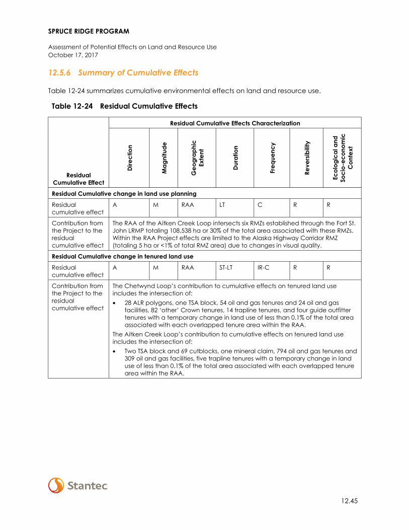
SPRUCE RIDGE PROGRAM
Assessment of Potential Effects on Land and Resource Use October 17, 2017
12.45
12.5.6 Summary of Cumulative Effects
Table 12-24 summarizes cumulative environmental effects on land and resource use.
Table 12-24 Residual Cumulative Effects
Residual Cumulative Effect
Residual Cumulative Effects Characterization Di
rect
ion
Mag
nitu
de
Geo
grap
hic
Exte
nt
Dura
tion
Freq
uenc
y
Reve
rsib
ility
Ecol
ogic
al a
nd
Soci
o-ec
onom
ic
Con
text
Residual Cumulative change in land use planning
Residual cumulative effect
A M RAA LT C R R
Contribution from the Project to the residual cumulative effect
The RAA of the Aitken Creek Loop intersects six RMZs established through the Fort St. John LRMP totaling 108,538 ha or 30% of the total area associated with these RMZs. Within the RAA Project effects are limited to the Alaska Highway Corridor RMZ (totaling 5 ha or <1% of total RMZ area) due to changes in visual quality.
Residual Cumulative change in tenured land use
Residual cumulative effect
A M RAA ST-LT IR-C R R
Contribution from the Project to the residual cumulative effect
The Chetwynd Loop’s contribution to cumulative effects on tenured land use includes the intersection of: • 28 ALR polygons, one TSA block, 54 oil and gas tenures and 24 oil and gas
facilities, 82 ‘other’ Crown tenures, 14 trapline tenures, and four guide outfitter tenures with a temporary change in land use of less than 0.1% of the total area associated with each overlapped tenure area within the RAA.
The Aitken Creek Loop’s contribution to cumulative effects on tenured land use includes the intersection of: • Two TSA block and 69 cutblocks, one mineral claim, 794 oil and gas tenures and
309 oil and gas facilities, five trapline tenures with a temporary change in land use of less than 0.1% of the total area associated with each overlapped tenure area within the RAA.
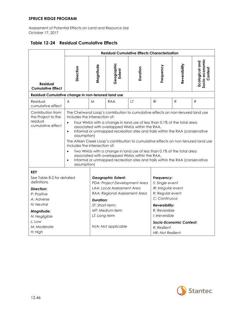
SPRUCE RIDGE PROGRAM
Assessment of Potential Effects on Land and Resource Use October 17, 2017
12.46
Table 12-24 Residual Cumulative Effects
Residual Cumulative Effect
Residual Cumulative Effects Characterization
Dire
ctio
n
Mag
nitu
de
Geo
grap
hic
Exte
nt
Dura
tion
Freq
uenc
y
Reve
rsib
ility
Ecol
ogic
al a
nd
Soci
o-ec
onom
ic
Con
text
Residual Cumulative change in non-tenured land use
Residual cumulative effect
A M RAA LT IR R R
Contribution from the Project to the residual cumulative effect
The Chetwynd Loop’s contribution to cumulative effects on non-tenured land use includes the intersection of: • Four WMUs with a change in land use of less than 0.1% of the total area
associated with overlapped WMUs within the RAA. • Informal or unmapped recreation sites and trails within the RAA (conservative
assumption) The Aitken Creek Loop’s contribution to cumulative effects on non-tenured land use includes the intersection of: • Two WMUs with a change in land use of less than 0.1% of the total area
associated with overlapped WMUs within the RAA. • Informal or unmapped recreation sites and trails within the RAA (conservative
assumption)
KEY See Table 8-2 for detailed definitions
Direction: P: Positive A: Adverse N: Neutral
Magnitude: N: Negligible L: Low M: Moderate H: High
Geographic Extent: PDA: Project Development Area LAA: Local Assessment Area RAA: Regional Assessment Area
Duration: ST: Short-term; MT: Medium-term LT: Long-term N/A: Not applicable
Frequency: S: Single event IR: Irregular event R: Regular event C: Continuous
Reversibility: R: Reversible I: Irreversible
Socio-Economic Context: R: Resilient NR: Not Resilient
SPRUCE RIDGE PROGRAM
Assessment of Potential Effects on Land and Resource Use October 17, 2017
12.47
12.6 DETERMINATION OF SIGNIFICANCE
12.6.1 Significance of Residual Effects
With the application of recommended mitigation measures, Project-specific residual effects on Land and Resource Use during construction and operation are predicted to be not significant. Project activities and physical works will comply with established land use plans and policies. With the application of mitigation measures, adverse residual effects are not anticipated to create a change or disruption that restricts or degrades present land use capability to a point where tenured or non-tenured activities cannot continue at or near current levels and where compensation is not possible.
The confidence in the conclusions made in this assessment is a function of the quality and quantity of baseline data, level of understanding of the effect mechanisms, assumptions made, and effectiveness of mitigation measures. There is an understood margin of error in spatial overlap and intersect data due to rounding. Because the significance conclusions made regarding residual effects on land and resource use are based on imperfect data and uncertainty, conclusions are made with a moderate level of confidence.
12.6.2 Significance of Cumulative Effects
Considering the Project’s minor contribution to cumulative effects within a regional context and with the application of mitigation measures, cumulative residual effects on Land and Resource Use during construction and operation are predicted to be not significant. The Project’s contribution to adverse cumulative effects is not anticipated to create a change or disruption that restricts or degrades present tenured or non-tenured land use capability to a point where activities cannot continue at or near current levels and where compensation is not possible. Project activities comply with established land use plans and policies (i.e., management directions for the Alaska Highway Corridor RMZ - the Dawson Creek LRMP).
In addition to the uncertainty noted above, there is also uncertainty regarding how many of the projects in the cumulative case will proceed. Because the significance conclusions made regarding cumulative effects on land and resource se are based on uncertainty, conclusions are made with a low to moderate level of confidence.
12.7 FOLLOW-UP AND MONITORING
With the implementation of standard mitigation measures and BMPs the potential adverse effects of Project activities on infrastructure and services are expected to be not significant. No follow-up programs are proposed.
SPRUCE RIDGE PROGRAM
Assessment of Potential Effects on Infrastructure and Services October 17, 2017
13.1
13 ASSESSMENT OF POTENTIAL EFFECTS ON INFRASTRUCTURE AND SERVICES
13.1 SCOPE OF ASSESSMENT
This section defines and describes the scope of the assessment of potential effects on Infrastructure and Services. This VC was selected because Project activities, including traffic and the presence of non-resident workers, could place increased demands on local services and infrastructure, such as accommodation, health, policing, firefighting, ambulance, and transportation.
13.1.1 Regulatory and Policy Setting
The scope of this section takes into consideration Table A-3 of the NEB Filing Manual (NEB 2017), which provides filing requirements and guidance for assessing socio-economic elements, including infrastructure and services. This section of the ESA focuses on those components identified in Table A-3 for Infrastructure and Services, except for the following:
• Railways are covered under other Crown tenures in Section 12 (Land and Resource Use) • Adverse effects on navigation and navigation safety; the Project is not anticipated to have
an interaction with navigation and navigation safety (see Table 4-1) • Recreation, powerlines, or potentially affected facilities; these are addressed in Section 12
(Land and Resource Use) • In addition to regulatory requirements, the assessment scope also reflects:
− The potential size (magnitude) and likely duration of Project effects − Experience of Westcoast with similar projects in the past, including mitigation and
management measures undertaken − The professional judgment of the assessment practitioners
13.1.2 Potential Effects, Pathways and Measurable Parameters
Potential effects of the Project were identified through public and regulatory consultations with stakeholders, past experience, and professional judgment. During the preparation of this assessment, Westcoast notified the First Nations and Métis communities listed in Section 3.2.2 regarding areas that could be affected by the Project.
Table 13-1 summarizes the potential effects, measurable parameters, and rationale for selection of the Infrastructure and Services VC. Measurable parameters were selected to provide a means of qualitatively assessing the expected change to existing socio-economic conditions.
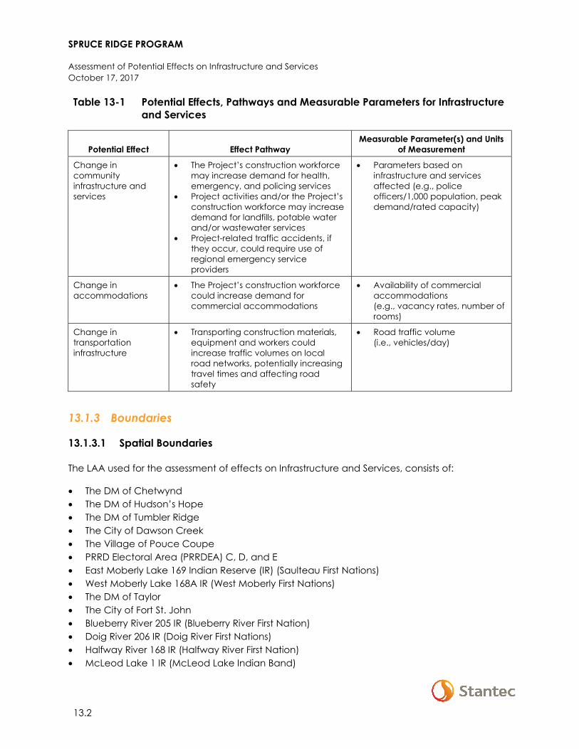
SPRUCE RIDGE PROGRAM
Assessment of Potential Effects on Infrastructure and Services October 17, 2017
13.2
Table 13-1 Potential Effects, Pathways and Measurable Parameters for Infrastructure and Services
Potential Effect Effect Pathway Measurable Parameter(s) and Units
of Measurement
Change in community infrastructure and services
• The Project’s construction workforce may increase demand for health, emergency, and policing services
• Project activities and/or the Project’s construction workforce may increase demand for landfills, potable water and/or wastewater services
• Project-related traffic accidents, if they occur, could require use of regional emergency service providers
• Parameters based on infrastructure and services affected (e.g., police officers/1,000 population, peak demand/rated capacity)
Change in accommodations
• The Project’s construction workforce could increase demand for commercial accommodations
• Availability of commercial accommodations (e.g., vacancy rates, number of rooms)
Change in transportation infrastructure
• Transporting construction materials, equipment and workers could increase traffic volumes on local road networks, potentially increasing travel times and affecting road safety
• Road traffic volume (i.e., vehicles/day)
13.1.3 Boundaries
13.1.3.1 Spatial Boundaries
The LAA used for the assessment of effects on Infrastructure and Services, consists of:
• The DM of Chetwynd • The DM of Hudson’s Hope • The DM of Tumbler Ridge • The City of Dawson Creek • The Village of Pouce Coupe • PRRD Electoral Area (PRRDEA) C, D, and E • East Moberly Lake 169 Indian Reserve (IR) (Saulteau First Nations) • West Moberly Lake 168A IR (West Moberly First Nations) • The DM of Taylor • The City of Fort St. John • Blueberry River 205 IR (Blueberry River First Nation) • Doig River 206 IR (Doig River First Nations) • Halfway River 168 IR (Halfway River First Nation) • McLeod Lake 1 IR (McLeod Lake Indian Band)
SPRUCE RIDGE PROGRAM
Assessment of Potential Effects on Infrastructure and Services October 17, 2017
13.3
All project components (i.e., the Chetwynd Loop, Aitken Creek Loop, CS2 Expansion, CSN5 Expansion, and C216 Modification) are included in the LAA for Infrastructure and Services.
The RAA is the same as the LAA, which encompasses a broad area suitable for assessing cumulative effects, as well as Project effects.
13.1.3.2 Temporal Boundaries
Subject to regulatory approval and seasonal limitations on the timing of construction and other activities, Table 2-3 outlines the planned timing of key Project activities.
Table 13-2 Planned Project Schedule
Project Phase Proposed Schedule 1
Construction July 2018–August 2019
Commissioning June–August 2019
Clean-up and Reclamation Following construction and fall 2019
In-Service Date August 2019
NOTE: 1 Subject to regulatory approval and seasonal limitations.
The Project is planned to have an operational life of at least 25 years. Decommissioning and abandonment will occur following the end of the operational life of the Project, and is not included in this assessment.
13.1.4 Residual Effects Characterization
Table 8-2 presents the criteria that are applied to characterize residual effects on infrastructure and services.
Table 13-3 Characterization of Residual Effects on Infrastructure and Services
Characterization Description Quantitative Measure or Definition of Qualitative
Categories
Direction The long-term trend of the residual effect
Positive – a residual effect that is beneficial to infrastructure and services relative to baseline. Adverse – a residual effect that is detrimental to infrastructure and services relative to baseline. Neutral – no net change in the effect for infrastructure and services relative to baseline.
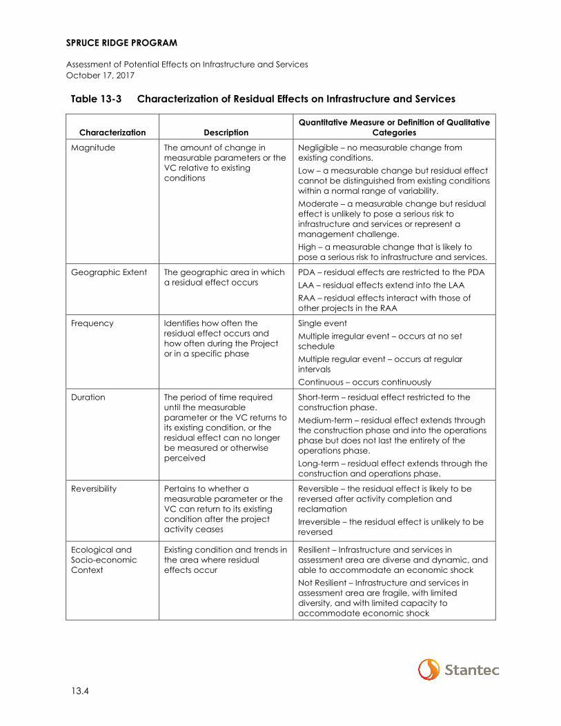
SPRUCE RIDGE PROGRAM
Assessment of Potential Effects on Infrastructure and Services October 17, 2017
13.4
Table 13-3 Characterization of Residual Effects on Infrastructure and Services
Characterization Description Quantitative Measure or Definition of Qualitative
Categories
Magnitude The amount of change in measurable parameters or the VC relative to existing conditions
Negligible – no measurable change from existing conditions. Low – a measurable change but residual effect cannot be distinguished from existing conditions within a normal range of variability. Moderate – a measurable change but residual effect is unlikely to pose a serious risk to infrastructure and services or represent a management challenge. High – a measurable change that is likely to pose a serious risk to infrastructure and services.
Geographic Extent The geographic area in which a residual effect occurs
PDA – residual effects are restricted to the PDA LAA – residual effects extend into the LAA RAA – residual effects interact with those of other projects in the RAA
Frequency Identifies how often the residual effect occurs and how often during the Project or in a specific phase
Single event Multiple irregular event – occurs at no set schedule Multiple regular event – occurs at regular intervals Continuous – occurs continuously
Duration The period of time required until the measurable parameter or the VC returns to its existing condition, or the residual effect can no longer be measured or otherwise perceived
Short-term – residual effect restricted to the construction phase. Medium-term – residual effect extends through the construction phase and into the operations phase but does not last the entirety of the operations phase. Long-term – residual effect extends through the construction and operations phase.
Reversibility Pertains to whether a measurable parameter or the VC can return to its existing condition after the project activity ceases
Reversible – the residual effect is likely to be reversed after activity completion and reclamation Irreversible – the residual effect is unlikely to be reversed
Ecological and Socio-economic Context
Existing condition and trends in the area where residual effects occur
Resilient – Infrastructure and services in assessment area are diverse and dynamic, and able to accommodate an economic shock Not Resilient – Infrastructure and services in assessment area are fragile, with limited diversity, and with limited capacity to accommodate economic shock
SPRUCE RIDGE PROGRAM
Assessment of Potential Effects on Infrastructure and Services October 17, 2017
13.5
13.1.5 Significance Definition
A significant adverse residual effect occurs when there is an exceedance of available capacity, or a substantial decrease in the quality of a service provided, on a persistent and ongoing basis, which cannot be mitigated with current or anticipated programs, policies, or mitigation measures.
13.2 BASELINE CONDITIONS FOR INFRASTRUCTURE AND SERVICES
This section first describes the methods used to identify baseline conditions, and then provides an overview of the baseline conditions for infrastructure and services. In the context of the socio-economic assessment, “baseline” is used rather than “existing”, as the most current data (e.g., Statistics Canada Census population data, infrastructure capacity reports, and service utilization statistics) range from 2011 through 2017, and therefore do not necessarily represent “existing” conditions.
13.2.1 Methods
The description of baseline conditions was primarily based upon data from Statistics Canada, specifically the 2011 and 2016 Censuses of the Population (Censuses) and 2011 National Household Survey (NHS). Information presented for the LAA/RAA and Aboriginal populations are underrepresented, as 2011 NHS and 2011 NHS Aboriginal Profile data are not available for all census subdivisions (see Section 15.1.4.3). 2016 Census information on Aboriginal persons and labour was not available at the time of writing (data will become available October 25 and November 29, 2017 respectively). The description of baseline conditions is also based upon data obtained from a variety of other sources, including:
• Police resource information obtained from the BC Ministry of Justice – Police Services Division • Traffic volume data obtained from the BC MOTI • Provincial Health Services Authority • Industry sources, including hotel and motel accommodation data • Phone interviews with managers of commercial accommodations located in Fort St. John
and Chetwynd
Additional information for Aboriginal and non-Aboriginal communities was collected from a review of recent local and regional reports and community profiles from government agencies, municipalities, websites, and various economic and social profiles of communities. Information was also gathered from publicly available independent socio-economic assessments of projects within the LAA/RAA.
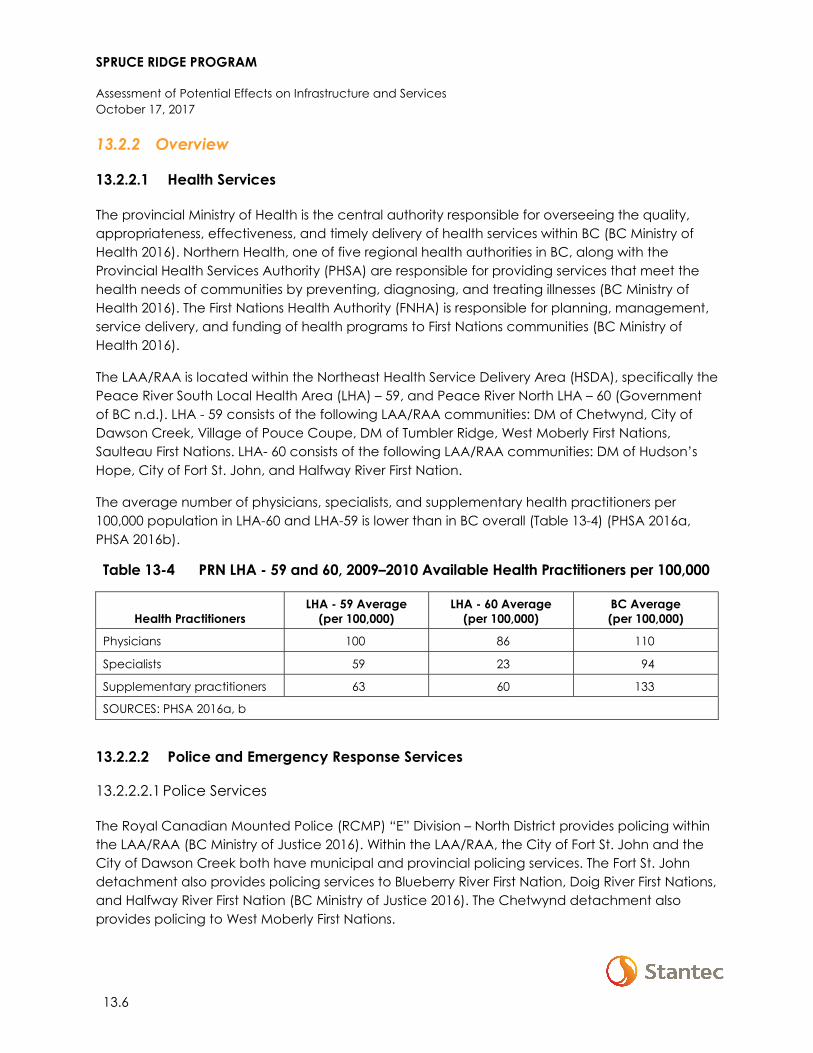
SPRUCE RIDGE PROGRAM
Assessment of Potential Effects on Infrastructure and Services October 17, 2017
13.6
13.2.2 Overview
13.2.2.1 Health Services
The provincial Ministry of Health is the central authority responsible for overseeing the quality, appropriateness, effectiveness, and timely delivery of health services within BC (BC Ministry of Health 2016). Northern Health, one of five regional health authorities in BC, along with the Provincial Health Services Authority (PHSA) are responsible for providing services that meet the health needs of communities by preventing, diagnosing, and treating illnesses (BC Ministry of Health 2016). The First Nations Health Authority (FNHA) is responsible for planning, management, service delivery, and funding of health programs to First Nations communities (BC Ministry of Health 2016).
The LAA/RAA is located within the Northeast Health Service Delivery Area (HSDA), specifically the Peace River South Local Health Area (LHA) – 59, and Peace River North LHA – 60 (Government of BC n.d.). LHA - 59 consists of the following LAA/RAA communities: DM of Chetwynd, City of Dawson Creek, Village of Pouce Coupe, DM of Tumbler Ridge, West Moberly First Nations, Saulteau First Nations. LHA- 60 consists of the following LAA/RAA communities: DM of Hudson’s Hope, City of Fort St. John, and Halfway River First Nation.
The average number of physicians, specialists, and supplementary health practitioners per 100,000 population in LHA-60 and LHA-59 is lower than in BC overall (Table 13-4) (PHSA 2016a, PHSA 2016b).
Table 13-4 PRN LHA - 59 and 60, 2009–2010 Available Health Practitioners per 100,000
Health Practitioners LHA - 59 Average
(per 100,000) LHA - 60 Average
(per 100,000) BC Average (per 100,000)
Physicians 100 86 110
Specialists 59 23 94
Supplementary practitioners 63 60 133
SOURCES: PHSA 2016a, b
13.2.2.2 Police and Emergency Response Services
13.2.2.2.1 Police Services
The Royal Canadian Mounted Police (RCMP) “E” Division – North District provides policing within the LAA/RAA (BC Ministry of Justice 2016). Within the LAA/RAA, the City of Fort St. John and the City of Dawson Creek both have municipal and provincial policing services. The Fort St. John detachment also provides policing services to Blueberry River First Nation, Doig River First Nations, and Halfway River First Nation (BC Ministry of Justice 2016). The Chetwynd detachment also provides policing to West Moberly First Nations.
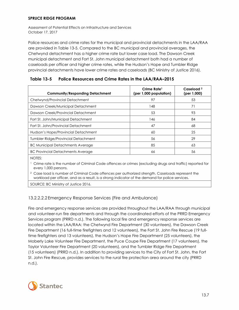
SPRUCE RIDGE PROGRAM
Assessment of Potential Effects on Infrastructure and Services October 17, 2017
13.7
Police resources and crime rates for the municipal and provincial detachments in the LAA/RAA are provided in Table 13-5. Compared to the BC municipal and provincial averages, the Chetwynd detachment has a higher crime rate but lower case load. The Dawson Creek municipal detachment and Fort St. John municipal detachment both had a number of caseloads per officer and higher crime rates, while the Hudson’s Hope and Tumbler Ridge provincial detachments have lower crime rates and caseloads (BC Ministry of Justice 2016).
Table 13-5 Police Resources and Crime Rates in the LAA/RAA–2015
Community/Responding Detachment Crime Rate1
(per 1,000 population) Caseload 2
(per 1,000)
Chetwynd/Provincial Detachment 97 53
Dawson Creek/Municipal Detachment 148 71
Dawson Creek/Provincial Detachment 53 93
Fort St. John/Municipal Detachment 146 84
Fort St. John/Provincial Detachment 47 68
Hudson’s Hope/Provincial Detachment 60 25
Tumbler Ridge/Provincial Detachment 56 29
BC Municipal Detachments Average 85 63
BC Provincial Detachments Average 66 56
NOTES: 1 Crime rate is the number of Criminal Code offences or crimes (excluding drugs and traffic) reported for
every 1,000 persons. 2 Case load is number of Criminal Code offences per authorized strength. Caseloads represent the
workload per officer, and as a result, is a strong indicator of the demand for police services.
SOURCE: BC Ministry of Justice 2016.
13.2.2.2.2 Emergency Response Services (Fire and Ambulance)
Fire and emergency response services are provided throughout the LAA/RAA through municipal and volunteer-run fire departments and through the coordinated efforts of the PRRD Emergency Services program (PRRD n.d.). The following local fire and emergency response services are located within the LAA/RAA: the Chetwynd Fire Department (30 volunteers), the Dawson Creek Fire Department (16 full-time firefighters and 12 volunteers), the Fort St. John Fire Rescue (19 full-time firefighters and 13 volunteers), the Hudson’s Hope Fire Department (25 volunteers), the Moberly Lake Volunteer Fire Department, the Puce Coupe Fire Department (17 volunteers), the Taylor Volunteer Fire Department (20 volunteers), and the Tumbler Ridge Fire Department (15 volunteers) (PRRD n.d.). In addition to providing services to the City of Fort St. John, the Fort St. John Fire Rescue, provides services to the rural fire protection area around the city (PRRD n.d.).

SPRUCE RIDGE PROGRAM
Assessment of Potential Effects on Infrastructure and Services October 17, 2017
13.8
The LAA/RAA is located within the northeast boundary of the BC Emergency Health Services (BCEHS) administrative area (BCEHS n.d.). The BCEHS provides pre-hospital emergency medical services and inter-facility patient transfer and transport services under three agencies: the BC Patient Transfer Network, Trauma Services BC, and BC Ambulance Services (BCAS) (BCEHS 2015a, b).
The PRRD tracks 9-1-1 calls (including RCMP, BC Ambulance, and fire dispatch related calls) for all the communities located in the LAA/RAA (PRRD n.d.). In 2014, 9-1-1 call volumes showed a 6% increase from 2013 for a total of 17,736 calls, and a decrease of 6% from 2012 (PRRD n.d.). The RCMP saw a 4% increase from 2013-2014, but an overall decrease of 11% from 2012–2014. BC Ambulance calls increased 7% from 2013–2014 and 4% 2012-2014 (PRRD 2015a).
13.2.2.3 Landfills, and Potable Water and Wastewater Services
13.2.2.3.1 Landfills
There are three landfills in the LAA/RAA, one in the DM of Chetwynd, one in Bessborough, and one in the City of Fort St. John known as the North Peace Regional Landfill. All three are operated by the PRRD. The remaining capacity as of 2016 is 87,337 m3 at Chetwynd Landfill, 1,962,400 m3 at Bessborough Landfill and 1,414,800 m3 at the North Peace Regional Landfill (PRRD pers. comm. 2017). A new fill plan quantified a lifespan of the North Peace Regional Landfill extending to approximately 2050 (PRRD 2015b). The Chetwynd Landfill has 9–12 years capacity remaining and will undergo a progressive closure over this time period (PRRD 2015b). The Bessborough Landfill has over 100 years’ lifespan remaining and will undergo planned and as needed operational capacity upgrades (PRRD 2015b). PRRD landfills do not accept liquid waste, hazardous waste, smoldering ashes, oil, gas or industrial waste (PRRD 2017).
13.2.2.3.2 Potable Water and Wastewater Services
The DM of Chetwynd’s primary source of water is the Pine River, providing up to 95% of all municipal water use (DM of Chetwynd 2012). Raw water reservoirs provide a total storage of 44 million gallons, which accounts for approximately 60 days of water supply. A secondary well provides additional capacity (5%) during times of high turbidity levels in the Pine River (DM of Chetwynd 2012).
Within Fort St. John, there are five wells that are sealed and covered (Fort St. John n.d.). Using a High Lift Pump Station, the wells are pumped through 11 km of pipeline to the City of Fort St. John’s Water Treatment Facility with an average flow of 9,000 m3 per day (Fort St. John n.d.). There are two treated water reservoirs, a 6.8 million litre reservoir located at 106th Avenue and 106th Street with an average turnover of 18 hours, and a 36.4 million litre reservoir located at the East Bypass Road and 112th Avenue with an average turnover of four days (Fort St. John n.d.).
The wastewater lagoon treatment facility located in Chetwynd is aging and will undergo infrastructure upgrades following funding allocation from the provincial and federal governments (Infrastructure Canada 2015). Upgrades will help reduce the quantity and improve
SPRUCE RIDGE PROGRAM
Assessment of Potential Effects on Infrastructure and Services October 17, 2017
13.9
the quality of treated water flowing into the Pine River, and will verify that the system complies with current wastewater treatment standards and requirements (Infrastructure Canada 2015). Within the City of Fort St. John, sewage is collected through underground pipes and flows using gravity and pump stations to treatment lagoons on the north and south sides of the city (St. Fort John n.d.).
13.2.2.4 Commercial Accommodations
As of September 2017, there were approximately 16 hotels/motels in the City of Fort St. John with more than 1,400 total rooms, 15 in the City of Dawson Creek with more than 860 total rooms, 10 in the DM of Chetwynd with more than 365 total rooms, four in the DM of Hudson’s Hope with 157 total rooms, three in the DM of Tumbler Ridge with more than 152 total rooms, and one each in the DM of Taylor, the Village of Pouce Coupe, and West Moberly First Nation with an unknown number of rooms (BC Stats 2010, Destination BC Corporation 2015; Expedia.ca 2017; Anonymous pers. comm. 2017a; Anonymous pers. comm. 2017b).
Utilization of commercial accommodations varies depending on the oil and gas and infrastructure projects active within the LAA/RAA (Anonymous pers. comm. 2017a; Anonymous pers. comm. 2017b). The fluctuation in the oil and gas industry and proximity to construction projects affects the demand in commercial accommodations; and capacity does not typically fluctuate with the tourism seasons (Anonymous pers. comm. 2017a; Anonymous pers. comm. 2017b). Typically, accommodations are busier in the winter months (from October to January) with approximately 60-70% occupancy (Sales Manager Pomeroy Lodging pers. comm.) For the remainder of the year, accommodations typically have around 30-40% occupancy (Sales Manager Pomeroy Lodging pers. comm.). Despite occupancy rates, the availability of affordable commercial accommodations within the LAA/RAA is a noted concern of stakeholders, with periods of very limited to no occupancy reported during all months of the year.
13.2.2.5 Transportation
Highways within the LAA/RAA include Highways 29, 97, 52 and 2. Highway 97 connects the DM of Chetwynd with the City of Dawson Creek. From the City of Dawson Creek, Highway 97 continues north to the DM of Taylor and the City of Fort St. John. Highway 29 connects Chetwynd with Saulteau First Nations, West Moberly First Nations, Hudson’s Hope and the City of Fort St. John. To the south, Highway 29 connects Chetwynd with Tumbler Ridge. West of the City of Dawson Creek, Highway 52 connects Highway 97 with Tumbler Ridge. Highway 2 connects the City of Dawson Creek with the Village of Pouce Coupe. Class ratings based on average daily traffic (ADT) and winter average daily count (WADC), which designate the type and level of maintenance service to be provided, for these highways is summarized in Table 13-6.
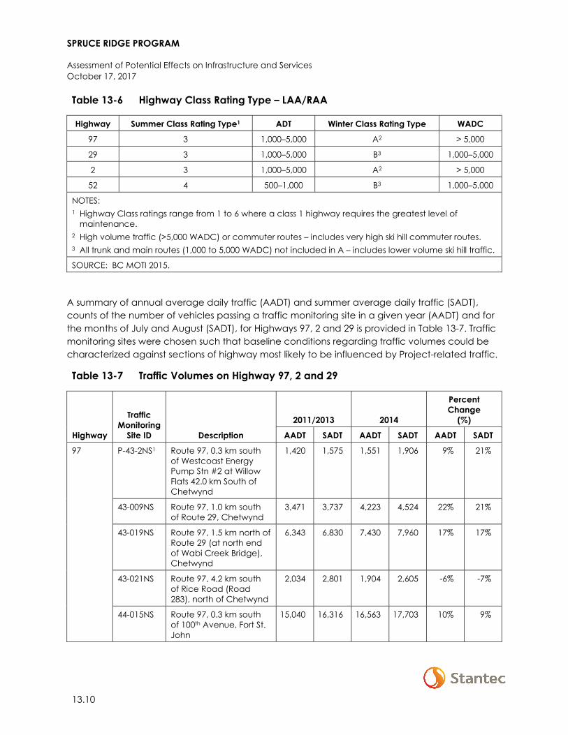
SPRUCE RIDGE PROGRAM
Assessment of Potential Effects on Infrastructure and Services October 17, 2017
13.10
Table 13-6 Highway Class Rating Type – LAA/RAA
Highway Summer Class Rating Type1 ADT Winter Class Rating Type WADC
97 3 1,000–5,000 A2 > 5,000
29 3 1,000–5,000 B3 1,000–5,000
2 3 1,000–5,000 A2 > 5,000
52 4 500–1,000 B3 1,000–5,000
NOTES: 1 Highway Class ratings range from 1 to 6 where a class 1 highway requires the greatest level of
maintenance. 2 High volume traffic (>5,000 WADC) or commuter routes – includes very high ski hill commuter routes. 3 All trunk and main routes (1,000 to 5,000 WADC) not included in A – includes lower volume ski hill traffic.
SOURCE: BC MOTI 2015.
A summary of annual average daily traffic (AADT) and summer average daily traffic (SADT), counts of the number of vehicles passing a traffic monitoring site in a given year (AADT) and for the months of July and August (SADT), for Highways 97, 2 and 29 is provided in Table 13-7. Traffic monitoring sites were chosen such that baseline conditions regarding traffic volumes could be characterized against sections of highway most likely to be influenced by Project-related traffic.
Table 13-7 Traffic Volumes on Highway 97, 2 and 29
Highway
Traffic Monitoring
Site ID Description
2011/2013 2014
Percent Change
(%)
AADT SADT AADT SADT AADT SADT
97 P-43-2NS1 Route 97, 0.3 km south of Westcoast Energy Pump Stn #2 at Willow Flats 42.0 km South of Chetwynd
1,420 1,575 1,551 1,906 9% 21%
43-009NS Route 97, 1.0 km south of Route 29, Chetwynd
3,471 3,737 4,223 4,524 22% 21%
43-019NS Route 97, 1.5 km north of Route 29 (at north end of Wabi Creek Bridge), Chetwynd
6,343 6,830 7,430 7,960 17% 17%
43-021NS Route 97, 4.2 km south of Rice Road (Road 283), north of Chetwynd
2,034 2,801 1,904 2,605 -6% -7%
44-015NS Route 97, 0.3 km south of 100th Avenue, Fort St. John
15,040 16,316 16,563 17,703 10% 9%
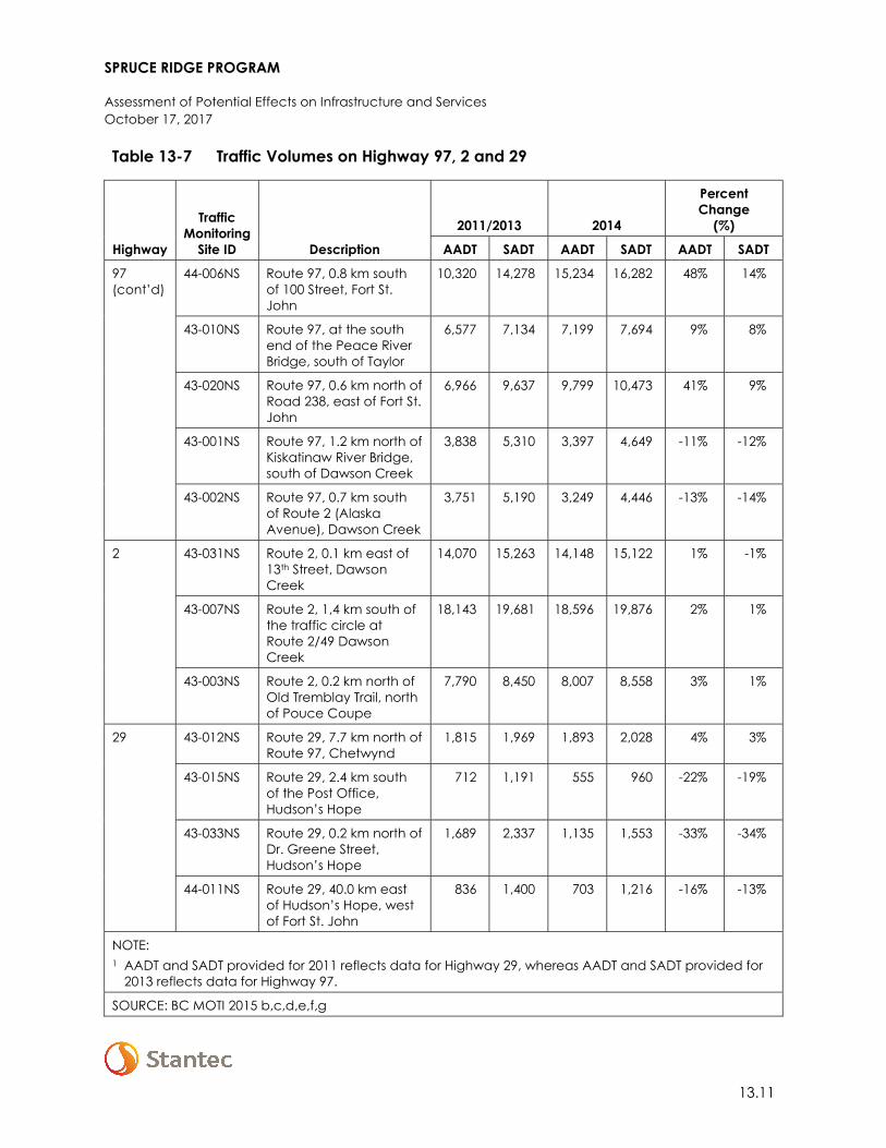
SPRUCE RIDGE PROGRAM
Assessment of Potential Effects on Infrastructure and Services October 17, 2017
13.11
Table 13-7 Traffic Volumes on Highway 97, 2 and 29
Highway
Traffic Monitoring
Site ID Description
2011/2013 2014
Percent Change
(%)
AADT SADT AADT SADT AADT SADT
97 (cont’d)
44-006NS Route 97, 0.8 km south of 100 Street, Fort St. John
10,320 14,278 15,234 16,282 48% 14%
43-010NS Route 97, at the south end of the Peace River Bridge, south of Taylor
6,577 7,134 7,199 7,694 9% 8%
43-020NS Route 97, 0.6 km north of Road 238, east of Fort St. John
6,966 9,637 9,799 10,473 41% 9%
43-001NS Route 97, 1.2 km north of Kiskatinaw River Bridge, south of Dawson Creek
3,838 5,310 3,397 4,649 -11% -12%
43-002NS Route 97, 0.7 km south of Route 2 (Alaska Avenue), Dawson Creek
3,751 5,190 3,249 4,446 -13% -14%
2 43-031NS Route 2, 0.1 km east of 13th Street, Dawson Creek
14,070 15,263 14,148 15,122 1% -1%
43-007NS Route 2, 1,4 km south of the traffic circle at Route 2/49 Dawson Creek
18,143 19,681 18,596 19,876 2% 1%
43-003NS Route 2, 0.2 km north of Old Tremblay Trail, north of Pouce Coupe
7,790 8,450 8,007 8,558 3% 1%
29 43-012NS Route 29, 7.7 km north of Route 97, Chetwynd
1,815 1,969 1,893 2,028 4% 3%
43-015NS Route 29, 2.4 km south of the Post Office, Hudson’s Hope
712 1,191 555 960 -22% -19%
43-033NS Route 29, 0.2 km north of Dr. Greene Street, Hudson’s Hope
1,689 2,337 1,135 1,553 -33% -34%
44-011NS Route 29, 40.0 km east of Hudson’s Hope, west of Fort St. John
836 1,400 703 1,216 -16% -13%
NOTE: 1 AADT and SADT provided for 2011 reflects data for Highway 29, whereas AADT and SADT provided for
2013 reflects data for Highway 97.
SOURCE: BC MOTI 2015 b,c,d,e,f,g
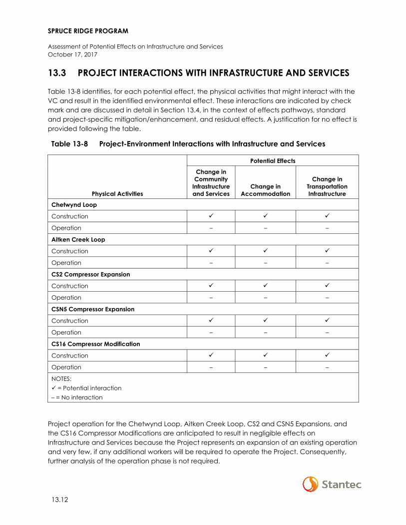
SPRUCE RIDGE PROGRAM
Assessment of Potential Effects on Infrastructure and Services October 17, 2017
13.12
13.3 PROJECT INTERACTIONS WITH INFRASTRUCTURE AND SERVICES
Table 13-8 identifies, for each potential effect, the physical activities that might interact with the VC and result in the identified environmental effect. These interactions are indicated by check mark and are discussed in detail in Section 13.4, in the context of effects pathways, standard and project-specific mitigation/enhancement, and residual effects. A justification for no effect is provided following the table.
Table 13-8 Project-Environment Interactions with Infrastructure and Services
Physical Activities
Potential Effects
Change in Community
Infrastructure and Services
Change in Accommodation
Change in Transportation Infrastructure
Chetwynd Loop
Construction
Operation – – –
Aitken Creek Loop
Construction
Operation – – –
CS2 Compressor Expansion
Construction
Operation – – –
CSN5 Compressor Expansion
Construction
Operation – – –
CS16 Compressor Modification
Construction
Operation – – –
NOTES: = Potential interaction – = No interaction
Project operation for the Chetwynd Loop, Aitken Creek Loop, CS2 and CSN5 Expansions, and the CS16 Compressor Modifications are anticipated to result in negligible effects on Infrastructure and Services because the Project represents an expansion of an existing operation and very few, if any additional workers will be required to operate the Project. Consequently, further analysis of the operation phase is not required.
SPRUCE RIDGE PROGRAM
Assessment of Potential Effects on Infrastructure and Services October 17, 2017
13.13
13.4 ASSESSMENT OF RESIDUAL EFFECTS ON INFRASTRUCTURE AND SERVICES
The assessment of potential effects on infrastructure and services considers changes in community infrastructure and services, accommodations, and transportation infrastructure and services resulting from Project interactions. This section first describes the analytical assessment techniques used in the assessment, followed by the Project effect pathways, applicable mitigation measures, and characterization and likelihood of residual effects for each Project effect.
13.4.1 Change in Community Infrastructure and Services
13.4.1.1 Analytical Assessment Techniques
Potential effects on community infrastructure and services, as well as health care infrastructure and services, were determined by estimating potential additional demand associated with Project-related population change and/or direct Project requirements (e.g., Project demand for landfills because of waste generated onsite) based on appropriate ratios for each measurable parameter (e.g., police officers per 1,000 residents; sewer and wastewater capacity). This additional demand was then compared to available capacity, in consideration of local or provincial standards. Peak and average workforce estimates used in the analysis are provided in the following subsection.
13.4.1.1.1 Workforce Estimates
Established in Section 14 (Employment and Economy), the peak construction workforce associated with the Chetwynd Loop is estimated at 448 persons (summer) of which 27% or 120 persons are associated with compressor station-related work. The peak construction workforce associated with the Aitken Loop is estimated at 300 persons (winter). Peak construction workforces will be sustained for six weeks. The approximately daily average workforce for both the Chetwynd Loop and Aitken Loop is estimated at 200 persons. Westcoast expects that approximately 58% (410 persons) of the peak construction workforce (roughly 710 persons; see Section 14.4.2.3.3.1) will be comprised of LAA/RAA residents with the remainder of the workforce comprised of residents from elsewhere in BC (18% or 126 persons) and Alberta (24% or 169 persons). At peak, the Project’s non-resident workforce (approximately 300 persons) would increase the population of the LAA/RAA by less than 0.5% (see Section 14.2.2.1 for baseline population information).
SPRUCE RIDGE PROGRAM
Assessment of Potential Effects on Infrastructure and Services October 17, 2017
13.14
13.4.1.2 Effect Pathways
Effect pathways for change in community infrastructure and services during Project construction are as follows:
• The Project’s construction workforce may increase demand for health, emergency, and policing services
• Project activities and/or the Project’s construction workforce may increase demand for landfills, potable water and/or wastewater services
• Project-related traffic accidents, if they occur, could require use of regional emergency service providers.
13.4.1.3 Mitigation
Standard industry practices and avoidance measures, as well as resource-specific mitigation will be implemented during construction and operation. Table 13-9 contains key mitigation measures for change in community infrastructure and services.
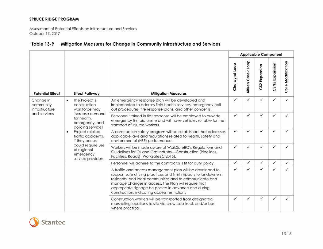
SPRUCE RIDGE PROGRAM
Assessment of Potential Effects on Infrastructure and Services October 17, 2017
13.15
Table 13-9 Mitigation Measures for Change in Community Infrastructure and Services
Potential Effect Effect Pathway Mitigation Measures
Applicable Component
Che
twyn
d Lo
op
Aitk
en C
reek
Loo
p
CS2
Exp
ansio
n
CSN
5 Ex
pans
ion
CS1
6 M
odifi
catio
n
Change in community infrastructure and services
• The Project’s construction workforce may increase demand for health, emergency, and policing services
• Project-related traffic accidents, if they occur, could require use of regional emergency service providers
An emergency response plan will be developed and implemented to address field health services, emergency call-out procedures, fire response plans, and other concerns.
Personnel trained in first response will be employed to provide emergency first aid onsite and will have vehicles suitable for the transport of injured workers.
A construction safety program will be established that addresses applicable laws and regulations related to health, safety and environmental (HSE) performance.
Workers will be made aware of WorkSafeBC’s Regulations and Guidelines for Oil and Gas Industry—Construction (Pipelines, Facilities, Roads) (WorkSafeBC 2015).
Personnel will adhere to the contractor’s fit for duty policy.
A traffic and access management plan will be developed to support safe driving practices and limit impacts to landowners, residents, and local communities and to communicate and manage changes in access. The Plan will require that appropriate signage be posted in advance and during construction, indicating access restrictions
Construction workers will be transported from designated marshaling locations to site via crew-cab truck and/or bus, where practical.
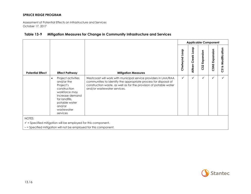
SPRUCE RIDGE PROGRAM
Assessment of Potential Effects on Infrastructure and Services October 17, 2017
13.16
Table 13-9 Mitigation Measures for Change in Community Infrastructure and Services
Potential Effect Effect Pathway Mitigation Measures
Applicable Component
Che
twyn
d Lo
op
Aitk
en C
reek
Loo
p
CS2
Exp
ansio
n
CSN
5 Ex
pans
ion
CS1
6 M
odifi
catio
n
• Project activities and/or the Project’s construction workforce may increase demand for landfills, potable water and/or wastewater services
Westcoast will work with municipal service providers in LAA/RAA communities to identify the appropriate process for disposal of construction waste, as well as for the provision of potable water and/or wastewater services.
NOTES: = Specified mitigation will be employed for this component. – = Specified mitigation will not be employed for this component.
SPRUCE RIDGE PROGRAM
Assessment of Potential Effects on Infrastructure and Services October 17, 2017
13.17
13.4.1.4 Residual Effect
The Project is predicted to have residual adverse effects on medical and emergency services due to potential motor vehicle and workplace incidents. Adverse residual effects on landfills and potable water and wastewater services due to increased demand from Project construction and the Project’s construction workforce are also predicted.
13.4.1.4.1 Medical and Emergency Services
Westcoast has a culture of conducting work in a safe and environmentally responsible manner. With health and safety being a core element of Westcoast’s management direction, health and safety-related engineering controls, programs and policies will meet or exceed legislative requirements. These measures reduce the likelihood and magnitude of workplace incidents and therefore increased demand on medical and emergency services. However, recognizing that workplace incidents may still arise, the assessment conservatively assumes that residual effects will occur.
Increased demand for medical and emergency services in the case of an accident could occur during construction-related activities and/or while workers are commuting between their home residences/lodgings and marshaling location (workers will be transported to site via bus and/or crew cab truck, where feasible). However, implementation of a traffic and access management plan, emergency response plan, consideration for on-site safety training and trained on-site safety attendants, will lower incremental demand. Similarly, increased demand on police and emergency response services could also occur through work-related accidents or injuries or in response to worker-local resident conflicts. However, implementation of Westcoast’s project-specific health and safety programs and fit for duty policy will reduce the likelihood of this occurring.
In consideration of the Project’s relatively small non-resident workforce (300 persons), short duration of construction (12 months), predicted change in population (0.5% at peak construction), and implementation of mitigation measures, increased demand from the Project on medical and emergency services will result in moderate magnitude adverse effects. Effects will occur irregularly over the short-term throughout the LAA/RAA and are reversible. Considering the high capacity utilization of health services and high case load of RCMP in the LAA/RAA (see Section 13.2.2.2 and Section 13.2.2.3) effects will occur within a non-resilient socio-economic context.
13.4.1.4.2 Landfills and Potable and Wastewater Services
Project construction has the potential to affect available landfill capacity from the disposal of waste debris associated with Project construction, and from the disposal of waste created by the non-resident workforce staying in commercial accommodations. Household waste from the non-resident workforce will be disposed at local landfills with sufficient capacity to handle Project needs. Waste generated during construction of the Chetwynd and Aitken Creek Loops and expansion and modification of compressor stations will be delivered to a landfill or transfer
SPRUCE RIDGE PROGRAM
Assessment of Potential Effects on Infrastructure and Services October 17, 2017
13.18
sites in the region. The capacity of waste disposal sites will be considered and if project needs are not easily accommodated, alternative disposal locations will be considered.
The non-resident workforce will also increase demand for potable water and waste water services while lodged and working within the LAA/RAA. Since no new working accommodations are proposed specific to the Project, increased demand associated with the lodging of these workers is already accounted for under existing peak occupancy-demand planning within the LAA/RAA.
Given the Project’s relatively small non-resident workforce (300 persons), short duration of construction (12 months), predicted change in population (0.5% at peak construction), and implementation of mitigation measures, increased demand from the Project on landfills, potable water and waste water services will result in low magnitude adverse effects. Effects will occur continuously over the short-term throughout the LAA/RAA and are reversible. Effects will occur within a resilient socio-economic context capable of absorbing increased demand.
13.4.2 Change in Accommodations
13.4.2.1 Analytical Assessment Techniques
Potential effects on accommodations were estimated by comparing the total available supply of commercial accommodations within the LAA/RAA with forecasted demand resulting from Project-related employment. Detailed information regarding Project-related employment is provided in Section 14 (Employment and Economy). Workforce estimates are summarized in Section 13.4.1.1.1.
13.4.2.2 Effect Pathways
Effect pathways for change in accommodations during Project construction are as follows:
• The Project’s construction workforce could increase demand for commercial accommodations.
13.4.2.3 Mitigation
Standard industry practices and avoidance measures, as well as resource-specific mitigation will be implemented during construction and operation. Table 13-10 contains key mitigation measures for change in accommodations.

SPRUCE RIDGE PROGRAM
Assessment of Potential Effects on Infrastructure and Services October 17, 2017
13.19
Table 13-10 Mitigation Measures for Change in Accommodations
Potential Effect Effect Pathway Mitigation Measures
Applicable Component
Che
twyn
d Lo
op
Aitk
en C
reek
Loo
p
CS2
Exp
ansio
n
CSN
5 Ex
pans
ion
CS1
6 M
odifi
catio
n
Change in accommodations
• The Project’s construction workforce could increase demand for commercial accommodations
A Worker Lodging Plan will be implemented to manage workforce accommodations during construction.
Westcoast will develop a Stakeholder Engagement Plan. The plan will facilitate communication channels with affected stakeholders over the operational life of the Project to resolve issues that may arise.
NOTES: = Specified mitigation will be employed for this component. – = Specified mitigation will not be employed for this component.
SPRUCE RIDGE PROGRAM
Assessment of Potential Effects on Infrastructure and Services October 17, 2017
13.20
13.4.2.4 Residual Effect
Currently, Westcoast plans to lodge the non-resident construction workforce in commercial accommodations (e.g., hotels, motels, and rental homes) in the LAA/RAA and in existing camp facilities near Wonowon BC (located along Highway 97). Demand for commercial accommodations within the LAA/RAA is largely dependent on current oil and gas projects. Given the availability of more than 2,934 rooms and an occupancy rate of 60-70% duration, between 880 and 1,173 rooms may be available, which far exceeds the estimated peak demand by non-resident Project workers of 300 rooms. Westcoast is also considering the use of existing camps near Wonowon to house construction workers associated with the Aitken Creek Loop. If workers are housed in camp facilities near Wonowon, then the demand for other commercial accommodations by non-resident workers would drop to approximately 140 rooms.
In consideration of the mitigation measure included in Table 13-10, Project-related residual effects on commercial accommodations, while beneficial to operators of these facilities (i.e., increased revenues) will be adverse in terms of availability. Residual effects will be moderate in magnitude, and will extend into the LAA/RAA. Effects occur during the schedule of workforce turn-a-rounds, and are short-term and reversible. Residual effects will occur in a resilient socio-economic context given current occupancy rates.
13.4.3 Change in Transportation Infrastructure and Services
13.4.3.1 Analytical Assessment Techniques
Potential effects on transportation infrastructure were estimated by comparing Project-related traffic volumes at peak periods of construction with baseline conditions, information on traffic volume, and the capability of the existing road network to absorb additional demand.
13.4.3.2 Effect Pathways
Effect pathways for change in transportation infrastructure and services during Project construction are as follows:
• Transporting construction materials, equipment and workers could increase traffic volumes on local road networks, potentially increasing travel times and affecting road safety.
13.4.3.3 Mitigation
Standard industry practices and avoidance measures, as well as resource-specific mitigation will be implemented during construction and operation. Table 13-11 contains key mitigation measures for change in transportation infrastructure and services.
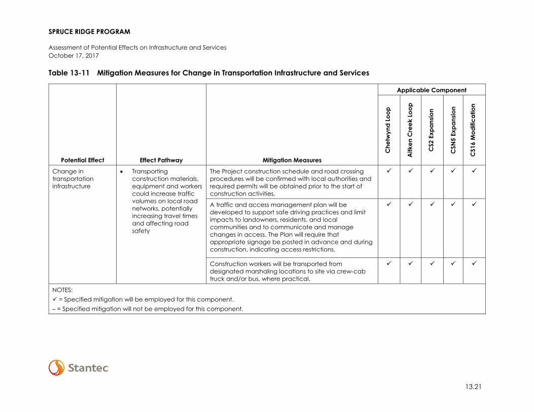
SPRUCE RIDGE PROGRAM
Assessment of Potential Effects on Infrastructure and Services October 17, 2017
13.21
Table 13-11 Mitigation Measures for Change in Transportation Infrastructure and Services
Potential Effect Effect Pathway Mitigation Measures
Applicable Component
Che
twyn
d Lo
op
Aitk
en C
reek
Loo
p
CS2
Exp
ansio
n
CSN
5 Ex
pans
ion
CS1
6 M
odifi
catio
n
Change in transportation infrastructure
• Transporting construction materials, equipment and workers could increase traffic volumes on local road networks, potentially increasing travel times and affecting road safety
The Project construction schedule and road crossing procedures will be confirmed with local authorities and required permits will be obtained prior to the start of construction activities.
A traffic and access management plan will be developed to support safe driving practices and limit impacts to landowners, residents, and local communities and to communicate and manage changes in access. The Plan will require that appropriate signage be posted in advance and during construction, indicating access restrictions.
Construction workers will be transported from designated marshaling locations to site via crew-cab truck and/or bus, where practical.
NOTES: = Specified mitigation will be employed for this component. – = Specified mitigation will not be employed for this component.
SPRUCE RIDGE PROGRAM
Assessment of Potential Effects on Infrastructure and Services October 17, 2017
13.22
13.4.3.4 Residual Effect
Estimates of Project-generated traffic during construction are provided in Table 13-12.
Table 13-12 Project-Generated Traffic, Construction
Trip Category
Number of Round
trips/day Assumptions
Construction waste and small debris
<1 Based on the generation of 20 forty cubic yard bins, three thirty yard bins, and 33 twenty yard bins during construction
Transportation of workers
92 Based on peak and average workforce estimates and the assumption that 10% of the workforce will be transported in crew cab vans (capacity assumed to be four persons), 20% will be transported in 24 person vans (capacity assumed to be 20 persons) and 70% will be transported in 52 person buses (capacity assumed to be 45 persons)
Equipment and materials
64 Based on Project design, Westcoast’s previous experience constructing projects of similar size and scope within the LAA/RAA, as well as publicly available information for projects of similar size within the LAA/RAA
Based on estimates provided in Table 13-12 the Project will increase ADT by 157 round trips. In comparison to AADT within the LAA/RAA this increase is relatively small (on average an increase of 1.3% at monitoring sites along Highway 97, 0.4% along Highway 2 and 0.1% along Highway 29). While it is unlikely that Project-generated traffic will increase the ADT by 157 counts along each of the major roadways within the LAA/RAA, a conservative assumption that this scenario will occur has been taken. More likely, increased traffic will be mainly along Highway 97 and 29 through the DM of Chetwynd to/from the City of Dawson Creek, and along Highway 97 north of the City of Fort St. John as most LAA/RAA-based goods and labour will be obtained from these locations.
Assuming a maximum increase of 157 round trips at all monitoring sites, the largest increase is anticipated to occur at traffic monitoring site 43-015NS on Highway 29 with a 9.4% increase in both AADT and a 5.5% increase in SADT. This is followed by traffic monitoring site 44-011NS with a 7.4% increase in AADT and a 4.3% increase in SADT. Table 13-13 provides a summary of residual increased traffic within the LAA/RAA.
SPRUCE RIDGE PROGRAM
Assessment of Potential Effects on Infrastructure and Services October 17, 2017
13.23
Table 13-13 Residual Effects on Traffic Volumes Highway 97–LAA/RAA
Highway
Traffic Monitoring
Site ID
2014 Average Traffic Counts
Project Contributed
Traffic Total with
Project
Percent Change
(%)
AADT SADT ADT AADT SADT AADT SADT AADT SADT
97
P-43-2NS1 1,551 1,906 157 52 53 1,603 1,959 3.4% 2.8%
43-009NS 4,223 4,524 157 52 53 4,275 4,577 1.2% 1.2%
43-019NS 7,430 7,960 157 52 53 7,482 8,013 0.7% 0.7%
43-021NS 1,904 2,605 157 52 53 1,956 2,658 2.7% 2.0%
44 -015NS 16,563 17,703 157 52 53 16,615 17,756 0.3% 0.3%
44 -006NS 15,234 16,282 157 52 53 15,286 16,335 0.3% 0.3%
43 -010NS 7,199 7,694 157 52 53 7,251 7,747 0.7% 0.7%
43 -020NS 9,799 10,473 157 52 53 9,851 10,526 0.5% 0.5%
43 -001NS 3,397 4,649 157 52 53 3,449 4,702 1.5% 1.1%
43 -002NS 3,249 4,446 157 52 53 3,301 4,499 1.6% 1.2%
2
43 -031NS 14,148 15,122 157 52 53 14,200 15,175 0.4% 0.3%
43 -007NS 18,596 19,876 157 52 53 18,648 19,929 0.3% 0.3%
43 -003NS 8,007 8,558 157 52 53 8,059 8,611 0.7% 0.6%
29
43 -012NS 1,893 2,028 157 52 53 1,945 2,081 2.8% 2.6%
43 -015NS 555 960 157 52 53 607 1,013 9.4% 5.5%
43 -033NS 1,135 1,553 157 52 53 1,187 1,606 4.6% 3.4%
44 -011NS 703 1,216 157 52 53 755 1,269 7.4% 4.3%
Project-generated traffic will not increase ADT beyond the range associated with the Class rating of these Highways (Class 3 highways with ADT from 1,000 to 5,000) in instances where that threshold has not already been exceeded. Through the use of a transportation management plan (see Table 13-10 – Mitigation) the scheduled movement of goods and labour will be effectively managed, lowering the potential for unforeseen increases in Project-related daily traffic.
Residual effects on change in transportation infrastructure are anticipated to be adverse in direction, low to moderate in magnitude and will extend throughout the LAA/RAA. Effects will be short-term and occur as regular events during the construction phase. Residual effects occur within a moderately resilient socio-economic context where current AADT is within an acceptable range for Class 3 highways. Residual effects are reversible following the completion of Project construction when Project-generated traffic will be reduced.
SPRUCE RIDGE PROGRAM
Assessment of Potential Effects on Infrastructure and Services October 17, 2017
13.24
13.4.4 Summary of Residual Effects
Residual effects on infrastructure and services are summarized in Table 13-14.
Table 13-14 Residual Effects on Infrastructure and Services
Residual Effect
Residual Effects Characterization
Dire
ctio
n
Mag
nitu
de
Geo
grap
hic
Exte
nt
Dura
tion
Freq
uenc
y
Reve
rsib
ility
Ecol
ogic
al a
nd
Soci
o-ec
onom
ic
Con
text
Change in community infrastructure and services
Construction A M | L LAA/RAA ST IR R NR | R
Change in accommodations
Construction A M LAA/RAA ST IR R R
Change in transportation infrastructure and services
Construction A L-M LAA/RAA ST R R R
KEY See Table 8-2 for detailed definitions
Direction: P: Positive A: Adverse N: Neutral
Magnitude: N: Negligible L: Low M: Moderate H: High
Geographic Extent: PDA: Project Development Area LAA: Local Assessment Area RAA: Regional Assessment Area
Duration: ST: Short-term; MT: Medium-term LT: Long-term N/A: Not applicable
Frequency: S: Single event IR: Multiple Irregular event R: Multiple Regular event C: Continuous
Reversibility: R: Reversible I: Irreversible
Ecological/Socio-Economic Context: D: Disturbed U: Undisturbed
SPRUCE RIDGE PROGRAM
Assessment of Potential Effects on Infrastructure and Services October 17, 2017
13.25
13.5 ASSESSMENT OF CUMULATIVE ENVIRONMENTAL EFFECTS ON INFRASTRUCTURE AND SERVICES
If the residual effects described in Section 13.4 are likely to interact cumulatively with residual environmental effects from other projects or physical activities (past, present and reasonably foreseeable) then the resulting cumulative environmental effects are assessed. This is followed by an analysis of the Project’s contribution to cumulative effects. Future projects and activities that are reasonably foreseeable are defined as those that (a) have been publicly announced with a defined project execution period and with sufficient project details that allow for a meaningful assessment, (b) are currently undergoing an environmental assessment or (c) are in a permitting process.
The assessment of cumulative effects is initiated with a determination of whether two conditions exist:
• The Project has residual environmental effects on the VC and • The residual effects could act cumulatively with residual effects of other past, present, or
reasonably foreseeable future physical activities
If either is not met, the assessment of cumulative effects concludes with a statement that further assessment of cumulative effects is not warranted because the Project does not interact cumulatively with other projects or activities.
13.5.1 Residual Project Effects Likely to Interact Cumulatively
In Section 4.7.1, Environmental Assessment Methods, presents the project and physical activities inclusion list, which identifies other projects and physical activities that might act cumulatively with the Project. Where residual environmental effects from the Project act cumulatively with residual effects from other projects and physical activities, a cumulative effects assessment is undertaken to determine their significance.
All past, present and reasonably foreseeable projects and physical activities presented in Section 4.7.1 overlap with the Project. Together these projects and physical activities will place cumulative demand on community infrastructure and services including police and emergency response services, landfills, and potable water and wastewater services through direct Project demand and demand generated by non-resident workers. Detailed in Section 14 (Employment and Economy), projects and physical activities identified as having an interaction with the Project have a combined demand of 3,380 person years (PYs) of direct labour anticipated to occur in Q3 2019 (coincides with peak Project construction). The assessment of cumulative effects that are likely to result from the Project in combination with these projects and physical activities is provided in subsequent sections.

SPRUCE RIDGE PROGRAM
Assessment of Potential Effects on Infrastructure and Services October 17, 2017
13.26
13.5.2 Change in Community Infrastructure and Services
13.5.2.1 Cumulative Effect Pathways
Cumulative effect pathways for change in employment and economy are as follows:
• Residual effects from the Project and projects and physical activities identified as having an interaction with community infrastructure and services have the potential to cumulatively increase demand for health, emergency, and policing services within the LAA/RAA between July 2018–August 2019 (the Project’s construction phase).
• Residual effects from the Project and projects and physical activities identified as having an interaction with community infrastructure and services have the potential to cumulatively increase demand for landfills, potable water and/or wastewater services within the LAA/RAA between July 2018–August 2019 (the Project’s construction phase).
• Traffic accidents associated with the Project and projects and physical activities identified as having an interaction with community infrastructure and services could cumulatively increase demand for regional emergency service within the LAA/RAA providers between July 2018–August 2019 (the Project’s construction phase).
13.5.2.2 Mitigation for Cumulative Effects
Implementation of proposed mitigation measures identified in Table 13-9 will reduce the Project’s contribution to adverse cumulative effects on change in community infrastructure and services. No additional mitigation measures are proposed for Project contributions to address cumulative effects on change in community infrastructure and services. It is expected that future projects that require regulatory approval will be subject to similar mitigation through environmental assessment and permitting processes.
13.5.2.3 Residual Cumulative Effects
13.5.2.3.1 Project’s Contribution to Cumulative Effects
Within the context of future demand on infrastructure and services within the LAA/RAA, the predicted contribution to residual effects from the Project will be small. The Project’s non-resident workforce is estimated at 300 persons, or less than 0.1% of total workforce estimates in the cumulative case during Q3 2019, and will generate 1,550 cubic yards of waste.
Stated in 13.5.2.2, Westcoast will implement mitigation measures to reduce the Project’s contribution to cumulative effects. With mitigation and management measures, the Project’s contribution to cumulative effects on change in community infrastructure and services in the LAA/RAA can be characterized as adverse, both moderate (with respect to health services and police) and low (with respect to fire and ambulance services, landfills, potable water and wastewater services) in magnitude, short-term in duration and reversible. Effects will occur continuously within both a non-resilient (with respect to health services and police) and resilient
SPRUCE RIDGE PROGRAM
Assessment of Potential Effects on Infrastructure and Services October 17, 2017
13.27
(with respect to fire and ambulance services, landfills, potable water and wastewater services) context.
13.5.2.3.2 Cumulative Effect with the Project
In combination with the Project, reasonably foreseeable projects will place increased demands on infrastructure and services that likely exceed available supply. Estimated in Section 14, the available labour supply of 500 persons within the LAA/RAA will be unable to satisfy cumulative demand for labour. In the cumulative case, increased reliance on non-resident workers will likely occur. With multiple pipeline, transmission and other industrial development proposed to be constructed in the LAA/RAA in 2018/2019, the in-migration of workers will lead to increased demand on health services, police and emergency services, and landfill and potable/ wastewater infrastructure within the LAA/RAA.
Noted in Section 13.5.2.2, it is expected that proponents of other projects will be responsible for implementing mitigation measures and meeting the permitting requirements of the NEB, BC Environmental Assessment Office, or other responsible authorities. Based on these considerations, mitigation measures proposed by Westcoast and other project proponents are therefore expected to manage to an acceptable level the cumulative adverse effects on community infrastructure and services within the LAA/RAA.
Cumulative effects with the Project on community infrastructure and services are expected to be adverse, both high (with respect to health services and police) and moderate (with respect to fire and ambulance services, landfills, potable water and wastewater services) in magnitude, extend throughout the LAA/RAA, are long-term in duration, and reversible. Effects will occur continuously within both a non-resilient (with respect to health services and police) and resilient (with respect to fire and ambulance services, landfills, potable water and wastewater services) context.
13.5.3 Change in Accommodations
13.5.3.1 Cumulative Effect Pathways
Cumulative effect pathways for change in accommodations are as follows:
• Residual effects from the Project and projects and physical activities identified as having an interaction with accommodations have the potential to cumulatively increase demand for commercial accommodations within the LAA/RAA between July 2018 – August 2019 (the Project’s construction phase).
SPRUCE RIDGE PROGRAM
Assessment of Potential Effects on Infrastructure and Services October 17, 2017
13.28
13.5.3.2 Mitigation for Cumulative Effects
Implementation of proposed mitigation measure identified in Table 13-10 will reduce the Project’s contribution to adverse cumulative effects on change in accommodations. No additional mitigation measures are proposed for Project contributions to address cumulative effects on accommodations. It is expected that future projects that require regulatory approval will be subject to similar mitigation through environmental assessment and permitting processes.
13.5.3.3 Residual Cumulative Effects
13.5.3.3.1 Project’s Contribution to Cumulative Effects
The Project’s contribution to increased demand within the LAA/RAA will be modest with a peak of 300 non-resident workers requiring accommodation within the LAA/RAA. This represents less than 5% of total direct labour demand during Q3 2019 (peak Project construction). Over the long term, continued demand for commercial accommodations near or above available capacity is expected to be met through the development of new commercial accommodations.
Westcoast will implement mitigation measures identified in Section 13.5.3.2 to reduce the Project’s contribution to cumulative effects. With mitigation and management measures the Project’s contribution to cumulative effects on change in commercial accommodations in the LAA/RAA can be characterized as adverse, moderate in magnitude, short-term in duration and reversible. Effects will occur continuously within a non-resilient context.
13.5.3.3.2 Cumulative Effect with the Project
In combination with the Project, reasonably foreseeable projects will place increased demand on commercial accommodations from the in-migration of workers. Workers engaged in oil and gas development represent the largest customer base for commercial accommodation operators in the LAA/RAA and account for the greatest proportion of earned revenue. Increased demand from these workers is therefore likely welcomed by commercial accommodation operators. In the cumulative case, occupancy rates, until adjusted through increased capacity, will be further reduced in the LAA/RAA.
As noted in Section 13.5.2.2, it is expected that proponents of other projects will be responsible for implementing mitigation measures and meeting the permitting requirements of the NEB, BC Environmental Assessment Office, or other responsible authorities. Cumulative effects with the Project on commercial accommodations are expected to be adverse, high in magnitude, extend throughout the LAA/RAA, long-term in duration and reversible. Effects will occur continuously within a resilient context.
SPRUCE RIDGE PROGRAM
Assessment of Potential Effects on Infrastructure and Services October 17, 2017
13.29
13.5.4 Change in Transportation Infrastructure and Services
13.5.4.1 Cumulative Effect Pathways
Cumulative effect pathways for change in accommodations are as follows:
• The transportation of construction materials, equipment and workers associated with the Project and projects and physical activities identified as having an interaction with transportation infrastructure and services could cumulatively increase traffic volumes on local road networks within the LAA/RAA, potentially increasing travel times and affecting road safety. Commutative effects with the Project would occur between July 2018–August 2019 (the Project’s construction phase).
13.5.4.2 Mitigation for Cumulative Effects
Implementation of proposed mitigation measures identified in Table 13-11 will reduce the Project’s contribution to adverse cumulative effects on change in transportation infrastructure and services. No additional mitigation measures are proposed for Project contributions to address cumulative effects on transportation infrastructure and services. It is expected that future projects that require regulatory approval will be subject to similar mitigation through environmental assessment and permitting processes.
13.5.4.3 Residual Cumulative Effects
13.5.4.3.1 Project’s Contribution to Cumulative Effects
The Project’s contribution to cumulative effects is considered small with an increase in AADT of 1.3% at monitoring sites along Highway 97, 0.4% along Highway 2 and 0.1% along Highway 29 through the movement of waste, materials, equipment, and workers. Westcoast will implement mitigation measures identified in Section 13.5.4.2 to reduce the Project’s contribution to cumulative effects. With mitigation and management measures the Project’s contribution to cumulative effects on change in transportation in the LAA/RAA is characterized as adverse, low to moderate in magnitude, short-term in duration and reversible. Effects will occur regularly within a resilient context.
13.5.4.3.2 Cumulative Effect with the Project
In combination with the Project, reasonably foreseeable projects will place increased demands on transportation infrastructure. In particular, the movement of workers, coupled with Project-related transportation of construction materials will increase traffic on local roads and highways. In the cumulative case, increased traffic could increase segments of Highways 97, 29 and 2 beyond their class ratings resulting in increased maintenance costs. Within the context of future demand on infrastructure and services within the LAA/RAA, the predicted effects of the Project will be small. The Project will result in an increase of AADT of 1.3% at monitoring sites along
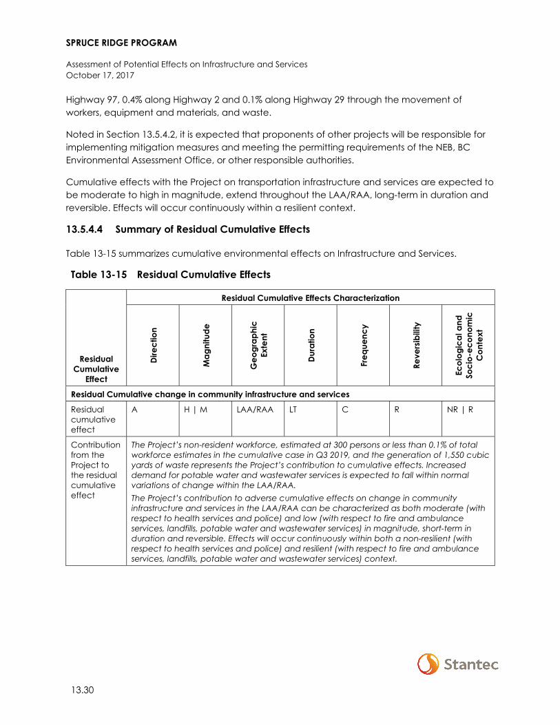
SPRUCE RIDGE PROGRAM
Assessment of Potential Effects on Infrastructure and Services October 17, 2017
13.30
Highway 97, 0.4% along Highway 2 and 0.1% along Highway 29 through the movement of workers, equipment and materials, and waste.
Noted in Section 13.5.4.2, it is expected that proponents of other projects will be responsible for implementing mitigation measures and meeting the permitting requirements of the NEB, BC Environmental Assessment Office, or other responsible authorities.
Cumulative effects with the Project on transportation infrastructure and services are expected to be moderate to high in magnitude, extend throughout the LAA/RAA, long-term in duration and reversible. Effects will occur continuously within a resilient context.
13.5.4.4 Summary of Residual Cumulative Effects
Table 13-15 summarizes cumulative environmental effects on Infrastructure and Services.
Table 13-15 Residual Cumulative Effects
Residual Cumulative
Effect
Residual Cumulative Effects Characterization
Dire
ctio
n
Mag
nitu
de
Geo
grap
hic
Ex
tent
Dura
tion
Freq
uenc
y
Reve
rsib
ility
Ecol
ogic
al a
nd
Soci
o-ec
onom
ic
Con
text
Residual Cumulative change in community infrastructure and services
Residual cumulative effect
A H | M LAA/RAA LT C R NR | R
Contribution from the Project to the residual cumulative effect
The Project’s non-resident workforce, estimated at 300 persons or less than 0.1% of total workforce estimates in the cumulative case in Q3 2019, and the generation of 1,550 cubic yards of waste represents the Project’s contribution to cumulative effects. Increased demand for potable water and wastewater services is expected to fall within normal variations of change within the LAA/RAA. The Project’s contribution to adverse cumulative effects on change in community infrastructure and services in the LAA/RAA can be characterized as both moderate (with respect to health services and police) and low (with respect to fire and ambulance services, landfills, potable water and wastewater services) in magnitude, short-term in duration and reversible. Effects will occur continuously within both a non-resilient (with respect to health services and police) and resilient (with respect to fire and ambulance services, landfills, potable water and wastewater services) context.
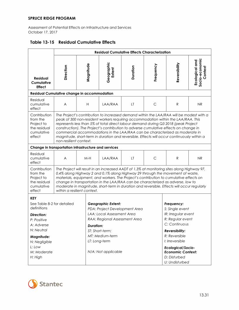
SPRUCE RIDGE PROGRAM
Assessment of Potential Effects on Infrastructure and Services October 17, 2017
13.31
Table 13-15 Residual Cumulative Effects
Residual Cumulative
Effect
Residual Cumulative Effects Characterization
Dire
ctio
n
Mag
nitu
de
Geo
grap
hic
Ex
tent
Dura
tion
Freq
uenc
y
Reve
rsib
ility
Ecol
ogic
al a
nd
Soci
o-ec
onom
ic
Con
text
Residual Cumulative change in accommodation
Residual cumulative effect
A H LAA/RAA LT C R NR
Contribution from the Project to the residual cumulative effect
The Project’s contribution to increased demand within the LAA/RAA will be modest with a peak of 300 non-resident workers requiring accommodation within the LAA/RAA. This represents less than 5% of total direct labour demand during Q3 2018 (peak Project construction). The Project’s contribution to adverse cumulative effects on change in commercial accommodations in the LAA/RAA can be characterized as moderate in magnitude, short-term in duration and reversible. Effects will occur continuously within a non-resilient context.
Change in transportation infrastructure and services
Residual cumulative effect
A M-H LAA/RAA LT C R NR
Contribution from the Project to the residual cumulative effect
The Project will result in an increased AADT of 1.3% at monitoring sites along Highway 97, 0.4% along Highway 2 and 0.1% along Highway 29 through the movement of waste, materials, equipment, and workers. The Project’s contribution to cumulative effects on change in transportation in the LAA/RAA can be characterized as adverse, low to moderate in magnitude, short-term in duration and reversible. Effects will occur regularly within a resilient context.
KEY See Table 8-2 for detailed definitions
Direction: P: Positive A: Adverse N: Neutral
Magnitude: N: Negligible L: Low M: Moderate H: High
Geographic Extent: PDA: Project Development Area LAA: Local Assessment Area RAA: Regional Assessment Area
Duration: ST: Short-term; MT: Medium-term LT: Long-term N/A: Not applicable
Frequency: S: Single event IR: Irregular event R: Regular event C: Continuous
Reversibility: R: Reversible I: Irreversible
Ecological/Socio-Economic Context: D: Disturbed U: Undisturbed
SPRUCE RIDGE PROGRAM
Assessment of Potential Effects on Infrastructure and Services October 17, 2017
13.32
13.6 DETERMINATION OF SIGNIFICANCE
13.6.1 Significance of Residual Project Effects
A significant adverse residual effect occurs when there is an exceedance of available capacity, or a substantial decrease in the quality of a service provided, on a persistent and ongoing basis, which cannot be mitigated with current or anticipated programs, policies, or mitigation measures. With the implementation of mitigation measures and in consideration of a peak non-resident workforce of 300 persons (sustained for six weeks) and an approximate daily average workforce of 200 persons (sustained for the duration of Project construction) demand for community infrastructure and services is not expected to exceed available capacity. Similarly, once mitigated, the requirement to lodge up to 300 workers in commercial accommodations within the LAA/RAA is not expected to exceed the estimated lowest-available room count (880 to 1,173 rooms). Also, with an increase of between 0.1% and 1.3% in AADT along regional highways, the Project is not expected to result in an exceedance of traffic thresholds associated with highway class ratings not already surpassed in the baseline case. Therefore, residual adverse effects on infrastructure and services are predicted to be not significant.
The confidence in the conclusions made in this assessment is a function of the quality and quantity of baseline data, level of understanding of the effect mechanisms, assumptions made, and effectiveness of mitigation measures. There is considerable uncertainty associated with population forecasts in the cumulative case because they depend on the nature and magnitude of major projects and associated economic development that will occur in the LAA/RAA. Because the significance conclusions made regarding residual effects on infrastructure and services are based on uncertainty, conclusions are made with a low to moderate level of confidence.
13.6.2 Significance of Residual Cumulative Effects
A significant adverse residual cumulative effect occurs when there is an exceedance of available capacity, or a substantial decrease in the quality of a service provided, on a persistent and ongoing basis, which cannot be mitigated with current or anticipated programs, policies, or mitigation measures.
The Project’s contribution to cumulative effects on infrastructure and services is extremely small in comparison to potential demand associated with projects and physical activities considered in the cumulative effects case. With respect to community infrastructure and services, once mitigated the Project will result in demand for 160 PYs of LAA/RAA labour or 6% of peak labour demand during Q3 2019 and will generate 1,550 cubic yards of waste. Increased demand for potable water and wastewater services is expected to fall within normal variations of change within the LAA/RAA. The Project’s contribution to increased demand on accommodations within the LAA/RAA will be modest with a peak of 300 non-resident workers requiring accommodation within the LAA/RAA while its contribution to increased demand on transportation infrastructure
SPRUCE RIDGE PROGRAM
Assessment of Potential Effects on Infrastructure and Services October 17, 2017
13.33
and services will be limited, increasing AADT between 0.1 and 1.3% along regional highways; both of which will be very small in comparison to regional cumulative effects.
In summary, while the Project in combination with other past, present, and reasonably foreseeable projects, may result in cumulative adverse effects that are distinguishable from current conditions and trends, they are expected to be effectively managed by identified Project mitigation measures; mitigation measures reasonably expected from other project proponents; as well as identified government programs, policies, and plans. Therefore, with the implementation of mitigation measures, residual cumulative environmental effects on infrastructure and services are predicted to be not significant.
In addition to the uncertainty noted above, there is also uncertainty regarding how many of the projects in the cumulative case will proceed. Because the significance conclusions made regarding cumulative effects on infrastructure and services are based on uncertainty, conclusions are made with a low to moderate level of confidence.
13.7 FOLLOW-UP AND MONITORING
With the implementation of standard mitigation measures and BMPs the potential adverse effects of Project activities on infrastructure and services are expected to be not significant. No follow-up programs are proposed.
SPRUCE RIDGE PROGRAM
Assessment of Potential Effects on Employment and Economy October 17, 2017
14.1
14 ASSESSMENT OF POTENTIAL EFFECTS ON EMPLOYMENT AND ECONOMY
14.1 SCOPE OF ASSESSMENT
This section defines and describes the scope of the assessment of potential effects on Employment and Economy. This VC was selected because the Project will create employment and business opportunities, as well as generate government revenues, while also potentially contributing to labour shortages.
14.1.1 Regulatory and Policy Setting
The scope of this section takes into consideration guidance provided by the NEB Filing Manual (NEB 2017), specifically Table A-3 which includes details on assessing socio-economic elements such as employment and economy.
14.1.2 Potential Effects, Pathways and Measurable Parameters
Potential effects of the Project were identified through public and regulatory consultation with stakeholders, past experience, and professional judgment (see Section 3).
Table 14-1 summarizes the potential effects, measurable parameters, and rationale for selection of the Employment and Economy VC. Measurable parameters were selected to provide a means of qualitatively assessing the expected change to existing socio-economic conditions.
Table 14-1 Potential Effects, Pathways and Measurable Parameters for Employment and Economy
Potential Effect Effect Pathway
Measurable Parameter(s) and Units
of Measurement
Change in employment and economy
• Project-related expenditures on labour, and goods and services, have the potential to affect direct, indirect and induced business activity and increase gross domestic product (GDP) in BC and Canada.
• The Project will create direct employment. Project purchasing of goods and services from local and regional businesses will created indirect employment. As well, household spending by individuals working directly or indirectly for the Project will create induced employment.
• Project demand for skilled labour will contribute to increased competition for, and cost of, labour
• Project-related employment
• Project expenditures on goods and services
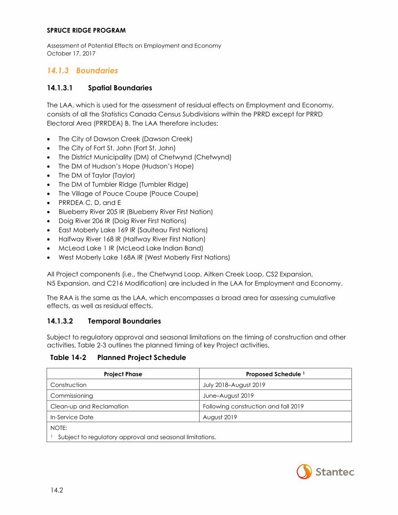
SPRUCE RIDGE PROGRAM
Assessment of Potential Effects on Employment and Economy October 17, 2017
14.2
14.1.3 Boundaries
14.1.3.1 Spatial Boundaries
The LAA, which is used for the assessment of residual effects on Employment and Economy, consists of all the Statistics Canada Census Subdivisions within the PRRD except for PRRD Electoral Area (PRRDEA) B. The LAA therefore includes:
• The City of Dawson Creek (Dawson Creek) • The City of Fort St. John (Fort St. John) • The District Municipality (DM) of Chetwynd (Chetwynd) • The DM of Hudson’s Hope (Hudson’s Hope) • The DM of Taylor (Taylor) • The DM of Tumbler Ridge (Tumbler Ridge) • The Village of Pouce Coupe (Pouce Coupe) • PRRDEA C, D, and E • Blueberry River 205 IR (Blueberry River First Nation) • Doig River 206 IR (Doig River First Nations) • East Moberly Lake 169 IR (Saulteau First Nations) • Halfway River 168 IR (Halfway River First Nation) • McLeod Lake 1 IR (McLeod Lake Indian Band) • West Moberly Lake 168A IR (West Moberly First Nations)
All Project components (i.e., the Chetwynd Loop, Aitken Creek Loop, CS2 Expansion, N5 Expansion, and C216 Modification) are included in the LAA for Employment and Economy.
The RAA is the same as the LAA, which encompasses a broad area for assessing cumulative effects, as well as residual effects.
14.1.3.2 Temporal Boundaries
Subject to regulatory approval and seasonal limitations on the timing of construction and other activities, Table 2-3 outlines the planned timing of key Project activities.
Table 14-2 Planned Project Schedule
Project Phase Proposed Schedule 1
Construction July 2018–August 2019
Commissioning June–August 2019
Clean-up and Reclamation Following construction and fall 2019
In-Service Date August 2019
NOTE: 1 Subject to regulatory approval and seasonal limitations.
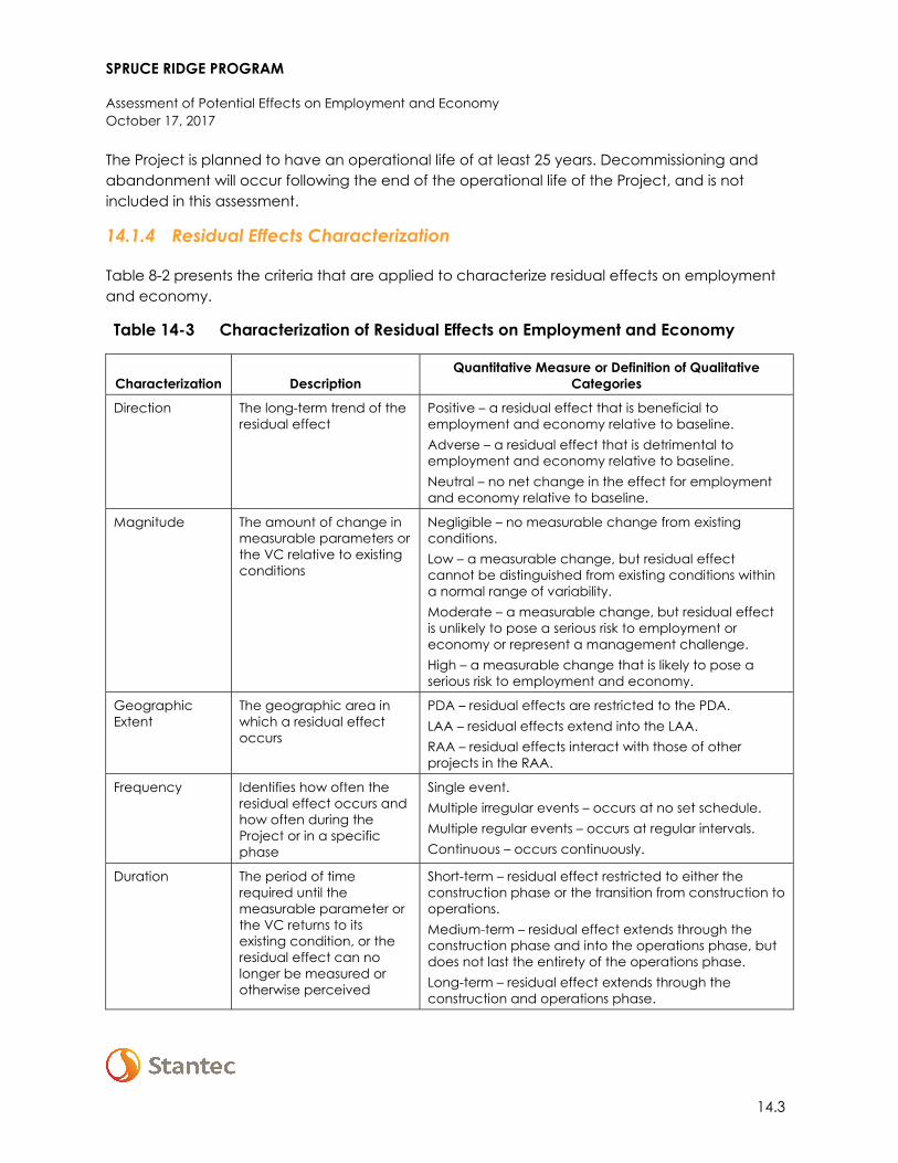
SPRUCE RIDGE PROGRAM
Assessment of Potential Effects on Employment and Economy October 17, 2017
14.3
The Project is planned to have an operational life of at least 25 years. Decommissioning and abandonment will occur following the end of the operational life of the Project, and is not included in this assessment.
14.1.4 Residual Effects Characterization
Table 8-2 presents the criteria that are applied to characterize residual effects on employment and economy.
Table 14-3 Characterization of Residual Effects on Employment and Economy
Characterization Description Quantitative Measure or Definition of Qualitative
Categories
Direction The long-term trend of the residual effect
Positive – a residual effect that is beneficial to employment and economy relative to baseline. Adverse – a residual effect that is detrimental to employment and economy relative to baseline. Neutral – no net change in the effect for employment and economy relative to baseline.
Magnitude The amount of change in measurable parameters or the VC relative to existing conditions
Negligible – no measurable change from existing conditions. Low – a measurable change, but residual effect cannot be distinguished from existing conditions within a normal range of variability. Moderate – a measurable change, but residual effect is unlikely to pose a serious risk to employment or economy or represent a management challenge. High – a measurable change that is likely to pose a serious risk to employment and economy.
Geographic Extent
The geographic area in which a residual effect occurs
PDA – residual effects are restricted to the PDA. LAA – residual effects extend into the LAA. RAA – residual effects interact with those of other projects in the RAA.
Frequency
Identifies how often the residual effect occurs and how often during the Project or in a specific phase
Single event. Multiple irregular events – occurs at no set schedule. Multiple regular events – occurs at regular intervals. Continuous – occurs continuously.
Duration
The period of time required until the measurable parameter or the VC returns to its existing condition, or the residual effect can no longer be measured or otherwise perceived
Short-term – residual effect restricted to either the construction phase or the transition from construction to operations. Medium-term – residual effect extends through the construction phase and into the operations phase, but does not last the entirety of the operations phase. Long-term – residual effect extends through the construction and operations phase.
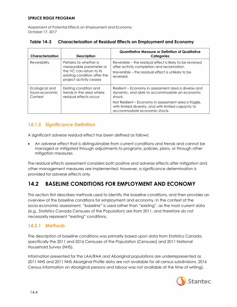
SPRUCE RIDGE PROGRAM
Assessment of Potential Effects on Employment and Economy October 17, 2017
14.4
Table 14-3 Characterization of Residual Effects on Employment and Economy
Characterization Description Quantitative Measure or Definition of Qualitative
Categories
Reversibility
Pertains to whether a measurable parameter or the VC can return to its existing condition after the project activity ceases
Reversible – the residual effect is likely to be reversed after activity completion and reclamation. Irreversible – the residual effect is unlikely to be reversed.
Ecological and Socio-economic Context
Existing condition and trends in the area where residual effects occur
Resilient – Economy in assessment area is diverse and dynamic, and able to accommodate an economic shock. Not Resilient – Economy in assessment area is fragile, with limited diversity, and with limited capacity to accommodate economic shock.
14.1.5 Significance Definition
A significant adverse residual effect has been defined as follows:
• An adverse effect that is distinguishable from current conditions and trends and cannot be managed or mitigated through adjustments to programs, policies, plans, or through other mitigation measures
The residual effects assessment considers both positive and adverse effects after mitigation and other management measures are implemented. However, a significance determination is provided for adverse effects only.
14.2 BASELINE CONDITIONS FOR EMPLOYMENT AND ECONOMY
This section first describes methods used to identify the baseline conditions, and then provides an overview of the baseline conditions for employment and economy. In the context of the socio-economic assessment, “baseline” is used rather than “existing”, as the most current data (e.g., Statistics Canada Censuses of the Population) are from 2011, and therefore do not necessarily represent “existing” conditions.
14.2.1 Methods
The description of baseline conditions was primarily based upon data from Statistics Canada, specifically the 2011 and 2016 Censuses of the Population (Censuses) and 2011 National Household Survey (NHS).
Information presented for the LAA/RAA and Aboriginal populations are underrepresented as 2011 NHS and 2011 NHS Aboriginal Profile data are not available for all census subdivisions. 2016 Census information on Aboriginal persons and labour was not available at the time of writing).
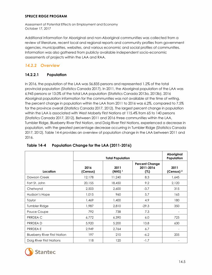
SPRUCE RIDGE PROGRAM
Assessment of Potential Effects on Employment and Economy October 17, 2017
14.5
Additional information for Aboriginal and non-Aboriginal communities was collected from a review of literature, recent local and regional reports and community profiles from government agencies, municipalities, websites, and various economic and social profiles of communities. Information was also gathered from publicly available independent socio-economic assessments of projects within the LAA and RAA.
14.2.2 Overview
14.2.2.1 Population
In 2016, the population of the LAA was 56,835 persons and represented 1.2% of the total provincial population (Statistics Canada 2017). In 2011, the Aboriginal population of the LAA was 6,945 persons or 13.0% of the total LAA population (Statistics Canada 2013a, 2013b). 2016 Aboriginal population information for the communities was not available at the time of writing. The percent change in population within the LAA from 2011 to 2016 was 6.2%, compared to 7.5% for the province overall (Statistics Canada 2017, 2012). The largest percent change in population within the LAA is associated with West Moberly First Nations at 115.4% from 65 to 140 persons (Statistics Canada 2017, 2012). Between 2011 and 2016 three communities within the LAA, Tumbler Ridge, Blueberry River First Nation, and Doig River First Nations, experienced a decrease in population, with the greatest percentage decrease occurring in Tumbler Ridge (Statistics Canada 2017, 2012). Table 14-4 provides an overview of population change in the LAA between 2011 and 2016.
Table 14-4 Population Change for the LAA (2011-2016)
Location
Total Population Aboriginal Population
2016 (Census)
2011 (NHS) 1
Percent Change 2011-2016
(%) 2011
(Census) 2
Dawson Creek 12,178 11,240 8.3 1,645
Fort St. John 20,155 18,450 9.2 2,120
Chetwynd 2,503 2,600 -3.7 315
Hudson’s Hope 1,015 960 5.7 165
Taylor 1,469 1,400 4.9 180
Tumbler Ridge 1,987 2,810 -29.3 350
Pouce Coupe 792 738 7.3 -
PRRDEA C 6,772 6,390 6.0 725
PRRDEA D 5,920 5,200 13.8 630
PRRDEA E 2,949 2,764 6.7 -
Blueberry River First Nation 197 210 -6.2 205
Doig River First Nations 118 120 -1.7 -
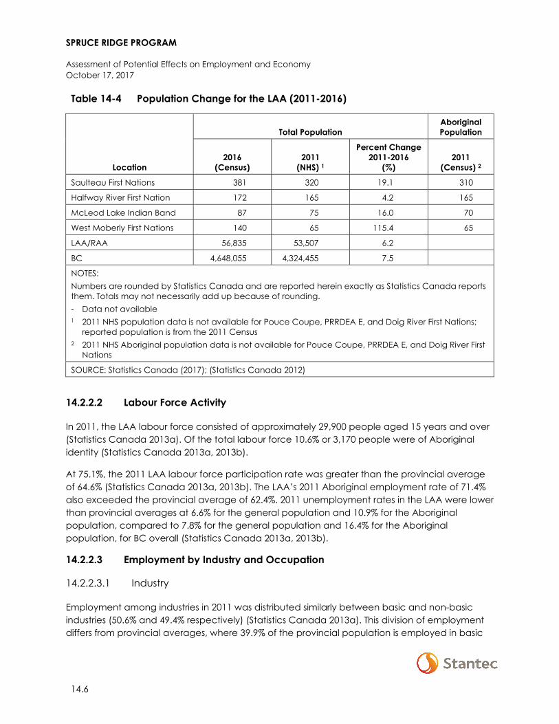
SPRUCE RIDGE PROGRAM
Assessment of Potential Effects on Employment and Economy October 17, 2017
14.6
Table 14-4 Population Change for the LAA (2011-2016)
Location
Total Population Aboriginal Population
2016 (Census)
2011 (NHS) 1
Percent Change 2011-2016
(%) 2011
(Census) 2
Saulteau First Nations 381 320 19.1 310
Halfway River First Nation 172 165 4.2 165
McLeod Lake Indian Band 87 75 16.0 70
West Moberly First Nations 140 65 115.4 65
LAA/RAA 56,835 53,507 6.2
BC 4,648,055 4,324,455 7.5
NOTES: Numbers are rounded by Statistics Canada and are reported herein exactly as Statistics Canada reports them. Totals may not necessarily add up because of rounding. - Data not available 1 2011 NHS population data is not available for Pouce Coupe, PRRDEA E, and Doig River First Nations;
reported population is from the 2011 Census 2 2011 NHS Aboriginal population data is not available for Pouce Coupe, PRRDEA E, and Doig River First
Nations
SOURCE: Statistics Canada (2017); (Statistics Canada 2012)
14.2.2.2 Labour Force Activity
In 2011, the LAA labour force consisted of approximately 29,900 people aged 15 years and over (Statistics Canada 2013a). Of the total labour force 10.6% or 3,170 people were of Aboriginal identity (Statistics Canada 2013a, 2013b).
At 75.1%, the 2011 LAA labour force participation rate was greater than the provincial average of 64.6% (Statistics Canada 2013a, 2013b). The LAA’s 2011 Aboriginal employment rate of 71.4% also exceeded the provincial average of 62.4%. 2011 unemployment rates in the LAA were lower than provincial averages at 6.6% for the general population and 10.9% for the Aboriginal population, compared to 7.8% for the general population and 16.4% for the Aboriginal population, for BC overall (Statistics Canada 2013a, 2013b).
14.2.2.3 Employment by Industry and Occupation
14.2.2.3.1 Industry
Employment among industries in 2011 was distributed similarly between basic and non-basic industries (50.6% and 49.4% respectively) (Statistics Canada 2013a). This division of employment differs from provincial averages, where 39.9% of the provincial population is employed in basic
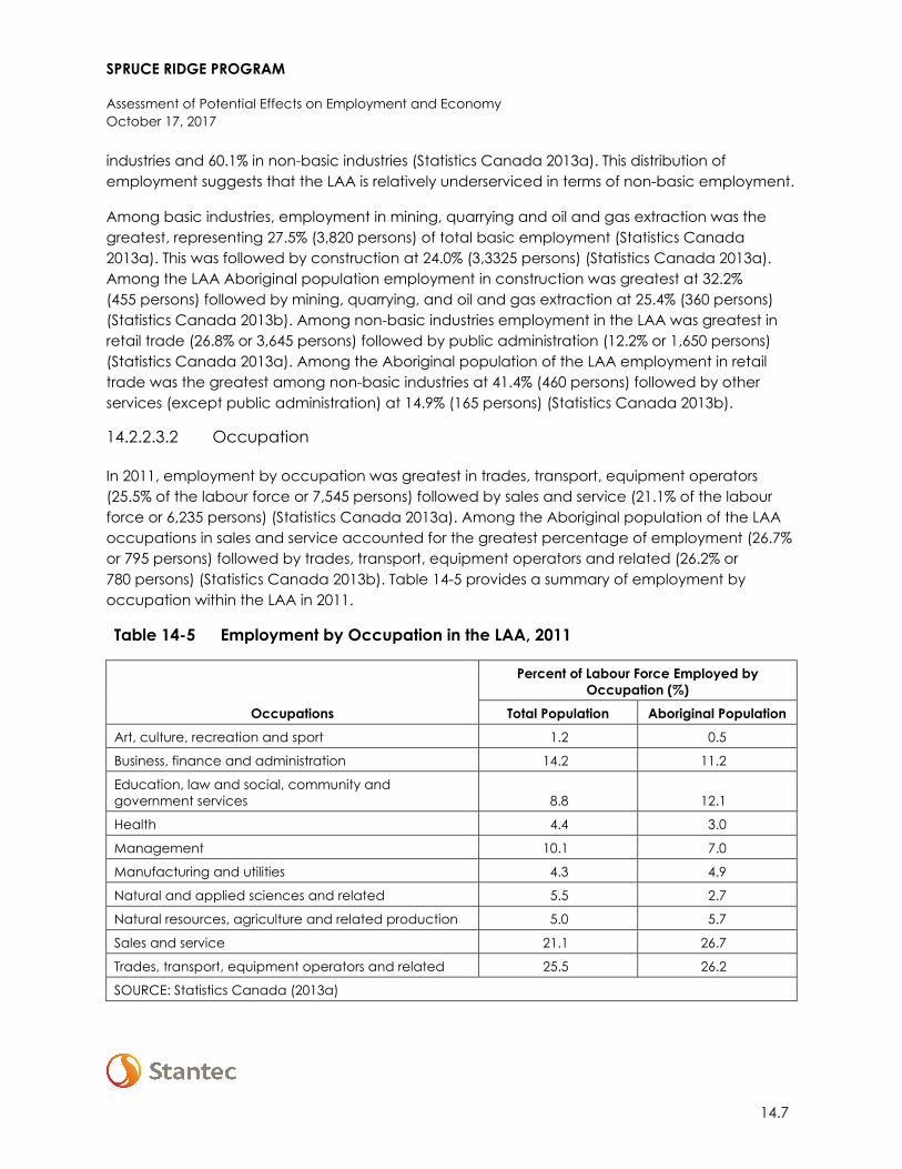
SPRUCE RIDGE PROGRAM
Assessment of Potential Effects on Employment and Economy October 17, 2017
14.7
industries and 60.1% in non-basic industries (Statistics Canada 2013a). This distribution of employment suggests that the LAA is relatively underserviced in terms of non-basic employment.
Among basic industries, employment in mining, quarrying and oil and gas extraction was the greatest, representing 27.5% (3,820 persons) of total basic employment (Statistics Canada 2013a). This was followed by construction at 24.0% (3,3325 persons) (Statistics Canada 2013a). Among the LAA Aboriginal population employment in construction was greatest at 32.2% (455 persons) followed by mining, quarrying, and oil and gas extraction at 25.4% (360 persons) (Statistics Canada 2013b). Among non-basic industries employment in the LAA was greatest in retail trade (26.8% or 3,645 persons) followed by public administration (12.2% or 1,650 persons) (Statistics Canada 2013a). Among the Aboriginal population of the LAA employment in retail trade was the greatest among non-basic industries at 41.4% (460 persons) followed by other services (except public administration) at 14.9% (165 persons) (Statistics Canada 2013b).
14.2.2.3.2 Occupation
In 2011, employment by occupation was greatest in trades, transport, equipment operators (25.5% of the labour force or 7,545 persons) followed by sales and service (21.1% of the labour force or 6,235 persons) (Statistics Canada 2013a). Among the Aboriginal population of the LAA occupations in sales and service accounted for the greatest percentage of employment (26.7% or 795 persons) followed by trades, transport, equipment operators and related (26.2% or 780 persons) (Statistics Canada 2013b). Table 14-5 provides a summary of employment by occupation within the LAA in 2011.
Table 14-5 Employment by Occupation in the LAA, 2011
Occupations
Percent of Labour Force Employed by Occupation (%)
Total Population Aboriginal Population Art, culture, recreation and sport 1.2 0.5
Business, finance and administration 14.2 11.2
Education, law and social, community and government services 8.8 12.1
Health 4.4 3.0
Management 10.1 7.0
Manufacturing and utilities 4.3 4.9
Natural and applied sciences and related 5.5 2.7
Natural resources, agriculture and related production 5.0 5.7
Sales and service 21.1 26.7
Trades, transport, equipment operators and related 25.5 26.2
SOURCE: Statistics Canada (2013a)
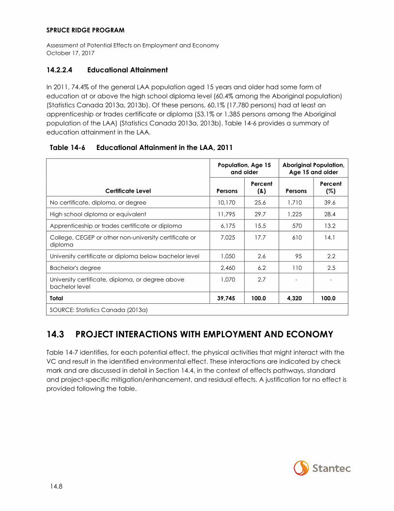
SPRUCE RIDGE PROGRAM
Assessment of Potential Effects on Employment and Economy October 17, 2017
14.8
14.2.2.4 Educational Attainment
In 2011, 74.4% of the general LAA population aged 15 years and older had some form of education at or above the high school diploma level (60.4% among the Aboriginal population) (Statistics Canada 2013a, 2013b). Of these persons, 60.1% (17,780 persons) had at least an apprenticeship or trades certificate or diploma (53.1% or 1,385 persons among the Aboriginal population of the LAA) (Statistics Canada 2013a, 2013b). Table 14-6 provides a summary of education attainment in the LAA.
Table 14-6 Educational Attainment in the LAA, 2011
Certificate Level
Population, Age 15 and older
Aboriginal Population, Age 15 and older
Persons Percent
(&) Persons Percent
(%)
No certificate, diploma, or degree 10,170 25.6 1,710 39.6
High school diploma or equivalent 11,795 29.7 1,225 28.4
Apprenticeship or trades certificate or diploma 6,175 15.5 570 13.2
College, CEGEP or other non-university certificate or diploma
7,025 17.7 610 14.1
University certificate or diploma below bachelor level 1,050 2.6 95 2.2
Bachelor's degree 2,460 6.2 110 2.5
University certificate, diploma, or degree above bachelor level
1,070 2.7 - -
Total 39,745 100.0 4,320 100.0
SOURCE: Statistics Canada (2013a)
14.3 PROJECT INTERACTIONS WITH EMPLOYMENT AND ECONOMY
Table 14-7 identifies, for each potential effect, the physical activities that might interact with the VC and result in the identified environmental effect. These interactions are indicated by check mark and are discussed in detail in Section 14.4, in the context of effects pathways, standard and project-specific mitigation/enhancement, and residual effects. A justification for no effect is provided following the table.
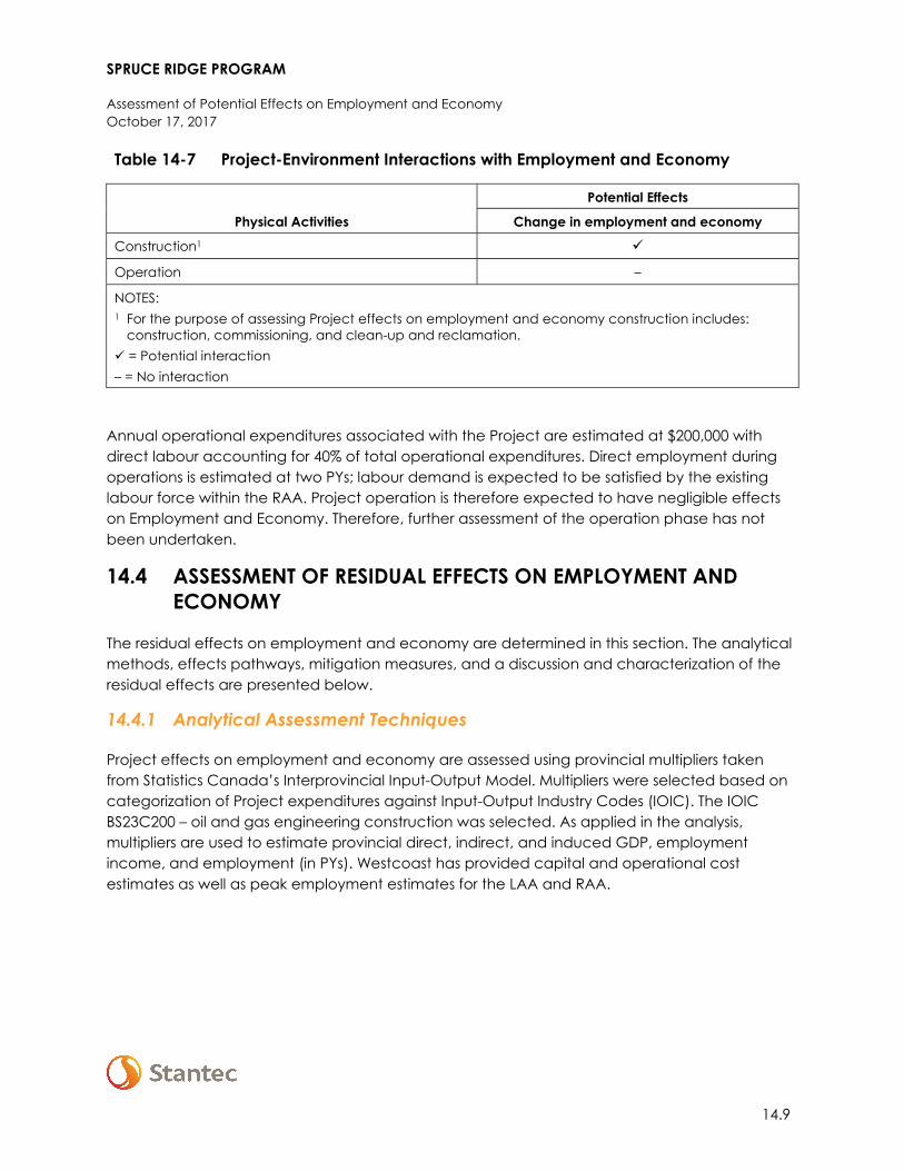
SPRUCE RIDGE PROGRAM
Assessment of Potential Effects on Employment and Economy October 17, 2017
14.9
Table 14-7 Project-Environment Interactions with Employment and Economy
Physical Activities
Potential Effects
Change in employment and economy
Construction1
Operation –
NOTES: 1 For the purpose of assessing Project effects on employment and economy construction includes:
construction, commissioning, and clean-up and reclamation. = Potential interaction – = No interaction
Annual operational expenditures associated with the Project are estimated at $200,000 with direct labour accounting for 40% of total operational expenditures. Direct employment during operations is estimated at two PYs; labour demand is expected to be satisfied by the existing labour force within the RAA. Project operation is therefore expected to have negligible effects on Employment and Economy. Therefore, further assessment of the operation phase has not been undertaken.
14.4 ASSESSMENT OF RESIDUAL EFFECTS ON EMPLOYMENT AND ECONOMY
The residual effects on employment and economy are determined in this section. The analytical methods, effects pathways, mitigation measures, and a discussion and characterization of the residual effects are presented below.
14.4.1 Analytical Assessment Techniques
Project effects on employment and economy are assessed using provincial multipliers taken from Statistics Canada’s Interprovincial Input-Output Model. Multipliers were selected based on categorization of Project expenditures against Input-Output Industry Codes (IOIC). The IOIC BS23C200 – oil and gas engineering construction was selected. As applied in the analysis, multipliers are used to estimate provincial direct, indirect, and induced GDP, employment income, and employment (in PYs). Westcoast has provided capital and operational cost estimates as well as peak employment estimates for the LAA and RAA.
SPRUCE RIDGE PROGRAM
Assessment of Potential Effects on Employment and Economy October 17, 2017
14.10
14.4.2 Change in Employment and Economy
14.4.2.1 Effect Pathways
Effect pathways for change in employment and economy during Project construction are as follows:
• Project-related expenditures on labour, and goods and services have the potential to affect direct, indirect, and induced business activity and increase GDP in BC and Canada
• The Project will create direct employment. It will also result in indirect employment (because of Project purchases of goods and services from local and regional businesses) and induced employment (because of the purchase of consumer goods and services by individuals who are employed directly or indirectly by the Project)
• Project demand for skilled labour will contribute to increased competition for and cost of labour
14.4.2.2 Mitigation
Standard industry practices and avoidance measures, as well as resource-specific mitigation will be implemented during construction and operation, as identified in the EPP (Appendix A). Table 14-8 contains key mitigation and enhancement measures for change in employment and economy.
SPRUCE RIDGE PROGRAM
Assessment of Potential Effects on Employment and Economy October 17, 2017
14.11
Table 14-8 Mitigation Measures for Change in Employment and Economy
Potential Effect Effect Pathway Mitigation Measures
Applicable Component
Chetw
ynd Loop
Aitken C
reek Loop
CS2 Expansion
N5 Expansion
CS16 M
odification
Change in employment and economy
• Project-related expenditures on labour, and goods and services have the potential to affect direct, indirect, and induced business activity and increase GDP in BC and Canada
• The Project will create direct employment. It will also result in indirect employment (because of Project purchases of goods and services from local and regional businesses) and induced employment (because of the purchase of consumer goods and services by individuals who are employed directly or indirectly by the Project)
• Project demand for skilled labour will contribute to increased competition for, and cost of, labour
Westcoast will engage early in consultation activities to enhance employment and business opportunities associated with the Project.
Westcoast will procure goods and services, where appropriate, from local and Aboriginal businesses.
Westcoast will follow its existing practice of encouraging local and Aboriginal content based on its previous experience from operating in the area, and through engagement with Aboriginal communities, local municipalities, residents, and the public.
Westcoast has an Aboriginal contractors' database which will be used by the company and shared with its prime contractors.
SPRUCE RIDGE PROGRAM
Assessment of Potential Effects on Employment and Economy October 17, 2017
14.12
Table 14-8 Mitigation Measures for Change in Employment and Economy
Potential Effect Effect Pathway Mitigation Measures
Applicable Component
Chetw
ynd Loop
Aitken C
reek Loop
CS2 Expansion
N5 Expansion
CS16 M
odification
Westcoast will adhere to its Diversity and Inclusion Goals and Vision which together value employee diversity and governs organizational compliance with laws concerning discrimination and equal opportunities. Westcoast will require its general contractor to have a socio-economic policy that aligns with that of Westcoast’s.
NOTES: = Specified mitigation will be employed for this component. – = Specified mitigation will not be employed for this component.
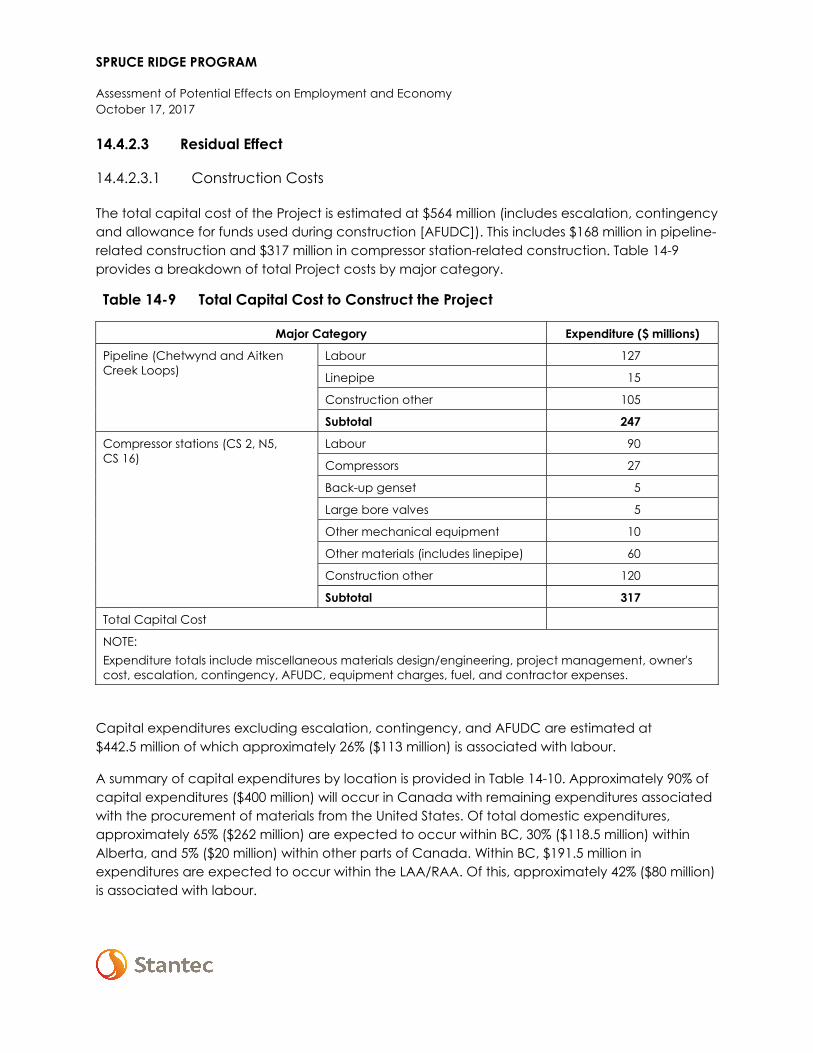
SPRUCE RIDGE PROGRAM
Assessment of Potential Effects on Employment and Economy October 17, 2017
14.4.2.3 Residual Effect
14.4.2.3.1 Construction Costs
The total capital cost of the Project is estimated at $564 million (includes escalation, contingency and allowance for funds used during construction [AFUDC]). This includes $168 million in pipeline-related construction and $317 million in compressor station-related construction. Table 14-9 provides a breakdown of total Project costs by major category.
Table 14-9 Total Capital Cost to Construct the Project
Major Category Expenditure ($ millions)
Pipeline (Chetwynd and Aitken Creek Loops)
Labour 127
Linepipe 15
Construction other 105
Subtotal 247
Compressor stations (CS 2, N5, CS 16)
Labour 90
Compressors 27
Back-up genset 5
Large bore valves 5
Other mechanical equipment 10
Other materials (includes linepipe) 60
Construction other 120
Subtotal 317
Total Capital Cost
NOTE: Expenditure totals include miscellaneous materials design/engineering, project management, owner's cost, escalation, contingency, AFUDC, equipment charges, fuel, and contractor expenses.
Capital expenditures excluding escalation, contingency, and AFUDC are estimated at $442.5 million of which approximately 26% ($113 million) is associated with labour.
A summary of capital expenditures by location is provided in Table 14-10. Approximately 90% of capital expenditures ($400 million) will occur in Canada with remaining expenditures associated with the procurement of materials from the United States. Of total domestic expenditures, approximately 65% ($262 million) are expected to occur within BC, 30% ($118.5 million) within Alberta, and 5% ($20 million) within other parts of Canada. Within BC, $191.5 million in expenditures are expected to occur within the LAA/RAA. Of this, approximately 42% ($80 million) is associated with labour.
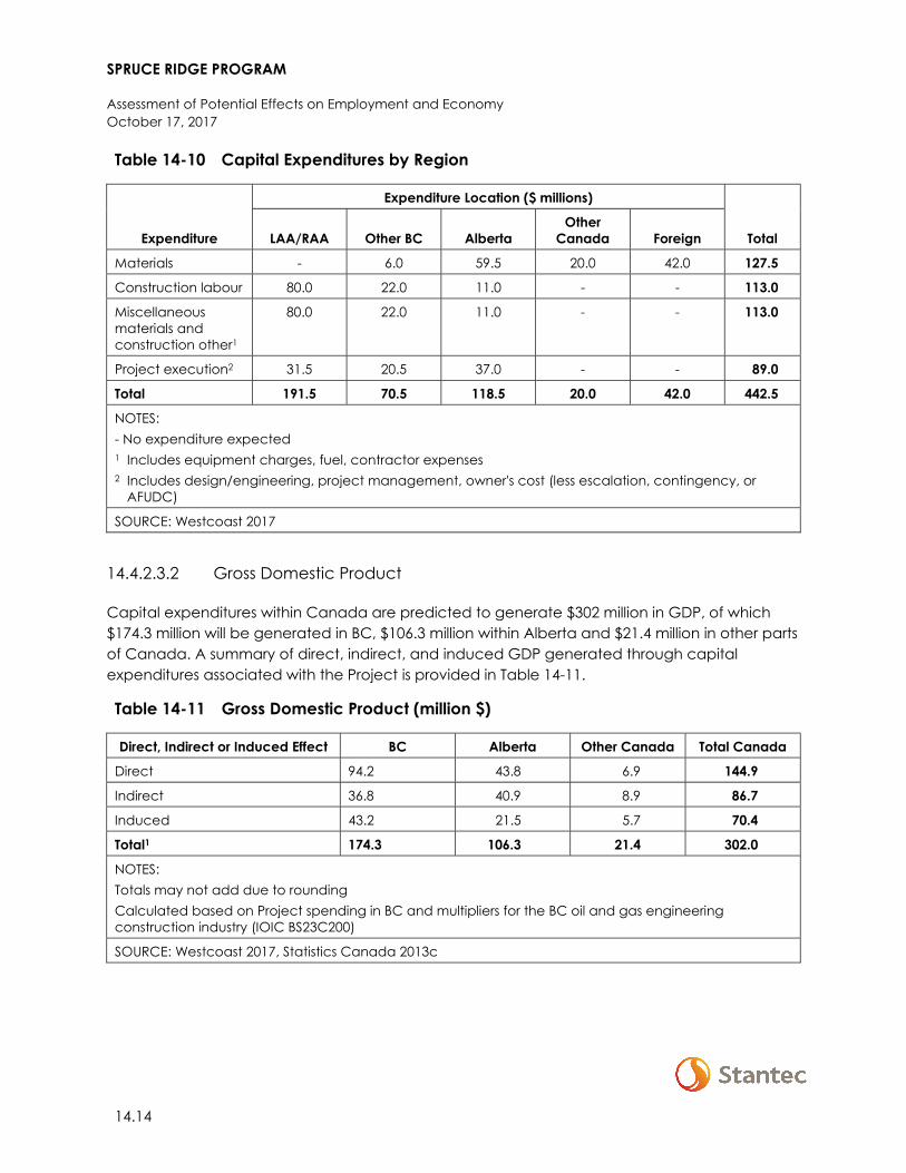
SPRUCE RIDGE PROGRAM
Assessment of Potential Effects on Employment and Economy October 17, 2017
14.14
Table 14-10 Capital Expenditures by Region
Expenditure
Expenditure Location ($ millions)
Total LAA/RAA Other BC Alberta Other
Canada Foreign
Materials - 6.0 59.5 20.0 42.0 127.5
Construction labour 80.0 22.0 11.0 - - 113.0
Miscellaneous materials and construction other1
80.0 22.0 11.0 - - 113.0
Project execution2 31.5 20.5 37.0 - - 89.0
Total 191.5 70.5 118.5 20.0 42.0 442.5
NOTES: - No expenditure expected 1 Includes equipment charges, fuel, contractor expenses 2 Includes design/engineering, project management, owner's cost (less escalation, contingency, or
AFUDC)
SOURCE: Westcoast 2017
14.4.2.3.2 Gross Domestic Product
Capital expenditures within Canada are predicted to generate $302 million in GDP, of which $174.3 million will be generated in BC, $106.3 million within Alberta and $21.4 million in other parts of Canada. A summary of direct, indirect, and induced GDP generated through capital expenditures associated with the Project is provided in Table 14-11.
Table 14-11 Gross Domestic Product (million $)
Direct, Indirect or Induced Effect BC Alberta Other Canada Total Canada
Direct 94.2 43.8 6.9 144.9
Indirect 36.8 40.9 8.9 86.7
Induced 43.2 21.5 5.7 70.4
Total1 174.3 106.3 21.4 302.0
NOTES: Totals may not add due to rounding Calculated based on Project spending in BC and multipliers for the BC oil and gas engineering construction industry (IOIC BS23C200)
SOURCE: Westcoast 2017, Statistics Canada 2013c
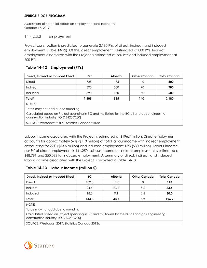
SPRUCE RIDGE PROGRAM
Assessment of Potential Effects on Employment and Economy October 17, 2017
14.4.2.3.3 Employment
Project construction is predicted to generate 2,180 PYs of direct, indirect, and induced employment (Table 14-12). Of this, direct employment is estimated at 800 PYs. Indirect employment associated with the Project is estimated at 780 PYs and induced employment at 600 PYs.
Table 14-12 Employment (PYs)
Direct, Indirect or Induced Effect BC Alberta Other Canada Total Canada
Direct 725 75 0 800
Indirect 390 300 90 780
Induced 390 160 50 600
Total1 1,505 535 140 2,180
NOTES: Totals may not add due to rounding Calculated based on Project spending in BC and multipliers for the BC oil and gas engineering construction industry (IOIC BS23C200)
SOURCE: Westcoast 2017, Statistics Canada 2013c
Labour income associated with the Project is estimated at $196.7 million. Direct employment accounts for approximately 57% ($113 million) of total labour income with indirect employment accounting for 27% ($53.6 million) and induced employment 15% ($30 million). Labour income per PY of direct employment is 141,250. Labour income for indirect employment is estimated at $68,781 and $50,082 for induced employment. A summary of direct, indirect, and induced labour income associated with the Project is provided in Table 14-13.
Table 14-13 Labour Income (million $)
Direct, Indirect or Induced Effect BC Alberta Other Canada Total Canada
Direct 102.0 11.0 0 113
Indirect 24.4 23.6 5.6 53.6
Induced 18.3 9.1 2.6 30.0
Total1 144.8 43.7 8.2 196.7
NOTES: Totals may not add due to rounding Calculated based on Project spending in BC and multipliers for the BC oil and gas engineering construction industry (IOIC BS23C200)
SOURCE: Westcoast 2017, Statistics Canada 2013c
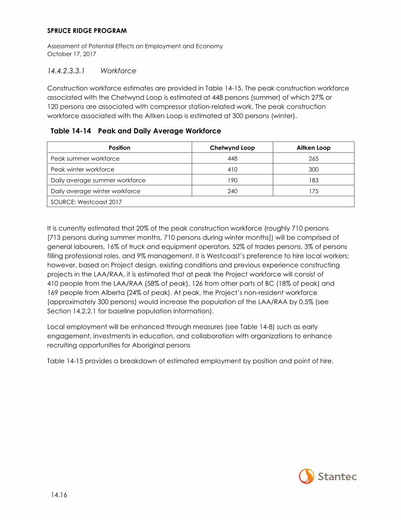
SPRUCE RIDGE PROGRAM
Assessment of Potential Effects on Employment and Economy October 17, 2017
14.16
14.4.2.3.3.1 Workforce
Construction workforce estimates are provided in Table 14-15. The peak construction workforce associated with the Chetwynd Loop is estimated at 448 persons (summer) of which 27% or 120 persons are associated with compressor station-related work. The peak construction workforce associated with the Aitken Loop is estimated at 300 persons (winter).
Table 14-14 Peak and Daily Average Workforce
Position Chetwynd Loop Aitken Loop
Peak summer workforce 448 265
Peak winter workforce 410 300
Daily average summer workforce 190 183
Daily average winter workforce 240 175
SOURCE: Westcoast 2017
It is currently estimated that 20% of the peak construction workforce (roughly 710 persons [713 persons during summer months, 710 persons during winter months]) will be comprised of general labourers, 16% of truck and equipment operators, 52% of trades persons, 3% of persons filling professional roles, and 9% management. It is Westcoast’s preference to hire local workers; however, based on Project design, existing conditions and previous experience constructing projects in the LAA/RAA, it is estimated that at peak the Project workforce will consist of 410 people from the LAA/RAA (58% of peak), 126 from other parts of BC (18% of peak) and 169 people from Alberta (24% of peak). At peak, the Project’s non-resident workforce (approximately 300 persons) would increase the population of the LAA/RAA by 0.5% (see Section 14.2.2.1 for baseline population information).
Local employment will be enhanced through measures (see Table 14-8) such as early engagement, investments in education, and collaboration with organizations to enhance recruiting opportunities for Aboriginal persons
Table 14-15 provides a breakdown of estimated employment by position and point of hire.
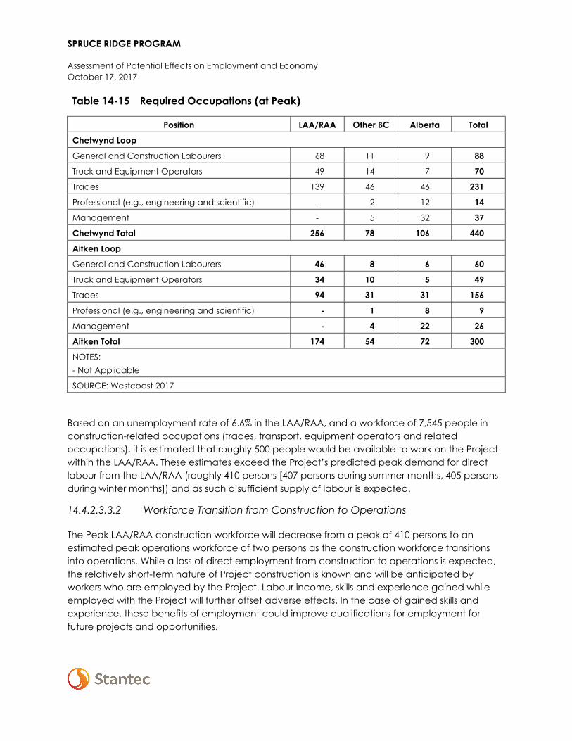
SPRUCE RIDGE PROGRAM
Assessment of Potential Effects on Employment and Economy October 17, 2017
Table 14-15 Required Occupations (at Peak)
Position LAA/RAA Other BC Alberta Total
Chetwynd Loop
General and Construction Labourers 68 11 9 88
Truck and Equipment Operators 49 14 7 70
Trades 139 46 46 231
Professional (e.g., engineering and scientific) - 2 12 14
Management - 5 32 37
Chetwynd Total 256 78 106 440
Aitken Loop
General and Construction Labourers 46 8 6 60
Truck and Equipment Operators 34 10 5 49
Trades 94 31 31 156
Professional (e.g., engineering and scientific) - 1 8 9
Management - 4 22 26
Aitken Total 174 54 72 300
NOTES: - Not Applicable
SOURCE: Westcoast 2017
Based on an unemployment rate of 6.6% in the LAA/RAA, and a workforce of 7,545 people in construction-related occupations (trades, transport, equipment operators and related occupations), it is estimated that roughly 500 people would be available to work on the Project within the LAA/RAA. These estimates exceed the Project’s predicted peak demand for direct labour from the LAA/RAA (roughly 410 persons [407 persons during summer months, 405 persons during winter months]) and as such a sufficient supply of labour is expected.
14.4.2.3.3.2 Workforce Transition from Construction to Operations
The Peak LAA/RAA construction workforce will decrease from a peak of 410 persons to an estimated peak operations workforce of two persons as the construction workforce transitions into operations. While a loss of direct employment from construction to operations is expected, the relatively short-term nature of Project construction is known and will be anticipated by workers who are employed by the Project. Labour income, skills and experience gained while employed with the Project will further offset adverse effects. In the case of gained skills and experience, these benefits of employment could improve qualifications for employment for future projects and opportunities.
SPRUCE RIDGE PROGRAM
Assessment of Potential Effects on Employment and Economy October 17, 2017
14.18
14.4.2.3.4 Summary
With the implementation of mitigation and enhancement measures, capital expenditures will result in beneficial or positive effects on employment and economy within the LAA and RAA contributing to increased economic output, GDP, labour income and employment. Based on a capital expenditure of $442.5 million and an available surplus of construction-related labour in the LAA and other parts of the RAA (the Project itself is not expected to result in labour shortages), beneficial effects are moderate in magnitude, extend to the RAA, are short term in duration (associated with Project construction) and will occur on an irregular basis. Beneficial effects will decrease in magnitude as the Project transitions from construction into operations and are therefore reversible. Drawing on baseline conditions, beneficial effects occur within a resilient socio-economic context.
While the Project will increase demand for labour within the RAA, a sufficient supply exists to meet construction-related demands. As such, and in consideration of the Project’s construction period (12 months) and size of its workforce (LAA/RAA peak of 410 persons sustained for six weeks with an approximate daily average size of 200 persons), adverse effects on the cost of labour are expected to be low in magnitude. Adverse effects related to increased labour costs will extend to the RAA, are short term (associated with Project construction) and will occur continuously. Adverse effects are reversible following the completion of Project construction and occur within a resilient socio-economic context.
With the implementation of mitigation measures, adverse effects associated with a decrease in direct employment as the Project transitions from construction to operations are low in magnitude, will extend to the RAA, are short term in duration (associated with Project transition from construction to operations), and will occur as a single event. Effects are reversible, but occur within a resilient socio-economic context; workers no longer employed with the Project are anticipated to secure future employment with other projects or employers within the RAA.
14.4.3 Summary of Residual Effects
Residual effects, both positive and adverse, on employment and economy are summarized in Table 14-16.
SPRUCE RIDGE PROGRAM
Assessment of Potential Effects on Employment and Economy October 17, 2017
Table 14-16 Residual Effects on Employment and Economy
Residual Effect
Residual Effects Characterization
Dire
ctio
n
Mag
nitu
de
Geo
grap
hic
Exte
nt
Dura
tion
Freq
uenc
y
Reve
rsib
ility
Ecol
ogic
al
and
Soci
o-ec
onom
ic
Con
text
Change in employment and economy
Construction
P M RAA ST IR R R
A L RAA ST C, S R R
KEY See Table 8-2 for detailed definitions
Direction: P: Positive A: Adverse N: Neutral
Magnitude: N: Negligible L: Low M: Moderate H: High
Geographic Extent: PDA: Project Development Area LAA: Local Assessment Area RAA: Regional Assessment Area
Duration: ST: Short-term; MT: Medium-term LT: Long-term N/A: Not applicable
Frequency: S: Single event IR: Multiple Irregular event R: Multiple Regular event C: Continuous
Reversibility: R: Reversible I: Irreversible
Socio-Economic Context: R: Resilient NR: Not Resilient
14.5 ASSESSMENT OF CUMULATIVE ENVIRONMENTAL EFFECTS ON EMPLOYMENT AND ECONOMY
If the residual effects described in Section 14.4 are likely to interact cumulatively with residual environmental effects from other physical activities (past, present, and reasonably foreseeable), the resulting cumulative environmental effects are assessed. This is followed by an analysis of the Project contribution to cumulative effects. Future projects and activities that are reasonably foreseeable are defined as those that (a) have been publicly announced with a defined project execution period and with sufficient project details that allow for a meaningful assessment, (b) are currently undergoing an environmental assessment or (c) are in a permitting process.
The assessment of cumulative effects is initiated with a determination of whether two conditions exist:
• The Project has residual environmental effects on the VC and • The residual effects could act cumulatively with residual effects of other past, present, or
reasonably foreseeable future physical activities
SPRUCE RIDGE PROGRAM
Assessment of Potential Effects on Employment and Economy October 17, 2017
14.20
If either is not met, the assessment of cumulative effects concludes with a statement that further assessment of cumulative effects is not warranted because the Project does not interact cumulatively with other projects or activities.
14.5.1 Residual Effects Likely to Interact Cumulatively
Table 14-16 presents the project and physical activities inclusion list, which identifies other projects and physical activities that might act cumulatively with the Project. Where residual adverse environmental effects from the Project act cumulatively with residual effects from other projects and physical activities, a cumulative effects assessment is undertaken to determine their significance.
All past, present, and reasonably foreseeable projects and physical activities presented in Section 4.7.1 overlap with the Project. Capital expenditures and labour demand associated with past and present projects and physical activities are captured in the baseline conditions (see Section 14.2.2). Reasonably foreseeable physical activities and projects represent an estimated combined total investment $12 billion within the RAA. Demand for labour within the RAA associated with these physical activities and projects is estimated at approximately 21,000 PYs (based on Project descriptions and publicly available information).
Within the RAA, cumulative demand for direct labour associated with the project and activities presented in Section 4.7.1 is estimated to decrease from 3,180 PYs in Q4 2017 to 2,370 PYs in Q2 2018. Demand is then expected to increase through Q4 2018 to 2,485 PYs (Q4 2018 coincides with the timing for peak Project construction) following which labour demand fluctuates through Q2 2019. Labour demand in Q3 2019 (coincides with the completion of Project construction) is estimated at 3,380 PYs. However, as other projects in the RAA move into construction in early 2019, demand for labour within the RAA is expected to increase to a peak of over 8,000 PYs in Q2 2020. The assessment of cumulative effects that are likely to result from the Project in combination with these projects and physical activities is provided in subsequent sections.
14.5.2 Change in Employment and Economy
14.5.2.1 Cumulative Effect Pathways
Cumulative effect pathways for change in employment and economy are as follows:
• Expenditures on labour, and goods and services on the part of projects and physical activities identified as having an interaction with change in employment and economy have the potential to cumulatively affect direct, indirect, and induced business activity within the RAA and increase GDP in BC and Canada in 2018/2019 (during the Project’s construction phase)
• Projects and physical activities identified as having an interaction with the Project will create direct employment adding to cumulative direct employment effects within the RAA. These projects and physical activities will also result in indirect employment (because of cumulative purchases of goods and services from local and regional businesses) and induced
SPRUCE RIDGE PROGRAM
Assessment of Potential Effects on Employment and Economy October 17, 2017
employment (because of the cumulative purchases of consumer goods and services by individuals who are employed directly or indirectly by these projects and physical activities). Commutative effects with the Project would occur within the RAA in 2018/2019 (the Project’s construction phase)
• Cumulative demand for skilled labour will contribute to increased competition for and cost of labour.
14.5.2.2 Mitigation for Cumulative Effects
Implementation of proposed mitigation measures identified in (Table 14-8) will reduce the Project’s contribution to adverse cumulative effects on change in employment and economy. No additional mitigation measures are proposed for Project contributions to address cumulative effects on change in employment and economy. It is expected that future projects that require regulatory approval will be subject to similar mitigation through environmental assessment and permitting processes.
14.5.2.3 Cumulative Effects
The above mentioned foreseeable projects will place increased demands on the RAA labour force and businesses with cumulative demand for labour, and goods and services potentially outpacing available supply. This is in addition to baseline conditions of which past and present physical activities and resource use have already had an effect. However, within the context of future economic and employment conditions in the RAA, the predicted effects of the Project will be extremely small.
With an estimated capital expenditure (less escalation, contingency, and AFUDC) of $191.5 million within the RAA, the Project accounts for less than 2% of total capital expenditures of reasonably foreseeable projects in the RAA. Likewise, Project demand for direct labour during construction (160 PYs within the RAA) accounts for only 6% of estimated peak labour requirements of reasonably foreseeable projects within the RAA in 2018.
In the cumulative case, demand for labour far exceeds the available supply within the RAA. Westcoast will implement mitigation measures identified in Section 14.5.2.2 to reduce the Project’s contribution to cumulative effects. It is expected that other projects will be responsible for implementing mitigation measures and meeting the permitting requirements of the NEB, BC Environmental Assessment Office, or other responsible authorities that will address the potential magnitude of cumulative effects in northeastern BC. Other considerations such as the use of fly-in/fly-out workers and provincial planning for increased industrial investment in northeastern BC (e.g., the BC Jobs Plan) will reduce the potential magnitude of cumulative effects associated with labour demand within northeastern BC. Based on these considerations, mitigation measures proposed by Westcoast and other project proponents are therefore expected to manage, to an acceptable level, the cumulative adverse effects on employment and economy within the RAA.
SPRUCE RIDGE PROGRAM
Assessment of Potential Effects on Employment and Economy October 17, 2017
14.22
With mitigation and management measures, the Project’s contribution to adverse cumulative effects on change in employment and economy in the RAA can be characterized as low in magnitude, will occur continuously over the short-term, and are reversible. Positive effects are moderate in magnitude, short-term in duration, will occur on an irregular basis and are reversible. Effects will occur continuously within a resilient context.
Cumulative effects with the Project will be both positive and adverse in direction. Both positive and adverse effects are predicted to be high in magnitude, extend throughout the RAA, long-term in duration and reversible. Positive effects will occur on an irregular basis while adverse effects will occur continuously. Effects occur within a resilient context.
14.5.2.4 Summary of Cumulative Effects
Table 14-17 summarizes cumulative environmental effects (both positive and adverse) on employment and economy.
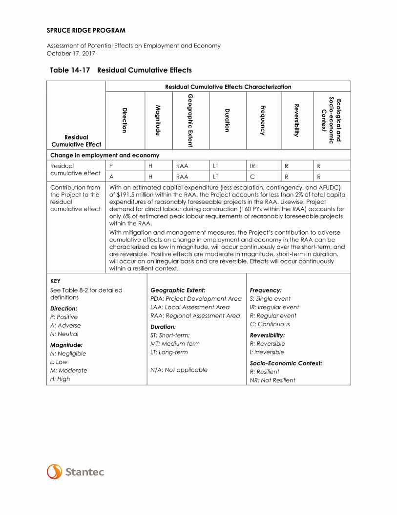
SPRUCE RIDGE PROGRAM
Assessment of Potential Effects on Employment and Economy October 17, 2017
Table 14-17 Residual Cumulative Effects
Residual Cumulative Effect
Residual Cumulative Effects Characterization
Direction
Magnitude
Geographic Extent
Duration
Frequency
Reversibility
Ecological and Socio-econom
ic C
ontext
Change in employment and economy
Residual cumulative effect
P H RAA LT IR R R
A H RAA LT C R R
Contribution from the Project to the residual cumulative effect
With an estimated capital expenditure (less escalation, contingency, and AFUDC) of $191.5 million within the RAA, the Project accounts for less than 2% of total capital expenditures of reasonably foreseeable projects in the RAA. Likewise, Project demand for direct labour during construction (160 PYs within the RAA) accounts for only 6% of estimated peak labour requirements of reasonably foreseeable projects within the RAA. With mitigation and management measures, the Project’s contribution to adverse cumulative effects on change in employment and economy in the RAA can be characterized as low in magnitude, will occur continuously over the short-term, and are reversible. Positive effects are moderate in magnitude, short-term in duration, will occur on an irregular basis and are reversible. Effects will occur continuously within a resilient context.
KEY See Table 8-2 for detailed definitions
Direction: P: Positive A: Adverse N: Neutral
Magnitude: N: Negligible L: Low M: Moderate H: High
Geographic Extent: PDA: Project Development Area LAA: Local Assessment Area RAA: Regional Assessment Area
Duration: ST: Short-term; MT: Medium-term LT: Long-term N/A: Not applicable
Frequency: S: Single event IR: Irregular event R: Regular event C: Continuous
Reversibility: R: Reversible I: Irreversible
Socio-Economic Context: R: Resilient NR: Not Resilient
SPRUCE RIDGE PROGRAM
Assessment of Potential Effects on Employment and Economy October 17, 2017
14.24
14.6 DETERMINATION OF SIGNIFICANCE
14.6.1 Significance of Residual Effects
Mitigation measures targeted at increasing beneficial effects of the Project and based on a capital expenditure of approximately $191.5 million within he LAA/RAA, a peak LAA/RAA workforce of 410 persons that will be sustained for a short period of time (six weeks), and an approximately daily average workforce size of 200 persons (over the 12-month construction period), residual effects on employment and economy are not expected to be distinguishable from current conditions and trends. This is supported by the resilient context in which effects occur, capital investment in oil and gas projects is characteristic of the economic profile of the region, and because the existing labour supply exceeds Project demand for labour (not including potential demand from reasonably foreseeable projects). As such, residual adverse effects on employment and economy are predicted to be not significant.
The confidence in the conclusions made in this assessment is a function of the quality and quantity of baseline data, level of understanding of the effect mechanisms, assumptions made, and effectiveness of mitigation measures. There is a moderate degree of confidence in the assessment of adverse effects on labour businesses because of uncertainty about future economic conditions in the LAA/RAA. The extent of employment of local and regional workers will also depend on how many workers choose to respond to recruitment activities. Because the significance conclusions made regarding residual effects on employment and economy are based on uncertainty, conclusions are made with a low to moderate level of confidence.
14.6.2 Significance of Cumulative Effects
In a scenario where all projects identified in the cumulative effects case were constructed, the capital expenditures within the RAA would dramatically affect business activity and contribute to increased provincial and federal GDP. These effects would be primarily beneficial in terms of regional, provincial, and federal economies. However, under this scenario the labour force within the RAA would be over-subscribed for an extended duration. With an oversubscription of labour, adverse economic effects, including localized labour shortages and potentially increased cost of labour could occur. As it is reasonably expected that proponents of large capital projects will implement mitigation measures similar to that of the Project, adverse effects are expected to be managed and reduced where possible.
In summary, while the Project in combination with other past, present, and reasonably foreseeable projects, may result in cumulative adverse effects that are distinguishable from current conditions and trends, they are expected to be effectively managed by identified Project mitigation measures; mitigation measures reasonably expected from other project proponents; as well as identified government programs, policies, and plans. Therefore, with the implementation of mitigation measures residual cumulative environmental effects on employment and economy are predicted to be not significant.
SPRUCE RIDGE PROGRAM
Assessment of Potential Effects on Employment and Economy October 17, 2017
14.6.2.1 Project Contribution to Cumulative Effects
Based on a capital investment of $191.5 million within the RAA and a peak demand for labour of 160 PYs within the RAA during construction, representing less than 2% of capital investment and 6% of total labour demand (at peak) within the RAA between Q1 and Q4 2018, the Project’s contribution to cumulative effects does not affect the sustainability of employment and economy.
In addition to the uncertainty noted above, there is considerable uncertainty associated with capital expenditure forecasts used in the cumulative case as they are based on preliminary estimates taken from publicly available documents with others based on ‘order-of-magnitude’ assumptions. There is also uncertainty regarding how many of the projects listed in Table 14-17 will proceed. Because the significance conclusions made regarding residual effects and cumulative effects on employment and economy are based on uncertainty, conclusions are made with a low to moderate level of confidence.
14.7 FOLLOW-UP AND MONITORING
With the implementation of standard mitigation measures and BMPs the potential adverse effects of Project activities on employment and economy are expected to be not significant. No follow-up programs are proposed.
SPRUCE RIDGE PROGRAM
Assessment of Potential Effects of the Environment on the Project October 17, 2017
15 ASSESSMENT OF POTENTIAL EFFECTS OF THE ENVIRONMENT ON THE PROJECT
15.1 SCOPE OF ASSESSMENT
The NEB Filing Manual, 2017-01 (NEB 2017) requires consideration of changes to the Project that may be caused by the environment. Potential effects of the environment on the Project are considered throughout the engineering and design process. The Project has benefitted from Westcoast’s extensive experience designing, constructing and operating pipelines and associated infrastructure. The Project team has applied this experience, together with industry best practices, when designing and planning the Project.
The Project will be designed, constructed, and tested in accordance with industry best practices and the provisions of the National Energy Board Act, the Onshore Pipeline Regulations (1999), applicable Westcoast specifications, CSA Z662-15, and the National Building Code of Canada.
Westcoast’s Pipeline Integrity Management Program has been developed to address commonly encountered hazards such as corrosion, cracking, external interference and geotechnical events in the pipeline ROW. Operations and maintenance activities include inline inspections, integrity excavations and repairs, pipeline aerial patrols and ground patrols, cathodic protection (CP) surveys and CP rectifier maintenance, and geotechnical slope stability and ground movement monitoring.
15.1.1 Project Interactions
The following are the identified potential effects of the environment on the Project:
• Extreme temperatures and strong winds: During construction, activities could be halted if extremely low or high temperatures or high winds affect the ability to safely execute construction works. Construction timelines may also be affected due to the requirement to stop work until conditions improve.
• Extreme precipitation: Extreme rain and snow can result in work stoppages and difficult working conditions, particularly during Project construction. Increased surface runoff could cause siltation and erosion, damage or washout watercourse crossings, or isolate work areas from access routes. Heavy snowfalls can result in construction delays and impede the movement of construction traffic.
• Watercourse migration: Watercourse migration can result in bank erosion, scour and a decrease in the depth of cover over sub-terrain pipelines at watercourse crossings.
• Earthquakes: Earthquakes can result in ground displacement that could result in additional stresses and strains on the pipeline.
• Forest fires: Forest fires may require construction activities or operations to be suspended and could cause damage to Project infrastructure.
SPRUCE RIDGE PROGRAM
Assessment of Potential Effects of the Environment on the Project October 17, 2017
15.2
• Corrosion: The interaction of steel with air, soil and groundwater can result in corrosion of pipelines and related steel infrastructure. This could result in a pipeline failure, leak, rupture or release if unmaintained.
The potential for residual effects of the environment on the Project are discussed in Section 15.3, including how these effects can be managed through the EPPs (Appendix A), the hazard management plans, emergency response plans, and health and safety plans (see Table 15-1).
15.2 MITIGATION
Environmental protection measures that will be implemented to address potential effects of the environment on the Project are included in the project-specific EPPs (Appendix A). Key mitigation measures, and the environmental conditions to which they apply, are listed in Table 15-1.
Table 15-1 Mitigation Measures for Effects of the Environment on the Project
Environmental Condition Mitigation Measures
Extreme temperatures and strong winds
• All materials used for Project construction will comply with CSA Z662 standards and Westcoast specifications for low temperatures
• Construction activities will be halted until conditions improve
Extreme precipitation • Implementation of sediment and erosion control measures • Establishment of surface and subsurface drainage systems • Construction activities will be halted until conditions improve
Watercourse migration • Watercourse crossings will be engineered using armouring and crossing techniques to reduce scour or erosion
• Sag bends to be set back from watercourse banks • Depth of cover for each watercourse crossing will be assessed on a
case by case basis Earthquakes • Pipelines will be designed and constructed in accordance with
CSA Z662 • Above ground facility structures and piping will be designed in
accordance with the National Building Code of Canada, (NBCC) Forest fires • Adhere to Fire Contingency Plan
Corrosion • The pipelines will be designed and constructed according to CSA Z662 to ensure that corrosion potential is mitigated
• Westcoast will perform corrosion and condition monitoring on the pipelines to identify areas of reduced integrity
SPRUCE RIDGE PROGRAM
Assessment of Potential Effects of the Environment on the Project October 17, 2017
15.3 ASSESSMENT OF RESIDUAL EFFECTS OF THE ENVIRONMENT ON THE PROJECT
15.3.1 Extreme Temperatures
From 1981 to 2010, the lowest average daily minimum temperature recorded for Chetwynd was -15.3°C (GOC 2017). The extreme minimum temperature recorded for the same time period was -52°C in January 1997. Extreme low temperatures have the potential to reduce the ductility of the materials used to construct Project components and increase their susceptibility to brittle fracture. Strong winds could result in soil erosion and impact some construction activities such as clearing, stripping, trenching, pipeline lowering in and construction of infrastructure at the compressor stations.
All materials selected for the Project will be designed to comply with CSA Z662-15 and Westcoast specifications for low temperatures. Should weather conditions present a risk to employees or contractors during construction, Westcoast would halt construction activities until such time as it is safe to proceed. During operations, the buried pipelines will be protected from temperature extremes by the overlying soil. Soil temperatures at typical burial depths seldom drop below freezing.
15.3.2 Extreme Precipitation
Extreme rain and snow can result in work stoppages and difficult working conditions, particularly during Project construction. Sedimentation and erosion control measures will be designed so that in the event of extreme rain and snow melt (e.g., erosive sediment-laden water) structural loading does not put the pipeline at risk. If unusually long wet periods or excessive rain do occur during construction, this can result in timing delays. The associated delay in construction completion can result in increased capital costs.
Measures that will be used to mitigate potential effects of rain and snow melt and associated run-off include maintaining surface and subsurface drainage (Westcoast will grade the ROW to prevent retention of water and snowmelt) and installing drainage and erosion controls, such as silt fencing, check dams, and sediment barriers prior to construction start-up, and adjusting these controls as needed during construction. See the Pipelines EPP (Appendix A-1) for more details on contingency planning.
If an extreme precipitation event were to occur during construction that poses a safety concern to Project personnel, construction would be halted until the event passed.
15.3.3 Watercourse Migration
Bank instability and the alteration of watercourses due to a rapid snowmelt or heavy runoff have the potential to adversely affect pipeline integrity. Scour is generally defined as erosion that occurs in response to a peak flow (flood) event. Watercourse crossings will be engineered using armouring and crossing techniques that reduce scour or erosion, as required. In addition, the

SPRUCE RIDGE PROGRAM
Assessment of Potential Effects of the Environment on the Project October 17, 2017
15.4
profiles of the crossings will be designed such that sag bends are set back far enough to reduce the likelihood of pipe exposure resulting from lateral erosion. Westcoast has proposed various design measures, such as increasing depth of cover, increasing setbacks, adding rip rap and adding berms to divert flow to prevent scour.
Thirty-eight watercourse crossings have been identified for the Project (see Section 8). Depth of cover for each watercourse crossing will be assessed on a case by case basis considering such factors as soil properties, creek and river flows, historical data and crossing profile. A detailed hydrotechnical assessment will be completed prior to Project construction to determine adequate depth of cover and armouring to mitigate the risks associated with channel migration. Westcoast uses a minimum of a 1 in 100-year flood event for design against pipeline exposures.
Watercourse crossing construction will be postponed if excessive flows or flood conditions exist or are expected. If construction methods cannot be modified to cope with the increased flow, contingency measures, including alternative construction methods or delaying installation of the watercourse crossing, will be considered.
15.3.4 Earthquakes
The Project is located in the southern Cordillera earthquake zone, which is a seismically stable region, but it can experience infrequent significant earthquakes. Natural Resources Canada (NRCan) defines significant earthquakes as those being of magnitude 5.0 or greater on the Richter Scale. The largest earthquakes recorded in modern times within the southern Cordillera have had magnitudes of 5.5 to 6.0. In 1986, a magnitude 5.5 earthquake occurred near Prince George, causing some minor residential structural damage (NRCan 2016). The potential southern Cordillera zone earthquake triggered ground displacements may include fault movements, landslides, lateral spread displacements and ground settlement related to liquefaction of soils.
The proposed pipeline will be designed and constructed in accordance with CSA Z662-15. The intention of this design standard is to maintain pipeline integrity based on the level of risk for earthquakes in the area. The significant earthquake or seismic hazard to a buried pipeline is ground displacement and the associated additional stresses and strains that the ground displacement may place on the pipeline.
It is recognized that modern steel pipelines designed and built to the CSA Z662 standard are a predictably safe means of moving petroleum products in earthquake prone areas. The pipelines are designed to deform longitudinally and in flexure to accommodate potential ground movements, which helps assists them to withstand the effects of most earthquake generated ground displacements without loss of product containment. Above ground facility structures and piping will be designed in accordance with the NBCC. The NBCC provides specific seismic loads for defined geological areas and requires those loads to be included in a structural analysis.
Data on geology, seismology and geotechnical conditions will be investigated and incorporated into the design of the pipeline.
SPRUCE RIDGE PROGRAM
Assessment of Potential Effects of the Environment on the Project October 17, 2017
15.3.5 Forest Fire
There is the potential for a forest fire to interrupt construction or operation of the Project (Project-related fires are discussed in Section 16.4). The extent of effects on the Project from fire depends greatly on the location and size of the event. The MFLNRORD has forest fire control programs in place to identify and control fires, minimizing the potential magnitude and extent of forest fires, as well as their environmental effect on the Project. In addition, Westcoast has established procedures to be followed in the event of forest fire (EPP, Appendix A-1 and Fire Contingency Plan, Appendix A-2). These procedures include equipping job sites and vehicles with fire-fighting equipment, appointing a qualified fire lead at each job site and posting a list at each job site of 24-hour fire dispatch coordinators and regional helicopter companies’ telephone numbers.
15.3.6 Corrosion
The natural elements, particularly the interaction of steel with air, soil, and groundwater, can result in corrosion of pipelines and related steel infrastructure. As a result, there is also risk that corrosion can affect the integrity of the existing and new pipeline. This could result in a pipeline failure, resulting in release of product if left unmaintained. The pipeline and associated appurtenances will be designed and constructed according to CSA Z662-15, which includes cathodic protection and external coating to prevent or reduce external corrosion.
Westcoast has an existing Pipeline Integrity Management Program in place to manage the safe operation and long-term integrity of its pipelines. In the event that an actual or suspected pipeline integrity problem is identified, it will be investigated in accordance with this program.
Maintenance digs will be conducted in a manner similar to the pipeline construction activities (i.e., ground disturbance procedures will be implemented, topsoil will be salvaged and replaced, subsoil will be stockpiled separately, backfilled and feathered-out, salvaged soils will be replaced and reseeded).
15.4 SUMMARY OF RESIDUAL EFFECTS OF THE ENVIRONMENT ON THE PROJECT
A significant effect of the environment on the Project would be one that precludes completion of a planned construction activity, a long-term interruption in services or damage to infrastructure requiring repairs that are not economically feasible. Potential effects of the environment on the Project will be managed through the implementation of mitigation measures, contingency planning, emergency response plans, hazard management plans and health and safety plans. Following implementation of these measures potential effects of the environment on the Project are considered manageable and are not expected to result in a failure of the Project, so are considered not significant.
SPRUCE RIDGE PROGRAM
Accidents, Malfunctions and Unplanned Events October 17, 2017
16 ACCIDENTS, MALFUNCTIONS AND UNPLANNED EVENTS
The NEB Filing Manual (NEB 2017) requires that the effects of accidents, malfunctions and unplanned events be considered in the ESA. Accidents, malfunctions and unplanned events are incidents or conditions that are not planned as a part of routine Project activities during any Project phase, despite best planning and application of mitigation measures.
Accidents and malfunctions can manifest as a result of abnormal operating conditions, process upsets, wear and tear, acts of nature, extreme weather events, human error, equipment failure, and other possible causes. Many accidents, malfunctions and unplanned events are preventable and can be readily addressed or prevented by good planning, design, equipment selection, hazard analysis and corrective action, emergency response planning, and mitigation. Pipeline integrity is addressed in Section 15.3.6, which discusses mitigation for corrosion, and Section 16.3.2, which identifies preventative and response measures.
16.1 IDENTIFICATION OF EVENTS AND POTENTIALLY AFFECTED VALUED COMPONENTS
The assessment team has conservatively selected scenarios that represent credible, high-consequence events that also adequately address the consequences of less likely or lower-consequence events. Based on the Project design, environmental and socio-economic sensitivities, existing emergency management programs, experience and professional judgment of the assessment team, the following accidents, malfunctions and unplanned events are considered in this assessment:
• Drilling Fluid Release: An inadvertent release is defined as an accidental release of drillingfluid during drilling operations, where permeable soils absorb drilling fluid circulation losses orwhere fractured bedrock substrates act as a conduit to the surface, resulting in surfacedischarge.
• Pipeline Leaks or Ruptures: The severity of any environmental effects resulting from apipeline rupture or leak depends on the location, timing, and the factors surrounding theevent. The risks are primarily associated with toxicity of the gas and the physicaldisturbance of a rupture or explosion.
• Fire: This Includes fire and/or explosion in a Project component. The focus is on theconsequence of the fire or explosion, and not the mechanism by which it occurs.
• Hazardous Materials Spill: This includes spills of fuel, petroleum products, or other chemicalsused on site that could occur during construction or operation.
• Vehicle Accident: This includes the consequence of any Project-related vehicle accidentthat may occur on a road transportation network, including vehicle accidents involvingwildlife.
SPRUCE RIDGE PROGRAM
Accidents, Malfunctions and Unplanned Events October 17, 2017
16.2
16.2 DRILLING FLUID INADVERTENT RELEASE
16.2.1 Causes and Interactions
An inadvertent drilling fluid release has the potential to affect locations both under watercourses and at locations of trenchless crossings. The Wildlife and Wildlife Habitat (Section 10), Fish and Fish Habitat (Section 8) and Soil and Soil Productivity (Section 7) VCs have the potential to be impacted in the unlikely event of an inadvertent release of drilling fluid.
16.2.2 Preventative and Response Measures
In order to prevent an inadvertent release from occurring, a trenchless drilling method will only be used at watercourse crossings with suitable geotechnical conditions. For this technology, the pipe is attached to the drill-head and cut materials flow back though the bore as it is fed under the watercourse. In the event of a drilling fluid release, the contractor will follow the steps outlined in the Spill Prevention and Response Plan (Section 7.7 of Appendix A-1). The appropriate permits will be obtained prior to construction. The contractor will also maintain the appropriate equipment and material on-site to sufficiently manage and contain an inadvertent release of drilling fluid. In the case of a drilling fluid release or sudden drop in drilling pressure, drilling will immediately be suspended and the contractor will notify the chief inspector and EI.
The response strategy employed will depend on the size and extent of the release, as well as the conditions that led to the release. This will include, but is not limited to, water quality monitoring upstream and downstream of the release site; development of a fissure/fracture plug composed of a sealing agent; downhole cementing; drilling location realignment to a more secure path; and reporting.
16.2.3 Residual Effects and Significance
The potential effects of an inadvertent release under a watercourse would be the contamination of surface water, and potential loss of habitat for wildlife and fish. Surface water will be affected through the discharge of drilling fluids and sediment entering the watercourse, resulting in an increase in turbidity. The increased turbidity can result in the potential loss of habitat and/or fish mortality. Increased levels of turbidity are known to reduce fish survival through gill irritation or damage, reduced feeding efficiency, and growth rate, all of which affect fish populations (see Section 8). For wildlife that occupy or use watercourses as a food source (Section 10), water source, or residence, there is a potential for a change in their habitat resulting from an inadvertent release of drilling fluid as a result of the changing physical properties within the watercourse.
The potential occurrence of an inadvertent release is considered low, and, if it occurs, is expected to be of short duration, occurring infrequently, limited in area, and cleaned-up by on-site crews using standard equipment already on site. With the implementation of preventative and response measures, the potential effects of an inadvertent release on the environment are assessed as not significant.
SPRUCE RIDGE PROGRAM
Accidents, Malfunctions and Unplanned Events October 17, 2017
16.3 PIPELINE LEAKS AND RUPTURES
16.3.1 Causes and Interactions
Although expected to be rare, an accidental pipeline rupture during Project operations could occur. A pipeline rupture represents an accident scenario on the Westcoast pipeline system, including facilities, with potential effects on the environment or possibly human and wildlife injury. A pipeline leak or rupture may interact with the Atmospheric Environment VC because of possible elevated emissions to the atmosphere during this type of event. The result would be atmosphere release of natural gas into the atmosphere. Natural gas is mostly methane, a GHG. It also contains trace amounts of CACs (e.g., H2S), and some VOC species. These could result in exceedances of BC AAQOs. The proximity of the Project to surrounding projects in the area may lead to the unlikely event of a third-party rupture. A gas release from a third-party rupture could result in an explosion causing fire damage to property and environment, or possibly human and wildlife injury, as discussed in Section 16.4.
16.3.2 Preventative and Response Measures
Westcoast has designed and will operate the Project in accordance with the most recent version of applicable CSA standards and design measures, Onshore Pipeline Regulations and ASME code requirements, as well as in-house engineering standards and procedures. As such, a standard will be maintained that will limit the potential for leaks, ruptures, or other hazardous situations.
As part of the design process, Westcoast has identified and limited potential operational threats. Some of the design features and operational standards used to reduce the risk of a leak or rupture are:
• Conducting geotechnical evaluations when selecting the facility sites and route options for the Project
• Burial of the pipeline to a minimum of cover in accordance with the CSA standards; using greater depths of cover for site-specific instances such as at water, road, or rail line crossing, areas of deep tillage, and heavy equipment crossings
• Designing pipelines and facilities according to appropriate specifications (e.g., CSA Z662) • Use of third-party inspection during manufacturing, testing, coating, and shipping of the pipe • Following welding specifications and conducting inspections during pipeline construction • Using cathodic protection to prevent corrosion • Using specified coatings and pipe materials to avoid stress, corrosion, and cracking • Verifying that gas composition and quality meet operational specifications • Scheduling pipeline integrity investigations (including excavations) • Placing signage, vehicle barricades, and controlled crossing structures to protect operating
pipelines
The Westcoast Gas Control Centre will continuously monitor flow rates and pressures of the proposed pipelines. Westcoast will have the ability to monitor the pipeline and control the emergency shut-down valves from its Gas Control Centre in both Fort St. John, BC and
SPRUCE RIDGE PROGRAM
Accidents, Malfunctions and Unplanned Events October 17, 2017
16.4
Calgary, Alberta, which are staffed 24 hours per day, seven days per week. Pressure drops or changes in flow not related to operational changes will be investigated without undue delay by Westcoast. The surface condition of the ROW and adjacent areas will be inspected on a routine basis in accordance with Westcoast's pipeline operations and maintenance procedures. Any indications of leaks, construction activity performed by others, or other conditions that may affect the safety and operation of the pipeline will be promptly investigated.
The Westcoast Field Emergency Response Plan (FERP) for the Fort St. John Region will be updated to include a Project-specific FERP. The FERP provides the framework for managing any leaks detected with the objective of ensure public and worker safety, the environment, and the facilities.
The leak detection program utilized by Westcoast is the result of over 50 years of experience operating and maintaining pipelines throughout BC. The accuracy and effectiveness of this program is assessed and improved upon over time based on operating experience and leak investigations. The incident investigation process results in the continuous assessment and improvement of the accuracy and effectiveness of the leak detection program.
16.3.3 Residual Effects and Significance
Potential exceedances of the BC AAQO could affect human and ecological health if the release of air contaminants was to persist and there was extended exposure to receptors. The occurrence of a pipeline leak or rupture is expected to be infrequent and of very short duration. The likely scenario is one where pipeline flow would be quickly shutdown, using emergency shut off valves so that the issue can be addressed. Although there could be some short-term exceedances of BC AAQO associated with a pipeline leak or rupture, annual emission rates and ground-level concentrations are unlikely to be affected. With the implementation of prevention and response measures, the effects of a pipeline leak or rupture on the environment are assessed as not significant.
16.4 FIRE
16.4.1 Causes and Interactions
In the unlikely event of a Project-caused fire or explosion during commissioning and operations, particulate matter released into the local air shed would interact with the Atmospheric Environment VC. The storage of hazardous combustible materials or waste at the worksite has the potential to lead to a fire during construction or operations. There is also potential for a fire to interact with the Vegetation and Wetland and Wildlife and Wildlife Habitat VCs, and with the Employment and Economy and Infrastructure and Services VCs as a fire and/or explosion could result in residential property loss and damage. Natural causes such as a forest fire could also cause a fire during all phases of the Project, as discussed in Section 15.3.5.
SPRUCE RIDGE PROGRAM
Accidents, Malfunctions and Unplanned Events October 17, 2017
16.4.2 Preventative and Response Measures
Safety orientation and fire prevention training will be provided to contractors working on construction of the Project to mitigate risks and establish response measures. Flammable material will be either piled or stored for winter burning or will be burned inside containers to limit the potential for fire to spread. The equipment used on site will meet applicable CSA and ASME codes and standards designed to prevent fires and explosions. Westcoast will implement the EPPs for the Project (Appendix A-1 and A-2); this includes waste management practices, wildfire prevention, a spill response plan, and a regular equipment inspection and maintenance program. Westcoast has a FERP in place for the Fort St John region.
16.4.3 Residual Effects and Significance
A large fire can lead to the alteration or loss of wildlife, vegetation and wetland habitats. Reductions in ambient air quality standards may occur if particulate matter levels exceed air quality standards when fires spread over large distances; however, such fires would be infrequent and are not expected to occur because of the limited nature of the Project (relative to other activities in the area). With the implementation of preventative and response measures, the effects of a fire on the environment are assessed as not significant.
16.5 HAZARDOUS MATERIALS SPILL
16.5.1 Causes and Interactions
A hazardous materials spill along the ROW or within the PDA could interact with the Soil and Soil Productivity VC. A spill of petroleum, oil, lubricants, or other hazardous materials may occur during construction or operation activities. Most spills are expected to be highly localized. In the event of a large spill, elevated contaminant levels in soil, groundwater, and vegetation may occur.
16.5.2 Preventative and Response Measures
During Project construction, contractors will be aware of spill response procedures and will be required to have Workplace Hazardous Materials Information System training. Equipment used in the construction and operation of the Project will meet applicable codes, and equipment operators will follow established operational practices. Westcoast will implement the EPPs for the Project (Appendix A-1 and A-2). As previously stated, Westcoast will develop a site-specific FERP in conjunction with the construction contractors.
16.5.3 Residual Effects and Significance
The potential effects of a spill would be the contamination of soils, groundwater, surface waterbodies, and vegetation. The potential occurrence of a spill is expected to be infrequent, of very short duration, limited in area, and easily cleaned-up by on-site crews using standard equipment and materials kept on site. With the implementation of preventative and response measures, the effects of a spill on the environment are assessed as not significant.

SPRUCE RIDGE PROGRAM
Accidents, Malfunctions and Unplanned Events October 17, 2017
16.6
16.6 VEHICLE ACCIDENT
16.6.1 Causes and Interactions
Any stage of the Project could be impacted from a vehicle accident. Traffic to and from the worksite during construction and operations and unsafe surface road conditions could potentially result in a vehicle accident. A vehicle accident has the potential to result in the release of hazardous materials to soil and groundwater and could interact with the Wildlife and Wildlife Habitat, Fish and Fish Habitat, Employment and Economy, and Infrastructure and Services VCs. These interactions would likely be in the form of wildlife strikes, fuel and oil release, and fire as a result of an accident, as covered in Section 15.
16.6.2 Preventative and Response Measures
There are no features of the Project that would substantially increase accident rates or decrease traffic safety. Project-related vehicles will be required to observe traffic rules and provincial and federal highway regulations. The prime contractor will also create and implement a traffic management plan for the construction period. This plan will be reviewed and approved by Westcoast. Trucking activity for construction of the Project will be required to take place on designated truck routes and observe speed limits and weight restrictions.
Westcoast requires that contractors and subcontractors have a drug and alcohol program in place. Individual companies are accountable for their own personnel, and testing will take place when a supervisor or other official has reasonable grounds to suspect that an employee is or may be unable to work in a safe manner because of the use of alcohol and/or drugs.
16.6.3 Residual Effects and Significance
The occurrence of a vehicle accident is expected to be infrequent, and its likelihood more concentrated during the construction phase. Because Project personnel will be required to comply with applicable traffic rules and regulations, and traffic to and from the site will not be increased during operations, the effects of a vehicle accident on the environment are assessed as not significant.
16.7 SUMMARY OF EFFECTS OF ACCIDENTS AND MALFUNCTIONS
The Project is being designed, and will be constructed and operated, with full regard for health, safety, and environmental protection. The careful planning of the Project and the implementation of proven and effective mitigation measures such as those included in the EPPs (Appendix A) and FERP will reduce the potential for accidents, malfunctions, and unplanned events to occur. Overall, the potential environmental effects of Project-related accidents, malfunctions, and unplanned events on the VCs, including cumulative environmental effects, during all phases of the Project, are rated as not significant.

SPRUCE RIDGE PROGRAM
Follow-up and Monitoring October 17, 2017
17 FOLLOW-UP AND MONITORING
Westcoast is committed to its corporate EHS Policy and has committed to a number of monitoring activities as part of the proposed mitigation for the pre-construction, construction and operations phases of the Project. Westcoast will implement an environmental inspection program during construction that will follow the EMCPC (Spectra 2014). Qualified EIs will work onsite during construction to verify that construction activities are in compliance with regulatory commitments and mitigation measures as outlined in the EPPs (Appendix A-1 and A-2).
Westcoast will implement a Post-Construction Monitoring Program following construction, as per the EMCPC. Residual effects or other issues that are identified post-construction will be followed-up on with remedial actions and appropriate documentation within post-construction monitoring reports. Post-construction monitoring reports will also describe any corrective actions implemented. Outstanding post construction issues on the ROW, which may include rutting, presence of roaches, weed infestations, revegetation issues, poor drainage, insufficient reclamation at watercourse crossings, and the presence of residual construction materials, will be identified through Westcoast’s continuous monitoring of all aspects of ROW integrity and will be addressed if warranted.
SPRUCE RIDGE PROGRAM
Environmental and Socio-Economic Management Plans October 17, 2017
18 ENVIRONMENTAL AND SOCIO-ECONOMIC MANAGEMENT PLANS
Westcoast is committed to maintaining high standards and values for the health and safety of employees, contractors, and the public. Westcoast recognizes that protecting and responsibly managing natural resources are critical to the quality of life in the areas it serves, the environment, and long-term business success. This also applies to all aspects of the Project.
18.1 ENVIRONMENTAL PROTECTION PLANS
The EPPs document environmental protection measures used to prevent or reduce potential adverse effects during construction of the Project (see Appendix A-1 and A-2). Two EPPs are prepared for the Project: a Pipelines EPP (Appendix A-1); and a Compressor Stations EPP (Appendix A-2). The EPPs are written in construction-specification format and provide project-related environmental mitigation measures and commitments to be addressed during the detailed engineering design, construction, and post-construction reclamation phases of the Project. The EPPs include, but are not limited to:
• Environmental Alignment Sheets • An environmental approvals and permit list • Roles and responsibilities of Project personnel • BMPs for activities including, but not limited to, stream crossings, vegetation clearing, and
erosion and sediment control • Emergency and general Project contacts • Construction specifications and typical drawings • Contingency Plans • Access Management Plan
The EPPs are based on:
• The Project application to the NEB for an order pursuant to s.58 of the NEB Act • The EMCPC mitigation measures developed and applied by Westcoast (Spectra 2014) • Industry BMPs • Construction activities taking place between July 2018 and August 2019 to meet the
planned in-service date of August 2019
Before starting construction, the EPPs may be updated to incorporate the results of the approval process, ongoing consultation, and any specific environmental feature information identified in pre-construction surveys (where required). Project personnel are required to comply with the measures outlined in the EPPs.

SPRUCE RIDGE PROGRAM
Environmental and Socio-Economic Management Plans October 17, 2017
18.2
18.2 INSPECTION
Construction activities will be closely monitored and documented by Westcoast inspectors to verify that construction and quality standards are met and that applicable NEB regulations are followed.
SPRUCE RIDGE PROGRAM
Conclusions October 17, 2017
19 CONCLUSIONS
Westcoast commissioned Stantec to assess the potential interactions between the Spruce Ridge Program and the relevant biophysical and socio-economic components. This ESA is based on the most current versions of the pipeline loops and compressor station design, however does not include all temporary infrastructure (e.g., access roads) due to the timing of access road design. Desktop and field studies of the proposed access roads will be completed in October 2017; the potential environmental effects and mitigation measures presented in this ESA will be re-evaluated with respect to changes in the significance of any residual effects resulting from the additional temporary infrastructure. The results of that assessment will be submitted as a supplemental filing upon completion.
With the application of standard and Project-specific environmental protection measures, the residual biophysical and socio-economic effects of the Project are predicted to be not significant, with the exception of the residual effects on caribou. The assessment of these residual effects and determination of significance are presented in the individual discussions in Section 5 to Section 14, and are summarized below.
19.1 BIOPHYSICAL COMPONENTS
The assessment considered potential adverse effects on air quality, greenhouse gas emissions, the acoustic environment, soil and soil productivity, fish and fish habitat, vegetation and wetlands, and wildlife and wildlife habitat. With the application of design, construction, mitigation and protection plans, potential Project residual effects are expected to be not significant, with the exception of the residual effects on caribou. The effects of cumulative disturbance to date within the local population units (LPUs) of the southern mountain population of woodland caribou are considered significant.
To address the predicted loss of caribou critical habitat associated with CS2 and CSN5, Westcoast will prepare a combined Caribou Habitat Restoration and Offset Measures Plan. The objective of the plan will be to achieve no net loss of caribou habitat through offsite habitat restoration and other offset measures (e.g., financial mechanisms).
19.2 SOCIO-ECONOMIC COMPONENTS
The assessment considered potential effects on land and resource use, infrastructure and services, and employment and economy. The PDA encompasses an area of approximately 185 ha in which multiple occurrences of tenured land use occur including agriculture, forestry, mining, oil, and gas, trapping an guide-outfitting. To maximize beneficial effects of the Project, mitigation measures targeted at increasing local employment and procurement will be implemented. Overall, the assessment found that the available capacity or quality of the infrastructure or services will not be exceeded. With the implementation of mitigation measures, the potential residual effects on these VC’s are expected to be not significant.
SPRUCE RIDGE PROGRAM
Conclusions October 17, 2017
19.2
19.3 HERITAGE
The assessment considered potential adverse effects of the Project on Heritage. Through route selection and archaeological assessments, knowledge shared by Aboriginal groups and the implementation of prescribed mitigation measures during construction, the potential residual effects on heritage resources are expected to be not significant.
19.4 EFFECTS OF THE ENVIRONMENT ON THE PROJECT
The assessment considered the effects of the environment on the Project, specifically those related to extreme weather, watercourse migration, earthquakes, forest fires, and corrosion. Potential effects of the environment on the Project will be managed through the implementation of mitigation measures, contingency planning, emergency response plans, hazard management plans and health and safety plans. With the implementation of these measures, potential effects of the environment on the Project are considered manageable and are not expected to result in a failure of the Project, so are considered not significant.
19.5 ACCIDENTS OR MALFUNCTIONS
The assessment considered the potential risk for accidents or malfunctions. Potential accidents or malfunctions that may occur during construction include drilling fluid release, pipeline leaks or ruptures, fire and/or explosions, hazardous materials spill, and vehicle accidents. The Project is being designed, and will be constructed and operated, with full regard for health, safety, and environmental protection. The careful planning of the Project and the implementation of proven and effective mitigation measures and a Field Emergency Response Plan (FERP) will reduce the potential for accidents, malfunctions, and unplanned events to occur. Overall, the potential environmental effects of Project-related accidents, malfunctions, and unplanned events on the VCs, including cumulative environmental effects, during all phases of the Project, are rated as not significant.
19.6 CUMULATIVE EFFECTS
The Project will overlap spatially and temporally with other past, present and reasonably foreseeable future projects and activities. The Project will contribute to cumulative effects on the following VCs: Vegetation and Wetlands, Wildlife and Wildlife Habitat, Land and Resource Use, Infrastructure and Services, and Employment and Economy. The Project contribution to cumulative effects is anticipated to be low to high magnitude. The conclusion of this assessment is that, with the implementation of the outlined mitigation measures, the adverse environmental and socio-economic residual and cumulative effects of the Project will be not significant, with the exception of caribou. The effects of cumulative disturbance to date within the LPUs of the southern mountain population of woodland caribou are considered significant. Therefore, by association, the residual cumulative effects within the CS2 and CSN5 Expansion RAAs are significant at baseline, and likely to remain significant under future conditions. After implementing mitigation measures, the residual effects on caribou habitat, mortality risk, and
SPRUCE RIDGE PROGRAM
Conclusions October 17, 2017
movement, resulting from the CS2 and CSN5 Expansions, on their own and collectively, are predicted to be significant.
Mitigation measures implemented by Westcoast are intended to prevent or reduce potential adverse biophysical, socio-economic, and heritage effects that may result from the Project. Compliance with the environmental commitments, implementation of the mitigation measures as presented in the ESA, the EPPs (Appendix A-1 and Appendix A-2), and involvement in the design and planning of the Project by environmental specialists (including consultants), as well as periodic inspection of the Project during construction and operation, will reduce the extent (e.g., magnitude, geographic extent, duration) of residual adverse environmental effects.
SPRUCE RIDGE PROGRAM
References October 17, 2017
20 REFERENCES
20.1 INTRODUCTION
NEB (National Energy Board). 2013. Onshore Pipeline Regulations. Canada.
NEB. 2017. National Energy Board Filing Manual, 2017-01. https://www.neb-one.gc.ca/bts/ctrg/gnnb/flngmnl/flngmnl-eng.pdf. Accessed: July 2017.
20.2 PROJECT DESCRIPTION
BC OGC (British Columbia Oil and Gas Commission). 2016. Environmental Protection and Management Guideline (EPMG). http://www.bcogc.ca/node/5899/download. Accessed: July 2017.
CEA Agency (Canadian Environmental Assessment Agency). 2012. Canadian Environmental Assessment Act. Canada.
CSA (CSA Group). 2015. CSA-Z662-15 – Oil and Gas Pipeline Systems.
Spectra. 2014. Environmental Manual for Construction Projects in Canada (EMCPC), 3rd Edition. Revised March 2015.
NEB (National Energy Board). 2013. Onshore Pipeline Regulations. Canada.
20.3 CONSULTATION AND ENGAGEMENT
No references for this section.
20.4 ASSESSMENT METHODS
No references for this section.
20.5 ATMOSPHERIC ENVIRONMENT
20.5.1 Air Quality
BC MOE (British Columbia Ministry of Environment). 2016. Information Sheet, Air Quality Management System, New National Air Quality Standards for SO2. BC Ministry of Environment, November 2016.
SPRUCE RIDGE PROGRAM
References October 17, 2017
20.2
BC MOE. 2015. British Columbia Air Quality Dispersion Modelling Guideline. British Columbia Ministry of Environment, November 2015. Available at: https://www.bcogc.ca/node/13339/download. Accessed: May 2017.
BC MOECCS (British Columbia Ministry of Environment and Climate Change Strategy). 2017a. BC Ambient Air Quality Objectives – Updated January 18, 2016. BC Ministry of Environment. Available at: http://www.bcairquality.ca/reports/pdfs/aqotable.pdf. Accessed June 2017.
BC MOECCS. 2017b. Guidance on Application of Provincial Air Quality Objectives for NO2. BC Ministry of Environment, February 7, 2017. Available at: http://www2.gov.bc.ca/gov/content/environment/air-land-water/air/air-quality-management/regulatory-framework/objectives-standards. Accessed August 2017.
BC MOECCS. 2017c. Guidance on Application of Provincial Air Quality Objectives for SO2. BC Ministry of Environment, February 7, 2017.
BC MOECCS. 2017d. 2016 Ambient AQ data from BC MOE. Data summaries as developed through SAS analysis, provided in Excel format by the BC MOE in May 2017.
CCME (Canadian Council of Ministers of the Environment). 1999. Canadian National Ambient Air Quality Objectives: Process and Status. Canadian Council of Ministers of Environment, Winnipeg 1999.
CLRTAP (Convention on Long-range Transboundary Air Pollution). 2004. Manual on Methodologies and Criteria for Modelling and Mapping Critical Loads and Levels and Air Pollution Effects, Risks and Trends. Umwelbundesamt, Berlin.
NEB (National Energy Board). 2017. Filing Manual. National Energy Board, Release 2017-01. Available at: https://www.neb-one.gc.ca/bts/ctrg/gnnb/flngmnl/index-eng.html.
20.5.2 Greenhouse Gases
BC MOE (British Columbia Ministry of Environment). 2016. British Columbia Greenhouse Gas Emissions by Sector – 1990 to 2014. Summary table. Available at: http://www2.gov.bc.ca/gov/content/environment/climate-change/data/provinical-inventory. Accessed: August 2017.
BC MOECCS (British Columbia Ministry of Environment and Climate Change Strategy). 2017. Provincial Greenhouse Gas Inventory - Frequently Asked Questions. Available at: http://www2.gov.bc.ca/gov/content/environment/climate-change/data/provinical-inventory/faq. Accessed: August 2017.
BC OGC (British Columbia Oil and Gas Commission). 2016. Flaring and Venting Reduction Guideline. June 2016. Version 4.5. Available at: http://www.bcogc.ca/node/5916/download. Accessed: August 2017.
SPRUCE RIDGE PROGRAM
References October 17, 2017
CEA Agency (Canadian Environmental Assessment Agency). 2003. Incorporating Climate Change Considerations in Environmental Assessment: General Guidance for Practitioners. Canadian Environmental Assessment Agency, Published by the Federal-Provincial-Territorial Committee on Climate Change and Environmental Assessment.
Dymond, C. 2014. Deforestation Emissions for BC by region. Ministry of Forests, Land and Natural Resources Operations. Competitiveness and Innovation Division.
EC (Environment Canada). 1999. Canadian Environmental Protection Act. Available at: http://www.ec.gc.ca/lcpe-cepa/default.asp?lang=En&n=26A03BFA-1. Accessed: September 2015.
ECCC (Environment and Climate Change Canada). 2017a. GHG Emissions Reporting Program. Available at: http://www.ec.gc.ca/ges-ghg/default.asp?lang=En&n=F3E7B38E-1. Accessed: August 2017.
ECCC. 2017b. National Inventory Report 1990 to 2015: Greenhouse Gas Sources and Sinks in Canada. Part 1-3. Available at: https://unfccc.int/national_reports/annex_i_ghg_inventories/national_inventories_submissions/items/10116.php.
ECCC. 2017c. Global Warming Potentials. Available online at: https://www.ec.gc.ca/ges-ghg/default.asp?lang=En&n=cad07259-1. Accessed: August 2017.
Government of British Columbia. 2007. Bill 44 – 2007 Greenhouse Gas Reduction Targets Act. Available at: http://www.bclaws.ca/EPLibraries/bclaws_new/document/ID/freeside/00_07042_01. Accessed: August 2017.
Government of British Columbia. 2008. Carbon Tax Act. Available at: http://www.bclaws.ca/EPLibraries/bclaws_new/document/ID/freeside/00_08040_01. Accessed: August 2017.
Government of British Columbia. 2014. Greenhouse Gas Industrial Reporting and Control Act (GGIRCA). Available at: http://www.bclaws.ca/civix/document/id/complete/statreg/14029_01. Accessed: August 2017.
Government of British Columbia. 2016. Greenhouse Gas Emission Reporting Regulations. Available at: http://www.bclaws.ca/civix/document/id/lc/statreg/249_2015. Accessed: August 2017.
SPRUCE RIDGE PROGRAM
References October 17, 2017
20.4
IPCC (Intergovernmental Panel on Climate Change). 2013: Summary for Policymakers. In: Climate Change 2013: The Physical Science Basis. Contribution of Working Group I to the Fifth Assessment Report of the Intergovernmental Panel on Climate Change [Stocker, T.F., D. Qin, G.-K. Plattner, M. Tignor, S.K. Allen, J. Boschung, A. Nauels, Y. Xia, V. Bex and P.M. Midgley (eds.)]. Cambridge University Press, Cambridge, United Kingdom and New York, NY, USA.
IPCC. 2007. Synthesis Report. Intergovernmental Panel on Climate Change, Contribution of Working Groups I, II and III to the Fourth Assessment Report of the Intergovernmental Panel on Climate Change [Core Writing Team: R. K. Pachauri and A. Reisinger (eds.)]. IPCC, Geneva, Switzerland, 104 pp.
NEB (National Energy Board). 2015. Filing Manual. National Energy Board, Release 2015-01. Available at: https://www.neb-one.gc.ca/bts/ctrg/gnnb/flngmnl/flngmnl-eng.pdf.
UNFCCC (United Nations Framework Convention on Climate Change). 2015. The Paris Agreement. Available at: http://unfccc.int/paris_agreement/items/9485.php. Accessed: August 2017.
WCI (Western Climate Initiative). 2011. Final Essential Requirements of Mandatory Reporting: 2011 Amendments for Harmonization of Reporting in Canadian Jurisdictions. Second Update. Western Climate Initiative. Available at: http://www2.gov.bc.ca/gov/topic.page?id=7E56C1CB0C524E3BB26EC22323B338A6&title=Amended%20Qualification%20Methods. Accessed: August 2017.
WCI. 2013. WCI Quantification Method 2013 Addendum to Canadian Harmonization Version. Western Climate Initiative. Available at: http://www2.gov.bc.ca/gov/topic.page?id=7E56C1CB0C524E3BB26EC22323B338A6&title=Amended%20Qualification%20Methods. Accessed: August 2017.
20.6 ACOUSTIC ENVIRONMENT
Bies, D. A., & Hansen, C. H. 2009. Engineering noise control: theory and practice. CRC press.
British Columbia Oil and Gas Commission (BC OGC). March 2009. British Columbia Noise Control Best Practices Guideline. Fort St. John, BC.
DataKustik GmbH (DataKustik). 2014. Cadna/A Computer Aided Noise Abatement Model, Version 4.4. Munich, Germany.
Golder 2016. Spectra Facility Industrial Hygiene Evaluation – CS-02, Report No.15-43308.8000. Completed by Golder Associates. May 2016.
Health Canada. 2017. Guidance for Evaluating Human Health Impacts in Environmental Assessment: Noise.
SPRUCE RIDGE PROGRAM
References October 17, 2017
International Organization for Standardization (ISO). 1993. Standard 9613-1, Acoustics – Attenuation of sound during propagation outdoors – Part 1: Calculation of absorption of sound by the atmosphere, Geneva Switzerland.
ISO. 1996. Standard 9613-2, Acoustics – Attenuation of sound during propagation outdoors – Part 2: General method of calculation, Geneva Switzerland.
National Energy Board (NEB). 2015. National Energy Board Filing Manual, 2015-01. Available at: http://www.neb-one.gc.ca/bts/ctrg/gnnb/flngmnl/index-eng.html. Accessed: August 2015.
Spectra 2015. Spectra U-2559 High Pine Expansion Project ESA. Completed by Stantec Consulting Ltd. 2015.
Spectra 2016. Spectra Sunset Creek Compressor Station Expansion Project Noise Assessment Report. Completed by Stantec Consulting Ltd. 2016.
Spectra 2014. Spectra Jedney I (J1) and II (J2) Gas Processing Plants – Noise Monitoring Program and Noise Impact Assessment Update. Completed by Stantec Consulting Ltd. 2014.
United States Environmental Protection Agency (US EPA) Office of Noise Abatement and Control. March 1974. Information on Levels of Environmental Noise Requisite to Protect Public Health and Welfare with Adequate Margin of Safety.
20.7 SOIL AND SOIL PRODUCTIVITY
AFPA and LFS (Alberta Forest Products Association and Land and Forest Service). 1996. Forest Soils Conservation. Alberta Forest Products Association/Land & Forest Service Task Force Report. Edmonton, Alberta.
Alberta Soils Advisory Committee. 1987. Soil quality criteria relative to disturbance and reclamation (Revised). Alberta Agriculture, Food and Rural Development, Edmonton, Alberta, Canada.
ALC-OGC (Agricultural Land Commission and Oil and Gas Commission). 2013. Schedule B of the Delegation Agreement, for Oil and Gas Uses in the Agricultural Land Reserve Peace River Regional District and Northern Rockies Regional Municipality, June 2013. http://www.bcogc.ca/node/5759/download.
BC MOE (British Columbia Ministry of Environment). 2014. BC Soils Information System (BCSIS) Data, Index. Available at: http://www.env.gov.bc.ca/esd/distdata/ecosystems/Soil_Data/BCSIS/ Current to 22 Dec. 2014. Accessed: June 2017.

SPRUCE RIDGE PROGRAM
References October 17, 2017
20.6
BC MOE and BC MOFR (British Columbia Ministry of Environment and British Columbia Ministry of Forests and Range). 2010. Field Manual for Describing Terrestrial Ecosystems. Second edition. Victoria: BC MOE Resources Inventory Branch and BC MOFR Research Branch.
BC MOF (British Columbia Ministry of Forests). 1999. Hazard Assessment Keys for Evaluating Site Sensitivity to Soil Degrading Processes Guidebook. 2nd ed. Version 2.1. For. Prac. Br., BC Min. For., Victoria, BC. Forest Practices Code of British Columbia Guidebook.
CCME (Canadian Council of Ministers of the Environment), 1999. Canadian Environmental Quality Guidelines (updated to 2007). Canadian Council of Ministers of the Environment, Winnipeg, MB.
CCME. 2001. Canada-Wide Standards for Petroleum Hydrocarbons (PHC) in Soil (Revised 2008). Canadian Council of Ministers of the Environment, Winnipeg, MB.
CLI (Canada Land Inventory). 1974. Agricultural Capability (BC) 93p_NW Moberly Lake, Peace River Region,1974, scale 1:250000. Surveys and Mapping Branch, Department of Energy, Mines and Resources, Ottawa. KML file available at: http://sis.agr.gc.ca/cansis/publications/maps/index.html.
CLI. 1998. National Soil DataBase. Agriculture and Agri-Food Canada. http://sis.agr.gc.ca/cansis/nsdb/cli/index.html.
Coote, D.R. and W.W. Pettapiece. 1989. Wind Erosion Risk – Alberta. Canada-Alberta Soil Inventory, Land Resource Research Centre, Research Branch, Agriculture Canada.
CSA (Canadian Standards Association). 2000. Phase II Environmental Site Assessment (1st Ed). Canadian Standards Association.
CSA. 2001. CSA Z768010-2001. Phase I Environmental Site Assessment (2nd Ed. Update no 1). Canadian Standards Association.
EC (Environment Canada). 2014. 1981-2010 Climate Normals and Averages. Available at: http://climate.weather.gc.ca/climate_normals/index_e.html#1981. Accessed: October 2017.
Government BC (Government of British Columbia). 2007. Environmental Management Act Contaminated Sites Regulation, Schedule 5. B.C. Reg. 375/96. Amended up to BC Reg. 239/2007, July 1. Available at: http://www.bclaws.ca/EPLibraries/bclaws_new/document/LOC/freeside/--E--/Environmental Management Act SBC 2003 c. 53/05_Regulations/21_375_96 Contaminated Sites Regulation/375_96_07.xml. Accessed: August 2017.
SPRUCE RIDGE PROGRAM
References October 17, 2017
Government BC. 2014. Environmental Remediation Sites, layer WHSE_WASTE.SITE_ENV_REMEDIATION_SITES_SVW current to 04-2017. Published by the Ministry of Environment and Climate Change Strategy – Environmental Emergencies and Land Remediation. Available at: http://maps.gov.bc.ca/ess/sv/imapbc/. Accessed: August 2017.
Kenk E. and I. Cotic. 1983. Land Capability Classification for Agriculture in BC. Surveys and Resource Mapping Branch, Ministry of Environment and Soils Branch, Ministry of Agriculture and Food. MOE Manual 1. Kelowna, BC.
Lord, T.M., and A.J. Green. 1986. Soils of the Fort St John - Dawson Creek Area, British Columbia. Department of Agriculture Research Branch, BC. British Columbia Soil Survey Report 42.
NEB (National Energy Board). 2011. Remediation Process Guide. Government of Canada. Available at: https://www.neb-one.gc.ca/sftnvrnmnt/nvrnmnt/rmdtnprcssgd/rmdtnprcssgd-eng.pdf. Accessed: August 2017.
NEB. 2017. National Energy Board Filing Manual, 2017-07 (2017). Government of Canada. Available at: http://www.neb-one.gc.ca/clf-nsi/rpblctn/ctsndrgltn/flngmnl/flngmnl-eng.html. Accessed: August 2017.
SCWG (Soil Classification Working Group). 1998. The Canadian System of Soil Classification. Agriculture and Agri-Food Canada Publication 1646. 3rd Edition (revised).
Wall, G.L., D.R. Coote, E.A. Pringle and I.J. Shelton (eds.). 2002. RUSLEFAC — Revised Universal Soil Loss Equation for Application in Canada: A Handbook for Estimating Soil Loss from Water Erosion in Canada. Research Branch, Agriculture and Agri-Food Canada. Ottawa. Contribution No. AAFC/AAC2244E.
20.8 FISH AND FISH HABITAT
BC Conservation Data Centre (BC CDC). 2017d. BC Species and Ecosystems Explorer. B.C. Ministry of Environment, Victoria B.C. Available: http://a100.gov.bc.ca/pub/eswp/. Accessed: June 2017.
BC Ministry of Environment (BC MOE). 2017a. Fisheries Information Summary System. Available at: http://www.env.gov.bc.ca/fish/fiss/. Accessed: June 2017.
BC Ministry of Environment (BC MOE). 2017b. Ecocat Ecological Reports Catalogue (3.6.4 PROD). Available at: http://a100.gov.bc.ca/pub/acat/public/welcome.do. Accessed: June 2017.
BC Ministry of Environment (BC MOE). 2017c. HabitatWizard. Available: http://www.env.gov.bc.ca/habwiz/. Accessed: June 2017.
SPRUCE RIDGE PROGRAM
References October 17, 2017
20.8
BC Ministry of Environment (BC MOE). 2017d. British Columbia Approved Water Quality Guidelines 2006 Edition. Water Quality Section, Water Management Branch, Environment and Resource Management Branch. http://www2.gov.bc.ca/gov/content/environment/air-land-water/water/water-quality/water-quality-guidelines/approved-water-quality-guidelines. Accessed June 2017.
BC Ministry of Environment (BC MOE). 2014. Policy for Mitigating Impacts on Environmental Values (Environmental Mitigation Policy). Available at: http://www.env.gov.bc.ca/emop/docs/EM_Policy_May13_2014.pdf. Accessed: June 2017.
BC Ministry of Environment (BC MOE) and Fisheries and Oceans Canada (DFO). 2014a. Standards and Best Practices for Instream Works – Pipeline Crossings. Version 1.0. Available at: http://www.elp.gov.bc.ca/wld/instreamworks/downloads/. PipelineCrossings.pdf.
BC Ministry of Environment (BC MOE) and Fisheries and Oceans Canada (DFO). 2014b. Standards and Best Practices for Instream Works – Culverts. Version 1.0. Available at: http://www.env.gov.bc.ca/wld/instreamworks/downloads/Culverts.pdf.
BC Ministry of Environment (BC MOE) and Fisheries and Oceans Canada (DFO). 2014c. Standards and Best Practices for Instream Works – Bridges. Version 1.0. Available at: http://www.env.gov.bc.ca/wld/instreamworks/downloads/Bridges.pdf.
BC Ministry of Environment (BC MOE) and Fisheries and Oceans Canada (DFO). 2014d. Standards and Best Practices for Instream Works – General BMPs and Standard Project Considerations. Version 1.0. Available at: http://www.env.gov.bc.ca/wld/instreamworks/ downloads/GeneralBMPs.pdf.
British Columbia Ministry of Water, Land and Air Protection (BC MWLAP). 2004. Standards and Best Practices for In-stream Works. Available at: http://www.elp.gov.bc.ca/wld/instreamworks/beaverdamremoval.htm.
BC Oil and Gas Commission (BC OGC). 2017. Environmental Protection and Management Guide. Version 2.4. July 2017. Available at: http://www.bcogc.ca/node/5899/download. Accessed: July 2017.
Canadian Association of Petroleum Producers, Canadian Energy Pipeline Association and Canadian Gas Association (CAPP, CEPA and CGA). 2012. Pipeline Associated Watercourse Crossings. 4th edition. Prepared by TERA Environmental Consultants. Calgary, AB.
Canadian Council of Ministers of the Environment (CCME). 2007. Canadian Water Quality Guidelines for the Protection of Aquatic Life. CCME. Ottawa, Ontario.

SPRUCE RIDGE PROGRAM
References October 17, 2017
Fisheries and Oceans Canada. 1995. DFO Freshwater End-of-Pipe Fish Screen Guideline. Available at: http://www.dfo-mpo.gc.ca/Library/223669.pdf. Accessed: November 2015.
Fisheries and Oceans Canada (DFO). 2013a. Fisheries Protection Policy Statement. Available at: http://www.dfo-mpo.gc.ca/habitat/cg2/pol/index-eng.html. Accessed: June 2017.
Fisheries and Oceans Canada (DFO). 2013b. Fisheries Productivity Investment Policy: A Proponent’s Guide to Offsetting. Available at: http://www.dfo-mpo.gc.ca/habitat/cg2/offsetting-guide-compensation/index-eng.html. Accessed: June 2017.
Fisheries and Oceans Canada, (DFO) 1998. Guidelines for the Use of Explosives in or Near Canadian Fisheries Waters. Habitat Management and Environmental Science Directorate, Ottawa, ON.
Fisheries and Oceans Canada (DFO). 2016. Measures to Avoid Causing Harm to Fish and Fish Habitat. Available at: http://www.dfo-mpo.gc.ca/pnw-ppe/measures-mesures/index-eng.html. Accessed: June 2017.
Fisheries and Oceans Canada (DFO). 2014. Pathway of Effects. Available at: http://www.dfo-mpo.gc.ca/pnw-ppe/pathways-sequences/index-eng.html. Accessed: June 2017.
McPhail, J.D. 2007. The Freshwater Fishes of British Columbia. University of Alberta Press. 620 pp.
National Energy Board (NEB). 2017. National Energy Board Filing Manual, 2017-01 (2017). https://www.neb-one.gc.ca/bts/ctrg/gnnb/flngmnl/flngmnl-eng.pdf. Accessed: June 2017.
Newcombe, C.P. and J.O.T. Jensen. 1996. Channel Suspended Sediment and Fisheries: A Synthesis for Quantitative Assessment of Risk and Impact. North American Journal of Fisheries Management. 16: 693–727.
20.9 VEGETATION AND WETLANDS
BC CDC (British Columbia Conservation Data Centre). 2017. BC Conservation Data Centre: Data Search. BC Ministry of Environment. Victoria, BC. Available at: http://www.env.gov.bc.ca/cdc/access.html. Accessed: July 2017.
BC MFLNRORD (British Columbia Ministry of Forests, Lands, Natural Resource Operations and Rural Development). 2017. Freshwater Atlas. Available from: http://www2.gov.bc.ca/gov/content/data/geographic-data-services/topographic-data/freshwater. Accessed: July 2017.
BC OGC (British Columbia Oil and Gas Commission). 2017a. Environmental Protection and Management Guideline. Version 2.4. Available at: http://www.bcogc.ca/node/5899/download. Accessed: November 2015.
SPRUCE RIDGE PROGRAM
References October 17, 2017
20.10
BC OGC. 2017b. Area based analysis. Available at: http://www.bcogc.ca/public-zone/area-based-analysis-aba. Accessed: July 2017.
Centre for Topographic Information. 2009. Land Cover, circa 2000: Feature Catalogue. 2009-05-04. Edition 1.0. Natural Resources Canada, Sherbrooke, PQ.
DeLong, C. 2004. A field guide to site identification and interpretation for the north central portion of the Northern Interior Forest Region. Land Management Handbook No. 54. British Columbia Ministry of Forests and Range, Victoria, BC.
DeLong, S.C., A. Banner, W.H. MacKenzie, B.J. Rogers, and B. Kaytor. 2011. A Field Guide to Ecosystem Identification for the Boreal White and Black Spruce Zone of British Columbia. Land Management Handbook No. 65. British Columbia Ministry of Forests and Range, Forest Science Program, Victoria, BC.
Environment Canada. 2014. Federal Policy on Wetland Conservation: Guidance for Application and Implementation in Environmental Assessment. April 2014.
Glencore. 2015. Sukunka Coal Mine Application for Environmental Assessment Certificate. Section 5.4 Vegetation. Prepared by Stantec Consulting Ltd. Available at: https://a100.gov.bc.ca/appsdata/epic/documents/p394/d39244/1438968632403_pQtRVGnPmFTx36fZFQjntpFvtQL739yvSsyjPsRLy4p2mtBqclyl!217898076!1438967759462.pdf.
IPC PRRD (Invasive Plant Committee of the Peace River Regional District). 2016. Strategic Plan and Profile of Invasive Plants and Noxious Weeds.
Kuhnlein, H.V. and N.J. Turner. 1991. Traditional Plant Foods of Canadian Indigenous Peoples. Nutrition, botany and use. (Food and Nutrition in History and Anthropology. Vol. 8). Gordon and Breach Science Publishers. Amsterdam B.V.
MacKenzie, W.H. and J.R. Moran. 2004. Wetlands of British Columbia: a Guide to Identification. Land Management Handbook No. 52. BC Ministry of Forests. Victoria, BC.
Marles, R., Ch. Clavelle, L. Monteleone, N. Tays and D. Burns. 2000. Aboriginal Plant Use in Canada’s Northwest Boreal Forest. UBC Press. Vancouver, BC.
Meidinger, D.V. and J. Pojar 1991. Ecosystems of British Columbia. Special Report Series No. 6. Victoria, BC.
NEB (National Energy Board). 2017. National Energy Board Filing Manual, 2017-01. https://www.neb-one.gc.ca/bts/ctrg/gnnb/flngmnl/flngmnl-eng.pdf. Accessed: July 2017.
SPRUCE RIDGE PROGRAM
References October 17, 2017
Penny, J.L. and R. Klinkenberg. 2017. Protocols for Rare Vascular Plant Surveys. In: B. Klinkenberg (ed.), 2017. E-Flora BC: Electronic Atlas of the Flora of British Columbia [eflora.bc.ca]. Lab for Advanced Spatial Analysis, Department of Geography, University of British Columbia, Vancouver, BC. Available at: http://www.geog.ubc.ca/biodiversity/eflora/ProtocolsforRarePlantSurveys.html. Accessed: July 2017.
Spectra Energy Transmission (Spectra). 2014. Environmental Manual for Construction Projects in Canada, 3rd Edition. Revised March 2015.
Turner, N.J. 1997. Food plants of Interior First Peoples. Royal BC Museum. Victoria, BC.
Turner, N.J. 1998. Plant Technology of First Peoples in British Columbia. Royal BC Museum. Victoria, BC.
20.10 WILDLIFE AND WILDLIFE HABITAT
Andrén, H. 1994. Effects of habitat fragmentation on birds and mammals in landscapes with different proportions of suitable habitat: a review. Oikos 71:355–366.
Apps, C. 2014. Assessing cumulative impacts to wide-ranging species across the Peace Break Region of northeastern British Columbia. Prepared for Yellowstone to Yukon Conservation Initiative. Available at: https://y2y.net/publications/reports?searchterm=assessing+cumulative. Accessed: September 2017.
Badry, M. 2004. Fisher Martes pennanti. Accounts and Measures for Identified Wildlife – Accounts V. BC Ministry of Water, Land and Air Protection, Biodiversity Branch, Identified Wildlife Management Strategy, Victoria, BC.
Bayne, E.M., S. Boutin, B. Tracz, and K. Charest. 2005. Functional and numerical responses of ovenbirds (Seiurus aurocapillus) to changing seismic exploration practices in Alberta’s boreal forest. Ecoscience 12:216–222.
BC BAT (British Columbia Bat Action Team) and BC MOE (British Columbia Ministry of Environment). 2017. White-Nose Syndrome Alert. March 2017. Available at: http://www2.gov.bc.ca/gov/content/environment/plants-animals-ecosystems/wildlife/wildlife-health/wildlife-diseases/white-nose-syndrome. Accessed: September 2017.
BC CDC (British Columbia Conservation Data Centre). 2017. BC Species and Ecosystems Explorer. Available at: http://www2.gov.bc.ca/gov/content/environment/plants-animals-ecosystems/conservation-data-centre/explore-cdc-data/species-and-ecosystems-explorer. Accessed: August 2017.
SPRUCE RIDGE PROGRAM
References October 17, 2017
20.12
BC MELP (British Columbia Ministry of Environment, Lands and Parks). 2000. Elk in British Columbia – Ecology, Conservation and Management. Province of British Columbia, Victoria, BC.
BC MFLNRO (British Columbia Ministry of Forests, Lands, and Natural Resource Operations). 2014. A Compendium of Wildlife Guidelines for Industrial Development Projects in the North Area, British Columbia. Available at: http://www.env.gov.bc.ca/wld/BMP/bmpintro.html#third. Accessed: August 2017.
BC MFLNRO. 2015. Provincial Framework for Moose Management in British Columbia. BC Ministry of Forests, Lands and Natural Resource Operations, Fish and Wildlife Branch, Victoria, BC. Available at: http://www.env.gov.bc.ca/fw/wildlife/management-issues/docs/provincial_framework_for_moose_management_bc.pdf. Accessed: September 2017.
BC MFLNRO and BC MOE (British Columbia Ministry of Environment). 2016. South Peace Northern Caribou Standardized Industry Management Practices. Draft Version 4.2, February 2016. Prince George, BC. Available at: http://www2.gov.bc.ca/gov/content/environment/plants-animals-ecosystems/wildlife/wildlife-conservation/caribou/central-mountain-caribou. Accessed: August 2017.
BC MOE. 2012. Grizzly Bear Population Status in BC. Last updated November 2012. Available at: http://www.env.gov.bc.ca/soe/indicators/plants-and-animals/grizzly-bears.html. Accessed: September 2017.
BC MOE. 2013a. Implementation Plan for the Ongoing Management of South Peace Northern Caribou (Rangifer tarandus caribou pop. 15) in British Columbia – March 2013. Available at: http://www2.gov.bc.ca/gov/content/environment/plants-animals-ecosystems/wildlife/wildlife-conservation/caribou/central-mountain-caribou. Accessed: September 2017.
BC MOE. 2013b. Natural Resource Board Direction: Planning and Approval of Development Activities in the South Peace Northern Caribou Area – April 2013. Available at: http://www2.gov.bc.ca/gov/content/environment/plants-animals-ecosystems/wildlife/wildlife-conservation/caribou/central-mountain-caribou. Accessed: September 2017.
BC MOE. 2013c. Guidance for the Development of Caribou Mitigation and Monitoring Plans for South Peace Northern Caribou – April 2013. Available at: http://www2.gov.bc.ca/gov/content/environment/plants-animals-ecosystems/wildlife/wildlife-conservation/caribou/central-mountain-caribou. Accessed: September 2017.
BC MOE. 2014a. Environmental Mitigation Policy for British Columbia – Working Document – May 2014. Available at: http://www.env.gov.bc.ca/emop/. Accessed: September 2017.

SPRUCE RIDGE PROGRAM
References October 17, 2017
BC MOE. 2014b. Procedures for Mitigating Impacts on Environmental Values – May 2014. Available at: http://www.env.gov.bc.ca/emop/. Accessed: September 2017.
BC MOE. 2014c. Guidelines for Amphibian and Reptile Conservation during Rural and Urban Development in British Columbia (2014). Available at: http://www.env.gov.bc.ca/wld/documents/bmp/HerptileBMP_complete.pdf. Accessed: September 2017.
BC MOE. 2016. Best Management Practices Guidelines for Bats in British Columbia. Available at: http://www.env.gov.bc.ca/wld/BMP/bmpintro.html#second_. Accessed: September 2017.
BC MWLAP (British Columbia Ministry of Water, Land and Air Protection). 2004. Accounts and Measures for Managing Identified Wildlife. Version 2004. Biodiversity Branch, Identified Wildlife Management Strategy, Victoria, BC.
BC OGC (British Columbia Oil and Gas Commission). 2017. Environmental Protection and Management Guideline. Available at: http://www.bcogc.ca/node/5899/download. Accessed: August 2017.
Bélisle, M., and C.C. St. Clair. 2001. Cumulative effects of barriers on the movement of forest birds. Conservation Ecology 5:9.
Blood, D. 2000. Moose in British Columbia: ecology, conservation, and management. British Columbia Ministry of Wildlife, Lands, and Parks, Victoria, BC.
Blood, D.A., and M. Paquet. 2001. Black Bears in British Columbia. BC Ministry of Environment, Lands and Parks, Victoria, BC.
Bookhout, T.A. 1995. Yellow rail (Coturnicops noveboracensis). In A. Poole (ed.). The Birds of North America Online. Cornell Lab of Ornithology, Ithaca, NY. Available at: http://bna.birds.cornell.edu.bnaproxy.birds.cornell.edu/bna/species/139. Accessed: August 2017.
Buskirk, S.W., and R.A. Powell. 1994. Habitat ecology of fishers and American martens. In S.W. Buskirk, A.S. Harestad, M.G. Raphael, and R.A. Powell. (ed.). Martens, Sables, and Fishers: Biology and Conservation. Comstock Publishing Associates, Cornell University Press, Ithaca, NY and London, ON. 283–296.
Buskirk, S.W., and L.F. Ruggiero. 1994. American marten. In L.F. Ruggiero, K.B. Aubry, S.W. Buskirk, L.J. Lyon and W.J. Zielinski (ed.). The Scientific Basis for Conserving Forest Carnivores: American Marten, Fisher, Lynx, and Wolverine in the Western United States. General Technical Report RM-254. US Department of Agriculture and Forestry Service, Rocky Mountain Forestry Range Experimental Station. Fort Collins, CO.

SPRUCE RIDGE PROGRAM
References October 17, 2017
20.14
Campbell, R.W., N.K. Dawe, I. McTaggart-Cowan, J.M. Cooper, G.W. Kaiser, A. C. Stewart, and M. C. E. McNall. 2001. The Birds of British Columbia: Volume 4 – Passerines (Wood-warblers through Old World sparrows). University of British Columbia Press, Vancouver, BC. 739 pp.
Campbell, R.W., M.I. Preston, M. Phinney, C. Siddle, and J. Deal. 2007. Featured species – Canada warbler. Wildlife Afield 4:95–160
Cooper, J.M., and S.M. Beauchesne. 2004. Short-eared Owl (Asio flammeus) in Accounts and Measures for Managing Identified Wildlife – Accounts V. 2004. BC Ministry of Water, Land, and Air Protection, Victoria, BC.
COSEWIC (Committee on the Status of Endangered Wildlife in Canada). 2002a. COSEWIC Assessment and Status Report on the Western Toad Bufo boreas in Canada. Committee on the Status of Endangered Wildlife in Canada. Ottawa, ON.
COSEWIC. 2002b. COSEWIC Assessment and Update Status Report on the Grizzly Bear Ursus arctos in Canada. Committee on the Status of Endangered Wildlife in Canada. Ottawa, ON.
COSEWIC. 2006. COSEWIC Assessment and Status Report on the Rusty Blackbird Euphagus carolinus in Canada. Committee on the Status of Endangered Wildlife in Canada. Ottawa, ON.
COSEWIC. 2008. COSEWIC assessment and update status report on the Short-eared Owl Asio flammeus in Canada. Committee on the Status of Endangered Wildlife in Canada. Ottawa, ON.
COSEWIC. 2009. COSEWIC Assessment and Status on the Yellow Rail Coturnicops noveboracensis in Canada. Committee on the Status of Endangered Wildlife in Canada. Ottawa, ON.
ECCC (Environment and Climate Change Canada). 2017a. Avoiding Harm to Migratory Birds – Technical Information. Last updated May 25, 2017. Available at: https://www.ec.gc.ca/paom-itmb/default.asp?lang=En&n=8D910CAC-1. Accessed: August 2017.
ECCC. 2017b. Conservation Allowances. Last updated June 1, 2017. Available at: http://www.ec.gc.ca/ee-ea/default.asp?lang=En&n=DAB7DD13-1&printfullpage=true#wsA08C2970. Accessed: September 2017.
ECCC. 2017c. Environment and Climate Change Canada Undertaking No. 4 Response, Wyndwood Pipeline Expansion Project Application of 21 October 2016, File No. OF-Fac-Gas_W102-2016-12 01 and Hearing Order GH-001-2017. Available at: https://apps.neb-one.gc.ca/REGDOCS/Item/View/3288343. Accessed: September 2017.
SPRUCE RIDGE PROGRAM
References October 17, 2017
ECCC. 2017d. Canada-British Columbia Southern Mountain Caribou (Central Group) Protection Study. Species at Risk Public Registry. Available at: http://registrelep-sararegistry.gc.ca/document/default_e.cfm?documentID=3106. Accessed: September 2017.
Environment Canada. 2012. Habitat disturbance mapping for woodland caribou, Southern Mountain population (Rangifer tarandus caribou): mapping process documentation. June 2012 version – DRAFT for external review. Prepared for Environment Canada’s Canadian Wildlife Service (Pacific and Yukon Region).
Environment Canada. 2014. Recovery Strategy for the Woodland Caribou, Southern Mountain population (Rangifer tarandus caribou) in Canada. Species at Risk Act Recovery Strategy Series. Environment Canada, Ottawa. Viii + 68 pp.
Environment Canada. 2015. Recovery Strategy for Little Brown Myotis (Myotis lucifugus), Northern Myotis (Myotis septentrionalis), and Tri-colored Bat (Perimyotis subflavus) in Canada [Proposed]. Species at Risk Act Recovery Strategy Series. Environment Canada, Ottawa. ix + 110 pp.
Environment Canada. 2016a. Recovery Strategy for the Common Nighthawk (Chordeiles minor) in Canada. Species at Risk Act Recovery Strategy Series. Environment Canada, Ottawa. vii + 49 pp.
Environment Canada. 2016b. Recovery Strategy for the Olive-sided Flycatcher (Contopus cooperi) in Canada. Species at Risk Act Recovery Strategy Series. Environment Canada, Ottawa. vii + 52 pp.
Environment Canada. 2016c. Recovery Strategy for the Canada Warbler (Cardellina canadensis) in Canada. Species at Risk Act Recovery Strategy Series. Environment Canada, Ottawa. vii + 56 pp.
Fahrig, L. 1997. Relative effects of habitat loss and fragmentation on species extinction. Journal of Wildlife Management. 61: 603–610.
Gilbert, P. F., O.C. Wallmo, and R.B. Gill. 1970. Effect of Snow Depth on Mule Deer in Middle Park, Colorado. The Journal of Wildlife Management. 34:15–23.
Gillingham, M.P., and K.L. Parker. 2008a. Differential habitat selection by moose and elk in the Besa-Prophet Area of northern British Columbia. Alces 44:41–63.
Gillingham, M.P., and K.L. Parker. 2008b. The importance of individual variation in defining habitat selection by moose in northern British Columbia. Alces 44:7–20.
Gyug, L., T. Hamilton, and M. Austin. 2004. Grizzly bear Ursus arctos. Accounts and measures for managing identified wildlife. Southern Interior Forest Region. British Columbia Ministry of Water, Lands and Air Protection. Victoria, BC.
SPRUCE RIDGE PROGRAM
References October 17, 2017
20.16
Hatler, D.F., D.W. Nagorsen, and A.M. Beal. 2008. Carnivores of British Columbia. Royal BC Museum Handbook. Victoria, BC.
Longcore, T., and C. Rich. 2004. Ecological light pollution. Frontiers in Ecology 2:191–198.
Lima, S., and L. Dill. 1990. Behavioral decisions made under the risk of predation: a review and prospectus. Canadian Journal of Zoology. 68(4):619–640.
Matsuda, B.M., D.M. Green, and P.T. Gregory. 2006. Royal BC Museum Handbook: Amphibians and Reptiles of British Columbia. Royal BC Museum, Victoria, BC. 266 pp.
NEB (National Energy Board). 2017a. National Energy Board Filing Manual. Available at: https://www.neb-one.gc.ca/bts/ctrg/gnnb/flngmnl/index-eng.html. Accessed: August 2017.
NEB. 2017b. Caribou Habitat Offsets: A Regulatory Perspective, the National Energy Board. Available at: http://www.aaco.ca/uploads/4/8/2/4/48245677/neb_dm_prod_-_998603_-_ppt_aaco_offsets_webinar_neb_feb_2017_fnl.pdf. Accessed: September 2017.
Powell, L.L., T.P. Hodgman, W.E. Glanz, J.D. Osenton, and C.M. Fisher. 2010. Nest-site selection and nest survival of the rusty blackbird: does timber management adjacent to wetlands create ecological traps? Condor 112(4):800–809.
Shackleton, D.M. 2013. Hoofed mammals of British Columbia. Lone Pine Publishing, Vancouver, BC. 272 pp.
Seip, D., and E. Jones. 2017. Population Status of Central Mountain Caribou Herds in British Columbia and Response to Recovery Management Actions, 2017. British Columbia Ministry of Environment, Prince George, BC. 14 pp.
Spectra Energy Transmission Inc. 2014. Environmental Manual for Construction Projects in Canada, 3rd Edition.
Swift, T.L., and S.J. Hannon. 2010. Critical thresholds associated with habitat loss: a review of the concepts, evidence, and applications. Biological Reviews. 85:35–53.
Wallmo, O.C., and R.B. Gill. 1971. Snow, winter distribution, and population dynamics of mule deer in the central Rocky Mountains. In A.O. Hagen (ed.) 1971. Proceedings of snow and ice in relation to wildlife and recreation symposium. Iowa State University, Ames, IA.
Weir, R.D., E.C. Lofroth, and M. Phinney. 2011. Density of fishers in boreal mixedwood forests of northeastern British Columbia. Northwestern Naturalist 92:65–69.

SPRUCE RIDGE PROGRAM
References October 17, 2017
Wiggins, D.A., D.W. Holt, and S.M. Leasure. 2006. Short-eared owl (Asio flammeus). In A Poole (ed.). The Birds of North America Online. Cornell Lab of Ornithology. Ithaca, NY. Available at: http://bna.birds.cornell.edu.bnaproxy.birds.cornell.edu/bna/species/062. Accessed: August 2017.
Wilson, H.F. 2005. Habitat Patterns of Yellow Rails (Coturnicops noveboracensis) at Douglas Marsh, Manitoba. Undergraduate Thesis, Dept. of Geography, Brandon University, Brandon, MB.
Wilson, S.F. 2016. Managing zone-of-influence effects of oil and gas activities on terrestrial wildlife and habitats in British Columbia. Journal of Ecosystems and Management 16:1–14.
20.11 HERITAGE RESOURCES
No references for this section.
20.12 LAND AND RESOURCE USE
Agricultural Land Commission Act (SBC 2002, c. 36), Victoria, BC.
BC ALC. 2017. ALC ALR Polygons. Available at: https://catalogue.data.gov.bc.ca/dataset/92e17599-ac8a-47c8-877c-107768cb373c. Accessed: September 2017.
BC MAH. 2017. Municipalities - Legally Defined Administrative Areas of BC. Available at: https://catalogue.data.gov.bc.ca/dataset/5d17b2a7-17d8-498d-a49a-b92b17e86858. Accessed: September 2017.
BC MEMPR. 2017. MTA - Mineral, Place and Coal Tenure Spatial View. Available at: https://catalogue.data.gov.bc.ca/dataset/923c5330-c798-4276-82c1-705000c5caac. Accessed: September 2017.
BC MFLNRORD. 2017a. TANTALIS - Surveyed Parcels. Available at: https://catalogue.data.gov.bc.ca/dataset/61d0864e-d795-4d20-8aa0-718f9fd6fb5f. Accessed: September 2017.
BC MFLNRORD. 2017b. Strategic Land and Resource Plans - Current. Available at: https://catalogue.data.gov.bc.ca/dataset/4b142d4c-83d6-4ecc-b66c-66601ae65992. Accessed: September 2017.
BC MFLNRORD. 2017c. Legal Planning Objective - All - Polygon. Available at: https://catalogue.data.gov.bc.ca/dataset/eed2b09d-295a-4a02-adf2-178283ffacb7. Accessed: September 2017.
BC MFLNRORD. 2017d. Non Legal Planning Features- All - Polygon. Available at: https://catalogue.data.gov.bc.ca/dataset/ad71d3c2-0776-4233-9765-18fbf18580cf. Accessed: September 2017.
SPRUCE RIDGE PROGRAM
References October 17, 2017
20.18
BC MFLNRO. 1997. Visual Landscape Inventory: Procedures and Standards Manual. Available at: https://www.for.gov.bc.ca/hfp/values/visual/Publications/VLI/Visual_Landscape_Inventory_Manual97.pdf. Accessed: September 2017.
BC MFLNRORD. 2017e. Visual Landscape Inventory. Available at: https://catalogue.data.gov.bc.ca/dataset/4e941067-20ec-4b5d-bca3-8831c9b2e4db. Accessed: September 2017.
BC MFLNRO. 2011. Land Policy: Form of Crown Land Allocation. Available at: http://www2.gov.bc.ca/assets/gov/farming-natural-resources-and-industry/natural-resource-use/land-water-use/crown-land/form_of_allocation.pdf. Accessed: September 2017.
BC MFLNRORD. 2017f. TANTALIS - Crown Tenures. Available at: https://catalogue.data.gov.bc.ca/dataset/3544ad91-0cf2-4926-a08a-bfe42d9a031d. Accessed: September 2017.
BC MFLNRORD. 2017g. Range Tenure. Available at: https://catalogue.data.gov.bc.ca/dataset/10b1b187-1ef5-421f-8aa2-f716379fdb99. Accessed: September 2017.
BC MFLNRORD. 2017h. FADM - Timber Supply Area (TSA). Available at: https://catalogue.data.gov.bc.ca/dataset/8daa29da-d7f4-401c-83ae-d962e3a28980. Accessed: September 2017.
BC MFLNRORD. 2017i. Forest Tenure Harvesting Authority Polygons. Available at: https://catalogue.data.gov.bc.ca/dataset/cff7b8f7-6897-444f-8c53-4bb93c7e9f8b. Accessed: September 2017.
BC MFLNRORD. 2017j. Wildlife Management Units. Available at: https://catalogue.data.gov.bc.ca/dataset/028d4791-1241-437a-9f7b-fdf08b0d6dfb. Accessed: September 2017.
BC MFLNRORD. 2017k. Guide Outfitter Areas. Available at: https://catalogue.data.gov.bc.ca/dataset/44ff66e7-f9b6-4703-a18b-2cff40444b28. Accessed: September 2017.
BC MFLNRORD. 2017l. Traplines of British Columbia. Available at: https://catalogue.data.gov.bc.ca/dataset/f8e27889-fb07-4f9d-b2ba-591578274b7c. Accessed: September 2017.
BC MFLNRO. 2016. 2016-2018 Hunting & Trapping Regulations Synopsis: Effective July 1, 2016 to June 30, 2018. Available at: http://www2.gov.bc.ca/assets/gov/sports-recreation-arts-and-culture/outdoor-recreation/fishing-and-hunting/hunting/regulations/2016-2018/hunting-trapping-synopsis-2016-2018.pdf. Accessed: September 2017.
BC MFLNRORD. 2017m. 2017-2019 Freshwater Fishing Regulations Synopsis: Effective April 1, 2017 to March 21, 2019. Available at: http://www.env.gov.bc.ca/fw/fish/regulations/docs/1719/fishing_synopsis_2017-19.pdf. Accessed: September 2017.
SPRUCE RIDGE PROGRAM
References October 17, 2017
BC MFLNRORD. 2017n. Recreational Features Inventory. Available at: https://catalogue.data.gov.bc.ca/dataset/4cadfc5b-a19b-4d49-8a20-48747c28209c. Accessed: September 2017.
BC Ministry of Forests. 2000. Recreation Manual: Chapter 8: Recreation Planning. Available at: https://www.for.gov.bc.ca/hfp/publications/00201/chap08/chap08.htm. Accessed: September 2017.
BC OGC. 2017a. Oil and Gas Commission Pipeline Right of Way Permits. Available at: https://catalogue.data.gov.bc.ca/dataset/6b5ff036-83b6-48c7-8c5e-b2e1823ac83f. Accessed: September 2017.
BC OGC. 2017b. Oil and Gas Commission Well/Facility Area Permits. Available at: https://catalogue.data.gov.bc.ca/dataset/2f2ecb55-2cc6-453f-8d2e-a16124aee65e. Accessed: September 2017.
Community Charter Act (SBC 2003, c. 26), Victoria, BC.
District of Chetwynd. 2016. Official Community Plan Bylaw No. 1030, 2016. January 2016. Available at: http://www.gochetwynd.com/wp-content/uploads/2016/01/OCP-Bylaw-No.-1030-2016-Draft.pdf. Accessed: September 2017.
District of Chetwynd. 2017a. Official Community Plan Bylaw No. 1030, 2016. January 2016. Schedule C - Land Use Map. Available at: http://www.gochetwynd.com/wp-content/uploads/2011/11/OCP-Bylaw-No.-1055-Land_Use_2017-Schedule-C-34x22.pdf. Accessed: September 2017.
District of Chetwynd. 2017b. Official Community Plan Bylaw No. 1030, 2016. January 2016. Schedule G - Development Permit Areas Map. Available at: http://www.gochetwynd.com/wp-content/uploads/2011/11/OCP-Bylaw-No.-1055-Land_Use_2017-Schedule-C-34x22.pdf. Accessed: September 2017.
District of Chetwynd. 2017c. Official Community Plan Bylaw No. 1030, 2016. January 2016. Schedule B - Zoning Bylaw Map, District Wide. Available at: http://www.gochetwynd.com/wp-content/uploads/2011/11/Zoning-Bylaw-No.-1056-District_Wide_2017-Schedule-B-34X22.pdf. Accessed: September 2017.
Forest Act (RSBC 1996, c. 157), Victoria, BC.
Forest and Range Practices Act (SBC 2002, c. 69), Victoria, BC.
Industrial Forestry Services. 2017. Summary of Volumes (loss factors) - Full Volumes Applied. Spectra 999999 - CP#99; Block #: Aitken Loop.
Local Government Act (RSBC 2015, c. 1), Victoria, BC.
Land Act (RSBC 1996, c. 245), Victoria, BC.
Mineral Tenure Act (RSBC 1996, c. 292), Victoria, BC.
SPRUCE RIDGE PROGRAM
References October 17, 2017
20.20
NEB. (2017). Filing Manual - Release 2017-01. The Publications Office, National Energy Board, 517 Tenth Avenue S.W., Calgary, Alberta, T2R 0A8. Retrieved from https://www.neb-one.gc.ca/bts/ctrg/gnnb/flngmnl/flngmnl-eng.pdf. Accessed: September 2017.
Oil and Gas Activities Act (SBC 2008, c. 36), Victoria, BC.
Park Act (RSBC 1996, c. 344), Victoria, BC.
PRRD. 2014. Peace River Regional District Regional Parks & Trails Master Plan. Available at: http://prrd.bc.ca/board/agendas/2014/2014-14-9064432105/pages/documents/09-R-01ReporttoBoardParksMasterPlanadoption2014.pdf. Accessed: September 2017.
RST BC. 2017. Description of Recreation Sites and Trails. Available at: http://www.sitesandtrailsbc.ca/about/description-of-recreation-sites-and-trails.aspx. Accessed: September 2017.
Wildlife Act (RSBC 1996, c. 488), Victoria, BC.
20.13 INFRASTRUCTURE AND SERVICES
NEB. (2017). Filing Manual - Release 2017-01. The Publications Office, National Energy Board, 517 Tenth Avenue S.W., Calgary, Alberta, T2R 0A8. Retrieved from https://www.neb-one.gc.ca/bts/ctrg/gnnb/flngmnl/flngmnl-eng.pdf.
Anonymous. 2017a. Personal communications: Phone interview with front of house staff at the Howard Johnson. June 15, 2017.
Anonymous. 2017b. Personal communications: Phone interview with front of house staff at the Home2Suite by Hilton. June 15, 2017.
BC Hydro. 2012. Site C Clean Energy Project Environmental Impact Statement. Volume 4: Social, Heritage, and Health Effects Assessment. Section 30: Community Infrastructure and Services. (Revised 2013). Available at:
http://www.ceaa-acee.gc.ca/050/documents_staticpost/63919/85328/Vol4_Social.pdf Accessed: June 2017.
BC Ministry of Health. 2016. 2017/17-2018/19 Service Plan. Available at: http://www.bcbudget.gov.bc.ca/2016/sp/pdf/ministry/hlth.pdf#page=5). Accessed: June 2017.
BC Ministry of Justice 2016. Police Resources in British Columbia, 2015. Available at: http://www2.gov.bc.ca/assets/gov/law-crime-and-justice/criminal-justice/police/publications/statistics/police-resources.pdf. Accessed: June 2017.
BCEHS. No date. BCAS Stations and District Map. Available at: http://www.bcehs.ca/careers-site/Documents/map-bcas-stations-districts.pdf. Accessed: June 2017.

SPRUCE RIDGE PROGRAM
References October 17, 2017
British Columbia Emergency Health Services (BCEHS). 2015a. Our Services - Operating Entities. Available at: http://www.bcehs.ca/our-services/operating-entities. Accessed: June 2017.
British Columbia Emergency Health Services (BCEHS). 2015b. BC Ambulance Service Factsheet - 2014. Available at: http://www.bcehs.ca/about-site/Documents/factsheets/BC%20Ambulance%20Service%20Factsheet.pdf. Accessed: June 2017.
British Columbia Emergency Health Services (BCEHS). 2015b. BC Ambulance Service Factsheet - 2014. Available at: http://www.bcehs.ca/about-site/Documents/factsheets/201508-bcehs-fact-sheet.pdf. Accessed: June 2017.
British Columbia Ministry of Transportation and Infrastructure (BC MOTI). 2015. Highway Maintenance Class (2015).
British Columbia Ministry of Transportation and Infrastructure (BC MOTI). 2017a. Traffic Data Program. Available at: https://prdoas3.pub-apps.th.gov.bc.ca/tig-public/Report.do?pdbSiteId=14133. Accessed: June 2017.
British Columbia Ministry of Transportation and Infrastructure (BC MOTI). 2017b. Traffic Data Program. Available at: https://prdoas3.pub-apps.th.gov.bc.ca/tig-public/Report.do?pdbSiteId=16874. Accessed: June 2017.
British Columbia Ministry of Transportation and Infrastructure (BC MOTI). 2017c. Traffic Data Program. Available at: https://prdoas3.pub-apps.th.gov.bc.ca/tig-public/Report.do?pdbSiteId=16875. Accessed: June 2017.
British Columbia Ministry of Transportation and Infrastructure (BC MOTI). 2017d. Traffic Data Program. Available at: https://prdoas3.pub-apps.th.gov.bc.ca/tig-public/Report.do?pdbSiteId=16876. Accessed: June 2017.
British Columbia Ministry of Transportation and Infrastructure (BC MOTI). 2017e. Traffic Data Program. Available at: https://prdoas3.pub-apps.th.gov.bc.ca/tig-public/Report.do?pdbSiteId=21148. Accessed: June 2017.
British Columbia Ministry of Transportation and Infrastructure (BC MOTI). 2017f. Traffic Data Program. Available at: https://prdoas3.pub-apps.th.gov.bc.ca/tig-public/Report.do?pdbSiteId=16881. Accessed: June 2017.
British Columbia Ministry of Transportation and Infrastructure (BC MOTI). 2017g. Traffic Data Program. Available at: https://prdoas3.pub-apps.th.gov.bc.ca/tig-public/Report.do?pdbSiteId=18506. Accessed: June 2017.
British Columbia Ministry of Transportation and Infrastructure (BC MOTI). 2017h. Traffic Data Program. Available at: https://prdoas3.pub-apps.th.gov.bc.ca/tig-public/Report.do?pdbSiteId=16880. Accessed: June 2017.
SPRUCE RIDGE PROGRAM
References October 17, 2017
20.22
British Columbia Ministry of Transportation and Infrastructure (BC MOTI). 2017i. Traffic Data Program. Available at: https://prdoas3.pub-apps.th.gov.bc.ca/tig-public/Report.do?pdbSiteId=23765. Accessed: June 2017.
British Columbia Ministry of Transportation and Infrastructure (BC MOTI). 2017j. Traffic Data Program. Available at: https://prdoas3.pub-apps.th.gov.bc.ca/tig-public/Report.do?pdbSiteId=16877. Accessed: June 2017.
British Columbia Ministry of Transportation and Infrastructure (BC MOTI). 2017k. Traffic Data Program. Available at: https://prdoas3.pub-apps.th.gov.bc.ca/tig-public/Report.do?pdbSiteId=17993. Accessed: June 2017.
British Columbia Ministry of Transportation and Infrastructure (BC MOTI). 2017l. Traffic Data Program. Available at: https://prdoas3.pub-apps.th.gov.bc.ca/tig-public/Report.do?pdbSiteId=16625. Accessed: June 2017.
British Columbia Ministry of Transportation and Infrastructure (BC MOTI). 2017m. Traffic Data Program. Available at: https://prdoas3.pub-apps.th.gov.bc.ca/tig-public/Report.do?pdbSiteId=16624. Accessed: June 2017.
British Columbia Ministry of Transportation and Infrastructure (BC MOTI). 2017n. Traffic Data Program. Available at: https://prdoas3.pub-apps.th.gov.bc.ca/tig-public/Report.do?pdbSiteId=16872. Accessed: June 2017.
British Columbia Ministry of Transportation and Infrastructure (BC MOTI). 2017o. Traffic Data Program. Available at: https://prdoas3.pub-apps.th.gov.bc.ca/tig-public/Report.do?pdbSiteId=16803. Accessed: June 2017.
British Columbia Ministry of Transportation and Infrastructure (BC MOTI). 2017p. Traffic Data Program. Available at: https://prdoas3.pub-apps.th.gov.bc.ca/tig-public/Report.do?pdbSiteId=18522. Accessed: June 2017.
British Columbia Ministry of Transportation and Infrastructure (BC MOTI). 2017q. Traffic Data Program. Available at: https://prdoas3.pub-apps.th.gov.bc.ca/tig-public/Report.do?pdbSiteId=16804. Accessed: June 2017.
Destination BC Corporation. 2015. Available at: https://www.hellobc.com/fort-st-john/accommodations.aspx. Accessed: June 2017.
District Municipality of Chetwynd. 2012. District of Chetwynd Community Water System Annual report for 2012. Available at: http://www.gochetwynd.com/wp-content/uploads/2011/11/2012-DoC-Annual-Water-Report-Northern-Health.pdf. Accessed: June 2017.
SPRUCE RIDGE PROGRAM
References October 17, 2017
Expedia.ca. 2017. Hotels - Fort St. John and Vicinity. Available at: https://www.expedia.ca/Hotel-Search?#&destination=Fort%20St.%20John%2C%20British%20Columbia%2C%20Canada&startDate=01/09/2017&endDate=02/09/2017®ionId=57378&latLong=56.245810,-120.816983&adults=1. Accessed: September 2017.
Fort St. John. No date. Community website. Available at: http://www.fortstjohn.ca/. Accessed: June 2017.
Government of BC. No date. Health Boundaries. Available at: http://www2.gov.bc.ca/gov/content/data/geographic-data-services/land-use/administrative-boundaries/health-boundaries. Accessed: June 2017.
Infrastructure Canada. 2015. Chetwynd Gets Funding for Upgrades to its Wastewater Treatment Facility. Government of Canada. Available at: http://news.gc.ca/web/article-en.do?nid=999079. Accessed: June 2017.
Peace River Regional District (PRRD). 2015a. Peace River Regional District 9-1-1 Calls. Available at: http://prrd.bc.ca/wp-content/uploads/page/911-services/2014_911stats.pdf. Accessed: June 2017.
Peace River Regional District (PRRD). 2015b. Peace River Regional District Committee of the Whole Meeting Agenda; Power Point Appendix: Peace River Regional District Status Update – May 2015: Solid Waste Manage Plan, May 28, 2015. Available at: http://prrd.bc.ca/board/agendas/2015/2015-13-930812627/pages/documents/May28CoWPrintableList.pdf. Accessed: June 2017.
Peace River Regional District (PRRD). No date. Fire Protection. Available at: http://prrd.bc.ca/services/emergency-services/fire-protection/. Accessed: June 2017.
Peace River Regional District (PRRD). 2017. Landfill and Transfer Stations. Available at: http://prrd.bc.ca/services/garbage-and-recycling/landfill-transfer-stations/. Accessed: September 2017.
Peace River Regional District Solid Waste Manager. Personal communication on June 20, 2017.
Provincial Health Services Authority (PHSA). 2016a. BC Community Health Profile 2016: Chetwynd. Available at: http://communityhealth.phsa.ca/HealthProfiles/HealthReport/Chetwynd. Accessed: June 2017.
Provincial Health Services Authority (PHSA). 2016b. BC Community Health Profile 2016: Fort St. John. Available at: http://communityhealth.phsa.ca/HealthProfiles/HealthReport/Fort%20St%20John. Accessed: June 2017.
Sales Manager from Pomeroy Lodging. Personal Communications on June 27, 2017.
SPRUCE RIDGE PROGRAM
References October 17, 2017
20.24
20.14 EMPLOYMENT AND ECONOMY
NEB. (2017). Filing Manual - Release 2017-01. The Publications Office, National Energy Board, 517 Tenth Avenue S.W., Calgary, Alberta, T2R 0A8. Retrieved from https://www.neb-one.gc.ca/bts/ctrg/gnnb/flngmnl/flngmnl-eng.pdf.
Statistics Canada. 2017. Census Profile. 2016 Census. Statistics Canada Catalogue no. 98-316-X2016001. Ottawa. Released August 2, 2017. Available at: http://www5.statcan.gc.ca/olc-cel/olc.action?ObjId=98-316-X2016001&ObjType=46&lang=en. Accessed: August 2017.
Statistics Canada. 2013a. National Household Survey (NHS) Profile. 2011 National Household Survey. Statistics Canada Catalogue no. 99-004-XWE. Ottawa. Released September 11, 2013. Available at: http://www12.statcan.gc.ca/nhs-enm/2011/dp-pd/prof/index.cfm?Lang=E. Accessed: August 2016.
Statistics Canada. 2013b. National Household Survey Aboriginal Population Profile. 2011 National Household Survey. Statistics Canada Catalogue no. 99-011-X2011007. Ottawa. Released November 13 2013. Available at: http://www12.statcan.gc.ca/nhs-enm/2011/dp-pd/aprof/index.cfm?Lang=E. Accessed: March 2016.
Statistics Canada. 2012. Census Profile. 2011 Census. Statistics Canada Catalogue no. 98-316-XWE. Ottawa. Released October 24 2012. Available at: http://www12.statcan.gc.ca/census-recensement/2011/dp-pd/prof/index.cfm?Lang=E. Accessed: March 2016.
20.15 EFFECTS OF THE ENVIRONMENT ON THE PROJECT
GOC (Government of Canada). 2017. Canadian Climate Normals. Available online at: http://climate.weather.gc.ca/climate_normals/results_1981_2010_e.html?searchType=stnProv&lstProvince=AB&txtCentralLatMin=0&txtCentralLatSec=0&txtCentralLongMin=0&txtCentralLongSec=0&stnID=2718&dispBack=0#station-metadata. Accessed: September 11, 2017.
NEB (National Energy Board). 2017. Filing Manual 2017-01. Available online at: https://www.neb-one.gc.ca/bts/ctrg/gnnb/flngmnl/flngmnl-eng.pdf.
NRCan (Natural Resources Canada). 2016. Seismic Zones in Western Canada. Available at: http://www.earthquakescanada.nrcan.gc.ca/zones/westcan-en.php#Scordillera. Accessed: September 11, 2017.
20.16 ACCIDENTS, MALFUNCTIONS AND UNPLANNED EVENTS
NEB (National Energy Board). 2017. Filing Manual 2017-01. Available online at: https://www.neb-one.gc.ca/bts/ctrg/gnnb/flngmnl/flngmnl-eng.pdf.
SPRUCE RIDGE PROGRAM
References October 17, 2017
20.17 FOLLOW-UP AND MONITORING
Spectra. 2014. Environmental Manual for Construction Projects in Canada (EMCPC), 3rd Edition. Revised March 2015.
20.18 ENVIRONMENTAL AND SOCIO-ECONOMIC MANAGEMENT PLANS
Spectra. 2014. Environmental Manual for Construction Projects in Canada (EMCPC), 3rd Edition. Revised March 2015.
20.19 CONCLUSIONS
Spectra. 2014. Environmental Manual for Construction Projects in Canada (EMCPC), 3rd Edition. Revised March 2015.