Specifications (PDF) - Jefferson County, MO
126
-
Upload
khangminh22 -
Category
Documents
-
view
9 -
download
0
Transcript of Specifications (PDF) - Jefferson County, MO

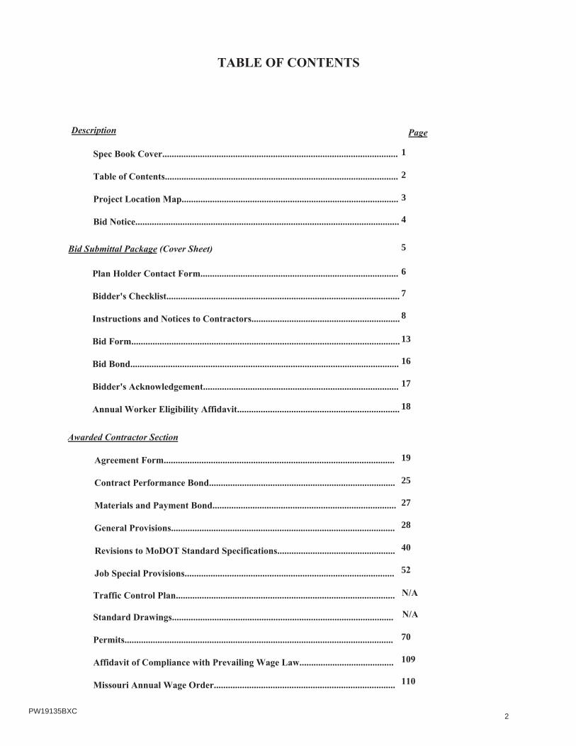
2
2
1
3
N/A
N/A
4
5
6
7
8
13
16
17
18
19
25
27
28
40
52
70
109
110
PW19135BXC

3PW19135BXC

BID NOTICE
Sealed bids for will be received at the office of The Department of the County Clerk, Jefferson County Administration Center, 729 Maple Street, Hillsboro, Missouri until 2:00 o'clock P.M. on, and at that time will be publicly opened and read. All bids shall be submitted in triplicate in an opaque sealed envelope, marked with the Project title, name and address of the Bidder, and accompanied by the other required documents. Bids submitted via fax or electronic will be rejected. Late Bids will not be accepted and will be returned to the sender, unopened.
Work shall be in accordance with the provided Specifications, Job Special Provisions, and Plans. Where not specificallycovered by the Specifications, or Job Special Provisions or Plans, the Contractor shall adhere to the currently effectiveEdition of the “Missouri Standard Specifications for Highway Construction”, and the currently effective “MoDOTStandard Plans for Highway Construction.” The contractor shall have a maximum of
working days to complete the project.
Plans and specifications for this project will be available, a no cost, downloadable files from the Jefferson County website (http://www.jeffcomo.org/PublicWorksProjects.aspx?nodeID=Purchasing), beginning Friday,The bidder will be responsible the County’s website for addendum(s) regarding this project prior to bidopening. All potential bidders must complete the “Plan Holder Contact Information” form and submit this formto Public Works at [email protected] and request placement on the bidder’s list.
All labor used in the construction of this public improvement shall be paid a wage no less than the prevailing hourly rate of wages of work, of a similar character in this locality, as established by the State of Missouri’s “Annual Wage Order” that is currently effective 10 calendar days prior to bid opening.
, Missouri hereby notifies all bidders that it will affirmatively ensure that in any contract entered intopursuant to this advertisement, businesses owned and controlled by socially and economically disadvantaged individuals will be afforded full opportunity to submit bids in response to this invitation and will not be discriminated against on the grounds of race, color, religion, creed, sex, age, ancestry, or national origin in consideration for an award.
All bidders must be on MoDOT’s Qualified Contractor List per Section 102.2 of the Missouri Standard Specifications for Highway Construction, Edition. The contractor questionnaire must be on file 7 days prior to bid opening.
Contractors and sub-contractors who sign a contract to work on any public works project must provide a minimum 10-Hour OSHA construction safety program, or similar program approved by the Department of Labor and Industrial Relations, to be completed by their on-site employees within sixty (60) days of beginning work on the construction project.
A certified or cashier’s check or a bid bond in the amount of 5% shall be submitted with each proposal. A certificate of insurance shall be submitted with each proposal.
All bids shall be made on the forms provided. Three (3) copies of the bid must be submitted, one (1) being original inked. , Missouri reserves the right to reject any or all bids, to waive any informality in the bids received, and to
award the contract to the lowest, responsive, responsible bidder.
END BID NOTICE
4
PW19135BXCHEADS CREEK ROAD STRUCTURE REPLACEMENT
March 5th, 2019CST
The proposed work includes: Removal and replacement of existing structure and approach pavement on Heads Creek Road. Thework in general will consist of the installation of a new concrete box culvert, bituminous pavement installation, guardrailinstallation, stream bank stabilization, and rock blanket installation. The total length of the project is approximately 140 feet (0.02miles).
forty40
February 8th, 2019.
PW19135BXC

5
HEADS CREEK ROAD STRUCTURE REPLACEMENT
PW19135BXC ROAD/BRIDGE
HEADS CREEK ROAD JESSE MESEY
1350001 [email protected]
March 5th, 2019 CST
PW19135BXC

6
PW19135BXC HEADS CREEK ROAD STRUCTURE REPLACEMENT
March 5th, 2019 CST$445,000.00
PW19135BXC

8
March 5th, 2019CST
The proposed work includes: Removal and replacement of existing structure and approach pavement on Heads Creek Road. Thework in general will consist of the installation of a new concrete box culvert, bituminous pavement installation, guardrailinstallation, stream bank stabilization, and rock blanket installation. The total length of the project is approximately 140 feet (0.02
PW19135BXC

9
40
500 FIVE HUNDRED
PW19135BXC

10PW19135BXC

11PW19135BXC

12PW19135BXC

13
HEADS CREEK ROAD STRUCTURE REPLACEMENTPW19135BXC
PW19135BXC

BID ITEMS:
HEADS CREEK STRUCTURE REPLACEMENT PW19135BXC
ROADWAY ITEMS:ITEM
NUMBERDESCRIPTION UNIT QUANTITY UNIT PRICE $ AMOUNT
2013000 Clearing and Grubbing AC 0.52022010 Removal of Improvements LS 12022019 Sawcutting LF 472035000 Unclassified Excavation CY 4542035500 Embankment in Place CY 1102036000 Compacting Embankment CY 110
3040504Type 5 Aggregate for Base
(4"Thick) (Roadway)SY 191
3040514Type 5 Aggregate for Base(14" Thick) (Shoulders)
SY 44
4011209Bituminous Pavement Mixture PG64 22, (BP 1)
(Roadway & Shoulders)TON 30.6
4013000Bituminous Pavement Mixture PG64 22, (Base)
(Roadway & Shoulders)TON 123.6
4071005 Tack Coat Gal 106061060 MGS Guardrail LF 75
6063015Crashworthy End Terminal
(50' System Length)EA 2
066610End Anchor (End Shoe Guardrail)
(12.5' System Length)EA 2
JSP Furnishing Rock Backfill, R18 CY 153JSP Placing Rock Backfill, R18 CY 153JSP Furnishing Rock Boulders, B36 (30" 42") CY 703JSP Placing Rock Boulders, B36 (30" 42") CY 703JSP 12" Flexible Storm Pipe & Banding LF 20
6161097 Traffic Control (All Inclusive) LS 16181000 Mobilization LS 1
6274000Contractor Furnished Surveying and
Staking (MoDOT Spec.)LS 1
8051000A Seeding & Mulching AC 0.28061019 Silt Fence LF 371
8065599SWPPP Design, Installation, Maintenance,
& RemovalLS 1
8080099 Restoration LS 1ROADWAY ITEMS =
BRIDGE ITEMS:ITEM
NUMBERDESCRIPTION UNIT QUANTITY UNIT PRICE $ AMOUNT
2063300 Class 4 Excavation CY 3502064099 Granular Backfill CY 612160500 Removal of Bridges LS 17034009 Class B 1 Concrete (Retaining Walls) CY 28.17034040 Class B 1 Concrete (Culverts Bridge) CY 131.47061020 Reinforcing Steel (Culverts Bridge) LBS 124307061040 Reinforcing Steel (Retaining Walls) LBS 55207101000 Reinforcing Steel (Epoxy Coated) LBS 88307133000 Bridge Guardrail (W Beam) EA 40
BRIDGE ITEMS =
14PW19135BXC

15
40FIVE HUNDRED
500
PW19135BXC

16PW19135BXC

17PW19135BXC

18PW19135BXC

19
40
FIVE HUNDRED500
HEADS CREEK ROAD STRUCTURE REPLACEMENT PW19135BXC
The proposed work includes: Removal and replacement of existing structure and approach pavement on Heads CreekRoad. The work in general will consist of the installation of a new concrete box culvert, bituminous pavementinstallation, guardrail installation, stream bank stabilization, and rock blanket installation. The total length of theproject is approximately 140 feet (0.02 miles).
PW19135BXC

BID ITEMS:
HEADS CREEK STRUCTURE REPLACEMENT PW19135BXC
ROADWAY ITEMS:ITEM
NUMBERDESCRIPTION UNIT QUANTITY UNIT PRICE $ AMOUNT
2013000 Clearing and Grubbing AC 0.52022010 Removal of Improvements LS 12022019 Sawcutting LF 472035000 Unclassified Excavation CY 4542035500 Embankment in Place CY 1102036000 Compacting Embankment CY 110
3040504Type 5 Aggregate for Base
(4"Thick) (Roadway)SY 191
3040514Type 5 Aggregate for Base(14" Thick) (Shoulders)
SY 44
4011209Bituminous Pavement Mixture PG64 22, (BP 1)
(Roadway & Shoulders)TON 30.6
4013000Bituminous Pavement Mixture PG64 22, (Base)
(Roadway & Shoulders)TON 123.6
4071005 Tack Coat Gal 106061060 MGS Guardrail LF 75
6063015Crashworthy End Terminal
(50' System Length)EA 2
066610End Anchor (End Shoe Guardrail)
(12.5' System Length)EA 2
JSP Furnishing Rock Backfill, R18 CY 153JSP Placing Rock Backfill, R18 CY 153JSP Furnishing Rock Boulders, B36 (30" 42") CY 703JSP Placing Rock Boulders, B36 (30" 42") CY 703JSP 12" Flexible Storm Pipe & Banding LF 20
6161097 Traffic Control (All Inclusive) LS 16181000 Mobilization LS 1
6274000Contractor Furnished Surveying and
Staking (MoDOT Spec.)LS 1
8051000A Seeding & Mulching AC 0.28061019 Silt Fence LF 371
8065599SWPPP Design, Installation, Maintenance,
& RemovalLS 1
8080099 Restoration LS 1ROADWAY ITEMS =
BRIDGE ITEMS:ITEM
NUMBERDESCRIPTION UNIT QUANTITY UNIT PRICE $ AMOUNT
2063300 Class 4 Excavation CY 3502064099 Granular Backfill CY 612160500 Removal of Bridges LS 17034009 Class B 1 Concrete (Retaining Walls) CY 28.17034040 Class B 1 Concrete (Culverts Bridge) CY 131.47061020 Reinforcing Steel (Culverts Bridge) LBS 124307061040 Reinforcing Steel (Retaining Walls) LBS 55207101000 Reinforcing Steel (Epoxy Coated) LBS 88307133000 Bridge Guardrail (W Beam) EA 40
BRIDGE ITEMS =
20PW19135BXC

21PW19135BXC

22PW19135BXC
HEADS CREEK ROAD STRUCTURE REPLACEMENT PW19135BXC

23PW19135BXC

24PW19135BXC

25PW19135BXC

26PW19135BXC

27PW19135BXC

28PW19135BXC

29PW19135BXC

30PW19135BXC

31PW19135BXC

32PW19135BXC

33PW19135BXC

34PW19135BXC

34) CHANGES: The Owner and/or the Consultant shall have the right to make changes within the scope of the work or change the quantities of the work to be performed. No such change shall be valid unless made in writing by the Owner or Consultant, approved by the engineer, and adopted by the county council. In the event such changes cause an increase or decrease in the Contractor’s cost, or time required for performance of the contract, the contract price and/or period of performance shall be equitably adjusted; provided, the increase or decrease in the amount of the work for which unit prices apply under the specifications shall be computed by multiplying the change in quantities (measured as provided in the contract documents) of such work by such contract prices.
In the absence of a bid price for a given item of work not provided for nor fairly included in the bid prices for other items of work, a written agreement may be made between the Owner and the Contractor to be included in the written order for such extra work. New items specifically covered under Section 109 of the Missouri Standard Specification for Highway Construction, 2016 shall be added to the contract as stated in those specifications. Incidental items, noted anywhere in the plans, specifications, or supplemental specifications, shall not be considered for additional compensation. Whenever the Contractor and the Owner are unable to agree on prices for extra work and the Owner directly or acting through the Consultant orders the Contractor to proceed with the work by force account, the work will be paid for in the manner herein described and the compensation thus provided shall constitute full payment for said work. All additional work provided by force account shall be calculated and compensated per Section 109.5 of the Missouri Standard Specifications for Highway Construction, 2016.
35) LIENS AND CLAIMS: In addition to other remedies available the Owner hereunder, in all cases of non-payment by the Contractor or a subcontractor of any sums of money due for labor, materials, supplies, equipment or other items in performing in this contract, or if at any time there should be evidence of a lien or claim chargeable to the Contractor or a subcontractor for which, if established, the Owner might become liable, the Owner is hereby authorized and empowered to retain out of any payment then due or thereafter to become due to the Contractor, an amount sufficient to indemnify the Owner against any such lien or claim.
Alternatively, without limiting other remedies and rights of the Owner under the Contract, under the Contractor’s bonds or under the law, the Owner may withhold, in addition to the 10 percent retention, a sufficient amount of payments otherwise due to the Contractor to cover payments that may be past due and payable by the Contractor or his subcontractors or suppliers for just claims for labor or materials furnished in and about the performance of the work under this contract and for failure of the Contractor to make proper payments to his subcontractors. The Owner shall disburse and shall have the right to act as agent for the Contractor in disbursing such funds as have been withheld pursuant to this paragraph to the party or parties who are entitled to payment there from. The Owner will render the Contractor a proper accounting of all such funds disbursed in behalf of the Contractor.
36) RESPONSIBILITY: Nothing in the Contract Documents shall be construed as placing the work under the specific direction or supervision of the Owner or the Consultant, or relieving the Contractor from his liability as an independent contractor and, as such, he shall perform his work, including, but not limited to, supervision and control of his own personnel and scheduling of the work as required to ensure its proper and timely performance, and he shall be solely responsible for the exercise of due care to prevent bodily injury and damage to property in the execution of the work. The Owner need not be present to witness installation of materials or performing of a service to deem the product or service unsatisfactory, and order the removal, replacement, installment, repetition, or depreciation of compensable value of the defective material or service.
37) INDEMNIFICATIONS AND INSURANCE:
Contractor’s Responsibility for Claims for Damage or Injury: The Contractor and surety shall indemnify and save harmless the County, and its members, agents and employees from all claims or suits made or brought for personal injury, death or property damage, caused or contributed to be caused by:
(a) The negligence of the contractor, subcontractors, suppliers or their respective officers, agents or employees; (b) The creation or maintenance of a dangerous condition of or on the County’s property or right of way, which
condition occurred at least in part due to the acts or omissions of the contractor, subcontractors, suppliers or their respective officers, agents or employees; or
(c) The failure of the contractor, subcontractors, suppliers of their respective officers, agents or employees, to perform the work in accordance with the plans and specifications.
Neither the County nor the Contractor, by execution of a contract, shall intend to or create a new or enlarge an existing causeof action in any third party. This provision shall not be interpreted to create any new liability which does not exist under the
GP-8 35
PW19135BXC

statutory limited waiver of sovereign immunity, or to waive or extinguish any defense which either party to this contractor their respective agents and employees may have to an action or suit by a third party.
Contractor's Responsibility for Work: Until the County accepts the work, it shall be in the custody and under thecharge and care of the Contractor. The Contractor shall restore and replace, at the Contractor’s expense, any lost orstolen County-owned material in the Contractor’s custody or control. Damages to any portion of the work before itscompletion and acceptance, caused by the action of the elements or from any other reason, shall be restored or replacedat the Contractor’s expense. Issuance of a payment estimate on any part of the work done will not be considered asfinal acceptance of any work completed up to that time. The County may, in its discretion, make such adjustments as itconsiders being proper for damage to the work due to unforeseeable causes beyond the control of, and without fault ornegligence on the part of the Contractor.
Liability Insurance Requirements: The Contractor shall procure and maintain at its own expense, until acceptance ofthe project by the County, liability insurance for all damages and losses imposed by law and assumed under the contract,of the kinds and in the amounts specified in the relevant sections shown herein. Before the Contractor commences thework, the Contractor shall require the insurance company or companies to furnish to the County evidence of such insuranceshowing compliance with these specifications. All insurance required herein shall be occurrence policies in a formacceptable to the County, and shall remain in force until all work required to be performed under the terms of the contractis satisfactorily completed as evidenced by its formal acceptance by the County.
Each policy or its declaration pages shall provide that the policy shall not be materially changed or canceled until theCounty has been given at least 30 days advance notice in writing. If any policy is canceled before the contract work iscomplete, a satisfactory replacement policy must be in force, with notice and evidence of insurance submitted to theCounty, prior to the effective date of cancellation of the former policy. All evidence of insurance and notices shall besubmitted to: Director of Public Works, Jefferson County Public Works Department, 725 Maple Street, PO Box 100,Hillsboro, Missouri 63050. The Contractor shall furnish the County with a complete copy of the policy prior to thetime the Contractor commences work on the site of the project. Failure to furnish evidence of proper insurance, orcomplete insurance policies will result in temporary suspension of work and may result in other claims or actions for breachof contract or otherwise, as may be recognized at law or in equity.
Workers' Compensation Liability Insurance: The Contractor shall furnish evidence to the County that, with respect tothe operations it performs, it carries workers’ compensation insurance, or is qualified as self-insured, sufficient to complywith all its obligations under state laws relating to worker’s compensation. The Contractor shall also require eachsubcontractor on the project to furnish the same evidence to the County. This evidence shall be furnished to and approvedby the County prior to the time the Contractor or the subcontractor commences work on the site of the project. Worker’sCompensation Liability Insurance shall be submitted with the bid
Commercial General Liability Insurance: The Contractor shall obtain one or more occurrence-based policies ofcommercial general liability insurance (Form CG 00 01 or equivalent), which provide coverage for the contract work. Theminimum limits of liability for commercial general liability insurance shall be: $1,000,000 each bodily injury or propertydamage occurrence, combined single limit, $2,000,000 general aggregate with a per project endorsement and $1,000,000products/completed operations aggregate. Each such policy shall be endorsed so as to cover liability arising from blastingif applicable, other inherently dangerous activities and underground property damage. Each such policy shall be endorsedto include broad form general liability, contractual liability and completed operations coverage. Commercial GeneralLiability Insurance shall be submitted with the bid
Commercial Auto Liability Insurance: The Contractor shall obtain one or more occurrence-based policies of autoliability insurance, which provide for its owned, non-owned and hired vehicles of every type and description, which areused in the contract work. The minimum limits of liability for such insurance shall be $1,000,000 combined single limit. Commercial Auto Liability Insurance shall be submitted with the bid
Additional Insureds: Each such policy of commercial general liability insurance shall name the County of Jeffersonand its employees as additional insureds. Each commercial general liability insurance policy shall also contain aseparation of insureds condition. The insurance afforded by the Contractor shall be primary insurance.
Subcontractor's Coverage: If any part of the contract is subcontracted, each subcontractor, or the Contractor on behalfof the subcontractor, shall obtain the same commercial general liability insurance and commercial automobile liabilityinsurance coverage. The commercial general liability insurance shall name the same entities specified above as additional
GP-9 36
PW19135BXC

insureds, and shall have the same separation of insureds conditions.
Railroad Protective Liability Insurance: In addition to other required liability insurance, the Contractor shall provide railroad protective liability insurance if applicable, for and in behalf of the railroad as outlined in provisions for each project. The insurance policy shall be submitted to the County in original and duplicate for approval. No work will be permitted on the railroad right of way until such approval is granted.
Insurance with Other Than Missouri Companies: Any insurance policy required as specified above, if written by an insurance company organized in a state other than Missouri, shall be signed by an agent or broker licensed by the State of Missouri. In the case of policies written by companies organized in a state other than Missouri, the evidence of insurance submitted as authorized in the contract shall be signed by an agent or broker licensed by the State of Missouri. Nothing in this provision limits or waives the requirement that each insurance policy must be issued by a company authorized to issue such insurance in Missouri.
Third Party Liability: Neither the State of Missouri, the County of Jefferson nor the Contractor, by execution of the contract including these specifications, intend to create a right of action in a third party beneficiary except as specificallyset out in these specifications and the contract. It is not intended by any required contractual liability in the contract or inthese specifications that any third party beneficiary has a cause of action arising out of the condition of the project when completed in accordance with the plans and accepted by the County.
Personal Liability of Public Officials: There shall be no personal liability upon the County, or any member, employee or agent of the County in carrying out any of the provisions of the contract or in exercising any power or authority granted to them, it being understood that in such matters they act as agents and representatives of the County, with official and public duty doctrine immunity. If any provision of the contract appears to impose a duty on such an individual, the duty remains exclusively that of the County and is not a personal duty or obligation of the individual
Professional Liability Insurance: The Vendor/Contractor shall provide the County with proof of Professional Liability Insurance, which shall protect the County against any and all claims, which might arise as a result of the operation of the Vendor/Contractor in fulfilling the terms of this Contract during the life of the Contract. The minimum amounts of such insurance will be $1,000,000.00. Should any work be subcontracted, these limits will also apply.
38) BOND: The Contractor at his expense shall, before commencing work hereunder, procure and deliver to the Owner a Performance Bond and a Labor and Materials Payment Bond in the amount of 100% of the contract as awarded, as security for the faithful performance of the contract and the payment of all obligations thereunder by the Contractor and his subcontractors. The Bonds shall be written in such form as may be satisfactory to the Owner and provided by a guaranty or surety company listed in the latest issue of U.S. Treasury Circular 570 and the penal sum shall be within the maximum specified for such company in said Circular 570. In substance, the condition of the obligation under said bond or bonds shall be as follows:
“The condition of this obligation is such that if the above bound Principal shall in all respects comply with the terms and conditions of said contract and his obligations thereunder, including the specifications and plans referred to therein, and such changes and alterations as may be made in said contract, specifications and plans and shall indemnify and save harmless the Owner against or from all costs, expenses, damages, injuries or losses to which the said Owner may be subjected by reason of any wrongdoing, misconduct, want of care or skill, negligence of default on the part of said Principal, his subcontractors, officers, agents or employees, in the execution of performance of said contract and shall promptly pay all just claims for damages for injury to property and for labor, equipment, materials and supplies incorporated in the work or consumed in the performance thereof incurred by said Principal, his subcontractors, officers, agents or employees, in or about the construction or improvement contracted for, then this obligation shall be void; otherwise, to remain in full force and virtue in law. The Surety hereby waives notice of any changes, alterations or modifications, including any extensions of the period of performance, in the contract, specifications and plans.”
If any surety upon any bond furnished in connection with this contract becomes unacceptable to the Owner, or if any such surety fails to furnish reports as to his financial condition from time to time as requested by the Owner, the Contractor shall promptly furnish such additional security as may be required from time to time to protect the interests of the Owner and of persons supplying labor or materials in the prosecution of the work contemplated by this contract.
GP-10 37
PW19135BXC

39) ROYALTIES AND PATENTS: The Contractor shall indemnify, defend, and hold harmless, the Owner and Consultant from all liabilities, decrees, judgments, claims or disbursements, including attorney fees and/or damages and expenses which may come against or be incurred by the Owner or the Consultant by reason of the use of any patented material, machinery, devices, equipment or processes furnished or used in the performance of the work under this contract or the use by the Owner of the completed structure or by reason of the use of patented designs furnished by the Contractor and accepted by the Owner. In the event any claim, action at law or suit in equity of any kind whatsoever is made or brought against the Owner, the Owner shall have the right, without impairment of the foregoing indemnification, to retain from the money due and to become due said Contractor a sufficient amount of money to protect itself against loss
40) CONFLICTS IN CONTRACT DOCUMENTS: Where any provision of plans, specifications, or any other document referred to or incorporated into the Contract Documents is inconsistent or in conflict with the another provision of the Contract Documents, the order of governance shall be per the revised Section 105.4 of the Missouri Standard Specifications for Highway Construction, as stated in these General Provisions, Provision 44
41) STANDARDS: Where materials and methods are indicated in the specifications as being in conformance with a standard specification, references shall be to the most current available standard at time of the opening of bids.
42) FEDERAL EMPLOYMENT AUTHORIZATION: The Contractor shall comply with the requirements of the revised Statutes of the State of Missouri Chapter sections 285.525 to 285.555. If any part of the contract is subcontracted, each subcontractor shall comply with the same requirements of this specification.
No Contractor shall knowingly employ, hire for employment, or continue to employ an unauthorized alien to perform work within the state of Missouri. As a condition for the award of the contract the Contractor shall, by sworn affidavit and provision of documentation, affirm its enrollment and participation in a federal work authorization program with respect to the employees working in connection with the contracted services. Everysuch Contractor shall also sign an affidavit affirming that it does not knowingly employ any person who is an unauthorized alien in connection with the contracted services.
A Contractor may enroll and participate in a federal work authorization program and shall verify the employment eligibility of every employee in the Contractor’s hire whose employment commences after the Contractor enrolls in a federal work authorization program.
A general contractor or subcontractor of any tier shall not be liable under sections 285.525 to 285.550 when such general contractor or subcontractor contracts with its direct subcontractor who violates subsection 1 of this section, if the contract binding the contractor and subcontractor affirmatively states that the direct subcontractor is not knowingly in violation of subsection 1 of this section and shall not henceforth be in such violation and the contractor or subcontractor receives a sworn affidavit under the penalty of perjury attesting to the fact that the direct subcontractor’s employees are lawfully present in the United States.
43) OSHA TRAINING: The Contractor shall comply with the requirements of the revised Statutes of the State of Missouri Chapter sections 292.675. If any part of the contract is subcontracted, each subcontractor shall comply with the same requirements of this specification.
Any Contractor signing a contract to work on the construction of public works for the Owner shall provide a ten-hour Occupational Safety and Health Administration (OSHA) construction safety program for their on-site employees which includes a course in construction safety and health approved by OSHA or a similar program approved by the department which is at least as stringent as an approved OS11A program. All employees are required to complete the program within sixty (60) days of beginning work on such construction project.
Any employee found on a worksite subject to this section without documentation of the successful completion of the course required under this section shall be afforded twenty (20) days to produce such documentation before being subject to removal from the project. The contractor shall forfeit as a penalty to the Owner two thousand five hundred dollars ($2,500) plus one hundred dollars ($100) for each employee employed by the contractor or subcontractor, for each calendar day, or portion thereof, such employee is employed without the required training. The penalty shall not begin to accrue until the time period in this section has elapsed.
GP-11
38PW19135BXC

The Owner shall withhold and retain all sums and amounts due and owing as a result of any violation of this section when making payments to the contractor under the contract. The contractor may withhold from any subcontractor, sufficient sums to cover any penalties the Owner has withheld from the contractor resulting from the subcontractor’s failure to comply with the terms of this section. If the payment has been made to the subcontractor without withholding, the contractor may recover the amount of the penalty resulting from the fault of the subcontractor in an action maintained in the circuit court in the county in which the public works project is located from the subcontractor.
In determining whether a violation of this section has occurred, and whether the penalty of this section shall be imposed, the Department of Labor and Industrial Relations shall investigate any claim of violation. Upon completing such investigation, the Department shall notify the Owner and any party found to be in violation of this section of its findings and whether a penalty shall be assessed. Determinations under this section may be appealed in the circuit court in the county in which the public works project is located. The Department may establish rules and regulations for the purpose of implementing the provisions of this section.
GP-12 39
PW19135BXC

REVISIONS TO MODOT STANDARD SPECIFICATIONSRev. 01/01/19
Modifications to the 2018 Missouri Standard Specifications for Highway Construction shall be as listed herein.
SECTION 102BIDDING REQUIREMENTS AND CONDITIONS
All references to submitting electronic bids in Section 102 shall be deleted. Please refer to the “Bid Notice” for directions to submit bids on County projects.
Delete Section 102.3 Bidding – in its entirety and replace it with the following:
102.3 Bidding Documents. Upon request, the County will furnish the bidding documents to the prospective bidder. These documents will generally be available on the County’s website for download and viewing. All prospective bidders must complete the registration form titled “PLAN HOLDER CONTACT INFORMATION” to be eligible to bid on the project and in order to receive updated notices. The documents will state the location, description and requirements of the contemplated construction and will show the estimate of the various quantities and kinds of work to be performed or material to be furnished, and will have a schedule of items for which unit bid prices are invited. The bidding documents will state the time in which the work shall be completed, the amount of the bid guaranty, and the date, time and place of the opening of bids.
102.3.1 All papers bound with or attached to or referenced in the bidding documents are considered a part thereof and must not be detached or altered when the bid is submitted.
102.3.2 If applicable, the prospective bidder will be required to pay the Commission the sum stated in the notice of bid opening for each copy of a project's bidding documents. The Missouri Standard Specifications for Highway Construction, Missouri Standard Plans for Highway Construction, including all revisions of these documents, and other items referenced in the bidding documents, whether attached or not, will be considered a part of the bid. A prospective bidder will be expected to separately purchase or have access to the current edition of the Missouri Standard Specifications for Highway Construction and the Missouri Standard Plans for Highway Construction, including all revisions of these documents.
102.3.3 It will be conclusively presumed that all of the bidding documents are in the bidder’s possession and that these documents have been reviewed and used by the bidder in the preparation of any bid submitted. The effective dates of the General Provision & Supplemental Specifications and the Supplemental Plans for Highway Construction will be specified in the contract documents. A copy of the latest version of these documents is available on MoDOT’s web site.
Delete Section 102.7 Preparation of Bidding Documents – in its entirety and replace it with the following:
102.7 Preparation of Bidding Documents. All bids shall be properly signed, sealed and submitted in accordance with Sec 102.10. Each bidder shall specify in the bid, in figures, a unit price for each of the separate items listed in the biddingdocuments, except a unit price entry will not be necessary for those items having a quantity of one and only the amount for that item need be entered. Zero will be considered a valid bid. The bidder shall not enter zero in any "Unit Price" field unless zero is the intended bid for that item. A unit price left blank, with or without an extension, other than items having a quantity of one, will be considered as zero by the Commission. In case of alternate items, unit prices shall be entered for only one alternate, unless otherwise specified in the bidding documents. A unit price shall not exceed two decimal places. Bids shall not contain interlineations, alterations or erasures except as noted in Sec 102.7.1. The bidder shall show the products of the respective unit prices and quantities in the amount column provided for that purpose. The extension of each line item shall be rounded to the nearest second decimal place value, with half cents rounded up. These extensions shall be totaled and in case of errors or discrepancies in extensions, the unit prices shall govern. All entries in the bid shallbe in ink or typewritten. If, in the sole discretion of the engineer, an obvious and apparent clerical error exists in the unit price listed for an item due to a misplaced decimal, but the extension appears to be correct and as intended in all respects, the engineer may correct the unit price bid in accordance with the extension listed. All errors in extensions or totals will be corrected by the engineer and such corrected extensions and totals will be used in comparing bids.
40PW19135BXC

102.7.1 A bidder may alter or correct a unit price, lump sum bid or extension entered on the paper bid form or the computer-generated itemized paper bid form by crossing out the figure with ink and entering a new unit price, lump sum bid or extension above or below in ink, with the bidder’s initials.
102.7.2 A bidder may submit a separate bid on any or all projects, except that bids shall be submitted for all projects in a required combination. Bidders not having the ability to simultaneously execute all contracts for bids submitted during a bid opening may state, in one of the bids, the maximum total value of contract awards the bidder is willing to accept for that bid opening. Only one statement of “Maximum Monetary Value of Awards Accepted this Bid Opening” shall be completed per bid opening. In the event a bidder submits multiple statements of maximum award, the lowest value stated will be used. The Commission reserves the right to select and award the combination of bids, not exceeding this maximum, that will be to the best interest of the County provided these bids are in conformance with the requests for bids. Any corrected bid that exceeds the lowest specified maximum award may be declared non-responsive.
102.7.3 The bid of an individual, including those doing business under a fictitious name, shall include the signature and address of the individual. The signature shall be exactly the same as that appearing on the contractor questionnaire.
102.7.4 The bid by a partnership or joint venture, including individuals doing business under fictitious names or corporations, shall be executed by at least one of the partners followed by the title "Partner" or one of the joint venturers followed by the title "Joint Venturer" and the business address of the partnership or joint venturer shown. The true legal name and address of each partner and joint venturer shall also be shown and shall appear exactly the same as that shown on the contractor questionnaire.
102.7.5 The bid by a corporation, whether acting alone or as a joint venturer, shall show the address and name of the corporation exactly as shown on the contractor questionnaire, and shall include the signature or digital ID and title of a person authorized by its board of directors to bind the corporation.
102.7.6 Each bidder shall submit with each bid a sworn statement, executed by or on behalf of the bidder to whom a contract may be awarded, certifying that the bidder has not, either directly or indirectly, entered into any agreement, participated in any collusion or otherwise taken any action in restraint of free competitive bidding in connection with the bid or any contract that may result from its acceptance.
102.7.7 A bid will not be accepted or considered if the bid is the product of collusion among bidders, if the bidder is disqualified or determined not responsible or if the bid is irregular in accordance with Sec 102.8.
Delete Section 102.9 Bid Guaranty – in its entirety. (See Section 11 of the “Instructions and Notices to Contractors” in the bid documents)
Delete Section 102.10 in its entirety.
Delete Section 102.11 in its entirety.
SECTION 105 CONTROL OF WORK
Delete Section 105.1- Authority and Duties of Commission in Contract Administration - items (a) through (h) that pertain exclusively to MoDOT and not to the County of Jefferson.
Revise 105.4 - Coordination of Contract Documents. - such that the governing ranking will be as follows:
(a) Job Special Provisions (b) Project Specific Drawings (c) General Provisions (d) Revisions to MoDOT Standard Specifications (e) General Special Provisions (f) Supplemental Specifications (g) Standard Specifications (h) Standard Drawings (i) Bid Items or Quantities
In case of discrepancies, calculated dimensions will govern over scaled dimensions.
41PW19135BXC

SECTION 107LEGAL RELATIONS AND RESPONSIBILITY TO THE PUBLIC
If a Corps of Engineers 404 Permit or Department of Natural Resources Section 401 permit is applicable for a project, then the permit requirements and conditions will prevail over Section 107.10.
SECTION 109MEASUREMENT AND PAYMENT
Delete Section 109.9.1.2 of Division 109.9 - Retained Percentage - in its entirety.
Delete Section 109.14 – Price Adjustment for Fuel - in its entirety.
SECTION 201CLEARING AND GRUBBING
Add the following to Section 201.2.2.1 Clearing:
(e) All branches hanging lower than 18 feet above the finish roadway surface shall be removed over all lanes of traffic, including up to 3 feet outside the traveled edge of pavement.
SECTION 203ROADWAY AND DRAINAGE EXCAVATION, EMBANKMENT AND COMPACTION
Modify Section 203.3.1 of Section 203.3 – Borrow – as follows:
Replace the first sentence with the following: Borrow will consist of approved material required for the construction of embankment or for other portions of the work, and shall be obtained either from borrow areas shown on the plans, from areas designated by the engineer, or from other approved sources.
Modify Section 203.4 as follows:
Delete the reference in Section 203.4.1 that states, “Finishing by hand methods will not be required,…”: Replace with the following:
Hand raking or fine grading by mechanical means of the disturbed areas shall be required to remove debris and stones. The soil shall be tilled to a depth of 4” and graded to a reasonably smooth surface. All brush, weeds, excess mud and silt, or other debris shall be removed from culverts and channels within the scope of the work in accordance with Sec 104.11.2, even if such structures are used in place.
Replace Section 203.4.1.1 with the following:
Field Stone. Before final project acceptance, the removal and disposal requirements of all loose field stones shall be guided by the following table:
SECTION 206EXCAVATION FOR STRUCTURES
Location - limits Residential business where maintained
lawns areLimits
All disturbed areas
Foreslopes, roadside ditches and backslopes outsideof maintained lawn areas Rock cut sections
Right of way
Maximum Stone SizeRelatively free of stones – ½”maximum 1” maximum
All disturbed areas As directed by the Engineer
42PW19135BXC

Replace Section 206.5.2 – with the following: “Final measurement of Class 3 Excavation for pipe culverts, utilities, retrofit pipe culverts, drop inlets or manholes will be made to reflect the actual computed quantity established from field measurements. The plan quantities were estimated based on the random boring data and visual observations of the adjacent existing ditch lines. The revision or correction will be computed and added to or deducted from the contract quantity. Measurement of Class 3 Excavation will be made to the nearest cubic yard for each structure of that volume of material actually removed from within the area bounded by vertical planes of 12 inch minimum to 18 inches maximum outside of the outer walls of the structure. The upper limits of the volume measured, will be the existing ground line, or the lower limits of the roadway excavation, whichever is lower. The lower limits of the volume measured will include excavation necessary for pipe bedding.
SECTION 304BASES AND AGGREGATE SURFACES
Delete Section 304.3.5 - Substitutions for Aggregate Base - in its entirety.
Modify Section 304.5 – Method of Measurement – as follows: Final measurement of the completed aggregate base course will be based on actual field measurements to the nearest square yard.
Replace Section 304.6 - Basis of Payment – with the following: “The accepted quantities of aggregate base course of the thickness and type specified will be paid for at the contract unit price for each of the pay items included in the contract. Payment will be considered full compensation for water used in performing this work.”
SECTION 401PLANT MIX BITUMINOUS BASE AND PAVEMENT
Section 401.4 Job Mix Formula – The County may waive submission of representative mixture samples. The Contractor, at the time he submits his job mix formula, shall request in writing whether samples are required. The County will respond in writing and if samples are required, they shall be submitted within ten working days of receipt of the County’s letter.
Section 401.4.1 Mixture Design – Modify this paragraph as follows:
The mix design shall be submitted to the County for approval at least seven (7) days prior to mixture production. A mix design shall be submitted for all County projects. The composition of the mixture shall conform to the following limits by weight:
Total Mineral Aggregate 94.0-96.5 % Asphalt Binder 3.5-6.0 %
Add the following item to Section 401.4.2 – Required Information:
(q) Unit weight of combined mixture.
Modify Section 401.4.3 Mixture Approval so that “Jefferson County” is substituted where it presently reads “Construction and Materials”.
Delete Section 401.5.2 Substitutions - in its entirety.
Delete Section 401.6 Field Laboratory – in its entirety.
Delete Section 401.7.1 and replace with the following:
401.7.1 Weather Limitations. Bituminous mixtures shall not be placed (1) when either the air temperature or the temperature of the surface on which the mixture is to placed is below 40 F (5 C), (2) on any wet or frozen surface, or (3) when weather conditions prevent the proper handling or finishing of the mixture. Temperatures are to be obtained in accordance with MoDOT Test Method TM20.
43PW19135BXC

If a rainfall event occurs (with rain duration lasting more than 5 min.) before 10am on any given workday, then paving operation shall be cancelled for the balance of that workday and the contractor is not charged for the workday. Once a rainfall event begins the contractor is to immediately shut down plant mix operation. No pavement materials will be accepted at the construction site until further notice from engineer. At the contractor’s request, the engineer may waive these requirements on an individual basis.
401.7.5.1 Irregularities. Add a sentence preceding the sentence “The outside edge alignment shall be uniform” as follows: The outside edges of the pavement shall be constructed to an angle of approximately 45 degrees with the surface of the roadbed and rolled with a hand roller for a smooth appearance.
Replace Section 401.8 Quality Control with the following:
The Contractor shall maintain equipment and qualified personnel or retain the services of a qualified testing laboratory to perform QC field inspection, sampling and testing in accordance with applicable portions of Section 403. The testing service shall be a firm different than the one retained by the County for testing services on that project. The Contractor shall notify the Engineer at the preconstruction meeting who he intends to use for testing services, the name of a contact person and his or her telephone number. A proposed third party testing service for dispute resolution shall be included with the mix design submittal.
Replace the last sentence in Section 401.8.4 Pavement Testing with the following:
The Contractor shall restore the surface from which samples have been taken immediately with the mixture under production or with a non-shrink concrete grout. A cold patch mixture will not be acceptable.
Replace Section 401.13 Method of Measurement with the following:
Measurement will be in accordance with Sec 403.22 and as modified by the job special provisions.
SECTION 402PLANT MIX BITUMINOUS SURFACE LEVELING
Delete Section 402.2.2 – in its entirety.
Add the following sentence to the beginning of Section 402.3 Composition of Mixture:
Mixture shall meet the requirements of the asphalt type specified in the contract and/or bidding documents.
Section 402.4 – Replace with the following:
402.4 Job Mix Formula. The mixture shall be in accordance with Sec 401.4 and shall conform to the following limits by weight:
Total Mineral Aggregate 92.0-96.5 % Asphalt Binder 3.5-8.0 %
Delete Section 402.9 - in its entirety.
SECTION 403ASPHALTIC CONCRETE PAVEMENT
Delete Section 403.4.1 – in its entirety.
Replace “Construction and Materials” in Section 403.4.3 with “the Engineer”.
Section 403.6 – Delete the first sentence in its entirety. Revise the fourth sentence to read: “The gyratory compactor shall be one from MoDOT’s Construction and Materials approved list.”
Delete Section 403.10.2 Substitutions – in its entirety.
44PW19135BXC

Section 403.11.1 Field Mix Redesign – Replace “Central Laboratory” with “Engineer”.
Section 403.11.1.1 Approval – replace “Construction and Materials” with “the Engineer”. Delete the second sentence in this section.
Modify the first sentence of 403.17.1 Quality Control Operations – to read “The Contractor shall maintain or retain equipment and qualified personnel to perform all QC field inspection, sampling and testing as required by this specification.” Add the following sentence: “The personnel, if from an independent testing laboratory, shall be different than the company retained by the County for QC purposes.”
Section 403.17.2 Bituminous Quality Control Plan – Change “Construction and Materials” to “the Engineer”.
Revise the last sentence of 403.22.4.2 Surface Restoration to read: “If bituminous construction has been completed, the surface from which samples have been taken shall be restored within 48 hours with an approved commercial mixture or with an approved non-shrink concrete grout. Cold mix is not an acceptable patch.
Delete Sections 403.23.5 through 403.23.7.3 inclusive.
SECTION 407 TACK COAT
Add Section 407.4.1.3 Weather Limitations. Tack coat shall not be applied when either the air temperature or the temperature of the surface to be tacked is below 40 F. Temperatures are to be obtained in accordance with MoDOT Test Method TM20.
SECTION 408 PRIME COAT
Add Section 408.4.1.1 Weather Limitations. Bituminous material shall not be applied (1) when either the air temperature or the temperature of the surface to be primed is below 60 F or (2) when weather conditions prevent the proper construction of the prime coat. Temperatures are to be obtained in accordance with MoDOT Test Method TM20.
SECTION 413SURFACE TREATMENTS
Replace “Construction and Materials” in Section 413.30.3 with “the Engineer”.
Replace “Construction and Materials” in Section 413.30.3.1 with “the Engineer”.
Revise Section 413.30.6.1 as follows: Quality Control Operations. Quality control shall be conducted in accordance with Sec 403.17 as modified herein by the “REVISIONS TO MODOT STANDARD SPECIFICATIONS”, except as follows.
SECTION 501 CONCRETE
Section 501.3 Mix Design. – Change the last sentence to read:
“The Contractor may be required to submit representative samples of each ingredient to the Engineer for laboratory testing.”
Revise Section 501.8.2 (f), the fifth sentence, “The Engineer may allow the use of the test concrete for appropriate incidental construction”, shall be deleted. In its place add the following sentence – “Test concrete shall not be used in construction”.
Revise Section 501.8.10 to delete the Type 1 field laboratory at the proportioning plant.
45PW19135BXC

SECTION 502PORTLAND CEMENT CONCRETE BASE AND PAVEMENTDelete Section 502.3.7 - in its entirety. Revise the first sentence in Section 502.11.1 to read, “Prior to approval of concrete mix designs by the engineer, the contractor shall submit a QCP to the County.”
Table I shall be revised so that “Percent of Contract Price” does not exceed 100.
Delete Sections 502.15.3 Width, 502.15.4 Pay Factors, and 502.15.8 PWL Determination Table in their entirety.
SECTION 601FIELD LABORATORIES
Delete this Section in its entirety.
SECTION 603WATER LINE INSTALLATION
Revise Section 603.2 - Material. To include the following sentence after the table:
Materials other than those shown may be specified by the Engineer and shall meet AWWA, ASTM, ANSI and NSF specifications.
Revise Section 603.3.4 - Abandoned Water Mains. To include the following at the end of this section:
8” and larger abandoned water mains remaining under the completed road and or shoulder shall be abandoned by grout filling the line. Grout shall consist of Mortar for Grout as specified in Section 1066. The cost of the grout, plugs, labor, fuel and equipment shall be included in the lump sum unit cost for “Removal of Improvements”. Smaller watermains shall be abandoned as noted above by capping and covering the cap with concrete. PVC watermains may be capped with caps made of the same material, glued in place.
SECTION 605 UNDERDRAINAGE
Delete Sections 605.10.2.5 through 605.10.2.5.3 in their entirety. Video inspection of edge drains will not be required.
SECTION 622PAVEMENT AND BRIDGE SURFACE REMOVAL AND TEXTURING
Revised Section 622.10.4 to read:
Final measurements of coldmilling of the type specified will be based on actual field measurements to the limits shown on the plans or as directed by the Engineer, and computed the nearest square yard. Revisions or corrections will be computed and added or deducted from the contract quantity.
46PW19135BXC

SECTION 627CONTRACTOR SURVEYING AND STAKINGAdd the following to the end of Section 627.2.1:
In addition, the Contractor shall protect and carefully preserve all official survey monuments, property marks, section markers and Geological Survey Monuments, or other similar monuments. The Contractor shall notify the Engineer of the presence of any such survey or property monuments as soon as they are discovered.
Revised Section 627.2.3 to read:
The project will generally have set control points with known coordinates provided by the design consultant. The engineer will furnish all coordinate data to lay out the job and locate benchmarks as shown on the plans. Except as specified herein, the contractor shall provide all other staking, including but not limited to, centerline stakes, right of way stakes, additionallines, connections, ramps, slope stakes, grade stakes, construction benchmarks and reference stakes locating all drainage, roadway and bridge structures, and utilities necessary for the successful prosecution of the work. Centerline staking shall be done before construction begins and shall be established at all PIs, PCs, PTs and at 100 foot intervals within the proposed project limits, including any temporary transition lengths outside the projects limits. Right of way staking shall be a maximum of 200 feet apart on tangents, at angle changes in the right of way and a maximum of 50 feet apart in horizontal curves, on both sides of the road, at all parcel property lines, and shall be done at the initial start of the projectto facilitate relocation of utilities. Right of way stakes shall indicate cuts and fills to final grade for help in determinationof utility placement. The contractor shall maintain construction stakes for the duration of the project at no additional cost to the County. All alignment control established by the contractor shall be referenced, and a copy of the references shall be furnished to the engineer.
Revised Section 627.2.4 to read:
Any surveying or measurements necessary for computing pay quantities, except for earthwork pay items which quantities are based on cross sections measurements, will be performed by the engineer. The contractor shall notify the engineer at least two working days prior to disturbing any areas used to calculate pay items.
Earthwork pay items which quantities are based on cross section measurements shall have “before” and “after” cross sections performed by the contractor. The contractor shall notify the engineer prior to surveying the cross sections so that a field representative, designated by the engineer, can be present to witness and record and/or verify the readings. The contractor shall cooperate with the designated field representative in coordinating the surveying activities.
Add the following to the end of Section 627.2.1:
Should it be necessary to disturb any survey or property monument (grading, install structure), a Missouri Professional licensed surveyor shall witness and reference their location, and reset such monument after construction work is completed and before final acceptance of project. The cost to protect, preserve and provide any surveying work to reset survey or property monuments will not be paid for separately, but shall be considered as included in the cost of the project, and no additional compensation shall be allowed.
SECTION 703CONCRETE MASONRY CONSTRUCTION
Add a sentence to the end of Section 703.3.8 -Surface Sealing for Concrete – that reads: “Surface sealing shall not be applied until after all defects in the bridge deck surface have been patched per the Engineer’s requirements.”
47PW19135BXC

SECTION 706REINFORCING STEEL FOR CONCRETE STRUCTURES
Delete the last sentence in Section 706.2.2 that allows flame cutting of uncoated reinforcement. Reinforcement shall be saw cut or sheared.
Delete the sentences in Section 706.3.1 that reads: “For bridge decks and top slabs of culverts, bars in the top mat shall be tied at all intersections except where spacing is less than or equal to 12 inches in each direction, in which case alternateintersections shall be tied. At other locations, the bars shall be firmly tied at alternate crossings or closer.” Replace this sentence with: “All reinforcement, including superstructure and substructure, shall be tied at 100% of crossing locations.”
SECTION 712STRUCTURAL STEEL CONSTRUCTION
Delete the sentence in Section 712.3 that reads: “Any material that has become bent shall be straightened before being assembled or shall be replaced, if necessary.” Replace it with the following: “Any material that has become bent from the intended shape shall be replaced at no cost to the County.”
SECTION 720MECHANICALLY STABILIZED EARTH WALL SYSTEMS
Delete Section 720.3.1 - in its entirety and replace with the following:
The Contractor shall submit product information on the type of mechanically stabilized earth wall system he is proposing. The wall shall be in conformance with the Plans and Job Special Provisions. Shop drawings and design calculations shall be submitted and shall be signed and sealed by a Professional Engineer registered in the state of Missouri.
SECTION 724 PIPE CULVERTS
Revise Section 724.3.1 to read:
Inspection of pipe and pipe placement will be performed visually by the County during construction.
Delete Sections 724.3.2, 724.3.3, 724.3.4, 724.3.4.1, 724.3.5, 724.3.6, 724.3.7, 724.3.8, and 724.3.9.
Revise Section 724.4.1 to read:
Final measurements of pipe culverts of the type specified will be based on actual field measurements to the nearest lineal foot along the geometric center of the pipe. Revisions or corrections will be computed and added or deducted from the contract quantity.
SECTION 725METAL PIPE AND PIPE ARCH CULVERTS
Revise Section 725.4 to read:
Backfill material for metal culverts shall consist of crushed stone.
Revise Section 725.4.1 to read:
Crushed stone shall consist of a mixture of stone in accordance with Section 1009, Grade 4, Gradation B. For all pipe culverts under roadways or sidewalks crushed stone backfill shall be used for full depth of the trench, and to the subgrade of the road, and to a point two feet on either side of the pavement width. For backfill under grass areas, the granular
48PW19135BXC

backfill shall be brought to one foot above the top of the pipe, then completed with earthen backfill to the required grade. Bedding material shall be the same as that specified above for backfill.
SECTION 726RIGID PIPE CULVERTS
Delete Section 726.1.2.
Modify the sixth sentence in Section 726.3.1 to read:
All joints shall be sealed with an approved plastic compound, tubular joint seal, an external wrap, cement mortar or other approved methods to create a soil tight condition.
Modify 726.3.2 Bedding to read:
Bedding for reinforced concrete pipe shall consist of a mixture of stone in accordance with Section 1009, Grade 4, Gradation B.
Section 726.3.4 - Insert the following after the second sentence:
For all pipe culverts under roadways or sidewalks crushed stone backfill, meeting the requirements of Section 1009, Grade 4, Gradation B, shall be used for full depth of the trench, and to the subgrade of the road, and to a point two feet on either side of the pavement width. For backfill under grass areas, the granular backfill shall be brought to one foot above the top of the pipe, then completed with earthen backfill to the required grade.
SECTION 727STRUCTURAL PLATE PIPE AND STRUCTURAL PLATE PIPE-ARCH CULVERTS
Delete 727.3.3 Bedding and Backfill material and replace with the following:
727.3.3 Bedding and Backfill Material. Bedding for structural plate pipe and structural plate pipe-arch culverts shall consist of a mixture of stone in accordance with Section 1009, Grade 4, Gradation B, except if rock is encountered, the trench shall be excavated to a minimum depth of 8 inches below the bottom of the culvert.
Delete Section 727.3.4.1 and Section 727.3.4.2 and replace with the following:
Backfill shall be with crushed stone consisting of a mixture of stone in accordance with Section 1009, Grade 4, Gradation B. Stone backfill shall be used for full depth of the trench, and to the subgrade of the road, and to a point two feet on either side of the pavement width. Layers of backfill shall be carefully tamped in place and shall be kept at approximately the same elevation on opposite sides of the structure at all times during the progress of work in order to equalize the loading.
SECTION 731PRECAST REINFORCED CONCRETE MANHOLES AND DROP INLETS
Revise Section 731.4.1 to read:
Final measurements of precast concrete manholes and drop inlets will be based on actual field measurements to the nearest lineal foot along the geometric center of the manhole/drop inlet. Revisions or corrections will be computed and added or deducted from the contract quantity. The depth of the structure will be the vertical distance from the top of the uppermost precast section to the invert flowline.
SECTION 732FLARED END SECTIONS
Delete the second sentence in Section 732.5 that reads:
49PW19135BXC

When two different diameters of pipe are shown on the plans for a given location for Group B or Group C pipe, the contract unit price for the flared end section or safety slope end section that would be required for the larger diameter pipe will be used for payment purposes.
SECTION 801LIME AND FERTILIZER
Revise the third sentence in Section 801.4.1 to read:
The soil shall be thoroughly broken up, worked, tilled and loosened to a minimum depth of 4 inches.
Revise the second sentence of 801.4.2 to read:
After application, the lime and fertilizer shall be thoroughly mixed into the soil to a minimum depth of 4 inches, except when applied hydraulically on slopes steeper than 2:1.
SECTION 802 MULCHING
Add the following to Section 802.1 Description.:If a specified stabilization covering is not indicated in the contract, mulch overspray shall be applied over rocky type soils.In all other cases the contractor shall have the options of mulch overspray, embedment, or other methods as approved by the engineer.
SECTION 803 SODDING
Add the following to Section 803.3 Construction Requirements:
Sodding placed at the downstream end of a flared end section or the downstream end of a pipe without a flared end section shall be securely fastened with metal clips. The sod shall be placed slightly lower than the flowline of the flared end section or the flowline of the culvert. Sod washed away by flows through the culvert shall be cleaned up, disposed of and replaced by the Contractor at no additional charge to the County.
SECTION 804 TOPSOIL
Add Section 804.3.3 The Contractor shall be responsible for obtaining all necessary permits for removal of topsoil from an area. This shall include but not be limited to land disturbance, stormwater discharge, endangered species, farmland protection, wetlands, hazardous waste and cultural resources. Contact agencies for most of these are listed on MoDOT’s website under Local Public Agency Manual.
SECTION 805 SEEDING
Revised the following under Section 805.3 Construction Requirements:805.3.1 The seedbed shall be prepared in accordance with Sec 801. Seeding shall be done before the seedbed becomes eroded. Seed shall be uniformly applied at no less than the rates specified in the contract provisions. If no seeding rates are shown in the contract documents, the following seeding and fertilizing rates shall be used:
(pure live seed per acre) (based on pure nutrients, no filler) Tall Fescue 60% 120 lbs per acre Nitrogen 80 lbs per acre Orchard Grass 20% 40 lbs per acre Phosphoric Acid 80 lbs per acre Annual Rye 20% 40 lbs per acre Potash 80 lbs per acre
Total 200 lbs per acre Total 240 lbs per acre
Revise 805.3.2 to read:
50PW19135BXC

805.3.2 Disturbed areas outside of authorized construction limits shall be seeded at the contractor’s expense, unless such disturbed areas are adjacent to the construction limits and caused by utility relocation/adjustment work. Disturbed areas caused by such utility work shall be prepared and seeded as directed by the Engineer.
Add Section 805.3.4: 805.3.4 Seeding application methods shall be as follows: Drop seeding shall only be allowed in small disturbed areas as approved by the engineer; Drill seeding shall be allowed for flat areas and slopes up to 3(H):1(V); and Hydro seeding shall be required on slopes 3(H):1(V) or steeper.
Revise Section 805.4 to read: 805.4 Acceptance. Acceptance of permanent seeding will be made when seeded disturbed areas meet the requirements for final stabilization as defined as a minimum uniform 70% perennial vegetative cover over disturbed land areas. Inspection for acceptance will be made within 60 days after seeding excluding seeding dates that fall between September 30 and March 1. Seeding that occurs between September 30 and March 1 will be inspected no earlier than May 1.
SECTION 806POLLUTION, EROSION AND SEDIMENT CONTROL
Revise 806.4.4 to read as follows:
Erosion control features shall be in place prior to any clearing and grubbing of the construction site. Additional erosion control features may need to be installed as the project continues and problem areas become exposed. Until the site is stabilized, all erosion and sedimentation control BMPs must be maintained properly. Maintenance must include inspections of all erosion and sedimentation control BMPs after each rainfall event and on a weekly basis. A written inspection report by the contractor shall be submitted to the engineer after every inspection. The report shall state a summary of the site conditions, status of the erosion and sediment control BMPs, date, time and name of inspector. The Contractor shall maintain all erosion control features by removing silt buildup so that the erosion control feature is fully effective. Any erosion control features knocked down during construction shall be reinstalled at no additional cost to the County.
Add a paragraph to 806.80.3 as follows:
The Contractor shall maintain the temporary pipes throughout the length of the project. Pipes, backfill and road surface washed out shall be replaced at no additional cost to the County.
Add the following sentence to 806.100.2.2: The Contractor shall maintain the temporary stream crossing throughout the length of the project. Pipes, backfill and road surface washed out shall be replaced at no additional cost to the County.
END OF “REVISIONS TO MODOT STANDARD SPECIFICATIONS”
51PW19135BXC

JOB SPECIAL PROVISIONS
52PW19135BXC

Jefferson County, MissouriHeads Creek Road Bridge over Creek Tributary
County Project No. PW19135BXC
JOB SPECIAL PROVISIONS – TABLE OF CONTENTS(Job Special Provisions shall prevail over Specification and/or General Provisions whenever in conflict therewith)
A. Subgrade RepairB. Removal of ImprovementsC. Rock Backfill, Boulders, and BeddingD. Required Clearances for Borrow AreasE. Emergency Provisions and Incident ManagementF. Coordination with Existing UtilitiesG. Traffic Control (All Inclusive)H. SWPPP Design, Implementation, Maintenance and RemovalI. Contractor-Furnished Surveying and StakingJ. 12-Inch Flexible Storm Pipe and BandingK. Project RestorationL. Granular Backfill
JEFFERSON COUNTYDEPARTMENT OF PUBLIC WORKS
729 Maple Street, PO Box 100Hillsboro, MO 63050Phone 636-797-5369
CDG Engineers, Inc.One Campbell PlazaSt. Louis, MO 63139Certificate of Authority: 1271Consultant Phone: (314) 781-7770
JOB NUMBER: PW19135BXCHeads Creek Road Bridge overTributary CreekJefferson County, MissouriDATE PREPARED: January 22, 2019
Date: January 22, 2019 ADDENDUM DATE:
Only the above Job Special Provisions A thru L are authenticated by this seal:
53PW19135BXC

Jefferson County, MissouriHeads Creek Road Bridge over Creek Tributary
County Project No. PW19135BXC
JOB SPECIAL PROVISIONS
A. SUBGRADE REPAIR
1.0 Description. During compaction of the prepared subgrade, the Contractor shall record and report all soft oruncompactable areas to the County.
Where the County deems subgrade material to be unsatisfactory, over-excavation below subgrade will be required toa depth of one foot below design subgrade. The excavated material shall be disposed of at a Contractor-furnishedoffsite disposal site.
2.0 Submittals. Submit manufacturer’s data and a 6" x 6" sample of the geogrid proposed. Submitted literature toclearly indicate its meets the below listed criteria.
3.0 Construction Requirements. Backfill the over-excavated areas with subgrade repair material as follows:
3.1 Cover over-excavated area with reinforced Geogrid meeting the following minimum requirements:
3.1.1 Geogrid proposed must meet the following minimum requirements:
1. Aperture Stability Modulus at 20 cm-kg/degKinney – 01 test method, 0.32 m-N/deg
2. Rib ShapeObservation test method, rectangular or square
3. Rib ThicknessCalipered test method, 0.03 in (-0.76 mm)
4. Nominal Aperture SizeI.D. Calipered test method, 1.0-1.5 in (25-33 mm)
5. Junction EfficiencyGRI-GG2-87 test method, 93%
6. Flexural RigidityASTM D1388-96 test method, 250,000 mg-cm
7. Minimum True Initial Modulus in UseASTM D6637-01 test method
MD, 17,140 lb/ft (250 kN/m) CMD, 27,420 lb/ft (400 kN/m)
3.1.2 Place Type 5 Aggregate on Geogrid in compacted lifts 4 inches in thickness to subgrade.
3.2 If the excavation below subgrade is required because of negligence on the part of the Contractor, the necessaryexcavation, backfilling and compaction required to restore the subgrade satisfactorily shall be at the Contactor's soleexpense.
4.0 Method of Measurement. Measurement will include subgrade repair material furnished, placed, andcompacted during Subgrade Repair and during Proofrolling as specified herein.
4.1 Measurement will be based upon measurement under this item.
5.0 Basis of Payment. Payment for this item will be paid at the contract unit price per square yard.
54PW19135BXC

Jefferson County, MissouriHeads Creek Road Bridge over Creek Tributary
County Project No. PW19135BXC
5.1 Payment for this item shall constitute full compensation for all material, labor, equipment, and incidentalsnecessary for excavation of designated areas, furnishing materials including rock stabilization fabric, placing andcompaction of materials, and recompaction of the subgrade. Disposal of excavated material is also included in thispayment item.
5.2 This item is to provide for the repair of the subgrade in the process of the work and shall be used only under thedirection of the County.
B. REMOVAL OF IMPROVEMENTS
1.0 Description. This work shall consist of the removal and disposal of all existing improvements, except thosedesignated or permitted to be left in place or to be removed under other items of work, within the right-of-way andwithin the limits of the construction area outside the right-of-way. Improvements, to be left in place withinconstruction limits, must be adequately protected and remain in operating condition.
1.1 The work to be performed under this section shall include, but not be limited to, the removal of the followingitems:
1. Any scattered or piled concrete, stones or debris as may be necessary for new construction.2. That portion of the existing fencing, roadway and entrances to be replaced, as shown on the plans.3. Existing pipes and other miscellaneous items as specified herein or shown on the plans.4. All incidental removals as necessary to install detour signs, bridge or roadway improvements as
shown on the plans or specified elsewhere herein.
2.0 Execution. The plans and specifications do not show or list each of the items requiring removal. TheContractor shall determine the quantity of items to be removed under this item and base his bid accordingly.Removal of improvements shall be accomplished as indicated in MoDOT Standard Specifications, Section 202.30,except as hereinafter modified.
2.1 Salvaged materials will be considered the property of the Contractor, unless otherwise indicated. County-owneditems such as traffic signs, etc., will remain the property of the County, and the Contractor shall deliver those itemsto the County at a specified location.
3.0 Method of Measurement. Removal of Improvements will not be measured for payment, but will beconsidered a lump sum.
4.0 Basis of Payment. Payment for all work, including all labor, materials and equipment required, specifiedherein including incidental removals will be made at the contract lump sum bid for “Removal of Improvements.”
C. ROCK BACKFILL, BOULDERS, AND BEDDING
1.0 General.
1.1 Section Includes. The work includes excavation, grading, and installation of rock backfill, boulders, andbedding placed at the locations shown on the drawings. The materials to be used and the construction of suchstructures shall be as specified herein.
1.2 References. The following is a list of standards which may be referenced in this section:
55PW19135BXC

Jefferson County, MissouriHeads Creek Road Bridge over Creek Tributary
County Project No. PW19135BXC
1. American Association of State Highway and Transportation Officials (AASHTO):
a. T85, Standard Method of Test for Specific Gravity and Absorption of Coarse Aggregate.b. T96, Standard Method of Test for Resistance to Degradation of Small-Size Coarse Aggregate by
Abrasion and Impact in the Los Angeles Machine.c. T103, Standard Method of Test for Soundness of Aggregates by Freezing and Thawing.d. T104, Standard Method of Test for Soundness of Aggregate by Use of Sodium Sulfate or
Magnesium Sulfate.e. T248, Reducing Field Samples of Aggregate Test Size.
2. ASTM International (ASTM): D698, Standard Test Methods for Laboratory CompactionCharacteristics of Soil Using Standard Effort (12 400 ft-lbf/ft3)
1.3 Submittals.
1.3.1 Contractor shall cooperate with Engineer in obtaining and providing samples of all specified materials.
1.3.2 Contractor shall submit certified laboratory test certificates for all items required in this section.
2.0 Products.
2.1 Materials.
2.1.1 Rock Backfill. Rock backfill used shall be the type designated on the drawings and shall conform to Table 1.
Table 1: Rock Backfill Gradation
Rock BackfillDesignation
% Smaller ThanGiven Size by
Weight
IntermediateRock Dimension
(inches)d50*
(inches)
R18
70 - 10050 - 7035 - 502 - 10
3024186
18
*d50 = Mean Particle Size
2.1.2 The rock backfill designation and total thickness of rock backfill shall be as shown on the drawings. Themaximum stone size shall not be larger than the thickness of the rock backfill.
2.1.3 Neither width nor thickness of a single stone of rock backfill shall be less than one-third (1/3) of its length.
2.1.4 The specific gravity of the rock backfill shall be two and one-half (2.5) or greater.
2.1.5 Rock backfill specific gravity shall be according to the bulk-saturated, surface-dry basis, in accordance withAASHTO T85.
2.1.6 The bulk density for the rock backfill shall be 1.3 ton/cy or greater.
2.1.7 The rock backfill shall have a percentage loss of not more than forty percent (40%) after five hundred (500)revolutions when tested in accordance with AASHTO T96.
2.1.8 The rock backfill shall have a percentage loss of not more than ten percent (10%) after five (5) cycles whentested in accordance with AASHTO T104 for ledge rock using sodium sulfate.
2.1.9 The rock backfill shall have a percentage loss of not more than ten percent (10%) after twelve (12) cycles offreezing and thawing when tested in accordance with AASHTO T103 for ledge rock, procedure A.
56PW19135BXC

Jefferson County, MissouriHeads Creek Road Bridge over Creek Tributary
County Project No. PW19135BXC
2.1.10 Rock shall be free of calcite intrusions.
2.1.11 Gradation.
1. Each load of riprap shall be reasonably well graded from the smallest to the largest size specified.
2. Stones smaller than the two to ten percent (2 to 10%) size will not be permitted in an amountexceeding ten percent (10%) by weight of each load.
3. Control of gradation shall be by visual inspection. However, in the event Engineer determines therock backfill to be unacceptable, Engineer shall pick two (2) random truckloads to be dumped andchecked for gradation.
a. Mechanical equipment and labor needed to assist in checking gradation shall be provided byContractor at no additional cost.
2.1.12 Broken concrete or asphalt pavement shall not be acceptable for use in the work.
2.1.13 Rounded rock (river rock) is not acceptable, unless specifically designated on the drawings.
2.2 Boulders.
2.2.1 Boulders used shall be the type designated on the drawings and shall conform to Table 2.
Table 2: Boulder Properties
BoulderClassification
Nominal Size(inches)
Range in SmallestDimension of IndividualRock Boulders (inches)
Maximum Ratio ofLargest to Smallest RockDimension of Individual
BouldersB36 36 30 - 42 1.50
2.2.2 The specific gravity of the boulders shall be two and one-half (2.5) or greater.
2.2.3 Boulder specific gravity shall be according to the bulk-saturated, surface-dry basis, in accordance withAASHTO T85.
2.2.4 The bulk density for the boulder shall be 1.3 ton/cy or greater.
2.2.5 The boulders shall have a percentage loss of not more than forty percent (40%) after five hundred (500)revolutions when tested in accordance with AASHTO T96.
2.2.6 The boulders shall have a percentage loss of not more than ten percent (10%) after five (5) cycles when testedin accordance with AASHTO T104 for ledge rock using sodium sulfate.
2.2.7 The boulders shall have a percentage loss of not more than ten percent (10%) after twelve (12) cycles offreezing and thawing when tested in accordance with AASHTO T103 for ledge rock, procedure A.
2.2.8 Rock shall be free of calcite intrusions.
2.3 Bedding.
2.3.1 Gradation for granular bedding shall conform to Table 3.
2.3.2 Granular bedding designation and total thickness of bedding shall be as shown on the drawings.
57PW19135BXC

Jefferson County, MissouriHeads Creek Road Bridge over Creek Tributary
County Project No. PW19135BXC
2.3.3 Granular bedding shall meet the same requirements for specific gravity, absorption, abrasion, sodium sulfatesoundness, calcite intrusion, and freeze-thaw durability as required for rock backfill.
1. Broken concrete asphalt pavement or sledge, shall not be acceptable for use in the work. Roundedriver rock is not acceptable unless specifically designated on the drawings.
2. The requirements for the wear test in AASHTO T96 shall not apply.
Table 3: Granular Bedding GradationU.S. Standard
Sieve Size Type II4 inches 90 - 1003 inches ---2 inch 20 - 90
1½ inches ---No. 4 0 - 20No. 16 ---No. 50 ---No. 100 ---No. 200 0 - 3
3.0 Execution.
3.1 Preparation.
3.1.1 Channel slope, bottom, or other areas that are to be protected with rock backfill or boulders shall be free ofbrush, trees, stumps, and other objectionable material and be graded to a smooth compacted surface as shown onthe drawings.
3.1.2 Contractor shall excavate areas to receive rock backfill to the subgrade as shown on the drawings accountingfor granular bedding.
3.1.3 Contractor shall excavate areas to receive boulders to the specified depth (bedding material is not required forboulders).
3.1.4 Subgrade Materials.
1. The subgrade materials shall be stable.2. If unsuitable materials are encountered, they shall be removed and replaced.
3.1.5 Additional Compaction.
1. Additional compaction shall not be required unless specified by Engineer.2. When subgrade is built up with embankment material it shall be compacted to ninety five percent
(95%) maximum density (ASTM D698).
3.1.6 Bedding.
1. After an acceptable subgrade is established, bedding shall be immediately placed and leveled to thespecified elevation on the drawings.
2. Immediately following the placement of the bedding material, the rock backfill shall be placed.3. If bedding material is disturbed for any reason, it shall be replaced and graded at Contractor’s
expense.4. Contamination:
a. In-place bedding materials shall not be contaminated with soils, debris or vegetation before therock backfill is placed.
58PW19135BXC

Jefferson County, MissouriHeads Creek Road Bridge over Creek Tributary
County Project No. PW19135BXC
b. If contaminated, the bedding material shall be removed and replaced at Contractor’s expense.
3.2 Placement.
3.2.1 Rock Backfill.
1. Following acceptable placement of granular bedding, rock backfill placement shall commence asfollows:
a. Machine Placed Rock Backfill:
1) Rock backfill shall be placed on the prepared slope or channel bottom areas in a mannerwhich will produce a reasonably well graded mass of stone with the minimum practicablepercentage of voids.
2) Rock backfill shall be machine placed, unless otherwise stipulated in the drawings orspecifications.
3) It is the intent of these specifications to produce a fairly compact rock backfill protection inwhich all sizes of material are placed in their proper proportions. Unless otherwiseauthorized by Engineer, the rock backfill protection shall be placed in conjunction with theconstruction of embankment or channel bottom with only sufficient delay in constructionof the rock backfill protection, as may be necessary, to allow for proper construction of theportion of the embankment and channel bottom which is to be protected.
b. Slope Placement:
1) When rock backfill is placed on slope, placement shall commence at the bottom of theslope working up the slope.
c. The entire mass of rock backfill shall be placed on either channel slope or bottom so as to be inconformance with the required gradation mixture and to line, grade, and thickness shown on thedrawings.
d. Rock backfill shall be placed to full course thickness at one operation and in such a manner as toavoid displacing the underlying bedding material. Placing of rock backfill in layers, or bydumping into chutes, or by similar methods shall not be permitted.
e. All material used for rock backfill protection for channel slope or bottom shall be placed anddistributed such that there shall be no large accumulations of either the larger or smaller sizes ofstone. Some hand placement may be required to achieve this distribution.
f. The basic procedure shall result in larger materials flush to the top surface with faces and shapesarranged to minimize voids, and smaller material below and between larger materials.
g. Surface grade shall be a plane or as indicated, but projections above or depressions under thefinished design grade by more than ten percent (10%) of the rock layer thickness shall not beallowed.
h. Smaller rock shall be securely locked between the larger stone. It is essential that the materialbetween the larger stones not be loose or easily displaced by flow or by disturbance.
i. The stone shall be consolidated by the bucket of the backhoe or other means that will causeinterlocking of the material.
59PW19135BXC

Jefferson County, MissouriHeads Creek Road Bridge over Creek Tributary
County Project No. PW19135BXC
j. All rock is to be placed in a dewatered condition beginning at the toe of the slope or other lowestpoint.
k. Contractor shall maintain the rock protection until accepted. Any material displaced for anyreason shall be replaced to the lines and grades shown on the drawings at no additional cost toOwner. If the bedding materials are removed or disturbed, such material shall be replaced priorto replacing the displaced rock backfill.
2. Hand Placed Rock Backfill:
a. Hand placed rock backfill shall be performed during machine placement of rock backfill andshall conform to all the requirements of 2.0, above.
b. Hand placed rock backfill shall also be required when the depth of rock backfill is less than two(2) times the nominal stone size, or when required by the drawings or specifications.
c. After the rock backfill has been placed, hand placing or rearranging of individual stones bymechanical equipment shall be required to the extent necessary to secure a flat uniform surfaceand the specified depth of rock backfill, to the lines and grades as shown on the drawings.
3. Soil Replacement Over Rock Backfill:
a. Where rock backfill is designated to be buried, place onsite excavated material that is free fromtrash and organic matter in rock backfill voids by washing and rodding.
b. Prevent excessive washing of material into stream.
c. When voids are filled and the surface accepted by engineer, place a nominal six (6) inches oftopsoil over the area, or as designated on the drawings.
d. Fine grade, seed, and mulch per the specifications.
3.2.2 Boulders.
1. Following excavation and acceptance of subgrade by Engineer, boulder placement shall commence asfollows:
a. Boulders shall be placed on the prepared subgrade in a manner which will minimize voids.
b. Voids between boulders exceeding 4" shall be chinked.
3.3 Reject of Work and Materials.
3.3.1 Engineer will reject placed rock backfill, boulders, and bedding that do not conform to this section. Contractorshall immediately remove and re-lay the rock backfill, boulders, and bedding to conform to specifications.
3.3.2 Rock backfill, boulders, and bedding that do not conform to this section shall be rejected, whether delivered tothe job site or placed.
3.3.3 Rejected rock backfill, and bedding shall be removed from the project site by Contractor at Contractor’sexpense.
60PW19135BXC

Jefferson County, MissouriHeads Creek Road Bridge over Creek Tributary
County Project No. PW19135BXC
D. REQUIRED CLEARANCES FOR BORROW AREAS
The necessary clearances for contractor furnished borrow areas shall be obtained prior to using the borrow area forthe project. The Contractor is encouraged to consider using material from previously disturbed locations (substantialdisturbance) or borrow areas that have previously been cleared, precluding the need to address most, if not all, of theissues described below. Written proof of MoDNR clearance of the contractor selected borrow area must be providedto the Jefferson County Public Works Department PRIOR to obtaining material. The contractor should include theJefferson County Project Number on all correspondence. The following addresses the primary environmental issuesrelated to clearance of borrow areas:
1. ENDANGERED SPECIES ACT
Missouri Department of Conservation (MDC)Planning DivisionP.O. Box 180Jefferson City, MO 65102-0180Telephone Number (573) 751-4115 or FAX (573) 751-4495
Request a search of the Heritage Database to determine if there are any known endangered or sensitivespecies or communities at the proposed site. All queries must be accompanied by a good quality mapillustrating the location of the proposed site.
Should MDC have no records for the proposed site and it is unlikely that sensitive species or importanthabitat will be damaged by this borrow activity, the contractor may proceed. Further coordination withMDC shall be required if the presence of or the likelihood of Federally threatened or endangered species orcritical habitat is indicated. Should MDC indicate that only state-listed rare or endangered species will beimpacted, the contractor should work to reduce the potential impact to those species. However, state listedspecies are not protected by state regulations which require measures of protection. Any impact to habitatswith known occurrences of species federally listed as threatened or endangered by the U.S. Fish andWildlife Service (FWS) is not allowed by the Endangered Species Act without coordination with FWS.
Columbia Field OfficeU.S. Fish and Wildlife Service (FWS)608 East Cherry StreetColumbia, MO 65201Telephone Number (573) 876-1911 or FAX (573) 876-1914
Should concerns be expressed regarding any species in this area, it may be advisable to locate anotherborrow area.
2. FARMLAND PROTECTION POLICY ACT
Compliance with the Farmland Protection Policy Act, which has the purpose of minimizing Federalprograms' contribution to the unnecessary and irreversible conversion of farmland caused by non-agricultural uses, is required. An aerial map showing the borrow site and Form AD-1 006 need to besubmitted to the Natural Resources Conservation Service (NRCS) serving the area. Form AD-1006 may beobtained from the NRCS office. Parts I and III of Form AD-1006 should be completed by the contractor.The form should be sent to the NRCS for completion of Parts II, IV, and V. The NRCS office should beinstructed to return the form to:
Missouri Department of TransportationEnvironmental SectionPlan ScopingP.O. Box 270Jefferson City, MO 65102
61PW19135BXC

Jefferson County, MissouriHeads Creek Road Bridge over Creek Tributary
County Project No. PW19135BXC
Parts VI and VII will be completed by MoDOT and the completed form will be returned to the contractorfor documentation of compliance. A copy of the form will be retained by MoDOT.
3. WETLANDS
A Federal Executive Order has decreed a national policy of "no net loss of wetlands". Under this policy,any impact to wetlands must be avoided if at all practical. When a borrow area has an impact on wetlands,the impact must be mitigated by construction or enhancement of a like quantity and quality of newwetlands. Avoiding an impact to wetlands is a primary goal.
To determine if a site occurs in a wetland, the United States Department of Agriculture should becontacted. The NRCS has identified and mapped wetlands as a requirement under the Food Security Act.These maps are available at the local NRCS office. Should wetlands be identified on the Food Security ActMaps, a site visit may be needed to confirm the location of the wetlands. If there is no impact to wetlands,no further action need be taken.
If there are questions regarding the extent of wetlands that cannot be avoided, the U.S. Army Corps ofEngineers (COE) should be contacted. A COE 404 Permit must be processed through the Corps office thathas jurisdiction over the project area.
4. HAZARDOUS WASTE SITES
Proposed borrow sites will probably be located in rural areas which have been used for agricultural orsimilar purposed. Hazardous wastes are most typically associated with commercial or industrial properties,past or present.
Hazardous wastes are unlikely if the proposed borrow area is basically farmland or pasture and has notbeen used for any commercial activity or dumping. The contractor should document the historic land use ofthe parcel and explain how this assessment was obtained. The contractor should provide the followingdocumentation to Jefferson County: who was contacted and the results of the contact. If potential problemsare identified during the search for information, it would be wise to locate another borrow area.
5. CULTURAL RESOURCES
All projects requiring environmental clearance for cultural resources (archaeological sites and structures)must be reviewed and approved by the Missouri Department of Natural Resources' (DNR) HistoricPreservation Program (HPP). To initiate the HPP review and clearance of a borrow site for CulturalResources, a "Section 106 Project Information Form" must be completed and submitted to the HPP alongwith the necessary documents. Copies of the "Section 106 Project Information Form" may be obtained fromMoDOT District Offices or the following:
Historic Preservation ProgramDepartment of Natural ResourcesAttention: Review & ComplianceP.O. Box 176Jefferson City, MO 65102Telephone Number (573) 751-7858
Based on the information submitted, HPP may clear the project or request that the contractor acquire theservices of an archaeological consultant to conduct a cultural resource survey of the proposed borrow site.After the contractor has obtained all of the above data and clearances, it should be submitted to JeffersonCounty construction representative for the project. The transmittal letter must include the County, Routeand Job Number of the project for which borrow will be used, A map indicating the location and limits ofthe borrow area must be included.
62PW19135BXC

Jefferson County, MissouriHeads Creek Road Bridge over Creek Tributary
County Project No. PW19135BXC
No direct payment will be made for obtaining the required clearances for borrow areas. An adjustment incontract time will be considered for any delay caused by receiving the required clearances.
E. EMERGENCY PROVISIONS AND INCIDENT MANAGEMENT
1.0 Description. The contractor shall have communication equipment on the construction site or immediate accessto other communication systems to request assistance from the police or other emergency agencies for incidentmanagement. In case of traffic accidents or the need for police to direct or restore traffic flow through the job site,the contractor shall notify police or other emergency agencies immediately as needed. The County Engineer shallalso be notified when the contractor requests emergency assistance.
2.0 General. In addition to the 911 emergency telephone number for ambulance, fire or police services, thefollowing agencies may also be notified for accident or emergency situation within the project limits.
Jefferson County Sheriff's Office: (636) 797-5000Antonia Fire District: (636) 948-4433
This list is not all inclusive. Notification of the need for wrecker or tow truck services will remain the responsibilityof the appropriate police agency.
The contractor shall notify enforcement and emergency agencies before the start of construction to request theircooperation and to provide coordination of services when emergencies arise during the construction at the projectsite. When the contractor completes this notification with enforcement and emergency agencies, a report shall befurnished to the County Engineer on the status of incident management.
3.0 Basis of Payment. No direct payment will be made to the contractor to recover the cost of the communication,equipment, labor, materials or time required to fulfill the above provisions.
F. COORDINATION WITH EXISTING UTILITIES
1.0 For informational purposes only, the following is a list of names, addresses, and telephone numbers of theknown utility companies in the area of the work for this improvement:
Utility Name Known Required Adjustment
Ameren MissouriWilliam Rosener6450 Highway MMHouse Springs, MO 63051Phone: 636-671-6152Email: [email protected]
No known adjustments. Utility pole and overhead lines runningalong west side of existing bridge. Contractor to coordinatewith Ameren to determine if their proposed work and methodsof construction require relocations or adjustments. Ameren willmake required adjustments or relocations at that time.
AT&T DistributionGlenn Hogemiller122 North Second StreetFestus, MO 63028Phone: 636-931-7525Email: [email protected]
Relocation required. AT&T facilities on west side of existingbridge. Facilities will need to be moved. Contractor tocoordinate with AT&T and Ameren on relocation efforts.
1.1 The existence and approximate location of utility facilities known to exist, as shown on the plans, are basedupon the best information available to the County at this time. This information is provided by the County "as-is"and the County expressly disclaims any representation or warranty as to the completeness, accuracy, or suitability ofthe information for any use. Reliance upon this information is done at the risk and peril of the user, and the County
63PW19135BXC

Jefferson County, MissouriHeads Creek Road Bridge over Creek Tributary
County Project No. PW19135BXC
shall not be liable for any damages that may arise from any error in the information. It is, therefore, theresponsibility of the Contractor to verify the above listing information indicating existence, location and status ofany facility. Such verification includes direct contact with the listed utilities.
1.2 The Contractor agrees that any effects of the presence of the utilities, their relocation, Contractor’s coordinationof work with the utilities and any delay in utility relocation shall not be compensable as a suspension of work, extrawork, a change in the work, as a differing site condition or otherwise including but, without limitation, delay,impact, incidental or consequential damages. The Contractor’s sole remedy for the effects of the presence ofutilities, delay in their relocation or any other effects shall be an excusable delay as provided in Section 105.7.3.The Contractor waives, for itself, its Subcontractors and suppliers the compensability of the presence of utilities,delay in their relocation and any cost to the Contractor, its Subcontractors and suppliers in any claim or actionarising out of or in relation to the work under the contract.
1.3 The Contractor shall be solely responsible and liable for incidental and consequential damage to any utilityfacilities or interruption of the service caused by it or its Subcontractors operation. The Contractor shall hold andsave harmless the County from damages to any utility facilities interruption of service by it or its Subcontractor’soperation.
2.0 Prior to beginning work, the Contractor shall request locates from Missouri One Call at 1-800-344-7483 andshall contact Ameren and AT&T to determine if any adjustments or relocation of their facilities will be required toaccommodate the proposed construction or the contractor’s methods of construction.
G. TRAFFIC CONTROL (ALL INCLUSIVE)
1.0 Description. This work will consist of furnishing and constructing traffic control and safety devices. TheContractor is responsible for submitting a Traffic Control Plan to the County Engineer.
The Contractor shall submit a written Traffic Control Plan, including drawings, to the County Engineer for reviewand approval 10 calendar days prior to initiating any road work. Traffic control maintenance is addressed by the JSPfor “Maintenance and Revisions to Traffic Control Base Plan” that follows.
2.0 Materials. All materials shall conform to subsection 616.2 of Section 616 (Temporary Traffic Control) of theMissouri Standard Specifications, 2018 edition, as well as the following:
Legends, dimensions, and gloss shall be in accordance with the “Manual on Uniform Traffic Control Devices”published by the Federal Highway Administration, the plans, or as directed by the Engineer and the MoDOTStandard Specification.
3.0 Construction Requirements. The construction requirements shall conform to Subsection 616.4 of Section 616(Temporary Traffic Control) of the Missouri Standard Specifications, 2018 edition, as well as the following:
A. The requirements of this Job Special Provision shall not relieve the Contractor of his responsibilities forprotecting both the public and the workers within the project area.
B. Existing entrances and approach streets must remain accessible at all times during construction.
C. The Contractor shall maintain all traffic control items for the full duration of construction under this JSP.
4.0 Method of Measurement. The Traffic Control will be measured for payment under traffic control (allinclusive).
5.0 Basis of Payment. The accepted quantities for the Traffic Control will be paid for at the contract bid prices andshall include the furnishing, installation and relocation of temporary signage, channelizers, or other warning devicesrequired during construction. This item shall include the temporary traffic control devices as shown on the Traffic
64PW19135BXC

Jefferson County, MissouriHeads Creek Road Bridge over Creek Tributary
County Project No. PW19135BXC
Control Plan as required under these provisions, and any and all devices, as necessary to reasonably insure the safetyof the public and the Contractor’s employees, which will be incidental to other pay items.
Payment will be made under: “Traffic Control (all inclusive)” per lump sum.
H. SWPPP DESIGN, IMPLEMENTATION, MAINTENANCE AND REMOVAL
1.0 Description. Design, implement, maintain and remove a Stormwater Pollution Prevention Plan (SWPPP).Maintenance of the SWPPP includes adjustments to the SWPPP as deemed necessary by the County and anyadjustments necessary to control stormwater pollution.
2.0 Materials. Provide all equipment and materials, suitable and in adequate quantity, required to accomplish thework as specified herein.
3.0 Construction Requirements. Design, install and maintain SWPPP BMP’s during construction as necessary tocontrol and prevent pollution of stormwater. Adjust SWPPP as directed by the County and as necessary to preventstormwater pollution. At an appropriate time after project completion, and only after all disturbed areas are fullyvegetated or otherwise protected from erosion in a permanent fashion, remove SWPPP BMP's.
The SWPPP shall meet the requirements as shown on Jefferson County's Stormwater Management Division'swebsite: www.jeffcomo.org/Stormwater.aspx
A copy of the approved SWPPP is required to be posted on the project site.
All BMP’s shall be inspected weekly and after rainfall events of 1 inch or more. Inspections must be scheduled atleast once per week and no later than 48 hours after a rainfall that causes stormwater runoff to occur on-site. Aninspection report must be delivered to the County after each inspection.
4.0 Basis of Payment. Payment for this item will be lump sum.
This item shall include the whole expense necessary to design a SWPPP, obtain all necessary landdisturbance/erosion control/grading permits, implement and maintain the SWPPP as described herein, and removestormwater BMP's at the appropriate time.
I. CONTRACTOR-FURNISHED SURVEYING AND STAKING
1.0 Description. This work includes the project surveying and staking by the Contractor from the bid documents.Additional detailed engineering drawings or CADD files will not be provided. This work shall be accomplished byor under the direct supervision of a Missouri Registered Land Surveyor. Proof of registration to be provided toCounty upon request.
2.0 Execution Prior to beginning construction, the Contractor shall locate and stake locations of all control pointsand benchmarks shown on the plans. The Contractor shall also locate and stake all pipes, structures and any otherappurtenances that may affect the earthwork and/or relocation of utilities.
Provide and maintain stake cuts at 50-foot intervals along the entire project centerline alignment for use in the utilityrelocation phase of the project. The payment for this work shall be included in the bid item for Contractor FurnishedSurveying and Staking.
3.0 Method of Measurement. Contractor-Furnished Surveying and Staking will not be measured for payment, butwill be considered a lump sum.
4.0 Basis of Payment. Payment for all work, including all labor, materials and equipment required, specifiedherein will be made at the contract lump sum bid for “Contractor Furnished Surveying and Staking.”
65PW19135BXC

Jefferson County, MissouriHeads Creek Road Bridge over Creek Tributary
County Project No. PW19135BXC
J. 12-INCH FLEXIBLE STORM PIPE AND BANDING
1.0 Description. This work shall include all labor, equipment and materials required for construction andinstallation of 12-inch flexible storm pipe and banding to an existing storm pipe at the locations shown on the plans.All work shall be in accordance with the drawings.
2.0 General.
2.1 Flexible Storm Pipe. This specification describes the 12-inch flexible storm pipe for gravity-flow stormdrainage.
2.2 Pipe Requirements.
2.2.1 All pipe shall have a smooth interior and annular exterior corrugations.
2.2.2 The pipe shall be flexible to meet plan layout requirements and ensure positive drainage.
2.2.3 All pipe shall meet AASHTO M330 and ASTM F2881, and shall be designed for Manning’s “n” value of0.012 for use.
2.2.6 Installation shall be in accordance with manufacturer’s recommended installation instructions.
3.0 Method of Measurement. The “12-inch Flexible Storm Pipe and Banding” will be measured to the nearestlinear foot along the centerline of the pipe. All accessories (bands, bolts, etc.) necessary for installation shall beincluded in the unit price.
4.0 Basis of Payment. Payment for furnishing all materials, labor and equipment for the flexible storm pipe andbanding will be paid for at the contract unit bid price per linear foot. No direct payment will be made for excavatingthe trench, furnishing and installing pipes, fittings, or for backfilling and backfill material.
K. PROJECT RESTORATION
1.0 Description. This section covers the work necessary for the completion of finish grading and site restoration.
1.1 Quality of Work and Materials. The Contractor shall furnish all materials and perform all work in accordancewith these specifications, drawings, and instructions. The work shall include restoring the site to existingcondition prior to any construction. Restoration will be made with "in kind" materials.
1.2 Weather Conditions. Work must be carried out only during weather conditions favorable to landscapeconstruction and to the health and welfare of plants. The suitability of such weather conditions shall be determinedby the County.
2.0 Material.
2.1 Topsoil. Work Included: Place topsoil in areas designated on the drawings or as specified herein.
2.1.1 Placement of Topsoil. Place no topsoil until subgrade has been approved. Before placing topsoil, rakesubsoil surface clear of stones, debris, and roots. Compact topsoil to form a layer with a minimum depth of 4" inareas to be seeded. Topsoil shall be placed so that after final settlement, there will be good drainage (andconforming to elevations shown on the drawings). Contractor is to maintain surfaces and place any additionaltopsoil necessary to replace that eroded before acceptance.
2.1.2 Preparation. Disk, drag, harrow or hand rake subgrade to a depth of 3" to provide bond for topsoil. Topsoilwhich must be transported across finished walks shall be delivered in such a manner that no damage will be done tothe walks. The Contractor shall be responsible for the repair of such damage.
66PW19135BXC

Jefferson County, MissouriHeads Creek Road Bridge over Creek Tributary
County Project No. PW19135BXC
2.1.3 Topsoil. Natural, friable, fertile, fine loamy soil possessing the characteristics of representative topsoils in thevicinity which produces a heavy growth; free from subsoil, objectionable weeds, litter, sods, stiff clay, stones largerthan 1" in diameter, stumps, roots, trash, toxic substances, or any other material which may be harmful to plantgrowth or hinder planting operations. The Contractor is to verify the amount stockpiled and supply any additional asneeded.
2.2 Imported Topsoil.
1. Imported topsoil shall be a natural, friable soil, representative of productive soils in the vicinity. Itshall be obtained from well-drained areas, free from admixture of subsoil and foreign matter, andobjects larger than 2 inches in diameter, toxic substances, and any other deleterious material whichmay be harmful to plant growth and be a hindrance to grading, planting, and maintenance operations.
2. Topsoil shall meet, or shall be improved to meet, the following mechanical requirements by addingsand and/or peat or manure and incorporating into the topsoil:
COMPONENT MAX. PERCENTAGESilt 50 percentClay 25 percent
3. Topsoil shall be pulverized prior to being brought to the jobsite. It shall be pulverized to a size of 3/8inches in diameter as the largest cross section.
4. No topsoil may be imported from the Big River or Meramec River floodplain areas.
2.3 Lime. Ground dolomitic limestone not less than 85 percent total carbonates and magnesium, ground so that 50percent passes 100-mesh sieve and 90 percent 20-mesh sieve. Coarser material will be acceptable provided thespecified rates of application are increased proportionately on the basis of quantities passing the 100-mesh sieve.
2.4 Fertilizer.
2.4.1 Commercial Fertilizer. A complete plant food containing 6 percent nitrogen, 24 percent available phosphoricacid, and 24 percent potash, at a rate of 50 lbs./5,000 sq. ft., conforming to applicable state fertilizer laws,availability of plant nutrients conforming to standards of the Association of Official Agricultural Chemists (AOAC),uniform in composition, dry, free-flowing, and delivered in original, unopened containers bearing manufacturer'sguaranteed analysis.
2.4.2 Superphosphate. Ammonium phosphate (16-20-0) containing 1.4 percent sulphur; granular, dry, free-flowingdelivered in original bags.
2.5 Textural Soil Amendments.
2.5.1 Peat. A natural residue formed by decomposition of reeds, sedges, or mosses from freshwater site, free fromlumps, roots, and stones, absorbing at least four times its dry weight of water, organic matter not less than 90 percenton a dry weight basis. The maximum moisture content at time of delivery shall be 65 percent by weight.
2.5.2 Manure. Well-rotted, unleached stable or cattle manure, reasonably free from weed seed and refuse,containing no chemicals or materials harmful to plant life; not less than 4 months nor more than 2 years old.Sawdust or shavings shall not exceed 50 percent content.
2.6 Straw Mulch. Threshed straw of oats, wheat, or rye, free from seed of obnoxious weeds or clean salt hay.
2.7 Seed.
67PW19135BXC

Jefferson County, MissouriHeads Creek Road Bridge over Creek Tributary
County Project No. PW19135BXC
2.7.1 Grass Seed. Fresh, clean, dry, new-crop seed complying with AOSA's "Journal of Seed Technology; Rulesfor Testing Seeds" for purity and germination tolerances.
2.7.2 Seed Species. Seed of grass species as follows, with not less than 95 percent germination, not less than 85percent pure seed, and not more than 0.5 percent weed seed:
1. Full Sun: K-31 Fescue or approved turf type fescue.
3.0 Construction Requirements.
3.1 Project Schedule. Within 20 calendar days of the date specified for commencement of work, submit to theCounty a proposed time schedule indicating dates for beginning and completion of the following operations:
1. Delivery and source of materials.2. Preparation of seed bed.3. Placing seed.4. Maintenance.
3.2 Construction Methods.
3.2.1 Preparation of Subgrade. After rough grading is completed and before topsoil is spread, thoroughly scarifyground to a minimum depth of 8 inches with a toothed ripping machine by running in two directions at right anglesover the entire surface to be planted.
3.2.2 Spreading of Topsoil. Spread topsoil and textural soil amendments, if required based on the results of thegradation test, over the prepared rough grade using a rubber-tired tractor with grader blade or equivalent notweighing more than 3-1/2 tons. Spread materials to make a finished thickness of a minimum of 4 inches.
3.3.2 Liming and Fertilizing.
1. Apply lime uniformly with a mechanical spreader to the entire area for grass at the rate determinedfrom soil test.
2. Apply commercial fertilizer uniformly with a mechanical spreader at a rate of 50 pounds per 5,000square feet, or at rate determined from soil test.
3.2.3 Finish Grading.
1. Thoroughly mix the applied materials to a depth of 4 inches by running a rototiller over the entire areain two directions at right angles.
2. Rake the top soiled area to a uniform grade so that all areas drain, as indicated on the grading plan.
3. Lightly compact with a cultipacker before placing seed.
4. Remove all trash and stones exceeding 1 inch in diameter from area to a depth of 2 inches prior topreparation and placing seed.
3.2.4 Seeding.
1. Sow seed with spreader or seeding machine. Do not broadcast or drop seed when wind velocityexceeds 5 mph. Evenly distribute seed by sowing equal quantities in two directions at right angles toeach other.
a. Do not use wet seed or seed that is moldy or otherwise damaged.
68PW19135BXC

Jefferson County, MissouriHeads Creek Road Bridge over Creek Tributary
County Project No. PW19135BXC
2. Sow seed at the rate of 15 lbs per acre.
3. Rake seed lightly into top 1/8 inch of topsoil, roll lightly, and water with fine spray.
4. Protect seeded areas with slopes exceeding 1:6 with erosion-control fiber mesh and 1:4 with erosion-control blankets installed and stapled according to manufacturer's written instructions.
5. Protect seeded areas with slopes not exceeding 1:6 by spreading straw mulch. Spread uniformly at aminimum rate of 2 tons/acre to form a continuous blanket 1-1/2 inches in loose depth over seededareas. Spread by hand, blower, or other suitable equipment.
a. Anchor straw mulch by crimping into topsoil with suitable mechanical equipment.
6. Protect seeded areas from hot, dry weather or drying winds by applying straw mulch within 24 hoursafter completing seeding operations. Soak and scatter uniformly to a depth of 3/16 inch and roll to asmooth surface.
4.0 Basis for Payment. Payment for this item will be lump sum.
This item shall also include backfilling behind pavements, to assure positive drainage, seeding (all disturbed areas),finish grading, and all other appurtenances not covered by unit prices.
L. GRANULAR BACKFILL
1.0 Description. This work shall include all labor, equipment, and materials required to install the granular backfillfor the structure as shown on the drawings. The method of construction and all special requirements are describedherein.
2.0 Materials. The provided granular backfill for structure shall meet the following gradation:
Sieve Percentage by WeightPassing 1-inch 100Passing 1/2-inch 60-90Passing No. 4 35-60Passing No. 30 10-35
3.0 Construction Requirements. Place to the dimensions shown on the drawings.
3.1 Compaction. Granular backfill shall be compacted to 95% of standard maximum per Section 304 of theMissouri Standard Specifications, latest edition.
3.2 Materials. Salvaged or new bituminous materials shall NOT be substituted for this granular backfill.
4.0 Method of Measurement. Measurement for Granular Backfill for Structure will be per Cubic Yard for allmaterials, equipment, and labor specified herein.
4.0 Basis of Payment. Payment for this item will be based on the contract unit price per Cubic Yard stated in theProposal.
Payment for this item shall constitute full compensation for all material, labor, equipment, and incidentals necessaryfor the placement and installation of the Granular Backfill for the Structure as shown on the contract drawings andspecified herein.
69PW19135BXC

ENVIRONMENTAL/CULTURAL PERMITS, LAND DISTURBANCE PERMIT(s), APPROVAL LETTERS,
RAILROADS, ETC. The following permits have been acquired and are included herein:
1. Corps of Engineers 404 Permit 2. MoDNR 401 Permit 3. Lead and Asbestos Test Results 4. Jefferson County Floodplain Developmental Permit (will be available to winning
bidder)
70PW19135BXC

DEPARTMENT OF THE ARMYST. LOUIS DISTRICT CORPS OF ENGINEERS
1222 SPRUCE STREETST. LOUIS, MISSOURI 63103-2833
REPLY TOATTENTION OF:
December 17, 2018
Regulatory BranchFile Number: MVS-2016-047
Mr. Jason JonasDept. of Public WorksJefferson County, Missouri725 Maple Street – P.O. Box 100Hillsboro, Missouri 63050
Dear Mr. Jonas:
We have reviewed the revised application, received on November 28, 2018, regarding the project known as Heads Creek Road Bridge 135030 Replacement. The proposed project is to replace the existing undersized concrete box culvert that supports Heads Creek Road over an unnamed tributary to Heads Creek immediately upstream from its confluence with Heads Creek. The new proposed concrete box culvert will be a 21 foot wide and 7 foot high structure that would meet Missouri Regional Condition 1 for adequate flow passage. The stream bed gradient will be reestablished with the placement of 24-36 inch stone to fill in the existing scour hole at the discharge. Protective stone revetment will be placed upstream of the culvert and inappropriate bank stabilization will be removed from the downstream banks and replaced with stone revetment. All concrete rubble and debris will be removed and disposed of in an upland location by the contractor. The project is located in Section 13, Township 42 North, Range 4 East,in Jefferson County, Missouri. Heads Creek is a secondary tributary to the Meramec River, a navigable waterway.
The Corps of Engineers has determined that this activity is authorized under Section 404 of the Clean Water Act by an existing Department of the Army nationwide permit for Linear Transportation Projects,as described in the January 6, 2017 Federal Register, Reissuance of Nationwide Permits; Notice (82 FR 1987), Appendix A (B)(14). This verification is valid until March 18, 2022, unless the District Engineer modifies, suspends, or revokes the nationwide permit authorizations in accordance with 33 CFR 330.5(d). If you commence, or are under contract to commence, this activity before the nationwide permits expire, you will have 12 months after the date the nationwide permit expire or are modified, suspended, or revoked, to complete the activity under the present terms and conditions of these nationwide permit. Enclosed is a copy of the nationwide permit and conditions and management practices with which you must comply. The District Engineer has further conditioned this authorization to include the following special conditions:
1. All material that is to be removed from the tributary to Heads Creek shall be disposed of in an upland area, void of any wetlands.
In accordance with General Condition number 30 of the Nationwide Permit, a compliance certification (Attachment A of this package) must be completed within 30 days of project completion or the permit issuance may be revoked and considered null and void.
The Missouri Department of Natural Resources Water Protection Program (MDNR/WPP) has conditionally issued general Section 401 Water Quality Certification for these nationwide permits, subject to special conditions (see enclosure). These conditions are part of the Corps permit. If you have any
71PW19135BXC

questions regarding the water quality certification conditions, you may call Mr. Mike Irwin, MDNR/WPP, at 573-522-1131 or [email protected]
This determination is applicable only to the permit program administered by the Corps of Engineers. It does not eliminate the need to obtain other federal, state or local approvals before beginning work. This permit verification does not convey property rights, nor authorize any injury to property or invasion of other rights.
You are reminded that the permit is based on submitted plans. Variations from these plans shall constitute a violation of Federal law and may result in the revocation of the permit. If this nationwide permit is modified, reissued, or revoked during this period, the provisions described at 33 CFR 330.6(b) will apply.
If you have any questions, please contact Samantha Hollenberg at (314) 331-8186. Please refer to file number MVS-2016-047. The St. Louis District Regulatory Branch is committed to providing quality and timely service to our customers. In an effort to improve customer service, please take a moment to complete the Customer Service Survey found on our web site at http://corpsmapu.usace.army.mil/cm_apex/f?p=regulatory_survey
Sincerely,
Chad M. LaMontagne Missouri Section Regulatory Branch
Attachments & Enclosures
Copy Furnished: (electronically w/o enclosures)Mr. Mike Irwin, MDNR-Water Protection ProgramMr. Jason Daniels, U.S. Environmental Protection AgencyMs. Heather Gibb, MDNR-State Historic Preservation OfficeMr. Matt Vitello, Missouri Department of Conservation
72PW19135BXC

ATTACHMENT A
COMPLETED WORK CERTIFICATION
Date of Issuance: December 17, 2018
File Number: MVS-2016-047
Name of Permittee: Jefferson County Dept. of Public Works– c/o Mr. Jason Jonas
Name of Project: Heads Creek Road Bridge 135030 Replacement
Project Location: Section 13, Township 42 North, Range 4 East; 38.381739°, -90.52917°
River Basin/County/State: Mississippi / Jefferson / Missouri
Project Manager: S. Hollenberg
Upon completion of this activity authorized by this permit and any mitigation required by the permit, sign this certification and return it to the following address:
U.S. Army Corps of EngineersAttn: Regulatory Branch (OD-F)
1222 Spruce StreetSt. Louis, Missouri 63103-2833
(Please note that your permitted activity is subject to a compliance inspection by a U.S. Army Corps of Engineers representative. If you fail to comply with this permit, you are subject to permit suspension, modification or revocation.)
I hereby certify that the work authorized by the above referenced permit has been completed in accordance with the terms and conditions of the said permit, and required mitigation was completed in accordance with the permit conditions.
__________________________ ___________________________Signature of Permittee Date
73PW19135BXC

No. 14. Linear Transportation Projects
(NWP Final Notice, 82 FR, 1987)
Activities required for crossings of waters of the United States associated with the construction, expansion, modification, or improvement of linear transportation projects (e.g., roads, highways, railways, trails, airport runways, and taxiways) in waters of the United States. For linear transportation projects in non-tidal waters, the discharge cannot cause the loss of greater than 1/2-acre of waters of the United States. For linear transportation projects in tidal waters, the discharge cannot cause the loss of greater than 1/3-acre of waters of the United States. Any stream channel modification, including bank stabilization, is limited to the minimum necessary to construct or protect the linear transportation project; such modifications must be in the immediate vicinity of the project. This NWP also authorizes temporary structures, fills, and work, including the use of temporary mats, necessary to construct the linear transportation project. Appropriate measures must be taken to maintain normal downstream flows and minimize flooding to the maximum extent practicable, when temporary structures, work, and discharges, including cofferdams, are necessary for construction activities, access fills, or dewatering of construction sites. Temporary fills must consist of materials, and be placed in a manner, that will not be eroded by expected high flows. Temporary fills must be removed in their entirety and the affected areas returned to pre-construction elevations. The areas affected by temporary fills must be revegetated, as appropriate. This NWP cannot be used to authorize non-linear features commonly associated with transportation projects, such as vehicle maintenance or storage
buildings, parking lots, train stations, or aircraft hangars. Notification: The permittee must submit a pre-construction notification to the district engineer prior to commencing the activity if: (1) the loss of waters of the United States exceeds 1/10-acre; or (2) there is a discharge in a special aquatic site, including wetlands. (See general condition 32.) (Authorities: Sections 10 and 404) Note 1: For linear transportation projects crossing a single waterbody more than one time at separate and distant locations, or multiple waterbodies at separate and distant locations, each crossing is considered a single and complete project for purposes of NWP authorization. Linear transportation projects must comply with 33 CFR 330.6(d). Note 2: Some discharges for the construction of farm roads or forest roads, or temporary roads for moving mining equipment, may qualify for an exemption under section 404(f) of the Clean Water Act (see 33 CFR 323.4). Note 3: For NWP 14 activities that require pre-construction notification, the PCN must include any other NWP(s), regional general permit(s), or individual permit(s) used or intended to be used to authorize any part of the proposed project or any related activity, including other separate and distant crossings that require Department of the Army authorization but do not require pre-construction notification (see paragraph (b) of general condition 32). The district engineer will evaluate the PCN in accordance with Section D, “District Engineer’s Decision.” The district engineer may require mitigation to ensure that the authorized activity results in no more than minimal individual and cumulative adverse environmental effects (see general condition 23).
Nationwide Permit General Conditions Note: To qualify for NWP authorization, the prospective permittee must comply with the following general conditions, as applicable, in addition to any regional or case-specific conditions imposed by the division engineer or district engineer. Prospective permittees should contact the appropriate Corps district office to determine if regional conditions have been imposed on an NWP. Prospective permittees should also contact the appropriate Corps district office to determine the status of Clean Water Act Section 401 water quality certification and/ or Coastal Zone Management Act consistency for an NWP. Every person who may wish to obtain permit authorization under one or more NWPs, or who is currently relying on an existing or prior permit authorization under one or more NWPs, has been and is on notice that all of the provisions of 33 CFR through 330.6 apply to every NWP authorization. Note especially 33 CFR 330.5 relating to the modification, suspension, or revocation of any NWP authorization.
1. Navigation. (a) No activity may cause more
than a minimal adverse effect on navigation.
(b) Any safety lights and signals prescribed by the U.S. Coast Guard, through regulations or otherwise, must be installed and maintained at the permittee’s expense on authorized facilities in navigable waters of the United States.
(c) The permittee understands and agrees that, if future operations by the United States require the removal, relocation, or other alteration, of the structure or work herein authorized, or if, in the opinion of the Secretary of the Army or his authorized representative, said structure or work shall cause unreasonable obstruction to the free navigation of the navigable waters, the permittee will be required, upon due notice from the Corps of Engineers, to remove, relocate, or alter the structural work or obstructions caused thereby, without expense to the United States. No claim shall be made against the United States on account of any such removal or alteration.
2. Aquatic Life Movements. No activity may substantially disrupt the
U.S Army Corps Of Engineers St. Louis District
2017 Nationwide Permit Summary
Issued: March 19, 2017 Expires: March 18, 2022
74PW19135BXC

necessary life cycle movements of those species of aquatic life indigenous to the waterbody, including those species that normally migrate through the area, unless the activity’s primary purpose is to impound water. All permanent and temporary crossings of waterbodies shall be suitably culverted, bridged, or otherwise designed and constructed to maintain low flows to sustain the movement of those aquatic species. If a bottomless culvert cannot be used, then the crossing should be designed and constructed to minimize adverse effects to aquatic life movements.
3. Spawning Areas. Activities in spawning areas during spawning seasons must be avoided to the maximum extent practicable. Activities that result in the physical destruction (e.g., through excavation, fill, or downstream smothering by substantial turbidity) of an important spawning area are not authorized.
4. Migratory Bird Breeding Areas. Activities in waters of the United States that serve as breeding areas for migratory birds must be avoided to the maximum extent practicable.
5. Shellfish Beds. No activity may occur in areas of concentrated shellfish populations, unless the activity is directly related to a shellfish harvesting activity authorized by NWPs 4 and 48, or is a shellfish seeding or habitat restoration activity authorized by NWP 27.
6. Suitable Material. No activity may use unsuitable material (e.g., trash, debris, car bodies, asphalt, etc.). Material used for construction or discharged must be free from toxic pollutants in toxic amounts (see section 307 of the Clean Water Act).
7. Water Supply Intakes. No activity may occur in the proximity of a public water supply intake, except where the activity is for the repair or improvement of public water supply intake structures or adjacent bank stabilization.
8. Adverse Effects From Impoundments. If the activity creates an impoundment of water, adverse effects to the aquatic system due to accelerating the passage of water, and/or restricting its flow must be minimized to the maximum extent practicable.
9. Management of Water Flows. To the maximum extent practicable, the pre-construction course, condition, capacity, and location of open waters must be maintained for each activity, including stream channelization, storm water management activities, and temporary and permanent road crossings, except as provided below. The activity must be constructed to withstand expected high flows. The activity must not restrict or impede the passage of normal or high flows, unless the primary purpose
of the activity is to impound water or manage high flows. The activity may alter the pre- construction course, condition, capacity, and location of open waters if it benefits the aquatic environment (e.g., stream restoration or relocation activities).
10. Fills Within 100-Year Floodplains. The activity must comply with applicable FEMA-approved state or local floodplain management requirements.
11. Equipment. Heavy equipment working in wetlands or mudflats must
be placed on mats, or other measures must be taken to minimize soil disturbance.
12. Soil Erosion and Sediment Controls. Appropriate soil erosion and sediment controls must be used and maintained in effective operating condition during construction, and all exposed soil and other fills, as well as any work below the ordinary high water mark or high tide line, must be permanently stabilized at the earliest practicable date. Permittees are encouraged to perform work within waters of the United States during periods of low-flow or no-flow, or during low tides.
13. Removal of Temporary Fills. Temporary fills must be removed in their entirety and the affected areas returned to pre-construction elevations. The affected areas must be revegetated, as appropriate.
14. Proper Maintenance. Any authorized structure or fill shall be properly maintained, including maintenance to ensure public safety and compliance with applicable NWP general conditions, as well as any activity-specific conditions added by the district engineer to an NWP authorization.
15. Single and Complete Project. The activity must be a single and complete project. The same NWP cannot be used more than once for the same single and complete project.
16. Wild and Scenic Rivers. (a) No NWP activity may occur in a
component of the National Wild and Scenic River System, or in a river officially designated by Congress as a ‘‘study river’’ for possible inclusion in the system while the river is in an official study status, unless the appropriate Federal agency with direct management responsibility for such river, has determined in writing that the proposed activity will not adversely affect the Wild and Scenic River designation or study status.
(b) If a proposed NWP activity will occur in a component of the National Wild and Scenic River System, or in a river officially designated by Congress as a ‘‘study river’’ for possible inclusion in the system while the river is in an official
study status, the permittee must submit a pre-construction notification (see general condition 32). The district engineer will coordinate the PCN with the Federal agency with direct management responsibility for that river. The permittee shall not begin the NWP activity until notified by the district engineer that the Federal agency with direct management responsibility for that river has determined in writing that the proposed NWP activity will not adversely affect the Wild and Scenic River designation or study status.
(c) Information on Wild and Scenic Rivers may be obtained from the appropriate Federal land management agency responsible for the designated Wild and Scenic River or study river (e.g., National Park Service, U.S. Forest Service, Bureau of Land Management, U.S. Fish and Wildlife Service). Information on these rivers is also available at: http://www.rivers.gov/.
17. Tribal Rights. No NWP activity may cause more than minimal adverse effects on tribal rights (including treaty rights), protected tribal resources, or tribal lands.
18. Endangered Species. (a) No activity is authorized under
any NWP which is likely to directly or indirectly jeopardize the continued existence of a threatened or endangered species or a species proposed for such designation, as identified under the Federal Endangered Species Act (ESA), or which will directly or indirectly destroy or adversely modify the critical habitat of such species. No activity is authorized under any NWP which ‘‘may affect’’ a listed species or critical habitat, unless ESA section 7 consultation addressing the effects of the proposed activity has been completed. Direct effects are the immediate effects on listed species and critical habitat caused by the NWP activity. Indirect effects are those effects on listed species and critical habitat that are caused by the NWP activity and are later in time, but still are reasonably certain to occur.
(b) Federal agencies should follow their own procedures for complying with the requirements of the ESA. If pre- construction notification is required for the proposed activity, the Federal permittee must provide the district engineer with the appropriate documentation to demonstrate compliance with those requirements. The district engineer will verify that the appropriate documentation has been submitted. If the appropriate documentation has not been submitted, additional ESA section 7 consultation may be necessary for the activity and the respective federal agency would be responsible for fulfilling its obligation under section 7 of the ESA.
(c) Non-federal permittees must submit a pre-construction notification to
75PW19135BXC

the district engineer if any listed species or designated critical habitat might be affected or is in the vicinity of the activity, or if the activity is located in designated critical habitat, and shall not begin work on the activity until notified by the district engineer that the requirements of the ESA have been satisfied and that the activity is authorized. For activities that might affect Federally-listed endangered or threatened species or designated critical habitat, the pre-construction notification must include the name(s) of the endangered or threatened species that might be affected by the proposed activity or that utilize the designated critical habitat that might be affected by the proposed activity. The district engineer will determine whether the proposed activity ‘‘may affect’’ or will have ‘‘no effect’’ to listed species and designated critical habitat and will notify the non-Federal applicant of the Corps’ determination within 45 days of receipt of a complete pre-construction notification. In cases where the non- Federal applicant has identified listed species or critical habitat that might be affected or is in the vicinity of the activity, and has so notified the Corps, the applicant shall not begin work until the Corps has provided notification that the proposed activity will have ‘‘no effect’’ on listed species or critical habitat, or until ESA section 7 consultation has been completed. If the non-Federal applicant has not heard back from the Corps within 45 days, the applicant must still wait for notification from the Corps.
(d) As a result of formal or informal consultation with the FWS or NMFS the district engineer may add species- specific permit conditions to the NWPs.
(e) Authorization of an activity by an NWP does not authorize the ‘‘take’’ of a threatened or endangered species as defined under the ESA. In the absence of separate authorization (e.g., an ESA Section 10 Permit, a Biological Opinion with ‘‘incidental take’’ provisions, etc.) from the FWS or the NMFS, the Endangered Species Act prohibits any person subject to the jurisdiction of the United States to take a listed species, where ‘‘take’’ means to harass, harm, pursue, hunt, shoot, wound, kill, trap, capture, or collect, or to attempt to engage in any such conduct. The word ‘‘harm’’ in the definition of ‘‘take’’ means an act which actually kills or injures wildlife. Such an act may include significant habitat modification or degradation where it actually kills or injures wildlife by significantly impairing essential behavioral patterns, including breeding, feeding or sheltering.
(f) If the non-federal permittee has a valid ESA section 10(a)(1)(B) incidental take permit with an approved Habitat
Conservation Plan for a project or a group of projects that includes the proposed NWP activity, the non-federal applicant should provide a copy of that ESA section 10(a)(1)(B) permit with the PCN required by paragraph (c) of this general condition. The district engineer will coordinate with the agency that issued the ESA section 10(a)(1)(B) permit to determine whether the proposed NWP activity and the associated incidental take were considered in the internal ESA section 7 consultation conducted for the ESA section 10(a)(1)(B) permit. If that coordination results in concurrence from the agency that the proposed NWP activity and the associated incidental take were considered in the internal ESA section 7 consultation for the ESA section 10(a)(1)(B) permit, the district engineer does not need to conduct a separate ESA section 7 consultation for the proposed NWP activity. The district engineer will notify the non-federal applicant within 45 days of receipt of a complete pre-construction notification whether the ESA section 10(a)(1)(B) permit covers the proposed NWP activity or whether additional ESA section 7 consultation is required.
(g) Information on the location of threatened and endangered species and their critical habitat can be obtained directly from the offices of the FWS and NMFS or their world wide Web pages at http://www.fws.gov/ or http:// www.fws.gov/ipac and http:// www.nmfs.noaa.gov/pr/species/esa/ respectively.
19. Migratory Birds and Bald and Golden Eagles. The permittee is responsible for ensuring their action complies with the Migratory Bird Treaty Act and the Bald and Golden Eagle Protection Act. The permittee is responsible for contacting appropriate local office of the U.S. Fish and Wildlife Service to determine applicable measures to reduce impacts to migratory birds or eagles, including whether ‘‘incidental take’’ permits are necessary and available under the Migratory Bird Treaty Act or Bald and Golden Eagle Protection Act for a particular activity.
20. Historic Properties. (a) In cases where the district
engineer determines that the activity may have the potential to cause effects to properties listed, or eligible for listing, in the National Register of Historic Places, the activity is not authorized, until the requirements of Section 106 of the National Historic Preservation Act (NHPA) have been satisfied.
(b) Federal permittees should follow their own procedures for complying with the requirements of section 106 of the National Historic Preservation Act. If pre-construction notification is required for the proposed NWP activity, the Federal permittee must provide the district
engineer with the appropriate documentation to demonstrate compliance with those requirements. The district engineer will verify that the appropriate documentation has been submitted. If the appropriate documentation is not submitted, then additional consultation under section 106 may be necessary. The respective federal agency is responsible for fulfilling its obligation to comply with section 106.
(c) Non-federal permittees must submit a pre-construction notification to the district engineer if the NWP activity might have the potential to cause effects to any historic properties listed on, determined to be eligible for listing on, or potentially eligible for listing on the National Register of Historic Places, including previously unidentified properties. For such activities, the pre- construction notification must state which historic properties might have the potential to be affected by the proposed NWP activity or include a vicinity map indicating the location of the historic properties or the potential for the presence of historic properties. Assistance regarding information on the location of, or potential for, the presence of historic properties can be sought from the State Historic Preservation Officer, Tribal Historic Preservation Officer, or designated tribal representative, as appropriate, and the National Register of Historic Places (see 33 CFR 330.4(g)). When reviewing pre-construction notifications, district engineers will comply with the current procedures for addressing the requirements of section 106 of the National Historic Preservation Act. The district engineer shall make a reasonable and good faith effort to carry out appropriate identification efforts, which may include background research, consultation, oral history interviews, sample field investigation, and field survey. Based on the information submitted in the PCN and these identification efforts, the district engineer shall determine whether the proposed NWP activity has the potential to cause effects on the historic properties. Section 106 consultation is not required when the district engineer determines that the activity does not have the potential to cause effects on historic properties (see 36 CFR 800.3(a)). Section 106 consultation is required when the district engineer determines that the activity has the potential to cause effects on historic properties. The district engineer will conduct consultation with consulting parties identified under 36 CFR 800.2(c) when he or she makes any of the following effect determinations for the purposes of section 106 of the NHPA: no historic properties affected, no adverse effect, or adverse effect. Where the non-Federal applicant has identified historic properties on which the activity might 76
PW19135BXC

have the potential to cause effects and so notified the Corps, the non-Federal applicant shall not begin the activity until notified by the district engineer either that the activity has no potential to cause effects to historic properties or that NHPA section 106 consultation has been completed.
(d) For non-federal permittees, the district engineer will notify the prospective permittee within 45 days of receipt of a complete pre-construction notification whether NHPA section 106 consultation is required. If NHPA section 106 consultation is required, the district engineer will notify the non- Federal applicant that he or she cannot begin the activity until section 106 consultation is completed. If the non-Federal applicant has not heard back from the Corps within 45 days, the applicant must still wait for notification from the Corps.
(e) Prospective permittees should be aware that section 110k of the NHPA (54 U.S.C. 306113) prevents the Corps from granting a permit or other assistance to an applicant who, with intent to avoid the requirements of section 106 of the NHPA, has intentionally significantly adversely affected a historic property to which the permit would relate, or having legal power to prevent it, allowed such significant adverse effect to occur, unless the Corps, after consultation with the Advisory Council on Historic Preservation (ACHP), determines that circumstances justify granting such assistance despite the adverse effect created or permitted by the applicant. If circumstances justify granting the assistance, the Corps is required to notify the ACHP and provide documentation specifying the circumstances, the degree of damage to the integrity of any historic properties affected, and proposed mitigation. This documentation must include any views obtained from the applicant, SHPO/ THPO, appropriate Indian tribes if the undertaking occurs on or affects historic properties on tribal lands or affects properties of interest to those tribes, and other parties known to have a legitimate interest in the impacts to the permitted activity on historic properties.
21. Discovery of Previously Unknown Remains and Artifacts. If you discover any previously unknown historic, cultural or archeological remains and artifacts while accomplishing the activity authorized by this permit, you must immediately notify the district engineer of what you have found, and to the maximum extent practicable, avoid construction activities that may affect the remains and artifacts until the required coordination has been completed. The district engineer will initiate the Federal, Tribal, and state coordination required to determine if the items or remains warrant a recovery effort or if the site is eligible for listing in
the National Register of Historic Places. 22. Designated Critical Resource
Waters. Critical resource waters include, NOAA-managed marine sanctuaries and marine monuments, and National Estuarine Research Reserves. The district engineer may designate, after notice and opportunity for public comment, additional waters officially designated by a state as having particular environmental or ecological significance, such as outstanding national resource waters or state natural heritage sites. The district engineer may also designate additional critical resource waters after notice and opportunity for public comment.
(a) Discharges of dredged or fill material into waters of the United States are not authorized by NWPs 7, 12, 14, 16, 17, 21, 29, 31, 35, 39, 40, 42, 43, 44, 49, 50, 51, and 52 for any activity within, or directly affecting, critical resource waters, including wetlands adjacent to such waters.
(b) For NWPs 3, 8, 10, 13, 15, 18, 19, 22, 23, 25, 27, 28, 30, 33, 34, 36, 37, 38, and 54, notification is required in accordance with general condition 32, for any activity proposed in the designated critical resource waters including wetlands adjacent to those waters. The district engineer may authorize activities under these NWPs only after it is determined that the impacts to the critical resource waters will be no more than minimal.
23. Mitigation. The district engineer will consider the following factors when determining appropriate and practicable mitigation necessary to ensure that the individual and cumulative adverse environmental effects are no more than minimal:
(a) The activity must be designed and constructed to avoid and minimize adverse effects, both temporary and permanent, to waters of the United States to the maximum extent practicable at the project site (i.e., on site).
(b) Mitigation in all its forms (avoiding, minimizing, rectifying, reducing, or compensating for resource losses) will be required to the extent necessary to ensure that the individual and cumulative adverse environmental effects are no more than minimal.
(c) Compensatory mitigation at a minimum one-for-one ratio will be required for all wetland losses that exceed 1 10-acre and require pre- construction notification, unless the district engineer determines in writing that either some other form of mitigation would be more environmentally appropriate or the adverse environmental effects of the proposed activity are no more than minimal, and provides an activity-specific waiver of this requirement. For wetland losses of 1 10-acre or less that require pre- construction notification, the district
engineer may determine on a case-by-case basis that compensatory mitigation is required to ensure that the activity results in only minimal adverse environmental effects.
(d) For losses of streams or other open waters that require pre-construction notification, the district engineer may require compensatory mitigation to ensure that the activity results in no more than minimal adverse environmental effects. Compensatory mitigation for losses of streams should be provided, if practicable, through stream rehabilitation, enhancement, or preservation, since streams are difficult- to-replace resources (see 33 CFR 332.3(e)(3)).
(e) Compensatory mitigation plans for NWP activities in or near streams or other open waters will normally include a requirement for the restoration or enhancement, maintenance, and legal protection (e.g., conservation easements) of riparian areas next to open waters. In some cases, the restoration or maintenance/protection of riparian areas may be the only compensatory mitigation required. Restored riparian areas should consist of native species. The width of the required riparian area will address documented water quality or aquatic habitat loss concerns. Normally, the riparian area will be 25 to 50 feet wide on each side of the stream, but the district engineer may require slightly wider riparian areas to address documented water quality or habitat loss concerns. If it is not possible to restore or maintain/protect a riparian area on both sides of a stream, or if the waterbody is a lake or coastal waters, then restoring or maintaining/protecting a riparian area along a single bank or shoreline may be sufficient. Where both wetlands and open waters exist on the project site, the district engineer will determine the appropriate compensatory mitigation (e.g., riparian areas and/or wetlands compensation) based on what is best for the aquatic environment on a watershed basis. In cases where riparian areas are determined to be the most appropriate form of minimization or compensatory mitigation, the district engineer may waive or reduce the requirement to provide wetland compensatory mitigation for wetland losses.
(f) Compensatory mitigation projects provided to offset losses of aquatic resources must comply with the applicable provisions of 33 CFR part 332.
(1) The prospective permittee is responsible for proposing an appropriate compensatory mitigation option if compensatory mitigation is necessary to ensure that the activity results in no more than minimal adverse environmental effects. For the NWPs, the preferred mechanism for providing compensatory mitigation is mitigation bank credits or in-
77PW19135BXC

lieu fee program credits (see 33 CFR 332.3(b)(2) and (3)). However, if an appropriate number and type of mitigation bank or in-lieu credits are not available at the time the PCN is submitted to the district engineer, the district engineer may approve the use of permittee-responsible mitigation.
(2) The amount of compensatory mitigation required by the district engineer must be sufficient to ensure that the authorized activity results in no more than minimal individual and cumulative adverse environmental effects (see 33 CFR 330.1(e)(3)). (See also 33 CFR 332.3(f)).
(3) Since the likelihood of success is greater and the impacts to potentially valuable uplands are reduced, aquatic resource restoration should be the first compensatory mitigation option considered for permittee-responsible mitigation.
(4) If permittee-responsible mitigation is the proposed option, the prospective permittee is responsible for submitting a mitigation plan. A conceptual or detailed mitigation plan may be used by the district engineer to make the decision on the NWP verification request, but a final mitigation plan that addresses the applicable requirements of 33 CFR 332.4(c)(2) through (14) must be approved by the district engineer before the permittee begins work in waters of the United States, unless the district engineer determines that prior approval of the final mitigation plan is not practicable or not necessary to ensure timely completion of the required compensatory mitigation (see 33 CFR 332.3(k)(3)).
(5) If mitigation bank or in-lieu fee program credits are the proposed option, the mitigation plan only needs to address the baseline conditions at the impact site and the number of credits to be provided.
(6) Compensatory mitigation requirements (e.g., resource type and amount to be provided as compensatory mitigation, site protection, ecological performance standards, monitoring requirements) may be addressed through conditions added to the NWP authorization, instead of components of a compensatory mitigation plan (see 33 CFR 332.4(c)(1)(ii)).
(g) Compensatory mitigation will not be used to increase the acreage losses allowed by the acreage limits of the NWPs. For example, if an NWP has an acreage limit of 1 2-acre, it cannot be used to authorize any NWP activity resulting in the loss of greater than 1 2- acre of waters of the United States, even if compensatory mitigation is provided that replaces or restores some of the lost waters. However, compensatory mitigation can and should be used, as necessary, to ensure that an NWP activity already meeting the established acreage limits also satisfies the no more than minimal impact requirement for the NWPs.
(h) Permittees may propose the use of mitigation banks, in-lieu fee programs, or permittee-responsible mitigation. When developing a compensatory mitigation proposal, the permittee must consider appropriate and practicable options consistent with the framework at 33 CFR 332.3(b). For activities resulting in the loss of marine or estuarine resources, permittee- responsible mitigation may be environmentally preferable if there are no mitigation banks or in-lieu fee programs in the area that have marine or estuarine credits available for sale or transfer to the permittee. For permittee- responsible mitigation, the special conditions of the NWP verification must clearly indicate the party or parties responsible for the implementation and performance of the compensatory mitigation project, and, if required, its long-term management.
(i) Where certain functions and services of waters of the United States are permanently adversely affected by a regulated activity, such as discharges of dredged or fill material into waters of the United States that will convert a forested or scrub-shrub wetland to a herbaceous wetland in a permanently maintained utility line right-of-way, mitigation may be required to reduce the adverse environmental effects of the activity to the no more than minimal level.
24. Safety of Impoundment Structures. To ensure that all impoundment structures are safely designed, the district engineer may require non-Federal applicants to demonstrate that the structures comply with established state dam safety criteria or have been designed by qualified persons. The district engineer may also require documentation that the design has been independently reviewed by similarly qualified persons, and appropriate modifications made to ensure safety.
25. Water Quality. Where States and authorized Tribes, or EPA where
applicable, have not previously certified compliance of an NWP with CWA section 401, individual 401 Water Quality Certification must be obtained or waived (see 33 CFR 330.4(c)). The district engineer or State or Tribe may require additional water quality management measures to ensure that the authorized activity does not result in more than minimal degradation of water quality.
26. Coastal Zone Management. In coastal states where an NWP has not previously received a state coastal zone management consistency concurrence, an individual state coastal zone management consistency concurrence must be obtained, or a presumption of concurrence must occur (see 33 CFR 330.4(d)). The district engineer or a State may require additional measures to
ensure that the authorized activity is consistent with state coastal zone management requirements.
27. Regional and Case-By-Case Conditions. The activity must comply with any regional conditions that may have been added by the Division Engineer (see 33 CFR 330.4(e)) and with any case specific conditions added by the Corps or by the state, Indian Tribe, or U.S. EPA in its section 401 Water Quality Certification, or by the state in its Coastal Zone Management Act consistency determination.
28. Use of Multiple Nationwide Permits. The use of more than one NWP for a single and complete project is prohibited, except when the acreage loss of waters of the United States authorized by the NWPs does not exceed the acreage limit of the NWP with the highest specified acreage limit. For example, if a road crossing over tidal waters is constructed under NWP 14, with associated bank stabilization authorized by NWP 13, the maximum acreage loss of waters of the United States for the total project cannot exceed 1/3-acre.
29. Transfer of Nationwide Permit Verifications. If the permittee sells the property associated with a nationwide permit verification, the permittee may transfer the nationwide permit verification to the new owner by submitting a letter to the appropriate Corps district office to validate the transfer. A copy of the nationwide permit verification must be attached to the letter, and the letter must contain the following statement and signature: “When the structures or work authorized by this nationwide permit are still in existence at the time the property is transferred, the terms and conditions of this nationwide permit, including any special conditions, will continue to be binding on the new owner(s) of the property. To validate the transfer of this nationwide permit and the associated liabilities associated with compliance with its terms and conditions, have the transferee sign and date below.” __________________________________________ (Transferee)
__________________________________________ (Date)
30. Compliance Certification. Each permittee who receives an NWP verification letter from the Corps must provide a signed certification documenting completion of the authorized activity and implementation of any required compensatory mitigation. The success of any required permittee-responsible mitigation, including the achievement of ecological performance standards, will be addressed separately by the district engineer. The Corps will provide the permittee the certification 78
PW19135BXC

document with the NWP verification letter. The certification document will include:
(a) A statement that the authorized activity was done in accordance with the NWP authorization, including any general, regional, or activity-specific conditions;
(b) A statement that the implementation of any required compensatory mitigation was completed in accordance with the permit conditions. If credits from a mitigation bank or in-lieu fee program are used to satisfy the compensatory mitigation requirements, the certification must include the documentation required by 33 CFR 332.3(l)(3) to confirm that the permittee secured the appropriate number and resource type of credits; and
(c) The signature of the permittee certifying the completion of the activity and mitigation. The completed certification document must be submitted to the district engineer within 30 days of completion of the authorized activity or the implementation of any required compensatory mitigation, whichever occurs later.
31. Activities Affecting Structures or Works Built by the United States. If an NWP activity also requires permission from the Corps pursuant to 33 U.S.C. 408 because it will alter or temporarily or permanently occupy or use a U.S. Army Corps of Engineers (USACE) federally authorized Civil Works project (a ‘‘USACE project’’), the prospective permittee must submit a pre- construction notification. See paragraph (b)(10) of general condition 32. An activity that requires section 408 permission is not authorized by NWP until the appropriate Corps office issues the section 408 permission to alter, occupy, or use the USACE project, and the district engineer issues a written NWP verification.
32. Pre-Construction Notification. (a) Timing. Where required by the
terms of the NWP, the prospective permittee must notify the district engineer by submitting a pre-construction notification (PCN) as early as possible. The district engineer must determine if the PCN is complete within 30 calendar days of the date of receipt and, if the PCN is determined to be incomplete, notify the prospective permittee within that 30 day period to request the additional information necessary to make the PCN complete. The request must specify the information needed to make the PCN complete. As a general rule, district engineers will request additional information necessary to make the PCN complete only once. However, if the prospective permittee does not provide all of the requested information, then the district engineer will notify the prospective permittee that the PCN is still
incomplete and the PCN review process will not commence until all of the requested information has been received by the district engineer. The prospective permittee shall not begin the activity until either:
(1) He or she is notified in writing by the district engineer that the activity may proceed under the NWP with any special conditions imposed by the district or division engineer; or
(2) 45 calendar days have passed from the district engineer’s receipt of the complete PCN and the prospective permittee has not received written notice from the district or division engineer. However, if the permittee was required to notify the Corps pursuant to general condition 18 that listed species or critical habitat might be affected or are in the vicinity of the activity, or to notify the Corps pursuant to general condition 20 that the activity might have the potential to cause effects to historic properties, the permittee cannot begin the activity until receiving written notification from the Corps that there is ‘‘no effect’’ on listed species or ‘‘no potential to cause effects’’ on historic properties, or that any consultation required under Section 7 of the Endangered Species Act (see 33 CFR 330.4(f)) and/or section 106 of the National Historic Preservation Act (see 33 CFR 330.4(g)) has been completed. Also, work cannot begin under NWPs 21, 49, or 50 until the permittee has received written approval from the Corps. If the proposed activity requires a written waiver to exceed specified limits of an NWP, the permittee may not begin the activity until the district engineer issues the waiver. If the district or division engineer notifies the permittee in writing that an individual permit is required within 45 calendar days of receipt of a complete PCN, the permittee cannot begin the activity until an individual permit has been obtained. Subsequently, the permittee’s right to proceed under the NWP may be modified, suspended, or revoked only in accordance with the procedure set forth in 33 CFR 330.5(d)(2).
(b) Contents of Pre-Construction Notification: The PCN must be in writing and include the following information:
(1) Name, address and telephone numbers of the prospective permittee;
(2) Location of the proposed activity;
(3) Identify the specific NWP or NWP(s) the prospective permittee wants to use to authorize the proposed activity;
(4) A description of the proposed activity; the activity’s purpose; direct and indirect adverse environmental effects the activity would cause, including the anticipated amount of
loss of wetlands, other special aquatic sites, and other waters expected to result from the NWP activity, in acres, linear feet, or other appropriate unit of measure; a description of any proposed mitigation measures intended to reduce the adverse environmental effects caused by the proposed activity; and any other NWP(s), regional general permit(s), or individual permit(s) used or intended to be used to authorize any part of the proposed project or any related activity, including other separate and distant crossings for linear projects that require Department of the Army authorization but do not require pre-construction notification. The description of the proposed activity and any proposed mitigation measures should be sufficiently detailed to allow the district engineer to determine that the adverse environmental effects of the activity will be no more than minimal and to determine the need for compensatory mitigation or other mitigation measures. For single and complete linear projects, the PCN must include the quantity of anticipated losses of wetlands, other special aquatic sites, and other waters for each single and complete crossing of those wetlands, other special aquatic sites, and other waters. Sketches should be provided when necessary to show that the activity complies with the terms of the NWP. (Sketches usually clarify the activity and when provided results in a quicker decision. Sketches should contain sufficient detail to provide an illustrative description of the proposed activity (e.g., a conceptual plan), but do not need to be detailed engineering plans);
(5) The PCN must include a delineation of wetlands, other special aquatic sites, and other waters, such as lakes and ponds, and perennial, intermittent, and ephemeral streams, on the project site. Wetland delineations must be prepared in accordance with the current method required by the Corps. The permittee may ask the Corps to delineate the special aquatic sites and other waters on the project site, but there may be a delay if the Corps does the delineation, especially if the project site is large or contains many wetlands, other special aquatic sites, and other waters. Furthermore, the 45 day period will not start until the delineation has been submitted to or completed by the Corps, as appropriate;
(6) If the proposed activity will result in the loss of greater than 1/10-acre of wetlands and a PCN is required, the prospective permittee must submit a statement describing how the mitigation requirement will be satisfied, or explaining why the adverse environmental effects are no more than minimal and why compensatory mitigation should not be required. As an alternative, the prospective permittee may submit a conceptual or detailed mitigation plan. 79
PW19135BXC

(7)For non-Federal permittees, if any listed species or designated critical habitat might be affected or is in the vicinity of the activity, or if the activity is located in designated critical habitat, the PCN must include the name(s) of those endangered or threatened species that might be affected by the proposed activity or utilize the designated critical habitat that might be affected by the proposed activity. For NWP activities that require pre-construction notification, Federal permittees must provide documentation demonstrating compliance with the Endangered Species Act;
(8) For non-Federal permittees, if the NWP activity might have the potential to cause effects to a historic property listed on, determined to be eligible for listing on, or potentially eligible for listing on, the National Register of Historic Places, the PCN must state which historic property might have the potential to be affected by the proposed activity or include a vicinity map indicating the location of the historic property. For NWP activities that require pre-construction notification, Federal permittees must provide documentation demonstrating compliance with section 106 of the National Historic Preservation Act;
(9) For an activity that will occur in a component of the National Wild and Scenic River System, or in a river officially designated by Congress as a “study river” for possible inclusion in the system while the river is in an official study status, the PCN must identify the Wild and Scenic River or the “study river” (see general condition 16); and
(10) For an activity that requires permission from the Corps pursuant to 33 U.S.C. 408 because it will alter or temporarily or permanently occupy or use a U.S. Army Corps of Engineers federally authorized civil works project, the pre-construction notification must include a statement confirming that the project proponent has submitted a written request for section 408 permission from the Corps office having jurisdiction over that USACE project.
(c) Form of Pre-Construction Notification: The standard individual permit application form (Form ENG 4345) may be used, but the completed application form must clearly indicate that it is an NWP PCN and must include all of the applicable information required in paragraphs (b)(1) through (10) of this general condition. A letter containing the required information may also be used. Applicants may provide electronic files of PCNs and supporting materials if the district engineer has established tools and procedures for electronic submittals.
(d) Agency Coordination: (1) The district engineer will
consider any comments from Federal and state agencies concerning the
proposed activity’s compliance with the terms and conditions of the NWPs and the need for mitigation to reduce the activity’s adverse environmental effects so that they are no more than minimal.
(2) Agency coordination is required for: (i) all NWP activities that require pre-construction notification and result in the loss of greater than 1/2-acre of waters of the United States; (ii) NWP 21, 29, 39, 40, 42, 43, 44, 50, 51, and 52 activities that require pre-construction notification and will result in the loss of greater than 300 linear feet of stream bed; (iii) NWP 13 activities in excess of 500 linear feet, fills greater than one cubic yard per running foot, or involve discharges of dredged or fill material into special aquatic sites; and (iv) NWP 54 activities in excess of 500 linear feet, or that extend into the waterbody more than 30 feet from the mean low water line in tidal waters or the ordinary high water mark in the Great Lakes.
(3) When agency coordination is required, the district engineer will immediately provide (e.g., via e-mail, facsimile transmission, overnight mail, or other expeditious manner) a copy of the complete PCN to the appropriate Federal or state offices (FWS, state natural resource or water quality agency, EPA, and, if appropriate, the NMFS). With the exception of NWP 37, these agencies will have 10 calendar days from the date the material is transmitted to notify the district engineer via telephone, facsimile transmission, or e-mail that they intend to provide substantive, site-specific comments. The comments must explain why the agency believes the adverse environmental effects will be more than minimal. If so contacted by an agency, the district engineer will wait an additional 15 calendar days before making a decision on the pre-construction notification. The district engineer will fully consider agency comments received within the specified time frame concerning the proposed activity’s compliance with the terms and conditions of the NWPs, including the need for mitigation to ensure the net adverse environmental effects of the proposed activity are no more than minimal. The district engineer will provide no response to the resource agency, except as provided below. The district engineer will indicate in the administrative record associated with each pre-construction notification that the resource agencies’ concerns were considered. For NWP 37, the emergency watershed protection and rehabilitation activity may proceed immediately in cases where there is an unacceptable hazard to life or a significant loss of property or economic hardship will occur. The district engineer will consider any comments received to decide whether the NWP 37 authorization should be modified, suspended, or revoked in accordance with the procedures at 33 CFR 330.5.
(4) In cases of where the prospective permittee is not a Federal agency, the district engineer will provide a response to NMFS within 30 calendar days of receipt of any Essential Fish Habitat
conservation recommendations, as required by section 305(b)(4)(B) of the Magnuson-Stevens Fishery Conservation and Management Act.
(5) Applicants are encouraged to provide the Corps with either electronic files or multiple copies of pre-construction notifications to expedite agency coordination.
D. District Engineer’s Decision
1. In reviewing the PCN for the proposed activity, the district engineer will determine whether the activity authorized by the NWP will result in more than minimal individual or cumulative adverse environmental effects or may be contrary to the public interest. If a project proponent requests authorization by a specific NWP, the district engineer should issue the NWP verification for that activity if it meets the terms and conditions of that NWP, unless he or she determines, after considering mitigation, that the proposed activity will result in more than minimal individual and cumulative adverse effects on the aquatic environment and other aspects of the public interest and exercises discretionary authority to require an individual permit for the proposed activity. For a linear project, this determination will include an evaluation of the individual crossings of waters of the United States to determine whether they individually satisfy the terms and conditions of the NWP(s), as well as the cumulative effects caused by all of the crossings authorized by NWP. If an applicant requests a waiver of the 300 linear foot limit on impacts to streams or of an otherwise applicable limit, as provided for in NWPs 13, 21, 29, 36, 39, 40, 42, 43, 44, 50, 51, 52, or 54, the district engineer will only grant the waiver upon a written determination that the NWP activity will result in only minimal individual and cumulative adverse environmental effects. For those NWPs that have a waivable 300 linear foot limit for losses of intermittent and ephemeral stream bed and a 1/2-acre limit (i.e., NWPs 21, 29, 39, 40, 42, 43, 44, 50, 51, and 52), the loss of intermittent and ephemeral stream bed, plus any other losses of jurisdictional waters and wetlands, cannot exceed 1/2- acre.
2. When making minimal adverse environmental effects determinations the district engineer will consider the direct and indirect effects caused by the NWP activity. He or she will also consider the cumulative adverse environmental effects caused by activities authorized by NWP and whether those cumulative adverse environmental effects are no more than minimal. The district engineer will also consider site specific factors, such as the environmental setting in the vicinity of the NWP activity, the type of resource that will be affected by the NWP activity, the functions provided by the aquatic resources that will be affected by
80PW19135BXC

the NWP activity, the degree or magnitude to which the aquatic resources perform those functions, the extent that aquatic resource functions will be lost as a result of the NWP activity (e.g., partial or complete loss), the duration of the adverse effects (temporary or permanent), the importance of the aquatic resource functions to the region (e.g., watershed or ecoregion), and mitigation required by the district engineer. If an appropriate functional or condition assessment method is available and practicable to use, that assessment method may be used by the district engineer to assist in the minimal adverse environmental effects determination. The district engineer may add case-specific special conditions to the NWP authorization to address site-specific environmental concerns.
3. If the proposed activity requires a PCN and will result in a loss of greater than 1/10-acre of wetlands, the prospective permittee should submit a mitigation proposal with the PCN. Applicants may also propose compensatory mitigation for NWP activities with smaller impacts, or for impacts to other types of waters (e.g., streams). The district engineer will consider any proposed compensatory mitigation or other mitigation measures the applicant has included in the proposal in determining whether the net adverse environmental effects of the proposed activity are no more than minimal. The compensatory mitigation proposal may be either conceptual or detailed. If the district engineer determines that the activity complies with the terms and conditions of the NWP and that the adverse environmental effects are no more than minimal, after considering mitigation, the district engineer will notify the permittee and include any activity- specific conditions in the NWP verification the district engineer deems necessary. Conditions for compensatory mitigation requirements must comply with the appropriate provisions at 33 CFR 332.3(k). The district engineer must approve the final mitigation plan before the permittee commences work in waters of the United States, unless the district engineer determines that prior approval of the final mitigation plan is not practicable or not necessary to ensure timely completion of the required compensatory mitigation. If the prospective permittee elects to submit a compensatory mitigation plan with the PCN, the district engineer will expeditiously review the proposed compensatory mitigation plan. The district engineer must review the proposed compensatory mitigation plan within 45 calendar days of receiving a complete PCN and determine whether the proposed mitigation would ensure the NWP activity results in no more than
minimal adverse environmental effects. If the net adverse environmental effects of the NWP activity (after consideration of the mitigation proposal) are determined by the district engineer to be no more than minimal, the district engineer will provide a timely written response to the applicant. The response will state that the NWP activity can proceed under the terms and conditions of the NWP, including any activity-specific conditions added to the NWP authorization by the district engineer.
4. If the district engineer determines that the adverse environmental effects of the proposed activity are more than minimal, then the district engineer will notify the applicant either: (a) That the activity does not qualify for authorization under the NWP and instruct the applicant on the procedures to seek authorization under an individual permit; (b) that the activity is authorized under the NWP subject to the applicant’s submission of a mitigation plan that would reduce the adverse environmental effects so that they are no more than minimal; or (c) that the activity is authorized under the NWP with specific modifications or conditions. Where the district engineer determines that mitigation is required to ensure no more than minimal adverse environmental effects, the activity will be authorized within the 45-day PCN period (unless additional time is required to comply with general conditions 18, 20, and/or 31, or to evaluate PCNs for activities authorized by NWPs 21, 49, and 50), with activity- specific conditions that state the mitigation requirements. The authorization will include the necessary conceptual or detailed mitigation plan or a requirement that the applicant submit a mitigation plan that would reduce the adverse environmental effects so that they are no more than minimal. When compensatory mitigation is required, no work in waters of the United States may occur until the district engineer has approved a specific mitigation plan or has determined that prior approval of a final mitigation plan is not practicable or not necessary to ensure timely completion of the required compensatory mitigation. E. Further Information
1.District Engineers have authority to determine if an activity complies with the terms and conditions of an NWP.
2. NWPs do not obviate the need to obtain other federal, state, or local permits, approvals, or authorizations required by law.
3. NWPs do not grant any property rights or exclusive privileges.
4. NWPs do not authorize any injury to the property or rights of others.
5. NWPs do not authorize interference with any existing or
proposed Federal project (see general condition 31).
F. Definitions Best management practices (BMPs):
Policies, practices, procedures, or structures implemented to mitigate the adverse environmental effects on surface water quality resulting from development. BMPs are categorized as structural or non-structural.
Compensatory mitigation: The restoration (re-establishment or rehabilitation), establishment (creation), enhancement, and/or in certain circumstances preservation of aquatic resources for the purposes of offsetting unavoidable adverse impacts which remain after all appropriate and practicable avoidance and minimization has been achieved.
Currently serviceable: Useable as is or with some maintenance, but not so degraded as to essentially require reconstruction.
Direct effects: Effects that are caused by the activity and occur at the same time and place.
Discharge: The term ‘‘discharge’’ means any discharge of dredged or fill material into waters of the United States.
Ecological reference: A model used to plan and design an aquatic habitat and riparian area restoration, enhancement, or establishment activity under NWP 27. An ecological reference may be based on the structure, functions, and dynamics of an aquatic habitat type or a riparian area type that currently exists in the region where the proposed NWP 27 activity is located. Alternatively, an ecological reference may be based on a conceptual model for the aquatic habitat type or riparian area type to be restored, enhanced, or established as a result of the proposed NWP 27 activity. An ecological reference takes into account the range of variation of the aquatic habitat type or riparian area type in the region.
Enhancement: The manipulation of the physical, chemical, or biological characteristics of an aquatic resource to heighten, intensify, or improve a specific aquatic resource function(s). Enhancement results in the gain of selected aquatic resource function(s), but may also lead to a decline in other aquatic resource function(s). Enhancement does not result in a gain in aquatic resource area.
Ephemeral stream: An ephemeral stream has flowing water only during, and for a short duration after, precipitation events in a typical year. Ephemeral stream beds are located above the water table year-round. Groundwater is not a source of water for the stream. Runoff from rainfall is the primary source of water for stream flow.
Establishment (creation): The manipulation of the physical, chemical, or biological characteristics present to develop an aquatic resource that did not previously exist at an upland site. Establishment results 81
PW19135BXC

in a gain in aquatic resource area. High Tide Line: The line of
intersection of the land with the water’s surface at the maximum height reached by a rising tide. The high tide line may be determined, in the absence of actual data, by a line of oil or scum along shore objects, a more or less continuous deposit of fine shell or debris on the foreshore or berm, other physical markings or characteristics, vegetation lines, tidal gages, or other suitable means that delineate the general height reached by a rising tide. The line encompasses spring high tides and other high tides that occur with periodic frequency but does not include storm surges in which there is a departure from the normal or predicted reach of the tide due to the piling up of water against a coast by strong winds such as those accompanying a hurricane or other intense storm.
Historic Property: Any prehistoric or historic district, site (including archaeological site), building, structure, or other object included in, or eligible for inclusion in, the National Register of Historic Places maintained by the Secretary of the Interior. This term includes artifacts, records, and remains that are related to and located within such properties. The term includes properties of traditional religious and cultural importance to an Indian tribe or Native Hawaiian organization and that meet the National Register criteria (36 CFR part 60).
Independent utility: A test to determine what constitutes a single and complete non-linear project in the Corps Regulatory Program. A project is considered to have independent utility if it would be constructed absent the construction of other projects in the project area. Portions of a multi-phase project that depend upon other phases of the project do not have independent utility. Phases of a project that would be constructed even if the other phases were not built can be considered as separate single and complete projects with independent utility.
Indirect effects: Effects that are caused by the activity and are later in time or farther removed in distance, but are still reasonably foreseeable.
Intermittent stream: An intermittent stream has flowing water during certain times of the year, when groundwater provides water for stream flow. During dry periods, intermittent streams may not have flowing water. Runoff from rainfall is a supplemental source of water for stream flow.
Loss of waters of the United States: Waters of the United States that are permanently adversely affected by filling, flooding, excavation, or drainage because of the regulated activity. Permanent adverse effects include permanent discharges of dredged or fill material that change an aquatic area to dry
land, increase the bottom elevation of a waterbody, or change the use of a waterbody. The acreage of loss of waters of the United States is a threshold measurement of the impact to jurisdictional waters for determining whether a project may qualify for an NWP; it is not a net threshold that is calculated after considering compensatory mitigation that may be used to offset losses of aquatic functions and services. The loss of stream bed includes the acres or linear feet of stream bed that are filled or excavated as a result of the regulated activity. Waters of the United States temporarily filled, flooded, excavated, or drained, but restored to pre-construction contours and elevations after construction, are not included in the measurement of loss of waters of the United States. Impacts resulting from activities that do not require Department of the Army authorization, such as activities eligible for exemptions under section 404(f) of the Clean Water Act, are not considered when calculating the loss of waters of the United States.
Navigable waters: Waters subject to section 10 of the Rivers and Harbors Act of 1899. These waters are defined at 33 CFR part 329.
Non-tidal wetland: A non-tidal wetland is a wetland that is not subject to the ebb and flow of tidal waters. Non- tidal wetlands contiguous to tidal waters are located landward of the high tide line (i.e., spring high tide line).
Open water: For purposes of the NWPs, an open water is any area that in a year with normal patterns of precipitation has water flowing or standing above ground to the extent that an ordinary high water mark can be determined. Aquatic vegetation within the area of flowing or standing water is either non-emergent, sparse, or absent. Vegetated shallows are considered to be open waters. Examples of ‘‘open waters’’ include rivers, streams, lakes, and ponds.
Ordinary High Water Mark: An ordinary high water mark is a line on the shore established by the fluctuations of water and indicated by physical characteristics, or by other appropriate means that consider the characteristics of the surrounding areas.
Perennial stream: A perennial stream has flowing water year-round during a typical year. The water table is located above the stream bed for most of the year. Groundwater is the primary source of water for stream flow. Runoff from rainfall is a supplemental source of water for stream flow.
Practicable: Available and capable of being done after taking into consideration cost, existing technology, and logistics in light of overall project purposes.
Pre-construction notification: A
request submitted by the project proponent to the Corps for confirmation that a particular activity is authorized by nationwide permit. The request may be a permit application, letter, or similar document that includes information about the proposed work and its anticipated environmental effects. Pre- construction notification may be required by the terms and conditions of a nationwide permit, or by regional conditions. A pre-construction notification may be voluntarily submitted in cases where pre- construction notification is not required and the project proponent wants confirmation that the activity is authorized by nationwide permit. Preservation: The removal of a threat to, or preventing the decline of, aquatic resources by an action in or near those aquatic resources. This term includes activities commonly associated with the protection and maintenance of aquatic resources through the implementation of appropriate legal and physical mechanisms. Preservation does not result in a gain of aquatic resource area or functions.
Protected tribal resources: Those natural resources and properties of traditional or customary religious or cultural importance, either on or off Indian lands, retained by, or reserved by or for, Indian tribes through treaties, statutes, judicial decisions, or executive orders, including tribal trust resources.
Re-establishment: The manipulation of the physical, chemical, or biological characteristics of a site with the goal of returning natural/historic functions to a former aquatic resource. Re- establishment results in rebuilding a former aquatic resource and results in a gain in aquatic resource area and functions.
Rehabilitation: The manipulation of the physical, chemical, or biological characteristics of a site with the goal of repairing natural/historic functions to a degraded aquatic resource. Rehabilitation results in a gain in aquatic resource function, but does not result in a gain in aquatic resource area.
Restoration: The manipulation of the physical, chemical, or biological characteristics of a site with the goal of returning natural/historic functions to a former or degraded aquatic resource. For the purpose of tracking net gains in aquatic resource area, restoration is divided into two categories: Re- establishment and rehabilitation.
Riffle and pool complex: Riffle and pool complexes are special aquatic sites under the 404(b)(1) Guidelines. Riffle and pool complexes sometimes characterize steep gradient sections of streams. Such stream sections are recognizable by their hydraulic characteristics. The rapid movement of water over a course substrate in riffles results in a rough flow, a turbulent surface, and high dissolved oxygen levels in the water. Pools are deeper areas associated with riffles. A slower stream velocity, a streaming flow, a smooth surface, and a finer 82
PW19135BXC

substrate characterize pools. Riparian areas: Riparian areas are
lands next to streams, lakes, and estuarine-marine shorelines. Riparian areas are transitional between terrestrial and aquatic ecosystems, through which surface and subsurface hydrology connects riverine, lacustrine, estuarine, and marine waters with their adjacent wetlands, non-wetland waters, or uplands. Riparian areas provide a variety of ecological functions and services and help improve or maintain local water quality. (See general condition 23.)
Shellfish seeding: The placement of shellfish seed and/or suitable substrate to increase shellfish production. Shellfish seed consists of immature individual shellfish or individual shellfish attached to shells or shell fragments (i.e., spat on shell). Suitable substrate may consist of shellfish shells, shell fragments, or other appropriate materials placed into waters for shellfish habitat.
Single and complete linear project: A linear project is a project constructed for the purpose of getting people, goods, or services from a point of origin to a terminal point, which often involves multiple crossings of one or more waterbodies at separate and distant locations. The term ‘‘single and complete project’’ is defined as that portion of the total linear project proposed or accomplished by one owner/developer or partnership or other association of owners/developers that includes all crossings of a single water of the United States (i.e., a single waterbody) at a specific location. For linear projects crossing a single or multiple waterbodies several times at separate and distant locations, each crossing is considered a single and complete project for purposes of NWP authorization. However, individual channels in a braided stream or river, or individual arms of a large, irregularly shaped wetland or lake, etc., are not separate waterbodies, and crossings of such features cannot be considered separately.
Single and complete non-linear project: For non-linear projects, the term ‘‘single and complete project’’ is defined at 33 CFR 330.2(i) as the total project proposed or accomplished by one owner/developer or partnership or other association of owners/developers. A single and complete non-linear project must have independent utility (see definition of ‘‘independent utility’’). Single and complete non-linear projects may not be ‘‘piecemealed’’ to avoid the limits in an NWP authorization.
Stormwater management: Stormwater management is the mechanism for controlling stormwater runoff for the purposes of reducing downstream erosion, water quality degradation, and flooding and mitigating the adverse effects of changes in land use
on the aquatic environment. Stormwater management facilities:
Stormwater management facilities are those facilities, including but not limited to, stormwater retention and detention ponds and best management practices, which retain water for a period of time to control runoff and/or improve the quality (i.e., by reducing the concentration of nutrients, sediments, hazardous substances and other pollutants) of stormwater runoff.
Stream bed: The substrate of the stream channel between the ordinary high water marks. The substrate may be bedrock or inorganic particles that range in size from clay to boulders. Wetlands contiguous to the stream bed, but outside of the ordinary high water marks, are not considered part of the stream bed.
Stream channelization: The manipulation of a stream’s course, condition, capacity, or location that causes more than minimal interruption of normal stream processes. A channelized stream remains a water of the United States.
Structure: An object that is arranged in a definite pattern of organization. Examples of structures include, without limitation, any pier, boat dock, boat ramp, wharf, dolphin, weir, boom, breakwater, bulkhead, revetment, riprap, jetty, artificial island, artificial reef, permanent mooring structure, power transmission line, permanently moored floating vessel, piling, aid to navigation, or any other manmade obstacle or obstruction.
Tidal wetland: A tidal wetland is a jurisdictional wetland that is inundated by tidal waters. Tidal waters rise and fall in a predictable and measurable rhythm or cycle due to the gravitational pulls of the moon and sun. Tidal waters end where the rise and fall of the water surface can no longer be practically measured in a predictable rhythm due to masking by other waters, wind, or other effects. Tidal wetlands are located channelward of the high tide line.
Tribal lands: Any lands title to which is either: (1) Held in trust by the United States for the benefit of any Indian tribe or individual; or (2) held by any Indian tribe or individual subject to restrictions by the United States against alienation.
Tribal rights: Those rights legally accruing to a tribe or tribes by virtue of inherent sovereign authority, unextinguished aboriginal title, treaty, statute, judicial decisions, executive order or agreement, and that give rise to legally enforceable remedies.
Vegetated shallows: Vegetated shallows are special aquatic sites under the 404(b)(1) Guidelines. They are areas that are permanently inundated and under normal circumstances have rooted
aquatic vegetation, such as seagrasses in marine and estuarine systems and a variety of vascular rooted plants in freshwater systems.
Waterbody: For purposes of the NWPs, a waterbody is a jurisdictional water of the United States. If a wetland is adjacent to a waterbody determined to be a water of the United States, that waterbody and any adjacent wetlands are considered together as a single aquatic unit (see 33 CFR 328.4(c)(2)). Examples of ‘‘waterbodies’’ include streams, rivers, lakes, ponds, and wetlands. [FR Doc. 2016–31355 Filed 1–5–17; 8:45 am]
BILLING CODE 3720–58–P
83PW19135BXC

Page 1 of 6
CLEAN WATER ACT SECTION 401 WATER QUALITY CERTIFICATION 2017 GENERAL AND SPECIFIC CONDITIONS Water Protection Program 03/2017
Division of Environmental Quality Acting Director: Steve Feeler PUB02235
Consistent with Section 401 of the Clean Water Act, these precertified conditions are designed to ensure activities carried out under Nationwide Permits (NWPs) authorized by the U.S. Army Corps of Engineers (USACE) do not violate Missouri Water Quality Standards at 10 CSR 20-7.031, resulting in permanent damage to habitat, increased turbidity, reduced bank and channel stability or impacts to the biological and chemical integrity of the waters. Where applicable, these conditions are in addition to, not a replacement for, any federal requirements or conditions.
The conditions outlined in this document apply to those authorized projects where the applicant has chosen to accept these conditions instead of pursuing an individual Clean Water Act Section 401 Water Quality Certification (WQC) for the following NWPs:
Only General Conditions apply to projects authorized by NWPs 5, 7, 15, 18, 23, 25, 27, 29, 30, 31, 36, 39, 40, 43, 45, and 46.
Both General and Specific Conditions apply to projects authorized by NWPs 3, 4, 6, 7, 12, 13, 14, 16, 19, 20, 22, 33, 41, 42, 53 and 54.
Alternatively, an applicant may apply for individual WQC if they do not wish to accept the conditions outlined in this document.
Projects authorized by NWPs 17, 21, 32, 34, 37, 38, 44, 48, 49, 50, 51 and 52 require individual WQC by the Department of Natural Resources.
NWPs 1, 2, 8, 9, 10, 11, 28 and 35 authorize projects under Section 10 of the Rivers and Harbors Act of 1899 only. An activity needing only a Section 10 permit may require a WQC if that activity can reasonably be expected to result in any discharge either during construction or operation of the facility. Thus, if the agency determines the activity is likely to result in a discharge during construction or operation, the Department of Natural Resources has the discretion to require a WQC for a Section 10 activity. The USACE will advise a Section 10 permit applicant that they may need a WQC if there is a reasonable expectation that a discharge will occur either during the construction or operation of the project.
Pursuant to Chapter 644.037, RSMo, the Department of Natural Resources shall certify without conditions NWPs as they apply to impacts on wetlands in Missouri.
Pursuant to Chapter 644.038, RSMo, the Department of Natural Resources certifies all NWPs for impacts in all waters of the state without the above-stated or any other conditions for the construction of highways and bridges approved by the Missouri Highway and Transportation Commission. The Memorandum of Understanding of 2016 and any subsequent modifications between the two agencies outline the requirements by which the Missouri Department of Transportation will design and construct projects in order to protect the water quality of waters of the state.
GENERAL CONDITIONS
1. NWPs shall not allow the filling of jurisdictional springs such as those associated with a water body’s point of origin or located in a streambed.
2. Acquisition of NWPs and the attendant WQCs shall not be construed or interpreted to imply the requirements for other permits are replaced or superseded, including Clean Water Act Section 402 National Pollutant Discharge Elimination System Permits for land disturbance or return water from material deposition. Permits or any other requirements shall remain in effect. Applicants with questions are encouraged to contact the Department of Natural Resources’ regional office in the project area. A regional office map with contact information can be located at www.dnr.mo.gov/regions/regions.htm.
84PW19135BXC

Page 2 of 6
3. Care shall be taken to keep machinery out of the water way as much as possible. If work in the water way is unavoidable, it shall be performed in a way that minimizes the duration and amount of any disturbance to banks, substrate and vegetation to prevent increases in turbidity. Fuel, oil and other petroleum products, equipment, construction materials and any solid waste shall not be stored below the ordinary high water mark at any time or in the adjacent flood-prone areas beyond normal working hours. All precautions shall be taken to avoid the release of wastes or fuel to streams and other adjacent waters as a result of this operation.
4. Petroleum products spilled into any water or on the banks where the material may enter waters of the state shall be immediately cleaned up and disposed of properly. Any such spills of petroleum shall be reported as soon as possible, but no later than 24 hours after discovery to the Department of Natural Resources’ Environmental Emergency Response number at 573-634-2436 or website at http://dnr.mo.gov/env/esp/esp-eer.htm.
5. Only clean, nonpolluting fill shall be used. The following materials are not suitable where contact with water is expected such as for bank stabilization, and shall not be used due to their potential to cause violations of the general and numeric criteria of the Water Quality Standards: a. Earthen fill, gravel, broken concrete where the material does not meet the specifications stated in the “Missouri
Nationwide Permit Regional Conditions”(http://www.nwk.usace.army.mil/Portals/29/docs/regulatory/nationwidepermits/2017/2017NWP_MORegCon.pdf?ver=2017-03-17-114205-543) and fragmented asphalt, since these materials are usually not substantial enough to withstand erosive flows.
b. Concrete with exposed rebar. c. Tires, vehicles or vehicle bodies, construction or demolition debris are solid waste and are excluded from
placement in the waters of the state. d. Liquid concrete, including grouted riprap, if not placed as part of an engineered structure. e. Any material containing chemicals that would result in violation of water quality standards.
6. Clearing of vegetation and trees shall be the minimum necessary to accomplish the activity except for the removal of invasive or noxious species and placement of ecologically beneficial practices. A vegetated riparian buffer strip shall be maintained during all stages of the project, including post-construction, from the high bank on either side of the jurisdictional channel to protect water quality and to provide for long-term stability of the stream channel, unless physical barriers prevent such a corridor. For purposes of these NWPs, lack of ownership or control of any portion of the riparian buffer strip may be considered a legitimate and discretionary cause to waive this requirement on that portion.
7. An individual WQC is required for any NWP issued on a water that is: a. Listed for a sediment-related impairment, aquatic habitat alteration or unknown impairment as listed in the most
current Water Quality Report (Section 305(b) Report) at http://dnr.mo.gov/env/wpp/waterquality/303d/303d.htm; or b. Located in or occur within two miles upstream of a designated outstanding state or national resource water as
found in 10 CSR 20-7.031, Tables D and E at http://s1.sos.mo.gov/cmsimages/adrules/csr/current/10csr/10c20-7a.pdf.
The Department of Natural Resources’ geospatial data is available upon request, and all published data is available on the Missouri Spatial Data Information Services website at msdis.missouri.edu/. Additional information to identify the project location, including stream reaches with listed impairments or special water designations, may be obtained from the Department of Natural Resources’ Water Protection Program at 573-522-4502.
8. Discharge to designated metropolitan no-discharge streams is prohibited, except as specifically permitted under the Water Quality Standards, 10 CSR 20-7.031, and non-contaminated stormwater flows. No water contaminant except uncontaminated cooling water, permitted stormwater discharges in compliance with permit conditions, and excess wet-weather bypass discharges not interfering with beneficial uses should be discharged to the watersheds of streams listed in 10 CSR 20-7.031, Table F at http://s1.sos.mo.gov/cmsimages/adrules/csr/current/10csr/10c20-7a.pdf.
9. A stream’s pattern, profile and dimension, including but not limited to sinuosity, slope and channel width, shall be maintained as much as practicable. Streambed gradient shall not be adversely impacted during project construction.No project shall accelerate bed or bank erosion.
10. NWPs authorized by the USACE for which the district engineer waives the impact limit related to linear feet (LF) or width shall require notification to the Department of Natural Resources. The Department of Natural Resources shall
85PW19135BXC

respond within 15 calendar days whether or not individual WQC would be required. This is applicable to NWPs 13,29, 36, 39, 40, 42, 43, 44, 50, 51, 52 and 54.
11. Proposed projects authorized by the USACE and containing a waiver of any “Missouri Nationwide Permit RegionalCondition,” except Regional Conditions 2, 3 and 7, shall require an individual WQC by the state.
12. Representatives from the Department of Natural Resources shall be allowed upon request on the project property,which includes the site(s) where the authorized activity takes place and any associated compensatory mitigationsite(s), to inspect the authorized activity and mitigation efforts as deemed necessary by the Department of NaturalResources to ensure compliance with WQC conditions and water quality standards. The applicant or their consultantshall submit any requested information deemed necessary by the Department of Natural Resources to ensurecompliance with WQC conditions.
13. After avoidance and minimization for the project, all unavoidable, adverse impacts shall be mitigated appropriatelybased on type and extent of impact.a. Mitigation for loss of aquatic resources shall be in conformance with the currently approved “Missouri Stream
Mitigation Method” and/or other mitigation guidance approved for use in Missouri. Mitigation guidance documentscan be located online at www.nwk.usace.army.mil/Missions/RegulatoryBranch/StateofMissouri.
b. Mitigation shall be within the state of Missouri.c. The applicant shall comply with the higher value of compensatory mitigation required by either the Department of
Natural Resources or the USACE, but not both unless explicitly noted.d. Stream impacts shall require compensatory mitigation with only in-stream or riparian corridor credits, unless the
Department of Natural Resources agrees to an alternative.
14. Antidegradation requirements dictate all appropriate and reasonable Best Management Practices related to erosionand sediment control, project stabilization and prevention of water quality degradation are applied and maintained; forexample, preserving vegetation, streambank stability and basic drainage. Best Management Practices shall beproperly installed prior to conducting authorized activities and maintained, repaired and/or replaced as needed duringall phases of the project to limit the amount of discharge of water contaminants to waters of the state. The projectshall not involve more than normal stormwater or incidental loading of sediment caused by project activities so as tocomply with Missouri’s general water quality criteria [10 CSR 20-7.031(4); Page 15 athttp://www.sos.mo.gov/cmsimages/adrules/csr/current/10csr/10c20-7a.pdf].
15. Channelization of streams is not allowed under this precertification:a. Channelization includes but is not limited to reducing the length of the channel, widening the channel for
increased water storage or flow, and/or construction of hard structures which concentrate flow.b. Bank stabilization activities along one bank of a stream are permitted, including but not limited to, bank sloping
and riprapping.c. The redirection of flow by excavation of the opposite bank or a streambed is considered a channel modification
and is prohibited.
16. No new or expanded wet stormwater retention basins or similar impoundment structures may be constructed unlessthey are located off-channel. In-channel dry stormwater detention basins are allowable if the stream channel is eithertemporarily or not adversely affected by the basin.
17. Any waste concrete or concrete rinsate shall be disposed of in a manner that does not result in any discharge to thejurisdictional waterways.
SPECIFIC CONDITIONS
18. Nationwide Permit 3 Maintenancea. Silt, sediment and debris removal shall be limited to a maximum of 100 LF upstream and 100 LF downstream of
structures.b. During dewatering, water shall not be returned directly to the water way but shall be pumped upland and filtered
through an appropriate treatment device as prescribed in any existing separate permit authorizing the dischargeof return water. If, however, instream flow is 1 cubic foot per second (cfs) or greater and the return rate is set at1 cfs or less, return may be made directly to the stream.
19. Nationwide Permit 4 Fish and Wildlife Harvesting, Enhancement, and Attraction Devices and ActivitiesAny inorganic or extraneous debris such as may be found on Christmas trees shall be removed to qualify as clean,nonpolluting fill.
86PW19135BXC

Page 4 of 6
20. Nationwide Permit 6 Survey ActivitiesWater, fines and excavated materials displaced by activities such as borings, shall not be returned directly to the water way, but shall be pumped upland and filtered through an appropriate treatment device as prescribed in any existing separate permit authorizing the discharge of return water.
21. Nationwide Permit 7 Outfall Structures and Associated Intake StructuresWQC does not replace or negate the need to obtain any required state permits under the Missouri Clean Water Law (Chapter 644, RSMo) for construction of wastewater treatment facility components including outfall structures; permits to release wastewater effluents; or for the construction of components related to public water supplies including intake structures as may be required by the Missouri Safe Drinking Water Law (Chapter 640, RSMo).
22. Nationwide Permit 12 Utility Line Activitiesa. For utility crossings that must disturb a water body, work shall be conducted in such a manner as to seal off the
work area from flow and minimize sediment transport. b. Material resulting from activity may not be temporarily side-cast into waters of the state for more than one month.c. Directional boring to avoid impacts to waters of the state is recommended. d. Drilling mud and/or other materials shall not be discharged into waters of the state. Best Management Practices
shall be implemented to prevent possible discharges from reaching waters of the state. In the event materials are inadvertently discharged to waters of the state, notification to the Department of Natural Resources is required within 24 hours by calling 573-522-4502. Restoration of the impacted water(s) may be required.
e. Utility line crossings shall be placed as close to perpendicular as possible, and be limited to a maximum crossing length of no more than one and one-half times the width of the stream.
f. New utilities lines, when considering the project as a whole, which (1) Cross more than one jurisdictional water resulting in greater than 500 LF and/or 0.50 acre of impact to jurisdictional waters as a project total, and (2) Travel through more than two county jurisdictions or more than one state jurisdiction shall be viewed as a whole project in the WQC process and require individual WQC of all crossings, except crossings utilizing directional boring.
23. Nationwide Permit 13 Bank StabilizationInnovative stabilization approaches require consultation with the Department of Natural Resources prior to approval and may require an individual WQC. The permittee shall invite the USACE and the Department of Natural Resources as well as the other state and federal resource agencies to examine innovative approaches.
24. Nationwide Permit 14 Linear Transportation Projectsa. The permittee must propose and employ measures to mitigate the removal of impounded sediment (e.g., sand,
gravel) in the unstable area upstream of a proposed project to prevent it from being transported downstream and/or construct a notched weir to slow the release of impounded sediment from upstream of the proposed project. Accumulated gravel may be allowed to naturally deposit into downstream plunge pool voids. Consultation with a hydrologist or other scientist is recommended if the amount of accumulated unconsolidated gravel exceeds the volume of plunge pool voids.
b. Where this NWP is used to authorize bridge and culvert structures, stream channel work is limited to a maximum of 100 feet upstream and a maximum of 100 feet downstream of the bridge or culvert. For purposes of this condition, a channel modification is any activity that alters the width, depth, length and/or sinuosity of a water way.
25. Nationwide Permit 16 Return Water from Upland Contained Disposal AreasThese activities could have specific tasks or processes involved which may require the acquisition of separate general or site specific permits. All applicants shall contact the Department of Natural Resources’ Water Protection Program at 573-522-4502 to determine any specific requirements which may or may not require an individual WQC.
26. Nationwide Permit 19 Minor DredgingThese activities could have specific tasks or processes involved which may require the acquisition of separate general or site specific permits. All applicants shall contact the Department of Natural Resources’ Water Protection Program at 573-522-4502 to determine any specific requirements which may or may not require an individual WQC.
27. Nationwide Permit 20 Response Operations for Oil and Hazardous Substancesa. These activities could have specific tasks or processes involved which may require the acquisition of separate
general or site specific permits. All applicants shall contact the Department of Natural Resources’ Water Protection Program at 573-522-4502 to determine any specific requirements which may or may not require an individual WQC.
b. Oil and hazardous substance releases are to be reported to the Department of Natural Resources’ Environmental Emergency Response number at 573-634-2436. Continue to report updates with regard to the containment and cleanup of releases.
87PW19135BXC

Page 5 of 6
28. Nationwide Permit 22 Removal of VesselsUse of this NWP in Missouri is limited to removal actions only and shall not be used for any disposal of vessel.
29. Nationwide Permit 33 Temporary Construction, Access and Dewateringa. The use of this NWP shall be limited to impacts of six months or less in duration. b. Any removal of accumulated sediment (e.g., sand, gravel) upstream of a proposed project shall be limited to the
quantity necessary to relieve any obstruction or to protect downstream habitat. The permittee must propose and employ measures to mitigate the removal of impounded sediment in the unstable area upstream of a proposed project to prevent it from being transported downstream and/or construct a notched weir to slow the release of impounded sediment from upstream of the proposed project.
30. Nationwide Permit 41 Reshaping Existing Drainage Ditchesa. Material from the reshaping activities shall not be side-cast into any jurisdictional waters. b. Removal of vegetation shall be the minimum necessary to conduct approved activity except for the removal of
invasive or noxious species. The Department of Natural Resources encourages deep-rooted vegetation to be maintained on at least one side of the water way to protect water quality; for example, leaving trees on the west side to prevent temperature exceedances in the water way.
31. Nationwide Permit 42 Recreational FacilitiesThe vegetated riparian buffer strip to be maintained from the high bank on either side of the jurisdictional channel may be used in part for the construction of public recreational trails, including those constructed to standards set by the Americans with Disabilities Act (ADA).
32. Nationwide Permit 53 Removal of Low-Head Damsa. The permittee must propose and employ measures to mitigate the removal of impounded sediment (e.g., sand,
gravel) in the unstable area upstream of a proposed project to prevent it from being transported downstream and/or construct a notched weir to slow the release of impounded sediment from upstream of the proposed project. Accumulated gravel may be allowed to naturally deposit into downstream plunge pool voids. Consultation with a hydrologist or other scientist is recommended if the amount of accumulated unconsolidated gravel exceeds the volume of plunge pool voids.
b. Stream channel work is limited to a maximum of 100 feet upstream and a maximum of 100 feet downstream of the dam.
c. Restoration of the stream channel to its former, natural state is authorized. Individual WQC is required for non-natural channel modifications. For purposes of this condition, a channel modification is any activity that alters the width, depth, length and/or sinuosity of a water way.
33. Nationwide Permit 54 Living ShorelinesInnovative stabilization approaches require consultation with the Department of Natural Resources prior to approval and may require an individual WQC. Invite the USACE and the Department of Natural Resources as well as the other state and federal resource agencies to examine innovative approaches.
Applications for WQC should be sent to the Department of Natural Resources, Water Protection Program, P.O. Box 176, Jefferson City, MO 65102-0176, or electronically to [email protected]. A complete application consists of the application submitted to the USACE as well as additional information necessary for a complete review of the project. This may include but is not limited to topographical maps, locational maps, engineering plans, project diagrams and where applicable mitigation plans [Section 644.026.26, RSMo and 10 CSR 20-6.060(5)].
An issued WQC becomes part of and expires with the Section 404 and/or Section 10 permit unless explicitly stated in the WQC. Consultation with the Department of Natural Resources is required should the permit require modification. Not all permit modifications require the WQC to be modified or reissued. For example when a permit expiration date is extended or the permit is reissued and there are no changes to the original project or water quality standards, the WQC may remainvalid for that project.
The Department of Natural Resources encourages, but does not require the permittee to consider environmentally-friendly design techniques to include stormwater management strategies that maintain or restore the original site hydrology through infiltration, evaporation or reuse of stormwater. Designs might include creating vegetated swales or rain gardens, or using porous pavement. More information can be found at these websites: www.epa.gov/owow/NPS/lid/ and www.lid-stormwater.net/lid_techniques.htm.
88PW19135BXC

Page 6 of 6
The Department of Natural Resources encourages the use of native vegetation to protect impacted areas from future water quality concerns. Native vegetation has evolved with Missouri’s geology, climate and wildlife to occur within a region as a result of natural processes rather than human intervention. For areas where direct impacts to streams are to be avoided, the Department of Natural Resources recommends a minimum riparian buffer strip width of 50 feet as measured from top of bank.
The following publication provides guidance on how to protect water quality through Best Management Practices on project sites. For more information, please read: “Protecting Water Quality: A field guide to erosion, sediment andstormwater best management practices for development sites in Missouri and Kansas” dated January 2011 and located online at http://dnr.mo.gov/env/wpp/wpcp-guide.htm.
To help determine if a proposed activity could encounter species or sites of conservation concern within or near a project,including those that have not been recorded, the applicant is encouraged to visit:
Missouri Department of Conservation’s “Natural Heritage Review” website athttps://naturalheritagereview.mdc.mo.gov/, and U.S. Fish and Wildlife Service’s “Information, Planning and Conservation” website at http://ecos.fws.gov/ipac/.
If the proposed project encounters and will potentially affect a species of concern, please report it to the Missouri Department of Conservation and the U.S. Fish and Wildlife Service.
For more information Missouri Department of Natural Resources Water Protection Program P.O. Box 176 Jefferson City, MO 65102-0176 [email protected] or 573-522-4502 http://www.dnr.mo.gov/env/wpp
89PW19135BXC

90PW19135BXC

ASBES OS AN LEA BASE PAIN S RVE SEA S CREE ROA BRI EO SE SPRIN S ISSO RI
JE ERSON CO N EPAR EN O P BLIC OR SILLSBORO ISSO RI
EO EC NOLO INCS LO IS ISSO RI
A S
J
91PW19135BXC

SI E AN PROJEC ESCRIP ION
ASBES OS S RVE
92PW19135BXC

FROM THE GROUND UP
ASBES OS RES L S
LEA BASE PAIN S RVE
HUD Guidelines for the Evaluation and Control of Lead-Based Paint Hazards in Housing
LEA BASE PAIN S RVE RES L S
93PW19135BXC

94PW19135BXC

FROM THE GROUND UP
APPEN I B
ASBES OS S RVE S AR
95PW19135BXC

ASBESTOS SURVEY SUMMARY Page 1 of 1
Inspection Date: July 24, 2018 Geotechnology, Inc. Project No.:Inspector: Brad Lohrum Project Name:
Site Address: Heads Creek Road Bridge Type of Structure:House Springs, Missouri
Type %1A Below Deck / Concrete F ND1B Below Deck / Concrete F ND1C Below Deck / Concrete F ND2A Above Deck / Concrete NF I ND2B Above Deck / Concrete NF I ND2C Above Deck / Concrete NF I ND
LF=Linear Feet NF=Non-Friable CH=Chrysotile PACM=Presumed Asbestos Containing Material
SF=Square Feet F = Friable AM=Amosite PTC=Point Count
1 = Note If Poor Condition (P)
ND=Non-Detect
NA=Not Analyzed per stop 1st positive
1 / Throughout Concrete
2 / Throughout
Homogeneous Area Number Location Type of Material
QuantityCondition1
N , P
AsbestosSampleI.D. Location of Sampled Material Substrate Friability
Category
Asphalt
J032667.01Heads Creek Road BridgeTwo-lane Concrete Bridge
N , P
96
PW19135BXC

FROM THE GROUND UP
APPEN I C
ASBES OS LABORA OR A A S EE S
97PW19135BXC

Date Received: 07/26/2018
Project: Heads Creek Road Bridge
QuanTEM Lab No. 297129
Analyzed By: Gayle Ooten
Methodology: EPA/600/R-93/116
Polarized Light Microscopy Asbestos Analysis Report
Project Location: Barnhardt, Missouri
Project Number: J032667.01
Account Number: C039
Received By: Katie Davis
Date Analyzed: 08/02/2018
QuanTEMSample ID
ClientSample ID Composition
Color /Description Asbestos (%)
Non-AsbestosFiber (%)
Client: Geotechnology, Inc.11816 Lackland Rd., STE 150St. Louis, MO 63146
Non Fibrous
001 1A Homogeneous SandCaCO3
Asbestos Not Present NA
Concrete
Tan
002 1B Homogeneous SandCaCO3
Asbestos Not Present NA
Concrete
Tan
003 1C Homogeneous SandCaCO3
Asbestos Not Present NA
Concrete
Tan
004 2A Homogeneous SandCaCO3Tar
Asbestos Not Present NA
Asphalt
Black
005 2B Homogeneous SandCaCO3Tar
Asbestos Not Present NA
Asphalt
Black
006 2C Homogeneous SandCaCO3Tar
Asbestos Not Present NA
Asphalt
Black
QuanTEM is a NVLAP accredited PLM laboratory (Lab Code: 101959-0). This report relates only to the specific items tested. NVLAP accreditation applies only to analysis performed utilizing EPA/600/M4-82-020 and EPA/600/R-93/116 methods. This report may not be used to claim product endorsement by NVLAP or any agency
of the US Government. This report may not be reproduced except in full, without the written approval of the laboratory.
Page 1 of 2
Unless otherwise noted, upon receipt the condition of the sample was acceptable for analysis.
98PW19135BXC

Date Received: 07/26/2018
Project: Heads Creek Road Bridge
QuanTEM Lab No. 297129
Analyzed By: Gayle Ooten
Methodology: EPA/600/R-93/116
Polarized Light Microscopy Asbestos Analysis Report
Project Location: Barnhardt, Missouri
Project Number: J032667.01
Account Number: C039
Received By: Katie Davis
Date Analyzed: 08/02/2018
QuanTEMSample ID
ClientSample ID Composition
Color /Description Asbestos (%)
Non-AsbestosFiber (%)
Client: Geotechnology, Inc.11816 Lackland Rd., STE 150St. Louis, MO 63146
Non Fibrous
Date of Report
8/2/2018Gayle Ooten, Analyst
QuanTEM is a NVLAP accredited PLM laboratory (Lab Code: 101959-0). This report relates only to the specific items tested. NVLAP accreditation applies only to analysis performed utilizing EPA/600/M4-82-020 and EPA/600/R-93/116 methods. This report may not be used to claim product endorsement by NVLAP or any agency
of the US Government. This report may not be reproduced except in full, without the written approval of the laboratory.
Page 2 of 2
Unless otherwise noted, upon receipt the condition of the sample was acceptable for analysis.
99PW19135BXC

100PW19135BXC

FROM THE GROUND UP
APPEN I
R LBP S RVE LO
101PW19135BXC

EO EC NOLO INCLEA BASE PAIN R CALIBRA ION LO
S AR O S RVE
C CS N S R O
EN O S RVE
C CS N S R O
102PW19135BXC

EO EC NOLO INCLEA BASE PAIN R CALIBRA ION LO
SN
C S I S L R
103PW19135BXC

FROM THE GROUND UP
APPEN I E
R S RVE A A S EE
104PW19135BXC

Geotechnology, Inc.11816 Lackland Road, Ste. 150
St. Louis, MO 63146
Heads Creek Road Bridge
Index Reading No Time Units Sequence Results PbC PbL PbK
1 1012 2018-07-24 14:54 mg / cm 2 Final Negative 0.40 0.20 0.40 0.20 LOD : 0.00
2 1013 2018-07-24 14:55 mg / cm 2 Final Negative 0.50 0.20 0.50 0.20 0.70 1.20
3 1014 2018-07-24 14:55 mg cm 2 Final Positive 3.60 1.40 3.60 1.40 3.40 5.10
4 1015 2018-07-24 14:58 mg / cm 2 Final Negative 0.01 0.03 0.01 0.03 0.25 2.17
5 1016 2018-07-24 14:59 mg / cm 2 Final Negative 0.06 0.07 0.06 0.07 0.40 1.60
6 1017 2018-07-24 14:59 mg / cm 2 Final Negative 0.08 0.09 0.08 0.09 0.50 2.40
7 1018 2018-07-24 15:00 mg / cm 2 Final Negative 0.09 0.08 0.09 0.08 0.70 2.20
8 1019 2018-07-24 15:00 mg / cm 2 Final Null 0.05 0.22 0.05 0.22 0.24 7.84
9 1020 2018-07-24 15:00 mg / cm 2 Final Negative 0.02 0.03 0.02 0.03 0.12 2.03
10 1021 2018-07-24 15:01 mg / cm 2 Final Negative 0.01 0.02 0.01 0.02 0.80 2.00
11 1022 2018-07-24 15:06 cps Final 4.34 0.00 0.71 0.00 0.02 0.00
12 1023 2018-07-24 15:07 mg / cm 2 Final Negative 0.21 0.10 0.21 0.10 LOD : 1.63
13 1024 2018-07-24 15:07 mg / cm 2 Final Negative 0.50 0.20 0.50 0.20 LOD : 1.95
14 1025 2018-07-24 15:08 mg cm 2 Final Positive 2.20 0.50 2.20 0.50 LOD : 3.90
Page 1 of 1 08/03/18 08:49:12
105PW19135BXC

FROM THE GROUND UP
APPEN I
LI I A IONS O REPOR
106PW19135BXC

ASBES OS AN LEA BASE PAIN S RVE SLI I A IONS O REPOR
1.
2.
3.
4.
5.
6.
107PW19135BXC

7.
8.
9.
10.
108PW19135BXC

109PW19135BXC

�
�
�
�
�
�
�
�
� � � � �
�
����� �
���������������� ��������
����������������������
�
������������������� !"#$ #��
%��&'�()*�+��*��,�-�./��"012 $�343�
567768 +,�9+:,;<�
�$�=00 #>=$0"�?21@��"012 $�AB3�ACA���D �A333��?21@2$�1@2#1E�FG3H�>=EI�=J1"#�=�0"#12J2">�0 KE� J�1@2I�
�$$L=M��=N"��#>"#�@=I�O""$�J2M">�?21@�1@"��"0#"1=#E� J��1=1"�=I�2$>20=1">�O"M ?��=$E�K"#I $�?@ �P=E�
O"�=JJ"01">�OE�1@2I��$$L=M��=N"��#>"#�P=E� OQ"01�OE�J2M2$N�=$� OQ"012 $�2$�1#2KM20=1"�?21@�1@"�R=O #�=$>�
�$>LI1#2=M��"M=12 $I�� PP2II2 $��S����T U�4BB��V"JJ"#I $��21E��D��C4W3AX34BB����L0@� OQ"012 $I�PLI1�
I"1�J #1@�2$�?#212$N�1@"�IK"02J20�N# L$>I� J� OQ"012 $����=0@� OQ"012 $�I@=MM�0"#12JE�1@=1�=�0 KE�@=I�O""$�
JL#$2I@">�1 �1@"��2!2I2 $� J�R=O #��1=$>=#>I��S����T U�YYB��V"JJ"#I $��21E��D��C4W3AX3YYB�KL#IL=$1�1 �
Z�����A3X4�3W3FWH�����0"#12J2">�0 KE� J�1@"��$$L=M��=N"��#>"#�@=I�O""$�J2M">�?21@�1@"��"0#"1=#E� J�
�1=1"� J�D2II L#2��
���������#2N2$=M��2N$">�OE�� ��������D=11�� ?"MM���2#"01 #�
��������2!2I2 $� J�R=O #��1=$>=#>I�
[2M">��21@��"0#"1=#E� J��1=1"\������ � � ���� � � � ]�_�a�.bcd����
� �
��������������� ������������������������������ �
!�"�#�"$�%&�'�(()*���+"�#�,-".,�)/�0#%)��#.$�1.$*(,��#��2"�#,�).(�
'�(()*���
110PW19135BXC

������������ ������������� ����������������
��������������� ������� !
"����������������� ���#���$������%�����&�'! �()*+
����� �,� -�#���.������.��� ""�%����� /� �� ��0� /����� ������ �������������
.�� ���� " ����� ��1�������1�������2�����$ 3� �4/�5��6�.������ � 78+&9 !! ( 7'8&*9���� 0�3� �� ()*+ 78(&:* *'( 9 78 &+*� ��3���� �������������� ()*+ 788&'! 9' ! 7'8&!9� ;���� ()*+ � 78+&+! 99 :* 7*9&8 �0�������� ()*+ 78'&(( + ( 7*<& 00������������1������ 788&'* :: :9 7' &':����� ������4.������$� �0��6 78(&<' +' 9* 7* &+:�=�8<>����� ������4�������-�������� �����?����0��6 7::&!( :8 :! 7!&9!�=�8(>������0����;� �� 78+&8! :8 :! 7!&9!�=�8(>��� ���0�� 7'<&:+ :8 :! 7!&9!�=�8(>���,�� ���� ��� ()*+ � 7:+&!: '( !: 78:&8<!���@�� 78:&!! +9 8* 7'(&' . �A 3� 788&<( ** + 7'!&9:!��2 � �4��������6B ������� �� 2 7'+&** 98 9 7*8&:'���� �����0�-�3����� � 7'+&** 98 9 7*8&:'����������0�-�3����� � 7'+&** 98 9 7*8&:'
���1� #����������������������0����� ��������� ()*+ 788&:8 <' '( 7*9& �� 2������� 78'&*' 9( !* 7*!&'!�� 2��������1� 7'(&(9 9( !* 7*:&:+����A ��1� ()*+ 78+&+! 99 :* 7*9&8*�;� ������������� ���� �;�. ()*+ 78'&<( 8 (( 7'9&:8��� �;�.. ()*+ 78'&<( 8 (( 7'9&:8��� �;�...��� ()*+ 78*& ( 8 (( 7'9&:8��� �;�...-� ()*+ 78'&<( 8 (( 7'9&:8��� �;�.C ()*+ 7'9&( 8 (( 7'9&:8��� �;�C ()*+ 7'9&( 8 (( 7'9&:8������ 788&: * : *' 7*:&'(
�����% �,� #����������������
��;������� ���������������� 78<&'! <* (< 7'9&*+������ � 78*&+* (9 8 7*+&(+���02� 78<&'! <* (< 7'9&*+��� �?�$��� ; �� 78'&9 *! 98 7*9&<9�1����������$ 3� 7:*&!! 8' '! 7''&9'�; ��3�� ������ �-��� ��� ������ 7:8&8* (( *+ 7'8&'9�� �@@�$ 3� 78'&: **( ! 7*:&'(�� �@@������1� 78 &(! **( ! 7*'&98���������� 78'&*' 9( !* 7*!&'!����������1� 7'(&(9 9( !* 7*:&:+� �������� ���� ,����% �,� 7'+&99! '' !! 7<& :!� ��3�% �,� -���0��� � 78 &:* 8! 8( 7* &+'
� ��������������� ��������������1��������/� �������
""�������.�� �0������.�� ����
111PW19135BXC

������������ ������������� ��������������������������
��������������� ������� !
"�������#�� �$������#�� ���� ���%���&������'�����(��)! �*+,-
����� �.� /�%���#������#��� ""�'����� 0� �� ��$� 0����� ������ �������������
#�� ���� ����� ��1�������1�����
"�&���� �� ����.�� ����2 ��� �3���� ��1�����2�������������2� � $����2� �������41��1�4��������������������(
%��������������� ��������������������������� ������������ ������4��1��1����������������������� �����
4 5�����3���1������-����6 /6( 7 8)9(
%���0��.����� ��������������0��14�������0��.������ ������������ ������4��1��1�������������������
���� ������4 5�����3���1������-����6 /6( 7 869(
���/�:������;���$2������.� �!���� ��/�-<=���$2���������� �!���� ��/�*<
�3�/�� >�����.� �?,��������/�?)-(,,=��� >��������� �?,��������/�?)!(@*
���/�� >�����.� �?,��������/�?)-(,,=��� >��������� �?,��������/�?)!(@*
���/�� >�����.� �?,��������/�?)-(,,=��� >��������� �?,��������/�?)!(@*
""���/�� >�����.� �?,��������/�?6-(-!=��� >��������� �?,��������/�?66(A*
112PW19135BXC

���������������� ����������
����������������������������������
����������� !"#$% �&&'�(��)*�+,*+&�"�� -./0!$12
��34� �5657086�7050 9:07;.�7(.<$7=9. #.7#>�%950. >9�50. #$ [email protected]!CD>@.AA<0:.�#1$7.AAE$7F� 0G%0>>$11$79HBI�D@$67>:07E$7FE00F"��JK340. >9@070/6A.7E$7F#.H>@.AA%$ >�>9$10�/@9BLD%$ >0%69�M0@$67>N0G%A6>�M0$1.9@�79HBO�D5� 690A6 %@:07�$#NE�9@:.H.99@0>97.�/@99�507.90"�@070/6A.7E$7F#.H>@.AA<0/� <09E00 9@0@$67>$12P��."5". #QP��."5"�@0*5:[email protected]@0$:9�$ 9$>%@0#6A09@0E$7FE00F17$54$ #.H9@7$6/@�@67>#.H.990 B!�D@$67>:07#.H.99@0>97.�/@99�507.90$1:.HE�[email protected]@$67>� 0G%0>>$190 B!�D@$67>� . H$ 0#.H9$<0:.�#.99@0.::A�%.<A0$M079�507.90"R19@0*5:A$H070A0%9>9$E$7F17$54$ #.H9@7$6/@�@67>#.H. #�>>9$::0##609$� %A050 9E0.9@07N@$A�#.H$7$9@07%$ #�9�$ ><0H$ #9@0%$ 97$A$19@0*5:A$H07N9@0H>@[email protected]@0$:9�$ 9$E$7F;7�#.H.99@0>97.�/@99�507.90$1:.H9$%$5:A0909@01$79HBI�D@$67>1$79@0E$7FE00F"�AA$M079�50E$7F:071$750#$ 4$ #.H9@7$6/@=.967#.H>@.AA<0:.�#.99�50. #$ [email protected]!CD9@0@$67AH7.90:A6>. .5$6 9086.A9$$ [email protected]$19@0@$67AH�$9.AR #�%.90#;7� /0S0 01�9>"�AAE$7F:071$750#$ =6 #.H>. #70%$/ �T0#@$A�#.H>>@.AA<0:.�#.9#$6<A0B�D9@0@$67AH7.90:A6>. .5$6 9086.A9$9@0@$67AH�$9.AR #�%.90#;7� /0S0 01�9>"=@�19>5.H<00>9.<A�>@0#E@0 %$ >�#070# 0%0>>.7H<H9@0*5:A$H07"=@�19@$67>. #7.90>E�AA<0.>1$AA$E>"R1>@�19>.700>9.<A�>@0#NE$7F$ 9@0;�7>9=@�19E�AA<0/� <09E00 2P��."5". #QP��."5". #%$ >�>9$10�/@9BLD@$67>$1E$7F:A6>$ [email protected]@$676 :.�#A6 %@"U$67>E$7F0##67� /9@01�7>9>@�19E�AA<0:.�#.99@0>97.�/@99�507.90$1:.H"�@0>0%$ #>@�19>@.AA>9.790�/@9@$67>.19079@0>9.79$19@01�7>9>@�19. #%$ >�>9$10�/@9BLD@$67>$1E$7F:A6>$ [email protected]@$676 :.�#A6 %@"�$7F$ 9@0>0%$ #>@�19E�AA<0/� <09E00 �P��:"5". #�P��:"5". #<0:.�#9@0>97.�/@99�507.90:A6>V�"��:07@$67"�@09@�7#>@�19>@.AA>9.790�/@9@$67>.19079@0>9.79$19@0>0%$ #>@�19. #%$ >�>9$10�/@9BLD@$67>:A6>$ [email protected]@$676 :.�#A6 %@"�$7F$ 9@09@�7#>@�19E�AA<0/� <09E00 !�P��:"5". #!P��."5". #<0:.�#9@0>97.�/@99�507.90:A6>VO"��:07@$67"�@0.##�9�$ .A.5$6 9>[email protected]$<0:.�#.70$ AH.::A�%.<A0E@0 E$7F� />@�19>"=@�19>[email protected]<0/� $ =.967#.H5$7 � /9@7$6/@9@$>0>@�19>E@�%@0 #$ =6 #.H5$7 � /E�AA<0:.�#.99�50. #$ [email protected]@0>07.90>"=@�19>[email protected]<0/� $ =6 #.H5$7 � /9@7$6/@9@$>0>@�19>E@�%@0 #$ 4$ #.H5$7 � /E�AA<0:.�#.9#$6<A09�509@0>07.90>"��JWW340. >0�/@9BLD@$67>>@.AA%$ >9�9690.#.HX>E$7FNE�9@9@0>9.79� /9�509$<00>9.<A�>@0#<09E00 2P��."5". #LP��."5"17$54$ #.H9$;7�#.H"��50. #$ [email protected]!CD>@.AA<0:.�#1$71�7>99E$B�D@$67>$1$M079�504$ #.H9@7$6/@;7�#.H. #9@01�7>90�/@9BLD@$67>$ =.967#.H"�AA$9@07$M079�50@$67>4$ #.H9@7$6/@=.967#.H>@.AA<0:.�#.9#$6<A0B�D9�507.90",$6<A0B�D9�50>@.AA<0:.�#1$7.AA9�50$ =6 #.H. #70%$/ �T0#@$A�#.H>$79@0#.H>$<>07M0#� A�06$19@0>0@$A�#.H>"��JWY340. >9@070/6A.7E$7F� /#.H>@.AA<0>%@0#6A0#9$%$ >�>9$1.9A0.>90�/@9BLD@$67>N<69 $5$709@. 90 B!�D%$ >0%69�M0@$67>N0G%A6>�M0$19@0A6 %@:07�$#"�@070/6A.7E$7F� /#.H5.H<0>%@0#6A0#9$%$550 %0.9. H9�50<09E00 9@0@$67>$1�P��."5". #!�P��."5"�AAE$7F:071$750#� 0G%0>>$11$79HBI�D@$67>� $ 0E$7FE00FN$7� 0G%0>>$190 B!�D@$67>� $ 0E$7F#.H>@.AA<0:.�#[email protected]$1$ 0. #$ [email protected]!CD9�50>9@070/6A.7@$67AHE./0>%.A0"� HE$7F:071$750#$ .=.967#.H>@.AA<0:.�#[email protected]$1$ 0. #$ [email protected]!CD9�50>9@070/6A.7@$67AHE./0>%.A06 A0>>>6%@=.967#.HE$7F1.AA>6 #079@0%.90/$7H$1=.967#.H4.F0?':,.H"� HE$7F:071$750#<H*5:A$H00>. HE@070$ =6 #.H$770%$/ �T0#@$A�#.H>N>@.AA<0:.�#[email protected]$1#$6<A0B�D9�509@070/6A.7E./0>%.A0"R1N#67� /9@0%$67>0$1.E$7FE00FN. *5:A$H00�>6 .<A09$E$7F1$7. H70.>$ N. #N.>.70>[email protected]*5:A$H00@.> $9.%%656A.90#1$79HBI�D@$67>$1%$5:0 >.<A09�50.99@0>97.�/@99�507.90N9@0*5:A$H07N.9@�>$:9�$ 5.H$11079@0*5:A$H009@0$::$796 �9H9$E$7F$ =.967#.H.9>97.�/@99�50Z:7$M�#0#N@$E0M07N�1#67� /9@0:07�$#E$7F0#<H>.�#*5:A$H00$ =.967#.HN9@0*5:A$H00[>%$5:0 >.<A09�50.99@0>97.�/@99�507.900G%00#>1$79HBI�D@$67>N.AA9�50E$7F0#� 0G%0>>$19@01$79HBI�D@$67>E�AA<0:.�#[email protected]$1$ 0. #$ [email protected]!CD9�50>9@070/6A.7@$67AHE./0>%.A0"��J\\340. >.70/6A.7E$7FE00F$11$79HBI�D@$67>E�AA>9.79$ 4$ #.H. #0 #$ ;7�#.H"�@070/6A.7E$7F#.H>@.AA<00�9@070�/@9BLD$790 B!�D@$67>"R1.%70E�>:70M0 90#17$5E$7F� /1$79HBI�D@$67>4$ #.H9@7$6/@;7�#.HN$7. H:.799@070$1<H70.>$ $1� %A050 9E0.9@07N=.967#.H$7. H:.799@070$15.H<0E$7F0#.>.5.F0?6:#.H.99@0>97.�/@99�507.90"*5:A$H00>E@$.70:.79$1.70/6A.7%70E$ .5.F0?6:#.HN $9E�9@>9. #� /9@01.%[email protected]@0H5.H [email protected]<00 05:A$H0#9@00 9�70E00FN>@.AAE$7F=.967#.H.99@0>97.�/@99�507.90"�E$7F#.H�>9$<0/� <09E00 2P��."5". #QP��."5"U$E0M07N9@0:7$]0%9>9.79� /9�505.H<0.#M. %0#$7#0A.H0#�15696.AAH./700#9$<H9@0� 9070>9:.79�0>";$7.AA9�50E$7F0#$ 70%$/ �T0#@$A�#.H>N$7#.H>$<>07M0#.>>6%@N#$6<A0B�D9�50>@.AA<0:.�#"
113PW19135BXC

���������������� ����������
����������������������������������
����������� !"#$% �&&'�(��)*�+,*+&�"�� -./0�$12
��345670. 89:.99:0;0/<=.;>$;?� /#.@8:.==%$ 8�89$10�/:9ABC:$<;8>$;?0#D09>00 2E��."F"G. #�E��H"F"G1�I0A�C#.@8H0;>00?G7$ #.@9$J;�#.@G� %=<8�I0"K$<;8$1>$;?.90.%:L$D8�908:.==D09:$80089.D=�8:0#D@9:0/0 0;.=%$ 9;.%9$;. #>$;?0#D@9:0F.L$;�9@$19;.#08"A�:0.D$I0>$;?� /:$<;8F.@D0%:. /0#D@F<9<.=./;00F0 9C"�$;?H0;1$;F0#$ M$ 89;<%9�$ �$;?$ N.9<;#.@8GN< #.@8. #D01$;0. #.190;9:0;0/<=.;>$;?� /#.@$ 7$ #.@9$J;�#.@G� %=<8�I0G8:.==D0%=.88�1�0#.8$I0;9�F0G. #H.�#1$;.9#$<D=0A�C9:0;.90$18� /=09�F0"�:00FH=$@0;[email protected]=�8::$<;8>$;?0#$ .L$D8�901$;.1$<;AOC90 A!�C:$<;#.@>$;?>00?.989;.�/:99�F0H.@1$;%$ 89;<%9�$ >$;?P9:0;0/<=.;>$;?� /#.@8:.==%$ 8�89$190 A!�C:$<;8>$;?0#%$ 80%<9�I0=@GD09>00 2E��."F". #2E��H"F"G1$<;AOC#.@8H0;>00?G7$ #.@9$�:<;8#.@G� %=<8�I0"� @>$;?H0;1$;F0#$ J;�#[email protected]<;#.@GN< #.@. #:$=�#.@8G. #D01$;0. #.190;9:0;0/<=.;>$;?� /#.@$ 7$ #.@9$�:<;8#.@>:0;0.1$<;AOC90 A!�C:$<;#.@>$;?>00?:.8D00 089.D=�8:0#G>�==D0H.�#.99>$9�F08A�C9:08� /=09�F0;.90$1H.@"�:0;.90$1H.@1$;.==>$;?H0;1$;F0#$ :$=�#.@88:.==D0.99>$9�F08A�C9:08� /=09�F0;.90$1H.@"��3Q46�:0;0/<=.;>$;?� /#.@8:.==%$ 8�89$10�/:9ABC:$<;8$1=.D$;$ 9:0L$DD09>00 8�RA2C."F". #1$<;AOCH"F". #9:0;0/<=.;>$;?� />00?8:.==%$ 8�89$11�I0A�C%$ 80%<9�I00�/:9ABC:$<;#.@8$1=.D$;$ 9:0L$DD0/� � />�9:7$ #.@. #0 #� />�9:J;�#.@$10.%:>00?"�:0 $;F.=>$;?>00?�8O�:$<;8"�==1<==S9�F0$;H.;9S9�F0=.D$;H0;1$;F0##<;� /8<%::$<;88:.==D0;0%$/ �T0#.8;0/<=.;>$;?� /:$<;8. #H.�#1$;.99:0;0/<=.;:$<;=@;.903�==>$;?H0;1$;F0##<;� /;0/<=.;>$;?:$<;8$ N.9<;#.@8>�==D0H.�#.99�F0. #$ 0S:.=1A!UC"�==>$;?H0;1$;F0#$<98�#0$1;0/<=.;>$;?� /:$<;8. #H0;1$;F0##<;� /9:0;0/<=.;>$;?>00?G8:.==D0.9#$<D=0A�C9�F089:0;0/<=.;;.90G0R%0H99:.99:01�;899>$A�C:$<;81$==$>� /9:0;0/<=.;>$;?#.@8:.==D0H.�#.9$ 0. #$ 0S:.=1A!UC9�F089:0;0/<=.;;.90"� 0.;=@89.;9� /9�F0$12E��."F"F.@D0<80#F<9<.==@./;00#<H$ D@9:0� 90;0890#H.;9�08"NKVJ�+��*EN:�19>$;?>$<=#89.;9.190;OE��H"F"9$2E��."F"�:01�;89B:$<;8>$<=#D0.9!!�W$19:0D.8�%>./0;.90"�I0;9�F07$ #.@9:;$</:J;�#.@>$<=#D0.9!U$1D.808:�19;.90"N.9<;#.@;0/<=.;>$;?#.@:$<;8X!U$1D.808:�19;.90"N.9<;#.@X>$;?.190;B:$<;8X�9�F089:0D.8�%>./0;.90"N< #.@. #K$=�#.@8X�9�F089:0D.8�%>./0;.90"�==>$;?H0;1$;F0#$ ;0%$/ �T0#:$=�#.@8. #N< #.@88:.==D0H.�##$<D=0A�C9�F0"�HH;$H;�.90$I0;9�F0;.9089$D0D.80#$ 1�1900 F� <90� %;0F0 98"��3QY670. 8.;0/<=.;>$;?>00?$11$;9@AO�C:$<;8G>�==89.;9$ 7$ #.@. #0 #$ J;�#.@"�:0;0/<=.;>$;?#.@8:.==D00�9:0;0�/:9ABC$;90 A!�C:$<;8"V1.%;0>�8H;0I0 90#1;$F>$;?� /1$;9@AO�C:$<;87$ #.@9:;$</:J;�#.@G$;. @H.;99:0;0$1D@;0.8$ $1� %=0F0 9>0.9:0;GN.9<;#.@$;. @H.;99:0;0$1F.@D0>$;?0#.8.F.?0S<H#[email protected]:089;.�/:99�F0;.90"*FH=$@008>:$.;0H.;9$1.;0/<=.;%;0>$ .F.?0S<H#.@G $9>�9:89. #� /9:01.%99:.99:0@F.@ $9:.I0D00 0FH=$@0#9:00 9�;0>00?G8:.==>$;?N.9<;#[email protected]:089;.�/:99�F0;.90"�>$;?#.@�89$D0/� D09>00 2E��."F". #ZE��."F"K$>0I0;G9:0H;$L0%989.;9� /9�F0F.@D0.#I. %0#$;#0=.@0#�1F<9<.==@./;00#9$D@9:0� 90;0890#H.;9�08"J$;.==9�F0>$;?0#$ ;0%$/ �T0#:$=�#.@8G$;#.@8$D80;I0#.88<%:G#$<D=0A�C9�F08:.==D0H.�#"��3[Q6*�/:9ABC:$<;88:.==%$ 89�9<90.>$;?#.@D09>00 9:0:$<;8$1\E��."F". #OE]�H"F"J$;9@AO�C:$<;8>�9:� 1�I0A�C#.@8G7$ #.@9:;$</:J;�#.@� %=<8�I0G8:.==%$ 89�9<909:0>$;?>00?"�$;?H0;1$;F0#� 9:0Z9:. #!�9::$<;G7$ #.@9:;$</:J;�#.@G8:.==D0H.�#.99�F0. #$ 0S:.=1A!UC9:0;0/<=.;89;.�/:99�F0;.90$1H.@"M$ 9;.%9$;:.89:0$H9�$ 9$H.@9>$A�C:$<;8H0;#[email protected]:09�F0. #$ 0S:.=1A!UC9:0;0/<=.;89;.�/:99�F0;.90$1H.@D09>00 9:0:$<;8$12E��."F". #�E]�H"F"G7$ #.@9:;$</:J;�#.@"�$;?H0;1$;F0#$<98�#09:0;0/<=.;=@8%:0#<=0#>$;?� /:$<;8. #$ N.9<;#.@8GN< #.@8. #;0%$/ �T0#=0/.=:$=�#.@8G$;#.@8%0=0D;.90#.88<%:G8:.==D0H.�#1$;.99:0;.90$1#$<D=0A�C9�F0"��3[[670. 81$;9@AO�C:$<;88:.==%$ 89�9<90.>$;?>00?G7$ #.@9:;$</:J;�#.@"*�/:9ABC:$<;88:.==%$ 89�9<90.>$;?#.@"K$<;8$1>$;?8:.==D0D09>00 9:0:$<;8$1\E��."F". #OE]�H"F"�==>$;?H0;1$;F0#D01$;0\E��."F". #.190;OE]�H"F". #.==>$;?H0;1$;F0#� 0R%088$10�/:9ABC:$<;8� . @$ 0>$;?#.@G$I0;1$;9@AO�C:$<;8� . @>$;?>00?. #9:01�;890�/:9ABC:$<;8$1>$;?$ N.9<;#.@G8:.==D0H.�#.99:0;.90$1$ 0. #$ 0S:.=1A!UC9�F089:0;0/<=.;;.90$1H.@"�==:$<;8>$;?0#� 0R%088$10�/:9ABC:$<;8$ N.9<;#.@G.==:$<;8>$;?0#$ N< #.@. #$ :$=�#.@8G$;#.@89:.9F.@D0%0=0D;.90#.88<%:G. #.8#08�/ .90#D@9:010#0;.=/$I0; F0 9G8:.==D0H.�#.99>$A�C9�F089:0;0/<=.;;.90$1H.@"�==8:�1981$;>$;?H0;1$;F0#D09>00 9:0:$<;8$1OE]�H"F". #!E��."F"8:.==;0%0�I00�/:9ABC:$<;[email protected]:0;0/<=.;:$<;=@;.90$1H.@H=<89>$#$==.;8A�"��CH0;%=$%?:$<;"�==>$;?H0;1$;F0#D09>00 9:0:$<;8$1!�E]�."F". #ZE��."F"$ .9:�;#8:�198:.==;0%0�I00�/:9ABC:$<;[email protected]:0;0/<=.;:$<;=@;.90H=<81$<;#$==.;8AO"��CH0;%=$%?:$<;"�==$I0;9�F0>$;?;0_<�;0#.190;9:0%$FH=09�$ $1.;0/<=.;8:�198:.==D0H.�#.9$ 0. #$ 0S:.=19�F08A!URC9:08:�19a:$<;=@;.90"
114PW19135BXC

���������������� ����������
����������������������������������
����������� !"#$% �&&'�(��)*�+,*+&�"�� -./01$23
��455670. 89:0;0/<=.;>$;?#.@8:.==A00�/:9BCD:$<;8A09>00 3E��."F". #GE1�H"F"�:02�;899>$B�D:$<;8$2>$;?H0;2$;F0#� 0I%088$29:00�/:9BCD:$<;>$;?#.@J7$ #.@9:;$</:K;�#.@J. #9:02�;8990 B!�D:$<;8$2>$;?$ L.9<;#.@J8:.==A0H.�#.9$ 0M$ 0N:.=2B!OD9�F089:089;.�/:99�F0;.90"�==>$;?H0;2$;F0#$ L< #.@J$A80;P0#:$=�#.@8. #� 0I%088$290 B!�D:$<;8.#.@J7$ #.@9:;$</:L.9<;#.@J8:.==A0H.�#.9#$<A=0B�D9:089;.�/:99�F0;.90"��4QQ670. 80�/:9BCD:$<;88:.==%$ 89�9<90.#.@R8>$;?A0/� � /.9SE��."F"B$;CE��D�"7". #0 #� /.91E1�B$;GE1�D-"7"�:0>$;?>00?8:.==A02$;9@BG�D:$<;8A0/� � /7$ #[email protected]��."F"B$;CE��D�"7"� #0 #� /K;�#[email protected]�B$;GE1�D-"7"�:0*FH=$@0;.9:�8$H9�$ F.@<80.2=0I�A=089.;9� /9�F0A09>00 9:0:$<;8$23E��."F". #CE��."F"�==$P0;9�F0J9:.9�8>$;?0#$<98�#0$29:0.A$P0089.A=�8:0#>$;?� /:$<;8$27$ #.@9:;$</:K;�#.@J8:.==A0H.�#.9#$<A=0B�D9�F0J� %=<#� /L.9<;#.@8JL< #.@8. #T$=�#.@8"��4QU670. 80�/:9BCD:$<;88:.==%$ 89�9<90.#.@V8>$;?J>�9:.2=0I�A=089.;9� /9�F09$A0/� A09>00 3E��."F"9$CE��."F"J2�P0B�D#.@8.>00?J7$ #.@9:;$</:K;�#.@"� @>$;?$P0;0�/:9BCD:$<;8� . @$ 0#.@8:.==A0.99:0$P0;9�F0;.90J>:�%:�89�F0M$ 0N:.=2B!OD"� @>$;?$ L.9<;#.@8:.==A0.99�F0M$ 0N:.=2B!ODJ< =088.7.?0N'H,.@#<09$� %=0F0 9>0.9:0;�8� 0220%9"� @>$;?$ L< #.@8$;:$=�#.@88:.==A0.9#$<A=0B�D9�F0"K$<;BGD#.@8J90 B!�D:$<;80.%:#.@9$A0>$;?0##<;� /7$ #.@9:;$</:K;�#.@J8:.==A0H.�#.989;.�/:99�F0"�7.?0N'H,.@,<0�$W %=0F0 9�0.9:0;� =@N*FH=$@00B8D>�==A0H0;F�990#9$>$;?. 0�/:9BCD:$<;F.?0N<H#.@$ L.9<;#.@$ =@J. #9:00FH=$@00>�==;0%0�P09:0;0/<=.;89;.�/:99�F0>./0;.90"��4UX670. 89:.90I%0H9.8�8$9:0;>�80H;$P�#0#:0;0� J9:0>$;?>00?8:.==A0#090;F� 0#9$A0/� .9CE��."F"�0# 08#.@. #0 #.9GE1�H"F"$ 9:02$==$>� /�<08#.@"*I%0H9.8:0;0� H;$P�#0#J>$;?� /:$<;8.;02;$FCE��."F"9$!!E��."F". #!�E1�H"F"9$GE��H"F". # $F$;09:. 9:0;0/<=.;:$<;88:.==A0>$;?0##<;� /9:02$;0 $$ $;.290; $$ .99:0;0/<=.;;.90"W 9:0%.80$2#.@8$2� %=0F0 9>0.9:0;89.;9� /9�F0. #Y<�99� /9�F0F.@A0.#Z<890#8$=$ /.89:0:$<;8>$;?0#$ 8<%:#.@8#$ $90I%00#0�/:9BCD. ##$ $90I90 #A0@$ #GE1�H"F"W %�;%<F89. %08>:0;09:0*FH=$@00$;*FH=$@008:.P0;0/<=.;=@A00 >$;?� /$P0;9�F0$ .H.;9�%<=.;#.@$;#.@8J $.#Z<89F0 9� 9:089.;9� /9�F08:.==$H0;.909$#0H;�P0*FH=$@008$2$P0;9�F0H.@J>:�%:9:0@>$<=#:.P0$9:0;>�80;0%0�P0#A<92$;9:0%:. /0� 9:089.;9� /9�F0"�:0H.;9�08< #0;89. #9:.99:0.HH=�%.9�$ $29:0H;$P�8�$ 8$29:0H;0%0#� /80 90 %0>�==;08<=9� *FH=$@008;0%0�P� /$P0;9�F0H.@0P0 >:0;09:0@:.P0 $9>$;?0#F$;09:. >�9:BCD:$<;8$ .H.;9�%<=.;#.@"+0/.;#=088$29:089.;� /9�F0J9:02$;0 $$ >$;?� /:$<;88:.==0 #.9!!E��."F". #9:0.290; $$ >$;?� /:$<;88:.==A0/� .9!�E1�H"F". #0 #C:$<;8. #��F� <908.290;9:089.;� /9�F02�I0#A@9:0*FH=$@0;2$;2$;0 $$ :$<;8"�$;?H0;2$;F0#A@. 0FH=$@00$ . $ N:$=�#[email protected]<;#.@J0I%0H9.8:0;0� .290;H;$P�#0#J$;.9 �/:9$;A02$;0$;.290;;0/<=.;>$;?� /:$<;8$ . $ N:$=�#.@>00?#.@J8:.==A0%$ 8�#0;0#$P0;9�F0>$;?J2$;>:�%:*FH=$@008>$;?� /#<;� /8<%:9�F08:.==A0H.�#.99:0;.90$2$ 0. #$ 0N:.=2B!OD9�F089:0�;;0/<=.;:$<;=@>./0;.902$;0.%::$<;$;2;.%9�$ 9:0;0$2J>$;?0##<;� /8<%:9�F0"�$;?H0;2$;F0#$ .L< #.@$;9:0;0%$/ �[0#:$=�#.@88:.==A0%$ 8�#0;0#$P0;9�F0>$;?2$;>:�%:9:0*FH=$@008:.==A0H.�#9>�%09:0.F$< 9$2:�8$;:0;;0/<=.;:$<;=@>./0;.902$;0.%::$<;$;2;.%9�$ 9:0;0$2>$;?0#$ . @8<%:#.@"
115PW19135BXC

���������������� ����������
����������������������������������
����������� !"#$% �&&'�(��)*�+,*+&�"�� -./01$23
��456780. 90�/:;<=>:$?@99:.AA%$ 9;�;?;0.#.BC9D$@E;$F0/� .;=G��."H". #0 #.;1GI�J"H"�:09;.@;� /;�H0H.BF0.#K. %0#$ 0<!>$@;D$<�>:$?@9"*HJA$B0099:.AA@0%0�K0;�H0. #$ 0L:.A2<!M>[email protected];�H0;:0B.@0@0N?�@0#;$D$@EF02$@0=G��."H"O#?@� /;:0A? %:J0@�$#[email protected];0@1GI�J"H"? A099;:09;.@;� /;�H0�9.#K. %0#.9J@$K�#0#.F$K0"P$@;B<1�>:$?@99:.AA%$ 9;�;?;0.D00EC9D$@EO8$ #.B;:@$?/:P@�#.BO$@. BJ.@;;:0@[email protected]$ $2� %A0H0 ;D0.;:0@<@.� $@H?#>OQ.;?@#.B$@. BJ.@;;:0@0$2H.BF0D$@E0#.9.H.E0L?J#.B.;;:09;@.�/:;;�H0@.;0"�:0*HJA$B0@9:.AA:.K0;:0$J;�$ $2D$@E� /2�K0<�>0�/:;<=>:$?@#.BR9$@2$?@<1>;0 <!�>:$?@#.BR98$ #.B;:@$?/:P@�#.B"S2. *HJA$B0@0A0%;9;$D$@E2�K0<�>0�/:;<=>:$?@#.B9#?@� /. BD$@ED00EO:$?@9D$@E0#H$@0;:. 0�/:;<=>J0@#.B$@2$@;B<1�>J0@D00E9:.AAF0J.�#.;;�H0. #$ 0L:.A2<!M>;:0:$?@AB@.;08$ #.B;:@$?/:P@�#.B"S2. 0HJA$B0@0A0%;9;$D$@E2$?@<1>;0 <!�>:$?@#.B9� . BD00EOD$@EJ0@2$@H0#H$@0;:. ;0 <!�>:$?@9J0@#.B$@2$@;B<1�>:$?@9J0@D00E9:.AAF0J.�#.;;�H0. #$ 0L:.A2<!M>;:0:$?@AB@.;08$ #.B;:@$?/:P@�#.B"S2. *HJA$B0@�9D$@E� /;0 <!�>:$?@#.B9. #A$909.#.B#?0;$� %A0H0 ;D0.;:0@O:0H.BD$@E;0 <!�>:$?@9P@�#.B.;9;@.�/:;;�H0"�AA;�H0$K0@;:0@0/?A.@D$@E#.B.9#02� 0#. #.AA:$?@9D$@E0#$ Q.;?@#.B9:.AAF0J.�#.;;:0@.;0$2$ 0. #$ 0L:.A2<!M>;:0@0/?A.@@.;0$2D./09"S2D$@EH0 .@0@0N?�@0#;$D$@E@0%$/ �T0#:$A�#.B9$@#.B9$F90@K0#.99?%:O$@$ Q? #.BO;:0B9:.AA@0%0�K0#$?FA0<�>;:0@0/?A.@@.;0$2J.B2$@9?%:D$@E"S2.A.F$@0@�9.99�9;� /. $;:0@%@.2;$ .H.E0L?J#.B. #;:0$;:0@%@.2;�9@0%0�K� /$K0@;�H0J.B;:0A.F$@0@9:.AA@0%0�K0;:09.H0$K0@;�H0H?A;�JA0.9;:0%@.2;.99�9;0#"&$$K0@;�H0@.;099:.AAF0F@$E0 #$D � ;$A099;:. ;:�@;B<I�>H� ?;0? �;9$2;�H0"-@$U0%;9;:.;%. $;F0J0@2$@H0##?@� /@0/?A.@D$@E#.BGV?�A#� /%$ 9;@?%;�$ D$@EO�2@0N?�@0#FB;:0$D 0@O;:0%$ ;@.%;[email protected]@2$@HD$@E$?;9�#0;:0 [email protected]:$?@9. #0HJA$B0099:.AAF0J.�#.JJA�%.FA09;@.�/:;;�H0:$?@ABD./0@.;0JA?9.J@0H�?H$2W!"��J0@:$?@2$@;:02�@9;0�/:;:$?@9D$@E0#"� B:$?@9D$@E0#� 0X%099$20�/:;:$?@99:.AAF0J.�#.;;:0.JJA�%.FA0$K0@;�H0@.;0JA?9W!"��J0@:$?@J@0H�?H"Q:�2;D$@EG�:0*[email protected]%;;$D$@EO$ 0O;D$$@;:@009:�2;9$ . BD$@E"�:0 ;D$$@H$@09:�;9.@0D$@E0#$ . B$J0@.;�$ O;:02�@9;9:�2;$@#.B9:�2;9:.AA%$ 9�9;$20�/:;<=>:$?@90X%A?9�K0$2A? %:;�H0Y;:090%$ #$@9D� /9:�2;%$ 9�9;$20�/:;<=>:$?@9RD$@E2$@0�/:;. #$ 0L:.A2:[email protected]%A?9�K0$2A? %:;�H0Y;:0;:�@#$@/@.K0B.@#9:�2;9:.AA%$ 9�9;$20�/:;<=>:$?@9RD$@E2$@ � 0<Z>:[email protected]%A?9�K0$2A? %:;�H0"�:09D� /9:�2;9:.AAF0J.�#;D0 ;BL2�K0%0 ;9<W"��>J0@:[email protected]$K0;:0@0/?A.@@.;0$2J.B"�:0/@.K0B.@#9:�2;9:.AAF0J.�#2�2;B%0 ;9<W"��>J0@:[email protected]$K0;:0@0/?A.@@.;0$2J.B"8?A;�JA09:�2;<90%$ #$@;:�@#9:�2;>$J0@.;�$ D�AA $;F0%$ 9;@?0#$ ;:00 ;�@0J@$U0%;�2.;. B;�H0�;�9#00H0#.#K�9.FA0. # 0%099.@B2$@;:00HJA$B0@;$.9J0%�2�%$J0@.;�$ "[$D0K0@O $9:�2;9:.AAF09;.@;0#F0;D00 H�# �/:;. #3G��."H"0X%0J;;:0/@.K0B.@#9:�2;$ .;:@00<I>9:�2;$J0@.;�$ O$@0X%0J;� ? ?9?.A$@0H0@/0 %BO@0/.@#A099�2;:0J@$U0%;�9D$@E� /$ 0<!>$@;D$<�>9:�2;"Q:�2;99:.AAF009;.FA�9:0#[email protected]� �H?H$2;:@00<I>%$ 90%?;�K0D$@E#.B9"�:0 �L!�$@!�:$?@9:�2;9.@0D$@E0#O;:090%$ #9:�2;9:.AA@0%0�K0W"��J0@:[email protected]$K0@0/?A.@@.;0$2J.B"�:0 ;:00HJA$B0@0A0%;9;$D$@E�L!�$@!�:$?@9:�2;9O;:02�@9;=:$?@99:.AAF0.;9;@.�/:;;�H0@.;09"�:0@0H.� � /�$@1:$?@99:.AAF0.;;:0$K0@;�H0@.;0$2;�H0. #$ 0L:.A2"��45\780. 9;:09;. #.@#D$@E#.B9:.AA%$ 9�9;$20�/:;<=>:$?@9$2D$@EF0;D00 ;:0:$?@9$2=G��."H". #1GI�J"H"D�;:.;:�@;B<I�>H� ?;0? J.�#A? %::$?@$%%?@@� /� ;:0H�##A0$2;:09:�2;"�:09;. #.@#D$@ED00E9:.AA%$ 9�9;$22�K09;. #.@#D$@E#.B9%$HH0 %� /$ 8$ #.B. #0 #� /$ P@�#.B"�:0 [email protected];.@;� /. #N?�;;� /;�H09H.BF0%:. /0#FBH?;?.A%$ 90 ;$2� ;0@09;0#J.@;�09"�AA;�H0D$@E0#F02$@0. #.2;0@;:009;.FA�9:0#0�/:;<=>:$?@D$@E#.BO8$ #.B;:@$?/:P@�#.BO. #.AA;�H0D$@E0#$ Q.;?@#.BO9:.AAF0J.�#2$@.;;:0@.;0$2;�H0]$ 0L:.A2<!M>;:0:[email protected]./0@.;0� 0220%;"�AA;�H0D$@E0#$ Q? #.B. #:$A�#.B99:.AAF0J.�#.;;:0@.;0$2#$?FA0<�>;:0:$?@ABD./0� 0220%;"�AAD$@E#$ 0$ Q.;?@#.BD�AAF0#$ 0.;;�H0]$ 0L:.A2<!M>O? A099Q.;?@#.B9:.AAF0?90#.9.H.E0L?J#.B"S2. 0HJA$B009:$?A#A$90$ 0$@H$@0#.B9� .D$@ED00E. #?90Q.;?@#.B.9.H.E0L?J#.B;:0J.B9:.AAF0.;;:0@0/?A.@:[email protected]./0@.;0. #F0 02�;9"��455780. 9;:0@0/?A.@D$@E#.B9:.AA%$ 9�9;$20�/:;<=>%$ 90%?;�K0:$?@9O0X%A?9�K0$2.;:�@;B<I�>H� ?;0A? %:J0@�$#OD�;:J.B.;;:0@0/?A.@9;@.�/:;;�H0:$?@AB@.;0"�:0@0/?A.@D$@E#.B9:.AAF0/� $ ;:0U$F9�;0F0;D00 ;:0:$?@9$23G��."H". #=G��."H"D�;:;:09;.@;� /;�H0;$F0#0;0@H� 0#FB;:0*HJA$B0@O? A099J@$U0%;$D 0@@0N?�@09#�220@0 ;9;.@;� /;�H0"�:�9.#U?9;.FA09;.@;� /;�H0%. O.;;:0*HJA$B0@R9$J;�$ OF09;.//0@0#;$J0@H�;9;.@;� /J$@;�$ 9$2;:0D$@E2$@%0.;K.@�$?9;�H09D�;:� ;:0J@09%@�F0#:$?@9"�:0*[email protected];.FA�9:.2$?@<1>;0 <!�>:$?@9:�2;0X%A?9�K0$2;:0;:�@;B<I�>H� ?;0A? %:J0@�$#.;;:09;@.�/:;;�H0D./0@.;0"P$@;B<1�>:$?@9J0@D00E9:.AA%$ 9;�;?;0.D00ER9D$@E8$ #.B;:@$?/:�:?@9#.B"S ;:00K0 ;.U$F�9#$D #?0;$D0.;:0@%$ #�;�$ 9O9.20;B$@$;:0@%$ #�;�$ 9F0B$ #;:0%$ ;@$A$2;:0*HJA$B0@O;:0 P@�#.BH.BO.;;:0$J;�$ $2;:00HJA$B0@OF0D$@E0#.9.H.E0L?J#.B.;;:09;@.�/:;;�H0D./0@.;0"Q;@.�/:;;�H0�9 $;;$0X%00#;0 <!�>:$?@9.#.B$@2$@;B<1�>:$?@9J0@D00E"��H0. #$ 0L:.A2<!M>9:.AAF0J.�#[email protected]$K0@;�H0:$?@9D$@E0##?@� /;:0D00EO8$ #.B;:@$?/:P@�#.B. #[email protected]$@EJ0@2$@H0#$ Q.;?@#.B",$?FA0<�>;�H09:.AAF0J.�#[email protected];�H0D$@E0#$ Q? #.B. #@0%$/ �T0#:$A�#.B9"
116PW19135BXC

���������������� ����������
����������������������������������
����������� !"#$% �&&'�(��)*�+,*+&�"�� -./0�$12
��345670. 80�/9:;<=9$>?889.@@%$ 8:�:>:0:90?0/>@.?A$?B#.C. #1$?:C;D�=9$>?8.A$?BA00BE7$ #.C:9?$>/9F?�#.C"�90*GH@$C0?89.@@08:.I@�89:908:.?:� /:�G0I0:A00 2JK�."G":9?$>/9LJ��."G"� *GH@$C0?G.C1>?:90?.#M>8::908:.?:� /:�G0>H:$LJK�."G":9?$>/9$>::90C0.?"��G0. #$ 0N9.@1;!O=89.@@I0H.�#.1:0?0�/9:;<=%$ 80%>:�P09$>?8A$?B0#.1:0?:9008:.I@�890#8:.?:� /:�G0. #1$?9$>?8A$?B0#I01$?0:9008:.I@�890#8:.?:� /:�G0"��G0. #$ 0N9.@1;!O=89.@@I0H.�#1$?A$?BH0?1$?G0#$ Q.:>?#.C8"�$?BH0?1$?G0#$ Q> #.C8. #R$@�#.C889.@@I0H.�#.::90#$>I@0;�=:�G0?.:0$1H.C"�90*GH@$C0?A90 A$?B� /$ R�/9A.C. #+$.#�$?BG.C9.P0:90$H:�$ :$8%90#>@0:90A$?BA00B1$?9�8H.P� /%?0A$ @C1?$G7$ #.C:9?$>/9�9>?8#.C.::0 ;!�=9$>?8H0?#.C.::908:?.�/9::�G0?.:0$1H.CA�:9.@@9$>?8� 0S%088$1:0 ;!�=9$>?8� . C$ 0#.C:$I0.::90.HH@�%.I@0$P0?:�G0?.:0$1:�G0. #$ 0N9.@1;!O="T1:90*GH@$C0?0@0%:8:$A$?B1?$G7$ #.C:9?$>/9�9>?8#.C. #�88:$HH0##>0:$� %@0G0 :A0.:90?;?.� E8 $AE8@00:1.@@� /=E:90*GH@$C0?89.@@9.P0:90$H:�$ :$A$?BF?�#.C.::908:?.�/9::�G0?.:0$1H.C:$%$GH@0:0:901$?:C;D�=9$>?8"��34U670. 8:90A$?B#.C89.@@%$ 8�8:$10�/9:;<=9$>?8A$?B0#I0:A00 VJ��."G". #DJK�H"G"F$?:C;D�=9$>?8A�@@%$ 8:�:>:0:90A$?BA00B1?$G7$ #.C:9?$>/9F?�#.CE� %@>8�P0"'H:$1$>?;D=9$>?8$1$P0?:�G0A$?BH0?#.CH0?1$?G0#I01$?0$?.1:0?:90.88�/ 0# $?G.@A$?B#.CE;:A0@P0;!�=%$ :� >$>89$>?8E8:.?:� / $0.?@�0?:9. 2J��."G"E7$ #.C:9?$>/9F?�#.C=E89.@@I0H.�#.:.?.:0$1$ 0. #$ 0N9.@1:�G08;!"�S=:9.:0GH@$C00W89$>?@C?.:0"� C.##�:�$ .@$P0?:�G0E7$ #.C:9?$>/9F?�#.CE89.@@I0H.�#.::A$:�G08;�S=:90?0/>@.??.:0$1H.C"�901�?8:0�/9:9$>?8$1$P0?:�G0A$?B$ Q.:>?#.C89.@@I0H.�#.::90?.:0$1$ 0. #$ 0N9.@1:�G08;!"�S=:90?0/>@.??.:0$1H.C"R$>?8A$?B0#� 0S%088$10�/9:;<=9$>?8$ Q.:>?#.C89.@@I0H.�#.::A$:�G08;�S=:90?0/>@.??.:0$1H.C",$>I@0:�G089.@@I0H.�#1$?A$?BH0?1$?G0#$ Q> #.C8E?0%$/ �X0#@0/.@9$@�#.C8$?#.C8:9.:G.CI0%0@0I?.:0#.88>%9.8#08�/ .:0#IC:9010#0?.@/$P0? G0 :"�@@89�1:81$?A$?BH0?1$?G0#I0:A00 :909$>?8$1DJK�H"G". #!J��."G"89.@@I0H.�#.::90?0/>@.?9$>?@C?.:0H@>8:A$#$@@.?8;Y�"��=H0?%@$%B9$>?"�@@89�1:81$?A$?BH0?1$?G0#I0:A00 :909$>?8$1!�JK�."G". #LJ��."G"89.@@I0H.�#.::90?0/>@.?9$>??.:0H@>81$>?#$@@.?8;YD"��=H0?%@$%B9$>?"�@@$P0?:�G0A$?B?0Z>�?0#.1:0?:90%$GH@0:�$ $1.?0/>@.?89�1:89.@@I0H.�#.:$ 0. #$ 0N9.@1:�G08;!"�S=:90[89�1:\9$>?@C?.:0"��34]670. 80�/9:;<=9$>?88:.?:� /I0:A00 2J��."G". #<J��."G". #0 #� /I0:A00 �JK�H"G". #DJK�H"G".::90*GH@$C0?8#�8%?0:�$ 89.@@%$ 8:�:>:0.#.CW8A$?B"� CA$?BH?�$?:$2J��."G"$?.1:0?0�/9:;<=9$>?889.@@I0H.�#.::90$P0?:�G0?.:0"F�P0;�=#.C81?$G7$ #.C:9?$>/9F?�#.C� %@>8�P089.@@%$ 8:�:>:0.?0/>@.?A$?BA00B"�@@9$>?8I01$?0. #.1:0?:9080?0/>@.?9$>?889.@@I0%$ 8�#0?0#$P0?:�G0. #89.@@I0H.�#1$?.::90?.:0$1#$>I@0;�=:�G0"�@@A$?B$ Q.:>?#.C. #Q> #.C89.@@I0H.�#.:#$>I@0;�=:90H?0P.�@� /8%.@0$1A./08"��3_670. 80�/9:;<=9$>?889.@@%$ 8:�:>:0.#.CW8A$?B%$GG0 %� /.:VJ��."G". #0 #� /.:KJK�H"G"E.@@$A� /$ 0N9.@1;O=9$>?1$?@> %9"�90$H:�$ 0S�8:81$?:90*GH@$C0?:$>80.1@0S�I@08:.?:� /:�G0I0:A00 :909$>?8$12J��."G". #LJ��."G"�90?0/>@.?A$?BA00B89.@@%$ 8�8:$11$?:C;D�=9$>?8$11�P0;�=A$?B#.C8E7$ #.C:9?$>/9F?�#.C"�90A$?BA00BG.C%$ 8�8:$11$>?;D=:0 ;!�=9$>?#.C81?$G7$ #.C:9?$>/9�9>?8#.CEA�:9F?�#.C.8.G.B0N>H#.C"T1:90G.B0N>H#.C�8.9$@�#.CE:900GH@$C0089.@@I0H.�#.::90#$>I@0;�=:�G0?.:0"�900GH@$C00889.@@I0H.�#:�G0. #$ 0N9.@1;!O=1$?A$?BH0?1$?G0#$ Q.:>?#.C8I01$?0:90?0/>@.?8:.?:� /:�G0$?.1:0?:90?0/>@.?Z>�::� /:�G0$?$P0?0�/9:;<=9$>?8H0?A$?B#.C;> @088A$?B� /.!�N9$>?A$?B#.CE:90 :�G0. #$ 0N9.@1;!O=�8H.�#1$?A$?BH0?1$?G0#$P0?:0 ;!�=9$>?8.#.C=$?$P0?1$?:C;D�=9$>?8H0?A$?BA00B"�$?BH0?1$?G0#$ Q> #.C8. #?0%$/ �X0#9$@�#.C889.@@I0H.�#.::90#$>I@0;�=:�G0?.:0$1H.C"QRTF���+aJ�90 �:�8 0%088.?C1$?:90H?$M0%::$$H0?.:0� 89�1:8E:90?0A�@@I0:9?00;K=0�/9:;<=9$>?89�1:8%$GG0 %� /.:<J��."G"Q9�1:A$?BG>8:%$ :� >01$?.H0?�$#$1 $:@088:9. :9?00;K=%$ 80%>:�P0A$?B#.C8E:A$;�=#.C8A9�%9G>8:I0?0/>@.?A$?B#.C8;7$ #.C:9?$>/9F?�#.C="T :900P0 ::9080%$ #$?:9�?#89�1:$1. C?0/>@.?A$?B#.C89.@@1.@@� :$.Q.:>?#.C$?.9$@�#.CE8>%90S:0 8�$ � :$.Q.:>?#.C$?9$@�#.C89.@@I0%$ 8�#0?0#.8H.?:$1:90H?0P�$>8A$?B#.C. #0GH@$C00889.@@I0H.�#.::90?0/>@.?89�1:?.:0"�901�?8:#.C89�1:89.@@A$?B.?0/>@.?0�/9:;<=9$>?#.C.:?0/>@.??.:08"�9080%$ #89�1:89.@@I00�/9:;<=9$>?8?0/>@.?:�G0H.CH@>8Y�"��H0?9$>?H?0G�>G1$?0�/9:;<=9$>?8A$?B"�9�?#89�1:A�@@I01$?0�/9:;<=9$>?8?0/>@.?:�G0H.CH@>8YK"��H0?9$>?H?0G�>G1$?0�/9:;<=9$>?8A$?B"��3U670. 8.@@A$?BH0?1$?G0#1?$G<J��."G":$DJK�H"G"E7$ #.C:9?$>/9F?�#.CEA�@@I0.:8:?.�/9::�G0H.C>H:$1$?:C;D�=9$>?8H0?A00B"�@@A$?BH0?1$?G0#7$ #.C:9?$>/9F?�#.CI01$?0<J��."G". #.1:0?DJK�H"G"A�@@I0#$ 0.::�G0. #$ 0N9.@1;!O="�@@A$?B#$ 0$ Q.:>?#.CA�@@I0#$ 0.::�G0. #$ 0N9.@1;!O=E> @088:900GH@$C0?. #0GH@$C00./?00:9.:Q.:>?#.C89.@@I0>80#.8.G.B0N>H#.C"�90*GH@$C0?G.C>80.1@0S�I@08:.?:� /:�G0$1VJ��."G":$<J��."G"E. #Z>�::� /:�G0$1KJK�H"G":$DJK�H"G"E. #. C8>%9#�110?0 :A$?B8:.?:� /:�G089.@@#0:0?G� 0A90:90?A./08.?0H.C.I@0.::908:?.�/9:?.:0$?:90H?0G�>G?.:0"�@@A$?BH0?1$?G0#$ Q.:>?#.C89.@@I0H.�#1$?.::�G0. #$ 0N9.@1;!O=E> @088:90Q.:>?#.C9.8I00 >80#.8.G.B0N>H#.C"�@@A$?BH0?1$?G0#$ Q> #.C. #9$@�#.C889.@@I0H.�#1$?.::90?.:0$1#$>I@0;�=:�G0"
117PW19135BXC

���������������� ����������
����������������������������������
����������� !"#$% �&&'�(��)*�+,*+&�"�� -./01$21
��3456780. 90�/:;<=>:$?@9A0@#.B9:.CC%$ 9;�;?;0.9;. #.@#D$@E#.BF0;D00 ;:0:$?@9$21G��."H". #=G��A"H"�:09;. #.@#D$@ED00E9:.CCF02$@;B<I�>:$?@9F0;D00 1G��."H"$ 8$ #.B. #0 #� /=G��A"H"$ J@�#.B"� $K0@;�H0@.;0$2;�H0. #$ 0L:.C2<!M>;:0F.90:$?@CB@.;09:.CCF0A.�#$ .CC:$?@9� 0N%099$20�/:;<=>:$?@9� .#.B8$ #.B;:@$?/:J@�#.B"O.;?@#.B99:.CCF0%$ 9�#0@0#$K0@;�H0. #D$@E#$ 0$ O.;?@#.B9:.CCF0A.�#.;;�H0. #$ 0L:.C2<!M>;:0A@0K.�C� /9%.C0"O? #.B9. #:$C�#.B99:.CCF0%$ 9�#0@0#$K0@;�H0. #D$@E#$ 0$ ;:090#.B99:.CCF0A.�#.;#$?FC0<�>;:0A@0K.�C� /9%.C0"��344P780. 9;:09;. #.@#D$@E#.B9:.CC%$ 9�9;$20�/:;<=>:$?@9$2D$@EF0;D00 ;:0:$?@9$2=G��."H". #IGQ�A"H"�:09;. #.@#D$@ED00E9:.CC%$ 9�9;$22�K09;. #.@#D$@E#.B9%$HH0 %� /$ 8$ #.B. #0 #� /$ J@�#.B� %C?9�K0"�CC;�H0D$@E0#F02$@0. #.2;0@;:009;.FC�9:0#0�/:;<=>:$?@D$@E#.BR8$ #.B;:@$?/:J@�#.BR. #.CC;�H0D$@E0#$ O.;?@#.B9R9:.CCF0A.�#2$@.;;:0@.;0$2;�H0S$ 0L:.C2<!M>;:0:[email protected]./0@.;0� 0220%;"�CC;�H0D$@E0#$ O? #.B9. #@0%$/ �T0#:$C�#.B99:.CCF0A.�#2$@.;;:0@.;0$2#$?FC0<�>;:0:[email protected]./0@.;0� 0220%;"��34UP780. 90�/:;<=>:$?@9A0@#.B9:.CC%$ 9;�;?;0.#.BV9D$@E. #2$@;B<I�>:$?@9A0@D00ER8$ #.B;:@$?/:J@�#.BR9:.CC%$ 9;�;?;0.D00EV9D$@E"�:0@0/?C.@9;.@;� /;�H09:.CCF0=G��."H"W2.90%$ #$@;:�@#9:�2;�9?90#R;:0@0/?C.@9;.@;� /;�H0$2;:090%$ #9:�2;9:.CCF0IGQ�A"H". #;:0@0/?C.@9;.@;� /A0@�$#2$@;:0;:�@#9:�2;9:.CCF0!�GQ�."H"�:090;�H09H.BF0.#X?9;0#FB;:00HAC$B0@"�:0#.B9:�2;9:.CCD$@E.@0/?C.@0�/:;<=>:$?@99:�2;.9$?;C� 0#.F$K0"*HAC$B009D$@E� /.90%$ #9:�2;9:.CC@0%0�K0. .##�;�$ .CY�"��.F$K0;:0@0/?C.@:$?@CB@.;0. #A0@2$@H90K0 . #$ 0L:.C2<ZM>:$?@9D$@E2$@0�/:;<=>:[email protected]"�:�@#9:�2;0HAC$B0099:.CCF0A.�#. .##�;�$ .CY�"��.F$K0;:0@0/?C.@:$?@CB@.;0. #D$@E90K0 <Z>:$?@92$@0�/:;<=>:[email protected]"�:0 %�@%?H9;. %09D.@@. ;R;:0*[email protected]%:. /0;:0@0/?C.@D$@ED00E;$2$?@<I>;0 L:$?@#.B9.;;:0@0/?C.@;�H0@.;0$2A.B"�CC;�H0D$@E0#F02$@0. #.2;0@;:009;.FC�9:0#D$@E#.B$20�/:;<=>:$?@9R8$ #.B;:@$?/:J@�#.BR. #.CC;�H0D$@E0#$ O.;?@#.B9:.CCF0A.�#.;;:0@.;0$2;�H0. #$ 0L:.C2<!M>0N%0A;� %.909D:0@0D$@E�9A.@;$2. 0HAC$B00V9@0/?C.@J@�#.B9:�2;"�CC;�H0D$@E0#$ O? #.B. #@0%$/ �T0#:$C�#.B99:.CCF0A.�#.;;:0#$?FC0<�>;�H0@.;0$2A.B0N%0A;� %.909D:0@0D$@E�9A.@;$2. 0HAC$B00V9A@0K�$?9#.B[99:�2;"[email protected]$K0@;�H0:$?@9D$@E0#Y�\"!�$2;:02@� /0F0 02�;9A$@;�$ $2;:0A@0K.�C� /D./09:.CCF0A.�#.;;:09.H0$K0@;�H0@.;0.;D:�%:;:0%.9:A$@;�$ $2;:0A@0K.�C� /D./0�9;$F0A.�#"�:0@0H.� � /Y!"11$2;:02@� /0F0 02�;A$@;�$ $2;:0A@0K.�C� /D./0H.BF0A.�#.;9;@.�/:;;�H0"
118PW19135BXC

��������������� ����������������������������������
�
���������������������� !���� !�"!"�#$%&�'%(� ������������������������������������������������������������������������������������������������)*+,�-�%.�/��
��0�12��&&�3%45�'%6,�%6��,3�7,*489��*:;��,(%4*<=%6��*:;�>?&:�@<A;��*B%4��*:;�C,<,4*689��*:;�DA*659+=E=6+�*6'�FA4=9<G*9�9A*&&�B,�(%GH,69*<,'�*<�<A,�'%?B&,�I J�<=G,�4*<,�%.�H*:����A,6�*6:�%.�<A,9,�A%&='*:9�.*&&�%6�*�K?6'*:;�<A,�.%&&%3=6+�L%6'*:�9A*&&�B,�%B9,4E,'�������0�M2���&&�3%45�<A*<�9A*&&�B,�'%6,�%6��,3�7,*489��*:;�L,G%4=*&��*:;�N6',H,6',6(,��*:;��*B%4��*:;�C,<,4*6O9��*:;�DA*659+=E=6+��*:;�*6'�FA4=9<G*9��*:�9A*&&�B,�H*='�<3=(,�<A,�*G%?6<�%.�A=9�%4�A,4�4,+?&*4�A%?4&:�3*+,�4*<,�.%4�,*(A�A%?4�%4�.4*(<=%6�<A,4,%.�3%45,'�%6�*6:�9?(A�'*:�������0�P2��DA,�.%&&%3=6+�'*:9�*4,�4,(%+6=Q,'�*9�A%&='*:9R��,3�7,*4O9��*:;�L,G%4=*&��*:;�S%?4<A�%.�>?&:;��*B%4��*:;�C,<,4*69��*:;�DA*659+=E=6+��*:;�FA4=9<G*9��*:�*6'�*6:�*''=<=%6*&�A%&='*:9�3A=(A�G*:�B,�G?<?*&&:�*+4,,'�?H%6����A,6,E,4�*6:�9?(A�A%&='*:�.*&&9�%6�*�K?6'*:;�<A,�.%&&%3=6+�L%6'*:�9A*&&�B,�4,(%+6=Q,'�*6'�%B9,4E,'�*9�<A,�A%&='*:����%45�H,4.%4G,'�%6�K?6'*:9�*6'�A%&='*:9�9A*&&�B,�H*='�*<�<A,�'%?B&,�<=G,�4*<,�%.�H*:����%�3%45�9A*&&�B,�H,4.%4G,'�%6��*B%4��*:�������0�T2�DA,�.%&&%3=6+�'*:9�*4,�*99=+6,'�'*:9�*6'�*4,�4,(%+6=Q,'�*9�A%&='*:9R��,3�7,*489��*:;�L,G%4=*&��*:;�N6',H,6',6(,��*:;��*B%4��*:;�C,<,4*689��*:;�DA*659+=E=6+��*:;�*6'�FA4=9<G*9��*:���N.�*�A%&='*:�.*&&9�%6�*�K?6'*:;�=<�9A*&&�B,�%B9,4E,'�%6�<A,�.%&&%3=6+�L%6'*:���N.�*�A%&='*:�.*&&9�%6�*�K*<?4'*:;�=<�9A*&&�B,�%B9,4E,'�%6�<A,�H4,(,'=6+�S4='*:����%�3%45�9A*&&�B,�H,4.%4G,'�%6��*B%4��*:�,U(,H<�=6�(*9,�%.�V,%H*4':�<%�3%45�?6',4�(%69<4?(<=%6���DA=9�=9�*HH&=,'�<%�H4%<,(<��*B%4��*:����A,6�*�A%&='*:�.*&&9�'?4=6+�<A,�6%4G*&�3%45�3,,5;�L%6'*:�<A4%?+A�S4='*:;�=<�9A*&&�B,�(%?6<,'�*9�,=+A<�IWJ�A%?49�<%3*4'�<A,�.%4<:�I@"J�A%?4�3,,5���$%3,E,4;�6%�4,=GB?49,G,6<�.%4�<A,9,�,=+A<�IWJ�A%?49�=9�<%�B,�H*='�<%�<A,�3%45G*6�?6&,99�3%45,'���N.�3%45G*6�*4,�4,X?=4,'�<%�3%45�<A,�*B%E,�,6?G,4*<,'�A%&='*:9�%4�'*:9�%B9,4E,'�*9�9?(A;�%4�%6�K?6'*:;�<A,:�9A*&&�4,(,=E,�'%?B&,�I J�<A,�4,+?&*4�4*<,�%.�H*:�.%4�9?(A�3%45������0�Y2��&&�3%45�H,4.%4G,'�%6��,3�7,*489��*:;�L,G%4=*&��*:;�N6',H,6',6(,��*:;��*B%4��*:;�C,<,4*689��*:;�DA*659+=E=6+��*:;�*6'�FA4=9<G*9��*:;�%4�<A,�'*:9�%B9,4E,'�=6�&=,?�%.�<A,9,�A%&='*:9;�9A*&&�B,�H*='�*<�<A,�'%?B&,�<=G,�4*<,�%.�H*:�������0�Z[2��&&�3%45�'%6,�%6��,3�7,*489��*:;��,(%4*<=%6��*:;�N6',H,6',6(,��*:;�C,<,4*689��*:;�DA*659+=E=6+��*:�*6'�FA4=9<G*9��*:�9A*&&�B,�H*='�*<�<A,�'%?B&,�<=G,�4*<,�%.�H*:���KA%?&'�*6:�%.�<A,9,�'*:9�.*&&�%6�K?6'*:;�<A,6�<A,�.%&&%3=6+�'*:�9A*&&�B,�%B9,4E,'�*9�<A,�A%&='*:����6',4�6%�(=4(?G9<*6(,9�9A*&&�,GH&%:,,9�B,�H,4G=<<,'�<%�3%45�%6��*B%4��*:�����0�ZY2��&&�3%45�'%6,�%6��,3�7,*489��*:;�L,G%4=*&��*:;�>?&:�@<A;��*B%4��*:;�C,<,4*689��*:;�DA*659+=E=6+��*:;�<A,�S4='*:�.%&&%3=6+�DA*659+=E=6+�*6'�FA4=9<G*9��*:�9A*&&�B,�H*='�*<�<A,�'%?B&,�<=G,�4*<,�%.�H*:����A,6�%6,�%.�<A,�*B%E,�A%&='*:9�.*&&9�%6�K?6'*:;�<A,�.%&&%3=6+�L%6'*:�9A*&&�B,�(%69=',4,'�<A,�A%&='*:;�*6'�3A,6�%6,�%.�<A,�*B%E,�A%&='*:9�.*&&9�%6�K*<?4'*:;�<A,�H4,(,'=6+�S4='*:�9A*&&�B,�(%69=',4,'�<A,�A%&='*:;�*6'�*&&�3%45�H,4.%4G,'�%6�9*='�'*:I9J�9A*&&�B,�H*='�*<�<A,�'%?B&,�<=G,�4*<,�����0�[M2���&&�3%45�'%6,�%6��,3�7,*489��*:;�L*4<=6��?<A,4�\=6+��*:;�L,G%4=*&��*:;�N6',H,6',6(,��*:;��*B%4��*:;�C,<,4*689��*:;�DA*659+=E=6+��*:;�<A,�'*:�*.<,4�DA*659+=E=6+;�FA4=9<G*9��*:;�)4,9=',6<=*&��&,(<=%6��*:;�%4�'*:9�&%(*&&:�%B9,4E,'�*9�9?(A;�*6'�K*<?4'*:�*6'�K?6'*:�9A*&&�B,�4,(%+6=Q,'�*9�A%&='*:9�*6'�9A*&&�B,�H*='�*<�<A,�'%?B&,�I J�<=G,�4*<,�%.�H*:���N.�*�6*G,'�A%&='*:�.*&&9�%6�*�K*<?4'*:;�<A,�A%&='*:�3=&&�B,�%B9,4E,'�%6�<A,�H4,(,'=6+�S4='*:����A,6�*�6*G,'�A%&='*:�.*&&9�%6�K?6'*:;�<A,�L%6'*:�*.<,4�3=&&�B,�%B9,4E,'�*9�<A,�A%&='*:����HH4%H4=*<,�%E,4<=G,�4*<,9�<%�B,�B*9,'�%6�.=.<,,6�G=6?<,�=6(4,G,6<9������0�[P2��&&�3%45�'%6,�%6��,3�7,*489��*:;�L,G%4=*&��*:;�S%?4<A�%.�>?&:;��*B%4��*:;�C,<,4*689��*:;�DA*659+=E=6+��*:�*6'�FA4=9<G*9��*:�9A*&&�B,�H*='�*<�<A,�'%?B&,�<=G,�4*<,�%.�H*:����A,6�*�$%&='*:�%((?49�%6�K*<?4'*:�=<�9A*&&�6%<�B,�%B9,4E,'�%6�,=<A,4�<A,�H4,E=%?9�S4='*:�%4�<A,�.%&&%3=6+�L%6'*:���K?(A�'*:9�9A*&&�B,�4,+?&*4�3%45�'*:9���N.�9?(A�*�A%&='*:�%((?49�%6�K?6'*:�=<�9A*&&�B,�%B9,4E,'�%6�<A,�.%&&%3=6+�L%6'*:�����0�1Z2��&&�3%45�'%6,�%6��,3�7,*489��*:;�)4,9=',6<9��*:;��%%'�S4='*:;�L,G%4=*&��*:;�S%?4<A�%.�>?&:;��*B%4��*:;�C,<,4*689��*:;�DA*659+=E=6+��*:;�S4='*:�*.<,4�DA*659+=E=6+��*:;�FA4=9<G*9��*:;�*6'��GH&%:,,89�#=4<A'*:�9A*&&�B,�H*='�*<�<A,�'%?B&,�<=G,�4*<,�%.�H*:���N.�*�A%&='*:�.*&&9�%6�K?6'*:;�<A,�.%&&%3=6+�L%6'*:�3=&&�B,�%B9,4E,'�*9�<A,�4,(%+6=Q,'�A%&='*:���N.�*�A%&='*:�.*&&9�%6�K*<?4'*:;�<A,�H4,(,'=6+�S4='*:�3=&&�B,�%B9,4E,'�*9�<A,�4,(%+6=Q,'�A%&='*:���
119PW19135BXC

��������������� ����������������������������������
�
���������������������� !���� !�"!"�#$%&�'%(� ������������������������������������������������������������������������������������������������)*+,� �%-�.��
��/�012�34,�-%&&%567+�'*89�*:,�:,(%+76;,'�*9�4%&6'*89<���,5�=,*:>9��*8?�@,A%:6*&��*8?�B7',C,7',7(,��*8?��*D%:��*8?�34*7E9+6F67+��*8�*7'�G4:69HA*9��*8���B-�*�4%&6'*8�-*&&9�%7�*�IJ7'*8?�6H�94*&&�D,�%D9,:F,'�%7�H4,�-%&&%567+�@%7'*8����%�5%:E�94*&&�D,�C,:-%:A,'�%7��*D%:��*8�,K(,CH�67�(*9,�%-�L,%C*:'8�H%�5%:E�J7',:�(%79H:J(H6%7��3469�:J&,�69�*CC&6,'�H%�C:%H,(H��*D%:��*8����4,7�*�4%&6'*8�-*&&9�'J:67+�H4,�7%:A*&�5%:E�5,,E?�@%7'*8�H4:%J+4�M:6'*8?�6H�94*&&�D,�(%J7H,'�*9�,6+4H�NOP�4%J:9�H%5*:'�H4,�-%:H8�NQ"P�4%J:�5,,ER�4%5,F,:?�7%�:,6ADJ:9,A,7H�-%:�H469�,6+4H�NOP�4%J:9�69�H%�D,�C*6'�H4,�5%:EA*7�J7&,99�5%:E,'����7��AC&%8,:�5%:E67+�*�-%J:�NQP�'*8?�H,7�NS"P�4%J:�9(4,'J&,�A*8�J9,�M:6'*8�*9�*�A*E,TJC�'*8�54,7�*7�%D9,:F,'�4%&6'*8�%((J:9�'J:67+�H4,�5%:E�5,,E����AC&%8,,9�4*F,�H4,�%CH6%7�H%�5%:E�H4*H�A*E,TJC�'*8���B-�5%:EA,7�*:,�:,UJ6:,'�H%�5%:E�H4,�*D%F,�,7JA,:*H,'�4%&6'*89?�%:�'*89�%D9,:F,'�*9�9J(4?�H4,8�94*&&�:,(,6F,�'%JD&,�N P�H4,�:,+J&*:�:*H,�%-�C*8�-%:�9J(4�5%:E�����/�VW2��34,�-%&&%567+�'*89�94*&&�D,�%D9,:F,'�*9�&,+*&�4%&6'*89<���,5�=,*:X9��*8?�@,A%:6*&��*8?�M%J:H4�%-�YJ&8?��*D%:��*8?�Z,H,:*7X9��*8?�34*7E9+6F67+��*8�*7'�G4:69HA*9��*8����%�5%:E�94*&&�D,�C,:-%:A,'�%7�H4,�M%J:H4�%-�YJ&8?��*D%:��*8�%:�G4:69HA*9��*8����78�5%:E�C,:-%:A,'�%7�H4,�*D%F,�4%&6'*89�94*&&�D,�C*6'�-%:�*H�H5%�N P�H6A,9�H4,�:,+J&*:�9H:*6+4H�H6A,�:*H,�%-�C*8����4,7�*78�%-�H4,�*D%F,�4%&6'*89�-*&&�%7�IJ7'*8?�H4,�-%&&%567+�@%7'*8�94*&&�D,�%D9,:F,'�*9�9J(4�4%&6'*8���B-�*�4%&6'*8�-*&&9�%7�I*HJ:'*8?�6H�94*&&�7%H�D,�(%796',:,'�H%�D,�%D9,:F,'�%7�H4,�C:,F6%J9�M:6'*8�%:�-%&&%567+�@%7'*8���IJ(4�'*89�94*&&�D,�:,+J&*:�5%:E'*89�����/�V[2���&&�5%:E�C,:-%:A,'�%7��,5�=,*:>9��*8?�@,A%:6*&��*8?�B7',C,7',7(,��*8?��*D%:��*8?�Z,H,:*7>9��*8?�34*7E9+6F67+��*8?�H4,�'*8�*-H,:�34*7E9+6F67+?�H4,�'*8�D,-%:,�G4:69HA*9?�*7'�G4:69HA*9��*8?�94*&&�D,�C*6'�*H�H4,�'%JD&,�H6A,�:*H,�%-�C*8������/�V\2�34,�-%&&%567+�4%&6'*89�*:,�:,(%+76;,'<���,5�=,*:>9��*8?�@,A%:6*&��*8?�M%J:H4�%-�YJ&8?��*D%:��*8?�Z,H,:*7>9��*8?�34*7E9+6F67+��*8?�H4,�'*8�*-H,:�34*7E9+6F67+�*7'�G4:69HA*9��*8����4,7�*�4%&6'*8�&69H,'�*D%F,�-*&&9�%7�I*HJ:'*8?�6H�94*&&�D,�(,&,D:*H,'�%7�H4,�M:6'*8�C:,(,'67+�H4,�4%&6'*8����4,7�*�4%&6'*8�-*&&9�%7�IJ7'*8?�H4,�-%&&%567+�@%7'*8�94*&&�D,�%D9,:F,'��$%&6'*89�:,-,::,'�H%�*D%F,�94*&&�D,�C*6'�-%:�*H�H4,�'%JD&,�N P�H6A,�:*H,�%-�C*8�54,7�5%:E,'�����/�[W2��&&�H6A,�5%:E,'�%7�IJ7'*89�*7'�:,(%+76;,'�4%&6'*89�94*&&�D,�C*6'�-%:�*H�H4,�:*H,�%-�'%JD&,�N P�H4,�4%J:&8�D*9,�5*+,�:*H,�67�,--,(H��34,��AC&%8,:�*+:,,9�H%�:,(%+76;,�H4,�-%&&%567+�4%&6'*89<��,5�=,*:X9��*8?�@,A%:6*&��*8?�B7',C,7',7(,��*8?��*D%:��*8?�Z,H,:*7X9��*8?�34*7E9+6F67+��*8�*7'�G4:69HA*9��*8���B-�H4,�4%&6'*8�-*&&9�%7�IJ7'*8?�6H�94*&&�D,�:,(%+76;,'�%7�H4,�-%&&%567+�@%7'*8���B-�H4,�4%&6'*8�-*&&9�%7�*�I*HJ:'*8?�6H�94*&&�D,�:,(%+76;,'�*9�*�I*HJ:'*8�%7&8�4%&6'*8������/�[V2��&&�5%:E�C,:-%:A,'�%7��,5�=,*:>9��*8?�@,A%:6*&��*8?�B7',C,7',7(,��*8?��*D%:��*8?�Z,H,:*7X9��*8?�34*7E9+6F67+��*8?�H4,�M:6'*8�*-H,:�34*7E9+6F67+��*8?�*7'�G4:69HA*9��*8�94*&&�D,�C*6'�*H�H4,�'%JD&,�N P�H6A,�:*H,�%-�C*8����4,7�*�4%&6'*8�-*&&9�%7�I*HJ:'*8?�6H�94*&&�D,�%D9,:F,'�%7�M:6'*8����4,7�*�4%&6'*8�-*&&9�%7�IJ7'*8?�6H�94*&&�D,�%D9,:F,'�%7�@%7'*8�����/�[[2�34,�-%&&%567+�'*89�*:,�:,(%+76;,'�*9�4%&6'*89<���,5�=,*:X9��*8?�@,A%:6*&��*8?�B7',C,7',7(,��*8?��*D%:��*8?�34*7E9+6F67+��*8�*7'�G4:69HA*9��*8���B-�*�4%&6'*8�-*&&9�%7�*�IJ7'*8?�6H�94*&&�D,�%D9,:F,'�%7�H4,�-%&&%567+�@%7'*8����%�5%:E�94*&&�D,�C,:-%:A,'�%7��*D%:��*8�,K(,CH�67�(*9,�%-�L,%C*:'8�H%�5%:E�J7',:�(%79H:J(H6%7���3469�:J&,�69�*CC&6,'�H%�C:%H,(H��*D%:��*8����4,7�*�4%&6'*8�-*&&9�'J:67+�H4,�7%:A*&�5%:E�5,,E?�@%7'*8�H4:%J+4�M:6'*8?�6H�94*&&�D,�(%J7H,'�*9�,6+4H�NOP�4%J:9�H%5*:'�H4,�-%:H8�NQ"P�4%J:�5,,ER�4%5,F,:?�7%�:,6ADJ:9,A,7H�-%:�H469�,6+4H�NOP�4%J:9�69�H%�D,�C*6'�H4,�5%:EA,7�J7&,99�5%:E,'����7��AC&%8,:�5%:E67+�*�-%J:�NQP�'*8?�H,7�NS"P�4%J:�9(4,'J&,�A*8�J9,�M:6'*8�*9�*�A*E,JC�'*8�54,7�*7�%D9,:F,'�4%&6'*8�%((J:9�'J:67+�H4,�5%:E�5,,E����AC&%8,,9�4*F,�H4,�%CH6%7�H%�5%:E�H4*H�A*E,�JC�'*8���B-�5%:EA,7�*:,�:,UJ6:,'�H%�5%:E�H4,�*D%F,�,7JA,:*H,'�4%&6'*89?�%:�'*89�%D9,:F,'�*9�9J(4?�H4,8�94*&&�:,(,6F,�'%JD&,�N P�H4,�:,+J&*:�:*H,�%-�C*8�-%:�9J(4�5%:E����
���/�1]2���&&�5%:E�C,:-%:A,'�%7��,5�=,*:>9��*8?��:A69H6(,��*8�NZ,H,:*7>9��*8P?��,(%:*H6%7��*8�N@,A%:6*&��*8P?�B7',C,7',7(,��*8�NM%J:H4�%-�YJ&8P?�34*7E9+6F67+��*8�*7'�G4:69HA*9��*8�94*&&�D,�C*6'�*H�H4,�'%JD&,�H6A,�:*H,�%-�C*8����%�5%:E�94*&&�D,�C,:-%:A,'�%7��*D%:��*8�,K(,CH�54,7�H:6C&,�N.P�H6A,�69�C*6'����4,7�*�4%&6'*8�-*&&9�%7�I*HJ:'*8?�M:6'*8�56&&�D,�%D9,:F,'�*9�H4,�4%&6'*8����4,7�*�4%&6'*8�-*&&9�%7�IJ7'*8?�H4,�-%&&%567+�@%7'*8�94*&&�D,�%D9,:F,'�*9�H4,�4%&6'*8���
120PW19135BXC

��������������� ����������������������������������
�
���������������������� !���� !�"!"�#$%&�'%(� ������������������������������������������������������������������������������������������������)*+,�-�%.�-��
��/�001���&&�2%34�5,3.%36,'�%7�897'*:;�*7'�<=,�.%&&%2>7+�3,(%+7>?,'�=%&>'*:;@�%3�<=,�'*:;�%A;,3B,'�*;�;9(=@�%.��,2�C,*3D;��*:@��,(%3*<>%7��*:@�E%93<=�%.�F9&:@��*A%3��*:@�G,<,3*7D;��*:@�H=*74;+>B>7+��*:�*7'�I=3>;<6*;��*:@�;=*&&�A,�5*>'�*<�'%9A&,�J K�<=,�=%93&:�3*<,�5&9;�*7�*6%97<�,L9*&�<%�<=,�=%93&:�H%<*&�M7'>(*<,'�E3>7+,�#,7,.><;����=,7,B,3�*7:�;9(=�=%&>'*:;�.*&&�%7�*�897'*:@�<=,�.%&&%2>7+�N%7'*:�;=*&&�A,�%A;,3B,'�*;�*�=%&>'*:�����/�0O1���&&�2%34�5,3.%36,'�%7��,2�C,*3D;��*:@�N,6%3>*&��*:@�F9&:�E%93<=@��*A%3��*:@�G,<,3*7D;��*:@�H=*74;+>B>7+��*:�%3�I=3>;<6*;��*:�;=*&&�A,�(%65,7;*<,'�*<�'%9A&,�J K�<=,>3�;<3*>+=<P<>6,�=%93&:�3*<,�%.�5*:��E3>'*:�*.<,3�H=*74;+>B>7+�*7'�<=,�'*:�A,.%3,�I=3>;<6*;�*3,�*&;%�=%&>'*:;@�=%2,B,3@�>.�<=,�,65&%:,3�(=%%;,;�<%�2%34�<=,�7%36*&�2%34�=%93;�%7�<=,;,�'*:;@�<=,�,65&%:,,�2>&&�A,�5*>'�*<�;<3*>+=<�P<>6,�3*<,�%.�5*:���M.�*�=%&>'*:�.*&&;�%7�*�8*<93'*:@�<=,�=%&>'*:�2>&&�A,�%A;,3B,'�%7�8*<93'*:Q�>.�*�=%&>'*:�.*&&;�%7�*�897'*:@�<=,�=%&>'*:�2>&&�A,�%A;,3B,'�%7�<=,�.%&&%2>7+�N%7'*:�����/�RS1���&&�2%34�5,3.%36,'�%7�<=,�.%&&%2>7+�3,(%+7>?,'�=%&>'*:;@�%3�'*:;�<=*<�6*:�A,�(,&,A3*<,'�*;�;9(=@�;=*&&�A,�5*>'�*<�<=,�'%9A&,�J K�<>6,�3*<,�%.�5*:T��,2�C,*3D;��*:@�N,6%3>*&��*:@�M7',5,7',7(,��*:@��*A%3��*:@�G,<,3*7;��*:@�H=*74;+>B>7+��*:@��*:�*.<,3�H=*74;+>B>7+�*7'�I=3>;<6*;��*:���M.�*�=%&>'*:�.*&&;�%7�897'*:@�><�;=*&&�A,�(,&,A3*<,'�%7�N%7'*:���M.�*�=%&>'*:�.*&&;�%7�8*<93'*:@�><�;=*&&�A,�(,&,A3*<,'�%7�<=,�E3>'*:�53%(,,'>7+�;9(=�8*<93'*:�����/�RU1��H=,�.%&&%2>7+�'*:;�*3,�3,(%+7>?,'�*;�=%&>'*:;T���,2�C,*3D;��*:@�N,6%3>*&��*:@�E%93<=�%.�F9&:@��*A%3��*:@�G,<,3*7D;��*:�J%3�69<9*&&:�*+3,,'�'*<,�%.�<=,�E3>'*:�*.<,3�H=*74;+>B>7+��*:�6*:�A,�;9A;<><9<,'�.%3�G,<,3*7D;��*:K@�H=*74;+>B>7+��*:�*7'�I=3>;<6*;��*:@�%3�>7�<=,�,B,7<�<=*<�*7:�%.�;*>'�$%&>'*:;�.*&&;�%7�897'*:@�<=,7�<=,�'*:�%3�'*:;�+,7,3*&&:�3,(%+7>?,'�*;�;9(=����7:�2%34�5,3.%36,'�*7:2=,3,�%7�*7:�%.�<=,�*.%3,;*>'�$%&>'*:;@�%3�%7�<=,�'*:�%3�'*:;�3,(%+7>?,'�*7'�%A;,3B,'�*;�;9(=@�;=*&&�A,�5*>'�.%3�*<�'%9A&,�J K�<>6,�<=,�3,+9&*3�=%93&:�3*<,����
121PW19135BXC

���������� ������������������������� �������
���������������� �����������
� �!�"���#���!�"����� ���$���%������&�����'�(� �)*+,
-��� ����.���$���"������"��� �&������� �� �!� ��#� ��!�/�� ����!����0��-�����
"����� ���� ��1�/ !���1�/ !����2���� )*+, 345'44 (4 +) 3+5'+���#������ )*+, 34(')) +5 ++ 3+6'���!���������7� ��/�.�������� ����8���#�9 3::'�) 6 +( 3�'5��;�4)<�����#���2������ 34,'4� 6 +( 3�'5��;�4)<�����#��.���������##�� )*+, 3(�')( 4( 4+ 3++'5��;�4<����� /#� 3(6':, 6 +( 3�'5��;�4)<����� /#��.���������##�� )*+, 3(�'4� 4( 4+ 3,',,�;�4<��=�����������!���=���� )*+, 34+'+) ( : 3+4',(���>�!!�/���=���� )*+, 34+'5) ( : 3+4',(��!!?��01� )*+, 345'44 (4 +) 3+5'+��2�����0��0��������� 2�" )*+, 34('6) +� 6 3(5':4����� 2�"" )*+, 34('6) +� 6 3(5':4����� 2�""" )*+, 34+')) +� 6 3(5':4����� 2�"@ )*+, 3(,'(� +� 6 3(5':4����!��.&����� )*+, 3(,')) +� 6 3(5':4��!��&����� )*+, 345'44 (4 +) 3+5'+��������������!���������&����� 3(,'55� () (� 36'�:��� �>�&�����.���#��� 34�':+ (� (+ 3+�',(
$������������ ��������������01?����/����������� ������������/����?��1��1���!�������������
���� �����?��>����=!�1�/���,�����4�.4'�:�749'
$��- �!/�0����� ������������- �!/�0����� ������������/����?��1��1���!����������������� ����
?��>����=!�1�/���,�����4�.4'�:�7(9'
"����?��>�����2�����#�0�?��>�����1��������� �����2��A����?��1������� 2�����!����!���1��������!���/����1��
���������� �����������1���B� ���1������������1������ 2�����!����!����1�?����1��- �!/�0����� ����������1���'�
122PW19135BXC

��������������� ��������������������������� �����
�
���������������� � �!!"�#���$%��&'%&�!������ ()*+�,��-�.�
�
���/��0121343�5+6415+3+27�8+5�9)15�#):�5�;7)2�)5�<�� 7�3+)2<�713+�)2���2+=>)?-�@,AB�<>)??�:+�8)1��-�5�)??�C�5D�12�+E +<<��-�-�57F�@G�B�>�45<�8+5�C�5D�C++D�����H�I/��0+)2<�)�5+*4?)5�C�5DC++D�<>)??�:+�-�57F�@G�B�>�45<�)2��C1??�<7)57��2�0�2�)F�)2��+2���2�951�)F����>+�%38?�F+5�<>)??�>)J+�7>+��871�2��-�C�5D12*�-1J+�K=>�45��)F<��5�-�45�,�=>�45��)F<�0�2�)F�7>5�4*>�951�)F���L-�)2�%38?�F+5�+?+ 7<�7��C�5D�-1J+�K=>�45��)F<��4512*�)2F�C�5DC++DM�>�45<�C�5D+��3�5+�7>)2�+1*>7�@KB�8+5��)F��5�G��8+5�C++D�<>)??�:+�8)1��)7�713+�)2���2+=>)?-�7>+�>�45?F�5)7+�0�2�)F�7>5�4*>�951�)F����L-�)2�%38?�F+5�+?+ 7<�7��C�5D�-�45�,�=>�45��)F<�12�)�C++DM�C�5D�8+5-�53+��3�5+�7>)2�7+2�@,�B�>�45<�8+5��)F��5�G��>�45<�8+5�C++D�<>)??�:+�8)1��)7�713+�)2���2+=>)?-�7>+�>�45?F�5)7+�0�2�)F�7>5�4*>�951�)F����>+2�C�5D12*�)�-1J+�K=>�45��)F�< >+�4?+�)2��)2�%38?�F+5�1<�85+J+27+��-5�3�C�5D12*�-�57F�@G�B�>�45<�0�2�)F�7>5�4*>�951�)FM��5�)2F�8)57�7>+5+�-M�:F�5+)<�2��-�12 ?+3+27�C+)7>+5M�;)745�)F��5�)2F�8)57�7>+5+�-�3)F�:+�C�5D+��)<�)�3)D+=48��)F�)7�7>+�<75)1*>7�713+�5)7+���L-�)2�%38?�F+5�1<�C�5D12*�)�-�45�,�=>�45��)F�< >+�4?+�)2��?�<+<�)��)F��4+�7��12 ?+3+27�C+)7>+5M�>+�3)F�C�5D�,��>�45<�951�)F�)7�<75)1*>7�713+����??�>�45<�C�5D+���J+5�7>+�G��>�45<�0�2�)F�7>5�4*>�951�)F�C1??�:+�8)1��)7�,�A��J+5713+�5)7+�����C�5D�)F�<>1-7�1<�7��:+*12�)7�7>+��871�2��-�7>+�%38?�F+5M�:+7C++2�NO���)�3��)2��2�7�?)7+5�7>)2�PO���)�3�����C+J+5M�7>+�85�Q+ 7�<7)5712*�713+�3)F�:+�)�J)2 +���5��+?)F+��1-�5+6415+����L-�C�5D3+2�)5+�5+6415+��7��C�5D�7>+�+243+5)7+��>�?1�)F<��5��)F<��:<+5J+��)<�<4 >��5�;42�)F<M�7>+F�<>)??�5+ +1J+���4:?+�@�B�7>+�5+*4?)5�5)7+��-�8)F�-�5�<4 >�C�5D����J+5713+�<>)??�:+� �3847+��)7��2+=>)?-�@,R�B�>�45�127+5J)?<���;>1-7O���>+�S�275) 7�5�3)F�+?+ 7�7��C�5D��2+M�7C���5�7>5++�<>1-7<��2�)2F�C�5D����>+2��8+5)712*��2�3�5+�7>)2��2+�<>1-7M�7>+�<>1-7<�<>)??�:+�D2�C2�)<�7>+��)F�<>1-7M�<C12*�<>1-7M�)2��*5)J+F)5��<>1-7�)<�<4 >�7+53<�)5+�5+ �*21T+��12�7>+�12�4<75F����>+2�7C��<>1-7<�)5+�C�5D+���2�)2F��8+5)71�2M�7>+�<>1-7<�C1??� �2<1<7��-�+1*>7�@KB��5�7+2�@,�B�>�45<�+E ?4<1J+��-�?42 >713+����>+2�7>5++�<>1-7<�)5+�C�5D+��7>+�-15<7��)F��5��)F�<>1-7�C1??� �2<1<7��-�+1*>7�@KB�>�45<�+E ?4<1J+��-�?42 >713+����>+�<+ �2���5�<C12*�<>1-7�<>)??� �2<1<7��-�<+J+2�)2���2+=>)?-�@U�,R�B�>�45<�C�5D�-�5�+1*>7�>�45<�8)FM�+E ?4<1J+��-�?42 >713+M�)2��7>+�7>15���5�7>+�*5)J+F)5��<>1-7�<>)??� �2<1<7��-�<+J+2�@UB�>�45<�C�5D�-�5�+1*>7�@KB�>�45<�8)FM�+E ?4<1J+��-�7>+�?42 >713+����??�713+�12�+E +<<��-�2�53)?�<>1-7<�<>)??�:+� �2<1�+5+���J+5713+���04?718?+�<>1-7�@7>+�7C���5�7>5++�<>1-7B��8+5)71�2�C1??�2�7�:+� �2<754+���2�7>+�+2715+�85�Q+ 7�1-�)7�)2F713+�17�1<��++3+��)�J1<):?+�)2��2+ +<<)5F�-�5�7>+�%38?�F+5�7��34?718?+�<>1-7�)�<8+ 1-1 ��8+5)71�2�����C+J+5M�2��<>1-7�<>)??�:+�<7)57+��:+7C++2�31�21*>7�)2��<1E�)�3��+E +87�7>+�*5)J+F)5��<>1-7��2�)�7>5++=<>1-7��8+5)71�2M��5�+E +87�12�)2�424<4)?��5�+3+5*+2 F�<174)71�2���L-�)2�%38?�F+5�<7)57<�)�<>1-7�:+7C++2�31�21*>7�)2��N�)�3��+E +87�7>+�*5)J+F)5��<>1-7��2�)�7>5++=<>1-7��8+5)71�2M�>+�<>)??�5+13:45<+�)??�+38?�F++<�-�5�7>+�+2715+�<>1-7�)7�7>+���4:?+�713+�5)7+���S�38?+71�2��-�7>+�<+ �2��<>1-7��2�)�7C�=<>1-7��8+5)71�2��5� �38?+71�2��-�7>+�*5)J+F)5��<>1-7��2�)�7>5++=<>1-7��8+5)71�2�7>)7� )551+<��J+5�127��;)745�)F�3�5212*�<>)??�:+�)7�7>+�<75)1*>7�713+�5)7+����J+5713+�<>)??�:+� �3847+��)7�A�>�45�127+5J)?<�������H�V/��%1*>7�@KB�>�45<�<>)??� �2<71747+�)�C�5D��)F�:+7C++2�7>+�>�45<��-�UO���)�3��)2��GO.��8�3��9�57F�@G�B�>�45<�C17>12�-1J+�@�B��)F<M�0�2�)F�7>5�4*>�951�)F�12 ?4<1J+M�<>)??� �2<71747+�7>+�C�5D�C++D����5D�8+5-�53+��12�7>+�P7>�)2��,�7>�>�45M�0�2�)F�7>5�4*>�951�)FM�<>)??�:+�8)1��)7�713+�)2���2+=>)?-�@,AB�7>+�5+*4?)5�<75)1*>7�713+�5)7+��-�8)F��S�275) 7�5�>)<�7>+��871�2�7��8)F�7C��@�B�>�45<�8+5��)F�)7�7>+�713+�)2���2+=>)?-�@,AB�7>+�5+*4?)5�<75)1*>7�713+�5)7+��-�8)F�:+7C++2�7>+�>�45<��-�NO���)�3��)2���O.��8�3�M�0�2�)F�7>5�4*>�951�)F�����5D+��8+5-�53+��12�7>+�-15<7�+1*>7�@KB�>�45<��2�;)745�)F�<>)??�:+�8)1��)7�7>+�5)7+��-��2+�)2��+1*>7�7+27><�@,�KB�7>+�5+*4?)5�<75)1*>7�713+�5)7+�����5D�8+5-�53+���47<1�+�7>+<+�>�45<�)2���2�;42�)F<�)2��5+ �*21T+��?+*)?�>�?1�)F<M��5��)F<� +?+:5)7+��)<�<4 >M�<>)??�:+�8)1��-�5�)7�7>+�5)7+��-���4:?+�@�B�713+���
123PW19135BXC

��������������� ��������������������������� �����
�
���������������� � �!!"�#���$%��&'%&�!������ ()*+����,�-�
�
��.�/01��2+)34�56+�7+*89)7�:�7;�)<�,�7�:6= 6�+>?9�<++4�46)99�@+� �>?+34)5+��)5�457)=*65�5=>+�6�879<�7)5+��,�?)<�46)99A�839+44��56+7:=4+�?7�B=�+��,�7A�@+*=3�)5�CD���)�>��)3��+3��)5�ED-��?�>����6+�7+*89)7�:�7;:++;�46)99� �34=45��,�,=B+�F�G��)<4A�2�3�)<�567�8*6�H7=�)<A�@+*=33=3*�)5�CD���)�>��)3��+3�=3*�)5�ED-��?�>��+I +?5�)4�>)<�@+�>��=,=+�����6+�45)75=3*�5=>+�>)<�@+�+=56+7�)�B)3 +���7��+9)<+���3+�6�87��7�5:��6�874�)5�56+��=4 7+5=�3��,�56+�%>?9�<+7����6+�%>?9�<+7�>)<�6)B+�56+��?5=�3�5��4 6+�89+�6=4�:�7;�:++;�,7�>�2�3�)<�567�8*6��6874�)<�)5�5+3�FJ�G�6�874�?+7��)<�)5�56+�457)=*65�5=>+�7)5+��,�?)<�:=56�)99�6�874�=3�+I +44��,�5+3�FJ�G�6�874�=3�)3<��3+��)<�5��@+�)5�56+�)??9= )@9+��B+75=>+�7)5+���K,�56+�%>?9�<+7�+9+ 54�5��:�7;�2�3�)<�567�8*6��6874�)<�)3��=4�45�??+���8+�5��=3 9+>+35�:+)56+7A�6�9=�)<4��7��56+7� �3�=5=�34�@+<�3��56+� �357�9��,�56+�%>?9�<+7A�6+�46)99�6)B+�56+��?5=�3�5��:�7;�H7=�)<�)5�56+�457)=*65�5=>+�7)5+��,�?)<�5�� �>?9+5+�56+�,�75<�FE�G�6�87�:�7;:++;����99�3+ +44)7<��B+75=>+�)3��:�7;�?+7,�7>+���3�L)587�)<A�46)99�@+�?)=��)5�5=>+�)3���3+M6)9,�FJNG�56+�6�879<�7)5+A�?984�)3�)>�835�+O8)9�5���3+M6)9,�FNG��,�56+�6�879<���5)9�K3�= )5+��H7=3*+�P+3+,=54����99�:�7;�?+7,�7>+���3�L83�)<4�)3��7+ �*3=Q+��6�9=�)<4�46)99�@+�?)=��)5���8@9+�F�G�56+�6�879<�7)5+A�?984�)3�)>�835�+O8)9�5��56+�6�879<���5)9�K3�= )5+��H7=3*+�P+3+,=54���L6=,54�>)<�@+�+45)@9=46+��:6+3� �34=�+7+��3+ +44)7<�@<�56+�%>?9�<+7���L6=,5�6�874�)3��7)5+4�:=99�@+�)4�,�99�:4���K,�46=,54�)7+�+45)@9=46+�A�:�7;��3�56+�H=745�L6=,5�:=99�@+*=3�@+5:++3�RD���)�>��)3��SD���)�>��)3�� �34=45��,�+=*65�FCG�6�874��,�:�7;�?984��3+M6)9,�6�87�83?)=��983 6�����874�:�7;+���87=3*�56+�,=745�46=,5�:=99�@+�?)=��)5�56+�457)=*65�5=>+�7)5+��,�?)<����6+�4+ �3��46=,5�46)99�45)75�+=*65�6�874�),5+7�56+�45)75��,�56+�,=745�46=,5�)3�� �34=45��,�+=*65�FCG�6�874��,�:�7;�?984��3+M6)9,�6�87�83?)=��983 6�����7;��3�56+�4+ �3��46=,5�:=99�@+*=3�@+5:++3��D���?�>��)3���D���?�>��)3��@+�?)=��56+�457)=*65�5=>+�7)5+�?984�T�����?+7�6�87����6+�56=7��46=,5�46)99�45)75�+=*65�6�874�),5+7�56+�45)75��,�56+�4+ �3��46=,5�)3�� �34=45��,�+=*65�FCG�6�874�?984��3+M6)9,�6�87�83?)=��983 6�����7;��3�56+�56=7��46=,5�:=99�@+*=3�@+5:++3�J�D���?�>��)3��JD���)�>��)3��@+�?)=��56+�457)=*65�5=>+�7)5+�?984�T-����?+7�6�87����6+�)��=5=�3)9�)>�8354�56)5�)7+�5��@+�?)=��)7+��39<�)??9= )@9+�:6+3�:�7;=3*�46=,54���L6=,54�56)5�@+*=3��3�L)587�)<�>�73=3*�567�8*6�56�4+�46=,54�:6= 6�+3���3�L83�)<�>�73=3*�:=99�@+�?)=��)5�5=>+�)3���3+M6)9,�56+4+�7)5+4���L6=,54�56)5�@+*=3��3�L83�)<�>�73=3*�567�8*6�56�4+�46=,54�:6= 6�+3���3�2�3�)<�>�73=3*�:=99�@+�?)=��)5���8@9+�5=>+�56+4+�7)5+4�����.�/U1��2+)34�+=*65�FCG�6�874�46)99� �345=585+�56+�7+*89)7�:�7;��)<�)3��,�75<�FE�G�6�874�)�:�7;�:++;A�2�3�)<�567�8*6�H7=�)<����6+�%>?9�<+7�46)99�+45)@9=46�56+�45)75=3*�5=>+�@+5:++3�RD-��)�>��567�8*6�SD���)�>����3�%>?9�<+7�>)<�,8756+7�)�V845�56+�45)75=3*�5=>+�8?�5��SD-����2��567�8*6�85�56+�<+)7����=>+�)3���3+M6)9,�FJNG�46)99�@+�?)=��),5+7�+=*65�FCG� �34+ 85=B+�6�874�:�7;+��),5+7�56+�+45)@9=46+��45)75=3*�5=>+�)3��,�7�6�874�:�7;+��@+,�7+�56+�+45)@9=46+��45)75=3*�5=>+����=>+�)3���3+M6)9,�FJNG�46)99�@+�?)=��,�7�:�7;�?+7,�7>+���3�L)587�)<4�����7;�?+7,�7>+���3�L83�)<4�)3����9=�)<4�46)99�@+�?)=��)5�56+���8@9+�F�G�5=>+�7)5+��,�?)<����6+�%>?9�<+7�:6+3�:�7;=3*��3��=*6:)<�)3��&�)����7;�>)<�6)B+�56+��?5=�3�5��4 6+�89+�56+�:�7;�:++;�,�7�6=4�?)B=3*� 7+:��39<�,7�>�2�3�)<�567�8*6��6874�)<�)5�5+3�FJ�G�6�874�?+7��)<�)5�56+�457)=*65�5=>+�7)5+��,�?)<�:=56�)99�6�874�=3�+I +44��,�5+3�FJ�G�6�874�=3�)3<��3+��)<�5��@+�)5�56+�)??9= )@9+��B+75=>+�7)5+��,�5=>+�)3���3+M6)9,�FJNG���K,�56+�%>?9�<+7�+9+ 54�5��:�7;�,7�>�2�3�)<�567�8*6��6874�)<�)3��=4�45�??+���8+�5��=3 9+>+35�:+)56+7�F7)=3A�43�:A�49++5�,)99=3*GA�56+�%>?9�<+7�46)99�6)B+�56+��?5=�3�5��:�7;�H7=�)<�)5�56+�457)=*65�5=>+�7)5+��,�?)<�5�� �>?9+5+�56+�,�75<�FE�G�6�874�����.�WX1�2+)34�56+�7+*89)7�:�7;:++;�46)99�45)75��3�2�3�)<�)3��+3���3�H7=�)<A�+I +?5�:6+7+�56+�%>?9�<+7�+9+ 54�5��:�7;�2�3�)<�567�8*6��6874�)<A�FJ�G�6�874�?+7��)<���99�:�7;��B+7�5+3�FJ�G�6�874�=3�)��)<��7�,�75<�FE�G�6�874�=3�)�:++;�46)99�@+�)5�56+��B+75=>+�7)5+��,��3+�)3���3+M6)9,�FJNG�5=>+4�56+�7+*89)7�6�879<�7)5+���6+�7+*89)7�:�7;�)<�46)99�@+�+=56+7�+=*65�FCG��7�5+3�FJ�G�6�874��K,�)�V�@� )3Y5�:�7;�,�75<�FE�G�6�874�2�3�)<�567�8*6�H7=�)<�@+ )84+��,�=3 9+>+35�:+)56+7��7��56+7� �3�=5=�34�@+<�3��56+� �357�9��,�56+�%>?9�<+7A�H7=�)<��7�L)587�)<�>)<�@+�:�7;+��)4�)�>);+M8?��)<�)5�457)=*65�5=>+�F=,�:�7;=3*�EMJ�Y4G��L)587�)<�>)<�@+�:�7;+��)4�)�>);+M8?��)<�)5�457)=*65�5=>+�F=,�:�7;=3*��MCY4G���3�%>?9�<+7A�:6��=4�:�7;=3*�)�,�87�FEG�5+3�FJ�G�6�87��)<�:�7;�4 6+�89+�>)<�84+�H7=�)<�)4�)�>);+M8?��)<�:6+3�)�:�7;�)<�=4�9�45��8+�5��)�6�9=�)<����:�7;�)<�=4�5��@+*=3�)5�56+��?5=�3��,�56+�%>?9�<+7�@85�3�5�9)5+7�56)3�JJD���)�>��+I +?5�:6+3�=3 9+>+35�:+)56+7A�7+O8=7+>+354��,�56+��:3+7��7��56+7� �3�=5=�34�@+<�3��56+�7+)4�3)@9+� �357�9��,�56+�%>?9�<+7�?7+B+35�:�7;��%I +?5�)4�:�7;+��)4�)�>);+M8?��)<A�5=>+��3�L)587�)<�46)99�@+�:�7;+��)5��3+�)3���3+M6)9,�FJNG�5=>+4�56+�7+*89)7�7)5+����7;�?+7,�7>+���3�L83�)<�46)99�@+�?)=��)5�5:��F�G�5=>+4�56+�7+*89)7�7)5+����7;�?+7,�7>+���3�7+ �*3=Q+��6�9=�)<4��7��)<4��@4+7B+��)4�48 6A�46)99�)94��@+�?)=��)5�56+���8@9+�F�G�5=>+�7)5+��,�?)<���H�7�)99��B+75=>+�6�874�:�7;+���87=3*�56+�:++;��7��3�L)587�)<�TJR�����,�56+�,7=3*+�@+3+,=54�?�75=�3��,�56+�?7+B)=9=3*�:)*+�46)99�@+�?)=��)5�5=>+�)3���3+M6)9,�FJNG���H�7�)99��B+75=>+�6�874�:�7;+���3�L83�)<4��7�7+ �*3=Q+��6�9=�)<4�TJR�����,�56+�,7=3*+�@+3+,=54�?�75=�3��,�56+�?7+B)=9=3*�:)*+�46)99�@+�?)=����8@9+�5=>+���6+�7+>)=3=3*�T�R���,�56+�,7=3*+�@+3+,=5�?�75=�3��,�56+�?7+B)=9=3*�:)*+�46)99�@+�?)=��)5�457)=*65�5=>+�����
124PW19135BXC

��������������� ��������������������������� �����
�
���������������� � �!!"�#���$%��&'%&�!������ ()*+�,��-�,�
�
��.�/01��2+)34�)�5+*67)5�8�59�8++9��-�-�5:;�<=�>�?�654@�4:)5:A3*��3�2�3�);�)3��+3�A3*��3�B5A�);����?+�5+*67)5�8�59��);�4?)77�C+�+A:?+5�+A*?:�<D>��5�:+3�<E�>�?�654���F-�)� 5+8�A4�G5+H+3:+��-5�I�8�59A3*�-�5:;�<=�>�?�654�2�3�);�:?5�6*?�B5A�);@��5�)3;�G)5:�:?+5+�-�C;�5+)4�3��-�A3 7+I+3:�8+):?+5@�J):65�);��5�)3;�G)5:�:?+5+�-�I);C+�8�59+��)4�)�I)9+K6G��);�):�:?+�4:5)A*?:�:AI+�5):+���%IG7�;++4�8?��)5+�G)5:��-�)�5+*67)5� 5+8��3�)�I)9+K6G��);@�3�:8A:?4:)3�A3*�:?+�-) :�:?):�:?+;�I);�3�:�?)H+�C++3�+IG7�;+��:?+�+3:A5+�8++9@�4?)77�8�59�J):65�);�):�:?+�4:5)A*?:�:AI+�5):+�����8�59��);�A4�:��C+*A3�C+:8++3�LM���)�I��)3��NM���)�I�����8+H+5@�:?+�G5�O+ :�4:)5:A3*�:AI+�I);C+�)�H)3 +���5��+7);+��A-�I6:6)77;�)*5++��:��C;�:?+�A3:+5+4:�G)5:A+4����77�?�654�8�59+���3�5+ �*3AP+��?�7A�);4@��5��);4��C4+5H+��)4�46 ?@���6C7+�<�>�:AI+�4?)77�C+�G)A������.�/Q1��2+)34�)�5+*67)5�8�59�8++9��-�-�5:;�<=�>�?�654�8A77�4:)5:��3�2�3�);�)3��+3���3�B5A�);����?+�5+*67)5�8�59��);�4?)77�C+�+A:?+5�+A*?:�<D>��5�:+3�<E�>�?�654���F-�)� 5+8�A4�G5+H+3:+��-5�I�8�59A3*�-�5:;�<=�>�?�654�2�3�);�:?5�6*?�B5A�);@��5�)3;�G)5:�:?+5+�-�C;�5+)4�3��-�A3 7+I+3:�8+):?+5@�J):65�);��5�)3;�G)5:�:?+5+�-�I);�C+�8�59+��)4�)�I)9+K6G��);�):�:?+�4:5)A*?:�:AI+�5):+���%IG7�;++4�8?��)5+�G)5:��-�)�5+*67)5� 5+8��3�)�I)9+K6G��);@�3�:8A:?4:)3�A3*�:?+�-) :�:?):�:?+;�I);�3�:�?)H+�C++3�+IG7�;+��:?+�+3:A5+�8++9@�4?)77�8�59�J):65�);�):�:?+�4:5)A*?:�:AI+�5):+�����8�59�);�A4�:��C+*A3�C+:8++3�LM���)�I��)3��NM���)�I�����8+H+5@�:?+�G5�O+ :�4:)5:A3*�:AI+�I);�C+�)�H)3 +���5��+7);+��A-�I6:6)77;�)*5++��:��C;�:?+�A3:+5+4:�G)5:A+4���B�5�)77�:AI+�8�59+���3�5+ �*3AP+��?�7A�);4@��5��);4��C4+5H+��)4�46 ?@���6C7+�<�>�:AI+�4?)77�C+�G)A�������.�R/1�2+)34�:?+��H+5:AI+�5):+�4?)77�C+�:AI+�)3���3+K?)7-�:?+�5+*67)5�5):+�-�5�8�59��H+5�-�5:;�<=�>�?�654�G+5�8++9���J63�);4�)3����7A�);4�4?)77�C+�G)A��):���6C7+�:?+�4:5)A*?:�:AI+�5):+�����
125PW19135BXC

��������������� ����������������� �������� ������
�
����������������������� ����� �! !�""#$�%#&� ������������������������������������������������������������������������������������������������'()*�+�#,�+��
��-�./��$$�0#12�3*1,#14*%�#5��*0�6*(178��(9:�;*4#1<($��(9:�=5%*3*5%*5&*��(9:��(>#1��(9:�?@(528)<A<5)��(9:�B@1<8C4(8��(9:�#1�#>8*1A*%�(8�8D&@:�8@($$�>*�3(<%�(C�C@*�%#D>$*�C<4*�1(C*�#,�3(9���@*5�(�"#$<%(9�,($$8�#5�(�ED5%(9:�;#5%(9�8@($$�>*�#>8*1A*%����#�0#12�8@($$�>*�3*1,#14*%�#5��(>#1��(9:�*F&*3C�<5�&(8*�#,�G*#3(1%9�C#�$<,*�#1�31#3*1C9���?@<8�<8�(33$<*%�C#�31#C*&C��(>#1��(9������-�H/��$$�0#12�3*1,#14*%�#5�ED5%(98�(5%�C@*�,#$$#0<5)�1*&#)5<I*%�@#$<%(98:�#1�C@*�%(98�#>8*1A*%�(8�8D&@:�#,��*0�6*(1J8��(9:��*(C<#5��(9:�K#D1C@�#,�LD$9:��(>#1��(9:�M*C*1(5J8��(9:�?@(528)<A<5)��(9�(5%�B@1<8C4(8��(9:�8@($$�>*�3(<%�(C�%#D>$*�N�O�C@*�@#D1$9�1(C*�3$D8�(5�(4#D5C�*PD($�C#�C@*�@#D1$9�?#C($�=5%<&(C*%�K1<5)*�Q*5*,<C8���@*5*A*1�(59�8D&@�@#$<%(98�,($$�#5�(�ED5%(9:�C@*�,#$$#0<5)�;#5%(9�8@($$�>*�#>8*1A*%�(8�(�@#$<%(9�����-�RR/�;*(58�($$�0#12�3*1,#14*%�#5��*0�6*(1J8��(9:�;*4#1<($��(9:�K#D1C@�#,�LD$9:��(>#1��(9:�M*C*1(5J8��(9:�?@(528)<A<5)��(9:�B@1<8C4(8��(9:�(5%�(59�(%%<C<#5($�@#$<%(98�0@<&@�4(9�>*�4DCD($$9�()1**%�D3#5�8@($$�>*�3(<%�(C�C@*�%#D>$*�N�O�C<4*�1(C*�#,�3(9���@*5*A*1�(59�8D&@�@#$<%(9�,($$8�#5�(�ED5%(9:�C@*�,#$$#0<5)�;#5%(9�8@($$�>*�1*&#)5<I*%�(5%�#>8*1A*%�(8�C@*�@#$<%(9���#�0#12�8@($$�>*�3*1,#14*%�#5��(>#1��(9�����-�RS/��$$�0#12�3*1,#14*%�#5��*0�6*(178��(9:�;*4#1<($��(9:�K#D1C@�#,�LD$9:��(>#1��(9:�M*C*1(578��(9:�?@(528)<A<5)��(9:�B@1<8C4(8��(9:�#1�%(98�&*$*>1(C*%�(8�8D&@:�8@($$�>*�3(<%�(C�C@*�%#D>$*�C<4*�1(C*�#,�3(9����@*5�#5*�#,�C@*�,#1*)#<5)�@#$<%(98�,($$8�#5�ED5%(9:�<C�8@($$�>*�&*$*>1(C*%�#5�C@*�,#$$#0<5)�;#5%(9����@*5�#5*�#,�C@*�,#1*)#<5)�@#$<%(98�,($$8�#5�E(CD1%(9:�<C�8@($$�>*�&*$*>1(C*%�#5�C@*�K1<%(9�>*,#1*�C@*�@#$<%(9�����-�RT/�?@*�,#$$#0<5)�%(98�(1*�1*&#)5<I*%�(8�@#$<%(98U��*0�6*(1J8��(9:�;*4#1<($��(9:�K#D1C@�#,�LD$9:��(>#1��(9:�?@(528)<A<5)��(9�(5%�B@1<8C4(8��(9��=,�(�@#$<%(9�,($$8�#5�ED5%(9:�<C�8@($$�>*�#>8*1A*%�#5�C@*�,#$$#0<5)�;#5%(9��=,�(�@#$<%(9�,($$8�#5�E(CD1%(9:�<C�8@($$�>*�#>8*1A*%�#5�C@*�31*&*%<5)�K1<%(9���#�0#12�8@($$�>*�3*1,#14*%�#5��(>#1��(9�*F&*3C�<5�&(8*�#,�G*#3(1%9�C#�0#12�D5%*1�:C1D&C<#5��?@<8�1D$*�<8�(33$<*%�C#�31#C*&C��(>#1��(9���@*5�(�@#$<%(9�,($$8�%D1<5)�C@*�5#14($�0#12�0**2:�;#5%(9�C@1#D)@�K1<%(9:�<C�8@($$�>*�&#D5C*%�(8�*<)@C�NVO�@#D18�C#0(1%�C@*�,#1C9�NW!O�@#D1�0**2X�@#0*A*1:�5#�1*<4>D18*4*5C�,#1�C@<8�*<)@C�NVO�@#D18�<8�C#�>*�3(<%�C#�C@*�0#12*1�D5$*88�0#12*%��=,�0#12*18�(1*�1*PD<1*%�C#�0#12�C@*�(>#A*�1*&#)5<I*%�@#$<%(98�#1�%(98�#>8*1A*%�(8�8D&@:�C@*9�8@($$�1*&*<A*�%#D>$*�N�O�C@*�1*)D$(1�1(C*�#,�3(9�,#1�8D&@�0#12�����-�SR/�?@*�,#$$#0<5)�%(98�(1*�1*&#)5<I*%�(8�@#$<%(98U���*0�6*(178��(9:�;*4#1<($��(9:�=5%*3*5%*5&*��(9:��(>#1��(9:�?@(528)<A<5)��(9�(5%�B@1<8C4(8��(9���=,�(�@#$<%(9�,($$8�#5�(�ED5%(9:�<C�8@($$�>*�#>8*1A*%�#5�C@*�,#$$#0<5)�;#5%(9����#�0#12�8@($$�>*�3*1,#14*%�#5��(>#1��(9�*F&*3C�<5�&(8*�#,�G*#3(1%9�C#�0#12�D5%*1�:C1D&C<#5��?@<8�1D$*�<8�(33$<*%�C#�31#C*&C��(>#1��(9����@*5�(�@#$<%(9�,($$8�%D1<5)�C@*�5#14($�0#12�0**2:�;#5%(9�C@1#D)@�K1<%(9:�<C�8@($$�>*�&#D5C*%�(8�*<)@C�NVO�@#D18�C#0(1%�C@*�,#1C9�NW!O�@#D1�0**2X�@#0*A*1:�5#�1*<4>D18*4*5C�,#1�C@<8�*<)@C�NVO�@#D18�<8�C#�>*�3(<%�C@*�0#124(5�D5$*88�0#12*%����5��43$#9*1�0#12<5)�(�,#D1�NWO�%(9:�C*5�N+!O�@#D1�8&@*%D$*�4(9�D8*�K1<%(9�(8�(�4(2*YD3�%(9�0@*5�(5�#>8*1A*%�@#$<%(9�#&&D18�%D1<5)�C@*�0#12�0**2����43$#9**8�@(A*�C@*�#3C<#5�C#�0#12�C@(C�4(2*YD3�%(9���=,�0#124*5�(1*�1*PD<1*%�C#�0#12�C@*�(>#A*�*5D4*1(C*%�@#$<%(98:�#1�%(98�#>8*1A*%�(8�8D&@:�C@*9�8@($$�1*&*<A*�%#D>$*�N�O�C@*�1*)D$(1�1(C*�#,�3(9�,#1�8D&@�0#12�����-�SZ/�?@*�,#$$#0<5)�%(98�(1*�1*&#)5<I*%�(8�@#$<%(98U���*0�6*(1J8��(9:�;*4#1<($��(9:�=5%*3*5%*5&*��(9:��(>#1��(9:�?@(528)<A<5)��(9�(5%�B@1<8C4(8��(9���=,�(�@#$<%(9�,($$8�#5�(�ED5%(9:�<C�8@($$�>*�#>8*1A*%�#5�C@*�,#$$#0<5)�;#5%(9����#�0#12�8@($$�>*�3*1,#14*%�#5��(>#1��(9�*F&*3C�<5�&(8*�#,�G*#3(1%9�C#�0#12�D5%*1�:C1D&C<#5���?@<8�1D$*�<8�(33$<*%�C#�31#C*&C��(>#1��(9����@*5�(�@#$<%(9�,($$8�%D1<5)�C@*�5#14($�0#12�0**2:�;#5%(9�C@1#D)@�K1<%(9:�<C�8@($$�>*�&#D5C*%�(8�*<)@C�NVO�@#D18�C#0(1%�C@*�,#1C9�NW!O�@#D1�0**2X�@#0*A*1:�5#�1*<4>D18*4*5C�,#1�C@<8�*<)@C�NVO�@#D18�<8�C#�>*�3(<%�C@*�0#124*5�D5$*88�0#12*%����5��43$#9*1�0#12<5)�(�,#D1�NWO�%(9:�C*5�N+!O�@#D1�8&@*%D$*�4(9�D8*�K1<%(9�(8�(�4(2*YD3�%(9�0@*5�(5�#>8*1A*%�@#$<%(9�#&&D18�%D1<5)�C@*�0#12�0**2����43$#9**8�@(A*�C@*�#3C<#5�C#�0#12�C@(C�4(2*�D3�%(9���=,�0#124*5�(1*�1*PD<1*%�C#�0#12�C@*�(>#A*�*5D4*1(C*%�@#$<%(98:�#1�%(98�#>8*1A*%�(8�8D&@:�C@*9�8@($$�1*&*<A*�%#D>$*�N�O�C@*�1*)D$(1�1(C*�#,�3(9��,#1�8D&@�0#12�������-�[R/��$$�0#12�3*1,#14*%�#5��*0�6*(178��(9:�'1*8<%*5C8J��(9:�M*C*1(58J��(9:��##%�K1<%(9:��*(C<#5��(9:�K#D1C@�#,�LD$9:��(>#1��(9:�B@1<8C4(8��A*��(9:��B@1<8C4(8��(9:�?@(528)<A<5)��(9�(5%��(9�(,C*1�?@(528)<A<5)�#1�%(98�&*$*>1(C*%�,#1�C@*�8(4*�����
�
126PW19135BXC