Spatial pattern of arsenic contamination in shallow wells of Bangladesh: regional geology and...
11
ORIGINAL PAPER Faisal Hossain Bellie Sivakumar Spatial pattern of arsenic contamination in shallow wells of Bangladesh: regional geology and nonlinear dynamics Published online: 8 October 2005 Ó Springer-Verlag 2005 Abstract Since the discovery of large-scale arsenic con- tamination of groundwater in Bangladesh more than a decade ago, studies related to its spatial characterization have relied on geostatistical approaches and the classical notion of linear stochastic dynamics. This study explores an alternative nonlinear approach, with a motivation to possibly achieve more cost-effective solutions for Ban- gladesh. It investigates the existence of nonlinear deter- ministic and chaotic dynamic behavior in the spatial pattern of arsenic contamination in the shallow wells (depth<150 m). The database comprises the nationwide arsenic survey completed in 1999 by the British Geo- logical Survey (BGS) in collaboration with the Depart- ment of Public Health Engineering (DPHE) of Bangladesh. Distinction is made in terms of regional geology (Pleistocene vs. Holocene deposits/Northwest vs. Southwest) to understand the geologic dependency. Identification of possible presence of nonlinear deter- ministic and chaotic patterns is made via the Grassber- ger-Procaccia correlation dimension algorithm. The analysis yields correlation dimension values ranging anywhere from 8 to 11 depending on the region, sug- gesting that the arsenic contamination in space, from a chaotic dynamic perspective, is a medium- to high- dimensional problem. The dimension results also indi- cate that the spatial dynamics of arsenic may be mod- erately sensitive to geology, with Pleistocene aquifers appearing to require a minimum of about two less dominant processes/variables for its description when compared to that required by the Holocene aquifers. Based on these results, a qualitative discussion is also cast on the potential opportunities offered by a nonlin- ear deterministic and chaotic dynamic approach towards improving cost-effectiveness in siting new safe wells. Keywords Groundwater contamination Bangladesh Shallow tube wells Nonlinear dynamics Regional geology Remediation drilling Cost-effectiveness Introduction The health risk posed by dissolved arsenic in ground- water has been reported in many countries around the world. Concentrations exceeding the World Health Organization’s (WHO) safe limit of 10 parts per billion (ppb) have been found in, among others, Bangladesh (Karim 2000), West Bengal in India (Mazumder et al. 1998); Taiwan (Tseng et al. 1968); Vietnam (Berg et al. 2001); Mexico (Del Razo et al. 1990) and regions of the United States (Welch et al. 2000). However, in terms of relative proportion of population at risk, arsenic con- tamination in Bangladesh represents a major calamity in modern history. It is estimated that about 80% of the population in Bangladesh (about 103 million) depend on shallow tube wells that have been excavated at a depth of less than 150 m (hereafter called ‘shallow wells’) (Ahmed 2002, 2003). An exposure distribution study by Yu et al. (2003) predicts that more than one million-per- year cases of arsenic-induced ailments are likely to evolve in the near future. Since 1993, when it was first discovered that the alluvial Ganges aquifers of Bangladesh were contami- nated with arsenic, numerous studies have been con- ducted to better understand the contamination scenario (e.g., Biswas et al. 1998; Burgess et al. 2000; Bhattach- arya et al. 2002; Mukherjee and Bhattacharya 2002; Harvey et al. 2002; van Geen et al. 2002; Meharg and Rahman 2003; Yu et al. 2003). These studies indicate that the arsenic contamination is mostly unique to shallow wells where both the WHO limit and the Ban- gladesh limit (50 ppb) are consistently exceeded up to a F. Hossain (&) Department of Civil and Environmental Engineering, Tennessee Technological University, Box 5015, Cookeville, TN, 38505-0001 USA E-mail: [email protected] Tel.: +1-931-3723257 Fax: +1-931-3726239 B. Sivakumar Department of Land, Air and Water Resources, University of California, Davis, CA, 95616 USA Stoch Environ Res Risk Assess (2005) 20: 66–76 DOI 10.1007/s00477-005-0012-7
-
Upload
independent -
Category
Documents
-
view
2 -
download
0
Transcript of Spatial pattern of arsenic contamination in shallow wells of Bangladesh: regional geology and...

ORIGINAL PAPER
Faisal Hossain Æ Bellie Sivakumar
Spatial pattern of arsenic contamination in shallow wells of Bangladesh:regional geology and nonlinear dynamics
Published online: 8 October 2005� Springer-Verlag 2005
Abstract Since the discovery of large-scale arsenic con-tamination of groundwater in Bangladesh more than adecade ago, studies related to its spatial characterizationhave relied on geostatistical approaches and the classicalnotion of linear stochastic dynamics. This study exploresan alternative nonlinear approach, with a motivation topossibly achieve more cost-effective solutions for Ban-gladesh. It investigates the existence of nonlinear deter-ministic and chaotic dynamic behavior in the spatialpattern of arsenic contamination in the shallow wells(depth<150 m). The database comprises the nationwidearsenic survey completed in 1999 by the British Geo-logical Survey (BGS) in collaboration with the Depart-ment of Public Health Engineering (DPHE) ofBangladesh. Distinction is made in terms of regionalgeology (Pleistocene vs. Holocene deposits/Northwestvs. Southwest) to understand the geologic dependency.Identification of possible presence of nonlinear deter-ministic and chaotic patterns is made via the Grassber-ger-Procaccia correlation dimension algorithm. Theanalysis yields correlation dimension values ranginganywhere from 8 to 11 depending on the region, sug-gesting that the arsenic contamination in space, from achaotic dynamic perspective, is a medium- to high-dimensional problem. The dimension results also indi-cate that the spatial dynamics of arsenic may be mod-erately sensitive to geology, with Pleistocene aquifersappearing to require a minimum of about two lessdominant processes/variables for its description whencompared to that required by the Holocene aquifers.Based on these results, a qualitative discussion is also
cast on the potential opportunities offered by a nonlin-ear deterministic and chaotic dynamic approach towardsimproving cost-effectiveness in siting new safe wells.
Keywords Groundwater contamination Æ BangladeshÆ Shallow tube wells Æ Nonlinear dynamics Æ Regionalgeology Æ Remediation drilling Æ Cost-effectiveness
Introduction
The health risk posed by dissolved arsenic in ground-water has been reported in many countries around theworld. Concentrations exceeding the World HealthOrganization’s (WHO) safe limit of 10 parts per billion(ppb) have been found in, among others, Bangladesh(Karim 2000), West Bengal in India (Mazumder et al.1998); Taiwan (Tseng et al. 1968); Vietnam (Berg et al.2001); Mexico (Del Razo et al. 1990) and regions of theUnited States (Welch et al. 2000). However, in terms ofrelative proportion of population at risk, arsenic con-tamination in Bangladesh represents a major calamity inmodern history. It is estimated that about 80% of thepopulation in Bangladesh (about 103 million) depend onshallow tube wells that have been excavated at a depthof less than 150 m (hereafter called ‘shallow wells’)(Ahmed 2002, 2003). An exposure distribution study byYu et al. (2003) predicts that more than one million-per-year cases of arsenic-induced ailments are likely toevolve in the near future.
Since 1993, when it was first discovered that thealluvial Ganges aquifers of Bangladesh were contami-nated with arsenic, numerous studies have been con-ducted to better understand the contamination scenario(e.g., Biswas et al. 1998; Burgess et al. 2000; Bhattach-arya et al. 2002; Mukherjee and Bhattacharya 2002;Harvey et al. 2002; van Geen et al. 2002; Meharg andRahman 2003; Yu et al. 2003). These studies indicatethat the arsenic contamination is mostly unique toshallow wells where both the WHO limit and the Ban-gladesh limit (50 ppb) are consistently exceeded up to a
F. Hossain (&)Department of Civil and Environmental Engineering,Tennessee Technological University, Box 5015,Cookeville, TN, 38505-0001 USAE-mail: [email protected].: +1-931-3723257Fax: +1-931-3726239
B. SivakumarDepartment of Land, Air and Water Resources,University of California, Davis, CA, 95616 USA
Stoch Environ Res Risk Assess (2005) 20: 66–76DOI 10.1007/s00477-005-0012-7

depth of 150 m. The first countrywide study towardsaccurate spatial (horizontal) characterization of thecalamity was conducted in 1998 by the British Geolog-ical Survey (BGS) in collaboration with the Departmentof Public Health and Engineering (DPHE) of Bangla-desh (hereafter, this survey is referred to as ‘BGS-DPHE’). This survey revealed that 46% of shallow wellsexceeded the WHO safe limit, while about 27% exceededthe Bangladesh limit.
There have been other studies as well that have at-tempted a spatial description of arsenic contaminationby either alluding to the BGS-DPHE (2001) survey forbenchmarking and/or conducting independent small-scale surveys. Notable examples include McArthur et al.(2001), van Geen et al. (2003), Yu et al. (2003), andHossain et al. (2005). Central in all these studiesaddressing the ‘spatial’ character of arsenic is the use ofclassical geostatistical tools. For example, the BGS-DPHE (2001) study reports the application of geosta-tistics involving three steps and the assumption that thearsenic concentration could be treated as a ‘regionalized’random variable in space. These three steps are: (1)computation and modeling of the variogram; (2) pre-diction of concentrations at nonsampled locations bykriging; and (3) statistical analysis of errors. Yu et al.(2003) used a variogram analysis to characterize thespatial variability of arsenic at three spatial scales (1 km,10 km and 100 km) nationwide. The study by van Geenet al. (2003) employed simple classical error statistics toquantify the vertical (depth) aspect of arsenic variabilityover a 25 km2 area with high-resolution measurements(6,000 wells). More recently, Hossain et al. (2005) havealso applied the variogram method to quantify thespatial variability of arsenic as a function of geology.Knowledge of anisotropy due to geology was also usedtherein to understand the implications for enhancing thecost-effectiveness of remediation drilling of safe wells ona regional basis in Western Bangladesh.
While there is no structural, or even philosophical,flaw in using the conventional geostatistical approach,there is indeed ample room to argue that the geostatis-tical treatment of arsenic contamination in space as aregionalized random (or stochastic) variable may con-stitute only an incomplete analysis of its spatial vari-ability (even if system-dependent). Incompleteness canpotentially arise from the fact that geostatistics oftenfails to recognize the random looking but deterministicbehavior (hereafter interchanged with ‘chaotic behav-ior’) that may be present due to self-similar (scale-invariant) factors in the continuum of the sub-surface.For example, it is generally accepted that arsenic ingroundwaters of Bangladesh is geologic in origin,deriving from the sediments transported from the up-land Himalayan catchments (BGS-DPHE 2001; McAr-thur et al. 2001; Yu et al. 2003). The BGS-DPHE studyclearly indicated that, contrary to the purely randomphenomenon observed at the village-scale (<5 km),there exists distinct spatial averages of arsenic contam-ination, as indicated by geostatistics, in the regional
scale that is 50–100 km scale at which geologic charac-teristics vary in Bangladesh (see Fig. 1). The associationof low levels of arsenic is found in relatively oxic, up-lifted old Pleistocene aquifers, and high arsenic con-centrations in reducing young Holocene aquifers(Nickson et al. 1998). Most (but not all) of the Pleisto-cene deposits are located in the Northern region (com-prising Madhupur clay, Barind clay and Alluvial fandeposits), while the majority of young Holocene depositsare located in the floodplains in the South (Deltaicdeposits and Alluvial deposits) (see Fig. 1; Alam et al.1990). Because Bangladesh is essentially a riverine (anddendritic) country with numerous ‘small’ floodplains,and further because the geology shows presence ofpockets of Holocene-like and Pleistocene-like depositsscattered throughout the country (see Fig. 1), there isadequate reason to anticipate chaotic behavior in thespatial pattern of arsenic contamination.
However, a more physical argument in favor ofexpecting deterministic chaos in the spatial variation ofarsenic can be argued as follows. Despite the apparently‘random’ variability observed in the spatial structure ofarsenic contamination (magnified further at scalessmaller than 5 km; see BGS-DPHE 2001 and Yu et al.2003 for details), field studies so far indicate evidence insupport of a limited number of competing theories/hypotheses behind the mobilization of arsenic (Burgesset al. 2000, 2002; McArthur et al. 2001; Harvey et al.2002; van Geen et al. 2003b). Each of these theories can,in principle, be mathematically represented as thecumulative effect of a finite number of dominant pro-cesses modeled by 3 or more partial differential equa-tions (PDE) (note: a minimum of 3 PDEs is required fora deterministic system to exhibit chaotic behavior; Hao1984). As an example, the theory put forward by Harveyet al. (2002) states that groundwater arsenic may haveincreased as a result of increased water withdrawal forirrigation. The three core (necessary but not sufficient)processes that make up this theory are: (1) groundwaterextraction by irrigation during winter/nonrainy sea-son—a process of porous media flow; (2) recharge ofgroundwater by rainwater, carrying along surface or-ganic matter to the subsurface aquifer—a process ofinfiltration (Richards Equation); and (3) microbialactivity in the aquifer zone leading to reducing condi-tions for arsenic mobilization—a process involvingmicrobial kinetics and diffusion. It may be possible toconstruct similar lines of argument for other competingtheories/hypotheses to argue that a simple physicallybased arsenic mobilization model (with finite degrees offreedom) can produce apparently ‘random’ spatial pat-terns of arsenic contamination in Bangladesh.
Taking note of the potential limitations of the geo-statistical approaches and the possible nonlinear andchaotic nature of groundwater flow and transport phe-nomena, recent studies have also suggested consider-ation of an alternate (non-geostatistical) paradigm foranalysis of groundwater resources. For example, in areview of research on nonlinear deterministic dynamics
67

in porous media flow, Faybishenko (2004) noted thefollowing relevant observation: ‘‘For many years thegeneral approach to flow investigations in a fracturedenvironment has been based on using stochastic meth-ods to describe random-looking data sets (e.g., Gelhar1993), without considering that deterministic chaoticprocesses could cause apparent randomness of experi-mentally observed data.’’ Similar concerns on the use ofpurely stochastic methods have been echoed by a fewother studies as well (e.g. Faybishenko 2002; Sivakumar2004; Sivakumar et al. 2005), which have indicated thepotential of nonlinear deterministic approach eitherindependently or in combination with a stochastic ap-proach.
Granted that the categorical absence of chaoticbehavior in groundwater flow and contamination phe-nomenon cannot therefore be theoretically established,the fundamental question that this study seeks to answeris as follows: What is the degree of nonlinear and chaoticbehavior observed in the spatial pattern of arsenic con-tamination of shallow wells in Bangladesh? The study ismotivated by the argument that the traditional approachof using geostatistics may be inadequate in the contextof cost-effective solutions (e.g., remediation drilling) fora resource-poor country like Bangladesh. Traditionalgeostatistical methods, such as kriging, only solve thepattern completion problem (i.e., spatial interpolation),but not the (complementary) pattern recognition prob-
Fig. 1 Geology of Bangladesh(after Alam et al. 1990)
68

lem (e.g., fractals and chaos). As a result, the ‘field’ ofarsenic estimated in this fashion from a finite amount offield information is subject to uncertainty due to mea-surement and sampling errors of in situ arsenic tests. Onthe other hand, a pattern recognition method seeks toassociate the sampled field with one or more describable‘memories’ (e.g., similar to recognizing a letter from ahand-written text) and can be analogous to a nonsto-chastic approach, such as the nonlinear deterministicdynamic (chaotic) approach.
Our investigation of nonlinear deterministic andchaotic behavior is, however, not directed towardsreplacement of the conventional geostatistical charac-terization techniques, but rather to eventually strengthenthem by proposing a synergistic use that minimizes theindividual limitations. Our study represents only a pre-liminary exploration of chaotic behavior, and we intendto employ in the future appropriately more sophisticatedmethods, in the spirit of increasing cost-effectiveness ofremediation solutions for Bangladesh. The study isbased on data from the BGS-DPHE (2001) survey andmakes geologic distinctions (Holocene vs. Pleistocene;Northwest vs. Southwest) to characterize the geologicdependency of the chaotic property. Results from thisstudy are eventually expected to initiate exploration onthe usefulness of a nonlinear deterministic and chaoticapproach in complementing the purely geostatisticalapproach, and, more specifically, to provide a concep-tual framework to improve the problem definition forquestions, such as: (1) what are the implications of thechaotic property in improving the cost-effectiveness ofremediation drilling? and (2) How can guidelines basedon conventional geostatistical approach be improved fora more effective water resources strategy in Bangladesh?
The paper is organized as follows. Section 2 presentsthe study region and dataset, while Sect. 3 describes thecorrelation dimension method used for identification ofchaos. In Sect. 4, we discuss the results and the impli-cations for more cost-effective remediation strategies vis-a-vis conventional geostatistical approaches. Finally,Sect. 5 presents the conclusions and recommendationsfor field-scale investigations to explore further the meritof the chaotic approach.
Study region and data
We choose to study the entire region of Bangladesh ashad been first surveyed by the BGS-DPHE (2001) studycomprising 3534 wells (see Fig. 1). The dataset is avail-able at http://www.bgs.ac.uk/arsenic/Bangladesh.html.The wells deeper than 150 m (and consistently below thesafe limits) are excluded from the analysis, thus resultingin a set of 3,085 shallow wells. This further implies thatthe vertical variability of arsenic concentration is insig-nificant compared to its horizontal variability and hencewill have negligible effect on the chaotic analysis con-ducted herein. Sample wells are systematically and uni-formly selected with approximately one well per 37 km2
(� 6 km·6 km). The arsenic measurements of the BGS-DPHE (2001) survey were based on Atomic AbsorptionSpectro-photometry (AAS), which is currently consid-ered the most reliable technique for benchmarking ar-senic measurements (Rahman et al. 2002). We assume aminimum detection limit of arsenic concentration as1 ppb and, hence, all nondetection wells are assigned avalue of 1 ppb. The advantage of this adjustment is thatit preserves the sanity of log-transformation of data thatis considered a necessary element, as arsenic concentra-tions are known to vary over 3–4 orders of magnitude inBangladesh (Yu et al. 2003; Hossain et al. 2005 ). Itmust be noted that, due to the spatial resolution of theBGS-DPHE (2001) survey, the study is limited to thescale of about 6–7 km (also note that this is the scale atwhich villages are clustered under the smallest adminis-trative unit called a ‘Union’). As with any type of fieldinvestigation, certain limitations (such as inaccessibilityof sampling locations and local lack of familiarity withrandomized sampling) existed with this BGS-DPHEsurvey as well. However, in the overall scheme of ourinvestigations, such limitations are considered insignifi-cant due to the fact that the BGS-DPHE survey cur-rently represents the most quality-controlled database ofarsenic measurements available countrywide.
To study the role played by geology, we furtherclassified our arsenic database into three categories: (A)Whole Bangladesh (no distinction made in geology); (B)Holocene deposits of Southwest Bangladesh (BD)(geologic distinction—those regions usually high in ar-senic); and (C) Pleistocene deposits of Northwest BD(geologic distinction—those regions usually low in ar-senic). We first defined Western BD as the region west ofthe Brahmaputra-Meghna River system (see Fig. 1). Theregion is then geographically subdivided into two partsbased on major Holocene/Pleistocene differences re-ported by Alam et al. (1990): (B) Southwest BD; and (C)Northwest BD. Hereafter regions A, B and C shall beconveniently interchanged with ‘Whole BD’, ‘SouthwestBD (or Holocene deposits)’ and ‘Northwest BD (orPleistocene deposits)’, respectively. The Northwest BD isdefined as the region bound by 24.0�N–26.7�N latitudeand 88.0�E–89.5�E longitude representing an area ofabout 35,000 km2 with 872 shallow wells (Fig. 1). TheSouthwest BD is bound by 22.49�N–23.79�N latitudeand 89.0�E–90.0�E longitude representing an exclusivelyHolocene area of about 13,000 km2 with 848 shallowwells.
The chaotic approach
Many methods have been formulated for the identifi-cation of chaotic behavior in a data series. One suchmethod used herein is the ‘Correlation Dimension’ (CD)method, which attempts to measure the extent to whichthe presence of a data point affects the position of theother points on the attractor. The concept is analogousto the classical notion of auto-covariance function, with
69

the exception that the dependency of a point in the series(in the continuum of space or time) is cast from theperspective of nonlinear determinism exhibited by a lo-cal attractor. The CD method uses the correlationintegral or function (Grassberger and Procaccia 1983)for distinguishing between chaotic and stochasticbehavior (more specifically, between low-dimensionaland high-dimensional systems). The concept of thecorrelation integral is that even when a process may lookirregular (i.e., ‘random’), if it comes from deterministicdynamics, it will have a limited number of degrees offreedom equal to the smallest number of first-orderdifferential equations that capture the most importantfeatures of the dynamics. For further details on therelevant issues in the application of CD in hydrologyand related fields, the reader is referred to the studies byTsonis et al. (1993), Sivakumar (2000, 2005), and Si-vakumar et al. (2002a, b), among others.
It is appropriate to mention, at this stage, that there isa fundamental difference in the manner in which theGrassberger–Procaccia algorithm is employed in thepresent study when compared to its application in thepast. Traditionally, the algorithm has been applied todata series in the continuum of time (e.g. Theiler 1987),whereas herein it is applied to data series in space. Whilethis deviation may raise concerns, which are under-standable, we would also like to emphasize that there isno convincing reason to believe that the algorithmcannot be used in the space domain, even involvingunequal delay distances. We admit that the phase-spacereconstruction for ‘irregular-interval data’ (regardless oftime or space) may have its own limitations, but webelieve that such potential limitations alone should nothamper our ability to investigate the usefulness of thealgorithm, and this is particularly so when our intentionis to primarily conduct a preliminary exploration in aspatial context. In addition, there are two caveats of theGrassberger–Procaccia algorithm that the reader shouldbe forewarned of. The first is causality—there is noreason to expect that causality will hold for spatial ser-ies. The second is that there are 1–3 independent vari-ables, rather than 1, affecting arsenic variability in space.Using just the distance as the independent variable, ra-ther than 2 spatial coordinates, implies some type ofisotropy in the spatial pattern and may bias results. Webelieve that the weaknesses of this algorithm, if any, maybe revealed in our results, and consequently, we mayalso employ a more appropriate phase-space recon-struction method in the future.
With the above limitations in mind, each selected wellis therefore considered a focal point, and the intra-welldistances between all other wells are computed. Thearsenic concentrations of each well with respect to thefocal well are arranged in the order of increasing intra-well distance. Thus, in essence, Region A (Whole BD)comprises 3,085 spatial series, while Region B and Chave 848 and 872 spatial series, respectively, each withthe same number of data points. The algorithm uses thephase-space reconstruction of these spatial series. For a
scalar spatial series Xi, where i=1, 2, 3,..., N, (and Xi isthe arsenic concentration at well i), the phase-space canbe constructed using the method of delays (distances)given by,
Y j ¼ ðXj;Xjþs;Xjþ2s; . . . ;Xjþðm�1Þs=DsÞ; ð1Þ
where j=1, 2,....., N � (m�1)s/Ds; m is the dimension ofthe vector Yj, also called the embedding dimension; ands is the delay distance taken to be some suitable multipleof the average intra-well distances Ds. For an m-dimensional phase-space, the correlation integral C(r) isgiven by (Theiler 1987),
CðrÞ ¼ limðN!1Þ
2
NðN � 1ÞX
i;j
H r � Y i � Y j
�� ��� �: ð2Þ
Here, 1 £ i<j £ N; H is the Heaviside step functionwith H(u)=1 for u>0 and H(u)=0 for u £ 0, whereu=r�|Yi � Yj|, and r is the radius of sphere centered onYi or Yj; and N is the number of data points (wells) inthe spatial series.
If the spatial series is characterized by an attractor,then for positive values of r, the correlation integralC(r) is related to the radius r by the following relation:
CðrÞ � arv; ð3Þ
where a is constant; and m is the correlation exponent orthe slope of Log C(r) versus Log r plot given by:
m ¼ limðr!0;N!1Þ
LogCðrÞLog r
: ð4Þ
The slope is generally estimated by a least-squares fitof a straight line over a certain range r, called the scalingregion.
To observe whether or not a chaotic pattern exists inthe spatial property of arsenic, the correlation exponentvalues are plotted against the corresponding embeddingdimension values. If the correlation exponent leads to afinite value (i.e., saturation of slopes), then the system isoften considered dominated by nonlinear deterministicand chaotic dynamics. If the value of the correlationexponent is small, then the system is generally thought asdominated by a low-dimensional dynamics (spatial)governed by the properties of an attractor. The satura-tion value of the correlation exponent is defined as thecorrelation dimension of the attractor of the spatialseries. In contrast, for systems dominated by stochasticprocesses, the correlation exponent is supposed to in-crease without any bound. While this type of interpre-tation is generally accepted for distinguishing betweenchaotic and stochastic behaviors, there may also becertain exceptions, since finite correlation dimensionsmay also result for stochastic systems with power-lawspectra. Some studies have questioned the studies thatreported existence of chaos in hydrologic data, but suchhave been raised mostly on the ground of data size (e.g.Schertzer et al. 2002). While the correlation dimensionmethod may indeed possess certain limitations, any
70
claim and counterclaim on the presence/absence ofchaos in a time series needs careful interpretation [see,for instance, Sivakumar (2000, 2005) and Sivakumaret al. (2002a, b) for details].
The CD of an attractor provides information on thedimension of the phase-space required for embeddingthe attractor, which, in turn, provides information onthe number of variables present in the spatial pattern ofthe corresponding arsenic-contaminated hydro-system.According to Fraedrich (1986), the nearest integer abovethe correlation dimension value provides the minimumdimension of the phase-space essential to embed theattractor, while the value of the embedding dimension atwhich the saturation of the correlation exponent occursprovides an upper bound on the dimension of the phase-space sufficient to describe the motion of the attractor.
Results and discussion
Correlation dimension analysis
Preliminary results of correlation dimension analysisreveal insignificant differences among the closely clus-tered wells. This is expected, since only the overall var-
iability of the spatial series is reflected in the CDanalysis, rather than that between individual and closelyspaced wells. Hence, for convenience, we demonstratethe CD analysis for a finite number of focal wells foreach region (A, B and C). We select 10 wells for each ofregions A, B and C. Table 1 summarizes the location ofeach focal well (note: focal wells were also included inthe CD analyses), its depth and corresponding arsenicconcentration. Figure 2 shows the relationship betweencorrelation function C(r) and radius r for the focal wellA-1 (see Table 1) in region A (no geologic distinction).Large scaling regions are observed in Fig. 2, which allowus fairly reasonable estimation of the correlation expo-nent. In Figs. 3 and 4, we show similar relationships forother focal wells, B-1 and C-1 for regions B (Holocene)and C (Pleistocene), respectively. However, distinctionsdue to geologic property are hard to establish qualita-tively in these figures. Since the Log C(r) versus Log (r)analyses from all other focal wells appear very similar,they are not shown herein.
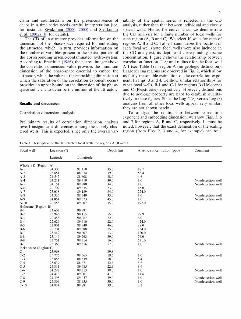
To analyze the relationship between correlationexponent and embedding dimension, we show Figs. 5, 6and 7 for regions A, B and C, respectively. It must benoted, however, that the exact delineation of the scalingregion (from Figs. 2, 3 and 4, for example) can be a
Table 1 Description of the 10 selected focal wells for regions A, B and C
Focal well Location (�) Depth (m) Arsenic concentration (ppb) Comment
Latitude Longitude
Whole BD (Region A)A-1 24.303 91.450 35.0 18.7A-2 23.851 88.654 39.0 58.4A-3 24.547 88.608 38.0 4.6A-4 24.211 89.419 39.0 1.0 Nondetection wellA-5 24.151 89.280 34.0 1.0 Nondetection wellA-6 22.709 89.635 23.0 15.0A-7 23.018 89.139 34.0 224.0A-8 24.336 88.749 33.0 1.0 Nondetection wellA-9 24.054 89.373 45.0 1.0 Nondetection wellA-10 22.558 89.007 35.0 192.0Holocene (Region B)B-1 23.607 90.991B-2 23.946 90.115 55.0 29.9B-3 22.488 90.067 22.0 6.0B-4 22.629 89.610 22.0 424.0B-5 22.901 88.949 46.0 88.0B-6 22.704 89.688 15.0 234.0B-7 23.542 90.607 13.0 120.0B-8 23.144 89.763 39.0 76.0B-9 22.751 89.714 16.0 571.0B-10 23.368 89.556 57.0 1.0 Nondetection wellPleistocene (Region C)C-1 23.968 89.8C-2 25.776 88.565 19.5 1.0 Nondetection wellC-3 25.855 88.539 18.9 5.4C-4 25.639 88.671 32.6 5.6C-5 24.811 89.485 22.9 8.6C-6 24.292 89.313 38.0 1.0 Nondetection wellC-7 24.418 89.001 41.0 11.6C-8 24.395 89.057 39.0 1.0 Nondetection wellC-9 24.809 88.935 30.0 1.0 Nondetection wellC-10 24.814 88.881 39.0 3.2
71

difficult task often requiring semiquantitative methodssuch as visual inspection. Hence, the subsequent esti-mation of correlation exponent with respect to embed-ding dimensions should be assessed as an empiricalexercise subject to the limitations of the semiquantitative
method employed herein. A saturation of the slope LogC(r)/Log (r) is observed, indicating evidence towardspossible nonlinear deterministic and chaotic dynamicbehavior. This saturation value of the correlationexponent (also known as Correlation Dimension, CD)
Fig. 2 The relationshipbetween Log C(r) and radius(Log r) for focal A-1 (region A)
Fig. 3 Same as Fig. 2 but forfocal well B-1 (region B)
Fig. 4 Same as Fig. 2 but forfocal well C-1 (region C)
72
appears to show moderate variability across geologicproperty. When no distinction is made in terms ofgeology, the nationwide CD value appears to lie in theranges of 10–11 while the embedding dimension at whichthis saturation occurs is found to be about 12 (seeFig. 5). We take this finding as a preliminary indicationof the medium-to-high level of dimensionality that existsin the mobilization mechanisms of arsenic. Conse-quently, it is an indication that a medium-to-large model
structure (perhaps with 10–12 model parameters) is re-quired to adequately capture this spatial variability atthe regionalized scale (� 6 km·6 km). Across geologicregions, Pleistocene deposits appear to require a mini-mum of two less variables/parameters for its spatialdescription than their Holocene counterpart. Also notethat the CD for Pleistocene region (Northwest BD)ranges around 8–9, while Holocene deposits correspondmuch closer to the nationwide value of 10–11. At this
Fig. 5 Relationship betweencorrelation exponent andembedding dimension forRegion A (no geologicdistinction) (focal well A-1)
Fig. 6 Same as Fig. 5 but forregion B (focal well B-1)
Fig. 7 Same as Fig. 5 but forRegion C (focal well, C-1)
73

stage, we speculate that this difference is perhaps due tothe predominance of oxic conditions in the Pleistoceneshallow wells that imply the absence of one or morearsenic mobilization mechanisms (i.e., no reductionmechanism). It is currently unknown as to how thesesaturation values will vary as higher resolution arsenicmeasurements (scales <6 km·6 km) become availablealong with more up-to-date groundwater chemistrydata. Hence, we stress the need for more detailedinvestigation involving higher resolution data to quan-tify more definitively the forcing role played by geology.In Table 2, we summarize the mean CD values for theselected 10 focal points over each region.
It is appropriate, at this stage, to highlight spatialvariability analyses recently reported by Hossain et al.(2005) on the basis of a purely geostatistical framework(variogram analyses). Hossain et al. (2005) reported thatregional anisotropy in the spatial dependence of arsenicfor Northwest region of Bangladesh was found to bestronger than that in the Southwest. The correlationlength for arsenic concentration in the East–Westdirection of Northwest Bangladesh (i.e., across majorriver floodplains, Fig. 1) was found to be almost twice(158.80 km) that of the North–South direction (alongthe major axis of Pleistocene deposits) (78.21 km). Forthe Southwest region, the ratio of East–West to North–South correlation lengths ranged from 1.40 to 1.51.
Implications of chaotic behavior for cost-effective sitingof remediation wells
For siting of new (safe) wells, it is currently considered avery expensive, and even almost-impossible, task toreconcile the need for detailed knowledge of hydroge-ology with the tremendous spatial variability (centime-ters vertically; meters horizontally) that is observed inthe Bangladesh sediments. Nevertheless, detailed fieldstudies can always lead to some useful ‘rules of thumb’for well-siting at the village level. The indications of suchan approach can be found in Hossain et al. (2005).However, initial experiences of the BGS-DPHE (2001,see page 240) over a small study region have exemplifiedthe difficulty in accurately quantifying the likelihood ofidentifying ‘uncontaminated wells’ from a geostaticallyderived spatial map of arsenic contamination. A majorinadequacy of geostatistical approaches, in our opinion,
arises from the observation that a geostatistically iden-tified (i.e., ‘kriged’) drilling location of a remediationwell in the neighborhood of a contaminated well isassociated with an uncertainty (equivalent to the mini-mized error variance). In Bangladesh, where publichealth is at risk, such uncertainty needs to be reducedand, hence, conventional geostatistical approaches (suchas kriging) should be explored for ‘enhancement’ withthe less conventional paradigms such as the nonlineardeterministic chaos theory to minimize the limitations.
Let us now consider, as an example, the recent reporton implementing a safe water supply program for Sri-nagar—a sub-district of Bangladesh comprising about30,000 (mostly rural) people (Hoque et al. 2004). Expe-rience from this program clearly recommended that, forarsenic-affected areas, a cluster-based piped water sys-tem be given proper consideration when selectingappropriate water options rather than household-basedoptions or the development of new low-cost options (e.g.filters, rain-water harvesting etc.) (Hoque et al. 2004).To effectively construct a cluster-based piped watersystem, a network of wells would need to be drilled andcentrally connected through a piped network in a fash-ion that the overall quality of water being pumped iswithin the Bangladesh safe limit of 50 ppb for arsenic.This requires drilling the maximum number of safewells, although a few unsafe wells may also be accept-able. For cost-effective implementation of this program,there are now two competing aspects interacting at thelevel of risk management and decision-making: (1)alternative but safe drinking water supply needs to beensured rapidly; and (2) remediation drilling should bepreferably shallow (given that deep-well drilling is atime-consuming and very costly option) and planned insurrounding locations that are known to be ‘probabi-listically’ low in arsenic.
Under such a situation, a chaotic approach has thepotential to augment the geostatistical approach. Thechaotic approach can identify the minimum number ofmodel (physical or black-box) parameters required toadequately model the spatial variability of arsenic inspace for the affected region that has already beenmapped for its CD value. One suggested example is theuse of a neural-network (NN) model with the number ofnodes equaling the number of variables (embeddingdimensions) obtained from the CD analysis that spa-tially ‘forecasts’ safe zones. The inputs to the NN-cha-otic model would be the arsenic concentration of thefocal well (point of application) and the distance fromthe well (i.e., point of prediction). This NN-chaoticmodel can then be used to identify the spots that arelikely to be safe in arsenic concentration (in recognitionof the self-similarity) and subsequently used as anadditional constraint to the geostatistical siting of wells(i.e., both kriging and the NN-chaotic model shouldagree on the location’s safe/unsafe likelihood). Despitethe traditional criticism of neural-network approaches(or any ‘time series’ approach, for that matter) as lack-ing potential to promote the scientific insight of a nat-
Table 2 Summary of correlation dimension value for regions A, Band C
Correlationdimension (Range)
Min Max
Region A 10 11Region B (Holocene) 10 11Region C (Pleistocene) 8 9
74

ural phenomenon, recent work indicates that substantialunderstanding has been gained in designing its archi-tecture (nodes and hidden layers) based on the physicalprocess it models [see for example: Sudheer and Jain(2003) and Jain et al. (2004) for river flow].
Currently, there are a number of maps available thatcharacterize the probability of arsenic contamination innonsampled regions based on kriging (see BGS-DPHE2001 and McArthur et al. 2001, for example). Hence, acombination of geostatistics with a chaotic dynamicapproach can intuitively be expected to refine the safedrilling spots with considerably lower probability offailure (i.e., by reducing the number of false hopes andfalse alarms) than what would have otherwise beenindicated by kriging alone. Although it remains to beseen if there exists a (suggested) physical connectionbetween the minimum number of NN nodes and theminimum embedding dimension from the CD method atthe region of application [see, however, Sivakumar et al.(2002a, b) for such a connection for river flow], thesuggestion, which has insignificant start-up costs com-pared to laboratory studies, is certainly worth investi-gating until proven wholly ineffective.
Conclusion
This paper presented a preliminary investigation of theexistence of nonlinear deterministic and chaotic behaviorin arsenic contamination in shallow tube wells of Ban-gladesh. The correlation dimension method revealedconvincing medium-to-high dimensional chaotic patternwith a countrywide dimension value ranging between 8and 11. The minimum number of variables and, hence,the number of dominant processes required to model thespatial variability of arsenic were also identified. It ap-peared that chaotic behavior of arsenic is moderatelysensitive to geology (Holocene vs. Pleistocene). The studyindicated that Pleistocene aquifers would require two lessminimum number of variables for its spatial descriptioncompared to the Holocene counterpart. However, higherresolution data may be required to explore this issuefurther. Finally, the paper discussed the potentialopportunities offered by the chaotic approach towardsbetter cost-effective remediation strategies than thatpossible by a purely geostatistical framework.
As part of a proposed (and needed) ‘enhancement’ ofgeostatistical approaches for spatial characterizationtowards increasing cost-effectiveness, we list the follow-ing as natural extensions to this study: (1) Investigate thescale-invariant or fractal behavior of arsenic with high-resolution data, with due consideration for the possibleinfluence of (small) data size, thresholds and presence ofzeros (or any other single value) on the outcomes offractal/chaos methods (e.g., Harris et al. 1997; Sivaku-mar 2001); (2) Consider the effects of depth of wells onchaotic characterization and explore fuzzy logic ap-proaches of membership functions (e.g., Klir and Yuan1995) to categorize wells as deep or shallow; and (3)
Study the impact of measurement error on the identifi-cation of chaotic behavior [see, for example, Sivakumaret al. (1999)] using the semiquantitative field kits (Rah-man et al. 2002).
Among the suggested extensions, (3) has particularsignificance to increase cost-effectiveness of (and reduc-ing risks for) siting of safe shallow wells through ourproposed paradigmatic approach (geostatistical-cum-chaotic). The majority of arsenic measurements inBangladesh on a large scale (totalling about 1.3 millionwells) are available from the cheap Field Kits (FK)(Rahman et al. 2002). Although FK measurements aresubject to large errors with a highly complex errorstructure, Hossain et al. (2005) have demonstrated thatFK measurements can still adequately characterize themodal depth (depth of highest arsenic contamination)for shallow wells. This probably indicates that thedatabase of FK-arsenic measurements that are currentlyavailable countrywide may indeed be sufficient to char-acterize the probable depth of highest arsenic contami-nation for local regions, even though the modal arseniccontamination rate (i.e., ‘‘highest fraction of contami-nated wells’’) may have large errors. Hence, one currentchallenge is to investigate the efficacy of using FKs formapping the chaotic behavior of arsenic and (otherwise)propose new desired performance levels for FKs thatwould make them as useful as AAS method in ourproposed geostatistical-cum-chaotic siting of new wells(see Sect. 4B). Work is ongoing in this direction, and wehope to report the details in the near future.
References
Ahmed MF (2002) Arsenic mitigation in Bangladesh. In: Interna-tional workshop in Bangladesh, Dhaka, 14–16 January. Pub-lished by: ITN- Bangladesh, Centre for Water Supply andWaste Management, BUET, Dhaka-1000, Bangladesh
Ahmed MF (2003) Arsenic contamination: Bangladesh perspective.ITN, BUET, Bangladesh, Dhaka
Alam MK, Hassan A, Khan M, Whitney JW (1990) Geologicalmap of Bangladesh. Geological Survey of Bangladesh
Berg M, Tran HC, Nguyen TC, Pham HV, Schertenleib R, GigerW (2001) Arsenic contamination of ground water and drinkingwater in Vietnam: a human health threat. Environ Sci Technol35(13):2621–2626
BGS-DPHE (2001) Arsenic contamination of ground water inBangladesh. In: Kinnburgh DG, Smedley PL, (eds) BritishGeological Survey Report WC/00/19, vol 1–4, British Geolog-ical Survey, Keyworth, UK (available at: http://www.bgs.ac.uk/arsenic/Bangladesh)
Bhattacharya P, Jacks G, Ahmed KM, Routh J, Khan AA (2002)Arsenic in ground water of the Bengal Delta plain aquifers inBangladesh. Bull Environ Contam Toxicol 60:538–545
Biswas BK, Dhar RK, Samantha G, Mandal BK, Chakraborti D,Faruk I, Islam KS, Chowdury M, Islam A, Roy S (1998) De-tailed study report of Samta, one of the arsenic-affected villagesof Jessore District, Bangladesh. Curr Sci 74:134–145
Burgess WG, Burren M, Perrin J, Ahmed KM (2000) Constraintson sustainable development of arsenic-bearing aquifers insouthern Bangladesh. Part 1: A conceptual model of arsenic inthe aquifer. In: Hiscock, Rivett, Davison (eds) Sustainableground water development. Geological Society of LondonSpecial Publication 193:145–163
75

Del Razo LM, Rellano MA, Cebrian ME (1990) The oxidationstates arsenic in well-water from a chronic arsenicism area ofMexico. Environ Pollut 64:143–153
Faybishenko B (2002) Chaotic dynamics in flow through unsatu-rated fractured media. Adv Wat Resour 25(7):793–816
Faybishenko B (2004) Non-linear dynamics in flow through frac-tured porous media: status and perspectives. Rev Geophys42:RG2003. DOI 10.1029/2003RG000125
Fraedrich K (1986) Estimating the dimensions of weather and cli-mate attractors. J Atmos Sci 43(5):419–132
Gelhar LW (1993) Stochastic subsurface hydrology. Prentice-Hall,Englewood Cliffs
Grasberger P, Procaccia I (1983) Measuring the strangeness ofstrange attractors. Physica D 9:189–208
Hao B-L (1984) Chaos. World Scientific, SingaporeHarris D, Seed A, Menabde M, Austin G (1997) Factors affecting
multiscaling analysis of rainfall time series. Nonlinear ProcGeophys 4:137–155
Harvey CF, Swartz CH, Badruzzaman ABM, Keon-Blute N, YuW, Ali MA, Jay J, Beckie R, Niedan V, Brabander D, OatesPM, Ashfaque KN, Islam S, Hemond HF, Ahmed MF (2002)Arsenic mobility and ground water extraction in Bangladesh.Science 298:1602–1606
Hoque BA, Hoque MM, Ahmed T, Islam S, Azad AK, Ali N,Hossain M, Hossain MS (2004) Demand-based water optionsfor arsenic mitigation: an experience from rural Bangladesh.Public Health 118:70–77
Hossain F, Bagtzoglou AC, Nahar N, Hossain MD (2005) Statis-tical characterization of arsenic contamination in shallow tubewells of western Bangladesh. Hydrol Proc 19 DOI 10.1002/hyp.5946
Jain A, Sudheer KP, Srinivasulu S (2004) Identification of physicalprocesses inherent in artificial neural network rainfall models.Hydrol Proc 18(3):571–581
Journel AG, Huijbregts CJ (1978) Mining geo-statistics. Academic,San Diego
Karim MD (2000) Arsenic in ground water and health problems inBangladesh. Water Res 36(4):799–809
Klir GJ, Yuan B (1995) Fuzzy sets and fuzzy logic: theory andapplications. Prentice Hall, New Jersey
Mazumder GDN, Haque R, Ghosh N, De BK, Santra A, Chak-raborti D, Smith AH (1998) Arsenic levels in drinking waterand the prevalence if skin lesions in West Bengal, India. Int JEpidemiol 27(5):871–877
McArthur JM, Ravenscroft P, Safiullah S, Thirlwall MF (2001)Arsenic in ground water: testing pollution mechanisms forsedimentary aquifers in Bangladesh. Wat Resour Res37(1):109–117
Meharg AA, Rahman MM (2003) Arsenic contamination of Ban-gladesh paddy fields. Environ Sci Technol 37:229–234
Mukherjee AB, Bhattacharya P (2002) Arsenic in ground water inthe Bengal delta plain: slow poisoning in Bangladesh. EnvironRev 9:189–220
Nickson RT, McArthur JM, Burgess W, Ahmed KM, RavenscroftP, Rahman M (1998) Arsenic poisoning of Bangladesh groundwater. Nature 395:338
Osborne AR, Provenzale A (1989) Finite correlation dimension forstochastic systems with power-law spectra. Physica D 35:357–381
Rahman MM, Mukherjee D, Sengupta MN, Chowdury UK, LodhD, Chanda CN, Roy S, Selim M, Quamruzzaman Q, MiltonAH, Shadullah SM, Rahman MT, Chakraborti D (2002)Effectiveness and reliability of arsenic field testing kits: are themillion dollar screening projects effective or not? Environ SciTechnol 36:5385–5394
Schertzer D, Tchiguirinskaia I, Lovejoy S, Hubert P, Bendjoudi H(2002) Which chaos in the rainfall-runoff process? A discussionon ‘Evidence of chaos in the rainfall-runoff process’ by Si-vakumar et al. Hydrol Sci J 47(1):139–147
Sivakumar B (2000) Chaos theory in hydrology: important issuesand interpretations. J Hydrol 227(1–4):1–20
Sivakumar B (2001) Rainfall dynamics at different temporal scales:a chaotic perspective. Hydrol Earth Syst Sci 5(4):645–651
Sivakumar B (2004) Chaos theory in geophysics: past, present andfuture. Chaos Sol Fract 19(2):441–462
Sivakumar B (2005) Correlation dimension estimation of hydro-logic series and data size requirement: myth and reality. HydrolSci J 50(4):591–604
Sivakumar B, Phoon KK, Liong SY, Liaw CY (1999) A systematicapproach to noise reduction in chaotic hydrological time series.J Hydrol 219(3/4):103–135
Sivakumar B, Berndtsson R, Olsson J, Jinno K (2002a) Reply to‘‘Which chaos in the rainfall-runoff process’’ by Schertzer et al.Hydrol Sci J 47(1):149–158
Sivakumar B, Persson M, Berndtsson R, Uvo CB (2002b) Is cor-relation dimension a reliable indicator of low-dimensionalchaos in short hydrological time series? Wat Resour Res 38(2).DOI 10.1029/2001WR000333
Sivakumar B, Harter T, Zhang H (2005) Solute transport in aheterogeneous aquifer: a search for nonlinear deterministicdynamics. Nonlinear Process Geophys 12:211–218
Sudheer KP, Jain A (2003) Explaining the internal behavior ofartificial neural network river flow model. Hydrol Proc18(4):833–844
Theiler J (1987) Efficient algorithm for estimating the correlationdimension from a set of discrete points. Phys Rev A 36(9):4456–4462
Tseng T, Babazono A, Yamamoto E, Kurumatani N, Mino Y,Ogawa T, Kishi Y, Aoyama H (1968) Ingested arsenic andinternal cancer in an endemic area of chronic arsenicism inTaiwan. J Natl Cancer Inst 40:453–463
Tsonis AA, Elsner JB, Georgakakos KP (1993) Estimating thedimension of weather and climate attractors: important issuesabout the procedure and interpretation. J Atmos Sci 50:2549–2555
van Geen A, Zheng Y, Vesteeg R, Stute M, Horneman A, Dhar R,Steckler M, Gelman A, Ahsan H, Graziano JH, Hussain I,Ahmed KM (2003) Spatial variability of arsenic in 6000 tubewells in a 25 km2 area of Bangladesh. Wat Resour Res39(5):1140. DOI 10.1029/2002/WR001617
Welch AH, Westjohn DB, Helsel DR, Wanty RB (2000) Arsenic inground water of the United States: occurrence and geochemis-try. Ground Water 38:589–604
Yu WH, Harvey CM, Harvey CF (2003) Arsenic ground water inBangladesh: a geo-statistical and epidemiological frameworkfor evaluating health effects and potential remedies. Wat Re-sour Res 39(6):1146. DOI 10.1029/2002WR001327
76