SOVEREIGNTY, PLANNING AND GRAY SPACE: ILLEGAL CONSTRUCTION IN SARAJEVO AND JERUSALEM
24
T ABLE OF CONTENTS Preface.................................................................................................. vii PART I: Spaces of Formal/Informal Interplays Chapter One............................................................................................ 1 Formal/Informal Interplays: A View from Architecture Beatrice De Carli and Maddalena Falletti Chapter Two ......................................................................................... 25 Practice in the Mess of Informality Nabeel Hamdi Chapter Three ....................................................................................... 38 Crossover Modernisms: Life and Afterlife in Michenzani, Zanzibar Viviana d’Auria and Annelies De Nijs Chapter Four ......................................................................................... 65 Chequered Urbanism: Confrontations Between Culture and Economy in Urbanising Amman Joud Khasawneh and Bruno De Meulder Chapter Five ......................................................................................... 88 Socio-Spatial Assemblages: The Backbone of Informal Settlement Regeneration Carmen Mendoza-Arroyo Chapter Six ......................................................................................... 111 New Planning Tools? Extending Water and Electricity Networks in Irregular Settlements of Lima, Peru Laure Criqui Chapter Seven ..................................................................................... 128 The Spatial Imaginaries of Informal Settlement, HIV and AIDS, and the State in Southern African Cities Colin Marx
Transcript of SOVEREIGNTY, PLANNING AND GRAY SPACE: ILLEGAL CONSTRUCTION IN SARAJEVO AND JERUSALEM

TABLE OF CONTENTS
Preface .................................................................................................. vii
PART I: Spaces of Formal/Informal Interplays
Chapter One ............................................................................................ 1
Formal/Informal Interplays: A View from Architecture
Beatrice De Carli and Maddalena Falletti
Chapter Two ......................................................................................... 25
Practice in the Mess of Informality
Nabeel Hamdi
Chapter Three ....................................................................................... 38
Crossover Modernisms: Life and Afterlife in Michenzani, Zanzibar Viviana d’Auria and Annelies De Nijs
Chapter Four ......................................................................................... 65
Chequered Urbanism: Confrontations Between Culture and Economy in Urbanising Amman
Joud Khasawneh and Bruno De Meulder
Chapter Five ......................................................................................... 88
Socio-Spatial Assemblages: The Backbone of Informal Settlement Regeneration
Carmen Mendoza-Arroyo
Chapter Six ......................................................................................... 111
New Planning Tools? Extending Water and Electricity Networks in Irregular Settlements of Lima, Peru
Laure Criqui
Chapter Seven ..................................................................................... 128
The Spatial Imaginaries of Informal Settlement, HIV and AIDS, and the State in Southern African Cities
Colin Marx

Table of Contents vi
PART II: Spaces of Power
Chapter Eight ...................................................................................... 143
Power in Space: Space Regulation amidst Techniques and Politics in the Global South
Francesco Chiodelli and Lina Scavuzzo
Chapter Nine ....................................................................................... 161
Transformative and Counter-Hegemonic Planning Regimes: South Africa and Lebanon
Scott A. Bollens
Chapter Ten......................................................................................... 183
Informality as Control: The Legal Geography of Colonisation of the West Bank
Erez Tzfadia
Chapter Eleven.................................................................................... 206
Sovereignty, Planning and Gray Space: Illegal Construction in Sarajevo and Jerusalem
Olivier Legrand and Oren Yiftachel
Chapter Twelve ................................................................................... 228
Politics of Urban Form: Architecture of Tehran (1921–53) Hamed Khosravi
Chapter Thirteen ................................................................................. 253
Unravelling Spaces of Representation through Insurgent Planning Actions Ignacio Castillo Ulloa
Chapter Fourteen ................................................................................. 275
The Contestation of Space and Ethics in Singapore: A Case of Dirty Hands in Planning
Jeffrey Chan & Faith Wong
Afterword ........................................................................................... 302
Alessandro Balducci

CHAPTER ELEVEN
SOVEREIGNTY, PLANNING AND GRAY SPACE: ILLEGAL CONSTRUCTION IN SARAJEVO
AND JERUSALEM1
OLIVIER LEGRAND AND OREN YIFTACHEL
Recent research on urban informality has convincingly criticised the academic field of urban studies for its under-theorisation of alternative and unsettled forms of urbanity (AlSayyad, 2004; Bayat, 2000). The paper focuses its analysis on the impacts of the interrelation between planning and informality upon the evolution of antagonistic urbanised ethno-national groups. Its goal is to set up the foundations of the concept of ‘urban sovereignty’ as accounting for the emergence of a new political geography. Indeed, it is expected that both economic globalisation and nation-state building will develop urban regimes with new forms of sovereignty and citizenship.
Toward this end, the paper attempts to bring the concept of sovereignty into the discourse on urban informality to reveal the centrality of two forms of ‘gray spaces’2 that is to say developments, enclaves, populations and transactions positioned in a ‘permanent temporariness’ between legality and illegality (Yiftachel, 2009b). These two forms of ‘gray spaces’ correspond to (a) legal, but unplanned development and (b) illegal, but planned development. Both of these gray spaces are recurrent features of ethnically contested and polarised cities. More importantly, our analysis of gray spaces in ethnically polarised cities is a necessary step for distinguishing between two types of effective sovereign regimes: (a) state regimes, for which planning is first of all a legal policy, and (b) urban regimes, for which planning is first of all a development policy. Finally, 1 This research was partially founded by the Israel Foundation Trustees (PhD Grant n°30). 2 We chose to keep the American spelling because it is a concept already defined by Yiftachel, (2009a; 2009b).
Administrator
Sticky Note
in - Chiodelli, F. et al (eds) 2014 Cities to be Tamed? Spatial Investigations across the Urban South, Cambridge Scholars Publishin, 215-236.
Sovereignty, Planning and Gray Space
207
the paper argues that ‘gray space’, in contemporary urban regions, informs us about the actual, and at times conflicting, relations between these two forms of sovereignty.
The paper is based on fieldwork conducted in Sarajevo and Jerusalem. These cities were chosen as comparative cases of emerging urban regimes within contemporary and enduring ethnically contested states. The assumption is that ‘gray spacing’ is becoming a central technology of power in these cities. Our methodology is founded on the systematic identification and comparison of the different gray spaces, as well as the detailed review of a number of key urban sites and projects. Gray spaces are classified according to the characteristics of these informal areas, such as spatiality (core/periphery), their inhabitants (class, nationality and ethnicity), and their access to urban citizenship (service delivery, housing, planning and development rights, public participation, and representation). The production, regulation and eradication of gray spaces are analysed in connection with what McGarry (2001) defined as ‘demographic engineering’. In the context of the polarised city, demographic engineering translates itself by the political will of one ethnic nation to impose and maintain its demographic and spatial hegemony (Bollens, 2000). The first section of the paper explores the theoretical relations and transactions between urban planning, gray space, and sovereignty. Next, the paper reviews the process of gray spacing in contemporary Sarajevo and Jerusalem.
1. Sovereignty and informality: Relations and transactions
Robinson (2002) points out that urban research tends to systematically compare and contrast the global cities to the ‘megacities’; in other words, the Western model to the Third World problem. Located on the side of the megacities, urban informality, one of the most dramatic features of contemporary global urban reality, finds itself marginalised in most urban theory (AlSayyad, 2004). The enduring conceptualisation of urban informality is centred on a supposed imbalance between urban development and economic growth (Davis, 2006). Against this type of analysis, recent research has convincingly argued that urban informality should be seen as a mode of production of space (AlSayyad and Roy, 2006). In this field, Roy’s research is unique because it explores the relations between informality and sovereignty using Agamben’s work on the state of exception (2005; 2009). However, by not including ethnically polarised cities, her analysis tends to consider sovereignty, planning, and informality as one-dimensional realities.
Chapter Eleven
208
In order to understand both the interests and limitations of Roy’s ‘epistemology of planning’, it is necessary to refer first to Agamben’s (1998; 2005) work on sovereignty. Agamben defines sovereignty as the power to proclaim a state of exception, to create ‘an anomic space in which what is at stake is a force of law without law’ (2005:39). Therefore, ‘if the sovereign is truly the one to whom the juridical order grants the power of proclaiming a “state of exception”, and, therefore, of suspending the order’s own validity, then the sovereign stands outside the juridical order and nevertheless belongs to it’ (1998:15). However, Agamben sees modern states and political authority as bound together (Agnew, 2009). While in the aftermath of 2001 the Guantanamo Bay detention camp was the prime example of a state of exception (Gregory, 2006), Roy chose to examine a more mundane and widespread expression of it, urban informality.
According to Roy ‘[to] deal with informality […] partly means confronting how the apparatus of planning produces the unplanned and unplannable’ (2005: 156). Informal spaces are in a ‘state of exception’ in regard to the formal and normal order of urbanisation. They are neither inside nor outside of the formal order of urbanisation. They are in a state of ‘permanent temporariness’, concurrently tolerated and condemned, perpetually waiting ‘to be corrected’ (Yiftachel, 2009a). The issue of production and reproduction is central because ‘urban planning [has] the power … to determine what is informal and what is not, and to determine which forms of informality will thrive and which will disappear’ (Roy, 2005:150). Such an approach aims to enhance the previous conceptualisation of sovereign power. Sovereign power is no longer confined to the power to declare a state of exception, and it also encompasses the power to end a state of exception.
However, for Roy, ‘informality, and the state of exception that it embodies, is produced by the state’ (2005:155), and therefore urban planning remains a state prerogative, an exclusive domain. The limitations of Roy’s epistemology of planning are explicit when confronted with cities in which the question who rules, where? is at the heart of the production of urban space (Bollens, 2000). In contested and polarised cities, such as Sarajevo and Jerusalem, the concepts of sovereignty and informality both become highly problematical.
First, Roy mobilises a Western vision of sovereignty based upon the reification of the state as a fixed and exclusive container of a society with a clear-cut division between inside and outside (Agnew, 2009). We propose instead the notion of ‘effective sovereign regimes’ (Agnew, 2009), that is, focusing on the fluctuating sovereign power over space, rather than

Sovereignty, Planning and Gray Space
209
on formal state authorities. This approach is more able to capture this structural diversity and complexity of various forms of sovereign power interacting in one central and contested place.
Second, in the context of urban polarisation, the notion of gray space seems to advance the notion of 'informality', which focuses both explicitly and implicitly on individual illegal activities, leaving aside the responsibilities of the public authorities. That is to say, informality is produced by private encroachments and is a place of social relegation; it is a space of disfranchisement par excellence. We propose instead the notion of gray space, rather than informality, as it seems more able to capture ‘developments, enclaves, populations and transactions positioned between the “lightness” of legality/approval/safety and the “darkness” of eviction/destruction/death’ (Yiftachel, 2009b: 243). It allows the differentiation between gray spaces that come from below, created by marginalised populations, and gray spaces that come from above, created or condemned by the political authorities or elites (Yiftachel, 2009b). Through the distinction between formal urban planning and substantive urban planning, the paper will focus on gray space from above.
Urban planning is defined as the formulation, legal enactment, financing, and implementation of spatial public policies. The practices of ‘planning’ include all policies performed directly or indirectly by the public authorities that affect urban development, zoning, and land use. However, urban planning should be conceived as a differentiated, at times conflicting, set of processes. In order to understand how urban planning has a direct effect upon intergroup relations, the paper proposes to distinguish the legal/formal side of urban planning from its technical/substantive sides (see Table 1). Formal urban planning classifies urban development according to existing legislation and ownership rights. On the other hand, substantive urban planning is proactively engaged in urban development in its physical, social, and economic aspects. In other words, formal planning corresponds to an indirect intervention of the public authorities in urban development, while substantive planning corresponds to a direct one. For example, urban planning in Jerusalem and Sarajevo uses two types of urban plan. The Outline Plan (Jerusalem) and the Master Plan (Sarajevo) provide a general guideline, while the Detailed Plan (Jerusalem/Sarajevo) provides many more specifications (land ratio, floor limitation, and so on). The former plan is on the side of formal planning, whereas the latter is on the side of substantive planning. This distinction is important because formal and substantive planning may not necessarily imply one another and more than one public authority may implement them.

Chapter Eleven
210
Foucault’s work on the notions of ‘normation’ (disciplinary normalisation) and normalisation (security) enables us to deepen the distinction between formal and substantive planning. In Security, Territory, Population, Foucault suggests that the aim of the mechanisms of ‘normation’ is to separate ‘the normal from the abnormal’ via previous construction of an ideal type, an ‘optimal sequence or coordination’ (2007[1978]: 85). On the other hand, the mechanisms of normalisation start from empirical and observed averages, standard deviations and limits, and their outcome is not to classify and separate, but rather to move the observed average toward a more desirable direction (2007; [1978]). Formal planning participates in the ‘normation’ of urban spaces, since the systematic discrimination between legal and illegal urban development is one of its main outcomes. Substantive planning participates in the ‘normalisation’ of urban spaces, since its proactive engagement in urban development aims to move positive socio-economic indicators up and negative ones down (for example, capital circulation should rise, while mortality should fall). In summary, formal urban planning (discipline) ‘is a mode of individualisation of the multiplicities’, whereas substantive urban planning (security) ‘works, fabricates, organises, and plans a milieu’ (2007; [1978]: 26).
Table 1 – The formal and substantive side of urban planning
Formal urban planning Substantive urban planning Action Classifying urban development Shaping urban development Plan Master Plan/Outline Detailed Plan Norm Ideal type Averages & standard deviations
Source: Authors’ own
The following set of questions and Figure 1 organise our analysis of Sarajevo and Jerusalem. Do formal and substantive planning necessarily imply one another? Does the interplay between substantive and formal planning significantly affect the tangibility of the living condition of a city’s inhabitants? May they be mobilised to manipulate the ethnic composition of the city? Do they provide a useful lens for a broader critique of the supposed hierarchically nested relations between city and state? The critical insights obtained by answering these questions illustrate that sovereignty cannot be assumed as an unproblematic pre-existing framework within which city planning and government operate. Sovereignty, that is, authority over territory and people, is likely to arise in varied ways within globalising urban regions and their gray spaces. Let us

Sovereignty, Planning and Gray Space
211
move now to the two case studies, where these concepts and arguments can be examined.
Fig. 1 – From informality to gray spaces. Source: Authors’ own.
2. Sarajevo: The rise of gray space
The issue of Sarajevo’s gray spaces must be understood in the context of post-conflict forced population displacements, ethno-national partition, and international community (IC) ‘protectorates’. Post-1995 Bosnia-Herzegovina is characterised by strict territorial divisions according to post-war ethnic composition. Along with the partition of Bosnia-Herzegovina by the Inter-Entity Boundary Line (IEBL), Sarajevo has been divided between the two Bosnian Entities, the Federation of Bosnia and Herzegovina (hereinafter ‘Federation’), and the Republika Srpska (RS) (see Map 1). On the side of the Federation, the 1991 Sarajevo Grad became the Sarajevo Canton, with nine municipalities. On the other side of the IEBL, the RS created ex nihilo East Sarajevo, a former suburb of Sarajevo Grad, with six municipalities (Sell, 1999). During and after the conflict, Sarajevo Canton was a privileged destination for Bosniak (Bosnian Muslim) refugees, while East Sarajevo was a privileged destination for Bosnian Serb refugees. In 2005, the Bosniak population represented 79.6% of the Sarajevo Canton population, whereas in 1991 it represented only 49% (FBiH, 2010). On the other side of the IEBL, the

Chapter Eleven
212
64,700 inhabitants of East Sarajevo are quasi-exclusively Bosnian Serbs, whereas in 1991 they represented only 35% of the population (Republika Srpska, 2010).
Fig. 2 – Pre-Conflict Sarajevo and Post-Conflict Sarajevo(s). Source: Sarajevo Canton, 2005.
Under the conditions of the Dayton Peace Accord (DPA), Bosnia-Herzegovina’s elected representatives are under the supervision of the Peace Implementation Council (PIC), a collection of 55 countries and agencies that represent the ‘IC’ (O’Neil, 2007). The PIC nominated a High Representative with extensive executive and legislative powers. One of the main goals of the PIC was the ‘undoing’ of ethnic cleansing and the restoration of a multi-ethnic Bosnia through the Minority Return Programme, which promoted and funded the return of refugees to settlement areas where they were no longer the majority. The legal foundation of this project was Annex 7 of the DPA, which guarantees to all Bosnian refugees the respect of their property rights. By the end of 2005, when the Minority Return Programme ended, approximately 95% of reclaimed properties had been restored (Bougarel et al., 2006: 13) In 1998, the Office of the High Representative (OHR) issued the Sarajevo Declaration, which promoted the ‘reconstruction of a truly multi-ethnic city, open in itself and to the outside’ (1998: 1). The Sarajevo Declaration

Sovereignty, Planning and Gray Space
213
renders explicit the importance of the Bosnian capital inside the Minority Return Programme.
As noted by Tuathail and Dahlman (2006), the will to undo one of the main outcomes of the war was in open contradiction to the ethno-territorial ideal promoted by Bosnian ethno-national leaderships. The settling of refugees in their pre- or post-conflict location was crucial in shaping the future of Bosnia-Herzegovina and its capital. Our analysis of post-conflict constructions aims to demonstrate that top-down official reports on urban informality reframe and dismiss not only the actual living conditions of a growing part of Sarajevo inhabitants, but also the outcome of the IC Minority Return Programme. To summarise, the production of legal but unplanned spaces in Sarajevo Canton and of illegal but planned spaces in East Sarajevo was a way to strengthen the demographic weight of Bosniaks in Sarajevo Canton and Bosnian Serbs in East Sarajevo without entering into direct conflict with the High Representative’s agenda.
2.1 Post-war informal urban development
in Sarajevo Canton and East Sarajevo
In contrast to the dramatic demographic growth that East Sarajevo has known, the total population of Sarajevo Canton before and after the conflict remained more or less equal. It is not surprising that the phenomenon of illegal construction was more important in East Sarajevo than in Sarajevo Canton. However, this account provides a partial and misleading vision of Sarajevo’s post-conflict urban development.
On the side of the Federation, most of the informal spaces in Sarajevo Canton were populated by Bosniak refugees and follow a well-known spatial pattern. They were located on the edge of the city, at the rural/urban interface, as well as along main traffic axes. In Novi Grad, illegal construction took place on ‘the best-quality agricultural land, potable water protected areas, existing and potential zones of exploitation of thermal and thermo-mineral water, areas of natural and construction heritage, [and] vital traffic infrastructure’ (Sarajevo Canton, 2005: 66). On the side of the Republika Srpska, the rise of illegal construction in East Sarajevo seems more evident. After the war, this administrative city underwent a ‘demographic revolution’: from 1991 to 2008 its total population increased by 37% (Institute for Urbanism of the Republika Srpska, 2010). Before the war, East Sarajevo was the suburban and recreational area of Sarajevo and thus its housing stock, mainly composed of family farms, secondary houses, and tourist apartments, was not adapted to the demographic influx that took place. For the Republika

Chapter Eleven
214
Srpska and the local authorities, the explosion of illegal construction in East Sarajevo is a logical outcome of the large influx of Bosnian Serb refugees during and after the conflict.
The rise of urban informality has been explained in two main ways: first, as a direct result of the conflict, that is to say the destruction of housing stock and the hardships of the economic situation of the majority of internally displaced persons (Bisogno and Chong, 2002), and second, as a result of the impacts of the ‘liberal peace’, the dismantling of the welfare system and the privatisation of the entire public housing sector (Divjak and Pugh, 2008). The issue of urban informality is not a disconnected phenomenon, as Bosnia-Herzegovina’s entire economy is characterised by the growing importance of the informal sector. It is estimated that since the end of the conflict, the informal economy has constituted roughly 50% of Bosnia and Herzegovina’s GDP (Bujiæ, 2003; BMI, 2011). However, such an account of Sarajevo’s informality is partial, as it is confined to the monitoring of urban developments that occur outside the existing legal planning frame.
2.2 Post-war formal and substantive planning
in Sarajevo Canton and East Sarajevo
An analysis of formal urban planning alone is likely to focus on individual ‘illegal’ activities, leaving aside the responsibilities of the public authorities. Post-conflict Sarajevo is characterised by the unsettled sharing of competencies and assets between the different public authorities (national, federal, regional, and local). The DPA has produced an ongoing indeterminacy regarding which authority is in charge of the former Yugoslavia’s public assets (land, housing, and infrastructure). This indeterminacy has in turn given rise to a quarrel between the central state, entities, cantons and municipalities. The issue of informality cannot be disconnected from the fact that in some cases, as in the case of public land, it is impossible to determine which authority is in charge. For example, a private golf course was built in Stari Grad public garden in clear contradiction of the existing planning regulations. However, as both Sarajevo Canton and the Federation claim authority over Sarajevo’s public gardens, and thus the right to enforce the law, the private golf course has not yet been removed or legalised. This private golf course is a symbolic, but not marginal case produced by post-Dayton indeterminacy. The role of public authorities, as well as the limits of the notion of urban informality, becomes more explicit when both formal planning and substantive planning are taken into consideration.

Sovereignty, Planning and Gray Space
215
On the side of the Sarajevo Canton, since 1996, the Federation has conducted three major regularisation campaigns of post-conflict illegal urban development. All of these campaigns have been realised without the participation of the Sarajevo Canton and outside its Master Plan (Imamovic, 2006). However, the Federation has neither the professional capacity nor the budget to provide urban services and infrastructures. Indeed, the main public institution in charge of urban planning policies is the Canton of Sarajevo. It has ‘inherited’ most of the competencies, budget, and personnel of 1991 Sarajevo Grad (Bublin, 1999). Therefore, although the amount of illegal construction has indeed dramatically decreased, most of these legalised spaces still have poor access to urban services and infrastructures; some of them still lack proper asphalt roads. The federal initiative was based solely on formal urban planning, specifically the production of new ownership titles. It has therefore not significantly affected the living conditions of the inhabitants. These legalised spaces correspond to legal, but unplanned urban development (see Graphic 1). They have indeed left the domain of illegality and informality, but remained within the domain of urban marginality, the domain of gray space.
On the side of the Republika Srpska, East Sarajevo displays an opposite model of post-conflict urban development in which formal planning has been suspended to secure substantive planning, in other words planned, but illegal urban development (see Graphic 1). We focus on the Municipality of East Novo Sarajevo since the majority of the post-conflict construction is concentrated there (see Map 1). These post-conflict structures lack proper building permits. The significance of illegal construction is altered when substantive planning (physical, social, and economic integration into the existing urban fabric) is taken into consideration. First, contrary to Sarajevo Canton, most of the illegal structures are apartment buildings that have been built by private developers. Second, asphalt roads connect all of them and overall they have fairly good access to urban services and infrastructures. In Banja Luka, the Institute for Urbanism of the Republika Srpska publishes drafts of the Master Plan that will legalise most of this post-conflict ‘illegal’ development.
2.3 Local and central authorities, substantive
and formal planning
Up to this point, the analysis has blended together public authorities, but gray space (legal but unplanned or illegal but planned urban

Chapter Eleven
216
development) may provide a useful lens through which to examine and understand the actual relations between local and central political authorities. An analysis of the spatial localisation of Sarajevo’s gray spaces on both sides of the IEBL may be revealing in this regard. On the side of Republika Srpska, before the war all of East Sarajevo’s municipalities, with the exception of Sokolac, were part of Sarajevo Grad and were covered by its 1985-2015 Urban Plan (see Fig. 2). If the housing development presented in the 1985 Master Plan could not answer post-conflict needs, its planned road network, especially the East Ring Road, could have ensured development of East Sarajevo more or less in continuity with Sarajevo Canton. However, most of the ‘illegal’ post-conflict structures in East Novo Sarajevo were erected on the track of the planned East Ring Road. As a result, the connection between East Sarajevo and Sarajevo Canton is only ensured today by one main road instead of two. It seems that both East Sarajevo and Republika Srpska authorities were aware of the reintegrative potential of the 1985 Urban Plan and gray space (illegal but planned development) was the most efficient way to counter it. Thus, due to the proximity of an attractive urban centre, gray space in East Sarajevo has also been mobilised to constrain and control the relations between the (Bosnian Serb) suburb and the (Bosniak) urban centre. In Sarajevo Canton, as mentioned above, the Federal campaigns of legalisation have been carried out regardless of the Cantonal Spatial Plan 2003-2025. Today the Sarajevo Canton must not only issue a new Cantonal Spatial Plan, but also it must provide service and connect to infrastructure the settlements legalised by the Federation, all this at its own and sole expense.
3. Jerusalem:
Empowerment, disfranchisement and abandonment
In East Jerusalem, the notion of informality is even more problematic and has been inapplicable since 1967. The 1948 UN General Assembly (UNGA) Partition Plan renders explicit the importance of Jerusalem in the Israeli-Palestinian conflict, as it proposes to place the city under the direct authority of the United Nations (Ginio, 1980). The UNGA resolution was never implemented, and Israel was admitted as a UN member state in May 1949, with the Green Line as its temporary border (Lustick, 1995). From 1948 to 1967, the Green line divided Jerusalem, with the old city located on the Jordanian side. At the end of the 1967 Six-Day War the whole of what had been Mandatory Palestine came under the control of Israel, opening a period of forced and voluntary population transfer that

Sovereignty, Planning and Gray Space
217
continues today. In June 1967, the Israeli Knesset modified the municipal border of the capital, annexing 70 square kilometres of the West Bank to Israel and creating what is commonly referred to as East Jerusalem (see Map 2) (Lapidoth, 2011: 13). This de facto annexation became de jure in 1980 with the Basic Law on Jerusalem, which proclaimed that ‘Jerusalem, complete and united, is the capital of Israel’ (Lapidoth, 2011: 13). The IC did not recognise the annexation of East Jerusalem, as it was in contradiction with UN Security Council (UNSC) Resolution 242 of 1967. The resolution declared ‘the inadmissibility of the acquisition of territory by war’ and called for the ‘withdrawal of Israel armed forces from territories occupied in the [1967] conflict’. Thus, the territory seized during the 1967 war, the Palestinian Occupied Territory (POT), including East Jerusalem, should be consequently ruled according to the 1907 Hague Convention and the 1949 Fourth Geneva Convention. In short, the rules regarding military occupation state that the occupying power is neither allowed to impose its laws on nor transfer its population to the occupied territory.
Since 1967, East Jerusalem has become a prime example of a contemporary polarised city where ‘international issues of sovereignty and autonomy become reducible to issues over neighbourhoods and suburban growth’ (Bollens, 2000: 15). According to the Israeli authorities, since East Jerusalem is part of its territory, its urban development must follow the 1965 Planning and Building Law. According to the other UN member states, since East Jerusalem is part of the POT, its urban development must follow rules that come from Ottoman, British Mandatory, and Jordanian law or from Israeli military orders (Gordon, 2008). From the perspective of the Israeli authorities, the poor living conditions of Palestinian residents in East Jerusalem are the result of them not respecting the planning regulations, while from the point of view of the IC, they stem from the Israeli authorities not respecting the Hague and Geneva conventions. Finally, whereas for the Israeli authorities most of the post-1967 Jewish urban settlements in East Jerusalem are legal, for the IC these settlements correspond to a transfer of population inside an occupied territory and are thus illegal.
To secure the annexation of East Jerusalem, Israeli authorities have deployed two main complementary planning policies. The first policy consists in the construction of ‘neighbourhoods’ that encircle East Jerusalem and contain a Jewish population, while the second is to impose restrictions on Palestinian development (Amirav, 2007). The last, but not yet validated Local Outline Plan believes that the initial objective of securing a Jewish majority of 70% of the overall population is no longer
Chapter Eleven
218
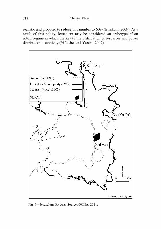
realistic and proposes to reduce this number to 60% (Bimkom, 2009). As a result of this policy, Jerusalem may be considered an archetype of an urban regime in which the key to the distribution of resources and power distribution is ethnicity (Yiftachel and Yacobi, 2002).
Fig. 3 – Jerusalem Borders. Source: OCHA, 2011.
Sovereignty, Planning and Gray Space
219
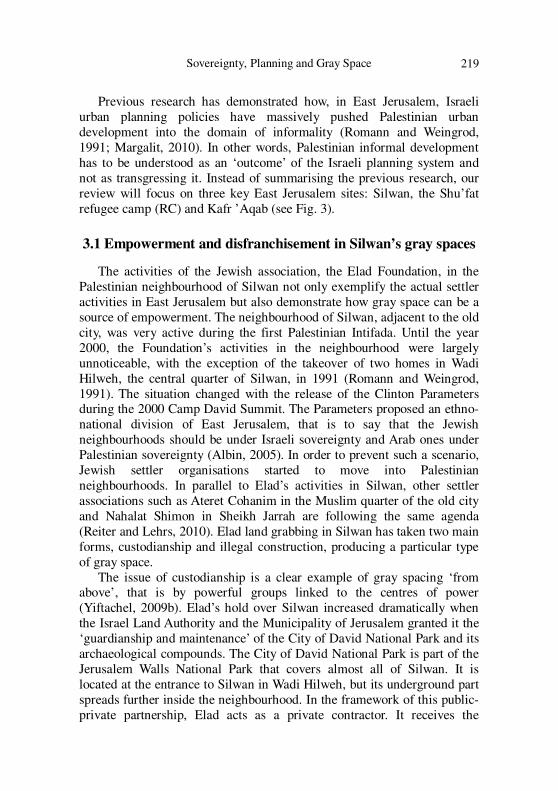
Previous research has demonstrated how, in East Jerusalem, Israeli urban planning policies have massively pushed Palestinian urban development into the domain of informality (Romann and Weingrod, 1991; Margalit, 2010). In other words, Palestinian informal development has to be understood as an ‘outcome’ of the Israeli planning system and not as transgressing it. Instead of summarising the previous research, our review will focus on three key East Jerusalem sites: Silwan, the Shu’fat refugee camp (RC) and Kafr ’Aqab (see Fig. 3).
3.1 Empowerment and disfranchisement in Silwan’s gray spaces
The activities of the Jewish association, the Elad Foundation, in the Palestinian neighbourhood of Silwan not only exemplify the actual settler activities in East Jerusalem but also demonstrate how gray space can be a source of empowerment. The neighbourhood of Silwan, adjacent to the old city, was very active during the first Palestinian Intifada. Until the year 2000, the Foundation’s activities in the neighbourhood were largely unnoticeable, with the exception of the takeover of two homes in Wadi Hilweh, the central quarter of Silwan, in 1991 (Romann and Weingrod, 1991). The situation changed with the release of the Clinton Parameters during the 2000 Camp David Summit. The Parameters proposed an ethno-national division of East Jerusalem, that is to say that the Jewish neighbourhoods should be under Israeli sovereignty and Arab ones under Palestinian sovereignty (Albin, 2005). In order to prevent such a scenario, Jewish settler organisations started to move into Palestinian neighbourhoods. In parallel to Elad’s activities in Silwan, other settler associations such as Ateret Cohanim in the Muslim quarter of the old city and Nahalat Shimon in Sheikh Jarrah are following the same agenda (Reiter and Lehrs, 2010). Elad land grabbing in Silwan has taken two main forms, custodianship and illegal construction, producing a particular type of gray space.
The issue of custodianship is a clear example of gray spacing ‘from above’, that is by powerful groups linked to the centres of power (Yiftachel, 2009b). Elad’s hold over Silwan increased dramatically when the Israel Land Authority and the Municipality of Jerusalem granted it the ‘guardianship and maintenance’ of the City of David National Park and its archaeological compounds. The City of David National Park is part of the Jerusalem Walls National Park that covers almost all of Silwan. It is located at the entrance to Silwan in Wadi Hilweh, but its underground part spreads further inside the neighbourhood. In the framework of this public-private partnership, Elad acts as a private contractor. It receives the
Chapter Eleven
220
protection of government agencies without being subjected to the legal and administrative restrictions normally applied to governmental bodies (Rapoport, 2009: 5). For example, the Nature and National Park Authority, which is in charge of the national parks in Israel, has refused to publish the contract it signed with the Elad Foundation (Oppenheimer, 2011). This is a clear example of the ability of a sovereign power to declare a state of exception, as the laws regulating the public-private partnership have been suspended rather than cancelled. Translated into urban terms, the City of David National Park corresponds to neither an illegal nor a legal space. It is a gray one.
The second method mobilised by the Foundation to take over Silwan is via ‘illegal construction’, but, as we will see, the term ‘illegal’ provides only a partial explanation. Since the neighbourhood is close to the old city and thus inside the Green Belt inherited from the British, it is barely possible to receive a building permit. This did not stop the Foundation from constructing, without a building permit, a seven-storey building near the park. The Foundation also uses a settlement method first developed in the West Bank, the ‘outpost’ (Weizman, 2007). It has installed temporary containers and caravans in the parking lot in front of the park, although, according to Israeli law, these temporary structures also need a permit. The Jerusalem Municipality is trying to issue a new detailed plan that proposes legalising all of Elad’s illegal buildings. This plan, which has not yet been validated, names the neighbourhood Kfar Shiloah instead of Silwan, preferring the settler terminology to the Palestinian one. Furthermore, while the municipality has presented the detailed plan, the Foundation has paid the architects and planners in charge of its formulation (Margalit, 2010). Therefore, the notion of informality alone is not able to encapsulate the specificities of the Foundation’s activities, which correspond to illegal but planned development. However, the specificities of Elad’s gray spaces have to be taken with caution; indeed for the international community the Foundation’s activities are illegal not because they do not follow Israeli law but because they correspond to a transfer of population inside an occupied territory.
The issue of Palestinian development in Silwan should also be evaluated according to this international legal perspective. As we have seen, according to the Jerusalem Municipality, Silwan is characterised by increasing ‘illegal’ Palestinian construction, a situation identical to that of the rest of East Jerusalem (Weiner, 2003). The key fact here is that the municipality uses the Israeli law as its frame to classify this development, which is in direct contradiction to the relevant international conventions and UNSC Resolution 242. Nevertheless this so-called ‘illegal’ status is

Sovereignty, Planning and Gray Space
221
used by the municipality to explain the poor access of most of the Palestinian residents to urban services and infrastructures. For example, with a median resident age of 18 years, the Silwan neighbourhood has neither a primary nor a secondary school. Thus, Palestinian gray space in Silwan does not exactly correspond to a legal but unplanned development, but rather to an ‘a-legal’ but unplanned development.
While, after the first Intifada, Silwan was a place where Israelis did not dare to venture, in a relatively short period the Foundation claims to have seized more than 70% of the neighbourhood’s land and approximately 300 settlers now live there (Greenberg, 2009; Margalit, 2010). The Foundation did not succeed per se in significantly altering the demographic balance in Silwan, but it has succeeded in creating a specific form of appropriation. The City of David National Park has become one of Jerusalem’s leading tourist attractions and the annual number of visitors rocketed from 25,000 in 2001 to 350,000 in 2007 (Pullan and Gwiazda, 2009). Silwan is illustrative of the situation in contemporary East Jerusalem: Elad’s empowering gray space faces another gray space characterised by a poverty rate close to 70%, a space of disfranchisement in which Silwan’s Palestinian inhabitants are forced to live.
3.2 Spaces of abandonment in Shu’fat RC and Kafr ’Aqab
In contrast to the case of Silwan, the situation of the Palestinian neighbourhoods Shu’fat RC and Kafr ’Aqab cannot inform us regarding the general situation in East Jerusalem. Gray spaces in these neighbourhoods are the outcome of processes of, first, partial integration and then, partial exclusion. The analysis of the Palestinian neighbourhoods of Shu’fat RC and Kafr ’Aqab is linked to the recent rebordering induced by the construction of the ‘security fence’, which has physically cut these two neighbourhoods off from the city. What is interesting here is the fact that Shu’fat RC and Kafr ’Aqab display a third type of gray space and present an alternative understanding of the relations between the Jerusalem Municipality and the State of Israel. Whereas the exclusion of these neighbourhoods by the security fence may be a way for the Israeli state to reborder Jerusalem and thus to maintain a Jewish demographic majority (HSRC, 2009), we argue that for the Jerusalem Municipality, Shu’fat RC and Kafr ’Aqab act as relief zones for Palestinian development.
In 1967, in the framework of unified and indivisible state policy on Jerusalem, both these Palestinian neighbourhoods were unilaterally incorporated into the Jerusalem Municipality. This annexation to Israel was, however, partial, as the Palestinian inhabitants received the status of

Chapter Eleven
222
permanent residents and not citizens. ‘Permanent’ residency status is not, indeed, permanent, and may, for example, be revoked at the discretion of the Israeli Minister of the Interior (HSRC, 2009). Palestinian Jerusalemites can pass their residency status to their children only under certain conditions. As residents, Palestinian Jerusalemites are entitled to vote in municipal elections as well as to enjoy certain Israeli National Insurance benefits. Until 2002, the situation of Shu’fat RC and Kafr ’Aqab did not differ from that of the other Palestinian neighbourhoods annexed in 1967.
The situation changed in 2002, when the Israeli government announced the construction of the separation barrier, aimed at preventing Palestinian terrorists from penetrating into its territory. The project was placed under the supervision of the Ministry of Defence. The construction of a wall 68 kilometres long that encircles Jerusalem began in 2003 (State of Israel, 2007). While most East Jerusalem territory is located inside in the Seam Zone, that is between the Green Line and the Fence, Shu’fat RC and Kafr ’Aqab are located on the eastern side of the Fence. Thus both neighbourhoods are physically cut off from Jerusalem.
However, this exclusion is partial. The Shu’fat RC and Kafr ’Aqab communities find themselves on the West Bank side of the fence, and as such they are de facto outside the municipal territory and thus completely deprived of urban services as basic as rubbish collection and postal delivery (Dajani et al., 2012). However, the Outline Plan for Jerusalem states that ‘the route creates complex situations which cannot be influenced by the physical planning, especially not at the outline level’ (Jerusalem Municipality, 2010) and consequently does not represent the security fence on its maps. In 2000, the Basic Law on Jerusalem was amended to prevent any transfer of any power, permanently or provisionally, concerning Jerusalem in its 1967 boundary (Lapidoth, 2011: 17). The constant affirmation by the Israeli authority that ‘the fence is inherently temporary’ (State of Israel, 2007) is consistent with the strengthening of Israeli sovereignty over Jerusalem’s 1967 territory. Finally, the Palestinian Authority is forbidden to fill the vacuum created by the withdrawal of the Jerusalem Municipality. As such they are not per se excluded from the Jerusalem Municipality.
Indeed, this second bordering process has contributed to the setting up of a space of indistinction between outside and inside. In Shu’fat RC and Kafr ’Aqab, urban planning processes, formal and substantial, have been totally suspended. As a result, these neighbourhoods have experienced a dramatic increase in population and construction (OCHA, 2011). They have become a refugee zone for many Palestinians, who experience difficulty in finding a place to build in the rest of the municipality without

Sovereignty, Planning and Gray Space
223
taking the risk of losing their residency status. The State of Israel may consider that Shu’fat RC and Kafr ’Aqab no longer belong to Jerusalem, while for the municipality they seem to act as ‘relief zones’ for Palestinian development. These spaces, where it is possible to build freely, are easing the restrictions imposed upon Palestinians in the rest of the municipality territory. Communities in Shu’fat RC and Kafr ’Aqab have not been excluded from the Jerusalem Municipality, but rather are abandoned by it. These neighbourhoods have become more than just spaces of disfranchisement: they are spaces of abandonment, a third kind of gray space.
4. Conclusion
In both Sarajevo Canton and East Sarajevo, gray spaces have been used to settle refugees in their post-conflict localisation without entering into direct conflict with the High Representative’s representative’s agenda. In Sarajevo Canton, substantive planning has been suspended, while in East Sarajevo it is formal planning that has been suspended. Therefore, we can highlight the ways in which gray spacing creating a new grammar of development. In Sarajevo Canton’s post-conflict urban development became legal but unplanned, while East Sarajevo’s post-conflict urban development surfaced as illegal but planned. Whereas in East Sarajevo both local and central authorities seem to share the same planning agenda, the legalisation campaigns of the Bosnia-Herzegovina Federation have come to work against the Sarajevo Canton’s Master Plan and at the expense of its budget. In summary, the main characteristics of Sarajevo gray spaces are: (a) their inhabitants belong to the dominant ethnic nation (Bosniak in Sarajevo Canton and Bosnian Serb in East Sarajevo), (b) they are sources of disfranchisement (Sarajevo Canton) and empowerment (East Sarajevo), and finally (c) only in Sarajevo Canton do they reveal the tensions that exist between the urban and state regime.
Due to the contestations surrounding the international status of East Jerusalem, the notion of informality has been inapplicable since 1967. In order to maintain a Jewish majority, Israeli authorities have, in some key sites, suspended part of the planning process, the same planning process they have unilaterally imposed on Arab East Jerusalem. As we have seen, in order to facilitate the Elad Foundation’s development in Silwan, formal planning has been suspended. In Shu’fat RC and Kafr ’Aqab, substantive and formal planning processes have been suspended, leaving the Palestinians with narrow zones in which they build. These areas are, neither inside nor outside the Jerusalem Municipality. Thus, Palestinians

Chapter Eleven
224
are able, for the moment, to build in these spaces of abandonment, where urban services, as basic as rubbish collection, have been suspended. In summary, the main characteristics of East Jerusalem gray spaces are, first, that their inhabitants belong to both ethnic nations; second, they are a source of disfranchisement (Silwan), empowerment (Elad-City of David) and abandonment (Shu’fat RC and Kafr ’Aqab). Finally, for central and local authorities, gray spaces in Shu’fat RC and Kafr ’Aqab have different, but not conflicting, purposes.
Table 2 – Gray spaces as sources of empowerment, disfranchisement and abandonment
Long-Term effect of gray-spacing
Legal but unplanned Illegal but planned Sarajevo Jerusalem Sarajevo Jerusalem
Empowerment East Sarajevo
Elad Foundation- City of David
Disfranchisement Sarajevo Grad Silwan
Abandonment Shu’fat RC/Kafr ’Aqab
Source: Authors’ own
Our research has demonstrated that gray space is a central technology of power in both Sarajevo and Jerusalem. In these ethnically polarised cities, gray spaces have been mobilised to enhance and deepen the demographic and spatial hegemony. Due to their key roles inside the demographic engineering policy, gray spaces are not the exclusive domain of minorities and of social relegation; they can also be sources of empowerment, disfranchisement and abandonment (see Table 4). Our analysis has also pointed out that gray spaces are not produced by one scale and by one authority. Thus, we must differentiate between state and urban sovereignty in order to understand both the ways in which gray spaces are produced, reproduced, and at times eradicated and to shed light on their often conflicting or distinct purposes. The move from an analysis in terms of informality to an analysis in terms of gray space confirms that urban planning is ‘not [...] a monolithic and singular regime of rule, but rather […] a fragmented domain of multiple and competing sovereignties’ (AlSayyad and Roy, 2006: 12). Planning is one of the main instances of sovereign power used by urban regimes, which appear to increasingly become a central site of effective sovereign power.

Sovereignty, Planning and Gray Space
225
References
Agamben G (1998) Homo Sacer: Sovereign Power and Bare Life. Stanford: Stanford University Press.
—. (2005) State of Exception. Chicago: University Of Chicago Press. Agnew J (2009) Globalization & Sovereignty. Lanham: Rowman &
Littlefield Publishers. Albin C (2005) Explaining conflict transformation: How Jerusalem
became negotiable. Cambridge Review of International Affairs 18:339-355.
AlSayyad N. (2004) Urban informality as a new way of life. In: Roy A and AlSayyad N (eds.) Urban Informality: Transnational Perspectives from the Middle East, Latin America, and South Asia. Lanham: Lexington Book, pp.7-29.
AlSayyad N and Roy A (2006) Medieval modernity: On citizenship and urbanism in a global era. Space and Polity 10/1: 1-20.
Amirav M (2007) The disintegration of the Jerusalem unification policy. Palestine-Israel Journal 14 (1):9-15.
Bayat A (2000) Subaltern in the Global South from ‘dangerous classes’ to ‘quiet rebels’: Politics of the urban subaltern in the Global South. International Sociology 15:533-557.
BIMKOM (2009) Planning in Jerusalem: The implications of the new outline plan of Jerusalem for Palestinian neighborhoods. Available at: http://eng.bimkom.org (accessed 10 September, 2011).
Bisogno M. and Chong, A. (2002) ‘Poverty and inequality in Bosnia and Herzegovina after the Civil War’. World Development 30 (1): 61-75.
Bollens, SA (2000) On Narrow Ground. New York: State University of New York Press.
Bougarel X, Helms E and Duijzing G (2006) Introduction. In Bougarel X, Helms E and Duijzing G (eds.) The New Bosnian Mosaic: Identities, Memories and Moral Claims in a Post-War Society. Farnham: Ashgate Publishing, pp.1-35.
Bublin M (1999) The Cities of Bosnia and Herzegovina, A millennium of development and the yeas of urbicide. Sarajevo: Sarajevo Publishing.
Bujiæ V (2003) The development policy dilemmas in Bosnia and Herzegovina and the association to EU. In: Faculty of Economics (ed.) From Transition to Development: Globalization and Political Economy of Development in Transition Economies. Sarajevo, University Sarajevo, pp. 299-313.
Business Monitor International (2011) Bosnia & Herzegovina Real Estate Report. London: Business Monitor International.

Chapter Eleven
226
Davis M (2006) Planet Of Slums. London and New York City: Verso Books.
Divjak B and Pugh M (2008) The political economy of corruption in Bosnia and Herzegovina. International Peacekeeping 15/3:373-386.
Dajani et al. (2013) Planned informality as a by-product of the occupation: the case of Kufr ‘Aqad neighbourhood in Jerusalem North. Planum, the Journal of Urbanism 26 (1):1-10.
Federation of Bosnia and Herzegovina (1995-2010) Statistical Yearbook. Sarajevo: Federation of Bosnia and Herzegovina.
Foucault M (2007[1978]) Security, Territory, Population. Houndmills: Palgrave Macmillan.
Friedland R and Hecht R (1996) To rule Jerusalem. Cambridge: Cambridge University Press.
Greenberg R (2009) ‘Towards an inclusive archaeology in Jerusalem: The case of Silwan/The City of David’. Public Archaeology 8/1: 35-50.
Gordon N (2008) From colonization to separation: Exploring the structure of Israel’s occupation. Third World Quaterly 29 (1): 25-44.
Gregory D (2006) The black flag: Guantánamo Bay and the space of exception. Geografiska Annaler: Series B, Human Geography 88 (4): 405–427.
Imamovic M (2006) Bosnia and Herzegovina, Evolution of its Political and Legal Institutions. Sarajevo: Magistrat.
Institute for Urbanism of the RS (2010) Strategic Development Plan of East Sarajevo. Banka Luka: Institute for Urbanism of the RS.
Lapidoth R (2011) Jerusalem Some Legal Issues. Jerusalem: The Jerusalem Institute for Israel Studies
Margalit M (2010) Seizing Control of Space in East Jerusalem. Tel Aviv: Sifrei Aliat Gag.
McGarry J (2001), Demographic engineering: the state-directed movement of ethnic groups as a technique of conflict regulation. Ethnic and Racial Studies 21(4): 613-638.
O.C.H.A (2011) East Jerusalem: Key Humanitarian Concerns. Jerusalem: O.C.H.A.
Office of the High Representative (1998) Sarajevo Declaration and Implementation Reports. Sarajevo: OHR.
O’Neil B (2007) Europe’s last colony. The American Conservative 17:14-16.
Oppenheimer Y (2011) An explosive situation in Silwan’. Palestine-Israel Journal of Politics, Economics and Culture 17(1-2): 31-34.
Pullan W and Gwiazda M (2009) ‘City of David’: Urban design and frontier heritage Jerusalem Quarterly 39 29-38.
Sovereignty, Planning and Gray Space
227
Rapoport M (2009) Shady Dealings in Silwan. Jerusalem: Ir Amin. Reiter Y and Lehrs L (2010) The Sheikh Jarrah Affair: The Strategic
Implications of Jewish Settlement in an Arab Neighbourhood in East Jerusalem. Jerusalem: JIIS Studies Series.
Republika Srpska (2010) Statitical Yearbook. Banja Luka: Republika Srpska.
Robison J (2002) Global and world cities: A view from off the map. International Journal of Urban and Regional Research 26 (3): 531-554.
Romann M and Weingrod A (1991) Living Together Separately. Princeton: Princeton University Press.
Roy A (2005) Urban informality: toward an epistemology of planning. Journal of the American Planning Association 71(2): 147-158.
—. (2009) The 21st-century metropolis: New geographies of theory’. Regional Studies 43(6): 819-830.
Sarajevo Canton (2005) Sarajevo Canton Spatial Plan 2003-2023. Sarajevo: Sarajevo Canton.
State of Israel (2007) Israel’s Security Fence. Available at: http://www.securityfence.mod.gov.il (accessed 29 March, 2013).
Tuathail G and Dahlman C (2006) Post-domicide Bosnia and Herzegovina: homes, homelands and one million returns. International Peacekeeping 13(2): 242-260.
Weizman E (2007) Hollow Land. London and New York City: Verso. Yiftachel O (2009a) Theoretical notes on ‘gray cities’: the coming of
urban apartheid. Planning Theory 8(1): 87-99. —. (2009b) Critical theory and ‘gray space’ mobilization of the colonized.
City 13(2-3): 240-256. Yiftachel O and Yacobi H (2003) Urban ethnocracy: ethnicization and the
production of space in an Israeli ‘mixed city’. Environment and Planning D: Society and Space 21: 673-693.