Sidhi–Beohari Road, Madhya Pradesh State Roads Project III
145
The initial environmental examination is a document of the borrower. The views expressed herein do not necessarily represent those of ADB’s Board of Directors, Management, or staff, and may be preliminary in nature. Environmental Assessment Report Initial Environmental Examination for SH-55: Sidhi–Beohari Road Project Number: 43063 November 2010 IND: Madhya Pradesh State Roads Project III Prepared by Government of Madhya Pradesh for the Asian Development Bank (ADB).
-
Upload
khangminh22 -
Category
Documents
-
view
5 -
download
0
Transcript of Sidhi–Beohari Road, Madhya Pradesh State Roads Project III
The initial environmental examination is a document of the borrower. The views expressed herein do not necessarily represent those of ADB’s Board of Directors, Management, or staff, and may be preliminary in nature.
Environmental Assessment Report
Initial Environmental Examination for SH-55: Sidhi–Beohari Road Project Number: 43063 November 2010
IND: Madhya Pradesh State Roads Project III Prepared by Government of Madhya Pradesh for the Asian Development Bank (ADB).
Table of Contents Executive Summary …………………………………………………………………………vi 1. INTRODUCTION 1
1.1. Project Background/Rationale .......................................................................... 1 1.2. Project Preparatory Technical Assistance (PPTA) and Environmental Assessment ................................................................................................................. 2 1.3. Purpose of the Study ....................................................................................... 2 1.4. Extent of IEE .................................................................................................... 3 1.5. IEE Content ..................................................................................................... 3 1.6. Team Composition and Acknowledgements .................................................... 3 1.7. Methodology .................................................................................................... 4
1.7.1. Information/ data Sources ............................................................................ 4 1.7.2. Public Consultation ...................................................................................... 5
2. POLICY, LEGAL AND ADMINISTRATIVE FRAMEWORK 6 2.1. Country’s Legal Framework and Regulatory Requirements for the Project ...... 6 2.2. Environmental Clearance Process ................................................................... 7 2.3. Administrative Structure and the Interactive framework ................................... 9
3. DESCRIPTION OF THE PROJECT 10 3.1. Project Location ............................................................................................. 10 3.2. Characteristics of the Existing road ................................................................ 11 3.3. Category of the Project .................................................................................. 14 3.4. Need for the Sub-Project ............................................................................... 14 3.5. Existing and Projected Traffic ........................................................................ 15 3.6. Key Rehabilitation and Reconstruction Activities ............................................ 16 3.7. Material required and Sourcing ...................................................................... 21 3.8. Project Implementation Schedule and Cost ................................................... 23
4. DESCRIPTION OF THE ENVIRONMENT 24 4.2. Physical Environment .................................................................................... 25
4.2.1. Meteorology and Climate ........................................................................... 25 4.2.2. Air and Noise Quality ................................................................................. 26 4.2.3. Topography and Geomorphology ............................................................... 27 4.2.4. Geology/Soil .............................................................................................. 27 4.2.5. Seismicity ................................................................................................... 28 4.2.6. Land use .................................................................................................... 28 4.2.7. Hydrology and Drainage ............................................................................ 31 4.2.8. Groundwater .............................................................................................. 32 4.2.9. Surface water ............................................................................................. 33
4.3. Ecological Resources .................................................................................... 34 4.3.1. Terrestrial Ecology ..................................................................................... 34 4.3.2. Aquatic Ecology ......................................................................................... 49
4.4. Socio-Economic Environment ........................................................................ 50 4.4.1. Economic Progress .................................................................................... 50 4.4.2. Infrastructure Facilities ............................................................................... 50 4.4.3. Population and Communities ..................................................................... 51 4.4.4. Literacy ...................................................................................................... 53 4.4.5. Occupational Status ................................................................................... 53 4.4.6. Current use of lands and resources for traditional purposes by Indigenous
Peoples ...................................................................................................... 54
ii
4.4.7. Structures or sites of historical, archaeological, paleontological, or architectural significance ............................................................................ 54
5. ANTICIPATED ENVIRONMENTAL IMPACTS AND ITS MITIGATION MEASURES 55
5.1.1. Climate ...................................................................................................... 55 5.1.2. Natural Hazard ........................................................................................... 56 5.1.3. Air Quality .................................................................................................. 56 5.1.4. Noise ......................................................................................................... 57 5.1.5. Impact on Land and Soil ............................................................................ 59 5.1.6. Groundwater .............................................................................................. 62 5.1.7. Siltation and Surface Water Quality of Rivers and Other Water Bodies ...... 62 5.1.8. Hydrology and Drainage ............................................................................ 63
5.2. Impact on Biological Environment .................................................................. 64 5.2.1. Terrestrial Ecology ..................................................................................... 64 5.2.2. Aquatic Ecology ......................................................................................... 65 5.2.3. Fauna ........................................................................................................ 66
5.3. Management of Construction Debris/Waste ................................................... 66 5.4. Socio-Economic Impact ................................................................................. 67
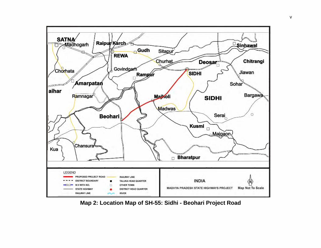
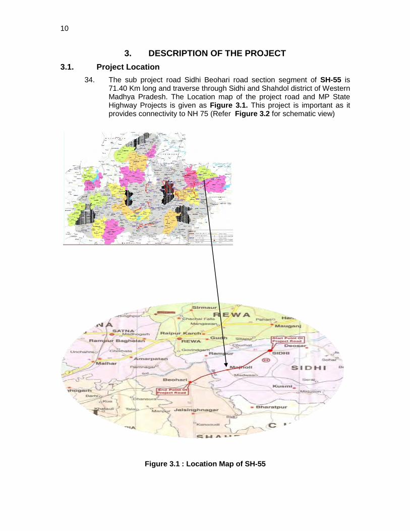
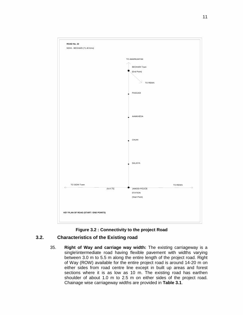
5.4.1. Positive Impacts ......................................................................................... 67 5.4.2. Anticipated Negative Impacts ..................................................................... 67 5.4.3. Obstruction and Disruption of Traffic .......................................................... 70 5.4.4. Transportation and Storage of Materials .................................................... 71
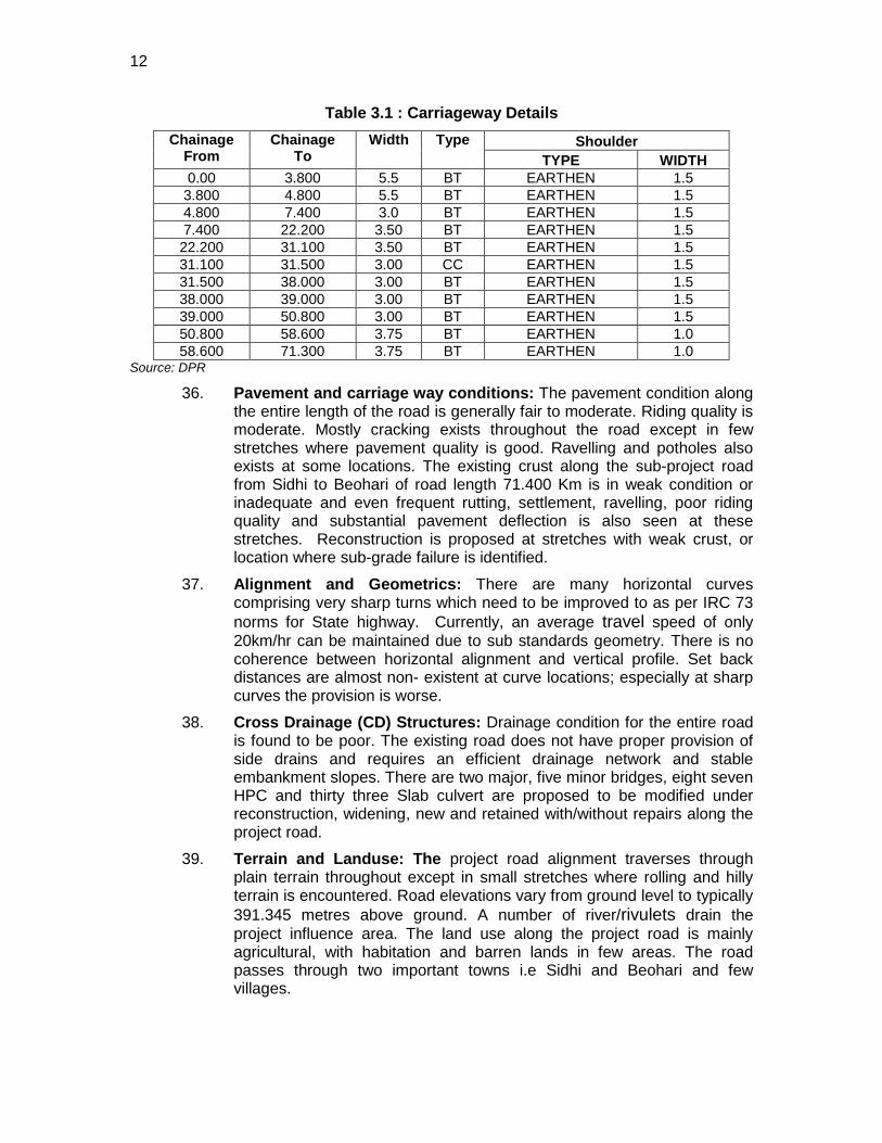
5.5. Cumulative and Induced Impact ..................................................................... 72 6. PUBLIC CONSULTATION AND INFORMATION DISCLOSURE 73
6.1. Consultation Method and Information Disclosed ............................................ 73 6.2. Compliance with Relevant Regulatory Requirements ..................................... 73 6.3. Beneficiaries’ Comments ............................................................................... 76
7. ENVIRONMENTAL MANAGEMENT PLAN AND GRIEVANCE ADDRESSAL MECHANISM 80
7.1. Environmental Management Plan .................................................................. 80 7.1.1. Social Development and Indigenous People Development Program (IPDP):80 7.1.2. Emergency Response Plan ........................................................................ 80
7.2. Environmental Monitoring Program (EMoP) ................................................... 80 7.2.1. Monitoring schedule and performance indicator ......................................... 81 7.2.2. Authorities and their Responsibilities for Implementation of EMoP ............. 82
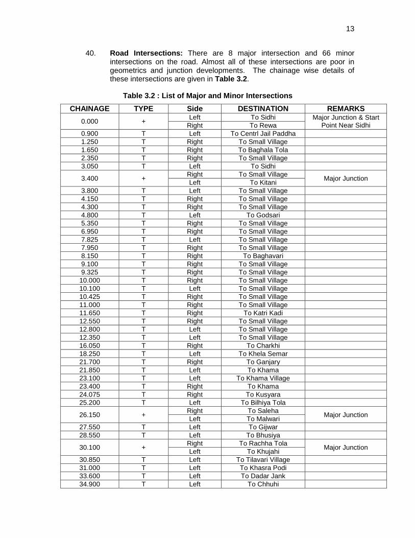
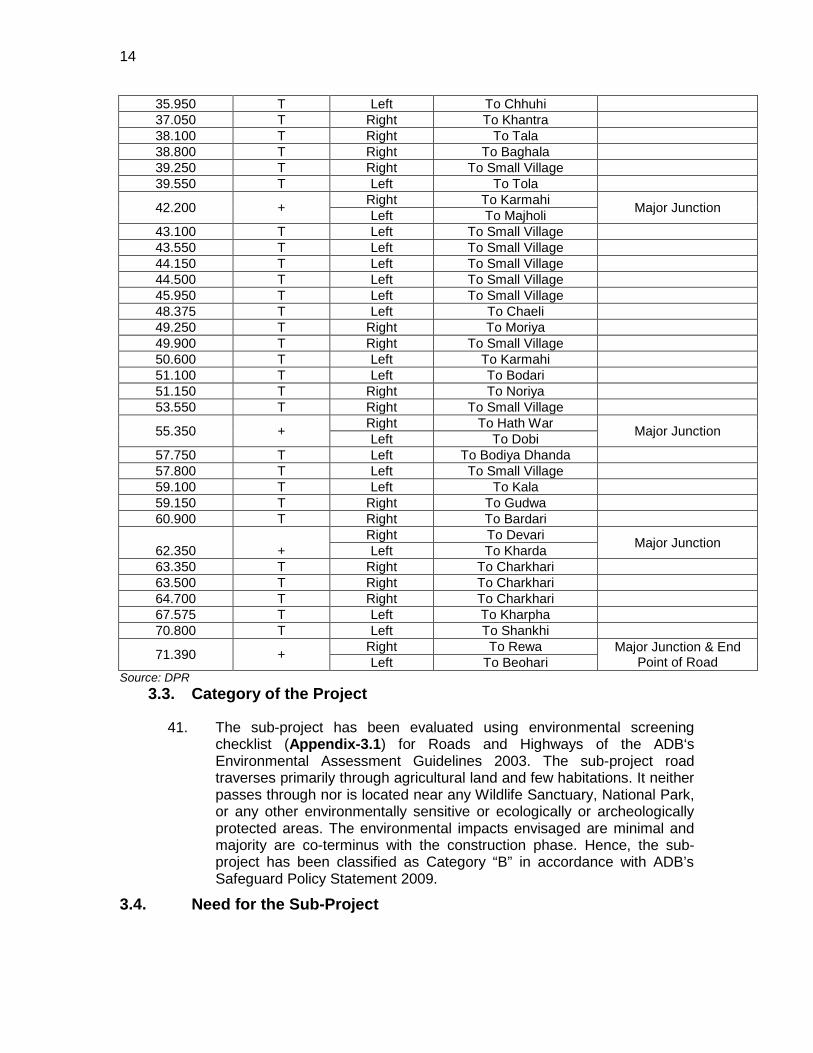
7.3. Institutional Setting and Proposed Implementation Arrangement ................... 82 7.3.2. Institutional / Capacity Building .................................................................. 86
7.4. Grievance Redressal Mechanism .................................................................. 88 8. CONCLUSIONS AND RECOMMENDATIONS 89
8.1. Conclusions ................................................................................................... 89 8.2. Key Recommendations: ................................................................................. 90
List of Tables Table 1.1 : Road Sections under MP State Highways III Project .................................... 1Table 1.2 : Primary and Secondary Information Sources ................................................. 4Table 2.1 : Permissions/Clearances Required for the Sub-Project .................................. 6Table 4.1 : Summary of Important Features of the Project Districts ............................... 24Table 4.2 Monthly Rainfall data (mm) in the project districts for the last five years ........ 25Table 4.3 : Ambient Air Quality Along the project section (24 Hourly) ............................ 26Table 4.4 : Noise Level in dB (A) Along the Project Corridor ......................................... 26Table 4.5 : Physiochemical Characteristics of soil in the project road ............................ 27
iii
Table 4.6 : Land Use Pattern in the State ...................................................................... 28Table 4.7 : Land Use Pattern along the project road ...................................................... 29Table 4.8 : Groundwater Quality Along the Project Corridor .......................................... 32Table 4.9 : Surface Water Quality of the river in project area ......................................... 33Table 4.10 : Forest details along the project road .......................................................... 35Table 4.11 : List of Plant Species found in the Study Area ............................................ 36Table 4.12 : List of Important Medicinal Plants found in the Study area ......................... 37Table 4.13 : List of Fauna found in the Study Area ........................................................ 38Table 4.14 : List of reptiles found in the study area ....................................................... 39Table 4.15 : List of Avifauna found in the Study Area .................................................... 39Table 4.16 : Tree along Project Road (within 20 m width) .............................................. 40Table 4.17 : Demographic Profile of the State and the country ...................................... 51Table 4.18 : List of villages in the project road ............................................................... 52Table 5.1 : Noise- Sensitive Locations along the Alignment .......................................... 57Table 6.1 Summary of Consultation with Government Officials ..................................... 74Table 6.2 : Summary of Consultation with NGOs .......................................................... 75Table 6.3 Consultation with local Community ................................................................ 77Table 7.1 : Roles and Duties of Implementing Agency/Organisations ............................ 83Table 7.2 : Combined Training Budget for MPSRP II ..................................................... 86 List of Figures Figure 2.1 : Environmental Clearance Procedure in India ................................................ 8Figure 2.2 : Legislative Interface among various regulatory bodies ................................. 9Figure 3.1 : Location Map of SH-55 ............................................................................... 10Figure 3.2 : Connectivity to the project Road ................................................................. 11Figure 3.3 : Typical Cross section of the project Road ................................................... 17Figure 4.1 : Hazard and Seismic Zoning Map ................................................................ 28Figure 4.2 : Drainage basin map of the study area ........................................................ 32Figure 4.3 : Population and Gender Ratio of SC-ST ...................................................... 53Figure 4.4 : Literacy scenario of the project area ........................................................... 53Figure 4.5 : Occupational Status Along the Project District ............................................ 54Figure 7.1 : Proposed Structure for EMP/EMOP Implementation .................................. 85 List of Appendix Appendix 3.1: Inventory and Survey Condition of Bridges ............................................. 92Appendix 3.2: Rapid Environmental Assessment Checklist ........................................... 96Appendix 4.1 : National Ambient Air Quality Standards ............................................... 100Appendix 4.2 : Ambient Noise Level Limits (In Leq dB(A)), India ................................. 101Appendix 4.3 : Drinking Water Standards And Probable Effects on Human Health (BIS:
IS: 10500, 1991) ................................................................................................... 102Appendix 4.4 : Water Quality Criteria And Standards for Freshwater Classification
(CPCB, 1979) ....................................................................................................... 105Appendix 5.1: Guidelines for Borrow Areas Management ........................................... 106Appendix 7.1: Environmental Management Plan (SH-55: Sidhi-Beohari 60.7 km) ....... 110Appendix 7.2: Monitoring Plan for the Performance Indicators .................................... 132
iv
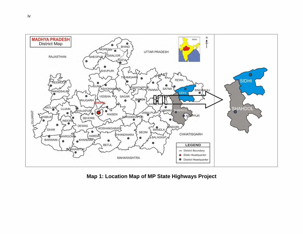
Map 1: Location Map of MP State Highways Project
v
Map 2: Location Map of SH-55: Sidhi - Beohari Project Road
vi
EXECUTIVE SUMMARY Introduction 1. Madhya Pradesh, with abundant mineral resources, and growing agricultural and
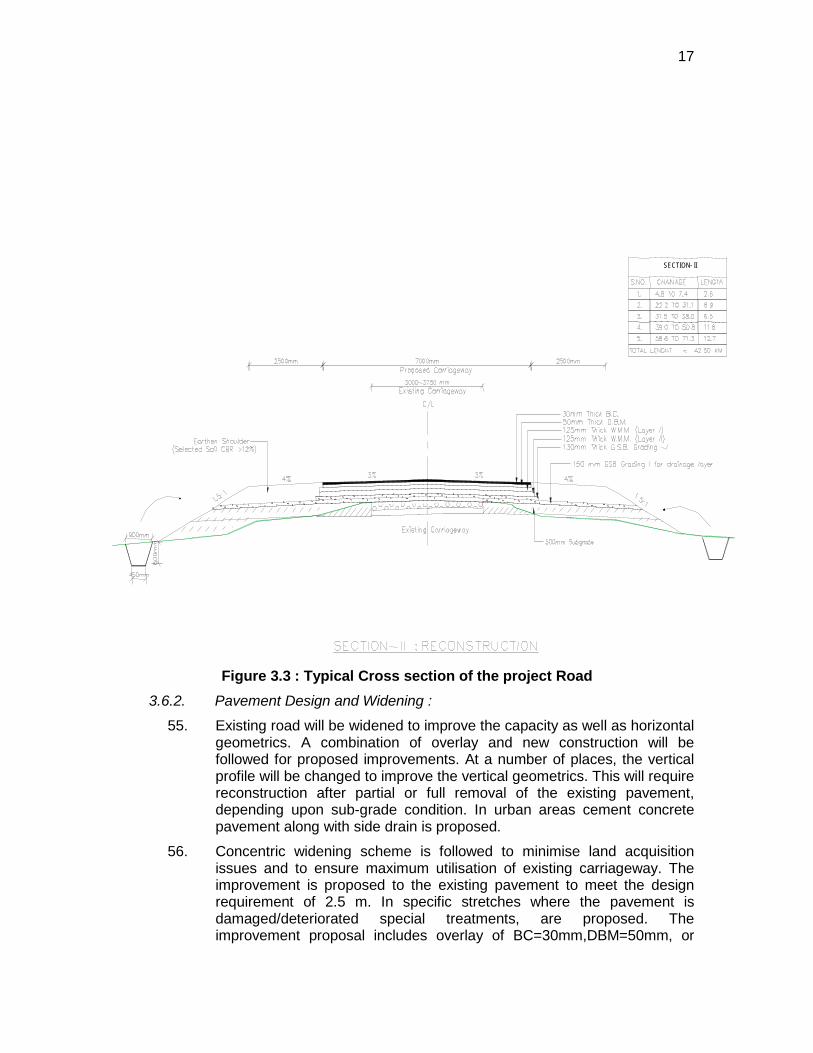
industrial production, need a well developed road network to cater to the increasing intra-state and regional traffic. Also, since it is centrally located within the country, most of the long haul north-south and east-west bound road traffic passes through the state. Therefore, the existing inadequate and damaged road infrastructure needs to be improved on priority to sustain the economic and social progress of the state. The improved road network with good interlinking between national, state highways and major district roads will not only contribute in significantly developing rural economy and reducing poverty but also increase the road capacity to cater the high projected traffic, reduce travel time and also contribute for lesser vehicular pollution emission.
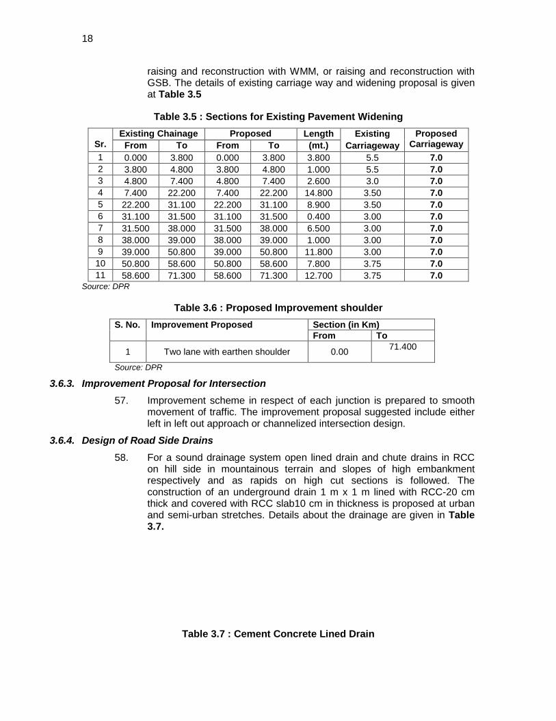
2. Madhya Pradesh Road Development Corporation (MPRDC), the executing agency (EA), is responsible to provide an integrated transport system in the state that is safe, efficient, affordable, accessible to all and environmentally sustainable. As per its mandate, MPRDC plans to improve various major district roads to at least two lanes carriage way level with funding support from Asian Development Bank (ADB).
3. To address this problem, Government of Madhya Pradesh (GOMP) has approached ADB for financial assistance for improving a total of 15 state roads covering a length of about 1081 kms under Madhya Pradesh State Highways III Project (MPSRSP III) programmed to be processed for implementation in 2010.The project also includes the institutional strengthening of the road sector under separate TA 7198(IND) which will enhance EA’s capacity for road asset development and management.
Description of Project 4. The proposed upgrading/rehabilitation of the State Highway-55 Sidhi-Beohari
Road Sub-project, one of the 15 state highway subprojects about 71.4 km long. The subproject will upgrade the existing bad road condition into a paved 2-lane divided carriageway configuration with improved road geometry, proper and adequate embankment, rehabilitation of existing bridges, adequate cross-drainage structures and side drains, improvement of junctions/intersections, underpasses, and wayside amenities. This road design will be adequate to cater to the volume of traffic until 2029 which is predicted to increase from the current 2583 to 9302 vehicles (average annual daily traffic). The sub-project will be implemented in 24 months with an estimated cost of INR 775 Million.
5. The sub-project was classified as Category-B as provided in the ADB Safeguard Policy Statement (2009) based on screening of likely impacts and sub-project location which does not pass through or located near any national park, wildlife sanctuary, or any other ecologically sensitive or protected areas. No archaeological/protected monument is located in the project vicinity. Under the EIA Notification, 2006 promulgated under Environment (Protection) Act 1986, the subproject is categorised as Category ‘B” and does not requires prior
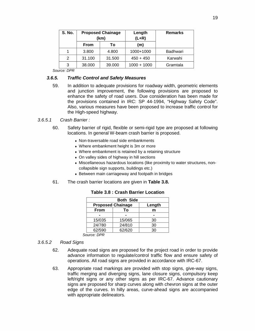
vii
environmental clearance from State Environmental Impact Assessment Authority (SEIAA)1
6. IEE was conducted based on Detailed Project report and sub-project details provided by the design team during the preparation of this report. The IEE covers all activities proposed under the project including various bridges and cross-drainage structures constructions. The core zone of impact is taken as 100 m on either side of the alignment. However, the study area impact zone is considered up to 7 km on both sides of road alignment to allow for a larger analysis of landuse and other environmental features.
.
Description of Environment 7. The Sub-Project passes through 2 districts – Sidhi and Shahdol. May-June is the
hottest month with daily maximum temperature of above 40 °C while January is coolest with minimum temperature of 5 °C. The wind speed in the region is mostly low (< 2 m/s) in almost all the months. The higher wind speeds are observed during monsoon season (June-July). The predominant wind direction is West to North-West. The weather remains dry for all the seasons except monsoon when the humidity is around 85%. Between the two districts, Shehadol receives the maximum rainfall (1485 mm) which occurs between the months of June to September as a result of south west monsoon.
8. The ambient air quality levels conform to the prescribed National Ambient Air Quality Standards (NAAQS) with concentrations of SPM, RSPM, SO2 and NOx value are 50.1 µg/m3, 36.3 µg/m3, 7.8 µg/m3 and 6.5 µg/m3 respectively in the project area. The noise levels are also within the prescribed limits.
9. Most of the project area lies in vast open agricultural land and is largely free from air pollution and noise generating sources with the exception of habited locations such as Sidhi, Tilwari, Chhuhi, Salaiya, Beohari etc. where ambient SPM concentrations exceeded standards due to traffic congestion, unpaved shoulders and inadequate road capacity. The project road is passing through mix terrain of hilly and plain region. Hilly terrain is mainly dominated by forest cover. A very small portion of the project area in bordering Sidhi and Shehdol is in bank of Banas River. In this region the main classes of soil are black, brown and bhatori (stony) soil. The volcanic, clay-like soil of the region owes its black colour to the high iron content of the basalt from which it formed. The soil requires less irrigation because of its high capacity for moisture retention. The other two soil types are lighter and have a higher proportion of sand. The black cotton soil covers almost three fourths of the area. The alluvial soils are found along the river courses. The higher elevations i.e. the hilly regions have a cover of murrum, which is made up of small rounded pieces of weathered trap. The Vindhyans and Bijawars have a thin cover of sandy loams. The alluvium is derived from hill slopes by numerous streams and watercourses. The two major rivers crossing the road are Mahan and Banas River. Banas River is the major tributary of Sone River. It crosses the road bordering between Sidhi and Shehadol at 54.250km chainage. River Mahan is crossing the road at chainage 36km. The Gulab Sagar
1 The EA has yet to formally approach MoEF for formal categorisation and grant of environmental clearance.
viii
dam on this river is 17km away from the project road. Both the rivers are perennial in nature.
10. The Land use pattern along the project road is also mixed type dominated by agriculture and forest area. There are also few public and private settlements along the project road. are several canals and drains cutting across the project alignment. The ground water availability along the project road area is poor. The depth of water table goes below 250 feet during summer season. Most of the wells become dry except in monsoon season.
11. In the project section about 17 km of the road alignment is passing through protected forest area. These forests are mainly tropical moist and tropical dry in nature. The study area is covered with dense vegetation dominated by sal (Shorea robusta) plantation. Sal forms pure patches at some locations. The open areas and agriculture fields were dominated by shrubby vegetation. Some important associated species of Shorea robusta are Anogessus latifolia Terminalia tomentosa Diospyros melanoxylon etc. Same open forest is also present in different patches. The general floristic composition in the study area is as follows: Sal (Shorea robusta), Dhawda (Anogessus latifolia), Tendu (Diospyros melanoxylon), Harra (Terminalia chebula), Bahera (Terminalia belerica), Saja (Terminalia tomentosa), Mahua (Madhuca indica), Bija (Pterocarpus marsupian), Salai (Boswellia serrata), Semal (Bombax malabaricum), Shisam (Darbergia latifolia), Haldu (Adina cordifolia), Kalam (Mitragyna parvifolia) etc. Aonla (Emblica officinalis), Achar (Buchanania lanzan), Kumbi (Careya arborea), Kari (Saccopetalum tomentosum), Khair (Acacia catechu), Rohan (Soymida febriguga), Palas (Butea monosperma) etc.Gudsakri (Grewia hirsuta), Badi kateri (Solanim indicum), Ratanjyot (Jatropa corcus), Lantana (Lantana camera) etc. The study area shows presence of medicinal plants. The area abounds in production of many kinds of fruits, flowers, seeds and leaves which have medicinal properties. Some of the important medicinal plants found in the study area are Aegle marmelos, Albizzia lebbeck, Tamarindus indica, Terminalia Arjuna, Ficus glomerata Ficus benghalensis, Adina cordifolia, Ailanthus excelsa, Azadirachta indica, Ficus religiosa, Madhuca latifolia
12. The vegetation density and diversity is an important factor determining the habitat and thus for particular wild animals. Different animals prefer different types of habitat for food and shelter. The Sanjay Dubri wildlife Sanctuary is also one of the most important Sanctuary of Madhya Pradesh covering 364.69 km² which is 12 km away from the proposed road development activity. There is movement of wild animals like Spotted Deer, Sambar, Blue bull, Wild boar and Jackal in the dense areas of the proposed road site. The study area has some hilly areas with thick plantation. However, the public consultation revealed the presence of Nilgai, Wild boar, Blue bull, Foxes, Hare, macaque, langur. During the survey domestic animals like cow, buffaloes, and goat were observed. There are several canals and drains cutting across the project alignment. Two major fish species were found in the study area viz. Rohu (Labeo rohita) and Catla (Catla catla). There is no breeding or spawning ground of these species in any of the water bodies in the project area since the water availability and flow velocity is quite low and unfavourable for breeding. No migratory fishes are found in these rivers.
13. The main economic crops of the district are Soyabean, Wheat, Gram Jowar and Pulses. The district is economically backward because of unfertile land and lack
ix
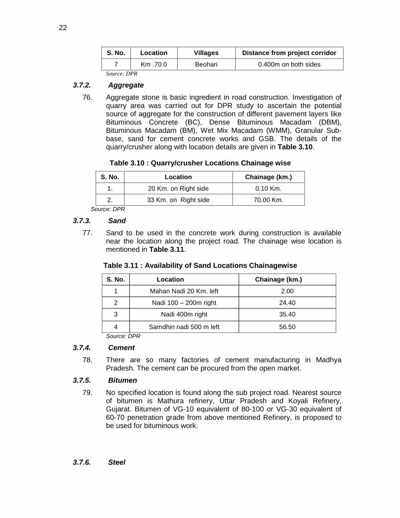
of irrigation sources. The industries in the study area includes oilseed milling, handloom weaving and dyeing and the manufacture of bell-metal vessels and pottery, bidi (indigenous cigarette) factories, cement, gold and silver smithies.
14. The total number of households in the villages of the project road is 16095 with a total population of 84454. Out of these, about 73% is general. The SC & ST population accounts for about 9 and 18% of the total population respectively. The overall literacy rate of Madhya Pradesh is 64.1%, which is almost equivalent to the countries literacy rate (64.8%). The project road passing through three districts of Madhya Pradesh covering 31 villages have total literacy rate of 60.8%. The population of literate male (61.3%) is comparatively higher than female. In the villages of the project road 32.92% of the total population comprise the workforce of the project area.74.72 % comprise the male working class population. Marginal population of villages of the project road is 6.8% with 60.7% represented by female population. Maximum percentage of the workers is other than agriculture, casual and households. The total other labour comprise of 68% of the total working class population.
Anticipated Environmental Impacts and Mitigation Measures 15. All pre-construction, construction, and operation activities that were likely to
cause environmental impacts were identified, and evaluated to assess their magnitude, duration, and potential receptors in consultation with the stakeholders. Consultations were made with the government representatives (District Forest Office, State Pollution Control Board, Water Resources Department, Directorate of Economics and Statistics, and the District Rural Development Authority), local communities (Sidhi, Tilwari, Chhuhi, Salaiya, Beohari etc), and NGOs (Bhopal Yuwa Paryavaran Shikshan and Samajik Sansthan, Ecosake Society for Environment Conservation and Social Awareness, Green Heart Nature Club, Forum for Environmental Protection, Energy Environment and Development Group, Centre for Envirocare and Energy Technology) between June to July 2010.
16. The significant impacts during design and construction stage include the constricted sections of the roads which will be by-passed or require road alignment improvement to avoid and minimize resettlement and other sensitive structures and locations particularly in Lakshman Dham, Palar, Ankhera (Bangaon), Luhari, Hata town, Hardua, Ghataria, Sakour (Hinota Kala), Budwar, Gaisabad. An estimated 462 trees will be removed along the road to allow for its expansion but will be compensated at a rate of 1:10 plantation along the road. Short-term deterioration of air quality due to increase in fugitive dust emissions and noise level from earthmoving, ground shaping, unpaved transport, and emissions from heavy equipment and other mobile sources. Water suppression to control dust, use of clean fuels, changing the location and timing of construction activities and equipment will minimize these impacts. Land use conversion particularly of residential areas and relocation of structures within the ROW will be implemented with following a meaningful consultation and acceptable compensation and relocation agreements. All borrow areas will comply with national laws and regulations. Impacts from the establishment and operation of the construction camps like generation and disposal of solid wastes, sewage, potable water requirements, health/hygiene, and safety is part of the
x
contractor’s responsibility highlighting the need for compliance with applicable laws. Waste and material use minimization will be promoted to decrease the volume of wastes that will be generated. Traffic safety to workers and pedestrian, particularly to children is considered through the preparation and strict implementation of a Traffic Control Plan to be prepared by the contractor prior to construction activities and in consultation with the affected communities.
17. During operation stage, the main impacts are on the surface water hydrology since the construction of a road crosses several river/rivulets in the flood-affected sections which can act as impediment to natural flow of water. Other issues relate to increase in mobile emissions, road safety to motorist, pedestrian and animals. To minimize the impact on the local hydrology, adequate cross drains and their proper maintenance will be implemented. Information and education campaign through the use of signs and posters distributed along the roadside encouraging motorist to properly maintain their vehicles, and proper driving habits to reduce emissions, reduce fuel consumption, and promote safety will be made. Finally, traffic control measures will be implemented to ensure safety to pedestrian.
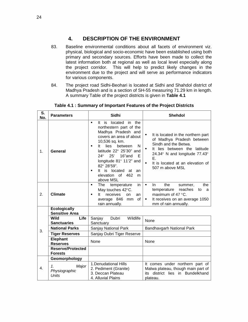
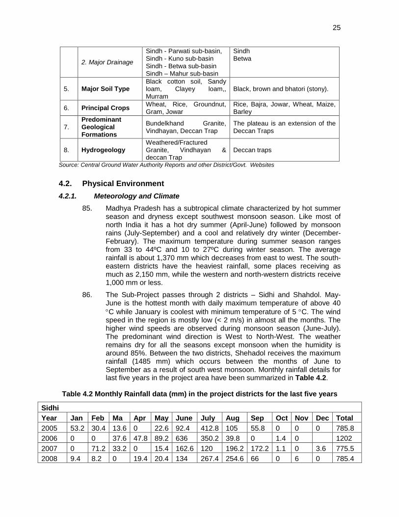
Conclusion 18. In general, the sub-project received immense support from local people with
some concerns and apprehensions related to compensation for land and safety on roads. The local people appreciated that besides providing an all weather efficient connectivity to large population and improving the traffic scenario in the region, it will bear out several other positive economic and social benefits which outweigh the negative environmental impacts.
19. This initial environmental examination (IEE) ascertains that the sub-project is unlikely to cause any significant environmental impacts. Few impacts were identified attributable to the proposed sub-project, all of which are localized and temporary in nature and can be easily mitigated with minor to negligible residual impacts. No additional studies or need of undertaking detailed EIA is envisaged at this stage.
1. INTRODUCTION
1.1. Project Background/Rationale 20. Madhya Pradesh, with abundant mineral resources, and growing
agricultural and industrial production, need a well developed road network to cater to the increasing intra-state and regional traffic. Also, since it is centrally located within the country, most of the long haul north-south and east-west bound road traffic passes through the state. Therefore, the existing inadequate and damaged road infrastructure needs to be improved on priority to sustain the economic and social progress of the state. The improved road network with good interlinking between national, state highways and major district roads will not only contribute in significantly developing rural economy and reducing poverty but also increase the road capacity to cater the high projected traffic, reduce travel time and also contribute for lesser vehicular pollution emission.
21. Madhya Pradesh Road Development Corporation (MPRDC), the executing agency (EA), is responsible to provide an integrated transport system in the state that is safe, efficient, affordable, accessible to all and environmentally sustainable. As per its mandate, MPRDC plans to improve various major district roads to at least two lanes carriage way level with funding support from Asian Development Bank (ADB).
22. Government of Madhya Pradesh (GOMP) has approached ADB for financial assistance for improving a total of 15 state roads covering a length of about 1081 kms under Madhya Pradesh State Highways III Project (MPSRSP III) programmed to be processed for implementation in 2010. The road sections details under MPSRSP III are given in Table 1.1
Table 1.1 : Road Sections under MP State Highways III Project
S. No.
Road No. Name of Roads SH
No. Length
(KM) Districts
I. BHOPAL PACKAGE
1 1 Bhind-Ater-Porsa SH-2 60.85 Bhind –Morena
2 2 Mihona-Lahar-Daboh-Bhander-Chirgaon SH-45 85.70 Bhind-Datia
3 3 Pichhore-Chanderi-Mungawali-Onder-Kurwai SH-19 146.50
Shivpuri - Ashoknagar-
Vidisha 4 7 Manawar-Mangod SH-38 49.63 Dhar 5 9 Sardarpur-Rajgarh-Bagh SH-35 50.43 Dhar
6 10 Agar-Barod-Alot-Jawara SH-41 108.70 Shajapur- Ratlam-Ujjain-
7 11 Pachor-Chapikheda-Jirapur-Machalpur-Soyat SH-51 86.70 Rajgarh-
Shajapur 8 13 Badi-Baktar-Dobi-Shahganj-Budhni SH-15 58.78 Raisen-Sehore
2
S. No.
Road No. Name of Roads SH
No. Length
(KM) Districts
9 14 Silwani-Udaipura Road SH-44 28.58 Raisen
Total (Bhopal Pkg) 675.87
II. JABALPUR PACKAGE
10 16 Rahatgarh-Khurai-Khimlasa SH-42 47.48 Sagar
11 18 Damoh-Hata-Gasiabad i/c Hata Town Portion SH-47 62.66 Damoh
12 19 Hata-Patera-Kumhari & Raipura-Salaiya-Bahuribandh-Sihora SH-48 91.28 Damoh-Panna-
Katni-Jabalpur
13 20A Amarpatan-Gorsari-Badera SH-13 46.50 Satna-Katni
14 21 Sundara-Singhpur-Kothi-Jaitwara-Birsinghpur-Semaria SH-52 85.29 Panna-Satna-
Rewa
15 22 Sidhi-Beohari SH-55 71.29 Sidhi-Shahdol
Total (Jabalpur Pkg) 404.49
Grand Total (Bhopal Pkg + Jabalpur Pkg) 1,080.36
Source: MPRDC
1.2. Project Preparatory Technical Assistance (PPTA) and Environmental Assessment
23. ADB has fielded TA: 7198 IND to assist MPRDC Road Construction Department (RCD) in project preparation for possible financing of MPSRSP III. As a part of this TA and safeguard requirement of ADB, environmental assessment has been carried out in accordance with relevant country’s applicable laws, regulations and in consistent to ADB’s Environmental Assessment Guidelines, 2003 and Safeguard Policy Statement (SPS), 2009. Each sub-project was scrutinized as to its type, location, scale, and sensitivity and the magnitude of its potential environmental impacts.
24. The present report pertains to Sidhi-Beohari (SH-55) sub-project. This sub-project is categorized as Category ‘B’ and hence an initial environmental examination (IEE) has been undertaken.
1.3. Purpose of the Study 25. This IEE report documents the environmental assessment of the Sidhi-
Beohari Road Subproject (hereafter the Subproject) and identifies the environmental issues to be considered at project planning and design stage. The IEE addresses the environmental management requirements of (i) the Government of India (GOI); (ii) the donor, Asian Development Bank (ADB), and (iii) the Project. In general, In general, an IEE addresses the following:
o Provides information about the baseline environmental setting of the subproject;
3
o Provides information on potential impacts of the Subproject and their likely characteristics including magnitude, distribution, duration, and who will be affected;
o Provides information on potential environmental impacts of the proposed subproject activities with its magnitude, distribution and duration
o Provides information on required mitigation measures with cost to minimize the impacts
o Analyses the alternatives options considering alternative locations, designs, management approaches, for selection of most feasible and environmental acceptable options.
o Provides details of stack holders consultation o Suggest environmental management and monitoring plan with
institutional measures for effective implementation of mitigative measures proposed.
1.4. Extent of IEE 26. IEE was conducted based on Detailed Project Report (DPR) provided by
the design team during the preparation of this report. Certain changes may occur in the sub-project structural components but these changes are unlikely to cause significant environmental impacts. The IEE covers all activities proposed under the project including various bridges and cross-drainage structures constructions. The core zone of impact is taken as 100 meters either side of the alignment. However, the study area is considered up to 7 km on either side of road alignment for larger analysis of land-use and other environmental features. Assessment is carried out for all components of environment covering terrestrial and aquatic ecology, soil, water, noise and socio economic aspects.
1.5. IEE Content 27. The IEE has been largely structured as per SPS, 2009 and ADB’s
Environmental Assessment Guidelines (2003). This includes following eight chapters including this introduction Chapter.
• Chapter 1- Introduction • Chapter 2- Policy, Legal and Administrative Framework • Chapter 3- Description of Project • Chapter 4- Description of Environment • Chapter 5- Anticipated Impacts and Mitigation Measures • Chapter 6- Information Disclosure, Consultation, and Participation • Chapter 7- Environment Management Plan and Grievance Redress
Mechanism • Chapter 8- Conclusion and Recommendation
1.6. Team Composition and Acknowledgements 28. The environmental assessment has been carried out by the team of the
environmental Experts of EQMS India Pvt. Ltd. The environmental team acknowledges the support extended by the executing agency, design consultant, and state departments/agency of forest, water resources and pollution control Board etc.
4
1.7. Methodology 29. Suitable methodology was adopted to accomplish the study. As the first
step, project-scoping exercise was undertaken identifying the parameters needed to be considered for the study and to outline the activities for collecting data on each parameter. Data pertaining to all facets of environment viz. physical, ecological and socio-economic environment both through primary and secondary sources were collected. The stepwise activities includes:
• Review of legal requirements • Review of feasibility study • Reconnaissance survey for identification of key issues data
requirement and preliminary consultation. • Primary and Secondary data Collection • Consultation with stakeholders • Identification of Impacts and Mitigation measures • Institutional Review and finalization of EMP in consultation with EA.
1.7.1. Information/ data Sources Key relevant information sources has been summarised in Table 1.2.
Table 1.2 : Primary and Secondary Information Sources
Environmental Parameters Information Sources
Project objectives, Technical information on existing road features and proposed rehabilitation work
Madhya Pradesh Road Development Corporation (MPRDC) and Design Consultant
Inventory of road features like water Bodies, Community structures, environmentally sensitive locations areas, congested locations etc.
Ground Physical surveys and Strip Plans by Design Consultant
Climatic Condition India meteorological Department, DPR, primary data collection
Geology, Seismicity, Soil and Topography
Central Ground Water Authority, State of Environment report published by SPCB, Government websites and primary data collection
Land Use/ Land Cover Survey of India (SoI) Toposheet, Observation during survey and Satellite Imagery
Drainage Pattern Survey of India Toposheet, water resources, field observation and local people, GIS Based land use analysis
Status of forest areas. Compensatory afforestation norms etc.
Divisional Forest Office, Sidhi and Shahdol
Status of Fishing Activity District Fisheries offices and Local Fishermen Air quality Noise, Soil and Water Onsite monitoring and Analysis of Field samples Borrow Areas, Quarries and other construction material source
Design consultant and public consultation during field visit
River geo-morphology, hydrology, Water resources department, DPR and
5
Environmental Parameters Information Sources
drainage, flood patterns, information from local people, field observations Socio-economic Environment Different Govt. agencies/civic bodies, Official
websites maintained by state Govt., census of India 2001 and Public Consultation during the Field survey, through figures collected from Directorate of Statistics.
1.7.2. Public Consultation 30. Extensive consultations were held with all stakeholders’ viz. local and
beneficiary population, govt. departments/agencies, fishermen, road users and NGOs with intent to collect baseline information, for better understanding of the potential impacts and appreciate the perspectives/concerns of the stakeholders. Information thus gathered was used to integrate it in project design and formulating mitigation measures and environmental management plan.
.
6
2. POLICY, LEGAL AND ADMINISTRATIVE FRAMEWORK
2.1. Country’s Legal Framework and Regulatory Requirements for the Project
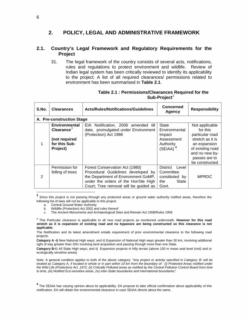
31. The legal framework of the country consists of several acts, notifications, rules and regulations to protect environment and wildlife. Review of Indian legal system has been critically reviewed to identify its applicability to the project. A list of all required clearances/ permissions related to environment has been summarised in Table 2.1.
Table 2.1 : Permissions/Clearances Required for the Sub-Project2
S.No.
Clearances Acts/Rules/Notifications/Guidelines Concerned Agency Responsibility
A. Pre-construction Stage
1
Environmental Clearance3
(not required for this Sub-Project)
EIA Notification, 2006 amended till date, promulgated under Environment (Protection) Act 1986
State Environmental Impact Assessment Authority (SEIAA) 4
Not applicable for this
particular road stretch as it is an expansion
of existing road and no new by-passes are to
be constructed
.
2
Permission for felling of trees
Forest Conservation Act (1980) Procedural Guidelines developed by the Department of Environment GoMP, under the orders of the Hon’ble High Court; Tree removal will be guided as
District Level Committee constituted by the State Govt.
MPRDC
2 Since this project is not passing through any protected areas or ground water authority notified areas, therefore the following list of laws will not be applicable to this project.
a. Central Ground Water Authority b. Wildlife (Protection) Act 2002 and rules thereof c. The Ancient Monuments and Archaeological Sites and Remain Act 1958/Rules 1959
3 This Particular clearance is applicable to all new road projects as mentioned underneath. However for this road stretch as it is expansion of existing road and no bypasses are being constructed so this clearance is not applicable. The Notification and its latest amendment entails requirement of prior environmental clearance to the following road projects. Category A -i) New National High ways; and ii) Expansion of National High ways greater than 30 km, involving additional right of way greater than 20m involving land acquisition and passing through more than one State. Category B-ii) All State High ways; and ii) Expansion projects in hilly terrain (above 100 m mean seal level (msl) and or ecologically sensitive areas) Note: A general condition applies to both of the above category: “Any project or activity specified in Category ‘B’ will be treated as Category A, if located in whole or in part within 10 km from the boundary of: (i) Protected Areas notified under the Wild Life (Protection) Act, 1972, (ii) Critically Polluted areas as notified by the Central Pollution Control Board from time to time, (iii) Notified Eco-sensitive areas, (iv) inter-State boundaries and international boundaries”.
4 The SEIAA has varying opinion about its applicability. EA propose to take official confirmation about applicability of this notification. EA will obtain the environmental clearance in case SEIAA directs about the same.
7
S.No. Clearances Acts/Rules/Notifications/Guidelines Concerned Agency Responsibility
per state government rules. B. Implementation Stage
3 Permission for Sand Mining from river bed
Mines and Minerals (Regulation and Development) Act, 1957 as amended in 1972
River Board Authorities/
Department of Mining Govt. of Madhya Pradesh
Contractor
4
Consent to operate Hot mix plant, Crushers, Batching Plant
Air (Prevention and Control of Pollution) Act 1981
Madhya Pradesh Pollution
Control Board
Contractor
5
Authorization for Disposal of Hazardous Waste
Hazardous Waste (Management and Handling) Rules 1989
Madhya Pradesh Pollution
Control Board
Contractor
6
Consent for Disposal of Sewage from Labour camps
Water (Prevention and Control of Pollution) Act 1974
Madhya Pradesh Pollution
Control Board
Contractor
7
Use of Fly ash within 100 kms around Thermal Power plants.
Fly Ash Notification, 1999 as amended up to 17th August 2003: MoEF Contractor
8 Pollution Under Control Certificate
Central Motor and Vehicle Act 1988
Department of Transport, Govt. of Madhya Pradesh
Contractor
14 Employing Labour/workers
The Building and Other Construction Workers (Regulation of Employment and Conditions of Service) Act, 1996,
District Labour Commissioner Contractor
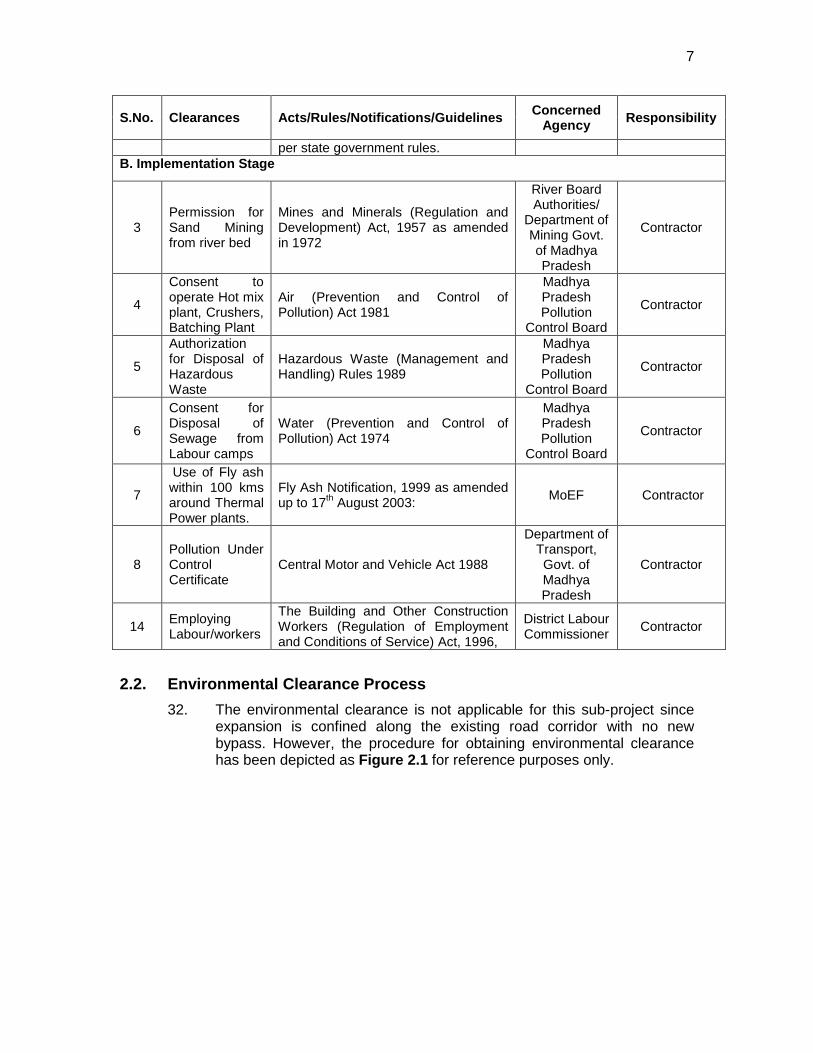
2.2. Environmental Clearance Process 32. The environmental clearance is not applicable for this sub-project since
expansion is confined along the existing road corridor with no new bypass. However, the procedure for obtaining environmental clearance has been depicted as Figure 2.1 for reference purposes only.
8
Figure 2.1 : Environmental Clearance Procedure in India
9
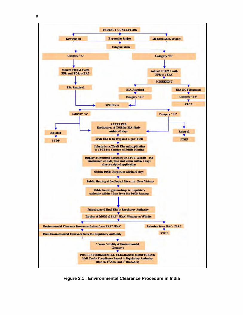
2.3. Administrative Structure and the Interactive framework 33. The Government through specific legislations regulates the environmental
management system in India. The MoEF and the pollution control boards (CPCB i.e. Central Pollution Control Board and SPCBs i.e. State Pollution Control Boards) together form the regulatory and administrative core of the part. Other Ministries/Statutory Bodies/departments responsible for ensuring environmental compliance and granting various clearances includes State ministry /Dept. of environment, regional offices of MoEF and state forests/wildlife departments. Their key roles and responsibilities and interface among them have been concisely depicted through the flow diagram in Figure 2.2.
Figure 2.2 : Legislative Interface among various regulatory bodies
10
3. DESCRIPTION OF THE PROJECT 3.1. Project Location
34. The sub project road Sidhi Beohari road section segment of SH-55 is 71.40 Km long and traverse through Sidhi and Shahdol district of Western Madhya Pradesh. The Location map of the project road and MP State Highway Projects is given as Figure 3.1. This project is important as it provides connectivity to NH 75 (Refer Figure 3.2 for schematic view)
Figure 3.1 : Location Map of SH-55
11
BEOHARI Town (End Point)
TO SIDHI Town
TO AMARKANTAK ROAD No. 22 SIDHI - BEOHARI (71.40 Kms)
JAMODI POLICE STATION (Start Point) TO REWA SALAIYA CHUHI AAMKHEDA PASGADI
(N.H-75)
TO REWA
KEY PLAN OF ROAD (START / END POINTS)
Figure 3.2 : Connectivity to the project Road
3.2. Characteristics of the Existing road
35. Right of Way and carriage way width: The existing carriageway is a single\intermediate road having flexible pavement with widths varying between 3.0 m to 5.5 m along the entire length of the project road. Right of Way (ROW) available for the entire project road is around 14-20 m on either sides from road centre line except in built up areas and forest sections where it is as low as 10 m. The existing road has earthen shoulder of about 1.0 m to 2.5 m on either sides of the project road. Chainage wise carriageway widths are provided in Table 3.1.
12
Table 3.1 : Carriageway Details Chainage
From Chainage
To Width Type Shoulder
TYPE WIDTH 0.00 3.800 5.5 BT EARTHEN 1.5
3.800 4.800 5.5 BT EARTHEN 1.5 4.800 7.400 3.0 BT EARTHEN 1.5 7.400 22.200 3.50 BT EARTHEN 1.5 22.200 31.100 3.50 BT EARTHEN 1.5 31.100 31.500 3.00 CC EARTHEN 1.5 31.500 38.000 3.00 BT EARTHEN 1.5 38.000 39.000 3.00 BT EARTHEN 1.5 39.000 50.800 3.00 BT EARTHEN 1.5 50.800 58.600 3.75 BT EARTHEN 1.0 58.600 71.300 3.75 BT EARTHEN 1.0
Source: DPR
36. Pavement and carriage way conditions: The pavement condition along the entire length of the road is generally fair to moderate. Riding quality is moderate. Mostly cracking exists throughout the road except in few stretches where pavement quality is good. Ravelling and potholes also exists at some locations. The existing crust along the sub-project road from Sidhi to Beohari of road length 71.400 Km is in weak condition or inadequate and even frequent rutting, settlement, ravelling, poor riding quality and substantial pavement deflection is also seen at these stretches. Reconstruction is proposed at stretches with weak crust, or location where sub-grade failure is identified.
37. Alignment and Geometrics: There are many horizontal curves comprising very sharp turns which need to be improved to as per IRC 73 norms for State highway. Currently, an average travel speed of only 20km/hr can be maintained due to sub standards geometry. There is no coherence between horizontal alignment and vertical profile. Set back distances are almost non- existent at curve locations; especially at sharp curves the provision is worse.
38. Cross Drainage (CD) Structures: Drainage condition for the entire road is found to be poor. The existing road does not have proper provision of side drains and requires an efficient drainage network and stable embankment slopes. There are two major, five minor bridges, eight seven HPC and thirty three Slab culvert are proposed to be modified under reconstruction, widening, new and retained with/without repairs along the project road.
39. Terrain and Landuse: The project road alignment traverses through plain terrain throughout except in small stretches where rolling and hilly terrain is encountered. Road elevations vary from ground level to typically 391.345 metres above ground. A number of river/rivulets drain the project influence area. The land use along the project road is mainly agricultural, with habitation and barren lands in few areas. The road passes through two important towns i.e Sidhi and Beohari and few villages.
13
40. Road Intersections: There are 8 major intersection and 66 minor intersections on the road. Almost all of these intersections are poor in geometrics and junction developments. The chainage wise details of these intersections are given in Table 3.2.
Table 3.2 : List of Major and Minor Intersections CHAINAGE TYPE Side DESTINATION REMARKS
0.000 + Left To Sidhi Major Junction & Start Point Near Sidhi Right To Rewa
0.900 T Left To Centrl Jail Paddha 1.250 T Right To Small Village 1.650 T Right To Baghala Tola 2.350 T Right To Small Village 3.050 T Left To Sidhi
3.400 + Right To Small Village Major Junction Left To Kitani 3.800 T Left To Small Village 4.150 T Right To Small Village 4.300 T Right To Small Village 4.800 T Left To Godsari 5.350 T Right To Small Village 6.950 T Right To Small Village 7.825 T Left To Small Village 7.950 T Right To Small Village 8.150 T Right To Baghavari 9.100 T Right To Small Village 9.325 T Right To Small Village 10.000 T Right To Small Village 10.100 T Left To Small Village 10.425 T Right To Small Village 11.000 T Right To Small Village 11.650 T Right To Katri Kadi 12.550 T Right To Small Village 12.800 T Left To Small Village 12.350 T Left To Small Village 16.050 T Right To Charkhi 18.250 T Left To Khela Semar 21.700 T Right To Ganjary 21.850 T Left To Khama 23.100 T Left To Khama Village 23.400 T Right To Khama 24.075 T Right To Kusyara 25.200 T Left To Bilhiya Tola
26.150 + Right To Saleha Major Junction Left To Malwari 27.550 T Left To Gijwar 28.550 T Left To Bhusiya
30.100 + Right To Rachha Tola Major Junction Left To Khujahi 30.850 T Left To Tilavari Village 31.000 T Left To Khasra Podi 33.600 T Left To Dadar Jank 34.900 T Left To Chhuhi
14
35.950 T Left To Chhuhi 37.050 T Right To Khantra 38.100 T Right To Tala 38.800 T Right To Baghala 39.250 T Right To Small Village 39.550 T Left To Tola
42.200 + Right To Karmahi Major Junction Left To Majholi 43.100 T Left To Small Village 43.550 T Left To Small Village 44.150 T Left To Small Village 44.500 T Left To Small Village 45.950 T Left To Small Village 48.375 T Left To Chaeli 49.250 T Right To Moriya 49.900 T Right To Small Village 50.600 T Left To Karmahi 51.100 T Left To Bodari 51.150 T Right To Noriya 53.550 T Right To Small Village
55.350 + Right To Hath War Major Junction Left To Dobi 57.750 T Left To Bodiya Dhanda 57.800 T Left To Small Village 59.100 T Left To Kala 59.150 T Right To Gudwa 60.900 T Right To Bardari
62.350 + Right To Devari Major Junction Left To Kharda
63.350 T Right To Charkhari 63.500 T Right To Charkhari 64.700 T Right To Charkhari 67.575 T Left To Kharpha 70.800 T Left To Shankhi
71.390 + Right To Rewa Major Junction & End Point of Road Left To Beohari
Source: DPR 3.3. Category of the Project
41. The sub-project has been evaluated using environmental screening checklist (Appendix-3.1) for Roads and Highways of the ADB‘s Environmental Assessment Guidelines 2003. The sub-project road traverses primarily through agricultural land and few habitations. It neither passes through nor is located near any Wildlife Sanctuary, National Park, or any other environmentally sensitive or ecologically or archeologically protected areas. The environmental impacts envisaged are minimal and majority are co-terminus with the construction phase. Hence, the sub-project has been classified as Category “B” in accordance with ADB’s Safeguard Policy Statement 2009.
3.4. Need for the Sub-Project
15
42. The main aim of developing this State highway is to provide connectivity to the selected townships with other major social and commercial centres within the district as well in the other parts of state. The sub project road holds strategic importance as it provides vital connectivity to Sidhi and Shahdol districts and to the nearby districts namely Rewa, Singroli, Umaria, Katni and Satna. The sub-project road will benefit more than 12 million populations (mainly rural) by providing improved transport and communication facilities which will contribute in accelerating the local economy.
43. The sub project road serves as important link for providing connectivity of National Highways NH-75. The traffic intensity at this sub-project road is increasing, necessitating augmentation of capacity for safe and efficient movement. The road condition is poor which reduces the average traffic speed to about 20 Km/h and also results in higher fuel consumption and vehicular pollution. Therefore, improvement of this subproject road is proposed to provide safe movement of increasing traffic at higher travel speeds with reduced travel time, accidents, overloading, and vehicle emissions.
3.5. Existing and Projected Traffic
44. Existing Traffic Volume: Average Daily Traffic (ADT) of sub-project road is presented in the Table 3.3. The recorded ADT is 1701 vehicles (2224 PCU). ADT of Project Road.
Table 3.3 : ADT of Project Road
Section Average Daily Traffic
Average daily PCUs
Sidhi-Beohari 1701 2224
Source: DPR
45. Projected Traffic: The maximum traffic projection for the year 2009 to 2029 is given at Table 3.4. It is expected that the traffic volume is doubled by the year 2019 i.e. 5364 (5341 PCU) and will be more than three times after 20 years i.e. 9302 (8591 PCU).
Table 3.4 : Summary of Projected Traffic for the Project Road Project Road Year
2009 Year 2014
Year 2019
Year 2024
Year 2029 From To
Sidhi Beohari 2583 (2842)
3778 (3949)
5364 (5341)
7144 (6835)
9302 (8591)
Source: DPR Note: Values in bracket indicate PCUs/day
46. The capacity of different carriageways is 6000, 15000 and 18000 PCUs per day for intermediate lane, 2 lane with earthen shoulders and 2 lane with Paved shoulders respectively. Analysing the capacity of Design Service Volume of Carriage ways and the projected traffic, it is concluded
16
that the project road requires two lanes with earthen shoulder by 2018-2023.
3.6. Key Rehabilitation and Reconstruction Activities 47. The sub project road rehabilitation involves activities like widening,
realignment, intersections improvement, correction in road geometry and raising the embankment height in at certain stretches of the road to meet the design norms defined for state highways under IRC codes. The brief of all key project activities are described below:
48. Realignment and Curvature Improvement: To avoid resettlement / rehabilitation and land acquisition issues existing alignment is followed with substandard geometry. There are many sharp curves in the existing road which need to be improved to develop a high-speed highway. In plain or rolling terrain, a minimum curve radius of 230 m is considered to achieve design speed. Absolute minimum radius of 150 m is used at location with space constraints (e.g. urban areas, structure approach & Forest Areas).
3.6.1. Proposed Cross Section Details 49. Lane Width and Earthen Shoulder: In order to meet future traffic
requirement the existing carriageway is proposed to be upgraded to Two Lane with Earthen Shoulder to achieve high speed of travel with comfort and safety. 7m wide carriageway is proposed with basic traffic lane width of 3.50m. Earthen shoulders of 2.50m wide is proposed on either side of the proposed main carriageway for rural plain and rolling terrains. In stretches like hilly or forest area earthen shoulder is restricted to 1.00m.
50. Footpath: The minimum width of footpath in urban stretches is proposed to be 1.00m. The side drain in such stretches may be accommodated under the footpath.
51. Utility Corridor: Minimum width of utility corridor for rural sections will be 2.0m and for urban/ built-up sections will be 1.00m.
52. Side Slopes: The side slopes are proposed based on embankment height and is as follows
53. For fill sections, the following side slopes are proposed:
Embankment height up to 3.0 m - 2H: 1V
Embankment height from 3.0 m to 6.0 m - 1.5H: 1V
Embankment height exceeding 6.0 m - To be designed based on soil parameters.
Cut slopes will be as follows Soil - 1H: 1V
54. Cross fall : Carriageway will have crossfall of 3.0%. For earthen shoulders crossfall value will be 4.0%. Figure 3.3 shows the typical cross section to be followed on the project stretch of 42.50 km length. The other cross sections are given in the appendix
17
Figure 3.3 : Typical Cross section of the project Road 3.6.2. Pavement Design and Widening :
55. Existing road will be widened to improve the capacity as well as horizontal geometrics. A combination of overlay and new construction will be followed for proposed improvements. At a number of places, the vertical profile will be changed to improve the vertical geometrics. This will require reconstruction after partial or full removal of the existing pavement, depending upon sub-grade condition. In urban areas cement concrete pavement along with side drain is proposed.
56. Concentric widening scheme is followed to minimise land acquisition issues and to ensure maximum utilisation of existing carriageway. The improvement is proposed to the existing pavement to meet the design requirement of 2.5 m. In specific stretches where the pavement is damaged/deteriorated special treatments, are proposed. The improvement proposal includes overlay of BC=30mm,DBM=50mm, or
SECTION- II
18
raising and reconstruction with WMM, or raising and reconstruction with GSB. The details of existing carriage way and widening proposal is given at Table 3.5
Table 3.5 : Sections for Existing Pavement Widening
Sr. N
Existing Chainage
Proposed
Length
Existing Carriageway
Proposed Carriageway From To From To (mt.)
1 0.000 3.800 0.000 3.800 3.800 5.5 7.0 2 3.800 4.800 3.800 4.800 1.000 5.5 7.0 3 4.800 7.400 4.800 7.400 2.600 3.0 7.0 4 7.400 22.200 7.400 22.200 14.800 3.50 7.0 5 22.200 31.100 22.200 31.100 8.900 3.50 7.0 6 31.100 31.500 31.100 31.500 0.400 3.00 7.0 7 31.500 38.000 31.500 38.000 6.500 3.00 7.0 8 38.000 39.000 38.000 39.000 1.000 3.00 7.0 9 39.000 50.800 39.000 50.800 11.800 3.00 7.0 10 50.800 58.600 50.800 58.600 7.800 3.75 7.0 11 58.600 71.300 58.600 71.300 12.700 3.75 7.0
Source: DPR
Table 3.6 : Proposed Improvement shoulder S. No. Improvement Proposed Section (in Km)
From To
1 Two lane with earthen shoulder 0.00 71.400
Source: DPR
3.6.3. Improvement Proposal for Intersection 57. Improvement scheme in respect of each junction is prepared to smooth
movement of traffic. The improvement proposal suggested include either left in left out approach or channelized intersection design.
3.6.4. Design of Road Side Drains 58. For a sound drainage system open lined drain and chute drains in RCC
on hill side in mountainous terrain and slopes of high embankment respectively and as rapids on high cut sections is followed. The construction of an underground drain 1 m x 1 m lined with RCC-20 cm thick and covered with RCC slab10 cm in thickness is proposed at urban and semi-urban stretches. Details about the drainage are given in Table 3.7.
Table 3.7 : Cement Concrete Lined Drain
19
S. No. Proposed Chainage (km)
Length (L+R)
Remarks
From To (m) 1 3.800 4.800 1000+1000 Badhwari 2 31.100 31.500 450 + 450 Karwahi 3 38.000 39.000 1000 + 1000 Gramtala
Source: DPR
3.6.5. Traffic Control and Safety Measures 59. In addition to adequate provisions for roadway width, geometric elements
and junction improvement, the following provisions are proposed to enhance the safety of road users. Due consideration has been made for the provisions contained in IRC: SP 44-1994, “Highway Safety Code”. Also, various measures have been proposed to increase traffic control for the High-speed highway.
3.6.5.1 Crash Barrier :
60. Safety barrier of rigid, flexible or semi-rigid type are proposed at following locations. In general W-beam crash barrier is proposed.
♦ Non-traversable road side embankments ♦ Where embankment height is 3m or more ♦ Where embankment is retained by a retaining structure ♦ On valley sides of highway in hill sections ♦ Miscellaneous hazardous locations (like proximity to water structures, non-
collapsible sign supports, buildings etc.) ♦ Between main carriageway and footpath in bridges
61. The crash barrier locations are given in Table 3.8.
Table 3.8 : Crash Barrier Location Both Side
Proposed Chainage Length From To m
- - - 15/035 15/065 30 24/780 24/810 30 62/590 62/620 30
Source: DPR
3.6.5.2 Road Signs
62. Adequate road signs are proposed for the project road in order to provide advance information to regulate/control traffic flow and ensure safety of operations. All road signs are provided in accordance with IRC-67.
63. Appropriate road markings are provided with stop signs, give-way signs, traffic merging and diverging signs, lane closure signs, compulsory keep left/right signs or any other signs as per IRC-67. Advance cautionary signs are proposed for sharp curves along with chevron signs at the outer edge of the curves. In hilly areas, curve-ahead signs are accompanied with appropriate delineators.
20
64. The signs will be of retro reflective sheetings of high intensity grade with encapsulated lens and fixing details as per of MoRT&H Specifications for Road and Bridge Works, 2001 are proposed.
3.6.5.3 Pavement Markings
65. In project road, pavement markings are proposed as per IRC: 35-1997, “Code of Practice for Road Marking” with centre-line, edge line, continuity line, stop line, give way lines, diagonal/chevron markings and zebra crossings. The pavement marking shall be of hot applied thermoplastic paint with glass beads as per the MORT&H specification for Road and Bridge Works, 2001.
3.6.6. Slope Stabilisation and Protection Works 66. Erosion is proposed to be minimized largely by the use of flat side slopes,
rounded and blended with natural terrain; serrated cut slopes; drainage channels designed with due regard to width, depth, slopes, alignment, and protective treatment; inlets located and spaced for erosion control prevention of erosion at culvert outlets; proper facilities for groundwater interception; dikes, berms, and other protective devices to trap sediment at strategic locations; and protective ground covers and planting.
67. High embankment will be site specifically designed considering the quality of the available material, prevalent moisture condition and associated pore water pressure, bearing capacity of the founding strata and the requirement of any preloading etc.
68. Other stabilisation measures as Concrete block pitching and Launching apron in CC blocks are proposed to be adopted on case to case basis after thorough study of the problematic sites.
3.6.7. Improvement Proposal for Bridges and Drainage Structure 69. There are two major bridges and Five minor bridges.. Include the list .
The rehabilitation of the bridge includes the activities like change of damaged handrails, replacement of defective expansion joints, repairing of minor cracks, repairing of solid slab having signs of damage, cleaning by sand blasting of corroded steel reinforcement and additional reinforcement where necessary, strengthening and repairing with PMC of RCC solid slabs which show honeycombing, removal of existing wearing coat and replacement with new wearing coat of 50 mm thick bituminous concrete after laying 12mm thick mastic asphalt, strengthening of approaches.
70. Water way/ ventway will be cleaned if vegetation growth is impeding the main water channel. The channel will be dredged if excessive siltation has blocked the waterway. Spur, dykes will be provided to change the water course if it is found that due to the flow direction, excessive scouring is occurring near one of pier or abutment and it is in danger.
3.6.8. Improvement Proposal for Causeways 71. There are no causeways proposed along the project road.
3.6.9. Improvement Proposal for Culverts
21
72. There are 111 culverts consisting of 88 pipe culverts and 33 Slab type culverts. The culverts are proposed to be widened for carriage way width of 12m. The improvement proposal includes dismantling and recasting of head walls, dead replacement with proper designs. Many of the culverts have vegetation in the channels apart from some sand mounds causing vent way obstructions, which need clearing. Pipe diameter less than 0.9 m is to be replaced by 1.2m diameter pipe. The culverts which are completely damaged or distressed are proposed for reconstruction. The culvert retained and repaired as mentioned above will be widen to match with formation width of Road section
Utilities and Services 73. Utilities and Services are seen only in the vicinity of towns, villages and
roadside establishments the project road alignment traverses through either open area or agricultural land with small stretches of forest area. As the project road connects the major towns namely Sidhi and Beohari, all major utilities run adjacent to the road alignment. Electric and telephone lines almost follow the existing road alignment. These have to be relocated.
3.7. Material required and Sourcing 74. The various construction materials which will required for the project road
construction and other activities are listed below.
• Borrow Soil • Aggregate • Granular material • Sand • Cement • Bitumen • Steel • Water
3.7.1. Borrow soil 75. Borrow Soil identified during survey for DPR study revealed that it can be
used for road embankment as well as for Sub grade layer. The details of available source, location, average lead distance to the project road and approximate available quantity are given in Table 3.9.
Table 3.9 : List of Borrow Area
S. No. Location Villages Distance from project corridor
1. Km. 2.2 Panwar 0.30 m .on Left & Right
2. Km. 16.9 Choupal 0.40 m. on Left & Right
3. Km. 27.9 Chhabari 0.40 m. on Left & Right
4 Km. 38.4 Tala 0.40 m. on Left & Right
5 Km. 56.9 Amakhewa 0.40 m. on Left & Right
6 Km. 60.0 Pasgadi 0.40 m. on Left & Right
22
S. No. Location Villages Distance from project corridor
7 Km .70.0 Beohari 0.400m on both sides Source: DPR
3.7.2. Aggregate 76. Aggregate stone is basic ingredient in road construction. Investigation of
quarry area was carried out for DPR study to ascertain the potential source of aggregate for the construction of different pavement layers like Bituminous Concrete (BC), Dense Bituminous Macadam (DBM), Bituminous Macadam (BM), Wet Mix Macadam (WMM), Granular Sub-base, sand for cement concrete works and GSB. The details of the quarry/crusher along with location details are given in Table 3.10.
Table 3.10 : Quarry/crusher Locations Chainage wise
S. No. Location Chainage (km.)
1. 20 Km. on Right side 0.10 Km.
2. 33 Km. on Right side 70.00 Km. Source: DPR
3.7.3. Sand 77. Sand to be used in the concrete work during construction is available
near the location along the project road. The chainage wise location is mentioned in Table 3.11.
Table 3.11 : Availability of Sand Locations Chainagewise
S. No. Location Chainage (km.)
1 Mahan Nadi 20 Km. left 2.00
2 Nadi 100 – 200m right 24.40
3 Nadi 400m right 35.40
4 Samdhin nadi 500 m left 56.50 Source: DPR
3.7.4. Cement 78. There are so many factories of cement manufacturing in Madhya
Pradesh. The cement can be procured from the open market.
3.7.5. Bitumen 79. No specified location is found along the sub project road. Nearest source
of bitumen is Mathura refinery, Uttar Pradesh and Koyali Refinery, Gujarat. Bitumen of VG-10 equivalent of 80-100 or VG-30 equivalent of 60-70 penetration grade from above mentioned Refinery, is proposed to be used for bituminous work.
3.7.6. Steel
23
80. There is numbers of steel rolling factories is situated in Madhya Pradesh, with various grade of steel. The steel is to be purchase from the open market.
3.7.7. Water 81. Ground water and surface water in the vicinity of the project road is
proposed to used as a source of water for construction activities. The total quantity of water required for construction activities in the project is 350 kl/ Day
3.8. Project Implementation Schedule and Cost 82. The project is in the detailed design stage. The construction of widening
of the road to 2- lane road, will be implemented in 24 months. The estimated cost of the project excluding R and R and EMP is estimated to be INR 775, 098, 355/-.
24
4. DESCRIPTION OF THE ENVIRONMENT
83. Baseline environmental conditions about all facets of environment viz. physical, biological and socio-economic have been established using both primary and secondary sources. Efforts have been made to collect the latest information both at regional as well as local level especially along the project corridor. This will help to predict likely changes in the environment due to the project and will serve as performance indicators for various components.
84. The project road Sidhi-Beohari is located at Sidhi and Shahdol distrIct of Madhya Pradesh and is a section of SH-55 measuring 71.29 km in length. A summary Table of the project districts is given in Table 4.1
Table 4.1 : Summary of Important Features of the Project Districts S.
No. Parameters Sidhi Shehdol
1. General
It is located in the northestern part of the Madhya Pradesh and covers an area of about 10,536 sq. km.
It lies between N latitude 22° 25’30” and 24° 25’ 16”and E longitude 81° 11’2” and 82° 28’59”.
It is located at an elevation of 462 m above MSL
It is located in the northern part of Madhya Pradesh between Sindh and the Betwa.
It lies between the latitude 24.34° N and longitude 77.43° E.
It is located at an elevation of 507 m above MSL
2. Climate
The temperature in May touches 42°C.
It receives on an average 846 mm of rain annually.
In the summer, the temperature reaches to a maximum of 47 °C.
It receives on an average 1050 mm of rain annually.
3.
Ecologically Sensitive Area Wild Life Sanctuaries
Sanjay Dubri Wildlife Sanctuary None
National Parks Sanjay National Park Bandhavgarh National Park Tiger Reserves Sanjay Dubri Tiger Reserve Elephant Reserves None None
Reserve/Protected Forests
4.
Geomorphology
1. Major Physiographic Units
1.Denudational Hills 2. Pediment (Granite) 3. Deccan Plateau 4. Alluvial Plains
It comes under northern part of Malwa plateau, though main part of its district lies in Bundelkhand plateau.
25
2. Major Drainage
Sindh - Parwati sub-basin, Sindh - Kuno sub-basin Sindh - Betwa sub-basin Sindh – Mahur sub-basin
Sindh Betwa
5. Major Soil Type Black cotton soil, Sandy loam, Clayey loam,, Murram
Black, brown and bhatori (stony).
6. Principal Crops Wheat, Rice, Groundnut, Gram, Jowar
Rice, Bajra, Jowar, Wheat, Maize, Barley
7. Predominant Geological Formations
Bundelkhand Granite, Vindhayan, Deccan Trap
The plateau is an extension of the Deccan Traps
8. Hydrogeology Weathered/Fractured Granite, Vindhayan & deccan Trap
Deccan traps
Source: Central Ground Water Authority Reports and other District/Govt. Websites
4.2. Physical Environment 4.2.1. Meteorology and Climate
85. Madhya Pradesh has a subtropical climate characterized by hot summer season and dryness except southwest monsoon season. Like most of north India it has a hot dry summer (April-June) followed by monsoon rains (July-September) and a cool and relatively dry winter (December-February). The maximum temperature during summer season ranges from 33 to 44ºC and 10 to 27ºC during winter season. The average rainfall is about 1,370 mm which decreases from east to west. The south-eastern districts have the heaviest rainfall, some places receiving as much as 2,150 mm, while the western and north-western districts receive 1,000 mm or less.
86. The Sub-Project passes through 2 districts – Sidhi and Shahdol. May-June is the hottest month with daily maximum temperature of above 40 °C while January is coolest with minimum temperature of 5 °C. The wind speed in the region is mostly low (< 2 m/s) in almost all the months. The higher wind speeds are observed during monsoon season (June-July). The predominant wind direction is West to North-West. The weather remains dry for all the seasons except monsoon when the humidity is around 85%. Between the two districts, Shehadol receives the maximum rainfall (1485 mm) which occurs between the months of June to September as a result of south west monsoon. Monthly rainfall details for last five years in the project area have been summarized in Table 4.2.
Table 4.2 Monthly Rainfall data (mm) in the project districts for the last five years
Sidhi Year Jan Feb Ma Apr May June July Aug Sep Oct Nov Dec Total 2005 53.2 30.4 13.6 0 22.6 92.4 412.8 105 55.8 0 0 0 785.8 2006 0 0 37.6 47.8 89.2 636 350.2 39.8 0 1.4 0 1202 2007 0 71.2 33.2 0 15.4 162.6 120 196.2 172.2 1.1 0 3.6 775.5 2008 9.4 8.2 0 19.4 20.4 134 267.4 254.6 66 0 6 0 785.4
26
2009 6.4 0 2.4 6.6 7.2 72 254.1 154.2 124.6 7.2 39.4 11 685.1 Shahadol Year Jan Feb Mar Apr May June July Aug Sept Oct Nov Dec Total 2005 94.8 17.2 8 0 0 119.3 605.6 405.6 217.5 17 0 0 1485 2006 0 0 53.9 7.3 9 61.1 483.4 376.5 57 0 17 0 1065.2 2007 0 67 4.3 0 12 104 300 342 220.8 0 0 0 1050.1 2008 4.3 6 8 15 0.6 199.3 321 252 139 0 0 0 945.2 2009 7 0 15 0 6 35.6 285.9 145.2 146 0 56 4.9 701.6
Source: India Meteorological Department, Delhi
4.2.2. Air and Noise Quality 87. In absence of any existing data on ambient air quality and noise levels of
the project area, onsite monitoring was conducted at few select locations. Most of the project area lies in vast open agricultural land and is largely free from air pollution and noise generating sources other than traffic and few brick-kilns existing in the area.
4.2.2.1 Air Quality
88. The 24 hourly average ambient air quality levels with respect to suspended particulate matter (SPM), respirable particulate matter (RSPM), Sulphur Dioxide and Oxides of Nitrogen are shown in Table 4.3. The Table reveals that maximum SPM, RSPM, SO2 and NOx value are 50.1 µg/m3, 36.3 µg/m3, 7.8 µg/m3 and 6.5 µg/m3 respectively in the project area. These ambient air quality levels conform to the prescribed National Ambient Air Quality Standards (NAAQS) (Appendix 4.1). Table 4.3 : Ambient Air Quality Along the project section (24 Hourly) S. No.
Name of
location
Pollutants concentration in µg /m3
SPM RSPM SO2 NOx
1 Tilwari 50.1 36.3 7.8 6.5 2. Chhuhi 34.4 22.2 6.3 6.0
Source: Field Monitoring
4.2.2.2 Noise
89. The ambient noise levels (Table 4.4) conform to the prescribed limit (Appendix 4.2) for all landuse categories monitored. Almost entire road is passing through forest and rural area with sparse population thus there is very little source of noise pollution.
Table 4.4 : Noise Level in dB (A) Along the Project Corridor
S. No. Location
Leq value dB (A) Day time Night time
Max Min Max Min 1. Salaiya village 56.5 40.4 44.2 30.2 2. Chhuhi village 44.4 31.2 28.2 22.4 3. Tilwari village 42.3 26.6 32.5 23.5
Source: Field Monitoring
27
4.2.3. Topography and Geomorphology 90. The project road is passing through mix terrain of hilly and plain region.
Hilly terrain is mainly dominated by forest cover. A very small portion of the project area in bordering Sidhi and Shehdol is in bank of Banas River.
4.2.4. Geology/Soil 91. In this region the main classes of soil are black, brown and bhatori (stony)
soil. The volcanic, clay-like soil of the region owes its black colour to the high iron content of the basalt from which it formed. The soil requires less irrigation because of its high capacity for moisture retention. The other two soil types are lighter and have a higher proportion of sand. The black cotton soil covers almost three fourths of the area. The alluvial soils are found along the river courses. The higher elevations i.e. the hilly regions have a cover of murrum, which is made up of small rounded pieces of weathered trap. The Vindhyans and Bijawars have a thin cover of sandy loams. The alluvium is derived from hill slopes by numerous streams and watercourses.
4.2.4.1 Soil Quality
92. The soil sample has been collected at four locations in the project section as shown in Table 4.5. The Table reveals that the dominant soil type is Sandy clay loam with good organic content.
Table 4.5 : Physiochemical Characteristics of soil in the project road S.No. Parameter Unit Tilwari Chuhi Physical Parameters 1. pH - 7.1 6.9 2. Electrical Conductivity µ µχ/οηµ 87.40 126.3
3. Moisture Content % 5.38 11.70 4. Bulk Density g/cm 1.74 1.82 5. Water Holding Capacity % 24.88 26.56
6. Colour Black Light brown Chemical Parameters 7. Calcium as Ca mg/100 gm 22.06 26.64 8. Magnesium as Mg mg/100 gm 23.54 18.0 9. Sodium as Na mg/100 gm 9.11 7.4 10. Potassium Available mg/100 gm 90.24 126.42 11. Phosphorus Available mg/100 gm 19.13 19.25 12. Nitrogen Available mg/100 gm 74.2 152.3 13. Cation Exchange
Capacity (CEC) meq/100gm 7.13 7.55
14. Chloride mg/100 gm 73.9 95.2 15. Organic Carbon % 0.52 0.73 16. Organic Matter % 1.18 1.30 17. Sulphate mg/100 gm 68.4 92.4 18. Grain Size Distribution a. Textural Class - Clay
Loam Sand Clay Loam
B
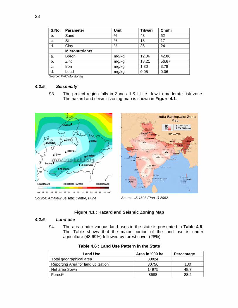
28
S.No. Parameter Unit Tilwari Chuhi b. Sand % 48 62 c. Silt % 18 17 d. Clay % 36 24 Micronutrients a. Boron mg/kg 12.36 42.86 b. Zinc mg/kg 18.21 56.67 c. Iron mg/kg 1.30 3.78 d. Lead mg/kg 0.05 0.06
Source: Field Monitoring
4.2.5. Seismicity 93. The project region falls in Zones II & III i.e., low to moderate risk zone.
The hazard and seismic zoning map is shown in Figure 4.1.
Source: Amateur Seismic Centre, Pune
Source: IS 1893 (Part 1) 2002
Figure 4.1 : Hazard and Seismic Zoning Map
4.2.6. Land use 94. The area under various land uses in the state is presented in Table 4.6.
The Table shows that the major portion of the land use is under agriculture (48.69%) followed by forest cover (28%).
Table 4.6 : Land Use Pattern in the State
Land Use Area in '000 ha Percentage Total geographical area 30824 Reporting Area for land utilization 30756 100 Net area Sown 14975 48.7 Forest* 8688 28.2
29
Land Use Area in '000 ha Percentage Area not available for cultivation 3364 10.9 Permanent Pasture & Grazing land 1341 4.3 Land under misc. tree crops & groves 20 0.06 Cultivable waste land 1175 3.8 Fallow land other than current fallows 596 1.9 Current fallows 596 1.9
Source: DPR * The data is given for 2004-05 (as per availability) including Reserved & Protected Forest
95. Land-Use of the Project Section: The Land use pattern along the project road is also mixed type dominated by agriculture and forest areas. Chainage wise land use along the project road is given in Table 4.7. There are also few public and private settlements along the project road.
Table 4.7 : Land Use Pattern along the project road CHAINAGE
From CHAINAGE
To LAND USE REMARK
0.000 0.100 builtup area Village 0.100 0.350 barren land 0.350 0.700 builtup area Village - Panwar 0.700 2.200 barren land 2.200 3.800 barren land 3.800 4.800 builtup area Village - Small 4.800 6.800 agricultural land 6.800 7.000 builtup area Village - Badhwari 7.000 7.400 agricultural land
7.400 9.800 barren land / agricultural
land
9.800 9.900 barren land / agricultural
land
9.900 10.850 barren land / agricultural
land
10.850 11.700 builtup Village -
Gadakhera
11.700 11.800 barren land / agricultural
land
11.800 11.850 builtup area Village -
Sapnidwari
11.850 12.700 barren land / agricultural
land 12.700 12.800 builtup area Village - Kutariya
12.800 14.900 barren land / agricultural
land 14.900 16.000 barren land 16.000 16.400 builtup area Village - Chouphal 16.400 20.400 forest 20.400 22.200 barren land 22.200 23.150 agricultural land 23.150 23.350 builtup area Village - Khama
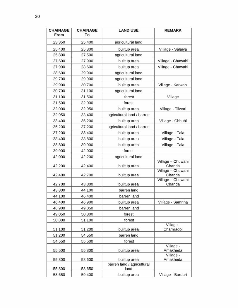
30
CHAINAGE From
CHAINAGE To
LAND USE REMARK
23.350 25.400 agricultural land
25.400 25.800 builtup area Village - Salaiya 25.800 27.500 agricultural land 27.500 27.900 builtup area Village - Chawahi 27.900 28.600 builtup area Village - Chawahi 28.600 29.900 agricultural land 29.700 29.900 agricultural land 29.900 30.700 builtup area Village - Karwahi 30.700 31.100 agricultural land 31.100 31.500 forest Village 31.500 32.000 forest 32.000 32.950 builtup area Village - Tilwari 32.950 33.400 agricultural land / barren 33.400 35.200 builtup area Village - Chhuhi 35.200 37.200 agricultural land / barren 37.200 38.400 builtup area Village - Tala 38.400 38.800 builtup area Village - Tala 38.800 39.900 builtup area Village - Tala 39.900 42.000 forest 42.000 42.200 agricultural land
42.200 42.400 builtup area Village – Chuwahi
Chanda
42.400 42.700 builtup area Village – Chuwahi
Chanda
42.700 43.800 builtup area Village – Chuwahi
Chanda 43.800 44.100 barren land 44.100 46.400 barren land 46.400 46.900 builtup area Village - Samriha 46.900 49.050 barren land 49.050 50.800 forest 50.800 51.100 forest
51.100 51.200 builtup area Village -
Chamradol 51.200 54.550 barren land 54.550 55.500 forest
55.500 55.800 builtup area Village -
Amakheda
55.800 58.600 builtup area Village -
Amakheda
55.800 58.650 barren land / agricultural
land 58.650 59.400 builtup area Village - Bardari
31
CHAINAGE From
CHAINAGE To
LAND USE REMARK
59.400 59.500 barren land / agricultural
land 59.500 59.800 builtup area Village - Pasgadi
59.800 61.700 barren land / agricultural
land 61.700 62.850 barren land 62.850 67.800 forest 67.800 68.200 barren land 68.200 69.500 agricultural land 69.500 71.400 builtup area Town - Beohari
Source: DPR
4.2.7. Hydrology and Drainage 96. Madhya Pradesh represents great river basins and the watershed of a
number of rivers. Catchments of many rivers of India lie in Madhya Pradesh. The Narmada (originating from Amarkantak) and Tapti (originating from Multai of Betul District) rivers and their basins divide the state in two, with the northern part draining largely into the Ganga basin and the southern part into the Godavari and Mahanadi systems. All the rivers, which drain into the Ganga, flow from south to north. The Chambal, Sipra, Kali Sind, Parbati, Kuno, Sind, Betwa, Dhasan and Ken rivers are the main tributaries of the Yamuna.
97. The two major rivers crossing the road are Mahan and Banas River. Banas River is the major tributary of Sone River. It crosses the road bordering between Sidhi and Shehadol at 54.250km chainage. River Mahan is crossing the road at chainage 36km. The Gulab Sagar dam on this river is 17km away from the project road. Both the rivers are perennial in nature.
98. Drainage: There are several canals and drains cutting across the project alignment. The detailed drainage pattern affecting the Sidhi-Beohari road is given in Figure 4.2.
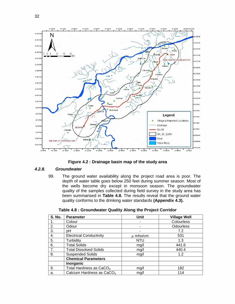
32
Figure 4.2 : Drainage basin map of the study area 4.2.8. Groundwater
99. The ground water availability along the project road area is poor. The depth of water table goes below 250 feet during summer season. Most of the wells become dry except in monsoon season. The groundwater quality of the samples collected during field survey in the study area has been summarised in Table 4.8. The results reveal that the ground water quality conforms to the drinking water standards (Appendix 4.3).
Table 4.8 : Groundwater Quality Along the Project Corridor S. No. Parameter Unit Village Well 1. Colour - Colourless 2. Odour - Odourless 3. pH - 7.2 4. Electrical Conductivity µ mho/cm 531 5. Turbidity NTU 1.3 6. Total Solids mg/l 441.6 7. Total Dissolved Solids mg/l 440.4 8. Suspended Solids mg/l 1.2 Chemical Parameters Inorganic 9. Total Hardness as CaCO3 mg/l 182 a. Calcium Hardness as CaCO3 mg/l 114
33
S. No. Parameter Unit Village Well b. Magnesium Hardness as
CaCO3 mg/l 69
10. Alkalinity as CaCO3 mg/l 42.0 a. Methyl Orange Alkalinity mg/l 41.0 b. Phenolphthalein Alkalinity mg/l - 11. Chloride mg/l 38.4 12. Flouride mg/l 0.75 13. Nitrate mg/l ND 14. Nitrite mg/l ND 15. Phosphate mg/l ND 16. Sulphate mg/l 0.31 17. Sulphite mg/l ND 18. Sodium mg/l 9 19. Potassium mg/l 6 Organic 20. Biological Oxygen Demand (3
day at 27oC) mg/l ND
Heavy metals 24. Iron mg/l 0.04 25. Nickel mg/l ND 26. Zinc mg/l Nil 27. Cadmium mg/l ND 28. Lead mg/l ND 29. Total chromium mg/l ND
Source: DPR
4.2.9. Surface water 4.2.9.1 Surface Water Quality
100. Surface water sample taken from Banas River have been compared with the standards prescribed by Central Pollution Control Board (CPCB) for Irrigation- Class D and propagation of wild life and fisheries -Class-E (Appendix 4.4). The results of the samples conforms their suitability for both these purposes. Results of the surface water quality in the project area have been summarized in Table 4.9
Table 4.9 : Surface Water Quality of the river in project area S. No. Parameter Unit Banas River Physical Parameters 1. pH - 7.1 2. Electrical Conductivity µ mho/cm 508 3. Turbidity NTU 1.2 4. Total Solids mg/l 255.8 5. Total Dissolved Solids mg/l 256.3 6. Suspended Solids mg/l 9 Chemical Parameters Inorganic 7. Total Hardness as CaCO3 mg/l 166 a. Calcium Hardness as CaCO3 mg/l 115 b. Magnesium Hardness as CaCO3 mg/l 51 8. Alkalinity as CaCO3 mg/l 53 a. Methyl Orange Alkalinity mg/l 53 b. Phenolphthalein Alkalinity mg/l -
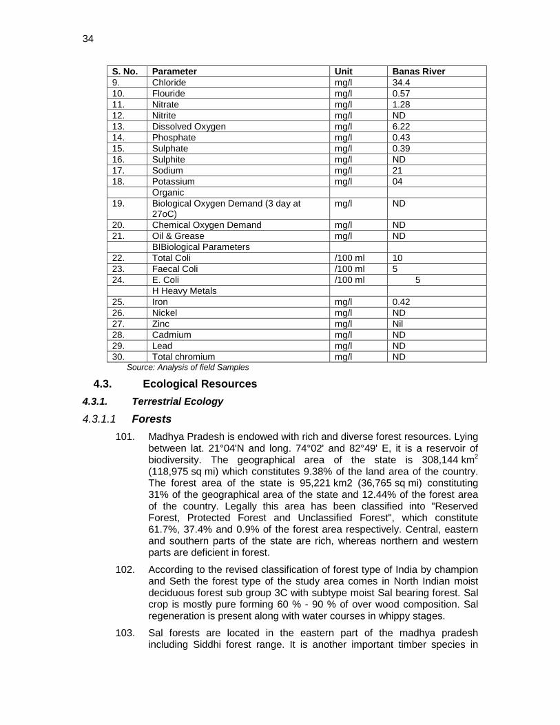
34
S. No. Parameter Unit Banas River 9. Chloride mg/l 34.4 10. Flouride mg/l 0.57 11. Nitrate mg/l 1.28 12. Nitrite mg/l ND 13. Dissolved Oxygen mg/l 6.22 14. Phosphate mg/l 0.43 15. Sulphate mg/l 0.39 16. Sulphite mg/l ND 17. Sodium mg/l 21 18. Potassium mg/l 04 Organic 19. Biological Oxygen Demand (3 day at
27oC) mg/l ND
20. Chemical Oxygen Demand mg/l ND 21. Oil & Grease mg/l ND BIBiological Parameters 22. Total Coli /100 ml 10 23. Faecal Coli /100 ml 5 24. E. Coli /100 ml 5 H Heavy Metals 25. Iron mg/l 0.42 26. Nickel mg/l ND 27. Zinc mg/l Nil 28. Cadmium mg/l ND 29. Lead mg/l ND 30. Total chromium mg/l ND Source: Analysis of field Samples
4.3. Ecological Resources 4.3.1. Terrestrial Ecology
4.3.1.1 Forests 101. Madhya Pradesh is endowed with rich and diverse forest resources. Lying
between lat. 21°04'N and long. 74°02' and 82°49' E, it is a reservoir of biodiversity. The geographical area of the state is 308,144 km2 (118,975 sq mi) which constitutes 9.38% of the land area of the country. The forest area of the state is 95,221 km2 (36,765 sq mi) constituting 31% of the geographical area of the state and 12.44% of the forest area of the country. Legally this area has been classified into "Reserved Forest, Protected Forest and Unclassified Forest", which constitute 61.7%, 37.4% and 0.9% of the forest area respectively. Central, eastern and southern parts of the state are rich, whereas northern and western parts are deficient in forest.
102. According to the revised classification of forest type of India by champion and Seth the forest type of the study area comes in North Indian moist deciduous forest sub group 3C with subtype moist Sal bearing forest. Sal crop is mostly pure forming 60 % - 90 % of over wood composition. Sal regeneration is present along with water courses in whippy stages.
103. Sal forests are located in the eastern part of the madhya pradesh including Siddhi forest range. It is another important timber species in
35
Madhya Pradesh. It is a large evergreen ecologically and economically important tree species. The sal forest is associated with mixed miscellaneous forests. There are also areas where Teak and Sal both species occur naturally mixed with other species like saja (Terminalia tomentosa), bija (Pterocarpus marsupium), lendia (Lagerstroemia parviflora), haldu (Adina cardifolia), dhaora (Anogeissus latifolia), salai (Boswellia serrata), aonla (Emblica officinalis), amaltas (Cassia fistula), gamhar (Gmelina arborea) etc.
104. Forest Area along the Project Section: In the project section about 17 km of the road alignment is passing through protected forest area. These forests are mainly tropical moist and tropical dry in nature. The details of the forest area along the section has been summarised in Table 4.10.
Table 4.10 : Forest details along the project road Road Name Type of
Forest Chainage Location Distance
Sidhi-Beohari Protected forest
km 16.4 -20.4, Both Side 10 m 31.1-32.0, Both Side 10 m 39.9-42.0, Both Side 10 m 49.05-51.10, Both Side 10 m 54.55-55.5 Both Side 10 m 55.8-58.6, Both Side 10 m 62.85-67.80 Both Side 10 m
Source: DPR and Strip Mapping
4.3.1.2 Flora 105. The study area is covered with dense vegetation dominated by sal
(Shorea robusta) plantation. Sal forms pure patches at some locations. The open areas and agriculture fields were dominated by shrubby vegetation. Some important associated species of Shorea robusta are Anogessus latifolia Terminalia tomentosa Diospyros melanoxylon etc. Same open forest is also present in different patches. The general floristic composition in the study area is as follows
106. Sal (Shorea robusta), Dhawda (Anogessus latifolia), Tendu (Diospyros melanoxylon), Harra (Terminalia chebula), Bahera (Terminalia belerica), Saja (Terminalia tomentosa), Mahua (Madhuca indica), Bija (Pterocarpus marsupian), Salai (Boswellia serrata), Semal (Bombax malabaricum), Shisam (Darbergia latifolia), Haldu (Adina cordifolia), Kalam (Mitragyna parvifolia) etc. Aonla (Emblica officinalis), Achar (Buchanania lanzan), Kumbi (Careya arborea), Kari (Saccopetalum tomentosum), Khair (Acacia catechu), Rohan (Soymida febriguga), Palas (Butea monosperma) etc.Gudsakri (Grewia hirsuta), Badi kateri (Solanim indicum), Ratanjyot (Jatropa corcus), Lantana (Lantana camera) etc.
107. The study area shows presence of medicinal plants. The area abounds in production of many kinds of fruits, flowers, seeds and leaves which have medicinal properties. Some of the important medicinal plants found in the study area are Aegle marmelos, Albizzia lebbeck, Tamarindus indica, Terminalia Arjuna, Ficus glomerata Ficus benghalensis, Adina cordifolia, Ailanthus excelsa, Azadirachta indica, Ficus religiosa, Madhuca latifolia.
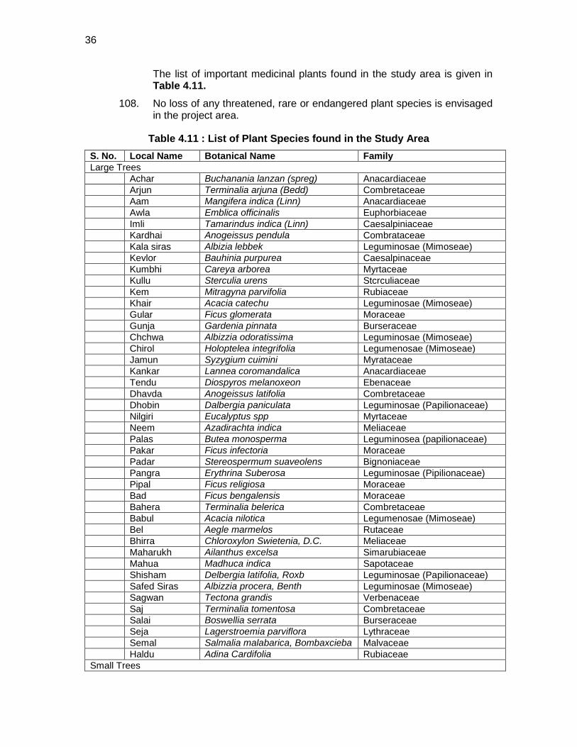
36
The list of important medicinal plants found in the study area is given in Table 4.11.
108. No loss of any threatened, rare or endangered plant species is envisaged in the project area.
Table 4.11 : List of Plant Species found in the Study Area S. No. Local Name Botanical Name Family Large Trees Achar Buchanania lanzan (spreg) Anacardiaceae Arjun Terminalia arjuna (Bedd) Combretaceae Aam Mangifera indica (Linn) Anacardiaceae Awla Emblica officinalis Euphorbiaceae Imli Tamarindus indica (Linn) Caesalpiniaceae Kardhai Anogeissus pendula Combrataceae Kala siras Albizia lebbek Leguminosae (Mimoseae) Kevlor Bauhinia purpurea Caesalpinaceae Kumbhi Careya arborea Myrtaceae Kullu Sterculia urens Stcrculiaceae Kem Mitragyna parvifolia Rubiaceae Khair Acacia catechu Leguminosae (Mimoseae) Gular Ficus glomerata Moraceae Gunja Gardenia pinnata Burseraceae Chchwa Albizzia odoratissima Leguminosae (Mimoseae) Chirol Holoptelea integrifolia Legumenosae (Mimoseae) Jamun Syzygium cuimini Myrataceae Kankar Lannea coromandalica Anacardiaceae Tendu Diospyros melanoxeon Ebenaceae Dhavda Anogeissus latifolia Combretaceae Dhobin Dalbergia paniculata Leguminosae (Papilionaceae) Nilgiri Eucalyptus spp Myrtaceae Neem Azadirachta indica Meliaceae Palas Butea monosperma Leguminosea (papilionaceae) Pakar Ficus infectoria Moraceae Padar Stereospermum suaveolens Bignoniaceae Pangra Erythrina Suberosa Leguminosae (Pipilionaceae) Pipal Ficus religiosa Moraceae Bad Ficus bengalensis Moraceae Bahera Terminalia belerica Combretaceae Babul Acacia nilotica Legumenosae (Mimoseae) Bel Aegle marmelos Rutaceae Bhirra Chloroxylon Swietenia, D.C. Meliaceae Maharukh Ailanthus excelsa Simarubiaceae Mahua Madhuca indica Sapotaceae Shisham Delbergia latifolia, Roxb Leguminosae (Papilionaceae) Safed Siras Albizzia procera, Benth Leguminosae (Mimoseae) Sagwan Tectona grandis Verbenaceae Saj Terminalia tomentosa Combretaceae Salai Boswellia serrata Burseraceae Seja Lagerstroemia parviflora Lythraceae Semal Salmalia malabarica, Bombaxcieba Malvaceae Haldu Adina Cardifolia Rubiaceae Small Trees
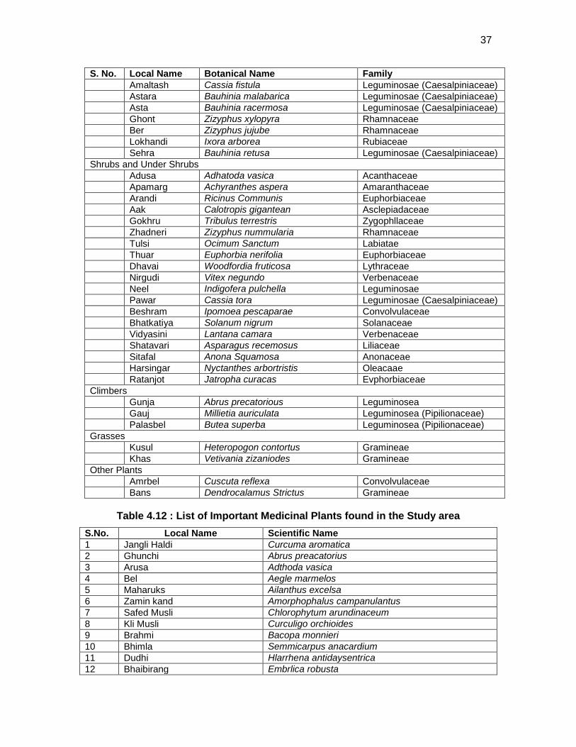
37
S. No. Local Name Botanical Name Family Amaltash Cassia fistula Leguminosae (Caesalpiniaceae) Astara Bauhinia malabarica Leguminosae (Caesalpiniaceae) Asta Bauhinia racermosa Leguminosae (Caesalpiniaceae) Ghont Zizyphus xylopyra Rhamnaceae Ber Zizyphus jujube Rhamnaceae Lokhandi Ixora arborea Rubiaceae Sehra Bauhinia retusa Leguminosae (Caesalpiniaceae) Shrubs and Under Shrubs Adusa Adhatoda vasica Acanthaceae Apamarg Achyranthes aspera Amaranthaceae Arandi Ricinus Communis Euphorbiaceae Aak Calotropis gigantean Asclepiadaceae Gokhru Tribulus terrestris Zygophllaceae Zhadneri Zizyphus nummularia Rhamnaceae Tulsi Ocimum Sanctum Labiatae Thuar Euphorbia nerifolia Euphorbiaceae Dhavai Woodfordia fruticosa Lythraceae Nirgudi Vitex negundo Verbenaceae Neel Indigofera pulchella Leguminosae Pawar Cassia tora Leguminosae (Caesalpiniaceae) Beshram Ipomoea pescaparae Convolvulaceae Bhatkatiya Solanum nigrum Solanaceae Vidyasini Lantana camara Verbenaceae Shatavari Asparagus recemosus Liliaceae Sitafal Anona Squamosa Anonaceae Harsingar Nyctanthes arbortristis Oleacaae Ratanjot Jatropha curacas Evphorbiaceae Climbers Gunja Abrus precatorious Leguminosea Gauj Millietia auriculata Leguminosea (Pipilionaceae) Palasbel Butea superba Leguminosea (Pipilionaceae) Grasses Kusul Heteropogon contortus Gramineae Khas Vetivania zizaniodes Gramineae Other Plants Amrbel Cuscuta reflexa Convolvulaceae Bans Dendrocalamus Strictus Gramineae
Table 4.12 : List of Important Medicinal Plants found in the Study area S.No. Local Name Scientific Name 1 Jangli Haldi Curcuma aromatica 2 Ghunchi Abrus preacatorius 3 Arusa Adthoda vasica 4 Bel Aegle marmelos 5 Maharuks Ailanthus excelsa 6 Zamin kand Amorphophalus campanulantus 7 Safed Musli Chlorophytum arundinaceum 8 Kli Musli Curculigo orchioides 9 Brahmi Bacopa monnieri 10 Bhimla Semmicarpus anacardium 11 Dudhi Hlarrhena antidaysentrica 12 Bhaibirang Embrlica robusta
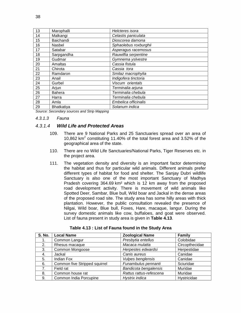
38
13 Marophalli Helcteres isora 14 Malkangi Celastis paniculata 15 Baichandi Dioscorea damona 16 Nasbel Sphaolebus roxburghii 17 Satabar Asperagus racemosus 18 Sarpgandha Rauwilfia serpentine 19 Gudmar Gymnema yslvestre 20 Amaltas Cassia fistula 21 Chirota Cassia tora 22 Ramdaron Smilaz macrophylia 23 Anail Indigofera tinctoria 24 Gurbel Viscum orientals 25 Arjun Terminalia arjuna 26 Bahera Terminalia chebula 27 Harra Terminalia chebula 28 Amla Embelica officinalis 29 Bhatkatiya Solanum indica Source: Secondary sources and Strip Mapping
4.3.1.3 Fauna
4.3.1.4 Wild Life and Protected Areas 109. There are 9 National Parks and 25 Sanctuaries spread over an area of
10,862 km2 constituting 11.40% of the total forest area and 3.52% of the geographical area of the state.
110. There are no Wild Life Sanctuaries/National Parks, Tiger Reserves etc. in the project area.
111. The vegetation density and diversity is an important factor determining the habitat and thus for particular wild animals. Different animals prefer different types of habitat for food and shelter. The Sanjay Dubri wildlife Sanctuary is also one of the most important Sanctuary of Madhya Pradesh covering 364.69 km² which is 12 km away from the proposed road development activity. There is movement of wild animals like Spotted Deer, Sambar, Blue bull, Wild boar and Jackal in the dense areas of the proposed road site. The study area has some hilly areas with thick plantation. However, the public consultation revealed the presence of Nilgai, Wild boar, Blue bull, Foxes, Hare, macaque, langur. During the survey domestic animals like cow, buffaloes, and goat were observed. List of fauna present in study area is given in Table 4.13.
Table 4.13 : List of Fauna found in the Study Area S. No. Local Name Zoological Name Family
1. Common Langur Presbytia entellus Colobidae 2. Rhesus macaque Macaca mulatta Circopthecidae 3. Common Mongoose Herpestes edwardsi Herpestidae 4. Jackal Canis aureus Canidae 5. Indian Fox Vulpes benglensis Canidae 6. Common five Stripped squirrel Funambulus pennanti Sciuridae 7. Field rat Bandicota bengalensis Muridae 8. Common house rat Rattus rattus-refescena Muridae 9. Common India Porcupine Hystrix indica Hystricidae
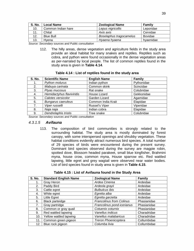
39
S. No. Local Name Zoological Name Family 10. Common Indian hare Lepus nigricollis Leporidae 11. Chital Axis axis Cervidae 12. Blue Bull Boselaphus tragocamelus Bovidae 13. Hyena Hyaena hyaena hyaenidae
Source: Secondary sources and Public consultation
112. The hilly areas, dense vegetation and agriculture fields in the study area provide an ideal habitat for many snakes and reptiles. Reptiles such as cobra, and python were found occasionally in the dense vegetation areas as per-narrated by local people. The list of common reptiles found in the study area is given in Table 4.14.
Table 4.14 : List of reptiles found in the study area S. No. Scientific Name English Name Family
1. Python molurus Indian python Pythonidae 2. Mabuya carinata Common skink Scincidae 3. Ptyas mucosus Rat snake Colubridae 4. Hemidactyhus flaviviridis House Lizard Gekkonidae 5. Calotes versicolor Garden Lizard Agamidae 6. Bungarus caeruleus Common India Krait Elapidae 7. Viper russelli Russel’s Viper Viperidae 8. Naja naja Indian cobra Elapidae 9. Dendrelaphis tristis Tree snake Colubridae
Source: Secondary sources and Public consultation
4.3.1.5 Avifauna 113. The composition of bird communities is strongly related to the
surrounding habitat. The study area is mostly dominated by forest canopy, with some interspersed openings and shrubby vegetation. These habitat conditions evidently attract numerous bird species. A total number of 29 species of birds were encountered during the present survey. Dominant bird species observed during the survey are magpie robin, spotted dove, Blossom headed parakeet, small blue kingfisher, Brahmini myna, house crow, common myna, House sparrow etc. Red wattled lapwing, little egret and grey wagtail were observed near water bodies. List of bird species found in study area is given in Table 4.15.
Table 4.15 : List of Avifauna found in the Study Area S. No. Standard English Name Zoological Name Family
1. Gray Heron Ardea Cinerea Ardeidae 2. Paddy Bird Ardeola grayii Ardeidae 3. Cattle egret Bulbulcus ibis Ardeidae 4. White egret Egretta alba Ardeidae 5. Little Egret Egretta garzetta Ardeidae 6. Black parteidge Francolinus from Colinus Phasianidae 7. Gray partridge Francolinus pond-icerianus Phasianidae 8. Common or gray quail Cotuenix coturnix Phasianidae 9. Red wattled lapwing Vanellus indicus Charadridae 10. Yellow wattled lapwing Vanellus malabaricus Charadridae 11. Common green pigeon Treron Phoenicoptera Collumbidae 12. Blue rock pigeon Columba livia Collumbidae
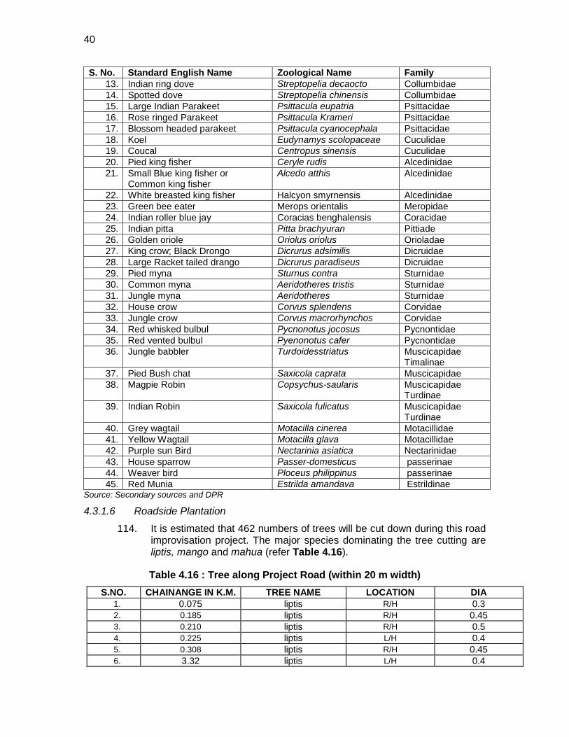
40
S. No. Standard English Name Zoological Name Family 13. Indian ring dove Streptopelia decaocto Collumbidae 14. Spotted dove Streptopelia chinensis Collumbidae 15. Large Indian Parakeet Psittacula eupatria Psittacidae 16. Rose ringed Parakeet Psittacula Krameri Psittacidae 17. Blossom headed parakeet Psittacula cyanocephala Psittacidae 18. Koel Eudynamys scolopaceae Cuculidae 19. Coucal Centropus sinensis Cuculidae 20. Pied king fisher Ceryle rudis Alcedinidae 21. Small Blue king fisher or
Common king fisher Alcedo atthis Alcedinidae
22. White breasted king fisher Halcyon smyrnensis Alcedinidae 23. Green bee eater Merops orientalis Meropidae 24. Indian roller blue jay Coracias benghalensis Coracidae 25. Indian pitta Pitta brachyuran Pittiade 26. Golden oriole Oriolus oriolus Orioladae 27. King crow; Black Drongo Dicrurus adsimilis Dicruidae 28. Large Racket tailed drango Dicrurus paradiseus Dicruidae 29. Pied myna Sturnus contra Sturnidae 30. Common myna Aeridotheres tristis Sturnidae 31. Jungle myna Aeridotheres Sturnidae 32. House crow Corvus splendens Corvidae 33. Jungle crow Corvus macrorhynchos Corvidae 34. Red whisked bulbul Pycnonotus jocosus Pycnontidae 35. Red vented bulbul Pyenonotus cafer Pycnontidae 36. Jungle babbler Turdoidesstriatus Muscicapidae
Timalinae 37. Pied Bush chat Saxicola caprata Muscicapidae 38. Magpie Robin Copsychus-saularis Muscicapidae
Turdinae 39. Indian Robin Saxicola fulicatus Muscicapidae
Turdinae 40. Grey wagtail Motacilla cinerea Motacillidae 41. Yellow Wagtail Motacilla glava Motacillidae 42. Purple sun Bird Nectarinia asiatica Nectarinidae 43. House sparrow Passer-domesticus passerinae 44. Weaver bird Ploceus philippinus passerinae 45. Red Munia Estrilda amandava Estrildinae
Source: Secondary sources and DPR 4.3.1.6 Roadside Plantation
114. It is estimated that 462 numbers of trees will be cut down during this road improvisation project. The major species dominating the tree cutting are liptis, mango and mahua (refer Table 4.16).
Table 4.16 : Tree along Project Road (within 20 m width) S.NO. CHAINANGE IN K.M. TREE NAME LOCATION DIA
1. 0.075 liptis R/H 0.3 2. 0.185 liptis R/H 0.45 3. 0.210 liptis R/H 0.5 4. 0.225 liptis L/H 0.4 5. 0.308 liptis R/H 0.45 6. 3.32 liptis L/H 0.4
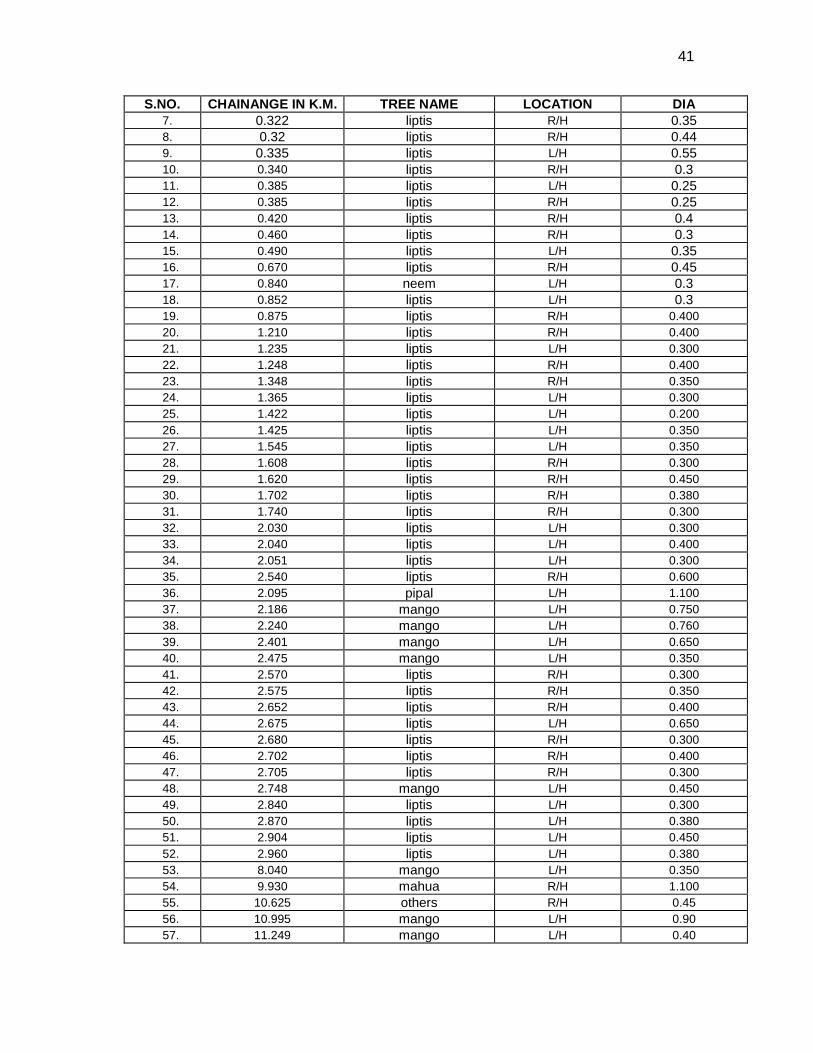
41
S.NO. CHAINANGE IN K.M. TREE NAME LOCATION DIA 7. 0.322 liptis R/H 0.35 8. 0.32 liptis R/H 0.44 9. 0.335 liptis L/H 0.55 10. 0.340 liptis R/H 0.3 11. 0.385 liptis L/H 0.25 12. 0.385 liptis R/H 0.25 13. 0.420 liptis R/H 0.4 14. 0.460 liptis R/H 0.3 15. 0.490 liptis L/H 0.35 16. 0.670 liptis R/H 0.45 17. 0.840 neem L/H 0.3 18. 0.852 liptis L/H 0.3 19. 0.875 liptis R/H 0.400 20. 1.210 liptis R/H 0.400 21. 1.235 liptis L/H 0.300 22. 1.248 liptis R/H 0.400 23. 1.348 liptis R/H 0.350 24. 1.365 liptis L/H 0.300 25. 1.422 liptis L/H 0.200 26. 1.425 liptis L/H 0.350 27. 1.545 liptis L/H 0.350 28. 1.608 liptis R/H 0.300 29. 1.620 liptis R/H 0.450 30. 1.702 liptis R/H 0.380 31. 1.740 liptis R/H 0.300 32. 2.030 liptis L/H 0.300 33. 2.040 liptis L/H 0.400 34. 2.051 liptis L/H 0.300 35. 2.540 liptis R/H 0.600 36. 2.095 pipal L/H 1.100 37. 2.186 mango L/H 0.750 38. 2.240 mango L/H 0.760 39. 2.401 mango L/H 0.650 40. 2.475 mango L/H 0.350 41. 2.570 liptis R/H 0.300 42. 2.575 liptis R/H 0.350 43. 2.652 liptis R/H 0.400 44. 2.675 liptis L/H 0.650 45. 2.680 liptis R/H 0.300 46. 2.702 liptis R/H 0.400 47. 2.705 liptis R/H 0.300 48. 2.748 mango L/H 0.450 49. 2.840 liptis L/H 0.300 50. 2.870 liptis L/H 0.380 51. 2.904 liptis L/H 0.450 52. 2.960 liptis L/H 0.380 53. 8.040 mango L/H 0.350 54. 9.930 mahua R/H 1.100 55. 10.625 others R/H 0.45 56. 10.995 mango L/H 0.90 57. 11.249 mango L/H 0.40
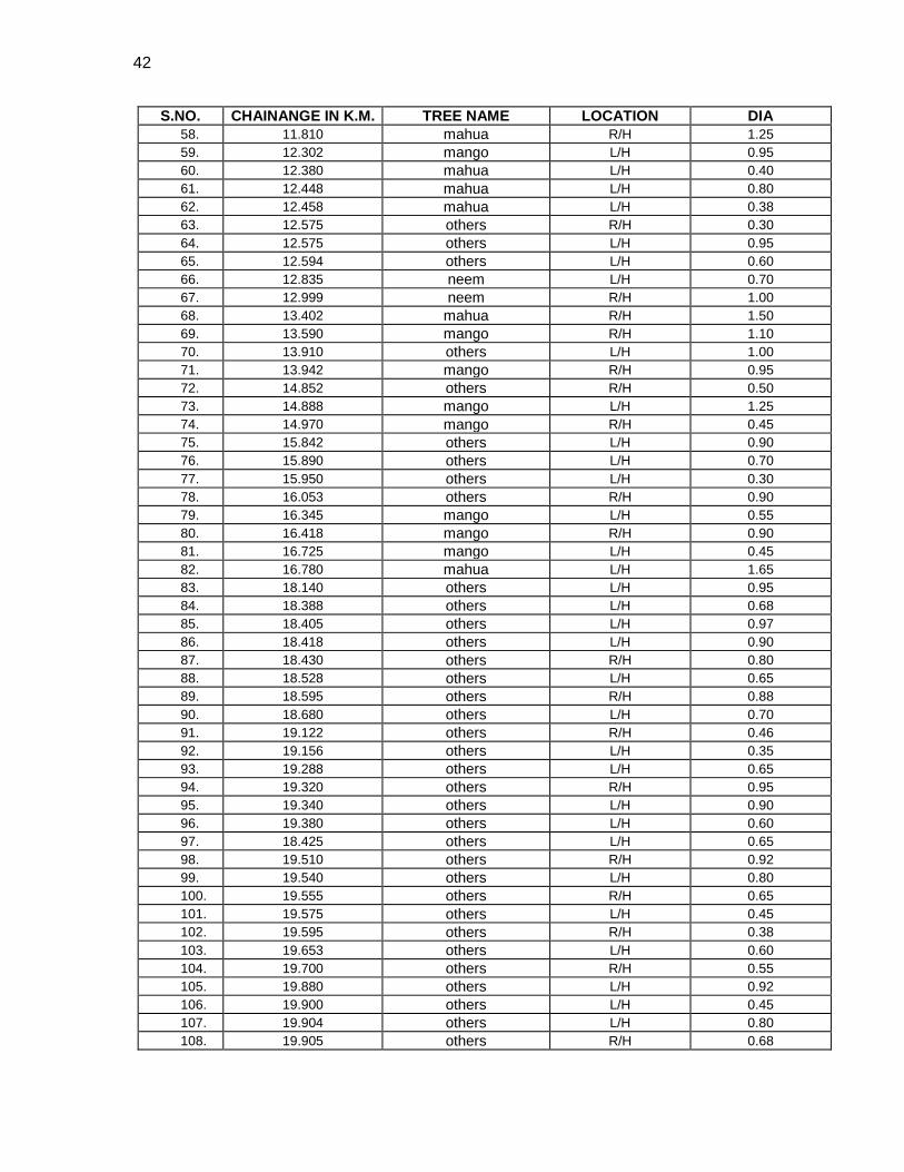
42
S.NO. CHAINANGE IN K.M. TREE NAME LOCATION DIA 58. 11.810 mahua R/H 1.25 59. 12.302 mango L/H 0.95 60. 12.380 mahua L/H 0.40 61. 12.448 mahua L/H 0.80 62. 12.458 mahua L/H 0.38 63. 12.575 others R/H 0.30 64. 12.575 others L/H 0.95 65. 12.594 others L/H 0.60 66. 12.835 neem L/H 0.70 67. 12.999 neem R/H 1.00 68. 13.402 mahua R/H 1.50 69. 13.590 mango R/H 1.10 70. 13.910 others L/H 1.00 71. 13.942 mango R/H 0.95 72. 14.852 others R/H 0.50 73. 14.888 mango L/H 1.25 74. 14.970 mango R/H 0.45 75. 15.842 others L/H 0.90 76. 15.890 others L/H 0.70 77. 15.950 others L/H 0.30 78. 16.053 others R/H 0.90 79. 16.345 mango L/H 0.55 80. 16.418 mango R/H 0.90 81. 16.725 mango L/H 0.45 82. 16.780 mahua L/H 1.65 83. 18.140 others L/H 0.95 84. 18.388 others L/H 0.68 85. 18.405 others L/H 0.97 86. 18.418 others L/H 0.90 87. 18.430 others R/H 0.80 88. 18.528 others L/H 0.65 89. 18.595 others R/H 0.88 90. 18.680 others L/H 0.70 91. 19.122 others R/H 0.46 92. 19.156 others L/H 0.35 93. 19.288 others L/H 0.65 94. 19.320 others R/H 0.95 95. 19.340 others L/H 0.90 96. 19.380 others L/H 0.60 97. 18.425 others L/H 0.65 98. 19.510 others R/H 0.92 99. 19.540 others L/H 0.80 100. 19.555 others R/H 0.65 101. 19.575 others L/H 0.45 102. 19.595 others R/H 0.38 103. 19.653 others L/H 0.60 104. 19.700 others R/H 0.55 105. 19.880 others L/H 0.92 106. 19.900 others L/H 0.45 107. 19.904 others L/H 0.80 108. 19.905 others R/H 0.68
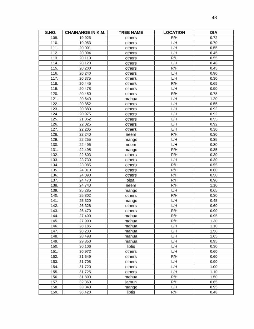
43
S.NO. CHAINANGE IN K.M. TREE NAME LOCATION DIA 109. 19.925 others R/H 0.72 110. 19.953 others L/H 0.70 111. 20.001 others L/H 0.55 112. 20.094 others L/H 0.45 113. 20.110 others R/H 0.55 114. 20.120 others L/H 0.48 115. 20.200 others R/H 0.45 116. 20.240 others L/H 0.90 117. 20.375 others L/H 0.30 118. 20.445 others R/H 0.65 119. 20.478 others L/H 0.90 120. 20.480 others R/H 0.78 121. 20.640 mahua L/H 1.20 122. 20.852 others L/H 0.55 123. 20.880 others L/H 0.92 124. 20.975 others L/H 0.92 125. 21.052 others L/H 0.55 126. 22.025 others L/H 0.92 127. 22.205 others L/H 0.30 128. 22.240 neem R/H 0.30 129. 22.255 mango L/H 0.35 130. 22.495 neem L/H 0.30 131. 22.495 mango R/H 0.35 132. 22.603 others R/H 0.30 133. 23.730 others L/H 0.30 134. 23.985 others R/H 0.55 135. 24.010 others R/H 0.60 136. 24.398 others R/H 0.50 137. 24.470 pipal R/H 0.90 138. 24.740 neem R/H 1.10 139. 25.285 mango L/H 0.65 140. 25.302 others R/H 0.30 141. 25.320 mango L/H 0.45 142. 26.328 others L/H 0.60 143. 26.470 others R/H 0.90 144. 27.400 mahua R/H 0.95 145. 27.900 mahua R/H 1.30 146. 28.185 mahua L/H 1.10 147. 28.230 mahua L/H 1.50 148. 28.498 mahua L/H 1.65 149. 29.850 mahua L/H 0.95 150. 30.106 liptis L/H 0.30 151. 30.972 others L/H 0.60 152. 31.549 others R/H 0.60 153. 31.708 others L/H 0.90 154. 31.720 others L/H 1.00 155. 31.725 others L/H 1.10 156. 31.800 mahua R/H 1.50 157. 32.360 jamun R/H 0.65 158. 33.840 mango L/H 0.95 159. 36.420 liptis R/H 0.48
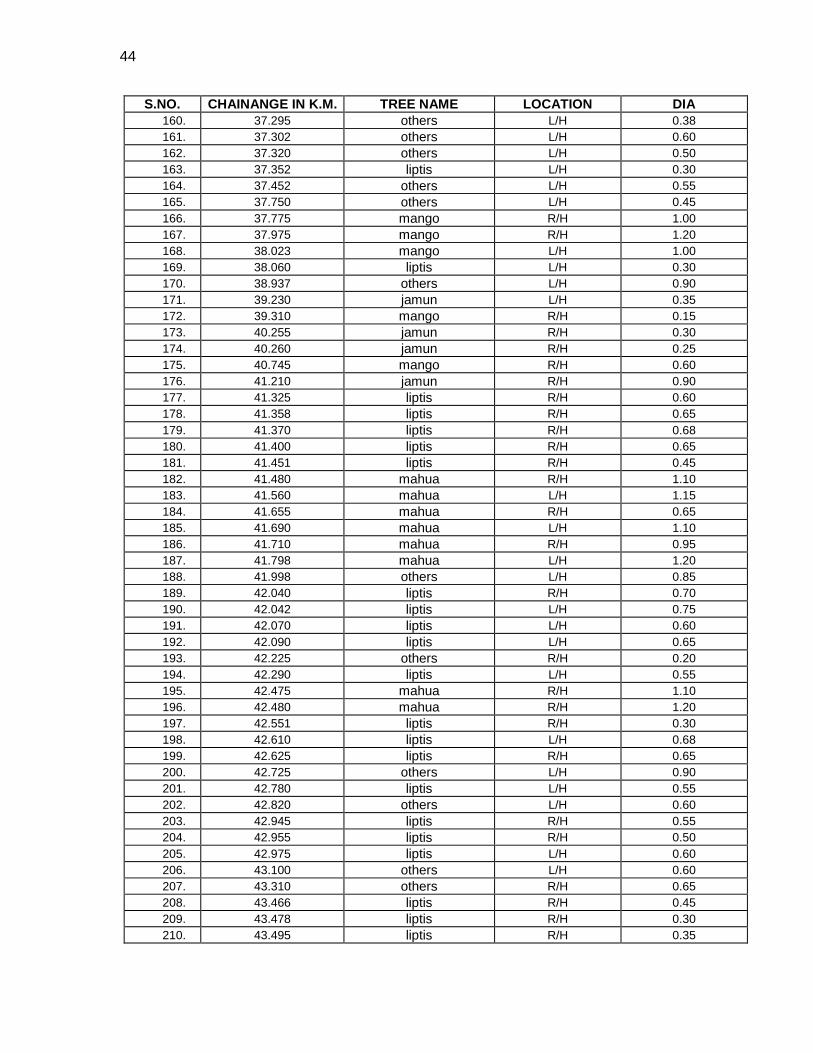
44
S.NO. CHAINANGE IN K.M. TREE NAME LOCATION DIA 160. 37.295 others L/H 0.38 161. 37.302 others L/H 0.60 162. 37.320 others L/H 0.50 163. 37.352 liptis L/H 0.30 164. 37.452 others L/H 0.55 165. 37.750 others L/H 0.45 166. 37.775 mango R/H 1.00 167. 37.975 mango R/H 1.20 168. 38.023 mango L/H 1.00 169. 38.060 liptis L/H 0.30 170. 38.937 others L/H 0.90 171. 39.230 jamun L/H 0.35 172. 39.310 mango R/H 0.15 173. 40.255 jamun R/H 0.30 174. 40.260 jamun R/H 0.25 175. 40.745 mango R/H 0.60 176. 41.210 jamun R/H 0.90 177. 41.325 liptis R/H 0.60 178. 41.358 liptis R/H 0.65 179. 41.370 liptis R/H 0.68 180. 41.400 liptis R/H 0.65 181. 41.451 liptis R/H 0.45 182. 41.480 mahua R/H 1.10 183. 41.560 mahua L/H 1.15 184. 41.655 mahua R/H 0.65 185. 41.690 mahua L/H 1.10 186. 41.710 mahua R/H 0.95 187. 41.798 mahua L/H 1.20 188. 41.998 others L/H 0.85 189. 42.040 liptis R/H 0.70 190. 42.042 liptis L/H 0.75 191. 42.070 liptis L/H 0.60 192. 42.090 liptis L/H 0.65 193. 42.225 others R/H 0.20 194. 42.290 liptis L/H 0.55 195. 42.475 mahua R/H 1.10 196. 42.480 mahua R/H 1.20 197. 42.551 liptis R/H 0.30 198. 42.610 liptis L/H 0.68 199. 42.625 liptis R/H 0.65 200. 42.725 others L/H 0.90 201. 42.780 liptis L/H 0.55 202. 42.820 others L/H 0.60 203. 42.945 liptis R/H 0.55 204. 42.955 liptis R/H 0.50 205. 42.975 liptis L/H 0.60 206. 43.100 others L/H 0.60 207. 43.310 others R/H 0.65 208. 43.466 liptis R/H 0.45 209. 43.478 liptis R/H 0.30 210. 43.495 liptis R/H 0.35
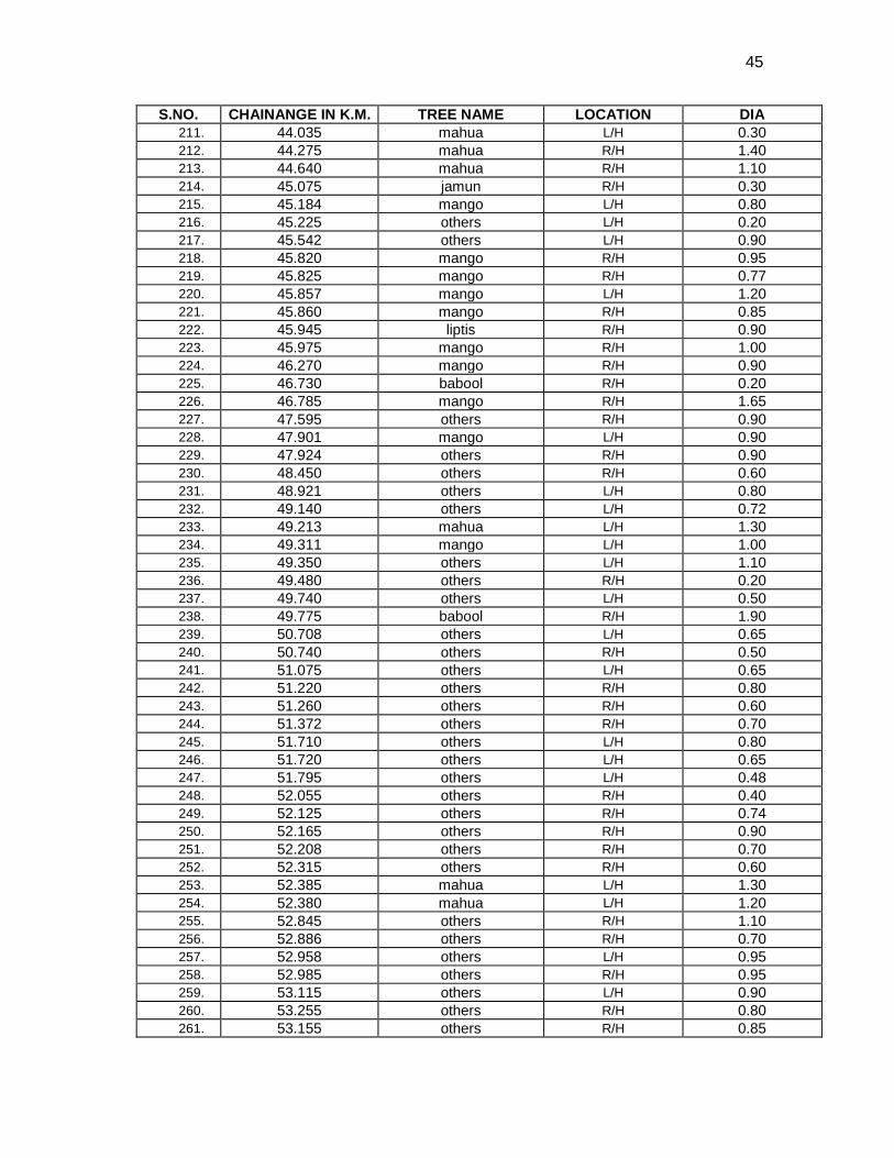
45
S.NO. CHAINANGE IN K.M. TREE NAME LOCATION DIA 211. 44.035 mahua L/H 0.30 212. 44.275 mahua R/H 1.40 213. 44.640 mahua R/H 1.10 214. 45.075 jamun R/H 0.30 215. 45.184 mango L/H 0.80 216. 45.225 others L/H 0.20 217. 45.542 others L/H 0.90 218. 45.820 mango R/H 0.95 219. 45.825 mango R/H 0.77 220. 45.857 mango L/H 1.20 221. 45.860 mango R/H 0.85 222. 45.945 liptis R/H 0.90 223. 45.975 mango R/H 1.00 224. 46.270 mango R/H 0.90 225. 46.730 babool R/H 0.20 226. 46.785 mango R/H 1.65 227. 47.595 others R/H 0.90 228. 47.901 mango L/H 0.90 229. 47.924 others R/H 0.90 230. 48.450 others R/H 0.60 231. 48.921 others L/H 0.80 232. 49.140 others L/H 0.72 233. 49.213 mahua L/H 1.30 234. 49.311 mango L/H 1.00 235. 49.350 others L/H 1.10 236. 49.480 others R/H 0.20 237. 49.740 others L/H 0.50 238. 49.775 babool R/H 1.90 239. 50.708 others L/H 0.65 240. 50.740 others R/H 0.50 241. 51.075 others L/H 0.65 242. 51.220 others R/H 0.80 243. 51.260 others R/H 0.60 244. 51.372 others R/H 0.70 245. 51.710 others L/H 0.80 246. 51.720 others L/H 0.65 247. 51.795 others L/H 0.48 248. 52.055 others R/H 0.40 249. 52.125 others R/H 0.74 250. 52.165 others R/H 0.90 251. 52.208 others R/H 0.70 252. 52.315 others R/H 0.60 253. 52.385 mahua L/H 1.30 254. 52.380 mahua L/H 1.20 255. 52.845 others R/H 1.10 256. 52.886 others R/H 0.70 257. 52.958 others L/H 0.95 258. 52.985 others R/H 0.95 259. 53.115 others L/H 0.90 260. 53.255 others R/H 0.80 261. 53.155 others R/H 0.85
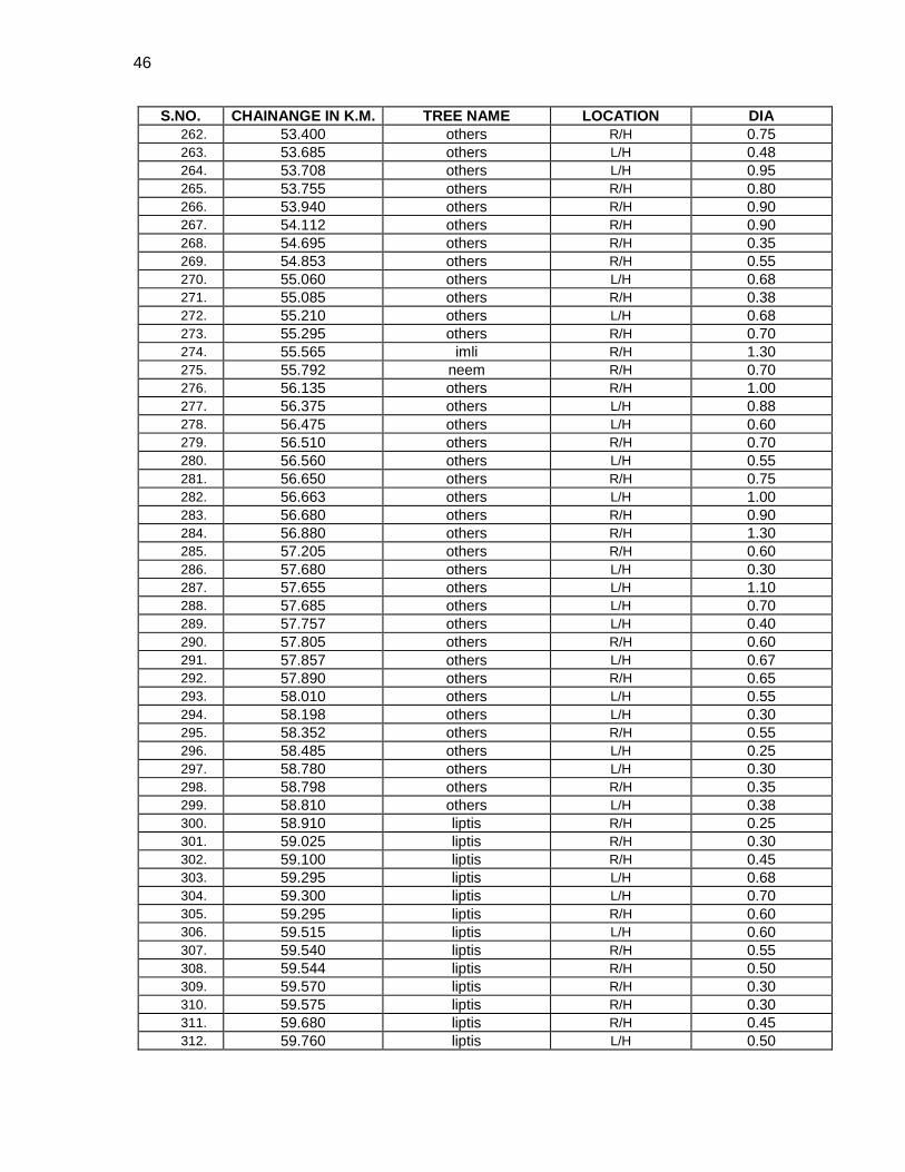
46
S.NO. CHAINANGE IN K.M. TREE NAME LOCATION DIA 262. 53.400 others R/H 0.75 263. 53.685 others L/H 0.48 264. 53.708 others L/H 0.95 265. 53.755 others R/H 0.80 266. 53.940 others R/H 0.90 267. 54.112 others R/H 0.90 268. 54.695 others R/H 0.35 269. 54.853 others R/H 0.55 270. 55.060 others L/H 0.68 271. 55.085 others R/H 0.38 272. 55.210 others L/H 0.68 273. 55.295 others R/H 0.70 274. 55.565 imli R/H 1.30 275. 55.792 neem R/H 0.70 276. 56.135 others R/H 1.00 277. 56.375 others L/H 0.88 278. 56.475 others L/H 0.60 279. 56.510 others R/H 0.70 280. 56.560 others L/H 0.55 281. 56.650 others R/H 0.75 282. 56.663 others L/H 1.00 283. 56.680 others R/H 0.90 284. 56.880 others R/H 1.30 285. 57.205 others R/H 0.60 286. 57.680 others L/H 0.30 287. 57.655 others L/H 1.10 288. 57.685 others L/H 0.70 289. 57.757 others L/H 0.40 290. 57.805 others R/H 0.60 291. 57.857 others L/H 0.67 292. 57.890 others R/H 0.65 293. 58.010 others L/H 0.55 294. 58.198 others L/H 0.30 295. 58.352 others R/H 0.55 296. 58.485 others L/H 0.25 297. 58.780 others L/H 0.30 298. 58.798 others R/H 0.35 299. 58.810 others L/H 0.38 300. 58.910 liptis R/H 0.25 301. 59.025 liptis R/H 0.30 302. 59.100 liptis R/H 0.45 303. 59.295 liptis L/H 0.68 304. 59.300 liptis L/H 0.70 305. 59.295 liptis R/H 0.60 306. 59.515 liptis L/H 0.60 307. 59.540 liptis R/H 0.55 308. 59.544 liptis R/H 0.50 309. 59.570 liptis R/H 0.30 310. 59.575 liptis R/H 0.30 311. 59.680 liptis R/H 0.45 312. 59.760 liptis L/H 0.50
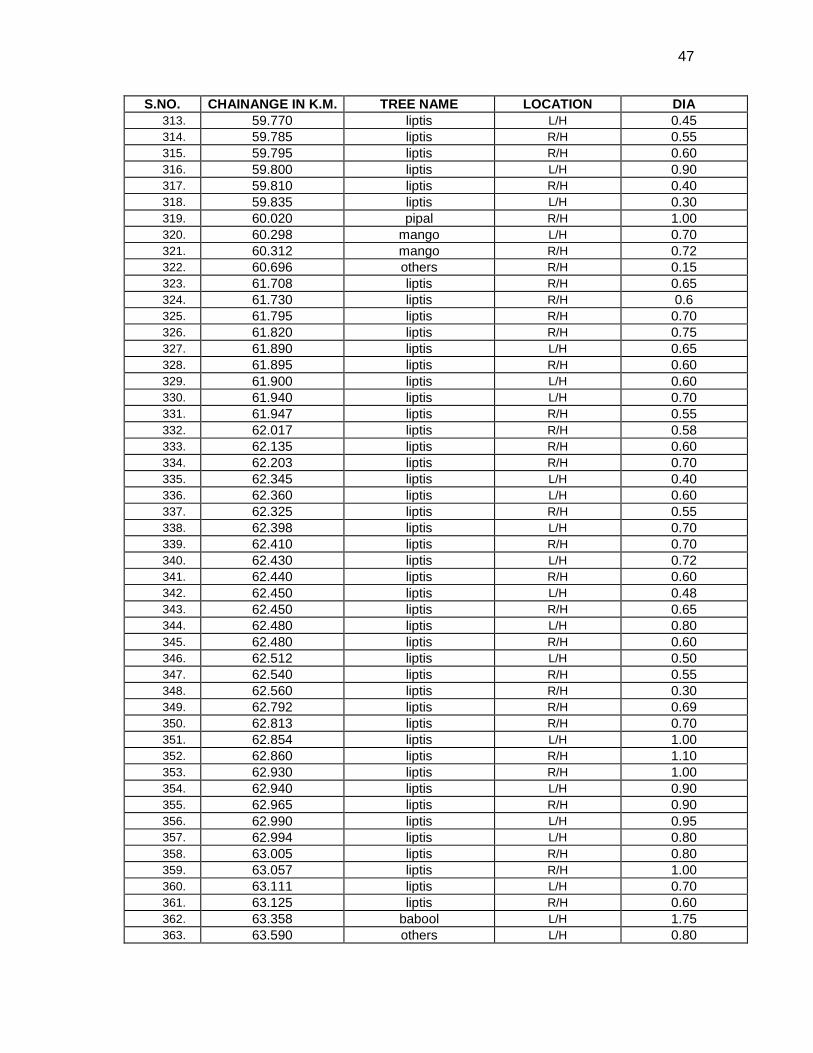
47
S.NO. CHAINANGE IN K.M. TREE NAME LOCATION DIA 313. 59.770 liptis L/H 0.45 314. 59.785 liptis R/H 0.55 315. 59.795 liptis R/H 0.60 316. 59.800 liptis L/H 0.90 317. 59.810 liptis R/H 0.40 318. 59.835 liptis L/H 0.30 319. 60.020 pipal R/H 1.00 320. 60.298 mango L/H 0.70 321. 60.312 mango R/H 0.72 322. 60.696 others R/H 0.15 323. 61.708 liptis R/H 0.65 324. 61.730 liptis R/H 0.6 325. 61.795 liptis R/H 0.70 326. 61.820 liptis R/H 0.75 327. 61.890 liptis L/H 0.65 328. 61.895 liptis R/H 0.60 329. 61.900 liptis L/H 0.60 330. 61.940 liptis L/H 0.70 331. 61.947 liptis R/H 0.55 332. 62.017 liptis R/H 0.58 333. 62.135 liptis R/H 0.60 334. 62.203 liptis R/H 0.70 335. 62.345 liptis L/H 0.40 336. 62.360 liptis L/H 0.60 337. 62.325 liptis R/H 0.55 338. 62.398 liptis L/H 0.70 339. 62.410 liptis R/H 0.70 340. 62.430 liptis L/H 0.72 341. 62.440 liptis R/H 0.60 342. 62.450 liptis L/H 0.48 343. 62.450 liptis R/H 0.65 344. 62.480 liptis L/H 0.80 345. 62.480 liptis R/H 0.60 346. 62.512 liptis L/H 0.50 347. 62.540 liptis R/H 0.55 348. 62.560 liptis R/H 0.30 349. 62.792 liptis R/H 0.69 350. 62.813 liptis R/H 0.70 351. 62.854 liptis L/H 1.00 352. 62.860 liptis R/H 1.10 353. 62.930 liptis R/H 1.00 354. 62.940 liptis L/H 0.90 355. 62.965 liptis R/H 0.90 356. 62.990 liptis L/H 0.95 357. 62.994 liptis L/H 0.80 358. 63.005 liptis R/H 0.80 359. 63.057 liptis R/H 1.00 360. 63.111 liptis L/H 0.70 361. 63.125 liptis R/H 0.60 362. 63.358 babool L/H 1.75 363. 63.590 others L/H 0.80
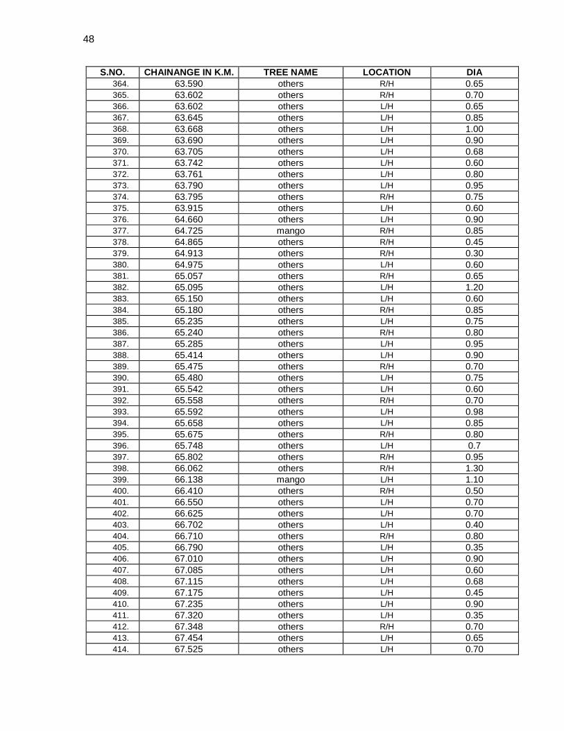
48
S.NO. CHAINANGE IN K.M. TREE NAME LOCATION DIA 364. 63.590 others R/H 0.65 365. 63.602 others R/H 0.70 366. 63.602 others L/H 0.65 367. 63.645 others L/H 0.85 368. 63.668 others L/H 1.00 369. 63.690 others L/H 0.90 370. 63.705 others L/H 0.68 371. 63.742 others L/H 0.60 372. 63.761 others L/H 0.80 373. 63.790 others L/H 0.95 374. 63.795 others R/H 0.75 375. 63.915 others L/H 0.60 376. 64.660 others L/H 0.90 377. 64.725 mango R/H 0.85 378. 64.865 others R/H 0.45 379. 64.913 others R/H 0.30 380. 64.975 others L/H 0.60 381. 65.057 others R/H 0.65 382. 65.095 others L/H 1.20 383. 65.150 others L/H 0.60 384. 65.180 others R/H 0.85 385. 65.235 others L/H 0.75 386. 65.240 others R/H 0.80 387. 65.285 others L/H 0.95 388. 65.414 others L/H 0.90 389. 65.475 others R/H 0.70 390. 65.480 others L/H 0.75 391. 65.542 others L/H 0.60 392. 65.558 others R/H 0.70 393. 65.592 others L/H 0.98 394. 65.658 others L/H 0.85 395. 65.675 others R/H 0.80 396. 65.748 others L/H 0.7 397. 65.802 others R/H 0.95 398. 66.062 others R/H 1.30 399. 66.138 mango L/H 1.10 400. 66.410 others R/H 0.50 401. 66.550 others L/H 0.70 402. 66.625 others L/H 0.70 403. 66.702 others L/H 0.40 404. 66.710 others R/H 0.80 405. 66.790 others L/H 0.35 406. 67.010 others L/H 0.90 407. 67.085 others L/H 0.60 408. 67.115 others L/H 0.68 409. 67.175 others L/H 0.45 410. 67.235 others L/H 0.90 411. 67.320 others L/H 0.35 412. 67.348 others R/H 0.70 413. 67.454 others L/H 0.65 414. 67.525 others L/H 0.70
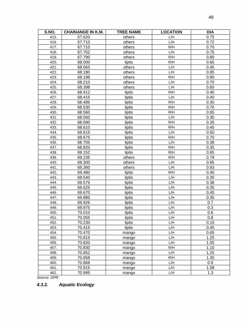
49
S.NO. CHAINANGE IN K.M. TREE NAME LOCATION DIA 415. 57.620 others L/H 0.75 416. 67.710 others L/H 0.72 417. 67.710 others R/H 0.70 418. 67.752 others L/H 0.75 419. 67.790 others R/H 0.80 420. 68.000 liptis R/H 0.65 421. 68.065 others L/H 0.45 422. 68.180 others L/H 0.95 423. 68.198 others R/H 0.90 424. 68.210 others L/H 0.70 425. 68.398 others L/H 0.65 426. 68.412 liptis R/H 0.45 427. 68.415 liptis L/H 0.40 428. 68.485 liptis R/H 0.30 429. 68.530 liptis R/H 0.70 430. 68.560 liptis R/H 0.65 431. 68.560 liptis L/H 0.30 432. 68.590 liptis R/H 0.35 433. 68.610 liptis R/H 0.40 434. 68.615 liptis L/H 0.50 435. 68.675 liptis R/H 0.70 436. 68.705 liptis L/H 0.38 437. 68.820 liptis R/H 0.35 438. 69.152 liptis R/H 0.65 439. 69.235 others R/H 0.78 440. 69.300 others L/H 0.95 441. 69.360 others L/H 0.93 442. 69.480 liptis R/H 0.45 443. 69.540 liptis L/H 0.30 444. 69.575 liptis L/H 0.38 445. 69.625 liptis L/H 0.35 446. 69.670 liptis L/H 0.45 447. 69.885 liptis L/H 0.35 448. 69.926 liptis L/H 0.7 449. 69.975 liptis L/H 0.3 450. 70.010 liptis L/H 0.6 451. 70.055 liptis L/H 0.8 452. 70.230 liptis L/H 0.15 453. 70.415 liptis L/H 0.45 454. 70.470 mango L/H 0.65 455. 70.815 mango L/H 1.25 456. 70.820 mango L/H 1.05 457. 70.830 mango R/H 1.10 458. 70.852 mango L/H 1.25 459. 70.858 mango R/H 1.35 460. 70.868 mango L/H 0.9 461. 70.915 mango L/H 1.08 462. 70.995 mango L/H 1.3
Source: DPR
4.3.2. Aquatic Ecology
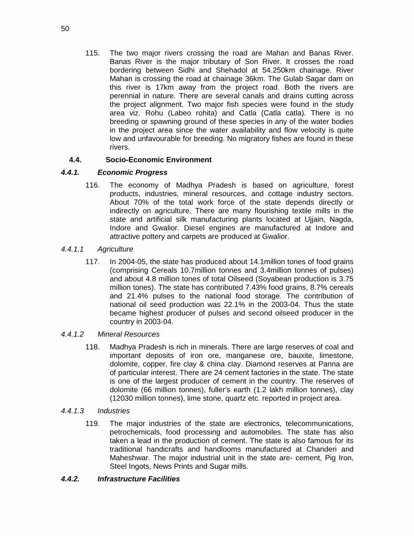
50
115. The two major rivers crossing the road are Mahan and Banas River. Banas River is the major tributary of Son River. It crosses the road bordering between Sidhi and Shehadol at 54.250km chainage. River Mahan is crossing the road at chainage 36km. The Gulab Sagar dam on this river is 17km away from the project road. Both the rivers are perennial in nature. There are several canals and drains cutting across the project alignment. Two major fish species were found in the study area viz. Rohu (Labeo rohita) and Catla (Catla catla). There is no breeding or spawning ground of these species in any of the water bodies in the project area since the water availability and flow velocity is quite low and unfavourable for breeding. No migratory fishes are found in these rivers.
4.4. Socio-Economic Environment 4.4.1. Economic Progress
116. The economy of Madhya Pradesh is based on agriculture, forest products, industries, mineral resources, and cottage industry sectors. About 70% of the total work force of the state depends directly or indirectly on agriculture. There are many flourishing textile mills in the state and artificial silk manufacturing plants located at Ujjain, Nagda, Indore and Gwalior. Diesel engines are manufactured at Indore and attractive pottery and carpets are produced at Gwalior.
4.4.1.1 Agriculture
117. In 2004-05, the state has produced about 14.1million tones of food grains (comprising Cereals 10.7million tonnes and 3.4million tonnes of pulses) and about 4.8 million tones of total Oilseed (Soyabean production is 3.75 million tones). The state has contributed 7.43% food grains, 8.7% cereals and 21.4% pulses to the national food storage. The contribution of national oil seed production was 22.1% in the 2003-04. Thus the state became highest producer of pulses and second oilseed producer in the country in 2003-04.
4.4.1.2 Mineral Resources
118. Madhya Pradesh is rich in minerals. There are large reserves of coal and important deposits of iron ore, manganese ore, bauxite, limestone, dolomite, copper, fire clay & china clay. Diamond reserves at Panna are of particular interest. There are 24 cement factories in the state. The state is one of the largest producer of cement in the country. The reserves of dolomite (66 million tonnes), fuller’s earth (1.2 lakh million tonnes), clay (12030 million tonnes), lime stone, quartz etc. reported in project area.
4.4.1.3 Industries
119. The major industries of the state are electronics, telecommunications, petrochemicals, food processing and automobiles. The state has also taken a lead in the production of cement. The state is also famous for its traditional handicrafts and handlooms manufactured at Chanderi and Maheshwar. The major industrial unit in the state are- cement, Pig Iron, Steel Ingots, News Prints and Sugar mills.
4.4.2. Infrastructure Facilities
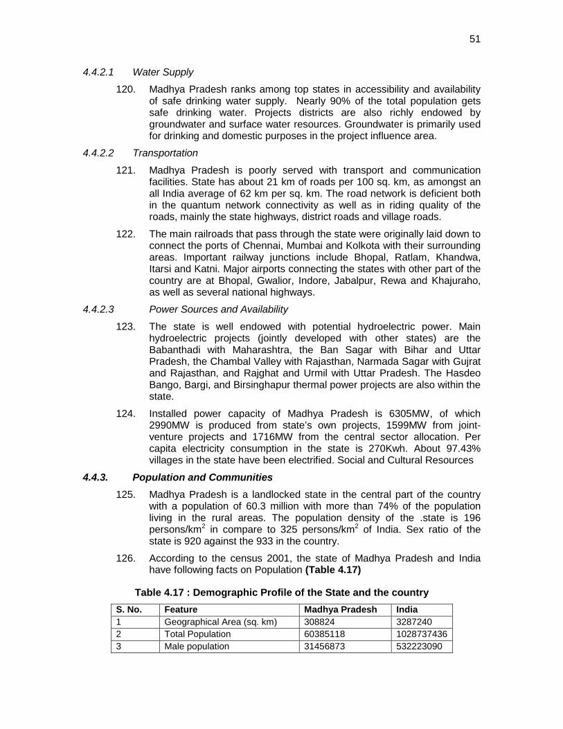
51
4.4.2.1 Water Supply
120. Madhya Pradesh ranks among top states in accessibility and availability of safe drinking water supply. Nearly 90% of the total population gets safe drinking water. Projects districts are also richly endowed by groundwater and surface water resources. Groundwater is primarily used for drinking and domestic purposes in the project influence area.
4.4.2.2 Transportation
121. Madhya Pradesh is poorly served with transport and communication facilities. State has about 21 km of roads per 100 sq. km, as amongst an all India average of 62 km per sq. km. The road network is deficient both in the quantum network connectivity as well as in riding quality of the roads, mainly the state highways, district roads and village roads.
122. The main railroads that pass through the state were originally laid down to connect the ports of Chennai, Mumbai and Kolkota with their surrounding areas. Important railway junctions include Bhopal, Ratlam, Khandwa, Itarsi and Katni. Major airports connecting the states with other part of the country are at Bhopal, Gwalior, Indore, Jabalpur, Rewa and Khajuraho, as well as several national highways.
4.4.2.3 Power Sources and Availability
123. The state is well endowed with potential hydroelectric power. Main hydroelectric projects (jointly developed with other states) are the Babanthadi with Maharashtra, the Ban Sagar with Bihar and Uttar Pradesh, the Chambal Valley with Rajasthan, Narmada Sagar with Gujrat and Rajasthan, and Rajghat and Urmil with Uttar Pradesh. The Hasdeo Bango, Bargi, and Birsinghapur thermal power projects are also within the state.
124. Installed power capacity of Madhya Pradesh is 6305MW, of which 2990MW is produced from state’s own projects, 1599MW from joint-venture projects and 1716MW from the central sector allocation. Per capita electricity consumption in the state is 270Kwh. About 97.43% villages in the state have been electrified. Social and Cultural Resources
4.4.3. Population and Communities 125. Madhya Pradesh is a landlocked state in the central part of the country
with a population of 60.3 million with more than 74% of the population living in the rural areas. The population density of the .state is 196 persons/km2 in compare to 325 persons/km2 of India. Sex ratio of the state is 920 against the 933 in the country.
126. According to the census 2001, the state of Madhya Pradesh and India have following facts on Population (Table 4.17)
Table 4.17 : Demographic Profile of the State and the country S. No. Feature Madhya Pradesh India 1 Geographical Area (sq. km) 308824 3287240 2 Total Population 60385118 1028737436 3 Male population 31456873 532223090
52
S. No. Feature Madhya Pradesh India 4 Female population 28928245 496514346 5 Rural Population 44282528 742490639 6 Urban Population 16102590 286119689 7 Density 196 325 8 Sex ratio (female/1000 male) 920 933 9 Literacy (%) 64.08 64.8
Source: Census Data, Census of India, 2001
127. The project road is passing through two districts of Madhya Pradesh. 90% of the total project road is coming in Sidhi district. These villages are listed in Table 4.18.
Table 4.18 : List of villages in the project road NAME CHAINAGE OF START CHAINAGE OF END
Jamodi, Sidhi, Start of Rd. 0.000 0.100 Panwar 0.350 0.700
Small Village 3.800 4.800 Badhwari 6.800 7.000
Gadakhera 10.850 11.700 Sapnidwari 11.800 11.850
Kutariya 12.700 12.800 Chouphal 16.000 16.400
Khama 23.150 23.350 Salaiya 25.400 25.800 Chawari 27.500 28.600 Karwahi 30.500 30.700 Tilwari 32.000 32.950 Chhuhi 33.400 35.200
Tala 37.200 39.900 Chuwahi Chanda 42.200 43.800
Samriha 46.400 46.900 Chamradol 51.100 51.200 Amakheda 55.500 55.800
Bardari 58.650 59.400 Pasgadi 59.500 59.800
Beohari, End of Rd. 69.500 71.400 Source: DPR and Strip Mapping
128. The total number of households in the villages of the project road is 16095 with a total population of 84454. Out of these, about 73% is general. The SC & ST population accounts for about 9 and 18% of the total population respectively as shown in Figure 4.3. The figure also reveals that the gender ratio among SC/ST population is almost the same
53
73.44%
8.74%
17.82%
GEN
SC
ST
0
1000
2000
3000
4000
5000
6000
7000
8000
9000
SC ST
Popu
latio
n (N
os) M F
Source: Census of India, 2001
Figure 4.3 : Population and Gender Ratio of SC-ST 4.4.4. Literacy
129. The overall literacy rate of Madhya Pradesh is 64.1%, which is almost equivalent to the countries literacy rate (64.8%). The project road passing through three districts of Madhya Pradesh covering 31 villages have total literacy rate of 60.8%. The population of literate male (61.3%) is comparatively higher than female as shown in Figure 4.4.
Figure 4.4 : Literacy scenario of the project area 4.4.5. Occupational Status
130. In the villages of the project road 32.92% of the total population comprise the workforce of the project area.74.72 % comprise the male working class population. Marginal population of villages of the project road is 6.8% with 60.7% represented by female population. Maximum percentage of the workers is other than agriculture, casual and households. The total other labour comprise of 68% of the total working class population.
0
5000
10000
15000
20000
25000
30000
35000
Male Female
Popu
latio
n (N
os) LIT ILL
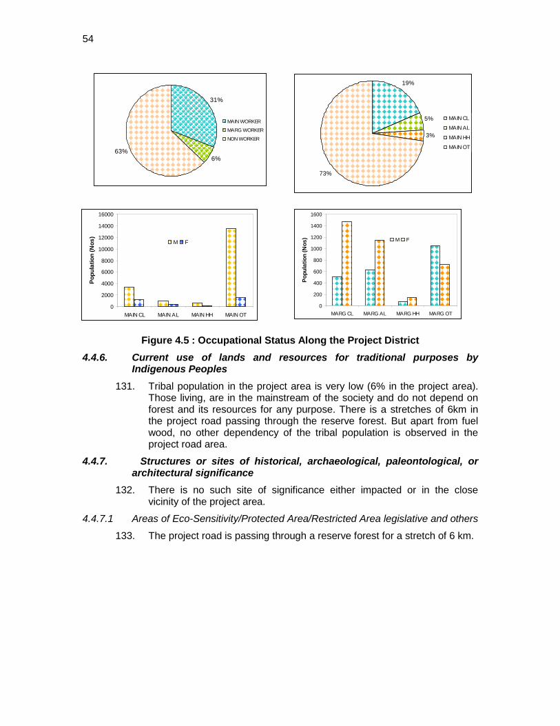
54
31%
6%63%
MAIN WORKER
MARG WORKER
NON WORKER
19%
5%
3%
73%
MAIN CL
MAIN AL
MAIN HH
MAIN OT
0
2000
4000
6000
8000
10000
12000
14000
16000
MAIN CL MAIN AL MAIN HH MAIN OT
Popu
latio
n (N
os)
M F
0
200
400
600
800
1000
1200
1400
1600
MARG CL MARG AL MARG HH MARG OT
Popu
latio
n (N
os) M F
Figure 4.5 : Occupational Status Along the Project District 4.4.6. Current use of lands and resources for traditional purposes by
Indigenous Peoples 131. Tribal population in the project area is very low (6% in the project area).
Those living, are in the mainstream of the society and do not depend on forest and its resources for any purpose. There is a stretches of 6km in the project road passing through the reserve forest. But apart from fuel wood, no other dependency of the tribal population is observed in the project road area.
4.4.7. Structures or sites of historical, archaeological, paleontological, or architectural significance
132. There is no such site of significance either impacted or in the close vicinity of the project area.
4.4.7.1 Areas of Eco-Sensitivity/Protected Area/Restricted Area legislative and others
133. The project road is passing through a reserve forest for a stretch of 6 km.
55
5. ANTICIPATED ENVIRONMENTAL IMPACTS AND ITS
MITIGATION MEASURES 134. Environmental impacts have been assessed considering present
environmental setting of the project area, nature, and extent of the proposed activities. Suitable approach and qualitative and quantitative techniques were used to ascertain likely direct and indirect impacts during design, construction and operation stages of the project. Impacts are classified as being insignificant, minor, moderate and major. The mitigation measures have been presented along with the impacts. .
135. During the field study, a number of informal consultations were held with people in the locality including those presently living along the various stretches of the sub project corridor. Some NGOs working in the areas were also contacted. Discussions were held with various concerned Government authorities like with Forests Departments, pollution control boards, State environmental impact assessment authority. Outcome of these consultations is referred for environmental impact assessment and designing of mitigative measures.
5.1. Impact on Physical Environment 5.1.1. Climate
136. Project will have no impact on climate of the area. The subproject may have minor impact on weather conditions of the area due to cutting of the 462 trees.
Design and Construction Phase
137. All efforts are made to minimise the cutting the trees through suitable design modifications. Supervision consultants will further ensure minimal cutting of the trees during the construction stage. The compensatory afforestation shall be made on the basis 1:5. The plantations shall begin with start of construction. The survival of plantation will be ensured, even if they are planted through concerned forest department. Tree of native variety only will be planted. In addition to above plantation, additional trees shall be planted through village Panchayats to improve microclimatic conditions of the area.
Mitigation Measures
138. The sub-project road is located in vast open agricultural land which will provide adequate dispersion of gaseous emission from vehicle. Further, extensive plantation will ameliorate/enhance the micro-climate. It also has associated benefits with respect to Green House Gas (GHG) emission reduction. The GHG emission reduction is anticipated due to improved road conditions and better connectivity. The GHG reduction is anticipated due to reduced idling of vehicle.
Operation Stage
56
139. It is proposed that MPRDC may initiate study to assess the GHG emission reduction and reap the economic benefits from road improvement projects including higher tree plantation.
Mitigation Measures
5.1.2. Natural Hazard 140. Earthquake: The sub project roads lies in seismic zone II/III as per
classification by Bureau of Indian Standards. This means lower to medium seismic intensity.
141. All subproject structures shall be designed with consideration of above seismicity.
Mitigation Measures
5.1.3. Air Quality
142. The potential sources of air emission during the construction phase of the project are: (i) dust from earth works (during site preparation), (ii) emissions from the operation of construction equipment and machines, (iii) fugitive emissions from vehicles plying on the road, (iv) fugitive emissions during the transport of construction materials, (v) air emissions other than dust arise from combustion of hydrocarbons particularly from the hot mix plants, and (vi) localised increased traffic congestion in construction areas. Most of the emissions will be in the form of coarse particulate matter which will settle down in close vicinity of construction site. Hot mix plant will generate carbon monoxide (CO), un-burnt hydrocarbon (HC), sulphur dioxide (SO2), particulate matters (PM), and nitrogen oxides (NOx) emissions. This may affect the air quality of nearby areas, especially, due to emission discharge from low height of the stack. However, this will be a temporary phase and hence, no significant impact is envisaged.
Design and Construction Phase
143. The stone aggregate will be sourced from licensed quarries. No new quarries shall be open for the project. The pollution related aspects to these quarries are independently complied by the quarry owner.
144. Road pavement design should be such that tyre friction due to vehicle movement will be reduced. Vehicles delivering loose and fine materials like sand and aggregates shall be covered. Dust suppression measures like water sprinkling, water fogging shall be applied in all dust prone locations such as unpaved haulage roads
Mitigation Measures
5
145. Mixing plants and asphalt (hot mix) plants shall be located at least 1 km away and in downwind direction of the human settlements. Material storage areas shall also be located downwind of the habitation area.
, earthworks, stockpiles and asphalt mixing plant areas. PPE shall be provided to the construction workers to minimise inhalation of respirable suspended particulate matter.
5 Water suppression of fugitive dust can reduce emissions from 12% to 98%
57
Contractor shall obtain consent to establish and operate from concerned State Pollution Control Board (SPCB) before its use for the project road. Hot mix plant shall be fitted with stack of adequate height (30 m) or as may be prescribed by SPCB to ensure enough dispersion of exit gases. Diesel Generating (DG) sets shall also be fitted with stack of adequate height. Low sulphur diesel shall be used in DG sets and other construction machineries. Construction vehicles and machineries shall be periodically maintained. LPG should be used as fuel source in construction camps instead of wood, wherever possible.
146. Air quality monitoring shall be carried out during construction phase. Suitable pollution control measures shall be adopted if monitored parameters are found above the prescribed limit.
147. The aggregate will be transported in the covered trucks through existing national and state highways.
148. The bad road conditions, the idling of vehicles are the main causes of the air and noise pollution at present. The improved road conditions will result in the improved ambient air quality. Since traffic is projected to increase with improved roads and better connectivity, the impact will remain more or less same. Since subproject is largely traverse through vast open agriculture areas, which provides adequate dispersion to gaseous pollutants generated from vehicles.
Operation Phase
149. It is proposed to maintain the road conditions including shoulders and embankment turfing. Thick trees shall be planted close to sensitive locations such as hospital, school boundaries and near religious places.
Mitigation Measures
150. Caution sign for speed regulation and lane driving shall be fixed near habitat areas. Educative awareness boards for safe and fuel efficient driving shall be fixed at selective locations.
5.1.4. Noise
151. Ambient noise level may increase temporarily in the close vicinity of various construction activities, maintenance workshops and vehicles and earthmoving equipment. These construction activities are expected to produce noise levels in the range of 80 – 95 dB(A) (at a distance of about 5 m from the source). Although this level of noise is higher the permissible limit for ambient noise level for residential/commercial levels but will occur only intermittently and temporary. This noise level will attenuate fast with increase in distance from noise source. Impact due to noise during construction activities will be minimal to inhabitants since most of the built-up areas are located at safer distance from the road. However, there are few noise sensitive locations especially schools close to the alignment (
Design and Construction Phase
Table 5.1)
Table 5.1 : Noise- Sensitive Locations along the Alignment
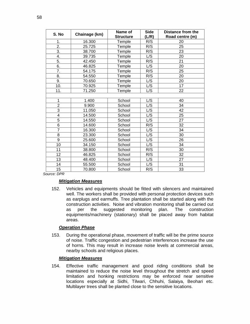
58
S. No Chainage (km) Name of Structure
Side (L/R)
Distance from the Road centre (m)
1. 16.300 Temple R/S 20 2. 25.725 Temple R/S 25 3. 38.700 Temple R/S 23 4. 39.735 Temple L/S 20 5. 42.450 Temple R/S 21 6. 46.825 Temple L/S 20 7. 54.175 Temple R/S 25 8. 54.550 Temple R/S 20 9. 70.650 Temple L/S 20 10. 70.925 Temple L/S 17 11. 71.250 Temple L/S 22
1 1.400 School L/S 40 2 9.900 School L/S 34 3 11.050 School L/S 42 4 14.500 School L/S 25 5 14.550 School L/S 27 6 14.600 School R/S 32 7 16.300 School L/S 34 8 23.300 School L/S 30 9 25.600 School L/S 26
10 34.150 School L/S 34 11 38.800 School R/S 30 12 46.825 School R/S 32 13 48.400 School L/S 27 14 55.500 School L/S 31 15 70.800 School R/S 33
Source: DPR
152. Vehicles and equipments should be fitted with silencers and maintained well. The workers shall be provided with personal protection devices such as earplugs and earmuffs. Tree plantation shall be started along with the construction activities. Noise and vibration monitoring shall be carried out as per the suggested monitoring plan. The construction equipments/machinery (stationary) shall be placed away from habitat areas.
Mitigation Measures
153. During the operational phase, movement of traffic will be the prime source of noise. Traffic congestion and pedestrian interferences increase the use of horns. This may result in increase noise levels at commercial areas, nearby schools and religious places.
Operation Phase
154. Effective traffic management and good riding conditions shall be maintained to reduce the noise level throughout the stretch and speed limitation and honking restrictions may be enforced near sensitive locations especially at Sidhi, Tilwari, Chhuhi, Salaiya, Beohari etc. Multilayer trees shall be planted close to the sensitive locations.
Mitigation Measures
59
5.1.5. Impact on Land and Soil 5.1.5.1 Loss of Productive Soil and Change in Land use
155. No land use will change due to the project since required ROW is available throughout the alignment. Land use though will change temporarily of construction camp areas and for the period of construction. This will also result in loss of soil productivity.
Design and Construction Phase
156. Land use may also change due to borrowing the earth. Land will also loose its productivity if top soil is not preserved.
157. It shall be ensured that the land taken on lease for access road and construction camp is restored back to its original land use before handing it over back to land owner.
Mitigation Measures
158. The top soil from the productive land (borrow areas, road widening areas etc.) shall be preserved and reused for plantation purposes. It shall also be used as top cover of embankment slope for growing vegetation to protect soil erosion.
159. The better access can lead to conversion of agriculture land for residential and commercial purposes close to roads and especially in rural and urban area. This may result in loss of productive land and agricultural produce.
Operation Phase
160. The EA may explore the feasibility of restricting about 50 m area either side of the road as no development zone on the line restriction are imposed for National Highways in India.
Mitigation Measures
5.1.5.2 Soil Erosion
161. Soil erosion may take place along steep and uncompacted embankment slope, and wherever vegetation is cleared. Soil erosion may have cumulative effect viz. siltation, embankment damage, drainage problem etc. Loss of soil due to run off from earth stock-piles may also lead to siltation. The intensity of soil erosion at different locations will be influenced by the lithology, topography, soil type and climatic condition (mainly rainfall) and drainage pattern.
Design and Construction Stage
162. Bank protection measures shall be taken at erosion prone areas. The protection measures may include use of geo-textiles matting. Provision of side drain shall be made to guide the water to natural outfalls. Stone pitching shall be carried out wherever necessary. When soil is spread on slopes for permanent disposal, it shall be buttressed at the toe by retaining walls. Side slopes of the embankment shall not be steeper than 2H:1V. Turfing/bio-turfing of embankment and slopes shall be done along
Mitigation Measures
60
the stretch. IRC: 56 -1974 recommended practice for treatment of embankment slopes for erosion control shall be taken into consideration. Soil erosion shall be visually checked on slopes and high embankment areas. In case soil erosion is found, suitable measures shall be taken to control the soil erosion.
163. Though terrain is flat all through the stretch, except at few locations where it is rolling terrain. Therefore, all steep cuts shall be flattened and benched. Retaining wall on both sides shall be provided. Shrubs shall be planted in loose soil area.
164. Soil of steep slopes of embankment and near bridge approaches may erode the embankment formation due to unexpected rainfall. Soil erosion condition may arise if borrow areas are not stabilized/restored properly. Regular monitoring for effectiveness of soil erosion measures (turfing, stone pitching, etc.) shall form part of the environmental monitoring during project operation). Suitable strengthening measures shall be taken to prevent reoccurrence of soil erosion at existing erosion prone locations and prevent them at newer locations.
Operation Phase
5.1.5.3 Borrow Areas and Quarries
165. The project area is generally having a flat terrain with some portion under rolling terrain, particularly between Pichhore-Chanderi section. Farmers were ready to provide earth from their field up to certain depth on adequate compensation, it is recommended that borrowing from agricultural land shall be minimised to the extent possible. Further, no earth shall be borrowed from already low lying areas.
Design and Construction Stage
166. Borrow areas if left un-rehabilitated may pose risk to people, particularly children and animals of accidentally falling into it as well as become potential breeding ground for mosquitoes and vector born disease.
167. Illegal quarrying may lead to unstable soil condition; destroy the landscape of the terrain, air and noise pollution. Opening of new quarries is not envisaged due to the proposed project. Quarry material will be sourced from existing nearby quarries.
168. Borrow pits shall be selected from barren land/wasteland to the extent possible. Borrow areas should not be located on cultivable lands except in the situations where land owners desires to level the land. The top soil shall be preserved and depth shall be restricted to the desired level. Borrow areas should be excavated as per the intended end use by the owner. The Indian Road Congress (IRC):10-1961 guideline should be used for selection of borrow pits and amount that can be borrowed
Mitigation Measures
169. The depths in borrow pits should be so regulated that the sides are not be steeper than 25%. To the extent possible, borrow areas shall be sited away from habited areas. Borrow areas shall be levelled with salvaged material or other filling materials which do not pose contamination of soil. Else, it shall be converted into intended use as per the requirement of
61
land owner/community. The borrow area shall be located/ rehabilitated as per the guidelines given at Appendix 5.1
5.1.5.4 Compaction and Contamination of Soil
170. Soil in the adjoining productive lands beyond the ROW, haulage roads, and construction camp area may be compacted due to movement of construction vehicles, machineries, equipments and due to siting of construction camps and workshops.
Design and Construction Stage
171. Soil may get contaminated due to inappropriate disposal of liquid waste, (lubricating oil and fuel spills, waste oil and lubricant and vehicle/equipment washing effluent) and solid waste (fuel filters, oily rags) likely to be generated from repair and maintenance of transport vehicles, construction equipment and machinery. Soil may get contaminated due to inappropriate disposal of domestic solid waste and sewage from construction camps.
172. To prevent soil compaction in the adjoining productive lands beyond the ROW, the movement of construction vehicles, machinery and equipment shall be restricted to the designated haulage route. The productive land shall be reclaimed after construction activity. Septic tank or mobile toilets fitted with anaerobic treatment facility shall be provided at construction camp. Domestic solid waste at construction camp shall be segregated into bio-degradable and non-biodegradable waste. The non-biodegradable and recyclable waste shall be sold off. Efforts shall be made that bio-degradable waste shall be composted in the mechanised and movable composter by the contractor. Non biodegradable and non saleable waste shall be disposed off to authorised land fill site. If land fill site not available then burial of the waste in a secured manner shall be ensured.
Mitigation Measures
173. Fuel and lubricants shall be stored at the predefined storage location. The storage area shall be paved with gentle slope to a corner and connected with a chamber to collect any spills of the oils. All efforts shall be made to minimise the waste generation. Unavoidable waste shall be stored at the designated place prior to disposal. To avoid soil contamination at the wash-down and re-fuelling areas, “oil interceptors” shall be provided. Oil and grease spill and oil soaked materials are to be collected and stored in labelled containers (Labelled: WASTE OIL; and hazardous sign be displayed) and sold off to SPCB/ MoEF authorized re-refiners.
174. No impact on soil is anticipated during operation phase of the project except along slope lying areas and near bridge approaches where unexpected rainfall may erode the embankment formation and deterioration of borrow areas if not rehabilitated properly.
Operation Stage
175. Erosion prone areas shall be visually checked periodically for any erosion and appropriate corrective action shall be taken if any erosion is
Mitigation measures
62
identified. Regular monitoring of side drains and cross drainage structures to check blockade situation.
5.1.6. Groundwater
176. Water will be mainly required for compaction of formation and domestic purposes in the workers camp. These requirements will be mainly sourced from groundwater (approximately 700 KL per day). Also, the depth to water table in some part is depleting annually. Any uncontrolled abstraction can further deteriorate the situation. Contamination of groundwater is not envisaged since all construction camps will have septic tanks or mobile toilets depending on the number of workers in each camp.
Design and Construction Stage
177. Requisite permission shall be obtained for abstraction of groundwater from State Ground Water Board/Central Ground Water Authority.
Mitigation Measures
178. The contractor shall make arrangements for water required during construction in such a way that the water availability and supply to nearby communities remains unaffected.
179. Water intensive activities shall not be undertaken during summer period to the extent feasible.
180. Provision shall be made to link side drains with the nearby ponds for facilitating water harvesting. Where ponds are not available, the water harvesting pits shall be constructed as per the requirement and rainfall intensity.
181. No impact is anticipated on groundwater due to the project during operation phase, hence, no specific mitigation is proposed.
Operation Stage
5.1.7. Siltation and Surface Water Quality of Rivers and Other Water Bodies
182. The project section is being crossed by Banas River which is perennial, but water level drops substantially during non-monsoon period. Hence, no impact is envisaged on surface water bodies in the project section.
Design and Construction Stage
183. Since there are not many water bodies crossing the alignment, siltation impact due to bridge rehabilitation works will be negligible, if construction debris/other waste are cleared immediately after construction. The temporary pollution of water bodies from spillage of chemicals and oil at construction sites and waste from construction camps may occur. Soil erosion has direct bearing on siltation. The siltation likely to be caused due to bank erosion has already been addressed above in soil erosion section.
184. Accidental oil and chemicals spills can contaminate the water.
Mitigation Measure
63
185. Siltation Issues: Required mitigation as suggested in soil erosion section shall be taken into consideration. Bridge rehabilitation activity is recommended during non-monsoon (mid-September to mid-June) period. Silt fencing and/or brush barrier shall be installed for collecting sediments before letting them into the water body. Silt/sediment should be collected and stockpiled for possible reuse as surfacing of slopes where they have to be re-vegetated. Chute drains shall be provided to drain surface runoff and prevent erosion from slopes.
186. Fuel and Lubricant Spillage Issue: All equipment operators, drivers, and warehouse personnel will be trained in immediate response for spill containment and eventual cleanup. No vehicles or equipment should be parked or refuelled near water-bodies, so as to avoid contamination from fuel and lubricants. All chemicals and oil shall be stored away from water and concreted platform with catchment pit for spills collection.The emergency response procedures including reporting, preferably written in the local language and simple to understand shall be provided by the contractors. The slopes of embankments leading to water bodies should be modified and re-channelised to prevent entry of contaminants. Large construction camps shall be avoided along the alignment and located away from habitation and water bodies.
187. Waste Disposal Issues: All wastes arising from the construction should be disposed in an environmentally accepted manner so as not to block the flow of water in the channels. The wastes should be collected, stored and transported to the approved disposal sites. Construction labourers shall be preferable from local population. Sewage from labour camps will be treated through septic tanks. No untreated sanitary wastewater shall be discharged into surface water bodies.
188. No major or long-term impact is anticipated during the operation phase on the surface water bodies due to the project implementation activities. Oil-contaminated runoff from the road during monsoon will have minimal impacts considering their low concentration. However, regular visual checks shall be made to observe any incidence of blockade of drains. Regular checks shall be made for soil erosion and turfing conditions of river training structures for its effective maintenance.
Operation Stage
5.1.8. Hydrology and Drainage
189. The activities involved with proposed road development will be carried out along with existing alignment. No new bridge is proposed to be constructed. Existing bridges/cross drainage structures are only to be improved. Diversion of water channels during rehabilitation of cross drainage structures is not envisaged.
Design and Construction Stage
190. Elaborate drainage system shall be provided to drain the storm water from the roadway and embankment and to ensure minimum disturbance to natural drainage of surface and subsurface water of the area. The
Mitigation Measures
64
design of drainage system such as surface and sub-surface drainage shall be carried out as per IRC: SP: 42 and IRC: SP: 50. Surface runoff from the main highway, embankment slopes and the service roads shall be discharged through longitudinal drains, designed for adequate cross section, bed slopes, invert levels and the outfalls. If necessary, the walls of the drains shall be designed to retain the adjoining earth. IRC: 34-1970: Recommendations for road construction in waterlogged area and IRC: 75 and MOSRTH guidelines for Design of High Embankments shall be referred.
191. Provision of additional cross drainage structure shall be made in the areas where nearby land is sloping towards road alignment in both the both sides.
192. Water accumulation incidence may occur due to inadequate availability of cross drainage structure or clogging of cross drainage structures.
Operation Stage
193. Regular removal/cleaning of deposited silt shall be done from drainage channels and outlet points before the monsoon season. Rejuvenation of the drainage system by removing encroachments/ congestions will be regularly conducted.
Mitigation Measures
5.2. Impact on Biological Environment 5.2.1. Terrestrial Ecology
194. The project section Pichhore-Chanderi passes through reserve forests areas. Also, 462 trees are likely to be cut due to the proposed road improvement work. The impact and mitigation due to tree cutting has been discussed in following paragraphs.
195. One month before the construction starts, clearing and grubbing will be performed by the contractor. All trees within the ROW with 300 mm diameter at 1 m above the ground will be cut, including the removal of stumps. All stumps and roots of trees of girth more than 33 mm at above 1 m from the ground level will be culled.
Design and Construction Stage
196. There are altogether 462 trees likely to be affected due to the project. Most of the roadside trees are non-fruit bearing in nature. The cutting of trees will have minor to negligible impact on local environment. Moreover, this will be temporary since large number of trees have been planned to be planted on both sides of the road. This will improve the local climatic conditions in long term.
197. Requisite permission from forest department shall be obtained for cutting of roadside trees.
Mitigation Measures

65
198. The project envisages plantation of approximately 3234 trees along both sides of road as per IRC SP: 21 specifications. This will include the compensatory plantation as per prevailing guidelines on 1:5 basis. All tree plantations will be carried out in close consultation with forest department.
199. A range of 10-15 m centre-to-centre is recommended for spacing of trees (parallel to the road). Setback distance of trees in different situations shall be based on IRC: SP: 21 and IRC: 66. The distance between the kerb, if any, and the nearest edge of tree trunk shall be at least 2 m. The plantation in median shall comprise shrubs whose height would normally not exceed 1-1.5 m and shall be as per IRC SP: 21.
200. For safe traffic operation, vertical clearance between the crown of the carriageway and lowest part of overhang of the tree available across the roadway shall conform to the standards laid down in IRC: SP: 21. The pit size, fencing, watering, and manuring requirements shall also conform to the above standard. Excess use of pesticides shall be restricted. Planting shall be such that it does not obstruct the visibility of traffic from any side and shall be pleasing in appearance.
201. Positive impacts on terrestrial ecology are expected during the project operation due to the increase in vegetation and landscaping along the state highway. The Project will coordinate with the local communities to maintain and enhance the trees planted along the state road. ”No adverse impact is anticipated during operation stage except accidental damages or absence of proper tree management“.
Operation Stage
202. No direct impact is anticipated during operation stage except accidental damages or absence of proper tree management.
203. Arrangement shall be made to ensure survivability of the tree plantation. The Social Forest Department or Divisional Forest Offices shall be consulted or involved in this programme. The tree survivability audit shall also be conducted at least once in a year to assess the effectiveness of the programme.
Mitigation Measures
5.2.2. Aquatic Ecology
204. Large scale/organised fishing was not observed in the rivers/water bodies of the project area. All water bodies are seasonal in nature except river Budhni.
Design and Construction Stage
205. Improvement of existing embankments particularly along the waterways will increase silt while accidental spill of materials, chemicals, and fuels will deteriorate receiving water quality.
206. Siltation shall be avoided by measures suggested in Para 166.
Mitigation Measures
Operation Stage
66
207. No impact is envisaged during operation phase of the project and hence no mitigation proposed. However, periodic surveillance shall be conducted to check erosion and siltation in major water bodies.
5.2.3. Fauna
208. Movement of animals like Cattle, Goats, Cows, Black Bug, Chital, foxes, macaque, langur, hare etc. have been observed along the project alignment.
Design and Construction Stage
209. Disturbance to these animals will be avoided to the extent possible. No food and waste littering will be ensured to disturb their natural habitat.
Mitigation measures
210. All precautions will be taken to minimise noise in these areas.
211. Movement of animals like Cattle, Goats, Cows, Black Bug, Chital, foxes, macaque, langur, hare etc. have been observed along the project alignment.
Operation Stage
212. A box culvert of 2.5 m height will be provided especially near forest areas for safe passage of animals.
Mitigation measures
213. Fencing wherever cattle movement is expected. To avoid the need for cattle underpasses, some of the proposed culverts `near habitations may be widened to facilitate cattle movement
5.3. Management of Construction Debris/Waste 214. Quarry dust and unused iron bars or damaged support structures
constitute significant wastes. Mitigation for solid waste from construction camp has been given in construction camp section.
215. The existing bitumen surface can be utilized for paving of crossroads, access roads, and paving works in construction sites and camps, temporary traffic diversions, haulage routes etc.
Mitigation measures
216. All excavated materials from roadway, shoulders, verges, drains, cross drainage and the like will be the property of the MPRDC and will be used for backfilling embankments, filling pits, and landscaping.
217. Unusable debris material should be suitably disposed off at pre-designated disposal locations, with approval of the concerned authority. The bituminous wastes shall be disposed in secure landfill sites only in environmentally accepted manner. For removal of debris, wastes and its disposal MOSRTH guidelines should be followed.
218. Unusable and surplus materials, as determined by the Project Engineer, will be removed and disposed off-site.
219. The locations of dumping sites should be selected with following considerations.
67
220. Unproductive/wastelands shall be selected for dumping sites.
221. Away from residential areas and located at least 1000 m downwind side of these locations,
222. Dumping sites do not contaminate any water sources, rivers etc, and
223. Dumping sites have adequate capacity equal to the amount of debris generated.
224. Public perception and consent from the village Panchayats about the location of debris disposal site has to be obtained before finalizing the location.
225. Form works will be re-used to the extent possible, more than 20 times as dictated by good practice. All stripped formworks will be examined for any damage and rectified in the workshop for re-use. Rectification includes plugging holes, and straightening bent steel props.
5.4. Socio-Economic Impact 226. Assessment of project impact on socio-economic conditions point to the
conclusions that positive benefits are many fold compared to its adverse impact.
5.4.1. Positive Impacts 227. Road-side economic activities will increase due to increased number of
vehicle using the road. Economic activities supporting transport like gasoline stations, automotive repair shops, lodging, and restaurants are expected to increase. Increase agro-industrial activities are also expected to take advantage of improved access to urban centres where there are higher demands and better prices for agricultural products. Other generic benefits of such projects are (i) Reduction in travel time (ii) better mode and frequency of transport (iii) access to quality heath care facilities, educational and other infrastructural facilities (iv) enhanced tourism activities in the area and state which in many terms will boost the local economy (v) better investment climate for industries creating more employment opportunities to local people.
5.4.2. Anticipated Negative Impacts 228. Minor losses like problems in accessibility and community linkage, health
and safety during and after construction, and temporary change in demographic configuration are mitigable with minor to negligible residual impacts.
5.4.2.1 Impacts due to Construction Camp and Immigration of Workers
229. Poor siting and improper management of construction camp may lead to several adverse impacts on environment viz. (i) loss of vegetation due to use of wood as fuel source for cooking (ii) deterioration in nearby surface water bodies’ quality (iii) compaction and contamination of soil due to uncontrolled disposal of solid waste (iv) Poor sanitation may result to transmission of communicable diseases among the workers and the host communities. This include the possible spread of sexually transmitted
Design and Construction Stage
68
disease, diseases from improper handling and supply of foodstuffs, poor water supply, insect-borne diseases, and alcoholic and drug.
230. Construction camp shall be sited at such locations so as to utilise the existing infrastructure. No productive land should be utilised for construction camp. All sites must be graded, ditched and rendered free from depressions to avoid water stagnation. Accommodation and ancillary facilities including recreational facility for workers shall be erected and maintained to standards and scales approved by the resident engineer. All camps should maintain minimum distance of 500 m from habitation and water bodies.
Mitigation measures
231. All construction camps shall be provided sanitary latrines and urinals with provision of septic tanks attached with soak pits. Storm water drains shall be provided for the flow of used water outside the camp. Drains and ditches shall be treated with bleaching powder on a regular basis. Garbage bins must be provided in the camp and regularly emptied and disposed off in a hygienic manner. The possibility of using LPG as fuel source for cooking to avoid any tree cutting, should be explored.
232. At every workplace, the Contactor will ensure, in collaboration with local health authorities that a readily available first-aid unit including an adequate supply of sterilized dressing materials and appliances shall be provided. Workplaces remote and far away from regular hospitals shall have indoor health units with one bed for every 250 workers.
233. The Contractor will ensure the good health and hygiene of all workers to prevent sickness and epidemics. These include the HIV/AIDS prevention program to reduce the risk and transfer of HIV virus between and among the workers and community, promote early diagnosis and assist affected individuals. Activities under the program include monthly information, education, and consultation communication campaigns to workers, drivers, delivery crew, and communities on the risk, dangers, and impacts of STD and HIV/AIDS.
234. The Contractor will ensure that sufficient supply of suitable and hygienically prepared food at reasonable price is available to the workers.
235. The Contractor will provide adequate and safe water supply for the use of the workers.
236. The Contractor will ensure that all precautions to protect the workers from insect and pest to reduce the risk to health. This includes the use of insecticides which should comply with local regulations.
237. No alcoholic liquor or prohibited drugs will be imported to, sell, give, and barter to the workers of host community.
238. Migrant workers may be the potential carriers of various diseases. Local community may get exposed to the diseases carried by migrant workers. Regular health check-up and immunization camps shall also be organized for the workers and nearby population.
5.4.2.2 Safety of Construction Workers and Accident Risk to Local Community
69
239. The following safety aspects viz. (i) safety of construction workers, (ii) safety of road users including pedestrians and cyclists (iii) safety to cattle; (iv) safety of local community (iv) unsafe/ hazardous traffic conditions due to construction vehicle movement need to be considered during design and construction stage and (v) conduct of safety audit.
Design and Construction Stage
240. During the construction phase, contractors shall be required to adopt and maintain safe working practices. Internationally accepted and widely used safety procedures should be followed during (i) road works (ii) handling of large construction equipment and machineries, (iii) handling of chemicals and hazardous materials and inflammable substances (iii) welding (iv) electrical works etc. A set of mitigation measures for construction workers have been provided in EMP matrix table.
Mitigation measures
241. Contractor shall arrange all PPEs for workers, first-aid and fire fighting equipments at construction sites. An emergency plan shall be prepared duly approved by engineer in charge to respond to any instance of safety hazard. The contractor will be required to appoint an Accident Prevention Officer (APO) who will conduct regular safety inspections at construction sites. The APO will have the authority to issue instructions and take protective measures to prevent accidents. The partial control on access for the project road shall be achieved through measures like service road with physical separation for local traffic, intersections, acceleration/deceleration lanes, vehicular and pedestrian underpasses, median openings with shelter lane.
242. The partial control on access for the project road shall be achieved through measures like service road with physical separation for local traffic, intersections, acceleration/deceleration lanes, vehicular and pedestrian underpasses, median openings with shelter lane.
243. Grade separated intersections/junctions shall be provided at all major intersections in consistent to IRC: 92
244. Pedestrian/cyclist and cattle passageways shall be provided near identified locations. These facilities shall be planned in accordance with the relevant provisions contained in IRC-11, IRC-17 and IRC-103. The crossing facilities can be designed either in conjunction with grade intersections or through underpasses.
245. To avoid disruption of the existing traffic due to construction activities, comprehensive traffic management plan shall be drawn up by the concessionaire. Traffic in construction zones shall be managed as per the provisions of IRC SP 55.
246. After construction is completed in a particular zone, it shall be opened for normal operation. All diversions/access roads should be closed before start of normal operation.
247. Use of retro-reflectorized traffic signs, and cantilever/gantry types overhead signs, thermoplastic road marking paints, delineators, traffic cones, empty bitumen drums, barricades, and flagmen will be used to
70
ensure traffic management and safety. Conduct of regular safety audit on safety measures adopted during construction. The audit will cover manpower and their safety, machinery, temporary works, equipment and vehicles, materials storage and handling, construction procedures, environment, site safety guidelines, and miscellaneous services.
248. Important issues related with safety during operational phase are monitoring of emergencies and establishing procedures to carry out rescues during sudden disasters such as floods, fires especially near habited areas.
Operation phase
249. It is proposed to explore the feasibility of providing the following facilities:
Mitigation Measures
o Highway patrol unit(s) for round the clock patrolling to provide assistance to the users in case of any need, monitor the travel conditions to provide information to the control section and to undertake immediate measures for managing the traffic flow in case of any incident.
o Phone booths for accidental reporting and ambulance services with minimum response time for rescue of any accident victims.
o Tow-away facility for the break down vehicles.
250. MPRDC may also explore the possibility of coordination with operating agency of intersecting National Highways to have common facilities and share the costs as appropriate.
5.4.3. Obstruction and Disruption of Traffic
251. Disruption of access to infrastructure or social resource due to construction activity will cause nuisance and to a certain extent additional cost to the public in terms of longer travel period due to diversion or heavier traffic. It will also pose risk of accident to motorist at night if these blockages and disruption are not clearly demarcated.
Construction Phase
252. The contractor will submit a Traffic Plan to the Project Engineer at least two weeks before the construction starts that will result to obstruction. The plan will include a drawing of temporary diversions and details of arrangement. It will also include plan for transportation of raw materials like quarry, sand etc. A section of the Traffic Plan will be a Control Plan that details how the safety of the pedestrians and workers and delineation of the roadway at night. This plan will recommend for approval of safe and convenient temporary diversion of traffic during construction, design of barricades, delineators, signs, markings, lights, and flagmen, among others.
Mitigation Measures
253. Paved shoulder will be provided on one side of the existing road by the contractor with the following minimum requirements:
• At least one 3.5 m lane to remain to traffic at all times
71
• The surface used by the through traffic will be firm bituminous compacted surface free of defect
• The maximum continuous length over which construction under traffic may take place is limited to 750 meters.
• Construction activity will be restricted to only one side of the existing road.
254. On stretches where it is not possible to pass the traffic on the part width of existing carriageway, temporary paved diversions will be constructed. These paved diversions will comply with standards on junctions and temporary cross drainage.
255. Transportation of quarry material to the construction sites through heavy vehicles shall be done through existing major roads to the extent possible. This will restrict wear and tear to the village/minor roads. Small vehicles/un-motorised vehicle can also be used for its further transportation to the construction sites from temporary storage areas.
5.4.4. Transportation and Storage of Materials 256. The construction material primarily will consist off aggregate, sand,
cement, bitumen, lubricating oil and fuel for vehicle and construction equipments. These will be stored temporarily at construction camps. Oils, fuels and chemicals will be stored on concreted platform with spill collection pits while cement will be stored under cover. All these temporary storage areas will be located at least 150 m away from the habitat. The likely impacts due to transportation and storage including fugitive emission have already been covered under different section above.
5.4.4.1 Impact on Land and Private Properties
257. The assessment made by the resettlement expert shall be referred for exact loss of private properties and measures to compensate such losses. Environmental screening of resettlement sites, if required for the project, shall be carried out. Besides monetary compensation for any loss of private trees, compensatory afforestation and extensive plantation has been incorporated in the EMP to have long-term environmental benefits.
Design and Construction Stage
258. Income restoration measures/livelihood options for vulnerable group/resource poor sections and other affected persons as recommended by social development/resettlement expert shall be implemented.
5.4.4.2 Impact on Common Property Resources
259. There are various types of community structures/ facilities/utilities along the proposed alignment (refer Table 5.1). Geometric adjustments have been made to minimize the loss to any such facilities. Any such structures even falling within ROW but out of required formation width shall be saved. Alternate access has to be provided to these structures during construction stage. No community structures are likely to be dismantled / relocated.
72
5.5. Cumulative and Induced Impact 260. Cumulative Impact: The area along the present road sections SH-55 is
developing. The road already exists and proposed project will facilitate the pace of development. Some of the cumulative impacts will be deterioration in the air and noise quality especially at the congested locations like Sidhi, Salaiya, Tilwahi, Beohari etc. due to increased traffic. The ancillary development activity due to the improved road conditions will further put pressure on agricultural lands and vegetated areas such as Panwar, Kutariya, Karwahi, Bardari. However, these activities will be slow and impacts are expected to be minimal.
261. The project is expected to improve long time water flooding, soil erosion conditions especially near Banas and Mahaan Rivers and other rolling terrain areas due to additional culverts and over-toppings. The higher amount of compensatory afforestation (1:7) will increase the aesthetics along the ROW and help in bringing the positive impact on the sourroundings. The improved accessibility will also result in increased industrial and commercial developments especially near Sidhi, Tilwari, Beohari, Tala etc. The net impacts are expected to be more positive..
262. Induced Impact - The induced impact from the project will be mainly due to the related developmental activities and improved infrastructural development like building construction and commercial establishment. This is likely to result in net positive impact due to overall social development
73
6. PUBLIC CONSULTATION AND INFORMATION DISCLOSURE 6.1. Consultation Method and Information Disclosed
263. Consultations were held during different stages of the preparation of IEE. To address the key environmental issues, consultations at various levels with local people and government departments were conducted to arrive at socially and technically accepted solutions. A comprehensive consultation with all stakeholders was conducted at the project section.
264. Stakeholder’s consultations were held with intent to understand their concerns, apprehensions, overall opinion and solicit recommendations to improve project design. Informal meetings, interviews were organized covering the entire project stretch. The informal consultation generally started with explaining the sub projects, followed by an explanation to potential impacts. Participant’s views were gathered with regard to loss of agricultural land, effect on air and noise quality of the area due to traffic, water availability, accident and risk.
265. The discussions were designed to receive maximum inputs from the participants regarding their acceptability and environmental concerns arising out of the sub-project. They were given the brief outline of the project to which their opinion was sought. Suggestions were also sought for mitigating any potential adverse impact.
6.2. Compliance with Relevant Regulatory Requirements 266. In India, public consultation is mandatory in case of Category A and B1
category projects6
267. Public consultation was undertaken consistent with the ADB requirements. All the five principles of information dissemination, information solicitation, integration, co-ordination and engagement into dialogue were incorporated in the consultation process. A framework of different environmental impacts likely from the project was strengthened and modified based on opinions of all those consulted, especially in the micro level by setting up dialogues with the village people from whom information on site facts and prevailing conditions were collected.
in select conditions. Being a category B project as per ADB Environmental Guidelines 2003, consultation was carried out during the early stage of IEE report preparation. The requirement of public consultation during the implementation of the project has been proposed as part of the mitigation plan.
6 As per schedule I of EIA notification number S.O. 1533, dated 14th September 2006. This notification also defines when a public consultation is mandatory.
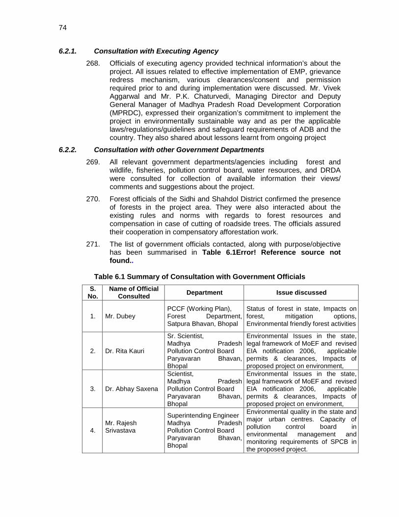
74
6.2.1. Consultation with Executing Agency 268. Officials of executing agency provided technical information’s about the
project. All issues related to effective implementation of EMP, grievance redress mechanism, various clearances/consent and permission required prior to and during implementation were discussed. Mr. Vivek Aggarwal and Mr. P.K. Chaturvedi, Managing Director and Deputy General Manager of Madhya Pradesh Road Development Corporation (MPRDC), expressed their organization’s commitment to implement the project in environmentally sustainable way and as per the applicable laws/regulations/guidelines and safeguard requirements of ADB and the country. They also shared about lessons learnt from ongoing project
6.2.2. Consultation with other Government Departments 269. All relevant government departments/agencies including forest and
wildlife, fisheries, pollution control board, water resources, and DRDA were consulted for collection of available information their views/ comments and suggestions about the project.
270. Forest officials of the Sidhi and Shahdol District confirmed the presence of forests in the project area. They were also interacted about the existing rules and norms with regards to forest resources and compensation in case of cutting of roadside trees. The officials assured their cooperation in compensatory afforestation work.
271. The list of government officials contacted, along with purpose/objective has been summarised in Table 6.1Error! Reference source not found..
Table 6.1 Summary of Consultation with Government Officials S.
No. Name of Official
Consulted Department Issue discussed
1. Mr. Dubey PCCF (Working Plan), Forest Department, Satpura Bhavan, Bhopal
Status of forest in state, Impacts on forest, mitigation options, Environmental friendly forest activities
2. Dr. Rita Kauri
Sr. Scientist, Madhya Pradesh Pollution Control Board Paryavaran Bhavan, Bhopal
Environmental Issues in the state, legal framework of MoEF and revised EIA notification 2006, applicable permits & clearances, Impacts of proposed project on environment,
3. Dr. Abhay Saxena
Scientist, Madhya Pradesh Pollution Control Board Paryavaran Bhavan, Bhopal
Environmental Issues in the state, legal framework of MoEF and revised EIA notification 2006, applicable permits & clearances, Impacts of proposed project on environment,
4. Mr. Rajesh Srivastava
Superintending Engineer Madhya Pradesh Pollution Control Board Paryavaran Bhavan, Bhopal
Environmental quality in the state and major urban centres. Capacity of pollution control board in environmental management and monitoring requirements of SPCB in the proposed project.
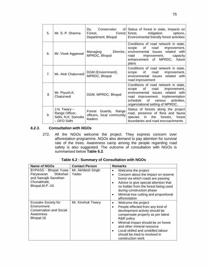
75
5. Mr. S. P. Sharma Dy. Conservator of Forest, Forest Department, Bhopal
Status of forest in state, Impacts on forest, mitigation options, Environmental friendly forest activities
6. Mr. Vivek Aggarwal Managing Director, MPRDC, Bhopal
Conditions of road network in state, scope of road improvement, environmental issues related with road improvement, capacity enhancement of MPRDC, future plans
7. Mr. Alok Chaturvedi DGM (Enviornment), MPRDC, Bhopal
Conditions of road network in state, scope of road improvement, environmental issues related with road improvement
8 Mr. Piyush.K. Chaturvedi DGM, MPRDC, Bhopal
Conditions of road network in state, scope of road improvement, environmental issues related with road improvement, implementation schedule of various activities, organizational setting of MPRDC,
9.
J.N. Tiwary – Range Officer, Sidhi, N.K. Sanodia – DFO Sidhi
Forest Guards, Range officers, local community leaders
Status of forests along the project road, presence of flora and fauna species in the forests, forest boundaries and road encroachments
6.2.3. Consultation with NGOs 272. All the NGOs welcome the project. They express concern over
afforestation programme. NGOs also demand to pay attention for survival rate of the trees. Awareness camp among the people regarding road safety is also suggested. The outcome of consultation with NGOs is summarised below Table 6.2.
Table 6.2 : Summary of Consultation with NGOs Name of NGOs Contact Person Remarks BYPASS - Bhopal Yuwa Paryavaran Shikshan and Samajik Sansthan Chunabhatti, Bhopal,M.P.-16
Mr. Akhilesh Singh Yadav
• Welcome the project • Concern about the impact on reserve
forest via which roads are passing • Advice to give special attention that
no fodder from the forest being used during construction phase
• Minimal tree cutting and proportional afforestation
Ecosake Society for Environment Conservation and Social Awareness Bhopal-16
Mr. Kinshuk Tiwary • Welcome the project • People effected from any kind of
development activity should be compensate properly as per latest R&R policy
• Minimal impact should be on forest and other mineral resource
• Local skilled and unskilled labour should be tried to involved in construction work
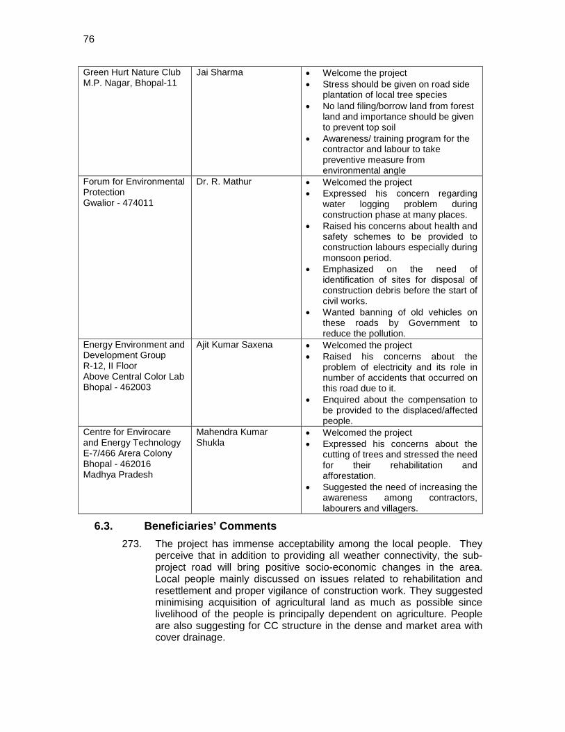
76
Green Hurt Nature Club M.P. Nagar, Bhopal-11
Jai Sharma • Welcome the project • Stress should be given on road side
plantation of local tree species • No land filing/borrow land from forest
land and importance should be given to prevent top soil
• Awareness/ training program for the contractor and labour to take preventive measure from environmental angle
Forum for Environmental Protection Gwalior - 474011
Dr. R. Mathur • Welcomed the project • Expressed his concern regarding
water logging problem during construction phase at many places.
• Raised his concerns about health and safety schemes to be provided to construction labours especially during monsoon period.
• Emphasized on the need of identification of sites for disposal of construction debris before the start of civil works.
• Wanted banning of old vehicles on these roads by Government to reduce the pollution.
Energy Environment and Development Group R-12, II Floor Above Central Color Lab Bhopal - 462003
Ajit Kumar Saxena • Welcomed the project • Raised his concerns about the
problem of electricity and its role in number of accidents that occurred on this road due to it.
• Enquired about the compensation to be provided to the displaced/affected people.
Centre for Envirocare and Energy Technology E-7/466 Arera Colony Bhopal - 462016 Madhya Pradesh
Mahendra Kumar Shukla
• Welcomed the project • Expressed his concerns about the
cutting of trees and stressed the need for their rehabilitation and afforestation.
• Suggested the need of increasing the awareness among contractors, labourers and villagers.
6.3. Beneficiaries’ Comments 273. The project has immense acceptability among the local people. They
perceive that in addition to providing all weather connectivity, the sub-project road will bring positive socio-economic changes in the area. Local people mainly discussed on issues related to rehabilitation and resettlement and proper vigilance of construction work. They suggested minimising acquisition of agricultural land as much as possible since livelihood of the people is principally dependent on agriculture. People are also suggesting for CC structure in the dense and market area with cover drainage.
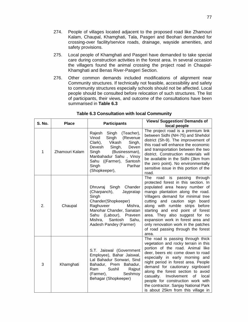
77
274. People of villages located adjacent to the proposed road like Zhamouri Kalam, Chaupal, Khamghati, Tala, Pasgeri and Beohari demanded for crossing-over facility/service roads, drainage, wayside amenities, and safety provisions.
275. Local people of Khamghati and Pasgeri have demanded to take special care during construction activities in the forest area. In several occasion the villagers found the animal crossing the project road in Chaupal- Khamghati and Benas River-Pasgeri Section.
276. Other common demands included modifications of alignment near Community structures. If technically not feasible, accessibility and safety to community structures especially schools should not be affected. Local people should be consulted before relocation of such structures. The list of participants, their views, and outcome of the consultations have been summarised in Table 6.3
Table 6.3 Consultation with local Community
S. No. Place Participants Views/ Suggestion/ Demands of local people
1 Zhamouri Kalam
Rajesh Singh (Teacher), Vinod Singh (Revenue Clark), Vikash Singh, Devesh Singh, Deven Singh (Businessman), Manbahadur Sahu , Vinoy Sahu ((Farmer), Santosh Singh Parihar (Shopkeeper),
The project road is a premium link between Sidhi (NH-75) and Shehdol district (Sh-9). The improvement of this road will enhance the economic and transportation between the two district. Construction materials will be available in the Sidhi (3km from the zero point). No environmentally sensitive issue in this portion of the road.
2. Chaupal
Dhruvraj Singh Chander (Charpanch), Jaypratap Singh Chander(Shopkeeper) Raghuveer Mishra, Manohar Chander, Sanatan Sahu (Labour), Praveen Mishra, Santosh Sahu, Aadesh Pandey (Farmer)
The road is passing through protected forest in this section. In populated area heavy number of mango plantation along the road. Villagers demand for minimal tree cutting and caution sign board along with rumble strips before starting and end point of forest area. They also suggest for no expansion work in forest area and only renovation work in the patches of road passing through the forest area.
3 Khamghati
S.T. Jaiswal (Government Employee), Bahar Jaiswal, Lal Bahadur Sonwari, Sind Bahadur, Prem Bahadur, Ram Sushil Rajput (Farmer), Seshmoy Behagar (Shopkeeper)
The road is passing through thick vegetation and rocky terrain in this portion of the road. Animal like deer, beers etc come down to road especially in early morning and night period in forest area. People demand for cautionary signboard along the forest section to avoid casualty. Involvement of local people for construction work with the contractor. Sanjay National Park is about 25km from this village in
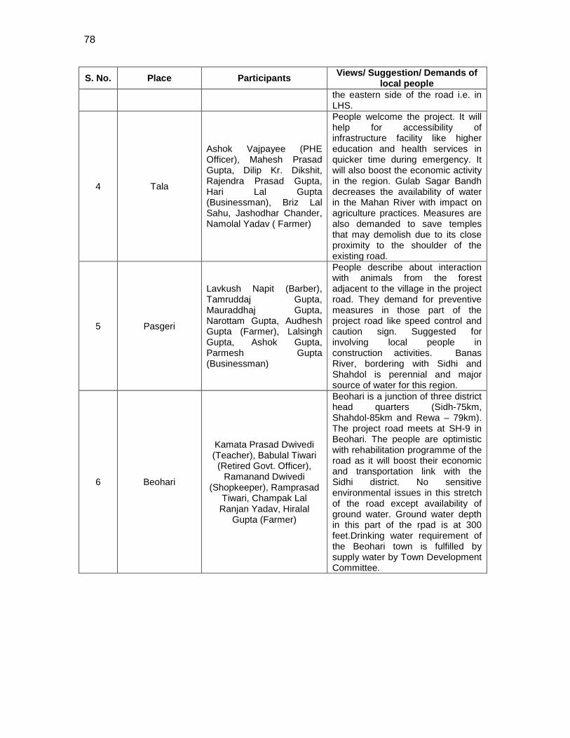
78
S. No. Place Participants Views/ Suggestion/ Demands of local people
the eastern side of the road i.e. in LHS.
4 Tala
Ashok Vajpayee (PHE Officer), Mahesh Prasad Gupta, Dilip Kr. Dikshit, Rajendra Prasad Gupta, Hari Lal Gupta (Businessman), Briz Lal Sahu, Jashodhar Chander, Namolal Yadav ( Farmer)
People welcome the project. It will help for accessibility of infrastructure facility like higher education and health services in quicker time during emergency. It will also boost the economic activity in the region. Gulab Sagar Bandh decreases the availability of water in the Mahan River with impact on agriculture practices. Measures are also demanded to save temples that may demolish due to its close proximity to the shoulder of the existing road.
5 Pasgeri
Lavkush Napit (Barber), Tamruddaj Gupta, Mauraddhaj Gupta, Narottam Gupta, Audhesh Gupta (Farmer), Lalsingh Gupta, Ashok Gupta, Parmesh Gupta (Businessman)
People describe about interaction with animals from the forest adjacent to the village in the project road. They demand for preventive measures in those part of the project road like speed control and caution sign. Suggested for involving local people in construction activities. Banas River, bordering with Sidhi and Shahdol is perennial and major source of water for this region.
6 Beohari
Kamata Prasad Dwivedi (Teacher), Babulal Tiwari (Retired Govt. Officer),
Ramanand Dwivedi (Shopkeeper), Ramprasad
Tiwari, Champak Lal Ranjan Yadav, Hiralal
Gupta (Farmer)
Beohari is a junction of three district head quarters (Sidh-75km, Shahdol-85km and Rewa – 79km). The project road meets at SH-9 in Beohari. The people are optimistic with rehabilitation programme of the road as it will boost their economic and transportation link with the Sidhi district. No sensitive environmental issues in this stretch of the road except availability of ground water. Ground water depth in this part of the rpad is at 300 feet.Drinking water requirement of the Beohari town is fulfilled by supply water by Town Development Committee.
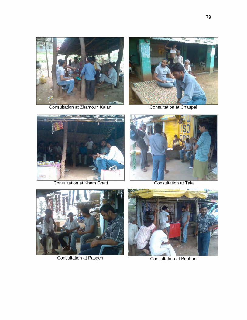
79
Consultation at Zhamouri Kalan
Consultation at Chaupal
Consultation at Kham Ghati
Consultation at Tala
Consultation at Pasgeri
Consultation at Beohari
80
7. ENVIRONMENTAL MANAGEMENT PLAN AND GRIEVANCE ADDRESSAL MECHANISM
7.1. Environmental Management Plan 277. The Environmental Management Plan (EMP) is prepared to facilitate
effective implementation of recommended mitigations measures with defined roles and responsibility, regulatory compliance requirements, stages of implementation with location, time frame and costs. The mitigation measures are proposed to eliminate or minimise the identified impact associated with design, construction and operation stages of the project, to acceptable level by adopting the most feasible options.
278. The EMP consists of action plans for (i) implementation of recommended mitigation measures, (ii) environment quality monitoring during construction and operation stage to assess the effectiveness of mitigation measures proposed, and (iii) institutional capacity building and training. The EMP is detailed at Appendix 7.1.
7.1.1. Social Development and Indigenous People Development Program (IPDP):
279. A separate Social Impact Assessment study is undertaken and social development programme is addressed as per this study. The involuntary resettlement issue is also addressed under separate study. However, the correlated issues like safety of habitats and workers, protection of common physical cultural resources, safe passage of habitats are addressed under environmental assessment and mitigation plan.
280. Since there is no indigenous population likely to be affected in the project area, IPDP is not envisaged. This has to be confirmed based on the social assessment.
7.1.2. Emergency Response Plan 281. Assessment of nature, type and extent of project activities establishes
that accidents on paved roads and consequent spillage can be the more frequent emergency. Other situation includes road overtopping due to heavy flood. It is suggested to develop a communication and response system to minimize the response time. The project authorities shall be prepared to counteract against such emergency either by developing in-house capabilities or by associating with any competent agency.
7.2. Environmental Monitoring Program (EMoP) 282. The environmental monitoring programme is prepared with aim to
monitor the environmental performance of environmental management plan. The EMOP is planned with the focus on following objectives:
• To the assess the effectiveness of mitigation measures proposed
• To assess the change in environmental quality during construction and operation stage with respect to before the project scenario.
• To assess compliance to regulatory requirements
81
• To monitor the status of corrective action taken in case of deviation from the planned measures or regulatory requirements.
283. This will be used as performance indicators for the project. A monitoring plan defining the parameters to be monitored, with sampling locations, frequency of measurements, cost and responsibility for various component of environment is prepared for all stages of project and provided as Appendix 7.2.
7.2.1. Monitoring schedule and performance indicator 284. The monitoring schedule has been developed based on the possible
occurrence of adverse impacts and required mitigation actions. However, this schedule is subject to change depending on the analysis results obtained. The performance indicators and protocol for changing the monitoring schedule is given below.
7.2.1.1.1 Tree Plantation
285. The 75% survival rate of re-plantation shall be monitored on the first year of the operation phase. If the survival rate is found below 75%, necessary measures will be taken to increase the survival rate and monitoring shall be again taken up up on the third year of operation. This cycle should continue until the 75% survival rate is achieved.
7.2.1.1.2 Soil Erosion and Drainage Congestion
286. No significant soil erosion problem is anticipated due to the project either in the construction phase or in the operation phase. However, in the construction phase, some localised soil erosion may be noticed owing to construction activities. However, if soil erosion is noticed during construction and operation phase, the corrective action shall be initiated and frequency of check be increased to assess the tendency of occurrence.
287. The cross drainage structure shall be free from siltation. Visual check shall be made periodically to identify any drainage congestion or water logging along the road. Appropriate corrective action shall be taken to clear the congestion and prevent reoccurrence.
7.2.1.1.3 Air and Noise Quality
288. Due to the variability of the construction activities, namely changes in batch composition, type of construction activity and other anthropogenic influences, the ambient air quality of the project area may change. If the air quality with respect to any parameter exceeds by more than 25% of its last monitored value, the monitoring frequency shall be doubled and cause of the increase investigated. If the construction activities are found to be the reason for this increase, suitable measures should be adopted.
289. Similarly, due to the variability in traffic movement, namely changes in traffic volume, traffic compositions and other anthropogenic influences, the noise quality in the project area is likely to change. If the noise quality exceeds by 20% of the applicable ambient noise quality standard or 10% of its last monitored value, the monitoring frequency shall be
82
increased and the cause of the increase investigated. If the construction activities are found to be the reason for this increase, suitable measures should be adopted.
7.2.1.1.4 Water Quality
290. No significant change in water quality is perceived due to the project in the operation phase. However, in the construction phase, the monitored values for pH, BOD, COD, TDS, DO and Oil & Grease might change owing to construction activities. Hence, it is suggested that if the monitored value for any water quality parameter exceeds by more than 20% of its last monitored status the monitoring frequency shall be increased.
7.2.2. Authorities and their Responsibilities for Implementation of EMoP 291. The most essential component of the Environment Monitoring Plan is
the execution of the Plan in accordance with the monitoring schedule provided therein. The field officer concerned at PIU will be responsible for timely monitoring of various parameters and compliance with the mitigative measure proposed. He can execute this task through supervision consultant. A resultant database is proposed to be maintained. A Management Information System (MIS) is also put in place for effective flow of information between various levels and functions within the MPRDC.
292. The monitoring reports shall be sent to Sr. Manager (Environment & Social) at head office with copy to Divisional Officer.
7.3. Institutional Setting and Proposed Implementation Arrangement 293. M. P. State Road Development Corporation (MPRDC) is responsible for
the development of state roads. MPRDC has set up divisional offices which act as Project Implementation Unit (PIU). Each PIU is headed by Divisional officer who is supported various engineers (field officers). These field officers also have the responsibility to comply with various regulatory permitting and compliance monitoring requirement. A Sr Manager (Environment & Social) is posted at Head Quarter who is responsible for overall environment and social management of sub projects. He reports to Dy General Manager who is responsible for the implementation of MPSRP_II and co-ordinate with ADB to monitor all environmental requirements of this subproject.
294. For subproject planning and implementation, Project Implementation Unit/s (PIUs) are established. This is headed by Divisional Officer and supported by Field officers. It is proposed to designate one of the field officers with additional responsibility of environment and social management. This officer shall be given adequate training for effective environmental management and monitoring. The designated field officer will be responsible for implementation and monitoring of EMP. Field Officer will monitor the compliance directly or with the help of supervision consultant. SQC will also supervise the contractor for complying the EMP requirements, monitoring requirements and obtaining the required permits. Divisional officer will overall responsible for ensuring effective
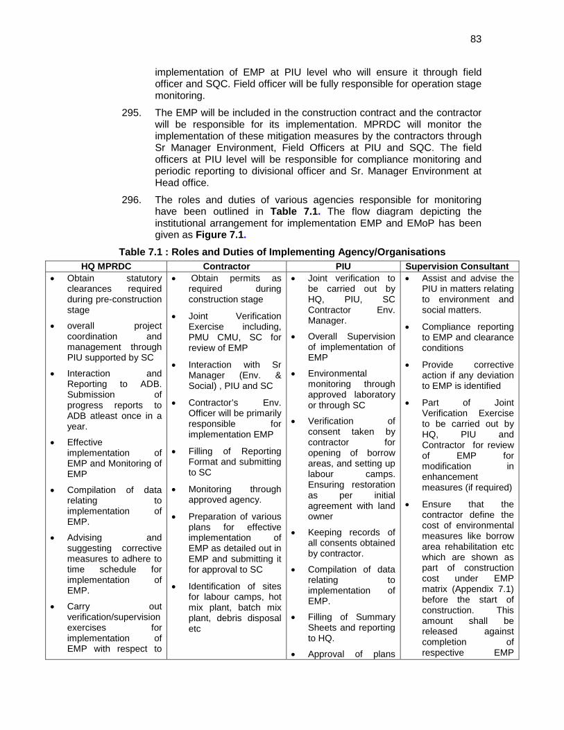
83
implementation of EMP at PIU level who will ensure it through field officer and SQC. Field officer will be fully responsible for operation stage monitoring.
295. The EMP will be included in the construction contract and the contractor will be responsible for its implementation. MPRDC will monitor the implementation of these mitigation measures by the contractors through Sr Manager Environment, Field Officers at PIU and SQC. The field officers at PIU level will be responsible for compliance monitoring and periodic reporting to divisional officer and Sr. Manager Environment at Head office.
296. The roles and duties of various agencies responsible for monitoring have been outlined in Table 7.1. The flow diagram depicting the institutional arrangement for implementation EMP and EMoP has been given as Figure 7.1.
Table 7.1 : Roles and Duties of Implementing Agency/Organisations HQ MPRDC Contractor PIU Supervision Consultant
• Obtain statutory clearances required during pre-construction stage
• overall project coordination and management through PIU supported by SC
• Interaction and Reporting to ADB. Submission of progress reports to ADB atleast once in a year.
• Effective implementation of EMP and Monitoring of EMP
• Compilation of data relating to implementation of EMP.
• Advising and suggesting corrective measures to adhere to time schedule for implementation of EMP.
• Carry out verification/supervision exercises for implementation of EMP with respect to
• Obtain permits as required during construction stage
• Joint Verification Exercise including, PMU CMU, SC for review of EMP
• Interaction with Sr Manager (Env. & Social) , PIU and SC
• Contractor’s Env. Officer will be primarily responsible for implementation EMP
• Filling of Reporting Format and submitting to SC
• Monitoring through approved agency.
• Preparation of various plans for effective implementation of EMP as detailed out in EMP and submitting it for approval to SC
• Identification of sites for labour camps, hot mix plant, batch mix plant, debris disposal etc
• Joint verification to be carried out by HQ, PIU, SC Contractor Env. Manager.
• Overall Supervision of implementation of EMP
• Environmental monitoring through approved laboratory or through SC
• Verification of consent taken by contractor for opening of borrow areas, and setting up labour camps. Ensuring restoration as per initial agreement with land owner
• Keeping records of all consents obtained by contractor.
• Compilation of data relating to implementation of EMP.
• Filling of Summary Sheets and reporting to HQ.
• Approval of plans
• Assist and advise the PIU in matters relating to environment and social matters.
• Compliance reporting to EMP and clearance conditions
• Provide corrective action if any deviation to EMP is identified
• Part of Joint Verification Exercise to be carried out by HQ, PIU and Contractor for review of EMP for modification in enhancement measures (if required)
• Ensure that the contractor define the cost of environmental measures like borrow area rehabilitation etc which are shown as part of construction cost under EMP matrix (Appendix 7.1) before the start of construction. This amount shall be released against completion of respective EMP
84
modification (if required) for enhancement measures.
prepared by contractor
• Addressing grievances of local community and information dissemination through NGOs/CBOs.
measures.
• Supervise implementation of EMP/EMoP by contractor
• Develop good practices construction guidelines to assist contractor in implementation of EMP
• Conduct Consultations programs with the stakeholders on regular basis to get first hand information on the inconvenience caused to contractor’s activities such as noise, debris disposal etc.
• Ensure submission of compliance report to EMP/EMoP once in six month to PIU
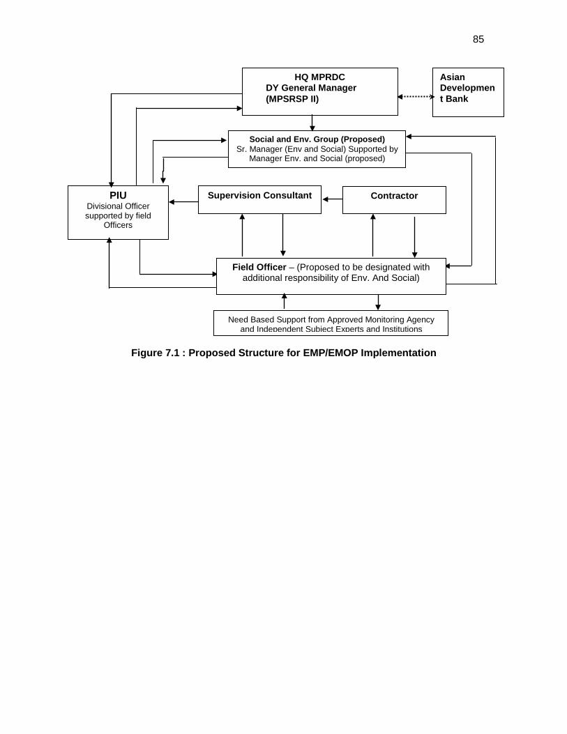
85
Figure 7.1 : Proposed Structure for EMP/EMOP Implementation
Social and Env. Group (Proposed) Sr. Manager (Env and Social) Supported by
Manager Env. and Social (proposed)
PIU Divisional Officer supported by field
Officers
Contractor
HQ MPRDC DY General Manager (MPSRSP II)
Field Officer – (Proposed to be designated with additional responsibility of Env. And Social)
Need Based Support from Approved Monitoring Agency and Independent Subject Experts and Institutions
Supervision Consultant
Asian Development Bank
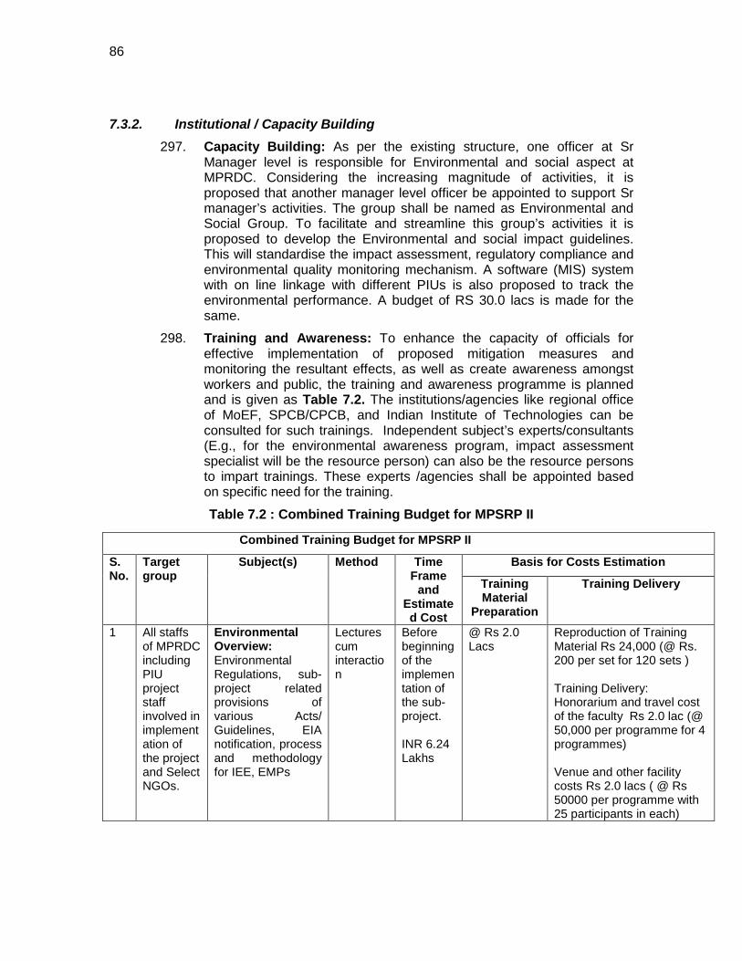
86
7.3.2. Institutional / Capacity Building 297. Capacity Building: As per the existing structure, one officer at Sr
Manager level is responsible for Environmental and social aspect at MPRDC. Considering the increasing magnitude of activities, it is proposed that another manager level officer be appointed to support Sr manager’s activities. The group shall be named as Environmental and Social Group. To facilitate and streamline this group’s activities it is proposed to develop the Environmental and social impact guidelines. This will standardise the impact assessment, regulatory compliance and environmental quality monitoring mechanism. A software (MIS) system with on line linkage with different PIUs is also proposed to track the environmental performance. A budget of RS 30.0 lacs is made for the same.
298. Training and Awareness: To enhance the capacity of officials for effective implementation of proposed mitigation measures and monitoring the resultant effects, as well as create awareness amongst workers and public, the training and awareness programme is planned and is given as Table 7.2. The institutions/agencies like regional office of MoEF, SPCB/CPCB, and Indian Institute of Technologies can be consulted for such trainings. Independent subject’s experts/consultants (E.g., for the environmental awareness program, impact assessment specialist will be the resource person) can also be the resource persons to impart trainings. These experts /agencies shall be appointed based on specific need for the training.
Table 7.2 : Combined Training Budget for MPSRP II
Combined Training Budget for MPSRP II
S. No.
Target group
Subject(s) Method Time Frame
and Estimated Cost
Basis for Costs Estimation
Training Material
Preparation
Training Delivery
1 All staffs of MPRDC including PIU project staff involved in implementation of the project and Select NGOs.
Environmental Overview: Environmental Regulations, sub-project related provisions of various Acts/ Guidelines, EIA notification, process and methodology for IEE, EMPs
Lectures cum interaction
Before beginning of the implementation of the sub-project. INR 6.24 Lakhs
@ Rs 2.0 Lacs
Reproduction of Training Material Rs 24,000 (@ Rs. 200 per set for 120 sets ) Training Delivery: Honorarium and travel cost of the faculty Rs 2.0 lac (@ 50,000 per programme for 4 programmes) Venue and other facility costs Rs 2.0 lacs ( @ Rs 50000 per programme with 25 participants in each)
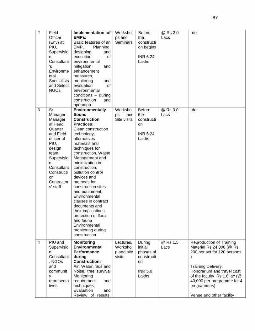
87
2 Field Officer (Env) at PIU, Supervision Consultant’s Environmental Specialists and Select NGOs
Implementation of EMPs: Basic features of an EMP, Planning, designing and execution of environmental mitigation and enhancement measures, monitoring and evaluation of environmental conditions – during construction and operation
Workshops and Seminars
Before the construction begins INR 6.24 Lakhs
@ Rs 2.0 Lacs
-do-
3 Sr Manager, Manager at Head Quarter and Field officer at PIU, , design team, Supervision Consultant Construction Contractors’ staff
Environmentally Sound Construction Practices: Clean construction technology, alternatives materials and techniques for construction, Waste Management and minimization in construction, pollution control devices and methods for construction sites and equipment, Environmental clauses in contract documents and their implications, protection of flora and fauna Environmental monitoring during construction
Workshops and Site visits
Before the construction INR 6.24 Lakhs
@ Rs 3.0 Lacs
-do-
4 PIU and Supervision Consultant, NGOs and community representatives
Monitoring Environmental Performance during Construction: Air, Water, Soil and Noise, tree survival Monitoring requirement and techniques, Evaluation and Review of results,
Lectures, Workshop and site visits
During initial phases of construction INR 5.0 Lakhs
@ Rs 1.5 Lacs
Reproduction of Training Material Rs 24,000 (@ Rs. 200 per set for 120 persons ) Training Delivery: Honorarium and travel cost of the faculty Rs 1.6 lac (@ 40,000 per programme for 4 programmes) Venue and other facility
88
299. Management System: It is proposed to develop standard environmental guidelines for impact assessment, management plan, and monitoring. It is recommended to develop an Environmental Management and Reporting Systems following international standards like ISO 14001.
7.4. Grievance Redressal Mechanism 300. Any environmental grievance received from public or stakeholders
concerning the project will be directed to the concerned PIU. Firstly, field officer will assess if the grievances are genuine or suggestion is acceptable. Accordingly, response will be given within 15-30 days through suitable mode by the field officer with the approval of Divisional Officer. In case PIU is unable to resolve the issue, the matter will be forwarded to Sr. Manager ( Environment & Social) at head quarter who will take it up further and resolve. The corrective and preventing action will be taken in a time bound manner as per response given to the stakeholders. The outcome shall also form part of quarterly report to ADB.
301. The local community will be informed by the respective supervision consultants about the option to express their grievances if any through the mechanism described above before the start of construction activities. The grievance redress mechanism with the name of concerned official shall also be displayed at MPRDC website, and on notice boards of the PIU office and construction sites.
Performance indicators and their applicability, possible corrective actions, reporting requirements and mechanisms
costs Rs 1.6 lacs ( @ Rs 40,000 per programme with 25 participants in each)
Total Training Costs
Rs 23.72 lacs or Say Rs. 24 lacs
89
8. CONCLUSIONS AND RECOMMENDATIONS 8.1. Conclusions
302. The findings of Environment Assessment indicate that project is unlikely to cause any significant environmental impacts. While some of the impacts are negative, there are many bearing benefits to the area. Most of the impacts are likely to occur during construction stage and are temporary in nature and can be mitigated with minor to negligible residual impacts. Some impacts require design consideration and are suitably addressed. The project received immense support from local people as they perceive that this project will improve the overall connectivity and bring various economic opportunities to the people of the area.
303. The alignment does not pass through or located nearby any ecologically sensitive or protected areas. No archaeological/protected monument is located in the project vicinity. The land use pattern around the alignment is predominantly agricultural. The significant impact during construction is mainly associated with minor increase in dust borne air pollution, increased noise level, nuisance due to movement and operation of vehicles, establishment of temporary facilities, hindrance in accessibility to common property resources etc. During operation stage, the main impact may be related to air quality and noise. Other issues relates to road safety including pedestrian and cattles.
304. Environmental screening and assessment of likely impacts, the project has been categorised as Category ‘B’. The effective implementation of environmental management plan will facilitate in minimising the environmental impact to acceptable level. No additional studies or need of undertaking detailed EIA is envisaged at this stage.
305. Key findings of the IEE are summarised in following paragraphs:
• The groundwater condition in the project section is poor. Hence, provisions of water harvesting should be adopted.
• Drainage along the roadside is poor. Hence, adequate measures are required as per the mitigation measures suggested in the IEE.
• Since no land acquisition is involved, the project will not affect any family. Also, there will be no Impact on community infrastructure as the upgradation is limited to the available ROW.
• Ambient noise level is within prescribed limit except near busy intersections. Some of the key suggested measures during construction are provision of temporary noise barriers and regulating construction timings near sensitive locations. Operation stage mitigation includes multilayered plantation and restricting honking near sensitive areas, maintaining good road conditions and congestion free traffic movement.
• Large quantity of earth is required for the project. The availability of government waste land/barren land/uplands etc. is limited in the area. Morrum and borrow area is available in the nearby area but sand and metals need to be sourced from distant locations such as Damoh.
90
• The compensatory afforestation should be undertaken at 1:5 basis in close consultation with forest department. Roadside plantation should be done as per IRC specifications. Additional plantation should be done in consultation at river banks especially at major bridge locations.
• Soil erosion along embankment slope, river banks, bridge sites and river training structures shall be checked through measures suggested in IEE. These measures coupled with silt fencing/brush barrier etc will also help to minimise siltation of water bodies though required at only few locations since most of the water bodies are seasonal in nature.
• Predominant land use along the project alignment is agricultural/open area which helps in adequate dispersion of air emission. The increased pollution level during construction stage will be largely localised and temporary in nature. Corridor specific measures to curb emission include maintaining good road conditions, improved traffic regulations and roadside plantation with pollutant absorbent species.
• Siting and management of temporary construction facilities i.e. construction camp, workers camp, hot mix plant, batching plant, dumping sites, stone crusher etc. shall be done in environmentally accepted manner as mentioned in IEE.
• Dismantled material shall be reused to the extent possible. Leftover debris shall be disposed off in environmentally acceptable method and at designated sites.
• Risk involved with accidents, community and occupational health safety should be mitigated as per measures provided in IEE. A proper traffic management plan shall be in place well before start of the construction.
306. Post Environmental Assessment Surveillance and Monitoring is essential to sustain the effectiveness of the mitigative measures suggested. A detailed monitoring plan has been prepared as part of the Environmental Management Plan. The focus areas of monitoring covers air, surface water quality, noise, soil erosion, drainage congestion and tree survival rate. The reporting requirements along with the follow up actions in case of deviation from the norms have been detailed out as a part of EMP. The frequency has been set in consideration of the likely impacts.
8.2. Key Recommendations: 307. Any major changes or any major additional work other than the proposed
project activities will require preparation of another environmental assessment. This additional assessment will have to be submitted to concerned Government authorities and ADB for concurrence before civil works commence.
308. The implementation of prescribed mitigation measures will minimize/avoid the adverse impacts. Moreover, the impacts shall be monitored continually by implementing and updating the Environmental Management plan and Environmental Monitoring Plan. Environmental Management and Monitoring Plan may be updated if deemed necessary as per site conditions. MPRDC shall submit six monthly compliance/update reports to ADB.

91
309. All necessary clearances/permissions/No-objections/Consents should be obtained as required at different stages and as outlined in legal framework chapter of IEE. MPRDC shall ensure that environmental clearance as may be required is obtained before start of construction.
310. Executing agency shall ensure that EMP and EMoP is included in Bill of Quantity (BOQ) and forms part of bid document and civil works contract. The same shall be revised if necessary during project implementation or if there is any change in the project design and with approval of ADB.
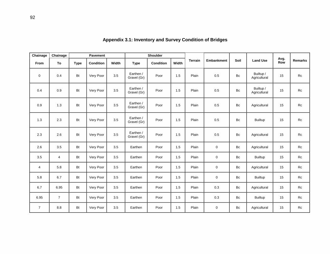
92
Appendix 3.1: Inventory and Survey Condition of Bridges
Chainage Chainage Pavement Shoulder
Terrain Embankment Soil Land Use Avg. Row Remarks
From To Type Condition Width Type Condition Width
0 0.4 Bt Very Poor 3.5 Earthen / Gravel (Gr) Poor 1.5 Plain 0.5 Bc Builtup /
Agricultural 15 Rc
0.4 0.9 Bt Very Poor 3.5 Earthen / Gravel (Gr) Poor 1.5 Plain 0.5 Bc Builtup /
Agricultural 15 Rc
0.9 1.3 Bt Very Poor 3.5 Earthen / Gravel (Gr) Poor 1.5 Plain 0.5 Bc Agricultural 15 Rc
1.3 2.3 Bt Very Poor 3.5 Earthen / Gravel (Gr) Poor 1.5 Plain 0.5 Bc Builtup 15 Rc
2.3 2.6 Bt Very Poor 3.5 Earthen / Gravel (Gr) Poor 1.5 Plain 0.5 Bc Agricultural 15 Rc
2.6 3.5 Bt Very Poor 3.5 Earthen Poor 1.5 Plain 0 Bc Agricultural 15 Rc
3.5 4 Bt Very Poor 3.5 Earthen Poor 1.5 Plain 0 Bc Builtup 15 Rc
4 5.8 Bt Very Poor 3.5 Earthen Poor 1.5 Plain 0 Bc Agricultural 15 Rc
5.8 6.7 Bt Very Poor 3.5 Earthen Poor 1.5 Plain 0 Bc Builtup 15 Rc
6.7 6.95 Bt Very Poor 3.5 Earthen Poor 1.5 Plain 0.3 Bc Agricultural 15 Rc
6.95 7 Bt Very Poor 3.5 Earthen Poor 1.5 Plain 0.3 Bc Builtup 15 Rc
7 8.8 Bt Very Poor 3.5 Earthen Poor 1.5 Plain 0 Bc Agricultural 15 Rc
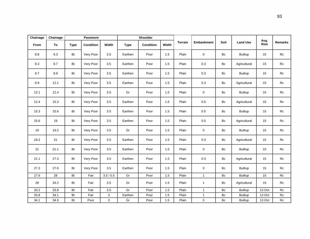
93
Chainage Chainage Pavement Shoulder Terrain Embankment Soil Land Use Avg.
Row Remarks From To Type Condition Width Type Condition Width
8.8 9.3 Bt Very Poor 3.5 Earthen Poor 1.5 Plain 0 Bc Builtup 15 Rc
9.3 9.7 Bt Very Poor 3.5 Earthen Poor 1.5 Plain 0.3 Bc Agricultural 15 Rc
9.7 9.9 Bt Very Poor 3.5 Earthen Poor 1.5 Plain 0.3 Bc Builtup 15 Rc
9.9 12.1 Bt Very Poor 3.5 Earthen Poor 1.5 Plain 0.3 Bc Agricultural 15 Rc
12.1 12.4 Bt Very Poor 3.5 Gr Poor 1.5 Plain 0 Bc Builtup 15 Rc
12.4 15.3 Bt Very Poor 3.5 Earthen Poor 1.5 Plain 0.5 Bc Agricultural 15 Rc
15.3 15.6 Bt Very Poor 3.5 Earthen Poor 1.5 Plain 0.5 Bc Builtup 15 Rc
15.6 19 Bt Very Poor 3.5 Earthen Poor 1.5 Plain 0.5 Bc Agricultural 15 Rc
19 19.2 Bt Very Poor 3.5 Gr Poor 1.5 Plain 0 Bc Builtup 15 Rc
19.2 21 Bt Very Poor 3.5 Earthen Poor 1.5 Plain 0.3 Bc Agricultural 15 Rc
21 21.1 Bt Very Poor 3.5 Earthen Poor 1.5 Plain 0 Bc Builtup 15 Rc
21.1 27.3 Bt Very Poor 3.5 Earthen Poor 1.5 Plain 0.3 Bc Agricultural 15 Rc
27.3 27.6 Bt Very Poor 3.5 Earthen Poor 1.5 Plain 0 Bc Builtup 15 Rc
27.6 28 Bt Fair 3.5 / 5.5 Gr Poor 1.5 Plain 1 Bc Builtup 15 Rc
28 33.2 Bt Fair 3.5 Gr Poor 1.5 Plain 1 Bc Agricultural 15 Rc
33.2 33.8 Bt Fair 3.5 Gr Poor 1.5 Plain 1 Bc Builtup 12-Oct Rc 33.8 34.1 Bt Fair 3 Earthen Poor 1.5 Plain 1 Bc Builtup 12-Oct Rc 34.1 34.9 Bt Poor 3 Gr Poor 1.5 Plain 0 Bc Builtup 12-Oct Rc
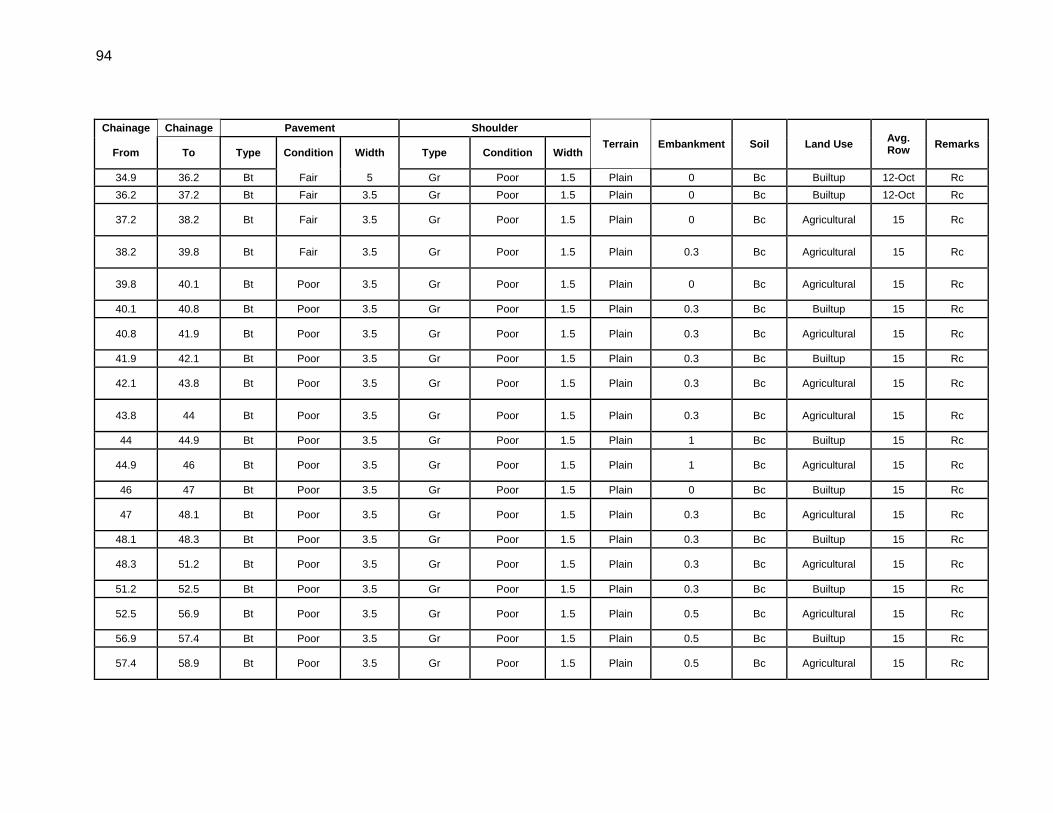
94
Chainage Chainage Pavement Shoulder Terrain Embankment Soil Land Use Avg.
Row Remarks From To Type Condition Width Type Condition Width
34.9 36.2 Bt Fair 5 Gr Poor 1.5 Plain 0 Bc Builtup 12-Oct Rc 36.2 37.2 Bt Fair 3.5 Gr Poor 1.5 Plain 0 Bc Builtup 12-Oct Rc
37.2 38.2 Bt Fair 3.5 Gr Poor 1.5 Plain 0 Bc Agricultural 15 Rc
38.2 39.8 Bt Fair 3.5 Gr Poor 1.5 Plain 0.3 Bc Agricultural 15 Rc
39.8 40.1 Bt Poor 3.5 Gr Poor 1.5 Plain 0 Bc Agricultural 15 Rc
40.1 40.8 Bt Poor 3.5 Gr Poor 1.5 Plain 0.3 Bc Builtup 15 Rc
40.8 41.9 Bt Poor 3.5 Gr Poor 1.5 Plain 0.3 Bc Agricultural 15 Rc
41.9 42.1 Bt Poor 3.5 Gr Poor 1.5 Plain 0.3 Bc Builtup 15 Rc
42.1 43.8 Bt Poor 3.5 Gr Poor 1.5 Plain 0.3 Bc Agricultural 15 Rc
43.8 44 Bt Poor 3.5 Gr Poor 1.5 Plain 0.3 Bc Agricultural 15 Rc
44 44.9 Bt Poor 3.5 Gr Poor 1.5 Plain 1 Bc Builtup 15 Rc
44.9 46 Bt Poor 3.5 Gr Poor 1.5 Plain 1 Bc Agricultural 15 Rc
46 47 Bt Poor 3.5 Gr Poor 1.5 Plain 0 Bc Builtup 15 Rc
47 48.1 Bt Poor 3.5 Gr Poor 1.5 Plain 0.3 Bc Agricultural 15 Rc
48.1 48.3 Bt Poor 3.5 Gr Poor 1.5 Plain 0.3 Bc Builtup 15 Rc
48.3 51.2 Bt Poor 3.5 Gr Poor 1.5 Plain 0.3 Bc Agricultural 15 Rc
51.2 52.5 Bt Poor 3.5 Gr Poor 1.5 Plain 0.3 Bc Builtup 15 Rc
52.5 56.9 Bt Poor 3.5 Gr Poor 1.5 Plain 0.5 Bc Agricultural 15 Rc
56.9 57.4 Bt Poor 3.5 Gr Poor 1.5 Plain 0.5 Bc Builtup 15 Rc
57.4 58.9 Bt Poor 3.5 Gr Poor 1.5 Plain 0.5 Bc Agricultural 15 Rc
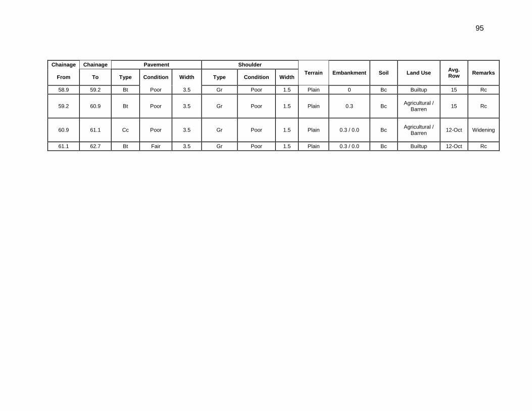
95
Chainage Chainage Pavement Shoulder Terrain Embankment Soil Land Use Avg.
Row Remarks From To Type Condition Width Type Condition Width
58.9 59.2 Bt Poor 3.5 Gr Poor 1.5 Plain 0 Bc Builtup 15 Rc
59.2 60.9 Bt Poor 3.5 Gr Poor 1.5 Plain 0.3 Bc Agricultural / Barren 15 Rc
60.9 61.1 Cc Poor 3.5 Gr Poor 1.5 Plain 0.3 / 0.0 Bc Agricultural / Barren 12-Oct Widening
61.1 62.7 Bt Fair 3.5 Gr Poor 1.5 Plain 0.3 / 0.0 Bc Builtup 12-Oct Rc
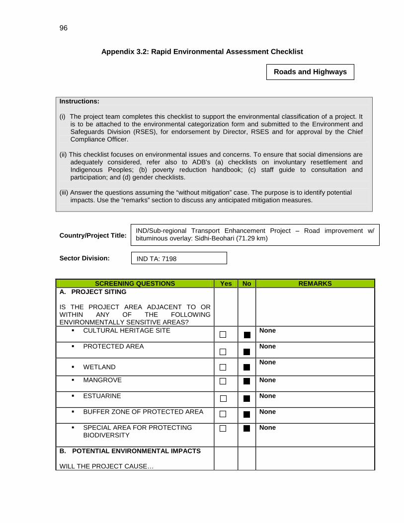
96
Appendix 3.2: Rapid Environmental Assessment Checklist
Instructions: (i) The project team completes this checklist to support the environmental classification of a project. It
is to be attached to the environmental categorization form and submitted to the Environment and Safeguards Division (RSES), for endorsement by Director, RSES and for approval by the Chief Compliance Officer.
(ii) This checklist focuses on environmental issues and concerns. To ensure that social dimensions are
adequately considered, refer also to ADB's (a) checklists on involuntary resettlement and Indigenous Peoples; (b) poverty reduction handbook; (c) staff guide to consultation and participation; and (d) gender checklists.
(iii) Answer the questions assuming the “without mitigation” case. The purpose is to identify potential
impacts. Use the “remarks” section to discuss any anticipated mitigation measures.
Country/Project Title: Sector Division:
SCREENING QUESTIONS Yes No REMARKS A. PROJECT SITING IS THE PROJECT AREA ADJACENT TO OR WITHIN ANY OF THE FOLLOWING ENVIRONMENTALLY SENSITIVE AREAS?
CULTURAL HERITAGE SITE
None
PROTECTED AREA
None
WETLAND None
MANGROVE
None
ESTUARINE
None
BUFFER ZONE OF PROTECTED AREA
None
SPECIAL AREA FOR PROTECTING BIODIVERSITY
None
B. POTENTIAL ENVIRONMENTAL IMPACTS WILL THE PROJECT CAUSE…
Roads and Highways
IND/Sub-regional Transport Enhancement Project – Road improvement w/ bituminous overlay: Sidhi-Beohari (71.29 km)
IND TA: 7198
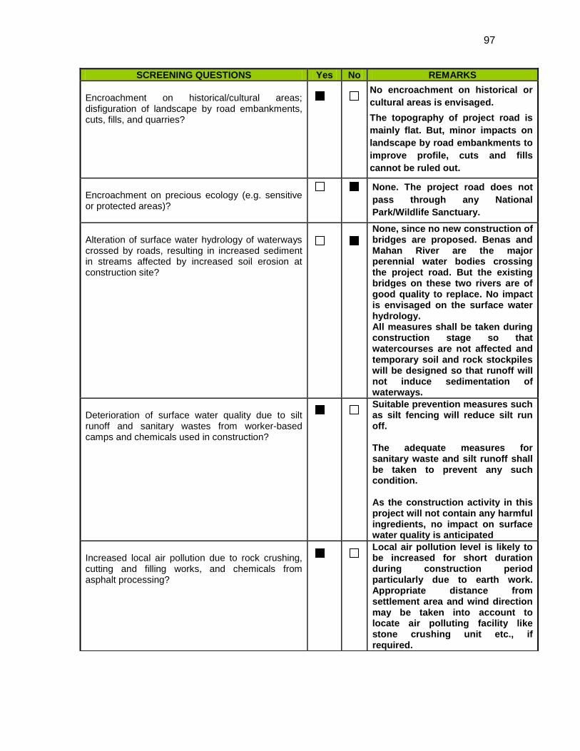
97
SCREENING QUESTIONS Yes No REMARKS Encroachment on historical/cultural areas; disfiguration of landscape by road embankments, cuts, fills, and quarries?
No encroachment on historical or cultural areas is envisaged. The topography of project road is mainly flat. But, minor impacts on landscape by road embankments to improve profile, cuts and fills cannot be ruled out.
Encroachment on precious ecology (e.g. sensitive or protected areas)?
None. The project road does not pass through any National Park/Wildlife Sanctuary.
Alteration of surface water hydrology of waterways crossed by roads, resulting in increased sediment in streams affected by increased soil erosion at construction site?
None, since no new construction of bridges are proposed. Benas and Mahan River are the major perennial water bodies crossing the project road. But the existing bridges on these two rivers are of good quality to replace. No impact is envisaged on the surface water hydrology. All measures shall be taken during construction stage so that watercourses are not affected and temporary soil and rock stockpiles will be designed so that runoff will not induce sedimentation of waterways.
Deterioration of surface water quality due to silt runoff and sanitary wastes from worker-based camps and chemicals used in construction?
Suitable prevention measures such as silt fencing will reduce silt run off. The adequate measures for sanitary waste and silt runoff shall be taken to prevent any such condition. As the construction activity in this project will not contain any harmful ingredients, no impact on surface water quality is anticipated
Increased local air pollution due to rock crushing, cutting and filling works, and chemicals from asphalt processing?
Local air pollution level is likely to be increased for short duration during construction period particularly due to earth work. Appropriate distance from settlement area and wind direction may be taken into account to locate air polluting facility like stone crushing unit etc., if required.
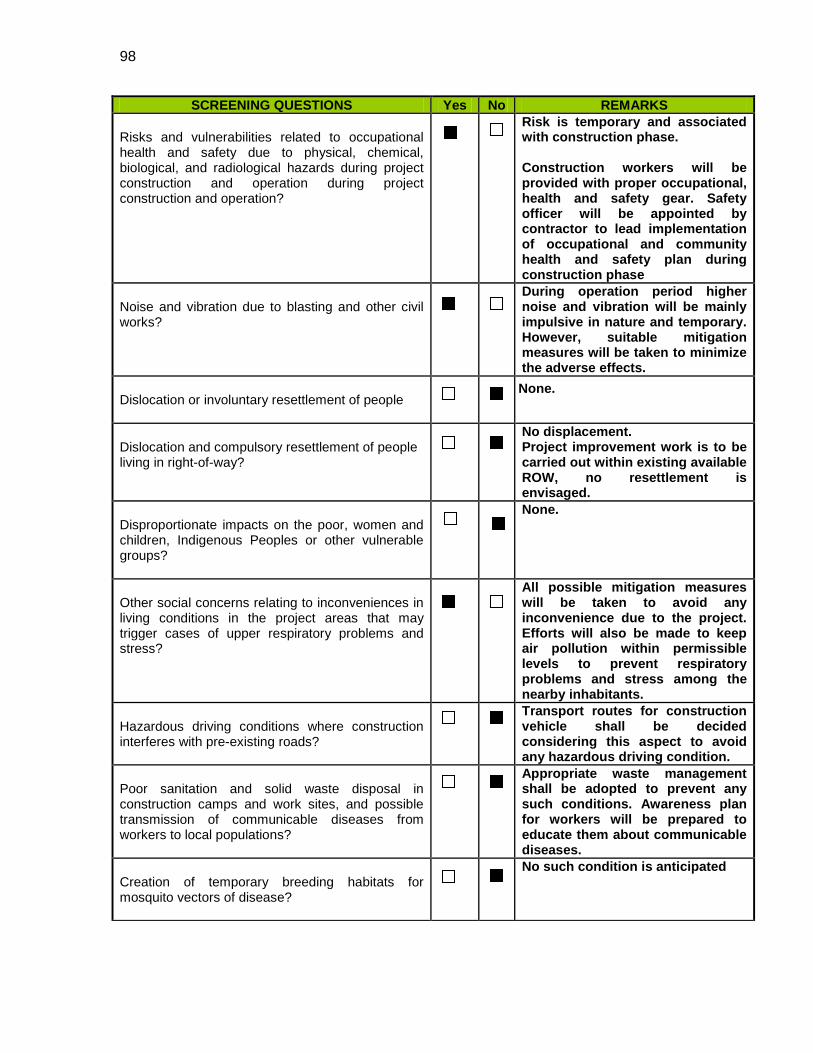
98
SCREENING QUESTIONS Yes No REMARKS Risks and vulnerabilities related to occupational health and safety due to physical, chemical, biological, and radiological hazards during project construction and operation during project construction and operation?
Risk is temporary and associated with construction phase. Construction workers will be provided with proper occupational, health and safety gear. Safety officer will be appointed by contractor to lead implementation of occupational and community health and safety plan during construction phase
Noise and vibration due to blasting and other civil works?
During operation period higher noise and vibration will be mainly impulsive in nature and temporary. However, suitable mitigation measures will be taken to minimize the adverse effects.
Dislocation or involuntary resettlement of people
None.
Dislocation and compulsory resettlement of people living in right-of-way?
No displacement. Project improvement work is to be carried out within existing available ROW, no resettlement is envisaged.
Disproportionate impacts on the poor, women and children, Indigenous Peoples or other vulnerable groups?
None.
Other social concerns relating to inconveniences in living conditions in the project areas that may trigger cases of upper respiratory problems and stress?
All possible mitigation measures will be taken to avoid any inconvenience due to the project. Efforts will also be made to keep air pollution within permissible levels to prevent respiratory problems and stress among the nearby inhabitants.
Hazardous driving conditions where construction interferes with pre-existing roads?
Transport routes for construction vehicle shall be decided considering this aspect to avoid any hazardous driving condition.
Poor sanitation and solid waste disposal in construction camps and work sites, and possible transmission of communicable diseases from workers to local populations?
Appropriate waste management shall be adopted to prevent any such conditions. Awareness plan for workers will be prepared to educate them about communicable diseases.
Creation of temporary breeding habitats for mosquito vectors of disease?
No such condition is anticipated
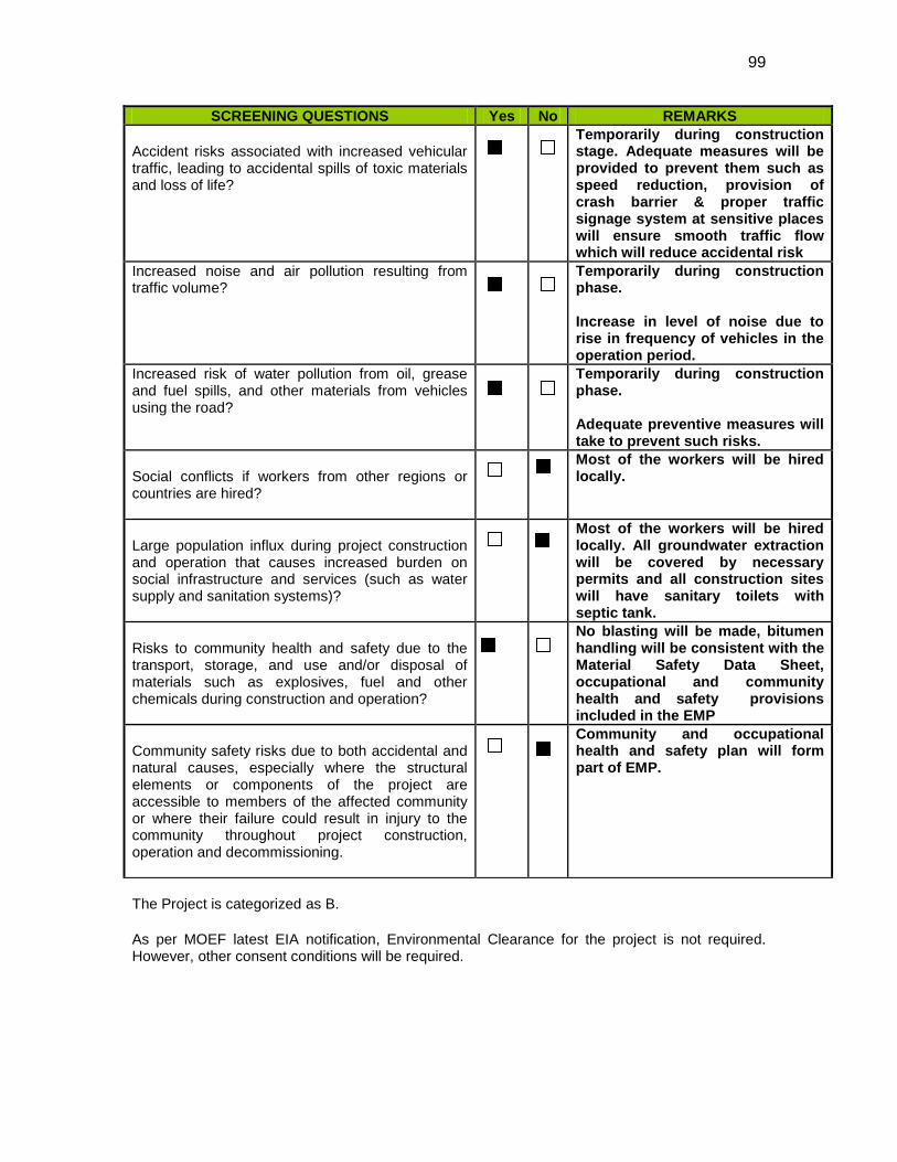
99
SCREENING QUESTIONS Yes No REMARKS Accident risks associated with increased vehicular traffic, leading to accidental spills of toxic materials and loss of life?
Temporarily during construction stage. Adequate measures will be provided to prevent them such as speed reduction, provision of crash barrier & proper traffic signage system at sensitive places will ensure smooth traffic flow which will reduce accidental risk
Increased noise and air pollution resulting from traffic volume?
Temporarily during construction phase. Increase in level of noise due to rise in frequency of vehicles in the operation period.
Increased risk of water pollution from oil, grease and fuel spills, and other materials from vehicles using the road?
Temporarily during construction phase. Adequate preventive measures will take to prevent such risks.
Social conflicts if workers from other regions or countries are hired?
Most of the workers will be hired locally.
Large population influx during project construction and operation that causes increased burden on social infrastructure and services (such as water supply and sanitation systems)?
Most of the workers will be hired locally. All groundwater extraction will be covered by necessary permits and all construction sites will have sanitary toilets with septic tank.
Risks to community health and safety due to the transport, storage, and use and/or disposal of materials such as explosives, fuel and other chemicals during construction and operation?
No blasting will be made, bitumen handling will be consistent with the Material Safety Data Sheet, occupational and community health and safety provisions included in the EMP
Community safety risks due to both accidental and natural causes, especially where the structural elements or components of the project are accessible to members of the affected community or where their failure could result in injury to the community throughout project construction, operation and decommissioning.
Community and occupational health and safety plan will form part of EMP.
The Project is categorized as B. As per MOEF latest EIA notification, Environmental Clearance for the project is not required. However, other consent conditions will be required.
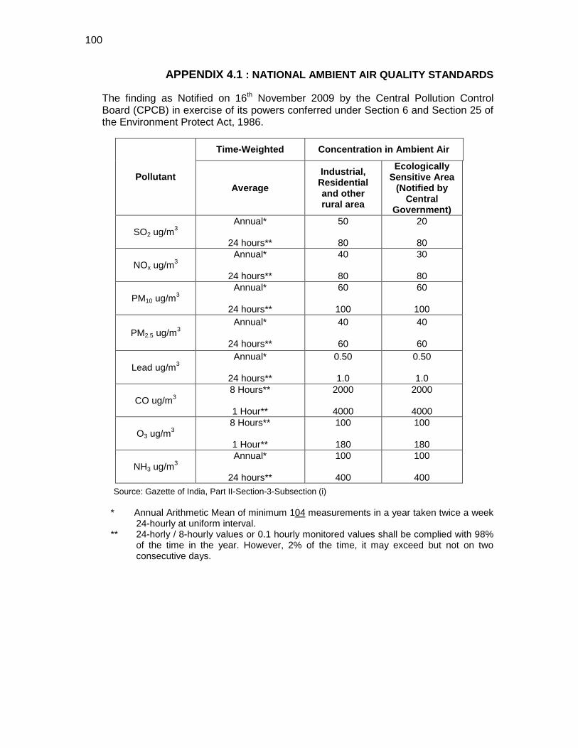
100
APPENDIX 4.1 : NATIONAL AMBIENT AIR QUALITY STANDARDS
The finding as Notified on 16th November 2009 by the Central Pollution Control Board (CPCB) in exercise of its powers conferred under Section 6 and Section 25 of the Environment Protect Act, 1986.
Source: Gazette of India, Part II-Section-3-Subsection (i) * Annual Arithmetic Mean of minimum 104
** 24-horly / 8-hourly values or 0.1 hourly monitored values shall be complied with 98% of the time in the year. However, 2% of the time, it may exceed but not on two consecutive days.
measurements in a year taken twice a week 24-hourly at uniform interval.
Pollutant
Time-Weighted Concentration in Ambient Air
Average
Industrial, Residential and other rural area
Ecologically Sensitive Area
(Notified by Central
Government)
SO2 ug/m3 Annual*
24 hours**
50
80
20
80
NOx ug/m3 Annual*
24 hours**
40
80
30
80
PM10 ug/m3
Annual*
24 hours**
60
100
60
100
PM2.5 ug/m3 Annual*
24 hours**
40
60
40
60
Lead ug/m3 Annual*
24 hours**
0.50
1.0
0.50
1.0
CO ug/m3 8 Hours**
1 Hour**
2000
4000
2000
4000
O3 ug/m3 8 Hours**
1 Hour**
100
180
100
180
NH3 ug/m3 Annual*
24 hours**
100
400
100
400
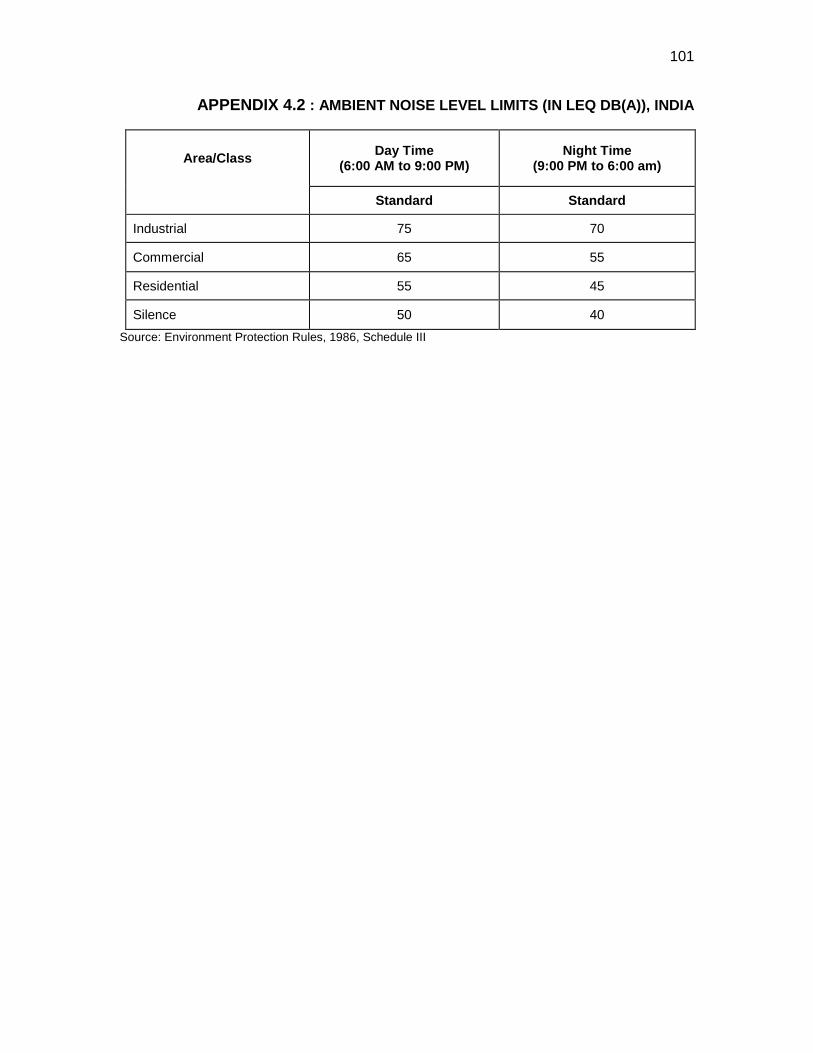
101
APPENDIX 4.2 : AMBIENT NOISE LEVEL LIMITS (IN LEQ DB(A)), INDIA
Area/Class Day Time (6:00 AM to 9:00 PM)
Night Time (9:00 PM to 6:00 am)
Standard Standard
Industrial 75 70
Commercial 65 55
Residential 55 45
Silence 50 40 Source: Environment Protection Rules, 1986, Schedule III
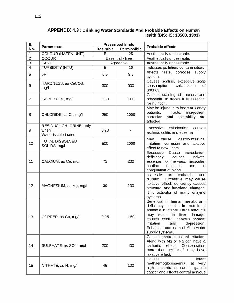
102
APPENDIX 4.3 : Drinking Water Standards And Probable Effects on Human Health (BIS: IS: 10500, 1991)
S. No. Parameters Prescribed limits Probable effects Desirable Permissible 1 COLOUR (HAZEN UNIT) 5 25 Aesthetically undesirable. 2 ODOUR Essentially free Aesthetically undesirable. 3 TASTE Agreeable Aesthetically undesirable. 4 TURBIDITY (NTU) 5 10 Indicates pollution/ contamination.
5 pH 6.5 8.5 Affects taste, corrodes supply system.
6 HARDNESS, as CaCO3, mg/l 300 600
Causes scaling, excessive soap consumption, calcification of arteries.
7 IRON, as Fe , mg/l 0.30 1.00 Causes staining of laundry and porcelain. In traces it is essential for nutrition.
8 CHLORIDE, as Cl , mg/l 250 1000
May be injurious to heart or kidney patients. Taste, indigestion, corrosion and palatability are affected.
9 RESIDUAL CHLORINE, only when Water is chlorinated
0.20 - Excessive chlorination causes asthma, colitis and eczema
10 TOTAL DISSOLVED SOLIDS, mg/l 500 2000
May cause gastro-intestinal irritation, corrosion and laxative effect to new users.
11 CALCIUM, as Ca, mg/l 75 200
Excessive Cause incrustation, deficiency causes rickets, essential for nervous, muscular, cardiac functions and in coagulation of blood.
12 MAGNESIUM, as Mg, mg/l 30 100
Its salts are cathartics and diuretic. Excessive may cause laxative effect; deficiency causes structural and functional changes. It is activator of many enzyme systems.
13 COPPER, as Cu, mg/l 0.05 1.50
Beneficial in human metabolism, deficiency results in nutritional anaemia in infants. Large amounts may result in liver damage, causes central nervous system irritation and depression. Enhances corrosion of Al in water supply systems.
14 SULPHATE, as SO4, mg/l 200 400
Causes gastro-intestinal irritation. Along with Mg or Na can have a cathartic effect. Concentration more than 750 mg/l may have laxative effect.
15 NITRATE, as N, mg/l 45 100
Causes infant methaemoglobinaemia, at very high concentration causes gastric cancer and effects central nervous
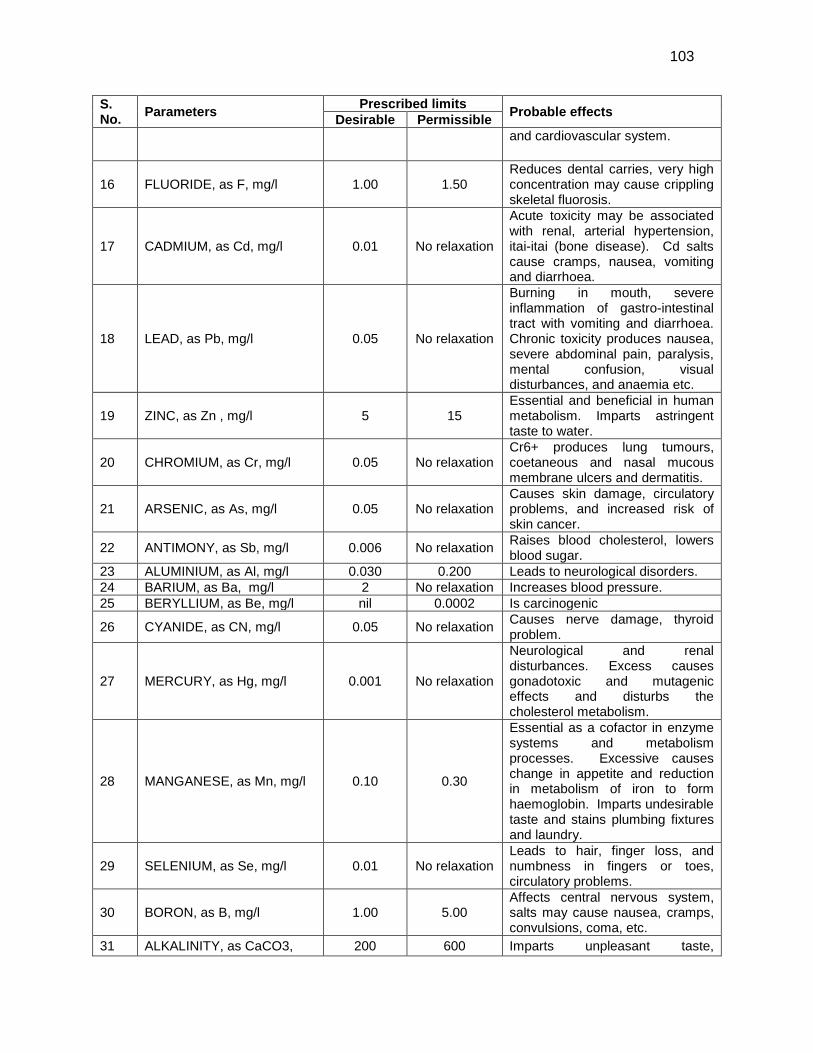
103
S. No. Parameters Prescribed limits Probable effects Desirable Permissible
and cardiovascular system.
16 FLUORIDE, as F, mg/l 1.00 1.50 Reduces dental carries, very high concentration may cause crippling skeletal fluorosis.
17 CADMIUM, as Cd, mg/l 0.01 No relaxation
Acute toxicity may be associated with renal, arterial hypertension, itai-itai (bone disease). Cd salts cause cramps, nausea, vomiting and diarrhoea.
18 LEAD, as Pb, mg/l 0.05 No relaxation
Burning in mouth, severe inflammation of gastro-intestinal tract with vomiting and diarrhoea. Chronic toxicity produces nausea, severe abdominal pain, paralysis, mental confusion, visual disturbances, and anaemia etc.
19 ZINC, as Zn , mg/l 5 15 Essential and beneficial in human metabolism. Imparts astringent taste to water.
20 CHROMIUM, as Cr, mg/l 0.05 No relaxation Cr6+ produces lung tumours, coetaneous and nasal mucous membrane ulcers and dermatitis.
21 ARSENIC, as As, mg/l 0.05 No relaxation Causes skin damage, circulatory problems, and increased risk of skin cancer.
22 ANTIMONY, as Sb, mg/l 0.006 No relaxation Raises blood cholesterol, lowers blood sugar.
23 ALUMINIUM, as Al, mg/l 0.030 0.200 Leads to neurological disorders. 24 BARIUM, as Ba, mg/l 2 No relaxation Increases blood pressure. 25 BERYLLIUM, as Be, mg/l nil 0.0002 Is carcinogenic
26 CYANIDE, as CN, mg/l 0.05 No relaxation Causes nerve damage, thyroid problem.
27 MERCURY, as Hg, mg/l 0.001 No relaxation
Neurological and renal disturbances. Excess causes gonadotoxic and mutagenic effects and disturbs the cholesterol metabolism.
28 MANGANESE, as Mn, mg/l 0.10 0.30
Essential as a cofactor in enzyme systems and metabolism processes. Excessive causes change in appetite and reduction in metabolism of iron to form haemoglobin. Imparts undesirable taste and stains plumbing fixtures and laundry.
29 SELENIUM, as Se, mg/l 0.01 No relaxation Leads to hair, finger loss, and numbness in fingers or toes, circulatory problems.
30 BORON, as B, mg/l 1.00 5.00 Affects central nervous system, salts may cause nausea, cramps, convulsions, coma, etc.
31 ALKALINITY, as CaCO3, 200 600 Imparts unpleasant taste,
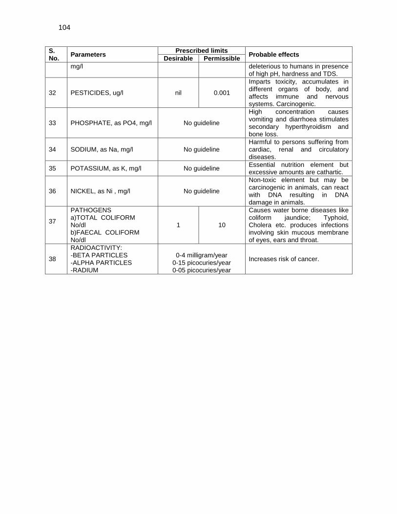
104
S. No. Parameters Prescribed limits Probable effects Desirable Permissible
mg/l deleterious to humans in presence of high pH, hardness and TDS.
32 PESTICIDES, ug/l nil 0.001
Imparts toxicity, accumulates in different organs of body, and affects immune and nervous systems. Carcinogenic.
33 PHOSPHATE, as PO4, mg/l No guideline
High concentration causes vomiting and diarrhoea stimulates secondary hyperthyroidism and bone loss.
34 SODIUM, as Na, mg/l No guideline Harmful to persons suffering from cardiac, renal and circulatory diseases.
35 POTASSIUM, as K, mg/l No guideline Essential nutrition element but excessive amounts are cathartic.
36 NICKEL, as Ni , mg/l No guideline
Non-toxic element but may be carcinogenic in animals, can react with DNA resulting in DNA damage in animals.
37
PATHOGENS a)TOTAL COLIFORM No/dl b)FAECAL COLIFORM No/dl
1 10
Causes water borne diseases like coliform jaundice; Typhoid, Cholera etc. produces infections involving skin mucous membrane of eyes, ears and throat.
38
RADIOACTIVITY: -BETA PARTICLES -ALPHA PARTICLES -RADIUM
0-4 milligram/year
0-15 picocuries/year 0-05 picocuries/year
Increases risk of cancer.
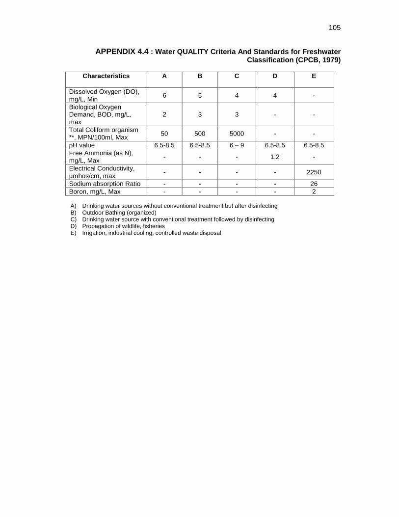
105
APPENDIX 4.4 : Water QUALITY Criteria And Standards for Freshwater Classification (CPCB, 1979)
Characteristics A B C D E
Dissolved Oxygen (DO), mg/L, Min 6 5 4 4 -
Biological Oxygen Demand, BOD, mg/L, max
2 3 3 - -
Total Coliform organism **, MPN/100ml, Max 50 500 5000 - -
pH value 6.5-8.5 6.5-8.5 6 – 9 6.5-8.5 6.5-8.5 Free Ammonia (as N), mg/L, Max - - - 1.2 -
Electrical Conductivity, µmhos/cm, max - - - - 2250
Sodium absorption Ratio - - - - 26 Boron, mg/L, Max - - - - 2
A) Drinking water sources without conventional treatment but after disinfecting B) Outdoor Bathing (organized) C) Drinking water source with conventional treatment followed by disinfecting D) Propagation of wildlife, fisheries E) Irrigation, industrial cooling, controlled waste disposal
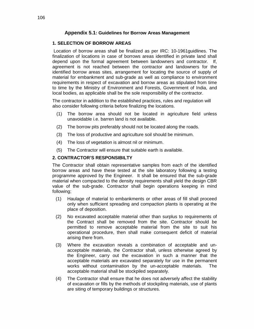
106
Appendix 5.1: Guidelines for Borrow Areas Management
1. SELECTION OF BORROW AREAS Location of borrow areas shall be finalized as per IRC: 10-1961guidlines. The finalization of locations in case of borrows areas identified in private land shall depend upon the formal agreement between landowners and contractor. If, agreement is not reached between the contractor and landowners for the identified borrow areas sites, arrangement for locating the source of supply of material for embankment and sub-grade as well as compliance to environment requirements in respect of excavation and borrow areas as stipulated from time to time by the Ministry of Environment and Forests, Government of India, and local bodies, as applicable shall be the sole responsibility of the contractor.
The contractor in addition to the established practices, rules and regulation will also consider following criteria before finalizing the locations.
(1) The borrow area should not be located in agriculture field unless unavoidable i.e. barren land is not available.
(2) The borrow pits preferably should not be located along the roads.
(3) The loss of productive and agriculture soil should be minimum.
(4) The loss of vegetation is almost nil or minimum.
(5) The Contractor will ensure that suitable earth is available.
2. CONTRACTOR’S RESPONSIBILTY The Contractor shall obtain representative samples from each of the identified borrow areas and have these tested at the site laboratory following a testing programme approved by the Engineer. It shall be ensured that the sub-grade material when compacted to the density requirements shall yield the design CBR value of the sub-grade. Contractor shall begin operations keeping in mind following;
(1) Haulage of material to embankments or other areas of fill shall proceed only when sufficient spreading and compaction plants is operating at the place of deposition.
(2) No excavated acceptable material other than surplus to requirements of the Contract shall be removed from the site. Contractor should be permitted to remove acceptable material from the site to suit his operational procedure, then shall make consequent deficit of material arising there from.
(3) Where the excavation reveals a combination of acceptable and un-acceptable materials, the Contractor shall, unless otherwise agreed by the Engineer, carry out the excavation in such a manner that the acceptable materials are excavated separately for use in the permanent works without contamination by the un-acceptable materials. The acceptable material shall be stockpiled separately.
(4) The Contractor shall ensure that he does not adversely affect the stability of excavation or fills by the methods of stockpiling materials, use of plants are siting of temporary buildings or structures.
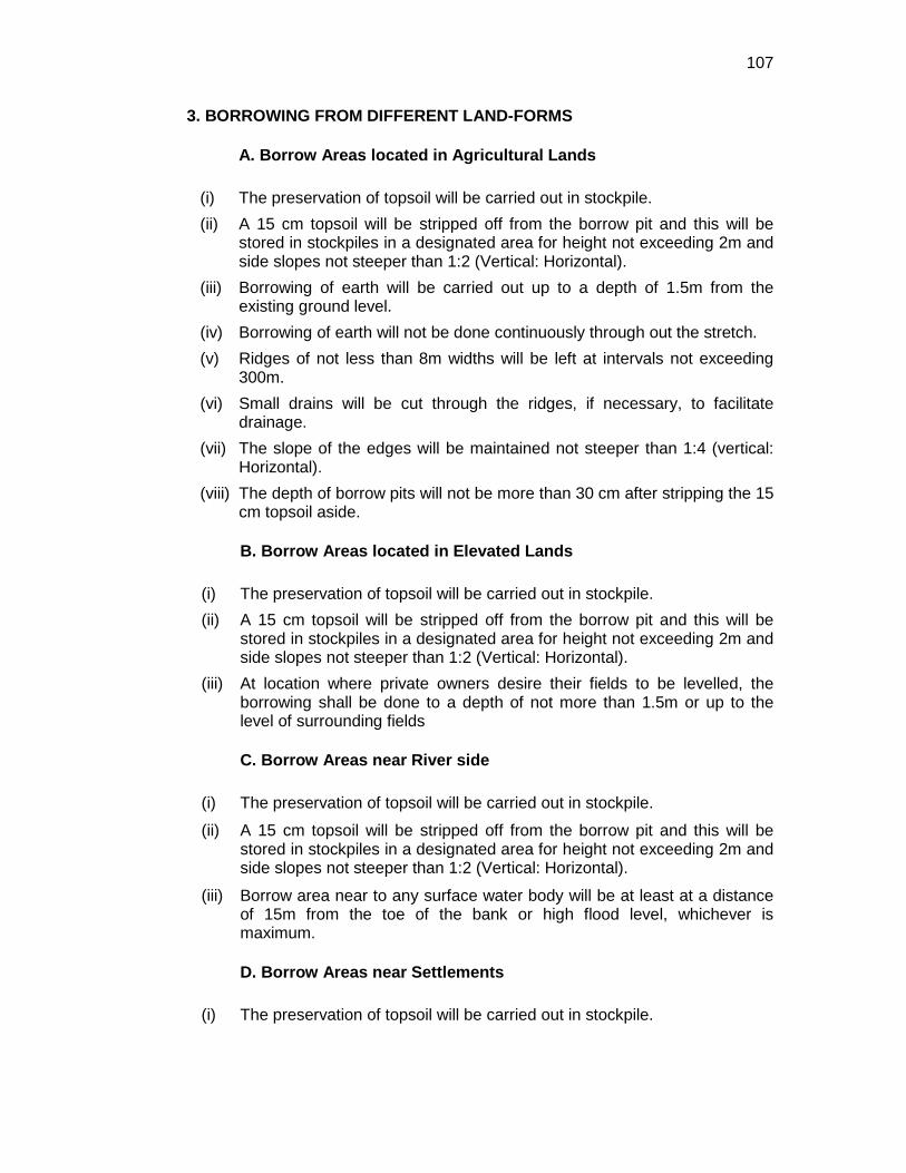
107
3. BORROWING FROM DIFFERENT LAND-FORMS
A. Borrow Areas located in Agricultural Lands
(i) The preservation of topsoil will be carried out in stockpile. (ii) A 15 cm topsoil will be stripped off from the borrow pit and this will be
stored in stockpiles in a designated area for height not exceeding 2m and side slopes not steeper than 1:2 (Vertical: Horizontal).
(iii) Borrowing of earth will be carried out up to a depth of 1.5m from the existing ground level.
(iv) Borrowing of earth will not be done continuously through out the stretch. (v) Ridges of not less than 8m widths will be left at intervals not exceeding
300m. (vi) Small drains will be cut through the ridges, if necessary, to facilitate
drainage. (vii) The slope of the edges will be maintained not steeper than 1:4 (vertical:
Horizontal). (viii) The depth of borrow pits will not be more than 30 cm after stripping the 15
cm topsoil aside.
B. Borrow Areas located in Elevated Lands
(i) The preservation of topsoil will be carried out in stockpile. (ii) A 15 cm topsoil will be stripped off from the borrow pit and this will be
stored in stockpiles in a designated area for height not exceeding 2m and side slopes not steeper than 1:2 (Vertical: Horizontal).
(iii) At location where private owners desire their fields to be levelled, the borrowing shall be done to a depth of not more than 1.5m or up to the level of surrounding fields
C. Borrow Areas near River side
(i) The preservation of topsoil will be carried out in stockpile.
(ii) A 15 cm topsoil will be stripped off from the borrow pit and this will be stored in stockpiles in a designated area for height not exceeding 2m and side slopes not steeper than 1:2 (Vertical: Horizontal).
(iii) Borrow area near to any surface water body will be at least at a distance of 15m from the toe of the bank or high flood level, whichever is maximum.
D. Borrow Areas near Settlements
(i) The preservation of topsoil will be carried out in stockpile.
108
(ii) A 15 cm topsoil will be stripped off from the borrow pit and this will be stored in stockpiles in a designated area for height not exceeding 2m and side slopes not steeper than 1:2 (Vertical: Horizontal).
(iii) Borrow pit location will be located at least 0.75 km from villages and settlements. If un-avoidable, the pit will not be dug for more than 30 cm and drains will be cut to facilitate drainage.
(iv) Borrow pits located in such location will be re-developed immediately after borrowing is completed. If spoils are dumped, that will be covered with a layers of stockpiled topsoil in accordance with compliance requirements with respect MOEF/PPCB guidelines.
E. Borrow Pits along the Road
Borrow pits along the road shall be discouraged and if deemed necessary and permitted by the Engineer; following precautions are recommended
(i) The preservation of topsoil will be carried out in stockpile.
(ii) A 15 cm topsoil will be stripped off from the borrow pit and this will be stored in stockpiles in a designated area for height not exceeding 2m and side slopes not steeper than 1:2 (Vertical: Horizontal).
(iii) Ridges of not less than 8m widths should be left at intervals not exceeding 300m.
(iv) Small drains shall be cut through the ridges of facilitate drainage.
(v) The depth of the pits shall be so regulated that there bottom does not cut an imaginary line having a slope of 1 vertical to 4 horizontal projected from the edge of the final section of bank, the maximum depth of any case being limited to 1.5m.
(vi) Also, no pit shall be dug within the offset width from the toe of the embankment required as per the consideration of stability with a minimum width of 10m.
4. REHABILITATION OF BORROW AREAS The objective of the rehabilitation programme is to return the borrow pit sites to a safe and secure area, which the general public should be able to safely enter and enjoy. Securing borrow pits in a stable condition is fundamental requirement of the rehabilitation process. This could be achieved by filling the borrow pit floor to approximately the access road level. Re-development plan shall be prepared by the Contractor before the start of work inline with the owners will require and to the satisfaction of owner. The Borrow Areas shall be rehabilitated as per following;
• Borrow pits shall be backfilled with rejected construction wastes and will be given a vegetative cover. If this is not possible, then excavation sloped will be smoothed and depression will be filled in such a way that it looks more or less like the original round surface.
• Borrow areas might be used for aquaculture in case landowner wants such development. In that case, such borrow area will be photographed

109
after their post use restoration and Environment Expert of Supervision Consultant will certify the post use redevelopment.
The Contractor will keep record of photographs of various stages i.e., before using materials from the location (pre-project), for the period borrowing activities (construction Phase) and after rehabilitation (post development), to ascertain the pre and post borrowing status of the area.
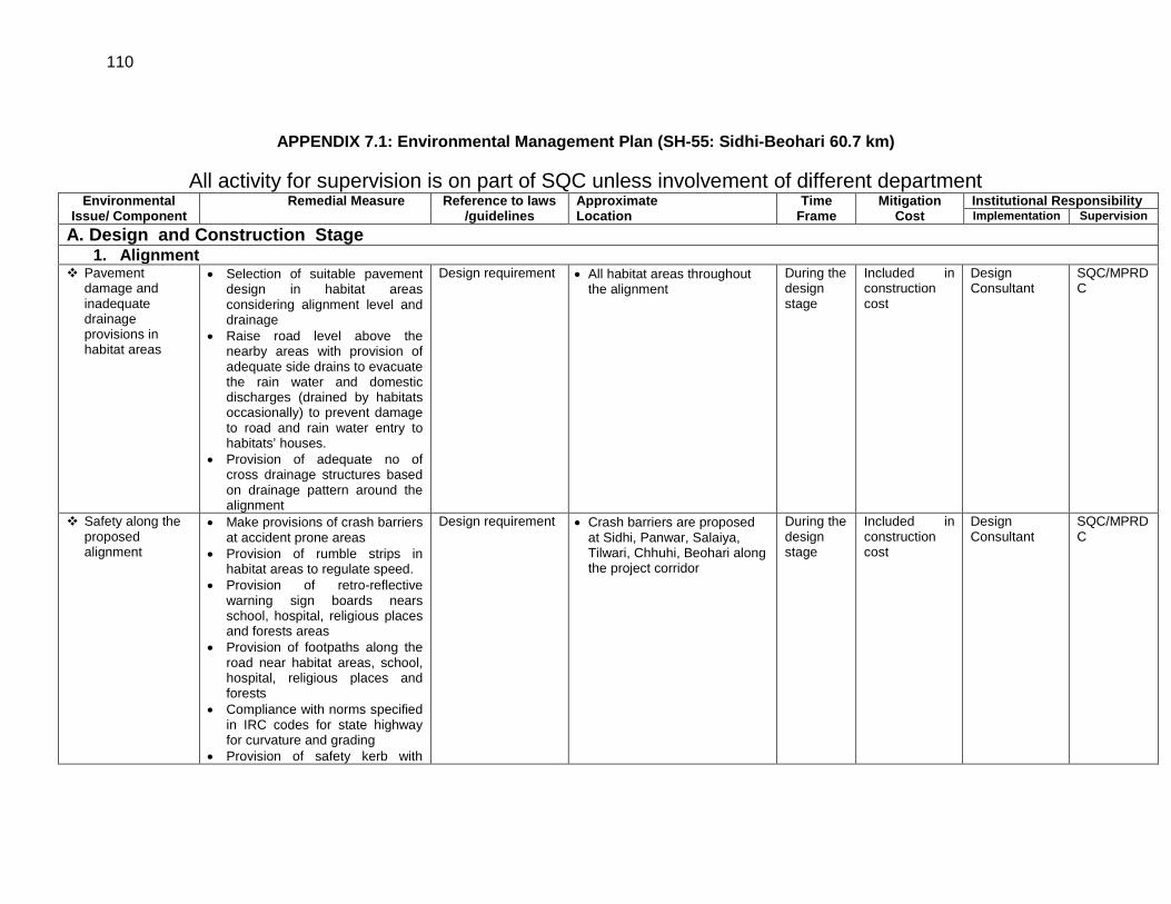
110
APPENDIX 7.1: Environmental Management Plan (SH-55: Sidhi-Beohari 60.7 km)
All activity for supervision is on part of SQC unless involvement of different department Environmental
Issue/ Component Remedial Measure Reference to laws
/guidelines Approximate Location
Time Frame
Mitigation Cost
Institutional Responsibility Implementation Supervision
A. Design and Construction Stage 1. Alignment
Pavement damage and inadequate drainage provisions in habitat areas
• Selection of suitable pavement design in habitat areas considering alignment level and drainage
• Raise road level above the nearby areas with provision of adequate side drains to evacuate the rain water and domestic discharges (drained by habitats occasionally) to prevent damage to road and rain water entry to habitats’ houses.
• Provision of adequate no of cross drainage structures based on drainage pattern around the alignment
Design requirement • All habitat areas throughout the alignment
During the design stage
Included in construction cost
Design Consultant
SQC/MPRDC
Safety along the proposed alignment
• Make provisions of crash barriers at accident prone areas
• Provision of rumble strips in habitat areas to regulate speed.
• Provision of retro-reflective warning sign boards nears school, hospital, religious places and forests areas
• Provision of footpaths along the road near habitat areas, school, hospital, religious places and forests
• Compliance with norms specified in IRC codes for state highway for curvature and grading
• Provision of safety kerb with
Design requirement
• Crash barriers are proposed at Sidhi, Panwar, Salaiya, Tilwari, Chhuhi, Beohari along the project corridor
During the design stage
Included in construction cost
Design Consultant
SQC/MPRDC
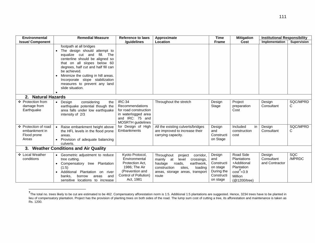
111
Environmental Issue/ Component
Remedial Measure Reference to laws /guidelines
Approximate Location
Time Frame
Mitigation Cost
Institutional Responsibility Implementation Supervision
footpath at all bridges • The design should attempt to
equalize cut and fill. The centerline should be aligned so that on all slopes below 60 degrees, half cut and half fill can be achieved.
• Minimize the cutting in hill areas. Incorporate slope stabilization measures to prevent any land slide situation.
• 2. Natural Hazards
Protection from damage from Earthquake
• Design considering the earthquake potential though the area falls under low earthquake intensity of 2/3
IRC:34 Recommendations for road construction in waterlogged area and IRC: 75 and MOSRTH guidelines for Design of High Embankments
Throughout the stretch Design Stage
Project preparation Cost
Design Consultant
SQC/MPRDC
Protection of road embankment in Flood prone Areas
• Raise embankment height above the HFL levels in the flood prone areas.
• Provision of adequate balancing culverts.
All the existing culverts/bridges are improved to increase their carrying capacity.
Design and Construction Stage
Included in construction cost
Design Consultant
SQC/MPRDC
3. Weather Conditions and Air Quality Local Weather
conditions • Geometric adjustment to reduce
tree cutting. • Compensatory tree Plantation
(1:5) • Additional Plantation on river
banks, borrow areas and sensitive locations to increase
Kyoto Protocol, Environmental Protection Act, 1986; The Air
(Prevention and Control of Pollution)
Act, 1981
Throughout project corridor, mainly at level crossings, haulage roads, earthwork, construction sites, loading areas, storage areas, transport route
Design and Construction stage During the Construction stage
Road Side Plantations +Additional Plantation cost7
Design Consultant and Contractor
=3.9 Million (@1200/tree)
SQC /MPRDC
7The total no. trees likely to be cut are estimated to be 462. Compensatory afforestation norm is 1:5. Additional 1:5 plantations are suggested. Hence, 3234 trees have to be planted in lieu of compensatory plantation. Project has the provision of planting trees on both sides of the road. The lump sum cost of cutting a tree, its afforestation and maintenance is taken as Rs. 1200.
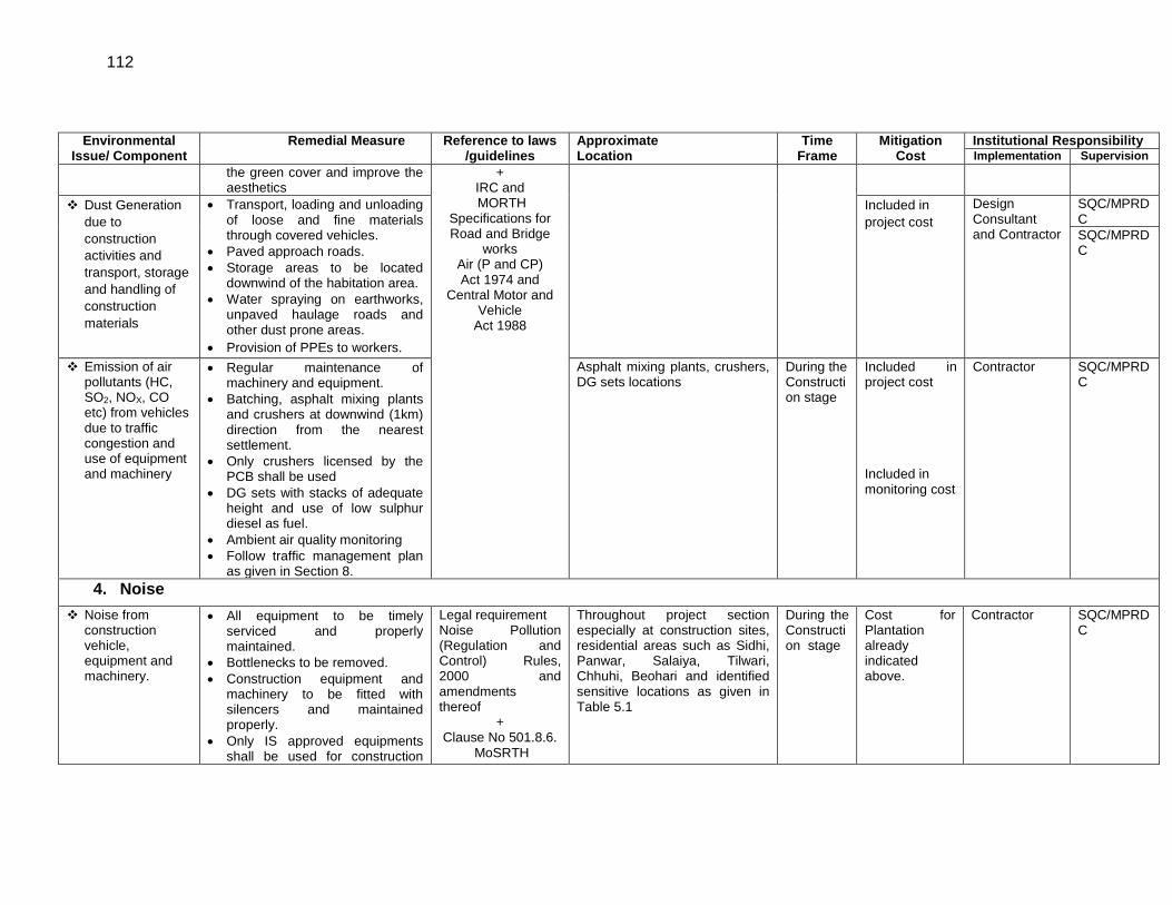
112
Environmental Issue/ Component
Remedial Measure Reference to laws /guidelines
Approximate Location
Time Frame
Mitigation Cost
Institutional Responsibility Implementation Supervision
the green cover and improve the aesthetics
+ IRC and MORTH
Specifications for Road and Bridge
works Air (P and CP) Act 1974 and
Central Motor and Vehicle
Act 1988
Dust Generation due to construction activities and transport, storage and handling of construction materials
• Transport, loading and unloading of loose and fine materials through covered vehicles.
• Paved approach roads. • Storage areas to be located
downwind of the habitation area. • Water spraying on earthworks,
unpaved haulage roads and other dust prone areas.
• Provision of PPEs to workers.
Included in project cost
Design Consultant and Contractor
SQC/MPRDC SQC/MPRDC
Emission of air pollutants (HC, SO2, NOX, CO etc) from vehicles due to traffic congestion and use of equipment and machinery
• Regular maintenance of machinery and equipment.
• Batching, asphalt mixing plants and crushers at downwind (1km) direction from the nearest settlement.
• Only crushers licensed by the PCB shall be used
• DG sets with stacks of adequate height and use of low sulphur diesel as fuel.
• Ambient air quality monitoring • Follow traffic management plan
as given in Section 8.
Asphalt mixing plants, crushers, DG sets locations
During the Construction stage
Included in project cost Included in monitoring cost
Contractor SQC/MPRDC
4. Noise Noise from
construction vehicle, equipment and machinery.
• All equipment to be timely serviced and properly maintained.
• Bottlenecks to be removed. • Construction equipment and
machinery to be fitted with silencers and maintained properly.
• Only IS approved equipments shall be used for construction
Legal requirement Noise Pollution (Regulation and Control) Rules, 2000 and amendments thereof
+ Clause No 501.8.6.
MoSRTH
Throughout project section especially at construction sites, residential areas such as Sidhi, Panwar, Salaiya, Tilwari, Chhuhi, Beohari and identified sensitive locations as given in Table 5.1
During the Construction stage
Cost for Plantation already indicated above.
Contractor
SQC/MPRDC
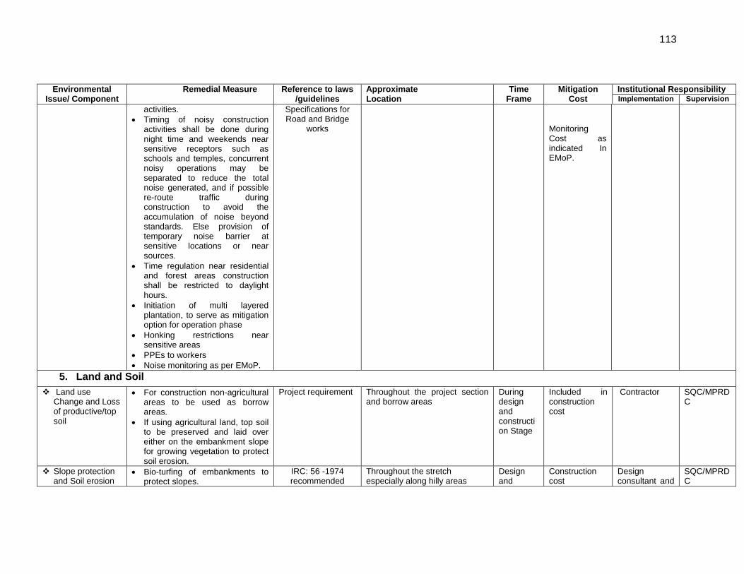
113
Environmental Issue/ Component
Remedial Measure Reference to laws /guidelines
Approximate Location
Time Frame
Mitigation Cost
Institutional Responsibility Implementation Supervision
activities. • Timing of noisy construction
activities shall be done during night time and weekends near sensitive receptors such as schools and temples, concurrent noisy operations may be separated to reduce the total noise generated, and if possible re-route traffic during construction to avoid the accumulation of noise beyond standards. Else provision of temporary noise barrier at sensitive locations or near sources.
• Time regulation near residential and forest areas construction shall be restricted to daylight hours.
• Initiation of multi layered plantation, to serve as mitigation option for operation phase
• Honking restrictions near sensitive areas
• PPEs to workers • Noise monitoring as per EMoP.
Specifications for Road and Bridge
works
Monitoring Cost as indicated In EMoP.
5. Land and Soil Land use
Change and Loss of productive/top soil
• For construction non-agricultural areas to be used as borrow areas.
• If using agricultural land, top soil to be preserved and laid over either on the embankment slope for growing vegetation to protect soil erosion.
Project requirement Throughout the project section and borrow areas
During design and construction Stage
Included in construction cost
Contractor SQC/MPRDC
Slope protection and Soil erosion
• Bio-turfing of embankments to protect slopes.
IRC: 56 -1974 recommended
Throughout the stretch especially along hilly areas
Design and
Construction cost
Design consultant and
SQC/MPRDC
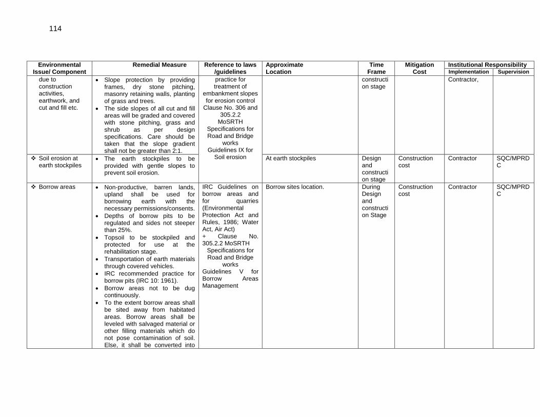
114
Environmental Issue/ Component
Remedial Measure Reference to laws /guidelines
Approximate Location
Time Frame
Mitigation Cost
Institutional Responsibility Implementation Supervision
due to construction activities, earthwork, and cut and fill etc.
• Slope protection by providing frames, dry stone pitching, masonry retaining walls, planting of grass and trees.
• The side slopes of all cut and fill areas will be graded and covered with stone pitching, grass and shrub as per design specifications. Care should be taken that the slope gradient shall not be greater than 2:1.
practice for treatment of
embankment slopes for erosion control
Clause No. 306 and 305.2.2
MoSRTH Specifications for Road and Bridge
works Guidelines IX for
Soil erosion
construction stage
Contractor,
Soil erosion at earth stockpiles
• The earth stockpiles to be provided with gentle slopes to prevent soil erosion.
At earth stockpiles Design and construction stage
Construction cost
Contractor SQC/MPRDC
Borrow areas • Non-productive, barren lands, upland shall be used for borrowing earth with the necessary permissions/consents.
• Depths of borrow pits to be regulated and sides not steeper than 25%.
• Topsoil to be stockpiled and protected for use at the rehabilitation stage.
• Transportation of earth materials through covered vehicles.
• IRC recommended practice for borrow pits (IRC 10: 1961).
• Borrow areas not to be dug continuously.
• To the extent borrow areas shall be sited away from habitated areas. Borrow areas shall be leveled with salvaged material or other filling materials which do not pose contamination of soil. Else, it shall be converted into
IRC Guidelines on borrow areas and for quarries (Environmental Protection Act and Rules, 1986; Water Act, Air Act) + Clause No. 305.2.2 MoSRTH
Specifications for Road and Bridge
works Guidelines V for Borrow Areas Management
Borrow sites location.
During Design and construction Stage
Construction cost
Contractor SQC/MPRDC
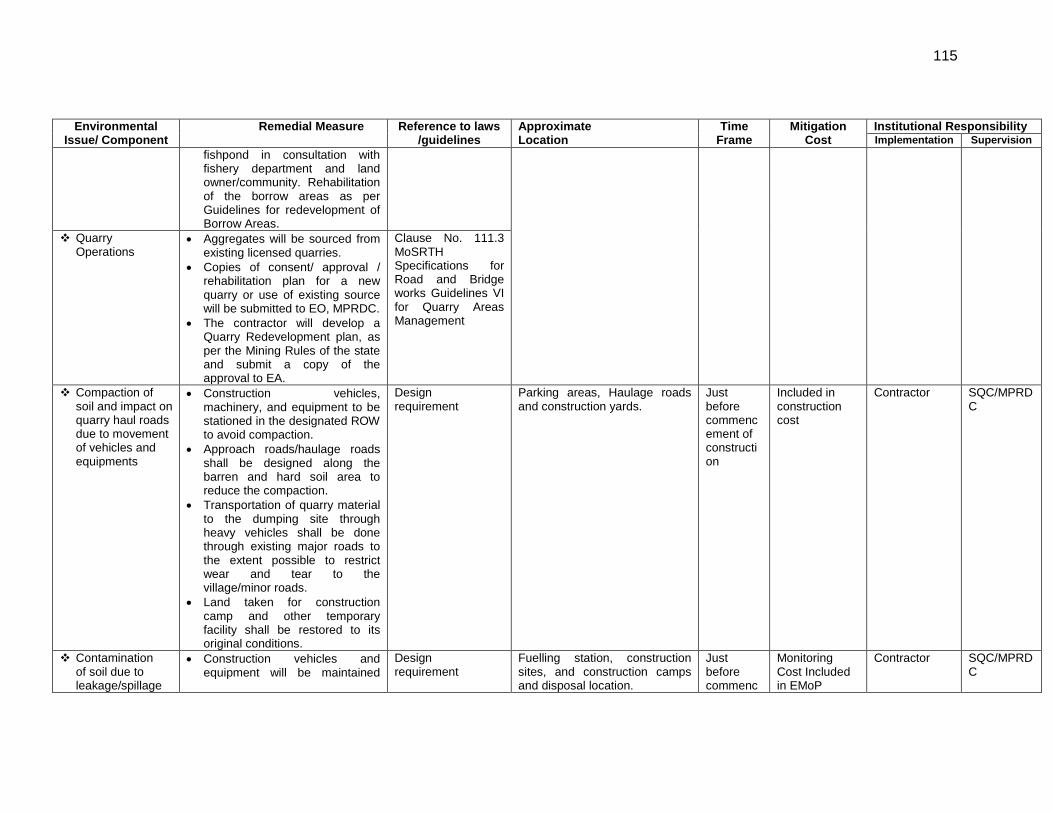
115
Environmental Issue/ Component
Remedial Measure Reference to laws /guidelines
Approximate Location
Time Frame
Mitigation Cost
Institutional Responsibility Implementation Supervision
fishpond in consultation with fishery department and land owner/community. Rehabilitation of the borrow areas as per Guidelines for redevelopment of Borrow Areas.
Quarry Operations
• Aggregates will be sourced from existing licensed quarries.
• Copies of consent/ approval / rehabilitation plan for a new quarry or use of existing source will be submitted to EO, MPRDC.
• The contractor will develop a Quarry Redevelopment plan, as per the Mining Rules of the state and submit a copy of the approval to EA.
Clause No. 111.3 MoSRTH Specifications for Road and Bridge works Guidelines VI for Quarry Areas Management
Compaction of soil and impact on quarry haul roads due to movement of vehicles and equipments
• Construction vehicles, machinery, and equipment to be stationed in the designated ROW to avoid compaction.
• Approach roads/haulage roads shall be designed along the barren and hard soil area to reduce the compaction.
• Transportation of quarry material to the dumping site through heavy vehicles shall be done through existing major roads to the extent possible to restrict wear and tear to the village/minor roads.
• Land taken for construction camp and other temporary facility shall be restored to its original conditions.
Design requirement
Parking areas, Haulage roads and construction yards.
Just before commencement of construction
Included in construction cost
Contractor SQC/MPRDC
Contamination of soil due to leakage/spillage
• Construction vehicles and equipment will be maintained
Design requirement
Fuelling station, construction sites, and construction camps and disposal location.
Just before commenc
Monitoring Cost Included in EMoP
Contractor SQC/MPRDC
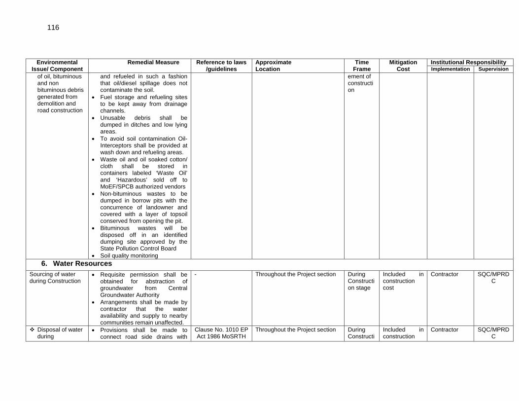
116
Environmental Issue/ Component
Remedial Measure Reference to laws /guidelines
Approximate Location
Time Frame
Mitigation Cost
Institutional Responsibility Implementation Supervision
of oil, bituminous and non bituminous debris generated from demolition and road construction
and refueled in such a fashion that oil/diesel spillage does not contaminate the soil.
• Fuel storage and refueling sites to be kept away from drainage channels.
• Unusable debris shall be dumped in ditches and low lying areas.
• To avoid soil contamination Oil-Interceptors shall be provided at wash down and refueling areas.
• Waste oil and oil soaked cotton/ cloth shall be stored in containers labeled ‘Waste Oil’ and ‘Hazardous’ sold off to MoEF/SPCB authorized vendors
• Non-bituminous wastes to be dumped in borrow pits with the concurrence of landowner and covered with a layer of topsoil conserved from opening the pit.
• Bituminous wastes will be disposed off in an identified dumping site approved by the State Pollution Control Board
• Soil quality monitoring
ement of construction
6. Water Resources Sourcing of water during Construction
• Requisite permission shall be obtained for abstraction of groundwater from Central Groundwater Authority
• Arrangements shall be made by contractor that the water availability and supply to nearby communities remain unaffected.
- Throughout the Project section
During Construction stage
Included in construction cost
Contractor SQC/MPRDC
Disposal of water during
• Provisions shall be made to connect road side drains with
Clause No. 1010 EP Act 1986 MoSRTH
Throughout the Project section
During Constructi
Included in construction
Contractor SQC/MPRDC
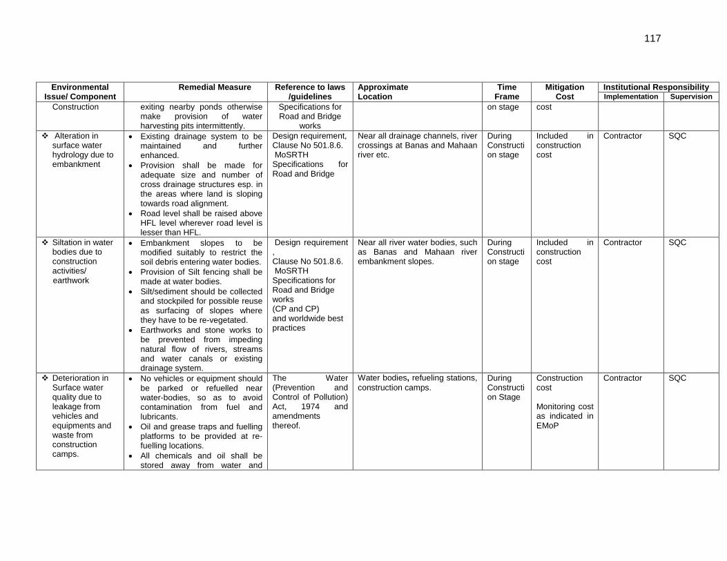
117
Environmental Issue/ Component
Remedial Measure Reference to laws /guidelines
Approximate Location
Time Frame
Mitigation Cost
Institutional Responsibility Implementation Supervision
Construction exiting nearby ponds otherwise make provision of water harvesting pits intermittently.
Specifications for Road and Bridge
works
on stage cost
Alteration in surface water hydrology due to embankment
• Existing drainage system to be maintained and further enhanced.
• Provision shall be made for adequate size and number of cross drainage structures esp. in the areas where land is sloping towards road alignment.
• Road level shall be raised above HFL level wherever road level is lesser than HFL.
Design requirement, Clause No 501.8.6. MoSRTH Specifications for Road and Bridge
Near all drainage channels, river crossings at Banas and Mahaan river etc.
During Construction stage
Included in construction cost
Contractor SQC
Siltation in water bodies due to construction activities/
earthwork
• Embankment slopes to be modified suitably to restrict the soil debris entering water bodies.
• Provision of Silt fencing shall be made at water bodies.
• Silt/sediment should be collected and stockpiled for possible reuse as surfacing of slopes where they have to be re-vegetated.
• Earthworks and stone works to be prevented from impeding natural flow of rivers, streams and water canals or existing drainage system.
Design requirement , Clause No 501.8.6. MoSRTH Specifications for Road and Bridge works (CP and CP) and worldwide best practices
Near all river water bodies, such as Banas and Mahaan river embankment slopes.
During Construction stage
Included in construction cost
Contractor SQC
Deterioration in Surface water quality due to leakage from vehicles and equipments and waste from construction camps.
• No vehicles or equipment should be parked or refuelled near water-bodies, so as to avoid contamination from fuel and lubricants.
• Oil and grease traps and fuelling platforms to be provided at re-fuelling locations.
• All chemicals and oil shall be stored away from water and
The Water (Prevention and Control of Pollution) Act, 1974 and amendments thereof.
Water bodies, refueling stations, construction camps.
During Construction Stage
Construction cost Monitoring cost as indicated in EMoP
Contractor SQC
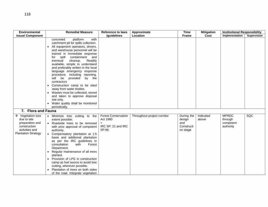
118
Environmental Issue/ Component
Remedial Measure Reference to laws /guidelines
Approximate Location
Time Frame
Mitigation Cost
Institutional Responsibility Implementation Supervision
concreted platform with catchment pit for spills collection.
• All equipment operators, drivers, and warehouse personnel will be trained in immediate response for spill containment and eventual cleanup. Readily available, simple to understand and preferably written in the local language emergency response procedure, including reporting, will be provided by the contractors
• Construction camp to be sited away from water bodies.
• Wastes must be collected, stored and taken to approve disposal site only.
• Water quality shall be monitored periodically.
7. Flora and Fauna Vegetation loss
due to site preparation and construction activities and
Plantation Strategy
• Minimize tree cutting to the extent possible.
• Roadside trees to be removed with prior approval of competent authority.
• Compensatory plantation at 1:5 basis and additional plantation as per the IRC guidelines in consultation with Forest Department.
• Regular maintenance of all trees planted.
• Provision of LPG in construction camp as fuel source to avoid tree cutting, wherever possible.
• Plantation of trees on both sides of the road. Integrate vegetation
Forest Conservation Act 1980 + IRC SP: 21 and IRC SP:66
Throughout project corridor
During the design and Construction stage
Indicated above
MPRDC through competent authority
SQC
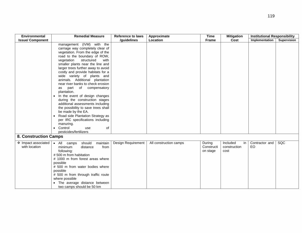
119
Environmental Issue/ Component
Remedial Measure Reference to laws /guidelines
Approximate Location
Time Frame
Mitigation Cost
Institutional Responsibility Implementation Supervision
management (IVM) with the carriage way completely clear of vegetation. From the edge of the road to the boundary of ROW, vegetation structured with smaller plants near the line and larger trees further away to avoid costly and provide habitats for a wide variety of plants and animals. Additional plantation near river banks to check erosion as part of compensatory plantation.
• In the event of design changes during the construction stages additional assessments including the possibility to save trees shall be made by the EA.
• Road side Plantation Strategy as per IRC specifications including manuring.
• Control use of pesticides/fertilizers
8. Construction Camps Impact associated
with location • All camps should maintain
minimum distance from following:
# 500 m from habitation # 1000 m from forest areas where possible # 500 m from water bodies where possible # 500 m from through traffic route where possible • The average distance between
two camps should be 50 km
Design Requirement
All construction camps During Construction stage
Included in construction cost
Contractor and EO
SQC
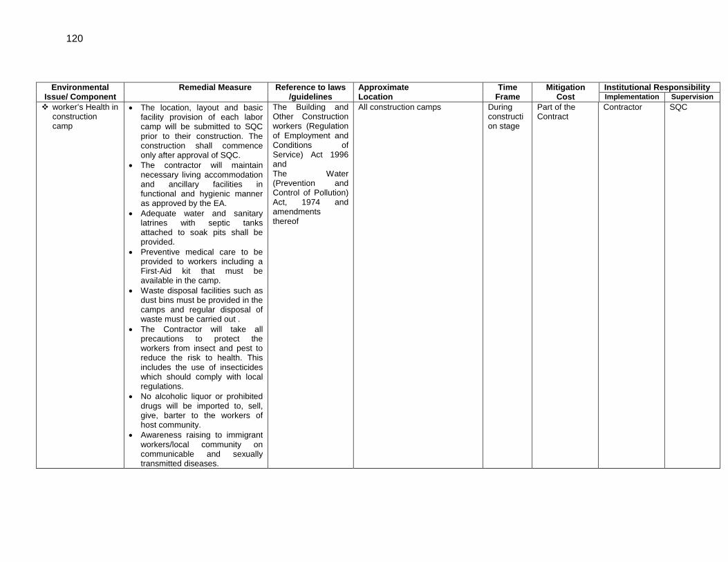
120
Environmental Issue/ Component
Remedial Measure Reference to laws /guidelines
Approximate Location
Time Frame
Mitigation Cost
Institutional Responsibility Implementation Supervision
worker’s Health in construction camp
• The location, layout and basic facility provision of each labor camp will be submitted to SQC prior to their construction. The construction shall commence only after approval of SQC.
• The contractor will maintain necessary living accommodation and ancillary facilities in functional and hygienic manner as approved by the EA.
• Adequate water and sanitary latrines with septic tanks attached to soak pits shall be provided.
• Preventive medical care to be provided to workers including a First-Aid kit that must be available in the camp.
• Waste disposal facilities such as dust bins must be provided in the camps and regular disposal of waste must be carried out .
• The Contractor will take all precautions to protect the workers from insect and pest to reduce the risk to health. This includes the use of insecticides which should comply with local regulations.
• No alcoholic liquor or prohibited drugs will be imported to, sell, give, barter to the workers of host community.
• Awareness raising to immigrant workers/local community on communicable and sexually transmitted diseases.
The Building and Other Construction workers (Regulation of Employment and Conditions of Service) Act 1996 and The Water (Prevention and Control of Pollution) Act, 1974 and amendments thereof
All construction camps During construction stage
Part of the Contract
Contractor SQC
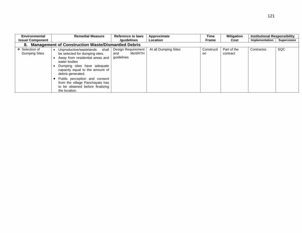
121
Environmental Issue/ Component
Remedial Measure Reference to laws /guidelines
Approximate Location
Time Frame
Mitigation Cost
Institutional Responsibility Implementation Supervision
8. Management of Construction Waste/Dismantled Debris Selection of
Dumping Sites • Unproductive/wastelands shall
be selected for dumping sites. • Away from residential areas and
water bodies • Dumping sites have adequate
capacity equal to the amount of debris generated.
• Public perception and consent from the village Panchayats has to be obtained before finalizing the location.
Design Requirement and MoSRTH guidelines
At all Dumping Sites Construction
Part of the contract
Contractor. SQC
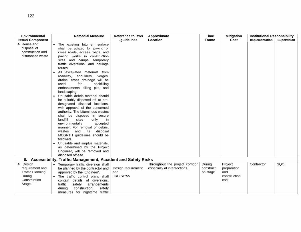
122
Environmental Issue/ Component
Remedial Measure Reference to laws /guidelines
Approximate Location
Time Frame
Mitigation Cost
Institutional Responsibility Implementation Supervision
Reuse and disposal of construction and dismantled waste
• The existing bitumen surface shall be utilized for paving of cross roads, access roads, and paving works in construction sites and camps, temporary traffic diversions, and haulage routes.
• All excavated materials from roadway, shoulders, verges, drains, cross drainage will be used for backfilling embankments, filling pits, and landscaping.
• Unusable debris material should be suitably disposed off at pre-designated disposal locations, with approval of the concerned authority. The bituminous wastes shall be disposed in secure landfill sites only in environmentally accepted manner. For removal of debris, wastes and its disposal MOSRTH guidelines should be followed.
• Unusable and surplus materials, as determined by the Project Engineer, will be removed and disposed off-site.
8. Accessibility, Traffic Management, Accident and Safety Risks Design
requirement and Traffic Planning During Construction Stage
• Temporary traffic diversion shall be planned by the contractor and approved by the ‘Engineer’.
• The traffic control plans shall contain details of diversions; traffic safety arrangements during construction; safety measures for nighttime traffic
Design requirement and IRC SP:55
Throughout the project corridor especially at intersections.
During construction stage
Project preparation and construction cost
Contractor SQC
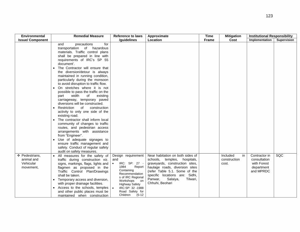
123
Environmental Issue/ Component
Remedial Measure Reference to laws /guidelines
Approximate Location
Time Frame
Mitigation Cost
Institutional Responsibility Implementation Supervision
and precautions for transportation of hazardous materials. Traffic control plans shall be prepared in line with requirements of IRC’s SP 55 document’.
• The Contractor will ensure that the diversion/detour is always maintained in running condition, particularly during the monsoon to avoid disruption to traffic flow.
• On stretches where it is not possible to pass the traffic on the part width of existing carriageway, temporary paved diversions will be constructed.
• Restriction of construction activity to only one side of the existing road.
• The contractor shall inform local community of changes to traffic routes, and pedestrian access arrangements with assistance from “Engineer”.
• Use of adequate signages to ensure traffic management and safety. Conduct of regular safety audit on safety measures.
Pedestrians, animal and Vehicular movement,
• All measures for the safety of traffic during construction viz. signs, markings, flags, lights and flagmen as proposed in the Traffic Control Plan/Drawings shall be taken.
• Temporary access and diversion, with proper drainage facilities.
• Access to the schools, temples and other public places must be maintained when construction
Design requirement and • IRC: SP: 27 -
1984 Report Containing Recommendations of IRC Regional Workshops on Highway Safety
• IRC:SP: 32 -1988 Road Safety for Children (5-12
Near habitation on both sides of schools, temples, hospitals, graveyards, construction sites, haulage roads, diversion sites (refer Table 5.1. Some of the specific locations are: Sidhi, Panwar, Salaiya, Tilwari, Chhuhi, Beohari
Included in construction cost.
Contractor in consultation with Forest department and MPRDC
SQC
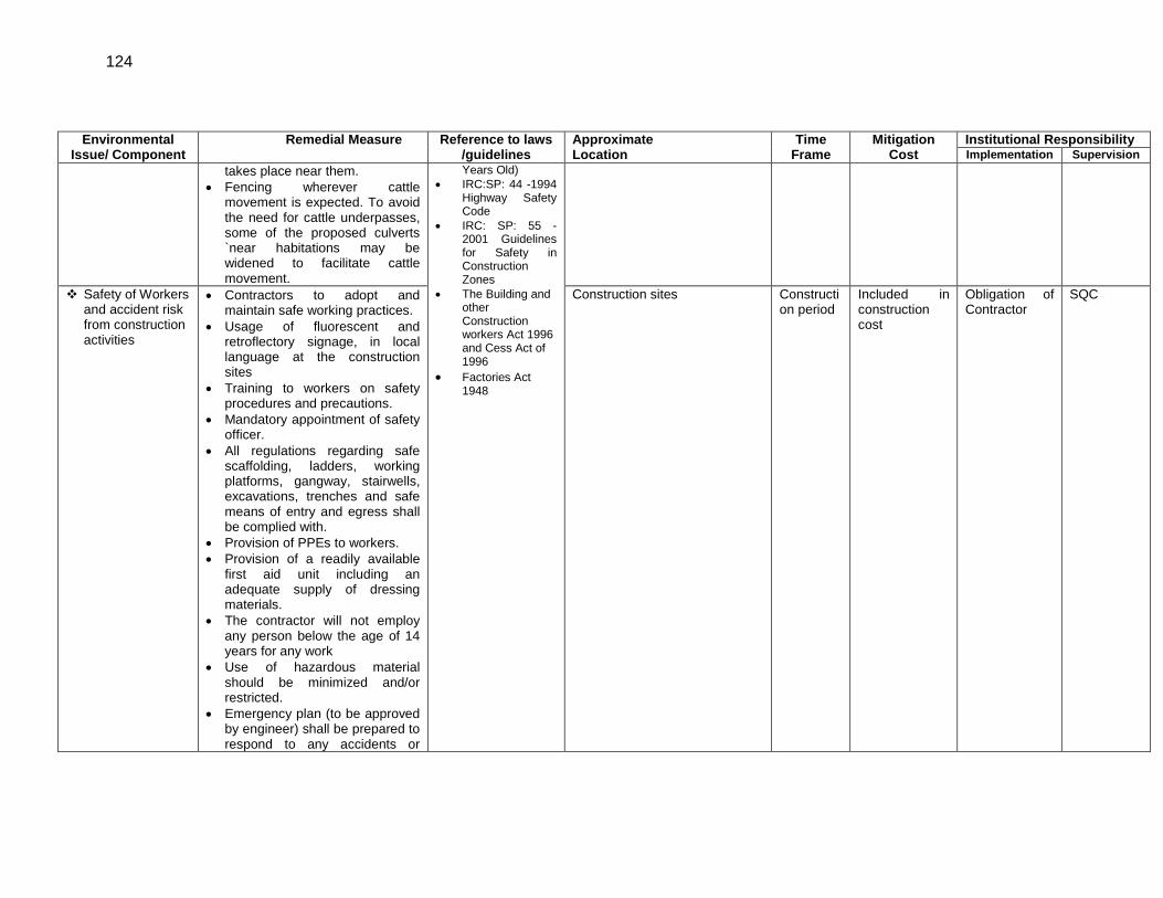
124
Environmental Issue/ Component
Remedial Measure Reference to laws /guidelines
Approximate Location
Time Frame
Mitigation Cost
Institutional Responsibility Implementation Supervision
takes place near them. • Fencing wherever cattle
movement is expected. To avoid the need for cattle underpasses, some of the proposed culverts `near habitations may be widened to facilitate cattle movement.
Years Old) • IRC:SP: 44 -1994
Highway Safety Code
• IRC: SP: 55 -2001 Guidelines for Safety in Construction Zones
• The Building and other Construction workers Act 1996 and Cess Act of 1996
• Factories Act 1948
Safety of Workers and accident risk from construction activities
• Contractors to adopt and maintain safe working practices.
• Usage of fluorescent and retroflectory signage, in local language at the construction sites
• Training to workers on safety procedures and precautions.
• Mandatory appointment of safety officer.
• All regulations regarding safe scaffolding, ladders, working platforms, gangway, stairwells, excavations, trenches and safe means of entry and egress shall be complied with.
• Provision of PPEs to workers. • Provision of a readily available
first aid unit including an adequate supply of dressing materials.
• The contractor will not employ any person below the age of 14 years for any work
• Use of hazardous material should be minimized and/or restricted.
• Emergency plan (to be approved by engineer) shall be prepared to respond to any accidents or
Construction sites Construction period
Included in construction cost
Obligation of Contractor
SQC
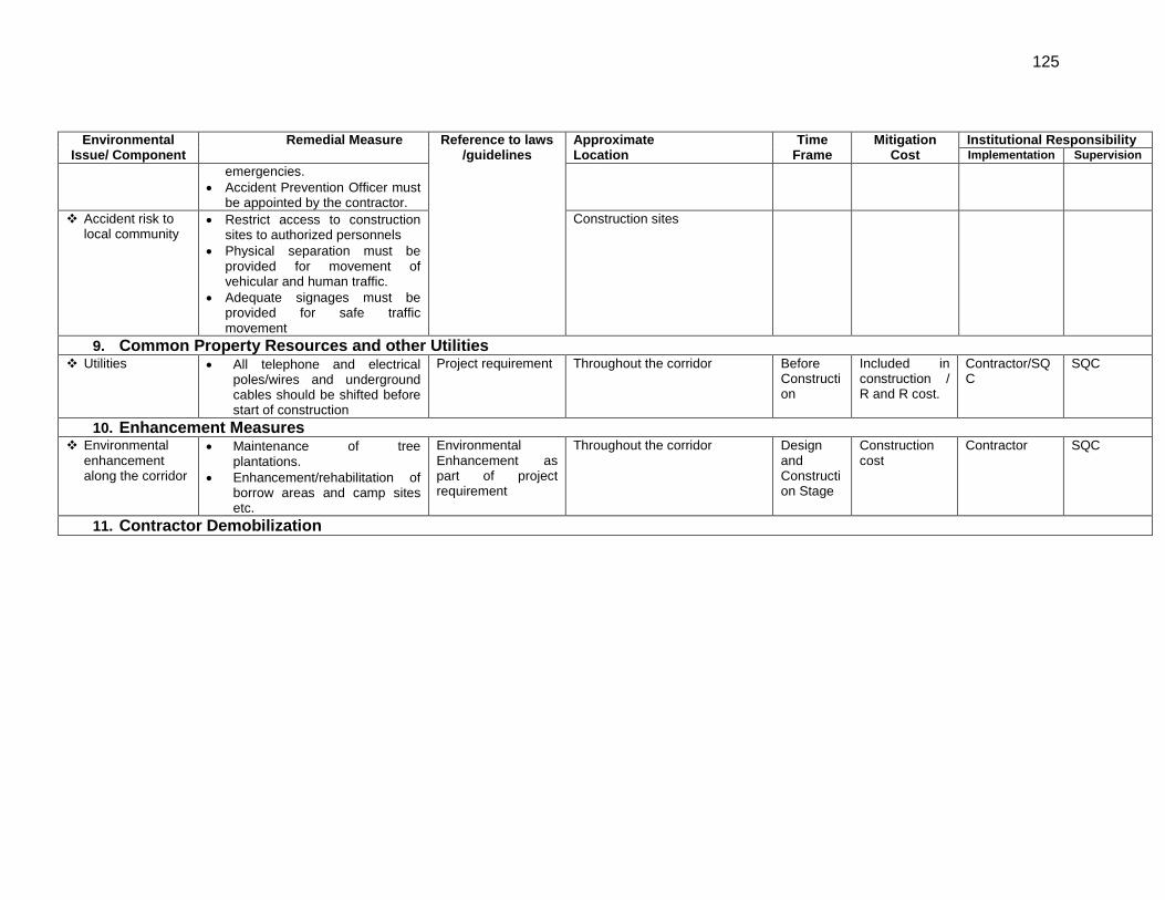
125
Environmental Issue/ Component
Remedial Measure Reference to laws /guidelines
Approximate Location
Time Frame
Mitigation Cost
Institutional Responsibility Implementation Supervision
emergencies. • Accident Prevention Officer must
be appointed by the contractor. Accident risk to
local community • Restrict access to construction
sites to authorized personnels • Physical separation must be
provided for movement of vehicular and human traffic.
• Adequate signages must be provided for safe traffic movement
Construction sites
9. Common Property Resources and other Utilities Utilities
• All telephone and electrical poles/wires and underground cables should be shifted before start of construction
Project requirement Throughout the corridor Before Construction
Included in construction / R and R cost.
Contractor/SQC
SQC
10. Enhancement Measures Environmental
enhancement along the corridor
• Maintenance of tree plantations.
• Enhancement/rehabilitation of borrow areas and camp sites etc.
Environmental Enhancement as part of project requirement
Throughout the corridor Design and Construction Stage
Construction cost
Contractor SQC
11. Contractor Demobilization
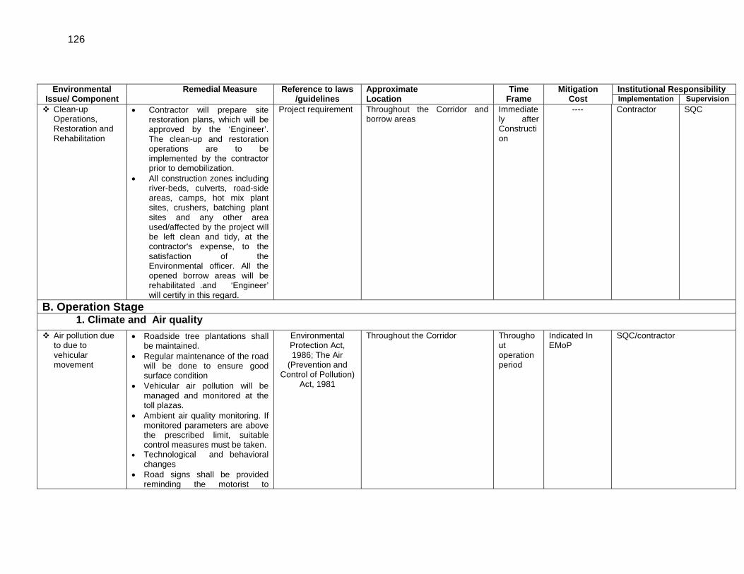
126
Environmental Issue/ Component
Remedial Measure Reference to laws /guidelines
Approximate Location
Time Frame
Mitigation Cost
Institutional Responsibility Implementation Supervision
Clean-up Operations, Restoration and Rehabilitation
• Contractor will prepare site restoration plans, which will be approved by the ‘Engineer’. The clean-up and restoration operations are to be implemented by the contractor prior to demobilization.
• All construction zones including river-beds, culverts, road-side areas, camps, hot mix plant sites, crushers, batching plant sites and any other area used/affected by the project will be left clean and tidy, at the contractor's expense, to the satisfaction of the Environmental officer. All the opened borrow areas will be rehabilitated .and ‘Engineer’ will certify in this regard.
Project requirement Throughout the Corridor and borrow areas
Immediately after Construction
---- Contractor SQC
B. Operation Stage 1. Climate and Air quality
Air pollution due to due to vehicular movement
• Roadside tree plantations shall be maintained.
• Regular maintenance of the road will be done to ensure good surface condition
• Vehicular air pollution will be managed and monitored at the toll plazas.
• Ambient air quality monitoring. If monitored parameters are above the prescribed limit, suitable control measures must be taken.
• Technological and behavioral changes
• Road signs shall be provided reminding the motorist to
Environmental Protection Act, 1986; The Air
(Prevention and Control of Pollution)
Act, 1981
Throughout the Corridor Throughout operation period
Indicated In EMoP
SQC/contractor
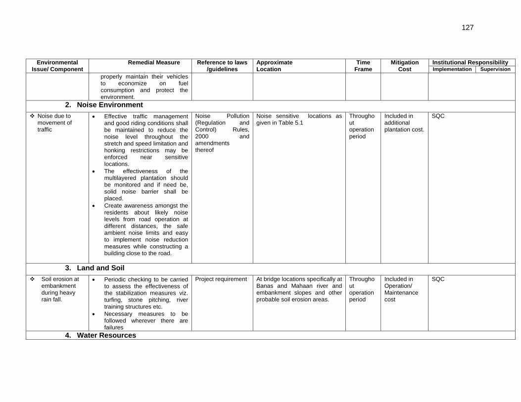
127
Environmental Issue/ Component
Remedial Measure Reference to laws /guidelines
Approximate Location
Time Frame
Mitigation Cost
Institutional Responsibility Implementation Supervision
properly maintain their vehicles to economize on fuel consumption and protect the environment.
2. Noise Environment Noise due to
movement of traffic
• Effective traffic management and good riding conditions shall be maintained to reduce the noise level throughout the stretch and speed limitation and honking restrictions may be enforced near sensitive locations.
• The effectiveness of the multilayered plantation should be monitored and if need be, solid noise barrier shall be placed.
• Create awareness amongst the residents about likely noise levels from road operation at different distances, the safe ambient noise limits and easy to implement noise reduction measures while constructing a building close to the road.
Noise Pollution (Regulation and Control) Rules, 2000 and amendments thereof
Noise sensitive locations as given in Table 5.1
Throughout operation period
Included in additional plantation cost.
SQC
3. Land and Soil Soil erosion at
embankment during heavy rain fall.
• Periodic checking to be carried to assess the effectiveness of the stabilization measures viz. turfing, stone pitching, river training structures etc.
• Necessary measures to be followed wherever there are failures
Project requirement At bridge locations specifically at Banas and Mahaan river and embankment slopes and other probable soil erosion areas.
Throughout operation period
Included in Operation/ Maintenance cost
SQC
4. Water Resources
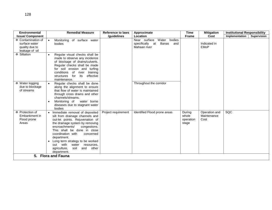
128
Environmental Issue/ Component
Remedial Measure Reference to laws /guidelines
Approximate Location
Time Frame
Mitigation Cost
Institutional Responsibility Implementation Supervision
Contamination of surface water quality due to leakage of oil
• Monitoring of surface water bodies
Near surface Water bodies specifically at Banas and Mahaan river
Indicated in EMoP
Siltation • Regular visual checks shall be made to observe any incidence of blockage of drains/culverts. Regular checks shall be made for soil erosion and turfing conditions of river training structures for its effective maintenance.
Water logging due to blockage of streams
• Regular checks shall be done along the alignment to ensure that flow of water is maintained through cross drains and other channels/streams.
• Monitoring of water borne diseases due to stagnant water bodies
Throughout the corridor
Protection of Embankment in Flood prone Areas
• Immediate removal of deposited silt from drainage channels and out-let points. Rejuvenation of the drainage system by removing encroachments/ congestions. This shall be done in close coordination with concerned department.
• Long term strategy to be worked out with water resources, agriculture, soil and other department.
Project requirement Identified Flood prone areas During whole operation stage
Operation and Maintenance Cost
SQC
5. Flora and Fauna
129
Environmental Issue/ Component
Remedial Measure Reference to laws /guidelines
Approximate Location
Time Frame
Mitigation Cost
Institutional Responsibility Implementation Supervision
Vegetation • Planted trees, shrubs, and grasses to be properly maintained.
• The tree survivalist audit to be conducted at least once in a year to assess the effectiveness
• Maintenance of box culverts, wherever provided.
Forest Conservation Act 1980
Throughout project section During whole operation period
Indicated in Monitoring cost in EMoP
SQC
6. Flooding/ inundation Road inundation
due to choking of drainage channels
• MPRDC will ensure that all drains (side drains and all cross drainages) are periodically cleared especially before monsoon season to facilitate the quick passage of rainwater and avoid flooding.
Project operation requirement
Throughout the stretch particularly in rolling topography section
During whole operation period
Overall Operation cost
SQC
7. Right-of-Way Maintenance Accident Risk due
to uncontrolled growth of vegetation
• Efforts shall be made to make shoulder completely clear of vegetation.
• Regular maintenance of plantation along the roadside
• Invasive plant not to be planted near the road.
Project requirement Throughout the Project route During whole operation period.
Included in operation/ Maintenance cost
SQC
8. Accidents and Safety Accident risks
associated with traffic movement.
• Traffic control measures, including speed limits, will be enforced strictly.
• Further encroachment and squatting within the ROW will be prevented.
• No school or hospital will be allowed to be established within 100 m of the highway without permission from the planning authorities.
IRC:SP:55 Throughout the Project route During whole operation period.
Included in operation/ Maintenance cost
SQC
130
Environmental Issue/ Component
Remedial Measure Reference to laws /guidelines
Approximate Location
Time Frame
Mitigation Cost
Institutional Responsibility Implementation Supervision
• Monitor/ensure that all safety provisions included in design and construction phase are properly maintained
• Highway patrol unit(s) for round the clock patrolling. Phone booths for accidental reporting and ambulance services with minimum response time for rescue of any accident victims, if possible.
• Tow-away facility for the break down vehicles, if possible.
• Coordination with operating agency of intersecting National Highways to have common facilities and share the costs as appropriate, if possible.
Transport of Dangerous Goods
• Preparation of spill prevention and control and emergency preparedness and responsive plans based on an analysis of hazards, implementation of presentation and control measures.
• Emergency plan for vehicles carrying hazardous material
Throughout the project stretch Included in operation/ Maintenance cost.
SQC
9. Monitoring Operation Performance Monitoring
Operation Performance
• The MPRDC will monitor the operational performance of the various mitigation/ enhancement measures carried out as a part of the project
• The indicators selected for monitoring include the survival rate of trees; utility of enhancement provision, status of rehabilitation of borrow areas, Air
Throughout the corridor Included in EMoP
SQC
131
Environmental Issue/ Component
Remedial Measure Reference to laws /guidelines
Approximate Location
Time Frame
Mitigation Cost
Institutional Responsibility Implementation Supervision
quality, water quality, noise levels, soil quality, drainage pattern, etc.
EA: Executing Agency, MPRDC: Madhya Pradesh Road Development Corporation, SQC: Supervision Quality Controller, EO: Environmental Officer, IRC: Indian Road Congress
132
APPENDIX 7.2: Monitoring Plan for the Performance Indicators Env.
Indicator Project Stage Parameters Method/Guidelines Location Frequency
and Duration Standards Approximate cost (Rs) Implementation Supervisi
on
Air Quality
Construction stage
SPM, RSPM, SO2,
NOX, CO, HC
High volume sampler to be located 50 m from the plant in the downwind direction. Use method specified by CPCB for analysis
Hot mix plants, stone crushers and construction/ earthwork sites and as suggested by SQC
(Total 6 Locations)
24 hr continuous, 3/year for 3
years
NAAQS 6x5000x3x3 =Rs. 2,70,000
Contractor through approved
monitoring agency
SQC
Operation stage
High volume sampler to be located 50 m from the selected locations in the downwind direction. Use method specified by CPCB for analysis
Major Road Intersections and Residential area
(6 Locations)
24 hr continuous, 3/year for 1
year
NAAQS 6X5000x3X1 =Rs 90,000
SQC through approved monitoring
agency
SQC
Water Quality
Construction stage
Ground water: (IS:
10500:1991) and
Surface water for
Class D and Class E as Prescribed by CPCB and for
vector borne diseases
Grab sample collected from source and analyze as per Standard Methods for Examination of Water and Wastewater
Groundwater at Construction Camps/site and Surface water at and downstream of Banas river and any large pond located close to the alignment being used by local community.
3/year for 3 years CPCB 6x 4000x3X3
=Rs 216, 000
Contractor through approved
monitoring agency
SQC
Operation stage
Groundwater at 2 locations and Surface water sample of Banas river (downstream of bridge Location) and stagnant water bodies developed due to borrow areas
3/year for 1 year CPCB 6X3x4000
=Rs 72, 000
EO through approved monitoring
agency
SQC
Siltation in Water Bodies
Construction Visual Checks for presence of
construction debris/waste and blockade of drainage channels
All rivers/streams/drainage channels and major water bodies along the stretch
Once during rainy seasons
of the construction
period.
Guidelines from water resources
department
Routine work of Engineering
Team Contractor SQC
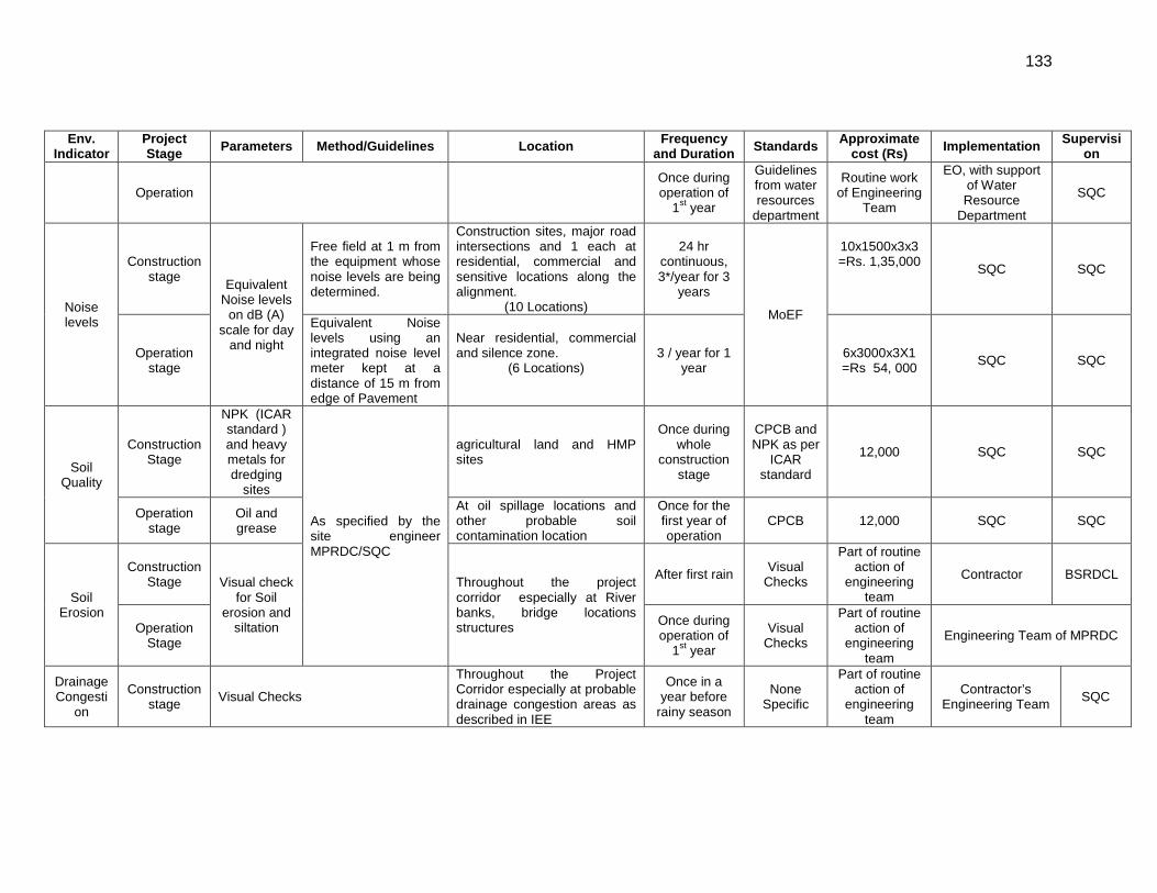
133
Env. Indicator
Project Stage Parameters Method/Guidelines Location Frequency
and Duration Standards Approximate cost (Rs) Implementation Supervisi
on
Operation Once during operation of
1st year
Guidelines from water resources
department
Routine work of Engineering
Team
EO, with support of Water Resource
Department
SQC
Noise levels
Construction stage Equivalent
Noise levels on dB (A)
scale for day and night
Free field at 1 m from the equipment whose noise levels are being determined.
Construction sites, major road intersections and 1 each at residential, commercial and sensitive locations along the alignment.
(10 Locations)
24 hr continuous, 3*/year for 3
years
MoEF
10x1500x3x3 =Rs. 1,35,000
SQC SQC
Operation stage
Equivalent Noise levels using an integrated noise level meter kept at a distance of 15 m from edge of Pavement
Near residential, commercial and silence zone.
(6 Locations)
3 / year for 1 year
6x3000x3X1 =Rs 54, 000 SQC SQC
Soil Quality
Construction Stage
NPK (ICAR standard ) and heavy metals for dredging
sites
As specified by the site engineer MPRDC/SQC
agricultural land and HMP sites
Once during whole
construction stage
CPCB and NPK as per
ICAR standard
12,000 SQC SQC
Operation stage
Oil and grease
At oil spillage locations and other probable soil contamination location
Once for the first year of operation
CPCB 12,000 SQC SQC
Soil Erosion
Construction Stage Visual check
for Soil erosion and
siltation
Throughout the project corridor especially at River banks, bridge locations structures
After first rain Visual Checks
Part of routine action of
engineering team
Contractor BSRDCL
Operation Stage
Once during operation of
1st year
Visual Checks
Part of routine action of
engineering team
Engineering Team of MPRDC
Drainage Congesti
on
Construction stage Visual Checks
Throughout the Project Corridor especially at probable drainage congestion areas as described in IEE
Once in a year before
rainy season
None Specific
Part of routine action of
engineering team
Contractor’s Engineering Team SQC
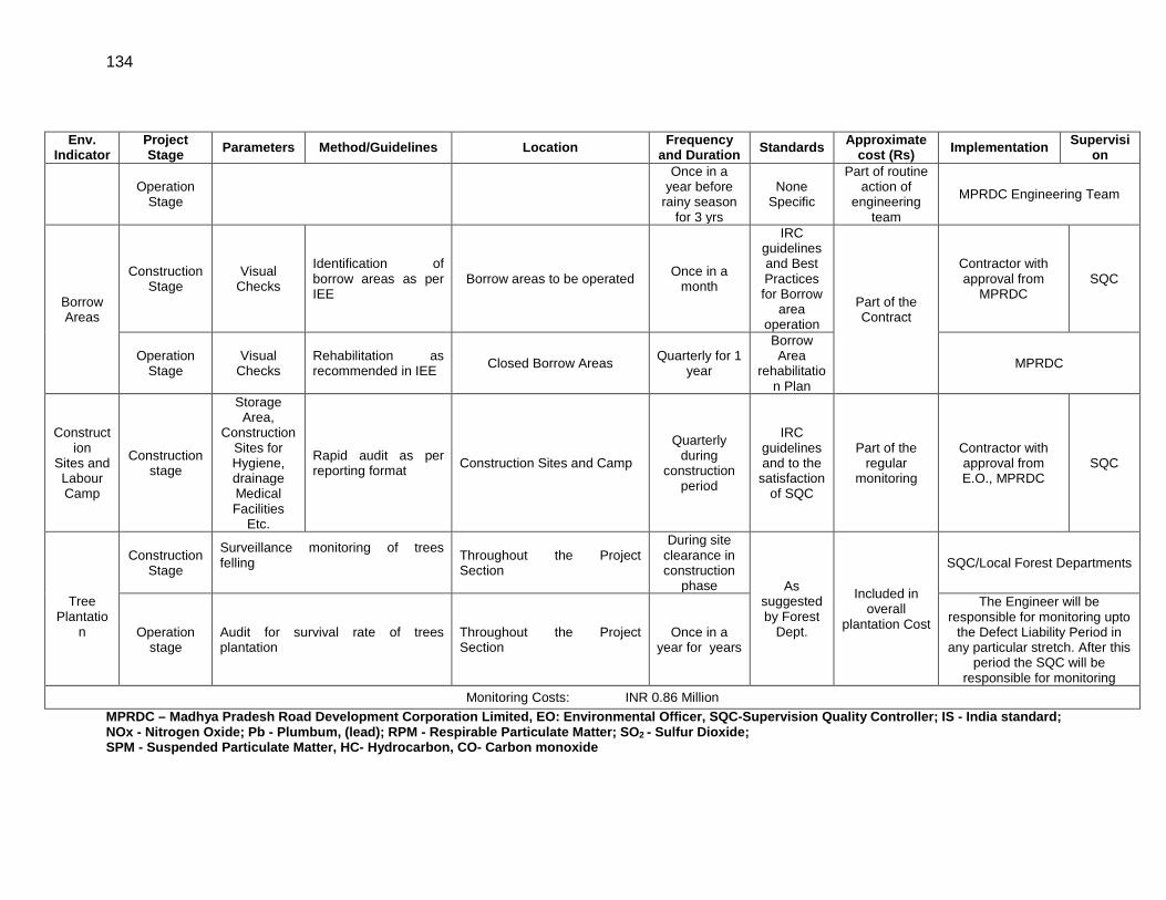
134
Env. Indicator
Project Stage Parameters Method/Guidelines Location Frequency
and Duration Standards Approximate cost (Rs) Implementation Supervisi
on
Operation Stage
Once in a year before
rainy season for 3 yrs
None Specific
Part of routine action of
engineering team
MPRDC Engineering Team
Borrow Areas
Construction Stage
Visual Checks
Identification of borrow areas as per IEE
Borrow areas to be operated Once in a month
IRC guidelines and Best Practices for Borrow
area operation
Part of the Contract
Contractor with approval from
MPRDC SQC
Operation Stage
Visual Checks
Rehabilitation as recommended in IEE Closed Borrow Areas Quarterly for 1
year
Borrow Area
rehabilitation Plan
MPRDC
Construction
Sites and Labour Camp
Construction stage
Storage Area,
Construction Sites for Hygiene, drainage Medical Facilities
Etc.
Rapid audit as per reporting format Construction Sites and Camp
Quarterly during
construction period
IRC guidelines and to the
satisfaction of SQC
Part of the regular
monitoring
Contractor with approval from E.O., MPRDC
SQC
Tree
Plantation
Construction Stage
Surveillance monitoring of trees felling
Throughout the Project Section
During site clearance in construction
phase As suggested by Forest
Dept.
Included in overall
plantation Cost
SQC/Local Forest Departments
Operation stage
Audit for survival rate of trees plantation
Throughout the Project Section
Once in a year for years
The Engineer will be responsible for monitoring upto
the Defect Liability Period in any particular stretch. After this
period the SQC will be responsible for monitoring
Monitoring Costs: INR 0.86 Million MPRDC – Madhya Pradesh Road Development Corporation Limited, EO: Environmental Officer, SQC-Supervision Quality Controller; IS - India standard; NOx - Nitrogen Oxide; Pb - Plumbum, (lead); RPM - Respirable Particulate Matter; SO2 - Sulfur Dioxide; SPM - Suspended Particulate Matter, HC- Hydrocarbon, CO- Carbon monoxide