Himachal Pradesh State Roads Transformation Program ...
169
HIMACHAL PRADESH ROAD & INFRASTRUCTURE DEVELOPMENT CORPORATION LIMITED (Government of Himachal Pradesh Undertaking) (An ISO 9001:2008 QMS & ISO 14001:2004 EMS conforming company) Himachal Pradesh State Roads Transformation Program (HPSRTP) (Under Funding Assistance of the World Bank) Raghunathpura-Mandi-Harpura-Bharari (Km 0.000 to Km 2.74) Environment and Social Impact Assessment (Final Report) October 2021 Report Prepared by: Deccan Consulting Engineers Private Limited (Independent ESIA Consultant to HPRIDCL)
-
Upload
khangminh22 -
Category
Documents
-
view
0 -
download
0
Transcript of Himachal Pradesh State Roads Transformation Program ...

HIMACHAL PRADESH ROAD & INFRASTRUCTURE DEVELOPMENT CORPORATION LIMITED
(Government of Himachal Pradesh Undertaking) (An ISO 9001:2008 QMS & ISO 14001:2004 EMS conforming company)
Himachal Pradesh State Roads Transformation Program (HPSRTP)
(Under Funding Assistance of the World Bank)
Raghunathpura-Mandi-Harpura-Bharari (Km 0.000 to Km 2.74)
Environment and Social Impact Assessment (Final Report)
October 2021
Report Prepared by: Deccan Consulting Engineers Private Limited (Independent ESIA Consultant to HPRIDCL)
Page | i
TABLE OF CONTENTS EXECUTIVE SUMMARY ...................................................................................................... 1
1 INTRODUCTION ............................................................................................................. 8
1.1 HPSRTP – Background & Objective ......................................................................... 8 1.2 Sub Project Roads under Tranche I - HPSRTP .......................................................... 9 1.3 Associated Facilities of Tranche I - HPSRTP ............................................................ 9 1.4 Purpose of ESIA ......................................................................................................... 9 1.5 Scope of the ESIA .................................................................................................... 10 1.6 Structure of ESIA Report ......................................................................................... 10
2 PROJECT DESCRIPTION ............................................................................................. 12
2.1 Sub-Project Road: Raghunathpura-Mandi-Harpura-Bharari ................................... 12 2.2 Present Pavement Condition & Carriageway Width ................................................ 13 2.3 Accident Data ........................................................................................................... 13 2.4 Traffic Surveys ......................................................................................................... 13 2.5 Traffic Projections .................................................................................................... 14 2.6 Proposed Improvement for Project Road ................................................................. 15 2.7 Typical Cross-Sections ............................................................................................. 16 2.8 Available Right of Way............................................................................................ 19 2.9 Existing and Proposed CD Structures ...................................................................... 21 2.10 Protection Works ...................................................................................................... 21 2.11 Bus Stops/ Rain Shelters & Street Lighting ............................................................. 21 2.12 Road Safety Features ................................................................................................ 22 2.13 Jetty Facilities for Ferry/Boat Boarding near Luhnu Stadium ................................. 22
2.13.1 Background ....................................................................................................... 22 2.13.2 Proposal for Jetty Facilities.............................................................................. 23
2.14 Project Road Construction Activities ....................................................................... 29 2.14.1 Encumbrances ................................................................................................... 29 2.14.2 Site Clearance ................................................................................................... 29 2.14.3 Earth Work Excavation ..................................................................................... 29 2.14.4 Construction Material Requirement ................................................................. 29 2.14.5 Construction Water Requirement ..................................................................... 29 2.14.6 Debris Disposal ................................................................................................ 30 2.14.7 Establishment of Campsites and Workforce Camps ......................................... 30 2.14.8 Traffic Diversions and Work Zone Safety ......................................................... 30 2.14.9 Bio-Engineering Solutions ................................................................................ 30 2.14.10 Conservation and Enhancement Measures ................................................... 31 2.14.11 Road Safety Signs and Furniture .................................................................. 31 2.14.12 Project Workers Requirement ....................................................................... 31
2.15 Institutional Framework of HPSRTP ....................................................................... 32
3 LEGAL AND REGULATORY FRAMEWORK ........................................................... 34
3.1 Applicable Regulations of GoI/GoHP ..................................................................... 34 3.2 World Bank ESF Policy and WBG’s EHSG– Extent of Relevance ........................ 41 3.3 Comparison of GoI/GoHP legislations and ESF, 2016 ............................................ 47 3.4 Clearances and Permissions required for Project Road and Jetty Facility ............... 53

Page | ii
4 BASELINE DATA .......................................................................................................... 54
4.1 Approach and Methodology ..................................................................................... 54 4.2 Data Sources ............................................................................................................. 57 4.3 Land Environment .................................................................................................... 59
4.3.1 Geology ............................................................................................................. 59 4.3.2 Hydrogeology .................................................................................................... 60 4.3.3 Physiography .................................................................................................... 62 4.3.4 Drainage ........................................................................................................... 64 4.3.5 Elevation ........................................................................................................... 67 4.3.6 Geo-morphology and Soils ............................................................................... 68 4.3.7 Soil, Moisture and Fertility Levels.................................................................... 68 4.3.8 Land Use ........................................................................................................... 70 4.3.9 Agriculture ........................................................................................................ 72
4.4 Physical Environment .............................................................................................. 73 4.4.1 Climate and Rainfall ......................................................................................... 73 4.4.2 Snowfall............................................................................................................. 74 4.4.3 Visibility ............................................................................................................ 74 4.4.4 Dust & Thunderstorms ...................................................................................... 74 4.4.5 Wind Speed and Direction ................................................................................ 74 4.4.6 Baseline Environment Monitoring Schedule and Methods ............................... 75 4.4.7 Ambient Air Quality .......................................................................................... 79 4.4.8 Ambient Noise Levels ........................................................................................ 79 4.4.9 Surface and Ground Water Quality .................................................................. 80 4.4.10 Soil Quality ....................................................................................................... 82
4.5 Biological Environment ........................................................................................... 83 4.5.1 Forest Area within State and Bilaspur District ................................................ 83 4.5.2 Forest Area along Project Road and at Jetty Facility ...................................... 85 4.5.3 Protected Areas ................................................................................................. 85 4.5.4 Biodiversity ....................................................................................................... 87 4.5.5 Floral Diversity ................................................................................................. 87 4.5.6 Trees, Shrubs and Herbs along Project Road .................................................. 87 4.5.7 Tree Felling Requirement ................................................................................. 89 4.5.8 Fauna ................................................................................................................ 90 4.5.9 Avifauna ............................................................................................................ 91 4.5.10 Fish and Fisheries............................................................................................. 93
4.6 Cultural Environment ............................................................................................... 93 4.6.1 Archaeological and Historical Monuments ...................................................... 93 4.6.2 Common Property Resources ........................................................................... 94
4.7 Hazard and Vulnerability ......................................................................................... 94 4.7.1 Landslide Prone Zones ..................................................................................... 94 4.7.2 Wind Hazard Zones........................................................................................... 96 4.7.3 Flood Prone Zones ............................................................................................ 98 4.7.4 Cloud Burst Occurrences .................................................................................. 99 4.7.5 Earthquake Zones ........................................................................................... 100 4.7.6 Overall Vulnerability Status ........................................................................... 103
4.8 Social Economic Profile ......................................................................................... 105 4.8.1 Demographic Features of Bilaspur District ................................................... 105 4.8.2 Demography, socio-economic profile of PIA .................................................. 106 4.8.3 Socio-economic Profile of PAF’s/ PAH’s ....................................................... 106
Page | iii
4.8.4 Status of women .............................................................................................. 106
5 STAKEHOLDER CONSULTATIONS & INFORMATION DISCLOSURE ............. 107
5.1 Stakeholders Consultations .................................................................................... 107 5.2 Consultations on Gender Based Violence .............................................................. 108
6 ANALYSIS OF ALTERNATIVES .............................................................................. 110
6.1 Considerations for Alternatives .............................................................................. 110 6.2 Alternative Analysis Option – No project scenario ............................................... 110 6.3 Alternative Analysis Option – Balancing cut and fill quantities ............................ 111 6.4 Alternative Analysis Option – Minimizing of Environmental and Social Impacts 111
7 ENVIRONMENT & SOCIAL RISKS AND IMPACTS AND MITIGATION MEASURES .................................................................................................................. 114
7.1 …related to Assessment and Management of E&S risk and impact (ESS 1) ........ 114 7.2 … relating to Labour and Working Conditions (ESS 2) ........................................ 114 7.3 …relating to Resource Efficiency, Pollution Prevention and Management (ESS 3)
................................................................................................................................ 116 7.3.1 Physiography .................................................................................................. 116 7.3.2 Geology ........................................................................................................... 116 7.3.3 Land Use and Soil ........................................................................................... 118 7.3.4 Water Resources ............................................................................................. 121 7.3.5 Surface and Ground Water Resources Depletion ........................................... 124 7.3.6 Surface & Ground Water Pollution ................................................................ 125 7.3.7 Air Quality ...................................................................................................... 128 7.3.8 GHG Emissions Estimate ................................................................................ 136 7.3.9 Noise and Vibration ........................................................................................ 138 7.3.10 Cumulative Impacts ........................................................................................ 142
7.4 … relating to Community Health and Safety (ESS 4) ........................................... 143 7.4.1 Utility Shifting & Site Clearance Operations ................................................. 143 7.4.2 Slope Stability and Landslide Hazards ........................................................... 143 7.4.3 Hazardous and Non-Hazardous Wastes ......................................................... 146 7.4.4 Work Zone Safety and Community Safety Risks ............................................. 149 7.4.5 Road Safety Measures ..................................................................................... 150 7.4.6 Traffic Calming Measures along Built-Up Stretches, Major/Minor Junctions 151 7.4.7 Natural Disasters/ Calamity and Hazard Vulnerability ................................. 151
7.5 …on land & assets (ESS 5) .................................................................................... 152 7.6 … relating to Biodiversity & Living Natural Resources (ESS 6) .......................... 153
7.6.1 Flora ............................................................................................................... 153 7.6.2 Fauna .............................................................................................................. 154
7.7 … on Tribal/Indigenous Population (ESS 7 ) ....................................................... 155 7.8 … on impacts on Cultural Heritage (ESS 8) .......................................................... 155
7.8.1 Chance Finds .................................................................................................. 155
8 ENVIRONMENT AND SOCIAL MANAGEMENT PLAN ....................................... 157
8.1 Budgetary Costs for ESMP Implementation and Supervision ............................... 157
Page | iv
Tables
Table 1-1: Roads Proposed for Widening/Upgradation under Tranche I- HPSRTP ............................................. 9 Table 2-1: Existing Pavement Condition of Project Road ....................................................................................13 Table 2-2: Existing Carriageway width of Project Road ......................................................................................13 Table 2-3: Traffic Survey Schedule ......................................................................................................................14 Table 2-4: Average Daily Traffic Values .............................................................................................................14 Table 2-5: Traffic Growth Rates and Traffic Projections for Project Road ..........................................................14 Table 2-6: Lane Configuration of Project Road ...................................................................................................15 Table 2-7: Overlay Design and Flexible Pavement Design (15 years) Options for Project Road ........................16 Table 2-8: Design Criteria adopted for Project Road ...........................................................................................16 Table 2-9: Typical Cross Sections (TCS) along Project Road ..............................................................................16 Table 2-10: Existing & Proposed CD Structures along Project Road ..................................................................21 Table 2-11: Provision for Longitudinal Drains along Project Road .....................................................................21 Table 2-12: Protection Works along Project Road ...............................................................................................21 Table 2-13: Bus Stops/Rain Shelters along Project Road .....................................................................................22 Table 2-14: Road Safety Features along Project Road .........................................................................................22 Table 2-15: Details of Encumbrances along Project Road ...................................................................................29 Table 2-16: Potential Locations for debris/muck disposal along Project Road ....................................................30 Table 2-17: Estimated Project Workers for Construction of Project Road & Jetty Facility .................................31 Table 3-1: Summary of Applicable E&S Regulations of GoI/GoHP ...................................................................35 Table 3-2: World Bank ESF Policy, 2016 and World Bank Groups’ EHSGs, IFC, 2007 ....................................42 Table 3-3: Comparison of GoI/GoHP legislations and Regulations and ESF, 2016 ............................................48 Table 3-4: Permissions Required for Project Road and Jetty Facility ..................................................................53 Table 4-1: Data Sources for Baseline Environmental and Social Assessment .....................................................58 Table 4-2: Data Sources for Baseline Environment Theme Maps ........................................................................59 Table 4-3: Geological Formations of Bilaspur District ........................................................................................60 Table 4-4: Hydrogeological Formations and Yield Potential in Bilaspur District ................................................60 Table 4-5: Annual Average Rainfall (mm) in Bilaspur District (2014-2020) .......................................................73 Table 4-6: Baseline Environmental Monitoring Schedule & Methods .................................................................75 Table 4-7: Baseline Environmental Monitoring Stations along Project Road & Jetty Facility ............................76 Table 4-8: Ambient Air Quality Along Project Road and Jetty Facility ...............................................................79 Table 4-9: Ambient Noise Levels along Project Road and Jetty Facility .............................................................79 Table 4-10: Water Quality along Project Road and Jetty Facility ........................................................................80 Table 4-11: Designated Best Use Water Quality Criteria .....................................................................................81 Table 4-12: Primary Water Quality Criteria for Bathing ......................................................................................82 Table 4-13: Soil Test Results along Project Road and at Jetty Facility Location .................................................82 Table 4-14: Legal Classification of Forest areas in Himachal Pradesh (as of 2018) ............................................83 Table 4-15: Forest Cover of Bilaspur Circle and Himachal Pradesh ....................................................................84 Table 4-16: Flora along Project Road ...................................................................................................................87 Table 4-17: Vegetation Sampling Locations along Project Road .........................................................................87 Table 4-18: Trees, Shrubs and Herbs along Project Road ....................................................................................87 Table 4-19: Trees require felling for widening of Project Road ...........................................................................89 Table 4-20: Mammalian fauna recorded/ reported along project road/ region .....................................................90 Table 4-21: Avifauna Sighted/Recorded/ Reported along Project Road/ Region .................................................91 Table 4-22: Common Property Resources along Project Road ............................................................................94 Table 4-23: Landslide Prone Areas of Bilaspur District and Himachal Pradesh ..................................................94 Table 4-24: Potential Landslide Locations along Project Road ............................................................................95 Table 4-25: Wind Hazard Zones along Project Region/ Road ..............................................................................97 Table 4-26: Seasonal Streams Flowing across Project Road ................................................................................99 Table 4-27: Historical Occurrences of Cloudbursts in Himachal Pradesh (1990-2001) .......................................99 Table 4-28: Cloudburst Occurrence Trend for Himachal Pradesh ......................................................................100 Table 4-29: Earthquake Zones of India ..............................................................................................................100
Page | v
Table 4-30: Occurrences of Earthquakes in Himachal Pradesh (2016-2017) .....................................................100 Table 4-31: Most Severe Earthquakes in Himachal Pradesh ..............................................................................101 Table 4-32: Shear wave Velocity profile of 4 test sites at Bilaspur ....................................................................101 Table 4-33: Probability of Seasonal Hazards of Bilaspur District ......................................................................103 Table 4-34: Demographic Profile of Project Road Tehsils/Sub-Tehsil and District ...........................................105 Table 5-1: Summary of Stakeholder Consultations ............................................................................................108 Table 5-2: Summary Outcome of Consultations and Issues discussed on Specific Issues along Project Road ..108 Table 7-1: Construction Materials Requirement for Project Road and Jetty Facility .........................................117 Table 7-2: Potential Borrow Area along Project Road .......................................................................................117 Table 7-3: Estimated Quantities of Earth Work Excavation for Project Road and Jetty facility ........................119 Table 7-4: Estimated Construction Water Requirement .....................................................................................124 Table 7-5: Estimated Sanitary waste/ Sullage during Construction Phase .........................................................126 Table 7-6: CPHEEO Recommended Sizes of Septic Tank up to 300 users .......................................................126 Table 7-7: Emissions Rates Used for Air Quality Modelling .............................................................................129 Table 7-8: Maximum Predicted GLCs of Air Quality Modelling (µg/m3) ........................................................129 Table 7-9: Predicted GLCs at Baseline Ambient Air Quality Monitored Locations (µg/m3) ............................129 Table 7-10: GHG Emissions at Present Traffic Levels - Existing and Improved Road Conditions (As of 2019-
20) ...................................................................................................................................................137 Table 7-11: GHG Emission Projections with Present and Improved Project Road Scenarios ...........................137 Table 7-12: Typical Machinery for Project Road & Jetty Construction .............................................................138 Table 7-13: Permissible Noise Exposures (OSHA Standards) ...........................................................................139 Table 7-14: On-going PMGSY Roads in Bilaspur Sadar Block, Bilaspur District ............................................142 Table 7-15: Recommended Slope cuts for Hillside along Project Road .............................................................144 Table 7-16: Potential Locations for Bio Engineering interventions along Project Road ....................................145 Table 7-17: Bio-Engineering Interventions for Slope Stability and Erosion Control .........................................145 Table 7-18: Estimated Hazardous Waste during Project Road Construction Phase ...........................................147 Table 7-19: Estimated Solid waste Generation during Project Construction Phase ...........................................148 Table 8-1: Budgetary Provisions for Specific Environmental Impact Mitigation / Enhancement Measures
(additional Requirements to be implemented by Contractor against budget) .................................158
Figures
Figure 2-1: Location Map of Raghunathpura-Mandi-Harpura-Bharari Road .......................................................12 Figure 2-2: Start and End Point of Project Road ..................................................................................................13 Figure 2-3: Traffic Volume Count Location along Project Road .........................................................................14 Figure 2-4: Typical Cross Section with Built-up Section (TCS-1) .......................................................................17 Figure 2-5: Typical Cross Section with Built-up Section (TCS-2A) ....................................................................18 Figure 2-6: Typical Cross Section with Built-up Section (TCS-2B) ....................................................................18 Figure 2-7: Typical Cross Section with Built-up Section (TCS-3) .......................................................................18 Figure 2-8: Location Plan of Access Road to Rosin and Turpentine Factory and Project Road ..........................20 Figure 2-9: Location of Project Road and Jetty Facility near Luhnu Stadium, Bilaspur ......................................25 Figure 2-10: Location Plan of Project Road and Jetty Facility near Luhnu Stadium Bilaspur (on google map) ..26 Figure 2-11: Plan of Proposed Jetty Facility near Luhnu Stadium Bilaspur .........................................................27 Figure 2-12: General Arrangement and Sectional Elevation of Jetty Facility near Luhnu Stadium Bilaspur ......28 Figure 4-1: Corridor of Impact and Project Influence Area for Sub-Project Road ...............................................54 Figure 4-2: Corridor of Impact for Jetty Facility near Luhnu Stadium Bilaspur ..................................................55 Figure 4-3: Location of Jetty Facility near Luhnu Stadium Bilaspur ...................................................................56 Figure 4-4: Tehsils of Bilaspur District ................................................................................................................63 Figure 4-5: Physiography of Bilaspur District ......................................................................................................65 Figure 4-6: Drainage Pattern of Bilaspur District .................................................................................................66 Figure 4-7: Elevation Profile of Bilaspur District .................................................................................................67 Figure 4-8: Soil Fertility Map along project road within Bilaspur District ..........................................................68

Page | vi
Figure 4-9: Soil Nutrient Levels of Bilaspur District (Showing N, P and K levels) .............................................69 Figure 4-10: Soil Moisture Map of Bilaspur District ............................................................................................70 Figure 4-11: Land use and Land Cover Map of Bilaspur District ........................................................................71 Figure 4-12: Cropping Pattern of Bilaspur District ..............................................................................................72 Figure 4-13: Annual Average Rainfall of Bilaspur District ..................................................................................73 Figure 4-14: Wind Rose Diagram of Project Road ...............................................................................................74 Figure 4-15: Location Plan of Environment Monitoring Locations along Project Road ......................................77 Figure 4-16: Location Plan of Environment Monitoring Locations near Jetty Location ......................................78 Figure 4-17: Forest Cover of Bilaspur District .....................................................................................................84 Figure 4-18: Wildlife Sanctuary/ Protected Areas of Bilaspur (within 15 km from Project Road) ......................86 Figure 4-19: Landslide Vulnerability Status of Bilaspur District .........................................................................96 Figure 4-20: Wind Hazard Map of Bilaspur District ............................................................................................97 Figure 4-21: Flood Hazard Map of Bilaspur District ............................................................................................98 Figure 4-22: Earthquake Hazard Map of Bilaspur District .................................................................................102 Figure 4-23: Figure Vs30 Values of Test Sites at Bilaspur (nearest location to Project Road) ..........................103 Figure 4-24: Overall Vulnerability Map of Bilaspur District .............................................................................104 Figure 5-1: Stakeholders Consultations on Project Road on 12th Sept 2019 .....................................................109 Figure 5-2: Stakeholders Consultations at Ghumarwin, Bilaspur for GBV Issues in Sept and December 2019 (at
project level) ...................................................................................................................................109 Figure 6-1: Partially Impacted Residential/Commercial Structure at Ch 0+187 ................................................112 Figure 6-2: Partially Impacted Religious Structure at Ch 1+052 ........................................................................113 Figure 7-1: Typical Details of Septic Tank Arrangement ...................................................................................127 Figure 7-2: Typical Soak Pit Disposal Arrangement ..........................................................................................127 Figure 7-3: Typical Details of Oil Interceptor/ Separator at vehicle service/ Lube storage area ........................128 Figure 7-4: Isopleth of Incremental GLCs of Ambient Air Quality Parameters (PM, NOx & CO) for Project
Road – Present Year 2020 ...............................................................................................................130 Figure 7-5: Isopleth of Incremental GLCs of Ambient Air Quality Parameters (PM, NOx & CO) for Project
Road – Construction Year 2023 ......................................................................................................131 Figure 7-6: Isopleth of Incremental GLCs of Ambient Air Quality Parameters (PM, NOx & CO) for Project
Road – Operational Year 2030 ........................................................................................................132 Figure 7-7: Isopleth of Incremental GLCs of Ambient Air Quality Parameters (PM, NOx, SOx & CO) at
Baseline AQ Monitored Locations along Project Road – Present Year 2020 .................................133 Figure 7-8: Isopleth of Incremental GLCs of Ambient Air Quality Parameters (PM, NOx, SOx & CO) at
Baseline AQ Monitored Locations along Project Road – Construction Year 2023 ........................134 Figure 7-9: Isopleth of Incremental GLCs of Ambient Air Quality Parameters (PM, NOx, SOx & CO) at
Baseline AQ Monitored Locations at Associated Facilities along Project Road – Operational Year 2030 ................................................................................................................................................135
Figure 7-10: Contour map showing noise levels due to present traffic for Year 2019-20 ..................................140 Figure 7-11: Contour map showing noise levels due to Projected Traffic Levels for Year 2038 .......................140 Figure 7-12: Landslide Prone locations along Project Road (Between Ch 1+45 to 2+74) .................................144 Figure 7-13: Typical Traffic Management & Work Zone Safety Arrangements................................................150
Page | vii
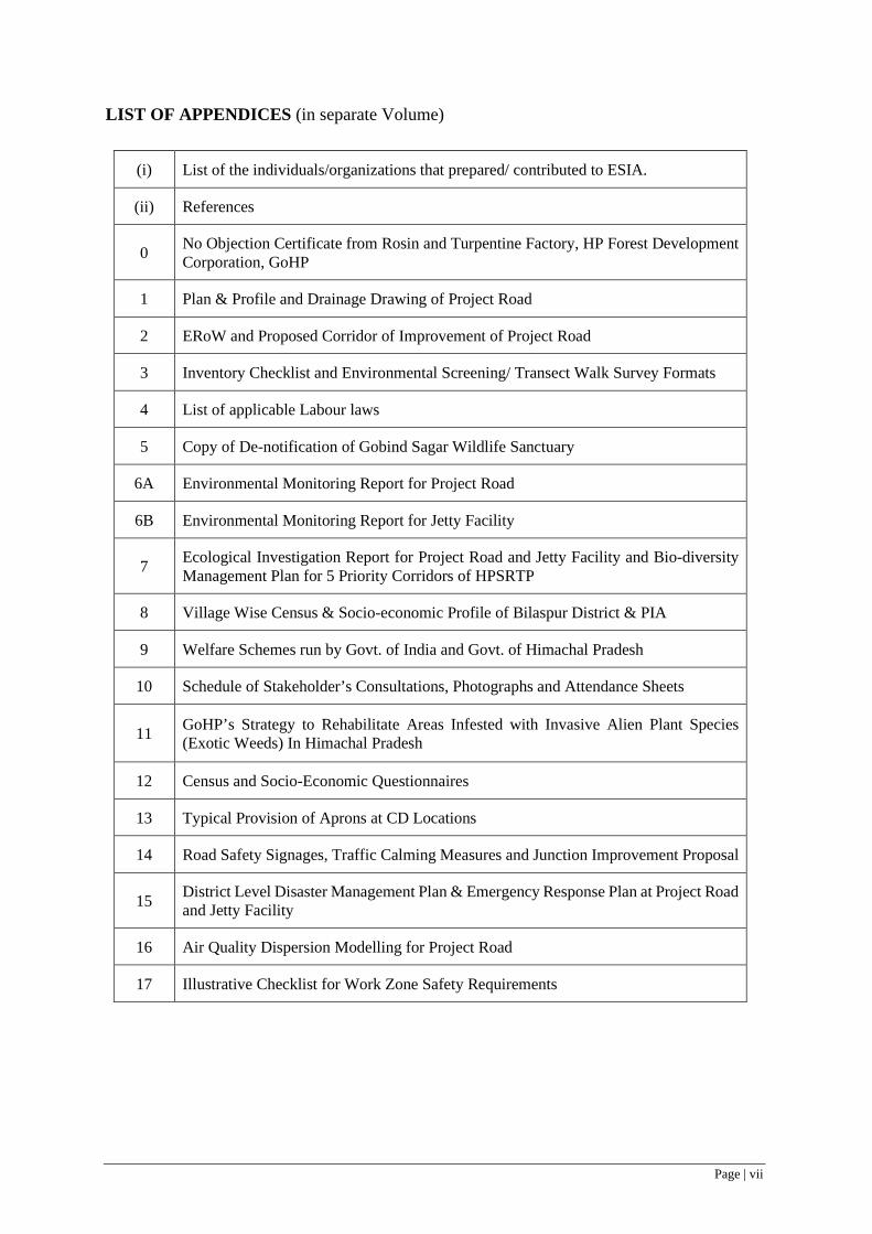
LIST OF APPENDICES (in separate Volume)
(i) List of the individuals/organizations that prepared/ contributed to ESIA.
(ii) References
0 No Objection Certificate from Rosin and Turpentine Factory, HP Forest Development Corporation, GoHP
1 Plan & Profile and Drainage Drawing of Project Road
2 ERoW and Proposed Corridor of Improvement of Project Road
3 Inventory Checklist and Environmental Screening/ Transect Walk Survey Formats
4 List of applicable Labour laws
5 Copy of De-notification of Gobind Sagar Wildlife Sanctuary
6A Environmental Monitoring Report for Project Road
6B Environmental Monitoring Report for Jetty Facility
7 Ecological Investigation Report for Project Road and Jetty Facility and Bio-diversity Management Plan for 5 Priority Corridors of HPSRTP
8 Village Wise Census & Socio-economic Profile of Bilaspur District & PIA
9 Welfare Schemes run by Govt. of India and Govt. of Himachal Pradesh
10 Schedule of Stakeholder’s Consultations, Photographs and Attendance Sheets
11 GoHP’s Strategy to Rehabilitate Areas Infested with Invasive Alien Plant Species (Exotic Weeds) In Himachal Pradesh
12 Census and Socio-Economic Questionnaires
13 Typical Provision of Aprons at CD Locations
14 Road Safety Signages, Traffic Calming Measures and Junction Improvement Proposal
15 District Level Disaster Management Plan & Emergency Response Plan at Project Road and Jetty Facility
16 Air Quality Dispersion Modelling for Project Road
17 Illustrative Checklist for Work Zone Safety Requirements

Page | viii
ABBREVIATIONS AND ACRONYMS
AIDS Acquired Immune Deficiency Syndrome AAQ Ambient Air Quality ADT Average Daily Traffic ANM Auxiliary Nurse Midwife ASI Archaeological Survey of India BIS Bureau of Indian Standards BMTPC Building Materials & Technology Promotion Council BPL Below Poverty Line CAR Contractor’s All Risk Policy CBO Community Based Organization CCTV Closed Circuit Television CD Cross Drainage CGWB Central Ground Water Board CGWA Central Ground Water Authority Ch Chainage CHS Plan Community Health & Safety Plan CMU Construction Management Unit COI Corridor of Impact CPCB Central Pollution Control Board CPRs Common Property Resources CPWD Central Public Works Department CRF Central Road Fund CSC Construction Supervision Consultant
CTO Consent to Operate CTE Consent to Establish CTVC Classified Traffic Volume Count
Cum Cubic Meter dB Decibel Level DEIAA District Environment Impact Assessment Authority
DLP Defect Liability Period DoE Department of Environment DC District Commissioner DFO Divisional Forest Officer DLC District Level Committee DPR Detailed Project Report EBRD European Bank for Reconstruction and Development EHSGs Environment Health and Safety Guidelines EO Environment Officer ERP Emergency Response Plan ESIA Environmental and Social Impact Assessment ESF Environment and Social Framework ESS Environment and Social Standards E&S Environment and Social ESHS Environment, Social, Health and Safety ESMF Environmental and Social Management Framework EMP Environmental Management Plan ERoW Existing Right of Way ESMP Environmental Social Management Plan ESMU Environment & Social Management Unit ESCP Environment and Social Commitment Plan FPIC Free Prior and Informed Consultation FGDs Focus Group Discussions GDP Gross Domestic Product GHG Greenhouse Gas GIIPs Good International Industry Practice GLC Ground Level Concentration
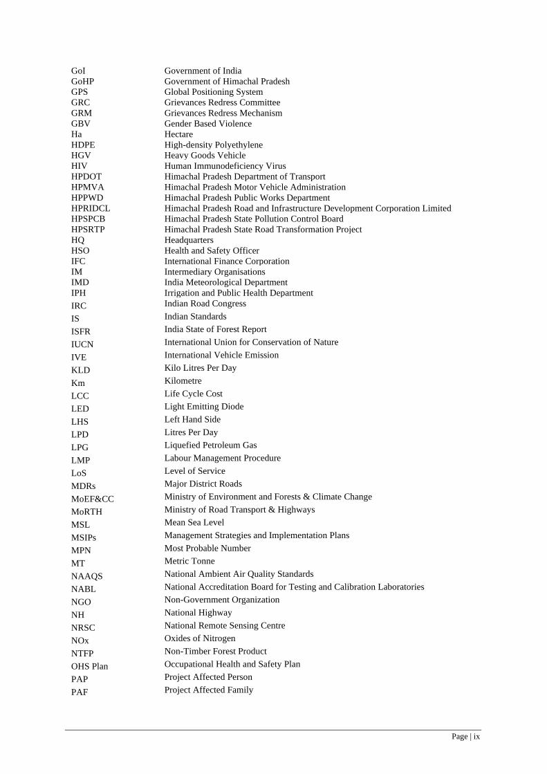
Page | ix
GoI Government of India GoHP Government of Himachal Pradesh GPS Global Positioning System GRC Grievances Redress Committee GRM Grievances Redress Mechanism GBV Gender Based Violence Ha Hectare HDPE High-density Polyethylene HGV Heavy Goods Vehicle HIV Human Immunodeficiency Virus HPDOT Himachal Pradesh Department of Transport HPMVA Himachal Pradesh Motor Vehicle Administration HPPWD Himachal Pradesh Public Works Department HPRIDCL Himachal Pradesh Road and Infrastructure Development Corporation Limited HPSPCB Himachal Pradesh State Pollution Control Board HPSRTP Himachal Pradesh State Road Transformation Project HQ Headquarters HSO Health and Safety Officer IFC International Finance Corporation IM Intermediary Organisations IMD India Meteorological Department IPH Irrigation and Public Health Department IRC Indian Road Congress IS Indian Standards ISFR India State of Forest Report
IUCN International Union for Conservation of Nature IVE International Vehicle Emission KLD Kilo Litres Per Day
Km Kilometre LCC Life Cycle Cost LED Light Emitting Diode
LHS Left Hand Side LPD Litres Per Day LPG Liquefied Petroleum Gas
LMP Labour Management Procedure LoS Level of Service MDRs Major District Roads
MoEF&CC Ministry of Environment and Forests & Climate Change MoRTH Ministry of Road Transport & Highways MSL Mean Sea Level
MSIPs Management Strategies and Implementation Plans MPN Most Probable Number MT Metric Tonne
NAAQS National Ambient Air Quality Standards NABL National Accreditation Board for Testing and Calibration Laboratories NGO Non-Government Organization
NH National Highway NRSC National Remote Sensing Centre NOx Oxides of Nitrogen
NTFP Non-Timber Forest Product OHS Plan Occupational Health and Safety Plan PAP Project Affected Person
PAF Project Affected Family

Page | x
PAH Project Affected Household PCP Project Contact Person
PD Project Director
pH Potential of Hydrogen PIA Project Influence Area
PMC Project Management Consultant
PM Particulate Matter PMGSY Pradhan Mantri Gram Sadak Yojana
PPE Personal Protective Equipment
PUC Pollution Under Control PWD Public Works Department
RAP Resettlement Action Plan
RFCTLARR Act Right to Fair Compensation and Transparency in Land Acquisition, Rehabilitation and Resettlement Act
RET Rare, Endangered and Threatened
RHS Right Hand Side
RPF Resettlement Policy Framework R&R Resettlement and Rehabilitation
RoW Right of Way
SC Schedule Caste SEP Stakeholder Engagement Plan
SEIAA State Environmental Impact Assessment Agency
SCRN State Core Roads Network SGRC State level Grievance Redress Committee
SH State Highway or Sexual Harassment
SIA Social Impact Assessment SME Small & Medium Enterprises
SO2 Sulphur Dioxide
ST Schedule Tribe USEPA United States Environmental Protection Agency
VGO Vigilance Officer VMS Variable Messaging System WB The World Bank WMM Wet Mix Macadam

Page | 1
EXECUTIVE SUMMARY
1.0 HPSRTP – Background & Objective
1. The Project Development Objective of HPSRTP (Himachal Pradesh State Roads Transformation Program) is to enhance the efficiency of the transportation, logistics and road safety to stimulate horticulture and overall economic growth in Himachal Pradesh, through Component 1: Building HP’s Transport and Logistics Institutions, and Resilience; Component 2 - Improving fruit belts, stimulating HP’s horticulture and overall economic growth, through upgrading priority target collector roads/ MDRs/ OSRs. Component 3: Enhancing road safety.
Sub Project Roads under Tranche I - HPSRTP
2. Raghunathpura-Mandi-Harpura- Bharari (2.75 km) is one of the four corridors under Tranche I of HPSRTP. The other three corridors are (a) Baddi – Sai – Ramshahr (33.40 km) (b) Dadhol – Ladrour (13.50 km) (c) Mandi – Rewalsar – Kalkhar (28 km) with a cumulative length of four corridors being 77.65 kms included under Tranche I.
2.0 Sub-project Road– Raghunathpura-Mandi-Harpura- Bharari
3. The Raghunathpura-Mandi-Harpura- Bharari road, designated as OSR-11 (Other State Road) starts from Raghunatpura and ends at Bharari and traverses entirely in Bilaspur Sadar tehsil of Bilaspur district. The road connects four settlement areas namely Raghunathpura, Mandi, Harapura, and Bharari. The project road has 5 junctions, out of which 2 are major junctions (at the beginning and end of the road) and the rest 3 are minor junctions and connects to nearby villages/settlements. The project road does not have any Schedule - V 1 areas of Himachal Pradesh or tribal households that meet the characteristics outlined in ESS 7 2.
4. The existing pavement condition of the project road is in fair condition throughout the length, except for the last 100 meters, which is a worn-out gravel road with no bituminous layer. The traffic surveys and traffic projection up to year 2038 indicate the project road warrant widening of the existing road to two lanes, in order to confirm to the Level of Service (LoS) recommended by IRC.
5. The widening of the project road is restricted to the available Right of Way (RoW) with no fresh land acquisition or involve any prior regulatory environmental or forest clearances. The project road widening considers 4 typical cross sections with width of CoI varying between 8.7 to 12.5m, protection measures along identified stretches (1450m long breast walls, 400m long retaining walls and 350m toe walls), which are prone to landslides. The project road upgradation proposal include construction of 7 CD structures (4 box culverts, 3 slab culverts), construction of 2 new bus stops with disabled friendly ramps and road safety components as per requirement.
Jetty Facilities Proposal
6. HPSRTP objectives, also mandate improvement in connectivity of roads falling within 15 km proposed project road corridors, which connect major tourism locations, industrial hubs and has potential to promote tourism, trade and industrial development of State. Accordingly, a Jetty for facilitating all season passenger ferry/boat boarding has been proposed at the Govind Sagar waterfront/Banks of Sutlej River, near the open grounds of Luhnu Stadium, Bilaspur. The proposed Jetty will be an extension to existing boarding ramp at the Government owned land near Luhnu stadium.
7. The boat/ferry facility near Luhnu stadium and similar facility at nearby Nale Ke Naun, jointly serves nearly 3000 people on a daily basis over engine operated 60-75 boat/ferry trips and connects 15-20 villages located on the other side of the riverbank/waterfront. The ferry/boat services provide
1 Fifth schedule areas in Himachal Pradesh are located in Lahaul & Spiti districts, Kinnaur, Pangi tehsil and Bharmour sub-tehsil in Chamba district. 2 characteristics as outlined in ESS 7 – Indigenous Peoples/Sub-Saharan African Historically Underserved Traditional Local Communities
Page | 2
affordable way of commuting between these villages to Bilaspur and merely takes 25-60 minutes, against nearly two to three hours through public transport. The enhanced waterway connectivity can contribute to long term reduction in GHG emissions.
8. The open ground on the banks of Gobind Sagar lake near Luhnu stadium, near jetty facility location is a landing site for paragliding by Department of Tourism and also serves as a mela ground, wherein 5000 to 10,000 people congregate every year during March. Most mela visitors would be using the ferry services as an affordable mode of transport. Besides, the licensed fishermen and fish catch collector boats operated by Fisheries Department, GoHP also land their collection at the same location. Thus, jetty facilities will contribute to income generation activities for traditional fishermen and license holders operating in the Gobind Sagar Lake, through improved access to market and contribute to development of fishing industry.
9. The footprint of the proposed jetty along the waterfront of Govind Sagar lake/River Sutlej will be less than 30 sq. m and superstructure area of the jetty will be 864 sq.m. (216 m long and 4.0 m wide), supported on pile foundation, without constricting underneath waterway and connects to the existing boarding platform, which is now facilitating the boat boarding, and operational for limited months in a year, only when the water levels are quite high. The jetty platform will have intermediate steps and disable friendly ramp and facilitate all season boarding, amid fluctuating water levels and will have openable railing to ensure safety of boarding commuters. A shelter house for the waiting and resting of commuters (50 user capacity with 75 sq.m. plinth area) with drinking water, ablution facility and separate toilets for women and men will be provided near the jetty facility.
3.0 Scope of ESIA
10. The scope of the ESIA is to: i) assess the existing baseline status of the environment within the Corridor of Impact (direct impact zone) and Project Influence Area; ii) identify the probable adverse and positive E&S risk and impacts due to the planned project during its entire cycle i.e. from pre-construction to construction and operation; iii) consider all the likely ESHS risks in the project and prepare requisite mitigation plans, as may be required; iv) identify capacity constraint of HPRIDCL in respect of E&S management and propose commensurate Institutional mechanism for ESMP implementation management measures, among others.
4.0 Legal and Institutional Framework
11. Key GoI and GoHP provisions applicable to the sub-project of road include: Environmental Protection Act, 1986; The Forest (Conservation) Act. 1980; Construction & Demolition Waste Management Rules, 2016; Air (Prevention and Control of Pollution) Act, 1981; Water (Prevention and Control of Pollution) Act, 1974; Noise Pollution (Regulation and Control Act) 1990; The Right to Information Act, 2005. Further, WB’s Environment and Social Framework, 2016 and ESS 1, 2-6, 8 and 10 relevant to this sub-project.
5.0 Regulatory Clearances and Permissions for Project Road and Jetty Facilities
12. Based on the present applicable regulatory framework, the project road and Jetty facilities will not require any prior environmental and forest clearances. The project road will require tree felling permissions, consent to establish and operate camp sites, hot mix plants, concrete batch mix plants, WMM plants, work force camps etc., permits for sourcing construction water, labor permits among others will be required for both project road as well as jetty facilities, all of these does not pose as a significant regulatory risk.
6.0 Baseline Environment Profile
13. The baseline environmental and social profile assessment include key attributes like geology, hydrogeology, physiography, drainage, soil, land use, flora, fauna, forest/vegetation cover, climate, ambient air quality, water quality, ambient noise levels, hazards and vulnerability, socio economic and demographic profile, particularly for COI (25 meter on either side) and PIA (15km on either side) and Mandi district as a whole.

Page | 3
14. Geologically, the rock formations occupying the PIA and Bilaspur district range from pre-Cambrian to Quaternary period. Hydro-geologically, ground water development in Bilaspur district, has not been fully explored and thus deemed to be falling in safe category and no block within district has been notified for restricted groundwater development by Central Ground Water Authority (CGWA). Project Road traverses through Dhuladhar range of Sutlej basin in hilly /mountainous area and does not traverse in flood plains or areas prone to floods. The elevation of project road range between 500-600, with 520 m at km 0+000 and 595 at Km 2+278. The climate of the district is temperate to sub- tropical with an average annual rainfall of 1185 mm, minimum and maximum temperatures ranging between 1.3oC and 34.7oC, respectively. The project road does not get snowfall, has a visibility of 4-10 km for 308 days in a year. The soil fertility in the PIA is medium with low Nitrogen levels, medium Phosphorus and high Potassium levels.
15. The baseline environmental monitoring carried out along project road and at Jetty Facility locations for ambient air quality, ambient noise levels, water quality and soil quality indicate that all tested parameters at all sampling locations were within the respective standards or does not critically exceed and largely conform to the respective stipulated limits/standards. This can be attributed to absence of any major emission sources related industrial activities, except for vehicular emissions.
16. The ecological investigation along project road has not indicated presence of any endangered and /or threatened (RET) floral species along the project road as per IUCN Red Data book of Indian plants. The project road has no forest areas adjacent to its right of way, but will require felling of 42 trees, which are within Right of Way. The Jetty construction does not involve any forest lands or tree felling. The project road or jetty facility does not have any National Parks, Wildlife Sanctuaries, Biosphere Reserve and/or any other notified protected areas within a radius of 10km. No wildlife crossing corridors or important bird areas are reported within the PIA. Gobind Sagar lake and the connected River Sutlej is the only prominent aquatic body present in PIA and the project road traverses in close proximity to the Gobind Sagar Lake and the Jetty facility is located on the bank of the Gobind Sagar Lake/ River Sutlej near Luhnu Stadium Bilaspur.
17. The project region falls under very high-risk seismic zone (Zone IV) and the Himachal Pradesh Disaster Management Authority has categorized the vulnerability status of the entire Bilaspur District, which include project road as well as its PIA as ‘High’ for natural calamities like wind hazard, earthquake, landslides considerations. The project region is not prone to floods and the probable areas liable for flash floods are more than 100 kms from project road. Although, Himachal Pradesh experiences occurrences of several cloud burst every year, Bilaspur district has no statistical probability of cloud burst occurrence and the project road has not experienced any cloud burst in last ten years.
18. The project road has no protected archeological or historical monuments within 300 meters on either side of its right of way. The project road has two Peepal tree with platforms, which are revered as religious places by local community but are not protected monuments under GOI regulations.
7.0 Baseline Socio-Economic Profile
19. The population of the Bilaspur District, which include the 15 km wide PIA is 381,956 with a male and female population of 192764 (50.46%) and 189192 (49.53%) respectively. Out of the total population of the district, 93.42% are in rural areas while a mere 6.58 % are in urban areas. The project road falls under 5 villages of Bilaspur Sadar tehsil, which has a population of 75,714 persons (2011 census), which is 19.82% of the district and 1.10% of the total population of the State. The density of population within Bilaspur Sadar tehsil is 327 persons per sq.km with an average family size of 4.7 persons per household.
20. The population of Scheduled Castes and Scheduled Tribes of the tehsil is 26.31% and 0.73% respectively. As per the village data, Bharari has highest SC population of 57.08% and Raghunathpura has highest ST population of 0.84%, which are along project road. The sex ratio of females per 1000 males in Bilaspur Sadar tehsil is 951 in rural area & 939 in urban area. At the Bilaspur district level, there are 981 females per 1,000 males. The literacy level at Bilaspur district as well as Bilaspur Sadar
Page | 4
tehsil hover around 85%, which is reflected even in villages along project road. The gender wise male and female literacy rate of the tehsil are 91.21% and 78.23% respectively.
8.0 Stakeholder Consultations
21. Consultations3 were held with communities at locations en-route the project road and likely to be affected by road widening. Key queries and concerns4 posed during consultations were relating to extent of compensation for likely affected households, avoidance of impacts on structures and religious and community purposes, road safety, street lighting, footpaths among others. Since the project road was only 2.74 kms long, sparsely populated with no major settlement areas and absence of potential GBV hotspots, no GBV consultations5 for this specific project corridor was conducted during ESIA.
9.0 Analysis of Alternatives
22. Alternative design options for project road widening were evaluated to minimize environmental and social impacts and to consider resource efficiency and minimization of natural resources extraction. Three alternatives were evaluated namely i) No Project Scenario ii) Minimization of earth work excavation, with constraint of limiting height for retaining walls and reuse the excavated materials for road and jetty construction, which will concurrently minimize land required for disposal of muck/debris iii) Avoid/minimize Environmental impacts (viz. avoid impacts on natural resources, sensitive receptors and religious places) and Social impacts (viz avoid impacts on encroached structures by both title and non-title holders).The alternatives evaluated for the Jetty considered factors like design and general structural arrangement, which require minimum footprint on the waterfront of Gobind Sagar/ River Sutlej and concurrently enable an all-season boarding facility, amid fluctuating water levels.
23. The project design for both project road and Jetty considers, reuse of 28204 cum out of 36171 cum of excavated materials (78%) in the construction of embankment, subgrade construction, backfilling of protection works and reclamation of low-lying areas within RoW, which incidentally reduces the muck disposal land requirement by 78% (7967 cu.m). Similarly, the analysis of alternative options through review and modifications of design for project road have enabled to completely avoid social impacts and impact to one Peepal tree6 with platform. The Jetty construction will not impact any structures and thus, will not have adverse social impacts but is expected to benefit the local community with a shortest and affordable mode of connectivity between their villages and Bilaspur, which is district headquarter and major urban center in the region. The Jetty facility will also enable to avoid risks to community associated with slushy mud banks, while boarding boats.
10.0 Assessment of E&S Risks and Impacts
24. The E&S risks and impacts of both project road widening and Jetty facility construction have been assessed by each relevant ESSs (ESS 2 to 8) and suitable mitigation measures to be implemented during project road widening and Jetty facility construction are also included in the stand alone ESMP volume.
25. E&S risks on labor and working conditions (ESS 2): At this stage, it is estimated that the project road and jetty construction will require 80 contract workers (including project managers, supervisors, skilled and unskilled labor, etc.) The Risks include: Non-payment of wages by Employer; Non-payment of benefits (compensation, bonus, maternity benefits etc.) by Employer; Discrimination in Employment
3 One stakeholder consultation was held on 19th September 2019, which was attended by 9 participants (8 male, 1 female and 0 third gender). 4 Participants of the stakeholder consultation were keen to know the provisions for compensation in case of impact on structures, although it was not warranted or applicable for the project road. The participants also desired that road design should consider footpaths and street lights along the road as per requirements. 5 GBV consultations have been conducted at project district level covering other corridors. HPSRTP has a GBV risk mitigation strategy for all road corridors including this project road. 6 Project road has two peepal tree platforms, out of which impact on one Peepal tree platform has been avoided through design modification, one is not impacted but both have been considered for enhancement/ conservation.

Page | 5
(e.g. abrupt termination of the employment, working conditions, wages or benefits etc.); Possibility of Gender Based Violence is not likely as the road does not have sensitive locations such as schools and hospitals etc. and also there are no major settlement areas or markets along the project road; Health risks of labour relating to HIV/AIDS and other sexually transmitted diseases.
26. HPRIDCL has a Labour Management Procedure that would be applicable for the project road as well as for the entire HPSRTP. Through this LMP and associated standard operating procedures for Occupational Health & Safety and Social (OHSS) guidelines, management system and governance controls, GoI /State Labour and Safety regulations will be complied. The responsibility to manage these risks would be clearly reflected in the contractual obligations of the Civil Works Contractor with appropriate mechanisms for addressing non-compliance. The bid documents for construction will incorporate requirements for Environment, Social, Health and Safety (ESHS) requirements and the metrics for periodic reporting by contractors. The bidder’s submission requirements as part of their technical bid include: i) ESHS strategy and implementation plan; code of conduct; ii) declaration of past ESHS performance. The successful bidder will be required to submit an ESHS Performance Security @ 2% of accepted contract value.
27. E&S risks and impacts relating to Resource Efficiency and Pollution Prevention (ESS 3): The project’s impacts and risk (both road and Jetty) would be due to muck disposal (estimated quantity of muck for disposal is 7967 cu.m); slope stability and erosion, easing of flow across seasonal streams (7 CD structures across seasonal streams), construction water demand (82.5 KLD), stressing water sources (absence of perennial water sources); liquid waste discharge (3060 LPD) (sewage/sullage from workforce camps and camp sites), emission from construction vehicles, equipment and plants; increased dust levels from operations, handling of hazardous and non-hazardous wastes, management of borrow areas, muck disposal sites, stone quarries/crusher units, hot mix plants, concrete batch mix plants. The project design optimization is carried out to minimize project’s footprint (both road and Jetty) on social and environment through optimization of resource efficiency and reduction in GHG emissions by 27634 metric tonnes.
28. E&S risks and impacts relating to Community Health and Safety (ESS 4): The project road will act as haul road for transporting construction materials and thus is likely to cause temporary impacts /nuisance to both existing road users and roadside settlement areas and potentially cause discomfort to locals or potential conflicts with local people including possible gender-based violence issues. The ESMP considers adequate mitigation measures to minimize the possible impacts and risks on community health and safety issues. The C-ESMP has been included as contractual obligations of the Civil Works Contractor with appropriate mechanisms for addressing non-compliance. The CSC will oversee the implementation of ESMP by the contractor.
29. E&S risks and impacts on land & assets (ESS 5): The project road widening will be confined to the available right of way and does not warrant any fresh land acquisition. The road widening will not affect any residential or commercial structure, including encroachments by non-title holders or squatters. Thus, no Resettlement Action Plan (RAP) was warranted for the project road.
30. The Jetty construction will not warrant any land acquisition and will be constructed along the waterfront of Gobind Sagar Lake/ banks of River Sutlej. The Jetty facility will not have any adverse social impacts. On the contrary it will have beneficial impacts connecting several villages through shortest route and avoid public transport system. The jetty will also enable licensed fishermen and fish catch collector boats operated by Fisheries Department land their collection near Luhnu stadium. Thus, development of jetty facilities will contribute to income generation activities for traditional fishermen and license holders operating in the Gobind Sagar Lake and enhance the development of fishing industry.
31. E&S risks and impacts on Disadvantaged and Vulnerable persons: The project road widening will not have impacts on disadvantaged and vulnerable persons. Two bus stops/ rain shelters along the project road, entry and along the jetty platform will be provided with disable friendly ramps.
32. E&S risks and impacts relating to Biodiversity & Living Natural Resources (ESS 6): Project Road widening will be confined to the existing right of way and no fresh forest land diversion will be

Page | 6
required. There is no presence of rare, endangered, and threatened flora species along project road but will involve felling about 42 trees within right of way. The Jetty construction will not impact aquatic ecosystem of Gobind Sagar Lake/ River Sutlej, as all construction works related to Jetty will be scheduled for non-monsoon months (Oct. to May) and the Jetty itself will not constrict the waterway beneath due to its design and general arrangement of foundation, which will have a footprint of less than 30 sqm. As part of ESMP, budgetary provisions have been included for conservation and enhancement of one natural water source has been made to facilitate drinking of water by stray/grazing as well as by local community.
33. E&S risks and impacts relating to Cultural Heritage (ESS 8): The project road does not have any monuments and/or archaeological site(s) protected by GoI/GoHP within 300 meters of the alignment. The project design includes renovation of two Peepal tree platforms, which are along road and of religious importance for local community are included in ESMP with budget provisions as cultural heritage enhancement measure. Thus, project road widening doesn’t have any risks/impacts to cultural heritage.
11.0 Environment and Social Management Plan
34. An ESMP has been prepared to mitigate Project’s environmental and social risks and impacts. It includes mitigation measures, monitoring plan, responsibilities for implementation and supervision along with reporting system with a budgetary provision of INR 91.45 Lakhs (INR 9.14 million). The ESMP obligates the contractor, upon mobilization, to prepare the C-ESMP, which shall be approved by CSC prior to the commencement of construction activities. The Contractor’s C-ESMP will include OHS plan, Water and Waste Management Plan, Influx management Plan, Worker’s camp management plan, CHS Plan, Traffic management and road safety management Plan, Quarry/borrow area management plan, and Site restoration Plan among others in accordance with the GoI and IFC&WB workers accommodation guidelines. All such plans will be reviewed and approved by the CSC, prior to commencement of construction works. The approved C-ESMP shall be reviewed periodically (but not later than every three (3) months) and updated in a timely manner. The budgetary provisions of under ESMP also include provisions for implementing nature based (bioengineering) solutions at reclaimed low-lying areas within RoW, muck disposal sites, land slide prone locations among others.
12.0 Institutional Arrangements for Implementation of ESMP
35. The implementation of ESMP will be overseen by CSC under the overall guidance of the Project Director cum Chief Engineer, HPRIDCL. The Project Director (PD) will be assisted by Construction Supervision Consultant (CSC) for implementation of ESMP at each of the contract package levels. The CSC shall provide one Environmental Specialist, one Social Development Specialist and one Bio-diversity Specialist for implementation of ESMP and shall coordinate with the Environmental Specialist at HPRIDCL headquarters for the implementation of ESMP for all the contract packages under the overall guidance of Project Director. At specific project contract package level, the Contractor shall provide one Social cum Community Liaison Officer, one Health & Safety Officer and one Environmental Officer, who shall be responsible for implementation of ESMP at field level under the guidance of the CSC.
36. The ESMP implementation monitoring, and reporting shall be through daily, weekly and monthly progress reports. The monitoring report (s) shall cover all operational areas as well as designated work camp sites, hot mix plants, material stack yards along with the periodic environmental monitoring carried out covering all such operational areas, where work is under progress and establishment sites as may be required. The checklists for monitoring the ESMP implementation shall be developed by CSC, based on the approved C-ESMP of the Contractor, prior to commencement of Construction works.
13.0 Grievance Redress Mechanism
37. HPRIDCL will establish GRM to redress the complaints received during the project construction phase like loss of access, damage to some private or common property or utilities, noise

Page | 7
and dust levels due to excavation works, traffic management, community safety and other similar issues/concerns. The institutional arrangements, procedure for receiving complaints, time limits for redressal of complaints are stipulated for the GRM. In addition, the contractor will be contractually obligated to set up another GRM, mainly to redress complaints relating to workforce, deployed for project road constriction under HPSRTP.
14.0 Training and Capacity Building
38. As a training and capacity building initiative, designated HPRIDCL and CSC staff will be sent on exposure visits to other similar road construction projects with good track record for ESMP implementation. The designated staff will also be sponsored for training courses conducted by accredited institutions in ESMP implementation.
Page | 8
1 INTRODUCTION
1.1 HPSRTP – Background & Objective 1. GoHP’s program for transforming state level transport institutions, improving mobility and logistics for horticulture and overall economic growth in HP, connecting HP to the Bharatmala network, and enhancing road safety, sets the goal for the institutional transformation envisaged to be implemented under the proposed HPSRTP (Himachal Pradesh State Roads Transformation Program). As such, HPSRTP will support launching of GoHP’s program focusing on strengthening the institutional base for transportation infrastructure and logistics services administration, across the State.
2. The Project Development Objective of HPSRTP is to enhance the efficiency of the transportation, logistics and road safety institutions to stimulate horticulture and overall economic growth in Himachal Pradesh.
3. The HPSRTP comprises the following components and sub-components:
Component 1: Building HP’s Transport and Logistics Institutions, and Resilience, including:
• Sub-component 1.1: Re-establishing the Himachal Pradesh Road and Infrastructure Development Corporation (HPRIDCL) with an objective to support GoHP’s initiative to create a corporate entity responsible for the administration of HP roads and delivering safe, resilient and well performing roads supporting the horticulture and overall economic development of the State. This involves, re-establishing HPRIDCL as the road asset and other public infrastructure manager, responsible for the development and maintenance of all roads and other infrastructure under the jurisdiction of the HPPWD.
• Sub-component 1.2: Supporting the commercialization process of the direct labor operations and promoting competitive performance-based maintenance contracting. The objective is to support GoHP’s initiative to improve the efficiency of road maintenance and reduce maintenance cost, by laying the ground for the full commercialization of HPPWD’s direct labor operations.
• Sub-component 1.3: Establishing HP Motor Vehicle Administration (HPMVA), strengthening the Directorate of Transportation of HPDOT and developing logistics system and strategy. The objective is to deliver efficient customer services, as well as competitive, safe and clean/less pollutant transportation in HP.
Component 2: Improving fruit belts and stimulate HP’s horticulture and overall economic growth including:
4. This component will finance upgrading priority target collector roads/MDRs. The upgrading of approximately 77.65 km of roads connecting small holding farmers production and primary processing clusters to wholesale markets/SME clusters.
Component 3: Enhancing Road Safety, including:
• Sub-component 3.1: Promoting the ‘Safe System’: This focuses on strengthening enforcement on state roads and critical accident spots along rural roads, by enhancing patrolling and establishing emergency response system.
• Sub-component 3.2: Promoting the ‘Safe Corridor initiative’: The Safe Corridor initiative will support the state highway patrol by providing surveillance equipment (CCTV cameras for speed control, accident recording, etc.), variable messaging system (VMS), training the police, and establishing emergency response posts.
5. The implementation of the core initiatives of the HPSRTP is expected to result in: i) Improved efficiency of transport and logistics institutions; ii) Reduction in maintenance expenditure; iii) Reduction in transport cost for transporting products from production clusters to SME/wholesale

Page | 9
markets along the project roads; iv) Reduction in road accident fatalities per 100,000 population in pilot areas.
1.2 Sub Project Roads under Tranche I - HPSRTP 6. Under Tranche I, four road corridors with a cumulative length of 77.65 km are being considered for upgradation/widening in line with the objective of Component 2 of HPSRTP. The details of the four corridors are given in Table 1-1.
Table 1-1: Roads Proposed for Widening/Upgradation under Tranche I- HPSRTP
S. No Name of the Road District Length (in Km)
1 Baddi – Sai – Ramshahr Solan 33.40
2 Dadhol – Ladrour Bilaspur 13.50
3 Mandi – Rewalsar – Kalkhar Mandi 28.00
4 Raghunathpura-Mandi-Harpura- Bharari Bilaspur 2.74
Total 77.65
1.3 Associated Facilities of Tranche I - HPSRTP 7. National Highways Authority of India (NHAI), GoI had initiated to construct a major bridge 7 for improving NH connectivity, which is 350 meters beyond the end point of the Raghunathpura-Mandi-Harpura- Bharari road, which is one of the four corridors under Tranche I. However, this under construction bridge by NHAI does not meet the criteria set out in the ESF Policy of the World Bank to qualify as ‘Associated Facility8.
1.4 Purpose of ESIA 8. Based on the risks and impacts of the priority Tranche I corridors, the risk rating9 is revised to ‘Substantial’ and accordingly an ESIA has been prepared.
9. The purpose of the ESIA is to use it as tool for decision-making on the sub-project road, so that there is sustainable development of the road construction. Specifically, the objective of the ESIA is:
i. To identify, evaluate and manage the environment and social risks and impacts of the project road in a manner consistent with the ESSs;
ii. To adopt a mitigation hierarchy approach to the project’s E&S risks i.e., a) anticipate and avoid risks and impacts; b) minimize or reduce risks and impacts to acceptable levels, if not avoidable; c) once risks and impacts have been minimized or reduced, mitigate; and (d) where significant residual impacts remain, compensate for or offset them, where technically and financially feasible;
7 Bridge construction had stopped due to contractual dispute and understandably NHAI has sorted out the matter for resumption of works 8 HPPWD is constructing four bridges (3 minor and 1 major bridge) through the Central Road Fund (CRF) of Government of India (GoI) along the Mandi-Rewalsar-Kalkhar road, which is also one of the four corridors under Tranche I. The four bridges, which are presently under construction meets all the three criteria set out in the ESF Policy of the World Bank to qualify as ‘Associated Facilities’ but does not warrant common approach or the assessment and management of environmental/social risks, since these are not under the funding by any other multi-lateral or bi-lateral funding agencies. The ESIA report for Mandi Rewalsar Kalkhar may be referred for any further details on Associated Facilities. 9 Initially, the overall project risk was categorized as ‘High’ as per an internal Environment and Social Risk Classification of the World Bank and ESIAs were prepared by an independent consultant.
Page | 10
iii. To help identify differentiated impacts on the disadvantaged or vulnerable and to identify differentiated measures to mitigate such impacts, wherever applicable;
iv. To assess the relevance and applicability of environmental and social institutions, systems, laws, regulations and procedures in the assessment, development and implementation of projects, whenever appropriate; identify gaps, if any exist, and
v. To assess borrower’s existing capacity and identify areas for enhanced capacity towards management of E&S risks.
1.5 Scope of the ESIA 10. The ESIA requires conforming to the applicable environment and social legal and regulatory framework of Government of India and Himachal Pradesh as well as World Bank’s Environmental and Social Framework Policy and relevant Standards.
11. The scope of the ESIA is to:
i. assess the existing baseline status of the environment within Corridor of Impact and Project Influence Area;
ii. identify the probable adverse and positive E&S risk and impacts due to the planned project during its entire cycle i.e., from preconstruction to construction to operation & maintenance;
iii. identify stakeholders and various groups/institutions who are either affected or have an interest or a stake in the project, with additional emphasis on disadvantaged and vulnerable groups and to carry out consultations with stakeholders to help elicit their concerns, suggestions and support;
iv. consider all ESHS likely in the project for further usage towards preparation of requisite mitigation plans, as may be required.
v. conduct additional studies, if any, for the enhancement of the benefit to the local community and the road users.
vi. identify capacity constraint of HPRIDCL in respect of E&S management and propose commensurate capacity enhancement measures; and finally
vii. use inputs from the above to prepare appropriate mitigation measures and plans and their inclusion in cost estimates (including rate analysis), Drawings, Bill of Quantities, Technical specifications and other inputs that would be integrated with the bid documents.
1.6 Structure of ESIA Report 12. The ESIA report for the widening and up-gradation of the 2.74 km long Raghunathpura-Harpura-Mandi-Bharari Road has been structured as hereunder:
i. Environmental and Social Impact Assessment (ESIA) Report
ii. ESIA Appendices Volume
13. This report presents the Environmental and Social Impact Assessment (ESIA) of the road and has been structured into 8 sections. ESIA Appendices include the plan and profile of road, right of way demarcation report, drainage map, ecological investigations and bio-diversity management plan report, environmental and social surveys/investigations reports, Attendance sheets and photos of stakeholder, bio-diversity management plan, road safety and signages, climate change disaster management plan and similar background data/information referred in ESIA.
0. Executive Summary
1. Introduction: This section describes background of project and its components; need/requirement, objective and scope and structure of the ESIA report.
Page | 11
2. Project Description: This section summarizes the project road design consideration, present and projected traffic data, widening proposals, protection works, cross drainage structures, road safety features for the Raghunathpura-Harpura-Mandi-Bharari Road under tranche I of HPSRTP.
3. Legal and Regulatory Framework: This section describes the environmental and social policies and regulations of Government of India, Govt. of Himachal Pradesh as well as the Environmental and Social Policy Framework (ESF), 2016 of the World Bank, which is applicable to the priority corridors under HPSRTP.
4. Baseline Data: This section describes baseline environmental and socio-economic profile of the direct corridor of impact (25 meters on either side) as well as the project influence area (15 km on each side) of Raghunathpura-Harpura-Mandi-Bharari road in Bilaspur district. The baseline environmental and social data have been assessed from both secondary data and supplemented by primary investigations, wherever required.
5. Stake holder Consultations and Information Disclosure: This section describes the stakeholder consultations conducted along the project corridor along with its outcome for ESIA.
6. Analysis of Alternatives: This section describes the alternatives evaluated for finalizing the widening and upgradation proposals of the project corridor, with a prime objective to minimize environmental and social impacts. The section also includes the outcome of stakeholder consultations to minimize the social impacts and improve road safety features.
7. Environment and Social Risks, Impacts and Mitigation Measures: This section identifies and evaluates the anticipated environmental and social risks, impacts by each relevant standard of ESSs (ESS-2 to 8) and commensurate mitigation measures due to the proposed widening and upgradation of project corridor.
8. Environmental and Social Management Plan: This section summarizes the Environmental and Social Management Plan (ESMP) to minimize and/or avoid the risks and impacts of the widening and up-gradation of the project corridor and jetty facility. The ESMP also includes enhancement or conservation measures for natural water sources, CPRs along project corridor along with budgetary provisions. The institutional arrangement for ESMP implementation supervision and monitoring mechanism for the project implementation phase as well as a GRM (grievance redress mechanism) to redress the concerns of PAPs as well as the construction related complaints from the local community during the construction phase have been included in the ESMP.

Page | 12
2 PROJECT DESCRIPTION
2.1 Sub-Project Road: Raghunathpura-Mandi-Harpura-Bharari 14. The Raghunathpura-Mandi-Harpura- Bharari road is 2.74 Km long and is designated as OSR-11 (Other State Road). The project road starts from Raghunatpura and ends at Bharari and traverses entirely in Bilaspur Sadar tehsil of Bilaspur district. The project road starts at Raghunathpura near NH-154 (0+00 Km) and connects to Bharari village near 2 +740 km (Figure 2-1). The latitude and longitude of the project road at Raghunathpura and Bharari are 31.172°N to 31.181°N and 76.444° E to76.454° E respectively. The altitude of project corridor from Raghunathpura to Bharari ranges between 600 to 250 m above mean sea level and pre-dominantly traverses through rolling terrain.
15. The 4 settlement areas along the project road are Raghunathpura, Mandi, Harapura, and Bharari. Out of the total 2.74 km length, the built-up areas of the settlement areas are limited to the initial 0.5 km, which is about 20% of the road length. Other than this, rest of the road is devoid of any settlement areas, throughout its balance length. The project road has 5 junctions, out of which 2 are major junctions (at the beginning and end of the road) and the rest 3 are minor junctions and connects to nearby villages/settlements. The Project Road does not have any fifth Schedule10 areas of Himachal Pradesh or tribal households that meet the characteristics outlined in ESS 711.
16. The Photographs of the project road at the beginning and end point are given in Figure 2-2.
Figure 2-1: Location Map of Raghunathpura-Mandi-Harpura-Bharari Road
10 Fifth schedule areas in Himachal Pradesh are located in Lahaul & Spiti districts, Kinnaur, Pangi tehsil and Bharmour sub-tehsil in Chamba district. 11 characteristics as outlined in ESS 7 – Indigenous Peoples/Sub-Saharan African Historically Underserved Traditional Local Communities
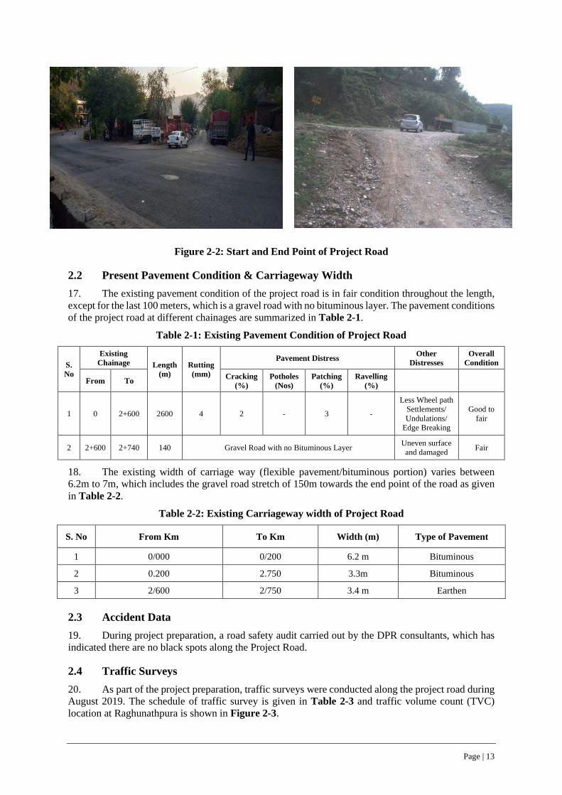
Page | 13
Figure 2-2: Start and End Point of Project Road
2.2 Present Pavement Condition & Carriageway Width 17. The existing pavement condition of the project road is in fair condition throughout the length, except for the last 100 meters, which is a gravel road with no bituminous layer. The pavement conditions of the project road at different chainages are summarized in Table 2-1.
Table 2-1: Existing Pavement Condition of Project Road
S. No
Existing Chainage Length
(m) Rutting (mm)
Pavement Distress Other Distresses
Overall Condition
From To Cracking (%)
Potholes (Nos)
Patching (%)
Ravelling (%)
1 0 2+600 2600 4 2 - 3 -
Less Wheel path Settlements/ Undulations/
Edge Breaking
Good to fair
2 2+600 2+740 140 Gravel Road with no Bituminous Layer Uneven surface and damaged Fair
18. The existing width of carriage way (flexible pavement/bituminous portion) varies between 6.2m to 7m, which includes the gravel road stretch of 150m towards the end point of the road as given in Table 2-2.
Table 2-2: Existing Carriageway width of Project Road
S. No From Km To Km Width (m) Type of Pavement
1 0/000 0/200 6.2 m Bituminous
2 0.200 2.750 3.3m Bituminous
3 2/600 2/750 3.4 m Earthen
2.3 Accident Data 19. During project preparation, a road safety audit carried out by the DPR consultants, which has indicated there are no black spots along the Project Road.
2.4 Traffic Surveys 20. As part of the project preparation, traffic surveys were conducted along the project road during August 2019. The schedule of traffic survey is given in Table 2-3 and traffic volume count (TVC) location at Raghunathpura is shown in Figure 2-3.

Page | 14
Table 2-3: Traffic Survey Schedule
S. No Road Name Location Existing Chainage Duration Survey Schedule
Classified Traffic Volume Count (CTVC)
1 Raghunathpura - Bharari Khansra At km. 0/300 1 Day** 05th Aug, 2019
Figure 2-3: Traffic Volume Count Location along Project Road
2.5 Traffic Projections 21. Daily traffic volume by vehicle type and direction were aggregated and an average calculated for the entire survey duration to determine the average daily traffic (ADT) at each survey location. The daily traffic by each hour of the day over the survey period, the Day wise hourly traffic data by vehicle type at the Traffic Volume Count (TVC) location is given in Table 2-4.
Table 2-4: Average Daily Traffic Values
TVC Location
2 W
3 W
Car/ Jeep/ Van
Bus LCV 2-Axle Trucks
3-Axle Trucks
Multi Axle
Vehicles
Tractor +
Trailer
Cycle/ Rick/ ADV
Total Vehicles
Total PCUs
Raghunathpura 236 46 176 27 40 13 9 1 2 1 551 522
22. The projected traffic projections on project road up to year 2038 is given in Table 2-5. The growth potential of goods traffic is different from passenger traffic and directly related to zone’s economic activity and production levels than its population and income growth patterns.
Table 2-5: Traffic Growth Rates and Traffic Projections for Project Road
Sl. No. Years Total Vehicles Total PCUs
1 2019 / AADT 551 522
2 2020 (Design) 608 573
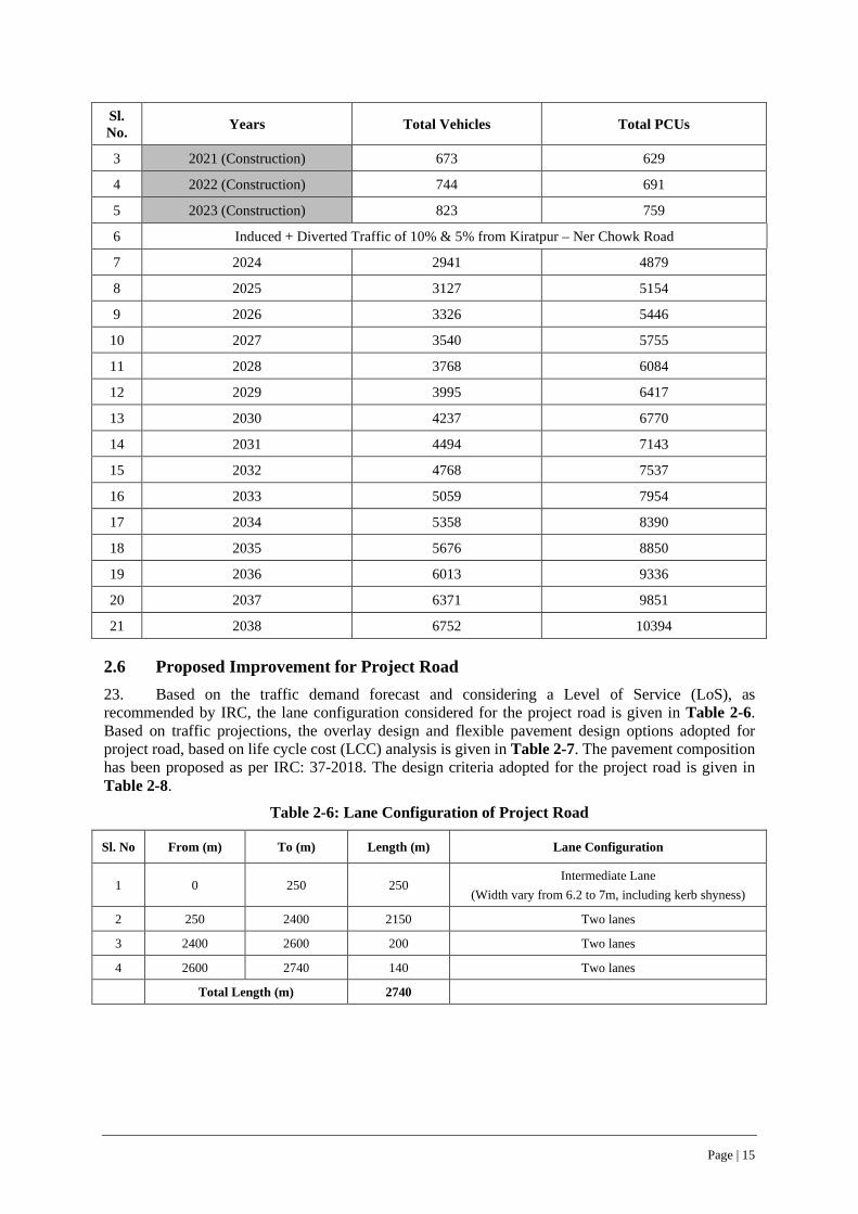
Page | 15
Sl. No. Years Total Vehicles Total PCUs
3 2021 (Construction) 673 629
4 2022 (Construction) 744 691
5 2023 (Construction) 823 759
6 Induced + Diverted Traffic of 10% & 5% from Kiratpur – Ner Chowk Road
7 2024 2941 4879
8 2025 3127 5154
9 2026 3326 5446
10 2027 3540 5755
11 2028 3768 6084
12 2029 3995 6417
13 2030 4237 6770
14 2031 4494 7143
15 2032 4768 7537
16 2033 5059 7954
17 2034 5358 8390
18 2035 5676 8850
19 2036 6013 9336
20 2037 6371 9851
21 2038 6752 10394
2.6 Proposed Improvement for Project Road 23. Based on the traffic demand forecast and considering a Level of Service (LoS), as recommended by IRC, the lane configuration considered for the project road is given in Table 2-6. Based on traffic projections, the overlay design and flexible pavement design options adopted for project road, based on life cycle cost (LCC) analysis is given in Table 2-7. The pavement composition has been proposed as per IRC: 37-2018. The design criteria adopted for the project road is given in Table 2-8.
Table 2-6: Lane Configuration of Project Road
Sl. No From (m) To (m) Length (m) Lane Configuration
1 0 250 250 Intermediate Lane
(Width vary from 6.2 to 7m, including kerb shyness) 2 250 2400 2150 Two lanes
3 2400 2600 200 Two lanes
4 2600 2740 140 Two lanes
Total Length (m) 2740

Page | 16
Table 2-7: Overlay Design and Flexible Pavement Design (15 years) Options for Project Road
Sl. No.
Chainage (km) Length (km)
SL Adopted
MSA
Design CBR (%)
Pavement Design Remarks
From To BC (mm)
DBM (mm) WMM GSB
1 0+00 0+250 0.25 5 - 30 50 - - Overlay design
2 0+250 2+740 2.49 5 15 30 50 250 150
Pavement Reconstruction on account of Geometrical
improvements (horizontal and vertical)
*BC-Bituminous Concrete, DBM-Dense Bituminous Macadam, WMM-Wet Mix Macadam & GSB-Granular Subbase
Table 2-8: Design Criteria adopted for Project Road
Sl. No. Design Parameter Limiting Values
1. Design Speed 30 kmph* 2. Cross fall/ Camber 2.5% minimum 3. Super elevation 7% 4. Vertical alignment 7% all along road, with exception of 8% gradient in limited and
short sections of road 5. Sight Distance Stopping sight distance-45m
Intermediate sight Distance-90m
2.7 Typical Cross-Sections 24. The Project Road design has been carried out in accordance with IRC-48 “Hill Road Manual” and IRC -52-2019 “Guidelines for Alignment Survey ad Geometric Design of Hill Roads”. The proposed improvement/widening scheme of project road comprises of 4 typical cross sections and given in Figures 2-4 to 2-7. The length and the corridor of improvement under each of type of cross section is given in Table 2-9 and alignment Plan & Profile of the project road is given in Appendix-1. The proposed improvement/widening scheme of project road comprises concentric widening, eccentric widening and as well as geometric improvements at necessary locations, which also considers blind spots and areas prone to landslides locations along project road.
Table 2-9: Typical Cross Sections (TCS) along Project Road
S. No Design Ch. From Design Ch. To Length (m) TCS no Remarks
1 0 250 250 TCS-1
Avg. Corridor of Improvement varies between 8.7 to 9.5m with rectangular
drain on both sides
2 450 470 20
TCS-2A
Avg. Corridor of Improvement is 11.5m with PCC Breast Wall abutting
with V Shaped drain
3 630 810 180
4 840 1040 200
5 1100 1140 40
6 1260 1310 50
7 1380 1510 130
8 1620 1820 200
9 1950 1990 40
10 2170 2290 120
11 2600 2740 140
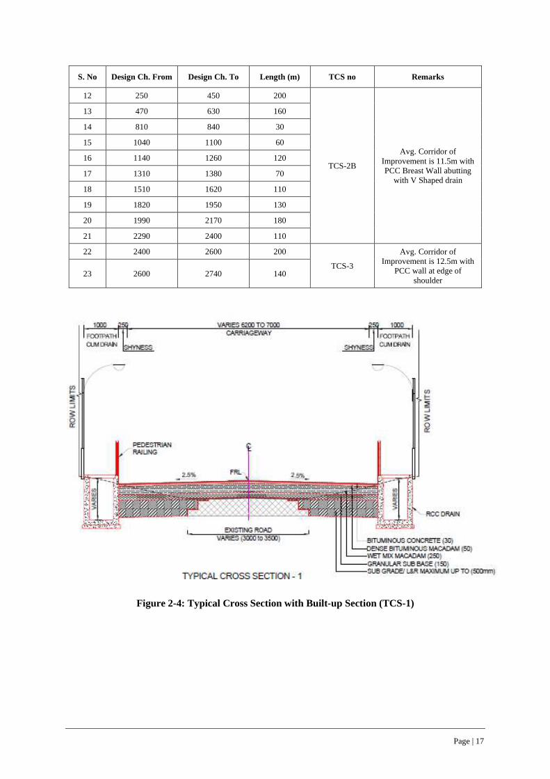
Page | 17
S. No Design Ch. From Design Ch. To Length (m) TCS no Remarks
12 250 450 200
TCS-2B
Avg. Corridor of Improvement is 11.5m with PCC Breast Wall abutting
with V Shaped drain
13 470 630 160
14 810 840 30
15 1040 1100 60
16 1140 1260 120
17 1310 1380 70
18 1510 1620 110
19 1820 1950 130
20 1990 2170 180
21 2290 2400 110
22 2400 2600 200
TCS-3
Avg. Corridor of Improvement is 12.5m with
PCC wall at edge of shoulder
23 2600 2740 140
Figure 2-4: Typical Cross Section with Built-up Section (TCS-1)
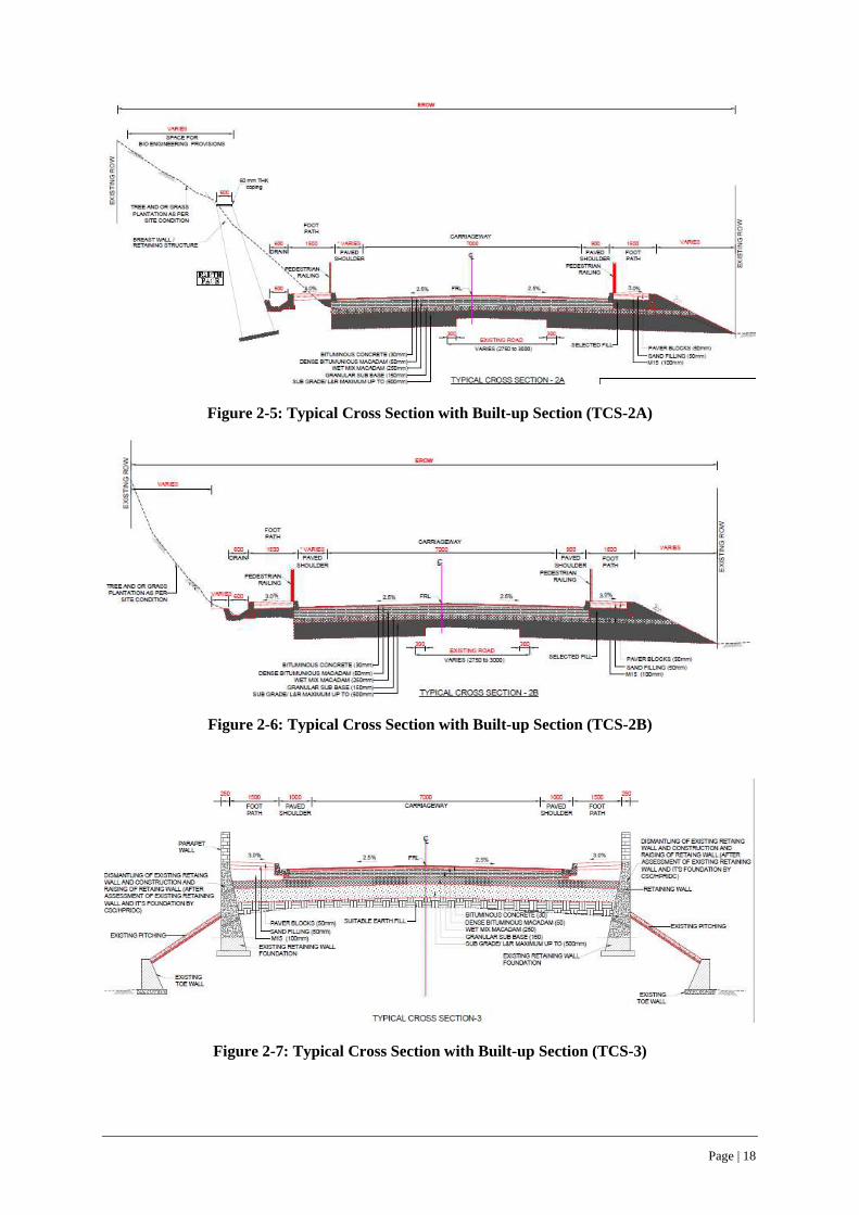
Page | 18
Figure 2-5: Typical Cross Section with Built-up Section (TCS-2A)
Figure 2-6: Typical Cross Section with Built-up Section (TCS-2B)
Figure 2-7: Typical Cross Section with Built-up Section (TCS-3)
Page | 19
2.8 Available Right of Way 25. As per the information sourced from the concerned PWD division, the width of the existing right of way (RoW) along project road varies between minimum of 9.5m (Ch. 0+000 to 0+200) to 20m (Ch. 0+200 to 2+740), with an average width of 14m.
26. The corridor of the improvement for the project road is restricted to the available right of way and no fresh land acquisition. The existing RoW and the proposed corridor of improvement for widening and upgradation of corridor is given in Appendix-2.
27. The ownership status of existing RoW along the project corridor has been verified through consultations and joint site inspection with concerned PWD division, revenue and forest departments and ground-truthing was done for checking the boundary pillars, demarcating existing RoW on ground, jointly by DPR and ESIA Consultants. Although, the boundary pillars for RoW are not erected, the project road has been constructed prior to 1980s by the HPPWD and since then being regularly maintained by the HPPWD till date and the RoW is in physical possession of HPPWD. The project road up-gradation/widening will be confined to the existing right of way and no additional land acquisition will be required for the widening/up-gradation of the project road.
28. The initial 130 meters of the project road between Ch 0+00 to Ch 0+130 serve as an access road to the nearby Rosin & Turpentine Factory under the Himachal Pradesh State Forest Development Corporation (HPSFDCL), owned by GoHP. The access road to the Rosin & Turpentine Factory was constructed prior to 1980s by the HPPWD and since then being regularly maintained by the HPPWD till date. Being the access road to the state-owned factory, the land title of this initial stretch of the 130 meters rest with the Department of Forests, GoHP. However, HPSFDCL has ‘no objection’ to the widening of the 130 meters stretch as part of the Raghunathpura- Mandi-Harpura- Bharari road as it facilitates the easy movement of heavy trucks in and out of the factory.
29. The Rosin and Turpentine factory authorities have been consulted as part of the stake holder engagement and the communication from the General Manager of the Rosin and Turpentine Factory confirming ‘no objection’ to the widening of the 130 meters stretch is given in Appendix 0. The location plan of the factory showing the access road and project road is shown in Figure 2-8. Other than this 130m stretch, the project road does not involve any forest lands either within or adjacent to the RoW.
30. Rosin is a forest produce obtained from pines and mostly conifers and used to manufacture other subsidiary products like Turpentine Oil, Phenyl etc. Himachal Pradesh has only two Rosin and Turpentine oil factories, one at Nahan in Sirmaur District and the other being at Bilaspur, along the Project road - Raghunathpura- Mandi-Harpura- Bharari. The total installed capacity of the Rosin and Turpentine oil factories within Himachal Pradesh is 1,11,000 quintals per annum and the Bilaspur factory situated along the project road producing 74,000 quintals, whereas the Nahan factory producing 37,000 quintals of raw resin per annum.

Page | 20
Figure 2-8: Location Plan of Access Road to Rosin and Turpentine Factory and Project Road

Page | 21
2.9 Existing and Proposed CD Structures 31. As part of the project upgradation 1 new box culvert, reconstruction of 3 box culverts and widening of 2 slab culverts are considered, while retaining 1 existing box culvert at Ch. 2+710. The schedule of CD structures along the project road are given in Table 2-10. The design provisions for concreate/ stone boulder aprons at CD locations for dissipation of energy and prevention of erosion is given in Appendix-13. The project design considers construction of 2570 meters of rectangular and ‘V’ shaped longitudinal drains (ref. Table 2-11) along the road which will be connected to the nearest culverts. (ref. Drainage maps under Appendix 1).
Table 2-10: Existing & Proposed CD Structures along Project Road
S. No.
Existing Chainage
(Km)
Design Chainage
(Km)
Existing type of CD Structure/
Culvert
Existing Span CD Improvement
Proposal
Proposed type of CD Structure/
Culvert No. of Spans
Span (m)
1 New 0+150 - - New Construction Pipe
2 New 0+284 - - - New Construction Box
3 0+680 0+680 Pipe 1 0.9 Reconstruction to Box Box
4 1+090 1+091 Slab 1 3 Widening Slab
5 1+595 1+592 Pipe 1 0.9 Reconstruction to Box Box
6 2+050 2+052 Slab 1 3 Widening Slab
7 2+500 2+510 Box 1 3.75 Retained Box
Table 2-11: Provision for Longitudinal Drains along Project Road
Sl. No From To Length Type of Drain
1 0 250 250 Rectangular drain on both sides
2 250 2400 2150 V shaped drain on LHS all along
3 2600 2770 170 V shaped drain on LHS all along
Total Length 2570
2.10 Protection Works 32. The project road design has considered 1450m long breast walls (height between 2-4m) and 400m long retaining walls (average height upto 3m) and 350m toe walls (height between 1-2) as protection works and given in Table 2-12.
Table 2-12: Protection Works along Project Road
S. No Type of Protection work From CH To CH Length (m) Height Range (m) Side
1 Breast Wall 0+340 2+770 1450 2-4 RHS
2 Retaining 2+400 2+600 400 3.0 Both sides
3 Toe Wall 0+250 2+770 350 1-2 RHS
2.11 Bus Stops/ Rain Shelters & Street Lighting 33. The project road, at present does not have any bus stops (locally known as rain shelters) between Km 0 to Km 2.740. Under the project road widening proposal, 2 bus stops are newly proposed (as
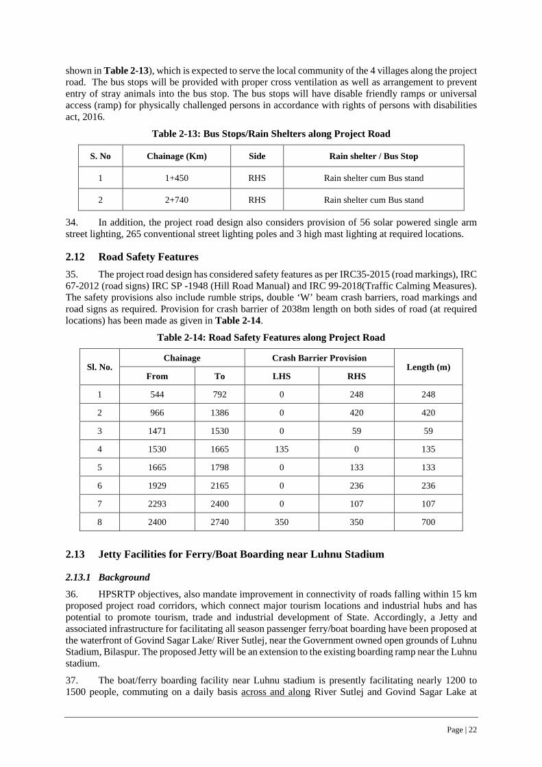
Page | 22
shown in Table 2-13), which is expected to serve the local community of the 4 villages along the project road. The bus stops will be provided with proper cross ventilation as well as arrangement to prevent entry of stray animals into the bus stop. The bus stops will have disable friendly ramps or universal access (ramp) for physically challenged persons in accordance with rights of persons with disabilities act, 2016.
Table 2-13: Bus Stops/Rain Shelters along Project Road
S. No Chainage (Km) Side Rain shelter / Bus Stop
1 1+450 RHS Rain shelter cum Bus stand
2 2+740 RHS Rain shelter cum Bus stand
34. In addition, the project road design also considers provision of 56 solar powered single arm street lighting, 265 conventional street lighting poles and 3 high mast lighting at required locations.
2.12 Road Safety Features 35. The project road design has considered safety features as per IRC35-2015 (road markings), IRC 67-2012 (road signs) IRC SP -1948 (Hill Road Manual) and IRC 99-2018(Traffic Calming Measures). The safety provisions also include rumble strips, double ‘W’ beam crash barriers, road markings and road signs as required. Provision for crash barrier of 2038m length on both sides of road (at required locations) has been made as given in Table 2-14.
Table 2-14: Road Safety Features along Project Road
Sl. No. Chainage Crash Barrier Provision
Length (m) From To LHS RHS
1 544 792 0 248 248
2 966 1386 0 420 420
3 1471 1530 0 59 59
4 1530 1665 135 0 135
5 1665 1798 0 133 133
6 1929 2165 0 236 236
7 2293 2400 0 107 107
8 2400 2740 350 350 700
2.13 Jetty Facilities for Ferry/Boat Boarding near Luhnu Stadium
2.13.1 Background
36. HPSRTP objectives, also mandate improvement in connectivity of roads falling within 15 km proposed project road corridors, which connect major tourism locations and industrial hubs and has potential to promote tourism, trade and industrial development of State. Accordingly, a Jetty and associated infrastructure for facilitating all season passenger ferry/boat boarding have been proposed at the waterfront of Govind Sagar Lake/ River Sutlej, near the Government owned open grounds of Luhnu Stadium, Bilaspur. The proposed Jetty will be an extension to the existing boarding ramp near the Luhnu stadium.
37. The boat/ferry boarding facility near Luhnu stadium is presently facilitating nearly 1200 to 1500 people, commuting on a daily basis across and along River Sutlej and Govind Sagar Lake at
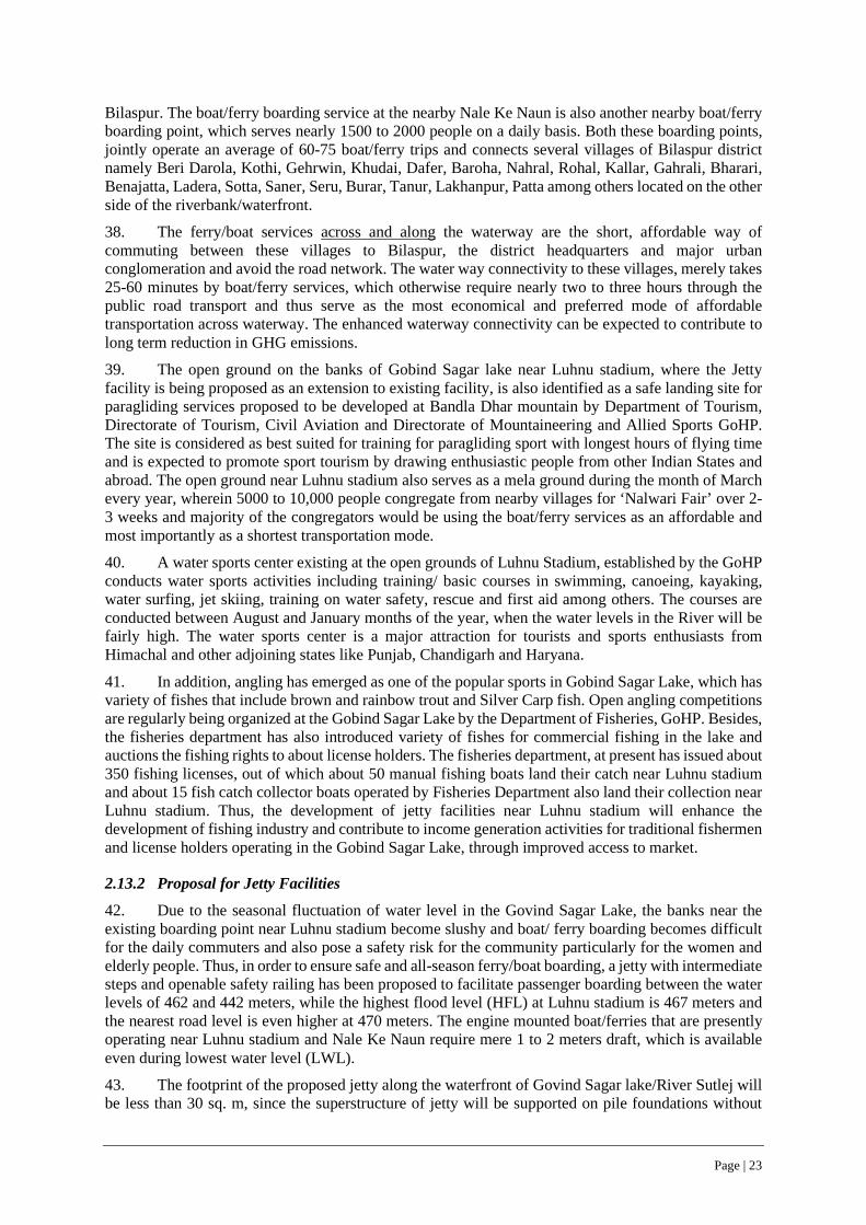
Page | 23
Bilaspur. The boat/ferry boarding service at the nearby Nale Ke Naun is also another nearby boat/ferry boarding point, which serves nearly 1500 to 2000 people on a daily basis. Both these boarding points, jointly operate an average of 60-75 boat/ferry trips and connects several villages of Bilaspur district namely Beri Darola, Kothi, Gehrwin, Khudai, Dafer, Baroha, Nahral, Rohal, Kallar, Gahrali, Bharari, Benajatta, Ladera, Sotta, Saner, Seru, Burar, Tanur, Lakhanpur, Patta among others located on the other side of the riverbank/waterfront.
38. The ferry/boat services across and along the waterway are the short, affordable way of commuting between these villages to Bilaspur, the district headquarters and major urban conglomeration and avoid the road network. The water way connectivity to these villages, merely takes 25-60 minutes by boat/ferry services, which otherwise require nearly two to three hours through the public road transport and thus serve as the most economical and preferred mode of affordable transportation across waterway. The enhanced waterway connectivity can be expected to contribute to long term reduction in GHG emissions.
39. The open ground on the banks of Gobind Sagar lake near Luhnu stadium, where the Jetty facility is being proposed as an extension to existing facility, is also identified as a safe landing site for paragliding services proposed to be developed at Bandla Dhar mountain by Department of Tourism, Directorate of Tourism, Civil Aviation and Directorate of Mountaineering and Allied Sports GoHP. The site is considered as best suited for training for paragliding sport with longest hours of flying time and is expected to promote sport tourism by drawing enthusiastic people from other Indian States and abroad. The open ground near Luhnu stadium also serves as a mela ground during the month of March every year, wherein 5000 to 10,000 people congregate from nearby villages for ‘Nalwari Fair’ over 2-3 weeks and majority of the congregators would be using the boat/ferry services as an affordable and most importantly as a shortest transportation mode.
40. A water sports center existing at the open grounds of Luhnu Stadium, established by the GoHP conducts water sports activities including training/ basic courses in swimming, canoeing, kayaking, water surfing, jet skiing, training on water safety, rescue and first aid among others. The courses are conducted between August and January months of the year, when the water levels in the River will be fairly high. The water sports center is a major attraction for tourists and sports enthusiasts from Himachal and other adjoining states like Punjab, Chandigarh and Haryana.
41. In addition, angling has emerged as one of the popular sports in Gobind Sagar Lake, which has variety of fishes that include brown and rainbow trout and Silver Carp fish. Open angling competitions are regularly being organized at the Gobind Sagar Lake by the Department of Fisheries, GoHP. Besides, the fisheries department has also introduced variety of fishes for commercial fishing in the lake and auctions the fishing rights to about license holders. The fisheries department, at present has issued about 350 fishing licenses, out of which about 50 manual fishing boats land their catch near Luhnu stadium and about 15 fish catch collector boats operated by Fisheries Department also land their collection near Luhnu stadium. Thus, the development of jetty facilities near Luhnu stadium will enhance the development of fishing industry and contribute to income generation activities for traditional fishermen and license holders operating in the Gobind Sagar Lake, through improved access to market.
2.13.2 Proposal for Jetty Facilities
42. Due to the seasonal fluctuation of water level in the Govind Sagar Lake, the banks near the existing boarding point near Luhnu stadium become slushy and boat/ ferry boarding becomes difficult for the daily commuters and also pose a safety risk for the community particularly for the women and elderly people. Thus, in order to ensure safe and all-season ferry/boat boarding, a jetty with intermediate steps and openable safety railing has been proposed to facilitate passenger boarding between the water levels of 462 and 442 meters, while the highest flood level (HFL) at Luhnu stadium is 467 meters and the nearest road level is even higher at 470 meters. The engine mounted boat/ferries that are presently operating near Luhnu stadium and Nale Ke Naun require mere 1 to 2 meters draft, which is available even during lowest water level (LWL).
43. The footprint of the proposed jetty along the waterfront of Govind Sagar lake/River Sutlej will be less than 30 sq. m, since the superstructure of jetty will be supported on pile foundations without
Page | 24
constricting the waterway beneath. The superstructure area of the jetty will be 864 sq.m (216 m long and 4.0 m wide) and connects to the existing boarding platform, which is now facilitating the boat boarding, and operational for limited months in a year, when the water levels are quite high. The proposed jetty platform will be 216 meters and supported on pile foundations (total 90 piles of each 600mm diameter with a cumulative footprint of less than 30 sq.m.), will have intermediate steps and disable friendly ramp for all season boarding, amid fluctuating water level and facilitate boarding at prevailing water level and thus enable/ overcome slushy banks and associated community risks thereof. The jetty or boarding platforms will have openable railing for commuter safety at seasonally fluctuating water levels (either increasing or receding). A shelter house for the waiting and resting of commuters (50 user capacity with 75 sq.m plinth area) near the boarding point with drinking water, ablution facility and separate toilets for women and men will be provided near Jetty facility.
44. The location plan, general arrangement, and sectional elevation of the proposed infrastructure along with site photographs is given in Figure-2-9 to and 2-12. The construction of jetty facility will be executed on a EPC basis under the implementation supervision of CSC. The estimated cost for the proposed infrastructure to facilitate an all-season boat/ferry boarding facility near Luhnu stadium is INR 30.09 million.

Page | 25
Figure 2-9: Location of Project Road and Jetty Facility near Luhnu Stadium, Bilaspur

Page | 26
Figure 2-10: Location Plan of Project Road and Jetty Facility near Luhnu Stadium Bilaspur (on google map)
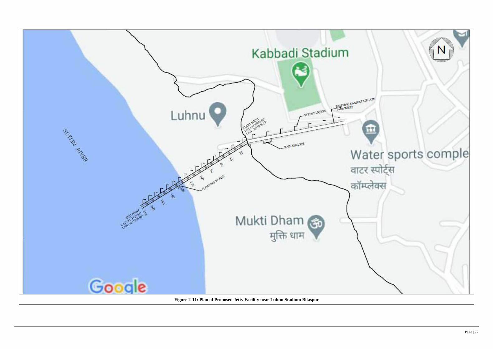
Page | 27
Figure 2-11: Plan of Proposed Jetty Facility near Luhnu Stadium Bilaspur

Page | 28
Figure 2-12: General Arrangement and Sectional Elevation of Jetty Facility near Luhnu Stadium Bilaspur
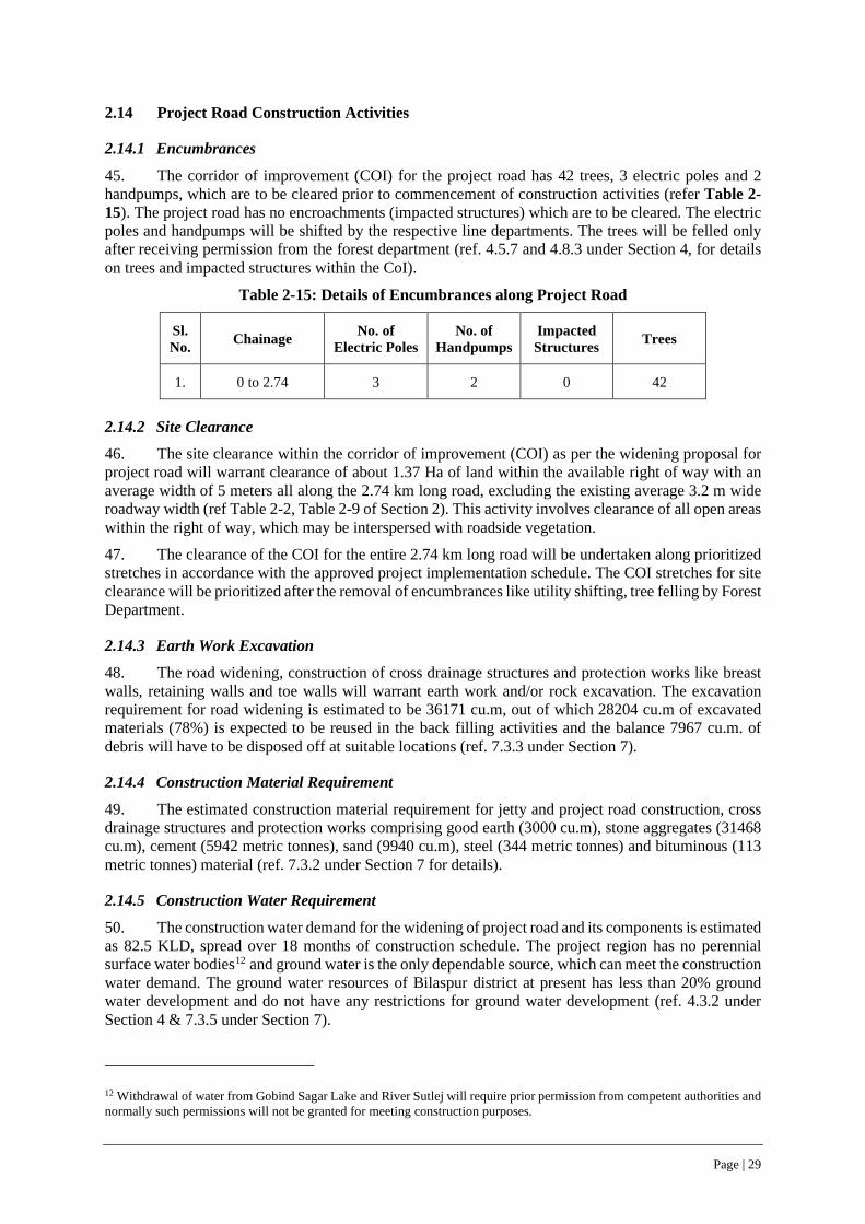
Page | 29
2.14 Project Road Construction Activities
2.14.1 Encumbrances
45. The corridor of improvement (COI) for the project road has 42 trees, 3 electric poles and 2 handpumps, which are to be cleared prior to commencement of construction activities (refer Table 2-15). The project road has no encroachments (impacted structures) which are to be cleared. The electric poles and handpumps will be shifted by the respective line departments. The trees will be felled only after receiving permission from the forest department (ref. 4.5.7 and 4.8.3 under Section 4, for details on trees and impacted structures within the CoI).
Table 2-15: Details of Encumbrances along Project Road
Sl. No. Chainage No. of
Electric Poles No. of
Handpumps Impacted Structures Trees
1. 0 to 2.74 3 2 0 42
2.14.2 Site Clearance
46. The site clearance within the corridor of improvement (COI) as per the widening proposal for project road will warrant clearance of about 1.37 Ha of land within the available right of way with an average width of 5 meters all along the 2.74 km long road, excluding the existing average 3.2 m wide roadway width (ref Table 2-2, Table 2-9 of Section 2). This activity involves clearance of all open areas within the right of way, which may be interspersed with roadside vegetation.
47. The clearance of the COI for the entire 2.74 km long road will be undertaken along prioritized stretches in accordance with the approved project implementation schedule. The COI stretches for site clearance will be prioritized after the removal of encumbrances like utility shifting, tree felling by Forest Department.
2.14.3 Earth Work Excavation
48. The road widening, construction of cross drainage structures and protection works like breast walls, retaining walls and toe walls will warrant earth work and/or rock excavation. The excavation requirement for road widening is estimated to be 36171 cu.m, out of which 28204 cu.m of excavated materials (78%) is expected to be reused in the back filling activities and the balance 7967 cu.m. of debris will have to be disposed off at suitable locations (ref. 7.3.3 under Section 7).
2.14.4 Construction Material Requirement
49. The estimated construction material requirement for jetty and project road construction, cross drainage structures and protection works comprising good earth (3000 cu.m), stone aggregates (31468 cu.m), cement (5942 metric tonnes), sand (9940 cu.m), steel (344 metric tonnes) and bituminous (113 metric tonnes) material (ref. 7.3.2 under Section 7 for details).
2.14.5 Construction Water Requirement
50. The construction water demand for the widening of project road and its components is estimated as 82.5 KLD, spread over 18 months of construction schedule. The project region has no perennial surface water bodies12 and ground water is the only dependable source, which can meet the construction water demand. The ground water resources of Bilaspur district at present has less than 20% ground water development and do not have any restrictions for ground water development (ref. 4.3.2 under Section 4 & 7.3.5 under Section 7).
12 Withdrawal of water from Gobind Sagar Lake and River Sutlej will require prior permission from competent authorities and normally such permissions will not be granted for meeting construction purposes.
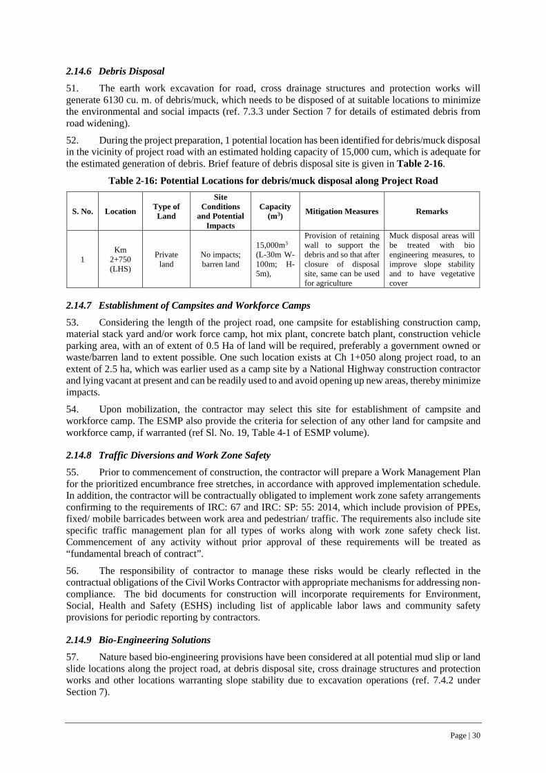
Page | 30
2.14.6 Debris Disposal
51. The earth work excavation for road, cross drainage structures and protection works will generate 6130 cu. m. of debris/muck, which needs to be disposed of at suitable locations to minimize the environmental and social impacts (ref. 7.3.3 under Section 7 for details of estimated debris from road widening).
52. During the project preparation, 1 potential location has been identified for debris/muck disposal in the vicinity of project road with an estimated holding capacity of 15,000 cum, which is adequate for the estimated generation of debris. Brief feature of debris disposal site is given in Table 2-16.
Table 2-16: Potential Locations for debris/muck disposal along Project Road
S. No. Location Type of Land
Site Conditions
and Potential Impacts
Capacity (m3) Mitigation Measures Remarks
1 Km
2+750 (LHS)
Private land
No impacts; barren land
15,000m3 (L-30m W-100m; H-5m),
Provision of retaining wall to support the debris and so that after closure of disposal site, same can be used for agriculture
Muck disposal areas will be treated with bio engineering measures, to improve slope stability and to have vegetative cover
2.14.7 Establishment of Campsites and Workforce Camps
53. Considering the length of the project road, one campsite for establishing construction camp, material stack yard and/or work force camp, hot mix plant, concrete batch plant, construction vehicle parking area, with an of extent of 0.5 Ha of land will be required, preferably a government owned or waste/barren land to extent possible. One such location exists at Ch 1+050 along project road, to an extent of 2.5 ha, which was earlier used as a camp site by a National Highway construction contractor and lying vacant at present and can be readily used to and avoid opening up new areas, thereby minimize impacts.
54. Upon mobilization, the contractor may select this site for establishment of campsite and workforce camp. The ESMP also provide the criteria for selection of any other land for campsite and workforce camp, if warranted (ref Sl. No. 19, Table 4-1 of ESMP volume).
2.14.8 Traffic Diversions and Work Zone Safety
55. Prior to commencement of construction, the contractor will prepare a Work Management Plan for the prioritized encumbrance free stretches, in accordance with approved implementation schedule. In addition, the contractor will be contractually obligated to implement work zone safety arrangements confirming to the requirements of IRC: 67 and IRC: SP: 55: 2014, which include provision of PPEs, fixed/ mobile barricades between work area and pedestrian/ traffic. The requirements also include site specific traffic management plan for all types of works along with work zone safety check list. Commencement of any activity without prior approval of these requirements will be treated as “fundamental breach of contract”.
56. The responsibility of contractor to manage these risks would be clearly reflected in the contractual obligations of the Civil Works Contractor with appropriate mechanisms for addressing non-compliance. The bid documents for construction will incorporate requirements for Environment, Social, Health and Safety (ESHS) including list of applicable labor laws and community safety provisions for periodic reporting by contractors.
2.14.9 Bio-Engineering Solutions
57. Nature based bio-engineering provisions have been considered at all potential mud slip or land slide locations along the project road, at debris disposal site, cross drainage structures and protection works and other locations warranting slope stability due to excavation operations (ref. 7.4.2 under Section 7).
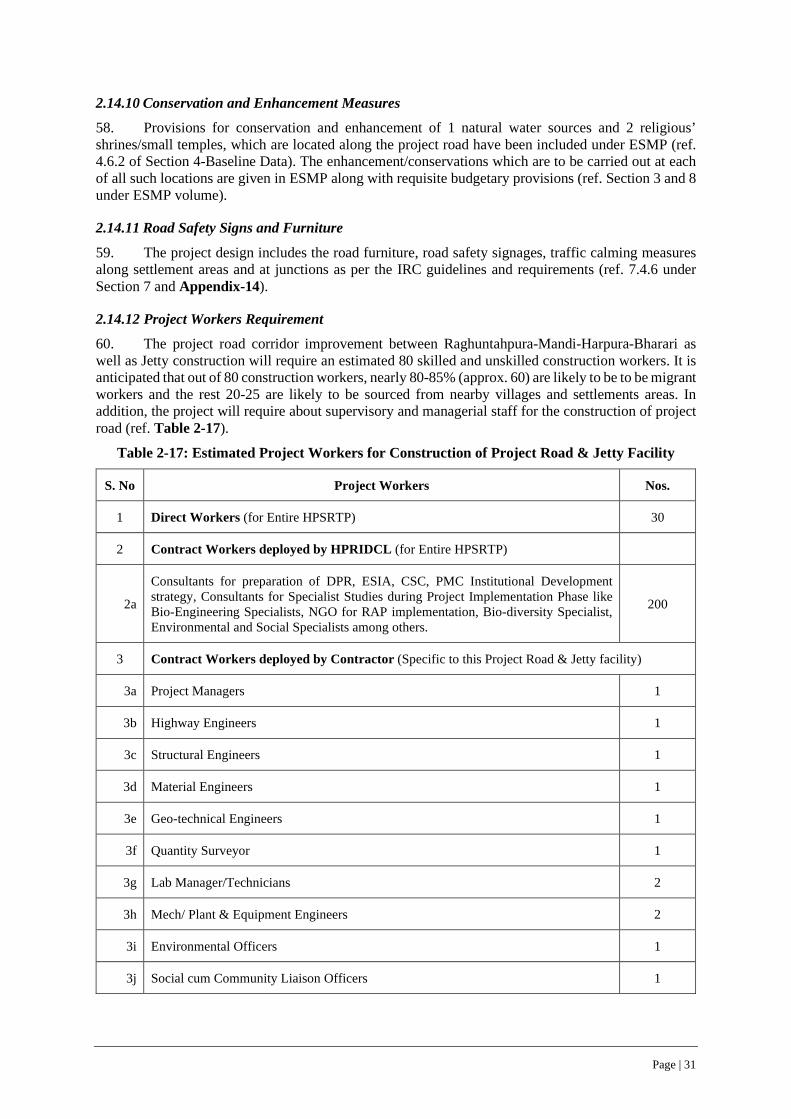
Page | 31
2.14.10 Conservation and Enhancement Measures
58. Provisions for conservation and enhancement of 1 natural water sources and 2 religious’ shrines/small temples, which are located along the project road have been included under ESMP (ref. 4.6.2 of Section 4-Baseline Data). The enhancement/conservations which are to be carried out at each of all such locations are given in ESMP along with requisite budgetary provisions (ref. Section 3 and 8 under ESMP volume).
2.14.11 Road Safety Signs and Furniture
59. The project design includes the road furniture, road safety signages, traffic calming measures along settlement areas and at junctions as per the IRC guidelines and requirements (ref. 7.4.6 under Section 7 and Appendix-14).
2.14.12 Project Workers Requirement
60. The project road corridor improvement between Raghuntahpura-Mandi-Harpura-Bharari as well as Jetty construction will require an estimated 80 skilled and unskilled construction workers. It is anticipated that out of 80 construction workers, nearly 80-85% (approx. 60) are likely to be to be migrant workers and the rest 20-25 are likely to be sourced from nearby villages and settlements areas. In addition, the project will require about supervisory and managerial staff for the construction of project road (ref. Table 2-17).
Table 2-17: Estimated Project Workers for Construction of Project Road & Jetty Facility
S. No Project Workers Nos.
1 Direct Workers (for Entire HPSRTP) 30
2 Contract Workers deployed by HPRIDCL (for Entire HPSRTP)
2a
Consultants for preparation of DPR, ESIA, CSC, PMC Institutional Development strategy, Consultants for Specialist Studies during Project Implementation Phase like Bio-Engineering Specialists, NGO for RAP implementation, Bio-diversity Specialist, Environmental and Social Specialists among others.
200
3 Contract Workers deployed by Contractor (Specific to this Project Road & Jetty facility)
3a Project Managers 1
3b Highway Engineers 1
3c Structural Engineers 1
3d Material Engineers 1
3e Geo-technical Engineers 1
3f Quantity Surveyor 1
3g Lab Manager/Technicians 2
3h Mech/ Plant & Equipment Engineers 2
3i Environmental Officers 1
3j Social cum Community Liaison Officers 1
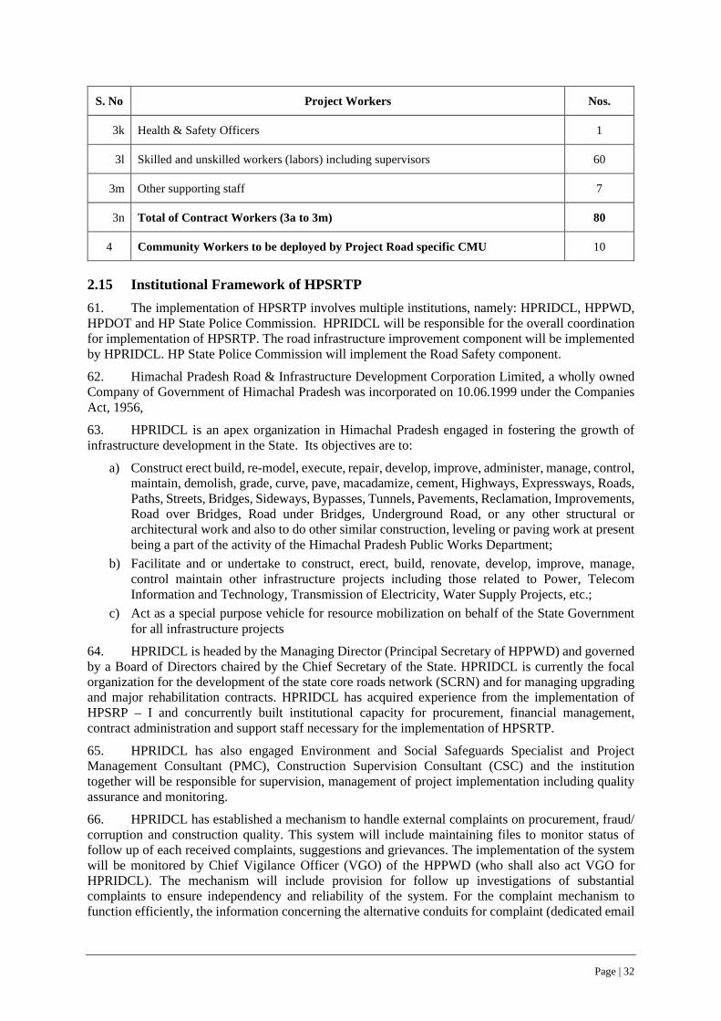
Page | 32
S. No Project Workers Nos.
3k Health & Safety Officers 1
3l Skilled and unskilled workers (labors) including supervisors 60
3m Other supporting staff 7
3n Total of Contract Workers (3a to 3m) 80
4 Community Workers to be deployed by Project Road specific CMU 10
2.15 Institutional Framework of HPSRTP 61. The implementation of HPSRTP involves multiple institutions, namely: HPRIDCL, HPPWD, HPDOT and HP State Police Commission. HPRIDCL will be responsible for the overall coordination for implementation of HPSRTP. The road infrastructure improvement component will be implemented by HPRIDCL. HP State Police Commission will implement the Road Safety component.
62. Himachal Pradesh Road & Infrastructure Development Corporation Limited, a wholly owned Company of Government of Himachal Pradesh was incorporated on 10.06.1999 under the Companies Act, 1956,
63. HPRIDCL is an apex organization in Himachal Pradesh engaged in fostering the growth of infrastructure development in the State. Its objectives are to:
a) Construct erect build, re-model, execute, repair, develop, improve, administer, manage, control, maintain, demolish, grade, curve, pave, macadamize, cement, Highways, Expressways, Roads, Paths, Streets, Bridges, Sideways, Bypasses, Tunnels, Pavements, Reclamation, Improvements, Road over Bridges, Road under Bridges, Underground Road, or any other structural or architectural work and also to do other similar construction, leveling or paving work at present being a part of the activity of the Himachal Pradesh Public Works Department;
b) Facilitate and or undertake to construct, erect, build, renovate, develop, improve, manage, control maintain other infrastructure projects including those related to Power, Telecom Information and Technology, Transmission of Electricity, Water Supply Projects, etc.;
c) Act as a special purpose vehicle for resource mobilization on behalf of the State Government for all infrastructure projects
64. HPRIDCL is headed by the Managing Director (Principal Secretary of HPPWD) and governed by a Board of Directors chaired by the Chief Secretary of the State. HPRIDCL is currently the focal organization for the development of the state core roads network (SCRN) and for managing upgrading and major rehabilitation contracts. HPRIDCL has acquired experience from the implementation of HPSRP – I and concurrently built institutional capacity for procurement, financial management, contract administration and support staff necessary for the implementation of HPSRTP.
65. HPRIDCL has also engaged Environment and Social Safeguards Specialist and Project Management Consultant (PMC), Construction Supervision Consultant (CSC) and the institution together will be responsible for supervision, management of project implementation including quality assurance and monitoring.
66. HPRIDCL has established a mechanism to handle external complaints on procurement, fraud/ corruption and construction quality. This system will include maintaining files to monitor status of follow up of each received complaints, suggestions and grievances. The implementation of the system will be monitored by Chief Vigilance Officer (VGO) of the HPPWD (who shall also act VGO for HPRIDCL). The mechanism will include provision for follow up investigations of substantial complaints to ensure independency and reliability of the system. For the complaint mechanism to function efficiently, the information concerning the alternative conduits for complaint (dedicated email
Page | 33
address and physical mailing box) are publicized. Complaints, suggestions and grievances handling system are notified at HPRIDCL’s website: http://himachalservices.nic.in›hpridcl. An Information Officer has been designated by HPRIDCL as a full-time Assistant Public Information Officer under the RTI Act and is responsible for updating the HPRIDCL’s website on required basis.
67. HPRIDCL will redress all complaints during project implementation. Responding to Complaints on Construction Quality Complaints received directly from the public relating to the quality of a specific work, good or service shall be in writing. They will be received and then reviewed by CE-cum-PD or if applicable, concerned Executive Engineer of Construction Management Unit (CMU) and will be dealt with in the following way. i) The CE-cum-PD shall record all complaints, whether they are referred from other recipients or directly, in a register to be maintained in a secure location in his own office. The email and physical address of the CE-cum-PD is available on web site. ii) The CE-cum-PD shall, within 5 working days of receipt of complaint, acknowledge receipt in writing to the complainant indicating that the HPRIDCL is considering the issues raised and will discuss them with the concerned officers of the HPRIDCL. iii) The CE-cum-PD shall then consult with the relevant officers of the HPRIDCL and, after thorough review of the facts as well as interviewing of officers concerned as necessary, shall make a judgment as to the validity of the complaint. iv) Within 20 working days, the CE-cum-PD shall instruct the concerned officer to take remedial action as necessary. v) The CE-cum-PD shall write to the complainant within 30 working days of the receipt of such complaint as to the final decision of the competent authority. vi) In the event, that a complaint is received concerning an externally funded contract, the relevant funding agency shall be informed at each stage of the complaint handling process.

Page | 34
3 LEGAL AND REGULATORY FRAMEWORK
68. A review of the legal and regulatory framework related to the environmental and social in terms of their relevance and applicability to the project road is presented in this chapter. The chapter also presents the current institutional structure of HPRIDCL, the designated nodal agency for implementation of HPSRTP by GoHP.
3.1 Applicable Regulations of GoI/GoHP 69. The Government of India has laid out various policy guidelines, acts and regulations pertaining to environment and social aspects. Table 3-1 lists all the applicable GoI regulations and their relevance to this sub-project.
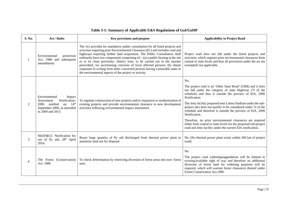
Page | 35
Table 3-1: Summary of Applicable E&S Regulations of GoI/GoHP
S. No. Act / Rules Key provisions and purpose Applicability to Project Road
1 Environmental protection Act, 1986 and subsequent amendments
The Act provides for mandatory public consultation for all listed projects and activities requiring prior Environmental Clearance (EC) and includes road and highways requiring further land acquisition. The Public Consultation shall ordinarily have two components comprising of: - (a) a public hearing at the site or in its close proximity- district wise, to be carried out in the manner prescribed, for ascertaining concerns of local affected persons; (b) obtain responses in writing from other concerned persons having a plausible stake in the environmental aspects of the project or activity.
Project road does not fall under the listed projects and activities, which requires prior environmental clearances from central or state levels and thus all provisions under the act are exempted/ not applicable.
2
Environmental Impact Assessment Notification-2006 notified on 14th September 2006, as amended in 2009 and 2013
To regulate construction of new projects and/or expansion or modernization of existing projects and provide environmental clearance to new development activities following environmental impact assessment
No.
The project road is an ‘Other State Road’ (OSR) and it does not fall under the category of state Highway (7f of the schedule) and thus is outside the preview of EIA, 2006 Notification.
The Jetty facility proposed near Luhnu Stadium under the sub-project also does not qualify to be considered under 7e of the schedule and therefore is outside the preview of EIA, 2006 Notification.
Therefore, no prior environmental clearances are required either from central or state levels for the proposed sub-project road and Jetty facility under the current EIA notification.
3 MoEF&CC Notification for use of fly ash, 28th April 2016.
Reuse large quantity of fly ash discharged from thermal power plant to minimize land use for disposal
No. (No thermal power plant exists within 300 km of project road)
4 The Forest (Conservation) Act. 1980
To check deforestation by restricting diversion of forest areas into non- forest uses.
No
The project road widening/upgradation will be limited to existing/available right of way and therefore no additional diversion of forest land for widening purposes will be required, which will warrant forest clearances thereof under Forest Conservation Act,1980.

Page | 36
S. No. Act / Rules Key provisions and purpose Applicability to Project Road
5
MoEF&CC circular (1998) on linear Plantation on roadside, canals and railway lines modifying the applicability of provisions of forest (Conversation) Act, to linear Plantation
Protection / planting roadside strip as avenue/strip plantations as these are declared protected forest areas.
Yes, permission for felling of 42 trees within the existing /available RoW is required from the Forest Department.
The project road widening is limited to available/existing RoW, but within which trees have grown over the years, which are required to be felled for road widening.
6 The Wildlife Protection Act, 1972 To protect wildlife such as National Parks and Sanctuaries No (No wildlife Sanctuary or National park is within 10 km of
project road)
7 Biological Diversity Act, 2002 Disclosure of species survey No, as per act, there is no presence of any rare, endangered,
threatened species reported along the project road corridor.
8 Air (Prevention and Control of Pollution) Act, 1981 To control air pollution Pollutants Yes (During construction phase, contractor will have to obtain
CTE and CTO) to regulate air quality at construction sites
9 Water (Prevention and Control of Pollution) Act, 1974
To control water pollution by controlling discharge of pollutants as per the prescribed standards
Yes (During construction phase, contractor will have to obtain CTE and CTO) to regulate air quality at construction sites
10 Noise Pollution (Regulation and Control Act) 1990
The standards for noise for day and night have been promulgated by the MoEF&CC for various land uses.
Yes (During construction phase, contractor will have to obtain CTE and CTO) to regulate Noise quality at construction sites
11 The Explosive Act 1984 Safe transportation, storage and use of explosive material No (as explosive are prohibited to be used.)
12 The Mines and Minerals (Development and Regulation) Act 1957
For opening new quarry. Yes (During construction only, if any new quarries are opened, contractor shall avail the permission/license from competent agencies)
13 The Ancient Monuments and Archaeological Sites and Remains Act 1958
Conservation of cultural and historical remains found in India No. The project corridor (within 200 metres) does not have any such protected monument and archaeological sites.

Page | 37
S. No. Act / Rules Key provisions and purpose Applicability to Project Road
14 National Resource Efficiency Policy, 2019 13 (Draft)
To create a facilitative and regulatory environment to mainstream resource efficiency across all sectors by fostering cross-sectoral collaborations, development of policy instruments, action plans and efficient implementation and monitoring frameworks.
No. Becomes applicable only after its notification (During construction Phase). However, Project Road design considers several resource efficiencies measures, to be consistent with ESS 3 of WB’s, ESF, 2016
15 Municipal Solid Waste (Management & Handling) Rules, 2000 (MSW Rules)
Segregation, Handling & safe disposal of domestic solid waste Yes (The work force camp and camp site shall have facility for collecting the waste, and access controlled to prevent the entry of stray animals for scavenging of waste.)
16
Hazardous Wastes (Management, Handling and Trans-boundary Movement) Rules, 2008.
Safe handling, storage, transportation & disposal of hazardous wastes Yes (Applicable during construction phase, the contractor shall obtain the requisite licenses for handling and disposal of hazardous waste generated during construction phase.)
17 Occupational Safety, Health and Working Conditions, 2019 14 (Draft Code)
Comprehensive Code on Occupational Safety, Health and Working Conditions, amalgamates 13 existing labour laws/acts relating to Safety, Health, working Conditions and Wages
No. Will become applicable, only after it is notified. However, till such time, the existing laws shall apply
18 Batteries (Management and Handling) Rules, 2001 Safe recycling of lead acid batteries
Yes (Applicable during construction phase, the contractor shall obtain the requisite licenses for handling and disposal of batteries during construction phase.)
19 Central Motor Vehicle Act 1988 and Central Motor Vehicle Rules 1989
To check vehicular air and noise pollution Yes (contractors’ responsibility to obtain Pollution Under Control certificates during construction stage for all vehicles deployed for construction activities)
20 National Labour Act, 1970. An Act to regulate the employment of contract labour in certain establishments and to provide for its abolition in certain circumstances and for matters connected therewith
Yes (This shall be contractors’ responsibility for compliance)
13 This is a draft Policy introduced in year 2019 and presently under the consideration of Government of India. Was earlier scheduled for Notification in June 2020 but likely to be rescheduled due to COVID-19. 14 Draft Code on Occupational Safety, Health and Working Conditions, 2019 has already been introduced in Parliament, after a Standing Committee of Parliament submitted its recommendations in Feb 2020. The matter is on hold possibly due to COVID -19 and soon be notified.
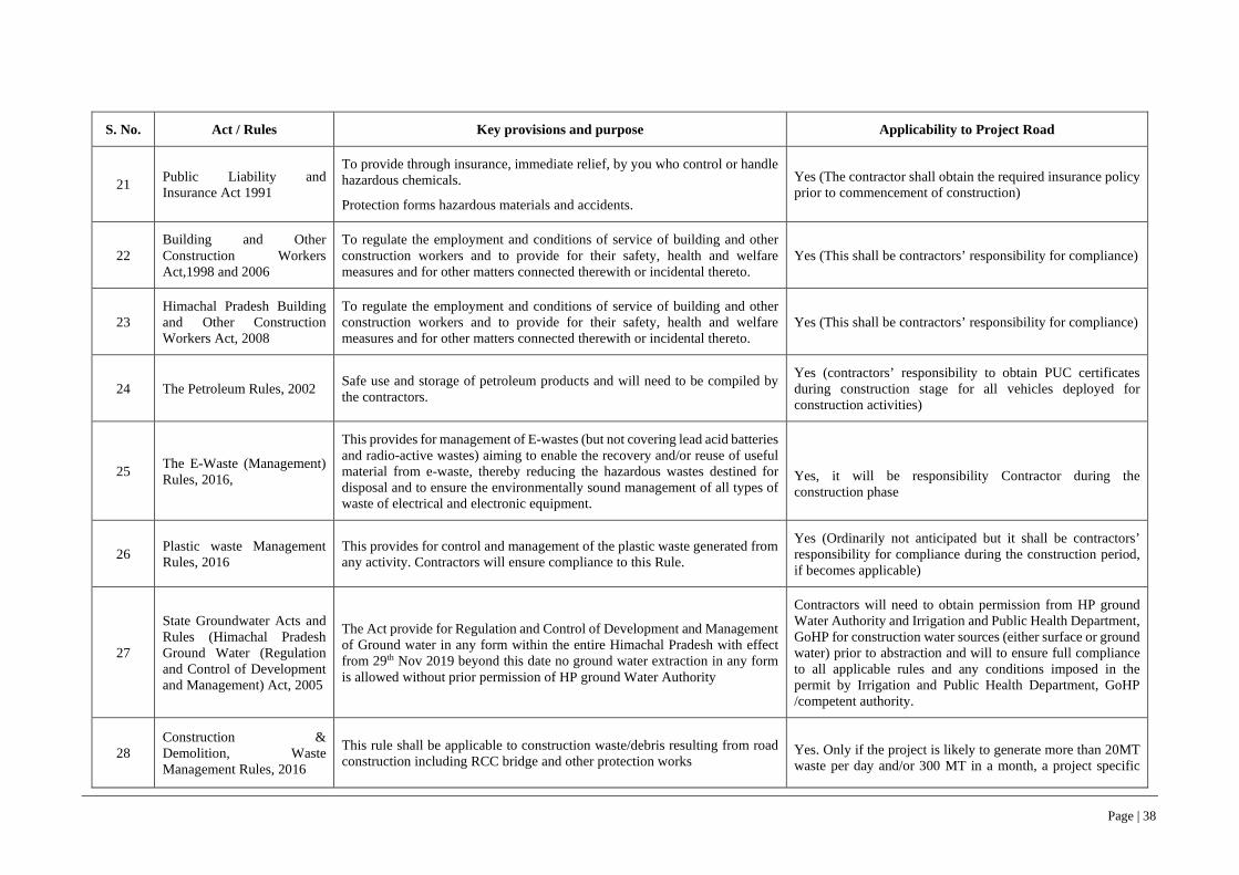
Page | 38
S. No. Act / Rules Key provisions and purpose Applicability to Project Road
21 Public Liability and Insurance Act 1991
To provide through insurance, immediate relief, by you who control or handle hazardous chemicals.
Protection forms hazardous materials and accidents.
Yes (The contractor shall obtain the required insurance policy prior to commencement of construction)
22 Building and Other Construction Workers Act,1998 and 2006
To regulate the employment and conditions of service of building and other construction workers and to provide for their safety, health and welfare measures and for other matters connected therewith or incidental thereto.
Yes (This shall be contractors’ responsibility for compliance)
23 Himachal Pradesh Building and Other Construction Workers Act, 2008
To regulate the employment and conditions of service of building and other construction workers and to provide for their safety, health and welfare measures and for other matters connected therewith or incidental thereto.
Yes (This shall be contractors’ responsibility for compliance)
24 The Petroleum Rules, 2002 Safe use and storage of petroleum products and will need to be compiled by the contractors.
Yes (contractors’ responsibility to obtain PUC certificates during construction stage for all vehicles deployed for construction activities)
25 The E-Waste (Management) Rules, 2016,
This provides for management of E-wastes (but not covering lead acid batteries and radio-active wastes) aiming to enable the recovery and/or reuse of useful material from e-waste, thereby reducing the hazardous wastes destined for disposal and to ensure the environmentally sound management of all types of waste of electrical and electronic equipment.
Yes, it will be responsibility Contractor during the construction phase
26 Plastic waste Management Rules, 2016
This provides for control and management of the plastic waste generated from any activity. Contractors will ensure compliance to this Rule.
Yes (Ordinarily not anticipated but it shall be contractors’ responsibility for compliance during the construction period, if becomes applicable)
27
State Groundwater Acts and Rules (Himachal Pradesh Ground Water (Regulation and Control of Development and Management) Act, 2005
The Act provide for Regulation and Control of Development and Management of Ground water in any form within the entire Himachal Pradesh with effect from 29th Nov 2019 beyond this date no ground water extraction in any form is allowed without prior permission of HP ground Water Authority
Contractors will need to obtain permission from HP ground Water Authority and Irrigation and Public Health Department, GoHP for construction water sources (either surface or ground water) prior to abstraction and will to ensure full compliance to all applicable rules and any conditions imposed in the permit by Irrigation and Public Health Department, GoHP /competent authority.
28 Construction & Demolition, Waste Management Rules, 2016
This rule shall be applicable to construction waste/debris resulting from road construction including RCC bridge and other protection works
Yes. Only if the project is likely to generate more than 20MT waste per day and/or 300 MT in a month, a project specific
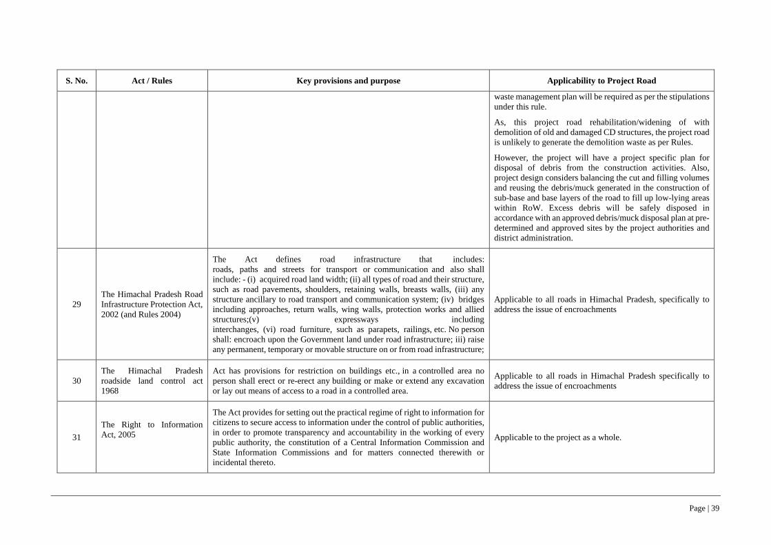
Page | 39
S. No. Act / Rules Key provisions and purpose Applicability to Project Road
waste management plan will be required as per the stipulations under this rule.
As, this project road rehabilitation/widening of with demolition of old and damaged CD structures, the project road is unlikely to generate the demolition waste as per Rules.
However, the project will have a project specific plan for disposal of debris from the construction activities. Also, project design considers balancing the cut and filling volumes and reusing the debris/muck generated in the construction of sub-base and base layers of the road to fill up low-lying areas within RoW. Excess debris will be safely disposed in accordance with an approved debris/muck disposal plan at pre-determined and approved sites by the project authorities and district administration.
29 The Himachal Pradesh Road Infrastructure Protection Act, 2002 (and Rules 2004)
The Act defines road infrastructure that includes: roads, paths and streets for transport or communication and also shall include: - (i) acquired road land width; (ii) all types of road and their structure, such as road pavements, shoulders, retaining walls, breasts walls, (iii) any structure ancillary to road transport and communication system; (iv) bridges including approaches, return walls, wing walls, protection works and allied structures;(v) expressways including interchanges, (vi) road furniture, such as parapets, railings, etc. No person shall: encroach upon the Government land under road infrastructure; iii) raise any permanent, temporary or movable structure on or from road infrastructure;
Applicable to all roads in Himachal Pradesh, specifically to address the issue of encroachments
30 The Himachal Pradesh roadside land control act 1968
Act has provisions for restriction on buildings etc., in a controlled area no person shall erect or re-erect any building or make or extend any excavation or lay out means of access to a road in a controlled area.
Applicable to all roads in Himachal Pradesh specifically to address the issue of encroachments
31 The Right to Information Act, 2005
The Act provides for setting out the practical regime of right to information for citizens to secure access to information under the control of public authorities, in order to promote transparency and accountability in the working of every public authority, the constitution of a Central Information Commission and State Information Commissions and for matters connected therewith or incidental thereto.
Applicable to the project as a whole.

Page | 40
S. No. Act / Rules Key provisions and purpose Applicability to Project Road
32 The Rights of Persons with Disabilities Act, 2016
The Act ensures that persons with disabilities enjoy the right to equality and non-discrimination in all aspects of life. Every entity has to comply with the accessibility standards relating to physical environment, transport and information and communication technology as per the standards prescribed in the RPD Act. These include barrier free built environment having elevators/ramps for the benefit of wheelchairs. In respect to Access to Transport”- mentioned that-the appropriate Government shall take suitable measures to provide, —(a) facilities for persons with disabilities at bus stops, railway stations and airports conforming to the accessibility standards relating to parking spaces, toilets, ticketing counters and ticketing machines;(b) access to all modes of transport that conform the design standards, including retrofitting old modes of transport, wherever technically feasible
Applicable to the project road infrastructure in terms of making it more accessible to person with disabilities/physically challenged

Page | 41
3.2 World Bank ESF Policy and WBG’s EHSG– Extent of Relevance
70. Section below (Table 3-2) present the relevance of WB’s ESF Policy, 2016 along with each of the ten standards (ESS1 to 10), WBG’s EHSG’s IFC, 2007 to the project road and requirements relating to other guidance notes of World Bank.
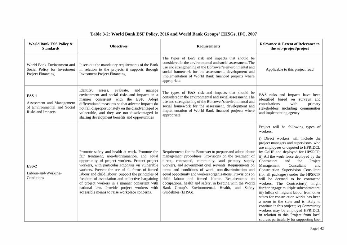
Page | 42
Table 3-2: World Bank ESF Policy, 2016 and World Bank Groups’ EHSGs, IFC, 2007
World Bank ESS Policy & Standards Objectives Requirements Relevance & Extent of Relevance to
the sub-project/project
World Bank Environment and Social Policy for Investment Project Financing
It sets out the mandatory requirements of the Bank in relation to the projects it supports through Investment Project Financing.
The types of E&S risk and impacts that should be considered in the environmental and social assessment. The use and strengthening of the Borrower’s environmental and social framework for the assessment, development and implementation of World Bank financed projects where appropriate.
Applicable to this project road
ESS-1
Assessment and Management of Environmental and Social Risks and Impacts
Identify, assess, evaluate, and manage environment and social risks and impacts in a manner consistent with the ESF. Adopt differentiated measures so that adverse impacts do not fall disproportionately on the disadvantaged or vulnerable, and they are not disadvantaged in sharing development benefits and opportunities
The types of E&S risk and impacts that should be considered in the environmental and social assessment. The use and strengthening of the Borrower’s environmental and social framework for the assessment, development and implementation of World Bank financed projects where appropriate.
E&S risks and Impacts have been identified based on surveys and consultations with primary stakeholders including communities and implementing agency
ESS-2
Labour-and-Working-Conditions
Promote safety and health at work. Promote the fair treatment, non-discrimination, and equal opportunity of project workers. Protect project workers, with particular emphasis on vulnerable workers. Prevent the use of all forms of forced labour and child labour. Support the principles of freedom of association and collective bargaining of project workers in a manner consistent with national law. Provide project workers with accessible means to raise workplace concerns.
Requirements for the Borrower to prepare and adopt labour management procedures. Provisions on the treatment of direct, contracted, community, and primary supply workers, and government civil servants. Requirements on terms and conditions of work, non-discrimination and equal opportunity and workers organizations. Provisions on child labour and forced labour. Requirements on occupational health and safety, in keeping with the World Bank Group’s Environmental, Health, and Safety Guidelines (EHSG).
Project will be following types of workers:
i) Direct workers will include the project managers and supervisors, who are employees or deputed to HPRIDCL by GoHP and deployed for HPSRTP; ii) All the work force deployed by the Contractors and the Project Management Consultant and Construction Supervision Consultant (for all packages) under the HPSRTP will be deemed to be contracted workers. The Contractor(s) might further engage multiple subcontractors; iii) Influx of migrant labour from other states for construction works has been a norm in the state and is likely to continue in this project; iv) Community workers may be employed HPRIDCL in relation to this Project from local sources particularly for supporting bio-

Page | 43
World Bank ESS Policy & Standards Objectives Requirements Relevance & Extent of Relevance to
the sub-project/project
engineering solutions towards slope stabilization workers, to instil sense of ownership and foster community driven development.
ESS-3
Resource-Efficiency-and-Pollution-Prevention-and-Management
Promote the sustainable use of resources, including energy, water, and raw materials. Avoid or minimize adverse impacts on human health and the environment caused by pollution from project activities. Avoid or minimize project-related emissions of short and long-lived climate pollutants. Avoid or minimize generation of hazardous and non-hazardous waste. Minimize and manage the risks and impacts associated with pesticide use. Requires technically and financially feasible measures to improve efficient consumption of energy, water, and raw materials, and introduces specific requirements for water efficiency where a project has high water demand.
Requires an estimate of gross greenhouse gas emissions resulting from project (unless minor), where technically and financially feasible. Requirements on management of wastes, chemical and hazardous materials, and contains provisions to address historical pollution. ESS-3 refers to national law and Good International Industry Practice, in the first instance the World Bank Groups’ EHSGs.
With respect to Resource Efficiency, the project preparation and the ESA process will identify feasible measures for efficient (a) energy use; (b) water usage and management to minimize water usage during construction, conservation
measures to offset total construction water demand and maintain balance for demand of water resources; and (c) raw materials use by exploring use of local materials, recycled aggregates, use of innovative technology so as to minimize project’s foot prints on finite natural resources.
With respect to Pollution Management, based on past road project experiences, the project will develop, as part of the ESA process, prevention and management measures to offset risks and impacts of pollution from potential sources such as dust and emission from operation of hot-mix and batching plants, crushers, construction and haulage vehicles, material and spoil stockpile; effluents and wastewater from labour camps, construction camp; spillage or leakage during handling of chemical admixtures, hazardous materials like bitumen, high strength diesel, used oil, battery wastes etc.; and disposal of non-hazardous wastes

Page | 44
World Bank ESS Policy & Standards Objectives Requirements Relevance & Extent of Relevance to
the sub-project/project
(municipal wastes) generated during project implementation period.
ESS-4
Community-Health-and-Safety
Anticipate or avoid adverse impacts on the health and safety of project-affected communities during project life-cycle from routine and non-routine circumstances. Promote quality, safety, and climate change considerations in infrastructure design and construction, including dams. Avoid or minimize community exposure to project-related traffic and road safety risks, diseases and hazardous materials. Have in place effective measures to address emergency events. Ensure that safeguarding of personnel and property is carried out in a manner that avoids or minimizes risks to the project-affected communities.
Requirements on infrastructure, taking into account safety and climate change, and applying the concept of universal access, where technically and financially feasible. Requirements on traffic and road safety, including road safety assessments and monitoring.
Addresses risks arising from impacts on provisioning and regulating ecosystem service. Measures to avoid or minimize the risk of water-related, communicable, and non-communicable diseases. Requirements to assess risks associated with security personnel, and review and report unlawful and abusive acts to relevant authorities.
In the project corridor there is likely to be i) hill cutting, landslides, road excavation, use of vibratory equipment, construction debris handling and disposal etc. during construction; ii) high likelihood of direct exposure to increased construction related traffic and equipment especially at road sections traversing settlement area with limited carriageway/roadway width, and sensitive receptors such as schools, religious place, health centre/hospitals; iii) high dust levels from earthworks/hill cutting, high noise and emission level from traffic congestion and idling of vehicles;
and iv) influx of migrant workers could potentially cause local discomfort or potential conflicts with local people.
ESS-5
Land-Acquisition-Restrictions-on-Land-Use-and-Involuntary-Resettlement
Avoid or minimize involuntary resettlement by exploring project design alternatives. Avoid forced eviction. Mitigate unavoidable adverse impacts from land acquisition or restrictions on land use by providing compensation at replacement cost and assisting displaced persons in their efforts to improve, or at least restore, livelihoods and living standards to pre-displacement levels or to levels prevailing prior to the beginning of project implementation, whichever is higher. Improve living conditions of poor or vulnerable persons who are physically displaced, through provision of adequate housing, access to services and facilities, and security of tenure. Conceive and execute
Applies to permanent or temporary physical and economic displacement resulting from different types of land acquisition and restrictions on access. Does not apply to voluntary market transactions, except where these affects third parties. Provides criteria for “voluntary” land donations, sale of community land, and parties obtaining income from illegal rentals. Prohibits forced eviction (removal against the will of affected people, without legal and other protection including all applicable procedures and principles in ESS5). Requires that acquisition of land and assets happens only after payment of compensation and resettlement has occurred. Requires community engagement and consultation, disclosure of information and a grievance mechanism.
Project Road widening is limited to available Right of Way (RoW) and no additional land acquisition will be required for widening.

Page | 45
World Bank ESS Policy & Standards Objectives Requirements Relevance & Extent of Relevance to
the sub-project/project
resettlement activities as sustainable development programs.
ESS-6
Biodiversity-Conservation
Protect and conserve biodiversity and habitats. Apply the mitigation hierarchy and the precautionary approach in the design and implementation of projects that could have an impact on biodiversity. To promote the sustainable management of living natural resources.
Requirements for projects affecting areas that are legally protected designated for protection or regionally/internationally recognized to be of high biodiversity value. Requirements on sustainable management of living natural resources, including primary production and harvesting, distinguishing between small-scale and commercial activities. Requirements relating to primary suppliers, where a project is purchasing natural resource commodities, including food, timber and fibre.
Site clearance activities for road construction will involve removal of road side vegetation and felling of trees. The biodiversity studies have indicated that entire corridor along the project road is rich in biodiversity, interspersed with invasive species. Other than the clearance of road side vegetation, road construction will also require felling of trees.
ESS-7
Indigenous-Peoples
Ensure that the development process fosters full respect for affected parties’ human rights, dignity, aspirations, identity, culture, and natural resource-based livelihoods. Promote sustainable development benefits and opportunities in a manner that is accessible, culturally appropriate and inclusive. Improve project design and promote local support by establishing and maintaining an ongoing relationship based on meaningful consultation with affected parties. Obtain the Free, Prior, and Informed Consent (FPIC) of affected parties in three circumstances. Recognize, respect and preserve the culture, knowledge, and practices of Indigenous Peoples, and to provide them with an opportunity to adapt to changing conditions in a manner and in a timeframe acceptable to them.
Applies when the Indigenous Peoples are present or have a collective attachment to the land, whether they are affected positively or negatively and regardless of economic, political or social vulnerability. The option to use different terminologies for groups that meet the criteria set out in the Standard. The use of national screening processes, providing these meet World Bank criteria and requirements. Coverage of forest dwellers, hunter gatherers, and pastoralists and other nomadic groups. Requirements for meaningful consultation tailored to affected parties and a grievance mechanism. Requirements for a process of free, prior and informed consent in three circumstances.
Not relevant to this sub-project road.
ESS-8
Cultural-Heritage
Protect cultural heritage from the adverse impacts of project activities and support its preservation. Address cultural heritage as an integral aspect of sustainable development. Promote meaningful consultation with stakeholders regarding cultural heritage. Promote the equitable sharing of benefits from the use of cultural heritage.
Requires a chance finds procedure to be established. Recognition of the need to ensure peoples’ continued access to culturally important sites, as well as the need for confidentiality when revealing information about cultural heritage assets that would compromise or jeopardize their safety or integrity. Requirement for fair and equitable sharing of benefits from commercial use of cultural
The alignment of the project road does not have any ancient monuments and/or archaeological site (s).
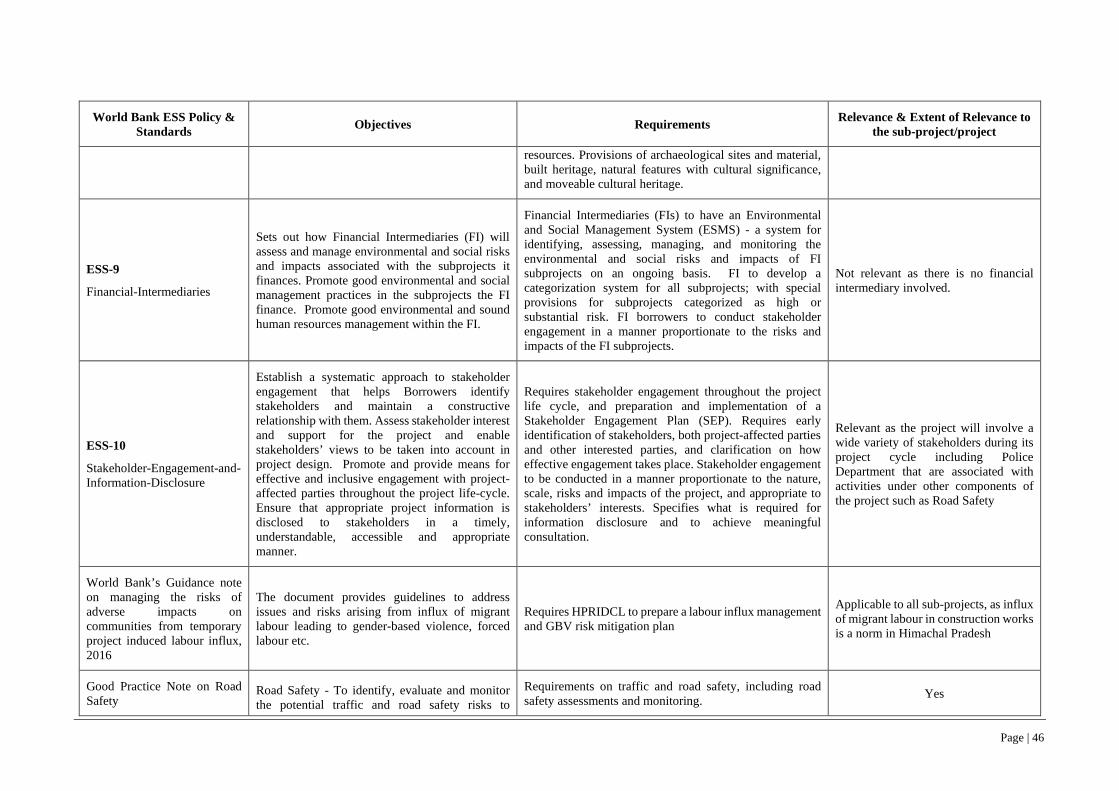
Page | 46
World Bank ESS Policy & Standards Objectives Requirements Relevance & Extent of Relevance to
the sub-project/project
resources. Provisions of archaeological sites and material, built heritage, natural features with cultural significance, and moveable cultural heritage.
ESS-9
Financial-Intermediaries
Sets out how Financial Intermediaries (FI) will assess and manage environmental and social risks and impacts associated with the subprojects it finances. Promote good environmental and social management practices in the subprojects the FI finance. Promote good environmental and sound human resources management within the FI.
Financial Intermediaries (FIs) to have an Environmental and Social Management System (ESMS) - a system for identifying, assessing, managing, and monitoring the environmental and social risks and impacts of FI subprojects on an ongoing basis. FI to develop a categorization system for all subprojects; with special provisions for subprojects categorized as high or substantial risk. FI borrowers to conduct stakeholder engagement in a manner proportionate to the risks and impacts of the FI subprojects.
Not relevant as there is no financial intermediary involved.
ESS-10
Stakeholder-Engagement-and-Information-Disclosure
Establish a systematic approach to stakeholder engagement that helps Borrowers identify stakeholders and maintain a constructive relationship with them. Assess stakeholder interest and support for the project and enable stakeholders’ views to be taken into account in project design. Promote and provide means for effective and inclusive engagement with project-affected parties throughout the project life-cycle. Ensure that appropriate project information is disclosed to stakeholders in a timely, understandable, accessible and appropriate manner.
Requires stakeholder engagement throughout the project life cycle, and preparation and implementation of a Stakeholder Engagement Plan (SEP). Requires early identification of stakeholders, both project-affected parties and other interested parties, and clarification on how effective engagement takes place. Stakeholder engagement to be conducted in a manner proportionate to the nature, scale, risks and impacts of the project, and appropriate to stakeholders’ interests. Specifies what is required for information disclosure and to achieve meaningful consultation.
Relevant as the project will involve a wide variety of stakeholders during its project cycle including Police Department that are associated with activities under other components of the project such as Road Safety
World Bank’s Guidance note on managing the risks of adverse impacts on communities from temporary project induced labour influx, 2016
The document provides guidelines to address issues and risks arising from influx of migrant labour leading to gender-based violence, forced labour etc.
Requires HPRIDCL to prepare a labour influx management and GBV risk mitigation plan
Applicable to all sub-projects, as influx of migrant labour in construction works is a norm in Himachal Pradesh
Good Practice Note on Road Safety
Road Safety - To identify, evaluate and monitor the potential traffic and road safety risks to
Requirements on traffic and road safety, including road safety assessments and monitoring. Yes

Page | 47
World Bank ESS Policy & Standards Objectives Requirements Relevance & Extent of Relevance to
the sub-project/project
workers, affected communities and road users throughout the project life-cycle and, where appropriate, will develop measures and plans to address them.
The Borrower will incorporate technically and financially feasible road safety measures into the project design to prevent and mitigate potential road safety risks to road users and affected communities”.
World Bank Groups’ EHSGs, IFC, 2007
General EHS Guidelines, April, 2007, IFC
The General EHS Guidelines contain information on cross-cutting environmental, health, and safety issues potentially applicable to all industry sectors
Requirements on environmental, health, and safety issues during construction of project road. Yes
EHS Guidelines for Construction Materials Extraction, April 2007, IFC
The EHS Guidelines contain the performance levels and measures that are considered to construction materials extraction activities such as aggregates, limestone, slates, sand, gravel, clay, gypsum, feldspar, silica sands, and quartzite
Requirements on the resource management of construction materials extraction activities such as aggregates, limestone, slates, sand, gravel, clay, gypsum, feldspar, silica sands, and quartzite.
Yes
71. The project will also adhere to all the applicable labor laws of GoI. The list of such laws is presented in Appendix 4.
3.3 Comparison of GoI/GoHP legislations and ESF, 2016
72. The GoI/GoHP legislations and ESF, 2016 of World Bank have been compared and gaps if any are summarized in the Table 3-3.
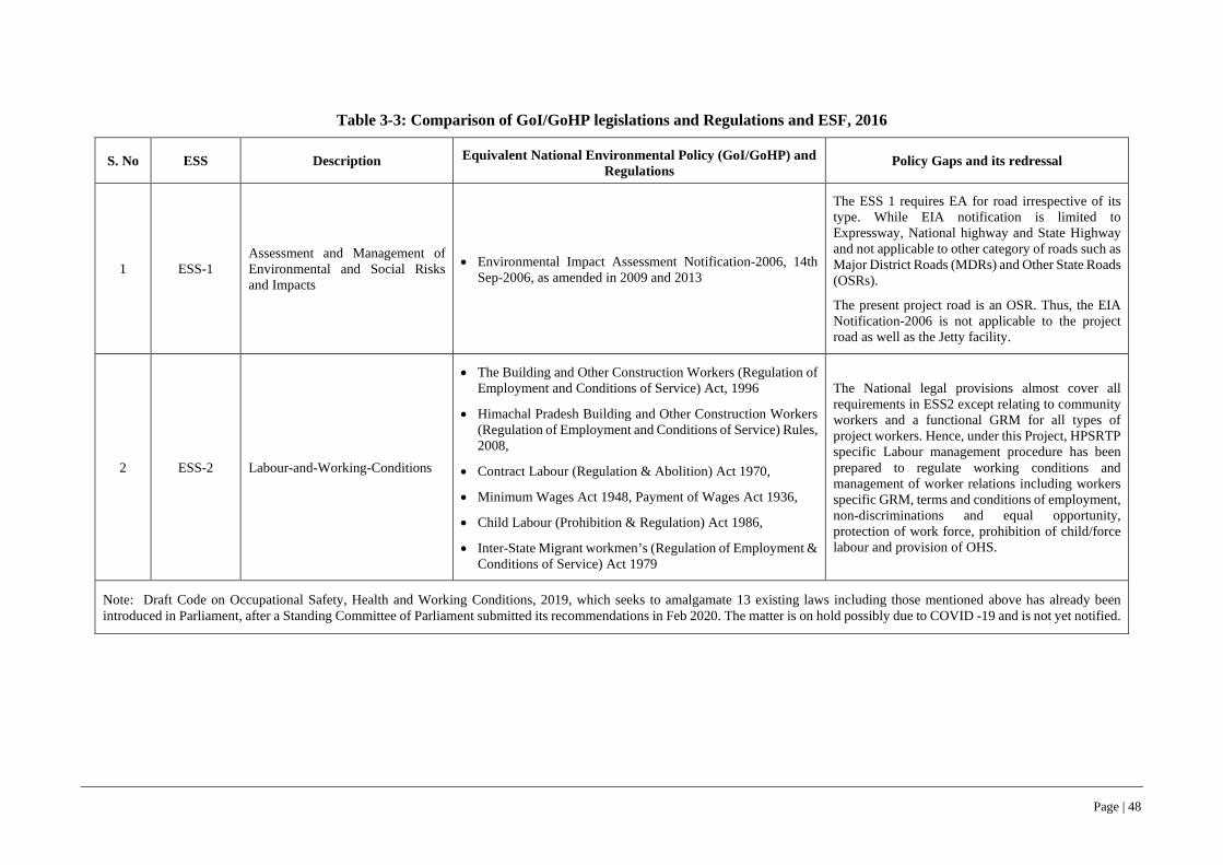
Page | 48
Table 3-3: Comparison of GoI/GoHP legislations and Regulations and ESF, 2016
S. No ESS Description Equivalent National Environmental Policy (GoI/GoHP) and Regulations
Policy Gaps and its redressal
1 ESS-1 Assessment and Management of Environmental and Social Risks and Impacts
• Environmental Impact Assessment Notification-2006, 14th Sep-2006, as amended in 2009 and 2013
The ESS 1 requires EA for road irrespective of its type. While EIA notification is limited to Expressway, National highway and State Highway and not applicable to other category of roads such as Major District Roads (MDRs) and Other State Roads (OSRs).
The present project road is an OSR. Thus, the EIA Notification-2006 is not applicable to the project road as well as the Jetty facility.
2 ESS-2 Labour-and-Working-Conditions
• The Building and Other Construction Workers (Regulation of Employment and Conditions of Service) Act, 1996
• Himachal Pradesh Building and Other Construction Workers (Regulation of Employment and Conditions of Service) Rules, 2008,
• Contract Labour (Regulation & Abolition) Act 1970,
• Minimum Wages Act 1948, Payment of Wages Act 1936,
• Child Labour (Prohibition & Regulation) Act 1986,
• Inter-State Migrant workmen’s (Regulation of Employment & Conditions of Service) Act 1979
The National legal provisions almost cover all requirements in ESS2 except relating to community workers and a functional GRM for all types of project workers. Hence, under this Project, HPSRTP specific Labour management procedure has been prepared to regulate working conditions and management of worker relations including workers specific GRM, terms and conditions of employment, non-discriminations and equal opportunity, protection of work force, prohibition of child/force labour and provision of OHS.
Note: Draft Code on Occupational Safety, Health and Working Conditions, 2019, which seeks to amalgamate 13 existing laws including those mentioned above has already been introduced in Parliament, after a Standing Committee of Parliament submitted its recommendations in Feb 2020. The matter is on hold possibly due to COVID -19 and is not yet notified.

Page | 49
S. No ESS Description Equivalent National Environmental Policy (GoI/GoHP) and Regulations
Policy Gaps and its redressal
3
ESS-3 and EHS Guidelines of IFC
Resource-Efficiency-and-Pollution-Prevention-and-Management`
• Environmental protection Act, 1986 and subsequent amendments
• Environmental Impact Assessment Notification-2006, 14th Sep-2006, as amended in 2009 and 2013
• Air (Prevention and Control of Pollution) Act, 1981;
• Water (Prevention and Control of Pollution) Act, 1974, for Pollution-Prevention-and-Management.
• The Noise Pollution (Regulation and Control) Rules, 2000
• National Resource Efficiency Policy, 2019 (Draft)
• Notification for use of fly ash, 2003 and MoEF&CC notification dated 25th March 2015
• Municipal Solid Waste (Management & Handling) Rules, 2000 (MSW Rules)
• Hazardous Wastes (Management, Handling and Trans-boundary Movement) Rules, 2008.
• Batteries (Management and Handling) Rules, 2001
• Central Motor Vehicle Act 1988 and Central Motor Vehicle Rules 1989
• The E-Waste (Management) Rules, 2016,
• Plastic waste Management Rules, 2016
• Construction & Demolition, Waste Management Rules, 2016
The majority of ESS3 requirements are addressed by existing regulations and indirectly for resource efficiency and climate change aspects. Further, bridging of gap is most likely after notification of National Resource Efficiency Policy, 2019, currently at draft stage. However, in its absence currently, the resource optimization initiatives considered in project road design as part of DPR and provisions in ESMP provide for commensurate resource efficiency and pollution prevention and management measures.
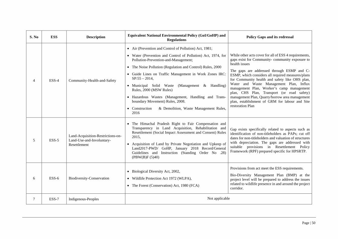
Page | 50
S. No ESS Description Equivalent National Environmental Policy (GoI/GoHP) and Regulations
Policy Gaps and its redressal
4 ESS-4 Community-Health-and-Safety
• Air (Prevention and Control of Pollution) Act, 1981;
• Water (Prevention and Control of Pollution) Act, 1974, for Pollution-Prevention-and-Management;
• The Noise Pollution (Regulation and Control) Rules, 2000
• Guide Lines on Traffic Management in Work Zones IRC: SP:55 – 2014,
• Municipal Solid Waste (Management & Handling) Rules, 2000 (MSW Rules)
• Hazardous Wastes (Management, Handling and Trans-boundary Movement) Rules, 2008.
• Construction & Demolition, Waste Management Rules, 2016
While other acts cover for all of ESS 4 requirements, gaps exist for Community- community exposure to health issues
The gaps are addressed through ESMP and C-ESMP, which considers all required measures/plans for Community health and safety like OHS plan, Water and Waste Management Plan, Influx management Plan, Worker’s camp management plan, CHS Plan, Transport (or road safety) management Plan, Quarry/borrow area management plan, establishment of GRM for labour and Site restoration Plan
5 ESS-5 Land-Acquisition-Restrictions-on-Land-Use-and-Involuntary-Resettlement
• The Himachal Pradesh Right to Fair Compensation and Transparency in Land Acquisition, Rehabilitation and Resettlement (Social Impact Assessment and Consent) Rules 2015,
• Acquisition of Land by Private Negotiation and Upkeep of Land2017-PWD/ GoHP, January 2018 Record/General Guidelines and Instruction (Standing Order No .28) (PBW(B)F (5)40)
Gap exists specifically related to aspects such as identification of non-titleholders as PAPs; cut off dates for non-titleholders and valuation of structures with depreciation. The gaps are addressed with suitable provisions in Resettlement Policy Framework (RPF) prepared specific for HPSRTP.
6 ESS-6 Biodiversity-Conservation
• Biological Diversity Act, 2002,
• Wildlife Protection Act 1972 (WLPA),
• The Forest (Conservation) Act, 1980 (FCA)
Provisions from act meet the ESS requirements.
Bio-Diversity Management Plan (BMP) at the project level will be prepared to address the issues related to wildlife presence in and around the project corridor.
7 ESS-7 Indigenous-Peoples Not applicable
Page | 51
S. No ESS Description Equivalent National Environmental Policy (GoI/GoHP) and Regulations
Policy Gaps and its redressal
8 ESS-8 Cultural-Heritage
• Ancient Monuments and Archaeological Sites and Remains Act, 1958 and
• The Himachal Pradesh Ancient and Historical Monuments and Archaeological Sites and Remains Act, 1976
Provisions form the act meets the ESS requirements.
Chance find procedures will be included in ESMP and C-ESMP. Impacts on religious structures (not protected, but social and cultural value) will be mitigated or managed through provisions for restoration or reconstruction of CPRs in ESMP.
9 ESS-9 Financial-Intermediaries Not applicable
10 ESS-10 Stakeholder-Engagement-and-Information-Disclosure
• Environmental Impact Assessment Notification-2006, 14th Sep-2006, as amended in 2009 and 2013
• The Himachal Pradesh Right to Fair Compensation and Transparency in Land Acquisition, Rehabilitation and Resettlement (Social Impact Assessment and Consent) Rules 2015,
• GoHP standing order on Private Negotiations
• Right to information Act 2005
Environmental Impact Assessment Notification-2006 is not applicable to the project road though it has provisions for public hearing as part of impact assessment process.
Similarly, HP RFCTLARR, 2015 has provisions for consultations during SIA.
The Standing order on private negotiations requires consultations but with affected land owners only.
The Project has prepared a Stakeholder Engagement Plan (SEP) to engage with all stakeholders relevant to the different components sub-components of the project
11 EHS Guidelines for Construction Materials Extraction, April 2007, IFC
• National Resource Efficiency Policy, 2019 (Draft)
• Environmental protection Act, 1986 and subsequent amendments
• Environmental Impact Assessment Notification-2006, 14th Sep-2006, as amended in 2009 and 2013
• Air (Prevention and Control of Pollution) Act, 1981;
• Water (Prevention and Control of Pollution) Act, 1974, for Pollution-Prevention-and-Management;
• The Noise Pollution (Regulation and Control) Rules, 2000
The majority of ESS3 requirements are addressed by existing regulations and indirectly for resource efficiency and climate change aspects. Further, bridging of gap is most likely after notification of National Resource Efficiency Policy, 2019, currently at draft stage.
Project design considers measures for minimization of natural material extraction and reuse of extracted materials in project construction
Page | 52
S. No ESS Description Equivalent National Environmental Policy (GoI/GoHP) and Regulations
Policy Gaps and its redressal
• Notification for use of fly ash, 2003 and MoEF&CC notification dated 25th March 2015
• Municipal Solid Waste (Management & Handling) Rules, 2000 (MSW Rules)
• Hazardous Wastes (Management, Handling and Trans-boundary Movement) Rules, 2008.
• Batteries (Management and Handling) Rules, 2001
• Central Motor Vehicle Act 1988 and Central Motor Vehicle Rules 1989
• The E-Waste (Management) Rules, 2016,
• Plastic waste Management Rules, 2016
• Construction & Demolition, Waste Management Rules, 2016
• The Mines and Minerals (Development and Regulation) Act 1957
Page | 53
73. Based on comparative analysis of national/state’s regulatory frameworks with ESS1-8 and 10, the requirements in regulatory frameworks were found to be aligned with ESSs. The exception being (a) GHG emission calculation, (b) resource efficiency, (c) community health and safety and (d) workers grievance redressal mechanism. These aspects are considered in different themes of impact assessment in line with international best practices, but not mandatory under existing regulatory frameworks. Currently, National Resource Efficiency Policy, 2019 is being framed (draft stage) with an objective to mainstream resource efficiency across all sectors by fostering cross-sectoral collaborations, development of policy instruments, action plans and efficient implementation and monitoring frameworks.
74. Further as gaps exists between GoHP, GOI and ESS5 requirements, gap-filling measures are reflected in the entitlement matrix of the Resettlement Policy Framework and in the Resettlement Action Plans. In case of stakeholder engagement, specifically, the EIA notification 2006 requires conducting of public hearings during process of impact assessment but is limited to project that are categorized as Category-A, while, RFCTLARR Act and also GoHP Standing order on Private Negotiations requires consultation with project affected people during Social Impact Assessment.
75. In the event of any conflict or inconsistency between the provisions of this GOI, GoHP and RPF and the provisions of World Bank’s ESF, the provisions of the ESF shall prevail.
3.4 Clearances and Permissions required for Project Road and Jetty Facility 76. The project road and the Jetty facility does not require any prior environmental clearances or forest clearances from the State Government or Government of India level. The pre-construction and construction stage permissions required for the project road are given in Table 3-4.
Table 3-4: Permissions Required for Project Road and Jetty Facility
S. No. Clearances/Permissions required Competent Authority to Accord
Clearances
Responsibility to Obtain Clearance
A. Pre-construction Stage
1 Permission for felling of an estimated 42 trees, which are within the Right of Way (RoW)/ Corridor of Impact (CoI)
Divisional Forest officer, Mandi, Department of Forests, GoHP and District Magistrate Mandi
HPRIDCL
B. Construction Stage
1
Consent to establish and Consent to operate construction camp sites, crusher units, hot mix plants, concrete batch mix plants, WMM plants, work force camps etc.
Himachal Pradesh State Pollution Control Board Contractor
2 Permissions for sourcing of water for construction activities (Surface and Ground Water)
HP Ground Water Authority and Irrigation and Public Health Department, GoHP
Contractor
3 License to store HSD and Explosives at Construction camp, if required.
Regional office of Chief Controller of Explosives, GoI, Himachal Pradesh Contractor
4 Permission to Establish Construction camps District Magistrate & Local Panchayat (s), landowners in case of private land Contractor
5 Opening of new quarry sites for Stone aggregates Geological Wing, Department of Industries, GoHP Contractor
6 Labour licence/ permits for engaging construction workers (skilled & un-skilled) Respective district level Labour Officer Contractor

Page | 54
4 BASELINE DATA
4.1 Approach and Methodology 77. Study Area: The study area for environmental and social baseline data assessment is defined on the consideration of physical space to be occupied, whether permanently or temporarily, during construction of the entire road infrastructure, associated infrastructure, as well as adjacent spaces, performance of planned activities in the various stages according to project needs, requirements on use and exploitation of natural resources, abiotic, biotic and socio-economic profile of the local community including third gender along the road and the area where significant environmental impacts are evident, with a view to define limit on which components involved are analyzed.
a. Corridor of Impact for Sub-Project Road: The land width that would be needed during road construction taking into account full construction width, movement of construction vehicle/equipment and safety zone on either side of centerline during construction stage is considered as Corridor of Impact (CoI). The CoI is considered as 50-metre-wide land strip i.e., 25 metre on each side of the centre line of the road (ref. Figure 4-1).
b. Corridor of Impact for Jetty Facilities: Based on the site assessment of proposed Jetty location near Luhnu Stadium Bilaspur, an area covering over a 300-meter radius surrounding Jetty location is considered as CoI for the jetty facility (ref. Figure 4-2 & 4-3).
c. Project Influence Area: 15 km strip on either side of project road which includes the Jetty Facility near Luhnu Stadium Bilaspur is considered as the Project Influence area (PIA) for collecting baseline data from secondary data sources as required for conducting environmental impact assessment for both sub-project road and Jetty facilities (ref. Figure 4-1).
78. The baseline environmental assessment for the ESIA studies has considered both CoI and PIA as shown in Figure 4-1, 4-2 & 4-3 as well as the respective tehsil/district as a whole in general.
Figure 4-1: Corridor of Impact and Project Influence Area for Sub-Project Road
.
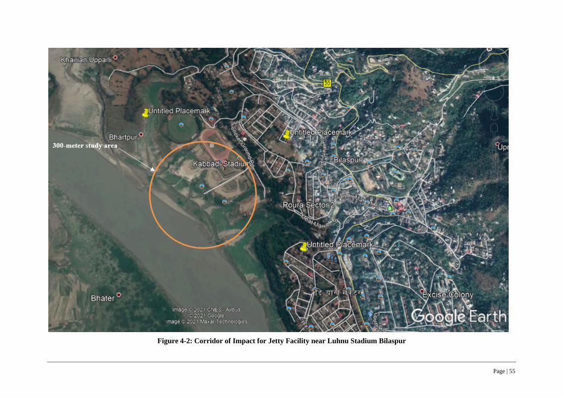
Page | 55
Figure 4-2: Corridor of Impact for Jetty Facility near Luhnu Stadium Bilaspur
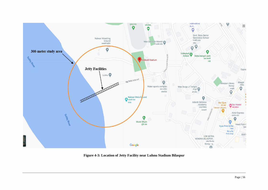
Page | 56
Figure 4-3: Location of Jetty Facility near Luhnu Stadium Bilaspur

Page | 57
79. Environmental and Social baseline data and assessment: The primary baseline information on different environmental and Socio-economic profile components for both CoI and PIA were collected through field surveys and secondary data sources. The input to field surveys i.e., identification of environmental factors to be considered for assessment was backed by thorough desk review of literature, existing rules/regulations/acts and reconnaissance survey. Field surveys were carried out to collect information on the major environmental features such as settlement facilities, drainage pattern of the area, forest stretches, trees within RoW of the alignment, water bodies, river flowing across road alignment, sensitive receptors, air, water, noise and soil quality etc. which helped in identifying areas of concern along the project road and associated critical issues. After the full documentation of the baseline environmental situation, each of the environmental aspects was examined against the project road upgrading component and activities. Environmental issues have been assessed to describe the potential impacts and risks that may result from construction works related to project road upgradation. Quantification has been done to the extent possible (See Appendix-3: Inventory Checklist and Environmental Screening/ Transect Walk Survey Formats).
80. The project influence area of 15 km was considered for socio-economic profile assessment based on the information collected from secondary and primary sources to provide an overview, levels of socio-economic development etc. of the project road. Secondary information from different government sources like Census of India, Economic and Statistics department, Agriculture department, Social Welfare & Women Development Department of Government of Himachal Pradesh. The secondary information helped to understand macro level socio-economic profile of the population by gender, ethnicity, vulnerability, poverty, working population and available infrastructure facilities for services in the project influence area.
81. As the project road was merely 2.74 km long and widening limited to available right of way with no fresh land acquisition or warranting clearances of RoW encroachments, no social surveys for R& R issues were warranted. However, stakeholder consultations were conducted along the road to elicit views and concerns of local community about the project road widening/upgradation. Since there were no potential hot spots, GBV consultations were conducted at Ghumarwin15, Bilaspur district as part of project (HPSRTP) level GBV risk mitigation strategy consultations.
82. All formats used for collection of the environmental and social base line information, checklists used for consultations, photographs, attendance sheets are available in project files/records and included in Appendices 3 & 10 respectively to this ESIA volume.
4.2 Data Sources 83. The baseline environmental profile of the CoI and PIA for both project road as well as associated facilities, in particular and Mandi district as a whole in general has been described in the following sections. The environmental profile includes key attributes like physiography, drainage, geology, soil, hydrogeology, land use, flora, fauna, forest/vegetation cover, climate, ambient air quality, water quality, ambient noise levels, hazards and vulnerability status of the PIA among others.
84. In order to assess the baseline environment, the data has been accessed from authentic and verifiable sources as given in Table 4-1 & 4-2. Due attempt has been made to source and access only the latest available data from authentic and verifiable sources.
15 Ghumarwin, an urban center is at 25 kms from project road and falls within Bilaspur district (same as that of project road)
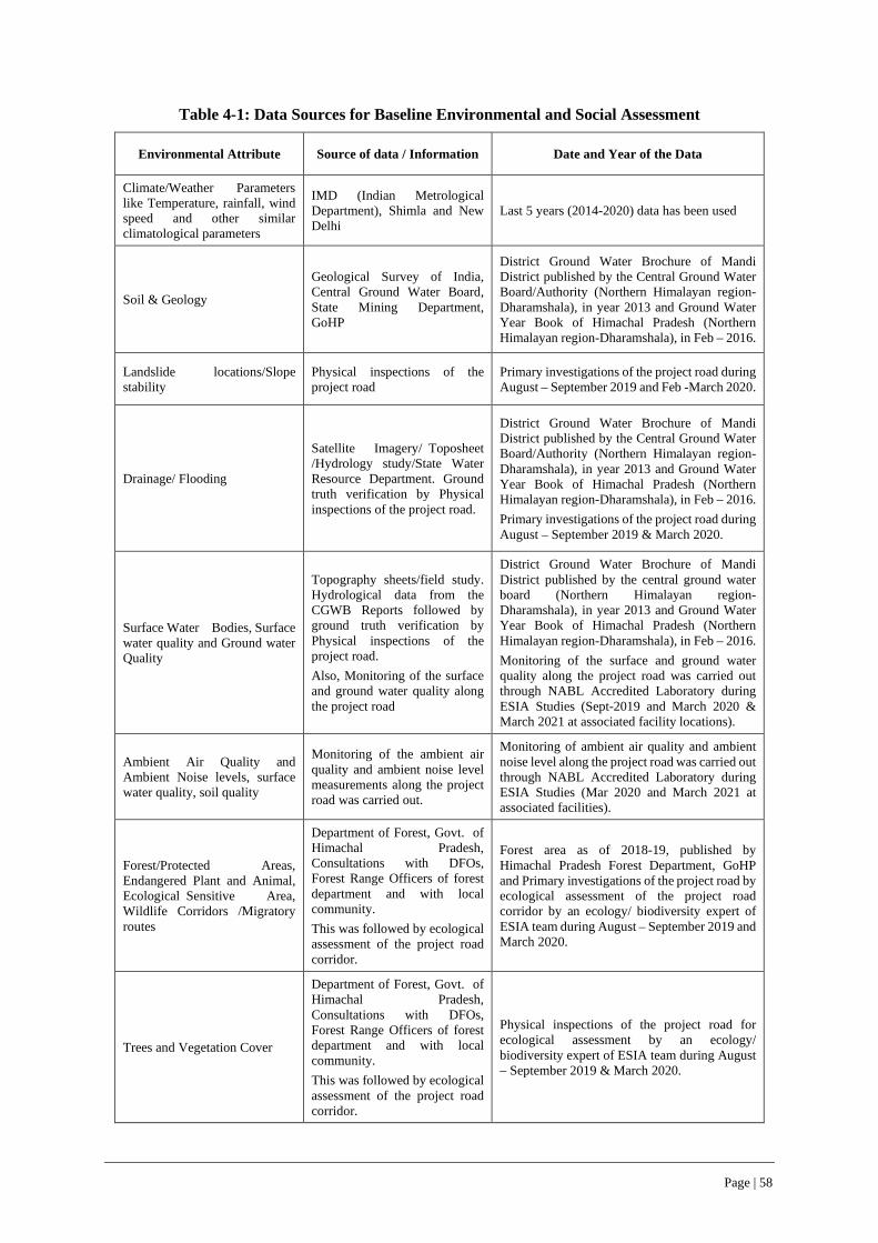
Page | 58
Table 4-1: Data Sources for Baseline Environmental and Social Assessment
Environmental Attribute Source of data / Information Date and Year of the Data
Climate/Weather Parameters like Temperature, rainfall, wind speed and other similar climatological parameters
IMD (Indian Metrological Department), Shimla and New Delhi
Last 5 years (2014-2020) data has been used
Soil & Geology
Geological Survey of India, Central Ground Water Board, State Mining Department, GoHP
District Ground Water Brochure of Mandi District published by the Central Ground Water Board/Authority (Northern Himalayan region-Dharamshala), in year 2013 and Ground Water Year Book of Himachal Pradesh (Northern Himalayan region-Dharamshala), in Feb – 2016.
Landslide locations/Slope stability
Physical inspections of the project road
Primary investigations of the project road during August – September 2019 and Feb -March 2020.
Drainage/ Flooding
Satellite Imagery/ Toposheet /Hydrology study/State Water Resource Department. Ground truth verification by Physical inspections of the project road.
District Ground Water Brochure of Mandi District published by the Central Ground Water Board/Authority (Northern Himalayan region-Dharamshala), in year 2013 and Ground Water Year Book of Himachal Pradesh (Northern Himalayan region-Dharamshala), in Feb – 2016. Primary investigations of the project road during August – September 2019 & March 2020.
Surface Water Bodies, Surface water quality and Ground water Quality
Topography sheets/field study. Hydrological data from the CGWB Reports followed by ground truth verification by Physical inspections of the project road. Also, Monitoring of the surface and ground water quality along the project road
District Ground Water Brochure of Mandi District published by the central ground water board (Northern Himalayan region-Dharamshala), in year 2013 and Ground Water Year Book of Himachal Pradesh (Northern Himalayan region-Dharamshala), in Feb – 2016. Monitoring of the surface and ground water quality along the project road was carried out through NABL Accredited Laboratory during ESIA Studies (Sept-2019 and March 2020 & March 2021 at associated facility locations).
Ambient Air Quality and Ambient Noise levels, surface water quality, soil quality
Monitoring of the ambient air quality and ambient noise level measurements along the project road was carried out.
Monitoring of ambient air quality and ambient noise level along the project road was carried out through NABL Accredited Laboratory during ESIA Studies (Mar 2020 and March 2021 at associated facilities).
Forest/Protected Areas, Endangered Plant and Animal, Ecological Sensitive Area, Wildlife Corridors /Migratory routes
Department of Forest, Govt. of Himachal Pradesh, Consultations with DFOs, Forest Range Officers of forest department and with local community. This was followed by ecological assessment of the project road corridor.
Forest area as of 2018-19, published by Himachal Pradesh Forest Department, GoHP and Primary investigations of the project road by ecological assessment of the project road corridor by an ecology/ biodiversity expert of ESIA team during August – September 2019 and March 2020.
Trees and Vegetation Cover
Department of Forest, Govt. of Himachal Pradesh, Consultations with DFOs, Forest Range Officers of forest department and with local community. This was followed by ecological assessment of the project road corridor.
Physical inspections of the project road for ecological assessment by an ecology/ biodiversity expert of ESIA team during August – September 2019 & March 2020.

Page | 59
Environmental Attribute Source of data / Information Date and Year of the Data
Population and Settlements within the RoW
Census of India, 2011 and Primary Surveys by of the project road corridor by a qualified and experienced social expert.
Census, 2011 data published by the Office of Registrar General & Census Commissioner, India and primary social economic survey of all households along the project corridor by social surveyors under guidance / supervision of key social specialist of ESIA team.
Cultural / Heritage and Ancient Structures.
Consultations with Archaeological Survey of India, State Archaeological Department, GoHP and web-based data search.
Archaeological Survey of India, GoHP and web-based data search for information on Cultural / Heritage and Ancient Structures within the PIA and Primary investigations of the project road during August – September 2019 and March 2020.
Table 4-2: Data Sources for Baseline Environment Theme Maps
Sl. No. Baseline Environment Theme Maps Data Sources
1 Agriculture land cover map Landsat-8 OLI Sensor
2 Agriculture map (Crop Pattern) Maps of India and Landsat-8 classification
3 Drainage map SRTM digital elevation model/CGWB
4 Earthquake map Vulnerability Atlas of India, BMTPC (Building Materials and Technology Promotion Council)
5 Elevation map SRTM digital elevation model
6 Flood Hazard map Vulnerability Atlas of India, BMTPC (Building Materials and Technology Promotion Council)
7 Forest Map Landsat-8 OLI sensor/HP Forest Department
8 Landslide map Vulnerability Atlas of India, BMTPC (Building Materials and Technology Promotion Council)
9 Land Use and Land Cover (LULC) map Landsat-8 OLI sensor
10 Physiography map SRTM digital elevation model
11 Satellite map for Data interpretation Landsat-8 OLI sensor
12 Soil Moisture Map Amy McNally NASA/GSFC/HSL (2018).
13 Soil fertility map Indian Institute of Soil Science (IISS)/HP Agriculture Dept
14 Taluka map Census 2011 data, Government of India.
15 Vulnerability Map HP state council for Environment science and technology and BMPTC
16 Wildlife Sanctuary map Wildlife Institute of India, Dehradun
17 Wind Hazard map Vulnerability Atlas of India, BMTPC (Building Materials and Technology Promotion Council)
4.3 Land Environment
4.3.1 Geology
85. Bilaspur district presents an intricate mosaic of mountain ranges, hills and valleys and is located in Shivalik ranges and forms part of the lesser Himalayas. It has a diverse landscape of hills, valleys with piedmont zone. There are seven main hill ranges i.e., Naina Devi, Kot, Jhanjiar, Tiun, Bandla,
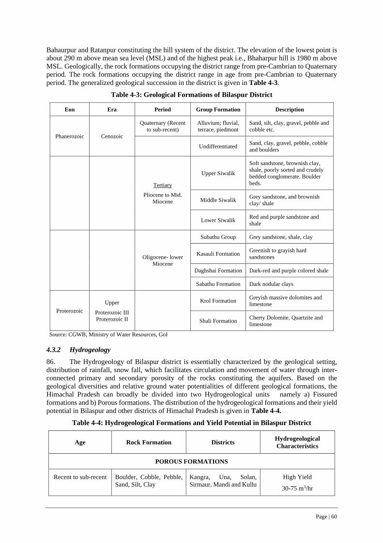
Page | 60
Bahaurpur and Ratanpur constituting the hill system of the district. The elevation of the lowest point is about 290 m above mean sea level (MSL) and of the highest peak i.e., Bhaharpur hill is 1980 m above MSL. Geologically, the rock formations occupying the district range from pre-Cambrian to Quaternary period. The rock formations occupying the district range in age from pre-Cambrian to Quaternary period. The generalized geological succession in the district is given in Table 4-3.
Table 4-3: Geological Formations of Bilaspur District
Eon Era Period Group Formation Description
Phanerozoic Cenozoic
Quaternary (Recent to sub-recent)
Alluvium; fluvial, terrace, piedmont
Sand, silt, clay, gravel, pebble and cobble etc.
Undifferentiated Sand, clay, gravel, pebble, cobble and boulders
Tertiary
Pliocene to Mid. Miocene
Upper Siwalik
Soft sandstone, brownish clay, shale, poorly sorted and crudely bedded conglomerate. Boulder beds.
Middle Siwalik Grey sandstone, and brownish clay/ shale
Lower Siwalik Red and purple sandstone and shale
Oligocene- lower Miocene
Subathu Group Grey sandstone, shale, clay
Kasauli Formation Greenish to grayish hard sandstones
Daghshai Formation Dark-red and purple colored shale
Sabathu Formation Dark nodular clays
Proterozoic Upper
Proterozoic III Proterozoic II
Krol Formation Greyish massive dolomites and limestone
Shali Formation Cherty Dolomite, Quartzite and limestone
Source: CGWB, Ministry of Water Resources, GoI
4.3.2 Hydrogeology
86. The Hydrogeology of Bilaspur district is essentially characterized by the geological setting, distribution of rainfall, snow fall, which facilitates circulation and movement of water through inter-connected primary and secondary porosity of the rocks constituting the aquifers. Based on the geological diversities and relative ground water potentialities of different geological formations, the Himachal Pradesh can broadly be divided into two Hydrogeological units namely a) Fissured formations and b) Porous formations. The distribution of the hydrogeological formations and their yield potential in Bilaspur and other districts of Himachal Pradesh is given in Table 4-4.
Table 4-4: Hydrogeological Formations and Yield Potential in Bilaspur District
Age Rock Formation Districts Hydrogeological Characteristics
POROUS FORMATIONS
Recent to sub-recent Boulder, Cobble, Pebble, Sand, Silt, Clay
Kangra, Una, Solan, Sirmaur, Mandi and Kullu
High Yield
30-75 m3/hr

Page | 61
Age Rock Formation Districts Hydrogeological Characteristics
FISSURED FORMATIONS
Tertiary Boulder Conglomerate Sandstone, Clay
Kangra, Solan, Sirmaur, Bilaspur, Una, Mandi and Hamirpur
Moderate to Low Yield
< 30 m3/hr
Proterozoic to Mesozoic
Shale, Slate, Phyllate, Limestone, Dolomite, Sandstone, Quartzite, Granite, Sehist
Lahaul & Spiti, Kinnaur, Chamba, Mandi, Shimla, Kangra, Sirmaur, Solan and Kullu
Moderate to Low Yield
< 05 to 30m3/hr
Source: CGWB, Ministry of Water Resources, GoI
87. Fissured formations comprise hard rocks belonging to Jutogh, Shali limestones, Chails, Chandpurs, Kangra-Darla volcanic, Subathu, Dharamsala and Siwaliks. These formations consist of schist, quartzite, slates, phyllites, limestones, granites, gneisses, sandstones, conglomerates and shales. These rocks are generally massive and consolidated, devoid of primary porosity and permeability’s. Secondary porosity and permeability have developed due to the tectonic activities along the fractured joints and fault zones. In this hard rock terrain ground water occurs either, along structurally weak zones, viz. fracture zones, faults, joints or along the contacts of different formations. The ground water in such areas is discharged through the springs in the topographically favorable areas. The thrust zones (Main boundary Fault/Palampur Thrust) and other faults at lower topography are the important areas for ground water development. Springs located along the thrust zone in Dharamsala and Palampur areas are having a discharge of more than 40 lps, indicative of their high potential.
88. In Siwalik formations, the contact zones of various formations and fault zones form potential ground water horizons, especially between Nadaun in the east and Nurpur in the west. Important springs at Trilokpur (30 lps) and Nagni (25 lps) are located at the intersection of Jawalamukhi thrust and north-south trending faults. Compact conglomeratic formations are generally devoid of water, but hand pumps have been successfully installed in low topography area and along fractured zones. The boreholes drilled for installing handpumps have yielded from less than 1 lps to about 20 lps. Discharge is generally higher in Jawalamukhi area along the thrust zone. Depth to water varies from free-flowing condition at Darshanpur (Trilokpur) to about 30 m in the bored wells. Depth to water in shallow zones (dug wells-of NHS), generally varies from less than 1 m to 15.44 m. Water level is shallower in topographic lows.
89. Porous Formations comprise Quaternary sediments as fluvio-glacial and fluvitile deposits occur as valley fill deposits, overlying the older rocks. Morainic and fluvio-glacial deposits are distributed in Kangra Palampur valley and in the higher altitude areas, while fluvitile deposits occur either along Beas River or its tributaries in low altitude areas.
90. Himachal Pradesh is hilly and mountainous for more than 85% of the area with few small intermontane valleys covering about 15% of the area. These intermontane valleys comprise of alluvial deposits, which form extensive aquifers and thus represent porous formations. Major valleys in the state are Indora-Nurpur and Kangra-Palampur valleys in district Kangra, Una valley in district Una, Balh valley in district Mandi, Nalagarh valley in district Solan and Paonta valley in district Sirmaur.
91. The Siwalik and Sirmaur group represent the Tertiary formation in the state. These two groups occur in the western part of the state and have northwest to southeast trend. The Siwalik comprises of boulder, conglomerate, sandstone and clay while, Sirmaur group comprises of shale, sandstone and clay. The primary porosity and permeability in the Tertiary formation is low to moderate and hence, these aquifers do not form high yielding aquifers.
92. The older rock formations of Proterozoic to Mesozoic eras constitute of igneous and metamorphic rocks like granite, gneiss, slate, schist, phyllite, quartzite etc. Due to their consolidated nature, these rock formations serve as poor aquifers. However, due to tectonic movements, they have been traversed by faults, thrust and joints, which have enhanced their ground water potential.

Page | 62
93. In Bilaspur district, ground water occurs under fissured formations with moderate to low yield of less than 30 cum./hour or 8LPS. The aquifer zone mainly comprises of boulder conglomerate sandstone and clay in association with pebbles and boulders in low plains and predominantly boulders, cobbles, pebbles mixed with little clay in terraces. The quality of ground water in hard rocks and alluvial areas is by and large good and suitable for domestic and irrigational use. The distribution of the hydrogeological formations and their yield potential across Himachal Pradesh is given in Table 4-4.
94. Most of the part of Bilaspur district having Metamorphic and Igneous rocks (consolidated and semi-consolidated) have not been explored due to mountainous terrain and difficulty in approachability as such, their yield potentials are reported to be unknown. Ground water resources and irrigation potential for Bilaspur district has not been computed as per the GEC-97 methodology due to hilly terrain and localized aquifers and thus stage of ground water development in Bilaspur district has not been estimated/assessed.
95. Snowfall in the higher reaches and rain fall in the lower areas are the main source for groundwater recharge. Springs are the other main sources for the irrigation and water supply schemes. At present, Bilaspur district is partly explored and only shallow aquifers are tapped mainly for water supply schemes.
96. Ground water development in Bilaspur district, has not been fully explored and thus deemed to be falling in safe category and therefore no area or block in the district has been notified for restricted groundwater development by Central Ground Water Authority (CGWA) and State Ground Water Authority (SGWA). Hence, there is a scope for developing the ground water resource in the district. The development of groundwater could be through constructing shallow and deep boreholes in the valleys and the river terraces.
4.3.3 Physiography
97. The project road entirely traverses within Bilaspur Sadar Tehsil of Bilaspur district, which is bounded by Hamirpur district, east by Mandi district, and southeast by Solan district and towards southwest by the State of Punjab.
98. The Bilaspur district comprises 6 Tehsils (Bharari, Ghumarwin, Bilaspur Sadar, Namhol, Jhanduta and Naina Devi). The alignment of project road, traversing entirely in Bilaspur Sadar Tehsil is shown in Figure 4-4.

Page | 63
Figure 4-4: Tehsils of Bilaspur District
(Source: - https://www.mapsofindia.com/maps/himachalpradesh/tehsil/Bilaspur.html)
Page | 64
4.3.4 Drainage
99. Himachal Pradesh is drained by 5 river basins, out of which Beas and Sutlej river forms major drainage basins of Mandi district. Beas basin drains 70%, while Sutlej basin drains 30% area of the district. The project road traverses through Dhauladhar range of Sutlej basin in Hilly/mountainous area as shown in Figure 4-5. The entire district has a dendritic pattern of drainage which is shown in Figure 4-6. The project road does not fall in flood plains or in areas, which are prone to floods (also ref. Section 4.7.3).
100. The project road traverse across several seasonal streams at different chainages along the road. The project design has considered 7 cross-drainage structures across such streams, which includes 3 slab culverts and 4 box culverts (ref. 2.9 under Section 2). The project design considers construction of 2570 meters of rectangular and ‘V’ shaped longitudinal drains along the road which will be connected to the nearest culverts. (ref. Drainage maps under Appendix 1). None of the rivulets/ streams along the project road are perennial and remain dry during most part of the year (non-monsoon months).
101. Gobind Sagar lake and the connected River Sutlej is the only prominent aquatic body present in PIA and the project road traverses in close proximity to the Gobind Sagar Lake and the Jetty facility is located on the bank of the Gobind Sagar Lake/ River Sutlej near Luhnu Stadium Bilaspur (ref. Figure 2-1, 2-10, 2-11 & 2-12). Gobind Sagar Lake is the only most prominent aquatic body within the PIA and/or Bilaspur district.
102. The Govind Sagar Lake, which is part of the Sutlej river system, earlier was a notified as wildlife sanctuary but the same has been de-notified in year 2013 as per decision of the Hon’ble Supreme Court (ref. Appendix 5).
103. The fisheries department under the State Government has introduced numerous species of fish for commercial fishing purposes. Most common fish species reported from the Dam are Gid (Labeo dero), Golden Mahseer (Tor putitora), Singhara (Mystus seenghala), Guj (Mastacembelus armatus), Gungli (Schizothorax sinuatus), Jhalli (Clupisoma monata), Chillwa (Barillus bendelinsis), Ticto (Puntius ticto), Sarana (Puntius sarana), Bata (Labeo bata) and Topra (Garra lamta) along with introduced fish species like Katla (Catla catla), Rohu (Labeo rohita), Mrigal (Cirrhinus mrigala), Common Carp (Cyprinus carpio) and Grass carp (Ctenopharyngodon indella). Among all recorded fish species, Golden Mahseer comes under ‘Endangered” category of IUCN.
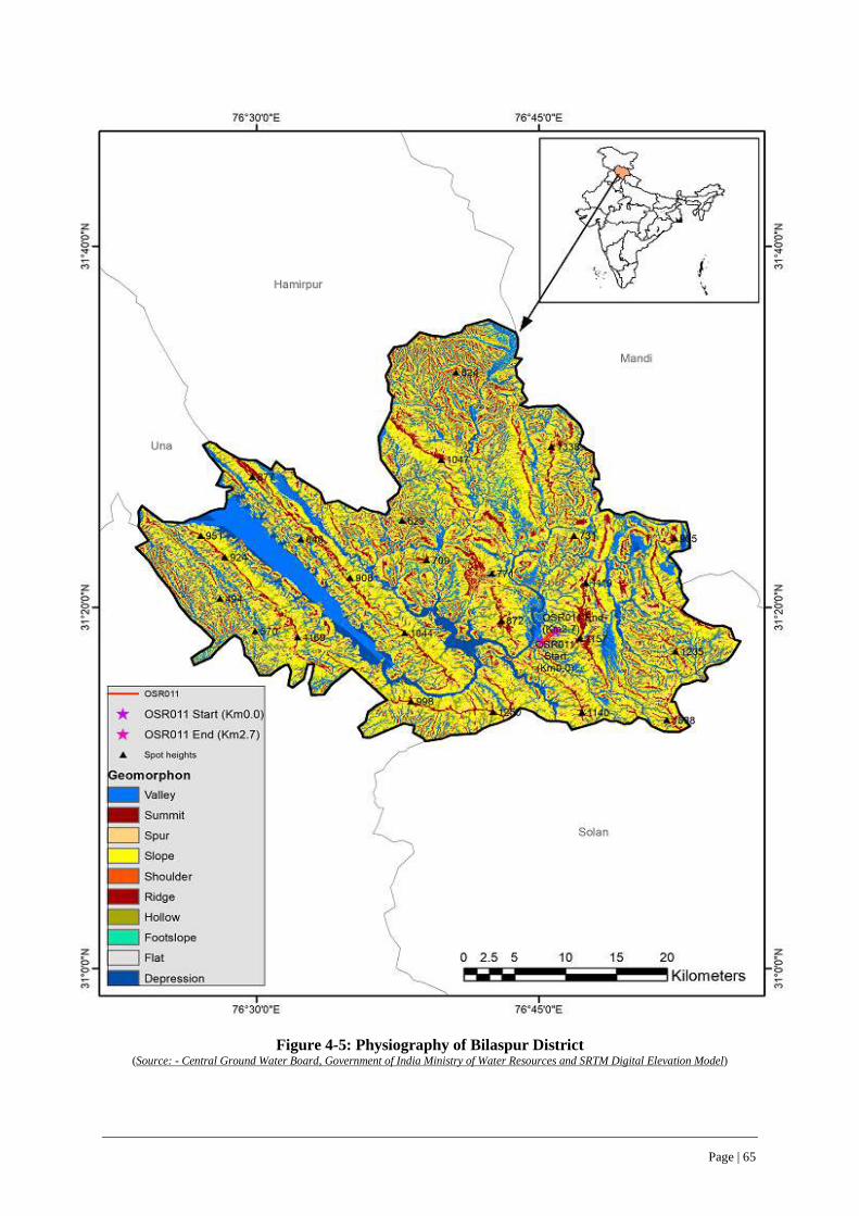
Page | 65
Figure 4-5: Physiography of Bilaspur District (Source: - Central Ground Water Board, Government of India Ministry of Water Resources and SRTM Digital Elevation Model)

Page | 66
Figure 4-6: Drainage Pattern of Bilaspur District
(Source: - Central Ground Water Board, Government of India Ministry of Water Resources and SRTM Digital Elevation Model)

Page | 67
4.3.5 Elevation
104. The elevation of project road lies in the range of 500-600 meters, with an average elevation of 600 meters above mean sea level. The minimum and maximum elevation of the project road is 520 m at km 2+278 and 595m at Km 0+000 respectively. The elevation profile of Bilaspur district showing the project road is given in Figure 4-7.
Figure 4-7: Elevation Profile of Bilaspur District
(Source: - Central Ground Water Board, Government of India Ministry of Water Resources and SRTM Digital Elevation Model)

Page | 68
4.3.6 Geo-morphology and Soils
105. Bilaspur district is located on Siwalik ranges and forms part of the lesser Himalayas. It has a diverse landscape of hills, valleys with piedmont zone. There are seven main hill ranges i.e., Naina Devi, Kot, jhanjiar, Tiun, Bandla, Bahaurpur and Ratanpur constituting the hill system. The elevation of the lowest point is about 290 m above mean sea level (MSL) and of the highest peak i.e., Bhadurpur hill is 1980m above MSL.
4.3.7 Soil, Moisture and Fertility Levels
106. Bilaspur district has two types of soils viz, alluvial soil and non-calcic brown soil. Most of the area in the district is covered with alluvial soil and only hilly area in the district is covered with non-calcic brown soil. Soil is rich in nutrients and is fertile. The soil fertility of Bilaspur district showing the project road is given in Figure 4-8 and 4-9.
Figure 4-8: Soil Fertility Map along project road within Bilaspur District
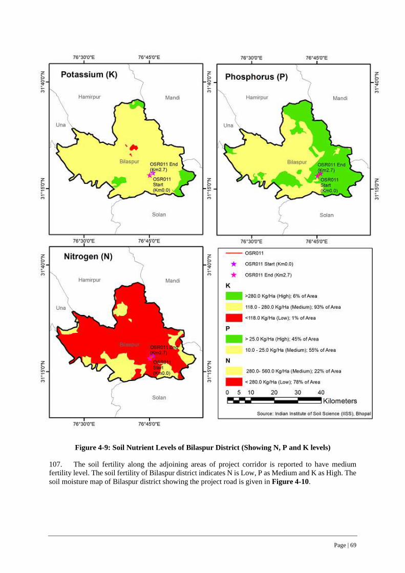
Page | 69
Figure 4-9: Soil Nutrient Levels of Bilaspur District (Showing N, P and K levels)
107. The soil fertility along the adjoining areas of project corridor is reported to have medium fertility level. The soil fertility of Bilaspur district indicates N is Low, P as Medium and K as High. The soil moisture map of Bilaspur district showing the project road is given in Figure 4-10.

Page | 70
Figure 4-10: Soil Moisture Map of Bilaspur District
4.3.8 Land Use
108. The land use / land cover of Bilaspur district showing the project road and Project Influence Area (15km on either side of road)) is given in Figure 4-11. The land use / land cover indicate that built –up land occupies about 7.75 Sq km, forest plantation occupies 91.89 Sq km, water bodies around 23.8 Sq km, agriculture crop land 158.32 Sq km, forest area around 16.54 Sq km, barren land around 50.31 Sq km among others.
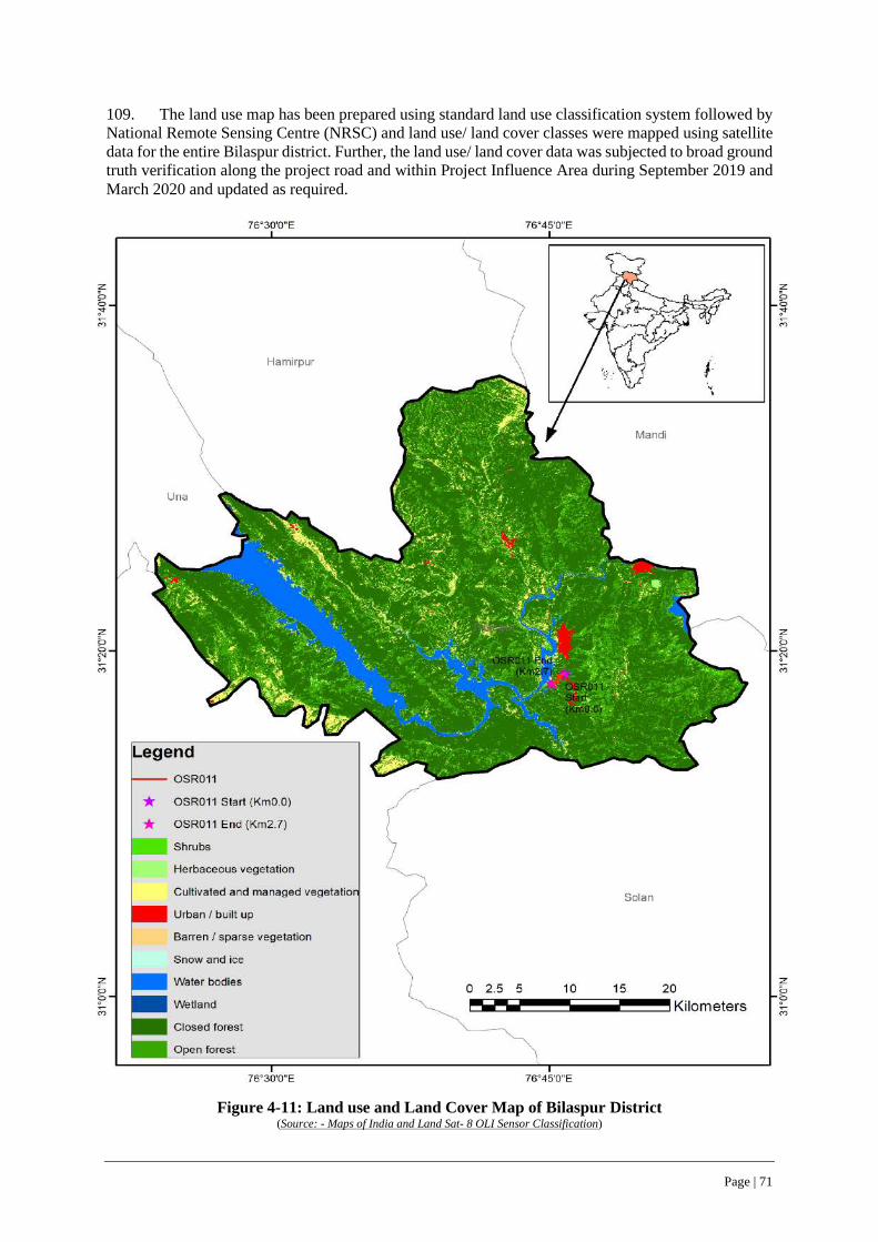
Page | 71
109. The land use map has been prepared using standard land use classification system followed by National Remote Sensing Centre (NRSC) and land use/ land cover classes were mapped using satellite data for the entire Bilaspur district. Further, the land use/ land cover data was subjected to broad ground truth verification along the project road and within Project Influence Area during September 2019 and March 2020 and updated as required.
Figure 4-11: Land use and Land Cover Map of Bilaspur District
(Source: - Maps of India and Land Sat- 8 OLI Sensor Classification)
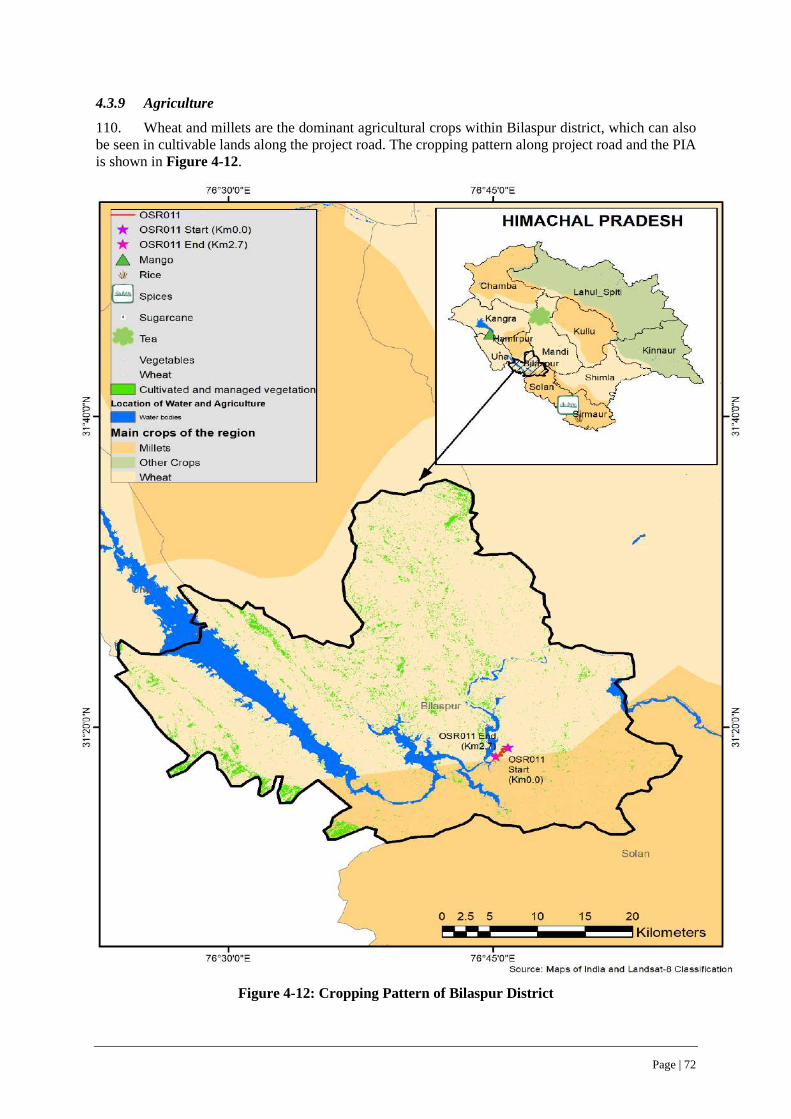
Page | 72
4.3.9 Agriculture
110. Wheat and millets are the dominant agricultural crops within Bilaspur district, which can also be seen in cultivable lands along the project road. The cropping pattern along project road and the PIA is shown in Figure 4-12.
Figure 4-12: Cropping Pattern of Bilaspur District
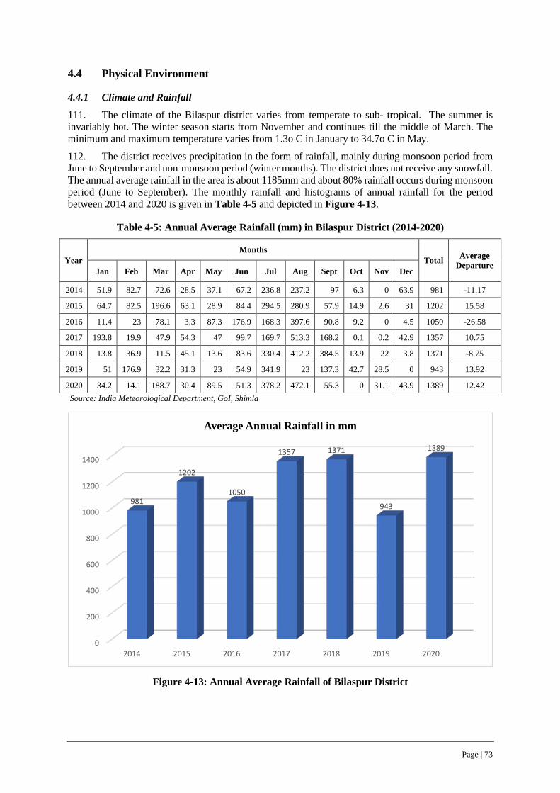
Page | 73
4.4 Physical Environment
4.4.1 Climate and Rainfall
111. The climate of the Bilaspur district varies from temperate to sub- tropical. The summer is invariably hot. The winter season starts from November and continues till the middle of March. The minimum and maximum temperature varies from 1.3o C in January to 34.7o C in May.
112. The district receives precipitation in the form of rainfall, mainly during monsoon period from June to September and non-monsoon period (winter months). The district does not receive any snowfall. The annual average rainfall in the area is about 1185mm and about 80% rainfall occurs during monsoon period (June to September). The monthly rainfall and histograms of annual rainfall for the period between 2014 and 2020 is given in Table 4-5 and depicted in Figure 4-13.
Table 4-5: Annual Average Rainfall (mm) in Bilaspur District (2014-2020)
Year Months
Total Average Departure
Jan Feb Mar Apr May Jun Jul Aug Sept Oct Nov Dec
2014 51.9 82.7 72.6 28.5 37.1 67.2 236.8 237.2 97 6.3 0 63.9 981 -11.17
2015 64.7 82.5 196.6 63.1 28.9 84.4 294.5 280.9 57.9 14.9 2.6 31 1202 15.58
2016 11.4 23 78.1 3.3 87.3 176.9 168.3 397.6 90.8 9.2 0 4.5 1050 -26.58
2017 193.8 19.9 47.9 54.3 47 99.7 169.7 513.3 168.2 0.1 0.2 42.9 1357 10.75
2018 13.8 36.9 11.5 45.1 13.6 83.6 330.4 412.2 384.5 13.9 22 3.8 1371 -8.75
2019 51 176.9 32.2 31.3 23 54.9 341.9 23 137.3 42.7 28.5 0 943 13.92
2020 34.2 14.1 188.7 30.4 89.5 51.3 378.2 472.1 55.3 0 31.1 43.9 1389 12.42 Source: India Meteorological Department, GoI, Shimla
Figure 4-13: Annual Average Rainfall of Bilaspur District
0
200
400
600
800
1000
1200
1400
2014 2015 2016 2017 2018 2019 2020
981
1202
1050
1357 1371
943
1389
Average Annual Rainfall in mm

Page | 74
4.4.2 Snowfall
113. The road as well as the project influence area and Bilaspur district as a whole does not receive snowfall in normal years.
4.4.3 Visibility
114. The project influence area (PIA) as well as the project road has a visibility of 4 to 10 km for 308 days in morning hours and 308 days in evening and up to 1 km for less than a day in both morning and evening hours.
4.4.4 Dust & Thunderstorms
115. The project influence area as well as project road does not experience any dust and thunderstorms in any part of year.
4.4.5 Wind Speed and Direction
116. The project road and surrounding region/PIA experiences calm days for 349 days during morning hours and 238 days in a year. The pre-dominant wind direction is South West during evening hours throughout the year. The wind speed is reported to be near to zero for most days (more than 90%) in a year. Wind speed ranging between 1-19 kmph prevail for 16 days during morning hours and 127 days in evening hours in a year.
117. The wind rose of the project road for the month of September 2019 is given in Figure 4-14. The most predominant wind direction is from North and the wind speed range between 0.5 to 2.10 meters/sec observed majorly along the project road.
Figure 4-14: Wind Rose Diagram of Project Road
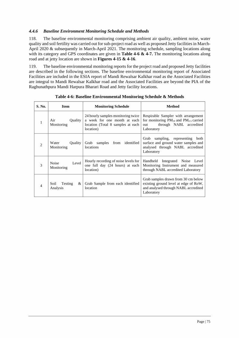
Page | 75
4.4.6 Baseline Environment Monitoring Schedule and Methods
118. The baseline environmental monitoring comprising ambient air quality, ambient noise, water quality and soil fertility was carried out for sub-project road as well as proposed Jetty facilities in March-April 2020 & subsequently in March-April 2021. The monitoring schedule, sampling locations along with its category and GPS coordinates are given in Table 4-6 & 4-7. The monitoring locations along road and at jetty location are shown in Figures 4-15 & 4-16.
119. The baseline environmental monitoring reports for the project road and proposed Jetty facilities are described in the following sections. The baseline environmental monitoring report of Associated Facilities are included in the ESIA report of Mandi Rewalsar Kalkhar road as the Associated Facilities are integral to Mandi Rewalsar Kalkhar road and the Associated Facilities are beyond the PIA of the Raghunathpura Mandi Harpura Bharari Road and Jetty facility locations.
Table 4-6: Baseline Environmental Monitoring Schedule & Methods
S. No. Item Monitoring Schedule Method
1 Air Quality Monitoring
24 hourly samples monitoring twice a week for one month at each location (Total 8 samples at each location)
Respirable Sampler with arrangement for monitoring PM10 and PM2.5 carried out through NABL accredited Laboratory
2 Water Quality Monitoring
Grab samples from identified locations
Grab sampling, representing both surface and ground water samples and analysed through NABL accredited Laboratory
3 Noise Level Monitoring
Hourly recording of noise levels for one full day (24 hours) at each location)
Handheld Integrated Noise Level Monitoring Instrument and measured through NABL accredited Laboratory
4 Soil Testing & Analysis
Grab Sample from each identified location
Grab samples drawn from 30 cm below existing ground level at edge of RoW, and analysed through NABL accredited Laboratory
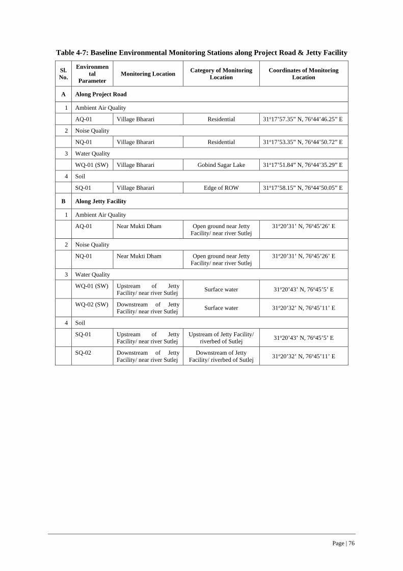
Page | 76
Table 4-7: Baseline Environmental Monitoring Stations along Project Road & Jetty Facility
Sl. No.
Environmental
Parameter Monitoring Location Category of Monitoring
Location Coordinates of Monitoring
Location
A Along Project Road
1 Ambient Air Quality
AQ-01 Village Bharari Residential 31o17’57.35” N, 76o44’46.25” E
2 Noise Quality
NQ-01 Village Bharari Residential 31o17’53.35” N, 76o44’50.72” E
3 Water Quality
WQ-01 (SW) Village Bharari Gobind Sagar Lake 31o17’51.84” N, 76o44’35.29” E
4 Soil
SQ-01 Village Bharari Edge of ROW 31o17’58.15” N, 76o44’50.05” E
B Along Jetty Facility
1 Ambient Air Quality
AQ-01 Near Mukti Dham Open ground near Jetty Facility/ near river Sutlej
31o20’31’ N, 76o45’26’ E
2 Noise Quality
NQ-01 Near Mukti Dham Open ground near Jetty Facility/ near river Sutlej
31o20’31’ N, 76o45’26’ E
3 Water Quality
WQ-01 (SW) Upstream of Jetty Facility/ near river Sutlej Surface water 31o20’43’ N, 76o45’5’ E
WQ-02 (SW) Downstream of Jetty Facility/ near river Sutlej Surface water 31o20’32’ N, 76o45’11’ E
4 Soil
SQ-01 Upstream of Jetty Facility/ near river Sutlej
Upstream of Jetty Facility/ riverbed of Sutlej 31o20’43’ N, 76o45’5’ E
SQ-02 Downstream of Jetty Facility/ near river Sutlej
Downstream of Jetty Facility/ riverbed of Sutlej 31o20’32’ N, 76o45’11’ E
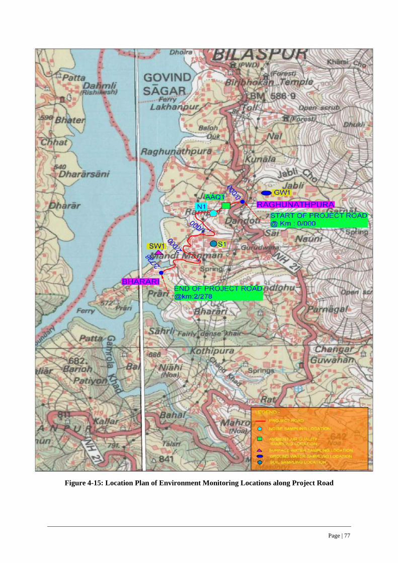
Page | 77
Figure 4-15: Location Plan of Environment Monitoring Locations along Project Road
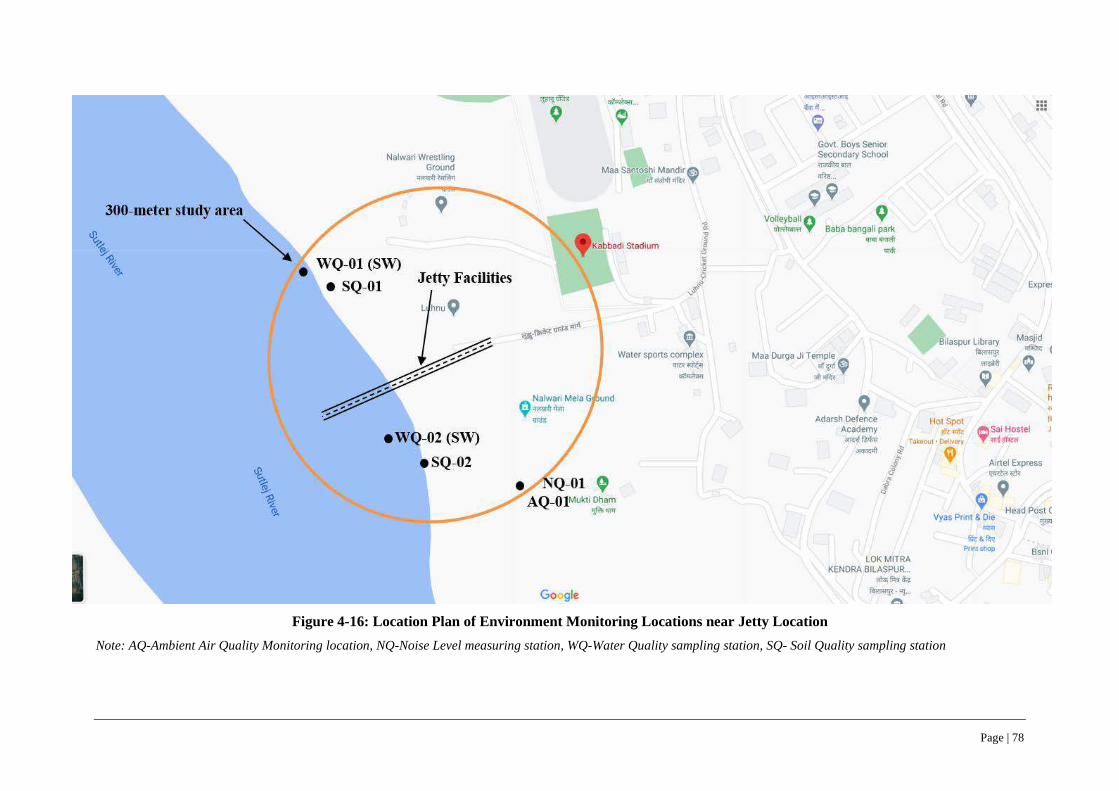
Page | 78
Figure 4-16: Location Plan of Environment Monitoring Locations near Jetty Location
Note: AQ-Ambient Air Quality Monitoring location, NQ-Noise Level measuring station, WQ-Water Quality sampling station, SQ- Soil Quality sampling station

Page | 79
4.4.7 Ambient Air Quality
120. The project influence area is devoid of any major polluting industries, which contribute to air pollution and the area also does not have any significant construction activities, except for construction of private individual houses by local inhabitants. The ambient air quality was monitored at two locations, one along the project road and one at Jetty facility, representing pre-monsoon season in March 2020 and March 2021. The monitoring test results carried out are given in Table 4-8. The test reports, sampling locations and its GPS coordinates, Photos taken during monitoring are given in Appendix 6. It may be seen that the ambient air quality (for all tested parameters) at both monitored locations are below the National Ambient Air Quality Standards as well as 24-hour values of EHS guidelines or below detection levels, which can be attributed to the absence of any significant industrial activities and therefore emissions at sampled locations along the project road and Jetty facility.
Table 4-8: Ambient Air Quality Along Project Road and Jetty Facility
S. No. Monitoring Locations
Ambient Air Quality in March 2020 & March 2021
PM 10 PM 2.5 SO2 NOX CO HC as
CH4
C6H6
Benzo-a- Pyrene
A Along Project Road
1. At Village Bharari – AQ-01 65 38 12 26 0.27 Bdl Bdl Bdl
B At Jetty Facility
2. Near Mukti Dham – AQ-01 81 48 9.2 12.1 Bdl Bdl Bdl Bdl
3. National Ambient Air Quality Standards, CPCB (NAAQS) 100 60 80 80 04 NS 05 01
4. IFC- EHS Guideline Values (24 Hour values)
50 25 20 200 Not Specified (NS)
Note: All units are in ug/m3, except Benzo -a-Pyrene, which is ng/m3; Bdl- Below Detection Level (<0.1) for Benzo Pyrene and <5 for Benzene Source: - Field Investigations for ESIA studies during March 2020 & March 2021
4.4.8 Ambient Noise Levels
121. Ambient noise levels were measured at was monitored at two locations, one along the project road and one at Jetty facility, representing pre-monsoon season in March 2020 and March 2021. The measured noise levels are given in Table 4-9. The test reports, sampling locations and its GPS coordinates, Photos taken during monitoring are given in Appendix 6. It may be seen that the ambient noise levels (for both day and night times) were below the National Ambient Noise levels well as one-hour values of EHS guidelines i.e., 55 dB(A) and 45 dB(A) during daytime and night-time levels at the monitored locations along the project road and Jetty facility. The project road does not have any sensitive receptor locations like school and hospitals.
Table 4-9: Ambient Noise Levels along Project Road and Jetty Facility
Sl. No. Project Road Monitoring Location Ambient Noise Levels Leq dB (A) in March 2020 & March 2021
Daytime Night-time
A Along Project Road
1. At Village Bharari – NQ-01 54.6 43.7
B At Associated Facilities
2. Near Mukti Dham – NQ-01 52.8 40.8
3. National Ambient Noise Levels Leq dB(A)
Residential (R) 55 45
Commercial (C) 65 55
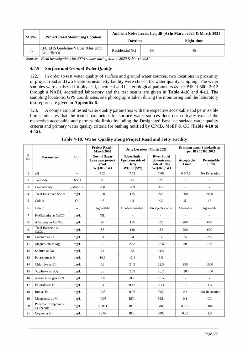
Page | 80
Sl. No. Project Road Monitoring Location Ambient Noise Levels Leq dB (A) in March 2020 & March 2021
Daytime Night-time
4. IFC EHS Guideline Values (One Hour Leq dB(A)) Residential (R) 55 45
Source: - Field Investigations for ESIA studies during March 2020 & March 2021
4.4.9 Surface and Ground Water Quality
122. In order to test water quality of surface and ground water sources, two locations in proximity of project road and two locations near Jetty facility were chosen for water quality sampling. The water samples were analyzed for physical, chemical and bacteriological parameters as per BIS 10500: 2012 through a NABL accredited laboratory and the test results are given in Table 4-10 and 4-11. The sampling locations, GPS coordinates, site photographs taken during the monitoring and the laboratory test reports are given in Appendix 6.
123. A comparison of tested water quality parameters with the respective acceptable and permissible limits indicates that the tested parameters for surface water sources does not critically exceed the respective acceptable and permissible limits including the Designated Best use surface water quality criteria and primary water quality criteria for bathing notified by CPCB, MoEF & CC (Table 4-10 to 4-12).
Table 4-10: Water Quality along Project Road and Jetty Facility
S. No Parameters Unit
Project Road – March 2020 Jetty Location - March 2021 Drinking water Standards as
per BIS 10500:2012 Govind Sagar
Lake near project road
WQ-01 (SW)
River Sutlej Upstream side of
Jetty WQ-01 (SW)
River Sutlej Downstream side of Jetty WQ-02 (SW)
Acceptable Limit
Permissible Limit
1 pH -- 7.23 7.73 7.68 6.5-7.5 No Relaxation
2 Turbidity NTU 18 <5 <5 1 5
3 Conductivity µMho/Cm 230 269 377 - -
4 Total Dissolved Solids mg/L 150 175 245 500 2000
5 Colour CU <5 <2 <2 5 15
6 Odour -- Agreeable Unobjectionable Unobjectionable Agreeable Agreeable
7 P-Alkalinity as CaCO3 mg/L NIL - - - -
8 Alkalinity as CaCO3 mg/L 98 115 135 200 600
9 Total Hardness as CaCO3
mg/L 86 140 155 200 600
10 Calcium as Ca mg/L 31 24 14 75 200
11 Magnesium as Mg mg/L 2 27.8 32.6 30 100
12 Sodium as Na mg/L 21 22 11.5 - -
13 Potassium as K mg/L 10.6 12.4 5.5 - -
14 Chlorides as Cl- mg/L 56 24.9 32.5 250 1000
15 Sulphates as SO4-2 mg/L 35 22.8 26.2 200 400
16 Nitrate Nitrogen as N mg/L 2.8 8.2 18.5 - -
17 Fluorides as F- mg/L 0.39 0.12 0.13 1.0 1.5
18 Iron as Fe mg/L 0.28 0.06 0.07 0.3 No Relaxation
19 Manganese as Mn mg/L <0.05 BDL BDL 0.1 0.3
20 Phenolic Compounds as Phenols mg/L <0.001 BDL BDL 0.001 0.002
21 Copper as Cu mg/L <0.02 BDL BDL 0.05 1.5
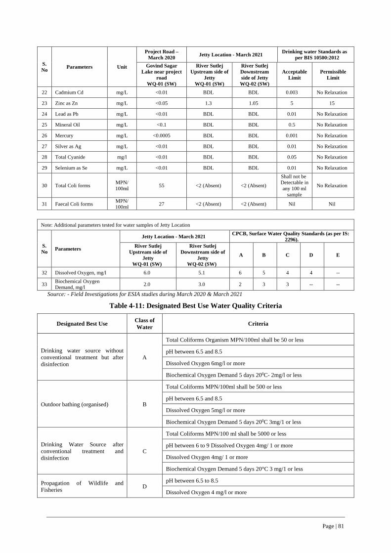
Page | 81
S. No Parameters Unit
Project Road – March 2020 Jetty Location - March 2021 Drinking water Standards as
per BIS 10500:2012 Govind Sagar
Lake near project road
WQ-01 (SW)
River Sutlej Upstream side of
Jetty WQ-01 (SW)
River Sutlej Downstream side of Jetty WQ-02 (SW)
Acceptable Limit
Permissible Limit
22 Cadmium Cd mg/L <0.01 BDL BDL 0.003 No Relaxation
23 Zinc as Zn mg/L <0.05 1.3 1.05 5 15
24 Lead as Pb mg/L <0.01 BDL BDL 0.01 No Relaxation
25 Mineral Oil mg/L <0.1 BDL BDL 0.5 No Relaxation
26 Mercury mg/L <0.0005 BDL BDL 0.001 No Relaxation
27 Silver as Ag mg/L <0.01 BDL BDL 0.01 No Relaxation
28 Total Cyanide mg/l <0.01 BDL BDL 0.05 No Relaxation
29 Selenium as Se mg/L <0.01 BDL BDL 0.01 No Relaxation
30 Total Coli forms MPN/ 100ml 55 <2 (Absent) <2 (Absent)
Shall not be Detectable in any 100 ml
sample
No Relaxation
31 Faecal Coli forms MPN/ 100ml 27 <2 (Absent) <2 (Absent) Nil Nil
Note: Additional parameters tested for water samples of Jetty Location
S. No Parameters
Jetty Location - March 2021 CPCB, Surface Water Quality Standards (as per IS: 2296).
River Sutlej Upstream side of
Jetty WQ-01 (SW)
River Sutlej Downstream side of
Jetty WQ-02 (SW)
A B C D E
32 Dissolved Oxygen, mg/l 6.0 5.1 6 5 4 4 --
33 Biochemical Oxygen Demand, mg/l 2.0 3.0 2 3 3 -- --
Source: - Field Investigations for ESIA studies during March 2020 & March 2021
Table 4-11: Designated Best Use Water Quality Criteria
Designated Best Use Class of Water Criteria
Drinking water source without conventional treatment but after disinfection
A
Total Coliforms Organism MPN/100ml shall be 50 or less
pH between 6.5 and 8.5
Dissolved Oxygen 6mg/l or more
Biochemical Oxygen Demand 5 days 200C- 2mg/l or less
Outdoor bathing (organised) B
Total Coliforms MPN/100ml shall be 500 or less
pH between 6.5 and 8.5
Dissolved Oxygen 5mg/l or more
Biochemical Oxygen Demand 5 days 200C 3mg/1 or less
Drinking Water Source after conventional treatment and disinfection
C
Total Coliforms MPN/100 ml shall be 5000 or less
pH between 6 to 9 Dissolved Oxygen 4mg/ 1 or more
Dissolved Oxygen 4mg/ 1 or more
Biochemical Oxygen Demand 5 days 20°C 3 mg/1 or less
Propagation of Wildlife and Fisheries D
pH between 6.5 to 8.5
Dissolved Oxygen 4 mg/l or more

Page | 82
Designated Best Use Class of Water Criteria
Free Ammonia (as N) 1.2 mg/l or less
Irrigation, Industrial Cooling, Controlled Waste Disposal E
pH between 6.0 to 8.5
Electrical Conductivity at 25°C micro mhos/cm Max 2250
Sodium absorption ratio Max. 26
Boron, Max. 2 mg/l Source: - CPCB, MoEF and CC
Table 4-12: Primary Water Quality Criteria for Bathing (Water used for organized outdoor bathing)
Sl. No. Criteria Rationale
1. Faecal Coliform MPN/100 ml
500 (desirable) 2500 (Maximum Permissible)
To ensure low sewage contamination Faecal coliform and faecal streptococci are considered as they reflect the bacterial pathogenicity
2. Faecal Streptococci MPN/100 ml
100 (desirable) 500 (Maximum Permissible)
The desirable and permissible limits are suggested to allow for fluctuation in environmental conditions such as seasonal change, changes in flow conditions etc.
3. pH Between 6.5 to 8.5 The range provides protection to the skin and delicate organs like eyes, nose, ears etc. which are directly exposed during outdoor bathing
4. Dissolved Oxygen 5 mg/1 or more
The minimum dissolved oxygen concentration of 5 mg/1 ensures reasonable freedom from oxygen consuming organic pollution immediately upstream which is necessary for preventing production of anaerobic gases (obnoxious gases) from sediment.
5. Biochemical Oxygen Demand (3 days at 27oC)
3 mg/1 or less The Biochemical Oxygen Demand of 3 mg/1 or less of the water ensures reasonable freedom from oxygen demanding pollutants and prevent production of obnoxious gases
Source: - CPCB, MoEF and CC
4.4.10 Soil Quality
124. The soil quality along the project corridor was tested at three locations, one location along the RoW of project road near Village Bharari and two locations near Jetty facility (1 upstream side & 1 downstream) (Figures 4-15 & 4-16). The soil fertility test values are given in Table 4-13. The laboratory test reports and test methods followed are given in Appendix 6. The tested soil fertility levels along the project road, generally confirms to soil fertility levels of the Bilaspur District as a whole and shown in Figures 4-8 and 4-10.
Table 4-13: Soil Test Results along Project Road and at Jetty Facility Location
Sl. No Test Parameters Units
Along Project Road RoW near Village Bharari-
March 2021 SQ-01
Jetty Location - March 2021
River Sutlej Upstream side of
Jetty SQ-01
River Sutlej Downstream side
of Jetty SQ-02
1 pH -- 7.88 7.62 7.81
2 Bulk Density gm/cc 1.54 1.48 1.37
3 Potassium as K mg/kg 111 26.4 27.2
4 Nitrogen as N Kg/ha 198 11.8 12.1

Page | 83
Sl. No Test Parameters Units
Along Project Road RoW near Village Bharari-
March 2021 SQ-01
Jetty Location - March 2021
River Sutlej Upstream side of
Jetty SQ-01
River Sutlej Downstream side
of Jetty SQ-02
5 Phosphate as P mg/kg 112 8.2 5.6
6 Zinc as Zn mg/kg 90 21.1 23.2
7 Copper as Cu mg/kg 26 3.25 3.18
8 Sodium Absorption Ratio - 4.9 5.27 4.28
9 Sand % 69.2 64.2 15.5
10 Silt % 12.5 27.2 12.4
11 Cation Exchange Capacity meq/100gm 4 19 21
12 Clay % 18.3 8.6 72.1
13 Nickel as Ni mg/kg 0.28 2.14 2.24
14 Chromium as Cr mg/kg 2.1 BDL BDL
15 Lead as Pb mg/kg 3.2 0.58 0.81
16 TOC % 0.39 4.62 4.25
17 Cadmium as Cd mg/kg BDL 1.66 1.18
18 Benthic Biota - - Absent Absent Source: Field Investigations for ESIA during March/April 2020 & March/April 2021
4.5 Biological Environment
4.5.1 Forest Area within State and Bilaspur District
125. Nearly 80 % of state’s geographical area is hilly and mountainous with altitude ranging from 460 meters to 6,600 m above mean sea level (AMSL). About 63.6 % of state’s area is classified as forest area, though only 26.4 % (ISFR, 2015) is under actual forest cover. Within Himachal Pradesh, legally forest is classified into Reserve Forest, Demarcated Protected Forest, un-demarcated protected forest, other forest, not managed by forest department. (Refer Table 4-14).
Table 4-14: Legal Classification of Forest areas in Himachal Pradesh (as of 2018)
S. No Category wise Forests Area (Km²) %age
1 Reserved Forests 1883 4.96
2 Demarcated Protected Forests 12852 33.87
3 Un-demarcated Protected Forests 16035 42.25
4 Other Forests (Managed by Forest Department) 7160 18.87
5 Other Forests (Not managed by Forest Department) 18 0.05
Total 37948 100
Source: - https://hpforest.nic.in
126. Himachal Pradesh has been bifurcated into 12 forest circles, with a total forest area of 37948 sq km. As of year 2018, Bilaspur forest circle, in which project road traverses has a forest cover of 522.69 sq km (1.37% of total state’s forest area) constituting reserve forests, demarcated protected forests; un-demarcated protected forests as given in Table 4-15. The forest map of Himachal Pradesh along with the project road is shown in Figure 4-17.
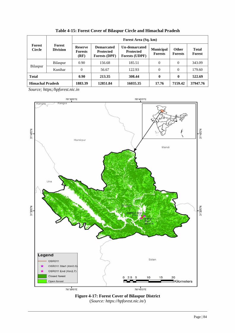
Page | 84
Table 4-15: Forest Cover of Bilaspur Circle and Himachal Pradesh
Forest Circle
Forest Division
Forest Area (Sq. km)
Reserve Forests
(RF)
Demarcated Protected
Forests (DPF)
Un-demarcated Protected
Forests (UDPF)
Municipal Forests
Other Forests
Total Forest
Bilaspur Bilaspur 0.90 156.68 185.51 0 0 343.09
Kunihar 0 56.67 122.93 0 0 179.60
Total 0.90 213.35 308.44 0 0 522.69
Himachal Pradesh 1883.39 12851.84 16035.35 17.76 7159.42 37947.76
Source; https;/hpforest.nic.in
Figure 4-17: Forest Cover of Bilaspur District
(Source: https://hpforest.nic.in/)
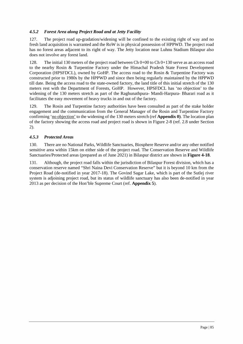
Page | 85
4.5.2 Forest Area along Project Road and at Jetty Facility
127. The project road up-gradation/widening will be confined to the existing right of way and no fresh land acquisition is warranted and the RoW is in physical possession of HPPWD. The project road has no forest areas adjacent to its right of way. The Jetty location near Luhnu Stadium Bilaspur also does not involve any forest land.
128. The initial 130 meters of the project road between Ch 0+00 to Ch 0+130 serve as an access road to the nearby Rosin & Turpentine Factory under the Himachal Pradesh State Forest Development Corporation (HPSFDCL), owned by GoHP. The access road to the Rosin & Turpentine Factory was constructed prior to 1980s by the HPPWD and since then being regularly maintained by the HPPWD till date. Being the access road to the state-owned factory, the land title of this initial stretch of the 130 meters rest with the Department of Forests, GoHP. However, HPSFDCL has ‘no objection’ to the widening of the 130 meters stretch as part of the Raghunathpura- Mandi-Harpura- Bharari road as it facilitates the easy movement of heavy trucks in and out of the factory.
129. The Rosin and Turpentine factory authorities have been consulted as part of the stake holder engagement and the communication from the General Manager of the Rosin and Turpentine Factory confirming ‘no objection’ to the widening of the 130 meters stretch (ref Appendix 0). The location plan of the factory showing the access road and project road is shown in Figure 2-8 (ref. 2.8 under Section 2).
4.5.3 Protected Areas
130. There are no National Parks, Wildlife Sanctuaries, Biosphere Reserve and/or any other notified sensitive area within 15km on either side of the project road. The Conservation Reserve and Wildlife Sanctuaries/Protected areas (prepared as of June 2021) in Bilaspur district are shown in Figure 4-18.
131. Although, the project road falls within the jurisdiction of Bilaspur Forest division, which has a conservation reserve named “Shri Naina Devi Conservation Reserve” but it is beyond 10 km from the Project Road (de-notified in year 2017-18). The Govind Sagar Lake, which is part of the Sutlej river system is adjoining project road, but its status of wildlife sanctuary has also been de-notified in year 2013 as per decision of the Hon’ble Supreme Court (ref. Appendix 5).
Page | 86
Figure 4-18: Wildlife Sanctuary/ Protected Areas of Bilaspur (within 15 km from Project Road)
(Source: https://hpforest.nic.in/)

Page | 87
4.5.4 Biodiversity
132. The state Himachal Pradesh is encompassed by tropical to temperate forests, alpine meadows and snow, high biodiversity and endemism, oaks-centered biodiversity, predominance of evergreen forests. The state has a wide ecological diversity due to large variation in altitude, latitude and rainfall and its seasonality.
4.5.5 Floral Diversity
133. Ecological investigations along the project road corridor have indicated presence of luxuriant growth of 60 angiosperm taxonomic group and two Pteridophytes taxonomic group, out of which invasive species comprises Ageratum conyzoides, Lantana camara, Parthanium hysterophoros. The taxonomic groups found along the project road are in Table 4-16 (ref. Appendix 7). The ecological investigation near Jetty location did not indicate the present of any flora as the riverbank has sandy soil.
Table 4-16: Flora along Project Road
S. No Taxonomic group Nos
1 Angiosperm 60
2 Pteridophyta 2
134. The ecological investigation along the project road was carried out at two sampling locations as given in Table 4-17.
Table 4-17: Vegetation Sampling Locations along Project Road
Sl. No. Sampling Location Co-ordinates
1. Near Bharari 31.31N, 76.76 E
2. Near Padgal Band 31.29N, 76.76 E
4.5.6 Trees, Shrubs and Herbs along Project Road
135. The trees, shrubs and herbs recorded as part of ecological investigations along the project corridor are given in Table 4-18. Acacia catechu, Dalbergia sissoo, Adhatoda vasica, Carissa opaca, Ageratum conyzoides, Parthanium hysterophoros, Bidens pilosa were dominant species found during the investigations along with various other grasses.
Table 4-18: Trees, Shrubs and Herbs along Project Road
Sl. No. Botanical Name Taxonomic Group
Status/ Importance of Floral Species
Invasive Medicinal Non-timber IUCN Category
1 Abutilon indicum Angiosperm - - - Not evaluated
2 Acacia catechu Angiosperm - Yes Yes Not evaluated
3 Adhatoda vasica Angiosperm - Yes - Least concern
4 Adiantum caudatum Pteridophytes - - - Not evaluated
5 Agave sisalana Angiosperm - Yes - Not evaluated
6 Ageratum conyzoides Angiosperm Yes Yes Yes Least concern
7 Albezia chinensis Angiosperm - Yes - Not evaluated
8 Amaranthus virdis Angiosperm - Yes - Least concern
9 Artemisia parviflora Angiosperm - Yes Yes Not evaluated
10 Barleria cristata Angiosperm - Yes - Not evaluated
11 Bidens pilosa Angiosperm - Yes Yes Not evaluated
Page | 88
Sl. No. Botanical Name Taxonomic Group
Status/ Importance of Floral Species
Invasive Medicinal Non-timber IUCN Category
12 Boerhavia diffusa Angiosperm - Yes - Not evaluated
13 Calotropis procera Angiosperm - Yes - Least concern
14 Carissa opaca Angiosperm - - - Least concern
15 Cassia fistula Angiosperm - Yes - Not evaluated
16 Cassia occidentalis Angiosperm - - - Least concern
17 Cassia tora Angiosperm - Yes - Not evaluated
18 Cheilanthes farinosa Pteridophytes - Yes - Not evaluated
19 Clematis gouriana Angiosperm - Yes - Not evaluated
20 Colebrookea oppositifolia Angiosperm - Yes Yes Not evaluated
21 Commelina benghalensis Angiosperm - Yes - Least concern
22 Cyanotis vaga Angiosperm - - Yes Not evaluated
23 Cynodon dactylon Angiosperm - Yes Yes Least concern
24 Dalbergia sissoo Angiosperm - Yes Yes Not evaluated
25 Eriophorum comosum Angiosperm - Yes Yes Not evaluated
26 Eucalyptus hybrid Angiosperm - Yes Yes Least concern
27 Euphorbia hirta Angiosperm - Yes Yes Not evaluated
28 Euphorbia royleana Angiosperm - Yes - Not evaluated
29 Ficus palmata Angiosperm - Yes Yes Least concern
30 Ficus roxburghii Angiosperm - Yes Yes Least concern
31 Flacourtia xylosma Angiosperm - Yes - Least concern
32 Gmelina arborea Angiosperm - Yes - Least concern
33 Impatiens balsamina Angiosperm - Yes Yes Not evaluated
34 Ipomea carnea Angiosperm - Yes Yes Not evaluated
35 Jatropha curcas Angiosperm - Yes - Not evaluated
36 Lantana camara Angiosperm Yes Yes - Not evaluated
37 Leucaena leucocephala Angiosperm - Yes - Not evaluated
38 Leucas lanata Angiosperm - Yes - Not evaluated
39 Micromeria biflora Angiosperm - Yes - Not evaluated
40 Mucuna pruriens Angiosperm - Yes - Not evaluated
41 Murraya koenigii Angiosperm - Yes Yes Not evaluated
42 Oxalis corniculata Angiosperm - Yes Yes Not evaluated
43 Parthenium hysterophorus Angiosperm Yes Yes - Not evaluated
44 Phoenix humilis Angiosperm - Yes - Not evaluated
45 Prinsepia utilis Angiosperm - Yes Yes Not evaluated
46 Rhus cotinus Angiosperm - Yes - Least concern
47 Ricinus communis Angiosperm - Yes Yes Not evaluated
48 Rosa macrophylla Angiosperm - Yes Yes Not evaluated
49 Rosa moschata Angiosperm - Yes - Not evaluated
50 Sida rhombifolia Angiosperm - Yes - Least concern
51 Solanum nigrum Angiosperm - Yes - Least concern
Page | 89
Sl. No. Botanical Name Taxonomic Group
Status/ Importance of Floral Species
Invasive Medicinal Non-timber IUCN Category
52 Solanum surattense Angiosperm - Yes - Not evaluated
53 Tinospora cordifolia Angiosperm - Yes - Not evaluated
54 Tinospora sinensis Angiosperm - Yes - Not evaluated
55 Tridax procumbens Angiosperm - Yes - Not evaluated
56 Urtica dioca Angiosperm - Yes Yes Not evaluated
57 Vallaris solanacea Angiosperm - Yes - Not evaluated
58 Vitex negundo Angiosperm - Yes Yes Least concern
59 Woodfordia fruticosa Angiosperm - Yes Yes Least concern
60 Xanthium indicum Angiosperm - Yes - Not evaluated
61 Ziziphus mauritiana Angiosperm - Yes Yes Least concern
62 Ziziphus oenoplia Angiosperm - Yes Yes Least concern Field Investigations for ESIA studies during September 2019 and March 2020 Endemic & RET Species
136. The recorded plant species during the ecological investigations along the project road were assessed for their conservation status by comparing/cross checking with red data book of Indian plants (Nayar and Sastry, 1987-1990) for their RET status. None of the taxa recorded during ecological investigations along the project road were found under RET category.
4.5.7 Tree Felling Requirement
137. The Project Road widening will require felling of trees, which are within corridor of improvement (ref. 2.14.1 under Section 2). During the baseline assessment, enumeration of trees within the corridor of improvement, which may require felling was carried out and the numbers of trees were found to be 42. Most of these trees, which require felling are commonly found in project region and none were found to be under RET category. The summary list of trees which require felling is given in Table 4-19.
Table 4-19: Trees require felling for widening of Project Road
Sl. No. Botanical name Local name Nos. of
trees Importance IUCN Category
1 Grevillea robusta Silver Oak 1 Agro-forestry, timber Least Concern
2 Tectona grandis Tinkoniya, Teak, Sagun 2 Timber Not Included
3 Morus nigra Toot, Shahtoot 9 Agro-forestry, medicinal Not Included
4 Melia azedarach Drek, Bakain 1 Medicinal, timber, fuelwood Least Concern
5 Broussonetia papyrifera
Jangli Toot, Paper mulberry 2 Fodder and pulp Least Concern
6 Wendlandia heynei Chiyuli, Tilak 1 No such major use Not Included
7 Vachellia nilotica Babool 1 Medicinal, agro-forestry Least Concern
8 Dalbergia sissoo Shisham 4 Timber, medicinal Not Included
9 Senegalia catechu Khair 6 Product Consumption, medicinal Not Included

Page | 90
Sl. No. Botanical name Local name Nos. of
trees Importance IUCN Category
10 Leucaena leucocephala Subabul 4 Agro-forestry Not Included
11 Moringa oleifera Sahjan, Senjana 2 Medicinal Not Included
12 Santalum album Chandan 1 Essential oil, timber Vulnerable
13 Toona ciliata Tuni, Toon 5 Timber, fodder Least Concern
14 Mallotus philippensis Kamala 1 Dye, fodder Least Concern
15 Ficus roxburghii Tayamal, Timla 1 Agro-forestry Least Concern
16 Grewia optiva Byul, Bihul, Bhimal 1 Agro-forestry Not Included
Total 42
138. Prior to issuance of tree felling permission by the forest Department, a joint inspection of project corridor will be undertaken by the Forest Department officials along with Project authorities for onsite inspection of the existing/proposed centerline of the road, available right of way and determine the number of trees, which are essentially to be felled for road widening purposes. The HP Forest Department established a web Portal for ONLINE submission of applications and issuing permission for tree felling by the various project development authorities after duly following the instructions thereof.
4.5.8 Fauna
139. In order to study the mammals of the of the project road/ region, 2-3 km long transects, and trails were walked. Direct sighting and calls as well as indirect evidence such as scats, pugmarks, scraps, horns were recorded during the survey walk. Secondary data as well as information elicited from the local people were also noted for the presence and absence of wild animals in the study area. A total of 19 mammalian species has been recorded/ reported along project road/ region area given in Table 4-20. No wildlife crossing corridors or sighting of any wild fauna was recorded/reported along the project road.
Table 4-20: Mammalian fauna recorded/ reported along project road/ region
Sl. No. Name Scientific Name IUCN Status WPA Status
1 Rhesus Macaque Macaca mulatta Least Concern Schedule-II
2 Langur Semnopithecus hector Least Concern Schedule-II
3 Red Muntjac Muntiacus muntjak Least Concern Schedule -III
4 Sambar Rusa unicolor Vulnerable Schedule -III
5 Wild Pig Sus scrofa Least Concern Schedule -III
6 Common Leopard Panthera pardus Vulnerable Schedule-I
7 Jungle Cat Felis chaus Least Concern Schedule-II
8 Palm Civet Paradoxurus hemaphroditus Least Concern Schedule-II
9 Indian Civet Viverricula indica Least Concern Schedule-II
10 Grey Mongoose Herpestes edwardsi Least Concern Schedule-II
11 Indian Mongoose Herpestes auropunctatus Least Concern Schedule-IV
12 Golden Jackal Canis aureus Least Concern Schedule-II
13 Indian Hare Lepus nigricollis Least Concern Schedule-IV
Page | 91
Sl. No. Name Scientific Name IUCN Status WPA Status
14 Grey Shrew Crocidura attenuata Least Concern Unlisted
15 House Shrew Suncus murinus Least Concern Unlisted
16 Porcupine Hystrix indica Least Concern Schedule-IV
17 Palm Squirrel Funambulus pennantii Least Concern Schedule-IV
18 Indian Gerbil Tatera indica Least Concern Schedule-IV
19 House Mouse Mus musculus Least Concern Schedule-V
RET Mammals
140. None of the species included under the Schedule-I category of Indian Wildlife Protection Act-1972 and endangered category of IUCN has been reported along the project road corridor or were encountered during primary survey. Most of the species recorded were found under Least Concern Category of IUCN except Common Leopard which comes under ‘Vulnerable’ category as per IUCN list.
Herpatofauna
141. Common House Lizard (Hemidactylus brookii) was sighted during primary study in the study area. Monitor lizard (Varanus bengalensis) has also reported in the project road/ region along with Rat Snake (Ptyas mucosa), Indian Cobra (Naja naja), and Common Indian Karait (Bungarus caeruleus). Monitor lizard is listed under schedule-I category of Wildlife Protection Act.
4.5.9 Avifauna
142. The presence of avifauna was also recorded along the project road/ region on the same trails used for mammals. A prismatic field binocular (Nikon ACULON A211 10x50) was used for the bird watching during survey walk. 06 to 09 AM hrs has been used for bird survey during this study. Most of the birds have been identified in the field by using the field guide. A total of 68 Bird species has been recorded during this study. Among recorded/reported avifauna, Common peafowl (Pavo cristatus), Cheer Pheasant (Catreus wallichii) and Kalij Pheasant (Lophura leocomelanos) and Circus cyaneus and accipiternirus comes under Schedule-I (part III) category under Wildlife Protection Act-1972. Among the all-recorded bird’s species, Aquila Nepalese’s (steeple eagle) come under endangered category of IUCN (Table 4-21).
Table 4-21: Avifauna Sighted/Recorded/ Reported along Project Road/ Region
Sl. No. Name Scientific Name WPA Status IUCN
1 Black Francolin Fracolinus Francolinus Schedule-IV Least Concern
2 Red Junglefowl Gallus Gallus Schedule-IV Least Concern
3 Kalij Pheasant Lophura leucomelanos Schedule-I & Part III Least Concern
4 Cheer Pheasant Catreus Wallichii Schedule-I & Part III Vulnerable
5 Pallid Harrier Circus cyaneus Schedule-I Least Concern
6 Eurasian Sparrowhawk Accipiter nisus Schedule-I Least Concern
7 Steppe Eagle Aquila nipalensis Schedule-I Endangered
8 Water Rail Rallus aquaticus Schedule-IV Least Concern
9 Common Pigeon Columba livia Schedule-IV Least Concern
10 Oriental Turtle Dove Streptopelia orientalis Schedule-IV Least Concern
11 Eurasian Collared Dove Streptopelia decacto Schedule-IV Least Concern
Page | 92
Sl. No. Name Scientific Name WPA Status IUCN
12 Spotted Dove Stigmatopelia chinensis Schedule-IV Least Concern
13 Rose-ringed Parakeet Psittacula krameri Schedule-IV Least Concern
14 Plum- headed Parakeet Psittacula cyanocephala Schedule-IV Least Concern
15 Common Hawk Cuckoo Hierococcyx sparveriodies Schedule-IV Least Concern
16 Indian Cuckoo Cuculus micropterus Schedule-IV Least Concern
17 Eurasian Cuckoo Cuculus canorus Schedule-IV Least Concern
18 Himalayan Cuckoo Cuculus saturatus Schedule-IV Least Concern
19 Asian Koel Eudynamys scolopaceus Schedule-IV Least Concern
20 Common Hoopoe Upupa epops Schedule-IV Least Concern
21 Indian Roller Coracias benghalensis Schedule-IV Least Concern
22 White-throated Kingfisher Halcyon smrnensis Schedule-IV Least Concern
23 Common Kingfisher Alcedo atthis Schedule-IV Least Concern
24 Green-Bee-eater Merops orientalis Schedule-IV Least Concern
25 Great Brbet Megalaima virens Schedule-IV Least Concern
26 Blue-throated Barbet Megalaima asiatica Schedule-IV Least Concern
27 Speckled Piculet Picumnus innominatus Schedule-IV Least Concern
28 Himalayan Woodpecker Dendrocopos himalayensis Schedule-IV Least Concern
29 Common Lora Agithina tiphia Schedule-IV Least Concern
30 Long-tailed Minivet Pericrocotus ethologus Schedule-IV Least Concern
31 Black Drongo Dicrurus macrocercus Schedule-IV Least Concern
32 Ashy Drongo Dicrurus leucophaeus Schedule-IV Least Concern
33 Yellow-bellied Fantail Chelidorhynx hypoxantha Schedule-IV Least Concern
34 Eurasian Jay Garrulus glandarius Schedule-III Least Concern
35 Black-headed Jay Garrulus lanceolatus Schedule-IV Least Concern
36 Yellow-bellied Blue Magpie Urocissa flavirostris Schedule-IV Least Concern
37 Red-billed Blue Magpie Urocissa erythrorhyncha Schedule-IV Least Concern
38 Grey Treepie Dendrocitta formosae Schedule-IV Least Concern
39 House Crow Corvus splendens Schedule-V Least Concern
40 Great Tit Parus major Schedule-IV Least Concern
41 Coal Tit Periparus ater Schedule-IV Least Concern
42 Himalayan Bulbul Pycnonotus leucogenys Schedule-IV Least Concern
43 Red-vented Bulbul Pycnonotus cafer Schedule-IV Least Concern
44 Jungle Prinia Prinia sylvatica Schedule-IV Least Concern
45 Common Tailorbird Orthotomus sutorius Schedule-IV Least Concern
46 Brown-flanked Bush Warbler Cettia fortipes Schedule-IV Least Concern

Page | 93
Sl. No. Name Scientific Name WPA Status IUCN
47 Grey-sided Bush Warbler Cettia brunnifrons Schedule-IV Least Concern
48 Lemon-rumped Warbler Phylloscopus chloronotus Schedule-IV Least Concern
49 Grey-hooded Warbler Phylloscopus xanthoschistos Schedule-IV Least Concern
50 Rusty Scimitar Babbler Pomatorhinus horsfieldii Schedule-IV Least Concern
51 Common Babbler Turdoides caudata Schedule-IV Least Concern
52 Jungle Babbler Turdoides striata Schedule-IV Least Concern
53 Oriental White-eye Zosterops palpebrosus Schedule-IV Least Concern
54 Common Myna Acridotheres tristis Schedule-IV Least Concern
55 Blue Whistling Thrush Myophonus caeruleus Schedule-IV Least Concern
56 Black-throated Thrush Turdus atrogularis Schedule-IV Least Concern
57 Oriental Magpie Robin Copsychus saularis Schedule-IV Least Concern
58 White-capped Redstart Chaimarrornis leucocephalus Schedule-IV Least Concern
59 Little-Forktail Enicurus scouleri Schedule-IV Least Concern
60 Spotted Forktail Enicurus maculatus Schedule-IV Least Concern
61 Grey Bushchat Saxicola ferreus Schedule-IV Least Concern
62 Mrs Gould's Sunbird Aethopyga gouldiae Schedule-IV Least Concern
63 House Sparrow Passer domesticus Schedule-IV Least Concern
64 Russet Sparrow Passer rutilans Schedule-IV Least Concern
65 Grey Wagtail Motacilla cinerea Schedule-IV Least Concern
66 White Wagtail Motacilla alba Schedule-IV Least Concern
67 Indian Peafowl Pavo cristatus Schedule-I & Part III Least Concern
68 Brown Dipper Cinclus pallasii Schedule-IV Least Concern
4.5.10 Fish and Fisheries
143. Govind Sagar lake and the connected River Sutlej is the only prominent aquatic body present in PIA. The fisheries department under the State Government has introduced numerous species of fish for commercial fishing purposes. Most common fish species reported from the Dam are Gid (Labeo dero), Golden Mahseer (Tor putitora), Singhara (Mystus seenghala), Guj (Mastacembelus armatus), Gungli (Schizothorax sinuatus), Jhalli (Clupisoma monata), Chillwa (Barillus bendelinsis), Ticto (Puntius ticto), Sarana (Puntius sarana), Bata (Labeo bata) and Topra (Garra lamta) along with introduced fish species like Katla (Catla catla), Rohu (Labeo rohita), Mrigal (Cirrhinus mrigala), Common Carp (Cyprinus carpio) and Grass carp (Ctenopharyngodon indella). Among all recorded fish species, Golden Mahseer comes under ‘Endangered” category of IUCN.
4.6 Cultural Environment
4.6.1 Archaeological and Historical Monuments
144. There are no protected archaeological or historical monuments within 300m radius (in all directions) of the Project Road. The present regulations of Government of India prohibit any construction activity within 100 meters and regulate construction activity within 200m, beyond the first

Page | 94
100 meters of prohibited area of any protected monument under the Ancient Monuments and Archeological Sites and Remains Act, 1957 and amendments thereof,
4.6.2 Common Property Resources
145. The project road corridor has 6 common property resources (CPRs) like 2 hand pumps, 1 public drinking water tap, 1 natural water source and 2 religious’ structures (Peepal tree with platform) as given in Table 4-22. The project road does not have any sensitive receptor locations like school and hospitals.
Table 4-22: Common Property Resources along Project Road
Sr. No.
Design Chainage Side Type of CPR Usage
Distance from existing
Centreline of Road (m)
GPS Coordinates
1 0.000 RHS Peepal tree platform with drinking water
facilities
Religious purpose 4.5 31o18’41” N/ 76o45’52” E
2 0+045 LHS Handpump Drinking water 3.2 31o18’40” N/ 76o45’50” E
3 0+055 LHS Public Water Tap installed by IPH,
GoHP
Drinking water 3.0 31o18’40” N/ 76o45’50” E
4 1+052 RHS Peepal tree platform with drinking water
facilities
Religious purpose 5.5 31o18’25” N/ 76o45’37” E
5 2+050 RHS Natural Water Source Drinking water 5.75 31o18’11” N/ 76o45’30” E
6 2+430 RHS Handpump Drinking water 3.8 31o18’11” N/ 76o45’17” E
4.7 Hazard and Vulnerability 146. The Hazard and Vulnerability status of the PIA and the Bilaspur district, which includes the landslide hazards, wind hazards, earthquake hazards, flood hazards are summarized hereunder.
4.7.1 Landslide Prone Zones
147. As per landslide vulnerability map of the State, the project road traverses in high landslide prone zone within the Bilaspur district as shown in Figure 4-19. The classification of landslides prone areas within Bilaspur district as well as whole of state is given in Table 4-23.
Table 4-23: Landslide Prone Areas of Bilaspur District and Himachal Pradesh
District Extent of Area in sq. km.
Total Area (sq. km) Severe to Very High High Moderate to
Low Unlikely
Bilaspur 2.16 8.42 0.83 0.01 11.42
Chamba 21.20 38.29 3.51 0.70 63.70
Hamirpur 0 8.51 2.04 0.45 11.00
Kangra 1.23 36.98 12.33 5.57 56.11
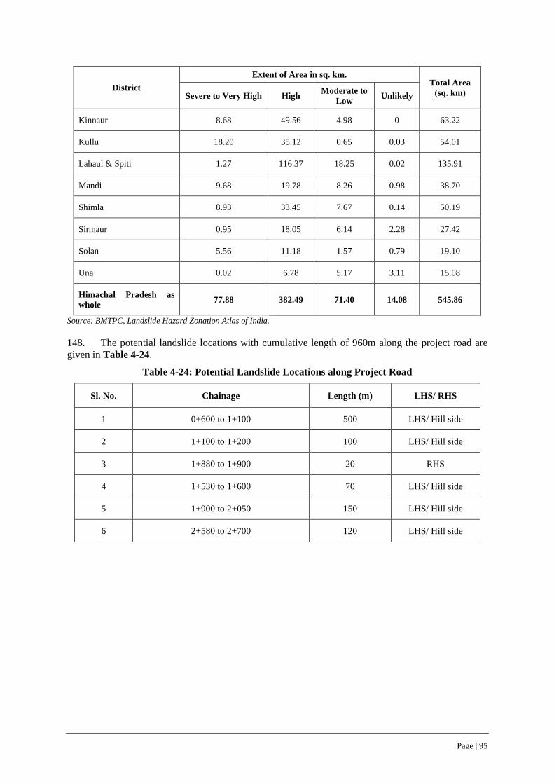
Page | 95
District Extent of Area in sq. km.
Total Area (sq. km) Severe to Very High High Moderate to
Low Unlikely
Kinnaur 8.68 49.56 4.98 0 63.22
Kullu 18.20 35.12 0.65 0.03 54.01
Lahaul & Spiti 1.27 116.37 18.25 0.02 135.91
Mandi 9.68 19.78 8.26 0.98 38.70
Shimla 8.93 33.45 7.67 0.14 50.19
Sirmaur 0.95 18.05 6.14 2.28 27.42
Solan 5.56 11.18 1.57 0.79 19.10
Una 0.02 6.78 5.17 3.11 15.08
Himachal Pradesh as whole 77.88 382.49 71.40 14.08 545.86
Source: BMTPC, Landslide Hazard Zonation Atlas of India.
148. The potential landslide locations with cumulative length of 960m along the project road are given in Table 4-24.
Table 4-24: Potential Landslide Locations along Project Road
Sl. No. Chainage Length (m) LHS/ RHS
1 0+600 to 1+100 500 LHS/ Hill side
2 1+100 to 1+200 100 LHS/ Hill side
3 1+880 to 1+900 20 RHS
4 1+530 to 1+600 70 LHS/ Hill side
5 1+900 to 2+050 150 LHS/ Hill side
6 2+580 to 2+700 120 LHS/ Hill side

Page | 96
Figure 4-19: Landslide Vulnerability Status of Bilaspur District
4.7.2 Wind Hazard Zones
149. As per wind hazard map of Himachal Pradesh, the project road completely traverses in moderate damage risk zone A. The wind hazard zonation map of Bilaspur district is shown in Figure 4-20. The wind hazard zonation based on wind speed as per BIS: 875 (Part 3) – 1987 titled “Indian Standard Code of Practice for Design Loads (other than earthquakes) for Buildings and Structures, Part 3, Wind Loads” is given in Table 4-25.
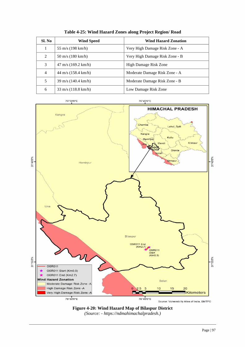
Page | 97
Table 4-25: Wind Hazard Zones along Project Region/ Road
Sl. No Wind Speed Wind Hazard Zonation
1 55 m/s (198 km/h) Very High Damage Risk Zone - A
2 50 m/s (180 km/h) Very High Damage Risk Zone - B
3 47 m/s (169.2 km/h) High Damage Risk Zone
4 44 m/s (158.4 km/h) Moderate Damage Risk Zone - A
5 39 m/s (140.4 km/h) Moderate Damage Risk Zone - B
6 33 m/s (118.8 km/h) Low Damage Risk Zone
Figure 4-20: Wind Hazard Map of Bilaspur District
(Source: - https://ndmahimachalpradesh.)

Page | 98
4.7.3 Flood Prone Zones
150. As per flood prone/hazard zone map, the project influence area is prone to flash floods as can be seen in Figure 4-21. However, there exist no major flood prone areas along the project road, despite its proximity to Govind Sagar Lake, which is in turn connected and fed by River Sutlej.
Figure 4-21: Flood Hazard Map of Bilaspur District (Source: - https://ndmahimachalpradesh.)
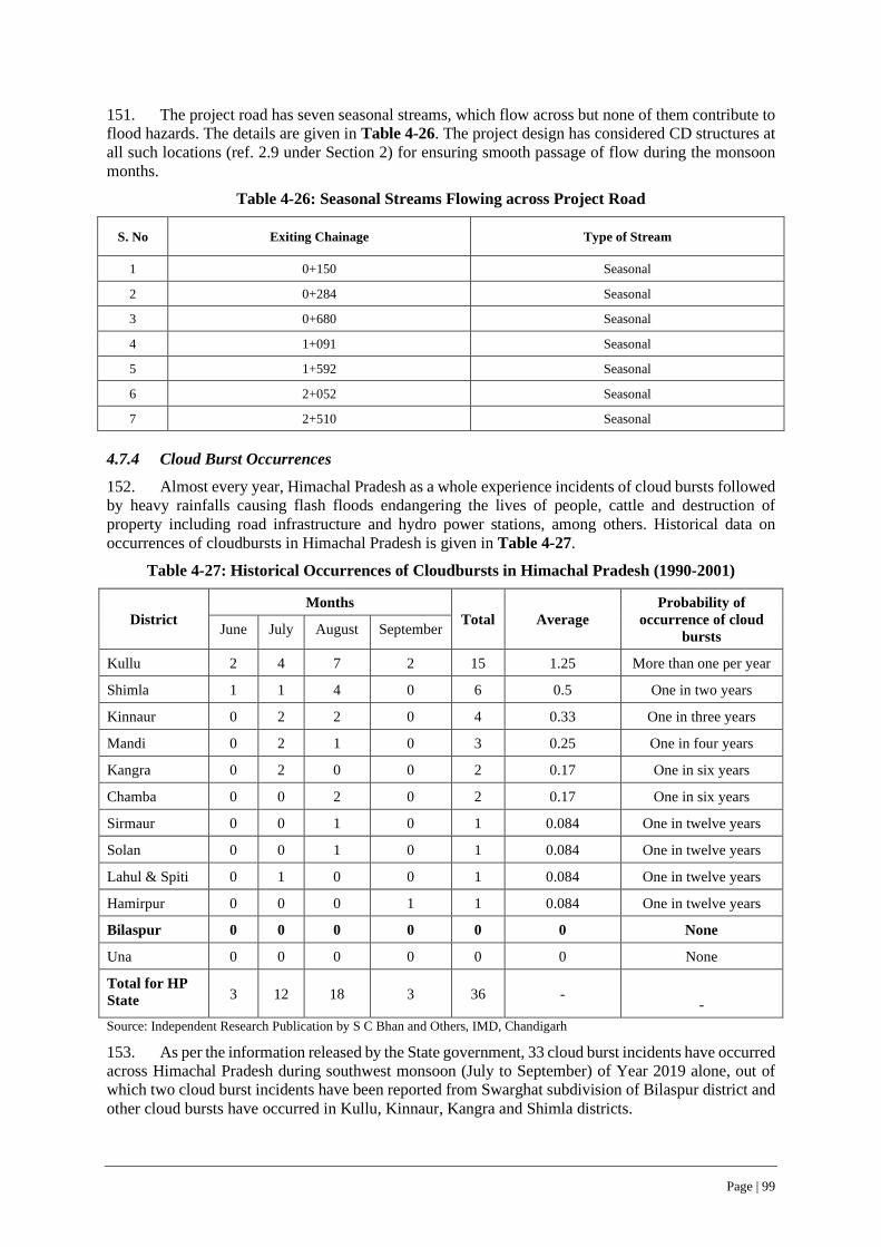
Page | 99
151. The project road has seven seasonal streams, which flow across but none of them contribute to flood hazards. The details are given in Table 4-26. The project design has considered CD structures at all such locations (ref. 2.9 under Section 2) for ensuring smooth passage of flow during the monsoon months.
Table 4-26: Seasonal Streams Flowing across Project Road
S. No Exiting Chainage Type of Stream
1 0+150 Seasonal
2 0+284 Seasonal
3 0+680 Seasonal
4 1+091 Seasonal
5 1+592 Seasonal
6 2+052 Seasonal
7 2+510 Seasonal
4.7.4 Cloud Burst Occurrences
152. Almost every year, Himachal Pradesh as a whole experience incidents of cloud bursts followed by heavy rainfalls causing flash floods endangering the lives of people, cattle and destruction of property including road infrastructure and hydro power stations, among others. Historical data on occurrences of cloudbursts in Himachal Pradesh is given in Table 4-27.
Table 4-27: Historical Occurrences of Cloudbursts in Himachal Pradesh (1990-2001)
District Months
Total Average Probability of
occurrence of cloud bursts June July August September
Kullu 2 4 7 2 15 1.25 More than one per year
Shimla 1 1 4 0 6 0.5 One in two years
Kinnaur 0 2 2 0 4 0.33 One in three years
Mandi 0 2 1 0 3 0.25 One in four years
Kangra 0 2 0 0 2 0.17 One in six years
Chamba 0 0 2 0 2 0.17 One in six years
Sirmaur 0 0 1 0 1 0.084 One in twelve years
Solan 0 0 1 0 1 0.084 One in twelve years
Lahul & Spiti 0 1 0 0 1 0.084 One in twelve years
Hamirpur 0 0 0 1 1 0.084 One in twelve years
Bilaspur 0 0 0 0 0 0 None
Una 0 0 0 0 0 0 None
Total for HP State 3 12 18 3 36 -
-
Source: Independent Research Publication by S C Bhan and Others, IMD, Chandigarh
153. As per the information released by the State government, 33 cloud burst incidents have occurred across Himachal Pradesh during southwest monsoon (July to September) of Year 2019 alone, out of which two cloud burst incidents have been reported from Swarghat subdivision of Bilaspur district and other cloud bursts have occurred in Kullu, Kinnaur, Kangra and Shimla districts.
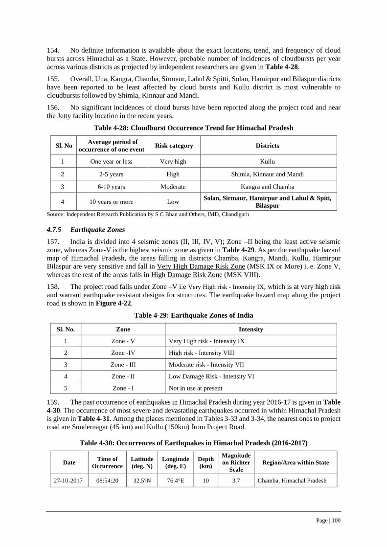
Page | 100
154. No definite information is available about the exact locations, trend, and frequency of cloud bursts across Himachal as a State. However, probable number of incidences of cloudbursts per year across various districts as projected by independent researchers are given in Table 4-28.
155. Overall, Una, Kangra, Chamba, Sirmaur, Lahul & Spitti, Solan, Hamirpur and Bilaspur districts have been reported to be least affected by cloud bursts and Kullu district is most vulnerable to cloudbursts followed by Shimla, Kinnaur and Mandi.
156. No significant incidences of cloud bursts have been reported along the project road and near the Jetty facility location in the recent years.
Table 4-28: Cloudburst Occurrence Trend for Himachal Pradesh
Sl. No Average period of occurrence of one event Risk category Districts
1 One year or less Very high Kullu
2 2-5 years High Shimla, Kinnaur and Mandi
3 6-10 years Moderate Kangra and Chamba
4 10 years or more Low Solan, Sirmaur, Hamirpur and Lahul & Spiti, Bilaspur
Source: Independent Research Publication by S C Bhan and Others, IMD, Chandigarh
4.7.5 Earthquake Zones
157. India is divided into 4 seismic zones (II, III, IV, V); Zone –II being the least active seismic zone, whereas Zone-V is the highest seismic zone as given in Table 4-29. As per the earthquake hazard map of Himachal Pradesh, the areas falling in districts Chamba, Kangra, Mandi, Kullu, Hamirpur Bilaspur are very sensitive and fall in Very High Damage Risk Zone (MSK IX or More) i. e. Zone V, whereas the rest of the areas falls in High Damage Risk Zone (MSK VIII).
158. The project road falls under Zone –V i.e Very High risk - Intensity IX, which is at very high risk and warrant earthquake resistant designs for structures. The earthquake hazard map along the project road is shown in Figure 4-22.
Table 4-29: Earthquake Zones of India
Sl. No. Zone Intensity
1 Zone - V Very High risk - Intensity IX
2 Zone -IV High risk - Intensity VIII
3 Zone - III Moderate risk - Intensity VII
4 Zone - II Low Damage Risk - Intensity VI
5 Zone - I Not in use at present
159. The past occurrence of earthquakes in Himachal Pradesh during year 2016-17 is given in Table 4-30. The occurrence of most severe and devastating earthquakes occurred in within Himachal Pradesh is given in Table 4-31. Among the places mentioned in Tables 3-33 and 3-34, the nearest ones to project road are Sundernagar (45 km) and Kullu (150km) from Project Road.
Table 4-30: Occurrences of Earthquakes in Himachal Pradesh (2016-2017)
Date Time of Occurrence
Latitude (deg. N)
Longitude (deg. E)
Depth (km)
Magnitude on Richter
Scale Region/Area within State
27-10-2017 08:54:20 32.5°N 76.4°E 10 3.7 Chamba, Himachal Pradesh

Page | 101
Date Time of Occurrence
Latitude (deg. N)
Longitude (deg. E)
Depth (km)
Magnitude on Richter
Scale Region/Area within State
27-08-2016 03:38:15 31.4°N 77.4°E 10 4.2 Kullu, Himachal Pradesh
27-08-2016 01:35:07 31.4°N 77.5°E 10 4.3 Kullu, Himachal Pradesh
27-08-2016 01:14:32 31.4°N 77.5°E 10 4.6 Kullu, Himachal Pradesh
01-08-2016 13:38:00 31.4°N 77.6°E 10 3.6 Rampur, Himachal Pradesh
01-08-2016 12:34:00 30.9°N 77.1°E 10 3 Solan, Himachal Pradesh
Table 4-31: Most Severe Earthquakes in Himachal Pradesh
Date Locations Affected Magnitude Extent of Reported Damage
4th April, 1905 Kangra 7.8 20,000 people died, 53,000 domestic animals perished, 1,00,000 houses destroyed, Estimated economic cost of recovery 2.9 million rupees
1st June, 1945 Chamba 6.5 NA
19th January, 1975 Kinnaur 6.8 60 people died, 100 badly injured, 2000 dwellings devastated, and 2500 people rendered homeless
26th April, 1986 Dharamshala 5.5 6 people died, Extensive damage to buildings. Loss estimated at Rs 65 crores
1st April, 1994 Chamba 4.5 NA
24th March, 1995 Chamba 4.9 Fearsome shaking, more than 70% houses developed cracks
29th July, 1997 Sundernagar 5 Damage to about 1000 houses
160. Seismic refraction survey and shear velocity profiles through Multi-Channel Analysis of Surface Wave (MASW) tests conducted 16 on behalf of Himachal State Disaster Management Authority at 4 sites spread across Bilaspur town, which is the nearest to the starting point of project road. The measured Vs30 values at these test sites range from 391 to 659 m/s as given in Table 4-32 and shown in Figure 4.23.
Table 4-32: Shear wave Velocity profile of 4 test sites at Bilaspur
Sl. No. Site id Location Average Vs30 (m/s) Soil Type
1 Bilaspur 1 31.34° N 76.76° E 483 C
2 Bilaspur 2 31.32° N 76.76° E 405 C
3 Bilaspur 3 31.33° N 76.77° E 659 C
4 Bilaspur 4 31.34° N 76.76° E 626 C
5 Bilaspur 5 31.34° N 76.96° E 391 C
Source: Himachal Pradesh Disaster Management Authority
16 complete investigation report can be accessed at https://www.hpsdma.nic.in//admnis/admin

Page | 102
Figure 4-22: Earthquake Hazard Map of Bilaspur District
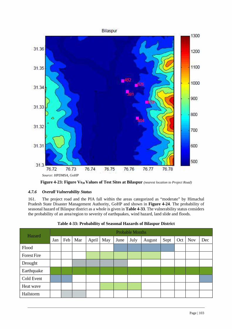
Page | 103
Source: HPDMSA, GoHP
Figure 4-23: Figure Vs30 Values of Test Sites at Bilaspur (nearest location to Project Road)
4.7.6 Overall Vulnerability Status
161. The project road and the PIA fall within the areas categorized as “moderate” by Himachal Pradesh State Disaster Management Authority, GoHP and shown in Figure 4-24. The probability of seasonal hazard of Bilaspur district as a whole is given in Table 4-33. The vulnerability status considers the probability of an area/region to severity of earthquakes, wind hazard, land slide and floods.
Table 4-33: Probability of Seasonal Hazards of Bilaspur District
Hazard
Probable Months Jan Feb Mar April May June July August Sept Oct Nov Dec
Flood
Forest Fire
Drought
Earthquake
Cold Event
Heat wave
Hailstorm
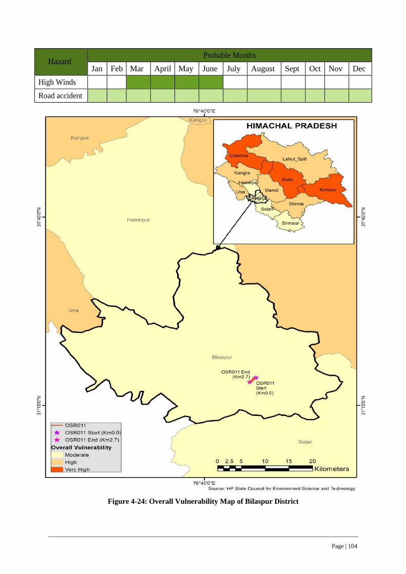
Page | 104
Hazard
Probable Months Jan Feb Mar April May June July August Sept Oct Nov Dec
High Winds
Road accident
Figure 4-24: Overall Vulnerability Map of Bilaspur District
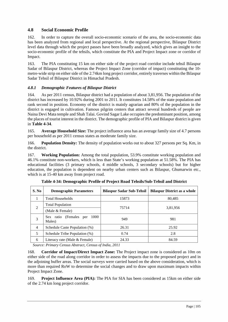
Page | 105
4.8 Social Economic Profile 162. In order to capture the overall socio-economic scenario of the area, the socio-economic data has been analyzed from regional and local perspective. At the regional perspective, Bilaspur District level data through which the project passes have been broadly analyzed, which gives an insight to the socio-economic profile of the tehsils, which constitute the PIA and Project Impact zone or corridor of Impact.
163. The PIA constituting 15 km on either side of the project road corridor include tehsil Bilaspur Sadar of Bilaspur District, whereas the Project Impact Zone (corridor of impact) constituting the 10-metre-wide strip on either side of the 2.74km long project corridor, entirely traverses within the Bilaspur Sadar Tehsil of Bilaspur District in Himachal Pradesh.
4.8.1 Demographic Features of Bilaspur District
164. As per 2011 census, Bilaspur district had a population of about 3,81,956. The population of the district has increased by 10.92% during 2001 to 2011. It constitutes 14.58% of the state population and rank second in position. Economy of the district is mainly agrarian and 80% of the population in the district is engaged in cultivation. Famous pilgrim centers that attract several hundreds of people are Naina Devi Mata temple and Shah Talai. Govind Sagar Lake occupies the predominant position, among the places of tourist interest in the district. The demographic profile of PIA and Bilaspur district is given in Table 4-34.
165. Average Household Size: The project influence area has an average family size of 4.7 persons per household as per 2011 census states as moderate family size. 166. Population Density: The density of population works out to about 327 persons per Sq. Km, in the district. 167. Working Population: Among the total population, 53.9% constitute working population and 46.1% constitute non-workers, which is less than State’s working population at 51.58%. The PIA has educational facilities (3 primary schools, 4 middle schools, 3 secondary schools) but for higher education, the population is dependent on nearby urban centers such as Bilaspur, Ghumarwin etc., which is at 15-40 km away from project road.
Table 4-34: Demographic Profile of Project Road Tehsils/Sub-Tehsil and District
S. No Demographic Parameters Bilaspur Sadar Sub-Tehsil Bilaspur District as a whole
1 Total Households 15873 80,485
2 Total Population
75714 3,81,956 (Male & Female)
3 Sex ratio (Females per 1000 Males) 949 981
4 Schedule Caste Population (%) 26.31 25.92 5 Schedule Tribe Population (%) 0.74 2.8 6 Literacy rate (Male & Female) 24.33 84.59
Source: Primary Census Abstract, Census of India, 2011
168. Corridor of Impact/Direct Impact Zone: The Project impact zone is considered as 10m on either side of the road along corridor in order to assess the impacts due to the proposed project and in the adjoining buffer areas. The social surveys were carried based on the above consideration, which is more than required RoW to determine the social changes and to draw upon maximum impacts within Project Impact Zone. 169. Project Influence Area (PIA): The PIA for SIA has been considered as 15km on either side of the 2.74 km long project corridor.
Page | 106
170. Socio Economic Characteristics of PIA: The environmental and social risks assessments seek to identify the impacts of the proposed project and focus on the ways and means to minimize the incidents of negative impacts and suggest the mitigation measures. Therefore, it is vital to understand the existing baseline socio-economic scenario in the study area to analysis the magnitude of the possible impacts. The socio-economic and demographic profile of villages on either side of the project road and Bilaspur sadar tehsil (PIA) is given in Appendix 8. The socio-economic profile of the PIA is summarized hereunder:
4.8.2 Demography, socio-economic profile of PIA
171. The sociological aspects include human settlements, demography, and social strata such as Scheduled Castes and Scheduled Tribes and literacy levels besides infrastructure facilities available in the study area. The economic aspects include occupational structure and income levels of workers. The following profile comprises of the study area.
• The total population of 16 villages which are within Bilaspur Sadar tehsil is 4681, in which the male population is 2498 (53.36%) and the female population is 2183 (46.64%). This shows that the male population higher in ratio. In the villages of Khasra &Mandlohul female population is higher than the male population as per census 2011.
• The male and female ratio of the study area is 874 females per every 1000 males. Among the total population, 78.47% (3673) of the people are literate and 21.53% (1008) of the people are illiterate. This shows that more than half of the population is literate. Among the literates, 56.71% (2083) are males and 43.29% (1590) are females. This shows that % of male literates are marginally higher than the female literates.
• Of the total study area population, 1.84% (86) consists of Scheduled Tribes, 26.81% (1255) are of the Scheduled caste population and 71.35% (3340) people belong to other castes. The schedule tribe population at the project level/sadar tehsil is 2.80%. The ST population is already in mainstream society with urban life styles and cultures, good living standards, high literate rate and occupation.
• Among the total population 65.26% (3055) are non-workers and remaining constitute the working population i.e., 34.74% (1626). The overall work force participation rate is lower than to the state work force about 51.58 %. Among the working population 67.90% (2597) are main workers and 32.10% (522) are marginal workers.
4.8.3 Socio-economic Profile of PAF’s/ PAH’s
172. The project road being merely 2.74 km long and widening limited to available right of way with no additional land acquisition or requirement for clearing of encroachments of right of way, primary survey(s) for assessing the R & R issues for likely PAP’s/PAHs was not warranted.
173. The widening proposal of project road was marginally impacting front portion of a shop having temporary roof but not affecting the main structure owned by a woman headed household (WHH) as well as one climbing step of a religious place (Peepal tree with platform), which are encroachment(s) into the RoW at Chainage 0+187 and 1+052 respectively as per project road design. The analysis of alternatives has enabled to avoid impact on these two structures by resorting to minor realignment of project road design at such specific locations (ref. Section 6 for Alternative Analysis).
4.8.4 Status of women
174. The project road corridor does not have any potential hotspots from GBV perspective. Thus, no GBV consultations were conducted for this specific project corridor during ESIA. Although, GBV consultations were conducted at Ghumarwin, Bilaspur district at project district level as part of GBV risk mitigation strategy for all road corridors under HPSRTP including this project road.
175. Programs and Policies: As part of socio-economic assessment, income generating schemes that are operational in Himachal Pradesh have been complied and are summarized in Appendix 9.
Page | 107
5 STAKEHOLDER CONSULTATIONS & INFORMATION DISCLOSURE
5.1 Stakeholders Consultations 176. The public/stakeholder consultations conducted as a part of environmental and social impact assessment for road widening and upgradation along the project road between Raghunathpura-Mandi-Harpura-Bharari are summarized in this chapter. The consultations were held with likely PAP’s and social beneficiaries at the sporadic settlements along the road, wherein the structures and common property resources extended into the right of way. In addition, consultations were also carried out in the project level region for understanding of the GBV issues prevailing in the area at societal level and more specifically due to migrant workers employed in several ongoing construction activities in the project region as a whole.
177. During consultations particular attention was given to discuss the concerns and aspiration of local communities and likely PAP’s, while conducting census and socio-economic survey, the social beneficiaries were also consulted on a one-to-one basis and solicited their views, responses and expectations, which helped to understand their status in the society, education, occupation income level etc.
178. During the consultation, the following project information was disseminated to participants:
i) Project Development Objective of HPSRTP, including background on HPSRP (phase I), which has been since completed by HPRIDCL between 2007-2017.
ii) Typical Cross Sections for the widening scheme project road along rural and settlement areas; iii) GoI’s Land Acquisition Act of 2013(RFCTLARR), GoHP provisions for compensation and
assistance as per approved RPF iv) Road safety and pedestrian safety measures considered in the project road design; v) Likely beneficial and adverse impacts arising due to project road improvement
179. The Stakeholder Consultations elicited following from participants:
i) Views on the project especially the probable adverse impacts; ii) Possible mitigation measures in case of any adverse impacts; iii) Means of better delivery of compensation and assistance; iv) Assurance from HPSRTP for not to marginalize people by depriving them from their livelihood. v) Provision of infrastructure such as drinking water and toilets, whenever warranted.
180. Through public participation, stakeholder’s viewpoints and suggestions were captured as an input to the technical design, which were duly considered, and all the suggestions were incorporated and addressed in the project design to the extent feasible and /or warranted. While the participants also raised concerns to develop scenic spot at the waterfront of Govind Sagar Lake. Wherein the, HPRIDCL is taking necessary measures to develop jetty facility at the lake as part of tourism development as well as to provide shortest and economical connectivity to several villages of Bilaspur district to reach district headquarters and avoid conventional, time taking road network. The summary of stakeholder consultations and outcomes are given in Table 5-1 and Table 5-2. The list of stakeholders consulted is given in Appendix 10.
181. The summary of the specific inputs for technical design after analyzing the concerns of the people has been presented in under the Section titled “Analysis of Alternative”. The Photographs taken during the pubic consultations in September, 2019 along project roads and in the project, region is given in Figure 5-1.
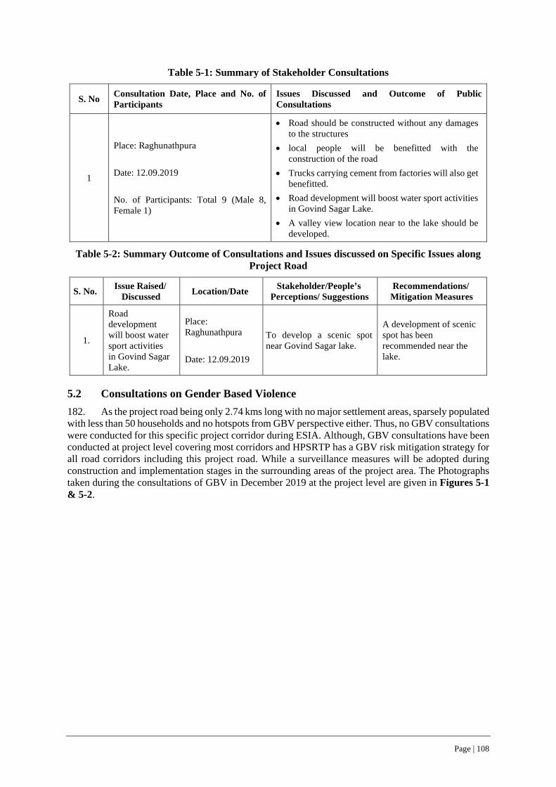
Page | 108
Table 5-1: Summary of Stakeholder Consultations
S. No Consultation Date, Place and No. of Participants
Issues Discussed and Outcome of Public Consultations
1
Place: Raghunathpura Date: 12.09.2019 No. of Participants: Total 9 (Male 8, Female 1)
• Road should be constructed without any damages to the structures
• local people will be benefitted with the construction of the road
• Trucks carrying cement from factories will also get benefitted.
• Road development will boost water sport activities in Govind Sagar Lake.
• A valley view location near to the lake should be developed.
Table 5-2: Summary Outcome of Consultations and Issues discussed on Specific Issues along Project Road
S. No. Issue Raised/ Discussed Location/Date Stakeholder/People’s
Perceptions/ Suggestions Recommendations/
Mitigation Measures
1.
Road development will boost water sport activities in Govind Sagar Lake.
Place: Raghunathpura Date: 12.09.2019
To develop a scenic spot near Govind Sagar lake.
A development of scenic spot has been recommended near the lake.
5.2 Consultations on Gender Based Violence 182. As the project road being only 2.74 kms long with no major settlement areas, sparsely populated with less than 50 households and no hotspots from GBV perspective either. Thus, no GBV consultations were conducted for this specific project corridor during ESIA. Although, GBV consultations have been conducted at project level covering most corridors and HPSRTP has a GBV risk mitigation strategy for all road corridors including this project road. While a surveillance measures will be adopted during construction and implementation stages in the surrounding areas of the project area. The Photographs taken during the consultations of GBV in December 2019 at the project level are given in Figures 5-1 & 5-2.
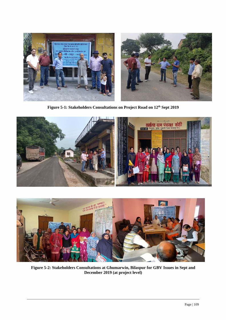
Page | 109
Figure 5-1: Stakeholders Consultations on Project Road on 12th Sept 2019
Figure 5-2: Stakeholders Consultations at Ghumarwin, Bilaspur for GBV Issues in Sept and
December 2019 (at project level)

Page | 110
6 ANALYSIS OF ALTERNATIVES
6.1 Considerations for Alternatives 183. Environmental and social impact assessment during project design stage helps to minimize, reduce or mitigate potential negative impacts of project action and enable to enhance positive impacts, sustainability and development benefits. Although many benefits are expected from the project, social assessments have identified potential adverse impacts on the immediate roadside communities and directly affected by project construction and operation. These impacts include loss of land, assets and associated impacts.
184. In accordance with the principle of mitigation hierarchy for management of E&S risks and impacts, analysis of alternatives has been considered to reduce such potential direct negative E&S impacts of the project. Recommendations have also been made for incorporation at the project preparation (DPR) stage itself from technical, environmental and social impacts perspective. This chapter summarize the alternatives considered and finalized.
185. Public Consultations were held with the local people, likely project affected population, community leaders and government officials, wherever the negative impacts are likely to be high in order to find out the alternatives to minimize the impact. With the help of the survey and consultations and engineering inputs the mitigation measures have been worked out. Mitigation measures largely focused on settlement areas along the road or zones of potential impacts. The recommendations of the stakeholders have been incorporated in designs, wherever feasible.
186. Road design considerations to minimize or mitigate risks and impacts included:
• Restrict the widening/ upgradation of project road to the available right of way and avoid fresh land diversion, subject to meeting the geometric design criteria adopted for project road.
• Avoid/minimize social impacts by considering alternate design considerations and alignment options, within the available right of way to the extent possible or feasible.
• Avoid direct impacts on natural resources/ springs/ community water resources, sensitive receptors and religious shrines or structures.
• Balance the cut and fill quantities through optimization of hill cut operation and limiting height of retaining walls (3m), reclamation of low-lying areas within RoW and/ or reuse of excavated materials to the extent possible or feasible.
• Minimize land requirements for muck/ debris disposal. • Providing suitable road calming and safety measures such as rumble strips for speed reductions
and noise barriers near sensitive receptors like schools and hospitals.
187. Jetty design considerations to minimize or mitigate risk and impacts included:
• Minimal land footprint and intrusion along waterfront of Gobind Sagar Lake/ River Sutlej for construction of Jetty facility.
• Facilitate ‘all season’ boarding of boats/ ferries through extension of existing boarding ramp and avoid risks of walking by women and elderly people through slushy mud banks during low water levels.
• Minimal intrusion into water front with no constriction of water way at all water levels during different seasons of the year.
• Provision of openable/ self-locking type hand railing along Jetty for the safety of women/ children/ elderly people, while boarding boats and ferries.
6.2 Alternative Analysis Option – No project scenario 188. The project road at present has 522 PCUs (as of year 2019), which is expected to reach 4879 PCUs by year 2024, 7173 PCUs by year 2031 and 10394 PCUs by year 2038, warranting widening of

Page | 111
the existing single lane to two lanes configuration in accordance with LoS recommended by IRC (ref. section 2.5 under Section 2). 189. Unless, the project road is widened/ upgraded to IRC recommended LoS, the present average speed, which is ranging between 15 to 20km/hr. (less than IRC recommended design speed for single lane) is likely to further reduce and consequently increase the travel time for the road users. With the increased traffic level over next few years, the accident rates as well as the road safety issues can be concurrently expected to worsen off and increase the level of discomfort to the road users. 190. On the contrary the project road widening/ upgradation is expected to cater to the increased traffic levels, improved riding comfort and reduced travel time for movement of agriculture produce. Thus, contributing to the economy of the region as well as the state. The project road widening can also be expected contribute to reduced GHG emission due to the improved pavement condition and decreased travel time (ref. Table 7-10 & 7-11 under Section 7). Thus, ‘no project scenario’ is not a viable/ desirable alternative option, which can be exercised. 191. The alternatives evaluated for the Jetty considered factors like design and general structural arrangement, which require minimum footprint on the waterfront of Gobind Sagar/ River Sutlej and concurrently enable an all-season boarding facility, amid fluctuating water levels.
192. The footprint of the proposed jetty along the waterfront of Govind Sagar lake/River Sutlej will be less than 30 sq. m, and the superstructure of jetty will be supported on pile foundations (total 90 piles of each 600mm diameter with a cumulative footprint of less than 30 sq.m.) without constricting the waterway beneath. The superstructure area of the jetty will be 864 sq.m (216 m long and 4.0 m wide) and connects to the existing boarding platform, and thus enable/ overcome slushy banks and associated community risks thereof while boarding the boat/ ferries.
6.3 Alternative Analysis Option – Balancing cut and fill quantities 193. The project road design has considered to balance the cut and fill quantity by minimizing the excavation/ hill cut requirements and opting for widening of the road on the valley/ low lying sections of right of way (RoW) through construction of retaining walls and toe walls. Such an option has enabled to redeploy/ reuse the excavated materials elsewhere along the road for construction of road, culverts/bridges, drainage and protection works and reclamation of low-lying stretches along the valley side within RoW for road widening through construction of retaining walls and toe walls. 194. In addition, this consideration also enables to reduce the requirement of fresh lands for muck disposal and also reduces the need to source new construction material for construction purposes. The details are presented in section 7.3.3 under Section 7.
195. The road widening, construction of cross drainage structures and protection works like breast walls, retaining walls and toe walls will warrant earth work and/or rock excavation. The excavation requirement for road widening is estimated to be 36171 cu.m, out of which 28204 cu.m of excavated materials (78%) is expected to be reused in the back filling activities and the balance 6130 cu.m. of debris will have to be disposed-off at suitable locations (ref. Table 6-4) (ref. 7.3.3 under Section 7).
196. The Jetty construction will not involve any significant quantities of earth work excavation and thus does not provide much scope for balancing the cut and fill quantities.
6.4 Alternative Analysis Option – Minimizing of Environmental and Social Impacts 197. The analysis of alternatives included both desk review of alignment design drawings and evaluation of impacted structures, followed by verification through actual field level assessments. The field assessments included on- site revalidation/measurement of offset distances from the centerline of the road to the proposed corridor of improvement on both left and right-hand side of the road and concurrently evaluating, whether impacted structures as per design drawing can be saved as per site conditions and all such findings of field assessments were shared with DPR Consultant team for their review/modifications in design thereof.
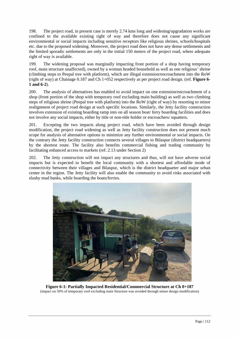
Page | 112
198. The project road, in present case is merely 2.74 kms long and widening/upgradation works are confined to the available existing right of way and therefore does not cause any significant environmental or social impacts including sensitive receptors like religious shrines, schools/hospitals etc. due to the proposed widening. Moreover, the project road does not have any dense settlements and the limited sporadic settlements are only in the initial 150 meters of the project road, where adequate right of way is available.
199. The widening proposal was marginally impacting front portion of a shop having temporary roof, main structure unaffected), owned by a woman headed household as well as one religious’ shrine (climbing steps to Peepal tree with platform), which are illegal extension/encroachment into the RoW (right of way) at Chainage 0.187 and Ch 1+052 respectively as per project road design. (ref. Figure 6-1 and 6-2).
200. The analysis of alternatives has enabled to avoid impact on one extension/encroachment of a shop (front portion of the shop with temporary roof excluding main building) as well as two climbing steps of religious shrine (Peepal tree with platform) into the RoW (right of way) by resorting to minor realignment of project road design at such specific locations. Similarly, the Jetty facility construction involves extension of existing boarding ramp into on all season boat/ ferry boarding facilities and does not involve any social impacts, either by title or non-title holder or encroachers/ squatters.
201. Excepting the two impacts along project road, which have been avoided through design modification, the project road widening as well as Jetty facility construction does not present much scope for analysis of alternative options to minimize any further environmental or social impacts. On the contrary the Jetty facility construction connects several villages to Bilaspur (district headquarters) by the shortest route. The facility also benefits commercial fishing and trading community by facilitating enhanced access to markets (ref. 2.13 under Section 2)
202. The Jetty construction will not impact any structures and thus, will not have adverse social impacts but is expected to benefit the local community with a shortest and affordable mode of connectivity between their villages and Bilaspur, which is the district headquarter and major urban center in the region. The Jetty facility will also enable the community to avoid risks associated with slushy mud banks, while boarding the boats/ferries.
Figure 6-1: Partially Impacted Residential/Commercial Structure at Ch 0+187
(impact on 50% of temporary roof excluding main Structure was avoided through minor design modification)
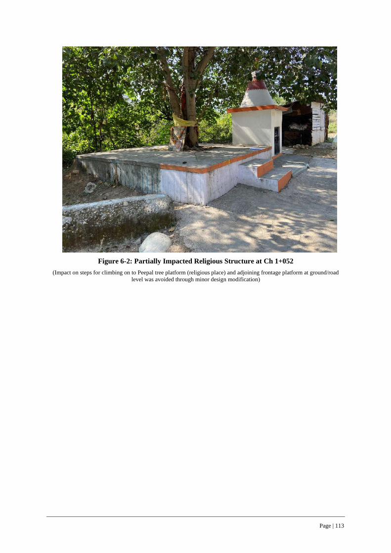
Page | 113
Figure 6-2: Partially Impacted Religious Structure at Ch 1+052
(Impact on steps for climbing on to Peepal tree platform (religious place) and adjoining frontage platform at ground/road level was avoided through minor design modification)

Page | 114
7 ENVIRONMENT & SOCIAL RISKS AND IMPACTS AND MITIGATION MEASURES
203. The environmental and social risks/ impacts due to the widening of 2.74Km project road between Raghunathpura-Mandi-Bharari and jetty facility construction have been assessed by each relevant ESSs (ESS 2 to 8) along with mitigation measures are summarized in this section. The social impacts of the project road widening have been completely avoided by considering the design modifications through alternative analysis (ref. Section 6 - Analysis of Alternatives) and therefore RAP was not warranted. The environmental and social management plan (ESMP) for impact mitigation and management measures are included in ESMP Volume, which is a standalone document to the ESIA and may be referred for details.
7.1 …related to Assessment and Management of E&S risk and impact (ESS 1) Impacts
204. The widening of the project road between Raghunathpura and Bharari, connecting Bharari and several other nearby villages to NH 154 at Raghunathpura (0+00 Km of project road), which includes the settlement areas along the project road like Raghunathpura, Mandi, Harapura, will be limited to the available RoW and does not involve land acquisition and consequently avoid social impacts/ risks thereof.
205. The Jetty facility proposed along the waterfront of Gobind Sagar Lake and River Sutlej near Luhnu Stadium will facilitate all season passenger ferry/boat boarding and connects several villages namely Beri Darola, Kothi, Gehrwin, Khudai, Dafer, Baroha, Nahral, Rohal, Kallar, Gahrali, Bharari, Benajatta, Ladera, Sotta, Saner, Seru, Burar, Tanur, Lakhanpur, Patta among others located on the other side of the riverbank/waterfront. The ferry/boat services across and along the waterway are the short, affordable and fastest way of commuting between these villages to Bilaspur, avoid the road network and contribute to reduce the GHG emission.
206. The Jetty will have less than 30 sq.m footprint on the waterfront of Gobind Sagar Lake/ River Sutlej and does not constrict the waterway beneath. Moreover, Jetty construction activities will be undertaken during non-monsoon months (October to May) when the water levels would recede to lowest level and construction of Jetty can be undertaken on the dried up water front/river bank of Sutlej. Consequently, the environmental risks and impacts on the aquatic eco-system of Gobind Sagar Lake/ River Sutlej due to Jetty construction activities will be insignificant or completely avoided. Rather, the Jetty construction will be beneficial to the commercial fishing community with improved access to market. Thus, the social benefits that will accrued due to the Jetty construction will be safe, all season boarding to the ferries, possible increase in the number of boat/ ferry trips per day with increase in passengers, facilitation to the commercial fishing community to trade their catch at local markets.
Mitigation Measures
207. The E&S risks and impacts of both project road widening and Jetty facility construction have been assessed by each relevant ESSs (ESS 2 to 8) and suitable measures are summarized in the following sub-sections. The risks and impacts of Jetty facility construction along the waterfront of Gobind Sagar Lake and River Sutlej near Luhnu Stadium can be minimized through scheduling of the construction activity to non-monsoon season between October to May months. The mitigation measures to be implemented during project road widening and Jetty facility construction are also included in the stand alone ESMP volume (ref. Table 4-1).
7.2 … relating to Labour and Working Conditions (ESS 2) Impacts
208. The project road widening between Raghunathpura-Mandi-Bharari and Jetty facility construction will require an estimated 80 contract workers, which include 60 skilled and unskilled construction workers. It is anticipated that out of 80 skilled and unskilled construction workers, nearly
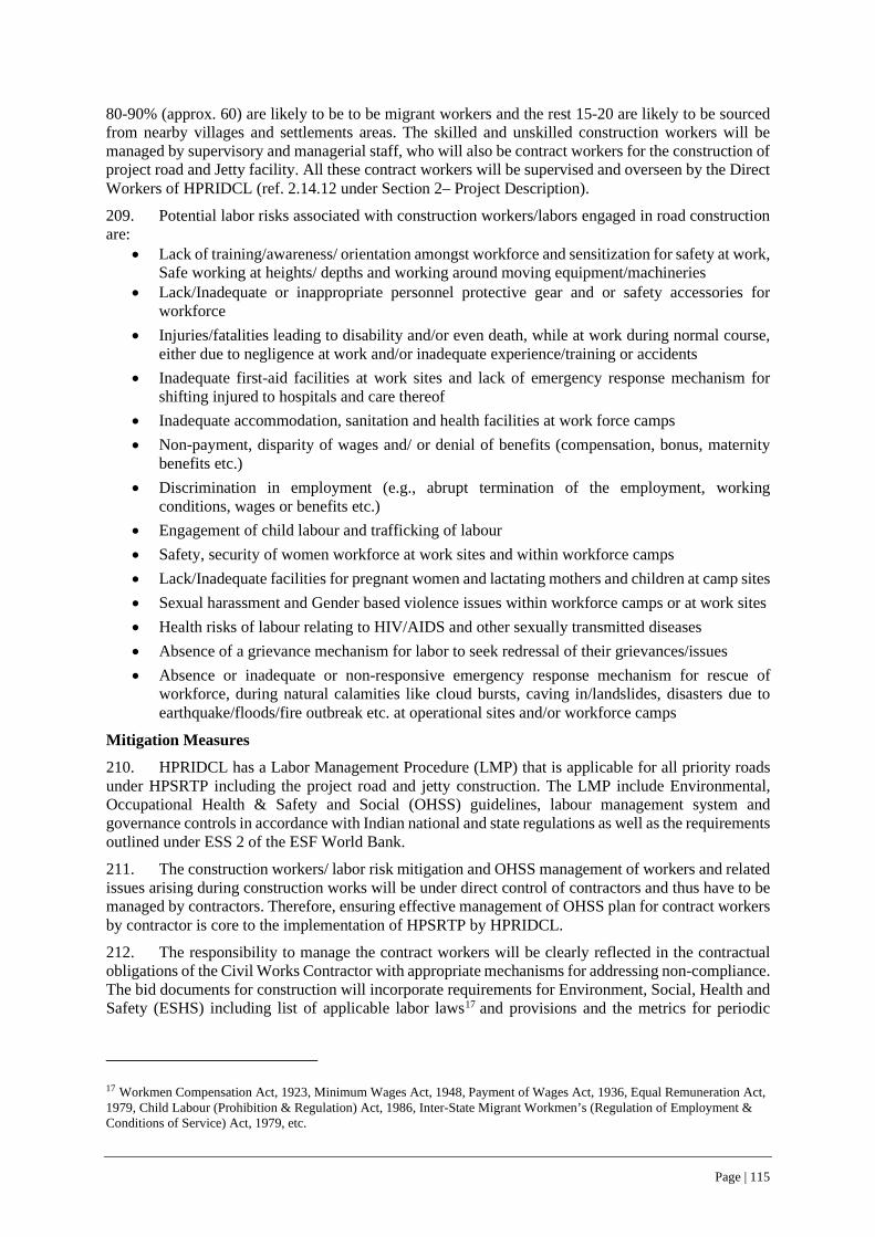
Page | 115
80-90% (approx. 60) are likely to be to be migrant workers and the rest 15-20 are likely to be sourced from nearby villages and settlements areas. The skilled and unskilled construction workers will be managed by supervisory and managerial staff, who will also be contract workers for the construction of project road and Jetty facility. All these contract workers will be supervised and overseen by the Direct Workers of HPRIDCL (ref. 2.14.12 under Section 2– Project Description).
209. Potential labor risks associated with construction workers/labors engaged in road construction are:
• Lack of training/awareness/ orientation amongst workforce and sensitization for safety at work, Safe working at heights/ depths and working around moving equipment/machineries
• Lack/Inadequate or inappropriate personnel protective gear and or safety accessories for workforce
• Injuries/fatalities leading to disability and/or even death, while at work during normal course, either due to negligence at work and/or inadequate experience/training or accidents
• Inadequate first-aid facilities at work sites and lack of emergency response mechanism for shifting injured to hospitals and care thereof
• Inadequate accommodation, sanitation and health facilities at work force camps • Non-payment, disparity of wages and/ or denial of benefits (compensation, bonus, maternity
benefits etc.) • Discrimination in employment (e.g., abrupt termination of the employment, working
conditions, wages or benefits etc.) • Engagement of child labour and trafficking of labour • Safety, security of women workforce at work sites and within workforce camps • Lack/Inadequate facilities for pregnant women and lactating mothers and children at camp sites • Sexual harassment and Gender based violence issues within workforce camps or at work sites • Health risks of labour relating to HIV/AIDS and other sexually transmitted diseases • Absence of a grievance mechanism for labor to seek redressal of their grievances/issues • Absence or inadequate or non-responsive emergency response mechanism for rescue of
workforce, during natural calamities like cloud bursts, caving in/landslides, disasters due to earthquake/floods/fire outbreak etc. at operational sites and/or workforce camps
Mitigation Measures
210. HPRIDCL has a Labor Management Procedure (LMP) that is applicable for all priority roads under HPSRTP including the project road and jetty construction. The LMP include Environmental, Occupational Health & Safety and Social (OHSS) guidelines, labour management system and governance controls in accordance with Indian national and state regulations as well as the requirements outlined under ESS 2 of the ESF World Bank.
211. The construction workers/ labor risk mitigation and OHSS management of workers and related issues arising during construction works will be under direct control of contractors and thus have to be managed by contractors. Therefore, ensuring effective management of OHSS plan for contract workers by contractor is core to the implementation of HPSRTP by HPRIDCL.
212. The responsibility to manage the contract workers will be clearly reflected in the contractual obligations of the Civil Works Contractor with appropriate mechanisms for addressing non-compliance. The bid documents for construction will incorporate requirements for Environment, Social, Health and Safety (ESHS) including list of applicable labor laws17 and provisions and the metrics for periodic
17 Workmen Compensation Act, 1923, Minimum Wages Act, 1948, Payment of Wages Act, 1936, Equal Remuneration Act, 1979, Child Labour (Prohibition & Regulation) Act, 1986, Inter-State Migrant Workmen’s (Regulation of Employment & Conditions of Service) Act, 1979, etc.
Page | 116
reporting by contractors. The bidders will be required to submit the following as part of their technical bid: i) ESHS strategy and implementation plan; code of conduct; ii) declaration of past ESHS performance. The successful Bidder will submit an Environmental, Social, Health and Safety (ESHS) Performance Security @ 2% of accepted contract value.
213. In order to further mitigate the potential labour risks, contractor will:
i. source all unskilled labor locally (to extent possible) to minimize labor influx into the project region. Skilled labor force, if unavailable locally, have to be brought from outside the project area/state.
ii. develop and implement a workforce camp management plan that addresses all requirements as per state or national regulations.
iii. conduct periodic training programs on HIV/AIDS and other communicable diseases iv. implement a grievance redressal mechanism (GRM) for workforce v. provide information to communities in project area about the contractor’s code of conduct for
workers, wherever applicable. vi. Plan and implement a GBV risk mitigation strategy, which include measures such as orientation
to all categories of labor, communities’ sensitization, signing of codes of conduct by all workers (all categories and levels) to be undertaken during throughout project implementation phase (ref. Sl. No. 4, Table 4-1 of ESMP Volume).
7.3 …relating to Resource Efficiency, Pollution Prevention and Management (ESS 3)
7.3.1 Physiography
Impacts
214. The project road is existing for last several decades and the present construction works involves only upgradation/ widening from single to two lane, within the available right of way. The widening/ upgradation follow the same existing ground profile, without significantly altering the vertical profile, except for improvement of geometrics at few locations, to enhance road safety and achieve a uniform design speed (ref. 2.6 under Section 2 - Project Description).
215. Similarly, the Jetty construction also does not alter the physiography along the Gobind Sagar waterfront/ riverbank of Sutlej (ref. 2.13 under Section 2 - Project Description). Therefore, no significant impact on physiography and soil of the region (ref. 4.3.3 under Section 4) is foreseen/ anticipated due to road and jetty construction works.
Mitigation Measures
216. The project road widening and jetty construction does not warrant specific mitigation measures for managing the impact on physiography and soil. However, the ESMP includes several GIIPs for mitigating incidental impacts of construction works like establishment of camp sites/ work force camps, opening of borrow areas/ muck disposal sites, removal of topsoil, contamination of soil from leakage and spillage during storage/ handling of fuels/ lubes, construction chemicals and construction materials, which may induce impacts on soil. The measures to be implemented to contain all such impacts are given in Table 4-1 of ESMP Volume.
7.3.2 Geology
Impacts
217. The project road and jetty construction will require different construction materials such as earth, stone aggregates, cement and sand that occurs naturally or manufactured from naturally occurring mineral resources, formation of which take millions of years. In addition, ever increasing development works across the globe has stressed these finite natural resources and is increasingly becoming resource constraint/ challenge in recent times. Considering these aspects, minimization of construction footprint as well as resource efficiency is considered for project road and jetty facility construction.
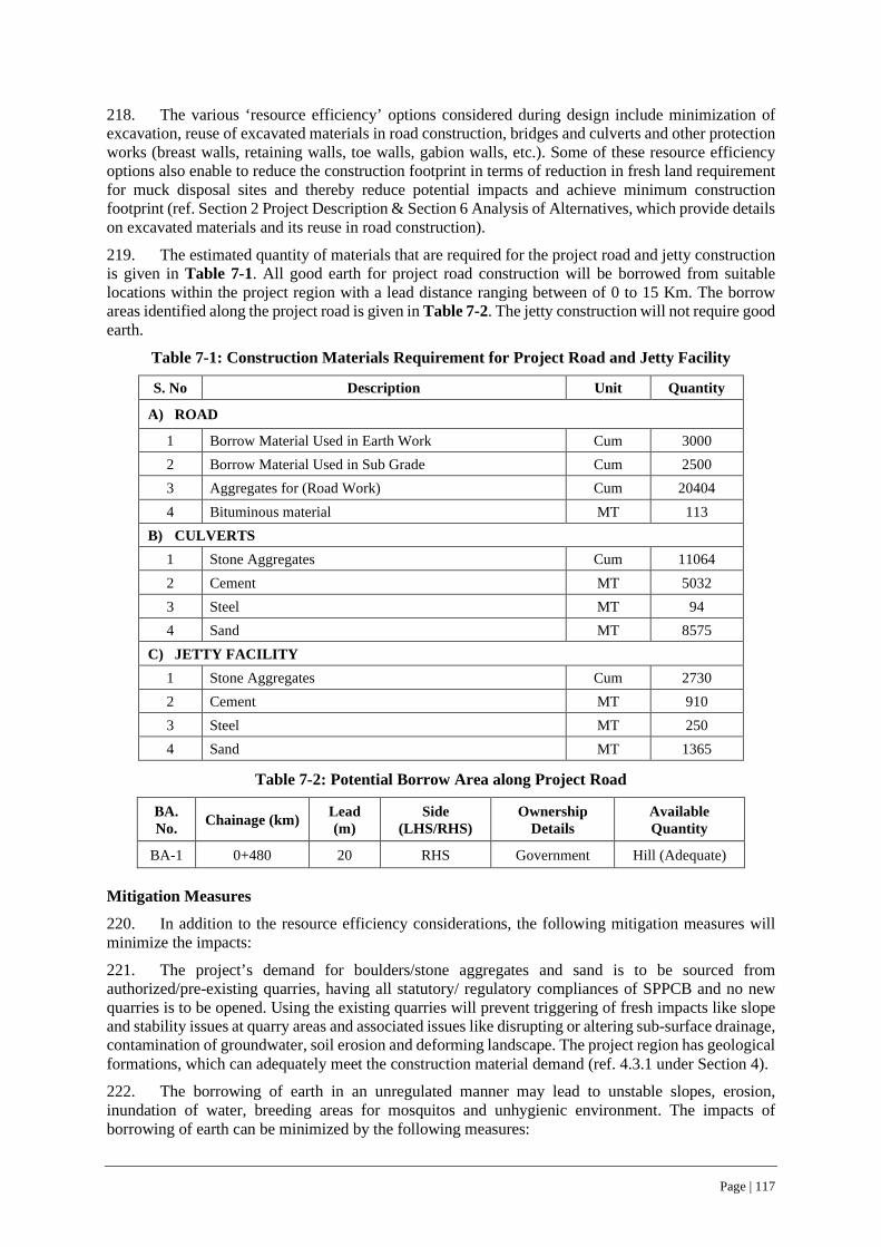
Page | 117
218. The various ‘resource efficiency’ options considered during design include minimization of excavation, reuse of excavated materials in road construction, bridges and culverts and other protection works (breast walls, retaining walls, toe walls, gabion walls, etc.). Some of these resource efficiency options also enable to reduce the construction footprint in terms of reduction in fresh land requirement for muck disposal sites and thereby reduce potential impacts and achieve minimum construction footprint (ref. Section 2 Project Description & Section 6 Analysis of Alternatives, which provide details on excavated materials and its reuse in road construction).
219. The estimated quantity of materials that are required for the project road and jetty construction is given in Table 7-1. All good earth for project road construction will be borrowed from suitable locations within the project region with a lead distance ranging between of 0 to 15 Km. The borrow areas identified along the project road is given in Table 7-2. The jetty construction will not require good earth.
Table 7-1: Construction Materials Requirement for Project Road and Jetty Facility
S. No Description Unit Quantity
A) ROAD
1 Borrow Material Used in Earth Work Cum 3000 2 Borrow Material Used in Sub Grade Cum 2500 3 Aggregates for (Road Work) Cum 20404 4 Bituminous material MT 113
B) CULVERTS 1 Stone Aggregates Cum 11064 2 Cement MT 5032 3 Steel MT 94 4 Sand MT 8575
C) JETTY FACILITY 1 Stone Aggregates Cum 2730 2 Cement MT 910 3 Steel MT 250 4 Sand MT 1365
Table 7-2: Potential Borrow Area along Project Road
BA. No. Chainage (km) Lead
(m) Side
(LHS/RHS) Ownership
Details Available Quantity
BA-1 0+480 20 RHS Government Hill (Adequate)
Mitigation Measures
220. In addition to the resource efficiency considerations, the following mitigation measures will minimize the impacts:
221. The project’s demand for boulders/stone aggregates and sand is to be sourced from authorized/pre-existing quarries, having all statutory/ regulatory compliances of SPPCB and no new quarries is to be opened. Using the existing quarries will prevent triggering of fresh impacts like slope and stability issues at quarry areas and associated issues like disrupting or altering sub-surface drainage, contamination of groundwater, soil erosion and deforming landscape. The project region has geological formations, which can adequately meet the construction material demand (ref. 4.3.1 under Section 4).
222. The borrowing of earth in an unregulated manner may lead to unstable slopes, erosion, inundation of water, breeding areas for mosquitos and unhygienic environment. The impacts of borrowing of earth can be minimized by the following measures:

Page | 118
• The contractor shall prepare and get the borrow area management plan approved by the CSC and all operations shall strictly adhere to the approved plan. The identified borrow area shall be inspected by CSC prior to its approval.
• Uplands shall be given a first choice while finalizing the borrow areas to reduce the footprint of the borrow areas (ref. 4.3.7 under Section 4, for soil quality and fertility levels within project region). The borrow area management plan shall indicate land area, boundary limits, limiting side slopes for excavated areas, estimated borrowed quantity and existing environmental settings, but not limited to topography, drainage, water bodies, settlements, trees, haul road etc. to identify likely environmental, social risks and associated safety hazards.
• Prior to commencing borrowing operations, all such identified borrow areas are to be approved by CSC based on compliance with existing regulations, suitability of earth, written agreement with landowner(s), likely potential environmental risks and safety hazards, borrow plan schedule including restoration/redevelopment plan. If government/panchayat land(s) have been chosen, then requisite approval/permissions from local self-government bodies shall be obtained prior to commencement of borrowing operations and conditions laid by the local bodies shall be complied thereof.
• Borrow areas shall not be opened in an irregular shape and sizes. The bottom of borrow pits shall not be left uneven and finished with a levelled bottom, to extent possible and shall not have deep pits within.
• The proposed depth of cutting shall be limited to a maximum of 1.5 meters below surrounding ground levels. In case excavation warrants for greater depth, such borrow area location shall also include occupational health and safety measures to prevent accidental or safety hazards till completion of restoration.
• Collection of topsoil in a segregated manner and its preservation and re-use elsewhere. • The agreement for borrowing soil shall clearly state the lease duration, depth and land area and
levels up to which the borrowing of earth shall be carried out, compensation for the agreed lease period, site restoration plan as desired/required by the landowner and any other condition mutually agreed upon between contractor and landowner. The agreement shall include a site restoration plan as agreed upon with the landowner.
• The transportation of earth from borrow areas in open/uncovered trucks can increase the dust levels. The contractor will ensure trucks are loaded only up to permitted capacities to prevent high emission, vehicle wear and tear, and road surface damage due to overloading.
• All haul roads either paved or unpaved used for transportation of materials shall be subjected to surveillance at regular intervals and rectify any type of surface damage till operation of borrow area and regularly clear the spills, if any.
• All haul roads (paved or unpaved) used for transportation of materials shall be subjected to daily surveillance especially along settlement/residential areas and carry out regular sprinkling of water for dust suppression until the completion of borrowing operations.
• Trucks in good condition shall only be deployed for operations and shall adhere to pre-determined routes. The contractor will resolve any conflict arising due to construction or material handling activities with community or individual, if any.
• CSC will conduct regular safeguards compliance audit during operation of borrow area and ensure prompt restoration of closed borrow area is in accordance with approved borrow area management plan.
7.3.3 Land Use and Soil
Impacts - Muck Disposal
223. The project road construction will generate muck/ debris from clearing operation within the RoW/CoI for road widening as well as construction of road (widening portion), culverts and protection works. Similarly, jetty construction also will generate muck or debris, although, much less as compared
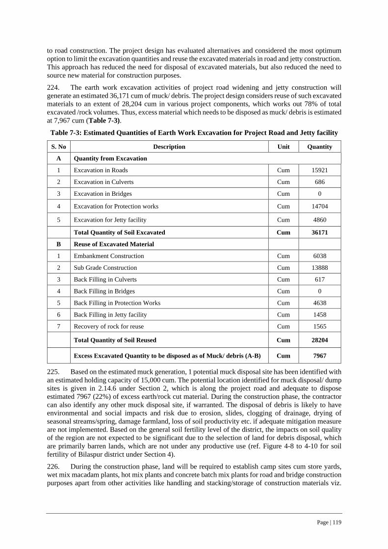
Page | 119
to road construction. The project design has evaluated alternatives and considered the most optimum option to limit the excavation quantities and reuse the excavated materials in road and jetty construction. This approach has reduced the need for disposal of excavated materials, but also reduced the need to source new material for construction purposes.
224. The earth work excavation activities of project road widening and jetty construction will generate an estimated 36,171 cum of muck/ debris. The project design considers reuse of such excavated materials to an extent of 28,204 cum in various project components, which works out 78% of total excavated /rock volumes. Thus, excess material which needs to be disposed as muck/ debris is estimated at 7,967 cum (Table 7-3).
Table 7-3: Estimated Quantities of Earth Work Excavation for Project Road and Jetty facility
S. No Description Unit Quantity
A Quantity from Excavation
1 Excavation in Roads Cum 15921
2 Excavation in Culverts Cum 686
3 Excavation in Bridges Cum 0
4 Excavation for Protection works Cum 14704
5 Excavation for Jetty facility Cum 4860
Total Quantity of Soil Excavated Cum 36171
B Reuse of Excavated Material
1 Embankment Construction Cum 6038
2 Sub Grade Construction Cum 13888
3 Back Filling in Culverts Cum 617
4 Back Filling in Bridges Cum 0
5 Back Filling in Protection Works Cum 4638
6 Back Filling in Jetty facility Cum 1458
7 Recovery of rock for reuse Cum 1565
Total Quantity of Soil Reused Cum 28204
Excess Excavated Quantity to be disposed as of Muck/ debris (A-B) Cum 7967
225. Based on the estimated muck generation, 1 potential muck disposal site has been identified with an estimated holding capacity of 15,000 cum. The potential location identified for muck disposal/ dump sites is given in 2.14.6 under Section 2, which is along the project road and adequate to dispose estimated 7967 (22%) of excess earth/rock cut material. During the construction phase, the contractor can also identify any other muck disposal site, if warranted. The disposal of debris is likely to have environmental and social impacts and risk due to erosion, slides, clogging of drainage, drying of seasonal streams/spring, damage farmland, loss of soil productivity etc. if adequate mitigation measure are not implemented. Based on the general soil fertility level of the district, the impacts on soil quality of the region are not expected to be significant due to the selection of land for debris disposal, which are primarily barren lands, which are not under any productive use (ref. Figure 4-8 to 4-10 for soil fertility of Bilaspur district under Section 4).
226. During the construction phase, land will be required to establish camp sites cum store yards, wet mix macadam plants, hot mix plants and concrete batch mix plants for road and bridge construction purposes apart from other activities like handling and stacking/storage of construction materials viz.
Page | 120
cement, sand, stone aggregates, storing excavated topsoil and other construction materials as may be required. In addition, land will also be required to establish workforce camps, if warranted.
227. Considering that the project road will be implemented under 1 contract package, the estimated land requirement for establishing camp site will be 0.5 hectares. It may be possible that the contractor may choose to establish more than 1 camp site per package depending upon land availability. The impacts on this land used for establishing camp sites will be limited to the construction phase and impacts arising due to such change in land use will for limited period (construction phase) will not be significant and transitory in nature, provided the sites are managed and restored to its previous state, after the project completion.
Mitigation Measures
228. The mitigation measures for the muck disposal are summarized hereunder:
229. Prior to undertaking any site clearance and/or excavation activities, particularly clearance/ excavation operations in any segment/operational stretch, the contractor shall prepare a work plan, detailing the type and numbers of equipment required, estimated volume of material to be cut or excavated, details of approved muck disposal sites, arrangements made for transport of excavated material to the approved disposal sites, dust suppression measures at excavation site and along transportation routes, method of stacking and/or handling the excavated material at the disposal site including rehabilitation plan of the disposal site, health and safety measures and emergency response plan for the entire operation shall be prepared in advance.
230. The criteria for selection of muck disposal site(s) and the content of a Muck Disposal Plan for typical site is given under Sl. No. 20 of Table 4-1, Section 4 of ESMP Volume. The requirement to have an approved Muck Disposal Plan will be mandatory part of contractor’s ESMP(C-ESMP).
231. The construction debris from all operational areas shall be regularly scavenged and disposed off at identified disposal sites or those approved by District administration.
232. The CSC prior to approving contractor’s civil work plan, shall ascertain preparation and inclusion of Muck Disposal Plan as one of main activity preceding site clearance and excavation activities.
233. The contractor shall prepare and get the Muck Disposal Plan approved by the CSC and shall strictly adhere to same. The Muck Disposal Plan shall ensure following:
i. The muck disposal plan shall indicate boundary limits and existing environmental settings, but not limited to topography, drainage, water bodies, settlements, trees, haul road etc. in and around the identified muck disposal sites.
ii. No muck disposal site shall be located in forest area or areas which are within 500 meters of any forest areas.
iii. The muck disposal plan shall consider and addressed factors relating slope stability of the muck heaps and shall not alter the surrounding natural drainage, obstruct or alter waterways in and around muck disposal sites and shall not cause safety hazard, environmental and social risks/ impacts.
iv. The gabion walls of adequate length and height (as per specific site requirement) shall be used to retain the dump muck and shall not lead to stability or erosion issues.
v. All the muck disposal sites shall be treated with nature based bioengineering solutions, so as to have a vegetative/ green cover over the entire muck disposal area as part of the muck disposal site closure plan. The ESMP include provision for bio-engineering solutions at all muck disposal sites (ref. Section 8 of ESMP Volume).
234. The criteria for selection of land to establish campsites and workforce camps is given under 7.5 of this Section and Sl. No. 19 & 20, Table 4.1, Section 4 of ESMP volume and summarized hereunder:

Page | 121
• Preference for Government owned waste/barren land for establishing construction camps, material stack yards and/or work force camps, hot mix plants, concrete batch plants, construction vehicle parking areas, to extent possible. One such location exists at Ch 1+050 along project road, to an extent of 2.5 ha, which was earlier used as a camp site by a National Highway construction contractor and lying vacant at present and can be readily used to and avoid opening up new areas, thereby minimize impacts.
• Strict avoidance of agricultural land or grazing land /community lands for any borrowing of good earth requirements of road construction work.
7.3.4 Water Resources
Impacts
235. The project road design considers construction of 1 new box culvert, reconstruction of 3 box culverts and widening of 2 slab culverts are considered, while retaining 1 existing box culvert at Ch. 2+710. The schedule of CD structures along the project road are given in Table 2-10 under Section 2. The project design also considers construction of 2570 meters of rectangular and ‘V’ shaped longitudinal drains (ref. Table 2-11) along the road which will be connected to the nearest culverts. (ref. Drainage maps under Appendix 1).
236. In addition, a Jetty facility will be constructed along the waterfront of the Gobind Sagar Lake/ River Sutlej near Luhnu Stadium Bilaspur.
237. All the rivulets/streams flowing across project road are seasonal and carry the discharge only during monsoon months (June-October) and remain dry during the other months of the year (ref. 2.9 under Section 2 and 4.3.4 under Section 4). The construction of CD structures is unlikely to alter the existing flow regime of these seasonal rivulets/streams across the project road. On the contrary, new or reconstructed CD structure is expected to ease the flow of water during rainy season and enable to avoid flash floods on downstream side even during heavy rainfall months or years. However, certain mitigation measures while working near CD structures along project road will be required to minimize the likely construction impacts on water resources.
Mitigation Measures during Construction of CD structures
238. The mitigation measures to be adopted while working near water bodies/ CD structures along project road are:
• Schedule all construction activities to dry or non-monsoon seasons, particularly excavation works and casting of concrete structures/works
• Identify, minimize, demarcate and barricade the areas for construction activities
• The water way/ streams shall not be unwarrantedly constricted or kept to minimum during construction phase, to facilitate flow of water due to unseasonal rains.
• All construction works specially foundation works of stream/ channel bed and bank protection works shall be scheduled for non-monsoon months and swiftly complete the work prior to onset of monsoon.
• Cordon-off and regulate the entry and exit points for workforce /construction labour for work sites. No workforce shall enter the waterfront/waterway/ stream bed unless it is warranted for construction works
• No construction related establishments like concrete batching plants, labour/workforce camps/material stack yards parking and vehicle servicing areas shall be established within 500 meters of the waterfront/waterway/ streams.
• All construction related establishments shall have adequate drainage facilities and potential contaminant areas shall have covered roofs and/or provided with segregated drainage systems, which shall have pre-treatment units like oil/grease separator, settling tanks, prior to its

Page | 122
discharge. No untreated waste shall be disposed-off into any natural water streams /channels under any circumstances
• All construction and operational areas including waterfront/waterway/ stream beds shall be scavenged for clearing of any material spills on a daily basis and also mandatorily, prior to monsoon and after the completion of work. All construction sites near waterfront/waterway/ streams shall be maintained in a clean and tidy at all times during construction phase and completely cleared off, prior to monsoon.
• All hazardous waste materials from operational and vehicle servicing areas shall be collected, stored under roof areas and safely disposed-off as per state pollution control broad norms
• All the workforce at construction related establishment sites shall be provided with adequate water, sanitation facilities to ensure no untreated sullage/ sanitation waste enters stream or water ways.
• The worksites, specifically near the waterfront/waterway/ streams shall have provision for mobile toilets of at least one mobile toilet of 2-seater capacity (1 men and 1 woman with separate entrances) is stationed at a suitable place, within 100 meters from each operational area. The mobile toilet shall have at least 1000 liters overhead water storage, well always maintained and in usable condition. Bottom tanks of mobile toilets shall be regularly cleaned, and overhead tank replenished as per requirement.
• Work force shall be oriented to use mobile toilets and avoid using nearby open places/waterfront.
• Every operational area shall be provided with one mobile drinking water kiosk having a storage of 300 liters and placed at a suitable place within 100 meters from work site
• All workforce deployed near waterfront/waterway/ streams shall be adequately oriented during induction and thereafter at daily briefing/toolbox talks about safety procedures and environmental requirements particularly when working near waterfront/waterway/ streams and provided with appropriate safety gear including retro-reflective jackets at worksite
• Ensure no waste of any form is dumped or construction material or waste/debris spills into waterfront/waterway/ streams during the entire construction works. All such waste materials/spills during construction shall be immediately cleared off to ensure no impacts on water quality.
• After the completion of the construction works, the cross-drainage construction site including upstream and downstream up to 100 meters shall be checked for remnant of construction debris/spills and same shall be and cleared off.
• All upstream and downstream sides of culverts/bridge sites are to be cleared off from the construction debris and bed profile shall not be altered, under any circumstances and/ or to be restored to match the original profile.
• Project designs include provision for construction of RCC/ stone boulder aprons on the upstream side along with steps with guiding walls and RCC/ stone boulder aprons on downstream side to channelize the water and dissipate energy to control the erosion and subsequently reduce floods on downstream areas. The engineering design drawings for CD structures at all locations along project road has included such required protection measures (ref. Appendix-13 for Typical details of such measures).
• In addition, nature-based solutions/measures (bioengineering) are also considered at selected locations to minimize the erosion and improve the slope stability as well as aesthetics. Adequate budget provisions have been included in the ESMP for undertaking bio-engineering interventions (ref. Section 8 of ESMP Volume).
• Renovation of 1 natural water source has been considered as natural resource conservation and/or enhancement measure (ref. 4.6.2 of Section 4-Baseline Data). The Conservation and
Page | 123
Enhancement Plans/Drawings of such natural water sources are included under Section 3 & 8 of ESMP Volume.
Mitigation Measures specific to Jetty Facility Construction
239. The construction of the Jetty facility along the waterfront of the Gobind Sagar Lake/ River Sutlej near Luhnu Stadium Bilaspur, scheduled for non-monsoon months will not impact or alter the flow regime of Sutlej River or the waterfront of Gobind Sagar Lake. However, certain mitigation measures, (similar to that of working near CD structures) have to be followed to minimize the likely construction impacts on water resources and the associated aquatic system as hereunder:
• Schedule all construction activities at/along waterfront areas to dry or non-monsoon seasons, particularly excavation works and casting of concrete structures/works and complete the works prior to onset of monsoon
• Identify, minimize, and demarcate the areas earmarked for construction activities with barricades
• Construction of coffer dams and/or diversion of waterway within the river/ waterfront area/ stream channel bed shall be kept to the minimum, so as not to alter the flow regime or adversely constrict the waterway
• All construction works specially foundation construction works at riverbed/ waterfront area/ shall be scheduled for non-monsoon months and swiftly complete the work prior to on-set of monsoon.
• Cordon-off and regulate the entry and exit points for workforce /construction labour for work sites near river/ waterfront area. No workforce shall enter the waterfront/waterway/ stream bed unless it is warranted for construction works and same shall have prior authorized permission
• No construction related establishments like concrete batching plants, labour/workforce camps/material stack yards parking and vehicle servicing areas shall be established within 500 meters of the waterfront/waterway/ streams.
• All construction related establishments shall have adequate drainage facilities and potential contaminant areas shall have covered roofs and/or provided with segregated drainage systems, which shall have pre-treatment units like oil/grease separator, settling tanks, prior to its discharge. No untreated waste shall be disposed-off into any natural water streams /channels under any circumstances
• All construction and operational areas including waterfront/waterway/ stream beds shall be scavenged for clearing of any material spills on a daily basis and also mandatorily, prior to monsoon and after the completion of work. All construction sites near waterfront/waterway/ streams shall be maintained in a clean and tidy at all times during construction phase and completely cleared off, prior to monsoon.
• All hazardous waste materials from operational and vehicle servicing areas shall be collected, stored under roof areas and safely disposed-off as per state pollution control broad norms
• All the workforce at construction related establishment sites shall be provided with adequate water, sanitation facilities.
• The worksites, specifically near the waterfront/waterway shall have provision for mobile toilets of at least one mobile toilet of 2-seater capacity (1 men and 1 woman with separate entrances) is stationed at a suitable place, within 100 meters from each operational area. The mobile toilet shall have at least 1000 liters overhead water storage, well always maintained and in usable condition. Bottom tanks of mobile toilets shall be regularly cleaned, and overhead tank replenished as per requirement.
• Work force shall be oriented to use mobile toilets and avoid using nearby open places/waterfront.
• Every operational area shall be provided with one mobile drinking water kiosk having a storage of 300 liters and placed at a suitable place within 100 meters from work site

Page | 124
• All workforce deployed near waterfront/waterway/ streams shall be adequately oriented during induction and thereafter at daily briefing/toolbox talks about safety procedures and environmental requirements particularly when working near waterfront/waterway/ streams and provided with appropriate safety gear including retro-reflective jackets at worksite
• Worksites near the waterfront/waterway/ streams shall have provision for lifesaving jackets and ropes (at least 2 sets each) placed at an easily accessible location(s) near waterfront for rescue operations, in case of any accidental falls of workforce into water. The same shall be extended and maintained even for the operation phase of the passenger berths.
• Ensure no waste of any form is dumped or construction material or waste/debris spills into waterfront/waterway/ streams during the entire construction works. All such waste materials/spills during construction shall be immediately cleared off to ensure no impacts on water quality.
7.3.5 Surface and Ground Water Resources Depletion
Impacts
240. The estimated water requirement for the project road and jetty construction is 82.5 KLD (Table 7-4) during project period for civil works like construction of embankment, sub-grade, bituminous work, concrete, dust suppression and daily consumptive use at work force camp, site offices, among others.
Table 7-4: Estimated Construction Water Requirement
S. No. Activity Unit
Quantity in litres required/meter length of road
Estimated Water Requirement (in KLD)
A Project Road Construction
1 Road/Embankment Litres/metre 500 13
2 Subgrade/WBM Litres/metre 250 6
3 Construction of CD Structures Litres/metre 375 1
B Jetty Facility Construction
1 Construction of Jetty facility Litres/metre 375 10
C Dust Suppression, Work Force Camp, Camp Site requirements
1 Dust Suppression and camp site management Litres/metre 250 6
2 On site sanitation & Drinking water per day 5000 15
3 Camp Site Water Requirement Litres 1000 3
4 Plantation of saplings/trees Litres 5400000 12
Total Water Requirement 66
Add 5% for wastage and 20% for Contingency 16.5
Water Requirement for entire Construction period over 12 months 82.5
Page | 125
241. The project road corridor and the PIA has no surface water bodies18, which can be tapped for meeting the construction water demand and thus ground water is the only dependable resource for meeting the construction water demand. The ground water utilization within Bilaspur District is less than 20% and none of the areas within Bilaspur district has been notified as over exploited /critical by CGWA/State Ground water authorities, construction water can be met though existing or new tube wells in and around project/area with prior permission from competent authorities (ref. 4.3.2 under Section 4). However, tapping of ground water sources (existing or new tube wells) for construction purposes will require prior permission from State Ground water Authority /Irrigation and Public Health department (IPH) for road and jetty construction purposes, as per present regulations.
Mitigation Measures
242. The impacts arising due to sourcing of construction water can be minimized through the following mitigation measures.
• Contractor can explore suitable locations for installing tube wells for meeting the construction water demand abstracting water (ref. 4.4.9 under Section 4 for water quality of sources along project road/ region). However, any such tube wells should be installed only after obtaining permission from competent/ designated State Govt. departments or Irrigation and Public Health Department, GoHP. At present, one such location exists at Ch 1+050 along the project road, to an extent of 2.5 ha, which has two tube wells and was earlier used as a camp site by a National Highway construction contractor and lying vacant at present and can be readily used to and avoid opening up new tube wells for meeting water demand and thereby minimize associated impacts.
• Identify freshwater seepage springs along hill sides, where temporary storage tanks can be constructed to harvest the water for meeting construction demand. However, prior permission from Irrigation and Public Health Department, GoHP shall be taken prior to tapping such natural resources. In no case, seepage springs used by communities/ road users should be strictly avoided for meeting the construction water demand.
• During the pre-Construction stage, contractor can identify local depressions along the alignment in consultation with the local panchayat to be developed as water storage areas, if found suitable/feasible. Such developed water storage areas during construction phase can be handed over to the local Panchayat after the complete of the construction works.
• The water usage pattern within the construction camps can be minimized by adopting following best practices:
i. Use buckets for washing purposes instead of using running water.
ii. Use of auto shut off taps (without sensors) in labor accommodation. iii. Install water meters with main supply pipes/water tanks/bore well to assess quantity
of consumed water, supplement with periodic audit of water abstraction and use. iv. Surveillance for plugging/rectification of leakages and /or overflows.
7.3.6 Surface & Ground Water Pollution
Impacts
243. The camp site office(s) and workforce camp(s) established for the project road and jetty construction will generate sewage and sullage/ sanitary wastes. The estimated sanitary waste generation at camps site offices and work force camps is given in Table 7-5. The sanitary waste needs to be treated
18 Withdrawal of water from Gobind Sagar Lake and River Sutlej for meeting the construction demand will not be permitted.

Page | 126
through septic tank and soak pit disposal arrangements in order to prevent potential surface and/or ground water pollution and soil contamination.
Table 7-5: Estimated Sanitary waste/ Sullage during Construction Phase
Workers Category Raghunathpura-Mandi-Harpura-Bharari
Nos LPD Quantity
Quantity of Sewage generation @ 80% of water consumption
Supervisory staff 23 45 1035 828
Non- local /Migrant labor at camp sites 31 90 2790 2232
Total (LPD) 3060
Mitigation Measures
244. Key avoidance and mitigation measures, which can prevent to avoid surface and/or ground water pollution include:
• All toilets and wash areas within the camp site and work force camps shall be provided with septic tanks and soak pit arrangements of adequate capacity. No wastewater from the camp/work force site shall be discharged directly into any surface water channels or drain, without any treatment, which eventually join surface water bodies.
• Typically, septic tanks each 5m length, 2m breadth and 1.5 m clear depth with 0.3 free board with soak pit arrangement, can serve up to 50 users at peak level as per CPWD specifications.
• The number of septic tanks required at the workforce camps and camp sites can be determined depending upon the number of locations of camp office sites and workforce camps and the number of users at each such locations.
• CPHEEO, Ministry of Housing and Urban Affairs, GoI recommended sizes of septic tank upto 300 users (as per BIS 2470 part I) are given in Table 7-6. Typical details of septic tanks and soak pit disposal arrangement for 50 users in given in Figure 7-1 & 7-2.
• The oil/lube storage shall be under roofed areas with impermeable cement concrete surfaces and provided with separate drainage system with provision for oil separators. No discharge from oil/lube storage areas shall be directly discharged into any open surface water channel/ streams.
• Oil interceptors shall be provided at vehicle service/ repairing area and oil/lube/fuel storage area with separate drainage system as shown in Figure 7-3.
Table 7-6: CPHEEO Recommended Sizes of Septic Tank up to 300 users
No. of Users Length (m) Breadth (m) Liquid depth (m) (cleaning interval of)
2 years 3 years 5 1.5 0.75 1.0 1.05
10 2.0 0.90 1.0 1.40 15 2.0 0.90 1.3 2.00 20 2.3 1.10 1.3 1.80 50 5.0 2.00 1.0 1.24
100 7.5 2.65 1.0 1.24 150 10.0 3.00 1.0 1.24 200 12.0 3.30 1.0 1.24 300 15.0 4.00 1.0 1.24
Source: CPHEEO, Ministry of Housing and Urban Affairs, GoI

Page | 127
Notes:
1. The capacities are recommended on the assumption that discharge from only WC will be treated in the septic tank.
2. A provision of 300mm should be made for free broad. 3. The sizes of septic tank are based on certain assumption on peak discharges, as estimated in IS:2470 (part
1) and while choosing the size of septic tank exact calculations shall be made. 4. For users over 100, the tank may be divided into independent parallel chambers of maintenance and cleaning.
Figure 7-1: Typical Details of Septic Tank Arrangement
Figure 7-2: Typical Soak Pit Disposal Arrangement

Page | 128
Figure 7-3: Typical Details of Oil Interceptor/ Separator at vehicle service/ Lube storage area
7.3.7 Air Quality
Impacts
245. The baseline ambient air quality for all monitored parameters (PM10, PM2.5, SO2, NO2, HC, CO) along project road and at jetty facility location (Table 4-9 under Section 4) were below the NAAQS, which can be attributed to present low vehicular traffic and absence of industrial emission sources along project road/area.
246. Road and jetty construction activities can contribute to increased dust levels due to activities like site clearance/preparation, excavation, hill cutting, material loading, unloading and transportation movement of construction vehicles/ equipment among others.
247. Gaseous emission during construction activities can be due to road and jetty construction machinery, equipment and plants like concrete batching plant, hot mix plant and wet mix macadam plant. The operation of vehicles, equipment and plant will result in emissions of carbon monoxide, sulphur dioxide, and oxides of nitrogen. Generally, additional vehicle movements generated during the construction phase will have the potential to influence local air quality particularly near sensitive receptors located at close proximity to road. Pollutant concentration is likely to reduce with increased distance from road.
248. Air quality modeling19 was carried out to determine the concentrations of PM10, PM2.5, NOx, SOx, CO on 500 meters20 either side, all along the project road at present/ base year (Year 2020-21), construction phase (2022-23), operation phase (2030 i.e., mid operational year) and ultimate design year of the road i.e., 2038 using AERMOD ViewTM. Since, the project road does not have any sensitive receptor locations like school, and hospitals, prediction of air quality specifically at such locations was not warranted (ref. Section
19 Air quality modelling was carried out only for project road, which will have linear source of emissions throughout its life cycle/ design period. 20 To match with core impact zone covered for the bio-diversity management study report (ref. Appendix-11)

Page | 129
4.4.8 & 4.6.2 – Baseline Data). The air quality modelling report is given in Appendix-16 and the modelling results are summarized hereunder.
249. The emission rates used for air quality modelling using the IVE model (International Vehicle Emission) are given in Table 7-7. The maximum predicted GLCs along the project road for present/ base year (Year 2020-21), construction phase (2022-23) and operation phase (2030 and 2038) are given in Table 7-8. The predicted GLCs at baseline ambient air quality monitored locations along project road (within 500-meter area shown in circles to match with the core-impact area of bio-diversity management study) are given in Table 7-9. The Isopleths of predicted ambient air quality parameters for selected scenarios are given in Figures 7-4 to 7-9 and Appendix-16 for complete modelling report. It may be seen from Table 7-8 & 7-9 that the predicted concentrations for all parameters were found to be below the NAAQ standards at all locations.
Table 7-7: Emissions Rates Used for Air Quality Modelling
Ambient AQ Parameters PM NOx SO2 CO
g/km g/s g/km g/s g/km g/s g/km g/s
Base Year - 2020 3.800 0.210 14.762 0.082 0.535 0.003 141.781 0.788
Construction Phase - 2023 7.965 0.038 29.297 0.138 1.084 0.005 298.310 1.409
Operational Phase – 2030 8.985 0.087 40.626 0.395 1.386 0.013 331.047 3.219
Ultimate Design Year (2038) 14.315 0.139 54.619 0.531 2.207 0.021 525.664 5.111
Table 7-8: Maximum Predicted GLCs of Air Quality Modelling (µg/m3)
Ambient AQ Parameters
Base Year - 2020 Construction Phase - 2023
Operational Phase - 2030
Design Year (2038)
PM (24 hr average) 6.35 11.81 10.3 17.4 NOx (24 hr average) 25.5 43.0 59.1 66.7 SOx (24 hr average) 0.91 1.55 1.87 2.80 CO (8 hr average) 441 789 657 1155
Table 7-9: Predicted GLCs at Baseline Ambient Air Quality Monitored Locations (µg/m3)
Baseline Monitoring Location along Project Road at Bharari Village (AQ-01)
Ambient AQ Parameters
Baseline Monitored
Levels
Base Year - 2020 Construction Phase - 2023
Operational Phase - 2030 Design Year (2038) NAAQs
GLC Total GLC Total GLC Total GLC Total
PM (24 hr average) 65.00 2.17 67.17 3.64 68.64 3.16 68.16 5.36 70.36 100
NOx (24 hr average) 26.00 7.84 33.84 13.24 39.24 18.18 44.18 20.53 46.53 80
SOx (24 hr average) 12.00 0.31 12.31 0.48 12.48 0.57 12.57 0.86 12.86 80
CO (8 hr average) 0.27 112.00 112.27 241.42 241.69 167.56 167.83 294.59 294.86 2000
Note: All figures are in µg/m3 *NAAQS – National Ambient Air Quality Standards, 2009
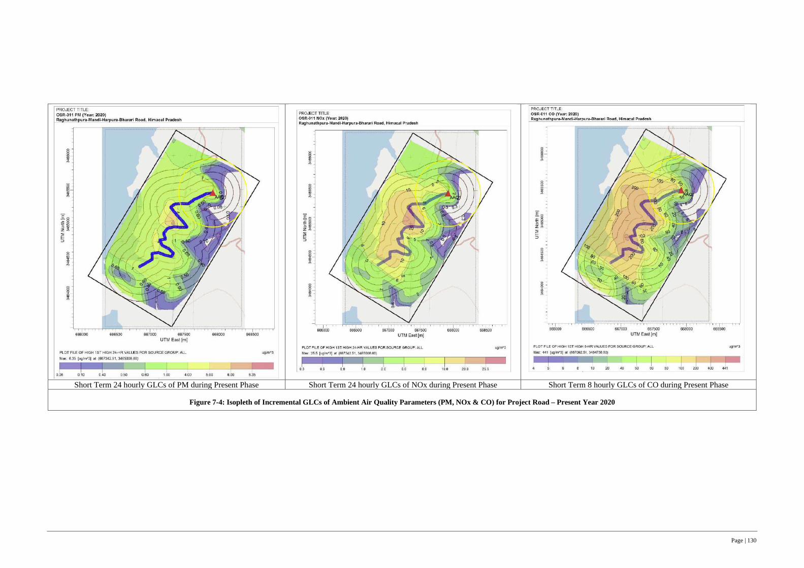
Page | 130
Short Term 24 hourly GLCs of PM during Present Phase Short Term 24 hourly GLCs of NOx during Present Phase Short Term 8 hourly GLCs of CO during Present Phase
Figure 7-4: Isopleth of Incremental GLCs of Ambient Air Quality Parameters (PM, NOx & CO) for Project Road – Present Year 2020

Page | 131
Short Term 24 hourly GLCs of PM during Construction Phase Short Term 24 hourly GLCs of NOx during Construction Phase Short Term 8 hourly GLCs of CO during Construction Phase
Figure 7-5: Isopleth of Incremental GLCs of Ambient Air Quality Parameters (PM, NOx & CO) for Project Road – Construction Year 2023

Page | 132
Short Term 24 hourly GLCs of PM during Operational Phase Short Term 24 hourly GLCs of NOx during Operational Phase Short Term 8 hourly GLCs of CO during Operational Phase
Figure 7-6: Isopleth of Incremental GLCs of Ambient Air Quality Parameters (PM, NOx & CO) for Project Road – Operational Year 2030

Page | 133
PM GLC during Present Phase NOx GLC during Present Phase
SOx GLC during Present Phase CO GLC during Present Phase
Figure 7-7: Isopleth of Incremental GLCs of Ambient Air Quality Parameters (PM, NOx, SOx & CO) at Baseline AQ Monitored Locations along Project Road – Present Year 2020

Page | 134
PM GLC during construction Phase NOx GLC during construction Phase
SOx GLC during construction Phase CO GLC during construction Phase
Figure 7-8: Isopleth of Incremental GLCs of Ambient Air Quality Parameters (PM, NOx, SOx & CO) at Baseline AQ Monitored Locations along Project Road – Construction Year 2023

Page | 135
PM GLC during operational phase NOx during operational phase
SOx during operational phase CO GLC during operational phase
Figure 7-9: Isopleth of Incremental GLCs of Ambient Air Quality Parameters (PM, NOx, SOx & CO) at Baseline AQ Monitored Locations at Associated Facilities along Project Road – Operational Year 2030
Page | 136
Mitigation Measures
250. Although, the combined values of baseline monitored levels and predicted GLCs of the ambient air quality parameters for base year (2020), construction phase (2023), and operational phase (2030 & 2038 i.e., beyond construction phase) is well below NAAQs (ref. Table 7-7 to 7-9 and Figure 7-4 to 7-9) at all predicted locations. Ensuring some of the following measures will enable to sustain and further improve the ambient air quality along the project road. Among the air quality parameters, dust levels in terms of particulate matter PM 2.5 and PM 10, and NOx parameter is a matter of concern both in short and long term.
251. Among the air pollutants, dust levels in terms of particulate matter PM 2.5 and PM 10, is the most significant for concern, which can be controlled through dust suppression measures like regular water sprinkling at operational areas. Furthermore, in order to control fugitive vehicular emissions, the following measures are to be strictly adhered to:
• All vehicles shall mandatorily have valid Pollution Control Certificates.
• The contractor shall do vehicle fitness test through competent authorities and vehicles with valid fitness certificate shall be deployed.
• All vehicles and equipment used during construction should be well maintained, efficient vehicles, having a lower unit emission ratio and higher payload shall be deployed.
• The pollution control equipment in hot-mix plant shall be kept in working condition at all times. The plant shall not be operated, if the pollution control equipment is not functional.
• The contractor shall provide wind barrier at perimeter of all plant sites to arrest or blowing of suspended particle depending on most prevailing wind direction and presence of sensitive receptors at downwind side of material stack yard.
• The contractor shall obtain and submit to CSC, all requisite permits (CTO and CTE) from the HPSPCB for operation of the hot mix Plant, stone crushing operations, batching plants and captive quarry operations and comply with all conditions stipulated in the CTO and CTE.
• Improved road conditions, after the completion of the project road widening is expected to improve average speed and congestion free traffic movement which in turn will reduce emissions and will not cause any significant increase in concentration of PM and CO during operation phase. Thus, the road shall be well maintained through periodic maintenance contract to ensure the pavement is in good condition and riding quality which can contribute to reduced GHG emissions during operation phase of project road.
7.3.8 GHG Emissions Estimate
252. The project road widening with improved geometrics and improved/good pavement surfaces/riding quality will contribute to reduced GHG emissions during operation phase of project road (ref. 2.5 under Section 2 for traffic projection). The estimated reduction in GHG emissions in case of project road widening scenario is summarized as hereunder.
253. The GHG emissions per year, at the present traffic, road geometry and pavement conditions are computed using the International Vehicle Emission (IVE) modelling and estimated at 1532.186 tons of carbon dioxide equivalents (CO2) (which includes N2O as well as CH4.). The GHG estimates, in case of widened/improved project road scenario at present traffic levels (as of 2019) is 898.130 tons of CO2, (which includes N2O as well as CH4.) Therefore, if the project road, at present traffic levels and improved/widened project road scenario could reduce GHG emissions by 538.872 tons of CO2 equivalent as given in Table 7.10.

Page | 137
Table 7-10: GHG Emissions at Present Traffic Levels - Existing and Improved Road Conditions (As of 2019-20)
Existing project road at Present Traffic levels (2019) Widened Project at Present Traffic levels scenario (2019) Change in emission
Type of vehicle CO2 N2O CH4 CO2 N2O CH4 Δ CO2 Δ N2O Δ CH4
Two wheelers 161.39 0.0000128 3.01 92.27 0 1.733057 -69.12 -0.0000128 -1.276943
Three wheelers 172.38 0.0036848 0.1 98.49 0.00196 0.077 -73.89 -0.0017248 -0.023
LMV (4 Wheelers) 845.74 0.0123683 0.01 483.41 0.007092 0.005133 -362.33 -0.005276344 -0.004867
Bus 214.03 0.0171591 0 122.35 0.009836 0 -91.68 -0.007323143 0
Heavy truck 39.81 0.0043116 0 39.66 0.004242 0 -0.15 -0.0000696 0
Light truck 6.4 0.0000012 0.13 6.4 0 0.131133 0 -0.0000012 0.001133
Total emission 1439.75 0.0375379 3.25 842.58 0.02313 1.946323 -597.17 -0.014407898 -1.303677
Total emissions (in terms of Co2 Equivalent)
1439.75 11.18629 81.25 842.58 6.89274 48.658075 -597.17 -4.2935536 32.591925
1532.186 898.1308 -568.872
Note: - N2O and CH4 is converted into Co2 Equivalent using 298 kg and 25 kg as multiplication factor respectively.
254. The GHG emissions of the project road has been estimated using ROADEO and IVE (International Vehicle Emission) models for the projected traffic levels over the life cycle of project road (up to year 2038) with improved geometrics and pavement surface for two scenarios i.e. (i) Present Project Road without any improvement/upgradation and (ii) Widened Project Road with improved pavement conditions due to upgradation. The estimated GHG emissions for both the scenarios are given in Table 7.11.
255. The GHG estimations show an increasing trend for both scenarios up to year 2038 for all the GHG constituent gases. However, the GHG estimations for improved road conditions (Columns 5,6,7 of Table 7-11) are lesser than the project road without any improvement/ upgradation (Column 2,3, 4 of Table 7-11). The difference between these two scenarios is the net reduction in GHG emissions likely to accrue due to improved road conditions as reflected in Columns 8, 9 and 10 of Table 7-11. Thus, the estimated net reduction in GHG emissions over the project lifecycle (up to year 2038) is 27634 metric tonnes in CO2 equivalent using the applicable conversion factors for N2O and CH4 (ref. Table 7-11).
Table 7-11: GHG Emission Projections with Present and Improved Project Road Scenarios
Year
Present Road with Projected Traffic Growth but without widening/ improvement of
pavement conditions
Widened/Improved Pavement Conditions of Project Road with Projected Traffic Growth during
Operation Phase
Change in GHG Emissions
CO2 N2O CH4 CO2 N2O CH4 Δ CO2 Δ N2O Δ CH4 (1) (2) (3) (4) (5) (6) (7) (8) (9) (10)
2020 1490 0.038 2.725
Construction Stage Construction Stage 2021 1727 0.046 2.791
2022 1836 0.050 1.786
2023 2111 0.056 3.415
2024 2354 0.063 3.800 1408.530 0.040 2.188 -945.208 -0.023 -1.612
2025 2556 0.069 4.134 1528.737 0.042 2.382 -1027.103 -0.026 -1.753
2026 2793 0.074 4.513 1671.624 0.047 2.599 -1121.820 -0.027 -1.914
2027 3045 0.081 4.928 1820.894 0.051 2.838 -1223.684 -0.030 -2.090
2028 3340 0.089 5.398 1997.769 0.056 3.109 -1342.096 -0.033 -2.289

Page | 138
Year
Present Road with Projected Traffic Growth but without widening/ improvement of
pavement conditions
Widened/Improved Pavement Conditions of Project Road with Projected Traffic Growth during
Operation Phase
Change in GHG Emissions
CO2 N2O CH4 CO2 N2O CH4 Δ CO2 Δ N2O Δ CH4 (1) (2) (3) (4) (5) (6) (7) (8) (9) (10)
2029 3593 0.096 5.810 2150.346 0.061 3.345 -1442.998 -0.036 -2.464
2030 3880 0.104 6.269 2321.929 0.065 3.611 -1557.853 -0.039 -2.658
2031 4183 0.111 6.766 2502.507 0.070 3.896 -1680.156 -0.041 -2.870
2032 4525 0.121 7.320 2707.478 0.076 4.214 -1817.978 -0.046 -3.105
2033 4838 0.126 7.882 2879.814 0.078 4.539 -1958.365 -0.048 -3.343
2034 5238 0.140 8.467 3134.127 0.088 4.876 -2103.510 -0.052 -3.591
2035 5622 0.151 9.090 3363.956 0.095 5.234 -2257.824 -0.056 -3.855
2036 6059 0.162 9.791 3625.516 0.102 5.638 -2433.633 -0.061 -4.153
2037 6488 0.174 10.488 3881.869 0.108 6.040 -2605.788 -0.066 -4.448
2038 6968 0.181 11.266 4169.224 0.116 6.487 -2798.939 -0.065 -4.779
Total 72647 1.935 116.639 39164.320 1.095 60.996 -26316.955 -0.650 -44.926
Total in Co2 Equivalents
72647 576.516 2915.981 39164.320 326.170 1524.91 -26316.955 193.732 -1123.155
76140 41015 -27634 Note: - N2O and CH4 is converted into Co2 Equivalent using 298 kg and 25 kg as multiplication factor respectively.
7.3.9 Noise and Vibration
Impacts - Noise
256. The principal source of noise during construction of project road would be from operation of equipment, machinery and vehicles deployed for construction activities, other than the regular traffic along the project road. (ref. 4.4.8 under Section 4, for baseline noise level along project road and jetty facility location). The project road and jetty facility does not have any sensitive receptor locations like school, and hospitals in its vicinity (ref. Section 4.4.8 & 4.6.2 – Baseline Data).
257. The earth moving machineries e.g., excavators, graders and vibratory rollers has potential to generate high noise levels of more than 70 dB (A) and can cause disturbance to the settlements, adjacent to the carriageway or within 100 m from the worksite. The noise levels of construction machinery typically used in road construction works and permissible noise exposure levels as per OSHA (Occupational Safety and Health Administration), USA is given in Tables 7-12 and 7-13.
Table 7-12: Typical Machinery for Project Road & Jetty Construction
Sl. No. Equipment Type and Capacity Noise Level
(dBA) Sl. No.
Equipment Type and Capacity
Noise Level (dBA)
1 Dozer 200 Cum/hr Cap. 85 13 Backhoe and Front-end loader 80-85
2 Motor Grader - output above 150 KW Cap. 85-94 14 Bulldozer 85
3 Long arm Hydraulic Excavator 85 15 Compactor 82
4 Vibratory Roller (2 Tandem + 1 Vibro) - Minimum 8-10T static Weight 94 16 Compressor 81
5 Pneumatic Road Roller (200-300KN Cap.) 85 17 Concrete Mixer 85
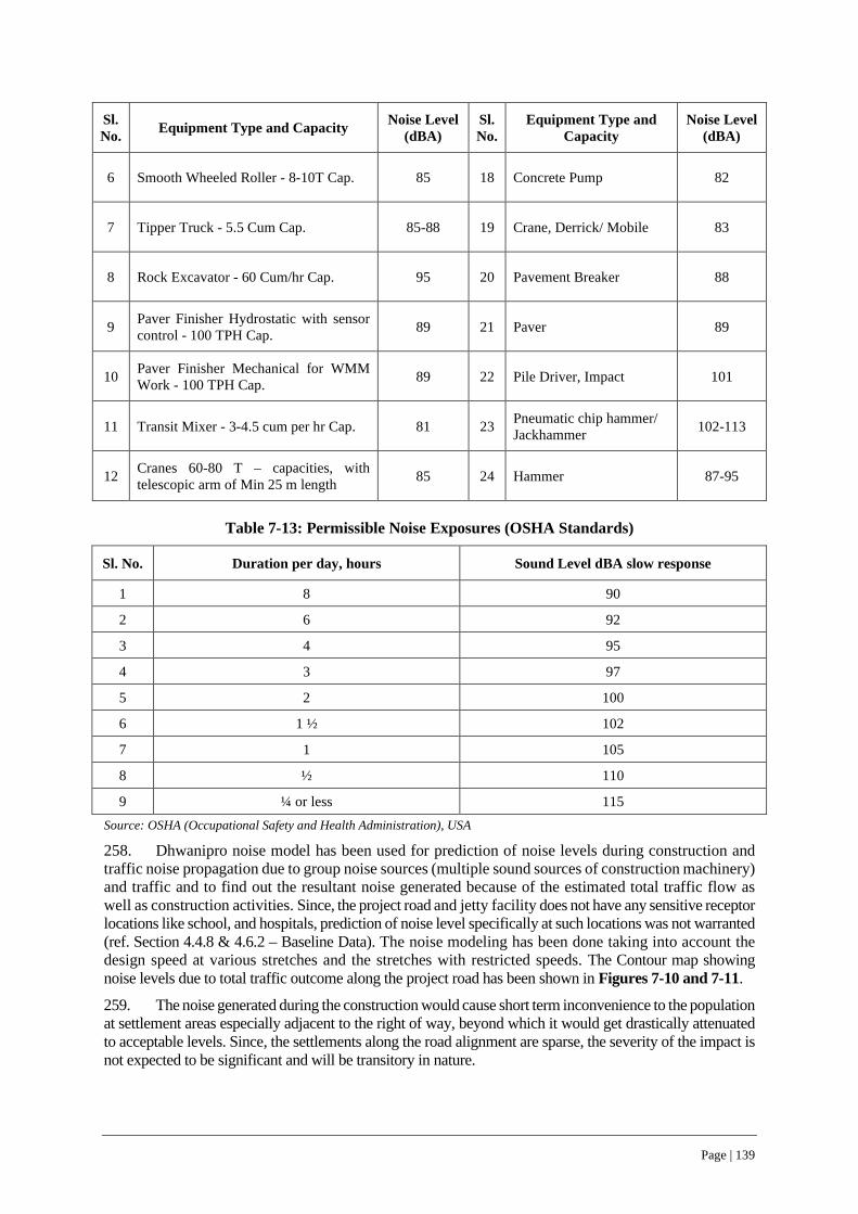
Page | 139
Sl. No. Equipment Type and Capacity Noise Level
(dBA) Sl. No.
Equipment Type and Capacity
Noise Level (dBA)
6 Smooth Wheeled Roller - 8-10T Cap. 85 18 Concrete Pump 82
7 Tipper Truck - 5.5 Cum Cap. 85-88 19 Crane, Derrick/ Mobile 83
8 Rock Excavator - 60 Cum/hr Cap. 95 20 Pavement Breaker 88
9 Paver Finisher Hydrostatic with sensor control - 100 TPH Cap. 89 21 Paver 89
10 Paver Finisher Mechanical for WMM Work - 100 TPH Cap. 89 22 Pile Driver, Impact 101
11 Transit Mixer - 3-4.5 cum per hr Cap. 81 23 Pneumatic chip hammer/ Jackhammer 102-113
12 Cranes 60-80 T – capacities, with telescopic arm of Min 25 m length 85 24 Hammer 87-95
Table 7-13: Permissible Noise Exposures (OSHA Standards)
Sl. No. Duration per day, hours Sound Level dBA slow response
1 8 90
2 6 92
3 4 95
4 3 97
5 2 100
6 1 ½ 102
7 1 105
8 ½ 110
9 ¼ or less 115 Source: OSHA (Occupational Safety and Health Administration), USA
258. Dhwanipro noise model has been used for prediction of noise levels during construction and traffic noise propagation due to group noise sources (multiple sound sources of construction machinery) and traffic and to find out the resultant noise generated because of the estimated total traffic flow as well as construction activities. Since, the project road and jetty facility does not have any sensitive receptor locations like school, and hospitals, prediction of noise level specifically at such locations was not warranted (ref. Section 4.4.8 & 4.6.2 – Baseline Data). The noise modeling has been done taking into account the design speed at various stretches and the stretches with restricted speeds. The Contour map showing noise levels due to total traffic outcome along the project road has been shown in Figures 7-10 and 7-11.
259. The noise generated during the construction would cause short term inconvenience to the population at settlement areas especially adjacent to the right of way, beyond which it would get drastically attenuated to acceptable levels. Since, the settlements along the road alignment are sparse, the severity of the impact is not expected to be significant and will be transitory in nature.
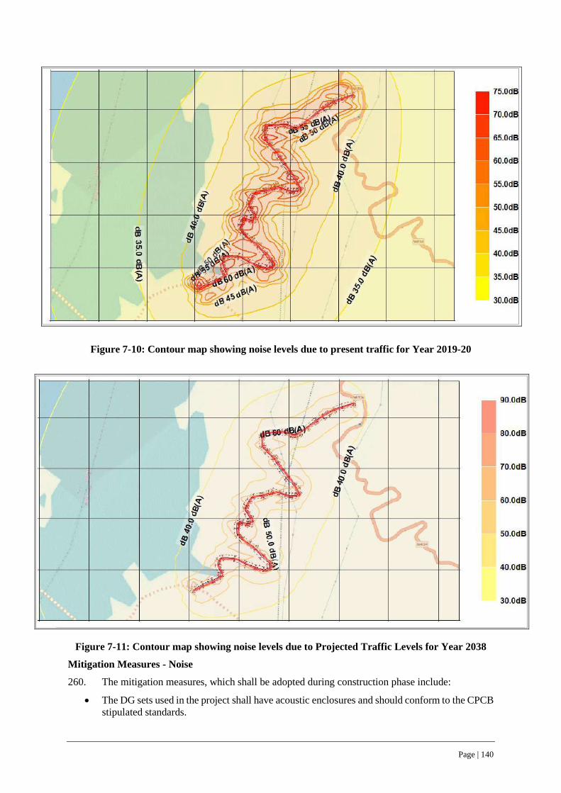
Page | 140
Figure 7-10: Contour map showing noise levels due to present traffic for Year 2019-20
Figure 7-11: Contour map showing noise levels due to Projected Traffic Levels for Year 2038
Mitigation Measures - Noise
260. The mitigation measures, which shall be adopted during construction phase include:
• The DG sets used in the project shall have acoustic enclosures and should conform to the CPCB stipulated standards.

Page | 141
• Regular maintenance of the machinery, equipment and vehicles shall be carried out to minimize the noise levels. All machinery, equipment and vehicles shall have a definite maintenance schedule and maintained by the contractor, accordingly.
• Nighttime construction activity shall be prohibited in case settlement/habitations are located within 500 m of the construction/operational site(s).
• In addition, a road safety awareness campaign including sensitization about traffic noise levels shall be conducted by CSC at all the schools located along project road. Such campaigns shall be conducted first prior to commencement of road construction works at such specific stretches and/or after the installation of proposed noise barriers, as the case may be.
• Along the settlement areas, the use of heavy construction machinery shall be regulated through slow pace of operations and ensure use of non – vibratory and small rollers to minimize noise levels as well as vibrations and to avoid cracks or damages to the kutcha or old structures, which are adjacent to RoW.
Impacts and Threshold Levels - Vibration
261. Vibration is an oscillatory motion21, which can be described in terms of the displacement, velocity or acceleration and measured in terms of peak particle velocities (PPVs) i.e. maximum speed of movement of a point in the ground during the passage of a vibration. Traffic-induced vibration is a low frequency disturbance, which can be transmitted through air or ground.
262. Vibrations arising from construction activities like earth work excavation, compaction, paving and movement of construction vehicles/machinery is generally ground-borne.
263. The vibration velocity levels in rural settlement areas or low-density settings like the project road is usually 50 VdB (vibration decibels) or even lower, which is well below the threshold of perception for humans, deemed to be around 65 VdB.
264. Typical outdoor sources of perceptible ground-borne vibrations like earth work excavation, compaction, paving and movement of construction vehicles/machinery, buses and trucks rarely create vibration that exceed 70 VdB, unless the riding surface/condition of pavement is very poor. If the pavement/road conditions are reasonably satisfactory, ground borne vibration from traffic is rarely perceptible.
265. Most perceptible indoor vibration due to ground-borne vibration include perceivable movement of the building floors, rattling of windows, shaking of items on shelves or hanging on walls, and rumbling sounds. Annoyance from vibration often occurs when the vibration exceeds the threshold of perception even by a small margin, although the vibration levels that cause annoyance will be well below the damage threshold for normal buildings.
Mitigation Measures - Vibration
266. The project road, even during the construction phase will be paved and maintained22 by the contractor to ensure smooth traffic movement and hence riding quality of pavement is expected to be satisfactory, thus not likely to contribute to ground borne vibration, beyond threshold levels.
267. The residual impacts of vibration during construction phase, although is short term in nature, is not likely to be significant and can be further controlled by measures like regulating construction activities to limited day hours, ensuring normal pace of construction activity with frequent breaks particularly in settlement areas. Such measures can reduce impacts of ground borne vibrations due to project road construction activities.
21 Source: Guidelines for Noise and Vibrations for Metro Rail Transit System by Research Designs and Standards Organization, Ministry of Railways, Government of India
22 Contractors will be obligated to maintain the present road even during the construction phase through periodic pavement renewals and ensure riding quality and smooth traffic movement for present road users
Page | 142
268. The project road during operation phase will have an improved pavement condition and smooth traffic movement, which considerably reduce ground borne vibration despite increased traffic movement during its design life over the years. Therefore, no specific mitigation measures are warranted during the operational phase, except for upkeep of pavement conditions and riding quality through routine maintenance.
7.3.10 Cumulative Impacts
Impacts
269. As part of ESIA, an attempt was made to assess the cumulative impacts of other developmental programs within 15 km on either side of project road (PIA). Review of the available and latest information, within 15 km Project influence Area of the project road indicate
• No major tourism development projects • No major industrial promotion program as per the Himachal industrial investment policy, 2019 • No scope for any major industries • Construction of 75 Km of rural roads at 12 different locations in the vicinity of PIA for
improving the connectivity of rural habitations to the state road network under PMGSY program of Government of India (Table 7-14), apart from routine maintenance works of existing roads by HPPWD.
270. Following are the list of ongoing Rural Road construction works under Bharat Nirman Program of Govt. of India in Mandi Sadar block (as on 31-03-2019), which are in the vicinity of PIA.
Table 7-14: On-going PMGSY Roads in Bilaspur Sadar Block, Bilaspur District
S. No Name of rural road under PMGSY Length (Km)
1 Bharathu to Jungal Jhaleda 7.72 2 Magzine Trasooh to Samtehan 7 3 Kunala to Kolwin 1.5 4 Kandrour to Bagari 9.555 5 Barmana to Salnoo 3 6 Brahampukhar to Shaili 11.3 7 Deoth to Lagghat 8 8 Swarghat to Jeori Pattan 9.5 9 Tikkar to Dauladhar 2.525 10 Bhater to Kanfara 3.825 11 Kharkari to Bater 4.24 12 SNB to Khal Tiba 6.81
Total 74.975
271. Thus, the only contribution to the impacts is the construction of rural roads at sporadic locations in the vicinity of PIA for improvement of the connectivity, which could trigger increase in traffic levels along the newly constructed and other roads of the region. The constructional impacts of rural roads on the material extraction and/or other environmental resources are not expected to be significant.
272. The cumulative impacts due to the increased traffic has been already captured during the GHG estimations for the project road up to 2038, which considers increased traffic levels over the years. The GHG emission projections of the improved project road over its life cycle indicate that there will be a net reduction of 27634 metric tonnes (refer Table 7-10 & 7-11).
Page | 143
Mitigation Measures
273. Although, the project road widening and upgradation will have some short-term impacts, which can be mitigated or managed through implementation of an environmental and social mitigation plan (ESMP). The ESMP (in a separate standalone volume) include all such warranted mitigation management measures, which can negate the short-term impacts.
274. Further, the long-term benefits of project road widening can only be sustained through periodic pavement maintenance for sustained riding quality, which can concurrently contribute to reduction in GHG emissions (ref. Table 7-10 & 7-11) over the design life up to year 2038.
7.4 … relating to Community Health and Safety (ESS 4)
7.4.1 Utility Shifting & Site Clearance Operations
Impacts
275. The project road has 3 electric poles and 2 handpumps along the corridor of improvement/ right of way, which will require shifting during the site clearance operation at the pre-construction stage (ref. 2.14.1 & 2.14.2 under Section 2 – Project Description). During utility shifting phase, there is likely to be a temporary disruption to services to the community. As the communities are the end users of services provided by these utilities.
276. In addition, there will also be an additional demand for electricity, water and health facilities for the workers (all levels) engaged for project road construction. Though such demand is limited only to construction phase, specific details on these demands are not currently known. However, it is presumed that contractors will use both the electricity grid and captive generators on site, camp offices and work force camps.
Mitigation Measures
277. Adoption of a well-planned and coordinated approach for utility shifting with respective utility/ line departments can minimize disruption to services and inconvenience to community. Although, the utilities will be shifted by the respective line departments, the CSC will closely coordinate to ensure a well scheduled shifting of utilities by the respective line departments with minimal disruption of services and inconvenience to community.
278. Use of both the grid electricity and captive generators at on site, camp offices and work force camps etc. will avoid stressing the local resources. Further, project’s additional water demand through dependence on ground water resources will not stress existing water sources and it is unlikely to become cause of conflict with community, though such demand is limited to construction phase only. Nevertheless, CSC will ensure that no community water sources are considered for sourcing of the water by the contractor in the, while approving the C-ESMP.
7.4.2 Slope Stability and Landslide Hazards
Impacts
279. Landslide is one of the most significant, unpredictable occurrences in hilly states like Himachal roads, which often leads to road blockages, accidents and even could lead to loss of life at times. The project traverses in moderate to low and high land slide zones of Bilaspur district and has 6 locations, with a cumulative length of 960m, which may turn to land slide prone either because of poor cut slopes or due to inherent geotechnical conditions Photographs showing some of such landslide prone locations are given in Figure 7-12 (ref. 4.7.1 & 4.7.6 under Section 4 - Baseline Data).
280. The predominant cause of landslides is due to human interventions like steep hill cutting, de-vegetation, uncontrolled development works along up-hills. The project road construction activities like site clearance operations for road widening as well as excavation operations for construction of breast walls, toe walls and retaining walls could also trigger mud slips or localized landslides, particularly during or just after monsoon months.

Page | 144
Figure 7-12: Landslide Prone locations along Project Road (Between Ch 1+45 to 2+74)
Mitigation Measures
281. The adverse impacts of excavation operations of project road construction can be minimized by regulating slope cuts as given in Table 7-15.
Table 7-15: Recommended Slope cuts for Hillside along Project Road
S. No Type of Material Recommended Slope cuts
1 Loose Soil and Vulnerable Geology 2V: 1H
2 Compacted Soil with Slope towards Road 4V: 1H
3 Soft Rock 6V: 1H
4 Hard Rock 8V: 1H
282. Blasting and use of explosives in any form shall not be used by the contractor under any circumstances. All rock excavation/ hill cutting operations shall be carried out using the rock driller/ hammer attachments with the excavators. Prior to commencement of any such rock excavation operations, contractor shall inspect the site to assess the potential for any disturbance to the adjoining houses/ properties and undertake the works in slow pace with prior intimation to such property owners, who are likely to get affected by the operations.
283. The landslide impact can be further minimized / mitigated through provision of engineering and non-engineering interventions. Some of the engineering protection measures considered for the project road are 1450m long breast walls (height between 2-4m) and 400m long retaining walls (average height upto 3m) and 350m toe walls (height between 1-2) at various stretches along project road in
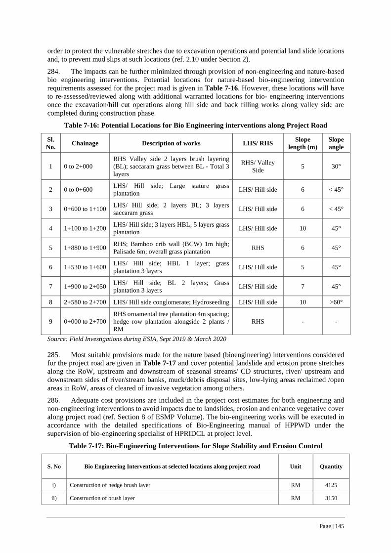
Page | 145
order to protect the vulnerable stretches due to excavation operations and potential land slide locations and, to prevent mud slips at such locations (ref. 2.10 under Section 2).
284. The impacts can be further minimized through provision of non-engineering and nature-based bio engineering interventions. Potential locations for nature-based bio-engineering intervention requirements assessed for the project road is given in Table 7-16. However, these locations will have to re-assessed/reviewed along with additional warranted locations for bio- engineering interventions once the excavation/hill cut operations along hill side and back filling works along valley side are completed during construction phase.
Table 7-16: Potential Locations for Bio Engineering interventions along Project Road
Sl. No. Chainage Description of works LHS/ RHS Slope
length (m) Slope angle
1 0 to 2+000 RHS Valley side 2 layers brush layering (BL); saccaram grass between BL - Total 3 layers
RHS/ Valley Side 5 30°
2 0 to 0+600 LHS/ Hill side; Large stature grass plantation LHS/ Hill side 6 < 45°
3 0+600 to 1+100 LHS/ Hill side; 2 layers BL; 3 layers saccaram grass LHS/ Hill side 6 < 45°
4 1+100 to 1+200 LHS/ Hill side; 3 layers HBL; 5 layers grass plantation LHS/ Hill side 10 45°
5 1+880 to 1+900 RHS; Bamboo crib wall (BCW) 1m high; Palisade 6m; overall grass plantation RHS 6 45°
6 1+530 to 1+600 LHS/ Hill side; HBL 1 layer; grass plantation 3 layers LHS/ Hill side 5 45°
7 1+900 to 2+050 LHS/ Hill side; BL 2 layers; Grass plantation 3 layers LHS/ Hill side 7 45°
8 2+580 to 2+700 LHS/ Hill side conglomerate; Hydroseeding LHS/ Hill side 10 >60°
9 0+000 to 2+700 RHS ornamental tree plantation 4m spacing; hedge row plantation alongside 2 plants / RM
RHS - -
Source: Field Investigations during ESIA, Sept 2019 & March 2020
285. Most suitable provisions made for the nature based (bioengineering) interventions considered for the project road are given in Table 7-17 and cover potential landslide and erosion prone stretches along the RoW, upstream and downstream of seasonal streams/ CD structures, river/ upstream and downstream sides of river/stream banks, muck/debris disposal sites, low-lying areas reclaimed /open areas in RoW, areas of cleared of invasive vegetation among others.
286. Adequate cost provisions are included in the project cost estimates for both engineering and non-engineering interventions to avoid impacts due to landslides, erosion and enhance vegetative cover along project road (ref. Section 8 of ESMP Volume). The bio-engineering works will be executed in accordance with the detailed specifications of Bio-Engineering manual of HPPWD under the supervision of bio-engineering specialist of HPRIDCL at project level.
Table 7-17: Bio-Engineering Interventions for Slope Stability and Erosion Control
S. No Bio Engineering Interventions at selected locations along project road Unit Quantity
i) Construction of hedge brush layer RM 4125
ii) Construction of brush layer RM 3150

Page | 146
S. No Bio Engineering Interventions at selected locations along project road Unit Quantity
iii) Construction of live palisade RM 300
iv) Construction of live Fascine RM 300
v Grass slip plantation on slope <45° @ 100 drills/sqm sqm 500
vi Grass slip plantation on slope 45°-60° @ 100 drills/sqm sqm 300
vii Grass slip plantation on >60° slope @ 100 drills/sqm sqm 200
viii Plantation of large sized stature grass slips at slope of <45° @ 20 slips/sqm sqm 3520
ix Bamboo crib wall cum 270
x Tree plantation in plains within RoW nos 250
xi Shrub Plantation in plains Within Row nos 200
xii Agave plantation in slopes nos 100
xiii Group plantation of shrubs sqm 100
xiv Hedge Plantation (2 plants/RM) RM 150
xv Hedge Plantation (4 plants/RM) RM 150
xvi Bamboo plantation within RoW nos 150
xvii Grass seed sowing<40° sqm 200
xviii Grass seed sowing<40° sqm 200
xix Grass seed sowing<40° with mulch and jute netting sqm 200
xx
Hydro seeding including dressing/trimming of slope including removing of fractured material and maintenance with watering 2 to 3 times after 12hrs of hydro seeding @ 1 Litre/Sqm (each time) for six months/propagation of grasses and shrubs under supervision of hydro seeding provider
sqm 2060
7.4.3 Hazardous and Non-Hazardous Wastes
Impacts
287. Road and jetty construction related pollution risks include accidental spill of fuel, used oil or chemicals and contamination from poor waste management practices that can affect soil, surface and groundwater at operational sites and/ or establishment camp sites like concrete batching plants, hot mix plants, vehicle parking/ service area, oil/ lube storage areas among others.
288. The project road and jetty construction activities will generate both non-hazardous and hazardous wastes throughout the construction phase. The anticipated non-hazardous waste types include excavated surplus material, construction debris, municipal solid waste, sanitary sullage and sewage generation from construction camp sites and workforce camps. While, hazardous waste may include used oil, lube/grease/cotton waste materials from service areas of construction machinery, empty drums or dis-used/replaced spares of vehicles/machinery, used batteries, dis-used chemicals for concreting like admixtures etc.
289. There are potentially several risks to human health and the environment that may be associated with the improper handling, storage and disposal of waste, both on and off-site. Improper handling and disposal could result in possible cross contamination of air, soil, surface and ground water resources, which can eventually impact on flora & fauna.
290. The estimated generation of hazardous waste during the construction phase of project road and jetty constriction is given Table 7-18. The used/discarded batteries during the construction phase are to be disposed-off in accordance with the battery management rules. As per the rule, the used/ discarded batteries will have to be mandatorily taken-back by the sellers and/ sent to the hazardous waste disposal

Page | 147
facilities through approved vendors by the State Pollution Control Board. Thus, no significant on-site impacts are foreseen due to discarded/used batteries.
Table 7-18: Estimated Hazardous Waste during Project Road Construction Phase
Equipment Type and Capacity
Raghunathpur -Mandi- Harpura-Bharari Road and Jetty facility
No. Tank
capacity in litres
Service frequency @
6 months
Grease and other misc. waste (@10
%per service)
Cotton waste (0.4 Kg per service)
Dozer D-50-A15 - 200 Cum/hr Cap. 1 15 4 6 1.6
Motor Grader - Engine output above 150 KW Cap. 1 15 4 6 1.6
Long arm Hydraulic Excavator - 1.00 Cum 2 15 4 12 3.2
Vibratory Roller (2 Tandem + 1 Vibro) - Minimum 8-10T static Weight
1 12 4 4.8 1.6
Pneumatic Road Roller - 200-300KN Cap. 1 10 4 4 1.6
Smooth Wheeled Roller - 8-10T Cap. 1 15 4 6 1.6
Tipper - 5.5 Cum Cap. 10 15 4 60 16
Water Tanker - 6 KL Cap. 2 15 4 12 3.2
Tractor-Trolley - 50HP Cap. 2 10 4 8 3.2
Rock Excavator/Ripper - 60 Cum/hr Cap. 1 12 4 4.8 1.6
Hot Mix Plant (Batch Type) with electronic controls and vibratory screens - Minimum 60 to 90 TPH
1 15 4 6 1.6
WMM Mixing Plant - Minimum 60 TPH 1 15 4 6 1.6
Stone Crushing Plant - 175-200 TPH Cap. 0 15 4 0 0
Paver Finisher Hydrostatic with sensor control - 100 TPH Cap. 1 15 4 6 1.6
Paver Finisher Mechanical for WMM Work - 100 TPH Cap. 1 15 4 6 1.6
Bitumen Pressure Distributor - 1750 Sqm/Hr Cap. 1 10 4 4 1.6
Power Broom - 1250 Sqm/hr Cap. 1 15 4 6 1.6
Loader - 1 Cum Bucket 1 15 4 6 1.6
Concrete batching and mixing plant - 15 to 20 cum/hr. Cap. 1 15 4 6 1.6
Mini smooth wheeled roller - 3-5T Cap. 1 12 4 4.8 1.6
Air Compressor - 170-250 cfm Cap. 2 10 4 8 3.2

Page | 148
Equipment Type and Capacity
Raghunathpur -Mandi- Harpura-Bharari Road and Jetty facility
No. Tank
capacity in litres
Service frequency @
6 months
Grease and other misc. waste (@10
%per service)
Cotton waste (0.4 Kg per service)
Plate Compactor 1 15 4 6 1.6
Transit Mixer - 3-4.5 cum per hr Cap. 3 15 4 18 4.8
Cranes 60-80 T – capacities, with telescopic arm of Min 25 m length 1 15 4 6 1.6
Total 212.4 60.8
291. During the construction phase, the generation of municipal solid waste from construction camp site offices and workforce camps is estimated as 13.5 kg per day as shown in Table 7-19, which is to be safely handled and stored prior to its disposal at approved places by district administration.
Table 7-19: Estimated Solid waste Generation during Project Construction Phase
Category
Raghunathpur -Mandi- Harpura-Bharari Road and Jetty facility
Nos Kg per day Quantity of Solid Waste generation per day
Supervision Staff 23 0.25 5.75
Non-locals/Migrant workers at camp site 31 0.25 7.75
Total Municipal Solid Waste in Kg during Construction phase (Say) 13.5
Organic Waste (40%) 5
and in organic Waste (60%) 8
Mitigation Measures
292. The hazardous waste generated at camp sites is to be collected in HDPE drums and placed under segregated roofed area for periodic disposal at approved waste disposal facilitates by HPSPCB. The nearest such facility is located at Baddi-Barotiwala-Nalagarh Industrial Area (BBN) in the adjoining Solan District. The discarded batteries shall be disposed only through authorized recyclers from HPSPCB.
293. The organic waste generated can be composted at respective campsites/work force camps through construction of compost pits for treating organic waste and provision of color-coded separate bins for collecting the organic and inorganic waste. The inorganic waste shall be disposed-off at nearest approved municipal disposal sites of Bilaspur town.
294. The sanitary/ sullage/ sewage generated at campsites, work force camps and other operational sites are to be disposed off through septic tanks and soak pit disposal arrangements (ref. Figure 7-1 & 7-2).
295. Waste management and the minimization of potential impacts during construction will depend on the implementation of appropriate procedures, protocols and monitoring of materials being delivered, handled and stored prior to disposal. The ESMP provide the required measures for hazardous waste management during the construction phase (ref. Table 4-1, Sl. No. 35 of ESMP Volume).
296. The C-ESMP to be submitted by the contractor shall include a Waste Management Plan prepared in accordance with requirements stipulated in (a) The Batteries (Management & Handling)
Page | 149
Rules, 2001 (b) Municipal Solid Wastes (Management and Handling) Rules, 2000, (c) Hazardous Waste (Management, Handling & Transboundary Movement) Rules, 2016 and (d) Construction and Demolition Waste Management Rules, 2016.
7.4.4 Work Zone Safety and Community Safety Risks
297. The project road construction works will have potential work zone safety for workforce as well as community safety risks, which can be summarized as hereunder:
i. Safety issues for both workforce as well as community due to mud slips or localized landslides during excavation operations for road widening and construction of protection works such as breast walls, toe walls and retaining walls
ii. Cracks or minor damages to the structures adjacent to the right of way due to the use of heavy construction machineries, which may have potential to induce vibrations, particularly during site clearance operations, excavation, and paving operations
iii. Safety issues for both workforce as well as community due to movement of rotating construction equipment, vehicles deployed for hauling of materials and debris disposals etc.
iv. Community health concerns due to increased/ direct exposure to high noise levels of construction machineries, particularly along settlement areas with limited carriageway/roadway width, particularly at sensitive receptor locations such as schools, religious places, health centers/hospitals etc.
v. Increased levels of dust and vehicle emissions due to construction activities, movement of construction vehicles, induced traffic congestion and idling of vehicles due to ongoing construction works
vi. influx of migrant workers could potentially cause discomfort or potential conflicts with local community particularly at marketplaces.
Management/Mitigation measures
298. Prior to commencement of construction, the contractor will prepare and submit Contractor’s ESMP (C-ESMP), which will include contractor’s management plan to comply with the project’s safeguard requirements and Management Strategies and Implementation Plans (MSIPs) for (i) Work Management; (ii) traffic and work zone safety management plan for the prioritized encumbrance free stretches, in accordance with approved implementation schedule. In addition, the contractor will be contractually obligated to implement work zone safety arrangements confirming to the requirements of IRC: 67 and IRC: SP: 55: 2014, which include provision of PPEs, fixed/ mobile barricades between work area and pedestrian/ traffic and required measures for ensuring community safety during construction activities. The requirements also include site specific traffic management plan for all types of works along with work zone safety check list. A typical diagram showing traffic management during construction phase as shown in Figure 7-13 and an illustrative checklist for work zone safety is given in Appendix-17.
299. The responsibility of contractor to manage these risks will be clearly reflected in the contractual obligations of the Civil Works Contractor with appropriate mechanisms for addressing non-compliance. The bid documents for construction will incorporate requirements for Environment, Social, Health and Safety (ESHS) including list of applicable labor laws and community safety provisions for periodic reporting by contractors. Commencement of any activity by contractor without prior approval of these requirements will be treated as “fundamental breach of contract”.
300. The C-ESMP will be approved by the CSC, prior to the commencement of construction activities, will be periodically reviewed by CSC (but not later than every 3 months) and updated in a timely manner by the Contractor, to ensure that it contains appropriate measures for the work zone and community safety throughout construction phase

Page | 150
Figure 7-13: Typical Traffic Management & Work Zone Safety Arrangements
7.4.5 Road Safety Measures
Impacts
301. The built-up and settlement areas have direct access on to project road in addition to intersections like major and minor junctions. The road will also act as haul road for transporting construction materials and debris, along with concurrently ongoing construction activities at prioritized stretches. Adding to these, existing site settings i.e., present narrow roadway width, sharp curves, hilly/mountainous terrain will provide limited option for maneuvering.
302. All of these is likely to cause restrictions/inconveniences and safety issues to existing road users, requiring temporary traffic diversions, among others.
Mitigation Measures
303. To ensure ease of traffic movement as well as community safety (local people as well throughfare road users) along the road will largely depend on contractor’s work management plan and procedures, which will be regulated through contractual obligations. In addition, traffic management through warden/monitor(s) with reflective jackets and handheld batons and appropriate traffic signages in addition to dust suppression and noise level management measures will also be required. Further, road safety measures like provision of information/caution boards, road signages, object markers will be provided at all required locations in accordance with IRC:99-2019 as per the road safety plan for the project road and are summarized in Appendix-14 and under Section 3.3 of ESMP volume.
304. In addition to road safety signages, traffic calming measures have been considered where there is no adequate scope for providing either two-lane or vision berm(s). At hairpin and blind curve bends, safety precautions are proposed as per of IRC: 99-2018 as given below and shown in Appendix-14.
i. Convex mirrors ii. Road studs along the curve portion iii. W-Beam Crash Barrier at curve location iv. Triple Chevron sign boards v. Speed restrictions – Speed limit, No overtaking and Blow horn signage vi. Rumble Strip markings
Page | 151
7.4.6 Traffic Calming Measures along Built-Up Stretches, Major/Minor Junctions
305. At built-up stretches, traffic calming measures are considered with due importance to both pedestrian and vehicular movements as list below and shown in Appendix-14.
a. Informatory signage for built-up stretches b. Speed limit signage for vehicular movements in built-up areas. c. Place identification signage d. Restriction signage for cautioning the road user to abide traffic rules.
306. Due to restrictions on land availability at minor and major junction locations, utmost consideration has been given to make the junctions/intersections safe for the road users 307. Traffic calming measures in compliance to relevant to IRC standards at all such major or minor locations are considered. Typical arrangement for Y- Type and T –Type Minor junctions are shown in Appendix-14.
7.4.7 Natural Disasters/ Calamity and Hazard Vulnerability
Impacts
308. The vulnerability status of the Bilaspur district, within which the project road is located is “Moderate” in terms of landslides, earthquake, wind, cloudburst and floods (ref. 4.7 under Section 4 - Baseline Data). However, the upgradation of 2.74 km long project road itself does not significantly alter the vulnerability status of the district as a whole.
309. Given the fact that the project road is in Zone IV, which carries highest risk and presence of potential land slide locations along project road, construction work poses risk and safety hazard to workforce and community, in the event of natural disasters like earthquake and/or landslides triggered during tremors of high intensity earthquake. Such events may strand the workforce or even worse, they may get trapped at project construction and establishment camp sites.
Mitigation Measures
The mitigation measures in an event of climate change induced natural disasters and/or any other natural calamities shall be as follows:
• Bilaspur district has a Disaster Management Plan at district level, which provide the institutional arrangements, designated officers, emergency response systems, infrastructure facilities like hospitals, fire stations, police station at tehsil, sub-division and village levels.
• In order to ensure the safety of work force at operational sites and safe evacuation of workforce in the event of natural disaster and/or any other natural calamities, the project road construction contractor shall have an emergency response plan (ERP).
• As part of the ERP, the project contractors of both road and jetty construction shall establish and maintain regular coordination with the designated officers for Disaster Management at district/sub-division levels. Maintaining regular coordination will enable to seek quick response in the event of natural disaster and/or any other natural calamity.
• All project operations (both road and jetty construction) shall be planned and coordinated in tandem with the weather predictions/alerts issued as relevant for the district/ project road.
• At project level (both road and jetty construction), contractor shall designate Incident Controller (IC), Emergency Controller (EC), Assembly Coordinator (AC) and other required personnel for the emergency response mechanism in an event of natural disaster/ calamity in line with the ERP.
• The emergency response plan (ERP) of the contractor shall form a part of C-ESMP for approval of the CSC. A template for the Climate Change Disaster Management and Emergency Response Plan at the level of project road construction for the contractors (both road and jetty

Page | 152
construction) is given in Appendix-15, which can be further updated after the mobilization of the Contractor.
• All work force irrespective of levels of both road and jetty construction are to be provided with training and periodic mock drill to ensure the preparedness to respond any emergency situations, always in short notice.
• The local community along project road and jetty facility location including boat operators and location commuters shall also be engaged in mock drills for proactive participation in case of any natural hazards or disaster/ calamity.
310. The mitigation measures are also included as part of the ESMP volume (ref. Table 4-1), a contractual obligation of the contractor.
7.5 …on land & assets (ESS 5) Impacts
311. The project road construction will be restricted to the available RoW with no fresh land acquisition. The Jetty will be constructed along the waterfront of Gobind Sagar Lake/ River Sutlej and will have minimal footprint (less than 30 sqm) and does not involve land acquisition and neither clearing of any encroachments (ref. section 1.7).
312. Thus, the widening of the project road and jetty facility construction will not have any adverse social impacts including disadvantaged and vulnerable persons and does not warrant resettlement action plan (RAP). The environmental and social impacts/ risks on land and assets due to project location are negligible.
313. During construction stage, land will be required to establish campsites, workforce camps, material stack yards, hot mix plants & machinery. It is estimated that about 0.5 ha of land would be required for this purpose limited to the construction phase. In addition, land will also be required for disposal of surplus muck from excavation operations and/or construction debris from construction activities. The Contractor will be required to identify barren lands, preferably Government and/or private land, subject to its approval by CSC and HPRIDCL. The impact at such location would be localized and temporary nature and these can be reversed through mitigation measures and nature-based bioengineering solutions.
Mitigation Measures
314. The project road widening and Jetty facility construction does not warrant preparation of Resettlement Action Plan (RAP), since there are no direct social impacts or clearance of encroachments involving R & R issues. The project design considers provision of disable friendly ramps (universal access ramp) at 2 bus stops along the project road for physically challenged persons in accordance with the Disability Act 2016. Similar disable friendly ramps are also provided at jetty facility (ref. Section 1.7).
315. Further, project design has considered the following mitigation hierarchy to avoid construction stage impacts.
• Preference for Government owned waste/barren land for establishing construction camps, material stack yards and/or work force camps, hot mix plants, concrete batch plants, construction vehicle parking areas, to extent possible. One such location exists at Ch 1+050 along project road, to an extent of 2.5 ha, which was earlier used as a camp site by a National Highway construction contractor and lying vacant at present and can be readily used to and avoid opening up new areas, thereby minimize impacts.
• Strict avoidance of agricultural land or grazing land /community lands for any borrowing of good earth requirements of road construction work.
• Identify and reclamation of low-lying areas within RoW for disposal of muck/construction debris will reduce the footprint/extent of fresh land diversion elsewhere. Also, all muck
Page | 153
/construction debris disposal locations will be treated with bio-engineering interventions, so as to stabilize the slopes as well as to develop a green vegetative cover on it
7.6 … relating to Biodiversity & Living Natural Resources (ESS 6) 7.6.1 Flora
Impacts
316. The widening/upgradation of the project road will be confined to the available right of way with no land acquisition and neither the road has any forest stretches.
317. The site clearance activities for road construction will involve removal of roadside vegetation. The ecological investigations along project corridor have indicated that although the entire area is rich in biodiversity, the project corridor is relatively less diverse due to human intervention, but is interspersed with invasive species like Ageratum conyzoides, Eupatorium adenophorum, Lantana camara, Parthenium hysterophoros. The ecological investigations have also indicated that there are no rare, endangered, and threatened floral species within the corridor (ref. 4.5.5 under Section 4).
318. Field investigations as part of ESIA has enumerated 42 trees which are within CoI and may have to be felled for project road widening (ref 4.5.6 under Section 4 - Baseline Data). The enumerated trees are commonly found/ prevalent in the area and does not have any special ecological importance. As per the current procedure of department of forests, GoHP, tree enumeration has to be jointly conducted with the Department of Forests, after the on-site marking of the center line of the proposed road widening plan, as part of the laid down procedures for according the tree felling permissions for the project road.
319. The jetty construction will not have any impacts on flora as all the construction work are carried out along the dried-up waterfront/ riverbank of Sutlej during non-monsoon season. The likely impacts of Jetty construction on the water resources and associated aquatic eco-system are given in section 7.3.4 and Sl. No. 39, Table 4-1 under ESMP volume. Nonetheless, the following measures will be strictly adhered to by contractor.
Mitigation Measures
320. In order to avoid/ negate/ limit the impacts on flora, the following mitigation measures shall be adhered during the project construction phase.
• All road construction activities shall be restricted to existing right of way and no adjoining govt. or private land shall be disturbed/trespassed for whatsoever reasons
• NO trees shall be disturbed, felled and/or lopped for movement of construction machinery or establishing working area within the right of way
• NO dumping of construction debris shall be done in the lands adjoining to RoW, be it govt. or private land without prior permission
• All workforce shall be strictly instructed to not to harm any wild animals, In case of sighting of any kind wild animals. Workforce shall be strictly instructed NOT to panic and walk away from the scene without disturbing the wild animals
• In view of the environmental/ecological concerns, vegetation clearance activities including removal of invasive species along CoI and replantation of suitable local vegetation types shall NOT employ any chemicals.
• Workforce shall be strictly instructed to not to harm, in case of sighting of any type of wild animals, workforce shall be strictly instructed NOT to panic and walk away from the scene without disturbing the wild animals
• Compensatory Plantation shall be taken up either along the project corridor or at places identified by the department of forests, GoHP in order to compensate for the number of trees felled for road widening. Forest Department may stipulate planting of three saplings for every tree cut and maintenance of the same for three years with 70% survival rate (provision included in ESMP Volume ref. Section 4 & 8).

Page | 154
• Normally, all such compensatory plantation activities will be undertaken by the department of forest and maintained for three years as a deposit work as a deposit work, borne by HPRIDCL. With this compensatory plantation measures, the tree cover lost could be regained in 3 to 5 years and thus the impacts could get mitigated.
• Only local species, which are regenerative type, less water consuming and approved by the forest department shall be used for plantation. Normally, all such afforestation work will be undertaken by the Department of Forest including maintenance for three years as a deposit work.
• In order to limit the propagation of invasive species, firstly all such invasive species within the corridor of impact and/or right of way shall be removed/cleared and replanted with local species (provision included in ESMP Volume ref. Section 8 and is also one of the recommendations of the independent bio-diversity management study (refer. Appendix-7)). The department of forests, GoHP has framed a procedure for removal of invasive species and replanting of local species, which shall be followed (refer Appendix-11).
7.6.2 Fauna
Impacts
321. There is no National Park or wildlife sanctuary within 15 km PIA from project road (ref. 4.5.3 under Section 4 - Baseline Data). The ecological investigation along the project corridor has not indicted the presence of any wildlife crossing or corridors.
Mitigation Measures
322. Mitigation Measures would include the following:
• HPRIDCL had commissioned an independent Bio-Diversity Management Study (refer. Appendix-7) to evolve measures to manage the human-animal conflicts, (particularly Leopard) for all project corridors under Tranche I, HPSRTP, which include the project road. The recommendations of the bio-diversity management plan will be duly implemented by HPRIDCL.
• All culverts along the project road are adequately sized (minimum 1100 mm diameter for pipe culverts, much bigger size of box and slab culverts) to serve as animal crossing points, which is one of the recommendations of the independent bio-diversity management study (ref. Appendix-7).
• Renovation/conservation of natural water source at Km 2.050 has been included for conservation and rehabilitation with adequate storage tanks and water troughs to facilitate drinking of water by stray animals/ grazing cattle. Design/drawings for conservation and enhancement of water sources along with budgetary provisions have been included (refer Section 3, 4 & 8 of ESMP Volume).
• All work force shall be oriented to keep calm and walk away from the scene, in case, wild animals are sighted either during work hours at operational/work sites or at night hours at campsites.
• The Construction camp and work force camp sites shall not be established in the vicinity/nearby forest areas. Atleast 500m distance shall be kept from such areas under unavoidable circumstances.
• The camp sites and work force camps shall be access controlled and well-lit to avoid/prevent entry of wild animals. The work force shall be oriented not to feed monkeys and /or stray animals and to properly collect waste food in dustbins to prevent menace in camp area.
• HPRIDCL will implement all other recommendations of an independent Bio-Diversity Management Study to manage the human-animal conflicts and will earmark requisite budgetary provisions.
Page | 155
7.7 … on Tribal/Indigenous Population (ESS 7) Impacts
323. The 2.74 km long project road as well as the jetty facility location is completely within Bilaspur district, which does not fall under the fifth schedule areas23 of Himachal Pradesh and also do not meet the characteristics outlined in ESS 724.
324. The widening proposal of the project road does not impact on any land or structures involving tribal (ST) households (ref 4.8.3 under Section 4). Hence, the project road and jetty construction has no impact on ST households and neither warrant application of any specific RPF provisions for tribal households under HPSRTP.
Mitigation Measures
325. No specific mitigation measures or RAP provisions for tribal households are warranted for the project road or jetty facility construction.
7.8 … on impacts on Cultural Heritage (ESS 8) Impacts
326. The project road corridor and jetty facility location (within 300 meters vicinity in all directions) does not have any protected archeological/historical monuments. The Government of India prohibit any type of construction activity within 100 meters and regulate construction activities within 200 meters beyond the prohibited distance of first 100 meters in all directions of the protected monuments under the Ancient Monuments and Archaeological Sites and Remains (Amendment and Validation) Act, 2010.
327. Thus, no impacts are foreseen on protected ancient monuments and archaeological sites due to the construction of project road and jetty facility (refer 4.6.1 under Section 4 - Baseline Data).
Mitigation Measures
328. The project road corridor has two religious’ shrines/structures (Peepal tree and platform), one at start point of road (0+0 chainage) and the other at Ch 1+052 (refer 4.6.2 under Section 4 - Baseline Data). While, both these are not impacted due to project road widening, renovation of these structures is considered as a cultural heritage conservation/enhancement measure. The conservation and enhancement works will be carried out in consultation with local community leaders and regular visitors to shrine, particularly including women. Thus, no significant impacts to religious structures or cultural heritage are anticipated to project road widening. The project road has no other sensitive receptors, like schools, hospitals adjacent to the right of way of project road. Design/drawings for conservation and enhancement of two religious’ shrines/structures along with budgetary provisions have been included (refer Section 3, 4 & 8 of ESMP Volume).
329. The jetty facility location has no religious shrines/structures, which will get impacted due to jetty construction and operation and therefore, no mitigation measures are warranted.
7.8.1 Chance Finds
Impacts
330. The project road corridor and jetty facility location are not known to have any historical or archeologically important monuments and therefore the probability of “chance finds” during the
23 Fifth schedule areas in Himachal Pradesh are located in Lahaul & Spiti districts, Kinnaur, Pangi tehsil and Bharmour sub-tehsil in Chamba district. 24 Characteristics as outlined in ESS 7 – Indigenous Peoples/Sub-Saharan African Historically Underserved Traditional Local Communities
Page | 156
earthwork excavation along the road or at potential borrow areas is extremely low. Thus, no potential impacts are foreseen on this account (refer 4.6.1 under Section 4 - Baseline Data).
Mitigation Measures
331. Despite having low probability of chance finds during earthwork excavation, in an unforeseen and unlikely scenario of sighting of remnants or chance find, the following management measures are to be followed as Cultural Heritage Management Plan as part of C-ESMP.
• Such sites shall be immediately cordoned off/ entry restricted to project workers as well as common people.
• The matter shall be immediately brought to the attention of HPRIDC as well as the State/Central Department of Archaeology or any other designated competent authority of the State/ Central Govt.
• All further work at such specific location(s) shall be carried out only after the site is cleared by the Archaeology Department or competent authorities.
• Any other instructions issued by the Archaeology Department or competent authorities shall be duly followed in all subsequent excavation works.
The ESMP Volume (Sl. No. 41 of Table 4-1) include the mitigation/management measures for “chance finds” along with the institutional responsibility for supervision and monitoring.
Page | 157
8 ENVIRONMENT AND SOCIAL MANAGEMENT PLAN
332. An environmental and social management plan (ESMP) has been prepared for impact mitigation and management during pre-construction, construction & operation phases of the project road.
333. The ESMP is a standalone separate volume which cover the following and may be referred for further details.
• Pre-Construction Stage Activities by CSC • Pre-Construction Activities by Contractor • Construction Stage Activities by Contractor • Operation Stage Activities by Contractor • Institutional Arrangements for ESMP Implementation, Supervision • ESMP Implementation Monitoring and Reporting requirements • Grievance Redress Mechanism for PAPs/PAHs and Project Stakeholders/Community • Grievance Redress Mechanism for Workforce • Training and Capacity Building
8.1 Budgetary Costs for ESMP Implementation and Supervision 334. The ESMP include mitigation management measures, which are akin to Good International Industry Practice (GIIP), considered incidental to works and deemed to be included in the quoted bid price by the contractor. However, certain project road specific mitigation measures and/or environmental enhancement measures, considered as additional requirements that are to be implemented by the contractor have also been included against budget provision and integrated in the contract/bidding documents as Mandatory Contractual Obligations. The estimated budgetary provisions for implementation of such specific mitigation measures and ESMP is INR 91,45,000 (91.45 Lakhs) INR 909.26 Lakhs) and included in ESMP. The abstract of the ESMP budget provision is given in Table 8-1.
335. The contractual ESHS (Environment, Social, Health and Safety) performance requirements by the contractor have been specified and incorporated as special conditions and performance requirements in bid documents of contract package for the project road. Adequate cost provisions for implementation of ESHS requirements have included in the item rates, so that contractor can perform requirements in a fair and objective manner. In addition, a provision of 2% of contract amount has been earmarked as ESHS performance security in the bidding documents. Thus, the contractor is expected to be fully aware of ESHS performance requirements at the bidding stage itself and accordingly deemed to have priced the performance requirements at the bidding stage itself.
336. The ESHS performance requirements incorporated in the bid documents, obligate the contractor, upon mobilization, to prepare a Contractor’s ESMP (C-ESMP), which will include impacts mitigation and management plan, environmental enhancement plan, OHS plan, labor management plan, labor Influx management Plan, workers’ campsite management plan, GRM for workers’, traffic management and road safety management plan, COVID-19 considerations and among others in accordance with the GoI, GoHP, IFC & WB requirements.
337. The C-ESMP will be reviewed in consultation with HPRIDCL and approved by the CSC, prior to commencement of construction works. The approved C-ESMP will be reviewed periodically (but not more than every three (3) months) by CSC and updated in a timely manner, to address changed requirements, if any during project implementation.

Page | 158
Table 8-1: Budgetary Provisions for Specific Environmental Impact Mitigation / Enhancement Measures (additional Requirements to be implemented by Contractor against budget)
S. No Description Amount in lakhs
1 Environmental Enhancement and /Cultural Heritage Conservation Measures along Project Road 7.00
i) Renovation to a natural water source (locally known as bowli) at 2+050 along project road (2+050) as shown in Figure 3-3 of ESMP volume. 2.50
ii) Renovation/improvement to religious shrine/structure (Peepal tree with platform) at 0+0 as shown in drawing No. Figure 3-4 of ESMP volume. 3.00
iii) Renovation/improvement to religious shrine/structure (Peepal tree with platform) and hand railing around the platform as a safety measure, at chainage 1+052, as shown in drawing No. Figure 3-5 of ESMP volume.
1.50
2 Nature based bio-engineering Interventions at selected locations along the project road in accordance with HPPWD bio-engineering manual /specifications and directions of bio-engineering specialist of CSC and HPRIDCL
45.99
3 Clearance/Removal of Invasive Species like Lantana and Sea Ruthenium etc. form the road corridor and Plantation of Indigenous local vegetation and Maintenance and upkeep for 70% survival rate for 6 months (3 km (both sides) up to width of 1.5 m)
8.1
4 Provision of plantation and maintenance (tree guard) of 200 Avenue trees along roadside and in RoW @ 1800 per tree. 3.6
5
Environmental Monitoring Cost as per CPCB Standard Procedures along project road and Jetty facility construction location (Ambient Air Quality Monitoring, Water quality Monitoring, Noise level Monitoring and Soil Quality Monitoring) at locations covering sensitive receptors, work force camp site and operational sites for 18 months construction phase and 1-year operation phase/DLP
26.76
6 Provision for Compensatory Afforestation in lieu of Tree felling for road construction
Cost shall be borne by HPRIDCL as per
the estimates of Department of Forests, GoHP
7 Provisions of Environmental Specialist (full time), EHS Officer (fulltime), Bio-Engineering Specialist (intermittent input), Horticultural specialist (intermittent input) and Training sessions for implementation of EMP
To be deployed by HPRIDCL
8 Land acquisition and Resettlement & Rehabilitation Cost Nil
9 Relocation of hand pumps & public water taps as per directions of the Engineer. Covered in Utility Shifting Budget
10 Cost for institutional strengthening, capacity building and training by HPRIDCL Cost will be borne
by HPRIDCL as per actuals
Total 91.45