Light the Night parade, events set rain or shine - eTypes ...
Upload
khangminh22Category
view
5download
0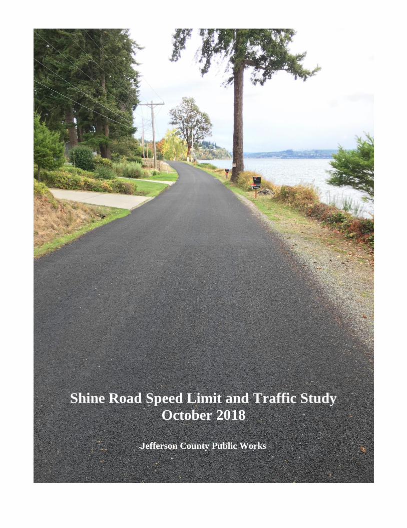
Shine Road Speed Limit and Traffic Study
October 2018
Jefferson County Public Works

This page intentionally left blank.
Speed Change Report Shine Road 2018 10.26.doc Page 2
REPORT OF ENGINEERING and TRAFFIC INVESTIGATION and
PROPOSED SPEED LIMIT CHANGE
ROAD NAME and NUMBER: Shine Road, County Road No. 505409
TERMINI: Mile Post (M.P.) 0.00 to M.P. 2.34
EXISTING MAXIMUM SPEED LIMIT: 35 Miles per Hour (MPH)
PROPOSED MAXIMUM SPEED LIMIT: 25 MPH
DATE OF STUDY: October, 2018
This engineering and traffic investigation that considers lowering the speed limit on Shine Road is in
response to numerous requests received from property owners living along this roadway for a lower speed limit.
This culminated in a petition submitted to the Board of County Commissioners on August 6, 2018, which included
signatures from 100 citizens (See Appendix “A”). The petition is also represented in a map (See Appendix “B”).
Several of the citizens submitted letters or emails or made phone calls to discuss the specific concerns behind the
request. Generally, the concerns can be summarized as follows:
Speed is too fast for the road width which is less than a full two lanes for much of its length
People speed down the middle of the road
It is barely wide enough to accommodate two vehicles coming from opposite directions
Traffic has increased and some drivers are using it to get around bridge related backups on SR-104
The road should be restricted to “local traffic”
The road has adverse alignment in certain sections and “blind spots”
There are steep drop-offs to the beach on the south side without much road shoulder because of erosion
There is very little road shoulder on the north side where deep drainage ditches are present
The road is used by residents for walking and there are no shoulders so they cannot get off the road
Drivers do not obey the speed limit anyway
There have been accidents
A “speed monitor” sign should be installed (digital speed “feedback” sign)
RCW 46.61.400, Basic Rule and Maximum Limits, specifies the maximum speed limit on county roads to
be fifty (50) miles per hour. This is the statutory speed limit for Jefferson County roadways unless otherwise
posted. The basic speed rule also allows for enforcement and citation for driving too fast for the prevailing
conditions, and so the absence of a sign does not necessarily mean one can travel at 50 mph. This section also states
that the maximum speed limits set forth in this section may be altered as authorized in RCW 46.61.405, 46.61.410
and 46.61.415. RCW 46.61.415 covers when local authorities may alter maximum limits and allows local
authorities to increase the limit but to not more than sixty (60) miles per hour or decrease the speed limit to lower
than twenty (20) miles per hour. Local authorities in their respective jurisdictions shall determine by an engineering
and traffic investigation the appropriate speed for all roadways. Speed limits are contained in Jefferson County
code section 10.05.040.
There is a vast amount of engineering literature related to driver behavior and establishing speed limits.
This study primarily relies on information found in:
The Manual on Uniform Traffic Control Devices (MUTCD) - a federal document adopted by all 50 states
Methods and Practices for Setting Speed Limits, FHWA-SA-12-004, April 2012
For the purposes of this report, it would not be practical to repeat all of the information contained in these
(and other) engineering documents related to setting speed limits; however, some important points that form the
basis for speed limit setting are summarized below:
Speed Change Report Shine Road 2018 10.26.doc Page 3
The primary purpose of the speed limit is to advise drivers of the maximum reasonable and safe
operating speed under favorable conditions. It provides a basis for enforcement and ought to be fair in
the context of traffic law.
The normally careful and competent actions of a reasonable person should be considered legal.
Laws cannot be effectively enforced without the consent and voluntary compliance of the public
majority.
The majority of drivers respond in a safe and reasonable manner as demonstrated by their consistently
favorable driving records.
Using these fundamentals, which are rooted deeply in government and law, has resulted in the
commonly accepted practice in the United States (and elsewhere) of relying heavily on the 85th percentile
speed as the basis for setting an appropriate speed limit. Numerous studies over decades of practice have
shown that the speed at which 85% of the drivers travel at or below is typically a reasonable speed limit.
This method is referred to as the Operating Speed Method and relies on the collective judgement of the
traveling public to determine what a reasonable and safe speed is for the road under favorable conditions.
The MUTCD states that the speed limit should be set within 5 mph of the 85th percentile speed of free-
flowing traffic. Many agencies will adjust the speed limit downwards by 5 mph and typically no more than
10 mph from this speed to account for hazards or conditions that a driver, even one acting responsibly, may
not be aware of. These conditions can include:
Narrow pavement widths of less than 20 feet
Horizontal and vertical curves that may limit sight distance
Driveways with restricted sight distance or other developments
High driveway density resulting in higher potential for conflict
High pedestrian and bicycle traffic in developed areas
Narrow shoulder widths
High crash rates when compared to system averages
There is no published methodology that recommends setting the speed limit below the 50th
percentile speed.
The Operating Speed Method is appropriate for collector and arterial roadways where mobility of
traffic is a prime consideration. The usefulness of this method tends to decline when considering
residential streets of short length where mobility of through traffic (as expressed by trip time) is less of a
priority than managing the roadway environment for the benefit/safety of adjacent properties and roadside
users (pedestrians/bicyclists). As a result, many cities set statutory speed limits of 25 mph (for example) on
all residential streets which has the benefit of creating a consistent expectation for drivers and also reduces
the amount of signage required to post various speed limits.
Finally, it should be noted that:
Speed limits are not set to account for the worst condition that exists along a road segment. Short
sections with adverse conditions, such as curves, can/should be posted with advisory speeds. These are
signs with black text on yellow backgrounds which are not regulatory in nature.
Setting speed limits too far below the 85th percentile speed encourages drivers to ignore speed limits,
does not encourage compliance with the posted speed limit, and can be difficult to enforce.
Setting unrealistically low speed limits can create its own hazard due to differential speeds between
drivers attempting to obey the low speed limit and those ignoring it. Differential operating speeds lead
to unsafe passing and tailgating.
Speed Change Report Shine Road 2018 10.26.doc Page 4
SPEED AND TRAFFIC STUDY
Jefferson County Public Works routinely performs speed studies on county roads to aid in enforcement and
to respond to inquiries regarding the speed limit. A speed study was conducted on Shine Road in June and July of
2018. The study consisted of placing equipment on the road at MP 0.62 and MP 1.30 over the period of time
typically lasting for a week and covering at least one weekend. The speed data from MP 1.86 is from an earlier
study conducted in 2005. Data was downloaded into software that performed the analysis and reported the results
in table and graphical formats. This data is available in Appendix “C”. A summary of the study is shown in the
table below.
Milepost 0.62 1.30 1.86
85th Percentile Speed (mph) 37 36 44
50th Percentile Speed (mph) 29 29 38
10 mph Pace Speed (mph) 25-35 25-35 35-45
Year 2018 ADT (Daily Trips) 239 285 N/A
Year 2005 ADT (Daily Trips) 211 N/A 303
Shine Road Speed Study Results
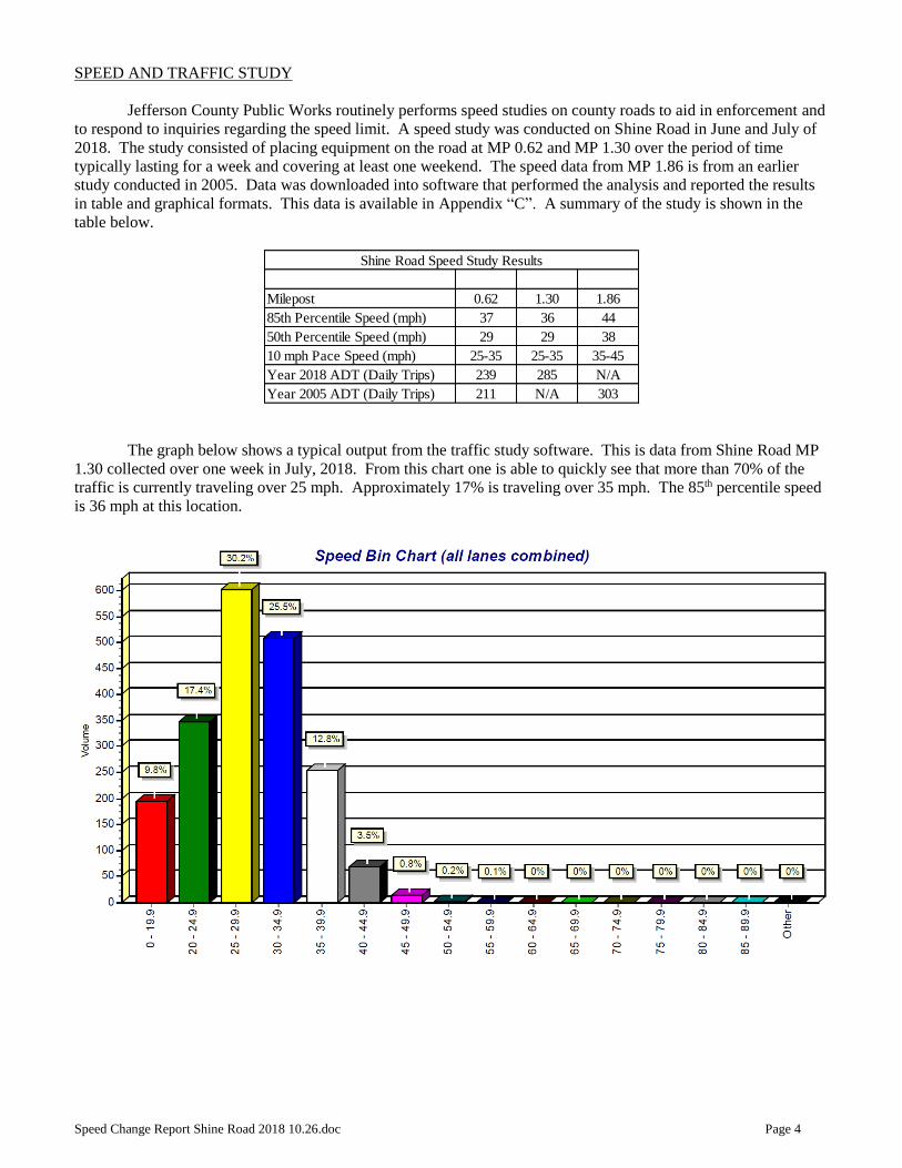
The graph below shows a typical output from the traffic study software. This is data from Shine Road MP
1.30 collected over one week in July, 2018. From this chart one is able to quickly see that more than 70% of the
traffic is currently traveling over 25 mph. Approximately 17% is traveling over 35 mph. The 85th percentile speed
is 36 mph at this location.

Speed Change Report Shine Road 2018 10.26.doc Page 5
The average daily traffic counts are as follows:
MP 0.62 MP 1.30 MP 1.86
2005 211 - 303
2010 220 - 377
2016 234 - 320
2018 239 285 -
Shine Road Average Daily Traffic Counts
These counts are the sum of the trips in both lanes, and generally the counts are evenly distributed in each
direction. So for example at MP 0.62 the total traffic on any given day would average 118 in one direction and 121
in the other direction for a total of 239. Traffic counts taken over the last decade have shown little increase in road
use which corresponds to a relatively slow pace of development in this area. Nationally, roads with an ADT of less
than 400, such as Shine Road, are considered to be “very low volume roads”.
Recently, the County has received reports from residents living along Shine Road indicating that drivers
from SR-104 are using Shine Road to cut ahead in line when the Hood Canal Bridge is closed for a span opening
for marine traffic. Some have stated that map applications on cell phones are directing drivers to use Shine Road as
an alternate route especially when SR-104 is backed up. Reportedly, Washington State Patrol is also present during
military bridge closures (Bangor traffic), and WSP clears Shine and Paradise Bay Roads first before releasing SR-
104 traffic. Some drivers may have become aware of this practice.
Traffic counters used for this 2018 study were in place during several bridge closures. None of the known
closures corresponded to typical peak traffic times, and the counters did not show an increase in traffic on Shine
Road (Note: Military closures are not posted so we could not determine when these occurred. Only non-military
closures are posted). A significant increase in traffic was noted eastbound on Sunday afternoon June 24th between 2
p.m. and 3 p.m. For this one hour period, traffic counts of 54 vehicles were recorded in this lane versus 5 during
the same time period the day before (Saturday) and 9 the day after (Monday). It is likely that some type of delay
was occurring on SR-104 at this time either from a military closure, accident, or just peak weekend traffic leaving
the Peninsula. This data corroborates the reports from citizens living on Shine Road.
Some residents have requested “Local Traffic Only” signage be installed to address this issue. Further
discussion of this is contained later in this report.
ROADWAY CHARACTERISTICS
Shine Road characteristics are summarized in the table below which is for a driver proceeding from west to
east (MP 0.00 towards MP 2.34).
BEGIN END WIDTH OF L. GRASS R. GRASS
MP MP DESCRIPTION PAVEMENT (FT) SHOULDER (FT) SHOULDER (FT)
0.00 0.10 90 degree curve left 18.5 1 3
0.10 0.30 Gentle left curve to tangent 18.5 1 3
0.30 0.40 Tangent -begin drop off to beach right side 18.0 0 3
0.40 0.65 Crest vertical curve restricts sight distance at MP 0.40 17.0 1 2
0.65 0.80 Very severe drop off to beach a few feet off pavement 17.0 0 0
0.80 0.90 Concrete barriers; no shoulder; crest curve restricts sight 17.0 0 0
0.90 1.10 Horizontal/Vertical curves; Advisory speed 25 mph 16.5 1 1
1.10 1.30 Drop off to beach on rt. side ends; crest curve restricts sight at MP 1.30 16.5 1 1
1.30 1.60 Tangent 16.5 1 1
1.60 1.80 Steep hill; crest curve restricts sight at MP 1.7 to MP 1.8 16.5 1 1
1.80 2.10 Begin 2-lane road 21.0 1 2
2.10 2.34 Curves right and left w/ 30 mph advisory; crest curve at 2.1 restricts sight 21.0 1 3
Both reported accidents occurred in these curves
SHINE ROAD CONDITIONS
Speed Change Report Shine Road 2018 10.26.doc Page 6
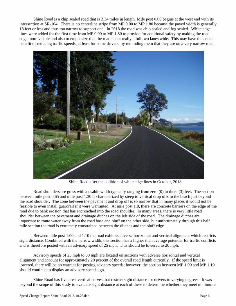
Shine Road is a chip sealed road that is 2.34 miles in length. Mile post 0.00 begins at the west end with its
intersection at SR-104. There is no centerline stripe from MP 0.00 to MP 1.80 because the paved width is generally
18 feet or less and thus too narrow to support one. In 2018 the road was chip sealed and fog sealed. White edge
lines were added for the first time from MP 0.00 to MP 1.80 to provide for additional safety by making the road
edge more visible and also to emphasize that the road is not really a full two lanes wide. This may have the added
benefit of reducing traffic speeds, at least for some drivers, by reminding them that they are on a very narrow road.
Shine Road after the addition of white edge lines in October, 2018
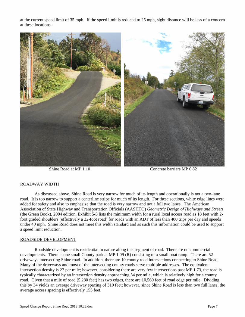
Road shoulders are grass with a usable width typically ranging from zero (0) to three (3) feet. The section
between mile post 0.65 and mile post 1.30 is characterized by steep to vertical drop offs to the beach just beyond
the road shoulder. The zone between the pavement and drop off is so narrow that in many places it would not be
feasible to even install guardrail if it were warranted. At mile post 1.8, there are concrete barriers on the edge of the
road due to bank erosion that has encroached into the road shoulder. In many areas, there is very little road
shoulder between the pavement and drainage ditches on the left side of the road. The drainage ditches are
important to route water away from the road base and bluff on the other side, but unfortunately through this half
mile section the road is extremely constrained between the ditches and the bluff edge.
Between mile post 1.00 and 1.10 the road exhibits adverse horizontal and vertical alignment which restricts
sight distance. Combined with the narrow width, this section has a higher than average potential for traffic conflicts
and is therefore posted with an advisory speed of 25 mph. This should be lowered to 20 mph.
Advisory speeds of 25 mph to 30 mph are located on sections with adverse horizontal and vertical
alignment and account for approximately 20 percent of the overall road length currently. If the speed limit is
lowered, there will be no warrant for posting advisory speeds; however, the section between MP 1.00 and MP 1.10
should continue to display an advisory speed sign.
Shine Road has five crest vertical curves that restrict sight distance for drivers to varying degrees. It was
beyond the scope of this study to evaluate sight distance at each of these to determine whether they meet minimums
Speed Change Report Shine Road 2018 10.26.doc Page 7
at the current speed limit of 35 mph. If the speed limit is reduced to 25 mph, sight distance will be less of a concern
at these locations.
Shine Road at MP 1.10 Concrete barriers MP 0.82
ROADWAY WIDTH
As discussed above, Shine Road is very narrow for much of its length and operationally is not a two-lane
road. It is too narrow to support a centerline stripe for much of its length. For these sections, white edge lines were
added for safety and also to emphasize that the road is very narrow and not a full two lanes. The American
Association of State Highway and Transportation Officials (AASHTO) Geometric Design of Highways and Streets
(the Green Book), 2004 edition, Exhibit 5-5 lists the minimum width for a rural local access road as 18 feet with 2-
foot graded shoulders (effectively a 22-foot road) for roads with an ADT of less than 400 trips per day and speeds
under 40 mph. Shine Road does not meet this width standard and as such this information could be used to support
a speed limit reduction.
ROADSIDE DEVELOPMENT
Roadside development is residential in nature along this segment of road. There are no commercial
developments. There is one small County park at MP 1.09 (R) consisting of a small boat ramp. There are 52
driveways intersecting Shine road. In addition, there are 10 county road intersections connecting to Shine Road.
Many of the driveways and most of the intersecting county roads serve multiple addresses. The equivalent
intersection density is 27 per mile; however, considering there are very few intersections past MP 1.73, the road is
typically characterized by an intersection density approaching 34 per mile, which is relatively high for a county
road. Given that a mile of road (5,280 feet) has two edges, there are 10,560 feet of road edge per mile. Dividing
this by 34 yields an average driveway spacing of 310 feet; however, since Shine Road is less than two full lanes, the
average access spacing is effectively 155 feet.
Speed Change Report Shine Road 2018 10.26.doc Page 8
Further discussion related to the effects of access spacing and the impact of increased access density on
accident rates can be found in the Traffic Engineering Handbook published by the Institute of Transportation
Engineers. In general, the ITE recommends that for optimum roadway function and safety (reflected by a lower
crash rate), minimum driveway spacing should be greater than the stopping sight distance which is 250 feet for a 35
mph roadway and 155 feet for a 25 mph roadway (Exhibit 3-1 from the Geometric Design of Highways and Streets,
2004 AASHTO). This information could be used to support a speed limit reduction to 25 mph for Shine Road.
CRASH HISTORY
MP DATE CRASH TYPE SEVERITY SURFACE LIGHT TIME ALCOHOL CITATION
2.28 3/3/2005 Crossed centerline/left roadway/over embankment PDO DRY DAY 14:25 Yes Yes
2.096 1/15/2016 Curve /B/onto WB shoulder/left roadway into ditch PDO WET DARK 23:50 Unknown Unknown
SHINE ROAD CRASH HISTORY
The crash history shows a very low accident rate of 0.63 per million vehicle miles traveled versus the 1.22
average for Jefferson County and 2.20 for the average of county roads nationally. Both reported crashes occurred in
the curves at the easterly end of the road where the road actually has a full two lanes marked by a centerline stripe
and usable grass shoulders.
Typically the recorded crashes under-report the actual incident occurrence since some drivers may be able
to extricate their vehicle before it is ever reported to law enforcement. For example, residents provided a photo of a
pickup/trailer in a ditch recently which does not show up in the accident record since it was never reported. There
is also no way to record near misses and “close calls” which road users and neighbors often cite as a reason for
concern. This is not unique to Shine Road.
PEDESTRIAN USE
Property owners living along Shine Road indicated in comments supporting the speed limit reduction that
the road is heavily used by pedestrians. Although Public Works has conducted no actual pedestrian counts, it is not
unusual to see pedestrians using this stretch of roadway. For example, during a 30 minute site visit performed to
collect information for this study, several groups of pedestrians were observed walking their dogs on the road. It is
obvious that pedestrians are using this road. By its nature, many property owners living on the north side of the
road must walk down and across the road to access stairways to the beach on the south side and Hicks Park which
is located centrally to the neighborhood. Also as is typical, mail is delivered in one direction only and so all of the
mail boxes are on one side of the road only (south side) requiring many property owners to cross the road to
retrieve their mail. Road shoulders for much of Shine Road are virtually non-existent to the point of being unusable
for pedestrians. As such, walkers use the traveled way of the road as reported.
Several comments were received regarding the danger of walking on the road during hours of darkness.
Jefferson County cannot recommend that pedestrians walk in the traveled way of any county road when it is dark.
It is not safe to walk on Shine Road in the dark. Filling in drainage ditches to provide a wider pedestrian shoulder
is not feasible in most areas. Even ditches that do not carry water much of the year will carry water during very
large storms. Ditches should not be designed for the average condition but for “design” storms.
DISCUSSION
Speed Limit
The Operating Speed Method of setting speed limits described earlier in this report would suggest that the
existing speed limit of 35 mph is acceptable. The reported accident rate is very low and the 85th percentile speed is
36 to 37 mph. It is commonly accepted practice however to reduce speed limits below the 85th percentile speed to
account for hazards or conditions that a driver might not be aware of. Shine Road exhibits nearly all of these
conditions including its narrow width that is less than a full two lanes; the lack of usable road shoulder and drop
offs just beyond what shoulder there is; high driveway density; and pedestrian use. The only reason that this road is
not exhibiting a larger problem, as would be reflected in a higher accident rate, is due to its very low traffic
Speed Change Report Shine Road 2018 10.26.doc Page 9
numbers. Most drivers are probably using the middle of the road, shying away from the edges, and then slowing
down considerably when encountering an oncoming vehicle.
It is unusual to post a speed limit below the 50th percentile speed. Doing so means that over half the road
users currently would be breaking the law. The 50th percentile speed on Shine Road is 29 mph which would
suggest that 30 mph could be an appropriate speed limit for this roadway. On the other hand, as mentioned earlier
in this report, many agencies statutorily set 25 mph speed limits on roads that are considered “residential”. This is
not the case in Jefferson County but in practice many of the County’s residential streets have been posted this way.
There is no official definition of what constitutes a “residential” street although it would be hard to argue that Shine
Road does not have many of the features that would make it one. By way of comparison, the residential loop
formed by Woodland Drive and Parkridge Drive was set at 25 mph when it was constructed as is appropriate for a
residential area. This 1.5 mile road has very low intersection density nowhere close to the 34 per mile of Shine
Road. Woodland and Parkridge are two-lane roads 22 feet in width with generous gravel shoulders and no roadside
hazards. Having a road system with these characteristics posted at 25 mph while Shine Road is posted at 35 mph is
inconsistent and does not make sense.
When conducting speed limit studies, Jefferson County Public Works typically uses the computer program
USLIMITS2 made available by the Federal Highway Administration. This program tries to bring objectivity to this
process using an “expert” method that considers the 85th percentile and 50th percentile speeds and factors in the
many variables that can also affect speed limits. This program yields a recommended speed limit of 30 mph for
Shine Road; however the program may be of limited usefulness on Shine Road because it is intended to be used for
a two lane road. If Shine Road were actually a full two lanes, then 30 mph would undoubtedly be a reasonable
speed limit for this road, but Shine road is not a full two lane road except from mile post 1.80 to mile post 2.34 and
even most of that section is characterized by continuous curves. USLIMITS2 could be interpreted to support a 25
mph speed limit since the result it produces for a two lane road should be further reduced by 5 mph due to the
narrowness of Shine Road. Output from USLIMITS2 can be found in Appendix “D”.
As a final check, the road was driven by Public Works staff multiple times in both directions to determine
whether the proposed speed limit of 25 mph is appropriate. Driving at 25 mph felt appropriate for the residential
nature of this neighborhood, especially given the constraints of the narrow roadway. When encountering traffic
coming from the opposite direction, it was necessary to slow down below 25 mph and in some places to actually
pull over and come to a stop to allow oncoming traffic to pass.
While the two-lane section at MP 1.80 to MP 2.34 could be posted at 30 mph, it is recommended that the
entire road have a single speed limit to avoid confusion. Since the two-lane section is almost entirely characterized
by curves this is not an unreasonable speed limit for this section either.
The difference in travel time for a driver traversing the entire 2.34 mile length of Shine Road at 25 mph
versus 35 mph is 96 seconds.
Speed Enforcement
As part of this investigation, Public Works reached out to the Jefferson County Sheriff’s Office (JCSO) to
get an opinion as to the appropriate speed limit for this road. JCSO has responded to multiple requests for speed
enforcement on this road; however, with the current speed limit of 35 mph is unable to make much of an impact on
reducing speeds. JCSO has indicated that a 25 mph speed limit is appropriate for this section of road and will give
them the ability to perform enforcement targeted at changing driver behavior at this location.
Fines
Fines for speeding in Washington State currently range from $125 for 5 mph over to $423 for 35 mph over
in zones posted with a speed limit of less than 40 mph. If the speed limit is lowered to 25 mph on Shine Road, a
driver could be fined $136 for driving at 35 mph.
Signage and Education

Speed Change Report Shine Road 2018 10.26.doc Page 10
Residents along Shine Road have requested more enforcement and suggested the use of activated speed
feedback signs such as the one shown below.
Studies have shown that these signs can be effective; however, they are expensive and the number of
requests for these signs would make them cost-prohibitive to own/operate/maintain for the County. The JCSO has
purchased two of these signs with a grant and partnered with Public Works to install them on a rotating basis at
various locations throughout the County. They are typically left in place for 6 to 8 weeks. Vandalism has been a
problem and the effort to install them is significant. There is some evidence that the signs are more effective on a
system-wide basis when moved around so drivers do not become accustomed or immune to them in the same place.
JCSO also has a trailer with one of these signs which was purchased by Public Works to help with speed education
and enforcement. Use of permanently installed speed feedback signs should be prioritized and reserved for high
traffic areas with significant pedestrian use such as school zones in order to justify their expense. Shine Road is a
very low volume road and would not be a high priority location for permanent installation. Use of the temporary
signs and/or trailer would be appropriate after the speed limit is changed. JCSO has intentionally held off on using
these signs prior to a speed limit change to avoid educating drivers to the current higher speed limit of 35 mph.
Speed limit signage consisting of aluminum signs on steel posts should be permanently mounted at either
end of Shine Road sufficiently far from the intersection with SR-104 that drivers can clearly see them. They should
not be installed too close to the intersection where they would be missed by a driver concentrating on completing
the movement from SR-104 onto Shine Road. In addition, speed limit signage should be posted in both directions
near the center of the 2.34 mile long segment. Curve warning signage will no longer be required with a 25 mph
speed limit; however it is recommended that advisory warning signs with a 20 mph advisory speed be retained at
the section of adverse alignment located at MP 1.00 to MP 1.10.
Local Traffic Only
The citizen petition identified as a problem the use of Shine Road as an alternate route by drivers when SR-
104 is backed up. The petition stated that this is creating increasingly hazardous conditions. Several commenters
suggested that the road should be posted for “Local Traffic Only” presumably to make it illegal to use for cut
through traffic.
The County does not have the legislative authority to close roads to certain members of the public based
upon their intended destination. RCW 47.48.010 allows the Board to close roads to certain classes of vehicles
usually for weight or size such as for seasonal restrictions or bridge weight restrictions. Roads can be closed
temporarily for construction or permanently due to hazards or the impracticality of repairing them. Closed roads
may sometimes be posted with advisory signage designed to encourage “local traffic only” to proceed beyond the
closure point in order to reduce traffic in construction areas or because there is no turnaround available. Such
signage is unenforceable and only advisory in nature. There is no legal definition of what “local” traffic is, and it is
Speed Change Report Shine Road 2018 10.26.doc Page 11
not possible for law enforcement to pull over a driver based upon their suspected destination. There are reports of
some cities attempting to post “local access only” or “no thru traffic” signage without much success for the reasons
listed above. Furthermore, installing this type of signage establishes a poor precedent for an agency since it will
soon be flooded with requests for similar signs on many other roads.
Traffic from SR-104 should not be using Shine Road to access the Hood Canal Bridge. Public Works has
reached out to the Washington State Department of Transportation (WSDOT) and suggested that advisory signage
could be placed on SR-104 with a clear message such as “Bridge Traffic – Do Not Use Shine Road”. Public Works
would be willing to install this sign at County expense. There is precedent for similar advisory signage on the other
side of the Bridge which reads “Do Not Block Driveways” installed at MP 59 on SR-3. Public Works will continue
to work with WSDOT and Washington State Patrol on this concept.
Speed Bumps and Speed Tables
Several suggestions were received to install speed bumps or speed tables on Shine Road to address driver
speed. There is an abundance of literature on the effectiveness and appropriateness of speed bumps/tables which
will not be repeated in this report. The short answer is that Jefferson County, like almost all other counties, will not
install these devices on county roads with the possible exception of at high priority sites such as school crossings.
The biggest issue with them is that everyone wants one on their street but not on any other street they use. Once
you start installing them, you cannot stop installing them. They are expensive, they can be dangerous, they are
noisy, they impede emergency response time, they are only effective over very short distances (drivers speed up
between them), and they are just uncomfortable. Since it would be very unusual to encounter one in a rural
environment, significant signage and pavement markings would be required at each one to attempt to make them
safe. The arguments against speed bumps/tables will never adequately satisfy some citizens who are adamant that
they are the answer for their street; however, Jefferson County has no plans to change its position on these devices.
RECOMMENDATION
It is recommended that the maximum speed limit be lowered to 25 MPH for the entire length of Shine Road
(MP 0.00 to MP 2.34) based on the roadway characteristics and operating characteristics described in this
report. This may be accomplished by holding a public hearing to update “Exhibit A” which is part of
Jefferson County Code 10.05.040.
Temporary speed feedback signs/trailer should be used for 6 to 8 weeks after the speed limit is changed.
JCSO should then perform some targeted speed enforcement.
Public Works should continue to work with WSDOT to install signage discouraging Hood Canal Bridge cut
through traffic.
Copyright © 2022 FDOKUMEN