Dr. Denis Shine: Glassmaking on Pearse Street, Dublin
19
1 News p.1..IPMAG XI: Hearth, Home and Household p.1..IPMAG on the Road: Field trips p.2..IPMAG X conference report p.2..People, Places, and Memory August 2010 p.3..IPMAG Book launch Articles p.3..Glassmaking on Pearse Street, Dublin Denis Shine p.6..Historic Shipwrecks 2009 Connie Kelleher p.11..The Battle of Saintfield Gavin Hughes p.15..Unusual plumb-bob Aisling Collins p.15..Commemorating the Battle of the Ebro in the Terra Alta, Catalunya Franc Myles Newsletter editor Dr. Audrey Horning School of Archaeology and Ancient History, University of Leicester. [email protected] www.science.ulster.ac/crg/ipmag.html IPMAG XI Hearth, Home, and Household : 400 years of material culture 4-6 February 2011 The eleventh annual IPMAG conference will be held in the Clare County Museum, O’Connell Square, Ennis. This year’s theme, ‘Hearth, Home, and Household’, considers the value of household level analyses in historical archaeology as illustrated through a wide range of Irish case studies. Seventeen research papers will be presented, on topics ranging from the unconventional households of pirates and prostitutes in 17th-century Cork to the spectre of the abandoned house in Ireland 1780-1980 (2010?). A special walking tour of Ennis will kick off the conference on Friday 4 February, led by Risteard Ua Cróinin and leaving from the Templegate Hotel at 4.30 sharp (so be there by 4.20!). At 8PM a representative of Ennis Town Council will present a welcome address, followed by a wine reception kindly sponsored by Aegis Archaeology Ltd. Registration opens at 9AM on Saturday and the presentation starts at 9.30AM. The conference dinner will be held at the Templegate Hotel on Saturday evening, and the conference will close Sunday afternoon following a morning of papers and the customary open discussion. IPMAG on the Road! Seventeenth-century settlement in Co. Offaly 23 July 2011 Following on the success of the July 2010 field trip to 17th-century Ulster sites (described below) IPMAG will again be offering a mid-summer tour event. This time, Dr James Lyttleton will be introducing attendees to a range of early 17th-century sites in Co. Offaly, starting off from Birr, and including re-edified medieval structures as well as new manor houses. The trip is limited to 25, so contact James [email protected] if you wish to participate. Irish Post-Medieval Archaeology Group IPMAG Newsletter Volume VIII, 2010/2011
-
Upload
independent -
Category
Documents
-
view
1 -
download
0
Transcript of Dr. Denis Shine: Glassmaking on Pearse Street, Dublin

1
News p.1..IPMAG XI: Hearth, Home and Household p.1..IPMAG on the Road: Field trips p.2..IPMAG X conference report p.2..People, Places, and Memory August 2010 p.3..IPMAG Book launch
Articles p.3..Glassmaking on Pearse Street, Dublin Denis Shine p.6..Historic Shipwrecks 2009 Connie Kelleher p.11..The Battle of Saintfield Gavin Hughes p.15..Unusual plumb-bob Aisling Collins p.15..Commemorating the Battle of the Ebro in the Terra Alta, Catalunya Franc Myles Newsletter editor Dr. Audrey Horning School of Archaeology and Ancient History, University of Leicester. [email protected] www.science.ulster.ac/crg/ipmag.html
IPMAG XI Hearth, Home, and Household : 400 years of material culture 4-6 February 2011 The eleventh annual IPMAG conference will be held in the Clare County Museum, O’Connell Square, Ennis. This year’s theme, ‘Hearth, Home, and Household’, considers the value of household level analyses in historical archaeology as illustrated through a wide range of Irish case studies. Seventeen research papers will be presented, on topics ranging from the unconventional households of pirates and prostitutes in 17th-century Cork to the spectre of the abandoned house in Ireland 1780-1980 (2010?). A special walking tour of Ennis will kick off the conference on Friday 4 February, led by Risteard Ua Cróinin and leaving from the Templegate Hotel at 4.30 sharp (so be there by 4.20!). At 8PM a representative of Ennis Town Council will present a welcome address, followed by a wine reception kindly sponsored by Aegis Archaeology Ltd.
Registration opens at 9AM on Saturday and the presentation starts at 9.30AM. The conference dinner will be held at the Templegate Hotel on Saturday evening, and the conference will close Sunday afternoon following a morning of papers and the customary open discussion.
IPMAG on the Road! Seventeenth-century settlement in Co. Offaly 23 July 2011
Following on the success of the July 2010 field trip to 17th-century Ulster sites (described below) IPMAG will again be offering a mid-summer tour event. This time, Dr James Lyttleton will be introducing attendees to a range of early 17th-century sites in Co. Offaly, starting off from Birr, and including re-edified medieval structures as well as new manor houses. The trip is limited to 25, so contact James [email protected] if you wish to participate.
Irish Post-Medieval Archaeology Group
IPMAG Newsletter Volume VIII, 2010/2011

2
Late medieval and Plantation-period sites west of Lough Neagh 24 July 2010 Organised and led by Nick Brannon, this first-ever IPMAG field trip took in eight late medieval and post-medieval sites on the western side of Lough Neagh which featured in Lord Deputy Mountjoy’s campaign against Hugh O’Neill during the Nine Years’ War, along with visits to several Plantation settlements including Salterstown, Moneymore, Bellaghy and Antrim Castle. Arboe high cross, as the finest of the Ulster group of figure-carved crosses, was also a highlight of the tour.
IPMAG on the road, July 2010 In addition to Nick’s commentary, Ruairí Ó Baoill gave a fascinating discourse on his excavations at Toome Castle, undeterred by lashing rain; Tom McErlean brought the Antrim Castle landscape back to life; Audrey Horning opined on the role of alcohol in the successes and failures of early 17th-century Moneymore; while Franc Myles shared stories of excavating at Bellaghy Bawn. All who participated agreed that the day was a great success and that site tours should become an annual event on the IPMAG calendar.
Franc Myles supervises the punishment of Drs Wes Forsythe and Colin Breen at Bellaghy bawn. Was it something they said, Franc?
People, Places and Memory conference NUI Galway August 2010 Ireland’s first ever interdisciplinary postgraduate conference on early modern Ireland was held at the Moore Institute, NUI Galway on 27 August 2010. The brainchild of IPMAG committee members Dr Siobhán McDermott and Eve Campbell, along with Enda O’Flaherty of NUIG, the one day event provided a forum for postgraduate students to come together to discuss and debate various aspects of early modern Ireland from an expressly interdisciplinary perspective. Fourteen papers were presented, followed by a keynote talk from Dr Audrey Horning, wine reception, and evening social. Sponsorship was gratefully received from the Millennium Fund, NUIG School of Geography & Archaeology, and IPMAG. The day was well attended and clearly achieved its aim of forging connections between scholars across a range of disciplines. Stay tuned for news of future postgraduate conferences!
IPMAG X 5-7 February 2010 IPMAG celebrated a landmark in February of 2010 in holding its tenth annual conference. We returned to the ‘scene of the crime’, Belfast, where the first conference was held back in 2001. Set in the splendour of the recently renovated Ulster Hall, and supported by a grant from Belfast City Council, a diverse programme of talks over two days illustrated the vibrancy of the study of Ireland’s historical archaeology. On Friday evening, in conjunction with a wine reception kindly sponsored by the School of Geography, Archaeology and Palaeoecology at Queen’s University Belfast, Nick Brannon presented a keynote talk in which he regaled those present with amusing as well as sobering stories of the challenges of pursuing and promoting post-medieval archaeology during the height of The Troubles. Another highlight of the conference included a book launch and reception held at the Freemasons’

3
Hall. There, somewhat to the bemusement of the regular clientele, IPMAG members took over the bar after Professor Charles Orser formally launched the 2009 volume Plantation Ireland: settlement and material culture, c.1550 - c.1700 edited by James Lyttleton and Colin Rynne and published by Four Courts Press. This volume has its origins in the 2006 joint conference of IPMAG and the Group for the Study of Irish Historic Settlement.
Another IPMAG book launch Ireland and Britain in the Atlantic World The Plantation Ireland volume was not the only IPMAG book to be launched in the last year. At an event kindly hosted by Derry City Council and held in the Tower Museum, Derry on 27 March 2010, Ireland and Britain in the Atlantic World, published by Wordwell, was launched by the Mayor of Derry, Cllr. Paul Fleming. Highlights of the evening that followed included an impromptu tour of the City walls led by Nick Brannon and an equally unplanned but infinitely enjoyable lock-in in a nearby pub where amongst other nefarious schemes, the plan for the summer field trip was hatched.
Craig McGuckian (Tower Museum), Mayor Paul Fleming, Audrey Horning, Tracy Collins, and Nick Brannon at the launch. The chapters in this collection constitute significantly revised versions of papers presented at the 2004 IPMAG conference held in conjunction with the Society for Post-Medieval Archaeology (SPMA). Edited by Audrey Horning and Nick Brannon, the volume is divided into sections which address four themes: landscapes and seascapes of conflict; change and continuity in the rural and
urban landscape; material culture, trade, and manufacturing; and archaeologies of the Irish Diaspora. By focusing first upon Ireland and its relationship with Britain, then broadening out to the Atlantic, the contributors provide a welcome new perspective on the archaeology and material culture of the last five hundred years, enabling broader consideration of the commonalties and divergences between Ireland, Britain, and the New World. IPMAG looks forward to a return conference in 2013 in conjunction with the celebration of Derry/Londonderry as UK Capital of Culture. Glassmaking on Pearse Street, Dublin an archaeological note By Denis Shine Redevelopment at No 47-54 Pearse Street in 2007 provided the opportunity to investigate the sites of two post-medieval glasshouses listed in the Record of Monuments and Place (DU018:020-325; NGR 316722, 234071; Collins 2006; 07E0156 ext.). No upstanding remains of these glasshouses survive. This note looks at the historic record of these glass houses and, although no direct evidence of the glass works were discovered, details some of the findings which may be related to these industries. The development site, formerly late Georgian terraced houses built in the first half of the 19th century on Great Brunswick Street/ Pearse Street, then the McGloughlin engineers and art metal works on Pearse Street, was being developed as offices by Henry J. Lyons & Partners and Chartered Accountants Ireland. De Gomme’s map of Dublin from 1673 indicates a glasshouse within the southern limits of the site (Clarke 2002). Glasshouses of this date are extremely rare in Ireland. The earliest excavated example at Glasshouse, Shinrone, Co. Offaly dates to the late 16th to early 17th centuries (O’Brien & Farrelly 1997; Farrelly & O’Brien 2000; Farrelly & O’Brien 2003; Rynne 2006, 181-182). By the mid 17th
century, with the depletion of wood fuel sources, glasshouses for the most part
4
Site located on Rocque’s map, 1756 were located in towns with access to coal (Westropp 1911, 34-35). The concentration of glasshouses in the Dublin dockland area from this period presumably allowed easy access to raw materials and fuel from incoming ships. Their structure generally consisted of a rectangular firing area serviced by a series of flues (Crossley 1990, 223). Although it’s impossible to say for certain, the glasshouse depicted by De Gomme most likely manufactured plate or crown glass to supply construction of new houses in Dublin. The 18th-century glasshouse cone recorded on Pearse Street in the Records of Monuments and Place (DU018:020-325) was constructed in 1750. This is depicted on Rocque’s map, dating to 1756, as a circular structure but appears to be positioned just outside the north-eastern limit of the development on Lazars Hill, modern Townsend Street (Clarke 2002). This location is typical of the time as glasshouses were frequently located in marginal, or less wealthy, areas of the city due to their production of smoke and fumes. Concentrations are evident around Pearse Street/ Townsend Street from about 1673 to 1756, as well as Mary’s Lane, the South Lotts, Ringsend and Abbey Street. Glass production at Lazars Hill commenced in 1750. An advertisement for the glasshouse appeared in the Dublin
Journal on 9 June 1750 listing their products as: ‘wide-mouthed quart and pint gooseberry bottles suitable for pickles, etc., gardevins of any size; pint, quart, bottle and gallon rounds for druggists and distillers; round and square canister bottles for snuff or flower mustard, small garden bell-glasses; tavern and public-house quart, pint and half-pint decanters for wine, cider, and ale. All the above goods of bright green glass’ (after Westropp 1911- 1912). Brickwork structure unearthed in 2007 The glassworks appears to have remained open only until 1756, catering almost exclusively to the domestic market (Westropp 1911, 39). Its failure may have been influenced by bans and restrictions placed on glass export from Ireland between 1746 and 1780. However it is more likely it could not compete with

5
other glasshouses in the domestic market. From cartographic evidence, the glasshouse’s cone appears to have been pulled down sometime between 1756 and 1801 (Clarke 2002). Archaeological test excavations and subsequent monitoring by CRDS Ltd (Clutterbuck 2007; Shine 2007) revealed a sequence of reclamation and construction over the site, but little direct evidence of the glass houses. Very occasional fragments of glass slag from test pits indicate the presence of glass production somewhere in the vicinity of the excavation. Unfortunately, contamination of the site’s soils by industrial activity in the 20th century (Golder Associates 2007) limited the scope of archaeological works for health and safety reasons, although all ground works were monitored. Archaeological evidence for both the reclamation works and the 19th-century terrace were encountered. A range of building rubbles, clays and sands were thrown down to reclaim the area, presumably following the construction of new quay walls in 1720. Reclamation appears to have started at the south of the site and extended into the low-lying marshy area in the direction of Lazars Hill to the north. A large amount of broken red brick at the south-eastern limit of the site could represent waste from a brickfield (DU018:020-049) on what is now Westland Row and Pearse Street in the early 18th century. Deposition of rubble and garden soils seems to have continued throughout the 18th and 19th centuries. A number of features associated with the 19th-century terrace were also noted. These included a damaged brick surface, a foul pipe network and limestone and brick walls relating to the recently demolished terrace and/or boundary walls. A single structure and find were noted which could potentially be associated with glass production on or close to the site. A red brick structure exactly 7.5m square was discovered near the north of the site. This was divided by two internal walls, forming a cross shape, into 4 equal quarters measuring 3m square. All the red
brick walls were mortar bonded and measured 0.5m wide, surviving to a depth of 0.6m, and consisted of 5 header brick courses. The walls were constructed directly on gravel subsoil before the interior was in-filled with brick rubble and finished with a rough mortar render. No artefacts were found to directly date the structure. However, the brick used in its construction was flatter (dimensions 0.22m by 0.11m by 0.06m) than all brick noted in the Georgian phases of the site. The building was aligned with Townsend Street, unlike the surviving 19th-century structures which are aligned with Pearse Street at the southern boundary of the site. This would suggest the building pre-dates the early 19th century when the line of Great Brunswick Street/ Pearse Street was established and respects the earlier street frontage as established by Townsend Street/Lazars Hill. Brookings map of 1728 and Rocque’s map of 1756 depict structures fronting onto Townsend Street which do not appear on Stockdale’s New Plan of Dublin in 1801 suggesting demolition in the intervening period, prior to Pearse Street being established. This suggests the structure is broadly contemporary with the glasshouse as depicted on Rocque’s map which appears to be located only c. 15m to the northeast. It is conceivable the building was demolished at the same time as the glasshouse (1756) but certainly prior to Stockdale’s plan in 1801. A large granite millstone was found within the rubble overburden 6m southwest of this structure. This measured 1.50m in diameter and 0.20m thick and had a square central socket measuring 0.38m. The mill stone was contained within the rubble deposit used to infill the site, most likely as part of 18th- and 19th-century reclamation and streetscape processes. Colin Rynne has discussed the use of a single stone laid on its edge, and attached by a perpendicular shaft to a fixed rotary anchor, horse-driven and used to crush materials (Rynne 2006, 15-21). It is possible that the mill stone discovered at Pearse Street may have been used in a similar fashion potentially to grind

6
materials such as coal for fuel or waste glass in part of the glass working process before being incorporated in later deposits. Granite millstone possibly used in glass industry If anyone reading this piece encountered a similar structure or mill stones, especially in the context of glassworks, your comments would be greatly appreciated. Contact me at [email protected]. References Clarke, H.B. 2002. Irish Historic Towns Atlas No. 11 (Dublin Part I, to 1610). Royal Irish Academy, Dublin. Collins, A. 2006. Pre-development Archaeological Assessment of the Proposed Development at 47-54 Pearse Street, Dublin 2. January 2006. Unpublished report for H.J. Lyons & Partners. Clutterbuck, R. 2007. Archaeological Assessment and Test Excavation at 47-54 Pearse Street, Dublin 2. April 2007. Unpublished report for Bruce Shaw Project Management. Crossley, D. 1990 Post-Medieval Archaeology in Britain. Leicester University Press, Leicester. Farrelly, J. & O’Brien, C. 2000. Glasshouse, Co. Offaly, No. 747. In Bennett, I. Excavations Bulletin 1999. Wordwell, Bray. Farrelly, J. & O’Brien, C. 2003 Glasshouse, Co. Offaly, No. 1101. In Bennett, I. Excavations Bulletin 2001. Wordwell, Bray. Golder Associates, 2007. Factual report on site investigation for Henry J Lyons Building Site, Pearse Street Dublin 2 Version B.O Unpublished report for Hegarty Demolition Ltd. O’Brien, C. and Farrelly, J. 1997. Forest glass furnaces in county Offaly, Archaeology Ireland 11 no. 4, 21-3. Rynne, C. 2006 Industrial Ireland 1750-1930: an Archaeology. The Collins Press, Cork Shine, D. 2007. Archaeological Monitoring of groundworks at 47-54 Pearse Street, Dublin 2. November 2007. Unpublished report for Bruce Shaw Project Management. Westropp M.S.D. 1911. Glass making in Ireland. P.R.I.A. Vol. XXIX, Sec. C, No. 3. 34-58.
Historic Shipwrecks 2009: Work by the State Underwater Unit By Connie Kelleher In 2009 the Underwater Archaeology Unit (UAU) of the Department of Environment, Heritage & Local Government undertook several dive projects on historic shipwreck sites in counties Donegal, Mayo and Cork. The projects were in keeping with the broad work brief of the UAU which is to quantify the resource by way of survey, excavation and desk-based research on wrecks and other underwater archaeological sites, assess planning and license applications, publish inventories and survey/excavation reports, and liaise with the general public, specialist and other interest groups. Results from the dive/survey work of the UAU inform and serve to update the Shipwreck Inventory of Ireland’s Archive (accessible by appointment through the Archive Unit in Dublin) and facilitate the formulation of long-term management and protection strategies for shipwrecks and other underwater sites where required.
Shipwreck Inventory of Ireland, vol. 1 The 2009 dive season followed the successful completion and publication of the first volume of the Shipwreck Inventory of Ireland, which covers the east coast of Ireland (Brady 2008). Research is ongoing on documentary evidence for shipwrecks for the rest of the country and it is intended that the focus for the next volume of the shipwreck inventory will be

7
on the northwest counties of Mayo, Sligo, Leitrim and Donegal. Blind Harbour Wreck, Co. Mayo: The first wreck site to be investigated in 2009 was in Blind Harbour in Co. Mayo. Local diver Tommy Walker contacted the UAU to report a number of cannon lying on the seabed within the bay. In co-operation with Mr. Walker and local diver Pat Coughlan from Gráinne Uaile Sub-Aqua Club, Karl Brady directed a 3-day dive survey that resulted in the identification of six iron guns that are scattered on the seabed. Preliminary analysis of the guns, including size, shape, and details of the trunnions and cascables suggests a possible late-16th or 17th-century date for them, though detailed recording is needed to allow for a more informed typological and temporal assessment. No other artefacts or wreck materials were identified during the rapid dive survey. The area is tidal, with strong currents and though shallow (ranging from 6m-13m generally), diving can be challenging and time-in-water is reduced due to local conditions. Results are at a preliminary stage with initial observations suggesting that the guns may represent jettisoned objects from a stranded vessel in an attempt to be refloated or perhaps are all that remain of a wreck that has long since been destroyed and dispersed in this highly-dynamic environment. Historical research is ongoing into the maritime activities that took place on that part of the coastline over time and the UAU plans to return to the site this year for a week, when the dive survey will be augmented by geophysical survey of the entire bay. Rutland Island Wreck, Co. Donegal: A previously unknown shipwreck off Rutland Island, near Burtonport in Co. Donegal, was investigated under the direction of Connie Kelleher in co-operation with local diver Liam Miller of Inishfree Charters, Burtonport, who discovered and reported the site. The wreck site is referred to as the ‘Rutland Island Wreck’, due to its location near the island, but it is hoped that we will in due course be in a position to positively identify the wreck itself.
UAU diver and hull timbers of Rutland Island Wreck (Image: C. Kelleher) Results from the 2009 dive inspection and targeted investigation of the site suggest that the wreck was a large, well-constructed vessel, possibly a warship (pers. comm. J. Kearon). The site retains the degraded lower oak hull timbers of the vessel and scattered about, both in situ and loose, are copper pins, bolts and nails. Some of the copper keel pins, measuring nearly 2m in length, provide evidence for the potential size of the ship itself. A number of artefacts were also recovered, including a fragment of a green glass bottle and part of a wooden pulley block. Records held by the UAU in its Shipwreck Inventory record fourteen ships having wrecked in the general area from the 16th through to the 20th centuries. Evidence to date from the site, including the extensive use of copper (pers. comm. M. Tuttle; Tuttle 2009, Report on HMS Serapis) and the glass bottle fragment (pers. comm. Dr A. Horning), is suggestive of a possible warship from the 18th century, with ongoing research highlighting two French frigates as having wrecked in the area in the year 1798 (pers comm. F. Moore). These ships, part of the 1796 French Armada, were engaged with the English Naval fleet off Arranmore Island, to the southwest of the present site, when they were reported as being lost. The UAU has scheduled two further weeks of diving at the site.

8
Site plan, Dunworley Bay Wreck ( F. Dunne) Dunworley Bay Shipwreck, Co. Cork: The 2009 dive project on the generically named ‘Dunworley Bay Shipwreck’ was the culmination of several previous dive surveys and assessment on the site by the UAU, which began in 2004 when details of treasure hunting on the wreck were reported. Thereafter in 2005 and 2006 further dive assessments were undertaken as part of an ongoing investigation into alleged illegal activity on the site. Legal proceedings concluded in February 2007, with a successful conviction, under Section 3 of the 1987 National Monuments (Amend.) Act, in Cork’s Circuit Court, against three Co. Cork divers. They were found guilty of tampering with and causing damage to a protected 17th-century wreck site in Dunworley Bay. The successful conviction followed a 3-year investigation undertaken by the National Bureau of Criminal Investigation (NBCI) in cooperation with the Department of Environment, Heritage and Local Government, The National Museum of Ireland and the local Garda Síochana. The Dunworley Wreck, as it is currently known, comprises 32m of a heavily-built wooden hull structure, seven iron cannon on the wreck site and one recovered iron cannon that had been lifted by the divers, one small swing gun and a small kedge anchor. The 2009 dive work on the site, under the direction of Connie
Kelleher, specifically focused on targeted excavation of part of the hull to try to obtain detailed information on its nature and extent, construction details, dating evidence and sampling, including obtaining caulking samples for analysis. Specialist analysis of the guns, including the identification of maker’s marks on one of the guns, has produced a date range of 1625-1640s (pers. comm. Dr R. Brown, Royal Armouries).
UAU diver and cannons, Dunworley Bay Wreck (Image: C. Kelleher) From the records held by the UAU for ships wrecked in the area for that period, two ships stand out: an unknown African gold trader and a pirate vessel named the Rover that was involved in the 1631 Algerine raid on Baltimore. Both records could, of course, refer to the same ship but to have evidence for a vessel from that infamous raid by the Algerine Turks, which decimated the local community in Baltimore at the time, and had much wider

9
political repercussions, would be of immense historical and archaeological significance (see for example, Barnby 1969; Coombes 1972; Ekin 2006). Work on the wreck site and specialist analysis is ongoing. The Pottery Wreck, Glandore, Co. Cork: While working in the area on the Dunworley wreck in 2009, the opportunity was taken to carry out an inspection on a wreck site that had been previously mapped by the UAU (Brady & Kelleher 1999). The wreck is known locally as ‘the Pottery Wreck’ as it is marked by a spread of broken sherds of pottery, roof tiles and red brick. Intact pottery and bricks were recovered in the 1980s following the wreck’s discovery by local man Mel Bendon. The pottery pieces range from domestic red earthenware skimming bowls, green glazed jugs of variable sizes, large earthenware pear-shaped pitchers with strap handles, and smaller red ware saucers.
Jug from Pottery Wreck Conditions in 2009 were not ideal, but under the direction of Connie Kelleher a more detailed plan of the site was undertaken and samples of the artefacts on the seabed were recovered for analysis. Mel Bendon was also on hand to provide background information and he handed over his collection of artefacts for further analysis, recording and photographing to Ms. Julianna O’Donoghue, contract underwater archaeologist, who was part of the UAU dive team. Ms. O’Donoghue will be directing future dive surveys, under licence, on the wreck site.
Hull structure was evident when the wreck was discovered and possibly still remains buried. From the reported size of the structural timbers noted at the time, it appears to be a medium-sized vessel (pers. comm. M. Bendon), though obviously this would need to be confirmed by locating the actual buried hull structure. The pottery assemblage is suggestive of a ship carrying a cargo of domestic wares and mass-produced brick. Specialist analysis of the pottery is to be undertaken this year but preliminary results suggest a date range in the 17th to 18th centuries.
General location of Santa Ana Maria Castlehaven, Co. Cork (© OSI) Santa Ana Maria: 1628 Spanish galleon, Castlehaven, Co. Cork: The remains of the Spanish Capitania of the 1627 Spanish treasure fleet, Santa Anna Maria, are located near the entrance to Castlehaven harbour. The Silver Plate Flota, as they were known, were engaged in bringing silver and gold, spices, precious jewels and other exotic goods back to Spain from the Spanish colonies in the West Indies, North, Central and South America. The ship itself is recorded as carrying a large quantity of campeche wood, 6 anchors, ropes, 170 pots of gunpowder, about 34 brass cannon, 10 or 12 iron guns and 400 muskets and part of the silver treasure taken from the mines of Mexico (Deposition of Peter Fransen of Amsterdam, mariner, 26 Jan. 1629. HCA 13/47 1628-29, ff. 444-4v, TNA, London; Appleby 1992, 179-180).
10
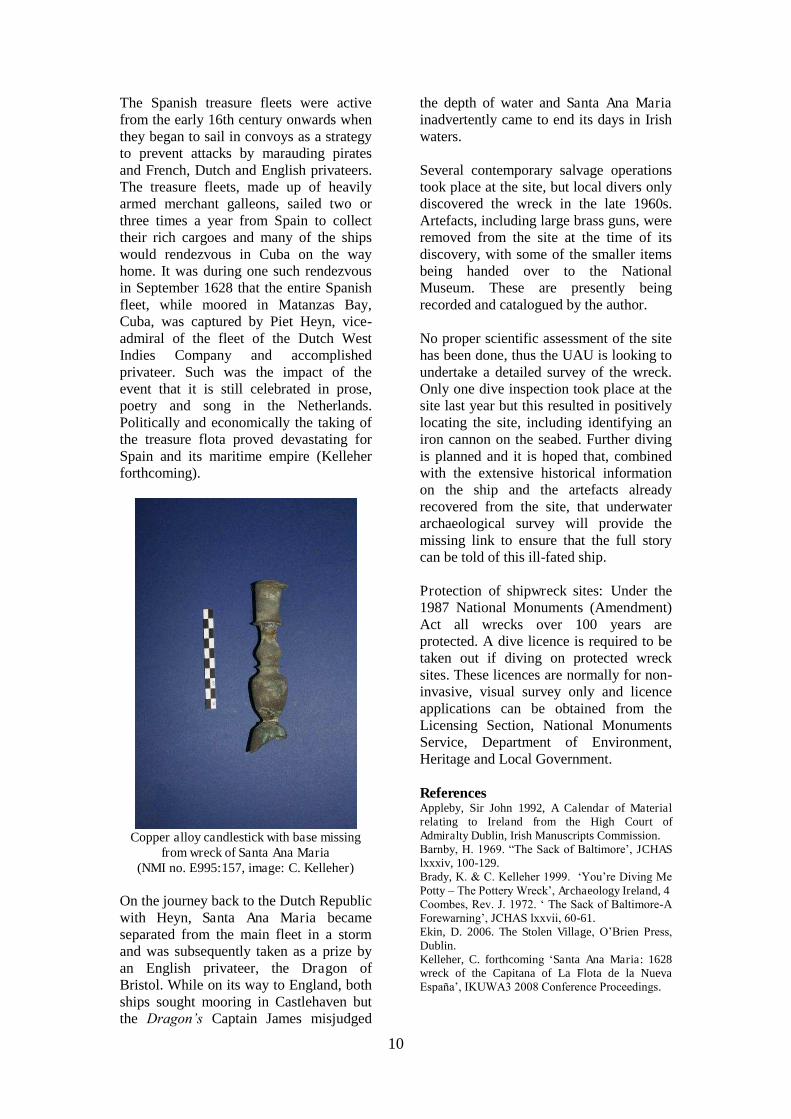
The Spanish treasure fleets were active from the early 16th century onwards when they began to sail in convoys as a strategy to prevent attacks by marauding pirates and French, Dutch and English privateers. The treasure fleets, made up of heavily armed merchant galleons, sailed two or three times a year from Spain to collect their rich cargoes and many of the ships would rendezvous in Cuba on the way home. It was during one such rendezvous in September 1628 that the entire Spanish fleet, while moored in Matanzas Bay, Cuba, was captured by Piet Heyn, vice-admiral of the fleet of the Dutch West Indies Company and accomplished privateer. Such was the impact of the event that it is still celebrated in prose, poetry and song in the Netherlands. Politically and economically the taking of the treasure flota proved devastating for Spain and its maritime empire (Kelleher forthcoming).
Copper alloy candlestick with base missing
from wreck of Santa Ana Maria (NMI no. E995:157, image: C. Kelleher)
On the journey back to the Dutch Republic with Heyn, Santa Ana Maria became separated from the main fleet in a storm and was subsequently taken as a prize by an English privateer, the Dragon of Bristol. While on its way to England, both ships sought mooring in Castlehaven but the Dragon’s Captain James misjudged
the depth of water and Santa Ana Maria inadvertently came to end its days in Irish waters. Several contemporary salvage operations took place at the site, but local divers only discovered the wreck in the late 1960s. Artefacts, including large brass guns, were removed from the site at the time of its discovery, with some of the smaller items being handed over to the National Museum. These are presently being recorded and catalogued by the author.
No proper scientific assessment of the site has been done, thus the UAU is looking to undertake a detailed survey of the wreck. Only one dive inspection took place at the site last year but this resulted in positively locating the site, including identifying an iron cannon on the seabed. Further diving is planned and it is hoped that, combined with the extensive historical information on the ship and the artefacts already recovered from the site, that underwater archaeological survey will provide the missing link to ensure that the full story can be told of this ill-fated ship. Protection of shipwreck sites: Under the 1987 National Monuments (Amendment) Act all wrecks over 100 years are protected. A dive licence is required to be taken out if diving on protected wreck sites. These licences are normally for non-invasive, visual survey only and licence applications can be obtained from the Licensing Section, National Monuments Service, Department of Environment, Heritage and Local Government. References Appleby, Sir John 1992, A Calendar of Material relating to Ireland from the High Court of Admiralty Dublin, Irish Manuscripts Commission. Barnby, H. 1969. “The Sack of Baltimore’, JCHAS lxxxiv, 100-129. Brady, K. & C. Kelleher 1999. ‘You’re Diving Me Potty – The Pottery Wreck’, Archaeology Ireland, 4 Coombes, Rev. J. 1972. ‘ The Sack of Baltimore-A Forewarning’, JCHAS lxxvii, 60-61. Ekin, D. 2006. The Stolen Village, O’Brien Press, Dublin. Kelleher, C. forthcoming ‘Santa Ana Maria: 1628 wreck of the Capitana of La Flota de la Nueva España’, IKUWA3 2008 Conference Proceedings.

11
The Battle of Saintfield 1798: a military historical and archaeological perspective By Gavin Hughes Introduction The battle of Saintfield was an extremely significant engagement during the 1798 United Irish campaign in Ulster. It came at a time when northern insurgent objectives mainly focused upon seizing the strategic towns of Antrim and Ballynahinch, both of which dominated the route to Belfast. However, between the 7th and 13th June, these two towns had seen crushing United Irish defeats. Only at Saintfield, on the 9th, were the tables reversed. Crown Forces were to suffer extremely heavy casualties here and, whilst exact figures remain uncertain, it is thought that some 56 soldiers from the York Fencibles and Newtownards Yeoman Cavalry and Infantry were lost (NA [Kew] WO 13/3964; Parks, 1798 in Hill, Turner, and Dawson 1998). United Irish casualty figures are still open to conjecture. The battle offers an excellent opportunity (as does the entire campaign) for combining rigorous military historical practice with archaeological techniques and theory (Hughes and Trigg forthcoming). The following article is a brief assessment of evidence for the battle in the landscape and its subsequent memorialisation. Battlefield Topography and Evidence Whilst Saintfield has changed considerably since 1798, there remains a discernable continuity in the landscape, mainly relating to places of worship and general town layout. The area of the battle on the Comber Road was, until fairly recently, relatively undisturbed as important photographic evidence from 1968 (see below) aptly demonstrates. However, the subsequent decades have seen much urban development which has considerably altered our perception of the battle site. Although the road where the Government troops were ambushed can still be followed on the ground, the hedgerow field boundary on the Saintfield
side, where the insurgent pikemen attempted to surge up towards the Crown cannon, is mostly under modern development. Consequently, the pivotal area where much of the battle occurred appears to lie under the modern road surface or beneath the ‘Cotswold Downs’ housing development. According to tradition as recorded in the Ordnance Survey Memoirs for Saintfield, the lower site of the battle (where the United Irish reserve was possibly positioned) is at Doran’s Wood (Day and McWilliams 1991, 116). Its remnants still extend along the stream by the Belfast road and Saintfield High School. Perhaps the most relevant surviving landmark is the Saintfield First Presbyterian Church and its environs. It was built in 1777 on the corner of Comber Street and in 1798 it lay on the edge of the town; fields ran down from the graveyard to the small stream at its foot, crossed by the bridge which led to both the Comber Road and Squire Price’s demesne. The Gothic gate lodge of this large estate is still extant, as is Saintfield House (c.1750) and grounds. Indeed, the town’s radical reputation largely stemmed from the influence of both the First Presbyterian’s minister, the Reverend Thomas Ledlie Birch and of Squire Nicholas Price, initially a reforming Anglican liberal with United Irish sympathies who later felt obliged to throw his weight behind the Establishment and raise a Corps of Yeomanry for the Government. Squire Price’s Saintfield Yeomanry met with little success and fewer recruits; five tunics (said to be from the ‘whole platoon’) were still in the private collection of the owner of Saintfield House, Lt-Colonel M.C. Perceval-Price in 1968. (Lyttle 1968, 174). The Anglican Parish church, built at the town’s heart in 1776, has changed little since 1798 when its vicar, Reverend James Clewlew, rode into the town on the morning of the 9th June. The vicar was accompanied by Rev. John Cleland, vicar of Newtownards and agent for Lord

12
Comber Road area in 1968 (McLelland 1968). Londonderry. Both were scouts for Colonel Staplyton’s column. On the town’s periphery (Fairview) is the Saintfield Second Presbyterian Church; built in 1796 by a congregation disenchanted by the United Irish sympathies of Rev. Birch. The Roman Catholic Chapel (1787) off Main Street would also have been a well-known landmark at the time of the Rebellion. Like many similar 1798 sites, Saintfield was cleared of debris and dead by the local inhabitants soon after the battle (McComb 1861, 128). Consequently, on the actual battle site evidence seems slight. Although it is not the intention here to focus on the artefactual evidence, anecdotal and photographic sources suggest that a number of items from the battle have been recovered. Such objects were recorded mainly in the first half of the last century and seem to be associated with the main part of the fighting (McClelland 1968; Robb 1971). One assemblage came from Mr Billy Grant, whose parents lived in The Square, Saintfield, and who was ‘one of the local people to have found swords and bayonets in this swampy area’ (Robb MSS; Lyttle 1968, 182). The ‘swampy area’ referred to was the patch of boggy ground at the bottom of the Saintfield First Presbyterian cemetery. Whilst some archaeological work has been recently conducted on an area within the cemetery of Saintfield First Presbyterian there is also significant, albeit haphazard, evidence for relics and artefacts of the battle being found.
Memorialisation of the Battle Memorials to the battle can be found in St. Mary’s Parish Church, Comber, and the area at the bottom of the cemetery of Saintfield First Presbyterian Church. Since 2009, development work has transformed the area into a form of ‘remembrance garden’ with a short walk by the stream and integrating the area of the two gravestones referred to below (Hyndman 2010). Next, this leads me to consider an enduring issue in battlefield archaeology in general; the location of associated burial sites for the war dead. At Saintfield First Presbyterian lie two headstones associated with United Irishmen killed during the battle. These sandstone headstones to John Lowry and James McEwen are at the foot of the cemetery and are immediately identifiable as being of 18th-century style and form. The gravestones are much worn with the latter being barely discernable and covered with moss. It reads: ‘Here lieth the Remains of James McEwen of Ballymacreely who Departed this life the 9th of June 1798 Aged 42 years’ (Clarke, 1969, 94). The other is in a better state of preservation and reads: ‘Here Lies the Body of John Lowry of Ballymarnon Parish of Killinchy he died June 9th 1798 aged 46 years.’ An older photograph of it can be compared to McEwen’s gravestone; using this, it appears unlikely that the same mason carved both stones. Indeed, it is possible that both stones were actually carved at significantly different
13
times. Lowry’s stone originally gave the date of his death as the 19th; yet there is a correction striking the ‘1’ out. Why these two individuals should be singled out for individual burial and memorialisation at all is intriguing. Tradition suggests that the rebel dead were interred in at least one pit, as were the Crown troops, in a location somewhere behind the current cemetery. Whilst nothing, as yet, has been discovered regarding the background of James McEwen, Birch mentions that John Lowry of Ardmillen led a unit of men from Killinchy (Toner 1998, 111). Clearly, Birch knew Lowry and it is plausible that he knew McEwen as well. In 1996 the headstones were obscured from view by a row of pine trees (O’Duifin 1998), which have recently been removed in modern renovations. However, during this spate of current work, gravestones have not been repositioned. This does not necessarily mean that the gravestones have not moved from their original position (Mytum, 2004, 185). Instead, as referred to above, a ‘park’ with walks and a seating area is landscaped around them. A number of new information boards have been erected at the site but, rather strangely, the details of the battle are relegated to a more general history of the events of 1798 itself. The only other memorial on the site is a modern slate plaque from (I believe) the late 1960s near the two United Irishmen’s graves. It is not known whether or not this plaque will soon be removed. It states:
‘Near this spot was fought the Battle of Saintfield on Saturday 9th June 1798 between the United Irishmen and the Royalist forces. Most of the dead of both sides seem to be interred somewhere to the rear of this plaque. The two adjoining headstones are those of insurgents who fell that day.’
Interestingly, this plaque could tend to suggest that both sides’ dead were mixed together during burial when, according to the documentary evidence, it is markedly stated otherwise (Brown 1820). It could also be noted that there is potentially an issue with loaded terminology in the plaque’s wording. Neither is the plaque’s
position entirely helpful in describing the location of associated burial pits. The suspected grave site area is now thoroughly disturbed and possibly under modern development. This is particularly disappointing as the building work potentially lies on top of an area known as ‘York Island’ which, according to local tradition and documentary sources, was the site of the burial of Government troops after the battle. This area could potentially yield human remains, which could be useful in illuminating further the exact nature of the fighting during the battle. Yet, as far as can be established, the site has not revealed any such traces - either in the modern period or in antiquity. Such remains, however, may not have survived due to soil conditions and any archaeological attempt to locate the mass graves of insurgents or Crown forces could be problematic. However, ‘some’ archaeological investigation has apparently been done at the foot of Saintfield First Presbyterian graveyard by Down Council and the District’s Head Archaeologist as a part of the churchyard renovations (Hyndman 2010). Finally, an important memorial to the battle can be found inside St. Mary’s Parish Church, Comber. It is a wall-mounted marble plaque in a neo-classical style typical of the late 18th century, with an urn in its centre and supporting pillars decorated with flowers, which may be symbolic of roses (Yorkshire?). The monument commemorates the York Fencible officers killed, including Captain William Chetwynd, Lt. William Haw Unite and Ensign James Sparks. The tablet was erected by ‘…their brother officers impressed with the deepest sorrow and with the highest sense of their courage and manly values.’ Interestingly, the three officers are also recorded as having given their lives ‘…bravely fighting for their King and Glorious Constitution in an Engagement near Saintfield with the Rebels.’ Conclusions Saintfield is a compact area of conflict, with landmarks which are still

14
recognisable within the landscape, which aid archaeological appreciation. However, as with similar sites elsewhere, we have the continuing issue of modern developments impacting on the remaining archaeology. Perhaps such urban conflict archaeology is in a more precarious position than its rural cousin. Whilst most useful military material was collected soon after the battle, one may reasonably expect expended musket shot and discarded canister fragments (from the Government guns) to be left behind. Equally, small items of lost equipment, or weapons broken during the fighting, would be of little military value to those clearing the field and could still remain in situ. Although this may seem optimistic, we have evidence to suggest that military artefacts (bayonets and edged weapons) were being recovered from the bottom of the Saintfield First Presbyterian cemetery as late as the middle of the last century (Robb 1968, 169-82). Despite modern agricultural and road disturbance, the field boundaries adjoining the modern Comber Road and Squire Price’s demesne may still hold material in a surviving battlefield layer. In this, the assistance of experienced and properly supervised metal-detectorists may be helpful. As the work of James O’Neill and Paul Logue on the Nine Years’ War demonstrates (Logue and O’Neill 2009), such a site - and 1798 campaign in general - merits a sustained and measured approach, combined with the careful use of archaeological practice. Finally, with the above proviso, the graves and potential burial sites around ‘York Island’ may benefit in the future from geophysical prospection, soil resistance monitoring or ground penetration radar. Whilst such methods rely greatly on the state of the ground, it may be that considerable information can still be gained from this practice. In this, the suspected grave sites may yield positive results, if the area has not already been too greatly disturbed. In particular, it may help in establishing if the location of the graves has moved and, if so, this may have a direct bearing upon the location of other ‘lost’ burial pits. Equally, it may resolve
any questions over whether or not this site is more a commemorative ‘sacred site’ of remembrance rather than an actual grave site. Acknowledgements: I would like to thank the staff at the Public Record Office Northern Ireland; the Linenhall Library, Belfast; Trinity College Library, Dublin; the Royal Society of Antiquaries of Ireland; I would also like to thank Rev. James Hyndman (Saintfield First Presbyterian Church), Rev. Chris Pollock (Saintfield Church of Ireland), Leslie Simpson (Down County Museum) and Jonty Trigg (University of Glasgow) for all their help and many useful observations. References Belfast News Letter, 12th June 1798, Linenhall Library, Belfast. Brown, Sandy c.1820 MS in C.J. Robb Collection, Down Recorder, 4th June 1971. Day, A. & McWilliams, P. (eds) 1991 Ordnance Survey Memoirs of Ireland, Vol. 7, Parishes of County Down, 1832-4, 1837, North Down & the Ards, Belfast, Institute for Irish Studies. Dickson, C., 1960 Revolt in the North: Antrim and Down in 1798 Dublin. Hill, Alexander: Deposition, 27th Sept 1799. PRONI Lytton White Papers, D714/3/45. Hill, M., Turner, B & Dawson, K. (eds) 1998 1798 Rebellion in County Down. Newtownards. Hyndman, Rev. James 2010, Minister of Saintfield First Presbyterian Church, Pers. Comm.01/03/2010. Hughes, G. and J. Trigg nd. ‘The 1798 Campaign’ Rosetta University of Birmingham. Logue, P. and J. O’Neill 2009 ‘The Battle of the Yellow Ford’ in A. Horning and N. Brannon (eds) Ireland and Britain in the Atlantic World Dublin, Wordwell. Lyttle, W.G., 1968 Betsy Gray, or Hearts of Down Newcastle, reprint. Maj-Gen. George Nugent to General Lake, 10th June 1798. N A I, Rebellion Papers Vol.4, 620/38/121. McComb, W. 1861 Guide to Belfast Belfast. McClelland, A. 1965 ‘Thomas Ledlie Birch United Irishman’, Proceedings and Reports of the Belfast Natural History and Philosophical Society 8, 28. McClelland, A. 1968 Preface in W.G. Lyttle, Betsy Gray. McClelland, A. 1971 History of Saintfield and District Saintfield. Muster Roll of York Fencibles killed at Saintfield, 9th June. NA [Kew] WO 13/3964. Mytum, H. 2004 Mortuary Monuments and Burial Grounds of the Historic Period New York, Springer. O’Duifin, S., ‘The Hearts of Down’, An Phoblacht/ Republican News, Thursday 4 June 1998. Patton, John: Letter, Saintfield 11 June 1798

15
[PRONI, McCance Papers D272/36]. Robb, C. The Down Recorder, 4 June 1971. Sparks, M. (Ensign, Yorks Fencibles), Letter to Capt Payne, 23 June 1798 in Young, R.M., Historical Notices of old Belfast and its vicinity [Belfast, 1896] and reprinted in Hill, M., Turner, B & Dawson, K. (eds) 1798 Rebellion in County Down (Newtownards, 1998) 261-263. Stewart, A.T.Q 1995 The Summer Soldiers Belfast. Stewart, A.T.Q. 1998 ‘1798 in the North’ History Ireland 6, No.2, 1798 Rebellion Special. Toner, G.P. 1998 ‘The Battle of Saintfield’, in M. Hill, B. Turner, and K. Dawson. (eds), 1798 Rebellion, 103-22. Unusual plumb-bob found during an underwater archaeological wade survey. By Aisling Collins A plumb-bob or a plummet is a weight, usually with a pointed tip on the bottom, that is suspended from a string and used as a vertical reference line. The plumb bob is one of the oldest tools in the world. The Egyptians used them for building. The key in a building construction is keeping things square to the ground.
This lead and brass plumb-bob was found during an underwater metal detection survey carried out by CRDS Ltd in the Carysfort Maretimo Stream in advance of the Carysfort Maretimo Stream Improvement Scheme. The Dublin to Kingstown Railway line, located adjacent to the find spot was constructed in 1834, and it is thought this may have been used during its construction. Could anybody date this plumb-bob? No parallels have been found to date.
Commemorating the Battle of the Ebro in the Terra Alta, Catalunya
By Franc Myles
There’s something of a feel of the backwoods in the northern hills of the Terra Alta, that part of Catalunya tucked into the mountains west of the Ebro. Here, the high ground to the north of the main valley is scored with crooked lines of olive and almond trees, stone-terraced into the hillsides between patches of parched scrubland and isolated wooded summits. An occasional ruin breaks the skyline or nudges into the side of a barranca but by Irish standards, the landscape is depopulated and abandoned. The area is of course extraordinarily beautiful and unspoilt. Most people from around here live in the small towns of la Fatarella, Vilalba dels Arcs or further west in Batea. Isolated farmhouses do hang on in decreasing numbers, some offering rough wine-tasting during the day, others a rustic bed and breakfast to souls needful of a particular quality of isolation. For here ruins remain ruins. There are no dilapidated fincas receiving the attentions of well-intentioned ex-pats, there are few enough Es Ven signs fixed to broken walls. Here the crumpled sun-dried placards advertising properties notionally marketable in an earlier economy, lie forgotten alongside the road, littered among rusting sherds of shrapnel and fragments of human bone. Historic landscape The valley below carries the main road from coastal Tarragonna west into Aragón. The ruined hilltop village of Corbera d’Ebre, its hardly-conserved church spire proud and intact, dominates the eastern end of the valley and overshadows the new town straddling the road below. Corbera was heavily bombed by the Nationalists over the course of the great Ebro offensive launched by the Republic in July 1938 and like Belchite to the west, it has been left to the elements and to the tourists, discomforting reminders of an unresolved conflict, the memory of which so far has been successfully managed by the Catalan state.
16
The main road continues west to the town of Gandesa, the military focus of the offensive, which though lasting just 115 days claimed over 130,000 lives. South of here are the Serra Cavalls which rise up into the serrated peaks of the Serra de Pàndols, their heights delineated by the pine tree line which occasionally obscures the ridge. Go further west through Calaceite and here the high ground recedes at either side. Beyond Alcañiz and further into Aragón the landscape opens onto a wide upland plateau ringed by distant mountains, with massive fields of winter wheat carpeting a rolling steppe extending onwards to a point just beyond eyeshot. On the road to Belchite, a compound of several square kilometres accommodates a sunflower farm, manifesting on the landscape as an army of flat-headed alien warriors arranged in tilted ranks, dwarfing a surprisingly flimsy fence. Belchite is a ruined town straddling the side of a hill, with two Baroque churches and several buildings just inside the medieval gate, roofless structures accessible through piles of masonry, bricks and roof tiles supporting charred roof timbers aligned at crazy angles. The town saw two major battles with its initial assault by American troops in 1937, followed by its abandonment the following March when it suffered heavy and sustained bombardment by Nationalist planes and artillery. Most of the upstanding ruins, which in 1989 perhaps represented as much as 40 percent of the surviving fabric of the streetscape, have now disappeared under an anonymous rolling terrain of demolition material. The levelled town thus demarcated appears itself to diminish around the edges, to be recycled elsewhere as hardcore or landfill. Although over 300 people lived in the town in 1955, a family of seven or eight were the only inhabitants there in 1989 and the place is now abandoned each evening after the last visitor departs the gates an hour after sunset. All of these landscapes are central to the history of the XV International Brigade, from the initial storming of Belchite and Quinto but more crucially to what become
known as the Great Retreats of March and April 1938, where Republican forces were progressively routed back eastwards, towards and across the Ebro. Many Internationals caught behind the lines were summarily executed with others surviving the remainder of the war in concentration camps such as San Pedro de Cardeña outside Burgos. When the Brigade advanced back across the Ebro the following July, local people showed them the mass graves into which their comrades had been thrown, often after the quick executions they themselves had been forced to witness. In any event, the Brigade never succeeded in taking Gandesa and was withdrawn in September after 60 days in the line. A huge and disproportionate casuality list records the crucial positions held by the Brigade during the advance, along with the several key fortified hilltops they never succeeded in capturing. The Ebro offensive was the last throw of the dice for the Republican government and its initial success was something of an embarrassment for Franco, who was again forced to call upon his German and Italian allies, just at the point where he was about to send them home. The nature of Franco’s defeat of the Republican government and the subsequent repression which lasted well into the 1970s was particularly felt in Catalunya, which apart from its separatist aspirations was the principal industrial base of the CNT, the main anarchist trade union. In the countryside, the repression was initially marked by the execution of anyone said to have actively opposed the coup, followed quickly by the banning of the Catalan language and a rationing system which was markedly more severe than in ostensibly ‘loyal’ areas. Nationalist battlefield fatalities were recovered and buried in the combatants’ home localities. International casualities, with a few significant exceptions, were buried hurriedly in mass graves or, in more remote areas, piled into the barrancas and pine copses which bestow upon the hills their remarkable appearance, and covered with stone cairns.

17
Archaeology and the politics of wind power The roads in the Terra Alta are dark and untraveled at night-time. The older ones, tarred-over dusty tracks, snake over the hills in tight curves around stepped orchards and dry stream beds. The main roads into Gandesa and Ascó are now being straightened to facilitate the construction of a large wind farm enveloping the hilltops in seemingly arbitrary patterns covering perhaps some 80km. The 6km between la Fatarella and Vilalba accommodates some 22 windmills, with bulldozers clearing stretches of land for associated access roads and ancillary structures. Local environmentalists opposed to this section of the wind farm were not slow to recognise its route across a massive graveyard in their campaign to halt their development. One such opponent, a blogger, Elies 115, graphically illustrated the human remains encountered on a walk through the hills near la Fatarella in July 2008 and the story was picked up all over Catalunya. Many subsequently voiced an opinion in the local media that had Roman remains been encountered, all works would have stopped to allow a thorough investigation. Excavating the dead What differentiates the remains recorded by Elies 115 from those emerging from other mass graves in the Spanish countryside is the fact that they most probably belong to members of the International Brigades. Although it is not suggested here that this has precluded a proper investigation of their remains, it is nonetheless of interest given the considerable body of literature associated with the Brigades when compared to their number relative to the Republican army as a whole. Archaeological work engaging with Franco-era Spain has concentrated on civilian mass grave sites. These hold the remains of the many thousands of socialists, communists, anarchists, schoolteachers and even liberals, executed for their beliefs, their resistance to the victors or simply by hearsay. The excavations throughout Spain have now
uncovered hundreds of burials, emphasising the oppression supposedly forgotten under the post-Franco pact of amnesia, where old wounds were let lie for the good of the fledgling democracy. Politically, this is to the advantage of the Socialist PSOE and the enacting of the Ley de Memoria Histórica (Law of Historical Memory) in 2007 has undeniably given the excavations a legislative basis, irrespective of feelings on the Nationalist side. Often undertaken in the media spotlight with relatives of the deceased present standing along the baulks, the excavations provide harrowing testimony of the extent of the Nationalist repression. Other more contentious issues have emerged: the muted enthusiasm of some families for the closure provided by the recovery of physical remains of their loved ones contrasted with the discomfiture evident on the faces of the family of Federico García Lorca, as they awaited the excavation of his remains after refusing for many years to have disturbed what they thought had been his grave. In Galicia and León former huídos, partisans who remained behind to continue the war from the mountains, have argued that the remains of their comrades should stay in the ground as incontrovertible and enduring evidence against Franco and his regime. An archaeological investigation undertaken prior to the construction of another wind farm elsewhere in the Terra Alta made little of the human bones and battlefield détruis scattered high along the terraces and in the scrub. The report made more of the trenches, the rude caves and refugios carved out of the sandy subsoil, lending shelter from the constant Nationalist bombardment; the physical manifestations of the Ebro offensive which today survive on the landscape. Yet, despite the plethora of recent work on the period, both academic and commemorative, there has been little attempt made to contextualise the human remains, which are as likely to date to the Great Retreats as they do to the offensive. Moreover, there has been little discussion as to what should now be done with the

18
bones, whether they should lie there in perpetual memory of the war or whether they should be systematically collected and placed in the monument at los Camposines which acts as an ossuary for human remains recovered from the surrounding fields and hillsides. Commemoration, conservation & construction State-sponsored commemoration of the battle of the Ebro was prompted by the recent 70th anniversary and has taken the form of a series of panels located at significant points on the landscape, all anchored to an interpretative centre in Corbera and notionally to the monument in los Camposines. Under the auspices of Memorial Democràtic the Catalan government has certainly made an effort to commemorate both sides of the conflict, the rusty orange signage and an accompanying series of information leaflets brands its commemoration for modern, all-embracing consumption. The souvenirs and tee shirts available at the 115 Days centre in Corbera are based on the graphic of a military helmet, one curiously more Republican than Nationalist in its typology. The interpretation within is dispassionate and uncontroversial; the centre, an anodyne exercise in contemporary architecture, was deserted the afternoon we visited. Just up the street from the interpretative centre is a private museum, Exposició La Trinxera, which trades in bullets, guns and (mostly) republican uniforms draped over ‘70s shop window mannequins. Here a very different experience is to be had: the exhibition confined to one large cluttered room, old-fashioned display cases line the space containing a mesmerising quantity of personal equipment and assorted militaria; the walls are covered with campaign maps, propaganda sheets and government proclamations. The floorspace is taken up with a full sized Republican command post along with various large weapons and a mule professionally fashioned from wire, carrying the obligatory ammunition boxes and stretchers. The owner/curator has a large shed to the rear crammed with similar
booty and takes particular pride that his Maxim machine gun is an original artefact, unlike that one displayed in another semi-private museum down the road in Gandesa. One returns blinking into the sunlight with thirsty lungs, persuaded that the patched, ragged costumes within have been taken from the dry bones lying out on the hills. A different engagement with the memory of the battle in Corbera can be experienced in the ruined village on the hilltop, itself a protected historical site. Here local artist Jesús Pedrola has for several years curated the Alphabet of Freedom, a collaborative project comprising large letters arranged throughout the ruined streetscape by visiting artists in a variety of media and styles. More recently a more formal entity, the Patronage del Poble Vell, has been set up by members of the community backed by the local council with the clear objective of ‘preserving and restoring’ the site. According to their website, ‘A lot of people visit the site and it concerns our own history. A history testified in the stones which we wish to restore and preserve, to leave in better condition for the younger generation. We don't wish the site to be lost or to deteriorate more.' However, the inherent technical challenge of trying to preserve a site already in ruins has not been addressed and it will be interesting to see how in the future Corbera will weigh up against Belchite, a less-visited spot, yet one which seems to disintegrate and diminish with each passing year. One of the objectives of the Patronage is to create a photographic archive that will serve to preserve the memory of the village as it was, while at the same time providing an exhibition space for donated works from artists associated with the alphabet project. A semi-derelict house on the edge of the old village has been acquired and is about to undergo conservation works, funded by ANAV, the power company which operates the 40-year old nuclear plant on the Ebro at nearby Ascó. The house stands directly beside the building Pedrola has been

19
reconstructing over several years at his own cost, which functions as an information point for those visiting the ruined village. He is now under pressure from the town hall to close up the building, which provides him with a meagre income to protect the Alphabet through the sale of books and posters. He worries how Corbera’s story will be presented in the new building and is suspicious of the input from ANAV, where the power plant is still seen as a legacy of the dictatorship. Those supporting the construction of the wind farms point to the nuclear plant and its abysmal safety record. The most recent incident relates to a serious leak which occurred in November 2007; although radioactive particles were still being detected outdoors on 14 March 2008, the Spanish Nuclear Energy Authority was not informed of the incident until 4 April. Local groups were incensed that staff at the plant had allowed a school trip to go ahead just a day before the leak was made public. In August the Energy Authority announced penalties against the plant of up to €22.5 million for a series of breaches, including their failure to immediately report the leak. The Zapatero government has pledged to make Spain nuclear-free, but has not proposed a meaningful time frame. Meanwhile it’s hoped that the sun and the wind can provide an ever-increasing proportion of the country’s needs into the future. Back up in the hills, the construction of the wind farm continues apace. With most of the windmills already erected, those opposed to their construction are admitting defeat. But what of the human remains that have been disturbed in their construction? On 17 June 2009 the Catalan parliament passed legislation on the recovery and identification of those who disappeared during the Civil War and subsequent dictatorship. The new law places the onus on the Catalan state to locate the graves of missing persons, supporting the rights of their descendants to obtain information about their fate and, if appropriate, to excavate their remains. The law further supports the marking of
such mass graves and their preservation as places of memory, to satisfy people’s right to know the truth of events during the period and the political circumstances in which the disappearances occurred. In the light of recent revelations regarding the execution of Robert Hale Merriman (the American chief of staff of the XV Brigade), it is only a matter of time before the families of the International fallen will request the assistance of the Catalan government in identifying the burial sites of their own disappeared. Conclusion As García Lorca’s descendants were sadly not to discover, the science of DNA matching has advanced sufficiently to allow the identification (or otherwise) of remains from known burial sites. Attempting, however systematically, to recover individual lives and histories from disarticulated bones gathered from the hillsides is another story. Given that the remains are as likely to belong to volunteers from outside Spain renders the task all the more impossible. It perhaps serves a greater purpose that the bones should remain where they lie with their anonymity intact, a reminder for all of the sacrifices made in the attempt to defeat fascism in Spain. In an economy where ruined villages compete with private museums and interpretative centres, where international solidarity has been replaced by the globalised capital of the power companies, their sacrifice has become all the more undermined.
The 2011 IPMAG committee includes chairperson Tracy Collins, Secretary Frank Coyne, Treasurer and Membership Secretary Rosanne Meenan, Website Manager Wes Forsythe, and members Nick Brannon, Eve Campbell, Richard Clutterbuck, Colm Donnelly, Audrey Horning, Connie Kelleher, Paul Logue, James Lyttleton, Siobhán McDermott, Franc Myles, and Ruairí Ó Baoill www.science.ulster.ac/crg/ipmag.html