Shelf stratigraphy and the influence of antecedent substrate on Holocene reef development, south...
18
Shelf stratigraphy and the influence of antecedent substrate on Holocene reef development, south Oahu, Hawaii E.E. Grossman * , W.A. Barnhardt, P. Hart, B.M. Richmond, M.E. Field US Geological Survey, Pacific Science Center, 400 Natural Bridges Dr. Santa Cruz, CA 95064, USA Received 6 December 2004; received in revised form 8 September 2005; accepted 13 September 2005 Abstract Paired analyses of drill cores and high-resolution seismic reflection data show that development of Holocene framework reefs on the Oahu (Hawaii) shelf is limited to settings of low wave energy and to the period 8000 to 3000 yr BP. A prominent bounding surface that is mapped across much of the Oahu shelf is an erosion surface cut into Marine Isotope Stages 5 and 7 limestones that show extensive loss of primary porosity, aragonite, and MgCO 3 owing to meteoric and vadose-zone diagenesis. This acoustic reflector is found exposed at the surface where wave energy is high or in the shallow subsurface below Holocene reef and sand sheet deposits where energy is low. Ship-towed video along 30 km of the shelf reveals a steady decrease in limestone accumulation from offshore of Honolulu southeast to Koko Head where the seafloor is characterized by volcanic pavement and/or thin sand deposits. This may reflect the build-up of late Pleistocene volcanics associated with the Hanauma Bay eruption (30,000–7000 yr BP) that now comprise the substrate in depths shallow enough to limit reef accretion. The absence of significant Holocene reef build-up on the south Oahu shelf is consistent with observations from north-facing coasts that lack Holocene reefs, indicating that Holocene reef formation in Hawaii is complex and patchy. D 2005 Elsevier B.V. All rights reserved. Keywords: shelf; reef; seismic-reflection; Holocene; Oahu; Hawaii 1. Introduction Recent studies suggest that in addition to increasing pressure from human activities and climate change, coral reefs on the Island of Oahu, Hawaii, develop within a narrow range of conditions largely controlled by high wave exposure and shallow antecedent topog- raphy (Grigg, 1998; Grossman and Fletcher, 2004). Analyses of core samples from two north-facing coasts show that the insular shelf is largely fossil and absent of appreciable Holocene reefs (N 1–2 m thick) where it is exposed to open ocean north swell (Rooney et al., 2004; Sherman et al., 1999). Pilot surveys of reef surface ages around the island of Oahu led Grigg (1998) to propose that Holocene reef accretion on Oahu has been insignificant due to long-period swell and has been limited to well-protected embayments such as Hanauma Bay (Easton and Olson, 1976) and Kaneohe Bay. On the windward coast of Kailua Bay, detailed studies of 32 cores show that a significant Holocene reef developed only between 8000 and 5000 yr BP and only in settings of low wave energy or at depths below wave scour (Grossman and Fletcher, 2004). Additionally, reef development has been uniquely 0025-3227/$ - see front matter D 2005 Elsevier B.V. All rights reserved. doi:10.1016/j.margeo.2005.09.012 * Corresponding author. Tel.: +1 831 427 4725; fax: +1 831 427 4748. E-mail address: [email protected] (E.E. Grossman). Marine Geology 226 (2006) 97 – 114 www.elsevier.com/locate/margeo
-
Upload
uhh-hawaii -
Category
Documents
-
view
1 -
download
0
Transcript of Shelf stratigraphy and the influence of antecedent substrate on Holocene reef development, south...

www.elsevier.com/locate/margeo
Marine Geology 226
Shelf stratigraphy and the influence of antecedent substrate on
Holocene reef development, south Oahu, Hawaii
E.E. Grossman *, W.A. Barnhardt, P. Hart, B.M. Richmond, M.E. Field
US Geological Survey, Pacific Science Center, 400 Natural Bridges Dr. Santa Cruz, CA 95064, USA
Received 6 December 2004; received in revised form 8 September 2005; accepted 13 September 2005
Abstract
Paired analyses of drill cores and high-resolution seismic reflection data show that development of Holocene framework reefs
on the Oahu (Hawaii) shelf is limited to settings of low wave energy and to the period 8000 to 3000 yr BP. A prominent bounding
surface that is mapped across much of the Oahu shelf is an erosion surface cut into Marine Isotope Stages 5 and 7 limestones that
show extensive loss of primary porosity, aragonite, and MgCO3 owing to meteoric and vadose-zone diagenesis. This acoustic
reflector is found exposed at the surface where wave energy is high or in the shallow subsurface below Holocene reef and sand
sheet deposits where energy is low. Ship-towed video along 30 km of the shelf reveals a steady decrease in limestone accumulation
from offshore of Honolulu southeast to Koko Head where the seafloor is characterized by volcanic pavement and/or thin sand
deposits. This may reflect the build-up of late Pleistocene volcanics associated with the Hanauma Bay eruption (30,000–7000 yr
BP) that now comprise the substrate in depths shallow enough to limit reef accretion. The absence of significant Holocene reef
build-up on the south Oahu shelf is consistent with observations from north-facing coasts that lack Holocene reefs, indicating that
Holocene reef formation in Hawaii is complex and patchy.
D 2005 Elsevier B.V. All rights reserved.
Keywords: shelf; reef; seismic-reflection; Holocene; Oahu; Hawaii
1. Introduction
Recent studies suggest that in addition to increasing
pressure from human activities and climate change,
coral reefs on the Island of Oahu, Hawaii, develop
within a narrow range of conditions largely controlled
by high wave exposure and shallow antecedent topog-
raphy (Grigg, 1998; Grossman and Fletcher, 2004).
Analyses of core samples from two north-facing coasts
show that the insular shelf is largely fossil and absent of
0025-3227/$ - see front matter D 2005 Elsevier B.V. All rights reserved.
doi:10.1016/j.margeo.2005.09.012
* Corresponding author. Tel.: +1 831 427 4725; fax: +1 831 427
4748.
E-mail address: [email protected] (E.E. Grossman).
appreciable Holocene reefs (N1–2 m thick) where it is
exposed to open ocean north swell (Rooney et al.,
2004; Sherman et al., 1999). Pilot surveys of reef
surface ages around the island of Oahu led Grigg
(1998) to propose that Holocene reef accretion on
Oahu has been insignificant due to long-period swell
and has been limited to well-protected embayments
such as Hanauma Bay (Easton and Olson, 1976) and
Kaneohe Bay.
On the windward coast of Kailua Bay, detailed
studies of 32 cores show that a significant Holocene
reef developed only between 8000 and 5000 yr BP
and only in settings of low wave energy or at depths
below wave scour (Grossman and Fletcher, 2004).
Additionally, reef development has been uniquely
(2006) 97–114
E.E. Grossman et al. / Marine Geology 226 (2006) 97–11498
linked with antecedent topography, although unlike the
Purdy (1974) model where reefs mimic high topogra-
phy. In this wave-exposed setting, reef development
occurs only within low topography below depths of
wave scour. Successful attempts have been made to
map and correlate reef distribution to antecedent to-
pography using seismic-reflection profiling (Harvey
and Hopley, 1981; Marshall et al., 1998; Searle,
1983), but data quality is generally poor in porous
Holocene reefs and coverage is sparse (and lacking in
Hawaii). Using high-resolution seismic reflection pro-
filing, ship-towed video, and analyses of core samples,
this paper characterizes the substrate of the southern
Oahu insular shelf and tests the hypothesis that Holo-
cene reefs across the greater Oahu shelf are restricted
to settings of low antecedent topography (below wave
scour) and/or areas of dissipated wave energy. The
extent to which this model represents recent reef
development around the entire Oahu shelf has been
unclear; if correct, the few extant reefs warrant greater
attention to increased human and climate change-re-
lated stress.
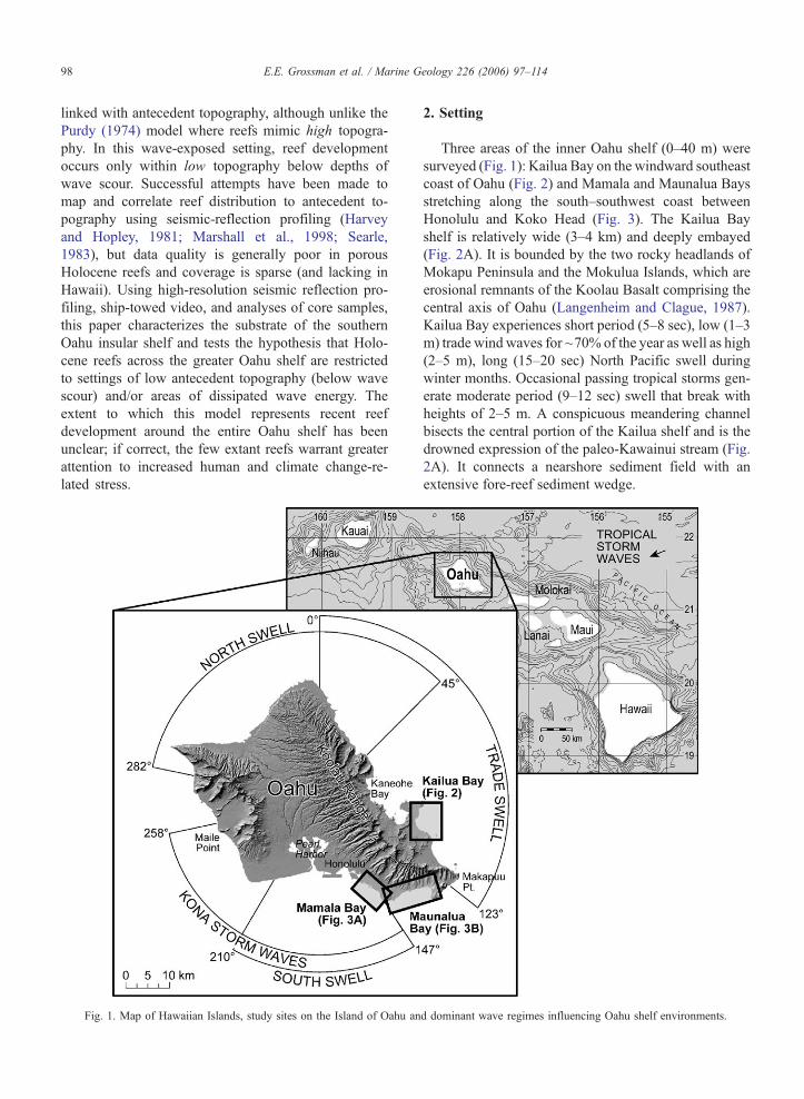
Fig. 1. Map of Hawaiian Islands, study sites on the Island of Oahu an
2. Setting
Three areas of the inner Oahu shelf (0–40 m) were
surveyed (Fig. 1): Kailua Bay on the windward southeast
coast of Oahu (Fig. 2) and Mamala and Maunalua Bays
stretching along the south–southwest coast between
Honolulu and Koko Head (Fig. 3). The Kailua Bay
shelf is relatively wide (3–4 km) and deeply embayed
(Fig. 2A). It is bounded by the two rocky headlands of
Mokapu Peninsula and the Mokulua Islands, which are
erosional remnants of the Koolau Basalt comprising the
central axis of Oahu (Langenheim and Clague, 1987).
Kailua Bay experiences short period (5–8 sec), low (1–3
m) trade wind waves for ~70% of the year as well as high
(2–5 m), long (15–20 sec) North Pacific swell during
winter months. Occasional passing tropical storms gen-
erate moderate period (9–12 sec) swell that break with
heights of 2–5 m. A conspicuous meandering channel
bisects the central portion of the Kailua shelf and is the
drowned expression of the paleo-Kawainui stream (Fig.
2A). It connects a nearshore sediment field with an
extensive fore-reef sediment wedge.
d dominant wave regimes influencing Oahu shelf environments.
Fig. 2. (A) Map of Kailua Bay and dominant morphological features
of the shelf including the drowned Kawainui stream channel connect-
ing a nearshore sand field with fore-reef sediment wedge. (B) Central
Kailua reef and location of seismic-reflection profiles (bold lines are
presented in Fig. 7), drill cores (triangles, numbered sites shown in
Fig. 7), and bottom photographs (squares, Fig. 3). Depth contours in
5-m intervals.
E.E. Grossman et al. / Marine Geology 226 (2006) 97–114 99
Mamala and Maunalua Bays in contrast, lie in the
lee of the Koolau Range and, as a result, trade wind
swell is significantly diminished along this portion of
the Oahu shelf (Figs. 1 and 3). The Mamala Bay shelf
extends seaward of a relatively low-gradient shoreface
between Pearl Harbor and the volcanic headland at
Diamond Head. The Maunalua Bay shelf between Di-
amond Head and Koko Head fronts a much narrower
and steeper coastal zone but is significantly wider out to
the shelf break. The shelf in these bays face directly
south and receives wave energy from distant southern
hemisphere Pacific swell characterized by long-period
(22 sec) and moderate heights (2–4 m). Episodic high
energy from tropical storm swell and annual Kona swell
(9–15 sec, 2–5 m) passing to the southwest also impacts
this coast.
3. Materials and methods
A combination of seismic-reflection profiling, ship-
towed video and coring were used in this analysis.
Navigation for these data sources was based on differ-
ential GPS, which ranged in positional accuracy be-
tween 1 and 8 m. An extensive and high-resolution
(1–2 m) airborne LIDAR data set (Figs. 2 and 3) col-
lected through a multi-agency effort to characterize
coastal habitats and shoreline change was used for initial
seafloor classification and for guiding the planning and
collection of seismic-reflection data and video-ground
truth imagery.
Seismic-reflection profiles were collected along 52
km of the Oahu Shelf in Kailua and Mamala Bays in
October 2001 aboard the RV Wailoa (Figs. 2 and 3).
The sound source for the single-channel seismic-reflec-
tion system was a 50-tip mini-sparker operated at 300 J
firing at 4 pings per sec. Data were acquired through a
5-m 30-hydrophone streamer and records of 200 msec
length were digitized at 16 kHz using Delph Seismic
software. Ship speed ranged from 3.5 to 4.5 kts pro-
ducing an average ping-space of 0.5 m. The digital data
were spatially filtered for swell effects by flattening to a
smooth seafloor using a 24-sec boxcar filter. This elim-
inated the effects of the dominant 7-sec trade swell that
characterized conditions during data acquisition and
had little effect on the morphology of seafloor features
examined here which are generally larger than the
wavelength filtered. A temporal band-pass filter of
200–800 was applied to the stacked data.
Ship-towed video was collected along ~30 km of the
shelf in Mamala and Maunalua Bays between 2000 and
2003 and recorded digitally generally with altimetry
data to discern distance off bottom and field of view
(Figs. 2 and 3). Two lasers separated at 10 cm provided
scale. Morphology, substrate type and coral and algal
species/genera were logged real-time and in post-pro-
cessing following the National Oceanic and Atmo-
spheric Association (NOAA) classification of coral
reef benthic habitats (Coyne et al., 2003). GPS posi-
tioning was recorded directly onto one of the digital
audio tracks using RedHen software/hardware for play-

Fig. 3. Map of (A) Mamala Bay and (B) Maunalua Bay showing seismic reflection profiles (solid dotted line, bold lines are presented in Fig. 9),
ship-towed video (open dotted line), drill core sites (triangles, numbered sites shown in Fig. 9) and bottom photographs (squares). Depth contours in
5-m intervals.
E.E. Grossman et al. / Marine Geology 226 (2006) 97–114100
back and automated ship track generation in ArcInfo.
Substrate classifications were made for every GPS
location recorded, which under ship speeds of 1–2 kts
resulted in a data spacing of 0.5 to 1 m.
Core samples were collected with a submersible,
hydraulic-powered, diver-operated, rotary drill of the
open barrel and wireline types (see Grossman and
Fletcher (2004) for specifications). Hole depths and
recovery lengths were measured with a 1-cm division
stadia rod. Cores were logged in the field and strati-
graphic reconstructions were generated with detailed
lithologic descriptions using standard sedimentologic
and petrographic techniques. Samples were screened
for radiometric dating using X-ray diffraction (XRD)
carbonate mineralogic signatures after thorough clean-
ing with H2O2 and dilute HCl after Grossman and
Fletcher (2004). Radiocarbon dates measured by the
Center for Accelerator Mass Spectrometry (Lawrence
Livermore Laboratory) and the National Ocean Sciences
Accelerator Mass Spectrometer (Woods Hole) were cal-
ibrated to calendar years using Calib. 4.2 (Stuiver and
Reimer, 1993) while U/Th ages were determined at the
University of Minnesota following the analytical and
reporting conventions of Edwards et al. (1987).
4. Results
4.1. Facies and structural units
4.1.1. Seismic facies and bounding surfaces
Four seismic facies (Fig. 4) are herein identified based
on acoustic reflection and geometric characteristics and

Fig. 4. Major shelf facies including seismic and sedimentary characteristics.
E.E. Grossman et al. / Marine Geology 226 (2006) 97–114 101
include (A) coral reef/mound, (B) pavement, (C) channel
fill sediment, and (D) fore-reef wedge facies. These
facies have been ground-truthed directly through sam-
pling and/or imaged with video and photography. One
prominent bounding surface that is pervasive across the
Kailua and Mamala shelves is identified as the Holocene
unconformity. Description of the acoustic properties and
geometry of these facies and bounding surface follows.
The coral reef/mound facies is morphologically dis-
tinct on the Oahu shelf, forming mound and/or ridge
topography along an otherwise relatively low-gradient
terrace (Fig. 4A). It generally has concentric and con-
tinuous parallel to subparallel internal reflectors. Re-
flection amplitudes are moderate in strength and despite
the high rugosity and porosity of recent to modern coral
reefs, acoustic energy is not significantly attenuated by

E.E. Grossman et al. / Marine Geology 226 (2006) 97–114102
this facies and is able to image underlying reflectors.
The coral reef/mound facies is commonly located near
breaks in slope of the underlying antecedent substrate.
It is most common in or near drowned depressions of
the antecedent topography (valleys, channels) apparent-
ly where low-lying substrate provides space below
wave scour effects.
The pavement facies (Fig. 4B) is composed of con-
tinuous to discontinuous parallel high-amplitude reflec-
tors at or within a few meters of the seafloor that are
often truncated. This unit attenuates acoustic energy so
effectively that seismic signal is often lost within 5–20
m of the pavement surface. In Kailua and Mamala
Bays, this pavement is entirely limestone, although
volcanic pavement predominates in Maunalua Bay
(see Section 4.1.2). The extremely low Mg-calcite min-
eralogy of the limestone pavement is responsible for the
strong density contrast of the pavement facies relative
to the other facies mapped here and the surface ocean
(see Section 4.1.3).
The channel fill sediment facies (Fig. 4C) is charac-
terized by parallel to subparallel, moderate to low-am-
plitude reflectors. Acoustic energy is effectively
transmitted tens of meters through this unit. The chan-
nel fill facies displays variable internal structure (onlap,
offlap, draping) and often reveals complex and strong
underlying acoustic reflectors representative of pave-
ment. The channel fill occurs in drowned channels and
valleys. Only the upper ~10 m of this unit has been
sampled, where it is composed of marine carbonate
sands.
The fore-reef wedge facies (Fig. 4D) displays
oblique parallel and sigmoidal offlapping reflectors
of moderate acoustic amplitude. Variable intensity
reflectors suggest interbedded units within the sedi-
ment wedge facies that likely represent material of
significantly different composition, grain size or ce-
mentation history. This is the dominant facies found
along the seaward edge of the low-gradient insular
shelf and is especially common near drowned chan-
nels and valleys. This unit commonly buries steps in
the underlying antecedent substrate offshore of the
�20 m isobath.
Where the pavement facies underlies the reef/
mound, channel fill, or fore-reef wedge facies, a distinct
bounding surface is revealed in seismic sections. This
surface is marked by the significant density contrast
associated with the pavement facies, and where it is
exposed at the seafloor, it exhibits pre-Holocene ages
reflecting a hiatus in sediment accumulation. This sur-
face is identified as the unconformity between Pleisto-
cene and Holocene deposits.
4.1.2. Modern seafloor substrates
Based on ship-towed video and surface sediment
sampling, the modern insular shelf of South Oahu is
comprised of three general substrate types: coral reef,
pavement (limestone and volcanic), and unconsolidated
sediment (Fig. 5).
Coral reef substrates on the south Oahu shelf occur
primarily in inner shelf settings (b15 m) and are gen-
erally thin veneers except in wave-protected settings.
They are generally of high rugosity (Fig. 5A), except
where coral community is dominated by encrusting
forms (Fig. 5B, C). They commonly display spur and
groove morphology. Coral reef substrates are equivalent
to the reef/mound facies observed in seismic reflection
data. Coral reef substrates are widely believed to be
ephemeral features on Oahu. Periodically extensive
tracts of surface coral are entirely removed by passing
hurricanes and high waves (Dollar and Tribble, 1992;
Grigg, 1995).
Pavement substrates occur between 0 and �120 m
depth and are low-gradient, smooth surfaces comprised
of fossil reef limestone (Fig. 5D) or volcanic basalts.
Volcanic pavements commonly display locally high
rugosity in the form of ledges (Fig. 5E), pedestals,
and meter-size plates (Fig. 5F) or boulders, whereas
limestone pavements are typically low relief. The age of
volcanic pavements comprising the shelf is poorly
known, while limestone pavement ages range ~5000
to 210,000 yr BP (Grossman and Fletcher, 2004; Sher-
man et al., 1999).
Unconsolidated sediments are primarily comprised
of marine carbonate sands found in channels and as
sheets (Fig. 5G, H) in mid- and outer-shelf depths
(Harney et al., 2000; Harney and Fletcher, 2003).
They also are common along the outer shelf in the
form of thick sediment deposits (Hampton et al.,
2003) commonly supporting dense stands of the green
calcareous alga Halimeda (Harney et al., 1999).
Variations to this simple classification result from
the temporal colonization of these substrates by coral
and algae (coralline and fleshy green and brown algae).
Other substrates including volcanic boulder fields are
known along portions of the south Oahu shelf (Maka-
puu Pt.) that were not part of this study.
4.1.3. Biolithofacies
Analyses of core samples from the Oahu shelf reveal
three primary reef units (Holocene and Marine Isotope
Stage (MIS) 5, and MIS 7 limestones) composed of six
biolithofacies: branching coral framestone facies, mas-
sive coral framestone facies, mixed coral and coralline
algal-dominated grainstone, branching coral-rich rud-

Fig. 5. Seafloor substrate types of the southern Oahu shelf (see Figs. 2 and 3 for locations). (A) Aggregated coral reef, central seaward Kailua Bay.
(B) Colonized pavement, offshore of Kewalo, Mamala Bay. (C) Encrusting coral reef on pavement, central south platform Kailua Bay. (D)
Limestone pavement with rubble, offshore of Kewalo Harbor, Mamala Bay. (E) Partly colonized volcanic pavement, western Maunalua Bay. (F)
Uncolonized volcanic pavement, central Maunalua Bay. (G) Uncolonized pavement central eastern Maunalua Bay. (H) Unconsolidated sediment
(sand sheet) outer eastern Maunalua Bay.
E.E. Grossman et al. / Marine Geology 226 (2006) 97–114 103

E.E. Grossman et al. / Marine Geology 226 (2006) 97–114104
stone, encrusting coral and coralline algal bindstone,
and a mixed skeletal and pelloidal wackestone. The
first five of these facies are discussed in detail by
Grossman and Fletcher (2004) and are characteristic
of the Holocene reef units in Kailua Bay. All six
facies are also found in pre-Holocene MIS 5
(125,000 yr BP) and 7 (210,000 yr BP) reef units
(Sherman et al., 1999; Grossman, 2001). The wack-
estone is restricted to MIS 5 and 7 reef units and
composed of well-cemented fine marine carbonate
sand and silt often displaying dessication cracks.
Holocene reef facies are differentiated in age from
those of MIS 5 and 7 units by radiometric dating (14C
and 230Th), carbonate mineralogy, and petrologic tex-
ture, namely dissolution and cementation histories
(Grossman, 2001). Particularly important to the seis-
mic-reflection imaging and interpretations made here is
the difference in MgCO3 mineralogy and cementation
history of Holocene and Pleistocene reef units. The
Holocene reef units are comprised of porous extant
coral, coralline algae, molluscs, foraminifera, and echi-
noids with pristine mineralogies characterized by ma-
rine values of aragonite (90–100%) and Mg-calcite
(12–20 mol% MgCO3) (Grossman, 2001). In contrast,
the pre-Holocene MIS 5 and 7 reef units commonly
retain little aragonite and are comprised of stable forms
of calcite (b4 mol% MgCO3) commonly related to
calcite spar infills, whisker cements, infilled dessication
cracks, and moldic porosity (Fig. 6).
The wholesale loss of aragonite in the pre-Holocene
reef units through dissolution and conversion of high-
Mg-calcites to stable forms of calcite during meteoric
and vadose zone diagenesis (during sea-level low
stands) has produced a surface layer of calcrete that
in turn yields a strong density contrast and acoustic
impedance in seismic reflection data relative to overly-
ing Holocene units. These distinct cementation and
alteration histories therefore have produced a distinct
reflector that can be continuously imaged over exten-
sive areas with significantly less effort than the widely
spaced data points obtained with great effort from
cores.
4.2. Shallow stratigraphy of Kailua Bay, Oahu
Seismic-reflection profiles in Kailua Bay show that
the shallow stratigraphy of the windward Oahu insular
shelf is characterized by reef/mound, pavement, chan-
nel fill and fore-reef wedge acoustic facies (Fig. 7).
Reef/mound facies are found only in the central portion
of the bay and occur in mid-shelf depths (�8 to �15 m
below mean sea level; Fig. 7A, B). Core samples show
that the Holocene reef at site K21 (Fig. 7B) is N11 m
thick. Based on the travel time between the top and
base of the reef facies at K21 and the measured thick-
ness of ~11 m in core section, we derive an interval
velocity for the porous Holocene reef framework of
approximately 1750 m/s, which is lower than previous-
ly assumed rates for recent carbonates of 2000 m/s
(Esker et al., 1998). Isolated reef and mound structures
are also observed buried below modern sediments (e.g.
intersection of OK17 and OK24; Fig. 7B). Landward of
the fore reef, reef/mound facies are restricted to the
central portion of the bay near the central drowned
channel and are generally thin (1–4 m) accumulations
(Fig. 7C). Cores through the Kailua shelf also show this
pattern of Holocene reefs to be restricted to central
Kailua Bay (Grossman and Fletcher, 2004).
The pavement facies occurs across the majority of
the Kailua Bay shelf. Across the wide reef platforms, it
becomes shallower and is ultimately exposed at the
surface beyond ~0.5 km north and south of the central
drowned channel (Fig. 7C). Results of coring show that
the decrease and eventual disappearance of Holocene
reef facies north and south away from the central
drowned channel is accompanied by a steady decrease
and eventual loss of aragonite content within the upper
2 m of the central Kailua reef platform (Fig. 8). A
corresponding decrease in the mol% MgCO3 is a char-
acteristic of limestone pavement formed by meteoric
and vadose zone diagenesis (Grossman, 2001; Sherman
et al., 1999).
The channel fill sediment facies is observed in all of
the seismic profiles that cross the central drowned
channel and is exemplified by a thick deposit display-
ing internal structure in Fig. 7D. Although asymmetric
bedforms observed migrating seaward under tradewind
wave conditions suggest sediment transport is active at
the surface of this facies (Cacchione et al., 1999),
intricately bedded internal structure within the facies
at significant depth (20–30 m, Fig. 7D) indicate vari-
able sediment accumulation has occurred over at least
the last several millennia. The channel fill sediment
facies is also observed in smaller pockets and karst
features across the reef.
Seaward of the fore reef the Kailua shelf grades into
an expansive sediment wedge that we have classified as
the fore-reef wedge seismic facies (Fig. 7A, B). Seis-
mic-reflection data indicate that it reaches a maximum
thickness of ~40 m near transect line OK25 (Fig. 7A).
The extent to which this sediment body represents
Holocene sedimentation is uncertain and has been the
focus of a number of studies (Casciano, 1979; Hampton
et al., 2003; Harney et al., 2000; Harney and Fletcher,

Fig. 6. Diagenetic products in MIS 5 and 7 reef units. (A) Mudstone/wackestone showing dessication cracks lined by coralline algae and infilled
with skeletal debris and pelloidal micrite all of which has been converted to calcite. Molds are common. (B) Moldic porosity (arrows) in cor-algal
bindstone balgal ridgeQ. Bindstone is entirely converted to calcite, only molds remain. (C) Dripstones of calcite (arrows) are common in MIS 7 cor-
algal bindstone. (D) Blocky calcite spar (arrow) and whisker cements (W) indicate diagensis of cor-algal bindstone within the meteoric phreatic and
vadose zones, respectively (polarized light).
E.E. Grossman et al. / Marine Geology 226 (2006) 97–114 105
2003). Intricate internal structure characteristic of bed-
ded sediment/rubble units (Fig. 7A, D) is observed in
this facies but has not been sampled to discern its age
and composition. The lack of a continuous reflector
characteristic of a flooding surface or surface of erosion
in the fore-reef wedge facies of most transects (includ-
ing OK19; Fig. 7A) suggests the entire package may be
Holocene in age. Alternatively, the reflector within the
fore-reef wedge facies of transect OK17 (Fig. 7B) may
be the marine flooding surface associated with the last
transgression. Determining the age and origin of this
surface will have important implications for the amount
of sediment produced and stored within the fore-reef
wedge facies during the Holocene.
A broad set of flat terraces (~1.25 km wide) flanking
both sides of the channel is buried within the central
drowned Kawainui paleostream channel (Fig. 7D). Al-
though its origin is probably fluvial, it is likely that
wave-erosion also helped shape it. Two periods of
channel incision are indicated by the (1) narrow central
channel cut within the (2) broader cut terraces flanking
the sides. It is likely that the central deeper incision was
cut by the last glacial maximum sea level low stand
21,000 yr BP.

Fig. 7. Seismic reflection profiles of the Kailua Bay shelf showing both uninterpreted (left) and interpreted (right) sections for line OK19 (A), OK17
(B), OK29 (C), and OK25 (D), locations noted in Fig. 2. Drill core sites (triangles) are shown with radiometric age results (Grossman and Fletcher,
2004), multiples (M), line crossings (crosses), reef facies (R), pavement facies (P), channel fill sediment facies (S), and fore-reef wedge facies (F).
E.E. Grossman et al. / Marine Geology 226 (2006) 97–114106
4.3. Shallow stratigraphy and seafloor substrate of
Mamala and Maunalua Bays
Seismic-reflection profiles of the Mamala Bay shelf
(Fig. 9) are dominated by pavement facies (Fig. 4) and
in general show considerably less variability than the
Kailua shelf (Fig. 7). The Mamala shelf is dominated
by limestone and volcanic pavement substrates with
isolated channel-fill sediment bodies or facies bSQ(Fig. 9). The extensive coverage of pavement is sup-
ported by coring results at sites M1–M6 that are char-
acterized by strongly cemented rudstones dating 7263–
2419 yr BP commonly bound by coralline algae of
similar age (Table 1). Near the shelf edge, fore-reef
wedge facies are common in seismic profiles and
reach up to 16–20 m thick (Fig. 9A).
Near Kewalo Harbor isolated features displaying
reef/mound facies occur in depths ranging 10–20 m.
A shore-normal seismic-reflection profile (OH9; Fig.
9A) crosses one such isolated mound that was cored

Fig. 8. Map showing aragonite content (A) and mol% MgCO3 (B)
remaining in surface samples (b2 m) across the Kailua shelf (size of
symbols proportional to content, values in bold text). A steady
decrease in aragonite and MgCO3 with distance away from the central
drowned channel where Holocene reefs accreted, reflects pervasive
expanse of recrystallized fossil MIS 5 and 7 reefal limestone that
produces a prominent subsurface acoustic reflector.
E.E. Grossman et al. / Marine Geology 226 (2006) 97–114 107
(M7). The 5.5 m core is comprised of branching coral
framestone underlying a thin veneer of rudstone. Ra-
diocarbon dating (Table 1) shows that these corals
ranged in age between 8000 yr BP at the base (�18.5
m) and 3000 yr BP at the surface (�13 m). The only
other reef/mound facies observed in seismic-reflection
profiles occurred as isolated spur and groove features
near core sites 5 and 6 (Fig. 9C). The majority of the
Mamala and Maunalua shelves is comprised of pave-
ment facies exposed at the surface as exemplified in
Fig. 9B.
Ship-towed video along cross-shore and along-shore
transects on the Mamala (Fig. 10) and Maunalua Bay
shelves (Fig. 11) show that the surface substrate is
dominated by pavement facies (P) with lesser amounts
of unconsolidated sediment facies (F and S). Modern
coral reef cover is relatively scarce and limited to
isolated patches within deep embayed and channeled
sections near shore (Fig. 10). Of the 20 km of video,
less than 2% is characterized as coral reef, whereas
pavement and unconsolidated sediment comprised
~58% and ~40% of surveyed seafloor, respectively
(Figs. 10 and 11). A distinct transition occurs seaward
of Diamond Head at which point limestone pavement
that characterizes Mamala Bay is replaced to the east by
pavement comprised of volcanic tuff (Fig. 5E). Al-
though a shallow fringing reef dominated by coralline
algae occurs along the inner shelf along the entire
Maunalua Bay coast, this is likely a fossil late Pleisto-
cene reef based on 125,000 yr BP ages of correlative
reef units exposed at the shoreline (Szabo et al., 1994).
It grades offshore into a relatively barren wave-abraded
volcanic pavement intermixed with thin sand sheets
(Fig. 11). Isolated pedestals and erosional remnants
support patchy distributions of small (10–15 cm diam-
eter) stout branching (Pocillopora meandrina) and lo-
bate (Porites lobata) coral colonies (Fig. 5E) indicative
of frequent disturbance. Several drowned stream chan-
nels bisect the Maunalua shelf and are shown in the
LIDAR and video data to be filled with sediment of
unknown thicknesses.
5. Discussion
5.1. Extent of Holocene reef development
The pervasive cover of pavement and unconsolidat-
ed sediment on the south Oahu shelf strongly supports
the hypothesis that Holocene reef development on
Oahu has been significantly limited in space and time.
Seismic-reflection data, coring results, and seafloor
imagery show that Holocene and modern reefs are
patchy and isolated in settings of low-wave energy.
Primary locations of observed Holocene reef accretion
occur in low antecedent topography of drowned stream
channels and valleys (Kewalo (Fig. 10A), Kailua (Figs.
2 and 5A) and within deep embayments that experience
dissipated wave energy as wave rays diverge (central
Kailua Bay). On the Kailua shelf, Holocene reef accre-
tion is clearly imaged above a strong acoustic reflector
characterizing the erosion surface cut into recrystallized
fossil MIS 5 and 7 reefal limestone observed in core
samples. Where pre-Holocene limestone units are less

Fig. 9. Seismic reflection profiles of the Mamala Bay shelf showing both uninterpreted (left or upper) and interpreted (right or lower) sections for
lines OH9 (A), OH1 (B), and OH2 (C). Drill core sites (triangles, locations noted in Fig. 3) are shown with radiometric age results (Table 1),
Multiples (M), cross-lines (crosses), reef facies (R), pavement facies (P), channel fill sediment facies (S), and fore-reef wedge facies (F).
E.E. Grossman et al. / Marine Geology 226 (2006) 97–114108

Table 1
Radiometric ages of Mamala Bay core samples
Sample Site Description Depth (m) %Ar MgCO3a y13C 14C 1(r) Cal age (yr BP) 2(r)
M1–15 Waikiki P. lobata �11.90 100 – 0.023 2742 40 2419 2666–2312
M5–20 Waikiki Coralline algae �10.51 b 15.83 0.100 5643 50 6020 6189–5892
M5–20 Waikiki P. lobata �10.49 100 – 0.332 5847 50 6265 6400–6100
M6–15 Waikiki P. lobata �10.67 100 – �0.377 6796 50 7263 7387–7159
M7–160 Kewalo P. compressa �13.79 100 – �0.500 3350 55 3050 3243–2841
M7–505 Kewalo P. lobata �17.24 100 – �0.980 7850 60 8175 8343–8017
Sample number format (xx�yyy): xx=site, yyy=depth of sample in core in cm.
Depth=meters below mean sea level.
%Ar=percent aragonite.a In mol% MgCO3.b 91% MgCO3 and aragonite.
E.E. Grossman et al. / Marine Geology 226 (2006) 97–114 109
than ~5–8 m below mean sea level and exposed to
moderate wave energy, this reflector (major bounding
surface) is exposed at the seafloor (Fig. 7) or draped by
a thin veneer of Holocene and/or modern encrusting
coral and coralline algae (bindstone) (Figs. 5C and 7).
The only accumulation of framework reefs during the
Holocene is within the antecedent topography of the
drowned paleo-Kawainui stream channel and below
wave base between 8000 and 5000 yr BP, indicating
that accommodation space was a primary factor for
development.
The same pattern characterizes the Mamala and
Maunalua Bay shelves, with only small patchy reef
development in the vicinity of drowned low antecedent
topography (e.g. Kewalo paleostream channel; Fig.
10A). Whereas Holocene coral framestone accretion
terminated on the windward Kailua shelf at ~5000 yr
BP (Grossman and Fletcher, 2004), it was maintained
until 3000 to 2400 yr BP on the Mamala Bay shelf near
Kewalo Harbor and offshore of Waikiki (Table 1).
Seismic-reflection data and video imagery collected in
this study indicate that few other settings provide the
necessary conditions for appreciable reef accretion and
that, where reefs are found, they are likely transient
features. Extensive coral reef gardens that were docu-
mented offshore of Waikiki were shown to be entirely
scoured from the seafloor during Hurricane Iwa in 1982
(Grigg, 1995), exhuming fossil mid-Holocene pave-
ment dating 2500 to 6000 yr BP (Table 1; Figs. 5D, 9
and 10A)). Little coral growth has occurred since. The
lack of accretion despite coral colony growth rates that
average 1 cm/yr on Oahu (Grigg, 1983) suggests that
regular and periodic wave scouring associated with
wave base has been a primary control on reef accretion
on the Mamala and Kailua Bay shelves since the mid-
Holocene.
The near absence of Holocene reef development and
sparse colonization of volcanic pedestals by small (10–
15 cm diameter) robust branching Pocillopora mean-
drina colonies on the Maunalua Bay shelf (Figs. 5E and
11) indicates that frequent disturbance controls modern
accretion and that a lack of accommodation space has
been a primary limiting factor on accretion. It also
suggests that either (1) antecedent low topography in
the form of channels and valleys were not as well
developed on the Maunalua shelf prior to the Holocene
sea-level transgression as along other coasts, (2) shal-
lower substrate afforded less accommodation space,
and/or (3) Maunalua Bay experiences a more energetic
wave regime than Kailua and Mamala Bay. High-reso-
lution LIDAR bathymetry and video imagery show that
channels on the Maunalua shelf have less relief above
channel fills relative to similar features on the Kailua
and Mamala Bay shelves (Fig. 11). The thickness of
Maunalua shelf channel fills is unknown. Holocene
reefs may be buried in them; however, their develop-
ment would have likely terminated ~5000 yr BP due to
wave abrasion and sediment deposition as in Kailua and
Mamala Bays.
The shallower Maunalua shelf may also have limited
Holocene reef accretion more than in Kailua and
Mamala Bays, as near-bottom friction stresses would
be accentuated during wave shoaling over the shallower
Maunalua shelf topography. In addition, it is likely that
wave-scour may be greater on the Maunalua Bay shelf,
which is exposed more directly to long-period southern
hemisphere swell and energetic wave energy associated
with Kona storms.
Another likely explanation for lower reef develop-
ment on the Maunalua Bay shelf relative to Kailua and
Mamala Bays is a shallower and younger substrate
comprised of recently deposited (late Pleistocene) vol-
canic tuff (Fig. 11). The Haunama Bay eruption is
thought to have formed 30,000–7000 yr BP (Easton
and Olson, 1976) during lower sea level. The fact that
this tuff shows little stream incision and extends across

Fig. 10. Substrate types observed in ship-towed video from the western (A) and eastern (B) portion of the Mamala Bay study area. Substrates
include aggregated coral (solid triangles), colonized pavement (solid squares), unconsolidated sediments (open circles), uncolonized pavement
(open squares), and volcanic pavement (open small triangles). Also shown are locations of drill cores (large triangles) and bottom photographs
(lettered squares). Depth contours in 5-m intervals. Dominant substrate type is uncolonized pavement. Colonized pavement occurs in isolated
patches near the Kewalo paleostream channel and seaward edges of select spurs with low coral cover (10–20%) of Pocillopora meandrina, and
Porites lobata in encrusting and lobate forms. While volcanic pavement is only clearly exposed in select regions near the lower flanks of Diamond
Head, it likely comprises a large proportion of the uncolonized pavement viewed in video in the form of abraded volcanic tuff and ash.
E.E. Grossman et al. / Marine Geology 226 (2006) 97–114110

Fig. 11. Substrate types observed in ship-towed video from the western (A) and eastern (B) portion of the Maunalua Bay study area. Symbols are the
same for Fig. 10. Dominant substrate type on the Maunalua shelf is uncolonized volcanic pavement and thin sand sheets. Colonized pavement is
limited to isolated volcanic pedestals and ridges with low cover (10–20%) of small (10–15 cm) Pocillopora meandrina colonies, indicative of little
accretion. Porites lobata is sparse but occurs in mid-shelf settings as isolated mounds.
E.E. Grossman et al. / Marine Geology 226 (2006) 97–114 111

E.E. Grossman et al. / Marine Geology 226 (2006) 97–114112
a broad and shallow portion of the shelf suggests that it
post-dates the last highstand (MIS 5e) reef deposits
found along the shore (Szabo et al., 1994). If correct,
this volcanic pavement may have filled accommodation
space, and prevented subsequent Holocene reef accre-
tion in Maunalua Bay. A test of this hypothesis would
include evidence of MIS 5 and/or 7 reefal limestone
(like that found in Kailua and Mamala Bays) buried
beneath the volcanic pavement observed across the
Maunalua shelf in this study.
Although the importance of wave base in controlling
space for reef accretion and in modifying reef structure
has long been realized (Lowenstam, 1957; Purdy, 1974),
it has been difficult to quantify the role of wave base
relative to other processes that modulate reef develop-
ment. Important conceptual models have been devel-
oped to illustrate accretion patterns and morphological
and coral colony response to gradients in wave forcing
and accommodation space (Adey, 1978; Chappell,
1980; Hubbard, 1997; Montaggioni, 2000). For exam-
ple, where annual and/or episodic high waves scour
reefs as in hurricane-prone settings such as the Carib-
bean, wave base is observed to directly control reef
architecture (Blanchon and Jones, 1997). A comprehen-
sive review of fringing reef development histories
shows how accommodation space set by sea-level po-
sition influences a variety of reef morphologies (Ken-
nedy and Woodroffe, 2002). Along with this study of
reef accretion on Oahu, these models provide important
starting points for refining our understanding of the role
of wave base in modulating accommodation space for
reef development.
5.2. Late Quaternary deposition on the Oahu shelf
A general model of seaward progradation of the
shelf during sea-level highstands by small, isolated
reef units and thick fore-reef sediment wedges char-
acterizes constructive shelf processes on the Island of
Oahu. Sherman et al. (1999) and Fletcher et al. (sub-
mitted for publication) describe fossil MIS 5 and 7
marine and eolian facies found on the north-facing
shelves of Maile Point and Kaneohe Bay and the
windward Kailua shelf. The data presented here sup-
port the concept that insufficient accommodation
space was also a limiting factor for reef development
since MIS 7 on the insular shelf of south Oahu. In
addition to the scarcity of Holocene reefs, the reoccu-
pation of stream valleys by fluvial systems like Kai-
wainui Stream (Fig. 7D) indicate that the wide reef
platforms surrounding the channel were of sufficient
relief to control stream processes and therefore reef
accommodation since at least MIS 5. Where frame-
work reefs have developed, they form patchy, local
accumulations of reefs and reefal mounds near breaks
in slope, in settings of dissipated wave energy near
drowned stream channels and valleys (Figs. 7A and
9A), or in embayed settings where wave energy is
reduced by divergence. Periodic high waves from
storms and annual open ocean swell appear to have
restricted reef accretion below wave base since the
mid-Holocene. This is observed by a clear transition
from vertical to lateral reef accretion as Holocene sea-
level rise slowed and stabilized 5000–3500 yr BP
(Grossman and Fletcher, 2004, 1998) even in wave-
protected settings like Hanauma Bay (Easton and
Olson, 1976). This has resulted in high sediment
production that fills channels and progrades seaward,
extending the shelf seaward during highstands (bFQ inFigs. 7A, B and 9A). The extent to which these
unconsolidated deposits will be lithified through me-
teoric and vadose cementation during subaerial expo-
sure is unknown. The Holocene appears to be the first
significant period of time in the late Quaternary in
Hawaii lacking accommodation space for framework
reef development such that sediment production and
progradation have become increasingly important in
shelf constructional processes.
6. Conclusion
A combination of high-resolution seismic reflection
profile data, ship-towed video and analyses of core
samples indicate that, like north-facing coasts exposed
to large ocean swell, the south Oahu shelf lacks signif-
icant Holocene reefs and is dominated by fossil pre-
Holocene pavement. A strong acoustic reflector is
clearly identified across the Kailua and Mamala Bay
shelves and is apparently formed by the density contrast
that exists between porous reefs and sediments of Ho-
locene age and pre-Holocene low-porosity, mineralogi-
cally stable calcite-filled limestones. The top of the
older, diagenetically altered limestone is exposed at
the surface where wave energy is high. This reflective
surface dips below thin Holocene reef packages and
unconsolidated sediment sheets where lower wave en-
ergy accommodates accumulation. The south Oahu
shelf is comprised of a complex mix of reefal material
originating during the Holocene, last interglacial
(125,000 yr BP), and penultimate interglacial
(210,000 yr BP) as well as late Pleistocene volcanic
tuff (30,000–7000). The volcanic substrate, likely orig-
inating from a Hanuama Bay eruption, appears to have
filled accommodation space for subsequent reef growth

E.E. Grossman et al. / Marine Geology 226 (2006) 97–114 113
in the moderately high wave-energy setting of Mauna-
lua Bay. A decrease in accommodation space through
time has resulted in an increase in sediment production
that feeds extensive prograding fore-reef sediment
wedges along the outer shelf.
Acknowledgements
This study was conducted as part of the U.S. Geo-
logical Survey Coral Reef Project. Support was also
provided by the National Science Foundation (EAR-
9610005) and National Geographic Society. We thank
Larry Kooker, Mike Boyle, and Andy Stevenson for
exceptional field and data acquisition efforts often in
the roughest of sea conditions and Josh Logan for GIS
expertise. We also thank Ken Hollingshead (National
Marine Fisheries Service) and Jeff Walters (Hawaii
Department of Land and Natural Resources) as well
as the Division of Aquatic Resources for sampling
permits and scientific interest. This work benefited
greatly from assistance from and discussions with the
fantastic members of the University of Hawaii Coastal
Geology Group.
References
Adey, W.H., 1978. Coral reef morphogenesis: a multi-dimensional
model. Science 202, 831–837.
Blanchon, P., Jones, B., 1997. Hurricane control on shelf–edge–
reef architecture around grand Cayman. Sedimentology 44,
479–506.
Cacchione, D., Richmond, B., Fletcher, C., Tate, G., Ferreira, J., 1999.
Sand transport in a reef channel off Kailua, Oahu, Hawaii. In:
Fletcher, C., Matthews, J. (Eds.), The Non-Steady State of the
Inner Shelf and Shoreline: Coastal Change on the Time Scale of
Decades to Millennia in the Late Quaternary, Abstracts with
Program, IGCP Proj., vol. 437. University of Hawaii, Honolulu,
HI, p. 63. Nov. 9–12.
Casciano, F.M., 1979. Offshore Sand Sampling: North and Windward
Shores, Oahu. Task Order, vol. 163. Ocean Innovators, Honolulu,
p. 42.
Chappell, J., 1980. Coral morphology, diversity and reef growth.
Nature 286, 249–252.
Coyne, M., et al., 2003. NOAA Technical Memorandum NOS
NCCOS CCMA (On-line), vol. 152. Benthic Habitats of the
Main Hawaiian Islands.
Dollar, S.J., Tribble, G.W., 1992. Recurrent storm disturbance and
recovery: a long-term study of coral communities in Hawaii. Coral
Reefs 12, 223–233.
Easton, W.H., Olson, E.A., 1976. Radiocarbon profile of Hanauma
Bay, Oahu, Hawaii. Geol. Soc. Amer. Bull. 87, 711–719.
Edwards, R.L., Chen, J.H., Wasserburge, G.J., 1987.238U–234U–230Th–232Th systematics and the precise measurement
of time over the past 500,000 years. Earth Planet. Sci. Lett. 81,
175–192.
Esker, D., Eberli, G., McNeill, D., 1998. The structural and
sedimentological controls on the reoccupation of Quaternary
incised valleys, Belize southern lagoon. AAPG Bull. 82 (11),
2075–2109.
Fletcher, C., et al. (submitted for publication). Complex origin and
structure of the Oahu carbonate shelf: Hawaiian Islands. Quater-
nary Science Reviews.
Grigg, R.W., 1983. Community structure, succession and develop-
ment of coral reefs in Hawaii. Mar. Ecol., Prog. Ser. 11, 1–14.
Grigg, R.W., 1995. Coral reefs in an urban embayment in Hawaii: a
complex case of history controlled by natural and anthropogenic
stress. Coral Reefs 14, 253–266.
Grigg, R.W., 1998. Holocene coral reef accretion in Hawaii: a
function of wave exposure and sea level history. Coral Reefs
17, 263–272.
Grossman, E.E., 2001. Holocene sea level history and reef develop-
ment in Hawaii and the central Pacific Ocean. PhD Dissertation
Thesis, University of Hawaii, Honolulu, HI. 257 pp.
Grossman, E.E., Fletcher, C.H.I., 1998. Sea level higher than present
3500 years ago on the northern main Hawaiian Islands. Geology
26, 363–366.
Grossman, E.E., Fletcher, C.H., 2004. Holocene development of a
reef limited by accommodation space, Kailua Bay, windward
Oahu, Hawaii. J. Sediment. Res. 74 (1), 49–63.
Hampton, M., et al., 2003. Geology of Reef-Front Carbonate Sedi-
ment Deposits Around Oahu, Hawaii. Open-File Report, vol. 03-
441. US Geological Survey.
Harney, J.N., Fletcher, C.H., 2003. A budget of carbonate framework
and sediment production, Kailua Bay, Oahu, Hawaii. J. Sediment.
Res. 73, 856–868.
Harney, J.N., Hallock, P., Fletcher, C.H., Richmond, B.M., 1999.
Standing crop and sediment production of reef-dwelling forami-
nifera on Oahu, Hawaii. Pac. Sci. 53 (1), 61–73.
Harney, J.N., Grossman, E.E., Fletcher, C.H., 2000. Age and compo-
sition of carbonate shoreface sediments, Kailua Bay, Oahu,
Hawaii. Coral Reefs 19, 141–154.
Harvey, N., Hopley, D., 1981. The relationship between modern reef
morphology and a pre-Holocene substrate in the Great Barrier
Reef province. Proceedings of the 4th International Coral Reef
Symposium, Manila, p. 549–554.
Hubbard, D.K., 1997. Reefs as dynamic systems. In: Birkeland, C.
(Ed.), Life and Death of Coral Reefs. Chapman and Hall, New
York, p. 536.
Kennedy, D.M., Woodroffe, C.D., 2002. Fringing reef growth and
morphology: a review. Earth-Sci. Rev. 57, 255–277.
Langenheim, V., Clague, D., 1987. Stratigraphic framework of vol-
canic rocks of the Hawaiian Islands. In: Decker, R., Wright, T.,
Stauffer, P. (Eds.), US Geological Survey Professional Paper,
vol. 1350. U.S. Geological Survey, Denver, p. 55–84.
Lowenstam, H.A., 1957. Niagaran reefs in the Great Lakes area.
Treatise on Marine Ecology and Paleoecology. Mem. Geol. Soc.
Amer. 67, 215–248.
Marshall, J.F., et al., 1998. Quaternary and Tertiary subtropical car-
bonate platform development on the continental margin of south-
ern Queensland, Australia. Spec. Publ. Int. Assoc. Sedimentol. 25,
163–195.
Montaggioni, L.F., 2000. Postglacial reef growth. C. R. Acad. Sci.
Paris, Earth Planet. Sci. 331, 319–330.
Purdy, E.G., 1974. Karst-determined facies patterns in British Hon-
duras: Holocene carbonate sedimentation model. Am. Assoc. Pet.
Geol. Bull. 58, 825–855.
Rooney, J., Fletcher, C., Grossman, E., Engels, M., Field, M., 2004.
El Nino influence on Holocene reef accretion in Hawaii. Pac. Sci.
58, 305–324.

E.E. Grossman et al. / Marine Geology 226 (2006) 97–114114
Searle, D.E., 1983. Late Quaternary regional controls on the devel-
opment of the Great Barrier Reef: geophysical evidence. J. Aust.
Geol. Geophys. 8, 267–276.
Sherman, C.E., Fletcher, C.H., Rubin, K., 1999. Marine and meteoric
diagenesis of Pleistocene carbonates from a nearshore submarine
terrace, Oahu, Hawaii. J. Sediment. Res. 69 (5), 1083–1097.
Stuiver, M., Reimer, P., 1993. Extended C-14 data-base and revised
Calib 3.0 C-14 age calibration program. Radiocarbon 35 (1),
215–230.
Szabo, B., Ludwig, K., Muhs, D., Simons, K., 1994. Thorium-230
ages of corals and duration of the last interglacial sea-level high
stand on Oahu, Hawaii. Science 266, 93–96.