Seamount summary points - SOEST Hawaii
11
Seamount summary points • Seamount classification system • Four key steps were identified in a process to identify and select potential Marine Protected Areas on seamounts (at the scale of an entire seamount as a minimum unit). • Define sets of physical characteristics to identify a range of habitat types • Determine the level of replication required in each category from (1) • Determine the reserve size (30–50% of management area) • The general principle involved here is the use of physical information as a proxy for grouping seamounts in a biologically meaningful way. For most oceanic areas, there are few biological data, but knowledge of physical characteristics is more available, and able to guide seamount classification as a first cut until more information is collected.
-
Upload
khangminh22 -
Category
Documents
-
view
6 -
download
0
Transcript of Seamount summary points - SOEST Hawaii
Seamount summary points• Seamount classification system• Four key steps were identified in a process to identify and select
potential Marine Protected Areas on seamounts (at the scale of anentire seamount as a minimum unit).
• Define sets of physical characteristics to identify a range of habitattypes
• Determine the level of replication required in each category from (1)• Determine the reserve size (30–50% of management area)• The general principle involved here is the use of physical
information as a proxy for grouping seamounts in a biologicallymeaningful way. For most oceanic areas, there are few biologicaldata, but knowledge of physical characteristics is more available,and able to guide seamount classification as a first cut until moreinformation is collected.
Seamount definition• Seamounts are defined as geologic features (generally
of volcanic origin) extending from the seafloor with anelevation of more than 1000 meters above the abyssalseabed. The principles presented here can and shouldbe applied to features that are geomorphologicallydistinct from, but ecologically similar to, seamounts.Such features may include:
• 1) knolls, vertical elevation of 500-1000m,• 2) Banks• 3) island slopes,• 4) atolls,• 5) continental slope-associated features (e.g.
intraplate volcanoes and hills)
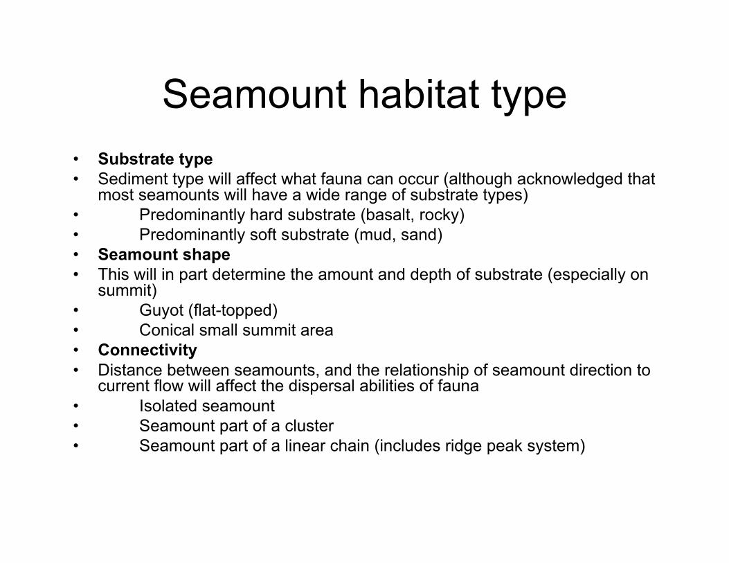
Seamount habitat type• Substrate type• Sediment type will affect what fauna can occur (although acknowledged that
most seamounts will have a wide range of substrate types)• Predominantly hard substrate (basalt, rocky)• Predominantly soft substrate (mud, sand)• Seamount shape• This will in part determine the amount and depth of substrate (especially on
summit)• Guyot (flat-topped)• Conical small summit area• Connectivity• Distance between seamounts, and the relationship of seamount direction to
current flow will affect the dispersal abilities of fauna• Isolated seamount• Seamount part of a cluster• Seamount part of a linear chain (includes ridge peak system)

• Summit depth• Depth is a major determinant of species composition. As the seamounts by definition arise from
abyssal depths (in most cases), elevation is also a relative measure of seamount size.• 0–200 m• 201–1000 m• 1001–2000 m• >2000 m• Oxygen concentration (OMZ)• Oxygen levels can also be important for survival of certain groups of species• 0–1 ml/l• 1–3 ml/l• >3 ml/l• Biogeographic zone• This reflects oceanographic conditions (water mass). Various zonation systems could be applied
(e.g.. Longhurst, Large Marine Ecosystem, Mexico Workshop)• Subtropical• Tropical• Subantarctic• Antarctic• Convergence/Frontal zone• Volcanic activity• This identifies whether hydrothermal vent communities may exist, and also whether volcanic
activity such as lava flows could impose significant natural change.• Yes• No
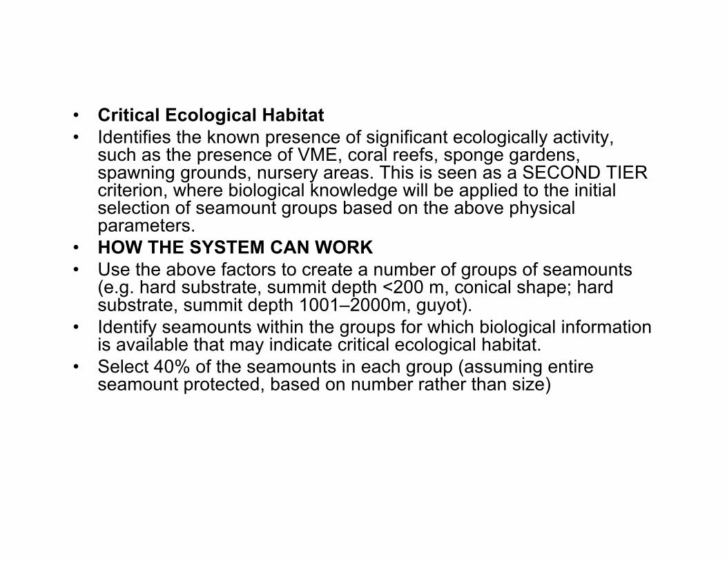
• Critical Ecological Habitat• Identifies the known presence of significant ecologically activity,
such as the presence of VME, coral reefs, sponge gardens,spawning grounds, nursery areas. This is seen as a SECOND TIERcriterion, where biological knowledge will be applied to the initialselection of seamount groups based on the above physicalparameters.
• HOW THE SYSTEM CAN WORK• Use the above factors to create a number of groups of seamounts
(e.g. hard substrate, summit depth <200 m, conical shape; hardsubstrate, summit depth 1001–2000m, guyot).
• Identify seamounts within the groups for which biological informationis available that may indicate critical ecological habitat.
• Select 40% of the seamounts in each group (assuming entireseamount protected, based on number rather than size)

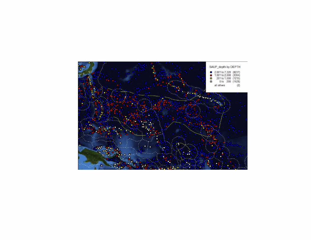
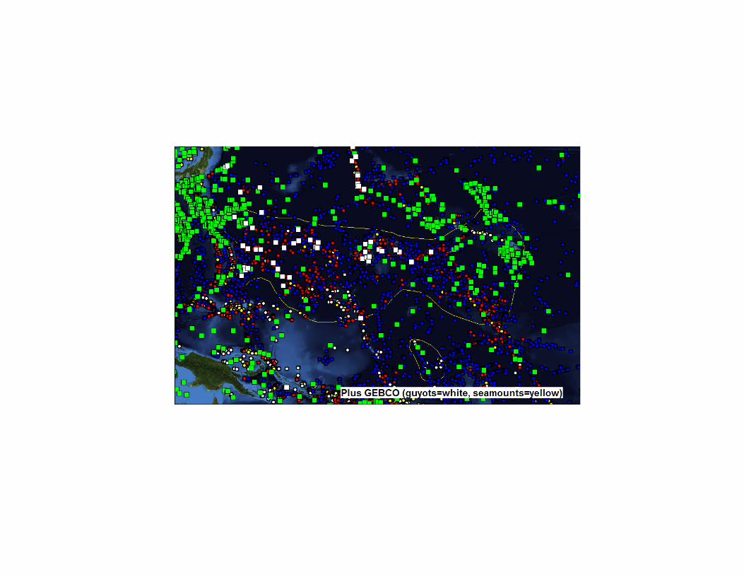


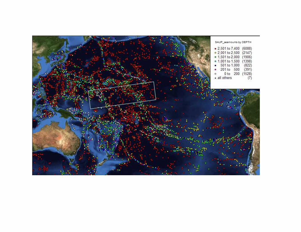
Then incorporate biological information where available andappropriate (below is Seamounts Online, April 2006, blue 0-10records, green 10-20, yellow 20-30, orange 30-40, red >40) onlyred are likely to be of much use…).