Geologic map and guide of the island of Oahu, Hawaii
90
-
Upload
khangminh22 -
Category
Documents
-
view
0 -
download
0
Transcript of Geologic map and guide of the island of Oahu, Hawaii


PLATE I
EXPLANATION -<?)- Hrghway d escribed
--- Highway nol de scribed
'·<f' Cone Crater
Swamp Peak
NA
Scale 2c:::l!!!!1!1:::::1!5!i::o==::::52iis="""':i4 m i I es
.. ·.·
MAP SHOWING PRINCIPAL ROADS AND GEOLOGIC FEATURES
oRabbit I. o Kaohika ipu I.
;y. ~ Makapuu Pt.

5
TERRITORY OF HAWAII
JOSEPH B . POINDEXTER, GOVERNOR
LOUIS M. WHITEHOUSE, COMMISSIONER OF PUBLIC LANDS
DIVISION OF HYDROGRAPHY MAX H. CARSON, CHIEF HYDROGRAPHER
BULLETIN 2
GEOLOGIC MAP AND GUIDE OF THE ISLAND OF OAHU, HAWAII
(WITH A CHAPTER ON MINERAL RESOURCES)
BY HAROLD T. STEARNS SENIOR GEOLOGIST, U.S. GEOLOGICAL SURVEY
PREPARED IN COOPERATION WITH THE GEOLOGICAL SURVEY.
U.S. DEPARTMENT OF THE INTERIOR
PR I N TE D IN T H E
TERRITORY OF HAWAII , UNITED STATES OF AMER ICA
AUGUST 1939
D ISTRI B UTE D BY TH E U . S . GEO LOGICAL S URVEY . ROO M 333 , F ED E R AL BLDG . , H O N OLULU , HAWAI I

PIINTE:D IY
ADYEITISE:II PUILIIHINI CO •. LTD
HONOLULU. HAWAII

CONTENTS PAGE
Foreword ------------ ---- ------ ------------------------------------------------------ 1
The geologic map__ ______________________________ __ ___ ___________ _____ ____ ____ _ 3
Section AA' ------------------------ --- ------- -- ---------------------------- 3
Section BB' -- -- ---------------------- --------------- -- --------- ----- --- ---- 4
Guide to the geology along the main highways____ __ ____ 6
Introduction ------- -- ----------------------------------- ----------- ---- -- - 6
Synopsis of the geologic history_________________ __ ____ _____ 8
Secondary eruptions on the Koolau Range, Oahu 11
Route 1-Highway "around the island" via Koko Head, Kahuku, Haleiwa and Wahiawa____ __ __ ______ 13
Route 2-Road to Waialae via Waikiki and
Diamond Head -------------- -------- --- -- ------ --- --- --- ------ --- --- 40
Route 3-Road to Round Top, Sugar Loaf, Tan
talus and Punchbowl -- -- ---- ------------- ----- ------ ---- -------- 43
Route 4-Road to Kaneohe junction via Nuuanu Pali __ _ ______ _______ __ _ __ _ ___ _ ____ ____ __ _ __ _ ___ _ __ ___ _ __ ____ _ _ __ ____ __ _ _ _ _ __ __ 4 7
Route 5-Road to Aiea via Fort Shafter__ ___ ______ ___ 50
Route 6-Road to Kailua, Lanikai, Mokapu and
Kokokahi ------------------------------- --- -- -- --------- ---- ------------- 52
Route 7-Road to Makua Valley via Waianae____ 55
R oute 8-Road from Wahiawa to Waianae via
Kolekole Pass ----------------- -------- -- --------- -------- ------------ 63
Mineral resources --- ---- --------- -- --- -- ---- --- -- ------ ---- --- ----- -- ---------- 68
Semi-precious g ems ------------------------------- --- ---------------- 68
Olivine -------- --- --- ------------------ -------- --- ---- ----- ------------ 68
Feldspar ------------------------------ --- ------ --- ------ -------------- 69
Obsidian ------------------------------- -- -- --- ----------- ----------- -- 69

VI CONTENTS
PAGE
Quartz ----------------------- ----------------- ---- ------ ---- -- --- ----- 69
Chalcedony, jasper, and opaL __ ___ ___________________ 69
Aragonite and calcite___ ___________________ __________ ________ 70
Zeolites ----------------------------- ---- ---- --- ------------------- ----- 70
Road metal -- ------ ---------------------------- ---------------------------- 71 Sand and graveL________________ _____ _____ _______________ __ ___ __ ____ ____ 72
Lime --------------------- - ------ ---- ------~------------------- -- ---------------- 72
Building stone ----- --- ------- -------- -------- ------ ------------------ -- --- 73
Clay ----------------- -- ------ ----- ------------- -- ----- --- ---- ---- -- ---- -- -------- 74
Pumice -------- ---------- --------- --- ---------------------------- --- ---- -- ---- - 7 4
Salt --------------------------- ------- -- ----- ------------------------------- ------ 7 5

ILLUSTRATIONS PLATE PAGE
1. Map of Oahu showing principal roads and geo-logic features ............ .......................... Inside front cover
2. Geologic and topographic map of Oahu ...... ln pocket
3. A, First stage in the development of Oahu ; B, Silhouette of the first stage; C, Second stage in the development of Oahu.......... .. ........ .. .......................... 11
4. A, Third stage in the development of Oahu ; B, Silhouette of the fourth stage; C, Fourth stage in the development of Oahu.... .......... .. .................... 11
5. A, Fifth stage in the development of Oahu ; B, Silhouette of the sixth stage ; C, Sixth stage in the development of Oahu............ .. ............................ 11
6. A, Seventh stage in the development of Oahu ; B, Silhouette of the seventh stage ; C, Eighth stage in the development of Oahu................ .. .. .. .... 11
FIGURE
1. Airplane view of Nuuanu Pali .......... ...... .. Frontispiece
2. Honolulu is built on a coral reef that has emerged from the sea in late geologic time.......................... 14
3. Tantalus, Sugar Loaf, and Round Top in erup-tion ---------------- ------------ -- ---- -- ---- ----------- --- ---- -- --- --------------- 15
4. The youthful Kaau Crater indents the rugged topography of the Koolau Range __________________________ 17
5. The Kaimuki area after the Mauumae, Kaimuki, Diamond Head, and Black Point eruptions.... .. .... 19
6. East end of Oahu after the Koko fissure erup-tions ------------- ---- ----- ------- ---------- ----------- -------- -- -----·-··-···--· 23
7. View showing relation of Koko lava flow and wind-drifted ash --- -- ---------------------------- -------- ----------- -- -- 24
8. The hig h cliff at the east end of Oahu.................... 26

VIII ILLUSTRATIONS
FIGURE
9. Cliff near Kahuku showing deposits of several stands of the sea ...... ---------------- ----- ------- ----------------------
10. Diagram showing the geologic history of Pearl Harbor lochs ---- ---- ----------- --- --- -------------------------------------
11. Road cut near Aiea junction showing gully filled with water-laid tuff __ ___ ______________________ __ ____ __ ________________ _
12. Typical firefountain at the source of the Mauna Loa lava flow of 1919 .. .... ------~ -- -- - - -- --- --- ----------- -- --------
13. Looking southwest toward precipitous Nuuanu Pali --------- ------------- ---- -------------- ------------- -- --- ---- -- --- -- ---------
14. The lava from Makuku cone devastated Nuuanu
Valley ---------------- --- -- ---- -- ------ --------- ------- ----- --------------------
15. Bomb sags in Salt Lake tuff near Halawa Gulch
16. Parallel notches 22 and 27 feet above sea level cut
PAGE
33
37
38
42
46
49
51
by the sea in hardened dunes near Kailua.......... .. .. 53
17. The windward face of North Mokulua Islet off Lanikai is lined with dozens of dikes..... ................. 54
18. A coral reef quarried for lime near Waianae........ 57
19. View of Keaau unconformity.............. .. .................. 58
20. Outline of formations shown in view of Keaau unconformity -------- -- ----------- ------------------------- -- ----- ------- 59
21. Makua Cave ---------------------- -- ---------- ---------------------------- 60
22. The sacrificial stone of Kolekole Pass wit h its flutings due to solution by rain _____ ____ ___ ____ ___ __________ _ 64
23. Diagram illustrating the history of Kolekole Pass and the sacrificial stone_____ __ __ __ ___________ ____ _____ ___ 65
The chapter endings illustrate diagrammatically the structure and phases of a Hawaiian type of volcanostructure (p. vi) , submarine eruption (p. 2) , ash cone (p. 7), lava dome (p. 12) , caldera (p. 39) , firefounta ins (_P- 45) , andesitic cinder cones (p. 62) , secondary eruption (p. 67) , and coral atoll (p. 75) .


Figure 1. The fluted Pali towers above the smooth alluvial flats that are terminated northwestward by a nearly buried interstream divide ( A). A secondary cinder cone (B) at the source of the Kaneohe lava flow interrupts the gentle seaward slope of the flats. Photo by Pan Pacific Press Bureau.

GEOLOGIC MAP AND GUIDE OF THE ISLAND OF OAHU, HAWAII
BY HAROLD T. STEARNS
FOREWORD
This bulletin, although designated Bulletin 2, is actually the fourth of a series published by the Division of Hydrography of the Territory of Hawaii. All four of the bulletins thus far published relate to the geology and ground-water resources of the island of Oahu.1 Together they present the results obtained on this island in the program of ground-water investigation of the Territory that has been conducted in cooperation with the Geological Survey, of the United States Department of the Interior. Bulletin 5 which is in preparation will describe the progress made in developing the g round-water resources of Oahu since Bulletin 1 was issued.
1 See last page for t itles of other bulletins.

2 GEOLOGIC MAP AND GUIDE OF OAHU
In Bulletin 2 is presented the detailed geologic map of Oahu that has resulted from this investigation. The base for this map is the new topographic map of Oahu prepared by the Topographic Branch of the Geological Survey. This bulletin also contains a guide to the geology along the main highways, which can be used advantageously in connection with the geologic map.
For 18 years the writer has had the great privilege of working under the technical direction of Mr. 0. E. Meinzer, geologist in charge of the Division of Ground Water, U. S. Geological Survey. Nearly two decades ago Mr. Meinzer envisioned the great benefits that the people of Hawaii would derive from a thorough study of the groundwater resources of these islands. He also recognized that a full knowledge of these resources could be obtained only by a complete understanding of the geology of the islands and the processes which formed them. This bulletin is one of a series that has been made possible largely as a result of his broad vision.
Credit is due Mr. W. 0 . Clark for the location of all the dikes shown on plate 2 in the headwaters of Kamananui Stream near the north end of the Koolau Range, and to Dr. C. K. Wentworth for about a dozen dikes north of Kaimuki. Messrs. 0. E. Meinzer, G. R. Mansfield, M. H. Carson, G. A. Macdonald, and S. H. Elbert kindly criticized the manuscript. Mr. Harry L. Taeuber designed the cover and with James Y. Nitta prepared the illustrations. Their work has greatly enriched this bulletin.

THE GEOLOGIC MAP
The topographic maps of 15-minute quadrangles, on a scale of 1 to 20,000 (approximately 3 inches to the mile), were used in the field as a base for the geologic mapping. The data were then transferred to the new topographic map of Oahu, which is on a scale of 1 to 62,500. The resulting geologic map is reproduced as plate 2 (in pocket) of this report. Some of the outcrops are too small to be shown on this smaller map. Plate 2 of this report was listed as plate 2 in Bulletin 1, which was, however, published without the map because of the time required to prepare and engrave the topographic base and the geologic map. The geologic structure sections at the bottom of plate 2 were not described in Bulletin 1, but are discussed below.
SECTION AA'
Section AA' extends from a point at sea 4Yz miles southwest of the mouth of Lualualei Valley through Kolekole Pass to a point at sea 9 miles off Hauula on the northeast side of the Koolau Range as shown by the line on the map (pl. 2). This section was chosen to show the deep submergence of Lualualei Valley, the structure of 'the caldera of the Waianae Volcano, the overlap of the Koolau lavas on the eroded Waianae surface, and the structure of the main rift zone of the Koolau Volcano. The depth of drowning of Lualualei Valley is established by a well near the axis of the valley which did not encounter bedrock until a depth of 1,200 feet had been reached. 2 The preerosion surface of the Waianae caldera is doubtless much more complicated than shown in this section, and the caldera may have been wider. The lava beds dipping away from the caldera in the head wall of Lualualei Valley and the breccias in Puu Kailio nearby that accumulated chiefly as talus at the foot of the caldera wall locate definitely the ea.st wall of the caldera as shown in the section. A small patch of post-Waianae basalt too small to show in the section or on the map is exposed at Kolekole Pass.
~Stearns, H . T . a nd Va ksvik, K . N ., Geology a nd grotmd-wa ter resources of the isla nd of Oahu, H a waii : Ha wa ii Division of Hydrography Bull. 1, p. 30, 1935.

4 GEOLOGIC MAP AND GUIDE OF OAHU
The overlap of the Koolau lavas upon the Waianae rocks is unknown below sea level, but sufficient structure is revealed in Kaukonahua Canyon near Schofield Barracks to indicate that the upper Koolau lavas flowed into an amphitheater-headed valley cut in Waianae lavas. Such lavas would dam the streams flowing from this amphitheater and cause them to drop their sediment. At times all the streams would sink into the permeable fresh Koolau flows, resulting in rapid fan building. For this reason the upper Koolau lavas are shown interfingering with gravel.
It is believed that very little of the Koolau Volcano has been eroded along the line of this section except on the northeast or windward side. Erosion along the crest of the range has proceeded just far enough to expose a few dikes. Large volumes of ground water are probably stored between dikes in this area because the rainfall is heavy and the streams have not yet cut deep enough to drain many of the dike-walled compartments containing water.
The undersea part of the section off this northeast coast is hypothetical. As elsewhere around Oahu it is assumed that the marine limestones interfinger with the earthy sediments dropped by streams at their mouths.
SECTION BB'
Section BB' extends from a point at sea 4 miles southwest of Honolulu across the Koolau Range near Nuuanu Pali to a point at sea 9Yz miles off Mokapu Peninsula, as shown by the line on plate 2. A reconstruction of the Koolau caldera has been attempted by the dotted line indicating the pre-erosion surface of the Koolau Volcano based on the outcrops of the lavas and breccias of the caldera complex. The rocks are poorly exposed in this area hence the complexities are probably much greater than shown. The structure is thus in part hypothetical.
The throat breccia shown in the section fills one of the deep ~its in the old caldera. It is shown tapering downward m the manner characteristic of throat breccias exposed in Hawaii.

GEOLOGIC MAP OF OAHU 5
An hypothesis to account for such pits is as follows. At · the intersection of rift zones in Hawaii there commonly develops a weak place where repeated fissuring allows rocks broken by this process to move downward into the magma chamber. Here they are either remelted or floated upward in erupting magmas. This place is one of nearly constant tumescence owing to the lava repeatedly forcing its way upward. The swallowing process soon engulfs the rocks above until finally a funnel-shaped shaft is formed. The size of the pit eventually developed depends apparently upon the depth of the bottom of the funnel , the rapidity of disposal of the rock fragments at the bottom, and the length of time the process continues. Explosions may loosen the rocks in the funnel and thereby speed up the process, as at Kilauea in 1924, but explosions are not essential. Engulfment concurrent with and following the Kilauea explosion accounted for more material than was blown out.'l The broken rock that accumulates in such a pit is called throat breccia.
A syncline is shown in the Kailua amygdaloidal basalt northeast of the throat breccia in this section. This is based on observed dips in Puu Papaa and upon the new interpretation that the Kailua lavas accumulated in the Koolau caldera and the synclinal structure was induced by sagging due to removal of support. The synclinal structure is shown hypothetically to a depth of 3,000 feet below sea level or to the bottom of the section.
The lava beds undersea in the southwest end of the section are drawn flatter than those on the land because the submarine soundings show a distinct submarine shelf in this area. This shelf may have been produced by the lavas ponding against the Penguin Bank, which is probably a submerged older volcanic mass extending southwestward from Molokai Island.
Only limestone and volcanics are shown above the Koolau basalt on the northeast end of the section. Possibly earthy sediments are interbedded with the limestone as elsewhere around the island, but no logs of wells are available in this area by which this possibility can be verified.
::J aggar, T . A. , The mechanism of volcanoes: N at. Research Council Bull. 77, p . 60. 1931.

GUIDE TO THE GEOLOGY ALONG THE MAIN HIGHWAYS
INTRODUCTION
This road guide has been prepared to meet the constant demand for more knowledge about the geology of Oahu and should greatly increase the usefulness of the geologic map. Many kinds of geologic phenomena are found on the island: dissected as well as recent volcanic craters and fissures from which lava and ash were erupted, landslides and fossiliferous volcanic mud flows, spectacular features of marine, stream, and wind erosion, conspicuous evidences of great submergence and emergence, coral reefs, stream and marine terraces, deltas, fans, tropical rain belts and deserts with their associated contrasting types of weathering and erosion. This concentration of so many diverse geologic features in such a small area makes Oahu outstanding among the islands of the world. This verdurecovered island surrounded by a blue sea is an ideal place to become acquainted with earth processes and products. Moreover, many of these geologic features are readily reached by automobile.
The logs given on the following pages have been made for an autoist travelling the main highways around the island starting at the Kamehameha statue on King Street, Honolulu (pl. 1). It is assumed that the traveler will have available the street map of Honolulu issued free by the Hawaii Tourist Bureau. The mileage reads up if driving clockwise around the island and down if going counterclockwise. The route from Haleiwa to Wahiawa is over the new highway not shown on plate 2. Likewise, the route to Waianae is over the new Waipahu cut-off, although this road is not shown on plate 2. The mileage varies slightly with different odometers due to many factors, but a sufficient number of landmarks are g iven so that frequent checks can be made. A few of the main side roads having interesting geologic exposures are also included (pl. 1).

INTRODUCTION 7
The Polynesians long ago recognized the difficulty a traveller going around an island meets in keeping oriented. Therefore, they have the useful words makai (toward the sea) and mauka (toward the mountains). Throughout the gui.de the equivalent English words "seaward" and "inland" are used. The terms "windward" and " leeward" are also indispensable in an island lying in the path of the northeast trade winds because these winds determine the climate which in turn influences rates of stream and marine erosion on the two sides of the island. In this text "windward" always refers to the north and northeast, and " leeward" to the south and southwest.
It is assumed that a person using the guide will have available Bulletin 1 of this series to which constant reference is made for detailed accounts. A useful addition to the trip is the geologic account of Oahu entitled " An Island Is Born," by Norah D. Stearns, which can be obtained from any library in Honolulu.

SYNOPSIS OF THE GEOLOGIC HISTORY
Oahu began its geologic history as two separate submarine volcanoes. (See above figure.) These gradually built two islands (pl. 3, A) . Both volcanoes were built over three sets of fissures intersecting at a summit crater and both at frequent intervals erupted highly fluid basaltic flows that built up shield-shaped cones. The Waianae Volcano gradually developed a large summit caldera near the present site of Kolekole Pass, and also a high, steep fault cliff that formed a wall bounding the southwest margin of the two main rift zones (pl. 3, C). Streams eroded the southwest slope now that it was protected by this cliff from flows, and lava continued to accumulate in the great caldera until this depression nearly if not entirely filled up. Near the close of this epoch, lava overflowed the northwest end of the fault cliff and ran down some of the valleys northwest of the present site of Waianae and a few bulky cinder cones were formed at the source of several of the flows along the two main rifts (pl. 4, A) . In the meantime the Koolau Volcano grew larger with a pronounced elongation northwestward as a result of copious flows from the northwest rift zone. Finally, the Waianae Volcano died, the sea pounded back its shore into great cliffs, and torrential streams carved great valleys, especially on the southwest side where the streams were older and the rocks weaker. These great valleys are now called N anakuli, Lualualei, Waianae, Makaha, and Keaau.
Meanwhile Koolau flows filled up the ocean between the Koolau and Waianae Volcanoes and joined the two moun-

SYNOPSIS OF THE GEOLOGIC HISTORY 9
tains in to a single island (pl. 4, B). What is now called the Schofield Plateau resulted from the Koolau flows banking a gainst the Waianae Mountain. Simultaneously a caldera about 4 miles across developed at the intersection of the rift zones near the present site of Kailua. Volcanic activity ceased and streams carved deep amphitheater-headed canyons in the Koolau Volcano. Meanwhile the streams of the Waianae Range had nearly dried up because the moist northeast trades were cut off by the g rowth of the Koolau Volcano. Oahu was then about 1 Yz times as large as it is now, and the mouths of the streams of that time are today about 1,800 feet below sea level (pl. 5, A). The streams g radually destroyed the caldera and today only the roots of the former firepits remain near Kailua. The magnificent canyons ate away much of their interstream divides and eroded headward so far that some even captured leeward-flowing streams.
Next the island became submerg ed 2,000 to 3,000 feet, but the land rapidly re-emerg ed part of this amount and consequently few changes from wave attack are noticeable except the stripping away of the soil at the higher levels (pl. 5, C). The re-emergence, however, was not simple but involved halts and partial resubmergence. Some of the later shore lines are well preserved in emerg ed reefs and beach deposits. The most important result of the shifting ocean level was the deep drowning of the great valleys and their subsequent sedimentation. This accounts for the ubiquitous flat valley floors. The complex history of the emergences and submergences is far from completely known, but the shore lines so far deciphered with their altitudes, in order from oldest to young est, are given below. Some of them have been determined from neighboring islands. 4 The shifting of shore lines is partly due to changes in ocean level accompanying glaciation and deglaciation of the earth during the Pleistocene, but probably more effective have been the g reat changes in the configuration of the ocean floors due to widespread earth movements.
·I Stearns, H . T., Ancient shore lines on the island of Lanai, H awaii: Geol. Soc. America Bull . vol. ,!9, pp . 615-628, 1938.

10 GEOLOGIC MAP AND GUIDE OF OAHU
ANCIENT SHORE LINES ABOVE(+ ) AND BELOW(- ) PRESENT SEA LEVEL
Name
Lualualei ..... . .... .... ...... · · · · · · · · · · · · · · · · · · · · · Mahana (traces on Oahu) . ... . . . ... . · · . . · · · · · · · · · · · Manele (traces on Oahu) .... . . . . .. .... .... .. · · . · · · Olowalu (traces on Oahu) .. . . . . . . . . . . ·. · · · · · · · · · · · Kahuku .. . . . . ... . .... . . .. . . · · · · · · · · · · · · · · · · · · · · · · Kahipa ......... . .. . ... .. · · · · · · · · · · · · · · · · · · · · · · · · · Kaena .. . . ..... .. .... . . .. . . · · · · · · · · · · · · · · · · · · · · · · · Laie .. . ...... . . .. · · · · · · · · · · · · · · · · · · · · · · · · · · · · · · · · Waipio .. . . ...... . .. . ..... · · ·. · · · · · · · · · · · · · · · · · · · · ·
Altitude (feet)
- 1800 ( + ) + 1200 (+ ) + 560 + 250 ( +) + 55 - 300 (+ ) + 95 + 70
60 (±) Waimanalo (really two shore lmes, one at 22 feet and
the other at 27 feet) ......... . .. . ....... .. .. · · · + 25 Ka papa ..... . .... . ......... . .. · · · · · · · · · · · · · · · · · · · · + 5 Present ....... . .. . . .. . .... . . .... · · ... . · · · · . · · · · · · · 0
During the late history of shifting sea level, volcanism was renewed near the old Koolau center of activity , and at intervals of a few hundred or a few thousand years down to Recent time vents were blasted through the coral reefs, as at Diamond Head, Salt Lake, Punchbowl, or the Koko craters, and firefountains played from cracks in the mountains and poured lavas into nearby valleys, as at Kalihi, Nuuanu, Kaneohe, Castle, Tantalus, or Sugar Loaf vents. (See fig . 13, Bull. 1.) Many erupted during the Waipio low stand of the sea (pl. 6, A) . Thus, we find some lava flows that are interstratified with or lie upon gravel or coral reefs. Altogether 30 such secondary eruptions are now known on the Koolau Range and there is no reason to believe that others may not take place in the future . (See list, p. 11.) A few secondary, or post-erosional eruptions also occurred on the Waianae Range. Their ag e is not yet established but they appear to be older than the post-Koolau eruptions.
A more detailed account of the geolog ic history will be found in Bulletin 1, pages 174-179, and a description of the general character of the rocks is given in the stratig raphic tables following page 68 in Bulletin 1.

SECONDARY ERUPTIONS ON THE KOOLAU RANGE, OAHU
1
!PLATES 1 AND 2 )
Middle ( ?) and late Pleistocene lavas and pyroclastics Eruptions during the Ka rna ( +95-fool ) and La ic ( + 70-foot) stands
of th e sect
NAME
1. Hawaiiloa 2. Pali Kilo and
Pyramid Rock 3. Mokapu 4. Mokulea 5 . Rocky Hill and
LOCATION
Mokapu Peninsula
do. do .
Kailua Bay
MATERIAL ERUPTED
Cinders and lava
Manoa Craters Punahou Street, Honolulu Cinders and lava Cinders, lava ,
and ash 6. Kalihi Head of Kalihi Valley
7. Haiku 8. Aliamanu
9. Kaneohe 10. Luakaha~
11 . Makuku 2
12. Pali 13 . Makawao
14. Moku Manu
Head of Haiku Valley Between Honolulu and
Pearl Harbor 2 miles south of Kaneohe Near head of Nuuanu Valley
Lava and ash
Ash Cinder and lava Cinders, lava ,
and ash do . Cinders and lava
Pali road l 2 miles southwest of
Olomana Peak }-Ash, cinders,
J
and lava Two islands north of
Mokapu Pt. 15. Ulupau Tip of Mokapu Peninsula Ash 16. Kaau Head of Palolo Valley Ash and lava
J~ ruptions during the Waipio ( minus 60+- foot ) and lf/ailllanalo ( 25-f ol ) stands of th e sea
17. Salt Lake and Makalapa Northwest side of Honolulu Ash
18. Ainoni 2 miles southwest of 1 19. 20. 21. 22. 23. 24. 25.
Olomana Peak . Maunawili South side of Olomana PeakJCmders and lava Training School North side of O lomana Peak Diamond Head Southeast part of Honolulu Ash Kaim uki ( . . fLava and spatter M a uumae ~ In KalmUk! , Honolulu 1 Cinders and lava Black Point:! Southeast of Diamond Headl Kamanaiki Kamanaiki Valley, branch of ~Lava
Kalihi Valley J 2r . Castle 3 miles east of Kailua Cinders and lava 27. Punchbowl Near center of Honolulu Ash and lava
1The number of post-Koola u eruptions listed here is less tha n in Bull. 1 due to the grouping of the Koko and Tantalus fissure eruptions into two units. The age of some eruptions is not yet definitely established. All lava flows a re basalt.
2Lua kaha cone is a t the pla.ce formerly called Lower Lua kaha and Makuku was formerly ca lled Luaka ha .
:lA second eruption occurred at the same place. See No. 30.

12 GEOLOGIC MAP AND GUIDE OF OAHU
Latest Pleistocene or Recent
Jiruptions after the Wai111a 11alo ( + 25-foot) stand of lit e sea MATERIAL
NAME LOCATION ERUPTED
28. Koko fissure eruptions: Manana4 Manana (Rabbit) Island ;
1 y.! miles northwest of Makapuu Pt.
Koko } Kahauloa East end of Oahu HanaumaBay . Koko Head do. Kalama Northeast of Koko Crater Kaohikaipu Islet 1 mile northeast of
Makapuu Pt. Kaupo 1 mile east of Makapuu Pt.
29. Tantalus fissure eruption:
Tantalus Sugar Loaf Round Top
30. Black Point
}On divide between Manoa
and Pauoa Valleys
Southeast side of Diamond Head
Ash
Ash and lava
Ash
}cindm and lava
Lava and spatter
{
Lava, cinders, and great volumes of black "sand"
Black ash
4 Possibly older t han the other vents along the Koko fissure.

t
~,.d_j 10' 1:x1"oo'


ROUTE 1, PLATE 1
HIGHWAY "AROUND THE ISLAND" VIA KOKO HEAD. KAHUKU, HALEIWA AND WAHIAWA"
COUNTER CLOCKWISE CLOCKWISE
(miles) (miles)
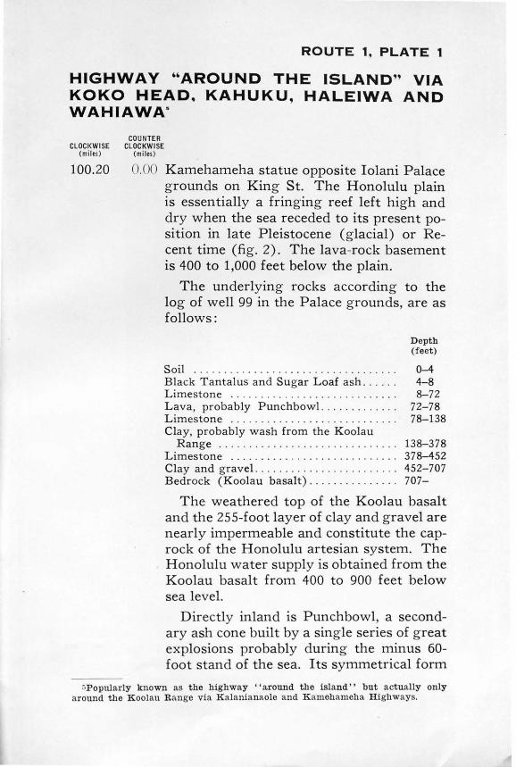
100.20 0.00 Kamehameha statue opposite Iolani Palace grounds on King St. The Honolulu plain is essentially a fringing reef left high and dry when the sea receded to its present position in late Pleistocene (glacial) or Recent time (fig. 2). The lava-rock basement is 400 to 1,000 feet below the plain.
The underlying rocks according to the log of well 99 in the Palace grounds, are as follows:
Soil . . .. . .......... . ... . .... . .. ... . .. . Black Tantalus and Sugar Loaf ash . .. . . . Limestone .......... . . .......... . ... . . Lava, probably Punchbowl . .. . . .. . .... . Limestone . ... . ........... . .. .. ..... . . Clay, probably wash from the Koolau
Depth (feet)
0-4 4-8 8-72
72-78 78-138
Range ... . .. .. .......... . .. . ........ 138-378 Limestone . . . . . . . . . . . . . . . . . . . . . . . . . . . . 378-452 Clay and gravel. . . ..... . ... . .. . . .. . . . .. 452-707 Bedrock (Koolau basalt) . . . . . . . . . . . . . . . 707-
The weathered top of the Koolau basalt and the 255-foot layer of clay and gravel are nearly impermeable and constitute the caprock of the Honolulu artesian system. The Honolulu water supply is obtained from the Koolau basalt from 400 to 900 feet below sea level.
Directly inland is Punchbowl, a secondary ash cone built by a single series of great explosions probably during the minus 60-foot stand of the sea. Its symmetrical form
~Popularly known as the highway ''around the island '' but actually only around the Koolau Range via K alanianaole and K amellameha Highways.

Figure 2. Honolulu is built on a co ral reef that has eme_rged fro m the sea in late geologic time. Photo by 11 th Photo Section, A. C., Luke Field, T . H.
97.85 2 .., .J
indicates that strong trade winds were not blowing at the time of the eruption as in the case of Tantalus, Sugar Loaf, and Round Top cones which are asymmetrical. A lava flow poured down its slope immediately after the explosions died down. (See BulL 1, p. 145.) Moiliili Park. Here one obtains excellent views of Round Top, Sugar Loaf, and Manoa Valley. The low eminence in front of Round Top showing a reddish quarry face among the houses is Rocky Hill, a secondary cinder cone. Where the smooth grassy slopes of Round Top change inland to rocky ledges a small gulch is discernible. At this place the Sugar Loaf lava formed a firefall in to Manoa Valley, flowed across M·anoa Valley to the east wall, and then seaward to Kapiolani Blvd. (fig . 3).

HIGHWAY AROUND THE ISLAND 15
Manoa Valley is a typical amphitheaterheaded valley carved by stream erosion when the island stood at least 1,200 feet higher than at present. (For origin of such valleys, seep. 24, Bull. 1.) The depth to the bedrock floor of Manoa Valley is more than 1,000 feet at this point. The flat valley floor has been produced by slow filling with silt, sand, gravel, secondary volcanic deposits, and probably coral, as the island submerged. The highest point of the Koolau Range is the peak on the west side of the skyline at the head of the valley, Puu Konahuanui, altitude 3,105 feet.
Figure 3. Round Top (B) , Sugar Loaf (C), and Tantalus (D) ~refountaining and the Sugar Loaf-Round Top lava flow (E) pounng into Manoa Valley. Rocky Hill (A) and W aikiki (F).

16
97.75 97.60
97.45
97.30
97.20
97.05
96.95
GEOLOGIC MAP AND GUIDE OF OAHU
2.4 ~ Reef limestone exposed inland of the road. 2.60 Intersection of King St. and University
Ave. Continue along Waialae Ave. 2.75 Rise in the road is caused by the Sugar
Loaf - Round Top lava flow. 2.90 A lane leads to Moiliili Quarry, where the
front of the Sugar Loaf - Round Top lava flow is exposed. This lava contains nephelite, melilite, and numerous other unusual minerals and is cut by narrow pegmatitoid veins of much coarser grain than the enclosing rock.0 It rests on soil and reef limestone of the 25-foot stand of the sea. A large subterranean cavern passes through the limestone in this area with its entrance just west of Kalo Place.
3.00 Abrupt eastern edge of the Sugar LoafRound Top lava flow which terminates onequarter mile seaward on Kapiolani Blvd.
3. 15 Intersection of Waialae and Harding Avenues and Kapiolani Blvd.
3.25 Kapahulu Ave. The highway leaves the alluvial flat of Palolo Stream and starts up the Kaimuki lava dome. Note the numerous stone walls made of the Kaimuki basalt. Palolo Stream has been diverted from its normal seaward course along the axis of its valley by this lava, so that it now flows westward along the north margin of the Kaimuki basalt, and at St. Louis College is at the contact of the Koolau and Kaimuki basalts.
Kapahulu Quarry, at the orange spot labelled Qht on plate 2, is nearly opposite the Kapahulu pumping station of the Honolulu Board of Water Supply. In this quarry the Kaimuki lava, shown in purple on plate 2,
~Dunha~, K . C., Crystal cavities in lavas from the H awaiian I slands : Am. Mineralog1st , vol. 18, no. 9, pp . 369- 385, 1933.

Figure 4. The youthful Kaau Crater indents the rugged topography of the Koolau Ran ge. Photo by 11th Photo Sec. , T. H .

18
96.40
96.15
96.00
95.95
95.90
GEOLOGIC MAP AND GUIDE OF OAHU
overlies Diamond Head ash, which in turn rests on silt and another lava from either Mauumae cone or Kaau Crater. At the entrance is an exposure of the beach deposits of the 25-foot stand of the sea. (See p. 13 7, Bull. 1.)
3. 0 Aliiolani School and view of Palolo Valley. Kaau Crater, the only pit crater on Oahu, lies at the head of this valley. It poured lava into three tributaries of this valley (fig. 4).
-t.o- Tenth Ave. For side trip up Palolo Valley turn inland. One and one-half blocks inland on the east side of the street is a quarry in the cinders of Mauumae cone. A large intrusive body is exposed in a second quarry 1.8 miles inland at the symbol on plate 2. (Seep. 21, Bull. 1.)
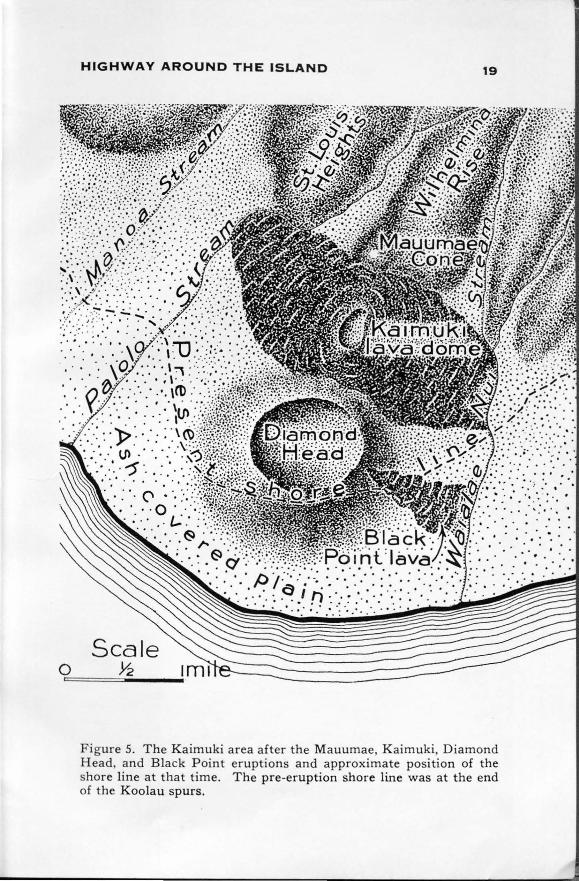
4.20 Center St. leads inland to the top of Mauumae cinder cone (fig. 5) , source of a voluminous nephelite lava flow which spread down over the site of Kaimuki before Diamond Head or Kaimuki cones erupted. (See p. 140, Bull. 1.)
4.25 Koko Head Ave. Behind the fire station, two blocks seaward, is the rim of Kaimuki Crater. To drive into this crater turn southwest at the fire station to Crater Road. The Kaimuki eruption (fig. 5) produced the only secondary lava dome on Oahu. (See p. 138, Bull. 1.)
4. 30 Waialae Ave. descends the eastern slope of the Kaimuki lava dome. Wilhelmina Rise street leads inland. From this ridge one can obtain an excellent view of the Honolulu coral plain, the vents on the Kaimuki-Diamond Head fissure, and many other geologic features. The red soil has been swept from the lower part of Wilhelmina Rise by former high stands of the sea.
HIGHWAY AROUND THE ISLAND 19
. .. . : .. : , .. .. : .· ,· . . · .. ·. • . .
• • 0 •• ... . . • ••
Scale 0 ~
Figure 5. The Kaimuki area after the Mauumae, Kaimuki. Diamond Head, and Black Point eruptions and approximate position of the shore line at that time. The pre-eruption shore line was at the end of the Koolau spurs.
• • 0 •
. . . . . .

20
95.65
95 .45
95.30
94.95
94.00
93.30
93.00
GEOLOGIC MAP AND GUIDE OF OAHU
4.- 5 Sixteenth Ave. The Palolo shaft (Maui-type well) ; of the Honolulu Board of Water Supply is 0.45 mile inland, but may be inspected only by previous arrangement with the board.
4.75 Nineteenth Ave. Thin-bedded very vesicu-lar pahoehoe lava from Kaimuki Crater is exposed at the intersection. The lateritic soil is due to the decomposition of the lava rock.
-.J.. 90 Typical Koolau basalt is exposed at Wai-alae Quarry, 0.2 mile inland. The highway leaves the Kaimuki lava dome here and starts across earthy sediments probably laid down in part during the 25-foot stand of the sea.
5.25 Kealaolu Ave. turns seaward towards Kahala Beach and around Diamond Head to Waikiki Beach. (See log of this route, p. 40.)
6.20 The cliff of bare Koolau basalt a short dis-tance inland was cut by the sea, and the plain is the abandoned ocean floor. Emerged reef is exposed on the inland side of the road. The bare rocky slopes above the 25-foot level were washed free from soil dur-ing the hi gher stands of the sea.
6.90 The duck pond seaward of the highway is supplied by Wailupe Spring at the eastern end of artesian area 5. (See p. 260, Bull. 1. ) Reef limestone is exposed on the inland side of the road.
7.20 Wailupe Valley. Its flat floor consists of sediments deposited as the island submerged.
92.25 7.9- At :he beach is Kawaikuhi Spring issuing at tlde level from typical reef limestone. A bank of Koolau basalt forms the inland
' Bull. 1, pp. 324-325.

HIGHWAY AROUND THE ISLAND 21
91.85 91.45
90.95 90.50
edge of the road with hardened detrital limestone containing fossil shells and coral on its sides. The top of the limestone is 22.5 feet above sea level and was laid down during the Waimanalo stand of the sea. It is overlain by black marine mud and talus, and on the west side above 4 feet of mud is a block 6 feet wide of tan-colored Koko tuff. Other smaller outcrops nearby indicate that the Koko vents exploded after the sea had withdrawn from this point. The various vents along Koko fissure from which this ash was ejected are shown by the small red "c" on plate 2. Koolau aa and pahoehoe are exposed in this road cut. The lower half of the bank is pahoehoe. Its top is a red oxidized zone above which is an aa flow having two clinker beds. Overlying the aa is another pahoehoe flow. About 25 feet above the road in line with the red zone at the top of the pahoehoe flow is a small patch of fossiliferous conglomerate, 37.5 feet above sea level, left during one of the high stands of the sea preceding the Waipio low stand.
8.3'"' Niu Valley. 8.75 Interstices of the talus in the road cut are
filled with Koko tuff and on the east side Koko tuff overlies soil-covered fossiliferous marine limestone.
9.25 Kuliouou Valley. 9.70 Maunalua Bridge. The flat here was left by
the 5-foot stand of the sea. Koko Head cone lies to the seaward with its corrugated stream pattern, and inland is the highest tuff cone on Oahu, Koko Crater.
88.80 11.40 Road cut exposes thin-bedded tuff from Hanauma Crater. The white fragments are limestone blasted from the underlying reef
22 GEOLOGIC MAP AND GUIDE OF OAHU
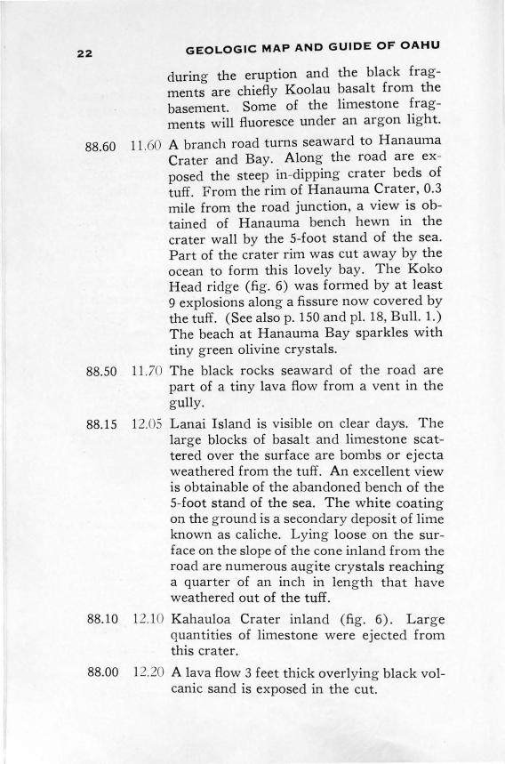
during the eruption and the black fragments are chiefly Koolau basalt from the basement. Some of the limestone fragments will fluoresce under an argon light.
88.60 11 .60 A branch road turns seaward to Hanauma Crater and Bay. Along the road are exposed the steep in-dipping crater beds of tuff. From the rim of Hanauma Crater, 0.3 mile from the road junction, a view is obtained of Hanauma bench hewn in the crater wall by the 5-foot stand of the sea. Part of the crater rim was cut away by the ocean to form this lovely bay. The Koko Head ridge (fig. 6) was formed by at least 9 explosions along a fissure now covered by the tuff. (See alsop. 150 and pl. 18, Bull. 1.) The beach at Hanauma Bay sparkles with tiny green olivine crystals.
88.50 11.70 The black rocks seaward of the road are part of a tiny lava flow from a vent in the gully.
88.15 12.05 Lanai Island is visible on clear days. The large blocks of basalt and limestone scattered over the surface are bombs or ejecta weathered from the tuff. An excellent view is obtainable of the abandoned bench of the 5-foot stand of the sea. The white coating on the ground is a secondary deposit of lime known as caliche. Lying loose on the surface on the slope of the cone inland from the road are numerous augite crystals reaching a quarter of an inch in length that have weathered out of the tuff.
88.10 12.10 Kahauloa Crater inland (fig. 6). Large quantities of limestone were ejected from this crater.
88.00 12.20 A lava flow 3 feet thick overlying black volcanic sand is exposed in the cut.

;.•
HIGHWAY AROUND THE ISLAND 23
87.95 12.2 - On the inland bank is an 8-inch block of basalt with a sag in the underlying bedding indicating that it fell as a bomb when the ash was soft.
that drooled out of' craclrs
uloa Crater
. ~£uma Bay craters ((
Scale o ~ 1 mile ~--====:;;
Figure 6. East end of Oahu after the Koko fissure eruptions.
24
87.85
GEOLOGIC MAP AND GUIDE OF OAHU
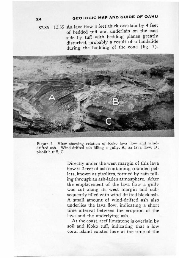
12.35 Aa lava flow 3 feet thick overlain by 4 feet of bedded tuff and underlain on the east side by tuff with bedding planes greatly disturbed, probably a result of a landslide during the building of the cone (fig. 7).
Figure 7. View showing relation of Koko lava flow and winddrifted ash. Wind-drifted ash filling a gully, A ; aa lava flow, B ; pisolitic tuff, C.
Directly under the west margin of this lava flow is 2 feet of ash containing rounded pellets, known as pisolites, formed by rain falling through an ash-laden atmosphere. After the emplacement of the lava flow a gully was cut along its west margin and subsequently filled with wind-drifted black ash. A small amount of wind-drifted ash also underlies the lava flow, indicating a short time interval between the eruption of the lava and the underlying ash.
At the coast, reef limestone is overlain by soil and Koko tuff, indicating that a low coral island existed here at the time of the

HIGHWAY AROUND THE ISLAND 25
explosions. (See pl. 3, A, Bull. 1.) The outcrops of limestone are visible from Ihiihilauakea Bridge ahead.
87.80 12.40 Gully in Koko tuff on inland bank about 8 feet deep filled with later tuff indicating a ti::ne interval between explosions.
87.55 12.65 A streak of very hard tuff shows on the inland side of the cut. (See pl. 17, B and p. 151, Bull. 1.) The anticlinal structure along this highway might be misinterpreted as due to folding . It is due to deposition only.
87.30 12.90 The caverns in the bluffs here are formed by weathering of the tuff.
87.20 13.00 The tuff dipping inland on the seaward side of the highway is part of a cone destroyed by the ocean (fig. 6).
87.15 13.05 Trail to the Blow Hole. This spouting horn is caused by the sea rushing into a cave and spurting through a hole in the roof. It performs best during large swells. On the inland side of the highway is brown talus filling a gully cut in the tuff. Molokai Island is visible on clear days to the east. It is north of Lanai Island.
86.60
85.40
84.75 84.55
13.60 The fresh rock exposed on the seaward side of the highway is a recent pahoehoe flow from a cinder cone in Kalama Valley (fig. 6). (See pl. 2 and p. 153, Bull. 1.)
14. 0 The highway follows the shore line and sea cliff that existed prior to the eruption of the Kalama basalt (fig. 6).
15.45 Branch road to Makapuu light house. 15.6 - A block of marine limestone can be seen on
the far side of the fence east of the highway, and numerous other similar blocks are scattered among the talus on the way to the summit. Although not in place, this is the highest limestone known on Oahu.8
Stearns, H . T. , Pleistocene shore lines ou the islands of Oahu and Maui, Hawaii: Geol. Soc. America Bull., vol. 46, p . 1933, 1935.

26
84.40
GEOLOGIC MAP AND GUIDE OF OAHU
15.80 Pass that was formed by the gradual beheading of a leeward valley by the recession of the windward sea cliff (fig. 8). At the
Figure 8. The hi gh cliff at the east end of Oahu. It was formed by the upper ends of amphitheater-headed valleys being made into a straight cliff by marine erosion. Koko Crater in the background and Kaohikaipu Islet in the foreground. Photo by 11th Photo Section , A . C., Luke Field, T. H.
foot of the cliff and a little to the east is a cave containing subaerial tuff from Manana (Rabbit) Island overlying marine gravel. (See p. 150, Bull. 1.) Looking north is Kaohikaipu Island, a reddish-brown cinder cone built on the Koko fissure. (Seep. 153, Bull. 1.) Manana Island, just beyond, is made up of tuff from two explosive vents. (Seep. 149, Bull. 1.) Looking northwest is a good view of the Mokulua Islands (Kailua dike complex), Ulupau Head (a tuff cone),

HIGHWAY AROUND THE ISLAND 27
84.35
84.00
83 .70 83.15
82.30
82.00 81.15
80.90
and Bird Island (a remnant of a tuff cone). The great cliff inland from the highway was formed by the sea straightening out the head walls of former amphitheater-headed valleys draining to the northeast. (See p. 28, Bull. 1.)
15. 5 A 3-foot dike that fed a lava flow during the building of the Koolau Volcano. In this cliff are exposed numerous thin-bedded aa lava flows and near the bottom the thin red layer indicates the top of a pahoehoe flow.
16.20 Kaupo lava flow. The black hummock in the talus slope inland was the vent of this pahoehoe flow . This lava is probably the youngest on Oahu. It is later than the talus and the last downward shift of sea level and may be only a few thousand years old (fi g . 6) . (See p. 154, Bull. 1.)
16 .. -0 West edge of Kaupo lava flow. 17.0.- Emerged reef overlying talus along the
shore. In some of these outcrops subaerial Manana Island tuff containing tree molds·" is found on top of the reef.
17.90 The g rooves in the cliff are due to stream erosion. Some of the caves may have been eroded by the sea when it stood higher.
1 .20 Recent sand dunes. 19.05 A trail goes inland to a brush-covered hill
made of hardened or lithified sand dunes deposited during the minus 60-foot stand of the sea. (See pl. 11 , A , Bull. 1.) This is the type locality of the Waim analo 25-foot stand of the sea.9 The two notches are 22 and 27 feet above mean sea level and were cu t when the sea stood at these two levels.
19.30 The low cliff cut by these two shore lines can be seen inland over the top of the brush.
' •Discovered by S. N. Castle on his property. !lOp. cit., p. 194-!. A more accessible exposure is described on route 6.

28 GEOLOGIC MAP AND GUIDE OF OAHU
79.7 5 20.45 Partly lithified sand dunes. 79.25 20.95 Lithified dunes exposed in the cut. 79.15 21.05 Waimanalo Post Office and plantation of
fice. They are on the edge of a terrace graded to a higher stand of the sea.
78.90 21.30 The cliff at this point is fluted by stream erosion. The sharp peak of Olomana to the west is cut by numerous dikes. Quartz crystals are found in the gulches draining this peak.
77.85 22.35 Exposure of typical dike complex. The bright red soil is characteristic of weathered dike complex.
77.45 22.75 Deeply weathered boulder conglomerate. 76.80 23.40 Olomana Peak directly inland. The syn
clinal structure in the lava flows can be faintly discerned.
76.40 23.80 The lava beds in the ridge seaward of the pond are Kailua amygdaloidal basalt formed in the caldera of the Koolau Volcano.
76.25 23.95 The white deposits on the seaward side of the cut are leached lava rock.
7 5.95 24.25 The red scar back of the school buildings at the foot of Olomana Peak exposes bedded cinders at the source cone of the Training School lava flow, a secondary eruption. (Seep. 132, Bull. 1.)
75.65 24.55 The highway starts across a plateau or flat underlain by the Training School lava flow.
75.25 24.95 Junction of highway and the road to Kailua and Mokapu. (For log see p. 52.)
75.00 25 .20 The cracks in the huge blocks of Training School basalt east of the highway were enlarged by rain-water solution.
74.70 25. -o Ulumawao Peak, northwest of the road, consists of throat breccia and dike complex. The throat breccia filled a former firepit of the Koolau Volcano.

HIGHWAY AROUND THE ISLAND 29
74.55 25.65 A road turns eastward to Maunawili Ranch where the Ainoni and Maunawili volcanics are exposed. (See pp. 129 and 131 , Bull. 1.)
74.40 25.80 Exposure of weathered gravel in terrace graded to a higher stand of the sea.
74.15 26.05 Fine v1ew of Puu Konahuanui, highest point of the Koolau Range, altitude 3,105 feet.
73.40 26.80 Excellent exposure of dike complex. 73.20 27.00 Junction, Nuuanu Pali road and highway.
(See log, p. 47.) 72.90 27.30 Dissected alluvial fan. The peak east of
Kaneohe behind Kokokahi is the main mass of throat breccia formed in the firepit of the Koolau Volcano. (See section BB', pl. 2.)
72.15 2 .05 Junction, old Pali road. 72.05 28. 15 Cut exposes decomposed cinders of one of
the secondary Kaneohe cones. 71.80 28.40 The rounded hills in a cluster are cinder
cones at the source of the Kaneohe lava flow (fig. 1). (Seep. 111 , Bull. 1.)
71.45 2c .75 Cinder cone exposed on the inland bank of the road.
71.25 2c .95 Brow of hill ; excellent view of the Pali. The wind gap inland of the road is the decapitated head of Kalihi Valley due to stream piracy by windward streams. The low flat ridge in front of the insane asylum is a partly buried interstream divide between Haiku and Kaneohe Valleys. Kaneohe Stream was diverted northwestward by this lava flow.
71.00 2 .20 The flat seaward of the road is underlain by Kaneohe basalt.
70.85 29 . .:> .; Road to Kokokahi. (See log, p. 52.) 70.05 30. 15 Road to Coral Gardens. 70.00 30.20 Kaneohe Court House.

30 GEOLOGIC MAP AND GUIDE OF OAHU
69.85 30.35 In the bank on the inland side of the road is exposed red decomposed Koolau dike complex overlain on both sides unconformably by boulder conglomerate. The dike complex composes a remnant of the interstream divide between Haiku and Kaneohe Streams.
69.75
69.50 68.70
68.25 67.80 67.00
66.80
66.05
64.50
63.00
62.30
61.65
61.60
30.45 Keaahala Stream superimposed on ancient main interstream divide due to a higher stand of the sea. (Seep. 44, Bull. 1.)
30.70 Excellent view of Haiku Valley. 31. 50 The flat is underlain by conglomerate and
Haiku basalt. Across the valley is a terrace graded to one of the high stands of the sea.
31.95 Center of Heeia Bridge. 32.40 Partly drowned interstream divide. 33.20 Breakers can be seen on the barrier reef
enclosing Kaneohe Bay. Kekepa Islet, the low small island just west of Pyramid Rock, and Kapapa Islet, northwestward, are partly drowned lithified dunes. Kapapa Islet is the type locality of the 5-foot stand of the sea.
33.-+0 Partly drowned interstream divide composed of dike complex.
34.1- Dike complex poorly exposed in the cut. This is the eroded northwest rift zone of the Koolau Volcano.
35.70 Several levels of terraces graded to different stands of the sea.
37. 20 Road to Waiahole tunnels. (See p. 399, Bull. 1.)
37.90 Hundreds of dikes are exposed in the red scars on this ridge. This is the heart of the Koolau dike complex. (See pl. 16, A, Bull. 1.)
38. 55 Road up Waikane Valley and trail to Schofield Barracks.
3 .60 Dike complex exposed in the cut.
HIGHWAY AROUND THE ISLAND 31
59.60 40.60 Mokolii Island, a t ypical marine stack. The flat crossed by the highway at this point was left by the 5-foot stand of the sea. Note the distinct shore line.
59.25 40.95 Jagged ridge west of the road is the remnant of an interstream divide and is composed of northeast-dipping basaltic flows poured from the fissures in the northwest rift of the Koolau Volcano.
57.85 42.35 Kaaawa Valley. Prominent terrace resulting from a drop in ocean level. The interstream divides bordering this valley get lower inland due to greater erosion in the higher wetter levels.
55.50 44.70 Outcrop of Koolau basalt. 54.85 45.35 East Kahana Bridg e. A typical drowned
valley. 54.45 45.75 Conspicuous unconformity with conglom
erate overlying partly decomposed Koolau basalt in cut.
52.90 47.30 South Punaluu Bridge. 52.85 47.35 Castle trail to the summit of the Koolau
Range. The first ceramic clay in the Hawaiian Islands was found along this trail.
51.35 -1-< . 5 Kaluanui Bridge. 50.60 49.60 Road to Sacred Falls, one of the well-known
scenic features of Oahu. The falls are up a narrow canyon about half a mile by foot trail from the end of the road. Several dikes are exposed in the canyon, and near the falls 1s a spectacular chimney-like plunge pool cut in the south wall. (See p. 63, Bull. 1.)
50.40 49.<)0 Hauula Post Office and alternate road to Sacred Falls.
47.95 52.25 Quarry face in lithified dune inland of the road. Brush-covered low hills nearby are lithified dunes also (pl. 2).

32 GEOLOGIC MAP AND GUIDE OF OAHU
46.95 53. 25 Laie swimming pool. This is caused by the falling in of the roof of a cavern dissolved in the limestone that connects to the sea. In the wall of this sink-hole is exposed reef limestone overlain by 6 inches of red soil which in turn is overlain by cross-bedded lithified dunes. Three shifts of sea level can be interpreted from this outcrop. The reef grew in a higher sea than at present as it extends above sea level. Next the sea fell below present level and the soil and dunes accumulated. Finally the sea rose, partly drowning the dunes.
46.90 53.30 Road to the Mormon temple. The type locality of the Laie 70-foot stand of the sea is about 1,000 feet southwest of the temple in a cane field. 1 0
46.25 53 .95 45.55 54.65 44.05 56.1 5 42.70 57.50
Lithified sand dunes. Recent sand dunes. Kahuku Post Office. Entrance to quarry in lithified dune and reef. In the cliff about 100 feet south of the quarry is the type locality of the Kahuku and Kahipa stands of the sea. Beach limestone of the 55-foot stand of the sea is overlain unconformably by stream-laid conglomerate which in turn is overlain by reef of the 95-foot stand of the sea and lithified dunes formed during the minus 60-foot stand of the sea. These dunes belong to a group that extend below sea level. Thus, five changes in sea level are recorded in this one exposure (fig. 9). 11 The honeycomb weathering on the large blocks is due to solution. Note the stalactites and stalagmites.
lOStearns, H . T., Pleistocene shore lines on t he islands of Oahu and Maui H awaii : Geol. Soc. America Bull., v ol. 46, p . 1939, 1935. '
ll !dem, p . 1933.

HIGHWAY AROUND THE ISLAND 33
42.65 57.55 On both sides of the highway marine beach conglomerate containing blocks of lithified dune overlie weathered Koolau basalt.
42.60 57.60 Lithified dune unconformable on Koolau basalt.
Figure 9. Cliff near Kahuku showing beach limestone of the Kahuku stage, s tream-laid conglomerate of the Kahipa stage, massive reef of the Kaena stage, and lithified dune probably laid down during· the Waipio stage. The cliff was cut during the Waimanalo stage.

34 GEOLOGIC MAP AND GUIDE OF OAHU
42.55 57.65 Marine conglomerate unconformable on Koolau basalt left by a former high stand of the sea.
41.90 -8.30 The black cliff inland of the road was cut in lithified sand dune by the 25-foot stand of the sea.
41.70 58.50 The flat-topped hills inland owe their mesa form to resistance to erosion of a strong bed of Koolau basalt.
39.80 60.40 Kawela Bay and emerged reef. 39.60 60.60 Ancient sea cliff inland parallels the high
way for several miles. 38.50 61. 70 Waialee Spring seaward of the road. 35.10 65 .1 0 Emerged coral reef and broad shore plat
form. At this point in stormy weather the waves break higher than almost any other place on Oahu.
34.95 65.25 Pupukea road goes inland. 34.70 65.50 Waimea Quarry, where an olivine-rich
basalt is exposed. 34.55 65.65 Typical barrier beach at the mouth of Wai
mea River. 34.45 65 .75 Typical aa basalt at the level of the road. 34.20 66.00 Waimea Bridge and canyon. Typical
stream-eroded canyon partly drowned by the submergence of Oahu.
34.10 66. 10 Boulder conglomerate deposited when the sea stood higher.
32.20 68.00 Laniakea Spring. 31.90 68.30 Lithified beach, a rock made at present sea
level by various chemical processes. (See p. 41, Bull. 1.)
30.00 70.20 Haleiwa Beach at Waialua Bay. Emerged reef limestone at entrance to the bay.
29.75 70.45 Anahulu Bridge. 29.70 70.50 Junction of Kamehameha Highway and the
road to Waialua. 28.90 71. 30 Lithified dune. 28.75 71.45 Waialua Bridge. The road from this point
south is not shown on plate 2.

HIGHWAY AROUND THE ISLAND 35
28.60 28.15 27.75
21.55
21.40
20.90
20.55 20.45 20.10 19.80
71.60 Junction. Road to Waialua. 72.05 Spheroidal weathered Koolau basalt. 72.45 To the northwest lies the ancient sea cliff
of the Waianae Range skirted by a Recent emerged marine plain. (See pl. 10, A, Bull. 1.)
78.6J The surface here is a slightly eroded flow slope of the Koolau Range. To the west is the Schofield re-entrant and Kolekole Pass. This re-entrant is due to the Koolau lavas flowing into and partly filling an amphitheater-headed valley carved in the Waianae Range that drained to the east. Northwest of Kolekole Pass is M t. Kaala, the highest point on Oahu, altitude, 4,030 feet. The peak consists of massive dense lava flows that have resisted erosion. Kolekole Pass, a typical wind gap, was caused by Lualualei Valley decapitating the ancient Schofield Valley prior to its filling with Koolau lava.
7 .80 Junction ; road to Waialua. If one drives toward Waialua 4.25 miles and then 0.1 mile west on a side road in to a grove of eucalyptus trees, the unconformity between the Waianae and Koolau basalts can be reached on foot by a rough steep descent of about 200 feet. (See p. 91 , Bull. 1.) The exposure is in the east wall of Kaukonahua Gulch in a g ully used as a waste-way for surplus ditch water.
79.30 "Birthstones" or " Alii" stones, 0.1 mile west on a side road are weathered remnants of a massive Koolau lava flow.
79.()5 Deep cut showing weathered Koolau basalt. 79.75 North bridge over Wahiawa Reservoir. , .10 Wahiawa. 0.40 South bridge over Wahiawa Reservoir.
This is one of the few reservoirs in the permeable basalts of the Hawaiian Islands that hold water.

36 GEOLOGIC MAP AND GUIDE OF OAHU
19.75 80.45 Junction. Road to Schofield Barracks and Kolekole Pass. (See log, p. 63.)
19.50 R0.70 Schofield water shaft on the east side of the road.
18.20 c 2.00 Soil 12 feet thick resting on partly decomposed Koolau basalt containing spheroidal boulders.
17.90 82. 30 Large residual boulders scattered about here.
17.40 , 2.( 0 Lines demarking lava flows visible in cut in spite of the deep weathering.
16.30 ( 3.90 Pohakea Pass in the Waianae Range west of here. At the pass gem feldspar is obtainable. (Seep. 75, Bull. 1.)
14.90 c ~. 30 Kipapa Bridge. 14.75 c: .-+: Cut shows all stages of weathering of basalt
from hard rock to lateritic soil. The round rocks in the soil are often mistaken for stream-rounded boulders. They are residual masses not yet decomposed.
14.00 ( 6.20 Excellent view of Pearl Harbor lochs which are partly dewatered drowned valleys, with heads enlarged by marine erosion (fig. 10). (Seep. 48, Bull. 1.)
12.20 .00 Center point of junction; road to Waianae on terrace graded to the 95-foot stand of the sea. (See log, p. 55 .)
11.90 ( ( .30 Bedded decomposed g ravels overlying weathered Koolau basalt. The alluvium weathers brown, in contrast to the red color of the decomposed basalt.
11.75 (8.r Waiawa Bridge. 11.40 t .80 Excellent exposure of spheroidal weathered
Koolau basalt in lateritic soil. 11.10 c9.10 Road to Pearl City. 10.50 R9.70 Power plant and Waiau-Waimanu Springs
discharging about 40,000,000 gallons of water per day. (Seep. 367, Bull. 1.)

HIGHWAY AROUND THE ISLAND 37
10.40 89. 0 Partly weathered Koolau basalt exposed in cut showing spheroidal weathering on the denser blocks.
10.20 0.00 Black marine mud, locally called " taro-patch" clay, left by the 5-foot stand of the sea.
Figure 10. Diagram showin g the geologic history of Pearl Harbor lochs . 1. When the sea stood 95 feet higher. 2. W hen the sea stood about 60 feet lower. 3. When the sea stood 25 feet higher . 4. Present sea level.

Fia ure 11. Road cut near Aiea junction. Gully fill ed with Salt Labke-Makalapa tuff (1) , black soil on which vegetation w as growing (2) , brown silt (3) , conglomerate (4) , water-laid Aliamanu tuff with basal vesicular layer (5) , and mud flow containing foss il wood (6).
9.80 90.40 Waimalu Bridge. 9.15 91.0: Kalauao Springs Bridge. Inland of the road
is one of the large Pearl Harbor springs discharging about 21 million g allons of water per day. (Seep. 367, Bull. 1.)
8.60 91.60 Conglomerate and soil overlain by Salt Lake-Makalapa tuff which is in turn overlain unconformably by more conglomerate.
8.45 91.75 Aiea Bridge. 8.40 91. 0 Junction, Aiea road. 8.35 9l.c 5 On the inland side of the cut a mud flow and
thin-bedded tuff 5 feet thick are exposed. The mud flow contains abundant plant remains and is overlain by 5 feet of cong lomerate and soil. The soil and g ravel were gullied by streams, and on this surface Salt Lake-Makalapa ash accumulated (fig . 11). (See also p. 110, Bull. 1.)
7.65 92.5 - Tuff overlying stratified silt. 7.55 92.6: Halawa Bridge.

HIGHWAY AROUND THE ISLAND 39
7.30 -· 0 Salt Lake-Makalapa tuff and agglomerate.
5.80 94.-+0
4.90 9-.3
4.60 95. 0 3.85 96.35 3.65 96 .. -5 3.20 97.00
2.80 97.-+0 1.70 98.50 1.55 98.6: 1.10 99. 10 0.90 99.30 0.65 9. 55 0.40 99.( 0 0.00 100.2
The numerous bomb sags are due to large blocks of Koolau basalt falling in the tuff prior to its consolidation (fig . 15) . Note how the texture of the material becomes finer eastward. Junction, Pearl Harbor Navy Yard road. The emerged marine plain consists of reef limestone which along the highway is overlain by Salt Lake tuff. John Rodgers Airport road. Eastward is a good view of Tantalus, Sugar Loaf, and Round Top cones and of the leeward valleys of the Koolau Range. Salt Lake tuff in the cut. Junction, Moanalua road. Emerged reef limestone. Moanalua Bridge. Delta of Moanalua Stream. Kalihi Bridge. Emerged reef. Kapalama Canal Bridge. Emerged reef. Junction, Dillingham Blvd. and King St. Nuuanu Bridge. King and Nuuanu Sts. Kamehameha statue opposite Iolani Palace on King St.
--------__ ..,.-___ ....,., ... -----•

ROUTE 2, PLATE 1
ROAD TO WAIALAE VIA WAIKIKI AND DIAMOND HEAD
COUNTER CLOC KWISE CLOCKWISE
(milts) (mil t s)
8.20 0.00 Kamehameha statue opposite Iolani Palace grounds.
8.00 0.20 Stone wall on the seaward side is made of reef limestone.
7.95 0.25 Junction, King St. and Kapiolani Blvd. Route 2 via Diamond Head follows Kapiolani Blvd.
7.20 1.00 Excellent view of Round Top, Sugar Loaf, Tantalus, and Punchbowl cones.
6.25 1.9'"" Junction, Kapiolani Blvd. and Kalakaua Ave. Route 2 via Diamond Head follows Kalakaua Ave.
5.85 -.3: Wall along Ft. de Russy on the seaward side is made of Diamond Head tuff.
4.85 3.3 - View of W aikiki Beach and reef. The waves break on the outer edge of the reef which during low tide can be seen projecting above the water as brown irregular masses of rock. The Hawaiian reefs are composed chiefly of the skeletons of algae, a limesecreting plant. Probably less than 20 per cent of the reef is made of coral.
4.35 .:>. t 5 Aquarium. 3.75 -1-.-t- Junction, Paki Ave. and Diamond Head Rd.
at east end of Kapiolani Park. 3.55 -1- .65 On the inland side is exposed 6 feet of steep-
ly dipping lithified calcareous dune overlain by 20 feet of Diamond Head hill wash . The sand was probably blown into this position during the minus 60-foot stand of the sea.
3.35 4.8 - Lithified sand dune overlain unconform-ably by hill wash from Diamond Head. Note the artificial caves.
3.20 5.00 Thick section of irregular bedded Diamond Head hill wash. Note the white limey coat-

WAIALAE VIA WAIKIKI 41
ing and thin seams caused by the secondary deposition of lime by percolating water.
2.95 - .r Diamond Head hill wash unconformable on jointed Diamond Head tuff.
2.7 5 5.4.; Amelia Earhart monument. Typical brown Diamond Head tuff which owes its color to the alternation of the glassy fragments to palagonite. Diamond Head was formed on the land by great explosions apparently caused by the ascending hot lava meeting ground water. (See p . 133, Bull. 1.) View of fringing reef, Black Point, and Koko Head.
2.70 5.50 Hill wash and talus filling a valley cut in Diamond Head tuff.
2.40 - . 0 Wind-drifted black firefoun tain debris six feet thick interbedded with Diamond Head hill wash. This ash came from a very late eruption close to Black Point.
2.30 5.90 Junction of road to Ft. Ruger and Kula-manu Place. If Kulamanu Place is followed to the beach, a short walk southeastward along the beach enables one to see evidence of the complicated geologic history of Black Point. (Seep. 142, Bull. 1 and fig . 5.) The Black Point lava erupted from a fissure which cuts emerged reef limestone. Its feeding dike is exposed at the beach close to the seaward end of Kulamanu Place.
2.00 6.20 Road to Black Point. The latter is made of emerged reef overlain by Diamond Head tuff and Black Point lava.
1.65 6 .. - _; Junction of Farmers Rd. and Kahala Ave. A short distance inland along Farmers Rd. is an excellent exposure of sea caves cut by the 25-foot stand of the sea in lithified dunes.
0.70 7.50 Junction, Kahala and Kealaolu Aves. 0.00 c .20 Junction, Kealaolu and Waianae Aves.
Route via Diamond Head follows Kealaoln Ave.

42 WAIALAE VIA WAIKIKI
Figure 12. The fir efountain debris of Tantalus, Sugar Loaf, and Round Top was made by firefountains similar to this one playing 200 fee t high at the source of the Mauna Loa lava flow of 1919. Photo by Hawaiian Volcano Observatory.

ROUTE 3, PLATE 1
ROAD TO ROUND TOP, SUGAR LOAF, TANTALUS AND PUNCHBOWL
COU NT ER CLOC KWISE CLOCKWISE
( mi les ) ( miles)
15.65
15.30 15.15 14.15 13.45
13.20
12.05
11 .40
11.20
11.00
10.50 10.20
0.00 Kamehameha statue across from Iolani Palace g rounds. Drive east on King St.
0.35 Alapai St. Turn inland. 0. 50 Turn east on Beretania St. 1. SO Turn inland on Makiki St. 2.20 Junction of Makiki Heights, Tantalus and
Round Top roads. 2.45 On Round Top Drive. Tantalus-Sugar
Loaf-Round Top firefountain debris in steeply dipping beds mantling a ridg e of Koolau basalt all along the road (fi g . 12) . (Seep. 154, Bull. 1.)
3.60 Koolau basalt w ith firefountain debris unconformable upon it.
-t.z- Bedding of agglomerate show s displacements apparently caused by sliding before it became consolidated.
-t.-t: View of Manoa Valley and Diamond Head. The low g reen hill at the foot of the valley wall near the seaward end of the ridg e is Rocky Hill, a secondary cinder cone. In the distance lies Diamond Head and midway in the foreg round is Moiliili Quarry at the marg in of the Sugar Loaf-Round Top lava flow (fig . 3) .
-t.6S Gulch a t the edge of Sugar Loaf-Round Top lava flow . In the quarry are exposed lava balls rounded by attrition overlying and intermixed w ith coarse cinders and spatter indicating a vent.
5. 15 Decomposed Koolau basalt. 5.45 Small hill adjacent to the road may be a
vent.

44 GEOLOGIC MAP AND GUIDE OF OAHU
9.70 5.95 The depression seaward of the road is one of the Sugar Loaf craters.
8.10 7.5: Trail about 0.15 mile long to the summit of Tantalus.
7.85 n:~o Exposure of Tan talus firefoun tain debris. 7.65 ( .00 Tantalus firefountain debris unconform-
able on weathered Koolau basalt. (See pl. 19, A, Bull. 1.)
7.60 <).0- Lookout point, on narrow ridge separating Pauoa and Makiki Valleys. Trail to Puu Konahuanui. Excellent view of the Waianae Range, the Schofield plateau, the Pearl Harbor lochs, Salt Lake Crater, and Ewa coral plain. Directly below is Pauoa Valley, the head of whch is partly filled with a massive lava flow from Tantalus (pl. 2). This affords the best view near Honolulu of the features of leeward Oahu. Sugar Loaf, Round Top, and the crater of Diamond Head are also visible. The ridges traversed by this road were once sharp ridges like the one separating Pauoa from Nuuanu Valleys, but they have been smoothed and widened by the deposition of Tantalus-Sugar Loaf-Round Top firefountain debris.
7.50 ~:U: Black firefountain debris filling g ullies eroded in weathered Koolau basalt.
6.65 9.00 Gully in Koolau basalt filled with black fire-fountain debris.
6.00 .6.=i Weathered Koolau basalt. 5.50 10.15 Black firefountain debris resting on wea-
thered Koolau basalt. 4.55 11.10 Junction, Makiki Heights Rd. 4.40 11.25 Exposure of Koolau basalt. 4.10 ll..=i.=i Typical Koolau pahoehoe lava. 3.70 11.95 Puowaina Bridge. Turn seaward on Punch
bowl road for 1-mile side trip to Punchbowl Crater.

TANTALUS-PUNCHBOWL ROAD 45
3.40 12.25 Typical brown Punchbowl tuff. The fragments originally black volcanic glass are altered to brown palagonite.
3.25 12.40 Rim of Punchbowl Crater. 2.95 12.70 Tantalus-Sugar Loaf-Round Top black fire
fountain debris unconformable on soil and Punchbowl tuff and lava. (See p. 146, Bull. 1.)
2.70 12.95 Lookout, top of Punchbowl. Road loops around spatter heap. E xcellent view inland of Sugar Loaf, Tantalus and Round Top cones.
1.65 14.00 Main road. Thin-bedded Punchbowl tuff exposed.
1.50 1-1-.1 5 Junction, a road connects with Pensacola St. extension.
1.45 14.20 Massive-bedded Punchbowl tuff. 1.30 14.35 Junction, Prospect St. Continue on Puo
waina Dr. 0.95 14.70 Junction, Puowaina Drive and Lusitana St. 0.85 14.80 Intersection, School, Emma, Lusitana Sts.
Follow Emma St. 0.40 15.23 Intersection, Beretania, Emma, and Alakea
Sts. Follow Alakea St. 0.20 15.43 Intersection, King and Alakea Sts. Follow
King St. 0.00 15.65 Kamehameha statue across from Iolani
Palace grounds.

Figure 13 . Lookin g southwest toward precipitous Nuuanu Pali . Kokokahi Peak (A), a root of the former firepit of the Koolau Volcano ; Puu Konahuanui (B) , the highest peak of the Koolau Range; Pali gap (C); Puu Lanihuli (D). Photo by 11th Photo Section, A. C ., Wheeler Field, T . H .

ROUTE 4, PLATE 1
ROAD TO KANEOHE JUNCTION VIA NUUANU PALl
COUNTER CLOCKWISE CLOCKWISE
(miles) (miles )
8. 70 0.00 Kamehameha statue. 8.30 0.40 Intersection of King St. and Nuuanu Ave. 8.10 0.60 Intersection of Beretania St. and Nuuanu
Ave. 6.90 1. 0 The rocks east of the road are Nuuanu
4.90 4.70
3.8 4.00
basalt. Intersection, old Pali road. Upper Nuuanu basalt west of the road is underlain by ashy soil and the lower Nuu-anu basalt.
3. 70 5.00 Nuuanu basalt is exposed in the cut. 3.05 5.65 The steep bank west of the road is the side
of Makuku (formerly called Luakaha) cinder cone, the source of a large secondary lava flow that flooded Nuuanu Valley (fig. 14). (See p. 112, Bull. 1.)
2.80 5.90 The "upside-down falls" west of the road play only during and shortly after a rain. Wind blows water upward.
1.90 6. 0 Red bank consisting of talus and firefoun-tain debris. Nuuanu Valley is a product of stream erosion.
1.85 6. J Top of Pali (fig. 13). Nuuanu Valley is be-headed by a windward stream and the water now drains from leeward to the windward side. The peak between Kailua and Kaneohe Bay behind Kokokahi consists of throat breccia which filled the former main firepit of the Koolau Volcano. The Pali extending northwestward shows distinct scallops due to great amphitheater-headed valleys that formerly drained to the windward. (For origin, see p. 26 and pl. 8,

48 GEOLOGIC MAP AND GUIDE OF OAHU
Bull 1.) The highest point of the range is reduced approximately 1,000 feet from its former height, and the crest is now one-half to 1 mile leeward of the former crest line of the Koolau Volcano as a result of stream erosion. The small rounded hills rising from the long smooth slopes of alluvium below the Pali are the Kaneohe secondary cinder cones that poured a lava flow seaward (pl. 2). The barrier reef of Kaneohe Bay is marked by a line of white breakers and the large light-colored spots in the blue waters of the bay are coral colonies.
1.75 6.9.- Dike. 1.70 7.00 Base of Pali volcanics with several feet of
explosive debris. 1.55 7. 1: Steeply dipping beds of firefountain debris
from the Pali eruption mantling an ancient cliff.
1.45 7.25 Red streak a foot thick of firefountain material interstratified with the Koolau basalt.
1.35 7.35 Massive Koolau basalt, possibly a crater fill.
1.20 7.50 Pali basalt filling a gulch. 1.15 7.55 Nearby is the base of the Pali lava flow with
underlying soil resting unconformably on Koolau basalt. Pali lava fills a former gulch cut in the Pali.
1.10 7.60 Dikes at hairpin turn. 0.90 7. 0 Fault. (See p. 173, Bull. 1.) 0.85 7.< 5 Unconformity, the Pali cinders rest on a
cliff of Koolau basalt. (See pl. 16, B, Bull. 1.)
0.70 8.00 Junction of old road to Kaneohe. Just down hill on this road is the Pali lava flow with numerous olivine segregations several inches across. They appear as reddishbrown spots but when broken open are green. (See p. 116, Bull. 1.)

NUUANU PALl ROAD 49
0.60 .10 Stratified red cinders from the Pali second-ary cone.
0.00 8.70 Road fork, Kaneohe junction.
NUUANU PALl
MAKUKU CONE
Figure 14. The lava from Makuku cone devastated Nuuanu Valley.

ROUTE 5, PLATE 1
ROAD TO AIEA VIA FORT SHAFTER
COUNTER CLOC KWISE CLOCKWISE
(miles ) (miles )
8.05 0.00 Kamehameha statue. Follow King St. west. 7.40 0.65 Nuuanu Bridge. 7.05 1.00 Junction, Dillingham Blvd. and King St.
Follow King St. 6.25 1.80 Kalihi pumping station, Honolulu Board of
Water Supply . 5.55 2 .. -o Kalihi Bridg e. 4.85 3.20 Kalihi basalt exposed 150 feet inland of the
road. 4.60 3.4- A road branches off to the cut described on
page 105, Bull. 1 and returns to the highway after a 2. 7 mile detour.
4.50 3.5.- Conglomerate and stream-laid tuff. 4.45 3.60 A road goes seaward to a mud flow con-
taining fossil plant remains. (See p. 109, Bull. 1.)
4.40 3.65 A road branches off to the cut described above.
4.35 3.70 Moanalua Bridge. 4.05 4.0 Junction, road to Pearl Harbor. Road cut
shown in plate 12, Bull. 1 is 0.55 mile from this junction on road to Pearl Harbor.
3.45 4.60 A side road leads west about 0. 25 mile for view of Salt Lake Crater.
3.35 4.70 Koolau aa basalt overlain unconformably by stream-laid conglomerate containing an interstratified bed of firefountain debris 18 inches thick, probably from Kalihi vent. The narrow gorge was cut by Moanalua Stream after the Salt Lake eruption.
3.15 4. 90 Cliff of massive Salt Lake tuff overlying conglomerate at seaward side of the road.
3.10 4.95 Entrance to Moanalua Quarry.

Figure 15. Sag in layers of tuff near Halawa Gulch ca used by a bomb falling in soft ash during the Salt Lake explosion .
3.05 -.00 Salt Lake tuff. 2.90 5. 15 Entrance to Aliamanu ammunition depot.
The Army road encircles the wall of Aliamanu Crater.
2.35 5.70 Red Hill and Aliamanu Crater rim seaward of the road.
1.70 6.35 Excellent exposure of Salt Lake tuff uncon-formable on red soil. The tubular holes in the tuff are molds of trees and branches made by the tuff burying trees at this place. Excellent exposure of bomb sags here (fig. 15). (See p. 110, Bull. 1.)
1.65 6.-tO Aliamanu tuff interbedded with cong lom-erate.
1.60 .-t- South Halawa Bridge. 1.45 6.60 North Halawa Bridge. 0.90 7.15 Conglomerate in cut. 0.40 7.6 - Road to Aiea water shaft No. 5. 0.20 7.< 5 Junction of Aiea road and road connecting
to Kamehameha Highway. 0.00 .05 Kamehameha Highway.

ROUTE 6, PLATE 1
ROAD TO KAILUA, LANIKAI, MOKAPU AND KOKOKAHI
COUNTER CLOCKWISE CLOCKWISE
( milts) (milts)
13.20 .00 Intersection of Kalanianaole Highway and road to Kailua, Lanikai, Mokapu, and Kokokahi.
12.70 0.5 Outcrop of Training School basalt east of the road.
12.10 1.10 Kailua amygdaloidal basalt dipping inland exposed in the cut opposite Mackay Radio Station.
11.95 1.25 Junction, continue east to Lanikai. The plain was left by the 5-foot drop in sea level.
11.65 1. 55 Inland of the road are abandoned sea stacks composed of lithified sand dunes showing notches cut by the 25-foot stand of the sea.
11.45 1.75 Quarry in lithified sand dunes. In the cliff east of this quarry are two well-exposed notches 22 and 27 feet above sea level (fig. 16). The stalactites and stalagmites have formed since the sea cut the notches. Due east at this turn in the road is an excellent view of the Lanikai syncline. (See p. 174, Bull. 1.)
10.65 2. -- Bridge.
10.10 3. 10 Lookout point and exposure of Kailua amygdaloidal lavas and dikes. Popoia Island is a remnant of reef left dry by the 5-foot drop in sea level. Beyond is the white-coated Mokolea Rock Islet, and also Ulupau Crater and Bird Island. The round grassy hill inland from Ulupau Crater 1s Puu Hawaiiloa, a cinder cone.
10.05 3.15 Road forks ; take the inland branch.

Figure 16. Parallel notches 22 and 27 feet above sea level cut by the sea in hardened dunes near Kailua .
9.85 3.35 A road turns into Lanikai Country Club where lithified dunes resting on Kailua amygdaloidal basalt are exposed.
9.60 3.60 The cliff alongside is Kailua amygdaloidal basalt.
9.00 -+.20 The gulch leading inland is approximately at the position of the former crater wall of the Koolau Volcano.
8.85 4.35 Loop road returns westward along the beach. By continuing east on a private road through the rock gate 0.1 mile to Wailea Point one may see near the last house one of the best exposures of Kailua amygdaloidal dike complex . Mokulua Islets directly off shore are likewise Kailua amygdaloidal dike complex (fig. 17).
7.65 ·"'··. End of loop. 6.85 6.35 Junction, Lanikai and Mokapu roads. 4. 70 8.:0 Junction, Mokapu and Kokokahi roads.
Follow Kokokahi road. (For geology of Mokapu Peninsula see pp. 99 and 101 , Bull. 1.)
4.30 < .90 Hill inland of the road is Kailua amygda-loidal basalt. In the g ulches draining this

Figure 17. T he windward face of North Mokul ua Islet off Lanikai is lined with dozens of dikes . Photo by 11th Photo Section, A . C., Luke Field, T . H.
ridge are found several minerals chiefly quartz and chalcedony, that are cut for semi-precious g ems.
2.50 10.70 Dike complex . 2.40 10. 0 Throat breccia cut by dikes inland of the
road overlain unconformably by conglomerate.
2.30 10.90 1.35 11. : 1.00 12.2 0. 70 12.-0
0.00 13.20
Dike complex. Road cut in deeply weathered dike complex. Deeply weathered older alluvium. Deeply weathered Kaneohe basalt overlain by decomposed conglomerate. Junction, Kokokahi road with Kamehameha Highway. The flat between here and the last point is produced by the Kaneohe basalt. (Seep. 111, Bull. 1.)

ROUTE 7. PLATE 1
ROAD TO MAKUA VALLEY VIA WAIANAE COU NTER
CLOCKWISE CLOCKWISE (mi les) (miles)
26. 70 0. Junction of Kamehameha Highway and Waianae road.
25.20 1.50 A road goes seaward to the fossil oyster beds on Waipio Peninsula. (See p. 53, Bull. 1.)
23.70 3.00 Junction, Kunia road to Schofield Barracks. 23.40 3.30 Junction, road to Ewa. 23.20 22.40 21.35
20.45
3.50 Cong lomerate in two terrace levels. 4.30 Road goes inland to Ewa shaft No. 3. -. 35 Road to Mutual Radio telephone station
and Sanitarium Flats. The von Holt trail leads from the end of this road to the head of N anakuli Valley .
. 25 Puu Makakilo, a cinder cone, lies inland of the road.
19.30 7.40 Entrance to Ft. Barrette which is on Puu Kapolei, a cinder cone partly destroyed by the sea during one of the higher stands.
18.60 8. 10 Entrance to quarry in Waianae lavas. 18.30 8.-+0 Junction. Road to Barbers Point leads to
an emerged reef composed largely of coralline algae.
18.20 Dense Waianae basalt in the cut. 18.10 Highly vesicular lavas on the slope of Puu
Palailai, one of the youngest cinder and lava vents in the Waianae Range.
17.20 9.50 Waianae aa basalt. 16.00 10.70 Marine fossiliferous conglomerate depos
ited by a former hig h stand of the sea unconformable on Waianae basalt in cut.
15.30 11.-+0 Junction, Barbers Point Road.

56
14.70
14.20
13.90
13.70
13.50 13.30
13.05 12.20
11.70 11.40
GEOLOGIC MAP AND GUIDE OF OAHU
L.OO Kahe Valley, the head of a deeply drowned amphitheater-headed valley. The basalt slopes above here have been swept free of soil partly by waves during former high stands of the sea.
12.:0 Ancient sea cliff truncating interstream divide.
12.< 0 Piliokaai Bridge. Excellent view of emerged reef limestone left by the 25-foot stand of the sea. Around this point is a good place to see a bench cut in the limestone by the present sea 1
" .
13.00 North of the highway one can see the discordant bedding in Puu Heleakala Ridge resulting from burial of a large cinder cone by the lower Waianae lavas.
13.-0 Emerged reef limestone. 13.-J.O Nanakuli Bridge. View of Nanakuli Val
ley. 13.6: Nanakuli Post Office. 1-J.. -o Junction, U. S. Naval Lualualei Ammuni
tion Depot road to Kolekole Pass. This road is not open to the public. Steeply dipping beds of the lower Waianae basalts are well exposed in Heleakala Ridge to the northeast. A prominent dike crosses the lower part of the ridge. In the road cut before reaching the gate of the Naval depot are ex cell en t exposures of emerged beach deposits of the 25-foot stand of the sea unconformable on older emerged reef.
l.i OO Ulahawa Bridg e. 1- .30 Road to lime quarry that is in a cliff cut by
the 25-foot sea into reef laid down by the earlier 95-foot sea. The beach deposits left by the 25-foot stand are well exposed and several tiny islets they formerly surrounded stand out prominently.
l2Stearns, H . T., Shore benches on the island of Oahu, H awaii: B ull . Geol. Soc. America, vol. 46, p . 1473, 1935.

MAKUA VALLEY VIA WAIANAE 57
10.95 15.75 Limestone unconformable on Waianae basalt at the beach. Puu o Hulu inland of the road consists of thin-bedded lower Waianae basalt cut by numerous dikes (pl. 2).
10.70 16.00 Typical talus slope. 9.80 16.90 Maipalaoa Bridge. Talus breccia separat
ing the middle and lower Waianae basalts is exposed in the saddle north of Puu Heleakala, the hig h peak 3 miles slightly south of east of the bridge. This breccia can be identified by the termination of the bedding of the middle Waianae lavas in the lowest point of the saddle, and it marks the line of a former hig h cliff. (See fig. 8 and p. 80, Bull. 1.)
9.20 17.50 Lualualei is a deeply submerged g reat amphitheater-headed valley that tapped the caldera of the Waianae Volcano . A drilled well in the middle of this valley encountered the bedrock floor of the valley 1,200 feet
Figure 18. A coral reef left by the 95-foot stand of the sea is -quarried for lime near Waianae. Photo by H . Ries.

Figure 19. View of unconformity between the lower Waianae dike complex and the middle and upper Waianae basalts in Keaau Valley. (See dia gram, fig ure 20.)
below the surface, indicating that the island of Oahu has been submerged at least this amount. This is the type locality of the Lualualei or minus 1,200-foot stand of the sea1a.
8.60 1 .10 Puu Kailio visible to the northwest. This is the old eruptive center of the Waianae Volcano.
8.35 1 .35 Limestone bluff, a remnant of a fringing reef left by the 95-foot stand of the sea. A cemented cobble beach runs eastward around the hill at this level.
8.00 18. 70 Road to Waianae lime quarry (fig. 18). 7.10 19.60 Junction, road to Kolekole Pass, Schofield
Barracks, and Wahiawa. (See log, p. 63. There is a locked gate at present on this road at the pass to Lualualei Valley.)
6.75 19.95 View of head wall of Waianae Valley . 6.35 20.35 Emerged reef limestone. 5.20 21. -o Makaha Valley. 5.05 21.6.- Mauna Lahilahi, the hill of Waianae basalt
seaward of the road, is a rernnan t of a deeply drowned interstream divide.
I3Stearns, H . T., Pleistocene shore lines on the islands of Oahu and Maui, Hawaii: Geol. Soc. America Bull., vol. 46, p. 1930, 1935.

Co a s t a I p I a i n o f s i I t, s a n d, a n d g r a v e I
Figure 20. Outl ine of formations shown in figure 19.
3.85 _2 . J Excellent view of major unconformity in the Waianae volcanic series in ridge threequarters mile inland (pl. 2). On the east are horizontal-bedded middle · Waianae lavas which have banked against the eastward-facing cliff of a former narrow ridge. The upper Waianae lavas overtopped this ridge and cascaded down the steep west slope. This is indicated by the change from a nearly horizontal attitude to dips reaching 65 ° just above the present talus slope. (See pl. 14, B, fig. 6, and p. 70 in Bull. 1.)
3.60 23. 10 Broad bench along the coast is the product of the present sea.
1.55 25. 1- Keaau Bridge. 0.90 2.- . 0 Enormous number of dikes exposed in the
ridge to the northwest. This is typical Waianae dike complex. Due east is a high gravel terrace in Keaau Valley, and in the cliff below Keaau Peak is a major unconformity. The dikes in the lower part of the section are truncated by erosion and do not cut the middle Waianae lavas resting unconformably upon them (figs. 19 and 20).
0.70 2 ).00 Sand dunes that sometimes "bark" or crackle when walked over lie seaward of the road1
'.
14Bolton, H . C., The • ' barking sands ' • of the H a waiian I slands : Scien ce, vol. 16, pp . 163- 164, 1890.

Figure 21. Makua Cave formed by marine eros1on.

MAKUA VALLEY VIA WAIANAE 61
0.55 - 6. 15 Makua Cave or Kaneana (Cave of the god Kane) (fig. 21). One legend says that this cave connects with Kauai and that Madame Pele, the Hawaiian goddess of volcanoes, after building Kauai came to Oahu through this tunnel. Another legend states that it was the home of Kaneana, the shark-man deity. 1
:;
The cave is about 450 feet long and trends S. 25 ° E. In places the roof is about 100 feet above the floor. The entrance is about 50 feet high and 45 feet wide. The south wall of the mouth of the cave consists of 8 feet of olivine aa overlain by a pahoehoe flow about 25 feet thick, which in turn is overlain by aa. There may be a slight downthrow to the south on the south side of the 2Yz-foot dike forming the north side of the cave. The dike on the south wall running inland along the trend of the cave is about 4 feet thick but it pinches out upward. Prior to the removal of the talus at the mouth, the cave was entered near the top of the present opening. The white line on the north wall marks the former upper limit of the talus that was removed during the excavation of the road. On the north wall 20 feet above the floor of the cave is coarse boulder conglomerate left by the sea on a ledge.
The cave is due to the enlargement by wave action of a fault crack that runs nearly parallel with a cross-jointed dike. The vertical grain of the dikes has facilitated wave quarrying. The ridge in which the cave is situated is in the heart of the Waianae dike complex (pl. 2) . Beyond the main opening is a series of chambers about 8 feet wide,
J:•The lure of Waia na e, a non. Ha waiian Ann. for 1931, p. 111.

62 GEOLOGIC MAP AND GUIDE OF OAHU
on the floors of which are 2 to 6 feet of consolidated calcareous sand containing smooth water-worn lava cobbles. The white coral sand is coated with a black tufa which makes the deposit resemble basalt. Numerous holes several inches to a foot in diameter and a foot or more deep pit the floor. These holes have fluted walls. The grooves are due to percolating water dropping from the roof and dissolving the limestone. The walls and roof are in many places coated with several inches of tufa which form tiny blunt-ended stalactites. The floor at the mouth of the cave is about 55 feet above sea level, but a short distance inside it is estimated to be only about 30 feet. The cave was probably made during the rise and recession of the sea to and from the 95-foot level.
0.15 26.55 Emerged beach deposits of the 25-foot stand of the sea.
0.00 26.70 End of pavement. Makua Valley.
------------...

ROUTE 8, PLATE 1
ROAD FROM WAHIAWA TO WAIANAE VIA KOLEKOLE PASS
COU NTER CLOCKWI SE CLOCKW ISE
(mi les) ( miles)
14.70 0.00 Junction, south end of Wahiawa Bridge, Kamehameha Highway and road to Schofield Barracks, Kolekole Pass, and Waianae. (Key must be obtained from the U. S. Army to pass through the gate at mileage 11.40 to reach Waianae.)
13.10 1.60 Funston gate to Schofield Barracks. Turn in at the gate and proceed southwest going to Waianae.
12.95 1.r Turn northwest on Waianae Ave. going to Waianae.
12.60 2. 10 Turn southwest on Lewis St. gomg to Waianae.
12.55 2.1: Turn west on Tremble Rd. at theater going to Waianae.
11.60 3. 10 Koolau basalt interfingers with alluvium from the Waianae Range under this area (section AA' , pl. 2).
10.30 ..J. . ..J.O Road ascends partly dissected alluvial fan. Mt. Kaala lies to the northwest.
8.80 5.90 Weathered talus and alluvium. 8.50 6.20 Breccia composed of cinders, olivine seg re-
gations, gabbro, aphanitic basalt, and intrusive rock lying unconformably on Waianae flow-lava and dikes. Note the truncated dikes.
8.45 6. - : Steep erosional unconformity between Waianae dike complex and deeply weathered post Waianae pyroclastics.
8.40 6.30 Waianae dike complex. 8.35 6.35 Deeply weathered talus. 8. 25 6.-J..- Waianae dike complex.

Figure 22. The sacrificial stone of Koleko le P ass w it h it s flut ings due to solution by rain.
8.00 6.70 Kolekole Pass, altitude 1,635 feet. Weath-ered talus breccia which accumulated at the base of a valley head wall that faced northeast and that was eroded aw ay by Lualualei Valley. E xcellent view of the leew ard coast of the Waianae Rang e. A t r ail leads up the hill to the Sacr ificial Stone (fi g . 22) which has a fluted surface due to rain-water solution. Fig ure 23 explains the history of this rock.16 On the flanks of Puu Kailio, the hill in the foreg round, is the finest place in the Hawaiian Islands to see a dissected caldera with its throat breccia, dikes, and firepits.
JGFor a more deta iled account , see Stearns, N . D., An island is born, p . 61, 1935.

KOLEKOLE PASS ROAD 65
7.90 G. >Q
7.85 G.85 7.7 5 ).95 7.60 7.1 )
The hills in Lualualei Valley are remnants of interstream divides that separate several deeply- drowned amphitheaterheaded valleys draining to the leeward. The drowning and subsequent alluviation have been so great that these remnants project above the surrounding material like islands in a sea of mud. (Seep. 31, Bull. 1 for the reason the large valleys are on the leeward side of the Waianae Range rather than on the windward side.) Contact of weathered talus with Waianae basalt. One dike crossing another. Thin sill. Recent talus covers the contact of throat breccia and Waianae basalt. This point is at the site of the former caldera wall of the Waianae Volcano and the north wall of a firepit.
Figure 23. Diagram illustrating the history of Kolekole Pass and the sacrificial stone. Race between Lualualei and Schofield Valleys to drain W 'aianae Crater (A); Lualualei drains the crater and the sacrificial stone falls into Schofield Valley (B) ; Lualualei beheads Schofield Valley, leaving the sacrificial stone on the divide (C).

66
7.55
7.50 7.45
GEOLOGIC MAP AND GUIDE OF OAHU
7.1 ~ Wide cross-jointed dikes cutting throat breccia.
7.20 Dike 5 feet wide. 7. z- Hairpin turn and excellent view of Lualua-
lei and Waianae Valleys. At the foot of the precipice in the ridge to the west separating Waianae and Lualualei Valleys is exposed steeply dipping talus breccia overlain by horizontal-bedded massive basalt of a former firepit. The narrow cracks in the cliff are where dikes have weathered away. The cliff at this point is practically the old caldera wall. In the ridge seaward of the pass to Waianae Valley is a gray scar, the only trachyte flow known on Oahu.
7.30 7.40 Olivine-rich dike striking N. 30° W. and dipping 23 " N. Note tachylite or volcanic glass at the edge of the wide dike at this point. About 135 dikes are exposed along this road between the pass and the foot of the hill.
6.55 c .15 Contact of throat breccia with massive lava flows of the Kailio syncline which accumulated on the caldera floor. (Seep. 174, Bull. 1.) This point marks the south wall of the old firepit.
6.30 .40 Massive lava flows that accumulated in the caldera of the Waianae Volcano.
5.90 0 Recent talus breccia. It differs from the throat breccia that formed as talus in the old firepit in that it has a little more dirt in the interstices, the fragments were slightly weathered before incorporation, and it is not cut by dikes.
4.55 10.15 Junction of Lualualei Ammunition Depot road and Waianae Valley road. A good view is afforded of the scalloped wall of the Waianae Range and the high precipitous ridge forming the west side of Waianae Valley.

KOLEKOLE PASS ROAD 67
3.75 1 .95 Flat of alluvium. 3.50 11 .- 0 Locked gate at boundary of Naval Reser
vation. In Mauna Kuwale Ridge directly ahead the only trachyte flow known on Oahu is exposed. (See p. 181, Bull. 1.) Running northwest is Kauaopuu Ridg e. At its upper end the indipping beds of talus breccia that underlie the lavas of a dissected firepit can be seen clearly.
3.30 11.-J.O Dike on the seaward side of the road. 2.70 12.00 Boulder conglomerate. 2.55 12. 1.=) Junction. Road to W aianae tunnels goes
inland. 1.00 13.70 Excellent view of Waianae Valley, and to
the north, Mt. Kaala, the highest point on Oahu. Note the massive horizontal beds of lava in Kaala.
0.35 1-1-.3- Pumping station No. 7, Waianae Plantation Co.
0.25 1-J..-J.S Knob of limestone south of the road. 0.00 1-1-.70 Junction, just east of Waianae Court House .
... -;~- -.4;"c:~~-..... ,;J,";;; ~: · -:-· ....
.,. ,(!~-... ---·.:.~~ ~ ..... . ..•. '' : ·:: : ... ~··. , •tJ •-:-:-·;"o~i"'..t.
MINERAL RESOURCES
SEMI-PRECIOUS GEMS
There is considerable interest in local semi-precious gems on Oahu and many persons hunt them. However, they have relatively little commercial significance and the few that are sold derive their value chiefly as souvenirs. A description of the gems and the better known localities where they are found follows. The minerals of O ahu have been described by Eakle and Dunham. 17
OLIVINE.-The gem peridot is yellowish-green and is cut from olivine (also known as chrysolite). It is the most prized gem in Hawaii and the only one with any market value elsewhere. Small crystals of olivine are found in many of the lava flows of Oahu, but crystals yielding g ems one-quarter to one-half carat are scarce because of fractures. The largest g em olivine found on the island of Oahu that has come to the writer's attention was from a segregation of olivine found in the Tantalus firefountain debris in Manoa Valley. It weighed about 2 carats. Seg regations of olivine an inch or more across are common in the Koko (Kalama cone) , Pali, Salt Lake, and Hawaiiloa volcanics, in Mt. Kaala, and in the Waianae cones-Puu Kapolei, Puu Kapuai, and Puu Makakilo. They are occasionally seen elsewhere, as in the flows at the head of Lualualei and Waianae Valleys. Single crystals are common in the basalt at Waimea Quarry and at the north point of the Koolau Range near Kahuku, but only by lon g and diligent search is the collector rewarded with one without fractures. The green sand beaches of Diamond, Ulupau, and Koko heads are chiefly olivine but the crystals are small.
FELDSPAR.-Clear crystals of feldspar of pale-yellow color, variety labradorite, are easily obtained at Pohakea Pass in the Waianae Range. They are sold in the local gem trade as Hawaiian topaz. The writer has never seen
l7E a kle , A. S., The minerals of Oahu: Mid-Pacific Mag., vol. 42 no. J pp. 341- 343, 1931.
1 '
Dunham, K. C., Cryst a l cavities in lavas from the H awaiian I slands: Am. Mineralogist , vol. 18, no. 9, pp. 369- 385, 1933.

MINERAL RESOURCES 69
one from Oahu of commercial yellow color. Feldspar is very much softer and less brilliant than topaz.
OBSIDIAN. -Op aque black glass, popularly known as obsidian, is readily obtainable from the selvedge of dikes in the road cuts along the Kolekole Pass road and elsewhere in the Waianae and Koolau Range. It is cut into attractive opaque black gems, locally sold as jet, but it does not usually take as brilliant a polish as the mainland obsidian. Obsidian is very common in western United States.
QUARTZ. -Hexagonal crystals of clear quartz usually less than an inch long are found in the gulches in areas of Kailua basalt and dike complex (pl. 2). They are most common near Olomana Peak. A few have been found on Mokulua islets off Lanikai and some in the vicinity of Kolekole Pass. They weather out of cavities in the rocks where they were deposited from migrating solutions. A few of the clear ones have been cut and sold as Hawaiian diamonds. They are sold in the trade elsewhere as Mexican diamonds or "crystal" and have little monetary value.
CHALCEDONY, JASPER, AND OPAL.-In the rocks in the ridge separating Waianae and Lualualei Valleys and also in the Kailua area are mammillary translucent to transparent, waxy chalcedony, a cryptocrystalline variety of quartz. It occurs in cavities and as coatings on the rocks where it was deposited by water. Irregular pellets of chalcedony weathered out of the vesicles in the lavas usually have a pale blue color and when cut cabochon are quite attractive. They are locally called "moonstone," although feldspar, not quartz, is the "moonstone" of the trade. Clear varieties cut cabochon are locally called Pele's tears. Chalcedon y usually milky white or white tinged with blue or red, is also common in most of the quarries that yield other minerals. Banded chalcedony, also called agate, is found in gas cavities in the lavas, but it usually has poor color and is not suitable for gem use. Some of the agates carrying opaque specks slightly resemble moss agates and are so called by local collectors.

70 GEOLOGIC MAP AND GUIDE OF OAHU
Greenish-brown, yellowish-brown, reddish-brown, red, and lavender jasper, a variety of quartz, is common in Lualualei Valley and near Kailua. Pieces up to 6 inches across are found lying loose on the ground. The greenish and reddish varieties are pleasing when cut and most in demand for costume jewelry. It is a dull, hard, opaque mineral.
Opal, an amorphous form of silica, has a slightly lower specific gravity than chalcedony, but in appearance is not readily distinguishable. No gem-quality opal has been found on Oahu. A poor quality opal occurs as amygdaloidal fillings in the basalt in a road cut on the north side of Mauna Kuwale Ridge on the north side of Lualualei Valley.
ARAGONITE AND CALCITE.-Crystals of calcite are common in limestone quarries such as those near Waianae or Kailua. Aragonite has also been reported in the limestones. Crystals of calcite found on Diamond Head gave this eminence its name. Calcite is found also in cavities in the Kailua basalt and in Moiliili Quarry as dog-toothshaped crystals. Some varities of calcite, commonly the stalactitic masses, are cut and polished for book ends. The Waikakalaua or Dillingham Quarry above Waipahu (pl. 2) has yielded large quantities of hemispherical yellow-banded iron-stained calcite. It generally occurs with zeolite needles in cavities. Mr. Lorrin A. Thurston named them Pele's pearls and gave them considerable publicity about 1900. Several thousands of dollars worth were sold at that time for beads, cuff links, a nd necklaces. They are too soft for jewelry, but are in demand as a local product.
ZEOLITES.-Zeolites are common in the cavities in the Kailua basalt and are found lying loose in the gulches in this rock, especially west of Kailua. They comprise epistilbite (radiated spherical aggregations), laumontite (stubby vitreous white crystals), heulandite (pearly coffinshaped crystals often mistaken for mica) , and ptilolite (delicate tufts of white crystalline needles). Pale strawyellow nontronite is found associated with these minerals.

MINERAL RESOURCES 71
Zeolites are found also in the cavities in the Dillingham Quarry above Waipahu, Moiliili Quarry in Honolulu, and in the road cuts along the Kolekole Pass road in Lualualei Valley. Associated with the zeolites in Moiliili Quarry are thompsonite (brilliant pyramidal crystals) , nepheline (dull-white hexagonal crystals), pyroxene (slender lustrous dark-green to black, often bladed crystals) , and apatite (gray needle-like crystals). Some of the zeolites are cut for gem stones but zeolites are generally too soft to be satisfactory as gems.
ROAD METAL
Excellent road metal is found on Oahu. Massive layers of dense basalt are quarried extensively, production varying with the rate of construction. The largest quarry is at Moiliili in the terminal margin of the Sugar Loaf lava flow. These post-Koolau nephelite basalts are excellent for quarrying because of their massive fine-grained character and thin overburden. Koolau basalt is being quarried at Moanalua Gulch, Waimea, and Schofield Barracks. A large intrusive mass is quarried in Palolo Valley. The Koolau basalt is too thin-bedded and the dense part too discontinuous for satisfactory quarry operations from Honolulu eastward. This unfavorable character was induced by the conditions of accumulation, namely, (1) high fluidity; (2) nearness to the source ; (3) steep dips. Waianae basalt is quarried at Kolekole Pass and Kawaihapai. At Waimanalo, Kailua, and Laie lithified dune sand is quarried for surfacing secondary roads and for road foundations. It does not crush well because of the thin bedding planes present. Reef limestone is quarried for road metal at Kahuku, Waimea, Barbers Point, and Testa Quarry in Lualualei Valley. At the Testa Quarry the rock breaks into suitable fragments because of the numerous small cavities where shells and coral have dissolved out of a limestone that before consolidation was a limy mud. The ledge is 35 to 60 feet thick and rests upon earthy sediments. This reef was laid down during the 95-foot stand of the sea. Total production of crushed basalt on Oahu

72 GEOLOGIC MAP AND GUIDE OF OAHU
was 449,600 cubic yards in 1938 valued at $742,600. About 113,000 cubic yards of crushed limestone valued at about $196,400 was produced also. Thus, nearly a million dollars worth of crushed rock was produced in 1938.
SAND AND GRAVEL
Calcareous beach sand can be obtained readily on Oahu. It consists of foraminifera, comminuted shells, coral, coralline algae, and echinoderm spines. The deposits are shown on plate 2. It is used for the manufacture of lime and for plaster and cement. The Honolulu Chamber of Commerce reports that 58,900 cubic yards of sand was sold during 1938 for $109,1 00. Basaltic sand and gravel is practically unobtainable in commercial quantities because the streams are too torrential to wash out the mud. The so-called "black sand" from Round Top is a fresh black glassy firefountain debris. It is used chiefly as surfacing material in yards because it does not get muddy in wet weather. It is excellent material for covering red soil which stains textiles so badly when wet and tracked into a home.
The olivine beach sands at Diamond, Koko, and Mokapu heads have potential value for making decorative concrete floors and objects of art.
LIME
Reef limestone is quarried near Waianae, Waipahu, and Kahuku for the manufacture of lime. Most of the lime is used for refining sugar. The chief producer is the Waianae Lime Co. Their output was 8,22 1 tons in 1937. The newly organized Hawaiian Gas Products Co. has a vertical kiln with a capacity of 25 tons per day. They use rock from Testa Quarry and manufacture quick lime and carbon dioxide for dry ice and the bottling industry. Kahuku Plantation used 380 tons of beach sand and Oahu Sugar Co. quarried 780 tons of limestone for lime in 1938. Total production in 1938 was about 4,000 tons of lime valued at about $54,000. All the lime used in the sugar industry on

MINERAL RESOURCES 73
Hawaii and Kauai comes from Oahu. About 1 percent of the production is used for plaster and a very small amount for fertilizer.
BUILDING STONE
Large quantities of basalt talus from the Koolau Range east of Honolulu, especially from the Kalama lava flow near Koko Head, are used annually for building stone and walls. Rock with pitted surfaces partly covered with lichens, the so-called "moss rock," brings the highest prices when used for buildings and walls because it makes them look old immediately after construction. Current prices are about 75 cents a cubic yard. It exists in great abundance at the foot of cliffs in the dry parts of the Waianae Range also.
Attractive walls are made also from blocks cut from cavernous coral limestone quarried from the reef near Moana Park, Honolulu. This is in demand because of its long use on tropical islands. It brings about 40 cents per square foot, measured on the face of a wall. Gray basalt from Moiliili and Palolo Quarries is also split into blocks and small quantities are used for building purposes. It is too sombre in color to be in great demand and the fresh surfaces are not considered attractive. Some is used for tombstones.
A few buildings and walls have been made of Diamond Head tuff. It works nicely when "green" but the demand is small.
A popular stone is lithified beach sand, most of which is quarried near Barbers Point. Other deposits exist on Mokapu Peninsula and in various places along the windward shore. The beach limestone used in the construction of the Honolulu Academy of Arts was brought from Molokai but stone of equal quality exists on Oahu. Small quantities of lithified dune sand are quarried in Kahala, Kahuku, and Kailua for building stone. The coarser-grained varieties are considered more attractive.

74 GEOLOGIC MAP AND GUIDE OF OAHU
CLAY
In the 19th Annual Report1 of the U.S. Geological Survey the following statement regarding kaolin in the terri-tory was made: ·
"Kaolin.-Pockets of large size and sometimes very pure material have been found. This mineral results from the decomposition of the rock-constituent minerals, especially feldspars, ''' * *. The scale upon which the rock alteration has gone on warrants the assumption that workable deposits of kaolin may be numerous."
Not until 1935 19 when Thomas Wells found a small deposit of ceramic clay near the summit of the Koolau Range on the Castle Trail was clay put to commercial use. It has to be packed out on mule back and is altogether too expensive and scarce to be used for anything but expensive decorative pottery sold locally.
It occurs only in thin layers in areas of heavy rainfall under humus where, during weathering of basalt, organic acids have leached the iron from the ferromagnesian minerals and altered the feldspars to kaolinite . ~0
Three complete chemical analyses show a variable composition, silica ranging from 34 to 57 percent, alumina 22 to 26 percent, iron oxides 3 to 9 percent. Titanium oxide was approximately 14 percent in two samples which is unusually high for clays. 21
PUMICE
A small deposit of lump pumice containing a few phenocrysts of labradorite of intermediate composition exists in a terrace at the mouth of Makaha Gulch. It was evidently washed ashore from some prehistoric eruption, possibly far away from the Hawaiian Islands. The index of the
1 Mineral resources of Hawaii: U. S. Geol. Survey 19th Ann. Rept. , pp. 681-686, 1897- 1898.
19Williams, John, Discovery of Hawaiian clay starts new pottery a rt: Honolulu Star-Bulletin, p. 1, Oct. 26, 1935.
20Wentworth, C. K. , Wells, R. C., and Allen, V. T., Ceramic clay in Hawaii: B. P . Bishop Museum Special Pub. 33, p. 14, 1939.
21 Idem, p. 15.

MINERAL RESOURCES 75
glass is 1.526 ( ± .003),22 which is rather low for most Hawaiian pumice, except the soda trachytes. No pumice deposits of commercial value are known on Oahu, although the highly vesicular firefountain debris from Round Top, Sugar Loaf, and Tantalus is used in making light concrete.
SALT
During 1938 approximately 2,150 tons of salt was produced by evaporation at 4 plants on Oahu. One of the plants obtained its water from drilled well 225 near Ft. Weaver, and the others from sea water. The value was about $21,500.
~2Determined by G. A. Macdonald .
. .... · ..

BULLETINS OF THE DIVISION OF HYDROGRAPHY,
TERRITORY OF HAW All
1. Geology and ground-water resources of the i land of Oahu ,
Hawaii. By Harold T. Stearns and Knute N. Vaksvik. 1935.
2. Geologic map and guide of the island of Oahu, Hawaii.
By Harold T . Stearns . 1939.
3. Annota ted bibliography and index of geology and water
supply of the island of Oahu , Hawaii. By Norah D. Stearns.
1935.
4. Records of the drilled wells on the island of Oahu Hawaii.
By Harold T. Stearns and Knute N. Vaksvik. 1938.