Semi—Detailed Soil Survey Linstead—Bog Walk Area - WUR ...
156
iV Soil Survey Report No. 2 7 / \ ^ j > • / y'• \ Semi—Detailed Soil Survey of the Linstead—Bog Walk Area St. Catherine, Jamaica (1:25,000) Soil Survey Staff (May 1987) MINISTRY'GF^AGRIGÜLTÜRE "'Planning Division v. rvéy Project ISEIC LIBRARY JK - 1987.03 Wageningen The Hetberlands 't" **i T»
-
Upload
khangminh22 -
Category
Documents
-
view
2 -
download
0
Transcript of Semi—Detailed Soil Survey Linstead—Bog Walk Area - WUR ...

iV
Soil Survey Report No. 2
7
/
\
^ j
> • /
y'•
\
Semi—Detailed Soil Survey of the
Linstead—Bog Walk Area St. Catherine, Jamaica (1:25,000)
Soil Survey Staff (May 1987)
MINISTRY'GF AGRIGÜLTÜRE "'Planning Division
v. rvéy Project ISEIC LIBRARY
JK - 1987.03
Wageningen The Hetberlands 't" **i
T»

Soil Survey Report No. 2.
SEMI-DETAILED SOIL SURVEY
of the
LINSTEAD-BOG WALK AREA
St. Catherine, Jamaica (1:25,000)
Soil Survey Staff May 1987
MINISTRY OF AGRICULTURE
Rural Physical Planning Division Jamaica Soil Survey Unit Scanned from original by ISRIC - World Soil Information, as ICSU
World Data Centre for Soils. The purpose is to make a safe depository for endangered documents and to make the accrued information available for consultation, following Fair Use Guidelines. Every effort is taken to respect Copyright of the materials within the archives where the identification of the Copyright holder is clear and, where feasible, to contact the originators. For questions please contact soil.isricgiwur.nl indicating the item reference number concerned.
11 SI I

f
SEMI-DETAILED SOIL SURVEY OF THE LINSTEAD-BOG WALK AREA, ST.CATHERINE, JAMAICA
I . t • I • •• . M
abstract
The Linstead-Bog Walk survey area is located in the parish of St.Catherine, Jamaica, and covers about 33,000 hectares. Location, climate, relief, geology, hydrology and present land use are described. The area includes prominent physiographic features such as hills of sedimentary, metamorphic, ' igneous and pyroclastic origin, and an inland basin with old alluvial 'deposits which is traversed by river plains. Mapping units are primarily delineated on the basis of physio-lithologic characteristics and include soils that are defined by taxonomy at the series level. The agricultural potential of" the mapping units for specific crops is assessed and general recommendations for cultivating and conserving the soils are made. The land evaluation procedure is explained in the report.
preface
'•f
This report is the second in a series of soil survey and land evaluation publications carried out under the auspices of the Soil Survey Project, a bi-lateral undertaking between the Governments of Jamaica and the Netherlands.
The Project's ultimate aims and objectives are to improve the role of the Agricultural Sector as part of the overall economy by optimizing land use through the re-inventorization of the soils of the island using new and internationally acceptable standards to allow for both the physical and chemical characterization. This permits the correlation with soils of other tropical and sub-tropical regions as well as the comparison of agricultural production and research statistics.
This report is the first in. the series whereby the data and information obtained, have been automated and applied in the Rural Physical Planning Division's Land Evaluation System (JAMPLES) which is an integral part of the Jamaican Geographic Information System (JAMGIS). The results of this process have been applied and used to prepare a feasibility study for the expansion of cacao production in part of the Linstead-Bog Walk project area: ;
This publication is a result of an international team effort by the Rural Physical Planning Division's' Soil Survey Staff under the direction of Mr. Vincent A. Campbell, assisted by Mr. Pirn Commissaris and Mr. Marvell Gray. The preparation, compilation and writing of the report has been the responsibility of Messrs. Niels Batjcs and Lex Bouwman and Miss Christine Clarke. Soil chemical and physical analyses have been carried out by the Division's Soils Laboratory headed by Miss Swonia Austin and cartography was done under the supervision of Messrs. L.Rose and S.MitcHell.
Other contributing international agencies are: United States Peace *Corps and United Nations Volunteers.
Robert H. deKruyff Director/Editor Rural Physical Planning Division
Vincent A.Campbell Project Director Soil Survey Project

I l l
c o n t e n t s , . „ . . . . . . . . f^ page
v-~V
Abstract- ._. . . . . , ] . : . . , . ' . " p .. i -i ' Preface — ' ' ' s , . „ _ . . , ....'•-, t c' * " " List of tables and figures, ._ , „ .. . ". ' . ' , ' v
1 INTRODUCTION ",; . '. ; ' 1 ; • ' - - i - . • ^
1.1 General .•"..'„. J 1.2 Objectives „ . , . . . . . . " 1. 1.3 The report 1
2 DESCRIPTION OF THE AREA ' * 4
2.1 General characteristics 4 2.1.1 Location 4 2.1.2 Topography 4 2.1.3 Infrastructure 4
2.2 Climate v- . 5 2.2.1 Rainfall and potential evapotranspiration 5 2.2.2 Temperature 6 2.2.3 Relative humidity / 6 2.2.4 Sunshine duration 7
2.3 Geology, relief and hydrology 7 2.3.1 Geology 7 2.3.2 Relief 8 2.3.3 Hydrology 8
2.4 Present land use 11
3 MATERIALS AND METHODS 13
3.1 Office procedures 13 3.2 Field procedures 13 3.3 Map compilation 15 3.4 Laboratory procedures 15
4 <THE SOILS 18
4.1 General characteristics of the soils 18 4.1.1 Soils of the hills and foothills 18 4.1.2 Soils of the inland basin 19 4.1.3 Soils of the river plains and valleys 20
4.2 Classification of the soils 21 4.3 The entries for the soil legend 23 4.4 Description of the soil mapping units 26
4.4.1 General, 26 4.4.2 Mapping units of the hills and foothills 26 4.4.3 Mapping units of the inland basin 36 4.4.4 Mapping units of the river plains and valleys 40

AGRONOMIC INTERPRETATION OF RESULTS
5.1 Introduction 5.2 Land evaluation
5.2.1 General approach 5.2.2 Rating of land qualities/characteristics
( 5.2.3 Land utilization types 5.2.4 Land suitability classes 5.2.5 Current versus potential suitability
5.3 Results 5.4 General recommendations
REFERENCES
APPENDICES

List of Tables
Table 1: Minimum length of the growing period in 75 percent of ' the years for 6 stations in the Linstead-Bog Walk area.
Table 2: Mean daily maximum, mean daily minimum and mean daily mean air temperature on a month by month basis at Worthy Park.
Table 3: Mean relative humidity observed at Worthy Park (1967-1971).
Table 4: Possible total hours and mean actual 'hours of sunshine duration in the Worthy Park area.
Table 5: Physiographic and geologic units of the Linstead-Bog Walk area.
Table 6: Physiographic units of the Linstead-Bog Walk survey area.
Table 7: Lithologic entries on the legend to the soil map. v
Tables 8 - 12: Suitability of the soils of the Linstead-Bog Walk area for growing' specific crops.
/
List of figures
Figure 1: Topographical map of the Linstead-Bog Walk area, St.Catherine.
Figure 2: Geological map of the Linstead-Bog Walk area, St.Catherine.
Figure 3: Land use map of the Linstead-Bog Walk area, St.Catherine.
Figure 4: Survey area and relationship to other surveys.
Enclosures
Enclosure 1: Semi-detailed soil map of the Linstead-Bog Walk area, St.Catherine, Jamaica.
Enclosure 2: Schematic cross section of the Linstead-Bog Walk inland basin.

1 INTRODUCTION
1.1 GENERAL
The semi-detailed soil survey of the Linstead-Bog Walk, area, St.Catherine, Jamaica, was carried out between the 27th of May and the 19th of June 1985; It is the result of a workshop on soil characterization for Land Capability Officers and Soil Surveyors of the Soil Survey Unit of the Ministry of Agriculture's Rural Physical Planning Division. '•
The objective of a soil characterization survey is to update the soil descriptions in the Soil and Land Use Surveys of Jamaica published by the Regional Research Centre, Trinidad (RRC,1958-1970). Special emphasis is placed on the chemical and physical characterization of the soils. In combination with the detailed morphometric descriptions of the soils, the newly gathered data allow soil classification according to Soil Taxonomy (USDA, 1975). Finally, the soils are interpreted in terms of their suitability for specific crops.
The Linstead-Bog Walk survey is the first soil characterization carried out in Jamaica. The survey was part of a workshop designed to develop a standardized methodology for all future soil characterizations in Jamaica and dealt with the pre-fieldwork activities, the framework for the entries on the national soil legend, the fieldwork proper and the integration of the results into a soil map and soil survey report. The framework that was developed during the workshop will be applied to all the forthcoming soil characterization surveys prepared by Rural Physical Planning Divisional Staff. In the first instance, the soil characterization programme will be carried out in areas with known high potential for agriculture.
1.2 OBJECTIVES
The main objectives of the Linstead-Bog Walk survey are:
• To develop a standardized methodology for soil characterization surveys.
• To characterize the soils by morphometric studies in the field and by chemical and physical analyses in the laboratory.
• To use the new information to revise and update the soil map and report of the previous soil survey of St.Catherine (RRC, 1958).
• To classify the soils according to Soil Taxonomy (USDA, 1975) in view of establishing a national soil reference system for all soil series that occur in the island.
• To assess the suitability of the soils for selected, climatically adapted crops through land evaluation.
1.3 THE REPORT
The body of this report consists of five sections, seven appendices and two enclosures. The latter include one semi-detailed soil map (1:25,000) and a schematic cross-section of the survey area. Section 2 gives a general description of

2
the survey area, its climate, geology and relief, and present, lahd]use:J{T[ri| jn'èjthóüs and materials used in the field and laboratory are discussed in Section 3. Section 4 explains the lay out of the legend to the soil map, describes the «rangerofi characteristics of the soils of each mapping unit and provides information on their; chemical -and physical characteristics. loThe, feasible, types of bland,, usef for each of.the soils identified;;are,given in Section 5.
Representative, profiles of t,the;tmainnsoils .are included; in. Appendixijl twjth accompanying analytical data sheets. The limitations of the soilsi'for „specific crops are discussed in Appendix II. Appendix III lists the recommended soil conservation practices. ; The USDA^ 19,75) classification „of the majorj soil series is given in [Appendix IVa.' (Theimapping-iunit symbols are correlated; withi those< of the Green Books (RRC, 1950-1978) in Appendix IVb.. The legend,of the soil map is attached as Appendix V. The results of the climatic analysis of the study area are presented in Appendix VI." Appendix VII, which; is a .glossary, has been attached for the user unfamiliar with the .technical terminology.»

LEGEND
Rood - Itt ClOM ^ B ^ M ^ V
-2nd O o a _ _ ^ _
' ! > 0 |
*lv»r
Coafoura — ~ —
P o r l t k Boundar,
SCALE I 100 ,000 or 0 6559 M to I Hut
Mi l* I J. 0 I 2 3 Ml las
I
FIGURE-1 TOPOGRAPHCAL MAP LINSTEAD 8 BOG WALK AREA
ST CATHERINE

2 DESCRIPTION OF THE AREA
2.1 GENERAL CHARACTERISTICS
2.1.1 Location
Located in the parish of St.Catherine and the district of St.Thomas-Ye-Vale, the survey area is approximately 21 kilometers north of Spanish Town (Fig. 1). The boundaries of the survey area lie at 77 05' 11" and 76 13' 17" longitude west of Greenwich and latitude 18 13' 17" and 18 03' 18" north of the equator. Approximately 33,000 hectares of land was surveyed in the compilation of this report. The survey area, which covers six topographical maps at a scale of 1:12,500, is located within the area covered by the Rio Cobre soil survey (see Fig. 4 in Section 3.1).
2.1.2 Topography
The Linstead-Bog Walk area and immediate surroundings, comprise what is commonly known as an inland basin. This prominent physiographic feature is characterized by low relief intensity (10-25m), slopes of 2-16% and an elevation of 100 to 150m. Within the basin small remnants of limestone hills protrude from the overlying alluvial deposits. The overall perimeters of the basin are strongly defined to the south by steep limestone hills. The abruptness of the limestone/alluvial contact is the direct result of faulting and jointing. In general, the abruptness of the limestone alluvial contact decreases to the north where karst topography becomes more prominent. To the east there are hills of granodiorite and metamorphic origin with slopes over 30% and elevation up to 800m.
2.1.3 Infrastructure
Two major towns are located within the survey area; Bog Walk in the south central and Linstead in the west central part. The town of Ewarton is located on the extreme western border of the survey area and therefore will not be discussed.
Bog Walk is serviced by piped water and electricity. Primary roads in the region are in good condition, as are most of the secondary roads. The frequent maintenance of roads is indicative of large plantation type agriculture, which surrounds Bog Walk. However, roads in the limestone hills to the west and south do not enjoy adequate maintenance. The majority of roads in the steep areas throughout the survey area are in fair to poor condition, thereby inhibiting easy access to markets and surrounding areas.
Linstead is also served by both electricity and piped water. However, unlike Bog Walk, Linstead is also serviced by a hospital and a fire station. In addition, several schools and medical clinics serve the area.
5
2.2 CLIMATE
2.2.1 Rainfall and potential evapotranspiration
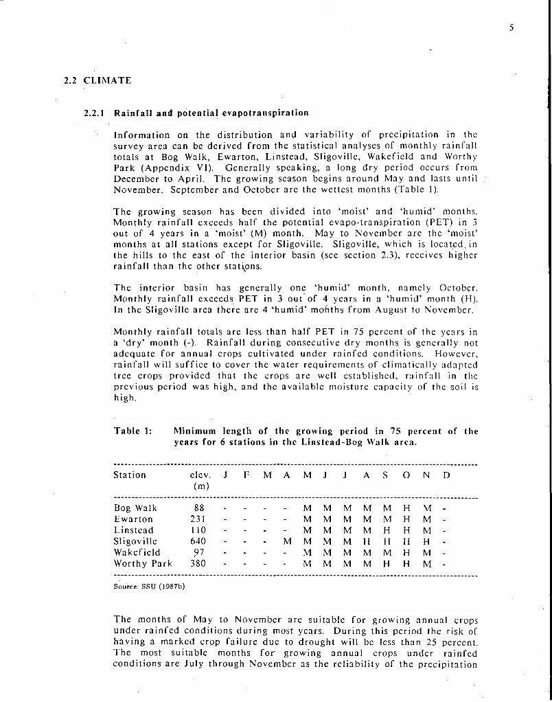
Informat ion on the d is t r ibut ion and var iab i l i ty of prec ip i ta t ion in the survey area can be derived from the stat is t ical analyses of monthly rainfal l totals at Bog Walk, Ewar ton , Linstead, Sligoville, Wakefield and Worthy Park (Appendix VI). General ly speaking, a long dry period occurs from December to April . The growing season begins a round May and lasts until November . September and October are the wettest months (Table 1).
The growing season has been div ided into 'moist ' and ' humid ' months. Monthly ra infa l l exceeds half the potent ia l evapo- t ransp i ra t ion (PET) in 3 out of 4 years in a 'moist ' (M) month. May to November are the 'moist ' months at all s tat ions except for Sligoville. Sligoville, which is located J n the hills to the east of the inter ior basin (see section 2.3), receives higher ra infa l l than the other stations.
The inter ior basin has general ly one ' h u m i d ' month, namely October. Monthly ra infa l l exceeds PET in 3 out of 4 years in a ' humid ' month (H). In the Sligoville area there are 4 ' humid ' months from August to November.
Monthly ra infa l l totals are less than half PET in 75 percent of the years in a ' d ry ' month (-). Ra infa l l du r ing consecutive dry months is generally not adequa te for annua l crops cul t ivated under ra infed condi t ions . However, ra infa l l will suffice to cover the water requi rements of c l imat ical ly adapted tree crops provided that the crops are well establ ished, ra infa l l in the previous period was high, and the avai lable moisture capaci ty of the soil is high.
Table 1: Minimum length of the growing period in 75 percent of the years for 6 stations in the Linstead-Bog Walk a rea .
Stat ion clcv. J F M A M J J A S O N D (m)
Bog Walk 88 Ewarton 231 Linstead 110 Sligoville 640 Wakefield 97 Worthy Park 380
M M M M M H M M M M M M H M M M M M H H M
M M M M H H H H M M M M M H M M M M M H H M
Source: SSU (1987b)
The months of May to November are sui table for growing annua l crops under ra infed condi t ions dur ing most years. Dur ing this period the risk of having a marked crop fa i lure due to drought will be less than 25 percent. The most sui table months for growing annua l crops under ra infed condi t ions are July through November as the re l iabi l i ty of the precipi ta t ion
f
is highest during these months (see the coefficients of variation (CV) in Appendix VI).
During the months of May, June and October there is a significant chance (at least in 5 percent of the years) of having 'excessive' rainfall. This can result in severe runoff and erosion in accidented areas and in severe flooding in low lying areas. The risk of receiving 'excessive' amounts of rainfall is highest in October, followed by May and June (JMS, 1987). These months correspond with the beginning and ending of the 'official' hurricane season.
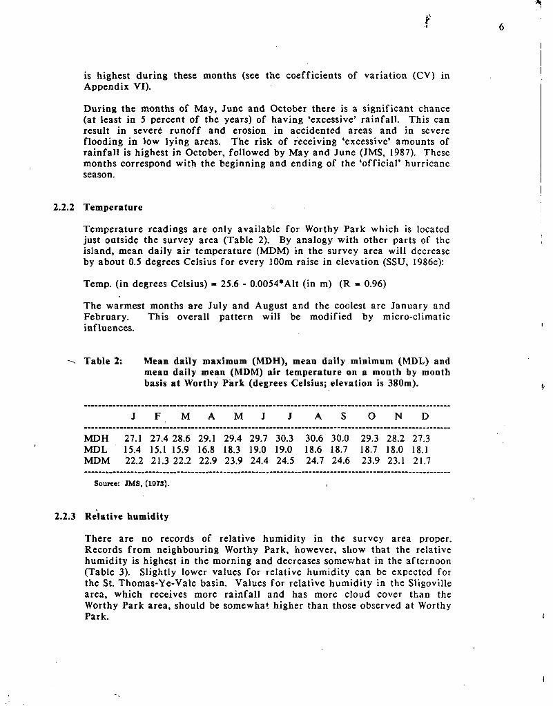
Temperature
Temperature readings are only available for Worthy Park which is located just outside the survey area (Table 2). By analogy with other parts of the island, mean daily air temperature (MDM) in the survey area will decrease by about 0.5 degrees Celsius for every 100m raise in elevation (SSU, 1986e):
Temp, (in degrees Celsius) = 25.6 - 0.0054*Alt (in m) (R = 0.96)
The warmest months are July and August and the coolest are January and February. This overall pattern will be modified by micro-climatic influences.
Table 2: Mean daily maximum (MDH), mean daily minimum (MDL) and mean daily mean (MDM) air temperature on a month by month basis at Worthy Park (degrees Celsius; elevation is 380m).
J F M A M J J A S O N D
MDH 27.1 27.4 28.6 29.1 29.4 29.7 30.3 30.6 30.0 29.3 28.2 27.3 MDL 15.4 15.1 15.9 16.8 18.3 19.0 19.0 18.6 18.7 18.7 18.0 18.1 MDM 22.2 21.3 22.2 22.9 23.9 24.4 24.5 24.7 24.6 23.9 23.1 21.7
Source: JMS, (1973).
Relative humidity
There are no records of relative humidity in the survey area proper. Records from neighbouring Worthy Park, however, show that the relative humidity is highest in the morning and decreases somev/hat in the afternoon (Table 3). Slightly lower values for relative humidity can be expected for the St. Thomas-Ye-Vale basin. Values for relative humidity in the Sligoville area, which receives more rainfall and has more cloud cover than the Worthy Park area, should be somewhat higher than those observed at Worthy Park.

7
Table 3: Mean relative humidity (%) at Worthy Park, St. Catherine (1967-1971)
J F M A M J J A S O N D Y
7 am 1 pm
92 70
93 70
92 68
93 64
93 74
91 74
93 72
93 73
94 76
95 77
92 78
91 76
93 73
Source: JMS (1973)
2.2.4 Sunshine duration
Sunshine duration records exist for 15 locations in Jamaica including Worthy Park (Table 4). Worthy Park lies in an inland basin at about 380m above mean sea level and should have less hours of sunshine than the St. Thomas-Ye-Vale basin. The depth and type of cloud cover, and monthly rainfall will affect the duration of sunshine from one area to another.
Table 4: Possible total hours (N) and mean actual hours (n) of sunshine duration in the Worthy Park area.
J F M A M J J A S O N D
N 11.2 11.5 12.0 12.5 13.0 13.2 13.1 12.7 12.2 11.7 11.3 11.0 n 6.5 6.5 6.5 6.7 5.8 5.7 6.2 5.9 6.0 4.9 5.7 5.1 n/N(%) 58 57 54 54 45 43 47 46 49 42 50 46
Source: JMS (1973)
2.3 GEOLOGY, RELIEF AND HYDROLOGY
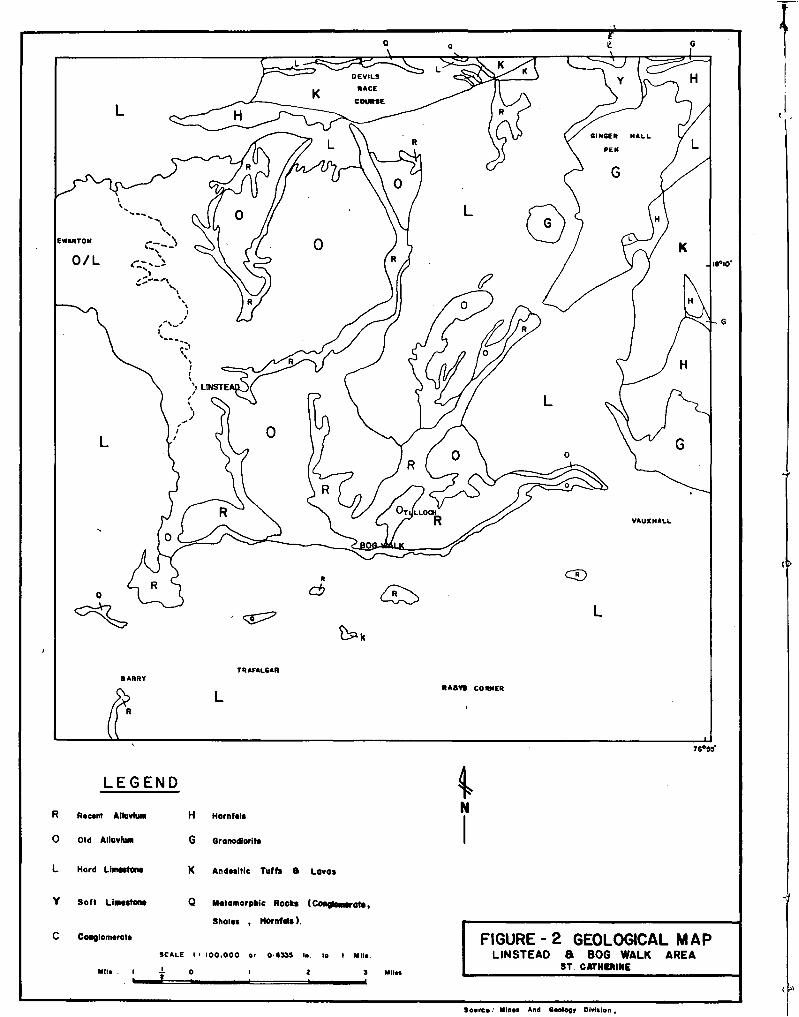
2.3.1 Geology
The oldest formation occurring within the survey area is the Mount Charles series of pelitic hornfels which has been altered from shale or mudstone by contact metamorphism. Also included in the Mount Charles series are hornfels which occur between Homily, Mount Industry, Lucky Hill and Troja.
Andesitic tuffs, lavas and volcanic bombs are the main constituents of the Border Formation which occurs in the hills east of the inland basin, while in the northern portion of the survey area (vicinity of Mount Diablo fault) the Devil's Race Course Formation is evident through poorly bedded andesitic tuffs, conglomerates, basaltic pillow lavas and small outcroppings of hard blue limestone.
f
In the eastern portion of the survey area is a very deeply weathered granodiorite intrusion. Consisting of igneous rock of intermediate texture, the grandiorite consists mainly of feldspars and ferro-magnesium minerals. In general, this material is extremely friable and permeable.
In the north - east portion of the survey area the Wagwater Group is evident. This group is characterized by weathered coarse conglomerates which include particles of limestone, tuff, andesite and shale.
The Yellow Limestone Group, which occurs in the north - eastern section of the survey area, consists of soft limestone, sandstone and siltstone. Much of the limestone is weathered, clayey and/or sandy, nodular and shaley. The sandstone, siltstone and shales occur to a lesser extent than the limestone and are located in isolated areas near Mendez Hill and Dignum Mountain.
The White Limestone Group is evident throughout the survey area as hills and as outcrops which protrude from alluvial deposits.
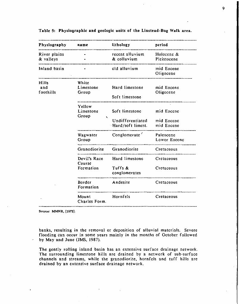
The Physiographic and geologic units that occur in the survey area are summarised in Table 5. Their geographical distribution is shown in Figure 2.
2.3.2 Relief
Based mainly on the landtype and underlying geology of the area, four landtypes are evident within the survey area. Briefly, these are:
a) hills of metamorphic pyroclastic, and igneous origin, b) hills and foothills of limestone, c) old alluvial inland basin deposits, and d) recent alluvial river plains and valleys.
Areas which are predominantly of granodiorite, hornfels and tuffs (a) consist of steep slopes (over 30%), knife sharp ridges, show active erosion, and an elevation up to 800 m and valleys with interlocking spurs.
Areas typical of karst limestone (b) exhibit various levels of cockpit formation and karst topography. In general, relief intensity is from 20 to 200 m, erosion is active, slopes are usually greater than 16% and the area in general consists of hills and valleys which are in various stages of erosion.
Old alluvial deposits account for a large part of the inland basin (c) and are characterized by flat to rolling (0-16%) topography. Within the basin, remnants of limestone foothills (b) occur. The basin also encompasses almost level to undulating (0-8%) river valleys which are along the Rio Cobre, Rio Doro and their tributaries (d).
2.3.3 Hydrology
The Rio Cobre and Rio Doro rivers are the major hydrologie features within the survey area. Due to the general southerly slope of the entire area, both rivers and their tributaries flow ultimately to the south. During periods of excessive rainfall both rivers and their tributaries overflow their
9
Table 5: Physiographic and geologic units of the Linstead-Bog Walk area.
Physiography name lithology period
River plains & valleys -
recent alluvium & colluvium
Holocene & Pleistocene
Inland basin - old alluvium mid Eocene Oligocene
Hills and
foothills
White Limestone Group
Hard limestone
Soft limestone
mid Eocene Oligocene
Yellow Limestone Group v
Soft limestone
Undifferentiated Hard/soft limest.
mid Eocene
mid Eocene mid Eocene
Wagwater Group
Conglomerate7 Paleocene Lower Eocene
Granodiorite Granodiorite Cretaceous
Devil's Race Course Formation
Hard limestone
Tuffs & conglomerates
Cretaceous
Cretaceous
Border Formation
Andesite Cretaceous
Mount Charles Form.
Hornfels Cretaceous
Source: MMNR, (1972).
banks, resulting in the removal or deposition of alluvial materials. Severe flooding can occur in some years mainly in the months of October followed by May and June (JMS, 1987).
The gently rolling inland basin has an extensive surface drainage network. The surrounding limestone hills are drained by a network of sub-surface channels and streams, while the granodiorite, hornfels and tuff hills are drained by an extensive surface drainage network.
I8»I0'
«ABT» CORNER
76°5S'
LEGEND
R R.csnt Alkivfim H Hornfali
O Old Alluvku» G Granodlorit*
i N
L Hord LhMOtona K Andssltic Toffs B Lavas
Y Soft LimMtOM Q Matamorpkic Rockt (Congfemrato,
Shal.» , HornMs).
C Conglomerate
SCALE I > 100.000 ar O 6335 In. Ie I MIK.
Milt I i . o 3 Mil»
FIGURE-2 GEOLOGICAL MAP LINSTEAO 8 BOG WALK AREA
ST CATHERINE
Sovrc*; Mln*t And ecology Dhritlon,
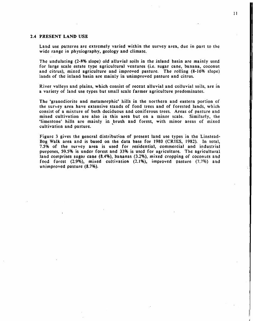
2.4 PRESENT LAND USE
Land use patterns are extremely varied within the survey area, due in part to the wide range in physiography, geology and climate.
The undulating (2-8% slope) old alluvial soils in the inland basin are mainly used for large scale estate type agricultural ventures (i.e. sugar cane, banana, coconut and citrus), mixed agriculture and improved pasture. The rolling (8-16% slope) lands of the inland basin are mainly in unimproved pasture and citrus.
River valleys and plains, which consist of recent alluvial and colluvial soils, are in a variety of land use types but small scale farmer agriculture predominates.
The 'granodiorite and metamorphic' hills in the northern and eastern portion of the survey area have extensive stands of food trees and of forested lands, which consist of a mixture of both deciduous and coniferous trees. Areas of pasture and mixed cultivation are also in this area but on a minor scale. Similarly, the 'limestone' hills are mainly in brush and forest, with minor areas of mixed cultivation and pasture.
Figure 3 gives the general distribution of present land use types in the Linstead-Bog Walk area and is based on the data base for 1980 (CRIES, 1982). In total, 7.5% of the survey area is used for residential, commercial and industrial purposes, 59.5% is under forest and 33% is used for agriculture. The agricultural land comprises sugar cane (8.4%), bananas (3.2%), mixed cropping of coconuts and food forest (2.9%), mixed cultivation (2.1%), improved pasture (7.7%) and unimproved pasture (8.7%).

. i 1:111 t o n :
mixed cultivation
forest (mainly deciduous)
mixed (bananas, coconuts & food forest)
residential, commercial & industrial
sugar cane
unimproved and improved pasture
Figure 3: Land use map of the Linstead-Bog Walk area, St. Catherine (scale: 1:150,000; adapted from CRIES, 1982).
.

3 MATERIALS AND METHODS
3.1 OFFICE PROCEDURES
The initial step in the * survey was to gather and study all available aerial photographs, topographical and geological maps, and other information about the Linstead-Bog Walk area. • . *, v
% , -. ' , \ \ „ -v - , .
The Soil and Land Use Survey of^the parish of 'St> Catherine (RCC, 1958) was used . as the-basis for the survey. - The information relevant for the survey area was
extracted from the above report and supplemented with recent information on the geology (MMNR, 1972), climate (JMS, 1973; SSU, 1987b) and land use (CRIES, 1982). .
- The Linstead-Bog Walk survey area is the sample area for the soil survey of the Rio Cobre Watershed, which was carried out in 1986 within the framework of the Hillside Agricultural Project. Figure '4sshows that the Linstead-Bog Walk area is 'covered by six 1:12,500 topographical map^ sheets (Nos. 84B, 84D, 85B, 94A, 94C and 95A, Survey Dept.) The corresponding 1:12,500 field sheets of the 7955 Soil Survey were used as base maps for the field ^survey. The topo-sheets were also used for compiling a slope map of the area. /"'
The base map for the final soil map at a scale 1:25,000 was obtained by photographic reduction of the 1:12,500 topographical sheets (Survey Department).
Black and white aerial photographs at a scale of 1:25,000, taken in March 1968, were studied with stereoscopes before the actual fieldwork. This exercise familiarized the soil surveyors with the land features, allowed for delineation of physiographic boundaries, and aided in the planning of reconnaissance field trips
s- and actual field work. /•
3.2 FIELD PROCEDURES , f
... y -A reconnaissance was carried out to check the validity of the physiographic units and to select appropriate sample areas covering each unit. Each field team was assigned to a sample area. A limited number of soil borings and mini-pits were made atjhis stage of the survey to get an initial overview of the soil conditions. The sample areas were surveyed using a network of auger borings. The borings were made to a depth of 120 cm, soil depth permitting, along transects running at
. right angles to the anticipated soil boundaries. Soil characteristics and , s information on the setting and land use were recorded on standard forms of the
Soil Survey Unit. On the basis of bore hole descriptions the soils were described and the soil boundaries of the 1958 Soil Survey checked. The borings also served to identify representative sites in each map unit for digging mini-pits and full-
. size pits.
Twelve mini-pits of about 60x60x60 cm were dug in the major soils to accurately describe their range in morphometric characteristics. On the basis of this knowledge representative sites for full-size pits were identified. Full-size pits are about 1 to 2 m across and 1.5 m deep unless hard rock occurs at a shallower depth.

T
PARISH OF
ST. ANN
I8°00 'N
\
> *~ï PARISH OF
ST MARY
.1 "
I
18°13'-I I
PARISH OF CLARENDON
C A R I B B E A N
SEA 77°00 ' W
LEGEND ROADS PARISH BOUNDARY
— . _ WATERSHED BOUNDARY
84D TOPOGRAPHC SHEET No. I i 12,500 SERIES
YZZA LINSTEAD/BOGWALK SOIL SURVEY
0 S 10 Miln l_ 1 1
SCALE 1 - 2 9 0 , 0 0 0
FIGURE 4
SURVEY AREA AND RELATIONSHIP TO OTHER SOIL SURVEYS. Sourct Aflopttd From S u f v y Dapot twnt

15
Twenty,, full^size,ipits were,^escribed following X\ie Guidelines for Soil Profile Descriptions (FAO, 1977) 'usirig'thV colour notations óf thé' Munsell Colour Charts (KC 1975). Provisional classification of the soils were made according to the Soil Taxonomy , (USDA, 19,75).ir Soil samples H from each , horizon were taken in accordance ,with'the,standardst'of yspA^l984)V l These samples were then brought to the Soil' Laboratory'"of' trie ,Rural Physical."Planning' Diyision where they were prepared for' chemical and 'physical analyses (see Section 3.3). No infiltration experiments were, carried out in the survey area.
During the survey of the sample areas the information gathered on soils was screened and analysed. A preliminary description of the soils and a framework for the field legend,for the soil map were prepared. The applicability of this framework was checked in the field and adapted when required.
A limited number of field checks were carried out outside the limits of the sample areas to confirm the range in characteristics of the soils, to check the boundaries on the 1958 Soil Survey sheets, and to establish the composition of the mapping units.
In total, 160 observations were; made during the fieldwork, viz. 128 augerings, 12 mini-pits and 20 full-size pits. , Forty five of the augerings were made in the inland basin, 43 in the. river valleys and river plains'^and 40 in the hills and foothills. The average' density of 'observations is. 0.5, per 100 ha..
3.3 MAP COMPILATION
Following final checking and correlation, the 1:12,500 field maps from the three field teams were compiled into a final field map. This map was transferred by hand to the 1:25 JOOO' base map.' ' The ' previously compiled slope map| was superimposed onto the soil map giving the final product. Final'copies of the map were obtained by making blue prints of the second sepia copy.
3.4 LABORATORY PROCEDURES
Sample preparation
Soil samples are segregated in an aluminum' tray and subsequently i oven dried at 35 degrees Celsius. The oven dry samples are 'crushed with a cross beater mill and passed through % 2 mm sieve. This fine earth fraction is used for the physical and chemical analyses.
Chemical methods
Calcium carbonate (rapid gravimetric method): Add 7 ml of 5 M HCl to 1 g of soil and to 0.1 mg of CaCO^, shake, and allow the CO2 to escape. The weight loss is the measure for the amount of CaCOo originally present. Weight losses due to evaporation are accounted for by including the calculated weight loss from blanks.
Organic carbon (Walkley & Black method): The soil sample is oxidized with potassium dichromate in the presence of concentrated sulphuric acid. The excess of dichromate is titrated with the standard solution of ferrous sulphate. The

amount of oxidizable materials is calculated from the amount of dichfomatê that has been reduced. " v i. \ ^
Available Phosphorus (Truog method): The soil sample is extracted with a 0.001 M solution of sulphuric acid buffered with ammonium sulphate at pH 3.0.* Acidified ammonium molybdate is added to the extract in which a yellow molybdenum-phosphate complex is formed. This complex is reduced by adding stannous chloride; the extract turns to blue. The intensity of thé blue colour is measured at 655 nm on a Spectronic-20 spectophotometer.
Available potash: The soil sample is leached with 0.5 M acetic acid and the potassium concentration in the leachate measured" by flame-photometer at 768 nm (EEL Corning 405). - : ~ t . ' • . -
Soil reaction: The soil sample is shaken for 2 hours with either water (pH-F^O) or 1 M KCl (pH-KCi) i n ' a 1/2.5 weight to volume ratio. ( ' .The pH in the supernatant suspension is measured potentiorrietrically. ' u '."**V
Nitrogen: (Macro Kjeldahl method): The soil sample is digested with concentrated sulphuric acid in the presence of CuSO^ and K^SÓ^ at about 300 degrees Celsius. An excess of NaOH is added to an aliquot of thé digest. The solution is distilled into boric acid which binds,thé released NH^. Theamount of ammonia captured, is titrated against 0.01 M HC1. ' ' . ' J ' ' ! * J
Extractable bases and Cation Exchange Capacity: The soil is mixed .with quartz sand, placed in a column and leached with 1 M ammonium acetate buffered at pH
^7. Calcium, magnesium, potassium and sodium are measured in the leachate, the divalent cations by atomic absorption spectrophotometry (Baird A-5100) and the monovalent cations by flame photometer (EEL''Corning ,405) at 589 and 768 nm respectively. ' .' / ', * V , " T**" "*,,»'I
The ammonium saturated soil sample is washed with 70% ethanol arid subsequently leached with a 10% KCl solution adjusted to pH 2.5. An aliquot.of this,leachate is made ammoniacal and is distilled into boric acid which binds" the'""released
s ammonia. The amount of NH^ is titrated against 0.02 M HC1.
The percentage of base saturation is calculated by dividing the sum of cations (Ca, Mg, Na and K) times 100 by the CEC value. - " l " ! ' ; r
Exchangeable'aCiditv and exchangeable'aluminium: The soil sample'is ' leached with ..K M KCl. The amount of exchangeable acidity is determined titrimetrically with 0.1 M NaOH.
Physical analyses
Textural analysis: The soil sample is pre-treated with 50 ml of the dispersing agent sodiuih hexa-metaphosphate and left to vstand" overnight. The mixture is then transferred to a mixing cup and'shaken for 15 minutes in the'case of fine textured samples and f o r 10 minutes in ' the case of coarse textured samples. The mixture is transferred to a sedimentation'cylinder of 1,000 ml and shaken for 1 minute. Forty seconds after shaking has ended the specific gravity of the suspension is. read from an ASTM H151 type hydrometer; 'this g ives the ' s i l t and clay size fractions. The clay size fraction is read after 2. hours.' The temperature of the solution is recorded at thé time of each hydrometer reading. The'readings
t

are corrected to 20 degrees Celsius and the percent of sand, silt and clay size fractions calculated. The suspension is washed through a 0.05 mm sieve which retains the sand size fraction. This fraction is weighed upon drying at 105 degrees Celsius.-, The .'sieve analysis' is built in as a cross check on the hydrometer results.
18
4 THE SOILS
4.1 GENERAL CHARACTERISTICS OF THE SOILS
The Linstead-Bog Walk area is characterized by hills which surround an interior basin with river plains and valleys. The distribution of the soils is largely determined by the physiography and parent material as described in the following sections.
4.1.1 Soils of the hills and foothills
The soils of the limestone hills and foothills are quite varied in their characteristics. Lucky Hill variant, St. Ann variant and Bonnygate soils are formed over bauxitic materials which occur over hard limestone rock. Union Hill soils are formed from hard limestone and Carron Hall soils from soft limestone. Union Hill and Carron Hall soils occur in areas that receive somewhat higher rainfall than areas of St. Ann variant and Bonnygate soils (udic and ustic moisture regime respectively). Lucky Hill variant soils are in depressions where runoff water can accumulate (udic moisture regime, see glossary).
St. Ann variant soils are deep, well drained dark red to dark reddish brown, moderately fine textured soils with a high content of organic carbon to a great depth. They have a good structure and are highly permeable. The available moisture capacity (AWC) of Stl Ann variant soils is moderate. St. Ann variant soils have a gibbsitic mineralogy, which results in a low inherent fertility, a low cation exchange capacity (CEC) and strong fixation of phosphorus.
St. Ann variant soils are often intricately associated with very shallow, excessively drained, dark red to dusky red, stony, medium textured Bonnygate soils. Bonnygate soils generally occur on rolling and steep slopes whereas St. Ann variant soils predominate on undulating and rolling areas.
Bonnygate soils, which are very shallow extending to hard limestone, occupy pockets and crevices in the limestone. They always occur in conjunction with limestone outcrops and boulders. Bonnygate soils are highly permeable, chemically poor, droughty and susceptible to erosion when the natural vegetation is cleared.
Lucky Hill variant soils are formed from colluvial materials, which are derived from hard limestone with admixtures of bauxitic materials, and occur in undulating depressions. They are moderately deep, moderately well drained to imperfectly drained, brown to strong brown and fine textured soils that have a high content of organic carbon to a great depth. Lucky Hill variant soils have a mixed mineralogy, a low CEC, a moderate AWC and are strongly acid. They can be saturated with water above a perched water table during some time of the year.
Union Hill soils are formed from hard limestone in rolling to steep areas. They are shallow, well drained, reddish brown to dark yellowish brown and fine textured. Union Hill soils show weak shrink-swell characteristics when their moisture content varies. The mixed mineralogy results in a moderately

19
high CEC and a low AWC. Union Hill soils are neutral to mildly alkaline in reaction and mostly calcareous. Generally, they are intricately associated with limestone outcrops and Carron Hall soils. Rock outcrops predominate on steep slopes and Carron Hall soils in depressions of undulating areas.
Carron Hall soils are formed from rubbly and marly limestone. They are moderately deep, well drained, brown cracking clay soils over a plastic, yellowish brown clay which is montmorillonitic. Carron Hall soils have a slow permeability and a low AWC. The mineralogy results in marked shrink-swell characteristics. The CEC is moderately high and the base saturation high. The soils are highly calcareous and mildly alkaline.
In some areas Union Hill soils are intricately associated with deep, well drained, yellowish red to reddish yellow, cracking, fine textured Wait-a-Bit soils in areas where acid shales surface amidst the limestone. The strongly acid Wait-a-Bit soils are moderately permeable and highly erodible. They have a low AWC and low inherent fertility.
The hills of granodiorite, pyroclastic and metamorphic origin are steeply dissected, and have as dominant soils Diamonds, Donnington and Flint River. These soils are in areas of high rainfall with a short dry season (udic moisture regime).
/ Diamonds soils are formed from hornfels. They are moderately deep, well drained to somewhat excessively drained, strong brown to yellowish brown, moderately fine textured, gravelly soils. They have mixed mineralogy with inclusions of amorphous or poorly crystallized minerals (possibly volcanic influence) and are slightly acid. Surface runoff and the inherent fertility are moderate.
The moderately deep, well drained to somewhat excessively drained, yellowish red, moderately fine textured Donnington soils are formed from acid tuffs and have mixed mineralogy. They have a low AWC and are highly erodible. The inherent fertility of Donnington soils, which are slightly acid, is moderate.
Flint River soils are moderately deep, somewhat excessively drained gravelly and coarse textured. They are formed from weathered granodiorite and have a mixed mineralogy. Flint River soils have a low AWC and are highly erodible. The inherent fertility is moderate and the reaction slightly acid.
2 Soils of the inland basin
Linstead, Pennants and Rosemere soils are formed from old alluvium which occurs in the St. Thomas-Ye-Vale inland basin. They are predominately on gently undulating to rolling slopes.
Linstead soils are deep, moderately well drained to imperfectly drained and fine textured, and have prominent red and white mottles in their subsoil. They have a mixed mineralogy with about 17% of montmorillonite and about 40% of kaolinite. The occurrence of montmorillonite is reflected in

the shrink-swell properties of the soils. The kaolinite results in soils with a low CEC and a low AWC. Linstead soils have a strongly acid subsoil and a low inherent fertility. Typically, they have a high content of organic carbon to a great depth.
Rosemere soils are deep, moderately well drained, mottled, red and yellowish red, fine textured soils. In the field they look like Linstead soils. Rosemere soils, however, are very strongly to extremely acid, have a low base saturation, and lack the high content of organic carbon. Linstead soils have a relatively high base saturation throughout their subsoil.
Pennants soil differ strongly from Linstead and Rosemere soils. They have a mixed mineralogy and crack deeply and widely upon drying. Pennants soils are deep, poorly drained and fine textured. They have a moderately high CEC, a neutral reaction range and a low AWC.
Soils of the river plains and valleys
Soils of the river plains are deep and mostly well drained. Depending on their occurrence in the landscape the texture varies from coarse to fine textured. Characteristically, the recent alluvial soils are stratified and have a high organic matter content in the topsoil. Knollis soils, which are formed from old alluvial deposits of the Rio Doro, lack the stratification which is so apparent in the recent alluvial soils.
The fine textured Wallens soils have a high AWC and the other soils (Prospect, Tulloch, Berkshire and Whim) have a. moderate AWC. Generally, the recent alluvial soils are slightly alkaline, have a high CEC and a high base saturation. The inherent fertility is high . The mineralogy of recent alluvial soils is predominantly mixed with some amorphous or poorly crystallized minerals. These minerals probably come from the catchment area of the rivers which extends into hills of pyroclastic of volcanic origin. Knollis soils are deep, poorly to very poorly drained, fine textured soils with moderately high inherent fertility and moderate available moisture capacity.
Prospect, Tulloch and Knollis soils are formed on terraces of the Rio Doro, which has its catchment area in granodiorite hills. Knollis soils occur on the 'higher' terrace, Tulloch soils on the 'middle' terrace and Prospect soils on the 'lower' terrace. Wallens, Whim and Berkshire soils are formed from recent deposits of the Rio Cobre, Rio Magno and their tributaries.
The soils that are formed from fluvio-colluvial materials are deep, moderately well drained to poorly drained and fine textured with a mottled subsoil. Rosehall and Sterling soils both have mixed mineralogy and have weak shrink-swell properties. Sterling soils differ from Rosehall soils in not having a thick dark coloured surface layer high in organic carbon and base saturation.

4.2 CLASSIFICATION OF THE SOILS
Soil Taxonomy (USDA, 1975) has been used in recent years by Soil Survey Staff to classify the soils of Jamaica. This system is widely used internationally and therefore allows for cross border correlation.
Soil Taxonomy defines classes in terms of observable or measurable properties, which are also termed morphometric properties. The classes are: Orders, Suborders, Great groups, Subgroups, Families and Series, where the Order is the highest category and the Series the lowest one.
Orders consist of soils with similar properties which resulted from the same soil forming processes, which acted to the same degree on the parent material or rock. Seven of the ten orders that are recognized by Soil Taxonomy have been identified in the survey area. The dominant characteristics of these orders will be briefly explained in the following paragraphs, and will enhance the user's understanding of the technical classification which is used in section 4.4.
• Entisols are young mineral soils with little, if any, horizon development. In the^survey area these soils are frequently rejuvenated by hillside processes such as erosion and soil creep. This order is represented by the Flint River series.
• Inceptisols are mineral soils that have'one or more pedogenetic horizons in which minerals are altered or removed (Bw horizon) but not accumulated. In general Inceptisols have weakly differentiated profiles and are on recent land surfaces or on land surfaces that are being rejuvenated. This order is represented in the survey area by soils of the Berkshire, Diamonds, Donnington, Union Hill, Bonnygate and Sterling series.
• Vertisols are mineral soils that have 30 percent or more clay, deep wide cracks when dry, and intersecting slickensides or wedge-shaped structural elements tilted at an angle to the horizon plane. The shrinking and swelling is due to the high content of montmorillonitic clay minerals which cause the natural inversion (churning) of the soil. Vertisols are represented in the survey area by the Pennants and Carron Hall series.
• Mollisols are mineral soils that have a thick, dark coloured surface layer which is high in organic matter content and has a high base saturation. They have a moderate to strong structure and weakly to strongly differentiated profiles. The subsoil has a high base saturation to a great depth. Mollisols in the survey area are mainly in river plains. Whim, Rosehall, Wallens, Prospect and Tulloch series have a weakly developed subsoil (Bw horizon), whereas Knollis soils have a clear clay bulge (Bt horizon).
• Alfisols are mineral soils with a clay enriched subsoil (Bt horizon; clay bulge), high base saturation to a great depth, and lack the dark coloured surface soil which is representative of a Mollisol. The Alfisols in the survey area are represented by the Linstead and St. Ann variant series.

• Ultisols are similar to Alfisols in having a clay bulge, but the base saturation of Ultisols is low in the deepest part of the subsoil. They are represented by the Lucky Hill variant and Rosemere series.
• Oxisols are very strongly weathered soils in which the material is very uniform with depth. They a rc represented by minor "included soils" in the survey area (typical St. Ann soils).
Suborders are subdivisions of orders based on characteristics that produce classes with the greatest genetic similarity. These characteristics are mainly soil temperature and soil moisture regime.
Great groups are subdivisions of suborders based on uniformity of type and sequence of major horizons and their features. At this stage of classification horizons are considered with the following features:
a) clay, iron or humus have accumulated; b) thin, hard pans interfere with the growth of roots and the movement
of water; c) similar temperature and soil moisture regimes are observed, and d) the base saturation is similar.
Some characteristics that are considered at the great group level in the survey area are: base saturation (Dystr- when low; Eutr- when high), thickness and degree of weathering of the clay bulge (Pale-) and temperature (Tropo-).
Subgroups are divisions of great groups. The constituents of the "Typic" subgroup have characteristics that are representing the central segment of the group. The other subgroups have the properties of one great group, and also one or more properties of another great group, suborder or order and are known as "intergrades".
Families are members of a subgroup. Each family has physical and chemical properties that affect their management in a similar way. Families in the survey area are predominantly distinguished on the basis of:
a) particle size class of the control section; b) mineralogy in the corresponding horizons; c) thickness of the soil penetrable by roots, and d) other properties that are needed to group soils in homogeneous units.
The series is the lowest category in Soil Taxonomy. A series may have virtually the whole range in characteristics that is permitted for a specific family, but it must have one or more specific properties that have a restricted range and can be deduced with reasonable accuracy while mapping. Series are mainly of a pragmatic nature; the series that are in a specific family have similar suitability for agriculture. An example of a Jamaican soil series is Rosehall; the name refers to the type location where the concept of the series was first described. Twenty series have been identified in the Linstead-Bog Walk area. The range in characteristics of the soils of these series is described in Section 4.4.
To allow for separation amongst the different members of Alfisols encountered in the Linstead-Bog Walk area, a new subgroup has been proposed for Jamaica. It is the "humic" subgroup which has 12kg or more of organic carbon per square meter
to a depth of 1 meter. These soils do not qualify as Argiudolls because the colour of the topsoil is not dark enough to qualify as a "mollic" epipedon. The concept will be tested and refined by Soil Survey Staff during their subsequent surveys.
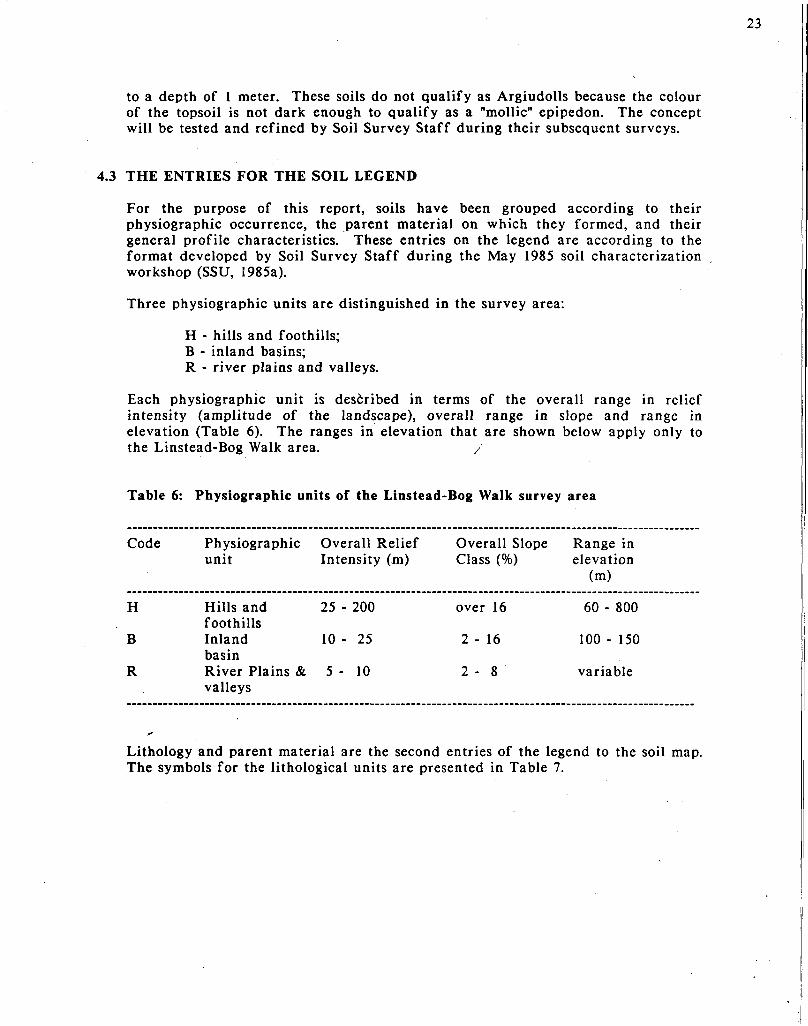
4.3 THE ENTRIES FOR THE SOIL LEGEND
For the purpose of this report, soils have been grouped according to their physiographic occurrence, the parent material on which they formed, and their general profile characteristics. These entries on the legend are according to the format developed by Soil Survey Staff during the May 1985 soil characterization workshop (SSU, 1985a).
Three physiographic units are distinguished in the survey area:
H - hills and foothills; B - inland basins; R - river plains and valleys.
Each physiographic unit is described in terms of the overall range in relief intensity (amplitude of the landscape), overall range in slope and range in elevation (Table 6). The ranges in elevation that are shown below apply only to the Linstead-Bog Walk area. /
Table 6: Physiographic units of the Linstead-Bog Walk survey area
Code Physiographic Overall Relief Overall Slope Range in unit Intensity (m) Class (%) elevation
(m)
H Hills and 25 - 200 over 16 60 - 800 foothills
B Inland 10 - 25 2 - 16 100 - 150 basin
R River Plains & 5 - 10 2 - 8 variable valleys
Lithology and parent material are the second entries of the legend to the soil map. The symbols for the lithological units are presented in Table 7.

Table 7: Lithologic entries on the legend to the soil map
24
Code Parent rock or material
G Granodiorite H Hornfels K Tuffs L Hard limestone I Undifferentiated (hard limestone and acid shales) J Undifferentiated (hard limestone and soft limestone) V Colluvium derived from limestone and bauxitic materials O Old alluvium R Recent alluvium F Mixture of alluvial and colluvial materials
The third and final entry describes the soils of the mapping units. Two types of mapping units have been used in mapping the Linstead-Bog Walk area, viz: consociations and complexes. The glossary describes these terms in detail. Summarizing, a consociation comprises one dominant soil (series) and up to 25 percent of other included soils. A complex contains two or more soils (series) that occur in a pattern that cannot be mapped meaningfully at the given scale. There is no clear geographical distribution of the soils within a complex. A complex can contain up to 25 percent of included soils (see USDA 1984 & 1985).
The characteristics of the dominant soils (series) of the map units are described in the following sequence: depth class, drainage class, Munsell colour notation (moist), textural class or textural group for stratified soils, and the texture of the topsoil when contrasting with the texture of the subsoil. When relevant the degree of mottling, calcareousness, stoniness and rockiness are mentioned in the map unit description. Cracking of the soils is reported when present and so is the occurrence of a surface layer with mollic properties.
Each mapping unit is given a name following the general format of USDA (1984). The root of the name of the mapping unit is the name of the dominant soil series followed by the texture of the topsoil in case of a consociation (e.g. Rosehall clay). For complexes the texture of the topsoil is generally omitted (e.g. Union Hill-Rock Outcrop complex) unless this texture is similar for both soils (e.g. Linstead-Rosemere clay). The name of the series is taken from RRC (1958) and adapted to modern standards when needed.
Each mapping unit is given a code for easy reference on the map and legend. The codes are made following a strict sequence; first the code for the physiographic unit, then the code for the lithological unit, and finally a number for the mapping unit.

25'
For example:
H HILLS AND FOOTHILLS
HG Soils formed on granodiorite
HG1 Flint River sandv loam: moderately deep, well drained to somewhat excessively drained, yellowish brown, gravelly sandy loam over soft, weathered granodiorite (Typic Troporthents). /
Each map unit code clearly indicates the type of mapping unit used. For example, consociations are of the general form HG1, whereas complexes are of the general form HLxl. The 'x ' indicates the compound nature of the mapping unit.
The dominant range in slope is shown on the map in the denominator of the code of the mapping unit, for example:
HG1
The key to the slope classes (FAO, 1977) is shown on the map under 'key to phases'. The slope classes are:
a) level to almost level (0-2%); /
b) undulating (2-8%); c) rolling (8-16%); d) hilly (16-30%); e) steep (30-50%) and f) very steep (over 50%).
The key to depth classes in the soil descriptions on the map is:
a) very shallow (less than 25cm); b) shallow (25-50cm); c) moderately deep (50-100cm) and d) deep (over 100cm) to a root limiting layer.
The textural groups are:
• fine textured (sandy clay, silty clay and clay); • moderately fine textured (clay loam, sandy clay loam and silty clay
loam); • medium textured (very fine sandy loam, loam, silt loam and silt); • moderately coarse textured (sandy loam and fine sandy loam) and • coarse textured (sand and loamy sand).
Soil depth and textural groups are not visualized on the map by any specific codes since these features are described on the legend.
4.4 DESCRIPTION OF THE SOIL MAPPING UNITS
26
4.4.1 General
Twenty soil mapping units have'been described during the mapping, viz.: 14 consociations and 6 complexes. The characteristics of the dominant soil(s) of each mapping unit will be discussed in the next subsections following the sequence on the legend to the soil map (see Appendix V). The classification of the dominant soils at the family level (USDA, 1975) is given in Appendix IVa. The key to the map numbers previously used in the 'Green Books' (RRC, 1958 -1970) is shown in Appendix IVb, and the acreages in Appendix IVc.
Technical terms are used when describing soils. These terms are explained in the glossary (see Appendix VII). The classification of the soils is according to Soil Taxonomy (USDA 1975) and will not be explained in detail in this report (see section 4.2).
4.4.2 Mapping units of the hills and foothills
HG1: FLINT RIVER sandy loam (3,461 ha)
The HGI consociation consists of moderately deep, somewhat excessively drained to well drained, yellowish brown, gravelly, coarse textured Flint River soils. Flint River soils are formed from weathered granodiorite and occur on steep and very steep hills in the north eastern part of the survey area.
Flint River soils are members of the loamy-skeletal, mixed, iso-hyperthermic family of Typic Troporthents. Representative members of Flint River soils are described in Appendix 1.1a and 1.1b.
Brief profile description: The solum generally ranges from 40 to 60cm in thickness and has very weakly differentiated layers. The surface layer (A horizon) is dark yellowish brown, sandy loam and gravelly. It is 10 to 30cm thick. The substratum (C horizon) is light yellowish brown mixed with yellowish brown, and in some pedons dark yellowish brown, sandy loam to gravelly loam. The volume percentage of weathered granodiorite fragments gradually increases with depth in the substratum which is about 15 to 50cm thick in most pedons . Weathered granodiorite rock is encountered between a depth of 40 and 60cm, but in some pedons it is at 80cm. The weathered granodiorite is friable, with gravelly sandy loam to gravelly sandy clay loam texture.
Soil properties affecting management: Flint River soils are slightly acid to medium acid, and have moderate inherent fertility. The loamy skeletal texture results in highly permeable soils with a low available moisture capacity. 'Although the depth to weathered granodiorite is shallow, roots of trees can penetrate to great depth in this material. Flint River soils occur on steep and very steep slopes. Consequently, the runoff and erosion hazard can be high. Steepness of slopes precludes mechanization.

27
Included soils: The HG1 mapping unit includes minor areas of Diamonds soils which are formed from hornfels (see under HH1), and of Cuffy Gully soils. The latter, which are formed from purrMe conglomerate, are moderately deep, somewhat excessively drained to well drained, dark reddish brown to brown, gravelly, medium textured soils (loamy-skeletal, mixed, iso-hyperthermic, Typic Troporthents). Small extents of Cuffy Gully soils are on very steep slopes in the eastern part of the survey area near the border to St. Mary.
Present land use: Flint River soils are mainly under food forest (breadfruit, mango, star apple), cacao and banana.
HH1: DIAMONDS clay loam (1,089 ha)
The HHl consociation consists of moderately deep, somewhat excessively drained to well drained, strong brown to yellowish brown, moderately fine textured Diamonds soils. Characteristically, these soils are high in silt and gravels. Diamonds soils are formed from hornfels and occur on steep and very steep slopes of dissected hills. They are extensive in the northern part of the survey area. ,
Diamonds soils are members of the loamy-skeletal, mixed, iso-hyperthermic family of Typic Eutropepts. The diamonds soil described in Appendix 1.2 is somewhat lighter textured and contains less gravel than is customary for the profile of a typical Diamonds soil.
Brief profile description: The solum typically is 50 to 100 cm deep extending to hard hornfels, but in some pedons it extends to 120cm. The surface layer (A horizon) is dark brown, clay loam to silt loam and 10 to 30 cm thick. The subsoil (Bw horizon) is strong brown to yellowish brown, and in some pedons dark reddish brown, clay loam to silt loam and 15 to 40 cm thick. The substratum (CR horizon) consists of soft, weathered hornfels and starts between 50 and 100 cm depth. The hornfels break into light yellowish brown loam to silt loam, but harder fragments occur. The solum contains variable amounts of gravels in the various layers, but generally the amount increases with depth. Hard hornfels start below a depth of 80cm, but in some pedons they occur below a depth of 50 cm.
Soil properties affecting management: Diamonds soils are slightly acid to neutral and have moderate inherent fertility. They have high Mg/Ca and Mg/K ratios so that nutrient imbalances may occur. Root penetration can be limited at a moderate depth by hard hornfels. The loamy-skeletal texture results in soils that are highly permeable and have a low available moisture capacity. Diamonds soils are high in silt in the topsoil and occur on steep to very steep slopes, and therefore prone to erosion. Steepness of slopes precludes mechanization.
Included soils: The HHl unit includes minor areas of dissimilar soils, viz: a) about 10 percent of shallow soils over hard hornfels which mainly are on very steep slopes and crests, b) small areas of shallow Bonnygate soils over hard limestone and c) moderately deep to deep, dark red to dark

reddish brown, moderately fine textured St. Ann variant soils. Inclusions of the b) and c) type account for about 5 to 10 percent of the HH1 mapping unit and occur in areas transitional to the limestone hills.
Present land use: Diamonds soils are mainly under food forest including breadfruit, mango, coffee and banana.
HK1: DONNINGTON gravelly loam (823 ha)
The HK1 consociation consists of moderately deep, well drained to somewhat excessively drained, dark yellowish brown, fine textured Donnington soils. Donnington soils are formed from acid tuffs and occur on steep and very steep slopes. They are in the south western part of the survey area near Giblatore.
Donnington soils are members of the fine, mixed, iso-hyperthermic family of Typic Dystropepts. A representative member of the Donnington series is described in Appendix 1.3. There are no chemical data for this profile.
Brief profile description: The solum of Donnington soils ranges from 40 to 90 cm in depth. The surface layer (A horizon) is dark brown to yellowish brown, gravelly clay loam. In some pedons it is clay loam. The surface layer is 20 to 30 cm thick. The subsoil (Bw horizon) is dark yellowish brown, in some pedons mixed with yellowish brown, clay loam, 20 to 30 cm thick. The lower part of the subsoil typically contains small white clay
'particles. The substratum (CR horizon) is brown, dark brown to bro\vnish yellow sandy__ciay loam to clay loam. In some pedons it is mixed with strong brown clay loam. Below 40 to 60 cm depth, manganese concretions and weathered tuff fragments are apparent. The fragments become harder with increasing depth. Fissured bedrock occurs between 60 to 90 cm depth.
Soil properties affecting management: The inherent fertility of Donnington soils which are slightly acid to medium acid, is moderate. Donnington soils are highly permeable and have a low available moisture capacity. Fissured bedrock at a moderate depth can limit root penetration. Steepness of slopes
"can result in a high runoff and severe erosion, and precludes mechanized agriculture.
Included soils: The HK1 mapping unit includes small areas of: a) shallow soils over weathered tuffs which are similar in characteristics to Donnington soils, and of b) deep, well drained, yellowish red to reddish yellow, fine textured Wait-a-Bit soils which are formed from acid shales. The range in characteristics of Wait-a-Bit soils is described under the heading HIxl.
Present land use: Donnington soils are mainly under food forest and natural forest.
29
HV1: LUCKY HILL variant clay loam (340 ha)
The HV1 consociation consists of deep, moderately well drained to imperfectly drained, strong brown to yellowish brown, fine textured Lucky Hill variant soils. Lucky Hill variant soils are formed from colluvium derived from hard limestone with admixtures of bauxitic materials. They occur in almost level to undulating valley bottoms and depressions within the limestone hills and foothills. The HV1 mapping unit is extensive in the East Prospect area. In other limestones areas, Lucky Hill variant soils, for the most part, cannot be mapped because of their limited extent.
Lucky Hill variant soils are members of the clayey, mixed, iso-hyperthermic family of Orthoxic-Epiaquic Tropohumults (proposed subgroup). A representative soil profile is described in Appendix 1.4.
Brief profile description: The solum of Lucky Hill variant soils generally is deep, but in some pedons it is moderately deep, extending to hard white limestone. The surface layer (A horizon) is dark brown to brown clay and 15 to 30 cm thick. The upper part of the subsoil (Btl horizon) is strong brown to yellowish brown clay, with few weak yellowish red mottles, and about 10 to 30 cm thick. The lower part of the subsoil (Bt2 and Bt3 horizons) is mixed strong brown to yellowish brown clay, with common distinct red and grey mottles. Generally, the mottles become coarser and more prominent with depth, but in some pedons they are absent. The subsoil has apparent clay skins on ped faces. Few manganese stains and concretions occur throughout most pedons. Lucky Hill soils contain more than 12kg of organic carbon per square meter to a depth of 1 meter.
Soil properties affecting management: Lucky Hill variant soils are slightly acid in the surface layer and very strongly acid in the subsoil. This limits root penetration to the upper 30cm of the solum. The surface layer is droughty and the available water capacity of the soil is moderate. The permeability and water intake rate of Lucky Hill variant soils is moderate. Water that runs off slopes may accumulate in small depressions where water logging may occur. The inherent fertility of Lucky Hill variant soils is low to moderate. The cation exchange capacity is low throughout the solum, but especially in the subsoil. The surface layer of Lucky Hill variant soils is hard when dry and sticky when wet. This results in limitations for manual tillage. Mechanized cultivation can be limited by slope and accessibility.
Included soils: The HVl mapping unit includes about 10 percent of very shallow, well drained, reddish brown to dark reddish brown, stony Bonnygate soils which are often associated with limestone outcrops (see under HLxl).
Present land use: Lucky Hill variant soils are mainly under unimproved pasture and some small scale, mixed cultivation.

HLxl: ST. ANN VARIANT - BONNYGATE complex (636 ha)
30
The HLxl complex consists of:
a) deep, well drained to somewhat excessively drained, dark red to dark reddish brown, moderately fine textured St. Ann variant soils (about 45%), and of
b) very shallow, excessively drained, dark red to dusky red, gravelly, fine textured Bonnygate soils (about 30%).
St. Ann variant soils are formed from bauxitic materials that are over hard limestone as are Bonnygate soils. The HLxl complex occurs on undulating to hilly slopes of the limestone hills in the Mendez Hill area.
St. Ann variant soils are proposed members of the fine-loamy, gibbsitic, iso-hyperthermic family of Oxic-Humic Haplustalfs. A representative profile of a St. Ann variant soil is described in Appendix 1.5. Bonnygate soils are members of the clayey-skeletal, gibbsitic, iso-hyperthermic family of Lithic-Oxic Ustropepts.
Note: St. Ann variant soils differ from typical St. Ann soils in that they have an argillic horizon, expressed by a weak increase in clay content with depth and the occurrence of clay skins in the lower part of the subsoil. They also contain weatherable minerals (lime fragments) in their solum. They have over 12kg of organic carbon per square meter to a depth of 1 meter. Typical St. Ann soils are members of the clayey, gibbsitic, isohyperthermic family of either Haplic Acrorthoxs (ISM, 1982) or Typic Eutrorthoxs (CRIES, 1982, after Guy D. Smith, 1976). The Soil Survey Unit at present does not have sufficient field and laboratory data to elucidate this variation.
Brief profile description: The solum of St. Ann variant soils is deep and extends to hard limestone. The surface layer (A horizon) is dark yellowish red to dark reddish brown, sandy clay loam to clay and about 10 to 20 cm thick. Up to 25 percent of the surface may be covered with small limestone fragments. The upper part of the subsoil (Btl horizon) is dark yellowish brown to dark reddish brown, sandy clay loam to clay loam and 10 to 35 cm thick. The subsoil (Btl & Bt2 horizons) is dark red to dark reddish brown, sandy clay loam to clay loam. The subsoil contains broken, thin clay skins in its lower part. Limestone fragments are encountered throughout the solum. St. Ann variant soils contain more than 12kg of organic carbon per square meter to a depth of 1 meter (humic properties). -
The solum of Bonnygate soils is typically 15 to 25 cm deep extending to hard limestone. The surface layer (A horizon) is dark brown, gravelly clay and 5 to 10 cm thick. The subsoil (Bw horizon) is dark red to dusky red, gravelly clay loam to clay. The transition to the limestone is irregular and broken, with deep pockets occurring quite frequently.
Properties affecting management: The solum of St. Ann variant soils is mildly alkaline to neutral. The permeability and water intake rate are high. Consequently, surface runoff is only apparent in rolling areas where the vegetation has been removed. St. Ann variant soils have moderate available

31
moisture capacity and droughty topsoil. The inherent fertility is low, with a low cation exchange capacity. The soil strongly binds phosphorus. Fine seedbeds are readily prepared by hand, but mechanized agriculture can be restricted by slope and the occurrence of stones and rock outcrops.
Bonnygate soils are neutral to mildly alkaline and have a low cation exchange capacity. Root-penetration is limited by the very shallow depth to hard limestone rock. Bonnygate soils are highly permeable and have low available moisture capacity; the soils are droughty. Slope and stoniness preclude mechanization.
Included soils: The HLxl consociation includes small areas of 5 to 15 cm thick, excessively drained, stony, moderately fine textured soils with patches of rock outcrops. These included soils predominantly occur on crests and steep upper slopes.
Present land use: St. Ann variant soils are mainly under crops such as yam, bananas and red peas. Bonnygate soils are predominantly under deciduous forest with limited areas of small scale mixed cultivation.
HLx2: UNION HILL - ROCK OUTCROP complex(6,494 ha)
The HLx2 complex consists of:
a) shallow, well drained, reddish brown to dark yellowish brown, gravelly and stony, fine textured Union Hill soils (about 55 percent), and of
b) hard limestone outcrops (about 35 percent). Union Hill soils are formed from hard limestone and intricately associated with limestone outcrops.
The HLx2 mapping unit mainly is on rolling to steep slopes, but in some areas it is on very steep slopes.
Union Hill soils are members of the clayey-skeletal, mixed, iso-hyperthermic family of Lithic-Vertic Eutropepts. A representative profile is described in Appendix 1.6.
Brief profile description: The solum is 30 to 50 cm deep extending to hard limestone rock. The surface layer (A horizon) is dark yellowish brown to dark brown, stony, clay loam and about 10 to 35 cm deep and has a high content of organic carbon. It commonly contains medium sized, manganese nodules. The subsoil (Bw horizon) is yellowish brown to strong brown, and in some pedons yellowish red, clay to stony clay which has slightly pronounced shrink-swell properties. It is 20 to 40 cm thick extending to hard limestone, but in some pedons it extends somewhat deeper into crevices. Limestone fragments are common throughout the solum.
Soil properties affecting management: Union Hill soils are moderately alkaline to mildly alkaline and have moderate inherent fertility. The solum

is moderately to slowly permeable when wet and highly permeable when dry. Surface runoff can be high after prolonged, heavy showers. The available moisture capacity is low. Steepness of slope, stoniness and consistence of the surface layer hamper the workability by hand. Mechanized agriculture generally is precluded due to slope and rockiness. Soil depth limits root penetration unless crevices and pockets occur in the hard limestone. Fine roots can be damaged by the shrinking and swelling of the soil.
Included soils: The HLx2 mapping unit includes minor areas of:
a) very shallow, stony, moderately fine textured Bonnygate soils, and of
b) deep moderately well drained, fine textured Lucky Hill variant soils in small depressions. Bonnygate soils seem to occur in areas of somewhat lower annual rainfall than Union Hill soils.
Present land use: Union Hill soils are mainly under food forest and natural deciduous forest, with some small scale mixed cultivation.
HLx3: BONNYGATE - ROCK OUTCROP - ST. ANN VARIANT complex (11,033 ha)
The HLx3 complex consists of three components that are intricately associated, viz.:
a) very shallow, excessively drained, dark red to dusky red, stony, fine textured Bonnygate soils (about 35 percent);
b) outcrops of hard limestone (about 35 percent); and
c) deep, well drained to somewhat excessively drained, dark red to dark reddish brown, moderately fine textured St. Ann variant soils (about 20 percent).
The complex occurs mainly on the very steep slopes of the limestone hills, with St. Ann variant soils mainly on rolling lower slopes and depressions between hills.
Bonnygate soils are members of the clayey-skeletal, gibbsitic, iso-hyperthermic family of Lithic-Oxic Ustropepts. St. Ann variant soils are members of the fine-loamy, gibbsitic, iso-hyperthermic family of Oxic-Humic Haplustalfs (proposed subgroup). Rock outcrops are classified as non soil.
Brief profile description: The solum of Bonnygate soils typically is 15 to 25 cm deep extending to hard limestone, but may be deeper in pockets and crevices in the limestone. The surface layer (A horizon) is dark brown, gravelly clay and about 5 to 10 cm thick. The subsoil (Bw horizon) is dark red to dusky red, stony, clay loam to clay. The transition to the limestone is

irregular and broken. Bonnygate soils therefore are intricately associated with limestone outcrops.
33
St. Ann variant soils are deep extending to hard limestone. The surface layer (A horizon) is dark yellowish red to dark reddish brown, sandy clay loam to clay and about 10 to 20 cm thick. Up to 25 percent of the surface may be covered with limestone fragments. The upper part of the subsoil (Btr horizon) is dark yellowish brown to dark reddish brown, sandy clay loam to clay and 10 to 35 cm thick. The subsoil (Bt2 & Bt3 horizons) typically is dark red to dark reddish brown clay loam to clay, but in some pedons it is dusky red clay. The subsoil contains broken, thin clay skins in its lower part. Few to common limestone fragments are encountered throughout the solum.
Properties affecting management: The factors that are limiting for St. Ann variant soils are described under the heading HLxl. Summarizing, St. Ann variant soils have good tilth, low available moisture capacity, low cation exchange capacity and strongly fix phosphorus in forms unavailable to crops. The shallow depth of yBonnygate soils limits root penetration. Bonnygate soils are highly permeable and have low available moisture capacity; they are very droughty. The cation exchange capacity is low and the reaction range from neutral to mildly alkaline.
Included soils: The HLx3 unit includes many small patches of 5 to 15 cm thick, excessively drained, gravelly soils which occur as transitional zones between Bonnygate soils and rock outcrops. Small areas of typical St. Ann soils are also included in the HLx3 complex. The differences between St. Ann variants and 'typical' St. Ann soils generally are difficult to map since their differentiation is mainly based on chemical and physical characteristics only measurable in the laboratory. Inclusions of typical St. Ann soils (probably clayey, gibbsitic, iso-hyperthermic members of Typic Eutrorthoxs) occur mainly in depressions (dolines) of the karst landscape which becomes more apparent in the north western part of the survey area near Zion Hill.
Present land use: The HLx3 unit is under natural deciduous forest where the Bonnygate - Rock Outcrop component predominates. The deep St. Ann variant soils are often under small scale, mixed cultivation.
HIxl: UNION HILL - ROCK OUTCROP - WAIT-A-BIT complex (57 ha)
The HIxl complex consists of:
a) shallow, well drained, reddish brown to dark yellowish brown, gravelly, fine textured Union Hill soils that are formed from hard white limestone,
b) areas with numerous hard limestone outcrops, and
c) deep, well drained, yellowish red to reddish yellow, fine textured soils that are formed from acid shales. The HIxl complex occurs

in the northeast portion of the survey area, near Spring Vale, where hard limestone and acid shales are very intricately associated. The HIxl complex consists of rolling to hilly land.
Union Hill soils are members of the clayey-skeletal, mixed, iso-hyperthermic family of Lithic-Vertic Eutropepts (see Appendix 1.6). Wait-a-Bit soils are members of the clayey, mixed, iso-hyperthermic family of Vertic Tropudults (see forthcoming Rio Cobre Soil Survey Report).
Brief profile description: Union Hill soils of the HIxl complex have similar range in characteristics as the Union Hill soils of the HLx2 complex. Rock outcrops consists of hard limestone.
Wait-a-Bit soils are deep and extend to weathered acid shales. The surface layer (A horizon) is strong brown to dark brown and yellowish red clay and about 25 to 35 cm thick, but on steep slopes the thickness of the surface layer is 5 to 10 cm due to erosion. The surface layer includes few, fine, faint mottles and shows weak shrink-swell properties. The subsoil (Bt horizon) is yellowish red to reddish yellow, compact silty clay to clay and contains many, medium, distinct mottles. In some pedons the subsoil has strongly mixed colour, including yellowish red, strong brown and yellow. Yellow 'spots' correspond with pockets of soft, weathered acid shales.
Properties affecting management: The limitations of Union Hill soils and of rock outcrops for agriculture have been discussed for the HLx2 complex.
Wait-a-Bit, which are medium acid to strongly acid, have a low to moderate inherent fertility. They are moderately to slowly permeable. Runoff and erosion can be high, especially on steep slopes. The available moisture capacity is moderate. The surface soil is hard when dry and plastic when wet, consequently it can only be tilled over a short range of soil moisture conditions. Steep slopes preclude the use of farm machinery.
Included soils: The HIxl unit includes minor areas of 5 to 15 cm thick, excessively drained soils over hard limestone. ~
Present land use: The soils of the HIxl complex mainly are under forest and brush, with some unimproved pasture.
HJxl: UNION HILL -CARRON HALL -ROCK OUTCROP complex (354 ha)
The HJxl complex consists of;
a) shallow, well drained, reddish brown to dark yellowish brown, gravelly, fine textured Union Hill soils that occur over hard white limestone,
b) moderately deep, well drained, yellowish brown to brownish yellow, fine textured, cracking Carron Hall soils that occur over rubbly and marly limestone, and

c) outcrops of hard white limestone.
35
The HJxl complex is on rolling to steep slopes, with Carron Hall soils predominating on the rolling slopes.
Union Hill soils are members of the clayey-skeletal, mixed, iso-hyperthermic family of Lithic-Vertic Eutropepts (see Appendix 1.6). Carron Hall soils are members of the fine, montmorillonitic, iso-hyperthermic family of Typic Chromuderts. A typical Carron Hall soil is described in Appendix 1.7.
Brief profile characteristics: The solum of Union Hill soils is 30 to 50 cm deep and extends to hard limestone. The surface layer (A horizon) is dark yellowish brown to dark brown, stony clay loam to clay and about 10 to 35 cm thick. It commonly contains medium sized manganese nodules. The subsoil (Bw horizon) is yellowish brown to strong brown clay to stony clay with marked shrink-swell properties and 20 to 40 cm thick extending to hard limestone. In some pedons the subsoil protrudes into crevices which extend below a depth of 50 cm. Limestone fragments are common throughout the solum. v
Carron Hall soils are 50 to 90 cm deep extending to rubbly or soft marly limestone. The surface layer (A horizon) is dark brown, olive brown, brown or yellowish brown clay and 20 to 30 cm thick. The surface layer is stony to very stony in some pedons. The substratum (AC horizon) is yellowish brown to brownish yellow, compact and sticky clay with faint mottles in the lower part. In most pedons rubbly, soft limestone is encountered below 50 cm depth, but in some pedons it is a marl with a texture of clay loam to loam. The solum shows marked shrink-swell properties.
Rock outcrops consist of areas of hard white limestone in most areas, but locally it is soft white limestone or hard blue limestone.
Soil properties affecting management: Union Hill soils are moderately alkaline to mildly alkaline and have moderate inherent fertility. The solum has moderately slow permeability when wet and is highly permeable when dry. Surface runoff can be high after prolonged, heavy showers. The available moisture capacity is low. Steepness of slope, stoniness and consistence of the surface layer, both wet and dry, slightly hamper the workability by hand. Mechanized agriculture is precluded due to stoniness and slope. Soil depth limits root penetration unless crevices occur in the hard limestone.
Carron Hall soils are mildly alkaline to neutral. The solum is moderately permeable when dry and slowly permeable when wet. Runoff can be high once the surface soil is saturated with water. The available moisture capacity of Carron Hall soils is low. The surface soil can only be worked over a narrow range of soil moisture conditions; the topsoil is hard when dry and sticky and plastic when wet. Severe shrinking and swelling of the soil may damage roots and even large structures (e.g. houses and roads). Stoniness of the surface soil and steep topography preclude mechanization in most areas.

Included soils: The HJxl unit includes minor areas of the following soils:
a) 5 to 15 cm thick, excessively drained, dark brown, gravelly, fine textured soils over hard limestone,
b) deep, poorly drained, strongly mottled, very firm, fine textured unnamed soils that occur on limestone colluvium on undulating slopes. This included soil covers about 2 hectares near Giblatore School.
c) deep, well drained, yellowish red to reddish yellow, acid, fine textured Wait-a-Bit soils that are formed from acid shales. This inclusion occurs in areas of very limited extent in the Giblatore area.
Present land use: The HJxl unit is under natural deciduous forest in areas of steep slopes. Small areas of gentle slopes are used for food crops and unimproved pasture.
3 Mapping units of the inland basin
BOl: LINSTEAD clay loam (5,214 ha)
The BOl consociation consists of deep, moderately well drained to imperfectly drained, prominently mottled, red and yellowish brown, fine textured Linstead soils. Linstead soils are formed from old alluvial deposits that are on almost level to rolling slopes in the St. Thomas-Ye-Vale inland basin.
Linstead soils are members of the fine, mixed, iso-hyperthermic family of Oxic-Humic Paleustalfs (proposed subgroup). Typical profiles of soils of the Linstead series are described in Appendices 1.8a and b.
Brief profile description: The solum of Linstead soils is deep. The surface layer (Ap horizon) is dark yellowish brown to brown clay loam and 10 to 30 cm thick. In some eroded pedons on rolling slopes the texture of the surface layer is clay. The subsoil (Bt horizons) is typically of a mixed colour, viz. red with brownish yellow 'spots' in the upper part and red with white 'spots' in the lower part. The subsoil is clay throughout and high in silt. It contains thin clay skins (possibly relicts of pressure faces). Manganese concretions occur throughout the solum. In some pedons, the surface layer cracks weakly up to 40 cm depth upon drying. Linstead soils have more than 12kg of organic carbon per square meter to a depth of 1 meter, a deep clay bulge and a limited amount of 'weatherable minerals'.
Soil properties affecting management: Linstead soils are slightly acid in the surface layer and strongly acid in the subsoil. They contain significant amounts of kaolinite (37-43%) and montmorillonite (16-17%), while illite occurs in minor quantities (2-3%) (Internal communication, Jamaica Bauxite Institute). This mixed mineralogy results in very complex soil characteristics. The surface layer shows weak shrink-swell properties as a result of the montmorillonite content. Consequently, the soils can only be worked over a narrow range of soil moisture conditions. Fine seedbeds are

37
difficult to prepare and maintain. Dry topsoils are permeable due to the occurrence of fairly wide cracks. The cracks close upon wetting so that the soil becomes slowly permeable arid compact. The subsoil can be saturated with water during some time of the year, which results in an oxygen deficiency in the root zone. Runoff under wet conditions may be high from saturated soils which occur on rolling slopes. In depressed areas water may stagnate on the surface of Linstead soils. The available moisture capacity is low and the surface soil droughty. Root penetration is limited at moderate depth caused by the poor aeration of the subsoil. The high kaolinite content results in soils with a low cation exchange capacity. The base saturation is moderate in. the subsoil and may be high in limed surface layers. The surface layer is prone to erosion on rolling slopes that have been denuded of their vegetation cover.
Included soils: The BOl complex includes small areas of:
a) soils that are similar in their general 'mappable' properties to Linstead soils, but have a -very strongly acid to extremely acid subsoil with a low base saturation and lack the high content of organic carbon. Tne characteristics of these Rosemere soils are described in greater detail under the heading B0x3,
b) soils similar to Linstead soils except a brownish yellow subsoil with prominent, light grey mottles within 75 cm of the surface and having clay minerals with a slightly higher cation exchange capacity (see Appendix 1.8c). These soils were mapped as Palm soils (RRC, 1958) and are members of the fine, mixed, iso-hyperthermic family of Oxic-Aquic Paleustalfs,
c) soils that are similar in appearance to Linstead soils but lack the deep clay bulge, have a somewhat higher CEC and crack widely up to a great depth upon drying. It would seem that these soils are mainly on lower slopes but this could not be confirmed during the fieldwork. A representative profile for this included unnamed soil is described in Appendix 1.8d. The soil is a member of Vertic Haplustalfs,
d) shallow, well drained, reddish brown to dark yellowish brown, gravelly, fine textured soils that are formed over hard white limestone. The inclusion occurs where the inland basin deposits border limestone foothills.
Present land use: Undulating land of the BOl unit is used for citrus orchards and sugar cane which are mainly grown on estates. Rolling areas are mainly used for pasture and some small scale, mixed cultivation.
B02: PENNANTS clay (85 ha)
The B02 consociation consists of deep, imperfectly to poorly drained, yellowish brown, mottled, fine textured Pennants soils. These cracking soils
are formed from old alluvial deposits and are on almost level slopes in the inland basin near Wakefield.
Pennants soils are members of a fine, mixed, iso-hyperthermic family of Aquic Chromuderts. A typical Pennants soil is described in Appendix 1.9.
Brief profile description: The solum of Pennants soil is deep. The surface layer (Ap horizon) is dark brown to very dark brown clay. In some eroded pedons on rolling slopes it is clay loam. The surface layer is 15 to 25 cm thick in undulating areas. The transitional layer (AC horizon) is yellowish brown, yellowish red and brown, faintly mottled clay and 10 to 20 cm thick. The upper part of the substratum (C horizon) is yellowish brown clay mixed with red and light grey 'spots'. Below a depth of about 75 cm the substratum (C2 horizon) grades to yellowish brown and brown clay with little or no mottles. Hard, ferro-manganese nodules occur commonly in the substratum. Pennants soils crack deeply and widely upon drying, and have intersecting, wedge shaped slickensides and common pressure faces in their substratum.
Properties affecting management: Pennants soils are moderately alkaline to mildly alkaline. The surface layer is very hard when dry and very sticky and plastic when wet. The solum cracks deeply and widely when dry and closes upon wetting. Consequently, dry soils are rapidly permeable whereas wet soils are slowly permeable and compact. Runoff may occur after prolonged showers once the soils are saturated with water. Runoff water may stagnate on the surface in depressed areas resulting in a temporary oxygen deficiency for plant roots. The soils are difficult to cultivate by hand. Mechanized cultivation is only feasible over a narrow range of soil moisture conditions. Pennants soils have a low available moisture capacity and a cation exchange capacity that is low for Vertisols. This is probably due to the occurance of kaolinite, whereas the montmorillonite causes the soil to shrink and swell.
Included soils: The B02 consociation includes minor areas of Linstead soils previously described under the heading BOl.
Present land use: The soils of the B02 unit are predominantly under sugar cane.
BOx3: ROSEMERE -LINSTEAD complex (684 ha)
The BOx3 complex consists of:
a) deep, moderately well drained, mottled, red and yellowish red, fine textured Rosemere soils and
b) deep, moderately well drained to imperfectly drained, mottled, red and brownish yellow, fine textured Linstead soils.

Rosemere and Linstead soils are formed from old alluvial deposits and occur mainly on almost level to undulating slopes in the northern part of the St. Thomas-Ye-Vale basin.
Rosemere soils are members of the clayey, mixed, iso-hyperthermic family of Oxic Paleustults. Linstead soils are fine, mixed, iso-hyperthermic members of Oxic-Humic Paleustalfs (proposed subgroup). A typical pit of a Rosemere soil is described in Appendix 1.10 whereas typical Linstead soils are described in Appendix 1.8a and b.
Brief profile description: Rosemere soils and Linstead soils are very similar in terms of colour, texture and overall physical properties. Rosemere soils, however, differ from Linstead soils in having a subsoil with a low base saturation and a very strongly to strongly acid reaction. They also lack the high organic carbon content which is typical for Linstead soils. The range in characteristics of Linstead soils is discussed under the heading BOl.
The solum of Rosemere soils is deep. The surface layer (Ap horizon) is brown to dark brown clay high in silt. It is 10 to 25 cm thick unless it has been partly eroded, often the case on rolling slopes. The subsoil (Bt horizon) is mixed yellowish brown and red, clay to clay loam and distinctly mottled. White and light grey 'spots' become prominent with depth. The lower part of the subsoil contains clay skins (probably relicts of pressure faces and slickensides). Ferro-manganese' concretions are common throughout most pedons. Rosemere soils have a deep clay bulge and probably do not contain 'weatherable minerals'.
Soil properties affecting management: The subsoil of Rosemere soils is very strongly acid to extremely acid and compact. This limits root penetration to the shallow surface layer. Since the available moisture capacity is low, Rosemere soils are droughty. Permeability of wet soils is slow. The cation exchange capacity and the base saturation are low (mainly exchangeable aluminium). The surface soil cannot be tilled easily by hand but slope generally allows for mechanized agriculture. Erosion may, however, be high on undulating to rolling land.
The management problems of Linstead soils have been discussed under the heading BOl. Overall they are better for agriculture than Rosemere soils because of less acid reaction and more favourable base saturation.
Including soils: Small areas of soils that are similar to Linstead soils, except for having topsoils that crack deeply upon drying, are included in the BOx3 complex (see BOl, under inclusions of the 'd' type).
Present land use: The soils of the BOx3 unit are used for citrus, some small scale mixed cultivation and unimproved pasture.
Mapping units of the river plains and river valleys
ROl: KNOLLIS clay (361 ha)
The ROl consociation consists of deep, poorly drained to very poorly drained, dark greyish brown to brownish yellow, mottled, moderately fine textured Knollis soils. Knollis soils are in depressed areas of gentle slopes on the highest terrace of the Rio Doro. The soils are developed from old, gravelly deposits of the Rio Doro.
Knollis soils are members of the fine, mixed, iso-hyperthermic family of Aquic Argiudolls. A representative profile is described in Appendix 1.11. There are no chemical data for this profile.
Brief profile description: The solum of knollis soils is deep. The surface layer (Ap horizon) is very dark greyish brown to dark brown, clay high in organic matter content and base saturation (mollic epipedon). In some pedons the surface layer is clay loam to sandy loam. The subsoil (Bt horizon) is pale brown to yellowish brown, clay loam to clay. It is distinctly mottled and about 70 cm thick. The substratum (C horizon) is a mottled, brownish yellow, clay loam to sandy clay loam which overlies strong brown to dark yellowish brown sandy loam with greenish grey mottles. Bleached sand grains occur throughout most pedons. Soft manganese stains are common in the subsoil and hard manganese concretions in the surface layer. Many wormcasts occur in the upper 60 cm of the solum, which is indicative of a high degree of biological activity.
Properties affecting management: Knollis soils are slightly alkaline throughout. The inherent fertility is moderate. The surface soil shows weak shrink-swell properties. The subsoil is compact and slowly permeable when wet. The subsoil may be saturated with water at some time of the year which results in a temporary deficiency of oxygen for plant roots. The available moisture capacity is moderate. Use of heavy machinery on wet soils may result in compaction of the subsoil. Areas of Knollis may be flooded with runoff water during excessively wet periods and may have a perched water table during some time of the year.
Included soils: Included with Knollis soils in the BOl mapping unit are small areas of deep, moderately well drained, yellowish red to red, fine textured soils with a dark brown clay surface layer. These soils are in higher areas.
Present land use: Knollis soils are mainly used for sugar cane and pasture, with limited areas of food crops.
RR1: PROSPECT sandy loam (757 ha)
The RR1 consociation consists of deep, well drained to moderately well drained, dark yellowish brown to dark greyish brown, moderately fine

textured Prospect soils. Prospect soils are formed from recent alluvium of the Rio Doro and are on almost level slopes of the lowest terrace.
Prospect soils are members of the fine-loamy, mixed, iso-hyperthermic family of Typic Hapludolls. A representative profile is described in Appendix 1.12.
Brief profile description:: The solum of Prospect soils is deep. The surface layer (Ap horizon) is dark brown sandy loam, which is high in organic matter content and well saturated with bases (mollic epipedon). In some pedons the surface layer is silty clay loam. The surface is 25 to 35 cm thick in most pedons. The subsoil (Bw horizon) is stratified, dark yellowish brown to dark greyish brown, sandy clay loam to silty clay loam. It is about 40 to 70 cm thick and faintly mottled in its lower part. The substratum (C horizon) is dark yellowish brown sandy loam to loamy sand. It contains many fine, prominent mottles. Many wormcasts are encountered throughout the solum which is indicative of a high degree of biological activity.
Soil properties affecting management: Prospect soils are neutral to slightly acid. The inherent fertility is high. The permeability of the solum is moderately rapid. The available moisture capacity is moderate. High silt content in some surface layers can result in /surface sealing so that germinating seeds may suffocate or may not be able to break through the crust. Generally, however, seedbeds are easily prepared and maintained on Prospect soils. There are few limitations for mechanized agriculture unless heavy machinery is used when the soils are wet, which can result in compaction of the subsoil. Prospect soils are prone to flooding in very wet months (e.g. May 1986), when rivers may overflow their banks.
Included soils: Small areas of Wallens and Tulloch soils, formed from recent deposits of the Rio Doro, are included in the RR1 consociation. The properties of these soils are described under the headings RR2 and RR3 respectively. Small bands of riverwash, which consist of rounded gravels and stones and occur along the stream channel of the Rio Doro are also included in the RR1 mapping unit.
Present land use: Prospect soils are mainly used for sugar cane, bananas, coconuts, citrus and pasture.
RR2: TULLOCH sandy loam (204 ha)
The RR2 consociation consists of deep, well drained brown to yellowish brown, stratified, medium textured Tulloch soils. Tulloch soils are formed from recent alluvial deposits of the Rio Doro, and are on almost level slopes on the 'middle' terrace.

Tulloch soils are members of the coarse-loamy, mixed, iso-hyperthermic family of Fluventic Hapludolls. A typical Tulloch soil is described in Appendix 1.13.
Brief profile description: The solum of Tulloch soils is deep. The surface layer (Ap horizon) is dark brown, to very dark greyish brown sandy loam in most pedons. However, it can be silty clay loam to loam. The surface layer is 20 to 35 cm thick and typically high in organic matter and well saturated with bases (mollic epipedon); The stratified subsoil (Bw horizon) is brown, dark yellowish brown and strong brown. The individual layers mainly are sandy loam and loam, but clay loam layers occur in some pedons. The subsoil is gravelly in some pedons. The substratum (C horizon) is strongly stratified with texture of sandy loam, sandy clay loam and silty clay loam in some pedons. It is dark yellowish brown to strong brown, and faintly mottled below a depth of 70 to 90 cm. The textural class of the 25 to 100 cm section of the solum (control section) is coarse-loamy. Most Tulloch soils are non-calcareous, but some pedons have a slightly calcareous surface layer and subsoil.
Soil properties affecting management: Tuiroch soils are mildly alkaline to neutral and have high inherent fertility. The solum is rapidly permeable and the available moisture capacity is moderate. The topsoil can be tilled readily resulting in well aerated, fine seedbeds. Use of heavy farm machinery under wet conditions may result in compaction of the subsoil. Tulloch soils may be flooded in very wet periods when the Rio Doro overflows it banks.
Included soils: The RR2 consociation includes small areas of deep, poorly drained, mottled, fine textured soils with a dark brown, clay surface layer. These soils are high in ferro-manganese concretions and occur in depressed areas on the 'middle' terrace of the Rio Doro. Formerly, these soils have been mapped as Tulloch silty clay (RRC, 1958). They are members of the fine, mixed, iso-hyperthermic family of Typic Hapludolls. Minor areas of soils that are similar to Tulloch soils, except for having a lighter coloured surface layer, are also included in the RR2 unit (coarse-loamy, mixed, iso-hyperthermic members of Typic Eutropepts).
Present land use: Tulloch soils are predominantly under cane and improved pasture, with small areas under mixed coconut-banana stands.
RR3: WALLENS silty clay loam (713 ha)
The RR3 consociation consists of deep, moderately well drained, brown to yellowish brown, fine textured Wallens soils. Wallens soils are formed from recent alluvial deposits along the Gloria and Rio Mango Gully. They occur predominantly on almost level slopes.
Wallens soils are members of the fine, mixed, iso-hyperthermic family of Typic Hapludolls. A representative Wallens soil is described in Appendix 1.14.

Brief profile description: The solum of Wallens soils is deep. The surface layer (Ap horizon) is a dark brown, silty clay loam, high in organic matter content and bases. It is 15 to 45 cm thick. In some pedons it contains few rounded gravels. The subsoil (Bw horizon) is brown to yellowish brown, silty clay loam and 30 to 60 cm thick. Few manganese stains occur in the lower part of the subsoil. The substratum (C horizon) is brown to yellowish brown silty clay loam to silty clay with few, fine, rust mottles and manganese stains.
Soil properties affecting management: Wallens soils are mildly alkaline and have high inherent fertility. The solum has moderately rapid permeability and high available moisture capacity. The substratum is occasionally saturated with water during wet periods when the groundwater table rises. Flooding occasionally occurs in very wet years when runoff water from the surrounding impervious old alluvial soils accumulates in these depressed areas. The surface soil is readily tilled resulting in well aerated, fine seedbeds. Use of heavy machinery on wet Wallens soils may result in compaction of the subsoil. Sealing of the surface soil may occur when the silt content of the surface layervis high. The resulting crust may impede germination of seeds.
Included soils: Small areas of: ./
a) deep, well drained, moderately fine textured, stratified, unnamed soils, and of
b) riverwash are included in the RR3 consociation.
Present land use: Wallens soils are mainly under citrus, bananas and coconuts. Of minor importance are mixed, small scale cultivation and unimproved pasture.
RR4: BERKSHIRE sandy loam (197 ha)
The RR4 consociation consists of deep, well drained to somewhat excessively drained, dark yellowish brown, stratified, medium textured Berkshire soils, which have a gravelly, moderately coarse textured substratum. Berkshire soils are formed from recent alluvial deposits which occur along Byndloss Gully, Gloria Gully and their tributaries. Berkshire soils are predominantly on almost level to gently undulating slopes.
Berkshire soils are members of the coarse-loamy, mixed, iso-hyperthermic family of Fluventic Ustropepts. A representative Berkshire soil is described in Appendix 1.15.
Brief profile description: The solum of Berkshire soils is moderately deep extending to rounded stones and gravels. The surface layer (Ap horizon) is dark brown and dark yellowish brown sandy loam and 15 to 40 cm thick. Few rounded gravel generally occur in the surface layer. The subsoil (Bw horizon) is dark yellowish brown loam and 25 to 50 cm thick. In some pedons it is gravelly loam or gravelly sandy loam. The deeper subsoil (BC

horizon) is dark yellowish brown, gravelly silt loam to gravelly sandy loam. This layer is strongly stratified with common thin layers of sandy loam. Common rounded stones occur below a depth of 50 to 100 cm. Many stones occur in the dark yellowish brown substratum (C horizon). Some Berkshire soils are calcareous.
Soil properties affecting management: Berkshire soils are moderately alkaline to neutral, with high inherent fertility. The upper 50 to 100 cm is medium textured with moderate available moisture capacity. It overlies a rapidly permeable gravelly and stony substratum with low available moisture capacity. The surface layer is readily tilled.
Included soils: The RR4 consociation includes minor areas of fine textured', recent alluvial unnamed soils over coarse, gravelly materials. Small areas of riverwash are also included in mapping with Berkshire soils.
Present land use: Berkshire soils are extensively used for sugar cane and some small scale cultivation of vegetables.
RR5: WHIM sandy loam (46 ha)
The RR5 consociation consists of deep, well drained, dark yellowish brown, medium textured Whim soils. Whim soils are formed from recent alluvial deposits. They border the Rio Cobre and Mountain River and are mainly on almost level slopes.
Whim soils are members of the fine-loamy, mixed iso-hyperthermic family of Udic Haplustolls. Whim soils are of little extent in the survey area. A typical Whim soil is described in the Soil Survey Report of the St. Catherine Plains (SSU, 1986d).
Brief profile description: The solum of Whim soils is deep. The surface layer (Ap horizon) is dark brown to very dark greyish brown, sandy loam which is high in organic matter and well saturated with bases (mollic epipedon). It is 20 to 30 cm thick. The stratified subsoil (Bw horizon) is dark yellowish brown, sandy clay loam to clay loam. It is 15 to 40 cm thick and overlies the brown to dark yellowish brown substratum (C horizon). The texture of the substratum is clay loam to sandy clay loam. The average
x particle size group of the 25 to 100 cm section of the solum is fine - loamy. Whim pedons may be calcareous at varying depths.
Soil properties affecting management: Whim soils are mildly alkaline to neutral and have high inherent fertility. They are rapidly permeable and have moderate available moisture capacity. When the silt fraction is high in the surface layer it may seal during heavy rain showers. This may be detrimental to germination of seeds. Whim soils are readily tilled. Within the survey area there is little scope for mechanized agriculture on Whim soils because of their location and limited extent. The Rio Cobre and Mountain River may overflow Whim soils in very wet periods, causing severe damage.

45
Included soils: Small areas of riverwash, which occur along the stream channels, are mapped together with Whim soils and minor areas of coarse textured and fine textured recent alluvial soils.
Present land use: Whim soils in the survey area are mainly used for small scale cultivation of bananas, dasheen and gungo peas.
RF1: ROSEHALL clay (405 ha)
The RF1 consociation consists of deep, imperfectly drained, yellowish brown, fine textured Rosehall soils which show weak shrink-swell properties. Rosehall soils are formed from fluvio-colluvial materials, e.g. a mixture of recent alluvium and colluvium. The latter is mainly derived from old alluvial deposits from the surrounding inland basin. Rosehall soils are on almost level areas in large dry valleys which are in the north western part of the St. Thomas-Ye-Vale basin.
Rosehall soils are members of the fine, mixed, iso-hyperthermic family of Vertic Hapludolls. A typical Rosehall soil is described in Appendix 1.16.
Brief profile description: The surface layer (Ap horizon) is dark brown clay and 20 to 40 cm thick. Typically, it is high in organic matter and well saturated with bases (mollic epipedon). The subsoil (Bw horizon) is yellowish brown to brown clay with many fine, strong brown mottles and 20 to 40 cm thick. The substratum (C horizon) is yellowish brown to light olive brown clay with many, distinct mottles. Hard manganese concretions occur throughout most pedons. The upper 50 cm of Rosehall soils show weak shrink-swell properties. There are some pressure faces in the 30 to 100 cm section of the solum. Rosehall soils are slightly calcareous throughout the solum. Biological activity is high in the well aerated surface layer, but limited in the subsoil which is seasonally saturated with water.
Properties affecting management: Rosehall soils are mildly alkaline to neutral and have high inherent fertility. The subsoil is compact and slowly permeable when wet. Under wet conditions the groundwater table will rise and as a result there may be an oxygen deficiency in the upper layers of the soil. Water may stagnate on the surface after heavy showers. Rosehall soils may be flooded during wet periods when runoff from the surrounding, poorly permeable old alluvial soils is high. Upon drying the soil cracks weakly so that the permeability increases. The available moisture capacity is moderate. The surface soil can only be tilled over a narrow range of soil moisture conditions. The surface soil is readily compacted when heavy farm machinery is used under wet conditions.
Included soils: Small areas of Sterling soils are included in the RF1 consociation.
Present land use: Rosehall soils are predominantly under sugar cane.

RF2: STERLING silty clay (197 ha)
The RF2 consociation consists of deep, moderately well drained, yellowish brown, mottled, fine textured Sterling soils. Sterling soils are formed from recent alluvial deposits which are mixed with colluvium. They are on almost level land along Byndloss Gully.
Sterling soils are proposed members of fine, mixed, iso-hyperthermic family of Vertic Eutropepts.
Brief profile description: The following description is based on auger boring observations. The 20 to 25 cm thick surface layer (Ap horizon) is dark yellowish brown silty clay with common, strong brown mottles and rusty coloured root channels. The subsoil (Bw horizon) is yellowish brown silty clay and 20 to 80 cm thick. It contains common, distinct, light brownish grey mottles and common manganese concretions. The substratum (C horizon) is yellowish brown silty clay with common, distinct, strong brown and light grey mottles and common manganese stains. In some pedons the lower part of the substratum is loamy sand and sand. The surface soil shows weak shrink-swell properties.
Properties affecting management: The solum is neutral in reaction and the internal fertility is high. The internal drainage is slow and water may stagnate on the surface after heavy showers. As a result an oxygen deficiency may occur in the rooted zone. The available moisture capacity is moderate. Sterling soils can be tilled over a limited range of soil moisture conditions. The use of heavy machinery on wet soils may result in compaction of the subsoil.
Included soils: Minor areas of Rosehall soils are included in the RF2 consociation.
Present land use: Sterling soils are mainly under sugar cane. Locally, mixed cultivation is carried out on a small scale.

47
5 AGRONOMIC INTERPRETATION OF RESULTS
5.1 INTRODUCTION
In the earlier sections of this report the environmental characteristics of the Linstead-Bog Walk survey area, which influence soil conditions and land use, have been described. This information allowed the surveyors to distinguish different soils (series), to classify the soils, and to map their geographical distribution. This information has been used for the final product of the survey, which is the agronomic interpretation of the results. This process is termed land evaluation.
Land evaluation matches requirements of selected land utilization types (LUT's) with the physical conditions of land. This matching process identifies limitations for specified land uses relevant to the study area.
Limitations of a mapping unit for a given use are expressed in terms of costs and benefits. Since precise/detailed information of socio-economic nature is not readily available, the land evaluation applied is based on mainly physical parameters, hence qualitative.
5.2 LAND EVALUATION /
5.2.1 General approach
The system of land evaluation that is used by Soil Survey Staff is based on the methodology of FAO (1976) and has been modified for Jamaican conditions of climate, soils and crops. The Jamaica Physical Land Evaluation System (JAMPLES) linked to R.P.P.D's computerized Geographical Information System was first released in October 1986. The methodology and assumptions are discussed in various Technical Soils Bulletins (SSU, 1985a & b, 1986a, b, c, d & e, 1987a, b & c). JAMPI ES is being further developed and may be modified and expanded when more precise data become available. • Further field verification and research is therefore envisaged and required.
In short the procedure of JAMPLES is as follows.
1) Data on monthly rainfall totals, monthly potential evapo-transpiration rates, air temperature, crop requirements and soil characteristics are stored in the environmental data bases (climate, soil and crops).
2) This information is then analyzed by computer. 3) First, the feasible crops are determined taking into account the
general air temperature regime of the area and the temperature requirements of the crops.
* 4) Second, it is assessed whether the 'temperature' adapted crops can be grown in the locality taking into account the length of the growing season.
5) Rainfall characteristics and land characteristics are further used to assess which crops can be grown taking into account the tolerable soil loss for the land unit.

6) If there is a marked erosion hazard, the recommended soil conservation methods are assessed. This first segregation (2-6) identifies the crops that could be grown in the study area on the basis of the agro-climatic conditions only.
7) The final step of JAMPLES assesses which of the agro-climatically adapted crops can be grown on each soil mapping unit, taking into account the characteristics of each of its soils.
5.2.2 Rating of land qualities/characteristics
The land characteristics/qualities in JAMPLES that relate to soils are:
1) textural group of the 25 to 100 cm depth zone(T) 2) reaction of the top soil (0-25 cm) (pH) 3) nutrient availability (NA) 4) nutrient retention of the topsoil (NR) 5) amount of finely divided calcium carbonate (CC) 6) salinity hazard (SA) 7) sodicity hazard (SO) 8) oxygen availability in the root zone (O) 9) availability of foothold for plants (F) 10) workability of the topsoil (W) 10a) workability by manual labour (WH) 10b) workability by mechanized labour (WM)
The land characteristics/qualities are rated for each soil mapping unit using the rating system developed by Soil Survey Staff (SSU, 1986c).
5.2.3 Land utilization types
The level of management strongly determines the results of any land suitability assessment. This has been understood in developing JAMPLES. Moreover, land use systems in Jamaica are widely varied; it is not practical, nor feasible, to consider each management level on an individual basis. Also, 78% of the farms are less than 2.5 hectares, fragmented, and used for multiple cropping of a wide variety of food crops and tree crops (see CRIES, 1982). Considering this complexity, the land utilization types in JAMPLES are defined in terms of crops which are grown either under a 'low' or 'high' level of management.
The broad categories of management in JAMPLES are:
• Small scale, mixed farming (L): Land use is of a permanent nature on predominantly small holdings (generally less than 2.5 hectares) with a mixed cropping system. Each holding consists of several small plots fragmented over a large area. Management is at a low level. Restricted use is made of capital due to economic constraints. The level of technical knowledge is low to moderate. Field activities are done by hand, the main tools being the spade, fork and machete. Management practices generally are limited to burning, manual tilling, seeding, field maintenance and harvesting. Simple drainage works and simple erosion control measures are seldomly used. Fertilizers and pesticides are applied

on a limited scale, but the amounts are not necessarily based on site specific recommendations. A good extension service therefore is crucial to the well functioning of the system. The produce is varied (e.g. vegetables, fruits and root crops) and mainly sold to the local market, or marketed through local higglers. A good system of infrastructure is needed.
• Large scale, single crap farming (H): Land tenure is of a permanent nature. The farms are large (10 to 25 hectares), predominantly with plots that are not fragmented. Management is at a moderate to high level. Moderate to intensive use is made of capital. The level of technical knowledge is moderate to high. Field management is mainly mechanized, but some field operations are done manually. Use is made of limited drainage works and of limited erosion control measures. Fertilizers and pesticides are applied when needed, but in amounts that are not necessarily based on site specific recommendations. The system produces single crops (e.g. citrus, banana and sugar cane) which are grown .on large tracts of land. The produce is sold on the national and international market. Consequently, a good infrastructure and marketing system are needed.
/' In selecting crops for land evaluation, due attention has been paid to those crops that are commonly grown on small holdings and those crops that are produced on large farms. Crops that require special management and a very high expenditure of capital (e.g. horticulture) have not been considered in this land evaluation, study.
For simplicity the crops have been grouped into six general categories, namely:
1 Vegetables: lettuce, onion, egg plant, tomato, chinese cabbage, white cabbage, cho cho, hot pepper, sweet pepper, and pumpkin. These crops are -mostly grown as single crops on small plots.
2 Food forest: This type of forest comprises banana, plantain, citrus, coconut, ackee, cacao, coffee, bread-fruit, avocado, pimento and mango which are intercropped.
3 Commercial crops: sugar cane, tobacco, coconut, citrus, coffee (arabica), coffee (canephora) and cacao. These crops are considered to be grown as single crops.
4 Food crops: a mixture of peanuts, pigeon pea, cow pea, red pea, corn (maize), sorghum, cassava, yam, sweet potato, irish potato and dasheen. These crops are generally intercropped.
5 Pasture: improved pasture and unimproved pasture for the rearing of beef and dairy cattle.
6 Forest: natural forest and commercial production of timber.

Land suitability classes
Two land suitability orders are used according to FAO (1976), viz. order S, which indicates that land is suitable for the specified kind of use on a sustained basis, and order N, which indicates that it is not. On land that rates as suitable(S), the benefits obtained will justify the inputs that have been made. The degree of suitability is expressed in the following land suitability subclasses:
• Class SI land has minor limitations that will not require major inputs to sustain maximum productivity (benefits).
• Class S2 land has limitations, which when- combined, are moderately severe for sustained application of a given use. The overall benefits to be obtained are appreciably lower than for class SI land, but still the inputs will be satisfactorily covered by the returns.
• Class S3 land has limitations which in aggregate are severe for sustained application of a given use. Benefits will be so reduced that the inputs will be only marginally covered.
Class N, not suitable land is divided in two subclasses, viz.:
• Class Nl land, where limitations are so severe as to preclude use of the land in the specified manner (e.g. deep, freely drained, fertile soils in a dry area will rate as Nl for vegetables when they are grown under rainfed conditions, but as SI when planned irrigation is available).
• Class N2 land has no potential for agriculture (e.g. limestone rock outcrops).
Class I, irrelevant, is used when the specified use is not relevant for the land unit (e.g. keeping fertile, freely drained recent alluvial soils under natural forest in a densely populated area).
Suitability subclasses are divisions of suitability classes based on the occurrence of a specific main limiting factor for the envisaged use (e.g. S3e, erosion problem). Some of these limitations'can be alleviated by using better farm methods, which will require extra monetary and human inputs.
Current versus potential suitability
The suitability of land for a given use varies strongly with the level of management which is used on the farm. Three general 'input classes' are considered, viz:
A low inputs, which includes the use of some fertilizers and pesticides (the application rates are not based on site specific recommendations), a low to moderate level of weed control, and mostly no erosion control measures.

B moderate inputs, which includes use of fertilizers and pest/disease control measures and adequate field maintenance practices which include the installation of hill side ditches, and use of trash lines and contour planting.
C High inputs, which includes all operations under B plus the installation and maintenance of vegetative barriers, grassed waterways, diversion channels, and the use of machinery for most field operations. Crop variety, quality of seeds and planting material are considered for a specific location.
Farmers who operate at the 'small scale, mixed farming' level generally use inputs of the A type, whereas those that are at the 'large scale, single crop farming' level mostly use inputs of the B and C types. Seen in this context the A type of inputs correspond with the 'current' suitability and the B and C types of inputs with the 'potential' suitability obtainable in the survey area.
5.3 RESULTS
The results of the physical land evaluation are discussed in this section. Information about the limitations of each soil series for growing specific crops can be derived from the tables in Appendix II. The first page of this appendix explains how the tables should be read; the results in the tables are self-explanatory.
The current and potential suitability of land for each type of general use is discussed in the following paragraphs. Tables 8 to 12 show the limitations of the land for a given use under current conditions of inputs (assumed to be A), and under conditions of higher inputs (B or C). For clarification the following points should be understood when reading tables 8 through 12:
1 Due to the map scale, small areas of dissimilar included soils may occur within each mapping unit. The suitability statements are for the dominant soil(s) of a mapping unit and as such not site specific. Hence .there is a need for on site investigations prior to developing a specific area for agriculture.
2 All crops are grown under rainfed conditions; statements for annual crops are only valid for the growing season (see Section 2.2.1).
3 All tree crops (cacao, coffee, coconut and citrus) are considered to be grown in pure stand, whereas food forest includes a mixture of several tree crops (see section 5.2.3) which results in a better protection against erosion.
4 Food crops consist of climatically adapted cereals, root crops and legumes which are grown in a mixed cropping pattern.
5 Only the main limitation of the soil for the given use is shown in the tables, but there may be more limitations (see Appendix II). The codes which are used in Tables 8 through 12 differ from those in Appendix II due to space limitations; they are: 'p' for physical constraints, 'f' for

52 *** I
unfavourable chemical characteristics, 'o' for poor oxygen supply related to unfavourable conditions of drainage, 'c' for climatic constraints, 'e' for erosion hazard, 'w' for poor workability, and 'g' for constraints that are adverse to livestock rearing.

Table 8: Suitability of the soils of the Linstead-Bog Walk area for specific crops.
(Mapping units of the igneous and metamorphic hills)
MAPPING UNIT
code soil slope banana citrus cacao coco- coffee food
plant nut crops
HG1 Flint River de A:N2 A:N2 A:S3e A:N2 A:S3e A:N2
B:I B:I B:S2e B:I B:S2e B:I
f A:N2 A:N2 A:N1 A:N2 A:N1 A:N2
B:I B:I B:S3e B:I B:S3e B:I
HH1 Diamonds de A:N2 A:N2 A:S3e A:N2 A:S3e A:N2
B:I B:l B:S2d B:I B:S2d B:I
f A:N2 A:N2 A:N1 A:N2 A:N1 A:N2
B:I B:I B:S3d B:I B:S3d B:I
HK1 Donnington de A:N2 A:N2 A:S3e A:N2 A:S3e A:N2
B:I B:I B:S2d B:I B:S2d B:I
LAND UTILIZATION TYPES
food natural pasture pasture sugar timber tobacco vege-
trees forest improv. unimpr. cane tables
A:S3e A:S1 A:I A:N2 A:N2 A:I A:N2 A:N2
B:S2e B:I B:N2 B:I B:I C:S2e B:I B:I
A:N1 A:S1 A:I A:N2 A:N2 A:I A:N2 A:N2
B:S3e B:I B:N2 B:I B:I C:S2e B:I B:I
A:S3e A:S1 A: I A:N2 A:N2 A: I A:N2 A:N2
B:S2d B:I B:N2 B:I B:I C:S2e B:I B:I
A:N1 A:S1 A: I A:N2 A:N2 A: I A:N2 A:N2 B:S3d B:I B:N2 B:I B:I C:S2e B:I B:I
A:S3e A:S1 A: I A:N2 A:N2 A: I A:N2 A:N2
B:S2d B:I B:N2 B:I B:I C:S2e B:I B:1

;
Table 9: Suitability of the soils of the Linstead-Bog Walk area for specific crops. (Napping units of the hard limestone hills)
aaaaasaaaaaaasasasasaaassaassaaaassssasssssassaaasssasasssssssssssasssssssssssssssssssssssssssssssssrsssssssssssssssssssssssssssassssssr
NAPPING UNIT LAND UTILIZATION TYPES
code soil slope banana citrus cacao coco- coffee food food natural pasture pasture sugar timber tobacco vege-plant nut crops trees fores.t improv. unimpr. cane tables
SaS33333»»M3a*SaS3333aa2333a3333a*3S3333SS33a3SSSSSSSSS3S3333333S3333S=S3S=S3S33333=S3=3S3=3333S3S3=====3=33S3S333S233SSS=r3=3=3333333
Hlxl St. Ann var. cd A:S3f A:S3f A:N2 A:S3f A:N2 A:S3f A:S3f A:S2f A:I A:S3f A:S3f A:I A:N2 A: S3 f B:S3c B:S2c B:I B:S3c B:I B:S2c B:S2c B:I C:S2c B:S2c B:S2c C:I B:I B:S3c
Bonnygate cd A:N2 A:N2 A:N2 A:N2 A:N2 A:S3c A:N2 A:S3d A: I A:S3c A:N2 A: I A:N2 A:N2 B:I. B:I B:I B:I B:I B:S3c B.-I B:I B:N2 B:S3c B:I C:N2 B:I B:I
ef A:N2 A:N2 ' A:N2 . A:N2 A:N2 A:N2 A:N2 A:S3d A:I A:N2 A:N2 A:I A:N2 A:N2 B:I B:I B:I B:I B:I ' B:I B:I B:I C:N2 B:I B:I C:N2 B:I B:I
Rock Outcrop cdef A:N2 A:N2 A:N2 A:N2 A:N2 A:N2 A:N2 A:N2 A:I A:N2 A:N2 A: I A:N2 A.-N2 B:I B:I B:I B:I B:I B:I B:I B:I B:N2 B:I B:I C:N2 B:I B:I
HLx2 Union Hill cd A:S3d A:N2 A:N2 A:N2 A:N2 A:S3p A:S3d A:S2d A:I A:S2g A:N2 A:I A:N2 A:S3w B:S3d B:I B:I B:I B:I B:S2p B:S2d B:I B:S2g B:S2g B:I C:N2 B:I B:S3w
e A:N2 A:N2 A:M2 A:N2 A:N2 A:S3d A:S3d A:S3d A:I A:S3g A:N2 A:I A:N2 A:N2 B:I B:I B:I B:I B:I B:S3d B:S3d B:I B:N2 B:N2 B:I C:N2 B:I B:I
Rock Outcrop cdef A:N2 A:N2 A:N2 A:N2 A:N2 A:N2 A:N2 A:N2 A: I A:N2 A:N2 A:I A:N2 A:N2 B:I B:I B:I B:I B:I B:I B:I B:I B:N2 B:I B:I C.-N2 B:I B:I
HLx3 Bonnygate cd A:N2 A:N2 A:N2 A:N2 A:N2 A:S3c A:N2 A:S3d A: I A:S3c A:N2 A: I A:N2 A:N2 B:I B:I B:I B:I B:I B:S3c B:I B:I B:M2 B:S3c B:I C:N2 B:I B:I
ef A:N2 A:N2 A:N2 A:N2 A:N2 A:S3d A:N2 A:S3d A:I A:N2 A:N2 A:I A:N2 A:N2 B:I B:I B:I B:I B:I B:S3d B:I B:I B:N2 ' B:I B:I C:N2 B:I B:I
Rock Outcrop cdef A:N2 A:N2 A:N2 A.-N2 A:N2 A.-N2 A:N2 A:N2 A: I A:N2 A:N2 A: I A:N2 A.-N2 B:I &:I B:I B:I B:I B:I B:I B:I B:N2 B:I B:I C:N2 B:I B:I
St. Am var. bc A:S3c A:S3f A:N2 A:S3f A:N2 A:S3f A: S3 f A:S2f A:I A: S3 f A: S3 f A:I A:N2 A:S3f B:S3c B:S2c B:I B:S2c B:I B:S2c B:S2c B:I C:S2c B:S2c B:S2c C:I B:I B:S3c

Table 10: Suitability of the soils of the Linstead-Bog Walk area for specific crops.
(Mapping units of the hard.limestone and soft'limestone hills)
. MAPPING UNIT
code soil slope banana citrus cacao coco- coffee
plant nut
Hlx1 Union Hill cd A:S3d A:N2 A:N2 A:N2 A:N2
B:S3d B:I B:I • B:.I B:I
Rock Outcrop cde A:N2 A:N2 A:N2 A:N2 A:N2
B:I B:I B:I B:I 8:1
Wait-a-bit cd A:N2 A:N2 A:S3p A:N2 A:S3e
B:I B:I B:S3p B:I B:S3p
HJx1 Union Hill cd A:S3d A:N2 A:N2 A:N2 A:N2
B:S3d B:I B:I B:I B:I
Carron Hall be A:N2 A:N2 A:N2 A:N2 A:N2 B:I B:I B M B:l B:I
Rock Outcrop cde A:N2 A:N2 A:N2 A:N2 A:N2 B:I B:I B:I B:I B:I
LAND UTILIZATION TYPES
food food natural pasture pasture sugar timber tobacco vege-
crops trees forest improv. unimpr. cane tables
A:S3u A:S3d A:S2d A:I A:S2g A:N2 A:I A:N2 A:S3u
B:S2u B:S2d B:I B:S2g B:S2g B:I C:N2 B:I B:S3w
A:N2 k:HZ A:N2 A:I A:N2 A:N2 A:I A:N2 A:N2
B:I B:I B:I B:N2 ' B ' : I B:I C:N2 B:I B:I
A:S3e A:S3e A: I A: I *:S2c A:N2 AM A:N2 A:N2
B:S3p B:S3p BM B:S2g B:S2*g B:I CM B:I B:I
•* v ' A:S3w A:S3d A:S2d AM A:S2g A:N2 AM A:N2 A:S3w
B:S2w B:S2 BM B:S2g B:S2g BM C:N2 BM B:S3w
A:S3p A:S3p A:S3p AM A:S2 A:N2 ' AM A:N2 A:N2
B:S3p B:S3p BM C:S2 B:S2 BM C:N2 BM BM
A:N2 A:N2' A:N2 AM A:N2 A:N2 AM A:N2 A:N2
BM BM BM B:N2 BM BM C:N2 BM BM
HV1 Lucky H i l l ab A:N2 A:S3o A:N2 A:N2 A:N2 A:S3p A:S3o AM AM A:S2f A:S3p AM A:N2 A:N2
var. BM B:S3o BM BM BM B:S3p B:S2o BM C:S2p B:S2p B:S3o CM BM BM

;
Table 11: Suitability of the soils of the Linstead-Bog Walk area for specific crops.
(Napping units of the inland basin)
aBS3s»aas3asssss3SSSssssssaisssssssasssssssssss3ssas3sssssssssssss=asS5sssss=sssssssssssssss=ssssss=s==ss==ssssss5s=aasssssssrsssas=asssss
NAPPING UNIT LAND UTILIZATION TYPES
code soil slope banana citrus cacao coco- coffee food food natural pasture pasture sugar timber tobacco vege-
plant nut crops trees forest improy. unimpr. cane tables
B01 Linstead ab A:N2 A: S3 f A:N2 A:N2 A:N2 A:S3f A: S3 f A:I A: I A: S3 f A: S3 f A: I A:N2 A:N2
8:1 B.-S2p B:I 8:1 B:I B:S2c B.-S2p 8:1 C:S2c B:S2c B:S2c C:I 8:1 B.-I
B02 Pennants ab A:N2 A:S3p A:N2 A.-N2 A:N2 A:S3p A:S3p A: I A: I A:S1 A:S2p A: I A:N2 A:N2
B:I B:S2p B:I 8:1 8:1 B:S3p B:S3p B:I C:S1 B:S1 C.-S2p C:I B:I B:I
B0x3 Rosemere ab A:N2 A: S3 f A:N2 A:N2 A.-N2 A:N2 A: S3 f A: I A: I A: S3 f A: S3 f A: I A:N2 A:N2
B:I B:S2p 8:1 B:I B:I B:I B:S2p 8:1 C:S2c B:S2c B:S2p C:I 8:1 B:I
Linstead ab A.-N2 A: S3 f A:N2 A:N2 A:N2 A:S3f A: S3 f A:I A:I A: S3 f A: S3 f A:I A:N2 A:N2
B:I B:S2p 8:1 B:I B:I B:S2c B:S2p B:I C:S2c B:S2c C:S2c C:I B:I 8:1
""»«•.

Table 12: Suitability of the soils of the Linstead-Bog Walk area for specific crops.
(Mapping units of the river plains and valleys)
MAPPING UNIT LAND UTILIZATION TYPRES
code soil slope banana citrus cacao coco- coffee food food natural pasture pasture sugar timber tobacco vege-
plant nut crops trees forest improv. unimpr. cane tables 3 3 a S 8 S S 8 S S S S S B = S = S 8 S S S S S = S S S = S = S 5 S 5 S S S S S S S S S a S 3 S S S S 3 S S S S S S S S a s S S S S S S S 8 S 3 S S S S S S S S = a 5 S = S S = S 5 S = = S S = S S S S = S S S S a S S S S = S S S S S S S S = a 3 5 a S S H S S 3 3 a 3
B01 Knol I is ab A:S3p A:S2p A:N2 A:S2p A:N2 A:S2p A:S2p A: I A:I A:S1 A:S2p A:I A:N2 A:N2
B:S3p B:S2p B:I B:S2p B:I B:S2p B:S2p B:I C:S1 B:S1 B:S2p C:I B:I B:I
RR1 Prospect ab A:S1 A:S1 A:N2 A:S1 A:N2 A:S1 A:S1 A:I A:I A:S1 A:S1 A:I A:S1 A:S1
B:S1 B:S1 B:I B:S1 B:I B:S1 B:S1 B:I C:S1 B:S1 B:S1 C:I B:S1 B:S1
RR2 Tulloch ab A:S2c A:S2 A:N2 A:S1 A:N2 A:S2c A:S1 A: I A:I A:S2c A:S2c A:I A:S2c A:S2c
B:S2c B:S1 B:I B:S1 8:1 B:S2c B:S1 B:I -"C:S2c B:S2c B:S2c C:I B:S2c B:S2c
RR3 Wallens ab A:SSo A:S2o A:N2 A:S2o A:N2 A:S2o A:S2o A:I A: I A:S1 A:S1 A:I A:N2 A:S2o
B:S2o B:S2o B:I B:S2o B:I B:S2o B:S2o B:I C:S1 B:S1 B:S2o C:I B:I B:S2o
RR4 Berkshire ab A:S2c A:S2c A:N2 A:S1 A:N2 A:S2c A:S2c A:I A:I A:S2c A:S2c A:I A:S2c A:S2c
B:S2c B:S2c B:I B:S1 B:I B:S2c B:S2c B:I C:S2c B:S2c B:S2c C:I B:S2c B:S2c
R<« Whin) ab A:S2c A:S1 A:S2 A:S1 A:N2 A:S2c A:S1 A:I A:I A:S2c A:I A:I A:S2c A:S2c
B:S2c B:S1 B:N2 B:S1 B:I B:S2c B:S1 B:I C:S1 B:S2c B:I C:I B:S2c B:S2c
RF1 Rosehall ab A:S2o A:S2o A:N2 A:S2o A:N2 A:S2o A:S2o A:I A: I A:S1 A:S2o A:I A:N2 A:S2o
B:S2o B:S2o B:I B:S2o B:I B:S2o B:S2o B:I B:S1 B:S1 B:S2o C:I B:I B:S2o
RF2 Sterling ab A:S3p A:S2o A:N2 A:S2o A:N2 A:S3p A:S2o A:I A:I A:S1 A:S1 A:l A:N2 A:S2p
B:S3p B:S2o B:I B:S2o B:I B:S2o B:S2o B:I B:S1 B:S1 B:S1 C:I B:I B:S2p
Note: All soils of the river plains and valleys may be severely flooded in about 5% of the years, which will result in
severe damage to food crops and some tree crops (e.g. May/June 1986 flood rains).

The results in Tables 8 through 12 can be summarized as follows:
• Land of the hills of igneous, metamorphic and pyroclastic orgin (HG, HH & HK units): This type of land has very steep slopes prone to erosion once the natural forest is removed. It should be under tree crops with the emphasis on coffee, cacao and climatically adapted food trees (e.g. mango, breadfruit, ackee and star apple). Only land with gentle slopes should be used for cultivation of food crops when good erosion control measures are used. Such measures are also needed when the soils are kept under tree crops or timber (e.g. grassed waterways and diversion channels). Much of the land has been eroded so that manure and fertilizers will be needed to restore the nutrient status of the topsoils (see Table 8).
• Land of the limestone hills and foothills (HV, HL, HI and HJ units): Cultivation must be kept to a minimum in the predominantly rocky hillsides with shallow Bonnygate soils. These hillsides should be kept in their natural vegetation. Shallowness, rockiness, slope and poor accessibility preclude timber production. Cultivation of food crops is feasible on undulating and rolling slopes with deep St. Ann variant soils. Application of fertilizers, especially of those containing phosphorus, will be needed to increase the nutritional status of these moderately droughty soils. Moderately deep Union Hills soils, which are not stony and occur on gentle slopes, are moderately suitable for shallow rooting food crops and highly suitable for pasture. Soil depth can hamper the development of tree crops on Union Hill soils. Carron Hall and Lucky Hill variant soils are best kept in pasture because of their poor physical properties (see Tables 9 & 10).
• Land of the inland basins (BO units): Soils of the inland basin are' predominantly fine textured with a compact, strongly acid subsoil. Drainage in the subsoil is often impeded. They are on undulafmg to rolling slopes which allow for large scale mechanized agriculture. With good management Linstead and Rosemere soils are suitable, for sugar cane, citrus and pasture. There is limited scope for growing food crops because the soils are droughty and difficult to cultivate by hand. Pennants soils have strongly impeded drainage and unfavourable physical characteristics and are therefore best kept under sugar cane or in pasture (see Table 11).
. v • Land of the river valleys and plains (RO, RR and RF units): The soils are naturally fertile and have excellent physical properties Their main draw back is flooding during periods of very high rainfall when runoff from the surrounding hills causes the rivers to overflow their banks. Otherwise, the well drained alluvial soils are suitable for a wide range of climatically adapted crops such as bananas, coconuts and food crops (Prospect, Tulloch and Whim). The moderately well drained soils, which can have ground water at a moderate depth during the growing season, are best kept under pasture or cane (Wallens, Rosehall, Knollis and Sterling soils) (see Table 12).
GENERAL RECOMMENDATIONS
In modern agriculture soil fertility should no longer be a technical problem, because all the required plant nutrients can be added as fertilizers. Soil acidity can be corrected by adding lime. The amount and kind of fertilizers, or lime, varies with the type of soil and crop, the variety of the crop, the desired level of yield and the general environmental conditions. The exact amount of specific fertilizers that is needed for each combination of soils and crops can only be assessed through field trials complemented with chemical analyses of soil and plant samples. The results of this type of work should be carried out through research and should be disseminated to farmers by the extension service.
From the foregoing it follows that it is rather the physical than the chemical characteristics of a soil that determine its suitability for modern agriculture. Serious physical constraints that occur in some soils of the survey area are erodibility, unfavourable available moisture capacity in conjunction with a dry season of 4 to 5 months, compact structure and a shallow depth to hard rock. Some of these "physical characteristics are of a permanent nature (e.g. depth to rock), but others such as erosion hazard and drainage, can be improved through appropriate land management. v
All the cultivated undulating and rolling lands are subject to erosion, especially those of the igneous, metamorphic and pyroclastic hills. Runoff and erosion occur mostly when a crop does not fully cover the soil, i.e. after sowing/planting and harvesting. All erodible soils on moderate slopes can be conserved by using a cropping system that controls runoff and erosion. Such a cropping system should include minimum tillage, use of contour planting/tilling, crops that cover the soil rapidly, and adequate fertilizer use. Relatively simple means to control erosion include a system of trashlines and grassed waterways which divert runoff. More expensive methods include terracing. The recommended conservation practices for mixed cropping in the survey area are shown in Appendix III.
Pasture is an effective way of preventing runoff and erosion by keeping the ground covered. Lack of rainfall during the dry season can temporarily stop the active growing of grass on some soils of the inland basin and limestone hills which result in dry, bare patches. A high level of management is needed on the 'climatically' suitable soils to maintain a permanent ground cover. It includes the use of fertilizer, selection of pasture mixtures (grasses and legumes), controlled stocking rate, choice of adapted livestock and control of pests and diseases. Controlling pasture can be done by rotating livestock from one fenced field to the other after each grazing period. This allows the pasture to recuperate.
Land that is suitable for cultivation of many crops (e.g. recent alluvial soils) should be fitted into rotations to contain diseases and pests and to make optimal use of the applied fertilizers. Many large holdings in the inland basin depend almost entirely on one crop for their income, which is hazardous both agronomically and economically. With good information on crop rotations, soil characteristics and specific crop requirements, this can be changed. Large scale rearing of beef and poultry is a possibility for product diversification when capital is available.
Many steep areas in the hills are in natural forest, food forest or timber. The permanent coverage of the ground by trees reduces the erosive action of raindrops and restricts runoff, thereby allowing more water to infiltrate the soil. The

t
amount of soil that will be lost as sediment to rivers is kept at an acceptable level and the risk of flooding in neighbouring low lying areas will be minimized. Damaging the watersheds by removing trees can result in induced droughts and an increased risk of flooding. Damaged watersheds are difficult to restore. (Trees should therefore be planted on unforested steep hills.) Areas of natural trees can be reconverted to timber and food forest. On the average, afforestation will be most successful in small plots of 1 to 1.5 ha each (MoA, 1983). Coffee and cacao grown on steep slopes as single crops should also be planted in small plots, leaving grassed strips along the contours to reduce the erosion hazard.
The previous general suggestions for improving the productivity of land have been made on the basis of the environmental characteristics of the Linstead-Bog Walk area. Soil productivity, however, depends to a large extent on the technical and socio-economic conditions of the farmer population. Unless these conditions are improved, there will be limited scope to increase the overall level of agricultural production in the area. A well functioning extension service, which disseminates research findings and agricultural knowledge to farmers, and the availability of adequate credit and marketing facilities are crucial in stimulating farmers to increase their levels of production.

61
REFERENCES
DB (1985): Reports on domestic food crop: (1982, 1983, & 1984). Statistics Branch, Data Bank & Evaluation Division, Ministry of Agriculture, Kingston, Jamaica.
FAO (1976): A framework for land evaluation. Soils Bulletin No.32. Food & Agricultural Organization of the United Nations, Rome, Italy.
ISM (1982): Acri-orthic Ferralsol (Haplic Acrorthox) Soil Monolith Paper No.6, Andriesse, W. & J.J. Scholten, International Soil Museum, Wageningen, The Netherlands.
JMS (1973): The Climate of Jamaica, First Edition, Jamaica Meteorological Service, Kingston, Jamaica.
(1987): A meteorological perspective of the May/June 1986 flood rains in Jamaica, West Indies. Blake, T.J., Jamaica Meteorological Service, Kingston, Jamaica. v
KC (1975): Munsell soil colour charts. Kollmorgen Corporation, Maryland, U.S.A.
MSU (1982): Jamaica Resource Assessment. Comprehensive Resource Inventory and Evaluation System (CRIES) Project in cooperation with the U.S. Agency for International Development, Michigan State University, East Lansing, Michigan, U.S.A.
Mo A (1983): Forestry inventory, final report. Second Integrated Rural Development Project, Ministry of Agriculture, Kingston, Jamaica.
MMNR (1972): Geological 1:50,000 sheets (Nos. 19 & 22). Ministry of Mining and Natural Resources, Kingston, Jamaica.
RRC (1958-1972): Soil and land use surveys, Jamaica (13 parishes, scale 1:50,000). Regional Research Centre, Imperial College of Tropical Agriculture, Trinidad.
(1958): Soil and land use survey No.l, Jamaica: Parish of St. Catherine scale 1:50,000). Vernon, K., Regional Research Centre, Imperial College of Tropical Agriculture, Trinidad.
SSU (1985a): Legends of semi-detailed soil maps: the entries proposed for Jamaica. Technical Soils Bulletin No.l, Batjes, N.H., A.F. Bouwman & Soil Survey Staff, Soil Survey Unit, Rural Physical Planning Division (RPPD), Ministry of Agriculture (MoA), Kingston, Jamaica.
(1985b): Assessment of the resistance of land to erosion for land evaluation. Technical Soils Bulletin No.2, bouwman, A.F. & Soil Survey Staff, Soil Survey Unit, RPPD, MoA, Kingston, Jamaica.
(1986a): Jamaica Physical Land Evaluation S\ -trm(JAMPLES). Technical Soils Bulletin No.3, Batjes, N.H., A.F. Bouwman. X.M. Sinclair & Soil Survey Staff, Soil Survey Unit, RPPD, MoA, Kingston, Jamaica. (Also published in:

Proceedings of the International workshop on quantified land evaluation procedures. ITC publication No.6, Beek, K.J. et al. (Eds.), International Training Centre, Enschede, The Netherlands.)
(1986b): Methodology and BASIC programmes for the assessment of rainfall probability. Technical Soils Bulletin No.4, Batjes, N.H. & Soil Survey Staff, Soil Survey Unit, RPPD, MoA, Kingston, Jamaica.
(1986c): Matching module, Jamaica Physical Land Evaluation System (MATMOD). Technical Soils Bulletin No. 5, Bouwman, A.F. & Soil Survey Staff, Soil Survey Unit, RPPD, MoA, Kingston, Jamaica.
(1986d): Soil & land use survey of the coastal plains of St. Catherine, Soil Survey Report No.l, Campbell, V.A., Commissaris, A.T.L.M, deWit, H.A., & Soil Survey Staff, Soil Survey Unit, RPPD, MoA, Kingston, Jamaica.
(1986e): General temperature zones for land evaluation. Technical Soils Bulletin No. 6, Batjes, N.H. & Soil Survey Staff, Soil Survey Unit, RPPD, MoA, Kingston, Jamaica.
(1987a): A computerized procedure for assessing the agroecological suitability of land for rainfed annual crops (CROPRISK). Technical Soils Bulletin No.7, Batjes, N.H. & Soil Survey Staff, Soil Survey Unit, RPPD, MoA, Kingston, Jamaica.
(1987b): An analysis of rainfall variability in St. Catherine for agricultural planning. Miscellaneous Soils Paper No.4, Batjes, N.H. & Soil Survey Staff,
^ Soil Survey Unit, RPPD, MoA, Kingston, Jamaica.
(1987c): JAMPLES Users Guide: A computerized land evaluation system for Jamaica. Technical Soils Bulletin No.8, Batjes, N.H. & Soil Survey Staff, Soil Survey Unit, RPPD, MoA, Kingston, Jamaica.
USD A (1975): Soil Taxonomy: A basic system for making and interpreting soil surveys. Agric. Handbook No.436, United States Department of Agriculture/Soil Conservation Service, Washington D.C., USA.
______ (1984) Soil survey manual. Preliminary revised edition, United States Department of Agriculture, Washington D.C., USA.
(1985): National soils handbook. Preliminary version, United States Department of Agriculture, Washington D.C., USA.

63
Abbreviations of Reference Organizations
DB: Data Bank and Evaluation Division, Ministry of Agriculture, Kingston,
Jamaica.
FAO: Food and Agricultural Organization of the United Nations, Rome, Italy.
ISM: International Soil Museum (presently: International Soil Reference
Information Centre), Wageningen, The Netherlands.
JMS: Jamaica Meteorological Service, Kingston, Jamaica.
KC: Kollmorgen Corporation, Maryland, USA.
MSU: Michigan State University, East Lansing, Michigan, USA.
Mo A: Ministry of Agriculture, Jamaica.
MMNR: Ministry of Mining and Natural Resources, Kingston, Jamaica. RRC: Regional Research Centre, Imperial College of Tropical Agriculture
(presently: University of the West Indies), Trinidad. SSU: Soil Survey Unit, Rural Physical Planning Division, Ministr; of
Agriculture, Kingston, Jamaica.
USDA: United States Department of Agriculture, Washington D.C., USA.
List of Appendices
1. Soil profile descriptions and analytical data sheets.
2. Soil limitations of the dominant soils for growing specific crops.
3. Recommended soil conservation practices for mixed cropping in the Linstead-Bog Walk area.
4. a) Soil taxonomy classification of the major soil series of the Linstead-Bog Walk area,
b) Correlation of the 1987 mapping units' with those used in the Green Books,
c) approximate acreages of each mapping unit.
5. Legend to the 1:25,000 soil map of the Linstead-Bog Walk area.
6. Agro-climatic analysis for six rainfall stations occurring in the Linstead-Bog Walk area.
7. Glossary

ï 64
APPENDIX 1
SOIL PROFILE DESCRIPTIONS AND ANALYTICAL DATA SHEETS

65
APPENDIX 1.1A
Profile No
Map Unit
USDA(1975)
Family
Series
Location
Parent material
Physiographic position
Topography
Elevation
Land use
Drainage class
Moisture condition
Described by
Remarks
85/94C/002
HG1
Typic Troporthents
loamy-skeletal, mixed, iso-hyperthermic
Flint River
94C, 458330N & 571670E
weathered granodiorite
lower part of slope in steeply dissected hills
over 50% slope
about 280m above MSL
food forest
somewhat excessively drained
moist throughout
A.F. Bouwman & M. Medley, 23/06/85
severe erosion observed
(All colours are for moist conditions unless otherwise stated)
A 0-70 cm yellowish brown (10YR 5/6) sandy loam; moderate fine granular structure; non-sticky and non-plastic when wet, friable when moist;" many very fine, medium and coarse roots; few granodiorite gravels and stones; non-calcareous; clear and smooth boundary.
C 70-60 cm dark yellowish brown (10YR 4/4) when rubbed, gravelly sandy loam; weak, fine and medium subangular blocky structure; non-sticky and non-plastic when wet, friable when moist; few fine and few medium roots; non-calcareous; gradual and smooth boundary.
CR below 60 cm weathered granodiorite mixed with dark yellowish brown, very pale brown and yellowish brown (10YR 4/6, 8/3 and 5/8 resp.) very gravelly sandy loam; friable when moist; few roots; in some places structure of weathered granodiorite observable.
t 66
ANALYTICAL DATA SHEET No.l.lA
Soil name Profile No. Lab reference No.
Flint River 85/94C/002 112/86
Lab No. depth (cm) %sa
-particle nd
size %silt
class %clay
USDA texture
pH (1 H 2 0
:2,5) KC1
SC 617 SC 618 SC 619
0-10 10-60 60-
67 69 70
21 15 18
12 16 12
sandy loam sandy loam sandy loam
7.0 7.2 7.3
5.5 4.6 4.7
Horizon Org.C (%)
Total-N (%)
C/N Av.-P 2 0 5
(ppm) Av. (PP
- K 2 0 m)
C a C 0 3
( % ) •
A C CR
2.37 .36 .10
.12
.02
.01
20 18 10
258 168 214
72 57 41
1.4 1.2 0.8
*"s
Extractable bases, exchangeable acidity and CEC (meq/100g soil)
Horizon Na+ K + Ca 2 + Mg2 + Sum Exch. CEC acid.
BS CEC clay
A .07 .11 7.8 2.2 10.1 0 8.4 100 69 C .16 .24 4.7 1.5 6.6 0 5.6 100 35 CR .11 .05 6.2 .6 6.9 0 5.2 100 43
Note: Analytical procedures are given in section 3 of the report CECclay in meq/100g clay size minerals (not corrected for O.C.)

67
APPENDIX LIB
Profile No
Map Unit
USDA(1975)
Family
Series
Location
Parent material
Physiographic position
Topography
Elevation
Land use
Drainage class
Moisture condition
Described by
Remarks
85/94D/011
HG1
Typic Troporthent8
loamy-skeletal, mixed, iso-hyperthermic
Flint River
94D, 447820N & 575320E
weathered granodiorite
midslope in very steeply dissected hills
over 50 percent slope
about 330m above MSL
ruinate
somewhat excessively drained
moist throughout
A.F. Bouwman, C A . Pottinger & M. Medley, 17/06/85
severe erosion observed
(All colours are for moist conditionsvunless otherwise stated)
A 0-30 cm dark yellowish brown (10YR 3/6) sandy clay loam; strong medium angular blocky structure; non-sticky and non-plastic when wet, friable when moist; very porous; many roots of all sizes; many worm casts; non-calcareous; clear and smooth boundary.
30-60 cm dark yellowish brown (10YR 4/6) gravelly sandy loam; moderate fine angular blocky structure; non-sticky and non-plastic when wet, friable when moist; many fine and medium pores; many fine and medium roots; many weathered granodiorite gravels; non-calcareóus; gradual and smooth boundary.
CR below 60cm weathered granodiorite.

ANALYTICAL DATA SHEET No.l.lB
Soil name : Flint River Profile No. : 85/94D/011 Lab reference No. : 114/86
Lab No. depth (cm)
particle size %sand %silt
class %clay
USDA pH (1:2,5) texture H 2 0 KCl
SC 626 SC 627
0-30 30-60
50 63
22 18
28 19
sandy clay L 6.9 sandy loam 7.5
4.4 4.8
Horizon Org.C (%)
Total-N (%)
C/N" ' , Av.-P205 Av.-K 20 (ppm) ,(ppm)
C a C 0 3
(%)
A ^C .29
.11
.03 16 10
46 50 138 59
0.8 0.7
Horizon Extractable bases, exchangeable acidity and CEC (meq/100g soil)
Na+ K + Ca 2 + Mg 2 + Sum Exch. CEC BS CEC acid. clay
A .11 .10 11.9 13.4 25.5 0 24.4 100 ' 87 C .19 .09 11.6 11.6 23.4 0 20.8 100 109
Note: Analytical procedures are given in Section 3 of the report. CECclay in meq/100g clay size minerals (not borrected for O.C).

69
APPENDIX 1.2
Profile No
Map Unit
USDA(1975)
Family
Series
Location
Parent material
Physiographic position
Topography
Elevation
Land use
Drainage class
Moisture condition
Described by
Remarks
85/84D/01M
HHI
Typic Eutropepts
loamy-skeletal, mixed, isohyperthermic
Diamonds
84D, 479580N & 541250E
hornfels
aid slope in very steeply dissected hills
slope over 100 percent
about 450m above MSL
food forest
somewhat excessively drained
moist below 25 cm depth
A. Commissaris & M. Gray, 15/07/85
high erosion hazard
(All colours are for moist conditions unless otherwise stated)
A 0-25 cm dark brown (10YR 4/3) gravelly silt loam, brown (10YR 5/3) when dry; strong, fine and medium subangular blocky structure; slightly sticky and slightly plastic when wet, firm when moist, hard when dry; few fine pores; few, coarse and medium roots and many fine roots; common gravels of hornfels; non-calcareous; clear and smooth boundary.
Bw 25-50 cm strong brown (7.5YR 5/6) silt loam, light yellowish brown (10YR 6/4) when dry; moderate, fine and medium subangular blocky structure; sticky and plastic when wet, firm when moist, hard when dry; few fine pores; common roots of all sizes; ant chambers observed; few, soft fragments of weathering hornfels; non-calcareous; irregular and broken boundary.
CR 50-100 cm soft weathering hornfels parting into silt loam; non-sticky and non-plastic when wet, friable when moist, hard when dry; irregular and broken boundary.
R below 100cm Hard, weathering hornfels.

ï 70
ANALYTICAL DATA SHEET No.1.2
Soil name Profile No. Lab reference No.
Diamonds 85/84D/01M 179/85
Lab No. depth (cm)
particle size %sand %silt
class %clay
USDA texture
PH(1 H 2 0
:2,5) KC1
SC 400 SC 401 SC 402
0-25 25-50 50-90
24 11 17
58 67 64
18 22 19
silt loam silt loam silt loam
6.4 5.8 6.3
5.2 3.0 3.5
Horizon Org.C (%)
Total-N (%)
C/N Av. -P 2 0 5
(ppm) Av.-Z (ppm)
C a C 0 3
(%)
A Bw CR
2.12 .48 .27
.21
.04
.02
10
14
37 9
15
54 20 28
0 0 0
-
Horizon Extractable bases, exchangeable acidity and CEC (meq/100g soil)
Na + K + Ca IT Mg 2+" Sum Exch. CEC acid
BS CEC clay
A Bw CR
.57
.57
.65
.14
.05
.05
11.3 13.5 13.8
9.7 23.7 25.8
21.7 37.8 40.3
-1 2.30 1.13
16.4 24.4 22.0
100 100 100
91 110 115
Note: Analytical procedures are given in Section 3 of the report. -1 means not measured. CECclay in meq/100g clay size minerals (not corrected for O.C).

71
APPENDIX 1.3
Profile No 85/85B/314 Map Unit HK1 USDA( 1975) Typic Dystropepts Family fine, mixed, iso-hyperthermic Series Donnington Location 8BB, 428916N and 539167E Parent material weathered, tuffaceous shales Physiographic position mid slope in steeply dissected hills
Topography slope over I Elevation about 300m above MSL Land use food forest Drainage class somewhat excessively drained Moisture condition dry throughout Described by A.F. Bouwman and C. Clarke, 16/07/85 Remarks high erosion hasard, no samples taken
(All colours are for moist conditions unless otherwise stated)
A 0-20 cm dark brown (10YR 4/3) clay; strong medium subangular structure; slightly sticky and slightly'plastic when wet, firm when moist, hard when dry; common medium pores; many roots of all sizes; worm casts observed; non-calcareous clear and smooth boundary.
Bw 20-40 cm dark yellowish brown (10YR 4/4) and yellowish brown (10YR 5/6) clay; strong, medium and coarse subangular blocky structure; slightly sticky and slightly plastic when wet, firm when moist, hard when dry; common fine pores; many roots of all sizes; worm casts observed; clear and smooth boundary.
CR below 40 cm dark yellowish brown (10YR 4/4), brownish >ellow (10YR 6/8) and dark brown (10YR 3/3) clay loam, brownish yellow (10YR 6/6) when rubbed; moderate coarse subangular blocky structure; non-sticky and non-plastic when wet, firm when moist, hard when dry; many, very fine and medium roots and common coarse roots; soft weathered white grains; rusty linings along root channels; common to many fragments of tuffs which increase in hardness with depth.

APPENDIX 1.4
Profile No 85/94C/326
Map Unit HV1
USDA(l975) Orhtoxic-Epiaquic Tropohumults (proposed subgroup)
Family clayey, mixed, iso-hyperthermic
Series Lucky Hill variant
Location 94C, 44S000N and 559500E
Parent material colluvium derived from limestone
Physiographic position depression between low hills
Topography almost flat (1% slope)
Elevation about 90m above MSL
Land use . ruinate food forest and backyard farming
Drainage class imperfectly drained
Moisture condition moist below 18cm
Described by D. Morrison, M. Medley, W. Thame and A. Bouwman on 06/06/85
Remarks . . none
(All colours are for moist conditions unless,otherwise stated)
Ap 0-18 cm very dark greyish brown (10YR 3/2) clay, dark brown (10YR 3/3) when dry; moderate, medium and fine subangular blocky structure; sticky and plastic when wet, friable when moist; few coarse pores and common medium and fine pores; many wormcasts; few coarse and many medium iron-manganese concretions; common very fine and fine roots; non-calcareous; clear and wavy boundary.
Btgl 18-30 cm strong brown *(7.5YR 5/8) clay with few coarse, medium and fine yellowish red (5YR 5/8) mottles; moderate, medium and fine subangular blocky structure; sticky and plastic when wet, friable when moist; patchy thin clay cutans on ped faces; few coarse pores; and common fine and very fine pores; many worm casts; few manganese
: stains; few fine roots; clear and wavy boundary., '
Btg2 JO-48 cm mixed strong brown and yellowish red(7.5YR 5/8 and 5/6 , resp.) clay with few medium and fine prominent light grey (5Y 6/1)
mottles; moderate, coarse and medium subangular blocky structure; sticky and plastic when wet, friable when moist; patchy thin clay cutans on ped faces and few pressure faces; common medium and fine pores; few worm casts; few hard concretions; very few medium and fine roots; clear and smooth boundary.
Btg3 48-136 cm mixed strong brown and yellowish red (7.5YR 5/6 and 5YR 5/8 resp.) clay with many coarse medium and fine light grey (5Y 7/1) mottles; moderate coarse subangular blocky structure parting to weak subangular blocks; sticky and plastic when wet, friable when moist; patchy thin clay cutans on ped faces and many pressure faces; few medium and common very fine pores; many worm casts; few, medium and fine hard iron-manganese nodules; very few, very fine roots.

73
ANALYTICAL DATA SHEET No.1.4
Soil name Profile No. Lab reference No.
Lucky Hill variant 85/94C/326 120/85
Lab No. depth particle size class USD A pH (1:2,5) (cm) %sand %silt %clay texture H 2 0 KC1
SC 294 0-18 44 11 45 clay 6.2 4.5 SC 295 18-30 32 7 61 clay 5.2 3.5 SC 296 30-48 32 4 64 clay 4.9 3.3 SC 297 48-90 32 7 61 clay 4.8 3.2 SC 298 90-136 39 5 56 clay 5.1 3.2
-\
Horizon Org.C Total-N C/N Av.-P205 Av.-K20 CaC03
(%) (%) (ppni) (ppm) (%)
Ap 1.96 .25 8 40 400 0 Btgl 1.18 .15 8 29 380 0 Btg2 .86 .10 9 24 122 0 Btg3 .56 .07 8 40 33 0 Btg3 .44 .06 7 52 24 0
Extractable bases, exchangeable acidity and CEC (meq/100g soil)
Horizon Na+ K+ Ca 2 + Mg2 + Sum Exch. CEC BS acid.
CEC clay
Ap .13 2.4 6.0 1.8 10.3 .14 13.2 78 29 Btgl .10 .84 2.7 0.5 4.1 4.14 12.0 a4 19 Btg2 .06 .30 1.2 0.1 1.6 7.25 12.8 12 20 Btg3 .07 .09 1.0 0.1 1.1 9.23 13.2 8 21 Btg3 .04 .12 2.7 0.1 2.8 1.85 13.6 20 24
Note: Analytical procedures are given in Section 3 of the report. CECclay in meq/100g clay size minerals (not corrected for O.C). About 13kg organic Carbon per square meter (bd=1.4). Exch. acidity consists mainly of exchangeable aluminium.

APPENDIX 1.5
85/85B/320
HLxl and HLx3
Oxic-Humic Haplustalfs (proposed subgroup)
fine loamy, gibbsitic, iso-hyperthermic
St. Ann variant
85B, 426415N and 521000E
Limestone with bauxitic deposits
crest of rolling hill
8% slope
about 460m above MSL
bush
somewhat excessively drained
dry throughout
A. Bouwman and C. Clarke in June 1985
very rocky and very stony surface
Humic is proposed for >12 kg of organic carbon
per square metre
(All colours are for moist conditions unless otherwise stated)
A 0-75 cm dark reddish brown (2.5YR 3/4) sandy clay loam; strong coarse subangular blocky structure breaking into moderate fine subangular blocks; non-sticky and non-plastic when wet; friable when moist; many very fine, fine and medium pores; many very fine, fine, medium and
--. coarse roots; no cutans observed; many limestone fragments of various sizes and shapes; 25% by volume of limestone boulders and stones; non-calcareous matrix; clear and wavy boundary.
Btl 75-50 cm dark reddish brown (2.5YR 3/4) clay loam; moderate and strong very fine subangular blocky structure; non-sticky and non-plastic when wet, friable when moist; no cutans observed; many medium and fine pores; many very fine and fine roots; common limestone fragments of various shape and size; non-calcareous matrix; clear and smooth boundary.
Bt2 50-90 cm dark reddish brown (2.5XR 3/4) sandy clay loam; weak coarse subangular blocky structure breaking into weak moderate and fine subangular blocks; non-sticky and non-plastic when wet, firm when moist; broken thin clay cutans; many fine and very fine roots; slightly calcareous matrix; gradual and smooth boundary.
Bt3 90-720 cm dark reddish brown (2.5YR 3/4) sandy clay loam; weak coarse subangular blocky structure breaking into weak and moderate fine subangular blocks; non-sticky and non-plastic when wet, firm when moist, hard when dry; broken thin clay cutans; many fine and very fine roots; slightly calcareous matrix; abrupt and clear boundary.
R below 120 cm hard white limestone.
Profile No
Map Unit
USDA(1975)
Family
Series
Location
Parent material
Physiographic position
Topography
Elevation
Land use
Drainage class
Moisture condition
Described by
Remarks

75
ANALYTICAL DATA SHEET No. 1.5
Soil name Profile No.. Lab reference No.
St. Ann variant 85/85B/320 174/85
Lab No. depth particle size class USDA (cm) %sand %silt %clay texture
pH (1:2,5) H 2 0 KC1
SC 3g5 SC 3g6 SC 3g7 SC 3gg
0-15 15-50 50-90 90-120
55 42 51 59
21 24 sandy clay L 7.7 7.4 29 29 clay loam 7.9 7.4 21 2g sandy clay L 7.8 7.3 17 24 sandy clay L 7.8 7.3
Horizon Org.C (%)
Total-N (%)
C/N Av. -P 2 0 5 (ppm)
Av.-K 20 (pprn)
CaCO-(%) "
A 2.42 .25 10 7 118 2.25 Btl 1.7 .21 g 10 37 3.07 Bt2 .66 .12 6 10 59 .75 Bt3 -1 -1 -1 10 76 .73
Extractable bases, exchangeable acidity and CEC (meq/100g soil)
Na+ K + Ca>+ Mg2 + Sum Exch. acid.
CEC BS CEC clay
A .15 .27 23 1.7 25.1 0 g.4 100 34 Btl .12 .10 18 1.0 19.2 0 8.0 100 27 Bt2 .07 .14 g.4 .g 9.4 0 5.6 100 20 Bt3 .16 .20 6.5 .3 7.1 0 3.2 100 13
Note: Analytical procedures are given in Section 3 of the report. -1 means not measured. CECclay in meq/100g clay size minerals (not corrected for O.C). About 16kg organic carbon per cubic meter (bd=1.3).
APPENDIX 1.6
Profile No
Map Unit
USDA(1975)
Family
Series
Location
Parent material
Physiographic position
Topography
Elevation
Land use
Drainage class
Moisture condition
Described by
Remarks
85/85B/01A
HLx2, Hlxl .and HJx l
Lithic-Vertic Eutropepts
clayey-skeletal, mixed, iso-hyperthermic
Union Hill
85B, 457333N and 537333E
hard white limestone
upper slope of limestone hill
25% slope
about 115m above MSL
food forest
well drained
not observed
Soil Survey Unit Staff, 03/06/85
surface soil cracks deeply upon drying
(All colours are for moist conditions unless otherwise stated)
Ap 0-25 cm brown (10YR 4/3) stony clay; strong medium angular blocky structure; sticky and plastic when wet, friable when moist; common, fine and medium pores; common fine, medium and coarse roots; few worm casts; calcareous matrix; clear and smooth boundary.
Bwl 25-32 cm yellowish brown (10YR 5/6) clay; strong medium angular ~ blocky structure; sticky and plastic when wet, firm when moist; very
few, weakly developed pressure faces; few, fine and medium pores; few, medium and coarse roots; calcareous matrix; clear and smooth boundary.
Bw2 32-45 cm yellowish brown (10YR 5/6) stony clay; strong medium angular blocky structure; sticky and plastic when wet, firm when moist; few, fine and medium pores; few medium roots; calcareous matrix; clear and wavy boundary.
R below 45 cm hard white limestone, in some places with stony clay in deeper fissures. '
77
ANALYTICAL DATA SHEET No. 1.6
Soil name Profile No. Lab reference No.
Union Hill 85/85B/01A 109/85
Horizon
Ap Bwl
Lab No. depth (cm)
—particle size nd %silt
class %clay
USDA texture
PH (1 H 2 0
7 SÏ Lab No. depth (cm) %sa
—particle size nd %silt
class %clay
USDA texture
PH (1 H 2 0 KC1
SC 248 SC 249
0-25 25-32
13 21
43 35
44 44
silty clay clay
7.6 8.1
6.6 6.9
Horizon Org.C (%)
Total-N (%)
C/N Av.-P-,05 (ppm)
Av.-K20 (ppm)
C a C 0 3
(%)
Ap Bwl
4.08 .98
.46
.12 9 8
35 y 18
193 68
>1 >1
Extractable bases, exchangeable acidity and CEC (meq/100g soil)
BS Na + K + Ca 2 + Mg2 + Sum Exch. CEC
.24
.21 .37 .11
59.3 62.1
1.8 .2
61.7 62.6
acid.
0 0
23.6 13.0
100 100
CEC clay
53 29
Note: Analytical procedures are given in Section 3 of the report. CECclay in meq/100g clay size minerals (not corrected for O.C).

? 78
APPENDIX 1.7
Profile No
Map Unit
USDA(1975)
Family
Series
Location
Parent material
Physiographic position
Topography
Elevation
Land use
Drainage class
Moisture condition
Described by
Remarks
85/94A/004
HJxl
Typic Chromuderts
fine, montmorillonitic, iso-hyperthermic
Carron Hall
94A, 4769167N and 571917E
soft limestone
mid slope of rolling hill
10 to 15% slope
about 440m above MSL
cacao and banana
moderately well drained
not observed
B. Pearson and V. Kelly, June 1985
deep and wide cracks at surface; very stony
(All colours are for moist conditions unless otherwise stated)
Ap 0-30cm brown (10YR 5/3) compact silty clay; strong medium subangular blocky structure; sticky and plastic when wet, very firm when moist; few worm casts; common coarse, medium and fine roots; clear and smooth boundary.
AC 30-60 cm brownish yellow (10YR 6/8) silty clay loam; weak coarse • angular blocky structure with some intersecting slickensides; few fine
pores; few fines roots; abrupt and irregular boundary.
R below 60 cm rubbled, soft limestone.

ANALYTICAL DATA SHEET No. 1.7
79
Soil name Profile No. Lab reference No.
Carron Hall 85/94A/004 186/85
Lab No. depth particle size class USDA pH (1:2,5) (cm) %sand %silt %clay texture H 2 0 KCl
SC 430 0-30 5 47 48 silty clay 7.1 5.9 SC 431 30-60 9 58 33 silty clay L 7.4 6.4 SC 432 60-65 15 59 26 silty loam 7.6 6.6
Horizon Org.C Total-N C/N Av. -P 2 0 5 Av.-K 20 C a C 0 3
(%) (%) (Ppml (ppm) (%)
Ap 2.78 .26 11 71 / 225 <0.5 AC .62 .08 8 69 81 <0.5 AC .48 .06 8 97 76 .70
Extractable bases, exchangeable acidity and CEC (meq/100g soil)
Horizon Na + K + Ca 2 + Mg2+ Sum Exch. CEC BS CEC acid. clay
Ap .24 .80 48.2 4.3 53.5 0 60.8 87 -1 AC .19 .31 49.5 3.4 53.4 0 55.2 96 -1 AC .20 .30 53.4 3.0 56.9 0 54.8 100 -1
Note: Analytical procedures are given in Section 3 of the report. -1 means not measured. CECclay in meq/100g clay size minerals (not corrected for O.C).

£ 80
APPENDIX 1.8A Profile No 85/85B/114 Map Unit BOl and BOx3 USDA(1976) Oxic-Humic Paleustalfs (proposed subgroup) Family fine, mixed, iso-hyperthermic Series Linstead Location 8SB, 4S8000N and 530000E Parent material old alluvium Physiographic position Mid slope in rolling inland basin Topography 13% slope Elevation about 150m above MSL Land use citrus orchards and large scale sugar cane Drainage class moderately well drained Moisture condition topsoil dry, moist below 10cm Described by A. Commissaris and V. Kelly, 05/06/85 Remarks none
(All colours are for moist conditions unless otherwise stated)
Ap 0-10 cm dark brown (7.5YR 4/4) silty clay, dark reddish brown (5YR 3/4) when dry; strong coarse subangular blocky structure parting into moderate, medium and fine subangular blocks; sticky and plastic when wet, firm when moist, hard when dry; common, fine, medium and coarse pores; common, fine and medium roots; common, soft and hard iron-manganese concretions; clear and wavy boundary.
-s Bt 70-40 cm red (2.5YR 4/6) clay high in silt; strong, coarse and medium prismatic structure breaking into medium and fine angular blocks; very sticky and very plastic when wet, very fine when moist; common thin pressure faces or clay cutans; few, medium and fine pores; common fine roots and few coarse roots; gradual and wavy boundary.
Btgl 40-90 cm red (2.5YR 4/6) clay with many, diffuse brownish yellow (10YR 6/6) mottles; moderate coarse angular blocky structure breaking into medium and fine angular blocks; very sticky and very plastic when wet, firm when moist; common small pressure faces or clay cutans and small slickensides; few very fine pores; few, fine and coarse roots; gradual and wavy boundary. ,
Btg2 below 90 cm red (2.5Yr 4/6) clay with many diffuse white (10YR 8/2) spots (possibly kaolinite); moderate coarse angular blocky structure breaking into medium and fine angular blocks; very sticky and very plastic when wet, firm when moist; common small pressure faces or clay cutans and small slickensides; few, fine and medium roots; few, fine and medium pores.

81
ANALYTICAL DATA SHEET N0.1.8A
Soil name Profile No. Lab reference No.
Linstead 85/85B/114 SC 310
Lab No. depth — particle size class USD A pH (1:2,5) (cm) %sand %silt %clay texture H 2 0 KC1
SC 310 0-30 10 46 44 silty clay 6.2 5.2 SC311 30-40 -1 -1 -1 - 5.6 3.7 SC 312 40-90 1 35 64 clay 5.6 4.0 SC 313 90- 2 35 63 clay 5.2 4.1
Horizon Org.C (%)
Total-N (%)
C/N Av.-P^O* (PPm)
Av.-K 20 (ppm)
CaCO: (%) "
Ap 3.63 .30 12 40 99 0 Bt 1.08 .11 10 24 33 0 Btgl .66 .07 9 17 20 0 Btg2 .65 .07 9 17 24 0
Extractable bases, exchangeable acidity and CEC (meq/100g soil)
Horizon Na + K + Ca2+ Mg 2 + Sum Exch. acid.
CEC BS CEC clay
Ap .13 .24 14.0 3.4 17.7 .09 17.8 99 40 Bt .12 .12 6.4 1.9 8.5 1.35 12.0 70 -1 Btgl .11 .07 6.0 .9 7.0 1.13 10.4 67 16 Btg2 .10 .09 6.8 .9 7.8 .50 10.0 78 15
Note: Analytical procedures are given in Section 3 of the report.; -1 means not measured. CECclay in meq/100g clay size minerals (not corrected for O.C). About 22kg organic C per cubic meter (bd=1.4)

APPENDIX 1.8B
Profile No 85/84B/1X6 Map Unit BOl and BOx3 USDA(1975) Oxic-Humic Paleustalfs (proposed subgroup) Family fine, mixed, iso-hyperthermic Series Linstead Location 84B, 466500N and 522583E Parent material old alluvium Physiographic position crest of low top in undulating inland basin Topography 3% slope Elevation about 213m above MSL Land use mixed cropping Drainage class moderately well drained Moisture condition moist throughout Described by A. Commissaris, V. Kelly and B. Pearson on 06/06/85 Remarks few small cracks observed
(All colours are for moist conditions unless otherwise stated)
Ap 0-30 cm dark yellowish brown (10YR 4/4) silty clay loam; moderate, fine and medium subangular blocky structure; sticky and plastic when wet, friable when moist; common, medium and fine pores; many fine and medium roots, and few coarse roots; common iron-manganese concretions; common limestone gravels; calcareous matrix; clear and smooth boundary.
Bt 30-50 cm red (2.5YR 4/8) silty clay; moderate, medium and fine subangular blocky structure; sticky and plastic when wet, friable when moist; patchy thin clay cutans; common fine, medium and coarse pores; common fine roots and few medium roots; few worm casts; few iron-manganese concretions; non-calcareous matrix; gradual and wavy boundary.
Btgl 50-80 cm red (2.5YR 4/8) silty clay with wavy prominent brownish yellow (10YR 6/8) mottles; moderate, medium and fine subangular blocky structure; sticky and plastic when wet, friable when moist; patchy thin cutans; common, coarse and medium pores; common fine roots; common iron-manganese concretions; non-calcareous matrix;
, N gradual and wavy boundary.
Btg2 80-120 cm red (2.5YR 4/8) silty clay with many prominent white (10YR 8/2) and yellow (10YR 7/«) mottles; moderate, medium and fine angular blocky structure; sticky when wet, friable when moist; patchy thin cutans; few fine and medium pores; common fine roots and few medium roots; common iron-manganese concretions; non-calcareous matrix.

ANALYTICAL DATA SHEET No. 1.8B
8.3
Soil name Profile No. Lab reference No.
: Linstead : 85/84B/116 : 123/85»
Lab No. depth (cm)
particle size %sand %silt
class %clay
USDA texture
PH (1:2,5) H 2 0 KC1
SC 318 0-30 SC 319 30-50-SC 320 50-80 SC 321 80-120
19 8 9 3
45 41 40 46
36 51 51 51
silty clay L silty clay silty clay silty clay
7.6 6.8 5.5 4.2 5.4 " 4.0 5.2 4.3
Horizon Org.C (%)
Total-N (%)
C/N Av.-P,0« (ppm)
Av.-K20 (ppm)
CaCO-(%) "
Ap '2.59 .22 11 35 81 , 1.61 Bt .88 .10 9 29 7 0 Btgl .42 .07 6 29 . 7 0 Btg2 .59 .06 10 24 11 0
Extractable bases, exchangeable acidity and CEC (meq/100g soil)
Horizon Na+ K+ Ca2 + M g i + Sum Exch. CEC BS CEC acid. clay
Ap .09 .19 31.0 .9 32.2 0 10.7 40 30 Bt :io .04 4.0 .3 4.4 .54 6.6 66 12 Btgl .05 .02 3.0 .2 3.2 1.08 5.6 57 10 Btg2 .11 .02 4.8 .1 5.0 .36 6.4 78 12
Note: Analytical procedures are given in Section 3 of the report. CECclay in meq/100g clay size minerals (not corrected for O.C). About 17kg of organic carbon per cubic meter (bd=1.4).

APPENDIX 1.8C
84
Profile No
Map Unit
USDA(1975)
Family
Series
Location
Parent material
Physiographic position
Topography
Elevation
Land use
Drainage class
Moisture condition
Described by
Remarks
85 /84B/MP1
BOl
Oxic-Aquic Paleustalfs (proposed subgroup)
fine, mixed, iso-hyperthermic
inclusion in BOl unit, formerly known as Palm (RRC, 1958)
84B; 541750N and 434750E
old alluvium
lower part of convex slope in undulating inland basin
2-8% slope
about 200m above MSL
sugar cane and mixed cultivation
moderately well drained
topsoil dry, moist below 15cm
M. Gray and A. Commissaris on 18/07/85
none
(All colour are for moist conditions unless otherwise stated)
Ap 0-20 cm dark brown (10YR 3/3) clay loam; weak, coarse and medium blocky structure; sticky and plastic when wet, friable when moist; common, fine and medium tubular pores; common fine roots; few worm casts; common iron-manganese concretions; non-calcareous matrix; clear and smooth boundary.
~- Bt 20-40 cm yellowish brown (10YR 5/4) clay; weak, coarse and medium angular blocky structure; sticky and plastic when wet, friable when moist; common, fine and medium tubular pores; common fine and few medium roots; many iron-manganese concretions; non-calcareous matrix; clear and smooth boundary.
Btg 40-60 cm brownish yellow (10YR 6/6) clay with common, distinct dark red and light grey (2.5YR 3/6) and 10YR 7/2 resp.) spots; weak, medium and coarse subangular blocky structure; sticky and plastic when wet, firm when moist; common weathering pressure faces and few slickensides; common, fine and medium tubular pores; fine and medium roots; common iron-manganese concretions; non-calcareous matrix.
Note: minipit up to 60 cm depth.

ANALYTICAL DATA SHEET No. 1.8C
85
Soil name Profile No. Lab reference No.
Ucnamed soil (formerly Palm) 85/84B/MP1 179/85
Lab No. depth ——particle size class USDA (cm) %sand %silt %clay texture
PH (1:2,5) H 2 0 KC1
SC 413 SC 414 SC 415
0-20 20-40 40-60
33 14 10
38 35 34
29 51 56
clay loam clay clay
6.3 6.2 5.6
4.8 5.0 3.7
V
*
Horizon Org.C (%)
Total-N (%)
C/N Av. -P 2 0 5
(ppm) Av.-K 20 (PPm)
C a C 0 3
(%)
Ap Bt Btg
.24
.22
.11
.04
.05
.04
6 4 2
12 10 10
24 68 86
0 0 0
Extractable bases, exchangeable acidity and CEC (meq/100g soil)
Horizon Na + K + C a 2 + Mg 2 + Sum Exch. •cid.
CEC BS CEC clay
Ap .06 .06 5.0 0.7 5.8 .14 7.2 80 24 Bt .21 .2 9.6 2.0 12.0 .Of 12.0 100 24 Btg .34 .24 8.6 3.0 12.1 1.40 15.6 77 27
Note: Analytical procedures are givpn in Section 3 of the report. CECclay in meq/100g clay size minerals (not corrected for O.C).
J? 86
APPENDIX 1.8P
Profil* No 8I/8U/115 Map Unit BOl USDA( 1976) Vertic-Humic Haplustalfs (proposed subgroup) Family fine, mixed, iso-hyperthermic Series inclusion, unnamed soil Location 85B, not observed Parent material old alluvium Physiographic position midslope of gentle ridge in undulating basin Topography 5% slope Elevation about 115m above MSL Land use citrus orchard Drainage data moderately well drained Moisture condition moist below 40cm Described by A. Commissaris, V. Kelly and B. Pearson. 06/06/85 Remarks 1cm wide cracks down to 40cm
(All colours are for moist conditions unless otherwise stated)
Ap 0-70 cm dark brown (7.5YR 4/4) silty clay loam, dark yellowish brown (10YR 4/4) when dry; strong, coarse and medium subangular blocky structure; sticky and plastic when wet, extremely firm when moist, extremely hard when dry; few small pressure faces; common, fine and medium pores; common, fine and medium roots; few worm casts; few iron-manganese concretions; few limestone gravels; non-
^ calcareous matrix; abrupt and irregular boundary.
Bt 70-40 cm mixed yellowish brown (10YR 5/6) and red (2.5YR 4/6) silty clay; moderate, medium and coarse angular blocky structure; sticky and plastic when wet, firm when moist; few to common pressure faces and moderately well developed slickensides; few fine pores; few, fine and medium roots; very few soft iron-manganese nodules; non-calcareous clear and wavy boundary.
Btgl 40-70 cm red (2.5YR 4/8) clay loam with many prominent white (10YR 8/2) mottles; weak coarse angular blocky structure; sticky and plastic when wet, firm when moist; common pressure faces and few slickensides well developed largely along the white spots (possibly
, \ kaolinite); very few, very fine pores; few medium roots; few fine, hard and soft iron-manganese nodules; non-calcareous; clear and smooth boundary.
Btg2 70-730 cm mixed red (2.5YR 4/8), white (10YR 8/2) and light grey (10YR 7/2) clay loam; weak coarse angular blocky structure; sticky and plastic when wet, firm when moist; common to few slickensides and pressure faces decreasing with depth; few, very fine pores; no roots; few gravels; non-calcareous matrix.

87
ANALYTICAL DATA SHEET No. 1.8D
Soil name Profile No. Lab reference No.
Unnamed soil 85/85B/115 123/85
Lab No. depth particle size class USDA (cm) %sand %silt %clay texture
PH (1:2,5) H 2 0 KC1
SC 314 SC 315 SC 316 SC 317
0- 10 10- 40 40- 70 70-130
17 6
26 20
43 41 36 47
40 53 38 33
silty clay L silty clay clay loam clay loam
7.8 5.9 4.7 4.3
6.5 4.1 3.5 3.5
Horizon Org.C (%)
Total-N (%)
C/N Av . -P ,0 5
(prjm) Av.-K20 (ppm)
C a C 0 3
(%)
Ap 2.92 .21 13 40 282 2.92 Bt 1.4 .15 9 24 99 0 Btgl .71 .06 11 24 54 0 Btg2 .50 .04 12 35 33 0
Extractable bases, exchangeable acidity and CEC (meq/100g soil)
Horizon Na+ K + Ca 2 + Mg*+ Sum Exch. acid.
CEC BS CEC clay
Ap .12 .65 -1 2.7 -1 0 17.2 -1 43 Bt .12 .32 13.2 2.3 15.9 .50 20.4 77 38 Btgl .10 .14 3.5 1.0 4.7 .54 12.4 37 32 Btg2 .15 .09 3.0 1.0 4.2 5.31 8.4 50 25
Note: Analytical procedures are given in Section 3 of the report. -1 means not measured. CECclay in meq/100g clay size minerals (not corrected for O.C). About 15kg of organic carbon per cubic meter (bd=1.4).

?
APPENDIX 1.9
88
Profile No 85/85B/321
Map Unit B 0 2
USDA(1975) Aquic Chromuderts
Family fine, mixed, iso-hyperthermic
Series Pennants
Location 85B, 436000N and 537100E
Parent material old alluvium
Physiographic position crest of low top in undulating inland basin
Topography 2-8% slope
Elevation about 95m above MSL
Land use sugar cane
Drainage class imperfectly drained to poorly drained
Moisture condition moist throughout
Described by C. Clarke and A.F. Bouwman on 17/07/85
Remarks no cracks observed under moist conditions
(All colours are for moist conditions unless otherwise stated)
Ap 0-20 cm dark brown (10YR 3/5) and very dark brown (10YR 2/2) clay loam; strong fine subangular blocky structure; sticky and plastic when wet, very firm when moist; many worm casts; many small limestone fragments; many, fine and very fine roots; calcareous matrix; diffuse and wavy boundary.
AC 20-35 cm yellowish brown (10YR 5/8) clay mixed with yellowish brown (10YR 5/6) and brown (10YR 4/3) mottles, with pockets of
~ protruding topsoil; strong medium angular blocky structure; sticky and plastic when wet, extremely firm when moist; many intersecting slickensides; many very fine pores; many worm casts filled with very dark greyish brown material; few, fine and very fine roots; s'-.ghtly calcareous matrix; clear and smooth boundary.
Cgl 35-75 cm yellowish brown (10YR 5/6) clay mixed with light grey (10YR 7/1) and red (2.5YR 4/8) mottles; weak coarse subangular blocky structure; very sticky and very plastic when wet, firm when moist; many intersecting, wedge shaped slickensides and many pressure faces; many very fine pores; few marl stones; very few roots; slightly calcareous matrix; diffuse and smooth boundary.
\ Cg2 75-135 cm yellowish brown (10YR 5/8) clay; massive structure when moist, structure under dry conditions could not be established; very sticky and very plastic when wet, extremely firm when moist; many intersecting slickensides and many pressure faces; few, very fine pores; many hard, black and red, rounded concretions; many soft limestone fragments; slightly calcareous matrix.

89
ANALYTICAL DATA SHEET No. 1.9
Soil name : Pennants Profile No. : 85/85B/321 Lab reference No. : 174/85
__________,=—____ _ _ _ _ _ _ _ = a _ _ = _ _ = _ _ a = = = a s 8 a — — —; — — ____==— — = — — — — Lab No. depth particle size class USDA pH (1:2,5)
(cm) %sand %silt %clay texture H 2 0 KC1
SC 389 0- 20 27 40 33 clay loam 7.7 7.1 SC 390 20- 35 20 31 49 clay 7.9 7.0 SC 391 35- 75 9 29 62 clay 7.9 6.8 SC 392 75-135 8 33 59 clay 7.5 6.3
Horizon Org.C (%)
Total-N (%)
C/N Av.-P205 (ppm)
Av.-K20 (ppm)
CaCO, (%) "
Ap 2.52 .25 10 58 287 8.69 AC 1.04 .14 7 23 155 1.74 Cgl .27 .06 5 10 107 .73 Cg2 .14 .10 1 12 50 <0.5
Extractable bases, exchangeable acidity and CEC (meq/100g soil)
Horizon Na + K + Ca 2 + M g ^ Sum Exch. acid.
CEC BS CEC clay
Ap .25 .71 -1 1.6 -1 0 14.4 -1 43 AC .16 .43 -1 1.0 -1 0 13.2 -1 26 Cgl .22 .32 -1 1.1 -1 0 13.2 -1 21 Cg2 .34 .16 -1 .3 -1 0 18.4 -1 31
Note: Analytical procedures are given in Section 3 of the report. -1 means not measured. CECclay meq/100g clay size minerals (not corrected for O.C).

>'
APPENDIX 1.10
Profile No
Map Unit
USDA(1975)
Family
Series
Location
Parent material
Physiographic position
Topography
Elevation
Land use
Drainage class
Moisture condition
Described by
Remarks
85/84B/0P3
BOx3
Oxic Paleustults
clayey, mixed, iso-hyperthermic
Rosemere
84B, 464750N and 544500E
old alluvium
top of ridge in undulating inland basin
3-5% slope
about 160m above MSL
citru orchards and sugar cane
moderately well drained
moist throughout
M.L. Gray & Soil Survey Staff 17/07/85
moderate erosion observed
Assumption: Less than 10% of weatherable
minerals in the upper 50 cm.
(All colours are for moist conditions unless otherwise stated)
Ap 0-25 cm dark brown (10YR 4/3) clay high in silt; moderate, fine and medium subangular blocky structure; sticky and plastic when wet, firm when moist, hard when dry; common, very fine and fine, tubular pores; common very fine and fine roots; few iron-manganese concretions; few
-* worm casts; non-calcareous matrix; clear and smooth boundary.
Btl 25-40 cm yellowish brown (10YR 5/6) clay high in silt; moderate, fine and medium subangular blocky structure; sticky and plastic when wet, firm when moist, hard when dry; few pressure faces and moderately well developed slickensides; few, very fine anc fine, tubular pores; few very fine and fine roots; non-calcareous matrix; clear and smooth boundary.
Bt2 40-80cm mixed dark red (2.5YR 3/6) and brownish yellow (10YR 6/8) clay high in silt; moderate, medium and coarse subangular blocky structure; sticky and plastic when wet, firm when moist, hard when dry; few pressure faces and few slickensides; few, very fine and fine tubular pores; few, very fine and fine roots; non-calcareous matrix; clear and smooth boundary.
Btg 80-100 cm mixed dark red (2.5YR 3/6), brownish yellow (10YR 6/8) and white(10YR 8/2) clay high in silt; moderate, medium and coarse angular blocky structure; sticky and plastic when wet, firm when moist; few slickensides with a decrease in pressure faces; few, very fine and fine pores; few, very fine and fine roots; non-calcareous matrix.

91
ANALYTICAL DATA SHEET No. 1.10
Soil name Profile No. Lab reference No.
Rosemere 85/84B/0P3 179/85
Lab No. depth particle size class USD A pH (1:2,5) (cm) %sand %silt %clay texture H 2 0 KC1
SC 409 0-25 14 34 52 clay 4.1 3.8 SC 410 25-40 3 33 64 clay 4.3 3.5 SC411 40-80 5 35 60 clay 4.3 3.5 SC 412 80-100 5 39 56 clay 4.4 3.4
Horizon Org.C Total-N C/N Av. -P 2 0 5 Av.-K20 CaC0 3
(%) (%) (ppm) (ppm) (%)
Ap 2.52 .20 13 37 59 0 Btl .27 .10 3 15 15 0 Bt2 .28 .06 5 10 11 0 Btg .31 .06 5 15 7 0
Extractable bases, exchangeable acidity and CEC (meq/100g soil)
Horizon Na + K + Ca 2 + Mg2 + Sum Exch. CEC BS CEC acid. clay
Ap .03 .16 1.1 .5 1.7 4.37 8.8 19 16 Btl .01 .16 .5 .2 .8 3.78 6.4 12 10 Bt2 .01 .04 1.1 .5 1.6 3.51 10.0 16 16 Btg .05 .01 .5 .4 .9 3.83 6.2 14 11
Note: Analytical procedures are given in Section 3 of the report. CECclay in meq/100g clay size minerals (not corrected for O.C). Probably less than 10% of weatherable minerals. Exch. acid is mainly exchangeable aluminium in Rosemere soils.

92
APPENDIX 1.11
Profile No 85/94C/325
Map Unit R 0 1
USDA(1975) Aquic Argiudolls
Family fine, mixed, iso-hyperthermic
Series Knollis
Location 94C, 442160N and 554410E
Parent material old sediments of Rio Doro
Physiographic position higher terrace in river plain of Rio Doro
Topography 0-2% slope
Elevation about 90m above MSL
Land use ' abandoned sugar cane field
Drainage class poorly drained
Moisture condition moist throughout
Described by D. Morrison, E. Medley, E. Thame and A. Bouwman, 06/06/85
Remarks can be flooded during very wet periods; no samples taken
(All colours are for moist conditions unless otherwise stated)
Ap 0-30 cm dark brown (10YR 3/3) sandy clay loam with few, fine distinct strong brown (7.5YR 5/8) mottles; moderate medium subangular blocky structure; sticky and plastic when wet, firm when moist; few large, and common medium and fine pores; many, medium and fine roots; common worm casts; few manganese concretions; non-calcareous matrix; clear and wavy boundary.
Btgl 30-60 cm mixed brown (10YR 4/3) and yellowish brown (10YR 5/6) clay loam with common medium distinct light grey (10YR 7/2) mottles; weak and moderate, medium subangular blocky structure; sticky and plastic when wet, firm when moist; common, fine and medium pores; common, fine and medium roots; common worm casts; few hard manganese concretions; non-calcareous matrix; clear and smooth boundary.
Btg2 60-100 cm mixed yellowish brown (10YR 5/6) and greenish grey (5GY 6/1) sandy clay; strong coarse subangular blocky structure; sticky and plastic when wet, firm when moist; common, fine and medium pores; clay cutans observed; few medium roots; common worm casts; common coarse manganese concretions; non-calcareous matrix; gradual
" and smooth boundary.
Cg 100-120 cm mixed brownish yellow (10YR 6/8) and greenish grey (5GY 6/1) sandy clay loam; strong medium subangular blocky structure; sticky and plastic when wet, very firm when moist; common, fine and medium pores; few medium roots; few worm casts; common coarse manganese concretions; non-calcareous matrix; gradual and smooth boundary.
2Cg 120-150 cm mixed greenish grey (5GY 6/1), strong brown (7.5YR 4/6) and dark yellowish brown (10YR 4/4) sandy loam; moderate medium subangular blocky structure; non-sticky and non-plastic when moist, friable when moist; few fine pores; few, fine and very fine roots; common manganese stains; non-calcareous matrix.

93
APPENDIX 1.12
Profile No 85/84D/324
Map Unit RR1
USDA(1975) Typic Hapludolls
Family fine loamy, mixed, iso-hyperthermic
Series Prospect (formerly mapped as Agualta-24)
Location 84D, 444000N and S53000E
Parent material recent alluvium
Physiographic position lowest terrace in river plain of Rio Doro
Topography 0-2% slope
Elevation about 80m above MSL
Land use sugar cane
Drainage class moderately well drained
Moisture condition moist throughout
Described by Soil Survey Unit Staff, 06/06/85
Remarks can be severely flooded during wet periods
(All colours are for moist conditions unless otherwise stated)
Ap 0-30 cm dark brown (10YR 3/3) sandy clay loam with few medium faint strong brown (7.5YR 5/8) mottles and rust linings along root channels; strong medium subangular blocky structure; slightly sticky and slightly plastic when wet, friable when moist; common fine pores; many worm casts; common medium, fine and very fine roots; clear and wavy boundary.
Bwgl 30-85 cm dark greyish brown (10YR 4/2) sandy clay loam with common medium and fine, faint yellowish red (5YR 5/8) and grey (5Y 6/1) mottles and many linings of rust along root channels; strong medium subangular blocky structure; slightly sticky and slightly plastic when wet, friable when moist; common fine pores; many worm casts; few medium roots and common fine and very fine roots; gradual and smooth boundary.
Bwg2 85-128 cm dark greyish brown (10YR 4/2) sandy clay loam with common, medium and fine yellowish red (5YR 5/8) and grey (5Y 6/1) mottles and many rust linings along root channels; moderate subangular blocky structure; slightly sticky and slightly plastic when wet, friable when moist; common medium, fine and very fine pores; many worm casts; few medium and common fine roots; clear and smooth boundary.
Cg 128-150 cm brown (10YR 4/3) sandy loam with many medium and fine prominent greyish brown (10YR 5/2) mottles; weak coarse subangular blocky structure; non-sticky and non-plastic when wet, loose when dry; few medium, fine and very fine pores; many worm casts; few limestone fragments.
f 94
ANALYTICAL DATA SHEET No. 1.12
Soil name Profile No. Lab reference No.
Prospect 85/84D/324 120/85
Lab No. depth particle size class (cm) %sand %silt
USDA pH (1:2,5) %clay texture H 2 0 KC1
32 sandy clay L 6.3 4.0 28 sandy clay L 7.0 4.5 28 sandy clay L 7.2 4.3 20 sandy clay 7.4 5.0
SC 285 SC 286 SC 287 SC 288
0- 30 30- 85 85-128
128-150
48 44 44 76
20 28 28 4
Horizon Org.C (%)
Total-N (%)
C/N A v - p 2 ° 5 (ppm)
Av.-K20 (ppm)
Ca CO-Cto)
Apg 1.44 .14 10 190 247 0 Bwgl .83 .16 5 288 160 .77 Bwg2 .54 ".07 8 288 118 .70 eg-- .38 .03 13 184 104 .55
Extractable,bases, exchangeable acidity and CEC (meq/100g soil)
Horizon Na+ K+ Ca>+ Mg*+ Sum Exch. acid.
CEC BS CEC clay
Apg .11 .43 14.4 4.8 19.7 .32 20.6 -1 64 Bwgl .10 .32 17.4 5.2 23.0 0 21,6 -1 77 Bwg2 .12 .27 18.7 5.1 24.2 0 21.6 -1 77 Cg .11 .18 8.4 1.9 10.6 0- 9.6 -1 48
Note: Analytical procedures are given in Section 3 of the report. -1 means not measured. CECclay in meq/100g clay size minerals (not corrected for O.C).

95
APPENDIX 1.13
Profile No
Map Unit
USDA(1975)
Family
Series
Location
Parent material
Physiographic position
Topography
Elevation
Land use
Drainage class
Moisture condition
Described by
Remarks
85/94C/P31
RR2
Typic Hapludolls
coarse loamy, mixed, iso-hyperthermic
Tulloch
94C, 437170N and 548000E
recent alluvium
middle terrace of river plain of Rio Doro
0-2% slope
about 100m above MSL
improved pasture
well drained
moist below 36cm
Soil Survey Unit Staff, 04/06/85
none
(All colours arc for moist conditions''unless otherwise stated)
Ap 0-36 cm dark brown (7.5YR 3/2) sandy loam; moderate fine subangular blocky structure; non-sticky and non-plastic when wet, friable when moist, slightly hard when dry; common, medium and fine pores; clear and smooth boundary.
Bw 36-53 cm brown (10YR 4/4) and strong brown (7.5YR 4/6) gravelly sandy loam; weak, medium and fine subangular blocky structure; non-sticky and non-plastic when wet, friable when moist; few very fine, common and medium pores; many very fine, small white grains of sand size; clear and wavy boundary.
C 53-83 cm strong brown (7.5YR 4/6) loam; weak, coarse and medium subangular blocky structure; non-plastic and slightly sticky when wet, friable when moist; common, very fine, fine and medium pores; many very fine and fine white grains; clear and smooth boundary.
2C 83-96 cm dark yellowish brown (10YR 4/6)sandy loam; weak coarse subangular blocky structure; non-plastic and non-sticky when wet, friable when moist; common very fine and fine pores; many very fine and fine white grains; clear and smooth boundary.
3Cg 96-134 cm dark yellowish brown (10YR 4/6) loam with many fine, medium and coarse distinct yellowish red mottles; weak, medium and fine subangular blocky structure; slightly plastic and slightly sticky when wet, friable when moist; common very fine, fine and medium pores; many fine and very fine white grains; many very fine and fine roots; clear and smooth boundary.
4Cg 134-150 cm dark yellowish brown (lOYr 4/6) sandy loam with common fine and medium reddish yellow mottles; weak, medium and fine subangular blocky structure; non-plastic and non-sticky; when wet, friable when moist; common very fine and fine pores; many very fine and fine white grains.
ANALYTICAL DATA SHEET No.1.13
96
Soil name Profile No. Lab reference No.
Tulloch 85/94C/P31 114/85
Lab No. depth particle size class (cm) %sand %silt
USDA pH (1:2,5) °/oclay texture H 2 0 KC1
16 sandy loam 6.9 -1 17 sandy loam 6.5 4.8 20 loam 6.6 4.8 16 sandy loam 7.4 6.5 20 loam 6.9 5.2
SC 253 SC 254 SC 255 SC 256 SC 257
0- 36 36- 53 53- 83 83- 96 96-134
60 61 47 61 48
24 22 33 23 32
Horizon Org.C (%)
Total-N (%)
C/N Av.-P-,0 (ppm)
2^5 Av.-K 2 0 (ppm)
CaCO-(%) '
Ap .57 .06 10 39 37 1.09 Bw .68 -1 -1 110 72 1.16
c -- .51 -1 -1 28 63 .57 2C .90 -1 -1 25 54 .91 3Cg 1.06 -1 -1 39 86 1.21
Extractable bases, exchangeable acidity and CEC (meq/100g soil)
Horizon Na + K + Ca 2 + Mg2 + Sum Exch. acid.
CEC BS CEC clay
Ap .11 .07 . 6.2 .4 6.7 0 5.4 100 33 Bw .21 .12 4.4 .3 5.0 0 5.8 86 34 C .17 .13 8.0 1.7 10.0 0 9.2 100 46 2C .16 .21 9.7 2.1 12.1 0 8.2 100 51 3Cg .18 .16 8.4 2.9 11.6 0 10.0 100 50
Note: Analytical procedures are given in Section 3 of the report. -1 means not measured. CECclay in meq/100g clay size minerals (not corrected for O.C).

97
APPENDIX 1.14
Profile No
Map Unit
USDA(1975)
Family
Series
Location
Parent material
Physiographic position
Topography
Elevation
Land use
Drainage class
Moisture condition
Described by
Remarks
85/85B/P21
RR3
Typic HapludolU
fine, mixed, iso-hyperthermic
Wallens
85B, 437500N and 534000E
recent alluvium
river plain
2-5% slope towards river bed
about 100m above MSL
tall grass and limited small scale cultivation
moderately well drained
moist throughout
M. Ahmed, N.H. Batjes, T. Johnson and M. Sharif, 06/06/85
risk of flooding in very wet periods
(All colours are for moist conditions unless otherwise stated)
Ap 0-10 cm dark brown (10YR 3/3) silty clay loam; moderate, medium and fine subangular blocky structure; slightly plastic and slightly sticky when wet, friable when moist; common pores of all sizes, medium and coarse pores are mostly filled with dark worm casts; few small rounded stones (l-3cm); many very fine and medium roots; gradual and smooth boundary.
AB 10-55 cm dark brown (10YR 3/3) silty clay loam; moderate, coarse and medium subangular blocky structure; slightly sticky and slightly plastic when wet, friable when moist; common pores of all sizes, medium and coarse pores arc filled with dark worm casts; locally, small pockets of dark yellowish brown sandy clay loam; common fi-c and medium roots; gradual and smooth boundary.
Bwgl 55-65 cm brown (10YR 4/3) silty clay loam with few prominent dark red mottles; moderate, medium and fine subangular blocky structure; sticky and slightly plastic when wet, firm when moist; common fine and medium pores; few fine roots; gradual and smooth boundary.
Bwg2 65-110 cm brown (10YR 4/3) silty clay loam with few dark manganese stains; moderate medium subangular blocky structure; sticky and slightly plastic wncn wet; firm when moist; shiny ped faces, probably due to water films; common, fine and medium pores; few shell fragments, pieces of charcoal and quartz grains; few fine roots; gradual and smooth boundary.
Cg 110-130 cm brown (10YR 4/3) silty clay loam with few fine, faint and strong brown mottles; moderate, medium and fine angular blocky structure; sticky and plastic when wet, firm when moist; few fine pores; few shell fragments; very few fine roots.

F 98
ANALYTICAL DATA SHEET No.1.14
Soil name Profile No. Lab reference No.
Wallens 85/85B/P21 123/85
Lab No. depth particle size class USDA (cm) %sand %silt %clay texture
PH (1:2,5) H 2 0 KC1
SC 302 SC 303 SC 304 SC 305
0- 10 10- 65 65-110
110-130
9 11 6 13
54 51 57 52
37 38 37 35
silty clay L silty clay L silty clay L silty clay L
7.4 7.9 7.7 7.7
6.6 6.6 6.0 5.9
Horizon Org.C (%)
Total-N (%)
C/N AV.-P^O; (ppm)
Av.-K20 (ppm)
CaCO-(%)
Ap 3.28 .31 11 115 179 1.50 Bw 1.23 .12 11 81 109 1.09 Bwgl 1.19 .11 10 75 132 .98 Bwg2 1.18 .11 11 63 136 .86
Extractable bases, exchangeable acidity and CEC (meq/100g soil)
Horizon N a + K + Ca5+ Mg* + Sum Exch. acid.
CEC BS CEC clay
Ap .26 .46 36.0 5.0 41.7 0 35.2 100 95 Bw .17 .32 35.9 2.9 39.2 0 31.8 100 83 Bwgl .16 .34 30.2 3.4 34.1 0 31.2 100 84 Bwg2 .17 .36 31.5 3.5 35.5 0 31.6 100 90
Note: Analytical procedures are given in Section 3 of the report. ^CECclay in meq/100g clay size minerals (not corrected for O.C).
c

99
APPENDIX 1.15
Profile No 85/84B/OM2
Map Unit RR4
USDA(1975) Fluventic Ustropepta
Family coarse loamy, mixed, iso-hyperthermic
Series Berkshire
Location 84B, 436000N and 536000E
Parent material recent alluvium
Physiographic position almost flat river valley
Topography 0-1% slope
Elevation about 150m above MSL
Land use fallow after peas
Drainage class somewhat excessively drained
Moisture condition moist throughout
Described by A. Commissaris & M. Gray, July 1985
Remarks none
(All colours are for moist conditionsvunless otherwise stated)
Ap 0-25 cm brown (10YR 4/3) silt loam; weak, fine and medium subangular blocky structure; sticky and plastic when wet, firm when moist; many fine and medium pores; common fine roots; few fine stones; gradual and smooth boundary.
Bw 25-50 cm dark yellowish brown (10YR 4/4) loam; weak, fine and medium subangular blocky structure; sticky and plastic when wet, firm when moist; many fine and medium pores; few medium and coarse roots; few stones; clear and smooth boundary.
BC 50-75 cm dark yellowish brown (10YR 4/4) gravelly loam; massive to weak subangular blocky structure; non-plastic and non-sticky when wet, friable when moist; many fine and medium pores; few medium and coarse roots; common rounded stones; clear and smooth boundary.
CI 75-120 cm dark yellowish brown (10YR 4/4) gravelly sandy loam with several thin (3-6cm) layers of sandy loam; loose structure; non-sticky and non-plastic when wet, loose when moist and when dry; few coarse pores; few coarse roots; few rounded stones; clear and smooth boundary.
C2 120-150 cm dark yellowish brown (10YR 4/4) coarse gravelly loam with few thin (2-5cm) layers of sandy loam; loose structure; non-sticky and non-plastic, loose when moist and when dry; few coarse pores; many rounded stones.

ï 100
ANALYTICAL DATA SHEET No. 1.15
Soil name Profile No.
: Lab reference No.
Berkshire 85/84B/OM2
Lab No. depth particle size class USDA (cm) %sand %silt %clay texture
PH (1:2,5) H 2 0 KC1
SC 403 SC 404 SC 405 SC 406 SC 407
0- 25 25- 50 50- 75 75-120
120-150
27 36 33 67 59
56 44 49 24 32
17 20 18 9 9
silt loam loam loam sandy loam sandy loam
6.5 7.6 7.7 8.1 8.1
5.5 6.4 7.0 7.3 7.3
Horizon Org.C (%)
Total-N (%)
C/N Av.-P^O* (ppm)
Av.-K 20 (ppm)
CaC0 3
(%)
Ap 1.43 .15 10 131 72 0 Bw .27 .04 7 132 104 <0.5 BC -^ .53 .05 10 23 50 .66 CI .20 .02 10 23 37 1.46 C2 .31 .03 10 23 45 .68
Extractable bases, exchangeable acidity and CEC (meq/100g soil)
Horizon Na+ K + Ca 2 + Mg*+ Sum Exch. acid.
CEC BS CEC clay
Ap .24 .16 17.6 1.5 19.5 .18 15.6 100 91 Bw 3.13 .33 16.4 8.9 28.7 0 25.6 100 128 BC .22 .12 18.2 .7 19.2 0 10.0 100 55 CI .11 .07 17.8 .6 18.5 0 6.0 100 66 C2 .14 .08 12.8 .7 13.7 0 6.8 100 75
Note: Analytical procedures are given in Section 3 of the report. CECclay in meq/100g clay size minerals (not corrected for O.C).

APPENDIX 1.16
101
Profile No
Map Unit
USDA(1975)
Family
Series
Location
Parent material
Physiographic position
Topography
Elevation
Land use
Drainage class
Moisture condition
Described by
Remarks
85/84D/P22
RF1
Vertic Hapludolls
fine, mixed, isohyperthermic
Rosehall
84D, 453080N and 546150E
fluvio-colluvium
dry river valley
0-2% slope
about 115m above MSL
sugar cane
imperfectly drained
moist throughout
N.H. Batjes, T. Johnson, M. Ahmed and M. Sharif, 06/06/85
no cracks observed; can be flooded during wet periods
structure of subsoil not observable due to swelling of
minerals
(All colours are for moist conditions unless otherwise stated)
Apg 0-35 cm dark brown (10YR 3/3) clay with few, fine and medium, faint strong brown mottles; strong, fine and medium subangular blocky structure; sticky and plastic when wet, firm when moist; common very fine pores; many fine and few medium roots; common linings of organic material along root channels; few fine rounded (1-2 mm) manganese concretions; few subangular gravels (2-3 cm); abrupt and smooth boundary.
Bwg 35-56 cm yellowish brown (10YR 5/6) clay with few fine faint strong brown mottles; massive, compact structure (shrink-swcll properties); sticky and plastic when wet, very firm when moist; few pressure faces; few fine and many very fine pores, and some coarse pores filled with worm casts and decaying roots; many fine manganese concretions (l-2mm); gradual and smooth boundary.
Cgl 56-101 cm yellowish brown (10YR 5/6) clay with many distinct pinkish grey mottles; massive, compact structure (shrink-swcll properties); sticky and plastic when wet, very firm when moist; few pressure faces; few very fine pores, and few coarse pores with thin pressure faces; few medium, rounded manganese concretions; gradual and smooth boundary.
Cg2 101-150 cm yellowish brown (10YR 5/6) clay with common medium distinct pinkish grey mottles; massive, compact structure (shrink-swcll properties); sticky and plastic when wet; many medium manganese concretions.

f 1
ANALYTICAL DATA SHEET No. 1.16
Soil name Profile No. Lab reference No.
Rosehall 85/84D/P22 114/86
Lab No. depth particle size class USDA (cm) %sand %silt %clay texture
SC 306 SC 307 SC 308 SC 309
0- 35 35- 56 56-101
101-150
35 30 35 35
25 24 21 25
40 46 44 40
clay clay clay clay
p H ( 1:2,5) H 2 0 KC1
6.8 5.3 7.1 -1 7.5 5.2 7.1 5.0
Horizon Org.C (%)
Total-N (%)
C/N Av.-P^Ch (ppm)
Av.-K20 (ppm)
CaCOc (%) "
APq 1.75 .2 9 24 160 .75 Bwg .90 .07 13 24 132 .36 Cgl .56 .03 19 24 109 .91 Cg2 .48 .03 16 46 146 1.98
Extractable bases, exchangeable acidity and CEC (meq/100g soil)
Horizon Na + K + Ca 2 + Mg*+ Sum Exch. acid.
CEC BS CEC clay
APg .32 .44 28.5 9.0 38.2 0 31.2 100 78 Bwg .38 .41 22.2 10.9 33.8 0 -32.4 100 70 Cgl .75- .38 27.6 12.9 41.6 0 32.8 100 74 Cg2 ,v 1.39 .48 22.5 12.3 36.6 0 30.4 100 76
Note: Analytical procedures are given in Section 3 of the report. -1 means not measured. CECclay in mcq/100g clay size minerals (not corrected for O.C).

APPENDIX 2
JAMAICA PHYSICAL LAND EVALUATION SYSTEM (JAMPLES) MATCHING MODULE l
Explanation of the codes used in the print out of MATMOD.
Slope classes are those applied by the Jamaican Soil Survey:
1. 0 - 2% 4. 16 - 30% 2. 2 - 8% 5. 30 - 50% 3. 8 - 16% 6. >50%
Only the factors which are limiting are presented. If a land unit does not present any limitations for growing of a suitable crop, it can be considered as highly suitable for the crop under consideration. The limitations are indicated with special symbols as specified below.
Each code, except for E (=erosion hazard), has a suffix, which indicates the degree of limitation:
1. slight limitations 2. strong limitations
The risk of soil loss is calculated, taking into consideration the most efficient and feasible conservation practice. If you wish to evaluate the erosion hazard and required soil conservation practices and its costs, you can use the SODEMOD program.
Symbols for the limitations of the land are:
HT = Temperature regime of highest regime in map unit. LT " = Temperature regime of lowest regime in map unit. E = Erosion hazard; no degree of limitation is indicated. T = Textural group of control section (usually 25 - 100 cm) PH = Soil reaction to topsoil (0 - 30 cm) O = Availability of oxygen in the rooting zone F = Availability of foothold for plant roots. SA = Salinity hazard. SO = Sodicity hazard. CC = Presence of finely divided CaCO^ NR = Nutrient retention (CEC pH7) NA = Availability of nutrients WH = Workability considered for manual labour WM = Workability considered for mechanization
1. A.F. Bouwman it Soil Survey Staff (September 1986c), Soil Survey Unit, Rural Physical Planning Division,
Ministry of Agriculture.
For each land unit, three lines are available in the print out. On the top line the limitations LT, HT, and E are printed. On the second line, the major soil limitations NR, NA, WH and WM will be shown
If the result of the matching is HT2; LT2 or E, further matching of crop requirement is stopped.

Soil slope c profile egg hot sweet lettuce onion plant tomato cabbage cho cho peppers peppers pumpkin
Flint River (50) 4 86/940/002 HT1;LT1;E E E E HT1;LT1;E E E E E
5 86/940/002 HT1;LT1;E E E E HT1;LT1;E E E E E
6 86/94D/002 HT1;LT1;E E E E HT1;LT1;E E E E E
Flint River (50) 4 86/94d/011 HT1;LT2;E LT1;E E E HT1;LT2;E LT2;E E E E
5 86/94d/011 HT1;LT2;E LT1;E E E HT1;IT2;E LT2;E E E E
6 86/94d/011 HT1;LT2;E LT1;E E E HT1;LT2;E' LT2.-E E E E
Donnington (36) 4 86/93C/0K LT1;E E HT1;E HT1;E LT1;E E HT1;E HT1;E HT1;E
5 86/93C/014 LT1;E E HT1;E HT1;E LT1;E E MT1;E HT1;E HT1;E
6 86/93C/014 LT1;E E HT1;E HT1;E LT1;E E HT1;E HT1;E HT1;E
Diamonds (34) 4 85/84B/004 HT1;LT1;E E E E HT1;LT1;E E E E E
5 85/84B/004 HT1;LT1;E E E E HT1;LT1;E E E E E
6 85/84B/004 HT1;LT1;E E E E HT1;LT1;E E E E E
O

Soil slope c profile cassava yam
Flint River (50) 4 86/94D/002 HT1;LT1;E E
sweet irish potato . potato sorghum maize ginger
HT1;LT1;E HT1;LT1;E HT1;LT1;E E
pimento
5 86/940/002 HT1;LT1;E E HT1;LT1;E HT1;LT1;E HT1;LT1;E E
6 86/940/002 HT1;LT1;E E HT1;LT1;E HT1;LT1;E HT1;LT1;E E
F2; NR2;
F2; NR2;
F2; NR2;
Flint River (50) 4 86/94d/011 HT1;E LT1;E HT1;LT2;E HT1;LT2;E HT1;E E
5 86/94d/011 HT1;E LT1;E HT1;LT2;E HT1;LT2;E HT1;E E
6 86/94d/011 HT1;E LT1;E HT1;LT2;E HT1;LT2;E HT1;E E
LT2;E
LT2;E
LT2;E
PH1;F2; NR1;
PH1;F2; NR1;
PH1;F2; NR1;
Donnington (36) 4 86/93C/014 HT2;LT1;E E LT1;E LT1;E HT2;LT1;E HT1:E HT1;E HT1; PH1;F2;
5 86/93C/014 HT2;LT1;E E LT1;E LT1.-E HT2;LT1;E HT1:E HT1;E HT1; PH1;F2;
6 86/93C/014 HT2;LT1;E E LT1;E LT1;E HT2;LT1;E HT1:E HT1;E HT1; PH1;F2;
Diamonds (34) 4 85/84B/004 HT1;LT1;E E
5 85/84B/004 HT1;LT1;E E
6 85/84B/004 HT1;LT1;E E
HT1;LT1;E HT1;LT1;E HT1;LT1;E E
HT1;LT1;E HT1;LT1;E HT1;LT1;E E
HT1;LT1;E HT1;LT1;E HT1;LT1;E E
PH1;F2; NA2;
PH1;F2; NA2;
PH1;F2; NA2;
-•*-
o
a— -w-

Soil slope c profile coffee coffee pigeon sugar cane tobacco (arabica) (caneph.) cocoa peanut pea cow pea red pea
Flint River (50) 4 86/94D/002 E E HT1;LT1;E E E HT1;LT1;E E E HT1;LT1;E
5 86/94D/002 E E HT1;LT1;E E E HT1;LT1;E E E HT1;LT1;E
6 86/94D/002 E E HT1;LT1;E E E HT1;LT1;E E E HT1;LT1;E
Flint River (50) 4 86/94d/011 E HT1;LT2 LT1 HT1;E E LT1;E HT1;LT2;E T1;PH1;F1; T1;PH1;F1
NR1 MR1; NR1
5 86/94d/011 E E HT1;LT2;E LT1;E E HT1;E E LT1;E HT1;LT2;E
6 86/94d/011 E E HT1;LT2;E LT1;E E HT1;E E LT1;E HT1;LT2;E
Donnington (36) 4 86/93C/014 HT2;E HT1 LT1 HT1 HT1 HT2;LT1;E HT1;E E LT1;E T1;PH2; PH2;F1; PH2;F1; T1;PH2;F1
5 86/93C/014 HT2;E HT1;E LT1;E HT1;E HT1;E HT2;LT1;E HT1;E E LT1;E
6 86/93C/014 HT2;E HT1;E LT1;E HT1;E HT1;E HT2;LT1;E HT1;E E LT1;E
Diamonds (34) 4 85/84B/004 E HT1;LT1 HT1;LT1;E E E HT1;LT1;E PH1;F1 PH1;F1 PH1;F1
NA2 NA2 NA2 NA2
5 85/84B/004 E E HT1;LT1;E E E HT1;LT1;E E E HT1;LT1;E
6 85/848/004 E E HT1;LT1;E E E HT1;LT1;E E E HT1;LT1;E
O

Soil slope c profile passion Banana fruit pineapple coconut citrus ackee breadfruit avocado mango
Flint River (50) 4 86/94D/002 E E E HT1;LT1;E E T1;PH1;F1; T1;F1; F2; PH1;F2; NR2; NR2; NR2; NR2
5 86/940/002 E E E HT1;LT1;E E T1;PH1;F1; T1;F1; F2; PH1;F2; NR2; NR2; NR2; NR2
6 86/940/002 E ' E E HT1;LT1;E E T1;PH1;F1; T1;F1; F2; PH1;F2; NR2; NR2; NR2; NR2
Flint River (50) 4 86/94d/011 E LT1;E LT1;E HT1; PH1;F2; T1;F1 T1;PH1;F1; F2; Ft; F2;
NR1 NR1 NR1 NR1
5 86/94d/011 E U1;E LT1;E HT1;E T1;F1 T1;PH1;F1; F2; F2; NR1 NR1 NR1
6 86/94d/011 E LT1;E LT1;E HT1;E T1;F1 T1;PH1;F1; F2; F2; NR1 NR1 NR1
Donnington (36) 4 86/93C/014 HT1;E E HT1;E HT2;LT1; HT1; HT1; HT1; HT1; T1;PH1;F2; PH2;F1; F1; PH2;F2; T1;PH2;F1; PH2;F2;
5 86/93C/014 HT1;E E HT1;E HT2;LT1;E HT1; HT1; HT1; E HT1; PH2;F1; F1; PH2;F2; PH2;F2;
6 86/93C/014 HT1;E E HT1;E HT2;LT1;E HT1; HT1; HT1; E HT1; PH2;F1; F1; PH2;F2; PH2;F2;
Diamonds (34) 4 85/84B/004 E E E HT1;LT1; PH1;F2 F1; PH1;F1; F2; F1; F2; NA2 NA2 NA2 NA2 NA2 NA2
5 85/84B/004 E E E HT1;LT1;E
HT1; F 1 ;
HT1; PH2;F2;
E
PH1;F1; NA2
F2; NA2
F 1 ; NA2
F1; PH1;F1; F2; F2; NA2 NA2 NA2 NA2
6 85/84B/004 E E E HT1;LT1;E E F1; PH1;F1; F2; F2; NA2 NA2 NA2 NA2
**VL
O 00
*<e- -è i£-

Soil slope c profile hot sweet lettuce onion egg plant tomato cabbage cho cho peppers peppers pumpkin
Lucky (74) 1 85/94C/326 HT2;LT2; Hill var.
HT1;LT1; T1;01; T2;01 T1;01; NR1;NA2;UH2;UM1; NR1;NA2;UH2;UM1; NR1;NA2;UH2;UH1;
HT2;LT2; HT2;LT2; T1;01 T1;01 T2;01; NR1;NA2;UH2;UM1; NR1;NA2;UH2;W*1; NR1;NA2;UH2;UM1;
2 85/94C/326 HT2;LT2; HT1;LT1; T1;01; T2;01 T1;01; NR1;NA2;UH2;UM1; NR1;NA2;UH2;UM1; NR1;NA2;WH2;UM1;
HT2;LT2; HT2;LT2; T1;01 T1;01 T2.-01; NR1;NA2;UH2;UM1; NR1;NA2;UH2;UM1; NR1;NA2;WH2;UM1;
St. Ann (78) 2 85/85B/320 HT1;LT1; HT1.-LT1; var. PH2; PH2; T1;PH2; PH2; PH2; PH2; PH2; PH2; T1;PH2;
NR2;NA1;UH2;WM1;NR2;NA1;UH2;WM1; NR2;NA1;UH2;UM1; NR2;NA1;UH2;UM1; NR2;NA1;UH2;UM1;NR2;NA1;WH2;UM1;NR2;NA1;WH2;WM1; NR2;NA1;UH2;UM1; NR2;NA1;UH2;UM1;
3 85/85B/320 HT1.-LT1; HT1.-LT1; [ PH2; PH2; T1;PH2; PH2; PH2; PH2; NR2;NA1;WH2;UM1;NR2;NA1;UH2;UM1; NR2;MA1;UH2;WM1; NR2;NA1;UH2;UM1; NR2;NA1;WH2;WM1;NR2;NA1;UH2;UM1;
PH2; T1;PH2; NR2;NA1;UH2;UM1; NR2;NA1;WH2;UM1;
Union (75) 3 85/85B/01A HT2;LT2;E; HT1;LT1;E Hill
HT2;LT2;E; HT2;LT2;E; E
4 85/85B/01A HT2;LT2;E; HT1;LT1;E HT2;LT2;E; , HT2;LT2;E;
5 85/85B/01A HT2;LT2;E; HT1;LT1;E E HT2;LT2;E; HT2;LT2;E; E
Bonny (77) 3 green book HT1;LT2;E LT1;E gate
HT1;LT2;E LT2;E
4 green book HT1;LT2;E LT1;E HT1;LT2;E LT2;E
5 green book HT1;LT2;E LT1;E HT1;LT2;E LT2;E
Carron (94) 2 85/94A/004 HT1;LT1; HT1.-LT1; Hall T1;PH2;02; T1;PH1;01;F1; T2;PH2;01;F1; T1;PH2;01;F1; T1;PH2;01; PH2;01;F1; T1;01; T1;PH2;01;F1; T2;PH1;01;F1;
NA2;WH2;WM1; NA2;UH2;UM1; NA2;WH2;WM1; NA2;WH2;UM1; NA2;WH2;WM1; NA2;WH2;WM1; NA2;WH2;WM1; NA2;WH2;WM1; NA2;UH2;UM1;
3 85/94A/004 HT1;LT1; HT1.-LT1; T1;PH2;02; T1;PH1;01;F1; T2;PH2;01;F1; T1;PH2;01;F1; T1;PH2;01; PH2;01;F1; T1;01; T1;PH2;01;F1; T2;PH1;01;F1; NA2;WH2;UH1; NA2;WH2;WM1; NA2;WH2;WM1; NA2;WH2;UM1; NA2;WH2;WM1; NA2;WH2;WX1; NA2;WH2;WM1; NA2;WH2;WM1; NA2;WH2;UM1;
O

Soil slope c profile irish sweet cassava yam potato potato sorghum maize ginger pimento
Lucky Hill (74) 1 85/94C/326 HT1;LT1; HT2;I/T2; HT2;LT2; HT2;LT2; T1;01; T1;PH1;01; T1;01; 01; NR1;MA2;UH2;WM2; NR1;NA2;WH2;WM2; NA2;UH2;UM1; NR1;NA2;UH2;WM2; NR1;NA2;UH1;
2 85/94C/326 HT1;LT1; HT2;LT2; HT2;LT2; HT2;LT2; T1;01; T1;PH1;01; T1;01; 01; NR1;NA2;UH2;UM2; NR1;NA2;WH2;UN2; NA2;WH2;UM1; NR1;NA2;UH2;UM2; NR1;NA2;WH1;
St. Ann (78) 2 85/85B/320 HT1;LT1; HT1;LT1; HT1;LT1; HT1.-LT1; PHI; PH2; PH2; PH2; PH1; PHI; PH2; PH1; NR2;NA1;UH2;UM2; NR2;NA1;UH2;UM2; NR2;NA1;UH2;UM2; NR2;NA1;UH2;UM2; NR2;WH2;UM1; NR2;NA1;UH2;UM2; NR2;NA1;WH2;UM2; NR2;NA1;UH1;
3 85/85B/320 HT1;LT1;E E HT1;LT1; HT1;LT1; HT1;LT1; PH2; PH2; PHI; PH1; PH2; PH1; NR2;NA1;WH2;UM2; NR2;NA1;WH2;UH2; NR2;UH2;UM1; NR2;NA1;UH2;UM2; NR2;NA1;WH2;UM2; NR2;NA1;UH1;
Union Hill (75) 3 85/85B/01A E HT1;LT1;E HT2;LT2;E HT2;LT2;E E E HT2;LT2;E;
4 85/85B/01A E HT1;LT1;E HT2;LT2;E HT2;LT2;E E E HT2;LT2;E;
5 85/85B/01A E HT1;LT1;E HT2;LT2;E HT2;LT2;E E E HT2;LT2;E;
Bonnygate st(77) 3 green book HT1;E LT1;E HT1;LT2;E HT1;LT2;E HT1;E E LT2;E
4 green book HT1;E LT1;E HT1;LT2;E HT1;LT2;E HT1;E E LT2;E
5 green book HT1;E LT1;E HT1;LT2;E HT1;LT2;E HT1;E E LT2;E
PH1;F2; NR1;NA2;WH1;
PH1;F2; NR1;NA2;UH1;
PH1;F2; NR1;NA2;UH1;
F2; NR1;UH1;
F2; NR1;UH1;
F2; NR1.-UH1;
Carron Hall (94) 2 85/94A/004 HT1;LT1; HT1;LT1; HT1;LT1; HT1;LT1; T1;PH1;01;F1; T1;PH2;01;F2; T1;PH2;01;F1; T1;PH1;01;F2; PH1;F1; T1;PH1;01;F1; T1;01;F1; 01;F2;. NA2;WH2;WM2; NA2;WH2;UM2; NA2;WH2;UM2; NA2;WH2;WM2; NA2;WH2;WM1; NA2;WH2;UM2; NA2;WH2;UM2; NA2;UHT?i~
3 85/94A/004 HT1;LT1; HT1;LT1; HT1;LT1; HT1;LT1; T1;PH1;01;F1; T1;PH2;01;F2; T1;PH2;01;F1; T1;PH1;01;F2; PH1;F1; T1;PH1;01.;F1; T1;01;F1; 01;F2; NA2;WH2;WM2; NA2;WH2;WM2; NA2;WH2;WM2; NA2;WH2;WM2; NA2;WH2;WM1; MA2;WH2;WM2; NA2;UH2;WM2; NA2;UH1;
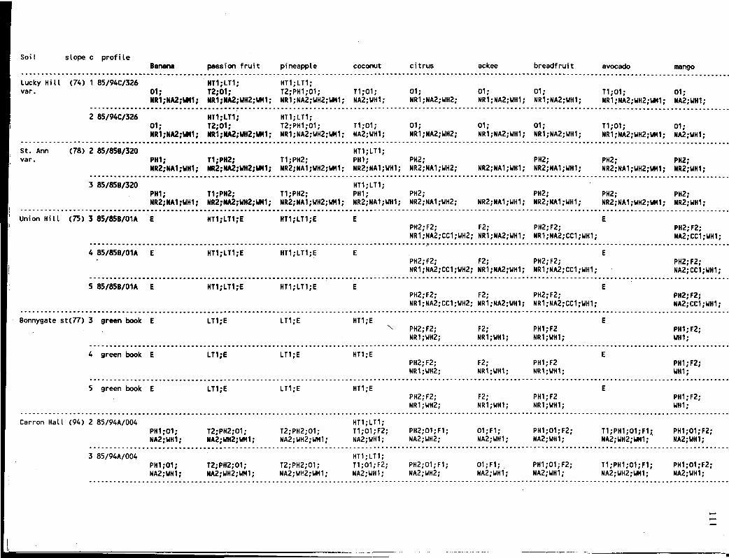
SoiI slope c profile Banana passion fruit pineapple coconut citrus ackee breadfruit avocado mango
Lucky Hill (74) 1 85/94C/326 HT1;LT1; HT1;LT1; var. 01; T2;01; T2;PH1;01; T1;01; 01; 01; 01; T1;01; 01;
NR1;NA2;UM1; NR1;NA2;UH2;UM1; NR1;NA2;UH2;UM1; NA2;WH1; NR1;NA2;UH2; NR1;NA2;UH1; NR1;NA2;WH1; NR1;NA2;WH2;WM1; NA2;WH1;
2 85/94C/326 HT1;LT1; HT1;LT1; 01; T2;01; T2;PH1;01; T1;01; 01; 01; 01; T1;01; 01; NR1;NA2;tM1; MR1;MA2;WH2;UM1; NR1;NA2;WH2;UM1; NA2;UH1; NR1;NA2;UH2; NR1;NA2;WH1; NR1;NA2;UH1; NR1;NA2;UH2;UM1; NA2;UH1;
St. Ann (78) 2 85/85B/320 HT1;LT1; var. PHI; T1;PH2; T1;PH2; PH1; PH2; PH2; PH2; PH2;
NR2;NA1;WH1; NR2;NA2;UH2;UN1; NR2;NA1;UH2;WM1; NR2;NA1;WH1; NR2;NA1;WH2; NR2;NA1;UH1; NR2;NA1;UH1; NR2;NA1;UH2;UM1; NR2.-WH1;
3 85/85B/320 HT1;LT1; PH1; T1;PH2; T1;PH2; PH1; PH2; PH2; PH2; PH2; NR2;NA1;WH1; MR2;MA2;WH2;WM1; NR2;NA1;WH2;WM1; NR2;NA1;UH1; NR2;NA1;UH2; NR2;NA1;UH1; NR2;NA1;UH1; NR2;NA1;UH2;UM1; NR2;UH1;
Union Hill (75) 3 85/85B/01A E HT1;LT1;E HT1;LT1;E E E PH2;F2; F2; PH2;F2; PH2;F2; NR1;NA2;CC1;WH2; NR1;NA2;WH1; NR1;NA2;CC1;WH1; NA2;CC1;UH1;
4 85/85B/01A E HT1;LT1;E HT1;LT1;E E E PH2;F2; F2; PH2;F2; PH2;F2; NR1;NA2;CC1;UH2; NR1;NA2;UH1; NR1;NA2;CC1;WH1; NA2;CC1;UH1;
5 85/85B/01A E HT1;LT1;E HT1;LT1;E E E PH2;F2; F2; PH2;F2; PH2;F2; NR1;NA2;CC1;UH2; NR1;NA2;WH1; NR1;NA2;CC1;WH1; NA2;CC1;WH1;
Bonnygate st(77) 3 green book E LT1;E LT1;E HT1;E E v PH2;F2; F2; PH1;F2 PH1;F2;
NR1;WH2; NR1;WH1; NR1;WH1; UH1;
4 green book E LT1;E LT1;E HT1;E E PH2;F2; F2; PH1;F2 PH1;F2; NR1;UH2; NR1;UH1; NR1;UH1; UH1;
5 green book E LT1;E LT1;E HT1;E E PH2;F2; F2; PH1;F2 PH1;F2; NR1;WH2; NR1;WH1; NR1;WH1; WH1;
Carron Hall (94) 2 85/94A/004 HT1;LT1; PH1;01; T2;PH2;01; T2;PH2;01; T1;01;F2; PH2;01;F1; 01;F1; PH1;01;F2; T1;PH1;01;F1; PH1;01;F2; NA2;WH1; NA2;UH2;UH1; NA2;WH2;WM1; NA2;UH1; NA2;WH2; NA2;WH1; NA2;UH1; NA2;WH2;WH1; NA2;UH1;
3 85/94A/004 HT1;LT1; PH1;01; T2;PH2;01; T2;PH2;01; T1;01;F2; PH2;01;F1; 01;F1; PH1;01;F2; T1;PH1;01;F1; PH1;01;F2; NA2;UH1; NA2;WH2;UM1; NA2;WH2;WM1; NA2;UH1; NA2;UH2; NA2;WH1; NA2;WH1; NA2;UH2;WM1; NA2;UH1;

Soil slope c profile coffee coffee pigeon sugar cane tobacco (arabica) (caneph) cooca peanut pea cowpea red pea
Lucky (74) 1 85/94C/326 HT2;LT2; HT1;LT1; HT1.-LT1; HT2;LT2; Hill var. PH1;01; T1;01 02; T1;PH1;01; T2;01; 01; PH1;01;
NR1;NA2;UH2;UM1; NR1;NA2;UH2;UM1; NR1;NA2;UH1;UM1; NR1;NA2;WH1;UM1; NR1;NA2;UH2;WR2; NR1;NA2;UH2;UN2; NR1;NA2;UH2;UM2;
2 85/94C/326 HT2;LT2; HT1;LT1; HT1.-LT1; HT2;LT2; PH1;01; T1;01 02; T1;PH1;01; T2;01; 01; PH1;01; NR1;NA2;WH2;UM1; NR1;NA2;UH2;UM1; NR1;NA2;UH1;UM1; NR1;NA2;UH1;VM1; NR1;NA2;UH2;UM2; NR1;NA2;UH2;UM2; NR1;NA2;UH2;WM2;
St. Ann (78) 2 85/85B/320 MT1;LT1; HT1;LT1; HT1.-LT1; var. PH1; PH2; PH2; PH2; PH2; T1;PH2; PH2; PH2; T1.-PH2;
NR2;NA1;UH2;UM1; NR2;NA1;UH2;UH1;NR2;NA1;WH1;UM1;NR2;NA1;UH1;UM1; NR2;NA1;UH1;UN1; NR2;NA1;UH2;WN2; NR2;NA1;UH2;UN2; NR2;NA1;UH2;UN2;NR2;NA1;UH2;UN2;
3 85/85B/320 HT1;LT1; HT1;LT1; HT1;LT1; PH1; PH2; PH2; PH2; PH2; T1;PH2; PH2; PH2; T1.-PH2; NR2;NA1;UH2;UM1; NR2;NA1;UH2;UM1;NR2;NA1;UH1;UH1;NR2;NA1;WH1;UM1; NR2;NA1;WH1;UM1; NR2;NA1;UH2;UM2; NR2;NA1;UH2;UM2; NR2;NA1;UH2;UM2;NR2;NA1;UH2;UM2;
Union (75) 3 85/858/01A E HT2;LT2;E HT1;LT1;E E E E HT1;LT1;E HT2;LT2;E Hill T1;PH2;F1;
NR1;NA2;CC2;WH2;WM1;
4 85/85B/01A E E HT2;LT2;E HT1;LT1;E E E E HT1;LT1;E HT2;LT2;E
5 85/85B/01A E E HT2;LT2;E HT1;LT1;E E E E HT1;LT1;E HT2;LT2;E
Bonny- {77} 3 green book E E HT1;LT2;E LT1;E; E HT1;E E LT1;E HT1;LT2;E
gate st
4 green book E E HT1;LT2;E LT1;E; E HT1;E E LT1;E HT1;LT2;E
5 green book E E HT1;LT2;E LT1;E; E HT1;E E LT1;E HT1;LT2;E
Carron (94) 2 85/94A/004 HT1;LT1; HT1;LT1; HT1;LT1;
Hall PH1;01;F1; T1;PH2;01; PH2;02;F1; PH2;02;F1; T1;PH2;01;F1; T2;PH1;01; PH1;01;F1; PH2;01;F2; T1;PH1;01;F1; NA2;UH2;UN1; NA2;UH2;UM1; NA2;WH1;UM1; NA2;UH1;UM1; NA2;UH1;UM1; NA2;WH2;UH2; NA2;WH2;UM2; NA2;WH2;WM2; NA?,"MI2;UM2;
3 85/94A/004 HT1;LT1; HT1;LT1; HT1;LT1; PH1;01;F1; T1;PH2;01; PH2;02;F1; PH2;02;F1; T1;PH2;01;F1; T2;PH1;01; PH1;01;F1; PH2;01;F2; T1;PH1;01;F1; NA2;WH2;UN1; NA2;UH2;UM1; NA2;UH1;UM1; NA2;UH1;UM1; NA2;WH1;WH1; NA2;WH2;UM2; NA2;WH2;UM2; NA2;WH2;WM2; NA2;UH2;UN2;
K>

Soil slope c profile hot sweet lettuce onion egg plant tomato cabbage cho cho peppers peppers pumpkin
Uaitabit (95) 3 86/93C/018 LT2;
4 86/93C/018 LT2;E;
LT1; HT1; HT1; T1; T2; T1; NR1;NA2; NR1.-NA2; NR1;NA2;
LT2; LT2; HT1;E; HT1; HT1; T1; T2; NR1;NA2; NR1;NA2;
LT1;E; HT1;E; HT1;E; LT2;E; L*2;E; HT1;E; HT1;E; HT1;E;
Linstead (61) 1 85/ /116 HT2;LT2; HT1.-LT1; T1;PH1;01; T2;PH2;01; T1;PH2;01; NR1;NA2;UH2;UM1; NR1;NA2;UH2;WM1; NR1;NA2;UH2;WM1;
HT2;LT2; HT2;LT2; T1;01; T1;PH2;01; T2;PH1;01 NR1;NA2;UH2;WM1; NR1;NA2;UH2;UM1; NR1;NA2;WH2;UM1
2 85/ /116 HT2;LT2; HT1;LT1; T1;PH1;01; T2;PH2;01; T1;PH2;01; NR1;NA2;UH2;WM1; NR1;NA2;UH2;UM1; NR1;NA2;UH2;WM1;
HT2;LT2; HT2;LT2; T1;01; T1;PH2;01; T2;PH1;01 NR1;NA2;UH2;WM1; NR1;NA2;UH2;WN1; MM;NA2;WH2;UM1
3 85/ /116 HT2;LT2; HT1.-LT1; T1;PH1;01; T2;PH2;01; T1;PH2;01; ' NR1;NA2;UH2;UM1; NR1;NA2;WH2;UM1; NR1;NA2;UH2;UM1;
HT2;UT2; HT2;LT2; T1;01; T1;PH2;01; T2;PH1;01 NR1;NA2;UH2;UM1; NR1;NA2;WH2;UM1; NR1;NA2;WH2;UM1
Linstead (61) 1 85/ / 1 K HT2.-LT2; HT1;LT1; T1;01; T2;01; T1;01; NR1;NA2;UH2;WM1; NR1;NA2;UH2;UM1; NR1;NA2;WH2;WM1;
HT2;LT2; HT2;IT2; T1;01; T1;01; T2;01 NR1;NA2;WH2;UM1; NR1;NA2;UH2;W*1; NR1;NA2;WH2;UM1
2 85/ /114 HT2;LT2; HT1;LT1; T1;01; T2;01; T1;01; NR1;NA2;UH2;UM1; NR1;NA2;UH2;UM1; NR1;NA2;UH2;UM1;
HT2/LT2; HT2;LT2; T1;01; T1;01; T2;01 NR1;NA2;UH2;WM1; NR1;NA2;UN2;UN1; NR1;NA2;WH2;UM1
Pennants (33) 1 85/85B/321 HT2;LT2; HT1;LT1; T1;PH2;02; T2;PH2;02; T1;PH2;02; NR1;NA2;UH2;WM1; NR1;NA2;UH2;UM1; NR1;NA2;UH2;UM1;
HT2;LT2; HT2.-LT2; T1;PH2;02; T1;PH2;02; T2;PH2;02; NR1;NA2;WH2;UM1; NR1;NA2;WH2;UM1; NR1;NA2;WH2;UM
2 85/85B/321 HT2;LT2; HT1;LT1; T1;PH2;02; T2;PH2;02; T1;PH2;02; NR1;NA2;UR2;UM1; NR1;NA2;UH2;UM1; NR1;NA2;UH2;WM1;
HT2;LT2; HT2;LT2; T1;PH2;02; T1;PH2;02; T2;PH2;02; NR1;NA2;WH2;WM1; NR1;NA2;UH2;UM1; NR1;NA2;WH2;WM
Rosemere (64) 1 85/84B/0P3 HT2;LT2; HT1;LT1; T1;PH2;01; T2;PH2;01; T1;PH2;01; NR2;NA2;UH2;WM1; NR2;NA2;UH2;WM1; NR2;NA2;WH2;WM1;
HT2;LT2; HT2;LT2; T1;PH2;01; T1;PH2;01; T2;PH2;01; NR2;NA2;WH2;UM1; NR2;NA2;UH2;UM1; NR2;MA2;WH2;WM
2 85/84B/0P3 HT2;LT2; HT1;LT1; T1;PH2;01; T2;PH2;01; T1;PH2;01; NR2;NA2;UH2;UM1; NR2;NA2;UH2;UH1; NR2;NA2;UH2;UM1;
HT2;LT2; HT2;LT2; T1;PH2;01; T1;PH2;01; T2;PH2;01; NR2;NA2;UH2;UM1; NR2;NA2;UH2;WM1; NR2;NA2;WH2;UM
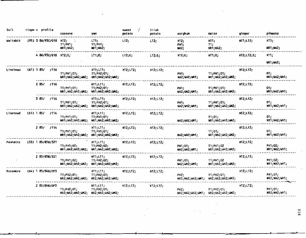
Soil rlope c profile sweet J irish cassava yam potato potato sorghum maize ginger pimento
Waitabit (95) 3 86/93C/018 HT2; ', LT1; , LT2; LT2; HT2; HT1; HT1;LT2; HT1; T1;PH1; T1;PH1; PH1; T1; NR1;NA2; HR1;NA2; NA2; NR1;NA2; NR1;NA2;
4 86/93C/018 HT2;E; LT1;E; LT2;E; LT2;E; HT2;E; HT1;E; HT2;LT2;E; HT1;
NR1;NA2;
Linstead (61) 1 85/ /116 HT1;LT1; HT2;LT2; HT2;LT2; HT2;LT2; T1;PH1;01; T1;PH2;01; PH1; T1;PH1;01; 01; NR1;NA2;UH2;UM2; NR1;NA2;UH2;UM2; NA2;WH2;WM1; NR1;NA2;WH2;UM2; NR1;NA2;WH1;
2 85/ /116 HT1;LT1; HT2;LT2; HT2/LT2; HT2;LT2; T1;PH1;01; T1;PH2;01; PHI; T1;PH1;01; 01; NR1;NA2;UH2;UM2; NR1;NA2;UH2;UM2; NA2;UH2;UM1; NR1;NA2;UH2;UM2; NR1;NA2;UH1;
3 85/ /116 HT1;LT1; HT2;LT2; HT2;LT2; HT2;LT2; T1;PH1;01; T1;PH2;01; PH1; T1;PH1;01; 01; NR1;NA2;UH2;UM2; NR1;NA2;WH2;UM2; NA2;WH2;UH1; NR1;NA2;UH2;UH2; NR1;NA2;WH1;
Linstead (61) 1 85/ /114 HT1;LT1; HT2;LT2; HT2;LT2; HT2;LT2; T1;PH1;01; T1;PH1;01; T1;01; 01; NR1;NA2;UH2;UM2; NR1;NA2;UH2;WM2; NA2;UH2;UM1; NR1;NA2;WH2;WM2; NR1;NA2;UH1;
2 85/ / 1 H HT1;LT1; HT2;LT2; HT2;LT2; HT2;LT2; T1;PH1;01; T1;PH1;01; T1;01; 01; NR1;NA2;UH2;WM2; NR1;NA2;UH2;WM2; NA2;UH2;UM1; NR1;NA2;WH2;WM2; NR1;NA2;UH1;
Pennants (33) 1 85/85B/321 ~ HT1;LT1; HT2;LT2; HT2;LT2; HT2;LT2; T1;PH1;02; T1;PH2;02; PH1.-01; T1;PH1;02 PH1;02; NR1;NA2;WH2;UM2; MR1;NA2;WH2;UM2; NA2;UH2;WM1; NR1;NA2;UH2;UM2; NR1;NA2;UH1;
2 85/85B/321 HT1;LT1; HT2;LT2; HT2;LT2; HT2;LT2; T1;PH1;02; T1;PH2;02; PH1;01; T1;PH1;02 PH1;02; NR1;NA2;UH2;UH2; NR1;NA2;WH2;WM2; NA2;WH2;UM1; NR1;NA2;WH2;WM2; NR1;NA2;WH1;
Rosemere (64) 1 85/84B/0P3 HT1;LT1; HT2;LT2; HT2.-LT2; HT2;LT2; T1;PH2;01; T1;PH2;01; PH2; T1;PH2;01; PH1;01; NR2;NA2;WH2;WM2; NR2;NA2;WH2;WM2; NR2;NA2;WH2;UM1; NR2;NA2;WH2;WM2; NR2;HA2;UH1;
- -<sv 2 85/84B/0P3 HT1;LT1; HT2;LT2; HT2;LT2; HT2;LT2;
T1;PH2;01; T1;PH2;01; PH2; T1;PH2;01; PH1;01; NR2;NA2;WH2;WM2; NR2;NA2;UH2;WM2; NR2;NA2;UH2;UM1; NR2;NA2;UH2;UM2; NR2;NA2;WH1;
- »> n._

Soil slope c profile passion Banana fruit pineapple coconut citrus ackee breadfruit avocado mango .
Waitabit (95) 3 86/93C/018 HT1; LT1; HT1.-LT1; HT2; HT1; HT1; • HT1; HT1; T2;PH1; T2;PH2; T1; PH1; T1;PH1; PH1;
NR1;NA2; NR1;NA2; NR1;NA2; NA2; NR1;NA2; NR1;NA2; NR1;NA2; NR1;NA2; NA2;
4 86/93C/018 HT1;E; LT1;E HT1;LT1;E; HT2; HT1; HT1; HT1; HT1; T1; PH1; T1;PH1; PHI; NA2; NR1;NA2; NR1;NA2; NR1;NA2; NR1;NA2; NA2;
Linstead (61) 1 85/ /116 HT1;LT1; HT1;LT1; PH1;01; T2;PH2;01; T2;PH2;01; T1;01; PH2;01 01; PH1;01; T1;PH1;01; . PHI,-01; NR1;NA2;UH1; NR1;NA2;UH2;UM1; NR1;NA2;UH2;UM1; NA2;UH1; NR1;NA2;UH2; NR1;NA2;WH1; NR1;NA2;UH1; NR1;NA2;UH2;UM1; NA2;UH1;
2 85/ /116 HT1;LT1; HT1;LT1; PH1;01; T2;PH2;01; T2;PH2;01; . T1;01; PH2;01 01; PHI,'01; T1;PH1;01; PH1;01; NR1;NA2;UH1; NR1;NA2;UH2;UH1; NR1;NA2;UH2;WH1; NA2;UH1; NR1;NA2;WH2; NR1;NA2;WH1; NR1;NA2;WH1; NR1;NA2;WH2;UM1; NA2;UH1;
3 85/ /116 HT1;LT1; HT1;LT1; PH1.-01; T2;PH2;01; T2;PH2;01; T1;01; PH2;01 01; PHI,-01; T1;PH1;01; PH1;01; NR1;NA2;UH1; NR1;NA2;UH2;WH1; NR1;NA2;UH2;UM1; NA2;UH1; NR1;NA2;UH2; NR1;NA2;WH1; NR1;NA2;UH1; NR1;NA2;UH2;UM1; NA2;WH1;
Linstead (61) 1 85/ /114 HT1;LT1; HT1;LT1; 01; T2;PH1;01; T2;PH2;01; T1;01; PH1;01 01; 01; T1;PH1;01; PH1;01; NR1;NA2;WH1; NR1;NA2;UH2;WM1; NR1;NA2;UH2;UM1; NA2.-WH1; NR1;NA2;UH2; NR1;NA2;WH1; NR1;NA2;WH1; NR1;NA2;WH2;UM1; M2;UH1;
2 85/ / 1 K HT1;LT1; . HT1;LT1; 01; T2;PH1;01; T2;PH2;01; T1;01; PH1;01 01; 01; T1;PH1;01; PH1;01; NR1;NA2;WH1; NR1;NA2;WH2;WM1; NR1;NA2;WH2;WM1; NA2;WH1; NR1;NA2;WH2; NR1;NA2;WH1; NR1;NA2;UH1; NR1;NA2;WH2;UM1; NA2;WH1;
Pennants (33) 1 85/85B/321 HT1;LT1; HT1;LT1; PH1;02; T2;PH2;02; T2;PH2;02; T1;PH1;02; PH2;02; 02; PH2.-02; T1;PH2;02; PH2;02; NR1;NA2;WH1; HR1;NA2;WH2;WM1; NR1;NA2;WH2;WM1; NA2.-WH1; NR1;NA2;WH2; MR1;NA2;UH1; NR1;NA2;WH1; NR1;NA2;WH2;UM1; NA2;WH1;
2 85/85B/321 HT1;LT1; HT1;LT1; PH1;02; T2;PH2;02; T2;PH2;02; T1;PH1;02; PH2;02; 02; PH2;02; T1;PH2;02; PH2;02; NR1;NA2;WH1; NR1;NA2;WH2;UM1; NR1;MA2;WH2;WM1; NA2;UH1; NR1;NA2;WH2; NR1;NA2;UH1; NR1;NA2;UH1; NR1;NA2;UH2;WM1; NA2;WH1;
Rosemere (64) 1 85/84B/0P3 HT1;LT1; HT1;LT1; PH2;01; T2;PH2;01; T2;PH1;01; T1;PH2;01; PH2;01; PH2;01; PH2.-01; T1;PH2;01; PH2;01; NR2;NA2;UH1; NR2;NA2;UH2;WM1; NR2;NA2;WH2;WH1; NR2;NA2;WH1; KR2;NA2;UH2; NR2;NA2;WH1; NR2;NA2;WH1; NR2;NA2;WH2;WM1; NR2;NA2;WH1;
2 85/84B/0P3 HT1;LT1; HT1;LT1; PH2;01; T2;PH2;01; T2;PH1;01; T1;PH2;01; PH2;01; PH2;01; PH2;01; T1;PH2;01; PH2;01; NR2;NA2;WH1; NR2;NA2;UH2;UM1; NR2;NA2;WH2;WM1; NR2;NA2;WH1; NR2;NA2;WH2; NR2;NA2;UH1; NR2;NA2;WH1; NR2;NA2;WH2;WM1; NR2;NA2;WH1;
^

Soil slope c profile coffee coffee sugar cane tobacco (arabica) (caneph) cocoa peanut pigeon pea cowpea red pea
Uaitabit (95) 3 86/93C/018 HT2; '- HT1; LT2; HT1;LT1; HT1; MT2; HT1; LT1; LT2; PH1; T1; PH1; T1;PH2; T2; PH2; NR1;NA2; NR1;NA2; NR1;NA2; NR1;NA2; NR1;NA2; NK1;NA2; NR1;NA2;
4 86/93C/018 HT2;E; HT1; LT2; HT1;LT1; HT1; HT2;E; HT1;E LT1;E LT2;E; T1; PH1; T1;PH2; NR1;NA2; NR1;NA2; NR1;NA2;
Linstead (61) 1 85/ /116 HT2;LT2; HT1;LT1; HT1;LT1; HT2.-LT2; PH1;01; T1;PH2;01; PH2;02; T1;PH2;01 T2;PH1;01; PHI,«01; PH2;01; NR1;NA2;UH2;UM1; NR1;NA2;UH2;UM1; NR1;NA2;WH1;WM1; HR1;HA2;WH1;WM1; HR1;NA2;UH2;WM2; NR1;NA2;WH2;WM2; NR1;NA2;WH2;UM2;
2 85/ /116 HT2;LT2; HT1;LT1; HT1;LT1; HT2;LT2; PH1;01; T1;PH2;01; PH2;02; T1;PH2;01 T2;PH1;01; PH1;01; PH2;01; NR1;NA2;WH2;UH1; NR1;NA2;UH2;UM1; NR1;NA2;WH1;UH1; NR1;NA2;WH1;UM1; HR1;NA2;WH2;WM2; H*1;NA2;WH2;WM2; HR1;NA2;UH2;UM2;
3 85/ /116 HT2;LT2; HT1;LT1; HT1;LT1; HT2;LT2; PHI,-01; T1;PH2;01; PH2;02; T1;PH2;01 T2;PH1;01; PH1;01; PH2;01; NR1;NA2;WH2;UM1; NR1;NA2;WH2;WM1; NR1;NA2;WH1;WM1; NR1;NA2;WH1;WM1; NR1;NA2;UH2;UM2; NK1;NA2;WH2;WM2; NR1;NA2;UH2;UM2;
Linstead (61) 1 85/ / 1 K HT2;LT2; HT1;LT1; HT1;LT1; HT2;LT2; 01; T1;01; PH1;02; T1;01; T2;01; 01; PH2;01; NR1;NA2;UH2;WN1; NR1;NA2;WH2;WM1; NR1;NA2;WH2;UM1; NR1;NA2;UH2;UM1; NR1;HA2;WH2;UM2; N«1;NA2;UH2;WM2; NR1;NA2;WH2;UM2;
2 85/ /114 HT2;LT2; HT1;LT1; HT1;LT1; HT2;LT2; 01; T1;01; PH1;02; T1;01; T2;01; 01; PH2;01; NR1;NA2;WH2;WM1; NR1;NA2;WH2;UM1; ' NR1;NA2;WH2;UM1; NR1;HA2;WH2;WM1; NR1;NA2;UH2;UM2; NR1;NA2;UH2;WM2; NR1;NA2;UH2;UM2;
Pennants (33) 1 85/85B/321 ~ HT2;LT2; HT1;LT1; HT1;LT1; HT2;LT2; PH1;02; T1;PH2;02; PH2;02; T1;PH2;02; T2;PH2;02; PH2;02; PH2;02; NR1;NA2;UH2;UM1; NR1;NA2;WH2;WM1; NR1;NA2;WH1;WH1; NR1;NA2;WH1;UM1; NR1;NA2;UH2;UM2; NR1;NA2;UH2;UM2; NR1;NA2;UH2;UH2;
2 85/85B/321 HT2;LT2; HT1;LT1; HT1;LT1; HT2;LT2; PH1;02; T1;PH2;02; PH2;02; T1;PH2;02; T2;PH2;02; PH2;02; PH2;02; NR1;HA2;UH2;UN1; NR1;NA2;WH2;UM1; NR1;NA2;UH1;UM1; HR1;HA2;UH1;WM1; N«1;NA2;UH2;WM2; NR1;NA2;UH2;WM2; NR1;NA2;UH2;WM2;
Rosenere (64) 1 85/84B/0P3 HT2;LT2; HT1;LT1; HT1;LT1; HT2;LT2; PH2;01; T1;PH2;01; PH2;02; T1;PH2;01; T2;PH2;01; PH2;01; PH2;01; NR2;NA2;WH2;UM1; NR2;NA2;WH2;WM1; NR2;NA2;UH1;WM1; HR2;NA2;WH1;WM1; NR2;NA2;WH2;WM2; NR2;NA2;UH2;WM2; HR2;NA2;WH2;WM2;
t'tH*.
2 85/84B/OP3 HT2;LT2; HT1.-LT1; HT1;LT1; HT2;LT2; PH2;01; T1;PH2;01; PH2;02; T1;PH2;01; T2;PH2;01; PH2;01; PH2;01; NR2;NA2;WH2;WM1; NR2;NA2;WH2;WM1; NR2;NA2;WH1;WM1; NR2;NA2;WH1;WM1; MR2;NA2;WH2;WM2; NR2;NA2;WH2;WM2; NR2;NA2;WH2;WM2;
0\
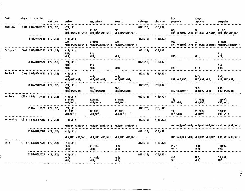
Soil slope c profile hot sweet lettuce onion egg plant tomato cabbage cho cho peppers peppers pumpkin
Knol I is ( 8) 1 85/94C/325 HT2;LT2; HT1;LT1; 02; T1;02; 02; NR1;NA2;WH2;WM1; NR1;NA2;UH2;UM1; NR1;NA2;UH2;UM1;
HT2;LT2; HT2;LT2; 02; 02; T1;02; NR1;NA2;UH2;UM1; NR1;NA2;UH2;UM1; NR1;NA2;UH2;WM1;
2 85/94C/325 HT2;LT2; HT1;LT1; 02; T1;02; 02; NR1;NA2;UH2;UM1; NR1;NA2;UH2;UM1; NR1;NA2;UH2;UM1;
HT2;LT2; HT2;LT2; 02; 02; T1;02; NR1;NA2;UH2;UM1; NR1;NA2;UH2;UM1; NR1;NA2;WH2;UM1;
Prospect (24) 1 85/84B/324 HT2;LT2; HT1;LT1; PH1; NR1;
T1; NR1;
HT2;LT2; HT2;LT2;
NR1; NR1; NR1; T1; NR1;
2 85/84B/324 HT2;LT2; HT1;LT1; PH1; NR1;
T1; NR1;
HT2;LT2; HT2;LT2;
NR1; NR1; NR1; Ti; NR1;
Tulloch ( 6) 1 85/94C/P31 HT2;LT2; HT1;LT1; PH1; NR2;NA2;UH1;
PH2; PH2; NR2;NA2;UH1; NR2;NA2;WH1;
HT2;LT2; HT2;LT2; PH2; PH1;
NR2;NA2;WH1; NR2;NA2;UH1; NR2;NA2;WH1;
2 85/94C/P31 HT2;LT2; HT1;LT1; PH1; NR2;NA2;WH1;
PH2; PH2; NR2;NA2;UH1; NR2;NA2;WH1;
HT2;LT2; HT2;LT2; PH2; PH1;
NR2;NA2;UH1; NR2;NA2;UH1; NR2;NA2;UH1;
Wal lens (12) 1 85/ /P21 HT2;LT2; HT1;LT1; T1;PH1; UH1;WM1;
T2;PH2; WH1;UM1;
T1;PH2; WH1;WM1;
HT2;LT2; HT2;LT2; T1; WH1;UM1;
T1;PH2; UH1;WM1;
T2;PH1; UH1;WM1;
2 85/ /P21 HT2;LT2; HT1;LT1; T1;PH1; WH1;UM1;
T2;PH2; WH1;UM1;
T1;PH2; WH1;UM1; v
HT2;LT2; HT2;LT2; T1; UH1;WM1;
T1;PH2; UH1;UH1;
T2;PH1; WH1;UM1;
Berkshire (11) 1 85/84B/OM2 HT2;LT2;
2 85/84B/0M2 HT2;LT2;
HT1;LT1; HT2.-LT2;
NR1;NA1;WH2;WM1; NR1;NA1;UH2;WM1; NR1;NA1;UH2;UM1;
HT1;LT1; HT2;LT2;
NR1;NA1;UH2;UM1; NR1;NA1;UH2;UM1; NR1;NA1;WH2;UM1;
HT2;LT2;
HT2;LT2;
NR1;NA1;WH2;WM1; NR1;NA1;UH2;WM1; NR1;NA1;UH2;WM1;
HT2;LT2;
NR1;NA1;UH2;WM1; NR1;NA1;WH2;UM1; NR1;NA1;UH2;WM1;
Whim ( ) 1 83/860/027 HT2;LT2; HT1.-LT1; PH2; UH1;
HT2;LT2; T1;PH2; WH1;
PH2; WH1;
PH2; UH1;
PH2; WH1;
T1;PH2; UH1;
2 83/860/027 HT2;LT2; HT1;LT1; PH2; UH1;
T1;PH2; WH1;
PH2; WH1;
HT2;LT2; HT2;LT2; PH2; UH1;
PH2; WH1;
T1;PH2; UH1;
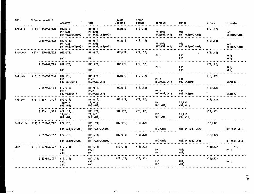
Soil slope c profile cassava yam
sweet /potato
irish potato sorghum maize ginger pimento
Knol I is ( 8) 1 85/94C/325 HT2;LT2; PH1;02; NR1;NA2;WH2;WM2;
HT1.-LT1; . PH1;02;
NR1;NA2;UH2;WM2;
HT2.-LT2; HT2;LT2; PH1;01; NA2;UH2, WM1;
02; NR1;NA2;UH2 WM2;
HT2;LT2; 02; NR1;NA2;UM1;
2 85/94C/325 HT2;LT2; PH1;02; NR1;NA2;WH2;WM2;
HT1;LT1; PH1;02; NR1;NA2;UH2;UH2;
HT2;LT2; HT2;LT2; PH1;01; NA2;UH2;UM1;
02; NR1;MA2;UH2;WM2;
HT2;LT2; 02; NR1;NA2;WM1;
Prospect (24) 1 85/848/324 HT2;LT2;
NR1;
HT1;LT1;
NR1;
HT2;LT2; HT2;LT2; PH1; PHI;
NR1;
HT2;LT2; PH1; NR1; .
2 85/84B/324 HT2;LT2;
NR1;
HT1;LT1;
NR1;
HT2;LT2; HT2;LT2; PH1; PH1;
NR1;
HT2;LT2; PH1; NR1;
Tul loch ( 6) 1 85/94C/P31 HT2;LT2; PH1; NR2;NA2;UH1;
HT1;LT1; PH2; NR2;NA2;UH1;
HT2;LT2; HT2;LT2; PH1; NR2;NA2; UH1;
PH1; NR2;NA2;UH1
HT2;LT2;
NR2;NA2;
2 85/94C/P31 HT2;LT2; PH1; NR2;NA2;WH1;
HT1;LT1; PH2; NR2;NA2;UH1;
HT2;LT2; HT2;LT2; PH1; NR2;NA2; WH1;
PHI; NR2;NA2;UH1
HT2;LT2;
NR2;NA2;
Wal lens (12) 1 85/ /P21 HT2;LT2; T1;PH1; UH2;UM1;
HT1;LT1; T1;PH2; WH2;WM1;
HT2;LT2; HT2;LT2; PH1; WH1;WM1;
T1;PH1; WH2;WM1;
HT2;LT2; •
2 85/ /P21 HT2;LT2; T1;PH1; UH2;WM1;
HT1;LT1; T1;PH2; WH2;UH1;
HT2;LT2; HT2;LT2; PHI; WH1;WM1;
T1;PH1; UH2;WM1;
HT2;LT2;
Berkshire (11) 1 85/84B/OM2 HT2;LT2;
NR1;NA1;UH2;WM2;
HT1;LT1; PH1; NR1;NA1;UH2;WM2;
HT2;LT2; HT2;LT2;
WH2;WM1; NR1;NA1;WH2, WH2|
HT2;LT2;
NR1;NA1;WH1;
2 85/84B/0M2 HT2;LT2;
NR1;NA1;UH2;WM2;
HT1;LT1; PH1; NR1;NA1;WH2;WM2;
HT2;LT2; HT2;LT2;
WH2;UM1; NR1;NA1;WH2, WM2;
HT2;LT2;
NR1;NA1;UH1;
Whim ( ) 1 83/860/027 HT2;LT2; PHI; WH1;
HT1;LT1; PH2; WH1;
HT2;LT2; HT2;LT2; PHI; WH1;
PH1; UH1;
HT2;LT2; PH1;
2 83/860/027 HT2;LT2; PH1; WH1;
HT1;LT1; PH2; WH1;
HT2;LT2; HT2;LT2; PH1; WH1;
PH1; UH1;
HT2;LT2; PHI;
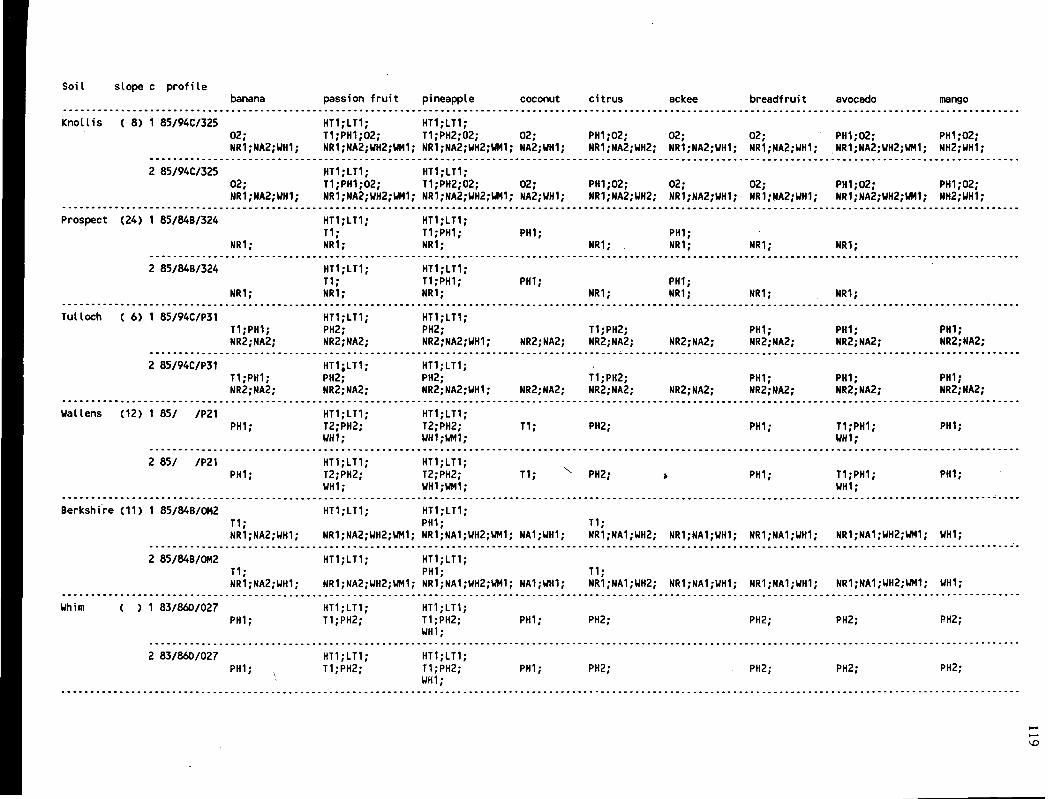
SoiI slope c profile banana passion fruit pineapple coconut citrus ackee breadfruit avocado mango
Knollis ( 8) 1 85/94C/325 HT1;LT1; HT1;LT1; 02; T1;PH1;02; T1;PH2;02; 02; PH1;02; 02; 02; PH1;02; PH1;02; NR1;NA2;UH1; NR1;NA2;WH2;UM1; NR1;NA2;WH2;WM1; NA2;UH1; NR1;NA2;WH2; NR1;NA2;WH1; NR1;NA2;UH1; NR1;NA2;UH2;UM1; NH2;UH1;
2 85/94C/325 HT1;LT1; HT1;LT1; 02; T1;PH1;02; T1;PH2;02; 02; PH1;02; 02; 02; PH1;02; PH1;02; NR1;NA2;WH1; NR1;NA2;UH2;UM1; NR1;NA2;UH2;UM1; NA2;UH1; NR1;NA2;UH2; NR1;NA2;UH1; NR1;NA2;WH1; NR1;NA2;WH2;WM1; NH2;UH1;
Prospect (24) 1 85/84B/324
NR1;
HT1;LT1; T1; NR1;
HT1;LT1; T1;PH1; NR1;
PH1; NR1;
PH1; NR1; NR1; NR1;
2 85/84B/324
NR1;
HT1;LT1; T1; HR1;
HT1;LT1; T1;PH1; NR1;
PH1; NR1;
PH1; NR1; NR1; NR1;
Tulloch ( 6) 1 85/94C/P31 HT1;LT1; HT1;LT1; T1;PH1; PH2; PH2; T1;PH2; PH1; PH1; NR2;NA2; NR2;NA2; NR2;NA2;WH1; NR2;NA2; NR2;NA2; NR2;NA2; NR2;NA2; NR2;NA2;
PH1; NR2;NA2;
2 85/94C/P31 HT1;LT1; HT1;LT1; T1;PH1; PH2; PH2; T1;PH2; PHI; PH1; NR2;NA2; NR2;NA2; NR2;NA2;WH1; NR2;NA2; NR2;NA2; NR2;NA2; NR2;NA2; NR2;NA2;
PHI; NR2;NA2;
Wallens (12) 1 85/ /P21 PHI;
HT1;LT1; T2;PH2; WH1;
HT1;LT1; T2;PH2; WH1;WM1;
T1; PH2; PH1; T1;PH1; UH1;
PH1;
2 85/ /P21 PH1;
HT1;LT1; T2;PH2; WH1;
HT1;LT1; T2;PH2; UH1;UH1;
T1; PH2; PH1; T1;PH1; WH1;
PH1;
Berkshire (11) 1 85/84B/0M2 HT1;LT1; HT1;LT1; T1; PH1; T1; NR1;NA2;UH1; NR1;NA2;WH2;WM1; NR1;NA1;UH2;UM1; NA1;UH1; NR1;NA1;UH2; NR1;NA1;UH1; NR1;NA1;WH1; NR1;NA1;WH2;UM1; UH1;
2 85/84B/0M2 HT1;LT1; HT1;LT1; T1; PHI; T1; NR1;NA2;WH1; NR1;NA2;UH2;WM1; NR1;NA1;WH2;WM1; NA1;WH1; NR1;NA1;UH2; NR1;NA1;UH1; NR1;NA1;WH1; NR1;NA1;WH2;WM1; WH1;
Uhim ( ) 1 83/860/027 PH1;
HT1;LT1; T1;PH2;
HT1;LT1; T1;PH2; WH1;
PHI; PH2; PH2; PH2; RH2;
2 83/860/027 PH1;
HT1;LT1; T1;PH2;
HT1;LT1; T1;PH2; WH1;
PHI; PH2; PH2; PH2; PH2;

SoiI slope c profile sugar cane tobacco
coffee coffee (arabica) (caneph) peanut pigeon pea cowpea red pea
Knol I is ( 8) 1 85/94C/325 PH1;02; 02; NR1;NA2;UH2;UH1; NR1;NA2;UH2;UH1;
HT2;LT2; HT1;LT1; HT1;LT1; PH1;02; PH2;02; T1;02; 02; PH2;02; NR1;NA2;UH2;WM1; NR1;NA2;WH2;UM1; NR1;NA2;WH2;UH2; NR1;NA2;UH2;UM2; NR1;NA2;UH2;WH2;
HT2;LT2;
2 85/94C/325 HT2;LT2; PH1;02; 02; NR1;NA2;UH2;WH1; NR1;NA2;UH2;WM1;
HT1;LT1; HT1;LT1; PH1;02; PH2;02; T1;02; 02; PH2;02; NR1;NA2;WH2;UM1; NR1;NA2;WH2;WM1; NR1;NA2;UH2;WM2; NR1;NA2;WH2;UM2; NR1;NA2;WH2;WM2;
HT2;LT2;
Prospect (24) 1 85/84B/324 PHI; NR1;
HT2;LT2;
NR1;
HT1;LT1; PHI; NR1;
PH1; NR1;
T1; NR1; NR1;
HT1;LT1;
NR1;
HT2.-LT2;
2 85/84B/324 PH1; NR1;
HT2;LT2;
NR1;
HT1;LT1; PH1; NR1;
PHI; NR1;
T1; NR1; NR1;
HT1;LT1;
NR1;
HT2;LT2;
Tulloch ( 6) 1 85/94C/P31 T1;PH1; NR2;NA2;
PH2; NR2;NA2;WH1;
HT2;LT2; HT1;LT1; PH2; NR2;NA2;
PH2; NR2;NA2;
PHI; NR2;NA2;WH1;
PH1; NR2;NA2;UH1;
HT1;LT1; PH2; NR2;NA2;WH1;
HT2;LT2;
2 85/94C/P31 T1;PH1; NR2;NA2;
PH2; NR2;NA2;UH1;
HT2;LT2; HT1;LT1; PH2; NR2;NA2;
PH2; NR2;NA2;
PH1; NR2;NA2;WH1;
PH1; NR2;NA2;UH1;
HT1;LT1; PH2; NR2;NA2;WH1;
HT2;LT2;
Wallens (12) 1 85/ /P21 PH1; UH1;
T1;PH2; WH1;WM1;
HT2;LT2; HT1;LT1; PH2; WH1;
T1;PH2; WH1;
T2;PH1; UH2;WM1;
PHI; UH2;WH1;
HT1;LT1; PH2; WH2;WM1;
HT2;LT2;
2 85/ /P21 PHI; WH1;
T1;PH2; ~WH1;UM1;
HT2;LT2; HT1;LT1; PH2; UH1;
T1;PH2; WH1;
T2;PH1; UH2;WM1;
PH1; WH2;WM1;
HT1;LT1; PH2; WH2;WM1;
HT2;LT2;
Berkshire (11) 1 85/84B/0M2 HT2;LT2; T1;PH1; NR1;NA1;UH2;UM1; NR1;NA1;WH2;WM1;
HT1-LT1; HT1;LT1; PHI; PH1;
NR1;NA1;WH1;WM1; NR1;NA1;WH1;WH1; NR1;NA1;WH2;WM2; NR1;NA1;UH2;WM2; NR1;NA1;WH2;WM2;
HT2;LT2;
2 85/84B/OM2 HT2;LT2; T1;PH1; NR1;NA1;WH2;WM1; NR1;NA1;WH2;UM1;
HT1;LT1; HT1;LT1; PHI; PH1;
NR1;NA1;WH1;WM1; NR1;NA1;WH1;UM1; NR1;NA1;WH2;WM2; NR1;NA1;WH2;WM2; NR1;NA1;WH2;WM2;
HT2;LT2;
Whim ( ) 1 83/860/027 PH1; PH2;
WH1;
HT2;LT2; HT1;LT1; PH2; PH2; T1;PH2;
UH1; PH2; WH1;
HT1;LT1; PH2; UH1;
HT2;LT2;
2 83/860/027 PH1; PH2;
UH1;
HT2;LT2; HT1;LT1; PH2; PH2; T1;PH2;
UH1; PH2; WH1;
HT1;LT1; PH2; WH1;
HT2;LT2;
o

121
APPENDIX 3
RECOMMENDED SOIL CONSERVATION PRACTICES FOR MIXED CROPPING IN THE LINSTEAD-BOG WALK AREA.
Description of the conservation options:
K Mechanical Practices Cultural Practices
0 none 1 none 2 colluvial terraces 3 none 4 colluvial terraces v
5 hillside ditches/orchard terraces 6 none 7 colluvial terraces 8 hillside ditches/orchard terraces 9 graded bench terraces
10 none 11 colluvial terraces 12 hillside ditches/orchard terraces 13 graded bench terraces
none very low very low low low low moderate moderate moderate moderate high high high high
Definitions of the level of cultural and mechanical practices of soil conservation.
Levels of cultural practices:
Very low: Zero mulch; crop residues removed; no application of manure; no use of mineral fertilizers; no farm plan; no crop rotation; bare fallow; mono-cropping; no living barriers.
Low: Low application of mulch (less than 0.5 tonnes/ha); crop residues burnt on site; no application of manure; low application of mineral fertilizers; no farm plan; limited crop rotation inter-cropping; living barriers along contours.
Medium: Surface mulch application (1-3 tonnes/ha); application of manure and/or composts; sub-optimal use of mineral fertilizers; crop rotation; farm plan; inter-cropping; contour-strip cropping; perennials; use of annual intercrops.
High: Surface mulch application (over 3 tonnes/ha); application of mineral fertilizers in combination with manure or composts; farm plan; crop

122
rotation with legumes; inter-cropping or mono-cropping with good rotation; perennials; use of inter-crops and leguminous cover crops; contour cropping with grass strips.
Levels of mechanical practices:
None: No soil conservation practices; field boundary effects only.
Low. Colluvial terraces (stone wall/bamboo/wood/other living barriers).
Medium: Annual crops; hill side ditches and grassed waterways; Perennials; graded orchard terraces with reverse slope and grassed waterways.
High: Graded bench terraces with reverse slope and stabilized terraces; water disposal system.
Detailed information on the methodology can be found in Technical Soils Bulletin No. 2 prepared by the Soil Survey Unit (SSU, 1985b).
\

Survey area : Linstead-Bog Walk Average rainfall erosivity index : 1250
Crop: Soil name
mixed cropping Crop factor :0.35 slope% Numbers of conservation options
Flint River
Diamonds
Donnington
Lucky Hill variant
St. Ann variant
Bonnygate stony clay
Union Hill
Carron Hall
Waitabit
Linstead
Rosemere
Pennants
Knollis Prospect TuUoch Wallens Berkshire Whim Rosehall
30 N.0 feasible practices; only (food) forest 50 No feasible practices; only (food) forest
30 No feasible practices; only (food) forest 50 No feasible practices; only (food) forest
30 No feasible practices; only (food) forest 50 No feasible practices; only (food) forest
2 1, 2, 3, 4, 5, 6, 7, 8, 9, 10, 11, 12, 13, 8 8, 9, 10, 11, 12, 13,
8 9, 11, 12, 13, 16 13,
16 No feasible/practices; only (food) forest 30 No feasible practices; only (food) forest 50 No feasible practices; only (food) forest
16 9, 13, 30 No feasible practices; only (food) forest 50 No feasible practices; only (food) forest
2 2, 3, 4, 5, 6, 7, 8, 9, 10, 11, 12, 13, 8 8, 9, 11, 12, 13,
8 8, 9, 11, 12, 13, 16 9, 13,
2 4, 5, 6, 7, 8, 9, 10, 11, 12, 13, 8 9, 11, 12, 13,
16 9, 13,
2 0, 1 , 2 , 3 , 4 , 5 , 6 , 7 , 8 , 9 , 10, 11, 12, 13, 8 5, 6, 7, 8, 9, 10, 11, 12, 13,
2 0, 1 , 2 , 3 , 4 , 5 , 6 , 7 , 8 , 9 , 10, 11, 12, 13, 8 5, 6, 7, 8, 9, 10, 11, 12, 13,
2 4, 5 ,6 , 7 , 8 , 9 , 10, 11, 12, 13, 2 5 , 6 , 7 , 8 , 9 , 1 0 , 1 1 , 1 2 , 1 3 , 2 7, 8, 9, 10, 11, 13, 2 4, 5 ,6 , 7, 8, 9, 10, 11, 12, 13 2 8, 9, 11, 13, 2 2 , 3 , 4 , 5 , 6 , 7 , 8 , 9 , 1 0 , 1 1 , 1 2 , 1 3 , 2 0, 1 , 2 , 3 , 4 , 5 , 6 , 7 , 8 , 9 , 10, 11, 12, 13,
124
APPENDIX 4A
SOIL TAXONOMY CLASSIFICATION (USDA, 1975) OF THE MAJOR SOIL SERIES OF THE LINSTEAD-BOG WALK AREA.
Map unit Series Family Subgroup
HG1 Flint River loamy-skeletal, mix, iso. Typic Troporthents HH1 Diamonds loamy-skeletal, mix, iso. Typic Eutropepts HK1 Donnington fine, mix, iso. Typic Dystropepts
HV1 Lucky Hill var clayey, mix, iso. Orthoxic-Epiaquic Tropuhumults
HLxl,3 St. Ann var. fine-loamy, gib, iso. Oxic-Humic Haplustalfs HLxl,3 Bonnygate clayey-skeletal, gib, iso. Lithic-Oxic Ustropepts HLx2 Union Hill clayey-skeletal, mon., iso. Lithic-Vertic Eutropepts HJxl Carron Hall fine, mon. iso. Typic Chromuderts HIxl Wait-a-Bit clayey, mix, iso. Vertic Tropudults
BOl Linstead fine,mix,iso. Oxic-Humic Paleustalfs BOx3 Rosemere clayey, mix, iso. Oxic Paleustults B02 Pennants fine, mix, iso. Aquic Chromuderts
ROl Knollis fine,mix,iso. Aquic Argiudolls RR1 Prospect fine-loamy, mix, iso. Typic Hapludolls RR2 Tulloch coarse-loamy, mix, iso. Fluventic Hapludolls RR3 Wallens fine, mix, iso. Typic Hapludolls RR4 Berkshire coarse-loamy, mix, iso. Fluventic Ustropepts RR5 Whim fine-loamy, mix, iso. Udic Haplustolls RF1 Rosehall fine, mix, iso. Vertic Hapludolls RF2 Sterling fine, mix, iso. Vertic Eutropepts
Note: mix.=mixed; mon.=montorillonitic; iso.=iso-hyperthermic; gib.=gibbsitic Only the code of the major map unit is given in the Table.

125
APPENDIX 4B
CORRELATION OF THE 1987 MAPPING UNITS WITH THOSE USED IN THE GREEN BOOKS (RRC, 1958).
1987 Mapping units Green Book soil numbers
code acres Major component(s) Main inclusion(s)
HG1 8,546 HH1 2,690 HK1 2,031
HV1 840 HLxl 1,570 HLx2 16,034 HLx3 27,243 HIxl 141 HJxl 873
BOl 12,875 B02 210 BOx3 1,689
ROl 891 RR1 1,869 RR2 503 RR3 1,760 RR4 487 RR5 114 RF1 999 RF2 487
Nu 307 Nrw 95
50 34 36
74 78; 77 75 77; 78 75; 95 94; 75
61 33 64; 61
8 24 6
12 11
124 13 14
51; 59; 38
77 75; 74 77; 74 74; 79
63; 64 61; 63 63
10 128
(Linstead + Alcan Ewarton) (river wash)
Note: 1 acre = 0.405 hectare

APPENDIX 4C
APPROXIMATE ACREAGE OF THE RESPECTIVE MAPPING UNITS OF THE LINSTEAD-BOG WALK SURVEY AREA.
Physiography lithology Mapping unit phase
H
acres (%)
59,968 72.9 G HG1
HGl /de HGl/ef
8,546 366
8,180
10.4
H HH1 HHl/ef
2,690 2,690
3.3
K HK1 H K l / d e
2,031 2,031
2.5
V HV1 HVl / a HVl /ab H V l / b
840 85
149 606
1.0
L HLx 44,847 54.5 HLxl
HLxl /be HLxl /cd HLxl /e
1,570 79
912 579
1.9
HLx2 HLx2/b H tx2 /bc HLx2/c HLx2/cd HLx2/d HLx2/de HLx2/ef
16,034 357
1,975 767
1,934 80
5,060 5,861
19.5
HLx3 HLx3/bc HLx3/c HLx3/cd HLx3/de HLx3/ef HKLx3/f
27,243 77 69
238 24,611 2,023
225
33.1
J HJxl HJx l / b HJx l /c HJxl /cd HJx l /d HJx l / e
873 85
372 44 53
319
1.1
I HIxl Hlx l /cd
141 141
0.1

Physiography lithology Mapping unit phase acres (%)
B O
O
Nu (Linstead + Alcan) Nrw (river wash)
TOTAL
14,774 18.0 BO 14,774 18.0
BOl 12,875 15.7 BOl/a 1,232 BOl/ab 1,873 BOl/b 833 BOl/be 8,888 BOl/c 49
B02 210 0.3 B02/a 182 B02/C 28
B0x3 1,689 2.0 BOx3/ab 1,689
7,110 8.6 ROl 891 1.0
ROl/a 828 V ROl/b 63
RR 4,733 5.8 RR1 1,869 2.3
RRl/a , 1,869 RR2 503 0.6
RR2/a 467 RR2/b 36
RR3 1,760 2.1 RR3/a 1,366 RR3/d 394
RR4 487 0.6 RR4/a 153 RR4/b 286 RR4/bc 48
RR5 114 0.1 RR5/b 114
RF 1,486 1.8 RF1 999 1.2
RFl/a 725 RFl/ab 104 RFl /b 170
RF2 487 0.6 RF2/a 184 RF2/b 303
307 0.4 45 0.1
82,254 100.0
Note: 1 acre = 0.405 hectare
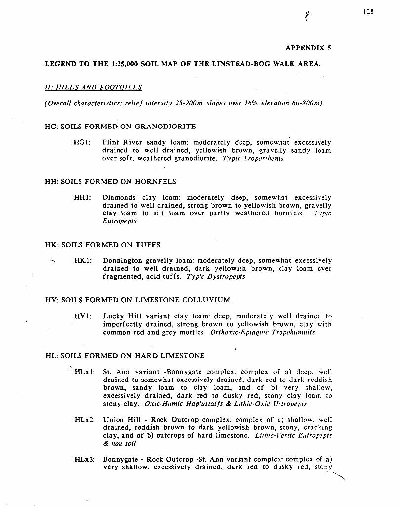
APPENDIX 5
LEGEND TO THE 1:25,000 SOIL MAP OF THE LINSTEAD-BOG WALK AREA.
H: HILLS AND FOOTHILLS
(Overall characteristics: relief intensity 25-200m, slopes over 16%, elevation 60-800m)
HG: SOILS FORMED ON GRANODIORITE
HG1: Flint River sandy loam: moderately deep, somewhat excessively drained to well drained, yellowish brown, gravelly sandy loam over soft, weathered granodiorite. Typic Troporthents
HH: SOILS FORMED ON HORNFELS
HH1: Diamonds clay loam: moderately deep, somewhat excessively drained to well drained, strong brown to yellowish brown, gravelly clay loam to silt loam over partly weathered hornfels. Typic Eutropepts
HK: SOILS FORMED ON TUFFS
-v HK1: Donnington gravelly loam: moderately deep, somewhat excessively drained to well drained, dark yellowish brown, clay loam over fragmented, acid tuffs. Typic Dystropepts
HV: SOILS FORMED ON LIMESTONE COLLUVIUM
HV1: Lucky Hill variant clay loam: deep, moderately well drained to imperfectly drained, strong brown to yellowish brown, clay with common red and grey mottles. Orthoxic-Epiaquic Tropohumults
HL: SOILS FORMED ON HARD LIMESTONE
HLxl: St. Ann variant -Bonnygate complex: complex of a) deep, well drained to somewhat excessively drained, dark red to dark reddish brown, sandy loam to clay loam, and of b) very shallow, excessively drained, dark red to dusky red, stony clay loam to stony clay. Oxic-Humic Haplustalfs & Lithic-Oxic Ustropepts
HLx2: Union Hill - Rock Outcrop complex: complex of a) shallow, well drained, reddish brown to dark yellowish brown, stony, cracking clay, and of b) outcrops of hard limestone. Lithic-Vertic Eutropepts & non soil
HLx3: Bonnygate - Rock Outcrop -St. Ann variant complex: complex of a) very shallow, excessively drained, dark red to dusky red, stony

clay loam to stony clay, b) outcrops of hard limestone, and of c) deep, well drained to somewhat excessively drained, dark red to dark reddish brown, sandy clay loam to sandy clay. Lithic-Oxic Ustropepts, non soil & Oxic-Humic Haplustalfs
HI: SOILS FORMED ON HARD LIMESTONE AND ACID SHALES
HIxl: Union Hill - Rock Outcrop - Wait-a-Bit complex: complex of a) soils similar to those of the HLx2 unit, and of b) deep, well drained, yellowish red to reddish yellow, cracking, silty clay to clay over acid shales. Lithic-Vertic Eutropepts, non soil & Vertic Tropudults
HJ: SOILS FORMED ON HARD AND SOFT LIMESTONE
HJxl: Union Hill - Carron Hall - Rock Outcrop complex: complex of a) soils similar to those of the HLx2 unit, and of b) moderately deep, moderately well" drained, yellowish brown to brownish yellow, cracking clay over rubbled and soft limestone. Lithic-Vertic Eutropepts, Vertic Chromuderts & non soil
/
B: INLAND BASIN
(Overall characteristics: relief intensity 10-25m, slopes 2-16%, elevation 100-150m)
BO: SOILS FORMED ON OLD ALLUVIUM
BOl: Linstead clay: deep, moderately well drained to imperfectly drained, red and yellowish red, prominently mottled, clay. la some pedons with a weakly cracking topsoil. Oxic-Humic Paleustalfs 1
B02: Pennants clay: deep, imperfectly to poorly drained, yellowish brown and yellowish red, mottled, widely and deeply cracking clay. Aquic Chromuderts
BOx3: Rosemere-Linstead clay: complex of a) deep, moderately well drained, red and yellowish red, prominently mottled clay, and of b) soils similar to those of the BOl unit. Oxic Paleustults & Oxic-Humic Paleustalfs
1. Humic subgroups are proposed in Jamaica for Alfisols with over 12 kg organic carbon per square metre to a depth of 1 metre
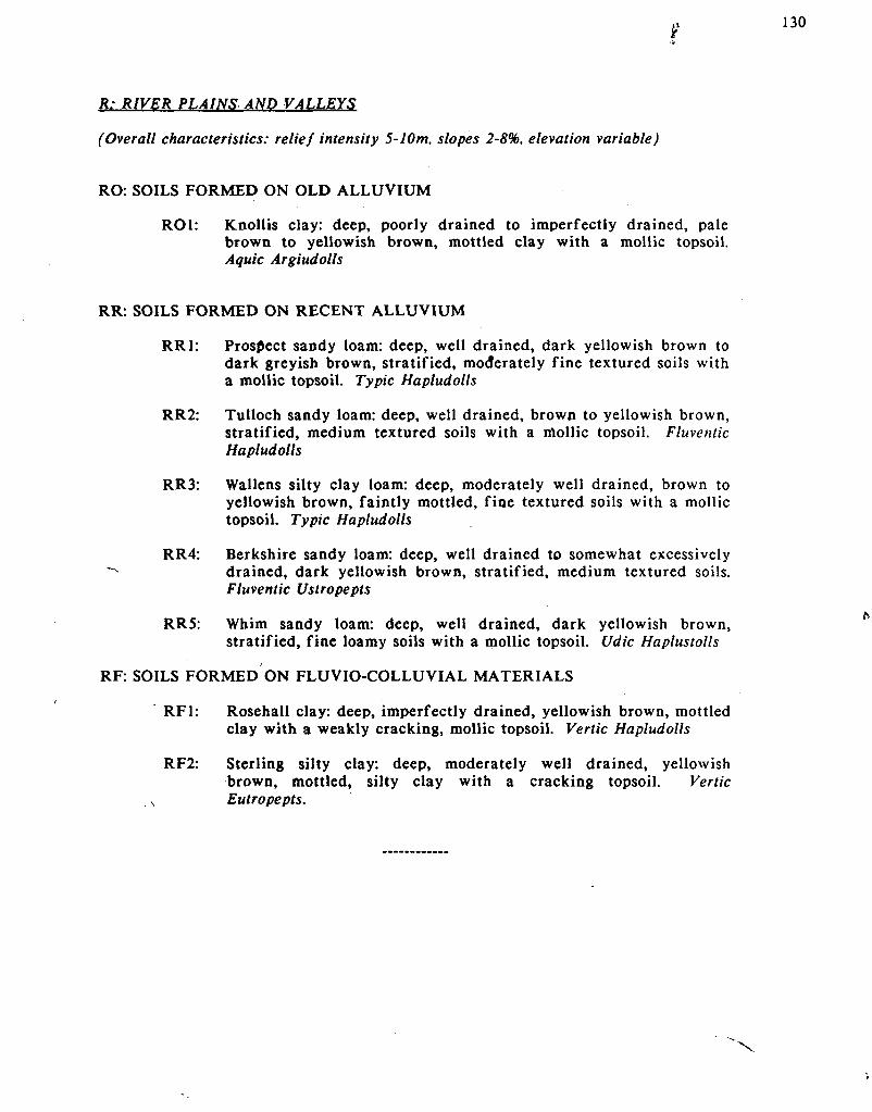
f
R: RIVER PLAINS AND VALLEYS
(Overall characteristics: relief intensity 5-10m, slopes 2-8%, elevation variable)
RO: SOILS FORMED ON OLD ALLUVIUM
ROl: Knollis clay: deep, poorly drained to imperfectly drained, pale brown to yellowish brown, mottled clay with a mollic topsoil. Aquic Argiudolls
RR: SOILS FORMED ON RECENT ALLUVIUM
RR1: Prospect sandy loam: deep, well drained, dark yellowish brown to dark greyish brown, stratified, moderately fine textured soils with a mollic topsoil. Typic Hapludolls
RR2: Tulloch sandy loam: deep, well drained, brown to yellowish brown, stratified, medium textured soils with a mollic topsoil. Fluventic Hapludolls
RR3: Wallens silty clay loam: deep, moderately well drained, brown to yellowish brown, faintly mottled, fine textured soils with a mollic topsoil. Typic Hapludolls
RR4: Berkshire sandy loam: deep, well drained to somewhat excessively "-• drained, dark yellowish brown, stratified, medium textured soils.
Fluventic Ustropepts
RR5: Whim sandy loam: deep, well drained, dark yellowish brown, stratified, fine loamy soils with a mollic topsoil. Udic Haplustolls
RF: SOILS FORMED ON FLUVIO-COLLUVIAL MATERIALS
RF1: Rosehall clay: deep, imperfectly drained, yellowish brown, mottled clay with a weakly cracking, mollic topsoil. Vertic Hapludolls
RF2: Sterling silty clay: deep, moderately well drained, yellowish brown, mottled, silty clay with a cracking topsoil. Vertic
s Eutropepts.

KEY TO TEXTURAL CLASSES: 131
4 0 %
90 80 70 60 50 40 30 20 10 PERCENT SAND
USOAUxtural trlangl* (Sail Surv*y Stott, 1951).
P*rc*nt Sand
Taxturol Trlongl» With camlly Taxtural Class**

KEY TO DEPTH CLASSES
very shallow less than 25cm shallow 25 - 50cm moderately deep 50 - 100cm deep over 100cm
KEY TO TEXTURAL GROUPS
fine sandy clay & silty clay moderately fine clay loam, sandy clay loam & silty clay loam medium very fine sandy loam, loam, silt loam & silt moderately coarse sandy loam & fine sandy loam coarse sand & loamy sand
KEY TO SLOPE PHASES
a: flat to almost flat 0 to 2% slope b: undulating 2 to 8% slope c: rolling 8 to 16% slope d: hilly 16 to 30% slope e: steep 30 to 50% slope f: very steep over 50% slope
MAPPING UNIT SYMBOL
H: Physiography L: Lithology or parent material x: symbol for soil complex
HLxl 1: code for soil properties
de de: slope phase

APPENDIX 6
AGRO-CLIMATIC ANALYSIS FOR 6 RAINFALL STATIONS OCCURRING IN THE LINSTEAD-BOG WALK AREA (FROM RAINSTAT).
The RAINSTAT option gives you:
1) Listings of the climatic files (monthly rainfall totals and PET) in mm/period.
2) The probability of exceeding a given amount of rainfall in 1/10, 2.5/10, 5/10, 7.5/10 and 9/10 years.
3) The probable minimum length of the growing period in 3 out of 4 years.
The following stations have been analysed:
a) BOG WALK v
b) EWARTON c) LINSTEAD d) SLIGOVILLE e) WAKEFIELD 7
f) WORTHY PARK
Ref.: SSU (1986b; 1987a)

>l 134
CLIMATIC ANALYSIS FOR BOG WALK
Table 1: Extremes and variability of monthly and annual rainfall totals and potential evapotranspiration for BOG WALK in mm. (Data base: 1950-1976).
Period Jan Feb Mar Apr May Jun Jul Aug Sep Oct Nov Dec YEAR
N 20 19 23 19 21 20 21 19 18 16 15 17 12 Mean 48 56 67 151 170 164 143 186 158 242 121 69 1518 CV (%) 75 117 82 156 55 61 38 45 38 42 62 114 11 Minim. 0 0 2 0 0 47 70 53 76 108 21 0 1299 10%-L 0 0 6 12 38 65 71 68 85 133 24 5 1263 25%-L 22 10 26 35 102 97 103 125 114 172 65 19 1386 50%- 48 36 58 91 170 146 140 186 152 226 116 47 1518 25%-U 74 82 99 200 238 211 180 247 196 296 173 97 1649 10%-U 98 144 145 376 302 292 220 304 243 378 229 168 1772 Maxim. 125 222 228 1123 349 534 288 340 301 548 316 315 1832 PET 104 109 139 143 151 146 155 145 125 123 105 104 1550
Table 2: Minimum length of the growing period (LGP) at BOG WALK in X out of 10 years (data base: 1950 - 1976)2
LGP(X) Jan Feb Mar Apr May Jun Jul Aug Sep Oct Nov Dec
X=7.5 * * * * M M M M M H M *
2. LGP(X): The minimum length of the growing period in X out of 10 years is the sum of the M's and H's. The length of the growing season will be shorter than LGP(X) in (10-X) out of 10 years. H (Humid period (Rain=>PET)); M (Moist period (Rain=>.5*PET)); * = Dry period (Rain<.5*PET) In 8 out of 10 years total annual rainfall is in the 1263 - 1771 mm range. Mean annual rainfall is 1517mm/year, and mean annual PET is 1549 (IND=>8 in 75 percent of the years). Note: Each month in a given year has been considered as an independent event.
x

CLIMATIC ANALYSIS FOR EWARTON
Table 1: Extremes and variability of monthly and annual rainfall totals and potential evapotranspiration for EWARTON in mm. (Data base: 1950-1980)
Period Jan Feb Mar Apr May Jun Jul Aug Sep Oct Nov Dec YEAR
N 25 25 22 21 21 21 23 24 23 21 20 17 12 Mean 44 56 86 93 151 159 122 137 151 188 101 72 1395 CV (%) 60 87 148 69 70 47 42 49 58 44 76 91 17 Minim. 8 11 3 1 35 29 36 41 58 34 25 6 1128 10%-L 8 10 9 4 48 55 51 57 58 75 32 11 1072 25%-L 25 22 23 47 79 105 85 88 90 127 51 27 1210 50%- 44 44 54 93 128 159 122 129 136 186 83 56 1376 25%-U 63 77 112 139 199 213 159 178 198 246 132 100 1563 10%-U 80 121 202 182 290 264 193 230 270 303 199 160 1756 Maxim. 107 189 644 205 490» 310 221 357 443 388 371 226 1844 PET 100 105 132 136 144 140 149 140 121 118 100 100 1486
Table 2; Minimum length of the growing period (LGP) at EWARTON in X out of 10 years (data base: 1950-1980).
LGP(X) Jan Feb Mar Apr May Jun Jul Aug Sep Oct Nov Dec
X=7.5 * * * * M M M M M H M *
3. LGP(X): The minimum length of the growing period in X out of 10 years is the sum of the M's and H's. The length of the growing season will be shorter than LGP(X) in (10-X) out of 10 years. H (Humid period (Rain=>PET}); M (moist period (Rain=>.5*PET)): * = D«y period (Rain<.5PET) In S out of 10 years total annual rainfall is in the 1072 - 1755mm range. Mean annual rainfall is 1376mm/year, and mean annual PET is 1485 (IND=>.W in 75 percent of the years). Note: Each month in a given year has been considered as an independent event.
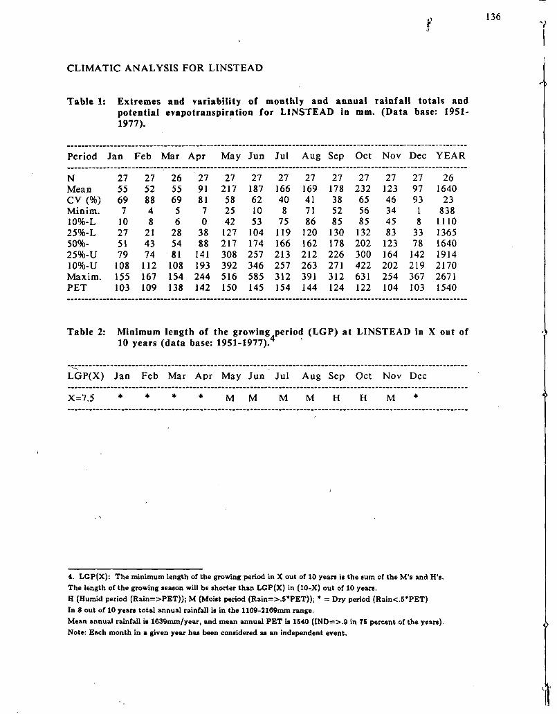
136
CLIMATIC ANALYSIS FOR LINSTEAD
Table 1: Extremes and variability of monthly and annual rainfall totals and potential evapotranspiration for LINSTEAD in mm. (Data base: 1951-1977).
Period Jan Feb Mar Apr May Jun Jul Aug Sep Oct Nov Dec YEAR
N 27 27 26 27 27 27 27 27 27 27 27 27 26 Mean 55 52 55 91 217 187 166 169 178 232 123 97 1640 CV (%) 69 88 69 81 58 62 40 41 38 65 46 93 23 Minim. 7 4 5 7 25 10 8 71 52 56 34 1 838 10%-L 10 8 6 0 42 53 75 86 85 85 45 8 1110 25%-L 27 21 28 38 127 104 119 120 130 132 83 33 1365 50%- 51 43 54 88 217 174 166 162 178 202 123 78 1640 25%-U 79 74 81 141 308 257 213 212 226 300 164 142 1914 10%-U 108 112 108 193 392 346 257 263 271 422 202 219 2170 Maxim. 155 167 154 244 516 585 312 391 312 631 254 367 2671 PET 103 109 138 142 150 145 154 144 124 122 104 103 1540
Table 2: Minimum length of the growing period (LGP) at LINSTEAD in X out of 10 years (data base: 1951-1977).
LGP(X) Jan Feb Mar Apr May Jun Jul Aug Sep Oct Nov Dec
X=7.5 * * * * M M M M H H M *
4. LGP(X): The minimum length of the growing period in X out of 10 years is the sum of the M's and H's. The length of the growing season will be shorter than LGP(X) in (10-X) out of 10 years. H (Humid period (Rain=>PET)); M (Moist period (Rain=>.5*PET)); * = Dry period (Rain<.5*PET) In 8 out of 10 years total annual rainfall is in the 1109-2169mm range. Mean annual rainfall is 1639mm/year, and mean annual PET is 1540 (IND=>.9 in 75 percent of the years). Note: Each month in a given year has been considered as an independent event.

137
CLIMATIC ANALYSIS FOR SLIGOVILLE
Table 1: Extremes and variability of monthly and annual rainfall totals and potential evapotranspiration for SLIGOVILLE in mm. (Data base: 1950-1980)
Period Jan Feb Mar Apr May Jun Jul Aug Sep Oct Nov Dec YEAR
N 27 28 27 29 29 29 29 29 29 29 27 29 25 Mean 52 55 65 131 209 186 155 223 251 324 157 97 1921 CV(%) 69 73 74 61 55 70 45 49 40 55 54 92 22 Minim. 2 3 8 23 20 52 49 32 95 92 51 2 830 10%-L 9 13 13 21 51 64 69 86 131 133 52 11 1332 25%-L 26 26 30 74 127 99 105 144 179 200 96 34 1616 50%- 48 47 57 131 209 155 149 215 240 295 151 76 1921 25%-U 75 75 91 188 291 239 199 294 313 419 212 138 2226 10%-U 102 109 131 242 367 351 251 374 390 562 275 216 2510 Maxim 151 178 197 314 480 v 563 334 579 634 841 376 366 2632 PET 92 94 117 119 128 128 136 129 111 109 90 91 1346
Table 2: Minimum length of the growing period (LGP) at SLIGOVILLE in X out of 10 years (data base: 1950-1980).
LGP(X) Jan Feb Mar Apr May Jun Jul Aug Sep Oct Nov Dec
X=7.5 * * * M M M M H H H H *
5. LGP(X): The minimum length of the growing period in X out of 10 years is the sum of the M's and H's. The length of the growing season will be shorter than LGP(X) in (10-X) out of 10 years. H (Humid period (Rain=>PET)); M (Moist period (Rain=>.5*PET)); * = Dry period (Rain<.5*PET). In 8 out of 10 years total annual rainfall is in the 1331-2510mm range. Mean annual rainfall is 1921mm/year, and mean annual PET is 1345 (IND=>1.2 in 75 percent of the years). Note: Each month in a given year has been considered as an independent event.

$
CLIMATIC ANALYSIS FOR WAKEFIELD ,
Table 1: Extremes and variability of monthly and annual rainfall totals and potential evapotranspiration for WAKEFIELD in mm.(Data base: 1950-1980).
Period Jan Feb Mar Apr May Jun Jul Aug Sep Oct Nov Dec YEAR
N 31 30 30 31 30 31 31 31 31 31 31 30 27 Mean 48 61 71 105 191 178 150 175 195 261 117 80 1616 CV(%) 76 100 83 71 51 74 32 39 58 56 55 100 20 Minim. 3 1 11 3 26 13 87 31 59 84 23 0 1031 10%-L 5 8 16 3 56 49 88 83 86 107 29 6 1158 25%-L 21 21 32 52 121 89 115 126 122 159 71 24 1375 50%- 44 46 58 105 191 151 147 173 174 233 117 60 1613 25%-U 71 85 96 157 261 240 182 222 246 334 162 115 1854 10%-U 100 138 145 206 326 351 215 269 335 456 204 187 2082 Maxim 149 248 302 265 411 656 271 394 682 690 281 314 2592 PET 103 109 138 142 150 145 154 144 124 122 104 103 1538
Table 2: Minimum length of the growing period (LGP) at WAKEFIELD in X out of 10 years (data base: 1950-1980).6
LGP(X) Jan Feb Mar Apr May Jun Jul Aug Sep Oct Nov Dec
X=7.5 * * * * M M M M M H M *
6 . LGP(X): The minimum length of the growing period in X out of 10 years is the sum of the M's and H's
The length of the growing season will be shorter than LGP(X) in (10-X) out of 10 years.
H (Humid period (Rain=>PET)) ; M (Moist period (Rain=>.5*PET)); * = Dry period (Rain<5*PET).
In 8 out of 10 years total annual rainfall is in the 1157-2081mm range.
Mean annual rainfall is 1612mm/year, and mean annual PET is 1537 (IND=>.8 in 75 percent of the years).
Note: Each month in a given year has been considered as an independent event.
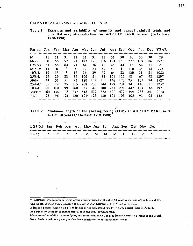
J 139
CLIMATIC ANALYSIS FOR WORTHY PARK
Table 1: Extremes and variability of monthly and annual rainfall totals and potential evapo-transpiration for WORTHY PARK in mm. (Data base: 1950-1980).
Period Jan Feb Mar Apr May Jun Jul Aug Sep Oct Nov Dec YEAR
N 31 31 31 31 31 31 31 31 30 30 30 30 29 Mean 50 56 52 81 187 173 116 153 180 272 109 86 1527 CV(%) 61 66 64 71 64 76 40 48 44 48 54 71 21 Minum 14 6 3 4 17 24 54 53 41 110 34 18 795 10%-L 19 13 8 16 36 39 60 64 82 130 38 21 1083 25%-L 29 29 28 39 100 81 83 101 122 181 67 42 1297 50%- 44 52 51 73 180 147 111 146 173 251 103 74 1527 25%-U 65 79 75 115 268 238 144 199 231 341 146 117 1757 10%-U 90 108 99 160 355 348 180 253 290 447 191 168 1971 Maxim 164 170 138 237 518 572 272 422 477 599 283 241 2218 PET 93 96 121 120 124* 123 130 121 105 102 93 93 1321
Table 2: Minimum length of the growing period (LGP) at WORTHY PARK in X out of 10 years (data base: 1950-1980)7
LGP(X) Jan Feb Mar Apr May Jun Jul Aug Sep Oct Nov Dec
X=7.5 * * * * M M M M H H M *
7. LGP(X): The minimum length of the growing period in X out of 10 years is the sum of the M's and H's.
The length of the growing season will be shorter than LGP(X) in (10-X) out of 10 years.
H [Humid period (Rain=>PET)]: M [Moist period (Rain«:>.5*PET)]; *=Dry period (Rain<.5*PET).
In 8 out of 10 years total annual rainfall is in the 1083-1970mm range.
Mean annual rainfall is 1526mm/year, and mean annual PET is 1321 [IND=>.98in 75 percent of the years].
Note: Each month in a given year has been considered as an independent event.
'<"
140
APPENDIX 7
GLOSSARY (Adapted from USDA, 1984).
Aeration, soil: The exchange of air in soil with air from the atmosphere. The air in a well aerated soil is similar to that in the atmosphere; the air in a poorly aerated soil is considerably higher in carbon dioxide and lower in oxygen.
Alluvium: Material, such as sand, silt or clay, deposited on land by streams.
Available water capacity (available moisture capacity): The capacity of soils to hold water available for use by most plants. It is commonly defined as the difference between the amount of soil water at field moisture capacity and the amount at wilting point. It is commonly expressed as mm of water per meter of soil. The capacity, in mm, in a 100cm profile or to a limiting layer is expressed as; very low: 0-50cm; low: 50-100cm; moderate: 100-150cm; high: 150-200cm; very high: more than 200cm.
Base saturation: The degree to which material having cation exchange properties is saturated with exchangeable bases (sum of Ca, Mg, Na, K), expressed as a percentage of the total cation exchange capacity.
Bedrock: Solid rock that underlies #he soil and other unconsolidated material, or that is exposed at the surface.
Bench terrace: A raised, level, or nearly level strip of earth constructed on or nearly on the contour, supported by a barrier of rock or similar material, and designed to make the soil suitable for tillage and to prevent accelerated erosion.
Boulders: Rock fragments larger than 60cm (2 feet) in diameter.
Calcareous soil: A soil containing enough calcium carbonate (commonly combined with magnesium carbonate) to effervesce visibly when treated with cold, diluted hydrochloric acid.
Cation: An ion carrying a positive charge of electricity. The common soil cations are calcium, potassium, magnesium, sodium and hydrogen (Note: In Jamaica sometimes aluminium). ,
Cation exchange capacity (CEC): The total amount of exchangeable cations that can' be held by the soil, expressed in terms of milli-equivalents per 100 grams of soil at neutrality (pH7, NH4OaC method). The term, as applied to soils, is synonymous with base-exchange capacity, but is more precise in meaning.
Clay: As a soil separate, the mineral soil particles less than 0.002 millimeters (2 microns) in diameter. As a soil textural class soil material that is 40 percent or more clay, less than 45 percent sand, and less than 40 percent silt.
Clay skin: A thin coating of oriented clay on the surface of a soil aggregate or lining pores or root channels. Synonyms: clay coating, clay skin.
Coarse textured soil: sand or loamy sand.
14
Colluvium: Soil material, rock fragments, or' both moved by creep, slide, or local wash and deposited at the base of steep slopes.
Complex, soil: A map unit of two or more kinds of soil in such an intricate pattern or so small in area that it is not practical to map them separately at the selected scale of mapping. The pattern and proportion of the soils are somewhat similar in all areas.
Concretions: Grains, pellets or nodules of various sizes, shapes and colours consisting of concentrated or cemented soil grains. The composition of most concretions is unlike that of the surrounding soil. Calcium carbonate and iron oxide are common compounds in concretions.
Conservation tillage: A tillage system that does not invert the soil and that leaves a protective amount of crop residue on the surface throughout the year.
Consistence, soil: The feel of the soil and the ease with which a lump can be crushed by the fingers. Terms commonly used to describe the consistence are:
Loose: non coherent when dry or moist; does not hold together in a mass.
Friable: When moist, crushes easily under gentle pressure between thumb and forefinger and can be pressed together in a lump'
Firm: When moist, crushes under moderate pressure between thumb and forefinger, but resistance is distinctly noticeable.
Plastic: When wet, rapidly deformed by moderate pressure but can be pressed into a lump; will form a "wire" when rolled between thumb and forefinger.
Sticky: When wet, adheres to other material and tends to stretch somewhat and pull apart rather than to pull free from other material.
Hard: When dry, moderately resistant to pressure; can be broken with difficulty between thumb and forefinger.
Soft: When dry, breaks into powder or individual grains under very slight pressure.
Cemented: Hard; little affected by moistening.
Consociation: A map unit in which 75 percent of one kind of soil (series) occurs.
Contour, stripcropping: Growing crops in strips that follow the contour. Strips of grass or close-growing crops are alternated with strips of clean tilled crops or summer fallow.
Control section: The part of the soil on which classification is based. The thickness varies among different kinds of soil, but for many it is that part of the soil profile between depths of 25 and 100 or 200cm.
Diversion, terrace: A ridge of earth, generally a terrace, built to protect down slope areas by diverting runoff from its natural course.
Doline: A depression in the landscape where limestone has been dissolved (synonym: sinkhole).
Erosion: The wearing away of the land surface by water, wind, ice or other geological agents and by such processes as gravitational creep.
Erosion, accelerated: Erosion much more rapid than geologic erosion (synonym: natural erosion), mainly as a result of the activities of man or other animals or of a catastrophe in nature, for example, fire that exposes the surface.
Fertility, soil: The quality that enables a soil to provide plant nutrients, in adequate amounts and in proper balance, for the growth of the specified plants when light, moisture, temperature, tilth and other growth factors are favourable.
Fine textured: Sandy clay, silty clay and clay.
Grassed waterway: A natural or constructed waterway, typically broad and shallow, seeded to grass as protection against erosion. Conducts surface water away from cropland.
Gravel: Rounded or angular fragments of rock from 2mm up to 7.6cm (up to 3 inches).
Gravelly soil material: Material that is IS to SO percent, by volume, rounded or angular rock fragments, not prominently flattened, up to 7.6cm in diameter.
Ground water: Water filling all the unblocked pores of underlying material below the water table.
Horizon, soil: A layer of soil, approximately parallel to the surface, having distinct characteristics produced by soil-forming processes. In the identification of soil horizons, an uppercase letter represents the major horizons. Numbers or lowercase letters that follow represent subdivisions of the major horizons. The major horizons in the survey area are as follows:
A horizon: The mineral horizon at or near the surface in which an accumulation of humified organic matter is mixed with the mineral material. Also, any plowed or disturbed surface layer.
B horizon: The mineral horizon below an A horizon. The B horizon is in part a layer of transition from the overlying horizon to the underlying C horizon. The B horizon also has distinctive characteristics, such as:
a) accumulation of clay, sesquioxydes, humus or a combination of these, b) granural, prismatic or blocky structure; c) redder or browner colours than those of the A horizon; or d) a combination of these.
C horizon: The mineral horizon or layer, excluding indurated bedrock, that is little affected by soil-forming processes and does not have the properties typical of the overlying horizon. The material of a C horizon may be either like or unlike that in which the solum formed. If the material is known to differ from that in the solum, an Arabic numeral, commonly a 42\ precedes the letter C.

f 143
R laver: Hard, consolidated bedrock beneath the soil. The bedrock commonly underlies a C horizon but can be directly below an A or a B horizon.
Infiltration: The downward entry of water into the immediate surface of the soil or other material, as contrasted witn percolation, which is movement of water through soil layers or material.
Large stones: Rock fragments 7.6cm (3 inches) or more across. Large stones adversely affect the specified use of the soil.
Loam: Mineral soil material that is 7 to 27 percent clay particles, 28 to SO percent silt particles and less than 52 percent sand particles.
Medium textured soil: Very fine sandy loam, silt loam or loam.
Metamorphic rock: Rock of any origin altered in mineralogical composition chemical composition or structure by heat, pressure and movement. Nearly all such rocks are crystalline. — -
Mineral soil: Soil that is mainly mineral material and low in organic material. Its bulk density (kg/m ) is more than that of organic material.
Minimum tillage: Only the tillage essential to crop production and prevention of soil damage.
Moderately coarse textured soil: Coarse sandy loam, sandy loam and fine sandy loam.
Moderately fine textured soil: Clay loam, sandy clay loam and silty clay loam.
Mottling: Irregular spots of different colours that vary in number and size. Mottling generally indicates poor aeration and impeded drainage.
Munsell notation: A designation of colour by degrees of the three simple variables hue, value and chroma. For example, a notation of 5YR 5/4 is a colour hue of 5YR, value of 5 and chroma of 4. Each code corresponds with a specific name for the colour (5YR 5/4 is reddish brown).
Parent material: The unconsolidated organic and mineral material in which soil forms.
Permeability: The quality of the soil that enables water to move downward through the profile. Permeability is measured as the number of centimeters per hour that water moves downward through the saturated soil. Terms describing permeability are: very slow - less than 1.5mm/hr.; slow - 5-15mm; moderate - 15-50mm; moderately rapid - 50-150mm; rapid - 150-500mm; very rapid - more than 500mm.

Phase, soil: A subdivision of a soil series based on features that affect its use and management. For example, slope, stoniness and rockiness.
Profile, soil: A vertical section of the soil extending through all its horizons and into the parent material.
Reaction, soil: A measure of acidity or alkalinity, expressed in pH values. A soil that tests to pH 7.0 is described as precisely neutral in reaction because it is neither acid nor alkaline. The degree of acidic or alkalinity is expressed as: extremely acid (pH <4.5), very strongly acid (4.5<pH<5.0), strongly acid (5.1<pH<5.5), medium acid (5.6<pH<6.0), slightly acid (6.1<pH,6.5), neutral (6.6<pH<7.3), mildly alkaline (7.4<ph<7.8), moderately alkaline(7.9<pH<8.4), strongly alkaline (8.5<pH<9.0) and very strongly alkaline (pH 9.1 and higher).
Relief: The elevations or inequalities of a land surface, considered collectively.
Relief; intensity: The range between the average lowest and average highest point in a specific landscape as seen in relation to the horizontal distance (synonym: amplitude).
Rock fragments: Rock or mineral fragments having a diameter of 2 mm or more.
Root zone: The part of the soil that can be penetrated by plant roots.
Runoff: The water that flows off the surface of the land without sinking into the soil is called surface runoff.
Sand: As a soil separate, individual rock or mineral fragments from 0.05 mm to 2.0 mm in diameter. As a soil textural class, a soil that is 85% or more sand and not more than 10% clay.
Sedimentary rock: Rock made up of particles deposited from suspensions in water which have been hardened. The chief kinds of sedimentary rocks are conglomerate, formed from gravel; shale, formed from clay; and limestone, formed from soft masses of calcium carbonate. There are many intermediate types.
Series, soil: A group of soils that have profiles that are almost alike, except for differences in texture of the surface layer or of the underlying material. All soils of a 'series have horizons that are similar in composition, thickness, and arrangement.
Shrfnk-swell: The shrinking of soil when dry and the swelling when wet. Shrinking and swelling can damage roads, dams, building foundations, and other structures. It can also damage plant roots.
Silt: As a soil separate, individual mineral particles that range in diameter from 0.002 mm to 0.05 mm. As a soil textural class, soil that is 80 percent or more silt and less than 12 percent clay.
Slope: The inclination of the land surface from the horizontal. Percentage of slope is the vertical distance divided by horizontal distance, then multiplied by 100. Thus a slope of 30 percent is a drop of 30 meters (or 30 feet) in 100 meters (or 100 feet) of horizontal distance.
145
Soil: A natural, three-dimensional body at the earth's surface. It is capable of supporting plants and has properties resulting in the integrated effect of climate and living matter on earthy parent material, as conditioned by relief over periods of time.
Solum: The upper part of a soil profile, above the C horizon, in which the processes of soil formation are active. The solum generally consists of the A, E, and B horizons. The living roots and plant and animal activities are largely confined to the solum.
Stones: Rock fragments 25-60 cm (10-24 inches) in diameter.
Stony: Refers to a soil containing stones in numbers that interfere or prevent tillage.
Structure, soil: The arrangement of primary soil particles into compound particles or aggregates.
Subsoil: Technically the B horizon; roughly the part of the solum below the plow layer.
Substratum: The part of the soil below the solum.
Subsurface layer: Any surface soil horizon (A, AE, AB or EB) below the surface layer.
Surface layer: The soil ordinarily moved in tillage, or its equivalent in uncultivated soil, ranging in depth from about 10-25 cm. Frequently designated as plow layer or the "Ap horizon".
Texture: The relative proportion of sand, silt and clay particles in a mass of soil.
Tuff: A compacted deposit that is 50 percent or more volcanic ash and dust.
Variant, soil: A soil having properties sufficiently different from those of other known soils to justify a new series name, but occurring in such a limited geographic area that creation of a new series is not justified.
NOTE: For further details see Glossary of Soil Science Terms, Soil Science Society of America (1984).
ï
Also Issued by the Soil Survey Unit
Soil Survey Reports
Soil and land use survey of the Coastal Plains of St. Catherine, Jamaica (1:50,000). (July 1986)
Semi-detailed soil survey report of the Linstead-Bog Walk area, St. Catherine, Jamaica (1:25,000). (May 1987)
Technical Soils Bulletins
No.l: Legends for semi-detailed soil maps: The entries proposed for Jamaica. (November 1985)
No.2: Assessment of the resistance of land to erosion for land evaluation. (December 1985)
No.3: Jamaica Physical Land Evaluation System (JAMPLES). (April 1985)
No.4: Methodology and BASIC programs for the statistical assessment of rainfall probability. (August 1986)
No.5: MATMOD: Matching model, Jamaica Physical Land Evaluation System. (September 1986)
No.6: General temperature zones for land evaluation in Jamaica. (September 1986)
No.7: CROPRISK: A computerized procedure to assess the agro-ecological suitability of land for rain fed annual crops. (April 1987)
Miscellaneous Soil Papers
No.l: Generalized soil map of Jamaica: explanatory note to the first draft (1:250,000). (May 1985)
No:2: General land capability map of Jamaica (1:500,000). (October 1986)
No.3: Soil and water quality for ornamental horticulture. (October 1986)
No.4: An analysis of rainfall variability in St. Catherine for agricultural planning. (February 1987)

1 wr
Also Issued by the Soil Survey Unit i Spjl Survey Reports
7
Soil and land use survey of the Coastal Plains of St. Catherine, Jamaica (1:50,000). (July 1986) l
VV ,: ySemi-detailed soil survey report of the'Lihstead-Bog Walk area,'Si. Catherine, Jamaica (1:25,000). (May 1987)
Technical Soils Bulletins / '
No.l: Legends for semi-detailed soil maps: The entries proposed! for Jamaica. (November 1985) / *
No.2: Assessment of the resistance of land to erosion for land evaluation. (December 1985)
No.3: Jamaica Physical Land Evaluation System (JAMPLES). (April 1985)
No.4: Methodology and BASIC programs for the statistical assessment of rainfall probability. (August 1986) N
t>
I No.5: MATMOD: Matching model, Jamaica Physical Land Evaluation' System.
(September 1986)
No.6: General temperature zones for land evaluation in Jamaica. (September 1986) V
No.7:~"CROPRISK: A computerized procedure to assess the agro-ecological suitability of land for rain fed annual crops. (April 1987)
Miscellaneous Soil Papers
, No.l: Generalized soil map of Jamaica: explanatory note to the first draft (1:250,000). (May 1985)
No.2: General land capability map of Jamaica (1:500,000). (October 1986) t
No.3: Soil and water quality for ornamental horticulture. (October 1986)
No.4: An analysis of rainfall variability in St. Catherine for agricultural planning. (February 1987)
JSL PRINTED «V TMC ABT PflINTEPV LIMITED
I c T
i*ê£2
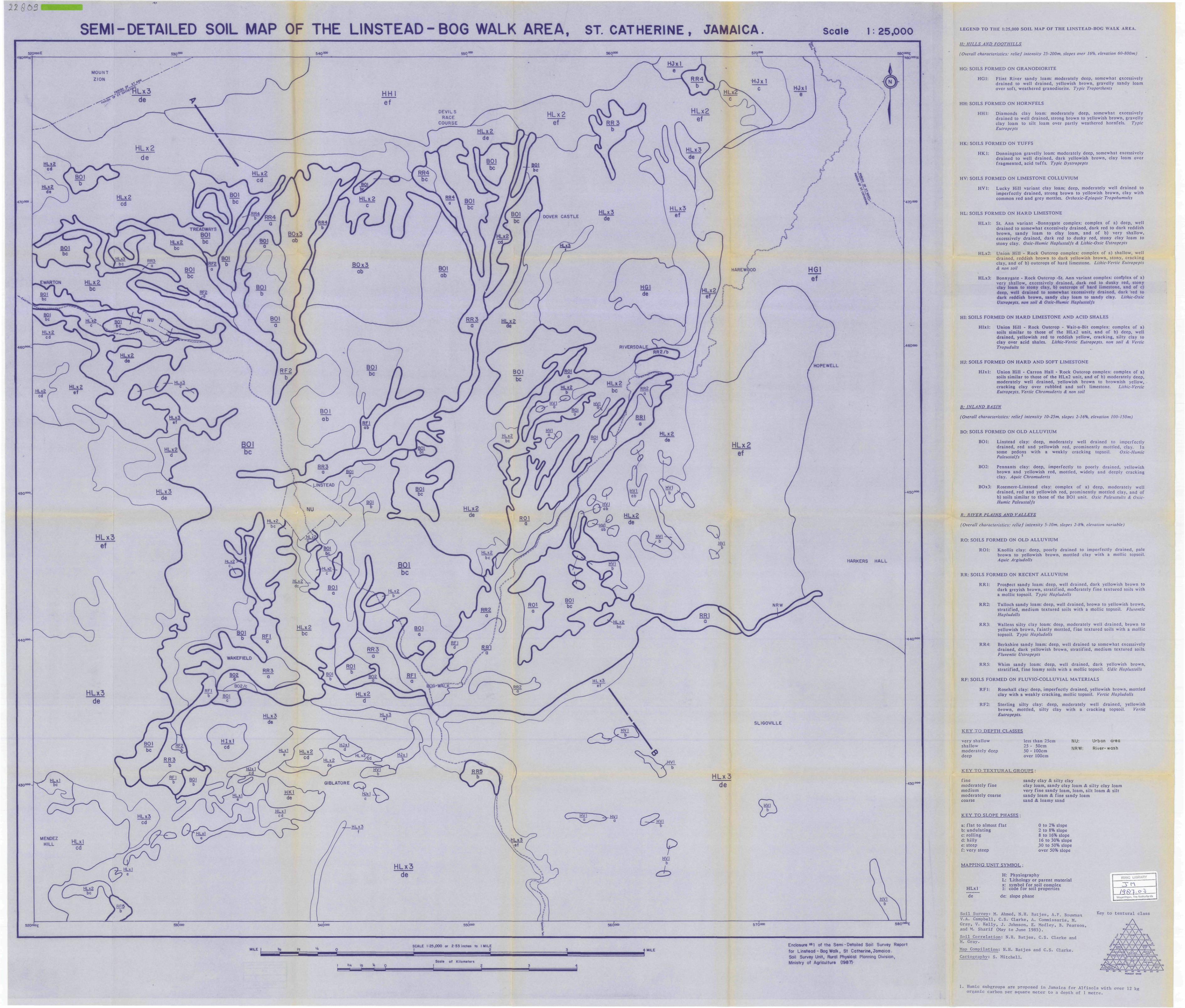
229ö a J
-*•
SEMI-DETAILED SOIL MAP OF THE LINSTEAD-BOG WALK AREA, ST. CATHERINE, JAMAICA. Scale 1: 25,000 LEGEND T O T H E 1:25,000 S O I L MAP OF T H E LINSTEAD-BOG WALK AREA.
H: HILLS AND FOOTHILLS
(Overall characteristics: relief intensity 25-200m, slopes over 16%, elevation 60-800m)
HG: SOILS F O R M E D ON G R A N O D I O R I T E
H G 1 : F l in t R ive r sandy loam: modera te ly deep, somewhat excessively d r a i n e d to well d r a ined , yellowish brown, gravel ly sandy loam over soft, w e a t h e r e d granodior i te . Typic Troporthents
HH: SOILS F O R M E D ON H O R N F E L S
H H 1 : D iamonds clay loam: moderate ly deep , somewhat excessively d r a i n e d to well d r a i n e d , s t rong brown to yellowish b rown, gravel ly clay loam to silt loam over par t ly weathered hornfe ls . Typic Eutropepts
HK: SOILS F O R M E D ON T U F F S
H K 1 : D o n n i n g t o n gravel ly loam: moderate ly deep, somewhat excessively d r a i n e d to well d r a ined , da rk yellowish brown, clay loam over f r agmen ted , acid tuf fs . Typic Dystropepts
HV: SOILS F O R M E D ON L I M E S T O N E C O L L U V I U M
H V 1 : L u c k y Hill v a r i a n t clay loam: deep, modera te ly well d r a ined to imper fec t ly d r a i n e d , s t rong brown to yellowish b rown, clay w i th common red and grey mottles. Orthoxic-Epiaquic Tropohumults
HL: SOILS F O R M E D ON H A R D LIMESTONE
H L x l : St. Ann v a r i a n t -Bonnygate complex: complex of a) deep , well d r a i n e d to somewha t excessively d ra ined , da rk red to da rk redd i sh b rown , s andy loam to clay loam, and of b) very sha l low, excessively d r a i n e d , d a r k red to dusky red, s tony c lay loam to s tony clay. Oxic-Humic Haplustalfs & Lithic-Oxic Ustropepts
HLx2: Un ion Hill - Rock Outc rop complex: complex of a) shal low, well d r a i n e d , r edd i sh brown to da rk yellowish brown, s tony, c r a c k i n g c lay , and of b) ou tc rops of hard l imestone. Lithic-Vertic Eutropepts & non soil
HLx3: Bonnyga te - Rock Ou tc rop -St. Ann va r i an t complex: confplex of a) very sha l low, excessively d ra ined , d a r k red to dusky red, s tony clay loam to stony c lay, b) outcrops of hard l imestone, and of c) deep, well d r a i n e d to somewhat excessively d r a i n e d , d a r k 'red to dark reddish b rown, sandy clay loam to sandy clay. Lithic-Oxic Ustropepts, non soil & Oxic-Humic Haplustalfs
HI: SOILS F O R M E D ON H A R D LIMESTONE A N D ACID SHALES
H I x I : U n i o n Hill - Rock O u t c r o p - Wait-a-Bit complex: complex of a) soils s imi lar to those of the HLx2 un i t , and of b) deep, well d r a i n e d , ye l lowish red to reddish yellow, c r ack ing , si l ty clay to clay over acid shales. Lithic-Vertic Eutropepts. non soil <$ Vertic Tropudults
HJ: SOILS F O R M E D ON H A R D A N D SOFT L I M E S T O N E
H J x l : U n i o n Hill - C a r r o n Hall - R o c k Ou tc rop complex: complex of a) soils s imi lar to those of the H L x 2 un i t , a n d of b) modera te ly deep , modera te ly well d r a i n e d , yel lowish b rown to b rownish yellow, c rack ing c lay over rubbled and soft l imestone. Lithic-Vertic Eutropepts, Vertic Chromuderts & non soil
8: INLAND BASIN
(Overall characteristics: relief intensity 10-25m, slopes 2-16%, elevation 100-I50m)
BO: SOILS F O R M E D ON O L D A L L U V I U M
B O l : Lins tead clay: deep , modera te ly well d r a i n e d to imperfec t ly d r a i n e d , red and yel lowish red, p rominen t ly mot t led , clay. In some pedons wi th a weak ly c r a c k i n g topsoil. Oxic-Humic Paleustalfs l
B 0 2 : Pennan t s clay: deep , imper fec t ly to poorly d r a i n e d , yellowish brown and yel lowish red, mot t led , widely and deeply c rack ing clay. Aquic Chromuderts
BOx3: Rosemere-Lins tead clay: complex of a) deep, modera te ly well d r a ined , red and yel lowish red , p rominen t ly mot t led clay, and of b) soils s imi la r to those of the BOl uni t . Oxic Paleustults <£ Oxic-Humic Paleustalfs
R: RIVER PLAINS AND VALLEYS
(Overall characteristics: relief intensity 5-10m, slopes 2-8%, elevation variable)
R O : SOILS F O R M E D ON O L D A L L U V I U M
R O l : Knol l i s c lay: deep , poorly d ra ined to imper fec t ly d ra ined , pale b rown to yel lowish brown, mott led clay wi th a mollic topsoil. Aquic Argiudolls
R R : SOILS F O R M E D ON R E C E N T A L L U V I U M
R R 1 : Prospect sandy loam: deep, well d r a ined , da rk yel lowish brown to da rk greyish brown, s t ra t i f i ed , moderate ly f ine t ex tu red soils wi th a mollic topsoil . Typic Hapludolls
R R 2 : Tu l loch s andy loam: deep , well d ra ined , brown to yellowish brown, s t r a t i f i ed , m e d i u m tex tu red soils wi th a moll ic topsoil. Fluventic Hapludolls
R R 3 : Wallens si l ty clay loam: deep, modera te ly well d r a i n e d , brown to yel lowish b rown, f a in t ly mott led, f ine t ex tu red soils wi th a moll ic topsoil . Typic Hapludolls
R R 4 : Berksh i re sandy loam: deep, well d r a ined to somewha t excessively d r a i n e d , d a r k yel lowish brown, s t r a t i f i ed , m e d i u m tex tu red soils. Fluventic Ustropepts
R R 5 : Whim sandy loam: deep , well d r a i n e d , d a r k yel lowish brown, s t r a t i f i ed , f ine loamy soils with a mollic topsoil. Udic Haplustolls
R F : SOILS F O R M E D ON F L U V I O - C O L L U V I A L M A T E R I A L S
R F 1 : Rosehal l clay: deep , imperfec t ly d ra ined , yellowish brown, mot t led c lay wi th a weakly c rack ing , mollic topsoil. Vertic Hapludolls
RF2: Ster l ing sil ty clay: deep, modera te ly well d r a i n e d , yellowish b r o w n , mot t l ed , s i l ty clay with a c r ack ing topsoil. Vertic Eutropepts.
K E Y T O D E P T H CLASSES
ve ry sha l low sha l low m o d e r a t e l y deep d e e p
less t han 25cm 25 - 50cm 50 - 100cm over 100cm
NU: Urban a r e a
NRW: R i v e r - w a s h
K E Y T O T E X T U R A L G R O U P S :
f i n e m o d e r a t e l y f i ne m e d i u m m o d e r a t e l y coarse coarse
K E Y T O SLOPE PHASES •
a: f l a t to a lmost f l a t b: u n d u l a t i n g c: ro l l ing d: h i l ly e: s teep f: ve ry s teep
M A P P I N G U N I T SYMBOL :
sandy c lay & sil ty clay clay loam, sandy clay loam & s i l ty c lay loam very f i ne sandy loam, loam, silt loam & silt s andy loam & fine sandy loam sand & loamy sand
0 to 2% slope 2 to 8% slope 8 to 16% slope 16 to 30% slope 30 to 50% slope over 50% slope
HLxl "óë"
H: Phys iography L: Li tho logy or pa ren t mater ia l x: symbol for soil complex 1: code for soil p roper t ies
de: slope phase
ISRIC LIBF
3"n_ ISELILE-I
Scale of Kilometers I 2
Enclosure**! of the Semi-Detailed Soil Survey Report for Linstead - Bog Walk, St Catherine, Jamaica. Soil Survey Unit, Rural Physical Planning Division, Ministry of Agriculture (1987)-
Soil Survey: M. Ahmed, N.H. Batjes, A.F. Bouwman V.A. Campbell, C.S. Clarke, A» Commissaris, M. Gray, V. Kelly, J. Johnson, E. Medley, B. Pearson, and M. Sharif (May to June 1985).
Soil Correlation: N.H. Batjes, C.S. Clarke and M. Gray.
Map Compilation: N.H. Batjes and C.S. Clarke.
Cartography: S. Mitchell.
Wagoning*"., the NsÖWriW*
Key to textural class
1. Humic subgroups are proposed in Jamaica for Alfisols with over 12 kg organic carbon per square meter to a depth of 1 metre.

ex- 1399.03.
375—
350
325
300-
2TS-
250-
22,5
200-
inm
m2
zg
75—
(50-4y j
125-
100"
75-
qoo o oloop o opooooc>op oooJOO OOO,oooooo•po o o o <^ o o ooooooo-OOOOO«)OOOOOo o o o o <>opooopoooo«>oooooooooo«jpoooo0/ÔOOOO
'iOQQ-O°OC
OOO'OOC3 0O00 0pooooc)OOOOO
• POOOOCvÏOOOOOOpoooociflÄP o opooooom%o%oo
O o o o o o o o o o o o o o o o
375
350
525
-300
-275
-250
Dooooooo o
DOOOOOOOV JoooocOÔOOOA
PRINCESS FELD
TREADWAYS TIME ftPATIENCE
SUNNYSiDEBURTONS
KNOLLS
RIO DORORIVER RIO PEDRO
RIVERL__ __JL_
i::Lr:i= ''^^^£&&&^
I.
PHYSIOGP^APHY
GEOLOGY
SOILSENCLOSURE 442 Of The Semi-detailed Soil SurveyReport For LINSTE AD-BOG WALK, ST CATHERINEJAMAICA. Soil Survey Unit» Rural Physical PlanningDivision,MINISTRY OF AGRICULTURE(1987).
Compilation; C.$. CLARKE a N.H. BATJESCortogrophy: G, DERBY
-225
-2,00
LEGEND
H
L
L OO C)OP
izrzi:
HORNFELS
LIMESTONE
0 OLD ALLUVIUM
OUUUUUM
RECENT ALLUVIUM
F,_
FLUVIO COLLUVIALMATERIALS
- PHYSIOGRAPHY (See Section 4-3 Of Report)
— GEOLOGY (Section 2-5)B O X 3 — SOIL CHARACTERISTICS (Section4-4)
L — COMPLEX (Section 4^3)
•ROSEMERE— LINSTEAD cloy
SCALE- VERTICAL lern* iOm
HORIZONTAL4 cm = I km
I N.B. Depth Of Geologic Material Has Been Arbitrarilyj Determined For Schematic Purposes,
14
A DISTANCE (Kilometres)