Seismological and Engineering Effects of the M 7.0 Samos ...

Earth Planets Space, 56, 1253–1259, 2004
Seismological and geological characterization of the crust in the southern partof northern Fossa Magna, central Japan
Hiroshi Sato1, Takaya Iwasaki1, Yasutaka Ikeda2, Tetsuya Takeda1, Nobuhisa Matsuta1,Tomoko Imai1, Eiji Kurashimo1, Naoshi Hirata1, Sin’ichi Sakai1, Driss Elouai3,
Taku Kawanaka4, Shinji Kawasaki4, Susumu Abe4, Takeshi Kozawa4,Takeshi Ikawa4, Yoshimasa Arai5, and Naoko Kato1
1Earthquake Research Institute, University of Tokyo, 1-1-1 Yayoi, Tokyo 113-0032, Japan2 Department of Earth and Planetary Science, 7-3-1 Hongo, University of Tokyo, Tokyo 113-0033, Japan
3Department of Earth and Planetary Systems Science, Hiroshima University,1-3-1 Kagamiyama, Higashi-Hiroshima 739-8526, Japan
4JGI Inc., 1-5-21, Otsuka, Tokyo 112-0012, Japan5Tokyo Electric Power Company, 212-1 Katsuyama, Ueno, Gunma 370-1613, Japan
(Received May 31, 2004; Revised December 27, 2004; Accepted December 27, 2004)
The northern Fossa Magna (NMF) is a Miocene rift basin formed in the final stages of the opening of the Seaof Japan. The northern part of Itoigawa-Shizuoka Tectonic Line (ISTL) bounds the western part of the NMFand forms an active fault system that displays one of the largest slip rates in the Japanese islands. Reflectionand refraction/wide-angle reflection profiling and earthquake observations by a dense array were undertakenacross the northern part of ISTL in order to delineate structures in the crust, and deep geometry of the activefault systems. The ISTL active fault system at depth (ca. 2 km) shows east-dipping low-angle in Omachi andMatsumoto and is extended beneath the Central Uplift Zone and Komoro basin keeping the same dip-angle downto ca. 15 km. The upper part of the crust beneath the Central Uplift Zone is marked by the high Vp and highresistivity zone. Beneath the folded zone of the NMF, the middle to lower crust shows low Vp, low resistivityand more reflective features. The balanced geologic cross-section based on the reflection profiles suggests thatthe shortening deformation since the late Neogene was produced by the basin inversion of the Miocene low-anglenormal fault.Key words: Crustal structure, geologic structure, active fault, Itoigawa-Shizuoka tectonic line, northern FossaMagna, seismic reflection profile, seismic refraction profile, central Japan.
1. IntroductionTo construct a realistic model to explain crutal defor-
mation processes in the short term (<100 years) to longterm is important for a better understanding of the occur-rence of crustal devastative earthquakes and seismic haz-ards. Geodetic measurements, including triangulation fornearly 100 years and GPS measurements, suggest that strainaccumulation has occurred around the northern part of theItoigawa-Shizuoka tectonic Line (ISTL) active fault systemand northern Fossa Magna, central Japan (Fig. 1; Sagiyaet al., 2002). Also, on the evidence of paleo-seismology(Okumura, 2001), the ISTL active fault system poses thehighest seismic risk and shows one of the largest slip rates(4–9 mm/yr) among active onshore faults (e.g. Ikeda etal., 2002). Based on such features, the northern part ofthe ISTL active fault system provides an excellent oppor-tunity to reveal on-going crustal deformation mechanismsand processes, and was determined as a target area for theresearch project on “Slip and Flow Processes in and belowthe Seismogenic Region”.
Copy right c© The Society of Geomagnetism and Earth, Planetary and Space Sci-ences (SGEPSS); The Seismological Society of Japan; The Volcanological Societyof Japan; The Geodetic Society of Japan; The Japanese Society for Planetary Sci-ences; TERRAPUB.
Revealing the crustal architecture of the target area is animportant key to construct the numerical model for crustaldeformation. For this purpose, multi-disciplinary researchto reveal the crustal structure has been carried out, includ-ing seismic reflection profiling (Sato et al., 2004a), seismicrefraction/wide-angle reflection profiling (Imai et al., 2004;Takeda et al., 2004), seismic tomography (Kurashimo andHirata, 2004), receiver function analysis (Yoshimoto et al.,2004; Abe et al., 2004), and resistivity structure by mag-netotelluric (MT) method (Ogawa et al., 2002) across thenorthern part of the ISTL active fault system. In this pa-per, we try to synthesize the crustal structure of the northernFossa Magna region and deep geometry of the ISTL activefault system based on the above-mentioned results and otherrelated seismic profiles (Matsuta et al., 2004; Ikeda et al.,2004; Elouai et al., 2004).
2. Geological SettingThe northern part of the ISTL is defined as the western
boundary fault of the Neogene sedimentary basin, namedFossa Magna. The tectonic line, which separates the pre-Tertiary basement of the NE Japan from SW Japan, is theTanakura Shear Zone (e.g. Otsuki, 1975; Fig. 1). The ISTLproduced a certain displacement in pre-Tertiary basement,
1253
1254 H. SATO et al.: CHARACTERIZATION OF THE CRUST OF NORTHERN FOSSA MAGNA
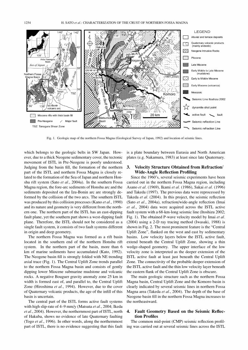
Fig. 1. Geologic map of the northern Fossa Magna (Geological Survey of Japan, 1992) and location of seismic lines.
which belongs to the geologic belts in SW Japan. How-ever, due to a thick Neogene sedimentary cover, the tectonicmovement of ISTL in Pre-Neogene is poorly understood.Judging from the basin fill, the formation of the northernpart of the ISTL and northern Fossa Magna is closely re-lated to the formation of the Sea of Japan and northern Hon-shu rift system (Sato et al., 2004a). In the southern FossaMagna region, the fore-arc sediments of Honshu arc and thesediments deposited on the Izu-Bonin arc are strongly de-formed by the collision of the two arcs. The southern ISTLwas produced by this collision processes (Kano et al., 1990)and its nature and geometry is very different from the north-ern one. The northern part of the ISTL has an east-dippingfault plane, yet the southern part shows a west-dipping faultplane. Therefore, the ISTL should not be considered as asingle fault system, it consists of two fault systems differentin origin and deep geometry.
The northern Fossa Magna was formed as a rift basinlocated in the southern end of the northern Honshu riftsystem. In the northern part of the basin, more than 6km of marine sediments have accumulated (Kato, 1992).The Neogene basin fill is strongly folded with NE trendingaxial trace (Fig. 1). The Central Uplift Zone trends parallelto the northern Fossa Magna basin and consists of gentlydipping lower Miocene submarine mudstone and volcanicrocks. A negative Bouguer gravity anomaly zone 25 km inwidth is formed east of, and parallel to, the Central UpliftZone (Hiroshima et al., 1994). However, due to the coverof Quaternary volcanic products, the age of the infill of thisbasin is uncertain.
The central part of the ISTL forms active fault systemswith high slip-rate of 4–9 mm/y (Matsuta et al., 2004; Ikedaet al., 2004). However, the northernmost part of ISTL, northof Hakuba, shows no evidence of late Quaternary faulting(Togo et al., 1996). In other words, along the northernmostpart of ISTL, there is no evidence suggesting that this fault
is a plate boundary between Eurasia and North Americanplates (e.g. Nakamura, 1983) at least since late Quaternary.
3. Velocity Structure Obtained from Refraction/Wide-Angle Reflection Profiling
Since the 1960’s, several seismic experiments have beencarried out in the northern Fossa Magna region, includingAsano et al. (1969), Ikami et al. (1986), Sakai et al. (1996)and Takeda (1997). The previous data were reprocessed byTakeda et al. (2004). In this project, the seismic reflection(Sato et al., 2004a), refraction/wide-angle reflection (Imaiet al., 2004) data were acquired across the ISTL activefault system with a 68-km-long seismic line (Itoshizu 2002;Fig. 1). The obtained P-wave velocity model by Imai et al.(2004) using a 2-D ray tracing method (Iwasaki, 1988) isshown in Fig. 2. The most prominent feature is the “CentralUplift Zone”, flanked on the west and east by sedimentarybasins. Low velocity layers below the ISTL active fault,extend beneath the Central Uplift Zone, showing a thinwedge-shaped geometry. The upper interface of the lowvelocity zone is interpreted as the deeper extension of theISTL active fault at least just beneath the Central UpliftZone. The connectivity of the probable deeper extension ofthe ISTL active fault and the thin low velocity layer beneaththe eastern flank of the Central Uplift Zone is obscure.
The main geologic structure such as the northern FossaMagna basin, Central Uplift Zone and the Komoro basin isclearly indicated by several seismic lines in northern FossaMagna area (Takeda et al., 2004). The depth of the base ofNeogene basin fill in the northern Fossa Magna increases tothe northeastward.
4. Fault Geometry Based on the Seismic Reflec-tion Profiles
The common mid-point (CMP) seismic reflection profil-ing was carried out at several seismic lines across the ISTL

H. SATO et al.: CHARACTERIZATION OF THE CRUST OF NORTHERN FOSSA MAGNA 1255
Fig. 2. P-wave velocity structure by ray-tracing method along Itoshizu 2002 seismic line (Sato et al., 2004a) after Imai et al. (2004). Red triangles:locations of explosive sources, blue triangles: locations of high energy shots (a large number of sweeps) by vibroseis trucks, yellow triangles:locations of vibroseis shot points used in this analysis. Green lines represent the reflectors clearly observed on the shot gathers by explosive sources.
active fault system. The representative line is the Itoshizu2002 (Sato et al., 2004a; Fig. 1). Seismic data were ac-quired using four vibroseis trucks and explosive sources.Resultant depth converted seismic sections and its geologicinterpretation are shown in Fig. 3. The obtained seismicprofiles, including a shallow high-resolution profile alongthe same seismic line (Matsuta et al., 2004), suggest thatthe ISTL active fault forms an emergent thrust with a dip-angle of 30 degrees to the east at the shallow depth (< 2km). The deeper extension of this fault can be traced in theMiocene basin fill with low-angle and possibly traced be-neath the Central Uplifted Zone (Sato et al., 2004a; Fig. 3suggested by arrows Y). The boundary between Cretaceousgranitic rocks and Neogene sediments is clearly recognizedby strong continuous reflections and can be traced down to3 km at a distance of 6 km from the western end (Fig. 3,X). The boundary between the Cretaceous and Neogeneand the extension of the ISTL active fault are estimated tomerge beneath the Central Uplift Zone. Based on our ve-locity model and seismic reflection profile and available ge-ologic data (e.g. Kato, 1980; Kato and Sato, 1983; Kato andAkabane, 1986; Kato et al., 1989; Arai, 2000), the seismicsection of Itoshizu 2002 is interpreted as shown in Fig. 3.The low-angle fault geometry of the ISTL active fault sys-tem at the depth more than 2-km is also demonstrated byseismic reflection profile in Matsumoto (Matsumoto 2002in Fig. 1; Ikeda et al., 2004). This geometry well accordsto the velocity structure obtained by the reprocessing of re-
fraction data of the 1987 seismic line (Fig. 1, Takeda et al.,2004). The similar geometry of the ISTL active fault systemis also presented in ERI NF 97 seismic line, located north ofthe Itoshizu 2002 seismic line (Fig. 1; Elouai et al., 2004).
5. Relationship between Velocity Structure, FaultGeometry and Other Geophysical Features
Along the Itoshizu 2002 seismic lines, earthquakes wererecorded for two months by a dense array of temporaryseismic stations. Based on these data, the crustal structurewas investigated by seismic tomography (Kurashimo andHirata, 2004) and receiver function analysis (Abe et al.,2004). Resistivity structure along the same profile wasalso obtained by the magnetotelluric method (Ogawa et al.,2002).
According to the receiver function analysis using CCP(common-conversion-point) stacking and prestack migra-tion of teleseismic P-SV converted wave, two P-S convertedinterfaces are identified at a depth of 17–18 km and 38–40km. The later phase with positive polarity can be interpretedas the P-S conversion from the Moho (Abe et al., 2004).Figure 4 is a shot record of the explosive source at the west-ern end of the Itoshizu 2002 seismic line. The coherentreflections can be recognized from 6 to 13 sec (TWT: two-way travel time), suggesting that the laminated lower crustextends up to 13 sec (TWT). From these observations, it ishighly probable that the Moho-depth is located at about 40km.

1256 H. SATO et al.: CHARACTERIZATION OF THE CRUST OF NORTHERN FOSSA MAGNA
Fig. 3. Stacked, migrated, depth converted seismic sections of Itoshizu 2002 and its geologic interpretation after Sato et al. (2004a). X: base of Neogene,Y: deeper extension of the ISTL active fault.
Fig. 4. Shot record by explosive source (100 kg of dynamite) at the western end of the Itoshizu 2002 seismic line. Arrows indicate the significantreflection from middle to lower crust.

H. SATO et al.: CHARACTERIZATION OF THE CRUST OF NORTHERN FOSSA MAGNA 1257
Fig. 5. Geologic cross-section along the Itoshizu 2002 seismic line (Sato et al., 2004a) with the resistivity structure (Ogawa et al., 2002), the hypocentraldistribution (Sakai, 2004) and P-wave velocity structure obtained by seismic tomography (Kurashimo and Hirata, 2004). The location of deepreflectors is after Imai et al. (2004).
Fig. 6. Schematic illustration showing the crustal structure around the southern part of the northern Fossa Magna.
The resistivity structure along the Itoshizu 2002 (Ogawaet al., 2002), the relocated, hypocentral distribution (Sakai,2004) and the reflectors observed on the shot gathers byexplosive sources (Imai et al., 2004) are superposed onthe geologic cross-section (Fig. 5). The high resistivityarea beneath the Central Uplift Zone (∼20 km) is almostcoincidence with the high velocity area obtained by seismictomography analysis (Kurashimo and Hirata, 2004). Thebasement beneath the folded zone of the northern FossaMagna basin is marked by the low resistivity (Ogawa et
al., 2002), low Vp (Kurashimo and Hirata, 2004; Takeda etal., 2004), low to moderate Vp/Vs (Kurashimo and Hirata,2004) and distribution of the clear reflectors (e.g. Fig. 3).Kurashimo and Hirata (2004) suggested the existence ofaqueous fluid pores with high aspect rations in this zone.
Using the obtained velocity structure by refraction analy-sis, hypocentral distribution of micro-earthquakes were re-determined and projected on the Itoshizu 2002 seismic line(Sakai, 2004; Fig. 5). Most of micro-earthquakes occur inthe footwall of the ISTL active fault system. As suggested

1258 H. SATO et al.: CHARACTERIZATION OF THE CRUST OF NORTHERN FOSSA MAGNA
Fig. 7. Schematic diagram showing the evolution of the northern Fossa Magna after Sato et al. (2004a).
by Ogawa et al. (2002), the hypocentral distribution has ten-dency to concentrate between low and high resistivity area.The focal mechanisms of these earthquakes are strike-slipwith WNW trending P-axis (Sakai, 2004). Including thenorthern Fossa Magna region, the most of the focal mecha-nisms in the back-arc side of the southern part of the north-ern Honshu shows the strike-slip type with WNW trendingP-axis (Kosuga, 1999). However, active faults distributedin this region are dominated in reverse faults. This in-compatibility suggests that the stress condition which gen-erates large earthquakes associated with faulting along thepre-existing active-seismogenic source fault probably differfrom the one of micro-earthquakes in steady state and/orstress build up processes.
The observed micro-earthquakes in the footwall, form-ing the NNW trending zone (Sakai, 2004), are possiblyproduced by slip of preexisting NNW trending fault sys-tem and/or triggered by migration of fluid to less permeable(more resistive) crust (e.g. Ogawa et al., 2001). However,we cannot find evidence showing the large vertical displace-ment along the estimated high-angle fault beneath the sur-face trace of the ISTL (Imai et al., 2004). It is reasonableto release the strike-slip components by slip on such high-angle fault. However, it seems to be very difficult to re-lease the significant amount of WNW- trending strain byNNW-trending high-angle fault. Thus, we interpreted thatthe deeper extension of the ISTL active fault does not con-nect to this high angle-fault (Fig. 6).
6. Tectonic Model for the Evolution of NorthernFossa Magna Basin
The basin formation and subsequent inversion processesin the northern Fossa Magna basin can be explained usinga simple model based on fault reactivation along the ISTL(Sato and Ikeda, 1999a; Sato et al., 2004a; Fig. 7). In thisreconstruction ca. 42 km of Miocene extension is estimated(Fig. 7, C and D). The total amount of shortening since thelate Neogene is estimated to be ca. 23 km. If the shorteningstarted at 6–4 Ma, the averaged slip rate is calculated as4–6 mm/y under a constant slip rate. This value is similarto the rate obtained by drilling and very shallow seismicreflection profiling across the toe of the thrust in northernpart of the ISTL active fault system from the late Quaternary(4.7 mm/y; Matsuta et al., 2001).
In the northernmost part of the ISTL, the faulting has ter-minated since late Quaternary. In the northern part of north-ern Fossa Magna, the late Quaternary horizontal shorteningaccommodated along the western Nagano basin active faultsystem (Fig. 1). The shift of the location of late Quater-nary faulting from the western end (ISTL active fault sys-tem) to the eastern end of the Northern Fossa Magna basin(western Nagano basin active fault system) is easily under-stood as the shortening deformation processes of the basinfill caused by the thrusting of the east-dipping master faultbeneath the Central Uplift Zone (Elouai et al., 2004; Takedaet al., 2004).
7. ConclusionsThe northern part of ISTL was formed as a low-angle nor-
mal fault in Miocene, bounding the western margin of thenorthern Fossa Magna rift basin. Due to the shortening de-

H. SATO et al.: CHARACTERIZATION OF THE CRUST OF NORTHERN FOSSA MAGNA 1259
formation since late Neogene, the present ISTL active faultsystem was developed in the basin fill by basin inversionprocesses.
Low Vp, low Vp/Vs and low resistivity are observedbeneath the folded zone of the northern Fossa Magna. Suchcrustal structure has potential to give significant amounts ofcontrol for seismicity and crustal deformation processes.
Acknowledgments. We are grateful to the members of researchproject on “Slip and Flow Processes in and below the SeismogenicRegion” for helpful discussions and comments. We also thank TimStern, Yasuo Ogawa and an anonymous refree for critical reviews.The seismic experiment of Itoshizu 2002 and the related researchwere supported by the above-mentioned project and Grant-in-Aidfor Scientific Research No. 14209004 provided from the Ministryof Education, Culture, Sports, Science and Technology, Japan.
ReferencesAbe, S., E. Kurashimo, H. Sato, N. Hirata, and T. Kawanaka, Seismic
migration of receiver functions for deep crustal structure across theItoigawa-Shizuoka tectonic line with dense broad-band seismic arrays,Proceedings of the 2nd International Symposium on Slip and FlowProcess in and below the Seismogenic Region, Tokyo, Japan, 2004.
Arai, Y., The late Cenozoic tectonics of the northern Fossa Magna, Masterthesis, Graduate School of Science, The Univ. of Tokyo, Tokyo, 182 pp.,2000.
Asano, S., K. Ichikawa, H. Okada, S. Kubota, H. Suzuki, M. Nogoshi,H. Watanabe, K. Seya, K. Noritomi, and K. Tazime, Explosion seismicobservations in the Matsushiro Earthquake Swarm Area, Spec. Rep.Geol. Survey of Japan, 5, Part I, 1–162, 1969.
Elouai, D., H. Sato, N. Hirata, S. Kawasaki, T. Takeshita, N. Kato, andT. Takeda, Deep seismic reflection profiling across the northern FossaMagna: The ERI 1997 and the JNOC 1996 seismic lines, active faultsand geological structures, Earth Planets Space, 56, this issue, 1333–1340, 2004.
Geological Survey of Japan (eds.), 1:1,000,000 Geological Map of Japan(3rd ed.), Geological Survey Japan, Tsukuba, 1992.
Hiroshima, T., M. Komazawa, and T. Nakatsuka, Gravity Map of Joshin-etsu District (Bouguer Anormalies) 1:200000, Geological Survey ofJapan, 1994.
Ikami, A., T. Yoshii, S. Kubota, Y. Sasaki, A. Hasemi, T. Moriya, H.Miyamachi, R. Matsu’ura, and K. Wada, A seismic refraction profilein and around Nagano Prefecture, Central Japan, J. Phys. Earth, 34,457–474, 1986.
Ikeda, Y., T. Imaizumi, M. Togo, K. Hirakawa, T. Miyauchi, and H. Sato(eds.), Atlas of Quaternary Thrust Faults in Japan, Univ. of Tokyo Press,Tokyo, 254 pp., 2002 (in Japanese).
Ikeda, Y., T. Iwasaki, H. Sato, N. Matsuta, and T. Kozawa, Seismic re-flection profiling across the Itoigawa-Shizuoka Tectonic Line at Mat-sumoto, Central Japan, Earth Planets Space, 56, this issue, 1317–1323,2004.
Imai, T., T. Iwasaki, T. Takeda, T. Kawanaka, and H. Sato, Detailed uppercrustal structure across the Itoigawa-Shizuoka Tectonic Line from the2002 seismic expedition, Abstracts 2004 Japan Earth and PlanetaryScience Joint Meeting, S075–005, 2004.
Iwasaki, T., Ray-tracing program for study of velocity structure by oceanbottom seismographic profiling, Zisin (J. Seismol. Soc. Japan), 41, 263–266, 1988 (in Japanese).
Kano, K., K. Kosaka, M. Murata, and S. Yanai, Intra-arc deformation withthe vertical rotation axes: The case of the pre-Middle Miocene terranesof Southwest Japan, Tectonophysics, 176, 333–354, 1990.
Kato, H., Geology of the Sakaki District, Quardrangle Series, Scale1:50000, Geol. Surv. Japan, 57 pp., 1980 (in Japanese with English Ab-stract).
Kato, H., Fossa Magna—A masked border region separating southwestand northeast Japan, Bull. Geol. Surv. Japan, 43, 1–30, 1992.
Kato, H. and S. Akabane, Geology of the Nagano District. QuardrangleSeries, Scale 1:50000, Geol. Surv. Japan, 122 pp., 1986 (in Japanesewith English Abstract).
Kato, H. and T. Sato, Geology of the Shinanoikeda District. QuardrangleSeries, Scale 1:50000, Geol. Surv. Japan, 93 pp., 1983 (in Japanese with
English Abstract).Kato, H., K. Mimura, T. Sato, and F. Takizawa, Geology of the Omachi
District Quardrangle Series, Scale 1:50000, Geol. Surv. Japan, 111 pp.,1989 (in Japanese with English Abstract).
Kosuga, M., Stress regime of the NE Japan deduced from crustal earth-quakes, Earth Monthly, 27, 107–112, 1999 (in Japanese).
Kurashimo, E. and N. Hirata, Low V p and V p/V s zone beneath thenorthern Fossa Magna basin, central Japan, derived from a dense arrayobservation, Earth Planets Space, 56, this issue, 1303–1310, 2004.
Matsuta, N., Y. Ikeda, T. Imaizumi, and H. Sato, Subsurface structure ofand rate of net slip on the Kamishiro fault, northern part of the Itoigawa-Shizuoka Tectonic Line, central Japan, Active Fault Research, 20, 59–70, 2001 (in Japanese with English Abstract).
Matsuta, N., Y. Ikeda, and H. Sato, The slip rate along the northernItoigawa-Shizuoka tectonic line active fault system, central Japan, EarthPlanets Space, 56, this issue, 1325–1332, 2004.
Nakamura, K., Possibility of a nascent plate boundary at the eastern marginof the Japan Sea, Bull. Earthquake Res. Inst., Univ. Tokyo, 58, 711–722,1983 (in Japanese).
Ogawa, Y., M. Mishina, T. Goto, H. Satoh, N. Oshiman, T. Kasaya, Y.Takahashi, T. Nisitani, S. Sakanaka, M. Uyeshima, Y. Takahashi, Y.Honkura, and M. Matsushima, Magnetotelluric imaging of fluidsin in-traplate earthquakes zones, NE Japan back arc, Geophysical ResearchLetters, 28, 3741–3744, 2001.
Ogawa, Y., S. Takakura, and Y. Honkura, Resistivity structure acrossItoigawa-Shizuoka tectonic line and its implications for concentrateddeformation, Earth Planets Space, 54, 1115–1120, 2002.
Okumura, K., Paleoseismology of the Itoigawa-Shizuoka tectonic line incentral Japan, Jour. Seismol., 5, 411–431, 2001.
Otsuki, K., Geology of the Tanakura Sear Zone and adjacent area, Contrib.Inst. Geol. Paleontol. Tohoku Univ., 76, 1–75, 1975 (Japanese withEnglish abstract).
Sagiya, T., T. Nishimura, Y. Iio, and T. Tada, Crustal deformation aroundthe northern and central Itoigawa-Shizuoka Tectonic Line, Earth Plan-ets Space, 54, 1059–1063, 2002.
Sakai, S., Seismicity of the northern part of Itoigawa-Shizuoka TectonicLine, Proceedings of the 2nd International Symposium on Slip and FlowProcess in and below the Seismogenic Region, Tokyo, Japan, 2004.
Sakai, S., T. Iwasaki, T. Iidaka, T. Yoshii, F. Yamazaki, and T. Kuwayama,The structure of the crust of Chubu region from the explosion observa-tion, Earth Monthly, 18, 104–108, 1996 (in Japanese).
Sato, H. and Y. Ikeda, Major fault systems in northern Honshu, Japan,Earth Monthly, 21, 569–575, 1999 (in Japanese).
Sato, H., T. Iwasaki, S. Kawasaki, Y. Ikeda, N. Matsuta, T. Takeda, N.Hirata, and T. Kawanaka, Formation and shortening deformation of aback-arc rift basin revealed by deep seismic profiling, central Japan,Tectonophysics, 388, 47–58, 2004a.
Sato, H., T. Yoshida, T. Iwasaki, T. Sato, Y. Ikeda, and N. Umino, LateCenozoic tectonic development of the back arc region of central north-ern Honshu, Japan, revealed by recent deep seismic profiling, J. Jpn.Assoc. Petrol. Tech., 69, 145–154, 2004b (in Japanese with English ab-stract).
Takeda, T., Detailed crustul structure in central Japan as revealed from re-analysis of wide-angle data, Master thesis, Graduate School of Science,The Univ. of Tokyo, 26 pp., 1997 (in Japanese).
Takeda, T., H. Sato, T. Iwasaki, N. Matsuta, S. Sakai, T. Iidaka, and A.Kato, Crustal structure in the northern Fossa Magna region, centralJapan, modeled from refraction/wide-angle reflection data, Earth Plan-ets Space, 56, this issue, 1295–1301, 2004.
Togo, M., Y. Ikeda, T. Imaizumi, and H. Sato, Fault morphology of bothends of the Kamishiro fault along the Itoigawa-Shizuoka Tectonic Line,central Japan, Active Fault Res., 15, 9–16, 1996 (in Japanese with En-glish abstract).
Yoshimoto, K., H. Fujisawa, T. Okada, N. Umino, A. Hasegawa, K. Obara,K. Shiomi, H. Tsukahara, S. Okamoto, T. Kawanaka, Hiroshi Sato, T.Nishimura, Haruo Sato, and M. Ohtake, Moho and Philippine Sea platestructure beneath central Honshu island, Japan, from teleseismic re-ceiver functions, Earth Planets Space, 56, this issue, 1273–1279, 2004a.
H. Sato (e-mail: [email protected]), T. Iwasaki, Y. Ikeda, T.Takeda, N. Matsuta, T. Imai, E. Kurashimo, N. Hirata, S. Sakai, D. Elouai,T. Kawanaka, S. Kawasaki, S. Abe, T. Kozawa, T. Ikawa, Y. Arai, and N.Kato
Copyright © 2022 FDOKUMEN