SEASCAPE-BASED MODELING OF BENTHIC HABITATS SPATIAL DISTRIBUTION. CASE STUDY: AVREN PLATEAU...
6
12th Int. Conference on Marine Science and Technology "Black Sea" 2014 Varna, Bulgaria pp. 175-182., ISSN 1314-0958 1 Eng. Bogdan Prodanov, PhD Student, Institute of Oceanology – Bulgarian Academy of Sciences (IO- BAS) E-mail: [email protected] 2 Iliyan Kotsev, Research Assistant, Institute of Oceanology – Bulgarian Academy of Sciences (IO-BAS) E-mail: [email protected] 3 Assoc. Prof. Eng. Lyubomir Dimitrov, Institute of Oceanology – Bulgarian Academy of Sciences (IO- BAS) E-mail: [email protected] SEASCAPE-BASED MODELING OF BENTHIC HABITATS SPATIAL DISTRIBUTION. CASE STUDY: AVREN PLATEAU SUBLITTORAL ZONE, BULGARIAN BLACK SEA Bogdan PRODANOV 1 , Iliyan KOTSEV 2 , Lyubomir DIMITROV 3 ABSTRACT The study examines the present-day submarine landscape structure of the Avren Plateau sublittoral zone and its benthic habitat diversity. It is accompanied by GIS-aided landscape mapping and cartography carried out at scale 1: 50, 000 as well as by analysis of the geo- components forming the contemporary seabed spatial pattern. Special attention is paid to the national biotopes related to the lowest taxonomic rank of the underwater landscape hierarchy, namely the landscape kind. Keywords: submarine landscape complexes, seabed biotopes, seascape morphologic pattern 1. INTRODUCTION The seascape approach to studying the nature of the seafloor is an innovative interdisciplinary concept in modern-day marine ecological studies. According to this notion, the landscape of the seabed comprises a complex mosaic of habitats (biotopes) that are interlinked and consistently found together and thereby forming its spatial morphologic pattern [1]. Hence, the cited concept considers the submarine landscape as a natural complex [2; 3; 4 etc.] that combines the physical benthic environment and the contiguous group of floristic, epi- and infaunal organisms that inhabit the seafloor [5; 6]. Furthermore, some authors describe the benthic habitats (biotopes) as the essential morphologic components of the underwater landscape complex [7], which implies for the hierarchic organization of the submarine nature’s elements into a coherent geo- ecosystem [8; 9; 10 etc.]. 2. DESCRIPTION OF THE STUDY AREA The study site encompasses the shallow sublittoral zone adjacent to the Avren Plateau coastal area, Bulgarian Black Sea. It stretches between the southern portion of Varna Bay near “Karantinata” locality on north and cape Ilandzhik on south in the vicinity of Kamchia Depression, reaching maximum depth of 24- 25m. The medio- and sublittoral landscape complexes within the investigated sector are in paragenetic relations with the subaereal terrestrial landscapes of the coastal zone, thereby having similar lithologic varieties presented by unconsolidated and solid sedimentary rocks with Neogenic age, e.g. sandstones, conglomerates, heterogeneous sands, silts etc. The loose seabed substrates are additionally diversified by the presence of gravels with terrestrial origin and organic debris, e.g. whole and disintegrated shells of marine invertebrates. The topography of the seabed comprises abrasive, abrasive-landslide, structural-abrasive, and structural-accumulative geomorphic elements with Neogenic and Quaternary age. Finally, the benthic biota is presented by floristic, epi- and infaunal coenoses typical for the Black Sea basin, e.g. algal, mussel and clam communities, burrowing thalassinids etc. 3. DATA AND METHODS Several data sources were used for the purpose of the present study, e.g. scanned lithologic, bathymetric and geomorphologic maps of the seabed adjacent to the Avren Plateau coastal area, geo-data sets on benthic substrates, archive bathymetric contours, point ESRI shape files on benthic biota etc. All these were integrated, processed and subsequently analyzed in Arc GIS 9.3.1 environment.
Transcript of SEASCAPE-BASED MODELING OF BENTHIC HABITATS SPATIAL DISTRIBUTION. CASE STUDY: AVREN PLATEAU...
12th Int. Conference on Marine Science and Technology "Black Sea" 2014
Varna, Bulgaria pp. 175-182., ISSN 1314-0958
1 Eng. Bogdan Prodanov, PhD Student, Institute of Oceanology – Bulgarian Academy of Sciences (IO-
BAS) E-mail: [email protected] 2Iliyan Kotsev, Research Assistant, Institute of Oceanology – Bulgarian Academy of Sciences (IO-BAS)
E-mail: [email protected] 3Assoc. Prof. Eng. Lyubomir Dimitrov, Institute of Oceanology – Bulgarian Academy of Sciences (IO-
BAS) E-mail: [email protected]
SEASCAPE-BASED MODELING OF BENTHIC HABITATS SPATIAL
DISTRIBUTION. CASE STUDY: AVREN PLATEAU SUBLITTORAL
ZONE, BULGARIAN BLACK SEA
Bogdan PRODANOV1, Iliyan KOTSEV
2, Lyubomir DIMITROV
3
ABSTRACT
The study examines the present-day submarine landscape structure of the Avren Plateau
sublittoral zone and its benthic habitat diversity. It is accompanied by GIS-aided landscape
mapping and cartography carried out at scale 1: 50, 000 as well as by analysis of the geo-
components forming the contemporary seabed spatial pattern. Special attention is paid to the
national biotopes related to the lowest taxonomic rank of the underwater landscape
hierarchy, namely the landscape kind.
Keywords: submarine landscape complexes, seabed biotopes, seascape morphologic pattern
1. INTRODUCTION
The seascape approach to studying the
nature of the seafloor is an innovative
interdisciplinary concept in modern-day
marine ecological studies. According to this
notion, the landscape of the seabed comprises
a complex mosaic of habitats (biotopes) that
are interlinked and consistently found
together and thereby forming its spatial
morphologic pattern [1]. Hence, the cited
concept considers the submarine landscape as
a natural complex [2; 3; 4 etc.] that combines
the physical benthic environment and the
contiguous group of floristic, epi- and
infaunal organisms that inhabit the seafloor
[5; 6]. Furthermore, some authors describe the
benthic habitats (biotopes) as the essential
morphologic components of the underwater
landscape complex [7], which implies for the
hierarchic organization of the submarine
nature’s elements into a coherent geo-
ecosystem [8; 9; 10 etc.].
2. DESCRIPTION OF THE STUDY
AREA
The study site encompasses the shallow
sublittoral zone adjacent to the Avren Plateau
coastal area, Bulgarian Black Sea. It stretches
between the southern portion of Varna Bay
near “Karantinata” locality on north and cape
Ilandzhik on south in the vicinity of Kamchia
Depression, reaching maximum depth of 24-
25m. The medio- and sublittoral landscape
complexes within the investigated sector are in
paragenetic relations with the subaereal terrestrial
landscapes of the coastal zone, thereby having
similar lithologic varieties presented by
unconsolidated and solid sedimentary rocks with
Neogenic age, e.g. sandstones, conglomerates,
heterogeneous sands, silts etc. The loose seabed
substrates are additionally diversified by the
presence of gravels with terrestrial origin and
organic debris, e.g. whole and disintegrated shells
of marine invertebrates. The topography of the
seabed comprises abrasive, abrasive-landslide,
structural-abrasive, and structural-accumulative
geomorphic elements with Neogenic and
Quaternary age. Finally, the benthic biota is
presented by floristic, epi- and infaunal coenoses
typical for the Black Sea basin, e.g. algal, mussel
and clam communities, burrowing thalassinids
etc.
3. DATA AND METHODS
Several data sources were used for the
purpose of the present study, e.g. scanned
lithologic, bathymetric and geomorphologic maps
of the seabed adjacent to the Avren Plateau
coastal area, geo-data sets on benthic substrates,
archive bathymetric contours, point ESRI shape
files on benthic biota etc. All these were
integrated, processed and subsequently analyzed
in Arc GIS 9.3.1 environment.
12th Int. Conference on Marine Science and Technology "Black Sea" 2014
The GIS procedures carried out with
reference to the present study at scale 1:50,
000 involved georeferencing of the scanned
map materials, digitizing of the necessary
map elements and subsequent creation of
graphic ESRI polyline/polygon shape files,
with the accompanying descriptive
information embedded in the attribute tables
etc. These procedures are described more in
detail by Kotsev [11]. Final result of the
activities carried out in GIS environment is
the production of a digital map of the benthic
landscape complexes, whose legend
represents logical hierarchic organization of
the identified submarine landscape complexes
into 4 taxa, namely class, type, genus and
kind, as described by Kotsev [12] and
provided in Figure 1.
The following stage of the study
represents the creation of a geo-dataset of the
seabed habitats using the descriptive data on
benthic substrates and biota embedded in the
attribute table of the already available
submarine landscape-complex dataset. A
correlation among depth, substrate type and
biotic components was performed in Arc GIS
and visualized under the form of a digital
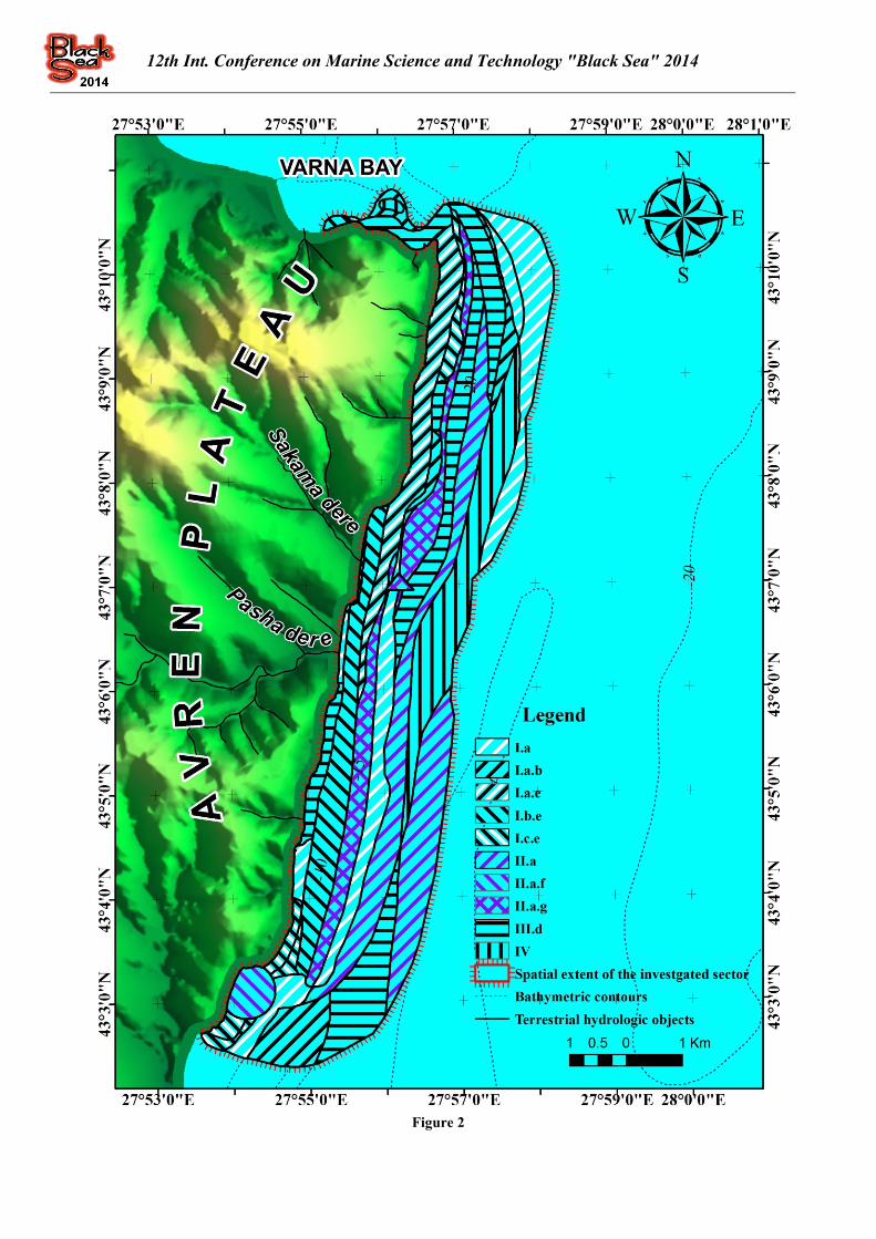
map, provided in Figure 2. The legend of the
map produced was compiled according to the
classification system of the national benthic
biotopes, proposed by Todorova et al. [13].
4. RESULTS
The contemporary submarine landscape
morphologic pattern of the investigated area
comprises 22 landscape kinds (Figure 1),
hierarchically united in 6 genera, 4 types and
2 classes as described by Kotsev [12]. The
area calculations reveal that the greatest
percentage, approximately 70%, of the
investigated sublittoral sector is occupied by
accumulative landscapes in the weakly active
and inactive portions of the sublittoral zone,
while these in the active mediolittoral and
shallow sublittoral sectors encompass less
than 10%.
The benthic habitat diversity includes 10
biotope types, united in 3 groups on the basis of
the underlying substrates (Figure 2). Greatest
areas are occupied by the deeper sublittoral soft-
bottom biotopes, while these of the geogenic reefs
are with much smaller spatial extent. Additional
elements of the seabed represent artificially
created spatial elements, such as areals of
stationary pound nets and mussel farms, which
are of insignificant total area.
5. DISCUSSION AND CONCLUSIONS
The investigation herein represents the first
attempt in Bulgarian marine studies to correlate
the morphologic submarine landscape pattern
with the associated habitats that build-up the
benthic environment. However, due to
imperfections of the geo-data used, which come
as a consequence from the coarse spatial
resolution and the insufficient geographic
coverage, especially when discussing the data
available on seabed biological communities, the
biotopes identified are mainly of predictive nature
and poorly backed by in situ investigations.
Besides, as can be noticed from the map in Figure
2, the submarine landscape complexes usually
contain several biotopes at a time. Therefore, for
correct investigations of the benthic habitat
diversity much finer mapping procedures are
needed at scale 1:5,000 or 1:10,000. Nevertheless,
the proposed seascape-based approach represents
an innovative and effective method for
identification and subsequent hierarchic
classification of the benthic biotopes in the
Bulgarian sector of the Black Sea
ACKNOWLEDGEMENTS
All authors have contributed equally for the
current report, thus our given names are arranged
in alphabetical order.
We would like to express our gratitude to the
colleagues from Department “Biology and
ecology of the sea” at IO-BAS for the provided
point data on benthic biotic diversity.

12th Int. Conference on Marine Science and Technology "Black Sea" 2014
Figure 1
12th Int. Conference on Marine Science and Technology "Black Sea" 2014
Figure 2
12th Int. Conference on Marine Science and Technology "Black Sea" 2014
I. Sandy-bottom biotopes; II. Biotopes with
silty sands and sandy silts; III. Hard-bottom
biotopes; a - Sands with Chamelea gallina; b
- Fine and medium sands with Lentidium
mediterraneum; c - Coarse and medium
mediolittoral sands, exposed to wave activity
with Donacilla cornea and Ophelia bicornis;
d - Infralittoral rocks overgrown by Mytilus
galloprovincialis and Mytilaster lineatus; e -
Coarse and medium shallow sands with
Donax trunculus; f - Shelly sands and gravels
with Modiolus adriaticus и Gouldia minima;
g - Silty sands and sandy silts with Upogebia
pusilla; h - Sands and silty sands with
Chamelea gallina; i - Infralittoral rocks
overgrown by Cystoseira sp.; j - Infralittoral
rocks overgrown by annual communities of
green and red algae;
Artificial components of the seabed: IV.a –
Stationary pound net; IV.b – Mussel farms REFERENCES
[1]. D a u v i n, J – C l., Bellan, G., Bellan-
Santini, D. The need for clear and comparable
terminology in benthic ecology. Part I.
Ecological concepts. Aquatic Conservation:
Marine and Freshwater Ecosystems, Vol. 18,
Issue 4, pages 432-445, 2008
[2]. O le n i n, S., Jean-Paul Ducrotoy, J. P.
The concept of biotope in marine ecology and
coastal management. Marine Pollution
Bulletin, Vol. 53, pages 20–29, 2006
[3]. П е н н о, М. В. Развитие научных
представлений о морских ландшафтах.
Журнал Национального университета
Тавриде имени „В. И. Вернадского”, УДК
911.5, стр. 166-172, 2014 /Penno , M. V.
Progression of scientific conceptions about
marine landscapes. Journal of Taurida
National “V.I. Vernadsky” University, pages
166-172, 2014/
[4]. П р е о б р а ж е н с к и й, Б. В.
Ландшафт как характеристика экосистемы.
В Методы комплексного картирования
экосистем шельфа, стр. 23-28. ДВНЦ АН
СССР, Владивосток, 1980 /Preobrazhenskiy,
B. V. The landscape as an ecosystem
property. In Methods for complex mapping of
the shelf ecosystems, pages 23-28.
Vladivostok, 1980/
[5]. С о р о к и н, А. Л., Касабов, Р. В.
Ландшафтные исследования как основа
выявления промысловых ресурсов
морских макрофитов Белого моря. В
Вопросы географии океана, стр. 71-72.
Ленинград, 1983 /Sorokin, A. L., Kassabov,
R. V. Landscape investigations as a basis for
assessment of the algae resources in the White
Sea. In Questions regarding geography of the
ocean, pages 71-72. Leningrad, 1983/
[6]. T a v i a n i, M., Angeletti, L., Campiani,
E., Ceregato, A., Foglini, F., Maselli, V.,
Morsilli, M. Parise, M. and Trincardi, F.
Drowned karst landscape offshore the
Apulian margin (Southern Adriatic Sea,
Italy). Journal of Cave and Karst Studies, Vol.
74, Issue 2, pages 197–212, 2012
[7]. T h o r s n e s, T., Erikstad, L., Doland,
M.F.J., Bellec, V.K. Submarine landscapes
along the Lofoten-Vesterålen-Senja margin,
northern Norway. Norwegian Journal of
Geology. Vol. 89, pages 5-16, 2009
[8]. К р а ш е н и н н и к о в, Г. Ф. Учение о
фациях. Учеб. пособие, 368 с. “Высшая
школа”, Москва, 1971 /Krashennikov, G. F.
Study of the (landscape) facies. Manual, 368
pp. “Vishaya shkola, Moscow, 1971/
[9]. П е т р о в, К. М. Береговая зона моря
как ландшафтная система. Изв. ВГО, Tом
103, вып. 5, стр. 391-396, 1971 /Petrov, K.
M. Marine coastal zone as a landscape
system. Journal оf the Geographic Society of
the USSR, Vol. 103, Issue 5, pages 391-396,
1971/
[10]. Л ы м а р е в, В. И. Океан как система
пространственных природных структур. В
Географические проблемы Мирового
океана, стр. 23-30. Ленинград, 1985
/Lamarev, V. I. Тhe ocean’s nature as a
spatial structural system. In Geographic
problems of the World Ocean, pages 23-30.
Leningrad, 1985
[11]. К о ц е в, И. Раздел 3. Хоризонтална
(планова) ландшафтна структура и
ландшафтно разнообразие на централния
сектор от Българската Черноморска
крайбрежна зона. 3.2. Използвана
методология. В Структура, динамика и
райониране на ландшафтите в
Черноморската крайбрежна зона между
нос Калиакра и нос Емине, стр. 101-105.
Дисертация за присъждане на

12th Int. Conference on Marine Science and Technology "Black Sea" 2014
образователно-квалификационна степен
„Доктор”, Институт по океанология-БАН,
гр. Варна, 2014 (под печат) /Kotsev, I.
Chapter III. Horizontal (planimetric)
landscape pattern and landscape diversity of
the central sector of the Bulgarian Black Sea
coastal zone. 3.2. Applied methodology. In:
Structure, dynamics and regionalization of the
landscape complexes between cape Kaliakra
and cape Emine, Bulgarian Black Sea coastal
zone, pages 101-105. Doctoral thesis, Institute
of Oceanology – Bulgarian Academy of
Sciences, Varna, 2014 (in press)/
[12]. К о ц е в, И. Структура, динамика и
райониране на ландшафтите в
Черноморската крайбрежна зона между
нос Калиакра и нос Емине. Aвтореферат на
дисертация за присъждане на
образователно-квалификационна степен
„Доктор”, Институт по океанология-БАН,
гр. Варна, 2014 (под печат)/
Kotsev, I. Structure, dynamics and
regionalization of the landscape complexes
between cape Kaliakra and cape Emine,
Bulgarian Black Sea coastal zone. Abstract of
Doctoral thesis, Institute of Oceanology –
Bulgarian Academy of Sciences, Varna, 2014
(in press)/
[13]. Т о д о р о в а, В., Керемедчиев, Ст.,
Карамфилов, В., Беров, Д., Димитров, Л.,
Коцев, И. и Денчева, К. ІІ.2.1
Преобладаващи типове местообитания на
морското дъно. В Първоначална оценка на
морската околна среда, съгласно Чл. 8 от
НООСМВ. Окончателен доклад, стр. 83-
164, Варна, 2013 (достъпен на
www.bsbd.org) /Todorova, V.,
Keremedchiev, St., Karamfilov, St., Berov,
D., Dimitrov, L., Kotsev, I and Dencheva, K.
II.2.1. Dominant habitat types of the seabed.
In: Initial assessment of the marine
environmental state. Final report, pages 83-
164, Varna, 2014