Quaternary isotope stratigraphy and paleoclimate of coral reef terraces

Sedimentology (1994) 41, 329-351
Sea level control of stacked late Quaternary coastal sequences, central Great Barrier Reef
MICHAEL K. GAGAN,* DAVID P. JOHNSON and GABRIEL M. CROWLEYt
Department of Geology, James Cook University, Townsville, Qld. 4811, Australia f Centre f o r Palynology and Palaeoecology, Department of Geography and Environmental Science,
Monash University, Clayton, Vie. 3168, Australia
ABSTRACT
Lithofacies analysis, pollen assemblages and radiocarbon age dates of 20 stratigraphic drill holes are used to develop an evolutionary history for late Quaternary sedimentation in two coastal embayments landward of the central Great Barrier Reef. Different physiographic settings of the embayments result in two contrasting styles of sedimentary sequence: (a) an exposed, moderate energy, beach barrier-lagoon system (Wyvuri Embayment) and (b) a protected, low energy, muddy inlet fill sequence (Mutchero Inlet). Despite sharp contrast in sequence style, similar depositional cycles occur in both embayments in response to late Quaternary sea level fluctuations including: (1) a last interglacial highstand (+2 m; c. 125 000 yr BP) beach barrier (Wyvuri); (2) an early to mid-Holocene (8000-6100 yr BP) transgressive beach barrier- lagoon (Wyvuri) and estuarine infill (Mutchero); and (3) mid-Holocene to present highstand beach barrier (Wyvuri) and estuarine (Mutchero) progradation. Preservation of such cycles in the stratigraphic record would produce a series of vertically stacked and offset linear barrier sands surrounded by lagoonal mud and fine grained shoreface sediment juxtaposed to muddy, estuarine infills.
Sea level elevations are well recorded by the upward transition from Rhizaghoru-dominated intertidal mangrove mud to freshwater swamp (clearly identified by pollen analysis) and by the basal contacts of beach barrier sediments which sharply overlie the upper shoreface. Transgressive sedimentation is interrupted in both embayments by a constructional beach barrier (Wyvuri) and abbreviated progradation (Mutchero) corresponding to a - 5 m pause in relative sea level rise at c. 6800 yr BP. Sea level control of fine scale coastal sedimentation patterns is beginning to be widely recognized and provides an accurate analogue for stacked ancient sequences.
INTRODUCTION
Late Quaternary coastal sequences have been studied world-wide to develop models of late Quaternary sea level change, and also as modern analogues for ancient beach barrier - lagoon sys- tems that are common in the stratigraphic record and are prime petroleum traps (Dickinson et al., 1972; McCubbin, 1982; Reinson, 1984). More recently, the well established sea level histories based on coastal sequences have become import-
*Present address: Research School of Earth Sciences, The Australian National University Canberra, ACT 0200, Australia.
ant in the study and prediction of global climatic, oceanographic and tectonic fluctuations (Pirazzoli, 1988; Shennan, 1989). The purpose of this paper is to present: (1) a detailed late Quaternary evolution- ary history for coastal sedimentation in two con- trasting embayments (Wyvuri Embayment and Mutchero Inlet) located landward of the central Great Barrier Reef, (2) new stratigraphic evidence for local downwarping of this coastal plain since the last interglacial, (c. 125 000 yr BP), and (3) evidence for a marked - 5 m stillstand near the end of the post-glacial marine transgression (c. 6800 yr BP) in northern Australia.
329

330 M. K. Gagan et al.
REGIONAL SETTING
Physiography
Palaeozoic granitic and metamorphic rocks, with tracts of Tertiary basalt, form the hinterland of the coastal plain between Innisfail and Cairns (Fig. la). Near the coast, Quaternary fluvial and paralic de- posits are restricted to narrow corridors flanked by bedrock. Two river catchments supply terrestrial sediment to the coast within the study area. The Russell and Mulgrave Rivers drain a combined catchment (900 km2) containing granitic rocks with up to 1622m relief, and converge near the coast to form Mutchero Inlet. The North and South Johnstone Rivers drain a larger catchment (1 500 km’) of lower elevation, composed primarily of Tertiary basalt, and converge at the coast 40 km south of Mutchero Inlet. The sediment yield of these rivers has not been studied. For the Burdekin River south of Townsville, however, Belperio (1979a) calculated the sediment load to be 15% sand and 85% mud. Mud may form an even greater percentage in the RusselUMulgrave and Johnstone Rivers because of the extremely wet climate and dominance of chemical weathering in the drainage basin. Long term coastal sediment transport is northward, so it is likely that the Johnstone Rivers are the ultimate source of sediment for Wyvuri Embayment (Bird, 1971).
Climate and vegetation
The Innisfail-Cairns coastal plain ranks amongst the wettest in Australia (Fig. lb) with annual rainfall averaging 2500mm over the study area, and maxi- mum recordings of over 7000 mm at the summit of Mt Bellenden Ker (Bone11 & Gilmour, 1980). Over 50% of the annual rainfall is monsoonal and occurs from January to March. Moderate orographic rain- fall occurs during the rest of the year and is strongly controlled by elevation and cooling of moisture-laden south-east tradewinds rising over the ranges. The persistent rainfall produces low annual runoff vari- ation for the Russell and Mulgrave Rivers (Pringle, 1991).
Diverse rainforest communities cover the coastal ranges with open eucalypt forest on steeper slopes and Melaleuca swamp forest on poorly drained low- land sites (Tracey, 1982). Mangrove communities line intertidal banks along rivers and colonize mudflats in protected coastal embayments. Extensive areas of the
coastal plain have been cleared for sugar cane cultivation.
Oceanography Tides along the Innisfail-Cairns coastline are pre- dominantly semidiurnal and have a maximum range at springs of 3.3m (Easton, 1970; Pickard, 1977). The coast is protected from open ocean swell by the Great Barrier Reef which lies a minimum of 35 km offshore (Fig. la). As shown by Waverider buoy data (Beach Protection Authority, 1979), from April to November south-east tradewinds blow across the 35 km wide lagoon to produce short period (4-6 s) seas with a significant wave height of 0.5-1.0m. Tradewind-driven seas rarely exceed 2.5 m but wave heights of 4.7 m were recorded during the passage of Cyclone Peter in 1979. Between cyclones, seas from December to March are relatively slight and vary in direction due to the reduced strength of the south- east tradewinds.
METHODS
Drilling
An exploration drill rig (Jacro 350 model) with 13 cm diameter augers was used to collect subsurface samples from 15 sites. The shallow water table (‘5 m) can cause caving and lead to inaccurate sampling of the stratigraphy if material is simply spun up the auger flights. Therefore, the auger-string was carefully corkscrewed into the sediment and the augers were winched from the hole in 3 m sections. Depths to stratigraphic contacts could then be accu- rately logged in the field and representative sediment samples collected at 25-50 cm intervals. Subsequent 3 m sections were drilled by lowering the augers to the bottom of the hole, clearing the hole of any caved sediment, and repeating the corkscrew style drilling. The error in determining the position of stratigraphic contacts using this technique is less than f 15 cm.
The vibracoring equipment and technique for col- lecting continuous 7.6 cm diameter cores from five sites in Wyvuri Embayment has been described by Lankesky et al. (1979). The method is very effective where the sediment is waterlogged and has a high mud content. Core compaction during drilling, cal- culated by comparing the penetration depth to the length of core recovered, ranged from 27 to 47%. To construct stratigraphic sections, therefore, each sedimentological unit was ‘stretched’ by an amount

Sea level control of stacked coastal sequences 33 1
-- 3 m - - lsohyet (mm) Modern coastal sediment wedge
Late Quaternary marine embayment - f i l l sediment
Coastal plain alluvium
Catchment boundary
40-- lsobath (m) _ _ Reef and soil
0 10 20 . . Bedrock u kilometres
Fig. 1. (A) Physiographical map of the Innisfail-Cairns coastal plain. The rectangular boxes show the location'of the study areas (Wyvuri Embayment and Mutchero Inlet) in relation to the major drainage basins, coastal plain alluvium and late Quaternary marine sediments. (B) Distribution of mean annual rainfall in the Johnstone River and RusselVMulgrave River drainage basins.
equal to the percentage compaction in a given core. Complete drill logs of the auger holes and photo- graphs of the vibracores forming the database for this paper are contained in Gagan (1990).
Levelling
A standard rise and fall levelling technique was used to relate the elevation of the drill sites to permanent benchmarks installed by the Queensland Department of Mapping and Surveys. Closure errors for the
surveys were less than 2 cm and the overall accuracy of the drill hole elevations relative to Australian Height Datum (AHD; c. mean sea level) is f 5 cm. Hence, by combining the stratigraphic sampling and levelling errors, the maximum uncertainty in the position of the stratigraphic contacts is f 20 cm.
Radiocarbon dating
Eighteen samples have been radiocarbon age dated (Table 1). and are reported as conventional ages,

332 M. K. Gagan et al.
Table 1. Radiocarbon ages and stable carbon isotope values for Wyvuri Embayment and Mutchero Inlet provided by the Radiocarbon Dating Laboratory, Waikato University.
Depth in Drill hole drill hole Type of 6I3C Conventional
Sample number (m) material (0%) age (yr BPI
Wyvuri Embayment WK1055 JW2 WK1056 JW3 WK1053 JW6 WK799 JW7 WK800 JW7 WK802 JW7 WK803 JW9 WK804 JW9 WK805 JW9 WK806 v w 2 WK807 v w 4 WK1054 v w 5
Mutchero Inlet WK1030 DD 1 WK1028 DDl WK1029 DD1 WK1369 DM 1 WK1370 DMl WK1371 DM1
9.50 13.50 3.60 5.00 6.50
14.25 9.20
12.00 14.75
1.20 1.60 1.25
1.50 4.50 6.60 0.45 4-50 4.65
Coarse organics Whole shells Organic mud
Wood detritus Wood detritus
Coarse organics Whole shells
Shell hash Coarse organics Wood detritus Wood detritus Wood detritus
Wood detritus Coarse organics Coarse organics
Peat Organic mud Organic mud
- 26.9 - 0.7 - 24.0 - 27.3 - 28.2 - 26.2 - 2.9 +0.1 - 27.4 - 27.7 - 27.3 - 26.9
- 28.0 - 28.3 - 28.1 - 29.8 - 31.5 - 32.8
7160 f 70 5050 f 150*
13200 f 260 6300 f 80 6840 f 80 7760 f 80 3100 f 130* 4890 f 130* 7010 f 90 5490 f 60 5950 f 70 6270 f 70
6100 f 140 6600 f 100 7050 f 130 ~
2649 f 70 7140f 120 6700 f 140
*Environment corrected age. Add 450 years to calculate conventional age.
corrected for isotopic fractionation (via S13C) relative to the PBD standard, following the internationally accepted radiocarbon age reporting practice (Stuiver & Polach, 1977). Conventional ages, however, are only valid for those samples that incorporate carbon directly from the atmosphere and a correction must be applied to marine carbonate ages because ocean water is depleted in radiocarbon relative to the at- mosphere. The correction adopted in Australia, and the one used for the three marine shell samples in this study, is to subtract 450h35yr from the conven- tional age (Gillespie & Polach, 1979) to obtain an environment corrected age. To determine the en-vironment corrected age error, the conventional age error is combined with the error ( f 35 yr) for the Gillespie and Polach (1979) seawater correction.
Pollen analysis
One core from Deeral (DD1) and one from Mutchero Inlet (DM1) were collected for pollen analysis using a hand-operated D-section sampler. Pollen was also extracted from vibracore VW4 located in Wyvuri Swamp (Fig. 2). Samples of 1 cm3 were extracted at
intervals through the cores and prepared using stan- dard procedures (Faegri & Iversen, 1975). Pollen grains were identified using light microscopy at x 600 magnification and, where possible, a minimum
of 100 pollen grains were counted. Because samples in the upper part of VW4 were dominated by fresh- water wetland taxa, the counts were extended to include a minimum of 50 pollen grains from other species.
Grain size analysis
Eighty-one samples from auger holes JW2-9 in Wyvuri Embayment were divided into gravel (>2.00 mm), sand (0.063-2.00 mm), silt (0,004 0.063 mm) and clay (<0.004 mm) fractions using a combined sieve and pipette technique described by Coventry & Fett (1979). The analytical uncertainty of each size fraction is less than =k 5 wt%. An auto- mated 24 cm diameter settling tube, described by Bryant ef a!. (1 987), was used to determine grain size statistics (Folk & Ward, 1957) for 99 sand samples. The grain size data presented graphically in this paper are tabulated in Gagan (1990).

333 Sea level control of stacked coastal sequences
LAST INTERGLACIAL HOLOCENE Auger drill hole site Freshwater swamp @ Beach barrier
rn Vibracore site ' QUATERNARY Mangroves
Back barrier . . Alluvium A D-section core site
c--l Cross section line PALAEOZOIC
.:.:,.: Beach barrier ridges Granite/metamorphics
LATE QUATERNARY COASTAL SEQUENCES
Models for late Quaternary coastal sedimentation have been developed for a range of physiographic,
oceanographic and climatic settings. This study fills an important gap in our understanding of coastal marine sedimentation in bedrock embayed, low-moderate wave energy, wet-tropical coastlines. For example, the stratigraphic style of the two

bJ
w
P
Tabl
e 2.
Sum
mar
y de
scrip
tion
of li
thof
acie
s co
mpr
isin
g th
e W
yvur
i Em
baym
ent
sedi
men
tary
seq
uenc
e.
Max
imum
A
ppro
xim
ate
Stra
tigra
phic
th
ickn
ess
age
rela
tions
hip
(4
(Y
r BP
I
Dia
gnos
tic
feat
ures
St
ratig
raph
ic
Li th
ofac
ies
Envi
ronm
ent
sequ
ence
de
scrip
tion
inte
rpre
tatio
n
Hol
ocen
e hi
ghst
and
pack
age
(Lag
oon
infil
ling)
Dar
k br
own
woo
d,
root
lets
, and
de
cayi
ng v
ascu
lar
plan
ts
Dar
k br
owni
sh g
rey
mud
with
pre
serv
ed
root
lets
and
coa
rse
orga
nics
Fres
hwat
er s
wam
p pe
at
Abu
ndan
t vas
cula
r pl
ants
V
ery
shar
p lo
wer
11
.5
<550
0 co
ntac
t
Dis
tingu
ishe
d fr
om
unde
rlyin
g tra
nsgr
essi
ve
man
grov
e m
ud b
y co
arse
org
anic
s an
d pr
eser
ved
root
s V
ery
wel
l sor
ted;
fin
e gr
aine
d
Dis
tingu
ishe
d fr
om
beac
h an
d ae
olia
n sa
nd b
y be
ing
wel
l so
rted
and
med
ium
gr
aine
d C
oars
e gr
ain
size
grav
el);
coar
seni
ng
dow
nwar
d tre
nd
Thin
ly b
edde
d an
d la
min
ated
poo
rly
sorte
d ov
eral
l
(up
to 1
5 wt%
Inte
rtida
l m
angr
ove
mud
Lo
wer
con
tact
at
low
wat
er d
atum
2
<630
0 (S
tills
tand
pa
ckag
e: 6
800-
7100
)
1.5 3
< 55
00
550G
6300
Ligh
t br
own,
ver
y w
ell s
orte
d, f
ine
sand
Li
ght b
row
n, w
ell
sorte
d, m
ediu
m
quar
tz s
and
Bac
k-ba
rrie
r ae
olia
n sa
nd
Bac
k-ba
rrie
r w
asho
ver
sand
Shar
p lo
wer
con
tact
% h Sh
arp
low
er c
onta
ct
6 3.5
(Bea
ch b
arrie
r an
d sh
oref
ace
prog
rada
tion)
Ligh
t br
own,
coa
rse
quar
tz s
and
that
is
coar
ser
and
less
so
rted
dow
nwar
d G
reen
ish
grey
, m
icac
eous
, thi
nly
bedd
ed a
nd
lam
inat
ed m
uddy
sa
nd
Dar
k gr
ey s
andy
m
ud t
hat f
ines
do
wnw
ard;
she
lls
com
pris
e 20
-30%
of
th
e se
dim
ent
Bea
ch b
arrie
r sa
nd
Ver
y sh
arp
low
er
cont
act
Upp
er s
hore
face
m
uddy
san
d G
rade
d lo
wer
co
ntac
t <6
300
Low
er s
hore
face
sa
ndy
mud
C
omm
only
has
ar
ticul
ated
Ana
dura
sh
ells
; low
cla
y/si
lt ra
tio (
1:2)
Shar
p or
gra
ded
low
er c
onta
ct
<630
0 6 5
6300
-780
0 H
oloc
ene
trans
gres
sive
pa
ckag
e (la
goon
se
dim
enta
tion)
Dar
k br
owni
sh t
o gr
eeni
sh g
rey,
cr
udel
y be
dded
mud
w
ith a
bund
ant f
ine
orga
nics
Inte
rtida
l man
grov
e m
ud
Dis
tingu
ishe
d fr
om
over
lyin
g pr
ogra
datio
nal
man
grov
e m
ud b
y fin
er o
rgan
ics;
cru
de
bedd
ing
' Sh
arp
disc
onfo
rmity
m
arks
low
er c
onta
ct

Tabl
e 2.
Con
tinue
d
Stra
tigra
phic
se
quen
ce
(Rew
orke
d be
ach
barr
ier)
Lat
e Pl
eist
ocen
e-H
oloc
ene
back
-bar
rier
infil
ling
Last
inte
rgla
cial
hi
ghst
and
pack
age
(inne
r be
ach
barr
ier)
Late
Ple
isto
cene
su
rfac
e
Max
imum
A
ppro
xim
ate
Lith
ofac
ies
Envi
ronm
ent
Dia
gnos
tic
Stra
tigra
phic
th
ickn
ess
age
desc
riptio
n in
terp
reta
tion
feat
ures
re
latio
nshi
p (
4
(Yr
BP)
Gre
enis
h gr
ey,
mod
erat
ely
wel
l so
rted,
fine
mud
dy
sand
tha
t coa
rsen
s do
wnw
ard
Dar
k br
owni
sh g
rey
clay
ey m
ud w
ith
abun
dant
fine
or
gani
cs
Poor
ly s
orte
d,
clay
ey, a
rkos
ic
grav
el a
nd s
and
Yel
low
-ora
nge,
wel
l so
rted,
fin
e qu
artz
sa
nd
Yel
low
-ora
nge,
m
oder
atel
y w
ell
sorte
d, f
ine-
med
ium
cl
ayey
qua
rtz
sand
Mot
tled,
oxi
dize
d in
terb
edde
d w
ell
sorte
d sa
nd a
nd
indu
rate
d cl
ay
Bea
ch b
arrie
r m
uddy
san
d sh
eet
Sand
com
pone
nt
mod
erat
ely
wel
l so
rted;
con
tain
s fe
rrug
inou
s no
dule
s
Ver
y sh
arp
or
2.3
700&
7800
di
scon
form
able
lo
wer
con
tact
Fres
hwat
er s
wam
p m
ud
Allu
vium
Aeo
lian
sand
cap
Bea
ch b
arrie
r sa
nd
Coa
stal
pla
in
allu
vium
and
soi
l
Hig
h cl
ay c
onen
t: hL
3C= - 2
4%0
Oxi
dize
d co
lour
; di
vers
e m
iner
alog
y;
poor
sor
ting
Ver
y hi
gh q
uart
z co
nten
t; w
ell s
orte
d;
high
cla
y/si
lt ra
tio
(5:l)
Dis
tingu
ishe
d fr
om
over
lyin
g ae
olia
n sa
nd b
y po
orer
so
rting
and
coa
rser
gr
ain
size
Mot
tled
oxid
ized
, sti
ff cl
ays;
fe
rrug
inou
s no
dule
s co
mm
on
Shar
p lo
wer
con
tact
Shar
p in
terf
inge
ring
cont
acts
Gra
ded
low
er
cont
act
Shar
p di
scon
form
ity
mar
ks lo
wer
con
tact
3.5
8.5
13 00
0
< 12
5 000
13 O
OG
125 0
00
125 0
00
Unk
now
n >
125 0
00
Unk
now
n
“i 8 P .-
L
W
W
ul
W
W
o\
Tabl
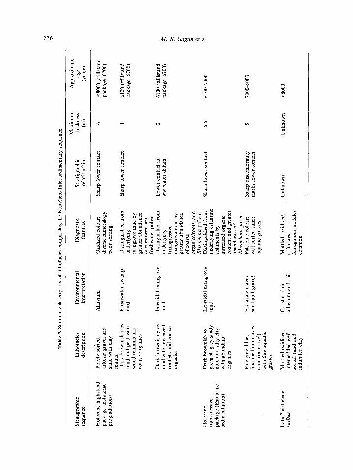
e 3.
Sum
mar
y de
scrip
tion
of li
thof
acie
s co
mpr
isin
g th
e M
utch
ero
Inle
t sed
imen
tary
seq
uenc
e.
Max
imum
A
ppro
xim
ate
Stra
tigra
phic
Li
thof
acie
s En
viro
nmen
tal
Dia
gnos
tic
Stra
tigra
phic
th
ickn
ess
age
sequ
ence
de
scrip
tion
inte
rpre
tatio
n fe
atur
es
rela
tions
hip
(4
(Y
r B
PI
Hol
ocen
e hi
ghst
and
pack
age
(Est
uari
ne
prog
rada
tion)
Hol
ocen
e tra
nsgr
essi
ve
pack
age
(Est
uari
ne
sedi
men
tatio
n)
Late
Ple
isto
cene
su
rfac
e
Poor
ly s
orte
d,
arko
sic
grav
el a
nd
sand
with
cla
y m
atri
x D
ark
brow
nish
gre
y m
ud a
nd p
eat
with
w
ood
rem
ains
and
co
arse
org
anic
s
Dar
k br
owni
sh g
rey
mud
with
pre
serv
ed
root
lets
and
coa
rse
orga
nics
Dar
k br
owni
sh t
o gr
eeni
sh g
rey
sand
y m
ud a
nd s
ilty
clay
w
ith a
bund
ant
orga
nics
Pale
gre
y-bl
ue,
fine-
med
ium
cla
yey
sand
(or
gra
vel)
with
fin
e aq
uatic
gr
asse
s
Mot
tled
oxid
ized
, in
terb
edde
d w
ell
sort
ed s
and
and
indu
rate
d cl
ay
Allu
vium
Fres
hwat
er s
wam
p m
ud
Inte
rtid
al m
angr
ove
mud
Inte
rtid
al m
angr
ove
mud
Estu
arin
e cl
ayey
sa
nd a
nd g
rave
l
Coa
stal
pla
in
allu
vium
and
soi
l
Oxi
dize
d co
lour
; di
vers
e m
iner
alog
y;
poor
sor
ting
Dis
tingu
ishe
d fr
om
unde
rlyin
g m
angr
ove
mud
by
grea
ter
abun
danc
e of
rai
nfor
est
and
fres
hwat
er p
olle
n D
istin
guis
hed
from
un
derly
ing
trans
gres
sive
m
angr
ove
mud
by
grea
ter
abun
danc
e of
coa
rse
orga
nics
hoot
s, a
nd
Rhizophora p
olle
n D
istin
guis
hed
from
un
derly
ing
estu
arin
e se
dim
ents
by
incr
ease
d or
gani
c co
nten
t an
d gr
eate
r ab
unda
nce
of
Rhi
zoph
ora
polle
n Pa
le b
lue
colo
ur;
wel
l sor
ted
sand
; aq
uatic
gra
sses
Mot
tled,
oxi
dize
d,
, st
iff c
lays
; fe
rrug
inou
s no
dule
s co
mm
on
Shar
p lo
wer
con
tact
6
40
00
(stil
lsta
nd
pack
age:
670
0)
Shar
p lo
wer
con
tact
1
6100
(stil
lsta
nd
pack
age:
670
0)
Low
er c
onta
ct a
t lo
w w
ater
dat
um
Shar
p lo
wer
con
tact
Shar
p di
scon
form
ity
mar
ks lo
wer
con
tact
Unk
now
n
2 5.5 5
6100
(stil
lsta
nd
pack
age:
670
0)
% h
610C
L700
0
7000
-800
0
Unk
now
n >8
000

Sea level control of stacked coastal sequences 337
embayments is distinctly different, primarily because of their different physiographic settings (Fig. 2). Wyvuri Embayment was originally broad and open to the shelf, and was successively closed by three packages of beach barrier-lagoon sedimentation. In contrast, Mutchero Inlet was a large estuary, pro- tected from the open coast by bedrock headlands, which rapidly filled in during the Holocene trans- gression and highstand.
Despite the different physiographic settings and sequence styles, similar depositional cycles occur in both embayments in response to late Quaternary sea level fluctuations including: (a) a last interglacial highstand package, (2) an early to mid-Holocene transgressive package punctuated by sedimentation marking a brief pause in sea level rise and (3) a mid- to late Holocene highstand package. The lithofacies forming the three sedimentary packages are defined by their geometry, lithology and, to a lesser degree, pollen assemblages (Tables 2 and 3). Stratigraphic relationships, textural trends and habitats of depo- sition based on pollen data are summarized in Figs. 3-7.
Last interglacial highstand package
Inner beach barrier
Drill hole JW4 in the 250m wide inner barrier (Wyvuri Embayment) intersected 10 m of oxidized, generally well sorted, fine-medium, clayey quartz sand with a well developed soil profile (Fig. 3). The basal 5 m is coarser and more poorly sorted than the upper 5 m and is interpreted to mark beach barrier followed by aeolian deposition. Stiff, oxidized, inter- bedded sand and clay which sharply underlie the sand are diagnostic of Pleistocene alluvium in this area. Brownish grey mud interbedded with oxidized, poorly sorted arkosic gravel and sand lie landward (JW6) of the inner barrier. The high clay content (70%) and 6I3C value of organic carbon ( - 24%0) in the mud indicate a freshwater swamp with terrestrial aquatic vegetation.
No Pleistocene marine sediments occur in Mutchero Inlet, even in deeper drill holes such as JR3 (Fig. 4). The basal stiff, oxidized, interbedded sands and clays are interpreted as alluvium. The upper contact of the alluvium is invariably sharp and overlain by pliable, water-laden, grey-green or brown sediments having basal radiocarbon ages 0f<8000 yr BP.
Age of the highstand package
The inner beach barrier sand has not been directly dated, but its location landward and separated from the outer barrier (Fig. 2) suggests it is correlative to other inner barriers deposited during the last inter- glacial sea level highstand about 125 000 yr BP
(Murray-Wallace & Belperio, 1991). In addition, weathering is much more extensive in the inner barrier compared to the outer barrier. The oxidized yellow-orange colour of the inner barrier sand sug- gests that weathering has proceeded since the Late Pleistocene (Pye, 1981) in a similar fashion to the weathering that has affected other inner barriers identified in north Queensland (Hopley, 1970; Hopley & Murtha, 1975; Jones, 1985). Moreover, the inner barrier contains up to 15% clay whereas the outer barrier contains no clay (see Fig. 7a). Because the sand of the inner barrier is nearly 100Y0 quartz, while feldspar and mafic minerals remain in the outer barrier, the clay may be diagenetic resulting from long term in situ weathering of other 'components that are unstable in humid envii-onments.
A single radiocarbon date from the clayey mud lying landward of the inner barrier yielded an age of 13 000 yr BP. This mud is thus a younger freshwater deposit, not a lagoonal mud associated with the inner beach barrier.
Holocene transgressive package
Wyvuri Embayment
Reworked beach barrier. The late Pleistocene discon- formity in Wyvuri Embayment is sharply overlain by a muddy sand sheet distinguished by moderately to well sorted sand and medium sand sized ferruginous nodules. The variety of mean grain sizes and sorting coefficients (Fig. 6), and nodules, probably reflect the constituents of different substrates that were weath- ered before being reworked during the post-glacial marine transgression. The muddy sand sheet is most likely the end-product of poorly preserved beach barrier sand mixed with lagoonal mud as the shore- line moved landward.
Lagoon sedimentation. The transgressive muddy sand sheet overlies organic-rich mud with Rhizophora pollen making up 85% of the total pollen count (Fig. 5). The organic-rich mud represents inter- tidal mangrove sedimentation established in a protolagoon being overstepped by the reworked beach barrier sand.

338 M. K. Gagan et al.
A WYVURI EMBAYMENT
-1 Holocene Outer Barrier-Lagoon ___ Last Interglacial 1- Inner Barrier -1.- SSW NNE ] WSW ENE
U I L -14 ' . . . . .
Freshwater swamp peat
Intertidal mangrove mud
g 2 g) Back-barrier aeolian sand
_ox 8 3 3 0 Back-barrier washover sand
Beach barrier sand 2 5?g Upper shoreface muddy sand
Lower shoreface sandy mud
al > g z al g % F Intertidal mangrove mud 0 CnV
L.3
Muddy sand sheet 8 ig I-
- .gz al - ;: u)Y 8 Aeolian sand cap
al cnm Beach barrier sand Y L - 0
= a lug0 2 . E =
h
o : g z Coastal plain alluvium and soil o m
kilometre
1 2 3
*4 *5 '6 7
*8 9
*10 *11 *l2
Radiocarbon Dates (yr BP) 13200 (WK 1053) 6270 (WK 1054) 5950 (WK807) 5490 (WK806) 6300 (WK799) 6840 (WK800) 71 60 (WK 1055) 7760 (WK802) 5050 (WK 1056) 3100 (WK803) 4890 (WK804) 7010 (WK805)
Sea level control of stacked coastal sequences 339
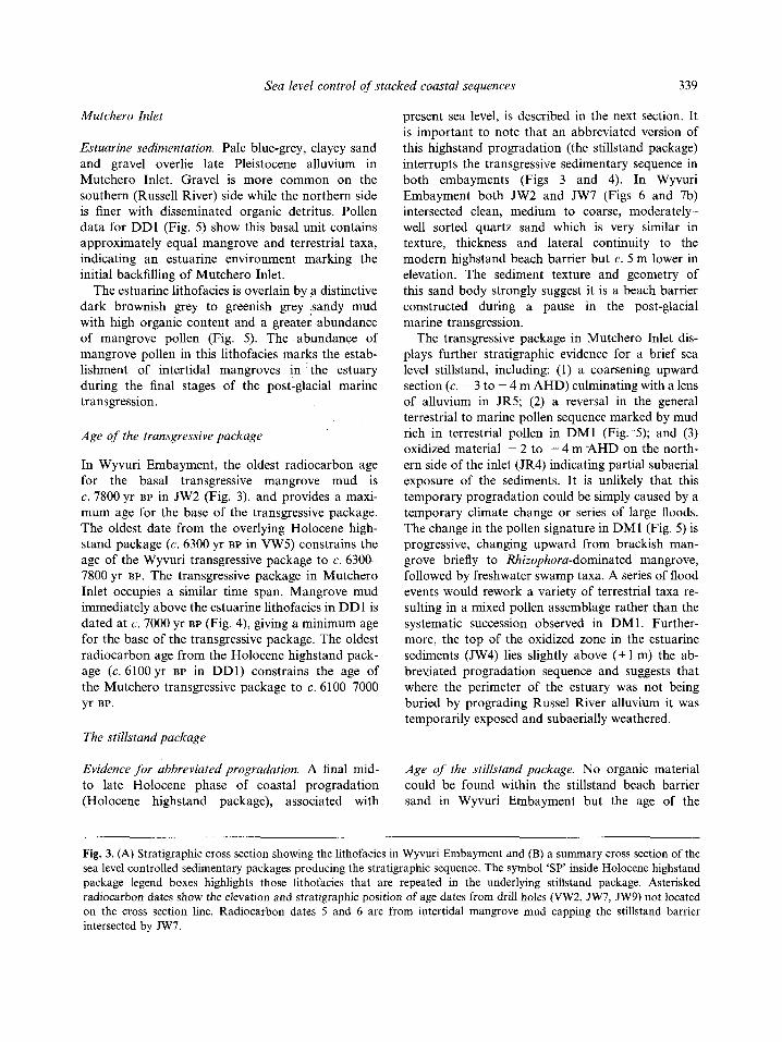
Mutchero Inlet
Estuarine sedimentation Pale blue-grey, clayey sand and gravel overlie late Pleistocene alluvium in Mutchero Inlet. Gravel is more common on the southern (Russell River) side while the northern side is finer with disseminated organic detritus. Pollen data for DD1 (Fig. 5) show this basal unit contains approximately equal mangrove and terrestrial taxa, indicating an estuarine environment marking the initial backfilling of Mutchero Inlet.
The estuarine lithofacies is overlain by a distinctive dark brownish grey to greenish grey sandy mud with high organic content and a greater abundance of mangrove pollen (Fig. 5). The abundance of mangrove pollen in this lithofacies marks the estab- lishment of intertidal mangroves in the estuary during the final stages of the post-glacial marine transgression.
Age of the transgressive package
In Wyvuri Embayment, the oldest radiocarbon age for the basal transgressive mangrove mud is c. 7800 yr BP in JW2 (Fig. 3). and provides a maxi- mum age for the base of the transgressive package. The oldest date from the overlying Holocene high- stand package (c. 6300 yr BP in VW5) constrains the age of the Wyvuri transgressive package to c. 6300- 7800 yr BP. The transgressive package in Mutchero Inlet occupies a similar time span. Mangrove mud immediately above the estuarine lithofacies in DD1 is dated at c. 7000 yr BP (Fig. 4), giving a minimum age for the base of the transgressive package. The oldest radiocarbon age from the Holocene highstand pack- age (c. 6100 yr BP in DD1) constrains the age of the Mutchero transgressive package to c. 6100-7000 yr BP.
The stillstand package
Evidence for abbreviated progradation. A final mid- to late Holocene phase of coastal progradation (Holocene highstand package), associated with
present sea level, is described in the next section. It is important to note that an abbreviated version of this highstand progradation (the stillstand package) interrupts the transgressive sedimentary sequence in both embayments (Figs 3 and 4). In Wyvuri Embayment both JW2 and JW7 (Figs 6 and 7b) intersected clean, medium to coarse, moderately- well sorted quartz sand which is very similar in texture, thickness and lateral continuity to the modern highstand beach barrier but c. 5 m lower in elevation. The sediment texture and geometry of this sand body strongly suggest it is a beach barrier constructed during a pause in the post-glacial marine transgression.
The transgressive package in Mutchero Inlet dis- plays further stratigraphic evidence for a brief sea level stillstand, including: (1) a coarsening upward section (c. - 3 to - 4 m AHD) culminating with a lens of alluvium in JR5; (2) a reversal in the general terrestrial to marine pollen sequence marked by mud rich in terrestrial pollen in DM1 (Fig. 5); and (3) oxidized material - 2 to - 4 m -AHD on the north- ern side of the inlet (JR4) indicating partial subaerial exposure of the sediments. It is unlikely that this temporary progradation could be simply caused by a temporary climate change or series of large floods. The change in the pollen signature in DMl (Fig. 5) is progressive, changing upward from brackish man- grove briefly to Rhizophora-dominated mangrove, followed by freshwater swamp taxa. A series of flood events would rework a variety of terrestrial taxa re- sulting in a mixed pollen assemblage rather than the systematic succession observed in DMl . Further- more, the top of the oxidized zone in the estuarine sediments (JW4) lies slightly above (+ 1 m) the ab- breyiated progradation sequence and suggests that where the perimeter of the estuary was not being buried by prograding Russel River alluvium it was temporarily exposed and subaerially weathered.
Age of the stillstnnd package. No organic material could be found within the stillstand beach barrier sand in Wyvuri Embayment but the age of the
Fig. 3. (A) Stratigraphic cross section showing the lithofacies in Wyvuri Embayment and (B) a summary cross section of the sea level controlled sedimentary packages producing the stratigraphic sequence. The symbol ‘SP’ inside Holocene highstand package legend boxes highlights those lithofacies that are repeated in the underlying stillstand package. Asterisked radiocarbon dates show the elevation and stratigraphic position of age dates from drill holes (VW2, JW7, JW9) not located on the cross section line. Radiocarbon dates 5 and 6 are from intertidal mangrove mud capping the stillstand barrier intersected by JW7.

340 M. K. Gugun et a1
A MUTCHERO INLET
I Mutchero 14 Mulgrave River I------ Russell River --
-14 i -16 L
I-
0 L
1 2 I I I I
kilometres
Alluvium
Freshwater swamp mud
Intertidal mangrove mud
Intertidal mangrove mud
Estuarine clayey sand and
Coastal plain alluvium and
,-River Channel Incision
I Late Pleistocene Surface 1
Radiocarbon gravel Dates (yr BP)
1 6100 (WK 1030) 2 6600 (WK1028) 3 7050 (WK 1029) 4 2640 (WK 1369) 5 7140 (WK1370) 6 6700 (WK1371)
soil
Fig. 4. (A) Stratigraphic cross section showing the lithofacies in Mutchero Inlet and (B) a summary cross section of the sea level controlled sedimentary packages producing the stratigraphic sequence. The symbol 'SP' inside Holocene highstand package legend boxes highlights those lithofacies that are repeated in the underlying stillstand package.
barrier is well constrained by datable material directly above and below it. The base of the beach barrier can be no older than the c. 7100 yr BP date from the top of the mangrove mud directly below it in JW2. In W 7 , the base of the mangrove mud draped over the top of the barrier provides a minimum age of c. 6800 yr BP. The brief period of progradation in Mutchero Inlet is very similar in age to the stillstand beach barrier. Radiocarbon ages of c. 6700 yr BP at - 3.5 m AHD in both DD1
and DMl imply the stillstand began at this time since the dates are found at the same elevation in both drill holes and lie within the base of the abbreviated progradation in DMl. The age date of c. 7100 yr BP above the abbreviated progradation package is older than sequential dates around it and indicates reworked organic matter. It is likely that the organic material was not derived from far away, however, since pollen spectra indicate a lowland origin.

Sea level control of stacked coastal sequences 341
2 -
1 -
i D -
-1 -
-2 -
-3 -
AHD
-1
-2 - rn F - E" -3 Y
c 0 ._ c 9 -4 a
-5
-6
-7
Pollen Counts Freshwater: Marine ("G Influence
0 100 High Low
- 5950 yr BP
F Pollen Classes Rhuophora BruguieralCeriops $ Other mangroves b E C t i i l l 2 Other wetland 3 2 8 Terrestrial taxa m u %
P r n u r n s c
Holocene highstand package
Wyvuri Embayment
Beach barrier and shoreface progradation The outer beach barrier of Wyvuri Embayment is 675 m across with eight beach ridges averaging 85 m in width. In the subsurface this lithofacies is easily distinguished by its coarse grain size and coarsening downward trend, having up to 15% gravel near the base (Figs 3 and 7). The basal contact of the beach barrier is very sharp and overlies thinly bedded and laminated, micaceous muddy sand which fines downward to dark grey, sandy mud. The muddy sand forms the upper shoreface where frequent changes in wave energy create alternating fine and coarse grained beds. The underlying sandy mud contains whole Anadara shells and shell hash, especially toward the base, and is interpreted as a lower shoreface deposit.
The three beach barrier packages in Wyvuri Em- bayment have progressively different grain size distri- butions which may be primarily source related. Figure 6 shows mean grain size is finest in the inter- glacial highstand barrier and becomes progressively coarser in the Holocene transgressive and outer barrier. The interglacial highstand barrier is in a relatively protected part of the embayment but even low energy beaches along the north-east Australian coast, such as those observed in the lee of offshore islands, are composed of coarse sediments if they are available. The finer mean grain size of the interglacial barrier is therefore likely to be due to a finer sediment source, perhaps an offshore source such as that pro- posed for the genesis of south-east Australian barriers (Chapman et al., 1982). The Holocene transgressive barrier is slightly finer grained than the ensuing outer barrier and may reflect a mixing of both shelf and coarser river sediment sources (Pringle, 1991). The grain size and mineralogy of the outer barrier reflects that of modern river sand (Bird, 1971).
Lagoon injilling. Landward of the outer beach bar- rier is a parallel, back-barrier sand body which is fine grained and well sorted (Figs 6 and 7). The basal
Fig. 5. Summary of pollen counts, habitats of deposition and radiocarbon ages in vibracore VW4 (Wyvuri Embay- ment) and D-section cores DM1 and DDl (Mutchero Inlet). The freshwater to marine influence in the habitats of deposition is estimated using the percentage of Rhizophora mangroves in the total pollen count.

342 M. K. Gagan et al.
3.5 a,
ii > -3.0
a 2.5
i? g 0.5 0
-0.0
la A
0.2 0.3 0.4 0.5 0.6 0.7 0.8 0.9 1.0 1.1 1.2 1 IV Well1 Well I M Well I Moderate I Poor
Sorting
Hol. highstand barrier 0 Back - barrier A Upper shoreface sand sheet + Lower shoreface
Hol. stillstand barrier
0 Transgressive muddy
0 Last interglacial barrier
Fig. 6. Comparison of the grain size attributes in the sandy lithofacies of Wyvuri Embayment. Mean grain size versus sorting differentiates the various depositional environments for each lithofacies with the exception of that for the transgressive muddy sand sheet which contains grains from the underlying late Pleistocene alluvium.
medium sand in the back-barrier is interpreted to be washover sand deposited while the barrier was still narrow, before successive beach ridges were formed during subsequent progradation. The upper portion of the back-barrier sand, however, is finer grained and very well sorted, which suggests it was not deposited by wave action, but may be aeolian. Wind deflation and westward transport of fine sand from the western part of the prograded barrier explains the coarser grain size and improved sorting there (Fig. 7a, JW3 vs. JW5), and the finer, very well sorted sand forming the upper part of the back-barrier. The aeolian lithofacies can be traced further landward where it forms a distinctive, remarkably continuous, 20 cm thick fine sand layer across the entire lagoon.
The bulk of the lagoon infill comprises dark brownish grey, organic mud. The predominance of
Rhizophora pollen (85% of total taxa; Fig. 5) and the proximity of the lagoonal mud to AHD shows it is intertidal mangrove mud deposited at or near present sea level. The transition from transgressive mangrove mud upward into highstand mangrove mud is indis- tinct but is positioned at Australian Low Water Datum to match that documented in modern man- grove swamps (Thom et al., 1975; Grindrod & Rhodes, 1984; Grindrod, 1985). The lagoon infill is capped by 2 m of dark brown freshwater peat distin- guished by wood remains, rootlets, decaying vascular plants, and pollen counts dominated by freshwater swamp and terrestrial pollen (Fig. 5). The peat marks an abrupt change from intertidal marine to fresh- water swamp sedimentation.
Mutchero Inlet
Estuarine progradatcon. The Holocene highstand package in Mutchero Inlet contains no beach' de- posits but is very similar to the lagoonal sequence in Wyvuri Embayment. The basal lithofacies is a dark brownish grey, organic mangrove mud which has lower Rhizophora pollen counts than its Wyvuri equivalent (50-70% vs. 85%). The change from inter- tidal marine to freshwater swamp conditions is marked by a sharp increase in rainforest and fresh- water pollen (Fig. 5 ) . The top unit is yellow-red, poorly sorted arkosic gravel and sand with a clay matrix interpreted to be colluvium interbedded with river channel and overbank deposits. The alluvium thickens southwards and becomes coarser grained. A channel deposit may have been intersected in auger drill hole JR2. near the modern inlet.
Age of the highstand package
The beach barrier in Wyvuri Embayment contains no datable shell material even though shells are common on the modern beach. It is likely that the barrier is continually flushed by heavy rains containing car- bonic acid which dissolves any aragonitic shells. Age dates from lithofacies associated with the barrier, however, can be used to constrain its age and general style of evolution. The oldest date from the highstand mangrove mud, landward of the barrier (Fig. 3), is c. 6300 yr BP, suggesting the barrier was in place and providing protection for the lagoon by that time. The youngest date from the highstand package (c. 3100 yr BP) is situated in the middle of the lower shoreface

Sea level control of stacked coastal sequences 343
sediment. Hence, progradation of the barrier prob- ably began c. 6300 yr BP. and continued to more recently than c. 3100 yr BP. The c. 5500 yr BP age of the aeolian back-barrier sand in VW2 (Fig. 2) sug- gests the beach barrier was large enough at that time to provide sand for landward transport to the back- barrier and across the lagoon surface. The change from aeolian to freshwater swamp sedimentation in the lagoon could not be dated.
The age of the highstand package in Mutchero Inlet coincides with that in Wyvuri Embayment. The oldest radiocarbon age for the highstand mangrove mud (c. 6100yr BP), associated with the present sea level, is from core DD1 located about 2 km north of the modern inlet. Freshwater swamp mud from DMl, immediately adjacent to the modern inlet, gives an age of c. 2600yr BP. The ages suggest that intertidal sedimentation began at least by 6100 yr BP at DD1 and prograded 2 km seaward to DMl some- time before 2600 yr BP.
RELATIVE SEA LEVEL HISTORY
Coastal sequences may yield accurate sea level his- tories provided their depositional environments are sensitive to sea level fluctuations. For example, high (or variable) wave energy sequences, and those in macrotidal settings, should be avoided because the elevational resolution of their lithofacies may be too coarse. Furthermore, reconstructing a sea level history can be confounded if the identification of indicator lithofacies is ambiguous or their elevations are poorly determined relative to mean sea level.
Wyvuri Embayment and Mutchero Inlet are well suited for reconstructing a relative sea level history because of their mesotidal, low-moderate wave energy hydraulic regime. The resulting sedimentary sequence contains two sensitive indictors of sea level: (1) the sharp intertidal mangrove mud to freshwater swamp transition clearly identified by pollen analysis and ( 2 ) the clean sand of the beach barriers which sharply overlies the muddy upper shoreface.
Sea level indicators
The transition from Rhizophora-dominated intertidal mud to freshwater swamp is a valuable sea level indicator and occurs at an elevation of +1.0 to + 1 5 m AHD along the mesotidal coasts of north- east Australia (Rhodes, 1982; Belperio, 1983; Chappel & Grindrod, 1984; Grindrod & Rhodes,
1984). The top of he Rhizophora-dominated mud in Wyvuri Embayment (+1.1 m, AHD) has a similar elevation (Figs 3 and 5) . It is important to note, however, that the top of the mangrove mud in Mutchero Inlet becomes progressively lower away from the coast, falling from +0.7 m AHD at DM1 to - 0.2 m AHD at DD1 located further upstream. The decreased elevation is probably related to the high mean annual rainfall of the study area (2500mm yr-') which results in lower salinities towards the head of the estuary. Progressive depres- sion of the upper position of mangrove growth in an upstream direction would be expected in a highly stratified, brackish estuary. Further evidence for the influence of freshwater on Rhizophora growth is provided by a systematic variation in the percentage of Rhizophora pollen versus other mangrove taxa (Fig. 5) . Grindrod & Rhodes (1984) have shown that in the open estuarine conditions of Missionary Bay, sediment accumulating within or immediately adjacent to Rhizophora colonies contains 80-95% Rhizophora pollen. The Rlzizopkora counts for man- grove mud in the Wyvuri lagoon (8.59'0 in VW4) fall exactly into this range. The Rhizophora pollen percentages in Mutchero Inlet, however, decrease in parallel with the depressed mangrove mud heights, from 70% in DMl (+0.7m AHD) to 40% in DDl ( - 0.2 m AHD).
Despite the freshwater-controlled height differ- ences, the transition from intertidal mangrove mud to freshwater swamp is still well constrained and sensi- tive to slight fluctuations in sea level. In lagoons experiencing limited freshwater input, such as that in Wyvuri Embayment, the mangrove mud to fresh- water swamp contact will be about 1 m above mean sea level. In high runoff estuaries, such as ,Mutchero Inlet, this contact will be lower and close to mean sea level away from the coast.
The distinct basal contact of the Holocene high- stand barrier is also strictly related to mean sea level and generally occurs at an elevation of 0 to +0.5 m AHD along more protected coasts in north-east Australia (Rhodes, 1982; Belperio, 1983; Grindrod & Rhodes, 1984). The beach barrier to shoreface con- tact in the protected southern end of Wyvuri Embay- ment (JW9) has a similar elevation of +0.4 m AHD (Fig. 7c) but becomes progressively lower toward the north ( - 0.8 m AHD in JW8). In addition, barrier height also increases northward by about 1 m from +4.5 m AHD (JW9) to +5.5 m AHD (JW8). This south to north increase in thickness (35y0) of the modern beach barrier reflects the northward increase

344 M. K. Gagan et al.
JW4 (t6.6m AHD) 0 25 50 75 100%
JW2 (+4.7m AHD) 0 25 50 75 100%
JW3 (+5.8m AHD) 0 25 50 75 100%
JW5 (+3.8m AHD) 0 25 50 75 100%
Interglacial Highstand
Barrier 14
15
16
Holocene Stillstand
Barrier
Holocene Highstand Barrier
Holocene Highstand
Barrier
JW2 (+4.?m AHD) B 0 25 50 75 100%
Central 0
15
16
JW7 (+4.7m AHD) 0 25 50 75 100%
Northern
JW9 (+4.6m AHD) C 0 25 50 75 100%
JW5 (+3.8m AHD) '
0 25 50 75 100%
Depositional Environments
Aeolian sand Washover sand Beach barrier sand Upper shoreface muddy sand Lower shoreface sandy mud Muddy sand sheet Intertidal mangrove mud
Grain Size
Gravel Sand Silt Clay
JWB (+5.5m AHD) 0 25 50 75 100%
Central
15] Southern 16
Northern

Sea level control of stacked coastal sequences 345
in mean wave energy along the shoreface. The north- ern section of the shoreline is more exposed to south-easterly, wind-driven, short period seas which tend to break near shore, especially at high tide. Higher wave surge heights build the beach higher in the north while the increase in mean wave energy allows coarse sand to be transported to deeper water where the finer, upper shoreface sediment is normally deposited. Meanwhile, because the southern end of the embayment is protected, the top of the beach is lower there and coarse sand is restricted to a narrow wave swash zone slightly above AHD.
The basal contact of the Holocene highstand bar- rier is well constrained throughout the mid-section of Wyvuri Embayment despite the difference in elev- ation (c. +O.S m) at the southern and northern extremities. The weighted mean height of the barrier is - 0.3 m AHD which accounts for the approximate length of beach represented by each drill hole (JWS, 8, 9). This height is a good estimate for the elevation of the mid-section of the shoreface to barrier contact is used to estimate the elevations of sea levels forming the ancient beach barriers.
The last interglacial highstand
Published evidence shows the relative height of the last interglacial shoreline around Australia to vary by more than 30 m and indicates that north-east Australia has subsided relative to other parts of the continent (Murray-Wallace & Belperio, 1991). For example, the last interglacial shoreline in south-east Australia is reported at + S m AHD, based on the heights of rare intertidal estuarine muds and the general elevation of beach ridges. Further north on the central-east coast, fossil coral elevations imply a lower shoreline height of + 1 to +3 m AHD (Pickett et al., 1989). Although some studies in north-east Australia have identified last interglacial marine sands (Hopley, 1970; Hopley & Murtha, 1975; Jones, 1985; Jones & Stephens, 1986), the related sea levels have not been determined but appear to lie consis- tently below present sea level. Drilling has shown that
late Pleistocene limestones beneath the modern Great Barrier Reef occur at - 3 to - 20 m AHD and never above present sea level (Hopley, 1982), prob- ably due to both shelf subsidence and subaerial weathering.
The base of the last interglacial highstand barrier in Wyvuri Embayment also lies below present sea level, at - 3.6 m (JW4) and - 3.4 m AGD (JW6). Assuming the base of the interglacial barrier extended to 0.3m below mean sea level, like the modern barrier ( - 0.3 m AHD), the corresponding interglacial shoreline now lies at approximately 3.2 m below AHD. The true position of the shoreline, however, may be even lower because the contact between the barrier sand and underlying shoreface was not intersected in the drill holes.
The regional variation in the elevation of the preserved shoreline is due primarily to differential hydroisostatic adjustment of the continental margin (Lambeck & Nakada, 1990; Murray-Wallace & Belperio, 1991). The best estimate for the true elev- ation of the last interglacial shoreline in Australia comes from the west coast of the Eyre Peninsula, South Australia, where a height of +2 m AHD exists along SO0 km of coastline. It is likely, therefore, that the coastal plain in the general area of Wyvuri Embayment has subsided by about 5 m since the time of the last interglacial sea level highstand (c 12.5 000 yr BP).
The mid-Holocene - 5 m stillstand
The exact nature of the post-glacial marine trans- gression is actively debated because it is difficult to identify unequivocally and to date submergent shore- lines. Transgressive sand sheets on shelves have been cited as evidence for a continuous transgression (Swift et al., 1972; Field & Duane, 1976) while the positions of submerged shoreline features have been used to infer episodicity in sea level rise (Sanders & Kumar, 1975; Carter et al., 1986). Although sub- merged shoreline features have been documented on the central Great Barrier Reef shelf (Carter &
Fig. 7. Comparison of the lateral and vertical distribution of gravel, sand, silt and clay in Wyvuri Embayment depositional environments. (A) Shore-normal changes in grain size from the last interglacial highstand barrier (JW4) seaward to the front of the Holocene highstand progradational barrier (JW5). (B) The thickness, bulk grain size and northward shore-parallel coarsening of the Holocene stillstand barrier which are similar to the younger highstand barrier. (C) The northward shore-parallel thickening and coarsening of the modern beach and upper shoreface which reflects the greater exposure of the northern end of the embayment to the mean wave climate. The JW5 drill hole elevation (+3.8 m AHD) is lower than that for JW8 and JW9 because it was sited atop a recently formed, incipient beach ridge.
346 M. K Gagan et al.
Johnson, 1986), the exact age and origin of these features are not known and hence their relationship with the post-glacial marine transgression is still not clear (Harris & Davies, 1989).
This study presents the first evidence for a - 5 m stillstand during the post-glacial marine transgression in north-east Australia. Two lines of evidence sup- port this view: first, the beach barrier beneath the Holocene highstand package in Wyvuri Embayment suggests sea level stabilized and a temporary shore- line was constructed; second, the abbreviated period of progradation interrupts the transgressive sequence at a similar elevation in Mutchero Inlet. The elev- ation of the sea level stillstand is well constrained in both Wyvuri Embayment and Mutchero Inlet. The sharp basal contact of the stillstand beach barrier with the underlying intertidal mangrove mud is inter- preted as the base of the beach barrier (Fig. 3). In JW2 the base of the beach barrier is at - 4.6 m AHD while in JW7 it is lower at - 6.1 m AHD (Fig. 7b). Assuming the beach extends to - 0.3 m AHD as for the modern beach, the associate stillstand elevation lies between -4.3 m and - 5.8 m AHD, with a mean value of c. - 5 m AHD. A similar shoreline elevation is reflected by the elevation of the Rhizophoralfreshwater swamp contact ( - 3.3 m AHD, DMI) in the stillstand package buried in Mutchero Inlet. Based on the modern Rhizophoral freshwater swamp contact being at +0.7 m AHD in DMl (Fig. 5), the elevation of the associated still- stand corresponds to c. - 4 m AHD. The 1 m differ- ence between the two calculated elevations could be narrowed if the elevation at which mangroves grew during the transgression in Mutchero Inlet was not depressed by 1 m, as it appears to be in the modern inlet. Nevertheless, the elevations from both Wyvuri Embayment and Mutchero Inlet are surprisingly similar and a mean elevation toward c. - 5 m AHD is estimated for the stillstand.
The age of the stillstand is also well constrained. Radiocarbon dates (6800-7100 yr BP) from immedi- ately below and above the stillstand beach barrier match the age from the base of the stillstand package (6700yr BP) in Mutchero Inlet. The difference between the mean age for the beach barrier (6950 yr BP) and the 6700 yr BP date in Mutchero Inlet is not statistically significant, and therefore the approxi- mate mean age for the stillstand is estimated to be c. 6800 yr BP.
The extent of the - 5 m stillstand is difficult to determine because it could have easily gone undetec- ted in other coastal sequences. For example, the el-
evation and age of the - 5 m stillstand fits well within the post-glacial sea level envelope for east Australia which has been summarized by Thom & Roy (1985) and refined using the elevations and ages of transgres- sive mangrove mud (Grindrod & Rhodes, 1985; Clark & Guppy, 1988; Crowley et al., 1990). That the stillstand falls within the bounds of the published envelope is not surprising, however, since the envelope boundaries are not well constrained. The elevation of the stillstand could vary by 10 m (from - 9 m to + I m AHD) and range in age from 8000 to 6500yr BP and still be within the agedepth uncer- tainty of the present east Australia sea level envelope.
It is important to note that the initiation of the northern Australian ‘Big Swamp’ period of man- grove sedimentation (Woodroffe et a!., 1985, 1989) corresponds well with the timing and elevation of the - 5 m stillstand. Mangroves proliferated during the ‘Big Swamp’ period which began c. 6800 yr BP at - 2 to - 5 m AHD as the rate of sea level rise began to slow. This period of sedimentation may have been triggered by the - 5 m stillstand which would have allowed estuarine sediments to fill partially coastal basins and provide shallow sites for colonization by mangroves which dominated once the transgression resumed. Future sea level studies may show that the - 5 m stillstand is a general feature that is detectable in coastal sequences throughout northern Australia.
Recent age-depth data from submerged coral reefs in the Caribbean (Fairbanks, 1989) and at Huon Peninsula, Papua New Guinea (Chappell & Polach, 1991) provide the most detailed records of glacio- eustatic sea level change during the post-glacial marine transgression. Both studies show that the rate of sea level rise was not constant. In the Caribbean, rapid sea level rise coincides with northern hemi- sphere glacial meltwater peaks centred on 12 000 yr BP and 9500yr BP. The Huon Peninsula data also show sea level rising rapidly from 9000 to 10 000 yr BP, during the time of the Younger Dryas. However, neither record is capable of discerning century scale pauses in sea level rise, particularly toward the end of the transgression (<8000 yr BP) when the rate of rise slowed significantly.
Sedimentary sequences in deep coastal enibay- ments may provide the best prospect for developing continuous, high resolution sea level histories for the later stages of the post-glacial marine transgression. Intertidal sediment accumulation in protected settings commonly mimics the rate of sea level rise. Such is the case in the Mutchero Inlet and the Wyvuri Embayment lagoon where mean vertical
Sea level control of stacked coastal sequences 347
sedimentation rates for the transgressive mangrove muds coincide at 5.4 and 5.1 mm yr - ', respectively. The predicted rate of sea level rise from 8000 to 6500 yr BP in north-east Australia is 4.5 mm yr ~ I ,
nearly matching the mangrove mud sedimentation rate. Similar sea level control of intertidal sediment accumulation has been confirmed in a study of 22 lagoons along the Gulf of Mexico and Atlantic coasts (Nichols, 1989). Sea level has continued to rise rela- tive to the eastern US during the Holocene and long term vertical accumulation rates closely paralleled the sea level rise in 71% of the lagoons.
Of additional importance is that some of the organic matter preserved in protected intertidal to supratidal deposits is generally produced and buried in situ thus greatly improving its value for radiocar- bon dating. Perhaps the weakest links in previous sea level studies are chronologies based upon bulk radio- carbon analysis of organic material having a variety of ages. Accelerator mass spectrometric radiocarbon dating now makes it possible to date selectively even small quantities of organic matter preserved in situ and should produce tightly constrained chronologies in the future. If the elevations of the sea level indicators are also well constrained the age-depth curve should be sensitive to subtle sea level move- ments. Recent studies of transgressive facies relation- ships in such settings are beginning to reveal century scale fluctuations in Holocene sea level. Recorded in the Wolfe Glade tidal wetlands, for example, are five short term episodes of rapid sea level rise resulting from surges and relaxations in the Atlantic Gulf Stream during the Holocene (Fletcher et al., 1993).
The mid- to late Holocene highstand Our estimate for the end of the post-glacial marine transgression is 6300-6100 yr BP, which agrees well with previous estimates of 6500-6000 yr BP (Chappell et al., 1983; Grindrod & Rhodes, 1984; Thom & Roy, 1985). Whether sea level stabilized at this time, or rose slightly higher before falling to its present pos- ition is uncertain. Convincing evidence for sea level being 1 m higher about 6000 yr BP is provided by Chappell et al. (1983) where fringing reefs from 11 offshore Great Barrier Reef islands were carefully surveyed and radiocarbon dated to show how sea level fell from + 1 m AHD to its present position. In contrast, sea level studies involving Holocene marine sediments in northern Australia have not discerned the + 1 m shoreline (Belperio, 1979b, 1983; Grindrod & Rhodes, 1984; Chappell & Grindrod, 1984; Jones, 1985; Woodroffe et al., 1989). The only exception is
in the southern Gulf of Carpentaria where the basal elevations of cheniers were used to show about 2.2 m of sea level fall over the last 6000 years (Rhodes, 1982).
Differences in the magnitude of sea level fall are to be expected throughout northern Australia due to different degrees of hydroisostatic adjustment of the continental margin to post-glacial sea level rise. The hydroisostatic model of Chappell et al. (1982) suggests that the Innisfail-Cairns coastal plain should have experienced a sea level fall of about 1.2 m during the last 6000 years. There is no evidence for a higher sea level in Mutchero Inlet, but this may not be a good site from which to judge the matter because post-depositional compaction may depress muddy sequences, as suggested by Chappell & Grindrod (1984). There is, however, tentative sup- port for a +1 m sea level in Wyvuri Embayment where the base of the beach barrier on the landward side of the prograded barrier sequence (intersected in JW3) is about 0.9 m higher (+0.6 m AHD) than the mean height for the modem beach barrier ( - 0.3 m AHD). The good match of this height with the predicted height may be coincidental, however, and more drill holes are needed to prove the point.
STRATIGRAPHIC RECORD OF AN EMBAYED TROPICAL COAST
The embayed nature of the Innisfail-Cairns coastline and sea level control of marine sedimentation both influence the stratigraphic style of the preserved coastal sequences. The influence of coastal physio- graphy is manifested in two contrasting styles of sedimentary sequence: (1) an exposed, moderate energy, beach barrier-lagoon system and (2) a pro- tected, low energy, muddy inlet fill sequence. How- ever, the same depositional cycles occur in both embayments and are strictly controlled by late Quaternary sea level fluctuations. Figure 8 illustrates four key depositional stages common to the late Quaternary coastal evolution of both embayments: 1 an inner beach barrier (Wyvuri Embayment) and
an open estuary (Mutchero Inlet) during the last interglacial sea level highstand (I25 000 yr BP);
2 partial preservation of a beach barrier-lagoon sequence (Wyvuri Embayment) and an abbrevi- ated period of estuarine progradation (Mutchero Inlet) associated with a - 5 m mid-Holocene sea level stillstand (6950-6700 yr BP);
3 initiation of the progradational beach barrier and lagoon (Wyvuri Embayment) and extensive

348 M. K. Gagan et a1
Ap 125000yr BP
0 2 2 kilometres
+2m Highstand
jouthwest Northeaz
+2m Highstand
iorth souti
6950yr BP c Establishment
beach barrier
-5m Stillstand
-5m Stillstand
6300yr BP
+1 m Highstand
+1 m Highstand i
To Present
I To Present
Fig. 8. Summary maps and cross sections showing four successive stages in the late Quaternary coastal evolution of (A) Wyvuri Embayment and (B) Mutchcro Inlet.

Sea level control of stacked coastal sequences 349
4
estuarine mangroves (Mutchero Inlet) at the mid- Holocene sea level highstand (6300-6100 yr BP);
and mid- to late Holocene coastal progradation in both embayments as sea level stabilized near its present position. Aeolian activity marked the early period of beach barrier progradation in Wy- vuri Embayment resulting in the burial of the lagoonal mangrove mud which was followed by contraction of mangroves to the northernmost corner of the lagoon. Progradation of alluvium and freshwater swamp lithologies over the estu- arine mangrove mud in Mutchero Inlet was fol- lowed by downcutting of the Russell/Mulgrave River channels.
Partially preserved beach barrier-lagoon and inlet fill sequences will be closely juxtaposed in ancient bedrock-embayed coastal settings and their relative positions should be useful for reconstructing palaeoshorelines. The barrier-lagoon systems will be the most important, volumetrically, and contain additional information related to the nearshore palaeohydraulic regime. For example, the bedrock- embayed, barrier-lagoon sequences of south-east Australia are sand dominated and up to 50 m thick because of the high wave energy hydraulic regime (Roy et al., 1980; Thom et al., 1981; Chapman et al., 1982; Thom, 1983; Melville, 1984). The Wyvuri barrier-lagoon sequence is much thinner (c. 15 m) due to the low-moderate wave energy setting and is also muddier because of the abundance of wet- tropical, chemical weathering products.
Given similar coastal hydraulic regimes, the most notable difference between the Wyvuri beach barriers and those from non-embayed coasts is the lack of tidal inlet sedimentation, which appears to be bed- rock controlled. Tidal inlet deposits are commonly preserved in beach barrier systems fringing the Gulf of Mexico and Atlantic coast of the United States such as Matagorda Island (Wilkinson, 1975), Galveston (Bernard & Le Blanc, 1965) and Core Banks in North Carolina (Moslow & Heron, 1978). On non-embayed coasts such as these, tidal inlet migration forms sandy, cross bedded inlet migration sequences stratigraphically below the beach barrier (Kumdr & Sanders, 1974; McCubbin, 1982; Reinson, 1984). There is no geomorphological or stratigraphic expression of abandoned tidal inlets in Wyvuri Embayment because long term northward sediment transport forces the tidal inlet to be positioned at the northern end of the embayment. Tidal inlet sedi-
mentation is therefore restricted, not only on the Innisfail-Cairns coastline but also on embayed coast- lines, in general, where longshore sediment transport has a preferred direction, such as in south-east Australia (Thom, 1983).
Numerous studies of ancient barrier sequences have highlighted the relationship between sea level and the formation and preservation of beach barriers (Campbell, 1971; Dickinson et al., 1972; Bridges, 1976; Ryer, 1977; Carter, 1978; McCubbin, 1982; Reinson, 1984). An ancient analogue for the Wyvuri Embayment beach barriers would be one having stacked linear sand bodies surrounded by lagoonal mud and fine grained shoreface sediments. Such a sequence has been described by Donselaar (1989) in the Upper Cretaceous Cliff House Sandstone of New Mexico where there was relative sea level rise punc- tuated with the accumulation of barrier sands during brief regressive intervals. The subsequent transgres- sions erode the upper part of each barrier while the low lying shoreface, tidal inlet and lagoonal units are preserved. The result is a series bf stacked sandstone bodies, slightly offset due to minor lateral shifts of the coastline. The - 5 m Holocene stillstand barrier and the subsequent progradational highstand barrier in Wyvuri Embayment represent one couplet of barriers in such a stacked sequence.
ACKNOWLEDGMENTS
Our appreciation is extended to all who made this study possible, in particular Neil Mockett who per- fected his drilling skills during many weeks in the field. The help of Bramston Beach locals Keith Sellers, and Glen and Mike Dawes, was fundamental to the success of the drilling. Doug Haywick com- petently assisted with lengthy drill hole levelling transects. Peter Kershaw, Phil Anderson, Peter Edney, and Kathy Strickland are warmly thanked for assisting in the field and with the pollen work. The bulk grain size analyses were completed in the Davies Laboratory of the Commonwealth Scientific and Industrial Research Organisation and sincere thanks go to Graham Murtha, Ross Coventry, Mike Cannon, and especially Kim Dent for fitting M.K.G. into their laboratory routine. Bob Carter provided generous support during all phases of the project. Michael Field and Lionel Carter are thanked for critical appraisal of an early manuscript and valuable reviews by Elana Leithold and Colin Woodroffe are gratefully acknowledged. Financial support for the project was provided by the Marine Science
350 M. K. Gagan et al.
and Technologies Grant Scheme and James Cook University Special Research Grants. G.M.C. was supported by a National Research Fellowship.
REFERENCES BEACH PROTECTION AUTHORITY (QUEENSLAND). 1979) Wave
data recording program, Townsville region. Report W03.1.
BELPERIO, A.P. (1979a) The combined use of wash load and bed material load rating curves for the calculation of total load: an example from the Burdekin River, Australia. Catena, 6, 317-329.
BELPERIO, A.P. (1979b) Negative evidence for a mid- Holocene high sea level along the coastal plain of the Great Barrier Reef Province. Mar. Geol., 32, MlLM9.
BELPERIO, A.P. (1983) Terrigenous sedimentation in the central Great Barrier Reef Lagoon; a model from the Burdekin region. B.M.R. J. Aust. Geol. Geophys., 8,
BERNARD, H.A. & LE BLANC, R.J. (1965) Resume of the Quaternary geology of the northwestern Gulf of Mexico province. In: Quaternary of the United States (Ed. by H.E. Wright, Jr and D.G. Frey), pp. 137-185. Princeton University Press.
BIRD, E.C.F. (1971) The origin of beach sediments on the north Queensland coast. Earth Sci. J., 5, 95-105.
BONNELL, M. & GILMOUR, D.A. (1980) Variations in short term rainfall intensity in relation to synoptic climatologi- cal aspect of the humid tropical northeast Queensland coast. Singapore J. Trop. Geogr., 1, 16-30.
BRIDGES, P.H. (1976) Lower Silurian transgressive barrier- island deposits, southwest Wales. Sedimentology, 23, 347- 362.
BRYANT, E., LEE, E., JOHNSON, D.P. & MOCKETT, N. (1987) Calibration of settling tubes for collective particle settling. J. sedim. Petrol., 57, 784785.
CAMPBELL, C.V. (1971) Depositional model - Upper Creta- ceous Gallup beach shoreline, Ship Rock area, North- western New Mexico. J. sedim. Petrol., 41, 395409.
CARTER, C.H. (1978) A regressive barrier and barrier- protected deposit: depositional environment and geologi- cal setting of the Late Tertiary Cohansey Sand. J. sedim. Petrol., 48, 933-950.
CARTER, R.M., CARTER, L. & JOHNSON, D.P. (1986) Sub- mergent shorelines in the SW Pacific: evidence for an episodic post-glacial marine transgression. Sedimentol- ogy, 33, 629-649.
CARTER, R.M. &JOHNSON, D. P. (1986) Sea-level controls of the post-glacial development of the Great Barrier Reef, Queensland. Mar. Geol., 71, 137-164.
CHAPMAN, D.M., GEARY, M., ROY, P.S. & THOM, B.G. (1982) Coastal Evohtion and Coastal Erosion in New South Wales. Government Printer, New South Wales.
CHAPPELL, J., CHIVAS, A,, WALLENSKY, E. POLACH, H.A. & AHARON, P. ( 1 983) Holocene palaeoenvironmental changes, central to north Great Barrier Reef inner zone. B.M.R. J , Aust. Geol. Geophys., 8, 223-235.
CHAPPELL, J. & GRINDROD, J. (1984) Chenier plain for- mation in northern Australia. In: Coastal Geomorphology in Australia (Ed. by B.G. Thom), pp. 197-23 1 . Academic Press, Sydney.
179-190.
CHAPPELL, J. & POLACH. H. (1991) Post-glacial sea-level rise from a coral record at Huon Peninsula, Papua New Guinea. Nature, 349, 147-149.
CHAPPELL, J., RHODES, E. G., THOM, B.G. & WALLENSKY, E. (1982) Hydro-isostasy and the sea-level isobase of 5500 BP in north Queensland, Australia. Mar. Geol., 49,81-90.
CLARK, R.L. & GUPPY, J.C. (1988) A transition from mangrove forest to freshwater wetland in the monsoon tropics of Australia. J. Biogeogr., 15, 665-684.
COVENTRY, R.J. & FETT, D.E.R. (1979) A pipette and sieve method of particle-size analysis and some observations on its efficacy. Div. Soils Divisional Report No. 38. Common- wealth Scientific and Industrial Research Organisatioa, Australia.
CROWLEY, G.M., ANDERSON, P., KERSHAW, A. P. & GRINDROD, J. (1990) Palynology of a Holocene marine transgressive sequence, lower Mulgrave River Valley, north-east Queensland. Aust. J. Ecol., 15, 231-240.
(1 972) Criteria for recognising ancient barrier coastlines. In: Recognition of ancient Sedimentary Environments (Ed. by J.K. Rigby and W.K. Hamblin), Spec. Publ. Soc. econ. Palaeont. Miner., 16, 192-214.
DONSELAAR, M.E. (1989) The Cliff House Sandstone, San Juan Basin, New Mexico: model for the stacking of ‘trans- gressive’ barrier complexes. J. sedim. Petfol., 59, 13-27.
EASTON, A.K. (1970) The tides of the continent of Australia. Research Paper 37. Horace Lamb Centre for Oceano- graphic Research.
FAEGRI, K. & IVERSEN, J. (1975) Textbook of Pollen Analy- sis. Blackwell Scientific Publications, Oxford.
FAIRBANKS, R.G. (1989) A 17,000-year glacio-eustatic sea level record: influence of glacial melting rates on the Younger Dryas event and deep-ocean circulation. Nature, 342, 637-642.
FIELD, M.E. & DUANE, D.B. (1976) Post--Pleistocene his- tory of the United States inner continental shelf; signifi- cance to origin of barrier islands. BuU. geol. Soc. Am., 87,
FLETCHER, C.H., VAN PELT, J.E., BRUSH, G.S. & SHERMAN, J. (1993) Tidal wetland record of Holocene sea-level movements and climate history. Palaeugeogr. Palaeoclim. Palaeoecol., 102, 177-21 3.
FOLK, R.L. &WARD, W.C. (1957) Brazos River Bar: a study in the significance of grain size parameters. J. sedim. Petrol., 27, 3-26.
GAGAN, M.K. (1990) Terrigenous sedimentation and the geologic impart of cyclone Winijired, Innisfail area, Central Great Barrier Reef Province. PhD thesis, James Cook University, Townsville.
GILLESPIE, R. & POLACH, H.A. (1979) The suitability of marine shells for radiocarbon dating of Australian prehistory. In: Proc. Int. Conf Radiocarbon (Ed. by R. Berger and H. Suess), pp. 404-421. University of California Press, Berkeley.
GRINDROD, J. (1985) The palynology of mangroves on a prograded shore, Princess Charlotte Bay, North Queensland, Australia. J. Biogeogr., 12, 323-348.
GRINDROD, J. & RHODES, E. G. (1984) Holocene sea level history of a tropical estuary: Missionary Bay, North Queensland. In: Coastal Geomorphology in Australia (Ed. by B.G. Thom), pp. 151-178. Academic Press, Sydney.
DICKINSON, K.A., BERRYHILL, H.L. Jn & HOLMES, C . W.
691-702.
HARRIS, P.T. & DAVIES, P.J. (1989) Submerged reefs and terraces on the shelf edge of the Great Barrier Reef, Australia. Coral Reefs, 8, 87-98.
HOPLEY, D. (1970) The geomorphology of the Burdekin Delta, North Queensland. Department of Geography Monograph Series, James Cook Univesity, 1.
HOPLEY, D. (1982) The Geomorphology ofthe Great Barrier Reej: Wiley.
HOPLEY, D. & MURTHA, G. G. (1975) The Quaternary deposits of the Townsville coastal plain. Department of Geography Monograph Series, James Cook University 8.
JONES, M.R. (1985) Quaternary geology and coastline evo- lution of Trinity bay, North Queensland. Geol. Surv. Queensland Publ., 386.
JONES, M.R. & STEPHENS, A. W. (1986) Evolutionary pro- cesses on a deltaic coast - evidence from the Barron Delta, Trinity Bay, Queensland. In: Recent Sediments in Eastern Australia (Ed. by E. Frankel, J.B. Keene and A.E. Waltho), pp. 117-129. Geological Society of Australia.
KUMAR, N. & SANDERS, J.E. (1974) Inlet sequence: a vertical succession of sedimentary structures and textures created by the lateral migration of tidal inlets. Sedimentology, 21,
LAMBECK, K. & NAKADA, M. (1990) Late Pleistocene and Holocene sea-level change along the Australian coast. Palaeogeogr. Palaeoclim. Palaeoecol., 3, 143-176.
LANESKY, D.A., LOGAN, B.W., BROWN, R.G. & HINE, A.C. (1979) A new approach to portable vibracoring under- water and on land. J. sedim. Petrol., 49, 654-657.
MCCUBBIN, D.G. (1982) Barrier-island and strand-plain facies. In: Sandstone Depositional Environments (Ed. by P.A. Scholle and D.R. Spearing), Geol. Mem. Am. Ass. petrol., 31, 247-280.
MELVILLE, G. (1984) Headlands and offshore islands as dominant controlling factors during late Quaternary bar- rier formation in the Forster-Tuncurry area, New South Wales, Australia. Sediment. Geol., 39, 243-271.
MOSLOW, T.F. & HERON, S.D., JR (1978) Relict inlets: preservation and occurrence in the Holocene stratigraphy of southern Core Banks, North Carolina. J. sedimen. Petrol., 48, 1275-1286.
MURRAY-WALLACE, C.V. & BELPERIO, A.P. (1991) The last interglacial shoreline in Australia - a review. Quat. Sci. Rev., 10, 441461.
NICHOLS, M.M. (1 989) Sediment accumulation rates and relative sea-level rise in lagoons. Mar. Geol., 88,201-219.
PICKARD, G. L. (1977) A review of the physical ocean- ography of the Great Barrier Reef and western Coral Sea. I. The Great Barrier Reef. Australian Institute of Marine Science Monograph Series, 2, 63-120.
PICKETT, J.W., Ku, T.L., THOMPSON, C.H., ROMAN, F.D., KELLEY, R.A. & HUARY, Y . P. (1989) A review of age determinations on Pleistocene corals in eastern Australia. Quat. Res., 31, 392-395.
PIRAZZOLI, P.A. (1988) Sea-level correlations: applying IGCP results. Episodes, 11, 1 11-1 16.
PRINGLE, A.W. (1991) Fluvial sediment supply to the north- east Queensland coast, Australia. Aust. Geogr. Studies, 29, 114-138.
491-532.
PYE, K. (1981) Rate of dune reddening in a humid tropical climate. Nature, 290, 582-584.
REINSON, G.E. (1984) Barrier island and associated strand- plain systems. In: Facies Models (Ed. by R.G. Walker), pp. 119-140. Geoscience Canada, Reprint Series 1.
RHODES, E.G. (1982) Depositional model for a chenier plain, Gulf of Carpentaria, Australia. Sedimentology, 29, 20 1-22 1.
ROY, P.S., THOM, B.G. & WRIGHT, L.D. (1980) Holocene sequences on an embayed high-energy coast: an evolu- tionary model. Sedim. Geol., 21, 1-19.
RYER, T.A. (1977) Patterns of Cretaceous shallow-marine sedimentation, Coalville and Rockport areas, Utah. Bull. geol. Soc. Am., 88, 177-188.
SANDERS, J.E. & KUMAR, H. (1975) Evidence of shoreface retreat and in-place “drowning” during Holocene sub- mergence of barriers, shelf off Fire Island, New York. Bull. geol. Soc. Am., 86, 65-76.
SHENNAN, I. (1989) Late Quaternary sea-level changes: measurement, correlation, and future applications - the international significance of IGCP Project 200. J. Quat. Sci., 4, 3-5.
STUIIVER, M. & POLACH, H.A. (1977) Discussion: reporting of I4C data. Radiocarbon, 19, 355-363.
SWIFT, D.J.P., KOFOED, J.W., SALISBURY, F.P. & SEARS, P. (1972) Holocene evolution of the- shelf surface, south and central Atlantic shelf of North America. In: Shelf Sedi- ment Transport: Process and Pattern (Ed. by D.J.P. Swift, D.J. Stanley and O.H. Pilkey), pp. 499-574. Dowden, Hutchinson & Ross, Stroudsburg, PA.
THOM, B.G. (1983) Transgressive and regressive stratigra- phies of coastal sand barriers in southeast Australia. Mar. Geol., 56, 137-158.
THOM, B.G., BOWMAN, G.M. & ROY, P.S. (1981) Late Quaternary evolution of coastal sand barriers, Port Stephens-Myall Lakes area, central New South Wales, Australia. Quat. Res., 15, 345-364.
THOM, B.G. & ROY, P.S. (1985) Relative sea-levels and coastal sedimentation in southeast Australia in the Holocene. J. sedim. Petrol., 55, 257-264.
THOM, B.G., WRIGHT, L.D. & COLEMAN, J.M. (1975) Mangrove ecology and deltaic-estuarine geomorphology: Cambridge Gulf-Ord River, Western Australia. J. Ecol.,
TRACEY, J.G. (1982) The Vegetation of the Humid Tropical Region of North Queensland. Commonwealth Scientific arid Industrial Research Organisation Report.
WILKINSON, B.J. (1975) Matagorda Island Texas: the evolu- tion of a Gulf Coast barrier complex. Bull. geol. Soc. Am., 86,959-967.
WOODROFFE, C. D., CHAPPELL, J., THOM, B.G. & WALLENSKY, E. (1989) Depositional model of a macro- tidal estuary and floodplain, South Alligator River, Northern Australia. Sedimentology, 36, 737-756.
WOODROFFE, C.D., THOM, B.G. & CHAPPELL, J. (1985) Development of widespread mangrove swamps in mid-Holocene times in northern Australia. Nature, 317, 7 1 1-7 13.
63, 203-232.
Sea level control of stacked coastal sequences 351
(Manuscript received 10 February 1993; revision accepted 16 September 1993)
Copyright © 2022 FDOKUMEN