Safety Investigation and Assessment of Dhaka-Chittagong National Highway in Bangladesh
13
1 Department of Civil Engineering, Bangladesh University of Engineering and Technology, Dhaka, email- [email protected] 2 Department of Civil Engineering, Bangladesh University of Engineering and Technology, Dhaka, email- [email protected] Safety Investigation and Assessment of Dhaka- Chittagong National Highway in Bangladesh Shameer Saleh 1 , S.M.A. Bin Al Islam 2 Abstract Accident is not an act of God; but it is a man-made epidemic which is amenable by rational analysis and countermeasures. There is no difference between road traffic injuries and other diseases. Road traffic crashes are fast growing relative to other diseases. Though roads are a vital part of any country’s growth and development but with more traffic, more and more traffic crash related injuries and fatalities are eminent. Apart from the human suffering, crashes cost a country a great deal of money, time and effort. Bangladesh is a very densely populated low lying country with more than 140 million inhabitants living in an area of about 147,570 square kilometers. Each year nearly 5000 crashes as reported by police occur in Bangladesh. About 10% of these reported crashes occur on national highways. Of the crashes and fatalities of known locations, the share of national highways is much higher, 56 % and 61% respectively. Among the national highways of Bangladesh, Dhaka-Chittagong highway is considered to be the major crash prone highway. The goal of the paper is to analyze the crash patterns in this highway. It was found that high incidence of crashes are closely related to the inbuilt roads and roadside hazards, not related to weather conditions and sunlight availability. Detailed field observations in two sites of this national highway were carried out to evaluate the extent of hazards and risk conditions associated with the road environment, road users and road vehicles. Most of the crashes at these locations are found to be of fatal types and pedestrians are the most vulnerable group susceptible to road traffic crashes. On the basis of field investigation and analysis, summary of important findings and recommendations (such as providing proper pedestrian facilities, dividers, widening of the highways etc.) to minimize crash numbers and severity have also been presented in this paper work. Field of Research: Civil Engineering 1. Introduction Road safety problem draws significant attention in a developing country like Bangladesh where road crashes are extremely high. It is estimated by AAA that among eight national highways, over 14% fatal crashes occur on only Dhaka– Chittagong highway, a major transportation artery in Bangladesh which has been
Transcript of Safety Investigation and Assessment of Dhaka-Chittagong National Highway in Bangladesh
1 Department of Civil Engineering, Bangladesh University of Engineering and Technology, Dhaka, email-
[email protected] 2 Department of Civil Engineering, Bangladesh University of Engineering and Technology, Dhaka, email-
Safety Investigation and Assessment of Dhaka-Chittagong National Highway in Bangladesh
Shameer Saleh1, S.M.A. Bin Al Islam2
Abstract
Accident is not an act of God; but it is a man-made epidemic which is amenable by rational analysis and countermeasures. There is no difference between road traffic injuries and other diseases. Road traffic crashes are fast growing relative to other diseases. Though roads are a vital part of any country’s growth and development but with more traffic, more and more traffic crash related injuries and fatalities are eminent. Apart from the human suffering, crashes cost a country a great deal of money, time and effort. Bangladesh is a very densely populated low lying country with more than 140 million inhabitants living in an area of about 147,570 square kilometers. Each year nearly 5000 crashes as reported by police occur in Bangladesh. About 10% of these reported crashes occur on national highways. Of the crashes and fatalities of known locations, the share of national highways is much higher, 56 % and 61% respectively. Among the national highways of Bangladesh, Dhaka-Chittagong highway is considered to be the major crash prone highway. The goal of the paper is to analyze the crash patterns in this highway. It was found that high incidence of crashes are closely related to the inbuilt roads and roadside hazards, not related to weather conditions and sunlight availability. Detailed field observations in two sites of this national highway were carried out to evaluate the extent of hazards and risk conditions associated with the road environment, road users and road vehicles. Most of the crashes at these locations are found to be of fatal types and pedestrians are the most vulnerable group susceptible to road traffic crashes. On the basis of field investigation and analysis, summary of important findings and recommendations (such as providing proper pedestrian facilities, dividers, widening of the highways etc.) to minimize crash numbers and severity have also been presented in this paper work.
Field of Research: Civil Engineering
1. Introduction
Road safety problem draws significant attention in a developing country like Bangladesh where road crashes are extremely high. It is estimated by AAA that among eight national highways, over 14% fatal crashes occur on only Dhaka– Chittagong highway, a major transportation artery in Bangladesh which has been

2
found as a country in high risk in terms of number of crashes among the South Asian countries. Bangladesh has one of the highest fatality rates in road crashes, higher than 73 deaths per 10,000 registered motor vehicles every year (Harnam, S., 2004). The national loss due to road crash is estimated to be about 15 billion taka i.e., US$ 300 million (Mahmud, S. M. S., 2009). A recent road traffic crash report shows that nearly 50% of all crashes occur on National Highways of which 75.5% are fatal. According to the International Road Assessment Programme (iRAP), the Dhaka-Chittagong highway in Bangladesh is mostly rated 2-stars or less (out of possible 5-stars) for vehicle occupants, pedestrians, motorcyclists and bicyclists indicating a relatively high level of risk of deaths and injuries.
Building a safe road infrastructure enriched with engineering elements as accident countermeasures can show immediate results – as forgiving roads are safer for their users. A traffic safety program can provide benefits only when effective countermeasures are applied to the location and area that really need safety treatments. Identifying and locating high crash – prone areas is an extremely cost-effective measure which not only reduces the crash rates significantly but also serves the national economy by reducing the cost of crashes.
This paper briefly summarizes the striking crash problem characteristics and priority road safety issues on Dhaka-Chittagong highway. Detailed field observations in two sites of this national highway were carried out to evaluate the extent of hazards and risk conditions associated with the road environment, road users and road vehicles. The paper in particular recommends some of the countermeasures made in regard to improve roadside environments and commitment in organizing road safety activities, professional capacity building and improved road user behavior. The paper outlines the findings of the assessment and identifies site specific cost effective countermeasures to provide a safer road environment for both road users and vehicles.
2. Worldwide Crash Scenario and Situation in Bangladesh According to the World Health Organization, road traffic injuries caused an estimated and remained unacceptably high at 1.24 million deaths worldwide in the year 2010, slightly down from 1.26 million in 2000. Only 28 countries, representing 449 million people (7% of the world’s population), have adequate laws that address all five risk factors (speed, drink – driving, helmets, seat-belts and child restraints). Over a third of road traffic deaths in low- and middle-income countries are among pedestrians and cyclists. However, less than 35% of low- and middle-income countries have policies in place to protect these road users (Hoque, M.M. 2001). Figure-1(left and right) illustrates road fatalities per 100,000 inhabitants per year and per 100,000 motor vehicles of different countries which have been selected randomly from different continents to have a clear vision of the crash fatality situation around the globe. From the figure, it can easily be understood that Bangladesh, being a small but densely populated country, is at extreme risk in case of road traffic fatalities and has the maximum fatality rate per 100,000 motor vehicles (1064.1) which is much higher than other countries (Hoque, M.M., 2007).
3
Figure-1: Road Fatalities per 100,000 inhabitants per Year (left) and road fatalities per 100,000 motor vehicles of selected countries (right). (Source: Wikipedia, the free encyclopedia and OECD/ITF, ed. (May 2014). "Road Safety Annual Report 2014")
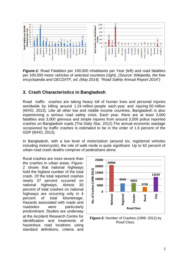
3. Crash Characteristics in Bangladesh Road traffic crashes are taking heavy toll of human lives and personal injuries worldwide by killing around 1.24 million people each year and injuring 50 million (WHO, 2013). Like all other low and middle income countries, Bangladesh is also experiencing a serious road safety crisis. Each year, there are at least 3,000 fatalities and 3,000 grievous and simple injuries from around 3,500 police reported crashes on Bangladesh roads (The Daily Star, 2012).The annual economic wastage occasioned by traffic crashes is estimated to be in the order of 1.6 percent of the GDP (WHO, 2013). In Bangladesh, with a low level of motorization (around six, registered vehicles including motorcycle), the role of walk mode is quite significant. Up to 62 percent of urban road crash deaths comprise of pedestrians alone. Rural crashes are more severe than the crashes in urban areas. Figure-2 shows that national highways hold the highest number of the total crash. Of the total reported crashes nearly 37 percent occurred on national highways. Almost 30 percent of total crashes on national highways are occurring only in 4 percent of total kilometrage. Hazards associated with roads and roadsides were particularly predominant. Studies are underway
at the Accident Research Centre for identification and treatments of hazardous road locations using standard definitions, criteria and
20966
6549 68333728
11619
0
5000
10000
15000
20000
25000
Nat
ion
al
Reg
ion
al
Feed
er
Ru
ral
Cit
y
No
. of
Cra
she
s (1
998
-201
2)
Road Class
Figure-2: Number of Crashes (1998- 2012) by
Road Class.

4
methods together with field observations so that cost effective countermeasures particularly the low cost countermeasures can be devised for highway safety improvements.
4. Methodology
An extensive analysis of the crash data and a specific site investigation were done by the author at Dhaka-Chittagong national highway (also known as N1 highway), which is one of the most used and important highways in Bangladesh. The study is based primarily after a specially created crash form by Bangladesh Police. Accident Report Form (ARF) is collected by Accident Research Institute (ARI) from range offices and district offices as hard copy and soft copy. The crash data for this highway between the years 2006 to 2010 was collected from the MAAP5 (Microcomputer Accident Analysis Package) software database of Accident Research Institute (ARI), BUET. The procedures followed in data collection from MAAP5 are illustrated in figure-3.
Information related to 974 crashes on N1 national highway which occurred during the period 2006 – 2010 was collected and used in crash analysis. Crash information of the latest years (2011 – 2013) was not available in complete format in ARI. That is why the period of analysis was selected from 2006 to 2010. Road traffic crash information of consecutive five years was then chronologically gathered and different patterns and characteristics were observed.
For the total of 974 crashes occurring at N1 in the year 2006 - 2010, various data was taken from ARI database. For each of the 974 crashes, information related to location of the crash, month of occurrence, collision type, weather condition, road geometry, lighting condition, total number of casualty, number of fatality, number of pedestrians involved in the crash, number and type of vehicles involved in the crash and factors of the crash (according to factors listed in FIR and designated in MAAP5 database of ARI) were collected and gathered for the need of crash investigation and analysis.
5. Study Area
The study was conducted on Dhaka- Chittagong national highway. The entire route of Dhaka-Chittagong national highway (NI) is Dhaka (N8) – Katchpur (N2) – Madanpur (N105) – Mainamati (N102) – Comilla (R140) – Feni (N104) – Chittagong (N196) – Manashertek ( N107) - Satkania (N108) – Ramu (N109)
Figure-3: Data Collection Procedure from MAAP5 Database
of ARI, BUET
Figure-4: Study Route of Dhaka- Chittagong
highway (N1)
5
– Cox’s Bazar (N110) – Teknaf. On the basis of International Roughness Index (IRI), 95.67% of the highway is good, 7.4% is fair. The percent of poor section is 4.2 and has a bad section of 0.54%. The length of the highway from zero point of Dhaka to Chittagong is 264 km and the total length of the highway is about 455 km. Figure-4 shows the study route of Dhaka- Chittagong highway.
6. Crash Characteristics on N1 Highway:
Significant under-reporting of crashes limits proper crash analysis to be carried out towards determining the actual societal and humanitarian impacts of road traffic crashes. A study from 2002 estimated that only 49% of the fatal crashes were reported while WHO has estimated it to be several times higher. The data shortcomings are a considerable problem for carrying out precise and accurate analysis of crashes and for taking effective road safety countermeasures. Nevertheless, based on the police reported crash database some striking features of crash characteristics on N1 highway are briefly discussed.
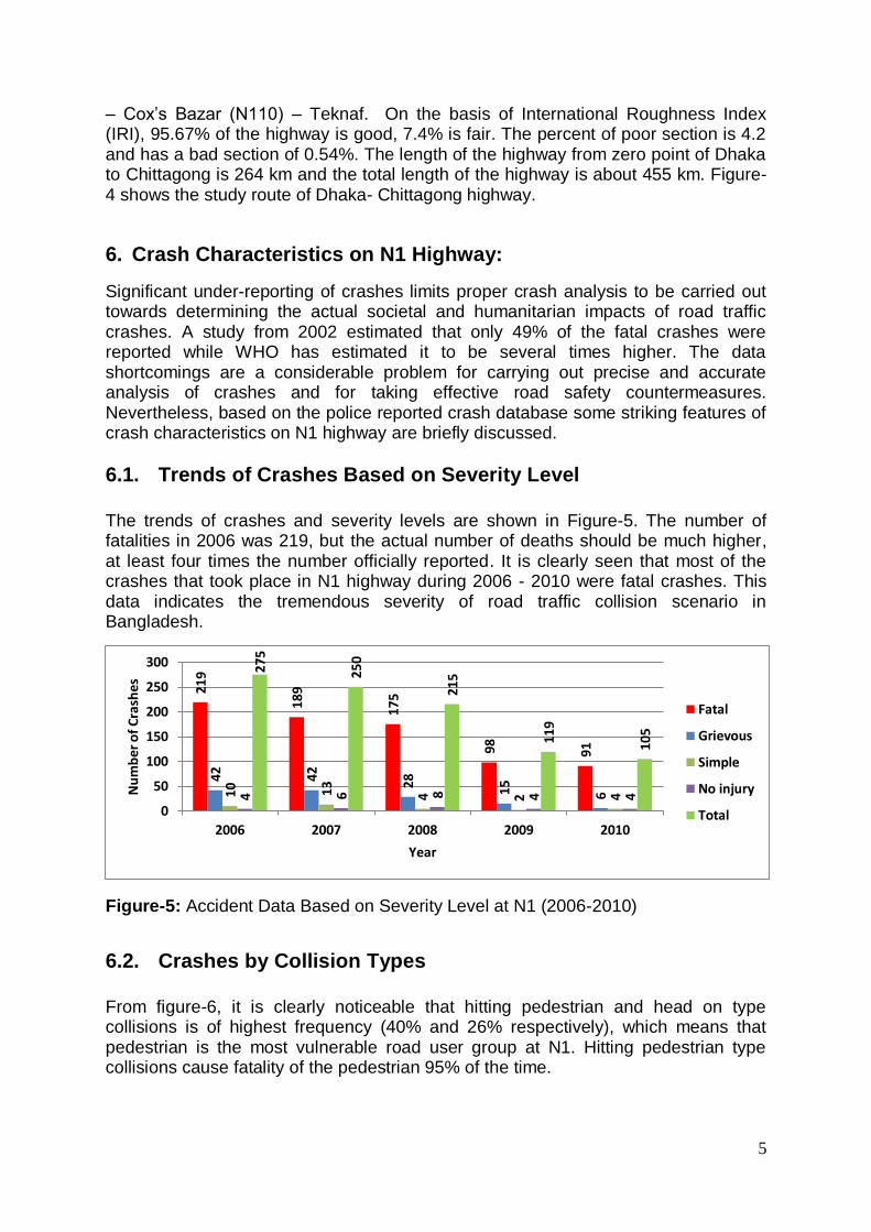
6.1. Trends of Crashes Based on Severity Level The trends of crashes and severity levels are shown in Figure-5. The number of fatalities in 2006 was 219, but the actual number of deaths should be much higher, at least four times the number officially reported. It is clearly seen that most of the crashes that took place in N1 highway during 2006 - 2010 were fatal crashes. This data indicates the tremendous severity of road traffic collision scenario in Bangladesh.
Figure-5: Accident Data Based on Severity Level at N1 (2006-2010)
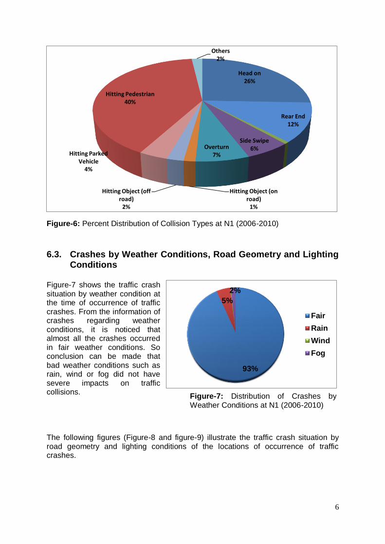
6.2. Crashes by Collision Types
From figure-6, it is clearly noticeable that hitting pedestrian and head on type collisions is of highest frequency (40% and 26% respectively), which means that pedestrian is the most vulnerable road user group at N1. Hitting pedestrian type collisions cause fatality of the pedestrian 95% of the time.
219
189
17
5
98 91
42 42 28 15
610 13 4 2 44 6 8 4 4
275
25
0
215
119
105
0
50
100
150
200
250
300
2006 2007 2008 2009 2010
Nu
mb
er o
f C
rash
es
Year
Fatal
Grievous
Simple
No injury
Total
6
Figure-6: Percent Distribution of Collision Types at N1 (2006-2010)
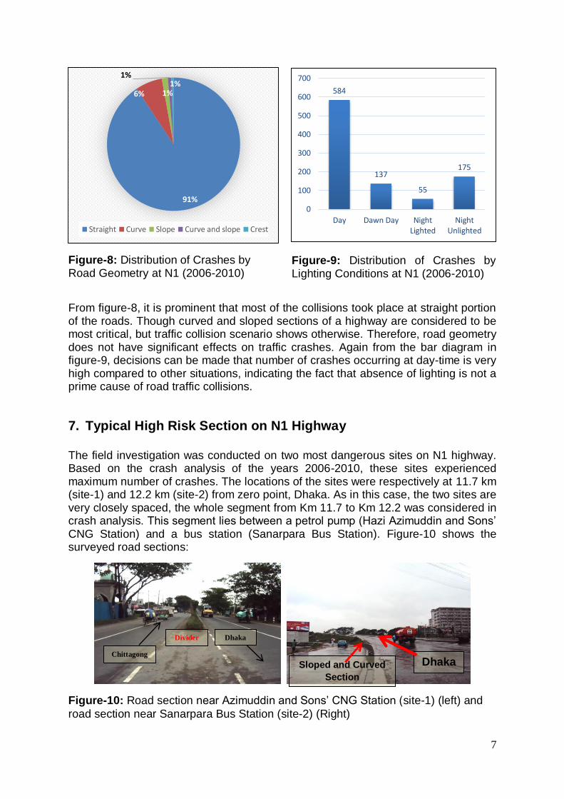
6.3. Crashes by Weather Conditions, Road Geometry and Lighting Conditions
Figure-7 shows the traffic crash situation by weather condition at the time of occurrence of traffic crashes. From the information of crashes regarding weather conditions, it is noticed that almost all the crashes occurred in fair weather conditions. So conclusion can be made that bad weather conditions such as rain, wind or fog did not have severe impacts on traffic collisions.
The following figures (Figure-8 and figure-9) illustrate the traffic crash situation by road geometry and lighting conditions of the locations of occurrence of traffic crashes.
Head on26%
Rear End12%
Side Swipe6%Overturn
7%
Hitting Object (on road)
1%
Hitting Object (off road)
2%
Hitting Parked Vehicle
4%
Hitting Pedestrian40%
Others2%
93%
5%
2%
Fair
Rain
Wind
Fog
Figure-7: Distribution of Crashes by Weather Conditions at N1 (2006-2010)
7
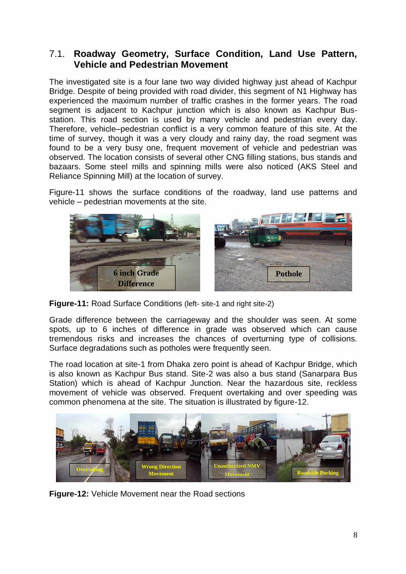
Figure-8: Distribution of Crashes by Road Geometry at N1 (2006-2010)
From figure-8, it is prominent that most of the collisions took place at straight portion of the roads. Though curved and sloped sections of a highway are considered to be most critical, but traffic collision scenario shows otherwise. Therefore, road geometry does not have significant effects on traffic crashes. Again from the bar diagram in figure-9, decisions can be made that number of crashes occurring at day-time is very high compared to other situations, indicating the fact that absence of lighting is not a prime cause of road traffic collisions.
7. Typical High Risk Section on N1 Highway The field investigation was conducted on two most dangerous sites on N1 highway. Based on the crash analysis of the years 2006-2010, these sites experienced maximum number of crashes. The locations of the sites were respectively at 11.7 km (site-1) and 12.2 km (site-2) from zero point, Dhaka. As in this case, the two sites are very closely spaced, the whole segment from Km 11.7 to Km 12.2 was considered in crash analysis. This segment lies between a petrol pump (Hazi Azimuddin and Sons’ CNG Station) and a bus station (Sanarpara Bus Station). Figure-10 shows the surveyed road sections:
Figure-10: Road section near Azimuddin and Sons’ CNG Station (site-1) (left) and
road section near Sanarpara Bus Station (site-2) (Right)
91%
6% 1%
1%1%
Straight Curve Slope Curve and slope Crest
Dhaka Sloped and Curved
Section
Chittagong
Divider Dhaka
584
137
55
175
0
100
200
300
400
500
600
700
Day Dawn Day NightLighted
NightUnlighted
Figure-9: Distribution of Crashes by Lighting Conditions at N1 (2006-2010)
8
7.1. Roadway Geometry, Surface Condition, Land Use Pattern, Vehicle and Pedestrian Movement
The investigated site is a four lane two way divided highway just ahead of Kachpur Bridge. Despite of being provided with road divider, this segment of N1 Highway has experienced the maximum number of traffic crashes in the former years. The road segment is adjacent to Kachpur junction which is also known as Kachpur Bus-station. This road section is used by many vehicle and pedestrian every day. Therefore, vehicle–pedestrian conflict is a very common feature of this site. At the time of survey, though it was a very cloudy and rainy day, the road segment was found to be a very busy one, frequent movement of vehicle and pedestrian was observed. The location consists of several other CNG filling stations, bus stands and bazaars. Some steel mills and spinning mills were also noticed (AKS Steel and Reliance Spinning Mill) at the location of survey.
Figure-11 shows the surface conditions of the roadway, land use patterns and vehicle – pedestrian movements at the site.
Figure-11: Road Surface Conditions (left- site-1 and right site-2)
Grade difference between the carriageway and the shoulder was seen. At some spots, up to 6 inches of difference in grade was observed which can cause tremendous risks and increases the chances of overturning type of collisions. Surface degradations such as potholes were frequently seen.
The road location at site-1 from Dhaka zero point is ahead of Kachpur Bridge, which is also known as Kachpur Bus stand. Site-2 was also a bus stand (Sanarpara Bus Station) which is ahead of Kachpur Junction. Near the hazardous site, reckless movement of vehicle was observed. Frequent overtaking and over speeding was common phenomena at the site. The situation is illustrated by figure-12.
Figure-12: Vehicle Movement near the Road sections
Pothole 6 inch Grade
Difference
Roadside Parking Overtaking
Unauthorized NMV
Movement
Wrong Direction
Movement
9
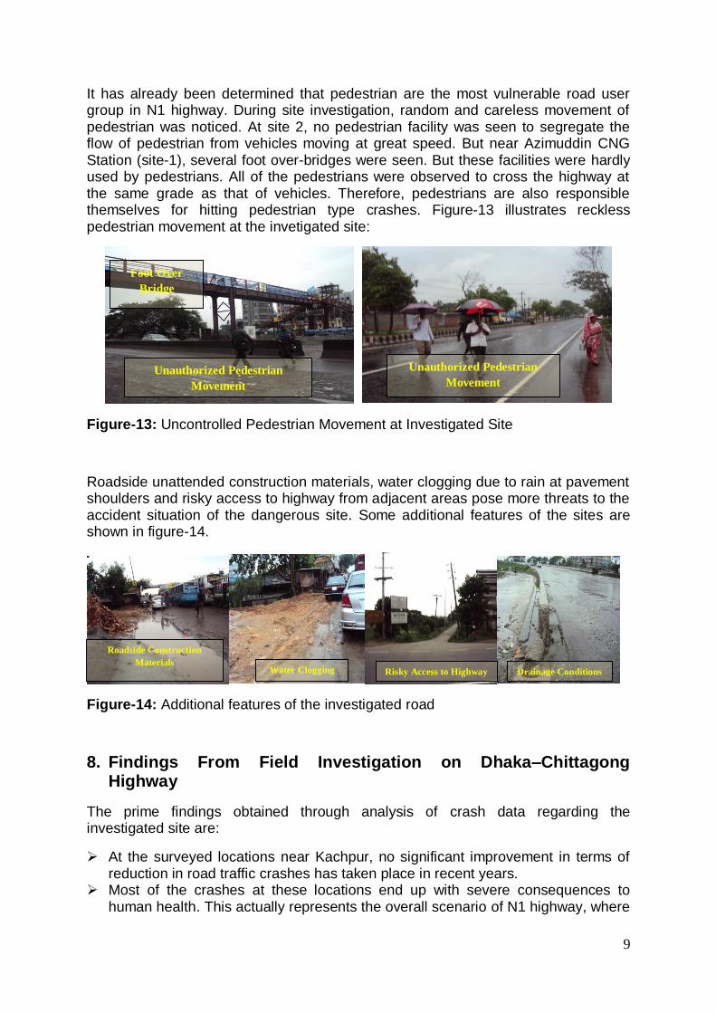
It has already been determined that pedestrian are the most vulnerable road user group in N1 highway. During site investigation, random and careless movement of pedestrian was noticed. At site 2, no pedestrian facility was seen to segregate the flow of pedestrian from vehicles moving at great speed. But near Azimuddin CNG Station (site-1), several foot over-bridges were seen. But these facilities were hardly used by pedestrians. All of the pedestrians were observed to cross the highway at the same grade as that of vehicles. Therefore, pedestrians are also responsible themselves for hitting pedestrian type crashes. Figure-13 illustrates reckless pedestrian movement at the invetigated site:
Figure-13: Uncontrolled Pedestrian Movement at Investigated Site
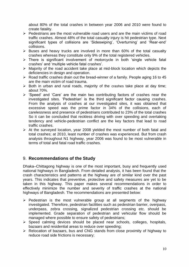
Roadside unattended construction materials, water clogging due to rain at pavement shoulders and risky access to highway from adjacent areas pose more threats to the accident situation of the dangerous site. Some additional features of the sites are shown in figure-14.
Figure-14: Additional features of the investigated road
8. Findings From Field Investigation on Dhaka–Chittagong Highway
The prime findings obtained through analysis of crash data regarding the investigated site are:
At the surveyed locations near Kachpur, no significant improvement in terms of reduction in road traffic crashes has taken place in recent years.
Most of the crashes at these locations end up with severe consequences to human health. This actually represents the overall scenario of N1 highway, where
Unauthorized Pedestrian
Movement
Foot Over
Bridge
Unauthorized Pedestrian
Movement
Water Clogging Drainage Conditions
Roadside Construction
Materials Risky Access to Highway
10
about 80% of the total crashes in between year 2006 and 2010 were found to create fatality.
Pedestrians are the most vulnerable road users and are the main victims of road traffic crashes. Almost 48% of the total casualty injury is hit pedestrian type. Next significant types of collisions are ‘Sideswiping’, ‘Overturning’ and ‘Rear-end’ collisions.
Buses and heavy trucks are involved in more than 60% of the total casualty crashes whereas they constitute only 9% of the total registered vehicles.
There is significant involvement of motorcycle in both ‘single vehicle fatal crashes’ and ‘multiple vehicle fatal crashes’.
Majority of the road accident take place at mid-block location which depicts the deficiencies in design and operation.
Road traffic crashes drain out the bread-winner of a family. People aging 16 to 45 are the main victim of road trauma.
Both in urban and rural roads, majority of the crashes take place at day time; about 70%.
‘Speed’ and ‘Care’ are the main two contributing factors of crashes near the investigated sites. ‘Pedestrian’ is the third significant factor causing crashes. From the analysis of crashes at our investigated sites, it was obtained that excessive speed was the prime factor in 34% of the collisions, each of carelessness and presence of pedestrians contributed to 23% of the total crashes So it can be concluded that reckless driving with over speeding and overtaking tendency and vehicle-pedestrian conflict are the key factors that lead to road traffic crashes.
At the surveyed location, year 2008 yielded the most number of both fatal and total crashes; at 2010, least number of crashes was experienced. But from crash analysis throughout N1 highway, year 2006 was found to be most vulnerable in terms of total and fatal road traffic crashes.
9. Recommendations of the Study
Dhaka–Chittagong highway is one of the most important, busy and frequently used national highways in Bangladesh. From detailed analysis, it has been found that the crash characteristics and patterns at the highway are of similar kind over the past years. This indicates that preventive, protective and safety measures are yet to be taken in this highway. This paper makes several recommendations in order to effectively minimize the number and severity of traffic crashes at the national highways of Bangladesh. The recommendations are presented below:
Pedestrian is the most vulnerable group at all segments of the highway investigated. Therefore, pedestrian facilities such as pedestrian barrier, overpass, underpass, zebra crossing, signalized pedestrian crossing etc. should be implemented. Grade separation of pedestrian and vehicular flow should be managed where possible to ensure safety of pedestrians;
Speed calming devices should be placed near schools, colleges, hospitals, bazaars and residential areas to reduce over speeding;
Relocation of bazaars, bus and CNG stands from close proximity of highway to reduce road side frictions is necessary;

11
As road divider reduces the number of head on collision, road dividers should be provided through the total length of highways, or at least through the most dangerous zones where severity of crashes is vital;
National highways should be at least of four lanes. Widening of highway can serve in reducing number and severity of crashes;
Extra lane should be provided for comparatively slowly moving non-motorized vehicles through all the highways;
Uniform width of shoulder should be provided. The shoulders should be paved for the comfort of driver;
As in our country, underreporting of crashes is a common phenomenon, non-fatal crashes should also be considered in obtaining crash characteristics in Bangladesh;
Adequate roadway lighting as well as side lighting in the motorized vehicles should be provided to facilitate night time driving;
Special training for drivers about traffic rules and driving should be provided; Improving safety aspects of road networks should be taken as an engineering
challenge and has to be prioritized over mobility aspects or roads; Appropriate signs, road markings, junction modification and visibility improvement
should be considered important; Roadway related safety initiatives have to be prioritized over behavioral or
educational initiatives; Encroachment on roadside has to be prevented and In case of a crash, effective communication to notify the occurrence, location and
nature of the crash and rapid response by para-medical services should be ensured to minimize the severity of the collision.
10. Recommendation for Further study
There is huge scope to proceed with this study in a wider scale. The following recommendations are proposed for further study relating to this topic:
GIS (Geographic Information System) can be used in order to locate the most collision prone sites accurately and present the data in spatial format, so that intensive treatments can be carried out at those specific spots;
The crash reporting system should be improved to meet the traffic engineering requirements for further detailed study and specialized officials are to be employed to prepare crash reports;
GIS based analysis can be conducted to accurately locate the spot of collision and analyze crash characteristics;
Site specific treatment measures can be elaborately analyzed for the sake of road user safety;
Crash prone sights can be subjected to detailed investigation including behavioral pattern of the community;
In addition to crash information, data regarding variation of speed and traffic volume may be included in future crash characteristics analysis studies;
Directional distribution of crashes may be conducted on these national highways for further analysis and
A before and after study of specific sites may be carried out to evaluate the performance of a treatment scheme.
12
11. Conclusions
This paper has highlighted striking road crash characteristics and outlined typical road and road environmental safety hazards identified through selected national highway. Resource targeting on high risk routes has seen significant crash improvements, now that the star ratings methodology has been developed and proven, proactive assessments. Importantly, application of such approaches needs clear understanding of and constant reference to fundamental safety principles and operational elements of safer road designs viz. to provide guidance, information, warn, control and forgive the drivers and there should not be no surprises to the drivers and should avoid discontinuities in the roadway environment. The systematic accident investigation in this regard can lead to the implementation of most cost-effective countermeasures aimed at specific accident types and/or specific road user groups. Corrections and fixing of existing road safety hazards demonstrated in the paper are indeed an enormous challenge to road engineering professionals in Bangladesh. Shortage of safety expertise, research and requisite funding are now significant constraints. It is therefore a priority for Bangladesh to address such safety issues with significant institutional improvements through sharing knowledge and experience of effective road safety programs worldwide. Much more research and studies require for enhancing our understanding of relationships between road design features and accident characteristics.
References
“BRTA Annual Report” (2008)
Harnam, S.; Dhattarwal,S. K., “Pattern and distribution of injuries in fatal Road Traffic Accidents in Rohtak (Harayana)” , Journal of Indian Academy of Forensic Medicine. 2004; 26(1), 20-23.
Hoque, M.M. (1989), “Road Accident Prevention”, Journal of the Institute of Engineers,
Bangladesh, Vol, 17.
Hoque, M. M.; McDonald, M. and Hall, R. D. (2001) “Road Safety Improvements in
Developing Countries: Priority Issues and Options” Proceedings of 20th Australian Road
Research Board (ARRB) Conference.
Hoque, M.M.; Muniruuzzaman, S.M and Ahmed, S. M (2007), “Effectiveness of black
spot treatments along Dhaka-Aricha highway Effectiveness of black spot treatments
along Dhaka-Aricha highway”, Department of Civil Engineering, Bangladesh University
of Engineering and Technology, Dhaka 1000, Bangladesh, Bangladesh Army, Accident
Research Center, Bangladesh University of Engineering and Technology, Dhaka-1000,
Bangladesh.
Hoque, M.M.; Smith G, Hossain D.Z. and Mahmud S.M.S. (2010) “Improving Highway Safety in Bangladesh: Road Improvement and the Potential Application of Irap” Proceedings of 24th Australian Road Research Board (ARRB) Conference.
Hoque, M. M.; Hossain, M. S.; Rahman, M. A.; Islam, S. M. A. B. A. (2014), “Safer
Motorcycling and Safer Roads: The Context of Bangladesh”.
13
Mahmud, S. M. S.; Hoque, M.S.; Qazi, A. S., “Road safety problems in Bangladesh: some major initiatives, constraints and requirements”, Transport and Communications Bulletin for Asia and the Pacific, 2009; 79.
Mahmud, S. M. S.; Talukder, M. M. A.; Ahmed, I.; Raihan, M.A., “Road Safety Initiatives in Bangladesh”, Jurnal Teknologi, 2013; 65(3), 64-60.
www.infrastructure.gov.au, accessed on 13/11/2014.