RUPESTRIAN LANDSCAPE AND SEATTLEMENTS
330
CRHIMA - cinp CULTURAL RUPESTRIAN HERITAGE in the CIRCUM-MEDITERRANEAN AREA Common Identity - New Perspective RUPESTRIAN LANDSCAPE AND SETTLEMENTS Workshops and Survey Results
Transcript of RUPESTRIAN LANDSCAPE AND SEATTLEMENTS

CRHIMA - cinp
CULTURAL RUPESTRIAN HERITAGE
in the
CIRCUM-MEDITERRANEAN AREACommon Identity - New Perspective
RUPESTRIAN LANDSCAPEAND SETTLEMENTS
Workshops and Survey Results
copertina A4 ufficiale catalogo copy.indd 1 14/11/2012 18:08:47

Exibition Firenze Giugno 2012 Cultural Rupestrian Heritage in the Circum - Mediterranean area
1
CULTURAL RUPESTRIAN HERITAGEIN THE
CIRCUM-MEDITERRANEAN AREACommon Identity - New Perspective
RUPESTRIAN LANDSCAPE AND SEATTLEMENTS
CHRIMA-CINP project
Culture Programme 2007-2013, Budget 2010, Strand 1.1 Multi-annualcooperation projects, Strand 1.2.1 Cooperation measures
CRHIMA-CINP October 2010 - Settember 2012
Catalogo1°ParteBN_01_2012-11-23.indd 1Catalogo1°ParteBN_01_2012-11-23.indd 1 30/11/2012 09:44:0330/11/2012 09:44:03

CRHIMA - CINP project
2
Thanks to all the Istitutions and the scholars for the availability and the cultural contribution.Thanks to all architecture students who participated to this project.
Scientifi c CommitteeM. Alper - Kadir Has Üniversitesi, Virtu Art Faculti. Istanbul
M. Assimakopoulou - National and Kapodistrian University of AthensR. Caprara - Archeogruppo “E. Jacovelli” Massafra. Taranto
C. Crescenzi - Università degli Studi di Firenze, Dip.to Architettura - dspE. Crescenzi - Ecole Nationale Supérieure d’Architecture de Paris La Villette
A. De Pascale - Museo Archeologico del Finale-IISL e Centro Studi Sotteranei di GenovaJ. Llopis Verdù - Universitat Politècnica de Valéncia, Expresión Gráfi ca Arquitectónica
U. Tramonti - Università degli Studi di Firenze, Dip.to Architettura - dsp
MASSAFRA, PALAGIANELLO. October 2010
MASSAFRA. April- May 2011
ISTANBUL, ORTAHISAR. September 2011 FLORENCE. June 2012
Regione Puglia Provincia di Taranto Comune di Massafra Comune di Palagianello Diocesi di Castellaneta Museo del Territoriodi Palagianello
Banca Popolare di Puglia e Basilicata
Università di BariDip. Ionico in Sist giuridici
del Mediterraneo
I. T. Agrario Statale“C. Mondelli”
di Massafra
Regione Puglia Presidentedella Fond. Zetema
di Matera
Comune di Massafra Comune di Mottola Comune di Laterza Comune di Grottaglie Comune di Statte Comune di Palagianello Comune di Gravina in Puglia
Università di BariDip. Ionico in Sist. giuridici
del Mediterraneo
Istituto Internazionaledi Studi Ligurisez. Finalese
Museo Archeologicodel Finale
Museo del Territoriodi Palagianello
Presidente della Camera dei Deputati
RistoranteSant’Oronzo
I. P. S. “M. Perrone”di Castellaneta
Liceo Scientifi co“A. Einstein”
di Mottola
Consultadelle Associazioni
di Massafra
PIS13 Habitat RupestrePuglia Museo del Territorio
di Palagianello
Ass. Terra di Puglia Coop. Nuova Hellas
Pro Loco di Massafra
Pro Loco di Laterza
Centro Educazione Ambientale
Gruppo Speleodi Statte
Ass. la Durlindana Ass. la DurlindanaI. T. Agrario Statale“C. Mondelli”
di Massafra
Liceo Scientifi co“De Ruggieri”
di Massafra
Ortahisar Belediyesi İlke Eğıtım ve SağlikVakfi
Kapadokya MYO
MustafapaşaBelediyesi
Uçhisar Belediyesi Uçhisar Belediyesi Presidente della Camera dei Deputati
Ministero per i Beni ele Attività Culturali
Regione Toscana Provincia di Firenze
Comune di Firenze
Comune di Sorano
Presidenza dellaRepubblica Italiana
Senatodella Repubblica
Exhibition Committee B. Alper - Kadir Has Üniversitesi, Virtu Art Faculti. Istanbul
S.Bertocci - Università degli Studi di Firenze, Dip.to Architettura - dsp M. Coetmellec - Ecole Nationale Supérieure d’Architecture de Paris **La Villette H. Costa - Universitat Politècnica de Valéncia, Expresión Gráfi ca Arquitectónica
C. Crescenzi - Università degli Studi di Firenze, Dip.to Architettura - dsp Y. K. ERKAN - Kadir Has Üniversitesi, Virtu Art Faculti. Istanbul
M. Scalzo - Università degli Studi di Firenze, Dip.to Architettura - dsp A. Tsolaki - MsC-Bioclimatic Architect
G. Verdiani - Università degli Studi di Firenze, Dip.to Architettura - dsp
Catalogo1°ParteBN_01_2012-11-23.indd 2Catalogo1°ParteBN_01_2012-11-23.indd 2 30/11/2012 09:44:0830/11/2012 09:44:08

Exibition Firenze Giugno 2012 Cultural Rupestrian Heritage in the Circum - Mediterranean area
3
The editors would like to thank all those who contributed with their work to the international congress and given their authorisation for publication. The editors and the organizers cannot be held responsible for either the contents or opinions expressed in these works. In addition, the authors hereby declare that the contents of this communication are original ones, or when appropriate, they
have the corresponding authorisation to include, use or adapt long quotations or tables and illustrations from other works.
© Copyright 2012DAdsp - UniFi
via San Niccolò 95 - 50019 Firenze
ISBN9788896080085
byCarmela Crescenzi
Graphic EditingAnna Incampo, Mirco Iualè, Stefano Malfatti, Enrico Pieraccioli
Printed byTipografi a il David, Firenze
Settembre 2012
This work has been fi nanced with the Funds of the Culture Programme 2007-2013Budget 2010 Strand 1.2.1 - Cooperation Projects
Cultural Rupestrian Heritage in the Circum-Mediterranean Area:Common Idendentity New Perspective (CRHIMA- cinp)
“This project has been funded with support from the European Commission. This publication refl ects the views only of the Author, and theCommission cannot be held responsible for any use which may be made of the information contained therein”
CHRIMA-CINP project
Catalogo1°ParteBN_01_2012-11-23.indd 3Catalogo1°ParteBN_01_2012-11-23.indd 3 30/11/2012 09:44:3830/11/2012 09:44:38

CRHIMA - CINP project
4
CONTENTS
INTRODUCTION TO THE RUPESTRIAN CULTURE IN THE MEDITERRANEAN AREA
SEATTLEMENT AND RUPESTRIAN CULTURE IN SANTORINI
RUPESTRIAN CULTURE IN SPAIN
Text:Tab. 1 C. Crescenzi . . . . . . . . . . . . . . . . . . . . . . . . . . . . . . . . . . . . . . . . . . . . . . . . . . .21Tab. 2-3 C. Crescenzi . . . . . . . . . . . . . . . . . . . . . . . . . . . . . . . . . . . . . . . . . . . . . . . . . . .22Tab. 4-6 C. Crescenzi . . . . . . . . . . . . . . . . . . . . . . . . . . . . . . . . . . . . . . . . . . . . . . . . . . 25Tab. 7-12 C. Crescenzi . . . . . . . . . . . . . . . . . . . . . . . . . . . . . . . . . . . . . . . . . . . . . . . . . . .26
Unifi , DA dsp - Carmela Crescenzi - traduzioni: A. Caprara (Tab.1-3), M. Antonelli, V. Grillo (Tab.4-12) editing: Anna Incampo
Estratto Tesi di Laurea di: Marco Antonelli e Valentina Grillo Relatore: Carmela Crescenzi
Credits:Tab. 1 M. Antonelli, V. Grillo (a cura di C. Crescenzi) . . . . . . . . . . . . . . . . . . . . . . . . . . . . . . . . . . . . . . . . . . . . . . . . .173Tab. 2 M. Antonelli, V. Grillo (a cura di C. Crescenzi) . . . . . . . . . . . . . . . . . . . . . . . . . . . . . . . . . . . . . . . . . . . . . . . . .174Tab. 3 M. Antonelli, V. Grillo (a cura di C. Crescenzi) . . . . . . . . . . . . . . . . . . . . . . . . . . . . . . . . . . . . . . . . . . . . . . . . .175Tab. 4 C. Crescenzi . . . . . . . . . . . . . . . . . . . . . . . . . . .. . . . . . . . . . . . . . . . . . . . . . . . . . . . . . . . . . . .. . . . . . . . . . . . . .176Tab. 5 C. Crescenzi. . . . . . . . . . . . . . . . . . . . . . . . . . . . . . . . . . . . . . . . . . . . . . . . . . . . . . . . . . . . . . . . . . . . . . . . . . . . .177Tab. 6 C. Crescenzi. . . . . . . . . . . . . . . . . . . . . . . . . . . . . . . . . . . . . . . . . . . . . . . . . . . . . . . . . . . . . . . . . . . . . . . . . . . . .178Tab. 7 M. Antonelli, V. Grillo (a cura di C. Crescenzi). . . . . . . . . . . . . . . . . . . . . . . . . . . . . . . . . . . . . . . . . . . . . . . . . 179Tab. 8 M. Antonelli, V. Grillo (a cura di C. Crescenzi). . . . . . . . . . . . . . . . . . . . . . . . . . . . . . . . . . . . . . . . . . . . . . . . . 180Tab. 9 M. Antonelli, V. Grillo (a cura di C. Crescenzi). . . . . . . . . . . . . . . . . . . . . . . . . . . . . . . . . . . . . . . . . . . . . . . . . 181Tab. 10 M. Antonelli, V. Grillo (a cura di C. Crescenzi). . . . . . . . . . . . . . . . . . . . . . . . . . . . . . . . . . . . . . . . . . . . . . . . . 182Tab. 11 C. Crescenzi. . . . . . . . . . . . . . . . . . . . . . . . . . . . . . . . . . . . . . . . . . . . . . . . . . . . . . . . . . . . . . . . . . . . . . . . . . . . .183Tab. 12 M. Antonelli, V. Grillo (a cura di C. Crescenzi). . . . . . . . . . . . . . . . . . . . . . . . . . . . . . . . . . . . . . . . . . . . . . . . ..184
Presentazione di R. De Rubertis. . . . . . . . . . . . . . . . . . . . . . . . . . . . . . . . . . . . . . . . . . . . . . . . . . . . . . . . .9
Cultural Rupestrian Heritage In The Circum Mediterranean Area: data and results of the projectdi C. Crescenzi . . . . . . . . . . . . . . . . . . . . . . . . . . . . . . . . . . . . . . . . . . . . . . . . . . . . . . . . . . . . . . . . . . . . . . . . . . . . . . . . . . . . 11
traduzioni: E. Teokaridou
Text:Tab. 1 C. Crescenzi . . . . . . . . . . . . . . . . . . . . . . . . . . . . . . . . . . . . . . . . . . . . . . . . . . .15Tab. 2 C. Crescenzi . . . . . . . . . . . . . . . . . . . . . . . . . . . . . . . . . . . . . . . . . . . . . . . . . . .16Tab. 3 C. Crescenzi . . . . . . . . . . . . . . . . . . . . . . . . . . . . . . . . . . . . . . . . . . . . . . . . . . .16Tab. 4 C. Crescenzi . . . . . . . . . . . . . . . . . . . . . . . . . . . . . . . . . . . . . . . . . . . . . . . . . . .17Tab. 5 M. Manganaro . . . . . . . . . . . . . . . . . . . . . . . . . . . . . . . . . . . . . . . . . . . . . . . . . 17Tab. 6 M. Manganaro . . . . . . . . . . . . . . . . . . . . . . . . . . . . . . . . . . . . . . . . . . . . . . . . . 17Tab. 7 M. Manganaro . . . . . . . . . . . . . . . . . . . . . . . . . . . . . . . . . . . . . . . . . . . . . . . . . 17
Unifi , DA dsp - Carmela Crescenzi - Unime, DiSIA - Mario Manganaro
Credits:Tab. 1 C. Crescenzi, G. Vampa, L. Ruggeri, M. Salvadori, E. Scotto (a cura di C. Crescenzi). . . . . . . . . . . . . . . . . . . . . . 161Tab. 2 U. Albricci, E. Viviani, G. Vampa, C. Obino, R. Muscogiuri (a cura di C. Crescenzi). . . . . . . . . . . . . . . . . . . . . . . 162Tab. 3 C. Giustiniani, G. Vampa, M. Antonelli, V. Grillo, N. Pacini (a cura di C. Crescenzi) . . . . . . . . . . . . . . . . . . . . . . .163Tab. 4 C. Crescenzi, G. Vampa, M. Antonelli, V. Grillo, N. Pacini (a cura di C. Crescenzi). . . . . . . . . . . . . . . . . . . . . . . .164Tab. 5 M. Manganaro, A. Altadonna, G. Martello, A. Nastasi, N. Siragusa (a cura di M. Manganaro). . . . . . . . . . . . . . . . . .165Tab. 6 M. Manganaro, A. Altadonna, G. Martello, A. Nastasi, N. Siragusa (a cura di M. Manganaro). . . . . . . . . . . . . . . . . .166Tab. 7 M. Manganaro, A. Altadonna, G. Martello, A. Nastasi, N. Siragusa (a cura di M. Manganaro). . . . . . . . . . . . . . . . . .167
traduzioni: A. Caprara (Tab.1-4), A. Altadonna (Tab.5-7) editing: Anna Incampo
Text:Tab. 1 H. Barros D1., J. Higon C1., J. Llopis V1 . . . . . . . . . . . . . . . . . . . . . . . . . . . . . 35Tab. 2 H. Barros D., J. Higon C., J. Llopis V. . . . . . . . . . . . . . . . . . . . . . . . . . . . . . . .38Tab. 3 H. Barros D., J. Higon C., J. Llopis V. . . . . . . . . . . . . . . . . . . . . . . . . . . . . . . .38Tab. 4-5 H. Barros D., J. Higon C., J. Llopis V. . . . . . . . . . . . . . . . . . . . . . . . . . . . . . . .36
Credits:Tab. 1 P. Navarro2, J. Herràez B3., H. Barros e C2., J. Luis D3. . . . . . . . . . . . . . . . . . . . . . . . . . . . . . . . . . . . . . . . . . . .193 Tab. 2 P. Navarro, J. Herràez B., H. Barros e C., J. Luis D. . . . . . . . . . . . . . . . . . . . . . . . . . . . . . . . . . . . . . . . . . . . . . 194Tab. 3 P. Navarro E., J. Herràez B., H. Barros e C., J. Luis D. . . . . . . . . . . . . . . . . . . . . . . . . . . . . . . . . . . . . . . . . . . . 195Tab. 4 J. Higon C., J. Llopis V., J. Albert B. . . . . . . . . . . . . . . . . . . . . . . . . . . . . . . . . . . . . . . . . . . . . . . . . . . . . . . . . . 196
Catalogo1°ParteBN_01_2012-11-23.indd 4Catalogo1°ParteBN_01_2012-11-23.indd 4 30/11/2012 09:44:3830/11/2012 09:44:38
Exibition Firenze Giugno 2012 Cultural Rupestrian Heritage in the Circum - Mediterranean area
5
TROGLODYTIC FRANCE
Credits:Tab. 1 G. M. Vampa, N. Pacini. . . . . . . . . . . . . . . . . . . . . . . . . . . . . . . . . . . . . . . . . . . . . . . . . . . . . . . . . . . . . . . . .203Tab. 2 G. M. Vampa, N. Pacini. . . . . . . . . . . . . . . . . . . . . . . . . . . . . . . . . . . . . . . . . . . . . . . . . . . . . . . . . . . . . . . . .204Tab. 3 G. M. Vampa, N. Pacini. . . . . . . . . . . . . . . . . . . . . . . . . . . . . . . . . . . . . . . . . . . . . . . . . . . . . . . . . . . . . . . . .205Tab. 4 G. M. Vampa, N. Pacini. . . . . . . . . . . . . . . . . . . . . . . . . . . . . . . . . . . . . . . . . . . . . . . . . . . . . . . . . . . . . . . . .206Tab. 5 G. M. Vampa, N. Pacini. . . . . . . . . . . . . . . . . . . . . . . . . . . . . . . . . . . . . . . . . . . . . . . . . . . . . . . . . . . . . . . . .207Tab. 6 G. M. Vampa, N. Pacini. . . . . . . . . . . . . . . . . . . . . . . . . . . . . . . . . . . . . . . . . . . . . . . . . . . . . . . . . . . . . . . . .208Tab. 7 G. M. Vampa, N. Pacini. . . . . . . . . . . . . . . . . . . . . . . . . . . . . . . . . . . . . . . . . . . . . . . . . . . . . . . . . . . . . . . . .209Tab. 8 G. M. Vampa, N. Pacini. . . . . . . . . . . . . . . . . . . . . . . . . . . . . . . . . . . . . . . . . . . . . . . . . . . . . . . . . . . . . . . . .210Tab. 9 G. M. Vampa, N. Pacini. . . . . . . . . . . . . . . . . . . . . . . . . . . . . . . . . . . . . . . . . . . . . . . . . . . . . . . . . . . . . . . . .211 Tab. 10 G. M. Vampa, N. Pacini. . . . . . . . . . . . . . . . . . . . . . . . . . . . . . . . . . . . . . . . . . . . . . . . . . . . . . . . . . . . . . . . .212 Tab. 11 G. M. Vampa, N. Pacini. . . . . . . . . . . . . . . . . . . . . . . . . . . . . . . . . . . . . . . . . . . . . . . . . . . . . . . . . . . . . . . . .213 Tab. 12 G. M. Vampa, N. Pacini. . . . . . . . . . . . . . . . . . . . . . . . . . . . . . . . . . . . . . . . . . . . . . . . . . . . . . . . . . . . . . . . .214Tab. 13 G. M. Vampa, N. Pacini . . . . . . . . . . . . . . . . . . . . . . . . . . . . . . . . . . . . . . . . . . . . . . . . . . . . . . . . . . . . . . . . 215
Unifi , DA dsp - Carmela Crescenzi
Text:Tab.1 C. Crescenzi . . . . . . . . . . . . . . . . . . . . . . . . . . . . . . . . . . . . . . . . . . . . . . . . . . . .43Tab.2 C. Crescenzi . . . . . . . . . . . . . . . . . . . . . . . . . . . . . . . . . . . . . . . . . . . . . . . . . . . .46Tab.3 C. Crescenzi . . . . . . . . . . . . . . . . . . . . . . . . . . . . . . . . . . . . . . . . . . . . . . . . . . . .48Tab.4 C. Crescenzi . . . . . . . . . . . . . . . . . . . . . . . . . . . . . . . . . . . . . . . . . . . . . . . . . . . .50Tab.5-7 C. Crescenzi . . . . . . . . . . . . . . . . . . . . . . . . . . . . . . . . . . . . . . . . . . . . . . . . . . . .51Tab.8 C. Crescenzi . . . . . . . . . . . . . . . . . . . . . . . . . . . . . . . . . . . . . . . . . . . . . . . . . . . .51Tab.9-12 C. Crescenzi . . . . . . . . . . . . . . . . . . . . . . . . . . . . . . . . . . . . . . . . . . . . . . . . . . . .52Tab.13 C. Crescenzi . . . . . . . . . . . . . . . . . . . . . . . . . . . . . . . . . . . . . . . . . . . . . . . . . . . .55
Unifi , DA dsp - Carmela Crescenzi - traduzioni: A. Caprara (Tab.1-2), A. Formica (Tab.4;6-9;11-12), E. Teokaridou (Tab. 3-5-10-13) editing: Anna Incampo
Estratto dalla tesi di laurea: Studi e riqualifi cazione della Loira troglodita. Il bourg-neuf: “la Loire a velo” elemento di riqualifi cazione. Relatore: Carmela Crescenzi, Correlatore: Bernard Tobie. Laureandi: Giovanni M.Vampa, Nicola Pacini
Tab. 5 J. Higon C. J. Llopis V., J. Albert B. . . . . . . . . . . . . . . . . . . . . . . . . . . . . . . . . . . . . . . . . . . . . . . . . . . . . . . .197Tab. 6 J. Higon C., J. Llopis V., J. Serra L. . . . . . . . . . . . . . . . . . . . . . . . . . . . . . . . . . . . . . . . . . . . . . . . . . . . . . . . 198Tab. 7 J. Llopis V., J. Higon C., A. Torre B., M. Ginevez R. . . . . . . . . . . . . . . . . . . . . . . . . . . . . . . . . . . . . . . . . . .200
Estratto tesi di laurea di: P. Navarro Esteve, J. Herràez Boquera, H. Barros e Costa, J. Luis Denia Assistant: Eduardo Baviera, Anna Delcampo, Carmen Lòpez
Tab. 6 H. Barros D., J. Higon C., J. Llopis V. . . . . . . . . . . . . . . . . . . . . . . . . . . . . . . 36Tab. 7 H. Barros D., J. Higon C., J. Llopis V. . . . . . . . . . . . . . . . . . . . . . . . . . . . . . . 37
(1) UPV,EGA; (2) ETSAV; (3) ETSICCP
editing: Anna Incampo
ITALIAN RUPESTRIAN CULTURE
Text:Tab. 1 C. Crescenzi . . . . . . . . . . . . . . . . . . . . . . . . . . . . . . . . . . . . . . . . . . . . . . . . . . . 61Tab. 2 C. Crescenzi . . . . . . . . . . . . . . . . . . . . . . . . . . . . . . . . . . . . . . . . . . . . . . . . . . . 61Tab. 3 C. Crescenzi . . . . . . . . . . . . . . . . . . . . . . . . . . . . . . . . . . . . . . . . . . . . . . . . . . . 63Tab. 4-5 C. Crescenzi . . . . . . . . . . . . . . . . . . . . . . . . . . . . . . . . . . . . . . . . . . . . . . . . . . . 65Tab. 6-8 C. Crescenzi . . . . . . . . . . . . . . . . . . . . . . . . . . . . . . . . . . . . . . . . . . . . . . . . . . . 66Tab. 9-13 C. Crescenzi . . . . . . . . . . . . . . . . . . . . . . . . . . . . . . . . . . . . . . . . . . . . . . . . . . . 67Tab. 14-16 C. Crescenzi . . . . . . . . . . . . . . . . . . . . . . . . . . . . . . . . . . . . . . . . . . . . . . . . . . . 68Tab. 17 C. Crescenzi . . . . . . . . . . . . . . . . . . . . . . . . . . . . . . . . . . . . . . . . . . . . . . . . . . . 69Tab. 18-23 C. Crescenzi . . . . . . . . . . . . . . . . . . . . . . . . . . . . . . . . . . . . . . . . . . . . . . . . . . . 70Tab. 24 C. Crescenzi . . . . . . . . . . . . . . . . . . . . . . . . . . . . . . . . . . . . . . . . . . . . . . . . . . . 73Tab. 25 C. Crescenzi . . . . . . . . . . . . . . . . . . . . . . . . . . . . . . . . . . . . . . . . . . . . . . . . . . . 75Tab. 26-29 C. Crescenzi . . . . . . . . . . . . . . . . . . . . . . . . . . . . . . . . . . . . . . . . . . . . . . . . . . . 75Tab. 30 C. Crescenzi . . . . . . . . . . . . . . . . . . . . . . . . . . . . . . . . . . . . . . . . . . . . . . . . . . . 76Tab. 31 C. Crescenzi . . . . . . . . . . . . . . . . . . . . . . . . . . . . . . . . . . . . . . . . . . . . . . . . . . . 77Tab. 32 C. Crescenzi . . . . . . . . . . . . . . . . . . . . . . . . . . . . . . . . . . . . . . . . . . . . . . . . . . . 79Tab. 33-34 S. Bertacchi, M. Pasquini . . . . . . . . . . . . . . . . . . . . . . . . . . . . . . . . . . . . . . . . . 81
Credits:Tab. 1 P. Formaglini, Michela Salvadori, N. Barbalace, N. Belvedere, B. Ciconte(a cura di C. Crescenzi). . . . . . . . . . . . . 219Tab.2 A. Faleburle1, P. Paolicchi2, R. Piagentini3 (a cura di C. Crescenzi) . . . . . . . . . . . . . . . . . . . . . . . . . . . . . . . .220Tab. 3 M. Balsinelli, L. Cantini, P. Casagni, S. Dati, A. Malara, N. Tanganelli (a cura di C. Crescenzi). . . . . . . . . .221Tab. 4-5 A. Bagni, V. Frontini, M. Lo Sasso, A. Massafra, F. Moretti, G. Pagliacci (a cura di C. Crescenzi). . . . . . . .225Tab. 6-7-8 A. Bartolini, A. Fratini, A. Ginetti, Odeta Rrapi, M. Zarrini . (a cura di C. Crescenzi) . . . . . . . . . . . . . . . . . 227Tab. 9-10 G. Bruni, F. D’Amato, S. Loia, G. Magini (a cura di C. Crescenzi). . . . . . . . . . . . . . . . . . . . . . . . . . . . . . . . 230Tab. 11-12 M. Balsinelli, L. Cantini, P. Casagni, S. Dati, A. Malara, N. Tanganelli (a cura di C. Crescenzi) . . . . . . . . . 232Tab. 13-14 A. Pistocchi, G. Sbragi, C. Trinci, M. Vasai . (a cura di C. Crescenzi) . . . . . . . . . . . . . . . . . . . . . . . . . . . . . .234Tab. 15-16 M. Balsinelli, L. Cantini, P. Casagni, S. Dati, A. Malara, N. Tanganelli (a cura di C. Crescenzi). . . . . . . . . .236Tab. 17 A. Pistocchi, G. Sbragi, C. Trinci, M. Vasai (a cura di C. Crescenzi) . . . . . . . . . . . . . . . . . . . . . . . . . . . . . . .238Tab. 18-19 A. Faleburle1 (a cura di C. Crescenzi) . . . . . . . . . . . . . . . . . . . . . . . . . . . . . . . . . . . . . . . . . . . . . . . . . . . . . . . 239Tab. 20 P. Paolicchi2 (a cura di C. Crescenzi). . . . . . . . . . . . . . . . . . . . . . . . . . . . . . . . . . . . . . . . . . . . . . . . . . . . . . . . 241Tab. 21 R. Piagentini3 (a cura di C. Crescenzi). . . . . . . . . . . . . . . . . . . . . . . . . . . . . . . . . . . . . . . . . . . . . . . . . . . . . .. 242Tab. 22 P. N. Esteve, J. H. Boquera, H. Barros e Costa, J. L. Denia (a cura di C. Crescenzi). . . . . . . . . . . . . . . . . . ..243Tab. 23 M. T. Eccheli, D. Luce4, L. Mariano4 (a cura di C. Crescenzi). . . . . . . . . . . . . . . . . . . . . . . . . . . . . . . . . . . . 244Tab. 24 C. Crescenzi, M. Scalzo, A. Faleburle . (a cura di C. Crescenzi) . . . . . . . . . . . . . . . . . . . . . . . . . . . . . . . . . . 245
Catalogo1°ParteBN_01_2012-11-23.indd 5Catalogo1°ParteBN_01_2012-11-23.indd 5 30/11/2012 09:44:3930/11/2012 09:44:39

CRHIMA - CINP project
6
RUPESTRIAN SETTLEMENT IN CAPPADOCIA
Text:Tav: 1 C. Crescenzi. . . . . . . . . . . . . . . . . . . . . . . . . . . . . . . . . . . . . . . . . . . . . . . . . 105Tav: 2 C. Crescenzi. . . . . . . . . . . . . . . . . . . . . . . . . . . . . . . . . . . . . . . . . . . . . . . . . 105Tav: 3 C. Crescenzi.. . . . . . . . . . . . . . . . . . . . . . . . . . . . . . . . . . . . . . . . . . . . . . . . .107Tav: 4-5 C. Crescenzi. . . . . . . . . . . . . . . . . . . . . . . . . . . . . . . . . . . . . . . . . . . . . . . . . 108Tav: 6-7 C. Crescenzi .. . . . . . . . . . . . . . . . . . . . . . . . . . . . . . . . . . . . . . . . . . . . . . . . 110Tav: 8 C. Crescenzi . . . . . . . . . . . . . . . . . . . . . . . . . . . . . . . . . . . . . . . . . . . . . . . . .111Tav: 9 C. Crescenzi. . . . . . . . . . . . . . . . . . . . . . . . . . . . . . . . . . . . . . . . . . . . . . . . . .112Tav: 10 C. Crescenzi . . . . . . . . . . . . . . . . . . . . . . . . . . . . . . . . . . . . . . . . . . . . . . . . .114Tav: 11-12 C. Crescenzi. . . . . . . . . . . . . . . . . . . . . . . . . . . . . . . . . . . . . . . . . . . . . . . . . .116Tav: 13 C. Crescenzi. . . . . . . . . . . . . . . . . . . . . . . . . . . . . . . . . . . . . . . . . . . . . . . . . .117Tav: 14 C. Crescenzi . . . . . . . . . . . . . . . . . . . . . . . . . . . . . . . . . . . . . . . . . . . . . . . . .119Tav: 15 C. Crescenzi . . . . . . . . . . . . . . . . . . . . . . . . . . . . . . . . . . . . . . . . . . . . . . . . .121Tav: 16 C. Crescenzi . . . . . . . . . . . . . . . . . . . . . . . . . . . . . . . . . . . . . . . . . . . . . . . . .122Tav: 17 C. Crescenzi . . . . . . . . . . . . . . . . . . . . . . . . . . . . . . . . . . . . . . . . . . . . . . . . .123Tav: 18 C. Crescenzi. . . . . . . . . . . . . . . . . . . . . . . . . . . . . . . . . . . . . . . . . . . . . . . . . 125Tav: 19 C. Crescenzi . . . . . . . . . . . . . . . . . . . . . . . . . . . . . . . . . . . . . . . . . . . . . . . . .126Tav: 20 C. Crescenzi . . . . . . . . . . . . . . . . . . . . . . . . . . . . . . . . . . . . . . . . . . . . . . . . .127Tav: 19 C. Crescenzi . . . . . . . . . . . . . . . . . . . . . . . . . . . . . . . . . . . . . . . . . . . . . . . . .128
Tab. 35 C. Crescenzi . . . . . . . . . . . . . . . . . . . . . . . . . . . . . . . . . . . . . . . . . . . . . . . .84Tab. 36-38 C. Crescenzi . . . . . . . . . . . . . . . . . . . . . . . . . . . . . . . . . . . . . . . . . . . . . . . .85Tab. 37 C. Crescenzi . . . . . . . . . . . . . . . . . . . . . . . . . . . . . . . . . . . . . . . . . . . . . . . .88Tab. 39 C. Crescenzi . . . . . . . . . . . . . . . . . . . . . . . . . . . . . . . . . . . . . . . . . . . . . . . .86Tab. 40-42 C. Crescenzi . . . . . . . . . . . . . . . . . . . . . . . . . . . . . . . . . . . . . . . . . . . . . . . .89Tab. 43 C. Crescenzi . . . . . . . . . . . . . . . . . . . . . . . . . . . . . . . . . . . . . . . . . . . . . . . .90Tab. 44-45 C. Crescenzi . . . . . . . . . . . . . . . . . . . . . . . . . . . . . . . . . . . . . . . . . . . . . . . .91Tab. 46 C. Crescenzi . . . . . . . . . . . . . . . . . . . . . . . . . . . . . . . . . . . . . . . . . . . . . . . .92Tab. 47 C. Crescenzi . . . . . . . . . . . . . . . . . . . . . . . . . . . . . . . . . . . . . . . . . . . . . . . .93Tab. 48 C. Crescenzi . . . . . . . . . . . . . . . . . . . . . . . . . . . . . . . . . . . . . . . . . . . . . . . .94Tab. 49-50 C. Crescenzi . . . . . . . . . . . . . . . . . . . . . . . . . . . . . . . . . . . . . . . . . . . . . . . .95Tab. 51 C. Crescenzi . . . . . . . . . . . . . . . . . . . . . . . . . . . . . . . . . . . . . . . . . . . . . . . .96Tab. 52-53 C. Crescenzi . . . . . . . . . . . . . . . . . . . . . . . . . . . . . . . . . . . . . . . . . . . . . . .102
Unifi , DA dsp - Carmela Crescenzi
Scansioni laser: M. Manganaro, A.Altadonna, G. Martello, A. Nastasi, N. Siragusa - Unime, DiSIATab - (Tab. 11-16, 23,37) Pablo N. Esteve ESTAV, Josè. H. Boquera ETSICCP - (Tab. 30) Vito L. Chiechi - (Tab. 32-33)
(1) “Progetti di parco della Gravina di S.Marco Massafra (Ta) recupero e riqualifi cazione ambientale” A.A. 2009- 2010; Relatore: Carmela Crescenzi; Corelatore: Roberto Caprara; Laureando: Alessandro Faleburle(2) “Recupero e riqualifi cazione del parco della Gravina di S.Marco a Masssafra (Ta)” A.A 2009-2010; Relatore: Carmela Crescenzi; Corelatore: Roberto Caprara; Laureando: Paola Paolicchi(3) “La gravina Madonna della Scala a Massafra (Ta)” A.A 2009-2010; Relatore: Carmela Crescenzi; Correlatore: Roberto Caprara; Laureando: Riccardo Piagentini(4) “Il gigante di pietra, recupero della cava di Massafra (Ta)”; Relatore: Maria Grazia Echeli; Correlatore: Luca Barontini; Laureandi: Daria Luce, Laura Mariano(5) “Un parco archeologico naturalistico per la riqualifi cazione di Casabona (Kr)”; Relatore: Giorgio Verdiani; Corelatore: Roberto Caprara; Laureando: Santo Curcio
Credits:Tav: 1 C. Giustiniani, U. Albricci, E. Viviani, A. Bindocci (a cura di C. Crescenzi). . . . . . . . . . . . . . . . . . . . . . . . . . . 275Tav: 2 C. Giustiniani (a cura di C. Crescenzi). . . . . . . . . . . . . . . . . . . . . . . . . . . . . . . . . . . . . . . . . . . . . . . . . . . . . . . . 276Tav: 3 U. Albricci, E. Viviani (a cura di C. Crescenzi).. . . . . . . . . . . . . . . . . . . . . . . . . . . . . . . . . . . . . . . . . . . . . . . . . 277Tav: 4 U. Albricci, C. Crescenzi, E. Viviani (a cura di C. Crescenzi). . . . . . . . . . . . . . . . . . . . . . . . . . . . . . . . . . . . . . 278Tav: 5 C. Crescenzi (a cura di C. Crescenzi).. . . . . . . . . . . . . . . . . . . . . . . . . . . . . . . . . . . . . . . . . . . . . .. . . . . . . . . . 279Tav: 6-7 C. Crescenzi, M. Salvadori, E. Scotto (a cura di C. Crescenzi).. . . . . . . . . . . . . . . . . . . . . . . . . .. . . . . . . . . . 280Tav: 8 C. Crescenzi (a cura di C. Crescenzi). . . . . . . . . . . . . . . . . . . . . . . . . . . . . . . . . . . . . . . . . . . . . . . . . . . . . . . . . 282Tav: 9 A. Bindocci, L. Covarino (a cura di C. Crescenzi). . . . . . . . . . . . . . . . . . . . . . . . . . . . . . . . . . . . . . . . . . . . . . . 283Tav: 10 C. Crescenzi, M. Iualè (a cura di C. Crescenzi). . . . . . . . . . . . . . . . . . . . . . . . . . . . . . . . . . . . . . . . . . . . . . . . . 284Tav: 11-12 C. Crescenzi, M. Salvadori, E. Scotto (a cura di C. Crescenzi). . . . . . . . . . . . . . . . . . . . . . . . . . . . . . . . . . . . . 285Tav: 13-17 A. Formica, E. LoPresti, S. Sangiorgio (a cura di C. Crescenzi). . . . . . . . . . . . . . . . . . . . . . . . . . . . . . . . . . . . 287Tav: 13 (a cura di C. Crescenzi). . . . . . . . . . . . . . . . . . . . . . . . . . . . . . . . . . . . . . . . . . . . . . . . . . . . . . . . . . . . . . . . . . . . 287Tav: 14 (a cura di C. Crescenzi) . . . . . . . . . . . . . . . . . . . . . . . . . . . . . . . . . . . . . . . . . . . . . . . . . . . . . . . . . . . . . . . . . . . . 288Tav: 15 (a cura di C. Crescenzi). . . . . . . . . . . . . . . . . . . . . . . . . . . . . . . . . . . . . . . . . . . . . . . . . . . . . . . . . . . . . . . . . . . . 289Tav: 16 (a cura di C. Crescenzi). . . . . . . . . . . . . . . . . . . . . . . . . . . . . . . . . . . . . . . . . . . . . . . . . . . . . . . . . . . . . . . . . . . . 290Tav: 17 (a cura di C. Crescenzi). . . . . . . . . . . . . . . . . . . . . . . . . . . . . . . . . . . . . . . . . . . . . . . . . . . . . . . . . . . . . . . . . . . . 291Tav: 18 (a cura di C. Crescenzi) . . . . . . . . . . . . . . . . . . . . . . . . . . . . . . . . . . . . . . . . . . . . . . . . . . . . . . . . . . . . . . . . . . . . 292Tav: 19-23 A. Formica, E. LoPresti (a cura di C. Crescenzi). . . . . . . . . . . . . . . . . . . . . . . . . . . . . . . . . . . . . . . . . . . . . . . . 293
Tab. 25 P. Formaglini, F. Giansanti, R. Bregoli (a cura di C. Crescenzi) . . . . . . . . . . . . . . . . . . . . . . . . . . . . . . . . . . .246Tab. 26 P. Formaglini, F. Tinelli, V. Di Nardo (a cura di C. Crescenzi). . . . . . . . . . . . . . . . . . . . . . . . . . . . . . . . . . . . . 247Tab. 27 M. Manganaro, A. Altadonna, A. Nastasi, G. Martello, S. Sacchelli, F. Tucci (a cura di C. Crescenzi). . . . . . .249Tab. 28-29 S. Sacchelli, F. Tucci (a cura di C. Crescenzi). . . . . . . . . . . . . . . . . . . . . . . . . . . . . . . . . . . . . . . . . . . . . . . . . .250Tab. 30 P. Formaglini, F. Giansanti, R. Bregoli (a cura di C. Crescenzi). . . . . . . . . . . . . . . . . . . . . . . . . . . . . . . . . . . .252Tab. 31 P. N. Esteve, J. H. Boquera, H. Barros e Costa, J. L. Denia (a cura di C. Crescenzi). . . . . . . . . . . . . . . . . . . . 253Tab. 32 C. Crescenzi, E. Scotto, M. Salvadori (a cura di C. Crescenzi). . . . . . . . . . . . . . . . . . . . . . . . . . . . . . . . . . . . .254Tab. 33-34 S. Bertacchi, M. Pasquini; C. Morea, S. Hidri, M. Jovovic, M. Golubchik, A. Levy, E. Mitrovic (a cura di S. Bertocci). . . . . . . . . . . . . . . . . . . . . . . . . . . . . . . . . . . . . . . . . . . . . . . . . . . . . . . . . . . . . . . . . . . 255Tab. 35-40 S. Beneventi, M. Cassone, V. Congedo (a cura di C. Crescenzi) . . . . . . . . . . . . . . . . . . . . . . . . . . . . . . . . . . . 253Tab. 41-44 N. Barbalace, N. Belvedere, B. Ciconte (a cura di C. Crescenzi). . . . . . . . . . . . . . . . . . . . . . . . . . . . . . . . . . . 260Tab. 45-48 S. Curcio5 , G. Verdiani (a cura di C. Crescenzi) . . . . . . . . . . . . . . . . . . . . . . . . . . . . . . . . . . . . . . . . . . . . . . 264Tab. 49-50 A. Serana, A. Temperini (a cura di C. Crescenzi) . . . . . . . . . . . . . . . . . . . . . . . . . . . . . . . . . . . . . . . . . . . . . .268Tab. 51-53 F. Marcocci, M. Gazzei (a cura di C. Crescenzi) . . . . . . . . . . . . . . . . . . . . . . . . . . . . . . . . . . . . . . . . . . . . . . .270
traduzioni: A(2-53). Caprara, E. Teokaridou(Tab.1) editing: Anna Incampo
Catalogo1°ParteBN_01_2012-11-23.indd 6Catalogo1°ParteBN_01_2012-11-23.indd 6 30/11/2012 09:44:3930/11/2012 09:44:39

Exibition Firenze Giugno 2012 Cultural Rupestrian Heritage in the Circum - Mediterranean area
7
Conferences, seminars and workshops . . . . . . . . . . . . . . . . . . . . . . . . . . . . . . . . . . . . . . . . . . . . . . . . . . . 151Bibliografy . . . . . . . . . . . . . . . . . . . . . . . . . . . . . . . . . . . . . . . . . . . . . . . . . . . . . . . . . . . . . . . . . . . . . . . . 161
Tav: 19 C. Crescenzi . . . . . . . . . . . . . . . . . . . . . . . . . . . . . . . . . . . . . . . . . . . . . . . .129Tav: 19 C. Crescenzi . . . . . . . . . . . . . . . . . . . . . . . . . . . . . . . . . . . . . . . . . . . . . . . .130Tav: 24 C. Crescenzi. .. . . . . . . . . . . . . . . . . . . . . . . . . . . . . . . . . . . . . . . . . . . . . . .132Tav: 25-28 C. Crescenzi. . . . . . . . . . . . . . . . . . . . . . . . . . . . . . . . . . . . . . . . . . . . . . . .133Tav: 29-30 C. Crescenzi . . . . . . . . . . . . . . . . . . . . . . . . . . . . . . . . . . . . . . . . . . . . . . . .140Tav: 30-31 C. Crescenzi.. . . . . . . . . . . . . . . . . . . . . . . . . . . . . . . . . . . . . . . . . . . . . . . .140Tav: 32-39 C. Crescenzi. .. . . . . . . . . . . . . . . . . . . . . . . . . . . . . . . . . . . . . . . . . . . . . . .141Tav: 40-47 C. Crescenzi. . . . . . . . . . . . . . . . . . . . . . . . . . . . . . . . . . . . . . . . . . . . . . . .142Tav: 49-53 C. Crescenzi. . . . . . . . . . . . . . . . . . . . . . . . . . . . . . . . . . . . . . . . . . . . . . . .145
Unifi , DA dsp - Carmela Crescenzi - traduzioni: A. Caprara (Tab.1-9; 11-12;24-53)V. Grillo (Tab.10) - A. Formica, E. Lo Presti (Tab.13-23)editing: Stefano Malfatti
(1) “Parco territoriale in Cappadocia. Vadi di Ortahisar”. Anno: 2011, Relatore: C. Crescenzi, Laureanda: A. Bindocci (2) “Arti e mestieri in Ortahisar, riqualifi cazione delle aree prodottive”. Anno: 2011, Relatore: C. Crescenzi, Correlatori: M. Alper , S. Di Tondo, Laureando: C. Giustiniani (3) “Public space and Ortahisar Kalesi’s Park”. Anno: 2011, Relatore: C. Crescenzi, Correlatori: M. Alper , R. Caprara, Laureandi: U. Albricci, E. Viviani(4) “Una nuova piazza per Ortahisar, Turchia”. Anno: 2011, Relatore: C. Crescenzi, Laureanda: Laura Covarino
Tav: 24 A. Bindocci (a cura di C. Crescenzi). .. . . . . . . . . . . . . . . . . . . . . . . . . . . . . . . . . . . . . . . . . . . . . . . . . . . . . . .298 Tav: 25 C. Giustiniani, U. Albricci, E. Viviani (a cura di C. Crescenzi). . . . . . . . . . . . . . . . . . . . . . . . . . .. . . . . . . . . . 299Tav: 26-27 A. Bindocci, L. Covarino (a cura di C. Crescenzi).. . . . . . . . . . . . . . . . . . . . . . . . . . . . . . . . . . . .. . . . . . . . . . 300Tav: 28 C. Giustiniani, U. Albricci, E. Viviani (a cura di C. Crescenzi) . . . . . . . . . . . . . . . . . . . . . . . . . . . . . . . . . . . . 302Tav: 29 A. Bindocci1 (a cura di C. Crescenzi). . . . . . . . . . . . . . . . . . . . . . . . . . . . . . . . . . . . . . . . . . . . . . . . . . . . . . . . 303Tav: 30-31 C. Giustiniani2 (a cura di C. Crescenzi) .. . . . . . . . . . . . . . . . . . . . . . . . . . . . . . . . . . . . . . . . . . . .. . . . . . . . . . 304Tav: 32-33 U. Albricci3, E. Viviani3 (a cura di C. Crescenzi). .. . . . . . . . . . . . . . . . . . . . . . . . . . . . . . . . . . . .. . . . . . . . . . 306Tav: 34 L. Covarino4 (a cura di C. Crescenzi). . . . . . . . . . . . . . . . . . . . . . . . . . . . . . . . . . . . . . . . . . . . . . . . . . . . . . . . 309Tav: 35 C. Giustiniani (a cura di C. Crescenzi) . . . . . . . . . . . . . . . . . . . . . . . . . . . . . . . . . . . . . . . . . . . . .. . . . . . . . . . 310Tav: 36 A. Bindocci, L. Covarino. . . . . . . . . . . . . . . . . . . . . . . . . . . . . . . . . . . . . . . . . . . . . . . . . . .. . . . . . . . . . . . . 311Tav: 37-48 S. Camedda, F. Pizzorusso, M. Polidori, E. Pollastrini, E. Roma, M. Ruini. . . . . . . . . . . . . . . . . . . . . . . . . . .312Tav: 49 C. Crescenzi. . . . . . . . . . . . . . . . . . . . . . . . . . . . . . . . . . . . . . . . . . . . . . . . . . . . . . . . . . . . . . . . . . . . . . . . . . . 324Tav: 50 C. Crescenzi, A. Bindocci, M. Salvadori, E. Scotto (a cura di C. Crescenzi). . . . . . . . . . . . . . . . . . . . . . . . . . . 325Tav: 51 S. Beneventi, M. Cassone (a cura di C. Crescenzi). . . . . . . . . . . . . . . . . . . . . . . . . . . . . . . . . . . . . . . . . . . . . . .326Tav: 52-53 G. Siclari (a cura di C. Crescenzi). . . . . . . . . . . . . . . . . . . . . . . . . . . . . . . . . . . . . . . . . . . . . . . . . . . . . . . . . . .327
Catalogo1°ParteBN_01_2012-11-23.indd 7Catalogo1°ParteBN_01_2012-11-23.indd 7 30/11/2012 09:44:3930/11/2012 09:44:39

CRHIMA - CINP project
8
Catalogo1°ParteBN_01_2012-11-23.indd 8Catalogo1°ParteBN_01_2012-11-23.indd 8 30/11/2012 09:44:3930/11/2012 09:44:39

Exibition Firenze Giugno 2012 Cultural Rupestrian Heritage in the Circum - Mediterranean area
9
L’avventura dell’uomo sul pianeta si rivela tanto più sorprendente quanto più ampio è l’angolo di osservazione con cui viene esaminata. È il caso che si presenta quando l’ambito delle rifl essioni è esteso fi no a comprendere la nascita e lo sviluppo dell’intera vita organica, svelando quanto di simile agli eventi umani si verifi ca in ambiti tanto apparentemente diversi. Non deve giudicarsi eccessivo esondare a tal punto fuori dal tema, perché, già analizzando il primo barlume di attività vitale che compare in questo mondo, si scopre l’importanza che ha per ogni organismo saper trarre vantaggio da tutto ciò che costituisce il suo ambiente circostante. E tali sono in primo luogo le altre espressioni di vita con cui possono stabilirsi rapporti d’ogni tipo: dalla sopraffazione, ad esempio a scopo ali-mentare, alla cooperazione, ad esempio a scopo collaborativo; ma tra tali espressioni fi gurano anche le manifestazioni della vita vegetale o di quella minerale ed è su queste ultime che si intende qui concentrare l’attenzione. Credo sia bene ricordare che, tra le azioni che ogni organismo vitale mette in atto nella sua lotta per la sopravvivenza, ai primi posti è sicuramente la propria protezione conseguita con i mezzi e con le modalità più varie. Dico subito che non è questo il luogo per indagare quanto si tratti di azione intelligente e deliberata o quanto, al contrario, sia esito di procedimenti sedimentatisi per selezione naturale. L’importante è che tra gli espedienti che la natura pone in atto nascono forme di reciproca integrazione la cui meravigliosa complessità, varietà e imprevedibilità di sviluppo am-miriamo con stupefatta partecipazione. A volte gli organismi utilizzano forme di simbiosi trovando conveniente il reciproco appoggio per meglio fronteggiare le avversità e a volte ricorrono all’impiego di prodotti altrui per trovarvi rifugio: gusci e conchiglie possono offrire un utile alloggio per chi è più debole; essenze vegetali resistenti possono essere intrecciate per costruire nidi e capanne; ma anche elementi di origine minerale possono essere impiegati per edifi care costruzioni o per scavarne all’in-terno anfratti protettivi. Pur nella loro diversità può dirsi, in senso lato, che si tratta sempre di opera-zioni ontologicamente somiglianti perché consistono nell’uso e nell’adattamento di una preesistenza al fi ne di produrre vantaggio a chi le compie; assumono, però, aspetti talmente distinti e caratteristici da dare avvio a catene di procedimenti che nel tempo acquistano progressiva autonomia diventando esse stesse soggetto di evoluzione, quasi come veri e propri organismi viventi. Dall’archetipo della capanna scaturisce un’ininterrotta successione di perfezionamenti che sono l’es-senza stessa dell’architettura, nell’immensa varietà delle sue tipologie, così come dall’archetipo della caverna discende il mondo dell’abitare ipogeo. Ciascuna delle due occasioni, accomunate nel trarre vantaggio da preesistenze materiali, si sviluppa secondo logiche proprie, ma anche attraverso impor-tanti e reciproche infl uenze che portano a condividere soluzioni tecniche e linguaggi fi gurativi, tanto che spesso il prodotto fi nale converge verso forme quasi indistinguibili, se pure concettualmente assai dissimili. Soprattutto nelle fasi più recenti dei rispettivi processi evolutivi, alla lenta selezione natu-rale, che richiede lunghe verifi che per far affermare le soluzioni più effi caci, si è affi ancata la veloce selezione fi gurativa che trasporta e diffonde idee attraverso l’imitazione. Il fenomeno si verifi ca anche
The wider the perspective of examining the human’s adventure on the planet is the more astonishing it gets. If we extend our inspections to the birth and the development of the entire organic life, we will fi nd out that human life is so much similar to that of totally different do-mains. We should not believe that we are wondering off the subject, as, while analysing the fi rst vital spark appearing on this world, we can realise how important is for each organism to take advantage of the surrounding environment. Several forms of life can establish different kinds of relations: from the overwhelming rela-tion of the one eating the other to the cooperative one. Among these forms of life there are also the vegetable and the mineral and we want to focus on them. Among the actions that a living organism produces in order to survive, one of the most common is its self protection, obtained in various ways. We are not going to investigate whether it is an intelligent and deliberate action or a consequence of natural selection procedures. What really counts is to underline how nature is able to create forms or reciprocal integration whose extraordinary complexity we admire with astonishing participation. Sometimes orga-nisms use forms of mutual symbiosis to face adversities, whereas sometimes, in order to fi nd rescue, they use other organisms’ objects or creations. Shells can offer useful lodging for the weak, resistant vegetable fi bres can be woven to build nests and huts. Minerals can also be used to build a structure and to dig protective narrow gorges. The adapting procedures, even when different, are basically similar one to another, since they consist of using or adapting something already existing in order to turn it to advantage. The procedures have become so dissimilar that they have progressively turned into autono-mous items of evolution, almost like actual living organisms. From the hut archetype comes out a continuous series of improvement which constitute the real essence of architecture in its great variety of typologies, so the hypogeum lodging comes from the cave archetype. Both creations have made use of pre-existing materials, but have developed differently, fol-lowing their own principles. Yet, they have also infl uenced each other so that they share technical solutions and fi gurative language and their fi nal products often meet in almost undistinguishable, though conceptually very different, forms.Especially in the more recent steps of the evolutionary process along with the extensive na-tural selection, which requires long tests to establish the most effective solutions, the quicker fi gurative selection sprang up, spreading ideas through imitation. The same phenomenon exists also in the architectural domain: forms and languages typical of the lands above the sea and those of the submerged world could confront and overlap in a mutual empowerment of the expressiveness. The static evidence of the trilithon system and the complex geometry of the vaulting struc-
PRESENTAZIONE di R. De Rubertis
Catalogo1°ParteBN_01_2012-11-23.indd 9Catalogo1°ParteBN_01_2012-11-23.indd 9 30/11/2012 09:44:4030/11/2012 09:44:40
CRHIMA - CINP project
10
in architettura: così forme e linguaggi caratteristici del mondo emerso e del mondo sommerso hanno potuto confrontarsi e sovrapporsi in un reciproco potenziamento espressivo. L’evidenza statica del sistema trilitico e la complessa geometria delle strutture voltate hanno plasmato l’architettura ipogea non meno di quanto la roccia da cui questa è formata abbia disegnato le bugne degli edifi ci emersi. Questo processo imitativo è stranamente simile a quello che ha portato ad accelerare bruscamente ogni tipo di evoluzione quando la lentissima trasmissione genetica del sapere è stata sostituita dalla sua trasmissione memetica, vale a dire dalla divulgazione immediata dell’informazione per comunica-zione diretta. Con questa chiave di lettura si apre la porta ad effi caci confronti storici tra le due forme dell’architettura. Le analogie morfologiche in essi riscontrate trovano giustifi cazione nella successio-ne delle reciproche infl uenze e nelle modalità dei loro modi di trasmissione. Trova inoltre conferma il valore culturale dell’architettura ipogea, talora riduttivamente intesa come riproposizione passiva di valori maturati altrove, alla quale deve essere invece riconosciuto il ruolo di compartecipe al pro-cesso evolutivo comune, sviluppato attraverso storie parallele ripetutamente confl uenti in un unico iter di progressiva complessifi cazione. Le varianti che si presentano sono molteplici e così anche le situazioni intermedie, nelle quali circostanze ambientali particolari, di natura orografi ca, climatica o socio-culturale, hanno prodotto architetture ipogee ma non sempre senza affaccio esterno, come i templi di Petra, oppure senza esterno ma non sempre ipogee, come sono gran parte di quelle arabe e islamiche, dove i volumi, quasi soffocati nel reciproco addossarsi, rivolgono spesso le loro aperture e i loro segni signifi cativi verso corti interne, una sorta di spazi scavati in un’edilizia intesa come ma-teria densa e compatta. In quest’ottica, si impone anche la riconsiderazione delle modalità di studio e di rappresentazione di quella che è una vera apparenza invertita dell’architettura costruita, dove si toglie invece di aggiungere e dove pieno e vuoto si compenetrano, confondendosi in un dialogo mor-fologicamente complesso. È indubbio che rappresentare quest’architettura che ha solo forma interna attraverso strumenti inventati e perfezionati per capire ed esprimere “il gioco sapiente, rigoroso e magnifi co dei volumi sotto la luce” richiede qualche abilità in più. E questo è forse uno degli aspetti più sorprendenti del lavoro grafi co qui presentato. Nelle immagini esperte uno sguardo indagatore sembra trapassare gli spessori che impediscono a quella luce di penetrare all’interno della roccia e rivela quello che solo un’altra luce può mostrare. La luce della mente che ricompone le forme in un mosaico logico tridimensionale e che, attraverso le “sapienti” trasparenze geometriche, i “rigorosi” tracciati ideali e le “magnifi che” espressioni fi gurative proposte, scopre quanto questo mondo ipogeo sia connesso con quell’altro illuminato dal sole e quanto siano entrambi espressioni parallele della stessa evoluzione culturale.
tures have shaped the architecture of the hypogeum just as the rock forming it has drawn rusticated ashlars of the buildings located on the surface of the earth. This process of imitation is strangely similar to the one that abruptly accelerated every evolution when the slow genetic transmission has been substituted by the transmission of knowledge through memory, that is to say, the immediate spreading of information through direct communication. This interpretation opens to effective historical comparison between the two forms of ar-chitecture. The morphological analogies found in them originate from the succession of reciprocal infl uences and from the modes of transmission. The cultural value of the hypogeal architecture is established, though sometimes it is reduc-tively considered as the passive reproduction of foreign values. It rather takes part in the common evolution process, which develops through parallel experiences directing towards the same progressive complex procedure.There are multiple models and intermediate situations in which orographic, climatic, social and cultural conditions have produced hypogeal architecture. For instance, Petra Temples have external façades, while not hypogeal Arab and Islamic structures are often merged in the surrounding volumes, with opening and characterizing features facing internal courts; they are spaces excavated in the dense and compact urban fabric.The study and representation modalities of an inverse appearance of buildings need to be reconsidered: a subtractive architecture instead of an additive architecture, where empty and fi lled spaces permeate in a morphologically complex dialogue. The representation of totally internal architectures needs more skills, since representing tools were principally invented and improved to understand and to express the “skilful, rigorous and magnifi cent play of volumes under the sunlight”. Perhaps this is the most surprising aspect of the graphical work in this session. An inquiring gaze seems to pass through the thick rock and to reveal dark spaces under a different light. The light of mind recomposes forms in a logic 3D mosaic and fi nds the connections betwe-en the hypogeal and the outside worlds through geometrical transparencies, ideal trackings and magnifi cent fi gurative expressions. The two worlds are parallel expressions of the same cultural evolution.
Catalogo1°ParteBN_01_2012-11-23.indd 10Catalogo1°ParteBN_01_2012-11-23.indd 10 30/11/2012 09:44:4030/11/2012 09:44:40

Exibition Firenze Giugno 2012 Cultural Rupestrian Heritage in the Circum - Mediterranean area
11
CULTURAL RUPESTRIAN HERITAGE IN THE CIRCUM MEDITERRANEAN AREAPrefazione
di C. Crescenzi
Crhima-cinp. The project “Rupestrian Cultural Heritage in circum Mediterranean Area: Common Identity-NewPerspective” (crhima cinp) aims to highlight the widespread rupestrian culture in the Mediterra-nean area, a heritage developed over time with environmental, architectural and artistic emergen-cies that are known only to scholars and enthusiasts of the subject, still though without having an overall picture of this cultural event. The project promotes a variety of activities and presents a synthetic framework of the infl uences and events that have contributed to the diffusion of the phenomenon and the arts that characterize it. The initiative has also raised awareness of the marking features of the random places that have been chosen as study areas and has encouraged many efforts to widespread consciousness on the importance of interdisciplinary knowledge to the understanding of a complex heritage that has resisted in time while responding to practical, spiritual and contingent needs of everyday life for many people. Additionally, the project , on one hand, has supported the transnational mobility of cultural operators who have strengthened the knowledge on the rupestrian territories through their activities and focused the attention of the authorities and the local population on the value of the unknown aspects of the indigenous patrimony, while forming, on the other hand, new operators educated to respect cultural diversity which enriches the regions of the same country or the countries of the union.
The project has developed a new interest in the rediscovery of the inhabited until the last cen-tury rupestrian villages, that characterize many countries of Europe and the Mediterranean and preserve material and immaterial memories of great interest that risk to be permanently compro-mised or destroyed. Finally, it has increased the exchange of information between the various Mediterranean countri-es by promoting existing monographs on different sites and publishing new studies of little-known areas with new material contributing to master major scientifi c topics and disseminate information.
The book describes the activities that have been successfully carried out thanks to the participa-tion and work of the project partners and contains a summary of the shared knowledge and work practices disseminated through the involvement of local authorities and local cultural associa-tions to its educating activities. The volume summarizes the general information on the rupe-strian phenomenon and deepens with unpublished reliefs the cultural emergencies characterizing the territories that have been objects of study during the workshops.
Performed and planned activitiesSpecial activities
• September-October 2010 - Workshop on the survey fi eldItaly, Massafra: Responsible Organizer Archeogruppo Onlus organization; DAdsp - UniFITurkey, Ortahisar: Responsible Organizer DAdsp - UniFI; Kadir Has Universitesi• October 2010 -Italy, Puglia - WorkshopResponsible Organizer: Archeogruppo Onlus organization; DAdsp - UniFI.- Presentation of the project to scholars, cultural operators and authorities not directly involved in the activities.- Exposition of the fi rst graphic reliefs of the rupestrian environments.- Acts of the “Study Days on Jonica Land. Rupestrian habitat in the Mediterranean. From arche-ology to new practices for its recovery and protection.” Massafra 29- 31 October 2010. Antonio Dellisanti publisher, May 2012.
Ordinary activities• April 2011 - Italy, Puglia - Opening WorkshopResponsible Organizer: Archeogruppo “E. Jacovelli” with DAdsp - UniFI and the Museum of the Territory of Palagianello.The Transnational Workshop has been based on the exchange of information about the progress of ongoing research on rupestrian sites in the various involved countries. It was preceded by similar activities in October 2010 for the promotion of the project in the fi rst months of work.All the participating institutions and local cultural associations, together with project partners and experts coming from Italy and from abroad, have attended these activities. Additionally, through these meetings, new partners had the possibility to join our project, such as the Museum of the Territory of Palagianello, the Centre for Underground Studies of Genoa and the UNESCOCentre of Florence. Finally, both activities involved an exhibition with the early surveys of rupe-strian sites, organized by the University of Florence.
• April 2011 - Italy, Puglia - Educational ToursResponsible Organizer: Archeogruppo with DAdsp - UniFI.The tour has concerned the rupestrian sites of Grottaglie, Statte, Ginosa, Castellaneta and Matera, a World Heritage Site; it has involved organizations, local associations, and schools, as well as international experts and workshop participants.
Catalogo1°ParteBN_01_2012-11-23.indd 11Catalogo1°ParteBN_01_2012-11-23.indd 11 30/11/2012 09:44:4030/11/2012 09:44:40

CRHIMA - CINP project
12
In addition, during the day dedicated to Rupestrian Culture, the citizens of the various municip lities in the Tarentine area had the chance to participate to guided tours of both known rupestrian churches and hidden sites, part of private and inhabited units.
• November 2010-2011 - Census activities and georeferencing of the rupestrian settlements and sites in:Italy: Puglia; extraordinary activities in Tuscany and Sicily - Archeogruppo with UniFI, UniME;Turkey: Cappadocia - Khas, Archeogruppo with Centro Studi Sotterranei (GE) and UniFI; Gree-ce: Santorini - NKUA, UniFI; France: Loire Valley, ENSAPLV with UniFI; Spain: Andalucia - UPV: EGA, IRP, ICGF.The census is published on the site: www.rupestrianmed.eu.The census has elaborated bibliographic information, and it has collected data with the territorial reconnaissance defi ning the thematic maps, and it has pursued the analysis and cataloguing of the architectural, structural and artistic features of houses, churches, tombs, etc. in the studied rupestrian settlements.
• November 2010-February 2012 - Studies of urban geography of some settlements in France, Italy, Turkey, SpainProject Manager: ENSAPLV and UniFI together with Archeogruppo for Massafra, Khas for Or-tahisar, Association Carrefour Anjou Touraine Poitou for Saumur, Municipality of Fira - Oia for Santorini.The analysis of structural, technological, economic and landscape components, was intended to enhance the whole system of environmental, anthropological, anthropic elements, and evidence of the elements of contrast and confl ict, considering the possibility of developing new strategies for the architectural and landscape planning according with the principles of the European Lan-dscape Convention.The graphic works were included in exhibitions in progress and summarized in the fi nal presen-tation in Florence, June 2012; therelations of partners were published in various publications.
• September 2011 - Turkey - Informative and training seminarsResponsible Organizer: Khas with the participation of all partners.The seminars consisted in a week of information exchange between researchers and students from the involved countries on the following topics:- new survey technologies for rupestrian sites: 3D scanners and photogrammetry;- new tools for the representation of architecture;- direct and indirect techniques for environmental and physical survey;- survey and conservation techniques for pigments in mural cave paintings.
Architectural and environmental surveys:
• May 2011 - Italy - The architectural and landscape survey in Puglia involved the town of Mas-safra, Palagianello, Mottola and Ginosa (UniFI-DAdsp, Archeogruppo, UPV-EGA MTP, private companies and cultural associations).Surveying in the fi eld has persisted, in different steps, during the two years of the project. In addition, the survey activities have been extended in the municipality of Sorano in Tuscany, and in the municipalities of Casabona and Zungri in Calabria (UniFIDAdsp). SPAIN, Valencia, city of Paterna (UPV-EGA)
• June-October 2011 - Environmental and landscape survey, Santorini, Greece (UniFI-DAdsp, NKUA, community of Fira - Oia).• September 2011 - Environmental and landscape survey, Cappadocia, Turkey (KHAS with Uni-FI),Further research phases have been added to the programmed survey activities and have been carried out with the collaborationof the Superintendence of Nevşehir and the municipality of Ortahisar• June 2012 - Italy, Florence - Final WorkshopResponsible Organizer: UniFIThe project’s results have been presented during the Workshop activities; the information and techniques used during the projecthave been conveyed, the foundation for the establishment of a European network of experts in ru-pestrian settlements has been laid, in order to contribute to the economic and tourist development of the Mediterranean countries.
ResultsThe Specifi c activities of the partners are published in:- the present book The rupestrian settlements in the circum-Mediterranean area, published by DAdsp, typ. Il David, Florence, September 2012. isbn: 978-88-96080-09-2;- the texts discuss: historical and cultural features; studies of some settlements with unpublished drawings of the architectural emergencies; thematic studies on the rupestrian culture;- the CD documentary “Journey through the rupestrian cultures”. The CD contains a video pre-senting the three territories of the Workshop: Puglia, Santorini and Cappadocia; 3D virtual video of the rupestrian environments with architectural and landscape values in Cappadocia and Puglia. It collects photographic material representing the qualities of the territories: rupestrian settle-ments, humanized villages, architectural emergencies; moments of socialization and activities
Catalogo1°ParteBN_01_2012-11-23.indd 12Catalogo1°ParteBN_01_2012-11-23.indd 12 30/11/2012 09:44:4030/11/2012 09:44:40

Exibition Firenze Giugno 2012 Cultural Rupestrian Heritage in the Circum - Mediterranean area
13
of Crhima-CINP;- the CD “Music for bagpipes in the Mediterranean Area”, with sounds and music of the Medi-terranean area;- in the web site www.rupestrianmed.eu. The site is an important data source that promotes the activities of the Crhima-CINP project, collects drawings and papers developed during its activi-ties, as also the data from the censuses that have been carried out or are still in progress. The results of the project activities, including the works on the rupestrian heritage by the partici-pating students, are published in:- Days of Study on the Jonica Earth. Rupestrian habitat in the Mediterranean. From archeology to new practices for its protection and recovery. Massafra 29-31 October 2010. Antonio Dellisanti publisher, May 2012. isbn: 978-88-89220-92-4- Days of Study on the Jonica Earth. Rupestrian habitat in the Mediterranean. From archeology to new practices for its protection and recovery. Massafra April - May 2011 published by DAdsp, typ. Il David, Florence, June 2012. isbn: 978-88-96080-06-1.- Crhima Cultural Rupestrian Heritage in the Circum-Mediterranean Area, Conference Firenze 21-23 Giugno 2012, Abstracts published by DAdsp, typ. Il David, Firenze June 2012. isbn: 978-88-96080-07-8.- Exbition: Massafra 2010, Massafra 2011, Ortahisar 2011, Mustafapasha 2011.- Final exibition: Firenze 2012, Sorano 2012.- Rupestrian Landscapes and Settlements Chrima Cinp Project Workshops and Survey Results. published by DAdsp, typ. Il David, Florence September 2012. isbn: 978-88-96080-08-5.The volume contains descriptive graphic papers of the Crhima-CINP project; general informa-tion about the rupestrian sites of the partner countries; general information about the rupestrian territories and emergencies.
CRH IMA -CINP Project staff:
ITALY:Coodinator project: Università degli Studi di Firenze - Dipartimento di Architettura. Disegno, Storia, Progetto Project manager, scientifi c responsible: Carmela CrescenziResearch staff: Stefano Bertocci, Marco Bini, Andrea Caprara, Carmela Crescenzi, Sergio Di Tondo, Maria Grazia Eccheli, Marcello Scalzo, Ulisse Tramonti, Giorgio Verdiani.Administrative staff: Gioi Gonnella, Cabiria Fossati, Laura Cammilli, Grazia PoliAssistant personal staff: Vincenzo Russo; Angelamaria Quartulli
Coordinator project: Acheogruppo “E Jacovelli”:Scientifi c responsible: Roberto Caprara
Research staff: Antonio Caprara, Roberto Caprara, Domenico Caragnano, Francesco Dell’Aqui-la, Salvatore Fazio, Giulio Antonio Mastrangelo, Beniamino Polimeni, Umberto Ricci.
FRANCECo-organizer project: Ecole Superieure Nationale de Paris La Villette - Department of Sciences Humaines, Department of Science and Techniques for Architecture Scientifi c responsible: Edith CrescenziResearch staff: Edith Crescenzi, Mireille MenardAdministrative staff: Liliane Gaubert
TURKEYCo-organizer project: Kadir Has University Of Istanbul - Virtu Art FacultyScientifi c responsible: MehemetAlperResearch staff: Fusun Emine Alioglu, BerrinAlper, MehemetAlper, Yuksel Dincer, Yonca K.Erkan, Gulsum Tanyeli
GREECECo-organizer project: National and Kapodistrian University of Athens - Department of Energy Physics NationalScientifi c responsible: Margarita AsimakopoulouResearch staff: Dimosthenis Asimakopoulos, Margarita Asimakopoulou, Sotiris Bekakos, Eleni Ioanna Petraki, Anastasia Tsolaki
SPAINCo-organizer project: Universidad Politecnica de Valencia - Departamento de Expresión Gráfi ca ArquitectónicaScientifi c responsible: Jorge Llopis Verdú;Research staff: Julio Albert Ballester, Hugo Barros da Rocha, José Luis Cabanes Ginés, Pedro Cabezos Bernal, Irene De la Torre Fornés, José Luis Denia Rios, Ángela García Codoñer, Manuel Giménez Ribera, José Herráez Boquera, Francisco Hidalgo Delgado, José Luis Higón Calvet, Susana Iñarra Abad, Pablo Navarro Esteve, Marina Sender Contell, Juan Serra Lluch, Ana Torres Barchino, Consuelo Vidal García, Santiago Yudici OliverAdministrative staff: Jorge LlopisVerdú, Mónica Espí Pastor, Ignasi Gironés Sarrió
ADDED PARTNERSMuseo del Territorio di Palagianello: Domenico CaragnanoCentro Studi Sotterranei: Roberto Bixio, Andrea De PascaleCentro UNESCO Firenze: Francesco Gramellini, Novella Mori
Catalogo1°ParteBN_01_2012-11-23.indd 13Catalogo1°ParteBN_01_2012-11-23.indd 13 30/11/2012 09:44:4030/11/2012 09:44:40

CRHIMA - CINP project
14
Catalogo1°ParteBN_01_2012-11-23.indd 14Catalogo1°ParteBN_01_2012-11-23.indd 14 30/11/2012 09:44:4030/11/2012 09:44:40

Exibition Firenze Giugno 2012 Cultural Rupestrian Heritage in the Circum - Mediterranean area
15
(Pic. 1) Vothonas, Sergena church, Greece. (C. Crescenzi).
(Pic. 2) Complex formed by the Iglesia rupestre de San Pedro in Tartales de Cilla and the Cuevas de los Portugueses, Spain.
CHRIMA- CINP PROJECTintroduction
Tav. 1 Tav. 1 Sin dagli albori della Preistoria l’uomo ha eletto come suo rifugio cavità naturali che difendeva dagli agenti atmo-sferici. Il rupestre è una cultura dell’abitare che attraversa molte civiltà che pure conobbero il costruito, di cui hanno lasciato am-mirevoli esempi. Una cultura dell’abitare fra tante, come altre ci-viltà ebbero quella del teepee, la tenda degli Indiani d’America, o la yurta, la tenda dei nomadi dell’Asia. Si sono scavati siti rupestri e ipogei, dove la geologia lo consentiva e le rocce erano trattabili e cedevano agevolmente al piccone. Nodo centrale del progetto è la comunicazione, nelle sue due accezioni di “comunanza”: nel suo antico e signifi cato del “mettere in comune” cose e “parteci-pare insieme” ad avvenimenti, di richiamare a strutture sociali co-munitarie; nella sua metafora di “rendere comuni” idee e pensieri, in cui non è la comunità il centro, ma gli individui quali interlo-cutori pensati isolatamente. L’eterogeneità espressa dal progetto si avvale dei media nella sua duplice interpretazione di strumento fi sico-meccanico - “qualsiasi tecnologia che crei estensioni del corpo e dei sensi, dall’abbigliamento al calcolatore” - e della pro-vocatoria, quanto vera e condivisibile, “il medium è il messag-gio”. E’ stato costruito un sito www.rupestrianmed.eu, con un da-tabase relazionale, che propone un’interfaccia iconica e testuale che si avvale di diversi, media secondo necessità e competenze degli studiosi che concorreranno all’arricchimento del database. Concentrandoci sulla conoscenza e sulla documentazione del supporto, occorre che quest’ultimo sia tangibile per porsi come volano di auspicabili interventi di restauro e recupero ambientale. Recupero fi nalizzato a fi ni turistici e a una corretta fruizione del territorio in modo da permettere il godimento nel quotidiano delle aree in abbandono e promuovendo la qualità della vita dei cittadi-ni che vi vivono. In questo modo la qualità della vita diviene vo-lano dello sviluppo culturale che fa leva sull’economia. Spesso lo sfruttamento del territorio ha prevalso sulle ragioni qualitative del vivere; l’edilizia ha costretto singolarità ambientali ad anfratti del territorio. La ristrutturazione di volumi esistenti si presta all’o-spitalità di poli culturali nuovi o attualmente ubicati nel tessuto
Tab.1 Since prehistory, man took shelter in natural caves, com-peting for them against animals, or at least underneath rocky spurs, to protect themselves against the severity of the weather. There is no rupestrian civilization: it is more a dwelling culture which has been shared by different civilizations, although they could also build incredible structures. It is only one among the different dwelling cultures, as other civilizations had the tee-pee (in North America) or the yurta (in Asia). Where geology allowed for excavation, where rocks were soft enough for a pickaxe, rupestrian and hypogeal sites were realized. This project is about communication, in both senses of “com-munity”: the ancient and fundamental meaning of “sharing” and “participating together” to happenings, and to recall com-munitarian social structures; the metaphoric meaning of “ma-king common” ideas and thoughts where community is not the centre, but individuals. The project will use media in their double meanings of physi-cal mechanical tool –“every technology that creates exten-sions of body and senses, from clothes to computer” – and of provocation – “the medium is the message”. The project has required the creation of the website www.rupestrianmed.eu, which is provided with a relational database, an iconic and textual interface. The interface uses different media de-pending on the experts’ needs and competencies, who will enhance the database. The support needs to be tangible in or-der to be helpful to environmental recovery and architectural restoration. The recovery is intended for tourist goals and to allow for a correct daily fruition of the abandoned areas in the territory, promoting a better quality of life for the inhabitants, a cultural development which improves economy. Often, the exploita-tion of the land and the expansion of built areas have prevailed on the quality of life; buildings forced environmental emergen-cies to constrained situations. The existing accesses and corridors need to be re-evaluated to
Catalogo1°ParteBN_01_2012-11-23.indd 15Catalogo1°ParteBN_01_2012-11-23.indd 15 30/11/2012 09:44:4030/11/2012 09:44:40

CRHIMA - CINP project
16
(Pic. 3) Monastery of San Juan de la Peña Spain, (G. M. Vampa, N. Pacini).
(Pic. 4) Samur, France, (G. M. Vampa, N. Pacini).
(Pic. 5) Ortahisar, Turkey, (C.Crescenzi).
urbano. Questi interventi mirano a focalizzare un’attenzione dello stare in gravina, per favorirne la frequentazione e appassionare la comunità, al mondo rupestre, pressoché sconosciuto ai non addet-ti ai lavori. Il protrarre l’assenza d’interventi, non invasivi, com-prometterebbe il precario equilibrio dell’habitat storicizzato e la qualità territoriale. La Spagna raggruppa un’importante quantità di abitazioni scavate: la più grande densità si trova in Andalu-sia, a Lorca, Guadix, Granada, Almanzora, Setenil. In Turchia, la singolarità della Cappadocia è legata alle eruzioni vulcaniche che hanno dato origine ad una roccia tenera, propizia all’abitato scavato. La città sotterranea di Derinkuyu è scavata su sette livelli nel tufo tenero. La città di Naours, situata in Picardie a 33 metri sottoterra, comporta un solo piano ma circa trecento stanze. Le entrate sono molteplici e le gallerie distribuiscono stanze laterali, piazze pubbliche, un tribunale, una prigione e delle cappelle.
create new green connection areas for an archaeological park. The restoration of existing buildings can bring to the creation of new Cultural Centers. These interventions are focused on living the ravines, to incre-ase the acknowledgement of the rupestrian episodes, which is generally unknown to non experts. The absence of not invasive interventions will compromise the instable balance of the hi-storical habitat and of the territorial quality.
Catalogo1°ParteBN_01_2012-11-23.indd 16Catalogo1°ParteBN_01_2012-11-23.indd 16 30/11/2012 09:44:4130/11/2012 09:44:41

Exibition Firenze Giugno 2012 Cultural Rupestrian Heritage in the Circum - Mediterranean area
17
(Pic. 6) The Bamiyan valley, Afghanistan, (www.famouswonders.com).
(Pic. 7) Abu Simbel, Egypt, (www.en.wikipedia.org).
(Pic. 8) Saint Catherine monastery, Monte Sinai, Egypt, (www.geolocation.ws).
Tav. 2 La Spagna raggruppa una importante quantità di abitazio-ni scavate: la più grande densità si trova in Andalusia, a Lorca, Guadix, Granada, Almanzora, Setenil. In Turchia, la singolarità della Cappadocia è legata alle eruzioni vulcaniche che hanno dato origine a una roccia tenera, propizia all’abitato scavato. La città sotterranea di Derinkuyu in Cappadocia è scavata su sette livelli nel tufo tenero. La città sotterranea francese di Naours, situata in Picardie a 33 metri sottoterra, comporta un solo piano ma circa trecento stanze. Le entrate sono molteplici e le gallerie distribui-scono stanze laterali, piazze pubbliche, un tribunale, una prigio-ne e delle cappelle. L’architettura religiosa degli antichi Egizi è spettacolare quanto le opere funerarie, i templi sotterranei di Abou Simbel sono i più importanti. In Afghanistan, nella vallata del Bamiyan si trovano santuari rupestri scavati in una falesia di circa 2 km di lunghezza e costituita da più di 700 grotte collegate da corridoi e scalinate interne. L’Etiopia è caratterizzata da una grande densità di chiese rupestri, il villaggio di Lalibela raggrup-pa una dozzina di realizzazioni, la maggior parte trattasi di chiese monolitiche.
* * *AREE DI STUDIO DEL BACINO MEDITERRANEOTav. 3 L’habitat rupestre è un elemento distintivo del paesaggio me-diterraneo. Strutture scavate dall’uomo nella roccia si trovano da-gli altipiani anatolici ai deserti egiziani, dai Balcani all’Italia, dalla Francia alla Spagna. In tale contesto antropologico ed etnografi co, la grotta è la “casa comune” della cultura mediterranea. Le grotte medievali - case e chiese rupestri – caratterizzano massicciamente il paesaggio dell’Italia Centro Meridionale, l’altipiano della Cap-padocia in Turchia, diverse regioni della Spagna, della Grecia e la valle della Loira fi no a Saumur in Francia, e in altri siti ancora. Tut-ti questi insediamenti costituiscono le micro cellule del più ampio habitat rupestre del Mediterraneo che racchiude diversità ma anche molti aspetti comuni. Recentemente si è rivolta l’attenzione agli insediamenti urbani, alle tipologie abitative e ai rifugi sotterranei. Questi sono certamente meno monumentali delle chiese, ma più numerosi e perpetuano un più lungo passato. A lungo considerato fenomeno espressivo di classi subalterne, da quando l’UNESCO ha riconosciuto come Patrimonio dell’Umanità i centri della Cap-
Tab. 2 There are many excavated dwellings in Spain (Pic. 2-3): the most of them are in Andalusia, Lorca, Guadix, Granada, Al-manzora, Setenil (Pic.2-3). In Turkey, the singular landscape of Cappadocia is due to volcanic eruptions, which originated a soft rock: this is suitable for rupestrian villages.The underground city of Derinkuyu in Cappadocia is on seven excavated levels in the tender tuff. The French underground city of Naours (Picardie) is 33 meters underground: it has a single level, but it is composed by three hundred rooms. There are many entrances,and galleries give access to the side rooms, public squa-res, a law court, a prison and some chapels.The religious architecture of the ancient Egyptians (Pic.7-8) is spectacular as the funerary works; the subterranean temples of Abu Simbel are the most important. In Afghanistan, the Bamiyan valley (Pic.6) of rupestrian sanctuaries are excavated in a 2 km long cliff and it consists of more than 700 caves connected by corridors and stairways. Ethiopia is characterized by the presence of many rupestrian churches; there are a dozen sites in the village of Lalibela, mostly monolithic churches.* * *FIELD OF STUDY IN THE MEDITERRANEAN AREATab. 3 The rupestrian habitat is a distinctive element of the Mediterranean landscape. Man has excavated structures in the rocks of Anatolian Plateau, in Egyptian deserts, in Balkan countries, in Italy, in France and in Spain. The cave is the “common house” of such an anthropologic and ethnographic contest. Medieval caves – rupestrian houses and churches- characterize the landscape of Southern Italy, Cappadocia (Pic.5), Spain, Greece (Pic.1), the Valley of Loira up to Samur in France (Pic. 4) and many other places. These settlements are part of the wider Mediterranean rupestrian habitat, which is characterized by differences and common aspects. Recently, the attention was focused on urban settlements, on typologies and on subterranean shelters. These structures are less monumental than churches, but they are more numerous and more ancient. The rupestrian civil structures were considered an expression of inferior classes. Since UNESCO included Cappadocia
Catalogo1°ParteBN_01_2012-11-23.indd 17Catalogo1°ParteBN_01_2012-11-23.indd 17 30/11/2012 09:44:4330/11/2012 09:44:43

CRHIMA - CINP project
18
a. Palagianello(I) b. Cappadocia(Tr) c. Santorini(Gr) (Photo of C. Crescenzi) (Pic. 10)
a b c
(Pic. 9) Matera, Italy, (www.trmtv.it).
padocia (Turchia) e i quartieri rupestri della città di Matera (Italia), sono incrementati notevolmente gli studi scientifi ci sulle strutture rupestri a carattere civile. Tuttavia lo scambio d’informazioni tra i paesi, fi nalizzato soprattutto a scopo turistico, è scarso, gli studi monografi ci sono rari. Inoltre l’unità culturale degli insediamen-ti rupestri è stata, in alcuni casi, danneggiata o distrutta, e la loro rilevanza di ‘ecomusei’, open air, non è stata compresa. Ai danni antropici si somma il naturale processo di deterioramento, causato dall’azione degli agenti atmosferici.
* * *Tav. 4 La geologia dei cinque paesi presi in esame, per molti aspet-ti, è molto simile tra loro. Questi sono dotati di caratteristiche mor-fologiche e geologiche che hanno permesso all’uomo di scavare la parete rocciosa e creare degli spazi dove poter svolgere le attività quotidiane. Tali luoghi si sono sviluppati, principalmente, dove le eruzioni vulcaniche hanno portato al deposito di materiali facil-mente lavorabile con mezzi rudimentali, come il tufo. Nei comuni di Massafra, Palagianello e Mottola (Italia) l’erosione dell’acqua e del vento ha corroso il banco di calcarenite, il quale costituisce la zona dell’arco ionico formando le cosiddette gravine dove si trova-no la maggior parte degli insediamenti rupestri della zona. In Tur-chia, nella regione della Cappadocia, le eruzioni vulcaniche hanno formato degli altopiani che, grazie all’erosione delle acque e del vento, hanno poi lasciato il posto alle valli di cui è caratteristica questa regione. L’isola di Santorini è costituita da quello che resta di un cratere sventrato in parte per un fenomeno sismico avvenuto in età preistorica e in parte eroso dall’attività degli agenti esogeni, e invaso successivamente dal mare. La stessa attività di costruzione degli edifi ci utilizza le tante rocce presenti nell’isola, realizzando i vari componenti con l’attenzione alle caratteristiche meccaniche e chimiche che queste possono offrire. In Francia, la formazione geologica, costituente l’ossatura delle differenti falesie della Valle della Loira è infl uenzata dalla presenza della formazione rocciosa detta Turonien. Alla base di questo si trova il Turonien inferiore, testimonianza dell’apogeo del mare di gesso. Più in alto il Turonien medio, si distingue per un gesso bianco, tenero, micaceo. In alto della falesia, il Turonien superiore, meno gessoso e più sabbioso, costituisce il letto più recente.
and Matera (Pic.9) in the World Heritage List, many scientifi c studies have been focusing on the subject. Yet, the exchange of information among the countries is mainly for tourist purposes and scarce itself: monographic studies are rare. Sometimes the cultural unity of rupestrian settlements has been damaged or destroyed by the man, and the importance of open air Ecomuseum has never been understood. The natural process of degradation is a further damage.
* * *Tab. 4 (Pic.10-11) The geology of the fi ve examined countries is very similar. They have geologic and morphologic characteristics which allowed the excavation of rocks to create spaces for daily activities. These places developed mainly because of volcanic eruptions, which deposited soft materials (as tuffs) that could be excavated with rudimental tools. The water and wind erosion in the area of Massafra, Palagianello and Mottola (Italy) have eroded the calcarenite on the Ionian coast, creating ravines. Many rupestrian settlements were realized in these ravines. In Cappadocia, Turkey, volcanic eruptions formed plateaus. The water and wind erosion created the characteristic valleys of the area. Santorini is constituted by a crater, which was destroyed by a prehistoric earthquake. Later, it has been eroded by external agents and than covered by the sea. The building activity has always been based on the different rocks of the island. The different mechanical and chemical characteristics of the rocks offered different solutions. The geological constitution of the cliffs in the Loire Valley, France, has been infl uenced by the typical rock called Turonien (Pic.12). The inferior Turonien testifi es the apogee of the chalk layer. The superior Turonien, which is sandier and less chalky, is the more recent bed.
Catalogo1°ParteBN_01_2012-11-23.indd 18Catalogo1°ParteBN_01_2012-11-23.indd 18 30/11/2012 09:44:4430/11/2012 09:44:44

Exibition Firenze Giugno 2012 Cultural Rupestrian Heritage in the Circum - Mediterranean area
19
(Pic. 11b) Saumur, France(G. M. Vampa, N. Pacini)
(Pic. 12) Typical rock called Turonien in France
(Pic. 11a) Margalef, Spain(www.planetmountain.com)
PAESAGGI RUPESTRI (Fig.13-19) (Text and drawings of M. Manganaro)
Tav. 5-6 In tempi in cui la ricerca è incanalata verso l’elimi-nazione o l’estrema riduzione del peso o del senso di gravità, sembra riapparire sottile e improvvisa, in varie forme e in vari contesti, la volontà quasi sommersa di riappropriarsi di un rapporto con la natura, che da sempre cova sotto le ceneri, e in cui la pietra ha un ruolo fondamentale. Il presente contributo, vuole essere un tentativo di lettura d’ambienti, che a contatto con la civiltà dei consumi e il diffuso sviluppo della tecnica, che pervade il nostro territorio sin nelle più remote provin-ce, tengono ancora intatta una specificità, basata sul rapporto complesso dell’uomo con la pietra, sviluppandosi nel tempo in forme molteplici, con accenti creativi e tecniche povere. Per evitare la completa sparizione o la riduzione a pochi brani dispersi, forse è il caso di capirne le ragioni, le tecniche, la ricchezza di elementi e di simbolismi che li accompagnavano e che ancora si possono leggere, ma soprattutto riappropriarsi della rete territoriale di cui facevano parte, riattivare le possi-bili tracce reali e di memoria, per una ricomposizione di an-tichi paesaggi rupestri. Solo eliminando il loro isolamento, si può evitare di farli cadere in oblio, e in più si possono inserire in una trama progettuale del presente, che li valorizzi a pieno, facendo riconoscere l’antico e complesso rapporto, che l’uo-mo ha saputo intessere parzialmente nel tempo con la pietra.Il presente contributo vuole essere un tentativo di lettura d’ambienti, che a contatto con la civiltà dei consumi e il dif-fuso sviluppo della tecnica, tengono ancora intatta una spe-cificità, che si basa sul rapporto complesso dell’uomo con la pietra, sviluppatosi nel tempo in forme molteplici, con accenti creativi e tecniche povere. Ci sono luoghi in cui la roccia è protagonista. Il paesaggio è caratterizzato dalla sua presenza. In alcuni casi incombe con la sua grandezza, in altri accoglie con i suoi recessi; in altri ancori appare misteriosa. Le minu-scole costruzioni sono elementi che la punteggiano, la indica-no, ne esaltano la potenza. La tecnica di sovrapporre elementi litei piatti in modo da coprire uno spazio, sia pur contenuto, facendoli sporgere convenientemente uno sull’altro è utilizza-
STONE SCENERIES (Pic.13-19)(Text and drawings of M. Manganaro)
Tab. 5-6 The desire, almost submerged, in regaining a relationship with nature, like a fi re always smouldering under the ashes, and in which the stone occupies a central theme seems to reappear suddendly, in various was funnelled towards the elimination or extreme reduction of weight or sense of gravity. This contribution wants to be an effort on the reading of enviroments, than with the contact of the consumer culture and widespread technologi-cal development, in good in the bad, pervades our territory in the most remote provinces and still holds intact a specifi city. If founds itself on the complex relationship of man with stone, developed in time through manifold forms, with creative accents and poor techniques. To avoid thei complete disappearance, perhaps it is the case to understand the reason, the techniques, the wealth of elements and symbolisms that accompany them and can still be read. But above all regain possession of the territorial net in which they were part of, reactivating possible real traces and memories for a redesign of rupestrian landscapes. Only by eliminating their isolation it can be avoided the falling in forgetfulness and they can be inserted as well in a present plot design being aware of the an-cient and complex relationship that man was able to link patiently in time with stone. The present paper will attempt readings of en-vironments which, in relation to a consumer culture and generali-zed technological progress which pervades in good and in the bad our territory, still maintain intact, in the most remote provinces, the specifi city founded on that complex relationship between man and stone construction, developed in time withn manifold form, using creative motives and primitive techniques. There are places where rocks play an essential role. The small constructions that dwell on them are like elements that puncture, point out, survery, exalting their power. Constructions relating to sheep farming are exemplifi ed in the Nebrodi territory mountains. The technique in overlapping element fl at rocks enclosing an ambient space, even if small, and which the stones stick one out after the other, has been long ago utilized by the shepherds. Landscapes are build in time through the intervention of man not only by constructing new volumes, but also by the subtraction of material; an extrac-
Catalogo1°ParteBN_01_2012-11-23.indd 19Catalogo1°ParteBN_01_2012-11-23.indd 19 30/11/2012 09:44:4530/11/2012 09:44:45

CRHIMA - CINP project
20
(Pic. 14) Sperlinga, (En). (Pic. 15) Montalbano Elicona (Me) (Pic. 16) Chiesa rupestre di S. Micidiario, (SR).
(Pic. 13) Olbia.
(Pic. 18) Latomy of Cappuccini- Siracura (Pic. 19) View of hypogeum spaces- Matera.(Pic. 17) Pantalica, (Sr).
ta da lungo tempo dai pastori. Paesaggi si sono realizzati nel tempo non solo con l’intervento dell’uomo per la costruzione di nuovi volumi, ma anche con l’asportazione di materia, in un’azione del cavare che assomiglia a quella dello scultore, ma per altri aspetti è profondamente differente. Per evitare la completa sparizione o la riduzione a pochi brani dispersi in aree vaste, forse è il caso di capirne le ragioni, le tecniche, le motivazioni, la ricchezza di elementi e di simbolismi che li accompagnavano e che ancora si possono leggere in essi, ma soprattutto riappropriarsi della rete territoriale di cui facevano parte, riattivarne le possibili tracce reali e di memoria, per una ricomposizione di antichi paesaggi rupestri.
ting process that resembles the work of a sculptor, evenif it is deeply different in various aspects. In order to avoid their com-plete disappearance or deterioration in few abandoned pieces in vast areas, perhaps it is the case to understand the reasons, the techniques, the intimate motivations, the wealth of elements and symbolisms that identify them and that can be still read; but above all in regaining awareness of that territorial network in which they were part of, reactivating possible trails and memories within the restoration of these ancient stone landscapes.
Catalogo1°ParteBN_01_2012-11-23.indd 20Catalogo1°ParteBN_01_2012-11-23.indd 20 30/11/2012 09:44:4630/11/2012 09:44:46

Exibition Firenze Giugno 2012 Cultural Rupestrian Heritage in the Circum - Mediterranean area
21
Tav. 1 Il carattere singolare dell’isola di Santorini suscita un pro-fondo stupore e interesse per i visitatori. Per uno studioso di ar-chitettura offre un’inesauribile lezione sempre attuale e con fonti sconosciute. Troviamo l’archetipo rifugio del vivere in grotta, e l’essenza dell’architettura del mediterraneo da cui Le Corbusier trasse principi per la sua città futura adattandone i principi formali alle necessità dell’uomo contemporaneo: “L’architettura è il gioco sapiente, esatto e magnifi co dei volumi assemblati nella luce”. Il territorio di Santorini è diverso dal paesaggio greco tradizionale; la sua comprensione è possibile considerando la globale comples-sità di ogni aspetto dell’isola. Nella risposta umana ai particolari e contingenti aspetti locali vanno ricercate le cause della nascita dell’architettura autoctona: le coperture voltate in pietra ben si di-stinguono dall’architettura abituale del Mar Egeo. Inoltre le terre di origine vulcanica hanno favorito lo sviluppo di insediamenti in grotta, simili per tipologie ed impianto a quelle presenti in mol-te delle regioni dell'area mediterranea. Il volto inconfondibile di Santorini è oggi dato dall'aspetto del suo paesaggio segnato dall’e-rosione del vento e dalle ferite dei terremoti, dalla sua geologia di rocce colorate e dai suoi insediamenti scavati o arroccati. La città minoica, distrutta dalla grande eruzione del 1500 a.C., restituita da-gli scavi condotti ad Akrotiri dà adito all’ identifi cazione dell’isola con la mitica Atlantide
ANALISI DELL’ISOLA DI SANTORINI (Fig.1-2-3) L’isola di Santorini, chiamata anche Θῆρα, “Thera” è situata nella parte meridionale dell’arcipelago delle Cicladi, ed è la più grande delle isole del Mar Egeo. Santorini, considerata unitamente all’isola di Thirasia, ha una for-ma circolare che chiude le isole centrali di Palia e Nea Kameni. Queste ultime, insieme alla famosa caldera rocciosa a strapiombo sul mare, sono sorte in seguito al collasso e all’emersione di una porzione della antica isola di Strongyli causata dall’eruzione del vulcano.Preziosissima la conformazione geomorfologica dell’isola. La
Tab. 1 Santorini is a volcanic island: this singular characteristic generates amazement and curiosity. Those who are interested in architecture can be satisfi ed with a wide variety of arguments. There are both the archetypical cave shelter and the Mediterra-nean essence of architecture that Le Corbusier used for his prin-ciples on the future town. “Architecture is a skilful, exact and magnifi cent game of assembled volumes in the light”.The landscape of Santorini is different from the traditional Greek landscape and the other islands of the Cyclades; it of-fers a particular variety of complexity and peculiarities. The autochthonous architecture is the answer to the contingent local aspects: stone vaults are not usual in the architecture of Aegean Sea.More, the volcanic lands have favoured the development of cave settlements, with the same typologies of similar settlements in the Mediterranean area.The unicity of Santorini consist in a landscape modelled by wind erosion and earthquakes, with coloured rocks, caves and entren-ched settlements. The great eruption of 1500 b. C. destroyed the Minoan town; the archaeological excavations of Akrotiri sugge-sted the identifi cation of this island with the mythical Atlantis.
GEOGRAPHICAL ASPECTS SANTORINI (Pic.1-2-3) Santo-rini is also called Θῆρα, “Thera”: it is in the southern part of the Cyclades, and it is the greatest island in the Aegean Sea.Together with the island of Thirasia, they form a circular bay which includes the islands of Palia and Nea Kameni. These were generated by an eruption that caused the collapse and the submer-sion of a part of Strongyli.The volcanic activity has shaped the geomorphology of Santorini, which gives high esthetical and landscape values to the island.Santorini is constituted by the remains of a crater that has been partly destroyed in a prehistoric earthquake and partly eroded,
(Pic. 1-2) Ancient Thera, (www.it.123rf.com).SEATTLEMENT AND RUPESTRIAN CULTURE IN SANTORINIC. Crescenzi
Catalogo1°ParteBN_01_2012-11-23.indd 21Catalogo1°ParteBN_01_2012-11-23.indd 21 30/11/2012 09:44:4730/11/2012 09:44:47

CRHIMA - CINP project
22
parte concava dell’isola è costituita da ripide scogliere, pressoché verticali, alte da 150 a 350 metri. Vi si leggono gli strati geologici delle successive eruzioni del vulcano e la variegata composizione mineralogica caratterizzata dai mille diversi colori. La pendenza verso il litorale nella parte est dell’isola è più dolce e forma nume-rose spiagge naturali di sabbia vulcanica nera. Qui sono coltivate le principali colture (viti, la fave e il pomodori). La vegetazione è bassa per resistere al forte vento e alla scarsità di acqua. Il clima si distingue per le scarse precipitazioni e i forti venti provenienti da nord e nord-ovest che attenuano il calore estivo. La popolazio-ne dell’isola, circa 7000 abitanti, risiedi nei tredici insediamenti principali. L’origine vulcanica dell’isola e le trasformazioni ge-ologiche hanno defi nito un paesaggio unico, estremamente duro e diffi cile. Caratteristiche che hanno concorso alla realizzazione di un’architettura in armonia col territorio e gli elementi naturali (Fig.4-7).
* * *IL PAESAGGIO E LA GESTIONE AMBIENTALETav. 2-3 (Fig.6) L’ambiente naturale e il paesaggio sono sempre delle risorse non rinnovabili da tutelare. Nel caso di Santorini sono patrimoni irripetibili per la loro assoluta valenza estetica. La tutela di un patrimonio così importante deve essere l’obiet-tivo di tutti coloro che sono direttamente impegnati nelle sue trasformazioni. Essa non deve essere sottomessa alle logiche di profi tto o vinta dalla scarsa preparazione professionale di tecni-ci. Occorrono attente analisi seguite da interventi di protezione e salvaguardia per il patrimonio naturale e paesaggistico dell’isola, minacciati dall’ incuria e dal sovraffollamento del turismo estivo.L’intensa bellezza del paesaggio è da ricercare in secoli di attività geologica del vulcano, nella durezza delle condizioni climatiche e nell’intensa interazione dell’ambiente naturale con l’attività antropica delle comunità che hanno abitato questo luogo. Qui è diffi cile rintracciare i confi ni tra natura e artifi cio, tra paesaggio e architettura, nata come risposta al sole, al vento, al mare e alla ge-ologia dell’isola. A ovest dell’arcipelago è localizzata la piccola isola abitata di Thirasia e a sud di questa c’è l’isola disabitata di Aspronisi. A sud-est dell’isola di Thira si trova il picco collinare di Profi tis Ilias, il punto più alto di Santorini con i suoi 556 metri
(Pic.4) Rupestrian houses “Iposcafi ” and new constructions (C. Crescenzi).
(Pic.3) Necropolis of the ancient Thera (www.viaggioinrete.blogspot.it)
and subsequently submerged by the sea. This crater is surrounded by many submarine volcanoes: the geodynamic environment of Santorini constitutes its tectonic position and its geological com-position. This volcanic area is the most active area of the “South Aege-an Volcanic Arc”, which is 500 km long and 20 to 40 km wide. It is extended from the Greek peninsula to the islands of Egina, Methoni, Poros, Milos, Santorini, Kos, Yali, Nisyros and the Bo-drum peninsula in Turkey. This small arc is characterized with an intense seismic activity, which indicates the subduction of the African plate under the Euro-Asian plate (the Aegean plate). The arc divides the Southern Mediterranean Sea from the Aegean Sea, and deep faults indicate the border: the Ionian fault has a pushing activity, the Plinian and the Strabone’s faults are characterized by mutual sliding. (Pic.4)
* * *
Tab. 2-3 (Pic.6) The natural environment and the landscape are not renewable resources that have to be preserved. In Santorini, they constitute a unique heritage for their aesthetic and percepti-ve values. The knowledge and the protection of such an impor-tant heritage is the aim of those who are directly engaged in its transformation. Its protection cannot be subdued to profi t, or be endangered for the insuffi cient preparation of technicians and operators. Careful analyses are needed to plan the protection and the preservation of the natural heritage of the island, which are endangered by negligence and tourist overcrowding.The intense beauty of the landscape has been forged in the cen-turies by the volcanic activity and the harsh climate conditions, as well as by the intense interactions of the man’s activities. The borders between nature and artefact are diffi cult to be recognized. Architecture was developed as an answer to sun, wind, sea and geology, in absolute harmony with the land and the natural ele-ments. The Caldera is the distinctive element of the island: it is a concave cliff, 150 to 350 meters tall. The cliff reveals the geological formation, the stratifi cations of the eruptions and the coloured organic and chemical components
Catalogo1°ParteBN_01_2012-11-23.indd 22Catalogo1°ParteBN_01_2012-11-23.indd 22 30/11/2012 09:44:4730/11/2012 09:44:47

Exibition Firenze Giugno 2012 Cultural Rupestrian Heritage in the Circum - Mediterranean area
23
s.l.m. Ci sono anche Gavrilos, Megalo Vouno e Mikros Profi tis Ilias, tutti compresi tra i 300 ei 400 metri di altitudine (Huber 2004). L’elemento distintivo dell’orografi a è dovuta alla caldera: il taglio a piombo sul mare mostra la formazione geologica, le stratifi cazioni delle eruzioni e le componenti organo-chimiche che con i loro colori rendono irripetibili la bellezza del paesaggio.Le uniche coste rocciose sono formate dalle pendici orientali del monte Profi tis Ilias, costituite da calcari triassici, e dalle co-ste di Akrotiri, costituite da formazioni geologiche di tufo e lava (NAMA 1998, v.2, 5 ). Le spiagge più frequentate di Santorini includono la spiaggia di Perissa, Kamari Beach, Avis Beach, Mo-nolithos Beach, e la Red Beach, uniche per la loro conformazione geologica e spesso prive di infrastrutture adeguate per la balnea-zione. Alla caldera si oppongono le regioni settentrionali, orien-tali e meridionali dell’isola: in gran parte piatte e levigate, con lieve pendenza fi no al mare. Muri a secco (Fig.5) e terrazzamenti, noti come “xerolithies”, difendono il territorio limitano le perdi-te di acqua piovana e l’azione erosiva esercitata da quest’ultima e dal vento. La presenza di queste strutture è dovuta alla scarsa permeabilità del suolo e, ancora oggi, rappresentano una grande opera a tutela del territorio e del paesaggio. I numerosi crolli e dissesti dei muri, per il lungo abbandono, pregiudicano il territo-rio e la sua vivibilità. La morfologia dell’isola è dovuta alla pre-senza di intensi fenomeni erosivi lungo i numerosi corsi d’acqua stagionali. Questi tagliano l’isola per l’intera larghezza perpen-dicolarmente alla linea di costa e hanno letti ripidi e di larghezza signifi cativa (NAMA 1998, v.2, 4). La porosità elevata del terreno favorisce l’erosione eolica ed idrica, l’abbandono delle opere a difesa dell’habitat compromette la stabilità stessa degli insedia-menti storicizzati. La piovosità media annua è di circa 300 milli-metri con la maggior parte delle precipitazioni che si verifi cano tra novembre e marzo. Il defl usso dell’acqua piovana è tuttavia molto rapido, data la scarsa permeabilità del suolo e la penden-za del terreno che varia dal 40% nella caldera fi no a scendere a valori tra 1% e 7% nel versante opposto. I torrenti stagionali che si sviluppano sono piuttosto ripidi, a regime torrentizio e sostan-zialmente rettilinei, hanno quindi scarsa capacità di irrigazione e elevato potere erosivo. La mancanza di risorse idriche sull’isola
(Pic.7) In the upper part of the dome or fi replace there are ope-nings for natural ventilation of the environment,
(C. Crescenzi).
(Pic.6) The strong winds are exploited with the presence of many windmills, (C. Crescenzi).
(Pic.5) Drywall able to retain rainwater and protect crops from strong winds, (C. Crescenzi).
which mark the landscape. The other rocky parts of the coasts are the eastern slope of the Profi tis Ilias, a mountain constituted by Triassic limestone, and the Akrotiri coast, which is constituted by geological formations of tuff and lava (NAMA 1998, v.2, 5). The peak of the Profi tis Ilias (556 meters amsl) is the highest peak of Santorini. Other reliefs are Gavrilos, Megalo Vouno and Mikros Profi tis Ilias, (between 300 and 400 meters amsl) (Huber 2004). The northern, eastern and southern areas of the island are plain, with a soft sloping to the sea. The small island of Thirasia is in the western part of the archipe-lago; the uninhabitated island of Aspronisi is South of Santorini. The most popular shores are Perissa, Kamari Beach, Avis Beach, Monolithos Beach, and Red Beach, often lacking the infrastructu-re. The population consists of about 7000 inhabitants, who live in thirteen main settlements.Dry stone walls (Pic.5) and terraces (the “xerolithies”) are built with red and black lapilluses and volcanic bombs (pyroclastic rocks); they protect the land, limiting the loss of rainwater and the erosion and enlarging cultivable areas. The presence of these infrastructures is due to the scarce permea-bility of the soil: they still have the important function of protec-ting the landscape. The collapses and disruption of these walls endanger the land and its liveability, which has been conquered in centuries.The morphology of the island is characterized by intense ero-sion along the season water courses: they cross the whole island perpendicularly to the coasts, with steep and wide beds (NAMA 1998, v.2, 4). The high porosity and the reduced coherence fa-vour the wind and water erosion: the abandon of the structures that protect the habitat affects the stability of historic settle-ments. The average rainfall is 300 mm per year; most of the rains occur in the period between November and March. The fl ows are very steep, because of the scarce permeability and the natural slope (which varies from 40% in the caldera to 1/7% on the opposite coast). The small season streams are steep, tor-rential and mostly straight; they cannot be used for irrigation and they erode the land. The lack of water resources has generated a sandy and dry landscape, with spare vegetation, few trees and
Catalogo1°ParteBN_01_2012-11-23.indd 23Catalogo1°ParteBN_01_2012-11-23.indd 23 30/11/2012 09:44:4730/11/2012 09:44:47

CRHIMA - CINP project
24
ha generato un paesaggio caratteristico con un terreno sabbioso e arido, vegetazione sparsa, pochi alberi e un’attività agricola che si limita alla produzione di pochi prodotti tipici, principalmente il vino, i pomodori e la fava. Il clima durante la stagione turistica è contraddistinto da bassa umidità e scarse precipitazioni rappre-sentando un’attrazione per i visitatori. La mancanza di acqua ha determinato in passato lo sviluppo di varie tecnologie per la sua raccolta e conservazione in cisterne, strutture tipiche delle costru-zioni tradizionali dell’isola. L’acqua piovana caduta era tutta con-vogliata, tramite canali predisposti all’esterno, dentro una prima cisterna (Fig.8) che consentiva alle impurità e ai detriti presenti di depositarsi sul fondo per decantazione, mentre l’acqua pulita scorreva nella seconda cisterna, da dove poteva essere prelevata. Ancora oggi l’acqua potabile è ricavata dalla raccolta in cisterne
a limited agricultural activity based on typical products, such as grapes, tomatoes and fava beans. The vegetation is low to re-sist the strong wind and water scarcity. Summer climate is very dry, with strong winds from north and north-west, which milden the summer heat. Many technologies were developed to collect and preserve water in cisterns, which are typical structures in the island. Rainwater was directed in a cistern through external channels. After the sedimentation of drifts and impurities, clean water run in another cistern (Pic.8), from where it was drawn. Part of the drinkable water requirement is still drawn from priva-te or public cisterns; the rest is obtained through new deep wells, desalinated water or imported water from Crete or continental Greece. Treated sewage could be used for irrigation, urban ne-cessities or the refi lling of aquifers (NAMA 1998, v.5, 17).
(Pic.8) Imeravigli cistern for rainwater harvesting, (C. Crescenzi).
Landscapes of Santorini, (C. Crescenzi).
Catalogo1°ParteBN_01_2012-11-23.indd 24Catalogo1°ParteBN_01_2012-11-23.indd 24 30/11/2012 09:44:4830/11/2012 09:44:48

Exibition Firenze Giugno 2012 Cultural Rupestrian Heritage in the Circum - Mediterranean area
25
individuali o pubbliche che coprono una piccola parte del fabbi-sogno. A queste si affi ancano altri metodi come la creazione di profondi pozzi, che attingono da falde acquifere spesso interes-sate dall’infi ltrazione di acqua salata, la dissalazione dell’acqua marina o l’importazione da Creta e dalla Grecia continentale. La maggior parte delle comunità è collegata alla rete idrica pubblica ad eccezione di Imerovigli, Perissa, Pyrgos, e Monolithos, che ancora si basano su cisterne e venditori d’acqua. In Oia, tutto il fabbisogno di acqua è coperto dall’impianto di desalinizzazione che si trova sulla sommità della caldera. Negli altri insediamenti, l’acqua estratta dai pozzi è pompata in serbatoi di grandi dimen-sioni gestiti da ciascun villaggio. Il trasporto dell’acqua avviene per gravità (Studio preliminare degli impatti ambientali della di-scarica Sanitaria 2003). La possibilità di utilizzare acque refl ue trattate offre opportunità per l’irrigazione, il riuso urbano e la ri-carica delle falde sotterranee (NAMA 1998, v.5, 17).
* * *L’EVOLUZIONE GEOLOGICA (Fig.9-10-11)Tav. 4-5-6 Santorini è un’isola che deve alla propria conforma-zione geologica l’alto valore estetico e paesaggistico alla base della sua elevata attrattività.Essa è costituita da quello che resta di un cratere sventrato in parte per un fenomeno sismico avvenuto in età preistorica e in parte eroso dall’attività degli agenti esogeni, e invaso successivamente dal mare. Tale cratere è inoltre circondato da numerosi vulcani sottomarini e risulta quindi opportuno collocare l’isola di Santori-ni in un determinato contesto geodinamico, in modo da defi nirne la posizione tettonica e la composizione geologica. Il complesso vulcanico di Santorini costituisce, infatti, la parte più attiva del “South Aegean Volcanic Arc”. Questo arco vulcanico ha una lun-ghezza di circa 500 km e una larghezza variabile da 20 a 40 km e si estende dalla terraferma della Grecia attraverso le isole di Egina, Methoni, Poros, Milos, Santorini, Kos, Yali, Nisyros e la penisola di Bodrum in Turchia. E’ un arco piccolo, molto ricur-vo, caratterizzato da un’intensa attività sismica con terremoti a profondità intermedie di 150-170 km che segnano la subduzione della placca africana sotto la placca eurasiatica, più precisamente
(Pic.10) Katharos beach, (C. Crescenzi).(Pic. 9) Characteristic prheatomagmatic tuff of Cape Koloumbos, (C. Crescenzi).
(Pic.11) Inclusions of basaltic tuff, (C. Crescenzi). * * *THE GEOLOGICAL EVOLUTION (Pic.9-10-11)Tab. 4-5-6 Santorini is an island that, thanks to its geological structure, can boast the high aesthetic value and the beautiful lan-dscape at the base of its high attractive features.It consists of the remains of a crater gutted in part to a seismic event occurred in prehistoric times and partly eroded by exo-genous agents, and subsequently invaded by the sea. Numerous submarine volcanoes surround this crater, and it is therefore ne-cessary to locate the island of Santorini in a specifi c geodynamic context, in order to defi ne the location of tectonic and geological composition. The volcanic complex of Santorini is in fact the most active part of the “South Aegean Volcanic Arc.” This volcanic arc has a length of about 500 km and a width varying from 20 to 40 km and extends from the mainland of Greece through the islands of Aegina, Methoni, Poros, Milos, Santorini, Kos, Yali, Nisyros and the Bodrum peninsula in Turkey. It ‘a small arc, very curved, characterized by intense seismic activity with earthquakes at in-termediate depths of 150-170 km that mark the subduction of the African plate under the Eurasian plate, specifi cally the Aegean plate at a speed of up to 5 cm per year in the north-east. The Arch
Catalogo1°ParteBN_01_2012-11-23.indd 25Catalogo1°ParteBN_01_2012-11-23.indd 25 30/11/2012 09:44:4930/11/2012 09:44:49

CRHIMA - CINP project
26
la placca Egea, ad una velocità di fi no a 5 cm all’anno in direzio-ne nord-est. L’Arco separa il Mediterraneo meridionale, profondo circa 3 km e indeformato, dal Mar Egeo, che ha una struttura no-tevolmente complessa. Lo scorrimento della zona di subduzione avviene con angoli di 30-40° e il confi ne delle due placche è in-dicato dalle profonde faglie Ionica, di Plinio e di Strabone a sud di Creta. Mentre le faglie di Plinio e di Strabone sono trasformi (strike-slip), ovvero caratterizzate prevalentemente da un moto di scorrimento reciproco, la faglia Ionica è di natura spingente.
* * *ANALISI TIPOLOGICA DEGLI INSEDIAMENTI Tav. 7-12 (Fig.12-13) L’accogliente profi lo esterno dell’isola ben si prestava allo sbarco di eserciti invasori o di popoli migranti, che hanno profondamente infl uito nel tempo sulle sorte dell’isola e plasmato la cultura dell’isola.Le dure condizioni climatiche, la particolare composizione ge-ologica, la sua posizione geografi ca dominante del Mare Egeo, e le tumultuose vicende storiche che hanno interessato lo stesso mare e le sue isole, hanno profondamente infl uito sull’ubicazio-ne e sull’organizzazione della struttura interna degli insediamenti che si sono sviluppati nel tempo. Una delle possibili distinzioni formali individua tre gruppi prin-cipali: gli insediamenti a sviluppo lineare, quelli fortifi cati con direzioni radiali e quelli rupestri. Una seconda classifi cazione si potrebbe declinare secondo la loro posizione orografi ca e geografi ca: insediamenti posti sulla calde-ra, vallivi, collinari e costieri. Dei primi insediamenti sviluppati sul territorio dell’isola, di cui abbiamo testimonianza archeologica sono l’antica Akrotiri, risa-lente alla tarda Età del Bronzo, e l’antica città di Thira, del IX secolo a.C., di cui oggi si ha il sorprendente sito archeologico in cima a Mesa Vounò. Essi sono fonte di comparazione per gli svi-luppi urbani e architettonici protrattisi nel tempo.Le sontuose vestigia di Akrotiri (distrutto dall’eruzione del 1500 a.C.), localizzata a sud-ovest dell’isola, mostrano l’alta qualità del benessere raggiunto dalla cultura minoica; ne è testimonianza la complessa confi gurazione urbana, gli edifi ci a due piani, curati architettonicamente e decorati da splendidi dipinti murali. L’abi-
(Pic.13) Paved road in Finikia, (A. Tsolaki).
(Pic.12) Settlement of Finikia, (A. Tsolaki).
separates the southern Mediterranean, about 3 km deep and not deformed, from the Aegean Sea, which has a very complex struc-ture. The sliding of the subduction zone occurs at an angle of 30-40 °, and the boundary of the two plates is indicated by deep faults Ionic, Pliny and Strabo localized in the south of Crete. While the faults of Pliny and Strabo are of the type “strike-slip”, or rather characterized by a mutual sliding motion, the Ionian fault has a pushing nature.
* * *TYPOLOGICAL ANALYSIS OF SETTLEMENTSTab. 7-12 (Pic.12-13) The cosy outer contour of the island well sui-ted to the landing of the invading armies or peoples migrants, who deeply infl uenced the future of the island and shaped its culture.The harsh climatic conditions, the particular geological compo-sition, its location dominating the Aegean Sea, and the turbulent historical events that have affected the sea and its islands, have profoundly infl uenced the location and organization of the inter-nal structure of the settlements that have developed over time.One of the possible formal distinctions identifi es three main groups: the settlements in linear development, those fortifi ed with radial directions and the dug settlements. A second classifi cation could be made according to their orographic and geographic posi-tion: settlements located on the caldera, inside the valleys, on the hills and in coastal areas. Two of the fi rst settlements developed on the territory of the island, which we have archaeological eviden-ce, are the ancient Akrotiri, dating from the late Bronze Age, and the ancient city of Thira, dating ninth century BC, of which today remains the amazing archaeological site on top of Mesa Vouno. They are a source of comparison for architectural and urban de-velopments, which continued over time. The magnifi cent ruins of Akrotiri (destroyed by the eruption of 1500 BC), located in the south-west of the island, show the high quality of well-being attained by the Minoan culture, as revealed by the complex urban confi guration, the two-storey buildings, architecturally cured and decorated with beautiful wall paintings. The oldest house of site dates back to the late Neolithic period (fourth millennium BC): the settlement grew from the twentieth to the seventeenth century
Catalogo1°ParteBN_01_2012-11-23.indd 26Catalogo1°ParteBN_01_2012-11-23.indd 26 30/11/2012 09:44:5030/11/2012 09:44:50

Exibition Firenze Giugno 2012 Cultural Rupestrian Heritage in the Circum - Mediterranean area
27
tazione più antica del sito risale al tardo Neolitico (IV millennio a.C.);l’insediamento si sviluppò dal XX al XVII secolo durante l’età del Bronzo (III millennio a.C.), diventando uno dei principa-li centri urbani e porti del Mar Egeo. Thira antica è arroccata sui 385 m di altezza e domina tutta l’iso-la. Essa fu fondata nel IX secolo da migranti e si sviluppò in età ellenistica e romana.Le strade lastricate conservano le chore, che indicano l’adatta-mento orografi co della città e degli altri centri costruiti su forti pendenze anche in epoche successive. L’antico insediamento di Thira ebbe due porti, localizzabili nella posizione odierna di Kamari e Perissa, e necropoli a nord-est e nord-ovest rispetto al villaggio. Gli scavi hanno riportato alla luce una complessa struttura urba-na, plasmata sul territorio e integrata nel paesaggio, che sfrutta le capacità di difesa naturali e le risorse materiche per realizzare effi caci strutture architettoniche. Fra gli edifi ci di maggior pregio troviamo: l’agorà al centro, il teatro all’aperto d’età ellenistica, il recinto sacro di Artemidoro, la Loggia Reale dell’età di Augusto, il tempio di Dionisio, il san-tuario di Apollo Karnio del VI secolo d.C., il gymnasio degli ado-lescenti, il cimitero di Sellada e l’antico teatro del III secolo d.C.
INSEDIAMENTI FORTIFICATI: datati prima del XVII secolo sono cinque diversi insediamenti fortifi cati, i “Castelia”: Skaros, Pyrgos, Emborìo, Akrotiri e Oia. Questi erano situati in luoghi facilmente difendibili da attacchi nemici, racchiusi all’interno di spesse mura difensive, e avevano un’alta densità di popolazione, sistema feudale costruito dai veneziani che vi s’insediarono nel primo decennio del XIII secolo.Inseguito, l’incremento della popolazione determinò l’amplia-mento del tessuto urbano fuori dalle mura difensive, solo i du-chi latini o i governatori e il loro seguito continuarono ad abitare all’interno del castello originale.
I CASTELLISkaros (Fig.14), fu il primo insediamento fortifi cato medioevale dell’isola. L’impianto originario, del 1250, occupava una roccia
(Pic.15) Fortifi ed settlement of Skaros, (www.fl ickriver.com).
during the Bronze Age (third millennium BC), becoming one of the major urban centres and ports of the Aegean. Ancient Thira is perched on the 385 m high and dominates the entire island. It was founded in the ninth century by migrants and developed in Hel-lenistic and Roman times. The cobbled streets retain the chore, indicating orographic adaptation of the city and of other centres built on steep slopes also in later periods. The ancient settlement of Thira had two ports, localized in the position today of Kamari and Perissa, and cemeteries in the northeast and northwest of the village. The excavations have brought to light a complex urban structure, modelled on the territory and integrated into the lan-dscape, which exploits the natural defence capabilities and the resources of local matter to achieve effective architectural struc-tures. Among the most valuable buildings there are: the agora in the centre, the outdoor theatre of the Hellenistic period, the sacred enclosure of Artemidorus, the Real Lodge of Augustus’s age, the temple of Dionysus, the sanctuary of Apollo Karnio of the sixth century AD, the Gymnasium’s adolescents, the Sellada cemete-ry and the ancient theatre of the third century AD. Dated until the seventeenth century are fi ve different fortifi ed settlements, the “Castelia”: Skaros, Pyrgos, Emborio, Akrotiri and Oia. These were located in places easily defended from enemy attacks, en-closed in thick defensive walls, and had a high population density (Monioudi-Gavala 1997, p. 110). Venetians who settled in the fi rst decade of the thirteenth century built the feudal system. Chased, the increase in population led to the expansion of the urban fabric outside the defensive walls, only the Latin dukes or governors and their entourage continued to live inside the original castle.
FORTIFIED SETTLEMENTS : The public space in fortifi ed settlements often consists only of the courtyard of the church, markets and other places of collective use located outside the walls. In the following urban development of these centres, small squares are located on the main road leading to the castle in the vicinity of churches and chapels; recent urban public spaces are relegated often at transportation nodes, such as bus stops and par-king lots, and are surrounded by commercial structures. The clo-sed nature of the fortifi ed settlements has prevented their growth.
(Pic.14) Pyros, Santorini, (www.sr.wikipedia.org).
Catalogo1°ParteBN_01_2012-11-23.indd 27Catalogo1°ParteBN_01_2012-11-23.indd 27 30/11/2012 09:44:5130/11/2012 09:44:51

CRHIMA - CINP project
28
cuneiforme che sporge dalla caldera vicino al villaggio di Imero-vigli. Esso era collegato all’isola unicamente con un ponte mobile in legno. Le unità abitative, disposte in circolo, formavano un alto muro difensivo, spesso e forato da pochissime piccole aperture. L’elevata pendenza del terreno costringeva il perimetro del villag-gio in una piccola area. L’unico spazio pubblico, di considerevoli dimensioni all’interno del castello, era la piccola piazza quadrata, posta di fronte alla chiesa. Le costruzioni, a due o più piani di altezza, avevano abi-tazioni costruite una sopra l’altra, con porte e scale che affaccia-vano direttamente sulle strade. Le abitazioni avevano dimensioni minime con alta densità. Il piano inferiore degli edifi ci era destinato alla conservazione dei cibi o al ricovero degli animali, mentre quello superiore era uti-lizzato come abitazione. Strette scale esterne conducevano dal-la strada ai piani superiori e molti degli interni erano voltati a botte. Il modello dei percorsi interni era volutamente tortuoso e disorientante come ulteriore misura difensiva, tuttavia una stra-da centrale collegava l’unico cancello d’ingresso con le chiese della città. Il materiale da costruzione più utilizzato era la pietra vulcanica presente sul sito ed essa fornì, nel corso degli anni, un’eccellen-te protezione contro gli incendi. Questo fi orente insediamento, subì un rapido declino a causa delle guerre tra turchi e veneziani per l’egemonia sull’isola. La popolazione di Skaros, gradualmente, si spostò nell’insedia-mento di Fira, sulla caldera (Fig.18), che alla fi ne del XVIII seco-lo divenne la capitale dell’isola. L’abbandono e la collocazione geografi ca inadatta a gestire i rinvigoriti traffi ci commerciali del Mediterraneo che Santorini decretarono la perdita progressiva del borgo. Emporio (Fig.16-17) conserva un nucleo originario cintato. Le attività produttive e commerciali avvenivano fuori le mura. All’esterno di queste, le abitazioni sono leggermente più grandi rispetto a quelle di Skaros, ma conservano le stesse tecniche e proporzioni dello spazio. Il fronte di accesso alle abitazioni, so-litamente, è preceduto da un piccolo cortile, un tempo orto della casa, protetto sul fronte strada da un muro.
(Pic.16) The front access to housing usually was preceded by a small courtyard, Finikia, (C. Crescenzi).
(Pic.17) Settlement of Emborio, Santorini, (www.angelfi re.com).
Reduced or ceased the risk of pirate attacks, the buildings before attacked the castle walls, exploiting structurally, and fi nally distri-buted them along the new roads, that were built to improve links between the neighbouring villages; negative process of urbaniza-tion evolved with the emergence of car use on the island.
THE CASTLESSkaros (Fig.14), was the fi rst medieval fortifi ed settlement on the island. The original building of 1250, occupied a wedge-shaped rock that protrudes from the caldera near the village of Imerovigli. It was only connected to the island by a mobile wooden bridge. The housing units are willing in a circle, forming a high defensive wall, thick and perforated by a few small openings. The high slope of the land forced the perimeter of the village in a small area. The only public space sizable inside the castle placed in front of the church. The buildings had houses built one above the other, with doors and stairs directly overlooking to the streets. The housing had minimum size with high density. The lower fl oor of the buil-ding was intended for the storage of food or shelter animals, while the upper one was used as a dwelling. Narrow external stairs led from the street to the upper fl oors and many of the interiors were barrel vaults. The model of the internal paths was deliberately tortuous and confusing as an additional defensive measure, but a main road linking the only gate with the churches of the city. The most widely used building material was the volcanic rock present on the site and it provided, over the years, an excellent protection against fi re. This fl ourishing settlement, suffered a rapid decline due to the wars between the Turks and the Venetians for hegemony on the island. The population of Skaros shifted in the settlement of Fira. The abandonment and geographic location, unsuitable to manage invigorated trade and commerce in the Mediterranean of Santorini, decreed the progressive loss of the village.Emborio (Pic.16-17) retains an original nucleus enclosed. The production and commercial activities took place outside the walls. Outside of these, the houses are slightly larger than those of Skaros, but retain the same techniques and proportions of the spaces. The front access to housing usually was preceded by a small courtyard, once vegetable garden. In the inner core there is
Catalogo1°ParteBN_01_2012-11-23.indd 28Catalogo1°ParteBN_01_2012-11-23.indd 28 30/11/2012 09:44:5130/11/2012 09:44:51

Exibition Firenze Giugno 2012 Cultural Rupestrian Heritage in the Circum - Mediterranean area
29
Nel nucleo più interno ci è un’alta densità edilizia; i percorsi, stretti e tortuosi aprono su scorci sorprendenti, offerti dalle in-credibili e plastiche soluzioni delle architetture. Dai primi de-cenni del XX secolo l’insediamento si estese fuori le mura.Il suo territorio era controllato dalla goulas, struttura fortifi ca-ta costruita dai veneziani nel XV secolo, torre di avvistamento che offriva accoglienza alla popolazione nei campi in caso di attacco. Pyrgos (Fig.15). All’insediamento fortifi cato si accede dall’unico ingresso posto nella parte occidentale del muro. Nel tempo si saturò l’area del castello con un nuovo anello di abitazioni. Le case sono profonde e strette, composte di due o tre piani; quello inferiore è realizzato parte in muratura e parte scavato nella te-nera roccia vulcanica. In seguito, fuori dalle mura fu costruito il nuovo quartiere di “Xeporto”. Il muro difensivo dell’insediamento fortifi cato di Akrotiri, nelle vicinanze del descritto sito archeologico, è costituito dai muri esterni dell’anello delle abitazioni; vi è un unico ingresso e, fatto singolare, la goulas si trova al centro del villaggio e non fuori le mura. Oia (Fig.19) fu fondata come insediamento fortifi cato, ma con la pressione demografi ca nei secoli XVII e XVIII si estese fuori del castello e sviluppò il carattere d’insediamento lineare, sca-vato lungo le pendici della caldera. Le rovine dell’originario ca-stello testimoniano ancora oggi l’egemonia del borgo.
VILLAGGI IN ROCCIAInsediamenti ipogei sono disposti sui crinali, quelli rupestri sono scavati negli spalti della caldera e delle gole, create dall’azione erosiva di fi umi stagionali. Questi ultimi, con la riduzione delle incursioni dei pirati, si sono costituiti gradualmente a partire dalla metà del XVII secolo. Tra questi nuovi villaggi ci sono Kartera-dos (Fig.21), Messaria, Vothonas (Fig.20), e altri gruppi sparsi nelle campagne (Monioudi-Gavala 1997, 123 p.). La favorevole orografi a di questi insediamenti proteggeva dai for-ti venti e consentiva la raccolta d’acqua durante le stagioni piovo-se, che era raccolta nelle cisterne delle singole abitazioni. L’accrescersi dei centri ha contribuito, in alcuni casi, a svilup-
(Pic.19) Oia, Santorini, (A. Tsolaki).
(Pic.18a,b) Traditional houses giving onto an open court on the Caldera, (A. Tsolaki).
a high building density, paths, narrow and winding opening onto amazing views, incredible and plastics solutions offered by the architecture. Since the early decades of the twentieth century the settlement begins to extend outside the walls. Its territory was controlled by Goulas, fortifi ed structure built by the Venetians in the fi fteenth century, used as watchtower, which offered hospita-lity to the people in the camps in case of attack. At the fortifi ed settlement of Pyrgos (Pic.15) is accessed from the unique entrance placed in the western part of the wall. Over time a new ring of houses saturated the area of the castle. The houses are deep and narrow, composed of two or three fl oors; the lower part is made of brick and partly dug into the soft volcanic rock. Later, outside the walls was built the new district “Xeporto”. The defensive wall of the fortifi ed settlement of Akrotiri, near the archaeological site described, consists of the outer walls of the ring of the houses; there is a unique enter and, singular fact, the Goulas is at the cen-tre of the village and not outside the walls. The economy of this settlement was devoted to cotton production, while the other for-tifi ed settlements were almost exclusively devoted to viticulture (Monioudi-Gavala 1997, p. 121). Oia (Pic.19) was founded as a fortifi ed settlement, but with the demographic pressure in the 17th and 18th centuries extend itself outside of the castle and develo-ped the character of linear settlement, dug along the slopes of the caldera. The ruins of the original castle witness still today to the hegemony of the village.
VILLAGES IN ROCKUnderground settlements are located on the ridges; those excava-ted were dug in the side of the caldera and the gorges, created by the erosive action of seasonal rivers. The latter, with the reduction of pirate raids, have formed gradually since the mid-seventeenth century. Among these new towns there are Karterados(Pic.21), Messaria, Vothonas (Pic.20), and other groups scattered in the countryside (Monioudi-Gavala 1997, 123 p.).The favourable orography of these settlements protected them from strong winds and allowed the collection of water during the rainy seasons, which was collected in tanks of individual homes.The growth of the urban centres has contributed, in some cases,
Catalogo1°ParteBN_01_2012-11-23.indd 29Catalogo1°ParteBN_01_2012-11-23.indd 29 30/11/2012 09:44:5130/11/2012 09:44:51

CRHIMA - CINP project
30
pare insediamenti rupestri o ipogei sulle colline circostanti. Le case sono letteralmente scolpite ai lati della valle scavando grotte nel morbido tufo di origine vulcanica. La principale infrastruttura viaria dell’abitato è lo stesso letto del ruscello che scorre linear-mente lungo la valle. Da questo, nei punti in cui la valle si allarga, si diramano strade secondarie, che risalgono lungo gli spalti con-nettendo gli edifi ci, e disponendo di spazi più ampi si diramano e disperdono fuori della valle. La casa tipica in questi insediamenti è l’iposcafo, una grotta scavata nei ripidi fi anchi della valle, il cui fronte esterno è muratura con pietra locale. Le case sono solita-mente di piccole dimensioni, costituite da due o tre stanze con soffi tti voltati a botte. Di solito un piccolo cortile, cintato, separa l’abitazione dalla strada, similmente alle abitazioni situate sulla caldera. In questa tipologia di villaggi, così come per gli insedia-menti fortifi cati, lo spazio pubblico è solitamente limitato al corti-le della chiesa. È possibile trovare altri piccoli spazi collettivi alle confl uenze nel fi ume principale degli affl uenti o, nelle più recenti espansioni, fuori dagli spalti della valle.Vothonas è uno dei villaggi trogloditi più interessanti e la cui in-tegrità culturale non è ancora compromessa dai nuovi interventi. Questo insediamento si sviluppò a metà del XVIII secolo e diven-ne un luogo molto prospero alla fi ne del XIX (Monioudi-Gavala 1997, p. 128). Esso è situato al centro di una lunga valle, dove confl uiscono due piccole gravine. Le case sono costituite da spazi chiusi e aperti ricavati sulle falde della valle, scavati o costruiti sopra di esse. Il fondovalle è l’asse viario principale, da esso si diramano stretti sentieri che risalgono i fi anchi della vallata.La prima espansione dell’insediamento è lineare e dislocato natu-ralmente lungo la valle. In epoche successive l’abitato si è inerpi-cato lungo le pareti della gravina fi no a riversarsi sulle colline o i piani adiacenti. Messaria è un altro insediamento scavato del XVII secolo, cui è se-guita un’espansione nella più ampia zona del fondovalle. Era il cuore industriale dell’isola nel tardo XIX secolo e all’inizio del XX. L’ar-chitettura caratterizzante del luogo è di tipo produttivo, nel centro del villaggio tra una distilleria e una sala per maglieria, si trova l’unico palazzo “casa Argyros” dichiarata monumento nel 1985 (Monioudi-Gavala 1997, p. 128, http://www.santoriniweb.com/Messaria.html).
(Pic.20a,b) Settlement of Vothonos, (C. Crescenzi).
(Pic.21) Karterados, Santorini, (A. Tsolaki).
to develop underground cave settlements in the surrounding hills. The houses are literally sculpted on the sides of the valley dig-ging into the soft volcanic stone. The main road infrastructure of the town is the bed of the stream that fl ows linearly along the valley. From this, in the points where the valley widens, branch secondary roads that climb the sides connecting the buildings, and having available more space branch and scatter themselves out of the valley. The typical house in these settlements is the iposcafo, a cave dug into the steep sides of the valley, whose outer face is in masonry with local stone. The houses are usually small, consi-sting of two or three rooms with barrel-vaulted ceilings. Usually a small courtyard, enclosed, separates the house from the road, similar to the dwellings of the caldera. In this type of villages, as well as the fortifi ed settlements, the public space is usually limi-ted to the churchyard. Is possible to fi nd other small public spaces at the confl uences of the tributaries with the main river or in the most recent expansion out of the sides of the valley.Vothonas is one of the most interesting troglodyte villages whose cultural integrity is not compromised by the new interventions. This settlement grew in the mid-eighteenth century and became very prosperous in the late nineteenth century (Monioudi-Gavala 1997, p. 128). It is situated in the centre of a long valley, at the confl uence of two small ravines. The houses are made of closed and open spaces obtained in the slopes of the valley, excavated or built on top of them. The bottom of the valley is the main road; from it spread narrow paths that climb up the sides of the valley.The fi rst expansion of the settlement is linear and naturally deve-loped along the valley. In later times the town was perched along the walls of the ravine and spilling over the hills or uplands adja-cent.Messaria is another settlement carved out of the seventeenth century, which was followed by an expansion in the wider area of the bottom of the valley. It was the industrial heart of the island in the late ninete-enth century and early twentieth century. The distinctive architecture of the place is of productive type. In the centre of the village, betwe-en a distillery and a room for knitting, there is the unique palace, "Argyros home," declared a monument in 1985 (Monioudi-Gavala 1997, p. 128, http://www.santoriniweb.com/ Messaria.html).
Catalogo1°ParteBN_01_2012-11-23.indd 30Catalogo1°ParteBN_01_2012-11-23.indd 30 30/11/2012 09:44:5230/11/2012 09:44:52

Exibition Firenze Giugno 2012 Cultural Rupestrian Heritage in the Circum - Mediterranean area
31
Karterados si è formato intorno alla metà del XVII secolo lungo il fondo della valle, e in seguito sui due rami in cui questa si divide. Caratteristico è il quartiere “Steps of Galaios”, con strade acciot-tolate e con case grotte ben conservate. Piccoli insediamenti in roccia si trovano sparsi su tutta l’isola, si ricorda Megalochori,insediamento collinare della metà del XVIII secolo, e Exo Gonia, su una ripida collina sopra Episkopi Gonias, ricco di abitazioni tradizionali.
INSEDIAMENTI LINEARIGeneralità. Oia, Fira e il villaggio di Imerovigli sono insediamen-ti sviluppatisi linearmente sul bordo del cratere e godono di un panorama che abbraccia l’intera caldera. Fanno parte di tali inse-diamenti anche i piccoli porti. Questi, sviluppatisi ai piedi della caldera, sono collegati agli insediamenti maggiori con tortuosi sentieri, che si snodano lungo la scogliera e percorsi solitamente coi muli. Questi villaggi, solitamente, sono a struttura mista, parte in roccia e parte murati. La struttura viaria, di solito più ampia rispetto a quelle degli altri tipi, è una complessa combinazione di percorsi regolari e scale. Esse spesso passano sulla copertura delle abitazioni sottostanti, ampliando così lo spazio a disposizio-ne delle abitazioni scavate. I tre borghi sono connessi dall’antica strada pedonale, che corre sul crinale della caldera; brevi percorsi ad essa perpendicolare, la collegano all’unica strada carrabile car-rabile che corre dietro il bordo della caldera.In questo tipo d’insediamenti, la dimensione delle case tende ad essere leggermente maggiore di quella riscontrata in un insedia-mento fortifi cato o scavato nella valle, ma ne conserva le pro-porzioni, le caratteristiche costruttive e il piccolo cortile antistan-te l’abitazione. Gli spazi pubblici, sul bordo della caldera, sono in prossimità delle chiese, poiché gran parte delle feste greche sono legate a ricorrenze religiose, occasioni di ritrovo e di assem-blea per i residenti. Lungo la scogliera, le dimensioni degli spazi pubblici sono limitati per la forte pendenza del terreno. Le nuo-ve piazze, costruite nelle aree di espansione oltre il bordo della caldera, sono spesso vicine ai nodi di trasporto, come le fermate degli autobus; a volte sono usate come parcheggi o per ospitare i mercati locali, e spesso circondate da locali commerciali e d’in-
(Pic. 22a,b,c) Details of a typical residence in Oia, (A. Tsolaki).Karterados was formed in the mid-seventeenth century along the bottom of the valley, and then in the two branches in which it is divided. Characteristic is the district "Steps of Galaios", with cob-bled streets and cave-houses well preserved.Small settlements in rock are scattered all over the island; remem-ber Megalochori, hilly settlement of the mid-eighteenth century, and Exo Gonia, situated on a steep hill above Episkopi Gonias, full of traditional houses.
LINEAR SETTLEMENTSGenerality. Oia, Fira and Imerovigli village are settlements that have developed linearly on the edge of the crater and enjoy a pa-norama that spans the entire caldera. They are part of these set-tlements also the small ports. These, developed at the foot of the caldera, are connected to settlements with winding paths, which wind along the cliff and are usually crossed by mules.These villages usually have a mixed structure, partly in the rock and partly walled.The road structure, usually wider than those of other types, it is a complex combination of regular paths and stairs. They often go on the roof of the houses below, thus increasing the available space of dwellings carved. The ancient pedestrian street that runs along the edge of the Caldera connects the three villages; short perpendicular paths connect it to the unique car road that runs around the edge of the caldera.In this type of settlement, the size of the houses tend to be slightly higher than that found in a fortifi ed settlement or dug in the valley, but retains the proportions, construction characteristics, and the small courtyard in front of the house.Public spaces, on the edge of the caldera, are in the vicinity of churches, because most of the Greek festivals are related to reli-gious festivals, occasions of hangout and meeting for residents. Along the cliff, the sizes of the public spaces are limited to the steep slope of the land. The new squares, built in the areas of expansion beyond the edge of the caldera, are usually near to tran-sportation hubs, such as bus stops; sometimes they are used as parking lots or to accommodate the local markets, and often sur-rounded by commercial and entertainment premises.
Catalogo1°ParteBN_01_2012-11-23.indd 31Catalogo1°ParteBN_01_2012-11-23.indd 31 30/11/2012 09:44:5230/11/2012 09:44:52

CRHIMA - CINP project
32
trattenimento. Gli insediamenti, inizialmente, tendevano a espan-dersi in prossimità del crinale o lungo gli stretti sentieri della cal-dera, che dalla cima conducevano al mare interno. L’espansione sulla caldera è stata fermata solo dall’elevato valore speculativo raggiunto dalle proprietà con affaccio sulla laguna e sul vulcano, e ai costi dovuti alle diffi coltà tecniche di accesso ed installazione dei cantieri per l’elevata pendenza del terreno; negli ultimi anni, l’espansione, soprattutto per attività commerciale, si è sviluppata verso le colline del versante opposto alla caldera meglio serviti da strade carrabili e parcheggi.Oia (Fig.22-25-26), fondato come insediamento fortifi cato, si estese fuori dalle mura come insediamento rupestre sulla parete della caldera. Le prime fonti documentate dell’insediamento di Oia ri-salgono al 1480; successivi documenti del XVII secolo descrivo-no il borgo fortifi cato con una popolazione di 500 individui, che per lo più vivevano in grotte. L’insediamento originario era situa-to nella parte nord-ovest dell’odierna città, dove sorge la goulas. Intorno al 1750 Oia era descritto come un insediamento densa-mente costruito e con un forte nel versante nord-occidentale. Con l’affermarsi del commercio marittimo, alla fi ne del XVIII secolo, Oia attraversò un periodo di forte espansione. La città, assecon-dando la morfologia del territorio, assunse uno sviluppo lineare lungo la caldera, in assenza di una qualsiasi forma organizzata di pianifi cazione urbana. Formalmente si possono distinguere cinque quartieri:il “Castello”, che era l’insediamento fortifi cato con la massiccia cattedrale della Vergine Maria di Akathistos nel centro; la “Side-ras”, zona residenziale per i ricchi armatori e capitani; “Monastiri” e “Machalas”, localizzate sul lato della caldera, con le chiese di Anastassi e di San Spiridione, così come le case degli equipaggi;“Perivolas”, che era costituito principalmente da kanaves (cantine per il vino), e “Finikia”, il quartiere degli agricoltori nel versante opposto alla caldera (Dora Monioudi-Gavala 1997, 117 p.). Fira. La prima fonte documentaria di Fira, il principale centro urbano dell’isola, risale al 1745. La città si sviluppò, dapprima, linearmente lungo il crinale della caldera, e, in seguito, si estese su aree vocate a vigneti e occupate da cantine e piccole abitazioni stagionali per gli agricoltori, senza alcuna pianifi cazione. Fira deve
(Pic. 24) View of Imerovigli, (C. Crescenzi).
(Pic. 23) Typical house in the settlement of Imerovigli, (C. Crescenzi).
The settlements, initially, tended to expand near the ridge or along the narrow paths of the caldera, which led from the top to the inland sea. The expansion of the caldera was stopped only by the high speculative value reached by the property overlooking the lagoon and the volcano, and by the costs due to the technical dif-fi culties of access and installation of the construction for the high slope of the land. In recent years, expansion, especially for busi-ness activities, has developed into the hills of the opposite side to the caldera, better served by driveways and parking lots.Oia (Pic.22-25-26), founded as fortifi ed settlement, spread outside the walls as an excavated settlement on the rock wall of the cal-dera. The fi rst documented sources of the settlement of Oia date back to 1480, successive documents of the seventeenth century describe the fortifi ed village with a population of 500 individuals, who mostly lived in caves. The original settlement was located in the northwest of the pre-sent town, where stands the fortifi ed tower. Around 1750 Oia was described as a densely built settlement and a fort in the northwest side. With the rise of maritime trade, in the late eighteenth cen-tury, Oia went through a period of rapid expansion. The town, adapting to the area’s morphology, assumed a linear development along the caldera, in the absence of any organized form of urban planning.Formally, we can distinguish fi ve districts:the “Castle”, which was the fortifi ed settlement with the massi-ve Cathedral of the Virgin Mary of Akathistos in the centre; the “Sideras”, a residential area for the wealthy ship owners and captains; “Monastiri” and “Machalas”, located on the side of the caldera, with the churches of Anastassi and St. Spyridon, as well as the houses of the crews; “Perivolas”, which consisted mainly of kanaves (wine cellars), and “Finikia”, the district of farmers in the opposite side of the caldera (Dora Monioudi-Gavala 1997, 117 p.).The fi rst documentary source of Fira, the main urban centre of the island, is dating back to 1745. The city developed at fi rst linearly along the ridge of the caldera, and later, it extended in areas dedi-cated to vineyards and occupied by wineries and small seasonal houses for the farmers, without any planning. Fira owes its supre-
Catalogo1°ParteBN_01_2012-11-23.indd 32Catalogo1°ParteBN_01_2012-11-23.indd 32 30/11/2012 09:44:5330/11/2012 09:44:53

Exibition Firenze Giugno 2012 Cultural Rupestrian Heritage in the Circum - Mediterranean area
33
la sua supremazia nell’isola, alla vicina del porto, centro nevralgico per il commercio e le comunicazioni. I suoi edifi ci pubblici più si-gnifi cativi furono costruiti verso la fi ne del XVIII secolo, fra questi troviamo l’Emporium, i monasteri dei Lazzaristi e Domenicani e la cattedrale cattolica romana di San Giovanni Battista (Monioudi-Gavala 1997, p. 124). Imerovigli (Fig.23-24) è un insediamento risalente alla fi ne del XVI secolo, situato sul bordo della scogliera lungo la caldera. Accolse gli abitanti che abbandonarono Skaros e, nel 1816, vi si trasferì an-che il monastero di San Nicholaos. Analogamente a Fira, lo svilup-po urbano di Imerovigli ha seguito una forma simmetrica lineare, con la diramazione di un sistema di stretti sentieri che seguono le pendenze naturali del terreno (Monioudi-Gavala 1997, p. 127).
* * *Le prime sei tavole riassumono il percorso di analisi a supporto del progetto per la riqualifi cazione di alcuni punti nodali affrontati nella città di Oia. Tav. 7-11 Le tavole espongono le soluzioni progettuali della tesi: Scavare lo spazio. Frammenti di pietra e paesaggio per i luoghi pubblici di Oia, Santorini. All. Marco Antonelli e Valentina Gril-lo, rel. Carmela Crescenzi, corr.:Stella Ntakovanou, Konstantinos Vafeiadis. Gli elaborati si avvalgono del materiale di studio e del-le conoscenze acquisite nel Workshop del luglio 2011 partners UniFi - DA.dsp, UPVS - EGA e NKU di Athens - DEPN, del lavoro di tirocinio degli allievi, dell’UniFi, Marco Antonelli e Valentina Grillo, svolto presso il comune di Thira, tutor l’ Ing. Konstantinos Vafeiadis.
macy in the island, to the proximity of the port, important centre for trade and communications. His most signifi cant public buil-dings were built toward the end of the eighteenth century, among them we fi nd the Emporium, the monasteries of the Lazarists and Dominicans and the Roman Catholic Cathedral of St. John the Baptist (Monioudi-Gavala 1997, p. 124).Imerovigli (Pic.23-24) is a settlement dating back to the end of XVI century, located on the edge of the cliff along the caldera. Recei-ved the people who left Skaros and, in 1816, moved in it also the monastery of St. Nicholaos. Similarly in Fira, urban development of Imerovigli has followed a linear symmetrical shape, with the branch of a system of narrow paths that follow the natural slope of the ground (Monioudi-Gavala 1997, p. 127).* * *The fi rst six tables summarize the process of analysis in support of the project for the redevelopment of some key points identifi ed in the town of Oia.Tav. 7-11 The tables set out the design solutions of the thesis: To excavate the space. Fragments of stone and landscape for public places in Oia, Santorini. Students: Marco Antonelli and Valen-tina Grillo, rapporteur Carmela Crescenzi, co-rapporteur: Stella Ntakovanou, Konstantinos Vafeiadis. The elaborates make use of the study material and the knowledge acquired in the Workshop of July 2011 that see like partners UniFi - DA.dsp, UPVS - EGA and NKU OF ATHENS - DEPN, the work of apprenticeship of the students of UniFi Marco Antonelli and Valentina Grillo, played in the Municipality of Thira, tutor eng. Konstantinos Vafeiadis.
(Pic.25 - 26) Photo of Oia, (Municipal records of Santorini).
View of the landscape of Caldera from Imerovigli, (C. Crescenzi).
Catalogo1°ParteBN_01_2012-11-23.indd 33Catalogo1°ParteBN_01_2012-11-23.indd 33 30/11/2012 09:44:5430/11/2012 09:44:54

CRHIMA - CINP project
34
Catalogo1°ParteBN_01_2012-11-23.indd 34Catalogo1°ParteBN_01_2012-11-23.indd 34 30/11/2012 09:44:5530/11/2012 09:44:55

Exibition Firenze Giugno 2012 Cultural Rupestrian Heritage in the Circum - Mediterranean area
35
RUPESTRIAN CULTURE IN SPAINH. Barros De Rocha, J. Higon Calvet, J. Llopis Verdù
Tab. 7 (Pic.1-5) Spain is one of the richest sources of excavated architectures around the Mediterranean. The distribution of the excavated dwellings is made by the almost totality at the main-land, with special emphasis on the South and East of the Peninsu-la, not only for socio-cultural reasons but also for the suitability of these territories from climate and geological point of view. Fur-thermore, it is noteworthy that this profusion of cave dwellings is not an isolated phenomenon linked to the poverty of large part of the population, but in the case of the Iberian Peninsula also have a large presence other phenomena of troglodyte architecture, as is the case of the numerous hermitages, convents and churches of rock character, both in the north medieval christian and in the mozarabic populations settled in the south of the peninsula in the same period, as well as more functional or industrial architectu-res, which found natural accommodation in natural caves or spe-cifi cally carved spaces.The geographical distribution of these two types of spaces is not homogeneous, as it responds to different cultural phenomena, de-veloped moreover in different historical periods. The cave hermi-tages and rock churches of Spain are concentrated in two main nuclei: one at the north, with particular density around the ancient Astur-Leonese kingdom and another one in the south, with a ma-jority of cave churches preserved in the vicinity of the province of Málaga. The former of these nuclei has its origin in the said border religioness (reliogidad de frontera), where hermits moved to the edges of the christian territories, either for religious reasons or accompanying the settlers who occupied the newly conque-red territories, while the latter are directly linked to the existence of a christian community in the heart of Al-Andalus: the moors. This are spaces of usually medieval origin that have survived over time, preserving their religious use, and well readapted to the new functional requirements usually of agricultural or industrial character. On the contrary, the excavated houses are distributed almost throughout the Peninsula, being especially abundant in those ge-
Póster 7 (Fig.1-5) España constituye uno de los focos más ricos en arquitecturas excavadas de todo el arco mediterráneo. La distri-bución de las viviendas excavadas se distribuye por la práctica totalidad del territorio peninsular, con especial incidencia en el Sur y el Este de la Península, tanto por motivos socio-culturales, como por la idoneidad de estos territorios desde el punto de vista climático y geológico. Pero además, hay que destacar que esta profusión de viviendas trogloditas no es un fenómeno aislado li-gado a la pobreza de amplias capas de población, sino que en el caso de la Península Ibérica también tienen una amplia presencia otros fenómenos de arquitectura troglodita, como es el caso de los numerosos eremitorios, conventos o iglesias de carácter rupe-stre, tanto en el Norte cristiano medieval, como en las poblacio-nes mozárabes asentadas en el Sur de la península en el mismo periodo, así como arquitecturas más funcionales o industriales, que encontraron acomodo natural en grutas naturales o espacios específi camente excavados.La distribución geográfi ca de estos dos tipos de espacios no es homogénea, ya que responde a fenómenos culturales diferencia-dos, desarrollados, además, en diferentes periodos históricos. Los eremitorios e iglesias rupestres de España se concentran en dos núcleos principales: uno al Norte, con especial densidad en el entorno del antiguo Reino Astur-Leonés y otro al Sur, con una mayoría de iglesias rupestres conservadas en el entorno de la pro-vincia de Málaga. El primero de estos núcleos tiene su origen en la mencionada religiosidad de frontera, en la que eremitas se de-splazaban a los bordes de los territorios cristianos, bien por moti-vos religiosos bien acompañando a los colonos que ocupaban los territorios recientemente conquistados, mientras que los segundos van directamente ligados a la existencia de una comunidad cri-stiana en el seno de Al-Andalus: los moriscos. Son espacios de origen generalmente medieval que han pervivido en el tiempo, bien conservando su uso religioso, bien readaptados a nuevas ne-cesidades funcionales de carácter generalmente agrícola o indu-strial. Por el contrario, las viviendas excavadas se distribuyen por
(Pic. 1) Monastery of San Juan de la Pena, (www.excursionesviajes.blogspot.it).
(Pic. 2) Rupestrian ermitage of Arroyuelos, (www.objetivocantabria.com).
(Pic. 3) Rupestrian ermitageos San Miguel, (www.aulasdemayorespalencia.blogspot.it).
Catalogo1°ParteBN_01_2012-11-23.indd 35Catalogo1°ParteBN_01_2012-11-23.indd 35 30/11/2012 09:44:5530/11/2012 09:44:55

CRHIMA - CINP project
36
ographical areas where low rainfall combined with the predomi-nance of soil of sedimentary character, material feature that facili-tated the excavation of this kind of shelters (Tab. 5).The origin of this type of settlement is closely linked to the phe-nomenon of poverty of large part of the population, at the middle of the XXth century. This fact explains the image of precarity associated to this type of housing structure, as well as the progressive abandonment they have been subjected from the 50's decade on, in a process that begins with its initial conversion into spaces devoted to agri-cultural tasks after being abandoned as housing purpose, and its posterior and gradual destruction in great part of the peninsula; currently, a process of recovery of eminently cultural character is being initiated, although associated with processes of tourism development in the interior counties, converting these spaces in a touristic phenomenon, which led to the beginning of its recovery and enhancement.
* * *DISTRIBUTION OF TROGLODYTE SETTLEMENTS IN THE WHOLE PENINSULATab. 4 In the whole of the Iberian Peninsula, fi ve geographic areas can be distinguished, in which are concentrated most of the cave dwellings that have reached us: Andalusia, Aragon, La Submeseta-Norte (North), Castilla-La Mancha and the ensemble of the Valencian Community and Murcia.
Andalusia: undoubtedly represents the main iberian focus of this type of settlements, especially considering that only Grenada area represented, around the 1960’s decade, almost 50% of the number of families living in such settlements in Spain, with more than 13.000 houses. In this province, the highest concentration is mainly at the east, in the Guadix-Baza Depression and rea-ching up Huéscar lands. In the particular case of the Benamaurel Township (Pic.6), cave dwellings are more than an half of the total number of homes in the municipality. In the rest of Andalusia, the existence of cave-dwellings is a largely extended phenomenon. Signifi cant examples are those of Cadiz, with the houses of Sete-
prácticamente toda la Península, siendo especialmente abundan-tes en aquellas áreas geográfi cas en las que se combinaban la baja pluviometría con la predominancia de tierras de carácter sedimen-tario, aspecto material que facilitaba la excavación de este tipo de refugios (Póster. 5). El origen de este tipo de asentamientos va íntimamente ligado al fenómeno de la pobreza de amplias capas de población hasta bien entrada la mitad del S.XX. Este hecho explica la imagen de precariedad asociada a este tipo de estructura habitacional, así como el progresivo abandono a que han ido sien-do sometidas a partir de los años 50, en un proceso que se inicia con su inicial conversión en espacios dedicados a tareas agrícolas, tras su abandono como vivienda, y su Póster nºior y paulatina de-strucción en gran parte de la Península, actualmente, está siendo iniciado un proceso de recuperación de carácter eminentemente cultural, si bien asociado a procesos de desarrollo turístico de las comarcas del interior, que han convertido este tipo de espacios en un fenómeno turístico, que ha propiciado el inicio de su recupera-ción y puesta en valor.
* * *LA DISTRIBUCIÓN DE LOS ASENTAMIENTOS TRO-GLODITAS EN EL CONJUNTO DE LA PENÍNSULAPóster 4 En el conjunto de la Península Ibérica cabe distinguir 5 áreas geográfi cas en las que se concentra la mayor parte de las viviendas trogloditas que han llegado hasta nosotros: Andalucía, Aragón, La Submeseta-Norte, Castilla-La Mancha y el conjunto de la Comunidad Valenciana y Murcia.
Andalucía. Representa sin lugar a dudas el principal foco ibérico de este tipo de asentamientos, especialmente si consideramos que tan solo el caso de Granada representaba, en torno a la década de 1960, casi el 50 % del número de familias que vivían en este tipo de asentamientos en España, con más de 13.000 viviendas. En esta provincia, la mayor concentración se da principalmen-te al Este, en la Depresión Guadix-Baza y llegando a alcanzar hasta las tierras de Huéscar. En el caso singular del municipio de Benamaurel (Fig.6), las viviendas-cueva constituyen más de la mitad del número de viviendas totales del municipio. En el resto de Andalucía, la existencia de viviendas-cuevas es un fenómeno
(Pic. 4) San Pedro de Rocas, (www.carmen-frontera.blogspot.it).
(Pic. 5) Rupestrian Church of Bobastro, (www.harca.blogspot.it).
(Pic. 6) Benamaurel, (www.experience-collector.blogspot.it).
Catalogo1°ParteBN_01_2012-11-23.indd 36Catalogo1°ParteBN_01_2012-11-23.indd 36 30/11/2012 09:44:5530/11/2012 09:44:55

Exibition Firenze Giugno 2012 Cultural Rupestrian Heritage in the Circum - Mediterranean area
37
nil de las Bodegas, in the slope of the Guadalporcun river. Here we can fi nd semi troglodyte dwellings, that combine an excavated part with other built from the cave to the outside, which improves the overall habitability of the house, both in terms of lighting and ventilation.
The Ebro Valley. Ebro Valley aggregate, from Navarre to the Mediterranean, constitutes an old region rich in this type of hou-sing, although almost completely disappeared nowadays. Juslibol (Pic.7), near Zaragoza capital, still in use and well preserved, is an interesting example. Besides, interesting examples in places like Bardallur, Salillas Jalon, Miedes, Épila, Muel and even Cala-tayud, can be observed.
The North Submeseta. This is an area of low representation at this type of housing. There are references of prior existence at León and Palencia, where some individual dwellings can be found, though, abandoned or converted into rural lodgings. One of the most interesting cases is Aguilar de Campos (Valladolid) (Pic.8), where, a well conserved troglodyte neighborhood is main-tained around the castle.
Castilla la Mancha. At Castilla la Mancha its number is especial-ly signifi cant in the cases of Toledo, Ciudad Real and Albacete, but in any case is progressively increasing from north to south, as we approach the Andalusian provinces. The We can highlight the case of cave dwellings of Madridejos and Villacañas municipalities (new nighborwood) (Pic.9), belonging to the typology of housing in horizontal plane with ramp access. Other cases of interest are Campo de Criptana nuclei (Cuevas de la Virgen de la Paz), and the fi eld of Hellin, with two centers, one in the archaeological site of Tolmo de Minateda, and the other at Las Minas site, both uninhabited from the developmentalism of the years 60-70th.
Valencia and Murcia Communities. Along with Andalusia, Va-lencia Community represents possibly the biggest case of tro-
ampliamente extendido. Casos signifi cativos son los de Cadiz, con las viviendas de Setenil de las Bodegas, en la vertiente del Rio Guadalporcún. Son viviendas semitrogloditas, que combinan una parte excavada con otra construida desde la cueva hacia el exterior, lo que mejora la habitabilidad general de la vivienda, tanto en lo relativo a la iluminación como a la ventilación.
El Valle del Ebro. El conjunto del Valle del Ebro, desde Navarra hasta el Mediterráneo, constituye una zona antaño rica en este tipo de viviendas, aunque en la actualidad hayan desaparecido casi plenamente. Son de interés los casos de Juslibol (Fig.7), cercano a Zaragoza capital, todavía en uso y bien conservadas. Además, pueden verse interesantes ejemplos en lugares como Bardallur, Salillas de Jalón, Miedes, Épila, Muel e incluso Calatayud.
La Submeseta Norte. Se trata de un área de escasa represen-tación de este tipo de viviendas. Consta la existencia previa en los casos de León y Palencia, conservándose casos individuales abandonados o reconvertidos en alojamientos rurales. Uno de los casos más interesantes es el Aguilar de Campos (Valladolid) (Fig.8), en donde se conserva un barrio troglodita bien conservado en torno al castillo.
Castilla la Mancha. En Castilla-La Mancha su número es espe-cialmente signifi cativo en los casos de Toledo, Ciudad Real y Al-bacete, pero en todo caso es progresivamente creciente de norte a sur, conforme nos acercamos a las provincias andaluzas. Signi-fi cativo es el caso de las viviendas cueva de los municipios de Madridejos y Villacañas (Barrio Nuevo) (Fig.9), perteneciente a la tipología de viviendas en plano horizontal, con acceso por rampa. Otros casos de interés son los núcleos del Campo de Criptana (Cuevas de la Virgen de la Paz), y el campo de Hellín, con dos núcleos, uno en el yacimiento arqueológico de Tolmo de Mina-teda, y el otro en el de Las Minas, ambos deshabitados desde el desarrollismo de los años 60-70.
Comunidad Valencia y Murcia. Junto con Andalucía, el caso de la Comunidad Valencia representa, posiblemente el caso más
(Pic. 7) Juslibol, (www.es.wikipedia.org).
(Pic. 8) Aguilar de Campos, (www.bestspaintravels.com).
(Pic. 9) Villacanas, (www.encuentroarte.wordpress.com).
Catalogo1°ParteBN_01_2012-11-23.indd 37Catalogo1°ParteBN_01_2012-11-23.indd 37 30/11/2012 09:44:5630/11/2012 09:44:56

CRHIMA - CINP project
38
glodytism in the Iberian Peninsula, once a total of 78 villages of the Community of Valencia own or have owned caves of various types. In this geographical area, settlements belonging to all types of grouping previously described can be found. We would like to point the settlements of Paterna Caves (Cuevas de la Torre, Cuevas de Buenavista and the Senda del Batán), Béte-ra Caves, or those already destroyed of Benimamet (Cuevas de Canales and Carolina), belonging mainly to the type of Settlement in horizontal plane or hypogeum Settlement. Belonging to the typology of wall Settlement, we can point the excavated housing nuclei of the caves of San Pedro in Casas de Juan Nunez (Alba-cete) (La Alcuza), the Underground Neighborwood of Crevillente and the Underground Neighborwood of Barranco in Ribarroja del Turia, the Caves of the Moors in Bocairente (Pic.10), the Caves of the windows in Alfara, the Caves of Pou Clar in Ontinyent, and the Turkish Caves at Chella, as well as the remarkable Covetes de les Finestres (windows) (Fig.11) located in the north of Sierra Mariola. (Tab.6).
* * *TYPOLOGIES OF EXCAVATED ARCHITECTUTES IN THE VALENCIAN COMMUNITY (Tab. 2)1. Residential Architectures: Torre de Paterna Neighborwood.The cave ensemble distributed around the urban nucleus of Pater-na are one of the most signifi cant excavated nuclei of the Commu-nity of Valencia and, by extension, the entire Iberian Peninsula. At this site, caves belonging to different typologies can be found, although we should emphasize two basic types: those that have been referred as hypogea Settlements, buried at a horizontal pla-ne, and the ones excavated at a wall front, that took advantage of the slope of the ground to face the street. The rest of the dwelling was dug behind the façade (the only unexcavated body building), and often entering under edifi cations erected on the upper ground. Regarding the fi rst referred case, they were generally structured around courtyards open to the ground, allowing both ventilation and lighting. Access could be done either by ramp or by the sides whenever existing road axes taking the advantage of the grounds uneven.
importante de trogloditismo en el caso de la Península Ibérica, ya que un total de 78 pueblos de la Comunidad Valenciana poseen o han poseído cuevas de diversos tipos. En este ámbito geográfi co es posible encontrar asentamientos pertenecientes a todas las ti-pologías de agrupación previamente descritas, presentando espe-cial interés, los asentamientos de las cuevas de Paterna (Cuevas de la Torre, Cuevas de Buenavista y las de la Senda del Batán), las cuevas de Bétera, o las ya destruidas de Benimamet (Cuevas de Camales y Carolina), pertenecientes mayoritariamente a la ti-pología de Asentamiento en plano horizontal o Asentamiento hi-pogeo. Pertenecientes a la tipología de Asentamiento en pared, serían los núcleos habitacionales excavados de las Cuevas de San Pedro en Casas de Juan Núñez (Albacete) (La Alcuza), el Barrio Subterráneo de Crevillente y el Barrio subterráneo del Barranco, en Ribarroja del Turia, las Cuevas de los Moros de Bocairente (Fig.10), las Cuevas de las Ventanas de Alfara, las Cuevas del Pou Clar en Ontinyent, y las Cuevas del Turco en Chella, así como las muy interesantes Covetes de les Finestres (Fig.11) ubicadas al Norte de Sierra Mariola. (Póster 6)
* * *LAS TIPOLOGÍAS DE ARQUITECTURAS EXCAVADAS EN LA COMUNIDAD VALENCIANA (Póster 2)1. Arquitecturas residenciales: El Barrio de la Torre de Paterna. El conjunto de cuevas distribuidas en torno al núcleo urbano de Paterna constituyen uno de los nucleos excavados más signifi ca-tivos de la Comunidad Valencia y, por extensión, de toda la Penín-sula Ibérica. Dentro del conjunto se encuentran cuevas pertene-cientes a diferentes tipologías, si bien pueden englobarse en dos tipos básicos: las que hemos denominado como Asentamientos hipogéos, enterrado en plano horizontal, y las excavadas en frente de pared, que aprovechaban el desnivel del terreno para presentar frente a la calle, excavándose el resto tras la fachada, única con-strucción de cuerpo no excavada, y adentrándose frecuentemente bajo las edifi ciaciones erigidas en el terreno superior. Respecto a las primeras, se estructuraban generalmente en torno a patios abiertos al terreno, que permitían tanto la ventilación como la iluminación. El acceso podía hacerse bien por rampa, bien por los laterales en
(Pic. 10) Las Cuevas de los Moros de Bocairent, (www.hijaspere-zosas.blogspot.it).
(Pic. 11) Cuevas of windows, (www.fl ickr.com).
Catalogo1°ParteBN_01_2012-11-23.indd 38Catalogo1°ParteBN_01_2012-11-23.indd 38 30/11/2012 09:44:5630/11/2012 09:44:56

Exibition Firenze Giugno 2012 Cultural Rupestrian Heritage in the Circum - Mediterranean area
39
The Neighborhood of the Tower of Paterna (Pic.12) as well as other troglodyte neighborhoods of the city, as Cuevas de Buena-vista and Senda del Batan, as often happens with these types of spaces that have been continuously reused throughout extended periods of time, are diffi cult to date. Hipothetically its origin has been established at Muslim domain period, although its peak is linked to migration that caused a population boom in the city in the nineteenth century. The fi rst census registered 38 caves in 1824. In 188, there are evi-dences that confi rm that some caves were rented by one Spanish peseta. From 1910 to 1921, there was an increase from 298 to 405 inha-bited carved dwellings. But only in 1945 the peak has been achie-ved with 509 occupied buildings of this type, occupied by 20% of the registered population. In the 60’s and 70’s most of the caves that surround the tower, like those of other neighborwoods of Pa-terna, were abandoned in a very bad preservation state.Constructively, they respond to the existence of sandy soils, co-vered by a limestone layer formed by cementation of dissolved salts in water runoff, which protects the lower parts from water fi ltrations. This geological structure enables both waterproofi ng and the fa-
aquellos casos en que existiesen ejes viarios aprovechando los desniveles del terreno. El Barrio de la Torre de Paterna (Fig.12), así como los otros barrios de viviendas troglodíticas de la ciu-dad, como eran las Cuevas de Buenavista y las de la Senda del Batán, como ocurre frecuentemente con estos tipos de espacios que han sido continuamente reutilizados a lo largo de dilatados periodos temporales, son de dudosa datación. Se ha establecido como hipótesis su origen en tiempos de dominación musulmana, si bien su gran auge va ligado a la emigración que provocó un auge poblacional en la ciudad en el siglo XIX. El primer censo registrado es de 38 cuevas en 1824. En 1881 hay constancia de cuevas que se alquilaban por una peseta. De 1910 a 1921, aumentan de 298 a 405 cuevas habitadas. Siendo en 1945 donde se consigue el cénit con 509 construcciones de este tipo ocupadas con el 20% de la población censada. En las décadas de los 60 y 70 la mayoría de las cuevas que rodean la Torre, al igual que las de otros barrios de Paterna, se encuentran abandonadas y en un estado pésimo de conservación.Constructivamente responden a la existencia de suelos arenosos cubiertos por una capa caliza formada por cementación de las sales disueltas en el agua de escorrentía superfi cial, que protege los espacios inferiores de las fi ltraciones de agua. Sta estructura
(Pic. 12) Barrio de la Torre de Paterna,(www.fl ickriver.com; http://foto-pacelli.blogspot.it).
Catalogo1°ParteBN_01_2012-11-23.indd 39Catalogo1°ParteBN_01_2012-11-23.indd 39 30/11/2012 09:44:5730/11/2012 09:44:57

CRHIMA - CINP project
40
cility of excavation under the limestone layer, making this type of ground suitable to be used as underground dwellings.
2. Religious architectures . Virgen de La Balma Sanctuary (Ca-stellón) (Pic.13) (Tab.3). About three Kilometers from Zorita vil-lage, in a monumental rocky mass, in the riverside of the Ber-gantes river was erected the Virgen de la Balma Sanctuary. The origin of the veneration to the Virgin on this place dates back to secular hermits installed on mountain caves. The increasing pilgrimage led to the construction of bigger sanctuary. Therefore, the church and attached inn were built in 1539. An extension of the inn was realized forty years later. Not many years after, nearby 1666, the administrators of the sanctuary de-cide not only to extend the church but also to build the campa-nile tower and a new interior portal. The Sanctuary, as pointed before, is totally carved on the mountain, in a natural shelter, protected with a traditional façade featuring balconies, balusters and chalk and hurdle walls. A large fl ight of stairs lead to the big inn, which hosts a strange carved dining room. This refectory is also the only passage to the church. The entrance façade is very simple, fl anked by two striated pilasters that support an opened-triangular pediment. Above, a little niche, topped with another pediment hosts the actual image of the Virgen del Perdón, that replaces the missing original one. The actual hermitage and its oblique façade and campanile were built up in 1667, protecting the interior and irregular cave-church.
3. Industrial Architectures: Burjassot silos (Tab. 1)(Pic.15-17) These silos are an ancient underground grain reservoir that used to supply the city of Valencia. In the sixteenth centu-ry, a time of scarcity, large quantities of wheat from Sicily were constantly imported and needed to be stored. To avoid the afore-mentioned problems, the city government decided to build three experimental silos. In 1573, they were commissioned to Sancho Camino stonemason in Burjassot Hill. The material of which com-prised the referred hill (limestone) plus the higher altitude regar-ding the capital (about 60 meters) were appropriate characteristics
geológica permite tanto la impermeabilización como la facilidad de excavación bajo la capa caliza, lo que convierte este tipo de terrenos en idóneos para su uso como viviendas subterráneas.
2. Arquitecturas religiosas. El santuario de la Virgen de La Bal-ma (Castellón) (Fig.13-14) (Póster 3). Cerca de tres kilómetros del pueblo de Zorita, en una masa rocosa monumental, cercana a la ribera del río Bergantes se erigió el Santuario de la Virgen de la Balma. El origen de la veneración a la Virgen en este lugar remonta a seculares ermitaños instalados en cuevas de la montaña. La cre-ciente peregrinación llevó a la construcción un santuario de otras dimensiones. Así, la iglesia y la posada adyacente se construyeron en 1539. Una La ampliación de la posada se realizó cuarenta déca-das después y, entorno al 1666, los administradores del santuario decidieron no solo ampliar la iglesia, sino también construir la torre campanario y un nuevo portal interior. El Santuario, como se ha señalado antes, está totalmente tallado en la montaña, en un refu-gio natural, protegido con una fachada tradicional con balcones, balaustres y muros de piedra caliza. Un gran tramo de escaleras conducen hasta la posada, que alberga una peculiar comedor tallado en la roca. Este comedor es también el único pasaje a la iglesia. La fachada de entrada del santuario es muy sencilla, fl anqueada por dos pilastras estriadas que sostienen un frontón triangular abierto. Arriba, un pequeño nicho, rematado con otro frontón acoge la ima-gen real de la Virgen del Perdón, que sustituye a la ausente original. La actual ermita y su fachada oblicua y campanario se construyeron en 1667, encerrando el espacio excavado.
3. Arquitecturas industriales. Los silos de Burjassot. (Póster 1)(Fig.15-17) Los silos son el antiguo depósito subterráneo de grano para el abastecimiento de la ciudad de Valencia. En el siglo XVI, época de escasez, se importó gran cantidad de trigo desde Sicilia, que era necesario almacenar. Para evitar los referidos problemas, el gobierno de la ciudad de-cidió así construir, de manera experimental, tres silos. En 1573, estos fueran encargados al cantero Sancho de Camino, en la coli-na de Burjassot. El material del que estaba compuesto dicho co-lina (piedra caliza), además de la altitud ligeramente más elevada
(Pic. 13) Sanctuary of the Virgen de la Balma,(www.ca.wikipedia.org).
(Pic. 14a, b) Details of the Sanctuary, (www. viajarlapuertaalconocimiento.blogspot.it).
Catalogo1°ParteBN_01_2012-11-23.indd 40Catalogo1°ParteBN_01_2012-11-23.indd 40 30/11/2012 09:44:5730/11/2012 09:44:57

Exibition Firenze Giugno 2012 Cultural Rupestrian Heritage in the Circum - Mediterranean area
41
conferred to maintain in good condition the wheat for long pe-riods of time. In the middle of September 1573 the construction of the fi rst 3 silos is terminated. As the result was satisfactory, at the following year, it was decided to build another 3 more silos, that will increase in number progressively and regularly until the late sixteenth century. But only in the reign of Charles IV, in 1806, the building was offi cially opened, after being provided with surfa-ce stores, well, paved terrace, stone cross and shield wall topped with railings. Forty-seven silos built (although this number differs according to some literature survey), but nowadays there are forty-one preserved. The small hill (Burjassot uptown), on which the silos are, is from tertiary geological constitution and in accordance with Roberto Blanes, “consists entirely of earthy structure together with some clay and limestone compact without being crystalline, forming layers of variable thickness ... “ If when analising dwel-ling architecture in the Spanish Levante, we can refer to a subtrac-tive architecture, sculpted by draining and subsoil materials , in the case of this Silos we think that the ground was partially extracted and later completed with new materials, adding part of the remo-ved material. The silos are distributed in an irregular manner along the esplanade. Formally, they have a profi le similar to a bottle, circular horizontal section and are topped in their upper and lower surfaces, with a geometry that is comparable to a paraboloid of revolution or a parabolic dome. Its surface is plastered with a thick layer of lime mortar, with a base of horizontal rows of brick.Seven of the silos were interconnected in the civil war, which allowed us to get an overall image developed with laser-scanner device.It is posible to acess this silos through an open door at the north end.
respecto a la capital (cerca de 60 metros), le confería unas ca-racterísticas apropiadas para mantener en excelentes condiciones el trigo durante largos periodos de tiempo. En la mitad de Septiembre de 1573 se da por fi nalizada y pagada la construcción de los 3 primeros silos. Como el resultado fue satisfactorio, al año siguiente se decidió la construcción de otros 3 silos más, aumentando de forma progresiva y regular la cantidad de depósitos hasta fi nales del siglo XVI. Pero solo bajo el reinado de Carlos IV, en 1806, se inauguró ofi -cialmente la edifi cación, después de haberla dotado de almacenes en superfi cie, pozo, terraza enlosada, cruz de término y muro de protección rematado con pretiles. De los cuarenta y siete silos construidos (aún que este número difi ere de acuerdo con algu-nas consultas bibliográfi cas), actualmente se conservan cuarenta y uno. La pequeña colina (zona alta de Burjassot), sobre la que se encuentran los silos es de constitución geológica terciaria y de acuerdo, con Roberto Blanes, “en su totalidad está formada de una estructura terrosa unida con algo de arcilla y caliza compacta sin llegar a ser cristalina, formando capas de variable espesor…”¹ Si en la arquitectura de viviendas en el Levante Español, nos po-demos referir a una “arquitectura de de sustracción, por vaciado y esculpido de los materiales del subsuelo”², en el caso de los Silos, se supone que se extraería parte del terreno para más tarde com-pletar con nuevos materiales, añadiendo parte de lo extraído. Así, se aprovecharían las características geológicas del asentamiento, para excavar parcialmente los silos, que serían más tarde remata-dos perimetral y superiormente. Los silos se reparten de una manera irregular a lo largo de la ex-planada. Formalmente, tienen un perfi l semejante a una botella, de sección horizontal circular y son rematados en sus superfi cies superiores y inferiores, con una geometría que se puede comparar a un paraboloide de revolución o una bóveda parabólica. Su superfi cie está enlucida con una capa gruesa de mortero de cal, con base de hileras horizontales de ladrillo. Siete de los silos fueron comunicados entre sí en la guerra civil, lo que nos permi-tió obtener una imagen de conjunto desarrollada con el equipo escaner-láser. El acceso se hace por una puerta abierta en el ex-tremo norte.
(Pic. 15) Burjassot silos, (www.lanaturalezaysusfrutos.blogspot.it).
(Pic. 16) Burjassot silos detail, (www.lanaturalezaysusfrutos.blogspot.it).
(Pic. 17) Panoramic view, (not identifi ed).
Catalogo1°ParteBN_01_2012-11-23.indd 41Catalogo1°ParteBN_01_2012-11-23.indd 41 30/11/2012 09:44:5830/11/2012 09:44:58

CRHIMA - CINP project
42
Catalogo1°ParteBN_01_2012-11-23.indd 42Catalogo1°ParteBN_01_2012-11-23.indd 42 30/11/2012 09:44:5830/11/2012 09:44:58
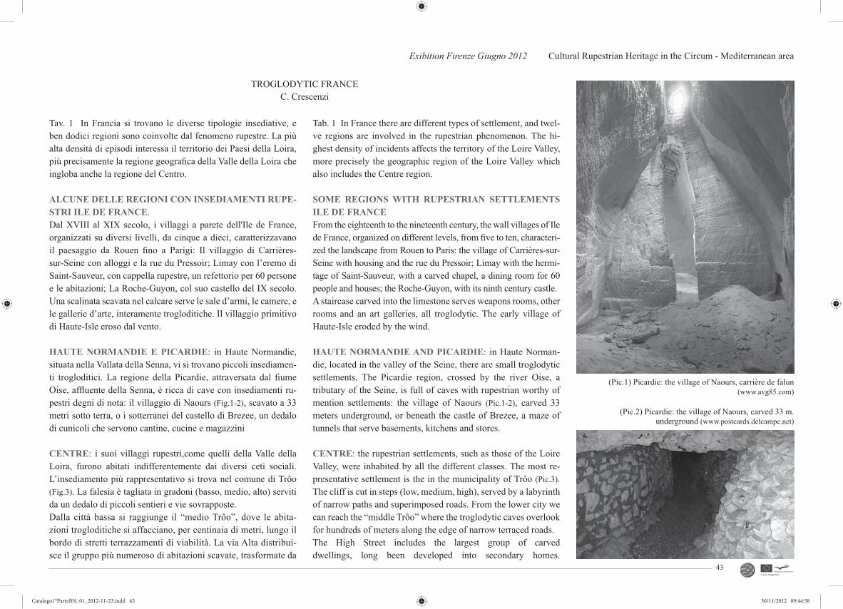
Exibition Firenze Giugno 2012 Cultural Rupestrian Heritage in the Circum - Mediterranean area
43
TROGLODYTIC FRANCEC. Crescenzi
Tav. 1 In Francia si trovano le diverse tipologie insediative, e ben dodici regioni sono coinvolte dal fenomeno rupestre. La più alta densità di episodi interessa il territorio dei Paesi della Loira, più precisamente la regione geografi ca della Valle della Loira che ingloba anche la regione del Centro.
ALCUNE DELLE REGIONI CON INSEDIAMENTI RUPE-STRI ILE DE FRANCE.Dal XVIII al XIX secolo, i villaggi a parete dell'Ile de France, organizzati su diversi livelli, da cinque a dieci, caratterizzavano il paesaggio da Rouen fi no a Parigi: Il villaggio di Carrières-sur-Seine con alloggi e la rue du Pressoir; Limay con l’eremo di Saint-Sauveur, con cappella rupestre, un refettorio per 60 persone e le abitazioni; La Roche-Guyon, col suo castello del IX secolo. Una scalinata scavata nel calcare serve le sale d’armi, le camere, e le gallerie d’arte, interamente trogloditiche. Il villaggio primitivo di Haute-Isle eroso dal vento.
HAUTE NORMANDIE E PICARDIE: in Haute Normandie, situata nella Vallata della Senna, vi si trovano piccoli insediamen-ti trogloditici. La regione della Picardie, attraversata dal fi ume Oise, affl uente della Senna, è ricca di cave con insediamenti ru-pestri degni di nota: il villaggio di Naours (Fig.1-2), scavato a 33 metri sotto terra, o i sotterranei del castello di Brezee, un dedalo di cunicoli che servono cantine, cucine e magazzini
CENTRE: i suoi villaggi rupestri,come quelli della Valle della Loira, furono abitati indifferentemente dai diversi ceti sociali. L’insediamento più rappresentativo si trova nel comune di Trôo (Fig.3). La falesia è tagliata in gradoni (basso, medio, alto) serviti da un dedalo di piccoli sentieri e vie sovrapposte. Dalla città bassa si raggiunge il “medio Trôo”, dove le abita-zioni trogloditiche si affacciano, per centinaia di metri, lungo il bordo di stretti terrazzamenti di viabilità. La via Alta distribui-sce il gruppo più numeroso di abitazioni scavate, trasformate da
Tab. 1 In France there are different types of settlement, and twel-ve regions are involved in the rupestrian phenomenon. The hi-ghest density of incidents affects the territory of the Loire Valley, more precisely the geographic region of the Loire Valley which also includes the Centre region.
SOME REGIONS WITH RUPESTRIAN SETTLEMENTSILE DE FRANCEFrom the eighteenth to the nineteenth century, the wall villages of Ile de France, organized on different levels, from fi ve to ten, characteri-zed the landscape from Rouen to Paris: the village of Carrières-sur-Seine with housing and the rue du Pressoir; Limay with the hermi-tage of Saint-Sauveur, with a carved chapel, a dining room for 60 people and houses; the Roche-Guyon, with its ninth century castle. A staircase carved into the limestone serves weapons rooms, other rooms and an art galleries, all troglodytic. The early village of Haute-Isle eroded by the wind.
HAUTE NORMANDIE AND PICARDIE: in Haute Norman-die, located in the valley of the Seine, there are small troglodytic settlements. The Picardie region, crossed by the river Oise, a tributary of the Seine, is full of caves with rupestrian worthy of mention settlements: the village of Naours (Pic.1-2), carved 33 meters underground, or beneath the castle of Brezee, a maze of tunnels that serve basements, kitchens and stores.
CENTRE: the rupestrian settlements, such as those of the Loire Valley, were inhabited by all the different classes. The most re-presentative settlement is the in the municipality of Trôo (Pic.3). The cliff is cut in steps (low, medium, high), served by a labyrinth of narrow paths and superimposed roads. From the lower city we can reach the “middle Trôo” where the troglodytic caves overlook for hundreds of meters along the edge of narrow terraced roads. The High Street includes the largest group of carved dwellings, long been developed into secondary homes.
(Pic.1) Picardie: the village of Naours, carrière de falun(www.avg85.com)
(Pic.2) Picardie: the village of Naours, carved 33 m.underground (www.postcards.delcampe.net)
Catalogo1°ParteBN_01_2012-11-23.indd 43Catalogo1°ParteBN_01_2012-11-23.indd 43 30/11/2012 09:44:5830/11/2012 09:44:58
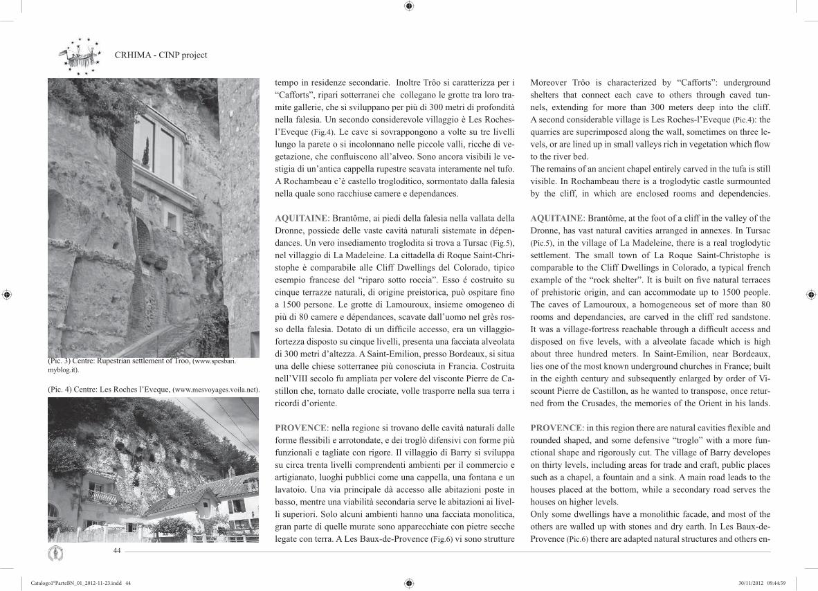
CRHIMA - CINP project
44
(Pic. 3) Centre: Rupestrian settlement of Troo, (www.spesbari.myblog.it).
tempo in residenze secondarie. Inoltre Trôo si caratterizza per i “Cafforts”, ripari sotterranei che collegano le grotte tra loro tra-mite gallerie, che si sviluppano per più di 300 metri di profondità nella falesia. Un secondo considerevole villaggio è Les Roches-l’Eveque (Fig.4). Le cave si sovrappongono a volte su tre livelli lungo la parete o si incolonnano nelle piccole valli, ricche di ve-getazione, che confl uiscono all’alveo. Sono ancora visibili le ve-stigia di un’antica cappella rupestre scavata interamente nel tufo. A Rochambeau c’è castello trogloditico, sormontato dalla falesia nella quale sono racchiuse camere e dependances.
AQUITAINE: Brantôme, ai piedi della falesia nella vallata della Dronne, possiede delle vaste cavità naturali sistemate in dépen-dances. Un vero insediamento troglodita si trova a Tursac (Fig.5), nel villaggio di La Madeleine. La cittadella di Roque Saint-Chri-stophe è comparabile alle Cliff Dwellings del Colorado, tipico esempio francese del “riparo sotto roccia”. Esso é costruito su cinque terrazze naturali, di origine preistorica, può ospitare fi no a 1500 persone. Le grotte di Lamouroux, insieme omogeneo di più di 80 camere e dépendances, scavate dall’uomo nel grès ros-so della falesia. Dotato di un diffi cile accesso, era un villaggio-fortezza disposto su cinque livelli, presenta una facciata alveolata di 300 metri d’altezza. A Saint-Emilion, presso Bordeaux, si situa una delle chiese sotterranee più conosciuta in Francia. Costruita nell’VIII secolo fu ampliata per volere del visconte Pierre de Ca-stillon che, tornato dalle crociate, volle trasporre nella sua terra i ricordi d’oriente.
PROVENCE: nella regione si trovano delle cavità naturali dalle forme fl essibili e arrotondate, e dei troglò difensivi con forme più funzionali e tagliate con rigore. Il villaggio di Barry si sviluppa su circa trenta livelli comprendenti ambienti per il commercio e artigianato, luoghi pubblici come una cappella, una fontana e un lavatoio. Una via principale dà accesso alle abitazioni poste in basso, mentre una viabilità secondaria serve le abitazioni ai livel-li superiori. Solo alcuni ambienti hanno una facciata monolitica, gran parte di quelle murate sono apparecchiate con pietre secche legate con terra. A Les Baux-de-Provence (Fig.6) vi sono strutture
Moreover Trôo is characterized by “Cafforts”: underground shelters that connect each cave to others through caved tun-nels, extending for more than 300 meters deep into the cliff.A second considerable village is Les Roches-l’Eveque (Pic.4): the quarries are superimposed along the wall, sometimes on three le-vels, or are lined up in small valleys rich in vegetation which fl ow to the river bed. The remains of an ancient chapel entirely carved in the tufa is still visible. In Rochambeau there is a troglodytic castle surmounted by the cliff, in which are enclosed rooms and dependencies.
AQUITAINE: Brantôme, at the foot of a cliff in the valley of the Dronne, has vast natural cavities arranged in annexes. In Tursac (Pic.5), in the village of La Madeleine, there is a real troglodytic settlement. The small town of La Roque Saint-Christophe is comparable to the Cliff Dwellings in Colorado, a typical french example of the “rock shelter”. It is built on fi ve natural terraces of prehistoric origin, and can accommodate up to 1500 people. The caves of Lamouroux, a homogeneous set of more than 80 rooms and dependancies, are carved in the cliff red sandstone. It was a village-fortress reachable through a diffi cult access and disposed on fi ve levels, with a alveolate facade which is high about three hundred meters. In Saint-Emilion, near Bordeaux, lies one of the most known underground churches in France; built in the eighth century and subsequently enlarged by order of Vi-scount Pierre de Castillon, as he wanted to transpose, once retur-ned from the Crusades, the memories of the Orient in his lands.
PROVENCE: in this region there are natural cavities fl exible and rounded shaped, and some defensive “troglo” with a more fun-ctional shape and rigorously cut. The village of Barry developes on thirty levels, including areas for trade and craft, public places such as a chapel, a fountain and a sink. A main road leads to the houses placed at the bottom, while a secondary road serves the houses on higher levels. Only some dwellings have a monolithic facade, and most of the others are walled up with stones and dry earth. In Les Baux-de-Provence (Pic.6) there are adapted natural structures and others en-
(Pic. 4) Centre: Les Roches l’Eveque, (www.mesvoyages.voila.net).
Catalogo1°ParteBN_01_2012-11-23.indd 44Catalogo1°ParteBN_01_2012-11-23.indd 44 30/11/2012 09:44:5930/11/2012 09:44:59

Exibition Firenze Giugno 2012 Cultural Rupestrian Heritage in the Circum - Mediterranean area
45
(Pic. 5) Aquitaine: Tursac, (www.trekearth.com).
(Pic. 6) Provence: Les Baux-de- Provence, (www.tripadvisor.it).
naturali adattate, altre interamente scavate dall’uomo. I trogloditi di Saint Chamas in origine legati all’attività portuale, devono la loro esistenza all’arcivescovo d’Arles, proprietario delle terre nel 1615, che permise agli abitanti di scavare le abitazioni nella fale-sia, alta 30 m.
POITOU-CHARENTES: Saint-Rémy-sur-Creuse presenta de-gli antichi raggruppamenti trogloditici, più o meno abbandonati. La falesia ospita, scavato su più livelli un antico villaggio troglo-ditico, un allineamento di circa 1 km con numerose abitazioni e una cappella con altare tagliato nella roccia. Diverse località La Roche-Posay, Bourré e Meschers-sur-Gironde, ospitano villaggi trogloditici. A Meschers-sur-Gironde (Fig.7) nelle gole delle alte falesie il villaggio si sviluppa spesso su due livelli. Le grotte, abi-tazioni di una popolazione povera, ora sono state riqualifi cate e ristrutturate;\ vi si accede per dei sentieri e delle scalinate, attra-verso i giardini superiori fi no alle residenze private e alle cavità pubbliche. In questa regione si trovano due chiese monolitiche, a Gurat la chiesa di Saint-Georges e ad Aubeterre-sur-Dronne (Fig.10) la chiesa di Saint Jean, il più imponente monumento rupe-stre francese, alto 20 m. L’attuale confi gurazione è frutto di am-pliamenti, il primo impianto è paleocristiano, fu ampliata nel XII secolo dai frati Benedettini per ospitare le reliquie portate da Pie-tro II di Castillon. Nella chiesa si trova l’antico fonte battesimale, tombe terragne e la galleria sospesa, da cui si gode una splendida vista sul complesso.
AUVERGNE: il villaggio trogloditico di Jonas (Fig.9) accoglie castelli, abitazioni, commerci e chiese, interamente scavati su set-te livelli nel tufo vulcanico della falesia. Questo tufo, di tinta ros-sastra, è facile da lavorare ma troppo friabile perché possa offrire una buona resistenza all’usura. Le abitazioni erano dislocate lun-go sentieri e scalinate tagliate nella roccia; tutte le diverse siste-mazioni sono ancora visibili ma gli ampliamenti successivi delle abitazioni e l’escavazione di nuovi accessi e dimore, intrapresi durante il medioevo, hanno reso precaria la stabilità delle apertu-re. Il paesaggio della regione ricorda la Cappadocia, nel triangolo formato da Clermont-Ferrand, Issoire e la Bourboule, s’incontra-
tirely carved by man. The troglodytes of Saint Chamas, originally linked to port activities, owe their existence to the Archbishop of Arles, ower of the land in 1615, who allowed the inhabitants to carve homes in the cliff 30 meters high.
POITOU-CHARENTES: in Saint-Remy-sur-Creuse there are ancient troglodytic groupings more or less abandoned. The cliff houses an ancient troglodytic village dug on several levels; an array of about 1 km with many houses and a chapel with an altar carved into the rock. Several sites, as La Roche-Posay, Bourré and Meschers-sur-Gironde (Pic.7), host troglodytic villages. In Meschers-sur-Gironde, in the gorges of the high cliffs, the village often develops on two levels. The caves, once houses for a poor population, have now been upgraded and renovated and are accessible by paths and stai-rways, through the upper gardens to the private residences and public cavities. In this region there are two monolithic churches: the church of Saint-Georges in Gurat and the church of Saint Jean in Aubeterre-sur-Dronne (Pic.10), which is the most impressive ru-pestrian french monument, 20 m high. Its current confi guration is the result of an expansion: the fi rst plant was early Christian and was expanded in the twelfth century by the Benedictine monks to house the relics brought by Peter II of Castillon. In the church there is the ancient baptismal font, ground tombs and a suspended gallery from which you can enjoy a splendid view of the complex.
AUVERGNE. The troglodytic village of Jonas (Pic.9) includes castles, homes, businesses and churches, all carved in seven le-vels in the volcanic tuff of the cliff. This tuff, reddish tint, it is easy to work with but too friable to provide a good resistance to usury. The houses were located along paths and stairs cut into the rock, and all the rooms are still visible but the successive en-largements of the houses and the excavation of new access and mansions, undertaken during the Middle Ages, made the stability of the openings precarious. The landscape of the region reminds of Cappadocia: in the trian-gle formed by Clermont-Ferrand, Issoire and La-Bourboule we
(Pic. 7) Poitou-Charentes: Meschers-sur-Gironde, (www.tripadvisor.it).
Catalogo1°ParteBN_01_2012-11-23.indd 45Catalogo1°ParteBN_01_2012-11-23.indd 45 30/11/2012 09:44:5930/11/2012 09:44:59

CRHIMA - CINP project
46
no coni rocciosi sormontati da un “cappuccio” di roccia più dura.* * *
Tav. 2 LA VALLE DELLA LOIRA: generalità. Nelle falesie calcaree scavate dalla Loira (Vienne, Loir, Cher) e dai suoi af-fl uenti, troviamo un’elevata densità di spazi scavati; nel corso del XIX secolo sono stati recensiti fi no a 40.000 abitanti trogloditici; signifi cativa la portata storica del della vita troglodita su questo vasto territorio. La Valle della Loira, Riconosciuto Patrimonio dell’Umanità quale paesaggio culturale, è il sito più vasto iscritto in Francia: 280 Km in lunghezza con una superfi cie di 800 Kmq.La riconosciuta valenza culturale è stata motrice per valorizzare il territorio con progetti tesi alla tutela, all’animazione e sensibiliz-zazione, per un recupero duraturo promuovendo scambi economi-ci, culturali e scientifi ci internazionali. Geologia. Nella ragione il troglotismo si sviluppa in una acco-gliente formazione geologica che costituisce l’ossatura delle dif-ferenti falesie della Valle della Loira detta “TURONIEN”. Esso è suddiviso in tre parti: alla base si trova il Turonien inferiore, testimonianza dell’apogeo del mare di gesso; il Turonien medio (Fig.11-12), un gesso bianco, tenero, micaceo, con una componen-te sabbiosa importante e racchiude delle selci in letti; il Turonien superiore, meno gessoso e più sabbioso, costituisce il letto più recente. Cenni storici sullo sviluppo rupestre nella valle. Nel Pale-olitico le caverne servivano temporaneamente come rifugio per le calamità naturali o per difendersi da attacchi di altre popolazioni. Solo con l’Età del Ferro (circa 700 A.C.)con l’affermazione dei nuovi strumenti, si scava la falesia e la si rende abitabile. Durante il periodo delle Invasioni Barbariche del V secolo a.C. la cavità diviene luogo di difesa. Con lo sviluppo del cristianesimo, nel IV secolo d.C., alcune grotte furono delegate a funzione di culto. Solo nell’XI secolo si affermò lo sviluppo del trogloditismo nella regione: Foulques Nerra, conte d’Anjou, ordina la costruzione di una cinquantina di castelli per dominare l’asse economico fl uviale ligeriano (Liger nome latino della Loira), comprendente tutto il fl usso di mercanzie veicolate. Nella falesia si aprirono numero-se cave d’estrazione del Tufo ristrutturati in volumi residenziali quelli posti spazi in prossimità della luce naturale. Una nuova espansione si ebbe nel XIII secolo col prosperare dell’attività
found rocky cones topped with a “cap” of hardest rock.* * *Tab. 2 THE LOIRE VALLEY: general. In the limestone clif-fs carved by the Loire (Vienne, Loir, Cher) and its tributaries, there is a high density of excavated areas; during the nineteenth century were reviewed up to 40,000 troglodytic inhabitants; the historic importance of the troglodytic life in this vast terri-tory is signifi cant. The Loire Valley, recognized a World Heri-tage for its cultural scenery, is the largest recorded site in Fran-ce: 280 Km in length with an area of 800 square kilometers.The recognized cultural value has been a driving force for enhan-cing the area with projects aimed at the protection, animation and sensitization to promote economic, cultural and scientifi c trades for a lasting recovery.Geology. In this region, troglodytism develops in a cosy ge-ological formation which constitutes the frame of the different cliffs of the Loire Valley called “TURONIEN.” It is divided into three parts: the base is the lower Turonien, an attestation of the apogee of the gypsum sea; a middle Turonien (Pic.11-12), a white gypsum, soft and micaceous, with a prevalent san-dy component, which contain fl ints; the higher Turonien, with less gypseous and more sandy, which is the most recent bed. Historical notes on the development of rock in the valley. In the Paleolithic caves were used as a temporary shelter for natural di-sasters or to defend against attacks from other populations. Only in the Iron Age (about 700 BC), with the coming of new instru-ments, the cliff is dug and made habitable. During the period of the barbarian invasions in the fi fth century BC the cavity becomes a place of defense. With the development of Christianity in the fourth century AD, some caves had a reli-gion function, and only in the eleventh century troglodytism de-veloped in the region: Foulques Nerra, Count of Anjou, ordered the construction of fi fty castles to dominate the Liger economic axis (Liger is the latin name of the Loire), which included all the fl ow of merchandise conveyed. Several quarries for the extraction of tuff were opened in the cliff, and subsequentially the ones pla-ced in natural light were restored as residential volumes. A new expansion took place in the thirteenth century with the fl ourish of
(Pic. 8) The church of Saint-Georges in Gurat, (www.fr.wikipedia.org).
(Pic. 10) The church of Saint Jean in Aubeterre-sur-Dronne, (www.fl irk.com).
Catalogo1°ParteBN_01_2012-11-23.indd 46Catalogo1°ParteBN_01_2012-11-23.indd 46 30/11/2012 09:44:5930/11/2012 09:44:59

Exibition Firenze Giugno 2012 Cultural Rupestrian Heritage in the Circum - Mediterranean area
47
battelliera e con la migrazione di popolazioni dalle regioni più povere, cercanti un alloggio a buon mercato. Con la Guerra dei Cento Anni (1337-1453 D.C.) il trogloditismo ridiviene rifugio in quanto è possibile incendiare le case, distruggere le colture, ma non abbattere le cave. Nel Rinascimento,Re Francesco I rivita-lizza l’economia della regione con i numerosi cantieri dei castelli della Loira. I coltivatori diventano cavatori l’inverno, la Loira di-viene asse di trasporto del tufo verso i siti in costruzione. Durante questo, gran parte degli abitanti della regione vivono sotto terra: i paysans come gli ecclesiastici, gli artigiani come i nobili. Durante le guerre di religione, il XVII secolo è l’anno di massima espan-sione del trogloditismo. Alla fi ne del XVIII secolo con lo sviluppo delle attività manifatturiere e industriali emergono nella campa-gna qualche costruzione in tufo. Il XIX secolo, con l’affermarsi del trasporto ferroviario, cresce la richiesta di costruzioni in su-perfi cie, la domanda di pietra da costruzione porta a scavare anche nelle parti di falesia ancora intatte, compromettendo seriamente la solidità della falesia stessa. L’inizio del XX secolo segna l’ab-bandono progressivo delle cavità, che offrirono ancora una volta rifugio durante l’occupazione tedesca. Negli anni ’50 Jeanne e Camille Fraysse fi nalizzano i loro studi all’habit rupestre; negli anni ’60-’70 l’attenzione ecologista focalizza il trait-d’union tra architettura e natura: la riscoperta di una vita tradizionale e delle sue ricchezze culturali genera un interesse crescente che soddisfa modi di vita alternativa. Dagli anni ‘80 si sono sviluppati numero-si progetti, l’emergenza bioclimatica e la necessità di economiz-zare l’energia aprono delle nuove prospettive per il patrimonio trogloditico, che tuttavia è a rischio: il 90% dell’abitato scavato nella Valle della Loira è abbandonato da due secoli.
METODO DI SCAVOVerticale (Fig.14). Lo scavo comincia con la “messa a nudo” del-la roccia; determinato il tracciato, si scava in verticale, seguendo una linea concava, allargando progressivamente il piano. L’esau-rimento dello strato o il raggiungimento della falda freatica ferma lo scavo. L’altezza delle gallerie, a volte più di 10 metri, è sempre uguale a due volte e mezzo la sua larghezza. Queste proporzioni assicurano un perfetto effetto di volta e la
shipping and with the migration of people from poorer regions, looking for a cheap accommodation. During the Hundred Years’ War (1337-1453 AD) troglodytism be-comes a refuge from possible burning homes and the destroying of the crops. In the Renaissance, King Francis I revitalize the re-gion’s economy with the yards of the Loire castles. In winter far-mers become miners and the Loire becomes a transport axis of the tuff to the construction sites. During this time most of the people in the region live below ground, paysans as the clergy, nobles as artisans. During the wars of religion, the seventeenth century is the period of maximum troglodytism expansion. At the end of the eighteenth century with the development of manufacturing and industrial, in the countryside we found the raise of some tuff construction. In the nineteenth century the rising of the rail transportation cau-se the demand of overground structures; the demand for building stone entails the digging of parts of cliff still intact, seriously compromising the solidity of the cliff itself. The beginning of the twentieth century marked the abandonment of the cavity, which once offered refuge during the German occupation. In the 50s Je-anne and Camille Fraysse fi nalize their study of the rupestrian habit; in the 60s and 70s the ecologist attention focuses on a link between architecture and nature: the rediscovery of a traditional life and its cultural wealth generates a growing interest which sa-tisfi es alternative ways of life. From the 80s many projects are developed: the bioclimatic emer-gency and the need to save energy open up new prospects for the troglodytic heritage, which, however, is at risk: 90% of the town dug in the Loire Valley is abandoned for two centuries.
METHOD OF EXCAVATIONVertical (Pic.14). The excavation begins “laying” the rock; once determined the plan, the digging proceed vertically along a con-cave line, progressively enlarging. The layer depletion or the at-tainment of the water table stop the digging. The height of the tunnels, sometimes more than 10 meters, is always equal to two and a half times its width. These proportions ensure a perfect vault effect and maximum
(Pic. 11) Middle Turonien, a white and soft gypsum, (www.jl.franchomme.free.fr).
(Pic. 12) Another exemple of Turonien, (www.geodiversite.net).
(Pic. 13) Method of excavation, (G. M. Vampa, N. Pacini).
Catalogo1°ParteBN_01_2012-11-23.indd 47Catalogo1°ParteBN_01_2012-11-23.indd 47 30/11/2012 09:45:0030/11/2012 09:45:00
CRHIMA - CINP project
48
stabilità massima dell’edifi cio. L’apertura minima sul suolo era facilmente richiudibile, l’accesso alla cava avviene tramite una rampa; per la loro suggestiva e particolare confi gurazione, queste cave sono chiamate “cattedrali”. Si trovano nel Sud-Saumurois, in prossimità di Doué-la-FontaineIn “galleria” o “camere” (Pic.13): questi metodi offrono maggiore sicurezza e stabilità, ma poco usati per la coltivazione offrendo un ricavo produttivo di scavo nettamente inferiore e quindi erano poco utilizzati. Nelle cave moderne il metodo più comunemente usato è quello dei “pilastri girati”: per non compromettere la stabilità della roccia, se ne lasciava una parte che assumeva le caratteristiche di un grande pilastro intorno ai quali si “girava” per estrarre materiale, da qui il nome di “pilastri girati”. Questi , a sezione quadrata o rettan-golare, di 3 o 4 metri di lato, potevano essere anche molto “informi”. I pilastri a setti sono più recenti e separavano in genere due gallerie parallele, questesono identiche e seguono una trama predefi nita.
* * *ECONOMIA E AMBIENTE TROGLODITATav.3 L’estrazione della materia ha lasciato dei vuoti enormi nella roccia; le condizioni di forte igrometria, di temperatura costante, di assenza di luce e di correnti d’aria hanno permesso lo sviluppo di una “economia dell’umidità”, con la fermentazione, macera-zione e conservazione dei prodotti.La coltura della vigna (Fig.15). La Valle della Loira possiede una delle più vaste aree a vigneto di tutta la Francia, e il vino è il prodotto per eccellenza della regione. Nel Saumurois il vigneto si estende su una superfi cie di 4.000 ettari. La produzione e stoc-caggio del vino ha un ruolo decisivo nell’economia locale. Fino al XVIII-XIX secolo la produzione del vino era soprattutto perso-nale e le cantine per il vino erano scavate appositamente, diffi cil-mente si riutilizzavano gallerie esistenti. Le cantine (Fig.16) sono rupestri e hanno una profondità variabile dai venti ai trenta metri, per avere l’oscurità, la stabilità termica e l’umidità necessari per una buona conservazione del vino. Dal XIX secolo, sviluppandosi la produzione del vino, e necessitando cave sempre più grandi, s’investì sulla riutilizzazione e riqualifi cazione delle gallerie sot-terranee abbandonate. Fra il vigneto e la cantina in cava vi era un forte legame, un rapporto leggibile e caratterizzante il paesaggio.
stability of the building. The minimum aperture on the ground was easily resealable and the access to the cave was through a ramp; for their striking and particular confi guration, these caves are called “cathedrals”. They are located in South-Saumurois, near Doue-la-Fontaine. In “gallery” or “rooms” (Pic.13): these methods offer gre-ater security and stability, but not much used to grow re-venue, offering a much lower production of excavation.In modern quarries the method most commonly used is that of the “turn-around pillars”: to not compromise the stability of the rock, a part was left assuming the characteristics of a large pil-lar around which “turn” to extract material. These, in square or rectangular section, of 3 or 4 meters on a side, could also be very “unformed”. The partition pillars are newer and generally they were separating two parallel and identical tunnel following a pre-established plot.* * *THE TROGLODYTE ECONOMY AND ENVIRONMENT Tab. 3 The extraction of the material has left huge voids in the stone; the conditions of high humidity, constant temperature, absence of light and air currents, has led to the development of a “moisture economy”, with fermentation, maceration and storage of products.The cultivation of the vine (Pic.15). The Loire Valley presents one of the largest areas of vineyards in France, and wine is the excellence product of the region. In Saumurois the vineyards co-ver an area of 4,000 hectares. The production and storage of wine are of fundamental importance for the local economy. Until the XVIII-XIX century, wine production remained at handicraft level and wine cellars were carved specifi cally, since the existing tun-nels were rarely used. The rupestrian cellars (Pic.16) have a depth varying from twenty to thirty feet in order to provide the neces-sary environmental conditions for the proper conservation of the wine such as obscurity, thermal stability and moisture. The deve-lopment of wine production in the nineteenth century increased the demand for extensive use of large caves which was satisfi ed through the rehabilitation and reuse of abandoned underground tunnels.
(Pic. 15) The cultivation of the vine: vineyard in the Loire Valley, (www.ecovacanze.it).
(Pic. 16) Rupestrian wine cellar, (www.ecovacanze.it).
(Pic. 14) Method of excavation, (G. M. Vampa, N. Pacini).
Catalogo1°ParteBN_01_2012-11-23.indd 48Catalogo1°ParteBN_01_2012-11-23.indd 48 30/11/2012 09:45:0030/11/2012 09:45:00

Exibition Firenze Giugno 2012 Cultural Rupestrian Heritage in the Circum - Mediterranean area
49
I due luoghi comunicavano con il “jitte de pressoir”, piccolo poz-zo- condotto intonacato con calce, in cui si gettava l’uva raccolta direttamente nel “pressoir” (Fig.17), posto nella cava sottostante il vigneto. Tutti i processi di vinifi cazione - raccolta del succo, fer-mentazione del mosto, conservazione e il successivo stoccaggio in bottiglia - avvenivano in cava. Il “pressoir” classico era costitu-ito da una vasca murata o in cemento, in cui era inserita la pressa di legno e ferro, il succo era raccolto da un rigagnolo collegato ad una vasca scavata nella roccia. Molti degli antichi pressoir e altri strumenti per la vinifi cazione sono andati persi, le tecniche meccanizzate hanno portato all’abbandono delle jitte per la rac-colta dell’uva, perdendo il legame fi sico tra vigneto in superfi cie e cantina in cava. Tuttavia le innumerevoli cantine del Saumurois utilizzano le cave come barricaie e sfruttano le accattivanti quali-tà architettoniche per promuovere l’ospitalità turistica, aprendo e offrendo gli ambienti suggestivi ai visitatori e alle visite guidate per la degustazione dei prodotti. La tradizione delle “pommes tapées” (Fig.18). Nel corso della se-conda metà del XIX secolo la vigna fu annientata dalla Phylloxera. Così la popolazione sviluppò un’“industria di soccorso” che spa-rì con la ripresa della viticoltura. Nacque l’attività delle pommes tapées, ossia le “mele schiacciate”, essiccate nei forni per pane e in seguito lavorate con un apposito martellino (Fig.19); la produzione è ancora di tipo artigianale e gran parte della lavorazione è manuale. La coltura dello champignon (Fig.21). La coltura dello champi-gnon Paris, nata nella regione parigina nel XVII secolo con colti-vazione en plain-air, si trosforma in coltura di cava e nel XIX seco-lo e s’installa nella Valle della Loira, in particolare nel Saumurois. Il Saumurois, potendo assicurare una produzione costante durante tutto l’anno, divenne il massimo produttore di champignon Paris. Inizialmente la sua coltivazione avveniva su “solchi”, composti con letame, paglia e un mélange di terra e tufo schiacciato. Questa tecnica fu abbandonata a vantaggio di quella in casse di legno, poi in sacchi di plastica, e infi ne in contenitori metallici. Oggi, nella Valle della Loira sono presenti una trentina di produttori di champi-gnon, “sopravvissuti” alla forte concorrenza proveniente dalla Cina, divenuta prima produttrice di champignon nel mondiale, tuttavia la Francia resta al primo posto per la coltura in cava.
The relation established between the vineyard and the rupestrian wine cellar was very strong and characteristic for that landscape. The two sites communicated with the “jitte de pressoir”, a small well coated with lime through which the collected grapes were directly conducted into the “pressoir” (Pic.17), located in the cave underneath the vineyard.The tradition of “pommes tapées.” (Pic.18) During the second half of the nineteenth century, the vineyard was destroyed by a pa-rasite, the Phylloxera, this event pushed the population to develop an “emergency industry” which disappeared once the viticulture was recovered. In that occasion a new activity emerged, it was called the production of pommes tapées or “squashed apples”, dried in the ovens otherwise used for the bread cooking and then worked with a special hammer (Pic.19); the production is still at a handicraft level and almost all of the work is operated directly and manually.The cultivation of champignon mushrooms (Pic.21). The en plein-air cultivation of Champignon mushrooms began in the Paris region during the seventeenth century, it was replaced by cultivation in quarries in the nineteenth century and spread in the Loire Valley. In particular, in Saumurois, characterized by tunnels extending for thousands of kilometers. The manure of the horses of the Cadre Noir, military riding school in the area, was used as fertilizer. Being able to ensure a constant production throughout the year thanks to cultivation in the quarry, the Saumurois became the largest producer of mushrooms in Paris. Initially, the cultivation of mushrooms was on “furrows”, made with manure, straw and a mixture of earth and pressed tuff. This technique was abandoned in the mid-twentieth century and initially replaced by that of wooden crates (in the 50’s), later on by plastic bags (in the 50’s), and fi nally by metal con-tainers. Today, in the Loire Valley the number of champignon producers is only about thirty, they survived from the strong competition with the offer from China, which became the fi rst producer of mushrooms in the world, even if France still holds the fi rst place for the cultivation in the quarry.The tradition of the dovecotes (Pic.20). The dovecote or pigeon
(Pic. 17) Pressoir à vin, (www.fr.wikipedia.it).
(Pic. 19) Pommes tapées dried in the ovens, (www.fl irk.com).
(Pic. 18) Les pommes tapées, (www.mesvoyages-mesballades.com).
Catalogo1°ParteBN_01_2012-11-23.indd 49Catalogo1°ParteBN_01_2012-11-23.indd 49 30/11/2012 09:45:0130/11/2012 09:45:01

CRHIMA - CINP project
50
La tradizione delle piccionaie. E’ una struttura edifi cata o scavata con nicchie per piccioni. Durante l’epoca feudale la proprietà di una piccionaia era un pri-vilegio signorile; il numero di piccioni era proporzionale e in fun-zione della superfi cie delle terre arabili. Erano un elemento qua-lifi cante delle dépendances signorili, poiché fornivano sia carne sia guano, eccellente concime riservato all’orto di proprietà del signore.
* * *IL PATRIMONIO TROGLODITICO NEL SAUMUROISTav.4 Il Saumurois è ricco di emergenze trogloditiche, ripartite senza discontinuità su circa 400 kmq si trovano tutte le tipologie di abitato : rurale, borghese, signorile, religioso. Tra le realtà più prossime alla città di Saumur troviamo degli esempi interessanti di recupero e riqualifi cazione di abitati trogloditici abbandonati nei secoli. (Fig.23-24) Rochemenier (Fig.22), restaurato e visitabile dal 1967, comprenden-te due antiche fattorie con abitazioni e una cappella sotterranea. Il comune di Doué-la-Fontaine, caratterizzato dalle “cattedrali” sca-vate nel falun, unica espressione del trogloditismo verticale. La frazione di Saint-Hilaire- Saint-Florent dove è stato aperto da più di trent’anni il museo “Pierre et Lumière”, un’antica galleria sot-terranea è stata riqualifi cata a museo, con le principali architetture della Valle della Loira riproposte in miniature scavate nel tufo. I borghi semitrogloditici dei Dampierre-sur-Loire, Souzay-Champi-gny, Parnay, Turquant. Questi villaggi, urbanizzati su direttrici per-pendicolari alla Loira, si affacciano su di essa con un’architettura elementare, sviluppando nella falesia retrostante, un gran numero di abitazioni trogloditiche, in parte abbandonate, o ancora abitate o in corso di ristrutturazione. Nel comune di Souzay è stata ristruttu-rata l’antica “via del commercio”, un percorso ciclo-pedonale sca-vato nella roccia. A Turquant sono state riqualifi cate una dozzina di cave adiacenti tra loro, che si affacciano sulla “via dei mestieri”, qui ogni spazio troglodita è un atelier artistico: dal soffi atore di vetro, al fabbro, allo scultore ecc. A Montsoreau si trova una Champignon-nières, ancora attiva, con spazio museale, con gallerie sotterranee dedite alla coltivazione dei funghi visitabili, con spazio ricreativo e ristorante per la degustazione dei prodotti della cava. Caratteristi-
house is a structure built or carved with alcoves for pigeons. Du-ring the feudal age the ownership of a dovecote was a noble pri-vilege and the number of pigeons was proportional to the area of arable soils. The dovecotes were a signifi cant element for elegant outbuildings as they were supplying the land owners with pigeon meat which was very appreciated at the time and with guano, an excellent fertilizer reserved for the vegetable gardens owned by the landholder.* * *THE TROGLODYTIC HERITAGE IN SAUMUROISTab. 4 The Saumurois is full of troglodytic presences, equally distributed, on approximately 400 square kilometers there are all types of town: rural, middle-class, genteel and religious. Among the most close to the town of Saumur there are interesting examples of recovery and requalifi cation of abandoned troglodytic villages over the centuries (Pic.23-24). Rochemenier (Pic.22), renovated and open since 1967, includes two ancient farms with dwellings and an underground chapel. The town of Doue-la-Fontaine, characterized by the “cathedrals” dug in the falun, is the only expression of verti-cal troglodytism. The village of Saint-Hilaire-Saint-Florent, where since thirty years there is the museum “Pierre er Lumière”: the museum is an ancient underground tunnel now reclassifi ed, where the main architecture of the Loire Valley are repeated in miniatures carved into the tuff; the semi-troglodytic villages of Dampierre-sur-Loire, Souzay-Champigny, Parnay, Turquant: these villages, urba-nized in lines perpendicular to the Loire, look on it with a simple architecture, developing a large number of troglodytic dwellings in the cliff behind, some partially abandoned, others still inhabited or undergoing restructuring. In the town of Souzay the old “trade route” was restored in a pedestrian and cycle route carved into the rock. In Turquant a dozen quarries adjacent to each other and facing the “way of trades” has been requalifi ed; every troglodytic space has become an art studio: the glassblower, the blacksmith, the sculptor. In Montsoreau there is a Champignonnières, still ac-tive, with the museum space, underground galleries, now open to visitors, dedicated to the cultivation of mushrooms, with a recrea-tional area and a restaurant for tasting the products of the quarry. Features of the town. The villages that follow along the secon-
(Pic. 20a, b) Exemples of dovecotes, (www.malverntrali.co.uk).
(Pic. 21) The cultivation of champignon, (www.malverntrali.co.uk).
Catalogo1°ParteBN_01_2012-11-23.indd 50Catalogo1°ParteBN_01_2012-11-23.indd 50 30/11/2012 09:45:0230/11/2012 09:45:02

Exibition Firenze Giugno 2012 Cultural Rupestrian Heritage in the Circum - Mediterranean area
51
che dell’abitato. I paesi che si susseguono lungo la strada diparti-mentale da Saumur a Montsoreau, presentano tre principali tipolo-gie di abitato. Gli edifi ci posti sulla strada, affacciati sul fi ume, sono staccati dalla roccia, caratterizzati da un’architettura elementare, prismatica con copertura a due falde; realizzati in muratura di tufo con copertura in lastre d’ardesia; risalgono generalmente al XIX secolo. Addossate alla falesia si hanno abitazioni semitroglodite, con un lato addossato alla roccia e costruita in muratura e con tetto spiovente a una falda, col colmo incastrato nella roccia. La terza tipologia è quella troglodita: può essere semitroglodita, con parte del corpo costruito in muratura o totalmente inserita nella roccia; la sua facciata, apparecchiata in tufo, è inscritta nel semicerchio del vano d’accesso alla cava e presenta l’ingresso ed un’unica fi nestra. L’abitazione può avere una o più stanze, scavando nuovi vani in profondità o adiacenti l’una all’altra sul fronte. In genere lo spazio
dary road from Saumur to Montsoreau are three main types of settlement. The buildings on the street, overlooking the river, are detached from the rock, characterized by a elemental archi-tecture, prismatic, with a gable roof; they are made of tuff ma-sonry and covered with slates; they generally date back to the nineteenth century. Other are semi-troglodytic dwellings resting against the cliff, with one side leaning against the rock and built in brick, with one-pitched roof, with the ridge stuck in the rock. The third type is the troglodytic one: it can also be semi-troglodytic, with part of the body built of masonry or totally inserted into the rock; the facade, made in tuff, is inscribed in the semicircle of the access to the cave, with an entrance and a single window.The house may have one or more rooms, since that plastic evo-lutionary nature of the carved space carved, digging deeper new rooms or adjacent to each other on the front.
(Pic. 22) Troglodytic settlement of Rochemenier, (www.wikipedia.org).
(Pic. 24) Troglodyte village who appears on the Loire,(G. M. Vampa, N. Pacini).
(Pic. 23) Loire river divides the valley in two different parts, (G. M. Vampa, N. Pacini).
Catalogo1°ParteBN_01_2012-11-23.indd 51Catalogo1°ParteBN_01_2012-11-23.indd 51 30/11/2012 09:45:0230/11/2012 09:45:02

CRHIMA - CINP project
52
di vita domestico era accentrato in un’unica stanza, quella prossima alle aperture per godere il più possibile della benefi ca luce; essa era arredata con un camino, fulcro dell’abitato, con le sue molteplici funzioni sia per il riscaldamento sia per la cottura dei cibi, spesso comprendeva un forno a pane o un “potager”, un braciere atto alla cottura degli alimenti.
* * *“LA LOIRE À VÉLO”Tav. 5 Il progetto “La Loire à Vélo” (Fig.25-26) è nato nel 1995, dall’iniziativa delle regioni Centro e Paesi della Loira. Questa pista ciclabile, che a fi ne lavori percorrerà 800 km e attraverse-rà la Valle della Loira, si integra nell’itinerario ciclabile europeo “Eurovélo 6”. L’itinerario di 3650 km attraverserà dieci nazio-ni (Francia, Svizzera, Germania, Austria, Slovacchia, Ungheria, Serbia, Croazia, Bulgaria e Romania), percorrerà le valli di 3 grandi fi umi europei ( Loira, Reno, Danubio) congiungendo, en-tro il 2012, la costa Atlantica con quella del Mar Nero. Servizi e assistenza lungo il percorso. La “Loire à Vélo” ha pro-mosso più di 200 strutture ospitaliere (hotels, campings, came-re, ostelli), contraddistinti dalla carta di qualità “Accueil Vélo” e situati ad una distanza massima di 5 km dal percorso ciclabile. Queste strutture offrono anche uno spazio di accoglienza-tecnica per le bici, materiale di riparazione e altri servizi inerenti all’atti-vità ciclistica. Lungo il suo itinerario si trovano venti punti per il noleggio di bici che offrono assistenza tecnica ai ciclisti.
* * *IL BOURG-NEUFTav. 6-7 Inquadramento territoriale. Bourg-Neuf (47.238835,-0.015976) (Fig.27), nel Saumurois, è una località del comune di Dampierre-sur-Loire, confi nante col comune di Souzay-Champi-gny. Dista pochi km dai centri storici trogloditi più conosciuti e rivalutati: Saumur, Turquant e Montsoreau. Una salita carrabile parte dalla strada dipartimentale e a circa 20 metri entra nel borgo troglodita, situato a 39 metri s.l.m.Cenni storici. L’origine del Bourg-Neuf risale al XV secolo, quan-do dei ligeriani scavarono nel tufo delle abitazioni creando un piccolo villaggio al riparo dalle inondazioni della Loira. Quando il letto del fi ume, nei periodi di piena, raggiungeva i piedi del-
In general, the space of domestic life was centralized in one room, the one next to the openings to enjoy the most of the benefi cial light; it was furnished with a fi replace, which was center of the house for both heating and for cooking food, and often included a baker’s oven or a “potager”, a brazier act to the cooking of food.
* * *“LA LOIRE À VÉLO”Tab. 5 The project of “La Loire à Vélo” (Pic.25-26) was born in 1995 on an initiative of the regions Centre and Pays de la Loire. This cycle path, which will cover a distance of 800 km and will cross the Loire Valley, will be integrated in the European bike path “Eurovelo 6”. The route of 3650 km will be passing through ten countries (France, Switzerland, Germany, Austria, Slovakia, Hungary, Serbia, Croatia, Bulgaria and Romania) and through the valleys of three major European rivers (the Loire, Rhine, Danube) connecting, by the end of 2012, the Atlantic coast to the Black Sea coast. Service and support along the way.The “Loire à Vélo” has launched more than 200 hospice facilities (hotels, campsites, rooms, hostels), marked out by the quality card “Accueil Vélo” and located at a maximum distance of 5 km from the cycle path. These facilities also offer a shelter area for bikes, repair material and other services related to cycling. Along the route there are twenty points for bike rentals that offer technical assistance to cyclists.* * *THE BOURG-NEUFTav. 6-7 Territorial organization. Bourg-Neuf (47.238835, -0.015976), in the Saumurois (Pic.27), is a town in the municipality of Dampierre-sur-Loire, bordering the town of Souzay-Champi-gny. It is a few km from the most popular and reassessed historical troglodytic sites: Saumur, Turquant and Montsoreau. A steep dri-veway depart from the secondary road and after about 20 meters it enters into the troglodytic village, at 39 meters above sea level.Background. The origin of Bourg-Neuf dates from the fi fteenth century, when the ligerians dug dwellings into the tufa creating a small village away by the fl oods of the Loire. When the bed of the river rea-
(Pic. 25) Cicle route provided by the project
(Pic. 26a, b) Cicle route, (www.discoveringfrance.com).
Catalogo1°ParteBN_01_2012-11-23.indd 52Catalogo1°ParteBN_01_2012-11-23.indd 52 30/11/2012 09:45:0230/11/2012 09:45:02

Exibition Firenze Giugno 2012 Cultural Rupestrian Heritage in the Circum - Mediterranean area
53
la falesia, al villaggio si accedeva dal plateau viticolo tramite un percorso che connetteva i vigneti ai giardini dei terrazzamenti. Queste case furono abitate fi no agli anni ’60 del XX secolo, da famiglie sempre più modeste che, infi ne, le abbandonarono per abitazioni più recenti e più confortevoli. Un intero borgo trogloditico. Il villaggio del Bourg-Neuf si svi-luppa lungo il percorso sinuoso della “Rue Haute” situata a mezza altezza della falesia. All’ingresso del borgo, la Rue Haute si divi-de in due sentieri che servono tutte le abitazioni del villaggio e si inserisce nelle vecchie gallerie di estrazione del tufo, servendo altre abitazioni e giardini che dominano la vallata. Le abitazioni, private, del Bourg-Neuf che, nonostante il degrado, presentano possibilità concrete di ristrutturazione sono sedici: una è già stata ristrutturata e riqualifi cata in “casa vacanza”; due sono in corso di ristrutturazione, le rimanenti tredici sono abbandonate. Le abitazioni del borgo sono troglodite e in parte semitroglodite. Il Bourg-Neuf differisce dai tipici insediamenti trogloditi a pare-te della zona: ha le caratteristiche degli insediamenti rupestri ma in parte presenta delle caratteristiche proprie degli insediamenti ipogei, come le gallerie sotterranee che si aprono in corti dove trovano accesso le abitazioni. Tutte le abitazioni hanno almeno un camino, alcune hanno un “potager” o un forno a pane; tutte hanno un piccolo spazio verde; vi sono abitazioni con un solo grande vano, o con più stanze e a più livelli.
* * *ELEMENTI CARATTERIZZANTI L’ABITATOTav. 8 IL CAMINO: il camino è un elemento architettonico pre-sente in ogni abitazione del borgo, indispensabile e funzionale per la vita quotidiana degli abitanti. Punto di ritrovo della famiglia e delle attività, oltre a riscaldare l’ambiente, era utilizzato per cu-cinare gli alimenti: spesso è provvisto di un “four à pain”, la cui “bocca” si apre all’interno del camino, o di un “potager”. Questo era un braciere in pietra, dove si cuocevano i cibi, zuppe di verdu-ra con i frutti autoprodotti negli orti che terrazzavano l’abitazione.All’interno del Bourg-Neuf si distinguono quattro tipologie di ca-mino, secondo l’epoca di costruzione:ci sono camini dal XV al XIX secolo, tutti realizzati in pietra di tufo. Quelli dei primi due secoli hanno un’architettura importante, con una bocca alta mediamente
ched the foot of the cliff during periods of high, the village was accessed from the plateau through a trail that connected to the vineyards of the terraced gardens. More and more modest fami-lies inhabited these houses until the 60s of the twentieth century, fi nally abandoning them for newer and more comfortable spaces. An entire troglodytic village. The village of Bourg-Neuf develops along the winding path of “Rue Haute” located half way up the cliff. At the entrance of the village, the Rue Haute divides into two paths that serve all the houses in the village and is part of the old mining tunnels of tuff, serving other houses and gardens overlooking the valley. Sixte-en of the private homes in Bourg-Neuf have real possibilities for restructuring despite the decay: one has already been renovated and upgraded to “holiday home”, two are in the process of re-structuring, the remaining thirteen are abandoned. The houses are troglodytic and partly semi-troglodytic. Bourg-Neuf differs from the typical wall troglodytic settlements of the area: it has the cha-racteristics of rock settlements but has some of the characteristics of the underground settlements, such as the underground galleries that open into courts where the homes are. All homes have at least one fi replace, some have a “potager” or a bread oven; all have a small green space; some of them with an only large compartment, other with multiple rooms and multiple levels.
* * *CHARACTERISTIC ELEMENTS OF THE HOUSESTab. 8 THE FIREPLACE: the fi replace is an architectural ele-ment which is present in every house of the village, necessary and functional for the everyday life of the inhabitants. Meeting point of the family and activities, it was used to heat the room as well as cook foods: it often has a “four à pain”, or a “potager”. The “potager” was a stone brazier used for cooking vegetable soups made with the homegrown produce of the terrace-gardens. In the village of Bourg-Neuf four types of fi re are found, according to the period of construction: fi replaces from the fi fteenth to the nine-teenth century are all made in stone; those of the fi rst two centuries have an impressive structure, with an average 1.60 metre mouth and a frame approximately 50-60 cm high, where the emblem of ancient
(Pic. 27a, b) The troglodyte surrounding heritage the Loire, (G. M. Vampa, N. Pacini).
Catalogo1°ParteBN_01_2012-11-23.indd 53Catalogo1°ParteBN_01_2012-11-23.indd 53 30/11/2012 09:45:0430/11/2012 09:45:04

CRHIMA - CINP project
54
1,60 m. e un fronte alto circa 50-60 cm, in cui spesso, in rilievo, si trova lo stemma di antichi casati nobili. I camini del XVI secolo hanno gli spigoli smussati, quelli del XV hanno gli spigoli vivi. I camini del XVIII e XIX secolo, meno imponenti e più elementari nella loro architettura: hanno una bocca alta circa 1,20 m. e un fron-te di 20-30 cm, anche le modanature sono più semplici. I comignoli dei camini emergevano in superfi cie e si elevavano per circa 50 cm; essi rendevano magico il paesaggio viticolo invernale, scie di fumo nascevano dal terreno per poi liberarsi nell’aria.
* * *Tav. 9 IL FORNO A PANE (Fig.28-29): questi erano costruiti dietro al camino, con la bocca verso l’interno e si sviluppavano verso l’esterno a forma di cupola. Erano realizzati in tufo che, oltre ad essere reperibile in zona, ha proprietà refrattarie eccellen-ti, ideali per realizzare il forno per la cottura del pane. Inoltre, i forni servivano per essiccare mele, pere e susine. La frutta essic-cata divenne l’alimento principale dei marinai che percorrevano la Loira con i loro battelli mercantili, e era una buona fonte di economia domestica. Al forno a pane è legata la tradizione locale delle Pommes Tapées; le mele, dopo l’essiccamento, erano battute con un martelletto (60 colpi a mela), il volume ridotto permetteva la conservazione di una grande quantità di prodotto in un piccolo spazio e con un peso contenuto.IL PRESSOIR (Fig.30): in due abitazioni del Bourg-Neuf si tro-vano i resti di due antichi Pressoir, ne resta la vasca in cemento e la lunga vite, in ferro, della pressa. Le due presse erano del tipo “casse-cou”, composto da una trave mobile in legno, il pressaggio era effettuato con l’aiuto di un ar-gano e di una corda che poteva rompersi in ogni momento, da qui il nome (casse-cou = corda rotta).
* * *Tav. 12 L’ORTO: ogni abitazione possiede uno spazio verde di piccole dimensioni. Questi, in origine, erano gli orti: risorsa indispen-sabile per il reperimento degli alimenti per gli abitanti. Ora sono orti o semplici giardini, tutti sopraelevati rispetto all’abitazione; alcuni di essi sono disposti su più livelli, fi no a raggiungere il plateau viti-colo in superfi cie. In alcune abitazioni vi sono piccoli annessi, per le derrate raccolte, o stalletti per animali da cortile, quali conigli e polli.
noble families often stands in relief. Fireplaces of the sixteenth cen-tury have rounded edges whereas those of the XV have sharp edges. Fireplaces of the eighteenth and nineteenth centuries are less impo-sing and their architecture is simpler: they have a mouth about 1.20 metre high and a frame of 20-30 cm; the moldings are also simpler. The chimneys of fi replaces emerged on the surface and towered about 50 cm, making the winter vineyard landscape magical: trails of smoke rose from the ground fl oating in the air.
* * *Tab. 9 OVEN FOR BREAD (Pic.28-29). In many houses there were ovens for bread; these were constructed behind the fi replace, with the mouth inwards and the dome-shaped body outward. They were made in tuff that has excellent refractory properties, ideal to realize an oven for baking bread. In addition, ovens were used to dry apples, pears and plums.Dried fruit became the staple food of the sailors who traveled the Loire with their merchant boats, being also a good source for the household income. Baked bread is linked to the local tradition of Pommes Tapées: after drying, apples were beaten with a mallet (60 strokes an apple); the volume reduced by more than half, al-lowing the storage of a large amount of product in a small space and with a light weight.THE PRESSOIR (Pic.30): in two houses of Bourg-Neuf are the remains of two ancient Pressoir: the concrete tank and the long iron screw of the press; all the wooden parts have been destroyed. The two presses were a “casse-cou” type, consisting of a moving beam of wood; the pressing was carried out with the help of a winch and a rope that could break at any time; hence the name (casse-cou = broken rope).* * *Tab. 12 THE VEGETABLE GARDEN: this originally were vegetable gardens, the “potager”, an indispensable supply for the inhabitants. Now they are simple orchards or gardens, all rai-sed higher then the house; some of them are disposed on se-veral levels, up to reach the vineyard plateau on the surface. In some houses there are small outbuildings used as storage for tools or foodstaff, or as stables for farm animals such as rabbits and chickens.
(Fig. 28) Fireplace of XVIII- XIX century, (G. M. Vampa, N. Pacini).
(Fig. 29) Fireplace of XVIII century, (G. M. Vampa, N. Pacini).
(Fig. 30) Pressoir type “a cliquet”, (G. M. Vampa, N. Pacini).
Catalogo1°ParteBN_01_2012-11-23.indd 54Catalogo1°ParteBN_01_2012-11-23.indd 54 30/11/2012 09:45:0430/11/2012 09:45:04

Exibition Firenze Giugno 2012 Cultural Rupestrian Heritage in the Circum - Mediterranean area
55
IL PROGETTOTav. 13 (.31) Il progetto di riqualifi cazione e ristrutturazione del Villaggio di Bourg - Neuf, è proposto dalla tesi di Laurea di Gio-vanni M. Vampa e di Nicola Pacini, con la correlazione dell’ Arch. Bernard TOBIE e sviluppata in collaborazione con l’ Association Carrefour Anjou Touraine Poitou. Il progetto “partecipato” ri-sponde alle richieste di mercato e sviluppo turistico promossi dal progetto “La Loire à Vélo”.
THE PROJECTTab.13 (Pic.31) The revaluation and renovation project of the vil-lage of Bourg - Neuf, is proposed by the thesis of Giovanni M. Vampa and Nicola Pacini, with the correlation of Arch. Bernard Tobie and developed in collaboration with the Association Car-refour Anjou Touraine Poitou. The project based on a “partici-pative” method answer the needs of the market and the tourism development promoted by “La Loire à Vélo”.
(Pic. 31) Front section and render of the project, (G. M. Vampa, N. Pacini).
Catalogo1°ParteBN_01_2012-11-23.indd 55Catalogo1°ParteBN_01_2012-11-23.indd 55 30/11/2012 09:45:0430/11/2012 09:45:04

CRHIMA - CINP project
56
Catalogo1°ParteBN_01_2012-11-23.indd 56Catalogo1°ParteBN_01_2012-11-23.indd 56 30/11/2012 09:45:0430/11/2012 09:45:04
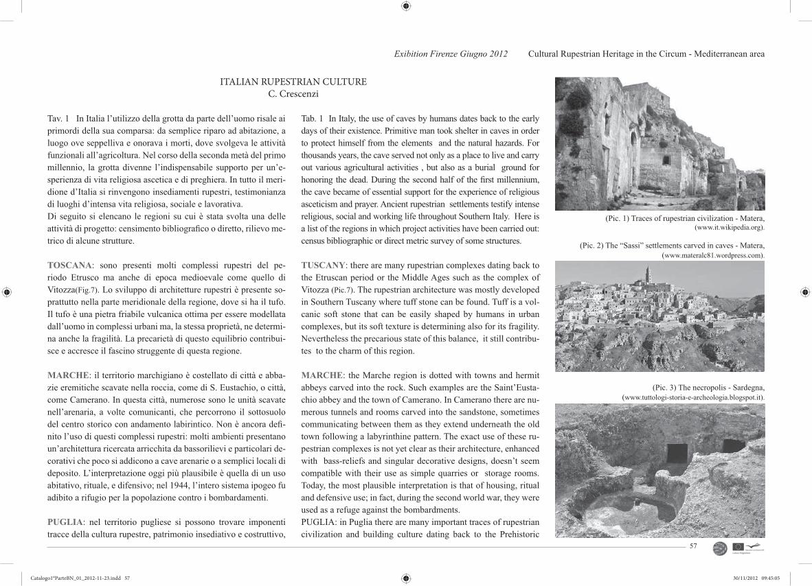
Exibition Firenze Giugno 2012 Cultural Rupestrian Heritage in the Circum - Mediterranean area
57
Tav. 1 In Italia l’utilizzo della grotta da parte dell’uomo risale ai primordi della sua comparsa: da semplice riparo ad abitazione, a luogo ove seppelliva e onorava i morti, dove svolgeva le attività funzionali all’agricoltura. Nel corso della seconda metà del primo millennio, la grotta divenne l’indispensabile supporto per un’e-sperienza di vita religiosa ascetica e di preghiera. In tutto il meri-dione d’Italia si rinvengono insediamenti rupestri, testimonianza di luoghi d’intensa vita religiosa, sociale e lavorativa.Di seguito si elencano le regioni su cui è stata svolta una delle attività di progetto: censimento bibliografi co o diretto, rilievo me-trico di alcune strutture.
TOSCANA: sono presenti molti complessi rupestri del pe-riodo Etrusco ma anche di epoca medioevale come quello di Vitozza(Fig.7). Lo sviluppo di architetture rupestri è presente so-prattutto nella parte meridionale della regione, dove si ha il tufo. Il tufo è una pietra friabile vulcanica ottima per essere modellata dall’uomo in complessi urbani ma, la stessa proprietà, ne determi-na anche la fragilità. La precarietà di questo equilibrio contribui-sce e accresce il fascino struggente di questa regione.
MARCHE: il territorio marchigiano è costellato di città e abba-zie eremitiche scavate nella roccia, come di S. Eustachio, o città, come Camerano. In questa città, numerose sono le unità scavate nell’arenaria, a volte comunicanti, che percorrono il sottosuolo del centro storico con andamento labirintico. Non è ancora defi -nito l’uso di questi complessi rupestri: molti ambienti presentano un’architettura ricercata arricchita da bassorilievi e particolari de-corativi che poco si addicono a cave arenarie o a semplici locali di deposito. L’interpretazione oggi più plausibile è quella di un uso abitativo, rituale, e difensivo; nel 1944, l’intero sistema ipogeo fu adibito a rifugio per la popolazione contro i bombardamenti.
PUGLIA: nel territorio pugliese si possono trovare imponenti tracce della cultura rupestre, patrimonio insediativo e costruttivo,
ITALIAN RUPESTRIAN CULTUREC. Crescenzi
Tab. 1 In Italy, the use of caves by humans dates back to the early days of their existence. Primitive man took shelter in caves in order to protect himself from the elements and the natural hazards. For thousands years, the cave served not only as a place to live and carry out various agricultural activities , but also as a burial ground for honoring the dead. During the second half of the fi rst millennium, the cave became of essential support for the experience of religious asceticism and prayer. Ancient rupestrian settlements testify intense religious, social and working life throughout Southern Italy. Here is a list of the regions in which project activities have been carried out: census bibliographic or direct metric survey of some structures.
TUSCANY: there are many rupestrian complexes dating back to the Etruscan period or the Middle Ages such as the complex of Vitozza (Pic.7). The rupestrian architecture was mostly developed in Southern Tuscany where tuff stone can be found. Tuff is a vol-canic soft stone that can be easily shaped by humans in urban complexes, but its soft texture is determining also for its fragility. Nevertheless the precarious state of this balance, it still contribu-tes to the charm of this region.
MARCHE: the Marche region is dotted with towns and hermit abbeys carved into the rock. Such examples are the Saint’Eusta-chio abbey and the town of Camerano. In Camerano there are nu-merous tunnels and rooms carved into the sandstone, sometimes communicating between them as they extend underneath the old town following a labyrinthine pattern. The exact use of these ru-pestrian complexes is not yet clear as their architecture, enhanced with bass-reliefs and singular decorative designs, doesn’t seem compatible with their use as simple quarries or storage rooms. Today, the most plausible interpretation is that of housing, ritual and defensive use; in fact, during the second world war, they were used as a refuge against the bombardments. PUGLIA: in Puglia there are many important traces of rupestrian civilization and building culture dating back to the Prehistoric
(Pic. 1) Traces of rupestrian civilization - Matera, (www.it.wikipedia.org).
(Pic. 2) The “Sassi” settlements carved in caves - Matera, (www.materalc81.wordpress.com).
(Pic. 3) The necropolis - Sardegna, (www.tuttologi-storia-e-archeologia.blogspot.it).
Catalogo1°ParteBN_01_2012-11-23.indd 57Catalogo1°ParteBN_01_2012-11-23.indd 57 30/11/2012 09:45:0530/11/2012 09:45:05

CRHIMA - CINP project
58
risalenti a epoche preistoriche. Gli abitanti sfruttarono, a scopo abitativo e cultuale, le naturali cavità della roccia calcarenitica, formatesi soprattutto lungo i margini di lame e gravine abbon-danti in questo territorio carsico. Lame e gravine costituiscono, oltre che importanti ecosistemi, la culla di una cultura che seppe fare degli anfratti rocciosi case, ambienti di lavoro e di culto. E’ un’antica e incantevole terra adagiata tra il mediterraneo e il cielo che offre un magico squarcio rupestre, soprattutto nelle province di Bari e Taranto, disseminato di emozionanti insediamenti e chie-se rupestri presenti in profondi canyons, le gravine, che partono dalle colline della Murgia e degradano dolcemente nel Mar Jonio.
SARDEGNA: Il territorio sardo è cosparso d’insediamenti rupe-stri che vanno dall’epoca preistorica a quella paleocristiana. Le grotte sono scavate per la maggior parte a ridosso di costoni roc-ciosi di calcarenite o di tufo trachitico. Le necropoli di ‘domus de janas’ (case delle fate) spesso costituiscono autentice ‘città dei morti’, come quella di Anghelu Ruju ad Alghero. Spesso alcune di queste domus, di aspetto monumentale, sono state riusate come chiese cristiane (Santu Liseu a Mores, Sant’Andrea Prius a Bo-norva). Nel tardo e post-medioevo nella roccia furono scavati pal-menti per la produzione del vino, soprattutto nel Sassarese. (Fig.3)
CALABRIA: in Calabria, nel periodo medioevale, la vita in grot-ta era diffusa su tutto il territorio. Molte sono le testimonianze di forme di vita monastica ispirate a ideali ascetici della religiosità orientale (Fig.7). Recenti ricerche hanno individuato insediamenti rupestri disseminati su tutto il territorio del Marchesato. Insedia-menti di notevole interesse si trovano a Casabona (Fig.4), Cotro-nei, Caccuri e Verzino. Tali insediamenti hanno costituito in pas-sato piccoli villaggi abitati dall’uomo; in un passato più recente le grotte sono state utilizzate dai pastori nel periodo di transumanza come ricovero temporaneo.
BASILICATA: Paesaggi culturali, che raccontano l’indissolubile legame tra uomo e natura, caratterizzano le specifi cità culturali di questa regione. Rocce calcaree, vulcaniche e sedimentarie alluvio-nali o marittime ospitano insediamenti rupestri e ipogeici. Il pa-
Age. The inhabitants were using the natural cavities of the rocks, mainly formed along the cliffs of the ravines, for residential and worship purposes. These ravines represent not only important and varied ecosy-stems, but also the cradle of a civilization that knew how to carve homes, work and worship places in these rocky areas. Puglia is an ancient and enchanting land of the Mediterranean offering a magical landscape, especially in the provinces of Bari and Taran-to, dotted with picturesque settlements and churches built in deep canyons on the hills of Murgia which slope gently down to the Ionian Sea.
SARDINIA: the rupestrian settlements of Sardinia date back from the Prehistoric Age to the Early Christian Age and most ca-ves are carved out from rocky cliffs of limestone or tuff. The ne-cropolises of ‘domus de Janas’ (fairy houses) consist in authentic ‘cities of the dead’, like that of Anghelu Ruju in Alghero. Often some of these monumental domus have been used as Chri-stian churches (Santu Liseu in Mores, Sant’Andrea Prius in Bo-norva) while in the late and post-medieval era, millstones were excavated in the rock for the production of wine, especially in Sassari. (Pic.3)
CALABRIA: in Calabria, during the Medieval Age, life in the caverns was widespread throughout the territory. There are several traces of monastic life, inspired by the ascetic ideals of the Eastern religiosity (Pic.7). Recent researches have identifi ed rupestrian dwellings scattered across the territory of the Marquis. Interesting archaeological settlements have also been located in the areas of Casabona (Pic.4), Cotronei, Caccuri and Verzino. These settlements were ancient small villages and in the more recent past were used by shepherds during the transhumance and as temporary shelter.
BASILICATA: the landscape of Basilicata testifi es the strong bond between man and nature and characterizes the cultural iden-tity of this region. Limestone, volcanic and sedimentary, alluvial or marine, host rupestrian or hypogeal settlements. The rupestrian
(Pic. 5) The necropolis of Savona, (www.italiaperturisti.it).
(Pic. 6) Tomb of the Queen - Nepi, (www.pomerium.org).
(Pic. 4) Casabona, caves - Crotone, (www.materalc81.wordpress.com).
Catalogo1°ParteBN_01_2012-11-23.indd 58Catalogo1°ParteBN_01_2012-11-23.indd 58 30/11/2012 09:45:0530/11/2012 09:45:05

Exibition Firenze Giugno 2012 Cultural Rupestrian Heritage in the Circum - Mediterranean area
59
View of Zungri - Vibo Valentia, (N. Barbalace).
(Pic. 7) Rupestrian settlement of Vitozza, (www.turisti per caso.it).
trimonio rupestre è l’identità storica, artistica paesaggistica della Basilicata. Abitazioni, chiese, monasteri e strutture produttive in grotta sono presenti in gran parte dei comuni della regione. Circa novanta comuni su 131 conservano importanti testimonianze della cultura rupestre. Dopo un lungo periodo di abbandono e degrado, il patrimonio rupestre locale è accettato quale cultura e singolarità del paesaggio e del territorio. Gli insediamenti più importanti e cono-sciuti sono a Matera. I “ Sassi “(Fig.1-2), quartieri scavati in grotta, e la Murgia, l’altopiano calcareo su cui sorge la città, sono stati dichiarati dall’UNESCO Patrimonio dell’Umanità. I siti rupestri di Matera sono all’interno di un Parco Regionale (Parco della Murgia Materana), costituito per tutelare, promuovere e valorizzare uno dei più importanti insediamenti rupestri europei.
LAZIO: le necropoli rupestri del Lazio rappresentano l’espres-sione artistica più rilevante dell’Etruria interna. La presenza di tombe con facciata monumentale costituisce in generale il segno di una certa ricchezza, poichè la creazione del prospetto esterno, scolpito in tufo per un’altezza di vari metri, doveva essere piutto-sto dispendiosa. Nei primi secoli della cristianità la roccia ospitò le catacombe, aree cimiteriali ipogee. Nel territorio laziale recenti studi, ad opera soprattutto dell’Università di Viterbo, riscoprono il vivere in grotta dimenticato nel tempo.
heritage is the historical and artistic identity of Basilicata. Homes, churches and production facilities in caves are present in most of the municipalities in the region. About ninety of 131 municipa-lities preserve important examples of rupestrian culture. After a long period of abandonment and degrade, the local rupestrian he-ritage is accepted as the cultural singularity of the landscape of this region. The most important and well known settlements are in Matera. The “Sassi” (Pic.1-2) settlements carved in caves, and the limestone plateau of Murgia on which the city stands , were declared by UNESCO as areas of cultural heritage. The rupestrian sites of Matera are to be found within the area of the Regional Park (Park of the Murgia Matera), created to protect, promote and enhance one of the most ancient settlements in Europe.
LAZIO: the rupestrian necropolises in Lazio are the most impor-tant artistic expression of inner Etruria. The presence of monu-mental tombs is generally considered as a sign of wealth, since the creation of the external façade, carved in tuff to a height of several meters, must have been quite expensive. In the early centuries of Christianity the rock hosted the catacombs, underground burial areas. Recent studies on the Lazio region carried out mostly by the University of Viterbo, has made the rupestrian culture to re-emerge after being forgotten over time.
Catalogo1°ParteBN_01_2012-11-23.indd 59Catalogo1°ParteBN_01_2012-11-23.indd 59 30/11/2012 09:45:0630/11/2012 09:45:06

CRHIMA - CINP project
60
Catalogo1°ParteBN_01_2012-11-23.indd 60Catalogo1°ParteBN_01_2012-11-23.indd 60 30/11/2012 09:45:0630/11/2012 09:45:06

Exibition Firenze Giugno 2012 Cultural Rupestrian Heritage in the Circum - Mediterranean area
61
PUGLIA
MASSAFRA Tav. 2 - 25Tav.2 IL TERRITORIO DI MASSAFRA : Coordinate geogra-fi che: 40°35’0’’N 17°7’0’’E.Il Comune di Massafra è una media cittadina pugliese di circa 32.000 abitanti. Il centro è collocato sul primo gradone premur-giano a un’altezza media di circa 110 s.l.m. con quote degradanti dai 465 s.l.m. nei pressi dei confi ni comunali con Mottola e Mar-tina Franca fi no al livello del mare. Massafra quindi è collocata al centro dell’Anfi teatro tarantino sulle ultime propaggini meridio-nali delle Murge che scendono a gradoni verso il golfo di Taran-to. Questo territorio è solcato in prevalenza in direzione nord-sud da numerose “GRAVINE”, formazioni erosive che nel corso del tempo hanno inciso profondamente i sedimenti calcarei. Le gra-vine sono caratterizzate dalla presenza d’insediamenti funerari e abitativi risalenti a varie epoche, preistoriche e storiche di diversa dimensione e importanza(Fig.1-2). Il territorio massafrese è stato abitato fi n dai tempi paleolitici: lo testimonia la presenza di selci lavorate ritrovate nella gravina di Madonna della Scala. È stata accertata anche la relazione con il mondo greco, testimoniata dal ritrovamento di ceramiche micenee. Il Thesaurus Massafrensis, monete vandale e bizantine, del V-VI secolo, permette di ipotizza-re che l’abitato sorse in seguito all’arrivo di un gruppo di profughi, cacciato dall’Africa settentrionale. Giunti in Puglia, i profughi avrebbero chiesto aiuto al Vescovo di Taranto, che avrebbe affi da-to loro una sua “massa”, un podere di grande estensione, situato tra le attuali gravine della Madonna della Scala e di San Marco, dove i profughi di provenienza africana “Afri” scavarono le loro
Tab. 2 THE MASSAFRA AREA : Geographic Coordinates: 40°35’0’’N 17°7’0’’EMassafra is town in Puglia with 32000 inhabitants. The town is at the feet of the Murge plateau, with an average altitude of 110 meters AMSL, in a sloping area from the altitude of 465 AMSL at the border with the territories of Mottola and Martina Franca to the sea. Many ravines cross this area from north to south: these were caused by the long time erosion of calcareous sediment. Ra-vines are characterized by the presence of funerary and housing settlements from various ages and with various extensions (Pic.1-2). The presence of worked fl int stones in the Madonna della Scala ravine (Pic.3) reveals that the area was occupied since the Palae-olithic Age. The fi ndings of Mycenean ceramics testify contacts with the Greek world. The Thesaurus Massafrensis is constituted by Byzantine and Vandal coins from the 5th and the 6th century: this may indicate that the town was founded by refugees from Northern Africa. When in Puglia, the Bishop of Taranto entrusted them with a massa, a wide smallholding between the two ravi-nes, Madonna della Scala (Pic.5-6) and St. Marco (Pic.4). Here, the Afros excavated houses in the rock. The four ravines in the Massafra Area (Madonna della Scala, Trovanza, St. Caterina and St. Marco) are characterized by their geographical position and their landscape. The St. Marco ravine, divides Massafra in two parts. Until the construction of the St. Marco bridge in 1860, the only link between the two parts of the town was the Ponte della Liscia, at the valley bottom. Another bridge was realized at the
(Pic. 1) The church of San Leonardo, (A. Faleburle).
(Pic. 2) The church of Santa Marina, (A. Faleburle).
(Pic. 3) Madonna della Scala Ravine, (C. Crescenzi).
Catalogo1°ParteBN_01_2012-11-23.indd 61Catalogo1°ParteBN_01_2012-11-23.indd 61 30/11/2012 09:45:0630/11/2012 09:45:06

CRHIMA - CINP project
62
abitazioni “a corte” nella roccia. Nel comune di Massafra sono quattro le gravine antropizzate di maggiore importanza: quella di San Marco(Fig.4), Madonna della Scala(Fig.5-6), Trovanza e Santa Caterina, contraddistinte tutte dalla particolare collocazione geo-grafi ca e per la vita svolta al loro interno. In questo lavoro sono state prese in esame le prime tre oltre a delle emergenze situate nel centro abitato o nel territorio. La gravina di San Marco è situa-ta al centro dell’abitato di Massafra e divide a metà la cittadina. Fino al 1860, anno di costruzione del ponte San Marco, unico collegamento, per oltrepassare il fi ume, era il Ponte la Liscia, il più antico di Massafra. Nello stesso anno fu redatto un piano di lottizzazione nella spianata di Santa Caterina e, agli inizi del 1900, fu realizzato il Ponte Nuovo per migliorare i collegamenti e rispondere all'espansione della città. La gravina di San Marco ha
beginning of the 20th century, to grant for the expansion of the town and to create a new link. The ravine contains many rupe-strian settlements: the Hegumen’s house, the rupestrian church of St. Marina, the rupestrian village, an anonymous rupestrian church, the Candelora and the church of St. Marco. The research is focused on the problems of the town, proposing the creation of a Urban Park, to improve the included archaeological sites. The goal is creating a new fruition of the abandoned ravine, which was part of the daily life for centuries. The geomorphology of the ravi-ne was produced by the water and wind erosion in the calcarenite bank. This layer is placed on a clay calcareous layer, which have been covered by alluvial deposits in the centuries. Calcarenite is permeable only when there are fractures and fi ssures that allow a conspicuous superfi cial fl ow of water. (Pic.7-8-9)
(Pic. 5 - 6) Views of San Marco Ravine, (C. Crescenzi).
(Pic. 4) Typical house of Madonna della Scala, (A. Faleburle).
Catalogo1°ParteBN_01_2012-11-23.indd 62Catalogo1°ParteBN_01_2012-11-23.indd 62 30/11/2012 09:45:0830/11/2012 09:45:08

Exibition Firenze Giugno 2012 Cultural Rupestrian Heritage in the Circum - Mediterranean area
63
importanti siti rupestri; partendo da sud: la casa dell’Igumeno, la chiesa rupestre di Santa Marina con l'omonimo villaggio rupestre, la chiesa rupestre anonima di Vico III Canali, la chiesa rupestre della Candelora ed in fi ne, all’estremità nord, ma non la meno importante, la chiesa rupestre di San Marco. Il lavoro su questa gravina, oltre a presentare dei rilievi delle emergenze di culto, propone il progetto di un Parco Urbano, a carattere archeologico -ambientale, per valorizzare e fruire i siti archeologici e le aree verde da essa racchiuse. La rinnovata fruizione della gravina, abbandonata per anni e fuori dalla vita sociale della città, re-stituirà il valore culturale ed ambientale che essa ha svolto nel corso dei secoli. La geomorfologia della gravina è dovuta all’erosione delle acque prima e del vento, che hanno plasmato il banco di calcarenite. Questo strato poggia su calcarei cretacei compatti solitamente non visibili per lo strato alluvionale depositatosi nel corso dei secoli sul fondo valle. La calcarenite determina un cospicuo ruscellamento delle acque superfi ciali che convogliandosi alimentano le fi umare. L’ andamento della gra-vina è delineato dalle fratture e dall’erosione che modella la forra con incisioni profonde lasciando le pareti quasi verticali. L’impermeabilità e la compattezza di queste rocce hanno favorito lo sviluppo degli insediamenti rupestri. (Fig.7-8-9)
LE GRAVINETav. 3 Le gravine hanno una lunghezza che va da 1 a 10 km e una larghezza dai 10 ai 300 m, con una profondità massima di 50 m. Le pareti sono caratterizzate da grotte naturali e artifi ciali. Le principali Gravine di Massafra sono: Velo, Santa Caterina, San Marco, Madonna della Scala, Monte Sant’Elia, Colombato, Porti-co del Ladro, Giulieno, Capo di Gavito e Canale Lungo. Di que-ste, quelle antropizzate, collegate direttamente all’abitato sono la gravina della Madonna della Scala, di San Marco e di Santa Caterina.GRAVINA DI MADONNA DELLA SCALA La gravina della Madonna della Scala è lunga 4 km, profonda 40 m circa e larga dai 30 ai 50 m.Al suo interno si trova il Santuario della Madonna della Scala e oltre 200 nuclei abitativi dell’originario villaggio. La parte nord è denominata “Capo di Gravina”, a cui segue la gravi-
RAVINESTab.3 Ravines ca be 1 to 10 km long 10 to 300 m widw, with a maximum depth of 50 m. Teir cliff are characterized by natural and artifi cial caves.The main Ravines in the Massafra area are: Volo, Santa Caterina, San Marco, Madonna della Scala, Monte Sant’Elia, Colombato, Capo di Gavito and Canale Lungo.Madonna della Scala, San MArco and Santa Caterina are directly linked to the town.
THE MADONNA DELLA SCALA The Madonna della Scala ra-vine is 4 km long, 40 m deep and 30/50 m wide. It contains the Sanctuary and more than 200 rupestrian houses. The north part is colled Capo di Gravina (Cape of Ravine); then there is Valle delle Rose (Valley of Roses), west of the town: its name is due to its
(Pic. 8) Alveolarization of calcarneite, (A. Faleburle).
(Pic. 9) Clasts in the calcarenite, (A. Faleburle).
(Pic. 7) Fracture in the calcarenite - Candelora, Massafra, (A. Faleburle).
Catalogo1°ParteBN_01_2012-11-23.indd 63Catalogo1°ParteBN_01_2012-11-23.indd 63 30/11/2012 09:45:1030/11/2012 09:45:10

CRHIMA - CINP project
64
na detta “Valle delle Rose“ che si estende ad ovest del paese, un tempo denominata Vallis Rosarum per la ricca vegetazione spon-tanea che ricopre l’intero letto dell’antico fi ume Patemisco.Sono presenti molte varietà di piante, alcune molto rare. All’estremità sud, detta “Gravina di Calitro” vi è il santuario seicentesco della Madonna di tutte le Grazie e i resti di tre chiese rupestri: Sanata Maria MAddalena, Santa Parasceve e sant’Eustachio.
GRAVINA DI SAN MARCO (Fig.10-11) Sempre a nord dell’a-bitato, la gravina di San Marco ha origine nelle vicinanze del-la “Masseria Pantaleo”. Completamente inglobata nell’abitato, prende il nome da una chiesa rupestre dedicata a San Marco. Fu in passato chiamata il Paradiso di Massafra (dal greco paradei-sos ovvero giardino), perchè lungo i costoni e i terrazzamenti, si sviluppa una rigogliosa vegetazione spontanea insieme con orti terrazzati, giardini, agrumeti.Suggestiva la vista da Ponte Vecchio della pittoresca gravina, dalle pareti in parte ridotte a terrazzi, cri-vellate dalle bocche delle caverne e delle grotte con fi tte pianta-gioni di fi chi d’India. Si segnalano inoltre: la chiesa-cripta di San Marco; la cappella- cripta della Cndelora, con affreschi dei sec. XII-XIV; l’abitazione dell’Igumeno, a vani intercomunicanti; la cripta del Serafi no utilizzata come frantoio fi no a pochi decenni fa. Domina la gravina il severo e maestoso Castello, della seconda metà del ‘500 ma di più antica fondazione, a pianta quadrata con tre torri cilindriche e una ottagonale.
rich vegetation that covers the bed of the ancient river Potemisco.Many varieties of plants are in this ravine, and some are very rare madical herbs. The 17th century Sanctuary of the Virgin of Holy Graces and the ruins of three rupestrian churches (Santa Maria Maddalena, Santa Parasceve and Sant’Eustachio) are in the southern ravine, Calitro.
THE SAN MARCO RAVINES (Pic.10-11) The San Marco Ravi-ne is north of Massafra, and it begins near the Masseria Pantaleo. It is on the east side of the old town, dividing the town in two parts. It is part of the town, and it is named after the rupestrian church of San Marco. In the past it was called Paradise(the Greek word paradeisos me-ans garden), because cliffs and terraces are covered with bloo-ming spontaneous vegetation, gardens, orange gardens. The sug-gestive view from the Ponte Vecchio shows terraces, cliffs, caves and cactuses. Many of these caves were inhabited in the Middle Age; others were important crypts,, as San Marco, the Candelora, Santa Marina. Other important caves are the Hegumen’s house and the ano-nymous crypt in Vico III Canali, used as an oil mill until few decades ago. The ravine is surmounted by the severe and majestic Castle from the 16th century (but founded before), with a square plan, three cylindrical towers and one octangular tower.
(Pic. 11) San Marco ravine: view of ponte nuovo, (C. Crescenzi).
(Pic. 10a, b) Views of San Marco Ravines, (C. Crescenzi).
Catalogo1°ParteBN_01_2012-11-23.indd 64Catalogo1°ParteBN_01_2012-11-23.indd 64 30/11/2012 09:45:1130/11/2012 09:45:11
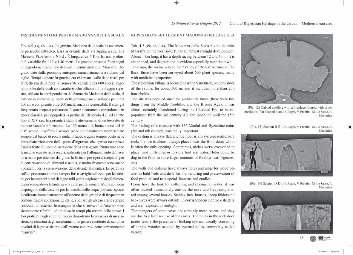
Exibition Firenze Giugno 2012 Cultural Rupestrian Heritage in the Circum - Mediterranean area
65
(Pic. 12) Gabled twelling with a fi replace, shared with seven partitions: fan-shaped plan, (A.Bagni, V. Frontini, M. Lo Sasso, A.
Massafra).
(Pic. 13) Section B-B’, (A.Bagni, V. Frontini, M. Lo Sasso, A. Massafra).
(Pic. 14) Section D-D’, (A.Bagni, V. Frontini, M. Lo Sasso, A. Massafra).
INSEDIAMENTO RUPESTRE MADONNA DELLA SCALA
Tav. 4-5 (Fig.12-13-14) La gravina Madonna della scala ha andamen-to pressoché rettilineo. Essa si estende dalla via Appia, a sud, alla Masseria Pizziferro, a Nord . È lunga circa 4 Km, ha una profon-dità variabile fra i 12 e i 40 metri. La gravina presenta Forti segni di degrado nel tratto che delimita il centro abitato di Massafra. De-grado dato dalla pressione antropica immediatamente a ridosso del ciglio. Tempi addietro la gravina era chiamata “valle delle rose” per la ricchezza della fl ora: vi sono state censite circa 600 specie vege-tali, molte delle quali con caratteristiche offi cinali. Il villaggio rupe-stre, ubicato in corrispondenza del Santuario Madonna della scala, si estende su entrambi gli spalti della gravina; esso si sviluppa per circa 500 m. e comprende oltre 200 nuclei ancora riconoscibili. Il sito, già frequentato in epoca preistorica, fu quasi sicuramente abbandonato in epoca classica, per ripopolarsi a partire dal III secolo d.C. ed abitato fi no al XIV sec. Importante è stato il ritrovamento di un tesoretto di monete vandale e bizantine. Le 135 monete di bronzo sono del V e VI secolo. Il soffi tto è sempre piano e il pavimento rappresentato sempre dal banco di roccia nuda; il fuoco è quasi sempre posto nelle immediate vicinanze della porta d’ingresso, che spesso costituisce l’unica fonte di luce e di aerazione della casa-grotta. Numerose sono le nicchie scavate nella roccia, utilizzate per l’alloggiamento di maci-ne a mano per ottenere dal grano la farina o per riporvi recipienti per la conservazione di alimenti o acqua, e molto frequenti sono anche i pozzatti, per la conservazione delle derrate alimentari. Le pareti e i soffi tti presentano inoltre sempre fori e caviglie utilizzati per le lettie-re, per incastrarvi piani di legno utili per la stagionatura degli alimen-ti, per sospendervi le lanterne e la culla per il neonato. Molte abitaioni dispongono della cisterna per la raccolta delle acque piovane, spesso localizzata immediatamente all’esterno della grotta e di frequente in comune fra più abitazioni. Le stalle, i pollai e gli alveari erano sempre realizzati all’esterno; le mangiatoie che si trovano all’interno sono sicuramente riferibili ad un riuso in tempi più recenti delle stesse. I fori praticati negli stipiti di roccia dimostrano la presenza di un sisi-stema di chiusura degli insediamenti, in genere costituito da semplici tavolati di legno assicurati dall’interno con travi dette comunemente “varroni”.
RUPESTRIAN SETTLEMENT MADONNA DELLA SCALA
Tab. 4-5 (Pic.12-13-14) The Madonna della Scala ravine delimits Massafra on the west side. It has an almost straight development. About 4 km long, it has a depth racing between 12 and 40 m. It is abandoned, and degradation is evident especially near the town. Time ago, the ravine was colled “Valley of Roses” because of the fl ora: there have been surveyed about 600 plant species, many with medicinal properties. The rupestrian village is located near the Sanctuary, on both sides of the ravine, for about 500 m. and it includes more than 200 households. The site was populed since the prehistoric times (there were fi n-dings from the Middle Neolithic and the Bronze Age); it was almost certainly abandoned during the Classical Era, to be re-populated from the 3rd century AD and inhabited until the 15th century.The fi nding of a treasure with 135 Vandal and Byzantine coins (5th and 6th century) was really important.The ceiling is always fl at, and the fl oor is always repesented bare rock; the fi re is almost always placed near the front door; whith is often the only opening. Sometimes, niches werw excavated to place hand millstones or to store foof and water. Holes could be dug in the fl oor to store larger amounts of food (wheat, legumes, etc). The walls and ceilings have always holes and rings for wood be-ams to hold beds and desk for the maturing and preservation of food product, and to suspend lanterns and cradles. Home have the tank for collecting and storing rainwater; it was often located immediately outside the cave and frequently sha-red among several houses. Stables, hen- houses, sheep foldersand bee- hives were always outside, in corrispondence of rock shelters and well exposed to sunlight. The mangers of some caves are certainly more recent, and they are due to a later re- use of the caves. The holes in the rock door jambs testify the presence of locking system, usually consisting of simple wooden secured by internal poles, commonly called varroni.
Catalogo1°ParteBN_01_2012-11-23.indd 65Catalogo1°ParteBN_01_2012-11-23.indd 65 30/11/2012 09:45:1330/11/2012 09:45:13

CRHIMA - CINP project
66
FARMACIA DI MAGO GREGUROTav 6-7-8 I nomi dei vari villaggi rupestri che hanno dato origine alla città sono andati perduti, tra i più imponenti ricordiamo la Gravina Madonna della Scala e la Gravina di San Marco, abban-donate nel XIV sec. e nel XVII sec. Di sicuro interesse è la cosidetta Farmacia di Mago Greguro, antico monastero altomedievale abbandonato in età più tarda e adibito poi a colombaia nel periodo bassomedievale. Un’attenta lettura della planimetria rivela che il complesso è costituito dalla giustapposizione di diverse unità originarie, in tutto 11 ambienti comunicanti. Non facilmente accessibile, è situata alla destra del-la grotta del Ciclope, ad una altezza di circa 10 metri al di sopra del fondo della gravina. L’interno (Fig.15) si presenta complesso con varie unità collegate da varchi e corridoi scavati in epoche successive. Le pareti inter-ne di alcuni ambienti sono caratterizzate dalla presenza di diverse “nicchie” che tradizione vuole venissero utilizzate dalla fi gura leggendaria del Mago Greguro che, con la fi glia Margheritella, raccoglieva e usava le erbe, ma in realtà servivano per l’alleva-mento dei colombi. L’interno della grotta si presenta complesso in quanto è il risultato dell’accorpamento di più unità collegate fra loro tramite corridoi scavati in epoche successive. L’unità, soprannominata la Farmacia, è suddivisa in due aree ri-spettivamente illuminate a destra dall’ingresso e a sinistra dalla fi nistra. L’ambiente di destra e quelli sul fondo sono interessati da più fi le di nicchie. Tra l’ingresso e la fi nestra vi è un camino per far fuoriuscire funi e vapori che termina all’esterno con un piccolo foro. La seconda unità (Fig.16) è composta da un solo ambiente illuminato da una porta centrale e da sue fi nestre poste agli estremi. Nel pavimento è presente una grande fovea per la raccolta dei cereali. Il terzo ambiente è suddiviso in più unità, divise tra loro da setti murari. Il pavimento presenta una fovea, oggi utilizzata come ingresso alla grotta. In seguito ad una delle ultime alluvioni una delle pareti del terzo ambiente è crollata con parte della facciata della gravina. Per accedere alla grotta è necessario servirsi di due scale in ferro, una appoggiate esternamente e una interna che mette in comuni-cazione questo ambiente con la grotta sottostante.
PHARMACY OF MAGO GREGUROTab. 6-7-8 The names of various rupestrian villages that gave rise to the city were lost. The most impressive settlements are in the Madonna della Scala ravine and in the San Marco ravine. They were respectively abandoned in the 14th century and in the 17th century.The so colled Pharmacy of Mago Greguro is very interesting: it is an Early Medieval monastery that was later abandoned, and then used as a dovecot during the Late Medieval period.A careful reading of the plan reveals that the complex consist of the original juxtaposition of different units, for a total 11 rooms. Not easily accessible, it is located on the right of the cyclops cave, at a height of about 10 meters above the bottom of the ravine. The interior walls (Pic.15) of some rooms are characterized by the presence of different sets of “niches”, carved out from the tuff: the tradition says that they were used by of the legendary magician Greguro tha, with his daughter Margheritella, collected and used medicinal herbs. The interior of the cave is complex because it is the result of amalgamation of several units which are interconneted by pas-sageways and corridors dug into later periods. The unit, called Fharmacy, is divided into two areas, respectively illuminated by the right input and the left of the window.The inviriment of the right and bottom are from more than one fi le niches a work area. Between the entrace and the window there is afi re to release fu-mes and vapors which ends at the exterior with a small hole. The second unit (Pic.16)consist of a single room lit by a central door and two windows placed at the ends. On the wall near the passage with the fi rts enviroment we fi nd ore rows of niches lined. In the fl oor there is a large pit for the col-lection of the grain. The third room is divided into several units, divided by seven walls in some cases demolished. The fl oor has an another pit, now used as a new entrance to the cave. Following a recent fl oor, but one of the walls of the third romm with a col-lapsed part of the facade of the ravine. To access the cave, must use two ladders, one internal and one external support that con-nects this room with the cave below.
(Pic. 15) Pharmacy of Mago Greguro: view of the fi rst room(3D model).
(Pic. 16a) Pharmacy of Mago Greguro: view of the second room (3D model).
(Pic. 16b)Detail of the interior, (A. Bartolini).
Catalogo1°ParteBN_01_2012-11-23.indd 66Catalogo1°ParteBN_01_2012-11-23.indd 66 30/11/2012 09:45:1430/11/2012 09:45:14

Exibition Firenze Giugno 2012 Cultural Rupestrian Heritage in the Circum - Mediterranean area
67
GRAVINA DI TROVANZA (Fig.17-18)Tav. 9-10 Poco lontano dal centro, in località Mastropaolo, si trova la piccola gravina di Trovanza (40.573994,17.148773 gravina a NO di parco di guerra). Dell’insediamento facevano parte alcune grotte, disposte su due livelli, adibite ad abitazione ed annessi; una delle grotte a pianta rettangolare, presenta una parete interamente rico-perta da piccoli loculi quadrati disposti su fi le parallele (colombaia/erbario). La comune interpretazione pensa ad un locale per la con-servazione di erbe medicinali, donde il nome popolare di “farma-cia”. Di fronte a questa grotta si trova una piccola chiesa rupestre a pianta rettangolare (m.4.60x3.20 circa; altezza m. 2.30), abside unica a base ortogonale ( m. 2.75x1.20) ad est, con altare addossato alla parete. Si conservano alcuni affreschi (in discrete condizioni). È ben conservato il sistema di canalizzazione di raccolta delle ac-que e la cisterna di contenimento. Inoltre sono state rilevate e rap-presentate in maniera canonica e tridimensionale alcune abitazioni del villaggio Madonna della Scala.
* * *CHIESA RUPESTRE DELLA CANDELORATav. 11-12-13 Prende il nome dall’affresco parietale della scena “La presentazione del bambino al Tempio”, la popolare Candelora, una delle dodici feste liturgiche più importanti della chiesa orienta-le. E’ situata sulla parete ovest della gravina di San Marco di fronte all’omonima chiesa posta sull’altro lato. Le coperture della cripta sono scavate in forma di cupola lenticolare, volta a crociera, pira-midale e a doppia falda. Le pareti laterali sono scandite da nicchie, con colonnette e capitelli decorati. Il vano più interessante è co-perto da una cupola lenticolare impostata su mensole gigliate, che trasformano in ottagono il quadrato della cornice di raccordo, a sua volta sorretta da piccole mensole triangolari. E’ una chiesa a pianta inversa con abside e ingresso affi ancati, costituita da sei campate ciascuna con una copertura diversa. Tra le coperture degna di nota è la cupola lenticolare scolpita nella campata più oscura, che rileva una cura attenta nella resa plastica dei particolari architettonici ad opera di un’esperta scuola di lapicidi salentini. Lungo le pareti si susseguono tredici arcate affrescate, divise da semicolonnine con rozzi capitelli compositi mentre esternamente, in posizione isolata, sorge la cappella funeraria annessa alla chiesa.
GRAVINA DI TROVANZA (Pic.17-18)Tab. 9-10 In Massafra, was detected the little “gravina” of Tro-vanza, in Mastropaolo area. Some caves were part of the settlement, on two levels, used as a residence and outbuildings; one of the caves has a rectangular plan and it has one wall entirely covered by small square niches arranged in parallel rows (dovecot / herbarium). The common in-terpretation thinks about a room for the conservation of medicinal herbs, hence the popular name of “pharmacy”.Faced with this cave is a small rupestrian church with a rectan-gular plan (about m.4.60x3.20, height 2.30 m.) with a single or-thogonal basis (2.75x1.20 m) to the east, with an altar against the wall. There are some frescos (in fair condition). The canal system for water collection and containment of that are well preserved.
* * *RUPESTRIAN CHURCH OF CANDELORATab. 11-12-13 The name derives from the fresco on the wall depic-ting the Presentation of the Child at the Temple, the popular Cande-lora, one of the twelve most important liturgical celebrations in the Eastern Cult. The church is on the western cliff of the San Marco ravine, opposite of the San Marco church on the facing cliff. The crypt ceilings are lenticular dome shaped; there is a cross vault, a pyramid vault and double pitched deiling. The most interesting room is covered with a dome on lilied consoles, which trasform the square frame into an octagon. The side walls have niches with small columns and capitals with carved crosses.This is one of the most interesting crypts of Massafra. Diehl studied it in the 19th century, and he suggested that the original church had a vestibulum. This is a reverse plan church, with fl anked apse and entrance, to respect the liturgical orientation. It has six bays, each with a diffe-rently decorated roof. The experienced stone workers from Salento cured the plastic effect of the architectural elements of the dome. Thirteen arches with frescoes are along the walls: they are divided by semi columns with rough composite capitals. The funerary cha-pel is outside the church.
(Pic. 17 - 18) Rupestrian settlement of Gravina di Trovanza,(www.perieghesis.it ).
Catalogo1°ParteBN_01_2012-11-23.indd 67Catalogo1°ParteBN_01_2012-11-23.indd 67 30/11/2012 09:45:1430/11/2012 09:45:14

CRHIMA - CINP project
68
CHIESA DI SAN MARCO (Fig.22)Tav. 14-15-16 Al nartece segue un’aula scandita in due navate se-parate da pilastri centrali e il presbiterio terminante con due absidi. Appartiene allo schema delle chiese fornite di due absidi gemelle di cui quella destra contiene una cattedra riservata al committente. La seconda abside avrebbe svolto funzione di protesi o di diaconico o di entrambe per la preparazione del rito eucaristico e la conserva-zione delle suppellettili liturgiche, ipotesi supportata dal fatto che non è accessibile dalla rispettiva navata dalla quale è separata per mezzo di un alto parapetto. L’abside destra rappresenta inoltre un episodio isolato nell’architettura rupestre soprattutto per la presen-za di una fi nestrella aperta allo scopo di far fi ltrare la luce della na-vata destra (Fig.19-21). La prima escavazione potrebbe farsi risalire al VII secolo, mentre incisioni graffi te ed incise sulle semicolonne, nonché l’intervento sulle absidi, rientrano in una successiva fase di completamento risalente probabilmente all’ XII sec., ultimo perio-do della dominazione bizantina. Si accede attraverso un profondo nartece con due arcosoli frontali, ad uno dei quali è collegato un pannello devozionale con l’effi gie di S. Marco.
CHURCH OF ST. MARCO (Pic.22)Tab. 14-15-16 The nave is divided into two aisles, and the pre-sbiterium has two apses. This is a scheme of two apses churches, in which the right apse includes the catedra for the commissioner.The second apse was the prothesis or the diaconicon, or both, to prepare the Eucha-ristic rite and to store the liturgical objects. In fact, this apse is separated from the aisle. The right apse is particular, since the light fi lters in the aisle through a small window. The church of San Marco dates back to the 10th century (Pic.19-21); the carved inscriptions on semi columns and the apses were carried out in a following period, probably during the late Byzantine period (12th century). The entrance of the church is through a narthex with two arco-solia; one of them includes a devotional panel of San Marco and the invocation of the commissioners.
(Pic. 19 - 21) Rupestrian church of San marco - 3D model
(Pic. 22) Church of San Marco, (M. Balsimelli).
Catalogo1°ParteBN_01_2012-11-23.indd 68Catalogo1°ParteBN_01_2012-11-23.indd 68 30/11/2012 09:45:1430/11/2012 09:45:14

Exibition Firenze Giugno 2012 Cultural Rupestrian Heritage in the Circum - Mediterranean area
69
CHIESA DI SANTA MARINA (Fig.22-28)Tav. 17 Ubicata sullo spalto orientale della gravina è inserita in un grande insediamento, adiacente alla casa dell’igumeno e al ce-nobio. La chiesa si compone di una navata unica con transetto rettangolare absidato e absidiole laterali. Il triplice incavo absida-le e il regolare movimento a ventaglio dei pilastri fanno pensare a schemi planimetrici orientali; l’infl usso orientale è confermato dalla stessa denominazione della cripta, essendo S. Marina una Santa appartenente alla tradizione bizantina. Si ipotizza la com-presenza della liturgia greca e latina.
CHURCH OF ST. MARINA (Pic.22-28)Tab. 17 It is on the right cliff of the ravine, in a wide settlement, beside the Hegumen’s church and the cenobium. The church has a single nave with a rectangular transept with central apse and side small apses. The triple apse and the regular fan shaped movement of the pil-lars suggest an Oriental plan: the Oriental infl uence is clear, since Saint Marina is from the Byzantine tradition. Probably both the Greek and the Latin rites were held.
(Pic. 23 - 28) The church of Santa Marina: 3D model and plan
Catalogo1°ParteBN_01_2012-11-23.indd 69Catalogo1°ParteBN_01_2012-11-23.indd 69 30/11/2012 09:45:1630/11/2012 09:45:16

CRHIMA - CINP project
70
PROGETTI Tav. 18 - 23 Le gravine, peculiarità dell’area Jonica, ne rappre-sentano l’unità e l’identità culturale e sono testimonianza di un habitat ricco di vita vanto di valori formativi.In alcuni dei siti, quale la Gravina di S. Marco a Massafra, ma potrebbe essere qualsiasi altro territorio, la ripidezza degli spalti e lo stato di abbandono rendono inaccessibili i luoghi, unici per ricchezza ambientale e valenza archeologica -architettonica. Essi, inoltre, sono attualmente le uniche risorse di aree verdi all’interno dell’insediamento urbano. La loro valenza e ubicazione li avocano tout-court a parchi urbani. Gestire l’impervia e problematica accessibilità è una sfi da diffi ci-le, che stimola a interventi minimi per il recupero delle aree verdi, delle architetture di culto e degli insediamenti residenziali con i relativi annessi ed opifi ci. L’accessibilità, spesso, è compromessa dalla privatizzazione dei possibili ingressi o da gravi abusi edili-zi. Questi, dislocati nei punti cruciali dei percorsi di fruizione o delle postazioni panoramiche, vietano e limitano il godimento e la percezione della complessiva area archeologica. E’ prioritario rivalutare gli accessi e i percorsi esistenti, oltre a crearne nuovi per realizzare spazi verdi di connessione per un parco archeolo-gico attrezzato. La ristrutturazione di volumi esistenti si presta all’ospitalità di poli culturali nuovi o attualmente ubicati nel tes-suto urbano. Questi interventi mirano a focalizzare un’attenzione signifi cativa dello stare in gravina, per incentivarne la frequenta-zione e appassionare la comunità tutta, al mondo rupestre, pres-soché sconosciuto ai non addetti ai lavori. Il protrarre l’assenza d'interventi, non invasivi, comprometterebbe ulteriormente il pre-cario equilibrio dell’habitat storicizzato e la qualità territoriale. Il Recupero, fi nalizzato alla corretta fruizione del territorio, permet-terà il godimento nel quotidiano delle aree in abbandono. Que-sto promuoverà la qualità della vita dei cittadini residenti e degli ospiti. La qualità della vita quale volano dello sviluppo culturale e dell’economia: “Mens sana in corpore sano”.In molti casi lo sfruttamento del territorio e l’espansione del co-struito hanno prevalso sulle ragioni qualitative del vivere; l’edili-zia ha costretto singolarità ambientali ad anfratti del territorio, a ferite aperte che chiedono di essere sanate.
PROJECTS Tab. 18-23 The ravines are a peculiarity of the Jonic area and they represent the unity and the cultural identity, in addition to being a habitat rich in life and values. In some sites, such as the Gravina of S. Mark in Massafra, but could be any other territory, the steepness of the cliffs and the state of abandonment make they inaccessible places that are unique to environmental wealth and architectural and archaeological importance. They are currently the only resources of green areas within the urban settlement. Their value and location assimilates them to urban parks. The arduous and problematic accessibility is a diffi cult challenge to manage and these diffi culties stimulate minimal intervention for the recovery of green areas, the architecture of worship and the residential development and its factories. Accessibility is often compromised by the privatization of buil-ding entrances or by serious abuse. The latter, located in the cru-cial points of paths to fruition or panoramic positions, prohibit and restrict the enjoyment and the perception of the overall ar-chaeological area. Becomes a priority to reassess logons and exi-sting routes as well as create new ones to create green spaces for an archaeological Park. The restructuring of existing volumes is lent to the hospitality of new cultural poles or currently located in the urban fabric. These interventions focus signifi cant attention on staying in “gravina”, to encourage the attendance and excite the entire community in the world “rock”, which is almost unknown to non-insiders. The prolonged absence of non-invasive interventions, would under-mine further the precarious balance of habitat quality and spatial context.Recovery, for both touristic and for the correct fruition of the ter-ritory, in order to allow every day the enjoyment in areas in aban-donment and to promote quality of life of citizens living there. In this way the quality of life becomes the driving force of cultural development that relies heavily on the economy.In many cases the exploitation of the land and the expansion of built has prevailed on the quality of life; the construction industry has forced environ-mental singularity in ravines of the territory by reducing them to wounds which need to be remedied.
(Pic. 30 - 31) Tav.18 - 19: plan of the shingle and perspective
(Pic. 29) Tav.18 - 19: Urban parck 3D model, (A. Faleburle).
Catalogo1°ParteBN_01_2012-11-23.indd 70Catalogo1°ParteBN_01_2012-11-23.indd 70 30/11/2012 09:45:1930/11/2012 09:45:19

Exibition Firenze Giugno 2012 Cultural Rupestrian Heritage in the Circum - Mediterranean area
71
Tav. 18-19. Gravina San Marco, tratto compreso fra Ponte Gari-baldi e Ponte nuovo (Fig.29-31). Lo studio dei percorsi di accesso e percorrenza, delle emergenze architettoniche e l’interesse per edifi ci a carattere civile e artigianale caratterizzano l’esercizio di recupero di Alessandro Faleburle. L’attenzione al recupero con interventi minimali addizionali al tessuto esistente risolve l’inte-grazione alla diffi cile morfologia dell’area.
* * *Tav.20 Paola Paolicchi propone la riqualifi cazione dell’affaccio alla Gravina di San Marco, a cerniera fra l’abitato e il parco. In-teresse prioritario è l’accessibilità e la percorribilità della gravina dall’ Appia a Ponte Garibaldi; suggerisce un collegamento pedo-nale fra i due spalti poco prima del ponte, piccole aree attrezzate a servizio dei quartieri e un ripopolamento della gravina con es-senze locali.
* * *Tav. 21 Il villaggio di Madonna della Scala gode di scarsa visibi-lità ed accessibilità. Riccardo Piagentini localizza punti panora-mici, consiglia un piccolo parco espositivo, e ambienti dedicati all’accoglienza giovanile. Dall’ostello costruito in roccia, un per-corso sotterraneo conduce al fronte della gavina; da questo un ter-razzino permette l’accesso diretto alla grotta del Mago Greguro, ora di diffi cile accesso. (Fig. 32-33)
* * *Tav. 23 Grande “Canion” (Fig.34-37), come distrattamente soleva chiamarlo Pasolini, delimitato a sud dal “mare azzurro e pulsante di luce” dello Ionio e sullo sfondo il profi lo calcareo della Fossa Bradanica.Rimasto fuori dal tempo come sospeso tra l’Europa e l’Africa, senza appartenere a nessuna terra. Legato per sempre all’immagine che il grande regista imprime nello sguardo del Cristo. Un campo archeologico realizzato per sottrazione, vestigia ipogeica di un disegno territoriale che trova matrice nella complessa conformazione morfologica di Massafra. Apogeo di un complesso sistema naturale il progetto ri-disegna
Tav 18-19 The ravine of San Marco between Ponte Garibaldi and Ponte Nuovo. (Pic.29-31)The project for the renovation of the ravine by Alessandro Fale-burle id characterized by the study of service corridors and paths, architectural emergences, civil and crafts buildings. The care for the renovation through minimal interventions solves the integra-tion with the diffi cult morphology of the area.
* * * Tav 20. Paola Paolicchi proposes a requalifi cation of the overlook on the ravine San Marco, a hinge between the city and the park. The prior interests are the access and the practicability of the ra-vine from the Via Appia to Ponte Garibaldi. The author suggests a pedestrian link between the cliffs, small areas with facilities, and the replanting of local essences in the ravine.
* * *Tav 21. The village of Madonna della Scala is hardly visible and practicable. Riccardo Piagentini locates panoramic spots; he sug-gests a small expositive park, and some facilities for youth recep-tion. The hostel is excavated in the rock; an underground corridor leads to the front of the ravine. A terrace gives access to the cave of Mago Greguro, which is today hardly reachable. (Pic.32-33)
* * *Tab. 23 The Grand “Canyon” (Pic.34-37), as Pasolini used to call it, is limited by the “blue and glowing” Ionian sea. The calca-reous profi le of the Bradano Valley is on the background. The Grand “Canyon” was out of time, suspended between Euro-pe and Africa, without belonging to any land. It will be always connected to the image impressed by the great director in the eyes of Christ. It is a kind of subtractive archaeological fi eld, the hypogeal remains of a territorial design arising from the com-plex morphological conformation of Massafra.The project is the apogee of a diffi cult natural system; it reorga-nizes a Contemporary Ravine that reveals the Soul of Art, what
(Pic. 33) Tav. 21: render of the project area
(Pic. 32) Tav. 21: sections of San Marco Ravine, (P.Paolicchi).
Catalogo1°ParteBN_01_2012-11-23.indd 71Catalogo1°ParteBN_01_2012-11-23.indd 71 30/11/2012 09:45:2030/11/2012 09:45:20

CRHIMA - CINP project
72
una “Gravina Contemporanea“ capace di rivelare quella di Boudelaire defi niva sussistenaza eterna delle cose: l’Anima dell’Arte. Avvicinarsi ad essa con il progetto signifi ca tradurre lìatavica tradizione costruttiva pugliese. Costruire togliendo, ricavando dal “sasso“ e scavando in esso, un elemento relativo che, ponendosi come un nuovo corpo, consenta a quell’anima di rivelarsi compiutamente. Pensare ad un centro sportivo ricavato nel tufo, signifi ca riappropriarsi di un luogo per troppo tempo oggetto dell’ignavia di una cieca amministrazione. Un ordine nuovo, sopito e fi nalmente riscoperto nelle tracce dell’ottocentesco insediamento urbano. A regola e misura dell’intero intervento, la maglia della città immaginata da Sante Simone sapientemente disegnata secondo l’orientamento morfologico delle gravine.
Baudelaire defi ned as the eternal subsistence. The project gets closer to this soul translating the primordial Apulian building tradition.A subtractive architecture obtains the relative element in the stone. This element allows the revelation of the artistic soul. A sports center, carved into the tuff helps regaining a site which had been forgotten for too long by a blind administration: a new rediscovered order in the traces of the nineteenth-century urban settlement.The road system of the city, as imagined by Sante Simone, is based on the morphological orientation of the ravines, according to the entire project.
(Pic. 34 - 37) Tav. 23: Plan and sections, (D. Luce, L . Mariano).
Catalogo1°ParteBN_01_2012-11-23.indd 72Catalogo1°ParteBN_01_2012-11-23.indd 72 30/11/2012 09:45:2030/11/2012 09:45:20

Exibition Firenze Giugno 2012 Cultural Rupestrian Heritage in the Circum - Mediterranean area
73
CHIESA DI SAN LEONARDO
Tav. 24 Situata all'esterno della città fi no agli anni '50, l'ipo-geo di San Leonardo è nascosto alla vista da una cinta in tufo. Dall'ingresso si accede a una piccola rampa (dromos) che disim-pegna: il piano di campagna caratterizzato da tagli per estrazio-ne del tufo e resti di alcune tombe; sulla sinistra quel che rimane di un piccolo ambiente, un paraecclesion con antistante cisterna; infi ne, di fronte, la chiesa. Questa è priva del fronte e della copertura di una delle navate e del nartece, tagliati per un uso improprio del monumento. La chiesa in origine quindi era a tre navate, partita con due pila-stri, di cui ne resta soltanto uno. Un subsellium qualifi ca la parete iconostatica. Questa era ca-ratterizzata da tre archi con plutei che immettevano nel bema, a corridoio unico partito con archi: nel centro si apre l'abside a calotta, sul fronte nord il diaconicon; la prothesis non fu mai portata a termine. La chiesa è decorata con dipinti di buona qualità. Sulla parete est dell’aula troviamo: Sant’Andrea; San Pietro. Nell’ intradosso dell’arco nord: Sant’Antonio Abate che reg-ge un cartiglio con l’iscrizione Aemulantes praecepta patrum (Emulando i precetti dei Padri) e San Paolo eremita. Sul pluteo presbiteriale nord: Santo Stefano diacono. Sul pilastro tra i due archi d’accesso al presbiterio: San Nicola. Nell’intradosso dell’arco maggiore del presbiterio: San Damia-no e San Cosma (Pic.38). Plutei presbiteriali sud: Annunciazione, con nell’ala nord l’Arcangelo Gabriele e nell’ala sud la Vergine Annunziata. Sul muro est dell’aula, sul pilastro sud tracce di un probabile san Vito. Nella calotta absidale v’è la Déesis (Fig.39), di raffi nata elegan-za. Sulla parete occidentale, a cielo aperto dopo remoti crolli, v’è un dipinto in cattivo stato di conservazione, nei cui lacerti è possibile ipotizzare una Madonna che allatta il Bambino affi an-cata da Santa Marina e da san Leonardo. L’architettura è da datarsi al decimo secolo la prima fase, e la sua confi gurazione compiuta poco prima del XIII-XIV secolo, datazione degli stessi affreschi.
CHURCH OF SAN LEONARDO
Tab. 24 The church was outside the town until the 50’s, and it has been included in the expansion of urban areas during the 60’s and the 70’s. San Leonardo is enclosed in a tuff wall. The gates lead to a small ramp (dromos) giving access to the campaign level (on the right, characterized by the cuts for the extraction of the tuff and the presence of some tombs) and a small room (on the left, a paraecclesion with a cistern); at the back, there is the church.The restoration for an improper use has destroyed the external front of the church and the ceiling of the narthex and of the fi rst aisle. The original church had three naves: six spans divided by two pilasters; now only one pilaster is present. A Un subsellium is on the iconostasis. This was characterized by three arches with plutei giving access to the bema, a single corridor divided in three parts with arches: the central apse is vaulted, the north front has the diaconicon and the south front has the prothesis; this last was never completed.The church contains high quality paintings: St. Andrew and St. Peter are painted on the eastern wall of the nave. St. Anthony the Great holding a scroll (with the inscription Aemulantes pra-ecepta patrum – “Emulating the precepts of the fathers”) and St. Paul the Hermit is painted on the intrados of the northern arch. St. Stephen is painted on the northern presbyteral; St. Nicholas is on the pillar between the two entrance arches; St. Damien and St. Cosmas (Pic.38) are represented in the intrados of the presbyterial arch. An Annunciation is contained in the southern presbyterial plutei (Gabriel the Archangel is on the northern wing, the Virgin in the southern one). Traces of a fresco representing St. Vitus are on a pillar of the eastern wall of the nave. A very elegant Déesis (Pic.39) is on the apse’s dome. The ruin of the ceiling has made the western aisle an open air space: the paintings on this wall are badly preserved, and the rests suggest that the theme was a Mary Breastfeeding the Baby, St. Marine and St. Leonard. The early architecture can be dated back to the X century, while the church was completed between the XIII and the XIV centuries, as the iconography and the painting techniques suggest.
(Pic. 39) Details in the Church of San Leonardo, (C. Giustiniani).
(Pic. 38) Paintings on the intrados of a arch, (C. Giustiniani).
Catalogo1°ParteBN_01_2012-11-23.indd 73Catalogo1°ParteBN_01_2012-11-23.indd 73 30/11/2012 09:45:2130/11/2012 09:45:21

CRHIMA - CINP project
74
CHIESA DI SAN SIMINE
Tav. 25 La chiesa è situata su una collina, a circa 2 km dalla città, rigogliosi alberi di pino ne nascondono la vista (Fig.40). La chiesa ha due accessi: di cui quello a sinistra, sormontato da una lunetta a semicerchio oltrepassato, è l’ingresso originale. Il secondo ingresso, più tardo, è dato dall’ampliamento di una fi nestra. La disposizione strutturale e gli elementi arcaici datano l’escavazione dell’aula al X e XI secolo (1090 - 1110 Caprara, Dell’Aquila). L’aula della chiesa (Fig.41) ha una forma quadrangolare di circa 6,30 mx6.00 m; la parete nord dell’aula è caratterizzata da due nicchie di diversa ampiezza, con archi ghierati a fondo piano, che affi ancano una terza con fondo circolare sormontato da una calotta. Una Madonna in trono con Bambino è nella nicchia a destra. In quella di sinistra si trovano rappresentati due santi, di cui, secondo le diverse interpretazioni, uno rappresenta San Pantaleone o San Giuda Taddeo. Nel lato ovest dell’aula si trova un vano quadrangolare (m 3,30x3,45) con giacitoio scavato nella roccia. La cella ha un ingresso aperto sull’esterno e un probabile foro di sfogo del fumo per focolare. Il presbiterio ha orientamento liturgico a est; è datato al XII secolo sia per la forma sia per alcune soluzioni architettoniche; è separato dall’aula da una iconostasi completa,caratteristica della chiesa con rito orientale. L’iconostasi ha una stretta porta centrale, con arco a tutto sesto, affi ancata da fi nestrelle, ai cui lati sono due nicchie con fondo piano. Sulla parete iconostatica sono graffi te e incise numerose croci. Il presbiterio è quadrangolare, con una nicchia a fondo piano sui lati Sud e Nord; ha un’abside a base trapezoidale che culmina in una calotta a quarto di sfera; l’altare è “alla latina”, aderente alla parete di fondo dell’abside.
CHURCH OF SAN SIMINE
Tab. 25 The church is on a hill, two kilometres far from the city, hidden by a luxuriant pinewood (Pic.40).It has two entrances: the original one is on the left, and it is surmounted by a horseshoe lunette.The second entrance is the result of a window enlargement.The structural disposition and the archaic elements suggest the period between the 10th and the 11th century as the date of excavation (1090 - 1110 Caprara, Dell'Aquila).The navies rectangular (6.30 m x 6.00 m) (Pic.41); the north wall is characterized by three niches. Two niches have arched lintels and plain back wall. The third niche is circular with a vault. The right niche contains the fresco of the Virgin with the Child. The left niche contains the fresco of two saints: one of the two fi gures is interpreted as Saint Pantaleo or Saint Jude the Apostle.The west side of the nave gives access to a quadrangular room (m 3.30 x 3.45) with a rock bed. The cell has an external en-trance and a smoke hole.The presbytery has facing East liturgical orientation; its form and some architectural solutions suggest that it is from the 12th century: a complete iconostasis separates it from the nave, a characteristic of Oriental rite churches.The iconostasis has a narrow central door with a round arch; it is fl anked by small windows and two niches with plain back wall. The walls are carved with crosses. The presbytery is qua-drangular, with niches on the northern and southern walls. It has a trapezoidal apse with a quarter of a sphere as a vault: the Latin altar adheres to the back wall of the apse.
(Pic. 40) Church of San Simine: view of the entrance, (P. Formaglini).
(Pic.41) Church of San Simine: interior, (P. Formaglini).
Catalogo1°ParteBN_01_2012-11-23.indd 74Catalogo1°ParteBN_01_2012-11-23.indd 74 30/11/2012 09:45:2230/11/2012 09:45:22

Exibition Firenze Giugno 2012 Cultural Rupestrian Heritage in the Circum - Mediterranean area
75
MOTTOLA Tav. 26-31
Tav.26 Cittadina collinare, di antiche origini, che oltre all’a-gricoltura ha sviluppato il tessuto industriale e incrementato i servizi. I mottolesi sono concentrati per la maggior parte nel capoluogo comunale; il resto della popolazione è distribuito tra numerose case sparse. Il territorio presenta un profi lo geometri-co irregolare, con differenze di altitudine accentuate. L’abitato, il cui nucleo storico, di forma circolare, si sviluppa a gradinate intorno alla collina, è interessato da una forte crescita edilizia; situato in posizione panoramica, ha un andamento plano-alti-metrico vario. Lo stemma comunale, concesso con Decreto del Capo del Governo, riproduce, su sfondo azzurro, una torre d’o-ro, merlata, sormontata da due corvi posti l’uno di fronte all’al-tro sui due merli esterni.
* * *CHIESA DI SAN NICOLA (Fig.42-43)Tav. 27-28-29 La chiesa di è ubicata a sud di Mottola, in località Gorgone. Essa è stata oggetto per secoli della devozione degli abitanti del luogo e non solo. Grazie alla bellezza dei suoi affreschi, è defi nita “La Cappella Sistina” della civiltà rupestre. La chiesa si trova sul ciglio della gravinetta ed è possibile accedervi attraverso una scala con struttura in ferro adattate alle pedate ricavate nella roccia. L’aula è divisa in tre navate da due pilastri. La pianta è a croce latina con sviluppo longitudinale e presenta una divisione tra aula e presbiterio. Lo spazio destinato ai fedeli è diviso in tre navate di cui la centrale risulta il doppio di quelle laterali. Lungo le pareti dell’aula corrono i sedili alti circa 40 cm.
Chiesa di San Gregorio (Fig.44) Chiesa a croce greca inscritta in un quadrato con cupola centrale, divisa da pilastri che reggono archi a tutto sesto, all’interno si trovano 3 absidi e 3 altari.
Villaggio rupestre di Petruscio (Fig.45) Già abitato in epoca preistorica, è un rifugio naturale in pietra scavato nella roccia. La lama è lunga oltre 4 km e contiene al suo interno numerose grotte.
Tab. 26 Mottola is an ancient town on a hill. Its economy is based on agriculture, industry and services. Most of the inhabitants live in the town; the rest is in spare houses in the countryside. This is a karst land, with an irregular geometric profi le and great altitude differences. The old town is circular, while the rest of the town is developed on the terraces of the hill, in a panoramic position. The Town Coat of Arms was conceded through a Prime Minister’s Decree: it represent a golden crenellated tower on pale blue fi eld, surmounted by two facing crows on the external merlons.
* * *ROCK CHURCH OF ST. NICHOLAS (Pic.42-43)Tab. 27-28-29 The church of St Nicholas is in the locality of Gorgone, South of Mottola. It has been a devotion place for centuries. The beauty of the frescoes grants this church the title of “rupestrian Sistine Chapel”. The church is on the cliff of the ravine: a recent iron staircase allows the access to the church. The plan is a Latin cross with the longitudinal development and presents a separated presbytery. Two pillars divide the space for the believers into three naves by; the central one is twice the side of the others.
Church of St. Gregory (Pic.44) The fl oor plan is an inscribed Greek cross with a central dome, divided by pillars supporting round arches; inside, there are three altars and three apses.
Petruscio rupestrian village (Pic.45). This village was already inhabited in prehistoric times: this natural stone shelter is constituted by many caves.
(Pic. 43) Exterior of the Church of San Nicola, (S. Sacchelli).
(Pic. 42) Church of San Nicola: view of the interior, (S. Sacchelli).
Catalogo1°ParteBN_01_2012-11-23.indd 75Catalogo1°ParteBN_01_2012-11-23.indd 75 30/11/2012 09:45:2330/11/2012 09:45:23

CRHIMA - CINP project
76
Chiesa di Santa Margherita (Fig.46) Ha due navate divise da arcate sostenute da pilastri.Dalla chiesa è possibile accedere in una grotta funeraria ipogeica con alcuni altari all’interno.
Chiesa di Sant’angelo La chiesa è formata da due ipogei sovrapposti. La cripta è a tre navate con absidi rettangolari, mentre, quella inferiore presenta varie sepolture, rivelando la sua destinazione funeraria.
* * *LA CHIESA DI SANT’ANGELO (Fig.47-52)Tav. 30 La chiesa di Sant’Angelo ha una struttura rara e svilup-pa la sua planimetria su due livelli (Fig.47): entrambe le piante presentano tre navate con absidi partiti da tre pilastri monoliti. Il piano inferiore è stato utilizzato come luogo di sepoltura (esempi simili sono stati trovati in Asia Minore).Inizialmente, la struttura è stata utilizzata come chiesa funeraria come denota la ripetizione del tema iconografi ca della Déesis. Probabilmente la struttura originaria era costituita da due navate: il diverso stile di quella a sinistra, posta a nord, attesta la sua esca-vazione più tarda. La scala che collega i due piani e la cripta fu-neraria sono del XIII secolo.Sul pavimento sono appena leggibili tracce dell’iconostasi distrutta durante la costruzione della Crip-ta. All’esterno, la chiesa ha un pronao di grandi dimensioni rinve-nuto durante gli scavi nel 1972. La chiesa superiore. La chiesa su-periore, datata al XII secolo, è la più antica. Tutti gli affreschi, del XIII-XIV secolo, sono seriamente danneggiati (Fig.48-49): il loro degrado è causato dalle infi ltrazioni dell’acqua e da alcuni atti di vandalismo. é possibile supporre che vi fossero molti altri affre-schi più antichi, che purtroppo nel corso degli anni si sono persi. Entrando, sulla destra vi è un dipinto di un santo vescovo. Nelle absidi a fondo piano troviamo il palinsesto di una Madonna in trono con Gesù con la sovrapposizione di un santo. Angeli in volo con abiti rossi decorano l’archivolto; Troviamo inoltre l’affresco di San Silvestro Papa con Mitra e Pastorale. Nella seconda nicchia è dipinta la scena del martirio di Santo Stefano, in parte distrutto durante i lavori di costruzione della navata. Segue la scena del Battesimo di Gesù dipinta nel XIII secolo. Altri santi decorano gli intradossi delle nicchie. Nella della prima calotta absidale è
Church of Santa Margherita (Pic.46) It has two aisles separated by arches on columns and a rectangular apse. The church has a hypogeal funerary cave with altars.
Church of Sant’angelo The church is formed by two overlapping hypogea. The crypt has three naves and rectangular apses; many tombs in the lower hypogeum testify its funerary destination.
* * *THE CHURCH OF SANT’ANGELO (Pic.47-52)Tab. 30 The church of Sain Angel is an uncommon structure, as it is developed on twe levels (Pic.47). Both the planimetries are organized on three naves, with apses and monolith pillars. The lower level has been used as a burial ground, as in some sites in Asia Minor.The repetition of the Déesis suggests that structure was used as a funerary church. Probably the original structure was constituted by two naves. The different style of the left nave testifi es a later excavation. The stairs that link the two levels and the funerary crypt were realized in the 13th century.Traces of the iconostasis can be found on the fl oor: it was de-stroyed during the construction of the crypt. Outside, a pronaos was discovered during the archaeological investigation in 1972.The superior church. The superior church is older, dating back to the 12th century. All of the frescos (13th / 14th century) are seriously damaged (Pic.48-49): their degradation is caused by wa-ter infi ltration and vandalism. It is possible that more ancient frescos have been lost. The painting of Saint Bishop is on the right of the entrance; the apses have plane back walls that contain the palimpsest of the Virgin on the Throne with the Child, and a Saint. Flying angels clothed in red adorn the archivolt. There is also a fresco depic-ting Saint Sylvester the Pope with a Mitre and a PastoralThe second niche contains the fresco with the Martyrdom of Saint Stephan, partly damaged during the works for the re-alization of the nave. There is also a scene with the Baptism of Jesus (13th century). Other Saints adorn the intradoxesof the niches.
(Pic. 44) Church of San Gregorio, (S. Sacchelli).
(Pic. 45) Rupestrian village of San Petruscio, (S. Sacchelli).
(Pic. 46) Church of Santa Margherita, (S. Sacchelli).
Catalogo1°ParteBN_01_2012-11-23.indd 76Catalogo1°ParteBN_01_2012-11-23.indd 76 30/11/2012 09:45:2430/11/2012 09:45:24

Exibition Firenze Giugno 2012 Cultural Rupestrian Heritage in the Circum - Mediterranean area
77
rappresentato San Giacomo con i pecten iacobeus sul mantello e sulla borsa da pellegrino. Nell’abside a fondo piano troviamo una seconda . Nella terza abside a sinistra vi sono tracce della Ma-donna col Bambino in trono tra gli Arcangeli turiferari Michele e Gabriele. Sulla parete di sinistra troviamo tracce di affreschi che individuano: santa Margherita, San Giovanni Evangelista e un Angelo. Sono ancora raffi gurati: san Vito; l’aquila nera con un libro fra le zampe, simbolo dell’evangelista Giovanni; un San Giorgio a cavallo; San Simeone lo Stilita il Giovane col serpente che si avvolge intorno alla colonna; altre tracce di affreschi rap-presentano un Santo con la barba, una Santa con diadema turrito, Santo Stefano e una Vergine col Bambino. Chiesa inferiore. Nella calotta absidale di destra è rappresentato il Pantocrator con San Basilio e Sant’Andrea, datato al XIV secolo; inoltre troviamo San Pietro con le chiavi e un rotolo aperto e San Paolo; il Martirio di San Bartolomeo.
* * *CASALROTTO Tav. 31 Il casale di Casalrotto é costituito da un centinaio di grotte scavate lungo i due spalti della lama. Compromesse dagli agenti atmosferici e dagli interventi umani, esse conservano ancora nic-chie, lucerne, vasche, pilastri, mangiatoie. Mancano notizie docu-mentarie riguardanti l’Alto Medio Evo. È stato ipotizzato che il monastero rupestre di Sant’Angelo - nucleo originario del casale - sia stato fondato da religiosi italo - greci nel corso della seconda colonizzazione bizantina (secoli IX-XI). La dedica della chiesa a S. Michele Arcangelo fa pensare a una possibile commistione fra la cultura bizantina e quella longobarda: questo popolo predilige-va l’Arcangelo, comandante delle milizie celesti, dominatore del male e delle forze della natura. Inoltre il codice ORIGO GENTIS LANGOBARDORUM, conservato all’Abbazia di Cava dei Tirre-ni, conferma la presenza longobarda in territorio motulese. Il toponimo più antico, documentato nel XII secolo delle “terrae Sancti Angeli”, è Casalis Ruptus; questo potrebbe derivare dal greco “crupte”, latinizzato “crypta”, e non dal medioevale “rup-tus”, pertanto il toponimo indicherebbe “case a grotta”. Le pri-me notizie storiche certe sul monastero di S. Angelo a Casalrotto sono riportate da una “charta donationis” del 5 maggio 1081. Esso
The fi rst apse vault contains the fresco with Saint James with the pecten iacobeus on the mantle and on the pilgrim’s bag. The third apse preserves traces of a Virgin in Throne with the Child between The Archangels Michael and Gabriel. On the left wall, there are traces of frescos with other characters: a Virgin with the Child, Saint Margaret, Saint Joan the Baptist, Saint Gorge, Saint Simeon the Stylite, with a snake around the column, an Angel, the Black Eagle holding a book (the symbol of Joan the Evangelist), Saint Stephen, a bearded Saint.The Inferior Church. The right apse vault contains a Pantocrator with Saint Basil and Saint Andrew (14th century); there is also a fresco depicting Saint Peter with the keys and a Scroll, Saint Paul and the martyrdom of Saint Bartholomew.
* * *CASALROTTO Tab.31 The village of Casalrotto is constituted by a hundred caves along the cliffs of the lama. They suffered the weather conditions and human interventions, but they still preserve ni-ches, oil lamps, pools, pillars, mangers. There is no documentation about the Early Middle Age: the hypothesis suggests that the rupestrian monastery of Sant’An-gelo (the original settlement of the village) was founded by Ita-lian and Greek monks during the second Byzantine colonization (9th/11th century). The dedication in the church of Saint Michael the Archangel could be interpreted as a mingling of the Byzan-tine and the Lombard cultures. This population worshipped the Archangel, the Commander of the Heavenly Army, dominator of Evil and of the forces of Nature. The ORIGO GENTIS LANGO-BARDORUM code, which is preserved in the Abbey of Cava dei Tirreni, confi rms the Lombard presence in the area of Mot-tola.The most ancient toponym is from the 12th century: Casalis Ruptus; this may derive from the Greek word “crupte”, (crypt) and not from the medieval word “ruptus”. So the meaning of the toponym could be “cave houses”. The early documentation
(Pic. 48 - 49) Details of the interior, (S. Sacchelli).
(Pic. 47) Plan of the Church of Sant’ Angelo
Catalogo1°ParteBN_01_2012-11-23.indd 77Catalogo1°ParteBN_01_2012-11-23.indd 77 30/11/2012 09:45:2530/11/2012 09:45:25

CRHIMA - CINP project
78
raggiunge il suo massimo splendore nel XII secolo grazie ad una serie di donazioni e di acquisti che si susseguono anche nel XIII secolo, per cui assume sempre più le caratteristiche del casale, e non solo rupestre. Dalla seconda metà del XIII secolo in poi, la politica fi scale di Federico II e di Manfredi, gli attacchi dei baroni alla proprietà monastica contribuirono a svuotare pro-gressivamente i casali rupestri del Mezzogiorno delle necessarie energie produttive, determinandone l’impoverimento e la deca-denza. All’inizio del XIV secolo un documento del priore Pietro di S. Angelo afferma che nei territori del monastero vi erano ancora circa 30 famiglie. Fu abitato con alterne fortune fi no agli inizi del XVIII secolo quando fu costruita la masseria dai Caracciolo, al servizio del vasto latifondo da essi posseduto nella zona.
on the monastery of Saint Angel in Casalrotto is on a “charta donationis” (May, 5th, 1081). It reaches it splenodurs in the 12th century, because of some donations and purchases, which went on in the following century. So it became more and mora a village. From the second half of the 13th century, the fi scal poli-tics of Frederick II and Manfred, the attacks from the Barons to the monastic properties contributed to the impoverishment and decay of the rupestrian villages in Southern Italy.At the beginning of the 14th century, a document of the Prior Peter of Saint Angel stated that the territories of the monastery were populated by 30 families. Certainly it was variously populated until the early 18th century, when the farm Caracciolo was built, to serve the large land esta-te of the family in that area.
(Pic.50 - 51 - 52) Church of Sant’ Angelo: views of working phase, (P. Formaglini).
Catalogo1°ParteBN_01_2012-11-23.indd 78Catalogo1°ParteBN_01_2012-11-23.indd 78 30/11/2012 09:45:2630/11/2012 09:45:26

Exibition Firenze Giugno 2012 Cultural Rupestrian Heritage in the Circum - Mediterranean area
79
PALAGIANELLO Tav- 32-34
Tav.32 (Fig.53-55) Centro di origine medievale, la cui economia è basata prevalentemente sull’agricoltura. I palagianellesi risiedono per la maggior parte nel capoluogo comunale; il resto della popolazione è distribuito tra numerose case sparse e la località Montedoro. Il territorio, che presenta fenomeni di erosione carsica del banco calcareo, ha un profi lo geometrico ondulato, con accentuate differenze di altitudine. L’abitato, sviluppatosi con pianta regolare, è interessato da una forte crescita edilizia; circondato da masserie, ha un andamento plano-altimetrico pianeggiante. Palagianello è storicamente legata al fenomeno dell’insediamento rupestre: l'attuale centro urbano sorge a ridosso della gravina omonima, sui cui spalti si è sviluppato in epoca medievale un articolato villaggio rupestre, forma insediativa per molti secoli complementare e non subalterna al centro. Il villaggio rupestre si sviluppa in particolare sullo spalto orientale della gravina, immediatamente al di sotto del Castello. Sentieri e scalinate permettono ancora oggi di attraversare parzialmente il villaggio rupestre, composto di decine di grotte scavate su più piani; i vani rupestri sono stati utilizzati fi no a pochi decenni fa ed oggi sono oggetto di interessanti forme di recupero. Il villaggio rupestre è arricchito dalla presenza al suo interno di numerose chiese rupestri, alcune delle quali mantengono ancora oggi tracce degli affreschi originari.
Tab.32 (Pic.53-55) The medieval town is on a plain: its economy is mainly based on agriculture. Most of the inhabitants live in the town; the rest is in spare houses in the countryside and in the locality Montedoro. The karst land has an undulated geometric profi le, with great altitude differences.The town developed in a regular shape, beside the railroad; the countryside is rich of masserie (country estates), and it is fl at. Palagianello is historically bound to the rupestrian settlement: the town is on the ravine, a natural defense of the settlement. A medieval village is on the ravine cliffs, a complementary settlement to the town. The rupestrian village was mainly developed on the eastern cliff of the raven, just beneath the Castle.Pathways and stairs allow visiting the rupestrian village, which is constituted by dozens of multi-fl oor caves. The rupestrian rooms on the top of the cliff have been used until few decades ago, and they are being interestingly restored by the Local Administration and by privates. Many rupestrian churches enrich the village: some of them still preserve the original frescoes.
(Pic. 53) Palagianello: view 1, (C. Crescenzi).
(Pic. 54) view 2, (C. Crescenzi).
(Pic. 55) view 3, (C. Crescenzi).
Catalogo1°ParteBN_01_2012-11-23.indd 79Catalogo1°ParteBN_01_2012-11-23.indd 79 30/11/2012 09:45:2830/11/2012 09:45:28

CRHIMA - CINP project
80
LE CHIESI RUPESTRI DI PALAGIANELLOTav.32 Ammonta ad otto il numero di chiese attualmente esisten-ti nel villaggio rupestre di Palagianello (TA, Puglia): le chiese dedicate a San Girolamo, a Sant'Andrea, a San Nicola, ai Santi Eremiti e la Chiesa Anonima, sono situate sulla parete orientale della gravina. Le chiese di Serrapizzuta, Jazzo Rivolta e Santa Lucia invece sono situate nella scarpata opposta.
CHIESA DI SANT’ANDREA (Fig.56-58): la chiesa è situata nel-la parte orientale della gravina, completamente isolata nell’unica massa tufacea superstite alla massiccia estrazione di materiale da costruzione effettuata fi no agli anni Settanta. A causa di tale ra-dicale distruzione, è stata determinata la totale cancellazione di tutte le evidenze architettoniche pertinenti al complesso rupestre antico. L’impianto religioso è costituito da diversi vani collegati, posti in asse con l’ingresso. L’orientamento est-ovest su cui si sviluppano gli spazi non è oggi immediatamente apprezzabile a causa della variazione dell’accesso, aperto in anni relativamente recenti nella zona settentrionale della chiesa, e che attualmente si affaccia direttamente sull’area del bema. Questa modifi ca è stata resa necessaria dal momento che l’escavazione di materiale roc-cioso rendeva di fatto impossibile l’ingresso attraverso il portale originario. L’area di accesso originale, presenta due arcosoli late-rali, utilizzati come sepolture. La presenza di numerosi riquadri parietali affrescati (Fig.57), ad oggi in parte distrutti, costituisce un’ulteriore testimonianza dell’eccezionale importanza della chiesa.
CHIESA ANONIMA (Fig.59-61): è situata sulla pendice est della gravina di Palagianello, in posizione ritirata rispetto agli altri edifi ci cultuali del paese, precisamente in prossimità dello stradello che dalla sommità del paese conduce sino alla zona più settentriona-le, area di sviluppo del villaggio rupestre antico. Risulta composta da uno spazio articolato in distinte aree, tutte sviluppate in dire-zione est-ovest. Si guadagna l’ingresso tramite una vasta apertura, attualmente semicrollata e parzialmente integrata da una muratura a blocchetti squadrati in tufo. La prima stanza risulta ampia, con
RUPESTRIAN CHURCHES IN PALAGIANELLOTab. 32 At present, only eight rupestrian churches still exist in the ancient settlement of the deep gravina of Palagianello (TA-Apulia): the churches dedicated to St. Gerolamo, St. Andrea, St.Nicola, to the holy Hermits and the so-called “Anonima” Church (Nameless), are all located on the east slope of the “gra-vina”. The churches of Serrapizzuta, Jazzo Rivolta and St. Lucia on the opposite one.
CHURCH OF ST. ANDREA (Pic.56-58): the church dedicated to St. Andrea is located in the eastern slope of the gravina, comple-taly isolated in the only tuff mass surving to massive extraction of construction material made until 1970 that thave completely deleted the original complex. The plan is made up of several connected rooms in axis with the entrance. The E-W orientation of the space is today not imme-diately noticeable beacause of the change of access, opened in relatively recent years in the northen part of the church, and which now faces directly into the bema. This change was necessary since the excavation of rocks made it possible to enter throuh the original portal. In the original entran-ce area, consisting of a round-headed arched opening, there are two arcosolia used as burial places. The presence of numerous wall painting (Pic.57), now partly de-stroyed, is a further evidence of the exceptional importance of the church.
ANONIMA CHURCH (Pic.59-61): the church is located on the east slope of the gravina of Palagianello, quite far from the other religious buildings of the rupestrian settlement. It is near to the pathway that from the top of the modern city takes to the northern most area, where the ancient village was mostly developed.Of considerable dimensions, the church is composed by a space divided into distinct areas, all developed along an east-west axis. The entrance, a wide opending now collapsed, is partially fi lled in with tuff square blocks.
(Pic. 57) Church of Sant’ Andrea: detail of the interior, (E. Bianchi).
(Pic. 56) Church of Sant’ Andrea: longitudinal section and plan of the ceiling, (Rif. Tav. 33, tutor: S. Bertacchi, M. Pasquini).
Catalogo1°ParteBN_01_2012-11-23.indd 80Catalogo1°ParteBN_01_2012-11-23.indd 80 30/11/2012 09:45:2930/11/2012 09:45:29

Exibition Firenze Giugno 2012 Cultural Rupestrian Heritage in the Circum - Mediterranean area
81
soffi tto piano e provvista di diverse nicchie, tre delle quali poste nella zona sud, all’incirca alla medesima altezza. Anche una analisi solo superfi ciale delle pareti rivela la variegata sovrapposizione di innumerevoli interventi, attuati nel corso dei secoli per rimodellare lo spazio, assecondando le nuove funzioni assunte dal luogo. Un unico pilastro, situato sulla destra e dalle forme erose dal tempo, divide idealmente la zona centrale da un’area allungata e dimen-sionalmente inferiore, che apre sulla conclusione absidale dello spazio. L’abside, in asse con l’entrata, ha forma quadrangolare con forature a nicchie sopravvissute al rimaneggiamento antropico delle strutture; perduto invece l’altare. Grazie alla scansione degli spazi è possibile una rappresentazione fedele alla realtà anche delle zone non facilmente misurabili, quali le soffi ttature dei vani, alle quali vengono associate fotografi e digitali al fi ne di rappresentarne l’aspetto materico e cromatico. In evidenza le croci intagliate nel-la pietra nell’intradosso delle coperture poste al centro del vano e con signifi cato di pseudocupole. Nell’ultimo vano, sono visibili le tracce di tre pilastri di forma quadrangolare presenti nella primiti-va organizzazione della chiesa, distrutti in seguito delle successive modifi che all’impianto architettonico. Nella sezione longitudinale che guarda la parete settentrionale della chiesa è chiaramente visi-bile l’articolazione degli spazi interni. L’antico accesso al nartece, all’estrema sinistra, è al momento parzialmente tamponato con una muratura che funge da parapetto. È visibile l’arcosolio Nord, in parte distrutto dall’asportazione di materiale della vicina cava. In scorcio l’affresco del San Giorgio della parete est del nartece, di cui sopravvive la sola parte superiore. Nell’aula troviamo invece il San Vito, dipinto eseguito a tempera su intonaco secco e datato 1590. Alla sua destra un altro affresco, per la maggior parte detur-pato dall’apertura di una grande nicchia, con la raffi gurazione del San Nicola e di un altro santo. Il vano visibile all’estrema destra è quello che nel tempo ha subito maggiori modifi che. Tra le più radi-cali, l’abbassamento del piano di calpestio e l’apertura della nuova porta di accesso. Si nota in sezione il muro divisorio e a destra una nicchia absidale.
* * *CHIESA DI SAN GEROLAMO (Fig.62-64) Tav. 33: ubicata nella parete est della gravina, in posizione inferiore rispetto alle
The fi rst room is the largest, with a fl at roof and various niches on the walls; three of them are located at about the same height. Even a superfi cial analysis of the walls reveals the overlapping of different interventions, carried out over the centuries to remodel the space, according to new functions of the site (problaly an oil mill as evidenced by the circular tank deeply carved in the soil of the fi rst room; afterwardsa shelter for people and /or animals).A single pillar on the right, eroded by time, ideally divides the central area from another adjacent, smaller and narrow, facing the apse area. The apse has a square shape with niches survived to the changes of the structures made by people, except the altar that have got lost. Thanks to the 3D scan of the spaces, a reliable re-presentation of reality can be done even of not directly accessible areas, such as the ceilings of the rooms, which are associated with digital photographs in order to represent the material aspect and color. In the center of the intrados of the roof there are circular cir-cles with carved crosses, with a symbolic meaning of false domes. In the last room, some traces of three square-shaped pillars are visible on the ceiling, evidences of the primitive organization of the church, destroyed as a result of subsequent changes to the ar-ticulation of the architecture. In the longitudinal section view of the north wall of the church is clearly visible the articulation of interior spaces. The old entrance to narthex, on the left, now par-tially closed with a wall for safety reasons. The arched niche in the north was pertly destroyed by the removal of material from the nearby pit. A aprt of the fresco of St. George on the east wall of the narthex, wich survives only partially, revealing the horse. In the hall we fi nd the san Vito, painting done in tempera on dry plaster and dated 1590, and on the right side another fresco, mo-stly disfi gured by the opening of a large niche, depicting two saints, one of them surely identifi able as the San Nicola. The room on the right in that time has undergone the major changes. Among the more radical, the Lowering of the fl oor and opening in the wall of the new access. In the section the partition wall made of tuff blocks and the right one of the apsidal niches.* * *CHURCH OF ST. GEROLAMO (Pic.62-64) Tav. 33: the church presents a plan with trapezoidal shape, like a fan. The original
(Pic. 58) Plan of the church of Sant’Andrea, (Rif. Tav. 33, tutor: S. Bertacchi, M. Pasquini).
(Pic. 59) Anonima church: plan, (Rif. Tav. 33, tutor: S. Bertacchi, M. Pasquini).
(Pic. 60) Anonima church: longitudinal section, (Rif. Tav. 33, tutor: S. Bertacchi, M. Pasquini).
Catalogo1°ParteBN_01_2012-11-23.indd 81Catalogo1°ParteBN_01_2012-11-23.indd 81 30/11/2012 09:45:3030/11/2012 09:45:30

CRHIMA - CINP project
82
altre della medesima pendice. Presenta un impianto con forma trapezoidale che si apre a ventaglio. L’accesso originale si trova in asse con l’abside. Secondo le interpretazioni degli studiosi, la chiesa sarebbe mancante di nartece e l’ingresso direttamen-te aperto sull’aula, mentre lo spazio prospiciente all’ingresso avrebbe visto la trasformazione del pronao in area coltivata. Sul lato meridionale dell’aula sono presenti due nicchie affrescate, una delle quali è servita in tempi recenti per l’apertura di un ulte-riore accesso per il collegamento di un altro spazio contiguo; dal-la parte settentrionale esiste un paraecclesion composto da due spazi. A sinistra dell’ingresso è presente una profonda cisterna, protetta da un muretto, utilizzata per la raccolta e la conservazio-ne dell’acqua. Sopraelevato di un gradino e separato da un setto iconostatico a tre arcate (le laterali in passato protette da setti lapidei), il bema è costituito da uno spazio allungato provvisto di diverse nicchie. La nicchia a nord riporta un affresco, solo par-zialmente sopravvissuto, raffi gurante la Vergine con il Bambino mentre quella opposta solo una traccia della sinopia preparatoria al dipinto. L’ingresso allo spazio interno è garantito tramite una porta architravata sormontata da lunetta, posta nel lato meridio-nale del primo vano, lateralmente rispetto allo sviluppo della chiesa secondo il consueto orientamento est-ovest. L’organizza-zione spaziale esistente, frutto probabilmente di interventi di sca-vo successivi vede la presenza di ambienti distinti per dimensioni ma tendenti ad una forma planimetrica quadrangolare. Secondo le interpretazione degli storici e l’ipotesi ricostruttiva della pri-migenia organizzazione, ai tre vani presenti potrebbero venir associate le funzioni rispettivamente di nartece, aula e bema. Il primo spazio, con soffi tto piano e fornito di due nicchie arcuate che presentano diverse iscrizioni, è diviso dall’aula tramite un arcone trasversale, impostato su due semipilastri, che funge da diaframma tra i vani contigui. L’aula, di dimensioni inferiori, ha lateralmente una seduta in pietra che corre lungo le pareti late-rali. La profonda abside è provvista di nicchia con croci incise nella parete fondale e voltata a botte. Assente qualsiasi evidenza relativa all’altare, sicuramente non addossato alla parete e andato distrutto nel tempo. Dall’osservazione della planimetria risulta chiara l’articolazione dello spazio. L’ingresso originario posto a
access, partly fi lled in with tuff blocks, is aligned with the apse. In the south side of the hall there are two painted niches, one of them in recent times has been destroyed for the opening of a further ac-cess to connect a contiguous space. On the northern side there is a paraecclesion consisting of two rooms. To the left of the entrance there is a deep tank, formerly used for collecting and storing wa-ter. Raised of a step and separated by a partition of three arches, the bema is constituted by a narrow space oriented North-South provided with several alcoves. The church is located on the western slope of the gravina. The en-trance to the interior space is ensured through an architraved door surmounted by lunette on the south side of the fi rst room, lateral to the development of the church in the usual east-west axis. The spatial organization currently existing, probably the result of dif-ferent operations of excavation, as shown by the presence of spa-ces modeled according to various metric units, with the presence of spaces distinct in size but all with a common planimetric shape. According to the interpretation of historians and an hypothetical reconstruction of the primitive organization, the three rooms may be associated with the narthex, the main hall and the bema. The fi rst space, with fl at ceiling and provided with two arched niches which present different carved inscriptions, is divided from the hall by a transverse arch, set to two half-pillars, which are used as a diaphragm between the adjacent rooms. The hall is smaller and has a stone seat sideways. Finally, the deep apse, smaller space and probably raised in the past, is covered by a barrel vault and presents carved crosses in the niche of the bot-tom wall. Absent any evidence on the altar, certainly not placed against the wall and destroyed in the course of time. The church of St. Gerolamo in the east wall of the Gravina of Palagianello, section plan. Here we can observe the articulation of space. The original entrance -West- opens on the main hall: from its walls it is possible to access the paraecclesion, northwards, and the adja-cent room through the opening in the south wall. At the left there is a deep cistern dug into the soil. Separated by a step and cur-rently accessible by three arches (the two lateral ones in the past were partially protected by an stone gate), the bema has a narrow shape. This space presents different niches: in the short sides they
(Pic. 63) Church of San Gerolamo: plan, (Rif. Tav. 33, tutor: S. Bertacchi, M. Pasquini).
(Pic. 62) Church of San Gerolamo: interior view, (Rif. Tav. 33, tutor: S. Bertacchi, M. Pasquini).
(Pic. 61) Anonima church: view of the ancient apse without the original altar, (E. Bianchi).
Catalogo1°ParteBN_01_2012-11-23.indd 82Catalogo1°ParteBN_01_2012-11-23.indd 82 30/11/2012 09:45:3230/11/2012 09:45:32

Exibition Firenze Giugno 2012 Cultural Rupestrian Heritage in the Circum - Mediterranean area
83
occidente si affaccia direttamente sul vano dell’aula, dalle cui pareti laterali è possibile l’accesso al paraecclesion ed allo spazio contiguo. A sinistra è presente la bocca di una profonda cisterna scavata nel suolo. Il bema presenta forma stretta ed allungata. In questo spazio si aprono diverse nicchie, quelle nei lati corti affrescate o con tracce di sinopie preparatorie, quelle della parete est presentano invece due altari agli estremi e due mense nelle nicchie mediane, tutte incorniciate da archi a tutto sesto con ghie-ra. Le due sezioni trasversali mostrano l’organizzazione spaziale della chiesa, nell’aula e nel bema. Nel primo caso è visibile la triplice arcata divisoria, che mostra le tracce del setto presente in passato a chiusura parziale dei fornici laterali. Il nuovo accesso aperto nella nicchia di destra permette il collegamento con lo spazio adiacente, con porta sull’esterno.
* * *CHIESA RUPESTRE DI SANTA LUCIA (Fig.65): è chiara l’articolazione spaziale della chiesa, orientata secondo l’asse E-O e con l’abside frontale all’ingresso. La rappresentazione planime-trica, ottenuta mediante la rielaborazione del rilievo effettuato con laser scanner tridimensionale, mostra con accuratezza l’aspetto morfometrico dello spazio. L’alta risoluzione permette la caratte-rizzazione di tutte le forme, irregolari poiché legate alla peculiare natura costruttiva del luogo, creato per escavazione nella roccia tufacea. Ne è un esempio la rappresentazione della grande vasca di forma circolare incisa nel suolo del primo vano, probabilmente dovuta al successivo utilizzo della chiesa come frantoio (le zone circolari rappresentano la zona d’ombra dello strumento per cui la ripresa dei punti è localmente più rada). Nell’alzato è riscon-trabile l’esatto aspetto sia morfologico che metrico degli spazi. Sono visibili le tracce di interventi di manomissione dello spazio originale susseguitisi nei secoli, che hanno adattato lo spazio alle nuove funzioni. Ad esempio risultano evidenti le aperture suc-cessive per mettere in comunicazione vani adiacenti, l’erezione di muri divisori per la gestione degli spazi, la pratica di fori e/o la distruzione di elementi verticali per l’inserimento di partizioni orizzontali. A sinistra dell’immagine, ovvero nella zona absidale, il soffi tto originale ha subito l’escavazione di un camino per l’are-azione che sfonda la massa rocciosa fi no a raggiungere l’esterno.
are painted with frescos; in the east wall there are two altars, two stone tables, all included in round arches. At the center, the apse has been excavated in a quadrangular shape, with niches and ar-ches of different sizes on the walls. The two cross sections show the spatial organization of the church: the area of the main hall and the bema. In the fi rst case, the triple arch is used as a partition. A careful analysis shows the traces of the stone gates that partially closed the side arches in the past. Signifi cant the small niche in the upper side of the right pillar, used to lodge a votive statue or an icon. The new access, opened recently in the right niche, allows the connection to the adjacent space.
* * *CHURCH OF ST. LUCIA (Fig.65): from the image it is clear the spatial organization of the church, oriented along the east-west axis, and with an apse in front of the entrance. The planimetric rapresentation, obtained by means of the ela-boration of the survey with three-dimensional laser scanner, shows with an accuracy close to reality the morphometrical description of space. The high resolution allows a detailed cha-racterization of any structure, generally irregular as related to the peculiar nature of the construction site, created by excava-tion in the tuff rock. An example could be the perfect represen-tation of the large circular basin, carved into the soil of the fi rst room, perhaps due to the later use of the church as an oil mill (the circular areas represent the shadow area of the instrument where the number of point is locally lower and the drawing appears less defi ned). As for the plan, also in the section anexact representation of metric space and materials is possible. there are traces of dif-ferent interventation on the original space trasformed over the centuries and adapted to new functions (e.g. the new openings in the walls for space management/destruction of vertical ele-ments for the insertion of horizontal partitions). To the left of the image, in the apse, the original ceiling has been exavated to open a chimney for ventilation or as a vertical link to uper level.
(Pic. 64) Church of San Gerolamo: section, (Rif. Tav. 33, tutor: S. Bertacchi, M. Pasquini).
(Pic. 65) Church of Santa Lucia: interior and view of the second room with the large arched niche, (E. Bianchi).
Catalogo1°ParteBN_01_2012-11-23.indd 83Catalogo1°ParteBN_01_2012-11-23.indd 83 30/11/2012 09:45:3330/11/2012 09:45:33

CRHIMA - CINP project
84
GINOSA (Fig.66-67) Tav. 35-40Tav. 35 Probabile centro peuceta ,divenne municipio romano col nome di Genusia nel III sec a. C. Già in epoca romana è attestata l’escavazione di insediamenti rupestri, con la costituzione di veri e propri villaggi trogloditici, abitati in parte fi no al XIX sec. I princi-pali insediamenti rupestri, ubicati lungo gli spalti della gravina del torrente Lagnone, sono quelli della Rivolta e di Casale. Numerose sono le grotte, e le chiese rupestri scavate nella tenera calcarenite. Un sistema di viuzze e di scalinate lungo i rapidi pendii della lama, connettevano i vari episodi, consentendo l’accesso agli insediamen-ti trogloditici disposti simmetricamente sul tessuto caveoso. Non è certo se i due nuclei rupestri principali siano coevi; sembra però che nella gravina di Rivolta vada identifi cato il primo insediamento uma-no, dato che Casale presenta caratteristiche tipologiche più recenti.
GINOSA (Pic.66-67) Tab. 35-40Tab. 35 Ginosa was probably a Peuceta village; after, it was Ro-man town with the name of Genusia (3rd century B.C.). In Roman times the excavation of rock dwellings is attested: this practice had the greatest development in the Middle Ages, with the realization of real troglodyte villages, partly inhabited until the 19th century. The main rock dwellings of Ginosa are situated along the terraces of the deep ravine: two most important rupestrian villages are Ri-volta and Casale.
(Fig. 67a, b) Landscapes of Ginosa, (S. Beneventi).
(Pic. 66) Ginosa: a view of the Ravine, (S. Beneventi).
Catalogo1°ParteBN_01_2012-11-23.indd 84Catalogo1°ParteBN_01_2012-11-23.indd 84 30/11/2012 09:45:3430/11/2012 09:45:34

Exibition Firenze Giugno 2012 Cultural Rupestrian Heritage in the Circum - Mediterranean area
85
IL RIONE “RIVOLTA”Tav. 36 L’insediamento della Rivolta è orientato a est, lungo la parete occidentale della “gravina”. E’ composto da 66 case-grotta disarticolate tramite percorsi su cinque piani sovrapposti,da tem-po in stato di abbandono.In alcune grotte è ancora leggibile l’o-riginaria struttura abitativa con sedili, giacigli, camini, alcove, mensole, e grandi cisterne per la raccolta dell’acqua piovana, tutti scavati nella calcarenite; mentre i luoghi di culto sono quasi tutti ricavati sul versante opposto della “gravina” conservando l’orien-tamento dell’abside ad est. Le tipologie di abitazione si possono sommariamente riportare a due tipi: la casa-grotta monolocale, dotata del solo camino comune ad entrambe le tipologie e la casa-grotta dall’articolazione complessa, dove la famiglia conviveva con animali. Nell’ultimo gruppo ci sono le grotte adibite ad uso produttivo: cantina, palmento, forno.
Il sistema delle acque: le grotte inizialmente usate come ci-sterne vengono inglobate da alcune case-grotta nella ricerca di nuovi spazi abitativi. Da ambiente agricolo si passa ad ambiente urbano. Negli orti e nelle aie si notano le cisterne (Pic.68-69) coll-lettive che raccolgono.
* * *
LE CHIESE RUPESTRI DI GINOSATav. 38 Le chiese rupestri di Ginosa si raggrupparsi in due tipo-logie: una a cappella semplice pseudo rettangolare, ad una sola abside, generalmente rappresentata da una nicchia con subsellia. La copertura a doppio spiovente in cui si snodano costoloni che richiamano e capriate. L’altra ripete la planimetria dell’architetture cristiane orientali a tre absidi, scandite in navate da pilastri in tufo. Il soffi tto è piano, ma a volte simula coperture a volta. Gli altari sono negli absidi e nelle nicchie, staccati dalla parete.
Santa Dominica (Fig.78): in gran parte crollata, la chiesa ha una pianta a croce greca inscritta con 4 pilastri centrali che, riparti-scono l’invaso architettonico in tre navate absidate raccordate da archi a tutto sesto. Tracce di affreschi.
“RIVOLTA”Tab. 36 The Rivolta rupestrian settlement is East facing, along the western cliff of the ravine. It consists of 66 rock dwellings connected by paths and stairs on fi ve fl oors; now it is abandoned. The rock dwellings are supplied with seats, couches, fi replaces, alcoves, shelves, and large tanks for collecting rainwater carved in the calcarenite rocks. On the other side of the ravine there are almost all the places of worship, with the apse facing East.There are two types of housing: the single rock dwellings are only equipped with the chimney (which is common to both typologies) and more articulated complexes, where the family was living with one or more animals.The last group includes private and public rock dwellings for pro-ductive use: cellars, wine production, oven.
The water system: the caves used as tanks are subsequently in-corporated by some rock dwellings: the agricultural environment switches to urban environment. In gardens and farmyards, there are tanks (Pic.68-69) that collect water from roofs and hanging gar-dens through the drainage channels.
* * *
RUPESTRIAN CHURCHES OF GINOSA Tab. 38 The rupestrian churches of Ginosa can be grouped into two types: a simple pseudo rectangular chapel, with one apse and a two steeped roof with ribs; the typical Byzantine church with three apses and niches, divided into aisles by pillars carved in the volcanic fl oor and plan ceiling.
Church of St. Dominica (Pic.78): this church is largely collapsed: the plan is a Greek cross inscribed in a square. Four central pillars divide the architecture in three aisles, with apses connected by round arches.
(Pic. 69) Hole of the cistern, (M. Cassone).
(Pic. 68) Type of cave used like a cistern, (M. Cassone).
Catalogo1°ParteBN_01_2012-11-23.indd 85Catalogo1°ParteBN_01_2012-11-23.indd 85 30/11/2012 09:45:3430/11/2012 09:45:34

CRHIMA - CINP project
86
Santa Lucia (Fig.77):la chiesa ha una navata principale quattro profondi bracci ortogonali ad arco ribassato.
San Marco: la chiesa di S. Marco (Fig.70) è ubicata sullo spalto ovest della gravina di Rivolta. Ha pianta quadrangolare biabsi-data, con pilastri cruciformi dei quali uno sostiene archi a tutto sesto. Sulla parete destra si aprono due cappelle laterali terminanti con absidi in cui sono visibili tracce di affreschi mal ridotti.
* * *Santa Sofi a (Fig.71) : Tav. 39 Chiesa ad aula unica con sebsellia. La copertura, simile ad una carena di nave, è solcata da due co-stoloni piatti che si incrociano. Due colonnine angolari reggono un arco ribassato che inquadra il presbiterio a pianta rettangolare.
Santa Barbara : è inserita in un complesso di grotte. Non sap-piamo se inizialmente gli ambienti fossero intercomunicanti, in quanto la leggibilità planimetrica è stata sconvolta da numerosi crolli. L’ingresso all’aula principale, quadrangolare monoabsi-data, è preceduto da un grande arco con pronao esterno. Sulla parete del vestibolo tracce di affreschi di gusto bizantino. Nel-la parete sinistra dell’aula un affresco mal conservato di Santa Barbara.San Biagio (Fig.72-74): a pianta rettangolare con copertura piana,
Church of St. Lucia (Pic.77): this rupestrian church consists of a rectangular nave and four orthogonal arms with segmental arches.
Church of St. Marco : the church of S. Marco (Pic.70) is located on the western side of the Rivolta ravine. It has a quadrangular plan with two apses, and cruciform pillars supporting round ar-ches. On the right wall, there are two side chapels ending in apses, in which there are traces of frescoes in bad state of preservation.
* * *Church of St. Sofi a (Pic.71): Tab. 39 This Church consists of a single rectangular space with subsellia. The slightly arched roof is crossed by two intersecting fl at ribs. Two corner columns support a low arch, which frames a rectangular presbytery with Latin altar.
Church of St. Barbara : the church of St. Barbara is set in a complex of caves. We do not know if the environments were initially interconnected, because it is diffi cult to understand the fl oor plan due to various collapses. The church is preceded by a vestibule whose walls are covered with traces of Byzantine. On the left wall of the church, there is a badly preserved fresco of Santa Barbara.
Church of St. Biagio (Pic.72-74): the church is rectangular
(Pic. 70) Church of San Marco, (M. Cassone).
(Pic. 72) Exterior of the Church of San Biagio, (M. Cassone).
(Pic. 71) Church of Santa Sofi a, (M. Cassone).
(Pic. 73) Church of San Biagio, (M. Cassone). (Pic. 74) Paintings ruins in the Church of San Biagio, (M. Cassone).
Catalogo1°ParteBN_01_2012-11-23.indd 86Catalogo1°ParteBN_01_2012-11-23.indd 86 30/11/2012 09:45:3530/11/2012 09:45:35

Exibition Firenze Giugno 2012 Cultural Rupestrian Heritage in the Circum - Mediterranean area
87
manca totalmente della parete d’ingresso. Sull’architrave è an-cora leggibile la fi gura del santo, databile al XIII-XIV sec. Priva di ornamenti architettonici, ha sulla parete destra due cappelle ret-tangolari voltate a tutto sesto e tompagnate con muratura di conci tufacei squadrati. Frammenti di intonaco sulle pareti e nelle cappel-le portano resti di affreschi simili a quelli presenti in S. Dominica.
* * *Tav. 40 San Vito Vecchio (Fig75): è stata scavata lungo l’antica via di collegamento tra Ginosa e Laterza. A pianta quadrangolare, ormai è in gran parte crollata. L’aula è preceduta da un arco di accesso rettangolare, poco profondo, sormontato da una lunetta in cui sono visibili frammenti di un affresco raffi gurante S. Vito, databili tra il X-XII sec. Il soffi tto, quasi del tutto crollato, era piano. Crollate anche le pareti di sinistra e parte di quella di fondo che tuttavia denuncia un’abside pseudo rettangolare dove, proba-bilmente vi era l’altare.
Sant’ Agostino (Fig.80): distrutta in epoca recente, presenta due navate distinte in sei campate voltate a vela e sostenute da due pilastri centrali. Il perimetro è movimentato da arcate e da una nicchia con probabile funzione di abside : non c’è altare.
SANTISSIMI MEDICI (Fig.76-79): forse è il risultato della tra-sformazione di due tombe a camera, di età classica in luogo di
with a flat roof; the entrance wall is totally missing. It has no architectural ornament: two rectangular round vaulted cha-pels are on the right wall, and there are fragments of frescoes on the walls.
* * *Tab. 40 Church of St. Vito Vecchio (Pic.75): this church was excavated along the ancient route between Ginosa and Laterza. Nowadays, it is largely collapsed. It has a quadrangular plan and a fl at ceiling. The entrance is ar-ched, and fragments of a fresco depicting St. Vito are visible on the lunette, dating back from the 10th-12th century. Also the left and the rear walls are collapsed: there are traces of a pseudo rec-tangular apse, where there was probably an altar.
Church of St. Agostino (Pic.80): destroyed and altered recently, the church of St. Agostino has two aisles divided into six bays with segmented spherical vaults supported by two central pillars.
CHURCH OF SS. MEDICI (Pic.76-79) : the church has a rec-tangular plan divided into two parts by apillar. It is probably the
(Pic. 78) Church of Santa Dominica, (M. Cassone).
(Pic. 77) Interior of the Church of Santa Lucia, (M. Cassone).
(Pic. 75) Church of San Vito Vecchio, (M. Cassone). (Pic. 76) Church of SS. Medici, (M. Cassone).(Pic. 79) Church of SS. Medici: detail of a pictorial frieze,
(M. Cassone).
Catalogo1°ParteBN_01_2012-11-23.indd 87Catalogo1°ParteBN_01_2012-11-23.indd 87 30/11/2012 09:45:3630/11/2012 09:45:36

CRHIMA - CINP project
88
(Pic. 81) Production methods of 3D models with Agisoft Photoscan, (S. Beneventi).
culto cristiano. Nota come chiesa dell’ECCE HOMO, per via di un affresco, datato 1528. Ne restano tre ambienti: il primo a pianta rettangolare suddivisa in due parti da un pilastro e soffi tto dalla leggera profi latura a falde. Il secondo costituito da una cisterna e il terzo è mutilo per l’ apertura di una tufara. Il fronte è del tutto crollato.
* * *Tav. 37 (Fig.81) STEP 1. Agisoft Photoscan permette di realizzare modelli con texture 3D da fotografi e. Il programma effettua l’alli-neamento delle immagini, ma la campagna di rilievo fotografi co va effettuata ponendo particolare attenzione alla luminosità, alla perpendicolarità dell’oggetto, e ad una suffi ciente sovrapposizio-ne delle immagini. STEP 2. Settando correttamente alcune impostazioni (numero poligoni, soglia chiusura buchi, qualità, tipo di geometria, soglia di fi ltro) si ottiene una nuvola di punti che ricostruisce geometrie e profondità per la restituzione fi nale di una mesh.STEP 3. Dopo il settaggio di ulteriori impostazioni (tipo di map-patura, il blending e la qualità dell’atlas) il programma restituisce un modello 3d con render fotografi co.STEP 4. Ottenuto il modello è possibile scalarlo con una misura presa in situ.
result of the transformation of two chamber tombs from the Clas-sical Period in a place for Christian worship. Many areas have collapsed.
* * *Tab. 37 (Pic.81)STEP 1 Agisoft Photoscan allows creating 3D mo-dels with textures from photographs. The program aligns the ima-ges, but the campaign of photographic survey should be carried out paying particular attention to luminosity, perpendicular shots and a suffi cient overlap of images.STEP 2 A point cloud is generated through the proper setting of some parameters (number of polygons, closing holes threshold, quality, type of geometry, fi lter threshold). The point cloud re-constructs the geometries and depths for the fi nal restitution of a high-resolution mesh.STEP 3 After additional settings (type of mapping, blending and quality of the Atlas), the program restitutes a 3D photographic model rendering.STEP 4 Made after the model can bring to scale measures taken “in situ”.
(Pic. 80) Church of Sant’Agostino, (M. Cassone).
Catalogo1°ParteBN_01_2012-11-23.indd 88Catalogo1°ParteBN_01_2012-11-23.indd 88 30/11/2012 09:45:3730/11/2012 09:45:37

Exibition Firenze Giugno 2012 Cultural Rupestrian Heritage in the Circum - Mediterranean area
89
CALABRIA
ZUNGRI (Fig.83) Tav. 41-48Tav.42 Il comune di Zungri, situato nel centro dell’altopiano del Monte Poro a 571 mt s.l.m., è localizzato in provincia di Vibo Valentia.
IL VILLAGGIO RUPESTREIl villaggio rupestre Il sito rappresenta, secondo una teoria panmonastica oggi non più condivisa da molti studiosi, una delle testimonianze dell’insediamento dei monaci Basiliani in Calabria. L’epoca di fondazione dell’insediamento è incerta, il complesso viene fatto risalire alla fase deutero-bizantina (VIII-IX sec,) L’a-rea rupestre ricopre una superfi cie di 3000 mq su cui sono distri-buite circa quaranta unità rupestri, mono o bicellulari. La topografi a del sito si mostra oggi con un crinale alquanto ripi-do sui cui medi terrazzamenti di tufo pliocenico si distribuiscono in modo casuale le diverse grotte: strutture rupestri, scavate nella roccia orizzontalmente rispetto al piano di campagna, integrate con manufatti epigei. L’accesso all’insediamento, che ne costitu isce la periferia orientale, avviene dalla zona adiacente l’odierna chiesa madre di Santa Maria della Neve di Zungri: un scalinata scavata nel
ZUNGRI (Pic.83) Tav. 41-48Tab. 42 Zungri is a town in the province of Vibo Valentia, in the middle of the plateau on the in a central position in the Monte Poro, at 571 meters abmsl.
THE RUPESTRIAN VILLAGEA theory maintains that the site is the evidence for the early exi-stence of Basilian monks in Calabria. It is uncertain when this settlement was found, but the complex can be dated back to the Early Middle Age Byzantine era. In the 3000 m2 area there are about forty rupestrian single or two-roomed units. Today, the to-pography of the site shows a rather steep ridge with various ter-races, on which various caves are randomly located: underground structures have been excavated hotrizontally in the rock supple-mented with epigeal works. The access to the settlement is near the actual Mother Church Santa Maria della Neve in Zungri. It is a staircase which was excavated from the rock and on which sides there was a water system to let the rain-water fl ow down. This staircase leads to a terrace where a group of caves was fi rst created (Pic.82-84). The
(Pic. 82) Staircase excavated from the rock, (N. Barbalace).
(Pic. 83) Panoramic view of Zungri, (B. Ciconte).
Catalogo1°ParteBN_01_2012-11-23.indd 89Catalogo1°ParteBN_01_2012-11-23.indd 89 30/11/2012 09:45:3830/11/2012 09:45:38

CRHIMA - CINP project
90
(Pic. 84) The access to the settlement, (B. Ciconte).
(Pic. 85) Detail of the fi replace, (N. Barbalace).
banco roccioso (Fig.82-84), sui cui lati è realizzato un sistema idrico per lo scorrimento delle acque piovane, conduce verso un primo ter-razzamento dove è stato realizzato un gruppo di grotte. Alcune strut-ture sono distribuite a vari livelli ed esposte a Sud-Est. Altre sono poste lungo il versante orientale del colle. Sul fi anco sud-orientale sono presenti alcune brevi scalette scavate che raccordano gruppi di diverse unità e stretti sentieri ancora visibili, che lasciano presumere l’esistenza di una viabilità interna. Diverse le funzioni svolte dalle cavità; unità abitative dotate da infrastrutture, servite da sistema via-rio e impianto idrico, silos, granai, stalle, magazzini e palmenti per la lavorazione dell’uva e delle olive; strutture in muratura comple-tavano le grotte nella loro sezione anteriore. Alcuni dettagli consen-tono la distinzione degli ambienti abitativi da quelli destinati all’uso produttivo o al ricovero di animali; la presenza di collegamenti fra vasche, pozzetti e canalette sempre realizzati con lo scavo nel banco roccioso testimonia il sistema idrico di raccolta delle acque all’inter-no o all’esterno della grotta. Gli impianti destinati ad uso agricolo-pastorale sono generalmente serviti da mangiatoie di forma rettan-golare scavate (più tardi costruite) e vasche di diversa grandezza e forma. Le abitazioni mostrano strutture a più vani su pianta circolare aventi copertura a cupola e foro centrale, oppure si sviluppano su due livelli con tetto piano e diaframma orizzontale in legno.
* * *Grotta 1- Unità abitativa su due livelliTav. 43 La grotta è posta subito dopo l’accesso all’area rupestre. Rimane ben poco della struttura originaria, appare senza alcuna copertura e solo da elementi nelle pareti si può immaginare il suo vero aspetto. La pianta si presenta piuttosto regolare, composta da una parte rettangolare con una parete di fondo curvilinea. Dalla presenza dei fori, rimasti sulle pareti della grotta, si evince che fosse sviluppata su due livelli. Il piano terra, forse era destinato al ricovero di animali data la presenza di una mangiatoia e scavata nel banco roccioso ancora oggi visibile.Grotta 2- Cisterna (Fig.86)La struttura è di forma circolare con sezione quasi costante. Essa era atta a contenere le acque piovane raccolte tramite il sistema di approvigionamento sviluppato nell’ area rupestre. La copertura, non più visibile, era costituita da una calotta cupoliforme.
remaining caves are distributed individually on various levels facing South-East. Some short staircases were excavated on the South Eastern bank, linking different units and pathways. The caves could have different functions: living units were supplied with infrastructures, such as road systems, silos, water system, barns, stables, warehouses and millstones for the processing of grapes and olives; masonry structures could complement and extend the caves in their front section. Some architectural details allow the distinction of living environments from working environments, which were di-rectly related to the productive use or the animal farming. The connections between the tanks, sumps and ducts, were also excavated in the rock; they testify the presence of a water collec-ting system inside and outside the caves. The agricultural and pastoral plants have generally a rectangular shaped excavated (and later built) manger and different sized and shaped tanks. The living environments were divided into several rooms on a circular plan; they were covered by a dome with upward sloping section and a central hole or they were constructed on two levels with a wooden fl oor and a fl at roof.
* * *Cave 1Tab. 43 The cave is placed immediately after the access to the rupestrian area. Today the original structure is almost completely ruined, with no roof: only some elements on the walls can suggest its original aspect. The plan is rather regular, composed by a rec-tangular part with a curved back wall. The holes for the wooden beams on the walls of the cave testify that it was developed on two levels. The ground fl oor was probably used for keeping animals, due to the presence of an excavated manger.Cave 2- storage tank (Pic.86)The structure is located on the eastern side of the area; it has a circular shape, with constant circular section. It was probably used to collect the rainwater through the collecting system of the rupestrian area. The roof, no longer visible, consisted of a domed vault.
Catalogo1°ParteBN_01_2012-11-23.indd 90Catalogo1°ParteBN_01_2012-11-23.indd 90 30/11/2012 09:45:3930/11/2012 09:45:39

Exibition Firenze Giugno 2012 Cultural Rupestrian Heritage in the Circum - Mediterranean area
91
(Pic. 86a, b) Storage tank, (N. Barbalace).
(Pic. 87) View of Casabona, (www.amicidellacalabria.blogspot.it).
Grotta 3- Unità abitativa ad attività produttivaTav. 44 La grotta è un esempio di unità con camino (Fig.85), di epoca più recente, idoneo probabilmente alla produzione del pane vista la presenza del forno la cui struttura è data dall’escavazione nella del vano e della relativa canna fumaria completata nella parte più interna da un‘altra struttura in mattoni pieni. E’ l’unico esempio di grotta realizzata con l’ausilio di strutture murarie attestanti più fasi edilizie.Grotta 4- Unità abitativa ad attività produttivaL’ unità abitativa è a pianta circolare con sezione degradante verso l‘alto divisa in due ambienti. La forma suggerisce di interpretare un vano come giaciglio, il banco roccioso rialzato, e l’altro come luogo dove si svolgevano le attività quotidiane per la preparazio-ne e cottura del cibo. In entrambi sono presenti dei fori in copertu-ra che assicuravano il tiraggio del fumo del focolare e l’areazione. all’interno sono presenti nicchie come arredi e parti basse rispar-miate per ottenere panche per seduta.
* * *CASABONATav. 45 La provincia di Crotone, ospita 12 siti rupestri ricondu-cibili a varie epoche storiche. Sono circa 1000 le grotte rupestri presenti sul territorio del Marchesato. Casabona (Fig.87) è il più grande ed esteso sito rupestre della provincia di Crotone, già nel 1935 il comune di Casabona censiva 500 grotte con destinazione agricola e pastorale. Le grotte risalgono a periodi diversi, alcune di esse sono riconducibili probabilmente al periodo tardo Neoli-tico e altre al periodo Bizantino. La collocazione di alcune grot-te al periodo Neolitico è testimoniata dalla presenza in alcune di esse di incisioni e pittogrammi rappresentanti spirali a cerchi concentrici, cerchi semplici, con buco e tringoli. Nelle grotte col-locate nel periodo Bizantino sono riconoscibili elementi comu-ni con molte grotte dello stesso periodo, esse sono caratterizzate dalla presenza di piccole nicchie absidali a terra, fori bassi e alti per l’innesto di strutture lignee, criptoporto e dromos. Le grotte sono distribuite in tre macro aree archeologiche, la più imponente è sicuramente quella di Valle Cupa. Lungo la gravina del fosso Malolacco, si sviluppa su tre versanti distinti, Est, Ovest e Sud il grande villaggio rupestre di Valle Cupa, con circa 250 grotte distribuite sui terrazzamnti naturali. La destinazione d’uso delle
Cave 3Tab. 44 The cave is an example of a unit with a more recent fi replace (Pic.85), which was probably used for the production of bread. The oven and the chimney were excavated in the rock, and complemented with some bricks. It is the only example of a cave with more wall structures show-ing different building steps.Cave 4This unit has a circular plan with sloping upward section; it is divided into two rooms. The form suggests how to interpret the spaces: there is a room bed on the rock fl oor, and the other is a place where daily activities took place for the preparation and the cooking of food. The draught of the fi re smoke and of the air was granted by holes in the ceiling. Inside, there are niches and benches for sitting.
* * *CASABONA Tab. 45 Crotone’s Province lodges 12 rocky sites of various hi-storical periods. In Marquisate’s territory there are about 1000 rocky sites.Casabona is the largest rocky site in Crotone’s province, alrea-dy in 1935 Casabona’s jurisdiction (Pic.87) censused 500 caves, appointed to agricultural and pastoral use. This caves date back to different periods, some of them probably date back to late Ne-olithic, others to Byzantine period. Some caves show engravings and pictograms that picture spirals and concentric circles, simple circles, with hole and triangles, that could be the proof of Neo-lithic period’s collocation of this rocky site. Other caves, that probably date back to Byzantine period, show common elements of others caves from same period, like small apsidal niches on land, low and high hole used for the grafting of wooden structures, cryptoporticus and dromos. Caves are di-stributed in 3 archaeological macro areas, of which Valle Cupa is the grandest certainly. The big Valle Cupa’s rocky site extends along the ravine of Malolacco ditch, it covers three different slo-pes: East, West and South. It is characterized by 250 caves about, distributed on natural ter-
Catalogo1°ParteBN_01_2012-11-23.indd 91Catalogo1°ParteBN_01_2012-11-23.indd 91 30/11/2012 09:45:4030/11/2012 09:45:40
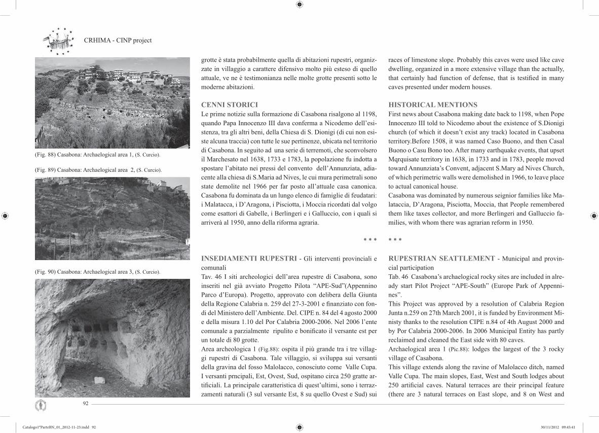
CRHIMA - CINP project
92
(Fig. 88) Casabona: Archaelogical area 1, (S. Curcio).
(Fig. 89) Casabona: Archaelogical area 2, (S. Curcio).
(Fig. 90) Casabona: Archaelogical area 3, (S. Curcio).
grotte è stata probabilmente quella di abitazioni rupestri, organiz-zate in villaggio a carattere difensivo molto più esteso di quello attuale, ve ne è testimonianza nelle molte grotte presenti sotto le moderne abitazioni.
CENNI STORICILe prime notizie sulla formazione di Casabona risalgono al 1198, quando Papa Innocenzo III dava conferma a Nicodemo dell’esi-stenza, tra gli altri beni, della Chiesa di S. Dionigi (di cui non esi-ste alcuna traccia) con tutte le sue pertinenze, ubicata nel territorio di Casabona. In seguito ad una serie di terremoti, che sconvolsero il Marchesato nel 1638, 1733 e 1783, la popolazione fu indotta a spostare l’abitato nei pressi del convento dell’Annunziata, adia-cente alla chiesa di S.Maria ad Nives, le cui mura perimetrali sono state demolite nel 1966 per far posto all’attuale casa canonica. Casabona fu dominata da un lungo elenco di famiglie di feudatari: i Malatacca, i D’Aragona, i Pisciotta, i Moccia ricordati dal volgo come esattori di Gabelle, i Berlingeri e i Galluccio, con i quali si arriverà al 1950, anno della riforma agraria.
* * *
INSEDIAMENTI RUPESTRI - Gli interventi provinciali e comunaliTav. 46 I siti archeologici dell’area rupestre di Casabona, sono inseriti nel già avviato Progetto Pilota “APE-Sud”(Appennino Parco d’Europa). Progetto, approvato con delibera della Giunta della Regione Calabria n. 259 del 27-3-2001 e fi nanziato con fon-di del Ministero dell’Ambiente. Del. CIPE n. 84 del 4 agosto 2000 e della misura 1.10 del Por Calabria 2000-2006. Nel 2006 l’ente comunale a parzialmente ripulito e bonifi cato il versante est per un totale di 80 grotte.Area archeologica 1 (Fig.88): ospita il più grande tra i tre villag-gi rupestri di Casabona. Tale villaggio, si sviluppa sui versanti della gravina del fosso Malolacco, conosciuto come Valle Cupa. I versanti prncipali, Est, Ovest, Sud, ospitano circa 250 gratte ar-tifi ciali. La principale caratteristica di quest’ultimi, sono i terraz-zamenti naturali (3 sul versante Est, 8 su quello Ovest e Sud) sui
races of limestone slope. Probably this caves were used like cave dwelling, organized in a more extensive village than the actually, that certainly had function of defense, that is testifi ed in many caves presented under modern houses.
HISTORICAL MENTIONSFirst news about Casabona making date back to 1198, when Pope Innocenzo III told to Nicodemo about the existence of S.Dionigi church (of which it doesn’t exist any track) located in Casabona territory.Before 1508, it was named Caso Buono, and then Casal Buono o Casu Bono too. After many earthquake events, that upset Mqrquisate territory in 1638, in 1733 and in 1783, people moved toward Annunziata’s Convent, adjacent S.Mary ad Nives Church, of which perimetric walls were demolished in 1966, to leave place to actual canonical house. Casabona was dominated by numerous seignior families like Ma-lataccia, D’Aragona, Pisciotta, Moccia, that People remembered them like taxes collector, and more Berlingeri and Galluccio fa-milies, with whom there was agrarian reform in 1950.
* * *
RUPESTRIAN SEATTLEMENT - Municipal and provin-cial participationTab. 46 Casabona’s archaelogical rocky sites are included in alre-ady start Pilot Project “APE-South” (Europe Park of Appenni-nes”. This Project was approved by a resolution of Calabria Region Junta n.259 on 27th March 2001, it is funded by Environment Mi-nisty thanks to the resolution CIPE n.84 of 4th August 2000 and by Por Calabria 2000-2006. In 2006 Municipal Entity has partly reclaimed and cleaned the East side with 80 caves.Archaelogical area 1 (Pic.88): lodges the largest of the 3 rocky village of Casabona. This village extends along the ravine of Malolacco ditch, named Valle Cupa. The main slopes, East, West and South lodges about 250 artifi cial caves. Natural terraces are their principal feature (there are 3 natural terraces on East slope, and 8 on West and
Catalogo1°ParteBN_01_2012-11-23.indd 92Catalogo1°ParteBN_01_2012-11-23.indd 92 30/11/2012 09:45:4130/11/2012 09:45:41

Exibition Firenze Giugno 2012 Cultural Rupestrian Heritage in the Circum - Mediterranean area
93
(Pic. 91) First forms of the abstract wall art, (S. Curcio).
(Pic. 92) Interior of the cave 16, (S. Curcio).
(Pic. 93) Cave of the Colombaia, (S. Curcio).
quali si sviluppano a raggera, uno dietro l’altra le grotte; le stesse sono collegate tra di loro da una fi tta rete di sentieri che convergono tutti sull’unica strada di acceso al sito che costeggia la profonda e impervia gravina.Area archeologica 2 (Fig.89): comprende il sito di Timpa Tallarico e del Rione Croci, qui sono presenti 80 grotte distribuite sull’antica strada di accesso al borgo settecentesco di Casabona, e a quello che oggi ne è il suo centro storico. Le grotte, seguono il percorso a ser-pentina della vecchia strada, presentano delle particolarità rispetto a quelle di Valle Cupa, infatti esse non presentano segni di scavo ne recenti e ne precedenti.Area archeologica 3 (Fig.90): comprende il sito di Montagna Piana, si trova ad ovest del più importante sito di Valle Cupa. È raggiungi-bile percorrendo la SP14 in direzione Zinga o attraverso i percorsi naturalistici, è composta da 15 grotte probabilmente facenti parte di un’antica masseria bizantina, confermato dalla presenza nel sito di una grotta detta la “colombaia” unica nel suo genere.
* * *
I PITTOGRAMMI E LE INCISIONI NELLE GROT-TE NEOLITICHE E BIZANTINE (Fig.91-93)Tav. 47 La grotta G19 sul Versante Est, detta grotta delle spirali come la grotta G16, è una delle circa 250 grotte del sito rupe-stre di Valle Cupa a Casabona (KR). La grotta, composta da un unico ambiente ipogeo, presenta sul-la parete sinistra delle incisioni rappresentanti una grande spi-rale a cerchi concentrici circondata da una serie di cerchi con buco e semplici. L’incisione è in ottimo stato di conservazione, le spirali sono incise sulla parete arenarica che presenta un sec-co strato che ha permesso la conservazione dell’incisione. La spirale centrale ha un diametro di circa 40 cm e d è composta da 4 cerchi concentrici con buco centrale, ha uno spessore me-dio di circa 1/1,5 cm. Intorno sono disposte, sembra in modo casuale, 9 cerchi con buco e 7 mezze lune con buco; partico-lare è il il cerchio con un grande buco centrale, che , oltre alle diverse dimensioni rispetto agli altri fori, presenta 3 piccoli fori in linea sulla parte superiore. La simbologia rappresentata
South slope), on which the caves extends radially, that are con-nected by a dense network of paths; this paths converge on the only access road, that skirts the deep and impervious ravine. Archaelogical area 2 (Pic.89): includes “Timpa Tallarico and Ri-one Croci” site, where there are 80 caves distributed along the old road for the access to seventeeth century village of Casabona and to his storical center. Caves follow the old street’s serpen-tine path, with a particular difference from those of Valle Cupa, in fact area’s 2 caves don’t show recent or preceding excavation signs.Archaelogical area 3 (Pic.90): it includes “Montagna Piana” site, that is located west of Valle Cupa more important site. It is attai-nable by provincial road n.14 towards Zinga or by nature trail. It is characterized by 15 caves, that probably were part of an ancient Byzantine farm, the presence in this site of a particular and nonpareil cava named “colombaia” (dovecot) could con-fi rm that.
* * *
PICTOGRAMS AND ROCK CAVING IN THE NEOLITHIC AND BYZANTINE CAVES (Pic.91-93)Tab. 47 The G19 cave on the east side is named cave of spirals like the G16 cave, and is one of the around 250 caves situated in the rocky site of Valle Cupa in Casabona (KR). The cave has only one room “underground” and the rock face on the left keeps clearly visible some rock painting describing a big spiral made up of concentric circles and enclosed by several rings simpler than the fi rsts. The rock painting is in a good state of maintenance, spirals are engraved on the rock face arenarica that thanks to its dry layer allowed the good maintenance of the carving. The spiral in the centre has a diameter of around 40 cm, it is made up of 4 circles with an hole in the middle and it is about 1/1,5 cm thick. All around there are in casual way 9 circles with the hole and 7 half-moons with an hole in the middle as well. The main circle has a bigger hole in the middle and has 3 small opening aligned on the superior part. The symbology
Catalogo1°ParteBN_01_2012-11-23.indd 93Catalogo1°ParteBN_01_2012-11-23.indd 93 30/11/2012 09:45:4230/11/2012 09:45:42

CRHIMA - CINP project
94
(Pic. 94a, b, c) Plan, sections and total view of the project, (estratto tesi di laurea, S. Curcio, relatore: G. Verdiani).
nell’incisione è probabilmente legata al culto della Dea Madre, che colloca presumibilmente il manufatto al periodo Neolitico medio o superiore.
* * *
IL PROGETTO (Fig.94)Tav. 48 Il progetto Parco Archeologico e Naturalistico di Ca-sabona è un’idea che nasce dalla volontà di concentrare in un unico grande “percorso” storico e progettuale, tutto ciò che è parte integrante della storia, tradizione e cultura della comunità di Casabona. Questo “percorso” è visto come una retta immaginaria sulla qua-le sono tracciati dei “punti”, momenti della nostra storia e della nostra evoluzione, che se uniti dalle origini a oggi, traccerebbe-ro segmenti di vita vissuta a Casabona e nel suo territorio, dalla protostoria alla storia. Segmenti di vita vissuta, un tracciato che tocca epoche diverse, iniziando dal Neolitico e attraversando le principali fasi evolu-tive dell’uomo, dalla nascita della cultura del periodo magno greco-romano, passando per il cristianesimo bizantino fi no alla società moderna, offrendo ai popoli che vi si sono avvicendati un riparo sicuro e accogliente adatto alla vita.
represented in the carving is probably linked to the cult of Mother Goddess and presumably dated back to the Middle or Superior Neolithic.
* * *
THE PROJECT (Pic.94)Tab. 48 The idea of the project named “Archaeological and Naturalistic Park of Casabona” derives from the willingness of merging in a single huge historical and process “timeline”, all integral aspects of the history, the tradition and the culture of Casabona’s community. This “timeline” has to be considered as an imaginary line on which many points are traced, representing the moments of our history and our evolution. These points, from the origins till today, would trace out the segments of Casabona and its area’s human experience, from early to modern history. These segments of human experience outline a path that affects different eras, starting from Neolithic and going through the main evolutionary stages of human life, from the birth of the Magno-Greek and Roman era to Byzantine Christianity, up to modern society, offering to all the civilizations following one another in the course of time a safe and homely shelter, suitable for life.
Catalogo1°ParteBN_01_2012-11-23.indd 94Catalogo1°ParteBN_01_2012-11-23.indd 94 30/11/2012 09:45:4230/11/2012 09:45:42
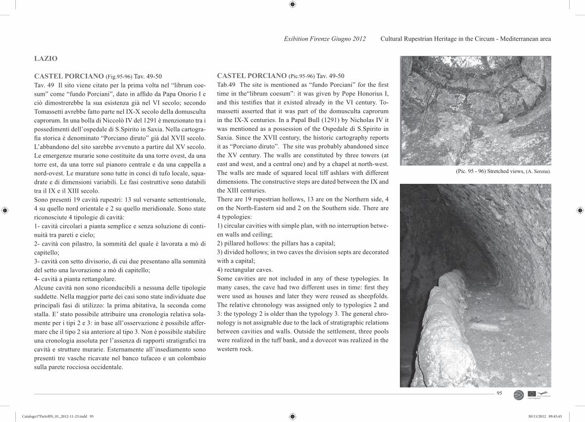
Exibition Firenze Giugno 2012 Cultural Rupestrian Heritage in the Circum - Mediterranean area
95
LAZIO
CASTEL PORCIANO (Fig.95-96) Tav. 49-50Tav. 49 Il sito viene citato per la prima volta nel “librum coe-sum” come “fundo Porciani”, dato in affi do da Papa Onorio I e ciò dimostrerebbe la sua esistenza già nel VI secolo; secondo Tomassetti avrebbe fatto parte nel IX-X secolo della domusculta caprorum. In una bolla di Niccolò IV del 1291 è menzionato tra i possedimenti dell’ospedale di S.Spirito in Saxia. Nella cartogra-fi a storica è denominato “Porciano diruto” già dal XVII secolo. L’abbandono del sito sarebbe avvenuto a partire dal XV secolo. Le emergenze murarie sono costituite da una torre ovest, da una torre est, da una torre sul pianoro centrale e da una cappella a nord-ovest. Le murature sono tutte in conci di tufo locale, squa-drate e di dimensioni variabili. Le fasi costruttive sono databili tra il IX e il XIII secolo.Sono presenti 19 cavità rupestri: 13 sul versante settentrionale, 4 su quello nord orientale e 2 su quello meridionale. Sono state riconosciute 4 tipologie di cavità: 1- cavità circolari a pianta semplice e senza soluzione di conti-nuità tra pareti e cielo; 2- cavità con pilastro, la sommità del quale è lavorata a mò di capitello; 3- cavità con setto divisorio, di cui due presentano alla sommità del setto una lavorazione a mò di capitello; 4- cavità a pianta rettangolare. Alcune cavità non sono riconducibili a nessuna delle tipologie suddette. Nella maggior parte dei casi sono state individuate due principali fasi di utilizzo: la prima abitativa, la seconda come stalla. E’ stato possibile attribuire una cronologia relativa sola-mente per i tipi 2 e 3: in base all’osservazione è possibile affer-mare che il tipo 2 sia anteriore al tipo 3. Non è possibile stabilire una cronologia assoluta per l’assenza di rapporti stratigrafi ci tra cavità e strutture murarie. Esternamente all’insediamento sono presenti tre vasche ricavate nel banco tufaceo e un colombaio sulla parete rocciosa occidentale.
CASTEL PORCIANO (Pic.95-96) Tav. 49-50Tab.49 The site is mentioned as “fundo Porciani” for the fi rst time in the“librum coesum”: it was given by Pope Honorius I, and this testifi es that it existed already in the VI century. To-massetti asserted that it was part of the domusculta caprorum in the IX-X centuries. In a Papal Bull (1291) by Nicholas IV it was mentioned as a possession of the Ospedale di S.Spirito in Saxia. Since the XVII century, the historic cartography reports it as “Porciano diruto”. The site was probably abandoned since the XV century. The walls are constituted by three towers (at east and west, and a central one) and by a chapel at north-west. The walls are made of squared local tiff ashlars with different dimensions. The constructive steps are dated between the IX and the XIII centuries.There are 19 rupestrian hollows, 13 are on the Northern side, 4 on the North-Eastern sid and 2 on the Southern side. There are 4 typologies:1) circular cavities with simple plan, with no interruption betwe-en walls and ceiling;2) pillared hollows: the pillars has a capital;3) divided hollows; in two caves the division septs are decorated with a capital;4) rectangular caves.Some cavities are not included in any of these typologies. In many cases, the cave had two different uses in time: fi rst they were used as houses and later they were reused as sheepfolds. The relative chronology was assigned only to typologies 2 and 3: the typology 2 is older than the typology 3. The general chro-nology is not assignable due to the lack of stratigraphic relations between cavities and walls. Outside the settlement, three pools were realized in the tuff bank, and a dovecot was realized in the western rock.
(Pic. 95 - 96) Stretched views, (A. Serena).
Catalogo1°ParteBN_01_2012-11-23.indd 95Catalogo1°ParteBN_01_2012-11-23.indd 95 30/11/2012 09:45:4330/11/2012 09:45:43

CRHIMA - CINP project
96
TOSCANA
Tav. 51 Necropoli di Populonia (Fig.97): Situata nel Golfo di Ba-ratti, è costituita da diversi siti, risalenti a momenti diversi della storia etrusca. Le aree di necropoli visitabili all’interno del Parco archeologico di Baratti e Populonia sono la Necropoli di San Cer-bone - Casone e di Poggio della Porcareccia, risalenti al VII secolo a.C. e VI secolo a.C. con alcune sepolture più tarde, e la Necropoli delle Grotte, risalente al periodo ellenistico (IV - II secolo a.C.). All’esterno del Parco si trovano sia zone cimiteriali come Poggio del Molino, Poggio delle Granate, Piano delle Granate del periodo villanoviano e le necropoli di Buche delle Fate, Poggio Malassarto e le tombe di Piano delle Granate del periodo ellenistico.
Area archeologica di Vetulonia (Fig.98): situata nel territorio co-munale di Castiglione della Pescaia, nei pressi della frazione di Vetulonia. Il sito archeologico presenta i resti degli antichi inse-diamenti e di una serie di necropoli che si sono succeduti nel cor-so dei secoli dal X secolo a.C. In origine, Vetulonia sorgeva su un promontorio sul Mar Tirreno; durante il VII secolo a.C. la città si sviluppò e si organizzò maggiormente grazie all’arrivo degli Etru-schi, che costruirono il sistema difensivo delle mura di Vetulonia attorno all’intero abitato. Fino al V secolo a.C. Vetulonia conob-be un periodo di grande fl oridezza economica, poi seguirono una temporanea crisi ed una grandissima ripresa durante il III secolo a.C.; in quest’epoca la città coniò anche una propria moneta, il cui simbolo ricordava l’origine marittima della città.
Chiusi (Fig.99): dell’antica città etrusca non è rimasto quasi nul-la; le testimonianze si trovano nelle numerose necropoli sparse nel territorio. Sono conosciute una quindicina di tombe dipinte, le principali sono: la tomba della Scimmia, quella della Tassinaia, di Vigna Grande, tomba Galeotti, di Poggio al Moro, del Colle, la Pellegrina, tomba del Leone, del Granduca e il Labirinto di Por-senna. La maggior parte delle quali si datano in epoca tardo-ar-caica (prima metà del V secolo a.C.). Oggi soltanto due di queste tombe presentano pitture leggibili: la tomba del Colle Casuccini (detta anche del Leone) e la tomba della Scimmia.
Tab. 51 Necropoli di Populonia (Pic.97): Located in the Gulf of Baratti, it consists of many sites, that they go back to different moments of Etruscan history. Inside Baratti’s and Populonia’s park there are necropolis of San Carbone, Casone and Poggio del-la Porcareccia, belonging to VII and VI century b.C. and some tombs of ellenistic period (IV-II century b.C.).Outside the park there are cimiterial areas like Poggio del Mulino, Poggio delle Granate, Piano delle Granate of villanovian period and the necropolis of Buche delle Fate, Poggio Malassarto and tombs of Piano delle Granate of ellenistic period.
Vetulonia (Pic.98): located in municipal territory of Castiglione della Pescaia, near a group of houses of Vetulonia. The archaeolo-gical site presents restes of ancient entering and some necropolis that they are succeeded during the centuries from X century b.C.At the beginning, Vetulonia was rising on a promontory on the Tyrrhenian Sea; during the VII century b.C. the town diveloped and organized more itself thanks to arrival of Etruscan, who bu-ilt a defensive system of Vetulonia’s walls around all inhabited. Until V century b.C. Vetulonia knew a great period of economic prosperity, then followed a temporary crisis and a big restarting during the III century b.C., in this age the city coined her money, whose symbol remembered the maritime origin of town.
Chiusi (Pic.99): about the ancient etruscan town has hardly anything left; the testimonies are sheets in numerouses necropolis around territory. Are known about fi fteen painted tombs, the most importants tombs are: Scimmia (Monkey), Tassinaia, Vigna Gran-de, Galeotti, Poggio al Moro, Colle, Pellegrina, Leone (Lion), Granduca and the Porsenna’s labyrinth. The most of whose are dated in late- archaic age (fi rst half of V century b.C.). Today only two tombs of these have legibles pain-tings: Colle Casuccini’s tomb (named also of Lion) and the tomb of Monkey.
(Pic. 97) Necropolis of Populonia, (www.fi .wikipedia.org).
(Pic. 98) Archaelogical area of Vetulonia, (www.fi .wikipedia.org).
(Pic. 99) Necropolis of Chiusi, (www.fi .wikipedia.org).
Catalogo1°ParteBN_01_2012-11-23.indd 96Catalogo1°ParteBN_01_2012-11-23.indd 96 30/11/2012 09:45:4430/11/2012 09:45:44
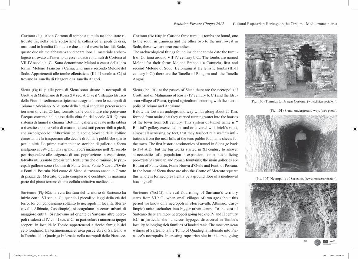
Exibition Firenze Giugno 2012 Cultural Rupestrian Heritage in the Circum - Mediterranean area
97
Cortona (Fig.100): a Cortona di tombe a tumulo ne sono state ri-trovate tre, nella parte sottostante la collina ed ai piedi di essa, una a sud in località Camucia e due a nord-ovest in località Sodo, queste due ultime abbastanza vicine tra loro. Il materiale archeo-logico ritrovato all’interno di esse fa datare i tumuli di Cortona al VII-IV secolo a. C.. Sono denominate Meloni a causa della loro forma: Melone Francois a Camucia, primo e secondo Melone del Sodo. Appartenenti alle tombe ellenistiche (III- II secolo a. C.) si trovano la Tanella di Pitagora e la Tanella Angori.
Siena (Fig.101): alle porte di Siena sono situate le necropoli di Grotti e di Malignano di Rosia (IV sec. A.C.) e il Villaggio Etrusco della Piana, insediamento tipicamente agricolo con le necropoli di Toiano e Ancaiano. Al di sotto della città si snoda un percorso sot-terraneo di circa 25 km, formato dalle condutture che portavano l’acqua corrente nelle case della città fi n dal secolo XII. Questo sistema di tunnel si chiama “Bottini”: gallerie scavate nella sabbia o rivestite con una volta di mattoni, quasi tutti percorribili a piedi, che raccolgono le infi ltrazioni delle acque piovane delle colline circostanti e la trasportano alle decine di fontane pubbliche sparse per la città. Le prime testimonianze storiche di gallerie a Siena risalgono al 394 d.C., ma i grandi lavori iniziarono nell’XI secolo per rispondere alle esigenze di una popolazione in espansione, talvolta utilizzando preesistenti fonti etrusche o romane; le prin-cipali gallerie sono i bottini di Fonte Gaia, Fonte Nuova d’Ovile e Fonti di Pescaia. Nel cuore di Siena si trovano anche le Grotte di piazza del Mercato: questo complesso è costituito in massima parte dal piano terreno di una cellula abitativa medievale.
Sarteano (Fig.102): la vera fi oritura del territorio di Sarteano ha inizio con il VI sec. a. C., quando i piccoli villaggi della età del ferro, (di cui conosciamo soltanto le necropoli in località Sferra-cavalli, Albinaio, Casolimpio); si coagulano in centri urbani di maggiore entità. Si ritrovano ad oriente di Sarteano altre necro-poli risalenti al IV e il II sec. a. C. in particolare i numerosi ipogei scoperti in località le Tombe appartenenti a ricche famiglie del ceto fondiario. La testimonianza etrusca più celebre di Sarteano è la Tomba della Quadriga Infernale nella necropoli delle Pianacce.
Cortona (Pic.100): in Cortona three tumulus tombs are found, one to the south in Camucia and the other two to the north-west in Sodo, these two are near eachother. The archaeological things found inside the tombs date the tumu-li of Cortona around VII-IV century b.C.. The tombs are named Meloni for their form: Melone Francois a Camucia, fi rst and second Melone of Sodo. Belonging at Hellenistic tombs (III-II century b.C.) there are the Tanella of Pitagora and the Tanella Angori.
Siena (Pic.101): at the passes of Siena there are the necropolis if Grotti and of Malignano of Rosia (IV century b. C.) and the Etru-scan village of Piana, typical agricultural entering with the necro-polis of Toiano and Ancaiano.Below the town an underground way winds along about 25 Km, formed from mains that they carried running water into the houses of the town from XII century. This system of tunnel name is “ Bottini”: gallery excavated in sand or covered with brick’s vault, almost all acrossing by feet, that they trasport rain water’s infi l-trations from the near hills at the tens public fountains sheets for the town. The fi rst historic testimonies of tunnel in Siena go back to 394 A.D., but the big works started in XI century to answer at necessities of a population in expansion, sometimes utilizing pre-existent etruscan and roman fountains; the main galleries are Bottini of Fonte Gaia, Fonte Nuova d’Ovile and Fonti of Pescaia.In the heart of Siena there are also the Grotte of Mercato square: this whole is formed prevalently by a ground fl oor of a medioeval housing cell.
Sarteano (Pic.102): the real fl ourishing of Sarteano’s territory starts from VI b.C., when small villages of iron age (about this period we know only necropoli in Sferracavalli, Albinaio, Caso-limpio) unite eachother into bigger urban centre. To the east of Sarteano there are more necropoli going back to IV and II century b.C. in particular the numerous hypogea discovered in Tombe’s locality belonging rich families of landed rank. The most etruscan witness of Sarteano is the Tomb of Quadriglia Infernale into Pia-nacce’s necropolis. Interesting rupestrian site in this area, going
(Pic. 100) Tumulus tomb near Cortona, (www.fi sica-sociale.it).
(Pic. 102) Necropolis of Sarteano, (www.museosarteano.it).
(Pic. 101) Siena: underground way, (web photo).
Catalogo1°ParteBN_01_2012-11-23.indd 97Catalogo1°ParteBN_01_2012-11-23.indd 97 30/11/2012 09:45:4430/11/2012 09:45:44

CRHIMA - CINP project
98
Interessanti siti rupestri della zona risalenti al XIII secolo d.C. sono la Grotta del Bruco,che si affaccia direttamente su un verti-ginoso precipizio, il Romitorio di San Bartolomeo con le “Celle di San Fracesco”, alle quali si accede attraverso un tunnel scavato nella roccia;ed infi ne le Celle di Frà Bonaventura, complesso di quattro celle scavate nella roccia tufo calcarea.
Sorano,Vitozza e Sovana: nella Maremma toscana, Sorano e Vi-tozza fanno parte del Parco archeologico città del tufo che è un au-tentico museo a cielo aperto; il parco comprende un vasto territorio di notevole interesse storico, archeologico e paesaggistico del quale fanno parte anche gli antichi centri di Castell’Azzara, Pitigliano, Castell’Ottieri, San Giovanni delle Contee, Montevitozzo, San Quirico, Sovana. Quest’ultima, nel comune di Sorano, “ospita” nel suo territorio le suggestive necropoli rupestri e le vicine necropoli etrusche; tra queste è da vedere assolutamente la particolarissima Tomba a Tempio etrusca che prende il nome da papa Ildebrando VII. A Sorano è possibile percorrere le vie cave e visitare l’insedia-mento rupestre di San Rocco (Fig.103), risalente all´epoca medie-vale. A Vitozza è possibile visitare l’insediamento rupestre con le sue spettacolari grotte, utilizzate dall´uomo come abitazioni fi no al 1700 e i “colombari” attribuiti ai secoli I a.C. - I d.C.
Pienza (Fig.104): la sua storia non è caratterizzata da lunghi periodi di vicende medievali e guerre: la città era un piccolo borgo fi no al 1462, conosciuto col nome di Corsignano. L’evento che cambiò le sue sorti fu la nascita nel 1405 di Enea Silvio Piccolomini che 53 anni dopo divenne Papa Pio II. Per il volere del pontefi ce Pienza nel giro di pochi anni, su progetto dell’architetto Bernardo Rossel-lino, si trasformò in una cittadina armoniosa, con forme tipicamen-te quattrocentesche. La morte prematura del papa fu la fi ne anche dei progetti innovativi sulla città e sul territorio circostante, che da allora sono rimasti pressoché invariati; per questo subito fuori le mura di Pienza si trova ancora il Romitorio di “Santa Caterina” risalente al XIV secolo d. C.. E’ situato su di un pendio tra la chiesa di S.Caterina e la Pieve di Corsignano - antico “baptisterorium” del V-VI sec. d.c.. L’eremo è scavato completamente in un enorme masso di tufo che “scende” lungo il piano della collina.
back to XIII century A.D., are the Cave of Bruco, that show it-self on a dizzy precipice, the Romitorio of San Bartolomeo with the “cells of San Francesco”, to arrive there must across a tunnel excavated into the rock; and at the end the Cells of Frà Bonaven-tura, a complex of four cells excavated into fuff calcareus rock.
Sorano,Vitozza e Sovana: in the Tuscan Maremma, Sorano and Vitozza belong to archaeological town of tuff Park, that is an au-thentic museum i open air; the park includes a big territory of remarkable historic, archaeological and landscaping interest, in this park there are also the town of Castell’Azzara, Pitigliano, Ca-stell’Ottieri, San Giovanno of Contee, Montevitozzo, San Quiri-co, Sovana. The last one, in the municipality of Sorano, has in its territory the evocatives rupestrian necropoli and the near etruscan necroploi; about these the special etruscan Temple Tomb is abso-lutely to visit, it tekes name by Pope Ildebrando VII. In Sorano is possible go along the mine streets and visit the rupestrian entering of San Rocco (Pic.103), going back to medioeval age.In Vitozza is possible visit another rupestrian entering with its spectacolar caves, utilized by man like habitation until 1700 and the “Colombari” of I b.C. - I A.D.
Pienza (Pic.104): the Pienza’s history is not peculiar to long period of medioeval vicissitudes and wars: the town was a small village until 1462, well known with name of Corsignano. The event that changed its destiny was the birth in 1405 of Enea Silvio Piccolo-mini who 53 years after became Pope Pio II. For desire of the Pope Pienza in few years, on a plan of architect Bernardo Rossellino, trasformed itself in a harmonious country town, with tipical 15th century forms. The untimely Pope’s death was the end of the inno-vational projects about the town and the its territory, that from that time they are remained almost unchanged; for this sudden out walls of Pienza there is still the Romitorio of “Santa Caterina” going back to XIV century A.D.. It’s located on a slope between S. Caterina’s church and Pieve of Corsignano- anciant “baptisterium” of V-VI century A.D.. The hermitage is completely exavated into a enor-mous rock of tuff that go down along the hill.
(Pic. 103) Sorano: cave of San Rocco, (F. Marcocci).
(Pic. 104) Pienza, (F. Marcocci).
Catalogo1°ParteBN_01_2012-11-23.indd 98Catalogo1°ParteBN_01_2012-11-23.indd 98 30/11/2012 09:45:4430/11/2012 09:45:44

Exibition Firenze Giugno 2012 Cultural Rupestrian Heritage in the Circum - Mediterranean area
99
Monteriggioni: a Monteriggioni si trova l’eremo di San Leonar-do al lago, il più antico dei conventi eremitici della provincia di Siena risalente al XII-XIV secolo. Sorge nel bosco di Pian del Lago, ai piedi della Montagnola Senese. San Leonardo fu trasfor-mato in una canonica rurale intorno al 1132. Tornò al suo stato eremitico sotto la guida spirituale di Fra Bal-dino Dei Balzetti. Ci sono state numerose campagne archeologi-che che hanno dato alla luce interessanti scoperte sulle comunità eremitiche. Gli scavi rivelarono dei momenti differenti di edifi -cazione. Il primo è rappresentato da una grotta naturale, con un oratorio romanico; nella seconda fase intorno al secolo XIV viene eretta una chiesa gotica all’interno del complesso monastico già pienamente sviluppato. Purtroppo, nel periodo in cui l’eremo cessò la sua funzione speci-fi ca, furono cancellate le tracce dei periodi antecedenti.
Sovicille (Fig.105): a Sovicille vi è un famoso eremo agostiniano. Si trova a circa 300m sul livello del mare e dista solo un miglio da San Leonardo al Lago. Il nome originale era Foltignano, ma già nel 1220 era conosciuto come Selva del lago. Il nome Lecceto fu usato per la prima volta nel 1392. Il documento più antico che attesti l’esistenza di Lecceto è datato 18 settembre 1223, e già in quell’anno l’eremo comprendeva la chiesa. Non si conosce il nome del fondatore e tanto meno l’anno di nascita. Un’ ipotesi afferma che in realtà Lecceto venne fondato, quando vi si insedia-rono i canonici secolari (tra il 1132 e il 1134).
Lucca (Fig.106): nella provincia di Lucca sono presenti diversi siti rupestri, i principali sono l’Eremo di Calomini a Gallicano e l’eremo di San Viviano a Vagli di sotto. Il primo è un suggestivo complesso architettonico del XIV secolo situato alla base di una grande parete a strapiombo. Il secondo, del XVI secolo, può esse-re considerato un edifi cio d’abri, vale a dire costruito sfruttando una tettotia naturale di una sporgenza rupestre.
Rosignano Marittimo: in prossimità del mare si trova la grotta “Buca dei corvi”, presumibilmente risalente al III secolo a. C..
Monteriggioni: In Monteriggioni’s territory ther is the Hermitage of San Leonardo at lake, the most anciant of hermitic convent of Siena’s province going back to XII-XIV century. It rise in the middle of a dense vegetation, in the forest of Pian del Lago, at the foot of Montagnola Senese. San Leonardo was trasformed into a rural rectory around 1132 A.D.. It went back at its heremitic con-dition under the spiritual guide Fra Baldino Dei Balzetti. There were numerous archeological campaigns of San Leonardo at lake and these gave interesting discoveries about heremitic communi-ties. The excavations displayed different moment of edifi cation. The fi rst excavation is represented by a natural cave, with a roma-nesque oratory builted upon the cave; in the second stage around XIV century a gothic church is erected inside the monastic com-plex already fully developed. Unfortunately, when the hermitage stopped its specifi c function and it was trasformed into a farmhou-se, the tracks of previous periods were cancelled.
Sovicille (Pic.105): in Sovicille there is a famous Augustinian her-mitage. It is at about 300mt above sea-level and it’s far 1 mile from San Leonardo al Lago. The original name of hermitage was Folti-gnano, but in 1220 it was already known like Selva del Lago. The Lecceto’s name was used for the fi rst time in 1392. The anciant do-cument that attests the existence of Lecceto is dated 18th September 1223, and in that year the hermitage included already the church. The founder’s name isn’t known and the year of birth least of all. A supposition affi rms that in reality Lecceto was founded, when canons secular install themself there (between 1132 and 1134).
Lucca (Pic.106): in the province of Lucca there are different rupestrian sites, the chief places the Eremo of Calomini in Gallicano and the Ere-mo of San Viviano in Vagli di Sotto. The fi rst is a suggestive architec-tonic complex of XIV century located to a base of a big wall sheer. The second, of XVI century, can be consider an “ abri” building, or co-structed using a natural shed of a rupestrian protrusion. The sanctuary appears literally clinging and vertically on a mountainous declivitites.
Rosignano Marittimo: near the sea there is the cave “Buca dei corvi”, presumably going back to III century b.C.. The access at
(Pic. 105) Famous Augustinian hermitage in Sovicille, (F. Marcocci).
(Pic. 106) Gallicano: Colomini rupestrian village, (F. Marcocci).
Catalogo1°ParteBN_01_2012-11-23.indd 99Catalogo1°ParteBN_01_2012-11-23.indd 99 30/11/2012 09:45:4530/11/2012 09:45:45

CRHIMA - CINP project
100
L’accesso alla “buca dei Corvi” (Fig.107) dalla via Aurelia risulta diffi coltoso in quanto il percorso è stretto, tortuoso e di notevole pendenza. Il piccolo golfo sottostante non consente di fatto l’at-tracco di grosse imbarcazioni a causa del basso fondale per cui si può supporre un utilizzo come ripostiglio o deposito di attrezzi per la pesca e come riparo delle mareggiate.
Trequanda: questa grotta trifora, del XIII secolo presenta l’in-gresso principale ostrutito, ma sempre accessibile, a causa dell’ac-qua piovana e dei vari smottamenti. Questa “Buca del Romito” si trova ad un’altitudine di m.530, è interrata per una profondità di 4-5m. in mezzo ad una roccia calcarea. La grotta è stata scava-ta sfruttando una cavità naturale alta ml.3,00 a forma di cupola. Nella prima nicchia troviamo una scultura in bassorilievo, raffi gu-rante una fattezza umana stilizzata con il solo busto e sulla destra troviamo scolpita”una acquasantiera”.
Capannori (Fig.108): vicino Pisa si trova l’Eremo di San Gior-gio della spelonca, del XII-XIII secolo, un singolare abri che si inarca per una trentina di metri e che si inoltra di poco (pro-fondità massima di 15 metri) nelle viscere della collina che da ovest-nord-ovest sovrasta l’abitato di S. Maria del Giudice. ll luogo presenta: una piccola chiesa sconsacrata, una scaletta a gradini regolari intagliati nel calcare, così come le cellette a cui conduce; una cavità circolare, usata per la raccolta delle acque, una cisterna con imboccatura squadrata; una caverna infi ne con le forme stalattitiche.
Ripafratta (Fig.109): nella provincia di Pisa a Ripefratta si trova il Romitorio di Rupecava,risalente al XIII secolo, è inserito nell'am-biente addossato al declivio del Monte Maggiore, rimanendo qua-si completamente nascosto dalla vegetazione. L'accesso all'eremo, dalla strada principale è segnato da un basso pilastro.Il complesso è defi nito da una struttura architettonica ab-bastanza semplice e sfrutta le possibilità offerte dalla particolare morfologia ambientale, per questa ragione si distribuisce su vari livelli.
“Buca dei corvi” (Pic.107) from Aurelia street is diffi cult to do be-cause of narrow and remarkable slope way. The little gulf below doesn’t consent the mooring of big boats because of the low sounding-depth so we can suppose the use of it like a cupboard or a deposit of implements for fi shing and like a stormy sea’s shelter.
Trequanda: this cave three-mullioned window, of XIII century, disused and neglected presents the main entry obstructed, but it is always accessible, because of water rain and many landslips. This “ Buca del Romito” is at 530 m. of altitude, it is buried for 4-5 m. of depth in the middle of calcareous rock. The cave it is excavated exploiting a natural cavity 3 m. high dome-shaped. In the fi rst niche there is a sculpture in bass-relief, that representsa human stylized feature with only bust and on the right there is an “holy water stoup” sculptured.
Capannori (Pic.108): near Pisa there is the Hermitage of San Giorgio della spelonca, of XII-XIII century, an unusual “abri” that curve itself along 30 metres and that not long advance ( the maximum depthis around 15 metres) into bowels of the hill that from west/north-west dominates the village of S. Maria del Giu-dice. The place presents: a little deconsecrated church, a small stairway with regular steps engraved in limestone that guides to a limestone cells; a circular cavity, probably used for water’s picking, a cistern with squared opening; at last a cavern with stalactitic forms.
Ripafratta (Pic.109): in the province of Pisa in Ripafratta there is Hermitage of Rupecava, going back to XIII century, it is inserted into an ambient leaning to Monte Mggiore’s slope, remaining al-most completely hidden from vegetation. the ermitage’s access, from main street is marked by a low pilaster. The complex is defi nite by an architectonic structure rather sim-ple and it exploits the possibilities offered by particular ambiental morfology, for this reason it lines over many levels.
(Pic. 107) Rosignano Marittimo: Buca dei Corvi, (web photo).
(Pic. 108) Capannori: Hermitage of San Giorgio, (web photo).
(Pic. 109) Ripafratta: Hermitage of Rupecava, (web photo).
Catalogo1°ParteBN_01_2012-11-23.indd 100Catalogo1°ParteBN_01_2012-11-23.indd 100 30/11/2012 09:45:4530/11/2012 09:45:45

Exibition Firenze Giugno 2012 Cultural Rupestrian Heritage in the Circum - Mediterranean area
101
VIE CAVETab.52 Le Vie Cave, chiamate anche “tagliate”o “cavoni”, sono una creazione ancora poco conosciuta degli Etruschi. Questi per-corsi, scavati a cielo aperto nelle colline di tufo, non hanno raf-fronti in altre civiltà del mondo antico. Ci sono numerose ipotesi sulla loro reale funzione: canali per convogliare le acque piovane, semplici vie di comunicazione, passaggi strategici contro i nemici All'interno del Parco Archeologico Città del Tufo, le Vie Cave di Sorano (Fig.110-111) e Sovana conducono alle varie necropoli etrusche. Questi sentieri ripidi, tortuosi scavati nella roccia tufa-cea consentivano di diminuire i tempi di percorrenza collegando i centri abitati, la campagna e le necropoli. Alcune Vie Cave sono sicuramente riconducibili, nel loro impianto originario, al sistema di epoca etrusca: è questo il caso della Via Cava del “Cavone” nella necropoli di Sovana. Altre Vie Cave risalgono all'epoca me-dievale. In tutte le Vie Cave si nota un’attenta opera di regimazio-ne delle acque che è ormai quasi completamente compromessa a causa dell’abbandono. Durante l'epoca cristiana la dimensione di oscurità che avvolge questi profondi tagli nella roccia e la sug-gestione che essi emanano hanno portato alla realizzazione di numerosi “scacciadiavoli” (piccole nicchie con immagini sacre
THE CAVE STREETTab. 52 The Cave streets, named also “tagliate” or “cavoni”, are a Etruscan creation that is not much known yet. There isn’t in ano-ther parts of world streets, excavated in open air into tuff hills like these. There are many hypotheses about their real function: canals to convoy rain-water, simple streets of communication, strategical passages against the enemy.Inside the archaeological park towns of tuff, the cave streets of Sorano (Pic.110-111) and Sovana lead to some etruscan necropoli.These tracks steep, tortuous and excavated into fuff rock allowed to reduce the time of way connecting the inhabited towns, the country and the necropoli.Some Cave streets are to go back again, in their original installa-tion, to a system of etruscan age: this is the chance of Cava street of “Cavone” in the necropolis of Sovana. Other Cave streets go up again madioeval age. In all Cave streets is possible see a careful work of water’s regimation that now is almost completely com-promise because of the abandonment. During Christian age the darkness dimension that wrap up these deep cut into the rock and the suggestion that they issue, have taken to realization of many “scacciadiavoli” ( little niches with sacred, painted images) to re-
(Pic. 111) Cave of San Carlo, (F. Marcocci).
(Pic. 110) Panoramic view of Sorano, (F. Marcocci).
Catalogo1°ParteBN_01_2012-11-23.indd 101Catalogo1°ParteBN_01_2012-11-23.indd 101 30/11/2012 09:45:4630/11/2012 09:45:46
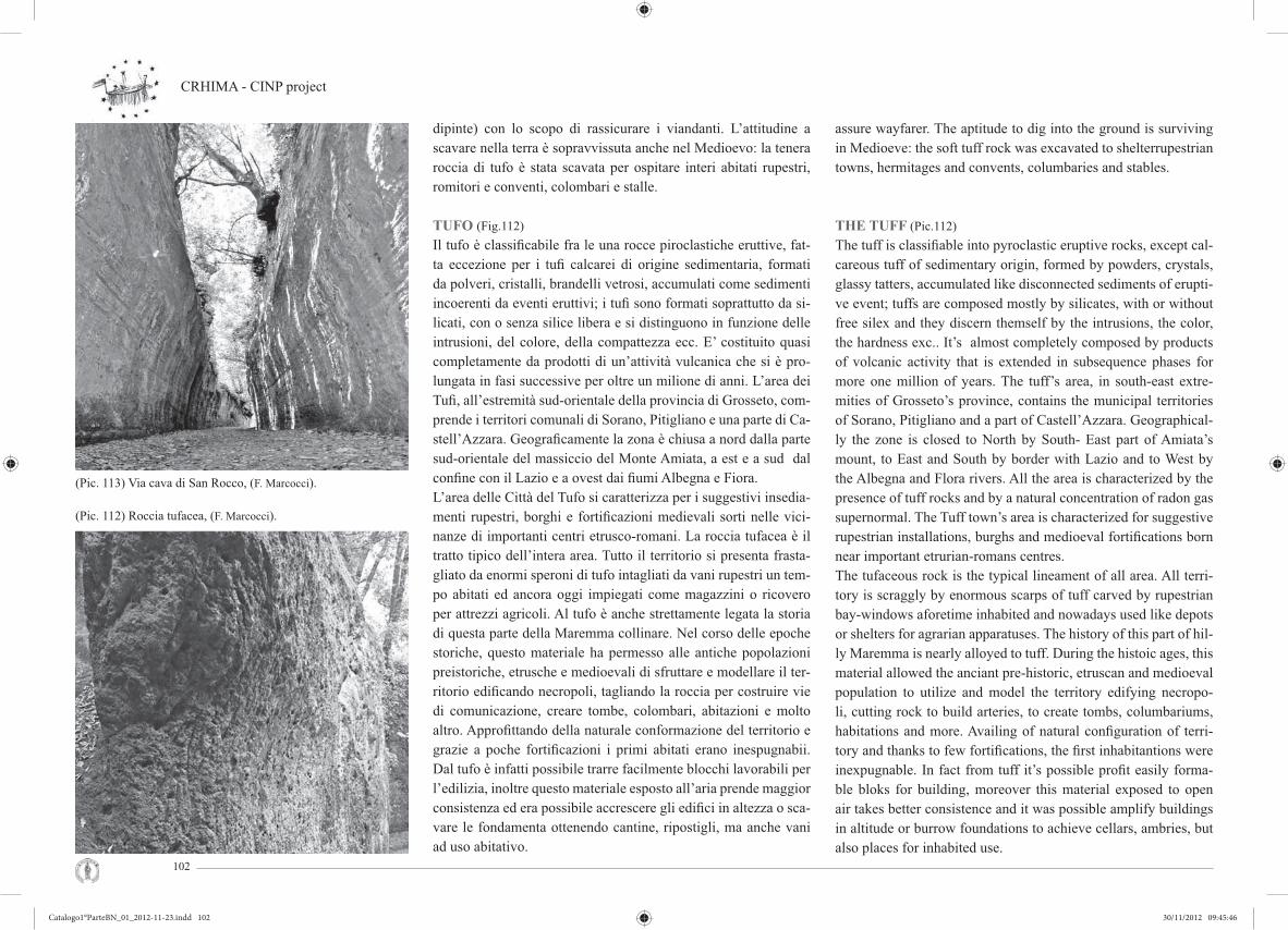
CRHIMA - CINP project
102
dipinte) con lo scopo di rassicurare i viandanti. L’attitudine a scavare nella terra è sopravvissuta anche nel Medioevo: la tenera roccia di tufo è stata scavata per ospitare interi abitati rupestri, romitori e conventi, colombari e stalle.
TUFO (Fig.112)Il tufo è classifi cabile fra le una rocce piroclastiche eruttive, fat-ta eccezione per i tufi calcarei di origine sedimentaria, formati da polveri, cristalli, brandelli vetrosi, accumulati come sedimenti incoerenti da eventi eruttivi; i tufi sono formati soprattutto da si-licati, con o senza silice libera e si distinguono in funzione delle intrusioni, del colore, della compattezza ecc. E’ costituito quasi completamente da prodotti di un’attività vulcanica che si è pro-lungata in fasi successive per oltre un milione di anni. L’area dei Tufi , all’estremità sud-orientale della provincia di Grosseto, com-prende i territori comunali di Sorano, Pitigliano e una parte di Ca-stell’Azzara. Geografi camente la zona è chiusa a nord dalla parte sud-orientale del massiccio del Monte Amiata, a est e a sud dal confi ne con il Lazio e a ovest dai fi umi Albegna e Fiora. L’area delle Città del Tufo si caratterizza per i suggestivi insedia-menti rupestri, borghi e fortifi cazioni medievali sorti nelle vici-nanze di importanti centri etrusco-romani. La roccia tufacea è il tratto tipico dell’intera area. Tutto il territorio si presenta frasta-gliato da enormi speroni di tufo intagliati da vani rupestri un tem-po abitati ed ancora oggi impiegati come magazzini o ricovero per attrezzi agricoli. Al tufo è anche strettamente legata la storia di questa parte della Maremma collinare. Nel corso delle epoche storiche, questo materiale ha permesso alle antiche popolazioni preistoriche, etrusche e medioevali di sfruttare e modellare il ter-ritorio edifi cando necropoli, tagliando la roccia per costruire vie di comunicazione, creare tombe, colombari, abitazioni e molto altro. Approfi ttando della naturale conformazione del territorio e grazie a poche fortifi cazioni i primi abitati erano inespugnabii. Dal tufo è infatti possibile trarre facilmente blocchi lavorabili per l’edilizia, inoltre questo materiale esposto all’aria prende maggior consistenza ed era possibile accrescere gli edifi ci in altezza o sca-vare le fondamenta ottenendo cantine, ripostigli, ma anche vani ad uso abitativo.
assure wayfarer. The aptitude to dig into the ground is surviving in Medioeve: the soft tuff rock was excavated to shelterrupestrian towns, hermitages and convents, columbaries and stables.
THE TUFF (Pic.112)The tuff is classifi able into pyroclastic eruptive rocks, except cal-careous tuff of sedimentary origin, formed by powders, crystals, glassy tatters, accumulated like disconnected sediments of erupti-ve event; tuffs are composed mostly by silicates, with or without free silex and they discern themself by the intrusions, the color, the hardness exc.. It’s almost completely composed by products of volcanic activity that is extended in subsequence phases for more one million of years. The tuff’s area, in south-east extre-mities of Grosseto’s province, contains the municipal territories of Sorano, Pitigliano and a part of Castell’Azzara. Geographical-ly the zone is closed to North by South- East part of Amiata’s mount, to East and South by border with Lazio and to West by the Albegna and Flora rivers. All the area is characterized by the presence of tuff rocks and by a natural concentration of radon gas supernormal. The Tuff town’s area is characterized for suggestive rupestrian installations, burghs and medioeval fortifi cations born near important etrurian-romans centres.The tufaceous rock is the typical lineament of all area. All terri-tory is scraggly by enormous scarps of tuff carved by rupestrian bay-windows aforetime inhabited and nowadays used like depots or shelters for agrarian apparatuses. The history of this part of hil-ly Maremma is nearly alloyed to tuff. During the histoic ages, this material allowed the anciant pre-historic, etruscan and medioeval population to utilize and model the territory edifying necropo-li, cutting rock to build arteries, to create tombs, columbariums, habitations and more. Availing of natural confi guration of terri-tory and thanks to few fortifi cations, the fi rst inhabitantions were inexpugnable. In fact from tuff it’s possible profi t easily forma-ble bloks for building, moreover this material exposed to open air takes better consistence and it was possible amplify buildings in altitude or burrow foundations to achieve cellars, ambries, but also places for inhabited use.
(Pic. 113) Via cava di San Rocco, (F. Marcocci).
(Pic. 112) Roccia tufacea, (F. Marcocci).
Catalogo1°ParteBN_01_2012-11-23.indd 102Catalogo1°ParteBN_01_2012-11-23.indd 102 30/11/2012 09:45:4630/11/2012 09:45:46

Exibition Firenze Giugno 2012 Cultural Rupestrian Heritage in the Circum - Mediterranean area
103
SORANOSorano sorge su uno sperone di tufo, proteso nella valle scavata all’intorno dal fi ume Lente. Come Pitigliano, anche questo paese colpisce per l’inconsueta agglomerazione degli edifi ci che quasi si confonde con la roccia sulla quale è costruito. In un labirinto di strade e vicoli trasversali, i dislivelli sono spesso superati con scale o gradinate. Il nucleo abitativo è racchiuso tra le due imponenti moli della fortezza degli Orsini (di fondazio-ne trecentesca ma rifatta alla metà del sec.XVI) e dal cosiddetto Sasso Leopoldino, rupe fortifi cata nel Settecento con un altissimo muro e un bastione squadrato. I due elementi delimitano anche visivamente il paese alle estre-mità nella veduta da levante. La situazione di dissesto geologico e ambientale conseguente al movimento franoso è una realtà con la quale Sorano deve purtroppo fare i conti; una serie di leggi speciali dal 1929 al dopoguerra hanno prodotto la costruzione di un nuovo centro residenziale esterno al capoluogo, ma il conse-guente abbandono da parte degli abitanti ha fi nito per aggravare la precarietà del centro storico. Nei dintorni rivestono notevole interesse le colombaie di Poggio Croce e Poggio di San Rocco, grandi locali di forma cubica sca-vati a cellette, di uso funerario, aperti nelle pareti rocciose. Al di là di San Rocco, hanno inizio le suggestive cave, antichissime vie in forte pendenza, strette fra pareti di tufo che in epoca romana fecero parte del sistema viario della Via Clodia.
GROTTA DI SAN ROCCO (Fig.113-115)Questa grotta rappresenta un tipo di abitazione etrusca scavata nella roccia tufacea, risalente circa al quarto secolo a.C. La grotta era ripartita in 4 stanze ognuna delle quali aveva una sua funzio-ne specifi ca. L’ altezza delle stanze è in media circa 250 cm in quanto, queste grotte venivano scavate con mezzi manuali, quin-di l’altezza possibile era data dall’estenzione del braccio umano. Specialmente nei soffi tti si notano ancora i segni provocati dagli utensili utilizzati per scavare. Sui pavimenti sono presenti i solchi per il defl usso delle acque. Nella prima stanza sono presenti nelle pareti alcune nicchie, è ipotizzabile che questa fosse la stanza più utilizzata per i vari lavori.
SORANOSorano uprises upon a scarp of tuff, obtruded into the valley axcavated around from Lente’s river. Like Pitigliano, also this town fl icks for unusual agglomeration of buildings that they confound itself with the rock where is builded. Into a labyrinth of streets and crossalleys, gradients often are beaten with stairs or terraces.The inhabited core is engirded between two imposing bulks of Orsini’s fortress ( fourteenth century foundation but remade du-ring XVI century) and so-called Sasso Leopoldino, a cliff forti-fi ed in XVIII century with an highhegemonic wall and a squad-ded bastion. The two elements border also visually the town at the extremities from east scenery.The situation of geologyc and environmental involvement con-secutive to crumbling motion is a fact for Sorano to be worth while; a range special laws from 1929 to after-war have begot-ten a build of a new residential center out of chief town, but the consequent abandonment of the habitants aggravated the preca-riousness of historiv center.Thereabouts the columbaries of Poggio Croce and of San Rocco have an appreciable affections, they are big locals with a cubic form cubicly excavated, for funeral use, open into rockies walls. Beyond of San Rocco, the evocative cave start, primeval streets with a strong inclination, close between tuff walls that during roman period they belonged to system of roads of Clodia street.
SAINT ROCCO CAVE (Pic.113-115)This cavern describes a model of etruscan habitation excavated into tuff rock, going back to around IV century b.C..The cave was comparted in 4 rooms each one had a specifi c fun-ction.The highness of rooms is average around 250 cm becouse these caverns were excavated with manual apparatuses, so the possible highness was given by extension of human arm. Especially in cei-lings we still fi nd signs caused by utensils used to excate. On the fl oors there are scarves for the water’s outfl ow. In the fi rst room there are some alcoves into the walls, it’s supposablethat that that room was used to several works.
(Pic. 115a, b) Section, (F. Marcocci, M. Gazzei).
(Pic. 114) Plan of San Rocco cave, (F. Marcocci, M. Gazzei).
Catalogo1°ParteBN_01_2012-11-23.indd 103Catalogo1°ParteBN_01_2012-11-23.indd 103 30/11/2012 09:45:4730/11/2012 09:45:47

CRHIMA - CINP project
104
Catalogo1°ParteBN_02_2012-11-23.indd 104Catalogo1°ParteBN_02_2012-11-23.indd 104 30/11/2012 09:46:4230/11/2012 09:46:42

Cultural Rupestrian Heritage in the Circum - Mediterranean area
105
TURCHIA
CAPPADOCIATav. 1 La Cappadocia è una delle zone più singolari del mondo per l’aspetto morfologico del suo territorio. L’area presenta un succedersi d’insolite formazioni con scene diverse, talora fi abe-sche, lunari quasi oniriche. La mano lenta ma inarrestabile dell’e-rosione ha creato nei millenni le meraviglie di cui godiamo; l’uo-mo vi ha inserito il suo intervento, sfruttando la formazione e le qualità geologiche del terreno, realizzando altri singolari e spetta-colari monumenti. La storia di questo scenario inizia circa sessan-ta milioni di anni fa, quando il corrugamento della crosta terrestre portò all’innalzamento della catena del Tauro. Nel IV sec. d.C., le comunità religiose, in particolare i movimenti che praticavano una vita spirituale ascetica, vi s’insediarono e svolsero un’intensa attività di antropizzazione. Gruppi di religiosi trovarono un acco-gliente e naturale isolamento nel territorio cappadoce sfruttando le tipiche conformazioni geologiche per l’impianto di monasteri ed eremi. Alle prime chiese rupestri, aperte nella viva roccia da-gli stessi monaci, seguirono sedi religiose belle e articolate, so-prattutto dopo la fi ne dell’iconoclastia. Questo moto, destinato ad eliminare gli eccessi dei culti delle immagini sacre, portò ad un recupero della spiritualità che si mantenne anche quando rifi orì il culto delle effi gi divine.
CULTURAL RUPESTRIAN HERITAGE IN THE CIRCUM- MEDITERRANEAN AREA
CAPPADOCIATab. 1 Because of its land morphology, Cappadocia is one of the most singular areas of the world. Strange rock formations arise creating different landscape: fairy, moon and dreamy atmospheres. The slow and relentless erosion created these wonders in thousands years. Man took his part: the formation and the geological quality of the land have been used to reali-ze unique and suggestive monuments. The story of this scena-rio starts more or less 60 millions years ago, when the Earth’s crust corrugated and formed the Taurus Mountains. Religious communities had an intense activity in connection with those movements contemplating and elevated ascetic spiritual life. These communities spread, and they searched for an isolated retirement, using the typical geologic formations of Cappado-cia as monasteries. The monks excavated the early rupestrian churches. Other re-ligious places followed, more beautiful and articulated, espe-cially after the end of iconoclasm. This movement wanted to eliminate the excesses in sacred images cults: it brought to the recovery of spirituality, which was still alive after the destruction of icons.
(Pic. 1) Urgup view, (C. Crescenzi).
(Pic. 2) Valley near Goreme. Air ballon view, (C. Crescenzi).
(Pic. 3) Goreme valley. Air balloon view, (C. Crescenzi).
Catalogo1°ParteBN_02_2012-11-23.indd 105Catalogo1°ParteBN_02_2012-11-23.indd 105 30/11/2012 09:46:4730/11/2012 09:46:47

CRHIMA - CINP project
106
CITTÀ RUPESTRITav. 2 NEVŞEHIR (Fig. 4) l’antica Nissa è capoluogo di una vasta zona, ha l’aspetto di una delle tipiche città moderne dell’Anatolia. Il suo territorio, che si erge a oltre mille metri di altitudine, fu terra di conquista fi n dall’antichità. Il primo nucleo sorse proba-bilmente in età hittita per la sua posizione a breve distanza dal fi ume Kizilirmak. Divenuta una importante città, fu occupata da popoli egei, verso il XII secolo a.C., e dai cimmeri, verso l’VIII secolo a.C.; fu governata dagli Assiri tra il 680 e il 610 a.C., dai Medi fi no al 550 e dai persiani fi no al 332 a.C. Dopo l’età elleni-stica, Nevşehir fu occupata dai romani dal 17 d.C. al 395, che la lasciarono a Bisanzio; in seguito passò sotto vari domini (degli Ilhanlilar, degli Eretna, degli Karamangullari) e infi ne fu annessa nel 1446 dall’impero ottomano. Delle antiche dominazioni resta-no alcune testimonianze, fra queste la fortezza, che risale all’epo-ca bizantina e che dall’alto di un colle domina l’abitato odierno. I restauri selgiuchidi e ottomani ne hanno fatto un fortilizio pen-tagonale, con quattro torrioni cilindrici e due accessi; sulla mu-raglia, in parte addossata agli speroni rocciosi, corre una robusta merlatura.
GÖREME(Fig. 2-3) La zona di Göreme fu abitata dalle epoche più antiche. Cristiani e comunità di monaci adibirono il luogo a zona di ritiro e di rifugio, stabilendo le proprie sedi dentro singolari coni tufacei, rendendosi diffi cilmente individuabili e facilitando così l’azione difensiva in caso di attacco. La maestria dei costruttori si espresse riproponendo le forme architettoniche delle chiese murate; le ba-siliche dei grandi centri vennero reinterpretate secondo sensibilità plastiche ornamentali, liberi dalle necessità statiche - strutturali (Fig. 7-9). L’arte pittorica ebbe qui una particolare fi oritura, portan-do alla nascita di uno stile detto “della Cappadocia” e che aveva origine dagli stilemi diffusi nelle grandi città. L’estrema stilizza-zione delle fi gure e degli elementi naturali trova, forse, la sua ori-gine nei dipinti realizzati nelle chiese di Göreme, all’interno del villaggio monastico. Le fi gure riprodotte dovevano costituire solo un richiamo delle scritture sacre a loro ben note.
CAVE CITYESTab. 2 NEVŞEHIR (Pic. 4) is a chef-lieu of a wide region, and it looks like a typical modern Anatolian town. This area at an altitude of more than one thousand meters was populated since the antiquity: the early settlement was probably founded near the Kizilirmak river during the Hittite age. Many populations occupied the town after it gained importan-ce: Aegean populations (12th century B.C.), Cimmerians (8th century B.C.), Assyrians (from 680 to 610 B.C.), Medes (until 550 B.C.) and Persians (until 332 B.C.). After the Hellenistic age, the Romans occupied it in 17 A.C., and left it to Byzan-tium in 395: then it was dominated by different populations (Ilhanlilar, Eretna, Karamangullari) before it was annexed to the Ottoman Empire. The ancient dominations left some traces: the fortress, overlooking the modern town from a high hill, is from the Byzantine period. Seldjuks and Ottoman restorations turned the fortress into a pentagonal fortress with four cylindrical to-wers and two accesses; the crenellated walls partly lean aginst the rocks.
GÖREME(Pic. 2-3) The Göreme area was populated since the most ancient history: Christians and monks community took shelter and reti-red in this region. They used to excavate their cells in the tuff cones, which offered a better defence in case of attack. The skill of the manufacturers was expressed interpreting the ar-chitectural forms of masonry-works, the Basilicas of big towns. The architecture was reinterpreted with a sensibility for the or-namental effect, free from static needs (Pic. 7-9). Painting was particularly developed into a Cappadocian style. The extreme stylization of fi gures and natural elements is pro-bably due to the localization of the Göreme churches within a village of monks. Figures had to be only reminders of the Scrip-ture.
(Pic. 4) Neveşhir, (www.neveshir.nl).
(Pic. 5) Landscape view near Ürgüp, (C. Giustiniani).
(Pic. 6) Avanos. Ceramic shop, (G. Verdiani).
Catalogo1°ParteBN_02_2012-11-23.indd 106Catalogo1°ParteBN_02_2012-11-23.indd 106 30/11/2012 09:46:5230/11/2012 09:46:52

Cultural Rupestrian Heritage in the Circum - Mediterranean area
107
AVANOSLa città di Avanos (Fig. 6-8) ha una storia assai antica: la zona era infatti già abitata nell’età del bronzo come testimonia il tumulo funerario di Toprakli. Lo stesso nome di Avanos, deriva dal nome latino che puntualizza la presenza di banchi minerali ferrosi che colorano il limo. Questo è raccolto in cave e raffi nato per ottene-re la materia prima per la realizzazione di ceramiche. L’arte dei vasai è una delle attività portanti della cittadina. Su molte strade si affacciano piccole botteghe di vasai dove l’artigiano, seduto dinnanzi al suo semplice tornio a pedale con a fi anco il caratteri-stico bacile di terracotta, realizza vasi di ogni forma decorati con elementi geometrici e fl oreali. Motivi simili compaiono sui tap-peti che, ad Avanos, come in altre aree della regione, costituisco-no un’attività tradizionale. Questi prodotti sono esposte lunghe le strade cittadine, fi ancheggiate da vecchi edifi ci in blocchi di tufo e da alcune case dalla caratteristica architettura musulmana.
AVANOSThe town of Avanos (Pic. 6-8) has a very ancient history: the fu-nerary tumulus in Toprakli testifi es that the area was populated since the Bronze Age. The name “Avanos” derives from the Latin “Venasa”, which indi-cates the presence of iron minerals colouring the silt. This is collected and refi ned in quarries, to produce the raw ma-terial for ceramics. The Ceramic art is very important: many workshops are in town, where the artisans realize pottery with a simple spring pole lathe. Another traditional activity of the area is the realization of car-pets. The local products are part of the town as the ancient tuff buildings and the Muslim architecture.
(Pic. 7) Karanlik Kilise. Dark church, (C. Crescenzi).
(Pic. 8) Avanos landscape view, (C. Crescenzi).
Catalogo1°ParteBN_02_2012-11-23.indd 107Catalogo1°ParteBN_02_2012-11-23.indd 107 30/11/2012 09:47:0130/11/2012 09:47:01

CRHIMA - CINP project
108
ÜRGÜPIl paese di Ürgüp si trova sulla strada che collega Kayseri con Nevşehir e Aksaray (Fig. 1-5). L’abitato sorge addossato ad un grande pianoro a forma di tavolato piatto appena inclinato. Le case più vecchie, arroccate alle rupi emergenti entro le quali tal-volta si spingono, sono realizzate con blocchi di tufo locale di colore rosato e beige che la integrano con il paesaggio naturale. I dintorni presentano ampie zone attraversate da canyons rosati, nei cui pressi si innalzano i “camini di Fata”, che caratterizzano il paesaggio tra Ürgüp e Nevşehir. Si tratta di coni tufacei, di consi-stenza tenera, protetti all’apice da un lastrone di pietra più dura; la pietra tenace, fratturatasi da una faglia unica per i moti geologici, è stata erosa dagli agenti atmosferici infi ltrati fra i blocchi, che hanno plasmato e isolati i coni conservatisi per la presenza del “cappello” in equilibrio a difesa delle piogge.
UÇHISARUçhisar, ovvero “i tre castelli”, si trova a breve distanza da Göreme. In lontananza l’abitato sembra sormontato da un erto picco roccio-so sulle cui pareti si aprono moltissime fi nestrelle e stanze interne delle abitazioni, messe in mostra dalle frane dovute al dilavamento della roccia (Fig. 10). In queste formazioni rocciose, considerate già dagli Hittiti fortezze naturali a presidio e protezione del territorio, sono dissimulati gli impianti urbani, costituiti da sistemi difensivi, strutture produttive, insediamenti residenziali civili e monastici.
* * *IL TERRITORIO DI CAPPADOCIATav. 3 Il territorio della Cappadocia presenta, con ricchezza, tutte le tipologie degli insediamenti in roccia: villaggi a parete, inse-diamenti nei “coni”, a corte chiusa, città sotterranee. L’impianto urbano sviluppa tutte le sue attività residenziali, produttive, di culto e difensive con scienza e cultura inattesi. Il vasto territorio offre soluzioni ecosostenibili sorprendenti con risposte alle condizioni climatiche, idrografi che e all’ecosistema delle aree ottenendo il massimo rendimento conciliando l’impat-to con le risorse dei luoghi. L’abbandono o la sostruzione dei villaggi, e la mancanza di sa-peri per la costruzione subdiale hanno contribuito alla perdita
ÜRGÜPÜrgüp is on the road from Kayseri to Nevşehir and Aksaray (Pic. 1-5). It is on a wide and slightly sloping plateau. The oldest houses lean against the emerging rocks, and sometimes rooms can be excavated inside the rock. The local pinkish and beige tuff blocks, with which the houses were made, merges them with the landscape. The surroundings are crossed by pinkish canyon: in these areas there are the Fairy Chimneys, characterizing the landscape between Ürgüp and Nevşehir. The tuff cones have a soft consistency, and they are protected with a surmounting stronger stone layer. The strong stone fractured from a single fault with geological movements. This allowed the climate to model and to isolate the cones, which were preserved by the “hat”, protecting them from the rain.
UÇHISARUçhisar means “the three castles”; it is close to Göreme. The town seems surmounted by a high rocky peak with many small win-dows that rain water has eroded, showing the internal rooms.The Hittites considered these formations as natural fortresses, to guard and defend the area (Pic. 10). The land conformation hinde-red the movement and facilitated the defence, while the astute camoufl age of the houses and of the monks’ settlement inside the rock offered a further protection.* * *CAPPADOCIA LANDSCAPETab. 3 Cappadocia offers a wide variety of rupestrian typologies: wall villages, rock chimneys, enclosed courtyards, underground towns. Every residential activity is developed within the urban settlement: the need of work places, places for worship, and de-fensive structures has been satisfi ed with incredible scientifi c and cultural skills. The wide territory offers surprising sustainable solutions that deal with climatic and hydrographical conditions and with the ecosy-stem; the environmental impact is compatible with the resources of the places. The abandonment or the substructure of the villages and the lack of knowledge about underground construction have
(Pic. 9) Karanlik Kilise crucifi xion, (C. Crescenzi).
(Pic. 10) Uçhisar wall village, (C. Crescenzi).
Catalogo1°ParteBN_02_2012-11-23.indd 108Catalogo1°ParteBN_02_2012-11-23.indd 108 30/11/2012 09:47:0930/11/2012 09:47:09

Cultural Rupestrian Heritage in the Circum - Mediterranean area
109
dell’inestimabile valore paesaggistico e architettonici oltre ai sa-peri “costruttivi” ecosostenibili dei siti.
* * *INSEDIAMENTI PRODUTTIVITav. 4 (Fig. 11) Insediamento in formazione di cono-parete; si nota-no due delle attività produttive più diffuse in quest’area: in basso troviamo un apiario, mentre nella parte alta un probabile riuso di abitazioni in piccionaia. Di grande interesse l’arte fi gurativa pa-rietale aniconica, disegni geometrici si alternano a quelli fi tomor-fi ci e zoomorfi ci; croci e pioppi si trovano sovente sugli ingressi delle piccionaie in località monastiche. Foto in basso: parete adia-cente al tunnel comunicante le due valli di Ortahisar, nella sezione dell’ insediamento a parete, si notano le aperture originarie oc-cluse dopo il riuso in piccionaia; inoltre è evidente l’ingresso ad ambienti sacri con le aperture tripartite sviluppate su due livelli e caratterizzati da archi oltrepassati.
* * *ŞAHINEFENDI ALTI PARMARKTav. 5 Nel territorio del piccolo villaggio di Şahinefendi, alle pendici del Orta Tepe, lungo la strada che da Ürgüp conduce a Soǧanlï, si trova un complesso monastico di grande dimensioni scavato in gran parte nel fronte della parete e nei coni alle pendici della valle. In un’erosione a “cono” è scavata la chiesa dei Qua-ranta Martiri (Altı Parmak Kilise) (Fig. 12-13-14-15). In questa chie-sa, costituita da due navate di diversa ampiezza, è conservato un importante patrimonio pittorico il cui ciclo fi gurativo si sviluppa in entrambe le navate. Sulla volta della navata nord, troviamo un unicum della pittura cappadocese, la raffi gurazione del martirio dei Quaranta Martiri di Sebaste immersi nel lago ghiacciato (a cui si deve il nome della chiesa), come recita l’iscrizione dedicatoria conservata sul fondo della navata sud, che indica il donatore, lo ieromonaco Makaris, ed il pittore, il monaco Etios, e la data delle pitture 1216 e 1217.Nei numerosi coni troviamo ancora una chiesa aniconica ed altri ambienti non ispezionati.Nella parete rocciosa in alto si staglia parte della parete scolpita d’ingresso a diversi ambienti; un ampio ambiente, probabilmente inizialmente bipartito in due vani, il primo con copertura piana
caused the loss of the inestimable landscape and architectural va-lues, as well as of the sustainable building technologies.* * *PRODUCTIVE SETTLEMENTSTav. 4 (Pic.11) Cone-wall settlement; two of the most popular wor-king settlements of the area: an apiary (down) and a dovecote (up). The fi gurative aniconic wall art is very interesting, with ge-ometrical, phytomorphic and zoomorphic drawings. Crosses and poplars are often on the entrance of dovecotes in monastic sites. croci e pioppi si trovano sovente sugli ingressi delle piccionaie in località monastiche. Bottom: a wall beside a tunnel that links the two valleys of Ortahisar: the original openings have been closed when a re-use as a dovecote occurred; the entrance of sacred pla-ces is revealed by three parts openings on two levels, characteri-zed by lowered arches.
* * *ŞAHINEFENDI ALTI PARMARKTab. 5 A wide monastic settlement was realized in the walls and in the cones at the foot of Orta Tepe, in the area of the small village of Şahinefendi, along the road that connects Ürgüp and Soǧanlï. The Altı Parmak Kilise (Church of the Forty Martyrs) (Pic. 12-13-14-15) was realized in a conic erosion. The two naves of the church have different dimensions, and they both house an important pictorial heritage. A masterpiece of the Cappadocian pictorial art is on the vault of the north nave: the martyrdom of the Forty Martyrs in the frozen lake. The inscription shows the donor (the hieromonk Makaris), the painter (the monk Etios) and the date of the painting (1216/17). Different structures are in the cones: another anico-nic church and some not inspected caves. The monastic structure is revealed by pilasters with bases and capitals in the rock wall. Once, the wide entrance room was divided into two parts: the fi rst has a plan ceiling; the second is barrel vaulted; fi ve arches mark the rear wall, four of which are blind arches.The central arch is the entrance to a severe room with simple corner pillars with small rooms; some late small windows were made in the adjacent niches, and they give light to the room. The left arch contains the door of the chapterhouse: it is surmounted
(Pic. 11) Cone wall settlement, (E. Viviani, U. Albrizzi 2011).
(Pic. 12) Altı Parmak vestibule, (C. Crescenzi).
Catalogo1°ParteBN_02_2012-11-23.indd 109Catalogo1°ParteBN_02_2012-11-23.indd 109 30/11/2012 09:47:1930/11/2012 09:47:19

CRHIMA - CINP project
110
(Pic. 13) Altı Parmak Monastery, (C. Crescenzi).
(Pic. 14) Altı Parmak church, (C. Crescenzi).
(Pic. 15) Altı Parmak landscape view, (C. Crescenzi).
mentre il secondo è voltato a botte; sulla sua parete di fondo tro-viamo cinque arcate, di cui quattro cieche, quella nel centro intro-duce alla chiesa, questa è a navata unica con abside a fondo piano, nella lunetta si legge una croce. Nell’arcata di sinistra la porta di ingresso all’ambiente è sormontata da un semicerchio, probabil-mente ornato da disegni geometrici colorati di rosso; essa immette in un ambiente rigoroso con piccoli vani porta oggetti. A destra della parete scolpita si trova un ambiente voltato a botte con di-verse nicchie, probabilmente dei vano-letti di monaci Pacomiani. A destra del fronte, lungo uno stretto sentiero, coperto dai detri-ti si trova l’ingresso di un’altra chiesa aniconica con un piccolo vano di accesso, a croce inscritta con tre absidi.L’altare centrale presenta un piedistallo sormontato da una mensa, la parete di fondo semicircolare è arricchita da nicchie in basso rilievo, accanto ai plutei distrutti troviamo un sedile; l’abside sini-stro presenta un altare a dado sormontato anch’esso dalle nicchie ribassate, plutei e sedile; nell’abside destro, con plutei, sulla pa-rete circolare troviamo una nicchia. Gli spazi partiti dalle quattro colonne sono sormontati da cupole, sui capitelli sono scolpiti, ed evidenziati in rosso, le palme della pace.
by a semicircle, which probably was adorned by ochre geometric drawings; the lunette is carved with a cross. The long walls are divided into three parts, with differently adorned columns and pil-lars; the plan ceiling is divided into three parts, the central part is higher.A barrel vaulted room is to the right of the vestibule: it is characterized by the presence of many niches, which probably ho-sted beds for the Pachomian Monks. The entrance to an aniconic church is to the right of the front, along a narrow path.A small room gives access to the church. The original door is now occluded by drifts, so the access to the church is allowed through a small window over the door. The plan of the church is an inscribed cross with three apses. The arms are barrel vaulted, and a dome is at their intersection; the side spans have domes. The central altar is on a pedestal, which holds the table; niches with basso-rilievos adorn the walls of the semicircular apse, and a seat is beside the ruined pluteus. The left apse houses a dado altar with lowered niches, pluteus and a seat. The right apse has pluteus and a niche in the middle of the circular wall. Two columns and two rectangular smoothed pillars mark the spans; the capitals are trun-cated pyramids, and they are decorated with red palms of peace.
Catalogo1°ParteBN_02_2012-11-23.indd 110Catalogo1°ParteBN_02_2012-11-23.indd 110 30/11/2012 09:47:2530/11/2012 09:47:25

Cultural Rupestrian Heritage in the Circum - Mediterranean area
111
(Pic. 16) Gülşehir St. Jean Kilisesi upper Chapel, (C.Crescenzi).
(Pic. 17 - 18) Açık Saray Monasterys front view, (C. Crescenzi).
AÇIK SARAY E ÇARŞI KILISETav. 6-7 L’eccezionale villaggio rupestre di Açık Saray (‘palaz-zo aperto’), (Fig. 17;18), sulla strada Nevsehir-Gulsehir, a pochi chilometri da quest’ultimo, è signifi cativo per le caratteristiche formazioni-modellazioni geologiche e per il notevole complesso monastico-residenziale. Esso è costituito da tre nuclei che si af-facciano su tre corti aperte che comprendono numerosi magazzini e foresterie, tre monasteri e due chiese.
Çarşi Kilise (Chiesa di fronte) - anche St. Jean Kilisesi. Il fronte partito della parete rocciosa, decorato con archi, annuncia la presenza della chiesa scavata in un “camino di fata”. La facciata è tripartita, negli archi ciechi e nei due clipei residuano disegni di croce dipinti in ocra. La chiesa si sviluppa su due livelli. La chiesa a terra è a croce greca, era cupolata all’incontro dei bracci e presenta semplici decori in ocra; un piccolo vestibolo ospitava la scala d’accesso alla chiesa superiore; attualmente una scala in ferro collega le due chiese. La chiesa superiore, a navata unica, è voltata a botte e totalmente affrescata (Fig. 16). La profonda absi-de è annunciata da La parete opposta ospita, sui lati delle piccole “cappelle” aperte con archi su due lati e nel centro il grande arco dell’abside che ospita sul fondo una nicchia e altre due più piccole ad essa laterali; inoltre vi troviamo una data che attesta la realizza-zione degli affreschi ad aprile del 1212. I restauri del 1995 condotti da Ridvan Islan hanno restituito il ciclo di affreschi coperti dalla fuliggine; gli affreschi dell’abside sono andati persi, come alcuni brani della copertura.
AÇIK SARAY AND ÇARŞI KILISETab. 6-7 The incredible rupestrian village of Açık Saray (“Open Palace”) (Pic. 17;18), few kilometres from Gülşehir along the road to Nevsehir, is remarkable for its characteristic geologic forma-tion and for the presence of a big monastic settlement. This is constituted by three settlements on three open courts, which include warehouses, guest quarters, three monasteries and two churches.
Çarşi Kilise (Opposite Church) - a.k.a. St. Jean Kilisesi.The presence of the church in the “fairy chimney” is marked by the presence of arches that part the rocky wall. The façade is divided into three parts; the blind arches and the two clipei were painted with ochre crosses. The church is developed on two levels: the church at the ground level is Greek cross shaped, with a dome at the intersection of the arms and simple ochre de-coration. A small vestibule gives access to the stairs that conduct to the second level. Now an iron ladder links the two churches. The superior church is a barrel vaulted single nave, and it is totally frescoed (Pic. 16). The wall has two small chapels with ar-ches on the sides, and the central apse with a bigger arch and th-ree niches. A date states that the frescoes were realized in April 1212. The works of 1995 by Ridvan Islan restored the cycle of frescoes, which was covered in soot. The paintings in the apse and on the ceiling are lost.
Catalogo1°ParteBN_02_2012-11-23.indd 111Catalogo1°ParteBN_02_2012-11-23.indd 111 30/11/2012 09:47:3230/11/2012 09:47:32
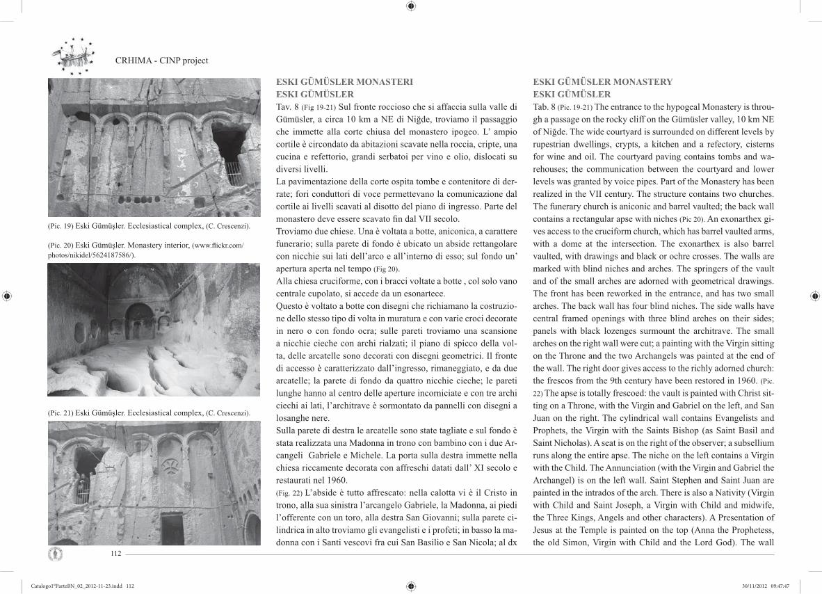
CRHIMA - CINP project
112
ESKI GÜMÜSLER MONASTERIESKI GÜMÜSLERTav. 8 (Fig 19-21) Sul fronte roccioso che si affaccia sulla valle di Gümüsler, a circa 10 km a NE di Niğde, troviamo il passaggio che immette alla corte chiusa del monastero ipogeo. L’ ampio cortile è circondato da abitazioni scavate nella roccia, cripte, una cucina e refettorio, grandi serbatoi per vino e olio, dislocati su diversi livelli.La pavimentazione della corte ospita tombe e contenitore di der-rate; fori conduttori di voce permettevano la comunicazione dal cortile ai livelli scavati al disotto del piano di ingresso. Parte del monastero deve essere scavato fi n dal VII secolo. Troviamo due chiese. Una è voltata a botte, aniconica, a carattere funerario; sulla parete di fondo è ubicato un abside rettangolare con nicchie sui lati dell’arco e all’interno di esso; sul fondo un’ apertura aperta nel tempo (Fig 20). Alla chiesa cruciforme, con i bracci voltate a botte , col solo vano centrale cupolato, si accede da un esonartece. Questo è voltato a botte con disegni che richiamano la costruzio-ne dello stesso tipo di volta in muratura e con varie croci decorate in nero o con fondo ocra; sulle pareti troviamo una scansione a nicchie cieche con archi rialzati; il piano di spicco della vol-ta, delle arcatelle sono decorati con disegni geometrici. Il fronte di accesso è caratterizzato dall’ingresso, rimaneggiato, e da due arcatelle; la parete di fondo da quattro nicchie cieche; le pareti lunghe hanno al centro delle aperture incorniciate e con tre archi ciechi ai lati, l’architrave è sormontato da pannelli con disegni a losanghe nere. Sulla parete di destra le arcatelle sono state tagliate e sul fondo è stata realizzata una Madonna in trono con bambino con i due Ar-cangeli Gabriele e Michele. La porta sulla destra immette nella chiesa riccamente decorata con affreschi datati dall’ XI secolo e restaurati nel 1960. (Fig. 22) L’abside è tutto affrescato: nella calotta vi è il Cristo in trono, alla sua sinistra l’arcangelo Gabriele, la Madonna, ai piedi l’offerente con un toro, alla destra San Giovanni; sulla parete ci-lindrica in alto troviamo gli evangelisti e i profeti; in basso la ma-donna con i Santi vescovi fra cui San Basilio e San Nicola; al dx
(Pic. 19) Eski Gümüşler. Ecclesiastical complex, (C. Crescenzi).
(Pic. 20) Eski Gümüşler. Monastery interior, (www.fl ickr.com/photos/nikidel/5624187586/).
(Pic. 21) Eski Gümüşler. Ecclesiastical complex, (C. Crescenzi).
ESKI GÜMÜSLER MONASTERYESKI GÜMÜSLERTab. 8 (Pic. 19-21) The entrance to the hypogeal Monastery is throu-gh a passage on the rocky cliff on the Gümüsler valley, 10 km NE of Niğde. The wide courtyard is surrounded on different levels by rupestrian dwellings, crypts, a kitchen and a refectory, cisterns for wine and oil. The courtyard paving contains tombs and wa-rehouses; the communication between the courtyard and lower levels was granted by voice pipes. Part of the Monastery has been realized in the VII century. The structure contains two churches. The funerary church is aniconic and barrel vaulted; the back wall contains a rectangular apse with niches (Pic 20). An exonarthex gi-ves access to the cruciform church, which has barrel vaulted arms, with a dome at the intersection. The exonarthex is also barrel vaulted, with drawings and black or ochre crosses. The walls are marked with blind niches and arches. The springers of the vault and of the small arches are adorned with geometrical drawings. The front has been reworked in the entrance, and has two small arches. The back wall has four blind niches. The side walls have central framed openings with three blind arches on their sides; panels with black lozenges surmount the architrave. The small arches on the right wall were cut; a painting with the Virgin sitting on the Throne and the two Archangels was painted at the end of the wall. The right door gives access to the richly adorned church: the frescos from the 9th century have been restored in 1960. (Pic.
22) The apse is totally frescoed: the vault is painted with Christ sit-ting on a Throne, with the Virgin and Gabriel on the left, and San Juan on the right. The cylindrical wall contains Evangelists and Prophets, the Virgin with the Saints Bishop (as Saint Basil and Saint Nicholas). A seat is on the right of the observer; a subsellium runs along the entire apse. The niche on the left contains a Virgin with the Child. The Annunciation (with the Virgin and Gabriel the Archangel) is on the left wall. Saint Stephen and Saint Juan are painted in the intrados of the arch. There is also a Nativity (Virgin with Child and Saint Joseph, a Virgin with Child and midwife, the Three Kings, Angels and other characters). A Presentation of Jesus at the Temple is painted on the top (Anna the Prophetess, the old Simon, Virgin with Child and the Lord God). The wall
Catalogo1°ParteBN_02_2012-11-23.indd 112Catalogo1°ParteBN_02_2012-11-23.indd 112 30/11/2012 09:47:4730/11/2012 09:47:47

Cultural Rupestrian Heritage in the Circum - Mediterranean area
113
di chi guarda vi è un sedile, un subsellium corre per tutta l’abside. Nella nicchia a sx dell’abside vi è una madonna con Bambino.Sulla parete a sx troviamo l’Annunciazione (Fig. 23): l’Arcangelo Gabriele e la Madonna racchiudono un abside, nel cui sott’arco troviamo S. Stefano e San Giovanni;la rappresentazione continua con la natività (Madonna con bambino, ai piedi san Giuseppe, a dx Madonna bambino e levatrice; i Magi, gli Angeli e altri per-sonaggi) in alto la presentazione al tempio (la profetessa Anna, il vecchio Simone, Madonna con Bambino e di fronte il Signore-Dio). La parete del cortile da cui si accede alle chiese è partita da nove arcate cieche le cui lesene presentano decorazioni crucifor-me, fi tomorfe e zoomorfe.
* * *KAYMAKLI UNDERGROUND CITYTav. 9 La posizione centrale della cappadocia, ponte fra l’occidente e l’oriente, la rende il crocevia di rotte commerciali e quindi oggetto di ripetute invasioni per la sua conquista. Per difendersi i suoi abitanti costruirono delle città sotterranee che permettevano a intere popolazioni di trovarvi rifugio. Ingegnosa opera di pianifi cazione urbana e architettonica scavata nella roccia, la città, realizzata su più livelli, è dotata di camini di aerazione e pozzi d’acqua vitali per un lungo soggiorno. Effi cienti accorgimenti e sistemi di protezione dalle invasioni esterne, cunicoli con punti di controllo e chiusure protette, servivano i vani disposti alle diverse quote, distribuiti secondo le esigenze e le priorità delle singole attività. Non tutte le città sotterranee sono state portate alla luce, alcune di quelle conosciute raggiungono i 50 m. di profondità. Nel territorio di Nevşehir le città più note sono Derinkuyu e Kaymaklı. Derinkuyu (pozzo profondo) conta dodici piani di profondità di cui otto accessibili. Kaymaklı (Fig 25-26-27) il cui nome antico era Enegup, fu aperta al pubblico nel 1964. E’ una delle più grandi strutture sotterranee della regione, degli otto piani ne sono visitabili quattro; i diversi nuclei si articolano intorno ai camini orizzontali di areazione e a quelli verticali, questi funzionali per il trasporto merci con carrucola, riserva d’acqua e strumento di difesa; la distribuzione delle attività è gerarchicamente simile ad altre città. Tuttavia essa
(Pic. 26) Kaymakli stone door, (L. Covarino).
(Pic. 24 - 25) Kaymakli. Chapel and winery, (L. Covarino).
(Pic. 22 - 23) Esky Gümüsler. Church apse and left wall, (C.Crescenzi).
of the courtyard is marked by nine blind arches: the pillars are adorned with cruciform, phytomorphic and zoomorphic decora-tions. Annunciation (with the Virgin and Gabriel the Archangel) is on the left wall (Pic. 23). Saint Stephen and Saint Juan are pain-ted in the intrados of the arch. There is also a Nativity (Virgin with Child and Saint Joseph, a Virgin with Child and midwife, the Three Kings, Angels and other characters). A Presentation of Jesus at the Temple is painted on the top (Anna the Prophetess, the old Simon, Virgin with Child and the Lord God). The wall of the courtyard is marked by nine blind arches: the pillars are adorned with cruciform, phytomorphic and zoomorphic decorations.
* * * KAYMAKLI UNDERGROUND CITY Tab. 9 The central position as a bridge between west and east makes Cappadocia an intersection for trade routes and the object of frequent invasions. Underground cities were built to defend the inhabitants, where entire populations could be sheltered. The city was an incredible work of urban and architectural plan-ning: it was developed on many levels, with chimneys for air con-ditioning and water wells for long stays.Protection systems, tunnels, check points and gates served the ro-oms at different levels. They were distributed according to the different needs and priori-ties of the single activities. Some of the underground cities have never been brought to light, and some of the known cities hit the lowest level at 50 meters below the ground level. The most famous underground cities in the area of Nevşehir are Derinkuyu and Kaymaklı.Derinkuyu (deep well) is developed on twelve levels, eight of which are accessible.The ancient name of Kaymaklı (Pic. 25-26-27) was Enegup: it was opened to the public in 1964.It is one of the greatest underground structures of the region: it is developed on eight levels, four of which are accessible. The different zones are articulated around horizontal chimneys
Catalogo1°ParteBN_02_2012-11-23.indd 113Catalogo1°ParteBN_02_2012-11-23.indd 113 30/11/2012 09:47:5930/11/2012 09:47:59

CRHIMA - CINP project
114
differisce da Derinkuyu per le dimensioni delle infrastrutture: i cunicoli sono più bassi, più stretti e con maggior pendenza. Gli spazi privati differiscono secondo il grado sociale: - le abitazioni per agiati, ubicati ai piani più alti, presentano una maggiore altezza e ampiezza, e a volte sono soppalcate; - l’abitazione per i meno abbienti sono più bassi e in profondità. Entrambi i tipi di abitazioni presentano porte di legno con chiavistello; nicchie per lucerne, per giare da vino e acqua; pietre da mulino, fovee per granaglie e frutti secchi, anelli litici a parete o al soffi tto, nicchie come alcove, interfono con altre abitazioni e con i punti di controllo degli accessi e dei punti obbligati.Nel primo piano è visitabile una piccola stalla, nelle adiacenze ve ne sono altre non aperte al pubblico. Vi troviamo inoltre una chiesa (Fig. 24-28) e degli ambienti adibiti a residenza. Nel secondo piano troviamo una chiesa, a nave unica biabsidata; lungo il periplo si sviluppa un subsellium, di fronte alle absidi è posto un fonte battesimale; accanto alla chiesa è ubicato un nartece funerario. Allo stesso livello sono dislocate altre cellule residenziali. Il terzo piano ha strutture a servizio della collettività: magazzini, cucina comune con forno centrale, fovee per il cibo secco; lavanderia con nicchie per sapone, vasche per acqua calda e sistema per lo smaltimento per le acque; cantine e fucina. L’attività siderurgica è testimoniata da un masso di andesite trattato per la fusione del rame. Nella città troviamo inoltre un cimitero con fosse comuni al pavimento e con tombe a parete, con nicchie per i materiali occorrenti alla mummifi cazione e per igienizzare gli ambienti. Il grande numero di magazzini e giare di terracotta nel quarto piano, oltre ad indicare la solidità economica di cui godevano gli abitanti della città, implica il sostentamento per un grande numero di abitanti residenti nella città.
(Pic. 27) Kaymaklı interior view, (L. Covarino).
(Pic. 28) Kaymaklı church altar, (L. Covarino).
for air conditioning and vertical chimneys for the transportation of goods through pulleys. The distribution of the activities is hie-rarchically similar to that of other cities. But the tunnels are lower, narrower and steeper than in Derinkuyu.Private spaces are different according to the social level of the inhabitants:- well off houses were on the higher levels: they are higher and wider, and sometimes they are supplied with a built-in overhead cupboard;- less well to do houses are at lower levels.Both kinds of houses have wooden doors with bolts; niches for oil lamps, wine and water jars; millstones, foveae for grains and dried fruits, stone rings on the walls and on the ceiling; niches as bedrooms, interphone with other houses and check points.A small cattleshed is at the fi rst level, near others that are not open to the public. There is also a church (Pic. 24-28) and some rooms for residences. A single nave church with two apses is at the second level, with a subsellium along its perimeter and a baptismal font in front of the apses. A funerary narthex is beside the church. Some other residential units are at the same level. The third level contains collective structures: warehouses, a kitchen with a central oven and foveae for dried food, a wash house with niches for the soap, warm water pools, a draining sy-stem, some cellars and a forge. An andesite rock for the fusion of copper testifi es the presence of a metal manufacture. The city has a cemetery with mass graves on the fl oor and wall tombs, with niches for mummifi cation products. The great number of warehouses and baked clay jars at the fourth level testifi es both the economical welfare of the city and the pos-sibility to support many citizens.
Catalogo1°ParteBN_02_2012-11-23.indd 114Catalogo1°ParteBN_02_2012-11-23.indd 114 30/11/2012 09:48:1730/11/2012 09:48:17

Cultural Rupestrian Heritage in the Circum - Mediterranean area
115
ÜRGÜP: ALCUNI INSEDIAMENTI RUPESTRITav. 10 Ürgüp (Fig. 29) si trova sulla strada che collega Kayseri con Nevşehir e Aksaray. L’abitato storico sorge addossato agli spalti del grande pianoro. Sull’enorme sperone roccioso che svetta nel cielo, con aspetto surreale, si trovano le tracce secolari del vecchio agglomerato di Ürgüp, le cui case rupestri poste nella parte alta, sono oggi abbandonate.Le case più antiche (Fig. 30-31-32), parzialmente in uso, sono addossate alle rocce: esse si spingono nella rupe, dove hanno trovato accoglienza e protezione; le strutture murate emergenti, realizzate con blocchi di tufo locale, di colore rosato e beige, s’integrano con il paesaggio. Gli edifi ci prismatici si mescolano ai monoliti squadrati che l’erosione ha isolato dai fi anchi scoscesi dell’altopiano. Gli edifi ci costruiti nella prima metà del XX sec. presentano un’architettura sobria con decorazioni di alta qualità. L’insediamento rupestre, essendo proprietà privata e occultato dalla continuità dell’abitare o dell’uso, non è molto conosciuto. Gli edifi ci di culto chiusi nelle abitazioni sono poco conosciuti e non accessibili. A ovest dell’abitato, sull’Istiklal Cd (38.629328,34.902046) è ubicata Emine Bağci Kilise (Fig. 33). Il fronte rupestre è crollato e mostra un grande vestibolo la cui copertura è bipartita: verso l’esterno la copertura è piana decorata con palmetta agli angoli del riquadro e con croce inscritte in clipei; la parte più interna è voltata a botte con archi ricalati, che scaricano su lesene. Singolare la partitura della parete est realizzata con lesene e mezze colonne; nella parte bassa troviamo riquadri decorati con piccole bugne di diversa geometria. La parte alta è partita in lunette riccamente decorate con una teoria di santi che chiudono su ambo i lati una porta d’ingresso di notevoli dimensioni. All’interno vi sono due vani, anch’essi decorati e con piccoli altari a muro sovrastati da una piccola nicchia; in uno troviamo un piccolo fonte battesimale (Fig. 34) usato in seguito come mangiatoia. La chiesa è tarda, probabilmente neoclassica. Sul costone che sovrasta Müftüler Sk, sul fronte crollato, dalla strada principale si scorge un altro complesso, non meglio identifi cato, la cui ricchezza decorativa è palesata dalle nicchie a conchiglia. Nel centro antico, le cui case si perdono nella pianura
ÜRGÜP: SOME RUPESTRIAN SETTLEMENTSTab. 10 Ürgüp (Pic. 29) is located on the road between Kayseri and Nevşehir Aksaray. The historic village is set against the hillside of the great plateau. On the enormous rocky outcrop that soars in the sky, with a surreal aspect, there are secular traces of the old agglomeration of Ürgüp, whose dug houses localized at the top area, are now abandoned.The oldest houses (Pic. 30-31-32), partly in use, are clinging to the rocks: they push the cliff, where they found shelter and protec-tion; the walled emergent structures, made of blocks of local tuff, pink and beige, are integrated with the landscape.The prismatic buildings mingle with square monoliths that ero-sion has isolated by the steep sides of the plateau. Buildings con-structed in the fi rst half of the twentieth century have a simple architecture with decorations of high quality. The cave settlement, being private property, and concealed by the continuity of living or use, is not well known. Buildings of worship closed in the vil-lage are little known and inaccessible.To the west of the town, in Istiklal Caddesi (38.629328,34.902046) is located Emine Bagci Kilise (Pic. 33). The dug side has collapsed and shows a large vestibule whose coverage is bipartite: the inside cover is decorated with palm fl at on the corners of the box and with a cross inscribed in clipeus, the inner part is a barrel vault with arches, discharging on pilasters. Singular the composition of the east wall made with pilasters and half columns, the bot-tom panels are decorated with small bosses of different geometry. The upper part is divided in lunettes richly decorated with a pro-cession of saints that close on both sides a door of considerable size. Inside there are two rooms, which are also decorated with small altars wall topped by a small niche; in one there is a small baptismal font (Pic. 34) used later as a manger. The church is late, probably neoclassical.On the ridge overlooking Müftüler Sokak, on the collapsed front, from the main road you can see another complex, unidentifi ed, with a rich decoration of shell-shaped niches.In the old centre, whose houses are lost in the plain below, were made some new modern buildings that are integrated with the lo-cal traditional architecture.
(Pic. 29) Urgup view, (C. Crescenzi).
(Pic. 30) Urgup Istiklal Cd house, (C. Crescenzi).
(Pic. 31) Urgup Istiklal Cd house, (C. Crescenzi).
Catalogo1°ParteBN_02_2012-11-23.indd 115Catalogo1°ParteBN_02_2012-11-23.indd 115 30/11/2012 09:48:2430/11/2012 09:48:24

CRHIMA - CINP project
116
sottostante, sono stati realizzati alcuni nuovi edifi ci moderni che s’integrano con l’architettura tradizionale locale. Questa città moderna, animata e prospera, piace per i numerosi mercati, i negozietti di tappeti, ceramica e oggetti in onice; gli accoglienti alberghi, spesso, sono ricavati in edifi ci antichi semi rupestri sapientemente restaurati.Le infrastrutture turistiche - culturali, tra cui un museo, dislocati in nodi strategici, non disturbano il suggestivo panorama. Infatti, sono i panorami e le singolare caratteristiche della natura geologica il patrimonio di Ürgüp e delle località limitrofe: canyon rosati e “camini di Fata”. Questi caratterizzano il paesaggio tra Ürgüp e Nevşehir,. I camini sono coni tufacei di consistenza tenera protetti all’apice da un lastrone di pietra dura; la roccia tenace, fratturatasi da una faglia unica per moti geologici, ha consentito agli agenti atmosferici di infi ltrarsi tra i blocchi plasmando e isolando i coni, destinati a conservarsi per la presenza del “cappello”, in equilibrio, a difesa delle piogge. Nel vasto territorio di Ürgüp, ora suddiviso in più municipalità, si trovano disseminate numerose chiese e cappelle, tra cui gli antichissimi edifi ci della valle Balkan (AVI secolo) in direzione di Ortahisar. Presso Cemil si trova il bel monastero detto Başmelek (dell’Arcangelo) mentre ad Ayvalik si trovano le chiese di Karaçali e Yucari. Nella località di Tağar - Yeşilöz sorge la chiesa di San Teodoro, Santo molto venerato nella zona, a un 1 Km a NO del villaggio. La chiesa è all’interno di un monastero a corte aperta; la sua presenza è segnata dalla facciata ad archi ciechi. In parte danneggiata da crolli, la chiesa di San Teodoro è una delle più maestose della zona. L’impianto a croce latina ha i bracci corti chiusi da tre absidi semicircolari con calotta semisferica incorniciata da larghe lesene angolari e archi a tutto sesto. Sugli stessi tre lati del tamburo si sviluppa un loggiato, vi si accede con una scala situata nel braccio ovest; l’affaccio è costituito da un’apertura tripartita con piccole colonne decorate con capitelli. All’intersezione col transetto, sul tamburo, raccordato con pennacchi e timpani con lunette, vi era una cupola ora crollata. Gli affreschi, geometrici e fi gurativi, sono stati datati tra il XI e il XIII secolo. Nella valle di Golgoli resta oggi ben poco degli antichi edifi ci sacri, originariamente ornati da dipinti. Inoltre l’arte islamica ha
This modern city, bustling and prosperous, like for many markets, shops selling carpets, ceramics and onyx objects. The comfortable hotels are often housed in old buildings semi-excavated beautiful-ly restored.The tourist end cultural infrastructure, including a museum, loca-ted in strategic nodes, do not disturb the suggestive view. In fact, the views and the unique characteristics of the geological nature are the heritage of Ürgüp and neighbouring cities: canyon rose, and “fairy chimneys”. These characterize the landscape between Ürgüp and Nevşehir. “Fairy chimneys” are cones of tuff tender texture apex protected by a slab of hard rock; the tenacious rock, fractured by a unique fault for geological movements, allowed to weather to infi ltrate between the blocks, shaping and isolating the cones, intended to preserved for the presence of the “hat”, in balance, in defence of the rains. In the vast territory of Ürgüp, now divided into several municipalities, are scattered many churches and chapels, inclu-ding the ancient buildings of the valley Balkan (AVI century) in the direction of Ortahisar. At Cemil is located at the beautiful mo-nastery said Başmelek (Archangel), while in Ayvalik there are the churches of Karaçali and Yucari.In the village of Tagar - Yesilöz there is the church of St. The-odore, highly revered saint in the area, at 1 km at northwest of the village. The church is in a monastery with an open court; its presence is marked by the façade with blind arches. Partially da-maged by collapses, the church of St. Theodore is one of the most impressive in the area. The plan at Latin cross has the short arms closed of three semi-circular apses with hemispherical cap framed by wide corner pilasters and arches. On the same three sides of the drum develops a porch, it is accessible by a staircase located in the west arm; the front consists of a tripartite opening with small columns decorated by the capitals. At the intersection with a transept, on the drum, connected with plumes and eardrums with lunettes, there was a dome now collapsed.The frescoes, geometric and fi gurative, have been dated between the eleventh and thirte-enth centuries. In the Valley of Golgoli today remains little of the ancient sacred buildings, originally decorated with paintings. In addition, Islamic art has here a fi ne example: at Damsa there is the
(Pic. 32) Urgup Istiklal Cd house, (C. Crescenzi).
(Pic. 33) Urgup Emine Bağci Kilise church, (C. Crescenzi).
(Pic. 34a, b) Urgup Emine Bağci Kilise. Church altar, (C. Crescenzi).
Catalogo1°ParteBN_02_2012-11-23.indd 116Catalogo1°ParteBN_02_2012-11-23.indd 116 30/11/2012 09:48:2930/11/2012 09:48:29

Cultural Rupestrian Heritage in the Circum - Mediterranean area
117
qui un pregevole esempio: presso Damsa si trova il complesso di Taşkinpacha. Qui sorge una moschea del XVI secolo, costituita da un vano rettangolare a tre navate coperte da una volta a botte e da una cupola. Nei pressi si trovano una moschea più piccola, il minareto e un bel cortile.
* * *ZELVETav. 11-12 L’Open-Air Museum di Zelve, ubicato sulla strada che va da Göreme ad Avanos, è un villaggio costituito da tre valli, sulle pendici dell’Aktepe (Fig. 35-37-39). I fronti sono caratterizzati dai camini di fata con fusti di grandi dimensioni che s’innalza-no dal fondo valle per circa 40 metri. Le valli sono state abitate in perfetta armonia dalle comunità cristiane e musulmane fi no al 1924, quando per lo scambio fra le minoranze tra Grecia e Tur-chia, i greci abbandonarono la Cappadocia; a causa della conti-nua erosione e dei crolli la valle fu abbandonata negli anni 50. Zelve alla fi ne degli anni sessanta, ormai città fantasma, è stata trasformata in Open-Air Museum; per il continuo degrado della roccia e l’incombente pericolo di crolli, è ora percorribile solo nel fondo valle. Il villaggio ospitava una delle comunità più grandi della regione: abitazioni, attività produttive, complessi monastici e sistemi difensivi caratterizzano uno dei paesaggi più drammatici dell’area. Nella valle si svilupparono i primi centri di formazio-ne al sacerdozio. Pur non presentando i cicli pittorici del centro monastico di Göreme, le architetture rappresentano esempi signi-fi cativi del periodo iconoclasta. Alle propaggini del fondo valle troviamo la Direkli Kilise (chiesa dei pilastri), interessante per le soluzioni architettoniche del sistema voltato. Percorrendo la prima valle troviamo Geyikli Kilise (La chiesa col cervo), com-pletamente diruta; sulle pareti residuano tracce di affreschi anico-nici, sul soffi tto piano è scolpita una grande croce sui cui bracci troviamo bassorilievi di simboli cristiani; tuttavia sono visibili su una delle pareti tracce di santi o profeti. Continuando per la stessa valle troviamo una moschea in roccia (Fig. 38), integrata con parte in muratura, immediatamente individuabile per la presenza di un piccolo minareto; il mihrab è decorato con piccole colonnine agli spigoli e una voltina che suggerisce una conchiglia. Subito dopo, nella sezione-parete, si trovano un fornice con arco tudor di note-
complex of Taşkinpacha. Here is a mosque of the sixteenth centu-ry, consisting of a rectangular room with three naves covered by a barrel vault and a dome. Nearby are a smaller mosque, the minaret and a beautiful courtyard.
* * *ZELVETab. 11-12 The Zelve Open-Air Museum, on the road between Göreme and Avanos, is a village developed in three valleys, on the slopes of the Mount Aktepe (Pic. 35-37-39). The fronts are characterized by the fairy chimneys about 40 meters tall. Here, the Christians and Muslims lived together in perfect harmony, until 1924. Then Christians had to leave the Valley because of the exchange of minorities between Greece and Turkey, and the Muslims were forced to evacuate the Valley in the 50’s when life became dangerous due to risk of erosion and col-lapses. At the end of the 60’s, Zelve was a ghost town, and it has been transformed into an Open-Air Museum; only the val-ley fl oor is practicable, because of the degradation of the rock and the risk of collapses.One of the greatest communities of the region lived in the vil-lage: houses, workshops, monasteries and defensive structures characterize an incredibly dramatic landscape.The valley hosted the early priesthood training centres. Archi-tectures are typical examples of the Iconoclast period, though they do not present the cycle of paintings in the Monastic cen-tre of Göreme. The Direkli Kilise (Church with columns) is at the offshoots of the valley, with very interesting vaults. The Geyikli Kilise (Deer Church) is in the same valley: it is now totally collapsed, with traces of aniconic frescos on the walls (though there are traces of Saints and Prophets on one wall). There is a cross relief on the plain ceiling, with Christian symbols on the arms. Further in the valley there is a rupestrian Mosquee (Pic. 38) integrated with masonry: the minaret clearly shows its presence. The mihrab is decorated with small co-lumns on the corners, and a shell shaped vault. A barrel vault with tall Tudor arch is on the wall, followed by the entrance to a protection system and to a communication
(Pic. 35) Zelve entrace to the valleys, (C. Crescenzi).
(Pic. 37) Zelve. Valley view, (C. Crescenzi).
(Pic. 36) Zelve stone door, (C. Crescenzi).
Catalogo1°ParteBN_02_2012-11-23.indd 117Catalogo1°ParteBN_02_2012-11-23.indd 117 30/11/2012 09:48:4330/11/2012 09:48:43
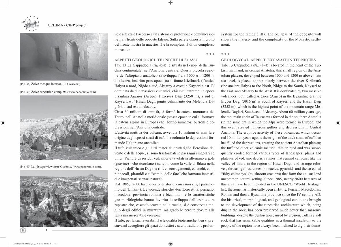
CRHIMA - CINP project
118
vole altezza e l’accesso a un sistema di protezione e comunicazio-ne fra i fronti delle opposte falesie. Sulla parete opposta il crollo del fronte mostra la maestosità e la complessità di un complesso monastico.
* * *ASPETTI GEOLOGICI, TECNICHE DI SCAVOTav. 13 La Cappadocia (Fig. 40-43) è situata nel cuore della Tur-chia continentale, nell’Anatolia centrale. Questa piccola regio-ne dell’altopiano anatolico si sviluppa fra i 1000 e i 1200 m di altezza, inscritta pressapoco tra il fi ume Kizilmark (l’antico Halys) a nord, Niğde a sud, Aksaray a ovest e Kayseri a est. E’ dominata da due massicci vulcanici, chiamati entrambi in epoca bizantina Argaios (Argeo): l’Erciyes Dagi (3258 m), a sud di Kayseri, e l’ Hasan Dagi, punto culminante dei Melendiz Da-glàri, a sud-est di Aksaray.Circa 60 milioni di anni fa, si formò la catena montuosa del Tauro, nell’Anatolia meridionale (stessa epoca in cui si formava la catena alpina in Europa) che formò numerosi burroni e de-pressioni nell’Anatolia centrale. L’attività eruttiva dei vulcani, avvenuta 10 milioni di anni fa e origine degli spessi strati di tufo, ha colmato le depressioni for-mando l’altopiano anatolico. Il tufo vulcanico e gli altri materiali eruttati,con l’erosione del vento e delle acque, si sono trasformati in paesaggi singolari ed unici. Pianure di residui vulcanici e tavolati si alternano a gole (gravine) - che ricordano i canyon, come la valle di Ihlara nella regione dell’Hasan Dag i- a rilievi, corrugamenti, calanchi, coni, pinnacoli, piramidi e ai “camini delle fate” che formano fantasti-ci e inaspettati scenari naturali. Dal 1985, i 9600 ha di questo territorio, con i suoi siti, è patrimo-nio dell’Umanità. Le vicende storiche -territorio ittita, persiano, macedone, provincia romana e bizantina - e le caratteristiche geo-morfologiche hanno favorito lo sviluppo dell’architettura rupestre che, essendo scavata nella roccia, si è conservata me-glio degli edifi ci in muratura, malgrado le perdite dovute alla lenta ma inesorabile erosione. Il tufo, per la sua lavorabilità e le qualità biotermiche, ben si pre-stava ad accogliere gli spazi domestici e sacri, tradizione prolun-
system for the facing cliffs. The collapse of the opposite wall shows the majesty and the complexity of the Monastic settle-ment.
* * *GEOLOGYCAL ASPECT, EXCAVATION TECNIQUESTab. 13 Cappadocia (Pic. 40-43) is located in the heart of the Tur-kish mainland, in central Anatolia: this small region of the Ana-tolian plateau, developed between 1000 and 1200 m above main sea level, is placed approximately between the river Kizilmark (the ancient Halys) to the North, Nidge to the South, Kayseri to the East, and Aksaray to the West. It is dominated by two massive volcanoes, both called Argaios (Argeo) in the Byzantine era: the Ercyes Dagi (3916 m) is South of Kayseri and the Hasan Dagi (3258 m), which is the highest point of the mountain range Me-lendiz Daglari, Southeast of Aksaray. About 60 million years ago, the mountain chain of Taurus was formed in the southern Anatolia (in the same era in which the Alps were formed in Europe) and this event created numerous gullies and depressions in Central Anatolia. The eruptive activity of these volcanoes, which occur-red 10 million years ago, is the origin of the thick strata of tuff that has fi lled the depressions, creating the ancient Anatolian plateau; the tuff and other volcanic material that erupted and was subse-quently eroded formed various types of landscapes: plains and plateaus of volcanic debris, ravines that remind canyons, like the valley of Ihlara in the region of Hasan Dagi, and strange relie-ves, thrusts, gullies, cones, pinnacles, pyramids and the so called “fairy chimneys” (mushroom erosions) that form the unusual and uncommon natural setting. Since 1985, nearly 9600 hectares of this area have been included in the UNESCO “World Heritage” list; the zone has historically been a Hittite, Persian, Macedonian, Roman and then a Byzantine province since the IV century AD: the historical, morphological, and geological conditions brought to the development of the rupestrian architecture which, being dug in the rock, has been preserved much better than masonry buildings, despite the destruction caused by erosion. Tuff is a soft rock that has remarkable qualities as a thermal insulator, so the people of the region have always been inclined to dig their dome-
(Pic. 38) Zelve mosque interior, (C. Crescenzi).
(Pic. 39) Zelve rupestrian complex, (www.panoramio.com).
(Pic. 40) Landscape view near Goreme, (www.panoramio.com).
Catalogo1°ParteBN_02_2012-11-23.indd 118Catalogo1°ParteBN_02_2012-11-23.indd 118 30/11/2012 09:48:4630/11/2012 09:48:46

Cultural Rupestrian Heritage in the Circum - Mediterranean area
119
gatasi nei secoli. In Cappadocia l’immenso patrimonio archeo-logico è costituito non solo da chiese e monasteri, ma da centri urbani, strutture agricole, insediamenti difensivi e necropoli. Eremi L’eremo rupestre è un insediamento costituito da una se-rie di ambienti domestici e da cappelle per la preghiera e il culto degli anacoreti. L’anacoretismo è una forma del monachesimo, intermedia fra ascetismo e cenobitismo, caratterizzata da isola-mento, preghiera e lavoro.Chiese, Cappelle e Monasteri (Fig. 42) In seguito all’introdu-zione del culto cristiano, a partire dal V sec d.C., si diffonde la realizzazione di strutture sacre. Numerosi i monasteri che ospi-tavano monaci riuniti in piccole comunità cenobitiche, comples-si di notevoli dimensioni con strutture articolate in molteplici ambienti e di grande valore architettonico. In Cappadocia sono state censite oltre 600 chiese e cappelle, realizzate tra il V e XII sec d. C.; la tipologia varia per periodo, numero di fedeli ed evoluzione dei riti religiosi. Tombe Molte tombe e necropoli sparse nel territorio apparten-gono all’epoca romana.Città sotterranee (Fig. 41) La città sotterranea, distribuita su più livelli, ospita abitazioni, cucine, stalle, cappelle per la preghiera e ambienti dotati di pozzi per l’aerazione. Un intricato sviluppo di gallerie connette abitazioni e servizi.
stic and sacred spaces; this is a tradition known about since the 1st century BC. In Cappadocia the immense archaeological consists not is only of churches and monasteries, but also preserved hou-ses, farm structures, defensive settlements and cemeteries.Hermitage The anchoritism is a result of the evolution of the mo-nasticism, characterized by the isolation, the prayer and the work: the rupestrian hermitage is a settlement consisting in a series of domestic spaces and chapels for the prayer.Churches, Chapel and Monasteries (Pic. 42) In Cappadocia, ap-proximately 60 churches and chapels have been recognized, rea-lized between the fi fth and sixth centuries; the typology changes according to the period, the number of believers and the evolution of the religious rites. After the introduction of the Christian cult, as from the VI and Vii centuries AD., the execution of holy struc-tures develops; the cult is reserved to monks assembled in small coenobitic communities and articulated spaces are realized, real complex with many rooms. Tombs Many tombs and necropolis are dated back to the Roman period.Underground cities (Pic. 41) The underground city is an agglo-meration of passages and spaces, carved on different levels, in which are set kitchens, chapels, houses and spaces equipped with air shafts.
(Pic. 41) Kaymaklı underground city access, (www.makemytrip.com).
(Pic. 42) Goreme Chapel 27 internal view, (C. Crescenzi).
(Pic. 43) Urgup landscape view, (C. Crescenzi).
Catalogo1°ParteBN_02_2012-11-23.indd 119Catalogo1°ParteBN_02_2012-11-23.indd 119 30/11/2012 09:48:4930/11/2012 09:48:49

CRHIMA - CINP project
120
Tab. 14 In Cappadocia, the most of preserved churches with pain-ted decorations, are carved in the rock, so they are consequently defi ned rupestrian; the technique of the excavation was adapted to the physical (the presence of the tuff) and economical necessities of the place: it needed only instruments to excavate or sometimes wooden beams for scaffoldings.After the choice of the site (for example in the case of a deep gorge) the cleaning phase started; the excavation of the fi rst space started proceeding in depth and determining its length: the dig-ging area was accessed by steps and wooden supports were instal-led to permit the excavation of the upper parts.The subsequent phase consisted in determine the width on the bot-tom wall, in proportion to the length as expected from the project; lastly the fl oor was levelled, making even the high (the reference point for the high is therefore determined from the ceiling).The craftsmen of the Cappadocia have remained faithful to the peculiar architectural models of the Byzantine civilization: the typology of these churches, in fact, corresponds to Byzantine ma-sonry of the region; in this case not only the plans are represented, but also the sections and the usual architectural elements.The churches, for its sizes, the ornaments and the painted deco-rations give information about its functions: the typology of the apse, the presence or absence of an enclosure around the sanctua-ry, of a niche used as a prothesis or a synthronon, supply clues about its regular (for the Eucharistic liturgy) or occasional use. The typology most widespread for the rupestrian churches is the single nave, formed by two spaces: the nave and the apse; the elements characterizing the inner liturgical space are the altar, the prothesis and the diaconicon, partition elements like templon and double arch, and cathedra, synthronon and ambon.The templon (Pic. 44-48) is a partition element of the space reserved to the priests; originally formed by a low barrier with plutei, it appears in the churches of the Christian Orient from the V century and does not block the view of the altar; its appearance is elabo-rated through mullions and an upper architrave and, with the pas-sing of time, it turns into a really sculpted wall with openings and paintings. (Pic. 47-49) The apse, generally elevated than the nave, lodges the altar, which is located attached to its bottom wall or in
Tav. 14 In Cappadocia, la maggior parte delle chiese conservate, e che ospitano decorazioni pittoriche, sono rupestri; la costruzione in roccia rispondeva alle esigenze fi siche (la presenza del tufo vulcanico) ed economiche del posto; non era necessario altro che utensili per scavare la roccia ed eventualmente travi di legno per impalcature sommarie. Dopo la scelta del sito (nel caso di una profonda gravina) si procedeva alla ripulitura; s’iniziava lo sca-vo dell’ambiente procedendo in profondità fi no a determinare la lunghezza e lasciando il piano di calpestio a gradoni per rende-re agevole lo scavo del soffi tto e, dove occorreva, s’installavano supporti di legno per consentire lo scavo delle parti alte. Negli edifi ci comuni l’altezza dei vani era data dall’altezza dell’uomo a braccio teso con in pugno l’utensile. Di seguito si determinava la larghezza della parete di fondo, proporzionata alla lunghezza come previsto dal progetto, e infi ne si completava uniformando l’altezza, livellando il pavimento (la quota di riferimento per l’al-tezza è data dal soffi tto). Per gli edifi ci di culto, gli artigiani della Cappadocia sono rimasti fedeli ai modelli architettonici bizantini: le tipologie delle chiese corrispondono a quelle bizantine in mura-tura, presenti nella regione; ne sono riprodotte non solo le piante, ma anche l’alzato e gli elementi architettonici. Le caratteristiche delle chiese, dimensioni, arredo liturgico e de-corazioni pittoriche, forniscono informazioni sulla loro funzione; la tipologia dell’abside, la presenza o assenza dei plutei, di una nicchia in funzione di prothesis o di un synthronon, raccontano del suo uso frequente (per la liturgia eucaristica) o occasionale. La tipologia più diffusa tra le chiese rupestri è la navata singola, costituita dall’aula rettangolare e dall’abside; gli elementi carat-terizzanti gli spazi liturgici interni sono l’altare, la prothesis e il diaconicon, la cathedra, il synthronon e l’ambone; gli elementi divisori, quali il templon e l’arco doppio. Il templon (Fig. 44-48) è un elemento di separazione fra l’aula e il presbiterio; inizialmente era costituito da una bassa barriera, i plu-tei, che non nascondeva la vista dell’altare e apparve dal V secolo nelle chiese dell’Oriente cristiano; la sua architettura si evolse nel tempo: colonnine e un architrave superiore sormontarono i plutei fi no a divenire una vera e propria parete forata da aperture e ricca-mente dipinta. (Fig. 47-49) L’abside, generalmente rialzata rispetto
(Pic. 44) 3D model of templon, (S. Sangiorgi).
(Pic. 45) Painting detail in Elmali Kilise church, (N. Thierry, da La Cappadoce de l’antiquité au moyen age, Brepols Publisher 2002).
(Pic. 46) Red ochre painting in Santa Barbara church, (www.metmuseum.org).
Catalogo1°ParteBN_02_2012-11-23.indd 120Catalogo1°ParteBN_02_2012-11-23.indd 120 30/11/2012 09:48:5130/11/2012 09:48:51

Cultural Rupestrian Heritage in the Circum - Mediterranean area
121
alla navata, ospita l’altare che può essere addossato alla sua parete di fondo o in posizione centrale. Il santuario, riservato a contenere il “corpo sacro”, è separato dall’aula mediante una schermatura parziale costituita da semplici plutei o da templon; per differen-ziare lo spazio della navata talvolta un arco doppio divide formal-mente la porzione riservata ai diaconi che celebrano le funzioni. A volte nell’abside trovano sistemazione delle nicchie con fun-zione di prothesis (luogo per la preparazione del pane e del vino) e diaconicon (sagrestia che contiene i paramenti sacri), in alcuni casi localizzate nell’arco trionfale, altre esternamente all’abside sulla parete di fondo della navata. Con l’evoluzione degli spazi, le nicchie diventano delle absidi minori e assolvono funzioni diver-se secondo la tipologia della chiesa: servono per celebrare un san-to o un monaco, o come prothesis e diaconicon. La cathedra è una sorta di trono scolpito, risparmiato durante lo scavo, e riservato ad un vescovo o diacono della comunità; il synthronon è una specie di bassa panca che si sviluppa lungo la parete dell’abside e in altri casi anche lungo i lati della navata, ed è chiamata subsellium. Con l’evoluzione dei riti, la navata è suddivisa in alcuni casi, da un arco doppio, che sporge dalle pareti laterali ribassato rispetto alla volta di copertura; dipinto da motivi ornamentali, costituiva una cornice visiva che suddivideva l’ambiente riservata ai celebranti del rito. La pianta centrale a croce libera è utilizzata per celebrare un martire e diffusa nelle chiese in muratura della regione: l’al-tare è situato al centro, sotto la cupola all’incrocio dei bracci. Per fornire adeguato spazio alle funzioni religiose, il braccio ovest, in cui di norma è posto l’ingresso e che ospita i fedeli, viene nel tempo allungato; questo modello è in seguito adattato alle chiese di congregazioni e comunità, divenendo un edifi cio per liturgie usuali; l’altare è traslato verso il braccio orientale e infi ne è poi posto all’interno del catino absidale. Pitture e illuminazione (Fig. 45-46) I cicli pittorici sono realizzati generalmente sull’intona-co ma anche a secco (Tokali II), direttamente sulla parete roccio-sa; di solito questa tecnica è usata per pitture aniconiche e sono eseguite con ocra rossa o con il verde.I pigmenti sono naturali (ossido di ferro, ematite, gesso) e, nel caso di ricca committenza, lapislazzulo e oro in foglia, il legante
central position; the sanctuary, used to lodge the “mystical body of Christ”, is divided by the nave trough a partial screen consi-sting in simple plutei or a tampon; the space of the nave was so-metimes articulated with a double arch dividing ideally the space reserved to the deacons celebrating the functions.Some niches, used as prothesys (space for the preparation of the bread and wine) or diaconicon (vestry containing the vestments) are carved into the apsidal walls; in some cases these are set to the side of the apse or at the end of the nave.After the evolution of the spaces, minor apses are used for diffe-rent functions according to the typology of the church: celebrate a saint or a monk, or as prothesys and diaconicon.The cathedra is a kind of carved throne, remained element of the excavation, reserved to the deacon or bishop of a community; the synthronon is a kind of low bench running along the apsidal wall, or sometimes along the walls of the nave.After the evolution of the religious rites, the nave sometimes is di-vided by a double arch sticking out of the lateral walls and it is de-pressed than the vault; this arch, painted with ornamental motifs, was a visual screen dividing the space reserved to the offi ciants. Used to celebrate a martyr, the typology of central plan with free cross is widespread in the masonry architecture of the region: the altar is located at the centre, crossing point covered by a dome.Subsequently the western arm, usually including the entrance, is increased in length, with the intention to give the suitable space for the religious services.In a short time this model was adapted to the churches of congre-gations or communities, so the church became a building for daily liturgies and the altar was moved from the centre to the eastern arm; subsequently it was placed into an apsidal arch, for conve-nience, as a result of the celebration of the Mass.Paintings and lighting(Pic. 45-46) The conducted programs are realized generally over the plaster, against the plain paintings are executed directly on the rock with red ochre or green; the pigments are natural (iron oxide, hematite, gypsum) and, in the case of a rich customer, lapis lazuli or gold leaf, the binding material used is often the casein and the technique is executed generally in dry mode.
(Pic. 47) 3D model of altar, (S. Sangiorgi).
(Pic. 48) 3D model of templon, (S. Sangiorgi).
(Pic. 49) 3D model of altar, (S. Sangiorgi).
Catalogo1°ParteBN_02_2012-11-23.indd 121Catalogo1°ParteBN_02_2012-11-23.indd 121 30/11/2012 09:48:5230/11/2012 09:48:52
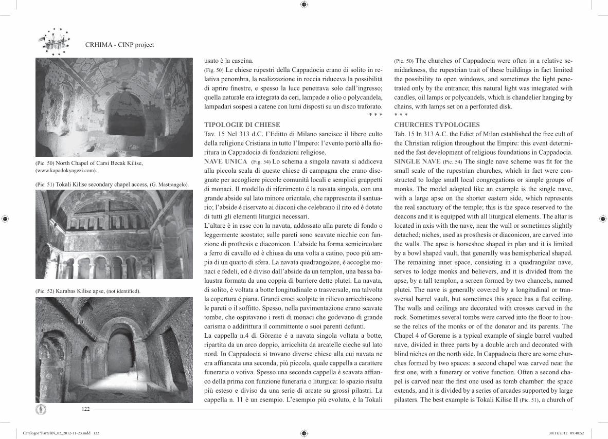
CRHIMA - CINP project
122
usato è la caseina.(Fig. 50) Le chiese rupestri della Cappadocia erano di solito in re-lativa penombra, la realizzazione in roccia riduceva la possibilità di aprire fi nestre, e spesso la luce penetrava solo dall’ingresso; quella naturale era integrata da ceri, lampade a olio o polycandela, lampadari sospesi a catene con lumi disposti su un disco traforato.
* * *TIPOLOGIE DI CHIESETav. 15 Nel 313 d.C. I’Editto di Milano sancisce il libero culto della religione Cristiana in tutto I’Impero: l’evento portò alla fi o-ritura in Cappadocia di fondazioni religiose.NAVE UNICA (Fig. 54) Lo schema a singola navata si addiceva alla piccola scala di queste chiese di campagna che erano dise-gnate per accogliere piccole comunità locali e semplici gruppetti di monaci. II modello di riferimento é la navata singola, con una grande abside sul lato minore orientale, che rappresenta il santua-rio; l’abside é riservato ai diaconi che celebrano il rito ed è dotato di tutti gli elementi liturgici necessari.L’altare è in asse con la navata, addossato alla parete di fondo o leggermente scostato; sulle pareti sono scavate nicchie con fun-zione di prothesis e diaconicon. L’abside ha forma semicircolare a ferro di cavallo ed è chiusa da una volta a catino, poco più am-pia di un quarto di sfera. La navata quadrangolare, è accoglie mo-naci e fedeli, ed é diviso dall’abside da un templon, una bassa ba-laustra formata da una coppia di barriere dette plutei. La navata, di solito, è voltata a botte longitudinale o trasversale, ma talvolta la copertura é piana. Grandi croci scolpite in rilievo arricchiscono le pareti o il soffi tto. Spesso, nella pavimentazione erano scavate tombe, che ospitavano i resti di monaci che godevano di grande carisma o addirittura il committente o suoi parenti defunti.La cappella n.4 di Göreme é a navata singola voltata a botte, ripartita da un arco doppio, arricchita da arcatelle cieche sul lato nord. In Cappadocia si trovano diverse chiese alla cui navata ne era affi ancata una seconda, più piccola, quale cappella a carattere funeraria o votiva. Spesso una seconda cappella è scavata affi an-co della prima con funzione funeraria o liturgica: lo spazio risulta più esteso e diviso da una serie di arcate su grossi pilastri. La cappella n. 11 è un esempio. L’esempio più evoluto, è la Tokali
(Pic. 50) The churches of Cappadocia were often in a relative se-midarkness, the rupestrian trait of these buildings in fact limited the possibility to open windows, and sometimes the light pene-trated only by the entrance; this natural light was integrated with candles, oil lamps or polycandels, which is chandelier hanging by chains, with lamps set on a perforated disk.* * *CHURCHES TYPOLOGIESTab. 15 In 313 A.C. the Edict of Milan established the free cult of the Christian religion throughout the Empire: this event determi-ned the fast development of religious foundations in Cappadocia.SINGLE NAVE (Pic. 54) The single nave scheme was fi t for the small scale of the rupestrian churches, which in fact were con-structed to lodge small local congregations or simple groups of monks. The model adopted like an example is the single nave, with a large apse on the shorter eastern side, which represents the real sanctuary of the temple; this is the space reserved to the deacons and it is equipped with all liturgical elements. The altar is located in axis with the nave, near the wall or sometimes slightly detached; niches, used as prosthesis or diaconicon, are carved into the walls. The apse is horseshoe shaped in plan and it is limited by a bowl shaped vault, that generally was hemispherical shaped. The remaining inner space, consisting in a quadrangular nave, serves to lodge monks and believers, and it is divided from the apse, by a tall templon, a screen formed by two chancels, named plutei. The nave is generally covered by a longitudinal or tran-sversal barrel vault, but sometimes this space has a fl at ceiling. The walls and ceilings are decorated with crosses carved in the rock. Sometimes several tombs were carved into the fl oor to hou-se the relics of the monks or of the donator and its parents. The Chapel 4 of Goreme is a typical example of single barrel vaulted nave, divided in three parts by a double arch and decorated with blind niches on the north side. In Cappadocia there are some chur-ches formed by two spaces: a second chapel was carved near the fi rst one, with a funerary or votive function. Often a second cha-pel is carved near the fi rst one used as tomb chamber: the space extends, and it is divided by a series of arcades supported by large pilasters. The best example is Tokali Kilise II (Pic. 51), a church of
(Pic. 50) North Chapel of Carsi Becak Kilise, (www.kapadokyagezi.com).
(Pic. 51) Tokali Kilise secondary chapel access, (G. Mastrangelo).
(Pic. 52) Karabas Kilise apse, (not identifi ed).
Catalogo1°ParteBN_02_2012-11-23.indd 122Catalogo1°ParteBN_02_2012-11-23.indd 122 30/11/2012 09:48:5230/11/2012 09:48:52

Cultural Rupestrian Heritage in the Circum - Mediterranean area
123
Kilise II (Fig. 51): la chiesa è costruita sul fondo di un’omonima chiesa più antica, ed è realizzata con una navata trasversale alla sua parete orientale.Particolare la disposizione di uno stretto corridoio su sui si affac-ciano le absidi e le divide dallo spazio principale. Questo corrido-io con soffi tto piano, sopraelevato dal pavimento della navata da tre gradini, sull’aula con cinque arcate; risparmiati dallo scavo, ai piedi di ognuno dei quattro pilastri, si trovano esempi di cathe-dra. La volta a botte che copre la navata é tripartita mediante due archi, le pareti nelle lunette sono decorate con arcatelle cieche sormontate da una partizione cruciforme.Karabaş Kilise (Fig. 52) è un complesso di navate singole, affi an-cate in successione: le due cappelle a nord sono messe in comuni-cazione da tre aperture alternate da due massicci pilastri squadra-ti e una coppia di arcate. A sud sono altre due cappelle a navata singola, sono messe in comunicazione tra loro da due semplici e stretti corridoi; l’impianto comprende un nartece rettangolare, che dà accesso diretto alle due cappelle meridionali.
* * *TIPOLOGIE A PIANTA BASILICALETav. 16 L’organizzazione interna dello spazio è ispirata alle grandi basiliche della cristianità: lo schema a navate divise da pilastri si trova nelle basiliche di Roma, erette durante I’Impero di Costan-tino e Giustiniano nel IV-V secolo d.C.II tipo basilicale a tre navate, adatto a comunità più o meno nu-merose o meta di pellegrinaggio, nelle chiese di villaggio è raro. È utilizzata nelle prime chiese rupestri della Cappadocia e in mo-nasteri di grande importanza. II suo uso, emulazione della forma a navata singola, è tipicamente precoce specialmente quando ha soffi tto piano, e in ogni caso probabilmente non e più tarda del VII secolo. Scavare dalla roccia navate con due fi le di pilastri o colonne era diffi cile e costoso, pertanto la tipologia era riservata alle chiese di particolare importanza; inoltre, la roccia non sempre presentava caratteristiche tali per ospitare ampi spazi. General-mente la pianta è rettangolare, con asse principale parallelo al lato corto e la copertura delle tre navate varia, ci sono casi in cui sono coperte da volta a botte o da soffi tto piano. Nella basilica (Fig. 55) troviamo elementi accessori: l’ambone, una sorta di pulpito cir-
more recent realization: a transverse nave, carved perpendicularly at the eastern side of the single nave, included into the ancient Tokali I. A narrow passageway, with fl at ceiling, divides the main space from the apses and, elevated than the nave, it opens to this by a series of fi ve arches; example of cathedra are carved into the rock to the base of each pilaster. The barrel vault of the nave is di-vided in three parts by two arches and the south wall is decorated with a moulding of blind arches and, in the upper part, a cruciform division, the same proposed for the opposite wall, but fl anked, in this case, by a series of fi ve narrow arches, which separate the nave from another barrel vaulted chapel, including an apse in the eastern part. Karabas Kilise (Pic. 52) consists in a complex of single naves placed side by side: the two chapels located at north are lin-ked by three openings composed alternately by two pilasters with a square base and a pair of arcades. At the south side there are two other single nave chapels, linking through two simple and narrow passages; the plan includes only a rectangular narthex leading into the two southern chapels. * * *BASILICA PLAN TYPOLOGIESTab.16 The organization of the inner space is inspired to the gre-at Christian basilicas, with naves divided by colonnades, as in the basilicas constructed during the Empire of Constantine and Justinian in the IV century A.C.. This typology, right for larger communities (as for the village churches or the spaces for pilgri-mage), is rare: it was used in the fi rst churches of Cappadocia or for buildings included into monastic complex.Its use, especially when it shows a fl at ceiling, can be considered an emulation of the single nave model, typically precocious, and probably dated at the VII° century.It was diffi cult and expensive to dig from the rock naves with two series of columns, so that happened only for important churches.Generally these churches have a rectangular plan with the main axis parallel to the short side; the three naves are covered by bar-rel vaulted or by fl at ceiling. The basilica (Pic. 55) is constructed to lodge more believers and it can include different subsidiary elements like the ambon, a kind of rockcut circular pulpit inclu-ded into the nave. The cathedra is a kind of throne located inside
(Pic. 53) Double nave church, (not identifi ed).
(Pic. 54) Perspective cross-section, ( S. Sangiorgi).
(Pic. 55) Main nave of St. John church in Cavusin, (not identifi ed).
Catalogo1°ParteBN_02_2012-11-23.indd 123Catalogo1°ParteBN_02_2012-11-23.indd 123 30/11/2012 09:48:5430/11/2012 09:48:54
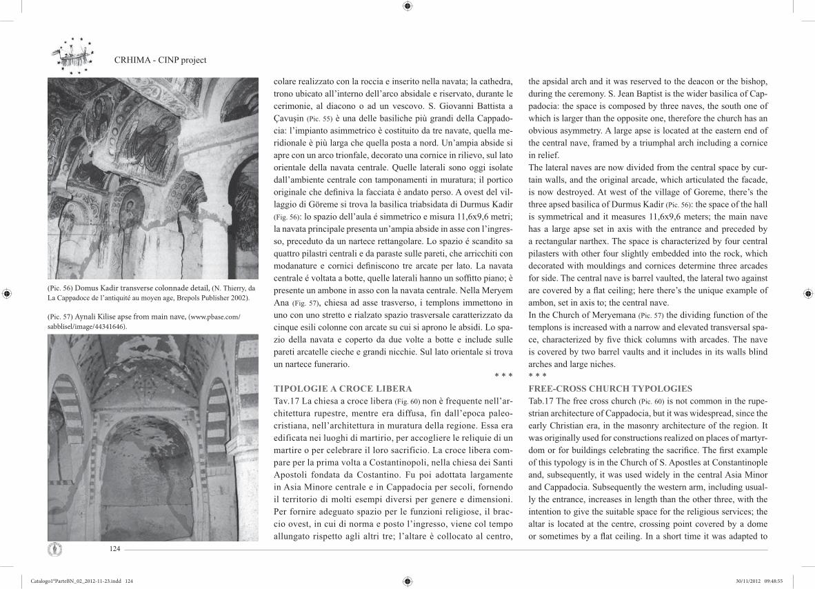
CRHIMA - CINP project
124
colare realizzato con la roccia e inserito nella navata; la cathedra, trono ubicato all’interno dell’arco absidale e riservato, durante le cerimonie, al diacono o ad un vescovo. S. Giovanni Battista a Çavuşin (Pic. 55) è una delle basiliche più grandi della Cappado-cia: l’impianto asimmetrico è costituito da tre navate, quella me-ridionale è più larga che quella posta a nord. Un’ampia abside si apre con un arco trionfale, decorato una cornice in rilievo, sul lato orientale della navata centrale. Quelle laterali sono oggi isolate dall’ambiente centrale con tamponamenti in muratura; il portico originale che defi niva la facciata è andato perso. A ovest del vil-laggio di Göreme si trova la basilica triabsidata di Durmus Kadir (Fig. 56): lo spazio dell’aula é simmetrico e misura 11,6x9,6 metri; la navata principale presenta un’ampia abside in asse con l’ingres-so, preceduto da un nartece rettangolare. Lo spazio é scandito sa quattro pilastri centrali e da paraste sulle pareti, che arricchiti con modanature e cornici defi niscono tre arcate per lato. La navata centrale é voltata a botte, quelle laterali hanno un soffi tto piano; è presente un ambone in asso con la navata centrale. Nella Meryem Ana (Fig. 57), chiesa ad asse trasverso, i templons immettono in uno con uno stretto e rialzato spazio trasversale caratterizzato da cinque esili colonne con arcate su cui si aprono le absidi. Lo spa-zio della navata e coperto da due volte a botte e include sulle pareti arcatelle cieche e grandi nicchie. Sul lato orientale si trova un nartece funerario.
* * *TIPOLOGIE A CROCE LIBERATav.17 La chiesa a croce libera (Fig. 60) non è frequente nell’ar-chitettura rupestre, mentre era diffusa, fin dall’epoca paleo-cristiana, nell’architettura in muratura della regione. Essa era edificata nei luoghi di martirio, per accogliere le reliquie di un martire o per celebrare il loro sacrificio. La croce libera com-pare per la prima volta a Costantinopoli, nella chiesa dei Santi Apostoli fondata da Costantino. Fu poi adottata largamente in Asia Minore centrale e in Cappadocia per secoli, fornendo il territorio di molti esempi diversi per genere e dimensioni. Per fornire adeguato spazio per le funzioni religiose, il brac-cio ovest, in cui di norma e posto l’ingresso, viene col tempo allungato rispetto agli altri tre; l’altare è collocato al centro,
the apsidal arch and it was reserved to the deacon or the bishop, during the ceremony. S. Jean Baptist is the wider basilica of Cap-padocia: the space is composed by three naves, the south one of which is larger than the opposite one, therefore the church has an obvious asymmetry. A large apse is located at the eastern end of the central nave, framed by a triumphal arch including a cornice in relief.The lateral naves are now divided from the central space by cur-tain walls, and the original arcade, which articulated the facade, is now destroyed. At west of the village of Goreme, there’s the three apsed basilica of Durmus Kadir (Pic. 56): the space of the hall is symmetrical and it measures 11,6x9,6 meters; the main nave has a large apse set in axis with the entrance and preceded by a rectangular narthex. The space is characterized by four central pilasters with other four slightly embedded into the rock, which decorated with mouldings and cornices determine three arcades for side. The central nave is barrel vaulted, the lateral two against are covered by a fl at ceiling; here there’s the unique example of ambon, set in axis to; the central nave. In the Church of Meryemana (Pic. 57) the dividing function of the templons is increased with a narrow and elevated transversal spa-ce, characterized by fi ve thick columns with arcades. The nave is covered by two barrel vaults and it includes in its walls blind arches and large niches.* * *FREE-CROSS CHURCH TYPOLOGIESTab.17 The free cross church (Pic. 60) is not common in the rupe-strian architecture of Cappadocia, but it was widespread, since the early Christian era, in the masonry architecture of the region. It was originally used for constructions realized on places of martyr-dom or for buildings celebrating the sacrifi ce. The fi rst example of this typology is in the Church of S. Apostles at Constantinople and, subsequently, it was used widely in the central Asia Minor and Cappadocia. Subsequently the western arm, including usual-ly the entrance, increases in length than the other three, with the intention to give the suitable space for the religious services; the altar is located at the centre, crossing point covered by a dome or sometimes by a fl at ceiling. In a short time it was adapted to
(Pic. 56) Domus Kadir transverse colonnade detail, (N. Thierry, da La Cappadoce de l’antiquité au moyen age, Brepols Publisher 2002).
(Pic. 57) Aynali Kilise apse from main nave, (www.pbase.com/
sabblisel/image/44341646).
Catalogo1°ParteBN_02_2012-11-23.indd 124Catalogo1°ParteBN_02_2012-11-23.indd 124 30/11/2012 09:48:5530/11/2012 09:48:55

Cultural Rupestrian Heritage in the Circum - Mediterranean area
125
nell’incrocio coperto a cupola o, di rado, con soffitto piano. Lo schema martiriale fu adattato per le chiese di congrega-zioni e comunità, per lo più indipendenti dai complessi mo-nastici. Quando le liturgie divennero consuetudine, l’altare fu traslato dal centro verso il braccio orientale, e posto all’inter-no dell’arco absidale. Nelle chiese rupestri la campata centra-le è più ampia, e i bracci della croce, sono spesso così poco profonde che non sono percepite come tali, ad esempio nella pianta a croce greca della Yılanlı Kilise a Belisirma, del San Pietro e Paolo a Balkan, della chiesa n.21 di Göreme; in molti casi, invece, è l’abside che forma il braccio orientale della croce, come a El Nazar a Göreme e nella Agaç Alti a Peristre-ma (Fig. 58). Yılanlı Kilise, nella valle di Peristrema presenta una croce libera i cui bracci raggiungono la profondità di ap-pena 90 cm; questi sono di uguali dimensioni, con pendenza leggermente digradante verso il centro e la pianta mostra una netta simmetria. Un’ampia abside sopraelevata e situata all’estremo orientale della croce, separata da un templon con semplici plutei; si ac-cede da un nartece, aperto direttamente sullo spazio principa-le, e da una seconda cappella, più piccola, a navata trasversa corredata con un’abside e altare sul lato maggiore. Un parti-colare esempio di pianta, considerata una variazione di quella cruciforme, è la tricora. La campata centrale è coperta con una cupola e su tre dei suoi lati si aprono altrettante absidi. La Tagar (o St. Theodore) a Yesilöz, villaggio a sud di Ürgüp, è un raro esempio in Cappa-docia (Fig. 59). El Nazar è una chiesa cruciforme scavata in un grosso cono roccioso a Göreme, ha subito molti rimaneggia-menti a causa dei crolli rocciosi: l’abside costituisce il braccio orientale; una grande cupola copre lo spazio centrale; gli altri bracci sono quadrangolari con ampie nicchie sui muri; sulla parete orientale dei bracci nord e sud si aprono dei piccoli vani absidati.
the churches of congregations or communities into independent buildings, not included into monastic complex; since the church became a building for daily Liturgies, the altar was moved from the centre to the eastern arm and it was placed into an apsidal arch, for convenience, as a result of the celebration of the Mass. If the central space is Iarger against the cross arms are very shout, but this aspect is not always visible: in the freecross plan 0f Ylanli Kilise at Belisirma and of the Church n. 21 at Goreme, the arms are 90cm deep; in many cases, the apse forms the eastern cros-sarm, as in El Nazar at Goreme and in Agac Alti at Peristrema (Pic.
58). Yilanli Kilise, in the Peristrema Valley, has a freecross plan with arms 90 cm deep; these have the same sizes, with a gradient sloping to the center, and the plan shows an obvious symmetry. A large elevated apse is located at the eastern end of the cross, clo-sed by a simple templon with plutei; the plan includes an entrance space, a narthex opening directly to the main space, and a second smaller chapel, with a transversal nave and any apse including an altar on the greater side. The tricora is a particular example of plant which can be considered a variation of the cruciform one. This type of plant is formed by a cross with a dome which co-vers the intersection of the arms, with three of these ending with apses. The Tagar church (or St. Theodore) is the only example in Cappadocia at Yesiloz, a village south of Urgup (Pic. 59). El Nazar is a cruciform church, carved into a large rock cone of the Goreme Valley, but for frequent Ianslides, it has been modifi ed in time: this “cross” has an apse formjng the eastern arm and a large dome covering the central space; the other arms include quadran-gular rooms, in the walls of which are carved large niches. In this plant three large semicircles extend the central square space to the south, west and north; in the eastern arm there’s a square room with a slightly vaulted ceiling that becomes fl at in the higher part. Given the particular orientation, this was the entrance to the internal space: the west access, on the rock wall side, was through a fi rst and deep chamber; then, turning left, the eastern arm was reacheable through a corridor.
(Pic. 58) Agac Alti church, (www.panoramio.com/photos/46140270).
(Pic. 59) St. Theodore tricora’s view, (O. Sagdic 1987).
Catalogo1°ParteBN_02_2012-11-23.indd 125Catalogo1°ParteBN_02_2012-11-23.indd 125 30/11/2012 09:48:5630/11/2012 09:48:56

CRHIMA - CINP project
126
TIPOLOGIE DI PIANTA A CROCE INSCRITTATav.18 La croce inscritta (Fig. 62) e tipica del periodo medio-bizantino. II primo esempio è la Nea Ekklesia (chiesa nuova) fondata nel 881 d.C. a Costantinopoli da Basilio I, alla fi ne del periodo iconoclasta. Questo schema di pianta si estese al resto del l’Impero divenendo “usuale nell’età di mezzo”; è un siste-ma di 9 campate in cui la croce disegnata dai quattro bracci si inscrive all’interno di uno spazio quadrangolare, o ‘quincunx’, con quattro comparti negli angoli. Lo spazio centrale, all’in-crocio del quattro bracci voltati a botte, è scandito da quattro colonne che sorreggono la cupola della campata centrale. Ap-parsa in Cappadocia fi n dal X secolo, questa pianta divenne più frequente durante I’XI secolo.II nuovo tipo d’impianto, insuffi cientemente compreso, fu dap-prima applicato maldestramente: fi tte colonne o pilastri, di so-lito nella Cappadocia occidentale e a Peristrema - con capitelli squadrati sostenevano la cupola principale; le campate d’ango-lo avevano un soffi tto piano o delle cupole appena accennate. L’architettura della croce inscritta racchiude un programma di progetto che include la rappresentazione dei cicli pittorici e delle loro relazioni, delle necessità delle celebrazioni liturgiche. Non si conosce la data di perfezionamento e raggiungimento della croce inscritta più moderna. Essa non fu frutto di un pro-cesso graduale, ma di un progetto di studio risolto da architetti e maestranze più abili e capaci di altri, unitamente ad alcune comunità monastiche più progressiste e tolleranti di altre.Per l’eccellente stato di conservazione delle loro pitture, spic-cano tre di questi edifi ci con avanzata croce inscritta, le chiese “colonnate” di Göreme: Elmali Kilise, Carikli Kilise e Ka-ranlik Kilise. Le chiese a croce inscritta (Fig. 61): nonostante la diffi coltà di scavo e il maggior per la realizzazione, si trovano sparse in tutta la regione; questa tipologia generalmente è parte di un complesso monastico e quasi mai un caso isolato nel ter-ritorio. Nella Direkli Kilise (Fig. 61), a Belisirma, i pilastri sono così fi tti da comprimere lo spazio interno e la minuscola cu-pola non riesce a imporre la sua presenza. L’abside centrale è divisa con un templon di semplici pannelli di roccia, in contro-tendenza con la privacy tipica dei nuovi riti. A Göreme vi sono
INSCRIBED CROSS PLANT TYPOLOGIESTab. 18 The inscribed cross plant (Pic. 62) is typical of the Byzanti-ne middle age. The fi rst example is the Nea Ekklesia (new church), founded in 881 AD in Constantinople by Basil I at the end of the ico-noclastic period. The use of this plant extended to the rest of the Em-pire and become the standard of the “’middle age”. This is a system of 9 spaces in which the cross drawn by the four arms is inscribed within a quadrangular space, or ‘quincunx‘, giving rise to four com-partments in the four corners. The central space, in the intersection of the four barrel vaulted arms, is defi ned by four columns supporting a dome that rises above it. Appeared in Cappadocia since the tenth cen-tury, this plant becomes more common during the eleventh century.The fi rst approach to the use of a inscribed cross plan was warm; the new type of church, insuffi ciently understood, was fi rst applied clumsily: dense columns, or pillars usually in Western Cappadocia and in Peristrema with square capitals supported the main dome, and the four corner spaces were covered with a fl at roof or a kind of simple “bubble” instead of real domes. The architectural scheme of the inscribed cross provides a complex and articulated concept that concerns painted images, linked one to another in a series of precise relationships, and the needs of the liturgical celebrations taking place below them. In the absence of certain dates, we can not calculate how long has taken to reach the most modern form of inscribed cross plan. Broadly speaking, however, we can establish that, when this happened, it was not the result of a gradual process, but a problem that was solved by architects and workers more skilled and capa-ble than others, or as some monastic communities have been more progressive and tolerant than others. Three of these churches with an advanced inscribed cross plan stand out for the excellent state of preservation of their paintings: the so called ‘column churches of Go-reme Elmali Kilise, Carikli Kilise and Karanlik Kilise. The inscribed cross churches are never isolated in the region, but generally these are part of a monastic complex; as the diffi cult of th eexcavation was greater as the manufacturing cost was greater. In the church known as Direkli Kilise (Pic. 61) in Belisirma, pillars are thick up to occlude the internal space and the tiny dome fails t0 impress his presence. The central apse is not separated by the iconostasis, but by templon made of simple panels of rock, which goes against the concept of privacy
(Pic. 60) Perspective cross-section, (S. Sangiorgi).
(Pic. 61) Direkli Kilise central space view, (C. Crescenzi).
Catalogo1°ParteBN_02_2012-11-23.indd 126Catalogo1°ParteBN_02_2012-11-23.indd 126 30/11/2012 09:48:5730/11/2012 09:48:57

Cultural Rupestrian Heritage in the Circum - Mediterranean area
127
varie chiese a croce inscritta: le piante seguono lo schema tipo ma si diversifi cano tra loro per il tipo di colonne, per la presen-za di nicchie o cicli pittorici più o meno ricchi, e per la scelta delle coperture dei comparti d’angolo. Nella valle di Kiliclar c’ é un primo esempio (X secolo) in cui gli spazi, non ancora ampi, presenta i comparti d’angolo coperti da piccole calotte.
* * *IL COMPLESSO DELLA KARANLIKTav. 19 La Karanlik (Fig. 63-64), la terza delle Chiese a colonne, scavata nelle vicinanze di Göreme 21 (S. Caterina) e alla som-mità della valle di Göreme, è inclusa in un complesso monastico, le cui stanze sono situate attorno ad una piccola corte. Il piano terra ospita tre stanze, cui si accede con un’apertura posta nella campata centrale del vestibolo: la prima si presenta come una ca-vità irregolare, probabilmente con una funzione originariamente secondaria; le altre due, entrambe con copertura piana, si diversi-fi cano in pianta: una trapezoidale e l’altra romboidale. Una scala ricavata nel muro ovest del refettorio porta al piano superiore, contenente due stanze: la prima rettangolare comunica con una seconda stanza, anch’essa apparentemente della medesima forma e con due profonde cavità nel muro meridionale. Sul lato sud del-la corte si apre un lungo vestibolo, in gran parte distrutto, di cui sono testimonianza pochi frammenti; in origine era costituito da un soffi tto piano defi nito con una cornice quadrata e l’ambiente, secondo quanto è possibile dedurre dalla parete che lo delimitava, era diviso in tre parti dalle paraste. Era decorato con un fregio, nelle cui partiture presenta tre piccole nicchie cieche con arco a ferro di cavallo. Sul lato orientale del vestibolo, un passaggio con-duce a un ampio refettorio con soffi tto piano, con absidi scavate nella roccia all’estremità di un tavolo, che si estende per tutta la lunghezza del muro est. La chiesa è accessibile dal lato orienta-le della corte; un’apertura rettangolare, incorniciata da un arco oltrepassato, conduce a una breve scala che si apre direttamente sul nartece. Esso è voltato a botte, leggermente decentrato rispet-to al naos, é decorato con due lunette e nicchie cieche con arco oltrepassato, e apre a una camera funeraria posta nel lato sud. La parete orientale si apre sulla chiesa a croce inscritta, con cupola centrale, in origine supportata da quattro sottili colonne, di cui ora
typical of the new rites. Some inscribed cross churches are into Gore-me Valley: the plans, proposing the typical scheme, differ for type of columns, the presence of niches or painted cycles more or less detai-led, and lastly for the cover used for the corner compartments. A fi rst example (X century) is into Kiliclar Valley where the spaces are not very large, and the corner compartments have small spherical vaults.* * *THE KARANLIK COMPLEXTab. 19 Karanlik (Pic. 63-64),the third of the Columns Churches, it’s carved near Goreme 21 (S. Catherine), in the head of Goreme valley and it is included in a monastic complex, where the rooms are set around a small courtyard. The ground fl oor contains also other three rooms, accessed by an opening in the centre bay of vestibule: the fi rst is an irregular cavity, probably secondary, the others two have a fl at ceiling, but are different in plan, one is tra-pezoidal and the other is rhomboidal. The west wall of refectory leads to the upper fl oor, containing two rooms: the fi rst one is rectangular and it has an opening in its east wall to a room , also rectangular in plan and apparently with two deep recesses in its south wall. In the south side of this courtyard, there’s a long vestibule, part of which is now lost, except several fragments; originally it had a flat ceiling above a square cornice and its wall was divided in three parts by pilasters. It’s decorated with a frieze of small hor-se—shoe arched blind niches, above which there was an horizon-tal moulding. On the east side of vestibule, a passage leads into a large refectory with a flat ceiling, containing rockcut apses at the each end of a table running along the east wall. The church is accessed at the east side of the courtyard, in fact a rectangular opening, set in a moulded horseshoe arched, leads into a short stairway, which opens into the narthex: it’s an in-scribed cross church, with a central dome and three apses in the east side. The barrel vaulted narthex, slightly decentralized to the naos, is decorated with two lunettes and horseshoe arched blind niches and extends into a small tomb chamber at the south side.A rectangular opening in the east wall of narthex leads into the naos: it’s inscribed cross in plan, with a central dome, originally supported by four slender columns, but now only one column of
(Pic. 62) Perspective cross-section, (S. Sangiorgi).
(Pic. 63) Karanlik Kilise. Dark church, (C. Crescenzi).
(Pic. 64) Karanlik Kilise. Dark church, (C. Crescenzi).
Catalogo1°ParteBN_02_2012-11-23.indd 127Catalogo1°ParteBN_02_2012-11-23.indd 127 30/11/2012 09:48:5830/11/2012 09:48:58
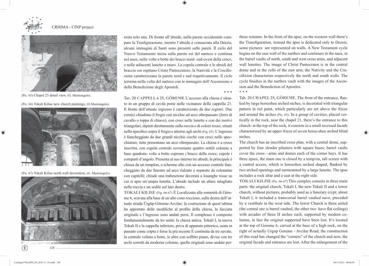
CRHIMA - CINP project
128
resta solo una. Di fronte all’abside, nella parete occidentale com-pare la Trasfi gurazione, mentre l’abside è consacrata alla Déesis, alcune immagini di Santi sono presenti sulle pareti. Il ciclo del Nuovo Testamento inizia sulla parete est del nartece e continua nel naos, nelle volte a botte dei bracci nord- sud-ovest della croce, e nelle adiacenti lunette a muro. La cupola centrale e le absidi del braccio est ospitano Cristo Pantocratore; la Natività e la Crocifi s-sione caratterizzano la parete nord e sud rispettivamente. Il ciclo termina nella volta del nartece con le immagini dell’Ascensione e della Benedizione degli Apostoli.
* * *Tav. 20 CAPPELLA 25, GÖREME L’accesso alla chiesa è situa-to in un gruppo di cavità poste nelle vicinanze della cappella 21. Il fronte dell’attuale ingresso è caratterizzato da due registri. Due cornici chiudono il fregio con nicchie ad arco oltrepassato (ferro di cavallo o toppa di chiave), con croci nelle lunette e con dei motivi triangolari, dipinti direttamente sulla roccia e di colore rosso, situati nello specifi co sopra il fregio e attorno agli archi (Fig. 65). L’ingresso è fi ancheggiato da due grandi nicchie cieche con croci nelle spec-chiature, tutte presentano un arco oltrepassato. La chiesa è a croce inscritta, con cupola centrale sovrastante quattro sottili colonne a base quadrata; volte a botte coprono i bracci della croce, cupole i comparti d’angolo. Presenta al suo interno tre absidi; la principale è chiusa da un templon, a schermo alto con un accesso centrale fi an-cheggiato da due fi nestre ad arco rialzato e separato da colonnine con capitelli; chiude una trabeazione decorata a losanghe rosse su cui si apre un’ampia lunetta. L’abside include un altare intagliato nella roccia e un sedile sul lato destro. TOKALI KILISE (Fig. 66-67) È Localizzata alla sommità di Göre-me 6, scavata alla base di un alto cono roccioso, sulla destra dell’at-tuale strada Ürgüp-Göreme-Avcilar; la costruzione di quest’ultima ha apportato delle modifi che al profilo della chiesa, la facciata originale e l’ingresso sono andati persi. Il complesso è composto fondamentalmente da tre unità: la chiesa antica, Tokali I, la nuova Tokali II e la cappella inferiore, priva di apparato pittorico, usata in passato come cripta e forse la più recente È costituita da tre navate, la centrale voltata a botte, le altre con soffi tto piano, divise con tre archi sorretti da moderne colonne, quelle originali sono andate per-
these remains. In the front of the apse, on the western wall there’s the Transfi guration, instead the apse is dedicated only to Deesis; some pictures are represented on walls. A New Testament cycle begins on the east wall of the narthex and continues in the naos, in the barrel vaults of north, south and west cross arms, and adjacent wall lunettes. The image of Christ Pantocrator is in the central dome and in the cells of the east arm; the Nativity and the Cru-cifi xion characterize respectively the north and south walls. The cycle fi nishes in the narthex vault with the images of the Ascen-sion and the Benediction of Apostles.* * *Tab. 20 CHAPEL 25, GÖREME. The front of the entrance, fl an-ked by large horseshoe arched niches, is decorated with triangular pattern in red paint, which particularly are set above the frieze and around the arches (Pic. 65). In a group of cavities, placed ver-tically in the rock, near the chapel 21, there’s the entrance to this church: at the top of the rock, it consists in a small recessed facade characterized by an upper frieze of seven horse-shoe arched blind niches. The church has an inscribed cross plan, with a central dome, sup-ported by four slender pilasters with square bases; barrel vaults cover the cross—arms and domes each of the corner bays. It has three apses, the main one is closed by a temp/on, tall screen with a central access, which is horseshoe arched shaped, fl anked by two arched openings and surmounted by a large lunette. The apse includes a rock altar and a seat at the right side. TOKALI KILISE (Pic. 66-67) This complex consists in three main parts: the original church, Tokali I, the new Tokali II and a lower church, without pictures, probably used as a funerary crypt; about Tokali I, it included a transversal barrel vaulted nave, preceded by a vestibule in the west side. The lower Church is three aisled (the central one is barrel vaulted, the other two have fl at ceilings) with arcades of three H arches each, supported by modern co-lumns, in fact the original supported have been lost. It’s located at the top of Goreme 6, carved at the base of a high rock, on the right of actually Urgup Goreme - Avcilar Road; the construction of this road has changed the “corners” of the church and now, the original facade and entrance are lost. After the enlargement of the
(Pic. 66) Tokali Kilise new church paintings, (G.Mastrangelo).
(Pic. 67) Tokali Kilise north wall decoration, (G. Mastrangelo).
(Pic. 65) Chapel 25 detail view, (G. Mastrangelo).
Catalogo1°ParteBN_02_2012-11-23.indd 128Catalogo1°ParteBN_02_2012-11-23.indd 128 30/11/2012 09:48:5930/11/2012 09:48:59

Cultural Rupestrian Heritage in the Circum - Mediterranean area
129
se. la prima, in origine era costituita da una navata trasversale vol-tata a botte e preceduta da un vestibolo sul lato ovest. La Tokali I è l’attuale nartece della più recente Tokali (Fig. 68). In seguito all’am-pliamento della chiesa, l’aula è stata modifi cata e l’abside è andata distrutto: la chiesa era a navata singola voltata a botte. La Tokali II è a nave unica con asse trasverso, la cui volta a botte è divisa in tre parti da due arcate longitudinali; le pareti laterali sono decorate (Fig. 69) con falsi archi sormontati da un fregio affrescato con cicli pittorici e chiusi dalla lunetta decorata con una grande croce che ne partisce la superfi cie; lo spazio del bema, sopraelevato rispetto alla navata, è delimitato da quattro pilastri. Sulla parete nord delle arca-te aprono ad una cappella laterale con abside ed altare. La Nuova Chiesa ha il ciclo iconografi co realizzato a secco (Annunciazione, Natività, Battesimo, ecc...) (Fig. 69). L’abside principale è dedicata alla rappresentazione della Crocifi ssione, e include nelle sue pareti temi quali l’Anastasi e la Deposizione. La Chiesa Antica è decorata con un ciclo narrativo (con temi quali l’Infanzia e la Passione di Cristo) che si sviluppa in due registri sui lati della volta, e nella parte alta di ogni parete.
* * *YILANLI KILISETav. 21 L’Yılanlı Kilise (Fig. 70-71-72) è situata alla fi ne del Cer-chio di Göreme, nelle vicinanze delle Cappelle 25 e 27. La chie-sa ha una forma irregolare: preceduta da un nartece rettangolare, contenente delle tombe, presenta una navata trasversa voltata a botte, accessibile dall’estremità nord, e che si estende a sud con un vano rettangolare con soffitto piano. Vi è un’unica abside di forma semicircolare a ferro di cavallo, posto sulla parete orientale della navata, con un altare e un sedile nel lato sud. Nella navata la decorazione pittorica è semplice e lineare, comprende alcuni pannelli votivi: nelle volte sono rappresentati Onesimo, Giorgio e Teodoro (entrambi a cavallo), Costantino ed Elena, Onofrio, Tom-maso e Basilio. L’abside è consacrata alla Dèesis, ma l’immagine non è ben preservata. Nella parete rocciosa, a destra della chiesa, leggermente incassata è tagliato un fronte che dà l’accesso a un refettorio: in origine tre nicchie articolavano il prospetto. Quel-la centrale incorniciava l’ingresso ed era fi ancheggiata da altre due nicchie cieche, oggi distrutte. Dall’ingresso si accede ad una
church, the vestibule has been modified and the sanctuary was destroyed: that what today appears as the narthex was originally the nave of a single apsed church; later the horse—shoe apse was expanded to produce the new church (Pic. 68). Tokali II includes a large transversal nave, barrel vault of which is divided in three parts by two transversal arches, while the side walls are decorated with false arches; the space of “bema”, elevated than the nave, is limited by four thick pilasters. The New Church has a full pain-ting programme, which starts in the north bay of the vault of the nave and extends to the wall above the arcades (Annunciation, Nativity, Baptism, ecc..) (Pic 69). The main apse is dedicated to the Crucifi xion (conch) and in its wall includes themes as the Anastasis and Deposition.The Old Church is decorated with a narrative cycle (covering the Infancy and the Passion of Christ) placed in two registers on each side of the vault and one on the upper part of each wall.
* * *YILANLI KILISETab. 21 Yilanli Kilise (Pic. 70-71-72) is located at the bottom of Go-reme’s Circle, near the Chapels 27 and 25. The refectory has a very irregular form: preceded by a rectangular narthex, containing some tombs, it has a transverse barrel vaulted nave, entered from the north end, and it extends, at the south end, into a rectangular room with a fl at ceiling. It has a single horseshoe apse in the east wall of nave, containing an altar and a seat in the south side. In a rectangular recess, set at the right of the church, there’s the ac-cess to a refectory: only fragment of its facade remains, in fact originally there were probably three niches which decorated this front. The central one framed the entrance and it was flanked by the other two, now in ruins. The access leads into a small room with a rectangular entrance to the refectory: it includes a table, running along the left wall, and a bench, which is largely destro-yed, only the wall-bench in fact is preserved, and the end of this is lodged into a flat arched recess. In the nave the decoration pain-ting is linear and simple, and includes some polychrome panels:
(Pic. 69) Tokali Kilise new church paintings, (G.Mastrangelo).
(Pic. 68) Tokali Kilise narthex, (C. Crescenzi).
(Pic. 70) Yilanli Kilise refectory view, (C. Crescenzi).
Catalogo1°ParteBN_02_2012-11-23.indd 129Catalogo1°ParteBN_02_2012-11-23.indd 129 30/11/2012 09:49:0030/11/2012 09:49:00

CRHIMA - CINP project
130
stanza di modeste dimensioni e che immette al refettorio: questo include un tavolo in roccia, con una panca in gran parte distrutta, che costeggia il muro a sinistra; è ben preservata solo la panca alla testa del tavolo e incorniciata da una profonda nicchia ad arco. Santa Barbara Kilise. Scavata nel medesimo ammasso roccioso sul lato sud di Elmali, troviamo una piccola chiesa monastica, oggi nota come Santa Barbara, di cui non conosciamo il nome originale. La tipologia architettonica riprende esattamente il mo-dello di Çarıklı Kilise: una pianta a croce iscritta tronca, la cui cupola poggia sulla parete e su due pilastri, invece di quattro; la chiesa è preceduta da un nartece, (contenente delle tombe) oggi distrutto, che si apre sul lato sud della chiesa. Questa ospita al suo interno tre absidi sopraelevate, di forma semicircolare a ferro di cavallo, accessibili con due gradini. La chiesa ha una facciata de-corata con tre nicchie cieche ad arco oltrepassato: quella centrale, che incornicia l’ingresso, è fi ancheggiata da due altre nicchie più piccole. Questa facciata un tempo era la parete est del nartece, di cui ora si hanno solo alcuni resti delle pareti nord e sud. La chiesa presenta una decorazione semplice, realizzata direttamente sulla roccia, che rappresenta principalmente fi gure simboliche e il mo-tivo della croce, dipinti di colore rosso. Conserva al suo interno dei pannelli policromi che raffi gurano nello specifi co S. Giorgio e S. Teodoro a cavallo, due fi gure femminili (una delle quali, su uno sgabello, probabilmente è proprio S. Barbara), e la Vergine col Bambino. L’abside principale in origine era schermata da un alto templon, di cui restano solo i cancelli che ne incorniciavano l’accesso; quelle laterali conservano dei bassi plutei e ospitano al loro interno un altare a muro e un sedile nell’angolo sud- est.
* * *ELMALI KILISETav. 22 La chiesa è denominata “Chiesa della Mela”, (probabil-mente a causa del globo rossastro impugnato da Gabriele nel di-pinto situato nella cupola, che ricorda una mela), è una delle tre Chiese a Colonne (le altre due sono Çarikli Kilise e Karanlik Kili-se), localizzata a est del Cerchio di Göreme. Originariamente alla chiesa si accedeva dalla valle, essendo crollata la parete rocciosa, oggi un tunnel scavato nella parete nord serve da ingresso. Uno stretto passaggio, a ovest del percorso principale, con un’apertura
in the vaults are represented Onesimos, George and Theodoros (both equestrian), Constantine and Helena, Onouphrios, Thomas and Basil; the apse is dedicated to the Deesis, but the image is not well preserved. A small monastic church, carved in the Elmali’s rock on the south side, its original name is unknown, today it’s named Santa Barba-ra. The architectural type has almost exactly the same as Carikli Kilise: an abridged inscribed cross plan, preceded by a narthex (containing several tombs), now destroyed, and a dome supported by two pilasters, instead of four. It has a lateral entrance on the south side and three elevated horseshoe apses(east side), accessed by two steps. The church now has a facade decorated with three blind niches: a central niche, fl anked by a pair of small horseshoe arched blind niches, sheltered by a gable moulding; the naos en-trance is in the central niche. This facade was once the east wall of a narthex of which the stubs of north and south walls survive.The church has a simple decoration, realized directly on the rock, and principally representing symbolic motifs and crosses in red paint. It contains several polychrome panels showing the eque-strian Saints George and Theodoros, two female Saints (one on a footstool probably S. Catherine),and the Virgin with Infant.The main apse originally was closed by a tall templon, of which remain only two chancels at the entrance; the lateral apses have low chancels slabs. Each of these contains an altar near the wall and a seat in the south—east corner.
* * *ELMALI KILISE. Tab. 22 Named the “Church of the Apple”(probably because the globe held by Gabriel as painted in the dome somehow resembles that fruit), it’s one of the three “Columns” Churches (the other two are Carikli Kilise and Karanlik Kilise), located at the east of the Circle of Goreme.The original access was from the valley, preceded by a narthex, but though parts of the Church have crumbled away, so a tunnel in the north wall now serves. A narrow recess (at the west of the
(Pic. 71) Yilanli Kilise refectory detail, (C. Crescenzi).
(Pic. 72) Yilanli Kilise refectory, (C. Crescenzi).
(Pic. 73) Elmali Kilise detail, (C. Crescenzi).
Catalogo1°ParteBN_02_2012-11-23.indd 130Catalogo1°ParteBN_02_2012-11-23.indd 130 30/11/2012 09:49:0130/11/2012 09:49:01

Cultural Rupestrian Heritage in the Circum - Mediterranean area
131
rettangolare, sormontata a sua volta da una lunetta, conduce ad un vano rettangolare, nel cui muro meridionale è scavato un secondo percorso, che si apre sul muro nord della chiesa. Questa è ben conservata perché fu utilizzata per molti anni come piccionaia. È a croce iscritta, con cupola centrale supportata da quattro sotti-li colonne, con tozzi capitelli trapezoidali; la campata centrale è incorniciata dalle ghiere degli archi che si innalzano dalle colon-ne; le campate d’angolo sono anch’esse sormontate da cupole di minore grandezza. La chiesa comprende tre absidi, sopraelevate, con pianta semicircolare a ferro di cavallo; ognuna dispone al suo interno di un altare e una seduta posta nell’angolo sud-est; quella principale era schermata da un alto templon, sormontato da una lunetta e con un unico ingresso. Le altre due absidi hanno un in-gresso a” toppa di chiave”, incorniciati da bassi cancelli.La decorazione pittorica (Fig. 73) è in gran parte conservata e ri-corda le chiese bizantine post-iconoclaste: l’abside è consacrata alla Dèesis, non include immagini di eventuali donatori, proba-bilmente rappresentati nella parte bassa del muro, dove sono di solito rappresentati, che è andato persa. Il Ciclo delle Grandi Fe-ste include tre temi: l’Ascensione, la Natività e la Crocifi ssione; sono presenti sulle pareti, pilastri e soffi tto dipinti raffi guranti Santi e Vescovi (Fig. 74), e, come ultimo dei pannelli a muro, vi sono due scene dell’Antico Testamento (l’Ospitalità di Abramo e i Tre Ebrei).
* * *CHIESA DI SAN BASILIOTav. 23 La chiesa monastica (Fig. 75) è localizzata all’ingresso del Cerchio di Göreme, nelle vicinanze di Elmali Kilise, sul lato nord- ovest. La sua pianta è simile alla Tokali Kilise: ha una navata tra-sversa voltata a botte, preceduta da un ampio nartece rettangolare, il cui ingresso è situato sul lato nord. Tre absidi sopraelevate si aprono alla navata, ognuna delle quali ospita un altare e un sedile nell’angolo sud-est. La decorazione pittorica e costituita da isolati pannelli votivi raffi guranti immagini di Santi (S. Caterina, S. Basi-lio, S. Giorgio e Teodoro a cavallo) e propone più volte il motivo della croce dipinta direttamente sulla roccia, residuo probabile della più antica decorazione.
main path), containing a rectangular opening, surmounted itself by a rock lunette, leads to the mentioned tunnel; this last opens to a rectangular area, in south wall of which another passage is carved, which leads to the north wall of the church.It was closed for many years as a pigeon shelter, so it has been presented: it’s an inscribed cross church with a central dome sup-ported by four slender columns with squat tapering block capi-tals; arches spring between the columns, framing the centre bay, and also the subsidiary bays are covered by smaller domes. The church includes three elevated horseshoe apses, each of which has an altar and a seat in the southeast corner; the main one was closed by a tall screen with open lunette and a single entrance, the others two have keyhole shaped entrance framed by low chancels slabs. The decoration painting (Pic 73) is well preserved and it remem-bers the themes of the Byzantine churches post-iconoclast: the apse is dedicated to Deesis, but it not includes images of donors, as in Karanlik Kilise, in fact in the middle and the lower parts of the walls (where we expect to see an image of a donor), much paints has been lost. The Cycle of the Great Feasts includes three themes: the Ascension, the Nativity and the Crucifixion; there are pictures of Saints and Bishop on the walls (Pic. 74), pilasters and ceilings, and lastly two wall panels representing scenes of the Old Testament (the Hospitality of Abraham and the Three Hebrews).
* * *THE CHURCH OF SAN BASILIOTab.23 This monastic church (Pic. 75) is located at the entrance of the Circle of Goreme, on the northwest side.Its plan is inspired to Tokali Kilise: a transversal barrel-vaulted nave, preceded by a large rectangular narthex, the which en-trance is at the north side. Three elevated apses open to the nave, each of which includes an altar and a seat in the southe-ast corner.The painted decoration consists in isolated votive panels repre-senting images of some Saints(S. Catherine, S. Basil, and S. George with S. Theodoros) and propose the cross motif painted directly On the rock.
(Pic. 74) Bishop Saints paintings in Elmali Kilise, (G. Mastrangelo).
(Pic. 75) St. Basil church entrace, (G. Mastrangelo).
Catalogo1°ParteBN_02_2012-11-23.indd 131Catalogo1°ParteBN_02_2012-11-23.indd 131 30/11/2012 09:49:0230/11/2012 09:49:02
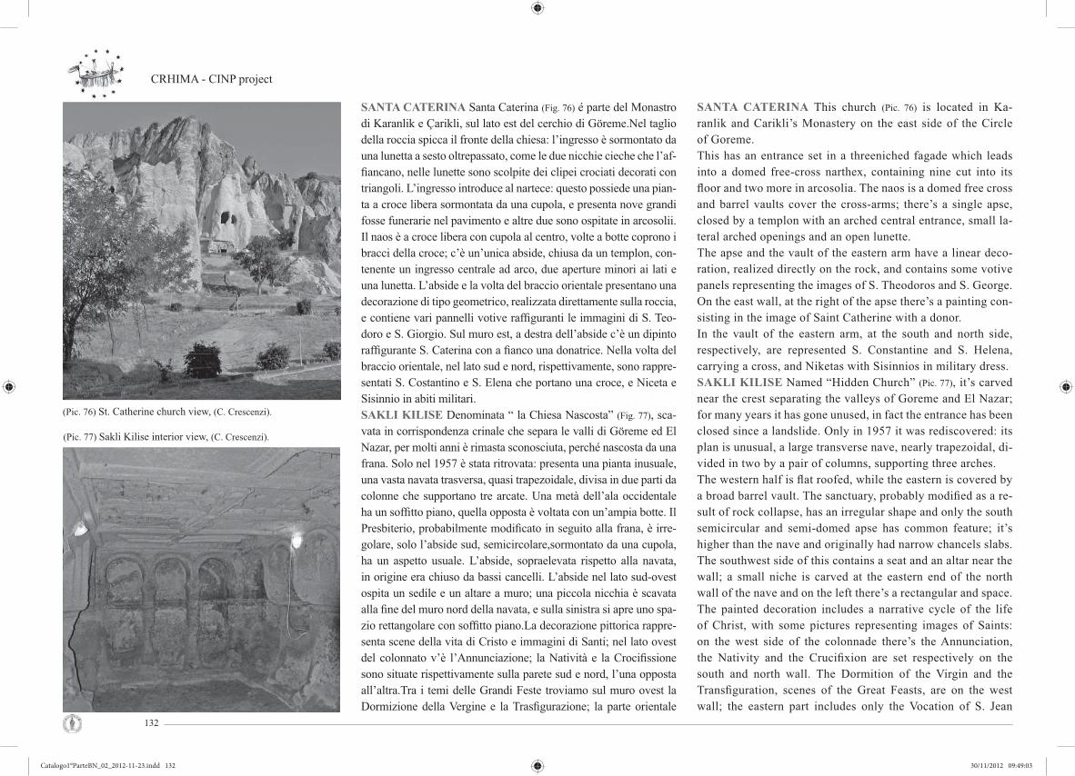
CRHIMA - CINP project
132
SANTA CATERINA Santa Caterina (Fig. 76) é parte del Monastro di Karanlik e Çarikli, sul lato est del cerchio di Göreme.Nel taglio della roccia spicca il fronte della chiesa: l’ingresso è sormontato da una lunetta a sesto oltrepassato, come le due nicchie cieche che l’af-fi ancano, nelle lunette sono scolpite dei clipei crociati decorati con triangoli. L’ingresso introduce al nartece: questo possiede una pian-ta a croce libera sormontata da una cupola, e presenta nove grandi fosse funerarie nel pavimento e altre due sono ospitate in arcosolii. Il naos è a croce libera con cupola al centro, volte a botte coprono i bracci della croce; c’è un’unica abside, chiusa da un templon, con-tenente un ingresso centrale ad arco, due aperture minori ai lati e una lunetta. L’abside e la volta del braccio orientale presentano una decorazione di tipo geometrico, realizzata direttamente sulla roccia, e contiene vari pannelli votive raffi guranti le immagini di S. Teo-doro e S. Giorgio. Sul muro est, a destra dell’abside c’è un dipinto raffi gurante S. Caterina con a fi anco una donatrice. Nella volta del braccio orientale, nel lato sud e nord, rispettivamente, sono rappre-sentati S. Costantino e S. Elena che portano una croce, e Niceta e Sisinnio in abiti militari.SAKLI KILISE Denominata “ la Chiesa Nascosta” (Fig. 77), sca-vata in corrispondenza crinale che separa le valli di Göreme ed El Nazar, per molti anni è rimasta sconosciuta, perché nascosta da una frana. Solo nel 1957 è stata ritrovata: presenta una pianta inusuale, una vasta navata trasversa, quasi trapezoidale, divisa in due parti da colonne che supportano tre arcate. Una metà dell’ala occidentale ha un soffi tto piano, quella opposta è voltata con un’ampia botte. Il Presbiterio, probabilmente modificato in seguito alla frana, è irre-golare, solo l’abside sud, semicircolare,sormontato da una cupola, ha un aspetto usuale. L’abside, sopraelevata rispetto alla navata, in origine era chiuso da bassi cancelli. L’abside nel lato sud-ovest ospita un sedile e un altare a muro; una piccola nicchia è scavata alla fi ne del muro nord della navata, e sulla sinistra si apre uno spa-zio rettangolare con soffitto piano.La decorazione pittorica rappre-senta scene della vita di Cristo e immagini di Santi; nel lato ovest del colonnato v’è l’Annunciazione; la Natività e la Crocifi ssione sono situate rispettivamente sulla parete sud e nord, l’una opposta all’altra.Tra i temi delle Grandi Feste troviamo sul muro ovest la Dormizione della Vergine e la Trasfi gurazione; la parte orientale
SANTA CATERINA This church (Pic. 76) is located in Ka-ranlik and Carikli’s Monastery on the east side of the Circle of Goreme. This has an entrance set in a threeniched fagade which leads into a domed free-cross narthex, containing nine cut into its fl oor and two more in arcosolia. The naos is a domed free cross and barrel vaults cover the cross-arms; there’s a single apse, closed by a templon with an arched central entrance, small la-teral arched openings and an open lunette.The apse and the vault of the eastern arm have a linear deco-ration, realized directly on the rock, and contains some votive panels representing the images of S. Theodoros and S. George. On the east wall, at the right of the apse there’s a painting con-sisting in the image of Saint Catherine with a donor. In the vault of the eastern arm, at the south and north side, respectively, are represented S. Constantine and S. Helena, carrying a cross, and Niketas with Sisinnios in military dress.SAKLI KILISE Named “Hidden Church” (Pic. 77), it’s carved near the crest separating the valleys of Goreme and El Nazar; for many years it has gone unused, in fact the entrance has been closed since a landslide. Only in 1957 it was rediscovered: its plan is unusual, a large transverse nave, nearly trapezoidal, di-vided in two by a pair of columns, supporting three arches.The western half is fl at roofed, while the eastern is covered by a broad barrel vault. The sanctuary, probably modifi ed as a re-sult of rock collapse, has an irregular shape and only the south semicircular and semi-domed apse has common feature; it’s higher than the nave and originally had narrow chancels slabs. The southwest side of this contains a seat and an altar near the wall; a small niche is carved at the eastern end of the north wall of the nave and on the left there’s a rectangular and space.The painted decoration includes a narrative cycle of the life of Christ, with some pictures representing images of Saints: on the west side of the colonnade there’s the Annunciation, the Nativity and the Crucifixion are set respectively on the south and north wall. The Dormition of the Virgin and the Transfiguration, scenes of the Great Feasts, are on the west wall; the eastern part includes only the Vocation of S. Jean
(Pic. 76) St. Catherine church view, (C. Crescenzi).
(Pic. 77) Sakli Kilise interior view, (C. Crescenzi).
Catalogo1°ParteBN_02_2012-11-23.indd 132Catalogo1°ParteBN_02_2012-11-23.indd 132 30/11/2012 09:49:0330/11/2012 09:49:03

Cultural Rupestrian Heritage in the Circum - Mediterranean area
133
accoglie esclusivamente la Vocazione di S. Giovanni Battista e il Battesimo di Cristo. L’abside sud è consacrata alle Déesis, che occupa l’intera volta e parte della parete; quella centrale presenta l’immagine di tre prelati. Una successione di Santi occupa invece la parete di quella nord, parzialmente conservata.
* * *Tav. 24 La Turchia, fi rmataria della Convenzione del Patrimonio Mondiale dal 1983 al 1998 ha iscritto nove siti naturali e cultura-li nella Lista Unesco del patrimonio Mondiale dell’Umanità. Di questi, sette sono patrimoni culturali e due hanno caratteristiche sia naturali sia culturali. Diversi i problemi causati dalla mancata norma dell’uso del suolo, come avviene in quasi tutti i paesi in via di sviluppo. Per garantire una gestione effi cace e una protezione adeguata ai siti interessati in Turchia, necessita che si formulino nuove strategie e politiche di gestione, supportate da cognizioni e conoscenze adeguate dello stato attuale. Il tema è stato trattato nel biennio 2007-08 dal progetto denominato “Determinazione dello stato corrente dei siti del patrimonio mondiale in Turchia”. Il pro-getto analizza i nove siti Turchi iscritti al patrimonio mondiale, presenta un quadro dello stato attuale e individua i problemi asso-ciati. I risultati della ricerca costituiscono la base per lo sviluppo delle politiche gestionali e strategiche per la futura salvaguardia del patrimonio patrimonio mondiale della Turchia.Siti Patrimonio Mondiale in Turchia:(1) Aree storiche di Istanbul, (2) Sito archeologico di Troia, (3) Città di Safranbolu, (4) Hattusha: La capitale ittita, (5) Grande Moschea e Ospedale di Divrigi; (6 ) Monte Nemrut, (7) Parco Na-zionale di Goreme e siti rupestri della Cappadocia, (8) Hierapolis-Pamukkale; (9) Xanthos – Letoon.Fino al 2008, uffi cialmente c’erano trentanove parchi nazionali in Turchia e la loro superfi cie totale raggiunge 877.771 ettari. Tali parchi sono amministrati a livello centrale dal Ministero delle Fo-reste e la Direzione Generale dei Parchi Nazionali controlla e cu-stodisce tutti i parchi nazionali del paese. L’UNESCO con la sua attività sul territorio ha valorizzato alcuni luoghi della regione. Tuttavia, vista la mancanza di un piano di gestione unitario che valorizzi e salvaguardi l’intero paesaggio naturalistico e archeo-logico della Cappadocia (Tesi di laurea di A. Bindocci, relatore
Baptist and the Baptism of Christ.The south apse is dedicated to the Deesis, which occupies the vault and part of the wall; in the central one there’s the image of three prelates, and lastly a series of Saint, well presented, is represented in the north that.* * *Tab. 24 The state of Turkey, signatory to the UNESCO World Heritage Convention, has registered from 1983 to 1998 nine na-tural and cultural sites in the World Heritage List. Seven of these registrations regard cultural heritages while the other two present both natural and cultural qualities. However, the lack of regula-tion regarding the land use zoning, concerning almost all develo-ping countries, has caused several problems. To ensure an effec-tive management and adequate protection for the affected sites in Turkey, it is necessary to formulate new strategies and manage-ment policies accompanied by suffi cient acknowledgement of the current state. The subject was approached within the years 2007-08 by the project entitled “Determination of the current status of world heritage sites in Turkey.” The project analyzes the nine Tur-kish sites that entered the world heritage, presents a description of their current state and identifi es all related problems. The research results provide the basis for policy development and strategic ma-nagement for future protection of the World Heritage in Turkey.World Heritage Sites in Turkey:The sites indicated in fi gure 11 are: (1) Historical areas of Istan-bul, (2) Archeological site of Troy, (3) City of Safranbolu, (4) Hattusha: The Capital of the Hittite Empire, (5) Great Mosque and Hospital of Divrigi; (6) Nemrut Mountain, (7) National Park of Goreme and rupestrian sites of Cappadocia, (8) Hierapolis-Pamukkale; (9) Xanthos – Letoon.Until 2008, there were offi cially 39 National Parks in Turkey co-vering a total area of 877.771 hectares. These parks are admini-strated by the Ministry of Forests while the General Directorate of the National Parks controls all the national parks of the country. The initiatives of UNESCO have already recovered the value of many sites in this region. Since there is no organized management plan for the evaluation and protection of the entire natural and archaeological landscape of Cappadocia (Thesis of di A. Bindoc-
(Pic. 78) Red river parck analysis, (A. Bindocci).
(Pic. 79) Exclosures of Red river parck, (A Bindocci).
Catalogo1°ParteBN_02_2012-11-23.indd 133Catalogo1°ParteBN_02_2012-11-23.indd 133 30/11/2012 09:49:0630/11/2012 09:49:06

CRHIMA - CINP project
134
ci, advisor C. Crescenzi, Unifi sett.2011, consultation R. Bixio - CSSGE), it was considered appropriate to develop the idea of a regional park that will permit the study and the preservation of all archaeological and rupestrian sites. For an effi cient management and control of the territory, the project synthesis presented in the current table suggests the establishment of a territorial park for the preservation of Cappadocian rupestrian sites which will invol-ve seven provinces administered by an advisory body that will co-ordinate their activities and develop a program for the protection of areas of special historical and natural interest.The institutional purpose of the multi-provincial natural park (Pic.
78-79-80) called “Red River Basin” aims to: a) preserve and recover the biocoenosis by focusing its attention to the preservation of natural and semi-natural habitats, to the pre-servation of the wild fl ora and wildlife, and to the protection of landscape values and ecological, hydraulic and hydro-geological balance both on the surface and the underground; b) preserve and enhance the architectural and historical heritage, the anthropological heritage and the agro-forestry-pastoral pro-duction activities and traditional crafts; c) protect the gravinale furrows and their water’s quality;* * *ORTAHISARTab. 25-28 The town of Ortahisar chosen for the workshop acti-vities of the Crhima-cinp project is located in the middle of the Red River Basin National Park, between Nevşheir and Ürgüp. Or-tahisar owes its name to its geographical location:” Castle in the middle “, a mighty rock formation that rises vertically up to 100 meters from the plateau (Pic. 81). Man has carved the interior and has transformed the rocky peak in a fortress located between Başhiar, “the fi rst castle” and Uçhisar, “the last castle”. Ortahisar, not far from the long distance viabi-lity road of Nevşehir-Kayseri, is located on the road connecting Nevşheir and Ürgüp. Historical notes. According to the scarcely documented information for this town, Ortahisar together with Başhiar, Uçhisar e Nigde, was conquered by Izhak Pasha in 1460. In the course of history it changed several times administration: in 1761 it was governed by Ürgüp while in 1894 the citizens of Or-
C. Crescenzi, Unifi sett.2011, consulenza R. Bixio - CSSGE) si è ritenuto opportuno prevedere un parco su scala regionale che, con strumenti amministrativi, permetta lo studio e la conserva-zione di tutti i siti rupestri e archeologici. Per una buona gestione e controllo del territorio, il progetto di sintesi, presentato nella tavola corrente, ipotizza l’istituzione di un parco territoriale per la salvaguardia dei siti rupestri in Cappadocia, comprendente sette province, e amministrato da un organo consultivo che coordini le loro attività e istituisca un piano per la salvaguardia delle aree di particolare interesse storico-naturalistico. Le fi nalità istitutive del Parco naturale pluri-provinciale (Fig. 78.79-
80), chiamato “Bacino del fi ume rosso” vogliono:a) conservare e recuperare le biocenosi, quindi rivolgendo parti-colare attenzione alla conservazione degli habitat naturali e se-minaturali, della fl ora spontanea e della fauna selvatica, e i valori paesaggistici, gli equilibri ecologici, gli equilibri idraulici e idro-geologici superfi ciali e sotterranei;b) salvaguardare e valorizzare i beni storico-architettonici, il pa-trimonio antropologico e le attività produttive agro-silvo-pastora-li e artigianali tradizionali;c) salvaguardare i solchi gravinali e la qualità delle acque presenti.
* * *ORTAHISARTav. 25-28 La città di Ortahisar, località scelta per le attività di workshop del progetto Crhima-cinp, si trova al centro del ter-ritorio interessato dal “Parco del Bacino del fi ume Rosso”, tra Nevşheir e Ürgüp. Ortahisar deve il suo nome alla posizione ge-ografi ca: “Castello di mezzo” una possente formazione rocciosa che si erge verticalmente per circa 100 metri dall’altipiano (Fig.
81). L’uomo, scavandone l’interno, ha trasformato il picco roc-cioso in una fortezza posta tra Başhiar, “ primo castello” e Uçhi-sar, “ultimo castello”. Ortahisar, poco distante dalla viabilità di grande percorren za, Nevşehir- Kayseri, è ubicato sulla strada che collega Nevşehir- Ürgüp.Note storiche: scarse sono le notizie documentate per questo co-mune. Nel 1460 fu conquistato da Izhak Pasha insieme a Başhiar, Uçhisar e Nigde. Nel corso della storia cambiò più volte ammini-strazione: nel 1761 era governata da Ürgüp; nel 1894 i cittadini di
(Pic. 81) Ortahisar houses and castle view, (C. Crescenzi).
(Pic. 80) Red river parck analysis, (A. Bindocci).
Catalogo1°ParteBN_02_2012-11-23.indd 134Catalogo1°ParteBN_02_2012-11-23.indd 134 30/11/2012 09:49:0830/11/2012 09:49:08

Cultural Rupestrian Heritage in the Circum - Mediterranean area
135
Ortahisa chiesero di essere amministrati da Arapsun per l’inade-guatezza politica di Ürgüp, per tornare nel suo governariato nel 1911. Infi ne nel 1916 Ortahisar divenne comune autonomo.Ortahisar sviluppa il suo centro storico principalmente sugli spal-ti della valle Selim Bağ alla confl uenza col torrente Garip Bağ/Atlık, affl uente del Kilizirmak. Nel territorio di Ortahisar furono ospitati comunità religiose fi n dal V secolo. Fino all’occupazione turca la zona aveva un caratte-re prevalentemente monastico. Gli abitanti, da sempre abituati all’asprezza del territorio, hanno saputo sfruttare al meglio le soluzioni che l’abitat offriva, trovan-do soluzioni innovative e sviluppando agli inizi del XX sec. un intenso uso della pietra. Le abitazioni scavate nella roccia pre-sentano caratteristiche di ricchezza e sapiente intaglio. Troviamo ricche abitazioni con la sala comune prospciente gli spazi aperti, con letti- divani con braccioli modanati disposti frontalmente a camini fi nemente lavorati, o camini accuratamenteente intagliati in grandi vani di accoglienza (Fig. 83). Le abitazioni, disposti a più livelli, spesso presentano al loro ingresso la cisterna per la raccolta delle acque; all’interno troviamo stipi a muro, ganci litei, nicchie per le lucerne o per il sostegno di contenitori ceramici, fovee o altro utile al vivere quotidiano. Troviamo ancora magaz-zini per le derrate o ambienti per le attività artigianali (Fig. 82-84). Il centro offre ospitalità a strutture di culto di grande espressione artistica e architettonica: molto è ancora da studiare e da “sco-prie”. Gli edifi ci sono inglobati in case private, la ristrutturazione seguita alla diaspora e alle migrazioni degli inizi del XX secolo, hanno contribuito distruzione e trasformazione di gran parte del patrimonio religioso.La presenza di monasteri, chiese ed eremi nel territorio di Orta-hisar, come in tutta la Cappadocia, è certamente in alcuni luoghi centrato sulla localizzazione del culto, ma per avere una giusta visione occorre pensare al rapporto spirituale della popolazione. In Santorini vi è una ricchezza di chiese e cappelle fuori da ogni rapporto logico di pensiero laico, e le cappelle corrispondono a singole famiglie, non necessariamente alle dirette dipendenze ad un monastero. L’impianto urbano è ben distribuito: nella valle dominata dal castello e alla confl uenza del Garip/Altik troviamo
tahisar asked to be administered by Arapsun due to the inadequate government policies of Ürgüp, only to return to its governorate in 1911. Finally in 1916 Ortahisar became independent. Ortahi-sar’s historic centre develops mainly on the terraces of the valley Selim Bağ and more specifi cally at its confl uence with the river Garip Bağ/Atlık, tributary of Kilizirmak.The territory of Ortahisar housed religious communities up to the fi fth century and until the Turkish occupation the area had a predominantly monastic character. The people, accustomed to the harshness of the territory, have been able to turn the rough conditions of this habitat in their advantage by fi nding innova-tive solutions and developing, in the early twentieth century, an extensive use of the stone material. In fact, the quality features of the houses carved into the rock witness the skilful carving of their inhabitants. We can fi nd rich houses with the common room overlooking the open spaces, having beds and sofas with detai-led worked armrests placed in front of fi nely crafted fi replaces or chimneys carved in large reception rooms (Pic. 83). The houses which develop in more than one levels, often have at their en-trance a cistern for water collection while the interiors present wall cabinets, niches for oil lamps or for the support of ceramic containers, fovee or other useful elements for the daily activities. We also fi nd storage rooms or rooms for craft activities (Pic. 82-
84). The centre offers hospitality to religious structures of great architectural and artistic value: much is still to be studied and “di-scovered”. Since the religious structures had been incorporated in private houses that were restructured during the migration of the early twentieth century, the heritage of worship has suffered destruction and transformation.The presence of monasteries, churches and chapels in the territory of Ortahisar and the rest of Cappadocia, is certainly related to worship locations, but in order to have a proper view of the gene-ral situation we must think of the spiritual relations developed in each population. In Santorini there is a great number of churches and chapels beyond any logical religious thought, and the chapels correspond to individual families.The urban layout is well distributed: in the valley dominated by the castle and at the confl uence of Garip / Altik we fi nd residen-
(Pic. 82) Ortahisar pigeon house view, (C. Crescenzi).
(Pic. 83) Ortahisar interior view, (C. Crescenzi).
(Pic. 84) Ortahisar dyeworks view, (C. Crescenzi).
Catalogo1°ParteBN_02_2012-11-23.indd 135Catalogo1°ParteBN_02_2012-11-23.indd 135 30/11/2012 09:49:1030/11/2012 09:49:10

CRHIMA - CINP project
136
le strutture residenziali e di culto, ad essa si accedeva attraverso passaggi obbligati e controllati. Percorrendo la valle verso S-O si trovano le piccionnaie, allevate per la produzione della carne e la raccolta del guano, ottimo per la concimazione dei campi e prodotto per l’arricchimento del reddito locale.
MONASTERI E CHIESE A ORTAHISAR1 - CHIESA ANONIMA Percorrendo il primo viottolo ai piedi del castello, sul fronte ovest si trova un complesso monastico di notevoli dimensioni (Pic. 85).Il fronte è molto compromesso, e ha subito dei notevoli crolli. La parete modanata è probabilmente quella del vestibolo che disim-pegnava i vari edifi ci (Pic. 86).É ancora possibile leggere, nel tratto residuo, una partizione dell’ambiente sottolineata con lesene poco sporgenti, da cui spic-cavano degli archi partitori della possibile volta a botte. È probabi-le che la partizione fosse in cinque parti come quella del vestibolo di Allach o di Şahinefendi. Una cornice marcapiano corre lungo la parete sottolineando le aperture e dividendo le lesene in due parti. Nella prima partitura modanata, da sx, troviamo l’ingresso lunettato che immette in un ambiente voltato a botte. La lunetta ha una ghiera su cui residuano dei disegni geometrici in ocra, in essa è stata aperta una fi nestra non coeva, com’è possibile leggere sulla parete interna; superiormente il piano è marcato da una cornice da cui si alzavano ancora parte di parete e la volta. Ai lati sono state ricavate, più tardi, delle nicchie. Il secondo ingresso è affi ancato da due campate più strette con fi nestre, forse postume, chiuse da archi. La parete è fortemente deteriorata e sono scomparsi i segni per una possibile lettura. Procedendo verso sud, quasi alla stessa quota troviamo una grande abside e alla sua destra il diaconicon; della chiesa di dimensioni considerevoli, non resta altro, perché il fronte è interamente crollato. Subito prima, nascosto nella pro-fondità da un vano voltato a botte, con archi ribassati e a sesto acuto, vi è una parete scolpita con grande cura. È possibile veder-ne soltanto una parte, essendo stata coperta, alla vista, da vani in muratura (Fig. 87). La parete era scandita da lesene, nella partitura più ampia vi è un ingresso sormontato da un arco oltrepassato a sua volta chiuso da una cornice timpanata, che immette in un am-
tial and worship structures while the valley used to be accessible through specifi c controlled passages. Walking through the valley from South to West we fi nd dovecots that provided the pigeon meat and the guano, a great fertilizer for the fi elds produced for the support of the local income.
MONASTERIES AND CHURCHES IN ORTAHISAR1 - ANONYMOUS CHURCHAlong the fi rst path at the base of the castle and on the west front, there is a monastic complex of considerable size (Pic. 85).
The front is much compromised, and has suffered considerable collapses. The molded wall is probably the vestibule which disen-gaged the various buildings (Pic. 86).
In the remaining part, it is still possible to read a partition of the environment highlighted with slightly protruding pilasters, which stood out from the arch dividers of the possible barrel vault. It is likely that the partition was in fi ve parts as the one of the vestibule of Allach or Şahinefendi. A cornice runs along the wall, pointing out the openings and dividing the pilasters into two parts. In the fi rst molded partition from the left, there is a lunette entrance that leads into a barrel-vaulted room. The lunette has a ring on which there are still some remaining ocher geometric designs and it is opened with a non coeval window, as it can be read on the inner wall; the top fl oor is marked by a frame from which still rises part of the wall and the ceiling. Some niches were later obtained on the sides. The second entrance is fl anked by two perhaps posthu-mously narrower bays with windows, closed by arches. The wall is much deteriorated and therefore signs for a possible reading have disappeared. Proceeding towards south, almost at the same level, there is a large apse and the diaconicon on its right; from, there is not much left of this considerable sized church because the front is completely collapsed. Just before the apse, hidden in the depths of a barrel-vaulted room with lowered pointed arches, there is a wall carved with great care, but only a part of it remains visible as it has been covered with masonry (Pic. 87). The wall was divided by pilasters. In the larger partition, there is an entrance surmounted by an arch ending in a framed tympanum, which le-ads to a large quadrangular space; during the period of the buil-
(Pic. 85) Anonymous Monastery, (C. Giustiniani).
(Pic. 86) Facade of the Anonymous Monastery, (C. Giustiniani).
(Pic. 87) Decoration of Monastery facade, (C. Crescenzi).
Catalogo1°ParteBN_02_2012-11-23.indd 136Catalogo1°ParteBN_02_2012-11-23.indd 136 30/11/2012 09:49:1230/11/2012 09:49:12

Cultural Rupestrian Heritage in the Circum - Mediterranean area
137
ding’s reuse, on the left, a blind niche has been closed with an arch and opened at the base so as to form an entrance for a room below. In the front compartment and to the left, there is a niche which protects the entrance of the cistern.2 - SAKLI KILISEAlways adjacent to these sacred buildings, there is a house con-sisting of three rooms, with a fl at roof, well-made quadrangular openings and niches, and a lowered fl oor, probably belonging to a priest, or a rich landlord. At the left of the entrance, there is a “divan”, a room with fi replace and sofas carved out from stone; it is illuminated by a window and with a large and direct open to the rest of the room: it almost reminds a modern living-room of the western culture. The lower part of the chimney has an ela-borated edge similar to the access steps of the Pankarlik church and the Emine Bagci Kilise in Urgup, while the outer arms are decorated with frames.Sakli Kilise (38.619419, 34.866077) and Ali Torun (38.61953, 34.86604). District Eski / Atik Mahalle.Following the road that starts from the municipal park in front of the castle and that leads to the belvedere, right after the public spring, on the left hand of the road and before crossing the bridge, there are two beautiful sacred buildings concealed by surrounding walls. Both buildings could be dated to the iconoclastic period and could be part of a single monastery. After crossing the small courtyard of a private home, we access Sakli or Gul Kilise by an opening in the wall of the altar, on the left of the apse. The church has a Greek cross plan, with a considerable height compared to the width of the spans; the arms of the cross are barrel vaulted and the central dome is characterized by brackets that mimic the support (Pic. 88); the pillars have a large section. On the western front (Pic. 89), in the considerably high central span, a small lancet window shows a room that surmounts the narthex in front of the church. The two places communicate through a wide door. The east wall of the narthex is articulated in three parts, two blind niches are placed by the church entrance, and they are underli-ned with geometric frames. The west wall has seven blind niches; the north and south only three; the niches are detached from the ground and are enclosed by elevated framed arches. The fl at roof
pio vano quadrangolare; sulla sinistra una nicchia cieca è chiusa con un archetto, alla base è stato aperto, in fase di riutilizzo, un ingresso per un vano sottostante. Nel vano antistante, a sinistra, vi è una nicchia che protegge l’ingresso della cisterna.2 - SAKLI KILISESempre adiacente a questi edifi ci sacri, probabilmente apparte-nente a un prelato, o ad un ricco signore, troviamo una abitazione, costituito da tre vani, con soffi tto piano, quadrangolari con scavo di ottima fattura, rimaneggiato e con quote pavimentali abbassa-te. Entrando, sulla sinistra, si trova il “divan”, stanza con camino e divani tagliati in pietra; illuminata da una fi nestra e con gran-de apertura diretta all’ampio vano, quasi un moderno soggiorno occidentale. La parte bassa del camino ha il bordo modanato si-milmente ai gradini di accesso della chiesa di Pankarlik e Emine Bağci Kilise in Ürgüp, mentre i braccioli esterni sono decorate con riquadrature.Sakli Kilise (38.619419,34.866077) e Ali Torun (38.61953,34.86604).Percorrendo la strada che parte dalla piazza prospiciente il ca-stello e che porta al belvedere, subito dopo la fonte pubblica, a sx della strada e prima di attraversare il ponte, si trovano, nascoste da muri di cinta due bellissimi edifi ci sacri. Entrambi potrebbero essere datati al periodo iconoclasta e potrebbero far parte di un unico monastero. Alla Sakli o Gul Kilise, dopo aver attraversato il piccolo cortile di un’abitazione privata, vi si accede da un’aper-tura aperta in breccia nella parete di fondo della prothesis, abside a sx. La chiesa, a croce greca inscritta, ha un’altezza notevole, rispetto all’ampiezza delle campate; i bracci della croce sono vol-tati a botte, la cupola centrale è caratterizzata da mensole che si-mulano il sostegno (Fig. 88); i pilastri hanno una sezione notevole. Sul fronte ovest (Fig. 89), nella campata centrale di ragguardevole altezza, si affaccia, con una piccola bifora, un vano che sovrasta il nartece antistante alla chiesa. Un’ampia porta comunicava i due luoghi. La parete est del nartece è partita in tre parti, due nicchie cieche affi ancavano l’ingresso, riquadrato con cornici geometri-che, alla chiesa. La parete ovest ha sette nicchie cieche, quella a sud e a nord ne hanno tre; le nicchie si staccano dal pavimento e sono chiuse da archi oltrepassati incorniciati. La copertura piana
(Pic. 88) Sakli Kilise central dome of the crooss inscribed church,(C. Crescenzi).
(Pic. 89) Sakli Kilise west wall. Mullion view, (C. Crescenzi).
(Pic. 90) Sakli Kilise. Ceiling crux decoration, (C. Crescenzi) .
Catalogo1°ParteBN_02_2012-11-23.indd 137Catalogo1°ParteBN_02_2012-11-23.indd 137 30/11/2012 09:49:1630/11/2012 09:49:16
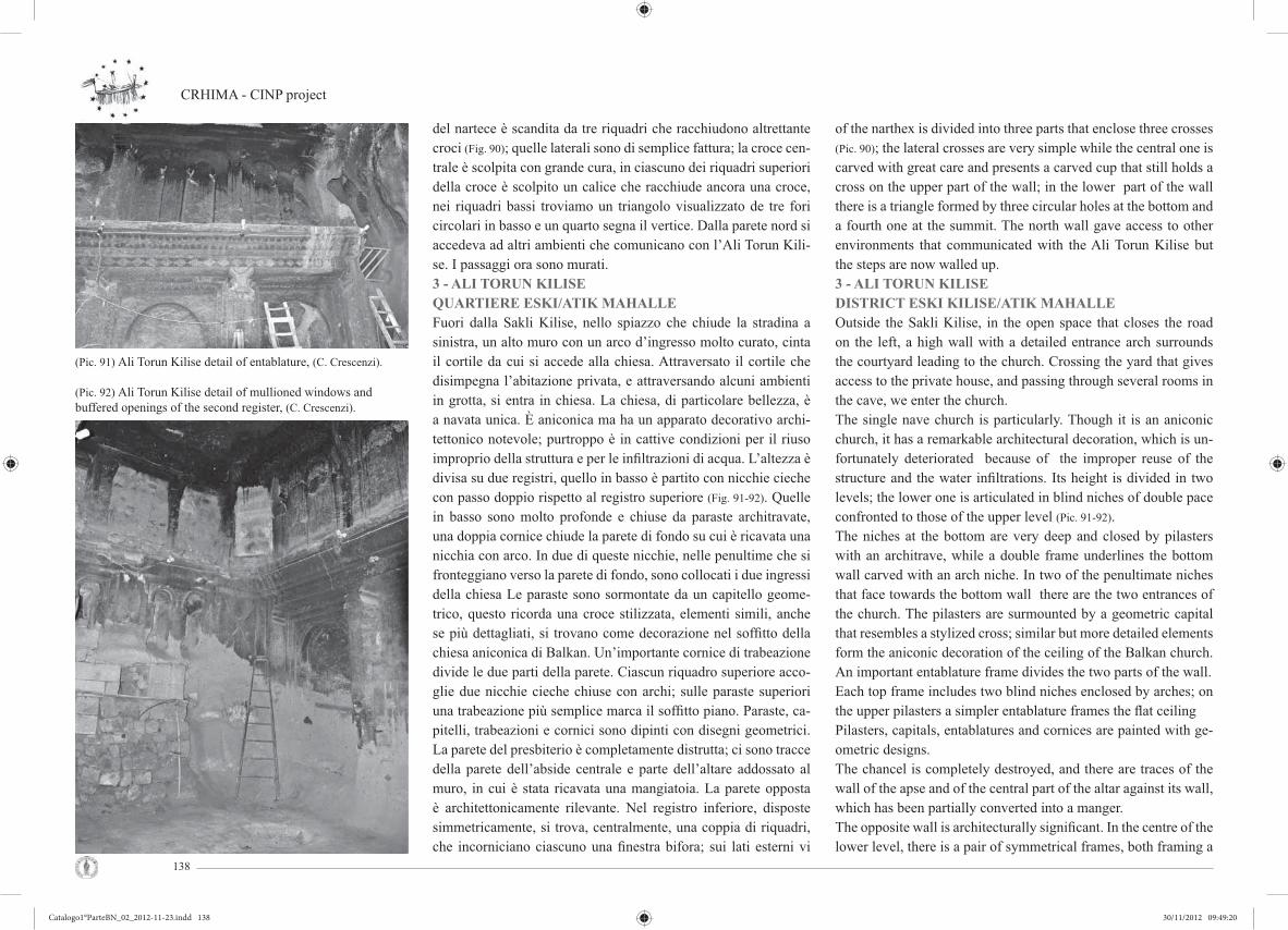
CRHIMA - CINP project
138
del nartece è scandita da tre riquadri che racchiudono altrettante croci (Fig. 90); quelle laterali sono di semplice fattura; la croce cen-trale è scolpita con grande cura, in ciascuno dei riquadri superiori della croce è scolpito un calice che racchiude ancora una croce, nei riquadri bassi troviamo un triangolo visualizzato de tre fori circolari in basso e un quarto segna il vertice. Dalla parete nord si accedeva ad altri ambienti che comunicano con l’Ali Torun Kili-se. I passaggi ora sono murati. 3 - ALI TORUN KILISEQUARTIERE ESKI/ATIK MAHALLEFuori dalla Sakli Kilise, nello spiazzo che chiude la stradina a sinistra, un alto muro con un arco d’ingresso molto curato, cinta il cortile da cui si accede alla chiesa. Attraversato il cortile che disimpegna l’abitazione privata, e attraversando alcuni ambienti in grotta, si entra in chiesa. La chiesa, di particolare bellezza, è a navata unica. È aniconica ma ha un apparato decorativo archi-tettonico notevole; purtroppo è in cattive condizioni per il riuso improprio della struttura e per le infi ltrazioni di acqua. L’altezza è divisa su due registri, quello in basso è partito con nicchie cieche con passo doppio rispetto al registro superiore (Fig. 91-92). Quelle in basso sono molto profonde e chiuse da paraste architravate, una doppia cornice chiude la parete di fondo su cui è ricavata una nicchia con arco. In due di queste nicchie, nelle penultime che si fronteggiano verso la parete di fondo, sono collocati i due ingressi della chiesa Le paraste sono sormontate da un capitello geome-trico, questo ricorda una croce stilizzata, elementi simili, anche se più dettagliati, si trovano come decorazione nel soffi tto della chiesa aniconica di Balkan. Un’importante cornice di trabeazione divide le due parti della parete. Ciascun riquadro superiore acco-glie due nicchie cieche chiuse con archi; sulle paraste superiori una trabeazione più semplice marca il soffi tto piano. Paraste, ca-pitelli, trabeazioni e cornici sono dipinti con disegni geometrici. La parete del presbiterio è completamente distrutta; ci sono tracce della parete dell’abside centrale e parte dell’altare addossato al muro, in cui è stata ricavata una mangiatoia. La parete opposta è architettonicamente rilevante. Nel registro inferiore, disposte simmetricamente, si trova, centralmente, una coppia di riquadri, che incorniciano ciascuno una fi nestra bifora; sui lati esterni vi
of the narthex is divided into three parts that enclose three crosses (Pic. 90); the lateral crosses are very simple while the central one is carved with great care and presents a carved cup that still holds a cross on the upper part of the wall; in the lower part of the wall there is a triangle formed by three circular holes at the bottom and a fourth one at the summit. The north wall gave access to other environments that communicated with the Ali Torun Kilise but the steps are now walled up.3 - ALI TORUN KILISEDISTRICT ESKI KILISE/ATIK MAHALLEOutside the Sakli Kilise, in the open space that closes the road on the left, a high wall with a detailed entrance arch surrounds the courtyard leading to the church. Crossing the yard that gives access to the private house, and passing through several rooms in the cave, we enter the church.The single nave church is particularly. Though it is an aniconic church, it has a remarkable architectural decoration, which is un-fortunately deteriorated because of the improper reuse of the structure and the water infi ltrations. Its height is divided in two levels; the lower one is articulated in blind niches of double pace confronted to those of the upper level (Pic. 91-92). The niches at the bottom are very deep and closed by pilasters with an architrave, while a double frame underlines the bottom wall carved with an arch niche. In two of the penultimate niches that face towards the bottom wall there are the two entrances of the church. The pilasters are surmounted by a geometric capital that resembles a stylized cross; similar but more detailed elements form the aniconic decoration of the ceiling of the Balkan church. An important entablature frame divides the two parts of the wall. Each top frame includes two blind niches enclosed by arches; on the upper pilasters a simpler entablature frames the fl at ceilingPilasters, capitals, entablatures and cornices are painted with ge-ometric designs. The chancel is completely destroyed, and there are traces of the wall of the apse and of the central part of the altar against its wall, which has been partially converted into a manger. The opposite wall is architecturally signifi cant. In the centre of the lower level, there is a pair of symmetrical frames, both framing a
(Pic. 91) Ali Torun Kilise detail of entablature, (C. Crescenzi).
(Pic. 92) Ali Torun Kilise detail of mullioned windows and buffered openings of the second register, (C. Crescenzi).
Catalogo1°ParteBN_02_2012-11-23.indd 138Catalogo1°ParteBN_02_2012-11-23.indd 138 30/11/2012 09:49:2030/11/2012 09:49:20

Cultural Rupestrian Heritage in the Circum - Mediterranean area
139
erano dei pannelli, di cui resta solo quello a destra, il riquadro è partito con croce stilizzata. Nel registro superiore vi erano tre grandi aperture che affacciavano sull’aula, probabilmente ve ne erano altre sulle prime due nicchie laterali; la parete di sinistra è stata demolita, una ringhiera protegge l’affaccio; si può ipotizzare un possibile matroneo.4 - NINO KILISELa piccola cappella funeraria, di cui uno dei nomi è Nino Kilisesi, è parte di un complesso monastico più ampio, in via di comple-ta distruzione per una ristrutturazione in atto (Fig. 93); le chiese che non hanno affreschi, non sono considerate di pregio, pertanto non infondono rispetto nei proprietari, ignari del valore del bene culturale in loro possesso. La piccola cappella, pur nel riuso im-proprio e parzialmente danneggiata, ha conservato parte del suo apparato iconografi co; ha una pianta a croce greca, nei bracci sono scavate delle tombe. La cupola centrale è annunciata da pen-nacchi diamantati triangolari. Questi erano affrescati, ora fungo-no da supporto a delle travi che sostengono un solaio di legno e pietrame e che occlude l’immagine degli affreschi della cupola.L’arco trionfale, interamente affrescato (Fig. 94), accoglie sulla si-nistra una nicchia usata per la deposizione dei vasi sacri. Nella calotta dell’abside è rappresentato il busto del Cristo, sulla parete vi sono rappresentati dei santi, un muro occlude la vista delle ico-nografi e. Sui fi anchi del cono che ospita la cappella, vi sono dei piccoli ambienti, narteci funerari o celle eremitiche.La chiesa, poco distante e alla sua sinistra, è distrutta; su una delle pareti s’intuisce il doppio registro e la partitura delle stesse. Le nicchie realizzate nei riquadri non sono omogenee: nel riquadro a destra ci sono tre nicchie cieche, chiuse da archetti e non pre-sentano decorazioni; nel secondo riquadro, due nicchie di eguale grandezza, con piccole mensole che annunciano l’arco, serrano una terza molto stretta, architravata e sormontata da una seconda a forma di ferro di cavallo; la terza partitura, sembra costituita da nicchie cieche e chiuse con archi sorretti da mensole. Alle spalle della chiesa, vi è un corridoio per la difesa che porta in vari am-bienti. L’accesso con la passerella di legno conduce in un ampio ambiente che immette in un “divan” di grandi dimensioni (Fig. 95), frutto di una ristrutturazione molto pesante; per illuminare l’am-
mullioned window; on the outside only the right panel articulated in a stylized cross remains. In the upper level, there were three large windows and there were probably others on the fi rst two side niches; the left wall was demolished and a railing protects the facing; we can hypothesize a possible matroneum.
4 - NINO KILISEThe small funerary chapel, also named Nino Kilise, is a part of a large monastic complex that is now in ruins for an ongoing re-structuring (Pic. 93); the churches without paintings are not consi-dered valuable, therefore these don’t instill respect for the owners that ignore the value of the property in their possession.The small chapel, though wrongly used and partially damaged, has preserved part of its iconographic cycle; it has a greek cross plan, the arms of which contain some carved tombs. The central dome is declared by diamond pendentives that originally were painted, but now they are a kind of support for the beams which support a fl oor realized in wood and stones, and occludes the paintings of the dome. The triumphal arch, entirely painted (Pic.
94), lodges on its left a niche used to contain the sacred vessels.The bust of Christ is painted in the conch of the apse, Saints are represented on the wall and the view of the images is partially oc-cluded by a wall. Small spaces, funerary narthexes and hermitical cells are located at the sides of the cone including the chapel.Another church, located at the left of the previous, is now de-stroyed: one of the walls suggests the presence in the past of a double register and the partition of other wall; the niches realized in the panels are not homogeneous: three blind niches without decorations, framed by small arches, are set in the right panel; in the second one instead there are two niches of the same size and with small corbels that lead to the arch, and frame a third niche that is smaller, with an architrave and surmounted by a second one that is horse-shoe shaped. The third seems to be composed to blind niches framed by arched supported by corbels. A defence passageway leading to various spaces is set behind the church.The access with a wooden foot-bridge leads into a large space that opens into an extensive “divan” (Pic. 95), result of a strong restructuration: on the top of the church, previously demolished
(Pic. 93) Destroyed church near Nino Kilise, (C. Crescenzi).
(Pic. 94) Nino Kilise painting, (C. Crescenzi).
(Pic. 95) Couch room. Fireplace detail, (C. Crescenzi).
Catalogo1°ParteBN_02_2012-11-23.indd 139Catalogo1°ParteBN_02_2012-11-23.indd 139 30/11/2012 09:49:2330/11/2012 09:49:23

CRHIMA - CINP project
140
biente sono state aperte le due fi nestre, rettangolari e protette con inferriate, che affacciano nella parte alta della chiesa, demolita o crollata in precedenza. Nella sala, vi è un bel camino murato in una parete costruita in conci, che ha occluso l’accesso ad altri ambienti.
5 - LA CHIESA DI CORISBAL’insediamento monastico, o il villaggio, si trova sul costone del-la valle che delimita a sud l’insediamento di Ortahisar (Fig. 96). È posto ai due lati dell’accesso in breccia che apre alla valle e guarda frontalmente il villaggio e il castello. Ai piedi del villaggio vi sono dei pianori coltivati a vigna, frutteto e orti, l’acqua scorre leggermente più in basso.Diverse le cappelle, spesso aniconiche e con disegni grossolani che simulano i conci della muratura, di buona qualità l’ornamento ar-chitettonico e la tecnica di scavo. In Alcuni di essi si trovano ancora alcuni affreschi, anche se molto deteriorati. I soffi tti sono voltati a botte o piani (Fig. 98), questi presentano croci scolpite al soffi tto. Molti ambienti sono di diffi cile accesso. Prospiciente un vigneto, chiude sulla destra una splendida chiesetta, anch’essa molto rovina-ta, ma di proporzioni e decorazioni architettoniche armoniche. Alla sua destra un secondo edifi cio, di cui è visibile solo parzialmente il soffi tto cupolato, i crolli ne impediscono l’accesso.Il fronte della chiesetta tagliato nella roccia, è partito in tre lunet-te con fondo piano separati da paraste con capitelli geometrici; l’ingresso è posto nella specchiatura centrale, più ampia e più alta delle altre due, tutte sono chiuse con un arco, nel centro delle piccole fi nestrelle circolari. La facciata è chiusa da una semplice cornice decorata con losanghe di colore ocra. Sulla destra vi era l’accesso o la fi nestra del nartece. La chiesa, decorata con disegni geometrici in rosso su fondo bianco, è a croce greca inscritta; i bracci, a botte, chiudono una cupola raccordata con pennacchi; le campate agli angoli sono a crociera; delle piccole ghiere o sempli-ci cornici evidenziano i cambi di superfi ci. I pilastri sono sormon-tati da capitelli geometrici tronco-piramidali.L’arco trionfale è incorniciato dalle paraste parietali e da semico-lonne sormontate da un capitello tronco conico, di diversa fattura, con decorazioni di raccordo, foglie stilizzate o testa di animali
or ruined, two windows, rectangular and protected with gratings, were opened to allow the entry of light. The entrance to the other spaces is occluded by a beautiful chimney carved into a wall con-structed with ashlars.
5 - THE CHURCH OF CORISBAThe monastic village is situated on the cliff of the valley delimi-ting the Ortahisar settlement on its southern side (Pic. 96). It is on the two sides of the opening to the valley and faces the settlement and the castle. The plain at the foot of the village is cultivated with vineyards, fruit trees and orchards; the water fl ows on a lower level.There are many chapels, which are often aniconic or with rough drawings simulating ashlars; the architectural ornaments and the excavating techniques are of good quality. There are some frescoes, though they are much deteriorated. The ceilings are vaulted or plain (Pic. 98), with carved crosses. Many rooms are hardly reachable. A wonderful but ruined little church facing a vineyard has very harmonic architectural decorations. Another building, on its right side, is not accessible because of some collapses: only the partial-ly dome vaulted ceiling is visible.The façade of the church is divided into three plain lunettes by responds with geometric capitals; the entrance is on the central space, which is the widest and highest; all of the lunettes are ar-ched with small circular windows on the top. The front is completed by a simple cornice decorated with ochre diamonds. The entrance or the window of the narthex was on the right side. The church was decorated with red geometrical drawings on a white background; it has an inscribed Greek cross plan: the arms are barrel vaulted, and they enclose a dome on pendentives. The corner bays are cross vaulted: small lintels or simple cornices underline the border between different surfaces. The pillars have geometric capitals in shape of truncate pyramids.The triumphal arch is framed with responds and semi-columns surmounted by truncated cones capitals; there are connecting de-
(Pic. 96) Corisba church facade, (C. Crescenzi).
(Pic. 97) Corisba church second narthex, (C. Crescenzi).
(Pic. 98) Corisba church valuted ceiling, (C. Crescenzi).
Catalogo1°ParteBN_02_2012-11-23.indd 140Catalogo1°ParteBN_02_2012-11-23.indd 140 30/11/2012 09:49:2630/11/2012 09:49:26

Cultural Rupestrian Heritage in the Circum - Mediterranean area
141
con corna. Il capitello di sinistra ha una sbozzatura grossolana ed è sormontato da un pulvino circolare. Nelle paraste dell’arco sono ricavate due nicchie cieche, poco profonde. La calotta dell’abside è stata rimaneggiata (Fig. 99), subito sotto la sua imposta erano ri-cavate cinque piccole nicchie; l’altare è andato distrutto e l’abside è usata come mangiatoia. Ai lati dell’arco, sulla parete di fondo, corrispondenti alle navate laterali, troviamo due nicchie a calotta, forma contratta delle absidi laterali, diaconicon e prothesis.Vi sono due narteci di possibile diversa datazione, il primo oppo-sto al presbiterio e l’altro alla sua destra (Fig. 97).Il primo, di ottima fattura, ha il soffi tto piano partito in due riqua-dri con una cornice modanata e decorata con tre medaglioni piani, clipei fregiati con croci incise; nei riquadri vi sono in rilievo due croci (Fig. 100); all’intersezione dei bracci e agli angoli del nartece vi sono ancora clipei con croci in rilevo, nei riquadri delle croci clipei graffi ti con croci; il soffi tto è annerito dal fumo, ma in al-cuni punti si vede il rosso dell’ocra con cui erano dipinti. Sulla parete di fondo, vi sono dei capitelli, corrispondenti alla pilastra-tura della chiesa che sembrano sostenere una trabeazione, ma di questo non vi è traccia, oppure semplicemente sono testimonianza di una variazione architettonica avvenuta nel tempo. Il secondo nartece ha subito molti rimaneggiamenti; è sulla pare-te sud della chiesa, da cui era schermato con due pilastri; la sua realizzazione potrebbe essere postuma e realizzata sfondando la parete che era partita con tre nicchie sormontate da archi; di questi si leggono ancora tracce sulla parete e sul soffi tto; sul lato sud del nartece vi è un vano con nicchie sulle pareti e una tomba sul pavimento.
* * *Tav. 29-34 Le tavole riassumono le esperienze didattiche proget-tuali condotte sul territorio di Ortahisar. Queste sviluppano dei temi a carattere territoriale e urbano, secondo le necessità verifi -cate in loco.Tav. 24 e29. La prima studia la possibile realizzazione di un par-co territoriale per la protezione delle aree omogenee a carattere paesaggistico archeologiche che connotano la regione della Cap-padocia. La seconda approfondisce e verifi ca il sistema parco con la riqualifi cazione dell’area urbana del centro storico di Ortahisar,
corations with stylized leaves or animal heads with horns. The left capital is roughly drafted with a circular dosseret. The responds of the arch contain two scarcely deep blind niches. The vault of the apse has been reworked (Pic. 99): fi ve small niches were carved right below the springer of the vault; the altar has been destroyed and the apse has been used as a manger. On the back wall, beside the arch, in correspondence of the two side aisles, there are two vaulted niches, a contracted form of side apses, with diaconicon and prothesis.Two narthexes were probably realized in different times (Pic. 97).The older faces the presbytery, excellently made, has a plain cei-ling divided into two spaces by a moulded cornice. It is decorated with three plain medallions and clipei with carved crosses (Pic.
100). Other clipei with crosses in relief are at the intersection of the arms and at the corners of the narthex; the ceiling is sooted, but the red dye of the ochre is still visible in some parts. The capitals on the back wall correspond to the pillars of the church, and they seem to sustain a missing entablature. They may also be a testimony of the architectural variations in time.The second narthex has been heavily reworked; it is on the sou-thern wall of the church, and it might have been realized later breaking down a wall with three niches surmounted by arches. There are still traces of these arches on the wall and on the ceiling; the southern side of the narthex contains wall niches and a fl oor tomb.
* * *Tab. 29-34 The didactic experiences in the area of Ortahisar are summed up in these tables. They have developed territorial and urban subjects, according to the verifi ed necessities.Tab. 24 e29. The fi rst table analyze the possibility of creating a territorial park to protect the homogeneous archaeological are-as of Cappadocia. The second table investigates and verifi es the park system through the transformation of the old town of Orta-hisar in integrated urban park for residence. This work has been realized by Annalisa Bindocci.
(Pic. 99) Corisba church apse collumn detail, (C. Crescenzi).
(Pic. 100) Corisba church ceiling with crosses, (C. Crescenzi).
(Pic. 101) Corisba church chapel n°2 interior view, (C. Crescenzi).
Catalogo1°ParteBN_02_2012-11-23.indd 141Catalogo1°ParteBN_02_2012-11-23.indd 141 30/11/2012 09:49:2730/11/2012 09:49:27

CRHIMA - CINP project
142
quale parco urbano integrato a residenza; il lavoro è stato condot-to da Annalisa Bindocci.Tav. 30 e 31. (Fig. 102) La qualità della vita e la riqualifi cazione dei luoghi di lavoro sono proposti da Claudio Giustiniani; l’attività ar-tigianale e i luoghi di lavoro sono interpretati come scambio cultu-rale di conoscenza e momento formativo dei viaggiatori; l’ubica-zione della sede è a cerniera fra il centro storico, i due canyon che caratterizzano la valle e il belvedere, punto di arrivo per i visitatori.Tav 32-33; tav 34La riqualifi cazione delle due piazze di arrivo e sosta nel centro di Ortahisar è il tema svolto da Umberto Albricci con Elisa Viviani e da Laura Viviani. Entrambi i lavori rispondono alle esigenze pro-mosse dalla comunità della località: luoghi collettivi e parcheggi con lo studio della viabilità per fruire i luoghi nel rispetto della popolazione e della godibilità per i visitatori.
* * *PANKARLIK E TAVSANLITav. 35-39 La chiesa di Pankarlik si trova a circa 2 Km a Sud-ovest del villaggio di Urgup, nella valle di Susam Bayırı. La chiesa fa parte di un complesso ampio, scavato in masso roccioso di notevoli dimensioni, che si stacca dalla valle. L’insediamento è fra quelli più antichi dell’area (Fig. 103). La chiesa è a navata unica, pressoché rettangolare, con copertura piana. L’ingresso, fortemente rimaneg-giato, è sormontato da un’originale fi nestra bifora (Fig. 104). Questa è partita da una doppia colonna, interna ed esterne coronate da un capitello. Il fronte dell’abside è stato fortemente rimaneggiato, pro-babilmente, quando è stata abbassata la quota di calpestio. Questa parete è priva d’affreschi, incorniciata con profi li databili al XIX secolo, stesso periodo dei gradini ondulati realizzati per accedere all’abside. La parete dell’unica abside ha un profi lo ad arco ol-trepassato, con prothesis e diaconicon; l’impianto non è originale, una cornice stacca la semicalotta di dimensioni autentiche.Questi elementi sono simili a quelli realizzati nella chiesa Emine Bagci in Urgup. Le tracce di alloggiamenti sugli spigoli dell’abside lasciano pensare alla presenza di un’iconostasi di legno ora scomparsa. Tutte le restanti pareti sono coperte da cicli pittorici di diversi periodi storici. L’impianto architettonico è stato più volte modifi cato come si può vedere dalle tracce residue sulle pareti e sul pavimento. Sul-
Tab. 30 e 31. (Pic. 102) The quality of life and the requalifi cation of workplaces are proposed by Claudio Giustiniani; the crafts and the workplaces are interpreted as cultural exchange and formati-ve moment; the offi ce is between the old town, the two canyons and the belvedere.Tab. 32-33; tab. 34The requalifi cation of the two squares in the centre of Ortahisar is broached by Umberto Albricci, Elisa Viviani and Laura Viviani. Both works satisfy the exigencies of the local community: collec-tive places, parking spots, respectful viability.
* * *PANKARLIK AND TAVSANLITab. 35-39 The church of Pankarlik is out in the countryside off the road 2 km from Urgup, in the Susam Bayırı valley. The church is part of one of the most ancient settlement of the area, and it was realized in a huge rock mass (Pic. 103). The church has a rectangular single nave with a plain ceiling. The entrance has been heavily reworked, and it is surmounted by the original double lancet window (Pic. 104). The window is divided by a double column and has two side columns with capi-tals. The front of the apse has been heavily reworked too, proba-bly when the fl oor was lowered. The wall has no frescos, and is profi led with a segmental arc, with prothesis and diaconicon; in the 19th century the apse was adorned with a cornice and some curved stairs. These elements are similar to those of the Emine Bagci church in Urgup. The traces of housings on the apse’s corners testify the presence of a wooden iconostasis. The remaining walls contain pictorial cycles from different ages. The traces on the fl oor and on the walls reveal that the architectural plant has been modifi ed many times. The walls beside the apse contain two moulded clypei enclosing a cross. The nave gives access to the funerary parecclesion.The inscriptions in the parecclesion and other elements of the
(Pic. 103) Pankarlik three cones view, (C. Giustiniani).
(Pic. 102) Project plan, (C. Giustiniani).
Catalogo1°ParteBN_02_2012-11-23.indd 142Catalogo1°ParteBN_02_2012-11-23.indd 142 30/11/2012 09:49:2930/11/2012 09:49:29

Cultural Rupestrian Heritage in the Circum - Mediterranean area
143
le pareti adiacenti l’abside, sono scolpiti due clipei multimodanati che racchiudono una croce. Dall’aula si accede ad un parecclesion funerario. Delle iscrizioni presenti in quest’ultimo, e altri elementi dell’aula datano la chiesa al VI secolo; le pitture murarie vengono datate al IX sec.. Pére de Jerphanion, interpretando un’iscrizione, che circoscriveva un clipeo con croce posto all’ingresso, suppose che la chiesa fosse dedicata a San Teodoro.La chiesa di Tavsanli (Fig. 105), in territorio di Ortahisar e a circa 3 Km ovest di Mustafapaşa, è parte di un complesso scavato in tre coni nell’impluvio di una piccola valle. Non si conosce la sua antica dedicazione, G. de Jerfanion suppose fosse dedicata a S. Eustachio. Un’iscrizione posta nell’abside data i dipinti alla prima metà del X secolo, periodo in cui governarono il vescovo Leone e l’imperatore Costantino Porphyrogenito. La parete ovest, su cui si trovava l’in-gresso, è ora distrutta. La chiesa è a nave unica e voltata a botte. La cornice che corre su entrambi i lati, da cui si stacca la volta, con profi lo a C, racchiudeva una lunga iscrizione dipinta di cui ne residua solo una piccola parte. Sulla parete Sud, rialzata, si apre l’abside; dei plutei, sormantati da un’arco privo di ghiera, residuano solo le tracce; sulla parete absidale si trovano tre nicchie, di cui due sono state ampliate; sotto quella centrale c’è un piccolo foro, proba-bilmente un reliquario;l’altare è stato smantellato. Nelle pareti nord e sud, si fronteggiano tre nicchie e delle sedute; queste ultime sono state in gran parte demolite. Gli affreschi, che coprivano per intero le pareti, sono distrutti o in cattivo stato di conservazione.
* * *Il MONASTERO DI ALLACH. Tav. 40-47 Il monastero di Hallac è situato a N-NE, coordinate 38.632327-34.869779, dell’abitato di Ortahisar nell’area com-presa dalla strada Nevsehir - Urgup - Yolu e quella che parte da Ortahisar per raggiungere la prima. Vi si accede agevolmente da una strada interna che si stacca sulla destra della comunale, 500 m. prima di raggiungere il bivio (Fig. 108).
La corte, con pareti rosa e crema parzialmente ossidati, è tagliata in uno sprone limitato da una corona di coni bruni.Il complesso presenta una corte aperta sul fronte sud su cui si affacciano ora sette ambienti a piano terra ed altri posti ad un secondo livello.
nave suggest that the church was built in the 6th century, whi-le the pictorial cycles were realized in the 9th century Pére de Jerphanion interpreted an inscription around a crossed clypeus on the entrance, and he supposed that the church was dedicated to St. Theodore.The church of Tavsanli (Pic. 105) is in the Ortahisar area, 3 km west of Mustafapaşa; it is a three cones complex in a small val-ley. The ancient dedication is uncertain: G. de Jerfanion sugge-sted that the church was dedicated to Saint Eustace. An inscrip-tion in the apsidal area testifi es that the paintings date back to the fi rst half of the X century, in the times of Leo the Bishop and Constantine VII.The west wall, where there was the entrance, is now destroyed. The single nave church is barrel vaulted. The C profi led cornice runs on both walls, and it sustains the vault; it contained an in-scription, which is partially deleted. The southern wall contains the upper level apse; there are traces of the plutei, which were surmounted by arches without lintels. Three niches are in the wall of the apse; two of them have been extended. The central niche has a lower breach (probably a reliquary); the altar has been destroyed. The northern and southern walls contain three niches and some partially demolished seats. The frescos, which originally covered the whole walls, are now destroyed or badly preserved.
* * *THE MONASTERY OF HALLAC. Tab. 40-47 Hallac Monastery is located to the north-northeast of the Ortahisar village, coordinates 38.632327-34.869779, in the area between the road connecting Nevshehir to Urgup and Yolu and the one connecting Ortahisar to Nevshehir. The monastery is easily accessible through an internal road that branches off to the right of the municipal avenue, 500 m before reaching the inter-section (Pic. 108).The court has partially oxidized pink and cream walls and it is cut into a spur limited by a crown of brown cones.The complex has an open courtyard on the south side on which now seven rooms are open on the ground fl oor and others on a
(Pic. 104) Pankarlik church interior view, (C. Giustiniani).
(Pic. 105) Tavsanli view of settlement’s cones, (C. Crescenzi).
Catalogo1°ParteBN_02_2012-11-23.indd 143Catalogo1°ParteBN_02_2012-11-23.indd 143 30/11/2012 09:49:2930/11/2012 09:49:29

CRHIMA - CINP project
144
Il nucleo originario probabilmente era una corte chiusa a cui si accedeva da un angusto passaggio sullo spigolo S-E ; il fronte sud probabilmente era chiuso da piccoli coni erosi dal tempo. Il piano di calpestio della corte originaria è coperto da un cumulo di detriti alto circa 1,00 -1,50 m.La corte adesso disimpegna quattro ingressi: a Nord troviamo in basso un complesso articolato in tre ambienti ( n° 2,3,4) , mentre in alto sono presenti aperture di ambienti non visitati; a est è ubi-cata una chiesa a croce inscritta con un nartece funerario; sempre sul fronte est troviamo in alto degli accessi per le abitazioni dei monaci adibiti in seguito a piccionaie; ad ovest una grande sala quadrata a croce inscritta, ed un secondo vano; probabilmente adibito a cucina. (Fig. 106-107)
Le specchiature Il taglio del solaio corrispondente alle spec-chiature è orizzontale pertanto il loro solaio doveva essere piano. Le tarde fi nestrature non compromettono la lettura in quota. Esse (Le specchiature) sono chiuse da paraste di di-versa fattura: della prima residua la parte alta del capitello; la seconda parasta è rastremata verso il basso, ha un capitello semplice, mentre la parte alta del fusto presenta una riquadra-tura che si rac-corda, in altezza, con la partitura orizzontale delle specchiature. Le ultime due paraste sono semplici con abbozzi di capitelli. Le tre partiture sono divise in due registri. Nei registri alti sono stati realizzati elementi costituiti da tre nicchie con archi oltrepassati (a forma di buco di serratura), doppi nelle partiture laterali; alcune nicchie sono state distrutte e restano solo le tracce sulla roccia. Le partiture laterali sono limitate da un portale il cui architrave è dentellato; le partizioni in basso presentano una nicchia piana con timpano che incor-nicia l’ingresso agli ambienti. La specchiatura di sx si caratterizza, in alto, per una apertura con ghiera posta al vertice del timpano la cui base presenta segni di usura per il tiro della fune e due piccoli depressioni circolari al di sotto del davanzale, questa immette in un vano, adibito a piccionaia in fase di riuso; sulla sinistra si trova un’apertura dif-forme e, in alto a dx una nicchia con fori per piccioni. Questa è decorata con linee ocra, rette o sinusoidali, che racchiudono una croce a sei punte inscritta. Il timpano delimita una specchiatura
second level. The original core was probably a closed court which was accessed by a narrow passage on the S-E edge; the south-ern front was probably closed by small cones eroded by time. The original ground level of the courtyard is cov-ered by a 1 - 1.50 m pile of debris. Today, the court disengages four entrances: at north there is a three rooms complex, which is located at the bottom (n° 2,3,4), while at the top there are openings of unvisited rooms; a church is located at east with an in-scribed cross plan church with a funerary narthex; on the eastern side, at the top, there are en-trances to the house of the monks, which were successively used as pigeon house; at west, there are an inscribed cross plan large square room (n°5) and a second room, probably used as kitchen (n°6) (Pic. 106-107).
The “specchiature” The cut of the fl oor in cor-respondance with the specchiature is horizontal, so their fl oor had to be plan. The late windows do not affect the reading at high altitude. The spec-chiature are closed by different pilasters: only the highest part of the capital re-mains in the fi rst pilaster; the second pilaster is ta-pered down, has a simple capital, while the upper part of the stem has a square which connects, in height, with the horizontal parti-tion of the mirrors. The last two pilasters are simple, with sketches of capitals. The three partitions are divided in two registers. In the high register composed elements were made on three niches with exceeded key-hole shaped arches, doubled on the side partitions. Some niches have been destroyed and there are only traces on the rock. Lateral partitions are delimited by a portal whose architrave is notched; the partitions at the bottom have a plan niche, with gable that frames the entrance to the rooms. Laterally to the gables there were carved crosses inscribed in medallions decorated with triangles, still visible on the right of those openings; at the left of the gable there are still traces of a symmetrical second medallion. The mirror on left is characte-rized, above, for an opening with a lintel placed at the top of the gable, whose base shows signs of decay caused by the rope used to pull of heavy objects and two small circular depres-sions below the sill. This opening leads into a room, used as a pigeon house during the reuse; on the left there is a deformed opening and on the right top there is a niche with a hole for pigeons. This
(Pic. 106) The east side, (C. Crescenzi).
(Pic. 107) The east side, (C. Crescenzi).
Catalogo1°ParteBN_02_2012-11-23.indd 144Catalogo1°ParteBN_02_2012-11-23.indd 144 30/11/2012 09:49:3030/11/2012 09:49:30
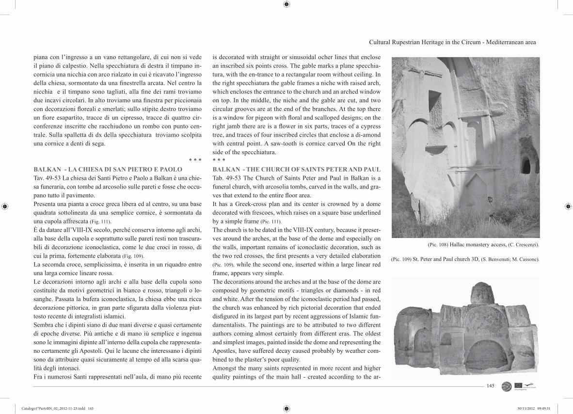
Cultural Rupestrian Heritage in the Circum - Mediterranean area
145
piana con l’ingresso a un vano rettangolare, di cui non si vede il piano di calpestio. Nella specchiatura di destra il timpano in-cornicia una nicchia con arco rialzato in cui è ricavato l’ingresso della chiesa, sormontato da una fi nestrella arcata. Nel centro la nicchia e il timpano sono tagliati, alla fi ne dei rami troviamo due incavi circolari. In alto troviamo una fi nestra per piccionaia con decorazioni fl oreali e smerlati; sullo stipite destro troviamo un fi ore esapartito, tracce di un cipresso, tracce di quattro cir-conferenze inscritte che racchiudono un rombo con punto cen-trale. Sulla spalletta di dx della specchiatura troviamo scolpita una cornice a denti di sega.
* * *BALKAN - LA CHIESA DI SAN PIETRO E PAOLOTav. 49-53 La chiesa dei Santi Pietro e Paolo a Balkan è una chie-sa funeraria, con tombe ad arcosolio sulle pareti e fosse che occu-pano tutto il pavimento.Presenta una pianta a croce greca libera ed al centro, su una base quadrata sottolineata da una semplice cornice, è sormontata da una cupola affrescata (Fig. 111).È da datare all’VIII-IX secolo, perché conserva intorno agli archi, alla base della cupola e soprattutto sulle pareti resti non trascura-bili di decorazione iconoclastica, come le due croci in rosso, di cui la prima, fortemente elaborata (Fig. 109).
La secomda croce, semplicissima, è inserita in un riquadro entro una larga cornice lineare rossa.Le decorazioni intorno agli archi e alla base della cupola sono costituite da motivi geometrici in bianco e rosso, triangoli o lo-sanghe. Passata la bufera iconoclastica, la chiesa ebbe una ricca decorazione pittorica, in gran parte sfi gurata dalla violenza piut-tosto recente di integralisti islamici.Sembra che i dipinti siano di due mani diverse e quasi certamente di epoche diverse. Più antiche e di mano iù semplice e ingenua sono le immagini dipinte all’interno della cupola che rappresenta-no certamente gli Apostoli. Qui le lacune che interessano i dipinti sono da attribuire quasi sicuramente al tempo ed alla scarsa qua-lità degli intonaci.Fra i numerosi Santi rappresentati nell’aula, di mano più recente
is decorated with straight or sinusoidal ocher lines that enclose an inscribed six points cross. The gable marks a plane specchia-tura, with the en-trance to a rectangular room without ceiling. In the right specchiatura the gable frames a niche with raised arch, which encloses the entrance to the church and an arched window on top. In the middle, the niche and the gable are cut, and two circular grooves are at the end of the branches. At the top there is a window for pigeon with fl oral and scalloped designs; on the right jamb there are is a fl ower in six parts, traces of a cypress tree, and traces of four inscribed circles that enclose a di-amond with central point. A saw-tooth is cornice carved On the right side of the specchiatura.* * *BALKAN - THE CHURCH OF SAINTS PETER AND PAULTab. 49-53 The Church of Saints Peter and Paul in Balkan is a funeral church, with arcosolia tombs, carved in the walls, and gra-ves that extend to the entire fl oor area.It has a Greek-cross plan and its center is crowned by a dome decorated with frescoes, which raises on a square base underlined by a simple frame (Pic. 111).
The church is to be dated in the VIII-IX century, because it preser-ves around the arches, at the base of the dome and especially on the walls, important remains of iconoclastic decoration, such as the two red crosses, the fi rst presents a very detailed elaboration (Pic. 109), while the second one, inserted within a large linear red frame, appears very simple.The decorations around the arches and at the base of the dome are composed by geometric motifs - triangles or diamonds - in red and white. After the tension of the iconoclastic period had passed, the church was enhanced by rich pictorial decoration that ended disfi gured in its largest part by recent aggressions of Islamic fun-damentalists. The paintings are to be attributed to two different authors coming almost certainly from different eras. The oldest and simplest images, painted inside the dome and representing the Apostles, have suffered decay caused probably by weather com-bined to the plaster’s poor quality. Amongst the many saints represented in more recent and higher quality paintings of the main hall - created according to the ar-
(Pic. 108) Hallac monastery access, (C. Crescenzi).
(Pic. 109) St. Peter and Paul church 3D, (S. Benvenuti; M. Cassone).
Catalogo1°ParteBN_02_2012-11-23.indd 145Catalogo1°ParteBN_02_2012-11-23.indd 145 30/11/2012 09:49:3130/11/2012 09:49:31

CRHIMA - CINP project
146
chaic tradition with whole body fi gures standing rigidly in front position, or bust portraits within circular medallions - only few of them can be identifi ed by the surviving traces of the inscriptions:(Pic. 111), San Sisinnio next to an anonymous saint;(Pic. 111), St. Procopius next to an anonymous saint;(Pic. 113), in a clipeus, San Giustino;The image of San Giustino is the only one still legible among the eight images who originally decorated the upper part of the walls in the main hall.At the heads of the arms of the cross, round vaulted, two intere-sting paintings can be quite easily distinguished:in the lunette of the entrance, a Virgin with the Child (of the type Odegitria) is represented seating on a throne with a dosseret (pul-vino) but without a dossal, between two Saints and bidders. These latter are represented in a smaller scale as size should be pro-portional to the dignity of the persons according to the medieval tradition.In the lunette of the northern arm, partially collapsed, we fi nd a bust-portrait of a great Archangel with outstretched wings.Quite exceptional is the iconography of the Martyrdom of St. Pe-ter represented on the ceiling of the entry’s arm, where the long inscription of nine or ten lines has been unfortunately destroyed and is impossible to reconstruct apart from the last word, the word “outos” which means ‘himself’, probably referred to the saint who is the main character of the scene.The saint stands beside a large cross at the center of the painting dressed only in a loincloth as all those who were sentenced to crucifi xion, while between him and the cross we fi nd the vertical inscription, “O AΓIOC ΠETROS” (ho Aghios Petros). Behind him, there are two holy women, perhaps weeping. At the other side of the cross in the ochre colored background that culmina-tes in the fi gure of a palazzo, a magistrate is pictured standing beside a soldier with a scale armor and another character. An inscription on the head of the magistrate, now heavily mutila-ted, identifi es him: NEPO [-] OB [-] ECI [-] EC. Obviously the painter or the client knew that Peter had been killed during the persecution of Nero and involves the emperor to the martyrdom of the saint.
e migliore, tutti, secondo la tradizione arcaica, olosomi in posi-zione stante rigidamente frontale, o in busto entro clipei circolari, soltanto di pochi è possibile indicare l’identità mediante la lettura delle iscrizioni esegetiche superstiti:(Fig. 111), San Sisinnio accanto a una santa anonima;(Fig. 111), San Procopio accanto a una santa anonima;(Fig. 113), in un clipeo, San Giustino;L’immagine clipeata di san Giustino è la sola ancora leggibile di otto che si trovavano nella parte alta del quadrato dell’aula.Nelle testate dei bracci della croce, voltati a tutto sesto, almeno in due casi, si leggono abbastanza agevolmente due interessanti dipinti: Nella lunetta sull’ingresso, una Vergine con Bambino, del tipo Odegitria, assisa su un trono con pulvino ma senza dossale, fra due Santi e offerenti, rappresentati, questi ultimi, in dimensione minore, secondo la tradizione medioevale che con la dimensione indicava la dignità delle persone rappresentate, e, nella lunetta del braccio nord, in parte crollato, un grande Arcangelo a mezzo bu-sto con le ali spiegate.Singolare è poi, nell’intradosso del braccio d’ingresso, l’icono-grafi a del Martirio di San Pietro, di cui è purtroppo andata di-strutta la lunga iscrizione illustrativa che si sviluppava su nove o dieci linee e della quale oggi è impossibile ricostruire anche una sola parola, ad eccezione dell’ultima, outos ‘egli stesso’, da riferirsi probabilmente al Santo che è il soggetto di un’azione della scena.Al centro del dipinto è una grande croce, alla quale si accosta il Santo, già vestito del solo perizoma dei condannati alla croce-fi ssione ed indicato dalla iscrizione in verticale posta fra lui e la croce, ‘O AΓIOC ΠETROS (ho ághios Pétros). Dietro di lui sono rappresentate due pie donne, forse piangenti.Dall’altra parte della croce, sullo sfondo ocra cuspidato di un palazzo, un magistrato che ha accanto un soldato con corazza a scaglie ed un altro personaggio. Sulla testa del magistrato una iscrizione, ora fortemente mutila, lo identifi cava: NEPO[-]OB[-]ECI[-]EC. Evidentemente il pittore o il committente sapeva che Pietro era stato ucciso durante la persecuzione di Nerone e fa par-tecipare l’imperatore al martirio del Santo.
(Pic.110) Valuted ceiling 3D view, (S. Benvenuti; M. Cassone).
(Pic. 111) S.Sisinnio and S.Procopius paintings, (C. Crescenzi).
(Pic. 112) Saints Peter and Paul church, (C. Crescenzi).
Catalogo1°ParteBN_02_2012-11-23.indd 146Catalogo1°ParteBN_02_2012-11-23.indd 146 30/11/2012 09:49:3130/11/2012 09:49:31

Cultural Rupestrian Heritage in the Circum - Mediterranean area
147
BALKAN – THE ANICONIC CHURCH A second Greek-cross church in Balkan is absolutely devoid of iconic paintings and clearly witnesses that it has been carved du-ring the VIII-IX, right in the middle of the iconoclastic period (Pic. 114-115). The interest of this church arises from its decorative reliefs, generally constituted by medallions which are surrounded by frames engraved with compact geometric patterns repeated in fake entablatures. In the central fi eld there were crosses with equal-length arms, some of them now missing because chiseled.The clypeus present larger diameters on the walls and smaller ones on the ceiling. The arches are all underlined by rings deli-cately engraved. On one of the entrance’s doorposts is carved, in fl attened, a beautiful palm with bunches of dates, which is to be interpreted as a quotation from Psalm 92-93, “The righteous shall fl ourish like the palm tree”, and so to be considered as a symbol of justice which makes an appropriate reference for a funeral church intended to accept the ones that have been submitted to the divine justice and so will fl ourish in Paradise. The palm is also a recur-ring motif in the decoration of the brackets that support or adorn the fake entablatures; these brackets sometimes confi gure with a cross of expanded arms, or bear engraved similar crosses or palm leaves. It is likely that this very sophisticated and delicate sculptu-ral decoration, light as lace, made it impossible, even after the ico-noclasm, to cover the walls with plaster so as to create paintings.
BALKAN - LA CHIESA ANICONICAUna seconda chiesa a croce greca libera a Balkan è assolutamen-te priva di dipinti iconici e denuncia chiaramente di essere stata scavata nei secoli VIII-IX, in pieno periodo iconoclastico (Fig. 114-
115). L’interesse che suscita questa chiesa è nella sua decorazione di rilievi, costituita generalmente da clipei circondati da cornici fi ttamente incise con motivi geometrici che si ripetono nelle fi nte trabeazioni. Nel campo centrale, anche lì dove oggi mancano per-ché scalpellate, erano croci a bracci uguali.I clipei hanno diametri diversi, maggiore quelli sulle pareti, mi-nore quelli sul soffi tto. Gli archi sono tutti sottolineati da ghiere delicatamente incise.Su uno stipite del portale d’ingresso è scolpita, in stiacciato, una bellissima palma con grappoli di datteri, che va interpretata come citazione dal salmo 92-93, ‘Il giusto fi orirà come palma’ e quindi come simbolo della giustizia, ma ben si addice ad una chiesa fu-neraria destinata ad accogliere i giusti che, affi dati alla giustizia divina, in Paradiso fi oriranno. La palma è peraltro motivo ricor-rente nella decorazione delle mensole che sostengono o ornano le fi nte trabeazioni, mensole che sono talvolta confi gurate a croce a bracci espansi o recano incise croci similari o foglie di palma. È probabile che proprio questa sofi sticata e delicatissima decorazio-ne scultorea, leggera come trina, abbia impedito, anche dopo l’i-conoclastia, di coprire le pareti d’intonaco per ubicarvi dei dipinti.
(Pic. 114) Aniconic church section, (G. Siclari).
(Pic. 113) St. Peter and Paul church. S. Giustino paintings, (C. Crescenzi).
(Pic. 115) Aniconic church axonometry, (G. Siclari).
Catalogo1°ParteBN_02_2012-11-23.indd 147Catalogo1°ParteBN_02_2012-11-23.indd 147 30/11/2012 09:49:3230/11/2012 09:49:32

Catalogo2°ParteColore_2012-11-23.indd 161Catalogo2°ParteColore_2012-11-23.indd 161 30/11/2012 10:20:3730/11/2012 10:20:37

2 Exibition Firenze 21/23 Giugno 20122
A cura di Carmela Crescenzi
credits :CARMELA CRESCENZI, GIOVANNI VAMPA, LICEO RUGGERI, MICHELA SALVADORI, ELENA SCOTTO
UMBERTO ALBRICCI, ELISA VIVIANI, GIOVANNI VAMPA, CLAUDIO OBINO, ROBERTA MUSCOGIURI
CLAUDIO GIUSTINIANI, GIOVANNI VAMPA, MARCO ANTONELLI, VALENTINA GRILLO, NICOLA PACINI
CARMELA CRESCENZI, GIOVANNI VAMPA, MARCO ANTONELLI, VALENTINA GRILLO, NICOLA PACINI
MARIO MANGANARO, ALESSIO ALTADONNA, GIUSEPPE MARTELLO, ANTONINO NASTASI, NICOLA SIRAGUSA
MARIO MANGANARO, ALESSIO ALTADONNA, GIUSEPPE MARTELLO, ANTONINO NASTASI, NICOLA SIRAGUSA
MARIO MANGANARO, ALESSIO ALTADONNA, GIUSEPPE MARTELLO, ANTONINO NASTASI, NICOLA SIRAGUSA
tav 1
tav 2
tav 3
tav 4
tav 5
tav 6
tav 7
graphics : Michela Salvadori, Elena Scotto editing : Enrico Pieraccioli
immagini in copertina: C. Crescenzi. graphic: Mirco Iualè
162
Catalogo2°ParteColore_2012-11-23.indd 162Catalogo2°ParteColore_2012-11-23.indd 162 30/11/2012 10:20:3930/11/2012 10:20:39

3Exibition Firenze 21/23 Giugno 2012 3DA dsp Carmela Crescenzi Tav. 1 credits: C. Crescenzi, G. Vampa, N.Pacini, L. Ruggeri, M. Salvadori, E. Scotto 163
Catalogo2°ParteColore_2012-11-23.indd 163Catalogo2°ParteColore_2012-11-23.indd 163 30/11/2012 10:20:4330/11/2012 10:20:43

4 Exibition Firenze 21/23 Giugno 20124DA dsp Carmela Crescenzi Tav. 2 credits: U. Albricci, E. Viviani, G. Vampa, N.Pacini, C. Obino, R. Muscogiuri164
Catalogo2°ParteColore_2012-11-23.indd 164Catalogo2°ParteColore_2012-11-23.indd 164 30/11/2012 10:20:4530/11/2012 10:20:45

5Exibition Firenze 21/23 Giugno 2012 5DA dsp Carmela Crescenzi Tav. 3 credits: : C. Giustiniani, G. Vampa, M. Antonelli, V. Grillo, N. Pacini 165
Catalogo2°ParteColore_2012-11-23.indd 165Catalogo2°ParteColore_2012-11-23.indd 165 30/11/2012 10:20:5230/11/2012 10:20:52

6 Exibition Firenze 21/23 Giugno 20126DA dsp Carmela Crescenzi Tav. 4 credits: C. Crescenzi, G. Vampa, M. Antonelli, V. Grillo, N. Pacini166
Catalogo2°ParteColore_2012-11-23.indd 166Catalogo2°ParteColore_2012-11-23.indd 166 30/11/2012 10:20:5530/11/2012 10:20:55

7Exibition Firenze 21/23 Giugno 2012 7 Prof. Mario Manganaro Tav. 5 credits: A. Altadonna, G. Martello, A. Nastasi, N. Siragusa 167
Catalogo2°ParteColore_2012-11-23.indd 167Catalogo2°ParteColore_2012-11-23.indd 167 30/11/2012 10:21:0130/11/2012 10:21:01

8 Exibition Firenze 21/23 Giugno 20128 Prof. Mario Manganaro Tav. 6 credits: A. Altadonna, G. Martello, A. Nastasi, N. Siragusa168
Catalogo2°ParteColore_2012-11-23.indd 168Catalogo2°ParteColore_2012-11-23.indd 168 30/11/2012 10:21:0330/11/2012 10:21:03

9Exibition Firenze 21/23 Giugno 2012 9Prof. Mario Manganaro Tav. 7 credits: A. Altadonna, G. Martello, A. Nastasi, N. Siragusa 169
Catalogo2°ParteColore_2012-11-23.indd 169Catalogo2°ParteColore_2012-11-23.indd 169 30/11/2012 10:21:0830/11/2012 10:21:08

Catalogo2°ParteColore_2012-11-23.indd 170Catalogo2°ParteColore_2012-11-23.indd 170 30/11/2012 10:21:1030/11/2012 10:21:10

Catalogo2°ParteColore_2012-11-23.indd 171Catalogo2°ParteColore_2012-11-23.indd 171 30/11/2012 10:21:1130/11/2012 10:21:11

Exibition Firenze 21/23 Giugno 20122
A cura di Carmela Crescenzi, Fondamenti della Geometria Descrittiva Unifi, Italy
credits :
Marco Antonelli, Valentina Grillo Marco Antonelli, Valentina Grillo Marco Antonelli, Valentina Grillo Prof. Carmela Crescenzi, Elena Scotto Marco Antonelli, Valentina Grillo Prof. Carmela Crescenzi, Elena Scotto Marco Antonelli, Valentina Grillo Marco Antonelli, Valentina Grillo Marco Antonelli, Valentina Grillo Marco Antonelli, Valentina Grillo, Michela Salvadori Prof. Carmela Crescenzi, Elena Scotto Marco Antonelli, Valentina Grillo Marco Antonelli, Valentina Grillo Marco Antonelli, Valentina Grillo Marco Antonelli, Valentina Grillo
Tav 1Tav 2Tav 3Tav 4Tav 5Tav 6Tav 7Tav 8Tav 9Tav 10Tav 11Tav 12Tav !3Tav 14Tav 15
graphics : Michela Salvadori, Elena Scotto editing : Enrico Pieraccioli
Tavole 1-3, 7-9, 12-15: estratto Tesi di Laurea di Marco Antonelli, Valentina Grillo
172
Estratto Tesi di Laurea: Scavare lo spazio. Frammenti di pietra e paesaggio per i luoghi pubblici di Oia, Santorini.Laureandi: Marco Antonelli, Valentina Grillo.Relatore: Carmela Crescenzi.Correlatori: Stella Ntakovanou, Kostantinos Vafeiadis.
Catalogo2°ParteColore_2012-11-23.indd 172Catalogo2°ParteColore_2012-11-23.indd 172 30/11/2012 10:21:1130/11/2012 10:21:11

Exibition Firenze 21/23 Giugno 2012 3DA dsp Carmela Crescenzi Tav.1 credits: Marco Antonelli, Valentina Grillo 173
Catalogo2°ParteColore_2012-11-23.indd 173Catalogo2°ParteColore_2012-11-23.indd 173 30/11/2012 10:21:1330/11/2012 10:21:13

Exibition Firenze 21/23 Giugno 20124DA dsp Carmela Crescenzi Tav.2 credits: Marco Antonelli, Valentina Grillo 174
Catalogo2°ParteColore_2012-11-23.indd 174Catalogo2°ParteColore_2012-11-23.indd 174 30/11/2012 10:21:1330/11/2012 10:21:13

Exibition Firenze 21/23 Giugno 2012 5DA dsp Carmela Crescenzi Tav.3 credits: Marco Antonelli, Valentina Grillo 175
Catalogo2°ParteColore_2012-11-23.indd 175Catalogo2°ParteColore_2012-11-23.indd 175 30/11/2012 10:21:1730/11/2012 10:21:17

Exibition Firenze 21/23 Giugno 20126DA dsp Carmela Crescenzi Tav.4 credits: Prof. . Carmela Crescenzi, Elena Scotto 176
Catalogo2°ParteColore_2012-11-23.indd 176Catalogo2°ParteColore_2012-11-23.indd 176 30/11/2012 10:21:1730/11/2012 10:21:17

Exibition Firenze 21/23 Giugno 2012 7DA dsp Carmela Crescenzi Tav.5 credits: Marco Antonelli, Valentina Grillo 177
Catalogo2°ParteColore_2012-11-23.indd 177Catalogo2°ParteColore_2012-11-23.indd 177 30/11/2012 10:21:2330/11/2012 10:21:23

Exibition Firenze 21/23 Giugno 20128DA dsp Carmela Crescenzi Tav.6 credits: Prof. Carmela Crescenzi, Marco Antonelli, Valentina Grillo, Michela Salvadori 178
Catalogo2°ParteColore_2012-11-23.indd 178Catalogo2°ParteColore_2012-11-23.indd 178 30/11/2012 10:21:2330/11/2012 10:21:23

Exibition Firenze 21/23 Giugno 2012 9179
Catalogo2°ParteColore_2012-11-23.indd 179Catalogo2°ParteColore_2012-11-23.indd 179 30/11/2012 10:21:3330/11/2012 10:21:33

Exibition Firenze 21/23 Giugno 201210DA dsp Carmela Crescenzi Tav.7 credits: Marco Antonelli, Valentina Grillo 180
Catalogo2°ParteColore_2012-11-23.indd 180Catalogo2°ParteColore_2012-11-23.indd 180 30/11/2012 10:21:3630/11/2012 10:21:36

Exibition Firenze 21/23 Giugno 201211 181
Catalogo2°ParteColore_2012-11-23.indd 181Catalogo2°ParteColore_2012-11-23.indd 181 30/11/2012 10:21:4530/11/2012 10:21:45

Exibition Firenze 21/23 Giugno 201212DA dsp Carmela Crescenzi Tav.8 credits: Marco Antonelli, Valentina Grillo 182
Catalogo2°ParteColore_2012-11-23.indd 182Catalogo2°ParteColore_2012-11-23.indd 182 30/11/2012 10:21:4530/11/2012 10:21:45

Exibition Firenze 21/23 Giugno 2012 13DA dsp Carmela Crescenzi Tav.9 credits: Marco Antonelli, Valentina Grillo 183
Catalogo2°ParteColore_2012-11-23.indd 183Catalogo2°ParteColore_2012-11-23.indd 183 30/11/2012 10:21:4930/11/2012 10:21:49

Exibition Firenze 21/23 Giugno 201214DA dsp Carmela Crescenzi Tav.10 credits: Marco Antonelli, Valentina Grillo 184
Catalogo2°ParteColore_2012-11-23.indd 184Catalogo2°ParteColore_2012-11-23.indd 184 30/11/2012 10:21:4930/11/2012 10:21:49

Exibition Firenze 21/23 Giugno 2012 15DA dsp Carmela Crescenzi Tav.11 credits: Prof. Carmela Crescenzi, Marco Antonelli, Valentina Grillo,Elena Scotto 185
Catalogo2°ParteColore_2012-11-23.indd 185Catalogo2°ParteColore_2012-11-23.indd 185 30/11/2012 10:21:5330/11/2012 10:21:53
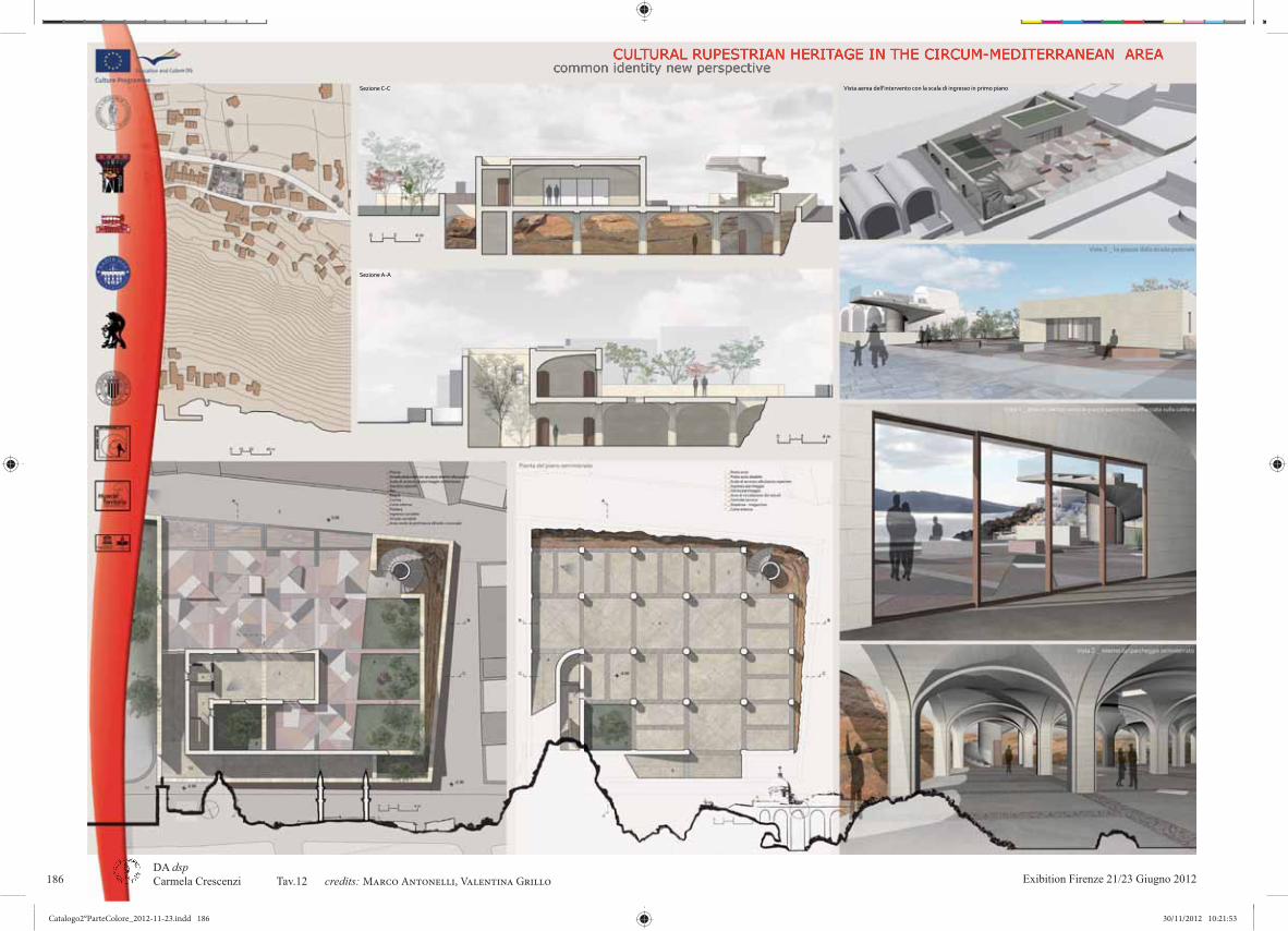
Exibition Firenze 21/23 Giugno 201216DA dsp Carmela Crescenzi Tav.12 credits: Marco Antonelli, Valentina Grillo 186
Catalogo2°ParteColore_2012-11-23.indd 186Catalogo2°ParteColore_2012-11-23.indd 186 30/11/2012 10:21:5330/11/2012 10:21:53

Exibition Firenze 21/23 Giugno 2012 17DA dsp Carmela Crescenzi Tav.13 credits: Marco Antonelli, Valentina Grillo 187
Catalogo2°ParteColore_2012-11-23.indd 187Catalogo2°ParteColore_2012-11-23.indd 187 30/11/2012 10:22:0830/11/2012 10:22:08

Exibition Firenze 21/23 Giugno 201218DA dsp Carmela Crescenzi Tav14 credits: Marco Antonelli, Valentina Grillo 188
Catalogo2°ParteColore_2012-11-23.indd 188Catalogo2°ParteColore_2012-11-23.indd 188 30/11/2012 10:22:1130/11/2012 10:22:11

Exibition Firenze 21/23 Giugno 2012 19DA dsp Carmela Crescenzi Tav.15 credits: Marco Antonelli, Valentina Grillo 189
Catalogo2°ParteColore_2012-11-23.indd 189Catalogo2°ParteColore_2012-11-23.indd 189 30/11/2012 10:22:3930/11/2012 10:22:39

Catalogo2°ParteColore_2012-11-23.indd 190Catalogo2°ParteColore_2012-11-23.indd 190 30/11/2012 10:22:4230/11/2012 10:22:42
Catalogo2°ParteColore_2012-11-23.indd 191Catalogo2°ParteColore_2012-11-23.indd 191 30/11/2012 10:22:4430/11/2012 10:22:44

Exibition Firenze 21/23 Giugno 20122
GRAPHICS : MICHELA SALVADORI, ELENA SCOTTO editing : Mirco IualèIMMAGINE IN COPERTINA: SANTUARIO DE BALMA, ZORITA DEL MAESTRAZGO, SPAIN. CREDIT: MIRCO IUALÈ
P. NAVARRO ESTEVE ETSAV, JOSÉ HERRÁEZ BOQUERA ETSICCP, HUGO BARROS E COSTA ETSAV, JOSÉ LUIS DENIA ETSICCPJ. HIGÓN CALVET ETSAV, J. LLOPIS VERDÙ ETSAV, J. ALBERT BALLESTER ETSAV J. HIGÓN CALVET ETSAV, J. LLOPIS VERDÚ ETSAV, J. SERRA LLUCH ETSAV J. LLOPIS VERDÚ ETSAV, J.HIGÓN CALVET ETSAV, A. TORRE BARCHINO ETSAV, M. GIMENEZ RIBERA ETSAVP. NAVARRO ESTEVE ETSAV, J. HERRÁEZ BOQUERA ETSICCP, H. BARROS E COSTA ETSAV, J.L. DENIA ETSICCP
tav 1-3tav 4,5tav 6tav 7tav 8
A CURA DI JORGE LLOPIS VERDÙ (EGA), PABLO NAVARRO ESTEVE (EGA)CREDITS :
192
Catalogo2°ParteColore_2012-11-23.indd 192Catalogo2°ParteColore_2012-11-23.indd 192 30/11/2012 10:22:4430/11/2012 10:22:44

Exibition Firenze 21/23 Giugno 2012 3EGAPablo Navarro Esteve Tav. 1 credits: P. Navarro Esteve ETSAV, J. Herráez Boquera ETSICCP, H. Barros e Costa ETSAV, J.L. Denia ETSICCP 193
Catalogo2°ParteColore_2012-11-23.indd 193Catalogo2°ParteColore_2012-11-23.indd 193 30/11/2012 10:22:4630/11/2012 10:22:46
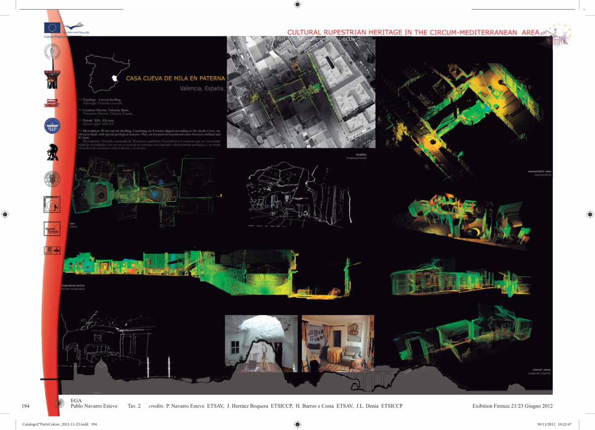
Exibition Firenze 21/23 Giugno 20124EGAPablo Navarro Esteve Tav. 2 credits: P. Navarro Esteve ETSAV, J. Herráez Boquera ETSICCP, H. Barros e Costa ETSAV, J.L. Denia ETSICCP194
Catalogo2°ParteColore_2012-11-23.indd 194Catalogo2°ParteColore_2012-11-23.indd 194 30/11/2012 10:22:4730/11/2012 10:22:47

Exibition Firenze 21/23 Giugno 2012 5EGAPablo Navarro Esteve Tav. 3 credits: P. Navarro Esteve ETSAV, J. Herráez Boquera ETSICCP, H. Barros e Costa ETSAV, J.L. Denia ETSICCP 195
Catalogo2°ParteColore_2012-11-23.indd 195Catalogo2°ParteColore_2012-11-23.indd 195 30/11/2012 10:22:5030/11/2012 10:22:50

Exibition Firenze 21/23 Giugno 20126EGAJorge Llopis Verdú Tav. 4 credits: J. Higón Calvet ETSAV, J.Llopis Verdù ETSAV, J. Albert Ballester ETSAV.196
Catalogo2°ParteColore_2012-11-23.indd 196Catalogo2°ParteColore_2012-11-23.indd 196 30/11/2012 10:22:5130/11/2012 10:22:51

Exibition Firenze 21/23 Giugno 2012 7EGAJorge Llopis Verdú Tav. 5 credits: J. Higón Calvet ETSAV, J.Llopis Verdù ETSAV, J. Albert Ballester ETSAV. 197
Catalogo2°ParteColore_2012-11-23.indd 197Catalogo2°ParteColore_2012-11-23.indd 197 30/11/2012 10:22:5430/11/2012 10:22:54

Exibition Firenze 21/23 Giugno 20128EGAJorge Llopis Verdú Tav. 6 credits: J. Higón Calvet ETSAV, J. Llopis Verdú ETSAV, J. Serra Lluch ETSAV.198
Catalogo2°ParteColore_2012-11-23.indd 198Catalogo2°ParteColore_2012-11-23.indd 198 30/11/2012 10:22:5530/11/2012 10:22:55

Exibition Firenze 21/23 Giugno 2012 9EGAJorge Llopis Verdú Tav. 7 credits: J. Llopis Verdú ETSAV, J.Higón Calvet ETSAV, A. Torre Barchino ETSAV, M. Gimenez Ribera ETSAV. 199
Catalogo2°ParteColore_2012-11-23.indd 199Catalogo2°ParteColore_2012-11-23.indd 199 30/11/2012 10:22:5830/11/2012 10:22:58

Exibition Firenze 21/23 Giugno 201210EGAPablo Navarro Esteve Tav. 8 credits: P. Navarro Esteve ETSAV, J. Herráez Boquera ETSICCP, H. Barros e Costa ETSAV, J.L. Denia ETSICCP200
Catalogo2°ParteColore_2012-11-23.indd 200Catalogo2°ParteColore_2012-11-23.indd 200 30/11/2012 10:22:5930/11/2012 10:22:59

Catalogo2°ParteColore_2012-11-23.indd 201Catalogo2°ParteColore_2012-11-23.indd 201 30/11/2012 10:23:0130/11/2012 10:23:01

Exibition Firenze 21/23 Giugno 20122
Giovanni M. Vampa(¹) , Nicola Pacini(¹).
GRAPHICS : MICHELA SALVADORI, ELENA SCOTTO EDITING : ANNA PINAZZI
CARMELA CRESCENZI, Fondamenti della Geometria Descrittiva Unifi, ItalyCREDITS :
Tav 1-13
IMMAGINE IN COPERTINA: SOUZAY-CHAMPIGNY, FRANCE CREDIT: GIOVANNI M. VAMPA
UNIVERSITÀ DEGLI STUDI DI FIRENZE, FACOLTÀ DI ARCHITETTURA, DAdsp.ESTRATTO DALLA TESI DI LAUREA:(¹) 2011,
202
Catalogo2°ParteColore_2012-11-23.indd 202Catalogo2°ParteColore_2012-11-23.indd 202 30/11/2012 10:23:0230/11/2012 10:23:02

Exibition Firenze 21/23 Giugno 2012 3DA dsp
credits: 203
Catalogo2°ParteColore_2012-11-23.indd 203Catalogo2°ParteColore_2012-11-23.indd 203 30/11/2012 10:23:0430/11/2012 10:23:04

Exibition Firenze 21/23 Giugno 20124DA dsp
credits:204
Catalogo2°ParteColore_2012-11-23.indd 204Catalogo2°ParteColore_2012-11-23.indd 204 30/11/2012 10:23:0530/11/2012 10:23:05

Exibition Firenze 21/23 Giugno 2012 5DA dsp
credits: 205
Catalogo2°ParteColore_2012-11-23.indd 205Catalogo2°ParteColore_2012-11-23.indd 205 30/11/2012 10:23:0830/11/2012 10:23:08

Exibition Firenze 21/23 Giugno 20126DA dsp
credits:206
Catalogo2°ParteColore_2012-11-23.indd 206Catalogo2°ParteColore_2012-11-23.indd 206 30/11/2012 10:23:0930/11/2012 10:23:09

Exibition Firenze 21/23 Giugno 2012 7DA dsp
credits: 207
Catalogo2°ParteColore_2012-11-23.indd 207Catalogo2°ParteColore_2012-11-23.indd 207 30/11/2012 10:23:1230/11/2012 10:23:12

Exibition Firenze 21/23 Giugno 20128DA dsp
credits:208
Catalogo2°ParteColore_2012-11-23.indd 208Catalogo2°ParteColore_2012-11-23.indd 208 30/11/2012 10:23:1330/11/2012 10:23:13

Exibition Firenze 21/23 Giugno 2012 9DA dsp
credits: 209
Catalogo2°ParteColore_2012-11-23.indd 209Catalogo2°ParteColore_2012-11-23.indd 209 30/11/2012 10:23:1530/11/2012 10:23:15

Exibition Firenze 21/23 Giugno 201210DA dsp
credits:210
Catalogo2°ParteColore_2012-11-23.indd 210Catalogo2°ParteColore_2012-11-23.indd 210 30/11/2012 10:23:1630/11/2012 10:23:16
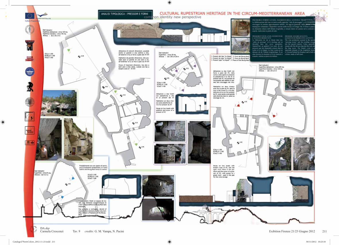
Exibition Firenze 21/23 Giugno 2012 11DA dsp
credits: 211
Catalogo2°ParteColore_2012-11-23.indd 211Catalogo2°ParteColore_2012-11-23.indd 211 30/11/2012 10:23:1830/11/2012 10:23:18

Exibition Firenze 21/23 Giugno 201212DA dsp
credits:212
Catalogo2°ParteColore_2012-11-23.indd 212Catalogo2°ParteColore_2012-11-23.indd 212 30/11/2012 10:23:1930/11/2012 10:23:19

Exibition Firenze 21/23 Giugno 2012 13DA dsp
credits: 213
Catalogo2°ParteColore_2012-11-23.indd 213Catalogo2°ParteColore_2012-11-23.indd 213 30/11/2012 10:23:2230/11/2012 10:23:22

Exibition Firenze 21/23 Giugno 201214DA dsp
credits:214
Catalogo2°ParteColore_2012-11-23.indd 214Catalogo2°ParteColore_2012-11-23.indd 214 30/11/2012 10:23:2330/11/2012 10:23:23

Exibition Firenze 21/23 Giugno 2012 15DA dsp
credits: 215
Catalogo2°ParteColore_2012-11-23.indd 215Catalogo2°ParteColore_2012-11-23.indd 215 30/11/2012 10:23:2530/11/2012 10:23:25

Catalogo2°ParteColore_2012-11-23.indd 216Catalogo2°ParteColore_2012-11-23.indd 216 30/11/2012 10:23:2630/11/2012 10:23:26

Catalogo2°ParteColore_2012-11-23.indd 217Catalogo2°ParteColore_2012-11-23.indd 217 30/11/2012 10:23:2730/11/2012 10:23:27

Exibition Firenze 21/23 Giugno 20122
A cura di Carmela Crescenzicredits :Tav 1
Tav 2Tav 3
Tav 4,5Tav 6,7,8Tav 9,10Tav 11,12
Tav 13,14Tav 15,16
Tav 17Tav 18,19Tav 20Tav 21Tav 22tav 23Tav 24Tav 25Tav 26Tav 27
Tav 28,29Tav 30Tav 31Tav 32Tav 33,34
Tav.35-40Tav 41-44Tav 45-48Tav 49,50Tav 51-53
Paolo Formaglini, Michela Salvadori, Nadia Barbalace, Natalia Belvedere, Bruno Ciconte Alessandro Faleburle (¹), Paola Paolicchi(²), Riccardo Piagentini(³) Manuela Balsimelli, Lorenzo Cantini, Paolo Casagni, Simone Dati, Andrea Malara, Nicola TanganelliAntonio Bagni, Vittorio Frontini, Mariangela Lo Sasso, Antonella Massafra, Andrea Bartolini, Alessandra Fratini, Alfeo Ginetti, Odeta Rrapi, Martina ZarriniGuido Bruni, Francesco D’amato, Simone Loia, Giorgio Magini Manuela Balsimelli, Lorenzo Cantini, Paolo Casagni, Simone Dati, Andrea Malara, Nicola TanganelliAndrea Pistocchi, Giulia Sbragi, Chiara Trinci, Matteo VasaiManuela Balsimelli, Lorenzo Cantini, Paolo Casagni, Simone Dati, Andrea Malara, Nicola TanganelliAndrea Pistocchi, Giulia Sbragi, Chiara Trinci, Matteo Vasai Alessandro Faleburle(¹) Paola Paolicchi(²)Riccardo Piagentini(³)Maria Grazia Eccheli, Daria Luce(4), Laura Mariano(4)Pablo Navarro Esteve, Josè Herraèz Boquera, Hugo Barros e Costa, Josè Luis Denia Carmela Crescenzi, Marcello Scalzo, Claudio GiustinianiPaolo Formaglini, Filippo Giansanti, Roberto BregoliPaolo Formaglini, Filippo Giansanti, Roberto BregoliElena Scotto, Michela Salvadori, Carmela Crescenzi, Serena Sacchelli, Francesca Tucci Serena Sacchelli, Francesca Tucci, S.CaramiaPaolo Formaglini, Filippo Giansanti, Roberto BregoliPablo Navarro Esteve, Josè Herraèz Boquera, Hugo Barros e Costa, Josè Luis Denia Elena Scotto, Michela Salvadori, Carmela CrescenziClaudia Morea, Samuela Hidri, Masha Jovovic, Maria Golubchik, Amitay Levy, Ela Mitrovic, Sara Jovanovic-Marusic, Lucija Mijic, Matej Deljak, Bianchi Elisa, Silvia Bordo, Stefano Bertocci, Margherita Coleschi, Matteo PasquiniMonica Cassone, Valeria Congedo, Simone BeneventiNadia Barbalace, Natalia Belvedere, Bruno CiconteSanto Curcio(5), Giorgio VerdianiAndrea Serena, Andrea TemperiniFlavia Marcocci, Marco Gazzei
graphics : Michela Salvadori, Elena Scotto editing : Enrico Pieraccioli
università degli studi di firenze, facoltà di architettura, dadspestratti delle tesi di laurea :
(1) “Progetti di parco della Gravina di S.Marco Massafra (Ta) recupero e riqualificazione ambientale” A.A. 2009-2010; Relatore: Carmela Crescenzi; Corelatore: Roberto Caprara; Laureando: Alessandro Faleburle
(2) “Recupero e riqualificazione del parco della Gravina di S.Marco a Masssafra (Ta)” A.A 2009-2010; Relatore: Car-mela Crescenzi; Corelatore: Roberto Caprara; Laureando: Paola Paolicchi
(3) “La gravina Madonna della Scala a Massafra (Ta)” A.A 2009-2010; Relatore: Carmela Crescenzi;Corelatore: Roberto Caprara; Laureando: Riccardo Piagentini
(4) “Il gigante di pietra, recupero della cava di Massafra (Ta)”; Relatore: Maria Grazia Echeli; Corelatore: Luca Barontini; Laureandi: Daria Luce, Laura Mariano
(5) “Un parco archeologico naturalistico per la riqualificazione di Casabona (Kr)”; Relatore: Giorgio Verdiani; Corelatore: Roberto Caprara; Laureando: Santo Curcio
immagine in copertina: Massafra , Gravina Madonna della Scala Mago Greguro
Carmela Crescenzi, Fondamenti della Geometria Descrittiva Unifi, Italy
218
Catalogo2°ParteColore_2012-11-23.indd 218Catalogo2°ParteColore_2012-11-23.indd 218 30/11/2012 10:23:2730/11/2012 10:23:27

Exibition Firenze 21/23 Giugno 2012 3DA dsp Carmela Crescenzi Tav. 1 credits: P. Formaglini, F.Giansanti, M. Salvadori, N. Barbalace, N. Belvedere, B. Ciconte 219
Catalogo2°ParteColore_2012-11-23.indd 219Catalogo2°ParteColore_2012-11-23.indd 219 30/11/2012 10:23:3730/11/2012 10:23:37

Exibition Firenze 21/23 Giugno 20124DA dsp Carmela Crescenzi Tav. 2 credits: A. Faleburle, P. Paolicchi, R. Piagentini
graphics : Michela Salvadori, Elena Scotto
220
Catalogo2°ParteColore_2012-11-23.indd 220Catalogo2°ParteColore_2012-11-23.indd 220 30/11/2012 10:23:3930/11/2012 10:23:39

Exibition Firenze 21/23 Giugno 2012 5DA dsp Carmela Crescenzi Tav. 3 credits: M. Balsimelli, L. Cantini, P. Casagni, S. Dati, A. Malara, N. Tanganelli 221
Catalogo2°ParteColore_2012-11-23.indd 221Catalogo2°ParteColore_2012-11-23.indd 221 30/11/2012 10:23:4730/11/2012 10:23:47

Exibition Firenze 21/23 Giugno 20126DA dsp Carmela Crescenzi Tav. 4 credits: A. Bagni, V. Frontini, M. Lo Sasso, A. Massafra222
Catalogo2°ParteColore_2012-11-23.indd 222Catalogo2°ParteColore_2012-11-23.indd 222 30/11/2012 10:23:4930/11/2012 10:23:49

Exibition Firenze 21/23 Giugno 2012 7DA dsp Carmela Crescenzi Tav. 5 credits: A. Bagni, V. Frontini, M. Lo Sasso, A. Massafra 223
Catalogo2°ParteColore_2012-11-23.indd 223Catalogo2°ParteColore_2012-11-23.indd 223 30/11/2012 10:23:5830/11/2012 10:23:58

Exibition Firenze 21/23 Giugno 20128DA dsp Carmela Crescenzi Tav. 6 credits: A. Bartolini, A. Fratini, A. Ginetti, O. Rrapi, M. Zarrini224
Catalogo2°ParteColore_2012-11-23.indd 224Catalogo2°ParteColore_2012-11-23.indd 224 30/11/2012 10:24:0030/11/2012 10:24:00

Exibition Firenze 21/23 Giugno 2012 9DA dsp Carmela Crescenzi Tav. 7 credits:A. Bartolini, A. Fratini, A. Ginetti, O. Rrapi, M. Zarrini 225
Catalogo2°ParteColore_2012-11-23.indd 225Catalogo2°ParteColore_2012-11-23.indd 225 30/11/2012 10:24:0830/11/2012 10:24:08

Exibition Firenze 21/23 Giugno 201210DA dsp Carmela Crescenzi Tav. 8 credits: A. Bartolini, A. Fratini, A. Ginetti, O. Rrapi, M. Zarrini226
Catalogo2°ParteColore_2012-11-23.indd 226Catalogo2°ParteColore_2012-11-23.indd 226 30/11/2012 10:24:1030/11/2012 10:24:10

Exibition Firenze 21/23 Giugno 2012 11DA dsp Carmela Crescenzi Tav. 9 credits: G. Bruni, F. D’amato, S. Loia, G. Magini 227
Catalogo2°ParteColore_2012-11-23.indd 227Catalogo2°ParteColore_2012-11-23.indd 227 30/11/2012 10:24:1830/11/2012 10:24:18
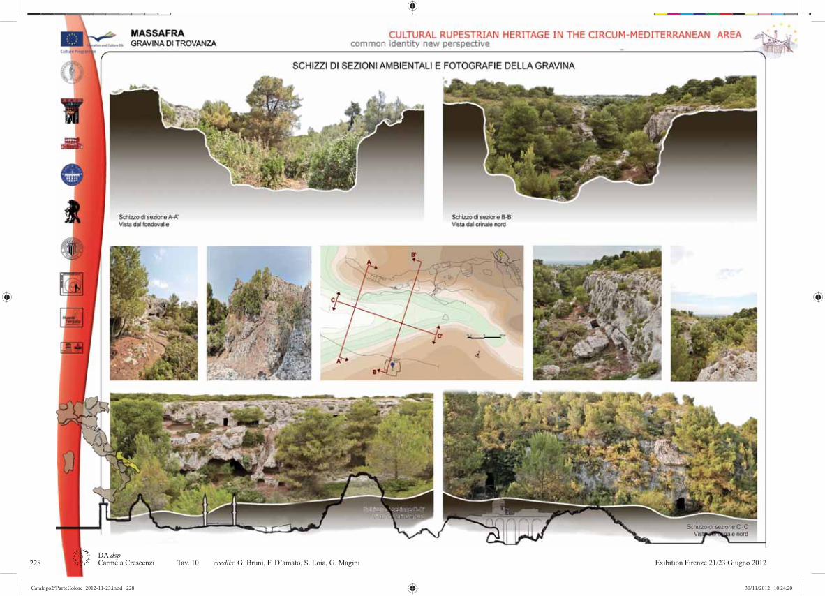
Exibition Firenze 21/23 Giugno 201212DA dsp Carmela Crescenzi Tav. 10 credits: G. Bruni, F. D’amato, S. Loia, G. Magini228
Catalogo2°ParteColore_2012-11-23.indd 228Catalogo2°ParteColore_2012-11-23.indd 228 30/11/2012 10:24:2030/11/2012 10:24:20

Exibition Firenze 21/23 Giugno 2012 13DA dsp Carmela Crescenzi Tav. 11 credits: M. Balsimelli, L. Cantini, P. Casagni, S. Dati, A. Malara, N. Tanganelli 229
Catalogo2°ParteColore_2012-11-23.indd 229Catalogo2°ParteColore_2012-11-23.indd 229 30/11/2012 10:24:2730/11/2012 10:24:27
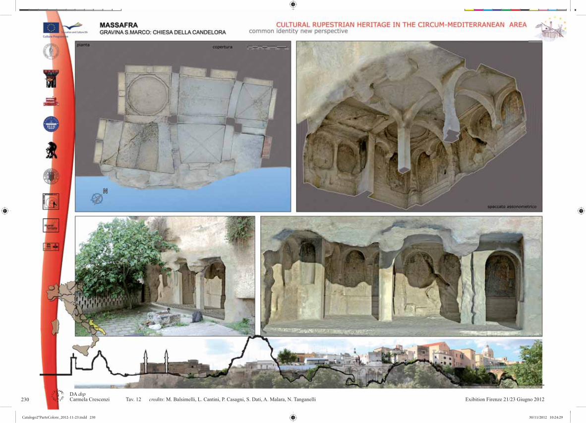
Exibition Firenze 21/23 Giugno 201214DA dsp Carmela Crescenzi Tav. 12 credits: M. Balsimelli, L. Cantini, P. Casagni, S. Dati, A. Malara, N. Tanganelli230
Catalogo2°ParteColore_2012-11-23.indd 230Catalogo2°ParteColore_2012-11-23.indd 230 30/11/2012 10:24:2930/11/2012 10:24:29

Exibition Firenze 21/23 Giugno 2012 15DA dsp Carmela Crescenzi Tav. 13 credits: A. Pistocchi, G. Sbragi, C. Trinci, M. Vasai 231
Catalogo2°ParteColore_2012-11-23.indd 231Catalogo2°ParteColore_2012-11-23.indd 231 30/11/2012 10:24:3830/11/2012 10:24:38

Exibition Firenze 21/23 Giugno 201216DA dsp Carmela Crescenzi Tav. 14 credits: A. Pistocchi, G. Sbragi, C. Trinci, M. Vasai232
Catalogo2°ParteColore_2012-11-23.indd 232Catalogo2°ParteColore_2012-11-23.indd 232 30/11/2012 10:24:4030/11/2012 10:24:40

Exibition Firenze 21/23 Giugno 2012 17DA dsp Carmela Crescenzi Tav. 15 credits: M. Balsimelli, L. Cantini, P. Casagni, S. Dati, A. Malara, N. Tanganelli 233
Catalogo2°ParteColore_2012-11-23.indd 233Catalogo2°ParteColore_2012-11-23.indd 233 30/11/2012 10:24:4930/11/2012 10:24:49

Exibition Firenze 21/23 Giugno 201218DA dsp Carmela Crescenzi Tav. 16 credits: M. Balsimelli, L. Cantini, P. Casagni, S. Dati, A. Malara, N. Tanganelli234
Catalogo2°ParteColore_2012-11-23.indd 234Catalogo2°ParteColore_2012-11-23.indd 234 30/11/2012 10:24:5130/11/2012 10:24:51

Exibition Firenze 21/23 Giugno 2012 19DA dsp Carmela Crescenzi Tav. 17 credits: A. Pistocchi, G. Sbragi, C. Trinci, M. Vasai 235
Catalogo2°ParteColore_2012-11-23.indd 235Catalogo2°ParteColore_2012-11-23.indd 235 30/11/2012 10:25:0030/11/2012 10:25:00

Exibition Firenze 21/23 Giugno 201220DA dsp Carmela Crescenzi Tav. 18 credits: A. Faleburle 236
Catalogo2°ParteColore_2012-11-23.indd 236Catalogo2°ParteColore_2012-11-23.indd 236 30/11/2012 10:25:0230/11/2012 10:25:02
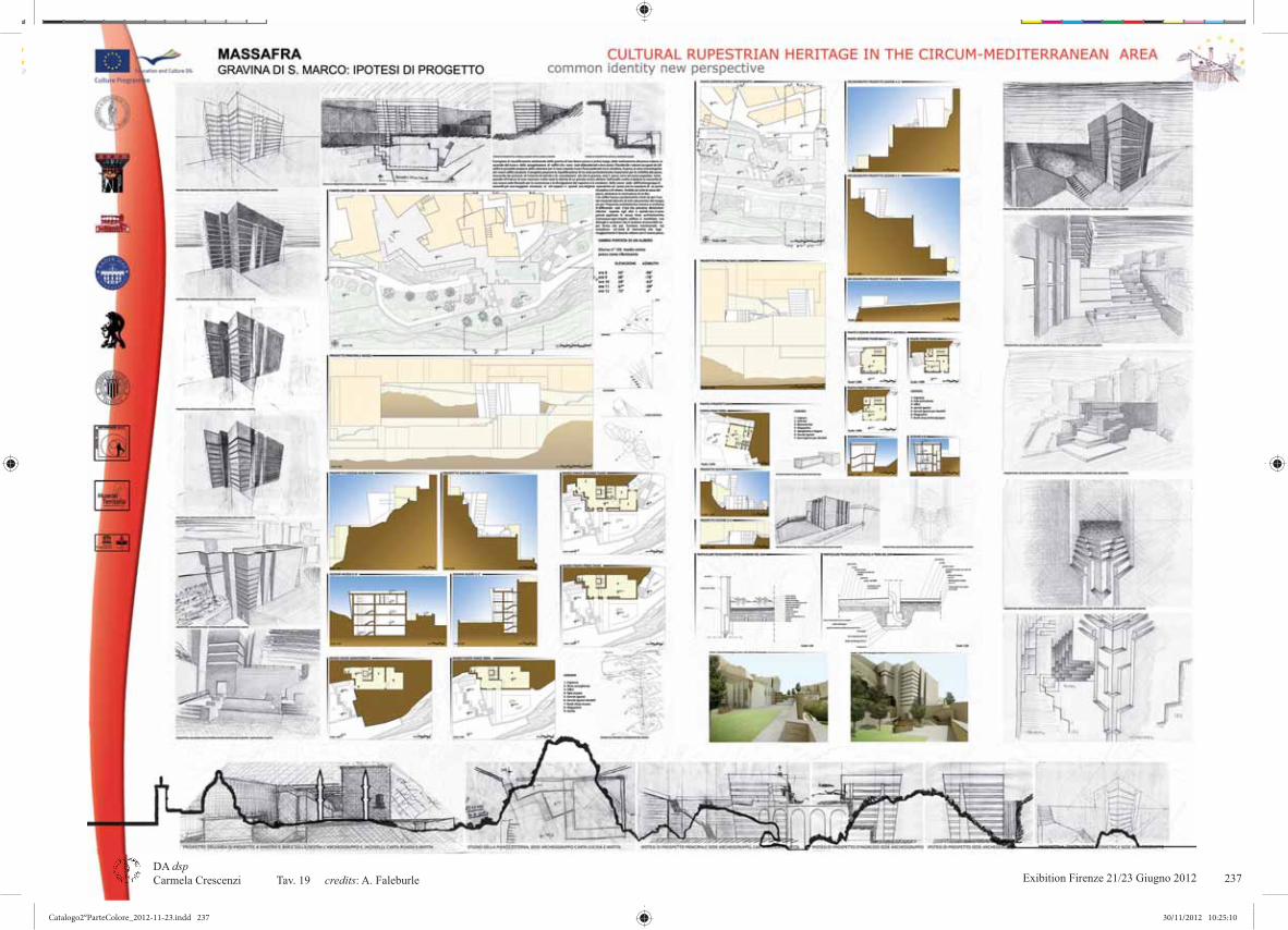
Exibition Firenze 21/23 Giugno 2012 21DA dsp Carmela Crescenzi Tav. 19 credits: A. Faleburle 237
Catalogo2°ParteColore_2012-11-23.indd 237Catalogo2°ParteColore_2012-11-23.indd 237 30/11/2012 10:25:1030/11/2012 10:25:10

Exibition Firenze 21/23 Giugno 201222DA dsp Carmela Crescenzi Tav. 20 credits: P. Paolicchi238
Catalogo2°ParteColore_2012-11-23.indd 238Catalogo2°ParteColore_2012-11-23.indd 238 30/11/2012 10:25:1230/11/2012 10:25:12

Exibition Firenze 21/23 Giugno 2012 23DA dsp Carmela Crescenzi Tav. 21 credits: R. Piagentini 239
Catalogo2°ParteColore_2012-11-23.indd 239Catalogo2°ParteColore_2012-11-23.indd 239 30/11/2012 10:25:1930/11/2012 10:25:19

Exibition Firenze 21/23 Giugno 201224DA dsp M.G.Eccheli Tav. 22 credits: D. Luce, L. Mariano240
Catalogo2°ParteColore_2012-11-23.indd 240Catalogo2°ParteColore_2012-11-23.indd 240 30/11/2012 10:25:2230/11/2012 10:25:22

Exibition Firenze 21/23 Giugno 2012 25DA dsp Carmela Crescenzi Tav. 23 credits: P. Navarro Esteve ESTAV, J. Herraèz Boquera ETSICCP, H. Barros e Costa FTSA, J. Luis Denia ETSICCP 241
Catalogo2°ParteColore_2012-11-23.indd 241Catalogo2°ParteColore_2012-11-23.indd 241 30/11/2012 10:25:2930/11/2012 10:25:29

Exibition Firenze 21/23 Giugno 201226DA dsp Carmela Crescenzi Tav. 24 credits: M. Scalzo, C.Giustiniani242
Catalogo2°ParteColore_2012-11-23.indd 242Catalogo2°ParteColore_2012-11-23.indd 242 30/11/2012 10:25:3230/11/2012 10:25:32

Exibition Firenze 21/23 Giugno 2012 27DA dsp Carmela Crescenzi Tav. 25 credits: P. Formaglini, F. Giansanti, R. Bregoli 243
Catalogo2°ParteColore_2012-11-23.indd 243Catalogo2°ParteColore_2012-11-23.indd 243 30/11/2012 10:25:4030/11/2012 10:25:40

Exibition Firenze 21/23 Giugno 201228DA dsp Carmela Crescenzi Tav. 26 credits: P. Formaglini, F. Giansanti, R. Bregoli244
Catalogo2°ParteColore_2012-11-23.indd 244Catalogo2°ParteColore_2012-11-23.indd 244 30/11/2012 10:25:4230/11/2012 10:25:42

Exibition Firenze 21/23 Giugno 2012 29DA dsp Carmela Crescenzi Tav. 27 credits: E. Scotto, M. Salvadori, C. Crescenzi, S. Sacchelli, F. Tucci 245
Catalogo2°ParteColore_2012-11-23.indd 245Catalogo2°ParteColore_2012-11-23.indd 245 30/11/2012 10:25:4930/11/2012 10:25:49

Exibition Firenze 21/23 Giugno 201230DA dsp Carmela Crescenzi Tav. 28 credits: S. Sacchelli, F. Tucci, S.Caramia246
Catalogo2°ParteColore_2012-11-23.indd 246Catalogo2°ParteColore_2012-11-23.indd 246 30/11/2012 10:25:5230/11/2012 10:25:52

Exibition Firenze 21/23 Giugno 2012 31DA dsp Carmela Crescenzi Tav. 29 credits: S. Sacchelli, F. Tucci, S.Caramia 247
Catalogo2°ParteColore_2012-11-23.indd 247Catalogo2°ParteColore_2012-11-23.indd 247 30/11/2012 10:25:5930/11/2012 10:25:59

Exibition Firenze 21/23 Giugno 201232DA dsp Carmela Crescenzi Tav. 30 credits: P. Formaglini, F. Giansanti, R. Bregoli248
Catalogo2°ParteColore_2012-11-23.indd 248Catalogo2°ParteColore_2012-11-23.indd 248 30/11/2012 10:26:0130/11/2012 10:26:01

Exibition Firenze 21/23 Giugno 2012 33DA dsp Carmela Crescenzi Tav. 31 credits: P. Navarro Esteve ESTAV, J. Herraèz Boquera ETSICCP, H. Barros e Costa FTSA, J. Luis Denia ETSICCP 249
Catalogo2°ParteColore_2012-11-23.indd 249Catalogo2°ParteColore_2012-11-23.indd 249 30/11/2012 10:26:1030/11/2012 10:26:10

Exibition Firenze 21/23 Giugno 201234DA dsp Carmela Crescenzi Tav.32 credits: E. Scotto, M. Salvadori, C. Crescenzi250
Catalogo2°ParteColore_2012-11-23.indd 250Catalogo2°ParteColore_2012-11-23.indd 250 30/11/2012 10:26:1330/11/2012 10:26:13

Exibition Firenze 21/23 Giugno 2012 35DA dsp Stefano Bertocci Tav. 33 credits: C. Morea, S. Hidri, M. Jovovic, M. Golubchik, A. Levy, E. Mitrovic, S. Jovanovic-Marusic, L. Mijic M. Deljak, B. Elisa, S. Bordo, M. Coleschi, M. Pasquini, S. Bertocci
251
Catalogo2°ParteColore_2012-11-23.indd 251Catalogo2°ParteColore_2012-11-23.indd 251 30/11/2012 10:26:1930/11/2012 10:26:19

Exibition Firenze 21/23 Giugno 201236DA dsp Stefano Bertocci Tav. 34 credits: C. Morea, S. Hidri, M. Jovovic, M. Golubchik, A. Levy, E. Mitrovic, S. Jovanovic-Marusic, L. Mijic M. Deljak, B. Elisa, S. Bordo, M. Coleschi, M. Pasquini, S. Bertocci
252
Catalogo2°ParteColore_2012-11-23.indd 252Catalogo2°ParteColore_2012-11-23.indd 252 30/11/2012 10:26:2130/11/2012 10:26:21

Exibition Firenze 21/23 Giugno 2012 37DA dsp Carmela Crescenzi Tav. 35 credits: M. Cassone, V. Congedo, S. Beneventi 253
Catalogo2°ParteColore_2012-11-23.indd 253Catalogo2°ParteColore_2012-11-23.indd 253 30/11/2012 10:26:2730/11/2012 10:26:27

Exibition Firenze 21/23 Giugno 201238DA dsp Carmela Crescenzi Tav. 36 credits: M. Cassone, V. Congedo, S. Beneventi254
Catalogo2°ParteColore_2012-11-23.indd 254Catalogo2°ParteColore_2012-11-23.indd 254 30/11/2012 10:26:3030/11/2012 10:26:30

Exibition Firenze 21/23 Giugno 2012 39DA dsp Carmela Crescenzi Tav. 37 credits: M. Cassone, V. Congedo, S. Beneventi 255
Catalogo2°ParteColore_2012-11-23.indd 255Catalogo2°ParteColore_2012-11-23.indd 255 30/11/2012 10:26:3930/11/2012 10:26:39

Exibition Firenze 21/23 Giugno 201240DA dsp Carmela Crescenzi Tav. 38 credits: M. Cassone, V. Congedo, S. Beneventi256
Catalogo2°ParteColore_2012-11-23.indd 256Catalogo2°ParteColore_2012-11-23.indd 256 30/11/2012 10:26:4230/11/2012 10:26:42

Exibition Firenze 21/23 Giugno 2012 41DA dsp Carmela Crescenzi tav. 39 credits: M. Cassone, V. Congedo, S. Beneventi 257
Catalogo2°ParteColore_2012-11-23.indd 257Catalogo2°ParteColore_2012-11-23.indd 257 30/11/2012 10:26:4930/11/2012 10:26:49

Exibition Firenze 21/23 Giugno 201242DA dsp Carmela Crescenzi Tav. 40 credits: M. Cassone, V. Congedo, S. Beneventi258
Catalogo2°ParteColore_2012-11-23.indd 258Catalogo2°ParteColore_2012-11-23.indd 258 30/11/2012 10:26:5130/11/2012 10:26:51

Exibition Firenze 21/23 Giugno 2012 43DA dsp Carmela Crescenzi Tav. 41 credits: N. Barbalace, N. Belvedere, B. Ciconte 259
Catalogo2°ParteColore_2012-11-23.indd 259Catalogo2°ParteColore_2012-11-23.indd 259 30/11/2012 10:26:5730/11/2012 10:26:57

Exibition Firenze 21/23 Giugno 201244DA dsp Carmela Crescenzi Tav. 42 credits: N. Barbalace, N. Belvedere, B. Ciconte260
Catalogo2°ParteColore_2012-11-23.indd 260Catalogo2°ParteColore_2012-11-23.indd 260 30/11/2012 10:27:0030/11/2012 10:27:00

Exibition Firenze 21/23 Giugno 2012 45DA dsp Carmela Crescenzi Tav.43 credits: N. Barbalace, N. Belvedere, B. Ciconte 261
Catalogo2°ParteColore_2012-11-23.indd 261Catalogo2°ParteColore_2012-11-23.indd 261 30/11/2012 10:27:1030/11/2012 10:27:10

Exibition Firenze 21/23 Giugno 201246DA dsp Carmela Crescenzi Tav.44 credits:N. Barbalace, N. Belvedere, B. Ciconte262
Catalogo2°ParteColore_2012-11-23.indd 262Catalogo2°ParteColore_2012-11-23.indd 262 30/11/2012 10:27:1230/11/2012 10:27:12

Exibition Firenze 21/23 Giugno 2012 47DA dsp Giorgio Verdiani Tav. 45 credits: S. Curcio 263
Catalogo2°ParteColore_2012-11-23.indd 263Catalogo2°ParteColore_2012-11-23.indd 263 30/11/2012 10:27:2030/11/2012 10:27:20
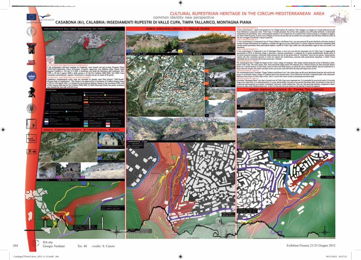
Exibition Firenze 21/23 Giugno 201248DA dsp Giorgio Verdiani Tav. 46 credits: S. Curcio264
Catalogo2°ParteColore_2012-11-23.indd 264Catalogo2°ParteColore_2012-11-23.indd 264 30/11/2012 10:27:2330/11/2012 10:27:23

Exibition Firenze 21/23 Giugno 2012 49DA dsp Giorgio Verdiani Tav. 47 credits: S. Curcio 265
Catalogo2°ParteColore_2012-11-23.indd 265Catalogo2°ParteColore_2012-11-23.indd 265 30/11/2012 10:27:3030/11/2012 10:27:30

Exibition Firenze 21/23 Giugno 201250DA dsp Giorgio Verdiani Tav. 48 credits: S. Curcio266
Catalogo2°ParteColore_2012-11-23.indd 266Catalogo2°ParteColore_2012-11-23.indd 266 30/11/2012 10:27:3330/11/2012 10:27:33

Exibition Firenze 21/23 Giugno 2012 51DA dsp Carmela Crescenzi Tav. 49 credits: A. Serena, A. Temperini 267
Catalogo2°ParteColore_2012-11-23.indd 267Catalogo2°ParteColore_2012-11-23.indd 267 30/11/2012 10:27:3930/11/2012 10:27:39
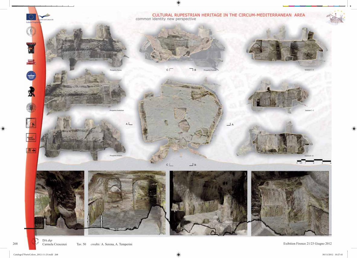
Exibition Firenze 21/23 Giugno 201252DA dsp Carmela Crescenzi Tav. 50 credits: A. Serena, A. Temperini268
Catalogo2°ParteColore_2012-11-23.indd 268Catalogo2°ParteColore_2012-11-23.indd 268 30/11/2012 10:27:4130/11/2012 10:27:41

Exibition Firenze 21/23 Giugno 2012 53DA dsp Carmela Crescenzi Tav. 51 credits: F. Marcocci, M. Gazzei 269
Catalogo2°ParteColore_2012-11-23.indd 269Catalogo2°ParteColore_2012-11-23.indd 269 30/11/2012 10:27:4930/11/2012 10:27:49
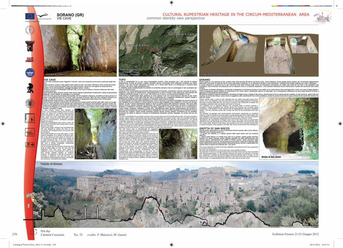
Exibition Firenze 21/23 Giugno 201254DA dsp Carmela Crescenzi Tav. 52 credits: F. Marcocci, M. Gazzei270
Catalogo2°ParteColore_2012-11-23.indd 270Catalogo2°ParteColore_2012-11-23.indd 270 30/11/2012 10:27:5130/11/2012 10:27:51

Exibition Firenze 21/23 Giugno 2012 55DA dsp Carmela Crescenzi Tav. 53 credits: F. Marcocci, M.arco Gazzei 271
Catalogo2°ParteColore_2012-11-23.indd 271Catalogo2°ParteColore_2012-11-23.indd 271 30/11/2012 10:27:5930/11/2012 10:27:59

Catalogo2°ParteColore_2012-11-23.indd 272Catalogo2°ParteColore_2012-11-23.indd 272 30/11/2012 10:28:0130/11/2012 10:28:01

Exibition Firenze 21/23 Giugno 2012 1ExiExiExiEExiExiExExExiEExExxiExiExiExiExiExExxiExiEExiExEEExiixixiExExiExixxixExExExiExxix bitbitbitbibbitbitbitbitbitiiiibitititttitbbbbitiitbbbitbitititbitbbbitiitiitititititititititbitiiiiibbitbiiibbitbitbitbiibbitiibitiiittbbitbitibiiitionionionioniiionononiononononononnionionionononiionnioniionioniioiionionioniioionononononionioiionionnioioiooionoononioiioioiooniooooonionioooonoooooonnionionioniiooooooooonnooonionionioiooooioioonioionioooiiiooooiioni FFFiFFFiFiFiFiiiFiFiFiFFFiiFiFiFiiFFiFiFiFiFFiFFFFFFFFFFiFFFFFFFFFFiiFFFFiFiFFFFFFFiFFiFFiFFFiFiFFFiFFFFFFFFFFFFFFFFFirererrenrrenrenrenrenrenrenrenrenrerenrenrenrenrennnrrrrenrrrennrennnrrrenrenrenenrennnrenrrrenenrennrrenenerrrennzzzezezeezeze zzezeezzzzzzezezeze zzezzeze zezeze zezzee eze zezezeezeze zeee ezeze zeezzzzzee 21/21/21/212121/21/221/21/2112221/1/22 /22221/21/2221/22 //2221/1//21/1/1/1211////2211////21///////2 ///223222222323222333233232322222223222222222322233222322222223222222322222223222233 GGiGiuGiuGiuGiuGiuGiuGiuiuuuiuGGiuGiuGiuGiuGiuGiuGGGiuGGiuiuiuGGiuGiuGiGiuGGGGiuGiuGGGGGGG uGGGiuuGGG uGiuGiuG uuG uugngggngngngngngnogngnonognoognnognooognognnognognognononognognognnnognognognonognggngnnooognnnnognognognognngnoognognogggnngnognognognognogggnnonoognognognogggnnnognonognooognoggggggngngnnngngngnnoggggngngngnnoogngngnnognoggnnnonooggnngnnnonoooonongnonooonog ooooggggggggggggg 202222202200020202020202222202020202222202022202020202202020202002022022020002020202020200220202022020220022222020000222200222022222000222200222022202001212112212121212121212121212121212122122211222121222221122222222122221121122112222212222111112222222112111211122111122221212211221212222222121212122221211212112 111111111111111111111111111111111111111111
Catalogo2°ParteColore_2012-11-23.indd 273Catalogo2°ParteColore_2012-11-23.indd 273 30/11/2012 10:28:0230/11/2012 10:28:02

Claudio Giustiniani, Umberto Albricci, Elisa Viviani, Annalisa BindocciClaudio Giustiniani Umberto Albricci, Elisa Viviani Umberto Albricci, , Carmela Crescenzi, Elisa VivianiCarmela Crescenzi Carmela Crescenzi, Michela Salvadori, Elena ScottoCarmela CrescenziAnnalisa Bindocci, Laura CovarinoCarmela Crescenzi, Mirco Iualè Carmela Crescenzi, Michela Salvadori, Elena ScottoAnnalisa Formica, Elisabetta LoPresti, Samuele Sangiorgio Annalisa Formica, Elisabetta LoPrestiAnnalisa Bindocci Claudio Giustiniani, Umbrto Albricci, Elisa VivianiAnnalisa Bindocci , Laura Covarino
graphics: Michela Salvadori, Elena Scotto editing: Mirco Iualè
Carmela Crescenzi, Fondamenti della Geometria Descrittiva Unifi, Italycredits :Tav 1Tav 2Tav 3Tav 4Tav 5Tav 6,7Tav 8Tav 9Tav 10Tav 11, 12Tav 13-18Tav 19-23Tav 24Tav 25Tav 26
Annalisa Bindocci, Laura Covarino Claudio Giustiniani, Umberto Albricci, Elisa Viviani
Annalisa Bindocci (¹)Claudio Giustiniani (²)
Umberto Albricci (³), Elisa Viviani (³)Laura Covarino (4)
Claudio GiustinianiAnnalisa Bindocci, Laura Covarino
S. Camedda, F. Pizzorusso, M. Polidori, E. Pollastrini, E. Roma, M. Ruini, G.Sanità, S.Sassoli, A.Superbi, G. L. Terrosi, R. Verardi, E. Zampaloni, C. Zuffa
Simone Benvenuti, Monica CassoneCarmela Crescenzi, Annalisa Bindocci, Michela Salvadori, Elena Scotto
Simone Beneventi, Monica CassoneGiovanni Siclari
Tav 27Tav 28Tav 29Tav 30,31Tav 32,33Tav 34Tav 35Tav 36Tav 37-48
Tav 49Tav 50Tav 51,52Tav 53
immagine in copertina: Şahinefendi Köyü, Turkiye credit: C. Crescenzi
università degli studi di firenze, facoltà di frchitettura, dadsp.ESTRATTI DALLE TESI DI LAUREA:(¹) “Parco territoriale in Cappadocia. Vadi di Ortahisar”. Anno: 2011 Relatore: C. Crescenzi, Laureanda: Annalisa Bindocci (²) Anno: 2011 Relatore: C. Crescenzi, Correlatori: M. Alper , S. Di Tondo Laureando: Claudio Giustiniani (³) “Public space and Ortahisar Kalesi’s Park”. Anno: 2011 Relatore: C. Crescenzi, Correlatori: M. Alper , R. Caprara Laureandi:(4) Anno: 2011 Relatore: C. Crescenzi, Laureanda:
274
Catalogo2°ParteColore_2012-11-23.indd 274Catalogo2°ParteColore_2012-11-23.indd 274 30/11/2012 10:28:0330/11/2012 10:28:03

Exibition Firenze 21/23 Giugno 2012 3DA dsp
credits: 275
Catalogo2°ParteColore_2012-11-23.indd 275Catalogo2°ParteColore_2012-11-23.indd 275 30/11/2012 10:28:0430/11/2012 10:28:04
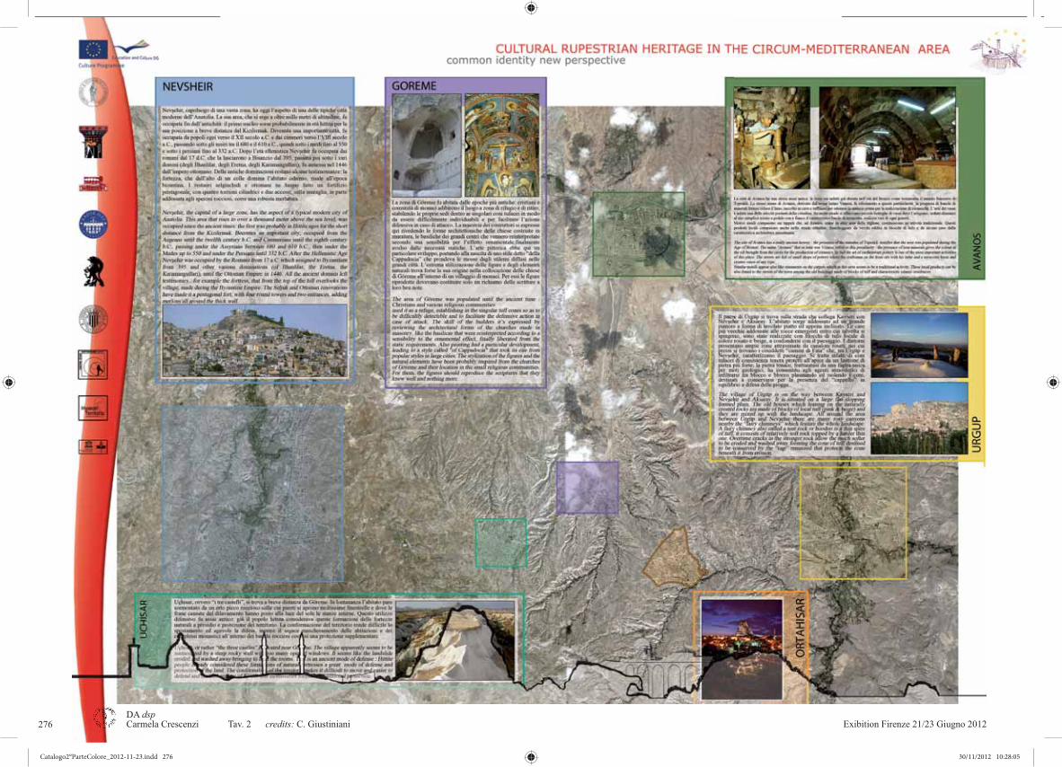
Exibition Firenze 21/23 Giugno 20124DA dsp
credits: C. Giustiniani 276
Catalogo2°ParteColore_2012-11-23.indd 276Catalogo2°ParteColore_2012-11-23.indd 276 30/11/2012 10:28:0530/11/2012 10:28:05

Exibition Firenze 21/23 Giugno 2012 5DA dsp
credits: 277
Catalogo2°ParteColore_2012-11-23.indd 277Catalogo2°ParteColore_2012-11-23.indd 277 30/11/2012 10:28:0830/11/2012 10:28:08

Exibition Firenze 21/23 Giugno 20126DA dsp
credits:278
Catalogo2°ParteColore_2012-11-23.indd 278Catalogo2°ParteColore_2012-11-23.indd 278 30/11/2012 10:28:0930/11/2012 10:28:09

Exibition Firenze 21/23 Giugno 2012 7DA dsp
credits: 279
Catalogo2°ParteColore_2012-11-23.indd 279Catalogo2°ParteColore_2012-11-23.indd 279 30/11/2012 10:28:1230/11/2012 10:28:12

Exibition Firenze 21/23 Giugno 20128DA dsp
credits:280
Catalogo2°ParteColore_2012-11-23.indd 280Catalogo2°ParteColore_2012-11-23.indd 280 30/11/2012 10:28:1330/11/2012 10:28:13
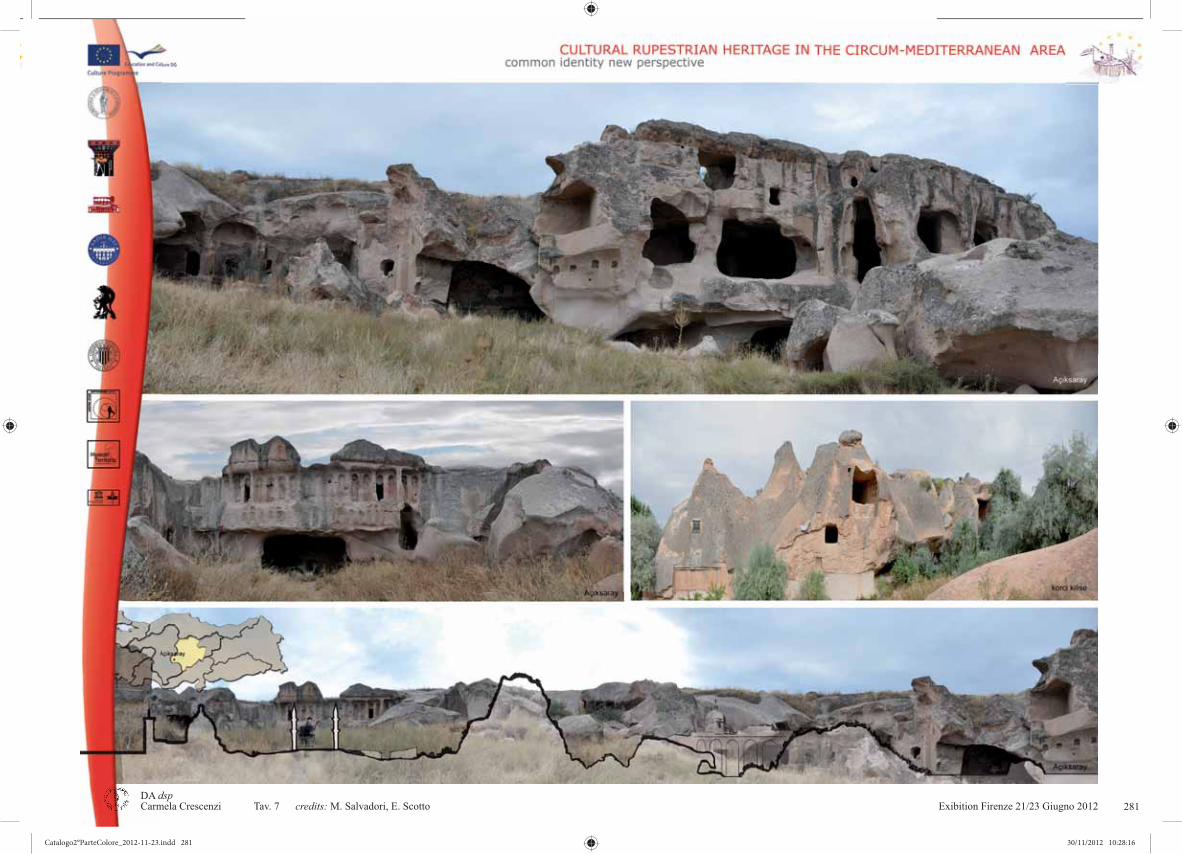
Exibition Firenze 21/23 Giugno 2012 9DA dsp
credits: 281
Catalogo2°ParteColore_2012-11-23.indd 281Catalogo2°ParteColore_2012-11-23.indd 281 30/11/2012 10:28:1630/11/2012 10:28:16

Exibition Firenze 21/23 Giugno 201210DA dsp
credits: 282
Catalogo2°ParteColore_2012-11-23.indd 282Catalogo2°ParteColore_2012-11-23.indd 282 30/11/2012 10:28:1730/11/2012 10:28:17

Exibition Firenze 21/23 Giugno 2012 11DA dsp
credits: 283
Catalogo2°ParteColore_2012-11-23.indd 283Catalogo2°ParteColore_2012-11-23.indd 283 30/11/2012 10:28:2130/11/2012 10:28:21

Exibition Firenze 21/23 Giugno 201212DA dsp
credits: C. Crescenzi, M. Iualè 284
Catalogo2°ParteColore_2012-11-23.indd 284Catalogo2°ParteColore_2012-11-23.indd 284 30/11/2012 10:28:2230/11/2012 10:28:22

Exibition Firenze 21/23 Giugno 2012 13DA dsp
credits: 285
Catalogo2°ParteColore_2012-11-23.indd 285Catalogo2°ParteColore_2012-11-23.indd 285 30/11/2012 10:28:2530/11/2012 10:28:25

Exibition Firenze 21/23 Giugno 201214DA dsp
credits:286
Catalogo2°ParteColore_2012-11-23.indd 286Catalogo2°ParteColore_2012-11-23.indd 286 30/11/2012 10:28:2630/11/2012 10:28:26

Exibition Firenze 21/23 Giugno 2012 15DA dsp
credits: A. Formica, E. Lo Presti, S. Sangiorgio
EVOLUZIONE - TIPOLOGIE
287
Catalogo2°ParteColore_2012-11-23.indd 287Catalogo2°ParteColore_2012-11-23.indd 287 30/11/2012 10:28:2830/11/2012 10:28:28

Exibition Firenze 21/23 Giugno 201216DA dsp
credits: A. Formica, E. Lo Presti, S. Sangiorgio
EVOLUZIONE - TIPOLOGIE
288
Catalogo2°ParteColore_2012-11-23.indd 288Catalogo2°ParteColore_2012-11-23.indd 288 30/11/2012 10:28:3030/11/2012 10:28:30

Exibition Firenze 21/23 Giugno 2012 17DA dsp
credits: A. Formica, E. Lo Presti, S. Sangiorgio
EVOLUZIONE - TIPOLOGIE
289
Catalogo2°ParteColore_2012-11-23.indd 289Catalogo2°ParteColore_2012-11-23.indd 289 30/11/2012 10:28:3330/11/2012 10:28:33

Exibition Firenze 21/23 Giugno 201218DA dsp Carmela Crescenzi Tav. 16 credits: A. Formica, E. Lo Presti, S. Sangiorgio
EVOLUZIONE - TIPOLOGIE
290
Catalogo2°ParteColore_2012-11-23.indd 290Catalogo2°ParteColore_2012-11-23.indd 290 30/11/2012 10:28:3430/11/2012 10:28:34

Exibition Firenze 21/23 Giugno 2012 19DA dsp
credits: A. Formica, E. Lo Presti, S. Sangiorgio
EVOLUZIONE - TIPOLOGIE
291
Catalogo2°ParteColore_2012-11-23.indd 291Catalogo2°ParteColore_2012-11-23.indd 291 30/11/2012 10:28:3730/11/2012 10:28:37

Exibition Firenze 21/23 Giugno 201220DA dsp
credits: A. Formica, E. Lo Presti, S. Sangiorgio
EVOLUZIONE - TIPOLOGIE
292
Catalogo2°ParteColore_2012-11-23.indd 292Catalogo2°ParteColore_2012-11-23.indd 292 30/11/2012 10:28:3830/11/2012 10:28:38

Exibition Firenze 21/23 Giugno 2012 21DA dsp
credits: E. Lo Presti, A. Formica
Goreme Goreme GoremeGoreme
293
Catalogo2°ParteColore_2012-11-23.indd 293Catalogo2°ParteColore_2012-11-23.indd 293 30/11/2012 10:28:4030/11/2012 10:28:40

Exibition Firenze 21/23 Giugno 201222DA dsp
credits: E. Lo Presti, A. Formica
Goreme
294
Catalogo2°ParteColore_2012-11-23.indd 294Catalogo2°ParteColore_2012-11-23.indd 294 30/11/2012 10:28:4230/11/2012 10:28:42
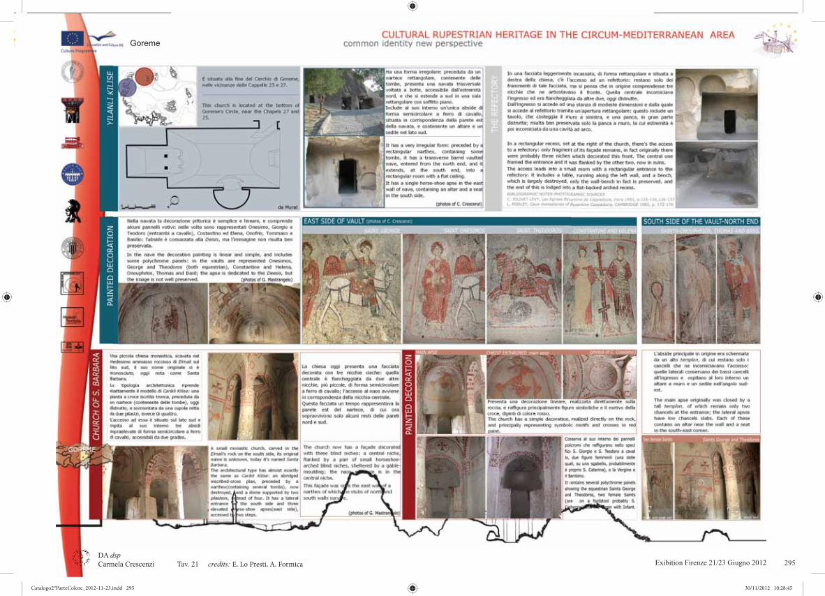
Exibition Firenze 21/23 Giugno 2012 23DA dsp
credits: E. Lo Presti, A. Formica
Goreme
295
Catalogo2°ParteColore_2012-11-23.indd 295Catalogo2°ParteColore_2012-11-23.indd 295 30/11/2012 10:28:4530/11/2012 10:28:45

Exibition Firenze 21/23 Giugno 201224DA dsp
credits: E. Lo Presti, A. Formica 296
Catalogo2°ParteColore_2012-11-23.indd 296Catalogo2°ParteColore_2012-11-23.indd 296 30/11/2012 10:28:4630/11/2012 10:28:46

Exibition Firenze 21/23 Giugno 2012 25DA dsp
credits: E. Lo Presti, A. Formica
Goreme
297
Catalogo2°ParteColore_2012-11-23.indd 297Catalogo2°ParteColore_2012-11-23.indd 297 30/11/2012 10:28:4830/11/2012 10:28:48

Exibition Firenze 21/23 Giugno 201226DA dsp
credits: A. Bindocci 298
Catalogo2°ParteColore_2012-11-23.indd 298Catalogo2°ParteColore_2012-11-23.indd 298 30/11/2012 10:28:5030/11/2012 10:28:50

Exibition Firenze 21/23 Giugno 2012 27DA dsp
credits: 299
Catalogo2°ParteColore_2012-11-23.indd 299Catalogo2°ParteColore_2012-11-23.indd 299 30/11/2012 10:28:5230/11/2012 10:28:52

Exibition Firenze 21/23 Giugno 201228DA dsp
credits:300
Catalogo2°ParteColore_2012-11-23.indd 300Catalogo2°ParteColore_2012-11-23.indd 300 30/11/2012 10:28:5330/11/2012 10:28:53

Exibition Firenze 21/23 Giugno 2012 29DA dsp
credits: A. Bindocci, C. Giustiniani 301
Catalogo2°ParteColore_2012-11-23.indd 301Catalogo2°ParteColore_2012-11-23.indd 301 30/11/2012 10:28:5630/11/2012 10:28:56

Exibition Firenze 21/23 Giugno 201230DA dsp
credits:
Ortahisar
302
Catalogo2°ParteColore_2012-11-23.indd 302Catalogo2°ParteColore_2012-11-23.indd 302 30/11/2012 10:28:5730/11/2012 10:28:57

Exibition Firenze 21/23 Giugno 2012 31DA dsp
credits: A. Bindocci 303
Catalogo2°ParteColore_2012-11-23.indd 303Catalogo2°ParteColore_2012-11-23.indd 303 30/11/2012 10:29:0030/11/2012 10:29:00

Exibition Firenze 21/23 Giugno 201232DA dsp
credits: C. Giustiniani
ORTAHISAR: IPOTESI DI PROGETTO
304
Catalogo2°ParteColore_2012-11-23.indd 304Catalogo2°ParteColore_2012-11-23.indd 304 30/11/2012 10:29:0230/11/2012 10:29:02

Exibition Firenze 21/23 Giugno 2012 33DA dsp
credits: C. Giustiniani
ORTAHISAR: IPOTESI DI PROGETTO
305
Catalogo2°ParteColore_2012-11-23.indd 305Catalogo2°ParteColore_2012-11-23.indd 305 30/11/2012 10:29:0430/11/2012 10:29:04

Exibition Firenze 21/23 Giugno 201234DA dsp
credits:
PUBLIC SPACE AND ORTAHISAR KALESI’S PARK
306
Catalogo2°ParteColore_2012-11-23.indd 306Catalogo2°ParteColore_2012-11-23.indd 306 30/11/2012 10:29:0630/11/2012 10:29:06
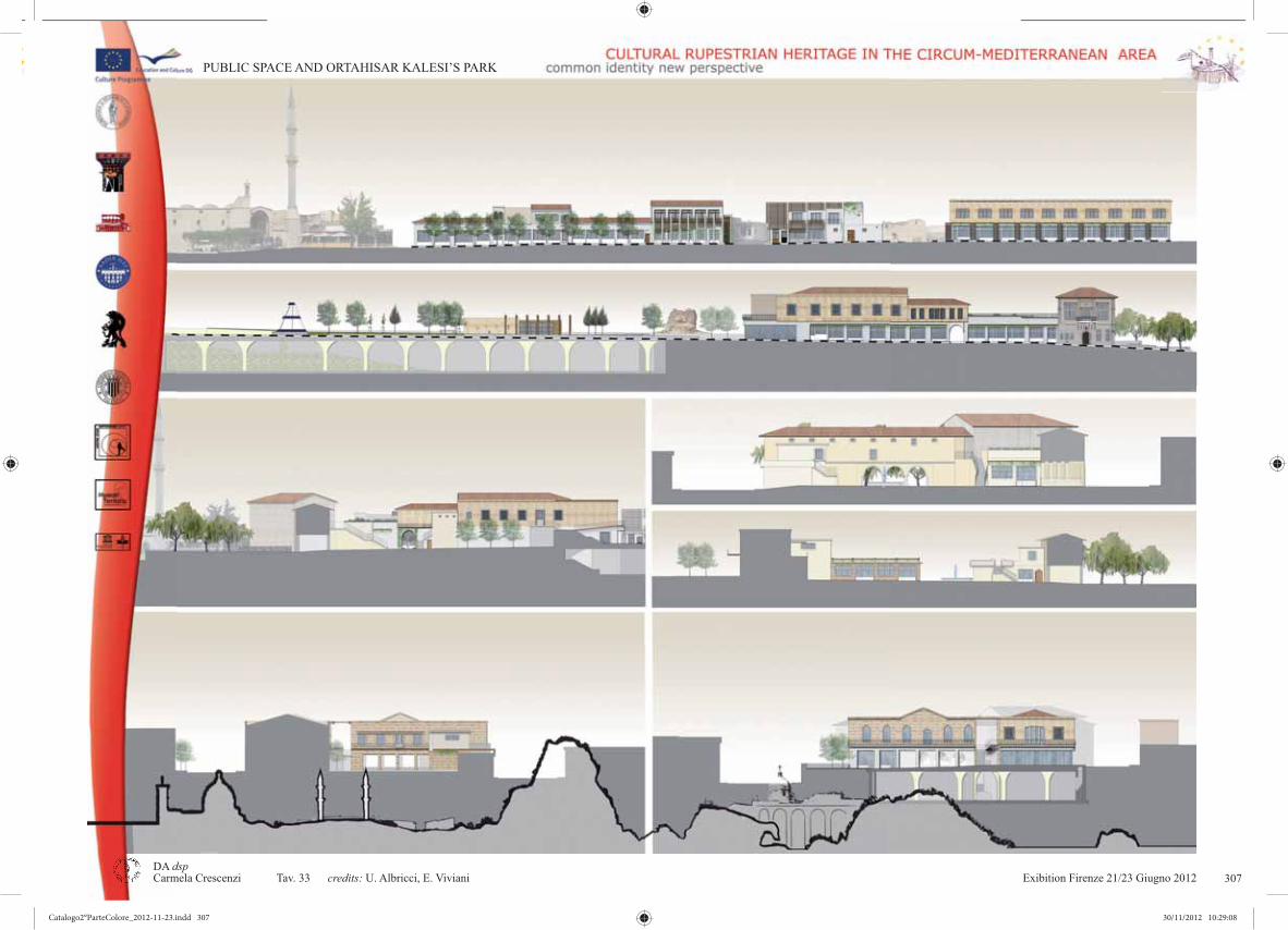
Exibition Firenze 21/23 Giugno 2012 35DA dsp
credits:
PUBLIC SPACE AND ORTAHISAR KALESI’S PARK
307
Catalogo2°ParteColore_2012-11-23.indd 307Catalogo2°ParteColore_2012-11-23.indd 307 30/11/2012 10:29:0830/11/2012 10:29:08

Exibition Firenze 21/23 Giugno 201236DA dsp
credits:
PUBLIC SPACE AND ORTAHISAR KALESI’S PARK
308
Catalogo2°ParteColore_2012-11-23.indd 308Catalogo2°ParteColore_2012-11-23.indd 308 30/11/2012 10:29:1030/11/2012 10:29:10

Exibition Firenze 21/23 Giugno 2012 37DA dsp
credits: C. Giustiniani 309
Catalogo2°ParteColore_2012-11-23.indd 309Catalogo2°ParteColore_2012-11-23.indd 309 30/11/2012 10:29:1230/11/2012 10:29:12

Exibition Firenze 21/23 Giugno 201238DA dsp
credits:
HALLAÇ MONASTERY - ORTAHISAR
310
Catalogo2°ParteColore_2012-11-23.indd 310Catalogo2°ParteColore_2012-11-23.indd 310 30/11/2012 10:29:1330/11/2012 10:29:13

Exibition Firenze 21/23 Giugno 2012 39DA dsp
credits: S. Camedda, F. Pizzorusso, M. Polidori, E. Pollastrini, E. Roma, M. Ruini, G.Sanità, S.Sassoli,A.Superbi, G. L. Terrosi, R. Verardi, E. Zampaloni, C. Zuffa
HALLAÇ MONASTERY - ORTAHISAR
311
Catalogo2°ParteColore_2012-11-23.indd 311Catalogo2°ParteColore_2012-11-23.indd 311 30/11/2012 10:29:1530/11/2012 10:29:15

Exibition Firenze 21/23 Giugno 201240DA dsp
credits: S. Camedda, F. Pizzorusso, M. Polidori, E. Pollastrini, E. Roma, M. Ruini, G.Sanità, S.Sassoli,A.Superbi, G. L. Terrosi, R. Verardi, E. Zampaloni, C. Zuffa
HALLAÇ MONASTERY - ORTAHISAR
312
Catalogo2°ParteColore_2012-11-23.indd 312Catalogo2°ParteColore_2012-11-23.indd 312 30/11/2012 10:29:1730/11/2012 10:29:17

Exibition Firenze 21/23 Giugno 2012 41DA dsp
credits: S. Camedda, F. Pizzorusso, M. Polidori, E. Pollastrini, E. Roma, M. Ruini, G.Sanità, S.Sassoli,A.Superbi, G. L. Terrosi, R. Verardi, E. Zampaloni, C. Zuffa
HALLAÇ MONASTERY - ORTAHISAR
313
Catalogo2°ParteColore_2012-11-23.indd 313Catalogo2°ParteColore_2012-11-23.indd 313 30/11/2012 10:29:1930/11/2012 10:29:19

Exibition Firenze 21/23 Giugno 201242DA dsp
credits: S. Camedda, F. Pizzorusso, M. Polidori, E. Pollastrini, E. Roma, M. Ruini, G.Sanità, S.Sassoli,A.Superbi, G. L. Terrosi, R. Verardi, E. Zampaloni, C. Zuffa
HALLAÇ MONASTERY - ORTAHISAR
314
Catalogo2°ParteColore_2012-11-23.indd 314Catalogo2°ParteColore_2012-11-23.indd 314 30/11/2012 10:29:2030/11/2012 10:29:20

Exibition Firenze 21/23 Giugno 2012 43DA dsp
credits: S. Camedda, F. Pizzorusso, M. Polidori, E. Pollastrini, E. Roma, M. Ruini, G.Sanità, S.Sassoli,A.Superbi, G. L. Terrosi, R. Verardi, E. Zampaloni, C. Zuffa
HALLAÇ MONASTERY - ORTAHISAR
315
Catalogo2°ParteColore_2012-11-23.indd 315Catalogo2°ParteColore_2012-11-23.indd 315 30/11/2012 10:29:2230/11/2012 10:29:22

Exibition Firenze 21/23 Giugno 201244DA dsp
credits: S. Camedda, F. Pizzorusso, M. Polidori, E. Pollastrini, E. Roma, M. Ruini, G.Sanità, S.Sassoli,A.Superbi, G. L. Terrosi, R. Verardi, E. Zampaloni, C. Zuffa
HALLAÇ MONASTERY - ORTAHISAR
316
Catalogo2°ParteColore_2012-11-23.indd 316Catalogo2°ParteColore_2012-11-23.indd 316 30/11/2012 10:29:2430/11/2012 10:29:24

Exibition Firenze 21/23 Giugno 2012 45DA dsp
credits: S. Camedda, F. Pizzorusso, M. Polidori, E. Pollastrini, E. Roma, M. Ruini, G.Sanità, S.Sassoli,A.Superbi, G. L. Terrosi, R. Verardi, E. Zampaloni, C. Zuffa
HALLAÇ MONASTERY - ORTAHISAR
317
Catalogo2°ParteColore_2012-11-23.indd 317Catalogo2°ParteColore_2012-11-23.indd 317 30/11/2012 10:29:2630/11/2012 10:29:26

Exibition Firenze 21/23 Giugno 201246DA dsp
credits: S. Camedda, F. Pizzorusso, M. Polidori, E. Pollastrini, E. Roma, M. Ruini, G.Sanità, S.Sassoli,A.Superbi, G. L. Terrosi, R. Verardi, E. Zampaloni, C. Zuffa
HALLAÇ MONASTERY - ORTAHISAR
318
Catalogo2°ParteColore_2012-11-23.indd 318Catalogo2°ParteColore_2012-11-23.indd 318 30/11/2012 10:29:2730/11/2012 10:29:27

Exibition Firenze 21/23 Giugno 2012 47DA dsp
credits: S. Camedda, F. Pizzorusso, M. Polidori, E. Pollastrini, E. Roma, M. Ruini, G.Sanità, S.Sassoli,A.Superbi, G. L. Terrosi, R. Verardi, E. Zampaloni, C. Zuffa
HALLAÇ MONASTERY - ORTAHISAR
319
Catalogo2°ParteColore_2012-11-23.indd 319Catalogo2°ParteColore_2012-11-23.indd 319 30/11/2012 10:29:3030/11/2012 10:29:30

Exibition Firenze 21/23 Giugno 201248DA dsp
credits: S. Camedda, F. Pizzorusso, M. Polidori, E. Pollastrini, E. Roma, M. Ruini, G.Sanità, S.Sassoli,A.Superbi, G. L. Terrosi, R. Verardi, E. Zampaloni, C. Zuffa
HALLAÇ MONASTERY - ORTAHISAR
320
Catalogo2°ParteColore_2012-11-23.indd 320Catalogo2°ParteColore_2012-11-23.indd 320 30/11/2012 10:29:3130/11/2012 10:29:31

Exibition Firenze 21/23 Giugno 2012 49DA dsp
credits: S. Camedda, F. Pizzorusso, M. Polidori, E. Pollastrini, E. Roma, M. Ruini, G.Sanità, S.Sassoli,A.Superbi, G. L. Terrosi, R. Verardi, E. Zampaloni, C. Zuffa
HALLAÇ MONASTERY - ORTAHISAR
321
Catalogo2°ParteColore_2012-11-23.indd 321Catalogo2°ParteColore_2012-11-23.indd 321 30/11/2012 10:29:3330/11/2012 10:29:33

Exibition Firenze 21/23 Giugno 201250DA dsp
credits: S. Camedda, F. Pizzorusso, M. Polidori, E. Pollastrini, E. Roma, M. Ruini, G.Sanità, S.Sassoli,A.Superbi, G. L. Terrosi, R. Verardi, E. Zampaloni, C. Zuffa
HALLAÇ MONASTERY - ORTAHISAR
322
Catalogo2°ParteColore_2012-11-23.indd 322Catalogo2°ParteColore_2012-11-23.indd 322 30/11/2012 10:29:3430/11/2012 10:29:34

Exibition Firenze 21/23 Giugno 2012 51DA dsp
credits: 323
Catalogo2°ParteColore_2012-11-23.indd 323Catalogo2°ParteColore_2012-11-23.indd 323 30/11/2012 10:29:3730/11/2012 10:29:37

Exibition Firenze 21/23 Giugno 201252DA dsp
credits:324
Catalogo2°ParteColore_2012-11-23.indd 324Catalogo2°ParteColore_2012-11-23.indd 324 30/11/2012 10:29:3830/11/2012 10:29:38

Exibition Firenze 21/23 Giugno 2012 53DA dsp
credits: 325
Catalogo2°ParteColore_2012-11-23.indd 325Catalogo2°ParteColore_2012-11-23.indd 325 30/11/2012 10:29:4030/11/2012 10:29:40
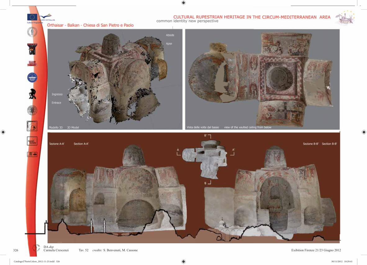
Exibition Firenze 21/23 Giugno 201254DA dsp
credits:326
Catalogo2°ParteColore_2012-11-23.indd 326Catalogo2°ParteColore_2012-11-23.indd 326 30/11/2012 10:29:4130/11/2012 10:29:41
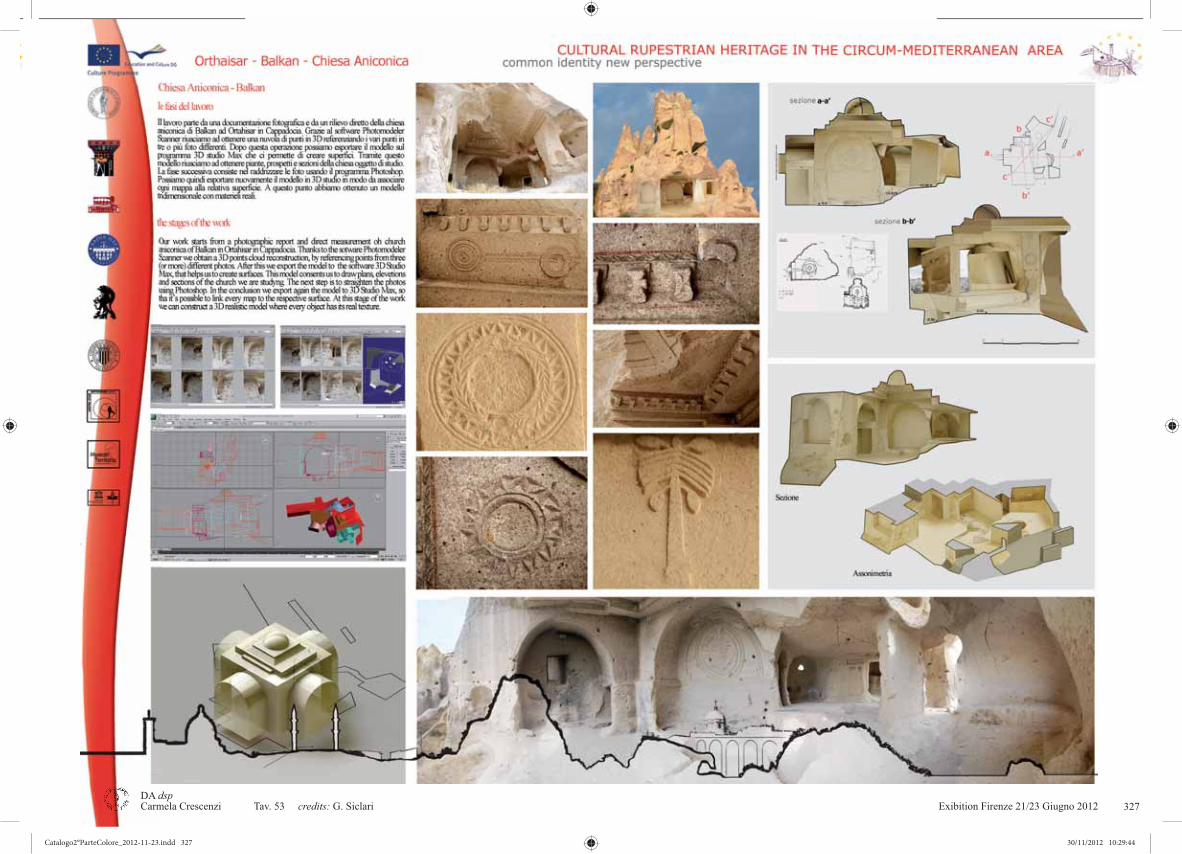
Exibition Firenze 21/23 Giugno 2012 55DA dsp Carmela Crescenzi Tav. 53 credits: G. Siclari 327
Catalogo2°ParteColore_2012-11-23.indd 327Catalogo2°ParteColore_2012-11-23.indd 327 30/11/2012 10:29:4430/11/2012 10:29:44

Catalogo2°ParteColore_2012-11-23.indd 328Catalogo2°ParteColore_2012-11-23.indd 328 30/11/2012 10:29:4530/11/2012 10:29:45

CRHIMA - CINP project
148
CONFERENCES, SEMINARS AND WORKSHOPS
Catalogo1°ParteBN_03_2012-11-23.indd 148Catalogo1°ParteBN_03_2012-11-23.indd 148 30/11/2012 09:53:0430/11/2012 09:53:04

Exibition Firenze Giugno 2012 Cultural Rupestrian Heritage in the Circum - Mediterranean area
149
Catalogo1°ParteBN_03_2012-11-23.indd 149Catalogo1°ParteBN_03_2012-11-23.indd 149 30/11/2012 09:53:0530/11/2012 09:53:05

CRHIMA - CINP project
150
1ST INTERNATIONAL SEMINARS IN “TERRA J ONICA”, Massafra - PalagianelloPROGRAM
29 OCTOBER 2010Ore 10.00 - Incontro tecnico dei convegnisti partners del Progetto europeo Cultura 2010 “Cultural Rupestrian Heritage in the Circummediterranean Area: Common Identity New Perspective”Ore 15.30 - Massafra, Piazza Garibaldi - Visita guidata al villaggio di Gravina San Marco e alla chiesa rupestre della Candelora.Ore 18.00 - Sala Consiliare del Comune di Massafra A pertura dei lavori del Convegno - C. D’Angela, Presidente del Convegno- A. Caprara, pre- sidente dell’Archeogruppo di Massafra.• CULTURAL RUPESTRIAN HERITAGE IN THE CIRCUM MEDITERRANEANAREA. MULTIMEDIALITÀ PER LA SUA DIFFUSIONE E CONOSCENZA. C. Crescenzi, A. Quartulli. Università di Firenze.
30 OCTOBER 2010Istituto Tecnico Agrario “C. Mondelli” Massafra.Ore 09.00 - S essione I - L a Comune E redità - C. D’Angela• LA ARQUITECTURA EXCAVADA EN EL LEVANTE ESPAŇOL: UNA PROPUESTA DE CLASIFICATION TIPOLOGICA PARA SU ANALISIS. J. Liopis Verdù, A. Torres Barchino, J. Serra Lluch, A. Garcia Codoner. Universidad Politecnica de Valencia.• ESQUISSE DE LA VIE RUPESTRE, MONASTIQUE ET PAYSANNE EN CAPPADOCE DE L’AN CINQ CENTS DE NOTRE ÈRE JUSQU’À LA FIN DES ANNÉES MILLE NEUF CENT SOIXANTE-DIX. G. Demenge.• CONSIDERAZIONI SUI COMPLESSI RUPESTRI DI AHLAT (TURCHIA SUD-EST):ANALISI, CLASSIFICAZIONE, DANNI ANTROPICI E PROCESSI DI DETERIOMETO. A. De Pasca le, R. Bixio. Centro Studi Sotterranei, Genova; Museo Archeologico del Finale, Ist. Int. Studi Liguri, Finale Ligure, SV .• L’HABITAT RUPESTRE DEL GEBEL GARBI (LIBIA) F. Dell’Aquila, G. Fiorentino, B. Polimeni, C. Bencini. Fond. Wadi Adras Onlus, L ivorno.• GLI INSEDIAMENTI RUPESTRI NEL TERRITORIO DELLA PROVINCIA DI BRINDISI. A. Chionna. Pro Loco San Vito dei Normanni (Br).• CHIESE RUPESTRI IN SARDEGNA R . Caprara, M. Sanna. Archeogruppo di Massafra.Ore 11.00 - C. Dell’Aquila• INSEDIAMENTI RUPESTRI DI ETÀ MEDIEVALE NEL LAZIO: METODOLOGIA E STA-TUS QUAESTIONIS E . De Minicis, P. Dalmiglio, V. Desiderio, N. Giannini. Università della Tuscia, Viterbo.• ESEMPI E TIPOLOGIE DI IPOGEI NELL’ITALIA CENTRALE M. Scalzo. Università di Firenze.
• LE GROTTE DI MONTE SENARIO. S. PARRINELLO, A. PAGANO.• THE CAVE CHURCH ES OF LAMA DI BELVEDERE (TARANTO). A. V. Greco. Perieghesis.• LA CHIESA DI CRISTO ALLE ZOLLE A MONOPOLI (BA): PORTA DI ACCESSO NELLA RETE DEGLI INSEDIAMENTI RUPESTRI NEL PAESAGGIO AGRARIO MONOPOLITANO C. Capitanio. Università di Firenze.• PRIME NOTE SULLA RISCOPERTA CHIESA RUPESTRE DI S . ANGELO ALLA MOR-SARA (SANTERAMO, BA) G. Fiorentino. Fondazione Wadi Adrar, Livorno.• RUPESTRIAN STRUCTURES FOR THE PRODUCTION AND PRESERVATION OF WINE IN SOUTHERN BASILICATA. A. Affuso, A. Preite. Associazione Nazionale Archeologi.Ore 14.30 - E. De Minicis• PRIME NOTIZIE DEL RILIEVO DEL COMPLESSO DELLE CATACOMBE DI SANT PAUL A MDINA, MALTA. S . Bertocci, L. V. Chiechi.• IL COMPLESSO DELLE CATACOMBE DI SAINT PAUL A MDINA, MALTA. D. Cardona, D. Zahra, J. K. Gambin, C. Delia. Heritage Malta.• IL RILIEVO DELLE CHIESE RUPESTRI DI S . MICHELE ALLEGROTTE E S . MARIA DELLA STELLA CON PARTE DELLA NECROPOLI di Padreterno a Gravina di Puglia. S. Bertocci• LA PITTURA PUGLIESE E GLI INFLUSSI CULTURALI DAL MEDITERRANEO ORIENTALE D. Caragnano, Museo del Territorio, Palagianello.• LA DECORAZIONE PITTORICA E LETTURA STRATIGRAFICA DELLA “CHIESA MAG-GIORE” DELLA GRAVINA DI RIGGIO A GROTTAGLIE A. Attolico, M. Miceli.• MASSAFRA SOTTERRANEA - C. MOTTOLESE, MASSAFRA.Ore 16.45 - M. Scalzo• SIMULATED TIMBER STRUCTURE IN THE NURAGIC AND ETRUSCAN HYPOGEIC FUNERARY ARCHITECTURE. G. Tampone, Università di Firenze.• TRA NATURA E ARTIFICIO: IL TRICLINIO SCENOGRAFICO DEL CANOPO A VILLA ADRIANA. S. Di Tonno, Università di Firenze.• ARCHEOLOGICAL EVIDENCES IN MASSERIA COPPOLA (CRISPIANO, TA) ON THE EXISTENCE OF A PREHISTORIC PEDESTRIAN MEDITERRANEAN PATH. A. Perrone. Dirigente Ministero Ambiente-Roma.• PAESAGGI RUPESTRI. M. MANGANARO, A. ALTADONNA, A. NASTASI. Dip.to di Scienze per l’Ingegneria e l’Architettura, Università di Messina.
Catalogo1°ParteBN_03_2012-11-23.indd 150Catalogo1°ParteBN_03_2012-11-23.indd 150 30/11/2012 09:53:0530/11/2012 09:53:05
Exibition Firenze Giugno 2012 Cultural Rupestrian Heritage in the Circum - Mediterranean area
151
Sessione II - Altri Saperi• PROPRIETÀ E POSSESSO NELL’AREA DELLE GRAVINE. G. Mastrangelo. Archeogruppo di Massafra.• FIBULA FUNERARIA A CROCE POMELLATA DA STATTE. G. Gasparre. Museo del Territorio, Palagianello.• LA PRODUZIONE DEL SALNITRO IN AMBIENTI RUPESTRI: TESTIMONIANZE IN TERRA D’OTRANTO. C. Dell’Aquila, F. Dell’Aquila. Università degli Studi di Bari, Fond. Wadi Adrar, Livorno.• ENERGETIC PHARMACOGNOSCY OF THE TRADITIONAL MEDIEVAL HERBAL ME-DICINE IN THE MEDITERRANEAN AREA. E. Rohrer.• PANAIERE E PAN(N)AIERO: ANTICHI TOPONIMI GRECI DI PUGLIA E BASILICATA S. BEKAKOS.31 October 2010Palagianello, Santuario della Madonna delle GrazieIII Sessione - Le Buone Pratiche e le Nuove ProspettiveOre 9.00 - J . L . Higon Calvet, C. Crescenzi• CAPPADOCIA: CONSERVATION PROBLEMS OF THE SITE AND APPLICATIONS. M. Alper, B. Alper, F. Alioglu, Y. Erkan, U.Eyd emir. Kadir Has University. Virtu Art Faculty, Istanbul.• INTEGRATED SURVEY FOR RESEARCH AND K NOWLEDGE OF CULTURAL RUPE-STRIAN HERITAGE. D. Costantino, M. G. Angelini. DIASS - Politecnico di Bari.• THE ELEPHANT STONE A NEW PATH FOR THE DIGITAL APPROACH. G. Verdiani, F. Piras, G. Guccini. DA dsp, UniFI .• SURVEYING LA BALMA CARVED ROCKS.
P. Navarro Esteve, H. Barros e Costa. UPV Expresión Grafi ca Arquitectónica.• LE TROGLODYTISME EN FRANCE ET PLUS PARTICULIÈREMENT DANS LA RÉGION D’ANJOU-POITOU-TOURAINE. E. Crescenzi, École Superieure d’Architecture de P aris La Villette.• LA METODOLOGIA DEL LASER SCANNER APPLICATA NELLA NECROPOLI DI SANT’ANDREA PRIU IN SARDEGNA. G . Tampone, D. Pasella, D. Blersch. U niversità di F irenze.Ore 11.15 - R. Caprara• IL PIANO URBANISTICO TERRITORIALE TEMATICO DEL COMUNE DI GROTTAGLIE. LE NUOVE TECNOLOGIE. F. Donatelli, Vicesindaco ed A ssessore all’Urbanistica; V. Cavallo, Capo del settore Urbanistica del Comune.• GENERACIÓN DE BASES DE DATOS GEORREFERENCIADAS DE LOS HABITAT RU-PESTRES EN EL ÁREA MEDITERRANEA. UNA PROPUESTA METODOLÓGICA. J. L. Higon Calvet. UPV Expresión Grafi ca Arquitectónica.• LA CLIMATIZZAZIONE NATURALE A SCALA URBANA. L’HABITAT RUPESTRE IN GRECIA E A SANTORINI. A. Tsolak i. G roup of Building Environmental Research, University of Athens.• IL PROGETTO DI RECUPERO DELLA CRIPTA DELLO SPIRITO SANTO NEL TERRITORIO DI MONOPOLI TRA ARCHEOLOGIA E RESTAURO. E. Dazzara, G. Donvito, R. Rotondo, Fond. San Domenico, Savelletri.• UN MODELLO DI INTERVENTO CONSERVATIVO: IL RESTAURO DELLA CRIPTA DEL PECCATO ORIGINALE A MATERA. R. De Ruggeri, Fond. Zètema, Matera.Ore 15.00 -19.00Workshop conclusivo. Università degli Studi di Firenze. DpAsdp
30 A pril 2011Ore 8.30-10.30 - C. Crescenzi, P. Navarro• CONTRIBUTI PER IL PATRIMONIO RUPESTRE: DA UNA PICCOLA ESPERIENZA DI RILIEVO ALCUNE QUESTIONI DI METODO G. Novello, A. Scandiffi o. Politecnico (To)• SALVAGUARDIA E CONSERVAZIONE PROGRAMMATA DEL PATRIMONIO RUPE- STRE. STRATEGIE DI INTERVENTO NELL’ARCO JONICO A. Sylos Labini. Università “La Sapienza” di Roma• ACCESSIBILITÀ AI SITI RUPESTRI. ALCUNE CONSIDERAZIONI PER MIGLIORARE LA FRUIBILITÀ DEI LUOGHI D’INTERESSE CULTURALE M . Agostiniano. Ministero per i Beni e le Attività Culturali, Roma
• LUCI NELL’OSCURITÀ. PROBLEMI DI CONSERVAZIONE DELLE CATACOMBE D. Concas. Università “La Sapienza” di Roma• PAESAGGI RUPESTRI- M . Manganaro, A. Altadonna, A. Nastasi, N. Siragusa. UniME .• ASPETTI TECNICI E LOGISTICI NELL’UTILIZZO DEL LASER SCANNER 3D PER IL RILIEVO DI SITI RUPESTRI- A. Acito, A. Brad ley, A. Buccarella. Aesse Progetti S.n.c. (Ma)Ore 10.45-12.30 - R. Caprara, E. Crescenzi• IL POPOLAMENTO IPOGEO NEI BACINI DEL M EDITERRANEO E DEL MAR NERO: LE FONTI STORICHE E LA DOCUMENTAZIONE ARCHEOLOGICA IN ETÀ CLASSICA E MEDIEVALE- S . Maglio• COMUNICARE IL PAESAGGIO MEDITERRANEO DALL’HABITAT RUPESTRE
2ND INTERNATIONAL SEMINARS IN “TERRA J ONICA”, MassafraPROGRAM
Catalogo1°ParteBN_03_2012-11-23.indd 151Catalogo1°ParteBN_03_2012-11-23.indd 151 30/11/2012 09:53:0530/11/2012 09:53:05

CRHIMA - CINP project
152
C. M. Scialpi. Politecnico di Bari• TECNICHE FOTOGRAFICH E D’AUSILIO ALLA CATALOGAZIONE E ALLA DOCU- MENTAZIONE DI AMBIENTI RUPESTRI- R. Nada lin. Fotografo d’architettura - Roma• LA VALORIZZAZIONE DEL PATRIMONIO RUPESTRE DEL LAZIO S. Salcini Trozzi. Regione Lazio• I MITREI A ROMA E NEL LAZIO- V. Bernardini. Università “La Sapienza” di Roma• MICROCLIMATIC ADVANTAGES OF UNDERGROUND CONSTRUCTION. M. Assimak opoulou1, A. Tsolak i1, E. Petrak i2. 1) University of Athens, 2) Università degli Studi della BasilicataOre 15.00-17.00 - A. Quartulli, Y. K. Erka n• RUPESTRIAN ARCHITECTURE IN ORTAHISAR, CAPPADOCIA: PAST AND PRESENT Y. K. Erkan(1), E. F. Alioglu(1), M. Alper(1), B. Alper(2). 1) Kadir Has Üniversitesi Istanbul, Turkey; 2)Yıldız T eknik Üniversitesi Istanbul, Turkey• CRITICALITY AND DOCUMENTATION OF A RUPESTRIAN SITE. THE MONASTERY OF ALLAÇH: THE VESTIBULE C. Crescenzi. Università degli Studi di Firenze• LO SVILUPPO DEGLI INSEDIAMENTI RUPESTRI IN FUNZIONE DELLE CARATTERI-STICHE FISIOGRAFICHE DEL TERRITORIO M . Parise. CNR IRPI - Commissione Nazionale Cavità Artifi cili• CAMMINAMENTI SOTTERRANEI IN STRUTTURE DIFENSIVE DELLA TURCHIA ORIENTALE: I CASI DI BITLIS, AHLAT E ANI A. De Pascale1, R. Bixio2. 1) Museo Archeologico del Finale, 2) Centro Studi Sotterranei
• LA VIVIENDA TROGLODITA EN ESPAÑA. GÉNESIS YEVOLUCIÓN DE UN MODO DE HABITAR- J. L. Higón, J. Llopis, A. Torres, J. Serra. UPV• SURVEYING LA BALMA CARVED ROCKS- P . Navarro, J. L. Cabanes, H. Barros. UPVOre 17.30-19.30 - R. Caprara, E. Petraki• L’ICONOGRAFIA DI SAN NICOLA NELLE CHIESE RUPESTRI DELLA PUGLIA E GLI INFLUSSI ARTISTICI DALL’AREA DEL MEDITERRANEO D. Caragnano. Museo del Territorio di Palagianello• FORME D’INSEDIAMENTO: PALAGIANELLO- F. Dell’aquila, B. Polimeni• ICONOSTASIS: SOME EXAMPLES IN THE RUPESTRIAN CHURCH M . Scalzo. Università degli Studi di Firenze• TOPOGRAFIA LEGGENDARIA- M. G. Eccheli. UniFI .• RUPESTRIAN CHURCH ES IN PALAGIANELLO, APULIA, ITALY. RESEARCH THROU-GH SURVEYING AND REPRESENTATION S . Bertacchi, M. Pasquini. Università di Firenze• I SEGNI DI UNA ANTROPIZZAZIONE REMOTA. LE CAVITÀ LITORANEE DEL CIRCEO. M. Martone• SANCTUARY IN A MEDITERRANEAN RUPESTRIAN LANDSCAPE F. Di Paola, M. R. Pizzurro• S.I.M.A. SISTEMA INTEGRATO DI MONITORAGGIO AMBIENTALE. APPLICAZIONE DI UN SISTEMA SCIENTIFICO PROTOTIPALE AL SANTUARIO RUPESTRE DI SANTA MARIA DELLA P ALOMBA A MATERA- A. Varasano.• IL MISTERO DI UNA “GROTTA“ A MARGELLINA- A. Marotta.
International WOR KSHOP s and educational tour, Massafra28 Aprile - 7 Maggio 2011
Thursday 28 aprilOre 8.00 Partenza per Grottaglie.Ore 9.30-12.30 Visita del Museo della Ceramica e monumenti della città, rilievo della chiesa anonima in gravina San Giorgio a cura di A. Acito, Aesse Progetti.Ore 13.00 Buffet offerto agli iscritti presso Masseria Capitolo (a cura di Masseria Capitolo, Pruvas e Bernardi).Ore 15.00-19.30 Visita a Statte della chiesa rupestre di S. Cipriano e dell’acquedotto del Triglio a cura di C.e.a. e Gruppo Speleo Statte.Ore 20.00 Buffet offerto a iscritti dal Comune di Statte.
Friday 29 APRILOre 7.50 Partenza per Matera.Ore 9.00-11.30 Visita della Cripta del Peccato Originale. Al ritorno breve sosta a Ginosa per vedere il villaggio rupestre di Rivolta.Ore 13.00 Pranzo ristorante Sant’ OronzoOre 15.00-18.30 Visita alla chiesa del Padreterno e a quella dell’Assunta a Castellaneta.Ore 20.00 Cena comunitaria per iscritti e partners.
Saturday 30 APRILGiornata internazionale di studio presso l’Istituto Tecnico Agrario “C. Mondelli” a Massafra.
Catalogo1°ParteBN_03_2012-11-23.indd 152Catalogo1°ParteBN_03_2012-11-23.indd 152 30/11/2012 09:53:0530/11/2012 09:53:05
Exibition Firenze Giugno 2012 Cultural Rupestrian Heritage in the Circum - Mediterranean area
153
Ore 8.30-12.30 Relazioni.Ore 13.00 Pranzo per iscritti presso Istituto Mondelli.Ore 14.30 - 19.30 Relazioni e chiusura dei lavori.Ore 20.00 Buffet per iscritti presso Istituto Mondelli.Durante la giornata si organizzeranno i gruppi di lavoro per il Workshop.
Sunday 1 APRILOre 9.00 Massafra, p.zza Garibaldi: apertura della Prima Giornata Europea dell’Habitat Rupestre.Ore 9.30 - 12.30 Visite guidate gratuite nei siti rupestri a cura di Terra di Puglia, coop. Nuova Hellas, Pro Loco. Spettacolo teatrale “Magarella” a cura degli studenti del Liceo Scientifi co Ruggieri. Soldati e popolani in costumi medievali a cura de La Durlindana. Visita guidate su traini e calessi a cura dell’Associazione Noi e la Vecchia Tradizione.Ore 10.30- 12.30 Incontro coordinatori del progetto presso l’Archeogruppo, via Ladiana 2, Massafra.Ore 13.00 Pranzo libero presso ristoranti convenzionati.Ore 15.30 Partenza per Palagianello.Ore 16.00 A lzabandiera dei paesi partners del progetto e dell’U.E..Ore 16.30-19.30 Visita guidata di alcune chiese rupestri a cura del Museo del Territorio.Ore 20.00 Buffet offerto dal Museo del Territorio di Palagianello.
Monday 2 MAYAula Magna del Liceo Scientifi co “D. De Ruggieri”.Ore 8.30-10.30 P resentazione delle attività;• I particolari che fanno la differenza e le iscrizioni rupestri, R . Caprara.Ore 10.30 1° gruppo - Lezioni:• Applicazione Laser Scanner: Rilievo di S. A ntonio Abate, P. Navarro e H. Barros - UPV, C.Crescenzi - UniFi;• Lettura architettonica e archeologica, R . Caprara;Rilievo fotografi co.Ore 10.30 2° gruppoRilievo speditivo e lettura archeologica della chiesa rupestre di San Leonardo, P. Dal Miglio - UniPg.Ore 10.30 3° gruppoRilievo speditivo e lettura archeologica della chiesa rupestre di San Simine a Pantaleo F. Dell’Aquila e C. Crescenzi - UniFi.Ore 10.30 - 15.30 LaureandiRilievo dell’area di testa delle gravine propedeutico al progetto di riqualifi cazione dell’area.Ore 16.00 Rientro presso il Liceo Scientifi co De Ruggieri di Massafra.Ore 16.30-19.30 Tavola rotonda:• www.rupestrianmed.eu, Database per i siti rupestri, C. Crescenzi, C. Dell’Aquila, H. Barros;• Il catasto delle cavità artifi ciali, M. Parise;• Deux sites troglodytiques: Turquant (Maine et L oire) sur la vallée de la Loire, Tröo (Loir et Cher) dans le Val de Loir. Geographie: topographie et géologie; exposition et orientation;
quelques habitats troglodytes; sauvegarde et mise en valeur du patrimoine troglodytique, C. Crescenzi - EnsaPLV Ore 20.00 Cena presso ristoranti convenzionati.
Tuesday 3 MAYOre 8.00 Il 1° gruppo va a Grottaglie.Ore 9.30-15.30 Rilievo di una chiesa rupestre con laser scanner, rilievo speditivo su l’architet-tura e i luoghi- P. Navarro, J . L . Higón - UPV , C.Crescenzi - UniFi.Ore 8.00 Il 2° gruppo va a Palagianello.Ore 9.30-15.30• Rilievo di una chiesa rupestre con laser scanner, L . Chiechi - Digitarca.• Rilievo speditivo caratterizzante l’architettura e i luoghi, S. Bertocci.Ore 8.00 Il 3° gruppo lavora a Massafra.Ore 8.30-15.30• Rilievo di una chiesa rupestre con laser scanner, rilievo speditivo caratterizzante l’architettura e i luoghi- A. Altadonna, A . Nastasi, N . Siragusa - UniMe.Pausa pranzo a sacco, libero.Ore 16.00 Rientro presso il L iceo Scientifi co di Massafra.Ore 16.30-19.30 Lezioni:• Aspetti tecnici e logistici nell’ utilizzo del Laser Scanner 3D per il rilievo di siti rupestri A. Acito, A. Bradley, A. Buccarella - Aesse Progetti;• S.I.M.A. Sistema Integrato di Monitoraggio Ambientale- A. V arasano - LOGOS , M atera;• Applicazione di un sistema scientifi co prototipale al S antuario rupestre di Santa Maria della Palomba a Matera, P. Navarro, H. Barros - UPV, L. Chiechi col proprio gruppo elabora i dati.Ore 20.00 Cena comunitaria per iscritti e partners.
Wednesday 4 MAYOre 8.00 Partenza per Mottola.Ore 9.30-12.30 Visita delle chiese rupestri di Sant’Angelo e San Nicola.• Rilievo di una chiesa rupestre con laser scanner, rilievo speditivo delle architetture e dei luoghi P. Navarro, H. Barros. UPV ; A . A ltadonna, A . Nastasi, N . Siragusa. UniMe.Ore 13.00 - 14.30 Pranzo offerto dall’Amministrazione Comunale.Ore 15.00 - 19.30 Liceo Scientifi co “A. Einstein” di Mottola. Lezioni:• Gli insediamenti rupestri del Lazio e della Tuscia- E . De Minicis, P. Dal Miglio;• La fauna delle Gravine, U . Ferrero;• Sui villaggi rupestri, R . Caprara.Ore 20.00 Rientro a Massafra cena libera.
Thursday 5 MAYOre 8.30-15.30 Elaborazione dei dati e rilievi laser scanner Massafra - Palagianello.Ore 16.00 - 19.30 Lezioni:• L’iconografi a delle chiese rupestri, D. Caragnano;
Catalogo1°ParteBN_03_2012-11-23.indd 153Catalogo1°ParteBN_03_2012-11-23.indd 153 30/11/2012 09:53:0530/11/2012 09:53:05
CRHIMA - CINP project
154
INTERNATIONAL SEMINARS “MEDITERRANEAN AREA: COMMON IDENTITY - NEW PERSPECTIVE”, ISTANBUL E ORTAHISARPROGRAM
ISTANBUL: 14-18 S EPTEMBER 201115 SEPTEMBER 201110.00-12.00 - Istanbul visit12.30 - L unch13.30-16.30 - Istanbul visit
16 SEPTEMBER 20119.30 - Session I - Kadir Has University• LASER-SCANNER A PPLICATION IN THE G ENERATION OF A RCHITECTONIC DATAP. Navarro, H. Barros e Costa. Universidad Politécnica de Valencia• LASER-SCANNER DEMOSTRATION IN THE CISTERN UNDER THE KADIR HAS UNIVERSITYP. Navarro, H. Barros e Costa. Universidad Politécnica de Valencia
17 SEPTEMBER 201110.00 - Session II - Kadir Has University• PUGLIA AND CAPPADOCIA: ANALOGY AND DIFFERENCES, videoR. Caprara. Archeogruppo “E. Jacovelli” Massafra• THE NATURE OF COLORA. Torres, J. Serra. Universidad Politécnica de Valencia• STONE APIARIES CONFRONTED, RUPESTRIAN BEE-KEEPING IN TURKEY, Malta, Italy- R. Bixio, A. De Pascale.• ISTANBUL & URBAN REGENERATION AREA- I. Dinçer. Yıldız Technical University• ADVANCED COMPUTER GRAPHIC FOR CULTURAL HERITAGEG. Verdiani, S. Di Tondo. Università degli Studi di Firenze• YENIKAPI EXCAVATIONS- Z. Kızıltan. Director of the Istanbul Archaelogical Museum• RELATIONSHIP BETWEEN OUR BEAUTIFUL UNIVERSITIESU. Tramonti. Università degli Studi di Firenze
ORTAHISAR: 19-25 SEPTEMBER 201119 SEPTEMBER 20119.30 - Opening Ceremony - Major of Ortahisar and C. Crescenzi
10.30 - Excursion 1: Ortahisar T own13.30 - Excursion 2: Ortahisar, Atlık Valley
20 SEPTEMBER 20119.30 - Session III - Cappadocia Vocational College• Seminar opening lectures - Director of College and C. Crescenzi• Geological Formation of CappadociaM. Coskun. Director of Nevsehir Protection Board• PLANNING ISSUES IN CAPPADOCIAY. Dinçer. Member of Nevsehir Protection Board, Galatasaray University• CONSERVATION PROBLEMS IN CAPPADOCIAG. Tanyeli. Member of Nevsehir Protection Board, Istanbul Tech. University• IMPACT OF RESTORATION EDUCATION TO CAPPADOCIA NEIGHBORHOODU. Demir. Cappadocia Vocational College, Director of Architectural Restoration Programme• INDOOR ENVIRONMENT CONTAINING THEMES SUCH AS: THERMAL COMFORT, INDOOR AIR POLLUTION, VISUAL COMFORTM. N. Assimak opoulos. National and Kapodistrian University of Athens14.00 - Survey: Technical Excursion in Sobesos archaelogical site - M. Coskun.Director of Nevsehir Protection Board21 September 20119.30 - Session IV - Cappadocia Vocational College• ANTHROPOLOGICAL ASPECT ABOUT THE CAVESC. Crescenzi, M. Menant. Ecole National Supérieure d’Architecture de Paris - La Villette• RUPESTRIAN HABITAT DISTRIBUTION IN SPAIN. A GEOLOGICAL AND CLIMATI-CAL APPROACHJ. L . Higon. Universidad Politecnica de Valencia• EXPEDITIOUS REPRESENTATIONS OF THE MONASTERY OF HALLACHC. Crescenzi. Università degli Studi di Firenze• ICONOSTASIS EXAMPLES OF CHURCH ES IN THE MEDITERRANEAN AREAM. Scalzo. Università degli Studi di Firenze• RUPESTRIAN MOSQUES OF ORTAHISARF. Alioglu, Y. K. Erkan, M. Alper, B. Alper. Kadir Has University, Yıldız Technical University
• Nozioni sulle norme di tutela del patrimonio rupestre, G . Mastrangelo.Tra i due interventi: proiezione del video La Strada dell’Angelo, A . V. Greco.
Friday 6 MAY Ore 8.30 - 15.30 Elaborazione dei dati.Ore 8.30 - 15.30 Escursione speleologica con V. Martimucci, gruppo di 10-15 persone.Ore 16.30 - 17.30 Elaborazione dei dati.
Ore 17.30 - 19.30 Lezione:• Esplorazione speleologica e rilievo in cavità artifi ciali, V. Martimucci.
Saturday 7 MAYOre 9.00 Presentazione dei lavori.Ore 13.00 Pranzo e saluti.
Catalogo1°ParteBN_03_2012-11-23.indd 154Catalogo1°ParteBN_03_2012-11-23.indd 154 30/11/2012 09:53:0530/11/2012 09:53:05

Exibition Firenze Giugno 2012 Cultural Rupestrian Heritage in the Circum - Mediterranean area
155
INTERNATIONAL CONFERENCE, FLORENCEPROGRAM
21 JUNE 2012Rectorate - Piazza San Marco, 4. Aula Magna.8.30 - Registration9.00 - Greetings10.00 - Coffee break10.15 - Session 1 - R. De Rubetis, J. L. Higon Calvet• CRHIMA -CINP. ACTIVITY, RESULTS AND DISSEMINATIONC. Crescenzi, Coordinator Crhima-cinp, DA dsp, UniFI , Italy.• SORANO - P. Vanni, Mayor of town of Sorano, Tuscany, Italy.• FROM THE NAPOLEONIC EXPEDITION TO SATELLITE TELEVISION. THE MEDI-TERRANEAN SEA AS AN AREA FOR CULTURAL CONTAMINATIONA. Tonini, Coordinatore del Master in studi Mediterranei, UniFI , Italy.• THE MEDITERRANEAN SEA AS A HISTORICAL SUBJECT DURING THE MIDDLE AND THE MODERN AGEI. Gagliardi, D.to Studi Storici e Geografi ci, UniFI , Italy.• SVILUPPI POLITOLOGI CI NEL MEDITERRANEO DALLA FINE DELLA GUERRA FREDDA N. Nocentini, PhD di Ricerca in Scienza della Politica presso SUM , XXVI ciclo.13.30 - Lunch - Plesso di S. Verdiana - SESV - Piazza Ghiberti, 27.15.00 - Session 2-3 - Chiesa di S.Verdiana - E. De Minicis, E. Crescenzi, M. Scalzo• THE AREA SOUTH OF BARI . AN ARCHIVE FOR ROCKY HABITATS G . Andreassi, E. Putignano, C. M. Scialpi. PoliBa, Italy.• THE SO -COLLED “CRYPT OF ONE HUNDRED NICHES ” OF THE MEDIEVAL SET-TLEMENT OF THE PENSIERI RAVINE IN THE LAND OF GROTTAGLIE (TA): STRATI-GRAPHIC AND ART HISTORICAL SURVEY A.Attolico, G.Bertelli. D.to di Studi Classici e Cristiani, UniBA , Italy.• THE SO -CALLED ST . NICHOLAS ’ HERMITAGE AT THE GARGANO ABBEY OF SAN-TA MARIA DI PULSANO : ARCHAEOLOGICAL AND TOPOGRAPHICAL ANALYSIS AND LASER SCANNING APPLICATIONS, AS PART OF A LANDSCAP RESTORATION PROJECT F. Monaco1, A. Fratta1, R. Fanelli1, F. LaBraca1, S. Biscotti2, P. Favia1.
1)UniFo, I taly 2)Prov. di Foggia, Italy.• MAN -MADE HERMITIC CAVES IN APULIA R . Caprara. A rcheogruppo “E. J acovelli” Massafra (TA ) I taly.• BIOCENOSIS, BIOME, GEOLOGY OF THE LAGNONE TONDO RAVINE AND THE HYDROGRAPHICAL BASIN GINOSAV.Stasolla1, D.Stasolla2, P.Pirrazzo1. 1)SdBCTA , U niBa, I taly 2)Referente Coordinatore Provinciale Comitati per Parco delle Gravine, Ginosa, Italy• THE ACTIVITIES OF THE TERRITORIAL MUSEUM OF PALAGIANELLO TO SAFE-GUARDING AND ENHANCEMENT OF LIVING IN CAVES IN APULIA D.Caragnano, L. Carucci. Museo del Territorio di Palagianello, Italy• MUSIC FOR BAGPIPES IN T HE MEDITERRANEAN AREA - A.Caprara, DAdsp - UniFi18.45 - Round Table19.30 - Opening exhibition Chrima-cinp - Plesso di S. Verdiana-SESV a cura di C. Crescenzi20.30 - Dinner (reservations)
22 JUNE 2012Palazzo Fenzi Marucelli. Via San Gallo, 10. Aula Magna.8.45 - Session 4 - Y. K. Erkan• THEUNDERGROUNDSITESINT HEADRIATI C FOOT HILLSBELT . THE CAVES IN MARCHE. THE CASE OF “CAVES” AT CAMERANOM .Scalzo1, S.Di Tondo1, J.Facchi2. 1)DA dsp, U niFi, I taly; 2)Councilor for culture, Munici-pality of Camerano, AN, Italy• DOMES IN T HE ETRUSCAN HYPOGEAL TOMBS- G. Tampone, DdCR, UniFi, Italy.• EXCURSION IN THE STONE LANDS CAPE ARCHITECTUREA. Altadonna, M. Manganaro, A. Nastasi, DiSIA , Facoltà di Ingegneria, UniMe, Italy.10.15 - Session 5-6 - G. Verdiani, R. Caprara• RUPESTRIAN ARCHITECTURE IN THE WORLD HERITAGE LIST :CAPPADOCIA CASEY. K. Erkan(1), E. F. Alioglu(1), M. Alper(1), B. Alper(2). 1)KHU I stanbul, Turkey; 2)YTU Istanbul, Turkey• PROGECT ON THE ROCK PAINTING IN CAPPADOCIA, RESEARCH PATHS
14.00 - Partner meeting15.30 - Survey18.00 - Exhibition: UNKNO WNSOF CAPPADOCIA . Özge Önderoğlu Akkuyu, Ortahisar
22 SEPTEMBER 20119.30 - Field Work. Cappadocia from the Air
23 SEPTEMBER 20119.30 - Field Work.
24 SEPTEMBER 20119.30 - Field Work.19.00 - Farewell Dinner. Burcu Hotel
Catalogo1°ParteBN_03_2012-11-23.indd 155Catalogo1°ParteBN_03_2012-11-23.indd 155 30/11/2012 09:53:0530/11/2012 09:53:05

CRHIMA - CINP project
156
M .Andaloro, C.Pelosi, P.Pogliani, D.Sgherri. D.to di Scienze dei beni culturali, UniTus, Viter-bo, Italy.• RUPESTRIAN SETTLEMENTS IN T HE MEDITERRANEAN REGION : FROM ARCHA-ELOGY TO GOOD PRATICES FOR THEIR RESTORATION AND PROTECTIONM .N. Assimakopoulos, A. Tsolaki, E.I. Petraki. NKU of A thens, Greece.• RUPESTRIAN WORKS AND ARTIFICIAL CAVITIES : CATEGORIES AND CONSTRU- CTION TECHNIQUES R .Bixio1-3, A.De Pascale1-2-3. 1)CSS Genova, I taly; 2)MAF -IISL , Finale Ligure, I taly; 3)CNCA-S.S.I.• RUPESTRIAN ARCHITECTURE IN THE MEDITERRANEAN BASIN AND RELATIONSHIP “QUARRY -AR CHITE CTURE ” C.Pentassuglia. Italy.• FACADES OF CAPPADOCIAN CHURCHES : MORPHOLOGICAL ANALYSIS AND EXCA-VATION TECHNIQUES F.dell’Aquila, B.Polimeni. Archeogruppo “E. J acovelli” Massafra, TA , Italy.13.30 - L unch14.45 - Session 7-8 - M. Bini; C. Crescenzi, E.I. Petraki• 3D SURVEY FOR POPOLARIZATION OF UNDERGROUND HERITAGE . THE CASE -STUDY OF ST . PAUL ’S CATACOMBS IN RABAT (MDINA , MALTA )S .Bertocc i1, M.Pasquini1, L.Chiechi2, G.D’Ambruoso2.1)DA dsp-Lab.LS &DUniFI , Italy 2)DigitArca, Mola di Bari (BA ), Italy.• GENESIS AND RECONSTRUCTION OF THE RUPESTRIAN TOMBS OF PETRA - G. Mazzacuva . DAA CM, UniRC, Italy.• THE SURVEY AND DOCUMENTATION OF HISTORICAL UNDERGROUND CAVITIES L. Baratin1, G.Checucc i2. 1)DiSBEF , Campus Scien. E.Mattei,UniUrb, Italy; 2) ABCG en.Eng.s.r.l, F irenze, I taly• THE DIGITAL SURVEY OF T HE RUPESTRIAN AR CHITE CTURES , SOME NOTE ON THE MEASURING AND MODELLING PHASES
G. Verdiani, DA dsp, UniFi, Italy• ANTHROPISATION OF NATURAL CAVITIES IN VAL DE LOIREE .Crescenzi, M.C.Ménard. ENSAP LaVillette• BURJASSOT SILOS: HISTORY AND SURVEY H. Barros E Costa1, P . N. Esteve1, J. Herraez Boquera2. 1)DEGA , Universidad Politécnicade V alencia, Spain 2)DI CGF , Universidad Politécnica de Valencia, Spain.• RUPESTRIAN SETTLEMENTS IN T HE VALLEY OF MANZANARES RIVER : FUNCTIO-NAL O CCUPATIONS DURING XX CENTURY .J.L.Higòn Calvet, J.Llopis Verdù, M.Gimenez Ribera, P.Cabezos Bernal. DEGA , Universidad Politécnica de Valencia, Spain.• THREE MODELS OF TROGLODYTIC ARCHITECTURE IN VALENCIAN REGION M.Sender Contell, M.C.Vidal Garcìa, S.Iñarra Abad. DEGA , Escuela Técnica Superior de Ar-quitectura, Universidad Politécnica de Valencia, España• RUPESTRIAN RELIGIOUS PRACTICE IN SPAIN DURING THE LATE MIDDLE AGESJ.Llopis Verdú, A.Torres Barchino, J.Serra Llunch, J.L.Hìgon Calvet, A.Garcìa Codoner. DEGA, Universidad P olitécnica de Valencia, Spain.18.45 - Round Table19.30 - Opening exhibition FIRENZE IMMAGINARIA - Plesso di S. Verdiana- SESV a cura di M. Scalzo
23 JUNE 2012TOUR SORANO (reservation, max fi fty-three places)7.30 Departure, Ferrucci Square10.30 Visit the Archaeological Etruscan settlement of Sovana13.00 L unch14.00 Visit the medieval settlement of Vitozza17.30 Departure to Florence
Catalogo1°ParteBN_03_2012-11-23.indd 156Catalogo1°ParteBN_03_2012-11-23.indd 156 30/11/2012 09:53:0530/11/2012 09:53:05

Exibition Firenze Giugno 2012 Cultural Rupestrian Heritage in the Circum - Mediterranean area
157
CD documentary “Journey through the rupestrian cultures” CD “Music for bagpipes in the Mediterranean Area”,sounds and music of the Mediterranean area
“Rupestrian Landscape and Settlements, workshops and survey results”. September 2012.
Acts of the 1st International Seminars in “Terra Jonica”, 29-31 October 2010.
Acts of the 2nd International Seminars in “TerraJonica”, April-May 2011.
Abstracts of Acts of the International Conferencein Florence, 21-23 June 2012.
“The Rupestrian Settlements in the Circum-Mediterranean Area”. September 2012.
ACTIVITIES RESULTS
Catalogo1°ParteBN_03_2012-11-23.indd 157Catalogo1°ParteBN_03_2012-11-23.indd 157 30/11/2012 09:53:0630/11/2012 09:53:06

CRHIMA - CINP project
158
BIBLIOGRAFYIntroduction:
1939 - DE JERPHANION G., RECENSIONE A. MEDEA, Gli affreschi delle cripte eremitiche pugliesi, in Archivio Storico per la Calabria e la Lucania, 9.1939 - MEDEA A., Gli affreschi delle cripte eremitiche pugliesi, Roma.1940 - DE JERPHANION G., L’excursius en Calabre et dans la Pouilles, in Atti del V Convegno internazionale di Studi Bizantini (Roma 20-26 ottobre 1936), Roma.1966 - LA SCALETTA, Le chiese rupestri di Matera, Roma.1967 - RESTLE M., Die byzantinische Wandmalerei in Kleinasien Reckling-hausen.1970 - FONSECA C.D., Civiltà rupestre in terra ionica. Ed. Bestetti, Roma-Milano.1980 - CAPRARA R., L’insediamento rupestre di Palagianello, Le chiese, Il David, Firenze.1980 - PACE V., La pittura delle origini in Puglia (secc. IXXIV), in AA.VV., L a Puglia fra Bisanzio e l’Occidente, Milano.1981 - CAPRARA R., Le chiese rupestri del Territorio di Taranto, Firenze.1981 - FONSECA C. D., La Cappadocia rupestre tra mito storiografi co e realtà storica, in Le aree omogenee della Civiltà Rupestre nell’ambito dell’Impero Bizantino: la Cappadocia, in Atti del V Convegno Internazionale di Studio sulla Civiltà Rupestre Medievale nel Mezzogiorno d’Italia ( Lecce - Nardò, 12 - 16 ottobre 1979) a cura di C. D. FONSECA, alatina1981 - HILD F., RESTLE M., TIB 2: Kappadokien (Kappadokia, Charsianon, Sebasteia und Lykandos), Vienna.1981 - THIERRY N., Monuments du Cappadoce de l’antiquité romaine au mo-yen age byzantin, in AA. VV., Le aree omogenee della Civiltà Rupestre nell’am-bito dell’Impero Bizantino: la Cappadocia; Atti V Convegno Internazionale di S tudio sulla Civiltà Rupestre medievale nel mezzogiorno d’Italia. Lecce-Nardò, 12-16 ottobre 1979, a cura di C. D. Fonseca, Congedo Editore, Galantina (Lec-ce)1983 - CAPRARA R., CRESCENZI C., SCALZO M., Il territorio nord del comune di Massafra, Firenze-Massafra.1985 - JOSÉ CAVANILLES A., Observaciones sobre la historia natural, ge-ografía, agricultura, población y frutos del Reyno de Valencia, ed. Albatros, Valencia.1990 - CAPRARA R., Iconografi a dei santi. Le chiese rupestri di Taranto, Ta-ranto, 19821991 - FALLA CASTELFRANCHI M., Pittura monumentale bizantina in Pu-glia, Milano.1991 - JOLIVET LÉVY C., Trois nouvelles représentations de la vision d’Eu-stathe en Cappadoce, in Monuments et Mémoires, Fondation E. Piot, 72, 1991 - THIERRY N., Le cult du cerf en Anatolie et la vision de saint Eustathe, in Monuments et Mémoires, Fondation E. Piot, 721994 - Zevi F . (a cura di), Neapolis. Banco di Napoli - Guida Editore1995 - BERTUCCI G., BIXIO R., TRAVERSO M. (a cura di), Le Città sotterra-nee della Cappadocia. Opera Ipogea 1, Erga edizioni, Genova1998 - MESSINA A., Una moschea rupestre a Rometta (Messina), in Atti della Prima Conferenza Italiana di Archeologia Medievale (Cassino 1995), Quader-ni di Archeologia Medievale, Supplemento 1, Scavi medievali in Italia (1994-1995), a cura di Stella Patitucci Uggeri, Roma
1998 - POGGI V., Scienza e realismo di Guillaume De Jerphanion, in Mélanges de l’Ecoile francaise de Rome. Moyen- Ages, vol. 110, n. 110-1121998 - THIERRY N., La Cappadoce de l’Antiquité au Moyen Âge, in Mélanges de l’Ecole Française de Rome. Moyen- Âge, Temps modernes T. 110, N°21999 - BIXIO R., SAJS., TRAVERSO M., Indagine in una miniera preistorica della Liguria orientale. Opera Ipogea 1, Erga edizioni, Genova2001 - MORRISSON C., Nomisma di Leone VI, in Deomene. L’immagine dell’orante fra Oriente e Occidente, a cura di A. Donati e G. Gentili, Milano2002 - BIXIO R., CASTELLANI V, SUCCHIARELLI C. (a cura di), Cappado-cia - le Città sotterranee. Istituto Poligrafi co e Zecca dello Stato, Roma.2004 - DI LAB IO E., L’albero delle tipologie, Opera Ipogea, Genova2004 - GUGLIA P., Il Catasto Nazionale delle Cavità Artifi ciali, Opera Ipogea, Genova.2006 - DELLE ROSE M., GIURI F., GUASTELLA P., PARISE M., SAMMARCO M., Aspetti archeologici e condizioni geologico- morfologiche degli antichi acque-dotti pugliesi. L’esempio dell’Acquedotto del Triglio nell’area tarantina. Opera Ipo-gea, nuova serie, n. 1-2, 33-50.2007, in Grotte e dintorni, n. 13 giugno2008 - MAINETTI M., Carta del trogloditismo nei paesi mediterranei, Com-missione Nazionale Cavità Artifi ciali - Società Speleologica Italiana.2008 - SAFRAN L., Scoperte salentine, in Arte medievale, anno VII 2010 - BEVILACQUA N., BORGIOLI L., ADROVER I., SAONARA G., Pig-menti nell’arte dalla preistoria alla rivoluzione industriale, ed. Il prato.2010 - PEERS G., Finding faith underground: Vision of the Forty Martyrs at Syracuse, in Looking Beyond Vision: Dreams and Insights, in Medieval Art and History, ed. Colum Horihane, Princeton
Greece:1703 - DAPPER O., Description exacte des isles de l’Archipel, et de quelques autres adjacentes, Amsterdam. 1718 - Tournefort de J. P., Relation d ‘un voyage du Levant, Paris.1888 - PAPAD OPETRAK IS C., History of Sfakia, Athens.1909 - XANTHOUDIDIS S. A., Concise History of Crete, Athens.1964 - SPANAK IS S. C., Tourism, History, Archaeology, Hraklion.1970 - PSILAKIS B., History of the Crete, Athens.1978 - AA . VV., Earth Sheltered Housing Design. Guidelines, Examples and References. The Underground Space Center, University of Minnesota, Van No-strand Reinhold, N .Y.1981 - ABBOTT D., POLLIT K., HILL HOUSING. A Guide to Designand Construction, Witney Library of Design, Watson- Guptill.1981 - WELLS M., Subterranean innovations, Gentle Architecture,McGraw-Hill, N .Y.1983 - BUONDELMONTI, C. A tour of Crete in 1415, Heraklion.1984 - KELAIDIS P. S., Rizitika to Sfakia, Vol. A, Athens.1985 - GIVONI B., KATZ L., Earth temperatures and undergroundbuildings, Energy & Buildings1991 - Spanak is S. C., Cities and villages of Crete, Heraklion.1993 - CARMODY J., STERLING R., Underground Space Design. A Guide
to Subsurface Utilization and Design for People in Underground Spaces. Van Nostrand Reinhold, New York.1994 - BOUCHET B., FONTOYNONT M., Daylighting of underground spa-ces: design rules, in: Etzion E., Erell E., Meir I. A., Pearlmutter D., Architecture of the Extremes. Proceedings of the 11th PLEA International Conference, Desert Architecture Unit, J. Blaustein Institute for D esert R esearch, B en-Gurion Uni-versity of the Negev, Sede Boqer Campus.1994 - PSILAK IS N., Monasteries and hermitages of Crete,Heraklion.1994 - SALA M., CECCHERINI NELLI L., Natural lighting systems and neu-ral networks for a bioclimatic architecture in underground spaces, in Etzion E., Erell E., Meir I. A., Pearlmutter D., Architecture of the Extremes. Proceedings of the 11th PLEA International Conference, Desert Architecturenit, J. Blaustein Institute for Desert Research, Ben-Gurion University of the Negev, Sede Boqer Campus.1997 - OLIVER P., Encyclopaedia of Vernacular Architecture of the World, V ol. 3, Cambridge U niversity P ress,Cambridge.1998 - ANTOURAK IS G. V., Issues of Archaeology and Art, Vol. 2, Cretan studies, Athens.1999 - PSILAK IS N., Byzantine churches and monasteries of Crete, Heraklion.2001 - BURKHART G., DETRIE T., SWILER D., When black is white, Paint and Coatings Industry Magazine.2001 - SYNODINOU M., Santorini Guidebook.2006 - STASINOPOULOS T. N., The Sustainability, The Four Elements of San-torini Architecture Lessons, in Vernacular Sustainability, School of Architectu-re, NTU Athens.
Spain:1964 - DÍAZ Y DÍAZ M. C., El eremitismo en la España visigótica,Revista Portuguesa de Historia.1966 - UTDJIAN E., Architecture et urbanisme souterrains, Editeur Robert Laffont, Paris.1968 - CARRIÓN IRÚN M., GARCÍA GUINEA M. A., Las iglesias rupestres de Repoblación de la región cantábrica, Congreso Luso-Español de Estudios Medievais, Porto. 1984 - VV. AA ., Los Silos de Villacañas, Servicio de Publica-ciones, Secretaría General Técnica Ministerio de Obras Públicas y U rbanismo, Madrid. isbn 84-7433-335-0.1986 - RUBIO MARCOS E., MONJES Y EREMITAS. Santuarios de roca del sureste de Burgos, Excma, Diputación Provincial de Burgos1987 - DIMITRI PHILIPPIDES, Greek traditional architecture: Santorini, Me-lissa, Athens1989 - LASAOSA CASTELLANOS M., RON CÁCERES A., et alt., Arquitec-tura Subterránea: cuevas de Andalucía, conjuntos habitados, Junta de Andalucía, Dirección General de Arquitectura y Vivienda, Sevilla.isbn: 84-87001-02-5.1989 - MONREAL JIMENO L.A., Eremitorios rupestres altomedievales del Valle del Ebro, Universidad de Deusto. Bilbao.1991 - WALTER L. FRIEDRICH, Fire in the Sea: The Santorini Volcano: Natu-ral history and the legend of Atlantis, Cambrige University, Cambridge1991 - LAMALFA DÍAZ C., Iglesias y habitáculos rupestres de la cabecera del
Catalogo1°ParteBN_03_2012-11-23.indd 158Catalogo1°ParteBN_03_2012-11-23.indd 158 30/11/2012 09:53:0630/11/2012 09:53:06
Exibition Firenze Giugno 2012 Cultural Rupestrian Heritage in the Circum - Mediterranean area
159
Ebro, Actas del Ier Curso de Cultura Medieval, Aguilar de Campoo1995- SERRA FLORENSAR., COCHROURA H., Arquitectu Subterránea y Energía Natural, Edicions de la Universitat Politécnica de Catalunya, Barcelo-na. ISBN 978-848301-497-4.1995 - EFTHIMIOS WARLAMIS, Learning from Santorini – The ecology of the living space, World ecological school of Santorini, Santorini1996 - Latxaga, Iglesias rupestres visigóticas en Álava La Capadocia del Pais Vasco y el complejo rupestre mas importante de Europa, in La Gran Enciclo-pedia Vasca, Bilbao.1997 - DORA MONIOUDI GAVALA, Santorini: Society and shelter 15th-20th Century, Lukas and Evangelos Bellonias’ Foundation, Athens1998 - YANNIS LOUKIANOS, The pebbly yards of Cyclades: Technique - Hi-story of a traditional kind of art, Atenas1999 - FERDINAND A. FOUQUÉ, Santorini and Its eruptions (Foundations of natural history), Johns Hopkins University, London2000 - FUIXENCH J .M., Santuarios Rupestres de España. Rincones de Leyen-da, Ed. Prames.2002 - GONZÁLEZ SEVILLA L. A., Santa María de Valverde (Valderredible, Cantabria ). Una propuesta de evolución arquitectónica, Trabajos de Arqueología, V. Santander2003 - GEORGE MEIS, Thira or Santorini: Born from Tephra, Meis Studio, Athens2003 - ARANDA NAVARRO F., MATERIA PRIMA. Arquitectura subterránea excavada en Levante, Ediciones Generales de la Construcción, Valencia. isbn 84-933044-0-9.2005 - BERZOSA GUERRERO J ., Iglesias rupestres. Cuevas artifi ciales. Ne-crópolis rupestres y otros horaradados rupestres de Vallderrible (Cantabria), Burgos.2006 - JOVÉ SANDOVA l F., La vivienda excavada en tierra. El Barrio del Ca-stillo en Aguilar de Campos: Patrimonio y técnicas constructivas, Universidad de Valladolid, Valladolid. ISBN 84-8448-394-0.2006 - MARTÍNEZ TEJEDA A.M., La realidad material de los monasterios y cenobios rupestres (siglo V-X). Monjes y Monasterios en la Alta Edad Media. Aguilar de Campoo.2006 - Puertas Trica s R., Iglesias rupestres de Málaga, Ed. Centro de Ediciones de la Diputación Provincial de Málaga.2007 - Alca lde Crespo G., Iglesias Ru-pestres. Olleros de Pisuerga y otras de su entorno. Ed. Edilesa.2010 - VV. AA ., El Monacato espontáneo: eremitas y eremitorios en el mundo medieval. Fundación S anta M aría la Real, Centro De Estudios Del Romanico; Aguilar de Campoo, Palencia.2011 - Rivas F. A., Las “cabañas” (cuevas excavadas de habitación temporal). On web site: http://www.aragon.es/edycul/patrimo/etno/epila/indice.htm
France: 1938 - TROCME S., La chapelle St Gervais aux Roches, in B.S.A.V.1976 - MOTHEREAU A., L’hypogée des Roches, in B.S.A.V.1976 - SALETTA P., Voyage dans la France troglodytioque, SIDES , Antony.1976 - SCHWEITZ D., Sur l’émergence d’une identité patrimoniale en Vendômois; les études sur le château de Lavardin, in B.S.A.V.1981 - CHARNEAU N., TREBBI J. C., Maison creusées, maison enterrées, Editions Aalternatives, Collection an Architecturale.1995 - MESANGE H., Troglos et perreyeux en vallée du Loir, Ed. du Cherche
Lune, Vendôme.1995 - TRIOLLET J., TRIOLLET L., Les souterrains - Le monde des souter-rains - Refuges en France, Errance, Paris.1995 - TRIOLLET J., TRIOLLET L., Souterrains et croyances: mythologie, folklore, culte, sorcellerie, rites initiatiques, Ed. Ouest, France.1995 - YVARD J . C., Géographie des paysages vendômois vers l’an 1100, in Actes du Colloque G eoffroy à Vendôme.1997 - CDI Orléans, Le monde des Troglos. Guide Découverte Anjou, Touraine, Vendômois, Ed Gaellic.1999 - REWERSKI J ., L’art des troglodytes, Ed Arthaud, Paris.2000 - SERDJENIAN E., Le Petit guide de Trôo, Imp. J .F Proux, Montoire sur le Loir.2001 - ALBERTO ARECCHI “La casa nella roccia”, Ed.Mimesis2001 - TRIOLLET L ., Troglodytes du Val de Loire, Ed. Alan Sutton, St Cyr sur L oire.2002 - TRIOLLET J., TRIOLLET L., Souterrains de Tourraine, Blé285 sois et Vendômois, Ed. Alan Suton, St Cyr sur Loire.2005 - BERTHOLON P., HUET O., Habitat creusé; le patrimoine troglodytique et sa restauration, Ed. Eyrolles, Paris.2005 - SCHWEITZ D., Sur l’organisation de l’espace au château de Lavardin: galeries et escaliers souterrains des XIVe et XVes, in B.S.A.V.2005 - VINCO C., DEA thesis, Risques et inégalités, Paris 8 Vincennes-Saint-Denis, Geography department: Le troglodytisme, un territoire en pleine muta-tion et aux enjeux multiples. Etude de cas la commune de Turquant 2005. Paris.2006 - MARC NAGELS E HERVÉ HUGUES, “Les Troglodytes en Val de Loi-re” Ed.Ouest-France2007 - NICOLE CHARINEAU E JEAN-CHARLES TREBBI, “Habiter le paysage”, Ed.Alternatives2008 - SCHWEITZ D., L’Identité traditionnelle du Vendômois: des travaux d’érudition locale à la reconnaissance d’un pays de la Vieille France (XVIIIe-XXe siècle), Editions du Cherche-Lune, Vendôme.
Italy:1960 - JACOVELLI E., Gli affreschi bizantini di Massafra, Massafra.1966 - ABA TANGELO L., Chiese cripte e affreschi italo-bizantini di Massafra, vol. 2, ed. Cressati, Taranto.1970 - AGNELLO G., Le catacombe di Sicilia e di Malta, in Atti del XV con-gresso di storia dell’architettura: L ’architettura a Malta dalla Preistoria all’Ot-tocento, Centro di studi per la storia dell’architettura, Roma.1970 - FONSECA C.D., Civiltà rupestre in terra ionica. Ed. Bestetti, Roma-Milano.1979 - CAPRARA R., La chiesa rupestre della Buona Nuova a Massafra, Firenze.1979 - CAPRARA R., La chiesa rupestre di san Marco a Massafra, Firenze.1980 - CAPRARA R., L’insediamento rupestre di Palagianello, Le chiese, Il David, Firenze.1980 - NICOLETTI M., L’architettura delle caverne, Laterza,Bari.1983 - CAPRARA R., CRESCENZI C., SCALZO M., Chiesa ipogeica detta “Cripta-pozzo” Carucci, in Il territorio nord del comune di Massafra, Firenze-Massafra, pp. 81-86.1988 - FONSECA C. D., Civiltà delle grotte: Mezzogiorno rupestre,Edizioni del Sole, Napoli.1989 - Dell’Aquila F., Messina A., Il templon nelle chiese rupestri dell’Italia
meridionale, “Byzantion” LIX , Bruxelles.1991 - FALLA CASTELFRANCHI M., Pittura monumentale bizantina in Pu-glia, Milano.1995 - CAPRARA A., Le iscrizioni nella cappella votiva della Madonna della Greca, “Archeogruppo” 3, Massafra1995 - SCALZO M., Il rilievo di architetture per sottrazione. Un esempio: il complesso ipogeico di S. Antonio Abate a Massafra, “Archeogruppo” 31997 - ALDO MAZZOLAI. Guida della Maremma. Percorsi tra arte e natura. Firenze, Le Lettere1998 - CAPRARA R., SCALZO M., La chiesa rupestre di San Leonardo a Massafra, Massafra.1998 - DELL’AQUILA F., Messina A., Le chiese rupestri di Puglia e Basilicata, Adda editore, Bari.2000 - Atti del Convegno Castello di Populonia 30-31 ottobre 1997, a cura di Andrea Zifferero, L’architettura funeraria a Populonia tra IX e VI secolo a.C., Edizioni all’Insegna del Giglio, Firenze2000 - MANZOLI C., Vita in grotta ed insediamenti rupestri a Laterza, Castel-laneta, Ginosa, Massafra, Mottola, Palagianello, Palagiano, Mottola.2001 - CAPRARA R., Società ed economia nei villaggi rupestri. La vita quoti-diana nelle gravine dell’arco jonico tarentino, Fasano di Puglia.2002 - ENRICO COLLURA, MARIO INNOCENTI, STEFANO INNOCEN-TI. Comune di Castiglione della Pescaia: briciole di storia. Grosseto, Editrice Innocenti2002 - CAPRARA A., La cella eremitica detta “del Santo barbato”nella gravina di Santa Caterina a Massafra, “Archeogruppo” 5, Massafra, pp. 115-120.2002 - TOMMASELLI M., Chiese rupestri di Matera e del suo territorio, Ca-pone editore, Lecce.2003 - MALLET M.- WHITEHOUSE D.B., Castelporciano:an abandoned vil-lage of roman campagna”2003 - MOSCIONI D., INSEDIAMENTI RUPESTRI MEDIEVALI DELLA TUSCIA I, Roma2005 - DOCCI M., Metodologie innovative integrate per il rilevamento dell’ar-chitettura e dell’ambiente, Gangemi Editore, Roma.2006 - CAPRARA R., La chiesa rupestre di Santa Croce a Massafra,Massafra.2008 - CAPRARA R., DELL’AQUILA F., Il villaggio rupestre della gravina “Madonna della Scala” a Massafra (Taranto), Massafra.2008 - CAPRARA R., DELL’AQUILA F., L’iconostasi nelle chiese rupestri pugliesi, Taranto.2010 - RUSSO M., BERALDIN J. A., GUIDI G., Acquisizione 3D emodellazione poligonale, McGraw-Hill, Milano.2010 - SCALZO M., Il fenomeno rupestre in Toscana dal III al XVIII secolo: alcune considerazioni preliminari, in S. Bertocci, S . Parrinello (a cura di), Ar-chitettura eremitica. Sistemi progettuali e paesaggi culturali. Atti del convegno nazionale di studi, Monte Senario 19-20 giugno 2010, Edifi r, Firenze.2011 - BERTACCHI S., PASQUINI M., Rilievo e rappresentazione delle chiese rupestri di Palagianello in Puglia, in S. Bertocci, S . Parrinello (a cura di), Architettura eremitica: sistemi progettuali e paesaggi culturali, Atti del secondo convegno internazionale di studi, Vallom-Italy: CRHIMA-CINP project brosa, 24-25 settembre 2011, E difi r E dizioni Firenze, Pisa2012 - BERTACCHI S., PASQUINI M., Rupestrian churches in Palagianello,
Catalogo1°ParteBN_03_2012-11-23.indd 159Catalogo1°ParteBN_03_2012-11-23.indd 159 30/11/2012 09:53:0630/11/2012 09:53:06

CRHIMA - CINP project
160
Apulia, Italy. Research through surveying and representation, in CRHIMA -cinp project, International seminar in “Terra Ionica”, Rupestrian settlements in the Mediterranean region, From Archaeology to good practices for their restaura-tion and protection, Massafra, aprile-maggio 2011, Firenze2012 - BERTOCCI S., BINI M., Manuale di rilievo architettonico e urbano, CittàStudi Editore (Collezione A rchitettura), Firenze.
Turkey: 1925 - DE JERFA NION G., Une nouvelle province de l’art Byzantine. Les églises rupestre de Cappadoce, Paris.1930 - DE JERPHANION G., La Voix des Monuments.1963 - THIERRY N. + M., Une nouvelle église rupestre de Cappadoce: Cam-bazli Kilise à Ortahisar, Journal Des Savants, n.11967 - RESTLE M., Die Byzantinesche Wandmalerei in Kleinasien,vol I-II -III , Recklinghausen.1971 - GIOVANNINI L ., Il territorio e gli ambienti rupestri, in Giovannini L ., Arte della Cappadocia, Les Éditions Nagel, Gènéve1972 - KOSTOF S., Caves of God. The monastic environment of Byzantine Cap-padocia, L ondon.1972 - THIERRY N., The Rock Churces, in Arts of Cappadocia,London.1975 - AKÇURA N., ALÇURA T., Cevat Erder vd., Ortahisar Araştırma, Değerlendirme, genel Koruma Projesi, Aşama 1, Rapor 2, T C Kültür B akanlığı, E ski Eserlerve Müzeler Genel Müdürlüğü, Ankara, Ekim, 1975.1979 - RESTLE M., Studien zur frȕhbyzantinischen ArchitekturKappadokiens, vol. 2, Vienna.1981 - HILD F., RESTLE M., TIB 2: Kappadokien (Kappadokia,Charsianon, Sebasteia und Lykandos), Vienna.1981 - THIERRY N., Monuments du Cappadoce de l’antiquité romaine au mo-yen age byzantin, in AA. VV., Le aree omogenee della Civiltà Rupestre nell’am-bito dell’Impero Bizantino: la Cappadocia; Atti V Conv. Int. di Studio sulla Civiltà Rupestre medievale nel mezzogiorno d’Italia. Lecce-Nardò, 12-16 ottobre 1979, a cura di C. D. Fonseca, Congedo Editore, Galantina (Lecce).1982 - BELDICEANU STEINHERR I., La géographie historique de l’Anatolie centrale d’après les registres ottomans, Comptes-rendus des séances de l’A-cadémie des I nscriptions et B elles-Lettres, a. 126, n.31985 - RODLEY L., Cave monasteries of Byzantine Cappadocia,Cambridge.1987 - SAGDIC O., Cappadocia, Turban.1989 - KOSTOF S., Caves of God, O xford U niversity P ress.1989 - THIERRY N., Eski Gümüş, monastère du Vieil Argent, in Ulysse, 8,
Paris1991 - JOLIVET-LÉVY C., Les églises byzantines de Cappadoce, Édition CNRS , Paris.1993 - JOLIVET-LEVY C., Kaplan M., Sodini J. P., Les Saints et leur Sanctuai-re a Byzance, Paris.1996 - TETERIATNIKOV N., The liturgical planning of Byzantine churches in Cappadocia, Roma. Urartian Irrigation Canals in Eastern Anatolia, Arkeoloji ve Sanat Y ayınları, Istanbul. 1997 - Jolivet-Lévy C., La Cappadoce, memoire de Byzance, Édition CNRS , Paris.1998 - DELL’AQUILA F., MESSINA A., Le chiese rupestri di Puglia e Basili-cata, Adda editore, Bari.1998 - SÖZEN M., Cappadocia, Ayhan Sahenk Foundation.1999 - CASTELLANI V., Civiltà dell’Acqua, System Graphic Ed.,Roma.2000 - GÜLYAZ M., Dovecotes of Cappadocia, in Sözen M ., Cappadocia, Ayhan şahenk Foundation, Istanbul2000 - KAPTAN A., KOÇAK S., DOĞA, Tarih ve Kültür Hazinesi Ortahisar, Ortahisar Belediyesi.2001 - JOLIVET LÉVY C., Images et espace cultuel à Byzance: l’exemple d’u-ne église de Cappadoce (Karsı kilise, 1212), dans Le sacré et son inscription dans l’espace à Byzance et en Occident, E tudes comparées, Paris2001 - JOLIVET-LÉVY C., La Cappadoce médiévale, Zodiaque, Saint-Lé ger-Vauban.2001 - JOLIVET-LEVY C., L’arte della Cappadocia, ed. Jaca Book.2001 - Özka rcı M., Niğde’de Türk Mimarisi, TTKY ayınları,Ankara.2002 - AA . VV., Cappadocia. Le città sotterranee, a cura di R. Bixio, V . Castel-lani e C. Succhiarelli, Istituto Poligrafi co e Zecca dello Stato. Roma.2002 - BIXIO R., Dal Cin F., Traverso M., Cappadocia: un apiario rupestre, in Opera Ipogea, 2/2002, Società Speleologica Italiana, Bologna2002 - KUHN S .L., Paleolithic Archeology in Turkey, in Evolutionary Anthro-pology, 112002 - THIERRY N., La Cappadoce de l’antiquité au moyen age, Turnhout.2003 - KALAS V., The 2003 Survey at Selime-Yaprakhisar in the Peristrema Valley, Cappadocia, in 22-Araştırma Sonuçları Toplantısı, vol.2, Kültür ve T urizm Bakanlığı, Ankara2004 - BIXIO R., BOLOGNA G., TRAVERSO M., Cappadocia 2003. Gli apiari rupestri dell’Altopiano Centrale Anatolico (Turchia)’, in Opera Ipogea, 1/2004, Società Speleologica Italiana, Bologna2004 - BIXIO R., CALOI V., CASTELLANI V., TRAVERSO M., Indagini su-gli insediamenti sotterranei, BAR -British Archaeological Reports International Series 1944, Acheopress, Oxford.2004 - KALAS V., Early explorations of Cappadocia and the monastic myth,
BM GS 282005 - OUSTERHOUT R., A Byzantine Settlement in Cappadocia, Washington D.C., Dumbarton Oaks.2006 - KALAS V., The 2004 Survey of the Byzantine Settlement at Selime-Yaprakhisar in the Peristrema Valley, Cappadocia, in 23-Araştırma Sonuçları Toplantısı, vol.1, Kültürve Turizm Bakanlığı, Ankara.2006 - ROUSSEL G., Découverte de vieux ruchers en Cappadoce, in Cahiers d’Apistoria n°5 A2007 - OKUYUCU D., Derinkuyu Yeraltı Şehri (Derinkuyu Underground City), Master Thesis, Atatürk üniversitesi- Erzurum, Sosyal Bilimler Enstitüsü, Sanat Tarihi Anabilim Dalı, Erzurum.2008 - ROUSSEL G., Ruchers de Turquie, in Cahiers d’Apistoria n° 7 A2010 - ALPER M., ALPER B., Kösebay Erka n Y., Füsun Alioğlu E., Cappado-cia: Conservation Problems Of The Site And Applications, International semi-nar in Terra Jonica, Rupestrian Settlements in the Mediterranean Region from Archaeology to good practices for their restoration and protection, Massafra 29-31, Ekim.2010 - GÜLYAZ M. E., Cappadocia. Patrimonio mondiale, Digital Dünyası, Istanbul.2010 - Lemaigre Demensil N., Architecture rupestre et décor sculpt en Cappa-doce (Ve-IXe siècle), BAR International Series 2093, Oxford.2010 - RODLEY L ., Cave Monasteries of Byzantine Cappadocia,Cambridge University Press.2011 - CAMPLANI A., La Chiesa siro-orientale: un cristianesimo di missione e di mediazione culturale, in D’Arelli F., Callieri P., A oriente. Città, uomini e dei sulle vie della seta, Electa, Milano2011 - KÖSEBA Y ERKAN Y., FÜSUN ALIOĞLU E., ALPER M., ALPERB., Rupestrian Architecture in Ortahisar, Cappadocia: Past and Present, 2° Con-vegno internazionale di studi Habitat Rupesstre, Massafra, Italy. Archives of the City of Ortahisar:- Ottoman A rchives, T arih: 28/Z /1181 (Hicrî), D osya N o:35,Gömlek N o:1726, F on Kodu: C.TZ .- Ottoman A rchives, T arih: 14/B /1329 (Hicrî), D osya N o:92/-1, G ömlek N o:52, F on Kodu: D H.İD.- Ottoman A rchives, T arih: 29/Ca/1175 (Hicrî), D osya o:129,Gömlek N o:6404, F on Kodu: C.MF .- Sheila Blair, Ilhanid Architecture and Society, Iran, vol. 22(1984), pp.67-90.- T C Kültür Bakanlığı, N evşehir Koruma Kurulu.- Vedat Doyuran, “Ortahisar’m çevresel jeolojik sorunları”,Türkiye Jeoloji Kurumu Bülteni, c. 19, 83-88, Ağustos 1976.
Catalogo1°ParteBN_03_2012-11-23.indd 160Catalogo1°ParteBN_03_2012-11-23.indd 160 30/11/2012 09:53:0630/11/2012 09:53:06