
Rules, Procedures and Standards for the Flow of Information ...
38
REPÚBLICA DE MOÇAMBIQUE MINISTÉRIO DA PLANIFICAÇÃO E DESENVOLVIMENTO MINISTÉRIO DA ADMINISTRAÇÃO ESTATAL Rules, Procedures and Standards for the Flow of Information on Disasters Part II: Rules, Procedures and Standards for the Flow of Information among agencies involved in disaster risk management
-
Upload
khangminh22 -
Category
Documents
-
view
2 -
download
0
Transcript of Rules, Procedures and Standards for the Flow of Information ...

REPÚBLICA DE MOÇAMBIQUE
MINISTÉRIO DA PLANIFICAÇÃO E DESENVOLVIMENTO
MINISTÉRIO DA ADMINISTRAÇÃO ESTATAL
Rules, Procedures and Standards for the Flow of Information on Disasters
Part II: Rules, Procedures and Standards for the Flow of Information among agencies involved in disaster risk
management
2
Table of Contents
PURPOSE 4
INTRODUCTION 4
RECOMMENDATIONS 5
STANDARD OPERATING PROCEDURES – THE BASIS FOR RULE MAKING 6
THE NEED AND TIMELINESS OF WARNINGS 8
ZERO- TO 12-HOUR FORECASTS AND NOWCASTS – THUNDERSTORMS, FLASHFLOODS, TSUNAMIS, EARTHQUAKES 9 SHORT-RANGE FORECASTS (12 HOURS TO A FEW DAYS) – TROPICAL CYCLONES, FLOODS 9 MEDIUM-RANGE FORECASTS (A FEW DAYS TO TWO WEEKS) – TROPICAL CYCLONES, FLOODS 10 EXTENDED-RANGE FORECASTS (TWO WEEKS AND BEYOND) – DROUGHTS AND SEVERE WEATHER 10 MONTHLY AND SEASONAL FORECASTS – DROUGHTS 10
STRENGTHENING THE WARNING SYSTEM 10
WARNING EXPECTATION 10 COLOR CODING SIGNALS 13 RISK BASED WARNINGS 18
INFORMATION FLOWS FOR EARLY WARNING OF HYDROMETEOROLOGICAL HAZARDS 20
THE NEED FOR A HAZARDS PARTNERSHIP AMONG INFORMATION PROVIDERS 20 AGREEMENTS ON DATA SHARING 20 AGREEMENTS ON RESPONSE MEASURES 21 TASKS OF CENOE 21 COMMUNICATING WARNINGS 23 ACCESS TO WARNING INFORMATION BY END-USERS 25
RULES FOR DISSEMINATION OF INFORMATION 26
MONITORING AND DETECTION 26 PREPARATION OF GUIDANCE 26 STRATEGIC ASSESSMENT 26 EARLY BRIEFING 26 EARLY WARNING 27 COLLECTION AND ASSESSMENT OF DISASTER INFORMATION 27
RULES FOR TRANSMISSION OF DECISIONS 28
AUTHORIZATION 28 CENOE 28 FIRST RESPONDERS 29 THE MEDIA 29 OTHER PARTIES 29 THE PUBLIC 29
WARNING ACCURACY AND VERIFICATION 29
SUMMARY 30

3
REFERENCES 31
ANNEX 1 – MOU TEMPLATE FOR DATA SHARING AGREEMENT 33
ANNEX 2: SUBJECTIVE WARNING VERIFICATION (EXAMPLE FROM UK MET OFFICE) 37

4
Purpose Part I of this report looks at the organizations that produce information, the decision-makers and end-users to assess the existing institutional framework and adequacy of the current methods of communication. The purpose of Part II, this document, is to provide specific guidance on the development of rules, procedures and standards for the flow of information to facilitate disaster preparedness, response and recovery in Mozambique. In particular, it provides standard operating procedures (SOPs) for dissemination of information to end-users and for the transmission of decisions made for action before, during and after disasters. The SOPs include recommended standards for timeliness of warnings and decisions.
Introduction The assessment of the current status of the institutions in Mozambique to warn, communicate, disseminate and respond to natural hazards has identified a number of strengths and weaknesses in the current system. Its strengths include the development and implementation of a comprehensive disaster management system centered on the National Institute of Disaster Management (INGC) and its operational arm – the National Emergency Operations Center (CENOE). The main sources of warning information are the National Meteorological Institute (INAM), the National Directorate of Water (NDA), the National Directorate for Geology (DNG), and the Ministry of Agriculture (MINAG). Other institutions such as the National Institute for Hydrography and Navigation (INAHINA) and the National Secretariat for Food Security and Nutrition (SETSAN) also have unique data sets that are critical for the warning information systems. Data sharing between these institutions is uneven and requires some effort to specify roles and responsibilities of each of the data providers to ensure that the warning systems operate optimally.
Although various communication methods are available, most do not reach the majority of the population. Communicating information to the public depends on radio and, in particular, on local radio broadcasts in local languages. It is recognized that the effectiveness of the warning system depends on this communication medium and the efforts of the Local Committees for Disaster Risk Management (LCDRM).
Mozambique is investing in strengthening and expanding its monitoring and analysis networks for hydrometeorological and seismic hazards, which should significantly improve timeliness and accuracy of forecasts. Other countries are also making advances in warning systems primarily through practical experience and partly in response to failures in their systems. Much of this knowledge and know-how can be used by Mozambique. Many of the examples used in this report are from Shanghai, China, which has been identified as a global best practice in Multi Hazard Early Warning by the World Meteorological Organization and by the World Bank (Rogers and Tsirkunov 2013, Tang et al. 2012).
Some of the lessons learned elsewhere include:
1. The need to interpret and explain to users the impact of the hazard rather than describing the hazard itself;

5
2. Warning systems should be consistent for all hazards so that users, for example, can easily relate the risks associated with a flood with the risks associated with a windstorm;
3. Most hydrometeorological warnings are issued based on an exceedance of a threshold related to the weather or hydrological hazard alone. More effective warnings should consider the likelihood and impact of the event to identify the threat level. Doing so may increase the lead-time and response to the warning;
4. Data sharing between information providers rarely occurs without a formal relationship that recognizes the contributions of each to the end product – the warning service;
5. There are so many types of data needed to develop comprehensive assessments of the risk to the population of a particular hazard that some countries are introducing formal partnerships among all of the key information providers. Such partnerships enable strategic assessment of hazards to be provided to decision-makers frequently. In turn this creates a higher level of awareness among all informed stakeholders increasing the likelihood of an effective response to any hazard;
6. Many hazards are interconnected or part of a cascading process when an initial event results in subsequent hazards. A multihazard approach ensures that all hazards are properly addressed.
Based on the analysis of Part I of this report, these lessons are equally applicable to Mozambique. The report’s recommendations are summarized in the following section.
Recommendations 1. Strengthen the leadership and coordination role of CENOE for data and
information sharing by creating a formal partnership with INGC, INAM, DNA, MINAG and DNG and other entities with relevant data. The CENOE led partnership should encourage and foster interactions between its members. It would be the source of a routine daily strategic assessment of hazards, which can be communicated through INGC to the Council of Ministers to ensure that they are always aware of the current situation even in the absence of a specific threat;
2. Develop a memorandum of agreement among the key data-supplying Ministries to share information openly;
3. Use a multihazard approach to warnings by replacing the existing system with a single standard operating procedure (SOP) for the dissemination of warnings and a common color-coded system that is applicable to all hazards. To differentiate events, new flags with a separate symbol for each hazard should be designed and distributed to facilitate communication of hazards among the local communities at risk as depicted in Figure 4 from China. Based on the SOP for dissemination, SOPs for all government agencies should be developed to establish their respective functions in an emergency situation;
4. Base the severity of warnings on the likelihood and impact of the hazard rather than on hydrometeorological or geophysical thresholds alone;
5. Use standard user-oriented verification methods to assess the effectiveness of the warning and response systems;
6. Strengthen local radio stations, which are the primary channels of public communication by including them in early briefing and daily strategic
6
assessments and by encouraging them to operate twenty-four hours a day, seven days a week at an early stage in the evolution of a natural hazard;
7. Require all government entities to use official sources of warning information and encourage all others to do the same.
Standard Operating Procedures – the basis for rule making SOPs are the standardization of linkages and approaches used to define the actions of disaster management actors on a category-by-category, level-by-level, and event-by-event basis. Linkages include both management and technical support. Management level support includes policy development, planning, duty identification, human resources, etc.
An SOP is a prescribed set of steps or rules to be followed routinely when certain defined conditions arise (e.g., when severe weather develops). It contains a written procedure of individual, often sequential, tasks that need to be undertaken. By documenting these steps, in the form of a checklist or other appropriate framework, operational staff has a ready reference of what is expected and can avoid the risk of missing key actions or minimize losses and avoid unnecessary and sometimes costly and wasteful actions.
If SOPs are written down and documented simply, anyone can follow the instructions to make sure the procedure is completed in the same way and to the same standard as the previous time the procedure was carried out.
SOPs are important because they capture what are the most efficient and effective ways to perform an operation. They help an agency produce predictable, reproducible results and maintain the quality and consistency of its service. SOPs are particularly useful among organizations to ensure consistent delivery of services and products to partner agencies and provide a baseline against which service standards can be reviewed (WMO 2012).
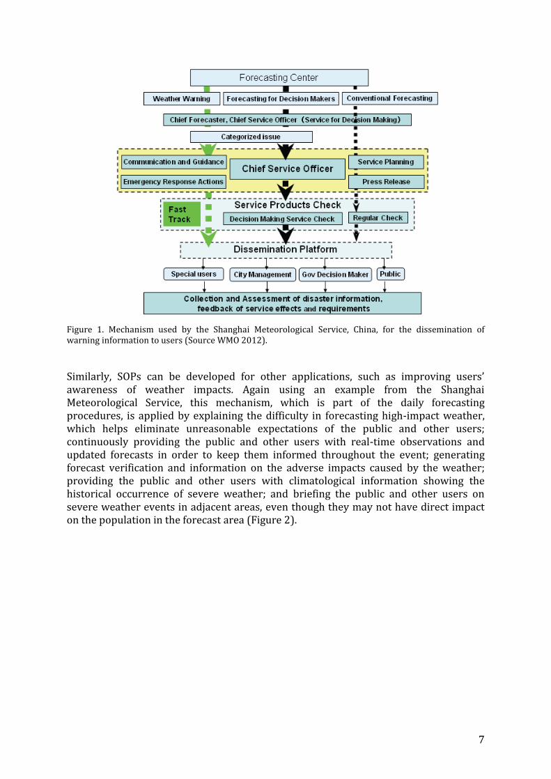
An example of a schematic for an SOP for the dissemination of hydrometeorological warnings is shown in Figure 1.
7
Figure 1. Mechanism used by the Shanghai Meteorological Service, China, for the dissemination of warning information to users (Source WMO 2012).
Similarly, SOPs can be developed for other applications, such as improving users’ awareness of weather impacts. Again using an example from the Shanghai Meteorological Service, this mechanism, which is part of the daily forecasting procedures, is applied by explaining the difficulty in forecasting high-impact weather, which helps eliminate unreasonable expectations of the public and other users; continuously providing the public and other users with real-time observations and updated forecasts in order to keep them informed throughout the event; generating forecast verification and information on the adverse impacts caused by the weather; providing the public and other users with climatological information showing the historical occurrence of severe weather; and briefing the public and other users on severe weather events in adjacent areas, even though they may not have direct impact on the population in the forecast area (Figure 2).

8
Figure 2. Schematic representation showing the SOP to improve users’ awareness of weather impacts (source WMO 2012). CSO is the Shanghai Meteorological Services’ Chief Service Officer, in charge of the Public Weather Service platform, responsible for interpreting forecasts, dissemination and communication with users.
The need and timeliness of warnings The need for a warning should be assessed against two considerations – the likelihood of an event, and the potential impact of an event. It is not sufficient to provide a warning of heavy rainfall; this hydrometeorological information needs to be translated into information that informs responders and the public of the impact of the hazard. In the case of rainfall – where and when will flooding occur? The more specific is the information then the more likely that there will be an appropriate response. The forecast must be compelling enough to trigger the desired action.
The content of the warning is therefore a joint development of responders, the main hydrometeorological and geophysical data providers and others with information on the vulnerability and exposure of people and property.
The timeliness of warnings must be sufficient to enable mitigating actions to be taken to reduce potential impacts. The main concern is the potential risk to life and property. For droughts, climate alerts are possible on a seasonal timescale and can be updated weekly, if required. Fast onset hydrometeorological hazards include tropical cyclones

9
and severe thunderstorms, which cause river floods, coastal storm surges, flash floods, wind and lightning damage and related fatalities. The ability to provide operational earthquake warnings is basically non-existent, but an immediate response is essential to minimize loss of life. Lead-time for tsunami warnings depends on the location of the source and may range from minutes to hours.
If not already available, baselines need to be established for the timeliness and skill of forecasts. Here some general guidance is provided based on international experience for particular hydrometeorological phenomena (see, for example, AMS 2007).
Zero- to 12-hour Forecasts and Nowcasts – Thunderstorms, Flashfloods, Tsunamis, Earthquakes The first 12 hours of forecasts cover to general areas: 1) Forecasting the initiation, evolution and movement of short-term, often intense weather phenomena such as thunderstorms and flash floods; and 2) predictions for larger-scale phenomena. Small-scale hazardous weather takes place on a time scale of minutes to hours, whereas larger-scale events have longer lifetimes. Earthquakes are also included here in the category of nowcasting; that is, detection through monitoring with little or no lead-time.
As the scale of the weather phenomenon decreases or the time range of the forecast increases, the predictability of the phenomenon generally decreases and the uncertainty of the forecast increases, resulting in a decrease of forecasting skill with time. In addition, to the inherent decrease of predictability with time, accurate forecasts of small-scale systems are hampered by inadequate observations and limitations in computational power. General areas where these important small-scale systems are likely to form can usually be predicted a few days in advance, based on large-scale weather model output available to INAM through the World Meteorological Organization’s (WMO) Severe Weather Forecasting Demonstration Project (SWFDP); but predicting their precise location, time and severity depends upon the continual monitoring and analysis of local observations. At best, the location of individual severe thunderstorms will not usually be known until hours or minutes prior to their occurrence. As an international benchmark, the US National Weather Service’s probability of detection for flash floods exceeds 90%, which is possible through the combined use of numerical models and enhanced detection by radar and satellite technology, along with advances in scientific understanding by forecasters. Other international benchmarks include the percentage of correct rainfall forecasts issued by the UK Met Office for day 1 is 71% and correctly forecast maximum temperatures for day 2 is 87%.
Warnings for tsunamis may be up to several hours in advance depending on the location of the originating earthquake or landslide; however, the false alarm rate for tsunamis is likely to be very high.
Short-range Forecasts (12 hours to a few days) – Tropical Cyclones, Floods Thanks to the WMO, Mozambique has access to reliable tropical cyclone track forecasts several days in advance of landfall and accurate precipitation forecasts up to 48-hours in advance from the WMO Regional Specialized Meteorological Center (RSMC) La Réunion - Tropical Cyclone Warning Center (TCWP). Storm surge predictions are also improving and will also be available through the SWFDP.

10
Medium-range Forecasts (a few days to two weeks) – Tropical Cyclones, Floods Medium-range forecasts, also available through the SWFDP, rely primarily on global numerical weather prediction systems. On average, these systems produce skillful forecasts up to 10 days in advance, although their performance varies by season and region. Skill is improved with the use of ensemble methods. Ensemble forecasts are multiple predictions from a set of numerical weather prediction systems with slightly different initial conditions and/or slightly different versions of atmospheric models. Differences between the individual predictions in the ensemble indicate likely forecast skill and confidence.
Extended-range Forecasts (two weeks and beyond) – Droughts and Severe Weather Ensemble techniques have also enhanced the skill of forecasts a week out and beyond, although skill in forecasting in the tropics lags behind that in higher latitudes. However, the ability to predict extreme weather events, including those beyond a week is improving.
Monthly and Seasonal Forecasts – Droughts Monthly and seasonal forecasts continue to improve. These developments are made available to Mozambique through the Southern African Regional Climate Outlook Forum (SARCOF). This Forum, however, has not yet taken advantage of the more frequent seasonal forecast updates that the global models are capable of providing, which would improve the skill of the forecast to inform particular climate-sensitive decisions.
Strengthening the Warning System
Warning Expectation Establishing rigid time standards for detection of hazards is difficult, because the lead-time is related to the likelihood of the event occurring. In the case of a tropical cyclone, at five days, the system can be detected; forecasts will give a range of locations for landfall and intensity. As the system develops and the lead-time decreases, the extent of the coastline at risk will decrease and the warning will become more specific. Forecasting intensity accurately remains difficult.
Table 1 summarizes the hazards, lead-times and means of detection. Lead-times are rarely a single time, but cover a range during which the warning levels will change as the likelihood of the event increases. This is discussed in detail in the following sections.
The first warnings should be issued in sufficient time for an effective response with consideration of the likelihood of the event and the avoidable losses. The logical flow is to start with awareness of the hazard, increasing to preparedness, and finally action. In the case of tsunamis, thunderstorms, flashfloods and storm surges, the response time is relatively short. Therefore, every effort should be made to improve the reliability of the warnings and extend the warning lead-time for action. In the case of tropical cyclones, the relatively long lead-time means that people can be prepared earlier to take action; however, the level of the warnings and expected actions need to be timed to have the optimal impact – avoiding all loss of life, minimizing damage and loss of productivity.
Hazard Lead-time Primary means Secondary means of Forecast Skill

11
of detection detection
Tropical Cyclone Up to 5 days Forecasts Observations Medium to High (landfall); low to medium (intensity)
Floods Hours to 2 day
Forecasts Observations Medium
Tsunami 0-12 hours Observations Forecast Very Low
Earthquake 0 Observations No skill
Drought Weeks to 2 months
Forecasts Observations High
Thunderstorms and Flashfloods
0-6 hours Observations Nowcasts/Forecasts Low to medium
Storm surge 0-6 hours Forecasts Observations Low to medium
Table 1. Summary of hazards and the lead-time for detection. Skill level is an indication of probability of detection at the longest lead-times indicated. High skill means a detection rate of better than 60%, medium skill is a detection rate between 40 and 60%, low is below 40% and very low skill is below 10%. Useful warnings can be issued based on the primary means of detection. Longer lead-times are possible for several phenomena, but the forecast skill decreases considerably.
This can be demonstrated by looking at the effectiveness and efficiency of a flash flood warning system for a small river basin. There is a trade-off between the benefits of an increased lead-time and the simultaneous decrease of warning reliability. An increase in lead-time provides valuable time for the completion of preventative measures, whereas the decrease of warning reliability will cause economic loss in the case of a false alert.
The reliability of the forecast is linked to the economic benefit as a function of warning lead-time. The reliability is determined from an analysis of an ensemble of flood forecasts and interpretation of flood forecast errors from past events. Determining the ability to reduce flood damage is based on surveys of end-users. The most important question for assessing the benefit of an alert is “Supposed you receive an alert some time before a flash flood, by how much could you reduce the flood damage?”
Figure 3, based on data from Schröter et al. (2008), illustrates this for a small river basin in Spain. Warning expectation as a function of lead-time, determined from past events, is shown. In this case the reliability is at 62% two hours before the event and decreases to 10% at six hours lead-time. Avoidable damage decreases nearly linearly from a maximum at 6 hours lead-time to a minimum at 1-hour lead-time.

12
Figure 3. Warning expectation as an indicator of optimal alert for the Besòs river basin in Europe (after Schröter et al. 2008)
Mitigation costs in terms of lost net value of production (in the graph scaled by a factor of 10) indicate the cost per hour that arises if the active persons stop productive work and turn to preventative measures. In view of the considerable costs in terms of loss of production associated with an alert, there is good reason to reflect carefully about triggering an alert for an event, which is still uncertain to occur. The warning expectation is defined as the product of the warning reliability and the avoidable damage. The resulting curve, with units of € per alert, is not constant but changes with lead-time and the maximum value defines the optimal point of time for releasing an alert with respect to reliability and consequences. In practice, this may indicate a change from an orange (be prepared) to a red warning (take action) signal. In the example, this occurs at a lead-time of 2 hours.
This serves to illustrate that many factors need to be considered in the design of an effective warning system and the timing of warnings. Using this, or a similar approach, can help to develop risk-based warnings. This is discussed in more detail in subsequent sections.

13
Color Coding Signals Color-coding is already used for some early warnings in Mozambique, but the use of signals varies from hazard to hazard and for some is non-existent (Table 2). It is proposed that the current system be overhauled with the aim of improving the understanding of the actions that need to be taken at each level of warning and for each hazard.
The information within each warning should be tailored for the specific requirements of the users; for example, one set is needed for emergency responders and one for the public, while different information will be required for aviation and for marine transportation. Figure 4 is the color-coded warning system used for hazards in Shanghai, China.
A common color for the level of severity makes it easier for people to understand the relationship between impacts of different hazards. This approach also minimizes confusion if multiple hazards occur simultaneously.
Each warning should have a detailed explanation of its meaning and the measures to be taken. Standard operating procedures should guide emergency responders following the issue of a particular warning.
Warnings Signal / Basic Meaning
Blue Green Yellow Orange Red
National alert NOT USED
High likelihood of national disaster
Imminent Disaster
Disaster in progress
Flood Low risk of floods
NOT USED
Moderate Risk of floods
High Risk of Floods
Tropical Cyclone Landfall in 2 days
NOT USED
Landfall in 1 day
NOT USED
Landfall in 6 hours
Tropical Cyclone Uses numbers 1-5 for severity
Drought NONE
Tsunami NONE
Earthquake NONE
Lightning Unclear
Wind Storm Unclear
Flash Flood Unclear
Table 2. The current use of signals in Mozambique

14
Figure 4. Severe weather warning signals used for all meteorological hazards in Shanghai (Source: Shanghai Meteorological Service). Similar colors are used for warnings issued by other agencies, such as the water management agency, which is responsible for flood forecasts.
Standard operating procedures in Shanghai require all agencies, which have a responsibility to issue warnings to their particular stakeholders, to develop joint response actions, which includes using the common signal colors. For example, if the Shanghai Meteorological Service issues tropical cyclone warnings, the Shanghai Flood Control Headquarters will issue similarly colored signals, albeit with their own code and precautionary measures (Figure 5). The Shanghai Emergency Management Service Office coordinates these activities and is in direct communication with both agencies. The Shanghai Meteorological Service issues its warnings directly to the public. The Shanghai Flood Control Headquarters issues warnings to the public and to flood control operators. Since the public receive warnings from two sources, it is important that these warnings are complementary and not contradictory.

15
Figure 5. Joint Response Action of Shanghai Met Service, Shanghai Flood Control Headquarters and the Emergency Management Service Office.
The Shanghai Meteorological Service warnings contain general information that is reinforced by specific information on flooding from the Flood Control Headquarters.
Table 3 lists the messages and precautionary measures to be taken for each level of typhoon (cyclone) warning issued by the Shanghai Meteorological Service. The warning signals are posted on all public electronic message boards, mobile phones and all television stations are required to broadcast the signal on all channels while it is in force. In addition, all other means of communication are used to ensure people receive the warnings.
Shanghai Meteorological Service
Shanghai Flood Control Headquarters
Emergency Management Service Office
General Public
Flood Control

16
Signal Meaning Precautionary Measures
In the next 24 hours, the tropical cyclone is likely to impact or has already had an impact on the area, average wind speeds of 39 - 49km/h on- and off- shore or gust of 62 - 74km/h; this condition is to continue.
1. Government and related departments should, according to their respective responsibilites, make good preparations for typhoon prevention.
2. Large-scale outdoor activities and high altitude operations should be suspended;
3. Operations on water and ships should take preventive measures such returning to port or avoiding the area if possible.
4. Reinforce structures susceptible to wind, such as doors, windows, coamings, scaffolding and billboards; cut off outdoor electric power.
In the next 24 hours, the tropical cyclone is likely to impact or has already had an impact on the area, average wind speeds of 62 - 74km/h on- and off- shore or gust of 89-102km/h; this condition is to continue.
1. Government and related departments should, according to their respective responsibilites, make preparation for taking emerngecy responses to a typhoon.
2. Large-scale outdoor assemblies and high altitude operations should be suspended.
3. Operations on water and ships should take preventive measures, and reinforce port facilities.
4. Reinforce or dismantle structures vulnerable to wind; people should stay indoors; make sure seniors and children stay in safe places; transfer people who are in dilapidated houses in a timely fashion.
TYPHOON
In the next 24 hours, the tropical cyclone is likely to impact or has already had an impact on the area, average wind speeds of 89 - 102km/h on- and off- shore or gust of 118 - 133km/h; this condition is to continue.
1. Government and related departments should, according to their respective responsibilites, take emerngecy response and rescue actions against typhoon;
2. Outdoor assemblies, classes and business (except special industries) should be suspended.
3. Emergency response and disaster rescue units should strengthen monitoring procedures and implement preventive measures.
4. Operations on water and ships should go back to port, reinforce port facilities.
5. Reinforce wind-affected structures, people should stay in safe areas; remind people that when the typhoon eye passes the wind speed will decrease or stop for a period of time and the people should continue to stay in safe places; people in unsafe buildings should be transferred in a timely fashion.
6. Preventative measures should be taken against flash floods and geological disasters induced by heavy rainfall.
In the next 24 hours, the tropical cyclone is likely to impact or has already had an impact on the target area, Average wind speeds of 118 - 133km/h on- and off- shore or gust of 150-166km/h; this condition is to continue.
1. Government and related departments should start emergency response and disaster rescue for typhoon.
2. Outdoor assemblies, classes and business (except special industries) should be suspended.
3. Take protective measurers for ships in port and transfer people to safe places.
4. Reinforce wind-affected structures, people should stay in safe areas; remind that when typhoon eye passes the wind will be weaken or stop for a short time and the people should continue to stay in safe places; people in unsafe buildings should be transferred in a timely fashion..
5. Preventative measures should be taken against flash floods and geological disasters induced by heavy rainfall.
Table 3. Typhoon (Tropical Cyclone) warning signals used in Shanghai including their meaning and precautionary measures to be taken.

17
A similar approach is used for drought, however, in this case there are only two levels of warning signal – orange and red (Table 4). Drought warnings are updated weekly.
Signal Meaning Precautionary measures
The comprehensive meteorological drought index for next week is expected to be at the level of heavy drought (return period of drought is 25 to 50 years), or any one county (district) has more than 40% of crops hit by the drought.
1. The government and relevant departments should, according to their respective responsibilities, take emergency response actions against drought impacts;
2. Relevant departments should start using the emergency reserved water sources, and dispatch all available water sources, giving priority to guaranteeing drinking water for urban and rural residents followed by livestock;
3. Limit water-supply to urban and rural areas, giving priority to the water for the irrigation of commercial crops, limit large amounts of water for agricultural irrigation;
4. Limit high water consumption in non-productive industries, water consumption in service industries, and discharge of industrial sewage;
5. The meteorological department should begin weather modification operations. (rain dispersal rockets/ cloud seeding).
The comprehensive meteorological drought index for next week is expected to be at the level of specially drought (return period of drought is 50 years ), or any one county (district) has more than 60% of crops hit by the drought.
1. The government and relevant departments should, according to their respective responsibilities, take emergency response and rescue actions against drought impacts;
2. Governments at all levels and relevant departments should start emergency response plans, such as long-distance water transfers, and adopt multiple measures including drawing water from other sources, digging deep wells, , so as to guarantee drinking water for urban and rural residents and livestock;
3. The water supply for urban and rural residents’ living-use should be limited to prearranged quantities, and the water supply for agricultural irrigation should be reduced or suspended;
4. Strictly forbid high water-consumption in non-production and service industries , and suspend the discharge of industrial sewage;
5. The meteorological department should intensify weather modification operations. (rain dispersal rockets/ cloud seeding).
Table 4. Drought warning signals used in Shanghai including their meaning and precautionary measures to be taken.
While the precautionary measures are appropriate, relying on hydrometeorological thresholds alone to determine when the warning is issued does not necessarily produce the most effective response. The recent experience in China with Tropical Cyclone Fitow described in Box 1 highlights the problem. In that case standard operating procedures and protocols meant that a red warning was issued in the City of Shanghai, based on the meteorological conditions, after the start of the morning commute giving no time for people to change their travel plans or for the emergency services to act. In a color-coded warning system that has four levels of severity (blue, yellow, orange and red), an orange hazard level or even yellow hazard level, combined with knowledge of people’s exposure to the hazard could have produced a forecast indicating a very high level of risk many hours sooner. This is requiring a rethinking of the warning process.
Achieving this requires the integration of many different sources of information in addition to data on the physical hazards. As described in Part I, this is already recognized in Mozambique (INGC 2012) and could be developed as a part of strengthening the overall warning system.

18
Box 1 Example of the need to forecast the impacts of the weather rather than only the hazard
One of the countries leading this effort is the UK and the Met Office, in particular, which focuses on providing risk based warnings. This may be a good template for Mozambique.
Risk Based Warnings Developed in collaboration with other government agencies and first responders, the UK Met Office uses a risk matrix to identify the likelihood of an event and the potential impact (Figure 6). The colors have the following basic structure – Green: No severe hydrometeorological hazard is expected; Yellow: Be aware; Orange: Be prepared; and Red: Take action.
Figure 6. Risk Matrix – A color is assigned to a warning based on the a combination of potential impact and likelihood (Source UK Met Office)
Tropical Cyclone Fitow began to impact the Chinese mainland on October 6, 2013 causing significant damage and disruption. Between 20:00 on October 7 and 14:00 on October 8th, Shanghai received total precipitation of 156mm, which is the most rainfall in 18 hours recorded since 1961. The impact was disastrous: 97 roads were flooded; 900 communities were flooded with many underground parking facilities and cars damaged; and some flood prevention walls were damaged and some destroyed. Overflowing rivers flooded four districts. By October 11, there were over 1.2million people directly impacted with one reported death; and nearly 28,000,000 hectares of farmland was flooded. The direct economic loss is estimated at 890 million RMB. In Zheijang Province, seven deaths were reported and the direct economic loss is estimated at over 33 Billion RMB.
SMS issues accurate warnings according to standard operating procedures and protocols, increasing the severity from blue to red as the situation worsened. Over 18 million people were alerted. However, the public response has been why were the warnings so late? The orange alert for rainfall was issued at 5:36 am on October 8 and the red alert at 07:38 am. This day coincided with the first day of school and work after the Chinese national holiday. The time of issuing the highest alerts coincided with rush hour – the morning commute was well underway before many people were aware of the severity of the situation.
Gridlock prevented people from either getting to their destinations or returning home.

19
The likelihood of an event is related to uncertainty; for example, the exact location or severity of the event. Generally, alerts at a 3 to 4 day lead-time will have a low or very low likelihood. The impact is related to vulnerability and exposure to the hazard and is tailored to the specific groups affected. For example, it can define the strain on emergency services or identify specific groups of people or communities. It can be used to determine when a particular hazard is beyond the capacity of provincial authorities and becomes a national responsibility. Using this approach, low likelihood events may be classified as yellow or orange level risks resulting in more timely response than basing warnings on the hydrometeorological hazard alone.
For each level, typical impacts and advice associated with each hydrometeorological phenomenon should be developed. Table 5 lists the impacts and advice associated with rain developed by the UK Met Office.
Applying this approach to the situation encountered during Tropical Cyclone Fitow, it is likely that the risk of a high impact would have been identified at least 12 hours or more earlier, triggering an orange or red alert at that time, which would triggered emergency actions and public warnings in sufficient time to have prevented so many people from being placed in harm’s way during the morning rush hour.
The value of this approach is now recognized by the WMO and new efforts are underway to involve WMO Members in pilots to test new warning systems. This will be implemented through the WMO SWFDP, which already involves Mozambique as an active participant.
Table 5 Generalized impacts at the four levels (very low, low, medium, high) for rain (Source: UK Met Office).

20
Information flows for early warning of hydrometeorological hazards The forgoing section described ways to improve the type, content and timing of warnings, including creating a more integrated warning system for all hazards. In this section, ways to improve communication between the key information providers and decision-makers is discussed. The INGC already provides a strong foundation for what is proposed here.
The need for a Hazards Partnership among information providers Information on hydrometeorological hazards and warnings should be initiated from a single source. This requires good operational interaction between all parties that are responsible for technical information. It is recommended that INGC, INAM, DNA, MINAG and DNG form the core of an operational partnership led by CENOE tasked with integrating all hydrometeorological, geophysical and other relevant information from all sources. Considerable experience has been gained in the development of a similar effort in the UK, the UK Natural Hazards Partnership (See Part I), which is a useful starting point that can be adapted to the specific situation in Mozambique.
Ideally all information providers would be members of the CENOE partnership with well-defined roles and responsibilities. For example, only INAM and DNA should generate authoritative flood forecasts and warnings, but data are needed from regional authorities. The partnership should aim to include ARA – Regional Water Authority; IIAM – Institute for Agrarian Research; DNSA – National Directorate for Agriculture Extension; INAMAR – National Maritime Institute; IDPP – Institute for the Development of Artisanal Fishery; INAHIMA – National Institute for Hydrography and Navigation. Other contributors might include the National Cartography and Tele-detection Centre (CENACARTA), the national agency responsible for mapping or geographical information systems.
Agreements on data sharing The most critical issue on data sharing is the consolidation of all information needed to produce reliable forecasts and warnings of impending hazards. This is critical; it should require formal agreements among all of the parties that can provide data and well-defined procedures for the use of these data. Experience elsewhere suggests that unless data sharing agreements exist, there will be no sense of obligation on the part of the data providers, who may conclude unilaterally what information is required and what they are willing to make available, rather allowing those integrating the data into an information system to determine the requirements.
A memorandum of understanding (MOU) or a memorandum of agreement (MOA) formalizes the relationship among data providers and between data providers and key users, defines mutual roles and responsibilities, and fosters a strong partnership from which all parties derive benefits. Developing an effective MOU requires a good mutual understanding of each party’s mission and objectives. In many cases, it includes a definition of any exchange of services and resources.
An MOU may focus primarily on data sharing issues or it may focus on procedural matters. For example, Standards Operating Procedures (SOPs) may be agreed, which explain in detail how the respective parties will routinely work together during a real-time event.
21
There needs to be a mutual desire by all parties to enter into an MOU, with a shared and equal commitment to working together; the provisions in the MOU should not conflict with any existing arrangements among the parties, nor with any arrangements each party might have with other organizations; the structure and content of the MOU should be clear, unambiguous and easy to review and update. The simpler and more straightforward the language, the less likelihood there is for misunderstanding or confusion; an MOU is a ‘living’ document and should include provisions for keeping it under review and up-to-date (WMO 2012).
Annex 1 provides a template for a data-sharing memorandum of understanding. The new protocol for data sharing between INAM and DNA is a good foundation for a more extensive development of agreement on data and information sharing among other parties. In particular, the agreement should extend beyond data sharing to the joint provision of warnings within a partnership framework.
Agreements on Response Measures Besides data sharing, standard operating procedures are needed for all entities, which have a role and responsibility in response to an emergency situation. For example, an early briefing to the agency responsible for water management should be followed by specific steps that the agency should take to be alert or prepared for action. If the agency is expected to interpret and communicate warnings to specific users these actions should be appropriately documented.
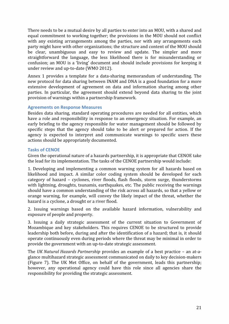
Tasks of CENOE Given the operational nature of a hazards partnership, it is appropriate that CENOE take the lead for its implementation. The tasks of the CENOE partnership would include:
1. Developing and implementing a common warning system for all hazards based on likelihood and impact. A similar color coding system should be developed for each category of hazard – cyclones, river floods, flash floods, storm surge, thunderstorms with lightning, droughts, tsunamis, earthquakes, etc. The public receiving the warnings should have a common understanding of the risk across all hazards, so that a yellow or orange warning, for example, will convey the likely impact of the threat, whether the hazard is a cyclone, a drought or a river flood.
2. Issuing warnings based on the available hazard information, vulnerability and exposure of people and property.
3. Issuing a daily strategic assessment of the current situation to Government of Mozambique and key stakeholders. This requires CENOE to be structured to provide leadership both before, during and after the identification of a hazard; that is, it should operate continuously even during periods where the threat may be minimal in order to provide the government with an up-to-date strategic assessment.
The UK Natural Hazards Partnership provides an example of a best practice – an at-a-glance multihazard strategic assessment communicated on daily to key decision-makers (Figure 7). The UK Met Office, on behalf of the government, leads this partnership; however, any operational agency could have this role since all agencies share the responsibility for providing the strategic assessment.
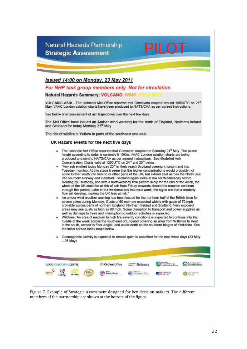
22
Figure 7. Example of Strategic Assessment designed for key decision-makers. The different members of the partnership are shown at the bottom of the figure.
23
In Mozambique, it is proposed that INAM, DNA, DNG and INGC would compile this strategic assessment as the key members of the CENOE partnership. In turn, CENOE would communicate this information to all relevant stakeholders as it does now during emergencies with this responsibility extended to non-emergency situations also. By making this a daily activity, communication channels are continuously exercised and tested; all stakeholders will eventually be fully engaged. In the UK, the stakeholders include the Cabinet Office, which in Mozambique would be the Council of Ministers. Compiling the summary will require all supporting entities to provide data and information to INAM, DNA, DNG, INGC and MINAG.
Communicating Warnings The challenge in communicating warnings is to ensure that all those with a responsibility to respond to a warning receive the information in time in a form that is easy to understand and use. The importance of the five early actions was highlighted in Part I. These are (i) early monitoring and detection; (ii) early briefing for specialized users and government agencies; (iii) early warning to the public; (iv) early dissemination; and (v) early response. The CENOE partnership would go a long way towards establishing a functional operational center for all hazards. In Shanghai, China, for example, the city government designated the Shanghai Meteorological Service as the home of the city’s hazard warning system with a broader mandate than providing only weather related warnings. Joint ownership among INGC, INAM, DNA, DNG and MINAG would create a more robust and reliable source of warning information and should enable the development of impact-based warnings rather than solely hydrometeorological-based warnings. This structure would also minimize the time required to share information and remove any risk of misunderstanding enabling more rapid and effective communication with external users.
Early briefing should be built into the operating procedures of CENOE since this already exists under INGC. In this capacity CENOE would exercise its responsibilities to inform government and communicate information to its provincial and district entities.
How information is communicated to the public varies from country to country. In Mozambique, CENOE may be best placed to communicate warnings to the public, in close cooperation with the other members of the partnership or the appropriate party may be designated based on the type of warning. In the case of floods, DNA, the authoritative source of the warning, may be designated to issue the warning jointly with other operational entities responsible for water resources management, for example. For cyclone warnings, the meteorological authority, INAM, would be designated to issue the warnings. One example, from the UK, is flood warnings. A Joint Flood Forecasting Center was established between the Environment Agency and the Met Office. This entity is a member of the National Hazards Partnership along with the Environment Agency and the Met Office; however, the Environment Agency is responsible for issuing the flood warnings to the public. Simultaneously, the Met Office issues rainfall warnings.
It is critical that a single voice have the sole responsibility to communicate a particular warning to the general public. The credibility of the warning message depends on the consistency in the information communicated through all available means of dissemination and trust in the source of the information. The public warning and the information flowing through the INGC network should be complementary enabling a timely response to the hazard and minimizing the risk of confusion among all responders.

24
Figure 8 shows schematically the proposed information flow for a hydrometeorological hazard expected to impact communities within two districts of one province in Mozambique. The structure is based on the partnership described above and adapted from current operational practices. Based on observations and numerical guidance, INAM forecasters in collaboration with INGC and DNA staff provide a strategic assessment of the threat, which INGC/CENOE conveys to the appropriate decision-makers as an early briefing. The severity of the warning is determined based on the vulnerability and exposure of the community threatened, and the readiness of the emergency response. INGC’s regional, provincial, district and LCDRM are placed on alert. Specialized agencies, such as INAHINA, with specific requirements are also provided with the early briefing in preparation for their dissemination of early warnings to mariners and fishermen. Based on further analysis, at the appropriate time, the LCDRM initiate local early warning. At that time warning information is also issued through all available media directly to the public.
Figure 8. Information flow between information provider, emergency operations agency and the public. Other Agencies refers to entities such as INAHINA, which would be responsible for communicating warnings to specialized users, such as mariners.
One difficulty with this approach is the number of decision levels before information is delivered to the community. Any breakdown in communication at any level will render the entire system ineffective. It is therefore essential to exercise the communication system frequently. This is the purpose of the strategic assessment, which is issued daily to the Government, INGC and CENOE staff and other stakeholders as required at each of the levels: in effect, a “green risk” alert during non emergency situations. In this way, any problems with the communication systems can be addressed prior to an emergency. Similarly, by using the media to provide routine weather, climate and hydrological information, all of these channels of communication are also tested.
The primary and sometimes only means of communication with the public is local radio, particularly the provincial broadcasting stations and the community radios. If this method is to be reliable, these radios stations must operate twenty-four hours a day, seven days a week during hazardous periods where there is a risk to life and property.
25
Using the risk matrix introduced earlier (Figure 6), it would be advisable to increase the frequency of broadcasts based on a yellow warning, which corresponds with “Be aware”. Making this work will require inclusion of part of the media in early briefings on the understanding that these briefings are intended to assist them to prepare their broadcast schedules accordingly, but not to transmit the information to the public prior to an authorized warning issued through CENOE.
A similar approach is applicable for all hazards. This can be summarized as follows:
Step 1: Hazard is detected and an initial warning level is ascribed based on likelihood and impact.
Step 2: INGC supported by members of CTGC and CENOE provides early briefing to decision-makers; if there is a vey short lead-time and high risk, this early briefing should be extended to media and other key stakeholders with instructions to begin preparations. If the lead-time is longer, the early briefing to key stakeholders may follow the briefing to the key government decision-makers. In any event, similar information is shared with all parties requiring an early briefing.
Step 3: INGC receives clearance to use CENOE to brief or alert key stakeholders and prepare public early warnings. Designated authority issues warnings with INGC and other entities as appropriate.
Step 4: INGC entities are alerted; key stakeholders are alerted and public warnings are disseminated by media and by other available means. Regional CENOE, the INGC provincial and District representations and LCDRM should receive information sufficiently in advance of public warnings to be able to respond to the public’s needs.
Step 5: Key information providers continue to update CENOE on the situation and issue further warnings as required; INGC operations are underway and evolve with the situation
Step 6: Feedback and verification of the hazard impact by responders and end-users during the event is used by CENOE to improve the warning information; verification after the event contributes to improving the overall system.
Access to warning information by end-users As discussed in Part I, there are often many sources of hydrometeorological information including foreign sources, which can sometimes conflict with official government issued alerts and warnings. This is a problem that compounds effective disaster risk reduction in many countries. Through the SWFDP and Climate Outlook Forums, WMO is helping countries address this issue by providing the best available severe weather information, flash flood guidance and drought information. However, this does prevent others from providing their own products. The only effective solution, short of regulation, is to encourage the use of official sources of information through frequent information campaigns. The introduction of a common warning system for all hazards and better understanding of the risks associated with a particular hazard will also help. If these steps do not work, the legal obligation to base hazard responses on authoritative sources of information may need to be enforced.
This problem extends to the international community working with the Government of Mozambique, which often prefers to access non-national sources of hazard information.
26
Rules for Dissemination of Information Standard Operating Procedures for the dissemination of Information is shown schematically in Figure 9 and described as follows:
Monitoring and Detection (Lead agency responsible for hazard – INAM, DNA, DNG or MINAG)
Timing: When available
1. Information is prepared based on forecasts and observations of the hazards from the lead agencies responsible for compiling the information and providing the initial guidance.
Preparation of guidance (Lead agency responsible for hazard – INAM, DNA, DNG or MINAG)
Timing: 30 minutes to 1 hour after detection, except for fast track
2. Based on predetermined criteria for the specific hazard, an initial impact and likelihood of occurrence is assigned to the hazard. This establishes the level of the threat and a color code is assigned.
3. Early warnings of short-lived, high-risk events, such as severe thunderstorms, lightning and flash floods are prepared to be fast tracked for dissemination to the public and stakeholders. This information is distributed as soon as possible, usually within 30 minutes of detection.
4. Technical input for the Strategic Assessment to decision-makers is prepared. 5. Technical input into briefings for key stakeholders is prepared. 6. Appropriate messages for wider dissemination are prepared and approved.
Strategic Assessment (INGC and other Members of CENOE)
Timing: In parallel with preparation of guidance, completed within 1 hour of detection
7. Members of the CENOE partnership compile the Strategic Assessment of the threat(s) as the main component of the early briefing to key decision-makers.
a. The Strategic Assessment contains information on all existing hazards including the current alert status.
b. It provides a summary of any expected changes in the situation and provides recommendations for action.
c. New threats are identified, the timing and location of the impact described and the proposed actions including level of warning.
d. If authorization is required from decision-makers, this is also identified.
The Strategic Assessment should be a familiar document to all decision-makers and key stakeholders because during normal times it would be disseminated on a daily basis. During an emergency, the information would be updated as frequently as needed to inform decisions.
Early briefing (INGC and Information sector of CENOE)
Timing: completed within 30 minutes to 1 hour after guidance is prepared. Where possible briefings are conducted in parallel or consolidated if appropriate

27
8. The dissemination platform for warning information is a component of CENOE, skilled in communication, which would be responsible for the following activities at the early briefing stage:
a. Support the INGC briefing of the Strategic Assessment to the key decision-makers.
b. Acquire authorization for actions as required. c. Support early briefings to all INGC staff in preparation for emergency
response. d. Provide early briefings to government agencies at national, provincial and
local levels likely to be impacted by the hazard. This will trigger activities based on their own SOPs for the particular hazard.
e. Provide early briefings to specialized users likely to be impacted by the hazard, focused on their particular needs.
f. Provide early briefings to the media, which are expected to transmit warning information to the public and other end-users at risk.
Early Warning (Information sector of CENOE)
Timing: Immediately following authorization, or receipt of fast track information
9. Fast track early warnings for the public are issued when required using all available means of communication (fax, email, short text messages, telephone, etc.).
10. Warning information is distributed to CENOE communication staff responsible for transmitting warnings to regional, provincial and local operations centers and LCDRM using all the most appropriate, expedite and reliable means (fax, email, short text messages, telephone, etc.).
11. Warning information is distributed to key stakeholders. 12. Warning information is distributed to the media for transmission to the public.
Collection and Assessment of Disaster Information (Lead technical agency and Information sector of CENOE)
Timing: On an hourly basis if possible during the event or when available
13. The Communication sector of CENOE monitors communications and advises on any breakdown in communication that may hamper warning communication.
14. The Communication sector of CENOE receives feedback on service effects a. Communicates information to forecasters and others responsible for
updating warning information 15. Lead technical agency uses data to improve warnings as appropriate. 16. Lead technical agency analyzes data to improve services after the event.

28
Figure 9. SOP for dissemination of warning information to Government, stakeholders, media and public. The public receives information from two sources, the media and the LCDRM if they are activated, since not every hazard triggers a full-scale emergency involving the LCDRM.
Rules for Transmission of Decisions The transmission of decisions is directly related to the rules for the dissemination of information, but here the emphasis is on the response to the warning information. The Standard Operating Procedures have several key steps:
Authorization Timing: Immediately following the early briefing
1. The INGC facilitates the early briefing of the Technical Council for Disaster Management (CTGC) and / or the Coordination Council for Disaster Management (CCGC) using the Strategic Assessment tool. If decisions are required, these are clearly identified with proposed actions and expected outcomes. The proposed level of alert will be included in the Strategic Assessment, which will include the likely geographical area affected and an assessment of any changes in risk that can be expected through the event that may lead to an increase in the alert level. The briefing will also include an assessment of the scale of the emergency response, if any.
CENOE Timing: immediately on receipt of authorization
2. On receipt of authorization the appropriate authorities will finalize warnings for dissemination
3. Fast track warnings are issued without prior authorization.
29
First Responders Timing: Immediately on receipt of briefing or warning
4. Key responders, especially the LCDRM, are expected to act immediately to be prepared for action on receipt of an early briefing
5. Key responders, especially the LCDRM, are expected to take action to warn the public and other end-users at risk within their jurisdiction on receipt of a warning transmitted to them by CENOE.
The Media Timing: On receipt of warning or update
6. The media have a duty to communicate warning information to the public. Local radio is particularly important. Warnings should be disseminated to radio stations, particularly the provincial radio stations and community radios stations, TV, etc. in the appropriate format for broadcast – already translated into the local language, clearly identify the impacts of hazard and the any actions that should be taken by recipient. The information should alert the recipient stay tuned to the radio for further updates and to pay attention to instructions from the LCDRM.
7. Radio stations need operate on an emergency basis for the duration of the event. This includes extending broadcast hours to ensure that the public is able to receive up to date information. Disruptions to normal programming should be expected.
8. Radio stations should rebroadcast the warning information frequently during period of validity as specified by the authority issuing the warning.
Other Parties Timing: On receipt of warning or update
9. Depending on the hazard, other parties may also be responsible for communicating the warnings to specialized users. For example, INAHINA would be responsible for communicating the warnings to mariners.
The Public Timing: On receipt of warning
10. The public are expected to have due regard to warnings, which are issued for their personal safety, and should follow official instructions regarding actions to be taken.
Warning Accuracy and Verification Warning information should be verified by the communication sector of CENOE both objectively and subjectively before, during and after the event. The objective verification might be “was the warning received”, “was the warning issued before the threshold” or “was the warning issued when a threshold was exceeded?” The subjective verification might be “Did the warning give good advice?” What were the impacts? Was the timing correct? Was the area affected correctly identified? Methods of verification include media reports and impacts reported by responders/end-users. Verifying the usefulness of the warning includes right place? Right time? Enough lead-time? Good advice? Annex 2 includes an example of scorecard used by the UK Met Office. Real-time

30
feedback before and during an event depends on two-way communication, in which all messages transmitted to the field are positively acknowledged immediately upon receipt. There should be no delay in the acknowledgement of the acceptance of the warning information. Absent an acknowledgement, it must be assumed that the information was not received and other means of communication should be sought.
An overall assessment after an event might take the form of the following:
Overall Marking Assessment
0-2 Very Poor Warning was missed or gave poor guidance to the customer or end-user, perhaps being classified as a “False Alarm”
3-5 Poor Guidance Although a warning was issued it gave poor guidance to the customer or end-user
6-7 Good Guidance A warning was issued, which gave generally good guidance to the customer or end-user
8-9 Excellent Guidance The warning issued gave excellent guidance to the customer or end-user
In the case of the UK Met Office, they aim to get at least 60% of all warnings assessed as “Good” or “Excellent” guidance by the customer or end-user.
Only the user (the emergency responder or the public) can assess a warning. Advisors within INAM, DNA, DNG, MINAG, INGC and CENOE should seek feedback from emergency responders in area affected before, during and after an event, and through surveys of the public after a severe event. One aim is to assess whether the public have heard the warning and have acted on it. This can take the form of the following kinds of questions: Where you aware of the flood warning? How did you hear about the warning? Did you change your plans as a result of the warning? Was the warning useful? Was the warning accurate? How do you prefer to receive flood warnings?
Summary The analysis has identified both good practices and gaps in Mozambique’s warning systems. Building on the strengths of the CENOE, it is recommended that Mozambique consider establishing a formal partnership led by CENOE for the sharing of data and information related to all hazards among all information providers. The proposed partnership might be modeled on the Natural Hazards Partnership create in the UK, which brings together all of the agencies that provide the data needed to create hazard warnings that incorporate the population’s vulnerability and exposure to those hazards.
This multihazard approach helps create a common framework for warnings and remove any barriers to communication between information providers. It can also improve communication with decision-makers. In particular, the partnership would have the responsibility to provide a strategic assessment on all threats on a daily basis. The aim would be to inform government decision-makers, but similar communications could also assist other key stakeholders – NGOs, international organizations and the private sector, for example.

31
Technical improvements are required to streamline hazard warnings. The current system is confusing with each hazard having its own unique signaling system or in some cases no signal at all. It is recommended that the present system be replaced with one that uses common color-coded signals to identify the level of risk for each hazard. Basing the new system on the national alerting system colors is recommended with the addition of one additional category – green, yellow, orange, red with each color associated with a common level of threat across all hazards. A generic SOP for dissemination of warnings has been outlined; however, in practice every government agency impacted by a hazard needs to operate using an SOP that is tied to the basic protocol for dissemination. In practice, these will include detailed information, such as telephone numbers and other contact information, and what actions to take following an early briefing or a warning.
Warnings need to explicitly take into consideration the likelihood of the hazard and its impact. This will help define a warning system based more effectively on the risk of impact of the hazard, rather than on physical parameters of the hazard alone. Countries taking this approach have demonstrated considerable improvement in the utility of their forecasts and warnings.
Although there are different means of communication, the public depends largely on the radio, and on local language stations in particular. A potential single point of failure in the warning system is the lack of ability to communicate effectively and appropriately with the public. Since not all radio stations operate 24 hours a day, 7 days a week, a procedure is needed, which encourages stations to adapt their operations during emergencies. Since advance preparation is needed, radio stations and other media should be invited to participate in early briefings along with other key stakeholders well in advance of the issuance of public warnings.
References AMS. 2007. Weather Analysis and Forecasting, An Information Statement of the
American Meteorological Society. Bull. Amer. Meteor. Soc., 88
INGC. 2012. “Avaliação do ciclo de desastres: Manual de procedimentos para apoio a tomada de decisão”. República De Moçambique, Ministério Da Administração Estatal.
Rogers, David P. and Vladimir V. Tsirkunov. 2013. Weather and Climate Resilience: effective Preparedness through National Meteorological and Hydrological Services. Directions in Development. Washington DC: World Bank.
Schröter, K., M. Otrowski, C. Velasco, H.P. Nachtnebel, B. Kahl, M. Beyene, C. Rubin M. Gocht, 2008: Effectiveness and Efficiency of Early Warning Systems for Flash-Floods (EWASE). First CRUE ERA-Net Common Call – Effectiveness and Efficiency of Non-structural Flood Risk Management Measures, 132pp. Available from www.crue-eranet.net
Tang Xu, Lei Feng, yongjie Zou, and Haishen Mu. 2012. “The Shanghai Multi-hazard Warning System: Addressing the Challenge of Disaster Risk Reduction in an Urban Megalopolis.” In Institutional Partnerships in Multi-Hazard Early Warning Systems, edited by Maryam Golnaraghi, 159-79. Heidelberg, Germany. Springer.

32
WMO 2012. Guidelines for Creating a Memorandum of Understanding and a Standard Operating Procedure between a National Meteorological or Hydrometeorological Service and a Partner Agency. WMO-1099, Geneva, Switzerland.

33
Annex 1 – MOU Template for Data Sharing Agreement
MEMORANDUM OF UNDERSTANDING
AMONG
THE PARTICIPATING ENTITIES OF THE MOZAMBIQUE NATURAL HAZARDS PARTNERSHIP
THE MINISTRY OF STATE ADMINISTRATION, THE MINISTRY OF TRANSPORT AND COMMUNICATIONS, THE MINISTRY OF PUBLIC WORKS AND HOUSING, THE MINISTRY OF AGRICULTURE and THE MINISTRY OF MINERAL RESOURCES
Premise
This Memorandum of Understanding (“the Memorandum”) sets forth the framework for a collaborative alliance, known as “CENOE”, among the Ministry of State Administration (on behalf of the National Institute of Disaster Management (INGC)), the Ministry of Transport and Communications (on behalf National Institute of Meteorology (INAM)), the Ministry of Public Works and Housing (on behalf of National Directorate of Water (DNA)), Ministry of Agriculture (MINAG) (including the National Secretariat for Food security and Nutition- SETSAN, and the National Cartography and Tele-detection Centre) and Ministry of Mineral Resources (on behalf of the National Directorate of Geology (DNG). The Ministry of State Administration, the Ministry of Transport and Communications, the Ministry of Public Works and Housing, Ministry of Agriculture and Ministry of Mineral Resources are collectively hereinafter referred to as “the Parties”. The objective of the Memorandum is to provide a framework within which hydrometeorological and geophysical data and related demographic information are shared and collaborative activities are undertaken within “CENOE”
Each party’s agencies (INGC, INAM, DNA, MINAG, DNG) will be responsible for data collection within the mandates of their own organizations.
1. Objectives
The purpose of the partnership is to:
a. Share data, which are based on the hydrometeorological and seismic observing networks operated by the Parties and data on vulnerability and exposure of the population and economic sectors collected by the Parties. More specifically, all data collected and/or information that is relevant to formulation of forecasts and warnings of hydrometeorological and geological risks should be made available to the Parties. Specific agreements on the ways of data transmission, types and formats of data will be developed between the Parties.
b. Provide a daily Strategic Assessment for all potential hazardous situations awareness for key decision-makers in Government of Mozambique and for other stakeholders expected to take action in event of an emergency.
c. Provide a common source of public information and warnings related to hazardous situations.

34
d. Share knowledge and promote the cooperation and integration of activities among the Parties and among users of the information services.
2. Framework for collaboration
a. The framework of the collaboration among the Parties is expected to include the following:
i. Exchange of data and information on weather, climate, hydrology, seismic activity, vulnerability and exposure of people and property without restriction to promote better coordination for present and future actions.
ii. The development a common format for the production, communication and dissemination of warnings related to natural hazards.
b. The Parties hereby formally acknowledge their agreement to the above-mentioned framework of cooperation.
3. Intellectual Property
The Parties recognize the importance of protecting and respecting intellectual property rights. This Memorandum does not grant the right to use materials belonging to, or created by, any other Party. The Parties shall agree in writing on the ownership and possible right of use of any intellectual property rights that may arise in any work to be created by the collaborative activities to be undertaken pursuant to this Memorandum, at the time of agreeing on the work plan for such activities.
4. Names and Emblems
No Party will use the name or emblem of any other Party, or any abbreviation thereof, without the prior written approval of such other Party in each case.
5. Limits to Agreement
This Memorandum does not constitute a commitment by any Party to provide support or financing for any individual activity or project not specified in their work programs that could be annexed to this Memorandum during its period of validity. Any sharing of information between the Parties shall be subject to the government policies on the disclosure of information.
6. Disputes, Controversies, and Claims
a. In case of a dispute, controversy, or claim between the Parties arising out of or relating to this Memorandum or an agreement for any activity or project undertaken pursuant thereto, the Parties shall attempt to reach an amicable resolution in good faith.
b. In the event an attempt to reach an amicable resolution proves unsuccessful within thirty days after the first Party has formally notified the dispute, controversy, or claim to the other Parties in writing, any such dispute, controversy, or claim shall proceed to arbitration. Arbitration shall be conducted by all Parties to this agreement and shall be submitted to the Government of Mozambique through the Council of Ministers.

35
7. Implementation
The authorized representatives with overall responsibility for implementation of this Memorandum are:
Position On behalf of Agency
Minister of State Administration INGC
Minister of Transport and Communications INAM
Minister of Public Works and Housing DNA
Minister of Agriculture MINAG, SETSAN and CENACARTA
Minister of Mineral Resources DNG
These individuals may designate officials of their respective organizations, namely INGC, INAM, DNA, MINAG and DNG to carry out the technical implementation of this Memorandum.
8. Relationships between the Parties
Each Party will conserve its own legal status.
9. Effect, Duration, and Modification
a. This Memorandum shall enter into force on the date of its signature by all Parties and remain valid for a period of five (5) years. Without objection, this Memorandum shall be automatically extended at the end of the initial term for another term of three (3) years.
b. At the end of the initial term of this Memorandum, a collective assessment by the Parties will be carried out to review the results and lessons learned from their collaborative activities. The views of stakeholders on the information and warning services shall be obtained by the Parties in connection therewith. The Parties will discuss and share any conclusions reached which may have a bearing on their collaboration under this Memorandum. Based on such assessment, the Parties may keep in force, or modify this Memorandum.
IN WITNESS WHEREOF, the Parties hereto, acting through their duly authorized representatives, have executed this Memorandum in their respective names on the dates hereinafter mentioned.
Signature (Minister of State Administration)
Location, Date:
Signature (Minister of Transport and Communication)
Location, Date:

36
Signature (Minister of Public Works and Housing)
Location, Date:
Signature (Minister of Agriculture)
Location, Date:
Signature (Minister of Mineral Resources)
Location, Date:

37
Annex 2: Subjective warning verification (example from UK Met Office) Impact Levels
3 Impact column ticked in warning is consistent with impacts experienced
2 Impact column ticked in warning is within one level of impacts experienced; e.g., if earning indicated “significant” impacts while those experienced were “low”
1 Impact column ticked in warning is within two levels of impacts experienced; e.g., if warning indicated “significant” impacts while those experienced were “very low”
0 Impacts were reported and no warning was issued or no impacts were reported when a warning was issued
Comments as necessary (Add any further information, which influenced your marking)
Assessment Score for Impacts (0, 1, 2 or 3))
Validity Time
3 All the impacts were noted within the warning validity time and the warning was issued at least 2 hours before the start validity time
2 Most of the impacts occurred within the warning validity time while others were no more than 2 hours outside the period
1 Some of the impacts occurred within the warning validity time but most occurred within 2hours either side of the period
0 No warning was issued or none of the impacts identified occurred within the warning validity period
Comments as necessary (Add any further information, which influenced your marking)
Assessment Score for Validity Time (0, 1, 2 or 3)
Area Affected
3 All impacts noted were within the warning area
2 The impacts occurred generally within the warning area, but the area is deemed to be too large or slightly too small
1 The area is generally displaced from the main impacts but a few impacts occurred within it
0 No warning was issued or there were no reported impacts in the area identified by the warning
Comments as necessary (Add any further information, which influenced your marking)
Assessment Score for Area (0, 1, 2 or 3)

38