Design of active bridge line rectification for SMPS - Infineon ...

Computers & Geosciences ] (]]]]) ]]]–]]]
Contents lists available at ScienceDirect
Computers & Geosciences
0098-30
doi:10.1
Abbre
GRASS,
Geospatn Corr
E-m
duccior
PleasGeos
journal homepage: www.elsevier.com/locate/cageo
Robust rectification of aerial photographs in an open source environment
Duccio Rocchini a,n, Markus Metz a,b, Alessandro Frigeri c, Luca Delucchi a, Matteo Marcantonio a,d,Markus Neteler a
a Biodiversity and Molecular Ecology Department, IASMA Research and Innovation Centre, Fondazione Edmund Mach, Via E. Mach 1, 38010 S. Michele all’Adige, Trento, Italyb Institute for Experimental Ecology, University of Ulm, Albert Einstein Allee 11, 89069 Ulm, Germanyc Istituto di Fisica dello Spazio Interplanetario, Istituto Nazionale di Astrofisica, via del Fosso del Cavaliere 100, 00133 Roma, Italyd BIOCONNET, Biodiversity and Conservation Network, Department of Environmental Science ‘‘G. Sarfatti’’, University of Siena, Via P.A. Mattioli 4, 53100 Siena, Italy
a r t i c l e i n f o
Article history:
Received 4 December 2010
Received in revised form
18 May 2011
Accepted 10 June 2011
Keywords:
Aerial photographs
Free open source software
Geometric correction
GRASS GIS
Orthorectification
Remote sensing
04/$ - see front matter & 2011 Elsevier Ltd. A
016/j.cageo.2011.06.002
viations: FOSS, Free open source software;
Geographical Resources Analysis Support Sys
ial Foundation
esponding author. Tel.: þ39 0461 615570.
ail addresses: [email protected],
[email protected] (D. Rocchini).
e cite this article as: Rocchini, D., etciences (2011), doi:10.1016/j.cageo.
a b s t r a c t
Aerial photographs provide the basis for developing indices of landscape composition and structure as
sensitive measures of large-scale environmental change over relatively long periods of time. In view of
this, proper image rectification is needed to enable geometrically unbiased application of landscape
metrics in order to obtain meaningful results. It is also particularly important to provide researchers
with image rectification tools within an open source environment, in order to: (i) guarantee free and
robust tools for processing remote sensing data, (ii) facilitate customization, and (iii) provide useful
support via forums and email lists. In this paper we provide a complete description of a robust and
freely licensed toolchain for orthorectifying images, which is available in the open source software
GRASS GIS. We will first sketch the theoretical background behind rectification and then illustrate the
workflow of the orthorectification procedure in GRASS GIS.
& 2011 Elsevier Ltd. All rights reserved.
1. Introduction
Remote sensing is a powerful tool for the exploration of theEarth surface since it provides a synoptic view of an area with ahigh temporal resolution (Gillespie et al., 2008). As an example,multitemporal analysis has been widely used for studying thedynamics of ecological and environmental processes. The literatureencompasses several fields of study such as soil loss (e.g., Disperatiet al., 2001), natural resources assessment (e.g., Geri et al., 2010),vegetation, and ecological dynamics (e.g., Pelorosso et al., 2009).
Aerial photographs provide the basis for developing indices oflandscape composition and structure as sensitive measures oflarge-scale environmental change (Kepner et al., 2000), and theirquantitative analysis is facilitated by geographic informationsystems (GIS), which offer many new possibilities in this field ofresearch (Baltsavias, 1996). In order to be able to overlay remotelysensed data onto each other (image-to-image) or onto topo-graphic maps (image-to-map), geometric correction is needed.Before accurate measurements based on aerial photographs canbe made, distortion in the photographs must be removed (Powers
ll rights reserved.
GPL, general public license;
tem; OSGeo, Open Source
al., Robust rectification of a2011.06.002
et al., 1996). Since all metrics calculated on a landscape (e.g., fromland use class coverage to patch shape and size) are sensitive togeometric distortion, geometric correction of aerial photographsis required for a realistic multitemporal study. Thus, orthogonalprojection of all points of the image to a reference surface(system) must be carried out in order to correct all types ofdistortion in the photos (Novak, 1992).
There are several problems with geographical data and theiranalysis, such as spatial resolution (Jelinski and Wu, 1996) andthe definition of thematic classes (Ricotta, 2005). However, fewstudies have explicitly dealt with the effects of image rectificationon the measure of landscape patterns (e.g., Rocchini, 2004).
The spread of software for GIS and remote sensing data analysiscould lead to two basic problems. First, an uninformed use of GIS canlead to the application of improper rectification algorithms, whichcould corrupt subsequent steps of the analytical process. Second, thecost of both software licensing and imagery puts it out of the reach ofmany researchers (Gillespie et al., 2008), especially those located indeveloping countries where the need is perhaps greatest (Nagendraand Rocchini, 2008). The development of free tools for robustlyrectifying images could, therefore, provide researchers with a valuableresource for landscape analysis. This way, the access to the codeallows study of the algorithm implementation, enabling a reproduci-ble environment for processing remote sensing data.
The aim of this paper is to provide researchers with a completedescription of a robust and free tool for orthorectifying images.We will firstly sketch the theoretical background behind
erial photographs in an open source environment. Computers &
D. Rocchini et al. / Computers & Geosciences ] (]]]]) ]]]–]]]2
rectification and then illustrate the workflow of the orthorectifi-cation procedure in GRASS GIS with a working example.
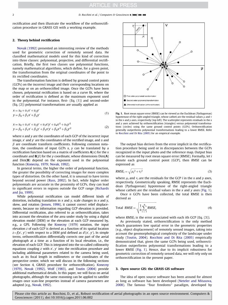
Fig. 1. Root mean square error (RMSE) can be viewed as the Euclidean (Pythagorean)
hypotenuse of the right-angled triangle, whose catheti are the residual values m and nin the x and y axes, respectively (top left). The scatterplot represents residuals in the x
and y axes achieved by orthorectification (triangles) versus polynomial transforma-
tions (circles) using the same ground control points (GCPs). Orthorectification
generally outperforms polynomial transformations leading to a lower RMSE. Refer
to Rocchini and Di Rita (2005) for an empirical example.
2. Theory behind rectification
Novak (1992) presented an interesting review of the methodsused for geometric correction of remotely sensed data. Heclassified mathematical models used for this kind of correctioninto three classes: polynomial, projective, and differential rectifi-cation. Briefly, the first two classes use polynomial functions,namely mathematical algorithms, which define, for a given point,the transformation from the original coordinates of the point toits rectified coordinates.
The transformation function is defined by ground control points(GCPs) on the incorrect image and their corresponding locations onthe map or on an orthorectified image. Once the GCPs have beenchosen, polynomial rectification is based on a curve fit, where theorder of rectification is defined as the maximum exponent usedin the polynomial. For instance, first- (Eq. (1)) and second-order(Eq. (2)) polynomial transformations are usually applied as
x¼ a0þa1x0 þa2y0
y¼ b0þb1x0 þb2y0ð1Þ
x¼ a0þa1x0 þa2y0 þa3x0y0 þa4x02þa5y02
y¼ b0þb1x0 þb2y0 þb3x0y0 þb4x02þb5y02ð2Þ
where x and y are the coordinates of each GCP of the incorrect inputimage, x0 and y0 are the coordinates of the rectified image, and a andb are coordinate transform coefficients. Following common nota-tion, the coordinates of input GCPs x, y can be translated by arectification function based on a matrix of coefficients A(a) for the x
coordinate and B(b) for the y coordinate, whose dimensions Dim(A)and Dim(B) depend on the exponent used in the polynomialfunction (Konecny, 1979; Novak, 1992).
In general terms, the higher the order of polynomial function,the greater the possibility of correcting images for more complextypes of distortion. On the other hand, it is unusual to have termsbeyond second power (Russ, 2002). In fact, while higher orderpolynomials are accurate in the proximity of GCPs, they can leadto significant errors in regions outside the GCP range (Richardsand Jia, 1999).
While polynomial rectification can model different kinds ofdistortion, including translation in x and y, scale changes in x and y,skew, and rotation (Jensen, 1996), it cannot correct relief displace-ments, because no information regarding GCP elevation is provided.Differential rectification, also referred to as orthorectification, takesinto account the elevation of the area under study by using a digitalelevation model (DEM) or the elevation at each GCP measured by,e.g., a GPS. Following the Konecny (1979) notation, the inputelevation z of each GCP is derived as a function of its spatial locationz¼ f(x0, y0) with respect to a DEM grid defined as d0(x0, y0). In simpleterms, orthorectification differentially corrects one part of the aerialphotograph at a time as a function of its local elevation, i.e., theelevation of each GCP. This is integrated into the so-called collinearityequations coupling z with x0, y0 into the rectification procedure andincluding additional parameters related to the camera being used,such as its focal length in millimeters or the coordinates of theperspective center, which we will discuss in the following sections(see Section 4, GRASS procedure for orthorectification). Konecny(1979), Novak (1992), Wolf (1983), and Toutin (2004) provideadditional mathematical details. In this paper, we will focus on aerialphotographs, although the same reasoning can be applied to satelliteimages once scan-line properties instead of camera parameters areadopted (e.g., Novak, 1992).
Please cite this article as: Rocchini, D., et al., Robust rectification of aGeosciences (2011), doi:10.1016/j.cageo.2011.06.002
The output bias derives from the error implicit in the rectifica-tion procedure being used or in discrepancies between the GCPsrecognized in the input photo and the reference map. Output biascan be measured by root mean square error (RMSE). Formally, let i
denote each ground control point (GCP), then RMSE can beexpressed as
RMSEi ¼
ffiffiffiffiffiffiffiffiffiffiffiffiffiffiffiffiffiffimi
2þni2
qð3Þ
where mi and ni are the residuals for the GCP i in the x and y axes,respectively. Geometrically speaking, RMSE represents the Eucli-dean (Pythagorean) hypotenuse of the right-angled trianglewhose catheti are the residual values in the x and y axes (Fig. 1).
Once n GCPs have been collected, the total RMSE is thenderived as
Total RMSE¼
ffiffiffiffiffiffiffiffiffiffiffiffiffiffiffiffiffiffiffiffiffiffiffiffiffiffi1
n
Xn
i ¼ 1
RMSEi
vuut ð4Þ
where RMSEi is the error associated with each ith GCP (Eq. (3)).As previously stated, orthorectification is the only method
which guarantees low spatial error in the geometric properties(e.g., object displacement) of remotely sensed images, taking intoaccount the geomorphological complexity of the landscape understudy (Toutin, 2004). Rocchini and Di Rita (2005) empiricallydemonstrated that, given the same GCPs being used, orthorecti-fication outperforms polynomial transformations leading to alower RMSE (Fig. 1). Hence, due to its implicit robustness forgeometric correction of remotely sensed data, we will rely only onorthorectification in the present paper.
3. Open source GIS: the GRASS GIS software
The idea of open source software has been around for almostas long as software has been developed (Neteler and Mitasova,2008). The famous ‘‘four freedoms’’ paradigm, developed by
erial photographs in an open source environment. Computers &

Fig. 2. General flow of the orthorectification procedure performed by GRASS GIS.
Note that the output consists of both the orthorectified image and the RMSE,
which is crucial for assessing image rectification accuracy. The different steps are
represented as ellipses. Refer to the main text for detailed information.
D. Rocchini et al. / Computers & Geosciences ] (]]]]) ]]]–]]] 3
Stallman (1997) in his seminal work which proclaims (i) thefreedom to run the program for any purpose, (ii) the freedom tostudy how the program works and adapt it to one’s own needs,(iii) the freedom to redistribute copies, and (iv) the freedom toimprove the program and release such improvements to thepublic, guarantees that the whole community benefits from soft-ware development (also see Fogel, 2009).
It is worth noting that full access to source code is crucial inGIS to ensure robust analysis output, particularly where complexalgorithms are concerned (Mitasova and Neteler, 2004). There arewell-known examples of Open Source software in other researchfields such as statistics (e.g., R Language and Environment forStatistical Computing, R Development Core Team, 2010), whilethe GIS community has the benefit of a powerful tool namedGeographical Resources Analysis Support System (GRASS), whichincludes more than 350 modules for managing and analyzinggeographical data (Neteler and Mitasova, 2008; Neteler et al., inreview). GRASS was created in 1982 by the U.S. Army Construc-tion Engineering Research Laboratories, and nowadays it is one ofthe cutting-edge projects of the Open Source Geospatial Founda-tion (OSGeo, founded in 2006).
The adoption of the free open source software (FOSS) license in1999 and the introduction of an online source code repository(Concurrent Versioning System) changed the development pro-cess of GRASS, thus allowing worldwide contributions from thescientific community. The modular software design of GRASSfacilitates the introduction of new functionalities without affect-ing the overall performance of the system. Moreover, its scriptingcapabilities enable automated processing of a large volume ofdata and a wide-ranging use of the achieved results. In particular,recent developments also allow GRASS users and developers tomake use of the Python programming language (Van Rossum,1995, 1997) to introduce new features.
Fig. 3. Graphic representation of diagonal fiducial marks (F) on a 230 mm
�230 mm aerial photograph, with the following coordinates in mm in the photo
coordinate system: FNE[115, 115], FSE[115, �115], FSW[�115, �115], and
FNW[�115, 115]. The operator must graphically individualize them into the
scanned image during the interior orientation process. Refer to the main text for
additional information.
4. GRASS GIS procedure for orthorectification
GRASS GIS contains a menu-based module named i.ortho.photo forphoto orthorectification. The orthorectification procedure in GRASSuses three different coordinate systems: that of the scanned image inpixels (image coordinate system), that of the camera sensor inmillimeters (photo coordinate system), and the real-world coordinatesystem defined by projection parameters (target coordinate system).Orthorectifying an aerial photograph in GRASS involves passing fromthe image coordinate system to the photo coordinate system (interiororientation) then to the target coordinate system (exterior orientationand rectification), based on the following steps (Fig. 2).
Step 1: Main parameters input. First, the GIS operator mustindicate the main input parameters used for subsequent orthor-ectification: (i) the reference system (named ‘‘target location’’ inGRASS) into which the image will be georeferenced, (ii) the DEMused for deriving the elevation of GCPs, and (iii) the cameraparameters. As a rule of thumb, a DEM of 10 m is used for photoswith an instantaneous field of view (IFOV) of ca. 1 m (e.g., Rocchiniand Di Rita, 2005). Camera parameters include: (i) the focal lengthin millimeters (mm), (ii) the coordinates in millimeters in the photocoordinate system of the principal point of symmetry, which areideally but not necessarily [0,0], (iii) the number of fiducial marks(usually four or eight) being used for interior orientation (see Step 2:Interior orientation), (iv) the coordinates of the fiducial marks inmillimeters in the photo coordinate system. As an example, inthe commonly used 230 mm�230 mm aerial photograph format(Morgan et al., 2010), the four diagonally located fiducial marksshould have the following coordinates FNE[115, 115], FSE[115,�115], FSW[�115, �115], FNW[�115, 115] in millimeters in thephoto coordinate system, where F¼fiducial mark for each
Please cite this article as: Rocchini, D., et al., Robust rectification of aGeosciences (2011), doi:10.1016/j.cageo.2011.06.002
cardinal point, provided that the origin of the photo coordinatesystem is O[0,0] (Fig. 3).
Step 2: Interior orientation. The interior orientation of thephotograph is needed to relate the image coordinate system(in pixels) to the photo coordinate system (camera sensor). Thisis done by graphically marking the fiducial marks (Fig. 3) intothe scanned image. Thus, GRASS computes the image-to-photocoordinate transformation parameters.
Step 3: Exterior orientation. Exterior orientation of the aerialphotograph is based on the selection of n GCPs, taking into
erial photographs in an open source environment. Computers &
D. Rocchini et al. / Computers & Geosciences ] (]]]]) ]]]–]]]4
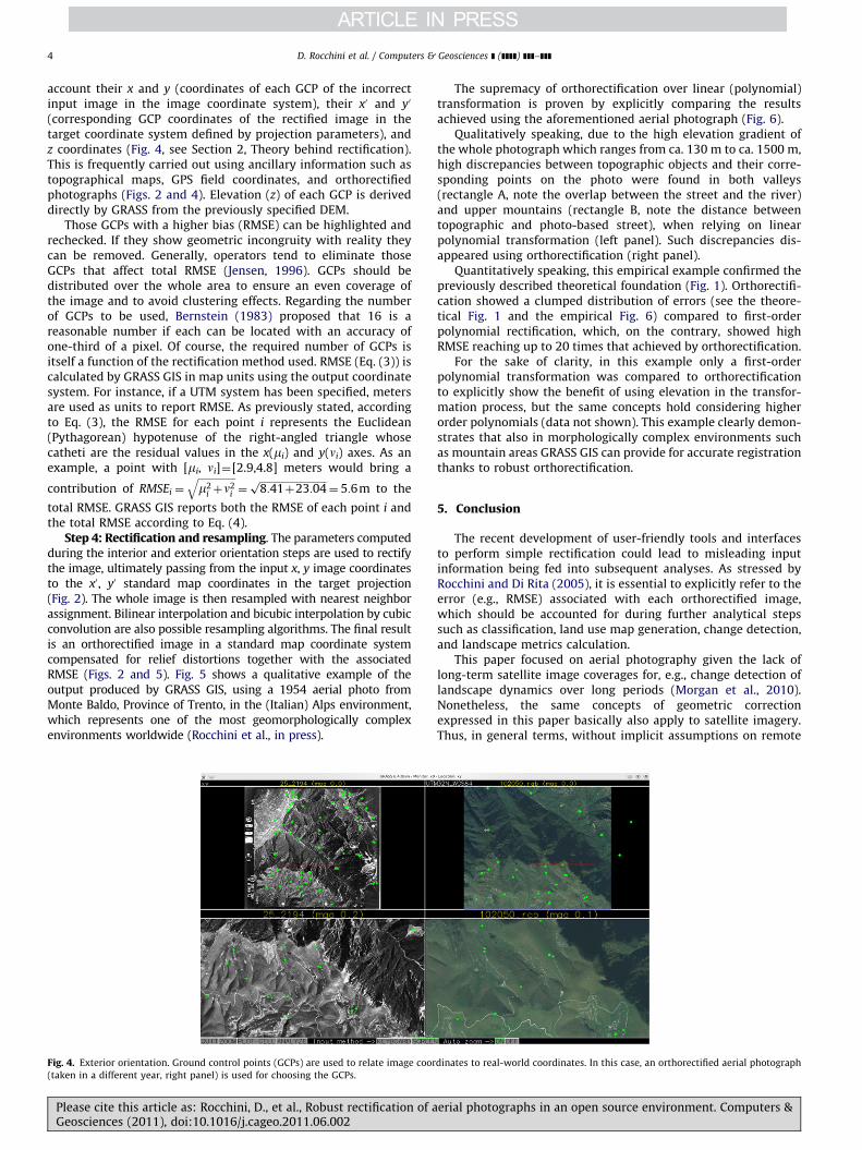
account their x and y (coordinates of each GCP of the incorrectinput image in the image coordinate system), their x0 and y0
(corresponding GCP coordinates of the rectified image in thetarget coordinate system defined by projection parameters), andz coordinates (Fig. 4, see Section 2, Theory behind rectification).This is frequently carried out using ancillary information such astopographical maps, GPS field coordinates, and orthorectifiedphotographs (Figs. 2 and 4). Elevation (z) of each GCP is deriveddirectly by GRASS from the previously specified DEM.
Those GCPs with a higher bias (RMSE) can be highlighted andrechecked. If they show geometric incongruity with reality theycan be removed. Generally, operators tend to eliminate thoseGCPs that affect total RMSE (Jensen, 1996). GCPs should bedistributed over the whole area to ensure an even coverage ofthe image and to avoid clustering effects. Regarding the numberof GCPs to be used, Bernstein (1983) proposed that 16 is areasonable number if each can be located with an accuracy ofone-third of a pixel. Of course, the required number of GCPs isitself a function of the rectification method used. RMSE (Eq. (3)) iscalculated by GRASS GIS in map units using the output coordinatesystem. For instance, if a UTM system has been specified, metersare used as units to report RMSE. As previously stated, accordingto Eq. (3), the RMSE for each point i represents the Euclidean(Pythagorean) hypotenuse of the right-angled triangle whosecatheti are the residual values in the x(mi) and y(ni) axes. As anexample, a point with [mi, ni]¼[2.9,4.8] meters would bring a
contribution of RMSEi ¼
ffiffiffiffiffiffiffiffiffiffiffiffiffiffiffim2
i þn2i
q¼
ffiffiffiffiffiffiffiffiffiffiffiffiffiffiffiffiffiffiffiffiffiffiffiffiffiffiffi8:41þ23:04p
¼ 5:6m to the
total RMSE. GRASS GIS reports both the RMSE of each point i andthe total RMSE according to Eq. (4).
Step 4: Rectification and resampling. The parameters computedduring the interior and exterior orientation steps are used to rectifythe image, ultimately passing from the input x, y image coordinatesto the x0, y0 standard map coordinates in the target projection(Fig. 2). The whole image is then resampled with nearest neighborassignment. Bilinear interpolation and bicubic interpolation by cubicconvolution are also possible resampling algorithms. The final resultis an orthorectified image in a standard map coordinate systemcompensated for relief distortions together with the associatedRMSE (Figs. 2 and 5). Fig. 5 shows a qualitative example of theoutput produced by GRASS GIS, using a 1954 aerial photo fromMonte Baldo, Province of Trento, in the (Italian) Alps environment,which represents one of the most geomorphologically complexenvironments worldwide (Rocchini et al., in press).
Fig. 4. Exterior orientation. Ground control points (GCPs) are used to relate image coor
(taken in a different year, right panel) is used for choosing the GCPs.
Please cite this article as: Rocchini, D., et al., Robust rectification of aGeosciences (2011), doi:10.1016/j.cageo.2011.06.002
The supremacy of orthorectification over linear (polynomial)transformation is proven by explicitly comparing the resultsachieved using the aforementioned aerial photograph (Fig. 6).
Qualitatively speaking, due to the high elevation gradient ofthe whole photograph which ranges from ca. 130 m to ca. 1500 m,high discrepancies between topographic objects and their corre-sponding points on the photo were found in both valleys(rectangle A, note the overlap between the street and the river)and upper mountains (rectangle B, note the distance betweentopographic and photo-based street), when relying on linearpolynomial transformation (left panel). Such discrepancies dis-appeared using orthorectification (right panel).
Quantitatively speaking, this empirical example confirmed thepreviously described theoretical foundation (Fig. 1). Orthorectifi-cation showed a clumped distribution of errors (see the theore-tical Fig. 1 and the empirical Fig. 6) compared to first-orderpolynomial rectification, which, on the contrary, showed highRMSE reaching up to 20 times that achieved by orthorectification.
For the sake of clarity, in this example only a first-orderpolynomial transformation was compared to orthorectificationto explicitly show the benefit of using elevation in the transfor-mation process, but the same concepts hold considering higherorder polynomials (data not shown). This example clearly demon-strates that also in morphologically complex environments suchas mountain areas GRASS GIS can provide for accurate registrationthanks to robust orthorectification.
5. Conclusion
The recent development of user-friendly tools and interfacesto perform simple rectification could lead to misleading inputinformation being fed into subsequent analyses. As stressed byRocchini and Di Rita (2005), it is essential to explicitly refer to theerror (e.g., RMSE) associated with each orthorectified image,which should be accounted for during further analytical stepssuch as classification, land use map generation, change detection,and landscape metrics calculation.
This paper focused on aerial photography given the lack oflong-term satellite image coverages for, e.g., change detection oflandscape dynamics over long periods (Morgan et al., 2010).Nonetheless, the same concepts of geometric correctionexpressed in this paper basically also apply to satellite imagery.Thus, in general terms, without implicit assumptions on remote
dinates to real-world coordinates. In this case, an orthorectified aerial photograph
erial photographs in an open source environment. Computers &
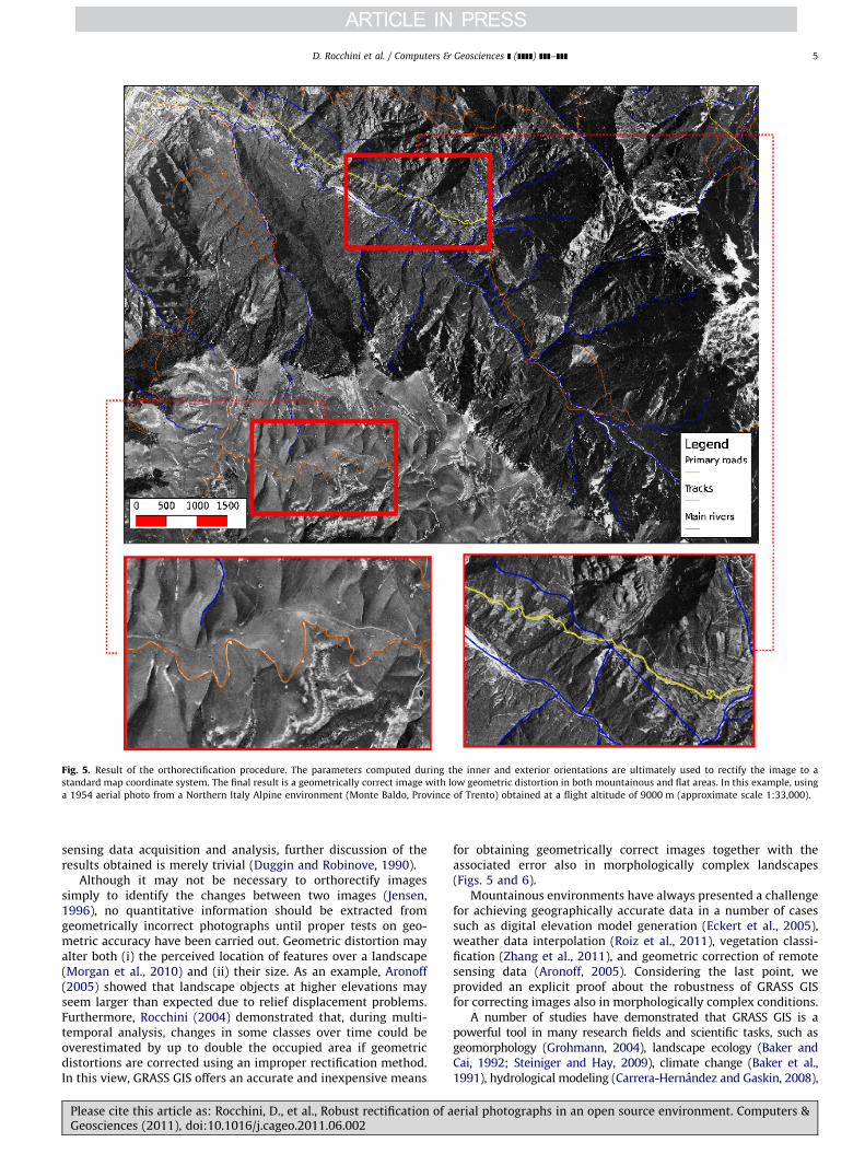
Fig. 5. Result of the orthorectification procedure. The parameters computed during the inner and exterior orientations are ultimately used to rectify the image to a
standard map coordinate system. The final result is a geometrically correct image with low geometric distortion in both mountainous and flat areas. In this example, using
a 1954 aerial photo from a Northern Italy Alpine environment (Monte Baldo, Province of Trento) obtained at a flight altitude of 9000 m (approximate scale 1:33,000).
D. Rocchini et al. / Computers & Geosciences ] (]]]]) ]]]–]]] 5
sensing data acquisition and analysis, further discussion of theresults obtained is merely trivial (Duggin and Robinove, 1990).
Although it may not be necessary to orthorectify imagessimply to identify the changes between two images (Jensen,1996), no quantitative information should be extracted fromgeometrically incorrect photographs until proper tests on geo-metric accuracy have been carried out. Geometric distortion mayalter both (i) the perceived location of features over a landscape(Morgan et al., 2010) and (ii) their size. As an example, Aronoff(2005) showed that landscape objects at higher elevations mayseem larger than expected due to relief displacement problems.Furthermore, Rocchini (2004) demonstrated that, during multi-temporal analysis, changes in some classes over time could beoverestimated by up to double the occupied area if geometricdistortions are corrected using an improper rectification method.In this view, GRASS GIS offers an accurate and inexpensive means
Please cite this article as: Rocchini, D., et al., Robust rectification of aGeosciences (2011), doi:10.1016/j.cageo.2011.06.002
for obtaining geometrically correct images together with theassociated error also in morphologically complex landscapes(Figs. 5 and 6).
Mountainous environments have always presented a challengefor achieving geographically accurate data in a number of casessuch as digital elevation model generation (Eckert et al., 2005),weather data interpolation (Roiz et al., 2011), vegetation classi-fication (Zhang et al., 2011), and geometric correction of remotesensing data (Aronoff, 2005). Considering the last point, weprovided an explicit proof about the robustness of GRASS GISfor correcting images also in morphologically complex conditions.
A number of studies have demonstrated that GRASS GIS is apowerful tool in many research fields and scientific tasks, such asgeomorphology (Grohmann, 2004), landscape ecology (Baker andCai, 1992; Steiniger and Hay, 2009), climate change (Baker et al.,1991), hydrological modeling (Carrera-Hernandez and Gaskin, 2008),
erial photographs in an open source environment. Computers &
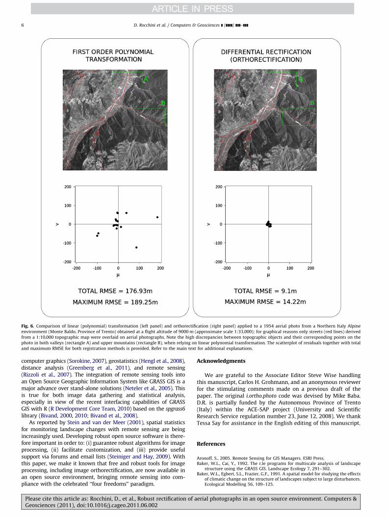
Fig. 6. Comparison of linear (polynomial) transformation (left panel) and orthorectification (right panel) applied to a 1954 aerial photo from a Northern Italy Alpine
environment (Monte Baldo, Province of Trento) obtained at a flight altitude of 9000 m (approximate scale 1:33,000); for graphical reasons only streets (red lines) derived
from a 1:10,000 topographic map were overlaid on aerial photographs. Note the high discrepancies between topographic objects and their corresponding points on the
photo in both valleys (rectangle A) and upper mountains (rectangle B), when relying on linear polynomial transformation. The scatterplot of residuals together with total
and maximum RMSE for both registration methods is provided. Refer to the main text for additional explanations.
D. Rocchini et al. / Computers & Geosciences ] (]]]]) ]]]–]]]6
computer graphics (Sorokine, 2007), geostatistics (Hengl et al., 2008),distance analysis (Greenberg et al., 2011), and remote sensing(Rizzoli et al., 2007). The integration of remote sensing tools intoan Open Source Geographic Information System like GRASS GIS is amajor advance over stand-alone solutions (Neteler et al., 2005). Thisis true for both image data gathering and statistical analysis,especially in view of the recent interfacing capabilities of GRASSGIS with R (R Development Core Team, 2010) based on the spgrass6
library (Bivand, 2000, 2010; Bivand et al., 2008).As reported by Stein and van der Meer (2001), spatial statistics
for monitoring landscape changes with remote sensing are beingincreasingly used. Developing robust open source software is there-fore important in order to: (i) guarantee robust algorithms for imageprocessing, (ii) facilitate customization, and (iii) provide usefulsupport via forums and email lists (Steiniger and Hay, 2009). Withthis paper, we make it known that free and robust tools for imageprocessing, including image orthorectification, are now available inan open source environment, bringing remote sensing into com-pliance with the celebrated ‘‘four freedoms’’ paradigm.
Please cite this article as: Rocchini, D., et al., Robust rectification of aGeosciences (2011), doi:10.1016/j.cageo.2011.06.002
Acknowledgments
We are grateful to the Associate Editor Steve Wise handlingthis manuscript, Carlos H. Grohmann, and an anonymous reviewerfor the stimulating comments made on a previous draft of thepaper. The original i.ortho.photo code was devised by Mike Baba.D.R. is partially funded by the Autonomous Province of Trento(Italy) within the ACE-SAP project (University and ScientificResearch Service regulation number 23, June 12, 2008). We thankTessa Say for assistance in the English editing of this manuscript.
References
Aronoff, S., 2005. Remote Sensing for GIS Managers. ESRI Press.Baker, W.L., Cai, Y., 1992. The r.le programs for multiscale analysis of landscape
structure using the GRASS GIS. Landscape Ecology 7, 291–302.Baker, W.L., Egbert, S.L., Frazier, G.F., 1991. A spatial model for studying the effects
of climatic change on the structure of landscapes subject to large disturbances.Ecological Modelling 56, 109–125.
erial photographs in an open source environment. Computers &
D. Rocchini et al. / Computers & Geosciences ] (]]]]) ]]]–]]] 7
Baltsavias, E.P., 1996. Digital ortho-images: a powerful tool for the extraction ofspatial- and geo-information. ISPRS Journal of Photogrammetry and RemoteSensing 51, 63–77.
Bernstein, R., 1983. Image geometry and rectification. In: Colwell, R.N. (Ed.),Manual of Remote Sensing. American Society of Photogrammetry, FallsChurch, VA.
Bivand, R.S., 2000. Using the R statistical data analysis language on GRASS 5.0 GISdata base files. Computers & Geosciences 26, 1043–1052.
Bivand, R.S., 2010. spgrass6: Interface between GRASS 6 and R. R package version0.6-19.
Bivand, R.S., Pebesma, E.J., Gomez-Rubio, V., 2008. Applied Spatial Data Analysiswith R. Springer, New York.
Carrera-Hernandez, J.J., Gaskin, S.J., 2008. Spatio-temporal analysis of potentialaquifer recharge: application to the Basin of Mexico. Journal of Hydrology 353,228–246.
Disperati, L., Salvini, R., Ciali, A., Fantozzi, P.L., Carmignani, L., Fiori, A. P., Bocci, M.,Paranhos Filho, A.C., 2001. Land cover and soil loss multitemporal analysis: anapplication of geoindicators in the Pantanal Wetlands (Brazil). In: Proceedingsof the First International Workshop on the Analysis of Multitemporal RemoteSensing Images, Trento, Italy, pp. 217–224.
Duggin, M.J., Robinove, C.J., 1990. Assumptions implicit in remote sensing dataacquisition and analysis. International Journal of Remote Sensing 11,1669–1694.
Eckert, S., Kellenberger, T., Itten, K., 2005. Accuracy assessment of automaticallyderived digital elevation models from aster data in mountainous terrain.International Journal of Remote Sensing 26, 1943–1957.
Fogel, K., 2009. Producing Open Source Software: How to Run a Successful FreeSoftware Project. Creative Commons Attribution-ShareAlike (3.0) License.O’Reilly, Sebastopol.
Geri, F., Amici, V., Rocchini, D., 2010. Human activity impact on the heterogeneityof a Mediterranean landscape. Applied Geography 30, 370–379.
Gillespie, T.W., Foody, G.M., Rocchini, D., Giorgi, A.P., Saatchi, S., 2008. Measuringand modeling biodiversity from space. Progress in Physical Geography 32,203–221.
Greenberg, J.A., Rueda, C., Hestir, E.L., Santos, M.J., Ustin, S.L., 2011. Least costdistance analysis for spatial interpolation. Computers & Geosciences 37,272–276.
Grohmann, C.H., 2004. Morphometric analysis in geographic information systems:applications of free software GRASS and R. Computers & Geosciences 30,1055–1067.
Hengl, T., Bajat, B., Blagojevic, D., Reuter, H.I., 2008. Geostatistical modeling oftopography using auxiliary maps. Computers & Geosciences 34, 1886–1899.
Jelinski, D.E., Wu, J., 1996. The modifiable areal unit problem and implications forlandscape ecology. Landscape Ecology 11, 129–140.
Jensen, J.R., 1996. Introductory Digital Image Processing. Prentice Hall, New York.Kepner, W.G., Watts, C.J., Edmonds, C.M., Maingi, J.K., Marsh, S.E., Luna, G., 2000. A
landscape approach for detecting and evaluating change in a semi-aridenvironment. Environmental Monitoring and Assessment 64, 179–195.
Konecny, G., 1979. Methods and possibilities for digital differential rectification.Photogrammetric Engineering and Remote Sensing 6, 727–734.
Mitasova, H., Neteler, M., 2004. GRASS as open source—free software GIS:accomplishments and perspectives. Guest editorial. Transactions in GIS 8,145–154.
Morgan, J.L., Gergel, S.E., Coops, N.C., 2010. Aerial photography: a rapidly evolvingtool for ecological management. BioScience 60, 47–59.
Nagendra, H., Rocchini, D., 2008. Satellite imagery applied to biodiversity study inthe tropics: the devil is in the detail. Biodiversity and Conservation 17,3431–3442.
Neteler, M., Bowman, M.H., Landa, M., Metz, M. GRASS GIS: A Multi-Purpose OpenSource GIS. In review.
Please cite this article as: Rocchini, D., et al., Robust rectification of aGeosciences (2011), doi:10.1016/j.cageo.2011.06.002
Neteler, M., Grasso, D., Michelazzi, I., Miori, L., Merler, S., Furlanello, C., 2005. Anintegrated toolbox for image registration, fusion and classification. Interna-tional Journal of Geoinformatics 1, 51–61.
Neteler, M., Mitasova, H., 2008. Open Source GIS: A GRASS GIS Approach, 3rd ed.Springer, New York.
Novak, K., 1992. Rectification of digital imagery. Photogrammetric Engineeringand Remote Sensing 58, 339–344.
Pelorosso, R., Leone, A., Boccia, L., 2009. Land cover and land use change in theItalian central Apennines: a comparison of assessment methods. AppliedGeography 29, 35–48.
Powers, P.S., Chiarle, M., Savage, W.Z., 1996. A digital photogrammetric method formeasuring horizontal surficial movements on the Slumgullion earthflow,Hinsdale County, Colorado. Computers & Geosciences 22, 651–663.
R Development Core Team, 2010. R: A Language and Environment for StatisticalComputing. Vienna, Austria, R Foundation for Statistical Computing, URL/http://www.R-project.orgS.
Richards, J.A., Jia, X., 1999. Remote Sensing Digital Image Analysis: An Introduc-tion. Springer, Berlin.
Ricotta, C, 2005. On possible measures for evaluating the degree of uncertainty offuzzy thematic maps. International Journal of Remote Sensing 26, 5573–5583.
Rizzoli, A., Neteler, M., Ros�a, R., Versini, W., Cristofolini, A., Bregoli, M., Buckley, A.,Gould, E., 2007. Early detection of tick-borne encephalitis virus spatialdistribution and activity in the province of Trento, northern Italy. GeospatialHealth 1, 169–176.
Rocchini, D., 2004. Misleading information from direct interpretation of geome-trically incorrect aerial photographs. The Photogrammetric Record 19,138–148.
Rocchini, D., Di Rita, A., 2005. Relief effects on aerial photos geometric correction.Applied Geography 25, 159–168.
Rocchini, D., McGlinn, D., Ricotta, C., Neteler, M., Wohlgemuth, T, Landscapecomplexity and spatial scale influence the relationship between remotelysensed spectral diversity and survey based plant species richness. Journal ofVegetation Science, in press. doi:10.1111/j.1654-1103.2010.01250.x.
Roiz, D., Neteler, M., Castellani, C., Arnoldi, D., Rizzoli, A., 2011. Climatic factorsdriving invasion of the tiger mosquito (Aedes albopictus) into new areas ofTrentino, northern Italy. PLoS ONE 6, e14800.
Russ, J.C., 2002. The Image Processing Handbook, rd ed. CRC Press, Boca Raton, FL.Sorokine, A., 2007. Implementation of a parallel high-performance visualization
technique in GRASS GIS. Computers & Geosciences 33, 685–695.Stallman, R., 1997. The GNU manifesto. In: Ermann, M.D., Williams, M.B., Shauf,
M.S. (Eds.), Computers, Ethics and Society 2nd ed. Oxford University Press,Oxford, pp. 229–239.
Stein, A., van der Meer, F., 2001. Statistical sensing of the environment—space,time, scale: combining remote sensing and spatial statistics for ecology andthe environment. International Journal of Applied Earth Observation andGeoinformation 3, 111–113.
Steiniger, S., Hay, G.J., 2009. Free and open source geographic information tools forlandscape ecology. Ecological Informatics 4, 183–195.
Toutin, T., 2004. Geometric processing of remote sensing images: models, algo-rithms and methods. International Journal of Remote Sensing 20, 1893–1924.
Van Rossum, G., 1995. Python Library Reference. CWI Report CS-R9524.Van Rossum, G., 1997. A tour of the Python language. In: Proceedings of the
International Conference on Technology of Object-Oriented Languages, IEEEComputer Society, Melbourne, Australia, p. 370.
Wolf, P.R., 1983. Elements of Photogrammetry, with Air Photo Interpretation andRemote Sensing, 2nd ed. McGraw-Hill, New York.
Zhang, Z., De Wulf, R.R., Van Coillie, F.M.B., Verbeke, L.P.C., De Clercq, E.M., Ou, X.,2011. Influence of different topographic correction strategies on mountainvegetation classification accuracy in the Lancang Watershed, China. Journal ofApplied Remote Sensing 5, 053512.
erial photographs in an open source environment. Computers &
Copyright © 2022 FDOKUMEN