Ritual and Identity in Rural Mesopotamia: Hirbemerdon Tepe and the Upper Tigris River Valley in the...
34
Volume 119, Number 4 October 2015 www.ajaonline.org ARCHAEOLOGY The Journal of the Archaeological Institute of America AMERICAN JOURNAL OF
Transcript of Ritual and Identity in Rural Mesopotamia: Hirbemerdon Tepe and the Upper Tigris River Valley in the...

Volume 119, Number 4October 2015
www.ajaonline.org
ARCHAEOLOGYThe Journal of the Archaeological Institute of America
AMERICAN JOURNAL OF

This article is © The Archaeological Institute of America and was originally published in AJA 119(4):533–64.
This e-print is supplied to the author for noncommercial use only, following the terms outlined in the accompanying cover letter. The definitive electronic version of the article can be found at:
www.jstor.org/stable/10.3764/aja.119.4.0533.
AMERICAN JOURNAL OF
ARCHAEOLOGY656 Beacon Street, Boston, MA 02215 • Tel.: 617-353-9361 • www.ajaonline.org

American Journal of ArchaeologyVolume 119, Number 4October 2015Pages 533–64 DOI: 10.3764/aja.119.4.0533
533
Ritual and Identity in Rural Mesopotamia: Hirbemerdon Tepe and the Upper Tigris River Valley in the Middle Bronze Agenicola laneri, mark schwartz, jason ur, anacleto d’agostino, remi berthon, mette marie hald, and anke marsh
field report
www.ajaonline.org
Excavations at the relatively small but strategically placed site of Hirbemerdon Tepe, located along the west bank of the upper Tigris River in modern southeastern Turkey, have yielded significant results. During the Middle Bronze Age (2000–1600 B.C.E.), the site was situated in an ecologically stratified landscape that included river ter-races suitable for agriculture as well as forested uplands ideal for pastoral and hunt-ing activities. A significant result of these excavations, which were conducted by the Hirbemerdon Tepe Archaeological Project, was the discovery of a well-preserved architectural complex with associated ritual artifacts on the northern side of the high mound. This report describes and situates this Middle Bronze Age site within its geographic, cultural, and ecological context. It examines the emergence of this small regional center and investigates the role of ritual activities in the development of socially integrated communities in the frontier zone of northern Mesopotamia during the beginning of the second millennium B.C.E.1
introduction
Over the last 20 years, archaeologists have incorporated the detailed study of small-scale rural communities into their analyses of large-scale urban soci-eties. These efforts are critical to a holistic understanding of regional social complexity.2 Furthermore, these investigations have established new research trajectories that emphasize the social organization of societies lacking major urban centers. The complex relationships between domestic, ceremonial, and economic elements have been highlighted in studies of ancient small-scale societies in both the Old and New Worlds.3
1 We would like to thank the Ministry of Culture and Tourism of Turkey for its sup-port and the permit for archaeological work at Hirbemerdon Tepe since 2003. The project was jointly planned with the Archaeological Museum of Diyarbakır as part of the Ilısu Dam Rescue Project. To the project’s director, Mehmet Çelebi, go our warmest acknowledgments. The Hirbemerdon Tepe Archaeological Project has been financial-ly supported by the University of Catania, the Istituto Italiano per l’Africa e l’Oriente, Grand Valley State University, Harvard University, the Italian Ministry of Foreign Affairs, the Curtiss T. and Mary G. Brennan Foundation, the Consiglio Nazionale delle Ricerche, the Credito Siciliano, and other private donors. Finally, we would like to thank Seth Richardson and the anonymous reviewers for the AJA for their comments, which were useful for revising this report. Figures are from the Hirbemerdon Tepe Archaeological Project archive unless otherwise noted.
2 Schwartz and Falconer 1994.3 E.g., Schwartz and Falconer 1994; Kolb and Snead 1997; Canuto and Yaeger 2000;
Faust 2000; Iannone and Connell 2003; Knapp 2003; Gerritsen 2004; Varien and Potter 2008; Mac Sweeney 2011.

N. LANERI ET AL.534 [AJA 119
The concept of a “geographic community” recent-ly introduced by Mac Sweeney in her study of Late Bronze and Iron Age societies of western Anatolia is a product of this line of research,4 and it is of particular use in analyses of small-scale societies.5 Mac Sweeney’s research breaks down the traditional distinction be-tween a “natural community” (i.e., one directly linked to the space shared by the inhabitants) and an “imag-ined community” (i.e., a mental construct based on symbolic social and cultural elements created by its members). Accordingly, the imagined community is related not necessarily to a specific place but to types of social relationships.6 Specifically, Mac Sweeney states:7
The geographic community is no longer thought to be a natural social structure, emerging automatically from environmental conditions. Nor is it considered to be a purely intellectual concept, defined wholly by individ-ual decisions and choice. Rather, it is now understood as a conscious mental construct, built through social practice and lived experience, which is itself facilitated by residential proximity and regular direct interaction. The intellectual, the environmental, and the social all have their part to play in its construction.
As a result of Mac Sweeney’s study, the work of archaeologists investigating small-scale societies can better define those elements that establish forms of commonality among the inhabitants of a site and region. The elements of shared experiences can de-rive from the way people interact with the landscape (e.g., livestock raising, hunting, or farming), with the material culture (e.g., the widespread use of pottery showing similar decorative patterns), with craft pro-duction (e.g., the localization and distribution of ar-eas dedicated to specialized work activities), and with the ideological sphere (e.g., the identification of areas for communal ceremonial activities). However, it is
4 According to Mac Sweeney (2011, 19), geographic com-munities are a “subset of the wider category of relational communities” that “are rooted in a particular locality” that serves the purpose of constructing a sense of spatial and so-cial commonality. Although multiple factors contribute to a geographic community’s identity (e.g., descent, ethnicity, re-ligious faith, profession, language), the “shared place and the shared experience of residential proximity” are the primary elements in founding the “community’s basic sense of the common experience.”
5 Small-scale societies can be described as societies lack-ing complex forms of administrative organization. They are based on sites with a one- or two-tier settlement hierarchy (i.e., hamlets and villages) and present relatively low popula-tion density.
6 Isbell 2000. For the original definition of imagined com-munities, see Anderson 1991.
7 Mac Sweeney 2011, 21.
through the identification of practices of communal unity (what Mac Sweeney calls “enactments of com-munity”) that archaeologists can “infer the existence of community identity.”8 A sense of shared identity can be found in the archaeological record through a detailed analysis of the remains of ritualized or cer-emonial activities, such as debris discarded in outdoor spaces that were locales for communal practices.9
The site of Hirbemerdon Tepe and the region of the upper Tigris River valley provide an ideal case study for the analysis of an ancient rural settlement system and the identification of communities within this small-scale society. The site of Hirbemerdon Tepe is located on the upper Tigris River in southeastern Turkey, a territory that in ancient times corresponded to the frontier between Anatolia and northern Meso-potamia (fig. 1). The region of the upper Tigris fits one of the important criteria for a geographic com-munity as set forth by Mac Sweeney, that of being a set area with a spatial focus.10 The region consists of a plain with some upland hills bordered on the south by the Tur ‘Abdin Mountains and on the north and east by the Taurus Mountains. It begins a few miles south of the modern city of Diyarbakır and follows the course of the Tigris for 60 km until about 5 km east of the confluence of the Batman and Tigris Rivers.11 The region is therefore bounded by mountains, which did not serve as an impervious barrier but still delimited this specific area. Many of the sites in this region are found in close proximity to the Tigris River, which was a likely focal point not only as a source of water but also as a local communication route. Because of the ease of water transport in comparison with overland transport, it is likely that most interregional contact was via the river.
The site’s geographical location at the junction be-tween alluvial terraces and the rocky hill slopes provid-ed specific opportunities and constraints to the ancient inhabitants. This geological diversity also influenced the structure of the ancient settlement, whereby the 1 ha main portion of the site was embedded in a nat-ural limestone terrace located next to the river and the 2 ha outer town was located on its lower slope and bordered on the east by the Tigris River. The ecologi-cally stratified landscape surrounding the site allowed inhabitants to diversify their economic subsistence. The river terraces were suitable for agricultural activi-ties and the uplands for animal pastures and hunting.
8 Mac Sweeney 2011, 46.9 Hayden 2001, 41–2.10 Mac Sweeney 2011, 20.11 Parker 2001.

HIRBEMERDON TEPE AND THE TIGRIS RIVER IN THE MIDDLE BRONZE AGE2015] 535
While Hirbemerdon Tepe is a small, multiperiod site (table 1), the most extensive occupation occurred during the beginning of the second millennium B.C.E. (cal B.C.E. 1975–1782 [2σ] according to the radio-carbon dates of animal bones at the site, which are discussed in detail below). During this long period of occupation (phase IIIB), the northern side of the high mound contained a prominent architectural complex. Today, the complex is well-preserved, and its associ-ated material culture suggests a ceremonial function for some sectors of the structure. In the outer town, some scattered areas dedicated to craft-production activities have been identified. Of particular interest during excavations by the Hirbemerdon Tepe Archae-ological Project was the outdoor area (the piazza) of the complex in the high mound, which contained a deposit of ritual paraphernalia, ceramic vessels, and animal bones sealed by ash at the end of its use. After this period, the site was abandoned and, in the high mound, a series of trash deposits filled the northern section of the architectural complex until the Late Bronze Age, when it was leveled to accommodate do-mestic architecture.12
12 Crescioli and Laneri 2011.
Along with the evidence from Hirbemerdon Tepe, the results of the numerous excavations conducted in the upper Tigris region section of the Ilısu Dam Rescue Project demonstrate that during the Middle Bronze Age the region was intensively occupied by small to midsized sites (e.g., Ziyaret Tepe, Üçtepe, Giricano, Salat Tepe, Kenan Tepe, Kavuşan Höyük, and Müslümantepe).13 The area thus lacked a major urban settlement as well as elements of complex ad-ministration, such as the palaces that are present in contemporaneous Mesopotamian regions.14 In addi-tion, recent archaeological surveys show that Middle Bronze Age settlements in the upper Tigris were lim-ited to villages and hamlets rarely more than a few hectares in extent.15 These settlements were evenly dispersed and closely connected to the Tigris itself or
13 Parker and Swartz Dodd 2003, 2005, 2011; Özfırat 2006; Laneri and Schwartz 2011.
14 A survey of the region north of Diyarbakır has brought to light the existence of a larger (ca. 19 ha) site belonging to this period, the site of Pir Hüseyin. However, the lack of actual ex-cavations prevents speculation about how Pir Hüseyin relates to the other well-known sites of the upper Tigris region (Peas-nall and Algaze 2010).
15 Ay 2001; Peasnall 2004; Özfirat 2006.
fig. 1. The upper Tigris River valley in the Middle Bronze Age.
N. LANERI ET AL.536 [AJA 119
its major perennial tributaries and wadis (see fig. 1; see also the section “Middle Bronze Age Settlement and Land Use” herein).16
Salvage excavations in the past decade at many of these sites have provided more data about individual occupations but have not altered the initial assessment of the rural settlement pattern of the upper Tigris region during the Middle Bronze Age. The lack of state-level social complexity, which is typical of con-temporaneous large-scale Mesopotamian societies, did not prevent communities from developing other forms of complex communal relationships and social organization, both within sites and at a regional level. The construction of community identity can be seen in the ubiquitous presence of similarly decorated pottery
16 Peasnall and Algaze 2010.
(Red Brown Wash Ware and Band Painted Ware) in all the assemblages of the Middle Bronze Age sites in the upper Tigris River valley. They can also be identi-fied in the remains of ritual activities, such as those found in the outdoor area of the Middle Bronze Age architectural complex at Hirbemerdon Tepe.
In addition to providing a summary of the archae-ological data from 10 years of work at Hirbemerdon Tepe, this report places the site within the region of the upper Tigris River valley and examines the pos-sible role played by the practice of ritual activities in constructing community identity among small-scale, rural societies,17 a subject that has been only rarely
17 For analyses of the importance of feasting and ritual activ-ities in constructing social solidarity and community identity among ancient societies, see Dietler and Hayden 2001.
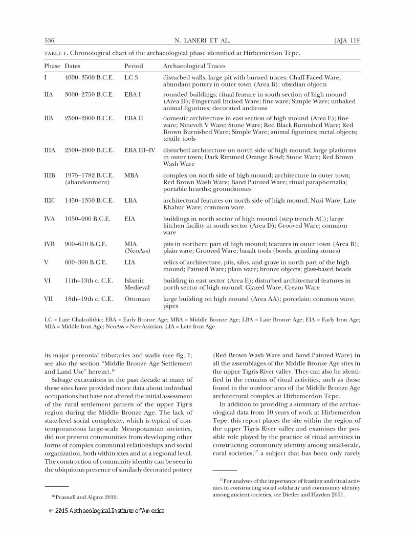
table 1. Chronological chart of the archaeological phase identified at Hirbemerdon Tepe.
Phase Dates Period Archaeological Traces
I 4000–3500 B.C.E. LC 3 disturbed walls; large pit with burned traces; Chaff-Faced Ware; abundant pottery in outer town (Area B); obsidian objects
IIA 3000–2750 B.C.E. EBA I rounded buildings; ritual feature in south section of high mound (Area D); Fingernail Incised Ware; fine ware; Simple Ware; unbaked animal figurines; decorated andirons
IIB 2500–2000 B.C.E. EBA II domestic architecture in east section of high mound (Area E); fine ware; Nineveh V Ware; Stone Ware; Red Black Burnished Ware; Red Brown Burnished Ware; Simple Ware; animal figurines; metal objects; textile tools
IIIA 2500–2000 B.C.E. EBA III–IV disturbed architecture on north side of high mound; large platforms in outer town; Dark Rimmed Orange Bowl; Stone Ware; Red Brown Wash Ware
IIIB 1975–1782 B.C.E. (abandonment)
MBA complex on north side of high mound; architecture in outer town; Red Brown Wash Ware; Band Painted Ware; ritual paraphernalia; portable hearths; groundstones
IIIC 1450–1350 B.C.E. LBA architectural features on north side of high mound; Nuzi Ware; Late Khabur Ware; common ware
IVA 1050–900 B.C.E. EIA buildings in north sector of high mound (step trench AC); large kitchen facility in south sector (Area D); Grooved Ware; common ware
IVB 900–610 B.C.E. MIA (NeoAss)
pits in northern part of high mound; features in outer town (Area B); plain ware; Grooved Ware; basalt tools (bowls, grinding stones)
V 600–300 B.C.E. LIA relics of architecture, pits, silos, and grave in north part of the high mound; Painted Ware; plain ware; bronze objects; glass-based beads
VI 11th–13th c. C.E. Islamic Medieval
building in east sector (Area E); disturbed architectural features in north sector of high mound; Glazed Ware; Cream Ware
VII 18th–19th c. C.E. Ottoman large building on high mound (Area AA); porcelain; common ware; pipes
LC = Late Chalcolithic; EBA = Early Bronze Age; MBA = Middle Bronze Age; LBA = Late Bronze Age; EIA = Early Iron Age; MIA = Middle Iron Age; NeoAss = Neo-Assyrian; LIA = Late Iron Age

HIRBEMERDON TEPE AND THE TIGRIS RIVER IN THE MIDDLE BRONZE AGE2015] 537
investigated in Mesopotamian archaeological con-texts.18 What follows is a synopsis of the principal find-ings of the site with their relevance to the theoretical issues discussed in the introduction. The first section of this report focuses on the architectural complex located on the high mound and its associated ritual paraphernalia, groundstone artifacts, and pottery as-semblages. It reconstructs the functions of specific sectors of the complex as well as the overall purpose of the architectural complex itself.
the architectural complex and its ritual aspects during the middle bronze age
The initial surface and geomagnetic surveys per-formed at Hirbemerdon Tepe revealed a high density of Middle Bronze Age pottery (Red Brown Wash Ware and the Band Painted Ware assemblages)19 as well as signs of well-preserved stone and mudbrick architec-ture. Subsequent excavations focused on a sounding (operation 1) in areas on the high mound (Areas A, AA, C, D, E, and F and step trench AB-AC) as well as a 10 x 10 sounding in the outer town (Area B) (fig. 2).20
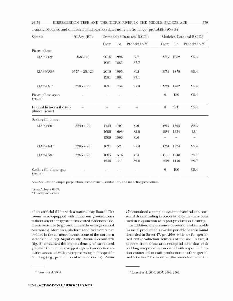
Three types of constructions were identified: a large architectural complex that was built on the northern side of the high mound (fig. 3); a series of highly dis-turbed square rooms, probably used as private dwell-ings, on the southern side of the high mound; and other remnants of architecture in the outer town. Radiocarbon dates on charcoal samples collected from Middle Bronze Age primary contexts in the architectural complex have been bolstered by more robust dating of samples from three animal bones from the period of intensive use of the complex (i.e., from locus A0408, floor of Outdoor Space 35, the area known as the piazza)21 and three other animal bones (two red deer bones and one large ungulate long bone) from the fill postdating this occupation (i.e., from locus A0496, fill of the piazza) (table 2).22 The
18 See, e.g., the work at the early third-millennium B.C.E. site of Tell al Raqa’i in northeastern Syria (Schwartz 1994, 2000).
19 Algaze et al. 1991; Laneri 2004.20 Laneri 2006; Laneri et al. 2006, 2008.21 Laneri et al. 2006.22 The samples were prepared and measured by the Leib-
niz Laboratory for Radiometric Dating and Stable Isotope Re-search in Kiel, Germany (Nadeau et al. 1997, 1998; Grootes et al. 2004). The dates were calibrated and modeled with Ox-Cal v.4.1.7 (Bronk Ramsey 2009) using the calibration curve IntCal09 (Reimer et al. 2009). In the model, we assigned the dates to two phases separated by an interval. We specified that one phase was strictly posterior to the other because of the stratigraphy. The model provides also post quem and ante quem boundaries for the beginning and the end of each
calibrated dates give a range of cal B.C.E. 1975–1782 (2σ) for the primary occupation of the architectural complex and a range of cal B.C.E. 1693–1456 (2σ) for the fill sealing these Middle Bronze Age contexts.23
The Built EnvironmentAs noted, the geology of the upper Tigris River val-
ley provided constraints and opportunities in regard to the construction of the settlement. The northern section of the high mound has a karstic-like basin that was formed when the underlying limestone formation was eroded by groundwater and caused the upper sedi-mentary formation to collapse. To accommodate the slope of this natural basin, the whole complex was sys-tematically planned using a series of artificial terraces; in fact, there are about 14 m of difference between the elevations of the upper-level floors and those at the entrance (see figs. 3, 4).24 The terraces were cre-ated either by cutting into the bedrock or by filling the natural gaps with earth. The upper section of the complex was built after the buildings belonging to earlier periods (mid to late third millennium B.C.E.) were razed, whereas the lowest section was constructed by embedding the architecture either directly in the natural limestone or on virgin soil.
Based on excavations and geomagnetic survey, the Middle Bronze Age complex is estimated to have oc-cupied a total of approximately 5,000 to 6,000 m2 (see fig. 3). A main entrance to the complex was located at its northwestern corner and consisted of a stone stair-case (2) leading to an internal road system formed by parallel and perpendicular streets (e.g., 3, 37, 47, 58, 67), staircases (e.g., 62, 64), and outdoor spaces (e.g., 24, 35). The road system had the dual purpose of both delimiting and connecting different sectors of the complex (see fig. 4).25 Another potential entrance was recently found on the eastern edge of the mound (Area F), where the natural bedrock forms a steep
phase and interval. However, the boundary dates are not in-cluded in the table as their ranges are too wide to be helpful.
23 The dates for this sealing fill are less grouped, and either the fill accumulated in a short time somewhere from the very end of the 17th century B.C.E to the mid 16th century B.C.E. or there were different deposit events spread over a period of 200 years maximum, from the 17th century B.C.E to the mid 15th century B.C.E. (The calibrated dates obtained from the samples of the animal bones give us a chronological interval similar to the one obtained from the radiocarbon dates on charcoal samples from comparable archaeological contexts.)
24 Other karstic-like basins can be seen in the surrounding hills (Ölçekli Türkiye Jeoloji Haritasi 1962; Doğan 2005).
25 Laneri 2011. The numbers in parentheses refer to the rooms and features of the architectural complex, as shown on fig. 4 herein.

N. LANERI ET AL.538 [AJA 119
cliff facing the river terraces (see fig. 3). In addition, a stone wall was built on top of the natural limestone bedrock, and the partial remains of a poorly preserved corridor (59), delimiting the edge of the complex, were found in both Area A and Area F.26
Of great interest is the sector located north of Street 47, which consists of a series of narrow buildings standing next to and abutting one another to form a discrete unit (see fig. 4, left). Each of these buildings was composed of four to five rooms that, as in rest of the complex, were paved either with flagstones on top
26 The wall was not very thick, and so it did not have any de-fensive function; rather, it was used to determine a boundary similar to the village walls found in other rural contexts—e.g., in the Iron Age villages of the Levant (Faust 2000, 26–8).
fig. 2. Topographic map of Hirbemerdon Tepe, showing the excavated and geophysically surveyed areas.
fig. 3. Satellite view of Hirbemerdon Tepe, highlighting the possible extension of the Middle Bronze Age architec-tural complex (base image © 2011 GeoEye and Basarsoft).
HIRBEMERDON TEPE AND THE TIGRIS RIVER IN THE MIDDLE BRONZE AGE2015] 539
of an artificial fill or with a natural clay floor.27 The rooms were equipped with numerous groundstones without any other apparent associated evidence of do-mestic activities (e.g., central hearths or large central courtyards). Moreover, platforms and basins were em-bedded in the corners of some rooms of the northern sector’s buildings. Significantly, Rooms 27a and 27b (fig. 5) contained the highest density of carbonized grapes in the complex, suggesting craft production ac-tivities associated with grape processing in this specific building (e.g., production of wine or raisins). Room
27 Laneri et al. 2008.
27b contained a complex system of vertical and hori-zontal drains leading to Street 47; they may have been used in conjunction with post-production cleaning.
In addition, the presence of several broken molds for metal production, as well as portable hearths found discarded in Street 47, provides evidence for special-ized craft-production activities at the site. In fact, it appears from these archaeological data that each building was probably associated with a specific func-tion connected to craft production or other special-ized activities.28 For example, the rooms located in the
28 Laneri et al. 2006, 2007, 2008, 2009.
table 2. Modeled and unmodeled radiocarbon dates using the 2σ range (probability 95.4%).
Sample 14C Age (BP) Unmodeled Date (cal B.C.E.) Modeled Date (cal B.C.E.)
From To Probability % From To Probability %
Piazza phase
KIA39683a 3585+20 2016 1996 7.7 1975 1882 95.4
1981 1885 87.7
KIA39682A 3575 + 25/-20 2019 1995 6.3 1974 1879 95.4
1981 1881 89.1
KIA39681a 3505 + 20 1891 1754 95.4 1923 1782 95.4
Piazza phase span (years)
– – – – 0 159 95.4
Interval between the two phases (years)
– – – – 0 258 95.4
Sealing fill phase
KIA39680b 3240 + 20 1739 1707 9.0 1693 1605 83.3
1696 1608 85.9 1584 1534 12.1
1569 1563 0.6 – – –
KIA39684b 3305 + 20 1631 1521 95.4 1629 1524 95.4
KIA39679b 3365 + 20 1605 1576 6.4 1611 1548 35.7
1536 1441 89.0 1538 1456 59.7
Sealing fill phase span (years)
– – – – 0 196 95.4
Note: See text for sample preparation, measurement, calibration, and modeling procedures.
a Area A, locus 0408.b Area A, locus 0496.

N. LANERI ET AL.540 [AJA 119
northwestern sector were filled with in situ storage jars, whereas the building located directly to the east of the staircase most likely functioned as a kitchen, given the high density of cooking vessels, traces of pyrotechno-logical activities, and presence of a semicircular oven (Rooms 8 and 9). It is more difficult to determine the functions of the rooms in the western part of the complex and the few rooms in the uppermost (and southern) sector of the complex (see fig. 4, right). Here, fewer groundstones, mostly basins and mortars, were found. Room 66 contained a small basin and a stone positioned to function as a seat. The site’s only aniconic clay votive plaque was also found in the fill of this room, suggesting that the room may have been used as a production area for ritual paraphernalia.
Another aspect of the architectural complex that points to nondomestic specialized functions is room size. On the whole, it appears that room sizes, espe-
cially in the buildings of the northeastern sector, are smaller than those in contemporaneous nearby sites, such as Salat Tepe and Ziyaret Tepe. From published site plans it can be estimated that the two main rooms of the Middle Bronze Age Brightly Burned Building at Ziyaret Tepe were 3.3 and 13.7 m2.29 Units 2, 4, and 5 from Salat Tepe were 25.8, 12.0, and 17.9 m2, respec-tively.30 However, at Hirbemerdon Tepe, room size in the northeastern section of the complex ranges from less than 1 m2 to approximately 7 m2. The buildings in this sector do not contain large central rooms but are segmented into several relatively small cells or units. For example, Rooms 30, 29, 28, and 27, all lo-cated in one building, had areas of 4.0, 1.5, 3.6, and
29 Matney et al. 2002.30 Ökse and Görmüş 2006.
fig. 4. The Middle Bronze Age architectural complex: left, lower section; right, upper section.

HIRBEMERDON TEPE AND THE TIGRIS RIVER IN THE MIDDLE BRONZE AGE2015] 541
4.1 m2, respectively, for a total of 13.2 m2. It is diffi-cult to envision this segmented structure being used as living space.
Ritual and ceremonial elements distinguish Build-ings G and Q and Outdoor Spaces 35 (the piazza) and 24 from other sectors of the complex (see fig. 4 [left], 5). This area (i.e., the two buildings and two outdoor spaces) was accessible directly from the staircase and was circumscribed by Street 47 to the north, a pathway (37) leading to the uppermost area to the west, and a retaining wall to the south. The uppermost build-ing, Building Q, was poorly preserved and did not contain any significant material remains. In contrast, Building G had numerous elements that suggest use as a ceremonial structure (fig. 6). It has one main entrance from Street 47 that leads to a vestibule (23) connected to a long room (51) that contains a stone altar and two perpendicular drains behind it. This room was paved with large flagstones, and a fine Red Brown Wash Ware cup containing a complete new-born piglet skeleton was placed in the northeastern corner as a ritual foundation deposit.31 The vestibule led to a series of rooms (22, 48–50) and then a large area (52) located next to the main room. Burned roof beams sealed the floor deposit,32 which contained a few pottery sherds. A square bench comprising a stone foundation topped by mudbricks sits along the
31 The use of pigs and piglets in purification rituals in north-ern Mesopotamia and central Anatolia during the third and second millennia B.C.E. is confirmed by both written and ar-chaeological records, as is the case for the pig bones found in the late third-millennium “channel to the underworld” dis-covered at the northeastern Syrian site of Tell Mozan/Urkesh (Kelly-Buccellati 2002; Collins 2004).
32 Because of their bad preservation, it was not possible to date the wooden beams.
western side of this room. Mortars, pestles, and the charred remains of grapes (Vitis vinifera) were found in Room 48, one of the rooms connecting this area to the vestibule. These finds suggest that grapes were processed in the building, as was the case in Rooms 27a and 27b in the northern sector. Given the archi-tecture of Building G, it is possible that wine or raisin production in this area of the architectural complex was connected with ritual activities, which may have been performed inside the building or in the outdoor spaces.33 Rooms 25 and 26 sit next to Building G and were probably used as storage rooms for it, given that they lacked entrances and contained numerous stone objects as well as pottery.34
Of great importance is the large outdoor space (the piazza) in which the largest number of ritual artifacts was found. It consists of an L-shaped area extending 250 m2 and joining the entry staircase (2), the main street (47), and the cobbled pathway (37) leading to the upper portion of the complex. Its natural com-pacted clay surface slopes southward in contrast to the rest of the architectural complex. On its eastern side, the outdoor space is bordered by the outer wall of Building G. The stepped foundation of this wall probably served as a conduit from the piazza to access Rooms 54, 55, and 55a at the eastern edge. While the
33 Laneri 2011.34 Laneri et al. 2008; Laneri 2011. Similar magazines lo-
cated next to a ceremonial building are found in the early second-millennium B.C.E. site of Tell Mohammed Diyab in northeastern Syria (Nicolle 2006).
fig. 5. Street 47 and the northern sector of the Middle Bronze Age architectural complex, view from the east. Note the vertical and horizontal drains.
fig. 6. The piazza (35) and Building G of the Middle Bronze Age architectural complex, view from the west.
N. LANERI ET AL.542 [AJA 119
function of these rooms is unclear, Room 55 was pur-posely filled with small stones, pebbles, sherds, and animal bones at the end of the complex’s use, while Room 54 contained some complete Gray Ware and Red Brown Wash Ware bottles.35
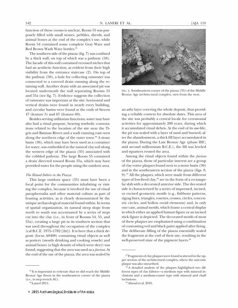
The southern side of the piazza (fig. 7) was confined by a thick wall, on top of which was a pathway (58). The facade of this wall contained recessed niches that had an aesthetic function, as evident from their high visibility from the entrance staircase (2). On top of the pathway (58), a hole for collecting rainwater was connected to a covered drain running along the re-taining wall. Another drain with an associated pit was located underneath the wall separating Rooms 55 and 55a (see fig. 7). Evidence suggests the collection of rainwater was important at the site: horizontal and vertical drains were found in nearly every building, and circular basins were found at the ends of Streets 47 (feature 5) and 67 (feature 69).
Besides serving utilitarian functions, water may have also had a ritual purpose, bearing symbolic connota-tions related to the location of the site near the Ti-gris and Batman Rivers and a wadi running east–west along the northern edge of the outer town.36 A stone basin (36), which may have been used as a container for water, was embedded in the natural clay soil along the western edge of the piazza (35) associated with the cobbled pathway. The large Room 55 contained a drain directed toward Room 55a, which may have provided water for the people using the outdoor area.
The Ritual Debris in the PiazzaThis large outdoor space (35) must have been a
focal point for the communities inhabiting or visit-ing the complex, because it involved the use of ritual paraphernalia and other material culture as part of feasting activities, as is clearly demonstrated by the unique archaeological material found within. In terms of spatial organization, its natural steep slope from north to south was accentuated by a series of steps cut into the clay (i.e., in front of Rooms 54, 55, and 55a), creating a large pit in its southern section that was used throughout the occupation of the complex (cal B.C.E. 1975–1782 [2σ]). It is here that a thick de-posit (locus A0408) containing ritual objects as well as pottery (mostly drinking and cooking vessels) and animal bones (a high density of which were deer) was found, suggesting that the area was used as a favissa. At the end of the use of the piazza, the area was sealed by
35 It is important to reiterate that we did reach the Middle Bronze Age floors in the southeastern corner of the piazza (i.e., in step trench AC).
36 Laneri 2011.
an ashy layer covering the whole deposit, thus provid-ing a reliable context for absolute dates. This area of the site was probably a central locale for ceremonial activities for approximately 200 years, during which it accumulated ritual debris. At the end of its use-life, the pit was sealed with a layer of sand and burned; af-ter the abandonment, a thick fill layer accumulated in the piazza. During the Late Bronze Age (phase IIIC, mid second millennium B.C.E.), the fill was leveled and squatters reused the area.
Among the ritual objects found within the favissa of the piazza, those of particular interest are a group of clay votive plaques found next to a stone basin (36) and in the southeastern section of the piazza (figs. 8, 9).37 All the plaques, which were made from different types of low-fired clay,38 are in the form of a rectangu-lar slab with a decorated anterior side. The decorated side is characterized by a series of impressed, incised, or excised geometric motifs (e.g., fishbone patterns, zigzag lines, triangles, rosettes, crosses, circles, concen-tric circles, and hollow ovoid elements) and, in only one case, animal motifs, which frame a central display in which either an applied human figure or an incised stick figure is depicted. The decorated motifs of most of these plaques are emphasized using a combination of contrasting red and black paint applied after firing. The deliberate filling of the piazza essentially sealed the fragments at the end of their use, resulting in the well-preserved state of the pigment layers.39
37 Fragments of clay plaques were found scattered in the up-per section of the architectural complex, where the aniconic plaque was also unearthed.
38 A detailed analysis of the plaques highlighted two dif-ferent types of clay fabrics—a medium type with mineral in-clusions and a medium-coarse type with mineral and chaff inclusions.
39 Abend et al. 2010.
fig. 7. Southeastern corner of the piazza (35) of the Middle Bronze Age architectural complex, view from the west.

HIRBEMERDON TEPE AND THE TIGRIS RIVER IN THE MIDDLE BRONZE AGE2015] 543
These plaques have a distinctive feature: what ap-pears to be a spout attached to the bottom edge of the decorated side. A perforated element generally extends up from the top edge of each plaque for the purpose of affixing or otherwise displaying it. Excava-tions have uncovered only one complete plaque not containing a human figure (fig. 10), and it was found in a different location (Room 66 of the upper section of the architectural complex), which suggests that this plaque was unfinished. Perhaps the room from which it came was where the plaques were produced.
The suggested purpose of these objects has been thoroughly discussed elsewhere.40 It is important to emphasize that while these plaques are common at Hirbemerdon Tepe, they are only rarely found at other Middle Bronze Age sites in the region (e.g., one was found at the nearby site of Ahmetli). While the pro-duction of small terracotta plaques, found mostly in domestic contexts, occurred in southern Mesopotamia during the first half of the second millennium B.C.E.,41 those plaques are small and moldmade and depict
40 For a detailed discussion of the plaques, see Laneri 2011.41 Opificius 1961; Moorey 2003, 28–34.
both mundane and ceremonial scenes. They never contain spouts, unlike those discovered at Hirbemer-don Tepe. Furthermore, most of the plaques found at Hirbemerdon Tepe had been purposely fragmented and discarded in the piazza.42
Other terracotta objects found with the plaques in this ritual deposit included a standing female figurine, the head of a human figure (fig. 11), and an animal with a squared pedestal on its back. The female fig-ure is headless and represents a typical Syro-Anatolian Middle Bronze Age moldmade human figurine, fron-tally presented with hands holding the breasts and the pubic triangle incised.43 The human head was probably part of a larger figure similar to one recently found at the nearby site of Müslümantepe, which was part of a drinking vessel.44 The head is decorated with in-cised raised hair, elongated eyes, and a series of holes
42 Abend et al. 2010; Laneri 2011.43 Ay 2013.44 A similar human head was found in the Middle Bronze
Age levels at Kenan Tepe (Parker and Swartz Dodd 2011, fig. 19).
fig. 8. A decorated clay votive plaque presenting a frontal human figure, unearthed in the northwestern section of the piazza (35) of the architectural complex.
fig. 9. A decorated clay votive plaque presenting a frontal human figure, unearthed in the southeastern section of the piazza (35) of the architectural complex.
N. LANERI ET AL.544 [AJA 119
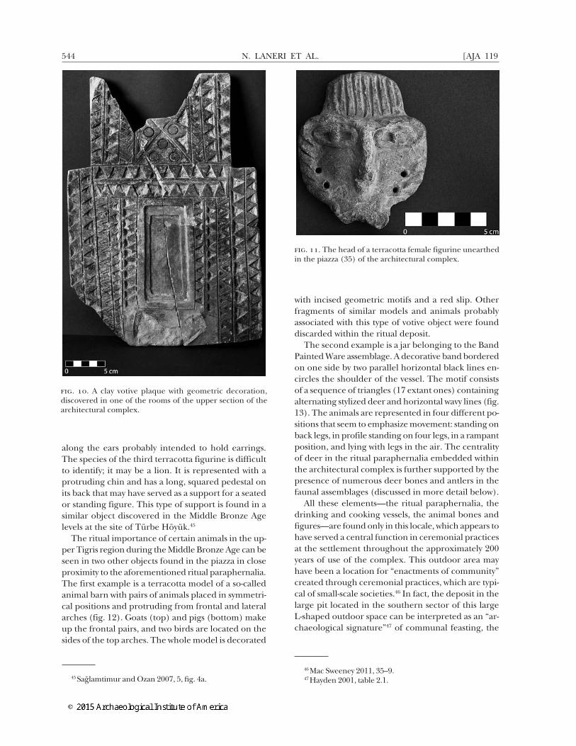
along the ears probably intended to hold earrings. The species of the third terracotta figurine is difficult to identify; it may be a lion. It is represented with a protruding chin and has a long, squared pedestal on its back that may have served as a support for a seated or standing figure. This type of support is found in a similar object discovered in the Middle Bronze Age levels at the site of Türbe Höyük.45
The ritual importance of certain animals in the up-per Tigris region during the Middle Bronze Age can be seen in two other objects found in the piazza in close proximity to the aforementioned ritual paraphernalia. The first example is a terracotta model of a so-called animal barn with pairs of animals placed in symmetri-cal positions and protruding from frontal and lateral arches (fig. 12). Goats (top) and pigs (bottom) make up the frontal pairs, and two birds are located on the sides of the top arches. The whole model is decorated
45 Sağlamtimur and Ozan 2007, 5, fig. 4a.
with incised geometric motifs and a red slip. Other fragments of similar models and animals probably associated with this type of votive object were found discarded within the ritual deposit.
The second example is a jar belonging to the Band Painted Ware assemblage. A decorative band bordered on one side by two parallel horizontal black lines en-circles the shoulder of the vessel. The motif consists of a sequence of triangles (17 extant ones) containing alternating stylized deer and horizontal wavy lines (fig. 13). The animals are represented in four different po-sitions that seem to emphasize movement: standing on back legs, in profile standing on four legs, in a rampant position, and lying with legs in the air. The centrality of deer in the ritual paraphernalia embedded within the architectural complex is further supported by the presence of numerous deer bones and antlers in the faunal assemblages (discussed in more detail below).
All these elements—the ritual paraphernalia, the drinking and cooking vessels, the animal bones and figures—are found only in this locale, which appears to have served a central function in ceremonial practices at the settlement throughout the approximately 200 years of use of the complex. This outdoor area may have been a location for “enactments of community” created through ceremonial practices, which are typi-cal of small-scale societies.46 In fact, the deposit in the large pit located in the southern sector of this large L-shaped outdoor space can be interpreted as an “ar-chaeological signature”47 of communal feasting, the
46 Mac Sweeney 2011, 35–9.47 Hayden 2001, table 2.1.
fig. 10. A clay votive plaque with geometric decoration, discovered in one of the rooms of the upper section of the architectural complex.
fig. 11. The head of a terracotta female figurine unearthed in the piazza (35) of the architectural complex.

HIRBEMERDON TEPE AND THE TIGRIS RIVER IN THE MIDDLE BRONZE AGE2015] 545
objects within having been discarded in abundance after use. The different types of clay used for mak-ing the plaques found in this locale may indicate that people brought them from other locations to the site as part of a pilgrimage. The path circling the piazza and the small Room 55a with water channels may have been connected to public rituals. The higher density of cooking ware and drinking vessels (mostly Band Painted Ware) in the piazza as compared with other sectors of the architectural complex likewise suggests that the activities performed there had a communal nature. The evidence that suggests the production of wine at the site may indicate that it was among the liq-uids consumed during the ritual ceremonies.
Thus, rituals conducted in the piazza and involv-ing more than a few individuals may have served the purpose of reinforcing community solidarity among villagers in the surrounding area and possibly in more distant settlements.48
48 Hayden 2001, 29–35.
The Pottery Assemblage and Its Regional Context The assemblage of pottery discovered in the out-
door space of the Middle Bronze Age architectural complex is important for the analysis of ceramics of this period and for the identification of intersite cul-tural connections in the upper Tigris region. During the Middle Bronze Age, a common material culture is widely recognizable in the whole region, marked by the ubiquitous presence of a pottery type known as Red Brown Wash Ware, which is characterized by a thick outer layer of red/dusky-red slip. Another stylis-tic type found in lower percentages in Middle Bronze Age contexts of this region is Band Painted Ware.49 While the pottery from Hirbemerdon Tepe shares
49 A coherent typology for the Middle Bronze Age pottery discovered within the architectural complex has already been established in other reports (Laneri et al. 2006, 2008, 2009; D’Agostino 2012).
fig. 12. A terracotta model of a so-called animal barn un-earthed in the piazza (35) of the architectural complex: top, front view; bottom, side view.
fig. 13. Vessel decorated with stylized images of deer, found in the piazza (35) of the architectural complex.

N. LANERI ET AL.546 [AJA 119
some decorative features with a ceramic type known as Khabur Ware (from the Khabur area in northeast-ern Syria),50 archaeometric analyses (discussed later in this report) have demonstrated that this specific pottery assemblage represents a local variant of Red Brown Wash Ware.
Based on more detailed analyses of the stylistic and technological characteristics of the vessels, it is possible to distinguish four main ware types: slipped/painted ware (which includes Red Brown Wash Ware and Band Painted Ware), common ware, gray ware, and cooking ware.51 Among these wares, slipped/painted ware con-stitutes approximately 72% of the Middle Bronze Age pottery assemblage (figs. 14, 15). Additionally, three main functional categories have been identified: utili-tarian, storage, and culinary. Utilitarian vessels consist of a variety of bowls and jars used for the consumption or short-term transportation of food; storage vessels are mainly large jars used to store substantial quantities of dry foodstuffs and liquids, probably for extended periods; culinary vessels consist of hole-mouthed and low-necked jars, where temper and surface treatment (i.e., coarse fabric and outer burnishing) indicate their use in cooking.
With regard to spatial distribution, utilitarian ves-sels are evenly dispersed, while storage and cooking vessels show distinct clustering within the architectural complex. Large containers of the Red Brown Wash Ware assemblage are in fact found in rooms that were used as storage areas (e.g., Rooms 25, 26, 30, and 43), whereas cooking vessels are concentrated in Rooms 22, 25, 27, 28, 30, 38, and 43 and overlap with Red Brown Wash Ware storage jars in two rooms. Rooms 22, 24, and 25 also contain decorated vessels (Band Painted Ware) that were used for liquids. A high density of sherds from containers and cooking vessels is found in the piazza (35), along with the highest density of Band Painted Ware at the site.
As mentioned previously, Band Painted Ware, a type of decorated vessel that takes its name from the horizontal band painted on the shoulder, is found in Middle Bronze Age pottery assemblages through-out the upper Tigris River area.52 The Band Painted Ware assemblage from Hirbemerdon Tepe allows for chronological comparisons with Khabur Ware, a ce-ramic type from the Khabur region in northeastern Syria that dates to the Middle Bronze Age and has a
50 Supra n. 49.51 Other classes are rarely found (e.g., brown and orange
wares), but they cannot be coherently linked to pottery types and so are not considered in this preliminary report.
52 Parker and Swartz Dodd 2003; Laneri et al. 2008.
similar decorative element.53 However, it is difficult to draw a direct link between these two stylistic traditions based only on a single decorative pattern, which is also found over a wide geographical area, including north-ern Mesopotamia, Syria, Palestine, and the highlands of eastern Anatolia and northwestern Iran. When look-ing at specific additional decorative elements, it is pos-sible to link bands, cross-hatched triangles, triangles filled with wavy lines, and vertical lines with the Khabur River valley, while wavy lines and figurative decorations can indicate a possible cultural connection with the eastern Anatolian highlands, northwestern Iran, and Transcaucasia.54
In addition, the Khabur Ware from Syria is more diverse than the Band Painted Ware from the upper Tigris, which contains a very limited number of vessel types (medium-sized jars and a few deep bowls) and lacks typical Khabur Ware repertoire shapes docu-mented in “secondary distribution” areas outside of the Khabur region proper.55
Another area of difference relates to the techno-logical characteristics of Band Painted Ware painted decoration and the surface treatment of Red Brown Wash Ware. Both specimens show a high concentra-tion of hematite, aluminum, and potassium—that is, a slurry made of iron-oxide clay. In Red Brown Wash Ware specimens, it is on the surface of the slip; in Band Painted Ware samples, it is found in the painted decoration.56 Because of its chemical composition, the coating/paint assumes different colors in relation to firing conditions: the chromatic effects range from light red/red to reddish-brown/brown, and some-times dark gray and black are thus the result of the oxidizing-reducing atmosphere of the kiln. In addi-tion, there are no macroscopic distinctions between the fabrics of Red Brown Wash Ware and Band Painted Ware, and therefore both should be included in the macrocategory of slipped/painted ware.57
Therefore, a more accurate classification term for ceramics produced in the upper Tigris River valley
53 Oguchi 2001.54 Oguchi 1998; Özfırat 2001, 2008. 55 Stein 1984; Faivre and Nicolle 2007.56 Laneri et al. 2006.57 The lack of distinction between the slip and painted
decoration recognizable in Red Brown Wash Ware and Band Painted Ware has brought up the conundrum of differentiat-ing between paint and slip on archaeological ceramics. Scien-tists involved in the project are investigating this conundrum through a series of proton-induced X-ray emission analyses on sherds of Red Brown Wash Ware and Band Painted Ware. However, we have assumed that the main distinction must be associated with the act of painting involved in applying the decorative pattern on Band Painted Ware vessels.

HIRBEMERDON TEPE AND THE TIGRIS RIVER IN THE MIDDLE BRONZE AGE2015] 547
during the Middle Bronze Age is Tigris Slipped and Painted Ware, with subgroupings of a simple slipped variant (Red Brown Wash Ware) and a painted variant (Band Painted Ware). The latter subgroup includes both the banded category and the extremely rare painted specimens (with triangles, vertical lines, ani-mal figures, and complex geometric patterns).
The earlier reddish/orange/black ceramic tradi-tion (i.e., Dark Rimmed Orange Bowls) is found in the upper Tigris River region in contexts dating to the end of the third millennium B.C.E., when the ware was first produced,58 and in neighboring regions, especially northern Mesopotamia. That this type can also be seen at other Middle Bronze Age sites of the upper Tigris River region (e.g., Üçtepe, Giricano, Zi-yaret Tepe, Kenan Tepe, Kavuşan Höyük, and Salat Tepe)59 suggests the presence of a regional decorative
58 Kibaroğlu 2008.59 Üçtepe: Özfırat 2006. Giricano: Schachner 2002, 37–8;
system between the late third and the first half of the second millennium B.C.E.
In general, the Middle Bronze Age pottery assem-blage in the upper Tigris is dominated by a slipped/painted ceramic style that includes Red Brown Wash Ware and Band Painted Ware. Stylistic characteristics of the assemblage at Hirbemerdon Tepe seem to cor-relate with functional characteristics, as Band Painted Ware is associated most often with the consumption of liquids, has decorative patterns similar to those seen in assemblages from neighboring regions, and is found in higher densities in the piazza. This evidence suggests that it was linked to the ritual activities con-ducted at the site.
Bartl 2005, 158. Ziyaret Tepe: Matney et al. 2002, 63–4. Kenan Tepe: Parker and Swartz Dodd 2003. Kavuşan Höyük: Kozbe et al. 2004. Salat Tepe: Ökse and Görmüş 2006.
fig. 14. The most representative pottery types of the Middle Bronze Age at Hirbemerdon Tepe: a–i, Red Brown Wash Ware; j, common ware; k, Band Painted Ware; l, gray ware.
fig. 15. The most representative pottery types of the Middle Bronze Age at Hirbemerdon Tepe: a, b, cooking ware; c–e, Red Brown Wash Ware (storage jars).
N. LANERI ET AL.548 [AJA 119
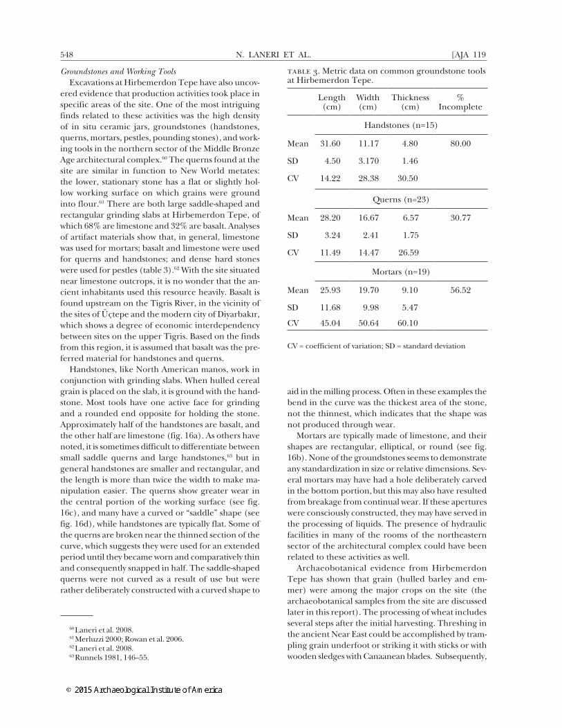
Groundstones and Working ToolsExcavations at Hirbemerdon Tepe have also uncov-
ered evidence that production activities took place in specific areas of the site. One of the most intriguing finds related to these activities was the high density of in situ ceramic jars, groundstones (handstones, querns, mortars, pestles, pounding stones), and work-ing tools in the northern sector of the Middle Bronze Age architectural complex.60 The querns found at the site are similar in function to New World metates: the lower, stationary stone has a flat or slightly hol-low working surface on which grains were ground into flour.61 There are both large saddle-shaped and rectangular grinding slabs at Hirbemerdon Tepe, of which 68% are limestone and 32% are basalt. Analyses of artifact materials show that, in general, limestone was used for mortars; basalt and limestone were used for querns and handstones; and dense hard stones were used for pestles (table 3).62 With the site situated near limestone outcrops, it is no wonder that the an-cient inhabitants used this resource heavily. Basalt is found upstream on the Tigris River, in the vicinity of the sites of Üçtepe and the modern city of Diyarbakır, which shows a degree of economic interdependency between sites on the upper Tigris. Based on the finds from this region, it is assumed that basalt was the pre-ferred material for handstones and querns.
Handstones, like North American manos, work in conjunction with grinding slabs. When hulled cereal grain is placed on the slab, it is ground with the hand-stone. Most tools have one active face for grinding and a rounded end opposite for holding the stone. Approximately half of the handstones are basalt, and the other half are limestone (fig. 16a). As others have noted, it is sometimes difficult to differentiate between small saddle querns and large handstones,63 but in general handstones are smaller and rectangular, and the length is more than twice the width to make ma-nipulation easier. The querns show greater wear in the central portion of the working surface (see fig. 16c), and many have a curved or “saddle” shape (see fig. 16d), while handstones are typically flat. Some of the querns are broken near the thinned section of the curve, which suggests they were used for an extended period until they became worn and comparatively thin and consequently snapped in half. The saddle-shaped querns were not curved as a result of use but were rather deliberately constructed with a curved shape to
60 Laneri et al. 2008.61 Merluzzi 2000; Rowan et al. 2006.62 Laneri et al. 2008.63 Runnels 1981, 146–55.
aid in the milling process. Often in these examples the bend in the curve was the thickest area of the stone, not the thinnest, which indicates that the shape was not produced through wear.
Mortars are typically made of limestone, and their shapes are rectangular, elliptical, or round (see fig. 16b). None of the groundstones seems to demonstrate any standardization in size or relative dimensions. Sev-eral mortars may have had a hole deliberately carved in the bottom portion, but this may also have resulted from breakage from continual wear. If these apertures were consciously constructed, they may have served in the processing of liquids. The presence of hydraulic facilities in many of the rooms of the northeastern sector of the architectural complex could have been related to these activities as well.
Archaeobotanical evidence from Hirbemerdon Tepe has shown that grain (hulled barley and em-mer) were among the major crops on the site (the archaeobotanical samples from the site are discussed later in this report). The processing of wheat includes several steps after the initial harvesting. Threshing in the ancient Near East could be accomplished by tram-pling grain underfoot or striking it with sticks or with wooden sledges with Canaanean blades. Subsequently,
table 3. Metric data on common groundstone tools at Hirbemerdon Tepe.
Length (cm)
Width (cm)
Thickness (cm)
% Incomplete
Handstones (n=15)
Mean 31.60 11.17 4.80 80.00
SD 4.50 3.170 1.46
CV 14.22 28.38 30.50
Querns (n=23)
Mean 28.20 16.67 6.57 30.77
SD 3.24 2.41 1.75
CV 11.49 14.47 26.59
Mortars (n=19)
Mean 25.93 19.70 9.10 56.52
SD 11.68 9.98 5.47
CV 45.04 50.64 60.10
CV = coefficient of variation; SD = standard deviation

HIRBEMERDON TEPE AND THE TIGRIS RIVER IN THE MIDDLE BRONZE AGE2015] 549
the chaff and seed were separated by winnowing per-formed in an open space. Once the grain was sieved, it could be stored properly.64 The mortars and querns likely served to dehusk and then mill the grain, as has been confirmed by archaeological and ethnographic evidence. The removal of the husk is best performed using a mortar with a wooden pestle.65 Water applied to the grain allows the grains to slide past one an-other without breaking and the husk to be stripped off.66 Stone pestles were found along with mortars at Hirbemerdon Tepe, and they may have been used for hulling. Wooden pestles used sufficient pressure to crack the hull but did not crush the hull and make it inseparable from the edible grain as a quern would
64 Murray 2000.65 Harlan 1967; Hillman 1984a; Wright 1994.66 Hillman 1984b; Samuel 2000.
do.67 The sorted grain would then be milled into flour using a handstone in a back-and-forth motion along the long axis of the quern.68 Many groundstones could potentially be used on many different substances rang-ing from grain to ochre or metallic ore, which raises the possibility that other activities occurred within these contexts.69 Preliminary analyses of the grinding stones have not yielded any identifiable starch grains, but future work may prove more fruitful in identifying the precise function of this assemblage.
According to chi-square analysis of the distribution of the groundstones in the architectural complex, the actual location of these artifacts was not random ( χ2 = 210.516; df = 63; two-tailed p-value = < 0.0001). In almost all cases, querns were found in separate lo-cations from mortars, which shows that these activities were spatially segregated. Previous distribution investi-gations of groundstone artifacts and large storage ves-sels seem to indicate that the processing of materials was organized in such a way that specific rooms had particularized functions.70 Mortars were also found in the large courtyard above the piazza and in the rooms on the upper levels of step trench AC, showing that the production activities of the site were extensive. No areas have yet been positively identified with thresh-ing, sorting, or large-scale storage of grain.
The architectural complex mostly consisted of specialized, nondomestic structures focused on pro-duction in addition to ritual activities. Ethnographic studies in Egypt have demonstrated that almost all households had their own milling stones and would share some communal mortars.71 Most ethnographic data confirm the storage of grain could occur before or after dehusking but not after milling the grain into flour.72 Interestingly, the artifacts found in the archi-tectural complex are related to hulling and milling, the steps that were likely to occur with stored grain that was being processed for consumption. This im-plies that a great deal of labor was invested not just in grain production and storage but also in food process-ing and that a large quantity of consumables could be produced at one time for a great number of individu-als, possibly in the context of ritual activities or feast-ing. The complex architecture at the site as a whole suggests a degree of labor management by some indi-viduals or groups who wielded some ritual authority. It is still not known whom these laborers were serving,
67 Wright 1994.68 Samuel 2000.69 Baysal and Wright 2005.70 Laneri et al. 2008.71 Samuel 2000.72 Hillman 1984b.
fig. 16. Drawings of the groundstones: a, handstones; b, mortars; c, querns; d, saddle querns.

N. LANERI ET AL.550 [AJA 119
but in all likelihood, these facilities were producing food for either an extended household or the exter-nal labor attached to this corporate group. Whether this food was produced in the context of feasting can-not be determined at this point, but the presence of a large quantity of vessels for consumption of liquid and foodstuff in the piazza (35) of the architectural complex might be further evidence of such a scenario.
the middle bronze age agricultural economy at hirbemerdon tepe
In regard to subsistence practices at Hirbemerdon Tepe, the archaeobotanical and phytolith remains provide adequate information for the reconstruc-tion of the Middle Bronze Age agricultural economy within the ecological context of southeastern Anato-lia. Other contemporaneous finds of charred plant remains from other sites in the region of the upper Tigris River valley will provide greater context in the future. Data sets deriving from Early Bronze Age de-posits at Titriş Höyük in the Urfa region and at Tell es-Sweyhat and Tell Brak in northern Syria can serve as comparative samples.73
At Hirbemerdon Tepe, sediment samples were pro-cessed by manual flotation for the recovery of charred plant remains.74 Most of the samples were from the ar-chitectural complex and derive primarily from room floors, pits, and fireplaces.75 Phytolith samples were collected between 2008 and 2011 from a variety of contexts, including hearths, floors, and groundstones from different areas of the site.
The main crops noted in the archaeobotanical samples are hulled barley (Hordeum sativum), emmer wheat (Triticum dicoccum), lentil (Lens culinaris), grass pea (Lathyrus sativus), and grape (Vitis vinifera). Com-mon wild species include the grasses bedstraw (Galium sp.) and medick (Medicago sp.), which can be found as field crop weeds and may have been brought to the settlement with the harvested crops. Wheat and barley phytoliths were also found in a variety of con-texts, including clay ovens and floors in Building Q as well as in the piazza itself. Wild grass phytoliths, in-cluding Aegilops sp. (goat grass), were also found, but since there is a positive correlation (0.9418) between the presence of wild grasses and the presence of do-mesticated cereals, the wild plants were likely to have come into the site with cereals as agricultural weeds. The off-site phytolith samples taken from the terrace
73 Urfa region: Hald 2010. Tell es-Sweyhat: Miller 1997. Tell Brak: Charles and Bogaard 1997; Colledge 2003.
74 The samples are still undergoing detailed analysis, and what follows here is a brief discussion of the preliminary re-sults from this work.
75 Laneri et al. 2008, 194–95.
indicate that the terrace had areas used for agriculture as well; emmer wheat was found in these samples. Oth-er plants found on-site include wetland plants (esp. sedges), which were ubiquitous throughout the site’s occupation despite a possible reduction in precipita-tion through time. The sedges could have been used in a variety of ways on-site, including as baskets, mats, and roofing material.
While all the crops mentioned were very likely to have been used for basic subsistence, grapes—most of which have been found (as macroremains) in Rooms 27a and 27b of the architectural complex—may have served a different purpose (e.g., for the production of wine). One grape with the flesh still intact raises the possibility that dried grapes could have been stored on-site. Dried grapes may have been part of the long-term food storage strategies within the Hirbemerdon Tepe crop economy and may have been used as an exchange commodity.
Apart from a cache of some 50 grass peas in Room 2 within the architectural complex, no large con-centrations of crops were encountered during the excavations; rather, it appears that the archaeobo-tanical and phytolith assemblages represent a gen-eral “background noise” of crops present on-site. As such, the plant remains give us an indication of what food crops were available to the inhabitants of Hirbe-merdon Tepe, though an assessment of the relative importance or a coherent spatial distribution of crops is still not possible. However, the limited presence of charred remains of Vitis vinifera in Rooms 27a and 27b and in Room 48 of Building G suggests the existence of specialized craft production associated with grape processing in these buildings. It is also important to note that it is in the eastern lobe of Rooms 27a and 27b that a raised squared platform/basin composed of large stones was found. This basin had a drain ori-ented toward the street. It was similar to those found in a late Early Bronze Age context at Titriş Höyük, where circular features were designed for the processing of grapes, and drains served in the cleaning of the ba-sins at the end of production.76 Based on written texts, it has been suggested that grape processing at Titriş Höyük was associated with ritual, which may also have been the case in Hirbemerdon Tepe given the proxim-ity of grape-processing areas to the ceremonial sector.77
Hulled barley, emmer wheat, grass pea, and lentils were common crops in southeast Anatolia during the Bronze Age, while grapes were generally less common. The presence of wetland plants and wood also indicates that the inhabitants were using other resources avail-
76 Algaze et al. 2001.77 Laneri 2007.
HIRBEMERDON TEPE AND THE TIGRIS RIVER IN THE MIDDLE BRONZE AGE2015] 551
able to them. The presence of certain samples (in particular, Vitis vinifera) in specific archaeological contexts within the architectural complex further sup-ports the idea that some of the rooms of the complex were used for specific purposes.
contextualizing the faunal remains of the middle bronze age layers
As has been previously noted, iconographic depic-tions of animals, such as the deer represented in one of the Band Painted Ware vessels found in the piazza (see fig. 13), demonstrate the important cultural role of animals at the site. A study of the faunal remains at Hirbemerdon Tepe likewise reveals some intrigu-ing patterns in the relationship between the site’s inhabitants and local fauna. Both wild and domestic animal remains are found in the faunal assemblages at Hirbemerdon Tepe; in general, the exploitation of animal resources focused on Cervus elaphus (red deer), Ovis aries (domestic sheep), Capra hircus (domestic goats), Sus domesticus (domestic pigs), and Bos taurus (domestic cattle). The remains of several other spe-cies have been found in smaller numbers (table 4). The relative importance of the individual taxon varies according to the chronological and contextual attri-bution of the assemblage. During the Middle Bronze Age, animals at Hirbemerdon Tepe were important not only for subsistence but also for ritual practices, as is demonstrated by the high density of deer bones and antlers in the architectural complex and by the ritual deposit of the newborn piglet within Building G (discussed above).78
The three primary faunal assemblages were located in the fill of Street 47 (contemporaneous with the use of the architectural complex); in the piazza (where faunal remains are located on the floor and in the overlying fill containing votive objects);79 and in the fill sealing the piazza,80 which is dated to the aban-donment of the building (Middle Bronze Age/Late Bronze Age transitional period). The number of iden-tified specimens (NISP) was corrected for complete skeletons to avoid overrepresentation of a species in small assemblages. This was the case for a complete dog (Canis familiaris) skeleton from the piazza.81
78 Whereas the layer dating to the Middle Bronze Age is full of deer bones and a few antlers, the highest density of deer antlers is recognizable in the thick collapse/filling layer seal-ing the piazza and dated to a Late Bronze Age horizon.
79 Abend et al. 2010; Laneri 2011.80 Crescioli and Laneri 2011.81 The faunal remains were studied using methods listed
elsewhere (Berthon and Mashkour 2008; Laneri et al. 2008; Berthon 2011, [forthcoming]).
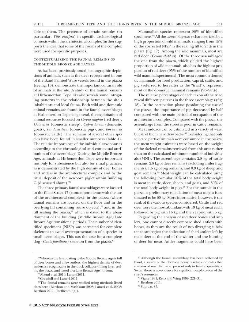
Mammalian species represent 96% of identified specimens.82 All the assemblages are characterized by a high proportion of wild mammals, ranging from 15% of the corrected NISP in the sealing fill to 25% in the piazza (fig. 17). Among the wild mammals, most are red deer (Cervus elaphus). Of the three assemblages, the one from the piazza, which yielded the highest proportion of wild mammals, also has the highest pro-portion of red deer (95% of the number of identified wild mammal specimens). The most common domes-tic mammals for food production, caprid, cattle, and pig (referred to hereafter as the “triad”), represent most of the domestic mammal remains (96–98%).
The relative percentages of each taxon of the triad reveal different patterns in the three assemblages (fig. 18). In the occupation phase postdating the use of the piazza, the importance of pig decreased by half compared with the main period of occupation of the architectural complex. Compared with the piazza, the assemblage from the street is poor in cattle remains.
Meat indexes can be estimated in a variety of ways, but all of them have drawbacks.83 Considering that only selected parts of animals were consumed in the piazza, the meat-weight estimates were based on the weight of the skeletal remains retrieved from this area rather than on the calculated minimum number of individu-als (MNI). The assemblage contains 2.8 kg of cattle remains, 2.8 kg of deer remains (excluding antler frag-ments), 1.5 kg of pig remains, and 0.9 kg of sheep and goat remains.84 Meat weight can be calculated using the following formulas: 50% of the total body weight is meat in cattle, deer, sheep, and goats, and 80% of the total body weight in pigs.85 For the sample in the piazza, a preliminary calculation of meat weight is es-timated to be 60 kg. More informative, however, is the rank of the various species considered. Cattle and red deer were the most abundant with 19 kg of meat each, followed by pig with 16 kg and then caprid with 6 kg.
Regarding the analysis of red deer bones and ant-lers, one cannot directly compare shed antlers with bones, as they are the result of two diverging subsis-tence strategies: the collection of shed antlers left by male deer at the end of the winter and the hunting of deer for meat. Antler fragments could have been
82 Although the faunal assemblage has been collected by hand, a survey of the flotation heavy residues indicates that remains of small fish were present only in limited quantities. So far, there is no evidence for significant exploitation of the river’s resources.
83 Vigne 1991; Reitz and Wing 1999, 221–31.84 Berthon 2011.85 Supra n. 83.

N. LANERI ET AL.552 [AJA 119
worked into artifacts and therefore separated from the consumption chain. To avoid biasing the counts in fa-vor of caprid and cattle, fragments of horn cores not attached to skulls were not included in the corrected NISP. Examining the antler and horn core remains separately from each other, it appears that antlers form a large portion of the sealing-fill assemblage (table 5). Unshed and shed antlers from the sealing fill reveal the importance of this raw material for the inhabit-ants of Hirbemerdon Tepe. Almost half of the antler remains show saw or cut marks. Interestingly, most of the sheep and goat horn cores were also recovered from the same fill. Three goat horn cores display chop marks on their bases.
The most significant of the faunal analyses at Hirbe-merdon Tepe is the reconstruction of the relative im-portance of hunting. Such a high proportion of wild mammals is not usually present in contemporary sites in Anatolia or northern Mesopotamia.86 At Halawa on the Euphrates in northern Syria, 9% of the mam-mals noted in the Middle Bronze Age assemblage
86 Boessneck and von den Driesch 1975; Clason and Bu-itenhuis 2000; Bartosiewicz 2005; Piątkowska-Małecka and Koliński 2006; Berthon and Mashkour 2008; Berthon 2010; Gündem 2010.
were wild.87 In northwestern Syria, the site of Umm el-Marra is a striking example of a Middle Bronze Age settlement with a great emphasis on hunting. There, hunting focused on steppe species, onager and gazelle, which constituted up to 40% of the assemblage.88 Near Hirbemerdon Tepe, the contemporaneous site of Müs-lümantepe had more than 12% wild mammals (almost exclusively red deer) in its assemblage.89 However, the other sites of the upper Tigris River valley, such as Giricano, Kenan Tepe, Başur Höyük, and Türbe Höyük, yielded a low percentage of wild mammals.90 It is hypothesized that the sites located closer to the broader part of the alluvial plain, such as Giricano or Kenan Tepe, focused on an agricultural economy, while the inhabitants of Müslümantepe and Hirbe-merdon Tepe took advantage of the nearby forested uplands to diversify their subsistence strategies with specialized red deer hunting.
Because of the large amount of meat they provide, red deer may have played an important role in the
87 Boessneck and von den Driesch 1989.88 Nichols and Weber 2006; Weber 2006.89 Berthon 2011, 2013.90 Less than 4%, according to Berthon 2010, 2011, 2013.
table 4. Corrected number of identified specimens in the three assemblages at Hirbemerdon Tepe.
Species Common Name Street Piazza Sealing Fill
Wild mammals
Canis lupus wolf 0 0 1
Sus scrofa wild boar 2 3 3
Cervus elaphus red deer 22 72 65
Dama mesopotamica Mesopotamian fallow deer 0 1 1
Bos primigenius wild cattle 0 0 1
C. aegagrus/O. orientalis wild goat or sheep 0 0 1
Ovis orientalis wild sheep 1 0 0
Domestic mammals
Canis familiaris dog 0 8 10
Equus spp. horse, donkey 2 1 8
Sus domesticus domestic pig 49 95 89
Bos taurus domestic cattle 13 55 137
Capra hircus/Ovis aries domestic goat or sheep 25 48 109
Capra hircus domestic goat 6 12 24
Ovis aries domestic sheep 5 7 33
Total 125 302 482
Note: See text for the description of the counting method.

HIRBEMERDON TEPE AND THE TIGRIS RIVER IN THE MIDDLE BRONZE AGE2015] 553
fig. 17. Relative representation (%) of the corrected number of identified specimens (NISP) of different groups of species in the Hirbemerdon Tepe faunal assemblages. See the section “Contextualizing the Faunal Remains of the Middle Bronze Age Layers” for NISP calculation details and table 4 for raw numbers.
fig. 18. Relative representation (%) of the corrected number of indentified specimens (NISP) of the main food providers at Hirbemerdon Tepe. The left set of bars represents only the domestic mammals, while the right set of bars represents the do-mestic mammals and the red deer. See the section “Contextualizing the Faunal Remains of the Middle Bronze Age Layers” for NISP calculation details and table 4 for raw numbers.

N. LANERI ET AL.554 [AJA 119
subsistence economy. Indeed, red deer hunting did not lose its importance in the period subsequent to the use of the piazza. However, it is in the piazza, where ritual activities took place, that the highest propor-tion of red deer remains were found. Street 47 and the piazza yielded two contemporaneous and spatially proximate assemblages. Even though the taxonomic diversity and the fragmentation rate are equivalent in the street and the piazza, there is a significantly lower representation of cattle and red deer in the street assemblage.
In contrast, the piazza is characterized by a higher proportion of large mammals, such as cattle and red deer. It is possible that these animals were consumed during rituals that took place in the piazza, as these taxa provide a substantial amount of meat.91 The high representation of butchery waste, such as phalanges, indicates that red deer could have been butchered inside the piazza, which may not have been the case for the other species.92 This implies that red deer were treated differently from domestic mammals and sup-ports the idea of red deer playing a role in the ritual activities. Red deer meat could have been highly val-ued as a result of the efforts necessary to acquire it
91 Hayden 1996; Kelly 2001.92 The MNI calculation suggests that three red deer, three
cattle, seven pigs, and six sheep or goats are represented in the assemblage from the piazza. Patterns of skeletal represen-tation indicate that cattle, pig, sheep, and goat were probably not butchered in the piazza. Therefore, only selected parts of their skeletons were brought there.
and the symbolic status of these wild mammals. The assemblage from the sealing fill (locus A0496) is char-acterized by a lower representation of pigs, which could indicate a significant evolution of the subsis-tence strategy. In addition, the high number of antler and horn core fragments suggests that a part of the sealing-fill assemblage might come from the waste of a production workshop.
geoarchaeological and off-site phytolith analyses at hirbemerdon tepe
Geoarchaeological and phytolith analyses situate the site within the environmental conditions of the alluvial plains and upland hills. The location of the Holocene terrace(s) provided data on local hydrologi-cal conditions at the time of occupation. Sedimentary stratigraphy documented deposition and hydrological fluctuations, allowing for interpretations of regional climate and land-use patterns. Phytolith samples pro-vided further information regarding land use, crop use, and changing vegetation patterns in the alluvial plain and surrounding foothills.93
The sedimentary evidence indicates that there were several sequences in the formation of the terrace, in-cluding cycles of alluviation and seasonal flooding alter-nating with erosional flash flooding. During this period, there is evidence not only at Hirbemerdon Tepe but also in the Urfa Plain of favorable climatic conditions
93 Samples were processed and analyzed at the Institute of Archaeology, University College London.
table 5. Number of horn core and antler remains in the assemblages at Hirbemerdon Tepe.
Street Piazza Sealing Fill
Red deer (Cervus elaphus) – – –
Tine or beam antler fragment 1 3 9
Unshed antler – – 4
Shed antler – – 1
Including antler with chop/sawing marks – 2 6
Mesopotamian fallow deer (Dama mesopotamica) – – –
Shed antler – – 1
Domestic cattle (Bos taurus) – – –
Horn core – – 4
Domestic sheep and goat (Capra hircus and Ovis aries) – – –
Horn core – 5 27
Including horn core with chop/sawing marks – – 4

HIRBEMERDON TEPE AND THE TIGRIS RIVER IN THE MIDDLE BRONZE AGE2015] 555
(floodplain alluviation and higher precipitation).94 The regular alluviation, as seen in the sedimentary record, may have allowed for floodwater farming. Very large multicell phytoliths (i.e., more than 50 conjoined sin-gle cells) from emmer were found, which may indicate floodwater farming.95 Wetland plant phytoliths as well as silicified sponge spicules and diatoms indicate the presence of waterlogged areas, such as backswamps, which are common in alluvial settings. There is also possible evidence of fruit horticulture (in the form of “jigsaw”-shaped phytoliths).96
As precipitation levels decreased and the river be-gan to incise the plain, the residents could no longer rely on the seasonal flooding of the terrace. There are no indications of large-scale channel irrigation, and it is likely that residents switched to rain-fed farming. Regional proxy evidence from Lake Van indicates that the very early second millennium B.C.E. is marked by increased precipitation between two periods of drier conditions.97 However, these episodes of “wet/dry fluctuations”98 are not reflected in the sedimen-tary record from Hirbemerdon Tepe. At some point after the Middle Bronze Age, a high-energy “flood” layer, with mixed-period artifacts and poorly sorted sediments, was deposited (fig. 19). High-energy flood layers are characterized mainly by poorly sorted sedi-ments and may contain artifacts stripped from sites located elsewhere. The flood layer may be attributable to increased erosion and sediment levels in the Tigris as a result of deforestation.
Although the sedimentary evidence seems to indi-cate that the climate was becoming generally more arid from the Early Bronze Age into the Middle Bronze Age, which would be consistent with the evidence from other parts of the Near East, wheat was still propagat-ed, as indicated by on-site archaeobotanical and phy-tolith evidence as well as the wheat phytoliths found in off-site contexts. The continued presence of woodland areas in the Middle Bronze Age is evidenced by the use of charcoal and wood on-site as well as the dicoty-ledon (tree and shrub) phytoliths preserved in the off-site sedimentary deposits. Unfortunately, shrubs and trees share many similar phytolith morphologies, and so it is difficult to determine what species were actually represented in the samples. However, faunal evidence from the site (i.e., the presence of red deer
94 For the evidence from the Urfa Plain, see Algaze et al. 1995; Rosen 1997, 2007.
95 Rosen and Weiner 1994; Madella et al. 2009.96 Tsartsidou et al. 2007.97 Wick et al. 2003; Deckers and Riehl 2007; Roberts et al.
2011.98 Roberts et al. 2011, 152.
whose natural habitat is open woodland) points to the likelihood of local forested areas. If there had been widespread deforestation, there would have been in-creased erosion and sediment yield in the river, which would have increased the deposition of sediments; there were no flood deposits until the post–Middle Bronze Age period observed in the geoarchaeologi-cal survey. Furthermore, the records from Lake Van show only a small decline in Quercus (oak) values, in-dicating that human impact was not severe in eastern Anatolia at this time.99
In general, the landscape of Hirbemerdon Tepe during the Middle Bronze Age was characterized by a mosaic of agricultural fields (cereals, possibly fruit trees, and other crop plants not detectable in the phy-tolith record, such as legumes) in the alluvial plain, waterlogged backswamp areas,100 and a wooded up-land area. The presence of a riparian forest cannot be clearly determined, but if one existed it is likely to have been cleared throughout the Bronze Age so that the wood could be used and the land repurposed for agricultural fields and possibly pastures.
the middle bronze age cultural landscape of the upper tigris
The geoarchaeological analyses demonstrate there was some environmental variability in terms of avail-able resources in the upper Tigris River valley, which is bounded by mountains and foothills to the north, east, and south. Survey work was initiated to connect Hirbemerdon Tepe to contemporaneous settlements in neighboring regions and place it in the context of
99 Roberts et al. 2011.100 Over time, the backswamp areas may have decreased as
a result of increasing aridity and lack of alluviation, but they were still present.
fig. 19. The flood layer seen across many of the gully sections.

N. LANERI ET AL.556 [AJA 119
the upper Tigris River valley and the wider sphere of northern Mesopotamia (see fig. 1).101
Physical and Cultural LandscapeUntil the present survey, few systematic archaeologi-
cal observations were made in the eastern zone, but the western terraces have been the focus of several exten-sive surveys since 1998, when they were host to a series of salvage excavations in advance of the construction of the Ilısu Dam.102 The initial surveys conducted by Algaze and colleagues in the 1980s identified many sites, but not those of the Middle Bronze Age;103 Red Brown Wash Ware, the characteristic Middle Bronze Age assemblage at Hirbemerdon Tepe, had not yet been recognized. Excavations at Üçtepe demonstrated the chronological position of this highly visible diag-nostic type,104 and subsequent reconnaissance surveys have recognized Middle Bronze Age occupations.105
Although the previous surveys present a preliminary picture of the Middle Bronze Age cultural landscape, they have all been extensive in nature, focusing on major mounded settlements (i.e., höyüks and tepes) to the near exclusion of sites of other morphologies. Furthermore, only Algaze’s survey investigated the eastern upland areas downstream from Hirbemerdon Tepe. The Hirbemerdon Tepe Survey was intended to complement and extend earlier research by inves-tigating both the river terrace and the upland zones and by employing a high-intensity methodology that could recover nonmounded sites. It was hoped that off-site aspects of the Middle Bronze Age landscape might be discernible via such an approach.
Survey MethodsTo recover a full range of site morphologies, the
Hirbemerdon Tepe Survey employed a hybrid of tra-ditional Near Eastern mound-focused methods and intensive transect-walking methods more common in the Mediterranean. Our traditional approach first identified potential sites from historical topographic maps, CORONA satellite photographs, IKONOS and QuickBird satellite imagery, and Shuttle Radar To-pography Mission digital terrain data. These places were then confirmed on the ground and subdivided by morphology; subsequently, the survey team col-lected diagnostic sherds and other relevant artifacts. Although it overlooks nonmounded sites and sherd
101 For a recent review, see Laneri and Schwartz 2011.102 Reviewed in Ur 2011.103 Algaze 1989; Algaze et al. 1991.104 Özfirat 2006.105 Ay 2001; Peasnall 2004; Özfirat 2006.
scatters, this method has been highly effective in re-covering Bronze Age sites throughout Mesopotamia, where Middle Bronze Age settlements were dispro-portionately located atop mounded areas of existing settlements.106
The spaces between these mounds on the western terraces are today all occupied by agricultural fields and are well suited for collection in walking transects. To maximize the area investigated while still maintain-ing a high intensity, the survey opted for 25 m transect intervals, on the assumption that plow movement will have dispersed artifacts from all but the smallest activ-ity areas over such an extent. Along each transect, op-erators marked each artifact with a colored flag before collection so that its position could be recorded.107 In this manner, individual artifacts were recorded by po-sition rather than amalgamated by transect or field. Artifact clusters were only later defined using spatial interpolation methods in a GIS program. This compo-nent of the survey is thus “siteless,” in the sense used by Dunnell.108
Because of the irregularity of the terrain, the east-ern upland zone required a modification of these methods. Transects were larger (lgth. 75–100 m) and defined by topography; fieldwalkers looked for sherds and stone alignments (primarily former tent footings). Because most sites in this region were nonpermanent campsites, artifacts were few, so potential sites were transected at 5 m intervals.
Middle Bronze Age Settlement and Land UseThe results of four years of survey confirm some of
the general patterning previously recognized (e.g., mound-based village settlement in a dispersed pattern near major permanent and seasonal watercourses) but expand it into the intervening “off-site” areas and even into the nonagricultural eastern uplands. The most visible Middle Bronze Age settlement occurs on small mounds, generally less than 1 ha (Güzelköy, Ahmetli, and Kavuşak), with one unnamed mound reaching almost 2 ha (site 97). At 3 ha, Hirbemerdon Tepe itself is the largest Middle Bronze Age site in the survey region.
Middle Bronze Age activities were not limited to mounded sites and neither are artifacts. The modern fields on the upper and lower river terraces were cov-ered in a light and discontinuous scatter of artifacts ranging from Lower Paleolithic hand axes to medieval
106 Wilkinson et al. 2004.107 All artifact positions were recorded using a Trimble
GeoXT mobile computer running ESRI’s ArcPad software.108 Dunnell 1992.
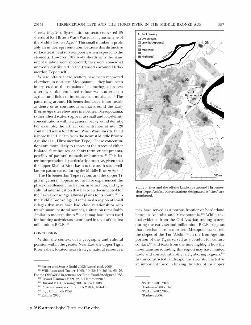
HIRBEMERDON TEPE AND THE TIGRIS RIVER IN THE MIDDLE BRONZE AGE2015] 557
sherds (fig. 20). Systematic transects recovered 35 sherds of Red Brown Wash Ware, a diagnostic type of the Middle Bronze Age.109 This small number is prob-ably an underrepresentation, because this distinctive surface treatment survives poorly when exposed to the elements. However, 787 body sherds with the same internal fabric were recovered; they were somewhat unevenly distributed in the transects around Hirbe-merdon Tepe itself.
Where off-site sherd scatters have been recovered elsewhere in northern Mesopotamia, they have been interpreted as the remains of manuring, a process whereby settlement-based refuse was scattered on agricultural fields to introduce soil nutrients.110 The patterning around Hirbemerdon Tepe is not nearly as dense or as continuous as that around the Early Bronze Age sites elsewhere in northern Mesopotamia; rather, sherd scatters appear as small and low-density concentrations within a general background density. For example, the artifact concentration at site 128 contained seven Red Brown Wash Ware sherds, but it is more than 1,200 m from the nearest Middle Bronze Age site (i.e., Hirbemerdon Tepe). These concentra-tions are more likely to represent the traces of either isolated farmhouses or short-term encampments, possibly of pastoral nomads or hunters.111 This lat-ter interpretation is particularly attractive, given that the upper Khabur River basin to the south was a well-known pasture area during the Middle Bronze Age.112
The Hirbemerdon Tepe region, and the upper Ti-gris in general, appears not to have experienced the phase of settlement nucleation, urbanization, and agri-cultural intensification that has been documented for the Early Bronze Age alluvial plains to its south.113 In the Middle Bronze Age, it remained a region of small villages that may have had close relationships with transhumant pastoral nomads, a situation remarkably similar to modern times,114 or it may have been used for hunting activities as mentioned in texts of the first millennium B.C.E.115
conclusions
Within the context of its geography and cultural position within the greater Near East, the upper Tigris River valley, located near strategic natural resources,
109 Parker and Swartz Dodd 2003; Laneri et al. 2009.110 Wilkinson and Tucker 1995, 19–22; Ur 2010a, 65–76.
For the Old World in general, see Bintliff and Snodgrass 1988.111 Ur and Hammer 2009, 52–3; Hammer 2012.112 Durand 2004; Fleming 2004; Ristvet 2008.113 Reviewed most recently in Ur 2010b, 404–13.114 E.g., Hütteroth 1959.115 Radner 2006.
may have served as a porous frontier or borderland between Anatolia and Mesopotamia.116 While tex-tual evidence from the Old Assyrian trading system during the early second millennium B.C.E. suggests that merchants from northern Mesopotamia skirted the slopes of the Tur ‘Abdin,117 in the Iron Age this portion of the Tigris served as a conduit for culture contact,118 and texts from the time highlight how the mountains surrounding this region may have limited trade and contact with other neighboring regions.119 In this constricted landscape, the river itself acted as an important force in linking the sites of the upper
116 Parker 2001, 2002.117 Forlanini 2006, 162.118 Parker 2002, 2006.119 Radner 2006.
fig. 20. Sites and the off-site landscape around Hirbemer-don Tepe. Artifact concentrations designated as “sites” are numbered.

N. LANERI ET AL.558 [AJA 119
Tigris River valley. Thus, the combination of physical circumscription and close proximity to the river may have influenced the creation of “geographic commu-nities” within this region at the beginning of the sec-ond millennium B.C.E., when the region was marked by the emergence or expansion of numerous small to midsized settlements (e.g., Üçtepe, Kavuşan Höyük, Kenan Tepe, Salat Tepe, Ziyaret Tepe, Hirbemerdon Tepe, Ahmetli). Many of these sites were located on the Tigris’ lower terraces, surrounded by the flood-plain and cultivable areas,120 and they may have been situated to control arable land.121
Through integration of the various forms of data, a general understanding of the region can be gained. Because Hirbemerdon Tepe was the largest settlement in this area of the Upper Tigris, was located on a high-ly visible limestone outcrop, and had artifactual and architectural evidence for ritual activities, it appears likely that the site was of some local importance in the Middle Bronze Age. Its location at the interface of two ecozones and the juncture of two rivers provided the inhabitants with a diverse range of agricultural, pas-toral, and foraging subsistence products. The ceramic evidence from Hirbemerdon Tepe and other sites in the region suggests a degree of cultural circumscrip-tion of settlements along the Tigris River while simul-taneously pointing to possible exchange with regions to the south and east.
Within the site of Hirbemerdon Tepe, the ritual complex was enclosed by a boundary wall and divided into utilitarian areas, in which the members of the community participated in craft production and grain processing. The complex also contained a ceremonial sector. Within this latter portion of the site, the large outdoor space, or piazza, may have been the locale for the performance of ritual activities, for accessing the special-purpose rooms, and for the subsequent disposal of ritual paraphernalia, vessels, and animal bones at the end of their use. The large pit was used as a favissa for almost 200 years and contained deco-rated clay votive plaques that had few stylistic paral-lels in neighboring regions. The differences in clay fabrics and the techniques used to manufacture the plaques suggest that some plaques were produced at different sites and were then brought to the complex in the context of a pilgrimage. Given the singular na-ture of the complex, ceremonial practices at the site may have helped promote an “ideology of community unity.”122 In fact, in many small-scale societies, such as
120 Kuzucuoğlu 2002; Doğan 2005.121 Ökse and Görmüş 2006; Ökse et al. 2012.122 Mac Sweeney 2011, 46.
those in the upper Tigris River valley, aggregation of populations tended to “occur in the context of com-munal ritual.”123
Even though at this stage it is difficult to determine the size, population, and geographic extent of this “community” or the total population at the site of Hirbemerdon Tepe itself given the paucity of domestic dwellings uncovered, it is still possible to rely on the three elements that, according to Kolb and Snead, are pivotal for the creation of a community: social inter-action, subsistence production, and self-identification and social recognition by the involved members.124All these elements are present at Hirbemerdon Tepe, and, in particular, the last aspect is clearly recognizable in the ubiquitous presence of similarly decorated pottery (Red Brown Wash Ware and Band Painted Ware) in all the assemblages of the Middle Bronze Age sites in the upper Tigris River valley.
The importance of the ritual area in the social inter-action and construction of the community is reinforced by the treatment of this area at the end of its use-life. The favissa was purposely burnt and sealed; other im-portant rooms (e.g., Room 55) were also deliberately filled prior to the abandonment of the complex dur-ing the 17th century B.C.E. These elements parallel ceremonial deposits in archaeological contexts from both the Old and New Worlds and can be thought of as “ceremonial trash”: the accepted and prescribed re-moval and deposition of ritual objects that can no lon-ger be used or recycled.125 The destruction of decorated clay plaques was intentional and most likely designed to “kill” the ceremonial paraphernalia126 but was not performed in a desecratory manner as is common in the destruction of ritual artifacts or buildings.127 Hall-marks of closure events of ritual-activity areas include the circumscribed nature of the deposit, the formal-ized deposition of specific animal species containing a high percentage of selective body parts, and the termination of the use of the area with a ritual cleans-ing involving fire. In addition, votive offerings and conflagration have been identified by archaeologists as signs of certain “termination rituals,”128 which were used to ceremonially end the use-life of buildings such as temples and to confine their supernatural power;129
123 Spielmann 2002.124 Kolb and Snead 1997.125 Walker 1995.126 Haury 1985.127 Eliade 1958, 14.128 Walker 1995, 1998; Mock 1998; Zuckerman 2007.129 On ending use-life, see Freidel and Schele 1989; Paglia-
ro et al. 2003. On confining supernatural power, see Mock 1998.
HIRBEMERDON TEPE AND THE TIGRIS RIVER IN THE MIDDLE BRONZE AGE2015] 559
the act of burning was a method for the elimination of this power from an object or a structure.130
The craft-production activities connected with feast-ing at the architectural complex may have supported the ritual activities involving communities at the site in a “ritual mode of production.”131 This form of eco-nomic production reinforced the relationship among the members of the community through shared ex-periences in the domain of craft production and con-sumption. In fact, among many small-scale societies, the impetus for economic intensification was neither political nor connected to risk management; rather, it was connected to ritual participation in communal feasts.132
All these elements also constitute that “sense of ‘place’ that is intimately linked to community identity” and practiced through the enactment of ritual activi-ties.133 In fact, it is through the relationship between people, place, and shared premises that a commu-nity is constituted.134 However, a community cannot be relegated to a single site; it needs to be conceived as a “geographic community”135 in which members share experiences within a broader landscape and its natural elements.136
Inhabitants of the upper Tigris River valley com-bined pastoral and hunting activities in the uplands with agriculture in the alluvial terraces. Grapes may have been important given that carbonized traces were found nearby or within the most important ceremonial buildings. The hunting of wild animals in the uplands may also have played a pivotal role in the ceremonial dimension of the community as well as in the exchange economy of the upper Tigris region.137 The high den-sity of wild deer bones found in Middle Bronze Age contexts at Hirbemerdon Tepe and the depiction of stylized deer on a vessel found in the architectural com-plex support the idea of the symbolic importance of deer and deer hunting within the community.
Thus, in the case of Hirbemerdon Tepe, the rela-tionship between people and place in constructing a community identity was realized through public ritual behavior. Evidence of feasting is clearly visible from the data unearthed from the piazza. While it is still not entirely clear who was partaking in these events, these
130 Walker 1998.131 Spielmann 2002.132 Vaughan 2004.133 Kolb and Snead 1997, 611.134 Yaeger and Canuto 2000, 5.135 Mac Sweeney 2011.136 Gerritsen 2004. 137 The use of the Tur ‘Abdin for hunting deer and oth-
er wild animals is evidenced, e.g., by later written texts (i.e., those from the Neo-Assyrian period [Radner 2006]).
ceremonial activities may have served as an “enactment of community,” as proposed by Mac Sweeney.138 Com-munal feasts can be viewed “as mechanisms of social co-hesion that serve to establish a sense of community”139 and that reinforce forms of community solidarity.140
In addition, Hirbemerdon Tepe may have been a specialized settlement in the region and distinct from similarly sized sites in the upper Tigris region. With specifically designed architecture intended to define and limit access to sectors dedicated to several differ-ent activities, and copious evidence of ritual, the site was not simply a rural agrarian village. It was special-ized in function. Ethnoarchaeology has shown that site specialization of craft activities can occur in the absence of social complexity and without the coordi-nation of elites.141 In addition, scholars have demon-strated that rural sites in complex societies are more diverse, specialized, independent, and politically com-plex than one might expect.142 While clear markers of social stratification and political centralization are lacking at Hirbemerdon Tepe, the site had spatially segregated nondomestic, specialized activity areas that demonstrate diversity in site function in the region.
In conclusion, the Hirbemerdon Tepe Archaeo-logical Project highlights the importance of investi-gating rural contexts in small-scale societies that are different from urbanized sites where written texts and monumental buildings are the defining archaeologi-cal features. At Hirbemerdon Tepe, a sense of com-munity among kin groups, site inhabitants, and/or the regional population may have been constituted through shared practices that involved the produc-tion and ceremonial consumption of foodstuff and ceremonial paraphernalia.143 These elements were pivotal for defining the “enactments of community”144 by the inhabitants of the Middle Bronze Age architec-tural complex. This community used ritual practices as a means to construct and strengthen a sense of shared identity.
nicola laneridipartimento di scienze umanisticheuniversity of catania95100 [email protected]
138 Mac Sweeney 2011, 46139 Dietler 2001, 74.140 Hayden 2001, 29–35.141 Stark 1991.142 Schwartz and Falconer 1994.143 Ingold 2000, 9–12.144 Mac Sweeney 2011, 44–8.

N. LANERI ET AL.560 [AJA 119
mark schwartzanthropology department220 lake michigan hallgrand valley state universityallendale, michigan [email protected]
jason urdepartment of anthropology 11 divinity avenue harvard university cambridge, massachusetts 02138 [email protected]
anacleto d’agostinodipartimento sagasuniversità degli studi di firenzevia san gallo 1050129 [email protected]
remi berthonarchéozoologie, archéobotanique:
sociétés, pratiques et environnementsmuséum national d’histoire naturelle55 rue buffon cp 5675005 [email protected]
mette marie haldenvironmental archaeology and
materials scienceny vestergade 111471 copenhagen [email protected]
anke marshinstitute of archaeology31–34 gordon square university college london london wc1h 0py united [email protected]
Works Cited
Abend, K., S. Caspi, and N. Laneri. 2010. “Conserving Frag-ments of Icons: Clay Votive Plaques from Hirbemerdon Tepe, Turkey.” In Conservation and the Eastern Mediterra-nean: Contributions to the Istanbul Congress, 20–24 September 2010, edited by C. Rozeik, A. Roy, and D. Saunders, 158–
64. London: International Institute for Conservation of Historic and Artistic Works.
Algaze, G. 1989. “A New Frontier: First Results of the Ti-gris-Euphrates Archaeological Reconnaissance Project, 1988.” JNES 48(4):241–81.
Algaze, G., R. Breuninger, C. Lightfoot, and M. Rosenberg. 1991. “The Tigris-Euphrates Archaeological Reconnais-sance Project: A Preliminary Report of the 1989–1990 Seasons.” Anatolica 17:175–240.
Algaze, G., P. Goldberg, D. Honça, T. Matney, A. Mısır, A. Rosen, D. Schlee, and L. Somers. 1995. “Titriş Höyük, A Small EBA Urban Center in Southeastern Anatolia: The 1994 Season.” Anatolica 21:13–64.
Algaze, G., G. Dinckan, B. Hartenberger, T. Matney, J. Pournelle, L. Rainville, S. Rosen, E. Rupley, D. Schlee, and R. Vallet. 2001. “Research at Titriş Höyük in South-eastern Turkey: The 1999 Season.” Anatolica 27:23–106.
Anderson, B.R.O.G. 1991. Imagined Communities: Reflections on the Origin and Spread of Nationalism. London: Verso.
Ay, E. 2001. “Upper Tigris Valley Survey: 1999 Season.” In Salvage Project of the Archaeological Heritage of the Ilısu and Carchemish Dam: Reservoirs, Activities in 1999, edited by N. Tuna, J. Öztürk, and J. Velibeyoğlu, 715–28. Ankara: Middle East Technical University.
———. 2013. “Bahar Tapınağı.” Arkeo Atlas 8:106–11.Bartl, P.V. 2005. “The Middle Bronze Age on the Upper
Tigris: New Evidence from the Excavations at Giricano and Ziyaret Tepe.” AMIran 37:153–62.
Bartosiewicz, L. 2005. “Animal Remains from the Excava-tions of Horum Höyük, Southeast Anatolia, Turkey.” In Archaeozoology of the Near East VI: Proceedings of the Sixth In-ternational Symposium on the Archaeozoology of Southwestern Asia and Adjacent Areas, edited by H. Buitenhuis, A.M. Choyke, L. Martin, L. Bartosiewicz, and M. Mashkour, 153–66. ARC Publications 123. Groningen: Archaeologi-cal Research & Consultancy.
Baysal, A., and K.I. Wright. 2005. “Cooking, Crafts and Cu-ration: The Ground Stone Artefacts from Çatalhöyük, 1995–1999.” In Changing Materialities at Çatalhöyük: Re-ports from the 1995–1999 Seasons, edited by I. Hodder, 307–24. British Institute of Archaeology at Ankara 39, Çatalhöyük Research Project 5, Monographs of the McDonald Institute for Archaeological Research. Cam-bridge: University of Cambridge and British Institute for Archaeology at Ankara.
Berthon, R. 2010. “Animal Exploitation in the Upper Tigris River Valley During the Middle Bronze Age: A First Com-parison of Hirbemerdon Tepe and Kenan Tepe/Yukarı Dicle Vadisi’nde Orta Tunç Çağı’nda Hayvan Kullanımı: Hirbemerdon Tepe ve Kenan Tepe’nin Karşılaştırması.” In Studies in Southeastern Anatolia Graduate Symposium/Güney Doğu Anadolu Araştırmaları Sempozyumu, edited by D.B. Erciyas, 123–38. Settlement Archaeology Series/Yerleşim Arkeolojisi Serisi 8. Istanbul: Ege Yayınları.
———. 2011. “Animal Exploitation in the Upper Tigris River Valley (Turkey) Between the 3rd and the 1st Mil-lennia BC.” Ph.D. diss., Christian-Albrechts-Universität.
———. 2013. “New Data on the Exploitation of Animal Resources in the Upper Tigris River Area (Turkey) During the 2nd and 1st Millennia BC.” In Archaeozool-ogy of the Near East X: Proceedings of the Tenth International Symposium on the Archaeozoology of South-Western Asia and Adjacent Areas, edited by B. De Cupere, V. Linseele, and S. Hamilton-Dyer, 145–62. Ancient Near Eastern Studies Suppl. 44. Leuven: Peeters Press.

HIRBEMERDON TEPE AND THE TIGRIS RIVER IN THE MIDDLE BRONZE AGE2015] 561
———. Forthcoming. “Animal Exploitation in the Upper Tigris River Valley During the Bronze Age: A First As-sessment from Hirbemerdon Tepe.” In Archaeozoology of the Near East 9, edited by M. Mashkour and M. Beech. Oxford: Oxbow.
Berthon, R., and M. Mashkour. 2008. “Animal Remains from Tilbeşar Excavations, Southeast Anatolia, Turkey.” Anatolia Antiqua 16:23–51.
Bintliff, J.L., and A.M. Snodgrass. 1988. “Off-Site Pottery Distributions: A Regional and Interregional Perspec-tive.” CurrAnthr 29:506–13.
Boessneck, J., and A. von den Driesch. 1975. “Tierkno-chenfunde vom Korucutepe bei Elazig in Ostanatolien (Fundmaterial der Grabungen 1968 und 1969).” In Korucutepe: Final Report on the Excavations of the Universi-ties of Chicago, California (Los Angeles) and Amsterdam in the Keban Reservoir, Eastern Anatolia, 1968–1970, edited by M.N. Van Loon, 1–220. Amsterdam and New York: North-Holland Publishing and American Elsevier.
———. 1989. “Die Faunenreste vom Tell Halawa am Assad- See/Nordsyrien (Drittes und Anfang zweites Jahrtaus-end v. Chr.).” In Halawa 1980 bis 1986: Vorläufiger Bericht über die 4.–9. Grabungskampagne, edited by W. Orthmann, 113–52. Saarbrücker Beiträge zur Altertumskunde 52. Bonn: Rudolf Habelt.
Bronk Ramsey, C. 2009. “Bayesian Analysis of Radiocarbon Dates.” Radiocarbon 51(1):337–60.
Canuto, M.A., and J. Yaeger, eds. 2000. The Archaeology of Communities: A New World Perspective. London: Routledge.
Charles, M., and A. Bogaard. 1997. “Palaeobotany.” In Excavations at Tell Brak. Vol. 1, The Mitanni and Old Babylonian Periods, edited by D. Oates, J. Oates, and H. McDonald, 128–30. Cambridge: British School of Ar-chaeology in Iraq.
Clason, A.T., and H. Buitenhuis. 2000. “Patterns in Animal Food Resources in the Bronze Age in the Orient.” In Archaeozoology of the Near East IV: Proceedings of the Fourth International Symposium on the Archaeozoology of Southwest-ern Asia and Adjacent Areas. Vol. A, edited by M. Mashk-our, A.M. Choyke, H. Buitenhuis, and F. Poplin, 233–42. ARC Publications 32. Groningen: Archaeological Re-search & Consultancy.
Colledge, S. 2003. “Plants and People.” In Excavations at Tell Brak. Vol. 4, Exploring an Upper Mesopotamian Regional Centre, 1994–1996, edited by R. Matthews, 389–416. Lon-don: British School of Archaeology in Iraq.
Collins, B.J. 2004. “A Channel to the Underworld in Syria.” NEA 67(1):54–6.
Crescioli, L., and N. Laneri. 2011. “Downsizing a Ceremonial Center: A Brief Overview of the Late Bronze Age Period at Hirbemerdon Tepe (SE Turkey).” Anatolica 37:115–46.
D’Agostino, A. 2012. “Hirbemerdon Tepe and the Upper Tigris Valley During the Early 2nd Millennium: A First Assessment of the Local Pottery Horizon.” In Looking North: The Socioeconomic Dynamics of the Northern Mesopo-tamian and Anatolian Regions During the Late Third and Early Second Millennium B.C.E., edited by N. Laneri, P. Pfälzner, and S. Valentini, 193–212. Studien zur Ur-banisierung Nordmesopotamiens ser. D, suppl. 1. Wi-esbaden: Harrassowitz.
Deckers, K., and S. Riehl. 2007. “Fluvial Environmental Con-texts for Archaeological Sites in the Upper Khabur Basin (Northeastern Syria).” Quaternary Research 67:337–48.
Dietler, M. 2001. “Theorizing the Feast: Rituals of Con-sumption, Commensal Politics, and Power in African
Contexts.” In Feasts: Archaeological and Ethnographic Per-spectives on Food, Politics, and Power, edited by M. Dietler and B. Hayden, 65–114. Washington, D.C.: Smithson-ian Institution Press.
Dietler, M., and B. Hayden, eds. 2001. Feasts: Archaeological and Ethnographic Perspectives on Food, Politics, and Power. Washington, D.C.: Smithsonian Institution Press.
Doğan, U. 2005. “Holocene Fluvial Development of the Upper Tigris Valley (Southeastern Turkey) as Docu-mented by Archaeological Data.” Quaternary Interna-tional 129:75–86.
Dunnell, R.C. 1992. “The Notion Site.” In Space, Time, and Archaeological Landscapes, edited by J. Rossignol and L. Wandsnider, 21–41. New York: Plenum.
Durand, J.-M. 2004. “Peuplement et sociétés à l’époque amorrite: (1) Les clans bensim’alites.” In Nomades et sé-dentaires dans le Proche-Orient ancien: Compte rendu de la XLVIe Rencontre assyriologique internationale, Paris, 10–13 juillet 2000, edited by C. Nicolle, 111–97. Amurru 3. Par-is: Editions Recherche sur les Civilisations.
Eliade, M. 1958. Patterns in Comparative Religion. Translated by R. Sheed. New York: Sheed and Ward.
Faivre, X., and C. Nicolle. 2007. “La Jézireh au Bronze moyen et la céramique du Khabur.” In Céramique de l’âge du bronze an Syrie. Vol. 2, L’Euphrate et la région de Jézireh, edited by M. al-Maqdissi, V. Matoïan, C. Nicolle, 179–313. BAHBeyrouth 180. Beyrouth: Institut Français du Proche-Orient.
Faust, A. 2000. “The Rural Community in Ancient Israel During the Iron Age II.” BASOR 317:17–39.
Fleming, D.E. 2004. Democracy’s Ancient Ancestors: Mari and Early Collective Governance. Cambridge and New York: Cambridge University Press.
Forlanini, M. 2006. “Étapes et itinéraires entre Aššur et l’Anatolie des marchands Paléo-Assyriens: Nouveaux documents et nouveaux problèmes.” Kaskal 3:147–75.
Freidel, D.A., and L. Schele. 1989. “Dead Kings and Living Temples: Dedication and Termination Rituals Among the Ancient Maya.” In Word and Image in Maya Culture: Explorations in Language, Writing and Representation, edit-ed by W.F. Hanks and O.S. Rice, 233–43. Salt Lake City: University of Utah Press.
Gerritsen, F. 2004. “Archaeological Perspectives on Local Communities.” In A Companion to Archaeology, edited by J. Bintliff, 141–54. Oxford: Blackwell.
Grootes, P.M., M.-J. Nadeau, and A. Rieck. 2004. “14C-AMS at the Leibniz-Labor: Radiometric Dating and Isotope Research.” Nuclear Instruments and Methods in Physics Re-search Section B: Beam Interactions with Materials and Atoms 223–224:55–61.
Gündem, C.Y. 2010. “Animal Based Subsistence Econo-my of Emar During the Bronze Age.” In Emar After the Closure of the Tabqa Dam: The Syrian-German Excavations 1996–2002. Vol. 1, Late Roman and Medieval Cemeteries and Environmental Studies, edited by U. Finkbeiner and F. Sakal, 125–76. Subartu 25. Turnhout: Brepols.
Hald, M.M. 2010. “Distribution of Crops at Late Early Bronze Age Titriş Höyük, Southeast Anatolia: Towards a Model for the Identification of Consumers of Central-ly Organised Food Distribution.” Vegetation History and Archaeobotany 19(1):69–77.
Hammer, E.L. 2012. Local Landscapes of Pastoral Nomads in Southeastern Turkey. Ph.D. diss., Harvard University.
Harlan, J.R. 1967. “A Wild Wheat Harvest in Turkey.” Ar-chaeology 20(3):197–201.

N. LANERI ET AL.562 [AJA 119
Haury, E.W. 1985. Mogollon Culture in the Forestdale Valley, East-Central Arizona. Tucson: University of Arizona Press.
Hayden, B. 1996. “Feasting in Prehistoric and Traditional Societies.” In Food and the Status Quest: An Interdisciplin-ary Perspective, edited by P. Wiessner and W. Schiefen-hövel, 127–48. Anthropology of Food and Nutrition 1. Providence, R.I.: Berghahn Books.
———. 2001. “Fabulous Feasts: A Prolegomenon to the Importance of Feasting.” In Feasts: Archaeological and Ethnographic Perspectives on Food, Politics, and Power, ed-ited by M. Dietler and B. Hayden, 23–64. Washington, D.C.: Smithsonian Institution Press.
Hillman, G.H. 1984a. “Interpretation of Archaeological Plant Remains: The Application of Ethnographic Mod-els from Turkey.” In Plants and Ancient Man: Studies in Palaeoethnobotany. Proceedings of the Sixth Symposium of the International Work Group for Palaeoethnobotany, Groningen, 30 May–3 June 1983, edited by. W. van Zeist and W.A. Casparie, 1–41. Rotterdam: A.A. Balkema.
———. 1984b. “Traditional Husbandry and Processing of Archaic Cereals in Recent Times: The Operations, Prod-ucts and Equipment Which Might Feature in Sumerian Texts. Part I. The Glume Wheats.” Bulletin on Sumerian Agriculture 1:114–52.
Hütteroth, W.-D. 1959. Bergnomaden und Yaylabauern im mittleren kurdischen Taurus. Marburger Geographische Schriften 11. Marburg: Geographischen Institutes der Universität Marburg.
Iannone, G., and S.V. Connell. 2003. “Perspectives on Ancient Maya Rural Complexity: An Introduction.” In Perspectives on Ancient Mayan Rural Complexity, edited by G. Iannone and S.V. Connell, 1–6. Cotsen Institute of Archaeology Monograph 49. Los Angeles: University of California.
Ingold, T. 2000. The Perception of the Environment: Essays in Livelihood, Dwelling and Skill. London: Routledge.
Isbell, W.H. 2000. “What We Should Be Studying: The ‘Imagined Community’ and the ‘Natural Communi-ty.’” In The Archaeology of Communities: A New World Per-spective, edited by M.A. Canuto and J. Yaeger, 243–66. London: Routledge
Kelly, L.S. 2001. “A Case of Ritual Feasting at the Cahokia Site.” In Feasts: Archaeological and Ethnographic Perspectives on Food, Politics, and Power, edited by M. Dietler and B. Hayden, 334–67. Washington, D.C.: Smithsonian Insti-tution Press.
Kelly-Buccellati, M. 2002. “Ein hurritischer Untergang in die Unterwelt.” MDOG 134:131–48.
Kibaroğlu, M. 2008. “Petrographische und geochemische Untersuchungen an archäologischer Keramik aus Nor-dost-Syrien, Südost-Anatolien, Ost-Anatolien und Ost-Georgien.” Ph.D. diss., University of Tübingen.
Knapp, B. 2003. “The Archaeology of Community on Bronze Age Cyprus: Politiko ‘Phorades’ in Context.” AJA 107(4):559–80.
Kolb, M.J., and J.E. Snead. 1997. “It’s a Small World After All: Comparative Analyses of Community Organization in Archaeology.” AmerAnt 62(4):609–28.
Kozbe, G., K. Köroğlu, and H. Sağlamtimur. 2004. “2001 Excavations at Kavuşan Höyük.” In Salvage Project of the Archaeological Heritage of the Ilısu and Carchemish Dam Res-ervoirs: Activities in 2001, edited by N. Tuna, J. Green-halg, and J. Velibeyoğlu, 463–503. Ankara: Middle East Technical University.
Kuzucuoğlu, C. 2002. “Preliminary Observation on the
Tigris Valley Terraces Between Bismil and Batman.” In Salvage Project of the Archaeological Heritage of the Ilısu and Carchemish Dam Reservoirs: Activities in 2000, edited by N. Tuna and J. Velibeyoğlu, 766–71. Ankara: Middle East Technical University.
Laneri, N. 2004. “Hirbemerdon Tepe 2003: A Preliminary Report.” Kazı Sonucları Toplantısı 26(2):63–72.
———. 2006. “The Second Season of Archaeological Work at Hirbemerdon Tepe (Turkey): A Preliminary Report.” EW 56(4):419–30.
———. 2007. “Burial Practices at Titriş Höyük, Turkey: An Interpretation.” JNES 66(4):241–66.
———. 2008. “Hirbemerdon Tepe: A Middle Bronze Age Site in Northern Mesopotamia.” EW 58(1):365–76.
———. 2011. “Connecting Fragments of a Materialized Belief: A Small-Sized Ceremonial Settlement in Rural Northern Mesopotamia at the Beginning of the Second Millennium B.C.E.” CAJ 21(1):77–94.
Laneri, N., and M. Schwartz. 2011. “Southeastern and East-ern Anatolia: The Middle Bronze Age.” In Oxford Hand-book of Anatolian Studies: (10,000–323 BCE), edited by S. Steadman and G. McMahon, 337–62. Oxford: Oxford University Press.
Laneri N., A. D’Agostino, M. Schwartz, S. Valentini, and G. Pappalardo. 2006. “A Preliminary Report of the Ar-chaeological Excavations at Hirbemerdon Tepe, South-eastern Turkey, 2005.” Anatolica 32:153–88.
Laneri, N., S. Valentini, and A. D’Agostino. 2007. “Hirbe-merdon Tepe: A Late Third to Mid Second Millennium B.C.E. Settlement of the Upper Tigris Valley.” AnatStud 57:77–86.
Laneri, N., M. Schwartz, J. Ur, S. Valentini, A. D’Agostino, R. Berthon, and M.M. Hald. 2008. “The Hirbemerdon Tepe Archaeological Project 2006–2007: A Preliminary Report on the Middle Bronze Age ‘Architectural Com-plex’ and the Survey of the Site Catchment Area.” Ana-tolica 34:177–239.
Laneri, N., M. Schwartz, S. Valentini, A. D’Agostino, and S. Nannucci. 2009. “The Hirbemerdon Tepe Archaeo-logical Project: The First Five Seasons of Archaeological Work at a Site in the Upper Tigris River Valley, SE Tur-key.” Ancient Near Eastern Studies 46:212–76.
Mac Sweeney, N. 2011. Community Identity and Archaeology: Dynamic Communities at Aphrodisias and Beycesultan. Ann Arbor: University of Michigan Press.
Madella, M., M.K. Jones, P. Echlin, A. Powers-Jones, and M. Moore. 2009. “Plant Water Availability and Analytical Microscopy of Phytoliths: Implications for Ancient Irriga-tion in Arid Zones.” Quaternary International 193:32–40.
Matney, T., M. Roaf, J. MacGinnis, and H. McDonald. 2002. “Archaeological Excavations at Ziyaret Tepe, 2000 and 2001.” Anatolica 28:47–89.
Merluzzi, E. 2000. “Basalt Tools at Ebla: An Example of ‘Ground Stone’ Industry in a Central Syria Site of the Bronze Age Period.” In Proceedings of the First Interna-tional Congress on the Archaeology of the Ancient Near East, Rome, May 18th–23rd 1998. Vol. 2, edited by P. Matthiae, A. Enea, L. Peyronel, and F. Pinnock, 1061–78. Rome: Università degli studi di Roma “La Sapienza.”
Miller, N. 1997. “Sweyhat and Hajji Ibrahim: Some Archaeo-botanical Samples from the 1991 and 1993 Seasons.” In Subsistence and Settlement in a Marginal Environment: Tell es-Sweyhat, 1989–1995 Preliminary Report, edited by R. Zettler, 95–122. MASCAP 14. Philadelphia: University of Pennsylvania Museum.

HIRBEMERDON TEPE AND THE TIGRIS RIVER IN THE MIDDLE BRONZE AGE2015] 563
Mock, S.B. 1998. “Prelude.” In The Sowing and the Dawn-ing: Termination, Dedication, and Transformation in the Archaeological and Ethnographic Record of Mesoamerica, edited by S.B. Mock, 1–17. Albuquerque: University of New Mexico Press.
Moorey, P.R.S. 2003. Idols of the People: Miniature Images of Clay in the Ancient Near East. Oxford: Published for the British Academy by Oxford University Press.
Murray, M.A. 2000. “Cereal Production and Processing.” In Ancient Egyptian Materials and Technology, edited by P.T. Nicholson and I. Shaw, 505–36. Cambridge: Cam-bridge University Press.
Nadeau, M.J., M. Schleicher, P.M. Grootes, H. Erlenkeus-er, A. Gottdang, D.J.W. Mous, J.M. Sarnthein, and H. Willkomm. 1997. “The Leibniz-Labor AMS Facility at the Christian-Albrechts University, Kiel, Germany.” Nuclear Instruments and Methods in Physics Research Section B: Beam Interactions with Materials and Atoms 123(1–4):22–30.
Nadeau, M.J., P.M. Grootes, M. Schleicher, P. Hasselberg, A. Rieck, and M. Bitterling. 1998. “Sample Throughput and Data Quality at the Leibniz-Labor AMS Facility.” Radiocarbon 40(1):239–45.
Nichols, J.J., and J.A. Weber. 2006. “Amorites, Onagers, and Social Reorganization in the Middle Bronze Age Syria.” In After Collapse: The Regeneration of Complex Societies, ed-ited by G.M. Schwartz and J.J. Nichols, 38–57. Tucson: University of Arizona Press.
Nicolle, C. 2006. Tell Mohammed Diyab 3: Travaux de 1992–2000 sur les buttes A et B. Paris: Editions Recherche sur les Civilisations.
Oguchi, H. 1998. “Notes on Khabur Ware from Sites Out-side Its Main Distribution Zone.” Al-Rafidan 19:119–33.
———. 2001. “The Origins of Khabur Ware: A Tentative Note.” Al Rafidan 22:71–87.
Ökse, A.T., and A. Görmüş. 2006. “Excavations at Salat Tepe in the Upper Tigris Region: Stratigraphical Sequence and Preliminary Results of the 2005–2006 Seasons.” Ak-kadica 127(2):167–97.
Ökse, A.T., E.B. Dönmez, A. Görmüş, M. Gürbüz, and M. Özdeğer. 2012. “The Middle Bronze Age Farming Economy of the Upper Tigris Region: A Reconstruc-tion Basing on Archaeological, Archaeobotanical and Ethnoarchaeological Analysis.” Akkadica 133(1):67–106.
Ölçekli Türkiye Jeoloji Haritasi. 1962. Diyarbakir. Map. Scale 1:500,000. Explanatory Text of the Geological Map of Turkey. Ankara: Maden Tetkik ve Arama Enstitüsü.
Opificius, R. 1961. Das altbabylonische Terrakottarelief. UAVA 2. Berlin: Walter de Gruyter.
Özfırat, A. 2001. Doğu Anadolu yayla kültürleri: M. Ö. II. Binyıl. Eski Anadolu uygarlıkları dizisi 5. Istanbul: Arke-oloji ve Sanat Yayınları.
———. 2006. Üçtepe. Vol. 2, Tunç Çağları (Kazı ve Yüzey Araştırması Işığında). Istanbul: Ege Yayınları.
———. 2008. “The Highland Plateau of Eastern Anatolia in the Second Millennium BCE: Middle/Late Bronze Ages.” In Ceramics in Transitions: Chalcolithic Through Iron Age in the Highlands of the Southern Caucasus and Anato-lia, edited by K.S. Rubinson and A. Sagona, 101–21. Ancient Near Eastern Studies Suppl. 27. Leuven and Dudley, Mass.: Peeters.
Pagliaro, J.B., J.F. Garber, and T.W. Stanton. 2003. “Evalu-ating the Archaeological Signatures of Maya Ritual and Conflict.” In Ancient Mesoamerican Warfare, edited by M.K. Brown and T.W. Stanton, 75–89. Walnut Creek, Calif.: AltaMira Press.
Parker, B.J. 2001. The Mechanics of Empire: The Northern Fron-tier of Assyria as a Case Study in Imperial Dynamics. Helsinki: The Neo-Assyrian Text Corpus Project.
———. 2002. “At the Edge of Empire: Conceptualizing Assyria’s Anatolian Frontier ca. 700 B.C.” JAnthArch 21 (3):371–95.
———. 2006. “Toward an Understanding of Borderland Processes.” AmerAnt 71(1):77–100.
Parker, B.J., and L. Swartz Dodd. 2003. “The Early Sec-ond Millennium Ceramic Assemblage from Kenan Tepe, Southeastern Turkey: A Preliminary Assessment.” AnatSt 53:33–69.
———. 2005. “The Upper Tigris Archaeological Research Project: A Preliminary Report from the 2002 Field Sea-son.” Anatolica 31:69–110.
———, eds. 2011. “Yukarı Dicle Arkeolojik Araştırma Proje-si (UTARP): 2002 Kenan Tepe kazılarına genel bakış/Upper Tigris Archaeological Research Project (UTARP): An Overview of the 2002 Excavations at Kenan Tepe.” In Salvage Project of the Archaeological Heritage of the Ilisu and Carchemish Dam Reservoirs: Activities in 2002, edited by N. Tuna and O. Doonan, 1–30. Ankara: Middle East Technical University.
Peasnall, B. 2004. “2002 Diyarbakır Small Streams Archaeo-logical Survey.” Arastırma Sonuçları Toplantısı 21(2):29–44.
Peasnall, B., and G. Algaze. 2010. “The Survey of Pir Hüse-yin, 2004.” Anatolica 36:165–95.
Piątkowska-Małecka, J., and R. Koliński. 2006. “Animal Re-mains from Tell Arbid (North-East Syria).” In Beiträge zur Archäozoologie und prähistorischen Anthropologie. Vol. 5, edited by N. Benecke, 22–31. Langenweißbach: Beier & Beran.
Radner, K. 2006. “How to Reach the Upper Tigris: The Route Through the Tur ‘Abdin.” State Archives of Assyria Bulletin 15:273–305.
Reimer, P.J. et al. 2009. “IntCal09 and Marine09 Radio- carbon Age Calibration Curves, 0–50,000 Years Cal BP.” Radiocarbon 51(4):1111–50.
Reitz, E.J., and E.S. Wing. 1999. Zooarchaeology. Cambridge: Cambridge University Press.
Ristvet, L. 2008. “Legal and Archaeological Territories of the Second Millennium BC in Northern Mesopotamia.” Antiquity 82(317):585–99.
Roberts, N., W.J. Eastwood, C. Kuzucuoğlu, G. Fiorentino, and V. Caracuta. 2011. “Climatic, Vegetation and Cul-tural Change in the Eastern Mediterranean During the Mid-Holocene Environmental Transition.” The Holocene 21(1):147–62.
Rosen, A.M. 1997. “The Geoarchaeology of Holocene En-vironments and Land Use at Kazane Hoyuk, S.E. Tur-key.” Geoarchaeology 12(4):395–416.
———. 2007. Civilizing Climate: Social Responses to Climate Change in the Ancient Near East. Lanham, Md.: AltaMira Press.
Rosen, A.M., and S. Weiner. 1994. “Identifying Ancient Ir-rigation: A New Method Using Opaline Phytoliths from Emmer Wheat.” JAS 21:125–32.
Rowan, Y., T.E. Levy, D. Alon, and Y. Goren. 2006. “Gilat’s Ground Stone Assemblage: Stone Fenestrated Stands, Bowls, Palettes, and Related Artifacts.” In Archaeology, Anthropology and Cult: The Sanctuary at Gilat, Israel, edited by T.E. Levy, 575–684. London: Equinox.
Runnels, C. 1981. “A Diachronic Study and Economic Analysis of Millstones from the Argolid, Greece.” Ph.D. diss., Indiana University, Bloomington.

N. LANERI ET AL., HIRBEMERDON TEPE AND THE TIGRIS RIVER IN THE MIDDLE BRONZE AGE564
Sağlamtimur, H., and A. Ozan. 2007. “Siirt-Türbe Höyük Kazısı Ön Rapor (Excavations at Siirt-Türbe Höyük– Preliminary Report).” Arkeoloji Dergisi 10(2):1–32.
Samuel, D. 2000. “Brewing and Baking.” In Ancient Egyptian Materials and Technology, edited by P.T. Nicholson and I. Shaw, 537–76. Cambridge: Cambridge University Press.
Schachner, A. 2002. “Ausgrabungen in Giricano (2000–2001): Neue Forschungen an der Nordgrenze des Meso-potamischen Kulturraums.” IstMitt 52:9–57.
Schwartz, G.M. 1994. “Rural Economic Specialization and Early Urbanization in the Khabur Valley, Syria.” In Ar-chaeological Views from the Countryside: Village Communities in Early Complex Societies, edited by G.M. Schwartz and S.E. Falconer, 19–36. Washington, D.C.: Smithsonian Institution Press.
———. 2000. “Perspectives on Rural Ideologies: The Tell Al-Raqa’i ‘Temple.’” In La Djéziré et l’Euphrate syriens de la protohistoire à la fin du IIe millénarire av. J.-C.: Tendances dans l’interprétation historique des données nouvelles. Textes, edited by O. Rouault and M. Wäfler, 163–82. Subartu 7. Turnhout: Brepols.
Schwartz, G.M., and S.E. Falconer. 1994. “Rural Approach-es to Social Complexity.” In Archaeological Views from the Countryside: Village Communities in Early Complex Societies, edited by G.M. Schwartz and S.E. Falconer, 1–9. Wash-ington, D.C.: Smithsonian Institution Press.
Spielmann, K.A. 2002. “Feasting, Craft Specialization, and the Ritual Mode of Production in Small-Scale Societies.” American Anthropologist 104(1):195–207.
Stark, M. 1991. “Ceramic Production and Community Specialization: A Kalinga Ethnoarchaeological Study.” WorldArch 23(1):64–78.
Stein, D.L. 1984. “Khabur Ware and Nuzi Ware: Their Ori-gin, Relationship, and Significance.” Assur 4(1):1–65.
Tsartsidou, G., S. Lev-Yadun, R.-M. Albert, A. Miller-Rosen, N. Efstratiou, and S. Weiner. 2007. “The Phyto-lith Archaeological Record: Strengths and Weaknesses Evaluated Based on a Quantitative Modern Reference Collection from Greece.” JAS 34:1262–75.
Ur, J.A. 2010a. Urbanism and Cultural Landscapes in North-eastern Syria: The Tell Hamoukar Survey, 1999–2001. Ori-ental Institute Publications 137. Chicago: The University of Chicago Oriental Institute.
———. 2010b. “Cycles of Civilization in Northern Meso-potamia, 4400–2000 B.C.E.” Journal of Archaeological Re-search 18(4):387–431.
———. 2011. “Ancient Landscapes in Southeastern Ana-tolia.” In Oxford Handbook of Ancient Anatolian Studies: (10,000–323 BCE), edited by S.R. Steadman and G. McMahon, 836–57. Oxford: Oxford University Press.
Ur, J.A., and E.L. Hammer. 2009. “Pastoral Nomads of the Second and Third Millennia AD on the Upper Tigris River, Turkey: Archaeological Evidence from the Hirbe-merdon Tepe Survey.” JFA 34(1):37–56.
Varien, M., and J.M. Potter. 2008. The Social Construction of Communities: Agency, Structure, and Identity in the Prehis-panic Southwest. Lanham, Md.: AltaMira Press.
Vaughan, K.J. 2004. “Households, Crafts, and Feasting in the Ancient Andes: The Village Context of Early Nasca Craft Production.” Latin American Antiquity 15(1):61–88.
Vigne, J.-D. 1991. “The Meat and Offal Weight (MOW) Method and the Relative Proportion of Ovicaprines in Some Ancient Meat Diets of the North-Western Medi-terranean.” Rivista di Studi Liguri 57(1–4):21–47.
Walker, W.H. 1995. “Ceremonial Trash?” In Expanding Archaeology, edited by J.M. Skibo, W.H. Walker, and A. Neilsen, 67–79. Salt Lake City: University of Utah Press.
———. 1998. “Where Are the Witches of Prehistory?” Jour-nal of Archaeological Method and Theory 5:245–308.
Weber, J. 2006. “Economic Developments of Urban Pro-portions: Animal Exploitation at Hajji Ibrahim/Tell es-Sweyhat and Tell Umm el-Marra, Northern Syria, During the Early and Middle Bronze Ages.” Ph.D. diss., University of Pennsylvania.
Wick, L., G. Lemcke, and M. Sturm. 2003. “Evidence of Lateglacial and Holocene Climatic Change and Hu-man Impact in Eastern Anatolia: High-Resolution Pol-len, Charcoal, Isotopic and Geochemical Records from the Laminated Sediments of Lake Van, Turkey.” The Holocene 13(5):665–75.
Wilkinson, T.J., and D.J. Tucker. 1995. Settlement Develop-ment in the North Jazira, Iraq: A Study of the Archaeological Landscape. Iraq Archaeological Reports 3. Warminster: Aris & Phillips.
Wilkinson, T.J., J.A. Ur, and J. Casana. 2004. “From Nucle-ation to Dispersal: Trends in Settlement Pattern in the Northern Fertile Crescent.” In Side-By-Side Survey: Com-parative Regional Studies in the Mediterranean World, edited by S.E. Alcock and J.F. Cherry, 189–205. Oxford: Oxbow.
Wright, K.I. 1994. “Ground-Stone Tools and Hunter- Gatherer Subsistence in Southwest Asia: Implications for the Transition to Farming.” AmerAnt 59(2):238–63.
Yaeger, J., and M.A. Canuto. 2000. “Introducing an Ar-chaeology of Communities.” In The Archaeology of Com-munities: A New World Perspective, edited by M.A. Canuto and J. Yaeger, 1–15. London: Routledge.
Zuckerman, S. 2007. “Anatomy of a Destruction: Crisis Ar-chitecture, Termination Rituals and the Fall of Canaan-ite Hazor.” JMA 20(1):3–32.