ABM-Revista-Brasiliana-no-25.pdf - Academia Brasileira de ...
Upload
khangminh22Category
view
3download
0
https://rbgeomorfologia.org.br/ ISSN 2236-5664
Revista Brasileira de Geomorfologia
v. 23, nº 3 (2022)
http://dx.doi.org/10.20502/rbg.v23i3.2142
Revista Brasileira de Geomorfologia. 2022, v.23, n.3; (Jul-Set). DOI: 10.20502/rbg.v23i3.2142 https://rbgeomorfologia.org.br/rbg/
Artigo de Pesquisa
The Study of Anthropogenic Disturbance on
Geopedogenetic Process at the Lower Slope of Mt. Ungaran,
Indonesia
Estudo da Perturbação Antropogênica na Vertente Inferior do Mt. Ungaran,
Indonésia
Juhadi1, Elok Surya Pratiwi2, Edy Trihatmoko3, Aprillia Findayani4, Junun Sartohadi5, Nur Hamid6
1 Department of Geography, Faculty of Social Science, Universitas Negeri Semarang, INDONESIA,
ORCID: https://orcid.org/0000-0003-2678-9620 2 Department of Geography, Faculty of Social Science, Universitas Negeri Semarang, INDONESIA,
[email protected] 3 Department of Geography, Faculty of Social Science, Universitas Negeri Semarang, INDONESIA,
ORCID: https://orcid.org/0000-0003-1998-9851 4 Department of Geography, Faculty of Social Science, Universitas Negeri Semarang, INDONESIA,
[email protected] 5 Department of Soil Science, Faculty of Agriculture, Universitas Gadjah Mada. INDONESIA, [email protected]
ORCID: https://orcid.org/0000-0002-0059-8335 6 Department of Islamic Community Development, Universitas Islam Negeri Walisongo Semarang, INDONESIA,
ORCID: https://orcid.org/0000-0002-7447-5872
Received: 05/07/2021; Accepted: 25/03/2022; Published: 01/07/2022
Abstract: Volcanic rocks mining activity will undoubtedly remove vegetation cover and cause the physical environment
changes. Revegetation effort as part of land rehabilitation program then often found many obstacles because it was mostly
conducted without adequate knowledge of detailed morphology and soil characteristics at the post-mining area. This study
investigates the geopedogenetic changes, including land surface morphology, recent geomorphic processes, and soil
properties caused by andesite rocks exploitation at the northern flank of Mt. Ungaran, Central Java Province of Indonesia. A
digital terrain model was firstly generated from small format aerial photography acquired by an unmanned aerial vehicle
(UAV) to identify the surface morphology changes due to the mining. Soil observation on field and laboratory tests were
conducted from samples at the affected and unaffected mining areas to analyze the changes in physicochemical properties.
This research exhibits that the mining activities have altered a single 60 m convex hill into a complex land surface morphology
consisting of the sloping zone, basins, and flat area. Human disturbance on the pedogenetic process at the mining area is in
the form of parent material alteration that makes them return to the early stage of soil development and topsoil reduction that
modifies its genetic horizons. In addition, the changes in surface morphology and the absence of vegetation cover right after
the mining ends also triggered new geomorphic processes in the form of incision and deposition on slopes and basins
respectively. The finer deposit layers then become a new parent material at the basin zone. Soil laboratory data demonstrate
that the affected soils tend to have a high level of base saturation for more than 10%, but lower C-organic ca. 0.71% on Horizon
A and 0.08% on Horizon B and N-total levels ca. 0.15% on Horizon A and 0.12% in Horizon B, which result in a less favorable
environment for supporting vegetation growth. A precise surface morphology design, extra soil surface protection, and
Revista Brasileira de Geomorfologia, v. 23, n.3, 2022 1736
Revista Brasileira de Geomorfologia. 2022, v.23, n.3; (Jul-Set). DOI: 10.20502/rbg.v23i3.2142 https://rbgeomorfologia.org.br/rbg/
organic matter enhancement could be wise recommendations for land managers to control soil incision and support vegetation
growth at the andesite post-mining area.
Keywords: geopedogenetic; andesite mining; surface morphology.
Resumo: A atividade de mineração de rochas vulcânicas sem dúvida removerá a cobertura vegetal e causará mudanças no
ambiente físico. O esforço de revegetação como parte do programa de reabilitação do solo frequentemente encontrou muitos
obstáculos porque foi conduzido principalmente sem o conhecimento adequado da morfologia detalhada e das características
do solo na área pós-mineração. Este estudo investiga as mudanças geopedogenéticas, incluindo morfologia da superfície da
terra, processos geomórficos recentes e propriedades do solo causadas pela exploração de rochas de andesito no flanco norte
do Monte Ungaran, Província de Java Central da Indonésia. Um modelo digital de terreno foi inicialmente gerado a partir de
uma fotografia aérea de pequeno formato adquirida por um veículo aéreo não tripulado (VANT) para identificar as mudanças
na morfologia da superfície devido à mineração. A observação do solo em testes de campo e de laboratório foi conduzida a
partir de amostras nas áreas de mineração afetadas e não afetadas, a fim de analisar as mudanças nas propriedades físico-
químicas. Esta pesquisa mostra que as atividades de mineração alteraram uma única colina convexa de 60 m em uma
morfologia de superfície de terra complexa que consiste em zona inclinada, bacias e área plana. A perturbação humana no
processo pedogenético na área de mineração se dá na forma de alteração do material original que o faz retornar ao estágio
inicial de desenvolvimento do solo e redução da camada superficial do solo que modifica seus horizontes genéticos. Além
disso, as mudanças na morfologia da superfície e a ausência de cobertura vegetal logo após o término da mineração também
desencadearam novos processos geomórficos na forma de incisão e deposição em encostas e bacias, respectivamente. As
camadas de depósito mais finas tornam-se então um novo material de origem na zona da bacia. Dados de laboratório de solo
demonstram que os solos afetados tendem a ter um alto nível de saturação de base para mais de 10%, mas menor ca. 0,71%
no Horizonte A e 0,08% no Horizonte B e níveis N-total ca. 0,15% no Horizonte A e 0,12% no Horizonte B, o que resulta em
um ambiente menos favorável para suportar o crescimento da vegetação. Um projeto de morfologia de superfície precisa,
proteção extra da superfície do solo e aprimoramento de matéria orgânica podem ser recomendações sábias para os gestores
de terras para controlar a incisão do solo e apoiar o crescimento da vegetação na área pós-mineração do andesito.
Palavras-chave: geopedogenética; mineração de andesito; morfologia de superfície.
1. Introduction
Geomorphology is the study of landforms both above and below sea level, which emphasizes the origin and
development in the future as well as its context with the environment (Thornbury, 1954; Verstappen, 1983). The
study of geomorphology can be interpreted as having a broad study scope, however, from the existing definitions,
it can be summarized into three main studies, namely the shape of the earth's surface itself (morphology),
processes, and materials as a result of processes in existing landforms (Summerfield, 1991; Verstappen, 1983).
Volcanic environments are known for their plentiful natural resources, such as fertile soil, abundant water,
breathtaking views, and earth materials with high economic value (Liu et al., 2012; Santamarta et al., 2014). These
natural resources attract people to live and conduct activities around the slopes of the volcanoes (Duncan et al.,
1981; Kelman & Mather, 2008). However, the growth in populations will also intensify interaction with nature. As
a consequence, changes to the physical condition of the environment are inevitable (Juhadi et al., 2021, 2020;
Rockström et al., 2009; Trihatmoko et al., 2021). One human activity in volcano environments that can dramatically
change environmental conditions is stone mining exploration. The processes of dredging, hoarding, and
transporting heavy materials, as well as the methods of waste material processing, can significantly change the
surface morphology (Xiang et al., 2018) and soil conditions (Feng et al., 2019; Shrestha & Lal, 2011).
Dejun et al (2016) report that mining activities in China have resulted in land subsidence, which has eventually
changed the physical properties of soil, such as bulk density, porosity, and dry density. Soil chemical properties,
such as actual pH, potential pH, cation exchange capacity (CEC), and the content of heavy metal elements, are also
prone to anomalies on the soil surface contaminated by the waste materials from mining activities. Chenot, et al
(2018) found that in ex-mining areas the rate of soil development will tend to be slower than in the original soil.
On the other hand, Koch (2007) reports that the arsenic content of the soil in ex-mineral mining areas will be
affected by the type of source rock.
Literature reviews demonstrates that human activities, for example, earth material mining, will lead to changes
in the physical and chemical properties of soil. The changes are unique and varied in each location, depending on
Revista Brasileira de Geomorfologia, v. 23, n.3, 2022 1737
Revista Brasileira de Geomorfologia. 2022, v.23, n.3; (Jul-Set). DOI: 10.20502/rbg.v23i3.2142 https://rbgeomorfologia.org.br/rbg/
the type of mining, the waste management, and the original physical condition of the area. In Indonesia, there have
been few detailed studies on the impact of mining activities on changes in the physiochemical condition of the soil,
and this only focuses on ex-coal mining areas and areas of ore deposits. Mizwar and Trihadiningrum (2015)
conducted research on the temporal dynamics of organic carbon in the soil around coal mines in East Kalimantan,
while Nurtjahya, et al (2017) studied the effect of tin mining activities in Bangka Belitung about changes in the
content of phosphates and Potassium, pH and soil texture. In addition, Mizwar and Trihadiningrum (Mizwar &
Trihadiningrum, 2015) studied the polycyclic aromatic hydrocarbon contamination of soil in ex-mining areas in
South Kalimantan, and Harijoko, et al (2010) investigated the increase in the content of mercury and arsenic in soil
in ex-gold mining areas in Central Java. However, research on changes to the physical and chemical properties of
soil due to andesite mining activities in volcano areas has not been conducted. Moreover, this kind of mining is
common in a location that was formed by volcanic processes (Da Silva et al., 2021; Siefert & Santos, 2021), especially
in Indonesia.
This research shed light on the impact of andesite mining activities on geopedogenetic changes on the
northern slope of Ungaran Volcano, Central Java. The geopedogenetic analysis focuses on the understanding of
the soil development (pedogenetic) disturbance due to morphological changes caused by andesite exploitation. A
high-resolution Digital Terrain Model (DTM) was established from unmanned aerial vehicles (UAV) to picture
micro-morphological change at the ex-mining area. Afterward, soil properties observation was conducted in any
morphological difference to understand the effect of mining activities on soil development. The research is vital in
documenting post-mining soil characteristics on a detailed scale. The data produced will be very useful for
environmental managers as a reference for soil conservation in ex-mining areas (Koch, 2007).
2. Studi Area
The research was conducted in an andesite post-mining area at the northern foot slope of Mt. Ungaran, at an
elevation of around 250 meters above sea level. Mt. ungaran is located in the middle of Central Java Province (409
km eastward from the Jakarta Capital City), Java Island – the most populated island in Indonesia. Morphologically,
the area comprises a rolling slope at about 8 to 16%; geologically the andesite formation (Tma) is the result of
tertiary sub-intrusion, while the area around it is a part of the Kaligetas formation (Qpkg), originating from the
sedimentation of volcanic materials in the early eruption phase of Ungaran Volcano, such as volcanic breccias, lava
flow, tuf, and tufan sandstone (Fig. 1). These two formations act as soil parent material that has developed around
the mining area. The different hardness levels of parent rocks mean soil developing from weathered andesite tends
to be thinner than volcanic pyroclastics. The soil develops in tropical climates with an annual rainfall of more than
3000 mm. Mixed garden land use dominates the area around the mining site, including Durio zibethinus, Parkia
speciose, musa, Nephelium lappaceum, etc.

Revista Brasileira de Geomorfologia, v. 23, n.3, 2022 1738
Revista Brasileira de Geomorfologia. 2022, v.23, n.3; (Jul-Set). DOI: 10.20502/rbg.v23i3.2142 https://rbgeomorfologia.org.br/rbg/
Figure 1. Geological map of the study area (black square). The central of mining activity is at the Turun hill composed by
Tertiary Augite Hornblende Andesite (Tma) and located at the middle of the Quaternary volcanic deposition area
(Kaligetas Formation/Qpkg; Kaligesik Volcanic/QTd; Jongkong Formation/Qpj; The Kemalon and Sangku Volcanics/Qks;
Gajahmungkur Volcanics/Qhg; Kabuh Formation/Qpk).
3. Materials and Methods
By combining multi-temporal satellite imagery interpretation, DEM analysis, and field surveys, the areas
affected by mining can be easily revealed, especially for surface shapes and soil conditions.
3.1. Data Acquisition
The research began with a before-and-after morphological comparison of the andesite mining area. Surface
morphology before mining was obtained from a 1:25,000 scale topographic map of Indonesia (Peta Rupa Bumi
Indonesia) issued in 2001, while post-mining morphology was obtained from a digital terrain model captured by
UAV in 2019, two years after mining activities had ended. UAV technology is widely known as an effective method
for mapping topography with detailed scales and resolutions of less than 10 centimeters in narrow areas (Beretta
et al., 2018; Jianping et al., 2015; Ren et al., 2019). The flight lines were set to portray an ex-mining area of around
12 hectares. Seven points to establish the position of x, y, and z from the GPS geodetic measurements were installed
in several locations as ground control points. The processes of creating mosaic and orthophotos were performed
using Agisoft Metashape Pro software, while the DTM was developed using Pix4D software. Morphological
changes due to mining activities were classified into certain zones using visual interpretation of 3D DTM
geovisualization. Finally, zones where markedly distinct morphological differences existed, were used as the basis
for determining soil sampling sites.
3.2. Soil Properties
Soil samples were then taken at the areas affected and unaffected by the mining, based on before-and-after
morphological analysis. It was assumed that there had been no significant morphological changes in the area
unaffected by mining during the two periods, but that there had been significant changes in the affected area. The
soil sampling points were decided based on the variation in surface morphology detail and the type of parent
material. Soil development was analyzed by horizon observation at the site and by physiochemical composition
identified in the laboratory (Junior & Thomaz, 2018; Von Ahn & Simon, 2017). The physiochemical soil

Revista Brasileira de Geomorfologia, v. 23, n.3, 2022 1739
Revista Brasileira de Geomorfologia. 2022, v.23, n.3; (Jul-Set). DOI: 10.20502/rbg.v23i3.2142 https://rbgeomorfologia.org.br/rbg/
compositions consisted of texture, color, soil moisture, bulk density as the physical characteristics, and soil organic
carbon (C-Organic), nitrogen total (N-Total), phosphorus pentoxide (P₂O₅) availability, pH, cation exchange
capacity (CEC), kalium exchange, and sodium exchange as the chemical characteristics.
4. Result
The integrated method has satisfactorily produced a more comprehensive analysis of the
pedogeomorphological process changes due to human disturbance in a mining area. The area affected by mining
activities identified from multi-temporal satellite imagery, and the newest aerial photograph generated by UAV is
12 ha. Generally, DEM analysis shows that the rock dredging process has transformed a 60 m high convex hill into
an area with relatively flat morphology (Fig 2). On a more detailed scale, five zones are identified as affected areas
from a series of mining processes, which are then predicted to have significant changes in geomorphological and
pedological processes. The five zones are (i) highwall zone, (ii) cutbanks zone (iii) drainage pits zone, (iv)
reclamation zone, and (v) scalped zone.

Revista Brasileira de Geomorfologia, v. 23, n.3, 2022 1740
Revista Brasileira de Geomorfologia. 2022, v.23, n.3; (Jul-Set). DOI: 10.20502/rbg.v23i3.2142 https://rbgeomorfologia.org.br/rbg/
Figure 2. Impact of mining activity on morphological change. a) Morphological form before mining. b)
Morphological form after mining. c) Morphological cross-section before and after mining.
4.1. Highwall zone (S1)
The Highwall zone is a cliff as high as 60 m caused by the rock dredging process. This area can be found on
the outermost boundary of the west side of the mine area with a slope of almost 70 degrees (Fig 3). Along the wall,
we can see the original soil profile that developed from weathered andesite rocks. The surface of the Miocene new
rock has weathered and formed the parent material of the soil. Referring to the physical and chemical
characteristics (see Table 1), the soil was entering its early mature stage, characterized by the formation of an A-

Revista Brasileira de Geomorfologia, v. 23, n.3, 2022 1741
Revista Brasileira de Geomorfologia. 2022, v.23, n.3; (Jul-Set). DOI: 10.20502/rbg.v23i3.2142 https://rbgeomorfologia.org.br/rbg/
Horizon at the upper layer with a thickness of around 60 cm and a small granular structure, dark brown and with
high silt content.
The original soil developed from andesite weathering in the highwall zone had higher levels of C-organic,
total N, and CEC compared to other zones: 1.28%, 0.16%, and 26,195, respectively. In contrast, it has the lowest
range of available Phosphate and base saturation which were only 0.48% and 7.04%, respectively, while the content
of Exch. Ca, Exch. Na, Exch. K and Exch. Mg showed no significant differences with other zones.
Figure 3. a) A steep slope along the highwall on the outer zone of the mining area. b) the outcrop showing the original
soil developed from andesite rock.
The steep slope in the highwall zone results in low stability to keep the slope standstill. As a result, along the
highwall zone, it is prone to landslides and cliff erosion (Juhadi et al., 2020). Slope failure displaces not only the
surface soil layer but also the parent material and andesite rock. Mass wasting can reduce the volume of soil
significantly, while the process of cliff erosion contributes to reducing soil mass with a smaller volume but with
high intensity (Passos et al., 2020). The two processes of soil and rock mass transfer will undoubtedly impact the
disruption of the soil formation process in the highwall zone. Collapsed deposits consisting of a mixture of rock
and soil can be found at the base of the cliff.
4.2. Cutbanks zone (S2)
The dredging process of soil material on the east side left an outcrop zone of about 3 meters high (Fig 4). Soil
dredging is carried out to obtain stockpile material for the main ex-mining area. On the outer boundary wall of the
dredging, the original soil outcrop of development from ash and pyroclastic deposits of the Kaligetas formation
can be seen.
Referring to the physical and chemical characteristics (Table 1), the soil at this point showed a higher
development stage than soil developed from andesitic rock (highwall zone). It was marked by the formation of an
A-horizon with a medium granular structure, and a B-horizon with a blocky subangular coarse structure. Soil
developed from volcanic pyroclastics tends to be dark reddish-brown and reddish-brown at the A-horizon and B-
horizon respectively. The B-horizon was very thick (more than 150 cm) and had a sturdier structure due to a higher
clay content than A-horizon.
Horizon A, the original soil developed from volcanic material has a C-Organic of 1.02%, and the level
decreases in the B horizon to only about 0.54%. The levels of Total N in horizons A and B are 0.15% and 0.12%,
respectively. The available Phosphate value was detected relatively high compared to soil horizons in the highwall,
reclamation, and scalped zones, namely 24.6% in horizon A and 17.35% in horizon B. On the other hand, the CEC
value is lower, namely 17.18% in horizon A and 19.40% in horizon B. The Base Saturation values are almost the
same, ranging from 7.89% to 8.47% and the Exch cations range from 0.15 to 1 cmol/kg in both the A and B horizons.
Andesite rock
Soil profile
a b
Revista Brasileira de Geomorfologia, v. 23, n.3, 2022 1742
Revista Brasileira de Geomorfologia. 2022, v.23, n.3; (Jul-Set). DOI: 10.20502/rbg.v23i3.2142 https://rbgeomorfologia.org.br/rbg/
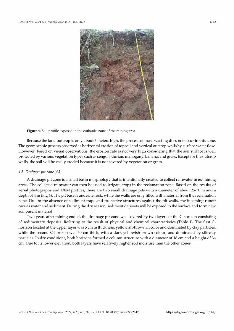
Figure 4. Soil profile exposed in the cutbanks zone of the mining area.
Because the land outcrop is only about 3 meters high, the process of mass wasting does not occur in this zone.
The geomorphic process observed is horizontal erosion of topsoil and vertical outcrop walls by surface water flow.
However, based on visual observations, the erosion rate is not very high considering that the soil surface is well
protected by various vegetation types such as sengon, durian, mahogany, banana, and grass. Except for the outcrop
walls, the soil will be easily eroded because it is not covered by vegetation or grass.
4.3. Drainage pit zone (S3)
A drainage pit zone is a small basin morphology that is intentionally created to collect rainwater in ex-mining
areas. The collected rainwater can then be used to irrigate crops in the reclamation zone. Based on the results of
aerial photographs and DEM profiles, there are two small drainage pits with a diameter of about 25-30 m and a
depth of 4 m (Fig 6). The pit base is andesite rock, while the walls are only filled with material from the reclamation
zone. Due to the absence of sediment traps and protective structures against the pit walls, the incoming runoff
carries water and sediment. During the dry season, sediment deposits will be exposed to the surface and form new
soil parent material.
Two years after mining ended, the drainage pit zone was covered by two layers of the C horizon consisting
of sedimentary deposits. Referring to the result of physical and chemical characteristics (Table 1), The first C-
horizon located at the upper layer was 5 cm in thickness, yellowish-brown in color and dominated by clay particles,
while the second C-horizon was 30 cm thick, with a dark yellowish-brown colour, and dominated by silt-clay
particles. In dry conditions, both horizons formed a column structure with a diameter of 18 cm and a height of 34
cm. Due to its lower elevation, both layers have relatively higher soil moisture than the other zones.

Revista Brasileira de Geomorfologia, v. 23, n.3, 2022 1743
Revista Brasileira de Geomorfologia. 2022, v.23, n.3; (Jul-Set). DOI: 10.20502/rbg.v23i3.2142 https://rbgeomorfologia.org.br/rbg/
Figure 6. Sediment deposits profile showed at the drainage pit zone.
Sediment deposits in the drainage pit zone have C-organic and Total-N levels low as anthropogenic materials
in the reclamation zone. The material was recorded to have the highest available phosphate compared to other
zones, reaching 32.42% in the first layer and 25.55% in the second layer. The measured CEC value is high, which is
more than 20 cmol/kg in both layers while the base saturation has a value of more than 10%. Exch level. cations
also vary from 0.13 to 1.08 cmol/kg.
4.4. Reclamation zone (S4)
The reclamation zone is the center of stone mining activities in the past. There has been the most contrasting
morphological change in this zone, which was previously a single hill ridge with a peak at an elevation of 336 m
above sea level but is now a relatively flat area with an average elevation of 285 m above sea level. Former mining
activities have removed surface soil to reveal bedrock, so the backfilling process is carried out to restore surface
soil and repair damaged surface morphology.
Anthropogenic soil materials covered the reclamation zone around 6 m thick (Fig 5). The materials which had
then become the C-horizon were composed of soil with a dark brown color and rocks with a diameter of around
3-6 cm. The soil contains a high value of silt and sands. The measured soil moisture was low at 3.6%, and the bulk
density was recorded at 2.4 g/cm³. The chemical characteristics of the soil in the reclamation zone also look quite
different from the original soil observed in the highwall zone. The levels of C-Organic and Total N were deficient
at only 0.39% and 0.08%, respectively. However, the condition of Available Phosphate was measured to be quite
high, reaching 21.67%. Base saturation is also high compared to other zones, which is 11.33, although the CEC level
is only around 19.44 cmol/kg. The Exch value of cations also varies from 0.15 to 1.04 cmol/kg.
The 1st C-horizon
The 2nd C-horizon

Revista Brasileira de Geomorfologia, v. 23, n.3, 2022 1744
Revista Brasileira de Geomorfologia. 2022, v.23, n.3; (Jul-Set). DOI: 10.20502/rbg.v23i3.2142 https://rbgeomorfologia.org.br/rbg/
Figure 5. a) Flat morphology covered by sparse vegetation in the reclamation zone. b) Anthropogenic material
containing rock and soil fragments.
The process of revegetation of the reclamation zone has been carried out since 2018 by planting several types
of plants such as sengon and bananas. Vegetation is grown at a sparse density, so there is still a lot of areas left
vacant. Two years after planting, some of the ground surfaces have begun to be overgrown with grass and low-
density shrubs, while the presence of sengon and bananas has not been able to protect the soil surface below fully.
Such conditions make this area prone to erosion during the rainy season. Apart from the fact that the soil surface
is not protected by vegetation cover, the texture of the anthropogenic material dominated by silt is one factor that
can increase the rate of surface erosion.
4.5. Scalped zone (S5)
The scalped zone is an area where the surface soil material has been dredged to be used as a mixture of
stockpile material in the reclamation zone (Fig 7). The scalped zone is located on the northern side of the
reclamation zone and has a relatively flat morphology. Shortly after the surface soil was dredged, this zone was
immediately re-vegetated by planting sengon plants. The density of the vegetation is high enough that almost all
of the soil surface is covered by leaf litter and grass.
Figure 7. Soil profile showed at the scalped zone of the mining area.
a b
A-Horizon
B-Horizon
Revista Brasileira de Geomorfologia, v. 23, n.3, 2022 1745
Revista Brasileira de Geomorfologia. 2022, v.23, n.3; (Jul-Set). DOI: 10.20502/rbg.v23i3.2142 https://rbgeomorfologia.org.br/rbg/
Referring to the physical and chemical characteristics (Table 1), soil in this zone is developed from pyroclastics
material just like we found in the cutbanks zone. The thin A-Horizon has developed on top of B-Horizon which
has a firmer structure at the bottom. The soil in this zone also has the same base color (5YR) and texture as the soil
developed from pyroclastic materials. However, the C-organic content tends to be less, which is only 0.71% on
Horizon A and 0.08% on Horizon B. The Total-N value is not much different, ranging from 0.05-to 0.1%. The value
of Available phosphate is measured at 13.97% in Horizon A and 28.72% in Horizon B. The level of CEC is also
relatively lower compared to other zones, which is around 16.83% in Horizon A and 17.01 on Horizon B. Soil has
varying levels of exch.cations between 0.1-0.8 cmol/kg with a Base Saturation of no more than 10% on either
horizon.
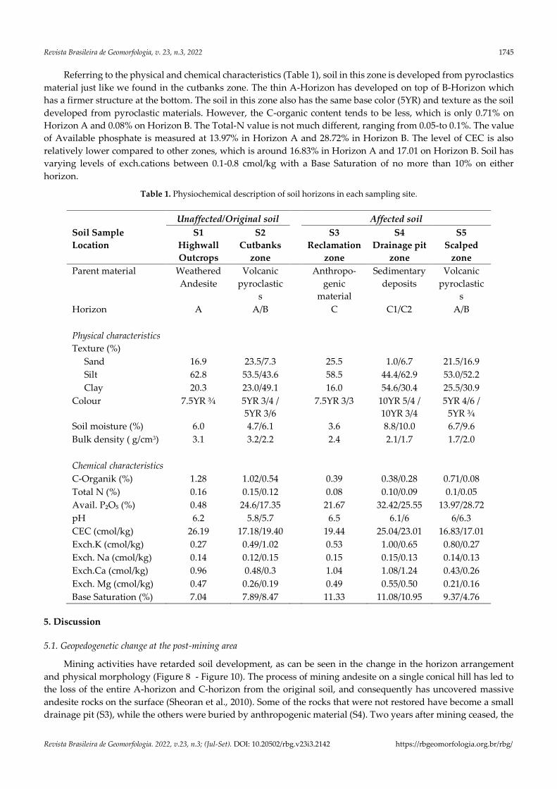
Table 1. Physiochemical description of soil horizons in each sampling site.
Unaffected/Original soil Affected soil
Soil Sample S1 S2 S3 S4 S5
Location Highwall
Outcrops
Cutbanks
zone
Reclamation
zone
Drainage pit
zone
Scalped
zone
Parent material Weathered
Andesite
Volcanic
pyroclastic
s
Anthropo-
genic
material
Sedimentary
deposits
Volcanic
pyroclastic
s
Horizon A A/B C C1/C2 A/B
Physical characteristics
Texture (%)
Sand 16.9 23.5/7.3 25.5 1.0/6.7 21.5/16.9
Silt 62.8 53.5/43.6 58.5 44.4/62.9 53.0/52.2
Clay 20.3 23.0/49.1 16.0 54.6/30.4 25.5/30.9
Colour 7.5YR ¾ 5YR 3/4 /
5YR 3/6
7.5YR 3/3 10YR 5/4 /
10YR 3/4
5YR 4/6 /
5YR ¾
Soil moisture (%) 6.0 4.7/6.1 3.6 8.8/10.0 6.7/9.6
Bulk density ( g/cm3) 3.1 3.2/2.2 2.4 2.1/1.7 1.7/2.0
Chemical characteristics
C-Organik (%) 1.28 1.02/0.54 0.39 0.38/0.28 0.71/0.08
Total N (%) 0.16 0.15/0.12 0.08 0.10/0.09 0.1/0.05
Avail. P₂O₅ (%) 0.48 24.6/17.35 21.67 32.42/25.55 13.97/28.72
pH 6.2 5.8/5.7 6.5 6.1/6 6/6.3
CEC (cmol/kg) 26.19 17.18/19.40 19.44 25.04/23.01 16.83/17.01
Exch.K (cmol/kg) 0.27 0.49/1.02 0.53 1.00/0.65 0.80/0.27
Exch. Na (cmol/kg) 0.14 0.12/0.15 0.15 0.15/0.13 0.14/0.13
Exch.Ca (cmol/kg) 0.96 0.48/0.3 1.04 1.08/1.24 0.43/0.26
Exch. Mg (cmol/kg) 0.47 0.26/0.19 0.49 0.55/0.50 0.21/0.16
Base Saturation (%) 7.04 7.89/8.47 11.33 11.08/10.95 9.37/4.76
5. Discussion
5.1. Geopedogenetic change at the post-mining area
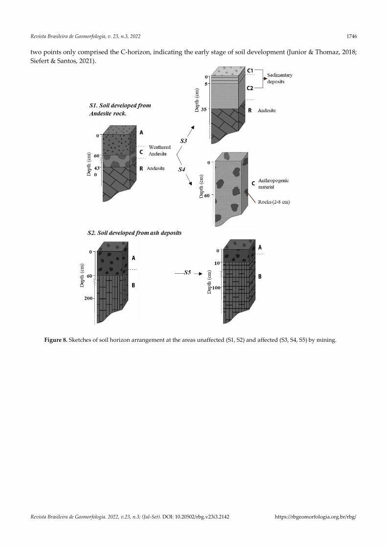
Mining activities have retarded soil development, as can be seen in the change in the horizon arrangement
and physical morphology (Figure 8 - Figure 10). The process of mining andesite on a single conical hill has led to
the loss of the entire A-horizon and C-horizon from the original soil, and consequently has uncovered massive
andesite rocks on the surface (Sheoran et al., 2010). Some of the rocks that were not restored have become a small
drainage pit (S3), while the others were buried by anthropogenic material (S4). Two years after mining ceased, the
Revista Brasileira de Geomorfologia, v. 23, n.3, 2022 1746
Revista Brasileira de Geomorfologia. 2022, v.23, n.3; (Jul-Set). DOI: 10.20502/rbg.v23i3.2142 https://rbgeomorfologia.org.br/rbg/
two points only comprised the C-horizon, indicating the early stage of soil development (Junior & Thomaz, 2018;
Siefert & Santos, 2021).
Figure 8. Sketches of soil horizon arrangement at the areas unaffected (S1, S2) and affected (S3, S4, S5) by mining.
Revista Brasileira de Geomorfologia, v. 23, n.3, 2022 1747
Revista Brasileira de Geomorfologia. 2022, v.23, n.3; (Jul-Set). DOI: 10.20502/rbg.v23i3.2142 https://rbgeomorfologia.org.br/rbg/
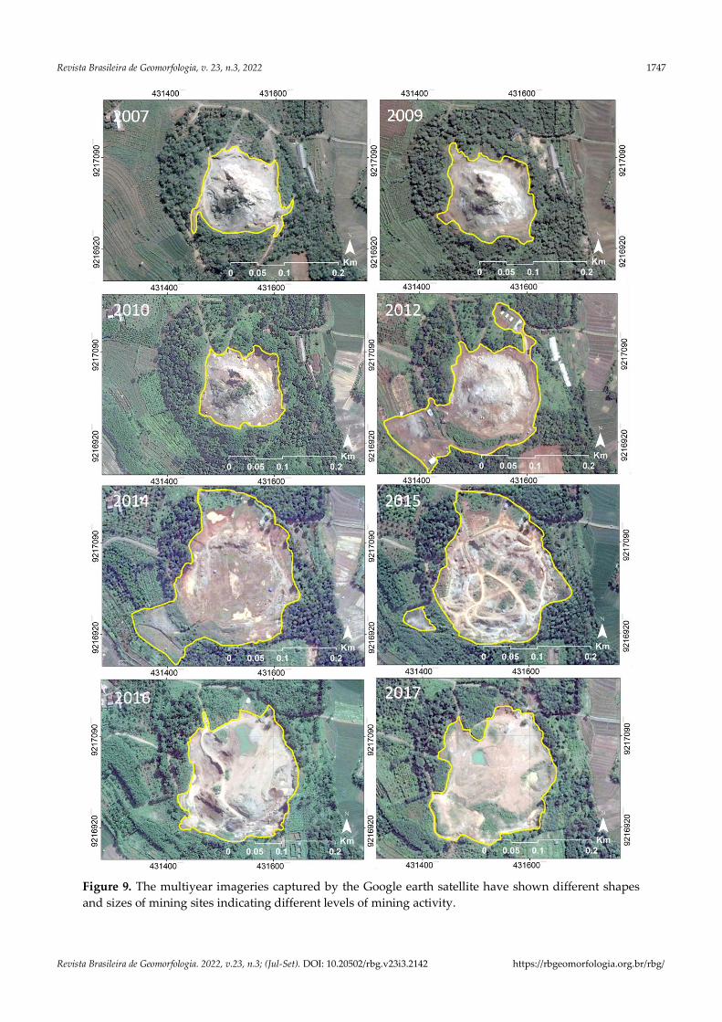
Figure 9. The multiyear imageries captured by the Google earth satellite have shown different shapes
and sizes of mining sites indicating different levels of mining activity.
Revista Brasileira de Geomorfologia, v. 23, n.3, 2022 1748
Revista Brasileira de Geomorfologia. 2022, v.23, n.3; (Jul-Set). DOI: 10.20502/rbg.v23i3.2142 https://rbgeomorfologia.org.br/rbg/
The formation of the C-horizon at the drainage pit (S3) was due to the concave or basin morphology which
has a lower elevation than the surrounding area. Two years after mining finished, the bedrocks were covered by
overland flow deposition occurring in the rainy season. The results of the field observation show two layers of
sediment which then became the new soil parent material (C-horizon) in that location. The first sediment appeared
thicker than the second layer because the area on which anthropogenic materials had been dumped had no
vegetation-covered at the surface. This condition leads to the erosion process and causes sedimentation at the
drainage pit. In the second year after mining ended, intentionally planted grass and vegetation could be seen on
the soil surface, such as Albizia chinensis and banana, causing it to be quite well protected from erosion, with the
production of thinner sediment materials.
The C-horizon which was formed at reclamation zone (S4) originated from the dumping of anthropogenic
materials in an attempt at post-mining restoration. Two years after mining finished, the area showed no significant
soil development, as proven by the absence of an A-horizon. Anthropogenic materials are known to have low
nutrient levels and bad sorting due to the presence of many rough fragments. This will hamper the growth of
vegetation and soil organisms which are important to the process of weathering and the production of organic
materials. Consequently, the pedogenetic process will tend to be slower (Chenot et al., 2017).
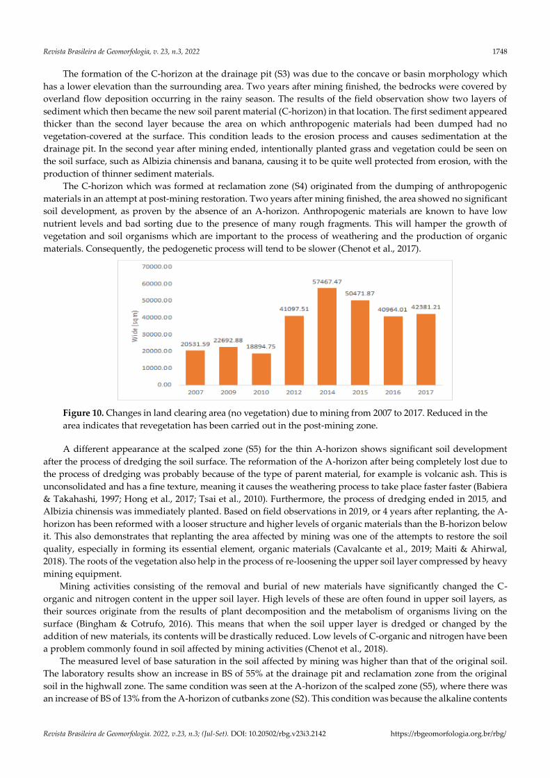
Figure 10. Changes in land clearing area (no vegetation) due to mining from 2007 to 2017. Reduced in the
area indicates that revegetation has been carried out in the post-mining zone.
A different appearance at the scalped zone (S5) for the thin A-horizon shows significant soil development
after the process of dredging the soil surface. The reformation of the A-horizon after being completely lost due to
the process of dredging was probably because of the type of parent material, for example is volcanic ash. This is
unconsolidated and has a fine texture, meaning it causes the weathering process to take place faster faster (Babiera
& Takahashi, 1997; Hong et al., 2017; Tsai et al., 2010). Furthermore, the process of dredging ended in 2015, and
Albizia chinensis was immediately planted. Based on field observations in 2019, or 4 years after replanting, the A-
horizon has been reformed with a looser structure and higher levels of organic materials than the B-horizon below
it. This also demonstrates that replanting the area affected by mining was one of the attempts to restore the soil
quality, especially in forming its essential element, organic materials (Cavalcante et al., 2019; Maiti & Ahirwal,
2018). The roots of the vegetation also help in the process of re-loosening the upper soil layer compressed by heavy
mining equipment.
Mining activities consisting of the removal and burial of new materials have significantly changed the C-
organic and nitrogen content in the upper soil layer. High levels of these are often found in upper soil layers, as
their sources originate from the results of plant decomposition and the metabolism of organisms living on the
surface (Bingham & Cotrufo, 2016). This means that when the soil upper layer is dredged or changed by the
addition of new materials, its contents will be drastically reduced. Low levels of C-organic and nitrogen have been
a problem commonly found in soil affected by mining activities (Chenot et al., 2018).
The measured level of base saturation in the soil affected by mining was higher than that of the original soil.
The laboratory results show an increase in BS of 55% at the drainage pit and reclamation zone from the original
soil in the highwall zone. The same condition was seen at the A-horizon of the scalped zone (S5), where there was
an increase of BS of 13% from the A-horizon of cutbanks zone (S2). This condition was because the alkaline contents

Revista Brasileira de Geomorfologia, v. 23, n.3, 2022 1749
Revista Brasileira de Geomorfologia. 2022, v.23, n.3; (Jul-Set). DOI: 10.20502/rbg.v23i3.2142 https://rbgeomorfologia.org.br/rbg/
of the new parent material remained concentrated in the upper layer. In contrast, alkaline matter in the developing
soil had been leached downward due to long-standing infiltration.
The insignificant difference in the exchangeable fraction of Na, Ca, Mg, and K was probably due to many
factors. The distribution of base ions in the soil can be affected by parent material, climate, human activity, and
types of vegetation (Chandra et al., 2011; Prusty & Azeez, 2007). In this respect, the inconsistency of the Na, Ca,
Mg, and K content was caused by the change of soil parent material due to human intervention. Anthropogenic
materials which were dumped would become the new soil parent material in most ex-mining areas, such as S3.
The runoff which occurred during the last two rainy seasons transported sediment and formed the new soil parent
material in the drainage pit. Finally, soil dredging at the scalped zone has uncovered the B-horizon from the
volcanic ash to the surface, which marks the beginning of new soil development.
CEC is highly affected by the number of colloids able to absorb cations in soil. Soil colloids can be clay particles
or organic materials; the higher the number of clay particles or organic material, the higher the CEC in soil (Blume
et al., 2016; Velde & Meunier, 2008). This explains why there was no significant difference in the CEC values in the
mining-affected soil and why the soil was not affected by mining. The original soil measured at the highwall zone
had the highest level of CEC, probably due to the high organic material content. The second highest CEC was
obtained from the sample of the mining-affected soil at the drainage pit, owing to its location in the lower elevation,
which caused the clay content to be higher than in the other locations (See Table 1).
Insignificant available phosphate might be caused by different fertilizer input from farmers. High contents of
phosphate were measured in the unaffected soil of S2, where there was a mixed garden. However, the soil was not
frequently cultivated, although the fruit and Albizia chinensis were often fertilized due to their high economic
value. The high phosphate content in the reclamation zone (S4) was probably due to the high level of fertilization
of the Albizia chinensis planted in raw material lacking organic matter. In addition, the high phosphate content in
the drainage pit (S3) was probably because the chemical elements had been carried by overland flow from the
reclamation zone (S4). The location of S5 also had the same conditions, probably due to fertilization in the plant
treatment process. Conversely, the unaffected soil at the location highwall zone had a low phosphate content, as it
was not used for productive agriculture such as bush or bamboo.
The soil moisture content also showed inconsistent trends, probably due to the micro-landform conditions as
a result of mining activities. The highest content of soil moisture was measured at the mining-affected area of
drainage pit (S3), with a basin morphology. Such a morphology leads to a high concentration of runoff when rain
falls and increases the amount of water absorbed by the soil. On the other hand, the lowest soil moisture was
detected on the flat morphology of the ex-mining backfill area at the reclamation zone (S4). Poorly sorted grains of
backfill materials give rise to low water absorption capability. In addition, low organic material content also plays
a significant role in reducing soil moisture content at that site.
5.2. Land rehabilitation recommendation
Paying attention to the geopedogenetic aspect at the post-mining area is very crucial for the success of
environmental rehabilitation. For example, the detailed post-mining morphology should be well designed to lower
erosion and avoid rapid silting at the basin zone. The thickness of C-Horizons at drainage pit (S3) (Fig. 3) showed
that there was still a large amount of surface water with high content of sediment flowing through that site as
shown in Figure 4. Creating small trenches in the surrounding area could be one of the solutions to holding the
sediment before flowing into the basin. In addition, because C2-Horizon is thicker than C1-Horizon, it brings to
mind for every land manager to take extra protection against anthropogenic soil ahead of the first rainy season.
Letting the grass grow and Covering the soil surface using mulch could be good choices to slow down the overland
flow and decrease soil erosion. Protecting the basin is important to keep its function as a water storage especially
in the dry season. It plays a big role to increase soil moisture content in anthropogenic soil during the revegetation
program.
Ensuring that the soil conditions are favorable for vegetation growth is also a major concern of the
rehabilitation program in post-mining areas. Soil affected by mining has very low C-organic and Nitrogen content
(Fig. 4a and 4b), but both are essential elements for vegetation to grow. Therefore, one of the main rehabilitation
targets is how to restore or increase the content of C-organic and N-content in the soil as quickly as possible. It
could be done by adding compost and/or manure.
Revista Brasileira de Geomorfologia, v. 23, n.3, 2022 1750
Revista Brasileira de Geomorfologia. 2022, v.23, n.3; (Jul-Set). DOI: 10.20502/rbg.v23i3.2142 https://rbgeomorfologia.org.br/rbg/
6. Conclusions
This research confirmed that human activities in the form of andesite rock exploitation have directly affected
the change of geopedogenetic processes. By using the integrated method, the comprehensive analysis of the
pedogeomorphological process changes due to human disturbance is able to be achieved. Micro-relief modification
and surface material conversion have triggered the erosion and sedimentation process that promoted various types
of soil development. The main area of rock excavation, which is now covered by new parent material from
anthropogenic soil and sedimentary flow, has reverted soil development to the initial stage, while the topsoil in
the surrounding area has also been disturbed by mining traffic.
The statistical analysis showed that some soil properties in the area affected by rock mining are significantly
different from those of the unaffected soil. The mining activities have dramatically lowered the C-organic and total
N content. In contrast, the level of base saturation tends to be high in the areas affected by mining. On the other
hand, rock mining activities have not significantly changed the soil water content, available phosphate, CEC, or
the exchangeable fraction of Na, Ca, Mg, and K.
Based on this result findings, a detailed surface morphology design at the post-mining area and the presence
of soil surface protection are essential to counter the erosion problem, while adding more C-organic and N-content
are needed for ensuring vegetation to grow at anthropogenic soil. This research strengthens that conducting
geopedogenetic analysis at the post-mining area is very important to evaluate and define the appropriate land
rehabilitation measures.
Authors’ Contributions: Juhadi: study design, obtaining funding, field work, methodology, formal analysis. Elok Surya
Pratiwi: field work, data acquisition, formal analysis. Edy Trihatmoko: field work, GIS analysis, and discussion of results.
Aprillia Findayani: field work, and data acquisition. Junun Sartohadi: methodology, formal analysis, data preparation. Nur
Hamid: field work, writing, submission and review.
Funding: This study was funded by Research and Community Services Institute (LPPM) of Universitas Negeri Semarang
(UNNES), support for research activities UNNES DIPA fund.
Acknowledgments: We thank the Rector, Head of Research and Community Services Institute (LPPM) of Universitas Negeri
Semarang (UNNES), and KESBANGLINMAS Semarang City, Gunungpati Sub-district Head, and Pakintelan Village Head,
Mangunsari.
Conflict of Interest: The authors declare no conflict of interest.
Reference
1. Babiera, V. V., & Takahashi, T. (1997). Characteristics of Soils Derived from Tephra and Pyroclastic Flow
Deposits from Taal Volcano, the Philippines. Soil Science and Plant Nutrition, 43(4), 763–776.
https://doi.org/10.1080/00380768.1997.10414643
2. Beretta, F., Shibata, H., Cordova, R., Peroni, R. de L., Azambuja, J., & Costa, J. F. C. L. (2018). Mining
Topographic Modelling Using UAVs Compared with Traditional. International Engineering Journal, 71(3), 463–
470. https://doi.org/https://doi.org/10.1590/0370-44672017710074
3. Bingham, A. H., & Cotrufo, M. F. (2016). Organic Nitrogen Storage in Mineral Soil: Implications for Policy and
Management. Science of the Total Environment, 551–552, 116–126. https://doi.org/10.1016/j.scitotenv.2016.02.020
4. Blume, H. P., Gerhard, W. B., Fleige, H., Horn, R., Kandeler, E., Knabner, I. K., Kretzschmar, R., Stahr, K., &
Wilke, B. M. (2016). Soil Science. Springer-Verlag Berlin Heidelberg. https://doi.org/10.1007/978-3-642-30942-7
5. Cavalcante, D. M., DeCastroa, M. F., Chaves, M. T. L., da Silva, I. R., & de Oliveira, T. S. (2019). Effects of
rehabilitation strategies on soil aggregation, C and N distribution and carbon management index in coffee
cultivation in mined soil. Ecological Indicators, 107.
https://doi.org/https://doi.org/10.1016/j.ecolind.2019.105668.
6. Chandra, R., Prusty, B. A. K., & Azeez, P. A. (2011). Pre-mining baseline characterization of soil: Alkali and
Revista Brasileira de Geomorfologia, v. 23, n.3, 2022 1751
Revista Brasileira de Geomorfologia. 2022, v.23, n.3; (Jul-Set). DOI: 10.20502/rbg.v23i3.2142 https://rbgeomorfologia.org.br/rbg/
alkaline earth metals. Acta Ecologica Sinica, 31(283–290).
https://doi.org/https://doi.org/10.1016/j.chnaes.2011.07.002.
7. Chenot, J., Jaunatre, R., Buisson, E., Bureau, F., & Dutoit, T. (2018). Impact of quarry exploitation and disuse
on pedogenesis. Catena, 160, 354–365. https://doi.org/10.1016/j.catena.2017.09.012
8. Da Silva, D. D. F. S., Corteletti, R. C., Filgueiras, R. A. C., & Santos, A. E. M. (2021). Correlations Between
Landslide Scars Parameters Using Remote Sensing Methods in The Estrada de Ferro Vitória-Minas,
Southeastern Brazil. Revista Brasileira de Geomorfologia, 22(2), 297–314. https://doi.org/10.20502/rbg.v22i2.1937
9. Dejun, Y., Zhengfu, B., & Shaogang, L. (2016). Impact on soil physical qualities by the subsidence of coal
mining: a case study in Western China. Environmental Earth Sciences, 75(8), 652. https://doi.org/10.1007/s12665-
016-5439-2
10. Duncan, A. M., Chester, D. K., & Guest, J. E. (1981). Mount Etna Volcano: Environmental Impact and Problems
of Volcanic Prediction. The Geographical Journal, 147(2), 164. https://doi.org/10.2307/634532
11. Feng, Y., Wang, J., Bai, Z., & Reading, L. (2019). Effects of surface coal mining and land reclamation on soil
properties: A review. Earth-Science Reviews, 191, 12–25. https://doi.org/10.1016/J.EARSCIREV.2019.02.015
12. Harijoko, A., Htun, T. M., Saputra, R., Warmada, I. W., Setijadji, L. D., Imai, A., & Watanabe, K. (2010).
Mercury and Arsenic Contamination From Small Scale Gold Mining Activities At Selogiri Area, Central Java,
Indonesia. Journal of Applied Geology, 2(1), 56–64. https://doi.org/10.22146/jag.7235
13. Hong, H., Fang, Q., Zhao, L., Schoepfer, S., Wang, C., Gong, N., Li, Z., & Chen, Z. Q. (2017). Weathering and
alteration of volcanic ashes in various depositional settings during the Permian-Triassic transition in South
China: Mineralogical, elemental and isotopic approaches. Palaeogeography, Palaeoclimatology, Palaeoecology, 486,
46–57. https://doi.org/10.1016/j.palaeo.2016.12.033
14. Jianping, C., Li, K., Chang, K., & Sofia, G. (2015). Open-pit mining geomorphic feature characterisation.
International Journal of Applied Earth Observation and Geoinformation, 42, 76–86.
https://doi.org/10.1016/j.jag.2015.05.001
15. Juhadi, J., Banowati, E., Sanjoto, T. B., & Nugraha, S. B. (2020). Rapid Appraisal for Agricultural Land
Utilization in the erosion and landslide vulnerable mountainous areas of Kulonprogo Regency, Indonesia.
Management of Environmental Quality: An International Journal, 31(1), 1–17. https://doi.org/10.1108/MEQ-01-
2019-0023
16. Juhadi, Sanjoto, T. B., Pratiwi, E. S., Trihatmoko, E., Istiqomah, & Findayani, A. (2021). Rural–Urban
Transformation and Landuse Dynamics in Gunungpati on the Northern Flank of Mt. Ungaran, Semarang,
Indonesia. Indonesian Journal of Geography, 53(2), 170–178. https://doi.org/10.22146/IJG.52385
17. Junior, P. F., & Thomaz, E. L. (2018). Land-Use Changes and The Increase in The Number Road-Stream
Crossings in a Rural Basin South of Brazil. Revista Brasileira de Geomorfologia, 19(4), 739–755.
https://doi.org/http://dx.doi.org/10.20502/rbg.v19i4.1380
18. Kelman, I., & Mather, T. A. (2008). Living with volcanoes: The sustainable livelihoods approach for volcano-
related opportunities. Journal of Volcanology and Geothermal Research, 172(3–4), 189–198.
https://doi.org/10.1016/J.JVOLGEORES.2007.12.007
19. Koch, J. M. (2007). Restoring jarrah forest trees after bauxite mining in Western Australia. Restoration Ecology,
15(SUPPL. 4), 26–39. https://doi.org/10.1111/j.1526-100X.2007.00289.x
20. Liu, J., Liu, J., Chen, X., & Guo, W. (2012). Volcanic Natural Resources and Volcanic Landscape Protection: An
Overview. In Updates in Volcanology - New Advances in Understanding Volcanic Systems. InTech.
https://doi.org/10.5772/54586
21. Maiti, S. K., & Ahirwal, J. (2018). Ecological Restoration of Coal Mine Degraded Lands: Topsoil Management,
Pedogenesis, Carbon Sequestration, and Mine Pit Limnology. In Phytomanagement of Polluted Sites: Market
Opportunities in Sustainable Phytoremediation (pp. 83–111). Elsevier. https://doi.org/10.1016/B978-0-12-813912-
7.00003-X
22. Mizwar, A., & Trihadiningrum, Y. (2015). PAH Contamination in Soils Adjacent to a Coal-Transporting
Facility in Tapin District, South Kalimantan, Indonesia. Archives of Environmental Contamination and Toxicology,
69, 62–68. https://doi.org/10.1007/s00244-015-0141-z
23. Nurtjahya, E., Franklin, J., Umroh, & Agustina, F. (2017). The Impact of tin mining in Bangka Belitung and its
reclamation studies. MATEC Web of Conferences, 101, 04010. https://doi.org/10.1051/matecconf/201710104010
24. Passos, J. S., Ducart, D. F., Medina, C. M., & De-Campos, A. B. (2020). Rock-Landform-Soil Relationship for
Revista Brasileira de Geomorfologia, v. 23, n.3, 2022 1752
Revista Brasileira de Geomorfologia. 2022, v.23, n.3; (Jul-Set). DOI: 10.20502/rbg.v23i3.2142 https://rbgeomorfologia.org.br/rbg/
Geomorphopedological Characterization in The Region of Lavra Velha, Occidental Chapada Diamantina,
Bahia. Revista Brasileira de Geomorfologia, 21(2), 421–434. https://doi.org/10.20502/RBG.V21I2.1751
25. Prusty, B. A. K., & Azeez, P. A. (2007). Vertical distribution of alkali and alkaline earth metals in the soil profile
of a wetland-terrestrial ecosystem complex in India. Australian Journal of Soil Research, 45(7), 533–542.
https://doi.org/10.1071/SR07041
26. Ren, H., Zhao, Y., Xiao, W., & Hu, Z. (2019). A review of UAV monitoring in mining areas: current status and
future perspectives. International Journal of Coal Science & Technology, 6, 320–333.
https://doi.org/10.1007/s40789-019-00264-5
27. Rockström, J., Steffen, W., Noone, K., Persson, Å., Chapin, F. S., Lambin, E. F., Lenton, T. M., Scheffer, M.,
Folke, C., Schellnhuber, H. J., Nykvist, B., De Wit, C. A., Hughes, T., Van Der Leeuw, S., Rodhe, H., Sörlin, S.,
Snyder, P. K., Costanza, R., Svedin, U., … Foley, J. A. (2009). A safe operating space for humanity. Nature 2009
461:7263, 461(7263), 472–475. https://doi.org/10.1038/461472a
28. Santamarta, J. C., Rodríguez-Martín, J., & Neris, J. (2014). Water Resources Management and Forest
Engineering in Volcanic Islands. IERI Procedia, 9, 129–134. https://doi.org/10.1016/j.ieri.2014.09.052
29. Sheoran, V., Sheoran, A., & Poonia, P. (2010). Soil Reclamation of Abandoned Mine Land by Revegetation: A
Review. International Journal of Soil, Sediment and Water, 3(2), 13.
30. Shrestha, R. K., & Lal, R. (2011). Changes in physical and chemical properties of soil after surface mining and
reclamation. Geoderma, 161(3–4), 168–176. https://doi.org/10.1016/J.GEODERMA.2010.12.015
31. Siefert, C. A. C., & Santos, I. dos. (2021). Linking Dissolved Organic Carbon Spatial Heterogeneity to
Groundwater Dynamics and Soil Organic Carbon Content in Subtropical Headwater Catchment. Revista
Brasileira de Geomorfologia, 22(1), 27–46. https://doi.org/http://dx.doi.org/10.20502/rbg.v22i1.1881
32. Summerfield, M. A. (1991). Global Geomorphology an Introduction to the Study of Landforms. Routledge.
33. Thornbury, W. D. (1954). Principles of Geomorphology. John Willey and Son.
34. Trihatmoko, E., E.S., P., Juhadi, T.B., S., Sunarto, & Marfai, M. A. (2021). A numerical study of tidal run up
and inundation impact using logical tool-less than equal A numerical study of tidal run up and inundation
impact using logical tool-less than equal. IOP Conference Series: Earth and Environmental Science, 683(1), 012062.
https://doi.org/10.1088/1755-1315/683/1/012062
35. Tsai, C. C., Chen, Z. S., Kao, C. I., Ottner, F., Kao, S. J., & Zehetner, F. (2010). Pedogenic development of
volcanic ash soils along a climosequence in Northern Taiwan. Geoderma, 156(1–2), 48–59.
https://doi.org/10.1016/j.geoderma.2010.01.007
36. Velde, B., & Meunier, A. (2008). The Origin of Clay Minerals in Soils and Weathered Rocks. Springer-Verlag Berlin
Heidelberg.
37. Verstappen, H. T. (1983). Applied geomorphology: geomorphological surveys for environmental development. Elsevier.
38. Von Ahn, M. M., & Simon, A. L. H. (2017). Geomorphological Mapping and Geodiversity: Study at the Minas
do Camaquã Geosite Protection Area (Brazil). Revista Brasileira de Geomorfologia, 18(2), 427–442.
https://doi.org/10.20502/rbg.v18i2.1137
39. Xiang, J., Chen, J., Sofia, G., Tian, Y., & Tarolli, P. (2018). Open-pit mine geomorphic changes analysis using
multi-temporal UAV survey. Environmental Earth Sciences, 77(6), 1–18. https://doi.org/10.1007/S12665-018-
7383-9/FIGURES/9
Esta obra está licenciada com uma Licença Creative Commons Atribuição 4.0 Internacional
(http://creativecommons.org/licenses/by/4.0/) – CC BY. Esta licença permite que outros
distribuam, remixem, adaptem e criem a partir do seu trabalho, mesmo para fins
comerciais, desde que lhe atribuam o devido crédito pela criação original.
Copyright © 2022 FDOKUMEN