Report Template - Environmental Clearance
260
Consultancy Services for Preparation of Feasibility Report cum Detail Project Report (DPR) of 4 laning of Ghazipur –Ballia- UP/Bihar New Greenfield section from Km. 0.000 to 115.460 of NH-31 and construction of new Buxar Spur connectivity from km 0.000 to km 17.300 in the state of Uttar Pradesh Final Feasibility Report MAIN REPORT INTRODUCTION AA/HD/2114 1 - 1 1. INTRODUCTION 1.1 GENERAL The National Highways Authority of India (NHAI) is engaged in the development of the National highways in the state of Uttar Pradesh. As part of this endeavor, NHAI has decided to upgrade some of the existing National Highways in the State of UP to National Highway standard. It was also decided to take up the preparation of DPR for these highways which are being upgraded to National Highway Standard. The consultancy services for preparation of Feasibility Report cum Detailed Project Report (DPR) of 4 laning of Ghazipur Ballia – UP/Bihar section from Km 0.000 to 128.000 of NH-31 and Construction of 2/4 laning Flyover at Ballia (Chandra Shekhar Mod to Satish Chandra College) was awarded to Aarvee Associates. The Letter of Acceptance was communicated vide letter No. NHAI/ Tech/ NH-19/ Pkg- I/ 2016/ 103661 dated 31st July 2017. The Agreement for consultancy services was concluded with NHAI on 04/09/2017. Letter of commencement was issued vide letter No. NHAI/ Tech/ NH-19/Pkg-I/DPR/2016/105592 dated 08.09.2017. Final DPR for the existing road “Special Repair and Maintenance work from Ghazipur to UP/Bihar border NH-31 from Km 405 to Km 535 including construction of New MJB at Km 412.130 and rehabilitation of MJB at Km 533 on EPC mode” submitted vide our letter no. AA/HW/NHAI/2114/18-19/9105 dated 26.03.2019. As per the directions from project authorities, the alignment proposals were reviewed in view of the MoRTH Circular No. NH-15017 / 21 / 2018 – P & M dated 26.02.2018. The greenfield alignment option including comparison table showing the cost comparison of widening of the existing alignment option via-a-via widening of was prepared and the same was reviewed at various levels and it was decided that green field alignment with spur providing connectivity to Buxar was approved during the meeting held in Ministry under the Chairmanship of Secretary and the Minutes of Meeting were communicated vide letter No. NHAI/Tech/ NH-19/Ghazipur-Ballia/ DPR/2016/122312 dated 13.08.2018. The District Administration of Ballia held public consultations regarding the proposed elevated flyover and communicated their decisions vide MoM dated 1393/ 14 – 1 dated 20.10.2018. The MoM inter-alia state that widening of the existing road to four lane standards would serve the traffic problems in Ballia town and elevated flyover is not required since construction of the said flyover would result in acquisition of land and structures for the purpose of flyover.
-
Upload
khangminh22 -
Category
Documents
-
view
1 -
download
0
Transcript of Report Template - Environmental Clearance
Consultancy Services for Preparation of Feasibility Report cum Detail Project Report (DPR) of 4 laning of Ghazipur –Ballia- UP/Bihar New Greenfield section from Km. 0.000 to 115.460 of NH-31 and construction of new Buxar Spur connectivity from km 0.000 to km 17.300 in the state of Uttar Pradesh
Final Feasibility
Report
MAIN REPORT
INTRODUCTION
AA/HD/2114 1 - 1
1. INTRODUCTION
1.1 GENERAL
The National Highways Authority of India (NHAI) is engaged in the development of the
National highways in the state of Uttar Pradesh. As part of this endeavor, NHAI has
decided to upgrade some of the existing National Highways in the State of UP to
National Highway standard. It was also decided to take up the preparation of DPR for
these highways which are being upgraded to National Highway Standard. The
consultancy services for preparation of Feasibility Report cum Detailed Project Report
(DPR) of 4 laning of Ghazipur Ballia – UP/Bihar section from Km 0.000 to 128.000 of
NH-31 and Construction of 2/4 laning Flyover at Ballia (Chandra Shekhar Mod to
Satish Chandra College) was awarded to Aarvee Associates.
The Letter of Acceptance was communicated vide letter No. NHAI/ Tech/ NH-19/ Pkg-
I/ 2016/ 103661 dated 31st July 2017. The Agreement for consultancy services was
concluded with NHAI on 04/09/2017. Letter of commencement was issued vide letter
No. NHAI/ Tech/ NH-19/Pkg-I/DPR/2016/105592 dated 08.09.2017.
Final DPR for the existing road “Special Repair and Maintenance work from Ghazipur
to UP/Bihar border NH-31 from Km 405 to Km 535 including construction of New MJB
at Km 412.130 and rehabilitation of MJB at Km 533 on EPC mode” submitted vide our
letter no. AA/HW/NHAI/2114/18-19/9105 dated 26.03.2019. As per the directions
from project authorities, the alignment proposals were reviewed in view of the MoRTH
Circular No. NH-15017 / 21 / 2018 – P & M dated 26.02.2018. The greenfield
alignment option including comparison table showing the cost comparison of widening
of the existing alignment option via-a-via widening of was prepared and the same was
reviewed at various levels and it was decided that green field alignment with spur
providing connectivity to Buxar was approved during the meeting held in Ministry
under the Chairmanship of Secretary and the Minutes of Meeting were communicated
vide letter No. NHAI/Tech/ NH-19/Ghazipur-Ballia/ DPR/2016/122312 dated
13.08.2018.
The District Administration of Ballia held public consultations regarding the proposed
elevated flyover and communicated their decisions vide MoM dated 1393/ 14 – 1
dated 20.10.2018. The MoM inter-alia state that widening of the existing road to four
lane standards would serve the traffic problems in Ballia town and elevated flyover is
not required since construction of the said flyover would result in acquisition of land
and structures for the purpose of flyover.
Consultancy Services for Preparation of Feasibility Report cum Detail Project Report (DPR) of 4 laning of Ghazipur –Ballia- UP/Bihar New Greenfield section from Km. 0.000 to 115.460 of NH-31 and construction of new Buxar Spur connectivity from km 0.000 to km 17.300 in the state of Uttar Pradesh
Final Feasibility
Report
MAIN REPORT
INTRODUCTION
AA/HD/2114 1 - 2
Public consultation meeting on the project alignment was held in the office of District
Magistrate Ballia on 05.09.2018 wherein the committee recommended that the
bypass alignment for Ballia be considered on the south side. This will require
modification of the alignment approved earlier in a length of approximately 38.50 km.
The said modification was reviewed during the meeting held on 08.12.2018 at NHAI
HQ, New Delhi under the chairmanship of Member (P) and agreed by Member.
Variation with financial implication for new Greenfield alignment was approved from
RO, Varanasi vide letter no. NHAI/UP (E)/GM (T)/NH-19/Ghazipur-Ballia/DPR/14 dated
27.10.2020. Accordingly, the Inception & Alignment report for the approved
Greenfield alignment were prepared and submitted vide our letter no.
AA/HW/NHAI/2114/20-21/2820 & 2966 dated 06.11.2020 & 16.11.2020.
Table-1.1: Project Details for Greenfield Alignment
S. No
Project Highway
Design Chainage (Km)
Remarks From To
1 Ghazipur to Manjhi Ghat UP/
Bihar Border 0.000 115.600 NH-31
2 Buxar Spur 0.000 17.800 -
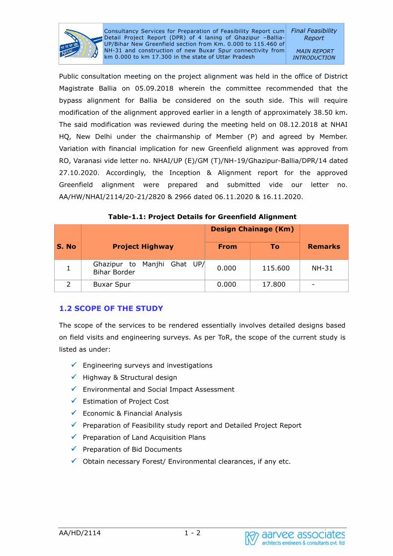
1.2 SCOPE OF THE STUDY
The scope of the services to be rendered essentially involves detailed designs based
on field visits and engineering surveys. As per ToR, the scope of the current study is
listed as under:
✓ Engineering surveys and investigations
✓ Highway & Structural design
✓ Environmental and Social Impact Assessment
✓ Estimation of Project Cost
✓ Economic & Financial Analysis
✓ Preparation of Feasibility study report and Detailed Project Report
✓ Preparation of Land Acquisition Plans
✓ Preparation of Bid Documents
✓ Obtain necessary Forest/ Environmental clearances, if any etc.
Consultancy Services for Preparation of Feasibility Report cum Detail Project Report (DPR) of 4 laning of Ghazipur –Ballia- UP/Bihar New Greenfield section from Km. 0.000 to 115.460 of NH-31 and construction of new Buxar Spur connectivity from km 0.000 to km 17.300 in the state of Uttar Pradesh
Final Feasibility
Report
MAIN REPORT
INTRODUCTION
AA/HD/2114 1 - 3
The New Greenfield alignment is proposed to Two lane with Paved Shoulder at normal
sections and Four laning with service roads at Underpass locations with proposed
Right of way of 60m. The Consultant shall furnish land acquisition details as per
revenue records/maps for further processing.
The Consultant shall study the possible locations and design of toll plaza. Wayside
amenities required on tolled highway shall also be planned. The local and slow traffic
may need segregation from the main traffic and provision of service roads and fencing
may be considered, wherever necessary to improve efficiency and safety.
The entire scope of services would, inter-alia, include the items mentioned in TOR.
The Consultant will also make suitable proposals for widening/improvement of the
existing road to Four lane configuration and strengthening of the carriageways, as
required at the appropriate time to maintain the level of service over the design
period. Already to implement ‘good for construction’ drawings shall be prepared.
Consultancy Services for Preparation of Feasibility Report cum Detail Project Report (DPR) of 4 laning of Ghazipur –Ballia- UP/Bihar New Greenfield section from Km. 0.000 to 115.460 of NH-31 and construction of new Buxar Spur connectivity from km 0.000 to km 17.300 in the state of Uttar Pradesh
Final Feasibility
Report
MAIN REPORT
INTRODUCTION
AA/HD/2114 1 - 4
Environmental Impact Assessment, Environmental Management Plan and
Rehabilitation and Resettlement Studies shall be carried out by the Consultant
meeting the requirements of the lending agencies like ADB/ World Bank/ JICA etc.
Wherever required, consultant will liaise with concerned authorities and arrange all
clarifications. Approval of all drawings including GAD and detail engineering drawings
will be got done by the consultant from the Railways. However, if Railways require
proof checking of the drawings prepared by the consultants, the same will be got done
by NHAI and payment to the proof consultant shall be made by NHAI directly.
Consultant will also obtain ‘No Objection Certificate’ from Ministry of Environment and
Forest and incorporate the estimates for shifting of utilities of all types involved from
concerned local authorities in the DPR. Consultant is also required to prepare all Land
Acquisition papers (i.e. all necessary schedules as per L.A. act) for acquisition of land
either under NH Act or State Act.
The consultant shall prepare the Bid Documents, based on the feasibility report, due
to exigency of the project for execution.
Consultant shall obtain all types of necessary clearances required for implementation
of the project on the ground from the concerned agencies. The client shall provide the
necessary supporting letters and any official fees as per the demand note issued by
such concerned agencies from whom the clearances are being sought to enable
implementation.
1.3 OBJECTIVE OF THE STUDY
The main objective of the consultancy service is to establish the technical, economic
and financial viability of the project and prepare detailed project reports for Two lane
road with paved shoulder and Four laning at underpass locations configuration by
considering the investment requirements and financial return through toll and other
revenues.
The viability of the project shall be established considering the requirements with
regards to rehabilitation, upgrading and improvement based on highway design,
pavement design, type of intersections, rehabilitation and widening of existing and/or
construction of new bridges and structures, road safety features, quantities of various
items of works and cost estimates and economic analysis.
The list of objectives to be achieved are listed as under:
a) Conduct detailed Engineering surveys & Investigations
Consultancy Services for Preparation of Feasibility Report cum Detail Project Report (DPR) of 4 laning of Ghazipur –Ballia- UP/Bihar New Greenfield section from Km. 0.000 to 115.460 of NH-31 and construction of new Buxar Spur connectivity from km 0.000 to km 17.300 in the state of Uttar Pradesh
Final Feasibility
Report
MAIN REPORT
INTRODUCTION
AA/HD/2114 1 - 5
b) Forecast the traffic demand on project stretch by conducting necessary
volume count and origin-destination studies giving due weightage to the
future development proposals along the project stretch
c) Design of pavement along the project stretch using respective IRC codes
d) Prepare the road geometric design along with plan & profiles based on
LiDAR/Aerial LiDAR and Drone based survey in topographic survey
e) Design of bridges/ cross drainage structures and grade separated structures
f) Develop General Arrangement Drawings (GADs) of structures for assessment
of quantities
g) Identify the Initial Social Impact Assessment by broadly identifying and
assessing the extent of private lands to be acquired and the government
lands/ forest land to be proposed for diversion
h) Identify the Initial Environmental Impact Assessment based on available
reports and by assessing the levels of pollution from the projected traffic on
the project highway
i) Prepare BOQ and cost estimates based on prevailing market rates and SSR
j) Prepare the economic and financial analysis of the project by bringing out the
project packaging and various feasible procurement alternatives
k) Prepare Land acquisition plans, utility relocation plans along with strip plans
l) Obtain necessary forest and environmental clearances
m) Submission of necessary bid/ contractual documents
1.4 APPROACH
The consultant’s approach towards the project is in accordance with the ToR in lines
with the project objectives. The prescribed engineering surveys and investigations
have been carried out on project stretch conforming to MORT&H/IRC/BIS
specifications/Codes as per ToR to generate adequate database for preparing the
most appropriate proposal for the rehabilitation and upgrading of the existing
highway.
1.5 OUTCOME OF CURRENT STUDY
The Draft Feasibility study assists in predicting the workability and effectiveness of
highway after its implementation. The viability of the project will be established

Consultancy Services for Preparation of Feasibility Report cum Detail Project Report (DPR) of 4 laning of Ghazipur –Ballia- UP/Bihar New Greenfield section from Km. 0.000 to 115.460 of NH-31 and construction of new Buxar Spur connectivity from km 0.000 to km 17.300 in the state of Uttar Pradesh
Final Feasibility
Report
MAIN REPORT
INTRODUCTION
AA/HD/2114 1 - 6
taking into account the requirements with regards to rehabilitation, upgrading and
improvement based on highway design, pavement design, provision of service roads
wherever necessary, type of intersections, rehabilitation and widening of existing
and/ or construction of new bridges and structures, road safety features, quantities of
various items of works and cost estimates and economic analysis.
The following structured outcome is presented in the current draft feasibility report:
1. Executive Summary
2. Introduction
3. Overview of NHAI
4. Existing features of the project corridor
5. Methodology adopted for the draft feasibility study
6. Socioeconomic profile of the project area
7. Indicative design standards, methodologies and specifications
8. Project Proposals of Green Field Stretch
9. Traffic demand assessment on project stretch for future horizon years
10. Pavement design based on traffic and pavement investigation surveys
11. Environmental screening and Preliminary Environmental Impact Assessment
12. Initial Social Impact Assessment and preliminary land acquisition/
resettlement plan
13. Cost estimates
14. Conclusions and Recommendations
1.6 TIME FRAME
The schedule for completion of assignment is 9 months.

Consultancy Services for Preparation of Feasibility Report cum Detail Project Report (DPR) of 4 laning of Ghazipur –Ballia- UP/Bihar New Greenfield section from Km. 0.000 to 115.460 of NH-31 and construction of new Buxar Spur connectivty from km 0.000 to km 17.300 in the state of
Uttar Pradesh
Final Feasibility Report
MAIN REPORT
OVERVIEW OF NHAI
AA/HD/2114 2 - 1
2. OVERVIEW OF NHAI
VISION STATEMENT OF NHAI
"To meet the nation’s need for the provision and maintenance of National Highways
network to global standards and to meet user’s expectations in the most time bound
and cost effective manner, within the strategic policy framework set by the
Government of India and thus promote economic wellbeing and quality of life of the
people."
2.1 INTRODUCTION
National Highways Authority of India (NHAI) is an autonomous organisation under the
Ministry of Road Transport & Highways and was constituted by an act of Parliament,
the National Highways Authority of India Act, 1988. NHAI is responsible for the
Development, Maintenance, and Management of National Highways and for matters
concerned thereto. The authority was made operational with the appointment of full
time Chairman and other Members in the year 1995. The first and foremost mandate
for NHAI was the construction and development of five road stretches in the states of
Haryana, Rajasthan, Bihar, West Bengal and Andhra Pradesh under loan assistance
from Asian Development Bank. Subsequently, development works for other highway
stretches were entrusted to NHAI.
NHAI is mandated to implement National Highways Development Project (NHDP)
which is India’s largest ever Highways Project. Presently National Highway network of
about 79,243 km serve as the main road network of the country. Even though
National Highways constitute only about 2% of the length of all roads, they carry
about 40% of the road traffic. Rapid expansion of passenger and freight traffic makes
it imperative to improve the road network in the country.
Accordingly, Government of India launched major initiatives to upgrade and
strengthen National Highways through various phases of NHDP, which are:
NHDP Phase I was approved by the Government in December 2000 at an estimated
cost of Rs. 30,300 crores and comprises GQ (5,846 km) and NS-EW Corridor
(981km), Port connectivity (356 km) and others (315 km).
NHDP Phase II was approved in December 2003 at an estimated cost of Rs. 34,339
crores (2002 prices) and comprises NS-EW Corridor (6,161 km) and other National
Highways of 486 km length with the total length of 6,647 km.
NHDP Phase III Government approved up-gradation and 4 laning of 4,815 km of
National Highways on BOT basis at an estimated cost of Rs. 33,069 crores under
Consultancy Services for Preparation of Feasibility Report cum Detail Project Report (DPR) of 4 laning of Ghazipur –Ballia- UP/Bihar New Greenfield section from Km. 0.000 to 115.460 of NH-31 and construction of new Buxar Spur connectivty from km 0.000 to km 17.300 in the state of
Uttar Pradesh
Final Feasibility Report
MAIN REPORT
OVERVIEW OF NHAI
AA/HD/2114 2 - 2
NHDP Phase IIIA. In April 2007, Government approved up-gradation and 4 laning of
7294 km at an estimated cost of Rs. 47,557 crores under NHDP Phase IIIB. Total
approved length of NHDP Phase III is 12,109 km at an approved cost of Rs. 80,626
crore.
NHDP Phase IV Government, in February 2012, approved upgradation/ strengthening
of 20,000 km of single/intermediate/two lane NHs to two lane with paved shoulder/4-
lane under NHDP Phase-IV on BOT (Toll) and BOT (Annuity) basis.
NHDP Phase V Government, in October 2006, approved six laning of 6,500 km of
existing 4 lane highways under NHDP Phase-V (on DBFOT basis) at an estimated cost
of Rs. 41,210 crores. Six laning of 6,500 km includes 5,700 km of GQ and about 800
km of other stretches.
NHDP Phase VI Government, in November 2006, approved for 1000 km of
expressways at an estimated cost of Rs. 16,680 Crores.
NHDP Phase VII Government, in December 2007, approved implementation of NHDP
Phase VII which envisages construction of approximately 700 km of stand alone
bypasses, grade separators, flyovers etc. at an estimated cost of Rs. 16,680 crores.
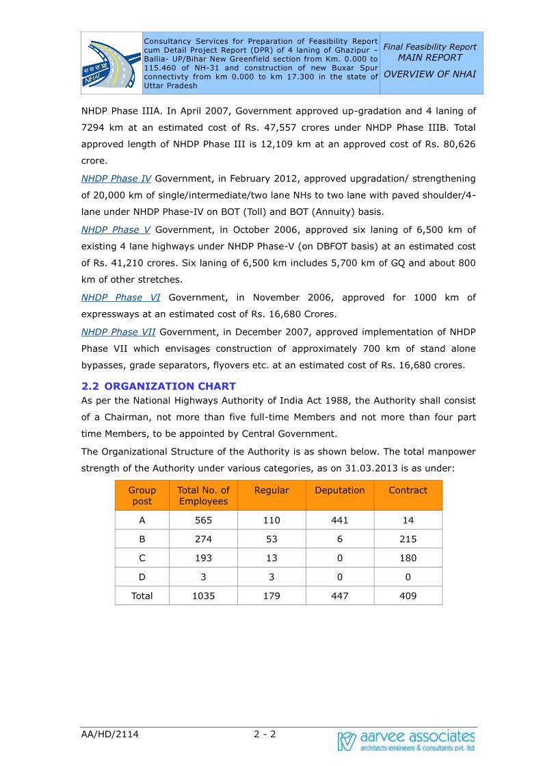
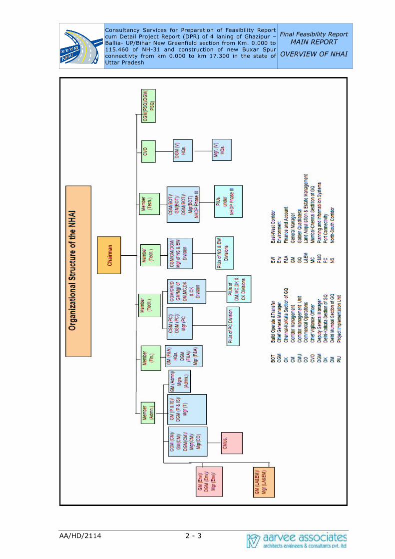
2.2 ORGANIZATION CHART
As per the National Highways Authority of India Act 1988, the Authority shall consist
of a Chairman, not more than five full-time Members and not more than four part
time Members, to be appointed by Central Government.
The Organizational Structure of the Authority is as shown below. The total manpower
strength of the Authority under various categories, as on 31.03.2013 is as under:
Group post
Total No. of Employees
Regular Deputation Contract
A 565 110 441 14
B 274 53 6 215
C 193 13 0 180
D 3 3 0 0
Total 1035 179 447 409
Consultancy Services for Preparation of Feasibility Report cum Detail Project Report (DPR) of 4 laning of Ghazipur –Ballia- UP/Bihar New Greenfield section from Km. 0.000 to 115.460 of NH-31 and construction of new Buxar Spur connectivty from km 0.000 to km 17.300 in the state of
Uttar Pradesh
Final Feasibility Report
MAIN REPORT
OVERVIEW OF NHAI
AA/HD/2114 2 - 3
Consultancy Services for Preparation of Feasibility Report cum Detail Project Report (DPR) of 4 laning of Ghazipur –Ballia- UP/Bihar New Greenfield section from Km. 0.000 to 115.460 of NH-31 and construction of new Buxar Spur connectivty from km 0.000 to km 17.300 in the state of
Uttar Pradesh
Final Feasibility Report
MAIN REPORT
OVERVIEW OF NHAI
AA/HD/2114 2 - 4
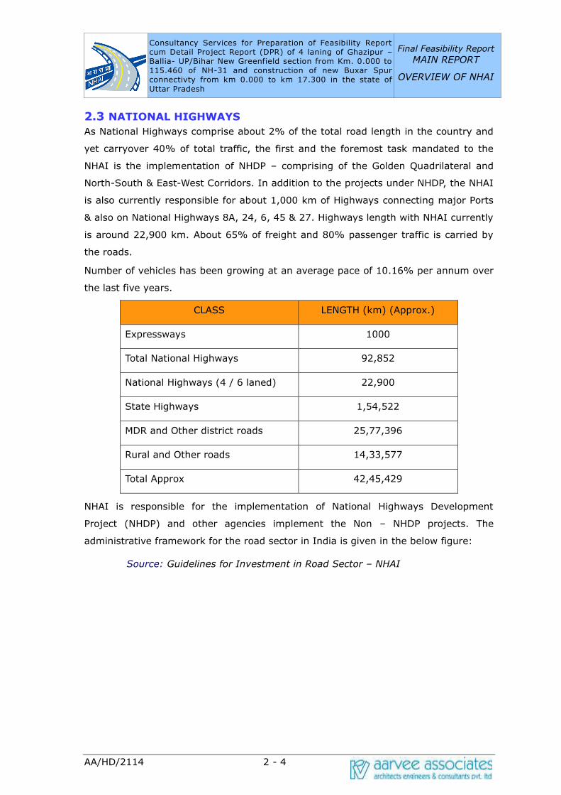
2.3 NATIONAL HIGHWAYS
As National Highways comprise about 2% of the total road length in the country and
yet carryover 40% of total traffic, the first and the foremost task mandated to the
NHAI is the implementation of NHDP – comprising of the Golden Quadrilateral and
North-South & East-West Corridors. In addition to the projects under NHDP, the NHAI
is also currently responsible for about 1,000 km of Highways connecting major Ports
& also on National Highways 8A, 24, 6, 45 & 27. Highways length with NHAI currently
is around 22,900 km. About 65% of freight and 80% passenger traffic is carried by
the roads.
Number of vehicles has been growing at an average pace of 10.16% per annum over
the last five years.
CLASS LENGTH (km) (Approx.)
Expressways 1000
Total National Highways 92,852
National Highways (4 / 6 laned) 22,900
State Highways 1,54,522
MDR and Other district roads 25,77,396
Rural and Other roads 14,33,577
Total Approx 42,45,429
NHAI is responsible for the implementation of National Highways Development
Project (NHDP) and other agencies implement the Non – NHDP projects. The
administrative framework for the road sector in India is given in the below figure:
Source: Guidelines for Investment in Road Sector – NHAI

Consultancy Services for Preparation of Feasibility Report cum Detail Project Report (DPR) of 4 laning of Ghazipur –Ballia- UP/Bihar New Greenfield section from Km. 0.000 to 115.460 of NH-31 and construction of new Buxar Spur connectivty from km 0.000 to km 17.300 in the state of
Uttar Pradesh
Final Feasibility Report
MAIN REPORT
OVERVIEW OF NHAI
AA/HD/2114 2 - 5
2.4 INSTITUTIONAL CHANGES
The following are the major landmark changes in the institutional framework that
facilitated the faster development of National Highways in India:
• National Highways Authority of India Act, 1988
• The National Highways (Collection of fees by any person for the use of section
of National Highways / Permanent Bridge / Temporary Bridge – Public funded
project) Rules, 1997
• The National Highways (Rate of fee) rules, 1997
• The National Highways Laws (Amendment) Act, 1997 to the National Highways
Act, 1956 that facilitated Land acquisition under NH Act, 1956
• The control of National Highways (Land and Traffic) Act, 2002
• Duty waiver for import of equipment used in highway construction
• Tax concessions for private entrepreneurs, investments in Highway sector.
\

Consultancy Services for Preparation of Feasibility Report cum Detail Project Report (DPR) of 4 laning of Ghazipur –Ballia- UP/Bihar New Greenfield section from Km. 0.000 to 115.460 of NH-31 and construction of new Buxar Spur connectivty from km 0.000 to km 17.300 in the state of
Uttar Pradesh
Final Feasibility Report
MAIN REPORT
OVERVIEW OF NHAI
AA/HD/2114 2 - 6
2.5 NATIONAL HIGHWAYS DEVELOPMENT PROJECT (NHDP)
The Government launched the National Highways Development Project (NHDP) to
upgrade and strengthen National Highways through the various phases of NHDP
being implemented by NHAI. National Highways Development Project is being
implemented in all phases except phase VI at present. The present phases improving
more than 49,260 km of arterial routes of NH Network to international standards.
The project-wise details NHDP all Phases as below.
NHDP Phase
Total
Length
(km.)
Already
4/6Laned
(km.)
Under
Implementation
(km.)
Contracts
Under
Implementation
(No.)
Balance
length for
award
(km.)
NHDP
Golden
Quadrilateral 5,846 5,846 0 0 -
NS – EW
Ph. I & II 7,142 6,360 365 42 417
Port
Connectivity 380 379 1 1 0
NHDP Phase III 12,109 6,393 4,373 89 1,343
NHDP Phase
IV*
14,799 942 5,904 55 7,953
NHDP Phase V 6,500 2,001 2,080 27 2,419
NHDP Phase VI 1,000 - - - 1,000
NHDP Phase VII 700 22 19 1 659
NHDP Total 48,476 21,943 12,742 215 13,791
Others (Ph.-I, Ph.-II &
Misc.) 1754 1428 326 10 -
SARDP -NE 388 99 12 1 277
Total by NHAI 50,618 23,470 13,080 226 14,068
Consultancy Services for Preparation of Feasibility Report cum Detail Project Report (DPR) of 4 laning of Ghazipur –Ballia- UP/Bihar New Greenfield section from Km. 0.000 to 115.460 of NH-31 and construction of new Buxar Spur connectivty from km 0.000 to km 17.300 in the state of
Uttar Pradesh
Final Feasibility Report
MAIN REPORT
OVERVIEW OF NHAI
AA/HD/2114 2 - 7
*Total 20,000 Km. was approved under NHDP Phase IV.Out of which 14,799 Km. was
assigned to NHAI remaining Km. with MORTH.Source: www.nhai.org (as per
31.01.2015)
Various phases of National Highways Development Project (NHDP)*- includes about
47,054 km of total NHs other than overlapping lengths of NHs (about 5,700 km
common under NHDP-I and NHDP-V).
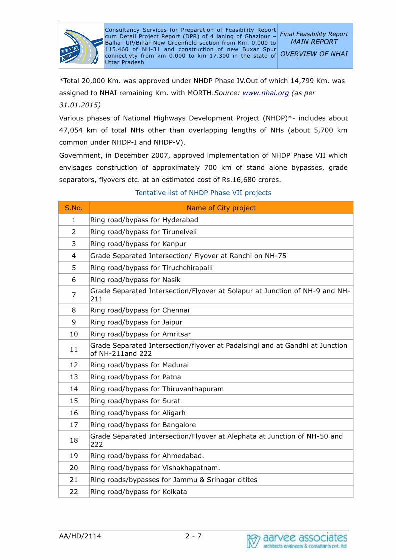
Government, in December 2007, approved implementation of NHDP Phase VII which
envisages construction of approximately 700 km of stand alone bypasses, grade
separators, flyovers etc. at an estimated cost of Rs.16,680 crores.
Tentative list of NHDP Phase VII projects
S.No. Name of City project
1 Ring road/bypass for Hyderabad
2 Ring road/bypass for Tirunelveli
3 Ring road/bypass for Kanpur
4 Grade Separated Intersection/ Flyover at Ranchi on NH-75
5 Ring road/bypass for Tiruchchirapalli
6 Ring road/bypass for Nasik
7 Grade Separated Intersection/Flyover at Solapur at Junction of NH-9 and NH-211
8 Ring road/bypass for Chennai
9 Ring road/bypass for Jaipur
10 Ring road/bypass for Amritsar
11 Grade Separated Intersection/flyover at Padalsingi and at Gandhi at Junction of NH-211and 222
12 Ring road/bypass for Madurai
13 Ring road/bypass for Patna
14 Ring road/bypass for Thiruvanthapuram
15 Ring road/bypass for Surat
16 Ring road/bypass for Aligarh
17 Ring road/bypass for Bangalore
18 Grade Separated Intersection/Flyover at Alephata at Junction of NH-50 and
222
19 Ring road/bypass for Ahmedabad.
20 Ring road/bypass for Vishakhapatnam.
21 Ring roads/bypasses for Jammu & Srinagar citites
22 Ring road/bypass for Kolkata

Consultancy Services for Preparation of Feasibility Report cum Detail Project Report (DPR) of 4 laning of Ghazipur –Ballia- UP/Bihar New Greenfield section from Km. 0.000 to 115.460 of NH-31 and construction of new Buxar Spur connectivty from km 0.000 to km 17.300 in the state of
Uttar Pradesh
Final Feasibility Report
MAIN REPORT
OVERVIEW OF NHAI
AA/HD/2114 2 - 8
S.No. Name of City project
23 Elevated link road to Chennai Port
24 Ring Road/bypass for Meerut
25 Ring Road/bypass for Coimbatore
26 Ring road/bypass for Bhopal
27 Ring road/bypass for Salem
28 Ring road/bypass for Nagpur
29 Ring road/bypass for Indore
30 Ring road/bypass for Lukcnow
31 Ring road/bypass for Imphal
32 Ring road/bypass for Pune
33 Ring road/bypass for Varanasi
34 Ring road/bypass for Dhanbad
35 Ring road /bypass for Ranchi
36 Grade Separated Intersection/flyover near Ratangiri at Junction of NH 17 and
204
2.6 SALIENT FEATURES OF NHDP PROJECTS
2.6.1 Steps Taken for Expediting Project Execution
NHAI is quickly adapting to the site problems by effectively utilising the experience
gained in the earlier projects. Its efforts to complete all the pre-construction activities
well before the award of the civil works contract are steps in the right direction. The
sizes of the contracts, the technical guidelines to the consultants are being constantly
updated based on the feedback received from time to time.
2.6.2 Safety Aspects
Fatality rate on Indian highways is very high. NHAI has introduced many safety
provisions in the design of highways for making highway travel safer. Some of these
are listed below:
➢ SAFETY BARRIERS / DELINEATORS HARD SHOULDERS ON MAIN ROADS
• Traffic signs and pavement markings.
• Underpasses and other grade separators at congested junctions.
• Removal of junctions and direct access points on main roads
• Improved median openings with stacking lanes
• Separate provision for safety and diversion in BOQ.
• Service roads in towns and villages for segregating local and through
traffic.

Consultancy Services for Preparation of Feasibility Report cum Detail Project Report (DPR) of 4 laning of Ghazipur –Ballia- UP/Bihar New Greenfield section from Km. 0.000 to 115.460 of NH-31 and construction of new Buxar Spur connectivty from km 0.000 to km 17.300 in the state of
Uttar Pradesh
Final Feasibility Report
MAIN REPORT
OVERVIEW OF NHAI
AA/HD/2114 2 - 9
• Safety audit for all the projects during FS/DPR as well as project
implementation.
2.6.3 Way Side Amenities
Wayside amenities are being provided with some of the following features:
• Fueling and servicing facilities.
• Restaurants
• Rest areas
• Telephone facilities
• Separate parking areas for goods and passenger vehicles
• Trauma care for accident victims
2.7 FUNDS FOR HIGHWAY DEVELOPMENT AND MAINTENANCE
Traditionally, financing for development of National Highways in India was from the
budgetary resources of the Government of India. In order to augment the available
resources, loans have also been raised from multilateral agencies like World Bank,
Asian Development Bank (ADB) and Japan Bank of International Cooperation
(JBIC).Around 80 per cent of the external assistance is provided to NHAI as a grant
by the Central government. The balance is made available as long-term loans to
NHAI, with the Centre bearing the foreign exchange risk. Such loans are usually
provided for 15-25 years with a moratorium of 5 years. Total cost of NHDP has been
estimated to be Rs. 54,000 Crores or US$ 13.2 billions whose components are as
below:
Likely sources Rs.Cr.
(1999 prices)
US$ Billions
(1999 prices )
Cess on Petrol and Diesel 20000 4.9
External assistance 20000 4.9
Market borrowings 10000 2.4
Private Sector Participation 4000 1
2.7.1 Central Road Fund
In a historic decision, the Government of India introduced a Cess on both Petrol and
Diesel. This amount at that time (at 1999 prices) came to a total of approximately

Consultancy Services for Preparation of Feasibility Report cum Detail Project Report (DPR) of 4 laning of Ghazipur –Ballia- UP/Bihar New Greenfield section from Km. 0.000 to 115.460 of NH-31 and construction of new Buxar Spur connectivty from km 0.000 to km 17.300 in the state of
Uttar Pradesh
Final Feasibility Report
MAIN REPORT
OVERVIEW OF NHAI
AA/HD/2114 2 - 10
Rs. 2,000 crores per annum. Further, Parliament decreed that the fund so collected
were to be put aside in a Central Road Fund (CRF) for exclusive utilization for the
development of a modern road network. The developmental work that it could be
tapped to fund and the agencies to whom it was available were clearly defined as
• Construction and Maintenance of State Highways by State Governments
• Development of Rural Roads by State Governments
• Construction of Rail over- bridges by Indian Railway
• Construction and Maintenance of National Highways by NHDP and Ministry
of Road Transport & Highways
Today, The Cess contributes between Rs 5 to 6 thousand crores per annum towards
NHDP. The annual accruals on account of this increase are approximately Rs. 5,800
Crores and this amount is distributed among National Highways, State Roads, Roads
of Economic Importance and Railways for taking up safety works such as ROBs,
manning of level crossings etc. The share of the National Highways from the Central
Road Fund is Rs. 2,000 Crores per annum.
2.7.2 Highway Infrastructure Bonds
Highway Infrastructure bonds are issued with benefits of tax savings for raising funds
for NHAI.
Policy Initiatives for Attracting Private Investment:
• Government will carry out all preparatory work including land acquisition
and utility removal. Right of way (ROW) to be made available to
concessionaires free from all encumbrances.
• NHAI / GOI to provide capital grant up to 40% of project cost to enhance
viability on a case to case basis 100% tax exemption for 5 years and 30%
relief for next 5 years, which may be availed of in 20 years.
• Concession period allowed up to 30 years
• Arbitration and Conciliation Act 1996 based on UNICITRAL provisions.
• In BOT projects entrepreneur are allowed to collect and retain tolls.
• Duty free import of specified modern high capacity equipment for
highway construction.
• Foreign Direct Investment up to 100 % in road sector.Declaration of the
road sector as an industry (Infrastructure as defined in section 18(1) (12)
of the Infrastructure Act includes Roads).
• Easier external commercial borrowing norms.
Consultancy Services for Preparation of Feasibility Report cum Detail Project Report (DPR) of 4 laning of Ghazipur –Ballia- UP/Bihar New Greenfield section from Km. 0.000 to 115.460 of NH-31 and construction of new Buxar Spur connectivty from km 0.000 to km 17.300 in the state of
Uttar Pradesh
Final Feasibility Report
MAIN REPORT
OVERVIEW OF NHAI
AA/HD/2114 2 - 11
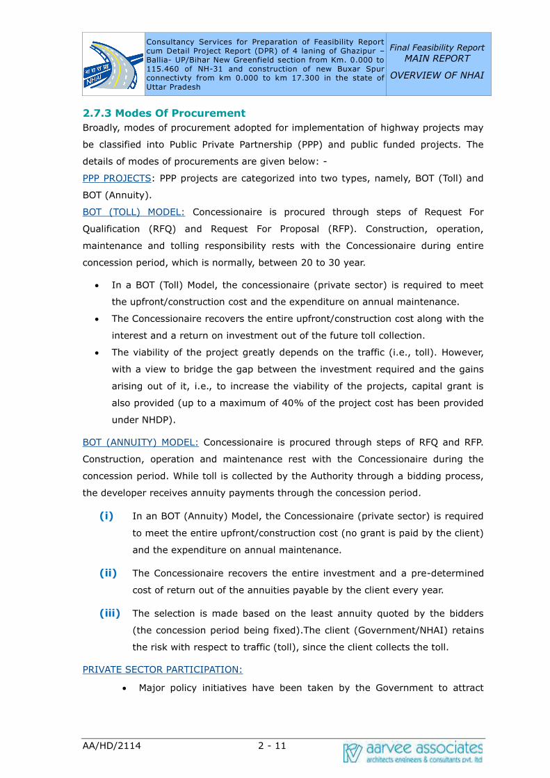
2.7.3 Modes Of Procurement
Broadly, modes of procurement adopted for implementation of highway projects may
be classified into Public Private Partnership (PPP) and public funded projects. The
details of modes of procurements are given below: -
PPP PROJECTS: PPP projects are categorized into two types, namely, BOT (Toll) and
BOT (Annuity).
BOT (TOLL) MODEL: Concessionaire is procured through steps of Request For
Qualification (RFQ) and Request For Proposal (RFP). Construction, operation,
maintenance and tolling responsibility rests with the Concessionaire during entire
concession period, which is normally, between 20 to 30 year.
• In a BOT (Toll) Model, the concessionaire (private sector) is required to meet
the upfront/construction cost and the expenditure on annual maintenance.
• The Concessionaire recovers the entire upfront/construction cost along with the
interest and a return on investment out of the future toll collection.
• The viability of the project greatly depends on the traffic (i.e., toll). However,
with a view to bridge the gap between the investment required and the gains
arising out of it, i.e., to increase the viability of the projects, capital grant is
also provided (up to a maximum of 40% of the project cost has been provided
under NHDP).
BOT (ANNUITY) MODEL: Concessionaire is procured through steps of RFQ and RFP.
Construction, operation and maintenance rest with the Concessionaire during the
concession period. While toll is collected by the Authority through a bidding process,
the developer receives annuity payments through the concession period.
(i) In an BOT (Annuity) Model, the Concessionaire (private sector) is required
to meet the entire upfront/construction cost (no grant is paid by the client)
and the expenditure on annual maintenance.
(ii) The Concessionaire recovers the entire investment and a pre-determined
cost of return out of the annuities payable by the client every year.
(iii) The selection is made based on the least annuity quoted by the bidders
(the concession period being fixed).The client (Government/NHAI) retains
the risk with respect to traffic (toll), since the client collects the toll.
PRIVATE SECTOR PARTICIPATION:
• Major policy initiatives have been taken by the Government to attract

Consultancy Services for Preparation of Feasibility Report cum Detail Project Report (DPR) of 4 laning of Ghazipur –Ballia- UP/Bihar New Greenfield section from Km. 0.000 to 115.460 of NH-31 and construction of new Buxar Spur connectivty from km 0.000 to km 17.300 in the state of
Uttar Pradesh
Final Feasibility Report
MAIN REPORT
OVERVIEW OF NHAI
AA/HD/2114 2 - 12
foreign as well as domestic private investments. To promote involvement
of the private sector in construction and maintenance of National
Highways, Some Projects are offered on Build Operate and Transfer
(BOT) basis to private agencies. After the concession period, which can
range up to 30 years, this road is to be transferred back to NHAI by the
Concessionaires
• NHAI funds are also leveraged by the setting up of Special Purpose
Vehicles (SPVs).The SPVs will be borrowing funds and repaying these
through toll revenues in the future. This model will also be tried in some
other projects. Some more models may emerge in the near future for
better leveraging of funds available with NHAI such as Annuity, which is a
variant of BOT model.
PUBLIC FUNDED PROJECTS:
The traditional mode of executing public funded projects was Item Rate Contract.
This was prone to time and cost overruns. This mode has been replaced by New
Engineering Procurement and Construction (EPC) contracts. The projects which are
not viable under BOT (Toll) mode, such as those in far flung areas would have to be
done under EPC mode. Model EPC Contract Agreement has been finalised and
implemented all across highway projects. Model EPC agreement relies on assigning
the responsibility for investigations, design and construction to the contractor for a
lump sum price determined through competitive bidding. Model EPC agreement
incorporates international best practices and provides a sound contractual framework
that specifies the allocation of risks and rewards, equity of obligations between
Government and the Contractor, precision and predictability of costs, force majeure,
termination and dispute resolution, apart from transparent and fair procedures.
2.8 FUTURE PROGRAMMES
A committee headed by the Honorable Prime Minister has proposed a massive
infrastructure developmental programme for the next 7 years.
The following development projects will be taken up under this programme.
a) Completion of GQ and EW-NS corridors.
b) Completion of 4-laning of 10,000 km under NHDP Phase-III
c) 2-laning with paved shoulders of 20,000 km of National Highways under
NHDP Phase- IV.
d) Augmenting highways in North East under Special Accelerated
Programme.
Consultancy Services for Preparation of Feasibility Report cum Detail Project Report (DPR) of 4 laning of Ghazipur –Ballia- UP/Bihar New Greenfield section from Km. 0.000 to 115.460 of NH-31 and construction of new Buxar Spur connectivty from km 0.000 to km 17.300 in the state of
Uttar Pradesh
Final Feasibility Report
MAIN REPORT
OVERVIEW OF NHAI
AA/HD/2114 2 - 13
e) 6-laning of selected stretches of National Highways under NHDP Phase-V.
f) Development of 1000 km of expressways under NHDP Phase-VI, and
g) Construction of ring roads, flyovers and bypasses on selected stretches
under NHDP Phase-VII.
h) Government has planned that all the future NHDP projects i.e. NHDP
Phase- III to Phase-VII will be implemented through public private sector
participation. Out of the above proposal Government has approved 4-
laning of 4000 km of National Highways under Phase-IIIA and
preparation of detailed project reports for balance 6000 km under NHDP
Phase-IIIB.
i) Actions have been initiated for getting the approval of the Government
for the remaining projects.
j) In June 2009, it was decided to build 20km per day of National Highways.
After oneyear, from June 2010 onwards, the Government has geared
itself towards achieving this target. The total achievement now stands at
15.96km per day as on 31.01.2012.
Improvement of Road Connectivity in Left Wing Extremism (LWE) affected areas:
The Government has also taken up a programme for the development of about 5,477
km (1,126 km of NH and 4,351 km of State Roads) in Left Wing Extremism (LWE)
affected areas as a special project estimated to cost about Rs. 7,300 crore in 34
districts in eight states namely in Andhra Pradesh, Bihar, Chhattisgarh, Jharkhand,
Madhya Pradesh, Maharashtra, Odisha and Uttar Pradesh. Development of 1,084 km
length has been completed by March, 2012. It has been targeted to complete all the
works by March, 2015.
Special Programme for 2-laning of entire balance NH network not covered under any
approved programmes:
Out of the total NH length of 76,818 km, the total balance length of NHs not covered
under any programme is about 23,500 km. Out of this, about 10,000 km are less
than 2-lane standards, i.e. 27 less than the minimum stipulated standards for NHs.
MORTH has taken initiatives to develop/ upgrade about 4,614 km length of such
stretches of NHs to 2-lane standards following Corridor Development Approach by
December 2014 through budgetary resources [1,564 km of less than 2-lane NHs] and
also through possible Loan Assistance from the World Bank [3,770 km having 3,050
km length of less than 2-lane NHs]. The balance length of about 5,400 km length of
NHs having less than 2-lane NH standards are required to be upgraded to minimum

Consultancy Services for Preparation of Feasibility Report cum Detail Project Report (DPR) of 4 laning of Ghazipur –Ballia- UP/Bihar New Greenfield section from Km. 0.000 to 115.460 of NH-31 and construction of new Buxar Spur connectivty from km 0.000 to km 17.300 in the state of
Uttar Pradesh
Final Feasibility Report
MAIN REPORT
OVERVIEW OF NHAI
AA/HD/2114 2 - 14
acceptable 2-lane NH standards also. Total length proposed to be taken up through
World Bank funding is about 3,770 km. The DPRs are under preparation for these
projects proposed to be funded through World Bank loan assistance.
Creation of National Road Safety and Traffic Management Board:
The Government had introduced a Bill in LokSabha on 4.5.2010 to create a National
Road Safety and Traffic Management Board to oversee the road safety activities in
the country which was referred to the Department related Parliamentary Standing
Committee for examination. The Parliamentary Committee submitted its report on
21.7.2010. Its recommendations have been examined. The Government is in the
process of carrying out certain amendments in the Bill for consideration by the
Parliament.
2.9 BORROWINGS FROM MULTI-LATERAL AGENCIES
Borrowing from multi – lateral funding agencies such as ADB, World Bank and JBIC
(OECF) is also one of the major sources for funding of Highway projects.
2.10 Cost Recovery Mechanisms and Finance Mechanism
The investments are being recovered either directly through tolls or indirectly through
cess on petrol and diesel.
CESS: In a historic decision, the Government of India introduced a Cess on both
Petrol and Diesel. This amount at that time (at 1999 prices) came to a total of
approximately Rs. 2,000 crores per annum. Further, Parliament decreed that the fund
so collected were to be put aside in a Central Road Fund (CRF) for exclusive
utilization for the development of a modern road network. The developmental work
that it could be tapped to fund and the agencies to whom it was available were
clearly defined as:
• Construction and Maintenance of State Highways by State Governments.
• Development of Rural Roads by State Governments
• Construction of Rail over- bridges by Indian Railways
• Construction and Maintenance of National Highways by NHDP and
Ministry of Road Transport & Highways
• Today, The Cess contributes between Rs 5 to 6 Thousands crores per
annum towards NHDP
LOAN ASSISTANCE FROM INTERNATIONAL FUNDING AGENCIES: Loan assistance is
available from multilateral development agencies like Asian Development Bank and
Consultancy Services for Preparation of Feasibility Report cum Detail Project Report (DPR) of 4 laning of Ghazipur –Ballia- UP/Bihar New Greenfield section from Km. 0.000 to 115.460 of NH-31 and construction of new Buxar Spur connectivty from km 0.000 to km 17.300 in the state of
Uttar Pradesh
Final Feasibility Report
MAIN REPORT
OVERVIEW OF NHAI
AA/HD/2114 2 - 15
World Bank or Other overseas lending agencies like Japanese Bank of International
Cooperation.
MARKET BORROWING: NHAI proposes to tap the market by securities cess receipts.
PRIVATE SECTOR PARTICIPATION: Major policy initiatives have been taken by the
Government to attract foreign as well as domestic private investments. To promote
involvement of the private sector in construction and maintenance of National
Highways, Some Projects are offered on Build Operate and Transfer (BOT) basis to
private agencies. After the concession period, which can range up to 30 years, this
road is to be transferred back to NHAI by the Concessionaires.
NHAI funds are also leveraged by the setting up of Special Purpose Vehicles
(SPVs).The SPVs will be borrowing funds and repaying these through toll revenues in
the future. This model will also be tried in some other projects. Some more models
may emerge in the near future for better leveraging of funds available with NHAI
such as Annuity, which is a variant of BOT model.
2.11 ISSUES TO BE ADDRESSED BY NHAI
2.11.1 Expressways
The road development plan of MORT&H envisages construction of expressways for a
total length of 10,000 Km. The stretches of National Highways that are required to be
upgraded to Expressways need to be identified and FS/ DPR studies may need to be
carried out for the construction of expressways and their implementation needs to be
taken up.
2.11.2 Data Center
• NHAI should endeavor to set up a road data center for all the highways
under its control. There is urgent need to store vast records pertaining to
the projects that are completed and or under execution so that the data
can be retrieved any time. For example, the land records of the lands
acquired for the purpose of road widening, As-built drawings, details of
highway furniture etc are to be stored in a database so that the
information can be retrieved any time.
• Road data in respect of all the highways entrusted to NHAI such as road
inventory, Bridge Inventory, traffic data, riding quality etc
• Unit rates for various items of work along the highway.
• Locations of borrow areas and the material available from them.
• Location of congested towns and villages existing along Nhs.
Consultancy Services for Preparation of Feasibility Report cum Detail Project Report (DPR) of 4 laning of Ghazipur –Ballia- UP/Bihar New Greenfield section from Km. 0.000 to 115.460 of NH-31 and construction of new Buxar Spur connectivty from km 0.000 to km 17.300 in the state of
Uttar Pradesh
Final Feasibility Report
MAIN REPORT
OVERVIEW OF NHAI
AA/HD/2114 2 - 16
• Permissions being accorded from time to time and due date for their
renewal
• Guarantees provided by the contractors / suppliers for various equipment
such as expansion joints, bearings, delineators, traffic safety devices
installed on highways.
• Location of toll gates, the details of the concessionaires/ contractors and
the revenues
• Details of specialized equipment and their details such as name of
supplier, the type of material, the warranty provided its performance and
so on.
2.11.3 Corridor Management
There is urgent need for effective Corridor management covering all the aspects of
pavement maintenance, land management, removing traffic hazards, preventing
ribbon development and control overloading of vehicles and incidence management.
The scope of existing institutional framework should be enlarged to include control of
misuse of highway property such as highway furniture by way of theft, defacing by
means of sticking posters, painting colors, or damaging. Though the required
legislation by way of National Highways (Land and Traffic) Act, 2002 is in place,
proper corridor management is yet to be effected. For making corridor control
effective, NHAI may consider creation of a Highway Protection Force on the lines of
Railway Protection Force and Industrial Protection Force. Highway police may be
activated for enforcing adherence to traffic rules.
Video monitoring of highways which is being done on experimental basis on NH 8 is
to be extended to all Highways in a phased manner for effective corridor
management and enforcing driver discipline.
2.11.4 Check Posts
NHAI and MORT&H should interact with the State Governments to regulate the
location and operation of check posts so that vehicular traffic is put to minimum
inconvenience and delay. The concerned regulating agencies should be made to
interact with NHAI for finalising the location and layout of the check posts so that
through traffic is put to minimum inconvenience.
2.11.5 Institutional Strengthening
The principle of NHAI to be a lean and thin organisation is laudable. But, it is
imperative for NHAI to have a dedicated cadre of personnel with specialisation in
various aspects such as legal, contract administration, transport planning, land
Consultancy Services for Preparation of Feasibility Report cum Detail Project Report (DPR) of 4 laning of Ghazipur –Ballia- UP/Bihar New Greenfield section from Km. 0.000 to 115.460 of NH-31 and construction of new Buxar Spur connectivty from km 0.000 to km 17.300 in the state of
Uttar Pradesh
Final Feasibility Report
MAIN REPORT
OVERVIEW OF NHAI
AA/HD/2114 2 - 17
management, project preparation, project execution, social aspects, inter-modal
transportation etc.
2.11.6 Dispute Resolution
The mechanism of Dispute Resolution should be monitored from time to time to see
whether the mechanism could be improved further.
2.11.7 Land Acquisition
There has been inordinate delay in acquisition of land in some States mostly due to
procedural formalities, court cases and low level of cooperation from the State Govt.
officials. There have been delays in disbursement of compensation by the Competent
Authority to the affected land owners, although NHAI deposits the compensation
amount determined by the competent authority well in advance.
2.11.8 Environment and Forest clearances
The Ministry of Environment & Forests (MoEF), vide circular dated 31.03.2011, linked
the grant of environment clearance (EC) with the forest clearance whereby EC is to
be considered only after submission of in-principle approval of Govt. of India (Stage-
1 clearance) for diversion of forest irrespective of the quantum of forest area to be
diverted. This linking had a major adverse impact on the NHDP Programme as NHAI
was unable to declare the Appointed Date for many projects to start the work even if
a small part of the ROW falls within the forest area. With constant pursuance of NHAI
at several forums in the meetings of Committee of Secretaries, Finance and Law
Ministry, MOEF approached Hon’ble Supreme Court for necessary modifications in the
guidelines for National Highways projects and the process for obtaining environment
and forest clearances has been simplified. As per latest notification of MoEF,
Environmental clearance is not required for projects upto 100 kms and also for
projects having more than 100 km. length in case it involves acquisition of additional
ROW less than 40 Mtrs in case of existing alignments and less than 60 Mtrs in case of
by-passes or new alignments respectively.
There have been considerable delays in obtaining forest clearances. Besides the
conditions stipulated by the Central Government (MOEF) in the first stage clearance
(in-principle approval), the State forest departments impose additional conditions
which are, at times, unreasonable and difficult to meet such as staff quarters,
wireless systems, vehicles etc. The demand for compensatory afforestation also
varies greatly from state to state from two times in some states to as much as twelve
times in some states.
Consultancy Services for Preparation of Feasibility Report cum Detail Project Report (DPR) of 4 laning of Ghazipur –Ballia- UP/Bihar New Greenfield section from Km. 0.000 to 115.460 of NH-31 and construction of new Buxar Spur connectivty from km 0.000 to km 17.300 in the state of
Uttar Pradesh
Final Feasibility Report
MAIN REPORT
OVERVIEW OF NHAI
AA/HD/2114 2 - 18
NHAI along with the Government of India and other institutions and authorities is
working towards implementing the changes and reforms to achieve the target of
building 20km per day.
Consultancy Services for Preparation of Feasibility Report cum Detail Project Report (DPR) of 4 laning of Ghazipur –Ballia- UP/Bihar New Greenfield section from Km. 0.000 to 115.460 of NH-31 and construction of new Buxar Spur connectivity from km 0.000 to km 17.300 in the state of Uttar Pradesh
Final Feasibility
Report
PROJECT BACKGROUND
AA/HD/2114 3 - 1
3. PROJECT BRACKGROUND
3.1 GENERAL
Uttar Pradesh abbreviated as UP, is the most populous state in the Republic of India
as well as the most populous country subdivision in the world. The state, located in
the northern region of the Indian subcontinent, has over 200 million inhabitants. It
was created on 1 April 1937 as the United Provinces during British rule and was
renamed Uttar Pradesh in 1950.
It covers 243,290 square kilometers, equal to 7.33% of the total area of India, and is
the fourth largest Indian state by area. Uttar Pradesh is the third largest Indian state
by economy, with a GDP of 9,763 billion. Agriculture and service industries are the
largest parts of the state's economy. The service sector comprises travel and tourism,
hotel industry, real estate, insurance and financial consultancies. The two major
rivers of the state, the Ganges and Yamuna, join at Allahabad and then flow as the
Ganges further east. The state has several historical, natural and religious tourist
destinations, such as, Agra, Varanasi, Raebareli, Kaushambi, Ballia,
Shravasti,Gorakhpur,Kushinagar,Lucknow,Jhansi,Allahabad,Budaun,Meerut,Mathura,
Muzaffarnagar and Shahjahanpur.
The Greenfield project highway starts at Km.0.000 near Hridaypur, Sarai Bandi on
NH-29 Ghazipur- Gorakhpur road at Km 84.800 (NH-29 Chainage) and ends on NH-
19 Bahoran Tola village in Bihar of Raghunathpur- Chappra Road. The total project
highway traverses in the Ghazipur and Ballia and Saran districts. It traverses mostly
through plain terrain and a mixed land use of residential and agricultural can be seen
throughout the corridor.
Table-3.1: Project Stretch Details
S. No
Project Highway
Design Chainage
(Km) Remarks
From To
1 Ghazipur to Manjhi Ghat
UP/Bihar Border
0.000 115.600 NH-31
2 Buxar Spur 0.000 17.800
The Consultant had conducted detailed reconnaissance survey to get acquainted with
the actual site conditions. The observations made are discussed in subsequent
sections.

Consultancy Services for Preparation of Feasibility Report cum Detail Project Report (DPR) of 4 laning of Ghazipur –Ballia- UP/Bihar New Greenfield section from Km. 0.000 to 115.460 of NH-31 and construction of new Buxar Spur connectivity from km 0.000 to km 17.300 in the state of Uttar Pradesh
Final Feasibility Report
MAIN REPORT
PROJECT BACKGROUND
AA/HD/2114 3 - 2
Fig:1 Figure Showing Project Location Map

Consultancy Services for Preparation of Feasibility Report cum Detail Project Report (DPR) of 4 laning of Ghazipur –Ballia- UP/Bihar New Greenfield section from Km. 0.000 to 115.460 of NH-31 and construction of new Buxar Spur connectivity from km 0.000 to km 17.300 in the state of Uttar Pradesh
Final Feasibility
Report
PROJECT BACKGROUND
AA/HD/2114 3 - 3
3.2 TERRAIN
Terrain is classified by the general slope of the country across the highway alignment.
Based on this criterion, the entire project stretch traverses predominantly through
Plain terrain (70%) followed by Rolling terrain (30%).
3.3 ABUTTING LANDUSE
In terms of land use, majority of adjoining lands were observed to be used for
agriculture purposes (70%) and the rest is barren land (30%). Important crops
grown along the project stretch are Wheat and Sugarcane. Moderately built-up areas
and a mix of fast and slow traffic characterize this corridor. Different types of
residential/ commercial structures (Permanent/Semi permanent) are noticed in the
built-up section.
3.4 CROSS DRAINAGE STRUCTURES
As a part of upgrading of the project, it is required to make an assessment of existing
structures with regards to their adequacies to ensure that they meet the objectives of
the project. List of proposed cross drainage structures and underpass locations along
the project stretch are shown below from Table-3.2 to Table-3.7.
Table-3.2: Proposed Major Bridges
S. No Design
Chainage Proposed Span
Remarks
1 48+000 MJB 3 x 25.0 New
2 91+195 MJB 2 x 30.0 New
3 114+043 MJB 3 x 65.5 + 15 x 64.8 Retained
Table-3.3: Proposed Minor Bridges
S. No Design
Chainage Proposed Span
Remarks
1 3+046 MIB 1 x 15.0 New
2 17+057 MIB 1 x 15.0 New
3 31+605 MIB 1 x 7.0 New
4 35+269 MIB 1 x 6.0 New
5 36+419 MIB 1 x 7.0 New
6 49+720 MIB 2 x 5.0 New
7 53+730 MIB 2 x 5.0 New
8 63+984 MIB 1 x 15.0 New
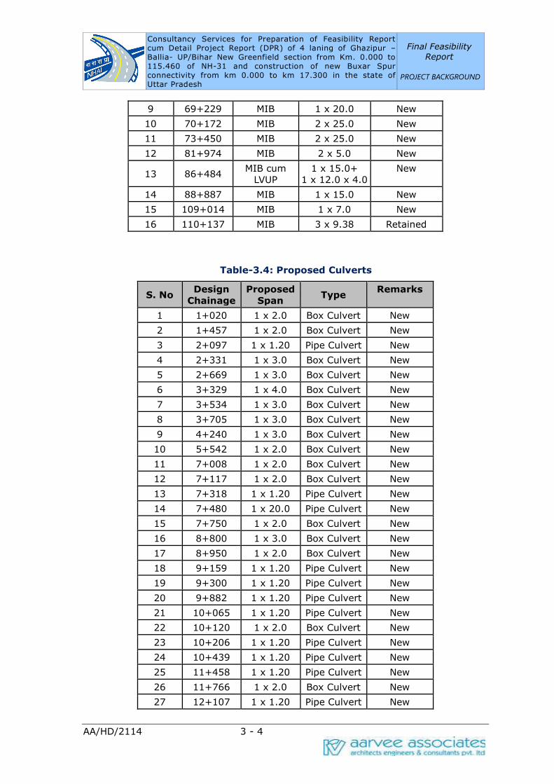
Consultancy Services for Preparation of Feasibility Report cum Detail Project Report (DPR) of 4 laning of Ghazipur –Ballia- UP/Bihar New Greenfield section from Km. 0.000 to 115.460 of NH-31 and construction of new Buxar Spur connectivity from km 0.000 to km 17.300 in the state of Uttar Pradesh
Final Feasibility
Report
PROJECT BACKGROUND
AA/HD/2114 3 - 4
9 69+229 MIB 1 x 20.0 New
10 70+172 MIB 2 x 25.0 New
11 73+450 MIB 2 x 25.0 New
12 81+974 MIB 2 x 5.0 New
13 86+484 MIB cum
LVUP
1 x 15.0+
1 x 12.0 x 4.0
New
14 88+887 MIB 1 x 15.0 New
15 109+014 MIB 1 x 7.0 New
16 110+137 MIB 3 x 9.38 Retained
Table-3.4: Proposed Culverts
S. No Design
Chainage
Proposed
Span Type
Remarks
1 1+020 1 x 2.0 Box Culvert New
2 1+457 1 x 2.0 Box Culvert New
3 2+097 1 x 1.20 Pipe Culvert New
4 2+331 1 x 3.0 Box Culvert New
5 2+669 1 x 3.0 Box Culvert New
6 3+329 1 x 4.0 Box Culvert New
7 3+534 1 x 3.0 Box Culvert New
8 3+705 1 x 3.0 Box Culvert New
9 4+240 1 x 3.0 Box Culvert New
10 5+542 1 x 2.0 Box Culvert New
11 7+008 1 x 2.0 Box Culvert New
12 7+117 1 x 2.0 Box Culvert New
13 7+318 1 x 1.20 Pipe Culvert New
14 7+480 1 x 20.0 Pipe Culvert New
15 7+750 1 x 2.0 Box Culvert New
16 8+800 1 x 3.0 Box Culvert New
17 8+950 1 x 2.0 Box Culvert New
18 9+159 1 x 1.20 Pipe Culvert New
19 9+300 1 x 1.20 Pipe Culvert New
20 9+882 1 x 1.20 Pipe Culvert New
21 10+065 1 x 1.20 Pipe Culvert New
22 10+120 1 x 2.0 Box Culvert New
23 10+206 1 x 1.20 Pipe Culvert New
24 10+439 1 x 1.20 Pipe Culvert New
25 11+458 1 x 1.20 Pipe Culvert New
26 11+766 1 x 2.0 Box Culvert New
27 12+107 1 x 1.20 Pipe Culvert New

Consultancy Services for Preparation of Feasibility Report cum Detail Project Report (DPR) of 4 laning of Ghazipur –Ballia- UP/Bihar New Greenfield section from Km. 0.000 to 115.460 of NH-31 and construction of new Buxar Spur connectivity from km 0.000 to km 17.300 in the state of Uttar Pradesh
Final Feasibility
Report
PROJECT BACKGROUND
AA/HD/2114 3 - 5
S. No Design
Chainage
Proposed
Span Type
Remarks
28 13+216 1 x 1.20 Pipe Culvert New
29 14+368 1 x 2.0 Box Culvert New
30 14+920 1 x 2.0 Box Culvert New
31 15+060 1 x 2.0 Box Culvert New
32 15+411 1 x 4.0 Box Culvert New
33 15+742 1 x 3.0 Box Culvert New
34 16+070 1 x 2.0 Box Culvert New
35 16+500 1 x 3.0 Box Culvert New
36 17+872 1 x 1.20 Pipe Culvert New
37 19+197 1 x 2.0 Box Culvert New
38 19+590 1 x 1.20 Pipe Culvert New
39 19+992 1 x 5.0 Box Culvert New
40 20+940 1 x 2.0 Box Culvert New
41 22+052 1 x 5.0 Box Culvert New
42 24+990 1 x 3.0 Box Culvert New
43 26+409 1 x 1.20 Pipe Culvert New
44 26+761 1 x 2.0 Box Culvert New
45 28+089 1 x 1.20 Pipe Culvert New
46 32+870 1 x 2.0 Box Culvert New
47 33+320 1 x 1.20 Pipe Culvert New
48 34+331 1 x 1.20 Pipe Culvert New
49 35+576 1 x 1.20 Pipe Culvert New
50 35+545 1 x 2.0 Box Culvert New
51 36+836 1 x 1.20 Pipe Culvert New
52 36+944 1 x 5.0 Box Culvert New
53 37+849 1 x 1.20 Pipe Culvert New
54 38+062 1 x 1.20 Pipe Culvert New
55 38+269 1 x 1.20 Pipe Culvert New
56 39+700 1 x 1.20 Pipe Culvert New
57 39+925 1 x 1.20 Pipe Culvert New
58 41+068 1 x 2.0 Box Culvert New
59 44+735 1 x 5.0 Box Culvert New
60 45+502 1 x 1.20 Pipe Culvert New
61 48+542 1 x 1.20 Pipe Culvert New
62 48+900 1 x 1.20 Pipe Culvert New
63 50+010 1 x 1.20 Pipe Culvert New
64 50+460 1 x 2.0 Box Culvert New
65 52+280 1 x 2.0 Box Culvert New
66 52+884 1 x 3.0 Box Culvert New
Consultancy Services for Preparation of Feasibility Report cum Detail Project Report (DPR) of 4 laning of Ghazipur –Ballia- UP/Bihar New Greenfield section from Km. 0.000 to 115.460 of NH-31 and construction of new Buxar Spur connectivity from km 0.000 to km 17.300 in the state of Uttar Pradesh
Final Feasibility
Report
PROJECT BACKGROUND
AA/HD/2114 3 - 6
S. No Design
Chainage
Proposed
Span Type
Remarks
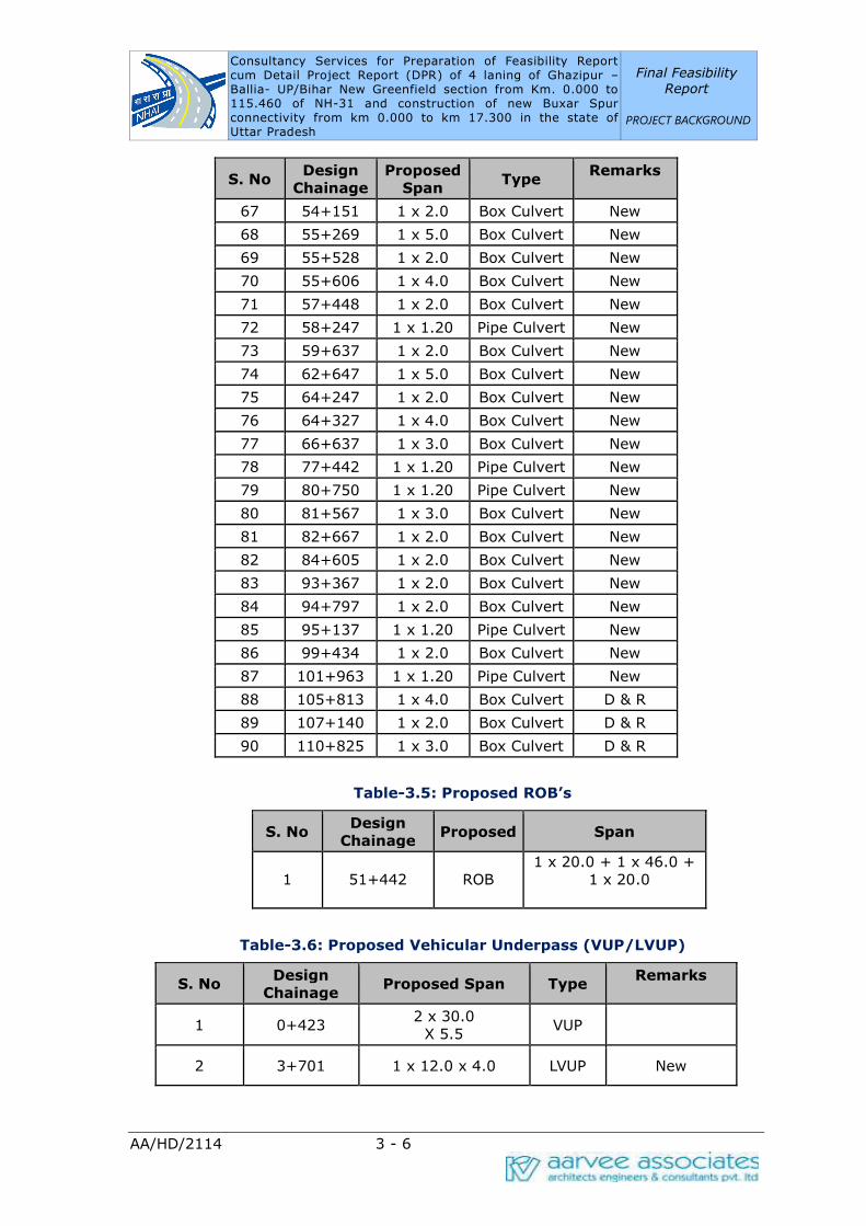
67 54+151 1 x 2.0 Box Culvert New
68 55+269 1 x 5.0 Box Culvert New
69 55+528 1 x 2.0 Box Culvert New
70 55+606 1 x 4.0 Box Culvert New
71 57+448 1 x 2.0 Box Culvert New
72 58+247 1 x 1.20 Pipe Culvert New
73 59+637 1 x 2.0 Box Culvert New
74 62+647 1 x 5.0 Box Culvert New
75 64+247 1 x 2.0 Box Culvert New
76 64+327 1 x 4.0 Box Culvert New
77 66+637 1 x 3.0 Box Culvert New
78 77+442 1 x 1.20 Pipe Culvert New
79 80+750 1 x 1.20 Pipe Culvert New
80 81+567 1 x 3.0 Box Culvert New
81 82+667 1 x 2.0 Box Culvert New
82 84+605 1 x 2.0 Box Culvert New
83 93+367 1 x 2.0 Box Culvert New
84 94+797 1 x 2.0 Box Culvert New
85 95+137 1 x 1.20 Pipe Culvert New
86 99+434 1 x 2.0 Box Culvert New
87 101+963 1 x 1.20 Pipe Culvert New
88 105+813 1 x 4.0 Box Culvert D & R
89 107+140 1 x 2.0 Box Culvert D & R
90 110+825 1 x 3.0 Box Culvert D & R
Table-3.5: Proposed ROB’s
S. No Design
Chainage Proposed Span
1 51+442 ROB
1 x 20.0 + 1 x 46.0 +
1 x 20.0
Table-3.6: Proposed Vehicular Underpass (VUP/LVUP)
S. No Design
Chainage Proposed Span Type
Remarks
1 0+423 2 x 30.0
X 5.5 VUP
2 3+701 1 x 12.0 x 4.0 LVUP New
Consultancy Services for Preparation of Feasibility Report cum Detail Project Report (DPR) of 4 laning of Ghazipur –Ballia- UP/Bihar New Greenfield section from Km. 0.000 to 115.460 of NH-31 and construction of new Buxar Spur connectivity from km 0.000 to km 17.300 in the state of Uttar Pradesh
Final Feasibility
Report
PROJECT BACKGROUND
AA/HD/2114 3 - 7
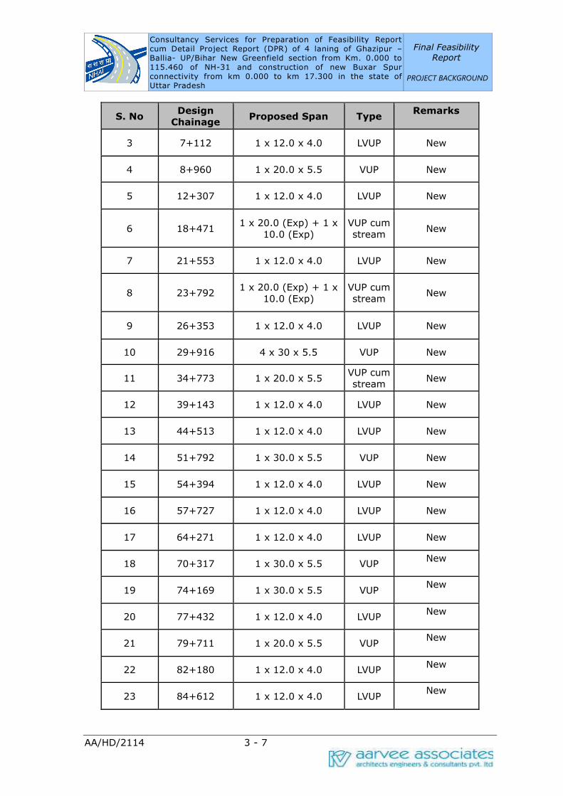
S. No Design
Chainage Proposed Span Type
Remarks
3 7+112 1 x 12.0 x 4.0 LVUP New
4 8+960 1 x 20.0 x 5.5 VUP New
5 12+307 1 x 12.0 x 4.0 LVUP New
6 18+471 1 x 20.0 (Exp) + 1 x
10.0 (Exp)
VUP cum
stream New
7 21+553 1 x 12.0 x 4.0 LVUP New
8 23+792 1 x 20.0 (Exp) + 1 x
10.0 (Exp)
VUP cum
stream New
9 26+353 1 x 12.0 x 4.0 LVUP New
10 29+916 4 x 30 x 5.5 VUP New
11 34+773 1 x 20.0 x 5.5 VUP cum
stream New
12 39+143 1 x 12.0 x 4.0 LVUP New
13 44+513 1 x 12.0 x 4.0 LVUP New
14 51+792 1 x 30.0 x 5.5 VUP New
15 54+394 1 x 12.0 x 4.0 LVUP New
16 57+727 1 x 12.0 x 4.0 LVUP New
17 64+271 1 x 12.0 x 4.0 LVUP New
18 70+317 1 x 30.0 x 5.5 VUP New
19 74+169 1 x 30.0 x 5.5 VUP New
20 77+432 1 x 12.0 x 4.0 LVUP New
21 79+711 1 x 20.0 x 5.5 VUP New
22 82+180 1 x 12.0 x 4.0 LVUP New
23 84+612 1 x 12.0 x 4.0 LVUP New

Consultancy Services for Preparation of Feasibility Report cum Detail Project Report (DPR) of 4 laning of Ghazipur –Ballia- UP/Bihar New Greenfield section from Km. 0.000 to 115.460 of NH-31 and construction of new Buxar Spur connectivity from km 0.000 to km 17.300 in the state of Uttar Pradesh
Final Feasibility
Report
PROJECT BACKGROUND
AA/HD/2114 3 - 8
S. No Design
Chainage Proposed Span Type
Remarks
24 89+661 1 x 12.0 x 4.0 LVUP New
25 92+283 1 x 12.0 x 4.0 LVUP New
26 95+779 1 x 12.0 x 4.0 LVUP New
27 97+519 1 x 30.0 x 5.5 VUP New
28 99+414 1 x 20.0 x 5.5 VUP New
29 101+989 1 x 12.0 x 4.0 LVUP New
30 103+870 1 x 30.0 x 5.5 VUP New
31 114+829 1 x 14.0 VUP R & W
Summary of Proposed Structures:
·Major Bridges = 3
·Minor Brides = 16
· Box Culverts = 56
· Pipe Culverts = 34
· ROB = 1
· VUPs = 14
· LVUPs = 17
BUXAR SPUR PROPOSED STRUCTURES:
Table-3.7: Proposed Structures in Buxar Spur
S.no. Design
Chainage Proposed Span Type Remarks
1 0+592 1 x 20.0 x 36.0
1 x 20.0 ROB New
2 1+114 1 x 2.0 Box Culvert New
3 1+676 1 x 8.0 MIB New
4 2+410 2 x 15.0 MIB New
5 4+610 1 x 2.0 Box Culvert New

Consultancy Services for Preparation of Feasibility Report cum Detail Project Report (DPR) of 4 laning of Ghazipur –Ballia- UP/Bihar New Greenfield section from Km. 0.000 to 115.460 of NH-31 and construction of new Buxar Spur connectivity from km 0.000 to km 17.300 in the state of Uttar Pradesh
Final Feasibility
Report
PROJECT BACKGROUND
AA/HD/2114 3 - 9
S.no. Design
Chainage Proposed Span Type Remarks
6 6+263 1 x 2.0 Box Culvert New
7 10+032 1 x 2.0 Box Culvert New
8 13+490 1 x 3.0 Box Culvert New
9 15+388 1 x 2.0 Box Culvert New
10 16+508 1 x 2.0 Box Culvert New
11 17+003 1 x 1.2 Pipe Culvert New
12 17+129 1 x 2.0 Box Culvert New
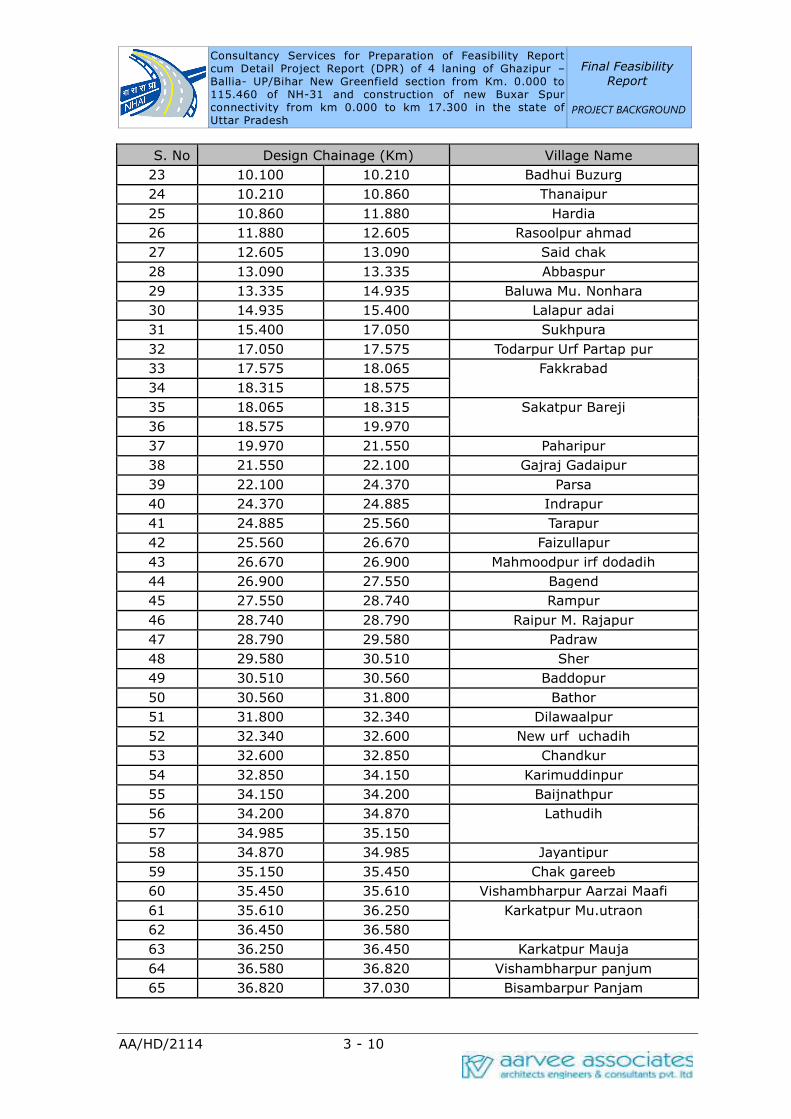
3.5 SETTLEMENTS
The project stretch passes through villages of Gazipur and Ballia Districts in the
project stretch. The complete list of villages abutting the project stretch is shown
below in Table-3.8.
Table-3.8: Settlements Limits – Greenfield Alignment
S. No Design Chainage (Km)
Village Name From To
1 0.000 0.570 Hridaypur
2 0.570 0.750 Saraibandi
3 0.860 1.025
4 0.750 0.860 Nasirpur
5 1.025 1.450
6 1.450 1.635 Dadi Kala
7 1.635 2.015 Khazapur
8 2.015 2.500 Dhobha
9 2.500 2.550 Ramdoopur
10 2.550 3.050 Mirzapur Mafi
11 3.050 3.550 Bhikharipur
12 3.550 4.280 Manpur
13 4.280 5.335 Tikari
14 5.335 6.070 Sathipur
15 6.070 6.210 Bisunpur Datta
16 6.210 6.295 Newada
17 6.295 7.950 Subhakarpur
18 7.950 8.530 Akhatiyarpur
19 8.530 9.200 Chak Ajam
20 9.620 9.660 Raibanpah
21 9.200 9.620 Badhui khurd
22 9.660 10.100 Chak Niamtulla
Consultancy Services for Preparation of Feasibility Report cum Detail Project Report (DPR) of 4 laning of Ghazipur –Ballia- UP/Bihar New Greenfield section from Km. 0.000 to 115.460 of NH-31 and construction of new Buxar Spur connectivity from km 0.000 to km 17.300 in the state of Uttar Pradesh
Final Feasibility
Report
PROJECT BACKGROUND
AA/HD/2114 3 - 10
S. No Design Chainage (Km) Village Name
23 10.100 10.210 Badhui Buzurg
24 10.210 10.860 Thanaipur
25 10.860 11.880 Hardia
26 11.880 12.605 Rasoolpur ahmad
27 12.605 13.090 Said chak
28 13.090 13.335 Abbaspur
29 13.335 14.935 Baluwa Mu. Nonhara
30 14.935 15.400 Lalapur adai
31 15.400 17.050 Sukhpura
32 17.050 17.575 Todarpur Urf Partap pur
33 17.575 18.065 Fakkrabad
34 18.315 18.575
35 18.065 18.315 Sakatpur Bareji
36 18.575 19.970
37 19.970 21.550 Paharipur
38 21.550 22.100 Gajraj Gadaipur
39 22.100 24.370 Parsa
40 24.370 24.885 Indrapur
41 24.885 25.560 Tarapur
42 25.560 26.670 Faizullapur
43 26.670 26.900 Mahmoodpur irf dodadih
44 26.900 27.550 Bagend
45 27.550 28.740 Rampur
46 28.740 28.790 Raipur M. Rajapur
47 28.790 29.580 Padraw
48 29.580 30.510 Sher
49 30.510 30.560 Baddopur
50 30.560 31.800 Bathor
51 31.800 32.340 Dilawaalpur
52 32.340 32.600 New urf uchadih
53 32.600 32.850 Chandkur
54 32.850 34.150 Karimuddinpur
55 34.150 34.200 Baijnathpur
56 34.200 34.870 Lathudih
57 34.985 35.150
58 34.870 34.985 Jayantipur
59 35.150 35.450 Chak gareeb
60 35.450 35.610 Vishambharpur Aarzai Maafi
61 35.610 36.250 Karkatpur Mu.utraon
62 36.450 36.580
63 36.250 36.450 Karkatpur Mauja
64 36.580 36.820 Vishambharpur panjum
65 36.820 37.030 Bisambarpur Panjam

Consultancy Services for Preparation of Feasibility Report cum Detail Project Report (DPR) of 4 laning of Ghazipur –Ballia- UP/Bihar New Greenfield section from Km. 0.000 to 115.460 of NH-31 and construction of new Buxar Spur connectivity from km 0.000 to km 17.300 in the state of Uttar Pradesh
Final Feasibility
Report
PROJECT BACKGROUND
AA/HD/2114 3 - 11
S. No Design Chainage (Km) Village Name
66 37.030 37.240 Vishambharpu
67 37.240 37.350 Bibipur Khas
68 37.350 37.820 Bharaouli Kalan
69 37.820 39.230 Patar
70 39.230 39.500 Tajpur
71 39.650 40.750
72 39.500 39.650 Patar
73 40.750 41.070 Bhediausar
74 41.070 41.480 Kajichak
75 41.480 41.910 Gopalchak
76 41.910 42.350 Bharauli Ala
77 42.350 43.200 Sahapur
78 43.200 43.550 Lakra
79 43.550 43.800 Badhwalia
80 43.800 44.250 Awagilwa
81 44.250 45.550 Hardarpur
82 45.550 47.050 Tikapur
83 47.050 48.050 Basaratpur
84 48.050 49.750 Sultanpur
85 49.750 50.390 Kotwari
86 50.390 50.780 Kurchunda Mu. Singhpur
87 50.780 50.930 Kalyanpur
88 50.930 51.250 Kurchunda Ekoni
89 51.250 52.200 Ekoni
90 52.200 52.400 TeteDad
91 52.400 52.600 Teekha
92 52.600 53.850 Teekha
93 53.850 53.900 Cheruia
94 53.900 54.220 Bairiya
95 54.220 54.550 Bhawarkol
96 54.550 55.250 Narhi
97 55.250 56.250 Gangahara
98 56.350 56.890
99 56.250 56.350 Vaina
100 56.890 57.350 Baghe Ji
101 57.350 58.980 Sagarapalli
102 58.980 59.350 Daraopur
103 59.350 59.670 Kaap Nasirabad
104 59.670 60.200 Sharfuddinpur Mu
105 60.200 60.390 Devariyakurdh
106 60.390 60.730 Mubarakpur
107 60.730 60.890 Khap Khori Pakar
108 60.890 61.190 Parsipatti

Consultancy Services for Preparation of Feasibility Report cum Detail Project Report (DPR) of 4 laning of Ghazipur –Ballia- UP/Bihar New Greenfield section from Km. 0.000 to 115.460 of NH-31 and construction of new Buxar Spur connectivity from km 0.000 to km 17.300 in the state of Uttar Pradesh
Final Feasibility
Report
PROJECT BACKGROUND
AA/HD/2114 3 - 12
S. No Design Chainage (Km) Village Name
109 61.190 61.280 Maldepur
110 61.280 62.120 Haibatpur
111 62.120 63.280 Bijaipur
112 63.280 63.800 Bankata
113 63.850 64.120
114 63.800 63.850 Makhdumhi
115 64.120 64.420 Bedua
116 64.420 65.050 Hirpur
117 65.050 65.110 Neori Taluka Jamuaon
118 65.110 65.280 Chandanapur
119 65.280 65.550 Kanspur
120 65.550 65.950 Jamuwa
121 65.950 66.770 Moorki
122 66.770 67.430 Jamun
123 67.430 68.180 Kishun Nagar
124 68.180 68.390 Mohan Chhapra
125 68.390 69.950 Nagwa
126 69.950 70.310 Harlal Chhapra
127 70.310 71.600 Jinari
128 71.600 71.870 Mafi Janari
129 71.870 73.300 Bhel Sarh
130 73.300 73.330 Urgasenpur
131 73.450 73.650
132 73.330 73.450 Bhimpatti
133 73.650 74.380 Oujha Kacchua
134 74.380 75.350 Kachha Khas
135 75.350 76.530 Rampur Titihi
136 76.530 77.130 Pochhari
137 77.130 78.100 Pindari
138 78.100 79.100 Sihakhund
139 79.100 80.690 Bharkoka
140 80.690 80.920 Kathal
141 80.920 81.450 Mudadih
142 82.070 84.130
143 81.450 82.070 Laakhpur
144 84.130 85.700 Belhari
145 85.700 86.340 Malikpura Mu. Jagchhapra
146 86.340 87.150 Dudaila
147 87.150 87.910 Khajuhati
148 87.910 88.800 Raghunathpur
149 88.800 89.590 Kanchanpur
150 89.590 90.350 Kewa
151 90.350 91.000 Mansing Chapra

Consultancy Services for Preparation of Feasibility Report cum Detail Project Report (DPR) of 4 laning of Ghazipur –Ballia- UP/Bihar New Greenfield section from Km. 0.000 to 115.460 of NH-31 and construction of new Buxar Spur connectivity from km 0.000 to km 17.300 in the state of Uttar Pradesh
Final Feasibility
Report
PROJECT BACKGROUND
AA/HD/2114 3 - 13
S. No Design Chainage (Km) Village Name
152 91.000 92.250 Cherdih
153 92.250 97.030 Moon Chhupra
154 97.030 97.450 Bairiya
155 98.460 100.800
156 97.450 98.460 Tengarahi
157 100.800 105.920 Sonabarsa
158 105.920 108.850 Ibrahimabad Uparwar
159 108.850 109.850
Chanddiar 160 112.100 113.290
161 109.850 112.100
162 113.290 114.550
163 114.550 114.890
Bahoran Tola 164 115.200 115.460
165 114.890 115.200
Table-3.9: Settlements Limits – Buxar Spur
S.
No
Design Chainage (Km) Village Name
From To
1 0.000 0.050 Bathor
2 0.050 0.350 Chandpur
3 0.350 2.450 Karimuddin pur
4 2.450 3.250 Kotiya Kodartal
5 3.250 4.500 Deoria
6 4.500 5.050 Maragupur
7 5.050 5.750 Musur Dewa
8 5.750 7.250 Khardiha
9 7.250 8.430 Bhushula
10 8.430 8.730 Muktapur Urf Charkha
11 8.730 9.450 Murera Bhuzurg
12 9.450 10.000 Shah pur
13 10.000 11.050 Basnia
14 11.050 11.250 Tetarpur Mutkle Dularpur
15 11.250 12.600 Tetarpur Kalan
16 12.600 13.850 Ramgarh
17 13.850 14.550 Kamal Pur
18 14.550 14.600 Jajar Kalsa
19 14.600 15.780 Kurmidi
20 15.780 16.470 Chintamanpatti
21 16.470 17.280 Kumkum Patti
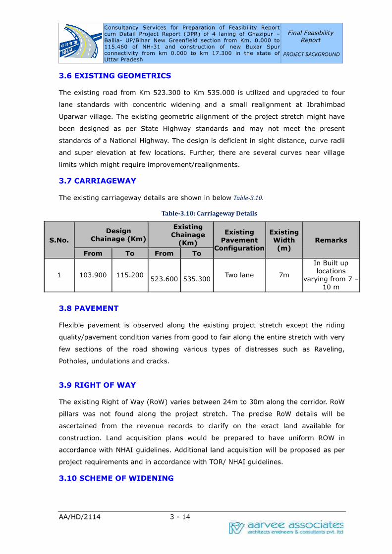
Consultancy Services for Preparation of Feasibility Report cum Detail Project Report (DPR) of 4 laning of Ghazipur –Ballia- UP/Bihar New Greenfield section from Km. 0.000 to 115.460 of NH-31 and construction of new Buxar Spur connectivity from km 0.000 to km 17.300 in the state of Uttar Pradesh
Final Feasibility
Report
PROJECT BACKGROUND
AA/HD/2114 3 - 14
3.6 EXISTING GEOMETRICS
The existing road from Km 523.300 to Km 535.000 is utilized and upgraded to four
lane standards with concentric widening and a small realignment at Ibrahimbad
Uparwar village. The existing geometric alignment of the project stretch might have
been designed as per State Highway standards and may not meet the present
standards of a National Highway. The design is deficient in sight distance, curve radii
and super elevation at few locations. Further, there are several curves near village
limits which might require improvement/realignments.
3.7 CARRIAGEWAY
The existing carriageway details are shown in below Table-3.10.
Table-3.10: Carriageway Details
S.No.
Design
Chainage (Km)
Existing
Chainage
(Km)
Existing
Pavement
Configuration
Existing
Width
(m)
Remarks
From To From To
1 103.900 115.200
523.600
535.300 Two lane 7m
In Built up
locations
varying from 7 – 10 m
3.8 PAVEMENT
Flexible pavement is observed along the existing project stretch except the riding
quality/pavement condition varies from good to fair along the entire stretch with very
few sections of the road showing various types of distresses such as Raveling,
Potholes, undulations and cracks.
3.9 RIGHT OF WAY
The existing Right of Way (RoW) varies between 24m to 30m along the corridor. RoW
pillars was not found along the project stretch. The precise RoW details will be
ascertained from the revenue records to clarify on the exact land available for
construction. Land acquisition plans would be prepared to have uniform ROW in
accordance with NHAI guidelines. Additional land acquisition will be proposed as per
project requirements and in accordance with TOR/ NHAI guidelines.
3.10 SCHEME OF WIDENING

Consultancy Services for Preparation of Feasibility Report cum Detail Project Report (DPR) of 4 laning of Ghazipur –Ballia- UP/Bihar New Greenfield section from Km. 0.000 to 115.460 of NH-31 and construction of new Buxar Spur connectivity from km 0.000 to km 17.300 in the state of Uttar Pradesh
Final Feasibility
Report
PROJECT BACKGROUND
AA/HD/2114 3 - 15
To accommodate Four lane with paved shoulders within proposed ROW, concentric
widening may be advisable along the existing alignment. However, final decision
regarding scheme of widening will be taken after finalization of geometric design
considering different parameters such as right of way availability, presence of utilities,
sensitive structures, economics and other considerations.
3.11 UTILITIES
The project road has utilities that come in the way of the proposed upgradation
scheme. The Electric lines are observed to be nearly at 5-10m from road edge and
crossing of High Transmission lines observed along the project corridor. In most of
the locations the electrical poles are within the Right of Way which should be
relocated. High Transmission towers and sub-stations are observed to be away from
Right of Way in the project stretch.
3.12 ADDITIONAL LAND ACQUISITION
Additional land acquisition may become necessary for the following, subject to the
improvement proposals made after a detailed study:
§ Bus bays and Truck lay-byes
§ Underpasses with Slip roads
§ Service Roads at Urban Locations
§ Proposed bypasses
§ Realignment sections
§ Toll Plazas
§ Rest areas
§ ROB's

Consultancy Services for Preparation of DPR for Two
laning with paved shoulder of Ghazipur –Ballia-
UP/Bihar Greenfield section from Km. 0.000 to
115.600 of NH-31 including Buxar Spur
(Length:17.300 Km) in the State of Uttar Pradesh
FINAL FEASIBILITY
REPORT
MAIN REPORT
METHODOLOGY
AA/HD/2114 4 - 1
4. METHODOLOGY ADOPTED
4.1 GENERAL APPROACH
The Consultants will collect the available data and information relevant for the Study.
The data and documents of major interest will include, but not be limited to, the
following:
i. Climate
ii. Road inventory
iii. Road condition, year of original construction, year and type of major
maintenance/rehabilitation works
iv. Condition of bridges and cross-drainage structures
v. Sub-surface and Geo-technical data for existing bridges
vi. Hydrological data, drawings and details of existing bridges
vii. Existing geological maps, catchment area maps, contour plans etc. for the
project area
viii. Condition of existing riverbank / protection works, if any
ix. Details of sanctioned/on-going works on the stretch sanctioned by MoRT&H/ other
agencies
x. Survey and evaluation of locally available construction materials
xi. Historical data on classified traffic volume (preferably for 5 years or more)
xii. Origin-destination and commodity movement characteristics; if available
xiii. Speed and delay characteristics, if available
xiv. Commodity-wise traffic volume; if available
xv. Accident statistics
xvi. Vehicle loading behaviour (axle load spectrum), if available
xvii. Type and location of existing utility services (e.g. Fibre Optical Cable, O/H and
U/G Electric, Telephone line, Water mains, Sewer, Trees etc.)
xviii. Environmental setting and social baseline of the project.
The detailed methodology of the surveys, investigations, data collection, analysis,
preparation of reports, designs and drawings etc. shall be in line with the indicative

Consultancy Services for Preparation of DPR for Two
laning with paved shoulder of Ghazipur –Ballia-
UP/Bihar Greenfield section from Km. 0.000 to
115.600 of NH-31 including Buxar Spur
(Length:17.300 Km) in the State of Uttar Pradesh
FINAL FEASIBILITY
REPORT
MAIN REPORT
METHODOLOGY
AA/HD/2114 4 - 2
methodologies given in the Terms of Reference and a brief account of the same is
furnished in the following sections.
4.2 SURVEYS AND INVESTIGATIONS
4.2.1 Road & Structural Inventory Survey
Road inventory will be carried out for the existing roads in standard formats at every
500m interval along with the recording of condition of existing structures by the
expert team. Features like terrain, land-use, surfacing type and width, shoulder, sub-
grade, local soil type, curve details, intersectional details, retaining structures details,
location of water bodies, location of forest areas, height of embankment or depth of
cut, ROW, CD structures, road side arboriculture, existing utility services, Existing
Railway crossings, cross roads, structures, junctions and general drainage conditions
etc., will be recorded for every 500m distance. The road inventory will be referenced
to the existing km posts established along the roadside. The details would be utilized
to arrive at the preliminary assessment of the scope of design.
Inventory of all the structures (bridges, viaducts, ROBs/RUBs and other grade
separated structures, culverts etc.) will be carried out along the project road as per
the guidelines stipulated in the manual of IRC: SP:35-2015. The inventory of culverts
will be presented in a tabular form covering relevant physical and hydraulic
parameters.
4.2.2 Pavement Condition Survey
The visual condition survey data will be recorded at site. This includes information on
visible deficiencies and ongoing/ recent improvements. The condition survey
inventory will be conducted by adopting the following details:
·Cracking area as percentage of total surface area
· Pothole No./100m length and area as percentage of total surface area
· Ravelling area as percentage of total surface area
·Rutting was measured as three categories None (0-10mm)/ Moderate (10mm
20mm)/ Severe (>20mm)
· Patching as percentage of total surface area
· Pavement edge drop in mm
· Shoulder condition
· Embankment condition

Consultancy Services for Preparation of DPR for Two
laning with paved shoulder of Ghazipur –Ballia-
UP/Bihar Greenfield section from Km. 0.000 to
115.600 of NH-31 including Buxar Spur
(Length:17.300 Km) in the State of Uttar Pradesh
FINAL FEASIBILITY
REPORT
MAIN REPORT
METHODOLOGY
AA/HD/2114 4 - 3
4.2.3 Culvert Condition Survey
The condition survey of the existing Pipe, Slab and Arch Culverts on the project
corridor is mainly intended to assess hydraulic adequacy, structural condition and
durability. The aim of condition survey is to assess the condition of existing culverts
for their capacity to carry four lanes of traffic with or without widening. As a partial
component of condition survey, visual observations will be made keeping in view
above said aim. Various condition features of culverts will be recorded and presented
for each culvert. In addition to condition survey, other particulars like presence of
scour, flow direction, type of crossing (Straight/Skew), adequacy of water way,
purpose of culvert (balancing/ drainage) and proposed rehabilitation measures will
also be presented for all culverts.
4.2.4 Condition Survey for Bridges & ROB
The condition survey of the existing bridges and structures on the project corridor is
mainly intended to assess the following:
· Structural condition
· Durability aspects
The aim of condition survey is to assess the condition of existing bridges and
structures for their capacity to carry two lanes of traffic with or without widening. As
a partial component of condition survey visual observations were made keeping in
view the requirement of IRC: SP:35-2015 and IRC: SP:40-1993. As Per IRC: SP:40-
1993, the normally observed signs of distresses are listed below. The common
distress signals in RCC bridges are as follows:
· Cracking; cracks could be of different types and widths
· Scaling
· Spalling of concrete
· Leaching, Rust stains
· Delimitation, Deformation
· Holes in Deck Slab
Visual observations carried out during the condition survey will be made to find out
the above listed distresses. In addition to the superstructure, the substructure also
will be inspected to locate visual signs of settlement, tilting, cracking, decay,
corrosion, cavitation, abnormal scour and damage due to impact of floating bodies.

Consultancy Services for Preparation of DPR for Two
laning with paved shoulder of Ghazipur –Ballia-
UP/Bihar Greenfield section from Km. 0.000 to
115.600 of NH-31 including Buxar Spur
(Length:17.300 Km) in the State of Uttar Pradesh
FINAL FEASIBILITY
REPORT
MAIN REPORT
METHODOLOGY
AA/HD/2114 4 - 4
4.2.5 Falling Weight Deflectometer Method
4.2.5.1 Introduction:
The following Falling Weight Deflectometer (FWD) procedure is adopted to evaluate
the strengthening requirements of existing flexible pavements.
4.2.5.2 Accessories for FWD Test:
➢ Six to Nine velocity transducers (geophones) are adequate.
➢ Falling Weight Deflectometer apparatus
➢ KGP Backcalcualtion Software
4.2.5.3 Theory:
Falling Weight Deflectometer (FWD) is an impulse-loading device in which a transient
load is applied and deflected shape of Pavement is measured using Displacement
Sensors to ascertain the structural strength of the pavement and to determine the
thickness of overlay required for sustaining the projected traffic load.
Falling Weight Deflectometer
Based on the data collected from condition survey, the road length shall be classified
into sections of uniform performance. Identification of sections of “good, fair and
poor” performance may have made separately for each lane and shoulders separately.
The length of each uniform section is kept at a minimum of 1 km except in the case
of localized failures section length restricted to 0.3 km. Sub grade samples for FWD
purpose, also shall be collected at each of FWD observation location. The entire
project shall be analyzed for the calculation of Modulus of Elasticity of existing
Pavement using KGPBACK software.
4.2.5.4 Interval of test points and Marking for FWD Test:
The interval at which data should be collected will depend on the length of uniform
section. Different measurement schemes can be adopted. These include
(i). measurement along the most distressed wheel path of the carriageway
(ii). measurement along inner as well as outer wheel paths of all the lanes
(iii). measurement along both wheel paths of only the outer most lanes and
(iv). measurement along the more distressed wheel paths of each of the lanes.
The guidelines given in below mentioned table are recommended for selection of
deflection measurement schemes for different types of carriageways.

Consultancy Services for Preparation of DPR for Two
laning with paved shoulder of Ghazipur –Ballia-
UP/Bihar Greenfield section from Km. 0.000 to
115.600 of NH-31 including Buxar Spur
(Length:17.300 Km) in the State of Uttar Pradesh
FINAL FEASIBILITY
REPORT
MAIN REPORT
METHODOLOGY
AA/HD/2114 4 - 5
Table-4.1: Guidelines for Selection of Deflection Measurement Scheme
Type of Carriage
way
Recommended
Measurement
Scheme
Maximum Spacing (m) for test
points along selected wheel path
of different classifications
Poor Fair Good
Two-lane Two-way
Single Carriageway
Measure along both
outer wheel paths 60 130 500
4.2.5.5 Marking of FWD Test Points:
1. Mark a point at a distance of 1 m from outer edge of outer lane for two-lane
two- way carriage way
2. Repeat the process of marking points at an interval of (Based upon the
Determined spacing for each uniform performance section).
4.2.5.6 Procedure:
1. The following steps may be followed for measuring the deflections at each test
point.
2. Mark the test point on the Pavement as the interval obtained from the Pavement
condition survey.
3. Center the load plate of the duly calibrated FWD over the test point.
4. Lower the load plate onto the pavement. There should be no standing water on the
pavement surface. The loading plate should be in proper contact with pavement
surface. If a non-segmental plate is used the presence of rutting at test location
Should be noted if it affects the contact between plate and pavement surface. The
longitudinal and transverse slope of the pavement should not exceed 10 % at the test
location for accurate measurement of deflection.
5. Lower the frame holding the displacement transducers (geophones) so that the
transducers are in contact with pavement surface.
6. Raise the mass to a predetermined height for producing a target load of 40 KN.
7. Drop one seating load. Load and deflection data for seating load drop need not be
recorded.
Consultancy Services for Preparation of DPR for Two
laning with paved shoulder of Ghazipur –Ballia-
UP/Bihar Greenfield section from Km. 0.000 to
115.600 of NH-31 including Buxar Spur
(Length:17.300 Km) in the State of Uttar Pradesh
FINAL FEASIBILITY
REPORT
MAIN REPORT
METHODOLOGY
AA/HD/2114 4 - 6
8. Raise the mass and drop. Record load and deflection data into the computer
through data acquisition system. While peak load and peak deflections at different
selected radial positions must be recorded, complete time history of load and
deflections can be stored for each load drop if feasible.
9. Repeat the above step at least two more times.
10. If the measured deflection is less than 10 μm, the tested repeated by changing
the peak load.
11. Raise the geophone frame and load plate and move to the next test point.
12. Record air temperature at half hourly interval. Record pavement surface
temperature if non-contact temperature sensors are available.
13. Deflection measurements should not be made when the pavement temperature is
more than 450C. In colder areas and areas of altitude greater than 1000 m where
the average daily temperature is less than 200C for more than 4 months in a year,
the standard pavement temperature of 35 0C will not apply. In such cases the
ambient temperature is greater than 200C. No temperature is applied for back
calculated moduli of bituminous layers.
4.2.5.7 Corrections and Analysis:
Following analysis & corrections are to be applied to the FWD test observations during
its analysis:
1. The deflections obtained from the above procedure, different pavement layer
thicknesses, Standard Load, No. of deflections measuring sensors used in test & their
radial distance, poisson’s ratio of different layers & assumed moduli ranges for
different pavement layers are used as inputs for back calculation of Elastic modulus
using KGP Back calculation software.
2. The pavement temperature and seasonal variation in climate influence the
deflections measured by the Falling Weight Deflectometer.
3. Measure Pavement surface layer temperature at half-hourly intervals by drilling
holes of 40 mm depth into the pavement surface layer. Fill the hole with a drop of
glycerol. Insert the thermometer into the hole and measure the temperature after
three minutes. Correction shall be applied to the deflection measured in accordance
with the procedure described in IRC: 115-2014, if the observed temperature is
different from 350C.

Consultancy Services for Preparation of DPR for Two
laning with paved shoulder of Ghazipur –Ballia-
UP/Bihar Greenfield section from Km. 0.000 to
115.600 of NH-31 including Buxar Spur
(Length:17.300 Km) in the State of Uttar Pradesh
FINAL FEASIBILITY
REPORT
MAIN REPORT
METHODOLOGY
AA/HD/2114 4 - 7
4. The back calculated modulus obtained from of bituminous layer obtained from
deflection survey conducted at a temperature "T2" °C can be corrected to estimate
the modulus corresponding to a temperature of "T1" °C using below mentioned
equation
ET1=λET2 where,
λ, temperature correction factor, is given as
λ=
ET1= back-calculated modulus (Mpa) at temperature T1 (0C)
ET2=back-calculated modulus (Mpa) at temperature T2 (0C)
5. Seasonal correction is to be applied using the relationships developed for different
seasons (Winter/ summer/ monsoon) given in the Clause 6.5.2 of IRC: 115-2014.
Seasonal Corrections factors are given by equations for subgrade,
Esub mon = 3.351 * (Esub_win)0.7688 – 28.9
Esub mon = 0.8554 * (Esub_sum)0.7688 – 8.461
Seasonal Correction factors for Granular Layers are given by equations,
Egranu_mon= - 0.0003 * (Egranu_Sum) + 0.9584* (Egranu_Sum) – 32.989
Egranu_mon = 10.5523 * (Egranu_win)0.624-113.857; Where,
Esub_win/ Egranu_win = Subgrade/Granular layer Modulus in Winter (Mpa)
Esub_sum/Egranu_Sum = Subgrade/Granular layer Modulus in Summer (Mpa)
Esub_mon/Egranu_mon = Subgrade/Granular layer Modulus in Monsoon (Mpa)
4.2.6 Roughness Survey
The objective of roughness survey is to determine the riding quality of the existing
pavement which shall form the basis for identifying the homogeneous sections and
calculating the vehicle operating cost of the traffic plying on the project road so that
the feasibility of improvement can be ascertained.
Roughness survey of existing pavement will be carried out along the outer wheel
paths in each direction using bump integrator. The instrument will be fixed and
operated in accordance with the manufacturer’s instructions. The reading shown by
the display unit which gives the roughness in cm/km will also be manually recorded
for each kilometer. The results of the survey will be expressed in terms of BI and IRI.
Based on the data, homogenous segments with respect to surface roughness will be
determined using cumulative difference approach.

Consultancy Services for Preparation of DPR for Two
laning with paved shoulder of Ghazipur –Ballia-
UP/Bihar Greenfield section from Km. 0.000 to
115.600 of NH-31 including Buxar Spur
(Length:17.300 Km) in the State of Uttar Pradesh
FINAL FEASIBILITY
REPORT
MAIN REPORT
METHODOLOGY
AA/HD/2114 4 - 8
The roughness values, which represent pavement functional performance, are
essentially intended for use in economic analysis, and for checking against the
pavement designs proposed for different sections.
4.2.7 Traffic Surveys
Road network has been studied during the reconnaissance. As per the details of TOR,
mid-block sections were identified for carrying out traffic surveys and all the detailed
locations of traffic surveys will be finalized in consultation with NHAI.
The following surveys are proposed in conformance with the TOR.
1. Classified Traffic Volume Count Surveys
2. Origin and Destination and Commodity Movement Surveys
3. Axle Load Surveys
4. Intersection Volume Count Surveys – At all major intersections/ selected
locations.
5. Pedestrian/ Animal Cross Traffic Survey
6. Speed-Delay Study
Actual survey locations will be approved by the Authority (NHAI) before
commencement of the surveys.
Consultant proposes to carry out Classified Traffic Volume Count surveys (CTVC) at
the approved locations for continuous 7 days with two teams for recording all vehicles
passing the selected location of section in both directions. CTVC will be carried out by
using Automatic Traffic Counter and Classifier (ATCC) System. ATCC System such as
Pneumatic Tube Detector, Inductive Detector Loop, Video Image Detection and
Infrared Sensor or equivalent technologies will be adopted. The survey data will be
analysed for calculating ADT and AADT after applying seasonal correction factors.
Origin-Destination and commodity movement survey by Road Side Interview method
will be conducted at approved locations for 24 hours by stopping the vehicles and
interviewing truck drivers with the assistance of local police on a random sampling
basis. Trained personnel will be engaged for collecting information as per
questionnaire and compile the same.
To arrive at the contribution of single trip, return trip and monthly trips of vehicles in
toll revenue analysis, Number plate method OD survey will be conducted for 24 hours
Consultancy Services for Preparation of DPR for Two
laning with paved shoulder of Ghazipur –Ballia-
UP/Bihar Greenfield section from Km. 0.000 to
115.600 of NH-31 including Buxar Spur
(Length:17.300 Km) in the State of Uttar Pradesh
FINAL FEASIBILITY
REPORT
MAIN REPORT
METHODOLOGY
AA/HD/2114 4 - 9
at same locations of RSI survey. Registered number of all vehicles surveyed will be
noted including state name.
Turning Movement Survey will be conducted at all approved location for 24 hours. At
each entry arm of the intersection, one enumerator will be positioned for recording
each type of turning movement (i.e. left turning, right turning and straight moving)
strategically so that they will be able to observe the turning movement of each
vehicle and record appropriately. The survey will be conducted for a continuous
period of 24 hours in accordance with IRC: SP: 41 – 1994.
Pedestrian/Animal crossing survey will be carried out at major crossings and as per
the critical locations identified and discussed with the client. The survey will be done
by trained enumerators who count the number of pedestrians/ animals crossing the
road using hand tally mark system. Pedestrian count surveys will be performed near
educational institutions, markets, bus stops and similar high – pedestrian activity
areas whereas animal count surveys will be conducted at critical locations of highway
where animals cross the road. The output of the survey will be useful in proposing
the number and locations of pedestrian and animal underpasses along the project
road.
The data obtained from the Origin-Destination survey, speed-delay survey and other
surveys will be analysed to assess the requirements for short term and long term
requirements of truck terminals at suitable locations along the project stretch.
Survey for Wayside Amenities will include an inventory of all the existing roadside
facilities like fuel-filling stations, tyre /mechanical repair shops, Dhabas (way-side
restaurant) /restaurants/hotels, motels and lay byes etc. The possibility of retaining
the existing facilities, if any, namely, bus bays, truck lay-byes, kerbs, foot paths,
drains, service roads shall be studied in accordance with the design standards given
in the Two lane manual (IRC: SP:73-2018). Primary objective is to accommodate all
the new facilities in the existing right of way. Any deviations shall be recorded and
produced for approval of the competent authority.
4.2.8 Axle Load Surveys
Axle Load survey will be conducted at approved locations of the project stretch along
with O-D surveys. Different types of trucks will be selected on random sampling basis
and will be weighed to estimate the loading pattern. The ratio of loaded trucks to that
of empty trucks will be ascertained from the results of the Origin-Destination survey
conducted at the same location.
Consultancy Services for Preparation of DPR for Two
laning with paved shoulder of Ghazipur –Ballia-
UP/Bihar Greenfield section from Km. 0.000 to
115.600 of NH-31 including Buxar Spur
(Length:17.300 Km) in the State of Uttar Pradesh
FINAL FEASIBILITY
REPORT
MAIN REPORT
METHODOLOGY
AA/HD/2114 4 - 10
4.3 SUBGRADE INVESTIGATIONS
Basic objective of subgrade investigation is to determine the suitability of existing
road sub grade to support the pavement in widening portion. The strength and the
level of compaction of the existing sub grade will be determined by conducting
various tests in the field and laboratory.
The investigations for subgrade characteristics are intended for design and
strengthening requirements such as overlay for the existing pavement, and for
designing new pavement for widening portions where the subgrade level of new
pavement falls within the existing roadway.
For the above purpose, test pits of size 1.0 m x 1.0 m will be made up-to sub-grade
level at a frequency of 2 pits for every 5.0km interval along the paved edge of the
carriageway. The pits will be excavated in such a way that each pit will be located
alternately on LHS & RHS @ 2.5km intervals or for each soil type, whichever is more.
Sub grade sample of about 50 kg will be collected in these locations at the interface
of carriageway and the shoulder and following activities shall be carried out:
· The pavement layers will be measured and logged.
· The field moisture content will be determined by rapid moisture meter at site or by
oven dry method after bringing the samples to lab.
· The field density will be determined by core cutter method.
· Grain size analysis and Atterberg limits will be determined in the laboratory for
classification of soils as per IS 2720 Part 5.
· The Maximum Dry Density and Optimum Moisture Content will be determined as per
Modified AASTHO Compaction T 180
· CBR testing will be carried out on the specimens compacted at NMC at 3 different
energy levels, on specimens soaked for 4 days as per AASHTO T 193.
· Field CBR using DCPT at each test pit as per TRRL Research Report LR 673
· Free Swell Index of the samples will be determined.
4.4 MATERIAL INVESTIGATIONS
The material investigations for road construction will be carried out to identify the
source of construction materials like borrow soil, coarse and fine aggregates and
water, including the information regarding the accessibility to source and lead from
the project stretch. This is one of the most important activity for stable, economic
and successful implementation of the project within the stipulated time.
Consultancy Services for Preparation of DPR for Two
laning with paved shoulder of Ghazipur –Ballia-
UP/Bihar Greenfield section from Km. 0.000 to
115.600 of NH-31 including Buxar Spur
(Length:17.300 Km) in the State of Uttar Pradesh
FINAL FEASIBILITY
REPORT
MAIN REPORT
METHODOLOGY
AA/HD/2114 4 - 11
4.4.1 Objectives
Material investigation shall be carried out based on the information collected from
local PWD, locals interview, information from local panchayat and zilla parishad
offices and from material suppliers.
The investigation on material sources will be carried out to fulfill the following basic
objectives.
· Source location indicating place, chainage, approximate quantity of material
available and lead distances from the project road to source.
·Ownership of land/quarry, whether Government or private.
· Visual classification and suitability for the construction.
A visit to the quarries and surrounding areas will be made and samples of soil, coarse
and fine aggregates will be collected separately for visual observation and necessary
laboratory tests.
During the process of investigation, due consideration will be taken to see that locally
available materials are used for reducing the cost of construction. A mass haul
diagram indicating locations, routes and lead will be prepared.
Following tests will be conducted on the samples.
On Borrow soils:
▪ Grain size Analysis
▪ Atterberg's Limits
▪ Modified Proctor test for OMC & MDD
▪ Unsoaked and Soaked CBR
▪ Free Swell Index (FSI)
On Coarse Aggregate:
▪ Specific gravity and water absorption.
▪ Aggregate Impact Value (AIV).
On Fine Aggregate:
▪ Grain size analysis for Zone Identification.
▪ Specific gravity and Water absorption.
Consultancy Services for Preparation of DPR for Two
laning with paved shoulder of Ghazipur –Ballia-
UP/Bihar Greenfield section from Km. 0.000 to
115.600 of NH-31 including Buxar Spur
(Length:17.300 Km) in the State of Uttar Pradesh
FINAL FEASIBILITY
REPORT
MAIN REPORT
METHODOLOGY
AA/HD/2114 4 - 12
4.5 SUB-SOIL INVESTIGATIONS
Geo-technical investigations will be carried out with a view to furnish the Detailed
Technical Information of the nature of sub-soil strata for foundation design and
assessment of stability of high embankments.
Basically, subsoil investigations will be carried out for new structures or the structures
to be reconstructed on a sample basis.
Objectives and Scope of Work:
a) Objectives
The objectives of Sub-Soil Investigation are to evaluate the following:
· To ascertain the sub-soil strata.
· To study standing Ground Water table.
· To study the physical and engineering properties of soil strata.
· To evaluate allowable safe bearing capacity of soils to design foundations.
· To recommend type and depth of foundation.
· To recommend improvements to the weak soil strata if any.
· To evaluate the stability of high embankment.
b) Scope of the Work
Sub-soil investigations are proposed for all major structures. Borehole frequency as
per length of bridge is tabulated below:
S.No. Description Location of Boring
1 Overall length = 6 – 30 m One abutment location
2 Overall length = 30 – 60 m
One abutment location and at least one
intermediate location between abutments
for structures having more than one span.
3 Overall length > 60 m Each abutment and each pier locations.
4.5.1 Field Investigations
· Boring of 150-mm dia holes in all kinds of soils up to 30.0 m or up to refusal strata
(N>100 Blows for 30 cms penetration) using Auger equipment.
Consultancy Services for Preparation of DPR for Two
laning with paved shoulder of Ghazipur –Ballia-
UP/Bihar Greenfield section from Km. 0.000 to
115.600 of NH-31 including Buxar Spur
(Length:17.300 Km) in the State of Uttar Pradesh
FINAL FEASIBILITY
REPORT
MAIN REPORT
METHODOLOGY
AA/HD/2114 4 - 13
· Boring of 150-mm dia holes in all kinds of soils up to 15.0 m or 3.0 m in Hard Rock
whichever encounter early using Calyx operated Rotary Boring Rig with Wash
Boring Method.
· Conducting field-tests such as Standard Penetration Tests (SPT) as per IS 2131-
1981 at various depths in the Boreholes.
· Collecting Disturbed/Representative samples (DS/RS) during drilling and also during
SPT Tests. Disturbed samples using the split spoon sampler and UDS(Undisturbed)
samples using 100 mm thin walled Shelby tubes shall be collected. The samples
recovered will be packed in polythene bags, labeled and sent to the laboratory for
testing.
· During field investigations the standing Water Table levels will be studied and
recorded in the Borehole log.
4.5.2 Laboratory Testing
The scope of Laboratory Testing is as follows:
· For Soil Samples Obtained from SPT:
· Grain Size Analysis as per IS 2720 part 4.
· For Soil samples Obtained from UDS tube:
· Specific Gravity as per IS 2720- part 3-Section 1 and IS 2720 – part 3.
· Grain Size Analysis as per IS 2720 part 4.
· Atterberg's Limits as per IS 2720 part 5, IS 2720 part 2.
· Determination of natural moisture content as per IS 2720 part 2.
· Determination of field density as per IS 2720.
· Determination of Tri-axial Shear Strength tests by UU method as per IS 2720-part
10.
· For Rock Core Samples Obtained from Double tube core barrel:
· Uniaxial Compressive strength test as per IS: 9143
· Point load index as per IS: 8764
· Specific gravity, Water absorption & Porosity as per IS: 1124
4.6 TOPOGRAPHIC SURVEYS
The basic objective of the topographic survey is to collect the essential ground
features along the alignment and develop Digital Terrain Model (DTM). The equipment
used for this purpose is UAV (Unmanned Aerial Vehicle). This data forms the basis for
Consultancy Services for Preparation of DPR for Two
laning with paved shoulder of Ghazipur –Ballia-
UP/Bihar Greenfield section from Km. 0.000 to
115.600 of NH-31 including Buxar Spur
(Length:17.300 Km) in the State of Uttar Pradesh
FINAL FEASIBILITY
REPORT
MAIN REPORT
METHODOLOGY
AA/HD/2114 4 - 14
all the designs to be carried out, so as to take care of design requirements of new
carriageway, possible improvements in highway geometrics, identifying areas of
restriction and their remedies and relocation of utilities. The data collected will result
in the final design and for the computation of earthwork and other quantities required.
4.7 ENVIRONMENTAL IMPACT ASSESSMENT
Inception Report reviews the proposed work plan related to environmental aspects
and makes desirable modifications keeping in view the requirement of the Project
Road. The methodology for carrying out the study and specifications to be adopted in
this project are as follows:
4.7.1 Objectives
The main objective of the study is to conduct Rapid Environmental Impact
Assessment for the proposed Two/Four laning of GHAZIPUR-BALLIA–UP/BIHAR
STRETCH IN THE STATE OF UTTAR PRADESH.
4.7.2 Specification/Guidelines
The Environmental Impact Assessment study shall be carried out as per the
requirement of the Ministry of Environment & Forests (MoEF), Environmental
Guidelines for Roads, Rail and Highways Project, World Bank Operational Directive
and Operational Policies and IRC Guidelines for Environmental Impact Assessment
(EIA) of Highway Projects.
4.7.3 Methodology
The methodology to be adopted for the EIA study is shown below as flow chart and
further detailed in the following paragraphs.
4.7.4 Data Collection
The data on different attributes of physical resources, ecological resources, quality of
life values and human use values will be collected both from secondary & primary
sources.
4.7.5 Secondary Data Collection
The published literature will be collected from different Govt. Organizations/
Institutions, NGOs etc. to assess the baseline environment. The aim will be to collect
secondary information to the maximum extent possible.
4.7.6 Flora & Fauna

Consultancy Services for Preparation of DPR for Two
laning with paved shoulder of Ghazipur –Ballia-
UP/Bihar Greenfield section from Km. 0.000 to
115.600 of NH-31 including Buxar Spur
(Length:17.300 Km) in the State of Uttar Pradesh
FINAL FEASIBILITY
REPORT
MAIN REPORT
METHODOLOGY
AA/HD/2114 4 - 15
The information on flora like roadside plantation and fauna within the study area will
be collected from the Forest Dept., Botanical survey of India, Zoological survey of
India and through field verification. The information on wetland, grassland and other
ecologically important areas will also be collected.
4.7.7 Geology and Soil
The information on geology and soil within the study area will be collected from
Geological Survey of India.
4.7.8 Ground Water
The information on ground water i.e. depth of water table, yield etc. will be collected
from the Central Ground Water Authority, Central Water Commission, Survey of India
District Planning Maps etc.
4.7.9 Land use
The land use pattern within the study area in general and adjacent to the road in
particular will be established through collection of maps/documents from Survey of
India, Agriculture Department and Forest Dept. and through field verification.
4.7.10 Climate & Meteorology
The climate and meteorology data i.e. temperature, wind speed, wind direction,
rainfall, relative humidity, cloud cover and cyclone will be collected from
Meteorological Department.
4.7.11 Archaeological/Historical Site
The information on archaeological and historical places, if any, will be collected from
Archaeological Survey of India, Dept. of Tourism etc.
4.7.12 Air and Water Quality
Available information on ambient air quality and water quality will be collected from
Central Pollution Control Board (CPCB), Uttar Pradesh State Pollution Control Board,
Reputed Research Laboratory and Universities.
4.7.13 Primary Data Collection
a. Field Reconnaissance Survey
Preliminary field survey will be undertaken to identify the critical issues and to
examine different alignment options. The following information/documents will be
collected during reconnaissance survey.
Consultancy Services for Preparation of DPR for Two
laning with paved shoulder of Ghazipur –Ballia-
UP/Bihar Greenfield section from Km. 0.000 to
115.600 of NH-31 including Buxar Spur
(Length:17.300 Km) in the State of Uttar Pradesh
FINAL FEASIBILITY
REPORT
MAIN REPORT
METHODOLOGY
AA/HD/2114 4 - 16
· Information on location, type and sensitivity of all critical natural habitats such as
reserved/protected forest, wildlife sanctuaries, wild life migratory route across the
road, wet lands, grass land, sacred groves etc.
· Information on location of schools, hospitals, religious, archaeological and historical
places.
· Identification of air quality, noise level, water quality and soil quality monitoring
stations as per BIS, CPCB, IRC and MoEF Guidelines.
· Details of roadside plantation i.e. Chainage-wise and girth size wise no. of trees.
· Information on industries i.e. pollution status, discharge point/disposal site of
effluent/solid waste along the corridor, if any.
· Information on flora and fauna within the study corridor will be collected and
verified in the field.
b. Environmental Impact Assessment
It will include the following:
· The collected primary and secondary data will be compiled to assess the existing
baseline environmental condition.
· Prediction of impact
· The assessment of impact during construction and operation phase
·Suggestion of mitigation measures
4.8 SOCIAL IMPACT ASSESSMENT
The social impact assessment will be an attempt to ascertain negative or positive
impact of the road on the existing social and cultural condition of people including
inter and intra group dynamics, relationships, institutions, values, systems and
potential changes. SIA contains two components:
· Study of impact due to acquisition of land and other property adjacent to the
existing Right-of-Way (ROW) as part of widening of existing road;
· Study of impact due to realignment and bypasses, which leaves the ROW zone and
follow a different route.
The main elements of SIA are:
· Social impact screening and assessment;
·Baseline social-economic surveys and census of the potentially affected population;
The social impact assessment and analysis also covers:
Consultancy Services for Preparation of DPR for Two
laning with paved shoulder of Ghazipur –Ballia-
UP/Bihar Greenfield section from Km. 0.000 to
115.600 of NH-31 including Buxar Spur
(Length:17.300 Km) in the State of Uttar Pradesh
FINAL FEASIBILITY
REPORT
MAIN REPORT
METHODOLOGY
AA/HD/2114 4 - 17
· Suggestion and cost-effective mitigation measures for adverse social impacts and
rehabilitation of PAPs
·Conflict resolution mechanisms
· Identification and determination of significant social, cultural and economic issues
requiring further studies and analysis
· Identification and appraisal of significant social risks to the project during its
construction and operation and
· Estimation of quality of data, key data gaps and level of uncertainty of social impact
prediction
Baseline Socio-Economic Survey:
•For the preparation of a draft entitlement framework for compensation of land and
other assets which may need to be acquired for the project, following studies are
proposed to be made on representative sample of road stretches
· Social, economic, cultural and demographic characteristics of potential project
affected population and families
· Legal status of the project affected households and assets
· Identification of cultural properties, common properties and public assets being
used by the project affected population
· Land usage and inventory of assets on the ROW and its legal boundary
·Assessment of various kinds of losses likely to be experienced by the PAPs/PAFs
· Valuation of assets and the compensation and
· Rehabilitation strategies, resettlement options and assessment of alternative sites
4.8.1 Methodology
The methodology for baseline socio-economic survey will be both qualitative and
quantitative. Household interview schedules will be administered for collecting data
from the sampled household through personal interview.
The surveyed data will be analyzed for assessing the impact of the loss of assets and
resources on various categories of people and communities, irrespective of their legal
rights under existing laws. The analysis also will cover customary-cultural practices,
social capital and gender dimensions of access and use of resources.
Consultancy Services for Preparation of DPR for Two
laning with paved shoulder of Ghazipur –Ballia-
UP/Bihar Greenfield section from Km. 0.000 to
115.600 of NH-31 including Buxar Spur
(Length:17.300 Km) in the State of Uttar Pradesh
FINAL FEASIBILITY
REPORT
MAIN REPORT
METHODOLOGY
AA/HD/2114 4 - 18
4.9 ESTIMATION OF QUANTITIES AND PROJECT COSTS
Estimation of quantities and tentative costs will be prepared for the project and
finalized in consultation with NHAI as per the requirements of Terms of Reference.
All the involved improvement works will be itemized using standard nomenclature for
work items compatible with application of the MOST Specification for Road and Bridge
Works. Quantities for each item will be worked out from the detailed drawings, and
these will be computer-generated.
The Unit rates of all items of construction work will be analyzed as per the guidelines
given in Standard Data Book of MORT&H. The basic rates of materials are obtained
from the latest edition of Standard Schedule of Rates (SSR: 2016-17). Market rates
are adopted for items for which, the rates are not available in SSR. The location of
material quarries like gravel, sand, crushed aggregate will be obtained from the
material investigations. The leads of different materials are obtained by drawing the
lead chart. In respect of hourly hire and operating cost of various road construction
machinery and equipment, rates given in MORT&H Standard Data Book and SSR are
considered. For machinery and equipment not covered by these two, the prevailing
market rates are considered. The labour rates are taken from SSR. Unit rates so
arrived have been compared with reference to the rates of similar items in the
ongoing projects under NHAI and are found comparable.
4.10 ECONOMIC ANALYSIS
The Economic analysis will be carried out and the benefit cost streams will be worked
out for the project corridor by using HDM-IV. The Economic analysis will cover but not
limited to the following aspects:
· Assesses the capacity of existing roads if any, and the effect of capacity constraints
on vehicle operating costs (VOC);
· Calculation of VOCs for the existing road situation;
· Quantification of all economic benefits, including those from reduced congestion,
travel distance, road maintenance cost savings, increased time saving and reduced
incidence of road accidents; and
· Assessment of the maintenance intervention required for contracts.
· Quantification of benefits if the project is maintained under traditional PPP route and
traditional procurement route using HDM-IV modeling.

Consultancy Services for Preparation of DPR for Two
laning with paved shoulder of Ghazipur –Ballia-
UP/Bihar Greenfield section from Km. 0.000 to
115.600 of NH-31 including Buxar Spur
(Length:17.300 Km) in the State of Uttar Pradesh
FINAL FEASIBILITY
REPORT
MAIN REPORT
METHODOLOGY
AA/HD/2114 4 - 19
· Estimation of the Economic Internal Rate of Return (EIRR) for the project over a
20/30-year period. Also, identification of the tradable and non-tradable components
of projects costs and the border price value of the tradable components.
The economic analysis will be taken into account for all ongoing and future road and
transport infrastructure projects and future development plans in the Corridor of
Influence (CoI). The economic analysis will also take into account for all other
developments – industrial, tourism etc. planned in the CoI.
4.11 FINANCIAL ANALYSIS
The financial analysis aspect is involved, when the work is to be taken up on BOT
basis. The objective and methodology of Financial Analysis is described hereinafter.
The main objective of financial analysis is to find the likely returns to the investor.
This covers aspects like financing through debt and equity, loan repayment, debt
servicing, taxation, depreciation etc. The viability of the project is evaluated on the
basis of cash flow analysis, where both costs and revenue have been indexed to take
in to account the inflation.
Financial viability analysis will be done on the basis of financial model developed by
the Consultant. The model projects the key financial statements of the investor over
the concession period. Concession period of 15/20/30 years will be considered, and
the growth rate of the traffic may be assumed at 5% per annum.
All investment costs and capital expenses will be identified in the year in which they
are deemed to occur. A 5% inflation rate per annum will be applied to all cost and
revenue items.
The construction is to be financed through both equity and loan. A Debt-Equity ratio
of 70:30 would be appropriate as most financial institutions hesitate to lend at higher
leverages and also in view of the fact that a high gearing invariably subjects projects
to substantial financial risks. A 15-year period is proposed for construction loan
repayment. The rate of interest considered will be in line with the prevailing lending
rates of financial institutions. The actual financial parameters to be adopted in the
analysis will be reviewed after gathering additional data from published sources and
finalized in consultation with NHAI as per the TOR.
Depreciation of capital items will be calculated by using two methods, viz. the Written
Down Value (WDV) Method and the Straight-Line Method (SLM). The WDV method
favors income shielding and is, therefore, used only to calculate taxes payable by the
Consultancy Services for Preparation of DPR for Two
laning with paved shoulder of Ghazipur –Ballia-
UP/Bihar Greenfield section from Km. 0.000 to
115.600 of NH-31 including Buxar Spur
(Length:17.300 Km) in the State of Uttar Pradesh
FINAL FEASIBILITY
REPORT
MAIN REPORT
METHODOLOGY
AA/HD/2114 4 - 20
concessionaire. The rate permitted for a toll road enterprise, viz. 10% will be used in
the analysis.
Tax holiday (100% tax exemption on profits and gains), as per Section 80-IA of
Income Tax Act, will be available from such business for 10 consecutive assessment
years out of 20 years beginning with the year in which undertaking or the enterprise
develops and begins to operate any infrastructure facility or develops an industrial
park or special economic zone or generates power or commences transmission or
distribution of power or undertakes substantial renovation or modernization. The
corporate tax rate adopted will be based on the latest Finance Bill.
The NPV and EIRR for the project will be calculated. It will undertake sensitivity
analysis by identifying the most critical factors and determine their impact on EIRR,
including varying project costs and benefits, implementation period, and combination
of these factors. Risk analysis will be conducted by considering the possible values for
key variables based on records and their occurrence probability.
Based on the above analysis consultant will give clear cut recommendation of the
preferred structuring of the Package - mode of implementation under PPP – BOT
(Toll)/ BOT (Annuity)/Hybrid Annuity mode/EPC mode or any other suitable model.
Consultancy Services for Preparation of Feasibility Report cum Detail Project Report (DPR) of 4 laning of Ghazipur –Ballia- UP/Bihar New Greenfield section from Km. 0.000 to
115.460 of NH-31 and construction of new Buxar Spur connectivity from km 0.000 to km 17.300 in the state of Uttar Pradesh
FINAL FEASIBILITY REPORT
MAIN REPORT
SOCIO ECONOMIC PROFILE
AA/HD/2114 5 - 1
5. SOCIO ECONOMIC PROFILE
5.1 OVERALL APPROACH
The districts through which the project road passes are considered to be the primary
project influence area. The existing highway of NH-31 passes through Ghazipur and
Ballia districts. Therefore, the influence area of the project corridor, for the purpose
of socio-economic analysis is considered with prime importance. The primary purpose
of Socio-economic analysis is to provide an overview of the state’s socioeconomic
setup and the relative status of the project influence area within the state. Data to be
considered include demographic aspects, macro-economic indicators and sectoral
production of agriculture and allied activities, manufacturing, mining and service
sectors including infrastructure. The profile provides the present scenario, the past
performance and the prospective growth of the economy, population and urbanization.
The profile depicts the spatial distribution of economic activities and provides basic
inputs for estimating future growth in Transport demand, on the basis of prospective
economic growth rates and transport demand elasticity. Secondary data available
with different state government departments have been collected and analysed for
preparation of socio-economic profile.
5.2 GENERAL FEATURES
The project passes through the state of Uttar Pradesh, situated in northern part of
India. It is the most populous state in India and 4th largest area wise. The state
covers an area of 243,290 square kilometres with a population of 199,581,477
according to 2011 census, which accounts for 16.16% of India. Uttar Pradesh has 75
districts, 18 revenue divisions, 14 municipal corporations, 165 municipalities, 52021
panchayats and 107452 villages.
As per 2011 census of India, the state had a population of 19,95,81,477 with a
population density of 820/square km. The total population growth in this decade was
20.23 percent while in previous decade it was 25.80 percent. Out of total population
of Uttar Pradesh, 22.27% of the population with 4,44,46,795 inhabitants live in urban
regions and 77.73% of population with 15,51,34,682 inhabitants live in rural areas.
There are 10,44,80,510 male and 9,53,31,831 female citizens. Children of age 0-6
constitutes 15.4% of the total population with 1,61,85,581 boys and 1,46,05,750
girls. Sex ratio of 898, less than the national average of 933 per 1000. Literacy rate
in Uttar Pradesh for Urban regions was 75.14 percent in which males were 80.45%
literate while female literacy stood at 60.96%. Gautam Buddha Nagar is the district
with highest literacy rate of 80.12% and Bahraich district is the least educated
district with a literacy rate of 46.48%.
Consultancy Services for Preparation of Feasibility Report cum Detail Project Report (DPR) of 4 laning of Ghazipur –Ballia- UP/Bihar New Greenfield section from Km. 0.000 to
115.460 of NH-31 and construction of new Buxar Spur connectivity from km 0.000 to km 17.300 in the state of Uttar Pradesh
FINAL FEASIBILITY REPORT
MAIN REPORT
SOCIO ECONOMIC PROFILE
AA/HD/2114 5 - 2
5.3 DELINEATION OF PROJECT INFLUENCE AREA
The project road runs entirely through the districts of Ghazipur and Ballia. The
project stretch of 130 km connects major towns of the districts like Ghazipur,
Mohammadabad, Ballia and Bariya. Located in the eastern part of Uttar Pradesh, the
project road mostly carries a mix of intra-state and inter-state traffic from the
surrounding states like Bihar.
5.3.1 Ghazipur District
According to the 2011 census Ghazipur district has a population of 3,620,268 roughly
equal to the nation of Lithuania or the US state of Oklahoma. Its headquarters are
loacted in Ghazipur City. This gives it a ranking of 79th in India (out of a total of 640).
Out of the total population males are 1,856,584 and females are 1,766,143. The area
of the district is 3,378 sq. km and it constitute 1.82% of the population of Uttar
Pradesh. It has a population density of 1,072 inhabitants per square kilometer
(2,780/sq. km). Its population growth rate over the decade 2001-2011 was 19.26%.
Ghazipur has a sex ratio of 951 females for every 1000 males and a literacy rate of
74.27% (higher than the national average of 74.04%). Male literacy is 85.77% and
female literacy is 62.29%. 92.44% of the total population is rural and 7.56% is urban.
Out of the total population of 3,622,727, rural population is 3,348,855 and urban
population is 273,872. Average literacy of rural population is 73.62% and that of
urban population is 82.05%.
Ghazipur is well connected with major cities by road, rail and air transport. Ghazipur
Airport is situated in Ghazipur Road on Ghazipur-Mau road. Ghazipur is 76km far
from Varanasi.
Table 5.1: Demographic Features of Ghazipur District
District: Ghazipur
Total Area (sq. kms) 3378 Male population 1,856,584
Population Density (persons/sq. km.)
1072 Female population 1,766,143
Population Growth (%) 19.2 Rural population (%) 92.44%
Literacy rate (%) 71.8 Urban population (%) 7.56%
Total Population 3,620,268 Sex Ratio 951
Consultancy Services for Preparation of Feasibility Report cum Detail Project Report (DPR) of 4 laning of Ghazipur –Ballia- UP/Bihar New Greenfield section from Km. 0.000 to
115.460 of NH-31 and construction of new Buxar Spur connectivity from km 0.000 to km 17.300 in the state of Uttar Pradesh
FINAL FEASIBILITY REPORT
MAIN REPORT
SOCIO ECONOMIC PROFILE
AA/HD/2114 5 - 3
Table 5.2: Socio-Economic Features of Ghazipur District
S.No Item Unit Ghazipur
1 District Area sq. km 3378
2 Tehsils No. 6
3 Towns No. 8
4 Villages No. 3367
5 Households No. 544,861
6 Decade Growth Rate
% 19.2
7 Main Workers No. 766,881
8 Marginal Workers No. 437,721
9 Non-workers No. 2,415,666
5.3.2 Ballia District
Ballia district is the easternmost part of the Uttar Pradesh state and borders on Bihar
State. It comprises an irregularly shaped tract extending westward from the
confluence of the Ganga and the Ghaghra, the former separating it from Bihar in the
south and the latter from Deoria and Bihar in the north and east respectively. The
boundary between Ballia and Bihar is determined by the deep streams of these two
rivers. It is bounded on the west by Mau, on the north by Deoria, on the north-east
and south-east by Bihar and on the south-west by Ghazipur. The district lies between
the parallels of 25º33' and 26º11' North latitudes and 83º38' and 84º39' East
longitudes.
According to the 2011 census Ballia district has a population of 3,223,642, roughly
equal to the nation of Mauritania or the US state of Iowa. This gives it a ranking of
108th in India (out of a total of 640). The district has a population density of 1,081
inhabitants per square kilometre (2,800/sq mi). Its population growth rate over the
decade 2001-2011 was 16.73%. Ballia has a sex ratio of 933 females for every 1000
males, and a literacy rate of 73.82%.
Ballia is located 117km far from Azamgarh, the administrative capital of the district,
145 km far from Varanasi, the religious capital of Uttar Pradesh and 155 km distant
from Gorakhpur city. Nearest airport is Lalbahadur Sastri International Airport,
Varanasi.

Consultancy Services for Preparation of Feasibility Report cum Detail Project Report (DPR) of 4 laning of Ghazipur –Ballia- UP/Bihar New Greenfield section from Km. 0.000 to
115.460 of NH-31 and construction of new Buxar Spur connectivity from km 0.000 to km 17.300 in the state of Uttar Pradesh
FINAL FEASIBILITY REPORT
MAIN REPORT
SOCIO ECONOMIC PROFILE
AA/HD/2114 5 - 4
Table 5.3: Demographic Features of Ballia District
District: Ballia
Total Area (sq. kms) 2981 Male population 1,672,902
Population Density
(persons/sq. km.)
1087 Female population 1,566,872
Population Growth (%) 17.4 Rural population (%) 90.61%
Literacy rate (%) 70.9 Urban population (%)
Total Population 3,239,774 Sex Ratio 939
Table 5.4 Socio-Economic Details of Ballia district
S. No Item Unit Ballia
1 District Area sq. km 2981
2 Tehsils No. 6
3 Towns No. 11
4 Villages No. 2361
5 Households No. 478,420
6 Decade Growth Rate
% 17.4
7 Main Workers No. 569,522
8 Marginal Workers No. 449,961
9 Non-workers No. 2,220,291
5.4 ECONOMY
The economy of Uttar Pradesh is the fourth largest economy in India after
Maharashtra, Karnataka and Tamil Nadu. In 2016-17, Uttar Pradesh's GSDP was
12.37 lakh crore (US$190 billion). According to 2011 census report Uttar Pradesh
have 22.3% urban population. Maharashtra have 5,08,18,259 urban population while
Uttar Pradesh have 4,44,95,063. State have 7 cities with population more than one
million. After partition in 2000, the new Uttar Pradesh state produces about 92% of
the output of the old Uttar Pradesh state. According to Tendulkar committee 29.43%

Consultancy Services for Preparation of Feasibility Report cum Detail Project Report (DPR) of 4 laning of Ghazipur –Ballia- UP/Bihar New Greenfield section from Km. 0.000 to
115.460 of NH-31 and construction of new Buxar Spur connectivity from km 0.000 to km 17.300 in the state of Uttar Pradesh
FINAL FEASIBILITY REPORT
MAIN REPORT
SOCIO ECONOMIC PROFILE
AA/HD/2114 5 - 5
population of Uttar Pradesh is poor in 2011-12 while Rangrajan committee gave the
report of 39.8% poor for same period in state.
In 10th Five-year planning between 2002 and 2007 state registered 5.2% annual
economic growth. In 11th Five-year planning between 2007 and 2012 state touched 7%
annual economic growth. But after that it fell on 5.9% in 2012-13 and 5.1% in 2013-
14 one of the lowest in India. The state's debt was estimated at 67 per cent of GDP
in 2005. In 2012, the state was one of the highest receivers of overall remittances to
India which stood at $0.1 billion (Rs. 3,42,884.05 crore), along with Kerala, Tamil
Nadu, and Punjab.
Comparative Study of National and state income
Preliminary estimates of state income i.e., Net State Domestic Product (NSDP) at
current price is estimated at Rs. 9762.97 billion in 2014-15 as compared to 8627.46
billion in 2013-14, showing a growth of 13.2% against 10.55% in the previous year.
Per capita state income (i.e. Per capita NSDP) at current prices is estimated at Rs.
40,373 in 2014-15 recording a growth rate of 11.37%, against 8.26% in the previous
year.
5.5 TRANSPORT
The state has the largest railway network in the country and the sixth highest railway
density. As of 2011, there were 8,546 km (5,310 mi) of rail in the state. Allahabad is
the headquarters of the North Central Railway and Gorakhpur is the headquarters of
the North-Eastern Railway. Other than Zonal Headquarters of Allahabad and
Gorakhpur, Lucknow and Moradabad serve as divisional Headquarters of the Northern
Railway Division. The railway stations of Lucknow NR, Kanpur Central, Varanasi
Junction, Agra Cantt, Gorakhpurand Mathura Junction were included in the Indian
Railways list of 50 world-class railway stations.
The state has a large, multimodal transportation system with the largest road
network in the country. The state is well connected to its nine neighboring states and
almost all other parts of India through the national highways. It boasts 42 national
highways, with a total length of 4,942 km (9.6% of the total NH length in India). The
Uttar Pradesh State Road Transport Corporation was established in 1972 to provide
economical, reliable, and comfortable transportation in the state with connecting
services to adjoining states and boasts as being the only State Transport Corporation
that runs in profit in the entire nation. All cities are connected to state highways, and
all district headquarters are being connected with four lane roads which carry traffic
between major centres within the state. One of them is Agra Lucknow Expressway,

Consultancy Services for Preparation of Feasibility Report cum Detail Project Report (DPR) of 4 laning of Ghazipur –Ballia- UP/Bihar New Greenfield section from Km. 0.000 to
115.460 of NH-31 and construction of new Buxar Spur connectivity from km 0.000 to km 17.300 in the state of Uttar Pradesh
FINAL FEASIBILITY REPORT
MAIN REPORT
SOCIO ECONOMIC PROFILE
AA/HD/2114 5 - 6
which is a 302 km (188 mi) controlled-access highway constructed by Uttar Pradesh
Expressways Industrial Development Authority (UPEIDA) to reduce vehicular traffic in
previously congested roads. This expressway is country’s largest Greenfield
Expressway which reduced the travel time between Lucknow and Agra from 6 hours
to 3.30 hours. Other district roads and village roads provide villages accessibility to
meet their social needs as also the means to transport agriculture produce from
village to nearby markets. Major district roads provide a secondary function of linking
between main roads and rural roads. Uttar Pradesh has the highest road density in
India, (1,027 km per 1000 km2) and the largest surfaced urban-road network in the
country (50,721 km).
The state has excellent civil aviation infrastructure with Chaudhary Charan Singh
International Airport in Lucknow and Lal Bahadur Shastri International Airport in
Varanasi, providing international service. and four domestic airports located at Agra,
Allahabad, Gorakhpur and Kanpur. The Lucknow Airport is the second busiest airport
in North India after the Indira Gandhi International Airport, New Delhi. The state has
also proposed creating the Taj International Airport at Kurikupa near Hirangaon,
Tundla in Firozabad district. An international Airport is also proposed at Kushinagar.
The Lucknow Metro is being constructed in the city of Lucknow as an alternative
mode of transport. The capital city is witnessing a swift rise in the number of
immigrants and this has called for the transformation of Public modes of transport.
5.6 INDUSTRY
UP has also witnessed rapid industrialization in the recent past, particularly after the
launch of policies of economic liberalization in the country. As of March 1996, there
were 1,661 medium and large industrial undertakings and 296,338 small industrial
units employing 1.83 million persons. The per capita state domestic product was
estimated at Rs 7,263 in 1997–98 and there has been visible decline in poverty in the
state. Yet, nearly 40 percent of the total population lives below the poverty line.
There are numerous types of minerals and many industries have come up based
upon these minerals. There are a number of cement plants in Mirzapur in the Vindhya
region, a bauxite-based aluminium plant in the Banda region and Sonbhadra region.
In the hilly regions of the state many non-metallic minerals are found which are used
as industrial raw materials. Coal deposits are found in the Singrauli region.
The state is poor in mineral resources. The only considerable deposits are of
limestone in Mirzapur district. These are being extracted and are used largely in
cement manufacture.
Uttar Pradesh has booming electronics industries, especially in UP-Delhi-NCR and
Consultancy Services for Preparation of Feasibility Report cum Detail Project Report (DPR) of 4 laning of Ghazipur –Ballia- UP/Bihar New Greenfield section from Km. 0.000 to
115.460 of NH-31 and construction of new Buxar Spur connectivity from km 0.000 to km 17.300 in the state of Uttar Pradesh
FINAL FEASIBILITY REPORT
MAIN REPORT
SOCIO ECONOMIC PROFILE
AA/HD/2114 5 - 7
Lucknow-Kanpur Corridor. It produces almost all types of durables.
Cottage industries, such as handloom and handicrafts, have traditionally provided
livelihood to a large number of people in the state: -
• Varanasi is a world-famous centre of handloom woven, embroidered textiles;
the main products are Zari-embroidery and brocade-work on silk sarees.
Lucknow is a centre of 'Chikan' embroidery, renowned for its grace and
delicacy, a skill more than 200 years old. Uttar Pradesh produces about 15%
of the total fabric production of the country, employs about 30% of the total
workforce of artisans in India and is responsible for an annual production of
about US$0,1 million in the state.
• The state has two major production centres of leather and leather products,
with over 11,500 units; Agra and Kanpur are the key centres. About 200
tanneries are located in Kanpur.
• Moradabad is renowned for brass work and has carved a niche for itself in the
handicraft industry throughout the world. Lately other products that are also
produced here like iron sheet metalwares, aluminium artworks, wood works
and glassware's have also become popular with the numerous foreign buyers
and are therefore being exported in large quantities. On an average
Moradabad exports goods worth Rs. 30–40 billion each year, which constitutes
40% of total exports from India under this category.
• Meerut is the biggest gold market of Asia. It is the biggest exporter of sports
related items and music instruments of the country.
• Bulandshahr is renowned for Khurja Pottery worldwide. There are nearly 23
export oriented units and they are exported to foreign countries such as the
United Kingdom, USA, Australia, New Zealand, United Arab Emirates, etc.
Sikandrabad industrial area, developed by UPSIDC, has a large number of
national and multinational companies working here successfully.
5.7 AGRICULTURE
Uttar Pradesh is a major contributor to the national food grain stock. In 2013-14
state produced 50.05 million tons of foodgrain which is 18.90% country's total
production. Partly this is due to the fertile regions of the Indo-Gangetic plain and
partly owing to irrigation measures such as the canals and tube-wells. Lakhimpur
Kheri is a densely populated sugar producing district in the country. It has been the
most common producer of food grains in India since the 1950s due to high-yielding
varieties of seed, greater availability of fertilizers and increased use of irrigation [1].
Consultancy Services for Preparation of Feasibility Report cum Detail Project Report (DPR) of 4 laning of Ghazipur –Ballia- UP/Bihar New Greenfield section from Km. 0.000 to
115.460 of NH-31 and construction of new Buxar Spur connectivity from km 0.000 to km 17.300 in the state of Uttar Pradesh
FINAL FEASIBILITY REPORT
MAIN REPORT
SOCIO ECONOMIC PROFILE
AA/HD/2114 5 - 8
Western Uttar Pradesh is more advanced in terms of agriculture as compared to the
other regions in the state. Majority of the state population depends upon farming
activities. Wheat, rice, pulses, oil seeds and potatoes are the major agricultural
products. Sugarcane is the most important cash crop throughout the state. Uttar
Pradesh is one of the most important state in India so far as horticulture is concerned.
Mangoes are also produced in the state.
Uttar Pradesh supports about 15% of India's total livestock population. Of its
livestock in 1961, 15% were cattle, 21% buffaloes, 13% goats and 8% other
livestock. Between 1951 and 1956 there was an overall increase of 14% in the
livestock population. There are about 8,000 km² of water area, including lakes, tanks,
rivers, canals and streams. The fishing area in the state is over 2,000 km² and there
are more than 175 varieties of fish.
5.8 MINERAL POTENTIAL
The State of Uttar Pradesh has a Long and Interesting history of Mining of Minerals.
In the early days Copper, Lead, Iron ore and Placer Gold have been mined on a small
scale in parts of Himalayas, Bundelkhand and South-Eastern districts. In addition
Vindhyan Sand Stone as building and Mill Stone were also mined in the districts of
Agra, Allahabad and Mirzapur.
Prior to 1900, the Copper ores were mined on a small scale in erstwhile Garhwal,
however, the development of Modern Technology and decline in the prices also lead
to the decline of small scale Mining. Mining activity during 1920 and 1930 further
declined due to various reasons. The Geologists have been examining the ground for
search of both Industrial and Metallic Mineral deposits which could be developed in
relation to present day Technology and Economics. In the post independence period,
this effort was considerably intensified with the creation of Directorate of Geology&
Mining in 1955 and the State witnessed spurt in the mining activity with the
development and setting up of Cement factory in Churk. The Silica Sand deposits
near Shankargarh in Allahabad were mined to meet the increasing demand of the
Glass and Foundry Industries. The activities in the traditional building stone industry
also increased considerably. Through the continuous efforts of the exploration
Geologists, mineral deposits like Soapstone, Diaspore, Pyrophyllite, Bauxite, Rock
Phosphate, high grade limestone and Cement grade Limestone, Dolomite, Coal etc.
could be evaluated and a vast potential for their expansion established.
5.9 FORESTS
Uttar Pradesh, with a geographical area of 2,40,928 km2 constitutes 7.3% of the
total area of the country. It has 70 districts falling in two of the fourteen main
Consultancy Services for Preparation of Feasibility Report cum Detail Project Report (DPR) of 4 laning of Ghazipur –Ballia- UP/Bihar New Greenfield section from Km. 0.000 to
115.460 of NH-31 and construction of new Buxar Spur connectivity from km 0.000 to km 17.300 in the state of Uttar Pradesh
FINAL FEASIBILITY REPORT
MAIN REPORT
SOCIO ECONOMIC PROFILE
AA/HD/2114 5 - 9
physiographic zones of India viz the Northern Plains or the vast Gangetic Plains
having highly fertile alluvial soil including 64 districts and the Central Highlands or
the smaller Southern hill plateau covering 10 districts. Agra Allahabad, Chandauli and
Mirzapur fall partly in both zones. The main forest types in the state are Tropical
Semi Evergreen (0.21%), Tropical Moist Deciduous (19.68%), Tropical Dry Deciduous
(50.66%), Tropical Thorn (4.61%) and Littoral and Swamp forests (2.35%).
The recorded forest area in undivided U.P. in 1951 was 30,245 sq. km. Additional
areas were notified gradually and by 1998-99 the forest cover went up to 51,428 sq.
km. In 1999 Uttaranchal was separated from U.P. and Uttar Pradesh was left with
only 16,888 sq.km. of recorded forest. The 2011 State of Forest Report reports the
recorded forest area as 16,583 sq.km, a decline of 305 sq.km. of recorded forest
area.
In terms of district wise forest cover, while the State of Forest Report for 2003
mentioned 10 districts with a forest cover less than 1%, the 2011 report indicated 11
districts. The new entrant here is Ghazipur which has shown a declining trend in
forest cover from 2003 to 2011 (1.39% to 0.92%). Two of the districts Ballia and
Moradabad are still below 1% but have shown an improvement over 2003, Azamgarh,
Deoria, Mainpuri have exhibited a decline while Badaun, SantKabir Nagar, Sant Ravi
Das Nagar and Varanasi have not reported any change.
According to Uttar Pradesh status of Environmental and Related issues, Uttar Pradesh
has forest and tree cover of 21720 sq. km, which is 9.01% of its geographical area.
Table 5.5: Forest cover details of Uttar Pradesh state
S.No Item Area (Sq. Km)
1 State geographical area 240,298
2 Recorded forest area 16583
3 Forest cover 14338
4 Tree cover 7382
5 Forest and tree cover 21720
6 Forest and tree cover against
geographical area 9.01%
Table 5.6: Position of forestry and wildlife sector in UP state as compared to India
S. No Item India U.P.
1 Geographical area 32,87,263 2,40,928
2 Recorded forest area 7,69,538 16,583

Consultancy Services for Preparation of Feasibility Report cum Detail Project Report (DPR) of 4 laning of Ghazipur –Ballia- UP/Bihar New Greenfield section from Km. 0.000 to
115.460 of NH-31 and construction of new Buxar Spur connectivity from km 0.000 to km 17.300 in the state of Uttar Pradesh
FINAL FEASIBILITY REPORT
MAIN REPORT
SOCIO ECONOMIC PROFILE
AA/HD/2114 5 - 10
S. No Item India U.P.
a Reserved forest 4,22,536 11,660
b Protected forest 2,13,982 1,420
c Unclassed forest 1,33,020 3,503
Percentage recorded forest area 23.41% 6.88%
3 Forest cover 6,92,027 14,338
a Very dense 83,471 1,626
b Moderately dense 3,20,736 4,559
c Open forest 2,87,820 8,153
Percentage of forest cover 21.05% 5.95%
4 Tree cover 90,844 7,382
Tree cover percentage 2.76% 3.06%
5 Total forest and tree cover 7,82,871 21,720
Percentage of total forest and tree cover
23.81% 9.01%
5.10 RIVERS
A Fascinating network of Perennial rivers has shaped the culture of Uttar Pradesh and
nurtured its populace like a loving mother for thousands of years that's why people
worship and celebrate most of their festivals on the bank of these rivers. The main
rivers are gangaes, Gomti, Gangi, Beson, Magai, Bhaisai, Tons and Karmnasa. The
state is well drained by a number of rivers originating in either the Himalayas to the
north or the Vindhya Range to the south. The Ganges and its main tributaries—the
Yamuna, the Ramganga, the Gomati, the Ghaghara, and the Gandak rivers—are fed
by the perpetual snows of the Himalayas. The Chambal, the Betwa, and the Ken,
originating from the Vindhya Range, drain the southwestern part of the state before
joining the Yamuna. The Son, also originating in the Vindhya Range, drains the
southeastern part of the state and joins the Ganges beyond the state borders (in
Bihar).
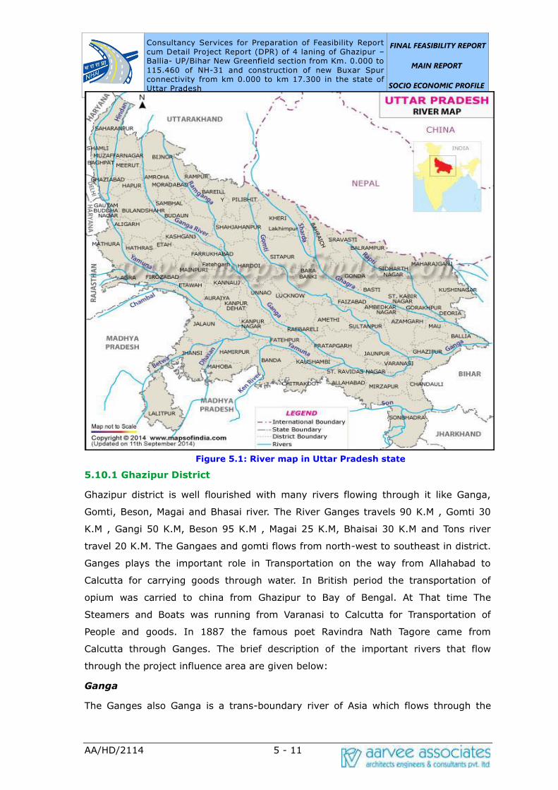
Consultancy Services for Preparation of Feasibility Report cum Detail Project Report (DPR) of 4 laning of Ghazipur –Ballia- UP/Bihar New Greenfield section from Km. 0.000 to
115.460 of NH-31 and construction of new Buxar Spur connectivity from km 0.000 to km 17.300 in the state of Uttar Pradesh
FINAL FEASIBILITY REPORT
MAIN REPORT
SOCIO ECONOMIC PROFILE
AA/HD/2114 5 - 11
Figure 5.1: River map in Uttar Pradesh state
5.10.1 Ghazipur District
Ghazipur district is well flourished with many rivers flowing through it like Ganga,
Gomti, Beson, Magai and Bhasai river. The River Ganges travels 90 K.M , Gomti 30
K.M , Gangi 50 K.M, Beson 95 K.M , Magai 25 K.M, Bhaisai 30 K.M and Tons river
travel 20 K.M. The Gangaes and gomti flows from north-west to southeast in district.
Ganges plays the important role in Transportation on the way from Allahabad to
Calcutta for carrying goods through water. In British period the transportation of
opium was carried to china from Ghazipur to Bay of Bengal. At That time The
Steamers and Boats was running from Varanasi to Calcutta for Transportation of
People and goods. In 1887 the famous poet Ravindra Nath Tagore came from
Calcutta through Ganges. The brief description of the important rivers that flow
through the project influence area are given below:
Ganga
The Ganges also Ganga is a trans-boundary river of Asia which flows through the
Consultancy Services for Preparation of Feasibility Report cum Detail Project Report (DPR) of 4 laning of Ghazipur –Ballia- UP/Bihar New Greenfield section from Km. 0.000 to
115.460 of NH-31 and construction of new Buxar Spur connectivity from km 0.000 to km 17.300 in the state of Uttar Pradesh
FINAL FEASIBILITY REPORT
MAIN REPORT
SOCIO ECONOMIC PROFILE
AA/HD/2114 5 - 12
nations of India and Bangladesh. The 2,525 km (1,569 mi) river rises in the western
Himalayas in the Indian state of Uttarakhand, and flows south and east through the
Gangetic Plain of North India into Bangladesh, where it empties into theBay of Bengal.
It is the third largest river in the world by discharge.
Gomti
Gomati River, also called Gumti, tributary of the Ganges (Ganga) River, central Uttar
Pradeshstate, northern India. It rises in northern Uttar Pradesh about 32 miles (51
km) east of Pilibhit and is intermittent for the first 35 miles (56 km) of its course,
becoming perennial after its junction with the Joknai. Below this point it flows
generally southeastward for some 500 miles (800 km), receiving its only major
tributary, the right-bank Sai River, near Jaunpur and emptying into the Ganges near
Saidpur. It drains a basin of about 7,240 square miles (18,750 square km).
5.10.2 Ballia District
Ballia district is the easternmost part of the Uttar Pradesh state and borders on Bihar
State. It comprises an irregularly shaped tract extending westward from the
confluence of the Ganga and the Ghaghra, the former separating it from Bihar in the
south and the latter from Deoria and Bihar in the north and east respectively. The
boundary between Ballia and Bihar is determined by the deep streams of these two
rivers. The brief description of the important rivers that flow through the project
influence area are given below:
Ghaghara
Ghaghara, also called Karnali is a perennial trans-boundary river originating on the
Tibetan Plateau near Lake Mansarovar. It cuts through the Himalayas in Nepal and
joins the Sharda River at Brahmaghat in India. Together they form the Ghaghra River,
a major left bank tributary of the Ganges. With a length of 507 kilometres (315 mi) it
is the longest river in Nepal. The total length of Ghaghara River up to its confluence
with the Ganges at Doriganj in Bihar is 1,080 kilometres (670 mi). It is the largest
tributary of the Ganges by volume and the second longest tributary of the Ganges by
length after Yamuna.
Tamsa
The Tamas River (also known as the Tons River) is a tributary of the Ganges flowing
through the Indian states of Madhya Pradesh and Uttar Pradesh. The Tamas rises in
a tank at Tamakund in the Kaimur Range at an elevation of 610 metres (2,000 ft). It
flows through the fertile districts of Satna and Rewa. At the edge of the Purwa
plateau, the Tamas and its tributaries form a number of waterfalls. The river receives

Consultancy Services for Preparation of Feasibility Report cum Detail Project Report (DPR) of 4 laning of Ghazipur –Ballia- UP/Bihar New Greenfield section from Km. 0.000 to
115.460 of NH-31 and construction of new Buxar Spur connectivity from km 0.000 to km 17.300 in the state of Uttar Pradesh
FINAL FEASIBILITY REPORT
MAIN REPORT
SOCIO ECONOMIC PROFILE
AA/HD/2114 5 - 13
the Belan in UP and joins the Ganges at Sirsa, about 311 kilometres (193 mi)
downstream of the confluence of the Ganges and Yamuna. The total length of the
river is 264 kilometres (164 mi). It has a total drainage area of 16,860 square
kilometres (6,510 sq mi).
Ganga
The Ganges also Ganga is a trans-boundary river of Asia which flows through the
nations of India and Bangladesh. The 2,525 km (1,569 mi) river rises in the western
Himalayas in the Indian state of Uttarakhand, and flows south and east through the
Gangetic Plain of North India into Bangladesh, where it empties into theBay of Bengal.
It is the third largest river in the world by discharge.
5.11 SOILS
The state has three distinct physiographic divisions from north to south viz. The
Shiwaliks, the Gangetic plain and the Southern High lands, Plateaus, and Scarplands
which are further divided into subunits given in the figure. The Project influence area
that passes through Jaunpur and Ghazipur districts fall in Alluvial plains.
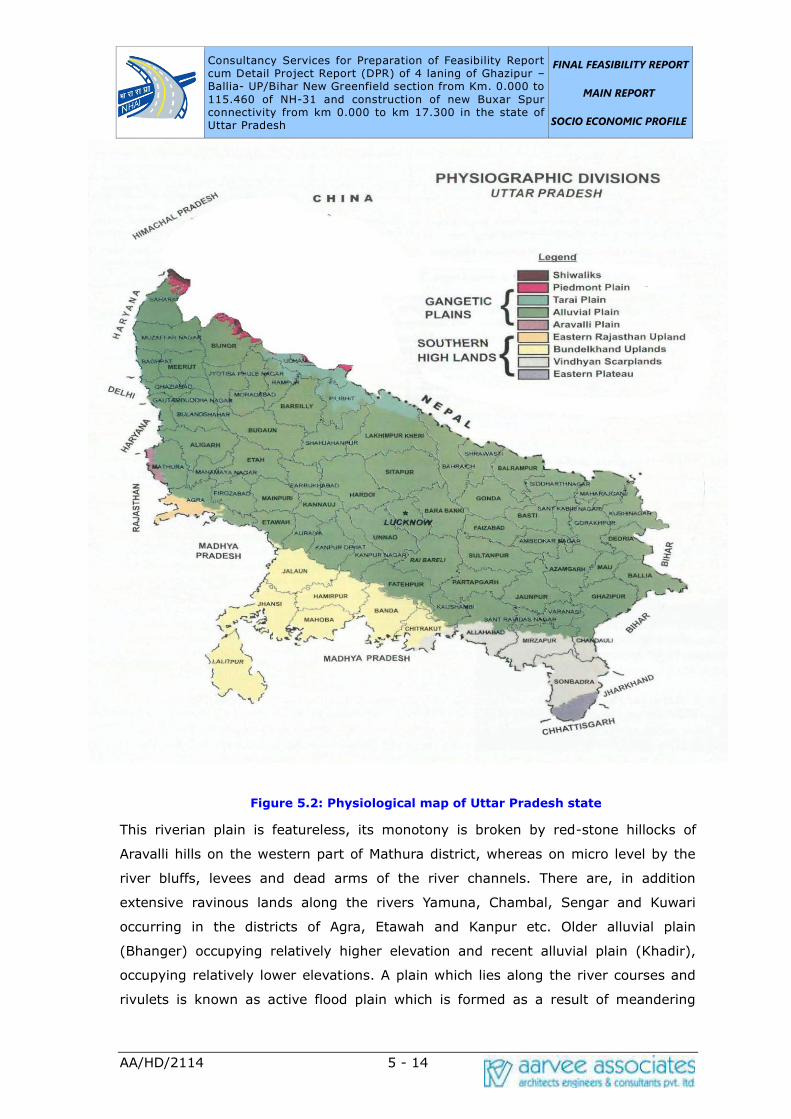
Consultancy Services for Preparation of Feasibility Report cum Detail Project Report (DPR) of 4 laning of Ghazipur –Ballia- UP/Bihar New Greenfield section from Km. 0.000 to
115.460 of NH-31 and construction of new Buxar Spur connectivity from km 0.000 to km 17.300 in the state of Uttar Pradesh
FINAL FEASIBILITY REPORT
MAIN REPORT
SOCIO ECONOMIC PROFILE
AA/HD/2114 5 - 14
Figure 5.2: Physiological map of Uttar Pradesh state
This riverian plain is featureless, its monotony is broken by red-stone hillocks of
Aravalli hills on the western part of Mathura district, whereas on micro level by the
river bluffs, levees and dead arms of the river channels. There are, in addition
extensive ravinous lands along the rivers Yamuna, Chambal, Sengar and Kuwari
occurring in the districts of Agra, Etawah and Kanpur etc. Older alluvial plain
(Bhanger) occupying relatively higher elevation and recent alluvial plain (Khadir),
occupying relatively lower elevations. A plain which lies along the river courses and
rivulets is known as active flood plain which is formed as a result of meandering
Consultancy Services for Preparation of Feasibility Report cum Detail Project Report (DPR) of 4 laning of Ghazipur –Ballia- UP/Bihar New Greenfield section from Km. 0.000 to
115.460 of NH-31 and construction of new Buxar Spur connectivity from km 0.000 to km 17.300 in the state of Uttar Pradesh
FINAL FEASIBILITY REPORT
MAIN REPORT
SOCIO ECONOMIC PROFILE
AA/HD/2114 5 - 15
action of these rivers and rivulets.
5.12 LAND UTILIZATION
The overall picture regarding land use patterns in India constitutes divergent
situations in regard to land use patterns across different states. In this part of Uttar
Pradesh have already not very much suitable for agriculture. However, one pattern
that was consistent almost all the districts is the increasing trend in land under non-
agricultural use due to increasing urbanization and industrialization, this trend is
inevitable. The land use system is highly dynamics which undergoes significant
changes according to the changes socio-economic and natural environment.
Transformation lands from different land use to agriculture to fulfill the demand of
food, fuel, wood, fodder and timber and on the other hand increasing the non-
agricultural land use means to development of urbanization and industrialization. The
main causes for expansion of urban area in this area because of settlement and
development of rural-urban fringe areas in the border districts of capital delhi area
e.g. Ghaziabad, Gautam Buddha Nagar etc. Increasing population and dependent of
agriculture are highly influence on agricultural and non-agricultural land use pattern.
For development of urban areas and concentration on environment this regards Mics.
Tree groves and garden are unchanged for social forestry and awareness. Also
Western Uttar Pradesh is not very much uniform topography, in northern part is hilly
mountain area, central and eastern part are upper ganga plain suitable for
agriculture and in Sothern part are the desert area. Pasture and other grazing land
are decreasing which influence for animal husbandry. Culturable waste land and
barren land are decreasing due to increasing other than agricultural land. Current
fallow land was increasing due to less concentration chemical fertilizer and irrigation.
Table 5.7: Land Utilization details of Uttar Pradesh State
Land Use Area (in
thousands) (ha) Percentage
Total geographic area 24093 NA
Reporting area for land utilization 24170 100.00
Forests 1658 6.86
Not available for land cultivation 3268 13.52
Permanent pastures and other grazing
lands
65 0.27
Consultancy Services for Preparation of Feasibility Report cum Detail Project Report (DPR) of 4 laning of Ghazipur –Ballia- UP/Bihar New Greenfield section from Km. 0.000 to
115.460 of NH-31 and construction of new Buxar Spur connectivity from km 0.000 to km 17.300 in the state of Uttar Pradesh
FINAL FEASIBILITY REPORT
MAIN REPORT
SOCIO ECONOMIC PROFILE
AA/HD/2114 5 - 16
Land Use Area (in
thousands) (ha) Percentage
Land under misc. tree crops and groves 374 1.55
Culturable Wasteland 440 1.82
Fallow lands other than current fallows 540 2.23
Current fallows 1408 5.83
Net area sown 16417 67.92
5.13 TOURISM
Situated in the northern part of India, bordering with the capital of India New Delhi,
Uttar Pradesh is one of the most popular and an established tourist destination for
both Indians and non-Indians alike in India. The most populous state of India, Uttar
Pradesh contains a large number of historical monuments and places of religious
significance. Geographically, Uttar Pradesh is very diverse, with Himalayan foothills in
the extreme north and the Gangetic Plain in the centre. It is also home of India's
most visited sites, the Taj Mahal, and Hinduism's holiest city, Varanasi. Kathak, one of
the eight forms of Indian classical dances, originated from Uttar Pradesh. Uttar
Pradesh is at the heart of India, hence it is also known as The Heartland of India.
Cuisine of Uttar Pradesh like Awadhi cuisine, Mughlai cuisine, Kumauni cuisine are
very famous not only in India but also many places abroad.
Uttar Pradesh is known for its rich culture and tradition. It is home to Ayodhya and
Mathura birthplace of Lord Rama and Lord Krishna respectively. Uttar Pradesh
attracts a large number of both national and international tourists. Taj Mahal, one of
the New Seven Wonders of the World in Agra is also located in Uttar Pradesh.
There are different places one can visit in Uttar Pradesh. Agra, Jhansi, Lucknow and
Meerut are historical cities famous for their monuments. Mathura, Vrindavan, Gokul,
Varanasi, Ayodhya and Allahabad are holy cities for Hindus and Kushinagar and
Sarnath are important Buddist places among the main four pilgrimage sites related to
the life of Gautama Buddha. Noida is the most developed urban city of Uttar Pradesh.
Iron Ore is abundantly available in the neighboring Districts of Karnataka viz., Raichur,
Bellary, which is suitable for setting up of Steel Plants. Due to availability of these
resources already, many Sponge Iron units have come in the District and there is
scope for mini steel plants.
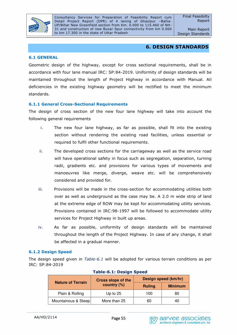
Consultancy Services for Preparation of Feasibility Report cum Detail Project Report (DPR) of 4 laning of Ghazipur –Ballia- UP/Bihar New Greenfield section from Km. 0.000 to 115.460 of NH-31 and construction of new Buxar Spur connectivity from km 0.000 to km 17.300 in the state of Uttar Pradesh
Final Feasibilty
Report
Main Report
Design Standards
Page 55
AA/HD/2114
6. DESIGN STANDARDS
6.1 GENERAL
Geometric design of the highway, except for cross sectional requirements, shall be in
accordance with four lane manual IRC: SP:84-2019. Uniformity of design standards will be
maintained throughout the length of Project Highway in accordance with Manual. All
deficiencies in the existing highway geometry will be rectified to meet the minimum
standards.
6.1.1 General Cross-Sectional Requirements
The design of cross section of the new four lane highway will take into account the
following general requirements
i. The new four lane highway, as far as possible, shall fit into the existing
section without rendering the existing road facilities, unless essential or
required to fulfil other functional requirements.
ii. The developed cross sections for the carriageway as well as the service road
will have operational safety in focus such as segregation, separation, turning
radii, gradients etc. and provisions for various types of movements and
manoeuvres like merge, diverge, weave etc. will be comprehensively
considered and provided for.
iii. Provisions will be made in the cross-section for accommodating utilities both
over as well as underground as the case may be. A 2.0 m wide strip of land
at the extreme edge of ROW may be kept for accommodating utility services.
Provisions contained in IRC:98-1997 will be followed to accommodate utility
services for Project Highway in built up areas.
iv. As far as possible, uniformity of design standards will be maintained
throughout the length of the Project Highway. In case of any change, it shall
be affected in a gradual manner.
6.1.2 Design Speed
The design speed given in Table-6.1 will be adopted for various terrain conditions as per
IRC: SP:84-2019
Table-6.1: Design Speed
Nature of Terrain Cross slope of the
country (%)
Design speed (km/hr)
Ruling Minimum
Plain & Rolling Up to 25 100 80
Mountainous & Steep More than 25 60 40
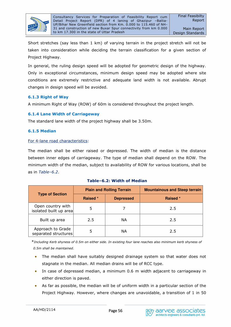
Consultancy Services for Preparation of Feasibility Report cum Detail Project Report (DPR) of 4 laning of Ghazipur –Ballia- UP/Bihar New Greenfield section from Km. 0.000 to 115.460 of NH-31 and construction of new Buxar Spur connectivity from km 0.000 to km 17.300 in the state of Uttar Pradesh
Final Feasibilty
Report
Main Report
Design Standards
Page 56
AA/HD/2114
Short stretches (say less than 1 km) of varying terrain in the project stretch will not be
taken into consideration while deciding the terrain classification for a given section of
Project Highway.
In general, the ruling design speed will be adopted for geometric design of the highway.
Only in exceptional circumstances, minimum design speed may be adopted where site
conditions are extremely restrictive and adequate land width is not available. Abrupt
changes in design speed will be avoided.
6.1.3 Right of Way
A minimum Right of Way (ROW) of 60m is considered throughout the project length.
6.1.4 Lane Width of Carriageway
The standard lane width of the project highway shall be 3.50m.
6.1.5 Median
For 4-lane road characteristics:
The median shall be either raised or depressed. The width of median is the distance
between inner edges of carriageway. The type of median shall depend on the ROW. The
minimum width of the median, subject to availability of ROW for various locations, shall be
as in Table–6.2.
Table–6.2: Width of Median
Type of Section Plain and Rolling Terrain Mountainous and Steep terrain
Raised * Depressed Raised *
Open country with
isolated built up area 5 7 2.5
Built up area 2.5 NA 2.5
Approach to Grade
separated structures 5 NA 2.5
*Including Kerb shyness of 0.5m on either side. In existing four lane reaches also minimum kerb shyness of
0.5m shall be maintained.
• The median shall have suitably designed drainage system so that water does not
stagnate in the median. All median drains will be of RCC type.
• In case of depressed median, a minimum 0.6 m width adjacent to carriageway in
either direction is paved.
• As far as possible, the median will be of uniform width in a particular section of the
Project Highway. However, where changes are unavoidable, a transition of 1 in 50
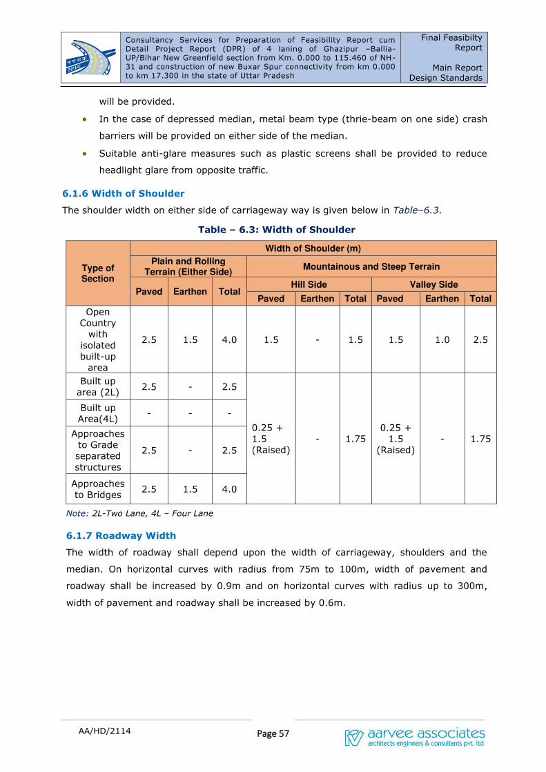
Consultancy Services for Preparation of Feasibility Report cum Detail Project Report (DPR) of 4 laning of Ghazipur –Ballia- UP/Bihar New Greenfield section from Km. 0.000 to 115.460 of NH-31 and construction of new Buxar Spur connectivity from km 0.000 to km 17.300 in the state of Uttar Pradesh
Final Feasibilty
Report
Main Report
Design Standards
Page 57
AA/HD/2114
will be provided.
• In the case of depressed median, metal beam type (thrie-beam on one side) crash
barriers will be provided on either side of the median.
• Suitable anti-glare measures such as plastic screens shall be provided to reduce
headlight glare from opposite traffic.
6.1.6 Width of Shoulder
The shoulder width on either side of carriageway way is given below in Table–6.3.
Table – 6.3: Width of Shoulder
Type of Section
Width of Shoulder (m)
Plain and Rolling Terrain (Either Side)
Mountainous and Steep Terrain
Paved Earthen Total Hill Side Valley Side
Paved Earthen Total Paved Earthen Total
Open
Country
with
isolated
built-up
area
2.5 1.5 4.0 1.5 - 1.5 1.5 1.0 2.5
Built up
area (2L) 2.5 - 2.5
0.25 +
1.5
(Raised)
- 1.75
0.25 +
1.5
(Raised)
- 1.75
Built up
Area(4L) - - -
Approaches
to Grade
separated
structures
2.5 - 2.5
Approaches
to Bridges 2.5 1.5 4.0
Note: 2L-Two Lane, 4L – Four Lane
6.1.7 Roadway Width
The width of roadway shall depend upon the width of carriageway, shoulders and the
median. On horizontal curves with radius from 75m to 100m, width of pavement and
roadway shall be increased by 0.9m and on horizontal curves with radius up to 300m,
width of pavement and roadway shall be increased by 0.6m.
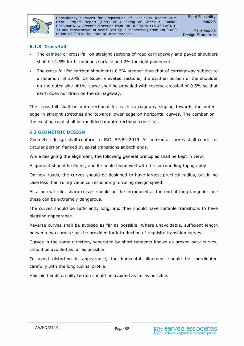
Consultancy Services for Preparation of Feasibility Report cum Detail Project Report (DPR) of 4 laning of Ghazipur –Ballia- UP/Bihar New Greenfield section from Km. 0.000 to 115.460 of NH-31 and construction of new Buxar Spur connectivity from km 0.000 to km 17.300 in the state of Uttar Pradesh
Final Feasibilty
Report
Main Report
Design Standards
Page 58
AA/HD/2114
6.1.8 Cross-fall
• The camber or cross-fall on straight sections of road carriageway and paved shoulders
shall be 2.5% for bituminous surface and 2% for rigid pavement.
• The cross-fall for earthen shoulder is 0.5% steeper than that of carriageway subject to
a minimum of 3.0%. On Super elevated sections, the earthen portion of the shoulder
on the outer side of the curve shall be provided with reverse crossfall of 0.5% so that
earth does not drain on the carriageway.
The cross-fall shall be uni-directional for each carriageway sloping towards the outer
edge in straight stretches and towards lower edge on horizontal curves. The camber on
the existing road shall be modified to uni-directional cross-fall.
6.2 GEOMETRIC DESIGN
Geometric design shall conform to IRC: SP:84-2019. All horizontal curves shall consist of
circular portion flanked by spiral transitions at both ends.
While designing the alignment, the following general principles shall be kept in view:
Alignment should be fluent, and it should blend well with the surrounding topography.
On new roads, the curves should be designed to have largest practical radius, but in no
case less than ruling value corresponding to ruling design speed.
As a normal rule, sharp curves should not be introduced at the end of long tangent since
these can be extremely dangerous.
The curves should be sufficiently long, and they should have suitable transitions to have
pleasing appearance.
Reverse curves shall be avoided as far as possible. Where unavoidable, sufficient length
between two curves shall be provided for introduction of requisite transition curves.
Curves in the same direction, separated by short tangents known as broken back curves,
should be avoided as far as possible.
To avoid distortion in appearance, the horizontal alignment should be coordinated
carefully with the longitudinal profile.
Hair pin bends on hilly terrain should be avoided as far as possible.

Consultancy Services for Preparation of Feasibility Report cum Detail Project Report (DPR) of 4 laning of Ghazipur –Ballia- UP/Bihar New Greenfield section from Km. 0.000 to 115.460 of NH-31 and construction of new Buxar Spur connectivity from km 0.000 to km 17.300 in the state of Uttar Pradesh
Final Feasibilty
Report
Main Report
Design Standards
Page 59
AA/HD/2114
6.2.1 Super-elevation
Super-elevation will be limited to 7%, if radius of curve is less than desirable minimum. It
will be limited to 5%, if the radius is more than desirable minimum and also at section
where Project Highway passes through an urban section or falls on a major junction.
6.2.2 Radii of Horizontal Curves
The minimum and absolute minimum radii of horizontal curves for various classes of
terrain are given in Table–6.4.
Table–6.4: Minimum Radii of Horizontal Curves
Nature of Terrain Desirable Minimum (m) Absolute Minimum (m)
Plain and Rolling 400 250
Mountainous and Steep 150 75
6.2.3 Sight Distance
The safe stopping sight distance and desirable minimum sight distance for four lane
divided carriageway for various design speeds are given in Table-6.5. The desirable values
of sight distance will be adopted for new carriage way. As a minimum, safe stopping sight
distance will be adopted for the improvement of the existing carriageway
Table-6.5: Safe Sight Distances
Design Speed
(km/hr)
Safe Stopping sight
distance (m)
Desirable minimum sight
distance (m)
100 180 360
80 130 260
60 90 180
40 45 90
6.3 VERTICAL ALIGNMENT
The vertical alignment will provide for a smooth longitudinal profile. Grade changes will
not be too frequent as to cause kinks and visual discontinuities in the profile. In this
regard, directions given in IRC: SP:23-1983 will be kept in view.
6.3.1 Gradients
The ruling and limiting gradients are given in Table-6.6. Ruling Gradients will be adopted
as far as possible. Limiting Gradient will be adopted in difficult situations, and for short
lengths.
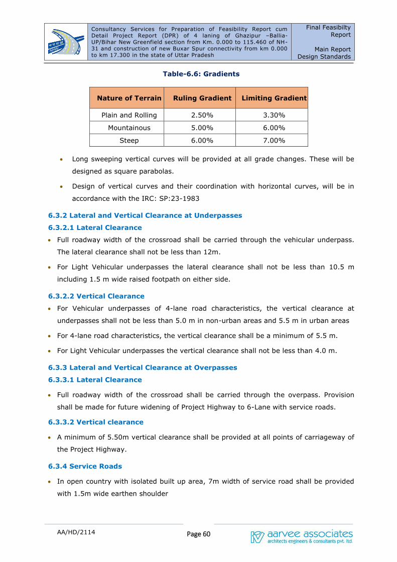
Consultancy Services for Preparation of Feasibility Report cum Detail Project Report (DPR) of 4 laning of Ghazipur –Ballia- UP/Bihar New Greenfield section from Km. 0.000 to 115.460 of NH-31 and construction of new Buxar Spur connectivity from km 0.000 to km 17.300 in the state of Uttar Pradesh
Final Feasibilty
Report
Main Report
Design Standards
Page 60
AA/HD/2114
Table-6.6: Gradients
Nature of Terrain Ruling Gradient Limiting Gradient
Plain and Rolling 2.50% 3.30%
Mountainous 5.00% 6.00%
Steep 6.00% 7.00%
• Long sweeping vertical curves will be provided at all grade changes. These will be
designed as square parabolas.
• Design of vertical curves and their coordination with horizontal curves, will be in
accordance with the IRC: SP:23-1983
6.3.2 Lateral and Vertical Clearance at Underpasses
6.3.2.1 Lateral Clearance
• Full roadway width of the crossroad shall be carried through the vehicular underpass.
The lateral clearance shall not be less than 12m.
• For Light Vehicular underpasses the lateral clearance shall not be less than 10.5 m
including 1.5 m wide raised footpath on either side.
6.3.2.2 Vertical Clearance
• For Vehicular underpasses of 4-lane road characteristics, the vertical clearance at
underpasses shall not be less than 5.0 m in non-urban areas and 5.5 m in urban areas
• For 4-lane road characteristics, the vertical clearance shall be a minimum of 5.5 m.
• For Light Vehicular underpasses the vertical clearance shall not be less than 4.0 m.
6.3.3 Lateral and Vertical Clearance at Overpasses
6.3.3.1 Lateral Clearance
• Full roadway width of the crossroad shall be carried through the overpass. Provision
shall be made for future widening of Project Highway to 6-Lane with service roads.
6.3.3.2 Vertical clearance
• A minimum of 5.50m vertical clearance shall be provided at all points of carriageway of
the Project Highway.
6.3.4 Service Roads
• In open country with isolated built up area, 7m width of service road shall be provided
with 1.5m wide earthen shoulder
Consultancy Services for Preparation of Feasibility Report cum Detail Project Report (DPR) of 4 laning of Ghazipur –Ballia- UP/Bihar New Greenfield section from Km. 0.000 to 115.460 of NH-31 and construction of new Buxar Spur connectivity from km 0.000 to km 17.300 in the state of Uttar Pradesh
Final Feasibilty
Report
Main Report
Design Standards
Page 61
AA/HD/2114
• In built up area, 7.5m wide carriageway (including kerb shyness of 0.25m on either
side) with raised foot path or separator on either side shall be provided.
The following requirements as per IRC: SP:84-2019 shall be applied:
• Minimum design speed – 40 kmph
• Acceleration and Deceleration lanes:
• Length – Designed for differential speed of 60 kmph
• Width – 5.5m
• Taper at merge: 1 in 15 beyond design length
• Wherever required, provision for parking bays of length 20m and width 3m shall be
provided along the service road
6.4 EMBANKMENT DESIGN
6.4.1 General
• The embankment height shall be measured with respect to the finished road levels. The
following principles will be followed for fixing the road level:
• No section of the road is overtopped. The Top of subgrade shall be at least 0.6 m above
ground level.
• The bottom of sub-surface is at least 1.0 m above the high flood level/ high water
table/ pond level. However, in case of old roads where it may be difficult to fulfill this
criterion without needing reconstruction or raising substantial length, the criteria may
be relaxed depending on site conditions, ensuring that the bottom of sub-grade is 0.6m
above High Flood Level (HFL). The HFL should be decided by intelligent inspections,
local observations, enquiries and studying past records.
6.4.2 Structural Features and Design of Embankment
• Embankment will be designed to ensure the stability of the roadway and shall
incorporate only those materials, which are suitable for embankment construction.
• Side slopes will not be steeper than 2H:1V and where necessary, the embankment
will be retained by a retaining structure in accordance with specification.
• Where the embankment is to be supported on a weak stratum it will be necessary
to specially design the embankment and adopt appropriate remedial/ ground
improvement measures.
• High embankments (height 6 m or above) in all soils will be designed from stability
considerations. For design of high embankments, IRC:75-2015 and MOSRTH –
Consultancy Services for Preparation of Feasibility Report cum Detail Project Report (DPR) of 4 laning of Ghazipur –Ballia- UP/Bihar New Greenfield section from Km. 0.000 to 115.460 of NH-31 and construction of new Buxar Spur connectivity from km 0.000 to km 17.300 in the state of Uttar Pradesh
Final Feasibilty
Report
Main Report
Design Standards
Page 62
AA/HD/2114
Guidelines for Design of High Embankments may be referred to.
• The side slopes shall be protected against erosion by providing turfing/ vegetative
cover, stone/cement concrete block pitching, geo-synthetics, gabion walls or any
other measures depending on the height of the embankment, type of soil involved
and susceptibility of soil to erosion as per IRC:56-1974. Pitching works on slopes
shall be as per MOST specifications.
6.4.3 Use of Pond Ash for Embankment Construction
Where Pond ash is used for construction of embankment in pursuance of the instructions
of the Ministry of Environment and Forests or otherwise, the embankment will be designed
and constructed in accordance with IRC: SP:58-2001.
6.4.4 Roadway in Cutting
The road level shall be fixed, keeping in view the provisions of relevant IRC Codes.
6.5 PAVEMENT DESIGN
6.5.1 Flexible Pavement
Flexible pavement shall be designed in accordance with IRC:37-2018 for a minimum
design period of 20 years or operation period, whichever is more. Stage construction will
be permissible subject to the requirements specified below:
• Alternative strategies or combination of initial design, strengthening and
maintenance can be developed by the concessionaire to provide the specified level
of pavement performance over the operation period subject to satisfying the
following minimum design requirements.
• The thickness of sub-base and base of pavement sections is designed for a
minimum design period of 20 years and the initial bituminous surfacing for a
minimum design period of 10 years.
• The pavement shall be strengthened by bituminous overlay as and when required
to extend the pavement life to full operation period.
6.5.2 Rigid Pavement
• Rigid pavement shall be designed in accordance with IRC:58-2015 for a minimum
design period of 30 years. Stage construction shall not be permitted.
• The Pavement Quality Concrete (PQC) shall rest of Dry Lean Concrete (DLC) sub-
base of 150 mm thickness.
• Separation membrane shall be used between PQC and DLC as per clause 602.5 of
MORTH specifications

Consultancy Services for Preparation of Feasibility Report cum Detail Project Report (DPR) of 4 laning of Ghazipur –Ballia- UP/Bihar New Greenfield section from Km. 0.000 to 115.460 of NH-31 and construction of new Buxar Spur connectivity from km 0.000 to km 17.300 in the state of Uttar Pradesh
Final Feasibilty
Report
Main Report
Design Standards
Page 63
AA/HD/2114
• DLC shall meet minimum strength requirements as per IRC: SP:49 and shall
extend beyond PQC by 0.75 m on either side.
• Below DLC layer, properly designed drainage layer GSB of 150 mm shall be
provided throughout road width.
6.5.3 Design Traffic
• The design traffic shall be estimated in terms of cumulative number of standard axles
(8160 kg) to be carried by the pavement during the design period.
• Initial daily average traffic flow shall be based on at least 7 days, 24 hr classified traffic
counts. IRC: 9 may be used as guidance for carrying out the traffic census. Any likely
change in traffic due to proposed improvement of the facility and/or future
development plans, land use, shall be duly considered in estimating the design traffic.
• The design traffic for service roads shall be ten million standard axels respectively. The
crust composition shall be provided accordingly
6.6 DRAINAGE DESIGN
Design and construction of surface and subsurface drains for highway drainage and
drainage of structures shall be carried out in accordance with the requirements of Clause
309 of MORTH specifications, IRC: SP:42, IRC: SP:50 and IRC: SP:90.
• Selection of type of roadside drains shall be based on the magnitude and duration of
flow. Longitudinal slope shall not be less than 0.3% for lined drains and 1% for unlined
drains.
• In case of depressed median, longitudinal drain shall be provided to drain off water.
• In super elevation sections, covered longitudinal and cross drains shall be provided.
Drainage where embankment height is more than 6m:
• In embankments where height exceeds 6 m, special arrangement for protection of
embankment slopes shall be essential in order to ensure that embankment slopes
maintain their shape during monsoon season.
• Drainage arrangement shall include a system consisting of providing kerb with channel
at the edge of the paved shoulders and provision of chute drains along the slopes at
designed intervals with energy dissipation basin and protection of side channels by
turfing or vegetation.
• Catch water drains shall be provided on hill slopes, if any, above cutting in trapezoidal
shape with stone lining.
• Sub-base shall be extended across the shoulders for efficient internal drainage of
pavement

Consultancy Services for Preparation of Feasibility Report cum Detail Project Report (DPR) of 4 laning of Ghazipur –Ballia- UP/Bihar New Greenfield section from Km. 0.000 to 115.460 of NH-31 and construction of new Buxar Spur connectivity from km 0.000 to km 17.300 in the state of Uttar Pradesh
Final Feasibilty
Report
Main Report
Design Standards
Page 64
AA/HD/2114
• Suitable filter or granular material or geo textiles to act as filtration and separation
layer shall be incorporated, wherever necessary, between the subgrade and sub-base
to prevent clogging.
• Effective drainage shall be provided both longitudinally and transversely for structures.
Transverse drainage shall be secured by means of suitable camber in the roadway
surface. Longitudinal drainage shall be secured by means of scuppers, inlets, or other
suitable means of sufficient size and numbers to drain the run off efficiently.
• When highway runs parallel to existing channels, adequate measures shall be taken in
the form of bank protection and channel alignment to avoid water build up or
stagnation against the highway slope endangering the pavement drainage.
6.7 DESIGN OF STRUCTURES
6.7.1 General
All structures shall be designed in accordance with the relevant Codes, Standards and
Specifications, Special Publications and Guidelines of the Indian Roads Congress. All
construction of bridges shall conform to MORTH Specifications for Road and Bridge Works.
6.7.2 Design Loading and Stresses
• The design loads and stresses shall be as per IRC:6-2014 appropriate for the width of
carriageway, type and properties of stream, location, altitude, etc.
• All new structures shall be designed for the condition when footpath is used as
carriageway. The footpath portion may be provided at the same level as the bridge
carriageway in non-built-up areas, raised footpaths shall be provided in built-up areas.
• All the components of structures shall be designed for a service life of 100 years except
appurtenances like crash barriers, wearing surface and rubberized components in
expansion joints and elastomeric bearings
6.7.3 Width of Structures
• The width of the culverts shall be equal to roadway width of the approaches. The outer
most face of railing/ parapet shall be in line with the outer most edge of shoulder.
• All new bridges shall have a footpath on left side of the traffic direction. The overall
width of new bridges with a footpath on left side shall be same as the roadway width of
approaches. The crash barrier shall be provided at the edge of the paved shoulders with
0.5m shy distance.
• If the width of widening, in case of existing bridges is 1.0m (0.5m on each side) or less,

Consultancy Services for Preparation of Feasibility Report cum Detail Project Report (DPR) of 4 laning of Ghazipur –Ballia- UP/Bihar New Greenfield section from Km. 0.000 to 115.460 of NH-31 and construction of new Buxar Spur connectivity from km 0.000 to km 17.300 in the state of Uttar Pradesh
Final Feasibilty
Report
Main Report
Design Standards
Page 65
AA/HD/2114
the widening of the structure may be dispensed with and traffic shall be guided with the
help of crash barriers in a transition of 1 in 20 on either side approaches.
6.7.4 Hydrology
The design discharge shall be evaluated for flood of 100-year return period.
6.7.5 Analysis of Design of Structures
All structures and their individual components will be analyzed and designed as per IRC:5-
2015, IRC:22-2008, IRC:24-2010, IRC:78-2014 and IRC:83 (all parts) depending upon
the type of structure/individual component proposed to be provided. The minimum cross-
sectional dimensions of each component will be provided so as to satisfy the requirements
specified in relevant IRC Code. The design will take into account long term durability,
serviceability, constructability, construction methodology and environmental factors. All
river training and protection works will be designed in accordance with IRC:89-1997.
6.7.6 Reinforced Earth Retaining Structures
Reinforced earth retaining structures shall not be provided for height more than 6 m
unless otherwise specified, and near water bodies. Such structures should be given special
attention in design, construction, ground improvement where necessary, maintenance and
selection of System/System design. Local and global stability of the structure shall be
ensured.
6.7.7 Rail-road Bridges
ROB/RUB shall be provided on all railway level crossings. In case the bridge is to be
provided over an existing level crossing, 2-lane bridge shall be constructed. The horizontal
and vertical clearances to be provided shall be as per requirement of railway authorities.
In case of RUB, full roadway width as in the approaches shall pass below the bridge
structure. Approach gradient shall not be steeper than 1 in 40 as per IRC: SP:73-2018.
6.8 TRAFFIC CONTROL DEVICES
6.8.1 Road Signs
• Three types of road signs viz., Mandatory, cautionary and Informatory shall be provided
and guidelines given in IRC 67-2012, clause 800 of MORTH specifications shall be kept in
view.
• All signs are placed on the left-hand side of the road. Where extra emphasis is
warranted, they may be duplicated on the right-hand side as well.
• On non-kerb side, the extreme edge of the sign is 1.5m–2.0m from the edge of the
carriageway. On kerb portion, it shall not be less than 60 cm from the edge of the kerb.
Consultancy Services for Preparation of Feasibility Report cum Detail Project Report (DPR) of 4 laning of Ghazipur –Ballia- UP/Bihar New Greenfield section from Km. 0.000 to 115.460 of NH-31 and construction of new Buxar Spur connectivity from km 0.000 to km 17.300 in the state of Uttar Pradesh
Final Feasibilty
Report
Main Report
Design Standards
Page 66
AA/HD/2114
6.8.2 Road Markings
Provisions have been made for centre and edge road marking with thermo plastic paint as
per MOST specification. This would help reduce road accidents. Road studs shall also be
provided in addition to pavement marking for better visibility during night. Guidelines
given in IRC 35 shall be used for providing these facilities.
6.8.3 Road Delineators
Provision of road delineators comprising of roadway indicators, hazard markers and object
markers has been made in the design that shall conform to the recommendation made in
IRC-79. Reflective Chevron signs at curves shall also be provided for.
6.8.4 Toll plaza
Toll Plaza shall be designed to permit the provision of toll lanes for a projected peak hour
traffic of 20 years subject to a minimum number of 16 toll lanes including all other
buildings and structures to be accommodated. Specifications given in IRC SP:84-2019 for
layout and design of toll plaza shall be followed.
6.8.5 Safety Barrier
Safety barrier of rigid, flexible, or semi rigid type in accordance with MORTH
guidelines/circular will be provided at following locations:
i. Where heights of embankment are 3 m or more
ii. Where embankment is retained by a retaining structure
iii. On valley side of highway in mountainous and steep terrain
iv. Between main carriageway and footpath in bridges
6.9 PROJECT FACILITIES
6.9.1 Pedestrian Facilities
• There shall be no pedestrian crossings across the carriageway. Facility for crossing
the carriageway by the pedestrians shall be provided through pedestrian
underpasses/FOB.
• Sidewalks wherever provided shall not be less than 1.5m.
6.9.2 Bus Bays
Busbays shall be located only near pedestrian underpass/ overpass locations. The layout
and design of bus bays with shelters shall be as per the specifications given in IRC SP:84-
2019.
Consultancy Services for Preparation of Feasibility Report cum Detail Project Report (DPR) of 4 laning of Ghazipur –Ballia- UP/Bihar New Greenfield section from Km. 0.000 to 115.460 of NH-31 and construction of new Buxar Spur connectivity from km 0.000 to km 17.300 in the state of Uttar Pradesh
Final Feasibilty
Report
Main Report
Design Standards
Page 67
AA/HD/2114
6.9.3 Truck Lay byes
Truck laybyes, in general, shall be located near check barriers, interstate borders, places
of conventional stops of the truck operators etc. The places shall be identified on the basis
of field survey. Adequate space for facilities and future growth shall be allocated.
6.9.4 Rest Areas
Rest Areas with minimum facilities shall be provided keeping in view the expected peak
hour traffic.
6.10 ENVIRONMENT IMPACT AND ASSESSMENT
State and Central Government guidelines including guidelines of Ministry of Environment
and TOR requirements.
6.11 SOCIAL IMPACT ASSESSMENT
State and Central Government guidelines and TOR requirements.
6.12 ESTIMATION OF QUANTITIES AND PROJECT COST
MOST Standard Data book for analysis of rates and Standard Schedule of Rates for the
current schedule of rates of State Government for the project area.
6.13 STANDARDS FOR AT-GRADE INTERSECTIONS
The standards proposed in IRC: SP:41-1994 "Guidelines for the Design of At-Grade
Intersection in Rural and Urban Areas" will be applied.
6.14 PROJECT SPECIFIC MODIFICATIONS FROM STANDARDS
Any project specific deviations warranted from site constraints will be finalized in
consultation with NHAI, Uttar Pradesh.
Consultancy Services for Preparation of Feasibility Report cum Detail
Project Report (DPR) of 4 laning of Ghazipur –Ballia- UP/Bihar New
Greenfield section from Km. 0.000 to 115.460 of NH-31 and construction of
new Buxar Spur connectivity from km 0.000 to km 17.300 in the state of
Uttar Pradesh
Final Feasibility Report
Main Report
Project Proposals
A/HD/2114 8-1
7. PROJECT PROPOSALS
7.1 General
The National Highways Authority of India (NHAI) is engaged in the development of the National
highways in the state of Uttar Pradesh. As part of this endeavor, NHAI has decided to upgrade some
of the existing National Highways in the State of UP to National Highway standard. It was also
decided to take up the preparation of DPR for these highways which are being upgraded to National
Highway Standard. The consultancy services for preparation of Feasibility Report cum Detailed
Project Report (DPR) of 4 laning of Ghazipur Ballia – UP/Bihar section from Km 0.000 to 128.000 of
NH-31 and Construction of 2/4 laning Flyover at Ballia (Chandra Shekhar Mod to Satish Chandra
College). The New Greenfield alignment is proposed to four lane with Paved Shoulder at normal
sections and Four laning with service roads at Underpass locations with proposed Right of way of
60m. The Consultant shall furnish land acquisition details as per revenue records/maps for further
processing.
The Consultant shall study the possible locations and design of toll plaza. Wayside amenities
required on tolled highway shall also be planned. The local and slow traffic may need segregation
from the main traffic and provision of service roads and fencing may be considered, wherever
necessary to improve efficiency and safety. Wherever required, consultant will liaise with concerned
authorities and arrange all clarifications. Approval of all drawings including GAD and detail
engineering drawings will be got done by the consultant from the Railways. However, if Railways
require proof checking of the drawings prepared by the consultants, the same will be got done by
NHAI and payment to the proof consultant shall be made by NHAI directly. Consultant will also
obtain ‘No Objection Certificate’ from Ministry of Environment and Forest and incorporate the
estimates for shifting of utilities of all types involved from concerned local authorities in the DPR.
Consultant is also required to prepare all Land Acquisition papers (i.e. all necessary schedules as per
L.A. act) for acquisition of land either under NH Act or State Act
The consultant shall prepare the Bid Documents, based on the feasibility report, due to exigency of
the project for execution.
Consultant shall obtain all types of necessary clearances required for implementation of the project
on the ground from the concerned agencies. The client shall provide the necessary supporting letters
and any official fees as per the demand note issued by such concerned agencies from whom the
clearances are being sought to enable implementation. The Proposed Greenfield Alignment stretch is
presented in Figure-8.1
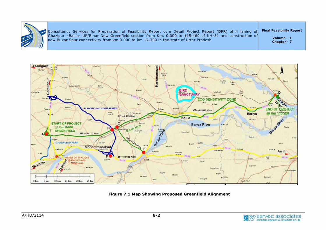
Consultancy Services for Preparation of Feasibility Report cum Detail Project Report (DPR) of 4 laning of
Ghazipur –Ballia- UP/Bihar New Greenfield section from Km. 0.000 to 115.460 of NH-31 and construction of
new Buxar Spur connectivity from km 0.000 to km 17.300 in the state of Uttar Pradesh
Final Feasibility Report
Volume – I Chapter - 7
A/HD/2114 8-2
Figure 7.1 Map Showing Proposed Greenfield Alignment
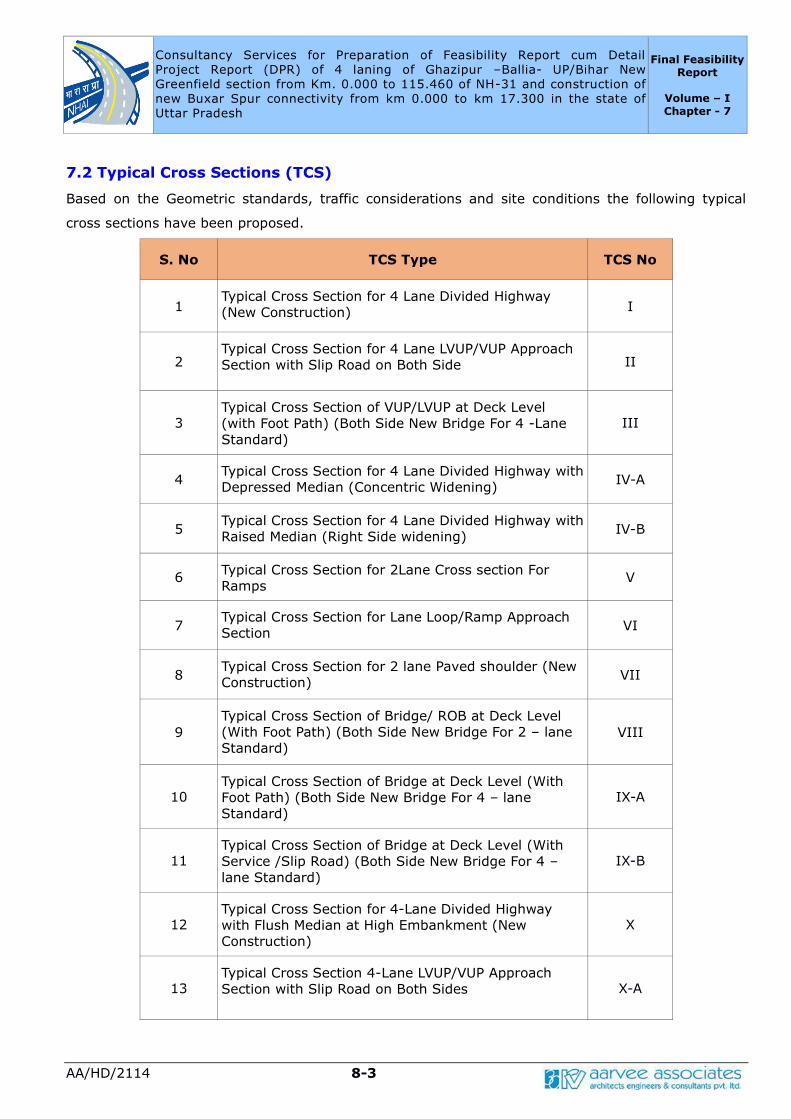
Consultancy Services for Preparation of Feasibility Report cum Detail
Project Report (DPR) of 4 laning of Ghazipur –Ballia- UP/Bihar New
Greenfield section from Km. 0.000 to 115.460 of NH-31 and construction of
new Buxar Spur connectivity from km 0.000 to km 17.300 in the state of
Uttar Pradesh
Final Feasibility Report
Volume – I Chapter - 7
AA/HD/2114 8-3
7.2 Typical Cross Sections (TCS)
Based on the Geometric standards, traffic considerations and site conditions the following typical
cross sections have been proposed.
S. No TCS Type TCS No
1 Typical Cross Section for 4 Lane Divided Highway
(New Construction) I
2 Typical Cross Section for 4 Lane LVUP/VUP Approach
Section with Slip Road on Both Side II
3 Typical Cross Section of VUP/LVUP at Deck Level
(with Foot Path) (Both Side New Bridge For 4 -Lane
Standard)
III
4 Typical Cross Section for 4 Lane Divided Highway with
Depressed Median (Concentric Widening) IV-A
5 Typical Cross Section for 4 Lane Divided Highway with
Raised Median (Right Side widening) IV-B
6 Typical Cross Section for 2Lane Cross section For
Ramps V
7 Typical Cross Section for Lane Loop/Ramp Approach
Section VI
8 Typical Cross Section for 2 lane Paved shoulder (New
Construction) VII
9
Typical Cross Section of Bridge/ ROB at Deck Level
(With Foot Path) (Both Side New Bridge For 2 – lane
Standard) VIII
10 Typical Cross Section of Bridge at Deck Level (With
Foot Path) (Both Side New Bridge For 4 – lane
Standard)
IX-A
11 Typical Cross Section of Bridge at Deck Level (With
Service /Slip Road) (Both Side New Bridge For 4 –
lane Standard)
IX-B
12 Typical Cross Section for 4-Lane Divided Highway
with Flush Median at High Embankment (New
Construction)
X
13 Typical Cross Section 4-Lane LVUP/VUP Approach
Section with Slip Road on Both Sides X-A
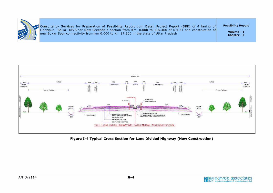
Consultancy Services for Preparation of Feasibility Report cum Detail Project Report (DPR) of 4 laning of
Ghazipur –Ballia- UP/Bihar New Greenfield section from Km. 0.000 to 115.460 of NH-31 and construction of
new Buxar Spur connectivity from km 0.000 to km 17.300 in the state of Uttar Pradesh
Feasibility Report
Volume – I Chapter - 7
A/HD/2114 8-4
Figure I-4 Typical Cross Section for Lane Divided Highway (New Construction)

Consultancy Services for Preparation of Feasibility Report cum Detail Project Report (DPR) of 4 laning of
Ghazipur –Ballia- UP/Bihar New Greenfield section from Km. 0.000 to 115.460 of NH-31 and construction of
new Buxar Spur connectivity from km 0.000 to km 17.300 in the state of Uttar Pradesh
Feasibility Report
Volume – I Chapter - 7
A/HD/2114 8-5
Figure II-4 Lane LVUP/VUP Approach Section with Slip Road on Both Side

Consultancy Services for Preparation of Feasibility Report cum Detail Project Report (DPR) of 4 laning of
Ghazipur –Ballia- UP/Bihar New Greenfield section from Km. 0.000 to 115.460 of NH-31 and construction of
new Buxar Spur connectivity from km 0.000 to km 17.300 in the state of Uttar Pradesh
Feasibility Report
Volume – I Chapter - 7
A/HD/2114 8-6
Figure III-4 Cross Section of VUP/LVUP at Deck Level (with Foot Path)
(Both Side New Bridge For 4 -Lane Standard)
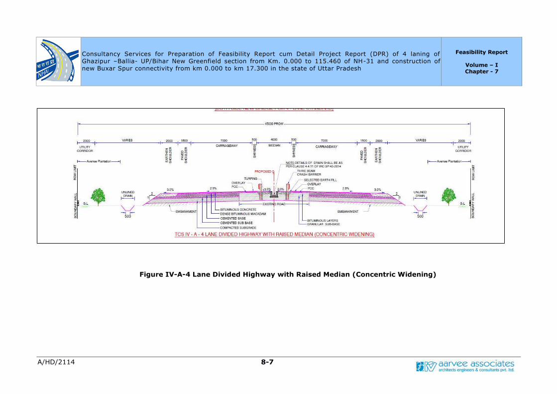
Consultancy Services for Preparation of Feasibility Report cum Detail Project Report (DPR) of 4 laning of
Ghazipur –Ballia- UP/Bihar New Greenfield section from Km. 0.000 to 115.460 of NH-31 and construction of
new Buxar Spur connectivity from km 0.000 to km 17.300 in the state of Uttar Pradesh
Feasibility Report
Volume – I Chapter - 7
A/HD/2114 8-7
Figure IV-A-4 Lane Divided Highway with Raised Median (Concentric Widening)

Consultancy Services for Preparation of Feasibility Report cum Detail Project Report (DPR) of 4 laning of
Ghazipur –Ballia- UP/Bihar New Greenfield section from Km. 0.000 to 115.460 of NH-31 and construction of
new Buxar Spur connectivity from km 0.000 to km 17.300 in the state of Uttar Pradesh
Feasibility Report
Volume – I Chapter - 7
A/HD/2114 8-8
Figure IV-B-4 Lane Divided Highway with Raised Median (Right side Widening)

Consultancy Services for Preparation of Feasibility Report cum Detail Project Report (DPR) of 4 laning of
Ghazipur –Ballia- UP/Bihar New Greenfield section from Km. 0.000 to 115.460 of NH-31 and construction of
new Buxar Spur connectivity from km 0.000 to km 17.300 in the state of Uttar Pradesh
Feasibility Report
Volume – I Chapter - 7
A/HD/2114 8-9
Figure V-2 Lane Cross Section for Ramps
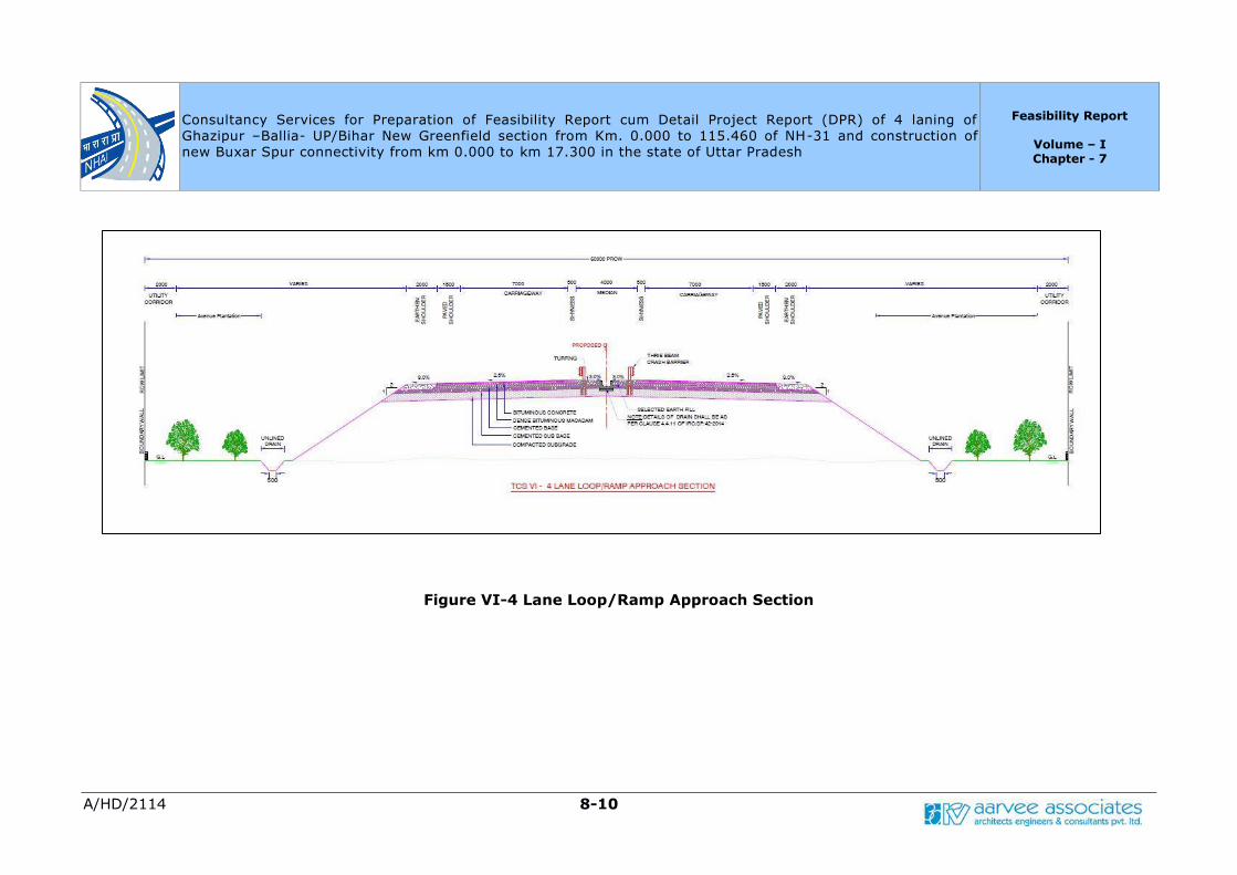
Consultancy Services for Preparation of Feasibility Report cum Detail Project Report (DPR) of 4 laning of
Ghazipur –Ballia- UP/Bihar New Greenfield section from Km. 0.000 to 115.460 of NH-31 and construction of
new Buxar Spur connectivity from km 0.000 to km 17.300 in the state of Uttar Pradesh
Feasibility Report
Volume – I Chapter - 7
A/HD/2114 8-10
Figure VI-4 Lane Loop/Ramp Approach Section
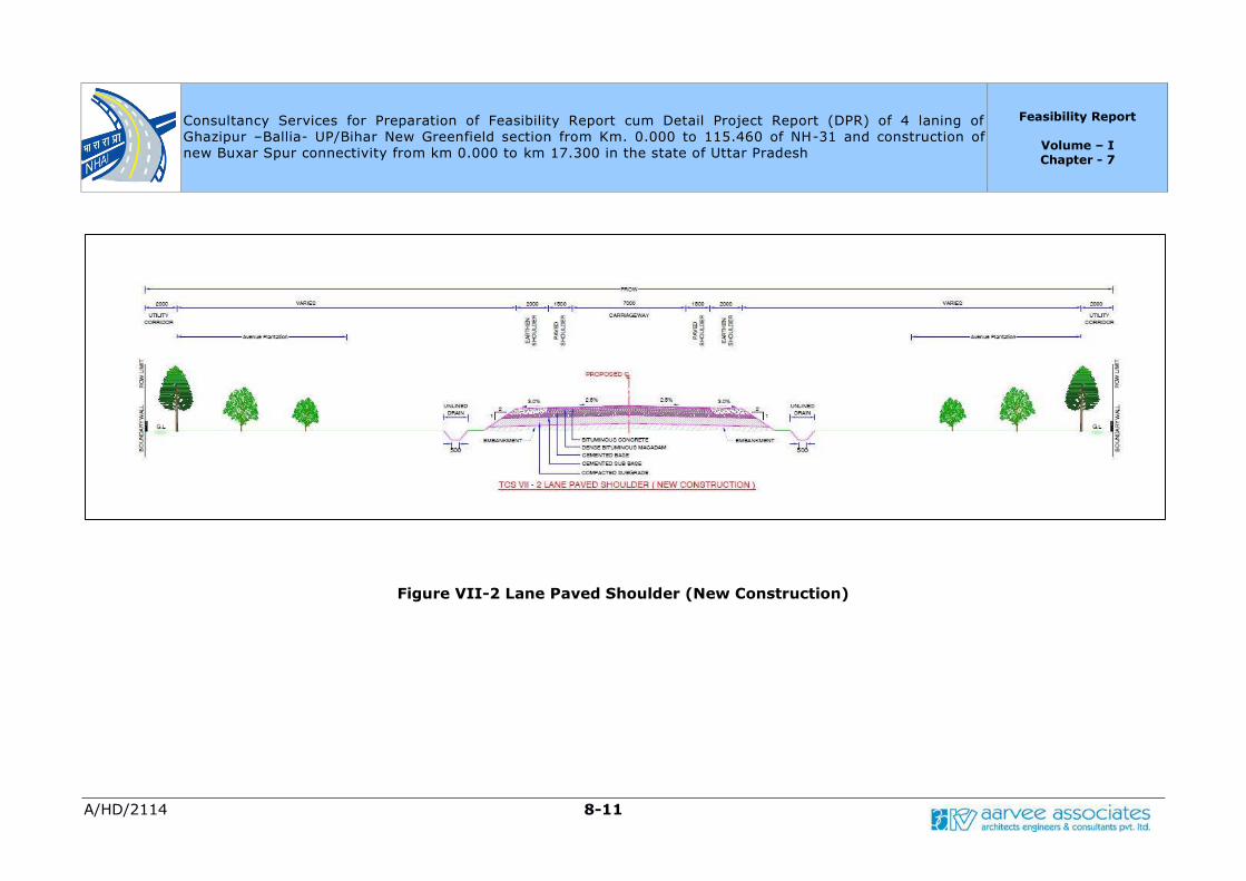
Consultancy Services for Preparation of Feasibility Report cum Detail Project Report (DPR) of 4 laning of
Ghazipur –Ballia- UP/Bihar New Greenfield section from Km. 0.000 to 115.460 of NH-31 and construction of
new Buxar Spur connectivity from km 0.000 to km 17.300 in the state of Uttar Pradesh
Feasibility Report
Volume – I Chapter - 7
A/HD/2114 8-11
Figure VII-2 Lane Paved Shoulder (New Construction)
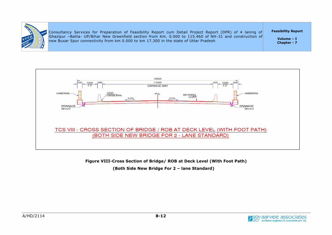
Consultancy Services for Preparation of Feasibility Report cum Detail Project Report (DPR) of 4 laning of
Ghazipur –Ballia- UP/Bihar New Greenfield section from Km. 0.000 to 115.460 of NH-31 and construction of
new Buxar Spur connectivity from km 0.000 to km 17.300 in the state of Uttar Pradesh
Feasibility Report
Volume – I Chapter - 7
A/HD/2114 8-12
Figure VIII-Cross Section of Bridge/ ROB at Deck Level (With Foot Path)
(Both Side New Bridge For 2 – lane Standard)

Consultancy Services for Preparation of Feasibility Report cum Detail Project Report (DPR) of 4 laning of
Ghazipur –Ballia- UP/Bihar New Greenfield section from Km. 0.000 to 115.460 of NH-31 and construction of
new Buxar Spur connectivity from km 0.000 to km 17.300 in the state of Uttar Pradesh
Feasibility Report
Volume – I Chapter - 7
A/HD/2114 8-13
Figure IX-A-Cross Section of Bridge at Deck Level (With Foot Path)
(Both Side New Bridge For 4 – lane Standard)

Consultancy Services for Preparation of Feasibility Report cum Detail Project Report (DPR) of 4 laning of
Ghazipur –Ballia- UP/Bihar New Greenfield section from Km. 0.000 to 115.460 of NH-31 and construction of
new Buxar Spur connectivity from km 0.000 to km 17.300 in the state of Uttar Pradesh
Feasibility Report
Volume – I Chapter - 7
A/HD/2114 8-14
Figure IX-B-Cross Section of Bridge at Deck Level (With Service /Slip Road)
(Both Side New Bridge For 4 –Lane standard)
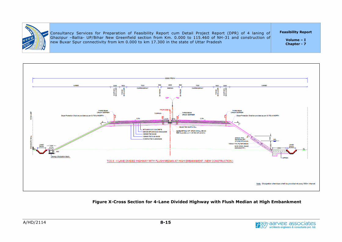
Consultancy Services for Preparation of Feasibility Report cum Detail Project Report (DPR) of 4 laning of
Ghazipur –Ballia- UP/Bihar New Greenfield section from Km. 0.000 to 115.460 of NH-31 and construction of
new Buxar Spur connectivity from km 0.000 to km 17.300 in the state of Uttar Pradesh
Feasibility Report
Volume – I Chapter - 7
A/HD/2114 8-15
Figure X-Cross Section for 4-Lane Divided Highway with Flush Median at High Embankment
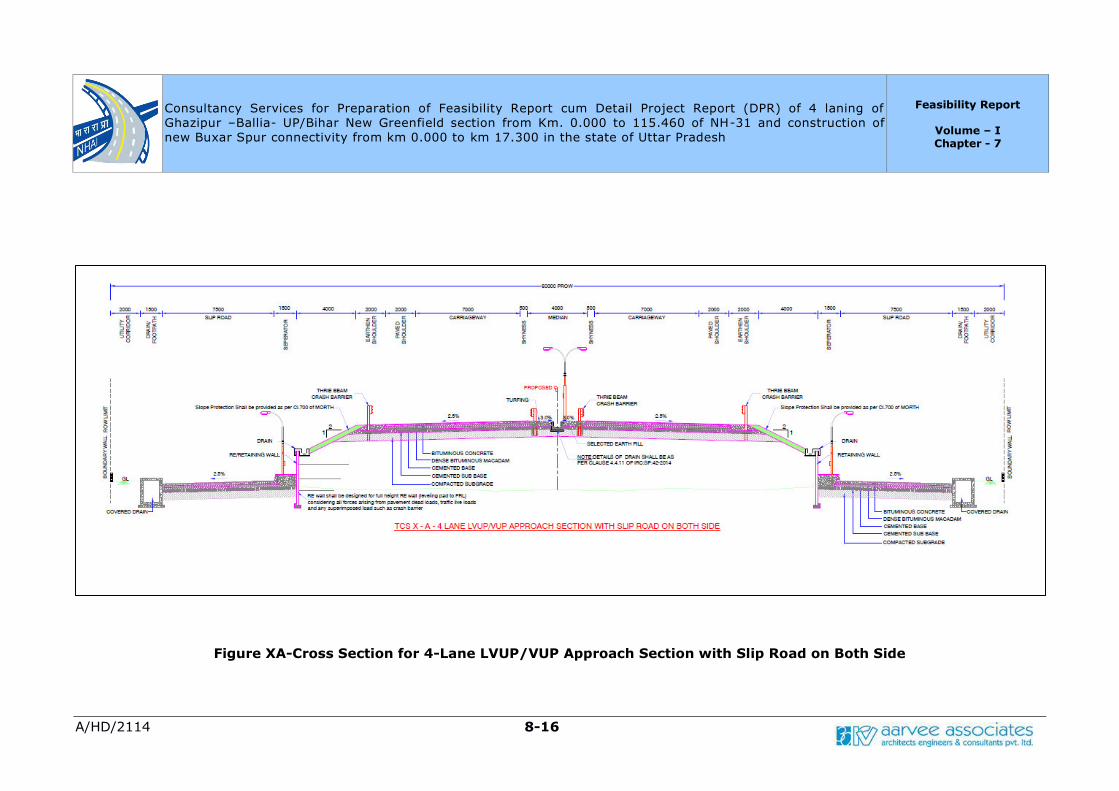
Consultancy Services for Preparation of Feasibility Report cum Detail Project Report (DPR) of 4 laning of
Ghazipur –Ballia- UP/Bihar New Greenfield section from Km. 0.000 to 115.460 of NH-31 and construction of
new Buxar Spur connectivity from km 0.000 to km 17.300 in the state of Uttar Pradesh
Feasibility Report
Volume – I Chapter - 7
A/HD/2114 8-16
Figure XA-Cross Section for 4-Lane LVUP/VUP Approach Section with Slip Road on Both Side
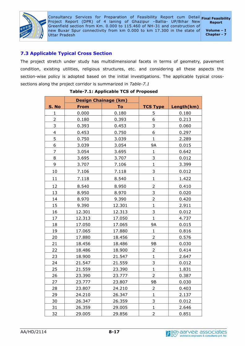
Consultancy Services for Preparation of Feasibility Report cum Detail
Project Report (DPR) of 4 laning of Ghazipur –Ballia- UP/Bihar New
Greenfield section from Km. 0.000 to 115.460 of NH-31 and construction of
new Buxar Spur connectivity from km 0.000 to km 17.300 in the state of
Uttar Pradesh
Final Feasibility Report
Volume – I Chapter - 7
AA/HD/2114 8-17
7.3 Applicable Typical Cross Section
The project stretch under study has multidimensional facets in terms of geometry, pavement
condition, existing utilities, religious structures, etc. and considering all these aspects the
section-wise policy is adopted based on the initial investigations. The applicable typical cross-
sections along the project corridor is summarized in Table-7.1
Table-7.1: Applicable TCS of Proposed
S. No
Design Chainage (km)
TCS Type Length(km) From To
1 0.000 0.180 5 0.180
2 0.180 0.393 6 0.213
3 0.393 0.453 3 0.060
4 0.453 0.750 6 0.297
5 0.750 3.039 1 2.289
6 3.039 3.054 9A 0.015
7 3.054 3.695 1 0.642
8 3.695 3.707 3 0.012
9 3.707 7.106 1 3.399
10 7.106 7.118 3 0.012
11 7.118 8.540 1 1.422
12 8.540 8.950 2 0.410
13 8.950 8.970 3 0.020
14 8.970 9.390 2 0.420
15 9.390 12.301 1 2.911
16 12.301 12.313 3 0.012
17 12.313 17.050 1 4.737
18 17.050 17.065 9A 0.015
19 17.065 17.880 1 0.816
20 17.880 18.456 2 0.576
21 18.456 18.486 9B 0.030
22 18.486 18.900 2 0.414
23 18.900 21.547 1 2.647
24 21.547 21.559 3 0.012
25 21.559 23.390 1 1.831
26 23.390 23.777 2 0.387
27 23.777 23.807 9B 0.030
28 23.807 24.210 2 0.403
29 24.210 26.347 1 2.137
30 26.347 26.359 3 0.012
31 26.359 29.005 1 2.646
32 29.005 29.856 2 0.851
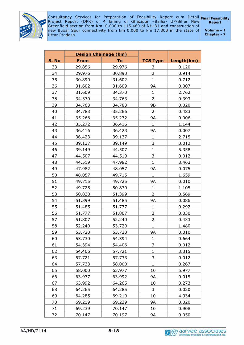
Consultancy Services for Preparation of Feasibility Report cum Detail
Project Report (DPR) of 4 laning of Ghazipur –Ballia- UP/Bihar New
Greenfield section from Km. 0.000 to 115.460 of NH-31 and construction of
new Buxar Spur connectivity from km 0.000 to km 17.300 in the state of
Uttar Pradesh
Final Feasibility Report
Volume – I Chapter - 7
AA/HD/2114 8-18
S. No
Design Chainage (km)
TCS Type Length(km) From To
33 29.856 29.976 3 0.120
34 29.976 30.890 2 0.914
35 30.890 31.602 1 0.712
36 31.602 31.609 9A 0.007
37 31.609 34.370 1 2.762
38 34.370 34.763 2 0.393
39 34.763 34.783 9B 0.020
40 34.783 35.266 2 0.483
41 35.266 35.272 9A 0.006
42 35.272 36.416 1 1.144
43 36.416 36.423 9A 0.007
44 36.423 39.137 1 2.715
45 39.137 39.149 3 0.012
46 39.149 44.507 1 5.358
47 44.507 44.519 3 0.012
48 44.519 47.982 1 3.463
49 47.982 48.057 9A 0.075
50 48.057 49.715 1 1.659
51 49.715 49.725 9A 0.010
52 49.725 50.830 1 1.105
53 50.830 51.399 2 0.569
54 51.399 51.485 9A 0.086
55 51.485 51.777 1 0.292
56 51.777 51.807 3 0.030
57 51.807 52.240 2 0.433
58 52.240 53.720 1 1.480
59 53.720 53.730 9A 0.010
60 53.730 54.394 1 0.664
61 54.394 54.406 3 0.012
62 54.406 57.721 1 3.315
63 57.721 57.733 3 0.012
64 57.733 58.000 1 0.267
65 58.000 63.977 10 5.977
66 63.977 63.992 9A 0.015
67 63.992 64.265 10 0.273
68 64.265 64.285 3 0.020
69 64.285 69.219 10 4.934
70 69.219 69.239 9A 0.020
71 69.239 70.147 10 0.908
72 70.147 70.197 9A 0.050
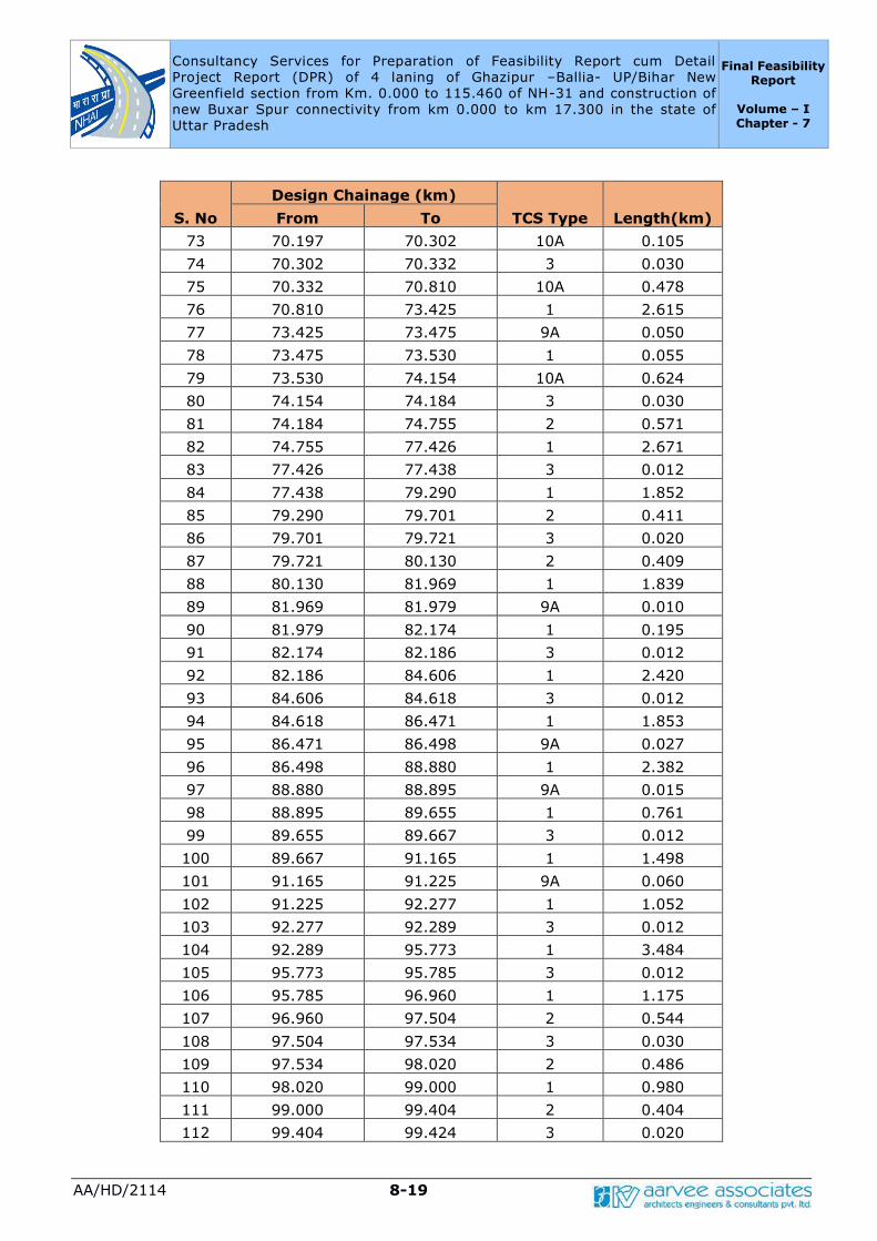
Consultancy Services for Preparation of Feasibility Report cum Detail
Project Report (DPR) of 4 laning of Ghazipur –Ballia- UP/Bihar New
Greenfield section from Km. 0.000 to 115.460 of NH-31 and construction of
new Buxar Spur connectivity from km 0.000 to km 17.300 in the state of
Uttar Pradesh
Final Feasibility Report
Volume – I Chapter - 7
AA/HD/2114 8-19
S. No
Design Chainage (km)
TCS Type Length(km) From To
73 70.197 70.302 10A 0.105
74 70.302 70.332 3 0.030
75 70.332 70.810 10A 0.478
76 70.810 73.425 1 2.615
77 73.425 73.475 9A 0.050
78 73.475 73.530 1 0.055
79 73.530 74.154 10A 0.624
80 74.154 74.184 3 0.030
81 74.184 74.755 2 0.571
82 74.755 77.426 1 2.671
83 77.426 77.438 3 0.012
84 77.438 79.290 1 1.852
85 79.290 79.701 2 0.411
86 79.701 79.721 3 0.020
87 79.721 80.130 2 0.409
88 80.130 81.969 1 1.839
89 81.969 81.979 9A 0.010
90 81.979 82.174 1 0.195
91 82.174 82.186 3 0.012
92 82.186 84.606 1 2.420
93 84.606 84.618 3 0.012
94 84.618 86.471 1 1.853
95 86.471 86.498 9A 0.027
96 86.498 88.880 1 2.382
97 88.880 88.895 9A 0.015
98 88.895 89.655 1 0.761
99 89.655 89.667 3 0.012
100 89.667 91.165 1 1.498
101 91.165 91.225 9A 0.060
102 91.225 92.277 1 1.052
103 92.277 92.289 3 0.012
104 92.289 95.773 1 3.484
105 95.773 95.785 3 0.012
106 95.785 96.960 1 1.175
107 96.960 97.504 2 0.544
108 97.504 97.534 3 0.030
109 97.534 98.020 2 0.486
110 98.020 99.000 1 0.980
111 99.000 99.404 2 0.404
112 99.404 99.424 3 0.020

Consultancy Services for Preparation of Feasibility Report cum Detail
Project Report (DPR) of 4 laning of Ghazipur –Ballia- UP/Bihar New
Greenfield section from Km. 0.000 to 115.460 of NH-31 and construction of
new Buxar Spur connectivity from km 0.000 to km 17.300 in the state of
Uttar Pradesh
Final Feasibility Report
Volume – I Chapter - 7
AA/HD/2114 8-20
S. No
Design Chainage (km)
TCS Type Length(km) From To
113 99.424 99.840 2 0.416
114 99.840 101.983 1 2.143
115 101.983 101.995 3 0.012
116 101.995 103.340 1 1.345
117 103.340 103.855 2 0.515
118 103.855 103.885 3 0.030
119 103.885 104.260 2 0.375
120 104.260 107.600 4A 3.340
121 107.600 109.011 1 1.411
122 109.011 109.018 9A 0.007
123 109.018 109.600 1 0.582
124 109.600 110.123 4A 0.523
125 110.123 110.151 9A 0.028
126 110.151 112.100 4A 1.949
127 112.100 112.900 4B 0.800
128 112.900 113.450 1 0.550
129 113.450 114.610 9A 1.160
130 114.610 114.822 1 0.212
131 114.822 114.836 3 0.014
132 114.836 115.460 4B 0.624
Table-7.2: Applicable TCS of Proposed-Buxar Spur
S. No
Design Chainage TCS
Type Length From To
1 0.000 0.550 7 0.550
2 0.550 0.635 8 0.085
3 0.635 1.670 7 1.035
4 1.670 1.680 8 0.010
5 1.680 2.400 7 0.720
6 2.400 2.420 8 0.020
7 2.420 17.275 7 14.855
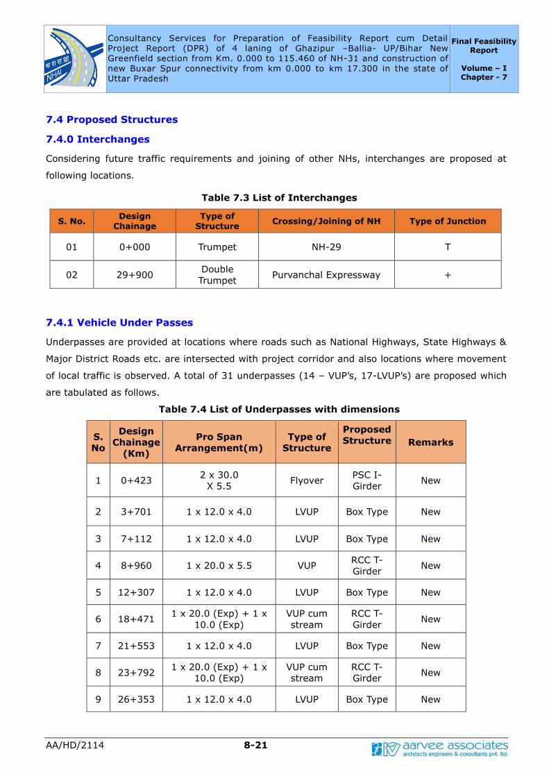
Consultancy Services for Preparation of Feasibility Report cum Detail
Project Report (DPR) of 4 laning of Ghazipur –Ballia- UP/Bihar New
Greenfield section from Km. 0.000 to 115.460 of NH-31 and construction of
new Buxar Spur connectivity from km 0.000 to km 17.300 in the state of
Uttar Pradesh
Final Feasibility Report
Volume – I Chapter - 7
AA/HD/2114 8-21
7.4 Proposed Structures
7.4.0 Interchanges
Considering future traffic requirements and joining of other NHs, interchanges are proposed at
following locations.
Table 7.3 List of Interchanges
S. No. Design
Chainage
Type of
Structure Crossing/Joining of NH Type of Junction
01 0+000 Trumpet NH-29 T
02 29+900 Double
Trumpet Purvanchal Expressway +
7.4.1 Vehicle Under Passes
Underpasses are provided at locations where roads such as National Highways, State Highways &
Major District Roads etc. are intersected with project corridor and also locations where movement
of local traffic is observed. A total of 31 underpasses (14 – VUP’s, 17-LVUP’s) are proposed which
are tabulated as follows.
Table 7.4 List of Underpasses with dimensions
S.
No
Design
Chainage
(Km)
Pro Span
Arrangement(m)
Type of
Structure
Proposed
Structure Remarks
1 0+423 2 x 30.0
X 5.5 Flyover
PSC I-
Girder New
2 3+701 1 x 12.0 x 4.0 LVUP Box Type New
3 7+112 1 x 12.0 x 4.0 LVUP Box Type New
4 8+960 1 x 20.0 x 5.5 VUP RCC T-
Girder New
5 12+307 1 x 12.0 x 4.0 LVUP Box Type New
6 18+471 1 x 20.0 (Exp) + 1 x
10.0 (Exp)
VUP cum
stream
RCC T-
Girder New
7 21+553 1 x 12.0 x 4.0 LVUP Box Type New
8 23+792 1 x 20.0 (Exp) + 1 x
10.0 (Exp)
VUP cum
stream
RCC T-
Girder New
9 26+353 1 x 12.0 x 4.0 LVUP Box Type New

Consultancy Services for Preparation of Feasibility Report cum Detail
Project Report (DPR) of 4 laning of Ghazipur –Ballia- UP/Bihar New
Greenfield section from Km. 0.000 to 115.460 of NH-31 and construction of
new Buxar Spur connectivity from km 0.000 to km 17.300 in the state of
Uttar Pradesh
Final Feasibility Report
Volume – I Chapter - 7
AA/HD/2114 8-22
S.
No
Design
Chainage
(Km)
Pro Span
Arrangement(m)
Type of
Structure
Proposed
Structure Remarks
10 29+916 4 x 30 x 5.5 Flyover PSC I-
Girder New
11 34+773 1 x 20.0 x 5.5 VUP cum
stream
RCC T-
Girder New
12 39+143 1 x 12.0 x 4.0 LVUP Box Type New
13 44+513 1 x 12.0 x 4.0 LVUP Box Type New
14 51+792 1 x 30.0 x 5.5 VUP PSC I-
Girder New
15 54+394 1 x 12.0 x 4.0 LVUP Box Type New
16 57+727 1×12.0 x 4.0 LVUP Box Type New
17 64+271 1×12.0 x 4.0 LVUP Box Type New
18 70+317 1 x 30.0 x 5.5 VUP PSC I-
Girder New
19 74+169 1 x 30.0 x 5.5 VUP PSC I-
Girder New
20 77+432 1 x 12.0 x 4.0 LVUP Box Type New
21 79+711 1 x 20.0 x 5.5 VUP RCC T-
Girder New
22 82+180 1 x 12.0 x 4.0 LVUP Box Type New
23 84+612 1 x 12.0 x 4.0 LVUP Box Type New
24 89+661 1 x 12.0 x 4.0 LVUP Box Type New
25 92+283 1 x 12.0 x 4.0 LVUP Box Type New
26 95+779 1 x 12.0 x 4.0 LVUP Box Type New
27 97+519 1 x 30.0 x 5.5 VUP PSC I-
Girder New
28 99+414 1 x 20.0 x 5.5 VUP RCC T-
Girder New
29 101+989 1 x 12.0 x 4.0 LVUP Box Type New
30 103+870 1 x 30.0 x 5.5 VUP PSC I-
Girder New
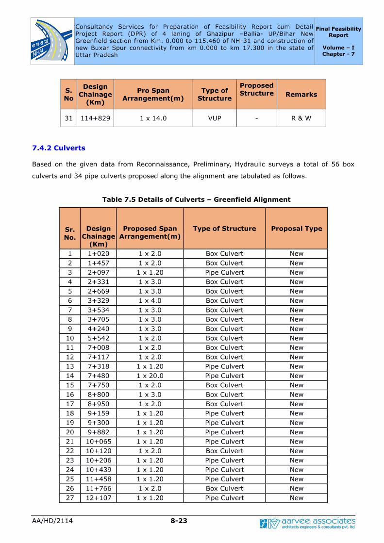
Consultancy Services for Preparation of Feasibility Report cum Detail
Project Report (DPR) of 4 laning of Ghazipur –Ballia- UP/Bihar New
Greenfield section from Km. 0.000 to 115.460 of NH-31 and construction of
new Buxar Spur connectivity from km 0.000 to km 17.300 in the state of
Uttar Pradesh
Final Feasibility Report
Volume – I Chapter - 7
AA/HD/2114 8-23
S.
No
Design
Chainage
(Km)
Pro Span
Arrangement(m)
Type of
Structure
Proposed
Structure Remarks
31 114+829 1 x 14.0 VUP - R & W
7.4.2 Culverts Based on the given data from Reconnaissance, Preliminary, Hydraulic surveys a total of 56 box
culverts and 34 pipe culverts proposed along the alignment are tabulated as follows.
Table 7.5 Details of Culverts – Greenfield Alignment
Sr.
No.
Design
Chainage
(Km)
Proposed Span
Arrangement(m)
Type of Structure
Proposal Type
1 1+020 1 x 2.0 Box Culvert New
2 1+457 1 x 2.0 Box Culvert New
3 2+097 1 x 1.20 Pipe Culvert New
4 2+331 1 x 3.0 Box Culvert New
5 2+669 1 x 3.0 Box Culvert New
6 3+329 1 x 4.0 Box Culvert New
7 3+534 1 x 3.0 Box Culvert New
8 3+705 1 x 3.0 Box Culvert New
9 4+240 1 x 3.0 Box Culvert New
10 5+542 1 x 2.0 Box Culvert New
11 7+008 1 x 2.0 Box Culvert New
12 7+117 1 x 2.0 Box Culvert New
13 7+318 1 x 1.20 Pipe Culvert New
14 7+480 1 x 20.0 Pipe Culvert New
15 7+750 1 x 2.0 Box Culvert New
16 8+800 1 x 3.0 Box Culvert New
17 8+950 1 x 2.0 Box Culvert New
18 9+159 1 x 1.20 Pipe Culvert New
19 9+300 1 x 1.20 Pipe Culvert New
20 9+882 1 x 1.20 Pipe Culvert New
21 10+065 1 x 1.20 Pipe Culvert New
22 10+120 1 x 2.0 Box Culvert New
23 10+206 1 x 1.20 Pipe Culvert New
24 10+439 1 x 1.20 Pipe Culvert New
25 11+458 1 x 1.20 Pipe Culvert New
26 11+766 1 x 2.0 Box Culvert New
27 12+107 1 x 1.20 Pipe Culvert New
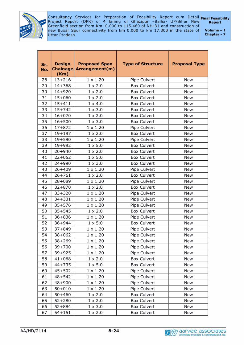
Consultancy Services for Preparation of Feasibility Report cum Detail
Project Report (DPR) of 4 laning of Ghazipur –Ballia- UP/Bihar New
Greenfield section from Km. 0.000 to 115.460 of NH-31 and construction of
new Buxar Spur connectivity from km 0.000 to km 17.300 in the state of
Uttar Pradesh
Final Feasibility Report
Volume – I Chapter - 7
AA/HD/2114 8-24
Sr.
No.
Design
Chainage
(Km)
Proposed Span
Arrangement(m)
Type of Structure
Proposal Type
28 13+216 1 x 1.20 Pipe Culvert New
29 14+368 1 x 2.0 Box Culvert New
30 14+920 1 x 2.0 Box Culvert New
31 15+060 1 x 2.0 Box Culvert New
32 15+411 1 x 4.0 Box Culvert New
33 15+742 1 x 3.0 Box Culvert New
34 16+070 1 x 2.0 Box Culvert New
35 16+500 1 x 3.0 Box Culvert New
36 17+872 1 x 1.20 Pipe Culvert New
37 19+197 1 x 2.0 Box Culvert New
38 19+590 1 x 1.20 Pipe Culvert New
39 19+992 1 x 5.0 Box Culvert New
40 20+940 1 x 2.0 Box Culvert New
41 22+052 1 x 5.0 Box Culvert New
42 24+990 1 x 3.0 Box Culvert New
43 26+409 1 x 1.20 Pipe Culvert New
44 26+761 1 x 2.0 Box Culvert New
45 28+089 1 x 1.20 Pipe Culvert New
46 32+870 1 x 2.0 Box Culvert New
47 33+320 1 x 1.20 Pipe Culvert New
48 34+331 1 x 1.20 Pipe Culvert New
49 35+576 1 x 1.20 Pipe Culvert New
50 35+545 1 x 2.0 Box Culvert New
51 36+836 1 x 1.20 Pipe Culvert New
52 36+944 1 x 5.0 Box Culvert New
53 37+849 1 x 1.20 Pipe Culvert New
54 38+062 1 x 1.20 Pipe Culvert New
55 38+269 1 x 1.20 Pipe Culvert New
56 39+700 1 x 1.20 Pipe Culvert New
57 39+925 1 x 1.20 Pipe Culvert New
58 41+068 1 x 2.0 Box Culvert New
59 44+735 1 x 5.0 Box Culvert New
60 45+502 1 x 1.20 Pipe Culvert New
61 48+542 1 x 1.20 Pipe Culvert New
62 48+900 1 x 1.20 Pipe Culvert New
63 50+010 1 x 1.20 Pipe Culvert New
64 50+460 1 x 2.0 Box Culvert New
65 52+280 1 x 2.0 Box Culvert New
66 52+884 1 x 3.0 Box Culvert New
67 54+151 1 x 2.0 Box Culvert New
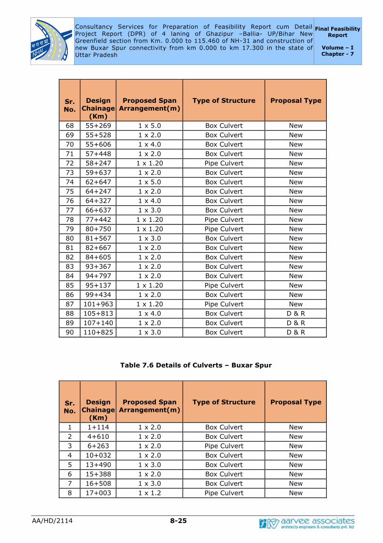
Consultancy Services for Preparation of Feasibility Report cum Detail
Project Report (DPR) of 4 laning of Ghazipur –Ballia- UP/Bihar New
Greenfield section from Km. 0.000 to 115.460 of NH-31 and construction of
new Buxar Spur connectivity from km 0.000 to km 17.300 in the state of
Uttar Pradesh
Final Feasibility Report
Volume – I Chapter - 7
AA/HD/2114 8-25
Sr.
No.
Design
Chainage
(Km)
Proposed Span
Arrangement(m)
Type of Structure
Proposal Type
68 55+269 1 x 5.0 Box Culvert New
69 55+528 1 x 2.0 Box Culvert New
70 55+606 1 x 4.0 Box Culvert New
71 57+448 1 x 2.0 Box Culvert New
72 58+247 1 x 1.20 Pipe Culvert New
73 59+637 1 x 2.0 Box Culvert New
74 62+647 1 x 5.0 Box Culvert New
75 64+247 1 x 2.0 Box Culvert New
76 64+327 1 x 4.0 Box Culvert New
77 66+637 1 x 3.0 Box Culvert New
78 77+442 1 x 1.20 Pipe Culvert New
79 80+750 1 x 1.20 Pipe Culvert New
80 81+567 1 x 3.0 Box Culvert New
81 82+667 1 x 2.0 Box Culvert New
82 84+605 1 x 2.0 Box Culvert New
83 93+367 1 x 2.0 Box Culvert New
84 94+797 1 x 2.0 Box Culvert New
85 95+137 1 x 1.20 Pipe Culvert New
86 99+434 1 x 2.0 Box Culvert New
87 101+963 1 x 1.20 Pipe Culvert New
88 105+813 1 x 4.0 Box Culvert D & R
89 107+140 1 x 2.0 Box Culvert D & R
90 110+825 1 x 3.0 Box Culvert D & R
Table 7.6 Details of Culverts – Buxar Spur
Sr.
No.
Design
Chainage
(Km)
Proposed Span
Arrangement(m)
Type of Structure
Proposal Type
1 1+114 1 x 2.0 Box Culvert New
2 4+610 1 x 2.0 Box Culvert New
3 6+263 1 x 2.0 Pipe Culvert New
4 10+032 1 x 2.0 Box Culvert New
5 13+490 1 x 3.0 Box Culvert New
6 15+388 1 x 2.0 Box Culvert New
7 16+508 1 x 3.0 Box Culvert New
8 17+003 1 x 1.2 Pipe Culvert New
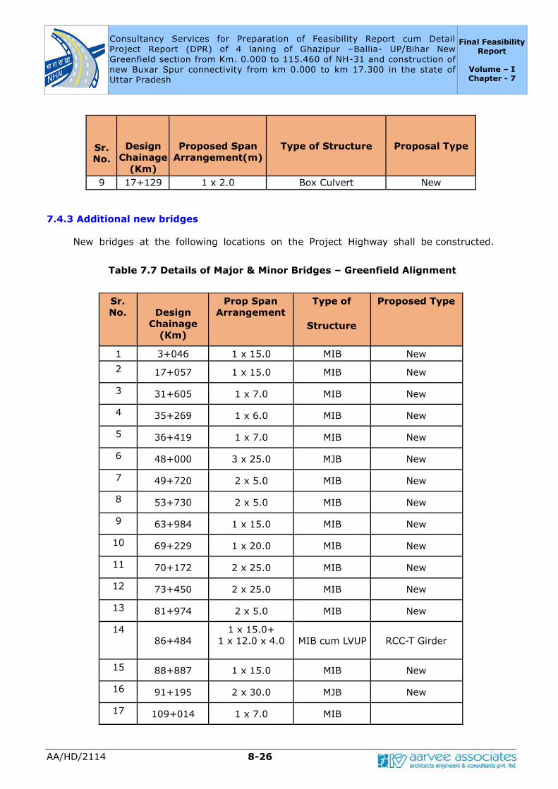
Consultancy Services for Preparation of Feasibility Report cum Detail
Project Report (DPR) of 4 laning of Ghazipur –Ballia- UP/Bihar New
Greenfield section from Km. 0.000 to 115.460 of NH-31 and construction of
new Buxar Spur connectivity from km 0.000 to km 17.300 in the state of
Uttar Pradesh
Final Feasibility Report
Volume – I Chapter - 7
AA/HD/2114 8-26
Sr.
No.
Design
Chainage
(Km)
Proposed Span
Arrangement(m)
Type of Structure
Proposal Type
9 17+129 1 x 2.0 Box Culvert New
7.4.3 Additional new bridges
New bridges at the following locations on the Project Highway shall be constructed.
Table 7.7 Details of Major & Minor Bridges – Greenfield Alignment
Sr.
No.
Design
Chainage
(Km)
Prop Span
Arrangement
Type of
Structure
Proposed Type
1 3+046 1 x 15.0 MIB New
2 17+057 1 x 15.0 MIB New
3 31+605 1 x 7.0 MIB New
4 35+269 1 x 6.0 MIB New
5 36+419 1 x 7.0 MIB New
6 48+000 3 x 25.0 MJB New
7 49+720 2 x 5.0 MIB New
8 53+730 2 x 5.0 MIB New
9 63+984 1 x 15.0 MIB New
10 69+229 1 x 20.0 MIB New
11 70+172 2 x 25.0 MIB New
12 73+450 2 x 25.0 MIB New
13 81+974 2 x 5.0 MIB New
14
86+484
1 x 15.0+
1 x 12.0 x 4.0
MIB cum LVUP RCC-T Girder
15 88+887 1 x 15.0 MIB New
16 91+195 2 x 30.0 MJB New
17 109+014 1 x 7.0 MIB
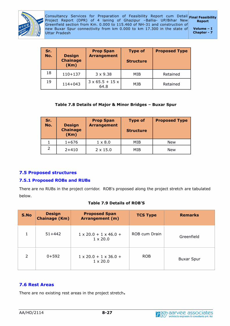
Consultancy Services for Preparation of Feasibility Report cum Detail
Project Report (DPR) of 4 laning of Ghazipur –Ballia- UP/Bihar New
Greenfield section from Km. 0.000 to 115.460 of NH-31 and construction of
new Buxar Spur connectivity from km 0.000 to km 17.300 in the state of
Uttar Pradesh
Final Feasibility Report
Volume – I Chapter - 7
AA/HD/2114 8-27
Sr.
No.
Design
Chainage
(Km)
Prop Span
Arrangement
Type of
Structure
Proposed Type
18 110+137 3 x 9.38 MIB Retained
19 114+043
3 x 65.5 + 15 x
64.8 MJB Retained
Table 7.8 Details of Major & Minor Bridges – Buxar Spur
Sr.
No.
Design
Chainage
(Km)
Prop Span
Arrangement
Type of
Structure
Proposed Type
1 1+676 1 x 8.0 MIB New
2 2+410 2 x 15.0 MIB New
7.5 Proposed structures
7.5.1 Proposed ROBs and RUBs
There are no RUBs in the project corridor. ROB's proposed along the project stretch are tabulated
below.
Table 7.9 Details of ROB’S
S.No Design
Chainage (Km)
Proposed Span
Arrangement (m) TCS Type Remarks
1 51+442 1 x 20.0 + 1 x 46.0 +
1 x 20.0
ROB cum Drain Greenfield
2 0+592 1 x 20.0 + 1 x 36.0 +
1 x 20.0
ROB Buxar Spur
7.6 Rest Areas
There are no existing rest areas in the project stretch.
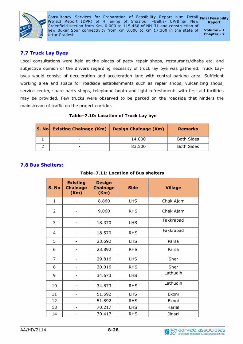
Consultancy Services for Preparation of Feasibility Report cum Detail
Project Report (DPR) of 4 laning of Ghazipur –Ballia- UP/Bihar New
Greenfield section from Km. 0.000 to 115.460 of NH-31 and construction of
new Buxar Spur connectivity from km 0.000 to km 17.300 in the state of
Uttar Pradesh
Final Feasibility Report
Volume – I Chapter - 7
AA/HD/2114 8-28
7.7 Truck Lay Byes
Local consultations were held at the places of petty repair shops, restaurants/dhaba etc. and
subjective opinion of the drivers regarding necessity of truck lay bye was gathered. Truck Lay-
byes would consist of deceleration and acceleration lane with central parking area. Sufficient
working area and space for roadside establishments such as repair shops, vulcanizing shops,
service center, spare parts shops, telephone booth and light refreshments with first aid facilities
may be provided. Few trucks were observed to be parked on the roadside that hinders the
mainstream of traffic on the project corridor.
Table–7.10: Location of Truck Lay bye
S. No Existing Chainage (Km) Design Chainage (Km) Remarks
1 - 14.000 Both Sides
2 - 83.500 Both Sides
7.8 Bus Shelters:
Table–7.11: Location of Bus shelters
S. No
Existing
Chainage
(Km)
Design
Chainage
(Km)
Side Village
1 - 8.860 LHS Chak Ajam
2 - 9.060 RHS Chak Ajam
3 - 18.370 LHS Fakkrabad
4 - 18.570 RHS Fakkrabad
5 - 23.692 LHS Parsa
6 - 23.892 RHS Parsa
7 - 29.816 LHS Sher
8 - 30.016 RHS Sher
9 - 34.673 LHS Lathudih
10 - 34.873 RHS Lathudih
11 - 51.692 LHS Ekoni
12 - 51.892 RHS Ekoni
13 - 70.217 LHS Harlal
14 - 70.417 RHS Jinari
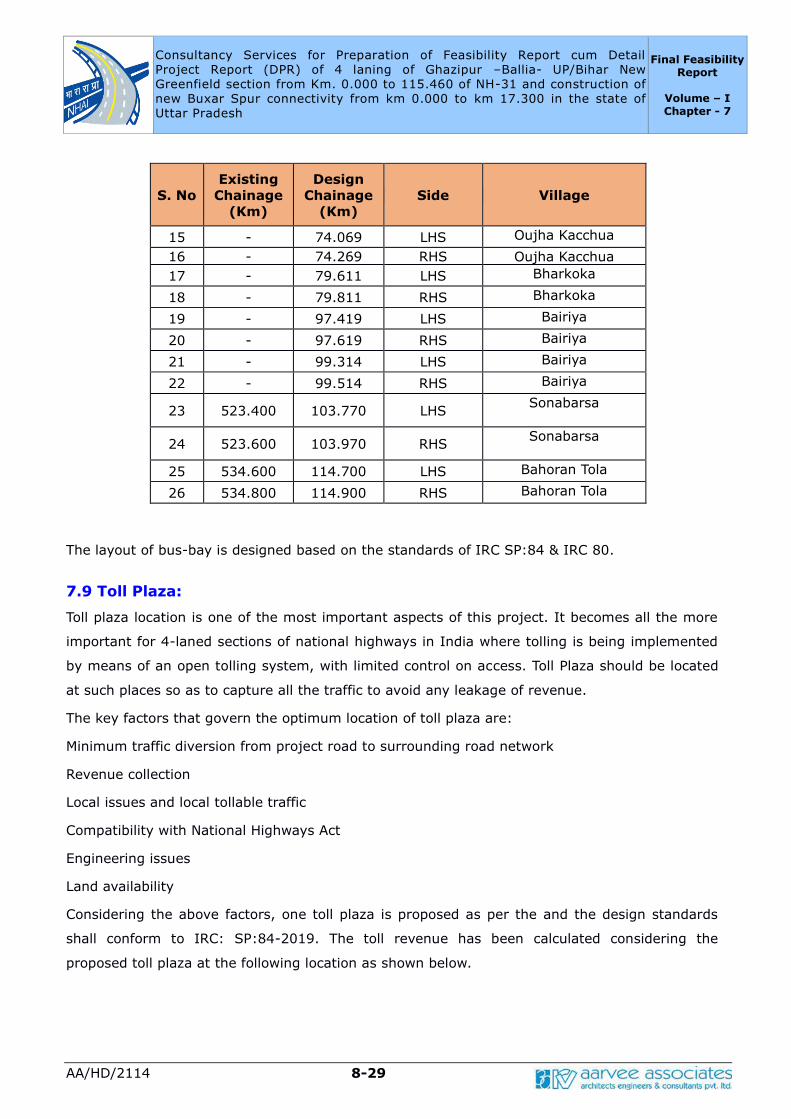
Consultancy Services for Preparation of Feasibility Report cum Detail
Project Report (DPR) of 4 laning of Ghazipur –Ballia- UP/Bihar New
Greenfield section from Km. 0.000 to 115.460 of NH-31 and construction of
new Buxar Spur connectivity from km 0.000 to km 17.300 in the state of
Uttar Pradesh
Final Feasibility Report
Volume – I Chapter - 7
AA/HD/2114 8-29
S. No
Existing
Chainage
(Km)
Design
Chainage
(Km)
Side Village
15 - 74.069 LHS Oujha Kacchua
16 - 74.269 RHS Oujha Kacchua
17 - 79.611 LHS Bharkoka
18 - 79.811 RHS Bharkoka
19 - 97.419 LHS Bairiya
20 - 97.619 RHS Bairiya
21 - 99.314 LHS Bairiya
22 - 99.514 RHS Bairiya
23 523.400 103.770 LHS Sonabarsa
24 523.600 103.970 RHS Sonabarsa
25 534.600 114.700 LHS Bahoran Tola
26 534.800 114.900 RHS Bahoran Tola
The layout of bus-bay is designed based on the standards of IRC SP:84 & IRC 80.
7.9 Toll Plaza:
Toll plaza location is one of the most important aspects of this project. It becomes all the more
important for 4-laned sections of national highways in India where tolling is being implemented
by means of an open tolling system, with limited control on access. Toll Plaza should be located
at such places so as to capture all the traffic to avoid any leakage of revenue.
The key factors that govern the optimum location of toll plaza are:
Minimum traffic diversion from project road to surrounding road network
Revenue collection
Local issues and local tollable traffic
Compatibility with National Highways Act
Engineering issues
Land availability
Considering the above factors, one toll plaza is proposed as per the and the design standards
shall conform to IRC: SP:84-2019. The toll revenue has been calculated considering the
proposed toll plaza at the following location as shown below.

Consultancy Services for Preparation of Feasibility Report cum Detail
Project Report (DPR) of 4 laning of Ghazipur –Ballia- UP/Bihar New
Greenfield section from Km. 0.000 to 115.460 of NH-31 and construction of
new Buxar Spur connectivity from km 0.000 to km 17.300 in the state of
Uttar Pradesh
Final Feasibility Report
Volume – I Chapter - 7
AA/HD/2114 8-30
Table-7.12: Location of Toll Plaza
Stretch
No of Toll Plazas
No. of Lanes
Entry Exit
Ghazipur –Ballia-
UP/Bihar
1@ km.5+000
7+1
7+1 2@ km. 65+000
Adequate land for toll plaza for the provision of toll lanes including all other buildings
and structures shall be acquired.
Table 7.13 Summary details of Structures
S.
No
Type Greenfield
Alignment
Buxar Spur
1 Flyovers 2 0
2 VUP 12 0
3 LVUP 17 0
4 SVUP 0 0
5 ROB 1 1
6 Box Culverts 56 8
7 Pipe Culvert 34 1
8 Minor Bridge 16 2
9 Major Bridge 3 0
Total 141 12
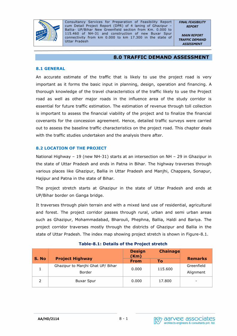
Consultancy Services for Preparation of Feasibility Report cum Detail Project Report (DPR) of 4 laning of Ghazipur –Ballia- UP/Bihar New Greenfield section from Km. 0.000 to 115.460 of NH-31 and construction of new Buxar Spur connectivity from km 0.000 to km 17.300 in the state of Uttar Pradesh
FINAL FEASIBILITY
REPORT
MAIN REPORT
TRAFFIC DEMAND
ASSESSMENT
8 - 1
AA/HD/2114
8.0 TRAFFIC DEMAND ASSESSMENT
8.1 GENERAL
An accurate estimate of the traffic that is likely to use the project road is very
important as it forms the basic input in planning, design, operation and financing. A
thorough knowledge of the travel characteristics of the traffic likely to use the Project
road as well as other major roads in the influence area of the study corridor is
essential for future traffic estimation. The estimation of revenue through toll collection
is important to assess the financial viability of the project and to finalize the financial
covenants for the concession agreement. Hence, detailed traffic surveys were carried
out to assess the baseline traffic characteristics on the project road. This chapter deals
with the traffic studies undertaken and the analysis there after.
8.2 LOCATION OF THE PROJECT
National Highway – 19 (new NH-31) starts at an intersection on NH – 29 in Ghazipur in
the state of Uttar Pradesh and ends in Patna in Bihar. The highway traverses through
various places like Ghazipur, Ballia in Uttar Pradesh and Manjhi, Chappara, Sonapur,
Hajipur and Patna in the state of Bihar.
The project stretch starts at Ghazipur in the state of Uttar Pradesh and ends at
UP/Bihar border on Ganga bridge.
It traverses through plain terrain and with a mixed land use of residential, agricultural
and forest. The project corridor passes through rural, urban and semi urban areas
such as Ghazipur, Mohammadabad, Bharouli, Phephna, Ballia, Haldi and Bariya. The
project corridor traverses mostly through the districts of Ghazipur and Ballia in the
state of Uttar Pradesh. The index map showing project stretch is shown in Figure-8.1.
Table-8.1: Details of the Project stretch
S. No
Project Highway
Design Chainage
(Km)
Remarks From To
1 Ghazipur to Manjhi Ghat UP/ Bihar
Border 0.000 115.600
Greenfield
Alignment
2 Buxar Spur 0.000 17.800 -
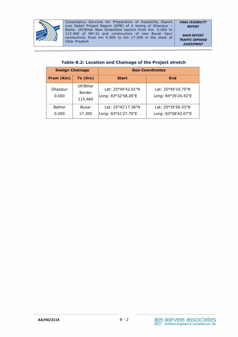
Consultancy Services for Preparation of Feasibility Report cum Detail Project Report (DPR) of 4 laning of Ghazipur –Ballia- UP/Bihar New Greenfield section from Km. 0.000 to 115.460 of NH-31 and construction of new Buxar Spur connectivity from km 0.000 to km 17.300 in the state of Uttar Pradesh
FINAL FEASIBILITY
REPORT
MAIN REPORT
TRAFFIC DEMAND
ASSESSMENT
8 - 2
AA/HD/2114
Table-8.2: Location and Chainage of the Project stretch
Design Chainage Geo-Coordinates
From (Km) To (Km) Start End
Ghazipur
0.000
UP/Bihar
Border
115.460
Lat: 25°40'42.01"N
Long: 83°32'58.26"E
Lat: 25°49'19.75"N
Long: 84°35'24.42"E
Bathor
0.000
Buxar
17.300
Lat: 25°42'17.36"N
Long: 83°51'27.70"E
Lat: 25°35'56.53"N
Long: 83°58'42.07"E
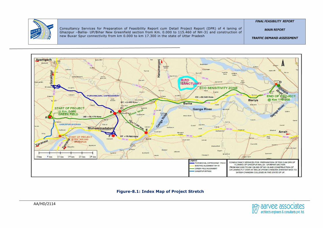
Consultancy Services for Preparation of Feasibility Report cum Detail Project Report (DPR) of 4 laning of Ghazipur –Ballia- UP/Bihar New Greenfield section from Km. 0.000 to 115.460 of NH-31 and construction of new Buxar Spur connectivity from km 0.000 to km 17.300 in the state of Uttar Pradesh
FINAL FEASIBILITY REPORT
MAIN REPORT
TRAFFIC DEMAND ASSESSMENT
AA/HD/2114
Figure-8.1: Index Map of Project Stretch

Consultancy Services for Preparation of Feasibility Report cum Detail Project Report (DPR) of 4 laning of Ghazipur –Ballia- UP/Bihar New Greenfield section from Km. 0.000 to 115.460 of NH-31 and construction of new Buxar Spur connectivity from km 0.000 to km 17.300 in the state of Uttar Pradesh
FINAL FEASIBILITY
REPORT
MAIN REPORT
TRAFFIC DEMAND
ASSESSMENT
AA/HD/2114
8.3 OBJECTIVES
The primary objectives of the traffic studies undertaken were to:
✓ Determine characteristics of traffic movement and to establish base year traffic.
✓ Determine travel pattern as well as type and weight of commodities carried by
goods vehicles.
✓ Capacity assessment and recommendation for road widening based on demand
forecast.
✓ Determine Vehicle Damage Factors to assist in pavement design.
8.4 SCOPE
The scope of traffic study includes the analysis of the primary data collected from
traffic surveys. Vehicle Damage Factor is assessed from the Axle Load Survey to
design pavement layers. To determine the capacity, level of service and pavement
composition along the project corridor, the following parameters are assessed:
✓ Average Daily Traffic, Annual Average Daily Traffic, Peak Hour Factor and
Seasonal Correction Factor of the Base Year
✓ Traffic Growth Rates
✓ Axle load survey
✓ Turning Moment volumes
8.5 TRAFFIC SURVEYS
During the reconnaissance survey, the existing road network was studied. As per the
details given in TOR, mid-block sections were identified for carrying out traffic surveys
and all other locations of traffic surveys were finalized as per TOR. Traffic Surveys
Planning Schedule is presented in Table-8.3.
Table-8.3: Traffic Survey Schedule
S.No Type of
Survey Location
Chainage
(km) Duration of
Survey Date of
Survey
1 Classified
Traffic Volume
Counts
Near Sultanpur 419.000
4 Days
5-01-2021
to
08-01-2021 2 Near Bariya 526.000
6 Turning
Movements
Phephna
(4-arm Junction) 473.100
24 hours
05-01-2021
7 Junction with NH 84
(Bharouli chowk 451.100 06-01-2021

Consultancy Services for Preparation of Feasibility Report cum Detail Project Report (DPR) of 4 laning of Ghazipur –Ballia- UP/Bihar New Greenfield section from Km. 0.000 to 115.460 of NH-31 and construction of new Buxar Spur connectivity from km 0.000 to km 17.300 in the state of Uttar Pradesh
FINAL FEASIBILITY
REPORT
MAIN REPORT
TRAFFIC DEMAND
ASSESSMENT
AA/HD/2114
S.No Type of
Survey Location
Chainage
(km) Duration of
Survey Date of
Survey
Junction)
14 Axle Load
Survey
Near Sultanpur 419.000
24 hours
05-01-2021
17 Near Bariya 526.000 06-01-2021
The Automatic Classified Traffic Volume Count (ATCC) surveys were conducted at two
strategic points, i.e., at Km 419.000 (near Sultanpur) and Km 526.000 (near Bariya)
for four consecutive days. The surveys were conducted using Pneumatic tubes and
video graphic methods. Turning movement surveys were conducted for a period of 24
consecutive hours at two locations, i.e., at Km 451.570 (Bharouli chowk Junction) and
at Km 473.100 (Phephna Junction) where the project corridor intersects with other
national and state highways.
Axle load Survey were conducted at four locations i.e., at Km 419.000 (near
Sultanpur) and 526.000 (near Bariya).
A map showing the project stretch with all the traffic survey locations is shown in the
Figure-8.2.
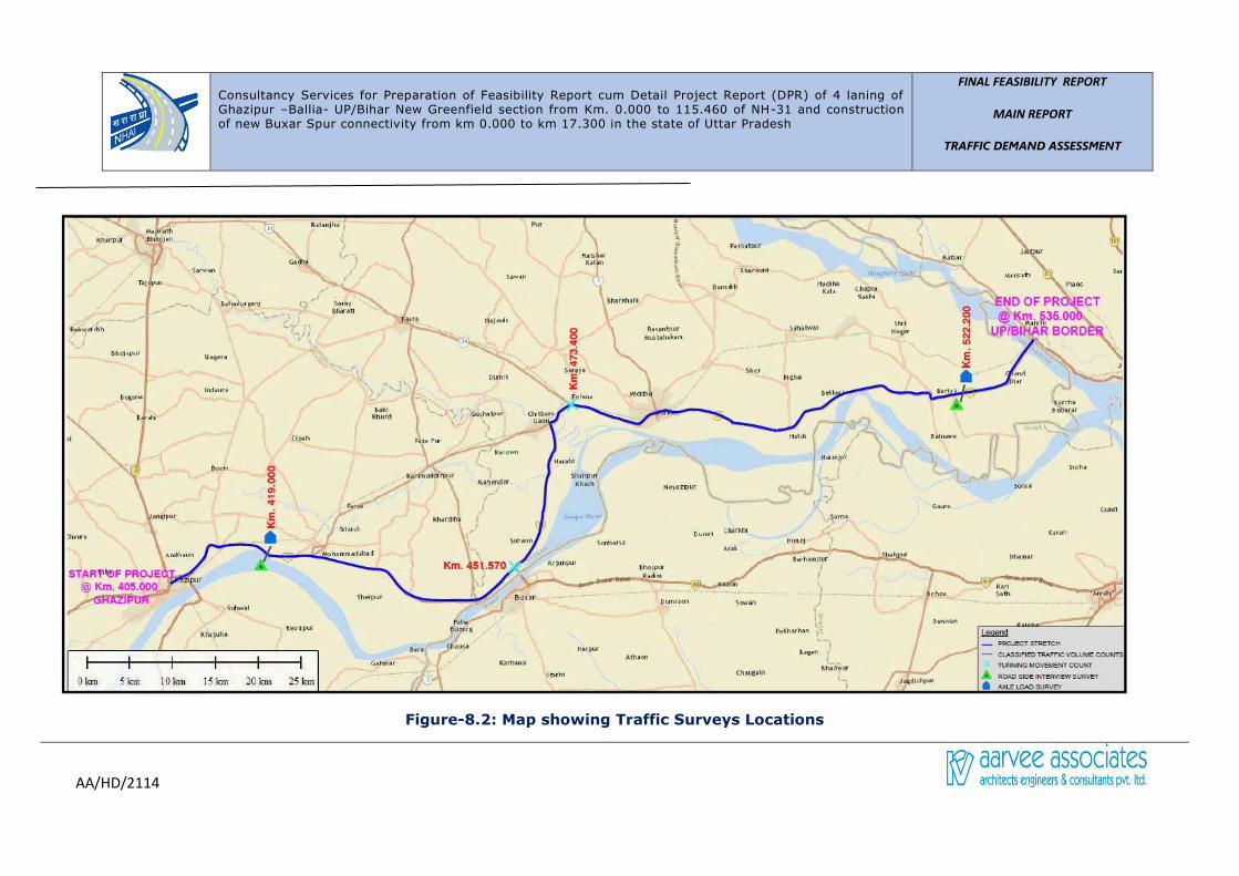
Consultancy Services for Preparation of Feasibility Report cum Detail Project Report (DPR) of 4 laning of Ghazipur –Ballia- UP/Bihar New Greenfield section from Km. 0.000 to 115.460 of NH-31 and construction of new Buxar Spur connectivity from km 0.000 to km 17.300 in the state of Uttar Pradesh
FINAL FEASIBILITY REPORT
MAIN REPORT
TRAFFIC DEMAND ASSESSMENT
AA/HD/2114
Figure-8.2: Map showing Traffic Surveys Locations
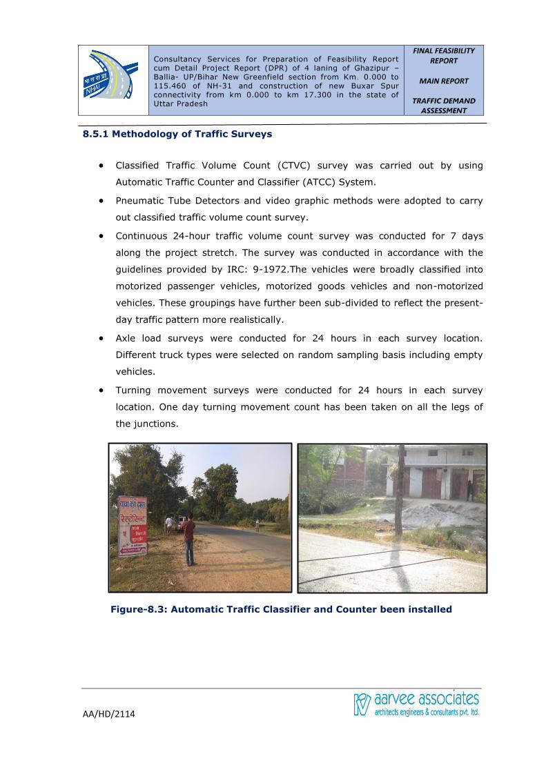
Consultancy Services for Preparation of Feasibility Report cum Detail Project Report (DPR) of 4 laning of Ghazipur –Ballia- UP/Bihar New Greenfield section from Km. 0.000 to 115.460 of NH-31 and construction of new Buxar Spur connectivity from km 0.000 to km 17.300 in the state of Uttar Pradesh
FINAL FEASIBILITY
REPORT
MAIN REPORT
TRAFFIC DEMAND
ASSESSMENT
AA/HD/2114
8.5.1 Methodology of Traffic Surveys
• Classified Traffic Volume Count (CTVC) survey was carried out by using
Automatic Traffic Counter and Classifier (ATCC) System.
• Pneumatic Tube Detectors and video graphic methods were adopted to carry
out classified traffic volume count survey.
• Continuous 24-hour traffic volume count survey was conducted for 7 days
along the project stretch. The survey was conducted in accordance with the
guidelines provided by IRC: 9-1972.The vehicles were broadly classified into
motorized passenger vehicles, motorized goods vehicles and non-motorized
vehicles. These groupings have further been sub-divided to reflect the present-
day traffic pattern more realistically.
• Axle load surveys were conducted for 24 hours in each survey location.
Different truck types were selected on random sampling basis including empty
vehicles.
• Turning movement surveys were conducted for 24 hours in each survey
location. One day turning movement count has been taken on all the legs of
the junctions.
Figure-8.3: Automatic Traffic Classifier and Counter been installed
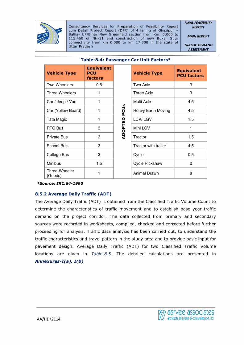
Consultancy Services for Preparation of Feasibility Report cum Detail Project Report (DPR) of 4 laning of Ghazipur –Ballia- UP/Bihar New Greenfield section from Km. 0.000 to 115.460 of NH-31 and construction of new Buxar Spur connectivity from km 0.000 to km 17.300 in the state of Uttar Pradesh
FINAL FEASIBILITY
REPORT
MAIN REPORT
TRAFFIC DEMAND
ASSESSMENT
AA/HD/2114
Table-8.4: Passenger Car Unit Factors*
Vehicle Type
Equivalent
PCU
factors
AD
OP
TE
D P
CU
s
Vehicle Type Equivalent
PCU factors
Two Wheelers 0.5 Two Axle 3
Three Wheelers 1 Three Axle 3
Car / Jeep / Van 1 Multi Axle 4.5
Car (Yellow Board) 1 Heavy Earth Moving 4.5
Tata Magic 1 LCV/ LGV 1.5
RTC Bus 3 Mini LCV 1
Private Bus 3 Tractor 1.5
School Bus 3 Tractor with trailer 4.5
College Bus 3 Cycle 0.5
Minibus 1.5 Cycle Rickshaw 2
Three-Wheeler (Goods)
1 Animal Drawn 8
*Source: IRC:64-1990
8.5.2 Average Daily Traffic (ADT)
The Average Daily Traffic (ADT) is obtained from the Classified Traffic Volume Count to
determine the characteristics of traffic movement and to establish base year traffic
demand on the project corridor. The data collected from primary and secondary
sources were recorded in worksheets, compiled, checked and corrected before further
proceeding for analysis. Traffic data analysis has been carried out, to understand the
traffic characteristics and travel pattern in the study area and to provide basic input for
pavement design. Average Daily Traffic (ADT) for two Classified Traffic Volume
locations are given in Table-8.5. The detailed calculations are presented in
Annexures-I(a), I(b)

Consultancy Services for Preparation of Feasibility Report cum Detail Project Report (DPR) of 4 laning of Ghazipur –Ballia- UP/Bihar New Greenfield section from Km. 0.000 to 115.460 of NH-31 and construction of new Buxar Spur connectivity from km 0.000 to km 17.300 in the state of Uttar Pradesh
FINAL FEASIBILITY
REPORT
MAIN REPORT
TRAFFIC DEMAND
ASSESSMENT
AA/HD/2114
Table-8.5: ADT at Survey Locations
Vehicle Type Km 419.000 Km526.000
Two Wheelers 7550 2007
Three Wheelers 623 337
Car 1544 694
Tata Magic 8 8
RTC Bus 59 12
Private Bus 55 58
Mini Bus 0 1
School/ College Bus 1 1
Two Axle 137 162
Three Axle 367 285
Multi Axle 425 292
Heavy Earth Moving 4 9
Light Commercial 90 102
Mini LCV 376 332
Tractor 14 13
Tractor with Trailer 13 13
Three Wheeler (Goods) 0 0
Bicycle 1151 15
Cycle Rickshaw 7 7
Animal Drawn 8 9
Government Exempted 38 38
Vehicles
Motorised 11304 4364
Non Motorised 1166 31
Total Traffic 12464 4395
Tollable Traffic 3062 1953
PCU
Motorised 10394 5583
Non Motorised 654 101
Total Traffic 11048 5677
Tollable Traffic 5852 4099

Consultancy Services for Preparation of Feasibility Report cum Detail Project Report (DPR) of 4 laning of Ghazipur –Ballia- UP/Bihar New Greenfield section from Km. 0.000 to 115.460 of NH-31 and construction of new Buxar Spur connectivity from km 0.000 to km 17.300 in the state of Uttar Pradesh
FINAL FEASIBILITY
REPORT
MAIN REPORT
TRAFFIC DEMAND
ASSESSMENT
AA/HD/2114
Fig: 8.5.1 Average Hourly Traffic Variation at Km 419.000, Sultanpur
Fig: 8.5.5 Average Hourly Traffic Variation at Km 526.000, Bariya Village
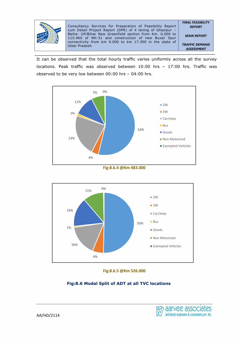
Consultancy Services for Preparation of Feasibility Report cum Detail Project Report (DPR) of 4 laning of Ghazipur –Ballia- UP/Bihar New Greenfield section from Km. 0.000 to 115.460 of NH-31 and construction of new Buxar Spur connectivity from km 0.000 to km 17.300 in the state of Uttar Pradesh
FINAL FEASIBILITY
REPORT
MAIN REPORT
TRAFFIC DEMAND
ASSESSMENT
AA/HD/2114
It can be observed that the total hourly traffic varies uniformly across all the survey
locations. Peak traffic was observed between 10:00 hrs – 17:00 hrs. Traffic was
observed to be very low between 00:00 hrs – 04:00 hrs.
Fig:8.6.4 @Km 483.000
Fig:8.6.5 @Km 526.000
Fig:8.6 Modal Split of ADT at all TVC locations
54%
4%
23%
1%
11%
7% 0%
2W
3W
Car/Jeep
Bus
Goods
Non Motorized
Exempted Vehicles
50%
6%
16%
1%
16%
11%0%
2W
3W
Car/Jeep
Bus
Goods
Non Motorized
Exempted Vehicles
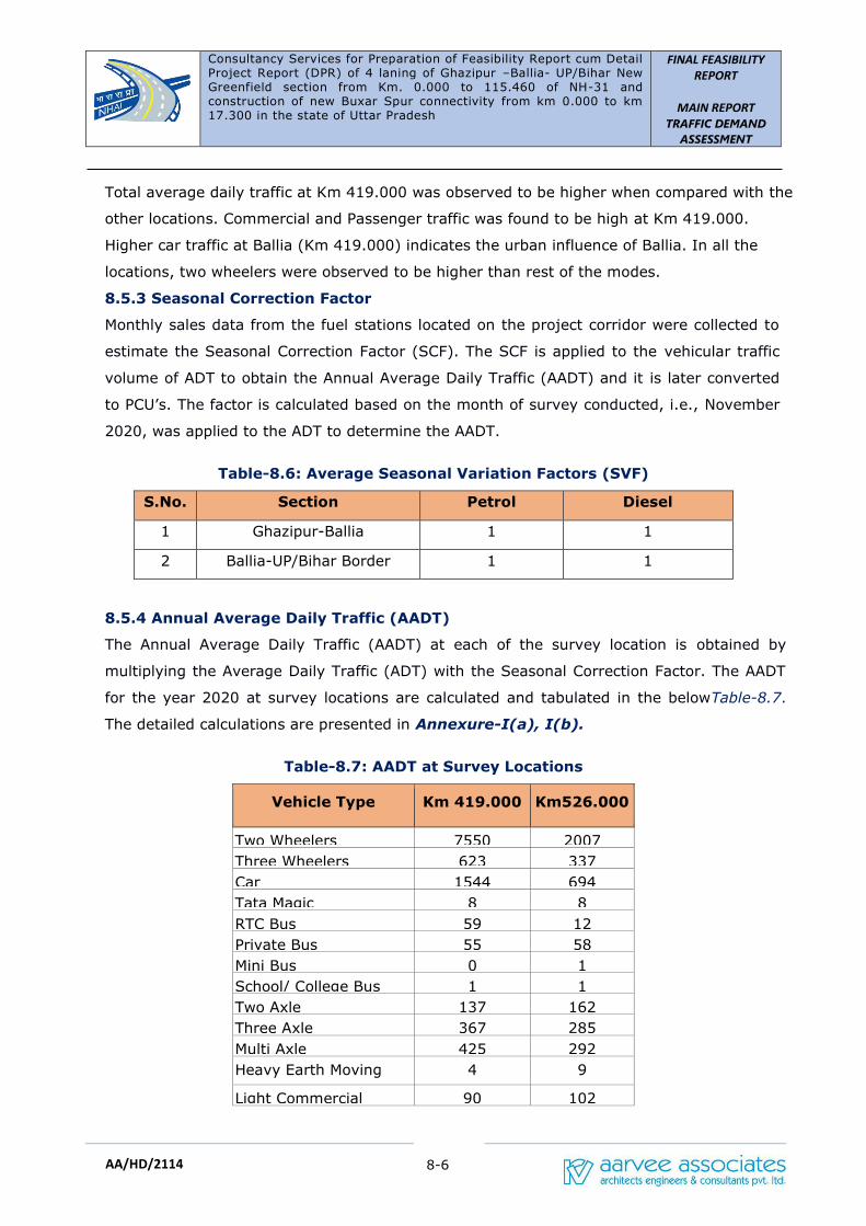
Consultancy Services for Preparation of Feasibility Report cum Detail Project Report (DPR) of 4 laning of Ghazipur –Ballia- UP/Bihar New Greenfield section from Km. 0.000 to 115.460 of NH-31 and construction of new Buxar Spur connectivity from km 0.000 to km 17.300 in the state of Uttar Pradesh
FINAL FEASIBILITY
REPORT
MAIN REPORT
TRAFFIC DEMAND
ASSESSMENT
8-6
AA/HD/2114
Total average daily traffic at Km 419.000 was observed to be higher when compared with the
other locations. Commercial and Passenger traffic was found to be high at Km 419.000.
Higher car traffic at Ballia (Km 419.000) indicates the urban influence of Ballia. In all the
locations, two wheelers were observed to be higher than rest of the modes.
8.5.3 Seasonal Correction Factor
Monthly sales data from the fuel stations located on the project corridor were collected to
estimate the Seasonal Correction Factor (SCF). The SCF is applied to the vehicular traffic
volume of ADT to obtain the Annual Average Daily Traffic (AADT) and it is later converted
to PCU’s. The factor is calculated based on the month of survey conducted, i.e., November
2020, was applied to the ADT to determine the AADT.
Table-8.6: Average Seasonal Variation Factors (SVF)
S.No. Section Petrol Diesel
1 Ghazipur-Ballia 1 1
2 Ballia-UP/Bihar Border 1 1
8.5.4 Annual Average Daily Traffic (AADT)
The Annual Average Daily Traffic (AADT) at each of the survey location is obtained by
multiplying the Average Daily Traffic (ADT) with the Seasonal Correction Factor. The AADT
for the year 2020 at survey locations are calculated and tabulated in the belowTable-8.7.
The detailed calculations are presented in Annexure-I(a), I(b).
Table-8.7: AADT at Survey Locations
Vehicle Type Km 419.000 Km526.000
Two Wheelers 7550 2007
Three Wheelers 623 337
Car 1544 694
Tata Magic 8 8
RTC Bus 59 12
Private Bus 55 58
Mini Bus 0 1
School/ College Bus 1 1
Two Axle 137 162
Three Axle 367 285
Multi Axle 425 292
Heavy Earth Moving 4 9
Light Commercial 90 102

Consultancy Services for Preparation of Feasibility Report cum Detail Project Report (DPR) of 4 laning of Ghazipur –Ballia- UP/Bihar New Greenfield section from Km. 0.000 to 115.460 of NH-31 and construction of new Buxar Spur connectivity from km 0.000 to km 17.300 in the state of Uttar Pradesh
FINAL FEASIBILITY
REPORT
MAIN REPORT
TRAFFIC DEMAND
ASSESSMENT
8-7
AA/HD/2114
Vehicle Type Km 419.000 Km526.000
Mini LCV 376 332
Tractor 14 13
Tractor with Trailer 13 13
Three Wheeler (Goods) 0 0
Bicycle 1151 15
Cycle Rickshaw 7 7
Animal Drawn 8 9
Government Exempted 38 38
Vehicles
Motorised 11304 4364
Non Motorised 1166 31
Total Traffic 12464 4395
Tollable Traffic 3062 1953
PCU
Motorised 10394 5583
Non Motorised 654 101
Total Traffic 11048 5677
Tollable Traffic 5852 4099
Table-8.8: Peak Hour Proportion (PHP) at Survey Locations
S.No. Volume Count
Location Count PHV Peak Hour PHP (%)
1 Km 419.000 4 Days 1825 7:00-8:00 14.64
2 Km 526.000 4 Days 380 11:00-12:00 8.64
8.5.5 Axle Load Survey and Analysis
Axle load surveys were conducted at Sultanpur, &
Bariya. Axle load Survey was conducted for all the
commercial vehicles (Trucks and LCV) in a normal
weekday in both the directions (24 hours in each
direction). The vehicles were selected randomly for
axle load measurement, ensuring suitable sample
for each category of commercial vehicles
consisting of overloaded and empty vehicles.
The Vehicle Damage Factor (VDF) is an index characterizing the traffic loading for a
highway and is defined as a multiplier for converting the number of commercial vehicles
of different axle loads to Standard Axle Loads (SAL). Equivalency factor (EF) is normally
worked out by using the Fourth Power Rule derived by AASHTO and approved by CRRI.
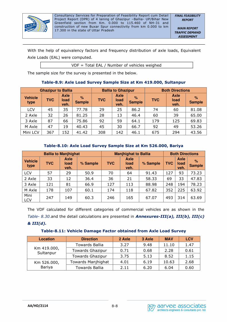
Consultancy Services for Preparation of Feasibility Report cum Detail Project Report (DPR) of 4 laning of Ghazipur –Ballia- UP/Bihar New Greenfield section from Km. 0.000 to 115.460 of NH-31 and construction of new Buxar Spur connectivity from km 0.000 to km 17.300 in the state of Uttar Pradesh
FINAL FEASIBILITY
REPORT
MAIN REPORT
TRAFFIC DEMAND
ASSESSMENT
8-8
AA/HD/2114
With the help of equivalency factors and frequency distribution of axle loads, Equivalent
Axle Loads (EAL) were computed.
VDF = Total EAL / Number of vehicles weighed
The sample size for the survey is presented in the below.
Table-8.9: Axle Load Survey Sample Size at Km 419.000, Sultanpur
Ghazipur to Ballia Ballia to Ghazipur Both Directions
Vehicle type
TVC Axle load veh.
% Sample
TVC Axle load veh.
% Sample
TVC Axle load veh.
% Sample
LCV 45 35 77.78 29 25 86.2 74 60 81.08
2 Axle 32 26 81.25 28 13 46.4 60 39 65.00
3 Axle 87 66 75.86 92 59 64.1 179 125 69.83
M Axle 47 19 40.43 45 30 66.7 92 49 53.26
Mini LCV 367 152 41.42 308 142 46.1 675 294 43.56
Table-8.10: Axle Load Survey Sample Size at Km 526.000, Bariya
Ballia to Manjhighat Manjhighat to Ballia Both Directions
Vehicle type
TVC Axle load veh.
% Sample TVC Axle load veh.
% Sample TVC Axle load veh.
% Sample
LCV 57 29 50.9 70 64 91.43 127 93 73.23
2 Axle 33 12 36.4 36 21 58.33 69 33 47.83
3 Axle 121 81 66.9 127 113 88.98 248 194 78.23
M Axle 178 107 60.1 174 118 67.82 352 225 63.92
Mini
LCV 247 149 60.3 246 165 67.07 493 314 63.69
The VDF calculated for different categories of commercial vehicles are as shown in the
Table- 8.30.and the detail calculations are presented in Annexures-III(a), III(b), III(c)
& III(d).
Table-8.11: Vehicle Damage Factor obtained from Axle Load Survey
Location Direction 2 Axle 3 Axle MAV LCV
Km 419.000,
Sultanpur
Towards Ballia 3.27 9.48 11.10 1.47
Towards Ghazipur 0.71 0.68 2.28 0.61
Towards Ghazipur 3.75 5.13 8.52 1.15
Km 526.000,
Bariya
Towards Manjhighat 4.01 6.19 10.63 2.68
Towards Ballia 2.11 6.20 6.04 0.60

Consultancy Services for Preparation of Feasibility Report cum Detail Project Report (DPR) of 4 laning of Ghazipur –Ballia- UP/Bihar New Greenfield section from Km. 0.000 to 115.460 of NH-31 and construction of new Buxar Spur connectivity from km 0.000 to km 17.300 in the state of Uttar Pradesh
FINAL FEASIBILITY
REPORT
MAIN REPORT
TRAFFIC DEMAND
ASSESSMENT
8-9
AA/HD/2114
Table-8.12: Goods Composition at Km 419.000, Sultanpur
Commodity 2 Axle
(%)
3 Axle
(%)
MAV
(%)
LCV
(%)
Mini LCV
(%)
Food grains and
pulses 13.04 8.39 2.94 8.33 3.64
Cash crops 0.00 0.00 0.00 0.00 0.00
Vegetables and Fruits 15.22 9.79 2.94 3.33 5.67
Processed Food Items 0.00 2.10 0.00 0.00 0.81
Packed Food Items 0.00 0.00 0.00 3.33 2.02
Fishery, Poultry and
Animal feed 2.17 2.80 0.00 3.33 4.45
Building Materials 0.00 21.68 32.35 3.33 6.07
Industrial Raw
Materials 4.35 1.40 0.00 0.00 0.81
Consumer Goods 6.52 16.08 29.41 16.67 13.36
Fertilisers, chemicals
and Pharmaceuticals 0.00 0.00 0.00 0.00 0.00
Machinery and
Automobiles 10.87 1.40 2.94 0.00 2.02
Petroleum Products 0.00 0.00 0.00 0.00 0.40
Parcel Goods 0.00 1.40 0.00 0.00 4.05
Empty 34.78 32.17 26.47 38.33 37.25
Industrial Outputs 0.00 2.80 0.00 8.33 4.05
Liquor and Cooldrinks 6.52 0.00 0.00 0.00 0.40
Passenger 6.52 0.00 2.94 15.00 14.98
Table-8.13: Goods Composition at Km 526.000, near Bariya
Commodity 2 Axle (%) 3 Axle (%)
MAV (%)
LCV (%)
Mini LCV (%)
Food grains and pulses 4.88 3.36 4.52 0.00 1.93
Cash crops 0.00 0.00 0.90 0.00 0.00
Vegetables and Fruits 9.76 13.03 9.05 11.34 10.22
Processed Food Items 4.88 2.94 4.07 2.06 2.21
Packed Food Items 0.00 0.84 0.00 2.06 0.28
Fishery, Poultry and
Animal feed 2.44 3.78 1.36 4.12 1.66
Building Materials 9.76 16.81 17.19 10.31 7.73
Industrial Raw
Materials 2.44 0.84 0.45 0.00 0.28
Consumer Goods 17.07 3.78 8.60 12.37 7.73

Consultancy Services for Preparation of Feasibility Report cum Detail Project Report (DPR) of 4 laning of Ghazipur –Ballia- UP/Bihar New Greenfield section from Km. 0.000 to 115.460 of NH-31 and construction of new Buxar Spur connectivity from km 0.000 to km 17.300 in the state of Uttar Pradesh
FINAL FEASIBILITY
REPORT
MAIN REPORT
TRAFFIC DEMAND
ASSESSMENT
8-10
AA/HD/2114
Commodity 2 Axle (%) 3 Axle (%)
MAV (%)
LCV (%)
Mini LCV (%)
Fertilisers, chemicals
and Pharmaceuticals 2.44 2.10 1.36 1.03 0.55
Machinery and
Automobiles 0.00 0.42 0.90 0.00 1.38
Petroleum Products 0.00 2.52 1.36 2.06 0.55
Parcel Goods 9.76 6.72 6.79 2.06 11.60
Empty 26.83 35.29 33.94 45.36 44.75
Industrial Outputs 7.32 3.36 5.88 6.19 1.93
Liquor and Cooldrinks 0.00 1.68 0.00 0.00 0.55
Passenger 2.44 2.52 3.62 1.03 6.63
It is observed that the percentage of goods vehicles plying empty on the project stretch
are on the higher side. The empty vehicles are moving towards Sonbhadra & Mirzapur
through the project stretch which are high in metal quarries. It is also observed that
various batching plants are present around the teekha junction, which is also one of the
reasons for observing the movement towards teekha junction with building materials.
8.5.6 Turning Movement Survey
The mid-block traffic volume count station as defined in Table–8.3 of this report have been
located to capture the pattern of the traffic plying on the project stretch. Apart from these
traffic volume counts, for the study of the road network around the project corridor, two
junctions have been identified for the turning movement surveys. The traffic pattern is
considerably influenced by these junctions, either in case of passenger vehicles or goods or
both also. 1 day turning movement counts have been taken on all the legs of these
junctions. The traffic volume levels and their characteristics at these intersections are
presented in Table-8.14 & 8.15. The leg wise classified traffic volume counts are presented
in Annexure-V(a), V(b).
8.5.7 Turning Bharauli Chowk Junction at km. 451+200
Bharauli Chowk intersection is a one of the major 3-legged intersection formed by
connecting the roads from Narainpur road, Teekha, Buxar road. Summary of intersection
traffic each direction wise in-terms of volume in numbers and PCUs are given below.
Table – 8.14: Bharauli Chowk Junction traffic each direction wise
TIME
LEG1 (Teekha) LEG2 (Buxar) LEG3 (Narainpur) INTERSECTION
TOTAL TOTAL TOTAL TOTAL
Vehicles PCUs Vehicles PCUs Vehicles PCUs Vehicles PCUs

Consultancy Services for Preparation of Feasibility Report cum Detail Project Report (DPR) of 4 laning of Ghazipur –Ballia- UP/Bihar New Greenfield section from Km. 0.000 to 115.460 of NH-31 and construction of new Buxar Spur connectivity from km 0.000 to km 17.300 in the state of Uttar Pradesh
FINAL FEASIBILITY
REPORT
MAIN REPORT
TRAFFIC DEMAND
ASSESSMENT
8-11
AA/HD/2114
TIME
LEG1 (Teekha) LEG2 (Buxar) LEG3 (Narainpur) INTERSECTION
TOTAL TOTAL TOTAL TOTAL
Vehicles PCUs Vehicles PCUs Vehicles PCUs Vehicles PCUs
8:00 9:00 1105 869 755 623 932 761 2792 2253
9:00 10:00 1253 981 938 785 905 740 3096 2505
10:00 11:00 1342 971 1030 806 950 784 3322 2560
11:00 12:00 1564 1159 1135 869 1083 858 3782 2885
12:00 13:00 1431 1047 1229 934 1168 887 3828 2867
13:00 14:00 1167 876 795 663 1028 851 2990 2389
14:00 15:00 1283 902 1026 785 1171 919 3480 2605
15: 16:00 1603 1189 1284 1041 1253 996 4140 3225
16:00 17:00 1240 897 1114 871 992 782 3346 2549
17:00 18:00 1304 917 1076 822 1036 805 3416 2543
18:00 19:00 1172 899 942 766 848 730 2962 2394
19:00 20:00 1114 818 888 701 790 602 2792 2120
20:00 21:00 820 579 585 423 627 473 2032 1474
21:00 22:00 522 366 433 319 435 327 1390 1012
22:00 23:00 253 207 145 133 250 203 648 543
23:00 0:00 191 172 117 120 190 164 498 456
0:00 1:00 105 107 110 117 99 109 314 333
1:00 2:00 126 132 95 100 113 111 334 342
2:00 3:00 101 105 79 72 68 70 248 246
3:00 4:00 125 115 95 85 94 76 314 275
4:00 5:00 122 117 111 108 97 90 330 314
5:00 6:00 185 179 136 137 109 101 430 416
6:00 7:00 253 210 142 145 217 173 612 527
7:00 8:00 455 339 308 301 419 320 1182 959
Total 18836 14145 14568 11721 14874 11927 48278 37792
8.5.8 Phephna Junction at km. 473+100
Phephna intersection is a one of the major 4-legged intersection formed by connecting
the roads from Barauli road, Trikalpur, Rasra and Baliya road. Summary of intersection
traffic each direction wise in-terms of volume in numbers and PCUs are given below.
Table – 8.15: Phephna Junction traffic each direction wise
TIME
LEG1 (Balliya) LEG2 (Barauli) LEG3 (Rasra) LEG 4 (To Trilakpur)
INTERSECTION
TOTAL TOTAL TOTAL TOTAL TOTAL
Vehicles PCUs Vehicles PCUs Vehicles PCUs Vehicles PCUs Vehicles PCUs
8:00 9:00 1030 849 1024 912 907 781 421 485 3382 3026
9:00 10:00 1299 992 1219 1029 1041 834 481 441 4040 3295
10:00 11:00 1356 1057 1200 928 1083 894 527 427 4166 3305
11:00 12:00 1386 1088 1350 1067 1177 927 495 497 4408 3577

Consultancy Services for Preparation of Feasibility Report cum Detail Project Report (DPR) of 4 laning of Ghazipur –Ballia- UP/Bihar New Greenfield section from Km. 0.000 to 115.460 of NH-31 and construction of new Buxar Spur connectivity from km 0.000 to km 17.300 in the state of Uttar Pradesh
FINAL FEASIBILITY
REPORT
MAIN REPORT
TRAFFIC DEMAND
ASSESSMENT
8-12
AA/HD/2114
TIME
LEG1 (Balliya) LEG2 (Barauli) LEG3 (Rasra) LEG 4 (To Trilakpur)
INTERSECTION
TOTAL TOTAL TOTAL TOTAL TOTAL
Vehicles PCUs Vehicles PCUs Vehicles PCUs Vehicles PCUs Vehicles PCUs
12:00 13:00 1336 1046 1360 1054 1201 988 475 489 4372 3576
13:00 14:00 1373 1100 1371 1090 1188 1011 490 552 4422 3752
14:00 15:00 1411 1099 1304 1037 1250 977 545 606 4510 3718
15:00 16:00 1381 1047 1010 839 1080 918 505 436 3976 3239
16:00 17:00 1062 803 975 750 872 712 403 369 3312 2634
17:00 18:00 922 756 907 821 745 667 426 527 3000 2770
18:00 19:00 1119 913 813 747 851 753 363 451 3146 2863
19:00 20:00 818 685 704 672 650 649 282 400 2454 2405
20:00 21:00 616 538 401 487 379 431 180 278 1576 1733
21:00 22:00 307 336 271 365 146 269 182 298 906 1266
22:00 23:00 268 335 251 386 122 267 133 235 774 1222
23:00 00:00 167 260 163 311 103 198 127 237 560 1005
00:00 01:00 133 212 158 348 109 278 112 215 512 1052
01:00 02:00 133 219 129 267 100 238 98 173 460 896
02:00 03:00 125 237 119 287 113 284 109 224 466 1031
03:00 04:00 161 286 174 414 156 380 129 270 620 1349
04:00 05:00 143 237 212 468 192 491 153 327 700 1522
05:00 06:00 156 224 236 463 246 511 172 325 810 1522
06:00 07:00 218 301 251 499 349 628 200 377 1018 1804
07:00 08:00 292 408 305 523 397 628 244 365 1238 1923
Total 15109 11970 7252 8998 7252 8998 7252 8998 46764 39893
Table–8.16: Traffic Volume Characteristics at Intersections
Chainage Type of Junction Total Traffic Volume
(PCUs) Peak Hour
Peak Hour Traffic (PCUs)
Km 451.200 3 legged 37792 15:00 to 16:00 4140
Km 473.100 4 legged 66556 14:00 to 15:00 2725

Consultancy Services for Preparation of Feasibility Report cum Detail Project Report (DPR) of 4 laning of Ghazipur –Ballia- UP/Bihar New Greenfield section from Km. 0.000 to 115.460 of NH-31 and construction of new Buxar Spur connectivity from km 0.000 to km 17.300 in the state of Uttar Pradesh
FINAL FEASIBILITY
REPORT
MAIN REPORT
TRAFFIC DEMAND
ASSESSMENT
8-13
AA/HD/2114
Fig: 8.10 Turning movements @Km. 451.200
Fig: 8.12 Turning movements @ Km. 473.400
8.6 TRAFFIC FORECAST
For forecasting the traffic in future, it is essential to estimate different components of
traffic viz., normal traffic, induced traffic, diverted traffic and developmental traffic.

Consultancy Services for Preparation of Feasibility Report cum Detail Project Report (DPR) of 4 laning of Ghazipur –Ballia- UP/Bihar New Greenfield section from Km. 0.000 to 115.460 of NH-31 and construction of new Buxar Spur connectivity from km 0.000 to km 17.300 in the state of Uttar Pradesh
FINAL FEASIBILITY
REPORT
MAIN REPORT
TRAFFIC DEMAND
ASSESSMENT
8-14
AA/HD/2114
Normal Traffic: Normal traffic is that traffic which would pass along the proposed
highway. The growth of traffic is normally estimated based on past and envisaged future
growth trend of traffic around the project influence area. However, as the proposed
stretch is a green field project, this component of traffic on project stretch is considered
as nil and can be ignored.
Generated Traffic: Generated traffic is defined as auxiliary traffic that occurs in
response to the road investment. The proposed expressway will attract trips from other
routes, modes and encourages longer and frequent travel. This additional traffic volumes
likely to be generated on project stretch after its inaugural is known as Generated
Traffic. It is classified into Induced traffic and Diverted traffic.
Diverted Traffic: Diverted traffic is the proportion of traffic on existing road network,
around the project influence area, which tends to make a shift in route as well as mode
to the proposed stretch. As the project stretch provides more attractive options to
commuters along the existing roads in the form of reduced travel distance, reduced
travel time, savings in vehicle operating costs, savings in toll and value of time,
significant segment of traffic opts to ply on proposed stretch. This component of
attracted traffic is considered as Diverted traffic which can be both positive and negative.
Induced Traffic: Provision of proposed stretch will reduce the travel time of
commuters. This further increases their frequency of travel and total vehicle-kilometers.
Considerable proportion of diverted traffic on project stretch tends to make more trips on
stretch which increases the total traffic volume. This component is treated as Induced
traffic.
Developmental Traffic: Provision of a greenfield stretch provides immense
opportunities for development of influential areas. Development is augmented by
investment in various sectors like industrial, commercial, real estate, tourism etc. This in
turn generates notable quantity of traffic volume which is often termed as
Developmental traffic. Such component contributes significantly to the future traffic
volumes along the project corridor.
"The projected traffic on project stretch is arrived by summing up the different
components of traffic as discussed above giving due diligence to future investments
and respective developments for different time horizons"
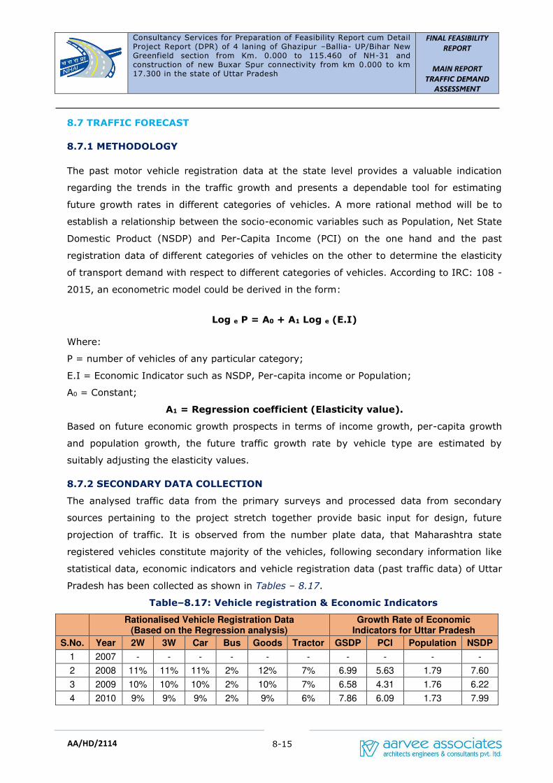
Consultancy Services for Preparation of Feasibility Report cum Detail Project Report (DPR) of 4 laning of Ghazipur –Ballia- UP/Bihar New Greenfield section from Km. 0.000 to 115.460 of NH-31 and construction of new Buxar Spur connectivity from km 0.000 to km 17.300 in the state of Uttar Pradesh
FINAL FEASIBILITY
REPORT
MAIN REPORT
TRAFFIC DEMAND
ASSESSMENT
8-15
AA/HD/2114
8.7 TRAFFIC FORECAST
8.7.1 METHODOLOGY
The past motor vehicle registration data at the state level provides a valuable indication
regarding the trends in the traffic growth and presents a dependable tool for estimating
future growth rates in different categories of vehicles. A more rational method will be to
establish a relationship between the socio-economic variables such as Population, Net State
Domestic Product (NSDP) and Per-Capita Income (PCI) on the one hand and the past
registration data of different categories of vehicles on the other to determine the elasticity
of transport demand with respect to different categories of vehicles. According to IRC: 108 -
2015, an econometric model could be derived in the form:
Log e P = A0 + A1 Log e (E.I)
Where:
P = number of vehicles of any particular category;
E.I = Economic Indicator such as NSDP, Per-capita income or Population;
A0 = Constant;
A1 = Regression coefficient (Elasticity value).
Based on future economic growth prospects in terms of income growth, per-capita growth
and population growth, the future traffic growth rate by vehicle type are estimated by
suitably adjusting the elasticity values.
8.7.2 SECONDARY DATA COLLECTION
The analysed traffic data from the primary surveys and processed data from secondary
sources pertaining to the project stretch together provide basic input for design, future
projection of traffic. It is observed from the number plate data, that Maharashtra state
registered vehicles constitute majority of the vehicles, following secondary information like
statistical data, economic indicators and vehicle registration data (past traffic data) of Uttar
Pradesh has been collected as shown in Tables – 8.17.
Table–8.17: Vehicle registration & Economic Indicators
Rationalised Vehicle Registration Data (Based on the Regression analysis)
Growth Rate of Economic Indicators for Uttar Pradesh
S.No. Year 2W 3W Car Bus Goods Tractor GSDP PCI Population NSDP
1 2007 - - - - - - - - - -
2 2008 11% 11% 11% 2% 12% 7% 6.99 5.63 1.79 7.60
3 2009 10% 10% 10% 2% 10% 7% 6.58 4.31 1.76 6.22
4 2010 9% 9% 9% 2% 9% 6% 7.86 6.09 1.73 7.99
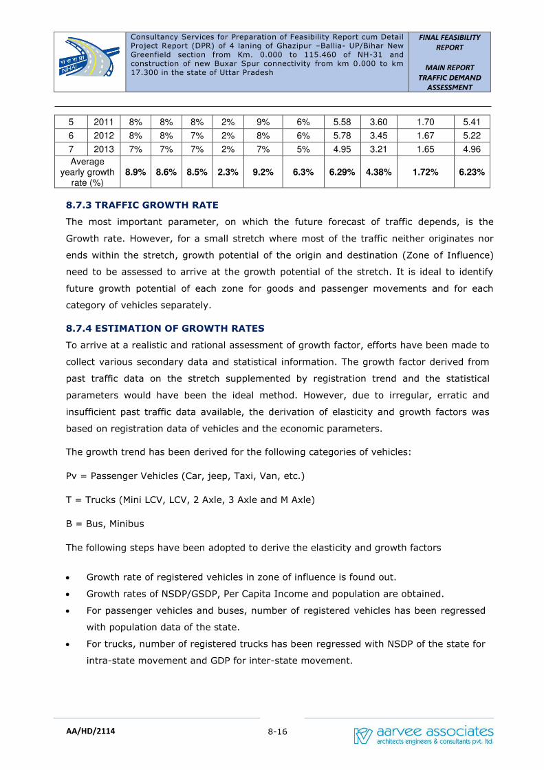
Consultancy Services for Preparation of Feasibility Report cum Detail Project Report (DPR) of 4 laning of Ghazipur –Ballia- UP/Bihar New Greenfield section from Km. 0.000 to 115.460 of NH-31 and construction of new Buxar Spur connectivity from km 0.000 to km 17.300 in the state of Uttar Pradesh
FINAL FEASIBILITY
REPORT
MAIN REPORT
TRAFFIC DEMAND
ASSESSMENT
8-16
AA/HD/2114
5 2011 8% 8% 8% 2% 9% 6% 5.58 3.60 1.70 5.41
6 2012 8% 8% 7% 2% 8% 6% 5.78 3.45 1.67 5.22
7 2013 7% 7% 7% 2% 7% 5% 4.95 3.21 1.65 4.96
Average yearly growth
rate (%) 8.9% 8.6% 8.5% 2.3% 9.2% 6.3% 6.29% 4.38% 1.72% 6.23%
8.7.3 TRAFFIC GROWTH RATE
The most important parameter, on which the future forecast of traffic depends, is the
Growth rate. However, for a small stretch where most of the traffic neither originates nor
ends within the stretch, growth potential of the origin and destination (Zone of Influence)
need to be assessed to arrive at the growth potential of the stretch. It is ideal to identify
future growth potential of each zone for goods and passenger movements and for each
category of vehicles separately.
8.7.4 ESTIMATION OF GROWTH RATES
To arrive at a realistic and rational assessment of growth factor, efforts have been made to
collect various secondary data and statistical information. The growth factor derived from
past traffic data on the stretch supplemented by registration trend and the statistical
parameters would have been the ideal method. However, due to irregular, erratic and
insufficient past traffic data available, the derivation of elasticity and growth factors was
based on registration data of vehicles and the economic parameters.
The growth trend has been derived for the following categories of vehicles:
Pv = Passenger Vehicles (Car, jeep, Taxi, Van, etc.)
T = Trucks (Mini LCV, LCV, 2 Axle, 3 Axle and M Axle)
B = Bus, Minibus
The following steps have been adopted to derive the elasticity and growth factors
• Growth rate of registered vehicles in zone of influence is found out.
• Growth rates of NSDP/GSDP, Per Capita Income and population are obtained.
• For passenger vehicles and buses, number of registered vehicles has been regressed
with population data of the state.
• For trucks, number of registered trucks has been regressed with NSDP of the state for
intra-state movement and GDP for inter-state movement.

Consultancy Services for Preparation of Feasibility Report cum Detail Project Report (DPR) of 4 laning of Ghazipur –Ballia- UP/Bihar New Greenfield section from Km. 0.000 to 115.460 of NH-31 and construction of new Buxar Spur connectivity from km 0.000 to km 17.300 in the state of Uttar Pradesh
FINAL FEASIBILITY
REPORT
MAIN REPORT
TRAFFIC DEMAND
ASSESSMENT
8-17
AA/HD/2114
• Mean value of average growth rate of registered vehicles and the growth rate
obtained by regression analysis for all categories have been found out at state level
for trucks.
• For passenger vehicles and buses, the mean growth rate of registered vehicular
growth rate and that from regression analysis have been adopted.
The projected growth rates for different category of vehicles for revenue calculations are
presented in Table-8.18, as shown below and the detailed calculations are given in
Annexure-VI.
Table–8.18: Projected Growth Rates
Projected Growth Rates in UP
S.No. Period 2W 3W Car Car (Y)
Goods Bus Mini Bus
1 2017-2019 6.00% 6.00% 6.00% 6.00% 7.00% 5.00% 5.00%
2 2019-2024 5.50% 5.50% 5.50% 5.50% 6.50% 4.50% 4.50%
3 2024-2029 5.00% 5.00% 5.00% 5.00% 6.00% 4.00% 4.00%
4 2029-2034 4.50% 4.50% 4.50% 4.50% 5.50% 3.50% 3.50%
5 2034-2039 4.00% 4.00% 4.00% 4.00% 5.00% 3.00% 3.00%
6 >2039 3.50% 3.50% 3.50% 3.50% 4.50% 2.50% 2.50%
The Consultants took into consideration the past growth of vehicular registration data,
existing traffic scenario and various growth indices with respect to socio-economic
development of project region. Based on the future developmental prospects of project
region and as per the codal standards growth rate for all vehicle types, Consultants
recommend a realistic uniform growth rate of 5% across all vehicle modes as shown in
Table 8.19.
Table–8.19: Adopted Growth Rates
Adopted Growth Rates
S.No. Period 2W 3W Car Car (Y) Goods Bus Minibus
1 2017-2019 5.00% 5.00% 5.00% 5.00% 5.00% 5.00% 5.00%
2 2019-2024 5.00% 5.00% 5.00% 5.00% 5.00% 5.00% 5.00%
3 2024-2029 5.00% 5.00% 5.00% 5.00% 5.00% 5.00% 5.00%
4 2029-2034 5.00% 5.00% 5.00% 5.00% 5.00% 5.00% 5.00%
5 2034-2039 5.00% 5.00% 5.00% 5.00% 5.00% 5.00% 5.00%
6 >2039 5.00% 5.00% 5.00% 5.00% 5.00% 5.00% 5.00%
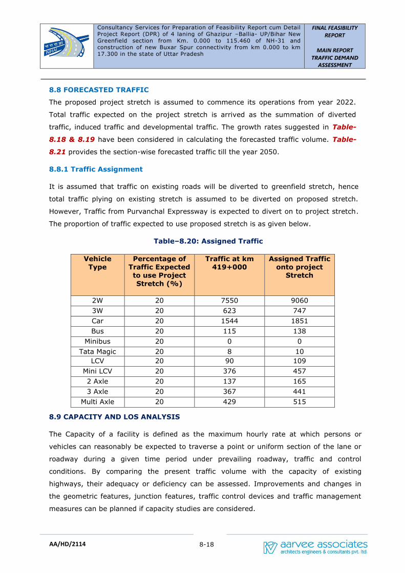
Consultancy Services for Preparation of Feasibility Report cum Detail Project Report (DPR) of 4 laning of Ghazipur –Ballia- UP/Bihar New Greenfield section from Km. 0.000 to 115.460 of NH-31 and construction of new Buxar Spur connectivity from km 0.000 to km 17.300 in the state of Uttar Pradesh
FINAL FEASIBILITY
REPORT
MAIN REPORT
TRAFFIC DEMAND
ASSESSMENT
8-18
AA/HD/2114
8.8 FORECASTED TRAFFIC
The proposed project stretch is assumed to commence its operations from year 2022.
Total traffic expected on the project stretch is arrived as the summation of diverted
traffic, induced traffic and developmental traffic. The growth rates suggested in Table-
8.18 & 8.19 have been considered in calculating the forecasted traffic volume. Table-
8.21 provides the section-wise forecasted traffic till the year 2050.
8.8.1 Traffic Assignment
It is assumed that traffic on existing roads will be diverted to greenfield stretch, hence
total traffic plying on existing stretch is assumed to be diverted on proposed stretch.
However, Traffic from Purvanchal Expressway is expected to divert on to project stretch.
The proportion of traffic expected to use proposed stretch is as given below.
Table–8.20: Assigned Traffic
Vehicle
Type
Percentage of
Traffic Expected
to use Project
Stretch (%)
Traffic at km
419+000
Assigned Traffic
onto project
Stretch
2W 20 7550 9060
3W 20 623 747
Car 20 1544 1851
Bus 20 115 138
Minibus 20 0 0
Tata Magic 20 8 10
LCV 20 90 109
Mini LCV 20 376 457
2 Axle 20 137 165
3 Axle 20 367 441
Multi Axle 20 429 515
8.9 CAPACITY AND LOS ANALYSIS
The Capacity of a facility is defined as the maximum hourly rate at which persons or
vehicles can reasonably be expected to traverse a point or uniform section of the lane or
roadway during a given time period under prevailing roadway, traffic and control
conditions. By comparing the present traffic volume with the capacity of existing
highways, their adequacy or deficiency can be assessed. Improvements and changes in
the geometric features, junction features, traffic control devices and traffic management
measures can be planned if capacity studies are considered.
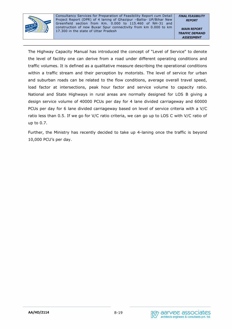
Consultancy Services for Preparation of Feasibility Report cum Detail Project Report (DPR) of 4 laning of Ghazipur –Ballia- UP/Bihar New Greenfield section from Km. 0.000 to 115.460 of NH-31 and construction of new Buxar Spur connectivity from km 0.000 to km 17.300 in the state of Uttar Pradesh
FINAL FEASIBILITY
REPORT
MAIN REPORT
TRAFFIC DEMAND
ASSESSMENT
8-19
AA/HD/2114
The Highway Capacity Manual has introduced the concept of "Level of Service" to denote
the level of facility one can derive from a road under different operating conditions and
traffic volumes. It is defined as a qualitative measure describing the operational conditions
within a traffic stream and their perception by motorists. The level of service for urban
and suburban roads can be related to the flow conditions, average overall travel speed,
load factor at intersections, peak hour factor and service volume to capacity ratio.
National and State Highways in rural areas are normally designed for LOS B giving a
design service volume of 40000 PCUs per day for 4 lane divided carriageway and 60000
PCUs per day for 6 lane divided carriageway based on level of service criteria with a V/C
ratio less than 0.5. If we go for V/C ratio criteria, we can go up to LOS C with V/C ratio of
up to 0.7.
Further, the Ministry has recently decided to take up 4-laning once the traffic is beyond
10,000 PCU’s per day.
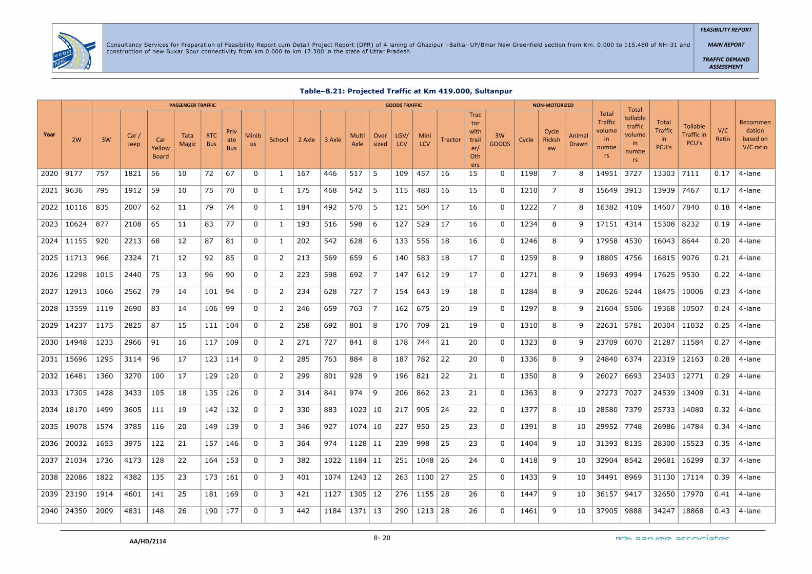
Consultancy Services for Preparation of Feasibility Report cum Detail Project Report (DPR) of 4 laning of Ghazipur –Ballia- UP/Bihar New Greenfield section from Km. 0.000 to 115.460 of NH-31 and construction of new Buxar Spur connectivity from km 0.000 to km 17.300 in the state of Uttar Pradesh
FEASIBILITY REPORT
MAIN REPORT
TRAFFIC DEMAND
ASSESSMENT
8- 20
AA/HD/2114
Table–8.21: Projected Traffic at Km 419.000, Sultanpur
Year
PASSENGER TRAFFIC GOODS TRAFFIC NON-MOTORIZED
Total
Traffic
volume
in
numbe
rs
Total
tollable
traffic
volume
in
numbe
rs
Total
Traffic
in
PCU's
Tollable
Traffic in
PCU's
V/C
Ratio
Recommen
dation
based on
V/C ratio 2W 3W
Car /
Jeep
Car
Yellow
Board
Tata
Magic
RTC
Bus
Priv
ate
Bus
Minib
us School 2 Axle 3 Axle
Multi
Axle
Over
sized
LGV/
LCV
Mini
LCV Tractor
Trac
tor
with
trail
er/
Oth
ers
3W
GOODS Cycle
Cycle
Ricksh
aw
Animal
Drawn
2020 9177 757 1821 56 10 72 67 0 1 167 446 517 5 109 457 16 15 0 1198 7 8 14951 3727 13303 7111 0.17 4-lane
2021 9636 795 1912 59 10 75 70 0 1 175 468 542 5 115 480 16 15 0 1210 7 8 15649 3913 13939 7467 0.17 4-lane
2022 10118 835 2007 62 11 79 74 0 1 184 492 570 5 121 504 17 16 0 1222 7 8 16382 4109 14607 7840 0.18 4-lane
2023 10624 877 2108 65 11 83 77 0 1 193 516 598 6 127 529 17 16 0 1234 8 9 17151 4314 15308 8232 0.19 4-lane
2024 11155 920 2213 68 12 87 81 0 1 202 542 628 6 133 556 18 16 0 1246 8 9 17958 4530 16043 8644 0.20 4-lane
2025 11713 966 2324 71 12 92 85 0 2 213 569 659 6 140 583 18 17 0 1259 8 9 18805 4756 16815 9076 0.21 4-lane
2026 12298 1015 2440 75 13 96 90 0 2 223 598 692 7 147 612 19 17 0 1271 8 9 19693 4994 17625 9530 0.22 4-lane
2027 12913 1066 2562 79 14 101 94 0 2 234 628 727 7 154 643 19 18 0 1284 8 9 20626 5244 18475 10006 0.23 4-lane
2028 13559 1119 2690 83 14 106 99 0 2 246 659 763 7 162 675 20 19 0 1297 8 9 21604 5506 19368 10507 0.24 4-lane
2029 14237 1175 2825 87 15 111 104 0 2 258 692 801 8 170 709 21 19 0 1310 8 9 22631 5781 20304 11032 0.25 4-lane
2030 14948 1233 2966 91 16 117 109 0 2 271 727 841 8 178 744 21 20 0 1323 8 9 23709 6070 21287 11584 0.27 4-lane
2031 15696 1295 3114 96 17 123 114 0 2 285 763 884 8 187 782 22 20 0 1336 8 9 24840 6374 22319 12163 0.28 4-lane
2032 16481 1360 3270 100 17 129 120 0 2 299 801 928 9 196 821 22 21 0 1350 8 9 26027 6693 23403 12771 0.29 4-lane
2033 17305 1428 3433 105 18 135 126 0 2 314 841 974 9 206 862 23 21 0 1363 8 9 27273 7027 24539 13409 0.31 4-lane
2034 18170 1499 3605 111 19 142 132 0 2 330 883 1023 10 217 905 24 22 0 1377 8 10 28580 7379 25733 14080 0.32 4-lane
2035 19078 1574 3785 116 20 149 139 0 3 346 927 1074 10 227 950 25 23 0 1391 8 10 29952 7748 26986 14784 0.34 4-lane
2036 20032 1653 3975 122 21 157 146 0 3 364 974 1128 11 239 998 25 23 0 1404 9 10 31393 8135 28300 15523 0.35 4-lane
2037 21034 1736 4173 128 22 164 153 0 3 382 1022 1184 11 251 1048 26 24 0 1418 9 10 32904 8542 29681 16299 0.37 4-lane
2038 22086 1822 4382 135 23 173 161 0 3 401 1074 1243 12 263 1100 27 25 0 1433 9 10 34491 8969 31130 17114 0.39 4-lane
2039 23190 1914 4601 141 25 181 169 0 3 421 1127 1305 12 276 1155 28 26 0 1447 9 10 36157 9417 32650 17970 0.41 4-lane
2040 24350 2009 4831 148 26 190 177 0 3 442 1184 1371 13 290 1213 28 26 0 1461 9 10 37905 9888 34247 18868 0.43 4-lane
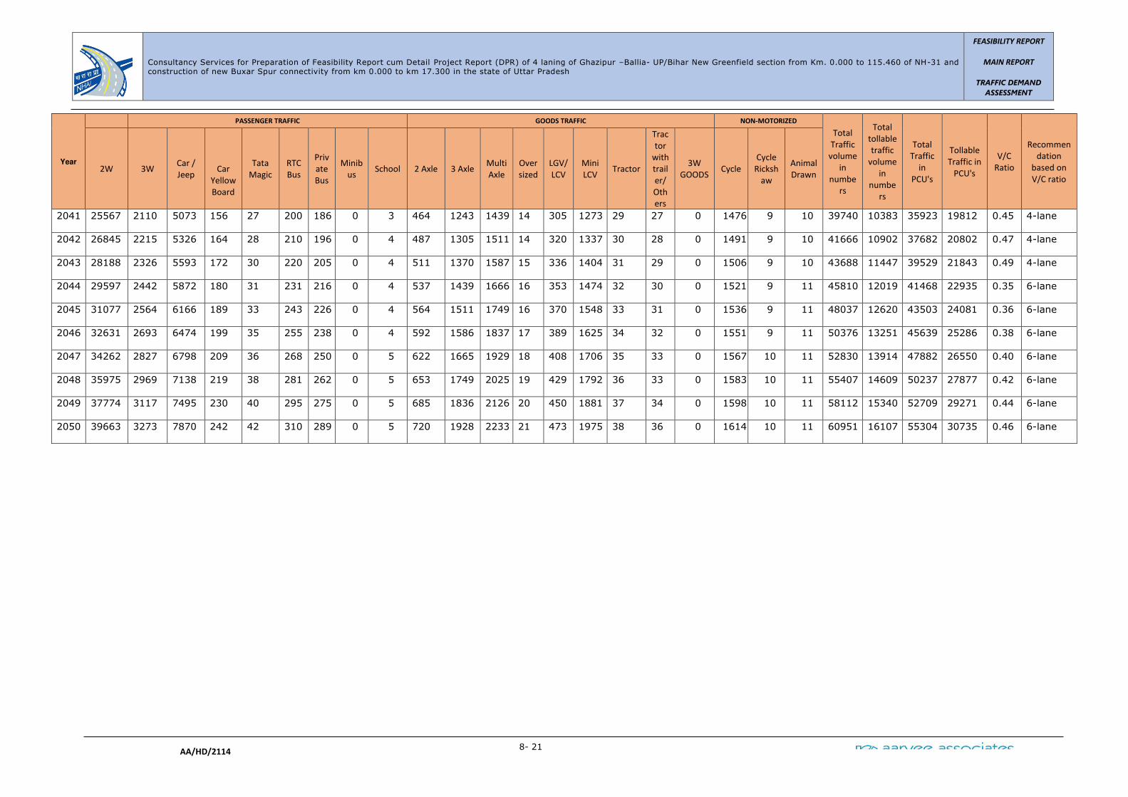
Consultancy Services for Preparation of Feasibility Report cum Detail Project Report (DPR) of 4 laning of Ghazipur –Ballia- UP/Bihar New Greenfield section from Km. 0.000 to 115.460 of NH-31 and construction of new Buxar Spur connectivity from km 0.000 to km 17.300 in the state of Uttar Pradesh
FEASIBILITY REPORT
MAIN REPORT
TRAFFIC DEMAND
ASSESSMENT
8- 21
AA/HD/2114
Year
PASSENGER TRAFFIC GOODS TRAFFIC NON-MOTORIZED
Total
Traffic
volume
in
numbe
rs
Total
tollable
traffic
volume
in
numbe
rs
Total
Traffic
in
PCU's
Tollable
Traffic in
PCU's
V/C
Ratio
Recommen
dation
based on
V/C ratio 2W 3W
Car /
Jeep
Car
Yellow
Board
Tata
Magic
RTC
Bus
Priv
ate
Bus
Minib
us School 2 Axle 3 Axle
Multi
Axle
Over
sized
LGV/
LCV
Mini
LCV Tractor
Trac
tor
with
trail
er/
Oth
ers
3W
GOODS Cycle
Cycle
Ricksh
aw
Animal
Drawn
2041 25567 2110 5073 156 27 200 186 0 3 464 1243 1439 14 305 1273 29 27 0 1476 9 10 39740 10383 35923 19812 0.45 4-lane
2042 26845 2215 5326 164 28 210 196 0 4 487 1305 1511 14 320 1337 30 28 0 1491 9 10 41666 10902 37682 20802 0.47 4-lane
2043 28188 2326 5593 172 30 220 205 0 4 511 1370 1587 15 336 1404 31 29 0 1506 9 10 43688 11447 39529 21843 0.49 4-lane
2044 29597 2442 5872 180 31 231 216 0 4 537 1439 1666 16 353 1474 32 30 0 1521 9 11 45810 12019 41468 22935 0.35 6-lane
2045 31077 2564 6166 189 33 243 226 0 4 564 1511 1749 16 370 1548 33 31 0 1536 9 11 48037 12620 43503 24081 0.36 6-lane
2046 32631 2693 6474 199 35 255 238 0 4 592 1586 1837 17 389 1625 34 32 0 1551 9 11 50376 13251 45639 25286 0.38 6-lane
2047 34262 2827 6798 209 36 268 250 0 5 622 1665 1929 18 408 1706 35 33 0 1567 10 11 52830 13914 47882 26550 0.40 6-lane
2048 35975 2969 7138 219 38 281 262 0 5 653 1749 2025 19 429 1792 36 33 0 1583 10 11 55407 14609 50237 27877 0.42 6-lane
2049 37774 3117 7495 230 40 295 275 0 5 685 1836 2126 20 450 1881 37 34 0 1598 10 11 58112 15340 52709 29271 0.44 6-lane
2050 39663 3273 7870 242 42 310 289 0 5 720 1928 2233 21 473 1975 38 36 0 1614 10 11 60951 16107 55304 30735 0.46 6-lane

Consultancy Services for Preparation of Feasibility Report cum Detail Project Report (DPR) of 4 laning of Ghazipur –Ballia- UP/Bihar New Greenfield section from Km. 0.000 to 115.460 of NH-31 and construction of new Buxar Spur connectivity from km 0.000 to km 17.300 in the state of Uttar Pradesh
FEASIBILITY REPORT
MAIN REPORT
TRAFFIC DEMAND
ASSESSMENT
8- 22
AA/HD/2114

Consultancy Services for Preparation of Feasibility Report cum Detail Project Report (DPR) of 4 laning of Ghazipur –Ballia- UP/Bihar New Greenfield section from Km. 0.000 to 115.460 of NH-31 and construction of new Buxar Spur connectivty from km 0.000 to km 17.300 in the state of Uttar Pradesh
Final Feasibility
Report
PAVEMENT DESIGN REPORT
AA/HD/2114 2- 1
9. PAVEMENT DESIGN
9.1 Introduction
The design of pavement i.e., calculating the total crust thickness depends on mainly
two factors Viz. total cumulative repetitions of standard axle loads for the design life
and the strength of sub-grade soils (CBR).
The total cumulative repetitions of standard axles is in turn, a function of the annual
average daily traffic (AADT) and applicable growth rate (r) of vehicles for forecasting
the traffic after a certain period and Vehicle Damage Factor (VDF) for converting the
mixed volume of traffic in terms of standard axle load repetitions. Further, lane
distribution factor is applied to account for the vehicle load distribution across the
width of pavement depending on the available carriageway width.
9.2 Pavement Design Objective
The Objective is to determine the total thickness of the pavement structure as well as
thickness of individual structural layer components. Design strength of pavement
must be adequate to support the projected traffic loading throughout the design
period.
9.3 Design Guidelines
a) Clause 5.3 of “Manual of Specifications and Standards for Two laning of Highways
through Public Private Partnership by – IRC:SP:84-2019” states that “new pavements
shall be designed in accordance with IRC:37(flexible) and rigid pavements shall be
designed in accordance with the method prescribed in IRC:58”. Strengthening of
existing pavement shall be determined based on FWD method (IRC: 115-2014) and
the design traffic as per the relevant code of IRC.
b) Clause 5.4.1 of IRC: SP:84-2019, states that “Flexible pavement shall be designed
for a minimum design period of 15 years or operation period, whichever is more.
Stage construction shall not be permitted.
It is a common phenomenon in Indian Roads that the road requires a functional
overlay every 5 years, even if the pavement is designed for 15 years.
c) Clause 5.4.2 of IRC: SP:84-2019, states:
i) Rigid pavement shall be designed for a minimum design period of 30 years. The
stage construction shall not be permitted.
ii) The Pavement Quality Concrete (PQC) shall rest over Dry Lean Concrete (DLC)

Consultancy Services for Preparation of Feasibility Report cum Detail Project Report (DPR) of 4 laning of Ghazipur –Ballia- UP/Bihar New Greenfield section from Km. 0.000 to 115.460 of NH-31 and construction of new Buxar Spur connectivty from km 0.000 to km 17.300 in the state of Uttar Pradesh
Final Feasibility
Report
PAVEMENT DESIGN REPORT
AA/HD/2114 2- 2
sub-base of 150mm thickness.
iii) A separation membrane shall be used between the PQC and DLC as per clause
602.5 of MORTH Specifications.
iv) The DLC shall meet the minimum cement and compressive strength
requirement as prescribed in IRC: SP: 49. The DLC shall extend beyond the
PQC by 0.75 m on either side.
v) Below DLC layer, a properly designed drainage layer GSB of 150 mm thickness
shall be provided throughout the road width. It shall be designed to obtain a
drainage coefficient of not less than 30 m per day.
9.4 PRELIMINARY INVESTIGATIONS
9.4.1 Pavement Investigation
The design consultants have undertaken the following pavement investigations to
assess the condition of the existing pavement along with the quality of the materials
that have been incorporated in construction. Pavement has been investigated
subjectively as well as objectively at suitable interval where necessary, for its
structural and functional performance. Following investigations were carried out for
the project stretch.
• Condition survey by visual inspection
• Test Pit investigations
• Geotechnical investigation of subgrade
• Benkelman Beam Deflection Test
9.4.2 Visual Condition Survey
Visual condition survey was conducted to identify the surface defects namely cracks,
rut depth etc to classify the pavement in terms of its surface condition as per IRC-81.
The results of the condition survey is presented separately in Road Inventory and
Condition Report. However, the criteria followed the summary of the project stretches
is presented below. Basically rut depth and % cracks criteria is as per IRC-81 and the
roughness criteria is as per IRC-SP-30.
Pavement Condition Roughness
(mm/km)
Rut depth
(mm/km) Cracks (%)
Excellent < 2000 < 0 0
Good 2000 to 2500 0 to 10 0
Fair/Average 2500 to 3500 10 to 20 <20

Consultancy Services for Preparation of Feasibility Report cum Detail Project Report (DPR) of 4 laning of Ghazipur –Ballia- UP/Bihar New Greenfield section from Km. 0.000 to 115.460 of NH-31 and construction of new Buxar Spur connectivty from km 0.000 to km 17.300 in the state of Uttar Pradesh
Final Feasibility
Report
PAVEMENT DESIGN REPORT
AA/HD/2114 2- 3
Pavement Condition Roughness
(mm/km)
Rut depth
(mm/km) Cracks (%)
Poor 3500 to 4000 >20 >20
Very poor/Reconstruction > 4000
Finally, it was observed that the pavement in the entire project is varies from good to
fair condition. The condition of the pavement and the percentages of different
distresses has been presented below.
Table-9.1: Pavement Condition of the Project stretch
Pavement Condition Percentage of Road
Length
Good 59.23
Fair 11.74
Poor 29.03
Very Poor 0.00
9.4.3 Existing Pavement Composition
Test pits were dug at the junction of pavement and shoulder at every 1.0 km interval
for in-situ testing of sub grade materials and recording pavement composition. The
average thickness of the pavement layers as observed at site is given below:
Table-9.2: Existing Pavement Crust Composition (mm)
S. No
Chainage
(Km)
Side
Thickness
Of
BT(BC+DBM)
Granular
Base Layer
(WMM/WBM)
Subbase
(GSB/
Boulders)
Total
1 523.000 RHS 120 250 100 470
2 524.000 LHS 120 250 100 470
3 525.000 RHS 150 300 100 550
4 526.000 LHS 150 300 100 550
5 527.000 RHS 150 300 100 550
6 528.000 LHS - *376
7 529.000 RHS 150 300 100 550
8 530.000 LHS 150 300 100 550
9 531.000 RHS 150 300 100 550
10 532.000 LHS 150 300 100 550
Note: *As per the inventory data by E.E NH Division-PWD, Ghazipur
9.4.4 Soil Investigations
a) Soil Classification:
The sub-grade soil along the project corridor generally consists of clayey sand, silty

Consultancy Services for Preparation of Feasibility Report cum Detail Project Report (DPR) of 4 laning of Ghazipur –Ballia- UP/Bihar New Greenfield section from Km. 0.000 to 115.460 of NH-31 and construction of new Buxar Spur connectivty from km 0.000 to km 17.300 in the state of Uttar Pradesh
Final Feasibility
Report
PAVEMENT DESIGN REPORT
AA/HD/2114 2- 4
sand and inorganic clays.
b) CBR of Subgrade soils:
Soaked and un soaked CBR tests were conducted at FDD & NMC on all the sub grade
soil samples taken from each test pit. It was observed that the soaked CBR varies
from 2.0% to 18.0% and unsoaked CBR varies from 4.0% to 28.0%. Following table
presents the detail of sub-grade.

Consultancy Services for Preparation of Feasibility Report cum Detail Project Report (DPR) of 4 laning of Ghazipur –Ballia- UP/Bihar New Greenfield section from Km. 0.000 to 115.460 of NH-31 and construction of new Buxar Spur connectivity
from km 0.000 to km 17.300 in the state of Uttar Pradesh
Final Feasibility Report
PAVEMENT DESIGN REPORT
AA/HD/2114 8- 5
Table-9.3: Existing Pavement Sub-grade CBR
S.N
o.
Ch
ain
ag
e
(K
m)
Sid
e
Grain Size Analysis (%)
IS
Cla
ssif
icati
on
Atterberg Limits
FS
I (
%)
Core Cutter
So
aked
CB
R
(%
)
Gravel
Co
arse S
an
d
Med
ium
San
d
Fin
e s
an
d
Fin
es
LL %
PL %
PI %
FD
D
(g
/cc)
NM
C (
%)
1 523+000 RHS 0.5 0.4 0.9 89.0 9.2 SP-
SM NP NP NP 0 1.62 1.69 12
2 524+000 LHS 1.7 1.2 1.7 26.7 68.7 ML NP NP NP 0 1.57 5.81 3
3 525+000 RHS 3.2 1.3 3.4 15.5 76.6 CI 35 16 19 30 1.65 14.63 5
4 526+000 LHS 1.7 0.4 0.9 11.0 86.0 CL 33 18 15 20 1.83 7.96 9
5 527+000 RHS 1.5 0.4 0.5 14.5 83.1 CI 35 15 20 30 1.74 12.91 8
6 529+000 LHS 2.4 0.6 1.0 34.4 61.6 CL 25 17 8 10 1.62 5.04 4
7 530+000 RHS 0.8 0.3 0.6 66.8 31.5 SM NP NP NP 0 1.67 3.41 10
8 531+000 LHS 1.5 0.8 0.9 59.2 37.6 SM NP NP NP 0 1.70 3.55 11
9 532+000 RHS 5.1 1.9 2.7 39.2 51.1 ML NP NP NP 10 1.71 4.16 6
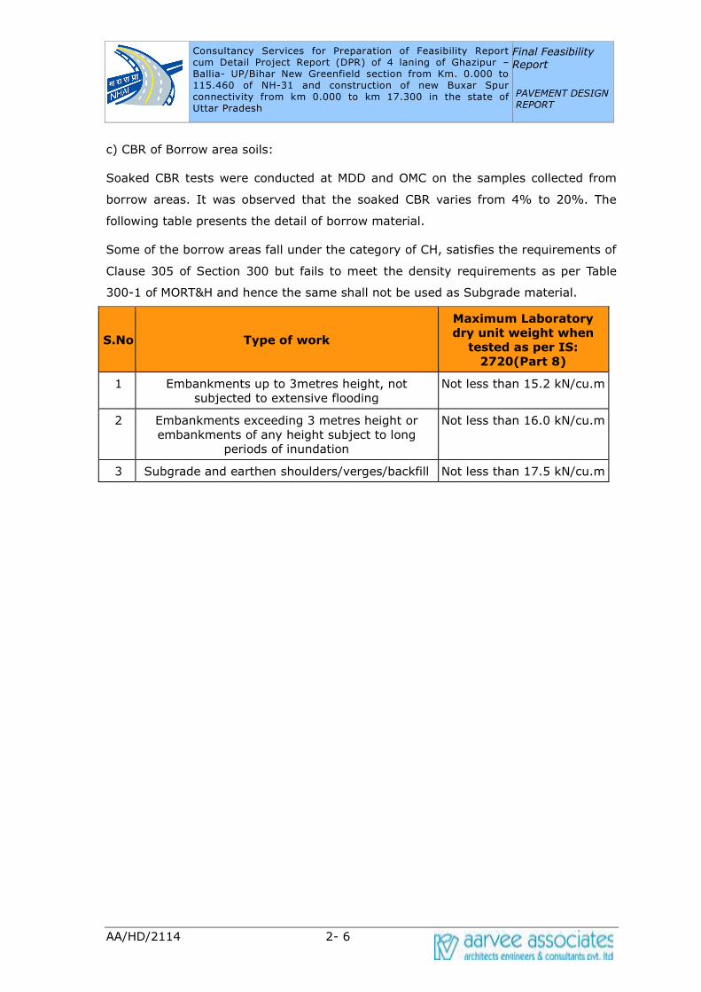
Consultancy Services for Preparation of Feasibility Report cum Detail Project Report (DPR) of 4 laning of Ghazipur –Ballia- UP/Bihar New Greenfield section from Km. 0.000 to 115.460 of NH-31 and construction of new Buxar Spur connectivity from km 0.000 to km 17.300 in the state of Uttar Pradesh
Final Feasibility
Report
PAVEMENT DESIGN REPORT
AA/HD/2114 2- 6
c) CBR of Borrow area soils:
Soaked CBR tests were conducted at MDD and OMC on the samples collected from
borrow areas. It was observed that the soaked CBR varies from 4% to 20%. The
following table presents the detail of borrow material.
Some of the borrow areas fall under the category of CH, satisfies the requirements of
Clause 305 of Section 300 but fails to meet the density requirements as per Table
300-1 of MORT&H and hence the same shall not be used as Subgrade material.
S.No Type of work
Maximum Laboratory
dry unit weight when
tested as per IS:
2720(Part 8)
1 Embankments up to 3metres height, not
subjected to extensive flooding
Not less than 15.2 kN/cu.m
2 Embankments exceeding 3 metres height or
embankments of any height subject to long
periods of inundation
Not less than 16.0 kN/cu.m
3 Subgrade and earthen shoulders/verges/backfill Not less than 17.5 kN/cu.m
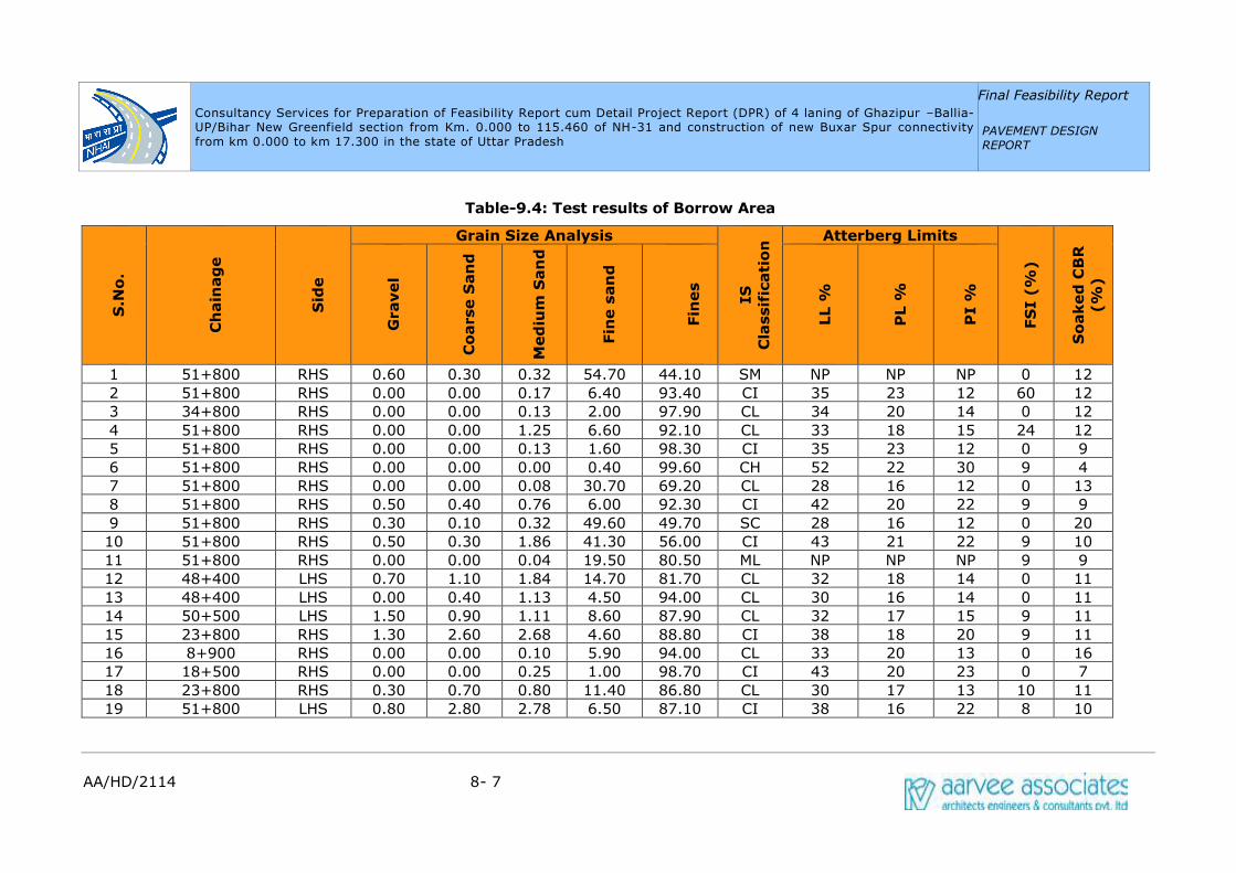
Consultancy Services for Preparation of Feasibility Report cum Detail Project Report (DPR) of 4 laning of Ghazipur –Ballia- UP/Bihar New Greenfield section from Km. 0.000 to 115.460 of NH-31 and construction of new Buxar Spur connectivity
from km 0.000 to km 17.300 in the state of Uttar Pradesh
Final Feasibility Report
PAVEMENT DESIGN REPORT
AA/HD/2114 8- 7
Table-9.4: Test results of Borrow Area
S.N
o.
Ch
ain
ag
e
Sid
e
Grain Size Analysis
IS
Cla
ssif
icati
on
Atterberg Limits
FS
I (
%)
So
aked
CB
R
(%
)
Gravel
Co
arse S
an
d
Med
ium
San
d
Fin
e s
an
d
Fin
es
LL %
PL %
PI %
1 51+800 RHS 0.60 0.30 0.32 54.70 44.10 SM NP NP NP 0 12
2 51+800 RHS 0.00 0.00 0.17 6.40 93.40 CI 35 23 12 60 12
3 34+800 RHS 0.00 0.00 0.13 2.00 97.90 CL 34 20 14 0 12
4 51+800 RHS 0.00 0.00 1.25 6.60 92.10 CL 33 18 15 24 12
5 51+800 RHS 0.00 0.00 0.13 1.60 98.30 CI 35 23 12 0 9
6 51+800 RHS 0.00 0.00 0.00 0.40 99.60 CH 52 22 30 9 4
7 51+800 RHS 0.00 0.00 0.08 30.70 69.20 CL 28 16 12 0 13
8 51+800 RHS 0.50 0.40 0.76 6.00 92.30 CI 42 20 22 9 9
9 51+800 RHS 0.30 0.10 0.32 49.60 49.70 SC 28 16 12 0 20
10 51+800 RHS 0.50 0.30 1.86 41.30 56.00 CI 43 21 22 9 10
11 51+800 RHS 0.00 0.00 0.04 19.50 80.50 ML NP NP NP 9 9
12 48+400 LHS 0.70 1.10 1.84 14.70 81.70 CL 32 18 14 0 11
13 48+400 LHS 0.00 0.40 1.13 4.50 94.00 CL 30 16 14 0 11
14 50+500 LHS 1.50 0.90 1.11 8.60 87.90 CL 32 17 15 9 11
15 23+800 RHS 1.30 2.60 2.68 4.60 88.80 CI 38 18 20 9 11
16 8+900 RHS 0.00 0.00 0.10 5.90 94.00 CL 33 20 13 0 16
17 18+500 RHS 0.00 0.00 0.25 1.00 98.70 CI 43 20 23 0 7
18 23+800 RHS 0.30 0.70 0.80 11.40 86.80 CL 30 17 13 10 11
19 51+800 LHS 0.80 2.80 2.78 6.50 87.10 CI 38 16 22 8 10

Consultancy Services for Preparation of Feasibility Report cum Detail Project Report (DPR) of 4 laning of Ghazipur –Ballia- UP/Bihar New Greenfield section from Km. 0.000 to 115.460 of NH-31 and construction of new Buxar Spur connectivity
from km 0.000 to km 17.300 in the state of Uttar Pradesh
Final Feasibility Report
PAVEMENT DESIGN REPORT
AA/HD/2114 8- 8
S.N
o.
Ch
ain
ag
e
Sid
e
Grain Size Analysis
IS
Cla
ssif
icati
on
Atterberg Limits
FS
I (
%)
So
aked
CB
R
(%
)
Gravel
Co
arse S
an
d
Med
ium
San
d
Fin
e s
an
d
Fin
es
LL %
PL %
PI %
20 64+300 LHS 0.00 0.30 0.24 3.20 96.30 CL 30 20 10 0 10
21 64+300 LHS 0.00 0.00 0.00 28.70 71.30 ML NP NP NP 0 11
22 64+300 LHS 0.00 0.40 0.72 2.10 96.80 CI 41 19 22 8 7
23 64+300 LHS 0.00 0.60 0.76 8.90 89.70 CL 29 18 11 0 10
24 70+600 LHS 0.00 0.00 0.00 0.80 99.20 CI 44 21 23 30 5
25 72+900 LHS 0.00 0.10 0.33 20.70 78.90 CL 32 18 14 10 10
26 74+200 RHS 0.00 0.00 0.33 7.60 92.10 ML NP NP NP 0 7
27 97+500 RHS 0.00 0.00 0.60 13.80 85.60 CL 34 18 16 9 10
28 109+700 LHS 0.20 0.10 0.45 24.60 74.70 ML NP NP NP 0 12
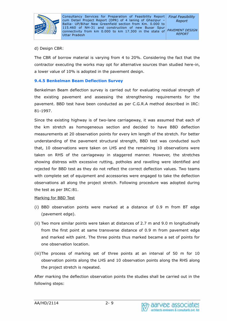
Consultancy Services for Preparation of Feasibility Report cum Detail Project Report (DPR) of 4 laning of Ghazipur –Ballia- UP/Bihar New Greenfield section from Km. 0.000 to 115.460 of NH-31 and construction of new Buxar Spur connectivity from km 0.000 to km 17.300 in the state of Uttar Pradesh
Final Feasibility
Report
PAVEMENT DESIGN REPORT
AA/HD/2114 2- 9
d) Design CBR:
The CBR of borrow material is varying from 4 to 20%. Considering the fact that the
contractor executing the works may opt for alternative sources than studied here-in,
a lower value of 10% is adopted in the pavement design.
9.4.5 Benkelman Beam Deflection Survey
Benkelman Beam deflection survey is carried out for evaluating residual strength of
the existing pavement and assessing the strengthening requirements for the
pavement. BBD test have been conducted as per C.G.R.A method described in IRC:
81-1997.
Since the existing highway is of two-lane carriageway, it was assumed that each of
the km stretch as homogeneous section and decided to have BBD deflection
measurements at 20 observation points for every km length of the stretch. For better
understanding of the pavement structural strength, BBD test was conducted such
that, 10 observations were taken on LHS and the remaining 10 observations were
taken on RHS of the carriageway in staggered manner. However, the stretches
showing distress with excessive rutting, potholes and ravelling were identified and
rejected for BBD test as they do not reflect the correct deflection values. Two teams
with complete set of equipment and accessories were engaged to take the deflection
observations all along the project stretch. Following procedure was adopted during
the test as per IRC:81.
Marking for BBD Test
(i) BBD observation points were marked at a distance of 0.9 m from BT edge
(pavement edge).
(ii) Two more similar points were taken at distances of 2.7 m and 9.0 m longitudinally
from the first point at same transverse distance of 0.9 m from pavement edge
and marked with paint. The three points thus marked became a set of points for
one observation location.
(iii) The process of marking set of three points at an interval of 50 m for 10
observation points along the LHS and 10 observation points along the RHS along
the project stretch is repeated.
After marking the deflection observation points the studies shall be carried out in the
following steps:
Consultancy Services for Preparation of Feasibility Report cum Detail Project Report (DPR) of 4 laning of Ghazipur –Ballia- UP/Bihar New Greenfield section from Km. 0.000 to 115.460 of NH-31 and construction of new Buxar Spur connectivity from km 0.000 to km 17.300 in the state of Uttar Pradesh
Final Feasibility
Report
PAVEMENT DESIGN REPORT
AA/HD/2114 2- 10
• The truck is loaded with a rear axle load of 8170 kg and the rear dual
tyre is set to inflation pressure of 5.6 kg/cm2
• The truck was slowly driven parallel to the edge and stopped such that
the left side rear dual wheel is centrally placed over the first point for
deflection measurement.
• The probe end of the Benkelman Beam is inserted between the gap of
dual wheel and placed exactly over the deflection observation point,
ensuring that the probe touches the pavement surface.
• The initial dial gauge reading (Do) is noted when the dial gauge
reading is stationary (or) when the rate of change of pavement
deflection is less than 0.025 mm per minute. Both the needles of dial
gauge are set to zero-zero before fitting it to BBD instrument and
locked. The readings of both the needles of dial gauge and noted down
in specified format. (The least count of the large needle is 0.01 mm
and that of small needle is 1.0 mm)
• After taking initial reading, the truck is moved forward slowly through a
distance of 2.7 m from the point and stopped.
• When the rate of recovery of pavement is less than 0.025 mm per
minute the intermediate dial gauge reading (Di) is noted down.
• The truck is drived forward through a further distance of 9.0 m and the
final dial gauge reading (Df) is noted down, when the rate of recovery
of the pavement is less than 0.025 mm per minute.
• The three deflection dial readings Do, Di and Df forms a set of readings
at one deflection point under consideration.
• Similarly the truck is moved forward to the next deflection observation
point, such that insertion of the probe of Benkelman Beam and
procedure of noting the set of three deflection observations shall be
exactly the same as explained above and repeated the same procedure
at all deflection observation points.
• The temperature of pavement surface is also recorded with the help of
thermometer by making a hole of 10-mm diameter, 45 mm deep in
existing B.T surface filled with Glycerol.
• Variability of deflections in a given section was considered for detecting
spots where extra deflection measurements have been made. For this

Consultancy Services for Preparation of Feasibility Report cum Detail Project Report (DPR) of 4 laning of Ghazipur –Ballia- UP/Bihar New Greenfield section from Km. 0.000 to 115.460 of NH-31 and construction of new Buxar Spur connectivity from km 0.000 to km 17.300 in the state of Uttar Pradesh
Final Feasibility
Report
PAVEMENT DESIGN REPORT
AA/HD/2114 2- 11
purpose, highest and lowest values in a group of ten was compared
with mean value. Wherever the highest or lowest values differ from the
mean by more than one third of the mean then extra deflection
measurements were made at 25m on either side of point where high or
low values are observed.
Corrections and Analysis
Following corrections were applied to the BBD test observations during its analysis:
1. The pavement temperature and seasonal variation in climate influence the
deflections measured by the Benkelman Beam.
2. Pavement temperature is recorded once for every hour by inserting a
thermometer in a hole approximately 45 mm deep and 10 mm diameter
filled with glycerol drilled in the pavement. Correction shall be applied to
the deflection measured in accordance with the procedure described in
IRC: 81-1997, if the observed temperature is different from 350C.
3. Seasonal correction was also applied using the moisture correction factors
for different type of soils given in IRC: 81-1997. PI and field moisture
content of the subgrade are established from test pits excavated
simultaneously along with the BBD tests.
4. The mean and standard deviation for ten consecutive points in each
section was computed after applying temperature and seasonal variation
corrections. Finally, the characteristic deflections were determined as
follows:
Characteristic Deflection = Mean deflection + 2 x Standard Deviation
Delineation of Homogeneous Sections:
The delineation of homogenous sections was completed using the characteristic
deflection values. In this approach, the characteristic deflection data for each one-
kilometer length of the project were used to conduct the “cumulative difference
approach” analysis. Using this approach, which is outlined in the American
Association of State Highway and Transportation Officials (AASHTO) Pavement
Design Guide Appendix J (Analysis Unit Delineation by Cumulative Differences), the
road was divided into various homogenous sections. The deflections values in each
homogenous section were then pooled and the characteristic deflection calculated.
This value was designated as the representative characteristic deflection for that
homogenous pavement section.
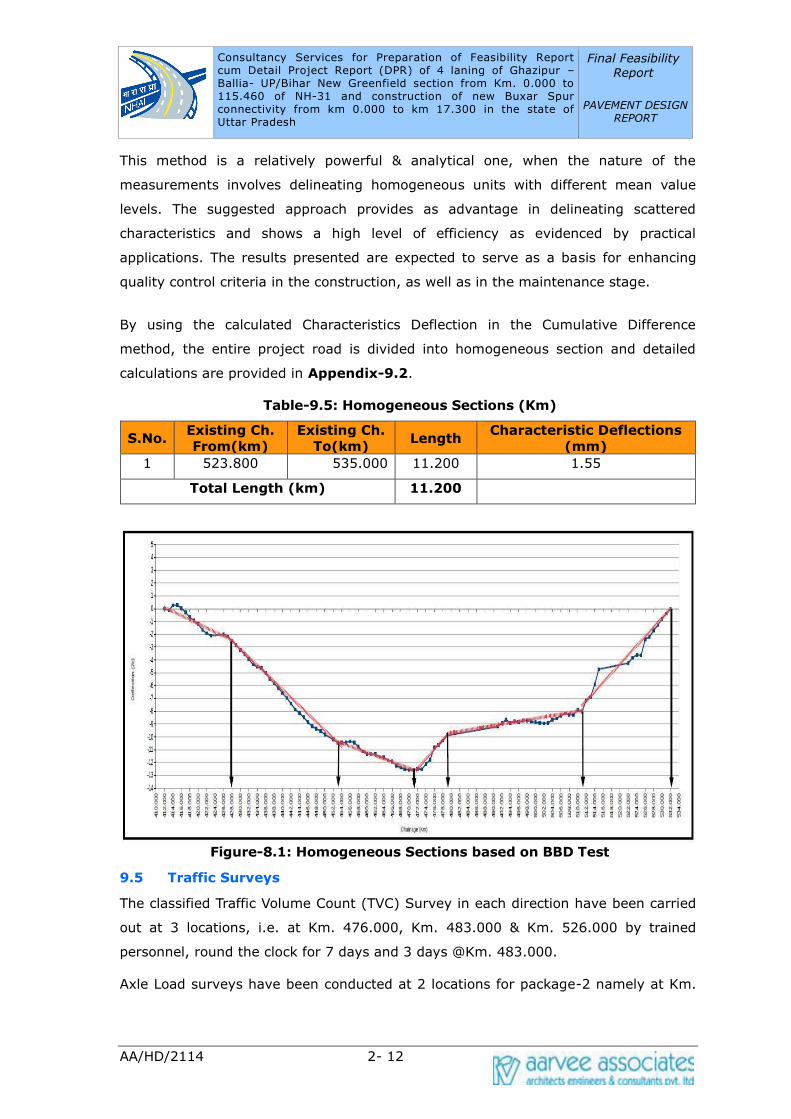
Consultancy Services for Preparation of Feasibility Report cum Detail Project Report (DPR) of 4 laning of Ghazipur –Ballia- UP/Bihar New Greenfield section from Km. 0.000 to 115.460 of NH-31 and construction of new Buxar Spur connectivity from km 0.000 to km 17.300 in the state of Uttar Pradesh
Final Feasibility
Report
PAVEMENT DESIGN REPORT
AA/HD/2114 2- 12
This method is a relatively powerful & analytical one, when the nature of the
measurements involves delineating homogeneous units with different mean value
levels. The suggested approach provides as advantage in delineating scattered
characteristics and shows a high level of efficiency as evidenced by practical
applications. The results presented are expected to serve as a basis for enhancing
quality control criteria in the construction, as well as in the maintenance stage.
By using the calculated Characteristics Deflection in the Cumulative Difference
method, the entire project road is divided into homogeneous section and detailed
calculations are provided in Appendix-9.2.
Table-9.5: Homogeneous Sections (Km)
S.No. Existing Ch.
From(km)
Existing Ch.
To(km) Length
Characteristic Deflections
(mm)
1 523.800 535.000 11.200 1.55
Total Length (km) 11.200
Figure-8.1: Homogeneous Sections based on BBD Test
9.5 Traffic Surveys
The classified Traffic Volume Count (TVC) Survey in each direction have been carried
out at 3 locations, i.e. at Km. 476.000, Km. 483.000 & Km. 526.000 by trained
personnel, round the clock for 7 days and 3 days @Km. 483.000.
Axle Load surveys have been conducted at 2 locations for package-2 namely at Km.

Consultancy Services for Preparation of Feasibility Report cum Detail Project Report (DPR) of 4 laning of Ghazipur –Ballia- UP/Bihar New Greenfield section from Km. 0.000 to 115.460 of NH-31 and construction of new Buxar Spur connectivity from km 0.000 to km 17.300 in the state of Uttar Pradesh
Final Feasibility
Report
PAVEMENT DESIGN REPORT
AA/HD/2114 2- 13
476.000 & Km. 526.000 for 24 hours. Further secondary economic data such as
population, Net State Domestic Product (NSDP) and Per Capita Income (PCI) was
used along with vehicle registration data to infer likely growth rates.
IRC:SP:84-2019 states that a minimum of 5% growth rate to be adopted for
pavement design. So the calculations were made taking the growth rates inferred
subject to a minimum value of 5%. However, Terms of Reference (TOR) stated the
use of a uniform growth rate of 5%. So design is done based on both the inferred as
well as uniform growth rates. Following Tables shows the various inputs that are
considered for pavement design.
9.5.1 Base Year Traffic (AADT)
For the purpose of the pavement design, commercial vehicles of laden weight more
than 3 tonnes has been considered. Such vehicles consisted of Buses, LCV's, 2 Axle
trucks, 3 Axle trucks and Multi Axle Trucks. The summary of AADT of commercial
vehicles considered for pavement design is given below.
Table 9.6: Annual Average Daily Traffic (AADT base year 2020)
Vehicle Type Km419.000
Sultanpur
Km 526.000
Ibrahimbagh
Bus 114 72
2 Axle Truck 137 162
3 Axle Truck 367 285
Multi Axle Truck 428 301
LCV & Minibus 90 103
Tractor with Trailers 13 13
Total 1149 936
9.5.2 Axle Load Surveys
The Vehicle Damage Factor (VDF) is an index characterizing the traffic loading for a
highway and is defined as a multiplier for converting the number of commercial
vehicles of different axle loads to Standard Axle Loads (SAL). Equivalency Factor (EF)
is normally worked out by using the Fourth Power Rule derived by AASHTO. With the
help of equivalency factors and frequency distribution of axle loads, Equivalent Axle
Loads (EAL) are computed as:
VDF = Total EAL/Number of Vehicles weighed.
The standard axle loads, and the legal axle loads considered while calculating the
equivalency factors for various axles are furnished below.
Consultancy Services for Preparation of Feasibility Report cum Detail Project Report (DPR) of 4 laning of Ghazipur –Ballia- UP/Bihar New Greenfield section from Km. 0.000 to 115.460 of NH-31 and construction of new Buxar Spur connectivity from km 0.000 to km 17.300 in the state of Uttar Pradesh
Final Feasibility
Report
PAVEMENT DESIGN REPORT
AA/HD/2114 2- 14
S. No. Type of Axles Standard Load (KN) Legal Load (KN)
1 Single Axle (Single Wheel) 65 66
2 Single Axle (Dual Wheel) 80 102
3 Tandem Axle (Dual Wheel) 148 190
4 Tridem Axle (Dual Wheel) 224 240
Axle load surveys were conducted for package-2 at Km. 476.000 & Km. 526.000.
This survey was conducted for 1 normal day in both directions of traffic
simultaneously with volume count of commercial vehicles (Trucks and LCV). The
random selection of vehicles for axle load measurement was done, ensuring suitable
sample for each category of commercial vehicles consisting of overloaded and empty
vehicles. The distribution of sample by commodity type is presented below.
Table – 9.7 (a): Distribution of Sample by Commodity at Km 419.000
Cod
e Commodity
2 AT 3 AT MAT LCV
Toward
s Ballia
Towards
Ghazipu
r
Toward
s Ballia
Towards
Ghazipu
r
Toward
s Ballia
Towards
Ghazipu
r
Toward
s Ballia
Towards
Ghazipu
r
1 Food grains
and pulses 13.04 16.13 11.45 3.70 13.17 8.33 10.81 14.29
2 Cash crops 0.00 0.00 0.00 0.00 0.00 0.00 0.00 0.00
3 Vegetables and
Fruits 0.00 0.00 16.67 0.00 10.53 2.78 2.70 3.90
4 Processed Food
Items 0.00 0.00 0.00 1.85 0.00 0.00 0.00 0.00
5 Packed Food
Items 0.00 0.00 0.00 0.00 2.63 0.00 2.70 0.00
6
Fishery, Poultry
and Animal
feed
0.00 0.00 2.08 0.00 7.89 0.00 2.70 0.00
7 Building
Materials 0.00 3.23 3.13 2.78 2.63 11.11 2.70 11.69
8 Industrial Raw
Materials 0.00 0.00 4.17 0.00 7.89 2.78 2.70 2.60
9 Consumer
Goods 17.39 12.90 12.50 4.63 18.42 0.00 8.11 10.38
10 Fertilisers,
chemicals,
Pharmaceutical
s
0.00 0.00 1.04 0.93 5.26 11.11 0.00 0.00
11 Machinery and
Automobiles 4.35 3.23 1.04 0.00 0.00 0.00 0.00 0.00
12 Petroleum
Products 26.09 0.00 5.21 0.93 5.26 0.00 5.41 0.00
Consultancy Services for Preparation of Feasibility Report cum Detail Project Report (DPR) of 4 laning of Ghazipur –Ballia- UP/Bihar New Greenfield section from Km. 0.000 to 115.460 of NH-31 and construction of new Buxar Spur connectivity from km 0.000 to km 17.300 in the state of Uttar Pradesh
Final Feasibility
Report
PAVEMENT DESIGN REPORT
AA/HD/2114 2- 15
Cod
e Commodity
2 AT 3 AT MAT LCV
Toward
s Ballia
Towards
Ghazipu
r
Toward
s Ballia
Towards
Ghazipu
r
Toward
s Ballia
Towards
Ghazipu
r
Toward
s Ballia
Towards
Ghazipu
r
13 Parcel Goods 4.35 16.12 4.17 12.04 15.79 5.56 18.92 5.19
14 Empty 34.78 45.16 38.54 73.14 10.53 52.77 43.25 49.35
15 Industrial
Outputs 0.00 3.23 0.00 0.00 0.00 5.56 0.00 1.30
16 Liquor and
Cooldrinks 0.00 0.00 0.00 0.00 0.00 0.00 0.00 1.30
Total 100 100 100 100 100 100 100 100
Table – 9.7 (b): Distribution of Sample by Commodity at Km 526.000
Cod
e Commodity
2 AT 3 AT MAT LCV
Toward
s Ballia
Toward
s
Manjhi
Ghat
Toward
s Ballia
Toward
s
Manjhi
Ghat
Toward
s Ballia
Toward
s
Manjhi
Ghat
Toward
s Ballia
Toward
s
Manjhi
Ghat
1 Food grains and
pulses 0.00 8.33 0.88 6.17 1.70 9.35 3.13 0.00
2 Cash crops 0.00 0.00 0.00 1.23 0.85 2.80 1.56 0.00
3 Vegetables and
Fruits 9.52 16.67 0.00 25.93 0.00 12.15 6.25 24.14
4 Processed Food
Items 0.00 0.00 0.00 0.00 0.00 0.93 1.56 3.45
5 Packed Food
Items 0.00 0.00 1.80 0.00 0.00 0.00 3.13 0.00
6
Fishery, Poultry
and Animal
feed
14.29 0.00 4.42 2.47 0.85 4.67 1.56 3.45
7 Building
Materials 19.05 8.33 36.28 4.94 22.88 18.69 4.69 0.00
8 Industrial Raw
Materials 14.29 8.33 6.19 0.00 22.03 6.54 0.00 0.00
9 Consumer
Goods 4.76 0.00 2.65 18.52 0.00 17.76 10.94 31.02
10 Fertilizers,
chemicals,
Pharmaceutical
s
9.52 0.00 0.88 2.47 0.00 4.67 0.00 3.45
11 Machinery and
Automobiles 0.00 0.00 0.00 0.00 0.00 0.00 3.13 6.90
12 Petroleum
Products 0.00 0.00 1.77 0.00 0.00 0.93 0.00 3.45
13 Parcel Goods 4.76 25.00 0.88 2.47 0.00 1.87 3.11 6.90
14 Empty 23.81 33.34 44.25 35.80 51.69 19.64 59.38 17.24
15 Industrial
Outputs 0.00 0.00 0.00 0.00 0.00 0.00 1.56 0.00

Consultancy Services for Preparation of Feasibility Report cum Detail Project Report (DPR) of 4 laning of Ghazipur –Ballia- UP/Bihar New Greenfield section from Km. 0.000 to 115.460 of NH-31 and construction of new Buxar Spur connectivity from km 0.000 to km 17.300 in the state of Uttar Pradesh
Final Feasibility
Report
PAVEMENT DESIGN REPORT
AA/HD/2114 2- 16
Cod
e Commodity
2 AT 3 AT MAT LCV
Toward
s Ballia
Toward
s
Manjhi
Ghat
Toward
s Ballia
Toward
s
Manjhi
Ghat
Toward
s Ballia
Toward
s
Manjhi
Ghat
Toward
s Ballia
Toward
s
Manjhi
Ghat
16 Liquor and
Cooldrinks 0.00 0.00 0.00 0.00 0.00 0.00 1.55 0.00
Total 100 100 100 100 100 100 100 100
The VDF calculated for different categories of commercial vehicles are shown below
and the detailed analysis is presented in Traffic Report.
Table 9.8: Vehicle Damage Factor (VDF)
S.
No. Mode
Km 419.000 Km 526.000
To Ballia To Ghazipur To Ballia To Ghazipur
1 2 Axle 2.56 3.75 2.11 4.01
2 3 Axle 5.81 5.13 6.20 6.19
3 M axle 11.50 8.52 6.04 10.63
4 LCV 1.28 1.15 0.60 2.68
9.5.3 Traffic Growth Rates
Past trends in the growth rates of traffic intensity along the project corridor provide a
valuable clue to the likely future traffic growth rates. But in most cases, the past
traffic data from statistical department is inconsistent and cannot be taken as a basis
for future traffic growth rate. Alternatively, the motor vehicle registration data at the
state level during the recent past provides more consistent information regarding the
trends in traffic growth and thus presents a better tool for estimating future growth
rates of different categories of vehicles. A more rational method is to establish a
relationship between the socio-economic variables such as population, Net State
Domestic Product(NDP) and Per-capita income(PCI) on one hand and the past
registration data of different categories of vehicles on the other to determine the
Elasticity of Transport Demand with respect to different categories of vehicles. The
computed traffic growth rates & the adopted growth rate for design are furnished
below.
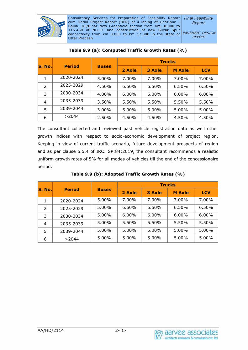
Consultancy Services for Preparation of Feasibility Report cum Detail Project Report (DPR) of 4 laning of Ghazipur –Ballia- UP/Bihar New Greenfield section from Km. 0.000 to 115.460 of NH-31 and construction of new Buxar Spur connectivity from km 0.000 to km 17.300 in the state of Uttar Pradesh
Final Feasibility
Report
PAVEMENT DESIGN REPORT
AA/HD/2114 2- 17
Table 9.9 (a): Computed Traffic Growth Rates (%)
S. No. Period Buses Trucks
2 Axle 3 Axle M Axle LCV
1 2020-2024 5.00% 7.00% 7.00% 7.00% 7.00%
2 2025-2029 4.50% 6.50% 6.50% 6.50% 6.50%
3 2030-2034 4.00% 6.00% 6.00% 6.00% 6.00%
4 2035-2039 3.50% 5.50% 5.50% 5.50% 5.50%
5 2039-2044 3.00% 5.00% 5.00% 5.00% 5.00%
6 >2044 2.50% 4.50% 4.50% 4.50% 4.50%
The consultant collected and reviewed past vehicle registration data as well other
growth indices with respect to socio-economic development of project region.
Keeping in view of current traffic scenario, future development prospects of region
and as per clause 5.5.4 of IRC: SP:84:2019, the consultant recommends a realistic
uniform growth rates of 5% for all modes of vehicles till the end of the concessionaire
period.
Table 9.9 (b): Adopted Traffic Growth Rates (%)
S. No. Period Buses Trucks
2 Axle 3 Axle M Axle LCV
1 2020-2024 5.00% 7.00% 7.00% 7.00% 7.00%
2 2025-2029 5.00% 6.50% 6.50% 6.50% 6.50%
3 2030-2034 5.00% 6.00% 6.00% 6.00% 6.00%
4 2035-2039 5.00% 5.50% 5.50% 5.50% 5.50%
5 2039-2044 5.00% 5.00% 5.00% 5.00% 5.00%
6 >2044 5.00% 5.00% 5.00% 5.00% 5.00%

Consultancy Services for Preparation of Feasibility Report cum Detail Project Report (DPR) of 4 laning of Ghazipur –Ballia- UP/Bihar New Greenfield section from Km. 0.000 to 115.460 of NH-31 and construction of new Buxar Spur connectivity from km 0.000 to km 17.300 in the state of Uttar Pradesh
Final Feasibility Report
PAVEMENT DESIGN REPORT
AA/HD/2114 2- 18
Figure-9.2: Traffic Location Map
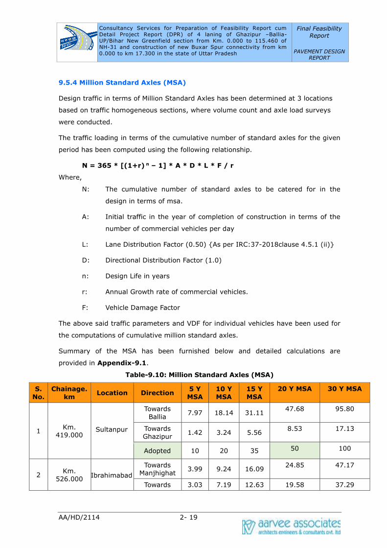
Consultancy Services for Preparation of Feasibility Report cum Detail Project Report (DPR) of 4 laning of Ghazipur –Ballia- UP/Bihar New Greenfield section from Km. 0.000 to 115.460 of NH-31 and construction of new Buxar Spur connectivity from km 0.000 to km 17.300 in the state of Uttar Pradesh
Final Feasibility
Report
PAVEMENT DESIGN REPORT
AA/HD/2114 2- 19
9.5.4 Million Standard Axles (MSA)
Design traffic in terms of Million Standard Axles has been determined at 3 locations
based on traffic homogeneous sections, where volume count and axle load surveys
were conducted.
The traffic loading in terms of the cumulative number of standard axles for the given
period has been computed using the following relationship.
N = 365 * [(1+r) n – 1] * A * D * L * F / r
Where,
N: The cumulative number of standard axles to be catered for in the
design in terms of msa.
A: Initial traffic in the year of completion of construction in terms of the
number of commercial vehicles per day
L: Lane Distribution Factor (0.50) {As per IRC:37-2018clause 4.5.1 (ii)}
D: Directional Distribution Factor (1.0)
n: Design Life in years
r: Annual Growth rate of commercial vehicles.
F: Vehicle Damage Factor
The above said traffic parameters and VDF for individual vehicles have been used for
the computations of cumulative million standard axles.
Summary of the MSA has been furnished below and detailed calculations are
provided in Appendix-9.1.
Table-9.10: Million Standard Axles (MSA)
S.
No.
Chainage.
km Location Direction
5 Y
MSA
10 Y
MSA
15 Y
MSA
20 Y MSA 30 Y MSA
1 Km.
419.000 Sultanpur
Towards
Ballia 7.97 18.14 31.11
47.68 95.80
Towards
Ghazipur 1.42 3.24 5.56
8.53 17.13
Adopted 10 20 35 50 100
2 Km.
526.000 Ibrahimabad
Towards
Manjhighat 3.99 9.24 16.09
24.85 47.17
Towards 3.03 7.19 12.63 19.58 37.29
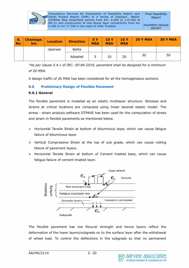
Consultancy Services for Preparation of Feasibility Report cum Detail Project Report (DPR) of 4 laning of Ghazipur –Ballia- UP/Bihar New Greenfield section from Km. 0.000 to 115.460 of NH-31 and construction of new Buxar Spur connectivity from km 0.000 to km 17.300 in the state of Uttar Pradesh
Final Feasibility
Report
PAVEMENT DESIGN REPORT
AA/HD/2114 2- 20
S.
No.
Chainage.
km Location Direction
5 Y
MSA
10 Y
MSA
15 Y
MSA
20 Y MSA 30 Y MSA
Uparwar Ballia
Adopted 5 10 20 30 50
*As per clause 5.4.1 of IRC: SP:84-2019, pavement shall be designed for a minimum
of 20 MSA.
A design traffic of 20 MSA has been considered for all the homogeneous sections.
9.6 Preliminary Design of Flexible Pavement
9.6.1 General
The flexible pavement is modeled as an elastic multilayer structure. Stresses and
strains at critical locations are computed using linear layered elastic model. The
stress - strain analysis software IITPAVE has been used for the computation of stress
and strain in flexible pavements as mentioned below.
➢ Horizontal Tensile Strain at bottom of bituminous layer, which can cause fatigue
failure of bituminous layer.
➢ Vertical Compressive Strain at the top of sub grade, which can cause rutting
failure of pavement layers.
➢ Horizontal Tensile Strain at bottom of Cement treated base, which can cause
fatigue failure of cement treated layer.
The flexible pavement has low flexural strength and hence layers reflect the
deformation of the lower layers/subgrade on to the surface layer after the withdrawal
of wheel load. To control the deflections in the subgrade so that no permanent
Consultancy Services for Preparation of Feasibility Report cum Detail Project Report (DPR) of 4 laning of Ghazipur –Ballia- UP/Bihar New Greenfield section from Km. 0.000 to 115.460 of NH-31 and construction of new Buxar Spur connectivity from km 0.000 to km 17.300 in the state of Uttar Pradesh
Final Feasibility
Report
PAVEMENT DESIGN REPORT
AA/HD/2114 2- 21
deflections results the pavement thickness is so designed that the stresses on the
subgrade soil are kept within its bearing power. Loading of bituminous pavement
requires the stiffest layers to be placed at the surface with successive weaker layers
down to subgrade.
For the purpose of structural design, only the number of commercial vehicles of laden
weight of 3 tonnes or more and their axle loading will be considered.
9.6.2 Fatigue Model
Due to repetition of loads, tensile strain develops cracks at the bottom of bituminous
layers which is a problem for long term serviceability. The phenomenon is called
fatigue of the bituminous layer and the number of load repetitions in terms of
standard axles that causes fatigue denotes the life of the pavement. Two fatigue
equations are considered, one in which the computed strains in by termed as 80%
reliability level and the other corresponding to 90% reliability level. The 80%
reliability equation is used for the pavement where VG30 grade bitumen is used and
90% reliability equation is used for the pavement where VG40 grade of bitumen is
used. The two equations for the conventional bituminous mixes designed by Marshall
method are given below:
Nf = 2.21 X 10-4 X (1/Et)3.89 X (1/MR)0.854 ---------1 (80% Reliability)
Nf = 2.021 X 10-4 X (1/Et)3.89 X (1/MR)0.854 ---------2 (90% Reliability)
Nf = Fatigue life in number of standard axles
Et = Maximum tensile strain at the bottom of Bituminous layer.
MR = Resilient Modulus of the Bituminous layer
The equation 2 is modified by considering 90% reliability with air voids around 3%
and the volume of bitumen about 13%.
9.6.3 Rutting Model
Rutting is the permanent deformation in pavement usually occurring longitudinally
along the wheel path. The rutting may partly be caused by deformation in the
subgrade and other non-bituminous layers which would reflect to the overlying layers
to take a deformed shape. The 80% reliability equation is used for the pavement
where VG30 grade bitumen is used and 90% reliability equation is used for the
Consultancy Services for Preparation of Feasibility Report cum Detail Project Report (DPR) of 4 laning of Ghazipur –Ballia- UP/Bihar New Greenfield section from Km. 0.000 to 115.460 of NH-31 and construction of new Buxar Spur connectivity from km 0.000 to km 17.300 in the state of Uttar Pradesh
Final Feasibility
Report
PAVEMENT DESIGN REPORT
AA/HD/2114 2- 22
pavement where VG40 grade bitumen is used. The rutting model considers the
vertical strain in subgrade and the two equations are given below by considering 80%
& 90% reliability.
N = 4.1656 X 10-8 X (1/Ez)4.5337 ---------3 (80% Reliability)
N = 1.41 X 10-8 X (1/Ez)4.5337 ---------4 (90% Reliability)
N = Number of cumulative standard axles to produce 20 mm rutting.
Ez = Maximum Vertical subgrade strain (micro strain)
9.6.4 Pavement Layers
In accordance with IRC 37:2018 for the following base and sub-base options are
available.
• Granular base and sub-base.
• Cementitious bases and sub-bases with a crack relief layer of aggregate
interlayer below bituminous surfacing.
• Cementitious bases and sub-bases with SAMI in between bituminous surfacing
and the cementitious base layer for retarding the reflection cracks into the
bituminous layer.
• Cemented base and granular subbase with crack relief interlayer of aggregate
above Cemented base.
• Bituminous surfacing over treated RAP and cemented subbase
Stage construction is not permitted when we are using cemented base and sub-bases
according to the guidelines of the code as it may lead to cracking of the stabilized
layer leading to failure of the pavement. Hence, the consultants adopting Granular
Base & Granular Sub-base for main carriageway pavement with stage construction.
9.6.4.1 Sub-base layer:
The sub-base layer serves three functions like to protect the sub-grade from over
stressing, to provide a platform for the construction traffic and to serve as drainage
and filter layer.
Material passing through 0.425 mm (425 micron), LL & PI shall not more than 25 and
6 %. Material shall have a minimum 10% fines value of 50 KN when tested in
compliance with BS:812. The water absorption value (as per IS 2386) of the coarse

Consultancy Services for Preparation of Feasibility Report cum Detail Project Report (DPR) of 4 laning of Ghazipur –Ballia- UP/Bihar New Greenfield section from Km. 0.000 to 115.460 of NH-31 and construction of new Buxar Spur connectivity from km 0.000 to km 17.300 in the state of Uttar Pradesh
Final Feasibility
Report
PAVEMENT DESIGN REPORT
AA/HD/2114 2- 23
aggregate shall be less than 2%, if not soundness test shall be carried out as per IS
383. 100% sample should pass through 75mm sieve and only 3-10% sample should
pass through 0.075mm sieve for all the three grades. When coarse graded subbase is
used as a drainage layer, Loss Angels abrasion value should be less than 40, so that
there is no crushing during the rolling and the permeability is retained. The sub-base
should be composed of two layers, the lower layer forms the separation/filter layer to
prevent intrusion of sub grade soil into the pavement and upper layer forms the
drainage layer to drain away any water that may enter through surface cracks.
Strength Parameter: Resilient Modulus (MRgsb)
MRgsb= 0.2 X h^ (0.45) X MR subgrade, where h is thickness of subbase layer in mm.
MR value of subbase is dependent on MR value of subgrade since weaker subgrade
does not permit higher modulus of the upper layer because of deformation under
loads.
MR subgrade = 10 X CBR if Subgrade CBR is <=5
MR subgrade = 17.6 X (CBR)^0.64 if Subgrade CBR is >5
9.6.4.2 Base layer:
Base layer consists of WMM, WBM, Crusher run macadam, reclaimed concrete etc.
Relevant specifications of IRC/MORTH are to be adopted for the construction.
Strength Parameter: Resilient Modulus (MR granular)
When both sub-base and base layers are made up of unbound granular layers, the
composite resilient modulus of the granular subbase and base are as follows:
MR granular= 0.2 X h0.45 X MR subgrade,
where h is combined thickness of subbase and base layers in mm.
9.6.4.3 Bituminous layers (Binder and Surface)
Binder layer consists of DBM and BM are to be adopted for construction. It is act like
as load distribution and supporting layer.
Strength Parameter: Resilient Modulus (MRBC/DBM)
The strength of bituminous mix based on extensive laboratory testing of Resilient
Modulus Test. Based on the study data of India, IRC:37-2018recommended resilient
modulus for different mix types and temperatures are given below.

Consultancy Services for Preparation of Feasibility Report cum Detail Project Report (DPR) of 4 laning of Ghazipur –Ballia- UP/Bihar New Greenfield section from Km. 0.000 to 115.460 of NH-31 and construction of new Buxar Spur connectivity from km 0.000 to km 17.300 in the state of Uttar Pradesh
Final Feasibility
Report
PAVEMENT DESIGN REPORT
AA/HD/2114 2- 24
Mix Type
Temperature o C
20 25 30 35 40
BC and DBM for VG30 bitumen 3500 3000 2500 1700 1250
BC and DBM for VG40 bitumen 6000 5000 4000 3000 2000
BC and DBM for Modified bitumen 5700 3800 2400 1650 1300
BM with VG30 bitumen - - - 700 -
9.6.5 Flexible pavement design for new carriage way
Pavement design is carried out in accordance with IRC 37:2018 for Granular base
and sub-base. The standard designs given in plate-7 of IRC:37-2018 specify the
minimum thickness and specifications of various component layers for the given
traffic in terms of cumulative standard axles and the subgrade CBR. The required
pavement composition according to IRC:37-2018 is as given below:
Table – 9.11: Option-1: Conventional Pavement Composition details
Reach Eff.
CBR
(%)
Design
Life in
Years
MS
A
Bitumen
Grade
Crust Composition in mm
From
(Km) To (Km) BC DBM WMM GSB Total
0.000 104.260 10 20 50 VG-40 40 105 250 200 595
Table – 9.12: Option-2: Cemented Base & Subbase with Crack Relief
Interlayer of Aggregate
Reach Eff.
CBR
(%)
Design
Life in
Years
MSA
Bitume
n
Grade
Crust Composition in mm
From
(Km) To (Km) BC
DBM
Agg.
In.
layer
CT-
B
CT-
SB Total
0.000 104.260 10 20 50 VG-40 40 60 100 100 200 500

Consultancy Services for Preparation of Feasibility Report cum Detail Project Report (DPR) of 4 laning of Ghazipur –Ballia- UP/Bihar New Greenfield section from Km. 0.000 to 115.460 of NH-31 and construction of new Buxar Spur connectivity from km 0.000 to km 17.300 in the state of Uttar Pradesh
Final Feasibility
Report
PAVEMENT DESIGN REPORT
AA/HD/2114 2- 25
Table – 9.13: Option-3: Cemented Base & Subbase with SAMI Interface layer
Reach Eff.
CB
R
(%
)
Desi
gn
Life
in
Year
s
MS
A
Bitu
men
Grad
e
Crust Composition in mm
From
(Km) To (Km) BC
DB
M SAMI
CT-
B
CT-
SB Total
0.000 104.26
0 10 20 50
VG-
40 40 60 SAMI 140 200 440
Table – 9.14: Option-4: Foamed Bitumen/Bitumen Treated RAP/Aggregates
Over Cemented Sub-base
Reach Eff.
CBR
(%)
Design
Life in
Years
MSA
Bitume
n
Grade
Crust Composition in mm
From
(Km) To (Km) BC
DBM Treate
d RAP CTSB Total
0.000 104.260 10 20 50 VG-40 40 65 100 200 405
Table – 9.15: Option-5: Cemented Base & Granular Subbase with Crack Relief
Interlayer of Aggregate
Reach Eff.
CBR
(%)
Design
Life in
Years
MSA Bitume
n Grade
Crust Composition in mm
From
(Km) To (Km) BC
DBM
Agg.
In.
layer
CT-
B GSB Total
0.000 104.260 10 20 50 VG-40 40 60 100 160 200 560
Table – 9.16: Option-6: Granular Base & Cement Treated Sub-Base
Reach Eff.
CBR
(%)
Design
Life in
Years
MSA Bitumen
Grade
Crust Composition in mm
From
(Km) To (Km) BC DBM WMM
CTSB Total
0.000 104.260 10 20 50 VG-40 40 70 150 200 460

Consultancy Services for Preparation of Feasibility Report cum Detail Project Report (DPR) of 4 laning of Ghazipur –Ballia- UP/Bihar New Greenfield section from Km. 0.000 to 115.460 of NH-31 and construction of new Buxar Spur connectivity from km 0.000 to km 17.300 in the state of Uttar Pradesh
Final Feasibility
Report
PAVEMENT DESIGN REPORT
AA/HD/2114 2- 26
9.7 Overlay Design for Existing Carriageway
The design of overlays for the existing pavement has been done taking in to account
the strength of the existing pavement based on detailed pavement investigations
including BBD test. The strengthening requirements for the existing pavement have
been worked out based on IRC guidelines considering average deflection values for
design homogeneous sections.
The overlay has been determined as per IRC:81-1997 and details of various layer
thicknesses applicable for overlay for each homogeneous section are given below.
Table – 9.17: Overlay Design
Reach Characteristic
Deflection
(Dc)
Design
Life MSA
Crust Composition
in mm
From To BC DBM Total
104.260 115.460 1.17 15 Y 20 40 50 90
*As per fig.9 Overlay Thickness Design Curve in IRC:81-1997
9.8 Service road, Paved Shoulder, Bus bays & Truck lay byes
8.8.1 Design of Shoulders
Paved Shoulder: The shoulder would be useable during all seasons of the year and
hence as per Clause 5.10 of IRC: SP:84-2019, the crust composition and
specification of paved shoulder shall be same as of the main carriageway.
Earthen Shoulder: Earthen shoulder shall be covered with 150 mm thick layer of
granular material confirming to the requirements given in Clause 401 of MORTH
specifications.
9.9 Recommendation for Pavement Option
It is recommended to construct Cement Treated Base & Cement Treated
Subbase with SAMI Interlayer for the entire stretch.
Consultancy Services for Preparation of Feasibility Report cum Detail Project Report (DPR) of 4 laning of Ghazipur –Ballia- UP/Bihar New Greenfield section from Km. 0.000 to 115.460 of NH-31 and construction of new Buxar Spur connectivity from km 0.000 to km 17.300 in the state of Uttar Pradesh
FINAL FEASIBILITY REPORT
MAIN REPORT
PRELIMINARY EIA
AA/HD/2114 10- 1
10. PRELIMINARY ENVIRONMENTAL IMPACT ASSESSMENT
10.1 Introduction
The National Highways Authority of India (NHAI) is engaged in the development of
the National highways in the state of Uttar Pradesh. The consultancy services for
preparation of Feasibility Report cum Detailed Project Report (DPR) of 4 laning of
Ghazipur Ballia – UP/Bihar section from Km 0.000 to 128.000 of NH-19 and
Construction of 2/4 laning Flyover at Ballia (Chandra Shekhar Mod to Satish Chandra
College) was awarded to Aarvee Associates.
The Letter of Acceptance was communicated vide letter No. NHAI/Tech/NH-19/Pkg-
I/2016/103661 dated 31st July,2017. The Agreement for consultancy services was
concluded with NHAI on 04/09/2017.Letter of commencement was issued vide letter
No. NHAI/Tech/NH-19/Pkg-I/DPR/2016/105592 dated 08.09.2017. Final DPR for the
existing road “Special Repair and Maintenance work from Ghazipur to UP/Bihar border
NH-31 from Km 405 to Km 535 including construction of New MJB at Km 412.130 and
rehabilitation of MJB at Km 533 on EPC mode” submitted vide our letter no.
AA/HW/NHAI/2114/18-19/9105 dated 26.03.2019. As per the directions from project
authorities, the alignment proposals were reviewed in view of the MoRTH Circular No.
NH-15017 / 21 / 2018 – P & M dated 26.02.2018. The greenfield alignment option
including comparison table showing the cost comparison of widening of the existing
alignment option via-a-via widening of was prepared and the same was reviewed at
various levels and it was decided that green field alignment with spur providing
connectivity to Buxar was approved during the meeting held in Ministry under the
Chairmanship of Secretary and the Minutes of Meeting were communicated vide letter
No. NHAI/Tech/ NH-19/Ghazipur-Ballia/ DPR/2016/122312 dated 13.08.2018.
The District Administration of Ballia held public consultations regarding the proposed
elevated flyover and communicated their decisions vide MoM dated 1393/ 14 – 1
dated 20.10.2018. The MoM inter-alia state that widening of the existing road to four
lane standards would serve the traffic problems in Ballia town and elevated flyover is
not required since construction of the said flyover would result in acquisition of land
and structures for the purpose of flyover.
Public consultation meeting on the project alignment was held in the office of District
Magistrate Ballia on 05.09.2018 wherein the committee recommended that the
bypass alignment for Ballia be considered on the south side. This will require
modification of the alignment approved earlier in a length of approximately 38.50 km.

Consultancy Services for Preparation of Feasibility Report cum Detail Project Report (DPR) of 4 laning of Ghazipur –Ballia- UP/Bihar New Greenfield section from Km. 0.000 to 115.460 of NH-31 and construction of new Buxar Spur connectivity from km 0.000 to km 17.300 in the state of Uttar Pradesh
FINAL FEASIBILITY REPORT
MAIN REPORT
PRELIMINARY EIA
AA/HD/2114 10- 2
The said modification was reviewed during the meeting held on 08.12.2018 at NHAI
HQ, New Delhi under the chairmanship of Member (P) and agreed by Member.
Variation with financial implication for new Greenfield alignment was approved from
RO, Varanasi vide letter no. NHAI/UP (E)/GM (T)/NH-19/Ghazipur-Ballia/DPR/14
dated 27.10.2020. Accordingly, the Inception & Alignment report for the approved
Greenfield alignment were prepared and submitted vide our letter no.
AA/HW/NHAI/2114/20-21/2820 & 2966 dated 06.11.2020 & 16.11.2020.
Table-10.1: Project Details for Greenfield Alignment
S. No
Project Highway
Design Chainage (Km)
Remarks From To
1 Ghazipur to Manjhi Ghat UP/
Bihar Border 0.000 115.600 NH-31
2 Buxar Spur 0.000 17.800 -
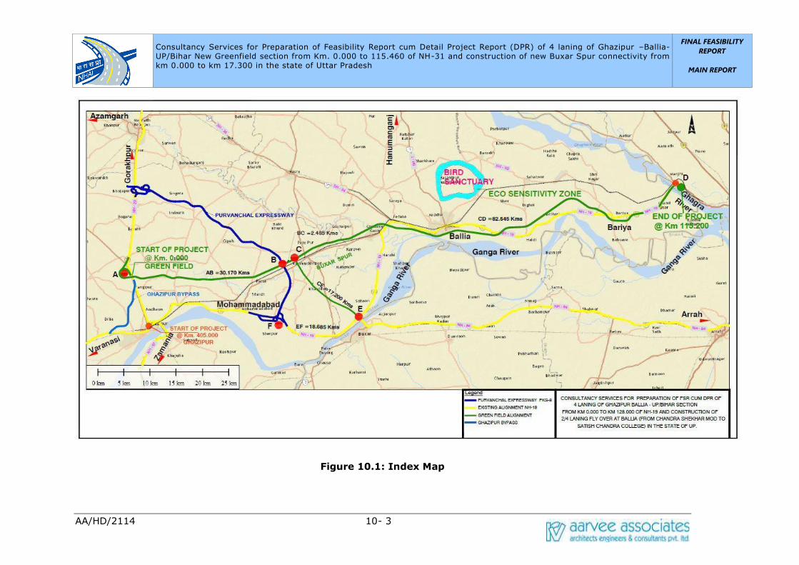
Consultancy Services for Preparation of Feasibility Report cum Detail Project Report (DPR) of 4 laning of Ghazipur –Ballia- UP/Bihar New Greenfield section from Km. 0.000 to 115.460 of NH-31 and construction of new Buxar Spur connectivity from km 0.000 to km 17.300 in the state of Uttar Pradesh
FINAL FEASIBILITY
REPORT
MAIN REPORT
PRELIMINARY EIA
AA/HD/2114 10- 3
Figure 10.1: Index Map
Consultancy Services for Preparation of Feasibility Report cum Detail Project Report (DPR) of 4 laning of Ghazipur –Ballia- UP/Bihar New Greenfield section from Km. 0.000 to 115.460 of NH-31 and construction of new Buxar Spur connectivity from km 0.000 to km 17.300 in the state of Uttar Pradesh UP/Bihar New Greenfield section from Km. 0.000 to
FINAL FEASIBILITY REPORT
MAIN REPORT
PRELIMINARY EIA
AA/HD/2114 10- 4
10.2 Project Description
The highway project is a Greenfield Alignment passing through Ghazipur and Ballia
districts of UP/Bihar. The total length of the highway is 115.460 km. It traverses
mostly through plain terrain and a mixed land use of residential and agricultural can
be seen throughout the corridor. Details of the project stretch are given in Table 10.2
Table 10.2: Project Stretch Details
S. No Stretch Length Major Settlements District(s)
1
Stretch from Ghazipur
Ballia–UP/Bihar Section
115.460 km
Ghazipur,
Muhammadabad, Ballia,
Ramgarh, Bairiya
Ghazipur
and Ballia
in UP,
Saran in
Bihar
2
Buxar Spur
17.300km
Bathor, Ramghar,
kumkumpatti
Ghazipur
and Ballia
10.2.1 Terrain
Terrain is classified by the general slope of the country across the highway alignment.
Based on this criterion, the entire project stretch traverses predominantly through
Plain terrain (70%) followed by Rolling terrain (30%).
10.2.2 Abutting Land use
In terms of land-use, majority of adjoining lands were observed to be used for
agriculture purposes and the rest is built up and barren land. Important crops grown
along the project stretch are Wheat and Sugarcane. Moderately built-up areas and a
mix of fast and slow traffic characterize this corridor. Different types of residential/
commercial structures (Permanent/Semi permanent) are noticed in the built-up
section.
10.2.4 Cross Drainage Works
As a part of upgrading of the project, it is required to make an assessment of existing
structures with regards to their adequacies to ensure that they meet the objectives of
the project. List of existing cross drainage structures along the project stretch are
shown below from Table 10.4 and Table 10.5

Consultancy Services for Preparation of Feasibility Report cum Detail Project Report (DPR) of 4 laning of Ghazipur –Ballia- UP/Bihar New Greenfield section from Km. 0.000 to 115.460 of NH-31 and construction of new Buxar Spur connectivity from km 0.000 to km 17.300 in the state of Uttar Pradesh UP/Bihar New Greenfield section from Km. 0.000 to
FINAL FEASIBILITY REPORT
MAIN REPORT
PRELIMINARY EIA
AA/HD/2114 10- 5
Table 10.3: Major Bridges (Existing)
S.No. Chainage (Km) Span (m)
1 532.100 32+2x64+31x32
Table10.4: Minor Bridges (Existing)
S.No. Chainage (Km) Span(m)
1 529.100 3x9.38
Summary of Existing Cross Drainage Structures:
• Major Bridges = 1
• Minor Brides = 1
10.2.5 Settlements
The project stretches passes through Ghazipur, Nasirpur, Chandrashekhar Mod, Ballia,
Bairaya major settlements in project stretch. The complete list of villages abutting
the project stretch is shown below in Table-10.5
Table 10.5: Major settlement in project stretch
S. No
Village
Name
Chainage (Km) Length
(km.) From To
1 Hridaypur 0.000 0.570 0.570
2
Saraibandi
0.570 0.750 0.180
0.860 1.025 0.165
3 Nasirpur 0.750 0.860 0.110
1.025 1.450 0.425
4 Dadi Kala 1.450 1.635 0.185
5 Khazapur 1.635 2.015 0.380
6 Dhobha 2.015 2.500 0.485
7 Ramdoopur 2.500 2.550 0.050
8 Mirzapur Mafi 2.550 3.050 0.500
9 Bhikharipur 3.050 3.550 0.500
10 Manpur 3.550 4.280 0.730
11 Tikari 4.280 5.335 1.055
12 Sathipur 5.335 6.070 0.735
13 Bisunpur
Datta
6.070 6.210 0.140

Consultancy Services for Preparation of Feasibility Report cum Detail Project Report (DPR) of 4 laning of Ghazipur –Ballia- UP/Bihar New Greenfield section from Km. 0.000 to 115.460 of NH-31 and construction of new Buxar Spur connectivity from km 0.000 to km 17.300 in the state of Uttar Pradesh UP/Bihar New Greenfield section from Km. 0.000 to
FINAL FEASIBILITY REPORT
MAIN REPORT
PRELIMINARY EIA
AA/HD/2114 10- 6
S. No
Village
Name
Chainage (Km) Length
(km.) From To
14 Newada 6.210 6.295 0.085
15 Subhakarpur 6.295 7.950 1.655
16 Akhatiyarpur 7.950 8.530 0.580
17 Chak Ajam 8.530 9.200 0.670
18 Raibanpah 9.620 9.660 0.040
19 Badhui khurd 9.200 9.620 0.420
20 Chak
Niamtulla
9.660 10.100 0.440
21 Badhui
Buzurg
10.100 10.210 0.110
22 Thanaipur 10.210 10.860 0.650
23 Hardia 10.860 11.880 1.020
24 Rasoolpur
ahmad
11.880 12.605 0.725
25 Said chak 12.605 13.090 0.485
26 Abbaspur 13.090 13.335 0.245
27 Baluwa Mu.
Nonhara
13.335 14.935 1.600
28 Lalapur adai 14.935 15.400 0.465
29 Sukhpura 15.400 17.050 1.650
30 Todarpur Urf
Partap pur
17.050 17.575 0.525
31 Fakkrabad 17.575 18.065 0.490
18.315 18.575 0.260
32 Sakatpur
Bareji
18.065 18.315 0.250
18.575 19.970 1.395
33 Paharipur 19.970 21.550 1.580
34 Gajraj
Gadaipur
21.550 22.100 0.550
35 Parsa 22.100 24.370 2.270
36 Indrapur 24.370 24.885 0.515
37 Tarapur 24.885 25.560 0.675
38 Faizullapur 25.560 26.670 1.110

Consultancy Services for Preparation of Feasibility Report cum Detail Project Report (DPR) of 4 laning of Ghazipur –Ballia- UP/Bihar New Greenfield section from Km. 0.000 to 115.460 of NH-31 and construction of new Buxar Spur connectivity from km 0.000 to km 17.300 in the state of Uttar Pradesh UP/Bihar New Greenfield section from Km. 0.000 to
FINAL FEASIBILITY REPORT
MAIN REPORT
PRELIMINARY EIA
AA/HD/2114 10- 7
S. No
Village
Name
Chainage (Km) Length
(km.) From To
39 Mahmoodpur
irf dodadih
26.670 26.900 0.230
40 Bagend 26.900 27.550 0.650
41 Rampur 27.550 28.740 1.190
42 Raipur M.
Rajapur
28.740 28.790 0.050
43 Padraw 28.790 29.580 0.790
44 Sher 29.580 30.510 0.930
45 Baddopur 30.510 30.560 0.050
46 Bathor 30.560 31.800 1.240
47 Dilawaalpur 31.800 32.340 0.540
48 New urf
uchadih
32.340 32.600 0.260
49 Chandkur 32.600 32.850 0.250
50 Karimuddinpu
r
32.850 34.150 1.300
51 Baijnathpur 34.150 34.200 0.050
52 Lathudih 34.200 34.870 0.670
53 34.985 35.150 0.165
Jayantipur 34.870 34.985 0.115
54 Chak gareeb 35.150 35.450 0.300
55 Vishambharpu
r Aarzai Maafi
35.450 35.610 0.160
56 Karkatpur
Mu.utraon
35.610 36.250 0.640
36.450 36.580 0.130
57 Karkatpur
Mauja
36.250 36.450 0.200
58 Vishambharpu
r panjum
36.580 36.820 0.240
59 Bisambarpur
Panjam
36.820 37.030 0.210
60 Vishambharpu
r-Part-3
37.030 37.240 0.210
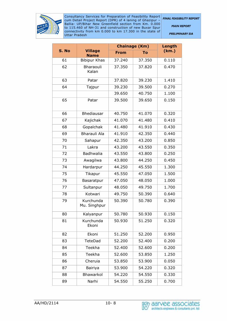
Consultancy Services for Preparation of Feasibility Report cum Detail Project Report (DPR) of 4 laning of Ghazipur –Ballia- UP/Bihar New Greenfield section from Km. 0.000 to 115.460 of NH-31 and construction of new Buxar Spur connectivity from km 0.000 to km 17.300 in the state of Uttar Pradesh UP/Bihar New Greenfield section from Km. 0.000 to
FINAL FEASIBILITY REPORT
MAIN REPORT
PRELIMINARY EIA
AA/HD/2114 10- 8
S. No
Village
Name
Chainage (Km) Length
(km.) From To
61 Bibipur Khas 37.240 37.350 0.110
62 Bharaouli
Kalan
37.350 37.820 0.470
63 Patar 37.820 39.230 1.410
64 Tajpur 39.230 39.500 0.270
39.650 40.750 1.100
65 Patar 39.500 39.650 0.150
66 Bhediausar 40.750 41.070 0.320
67 Kajichak 41.070 41.480 0.410
68 Gopalchak 41.480 41.910 0.430
69 Bharauli Ala 41.910 42.350 0.440
70 Sahapur 42.350 43.200 0.850
71 Lakra 43.200 43.550 0.350
72 Badhwalia 43.550 43.800 0.250
73 Awagilwa 43.800 44.250 0.450
74 Hardarpur 44.250 45.550 1.300
75 Tikapur 45.550 47.050 1.500
76 Basaratpur 47.050 48.050 1.000
77 Sultanpur 48.050 49.750 1.700
78 Kotwari 49.750 50.390 0.640
79 Kurchunda
Mu. Singhpur
50.390 50.780 0.390
80 Kalyanpur 50.780 50.930 0.150
81 Kurchunda
Ekoni
50.930 51.250 0.320
82 Ekoni 51.250 52.200 0.950
83 TeteDad 52.200 52.400 0.200
84 Teekha 52.400 52.600 0.200
85 Teekha 52.600 53.850 1.250
86 Cheruia 53.850 53.900 0.050
87 Bairiya 53.900 54.220 0.320
88 Bhawarkol 54.220 54.550 0.330
89 Narhi 54.550 55.250 0.700

Consultancy Services for Preparation of Feasibility Report cum Detail Project Report (DPR) of 4 laning of Ghazipur –Ballia- UP/Bihar New Greenfield section from Km. 0.000 to 115.460 of NH-31 and construction of new Buxar Spur connectivity from km 0.000 to km 17.300 in the state of Uttar Pradesh UP/Bihar New Greenfield section from Km. 0.000 to
FINAL FEASIBILITY REPORT
MAIN REPORT
PRELIMINARY EIA
AA/HD/2114 10- 9
S. No
Village
Name
Chainage (Km) Length
(km.) From To
90 Gangahara 55.250 56.250 1.000
56.350 56.890 0.540
91 Vaina 56.250 56.350 0.100
92 Baghe Ji 56.890 57.350 0.460
93 Sagarapalli 57.350 58.980 1.630
94 Daraopur 58.980 59.350 0.370
95 Kaap
Nasirabad
59.350 59.670 0.320
96 Sharfuddinpur
Mu
59.670 60.200 0.530
97 Devariyakurd
h
60.200 60.390 0.190
98 Mubarakpur 60.390 60.730 0.340
99 Khap Khori
Pakar
60.730 60.890 0.160
100 Parsipatti 60.890 61.190 0.300
101 Maldepur 61.190 61.280 0.090
102 Haibatpur 61.280 62.120 0.840
103 Bijaipur 62.120 63.280 1.160
104 Bankata 63.280 63.800 0.520
63.850 64.120 0.270
105 Makhdumhi 63.800 63.850 0.050
106 Bedua 64.120 64.420 0.300
107 Hirpur 64.420 65.050 0.630
108 Neori Taluka
Jamuaon
65.050 65.110 0.060
109 Chandanapur 65.110 65.280 0.170
110 Kanspur 65.280 65.550 0.270
111 Jamuwa 65.550 65.950 0.400
112 Moorki 65.950 66.770 0.820
113 Jamun 66.770 67.430 0.660
114 Kishun Nagar 67.430 68.180 0.750
115 Mohan
Chhapra
68.180 68.390 0.210

Consultancy Services for Preparation of Feasibility Report cum Detail Project Report (DPR) of 4 laning of Ghazipur –Ballia- UP/Bihar New Greenfield section from Km. 0.000 to 115.460 of NH-31 and construction of new Buxar Spur connectivity from km 0.000 to km 17.300 in the state of Uttar Pradesh UP/Bihar New Greenfield section from Km. 0.000 to
FINAL FEASIBILITY REPORT
MAIN REPORT
PRELIMINARY EIA
AA/HD/2114 10- 10
S. No
Village
Name
Chainage (Km) Length
(km.) From To
116 Nagwa 68.390 69.950 1.560
117 Harlal
Chhapra
69.950 70.310 0.360
118 Jinari 70.310 71.600 1.290
119 Mafi Janari 71.600 71.870 0.270
120 Bhel Sarh 71.870 73.300 1.430
121 Urgasenpur 73.300 73.330 0.030
73.450 73.650 0.200
122 Bhimpatti 73.330 73.450 0.120
123 Oujha
Kacchua
73.650 74.380 0.730
124 Kachha Khas 74.380 75.350 0.970
125 Rampur Titihi 75.350 76.530 1.180
126 Pochhari 76.530 77.130 0.600
127 Pindari 77.130 78.100 0.970
128 Sihakhund 78.100 79.100 1.000
129 Bharkoka 79.100 80.690 1.590
130 Kathal 80.690 80.920 0.230
131 Mudadih 80.920 81.450 0.530
82.070 84.130 2.060
132 Laakhpur 81.450 82.070 0.620
133 Belhari 84.130 85.700 1.570
134 Malikpura Mu.
Jagchhapra
85.700 86.340 0.640
135 Dudaila 86.340 87.150 0.810
136 Khajuhati 87.150 87.910 0.760
137 Raghunathpur 87.910 88.800 0.890
138 Kanchanpur 88.800 89.590 0.790
139 Kewa 89.590 90.350 0.760
140 Mansing
Chapra
90.350 91.000 0.650
141 Cherdih 91.000 92.250 1.250
142 Moon
Chhupra
92.250 97.030 4.780
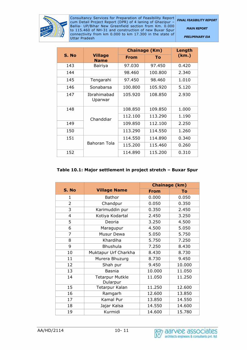
Consultancy Services for Preparation of Feasibility Report cum Detail Project Report (DPR) of 4 laning of Ghazipur –Ballia- UP/Bihar New Greenfield section from Km. 0.000 to 115.460 of NH-31 and construction of new Buxar Spur connectivity from km 0.000 to km 17.300 in the state of Uttar Pradesh UP/Bihar New Greenfield section from Km. 0.000 to
FINAL FEASIBILITY REPORT
MAIN REPORT
PRELIMINARY EIA
AA/HD/2114 10- 11
S. No
Village
Name
Chainage (Km) Length
(km.) From To
143 Bairiya 97.030 97.450 0.420
144 98.460 100.800 2.340
145 Tengarahi 97.450 98.460 1.010
146 Sonabarsa 100.800 105.920 5.120
147 Ibrahimabad
Uparwar
105.920 108.850 2.930
148
Chanddiar
108.850 109.850 1.000
112.100 113.290 1.190
149 109.850 112.100 2.250
150 113.290 114.550 1.260
151
Bahoran Tola
114.550 114.890 0.340
115.200 115.460 0.260
152 114.890 115.200 0.310
Table 10.1: Major settlement in project stretch – Buxar Spur
S. No
Village Name
Chainage (km)
From To
1 Bathor 0.000 0.050
2 Chandpur 0.050 0.350
3 Karimuddin pur 0.350 2.450
4 Kotiya Kodartal 2.450 3.250
5 Deoria 3.250 4.500
6 Maragupur 4.500 5.050
7 Musur Dewa 5.050 5.750
8 Khardiha 5.750 7.250
9 Bhushula 7.250 8.430
10 Muktapur Urf Charkha 8.430 8.730
11 Murera Bhuzurg 8.730 9.450
12 Shah pur 9.450 10.000
13 Basnia 10.000 11.050
14 Tetarpur Mutkle
Dularpur
11.050 11.250
15 Tetarpur Kalan 11.250 12.600
16 Ramgarh 12.600 13.850
17 Kamal Pur 13.850 14.550
18 Jajar Kalsa 14.550 14.600
19 Kurmidi 14.600 15.780

Consultancy Services for Preparation of Feasibility Report cum Detail Project Report (DPR) of 4 laning of Ghazipur –Ballia- UP/Bihar New Greenfield section from Km. 0.000 to 115.460 of NH-31 and construction of new Buxar Spur connectivity from km 0.000 to km 17.300 in the state of Uttar Pradesh UP/Bihar New Greenfield section from Km. 0.000 to
FINAL FEASIBILITY REPORT
MAIN REPORT
PRELIMINARY EIA
AA/HD/2114 10- 12
S. No
Village Name
Chainage (km)
From To
20 Chintamanpatti 15.780 16.470
21 Kumkum Patti 16.470 17.280
Figure 10.2: Built-up Areas
There are no ROB’s/RUB’s present in the stretch.
Table 10.2: ROB along Project Stretch
S.No. Railway Crossing Chainage Location Type
Nil
Table 10.3: Railway Crossing along Project Stretch
S.No. Railway Crossing Chainage (Km) Location Type
Nil
10.2.7 Existing Geometrics
The existing geometric alignment of the project stretch might have been designed as
per State Highway standards and may not meet the present standards of a National
Highway. The design is deficient in sight distance, curve radii and super elevation at
few locations. Further, there are several curves near village limits which might
require improvement.

Consultancy Services for Preparation of Feasibility Report cum Detail Project Report (DPR) of 4 laning of Ghazipur –Ballia- UP/Bihar New Greenfield section from Km. 0.000 to 115.460 of NH-31 and construction of new Buxar Spur connectivity from km 0.000 to km 17.300 in the state of Uttar Pradesh UP/Bihar New Greenfield section from Km. 0.000 to
FINAL FEASIBILITY REPORT
MAIN REPORT
PRELIMINARY EIA
AA/HD/2114 10- 13
10.2.8 Carriageway
The existing carriageway details are shown in Table 10.4.
Table 10.4: Existing Carriageway Details
S.No. From
km To km
Existing
Pavement
Configuration
Existing
Width
(m)
Remarks
1 523.600 535.300 Two Lane 7m In Built-up Locations
varying from 7 – 10 m
10.2.9 Pavement
Flexible pavement is observed throughout the project stretch except the riding
quality/pavement condition varies from good to fair along the entire stretch with very
few sections of the road showing various types of distresses such as Raveling,
Potholes, undulations and cracks.
10.2.10 Right of Way
The existing Right of Way (RoW) varies between 15m to 20m along the corridor. RoW
pillars was not found along the project stretch. The precise RoW details will be
ascertained from the revenue records to clarify on the exact land available for
construction. Land acquisition plans would be prepared to have uniform ROW in
accordance with NHAI guidelines. Additional land acquisition will be proposed as per
project requirements and in accordance with TOR/ NHAI guidelines.
10.2.11 Scheme of Widening
To accommodate Two/Four lane with paved shoulders within available ROW,
concentric widening may be advisable. However, final decision regarding scheme of
widening will be taken after finalization of geometric design considering different
parameters such as right of way availability, presence of utilities, sensitive structures,
economics and other considerations.
10.2.12 Utilities
The project road has utilities that come in the way of the proposed upgradation
scheme. The Electric lines are observed to be nearly at a distance of 5-10m from
road edge and crossing of High Transmission lines observed along the project corridor.
In most of the locations the electrical poles are within the Right of Way which should
be relocated. High Transmission towers and sub-stations are observed to be away
Consultancy Services for Preparation of Feasibility Report cum Detail Project Report (DPR) of 4 laning of Ghazipur –Ballia- UP/Bihar New Greenfield section from Km. 0.000 to 115.460 of NH-31 and construction of new Buxar Spur connectivity from km 0.000 to km 17.300 in the state of Uttar Pradesh UP/Bihar New Greenfield section from Km. 0.000 to
FINAL FEASIBILITY REPORT
MAIN REPORT
PRELIMINARY EIA
AA/HD/2114 10- 14
from Right of Way in the project stretch.
10.2.13 Additional Land Acquisition
Additional land acquisition may become necessary for the following, subject to the
improvement proposals made after a detailed study:
• Bus bays and Truck lay-byes
• Underpasses with Slip roads
• Service Roads at Urban Locations
• Proposed bypasses
• Realignment sections
• Toll Plazas
• Rest areas
• ROB's
10.2.14 Technical Assessment of Existing Road
I. The Project road is mostly composed of flexible pavement throughout the
project stretch.
II. The existing carriageway of the project is of 2 & 4 lane with paved shoulder of
width 1.5 m on both sides with median openings varying from 1 to 3m.
III. The existing road condition varies from Good to fair, except at some locations
where the condition is poor.
IV. The surface condition of the pavement varies from good to fair condition.
Pavement distresses were observed in the form of Longitudinal, Block, Map
cracking, ravelling and pot holes.
V. The Earthen Shoulders condition varies from good to poor on both sides of the
road. It is observed that at some particular locations, there is material loss of
shoulders on both sides.
VI. Unlined drains exist almost entire length of the project stretch. Some are
partially functioning and some are totally blocked.
VII. The pavement has few structural failures which can be attributed to the
Consultancy Services for Preparation of Feasibility Report cum Detail Project Report (DPR) of 4 laning of Ghazipur –Ballia- UP/Bihar New Greenfield section from Km. 0.000 to 115.460 of NH-31 and construction of new Buxar Spur connectivity from km 0.000 to km 17.300 in the state of Uttar Pradesh UP/Bihar New Greenfield section from Km. 0.000 to
FINAL FEASIBILITY REPORT
MAIN REPORT
PRELIMINARY EIA
AA/HD/2114 10- 15
insufficient compaction of the Sub-grade and Sub-base layers.
10.3 Preliminary Environmental Assessment
This Report describes the proposed work plan related to environmental aspects and
makes desirable modifications keeping in view the requirement of the Project Road.
Standard methods / procedures will be adopted during environmental monitoring
analysis and report preparation. The exact sampling locations and number will be
finalized during field studies. However, tentative sampling number is provided at this
stage. The methodology for carrying out the study and specifications pertaining to
environment to be adopted in this project are as follows:
10.3.1 Objectives
The major objective of this study is to establish present environmental condition
along the project corridor through available data/ information supported by field
studies to evaluate the impacts on relevant environmental attributes due to the
construction & operation of the proposed project; to recommend adequate mitigation
measures to minimize/ reduce adverse impacts and to prepare an Environmental
Management Plan (EMP) for timely implementation of the mitigation measures to
ensure that the project will result in a high quality and safe road to users in a
sustainable and environment-friendly manner. An Environmental Impact Assessment
(EIA) study basically includes:
• Establishment of the present environmental scenario;
• Study of the specific activities related to the project;
• Evaluation of the potential environmental impacts;
• Undertake an analysis of alternatives by bringing in environmental
considerations into the upstream stages of sub-project planning and design;
• Preparation of Environmental Management Plan that specifies the measures to
mitigate adverse impacts and enhance positive impacts of the sub-project on
the environment, along with the monitoring, capacity building and institutional
arrangements.
10.3.2 Need for Environment Impact Assessment
Highway developmental activities should be planned and executed after considering
the potential environmental impacts. To minimize these adverse impacts that may be
created by highway development projects, the techniques of Environmental Impact
Consultancy Services for Preparation of Feasibility Report cum Detail Project Report (DPR) of 4 laning of Ghazipur –Ballia- UP/Bihar New Greenfield section from Km. 0.000 to 115.460 of NH-31 and construction of new Buxar Spur connectivity from km 0.000 to km 17.300 in the state of Uttar Pradesh UP/Bihar New Greenfield section from Km. 0.000 to
FINAL FEASIBILITY REPORT
MAIN REPORT
PRELIMINARY EIA
AA/HD/2114 10- 16
Assessment (EIA) become necessary. Identification and assessment of potential
environmental impacts should be an integral part of the project life cycle. It should
commence early in the planning process of the project to enable a full consideration
of alternatives and to avoid later delays and complications.
10.3.3 Legal and Environmental Clearance Requirements
The increase of environmental concerns has necessitated appropriate tools to protect
the environment. India has developed a fairly comprehensive regulatory framework
to address environmental and social concerns in relation to development projects. Its
wide-ranging enactments cover almost all major issues that need to be addressed in
the course of development of infrastructure from a social and environmental
perspective. This section describes the institutional set-up and key legislation
pertaining to environmental issues.
Institutional Framework
The Ministry of Environment, Forest and Climate Change (MoEF&CC) to serve as the
focal point in the administrative structure for the planning, promotion and
coordination of environmental and forestry programmes. The Ministry of Environment
and Forests (MoEF) has been renamed recently in the year 2014 as Ministry of
Environment and Forest and Climate Change (MoEF&CC). The MoEF&CC has overall
authority for the administration and implementation of government policies, laws and
regulations related to the environment, including conservation, environmental
assessment, sustainable development and pollution control. MoEF&CC identifies the
need to enact new laws and amend existing environmental legislation when required,
in order to continue to conserve and protect the environment. At the state level, the
MoEF&CC authority is implemented by the Department of the Environment and the
Department of Forest.
In 1976, the 42nd Constitutional Amendment created Article 48A and 51A, placing an
obligation on every citizen of the country to attempt to conserve the environment. As
a result, a number of laws related to environmental conservation were passed to
strengthen existing legislation. Environment (Protection) Act, 1986 is the landmark
legislation as it provides for the protection of environment and aims at plugging the
loopholes in the other related acts.
The Government of India through specific legislation regulates the environmental
management system in India. The Ministries / Statutory Bodies responsible for
ensuring environmental compliance by project proponents include:

Consultancy Services for Preparation of Feasibility Report cum Detail Project Report (DPR) of 4 laning of Ghazipur –Ballia- UP/Bihar New Greenfield section from Km. 0.000 to 115.460 of NH-31 and construction of new Buxar Spur connectivity from km 0.000 to km 17.300 in the state of Uttar Pradesh UP/Bihar New Greenfield section from Km. 0.000 to
FINAL FEASIBILITY REPORT
MAIN REPORT
PRELIMINARY EIA
AA/HD/2114 10- 17
• The Ministry of Environment & Forests and Climate Change (MoEF&CC)
• Central Pollution Control Board (CPCB)
• Uttar Pradesh Pollution Control Board (UPPCB)
• Department of Environment in the States
10.4 Applicability of International, National and State
Environmental Norms
The proposed highway development project is attracting various International,
National, State, and World Bank environmental laws, rules and regulations. These
regulations and rules are helpful in impact mitigation and improvement of the
environment. The environmental assessment study will be carried out as per the
requirement of the National/State/World Bank environmental guidelines. The
applicability of the regulatory norms is given in Table 5.10
Table 5.10: Applicability of Environmental Regulatory Norms for the Project
Project Project Components
Applicability of
Environmental Laws,
Policies and
Notifications
Remarks
4 laning of
Ghazipur
Ballia –
UP/Bihar
section from
Km. 0.000
to 128.000
of NH-19
and
Construction
of 2/4
laning
Flyover at
Ballia
(Chandra
Shekhar
Mod to
Satish
Chandra
College) in
the State of
Uttar
Pradesh
• Right of Way • Land Acquisition • Protected Social
Forestry
throughout the
Right of Way
(RoW) • Quarries • Borrow Areas • Establishment of
Hot Mix Plants
and Batch mix
Plants • Sensitive
Locations
(Schools,
hospitals, etc,.) • Archaeological
Sites
The Environment
(Protection) Act, 1986
and further notifications
issued under this Act.
Any act during
implementation causing
damage to environment.
As per the Environment
(Protection) Act (EP)
1986, ambient noise
levels are to be
maintained as stipulated
by the Central Pollution
Control Board (CPCB) for
different categories of
areas like, commercial,
residential and silence
zones, etc., during sub-
project construction and
operation. Section -3
(2)(iii & iv).
Water (Prevention and
Control of Pollution) Cess
Act, 1977 including Rules
Applicable to all activities,
which discharge effluents
as a result of process or
operations.
Section 3 (2)(a) of the
Act and Cess to the Govt.
of India as per Table -I &
II for consumption of
Water (Prevention and
Control of Pollution) Act,
1974 – as amended in
1978 & 1988.
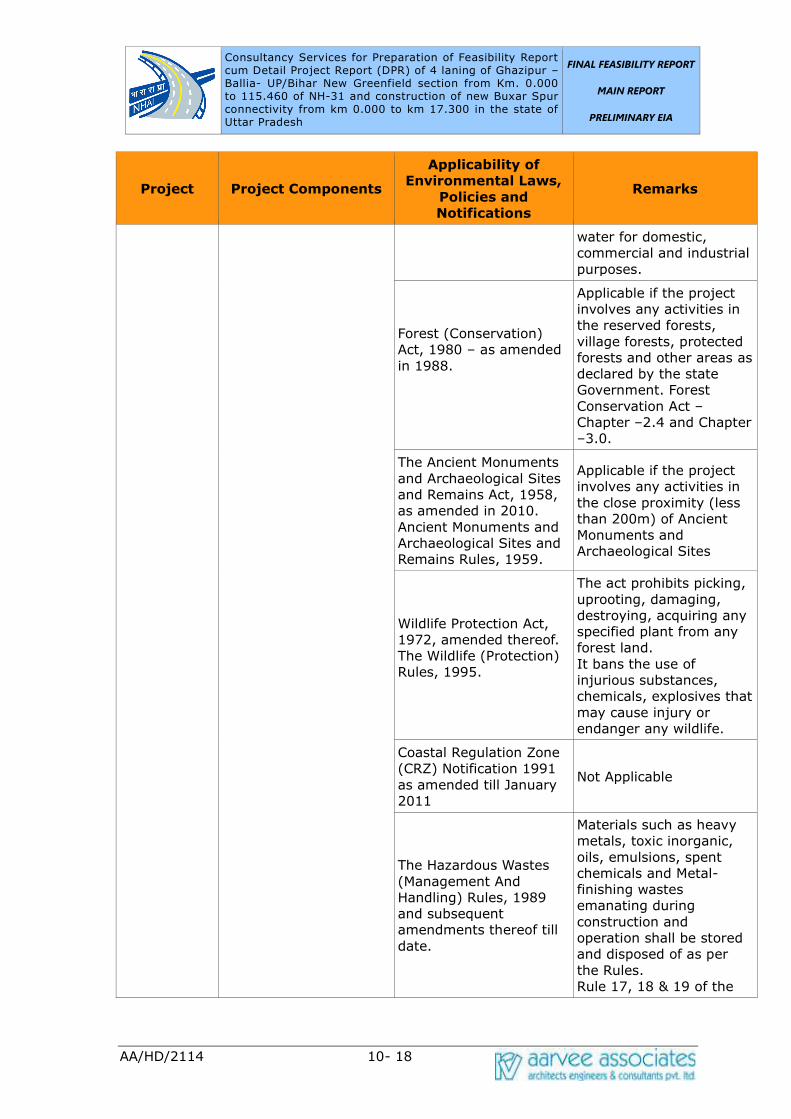
Consultancy Services for Preparation of Feasibility Report cum Detail Project Report (DPR) of 4 laning of Ghazipur –Ballia- UP/Bihar New Greenfield section from Km. 0.000 to 115.460 of NH-31 and construction of new Buxar Spur connectivity from km 0.000 to km 17.300 in the state of Uttar Pradesh UP/Bihar New Greenfield section from Km. 0.000 to
FINAL FEASIBILITY REPORT
MAIN REPORT
PRELIMINARY EIA
AA/HD/2114 10- 18
Project Project Components
Applicability of
Environmental Laws,
Policies and
Notifications
Remarks
water for domestic,
commercial and industrial
purposes.
Forest (Conservation)
Act, 1980 – as amended
in 1988.
Applicable if the project
involves any activities in
the reserved forests,
village forests, protected
forests and other areas as
declared by the state
Government. Forest
Conservation Act –Chapter –2.4 and Chapter
–3.0.
The Ancient Monuments
and Archaeological Sites
and Remains Act, 1958,
as amended in 2010.
Ancient Monuments and
Archaeological Sites and
Remains Rules, 1959.
Applicable if the project
involves any activities in
the close proximity (less
than 200m) of Ancient
Monuments and
Archaeological Sites
Wildlife Protection Act,
1972, amended thereof.
The Wildlife (Protection)
Rules, 1995.
The act prohibits picking,
uprooting, damaging,
destroying, acquiring any
specified plant from any
forest land.
It bans the use of
injurious substances,
chemicals, explosives that
may cause injury or
endanger any wildlife.
Coastal Regulation Zone
(CRZ) Notification 1991
as amended till January
2011
Not Applicable
The Hazardous Wastes
(Management And
Handling) Rules, 1989
and subsequent
amendments thereof till
date.
Materials such as heavy
metals, toxic inorganic,
oils, emulsions, spent
chemicals and Metal-
finishing wastes
emanating during
construction and
operation shall be stored
and disposed of as per
the Rules.
Rule 17, 18 & 19 of the
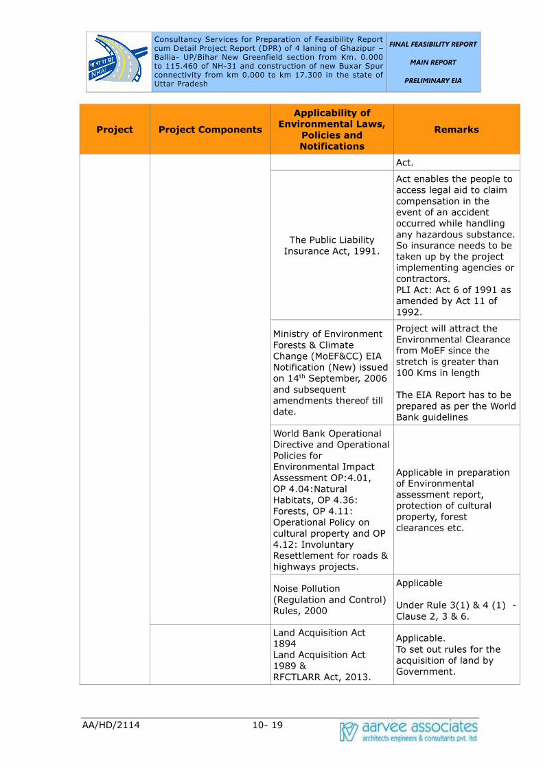
Consultancy Services for Preparation of Feasibility Report cum Detail Project Report (DPR) of 4 laning of Ghazipur –Ballia- UP/Bihar New Greenfield section from Km. 0.000 to 115.460 of NH-31 and construction of new Buxar Spur connectivity from km 0.000 to km 17.300 in the state of Uttar Pradesh UP/Bihar New Greenfield section from Km. 0.000 to
FINAL FEASIBILITY REPORT
MAIN REPORT
PRELIMINARY EIA
AA/HD/2114 10- 19
Project Project Components
Applicability of
Environmental Laws,
Policies and
Notifications
Remarks
Act.
The Public Liability
Insurance Act, 1991.
Act enables the people to
access legal aid to claim
compensation in the
event of an accident
occurred while handling
any hazardous substance.
So insurance needs to be
taken up by the project
implementing agencies or
contractors.
PLI Act: Act 6 of 1991 as
amended by Act 11 of
1992.
Ministry of Environment
Forests & Climate
Change (MoEF&CC) EIA
Notification (New) issued
on 14th September, 2006
and subsequent
amendments thereof till
date.
Project will attract the
Environmental Clearance
from MoEF since the
stretch is greater than
100 Kms in length
The EIA Report has to be
prepared as per the World
Bank guidelines
World Bank Operational
Directive and Operational
Policies for
Environmental Impact
Assessment OP:4.01,
OP 4.04:Natural
Habitats, OP 4.36:
Forests, OP 4.11:
Operational Policy on
cultural property and OP
4.12: Involuntary
Resettlement for roads &
highways projects.
Applicable in preparation
of Environmental
assessment report,
protection of cultural
property, forest
clearances etc.
Noise Pollution
(Regulation and Control)
Rules, 2000
Applicable
Under Rule 3(1) & 4 (1) -
Clause 2, 3 & 6.
Land Acquisition Act
1894
Land Acquisition Act
1989 &
RFCTLARR Act, 2013.
Applicable.
To set out rules for the
acquisition of land by
Government.

Consultancy Services for Preparation of Feasibility Report cum Detail Project Report (DPR) of 4 laning of Ghazipur –Ballia- UP/Bihar New Greenfield section from Km. 0.000 to 115.460 of NH-31 and construction of new Buxar Spur connectivity from km 0.000 to km 17.300 in the state of Uttar Pradesh UP/Bihar New Greenfield section from Km. 0.000 to
FINAL FEASIBILITY REPORT
MAIN REPORT
PRELIMINARY EIA
AA/HD/2114 10- 20
Project Project Components
Applicability of
Environmental Laws,
Policies and
Notifications
Remarks
Motor Vehicles Act, 1988
Rules of Road
Regulations, 1989
Applicable.
To enforce highway codes
during construction and
operation.
A brief description of the relevant laws is given below:
EIA Notification, 2006
This is the Indian Government’s Guidelines for environmental impact assessment
governing all of the development interventions that takes place within the boundaries
of India. EIA notification was issued by Ministry of Environment, Forests and Climate
Change (MoEF&CC) in 2006. Under this EIA Notification, the projects listed in
Schedule-1 of the Notification require prior environmental clearance. The objective of
the notification is to formulate a transparent, decentralized and efficient regulatory
mechanism to:
• Incorporate necessary environmental safeguards at planning stage
• Involve stakeholders in the public consultation process
• Identify developmental projects based on impact potential instead of the
investment criteria
As per EIA Notification, 2006 and amendment thereafter, “Expansion of National
Highways greater than 100 Km involving additional Right of Way or land acquisition
greater than 40 m on existing alignment and 60 m on re-alignments or bypasses”
may require clearance from EAC, MoEF&CC. As per Honorable Supermen court’s
direction, 10 km radius from the boundary of wildlife sanctuary will be considered as
eco-sensitive zone till the actual radius of the Eco-sensitive zone around the wildlife
sanctuary boundary is notified by the state government. The MDR and ODRs do not
come in the purview of EIA Notification, 2006.
Forest (Conservation) Act, 1980:
This Act is of particular significance in case the project corridors require acquisition of
forest land outside the RoW of the road corridors as a result of the rehabilitation work
proposed. The Indian Forest Act (1927) was amended in 1980 in an attempt to check
the rapid deforestation occurring throughout India and the Forest (Conservation) Act,
1980 came into existence. At the state level, the government was empowered to
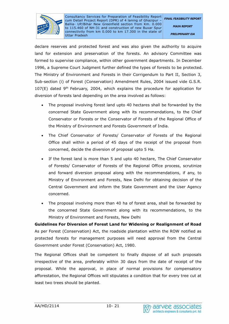
Consultancy Services for Preparation of Feasibility Report cum Detail Project Report (DPR) of 4 laning of Ghazipur –Ballia- UP/Bihar New Greenfield section from Km. 0.000 to 115.460 of NH-31 and construction of new Buxar Spur connectivity from km 0.000 to km 17.300 in the state of Uttar Pradesh UP/Bihar New Greenfield section from Km. 0.000 to
FINAL FEASIBILITY REPORT
MAIN REPORT
PRELIMINARY EIA
AA/HD/2114 10- 21
declare reserves and protected forest and was also given the authority to acquire
land for extension and preservation of the forests. An advisory Committee was
formed to supervise compliance, within other government departments. In December
1996, a Supreme Court Judgment further defined the types of forests to be protected.
The Ministry of Environment and Forests in their Corrigendum to Part II, Section 3,
Sub-section (i) of Forest (Conservation) Amendment Rules, 2004 issued vide G.S.R.
107(E) dated 9th February, 2004, which explains the procedure for application for
diversion of forests land depending on the area involved as follows:
• The proposal involving forest land upto 40 hectares shall be forwarded by the
concerned State Government along with its recommendations, to the Chief
Conservator or Forests or the Conservator of Forests of the Regional Office of
the Ministry of Environment and Forests Government of India.
• The Chief Conservator of Forests/ Conservator of Forests of the Regional
Office shall within a period of 45 days of the receipt of the proposal from
concerned, decide the diversion of proposal upto 5 Ha.
• If the forest land is more than 5 and upto 40 hectare, The Chief Conservator
of Forests/ Conservator of Forests of the Regional Office process, scrutinize
and forward diversion proposal along with the recommendations, if any, to
Ministry of Environment and Forests, New Delhi for obtaining decision of the
Central Government and inform the State Government and the User Agency
concerned.
• The proposal involving more than 40 ha of forest area, shall be forwarded by
the concerned State Government along with its recommendations, to the
Ministry of Environment and Forests, New Delhi
Guidelines For Diversion of Forest Land for Widening or Realignment of Road
As per Forest (Conservation) Act, the roadside plantation within the ROW notified as
protected forests for management purposes will need approval from the Central
Government under Forest (Conservation) Act, 1980.
The Regional Offices shall be competent to finally dispose of all such proposals
irrespective of the area, preferably within 30 days from the date of receipt of the
proposal. While the approval, in place of normal provisions for compensatory
afforestation, the Regional Offices will stipulates a condition that for every tree cut at
least two trees should be planted.
Consultancy Services for Preparation of Feasibility Report cum Detail Project Report (DPR) of 4 laning of Ghazipur –Ballia- UP/Bihar New Greenfield section from Km. 0.000 to 115.460 of NH-31 and construction of new Buxar Spur connectivity from km 0.000 to km 17.300 in the state of Uttar Pradesh UP/Bihar New Greenfield section from Km. 0.000 to
FINAL FEASIBILITY REPORT
MAIN REPORT
PRELIMINARY EIA
AA/HD/2114 10- 22
However, if the decision is not ordered by the concerned Regional Office within 30
days of the receipt of fully completed application, the Central Government / State
may proceed with the widening/modernization under intimation to the local State
Forest Department and Central Government.
All the cases for forest clearance are now required to be applied online on the
MoEF&CC website. From there the application will be forwarded to the Nodal Officer
of respective state for further processing of application. The user agency will submit
the proposal in the prescribed format through the State Forest Department to the
concerned Regional Office of the Ministry.
Wild Life Protection Act, 1972:
The Wildlife Protection Act, 1972 has allowed the government to establish a number
of National Parks and Sanctuaries over the past 25 years, to protect and conserve the
flora and fauna of the state.
The Water (Prevention and Control of Pollution) Act, 1974:
The act resulted in the establishment of the Central and State level Pollution Control
Boards whose responsibilities include managing water quality and effluent standards,
as well as monitoring water quality, prosecuting offenders and issuing licenses for
construction and operation of any facility. This will include generation of liquid
effluent during construction of road from civil engineering activities or from domestic
activities in workers colony. There are specific penalties for violation, which include
imprisonment for responsible officials.
The Air (Prevention and Control of Pollution) Act, 1981:
The act empowers Central and State Pollution Control Boards for managing air
quality and emission standards, as well as monitoring air quality, prosecuting
offenders and issuing licenses for construction and operation of any facility. Air
quality includes noise level standards. There are specific penalties for violation, which
include imprisonment for responsible officials. This act has notified National Ambient
Air Quality Standard for different regions e.g. Industrial, Residential and Sensitive.
Air quality during construction and operation phases will be guided by this specific act.
Environment (Protection) Act, 1986:
This act was passed as an overall comprehensive act “for protection and
improvement of environment” Under this act rules have been specified for
discharge/emission of effluents and different standards for environmental quality.
These include Ambient Noise Standard, Emission from Motor Vehicles, Mass Emission
Consultancy Services for Preparation of Feasibility Report cum Detail Project Report (DPR) of 4 laning of Ghazipur –Ballia- UP/Bihar New Greenfield section from Km. 0.000 to 115.460 of NH-31 and construction of new Buxar Spur connectivity from km 0.000 to km 17.300 in the state of Uttar Pradesh UP/Bihar New Greenfield section from Km. 0.000 to
FINAL FEASIBILITY REPORT
MAIN REPORT
PRELIMINARY EIA
AA/HD/2114 10- 23
standard for Petrol Driven Vehicles, General Effluent Standards etc. especially
important for road project.
Fly ash Notification, 2016:
According to the Notification No. S.O. 763 (E), dated 14.09.1999 and its amendment
thereafter on 27.08.2003 and notification S.O. 2804 (E) dated 3rd November 2009 by
Ministry of Environment and Forests, it is mandatory to use fly ash within a radius of
300 kilometers of Thermal Power Plant. No agency, person or organization shall
within a radius of 300 kilometers of Thermal Power Plant undertake construction or
approve design for construction of roads of flyover embankments in contravention of
the guidelines/ specification issued by the Indian Road Congress (IRC) as contained
in IRC specification No. SP: 58: 2001. Any deviation from this direction can only be
agreed to a technical reasons if the same is approved by Chief Engineer (Design) or
Engineer-in-chief of the concerned agency or organization or on production of
certificate of “Pond ash not available” from the Thermal Power Plant(s) located within
100 kilometers of the site construction. This certificate shall be provided by TPP
within two working days from the date of making request for fly ash.
Soil required for top or side cover of embankment of roads or flyovers shall be
excavated from the embankment site and it is not possible to do so, only the
minimum quantity of the soil required for the purpose shall be excavated from soil
borrow area. In either case, the topsoil should be kept or stored separately. Voids
created due to soil borrow area shall be filled up with ash with proper compaction
and covered with top soil kept separately as mentioned above. No agency, person or
organization shall within a radius of 100 kilometers of coal or lignite based Thermal
Power Plant allow reclamation and compaction of low lying areas with soil. Only pond
ash shall be used for compaction. They shall also ensure that such reclamation and
compaction is done in accordance with the bye-laws, regulation and specification laid
down by Authorities.
All agencies undertaking construction of roads or fly over bridges including Ministry of
Shipping Road Transport and Highways (MoSRTH), National Highways Authority of
India (NHAI), Central Public Works Department (CPWD), State Public Works
Department and other State Government Agencies, shall within three months from
the 1st day of September 2003 make provision in their documents, schedules of
approved materials and rates as well as technical documents; including those related
to soil borrow area or pits.
Consultancy Services for Preparation of Feasibility Report cum Detail Project Report (DPR) of 4 laning of Ghazipur –Ballia- UP/Bihar New Greenfield section from Km. 0.000 to 115.460 of NH-31 and construction of new Buxar Spur connectivity from km 0.000 to km 17.300 in the state of Uttar Pradesh UP/Bihar New Greenfield section from Km. 0.000 to
FINAL FEASIBILITY REPORT
MAIN REPORT
PRELIMINARY EIA
AA/HD/2114 10- 24
Make necessary specifications/guidelines for road or fly over embankments that are
not covered by the specification laid down by the Indian Road Congress (IRC).
World Bank Safeguard Policies
Environmental Assessment – OP 4.01 Requirements:
Operational Policy 4.01 (OP 4.01) is one of the ten safeguard policies of the World
Bank, which provides the Environmental Assessment (EA) guidance for the lending
operations. The OP 4.01 requires the borrower to screen projects upstream in the
project cycle for potential impacts. Thereafter, an appropriate EA approach to assess,
minimize, enhance and mitigate potentially adverse impacts is selected depending on
nature and scale of project. The EA needs to be integrated in the project
development process such that timely measures can be applied to address identified
impacts. The policy requires consultation with affected groups and NGOs to recognize
community concerns and the need to address the same as part of EA.
Cultural Property – OP 4.11 Requirements:
The World Bank's Operational Policy Note 4.11 aims at preserving and avoiding the
elimination of structures having archaeological (prehistoric), paleontological,
historical, religious and unique natural values. Projects that could significantly
damage non-replicable cultural properties are declined for funding and the Bank will
in turn assist protection and enhancement of cultural properties encountered in the
project rather than leaving that protection to chance.
Natural Habitats – OP 4.04 Requirements:
Operational Policy 4.04 sets out the World Bank's policy on supporting and
emphasizing the precautionary approach to natural resource management and
ensuring opportunities for environmentally sustainable development. As per this
policy, projects that involve significant conversion or degradation of critical natural
habitats are not supported by the Bank. Projects involving non critical habitats are
supported if no alternatives are available and if acceptable mitigation measures are in
place.
Forests – OP 4.36 Requirements:
OP 4.36 sets out specific policy on protection of forests through consideration of
forest related impacts of all investment operations, ensuring restrictions for
operations affecting critical forest conservation areas, and improving commercial
forest practice through use of modern certification systems. The policy requires
consultation with local people, the private sector and other stakeholders in forest

Consultancy Services for Preparation of Feasibility Report cum Detail Project Report (DPR) of 4 laning of Ghazipur –Ballia- UP/Bihar New Greenfield section from Km. 0.000 to 115.460 of NH-31 and construction of new Buxar Spur connectivity from km 0.000 to km 17.300 in the state of Uttar Pradesh UP/Bihar New Greenfield section from Km. 0.000 to
FINAL FEASIBILITY REPORT
MAIN REPORT
PRELIMINARY EIA
AA/HD/2114 10- 25
area.
Involuntary Resettlement OP 4.12:
This policy describes Bank policy and procedures on involuntary resettlement as well
as the conditions the borrowers are expected to meet in operations involving
resettlement. The objective of the Bank's policy is to ensure that populations
displaced by a project also benefit from the project and that livelihood and standards
of living are improved, or at, least restored to earlier levels.
Indigenous People OP 4.20 Requirements:
The World Bank policy on indigenous peoples, OP/BP 4.20, Indigenous Peoples,
underscores the need for Borrowers and Bank staff to identify indigenous peoples,
consult with them, ensure that they participate in, and benefit from Bank-funded
operations in a culturally appropriate way- and that adverse impacts on them are
avoided, or where not feasible, minimized or mitigated.
As per the World Bank’s Environmental Safeguard policy, the project coordinating
entity or implementing institution carries out Environmental Assessment (EA) during
the preparation of each proposed sub-project according to country requirements and
the requirements of this policy. The Bank appraises and recommends to strengthen
the capabilities of the coordinating entity or the implementing institution to (a)
screen sub-projects, (b) obtain the necessary expertise to carry out EA, (c) review all
findings and results of EA for individual sub-projects, (d) ensure implementation of
mitigation measures (including, where applicable, an EMP), and (e) monitor
environmental conditions during project implementation. If the Bank is not satisfied
that adequate capacity exists for carrying out EA, all Category A sub-projects and, as
appropriate, Category B sub-projects including any EA reports are subject to prior
review and approval by the Bank.
The purpose of conducting an environmental assessment (EA) is to identify
environmental and social consequences of the proposed sub-projects or components,
in order to:
• Ensure the identification of potential environmental issues and social concerns
early in the implementation of a proposed project to incorporate necessary
safeguards in project design in order to prevent potential adverse impacts by
determining appropriate mitigation and compensation measures;
• Minimize risks and enhance positive impacts/benefits;
Consultancy Services for Preparation of Feasibility Report cum Detail Project Report (DPR) of 4 laning of Ghazipur –Ballia- UP/Bihar New Greenfield section from Km. 0.000 to 115.460 of NH-31 and construction of new Buxar Spur connectivity from km 0.000 to km 17.300 in the state of Uttar Pradesh UP/Bihar New Greenfield section from Km. 0.000 to
FINAL FEASIBILITY REPORT
MAIN REPORT
PRELIMINARY EIA
AA/HD/2114 10- 26
• Avoid delays and extra costs which may subsequently arise due to
unanticipated environmental problems;
• Identify the potential for maximizing environmental resources management
and socio-economic benefits to local communities within the scope of the sub
project.
• The EA should cover physical-chemical, biological, socio-economic and cultural
issues that are likely to arise during upgrading and widening of roads safety
risks and appurtenance structures and associated activities as appropriate.
The World Bank has classified the type of projects into following categories depending
on the extent of the impact on environment:
(i) Category A: A proposed project is classified as Category A, if it is likely to have
significant adverse environmental impacts that are sensitive, diverse, or
unprecedented. Such project requires full EIA study.
(ii) Category B: A proposed project is classified as Category B if its potential
adverse environmental impacts on human populations or environmentally important
areas— including wetlands, forests, grasslands, and other natural habitats—are less
adverse than those of Category A projects. These impacts are site-specific; few if any
of them are irreversible; and in most cases mitigatory measures can be designed
more readily than for Category A projects.
(iii) Category C: A proposed project is classified as Category C if it is likely to have
minimal or no adverse environmental impacts. Beyond screening, no further EA
action is required for a Category C project.
(iv) Category FI: A proposed project is classified as Category FI if it involves
investment of Bank funds through a financial intermediary, in sub projects that may
result in adverse environmental impacts.
Thus for Category-A project detail Environmental Assessment would be required. For
the project requiring Environmental Clearance from the MoEF&CC, detailed
Environmental Impact Assessment would be required in accordance with the
Environmental Impact Assessment Notification, 2006 and amended thereafter. For
Category-B projects site specific EA is required and a generic environmental
management plan (EMP) would be required to be prepared for such project. For
Category C projects no study beyond environmental screening is required.
Statutory Clearance for Borrow area and stone quarry
Consultancy Services for Preparation of Feasibility Report cum Detail Project Report (DPR) of 4 laning of Ghazipur –Ballia- UP/Bihar New Greenfield section from Km. 0.000 to 115.460 of NH-31 and construction of new Buxar Spur connectivity from km 0.000 to km 17.300 in the state of Uttar Pradesh UP/Bihar New Greenfield section from Km. 0.000 to
FINAL FEASIBILITY REPORT
MAIN REPORT
PRELIMINARY EIA
AA/HD/2114 10- 27
Mining of minor minerals such as sand, gravel, clay, marble and other stones will not
be allowed in the country without the approval of the Central government. The
Honorable Supreme Court, vide its order dated 27.02.2012 in I.A.No.12-13 of 2011
in SLP (C) No.19628-19629 of 2009 titled Deepak Kumar etc. Vs. State of Haryana &
Ors. has inter alia ordered that leases of minor mineral including their renewal for an
area less than 5 ha be granted by the State / Union Territory only after getting
environment clearance (EC) from the Ministry of Environment, Forests and Climate
Change (MoEF&CC). In order to ensure compliance of the aforesaid order of the
Hon’ble Supreme Court, MoEF&CC issued an OM No.L-11011/47/2011-IA.II(M) dated
18.05.2012 stating inter alia that all mining projects of minor minerals including their
renewal, irrespective of the size of the lease would require prior EC and that the
projects of minor minerals with lease area less than 5 ha would be treated as
Category “B” as defined in EIA Notification, 2006 and will be considered by the
respective State Environment Impact Assessment Authorities (SEIAAs) notified by
MoEF&CC and following the procedure prescribed under the EIA Notification, 2006.
The mining projects having more than 5 Ha of lease area will be categorised as
Category A project and will be appraised by Central Committee of MoEF&CC.
Regarding the borrow area for ordinary soil, the Contractor has to obtain
environmental clearance from State Environmental Impact Assessment Authority
(SEIAA) of MoEF&CC in compliance to the Supreme Court’s order and MoEF&CC
conditions vide their circular no. L-11011/47/2011-IA.II(M) dated 20th June, 2013. If
the area of a borrow area is less than 5 Ha then this will be treated as Category-B-2
Project and will be appraised and approved based of only Form-1. No EIA study will
be required for such area. However if the size of the borrow area is more than 5 Ha
then it will be categorized as “Category-B1” and therefore will require EIA study,
based on which the SEIAA will give clearance for the same.
Applicability of Clearances:
Environmental Clearance
Environmental Impact Assessment (EIA) Notification issued on 14th September 2006
(amended) by the MoEFCC, Govt., of India and as per the amended Notification of
the MoEF on 22nd August 2013 on Highway projects. New, expansion or
modernization of any activity falling within the 32 categories of developmental and
industrial activities shall be undertaken in any part of India only after it has been
accorded environmental clearance by the MoEF in accordance with the procedures
specified in the notification. Among the 32 categories listed in Schedule -1 of
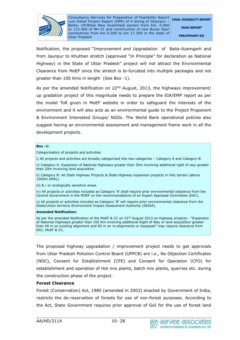
Consultancy Services for Preparation of Feasibility Report cum Detail Project Report (DPR) of 4 laning of Ghazipur –Ballia- UP/Bihar New Greenfield section from Km. 0.000 to 115.460 of NH-31 and construction of new Buxar Spur connectivity from km 0.000 to km 17.300 in the state of Uttar Pradesh UP/Bihar New Greenfield section from Km. 0.000 to
FINAL FEASIBILITY REPORT
MAIN REPORT
PRELIMINARY EIA
AA/HD/2114 10- 28
Notification, the proposed “Improvement and Upgradation of Balia-Azamgarh and
from Jaunpur to Khuthan stretch (approved “In Principle” for declaration as National
Highway) in the State of Uttar Pradesh” project will not attract the Environmental
Clearance from MoEF since the stretch is bi-furcated into multiple packages and not
greater than 100 Kms in length (See Box -1).
As per the amended Notification on 22nd August, 2013, the highways improvement/
up gradation project of this magnitude needs to prepare the EIA/EMP report as per
the model ToR given in MoEF website in order to safeguard the interests of the
environment and it will also acts as an environmental guide to the Project Proponent
& Environment Interested Groups/ NGOs. The World Bank operational policies also
suggest having an environmental assessment and management frame work in all the
development projects.
Box -1:
Categorization of projects and activities
i) All projects and activities are broadly categorized into two categories – Category A and Category B
ii) Category A: Expansion of National Highways greater than 30m involving additional right of way greater than 20m involving land acquisition.
ii) Category B: All State Highway Projects & State Highway expansion projects in hilly terrain (above 1000m AMSL)
iii) & / or ecologically sensitive areas.
iv) All projects or activities included as Category ‘A’ shall require prior environmental clearance from the Central Government in the MOEF on the recommendations of an Expert Appraisal Committee (EAC).
v) All projects or activities included as Category ‘B’ will require prior environmental clearance from the State/Union territory Environment Impact Assessment Authority (SEIAA).
Amended Notification:
As per the amended Notification of the MoEF & CC on 22nd August 2013 on Highway projects - “Expansion of National Highways greater than 100 Km involving additional Right of Way or land acquisition greater than 40 m on existing alignment and 60 m on re-alignments or bypasses” may require clearance from EAC, MoEF & CC.
The proposed highway upgradation / improvement project needs to get approvals
from Uttar Pradesh Pollution Control Board (UPPCB) are i.e., No Objection Certificates
(NOC), Consent for Establishment (CFE) and Consent for Operation (CFO) for
establishment and operation of Hot mix plants, batch mix plants, quarries etc. during
the construction phase of the project.
Forest Clearance
Forest (Conservation) Act, 1980 (amended in 2003) enacted by Government of India,
restricts the de-reservation of forests for use of non-forest purposes. According to
the Act, State Government requires prior approval of GoI for the use of forest land

Consultancy Services for Preparation of Feasibility Report cum Detail Project Report (DPR) of 4 laning of Ghazipur –Ballia- UP/Bihar New Greenfield section from Km. 0.000 to 115.460 of NH-31 and construction of new Buxar Spur connectivity from km 0.000 to km 17.300 in the state of Uttar Pradesh UP/Bihar New Greenfield section from Km. 0.000 to
FINAL FEASIBILITY REPORT
MAIN REPORT
PRELIMINARY EIA
AA/HD/2114 10- 29
for non-forest purposes (means the breaking up or clearing of any forest land) or for
assigning least to any private person or agency not controlled by government. The
Forest (Conservation) Rules, 2003 issued under this Act, provide specific procedures
to be followed for conversion of forest land for non-forest purposes.
Limited sub-projects may require acquisition of forest land. The forest land
conversion will follow the “Guidelines for Diversion of Forest Lands for Non-Forest
Purpose” under Forest (Conservation) Act, 1980. Compensatory afforestation is one
of the most important conditions stipulated for diversion of forest land. The
conditions of forest diversion proposals are summarized in Table 10.6.
Table 10.6: Conditions of Forest Diversion Proposals
S.
No Condition of Forest Diversion
Submission of Proposal and seeking
permission from
1
Diversion of forest land for small
development and public utility
projects upto 5 hectares
State Government may authorize the Nodal
Officer or any other Officer to submit the
proposals directly to the Regional Offices.
2
Diversion of forest land up to 40
hectares and proposals for
clearing of naturally grown trees
for reforestation
Central Zone, Regional Office of the
MoEF&CC, Lucknow.
3 All other proposals (> 40
hectares) The Secretary, Ministry of Environment &
Forests, Government of India.
The other conditions of Forest diversion are:
• Compensatory afforestation is compulsory for conversion.
• Afforestation will be done over an equivalent area of non-forest land.
• As far as possible, the non-forest land for compensatory afforestation should
be identified contiguous to or in the proximity of Reserved Forest or Protected
Forest. If non-forest lands are not available in the same district other non-
forest land may be identified elsewhere in the state.
• Where non-forest lands are not available, compensatory afforestation may be
carried out over degraded forest twice in extent to the area being diverted.
• Conversion of forest lands that are part of National Parks/Sanctuaries and
Tiger Reserve areas (notified under Indian Wildlife (Protection) Act, 1972) is
not permitted. In exceptional case, the State Government requires consent of
the National Board of Wildlife for obtaining approval of the State Legislature
for de-notification of the area as a sanctuary.
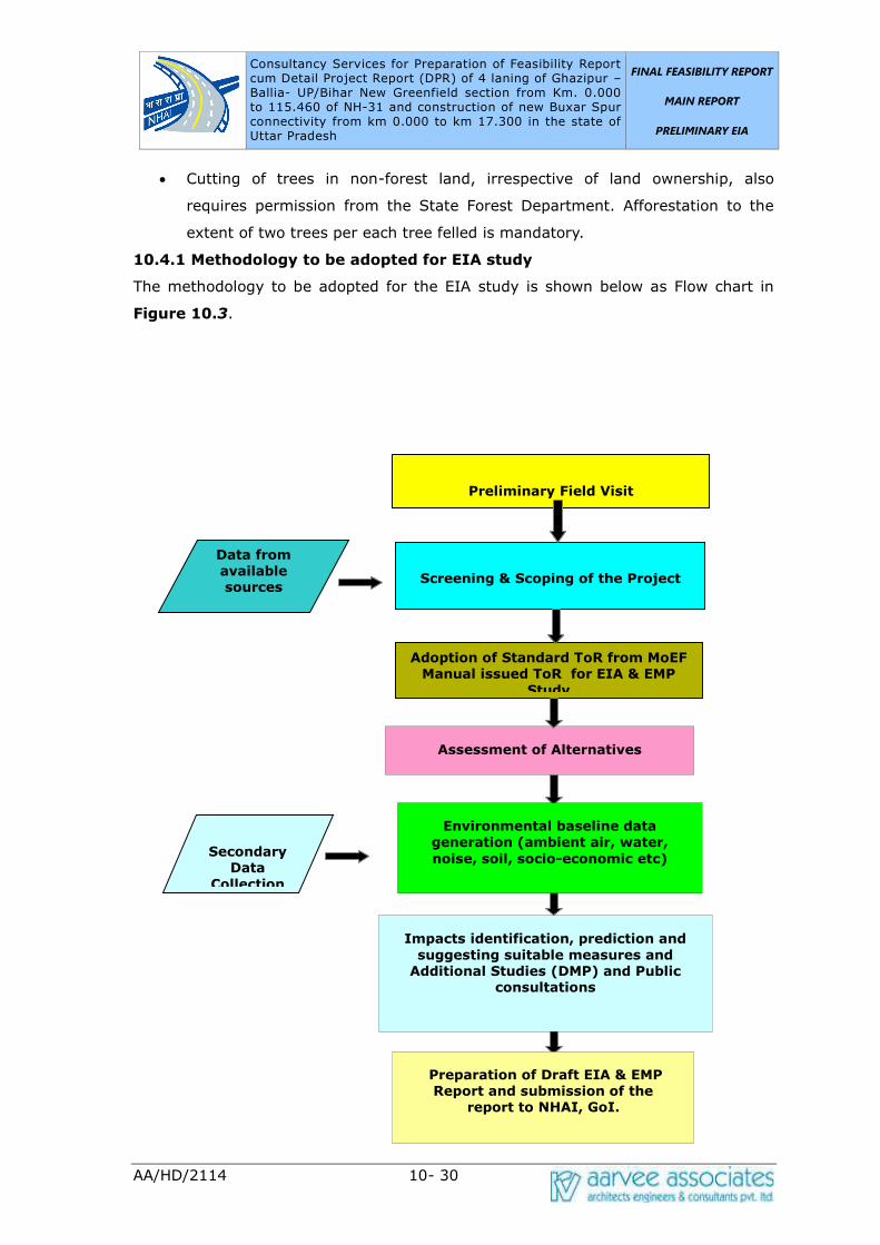
Consultancy Services for Preparation of Feasibility Report cum Detail Project Report (DPR) of 4 laning of Ghazipur –Ballia- UP/Bihar New Greenfield section from Km. 0.000 to 115.460 of NH-31 and construction of new Buxar Spur connectivity from km 0.000 to km 17.300 in the state of Uttar Pradesh UP/Bihar New Greenfield section from Km. 0.000 to
FINAL FEASIBILITY REPORT
MAIN REPORT
PRELIMINARY EIA
AA/HD/2114 10- 30
• Cutting of trees in non-forest land, irrespective of land ownership, also
requires permission from the State Forest Department. Afforestation to the
extent of two trees per each tree felled is mandatory.
10.4.1 Methodology to be adopted for EIA study
The methodology to be adopted for the EIA study is shown below as Flow chart in
Figure 10.3.
Preliminary Field Visit
Data from available sources
Screening & Scoping of the Project
Secondary
Data
Collection
Assessment of Alternatives
Preparation of Draft EIA & EMP
Report and submission of the report to NHAI, GoI.
Adoption of Standard ToR from MoEF Manual issued ToR for EIA & EMP
Study
Environmental baseline data
generation (ambient air, water,
noise, soil, socio-economic etc)
Impacts identification, prediction and
suggesting suitable measures and Additional Studies (DMP) and Public
consultations
Consultancy Services for Preparation of Feasibility Report cum Detail Project Report (DPR) of 4 laning of Ghazipur –Ballia- UP/Bihar New Greenfield section from Km. 0.000 to 115.460 of NH-31 and construction of new Buxar Spur connectivity from km 0.000 to km 17.300 in the state of Uttar Pradesh UP/Bihar New Greenfield section from Km. 0.000 to
FINAL FEASIBILITY REPORT
MAIN REPORT
PRELIMINARY EIA
AA/HD/2114 10- 31
Figure 10.3: Flow Chart showing the EIA methodology
10.4.2 Scope of Environmental Impact Assessment (EIA) Study
The EIA/EMP report encompasses the findings of the study to identify, predict and
evaluate the likely impacts due to the proposed activity and suitable measures to
mitigate and minimize the adverse impacts and ameliorate environmental quality in
the surrounding region. The environmental safety concerns which can be internalized
in the project planning and implementation stages have been identified and suitable
measures needed are elicited as Environmental Management Plan (EMP).
Detailed baseline data collection prior to project implementation is under progress for
air, noise, water, land, biological and socio-economic environment within the project
area. The baseline data for pre-project environmental status will be presented along
with identification, prediction and evaluation of impacts due to project activities.
The published literature will be collected from different Govt. Organizations /
Institutions, NGOs etc. to assess the baseline environment. The aim will be to collect
secondary information to the maximum extent possible. The information on flora like
road side plantation and fauna within the study area will be collected from the Forest
Dept., Botanical survey of India, Zoological survey of India and through field
verification. The information on wetland, grassland and other ecologically important
areas will also be collected.
The information on geology and soil within the study area will be collected from
Geological Survey of India. The information on ground water i.e. depth of water table,
yield etc. will be collected from the Central Ground Water Authority, Central Water
Commission, Survey of India.
District Planning Maps etc. The land use pattern within the study area in general and
adjacent to the road in particular will be established through collection of
Incorporation of Comments and submission of Final EIA /EMP Report
Consultancy Services for Preparation of Feasibility Report cum Detail Project Report (DPR) of 4 laning of Ghazipur –Ballia- UP/Bihar New Greenfield section from Km. 0.000 to 115.460 of NH-31 and construction of new Buxar Spur connectivity from km 0.000 to km 17.300 in the state of Uttar Pradesh UP/Bihar New Greenfield section from Km. 0.000 to
FINAL FEASIBILITY REPORT
MAIN REPORT
PRELIMINARY EIA
AA/HD/2114 10- 32
maps/documents from Survey of India, Agriculture Department and Forest Dept. and
through field verification.
The climate and meteorology data i.e. temperature, wind speed, wind direction,
rainfall, relative humidity, cloud cover and cyclone will be collected from
Meteorological Department. Available information on ambient air quality and water
quality will be collected from Central Pollution Control Board (CPCB), Uttar Pradesh
Pollution Control Board, Reputed Research Laboratory and Universities. The
information on archaeological and historical places, if any, will be collected from
Archaeological Survey of India, Dept. of Tourism etc.
Primary/Secondary Data Collection A) Field Reconnaissance Survey
• Preliminary field survey will be undertaken to identify the critical issues and to
examine different alignment options. The following information/documents will
be collected during reconnaissance survey.
• Information on location, type and sensitivity of all critical natural habitats such
as reserved/protected forest, wild life sanctuaries/ wild life migratory route
across the road, wet lands, grass land, sacred groves etc.
• Information on sensitive such as location of schools, hospitals, religious,
archaeological and historical places.
• Assessment of air quality, noise level, water quality and soil quality monitoring
stations as per BIS, CPCB, IRC and MoEF Guidelines.
• Details of roadside plantation i.e. Chainage wise and girth size wise no. of
trees.
• Information on industries i.e. pollution status, discharge point/disposal site of
effluent/solid waste along the corridor, if any.
• Information on flora and fauna within the study corridor will be collected and
verified in the field.
B) Environmental Impact Assessment
It will include the following:
• The collected primary and secondary data will be compiled to assess the
existing baseline environmental condition.
• Prediction of significant impacts
Consultancy Services for Preparation of Feasibility Report cum Detail Project Report (DPR) of 4 laning of Ghazipur –Ballia- UP/Bihar New Greenfield section from Km. 0.000 to 115.460 of NH-31 and construction of new Buxar Spur connectivity from km 0.000 to km 17.300 in the state of Uttar Pradesh UP/Bihar New Greenfield section from Km. 0.000 to
FINAL FEASIBILITY REPORT
MAIN REPORT
PRELIMINARY EIA
AA/HD/2114 10- 33
• The assessment of impact during construction and operation phase
• Suggestion of mitigation measures
10.4.3 Generic Structure of EIA report
In terms of the EIA Notification of the MoEFCC dated 14th September 2006, the
generic structure of the EIA document shall be as under:
1. Introduction
2. Project Description
3. Approach & Methodology
4. Environmental Regulatory Framework
5. Analysis of Alternatives (Technology and Site)
6. Description of the Environment
7. Anticipated Environmental Impact & Mitigation Measures
8. Environmental Management Plan
9. Environmental Monitoring Plan
10. Environmental Cost Estimates
11. Summary & Conclusions
12. Disclosure of Consultants engaged
10.5 Baseline Environmental Conditions
The description of environment presents the Baseline Environmental Status of the
project area in terms of its physical, micro-meteorological, chemical, biological,
Social and cultural description. The baseline data would help to establish the pre-
project environmental status in the project corridor. The possible impacts due to
proposed activity will be predicted based on the quantification of project activities.
For the study area, primary Environmental baseline data will be collected by M/s.
Aarvee Associates, Hyderabad through laboratory Recognized by Ministry of
Environment & Forests, Government of India who will be engaged for the field study
of air, water, noise, soil etc. The environmental attributes will be covered for the
study include ambient air quality, ground and surface water quality, noise levels, land
environment including soil quality, land-use pattern, forest cover, biological
environment, socio-economic and health status of the population, demography and
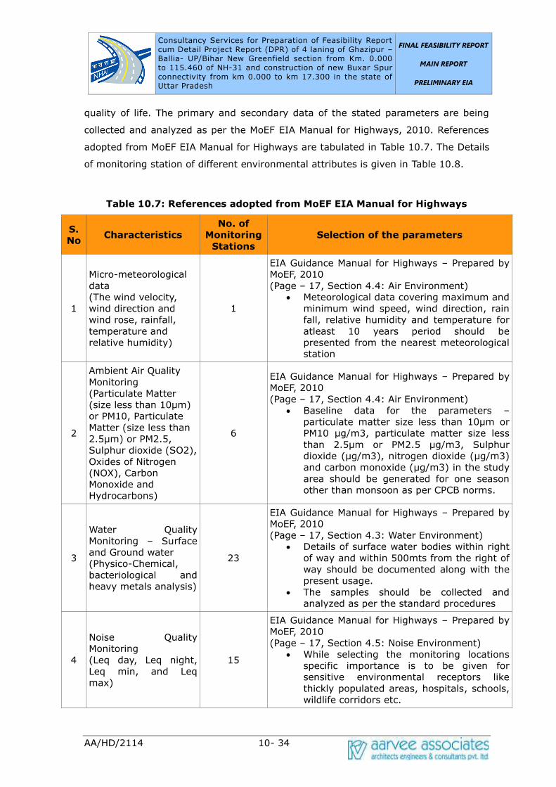
Consultancy Services for Preparation of Feasibility Report cum Detail Project Report (DPR) of 4 laning of Ghazipur –Ballia- UP/Bihar New Greenfield section from Km. 0.000 to 115.460 of NH-31 and construction of new Buxar Spur connectivity from km 0.000 to km 17.300 in the state of Uttar Pradesh UP/Bihar New Greenfield section from Km. 0.000 to
FINAL FEASIBILITY REPORT
MAIN REPORT
PRELIMINARY EIA
AA/HD/2114 10- 34
quality of life. The primary and secondary data of the stated parameters are being
collected and analyzed as per the MoEF EIA Manual for Highways, 2010. References
adopted from MoEF EIA Manual for Highways are tabulated in Table 10.7. The Details
of monitoring station of different environmental attributes is given in Table 10.8.
Table 10.7: References adopted from MoEF EIA Manual for Highways
S.
No Characteristics
No. of
Monitoring
Stations
Selection of the parameters
1
Micro-meteorological
data
(The wind velocity,
wind direction and
wind rose, rainfall,
temperature and
relative humidity)
1
EIA Guidance Manual for Highways – Prepared by
MoEF, 2010
(Page – 17, Section 4.4: Air Environment)
• Meteorological data covering maximum and
minimum wind speed, wind direction, rain
fall, relative humidity and temperature for
atleast 10 years period should be
presented from the nearest meteorological
station
2
Ambient Air Quality
Monitoring
(Particulate Matter
(size less than 10μm) or PM10, Particulate
Matter (size less than
2.5μm) or PM2.5, Sulphur dioxide (SO2),
Oxides of Nitrogen
(NOX), Carbon
Monoxide and
Hydrocarbons)
6
EIA Guidance Manual for Highways – Prepared by
MoEF, 2010
(Page – 17, Section 4.4: Air Environment)
• Baseline data for the parameters –
particulate matter size less than 10μm or PM10 μg/m3, particulate matter size less than 2.5μm or PM2.5 μg/m3, Sulphur dioxide (μg/m3), nitrogen dioxide (μg/m3) and carbon monoxide (μg/m3) in the study area should be generated for one season
other than monsoon as per CPCB norms.
3
Water Quality
Monitoring – Surface
and Ground water
(Physico-Chemical,
bacteriological and
heavy metals analysis)
23
EIA Guidance Manual for Highways – Prepared by
MoEF, 2010
(Page – 17, Section 4.3: Water Environment)
• Details of surface water bodies within right
of way and within 500mts from the right of
way should be documented along with the
present usage.
• The samples should be collected and
analyzed as per the standard procedures
4
Noise Quality
Monitoring
(Leq day, Leq night,
Leq min, and Leq
max)
15
EIA Guidance Manual for Highways – Prepared by
MoEF, 2010
(Page – 17, Section 4.5: Noise Environment)
• While selecting the monitoring locations
specific importance is to be given for
sensitive environmental receptors like
thickly populated areas, hospitals, schools,
wildlife corridors etc.

Consultancy Services for Preparation of Feasibility Report cum Detail Project Report (DPR) of 4 laning of Ghazipur –Ballia- UP/Bihar New Greenfield section from Km. 0.000 to 115.460 of NH-31 and construction of new Buxar Spur connectivity from km 0.000 to km 17.300 in the state of Uttar Pradesh UP/Bihar New Greenfield section from Km. 0.000 to
FINAL FEASIBILITY REPORT
MAIN REPORT
PRELIMINARY EIA
AA/HD/2114 10- 35
S.
No Characteristics
No. of
Monitoring
Stations
Selection of the parameters
• Hourly monitoring of noise levels (Leq)
should be recorded for 24 hours by using
integrated noise meter. Noise standards
have been designated for different types of
land use, i.e. residential, commercial,
industrial areas and silence zones as per
the Noise Pollution (Regulation and
Control) Rules 2000
5
Soil Quality Monitoring
(Physico-Chemical and
heavy metals analysis)
6
EIA Guidance Manual for Highways – Prepared by
MoEF, 2010
(Page – 17, Section 4.2: Land Environment)
• The soil profile of the highway alignment
should be presented based on the soil
series maps of National Bureau of Soil
Survey and Land Use.
• The suggested parameters for soil analysis
are pH, Electrical conductivity, sand (%),
silt (%), clay (%), texture, moisture
retention capacity (%), infiltration rate
(mm/hour), bulk density (gm/ cc), porosity
(%), organic matter (%), nitrogen
(mg/1000g), potassium (mg/1000g),
phosphorous (mg/1000g), sulphates and
sodium sulphates.
Table 10.8: Details of dfferent Envriomental attributes monitoring stations
Sampling
ID
Lattitude (North) Longitude (East) Location Name
Micro Meteorological
MM 25.7575858750365 84.1459752445573 Ballia
Ambient Air Quality Monitoring
AQ1 25.5901571284286 83.5771763788741 Ghazipur
AQ2 25.6140386372571 83.7571510186977 Mohammadabad
AQ3 25.565012191814 83.9350855521908 Narainpur – Sarai
Kota
AQ4 25.7575343996102 84.1458355231544 Ballia
AQ5 25.7797338869784 84.3983415210006 Yadavnagar
AQ6 25.8085920466198 84.5706671742556 Ramgarh
Noise Quality Monitoring
NQ1 25.5902491689303 83.5786988699982 Ballia
NQ2 25.6263876290468 83.6369585632145 Bharsouta
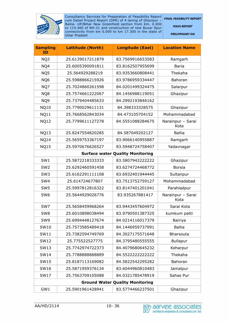
Consultancy Services for Preparation of Feasibility Report cum Detail Project Report (DPR) of 4 laning of Ghazipur –Ballia- UP/Bihar New Greenfield section from Km. 0.000 to 115.460 of NH-31 and construction of new Buxar Spur connectivity from km 0.000 to km 17.300 in the state of Uttar Pradesh UP/Bihar New Greenfield section from Km. 0.000 to
FINAL FEASIBILITY REPORT
MAIN REPORT
PRELIMINARY EIA
AA/HD/2114 10- 36
Sampling
ID
Lattitude (North) Longitude (East) Location Name
NQ3 25.6139017211879 83.7569916653583 Ramgarh
NQ4 25.6005390091811 83.8162507955699 Baria
NQ5 25.564929288219 83.9353660808441 Thekaha
NQ6 25.5988866215926 83.9786959334447 Bahoran
NQ7 25.7024860261598 84.0201499324475 Salarpur
NQ8 25.7574661222067 84.1456988119051 Ghazipur
NQ9 25.7379404485633 84.2992193846162
NQ10 25.7790029611131 84.398333328575 Ghazipur
NQ11 25.7668562843034 84.473105704152 Mohammadabad
NQ12 25.7799611127278 84.5551088284675 Narainpur – Sarai
Kota
NQ13 25.8247554820285 84.587049202127 Ballia
NQ14 25.5659753367197 83.9066140955887 Ramgarh
NQ15 25.5970676626527 83.5948724758407 Yadavnagar
Surface water Quality Monitoring
SW1 25.5872218333333 83.5807942222222 Ghazipur
SW2 25.6292460591458 83.6274724468772 Borsia
SW3 25.6162291111108 83.6932401944445 Sultanpur
SW4 25.614724677807 83.7513752759127 Mohammadabad
SW5 25.5997812816322 83.8147401201041 Parahladpur
SW6 25.5644929026776 83.935267881417 Narainpur – Sarai
Kota
SW7 25.5658459968264 83.9443457604972 Sarai Kota
SW8 25.6010898038494 83.9790501387325 kumkum patti
SW9 25.6994448127674 84.0214116017379 Bairiya
SW10 25.7573585489418 84.1446959737991 Ballia
SW11 25.7382594749769 84.3027175571648 Bharsouta
SW12 25.775522527775 84.3795480555555 Bullapur
SW13 25.7742974722373 84.4079680645232 Keharpur
SW14 25.7788888888889 84.5522222222222 Thekaha
SW15 25.8187113169082 84.5822542295282 Bahoran
SW16 25.5871959376134 83.6044960810483 Jamalpur
SW17 25.7563709105088 84.0321785478919 Sahas Pur
Ground Water Quality Monitoring
GW1 25.5901961428941 83.5774466237501 Ghazipur

Consultancy Services for Preparation of Feasibility Report cum Detail Project Report (DPR) of 4 laning of Ghazipur –Ballia- UP/Bihar New Greenfield section from Km. 0.000 to 115.460 of NH-31 and construction of new Buxar Spur connectivity from km 0.000 to km 17.300 in the state of Uttar Pradesh UP/Bihar New Greenfield section from Km. 0.000 to
FINAL FEASIBILITY REPORT
MAIN REPORT
PRELIMINARY EIA
AA/HD/2114 10- 37
Sampling
ID
Lattitude (North) Longitude (East) Location Name
GW2 25.6141697625644 83.7568011788303 Chak Faridot
Sarasan
GW3 25.564461802331 83.9345878535339 Mohammadabad
GW4 25.7574194376598 84.1465962806589 Parahladpur
GW5 25.7793347933481 84.3982276197811 Narainpur – Sarai
Kota
GW6 25.8084580068033 84.5708432423457 kumkum patti
Soil Quality Monitoring
S1 25.5905562873933 83.5774385183405 Ghazipur
S2 25.6133266171273 83.7578005307295 Mohammadabad
S3 25.5651165767814 83.9365155116291 Narainpur – Sarai
Kota
S4 25.7563283205081 84.1355418283502 Ballia
S5 25.7793366704982 84.3970751815361 Ramgarh
S6 25.8076609743882 84.570426478643 Yadavnagar
10.5.1 Climatic Conditions
The climate of the region is characterized as humid sub-tropical with dry winter. The
climate, wind and wave pattern are governed by the annually changing monsoons
and transition periods between them dividing the year into four seasons.
Meteorological seasons defined by Indian Meteorological Department (IMD) are given
in Table 10.9.
Table 10.9: Seasons of the region
Season Months Characteristics
Winter January-February Cool season of the year
Pre Monsoon March-May Hottest part of the year, occurrence of dust
storms
Southwest
Monsoon June-September
Characterized by predominantly SW winds.
Generally strong and persistent winds prevail.
Post Monsoon October-
December
Characterized by predominantly NE winds. Fair
weather with the variable winds
Temperature
Temperature varies from 0 to 46°. High temperatures of around 50°C have been
recorded in some parts of Uttar Pradesh. Given such a wide range of temperature
fluctuations in most parts of the state, it can lead to either cold waves or heat waves
Consultancy Services for Preparation of Feasibility Report cum Detail Project Report (DPR) of 4 laning of Ghazipur –Ballia- UP/Bihar New Greenfield section from Km. 0.000 to 115.460 of NH-31 and construction of new Buxar Spur connectivity from km 0.000 to km 17.300 in the state of Uttar Pradesh UP/Bihar New Greenfield section from Km. 0.000 to
FINAL FEASIBILITY REPORT
MAIN REPORT
PRELIMINARY EIA
AA/HD/2114 10- 38
both resulting in substantial loss of life and economy.
Relative Humidity
There is low relative humidity of around 20% and dust-laden winds blow throughout
the season. In summers, hot winds called loo blow all across the state of Uttar
Pradesh.
Floods & Droughts
Floods are a known hazard of Uttar Pradesh due to overflowing of its main rivers like
Ganga, Yamuna, Ramganga, Gomti, Sharda, Ghaghra, Rapti and Gandak. Major flood
management efforts have been undertaken to mitigate the risk. Most of these floods
occur due to the Monsoon rains and overflowing of rivers during the rainy periods.
Year 2010 witnessed one such year of flooding in Uttar Pradesh.
Shortage of rain during the highly variable Monsoon season can cause droughts in
Uttar Pradesh leading to severe loss to man and property. The recurrence of a major
deficiency in annual rainfall follows a 6–8 years cycle in Eastern Uttar Pradesh
whereas in Western Uttar Pradesh it is a 10 years cycle.
Rainfall
The normal annual rainfall of the state is 947.4 mm and it ranges from 710 mm to
1750 mm during 40 years. The tarai foot hill receives heavy rainfall while in south
part rainfall decreases. The large percentage of the annual rainfall over the state is
received during June to September. The winter rainfall is received during December
to February that is more in North-West part of the Uttar Pradesh. As regards the
precipitation trend in the South West and South Eastern part of the state, it ranges
from 672 to 1381 mm.
Seismic Zone of The Study Area
The project stretch according to the seismic zoning of India falls under zone III of
moderate damage risk zone. Historically, parts of this project stretch have not
experienced seismic activity.
10.5.2 Air Environment
Standard methods / procedures will be adopted during environmental monitoring
analysis and report preparation. After a preliminary reconnaissance of the study
region and taking into account the meteorological (predominant wind directions, wind
speed), topographic conditions, major settlements & its traffic volume and details on
existing industrial activities in the study region, 1 Micro-Meteorology station and
different stations will be identified to carry out Ambient Air Quality Monitoring (AAQM)

Consultancy Services for Preparation of Feasibility Report cum Detail Project Report (DPR) of 4 laning of Ghazipur –Ballia- UP/Bihar New Greenfield section from Km. 0.000 to 115.460 of NH-31 and construction of new Buxar Spur connectivity from km 0.000 to km 17.300 in the state of Uttar Pradesh UP/Bihar New Greenfield section from Km. 0.000 to
FINAL FEASIBILITY REPORT
MAIN REPORT
PRELIMINARY EIA
AA/HD/2114 10- 39
in the study area spread over 105.400 Km. The parameters are being monitored in
the study area are PM10, PM2.5, SO2, NO2, CO and HC. The monitoring results will
be described with reference to the NAAQ Standards, 2009 and will be presented in
draft EIA & EMP (Draft Feasibility) Report.
Methodology to be Adopted
In assessing the environmental impact, collection and interpretation of baseline data
is of prime importance. The primary data for the study period is being collected for
24 hourly, twice a week for all the 4 weeks as per national guidelines. The criteria
followed for selecting the AAQM stations is recommended by IS: 5182 and CPCB.
They are:
• The sampling station had free exposure so that it did not collect air from
stagnant pockets.
• It was not obstructed by large structures including hills.
• The sampling point was not directly influenced by any local source of
emission.
• It was located at a minimum height of 1.5 m from the ground level.
Monitoring and Analytical Procedure
Ambient air quality was monitored for the presence of contaminants existing in the
air. In order to evaluate and quantify the air pollution problem, measurements are
being carried out for various air pollutants mentioned above. This data will be used
not only to evaluate the air quality in the study region but also as the basis to
develop programs aiming at preventing the spread of pollutants leading to a risk to
human health and general environment. Fine Dust Samplers (FDS) were used for
ambient air sampling of selected parameter. The method for the selected parameter
are based on the methods recommended by IS: 5182.
10.5.3 Water Environment
Selected physico – chemical parameter along with bacteriological indicators of
pollution will be used for describing the baseline status of water environment.
Generation of baseline data for water quality covers sources of ground and surface
water. The Assessment of water quality in the study area includes
• Surface water quality (IS 2296)
• Ground water quality (IS 10500)
Consultancy Services for Preparation of Feasibility Report cum Detail Project Report (DPR) of 4 laning of Ghazipur –Ballia- UP/Bihar New Greenfield section from Km. 0.000 to 115.460 of NH-31 and construction of new Buxar Spur connectivity from km 0.000 to km 17.300 in the state of Uttar Pradesh UP/Bihar New Greenfield section from Km. 0.000 to
FINAL FEASIBILITY REPORT
MAIN REPORT
PRELIMINARY EIA
AA/HD/2114 10- 40
Surface Water Quality
During the study period multiple samples will be collected for assessing the water
quality. These were identified considering proximity to the project site, their activities
and depending upon its utility by the people in the region. The samples are being
collected at this stage.
Surface water samples will be analysed for Temperature, pH, Turbidity, EC, Colour,
TSS, TDS, Odour, DO, BOD, COD, TKN, Total Hardness, Sodium, Potassium, Calcium,
Magnesium, Ammonia, Chloride, Sulphate, Phosphate, Nitrate, Fluoride, Surfactants,
Dissolved Iron, Copper, Zinc, Manganese, Arsenic, Lead, Mercury, Boron, Chromium,
Phenols, Cadmium, Total Coliform, Faecal Coliform. The detail analysis will be given
after approval of Preliminary EIA Report.
Ground Water Quality:
Ground Water is one of the main sources of water in the project corridor for domestic,
commercial and other irrigation use hence the rate of extraction of ground water is at
a massive scale. For assessing the ground water quality in the study area, multiple
samples will be collected from the identified bore wells/ dug wells. Selection of
samples considered as per the utilization of the people along the proposed widening
and improvement project.
Ground water samples will be analysed for Temperature, pH, Turbidity, EC, Colour,
TSS, TDS, Odour, DO, BOD, COD, TKN, Total Hardness, Sodium, Potassium, Calcium,
Magnesium, Ammonia, Chloride, Sulphate, Phosphate, Nitrate, Fluoride, Surfactants,
Dissolved Iron, Copper, Zinc, Manganese, Arsenic, lead, Mercury, Boron, Chromium,
Phenols, Cadmium, Total Coliform, Faecal Coliform. The detail analysis will be given
after approval of Preliminary EIA report.
10.5.4 Noise Environment
Keeping in view of the proposed improvement and widening project, noise monitoring
will be carried out at various locations. The locations will be selected based on land
use pattern, traffic intersections and diversions along the existing alignment.
Precision integrating sound level meter having statistical unit with digital display will
be used for ambient noise level monitoring in the present study. The noise quality
monitoring is planned and executed as per Protocol for Ambient Level Noise
Monitoring. Noise monitoring for 24 hours is being carried out at each location during

Consultancy Services for Preparation of Feasibility Report cum Detail Project Report (DPR) of 4 laning of Ghazipur –Ballia- UP/Bihar New Greenfield section from Km. 0.000 to 115.460 of NH-31 and construction of new Buxar Spur connectivity from km 0.000 to km 17.300 in the state of Uttar Pradesh UP/Bihar New Greenfield section from Km. 0.000 to
FINAL FEASIBILITY REPORT
MAIN REPORT
PRELIMINARY EIA
AA/HD/2114 10- 41
the study period. Noise monitoring locations and noise levels recorded i.e., Leq day,
Leq night, Lmin and Lmax to be presented.
The Central Pollution Control Board has specified ambient noise levels for different
land use for day and night times. Importance was given to the timing of exposure
and areas designated as sensitive. The National ambient noise level standards are
given below.
Area Code Category
Limits in Decibels (dB(A))
Day Time Night Time
A Industrial 75 70
B Commercial 65 55
C Residential 55 45
D Silence Zones 50 40
The monitored samples are being analysed with respect to concerned national
standards for the respective categories.
10.5.5 Land Environment
As part of the land environment, soil quality is being studied in detail and the same will
be presented after approval of Preliminary EIA report.
10.5.6 Soil Quality
The soil samples of different area along the project stretch will be collected at different
locations for assessing the physic-chemical characteristics of the soil in the project area.
The quality parameters will include pH, Electrical conductivity, sand, silt, clay, texture,
moisture retention capacity, infiltration rate, bulk density, porosity, organic matter,
Nitrogen, potassium, phosphorous, Pb, iron and organic carbon.
10.5.7 Landuse Pattern
The proposed highway project stretch traverses predominantly through plain terrain
(70%) followed by rolling terrain (30%). The predominant soils identified in the study
area are Shallow red gravelly clay, Moderately deep red gravelly loamy soils and
Moderately deep red calcareous clay soils. The objectives of land use studies are:
• To determine the present land use pattern.
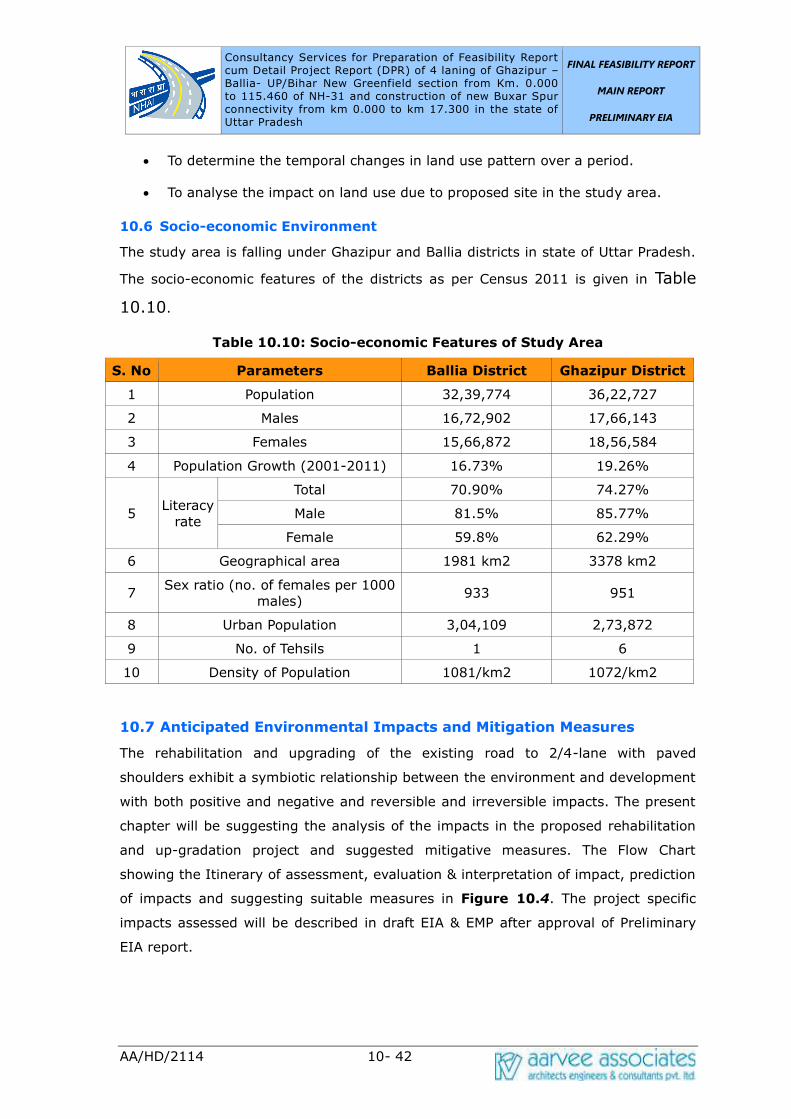
Consultancy Services for Preparation of Feasibility Report cum Detail Project Report (DPR) of 4 laning of Ghazipur –Ballia- UP/Bihar New Greenfield section from Km. 0.000 to 115.460 of NH-31 and construction of new Buxar Spur connectivity from km 0.000 to km 17.300 in the state of Uttar Pradesh UP/Bihar New Greenfield section from Km. 0.000 to
FINAL FEASIBILITY REPORT
MAIN REPORT
PRELIMINARY EIA
AA/HD/2114 10- 42
• To determine the temporal changes in land use pattern over a period.
• To analyse the impact on land use due to proposed site in the study area.
10.6 Socio-economic Environment
The study area is falling under Ghazipur and Ballia districts in state of Uttar Pradesh.
The socio-economic features of the districts as per Census 2011 is given in Table
10.10.
Table 10.10: Socio-economic Features of Study Area
S. No Parameters Ballia District Ghazipur District
1 Population 32,39,774 36,22,727
2 Males 16,72,902 17,66,143
3 Females 15,66,872 18,56,584
4 Population Growth (2001-2011) 16.73% 19.26%
5 Literacy
rate
Total 70.90% 74.27%
Male 81.5% 85.77%
Female 59.8% 62.29%
6 Geographical area 1981 km2 3378 km2
7 Sex ratio (no. of females per 1000
males) 933 951
8 Urban Population 3,04,109 2,73,872
9 No. of Tehsils 1 6
10 Density of Population 1081/km2 1072/km2
10.7 Anticipated Environmental Impacts and Mitigation Measures
The rehabilitation and upgrading of the existing road to 2/4-lane with paved
shoulders exhibit a symbiotic relationship between the environment and development
with both positive and negative and reversible and irreversible impacts. The present
chapter will be suggesting the analysis of the impacts in the proposed rehabilitation
and up-gradation project and suggested mitigative measures. The Flow Chart
showing the Itinerary of assessment, evaluation & interpretation of impact, prediction
of impacts and suggesting suitable measures in Figure 10.4. The project specific
impacts assessed will be described in draft EIA & EMP after approval of Preliminary
EIA report.

Consultancy Services for Preparation of Feasibility Report cum Detail Project Report (DPR) of 4 laning of Ghazipur –Ballia- UP/Bihar New Greenfield section from Km. 0.000 to 115.460 of NH-31 and construction of new Buxar Spur connectivity from km 0.000 to km 17.300 in the state of Uttar Pradesh UP/Bihar New Greenfield section from Km. 0.000 to
FINAL FEASIBILITY REPORT
MAIN REPORT
PRELIMINARY EIA
AA/HD/2114 10- 43
Figure 10.4: Itinerary of Assessment of Impacts and Mitigation Measures
10.7.1 Assessment of Impacts in Key Stages of the Project
The rehabilitation and upgrading of the existing road to 2/4-lane with paved
shoulders projects can have impacts or cause impacts in three specific situations as
follows:
• Impacts due to Project Design,
• Impacts during Construction, and
• Impacts during Operational stage.
10.7.2 Impacts due to Project Design
The engineering design of the road will be finalized by considering all environmental
safeguards. The project envisages natural drainage network, roadways which will
have marginal negative impacts of temporary and localized in nature. Land
acquisition for road development is minimal of less than 10m. Rehabilitation and
upgrading of the existing road is unavoidable and may lead to loss of livelihood for
Consultancy Services for Preparation of Feasibility Report cum Detail Project Report (DPR) of 4 laning of Ghazipur –Ballia- UP/Bihar New Greenfield section from Km. 0.000 to 115.460 of NH-31 and construction of new Buxar Spur connectivity from km 0.000 to km 17.300 in the state of Uttar Pradesh UP/Bihar New Greenfield section from Km. 0.000 to
FINAL FEASIBILITY REPORT
MAIN REPORT
PRELIMINARY EIA
AA/HD/2114 10- 44
very few project affected peoples.
10.7.3 Impacts during Construction Stage
The construction stage is one of the critical stage of the project which may pose
maximum impact on the environment. The major impacts associated in this stage
from site clearance to the final BT Stage of the main carriageway will be identified
and the appropriate mitigation measures are being suggested.
10.7.4 Impacts during Operation Stage
The proposed project can harmonize with the surrounding environment and serve
multiple users with the following positive impacts.
• To relieve traffic congestion on towns /cities along the proposed stretch.
• To provide effective linkage to Uttar Pradesh.
• To Increase access to markets, jobs, education, and health services.
However, some of the negative impacts are also associated in this stage. The major
impacts envisaged in this stage are increasing of traffic resulting an increase of air as
well as noise pollution. To minimise the impacts an appropriate mitigative measures
will be suggested.
10.8 Evaluation and Interpretation of The Impacts
Matrix method will be adopted for the evaluation of impacts. Based on the scoping of
the areas and the work being proposed the following key issues were evaluated for
this project.
• Preservation of aesthetic and landscape of the area to the possible extent.
• Effective restoration of Burrow areas and quarries.
• Evaluation of Environmental Quality
• Tree removal and tree plantation.
• Sanitation and waste disposal.
• Road safety.
• Protection of flora and fauna.
• Afforestation
The outcome of the results will be interpreted. The interpreted values will be helpful
for the decision makers to take appropriate decision in right time.

Consultancy Services for Preparation of Feasibility Report cum Detail Project Report (DPR) of 4 laning of Ghazipur –Ballia- UP/Bihar New Greenfield section from Km. 0.000 to 115.460 of NH-31 and construction of new Buxar Spur connectivity from km 0.000 to km 17.300 in the state of Uttar Pradesh UP/Bihar New Greenfield section from Km. 0.000 to
FINAL FEASIBILITY REPORT
MAIN REPORT
PRELIMINARY EIA
AA/HD/2114 10- 45
10.9 Prediction of The Impacts
As discussed earlier, the major impacts associated with this project are air and noise.
The air quality due to vehicular movement is predicted using the CALINEPro software
and to predict the cumulative noise impacts, a Federal Highways Administration
(FHWA) Noise Model will be adopted. The air and noise impacts are aimed to predict
the future impacts for “Without and With Project Scenario” by using the traffic study
report.
10.10 Suggesting suitable Mitigation Measures
The mitigation measures are highlighted for the following key issues in the project.
• Soil quality (Top soil, soil erosion etc)
• Solid waste or muck disposal
• Air quality
• Water quality (wetlands, water bodies, groundwater etc)
• Noise quality
• Biological Environment (Flora, fauna, tree plantation and enumeration)
• Socio-economic quality of life
• Safety and health aspects during construction and operation phase.
10.11 Environmental Management Plan
The Environmental Management Plan (EMP) states the procedure in which the project
proponent would carry out the implementation of the mitigation measures and
ensure compliance with environmental regulations that are binding on the project.
The EMP also specifies the organizational requirements and institutional
strengthening necessary for sound environmental management of the project. The
major components of the EMP are:
• EMP Implementing Agency
• Monitoring of the EMP implementation
• Training on Environmental management
• Budget for EMP implementation.
The project specific EMP with budgetary provisions will be given after approval of
Preliminary EIA Report.
Consultancy Services for Preparation of Feasibility Report cum Detail Project Report (DPR) of 4 laning of Ghazipur –Ballia- UP/Bihar New Greenfield section from Km. 0.000 to 115.460 of NH-31 and construction of new Buxar Spur connectivity from km 0.000 to km 17.300 in the state of Uttar Pradesh UP/Bihar New Greenfield section from Km. 0.000 to
FINAL FEASIBILITY REPORT
MAIN REPORT
PRELIMINARY EIA
AA/HD/2114 10- 46
10.11.1 EMP Implementing Agency
The Project Proponent will establish an Environmental Management Cell (EMC) to
supervise and implement the mitigation measures as documented in the EMP. This
EMC must also be adequately empowered to discharge the responsibilities as outlined
in the EMP. To ensure smooth implementation of EMP the project proponent will have
to collaborate with various government agencies like Public Works Department,
Revenue Department, State Pollution Control Board, State Forest Department, Police
Department and other allied departments.
10.12 Monitoring of EMP Implementation
The EMP will primarily be implemented by the Project Proponent and Civil Contractor.
However, for an effective implementation of EMP, the current project will be
monitored two level monitoring. The first one is internally by top management of
Contracting Company and the second one by the National Highways wing under the
R&B, Govt. of Uttar Pradesh. The EMC constituted by Contracting Company shall be
the prime agency for monitoring all the activities during construction and operation
phases. National Highways wing under the R&B or supervision consultant appointed
by R&B shall supervise all activities and accordingly advise the Contracting Company
to improve on areas where any shortcomings are observed. The EMC shall provide all
the monitoring results to National Highways wing under the R&B. National Highways
wing under the R&B shall keep a record of all information and shall suggest suitable
measures to be adopted by Contracting Company if any aspect is found to be
deviating from the stipulated values/ standards. Monitoring shall be carried out
during construction and operation phase.
10.13 Budget for EMP Implementation
The design and construction of the project involves a number of items such as
resettlement & rehabilitation, erosion prevention, rehabilitation of borrow areas, tree
plantation, safety signage etc., which are included in the contract cost. Only those
items that are not covered under the budget for construction will be shown in the
EMP implementation budget.
The main components are as follows:
• Setting up of Environment Management Cell
• Tree Plantation
• Environmental monitoring during construction and operation phases

Consultancy Services for Preparation of Feasibility Report cum Detail Project Report (DPR) of 4 laning of Ghazipur –Ballia- UP/Bihar New Greenfield section from Km. 0.000 to 115.460 of NH-31 and construction of new Buxar Spur connectivity from km 0.000 to km 17.300 in the state of Uttar Pradesh UP/Bihar New Greenfield section from Km. 0.000 to
FINAL FEASIBILITY REPORT
MAIN REPORT
PRELIMINARY EIA
AA/HD/2114 10- 47
• Conducting awareness programmes
• Capacity building and training during construction and operation phases.

Consultancy Services for Preparation of Feasibility Report cum Detail Project Report (DPR) of 4 laning of Ghazipur –Ballia- UP/Bihar New Greenfield section from Km. 0.000 to 115.460 of NH-31 and construction of new Buxar Spur connectivity from km 0.000 to km 17.800 in the state of Uttar Pradesh
FINAL FEASIBILITY REPORT
MAIN REPORT
INITIAL SIA
AA/HD/2114 11 - 1
11.0 INITIAL SOCIAL IMPACT ASSESSMENT
11.1 INTRODUCTION
The National Highways Authority of India (NHAI) is engaged in the development of
the National highways in the state of Uttar Pradesh. As part of this endeavor, NHAI
has decided to upgrade some of the existing National Highways in the State of UP to
National Highway standard. It was also decided to take up the preparation of DPR for
these highways which are being upgraded to National Highway Standard. The
consultancy services for preparation of Feasibility Report cum Detailed Project Report
(DPR) of 4 laning of Ghazipur Ballia – UP/Bihar section from Km 0.000 to 128.000 of
NH-31 and Construction of 2/4 laning Flyover at Ballia (Chandra Shekhar Mod to
Satish Chandra College) was awarded to Aarvee Associates.
The Letter of Acceptance was communicated vide letter No. NHAI/ Tech/ NH-19/ Pkg-
I/ 2016/ 103661 dated 31st July 2017. The Agreement for consultancy services was
concluded with NHAI on 04/09/2017. Letter of commencement was issued vide letter
No. NHAI/ Tech/ NH-19/Pkg-I/DPR/2016/105592 dated 08.09.2017.
Final DPR for the existing road “Special Repair and Maintenance work from Ghazipur
to UP/Bihar border NH-31 from Km 405 to Km 535 including construction of New MJB
at Km 412.130 and rehabilitation of MJB at Km 533 on EPC mode” submitted vide our
letter no. AA/HW/NHAI/2114/18-19/9105 dated 26.03.2019. As per the directions
from project authorities, the alignment proposals were reviewed in view of the MoRTH
Circular No. NH-15017 / 21 / 2018 – P & M dated 26.02.2018. The greenfield
alignment option including comparison table showing the cost comparison of widening
of the existing alignment option via-a-via widening of was prepared and the same was
reviewed at various levels and it was decided that green field alignment with spur
providing connectivity to Buxar was approved during the meeting held in Ministry
under the Chairmanship of Secretary and the Minutes of Meeting were communicated
vide letter No. NHAI/Tech/ NH-19/Ghazipur-Ballia/ DPR/2016/122312 dated
13.08.2018.
The District Administration of Ballia held public consultations regarding the proposed
elevated flyover and communicated their decisions vide MoM dated 1393/ 14 – 1
dated 20.10.2018. The MoM inter-alia state that widening of the existing road to four
lane standards would serve the traffic problems in Ballia town and elevated flyover is
not required since construction of the said flyover would result in acquisition of land

Consultancy Services for Preparation of Feasibility Report cum Detail Project Report (DPR) of 4 laning of Ghazipur –Ballia- UP/Bihar New Greenfield section from Km. 0.000 to 115.460 of NH-31 and construction of new Buxar Spur connectivity from km 0.000 to km 17.800 in the state of Uttar Pradesh
FINAL FEASIBILITY REPORT
MAIN REPORT
INITIAL SIA
AA/HD/2114 11 - 2
and structures for the purpose of flyover.
Public consultation meeting on the project alignment was held in the office of District
Magistrate Ballia on 05.09.2018 wherein the committee recommended that the
bypass alignment for Ballia be considered on the south side. This will require
modification of the alignment approved earlier in a length of approximately 38.50 km.
The said modification was reviewed during the meeting held on 08.12.2018 at NHAI
HQ, New Delhi under the chairmanship of Member (P) and agreed by Member.
Variation with financial implication for new Greenfield alignment was approved from
RO, Varanasi vide letter no. NHAI/UP (E)/GM (T)/NH-19/Ghazipur-Ballia/DPR/14
dated 27.10.2020. Accordingly, the Inception & Alignment report for the approved
Greenfield alignment were prepared and submitted vide our letter no.
AA/HW/NHAI/2114/20-21/2820 & 2966 dated 06.11.2020 & 16.11.2020.
11.2 PROJECT ROAD DESCRIPTION
The Greenfield project highway starts at Km.0.000 near Hridaypur, Sarai Bandi on
NH-29 Ghazipur- Gorakhpur road at Km 84.800 (NH-29 Chainage) and ends on NH-
19 Bahoran Tola village in Bihar of Raghunathpur- Chappra Road. The total project
highway traverses in the Ghazipur and Ballia and Saran districts. It traverses mostly
through plain terrain and a mixed land use of residential and agricultural can be seen
throughout the corridor.
S. No
Project Highway
Design Chainage
(Km) Remarks
From To
1 Ghazipur to Manjhi Ghat
UP/Bihar Border
0.000 115.600
NH-31
2 Buxar Spur 0.000 17.800

Consultancy Services for Preparation of Feasibility Report cum Detail Project Report (DPR) of 4 laning of Ghazipur –Ballia- UP/Bihar New Greenfield section from Km. 0.000 to 115.460 of NH-31 and construction of new Buxar Spur connectivity from km 0.000 to km 17.800 in the state of Uttar Pradesh
FINAL FEASIBILITY REPORT
MAIN REPORT
INITIAL SIA
AA/HD/2114 11 - 3
11.3 EXISTING CHARACTERISTICS OF THE ROAD
The part of project corridor where existing stretch is being used is of 2 lane
undivided carriageway varying from 7 meter to 10 meters. A major stretch of
existing road is two lanes with 7m width. The paved shoulder of 1.5m width was
observed in some parts of the corridor. A large chunk of adjoining land is found to be
used for agricultural purposes followed by built-up sections. Major part of project
stretches traverses through plain terrain.
11.4 LAND USE PATTERN
In project area, the land use is characterized by agricultural lands, barren, built up
area, forest, plantation and water bodies. The built-up area is characterized by
residential structures, commercial units, bus shelter, government offices, school,
Panchayat office and Kiosks etc. With regard to land use pattern, a major track of
land is used for agricultural purposes followed by built-up area and barren/Open
land. Wheat and Sugar cane and millets are widely cultivated along the project
roads.
11.5 REVENUE VILLAGES/ SETTLEMENTS ALONG THE ROAD
The existing road passes through 173 (152- Greenfield Alignment + 21 Buxar Spur)
villages/settlements and also passes through some congested built-up locations
which make through traffic very slow and dangerous. In this connection, alternative
alignments are proposed. The list of villages along with chainages is given in Table
11.2.
Table 11.2: List of Villages along the Project Road – Greenfield Alignment
S. No
Village
Name
Chainage (Km) Length
(km.) From To
1 Hridaypur 0.000 0.570 0.570
2
Saraibandi
0.570 0.750 0.180
0.860 1.025 0.165
3 Nasirpur 0.750 0.860 0.110
1.025 1.450 0.425
4 Dadi Kala 1.450 1.635 0.185
5 Khazapur 1.635 2.015 0.380

Consultancy Services for Preparation of Feasibility Report cum Detail Project Report (DPR) of 4 laning of Ghazipur –Ballia- UP/Bihar New Greenfield section from Km. 0.000 to 115.460 of NH-31 and construction of new Buxar Spur connectivity from km 0.000 to km 17.800 in the state of Uttar Pradesh
FINAL FEASIBILITY REPORT
MAIN REPORT
INITIAL SIA
AA/HD/2114 11 - 4
S. No
Village
Name
Chainage (Km) Length
(km.) From To
6 Dhobha 2.015 2.500 0.485
7 Ramdoopur 2.500 2.550 0.050
8 Mirzapur Mafi 2.550 3.050 0.500
9 Bhikharipur 3.050 3.550 0.500
10 Manpur 3.550 4.280 0.730
11 Tikari 4.280 5.335 1.055
12 Sathipur 5.335 6.070 0.735
13 Bisunpur
Datta
6.070 6.210 0.140
14 Newada 6.210 6.295 0.085
15 Subhakarpur 6.295 7.950 1.655
16 Akhatiyarpur 7.950 8.530 0.580
17 Chak Ajam 8.530 9.200 0.670
18 Raibanpah 9.620 9.660 0.040
19 Badhui khurd 9.200 9.620 0.420
20 Chak
Niamtulla
9.660 10.100 0.440
21 Badhui
Buzurg
10.100 10.210 0.110
22 Thanaipur 10.210 10.860 0.650
23 Hardia 10.860 11.880 1.020
24 Rasoolpur
ahmad
11.880 12.605 0.725
25 Said chak 12.605 13.090 0.485
26 Abbaspur 13.090 13.335 0.245
27 Baluwa Mu.
Nonhara
13.335 14.935 1.600
28 Lalapur adai 14.935 15.400 0.465
29 Sukhpura 15.400 17.050 1.650
30 Todarpur Urf
Partap pur
17.050 17.575 0.525
31 Fakkrabad 17.575 18.065 0.490
18.315 18.575 0.260
32 Sakatpur 18.065 18.315 0.250

Consultancy Services for Preparation of Feasibility Report cum Detail Project Report (DPR) of 4 laning of Ghazipur –Ballia- UP/Bihar New Greenfield section from Km. 0.000 to 115.460 of NH-31 and construction of new Buxar Spur connectivity from km 0.000 to km 17.800 in the state of Uttar Pradesh
FINAL FEASIBILITY REPORT
MAIN REPORT
INITIAL SIA
AA/HD/2114 11 - 5
S. No
Village
Name
Chainage (Km) Length
(km.) From To
Bareji
18.575 19.970 1.395
33 Paharipur 19.970 21.550 1.580
34 Gajraj
Gadaipur
21.550 22.100 0.550
35 Parsa 22.100 24.370 2.270
36 Indrapur 24.370 24.885 0.515
37 Tarapur 24.885 25.560 0.675
38 Faizullapur 25.560 26.670 1.110
39 Mahmoodpur
irf dodadih
26.670 26.900 0.230
40 Bagend 26.900 27.550 0.650
41 Rampur 27.550 28.740 1.190
42 Raipur M.
Rajapur
28.740 28.790 0.050
43 Padraw 28.790 29.580 0.790
44 Sher 29.580 30.510 0.930
45 Baddopur 30.510 30.560 0.050
46 Bathor 30.560 31.800 1.240
47 Dilawaalpur 31.800 32.340 0.540
48 New urf
uchadih
32.340 32.600 0.260
49 Chandkur 32.600 32.850 0.250
50 Karimuddinpu
r
32.850 34.150 1.300
51 Baijnathpur 34.150 34.200 0.050
52 Lathudih 34.200 34.870 0.670
53 34.985 35.150 0.165
Jayantipur 34.870 34.985 0.115
54 Chak gareeb 35.150 35.450 0.300
55 Vishambharpu
r Aarzai Maafi
35.450 35.610 0.160
56 Karkatpur 35.610 36.250 0.640
Consultancy Services for Preparation of Feasibility Report cum Detail Project Report (DPR) of 4 laning of Ghazipur –Ballia- UP/Bihar New Greenfield section from Km. 0.000 to 115.460 of NH-31 and construction of new Buxar Spur connectivity from km 0.000 to km 17.800 in the state of Uttar Pradesh
FINAL FEASIBILITY REPORT
MAIN REPORT
INITIAL SIA
AA/HD/2114 11 - 6
S. No
Village
Name
Chainage (Km) Length
(km.) From To
Mu.utraon
36.450 36.580 0.130
57 Karkatpur
Mauja
36.250 36.450 0.200
58 Vishambharpu
r panjum
36.580 36.820 0.240
59 Bisambarpur
Panjam
36.820 37.030 0.210
60 Vishambharpu
r-Part-3
37.030 37.240 0.210
61 Bibipur Khas 37.240 37.350 0.110
62 Bharaouli
Kalan
37.350 37.820 0.470
63 Patar 37.820 39.230 1.410
64 Tajpur 39.230 39.500 0.270
39.650 40.750 1.100
65 Patar 39.500 39.650 0.150
66 Bhediausar 40.750 41.070 0.320
67 Kajichak 41.070 41.480 0.410
68 Gopalchak 41.480 41.910 0.430
69 Bharauli Ala 41.910 42.350 0.440
70 Sahapur 42.350 43.200 0.850
71 Lakra 43.200 43.550 0.350
72 Badhwalia 43.550 43.800 0.250
73 Awagilwa 43.800 44.250 0.450
74 Hardarpur 44.250 45.550 1.300
75 Tikapur 45.550 47.050 1.500
76 Basaratpur 47.050 48.050 1.000
77 Sultanpur 48.050 49.750 1.700
78 Kotwari 49.750 50.390 0.640
79 Kurchunda
Mu. Singhpur
50.390 50.780 0.390
80 Kalyanpur 50.780 50.930 0.150
Consultancy Services for Preparation of Feasibility Report cum Detail Project Report (DPR) of 4 laning of Ghazipur –Ballia- UP/Bihar New Greenfield section from Km. 0.000 to 115.460 of NH-31 and construction of new Buxar Spur connectivity from km 0.000 to km 17.800 in the state of Uttar Pradesh
FINAL FEASIBILITY REPORT
MAIN REPORT
INITIAL SIA
AA/HD/2114 11 - 7
S. No
Village
Name
Chainage (Km) Length
(km.) From To
81 Kurchunda
Ekoni
50.930 51.250 0.320
82 Ekoni 51.250 52.200 0.950
83 TeteDad 52.200 52.400 0.200
84 Teekha 52.400 52.600 0.200
85 Teekha 52.600 53.850 1.250
86 Cheruia 53.850 53.900 0.050
87 Bairiya 53.900 54.220 0.320
88 Bhawarkol 54.220 54.550 0.330
89 Narhi 54.550 55.250 0.700
90 Gangahara 55.250 56.250 1.000
56.350 56.890 0.540
91 Vaina 56.250 56.350 0.100
92 Baghe Ji 56.890 57.350 0.460
93 Sagarapalli 57.350 58.980 1.630
94 Daraopur 58.980 59.350 0.370
95 Kaap
Nasirabad
59.350 59.670 0.320
96 Sharfuddinpur
Mu
59.670 60.200 0.530
97 Devariyakurd
h
60.200 60.390 0.190
98 Mubarakpur 60.390 60.730 0.340
99 Khap Khori
Pakar
60.730 60.890 0.160
100 Parsipatti 60.890 61.190 0.300
101 Maldepur 61.190 61.280 0.090
102 Haibatpur 61.280 62.120 0.840
103 Bijaipur 62.120 63.280 1.160
104 Bankata 63.280 63.800 0.520
63.850 64.120 0.270
105 Makhdumhi 63.800 63.850 0.050
106 Bedua 64.120 64.420 0.300

Consultancy Services for Preparation of Feasibility Report cum Detail Project Report (DPR) of 4 laning of Ghazipur –Ballia- UP/Bihar New Greenfield section from Km. 0.000 to 115.460 of NH-31 and construction of new Buxar Spur connectivity from km 0.000 to km 17.800 in the state of Uttar Pradesh
FINAL FEASIBILITY REPORT
MAIN REPORT
INITIAL SIA
AA/HD/2114 11 - 8
S. No
Village
Name
Chainage (Km) Length
(km.) From To
107 Hirpur 64.420 65.050 0.630
108 Neori Taluka
Jamuaon
65.050 65.110 0.060
109 Chandanapur 65.110 65.280 0.170
110 Kanspur 65.280 65.550 0.270
111 Jamuwa 65.550 65.950 0.400
112 Moorki 65.950 66.770 0.820
113 Jamun 66.770 67.430 0.660
114 Kishun Nagar 67.430 68.180 0.750
115 Mohan
Chhapra
68.180 68.390 0.210
116 Nagwa 68.390 69.950 1.560
117 Harlal
Chhapra
69.950 70.310 0.360
118 Jinari 70.310 71.600 1.290
119 Mafi Janari 71.600 71.870 0.270
120 Bhel Sarh 71.870 73.300 1.430
121 Urgasenpur 73.300 73.330 0.030
73.450 73.650 0.200
122 Bhimpatti 73.330 73.450 0.120
123 Oujha
Kacchua
73.650 74.380 0.730
124 Kachha Khas 74.380 75.350 0.970
125 Rampur Titihi 75.350 76.530 1.180
126 Pochhari 76.530 77.130 0.600
127 Pindari 77.130 78.100 0.970
128 Sihakhund 78.100 79.100 1.000
129 Bharkoka 79.100 80.690 1.590
130 Kathal 80.690 80.920 0.230
131 Mudadih 80.920 81.450 0.530
82.070 84.130 2.060
132 Laakhpur 81.450 82.070 0.620
133 Belhari 84.130 85.700 1.570

Consultancy Services for Preparation of Feasibility Report cum Detail Project Report (DPR) of 4 laning of Ghazipur –Ballia- UP/Bihar New Greenfield section from Km. 0.000 to 115.460 of NH-31 and construction of new Buxar Spur connectivity from km 0.000 to km 17.800 in the state of Uttar Pradesh
FINAL FEASIBILITY REPORT
MAIN REPORT
INITIAL SIA
AA/HD/2114 11 - 9
S. No
Village
Name
Chainage (Km) Length
(km.) From To
134 Malikpura Mu.
Jagchhapra
85.700 86.340 0.640
135 Dudaila 86.340 87.150 0.810
136 Khajuhati 87.150 87.910 0.760
137 Raghunathpur 87.910 88.800 0.890
138 Kanchanpur 88.800 89.590 0.790
139 Kewa 89.590 90.350 0.760
140 Mansing
Chapra
90.350 91.000 0.650
141 Cherdih 91.000 92.250 1.250
142 Moon Chhupra 92.250 97.030 4.780
143 Bairiya 97.030 97.450 0.420
144 98.460 100.800 2.340
145 Tengarahi 97.450 98.460 1.010
146 Sonabarsa 100.800 105.920 5.120
147 Ibrahimabad
Uparwar
105.920 108.850 2.930
148
Chanddiar
108.850 109.850 1.000
112.100 113.290 1.190
149 109.850 112.100 2.250
150 113.290 114.550 1.260
151
Bahoran Tola
114.550 114.890 0.340
115.200 115.460 0.260
152 114.890 115.200 0.310

Consultancy Services for Preparation of Feasibility Report cum Detail Project Report (DPR) of 4 laning of Ghazipur –Ballia- UP/Bihar New Greenfield section from Km. 0.000 to 115.460 of NH-31 and construction of new Buxar Spur connectivity from km 0.000 to km 17.800 in the state of Uttar Pradesh
FINAL FEASIBILITY REPORT
MAIN REPORT
INITIAL SIA
AA/HD/2114 11 - 10
Table 10.1: Major settlement in project stretch – Buxar Spur
S. No
Village Name
Chainage (km)
From To
1 Bathor 0.000 0.050
2 Chandpur 0.050 0.350
3 Karimuddin pur 0.350 2.450
4 Kotiya Kodartal 2.450 3.250
5 Deoria 3.250 4.500
6 Maragupur 4.500 5.050
7 Musur Dewa 5.050 5.750
8 Khardiha 5.750 7.250
9 Bhushula 7.250 8.430
10 Muktapur Urf Charkha 8.430 8.730
11 Murera Bhuzurg 8.730 9.450
12 Shah pur 9.450 10.000
13 Basnia 10.000 11.050
14 Tetarpur Mutkle
Dularpur
11.050 11.250
15 Tetarpur Kalan 11.250 12.600
16 Ramgarh 12.600 13.850
17 Kamal Pur 13.850 14.550
18 Jajar Kalsa 14.550 14.600
19 Kurmidi 14.600 15.780
20 Chintamanpatti 15.780 16.470
21 Kumkum Patti 16.470 17.280
11.6 SCOPE OF SERVICES
As far as possible, the construction of road shall be carried out within the proposed
right of way. The tract of alignment necessitates land acquisition. However, in urban
locations of Gazipur, Muhammadabad, Ballia town where widening of existing road to
four lanes with configuration is not possible hence bypass proposal is considered.
While finalizing the road alignment efforts have been made by adopting appropriate
engineering designs, to minimize resettlement impacts. To minimize displacement
and to reduce disruption of livelihoods 7 bypasses have been proposed.
Consultancy Services for Preparation of Feasibility Report cum Detail Project Report (DPR) of 4 laning of Ghazipur –Ballia- UP/Bihar New Greenfield section from Km. 0.000 to 115.460 of NH-31 and construction of new Buxar Spur connectivity from km 0.000 to km 17.800 in the state of Uttar Pradesh
FINAL FEASIBILITY REPORT
MAIN REPORT
INITIAL SIA
AA/HD/2114 11 - 11
11.7 PURPOSE OF THE SOCIAL IMPACT ASSESSMENT STUDY
Social assessment study is generally carried out to identify critical locations and
issues that need to be studied further in detail for impact assessment, mitigation
measures and management plan. In socio economic point of view, the identified
areas directly served by the project road delineate the broad and immediate picture
of influence area.
The primary purpose of social assessment is to provide an overview of socio-
economic setup and the relative status of the project influence area within the state.
Data considered include physical, biological, demographic aspects, macro-economic
indicators and sectoral production of agriculture and allied activities, manufacturing,
mining and service sectors including infrastructure. Secondary data available with
various government departments are collected and analysed for preparation of the
socio-economic profile.
11.8 OBJECTIVE OF THE STUDY
The objective of the survey is to generate an inventory of social impacts on the
likely to be affected people by the project. The project impacts were identified
through a series of exercises including social screening during early project
preparation stage and informal public consultations with villagers and road users.
The screening on each road section focuses on:
➢ identification of social issues such as involuntary resettlement;
➢ current usage of land in proposed ROW;
➢ potential impact of the proposed project on productive resources,
natural resources, common property resources and social
infrastructures;
➢ social, economic, cultural and demographic characteristics of the
potential project affected population;
➢ identification and special need analysis of vulnerable groups, ethnic
minorities and SC/STs among the population;
➢ consultation with the Project affected people

Consultancy Services for Preparation of Feasibility Report cum Detail Project Report (DPR) of 4 laning of Ghazipur –Ballia- UP/Bihar New Greenfield section from Km. 0.000 to 115.460 of NH-31 and construction of new Buxar Spur connectivity from km 0.000 to km 17.800 in the state of Uttar Pradesh
FINAL FEASIBILITY REPORT
MAIN REPORT
INITIAL SIA
AA/HD/2114 11 - 12
11.9 METHODOLOGY
Approach and methodology mainly consist of quantitative and qualitative tools and
techniques. The study was conducted in two phases.
11.9.1 PHASE – I: PRE-SURVEY ACTIVITIES
11.9.1.1 Collection and review of project literature
This phase intends to familiarize with the concerned and important stakeholders to
identify and collect the available literature and to scope the activities. This involved
two-pronged approach (a) discussions with Project Implementing Authorities and
other concerned, b) collection of available relevant project literature. Consultations
were held with concerned revenue officials and local people to establish the
ownership of land. Literature review and consultations formed the basis for
identification of stakeholders.
11.9.1.2 Rapid reconnaissance survey to familiarize field activities
In addition to review and consultations, rapid preliminary field visits were conducted
as part of ground truthing exercise. It provided the elementary idea about field
research preparation and helped for pilot testing of schedules and checklists.
PHASE II: SURVEY ACTIVITIES
11.9.2.1 a) Identification of Structures
The social team conducted an identification of structures within 22.5 meter on either
side of the existing central line of the project road. The database with respect to
likely to be affected structures within proposed ROW will be used later to identify
structures during census survey. The present survey includes comprehensive
examination of people’s assets, important cultural or religious sites, and common
property resources. All the affected properties belonging to both titleholders and
non-titleholders shall be incorporated in Detailed Project Report. The required
volume of land and structures with location, size, geometry, type of construction,
name of the owner(s), address etc. shall also be covered.
b) Consultations
The informal consultations were undertaken with villagers for dissemination of
information about the alignments and the need of bypasses. In identification stage
the discussions centred on the mapping of the social issues related to the project
Consultancy Services for Preparation of Feasibility Report cum Detail Project Report (DPR) of 4 laning of Ghazipur –Ballia- UP/Bihar New Greenfield section from Km. 0.000 to 115.460 of NH-31 and construction of new Buxar Spur connectivity from km 0.000 to km 17.800 in the state of Uttar Pradesh
FINAL FEASIBILITY REPORT
MAIN REPORT
INITIAL SIA
AA/HD/2114 11 - 13
stretch and thereby understand the concerns and aspirations of the people on
proposed bypasses. The informal meeting also facilitated to make a rapport with
likely to be affected APs in the proposed bypass villages and built up location.
Though the road passes through number of villages/ settlements but the socio-
economic profile across this whole stretch of 130 Kms has lot of uniformity. The
issues emerged out of consultative process are also quite common with minor
variations. The focus on the likely to be project affected people, dependants, impact
on livelihood and likely losses of property were central theme of our consultation
programmes.
11.10 PROJECT IMPACTS
The initial social assessment study ascertains the likely magnitude of impact on live
and livelihood of the people due to land acquisition. The proposed road necessitates
land acquisition from current owners/users. The construction of road project will
have significant positive impacts, but they may simultaneously also bring negative
impacts on nearby communities, if proper precaution is not taken during design and
implementation stage of the project. Acquisition of land may cause social disruption
and economic loss for project affected persons (APs) and their families. It is,
therefore, important that disturbances and losses of APs due to project are
minimized through proper planning. The Resettlement Action Plan needs a broad
and comprehensive study and that will be incorporated in subsequent reports. While
finalizing the road alignment efforts has to be made by adopting appropriate
engineering designs, to minimize resettlement impacts.
Social impacts can be positive or negative. The negative impact may affect the
employment, income, production, way of life, culture, community, environment,
health and well-being, personal and property rights, and fears and aspirations of the
people. In this regard, the social impact assessment for the proposed road will be an
attempt to ascertain negative or positive impact on the existing social and cultural
condition of people including inter and intra group dynamics, relationships,
institutions, values systems and potential changes.
11.10.1 Extent of Land Acquisition
As per our initial assessment, the proposed project road would require both private
and government land of approx. 850 hectares. With regard to upgradation and

Consultancy Services for Preparation of Feasibility Report cum Detail Project Report (DPR) of 4 laning of Ghazipur –Ballia- UP/Bihar New Greenfield section from Km. 0.000 to 115.460 of NH-31 and construction of new Buxar Spur connectivity from km 0.000 to km 17.800 in the state of Uttar Pradesh
FINAL FEASIBILITY REPORT
MAIN REPORT
INITIAL SIA
AA/HD/2114 11 - 14
improvement of existing alignment, an additional 35-meter RoW is required to
accommodate various features of the proposed road. Of the total required land for
the project, approx. 850 hectares needs to be acquired for the proposed
bypasses/realignment. The scope of land acquisition in the project road sections
includes a) a minimum 45m RoW is required for upgradation of road as per IRC
Guideline b) 60m at greenfield Alignment.
Table 11.3: Land Requirement for the Proposed Project Road
S.
No.
Project Component Length in
Kilometer
Land to be acquired
in Hectare
1 Greenfield Alignment 104.260
850.000 2 Widening of the existing road 11.200
Total 115.460 850.000
Source: Land Acquisition Plan, Aarvee Associates
The exact number of likely to be affected households and thereby magnitude of
impact can be determined after the completion of survey. All the affected properties
belonging to legitimate owners shall be incorporated in the subsequent reports.
11.11.2 Religious Structures Along the Project Stretch
During impact assessment survey, 2 religious structures adjacent to the existing
road were identified. Almost all likely affected religious structures were observed
within a distance of 5-10 m from the edge of the shoulder.
With utmost care and innovative engineering techniques some prominent medium or
large religious structures need to be saved either from demolition or relocation.
Proper provision must be considered for relocating these structures before the
implementation of the project to avoid land acquisition conflict and communal
problems.
Table 11.4: List of Religious Structures
S. No. Chainage Side Type
1. 526.100 RHS Temple
2. 530.200 RHS Temple

Consultancy Services for Preparation of Feasibility Report cum Detail Project Report (DPR) of 4 laning of Ghazipur –Ballia- UP/Bihar New Greenfield section from Km. 0.000 to 115.460 of NH-31 and construction of new Buxar Spur connectivity from km 0.000 to km 17.800 in the state of Uttar Pradesh
FINAL FEASIBILITY REPORT
MAIN REPORT
INITIAL SIA
AA/HD/2114 11 - 15
11.12 LEGAL POLICIES AND RESETTLEMENT FRAMEWORKS
11.12.1 Principles and Policies needs to be adopted for the Project
The core involuntary resettlement principles for this project are: (i) land acquisition,
and other involuntary resettlement impacts will be avoided or minimized exploring
all viable alternative project designs; (ii) where unavoidable, time-bound
resettlement action plan (RAP) will be prepared and APs will be assisted in improving
or at least regaining their pre-project standard of living;(iii) Consultation with APs
on compensation, disclosure of resettlement information to APs, and participation of
in planning and implementing sub-projects will be ensured; (iv) payment of
compensation to APs for acquired assets at replacement rates; (v) payment of
compensation and resettlement assistance prior to the construction contractor
taking physical acquisition of the land and prior to the commencement of any
construction activities.
11.12.2 Minimization of Social Impacts
According to the broad principle mentioned above, an appropriate decision by
engineering, environmental and social impact assessment teams has to be taken to
avoid land acquisition from fertile lands, religious places, graveyard and also in
congested built up locations (which would save both displacement and livelihoods as
well as excessive costs).
11.12.3 Rehabilitation and Relocation of PAPs
Restoring livelihood for project affected people is an important task in resettlement
plan. The required support shall be extended to the affected households during
relocation and a time bound, fair & just entitlements shall also be given to the
people to compensate and regain their pre-project level status.
11.12.4 The Right To Fair Compensation And Transparency In Land
Acquisition, Rehabilitation And Resettlement Act,2013
The 1894 Land Acquisition Act was repealed, and a new comprehensive legislation
was brought in Parliament and it came to effect on 1st January 2014. This Central
Act ensures, in consultation with institutions of Local Self-Government and Gram
Panchayats established under the Constitution, a humane, participative, informed
and transparent process of land acquisition for industrialization, development of
essential infrastructural facilities and urbanization with the least disturbance to the
Consultancy Services for Preparation of Feasibility Report cum Detail Project Report (DPR) of 4 laning of Ghazipur –Ballia- UP/Bihar New Greenfield section from Km. 0.000 to 115.460 of NH-31 and construction of new Buxar Spur connectivity from km 0.000 to km 17.800 in the state of Uttar Pradesh
FINAL FEASIBILITY REPORT
MAIN REPORT
INITIAL SIA
AA/HD/2114 11 - 16
owners of the land and other affected families and provide just and fair
compensation to the affected families whose land has been acquired or proposed to
be acquired or are affected by such acquisition and make adequate provisions for
such affected persons for their rehabilitation and resettlement and ensuring that the
cumulative outcome of compulsory acquisition should be that the affected persons
become partners in development leading to an improvement in their post-acquisition
social and economic status and for matters connected therewith or incidental
thereto.
The provisions of this Act Under Section 2(1) relating to land acquisition,
compensation, rehabilitation and resettlement, shall apply, when the appropriate
government acquires land for its own use, hold and control, including for Public
Sector Undertakings and for public purpose. Under LARRA- 2013 for land acquisition
for various types of project, provisions of consent have been inbuilt to secure the
interest of the stakeholders. As far as National Highways project is concerned [when
the appropriate government acquires land for infrastructural projects under Section-
2 (1) (B) (Vii)] consent is not required.
Table 11.5: Consent requirements for project as per types and sites
Protect Type + Area
Consent
Landowners and
Tenants
Gram Sabha/ Panchayat/
Autonomous District Council
Public + Non-Scheduled Area Not required Not required
Public + Scheduled Area Not required Required
PPP + Non-Scheduled Area Required (70%) Not required
PPP + Scheduled Area Required (70%) Required
Private + Non-Scheduled
Area Required (80%) Not Required
Private + Scheduled Area Required (80%) Required
Source: LARR Act-2013, Ministry of Law and Justice
The LARRA, 2013 provides a framework for facilitating land acquisition in India.
LARRA, 2013 enables the State Government to acquire private land for public
purposes. With regard to land acquisition for the proposed alignment, the state
government of Andhra Pradesh has to follow this LARR Act. For provision of
Consultancy Services for Preparation of Feasibility Report cum Detail Project Report (DPR) of 4 laning of Ghazipur –Ballia- UP/Bihar New Greenfield section from Km. 0.000 to 115.460 of NH-31 and construction of new Buxar Spur connectivity from km 0.000 to km 17.800 in the state of Uttar Pradesh
FINAL FEASIBILITY REPORT
MAIN REPORT
INITIAL SIA
AA/HD/2114 11 - 17
compensation and other applicable entitlements it is bound to abide by the guiding
principles laid down under Schedule- I and II of the Act.
11.13 Scheduled Caste and Scheduled Tribes Orders (Amendment) Act, 2002
The Act provides for the inclusion in the lists of Scheduled Tribes (ST), of certain
tribes or tribal communities or parts of or groups within tribes or tribal communities,
equivalent names or synonyms of such tribes or communities, removal of area
restrictions and bifurcation and clubbing of entries; imposition of area restriction in
respect of certain castes in the lists of Scheduled Castes (SC) and the exclusion of
certain castes and tribes from the lists of SCs and STs.
11.14 Various Provisions Under LARR Act-2013
Table: 11.6 – THE LAND ACQUISTION, REHABILATATION AND RESETTLEMENT
ACT,2013
1. LAND ACQUISITION
In case of land acquisition, the amount of compensation to be determined is that of
the value of the land +100 percent Solatium+12 percent additional market value
from the date of notification to taking over the possession or award whichever is
higher. Market value of land as mentioned under section 26 of LARRA Act-
2013 needs to be multiplied by the radial factor (based on the distance of
project from urban area as notified by the appropriate government- e.g
multiplication of 2 in Rural area and Multiplication of 1 in Urban area) plus
value of assets attached to land or building (mentioned in Section 29 of
LARRA Act-2013) Plus Solatium (solatium includes 100% market value
multiplied by 2 plus value of assets in Rural area and multiplied by 1 plus
value of assets in urban area)
2. PROVISION OF HOUSING UNITS IN CASE OF DISPLACEMENT
If a house is lost in rural areas, a constructed house shall be provided as
per the Indira Awas Yojana specifications. If a house is lost in urban areas,
a constructed house shall be provided, which will be not less than 50 sq
mts in plinth area.
The benefits listed above shall also be extended to any affected family which is
without homestead land and which has been residing in the area continuously for a
Consultancy Services for Preparation of Feasibility Report cum Detail Project Report (DPR) of 4 laning of Ghazipur –Ballia- UP/Bihar New Greenfield section from Km. 0.000 to 115.460 of NH-31 and construction of new Buxar Spur connectivity from km 0.000 to km 17.800 in the state of Uttar Pradesh
FINAL FEASIBILITY REPORT
MAIN REPORT
INITIAL SIA
AA/HD/2114 11 - 18
period of not less than three years preceding the date of notification of the affected
area which has been involuntarily displaced from such area:
Provided that any such family in urban areas which opts not to take the house
offered, shall get a one-time financial assistance for house construction, which shall
not be less than one lakh fifty thousand rupees:
Provided further that if any affected family in rural areas so prefers, the equivalent
cost of the house may be offered in lieu of the constructed house:
Provided also that no family affected by acquisition shall be given more than one
house under the provisions of this Act.
Explanation- The houses in urban areas may, if necessary, be provided in multi-
storied building complexes
3. CHOICE OF ANNUITY OR EMPLOYMENT
The appropriate Government shall ensure that the affected families are provided
with the following options:
(a) where jobs are created through the project, mandatory employment at a
rate not lower than the minimum wages provided for in any other law for the
time being in force, to at least one member per affected family in the project or
arrange for a job in such other project as may be required; or
(b) onetime payment of five lakhs rupees per affected family; or
(c) annuity policies that shall pay not less than two thousand rupees per month
per family for twenty years, with appropriate indexation to the Consumer Price
Index for Agriculture Labourers.
4. SUBSISTENCE GRANTS
The appropriate Government shall ensure that the affected families are provided
with the following options:
Given monthly subsistence allowance equivalent to three thousand rupees per
month for a period of one year from the date of award. In addition to this
Consultancy Services for Preparation of Feasibility Report cum Detail Project Report (DPR) of 4 laning of Ghazipur –Ballia- UP/Bihar New Greenfield section from Km. 0.000 to 115.460 of NH-31 and construction of new Buxar Spur connectivity from km 0.000 to km 17.800 in the state of Uttar Pradesh
FINAL FEASIBILITY REPORT
MAIN REPORT
INITIAL SIA
AA/HD/2114 11 - 19
amount, the scheduled castes and the scheduled Tribes displaced from Scheduled
Areas shall receive an amount equivalent to fifty thousand rupees.
5. TRANSPORTATION COST
The appropriate Government shall ensure that the affected families are provided
with the following options:
Each affected family which is displaced shall get a onetime financial assistance of
fifty thousand rupees as transportation cost for shifting of the family, building
materials, belongings and cattle.
6. CATTLE SHED/ PETTY SHOPS COST
Each affected family having cattle or having a petty shop shall get one-time
financial assistance of such amount as the appropriate Government may, by
notification, specify subject to a minimum of twenty-five thousand rupees for
construction of cattle shed or petty shop as the case may be.
7. ONE TIME GRANTS TO ARTISAN, SMALL TRADERS AND OTHERS
Each affected family of an artisan, small trader or self-employed person or an
affected family which owned non-agricultural land or commercial, industrial or
institutional structure in the affected area, and which has been involuntarily
displaced from the affected area due to land acquisition, shall get one-time financial
assistance of such amount as the appropriate Government may, by notification,
specify subject to a minimum of twenty-five thousand rupees.
8. ONE TIME RESETTLEMENT ALLOWANCE
Each affected family shall be given a one-time "Resettlement Allowance" of fifty
thousand rupees only.
9. STAMP DUTY REGISTRATION
(1). The stamp duty and other fees payable for registration of the land or
house allotted to the affected families shall be borne by the Requiring Body.
(2). The land for house allotted to the affected families shall be free from all
Consultancy Services for Preparation of Feasibility Report cum Detail Project Report (DPR) of 4 laning of Ghazipur –Ballia- UP/Bihar New Greenfield section from Km. 0.000 to 115.460 of NH-31 and construction of new Buxar Spur connectivity from km 0.000 to km 17.800 in the state of Uttar Pradesh
FINAL FEASIBILITY REPORT
MAIN REPORT
INITIAL SIA
AA/HD/2114 11 - 20
encumbrances.
(3). The land or house allotted may be in the joint names of wife and husband of the
affected family.
10. PROVISION OF INFRASTRUCTURAL AMENITIES
1. Roads within the resettled villages and an all weather road link to the nearest
pucca road, passages and easement rights for all the resettled families be
adequately arranged.
2. Proper drainage as well as sanitation plans executed before physical
resettlement.
3. One or more assured sources of safe drinking water for each family as per the
norms prescribed by the Government of India.
4. Provision of Drinking water for cattle.
5. Grazing land as per proportion acceptable in the State.
6. A reasonable number of Fair price Shops
7. Panchayat Ghars, as appropriate.
8. Village level Post Offices, as appropriate, which facilities for opening saving
accounts.
9. Appropriate seed-cum-fertilizer storage facility if needed.
10. Efforts must be made to provide basic irrigation facilities to the agricultural land
allocated to the resettled families if not from the irrigation project, then by
developing a cooperative or under some Government scheme or special assistance.
11. All new villages established for resettlement of the displaced persons shall be
provided with suitable transport facilities which must include public transport
facilities through local bus services with the nearby growth centres/ urban localities.

Consultancy Services for Preparation of Feasibility Report cum Detail Project Report (DPR) of 4 laning of Ghazipur –Ballia- UP/Bihar New Greenfield section from Km. 0.000 to 115.460 of NH-31 and construction of new Buxar Spur connectivity from km 0.000 to km 17.800 in the state of Uttar Pradesh
FINAL FEASIBILITY REPORT
MAIN REPORT
INITIAL SIA
AA/HD/2114 11 - 21
12.Burial or cremation ground, depending on the caste communities at the site and
their practices.
13. Facilities for sanitation, including individual toilet points.
14. Individual single electric connections(or connection through non-conventional
sources of energy like solar energy), for each household and for public lighting.
15.Anganwadi's providing child and mother supplemental nutritional services.
16. School as per the provisions of the right of children to Free and Compulsory
Education Act, 2009 (35 of 2009);
17. Sub-health centre within two kilo metres range.
18. Primary Health Centre as prescribed by the Government of India.
19. Playground for children.
20. One community centre for every hundred families.
21. Places of worship and chowpal/tree platform for every fifty families for
community assembly, of numbers and dimensions consonant with the affected area.
22. Separate land must be earmarked for traditional tribal institutions.
23. The forest dweller families must be provided, where possible, with their
traditional rights on non-timber forest produce and common property resources, if
available close to the new place of settlement and, in case any such family can
continue their access or entry to such forest or common property in the area close
to the place of eviction, they must continue to enjoy their earlier rights to the
aforesaid sources of livelihood.
24. Appropriate security arrangements must be provided for the settlement, if
needed.
25. Veterinary service centre as per norms.
11.SPECIAL PROVISIONS FOR SCHEDULED CASTE AND SCHEDULED TRIBES

Consultancy Services for Preparation of Feasibility Report cum Detail Project Report (DPR) of 4 laning of Ghazipur –Ballia- UP/Bihar New Greenfield section from Km. 0.000 to 115.460 of NH-31 and construction of new Buxar Spur connectivity from km 0.000 to km 17.800 in the state of Uttar Pradesh
FINAL FEASIBILITY REPORT
MAIN REPORT
INITIAL SIA
AA/HD/2114 11 - 22
(1) In case of a project involving land acquisition on behalf of a Requiring Body
which involves involuntary displacement of the Scheduled castes or the Scheduled
Tribes families, a Development plan shall be prepared, in such form as may be
prescribed, laying down the details of procedure for settling land rights due but not
settled and restoring titles of tribals on alienated land by undertaking a special drive
together with land acquisition.
(2) The Development Plan shall also contain a programme for development of
alternate fuel, fodder and non-timber forest produce resources on non-forest lands
within a period of five years sufficient to meet the requirements of tribal
communities as well as the Scheduled castes.
(3) The concerned Gram Sabha or the Panchayats at the appropriate level in the
Scheduled Areas under the Fifth Schedule to the Constitution or , as the case may
be, Councils in the Sixth Scheduled Areas shall be consulted in all cases of land
acquisition in such areas, including acquisition in case of urgency, before issue of a
notification under this Act, or any other Central Act or a State Act for the time being
in force as per the Provisions of the Panchayats (Extension to the Scheduled Areas)
Act, 1996 (40 of 1996) and other relevant laws.
(4) In case of land being acquired from members of the Scheduled Castes or the
Scheduled Tribes, at least one-third of the compensation amount due shall be paid
to the affected families at the outset as first installment and the rest shall precede
the taking over of the possession of the land.
(5) The Scheduled Tribes affected families shall be resettled preferably in the same
Scheduled Area in a compact block, so that they can retain their ethnic, linguistic
and cultural identity.
(6) The resettlement areas predominately inhabited by the Scheduled castes and
the Scheduled Tribes shall get land, to such extent as may be decided by the
appropriate Government, free of cost for community and social gatherings.
(7) In case of a project involving land acquisition on behalf of a Requiring body, the
affected families belonging to the Scheduled Castes and the Scheduled Tribes

Consultancy Services for Preparation of Feasibility Report cum Detail Project Report (DPR) of 4 laning of Ghazipur –Ballia- UP/Bihar New Greenfield section from Km. 0.000 to 115.460 of NH-31 and construction of new Buxar Spur connectivity from km 0.000 to km 17.800 in the state of Uttar Pradesh
FINAL FEASIBILITY REPORT
MAIN REPORT
INITIAL SIA
AA/HD/2114 11 - 23
resettled out of the district of acquisition will get twenty-five percent. Higher
monetary benefits under Rehabilitation and Resettlement Scheme.
(8) Any alienation of tribal lands or lands belonging to members of the Scheduled
Castes in disregard of the laws and regulations for the time being in force shall be
treated as null and avoid; and in the case of acquisition of such lands, the
rehabilitation and resettlement benefits shall be available to the original tribal land
owners or land owners belonging to the Scheduled Castes.
(9) The affected Scheduled Tribes, other traditional forest dwellers and the
Scheduled castes families having fishing rights in a river or pond or dam in the
affected area shall be given fishing rights in the reservoir area of the irrigation or
hydel projects.
(10) Where the affected Scheduled Castes and Scheduled Tribes are relocated
outside of the district then they shall be paid an additional twenty-five percent.
Rehabilitation and Resettlement benefits to which they are entitled in monetary
terms along with a one-time entitlement of fifty thousand rupees.
11.15 ENTITLEMENT MATRIX
The broad entitlement matrix comprising the R & R compensation and assistance is
presented below. The titleholder APs will receive compensation for land and assets,
as decided by the competent authority. The titleholders are entitled to receive
compensation for land/assets at replacement cost, R & R assistance and allowances
as well as exempted from fees and other charges. They should be given advance
notice to harvest non-perennial crops, or compensation for lost standing crops. They
will have the right to salvage material from existing structures.
The LARR-2013, represents a significant milestone in the development of a
systematic approach to address resettlement issues in India and closes significantly
the gap between Indian national policies and operational policy of the World
Bank/ADB. The Act gives directives for the acquisition of land in the public interest
and even provides assistance under R & R provision for landless, agricultural labours,
tenants, sharecropper, dependents and those who reside preceding three years prior
to land acquisition for their loss of livelihood/income.

Consultancy Services for Preparation of Feasibility Report cum Detail Project Report (DPR) of 4 laning of Ghazipur –Ballia- UP/Bihar New Greenfield section from Km. 0.000 to 115.460 of NH-31 and construction of new Buxar Spur connectivity from km 0.000 to km 17.800 in the state of Uttar Pradesh
FINAL FEASIBILITY REPORT
MAIN REPORT
INITIAL SIA
AA/HD/2114 11 - 24
11.16 SOCIO ECONOMIC PROFILE OF PROJECT STATE AND DISTRICTS
11.16.1 Uttar Pradesh
The state of Uttar Pradesh is situated in Northern part of India and surrounded by
Tibet and Nepal in the North, Madhya Pradesh in the South, Haryana, Delhi and
Rajasthan in the West and Bihar in the East.
Uttar Pradesh has always played a significant role on the political map of India. Rural
class structure in UP is very unequal, distinguished by the presence of a class of big
landowners and large number of poor’s.
Demography
The population of the state is overwhelmingly rural which constitutes around 131.6
million of the total while the urban population constitutes only 34.5 million. There
are 35 cities in the state with a population of one lakh or more and only six cities i.e.
Kanpur, Lucknow, Varanasi, Allahabad, Agra and Meerut are in the list of million plus
population cities. Administratively UP is divided into 70 districts, ranging in area from
1000 square kilometers to over 7000 square kilometers and in population from 7
lakhs to 4.9 million.
Uttar Pradesh is primarily an agrarian economy with more than 60 per cent of the
population depends on agriculture for their livelihood. The state is the largest
producer of food grain in India and offers a diverse agro climatic condition which is
conducive for agricultural production. Uttar Pradesh is known for its highest
contribution to nation ‘s sugarcane basket. However, the state offers excellent
investment opportunities for industrial development.
Uttar Pradesh is the most populous state in India with a population of 199,812,341
people as per Census 2011 and a land area of 2,40,928 sq. km. According to Census
2011 one sixth of the world ‘s population lives in India and one–sixth of India ‘s
population lives in Uttar Pradesh. According to Census 2011, male population
constitutes 52.41 percent and female’s population is recorded 47.59 percent.
Presently, Uttar Pradesh covers 2.43 lakh sq. km. and accounts for 7.3 per cent of
total area of the country.
The important demographic characteristics of UP and India have shown that the
Consultancy Services for Preparation of Feasibility Report cum Detail Project Report (DPR) of 4 laning of Ghazipur –Ballia- UP/Bihar New Greenfield section from Km. 0.000 to 115.460 of NH-31 and construction of new Buxar Spur connectivity from km 0.000 to km 17.800 in the state of Uttar Pradesh
FINAL FEASIBILITY REPORT
MAIN REPORT
INITIAL SIA
AA/HD/2114 11 - 25
average annual exponential growth rate in the state is at 1.85 per cent than that in
the country (1.64 per cent) as a whole (Census 2011).
The population density in the state according to Census 2011 was 828 persons per
sq. km., which is much higher than figure of 382 persons per sq. km for the country
as a whole (Census 2011). Population growth has also remained high in the past
decades. Sex ratio of UP state is 912 which is below national average of 940 as per
census 2011.
Literacy Ratio
Uttar Pradesh had a literacy rate of 69.72 per cent in 2011, which is lower than that
of national level. During the decade 2001-2011, there has been an increase by
around 13 per cent points in the literacy level in the state. The literacy rate for males
stands at 79.24 percent and for females at 59.26 percent in 2011 census.
Economy
Uttar Pradesh is one of the fastest developing states in India and has shown a
healthy growth path during the last decade. The average real Gross State Domestic
Product (GSDP) of the state has grown at around 6 per cent during 2002‐2011 and
has augmented more than twofold fromRs.1, 82,885 crores in 2002 to Rs. 3, 91,952
crores in 2011. Tertiary sector contributes a significant share of around 49 per cent
in the GSDP followed by primary and secondary sector at around 28 per cent and 24
per cent respectively during 2011. It may be noted that the share of primary sector
has declined marginally from around 30 per cent during 2006 to around 28 per cent
in 2011, while share of secondary sector has remained stagnant at around 24 per
cent during the same period.
The state ‘s economy, primarily being agricultural, is undergoing a gradual change
with a decline in the share of agriculture and an increase in the share of the services
sector.
State Income
State Domestic Product (SDP) in Common Parlance know ad “State Income” is a
measure in monetary terms of the volume of all goods and services produced during

Consultancy Services for Preparation of Feasibility Report cum Detail Project Report (DPR) of 4 laning of Ghazipur –Ballia- UP/Bihar New Greenfield section from Km. 0.000 to 115.460 of NH-31 and construction of new Buxar Spur connectivity from km 0.000 to km 17.800 in the state of Uttar Pradesh
FINAL FEASIBILITY REPORT
MAIN REPORT
INITIAL SIA
AA/HD/2114 11 - 26
a given period of time within the geographical boundaries of the state, accounted
without duplication. This is the most important single economic indicator used to
measure the growth and study the structural changes taking place in the economy.
SDP estimates over a period of time reveal the extent and direction of the changes in
the level of economic development. Sectoral composition of SDP gives an idea about
the relative position of different sectors in the economy over a period of time, which
not only indicates the real structural changes taking place in the economy, but also
facilitates in formulation of the plans for overall economic development.
The Per Capita Net State Domestic Product, also Known as per capita income, is
used to determine both the absolute and relative performance of the state economy.
It is also considered as an important tool to measure the regional disparities. The
state is the third major state economics and it contributes about 8.24 percent to the
GDP at National level during the year 2013-14, though the state’s share to India’s
population is about 16.50 percent. For the Twelfth Five Year plan, a very high growth
target of 10 percent has been set for Uttar Pradesh by Planning commission
Government of India. The State economy has been measured in terms of the Gross
State Domestic Product (GSDP) at factor cost at constant prices as well as at Current
prices. This is the most important single economic dictator used to measure the
growth and to study the structural changes taking place in the economy.
Gross State Domestic Product (GSDP) at factor cost at constant (2004-05) prices in
2009-10 has been estimated at Rs.294836 crore as against Rs. 276677 crore in
2008-09 registering a growth of 6.6 percent during the year. At current prices, GSDP
at factor cost in 2009-10 has been estimated at Rs. 491302 crore as against Rs.
412151 crores in 2008-09, registering a growth of 19.2 percent during the year. The
higher growth in the economy during the year 2009-10 can be mainly attributed to
manufacturing electricity, construction and communication sectors, which have
contributed 11 to 35 percent growth during 2009-10 at constant (2004-05) prices.
Agriculture
Agriculture is one of the most significant sectors of the economy of Uttar Pradesh
with two third of the workforce of the state dependent on agriculture for their
livelihood. The state is the largest producer of food grain in India and offers diverse
ago climatic conditions which are conducive for agricultural production. The major
Consultancy Services for Preparation of Feasibility Report cum Detail Project Report (DPR) of 4 laning of Ghazipur –Ballia- UP/Bihar New Greenfield section from Km. 0.000 to 115.460 of NH-31 and construction of new Buxar Spur connectivity from km 0.000 to km 17.800 in the state of Uttar Pradesh
FINAL FEASIBILITY REPORT
MAIN REPORT
INITIAL SIA
AA/HD/2114 11 - 27
crops grown in the state are paddy, wheat, sugarcane, potato, mustard, groundnut,
gram, pea and lentil. The state is well established for the export of rice, mangoes,
vegetables and potatoes. The state has set up as many 485 fruits and vegetable
processing units. Uttar Pradesh has implemented ―e‐Croupal‖ model to tackle the
challenges faced by the sector through delivering of valued service to the customers.
Western Uttar Pradesh is more advanced in terms of agriculture as compared to the
other regions in the state. Majority of the state population depends upon farming
activities. Wheat, rice, pulses, oil seeds and potatoes are the major agricultural
products. Sugarcane is the most important cash crop throughout the state. Uttar
Pradesh is one of the most important state in India so far as horticulture is
concerned.
Small Scale Industries
The small-scale industries constitute an important segment of the state economy in
terms of employment generation, source of foreign exchange earnings and exports.
The favorable government policies coupled with availability of large pool of human
resource makes the state one of the best locations for setting up SSI units within the
state. The state has set up 679703 units, which has generated employment for
2742766 persons and has attracted investment of more than Rs. 12000 crore6. The
state has proposed to set up 33000 units in the annual budget of 2011‐12 which
would create employment opportunities for 1.3 lakhs persons of the state. Uttar
Pradesh has initiated several schemes for the development of SSIs, such as
Transport Assistance Scheme, Technology Up‐gradation Scheme and has introduced
Single Table System for providing prompt and quick solutions to the entrepreneurs in
the state. In addition to this, the state has also implemented Market Development
Assistance Scheme to facilitate marketing of products of Khadi and Village industries.
Employment Scenario
Employment generation and income expansion is key to the development process of
an economy. The unemployment rate in the state stands at around 8.2 per cent
(2010) which is better in comparison to the national average of 9.4 per cent. The
state has performed better in comparison to other big states like Rajasthan, Punjab,
Haryana at 18 per cent, 10.5and 8.7 per cent respectively. The performance of the
Consultancy Services for Preparation of Feasibility Report cum Detail Project Report (DPR) of 4 laning of Ghazipur –Ballia- UP/Bihar New Greenfield section from Km. 0.000 to 115.460 of NH-31 and construction of new Buxar Spur connectivity from km 0.000 to km 17.800 in the state of Uttar Pradesh
FINAL FEASIBILITY REPORT
MAIN REPORT
INITIAL SIA
AA/HD/2114 11 - 28
state on the front of employment generation is described as (1) As per NSS 61st
round 2004-05 proportion of casual workers declined during 1999-00 and 2004-05.
(2) Share of self-employed increased significantly. (3) Share of public sector
employees in the organized sector declined from 80 per cent in 1991 to 76 per cent
in 2008. Table 3.15 reveals that the employment opportunities were continuously
declining in public as well as private sectors in the state. However, there has been a
marginal increase in private sector employment since 2007, but the organized sector
revealed a declining trend.
Infrastructure
Infrastructure is generally defined to encompass the physical framework of facilities
through which goods and services are provided to the people. The genesis of the
expansion of physical and social infrastructure is financial infrastructure. A study
sponsored by the Twelfth Finance Commission has prepared a composite index of
infrastructure at the state level using variables related to transport index in which
UP‘s rank is 11th and in terms of communication its rank is 12th, but in terms of
power its rank is 15th. The gap in value of index is, however, large in case of
communication and power. In UP not only the availability of infrastructure is
inadequate, its quality is poor and management deficient.
Economic Infrastructure
Infrastructure plays a vital role in driving industrial, economic and social growth. To
develop a strong economy, Uttar Pradesh has been making serious and conscious
efforts in the development of infrastructure and inviting private participation on a
large scale. Noida offers excellent infrastructural facilities for setting up industrial,
educational and residential projects and has been ranked one of cities, where it takes
minimum time to start a business. The proximity to national capital is an additional
advantage for the state. Various PPP projects have been undertaken in the sectors
like expressways, roads, energy, transportation, education, urban rejuvenation etc.
The state offers an extensive road network which plays a significant role in the
economic development and helps in encouraging trade thereby promoting wide
markets of various products and enable exploitation of economies of scale. Uttar
Pradesh is a land locked territory and road connectivity to all major commercial

Consultancy Services for Preparation of Feasibility Report cum Detail Project Report (DPR) of 4 laning of Ghazipur –Ballia- UP/Bihar New Greenfield section from Km. 0.000 to 115.460 of NH-31 and construction of new Buxar Spur connectivity from km 0.000 to km 17.800 in the state of Uttar Pradesh
FINAL FEASIBILITY REPORT
MAIN REPORT
INITIAL SIA
AA/HD/2114 11 - 29
centers is first class. The state has set up Uttar Pradesh State Road Transport
Corporation (UPSRT) to provide an economical, reliable and comfortable transport in
the state. The state has implemented various mega road projects under PPP such as
1047 Kms long 8‐lane Ganga Expressway along the course of great river Ganga,
joining far east with national capital, a 165km long 6 lane Yamuna expressway to
provide fast access to the city of Taj Mahal and a network of expressways are in the
pipeline. An amount of Rs.6775 crore has been earmarked in the state budget of
2011‐12, to be spent on construction and maintenance of roads and bridges which is
around 17 per cent higher than previous year.
Table 11.7.: Road Infrastructures in Uttar Pradesh State
Roads Length in Km.
National Highways 6681
State Highways 7957
Major district roads 7307
Other district roads and village roads 329215
Total 35116
Source: PHD Research Bureau
U.P has a fairly large network of roads running into 2,76,782 km. including rural
roads. The road density in the state is relatively low in terms of areas as well as
population as compared to more developed states of the country. Presently, the state
has 169.8 km. road per lakh of population with road density of 100 sq. km. area.
Thus, among 26 states, of the country U.P ranks 11th in terms of road density and
23rd in terms of road density per lakh of population. UP ‘s coverage (30.8 km.) is
better than the national level (23.7 km.) but poorer than best performing states like
Punjab (92.2 km.) and hence on this count the UP‘s rank is 6th among major states.
Significantly, the quality of roads in the state is generally below laid down standards
and it has been observed that 541 sq. km. of the total road length is surfaced or
pucca road.
11.17 SOCIO-ECONOMIC PROFILE OF PROJECT INFLUENCED DISTRICTS
11.17.1 Demographic Profile of Project Districts
The project influence area of two districts is spread over 6358 sq. km. with a
population of 6860042 i.e. (3.43%) of state population, according to 2011 census.
Consultancy Services for Preparation of Feasibility Report cum Detail Project Report (DPR) of 4 laning of Ghazipur –Ballia- UP/Bihar New Greenfield section from Km. 0.000 to 115.460 of NH-31 and construction of new Buxar Spur connectivity from km 0.000 to km 17.800 in the state of Uttar Pradesh
FINAL FEASIBILITY REPORT
MAIN REPORT
INITIAL SIA
AA/HD/2114 11 - 30
The proportion of district population of Ghazipur to state population was recorded
highest i.e 1.81 percent with 3620268 population while Ballia district population
stood with 1.62 percent as second populous project district.
About 91.5 % project district population live in rural areas and 9.5 % reside in urban
pockets. It shows that the level of urbanization in project district is very low
compared to state as well national average.
There is a rapid increase in the density of population in project districts during the
decade of 2001-2011. Ballia district has recorded the highest density of population
with 1087 persons per sq. km. in project district.
Human development means increased capabilities of people that enable them to
access larger opportunities in life. In the context of HDI in PIA districts, Ghazipur
tops the position.
In Gender Empowerment Measure (GEM) Ghazipur district also scales the height of
success among the project districts. GEM measures whether women and men are
able to actively participate in economic and political life and in decision making.
While Gender Development Index (GDI) focuses on expansion of capabilities, GEM is
concerned with the use of those capabilities to take advantage of the opportunities in
life. While political freedoms, participating in community and physical security are
important parameters for measuring the value and position of women in the society.
Ghazipur district tops in sex ratio with 952 females per 1000 males in PIA districts.
The demographic and socio-economic characteristics of both project districts are
presented in Tables – 11.8 and 11.9 below.
Table 11.8: Demographic Profile of Project Influenced Area (PIA) - 2011
Census
District
Population % of District Pop.
to State
Population
% Urban population
to Total District population
Population
Density (Person/ sq.km)
Total Rural Urban
Ballia 3239774 2935665 304109 1.62 9.39 1087
Consultancy Services for Preparation of Feasibility Report cum Detail Project Report (DPR) of 4 laning of Ghazipur –Ballia- UP/Bihar New Greenfield section from Km. 0.000 to 115.460 of NH-31 and construction of new Buxar Spur connectivity from km 0.000 to km 17.800 in the state of Uttar Pradesh
FINAL FEASIBILITY REPORT
MAIN REPORT
INITIAL SIA
AA/HD/2114 11 - 31
Gazipur 3620268 274360 3345908 1.81 7.58 1072
Uttar Pradesh 199812341 155317278 44495063 - - 829
Source: Primary Census Abstract, Census 2011
11.17.2 Literacy Profile in PIA Districts
The project districts have registered impressive growth in literacy in comparison to
other districts of Uttar Pradesh state. With regard to literacy, Ghazipur district
occupies first position (71.78 %) whereas Ballia district records low with (70.94 %).
The male and female category of literacy rate in both project districts is higher than
that of Uttar Pradesh state.
Table 11.9: Socio- Economic Details of Project Districts
S. No Item Unit Ballia Ghazipur UP
1 Population No. 3239774 3620268 199812341
2 Male No. 1672902 1855075 104480510
3 Female No. 1566872 1765193 95331831
4 Sex ratio (Female per
1000 males)
No. 937 952 912
5 Population Growth Rate % 17.31 19.18 20.23
6 Literacy Rate % 70.94 71.78 67.68
7 Male Literacy % 81.49 82.80 72.28
8 Female Literacy Rate % 59.75 60.29 57.18
9 Geographical Area Sq.
Km.
2981 3377 240928
Source: Primary Census Abstract, Census 2011, Zila Sankhyakiya Patrika, Govt. of Uttar Pradesh – 2014-15
11.17.3 Land Use Pattern in Project District
As per the land utilization statistics of 2013-14, the total land area of project
districts is 6.32 lakh hectares, out of which the area under forest cover is 0.002 lakh
hectares, constituting 0.03 percent of the geographic area. Nearly,74.47 percent
area is under cultivation (4.70 lakh hectares), 15.3 percent land is put to non-
agricultural uses (0.97 lakh hectares), 1.99 percent is barren and uncultivable (0.12
lakh hectares). Land use under various categories is indicated in the following table.
Table – 11.10 : Land Use Pattern in Project Districts- 2013-14

Consultancy Services for Preparation of Feasibility Report cum Detail Project Report (DPR) of 4 laning of Ghazipur –Ballia- UP/Bihar New Greenfield section from Km. 0.000 to 115.460 of NH-31 and construction of new Buxar Spur connectivity from km 0.000 to km 17.800 in the state of Uttar Pradesh
FINAL FEASIBILITY REPORT
MAIN REPORT
INITIAL SIA
AA/HD/2114 11 - 32
S. No. Land Utilization Particulars Unit Ballia Ghazipur
1 Total Area Hectare 299265 333214
2 Total Forest Area Hectare 81 121
3 Barren & Uncultivable Land Hectare 9486 3144
4 Land put to Non-Agricultural
Usage Hectare 47122 50030
5 Net Area Sown Hectare 216978 254006
6 Net Irrigated Area Hectare 179825 219568
Source: Zila Sankhyakiya Patrika, Govt. of Uttar Pradesh – 2014-15
11.17.4 Road Network
The district's road network consists of National Highways, State Highways, Major
District Roads, Other District Roads being maintained by Public Works Department of
the state. Uttar Pradesh has the largest network of National Highways in Northern
India. The total road length in two project districts under PWD is 7389 kilometers.
The district and rural road constitute a major chunk covering 6494 km. followed by
important road of district 355 km., national highways 308 km. and state highways
232 km. The national highways cover 213 km. in Ghazipur district is the highest
length in project district. For better connectivity with the national highways system
in the state, the state government has proposed additional lengths of new national
highways, to strengthen the road network in the state.
Table 11.11: Road Length in Project Districts under PWD- 2013-14
District National
Highways
State
Highways
Important
Roads of
District
Other
district and
Rural Roads
Total
Length
Ballia 95 160 105 2589 2949
Ghazipur 213 72 250 3905 4440
Total 308 232 355 6494 7389
11.18 BALLIA DISTICT PROFILE
Ballia is the eastern most district of Uttar Pradesh covering an area of 2981 sq.km,
lies in between 25º33' and 26º11' North latitudes and 83º38' and 84º39' East
longitudes with total population of 3239774 as per 2011 census.
The district is bounded on north by Ghagra river and in south by Chhoti Sargu and

Consultancy Services for Preparation of Feasibility Report cum Detail Project Report (DPR) of 4 laning of Ghazipur –Ballia- UP/Bihar New Greenfield section from Km. 0.000 to 115.460 of NH-31 and construction of new Buxar Spur connectivity from km 0.000 to km 17.800 in the state of Uttar Pradesh
FINAL FEASIBILITY REPORT
MAIN REPORT
INITIAL SIA
AA/HD/2114 11 - 33
Ganga river. The entire district forms an interfluves zone of Ghagra & Ganga river
and possesses plain flat topography. The boundary between Ballia and Bihar is
determined by the deep streams of these two rivers. The irrigation in the district
takes place by Dharighat Lift Irrigation canal and Tubewells. The average rainfall of
the district is 983 mm with 41.5o C highest and 5.4o C minimum average normal
temperature. The irrigation in the district is done both by pump canals and
tubewells.
There are three major cropping seasons in the district, kharif, rabi and zaid. With
more than 80 % cultivated area being irrigated, the agricultural potential of the
district can be rated as high as 2.39 lakh cultivators and 3.18 lakh agricultural
laborers are involved in this sector. Sugarcane and wheat are the main crop, a
thorough study into its cultivation as prevalent in the district would reveal the
important gaps required to be addressed to realize the full potential.
The major cropped area of the district Balia is covered by wheat (39%), paddy
(34.30%) and other crops (25%) including vegetables and pulses crops. Paddy and
wheat are predominantly cultivated in the irrigated areas. Paddy is mainly grown in
kharif season. In some pockets sugarcane and potato are sown as commercial crops.
The main problem in this district is related to irrigation during summer as the ratio of
irrigated area to net cropped area is 82% and out of which 97.4% is through surface
water and rest 33.8% is by groundwater.
There are a large percentage of farmers who are small and marginal. This is unique
situation, pointed towards uneconomic and inviable land holdings.
Table 11.12: District profile of Balia at a glance
Particulars Characteristics Value
1 Area
1.1 Geographical Area (Sq. Km.)
1.2 Forest (ha) NIL
1.3 Net sown area (000 ha) 217.8
1.4 Area sown more than once
(000 ha)
126
1.5 Total cropped area (000 ha) 348
Consultancy Services for Preparation of Feasibility Report cum Detail Project Report (DPR) of 4 laning of Ghazipur –Ballia- UP/Bihar New Greenfield section from Km. 0.000 to 115.460 of NH-31 and construction of new Buxar Spur connectivity from km 0.000 to km 17.800 in the state of Uttar Pradesh
FINAL FEASIBILITY REPORT
MAIN REPORT
INITIAL SIA
AA/HD/2114 11 - 34
Particulars Characteristics Value
1.6 Cropping intensity (%) 162.9
1.7 Fallow land (ha) 15587
1.8 Land not available for
cultivation (ha)
9195
2 Administrative
2.1 No. of blocks 17
2.2 No. of villages inhabited and
electrified
1221 villages electrified out of
1792
2.3 No. of villages with potable
water supply
1792 (100%)
3 Rainfall
3.1 Normal 1014
3.2 Actual (2005) 484
3.3 Actual (2006) 497
4 Agro-climatic region and zone Upper Gangetic plains region of
the Northen plains and Mid plains
zone
5 Population (000)
5.1 Total 2761.62
5.2 Male 1413.77
5.3 Female 1347.85
5.4 Population below poverty
line
1284.63 (46.60%)
6 Literacy (%)
6.1 Total 58.88
6.2 Male 73.15
6.3 Female 43.92
7 Credit infrastructure
7.1 Nationalized bank branches 80
7.2 Regional Rural Banks 117
7.3 Cooperative Banks 24
7.4 Cooperative and Village
Development Bank
04
8 Agricultural & allied work forces
8.1 Cultivator 239509
8.2 Agricultural laborers 318446
Consultancy Services for Preparation of Feasibility Report cum Detail Project Report (DPR) of 4 laning of Ghazipur –Ballia- UP/Bihar New Greenfield section from Km. 0.000 to 115.460 of NH-31 and construction of new Buxar Spur connectivity from km 0.000 to km 17.800 in the state of Uttar Pradesh
FINAL FEASIBILITY REPORT
MAIN REPORT
INITIAL SIA
AA/HD/2114 11 - 35
Particulars Characteristics Value
8.3 Artisans 22599
8.3 Household/cottage
industries
20700
8.4 Allied agro activities 3200
8.5 Other workers 134678
9 Irrigation (000 ha)
9.1 Net irrigated area (ha) 168823
9.2 By channels (ha) 24140
9.3 By wells (ha) 8738
9.4 Tube wells (ha) 135499
9.5 Other sources 446
Source: Statistical Magazine; Govt. of U.P.
Kharif, Rabi and Zaid are the three major cropping seasons in the district. The major
cropped area of the district is covered by wheat (39%), paddy (34.30%) and other
crops (25%) including maize, barley, masoor, arhar and potato. Sugarcane is the
main cash crop. Agro-climatic conditions of the district are suitable for commercial
cultivation of fruits, flowers, and tuber crops, medicinal and aromatic plants.
Agro-climatic conditions of the district are suitable for commercial cultivation of fruits
like mango, papaya, guava and vegetable crop like tomato, parwal, brinjal, satputia,
flowers like rose, gladiolous, tuber crops e. g. potato, sweet potato, suran, spices
like garlic, chilli, turmeric and dry land horticulture crops like ber and aonla. Agro-
economic conditions of the district are also suitable for large scale production of
mushrooms and commercial bee keeping.
11.19. Ghazipur District Profile
Ghazipur, a district of eastern Uttar Pradesh, was constituted as a separate district in
1818. The city of Ghazipur is the district headquarters. Ghazipur is famous for
production of unique Rose Scented Spray called ‘Gulab Jal’ and for the tomb of
famous Viceroy of British India Lord Cornwallis who died here and his tomb is being
conserved by Archeological Survey of India. The “Government Opium and Alkaloid
works" situated in Ghazipur city is the biggest opium factory of Asia.
Ghazipur district forms the eastern part of the Varanasi Division. It lies between the
Consultancy Services for Preparation of Feasibility Report cum Detail Project Report (DPR) of 4 laning of Ghazipur –Ballia- UP/Bihar New Greenfield section from Km. 0.000 to 115.460 of NH-31 and construction of new Buxar Spur connectivity from km 0.000 to km 17.800 in the state of Uttar Pradesh
FINAL FEASIBILITY REPORT
MAIN REPORT
INITIAL SIA
AA/HD/2114 11 - 36
parallels of 25° 19' and 25° 54' North latitude and 83° 4' and 83° 58' East longitude.
This location is 67.50 Meter above the sea level. The length of district from East to
West is 90 Km. and width from North to South is 64 Km. River Ganges from one side
and Karmnasa from other side divide it from Bihar State. It is bounded by Ballia and
Bihar State in east, Jaunpur, Varansi and Azamgarh in west, Mau and Ballia in north
and Chandauli in south. The boundaries are generally conventional though at places
they are marked by natural feature. Total geographical area of the district is about
3377 Sq.Km.
The District has a sound agricultural base and reasonably good infrastructure but
industrial potential is low. The lack of enterprise and technical knowledge of local
people may be the major constraints in industrial growth of district. Ghazipur has
long been famous for the manufacture of perfume especially Rose Water and Itr (
Otto of roses ). A local firm of this industry was awarded a medal for the quality of
its product at British Empire exhibition in London in last century. Now this industry is
facing gradual decline due to the shrinkage of cultivation of perfume-bearing plants.
another is Sugar industry, but now there are no more factory in existence. The
manufacturing of Saltpeter is present is Saidpur. The Weaving of clothes is mainly
centered in Bahariabad. There are 47 registered factories under section 1948 and 24
are in working condition and from 19 factories their return are received, total
laborers and employees were 2198 in 1991.
The manufacture of Rice, agriculture goods, furniture, leather article, utensils,
Khandsari, Weaponry, Steel trunk, Almirah, candles and Handloom clothes are the
main small scale industries of the district. As the colour packing, sugar processing
and flour milling are also undertaken in the district.
Village & Cottage industries includes mostly the handicraft handed down from
generation to generation like Gur making, Village Oil Industry, Leather Tanning &
Foot Wear, Woolen Blanket Pottery etc.
Govt. Opium and Alkaloids Works- Opium and Alkaloid Works, Ghazipur a
government enterprise, specialises in manufacture of excise opium, export opium
and alkaloids. The raw material used is raw opium which derived from the white or
opium poppy ( Papaver somnigerum) through the fields organisation of the industries
department of state , which comprises four division - Bareilly, Shahjahapur ,
Consultancy Services for Preparation of Feasibility Report cum Detail Project Report (DPR) of 4 laning of Ghazipur –Ballia- UP/Bihar New Greenfield section from Km. 0.000 to 115.460 of NH-31 and construction of new Buxar Spur connectivity from km 0.000 to km 17.800 in the state of Uttar Pradesh
FINAL FEASIBILITY REPORT
MAIN REPORT
INITIAL SIA
AA/HD/2114 11 - 37
Barabanki, and Faizabad. Every year the Government of India notifies the areas in
which poppy can be cultivated and the extent to which it can be cultivated in each
division and licenses are issued to cultivators, who desire to grow the plant.This unit
first established in 1820 under the Benaras Opium Agency is now the biggest
industrial enterprise for making opium in the country. The factory consists of several
godowns, power-houses and workshops. It is provided with a railway siding and the
wagons containing opium are shunted out from the station to the factory siding. Raw
opium is imported from different States and all the opium that is seized throughout
the country is sent to this factory. Opium is also exported to different countries.
The city has sound agriculture base and reasonably good infrastructure, yet the
industrial potential is low. The lack of enterprise and technical knowledge of local
people may be the major constraints in industrial growth. Ghazipur has long been
famous for the manufacture of perfumes especially rose water (Ghazipuri Gulabjal
)and Attar of roses (Rose oil). A local firm was awarded a medal for the quality of
product in British empire exhibition in London in the last century. Now this industry is
facing gradual decline due to the shrinkage of cultivation of perfume bearing plants.
Sugar industry was important to this region but now there are few factories left. The
manufacturing of saltpeter is done in Saidpur. Cloth weaving is centered in
Bahariabad. There are 47 registered factory under section 1948. But scenario have
change from last decade, a multi productive agro manufacturing unit M/s Sukhbhir
Agro, an alcohol manufacturing unit M/s Lords Distillery, a Polythene Manufacturing
unit M/s Bryplast Private Limited, a Homoeopathic Medicines Manufacturing unit M/s
M.D.Homoeo Lab. Pvt. Ltd., Maharajganj, Ghazipur worked successfully in district.
These companies provide many employment opportunities.
Consultancy Services for Preparation of Feasibility Report cum Detail Project Report (DPR) of 4 laning of Ghazipur –Ballia- UP/Bihar New Greenfield section from Km. 0.000 to 115.460 of NH-31 and construction of new Buxar Spur connectivity from km 0.000 to km 17.300 in the state of Uttar Pradesh
FINAL FEASIBILITY
REPORT
MAIN REPORT
COST ESTIMATES
AA/HD/2114 12 - 1
12. Cost Estimates
12.1 COST ESTIMATES
Based on the improvement options considered, the quantities are estimated for:
◆ Rehabilitation of existing carriageway
◆ Construction of new carriageway
◆ Roadside furniture including safety devices
◆ Passenger amenities and toll gates
The pavement quantities are worked out for the adopted flexible and rigid
Pavement design made based on the traffic data and other design criteria. The
analysis of rates has been carried out as per the Standard Data Book of
MORT&H.
12.2 UNIT RATES
The Unit rates of all items of construction work have been analyzed as per the
guidelines given in Standard Data Book of MORT&H. The rates of materials are
obtained from the SOR of UP/Bihar. Market rates are adopted for items for
which the rates are not available in the SOR. The location of material quarries
like gravel, sand, crushed aggregate is obtained from the material
investigations. The leads of different materials are obtained by drawing the
lead chart. In respect of hourly hire and operating cost of various road
construction machinery and equipment, rates given in MORT&H Standard Data
Book and SOR are considered. For machinery and equipment not covered by
these two, the prevailing market rates are considered. The labour rates are
taken from SOR. Unit rates so arrived have been compared with reference to
the rates of similar items in the ongoing projects and are found comparable.
12.3 CONSTRUCTION QUANTITIES
The quantities of earthwork in cut and fill are calculated based on the highway
design. Provision is made for hard rock excavation. The pavement quantities like Sub
grade, GSB, WMM, DBM and BC are computed using the Pavement design and the
typical cross section adopted. Adequate provision is made for roadside furniture
including safety devices and miscellaneous items.
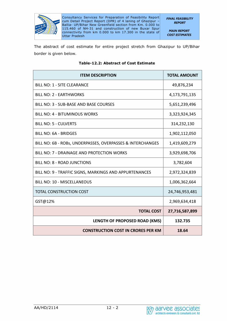
Consultancy Services for Preparation of Feasibility Report cum Detail Project Report (DPR) of 4 laning of Ghazipur –Ballia- UP/Bihar New Greenfield section from Km. 0.000 to 115.460 of NH-31 and construction of new Buxar Spur connectivity from km 0.000 to km 17.300 in the state of Uttar Pradesh
FINAL FEASIBILITY
REPORT
MAIN REPORT
COST ESTIMATES
AA/HD/2114 12 - 2
The abstract of cost estimate for entire project stretch from Ghazipur to UP/Bihar
border is given below.
Table-12.2: Abstract of Cost Estimate
ITEM DESCRIPTION TOTAL AMOUNT
BILL NO: 1 - SITE CLEARANCE 49,876,234
BILL NO: 2 - EARTHWORKS 4,173,791,135
BILL NO: 3 - SUB-BASE AND BASE COURSES 5,651,239,496
BILL NO: 4 - BITUMINOUS WORKS 3,323,924,345
BILL NO: 5 - CULVERTS 314,232,130
BILL NO: 6A - BRIDGES 1,902,112,050
BILL NO: 6B - ROBs, UNDERPASSES, OVERPASSES & INTERCHANGES 1,419,609,279
BILL NO: 7 - DRAINAGE AND PROTECTION WORKS 3,929,698,706
BILL NO: 8 - ROAD JUNCTIONS 3,782,604
BILL NO: 9 - TRAFFIC SIGNS, MARKINGS AND APPURTENANCES 2,972,324,839
BILL NO: 10 - MISCELLANEOUS 1,006,362,664
TOTAL CONSTRUCTION COST 24,746,953,481
GST@12% 2,969,634,418
TOTAL COST 27,716,587,899
LENGTH OF PROPOSED ROAD (KMS) 132.735
CONSTRUCTION COST IN CRORES PER KM 18.64
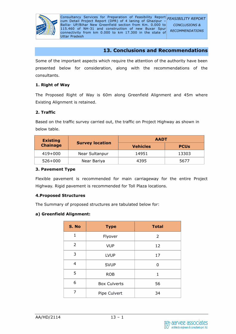
Consultancy Services for Preparation of Feasibility Report cum Detail Project Report (DPR) of 4 laning of Ghazipur –Ballia- UP/Bihar New Greenfield section from Km. 0.000 to 115.460 of NH-31 and construction of new Buxar Spur connectivity from km 0.000 to km 17.300 in the state of Uttar Pradesh
FEASIBILITY REPORT
CONCLUSIONS &
RECOMMENDATIONS
AA/HD/2114 13 – 1
13. Conclusions and Recommendations
Some of the important aspects which require the attention of the authority have been
presented below for consideration, along with the recommendations of the
consultants.
1. Right of Way
The Proposed Right of Way is 60m along Greenfield Alignment and 45m where
Existing Alignment is retained.
2. Traffic
Based on the traffic survey carried out, the traffic on Project Highway as shown in
below table.
Existing
Chainage Survey location
AADT
Vehicles PCUs
419+000 Near Sultanpur 14951 13303
526+000 Near Bariya 4395 5677
3. Pavement Type
Flexible pavement is recommended for main carriageway for the entire Project
Highway. Rigid pavement is recommended for Toll Plaza locations.
4.Proposed Structures
The Summary of proposed structures are tabulated below for:
a) Greenfield Alignment:
S. No Type Total
1 Flyover 2
2 VUP 12
3 LVUP 17
4 SVUP 0
5 ROB 1
6 Box Culverts 56
7 Pipe Culvert 34

Consultancy Services for Preparation of Feasibility Report cum Detail Project Report (DPR) of 4 laning of Ghazipur –Ballia- UP/Bihar New Greenfield section from Km. 0.000 to 115.460 of NH-31 and construction of new Buxar Spur connectivity from km 0.000 to km 17.300 in the state of Uttar Pradesh
FEASIBILITY REPORT
CONCLUSIONS &
RECOMMENDATIONS
AA/HD/2114 13 – 2
S. No Type Total
8 Minor Bridge 16
9 Major Bridge 3
Total 141
a) Buxar Spur:
S. No Type Total
1 ROB 1
2 Minor Bridge 2
3 Box Culverts 8
4 Pipe Culverts 1
Total 12
5. Project Facilities
Roadside furniture like Traffic signs/overhead signs, pavement markings, crash
barriers, road studs is proposed as per Four laning manual.
6. Mode of Execution
The mode of execution is Hybrid Annuity Model (HAM).