CRITICAL DATr SHEET - Archaeological Survey of India, Agra ...
Upload
khangminh22Category
view
0download
0
CEYLON.
XX.-1909.
ARCHJiOLOGICAL SURYEY OP CEYLON.
NOETH-CENTEAL, CENTEAL, AND NOETHEEN
PE0YINCE8.
ANNUAL REPORT,
1905.
By H. C. p. bell, C.C.S.,
Archaeological Commissioner.
5^
PRINTED BY H. M. RICHARB8, ACTING GOVERNJIENT PRINTER, CEYLON.
Co be purchased at the Government Record Office, Colombo, price, with 36 Plates and plan, Rs. 4.
1D09.

J. c. /« O S^ ,
7 c ^ c-^ ^^ <D


Preanble
ClearihgExcavationAii s cell aneous :
-
Ola ivianuscripts ...
Index to the "kahawan:Catalogue of "i^inds"
Clearing ...Excavation:
-
"Raja iii'-aligav/a"
Kestoration and Conservation:'"Thuparnraa"Wata-da-ge ...
"Ha J a Maligawa"
GCi^TI^r^T^.
AIIUHADHABURA.
Page 1
1
1
PCLOlJWARUWA.
1
1
1
2
3
56G
SIGIKIYa.Clearing ... ... ...Restoration and Gonservation:-
tiallery ... ... ...Paintings ... ... ...
Circuit vVork:-ijorth-Contral Province, Taraankaduwa ...
Northern Province, East Wanni ...Epigraphical V/or^:-
List of Inscriptions, horth-Central, i-iorth-Vi/'e stern, horthorn Provinces 39Inscriptions, iiiorthern Province, East Wanni ... 43
Appendices:—A. "Thuparana" ... ... ... 50ii. Taraankaduwa, Ego da Pattuwa ... ... 52C. Inscriptions on Gallery Wall, Sigiri-gala. ... 53
7
1519
2024
PlatePlatePlatePlatePlatePlatePlatePlatePlatePlatePlatePlatePlatePlatePlatePlatePlatePlate
PlatePlatePlatePlatePlatePlatePlatePlatePlatePlatePlatePlatePlatePlatePlatePlatePlate
I.II.
III. .
IV. .
V.
vl. .
VII. .
VIII. .
ix. .
X. .
XI. .
XII. .
XLII. .
XIV. .
XV. .
xn.XVII.XVIII .
XIX. .
XX. .
XXI. .
XXII.XXIII.XXIV. .
XXV. .
XXVI.XXVII..XXVIII-XXIX. •
XXX. .
XXXI . .
XXXII ..
XXXIII.XXXIV..XXXV.
Plate XXXVI
(24)
Polonnaruwa,Do.Do.
Sigiri-gala,Do.Do.Do.Do.Do.Do.Do.Do.Do.Do.Do.Do.Do.Do.
Do.Do.Do.Do.Do.Do.Do.Do.Do.Do .
Do.Do.Do.Do.Do.Do.Do.
Do .
PLATES.
'•Raja ii^aligav/a", i^orth-vVest.do. Scuth-East.do. Interior.
Rock from South-V/est C1899)
.
Rock from V/est (1897).GalleryGalleryGalleryGalleryGalleryGalleryGalleryGalleryGalleryGalleryGalleryGalleryGallery
orationGalleryGalleryGalleryGalleryGalleryGalleryGalleryGallery
ij o r th Ap p ro a ch ( 1895 )
.
South Approach (1298).Inside, looking north (1895).Birds '-eye view, looking north (1897).Ilorth-west end, inside, ruined (l£98)
.
Horth-v/est end, inside, ruined (l£98).liorth-west end, outside, ruined (1898).riorth-stretch, ruined (1893).ijorth-v/est end, and liorth stretch, ruined( 1899Korth-stretch, under excavation (1899).IIcrth-\7est end, restoration cor.imenced (lS99).
end, under restoration (.1900).end and north stretch, under rest-
I.orth- v/estIiorth-west(1901).
hcT th-west end
,
North-west end.North stretch,
inside restored (1002).inside? restored (1902).
Fresco pocketsFresco pockets
North stretch,North stretch,
stretch,stretch,stretch,
NorthNorthNorth
air) 1898.'902)
.
under restoration (1902).,inside, under redbration( 1902)restored (1905).east end, restored (1905).restored (1905).restored (1905).
A«B. (Photographing from midA. 3. (Telepliotographic view,
Fresco pocket A. (unprotected, 1896).Fresco pocket B. (unprotected, 1896).Fresco pocket A. (wired in and bridged.Fresco pocket B, (wired in and bridged.Fresco pocket A. Figures Nos.3, 4 (1901).Fresco pocket B. Figures Nos.3, 4 (1901).Fresco pocket B. Figures Nos,7, 8 (1901).Fresco pocket B, Figures Kos.ll, 12 (l90l).Plan of Sigiri Nuwara: inner portion.
1905 ).y
190^

T

AECHiEOLOGICAL SURVEY OF CEYLON.
NORTH-CENTRAL, CENTRAL, AND NORTHERNPROVINCES.
ANNUAL REPORT: 1905.
Peeamble.
With a vote temporarily much reduced, and with but liaK of the normal labour force available,the Archceological Survey liad, in 1905, to confine itself almost entirely to " harking back" to field
work done duiing the past fifteen years.
Owing to the heavy rains of successive monsoons, the constant incursion of herds of cattle, and theprodigahty of nature itself, most of the ruins in the extensive areas excavated at Anuradhapura between1890 and 1902—and at Polonnaruwa since 1900—had become washed, silted, and hardly recognizable.The very outhnes were in places obscured, whilst details of mouldings and sculpture had been greatlyhidden by the resprouting of irrepressible roots. It was most desirable—indeed essential—to partiallyre-dig the majority of the ruins already exhumed, lest the labour of years should be rendered entirelynugatory.*
ANURADHAPURA.
Clearing.
The annual sum of Rs. 3,000 allotted to the Arohajological Commissioner for the purpose ofclearing scrub jungle and keeping down weeds in the ruined covered areas at Anuradhapura outside theTown limits was fully expended.
More than 550 acres in aU were cleared, the average expenditure per acre working out to less
than Rs. 5-43. No clearing contracts were granted in 1905. Tlie plan of employing coolies underoverseers, closely supervised, was contmued with the success attamed last year.
Excavation.
In lieu of fresh excavations the work of thoroughly cleaning stairs, basements, floors, &c., of thevery numerous ruins of Anuradhapura excavated in the course of the past thirteen years, was systematically
carried out.
By the end of the year 200 sites and upwards had thus been all more or less re-dug in theAbhayagiriya, Sela Chaitya, Ruwanveh, and Thuparama areas; within the Buddhist monasteries
located at Vijayarama, Pankuliya, Toluvila, and Puliyankulama; and amid the coterie of Hindu shrines
north of Jetawanarama.Miscellaneous.
Ola Manuscripts.
The Archseological Commissioner supplied the Oriental Library in 1905 with copies of three palmleaf manuscripts secured in the North-Central Province.
f
Index to the " Mahawansa."
A good Index has been a real want long felt by students of the " Mahdwarjsa" the chief chronicle
of the sovereigns of Ceylon.
Mr. J. Still, Assistant to the Archaeological Commissioner, set himself to the tedious task of
indexing the English version, and patiently carried it through in the most thorough manner before tlie
close of tjie year.
The Index comprises every name, wlietlier of j)ersons, places, buildings, tanks, channels, &c.,
arranged alphabetically besides a chronological list of wars, campaigns, and battles , as well as genealogical
trees of the several royal families.
An Index to tlie great historical work so full, and published under Government authority, should
prove of much ser\ice.|
Catalogue of " Finds."
A " List of Archgeological Finds " is in course of preparation. It is intended to be the precursor
of a fuller and more detailed Catalogue, amply illustrated.
For a mere list of articles and of fragments of all sorts and descriptions found can give but anincomplete idea of the manner of old time craftsmen of the Island, unless aided by photography.
* Such temporary clieck on continuous excavations by the Archasological Survey will have to be periodically
bonie with, in order to permit of ruins pre%'iously dug being duly cleaned and re-opened up.
t See Administration Report, Colombo Museum, 1905, D 10.
88-08 [ 25 ]

2 CEYLON SESSIONAL PAPERS, 1909.
The Catalogue will furnish a short description of each object, and will mention where each wasfound. A large number of tyi^ical specimens, besides other objects which seem most worthy of repre-
sentation, will be figured in tlie Plates.
Of these illustrations, the majority will depict bronze work, iron tools, weapons, and fittings, and
articles in crystal and glass. Pottery and stone work will bo represented by selected types.
The Catalogue thus illustrated will be of value in enabling avchieological " finds " made in Ceylon
to be compared with those in the Museums of India and other similar repositories of ancient Buddliist
and Hindu specimens.
POLONNARUWA.
Cle.uiing.
Towards the close of the season the question of battling with the formidable growth of trees and
vegetation on the two great Dagabas ( Kiri Vehera," " Rankot Vehera ") of Polonnarawa and its larger
brick built shrines ('' Jitawandniina," &c.) was seriously faced. From their height and conformation
such huge structures cannot safely be scaled and cleaned during the prevalence of the violent south-
west wind.
Vegetation had laid a terrible grip on these magnificent ruins, and for years, despite
occasional scotc'aing prior to the advent of the Archaeological Survey at Polonnaruwa * been steadily
worldng their certain, if slow, destruction. Drastic action was necessary ; for serpentine roots of
innumerable trees penetrating deep into the masonry had caused yawning cracks, vhich lessened greatly
the stability of the square tees (Jiatares kotu) and pinnacles (kot) o' tln' Dagabas, and the towermg walls
of oth'^r edifices.
• The work of eradication proved very heavy, and attended with no little risk. Some of the roots
were as thick as a man's thigh, whilst the high walls, tottering at top, of some of the loon^ed buildings
constructed of brickwork are too insecure to permit of strong blows with full-sized axes. Small " Vedda
axes " we.e, therefore , used cautiously, and served well ; but could only cope effectively with the countless
massy roots by gentle and prolonged chopping.
Tiie trees which had invaded both the Dagabas, the so-called " Jetawandrdma," ' Thupdrdma,"
and " Hela-dd-ge" Vihares, and the four-square, staged " Sat-mahal Prdsddaya" were thus attacked,
and in great part conquered during the autumn. But another season's work on them will be
required.
Oace all serious vegetation is thoroughly eradicated, it should not be difficult by yearly attention
to keep these ruins free of similar uncontrolled growth in future.
" Demala Maha Seya."
I'l addition, the undergrowth surromiding the isolated and more distant ruin, strangely misnamed'• De)nala-3IaJid-Scya,"-\ was cleared, and its surface and exterior walls stripped of the vegetation which
(as at " Thiipdrdma" " Jetawwidrdma," &c.) had taken free root.
This ancient Vihare, constructed of brick, is situated nearly three miles north of the Promontorywith its ruins, and more than a mile beyond the cave temple and rock-cut images stjled collectively the
"GalViMre."Its correct name is at present uncertain. No inscription has been discovered there as j^et.
The true "Demala Mahd SiJi/a—the greatest of all the thupas, one thousand three hmidred
cubits round about," constructed by Parakrama Bdhu the Great—lies between the brick shrine and the" GalVihdrL" Tins immense straggling hillock, forest-covered (known now-a-days as " UnagalaVehera "),
except for brickbats strewn about its slopes, affords hardly any indication of its identity save ii: magnitude
and position. " It was," saj^s the Mahdwansa,% "called the Damila Tliupa, because that the Damilas
(Tamils) who were brought here from the Paniju country, after it had been con piered, were also
employed in the building thereof."
Th"! ruined Viharo now call 'd Demala Mahd Siya" is much better preserved than " Thupd-rdma" which it strikingly resembles in gener.il fines, but mth some important modifications. In external
ornamentation it is both fuller in detail and more complex. The total colla]ise of the roof had choked both
vestibule and shrine, besides burying the lower part of the walls outside in masses of brick and mortar
masonry.The ruin was partially excavated by Mr. S. M. Burrows in 1885-86.§
The vestibule appears to have been completely cleared then. About the same date one or twoof the paintings (Jdlaka stories, &c.) on the walls were copied in water colours by Mr. A. Murray,
Provincial Engineer.
But the shrine remains to this day wholly filled with tons of debris—the WTeckage of fallen roof,
and upper walls—which will nff -r no mean task to excavat'' and remove.
A large slice of the e.Kterior wall of the shrine at its north-east angle has fallen quite recently. Otherbreakaways sceai likely to follow.
Such precautions as are possible short o'. immediate special attention are being taken to prevent
further dilapidation.
Wata-da-ge.
In the jungle about 100 yards south of this ruin, and yet hidden in jungle, on raised ground,
is portion of a brick wall almost certainlj' belonging to a " Wala-dd-gi." The path to the 'DemalaMafia Shja " Vihdro passes over what is probably its outer maluwa or platform. This site has also
been cleared.
* A small yearly vote of Rs. 150 was formerly allotted to the Government Agent, North-Central Province, for
clearing ruins at Pojonnnruwa.
t This is but one of sevonil misnoraora hitherto recklessly afifixed to Pojonnaruwa ruins, e.g., " Dalada Mdligdwa,"" Thupdrdma," " Nayipma Vihiiri." &c.
t Mahdu-ansa, LXXVIII., 88.
§ Sossional Papers, 1880, X., p. 10.
[ 26 ]

ARCH^OLOGICAL SURVEY, 1905. 3
Excavation.
Similarly to the lull in excavations at Anuradhapura no new digging \\'as attempted at Poloanaruwa,
with one exception. The ruins worked ofi in the past five years, 1900-1904, were well cleaned—\\ithin
the Promontory overlooking the lake—in the area on the Minneriya road marked by the cluster of
Hindu Devales—and upon the banked quadi-angle north of the Citadel containing some of the most
important edifices of Polomiaruwa (" Thuididma," Wata-dd-gi, " Sat-mahal Pidsddaya," " Heta-dd-ge,"
&c.).
" Raja Maligawa."
The only fresh excavation essayed in 1905 was at the ruin, popularly styled " Bdja Mdlkjdwa,"*
which stands witliin the Citadel at Polonuaruwa. This beautiful building, fashioned in stone with its
bold lion-guarded staircase, is, among Buddliistic stone ruins of Polonuaruwa, second only in elegance
and profusion of sculpture to the unique Wata-dd-ge.
The so-called " Rdja Mdligdwa " and the prominent brick ruin with tall massive walls adjoining
it to the west (the supposititious " Hira-ge," or'
' prison," of modern nomenclature, but originally part of
the " King's Palace ") are the sole structures above ground within the Citadel confines, an area of about
oue-fourth of a mile square, situated to the east of tlie Promontory. But experimental trenches
run for short distances outside the premises surrounding the " Bdja Mdligdwa " point tb the whole area
having been probably once covered by minor buildings, cross walls, bye-streets, &c., lying buried some
three or four feet below the present surface.
In design the " Rdja Mdligdwa" is almost an exact replica, on a slightly smaller scale, of that
wonderfully close approximation to the classical basilica,—the " Council Chamber " on the Promontory.
But in regard to its state of preservation, whilst the latter structure has suffered " complete spoliation
of its once handsome stylobate " and stairs, besides, not improbably, the deliberate overthrowing of the
outer row of columns, the ''Rdja Mdligdwa" except for such rough treatment as time and exposure
have naturally wrought exteriorally, has survived virtually complete in all its details, save the
ephemeral roof.
It stands within a brick walled enclosure, oblong in plan, about 50 yards from north to ; outh
by 35 yards across. The building does not occupy a central position within its premises. To the east
it is 4l"ft. inside the boundary wall ; to the north 42 ft. ; but the wall on the west is only 28 ft. away,
while to the south the limit is somewhat uncertain.
Certain divergencies of detail—notably in regard to the columns—exist. But otherwise the
description of the ground plan of the " Council Chamber," on the Promontory and of so much of its
elevation as is left, applies nearly word for word to the " Rdja Mdligdwa " within the Citadel.
The buildins^'s axis lies from north to south. From front to back the entire structui-e measures 45 ft-
in breadth by 117 ft. in depth inclusive of an open portico, 17 ft. 6 in., on the north at a lower level. This was
probably mounted by two or tlu-ee steps, centrally placed, and directly opposite to the chief staircase, nowwholly gone, a portion of one balustrade alone surviving. A single limestone lion, in full round, was discovered
near tlie portico ; and has been replaced upon the pedestal remaining at the head of the stairs.
The dunensions of the main building itself are 100 ft. north and south by 40 ft. across. It originally rose
from a triplicated basement, of which the elevation and ornament are fortmiately deducible with considerable
certainty from the few slabs (plinth, dado, coping) left These closely resemble another ruin very perfectly
preserved—the so-called " Raja Maligawa " within the Citadel.
The lowest part of the ten-aeed pediment was 3 ft. in height. Its dado bore bas reliefs of single elephants
in profile between finished pilasters. The second tier was higher (4 ft. 2 in.) and moulded in the stereotyiDed
Anuradhapura typo—cyma plinth and coping, divided by torus and broad vertical block. This memberwas carved with' similar pilasters, each pair flanking a separate lion passant guardant, like those marking
the balustrades to important staircases at Anuradhapura. Finally, the topmost tier, standing 2 ft. 4 in.
above the second, followed the same moulded form sans the " bull-nose." On its dado was presented a row of
gesticulating gancis, every dwarf, as witli the lions and eloijhauts below, cut off from the next by a pilaster.
The marCTuial surface of the cornice to the second portion of the basement was adorned with a band of hausas
and wavy creeper (Uya-vel maldania), whilst the top of the tliird tier exhibited only a band of Uya-vel without
the birds. The highest coping lay fliLih with the floor of the chamber 2 ft. 8 in. outside the outer pillars. The
entire basement projected 7 ft. 8 in.
The building seems to have been wallless, except at the south. Its roof was supported upon forty-eight
stout granite columns set out in two parallel lines, leaving an intercolumrdation of 5 ft. 6 in. between the inner
and outer rows, with a width of 12 ft. down the centre cf the Hall. The exterior pillars are of slightly larger
girth than the rest. Nearly all are of one design—four-sided at plinth and neck, but on the sliaft hampered
intermediately into octagonal facets. Their capitals were of the blanching order—moulded, but unadorned
with carvmgs. The floor was laid in lime plaster, and the pillars stood 6 ft. 6 in. above it.
The building had a second narrow set of stairs, only 3 ft. wide, consisting of four steps above a plain
moonstone i-aised concentrically, and clumsy wings shaped to "a splay. This flight occm-s about two-thirds
down the west side of the platform, f
Like the " Council Chamber " the " Rdja Mdligdwa " was constructed wholly in gray granite
as an oblong basilica.
In exterior dimensions it measured, excluding the podium to the front staircase projecting on
the nortli, 75 ft. 6 in. down its longest sides, north and south, by 33 ft. 6 in. from east to west.
The stone stylobate rose in three receding tiers as a revetment of stone slabs (II ft. 6 in. in full
height), moulded and carved on their vertical faces, with flat gangways above, exactly duplicating the
basement lines of the " Council Chamber," as far as can be gathered from a comparison of the well
preserved " Rdja Mdligdwa " with its dilapidated congener on the Promontory.
Thus, the lowest platform (3 ft. 2 in. high by 3 ft. broad) is rectangularly moulded—plain plinth
and cap-stone separating a block course formed of perpendicular slabs on which are cut in low relief a
procession nortliwards of single elephants, separated from one another by an ornamental pilaster.
The second, or middle, tier, which is lofty in proportion to its widtli (5 ft. 4 in. by I ft. 7 in.)
adopts familiar jnoulded forms—ogee plinth, closely placed torus, straight block, and cyma copmg.
The dado above tlie bowtcll exhibits a repetition of that series of conventionalized heraldic lions,
* Plates I., II. t Annual Report, 1900, pp. 8, 9.

4 CEYLON SESSIONAL PAPERS, 1909.
pilaster dividorl, apparently Ixelcl to be essential to the adornment of the basements of all large edifices
at Polonnaruwa as testified to at " Thu-pdrdma," Wata-dd-ge, " Ileta-dd-ge," &c.The third, and uppermost, platform is of much the same height (3 ft.) as the bottom stage.
Its coping slabs are but 1 ft. 6 in. in breadth, and projected only 10 in. beyond the alignment of the
outer row of pillars which supported the building's roof. The face is moulded similarly to that of the
second tier, except in dispensing with the torus. A long row of those jovial little ganas (each one cut
off from his fellow by a pilaster), who lend such delightful piquancy to the circular stylobate of the
Wa(a-dd-/ji, relieves its dado block.
The elei^hants (a few excepted) are carved witli a stereotyped stiffness, strangely at variance
with their life-like representation on moonstones ; whilst the lions might well be stone bas-reliefs of
indiffeiently stuffed specimens for all the animation they display. The dwarfs alone, by tlieir ever
varied jjoses and "right merrie gestures," save the ornamentation of the elongated stylobate from that
wearisome effect which monotonous repetition, cannot fail to induce.*
The edge of the coping surface of the two lower gangways is adorned mth a neat band of leafy
creeper pattern ; that of the uppermost with hansas and a foliated fillet.
TJie bottom stage of the basement is thrown forward from the middle of the north of the building
for 10 ft. so as to form a platform 15 ft. in width, on which was placed the main staircase of 12 steps,
6 ft. 10 in. broad, rising by easj'^ gradines to the landing at the threshold of the building.
The stairs when complete and undamaged must have nearly rivalled, in the massiveness andfinish of their magnificent pair of granite balustrades, the imposing stairway at the main entrance onthe east to the so-called '^ Jetawavdrdma'" Vihare. These wing stones are of the most elaborate
ma/fcara-headed type, with thick ornamental roll curling from the mouths of the saurians dowTi to
a bold volute at bottom. The exterior vertical face of the balustrades (which are 5 ft. 7 in. in height
to the top of the monster's flat-curled trunk) bears the same sculpture seen on the wings of the
staircases at the Wata-dd-ge, namely, profile lion, preceding a pilaster with manifold spreading capitals.
But here an additional figure is introduced—a Domtupdlayd , facing full front, adorned with high
mukata head-gear, heavy earrings, &c., who holds a staff' across his body diagonally between both hands.
No dwarf, or other carving, occurs on the inside face of the balustrades ; which, in this respect,
differ from the majority of their high class at Polonnaruwa as well as at Anuradliapura.
The steps leading uj) to the ground floor of the building are footed by a fine moonstone (6 ft. 10 in.
Ijy 4 ft.) of the elaborate order found at the Wata-cld-gc and other adjoining shrines. These
safldakaja pahan have been more than once described in detail. At the " Edja Mdligdwa'' the lion
—
usually omitted from moonstones at Polonnaruwa—finds a place (as at the " Heta-dd-ge ") in the
concentric zoophorous bands of animal life. There are in all 30 lions, 14 elephants, and 12 horses
—
moving from left to right—divided by ornamental fillets, with an inner belt of undulatmg foliaged
creeiJer which surroimds the central lotus. Tlie rows of beasts are themselves encircled by a band of
hansas (40 in all) and outer leafy border.
f
It was obvious, as digging followed the outline of the bay projection upon which the stairs entering
on the front were placed, that a shorter flight of perron steps must once have mounted the podium still
further forward on the north.
No remains of this outermost staircase existed in situ ; but close by were unearthed a pair of
balustrades and a moonstone, which manifestly formed part of former stairs, less wide than the upper
stairway and not so elaborately finished.
The moonstone (4 ft. 6 in. at base) closely resembles the larger saMakada pahana above it ; but.
though adorned by concentric belts of horses (13), elephants (13), and ducks (25), the lion is excluded,
as he rigidly is from the moonstones at the Wata-dd-ge.X The balustrades to this lower flight of
steps are of ordinary makara design, sans carving on their faces.
Two other staircases, now considerably ruined, served the " Rdja Mdligdwa" rising respectively,
in double tiers, at the middle of the east and west sides of the building, not one only on the west as
noticeable at the " Council Chamber." These minor stairs (sets of perhaps four and six steps between
.splayed balustrades) were obviously added later than the erection of the edifice ; for, as now ruined,
they unmask the continuous sculptured dados and mouldings of the stylobate they hid when whole.
Their severe plainness offers a strong contrast to the ultra-elaborated staircase on the north front.
At the head of the main stairs were placed, most effectively, one on cither side of tlie
doorway to the pillared edifice, a pair of stone lions, carved in full round, couchant, and facing
outwards.The figures (adorned with a lotus boss near the rump) are 3 ft. 7 in. from nose to tail tip, 2 ft.
across the haunches, and 2 ft. 10 in. in height, or, inclusive of their low moulded pedestals, 5 ft. by 3 ft.
by 3 ft. 7 in.
The "lord of beasts," is ludicrously travestied in these "China dog" sirj,hayd fo painfully
conventionalized—semi bull-dog in face, with humped forehead, scalloped ears, leafy tail, and unnatural
claws. Nathless, despite their grotesqueness, these fearsome janitors are imposing enough as placed to
guard the portal.
Passing into the building, it is patent that it was a long pillared hall of 48 columns measuring
inside 60 ft. 2 in. by 18 ft. 3 in. between tiie gangway of the uppermost tier to tlie basement slabs. Its
columniation followed that of the " Council Chamber," the pillars being arranged in four lines of twelve
from north to south.
§
Ample interspace separated the inner rows and provided a broad passage (10 ft. in width) downthe axis of the hall.
* For those ornving for such details, the following pioviaionul eniimerntion is oHerpd:
—
Elephants : E. bay 7 J,hnll 2.5 ; W. bay 7}. hall 25 ; S. 1 1. Liona: E. bay 4, hall 33 ; W. bay 4, hall 32 ; S. 10. Dicarfs : E. bav 4 ; hall 52 :
W. bay 4, hall .51 : S. 18. In all approximatoly 7(> olopliants, 83 lions. 129 dwarfs.
f-As minutite it may be noted that the elopliants are separated from the lions on one side and horses on. the
other by a fillet of " voided " diamonds and egg-shaped " ball flowers," broken thrice by profile makara headsback to back. The lotus is given nine petals.
+ Annual Heport, 1903, pp. 23. 24.
S Plate ni.
[ 28 ]

ARCHAEOLOGICAL SURVEY, 1905. 5
The outer range (3 ft. 5 in. from the inner lines), consisting in all of 28 pillars, was encased in the
stone gangway of the uppermost platform. These pillars average about 7 ft. in height by less than 9 in.
in section.
Of the two inside rows of columns, 10 on either side, the last and penultimate pillars at the southend of the building resemble those of the exterior line. Tlieso four marked the corners of an inner
room, or dais (12 ft. 6 in. by 6 ft. i in.), and were built into its brick plinth.
The remaining 16 columns, eight to east and west, which stood 6 ft. 8 in. above the lime plastered
floor, assumed the partially octagonal type and in addition were face-carved in basso-relievo ornamentation.
The base of these pillars is square for 4 ft. ; thence sliding for 1 ft. 8 in. into an octagonal shaft of 5 in.
facets ; finally returning to rectangular for 1 ft. at their termination. The x^'Hars bore no capitals,
the wooden roof beams being made to rest directly oa their flat heads.*
The design of the carving approximates to that of the handsome columns in the vestibule of
Viliare No. 2, on the raised quadrangle, excavated in 1903.f At the base, single fronting dwarfs , differing
onlj' in attitude and adornment, support on head and both hands a fUlet of egg-and-diamond pattern,
from which rises the " three-peaked ornament." Above this are loops and tassels depending from a
fringe ; then a second similar fiUet, and the spiky ornament, with circular florid centre borne up by apair of makara heads addorsed. Whilst the lower rectangular part of the piUar is covered with this
surface carving, the middle eight-sided strip is left quite bare. This gives place above to the squaredhead, wliich displays, on alternate pillars, in the one case a panel with an eight-petalled lotus expanded,and in the other a kalasa, or vase, between fillets like those on the pillar base.
Close study of the ornamentation of the several pillar faces will elicit much minor variation in
detail, resulting doubtless from individual freedom allowed themselves by ditTerent stone masons.
Extra Buildings.
The complete removal of the earth within the walled enclosure down to the level of the foot of
the basement of the " Edja Mdligdwa " revealed a roughly formed site, 45 ft. long by 30 ft. 6 in. fromwest to east, occupying the north-east corner of the premises. The basement and the few steps up onthe west are built of brick, coarsely coated with lime mortar. Two rows of stone sockets (popularly called" gal'Vangedi ") for wooden posts, 15 ft. apart, seem to have held the roof.
The ground level at the foot of the steps and basement of this site is on a level with the bottomof the lowest platform of the " Rdja Mdligdwa." This sufficiently proves, without the further testimonyof the makeshift building itself, that it must have been constructed after the space in front of the " RdjaMdligdwa " had been filled in, so as to bury the outermost stairs of that structure—the disappearanceof which is thus accounted for.
At the back of the " Rdja Mdligdwa " are, as has been said, traces of subordinate buildings J onerange of outhouses or minor chambers (judging by wall foundations) running close up to its basementon that side. These were probably built at the same period as the raised site to the north-east.
Wells.
Far the largest well yet discovered at Polonnaruwa lies just outside the premises of the " RdjaMdligdwa " to the north. Its existence was quite unsuspected, as it had been choked completely, andwas only brought to light by accident during the progress of the trial excavations pushed outwards fromthe enclosing wall.
This well is stoutly bricked in and rectangular (11 ft. 2 in. by 10 ft. 6 in.). The side walls
descend at a gradual slope to rock bottom at a depth of 24 ft., where the area is diminished to 8ft. 6 in.
by 7 ft. 10 in.§
A second well, hugging the south-east boundary wall is an ura linda, formed of circular rings of
pottery 2 ft. 10 in. in diameter.
Restoration and Conservation.
" Thuparama."
The Provincial Engineer, North-Central Province (Mr. W. C. Price), was directed in January to
confer with the Archaeological Commissioner regarding the steps to be taken for the preservation of" Th u pdrdma " Viliare at Polonnaruwa.
||
In forwarding for the information of the Provincial Engineer a Report made to Government onthe Restoration and Conservation of Ancient Monuments, together with Plans of " Thiipdrdma" andphotographs, the Archaeological Commissioner wrote :
—
The preliminary work—which must in any case have been done to save the structure
—
rebuildingthe hack ivall so as to unite with the roof and filling in the three ivide cracks—was commenced by me on nij' ownresponsibility last year, and is well aclvaiieed. The wall is being carried up on the old lines and stronglybuilt.
I suggest, therefore, that we shovild sign a joint recommendation to the above effect, adding that laterin tlie year, after again inspecting the ruin, we will submit a fm-ther report as to anj' work, which may appeardesirable towards strengthening and saving the ruin from collapse at oth^r ]iarts.1[
The Provincial Engineer in Februarji- furnished his draft Report to the Archaeological Commissionerwho replied that he reluctantly found himself unable to sign it.
I am quite ready to agi'ee to the execution of the masonry repairs on the lines suggested. But to anypulling down and rehuilding , or additional incongruous support to the walls, I entirely object, as, in my view, acala'nity worse tlian tlie complete collapse of the building.
' Outer rows: 11 pillars broken ; inner rows : 8 pillars broken, 1 missing.
t Annuiil Report, 1903, p. 10.
% E-irthPriwdre drainagf pipes, trunrated cnnos fitting into each other, were unearthed hero.
S Beyond fragments of chatties and bones of animals the well gave up nothing.
II P. E., N. C. P., No. 11, Janum-y 11,1 90.5.
^ A.C., No. 16, January 30.
[ 29 ]

6 CEYLOX SESSIONAL PAPERS, 1909.
I consider that the insertion of iron annatiire (inevitably more or less unsightlj') is proniatiu-e at tliis
stage, as it may ultimately be fonnd, if not wholly unnecessary, at least capable of much reduction.*
In April the Director of Public Works addressed the Government (No. 539 of April 3), after a
personal inspection of the ruin in company with the Provincial Engineer.
On that letter the Archaeological Commissioner minuted :
—
T)ie Director of Public Works explains tlie present condition of " Thupdrdma" ruin very clearly.
Jly acquaintance with the structure during the past twelve years confirms the opinion expressed that
no setlhmoit has occurred in recent years.
Whilst entirely in agrocnuont witli tlie Director that tlie cracks in the walls and along the soffit of the
arched roof should be carefully dealt with, as pointed out by him, and vegetation (removed in 1904) not
allowed to again assert itself, I venture to record an emphatic protest against any pulling down andrebuilding.
Despite the gaping cracks the apparently unsafe corners (nortli-wost, south-west, south-east) of the
ruin have not opened out a fraction of an inch since 1893. This fact, like tlie extraordinary stability of the half
unsxipported roof of the vestibule and the shrine itself, ii due to the marvellous strength and durability of the
ancient mortar. The cracks once filled in, the packing being well bonded with the old masonry, I am confident
that the corners will continue to stand firm for vtry many years.
I reiterate my settled opinion tliat the safest way to strengthen the structm-e is to continue tlie building
of the inner face of the back (west) wall until it is again united to the unsupported end of the vaulted roof.
Half this essential work was carried out b_>- tlie Archreological Survey in 1904. I caimot too strongly
reconunend its completion as soon as possible.
The vestibule (on the east) is of minor moment than the sanctimi, less likely to collapse, and easier to
strengthen. It can well wait.
As soon as His Excellency the Governor sanctions the recommencenient of restoration work by the
Archseological Smwey, I am prepai'ed to complete all necessary repairs, &c., to the "Thupdrdma" Vihar6
departmentally.f
Subsequently the Report of the Provincial Engineer (No. 190 of February 13) was referred to the
Archseological Commissioner, who replied :—Reference is requested to my previous Memorandum on this question, N"o. 54/273 of the 14th instant.
The one great essential to tlie preservation of " Thupdrdma " Viliar6 is to once more unite its half
unsupported roof with the back wall. Tliis junction again effected in strong masonry (brick and cenient), and
the several cracks duly filled in from bottom to top, the ruin will continue to stand for years to come. No iron
supports will be needed to brace walls, which albeit cracked, neglected, and root pierced, have not opened in
the least degree in modern days.
The less this magnificent structure is " modernized " into execrable sniugness by premature demolition
and rebuildmg of existing walls and resort to hideous iron adjuncts, the better in everj' way.J
Later the Archaeological Commissioner had the privilege of personally explaining his views to His
Excellency the Governor on the sjjot ; and in Julj' the following ^Minute by Sir H. A. Blake was forwarded
for his information and guidance.
I have examined the "Thupdrdma" ruin very carefully with the ArchssDlogical Commissioner.
It is evident that a portion of the building added to the interior at a later date has sunk about 1 J inch
owing to the giving way of the foundation.
The various sections of the walls partly divided by cracks may be regarded as so many solid masses,
the old mortar being as hard as stone.
If the cracks are all filled, the old wall continued until it supports the roof at the western end, the
gangways on the top being cemented so as to exclude water, and gargoyles so arranged as to discharge beyond
the foundation—as proposed by the ArchsBological Commissioner—I see no reason whj' the building should
not stand for centviries in this climate.
In this, as in otiier buildings, the keynote of the work should be preservation, not restoration, except
where all original brick and stone work are simply displaced.
The work of restoration at '
' Thupdrdma " (as far as already advanced, and as it is proposed by the
Arch^ological Survey Department to continue and complete it) being in accordance with His Excellency's
deliberate decision, recorded in the above Minute, will therefore be recommenced next season.
Wata-da-ge.
As at " Thupdrdma" Vihare all restoration work on the Wata-dd-g6 was m abeyance during
1905.
" Raja Maligawa."
In \-iew of the high architectural importance of this ruin and the great risk of its wholesale
collapse in places, it was decided, pending regular- restoration, to clear away debris ui)on and aroimd the
building, so tliat this handsome stone structure ini<;l.t be opened out to full \-iew from all sides, to remove
at once all vegetation threatening to further push out the stone faced revetment, to reset fallen slabs,
and straighten leaning pillars provisionally.
Fortunately all the carved slabs of the high triplicated stylobate, and the majority of the
twenty chaste inner columns, still remained \mbrokeu. But there were ominous signs of imminent slip
of several stones now ready to fall, foi'ccd outwards by the gradual sinking and " thrust " of the upper
members of the basement.
Much of this desirable work was completed before the season closed. Every slab of the west face
of the stylobate has been found, and temporarily replaced on fairly true lines.§ The bold effect is
exceedingly pleasing.
* A.C., No. Ii52, March 2.
t A. C, No. 54/273, April 4.
X A. C, No. 60,28(1, April 24.
§ Tn the course of resetting tlie top gangway of the basement, near its north-west cornpr, portion of a weathered
inscription of tho 10th century dime to light on the buck of one cap-stone. This barofacoil utilization by successive
rulers at Polonnaruwa of any suitable slabs, pillars, &c. , inscribed or sculptured in tlie time of their predecessors,
is l>oin}; constantly proved by excavations.
[ 30 ] '
ARCHAEOLOGICAL SURVEY, 1905. 7
CENTRAL PROVINCE.
MATALE DISTRICT.
SIGIRIYA.
Clearing.
Eirly in 1905, a small gang carried out the annual cleaning of the citadel on Sirjiri-rjala in theCentral Province and of the highest terraces skirting the Rock's base to north, west, and south.
On the Rock's summit and its steep slopes the carpet of strong grass , which has gradually sproutedsince excavations were completed in 1897, help.; to hold together the banks of crumbh'ug brickwork, andcheck further washaway. This grass is, therefore, every year merely freed of plant growth, and burnt.A wholesale sweep of all vegetation would but result in a continuance of the heavy scour which occurredeach monsoon until this grass grew and began to protect the ruined walls fringing the summit from rapiddenudation.
Restoration and Conservation.
The restoration of all that remauis of the " Gallery " virtually closed in 1904.Some account of the Gallery and of the work do le towards its preservation and restoration
year by year, from 1S99 to 1905 inclusive, can now, tlierefore, be fitly recorded.
Sigiri-gala.
The huge isolated mass of gneiss rock oval in contour now-a-da_ys known locally as " Svjiri-gala '""
is situated in the Matale District of the Central Province, some 10 miles north-east of Dambulla, andnearly 20 almost due west of Polonnaruwa. It was at this " rocky fortress in mid-air" that in the5th century Kasyapa I., the parricide king, took refuge, making it his capital yet ever "living in fearof the world to come and of Moggallana " (his brother and successor), at whose hands he uftimatelymet the just retribution of his crime.
f
The Rock and its entourage {" Skjiri-nuwara") were subsequently handed over to Buddhistmonks, proofs of whose occupation still remain. For centuries it has been completely abandoned(doubtless owing to the collapse of portions of the Gallery) ; but below the neighbouring hill", Piduragala,a mile to the north, a small Buddhist vihare—the modern substitute for the ancient temjile whicli wassituated near its summit—^gtill exists.
Sigiri-gala rises to about GOO feet above the fields and tank lying beneath it to south-west and south.For about half its height the Rock towers sheerly, but the lower spurs and reaches are masked by a seriesof bare boulders, and of stone-banked terraces, much dilapidated. J Immediately at the foot of the cliff
masses of debris, washed down from the ruined outskirts of the Citadel which formerly crowned thesummit of the Rock, still further conceal the base of the main Rock.
Forest trees , undergrowth , and patches of mdna grass {Andropogon zeylanicus) extending up to thevery face of the Rock, hid this talus and the terraces completely when the Archaeological Survey commencedoperations at Sigiriya in 1895. This pall, so to speak, has since been pushed back steadily, season byseason, with the object of leaving all open and visible in a wide belt several hundred yards in width.
During the occupation of " Sigiri-nuwara''- by Kasyapa I. (479-497 a.d.), were carried out theworks of stupendous labour, the remains of which even now excite in the explorer wonder and admiration.
Among these marvellous proofs of tremendous energy, toilsomely executed within the compass ofa reign of no more than eighteen years—if the Mdhawa'i^sa is to be trusted—one specially stands out asa tour de force, viz., the marvellous " Gallery."
The summit of Sigiri-gala is quite inaccessible without adventitious aid ; and this necessary helpthe Gallery easily afforded in former days.
Artificially built of b.ick, high Mailed, and paved with stone, the Gallery was made to run alongthe western and northern faces of the Rock. In its serpentine course up to the Rock's summit it
clung to the cliff at the level where the Rock face has the greatest concavity ; so that while restingupon the highest part of the downward slope, it was also, for much of its length, well overhun^ andprotected by the beetling crag towering above.
§
In 1895 a hundred yards of the Gallery—wall, floor, and foui- staircases—still stretched almostperfect (with the ruins of two more landings and stairs, from whicli the flanking wall had fallen awavbodily) along the western face of the Rock nearly as far north as the point where it formerly swervedeastward.
II
Beyond the north-west corner of the Rock was a wide stretching breach. For a distance of manyyards no remains of the Gallery had survived and further progress was impossible. T[
At the far end of this g,ip the half buried ruins of a long, steeply rising, stairway, alsowanting its outer wall, could be traced a^ong the north face of the Rock. These stairs formed part of theoriginal continuation of the Gallery where it formerly mounted east to the broad maluwa, or highestterrace, projecting from the Rock to the north.**
* Stylod" Sihlgiri " passim in inscrlptioasof the 10th to Uth centuries on the Gallery wall. The forms '• Scyqiri,"" Sigiri." " Higiri " also occur.
t For a general description of " Sigiri-nuwara" reference may be made to :
—
(1) Mahdivansa, XXXIX.(2) Sigiri, the Lion Rock (T. W. Rhys Davids, R. A. S. Joiu-nal, vol. VII., part X., 1875).(3) The Ruins of Sigiri in Ceylon (T. H. Blakesley, R. A. S. Journal, N.S., vol. VIII., part II., 1870).(4) Ceylon A. S. .lournal, vol. XIV., No. 40. 1S95, No. 47, 1890 ; vol. XV., No. 48, 1897.(5) Archaaological Survey, Annual Reports, 1895-1005.(fi) Guide Books.
t Plate IV.
§ Plates v., VII., VIII., IX. A perfect shelter.
" Vaulted above lyke to reclynatoryes.That called were deanibulatoryes.Men to walke togithers twaine and twaine,To kf>ep them drye when it happed to rayne."—Lydgato, Boke of Troije.
IIPlates v., VIII. to XI.
TIPlates X. to XV. ** Plate XIII.
[ 31 ]

8 CEYLON SESSIONAL PAPERS, K09.
Further on, where the Gallery manifestl}' once zig-zagged up the slopmg face of the Rock abovethe "Lion Staircase-House" (which showed merely as a jungle-covered mound of brick debris until
opened up in 1897) it has been completely washed away. Only ledges, grooves, and oblong " keys," cut
in the Rock, are left to suggest how its brick foundations were sustained ; but these, with higher
channelettes intended to pass off water, clearly mark its steeply inclined course onwards, in a
north-easterly direction, from the head of the present iron ladders.*
The lines of ledges on the Rock ended (1895) at sloping talus, from which a few steps protruded
,
pointing to the existence of a stairway \^hich had of old emerged on the summit. Excavation subsequently
revealed a right-angled fliglit of clean cut limestone steps.t
Approaches to Gallery.
Near the commencement of the Gallery, the Great Rock throws ofi two spurs^one directly west,
the other in a south-westerlj^ direction.
Along these spm's were led upwards, by a gradual series of limestone steps and paved landings.
Approach Stairwaj^s, which converged at an entrance Portico to the GaUery.
The "Northern Approach " served the terraces of the Timer City and so much of the Outer City
located to the west and north-west of the Rock : along the " Southern Approach " access was given from
the remainder of the terraces and City lying to the south and south-west, including the tank (Sigiri-vewa)
and the suburb on the Mnpa-gala Rocks (the Viceroy's residence) adjacent to it.
Revealed by excavation in 1895, these two Staircases showed as follows :
—
Northern Stairway.
Among the many gigantic boulders, once crowned with buildings, which stud the terraces lying
below Sigiri-cjala to the west, is the closely adjoining pair, beneath which cower Caves Nos. 5 and 6.
J
These boulders stand about 50 yards north of the " Audience Hall," and " Cistern," Rocks ;§ and
it is under their adjacent sides, which overhead unite, that the "Northern Approach Stairway"
commences.The deep grooves for foimdations cut in the rocks immediately in front of these two boulders
maxk the former sites of a pair of flanking " guard rooms " (mura-geval)
.
1st Flight.—This, like the bottom flight of the " Southern Approach Stairway," consisted of
three tiers, each with a short landing. These stairs rose straight east.
(a) The first perron stage has 5 steps left of the full 9, with plain moonstone at foot; (6) the
second, 7 steps ; (c) the third, 9.
From the topmost landing further stairs branched off to left and right.
One flight rose at right angles north, and thence from a landing harked back east again. This
led to the terraces in that direction.||
2nd Flight.—The Northern Approach to the Gallery was carried up by a second set of steps
(a score or more originally, but now barely tea) skirtiag to right the north-west face of the southern of the
two boulders above-mentioned.
This flight led on to a passage, the lowest stretch of the Staircase where it began its direct course
eastward (uninterrupted save for one right angled deviation) imtU it attained the Rock.^
This passage is continued, with one step rise about midway, for nearly 20 yards before reaching
the foot of the 3rd flight.
It hugs to right (south) a high rampart wall, stoutlj'-built at a slight batter, formed by stone
rubble centre (12 ft. 6 in. thick), with soUd brick casing (4 ft. 4 in.) the whole way up. This massy wall
bounds on the north the so-called " Et-gdla" or " Elephant-kraal"** mto which it has one opening.
A few steps on either side north and south give ingress and egress—virtually a passage 23 ft. in length
by 5 ft. 6 in. wide—tlirough this gateway in the wall. The wall runs on past the 3rd flight of steps into
rock (the tail end of the spur), where some building once stood at the north-east corner of the " Et-gdla " ;
thence it turns shai-p north for 18 feet, before reverting to east.
3rd Flight.—In all 19 steps, in fair condition. The stairs ascend steeply, keepmg the north wall
of the " Et-gala " to south, and flanked by a brickwork balustrade shaped to a splay (stiU unbroken, but
plasterless) on the oS side.
The landing above these stairs (revetted by a double convex bemma) follows the northern right
angle trend of the massive Staircase wall.
4th Flight.—These stairs were placed where the landing beyond the 3rd flight returns again east at
right angles, below the south flanking wall on right. The 15 steps remaining are on the \\hole fairly
preserved.
5th Flight.—The next existing stairs (originally 6th flight) stand on a somewhat higher level, and to
the right front of the 4th flight. There must, therefore, have once been a short flight of steps (5th) from
the landing above the 4th stairs, rising south on to the landing at foot of the 6th set of steps. This latter
landin" extended first \\'est, then south, above the landing between the 3rd and 4th stairs, to the building
at the north-east angle of the " Et-gd!a " referred to. Thence descent by a few steps (2 still in situ) was
* The exposed position of tliis portion of the Gallery, resting on the slanting Rock, must have hastened its fall.
t These have since been, reset, and a wing wall of brick built on either side.
+ For the Caves of " Sigiri-nuwara" see Annual Report, 1899, pp. 66, 67.
§ Annual Report, 1895. p. 11.
liThis was at one time the true 2nd flight in the ascent of the " Northern Stairway" to the Gallery. The later
adopted steps wore necessitated by a cloavupe of the bouldor (probably due to lightning) blocking passage onwardsfrom the original stairs. The grooves on the fallen piece of rock prove thnt it was split oH after the boulder had beenutilized for some building.
t Plat© VI.** On the lucits a non lucendo principle. In its ruined condition, until excavated, this cut de sac (formed by parallel
beini. or ramps, east and west, and shut into north and south by the flanking walls of the two Stairw«>s) had suggested
a model " Elephant kraal" (•• El-gdla ") to the unsophisticated villagers of the present day,
[ 32 ]

ARCH.EOLOGICAL SFRVEY, 1905. 9
fornaerly made on to the top of the rampart wall, and along it WP3twardn over the gateway serving
the " Ef-gdla" as far as the " watch tower" boulder which shelters Cave No. 5.
6th Flight.—This and the two flights above it rise east beneath the continuation upwards of the
Northern Stairway's flanking wall, which mavches with the ascent on tlie right (south).* Tlie wing wall
and revetment of' brick on the off side (north) of the stairs have fallen away, exposing the stone rubble
core of the foundation on which the steps rest. There are now left 21 steps, all in good order, and
beyond them a level landing, 14 ft. in length.
7th Flight.—At the foot of this flight is another break m the wall, for a second gateway 10 ft.
4 in. by 5 ft. wide, leading into the terrace lying between the fork of the two spurs from the Rook. The
existing 14 steps of these stairs are excellently preserved, having hardly shifted at all, and but little
worn. As at the 6th flight, their foundations are exposed by abrasion and fall outwards of the revetment
wall on the north side.
The landing at head of the 7th stairs stretches for 22 ft. 2 in.
Sth Flight.—This was the longest flight of the Nortliern Approach Stairway. Of the 31 steps
surviving whole or in pieces, about a dozen are in fair order ; from another dozen the ends are broken off.
The outer wall and revetment (north) are gone. Like the 6th and 7th stairs this flight too clings to the
flanking wall on south.
The wall onwards to the Rock from the landing below the 6th fliglit of steps still retains its
brick casing, and is of hardly less breadth than the lower wall, which ran from the building once
occupying the end of the spur at the north-east corner of the " Et-gdla " on to the boulder, west. This
upper stretch of wall was carried straiglit east to about half way up the Sth stairs, from which point its
south face was made to curl gradually southwards, so as to unite with the walls (no longer standing
but located by deep ledges and " sets") of whatever buildings occupied the projection between the
Northern and' Southern Apnroach Stairways at the foot of the Rock cliff. The wall was wide enough
at top to allow of being utilized as a means of communication.
As the outer (north) revetment of the Northern Approach ran on direct east to meet the Great
Rock, ample space must have beeii available near its head for habitable chambers.
f
It is impossible now to recast for certain the manner in which the Stairway ultimately
reached the Portico to the Gallery. The washaway above the Sth flight of steps has left merely
sloping brickwork with some 15 displaced limestone steps, heading first southerly witli tlie Rock
to left, then east into the Gallery wlien it existed at this point. These steps represent the few
survivors of the last two or three flights of stairs in the Northern Approach. They probably mounted
almost at right angles, from a landing at the head of the Sth flight.
J
Southern Stairway.
The Southern Approach started at the south end of the confuied enclosure popularly termed" Et-gdla." This Stairway could be reached from the Northern Approach, as already said, through the
gateway in the high massy wall, which both flanked the latter Staircase on the south and bounded the" Et-gdla " to north. But it was unaccountably shut off by a tall thick wall from the broad terrace
lying to south-east of the boulder, for convenience now styled " Cistern Rock."
From its inception up to the junction with the Portico to the Gallery, where both Approaches
converged, this Southern Stairway was originally flanked, for the whole of its course, by side walls of
brick, the foundations of which rested in parallel ledges and substantial " sets " wherever the Staircase
traversed bare rock.
1st Flight.—This rose within the " Et-gdla " upon the lowest extremity of the south-west spur of
the Rock. It seems to have resembled the initial stairs of the Northern Approach in consisting of three
tiers, which ascended in a generally south-eastern direction.
(a) The first tier had only 3 steps (still in fair order, but weather worn) and a two-foot landing
;
(b) of the second stage about 30 steps (a dozen or so fairly preserved) remain, the rest have disappeared
together with the outer wall;
(c) thence, by an obtuse angle bend, a third tier was carried up the rock
face. Of this portion of tlie stairs, wing walls and aU the steps have gone except half a dozen at the top,
and even these are gradually sliding down.
At head of the 1st flight of steps is a terrace, the bemma, or ramp, of which meets the Southern
Stairway on the south and (with a slight projection west) runs on north into'the great flanking wall
of the Northern Approach.Between the head of the 1st flight and the foot of the 2nd, the Southern Approach was continued
as a short level passage, stone revetted to south, and probably brick walled on north.
About half way there was one step rise. At this point access was given on the right (south) by a
few steps descending, still in position ; and to the left (north) on to a roughly semi-circular terrace by a
doorway (through a brick wall now gone) marked by a single step. This terrace§ (which once ran back
to the foot of the Great Rock on the east) is confined to the west between the Southern a,nd Northern
Staircase Approaches by the stone faced ramp, cyelopean in part, rising above the " Et-gdla."
2nd Flight.—The wings of these stairs are wholly gone ; but remains of the foundation walls and
floor have lasted. This flight rose in a north-easterly direction. It comprised some 25 steps
(still standing)
* Plate VI.
t Similar chambers once stood on the projecting foot of the Rock's west scarp to north of this Approach
Stairway, judginct by the deep grooves lining the Rock here.
X Wlien the restoration of the better preserved Southern .Approach Staircase (by which access to the Gallery is
at present attained) has been sufficiently completed , attention will be given to the hardly less deserving Northern Stairwa>-.
§ It originally abutted at one level on to the bottom of the Great Rock, whence the two spurs branch west
and south-west respectively. To get rid of the tons of tahis fallen from above, which covered two-tliirds of this
spacious terrace deeply, it would have been necessary to choke the ' Et-gdla" by utilizing it as " diimping ground."
The Archaeological Commissioner, therefore, decided to smooth the sloping mound of debris at back (oast) into stages
(revetted with rubble, and properly drained), in keeping with other terraces to north and south.
88-08 [ 33 ]

10 CEYLON SESSIONAL PAPERS, 1909.
3rd and 4th Flights.—The extent of landings, and " going," to the next two sets of stairs
(3rd and 4th) is more or less problematical. All but the brick base of their upper part has been
carried away.* Not a single step remains.
East of tlie landini: n.l>ove the 2nd flight a vertical stone and rubble h^mma (once cased with brick)
abuts on to where the 3rd and 4th stairs once stood. Hicrher still than this ramp rises the stone revetted
terrace, running back to the Great Rock, in which -was sunk a brick-lined storage tank fed by the main
rain-water dr.dn of the Citadel clearly marked on the Rock's face.
The outer wall of the 2nd, 3rd, and 4th flights was taken along the veiy verge of the rock spur, in
grooves and " sets."
So far up the Southern Approach (except the 2nd flight), the true extents and lines of the stairs
are more or less doubtful, owing to the comparatively little tliat is left as guide. But from the landing
at the foot of the 5th flight the origuial course of the Staii-way can bo followed -vvith perfect certainty.
From this point upwards excavation ui 1S95 revealed tlie inner brick wall, still 4 to 5 feet high,
which flanked tire Approacli Staircase on the south-east. It was built up from the rocky spur in clean
exterior batter, and is in good oi'der. In thickness (at present heiglit unrestored) 5 ft. 3 in. as far as
head of the 5th stairs, it suddenly widens to 12 ft. 6 in. onwards till it touches the Rock.
Tlie great heiglit and tapering form of this south flankijig wall, as it originally stood, can be
gathered fi-om the " keys " to take the end of the bricks seen in the face of tlie Great Rock on to which
the wall abutted finally.
5lh Fli(/ht.—About IG ft. length of the landing in front of the 5th flight is left. Of the original
number of steps, 13 were unearthed, in fair preservation—a few broken—but all off tiie level, andgradually sUpping down the rock slope to north-west. The landuig terminating at tlie 4th stairs is
13 ft. 6 m. long.
6th Flight.—Shows 11 steps, in much the same condition as 3rd flight ; and similarly sliding
outwards. Short landing, 8 ft. in length, on to the 5th stairs.
7ih FUghl.~Sti\[ has 6 steps, level and fairly ^^•eU ijreservcd, like the two preceding stairs. Thelanding onwards is 12 ft. 3 in. in length.
8th Flight.—These, tlie uppermost stairs of the Southern Approach, consist of 30 steps, most in
good order, consideruig lapse of time, weathering, and the friable nature of the ston". This flight
led into a Mura-ge or " Guard Room " at the e.xtreme south end of the Gallery when complete in old days.
In line with the 6th flight of stairs the rook spur widens out rapidly in a northerly direction until
it meets the root of the less pronounced fellow spur, along which the Northern Approach Stairway wastaken.
This rocky base to the two spurs exhibits, as already stated, lodges and " sets " for foundations of
walls near its steep edge.
Above these are some remains of the brickwork of the former buildings.
It was here that the main Portico in front of the direct entrance into the Gallery was obviously
placed. It seems to have had side rooms, connected by steps, of which indications are deducible from
what has survived even in the almost total ruin of the structure.
The Northern Approach Staircase reached the Gallery through this Vestibule : the Southern
Stairway mounted direct to the Gallery at the Mura-gi, but also communicated on the left (north) with
the Portico.
Gallery.
The Gallery was constructed in this wise.
First, a series of mortice and putlog holes to take upright and cross timbers had to be sunk in
the west face of the Rock at requisite heights.! From the scaffolding thus erected a pair, or more, of
wide continuous ledges were chiseUed in the Rock, gradually rising northwards.
The retaining wall of the Gallery was then built up in brick, almost dry-laid, from these wide rock-
sunk grooves, and the space between the wall and the Rock's face filled in horizontally with similar
courses of bricks to just short of floor level. No mortar was used, and the bond was markedly
irregular.
The outer side of the wall was given a marked batter ; inside it tapered slightly.
Finally, both faces of the wall received a substantial coating of hard \\iiite plaster, much of which
displays its high polish to this daj-^J ; whilst the floor was flagged with slabs of dolomite.
To allow of the ascent being, as far as practicable, made on the level, staircases, varying con-
siderably m height, were placed at suitable intervals along the GaUery. Like the pavement the steps
of every flight were cut from limestone. To all the stairs were given, on the Rock side, plain low splay-
form balustrades of brickwork, plastered.
The Galk^ry proper commences at the head of the uppermost (Sth) flight of steps of the Southern
Approach Stauway, the stout inner wing wall of which ran on upwards until it jomed the Rock.§ At the
top of these stairs to left (north) was as stated a " Guard Room," partially (12 ft. by 7 ft.) paved.
The Gallery passed behind this room northwards, with the Rock to the right, ascending, and again
descending b\' 4 steps.
This isolated portion of the Gallery is about 30 ft. in length. In the Rock face ran be seen the" keys" for the bricks of the vortical walls find three horizontal mortices, which aided in holding tlie ends
of wall i^lates aad ridge beam of a gable-ended roof, which no doubt sheltered the Gallery and united
with the roofed Mura-gt in front. From the foot of its descending steps the Galleiy has been washedaway completely as far as the broken face of the landing (where an iron ladder is now placed) whichextends to the foot of the 1st (o.visting) stairs wit'iin thr Gallery.
• Theae stair.x will be rebuilt, and the 2nd flight rewiilled, when work on the Southern Approach to the Gallery
can be resumed.
t Some of these holes may be seen both within and without the Gallery.
i Many « visitor to the ruined GaUery (" iena ") has centuries back, recorded on its walls his admiration of
its " mirror-like " wall (" kedapat p<ivura "). See Appendix C.
§ Plote VII.
[ 34 ]

Archaeological survey, 1905. 11
Along the gap (some 80 ft. in length) where the Gallery has disappeared run two wide parallel
ledges, cut in the Rock. Upon these ledges, as continued on to the north-west corner of the Rock, rest
the foundations of the original Galli^ry as far as it has survived.
There is a third ledge, slightly lower down the Rock slope, for about half the distance of thegap ; and between it and the lower of the two regular ledges occurs a deep and wide rock " seat."This extra " cutting " may merely signify that the Gallery wall had to be strengthened by a buttress.
For the Rock crag (above where the Gallery formerly ran) is nearly vertical for three quartersof the bare gap. The Gallery must, therefore, manifestly have been sheltered by a " lean to " roof,
the rain water running down the Rock face being further fendered off by a shallow katare, or drip line,
cut high up the cliff. Shallow channellettes were also provided to carry off, under the Gallery floor, anywater trickling down the Rock face.
Coming to the existing Gallery, north of the gap.
The present southern extremity of its wall and floor rising from their foundation on the live Rockoffers to view cross section well nigh perfect.* In 1895 a length of some 10 to 12 feet of tliis end portionstood completely detached from the rest of the wall on the north. Of the Gallery floor, where the wall hadfallen away for 13 ft. near the foot of the 1st stairs, a strip, only 2 ft. in. wide, remained on the Rock side.f
The sectional faoe of the broken wall at this end explains most clearly the construction of theGallery, not only at this point, but allowing for different proportions according to the Rock's varyingconformation, through its entire length.
From the first layer of bricks, of this section, up to the neck of the wall below the spreadingcoping 120 courses were allowed for the outer face, and 50 courses for the inner.
Further, the horizontal courses of the revetment were made to rise with some regard to proportionin the number of bricks to height at defuiite intervals. Thus, the outermost footing of the wall in thebottom ledge consists of 9 layers of single bricks. The lateral number is increased to 3 to the layer atthe level of the twelfth course where the upper or second ledge intervenes in the receding face of theRock. At the twenty-fifth course, with the Rock still further sloping backwards, the layer has grownto 6 bricks ; at the fiftieth to 9 ; and at floor level (sixty-eighth course) to 12 bricks.
The i)roportion is continued in the wall itself. The section shows 4 bricks in the bottom coursein line with tlie pavement ; 3 at the twenty-fifth course ; and finally 2 immediately below the coping.
This coping, about 18 in. at broadest by 1 ft. in height, was moulded similarly on both sides,
rectangular below, bowl-shaped above, and topped by a raised flat band.From Rock base to crown of coping the wall, at its broken southern end, gives a vertical
measurement of 24 ft. 11 in. on its external face. Its stability was aided by an irregular batter of 2 ft.
5J in. (to neck) ; or virtually 1 in 10. Inside, from the Gallery floor its height is 11 ft. 1 in., with aninappreciable inward slope of 2 in.
The dimensions of the largest bricks used are 1 ft. 2 in. by 2J in. by 2 in. The courses werethinly laid in clay ; but to both faces of the wall was given a thick coating of lime plaster of a verytenacious and enduring quality.
The landing leading to the 1st flight of steps may have commenced at the bottom of the 4 stepswhich descend from the original termination of the Gallery to the south of the gap. Now only some 18feet of its stretch remain.
1st Stairs.—The stairway is 5 ft. 10 in. in breadth to the splayed balustrade to right, and hashorizontal going of 16 ft. 5 in. in 12 ft. 8 in. vertical height. All its 19 limestone steps are veryperfect. The Gallery wall was broken off at the north end of the breach above mentioned in a line withthe 3rd or 4th step. From where it recommences the whole of the upper part of the waU—which for abouthalfway was once on a level with the top of the detached southern strip (partially reunited to the mainwall in 1896) and then followed the slope of the stairs upwards—has crumbled away, more or less, to
slightly beyond the commencement of the next landing. Here by a concave depression at the head of
the stairs, the wall sank again to horizontal and then ran on nearly level as far as the vertical ramp of
the next rise.
Between the 1st and 2nd stairs the floor widens out to a maximum of 7 ft. 6 in., whilst overheadthe cliff overhangs the Gallery more and more. J In this stretch of more than 40 yards the line of theGallery wall curves fom- times. The limestone pavement was missing for a space of some 12 ft.
Before the foot of the 2nd set of steps is reached the wall is given a perpendicular rise of 2 ft.,
followed by a gradual slope along the oil' side of the stairs : thence the top of the wall runs parallel withthe pavement to the next vertical ramp, 1 ft. 9 in. high, about half way between the 2nd and 3rd stairs.
2nd Stairs.—A short flight of 6 steps, 4 ft. 4 in. wide, and 4 ft. in height, with 4 ft. 5 in. going.
As at the 1st stairs, there is a low splayed balustrade of brick and plaster separating the steps from the
Rock.
3id Stairs.—An even shorter set of 4 steps, 7 ft. broad, 2 ft. 3 in. high, and 2 ft. 4 in. going, withsimilar balustrade to right. The 3rd flight is 35 ft. beyond the 2nd. The floor in this section has beenmuch robbed of its paving slabs. A third ramp of only 1 ft. rise occurs between the 3rd and 4th stausabout haK way. A distance of 58 ft. separates these two flights.
4th Stairs.—Like the 2nd stairs this flight has 6 steps with 4 ft. rise in 4 ft. 4 in. of going. It is
5 ft. 9 in. in breadth at toj), but 6 in. less at bottom, and has the usual splayed balustrade to right.
After the third ramp§ the wall slopes very gently up to the head of the 4th stairs.
Where this rise in the wall occurs, a good deal of the plaster of the wall inside (at top andbottom) had broken away, and that of the coping was much abraded.
From the 2nd to the 3rd stairs the Gallery wall (very slightly concave) runs fairly straight ; thenbellies a little, bending inwards again to the third ramp ; thence on roughly straiglit to the 4th stairs.y
* Plate VII.
t Plato VI.
X The P^ock projects most about iu lino with the first ramp of the wall near the ind stairs.
§ The original plaster adhering to the face of one ramp showed the figure of the rising siui, or a semi-lotus, in aframed pediment. The other ramps were all plasterless, but had once been similarly ornamented. These have beenrenewed.
IIPlates VIII., IX., show the 2nd, 3rd, and 4tli ataii-s within the Gallery.
[ 3o ]

12 CEYLON SESSIONAL PAPERS, 1909.
Onwards from here it again curves somewhat in the distance of 36 ft. as far as the broken north end of
the old wall. From this point the wall had completely fallen outwards down the cliff, leaving the heart
of the floor exposed.The distance from the 4tli stairs to the 5th stairs is nepaly 51 ft.
5th Stairs.—Only 6 steps were left, and these out of position. Past the 5th stairs half the
floor slabs of the next landing (nearly 22 ft. in length) were missing.
6th Stairs.—The 6 lower steps of this flight alone survived. No pavement slabs existed beyond
these stairs. Even every trace of the brick-laid base of the floor ended a few feet further on.
7th Stairs.—Weathered grooves and " keys " in the rock slope showed tiiat there must have been
formerly a further set of stairs before the actual north-west corner of Rock was reached.
The plaster surface of the wall within the Gallery is covered with writing mostly from the lOtb
century onwards—records of a countless stream of visitors to Sigiri-gala since its abandonment.*
Progress of Restoration.
The \\ork of restoring the ancient Gallery, and its Southern Approach Stairway, may be said to
have begun virtually in 1895, wlien the Archaeological Survey commenced operations at Sigiriya. It has
been since carried on steadily each season during the three to four spring months prior to the commencementof the south-west gale, which renders work on the exposed face of Sigiri-gala, if not impossible, at least
prohibitively unprofitable.
Until the jjresent iron bridge was thrown across the gap in the Gallery round the north-west
corner of the Rock beyond the 5th and 6th stairs, and the broken Gallery comiected to it on both sides,
the ladders at the foot of the final ascent to the Rock's summit could only be reached by a long
devious ascent winding up a series of terraces on the lower reaches of the liill side to west and north-
west of the Rock. Tliis rough narrow path, lined by sharp mdnd grass and strewn with loose stones
and broken brick, joroved ever " bitterness to the flesh" of those essaying the climb.
The Gallery extended only for about a hundred yards, practically sound as of old. Beyondthis further progress was w holly cut off .f Separated by an impassable breach of more than 40 yards were
the remains of the final staircase—wallless, narrow, and difficult of access—leading on to the maluioa
below the grass covered mound, styled since its excavation, the "Lion Staircase House.J" In other
words, along the Gallery it was impossible to get past the ruined 6tli stairs near the north-west corner
of the Rock ; and the condition of the dilapidated stairs on the north (separated from the western stretch
by the gap now bridged) rendered it equally impracticable to utihze that portion of the old Gallery.
§
The restoration of the Gallery from its north-westerly end, which in 1904 culminated in its thorough
completion to the maluwa (terrace), on which stands the " Lion Staircase House," immediately below the
ladders and grooves to the Rock's summit, commenced in 1899.
1895.
In 1895, the only means of reaching the entrance to the Gallery was by scrftmbling up steep banks,
covered with mdnd grass and brick debris. To gain access to the Gallery an ordinary jungle stick ladder
had to be mounted.During this season stanchions and a hand-rail of iron were fixed by the Public Works Department
along the edge of the lower of the two ledges m the bare gap between the original southern extremity of
the Gallery and its present commencement, and a iron ladder|| placed at the exihting entrance.
The inside of the Gallery was also freed of the carpet—a foot thick—of granite chips and fhie dust,
due to abrasion of centuries from the overhanging Rock. This necessary clean sweep, as a fijst step,
added vastly to the attractiveness of the GaUery, with its six flights of steps which still remained in
more or less preservation.
1896.
The yawning breach, some 15 ft. deep by 8 ft. wide, in the floor of the landing, in front of the Ist
flight of steps within the Gallery, was half built up in 1896.
1897.
The following year this breach was completely closed, and the outer wall of brick raised to 4 ft.
6 in. height above floor level.
In 1894 the Public Works Department had erected two thoroughly substantial iron ladders
(though without hand rails) on the top of the mound at the uppermost maluwa to aid the ascent to the
Rock's summit. But at the head of these ladders only a low single rail, " as easy to slip under as to
fall over," was fixed in the Rock's slope upwards as sole protection on the off side against fall from the
giddy height. -
This inadequate, and highly unsafe, mono rail had to be temporarily aided during the operations
of llie Archaiological Survey in 1895 and 1896 by lashing to it a stout wooden fence. In 1897, byjumping in additional iron stanchions and fixing a second and higher rail and diagonal bars a " UnionJack " railing 4 ft. 6 in. or more in hciglit «as formed.^ Tliis patchwork railing, if rough and ready, is
at least perfectly safe.**
See Appendix C.
t Plates X., XI.j " Nisseni-gehdni " (Mah&wapsa, XXXJX., 3)—Annual Report, 1898, pp. 8, 9.
§ Plates XII. to XV.IItinfortunately this ladiler wns placed askew, and at an awkward point for mounting. It will be superseded,
when more urgent work permits, by a step ladder of easy ascent, fixed in a eon\enient position.
^ The erection of the ladder into the Gallery, of the two others at the maluioa for the iiscont of the Kockwith the original single rail onwards to the summit, was carried out by the Public Works Department in 1894.
Since the Archa;ological Survey took charge in 1895 it has accepted full responsibility for all work done at Sigiriya,
masonry as well us iron, i.e.. alterations, improvements, and additions to the ladders andrailings, besides the restoration
of the Glallery and Approach Stairways.** This admittedly ugly composite railing can only be set right by the roino\al of the <indrsirable low rail fixed
by the Public Works Department, and the insertion of neat stanchions and hand rails in regular line and at properheight.
[ 3'n

ARCH.^OLOGICAL SURVEY, 1905. 13
1898.
Duiing 1898 the Gallery's irregular flooring of limestone slabs, so far as left, was relaid and pointed
in cement, and the many lacunce in the pavement levelled up with cement concrete. Further, all broken
portions of the coping of the Gallery wall (especially at the three vertical ramps), and gaps in the plaster
of the inner face from which the old plaster had come away, were carefully renewed.
Excavation in 1895 revealed that the entire outer (north) wall of the Southern Staircase Approach
to the Gallery had fallen bodily down the side of the bare spur, on whicli it was formerly carried
upwards to the Great Rjck, and that the steps themselves were slipping and certain to follow unless
preventive action was taken. The renewal of this wall was, therefore, commenced. It was stepped
upwards exteriorally at a safe, but less, width than of old (when the massiveness and great height
of the side walls liad necessitated broader foundations) rising from a bed of cement concrete remforced
by iron rods let into the sloping rock at close intervals.
The two iron ladders, from the " Lion Staircase House " to the cramped landing with deep grooves
(of a probable portcullis in old times) from which the Gallery once continued its course to the summit
along the north slope of the Rock, were made easier of ascent by hand-rails and iron planks laid beneath
the rmigs, to prevent all possibility of a fall.
1899.
The restoration of the retaining wall of the Southern Stairway to the Gallery was in 1899
carried to 4 ft. 6 in. height inside—a sufficient height to serve its modern purpose.*
The stairs, at which the Gallery's tortuous trend at the Rock's summit originally terminated,
when uncovered, were seen to be in imminent danger of sliding down the bare Rock bodily, as centuries
ago probably all the rest of the Gallery had been swept off this inclined and unprotected northern face
in one dire avalanche of destiuction.t As this is the only safe point of ascent from the narrow rock-cut
ledges (which formerly held the Gallery's foundations above the two iron ladders and confined landing)
their prompt preservation \\'as essential.
This staircase was well secured, the steps straightened, a high vertical wall built on their left, and
another with easy outside batter to the right.
The stairs were then carried down, by a right-angled extension, with wing walls and temporary
iron foot-rests below, J to join the rock ledges at the point where the protection of the iron i-ailing begins.
On the edge of the portcullis landing at the head of the .second ladder, where occurs an awkward
and somewhat dangerous turn to the ledges running on upwards diagonally, the iron railing was
rendered absolutely safe by heightening and arching.
The laying of a cement concrete bed in the rock-cut grooves, for the foundations of the newrevetment of the floor and half-wall above it to replace the fallen wall of the Gallery, which once flanked
the 5th, 6th, and 7th stairs at the north-west end of the Rock, involved great labour and no small risk
to life ; but was safely accomplished by the end of the season.
It was necessary to make three sets of borings—the first, in the rock wall to sling " cradles"
down the face of the scarp ; the second, along the rock grooves for iron rods to armour the concrete
bed upon which the brickwork was to be laid above ; the third, to fix stout irons to support scaffolding
for the masons to rebuild the revetment and wall of the Gallery. The foundations of the Gallery at
this end are from 10 to 15 ft. below the true level of the floor ; above which the new wing wall had to be
raised a further 4 ft. 6 in.
1900.
Steady progress was made this year (190O) in rebuildmg, from the foundation of iron-stri ngthened
concrete, the floor and outer wall of the Gallery near the north-west corner of the Rock. A great deal
of the brick under-structure had fallen away, leaving the steps barely supported. The 5th stairs was
completed by the addition of a top step, making 7 in all (5 ft. 11 in. in height, 4 ft. 4 in. wide with 4 ft.
7 in. going) ; and the 6th flight (6 ft. 3 in. high by 6 ft. 8 in. horizontal gohig and 5 ft. 5 in. wide) byadding 3 similarly constructed steps to the 6 left. Their landings were concrete paved.
Further, the first length of the iron bridge intended to connect the west face of the Gallery with
the portion still left in ruins ou the north, was fixed in position.
1901.
The rebuilding of the floor, steps, and half-wall (4 ft. 6 in. high) of the Gallery at its north-west
end was completed in 1901 to a point beyond which, owmg to the configuration of the Rock, it is
impracticable to carry masomy restoration. No vertige of the Gallery remained past the 6th flight of
stejis. The whole had to be rebuilt, on steeply shelving rock from the head of these stairs on to the
commencement of the iron bridge, including a 7th flight of 9 steps (height 6 ft. 1 in., width 4 ft. 5 in.,
going 7 ft. 1 in.) and a landing, 20 ft. 8 in. to the extreme verge of the masonry work.
The right-angled standards and diagonal struts for the iron bridge intended to join the western
stretch of the Gallery to what remained of the long fhghts of steps which marked its continuation along
the north base of the cliff in former days, were also firmly tailed into the Rock.
* The landings still need relaying, and the walls have to be plastered, or at least pointed in cement. No work on
the Southern Approach has been attempted since 1809 owing to the importance of pushing on the restoration of the
Gallery itself.
f"
. . With sudden shockFell the whole fabric to the grotmd ;
And naked left this dripping rock.
With shape less ruin spread around !"'
I These will be converted into regular steps later.
[ 37 J

14 CEYLON SESSIONAL PAPERS, 1900.
1902.
The work done during 1902 comprised :^
(i.) The completion, by the adjustment and screwing down of rails and flooring, of the u-on
bridge which spans the gap between the west portion of the ancient Gallery andthat hugging its northerly scarp. The bridge is 68 ft. in length and 3 ft. wide, floored
with five to six breadths of iron phmks, and off railed to a height of 4 ft.*
(ii.) The building at the further (east) end of the bridge of a very substantial abutment in
stone, to prevent downward slip of the brick foundations of the long steep stairs
which terminate at the maluwa on the north of tlie rock. This abutment rises 16 ft.
above the original rubble ramp (itself 16 ft. 9 ui. high) with a slope of 1 in 3. Atfloor level it is 8 ft. 6 in. broad, diminishing from 14 ft. at bottom.
1903.
In 1903 the restoration of the Gallery reached the foot of the broad limestone steps (9th stairs),
half-way up the Gallery's last staircase of two flights, which trends onwards to the maluwa, below the
Rock's northern face.
A wide and deep breach in tlie ruined brick foundations of the Gallery between the stone abutmentat the end of the iron bridge and this upper flight had to be filled, and steps built upwards from a short
landing at the level of the bridge.
These stairs, the 8th (now rebuilt as a set of 32 lower steps of the final stairway), is necessarily
awkwardly cramped and winding before reaching the spacious flight (9th), which form its head. The 8th
stairs rise 20 ft. 9 in. in a going of 24 ft. 4 in., the stej)s (fliers and winders) varying the width from 4 ft.
10 m. to 3 ft. 3 in.
1904.
The flanking wall and last, or 9th, stairs of the Gallery were in 1904 united to the maluwa lying
to the north of the Rock. This final flight numbers 41 steps, has vertical rise of 27 ft. and 31 ft. 4 in.
horizontal going. To reaf^h th's terrace from the iron bridge it is, therefore, necessary to mount a long
staircase of two flights of 73 continuous steps, save for one short landmg.
In the ascent to the summit of Sigiri-gala progress has thus been rendered once more possible andeasy along the whole length of the existing Gallery as far as the northern terrace, the half-way point
of its original stretch, whence, in zig-zag course, it of old struck upwards through the lion-shaped
Mura-ge, or Guard-house.
f
1905.
In the early months of 1904 the restoration of the portion of the Gallery stairs and walls
beyond the iron bridge (which unites with the Gallery along the Rock's west face) had been finished
;
and repairs commenced at the " Lion Staircase House."During the season of 1905 the reconstruction was nearly completed of the greatly ruined retain-
ing wall to the upper landings and half a dozen flights of steps Imgging tlie Rock immediately below the
foot of the two iron ladders which initiate the real ascent to the summit of Sigiri-gala.
This work was essential as the approach to the ladders was in places hazardous. Another year's
delay might have seen that portion of the brick substructure collapse entirely, cutting ofl' practically all
access.
* Tho construction of tliis bridge in such a situation reflects very great credit on its builder, the "village blnck-
emitli," Gamagedara .Salinnnhftini of Lonndora (Mdtal6 District). Strong, neat, ornamental, it is justly commended byall visitors to Sigiriyu. Given the design by the Arrhseological Survey Department , this humble, self-taught, villager hasworked out, under supervision, all details excellently. Tlie bridge is affixed to the Rock in cantilever fashion. Fivelengths of iron planks rest upon cross horizontals—round iron rods (bent half way to form the uprights for the railing)
jumped into the Kock strongly, and doubly secured by raking struts.
t Tho restoration of the retaining wall to tho upper part of the ascent through the " Lion Staircase House"near tho foot of the Inddprs was begun towards the end of the season (1904).
[38]

ARCH.EOLOGICAL SURVEY, 1905. 15
<

16 CEYLON SESSIONAL PAPERS, 1909.
i Paintings.
Practically full protection has at length been afforded to the unique " frescoes "* on the rock roof
and walls of the most southerly of the caves, or so-called " pockets," which indent the western cliff of
Sigiri-gala.
The gradual steps (summarized below) that led up to this eminently, satisfactory result may be
preceded by a brief description of the caves and paintings themselves.
f
Altogether about half a dozen pockets are noticeable in the west face of the Great Rock, all
plaster-coated. Four at least once contained paintings.
In two of these, towards the north end of the scarp, remains of a single figure may be seen.
Furthest north is a small cup-like cave (E) , immediately above the point where the Gallery wall
had fallen away at its north-west end. This cosy pocket (13 ft. in length by 7 ft. 6 in. high, and
7 ft. only in width to back) contains part of the body of a female similar to those of caves Aand B.
South of E occurs a second rock pocket (D), the highest of all, now quite inaccessible, 180 ft. and
upwards from the terrace below. Its shallow floor line slopes down at an angle of 30 or steeper. Byswinging over the cliff a photograph of tliis cave was obtained, and an eye-copy to fair scale of what is
left of the fresco. JA third nockpt (C) . about the height of caves A and B, lies still further south. It retains its plaster
coating, but shows no reliable trace of painted figures.
The main collecMon of frescoes to be seen on the western face of Sigiri-gala is confined to the two
rock chambers (A and B), situated some fifteen yards above the Gallery floor near its south end. Strictly
speakin» there is but one long cave, 67 ft. 6 in., divided into a pair of " pockets" (A, 26 ft. 3 in.,
;
B, 41 ft. 3 in. respectively) by a cramped ledg?.§
Cave B is roomy, and much more than high enough to stand in upright, except at the end.
Here the rock floor rises steeply on to a narrow slanting ledge, only 3 ft. 6 in. in height and about
a yard in width—the sole possible means of approach to the second, and much smaller, cave (A) until
the iron gangway was fixed in 1905.||
The paintings consist of twenty-one half-figure portraits, all female, and a hand of one more
figure. Of these, five are in pocket A, seventeen in the larger chamber B. All had suffered more
or less, some terribly, from nesting .swallows, rock bees (Sin. bambaru), and the clay-building mason
bee {Sin Kufhbald).
Nos. 1 and 2 of the existing frescoes in pocket B are painted on the rock face of the ledge
which separates the two pockets ; Nos. 3 to 13 on the rock, and lower part of the roof, at the back of
the cave ; No. 14 on the rock at the south "horn " of the half-moon chamber ; Nos. 15, 16, and 17 (the
solitary hand) , high up the oblique roof beyond the floor line. If
The figures in pocket B are mostly somewhat above life-size ; those of A less than the ordinary
human form—a divergence due to the proportionate wall space available.
Careful comparison of the Sigiriya paintings with some of those found in the Ajanta caves proves
beyond question that artists trained in the same school—possibly the very same hands—executed both
the Indian and Ceylon frescoes. Dress and ornament, pose and colouring, are common to both
alike.**
The predilection for the three-quarter face is conspicuous—an absolute contrast from the weak
conventional " silhouettes " of present day Sinhalese artists. Of the score of faces left in pockets A and
B at Sigiri-gala, onlv three are in profile.
The Ceylon figures are not in full length, but cut off at the waist by cloud effects—no doubt to
economize space.ft In this they differ from the generality of the paintings at Ajanta.
The scene intended to be pourtrayed would seem to be a procession of the queens and princesses
of King Kasyapa's Court, with their attendants, on the way to worship at the Buddhist Vihare of Pidura-
gala, the hill about a mile north of Sigiri-gala. The figures are manifestly all walking in that direction,
and the flowers held in their hands by the ladies, and carried for them by servant-maids, can hardly bear
True fresco is a method of paintint; upon wet plaster with colours mixed with water. These soak into the
plaster, becoming permanently incorporated with it as it dries. Only pigments which do not suffer from lime can be
used, and only so much plaster surface as remains wet for each day's painting can be dealt with by the artist."
{Technological and Scientific Dictionary, 1906)
t Taken from Papers contributed by tlie Archaeological Commissioner to Ceylon A. S. Journal, vol. XIV., No.
46, 189.5. No. 47, 189fi. and No. 48, 1S97. Reference may be made to these for further particulars.
X Plate XV. Plate XIV shows pockets C, D, E above the Gallery from right to left.
§ Plates XXVII. to XXX.!lFor detailed cross sectional measurements see infra p. 18.
'H "The groundwork at Ajanta appears to be composed of cowdung, with an immixture of pulverized trap,
laid on the rousjhish surface of the rock to a thickness viirying from \ inch to i inch. Over this ground was laid (the
intonaco of) thFn, smooth plaster, about the thickne.ss of an eggshell, upon which the painting was done." Ind. Ant.
Vol. II. 1S73, p. 153. "An analysis of tho piaster in the 'pockets' at Sigiriya showed a groimdwork of tempered
earth and kaolin of a reddish brown hue and j inch in thickness coated with at least two layers of white chunam. J to
J inch thick. The clay base, strengthemd 'by the admixture of paddy husk {dahiydwa). with perhaps shreds of
coconut fibre, was first put on by hand, the chunam coating being (as at the present day) smoothed over it with a
trowel.•* How close is the resemblance is strikingly borne out by placing Plate XXXVI. (figures Nos. 11, 12, Sigu-iya,
Cave B) side by side with the two females of fig. 11 given at p. 10 of " The Paintings in the Buddhist Cave Temples at
Ajant<i" (Griffiths. 1896. vol. I).
tt Mr. E. B. Havell ( Indian Sculpture and Painting," 1908, p. 170) runs a tilt against this explanation of the
figures \ye\n<t cut short, as not " artistically convincing." A visit to the "pockets" themselves would, however, satisfy
hira that the conformation of the rock left the artists no option but to "dock" the ladies of their lower limbs to
avoid the oraicil oTeot exf.rnmities distirted by concavity mmt necessarily induce. Equally undesirable would have
been the compression of full length figures into the limited space available in as much as details could not be distin-
gui'ihel from the terraces below the Rock. No small ingenuity was exercised in putting to full use the peculiar, badly
adapted surface (wall and roof) of the chambers, so as to exhibit to the best advantage a series of half figure portraits
ranged in possibly three to fo\ir rows originftlly.
Plates XXXTTT. to XXXVI.
[ 40 1

ARCH.^OLOGICAL SURVEY, 1905. 17
any other signification. The frescoes in pocket A may have no connection with those of the largercave ; thougli both seem to represent the same scene, painted by different artists.*
Grouping in pairs is chiefly favoured throughout : usually queen, or princess, attended by alady-in-waiting of the same, or kindred, blood, or by a dark-skinned damsel of alien race. The lattei
(Nos. 4, 8, and 11 of cave B) are given an olive green complexion—a " badge of servitude," which clearly
marks them off from the high-born dames, their mistresses, whether pale-yellow " blondes " or orange-liued " brunettes "—all three coloured types reproduced frequently at Ajanta.
The Ajanta paintings abound in female forms apparently " clothed on with chastity " alone.
So too at Sigiriya. Yet every court-lady depicted in the frescoes is in reality fully clothed : in
coloured kambdya from the waist dowrn\'ards, and above in short-sleeved jacket of finest material—so thin,
indeed, that the painter has occasionally contented himself by indicating it by a mere line of deepercolour.
A redundancy of ornament is affected equally by queen or serving-woman. Coronets, tiaras,
aigrettes crown the head ; flowers and ribbons adorn the hair ; and ears, neck, breast, arms, and wrists
are loaded with a plethora of the heaviest ornaments and jewelled gauds.The portraits are all painted in brilliant colours and with the broad " dabbiness " cliaracteristie
of scene painting, which renders them so clear, yet soft, from a distance.
The paintings appear to have been fu'st outlined in red or black—-perhaps by artists different
from the finisliers of the pictures, who did not slavislily follow the original outlines.
f
The type of feature is Aryan—oval face, thick fleshy lips, but straight, almost Grecian, nose andforehead. The " almond eyes " of No. 1 cave B betoken a tinge of Mongolian blood.
These paintings were doubtless for the most part " portraits." Conventionalism rules the stiff
disposition of arms and hands; yet each figure i.s imbued with divergent traits in face, form, pose, and
dress, which seem to stamp it as an individual likeness.
Mr. Griffitli held formerly that the so-called frescoes at Ajanta are strictly paintings in tempera,
that is, the pigments used were mixed witJi some liquid vehicle and laid on a dry surface. The Sigiriya
paintings are of exactly the same category.
The latest pronouncement is that they are '' true frescoes."JOnly three pigments were used, yelloiv, red, and green, though black seems to have been given a
trial as background to one figure. No. 14 in pocket B. The entire omission of blue is very remarkable,for this colour enters freely into the sister paintings at Ajanta. As at Ajanta two layers of paintingexist.
The frescoes of Sigiri-gala, in their inaccessible isolation, high above the GaOery that clings to theRock, and well sheltered by the beetling crag, have naturally attracted the notice of every visitor to
Sigiriya.
It was left for Sir A. H. Gordon, when Governor of Ceylon, to initiate practical action for thesecuring of copies of the paintings.
At the desire of His Excellency, Mr. A. Murray, Provincial Engineer, Public Works Department,(aided by Mr. F. G. Piggott, District Engineer), by jumping iron supports into the liock face andutilizing an improvised ladder managed in June, 1889, to gain the larger, or more southern (B), of the
two chief caves in which the only well preserved paintings still exist.
After a week's work Mr. Murray brought a\;'ay copies done in pastel or coloured chalks of thirteen
of tlie figures in cave B, all he could reach, without erecting scaff')lding.§
Seven years later the Archaeological Survey commenced work in the " pockets" systematically.
In addition to full sets of photographs, the whole series of the frescoes of Sigiriya have beenfaithfully reproduced on canvas and in a manner worthy of the old paintings.
This happy achievement is due to the singidar talent, unflagging patience, and courage withwhich Mr. D. A. L. Perera, Head Draughtsman of the .^rchajological Survey, carried through a laborious
undertaking encompassed by great difficulty.||
* To llr. A. K. Coomaraswamy, (" Mediaeval Sinhalese Art," 1908, pp. 177, 178) " the {act that the figures arecut off at half length by conventional clouds suggests that they represent divine beings ; wlio are always so represented in
modern work." But if " divine" wliy only feinales ? The famous bas-relief, known as " Arjuna's Penance ",dating from mucli the same period, sculptvired on the rocks at Mavollipuram, Southern India, displays numerous" divine beings " (gods and other), " at half length," but invariably in pairs, male and female. Mr. Coomaraswamylias to admit that " the Sigiri paintings are somewhat sensuous " .... " not markedly religious in feeling."
If by theii' limning females were over overwhelmingls' self declared " of the earth, earthy," each of thesewell favoured Court beauties and her attendants stands confessed veritable woman in the flesh.—" an angel ready madefor heaven" in Moore's sense only.
t See the double left hand of Figure No. 8. Cave B in Plate XXXV.t Until recently the Ajai;ita and Sigiriya frescoes have been regarded as paintings in tempera, pure and simple
{Indian Antiquary, vol. II., 1873, vol. III., 1874). But Mr. Griffiths hi.s apparently seen cuise to alter his early opinion.For Mr. Havell (loc. cit. pp. 171-"2), writes:— " The Ajanta paintings v.re true frescres, exocvited by a process similar tothat known in Italy as fresco buono, though, if Mr. Griffiths is correct, they seem to have been retouched in tempera.There is no known process of tempera or oil painting which wouki stuntl exposure to tropical weather f<ir nearly fifteen
hundred years as the Sigiri paintings have done. Tlie process employed both at Ajaiitil and Sigiri was doubtless somemodification of the present Indian fresco process and \c-ry similar to that used in ancient Egypt, the simplicity of
which, as Mr. Griffiths observes, has ensured a durability denied to more recent attempts in Europe, executed withall the aids of modern chemical science."
§ The Fortress Rock of Sigiriya and its Ancient Frescoes (A. Murray, " Black and White," No. 189, 1891).
As an heroic first attempt to reproduce the frescoes, carried out under trying conditions of weather, working spaceand materials, which rendered full success hopeless. Mr. Murray's efforts are most praiseworthy- That in circum-stances more favourable, the Archaeological Survey has been enabled to ohtaia actual facsimiles, in colour, in size, anddetail of these unique paintings—as they remained after the wear and tear of nearly fifteen centuries—need in nodegree detract from the individual merit of Mr. Murray's pioneer work.
Side by side with the perfect copies in oil made by Mr. Perera, Mr. Murray's rapidly executed, but none theless highly creditable, drawings are now hanging on the staircase walls at the Colombo Museum. Where these, pro tanto
admirable, pastel drawings fail—as any medium but oil colours must inevitably fail— is in not exhibiting the vividnessand coarseness of the original colouring.
IIMr. Perera spent nineteen weeks in the caves—exposed latterly to the driving south-west wind, sorely tried
by attacks of fever, and subsequently by inflammation of the eyes—before the final touch could be put to the last of
the twenty-two paintings.
88-08 [ 41 ]

18 CEYLON SESSIONAL PAPERS, 1909.
The copies of the frescoes, as secured bj' the Archaeological Survey, represent the original paiiitings
in the condition in which they existed in 1895, with a fidelity almost perfect. Not a line, not a flaw or
abrasion, not a shade of colour, bat lias been reproduced with the minutest accuracy.*
Progress of Conservation.
A summary is given below of the action taken annually from 1896 to 1905 towards securing
facsimile copies in oils of the twenty-two paintings in the southemmost pocket caves (A B) of Sigiri-
gala, and their protection against the inroads of birds and insects.
1896.
Several alternate proposals for solving the difficulty of devising some inexpensive plan for making
pockets A and B accessible cuhnijiated in the adoption of a wire-rope ladder.
Only six copies of the whole series of paintings could be finished by Mr. Perera in 1898 after the
erection of the ladder, l^efore the season clo ;ed.t
Meanwhile other work was done in a collateral direction. A comprehensive painting of the two
pockets A and B, and their frescoes was made by Mr. Perera from a " cradle " hanging in mid-air swung
over tlie cliff—the only possible means of vievnng and photographing the paintings closely as a whole.
Iron standards, united by cross rails, were driven into the Rock above the ladder along the edge of
both pockets and the connecting ledge, as an essential safeguard. Without such hand-rail a slip on the
smooth shelving floor of the cave would have resulted in certain death on the rocks fifty yards below.
1897.
Next year Mr. Perera set to work in February and before the season of 1897 closed, completed
on canvas copies in oils of the eleven remaining figures and the hand in pocket B, and tlie five figures
in pocket A.
To get at the highest paintings a trestle of jungle timber had to be constructed, in cantilever
fashion with a rough " cage " at its extremity, overhanging the Gallery and rocks below.
Even more difficulty and danger attended the fixing of a hurdle platform, from whicli to paint and
photograph the frescoes of th"^ smaller pocket, outside the slanting ledge (extremely narrow at one point
and barely traversable anywhere) which extends from the north end of pocket B to the termination of
pocket A.1899; 1900.
The general idea from the first for the protection of caves A and B was to cage them in with wire
netting, in such manner that whilst effectually excluding birds, bats, and bees, in no appreciable degree to
interfere with the view of the paintings from the rock boulders and terraces below. J
Much preliminary work was necessary in the seasons of 1899 and 1900. Suitable jmigle timber
had to be cut, brought up to the Gallery on men shoulders, and subsequently hauled into the caves, for
the scaffolding and hurdle platforms whicii it was necessary to erect at the outset. Further, it was
found necessary to fix in the rock floor stout iron staples and a stronger railing for greater safety, and
as adequate support to the timbers.
As in the case of the restoration of the north end of the Gallery it was essential to commence a
triple set of borings—first for the iron railing along the edge of the caves, next for the stanchions, &c.,
to hold the scaffolding, and finally for the IJ in. standards, running from floor to roof, to take the
iron framing of the wire-netting.
Full sets of photographs (whole, half, and quarter plate) were taken of the " frescoes," whilst the
many " pittings " in the plaster due to the centuries of attack by swallows, and bees, which had
deplorably disfigured all the paintings more or less were most carefully blocked out, besides the
regrettable damage done by inexperienced hands in 1889.
§
1901.
Experience in 1901 disclosed the necessity of utilizing ;idditional jungle timber of a stouter kind
for the erection of the final scaffolding. Tins, as before, had to he transported to the foot of the hill,
thence carried up to the Gallery, and ultimately lifted by degrees into the caves.
1902.
By the end of the 1902 scasni all needful borings had been made into the outermost verge of the
floor of both pockets, and the erection of an elaborate scaffolding (caged in to eliminate risk of fall to
instant death) completed readyrfor next season.
1903.
All difficulties were in 1903 at length overcome in the case of the larger (B) of the two united
" fresco pockets."
The floor of the cave slopes downwards from the back. It w&s, therefore, advisable to somewhat
level the slanting and uneven surface. This was done by laying a bed of concrete in pocket B, as far out
as the hand-rail at the edge. Iron standards were then let into the sockets bored in the rock floor and
roof, and the iron frames with g.dvanized wire-netting stretched across and screwed down.
The netting, | of an inch m mesh, used to shelter the two rock ihambcrs is, from even a short
distance, practically invisible. Its only effect is to very slightly darken the appearance of the paintings.
Tlio serious and vuuiecessary damage (See Cave, The Ruined Cities of Ceylon, 1897, Plate XXXIV.) wrought
artificially in 1889 (by affixing the tracing paper so chinisily that in romoving tlio plaster svirfare eame away, leaving
white line " fraino8 " around— and ovon across—tho figures) was ignored Ijy Mr. Perera in copying the paintings.
The,se intolerable standing bloniishes were neatly painted ont by the same Drnughtsman in 1900.
t The ladder falls almost perpendicularly to the floor of the Gallery, within one foot of its outer woU, from the
shoulder of the overhanging rock, 40 ft. up. From that point the rook bends inwards for 4 or 5 ft. to the sloping floor
of the larger cave B.. . 2.
% The Indian Government has awakened to the desirability of like action for the preservation of its pamtmgs at
AjaQ(&. In Ceylon the work of conservation, begun in 1899, is now completed (1905).
§ See ante p. 10, footnote §. This fully justifiable, but delicate, work Jlr. Perora completed with that exquisite
skill which liis previous copying of tho painting assured. He employed lasting "spirit fresco " medium and pigments
similar to those used in England for miu-al paintings by Mr. Gambier Perry, Mr. Madox IJrown, and Sir Frederick
Leighton (Amuial Report, 1900, p. 14, f).
[-12 1

ARCH^OLOGICAL SURVEY, 1905. 19
1904.
The fixing iii 1904 of the ironwork and netting for the smaller pocket (A) proved an undertaking
of much difficulty not unspiced with danger.
The formation of the rock outside cave A, and the very cramped ledge leading to it, demanded
some means of convenient and easy access from the larger pocket. The construction of a short gangway
formed of u-on planks (caut'levered out on the same hnes as the bridge joining up the two .sections of the
Gallery, and mtended to be closed in with wire-netting screwed down under it) was begun.
Half of the ironwork protruding from the ledge between the two caves and along the front of
pocket A was finished this season.
1905.
Tlie iron gangway 2 ft. 1 in. in breadth running along outside the smaller rock chamber (A) was
fixed througliout, and its front completely wired m this season (1905).
An iron frame door, covered with wire-netting, has been fitted at the point where the temporary
wire rope-ladder mounts to pocket B. This is the sole means of access to the caves.*
AH the iron and masonry work in both pockets (A and B) has now been fuiished in such manner
that whilst the paintings can be examined closely, without difficulty and in perfect safety, from one end of
the caves to the other, they are for ever secure from further damage.
"FRESCO POCKETS" A. B. AT SIGIRI-GALA.
Cross Sectional Measurements.

20 . CEYLON SESSIONAL PAPERS, 1909.
NORTH-CENTRAL PROVINCE.
TAMANKADUWA.
(i.) Exploration.
^' Sitfhala Pattuwa.
Giritale.
No more picturesquely situated tank exists in tlie whole of tlie North-Central Province tliaii
Giritale-vewa.
Unobtrusively it nestles in peaceful seclusion at the feet of close lying liiUs (a portion of tlie
Sudukanda range), which, at one point, seem to rise, in their wooded beauty, almost direct from the
water's edge.
By what ruler this tank was originally consti'ucted is not recorded ; but it may well date fromthe days of Maha Sena, (277-304 a.d.) who in constructing the immense neiglibouring tank of Minneriya,
only 4 miles distant, would hardly have omitted Giritale from his irrigation works. At any rate" Giritalaka" was among the "many old and decayed tanks" which Parakrama Bahu the Great(1164-1197 A.D.) " caused to be repaired " eight centuries later. It was then made to serve " the channel
Kaveri which supj)hed water for the Kaddiira Vaddhamana "* one of the tanks of Tamankaduwa at tlie
present day abandoned and unidentified.
A tank of such impoi tance, despite its comparative smallness—its bund is short, though substantial
—would naturaUy attract to itself a Buddhist temple, just as monasteries sprung up at Nagala-kanda, andother sites round Minneriya.
Ruins.
Accordingly, it is (juite natural to find, about half a mile from the modern hamlet of Giritale the
remains of a monastery which dates back to at least the 10th century.
The mins are in uncleared jungle, and their fuU extent is not known.But there are several pillared sites besides a fair-sized ruined dagaba mound wliich has been gutted
in modern days.
Taped at bottom the hillock measured 408 ft. in circumference ; but this gives no fair gauge of
the actual periphery of the dagaba itself.
Strange irony of fate that the vandals who rifled the dagaba should have—all unwittingly—done" a good turn " to archaeology. They seeni to liave driven a trench at random into the moundhorizontally for over 60 ft. until it struck the wall of tlie garhJia griha, or reUc chamber, near its south-
west corner. This they then breached and dug out the cella to a depth of 7 ft. below its floor,
incontinently '
' relieving " the chamber of whatever it may have contained. The villagers, who hve almostwithin sight of the ruins, profess bhssful ignorance of the fact, albeit they must have " taken a hand"(probably with Tamil "road coohes")t in this well-known and increasingly popular "game" of" dagaba delving."
The relic chamber (now clearly exposed to view in section, thanks to the desecration of treasm-e
seekers) is in shai^e a truncated pyramid—4 ft. 6 in. at bottom, 3 ft. 9 in. at top, and 5 ft. deep. It wasbrick lined, with a bottle-shaiied niche (13 in. high by 4 to 8 in. wde and 8 in. deep) in the middle of
each side ; and was capped by a stone slab, 5 in. thick. This slab is 15 ft. below the present top of the
dagaba mound.
Spill Water.
Any one passing along the main road from Minneriya can hardly fail to notice, sliortly beyond the
19th milestone on the Topavewa side, a ruined stone structure, one end of which actuallj' touches the
side drain.
This is an ancient ruined spill constructed of cut stone slabs (recaUing that by which the sluice
cojiduits discharge into the pokuna on the Promontory at Polonnaruwa).J It is still in good preservation
on the whole. In lateral width tlie abutments of the spill no^^• measure 33 ft. 3 in. At the middle of
the stretch of stone walling a platform of neatly laid slabs projects for 3 ft., spreading out on top from7 ft. 6 in. to 9 ft. 2 in. in breadth. The outer face of this—the actual spill—is vertical, but below it is
undercut and moulded. The top of the spill is only 2 ft. above the present level of the ground ; and the
flanking walls not more than 4 ft. 6 in.
Vehera-gala.
On the top of a granite-hill, about a mile from the Moor village of Hatamune and near the minorroad to Divulankadawala, are to be seen a series of broad ledges cut into the rock in seven concentric
rings, rising one above the other. The outermost circle is approximately 220 yards in circumference.
The grooves and interspaces eatili average 2 ft. 4 in. in A\idth, or 35 ft. altogether across the whole fifteen;
whilst the bare circle within measures 150 ft. in diameter. Only on the north and north-east are the
ledges still covered, for short spaces, with earth and brick debris.
These concentric rock-cut groves can only signify one object—circular " sets " to take the founda-tions of an immense Dagaba, which has since completely " disappeared," its bricks doubtless serving
for other purposes at Polonnamwa or elsewhere in later days.
That a dagaba once occupied the site is borne out not only by the circular rings, but by " catches,"
in t!ie rock extending outwards from the ledges for a breadth of 80 ft. on the east. Here the approachstaircase would naturally be placed.
Tliere is no tradition as to the name of the stupa, wliioh once stood on the hill, still known as" Vefiera-gala" or '• the dagaba (crowned) rock."
* Mahdwaiua, LXXIX., 34, 56.
t TUp nxiil from Minn4ri^tt to T6paveHrt was lunli-r construction by the Public Worka Departmoiit near Giiital6in 1 800-97.
t Annual Report, 1901, p. II.
[ 44]

ARCH^OLOGICAL SURVEY, 1905. 21
The adjoining rock with a " water-hole " is called Binpataha-gala.
(b) Nearer Topavewa, between Hatamune and Anaolandewa in the jungle, off the same minor
road, is a large brick dagaba, ruined and overgrown. A tall pillar close by bears a faint inscription
;
but it has weathered beyond hope of decipherment.
Meda (Marakkala) Paltuim.
Onegama.
(rt) About three quarters of a mile from Onegama on the road to Tambala there are the ruins of
a dagaba and an oblong building, probably a vihare, measuring 48 ft. by 32 ft.
(6) Other ruins exist bet\\een Tambala and Hunganvila ; but they are of no importance.
(c) Veragodu, 2i miles to tlie east of Onegama. This site is dotted with ruins. Here too there
is an ancient dagaba mound measuring 66 ft. in diameter and 15 ft. in height. The dagaba liad been
recently dug into, and the pit again filled in with earth and brickbats. Four- slabs of stone he on the
top of the dagaba..^ i u ,
The Moors of Onegama and Tambala have not scrupled to " draw on tliese rums to build their
Mosque.*Wara-yaya.
About a mile south of Kotavella, the southernmost village in the Meda Pattuwa of Taman-
kaduwa, inhabited jointly by Moors, Sinhalese, and semi-Veddo. A dagaba breached down its centre
by a pit' 10 feet deep. On its verge hes the octagonal kota (" Indra Mia" so-called) 8 ft. by 4 ft. by
6'in. eacli face, which once surmounted the dagaba. The bottom circumference of the mound (now
jungle covered) stretches 40 yards.
To south is a site with stones morticed to receive wooden posts (" galvangedi ") of some building.
Nagane-gala.
Nagane-gala is situated about IJ mile, south-east of Kotavella. Remains of a dagaba, galwala, dsc.
,
occur on the summit of the rock.
Malagomuwa-vewa.
Malagomuwa-vewa is an ancient tank, breached (the correct name is said to be " MMaijommcma ")
across the Ambanganga, 3 to 4 miles south of Kotavella.
It ranks as one of the large tanks of Tamankaduwa.Mr. D. Blair of the Survey Department saw this tank in 1898 :
—
Tliere are other irrigation works in tlie district unconnected with the great ehamiels, yet worthy of
One of these is MaJagomuwa-vewa, situated in Meda Pattuwa, 3 miles south of Kotavella village. All
that remains now is a sheet of shallow water covering about 40 acres, retained by a bund in perf(-ct order
on the south-east johiing two hills of bare rock.
North of it the Nagaha-eti-ela flows through a narrow gorge between two hills of bare rock, and it is
here that the tank was breached.
A biuid 60 ft. long and 30 ft. high with a sluice and spill in it would be all that is necessary to restore
this tank, when it would cover 200 or 300 acres and urigate the land between it and the Mahaveli-ganga. To
this day names of " fields " are given to stretches of open land below it, testifying to its former usefulness,
and the rums of an ancient stone amuna were found on the stream issuing from the tank."t
The bund was examined by the Arch«ological Commissioner from end to end in 1901. It is
formed by an earthen embankment some 700 yards in length by 40 to 50 feet in height, and lying
approximately north-east and south-west, which joined up three groups of rocks. The bund is breached
in two places.. .,, .
There are two sluices in the bund, both with bisokotu (valve pits). One of these is still in
fair order., , ,
The bisokotuwa to the south-west was placed in a spit of the bund projecting shghtly into the tank.
It was 10 feet square, faced by stone slabs, with brickwork backing 8 feet in height. The intake was
25 ft. in length ; the escape channel on the pahwpola, or outer side, of tlie bund 83 ft. This bisokotuwa
fronts north-west and south-west.
The bund, here 50 feet in height, has been breaciied (the bindunkada or breach is 7 yards wide)
close to the sluice on the west, 60 yards east of rocky high ground.
A stretch of earthen embankment 564 yards in length intervenes between this and the middle
cluster of rocks., . , •
There is a further length of 91 yards of bund on to the second sluice to the north-east, winch is
located amid rocks at the extremity of the hillock kno\vii as Malagomuwa kanda. This bis(>kotuwa
also juts somewhat into the tank. It lies north and south. 'Its square pit and brick support are of the
same size as that of the other sluice, but its intake channel is only 21 ft. long and the outlet " race"
74 feet.
The Nagaha-eti-ela, flowing from the north, after receiving the Malagomuwa-ela on the west and
describing a loop, continues eastwards. But instead of passing through the sluice, as in olden days, it
has breached the bund (45 ft. high) also to west of the bLwkotuwa , iovcing its way through a rock bound
gorge.
The catchment area of the tank probably ran back to the eastern slopes of the Sudukanda range.
Gonanne-damana-gala.
Gonaune-damana-gala is the name givm to three closely adjoining liiils or peaks, three miles
beyond Malagomuwa-vewa further south. These t ower north of a lower rock ,known as ' • Pataha-gala ,
with a gorge between, not unlike that dividing the two rocks of Kiri-eba-gala.
* The Aichsological Survey Department obtained tliis year (1905) a conviction in tlic Police Court, Anuradhapura.
against ten villagers of Onegama for such pilfering. Each man was fined Rs. 50.
t Administration Report, Surveyor-General, 1898, B 17.
[ 46 ]

22 CEYLON SESSIONAL PAPERS, 1909.
A Buddhist monastery existed once at the foot of the slope to " Patahagala."
Its prdkdraya, or limitaiy wall, rubble built, extended 62 yards east and west by 70 yards north
to south.
On the east is a small dagaba. West of this a ruin—perhaps the pansala formerly—with two
stone steps left at the entrance, facing east. This building was apparently once pillared, north to south,
by two rows of six wooden posts let into stones with 9-in. square sockets. Northwards is a site marked
by bricks ; and between the dagaba and the presumed pansala two more sites, brick strewn.
The top of'' Pataha-gala " is flattish , but not very extensive. Here brick debris proves the former
existence of some building or buildings. The galivala (rock-water hole) on this rock never dries up ; and
in " the close season" is evidently a regularly utilized "death trap" for game—judging by a permanent" gal-kotuwatla " or " stone butt " constructed for night shooting by native " sportsmen " close by.
The Karapan-ela flows below the hill.
Kiri-eba-gala.
Kii'i-eba-gala is situated about 2i miles eastward from Gonanne-damana-gala, along the survey line
wrongly cut in 1897 by the Survey Department as the boundary between Tamankaduwa and the Matale
District.
It is a large isolated hill, resembling Dambulla Rock, in one portion being bowl shaped. There
are said to be no ruins on that part.
On the top of the lower reach of rock to the north are remains of an ancient monastery. A small
dagaba stands on a rubble banked mahiiva still traceable along its south face. One of its ovolo moulded
bricks measured 18 in. by 8 in. by 7J in. Hard by are the ruins of a vihare (bricks 11 in. by 8 in. by
3 in.) ; and a set of rough cut stones, with 6-in. sockets for wooden pillars (" galvangedi "). Similar stones
occur at other points. At the site of the vihare is tlic half-buried trunk of a liiti-pilamayak , or erect
statue of Buddha in limestone, 4 ft. 6 in. from neck to ankles. Its dsanaya (3 ft. in diameter) lies not
far off, much weathered. There is a choked pataha (pond) below to north ; and. on the south, rock water-
holes (gal-walavttl) silted up.
The main ascent from the west is very gradual, and is marked by several pUes of small stones.
Prom Kiri-eba-gala a fine view is obtained of the Matale and Batticaloa hills. " Rankot Vehera "
of Polonnaruwa stands out distinct as a pinnacle-crowned hillock in a bee line 12 miles distant, north.
Wasgomuwa-gala.
Was"omuwa-gala and Wasgomuwa-ela demarcate the correct boundary at this point between the
Central and North-Central Provinces.
Not long ago a Buddhist monk was " interrupted," before he could complete the rifling of an
ancient dagaba mound on this rock.
Egoda Pattuwa.
Yakkure.
(a) Almost on the bank of the Hunganman-ela (the old, and recently re-fixed, boundary between
the Eastern and North-Central Provinces) and 50 yards from the path from Yakkure to Kalukala-eba is
a small cluster of ruins.
A small dagaba on a square, low, nialuwa, both of brick. All above the tholobateof the dagaba
is gone, as no doubt this dagaba has like others been looted though since filled in.
To south, close, stands a thirty-piUared ruin.
South of this again a sixteen-pillared building, with entrance steps on east, at the sides of which
are octagonal stumps of a pair of pillars for the portico.
(b) No ruins are known in the neighbourhood other than those already examined in 1897,*
except a circular, slab-lined, site, half a mile from Yakkure, adjoining the above path. The .slabs are
large about 6 ft. by 5 ft. by 1 ft. This structure, whatsoever it was, has been robbed of much of its
stonework.
(ii.) Boundary Questions.
I.—Boundary between the Central and the North-Central Provinces.
The boundary between the Meda Pattuwa of Tamankaduwa and the Laggala Pallesiya Pattuwa
of Mcitalc District has been definitely settled.
A mistake as to the true boundary line between the Sudukanda range and the Mahaveli-ganga, as
wrongly demarcated by a Survey Officer, was discovered by the Archa?ological Commissioner in 1901,
when on circuit in that comer of Tamankatjuwa. This error (whereby a strip of some 4 to S miles of
country, lying between Sudukanda to the west and Wiisgomu-oya cum gala and the Mahavoli-ganga on
the east ' would have been lost to the North-Central Province) was brought to the notice of the Government
Agent, North-Central Province.
f
Acting on this information the boundary was subsequently examined by the Government Agent,
North-Central Province (Mr. L. W. Booth), and the Assistant Government Agent, Matale (Mr. E. R.
Alexander) jointly.
The portion of the North-Central Province erroneously cut off, has smce been restored to
Tamanka(Juwa.
//.
—
Enniern Boundnry hetimen the Nortfi -Central, and Eastern Province-^.
This matter enme up in 1903. The Government Agent, Eastern Province (Mr. S. Haughton), had
suggested to the Government that the Egoda Pattuwa of Tamankaduwa should be taken from the
Xorth-CVntral Provint^e and annexed to the Eastern Province, making the Mahavcli-gaijga the east and
west bdiindaries respectively of the two Provinces.
• Minor ruins, at B6velamulla and " P61ugam '^ehera," Annual Report, 1897, p. 9.
t A. O., No. 671, August 24/26, 1901.
[46]

ARCHAEOLOGICAL SURVEY, 1905. 23
The Government referred the question to the Government Agent, North-Central Province (Mr. L.
W. Booth), \\ho soHcited tlie views of the Ai'chajological Commissioner, in as much as that Oificer hadcollected rehable information on the spot regarding the ancient boundary between Tamankaduwa andthe Eastern Province.*
VaUd reasons against this proposed radical alteration of " territorial limits" were urged by the
Archaeological Commissioner in a letter, giving the true boundary as it existed of old, and in aMemorandumf on the general question, based upon his personal examination of the virtually
unexplored country when on tour in 1897, upon inquiry on the spot, and general study of thequestion.
In 1907 the Archaeological Commissioner made a very exhaustive circuit through Tamankaduwaand its " Vedi Rata" His route took him on to. and along, the boundary of the Eastern Province.
From Kohombalewa (on the further bank of the Maduru-oya), the furthest hamlet of the Veddo of
Tamankaduwa. At two points he pushed into tlie Eastern Province , as fa)- as Kandegama-kanda andNelugalakanda. in order to copy cave and rock inscrijitions at those hills.
The ancient boundary landmarlvs between Tamankaduwa and the Eastern Province were carefully
recorded from the mouth of Talawarige Muttuwa, the old '' Patabendd," or Chief of the TamankaduweVeddo, whose simple statements could be relied on unhesitatingly.
The " Patabendd'^ gave the boundary line in full detail from the Mahaveh-ganga opposite to theconfluence of the Wasgomuwa-oya as far as Makuppe. He was not prejiared to state the exactboundary beyond that Vedda hamlet, whiih is situated near the borders of Tamankaduwa towards thenorth-east.
The unsophisticated Veddo in giving the true landmarks of the ancient boundary of Taman-kaduwa on the east, plaintively stated that these had been robbed from them by unscrupulous native
headmen of the Eastern Province years ago, in order to " annex " Kandegama-kanda with its rich annualyield of bambaru (rock-bees) honey and wax.
The Government ordered the retention of the Egoda Pattuwa of Tamankaduwa as part of
the North-Central Province, and instructed the Surveyor-General to adopt the boundary line as
recorded by the Archaeological Commissioner and accepted by the Government Agent, North-CentralProvince.
J
This decision gives to the Eastern Province all the country to the east of the Maduru-oya as far
north as its sharp trend eastwards. Thence the line \\-ill run approximately as it is now, or be made to
foUow the course of any convenient tributaries to the Maduru-oya or Virgal-aru.
In exchange, the North-Central Province has acquired a very small portion of country hitherto
belonging to the Eastern Province, adjoining Kandegama-kanda, and lying at the extreme south-eastcorner of Tamankaduwa.
///.
—
Southern Boumlary between the North-Central awl Eastern Provinces.
The question of boundary, as raised and settled in 1903, affected only the dehmitary hne to thenorth of Kandegama-kanda.
During a short circuit made in August of this year (1905) across the Mahaveh-ganga throughYakkure and Kalukele-eba hamlets into Bintenna, the ArchaBological Commissioner was enabled to
make the necessary inquiries, suj>plemented by partial inspection, for correctly filling in the gap in the
boundary still undefined between Kandegama-kanda to the south-east and the Mahaveh-ganga on the
north-west.
Regarding the boundary "in the days of the kings " (as the villagers put it) there was absolute
consensus of statement confirming to the letter the landmarks as given quite independently by the" Patabendd " of the Veddo, in 1907.
Tliis hne which cuts the path from Yakkure in Tamankaduwa to Dollagal-vela in the EasternProvince to the south of Kalukele-eba, as given in detail by the oldest inhabitants, has on every groundthe appearance of being the correct ancient boundary.
The Archaeological Commissioner furnished particulars to the Government.§ The proposedadjustment of the boundary from Kandegama-kanda over Karapola-kanda and on to the right bank of
the Mahaveh-ganga (opposite the j^oint where the Wasgomuwa-oya debouches and the boundary betweenMatale District and Tamankaduwa starts westwards) was supported by the Government Agent, North-Central Province (Mr. C. D. Vigors), and has been approved by the Government, the Guvemment i^gent.
Eastern Province (Mr. E. F. Hopkms), raising no objection.||
This boundary line, which cuts off a sharp and awkward wedge of the Eastern Province , runningnorth-west, reduces it by a very narrow and insignificant strip of Bintenna, and transfers the village of
Kalukele-eba to Tamankaduwa, to which it belonged of old.
That Kalukele-eba should be included in the Eastern Province was an anomally that could
not possibly have been continued had any competent officer been deputed by Government earlier to
investigate on the spot.
For all inquiries before the Government Agent, Eastern Province, these luckless villagers have hadhitherto to traverse miles of the wildest country to reach the nearest halting place of the Agent, whenon circuit.
Kalukele-eba is but 2i miles from Yakkure, visited regularly by the Revenue Officer of Taman-kaduwa, who hves at Topavewa only 12 miles distant.
Moreover, its inhabitants are closely related to the villagers of Yakkure, and of the same race
—
originaUv Veddo graduallv transformed into semi-Sinhalese.
H. C. P. BELL,Archaeological Commissioner.
* G. A., N.-C, P. No. 1,756, June 19, 1903.
t A. C, No. 39|G60, July 28|3(). 1903. Seo Appendix B.
i Col. Sec.. No. 4451015.151, August 8. 1903.
§ .4. C, No, 34 T, August 31, 1905.
IICol. Sec. N<i. 509|020.296, November 20, 1905. [The line lias .since been definitely laid down by tlio Survey
Department,]
[47]

24 CEYLON SESSIONAL PAPERS, 1909.
NORTHERN PROVINCE
EAST WANNI.
Archceological Tour.
CAIr. Still should have incorporated into his account the previous valuable references to many of
the ruined sites and lilhic records examined by Mr. J. P. Lewis, and giv^en under " Archaology " in
his Manual of the Vanni, 1895.* The omi.ssion is now made good, by inserting all such details within
thick brackets before Mr. Still's letterpress.
No attempt has been made, except in ihe truer spelling of names, to amend Mr. Still's descriptions
of ruins, as well as his versions of the inscriptions. These must stand for the present on their ownmerits, pending further examination of the several sites and records dealt with by him — ArcJil. fommr.^
Broadly speaking, the boundaries of tlie country included in the circuit on which this is a report
are as follows ;
—
North.—The road that runs from Nedunkeiii to Chemmalai on the coast.
East.—The coast line as far south as Pilmoddai.
South.—The southern sliore of Kokkilay lagoon, the jungle track that connects Amarivaj'al
with Ajutgama and the Sinhalese villages near Padaviya, tlie minor road south-west
from Ajutgama to K^bitigallewa, and the Vavuniya-Trincomalee road from there to
Vavuniya.
West.—A Une foUo\ving the paths connecting the village of Madukanda on the Vavuiiiya-
Trincomalee road with Periya Puliyankulam . a line through the jungle from then'
to Kulankulam, and the minor road north to Nedunkeiii.
It will be noticed that the boundary given as that on the south includes a good deal of the eastern
boundary ; I have divided them as above to avoid confusion.
Several of the places visited fall outside these boundaries, but in no case more than a mile or two.
Inside the boundaries all ruins I could find or hear of were visited, except a few ruins in the northern
corner of the North-Central Province, which have all been thoroughly explored by the Archfeological
Commissioner in a former circuit.
I have described eaoli locahty under a separate heading, and have added to the archaeological
report a few details about roads and water which may prove of service to others who wish to visit the
ruins.
In some places I have attempted to give translations of the names of villages, hills, &c., witii
the idea that they may some day help towards their identification, but in the majority of cases a place
is only named after the tree most prevalent in the neighbourhood.
Finallj' I have, with great diffidence, endeavoured to translate some of the inscriptions copied a
various places.
Throughout the circuit I was greatly aided by Mr. J. P. Lewis's interesting " Manual of the Vanni."
Irat-periya-kulam.
CA Buddhist monastery existed at Iratperiyakulam, where, on the side of the road about a quarter
of a mile from the bund of the tank, are the ruins of poya-gr with a large sedent stone image of Buddlia
and the usual two rows of pillars with a flight of steps. Mr. Parker would " hesitate to identify (these
ruins) as tliose belonging to the Tihadiya Viliiro, which was probably on the high rock Iratperiyakulam-
kanda, where some remains were found when the trigonometrical tower was built."tIratperiyakulam. Mr. Parker thinks, is the " Alawichcha lake '" named iix an inscription at the
base of the large rock which towers above the tank and village, in which case " the lake " must have
been constructed prior to 113 A.D.f
Witli regard to one of the sluices at Iratperiyakulam, wliich is stiU in use. Mr. Parker remarks :
—
Wo liave here a sluice which has continvied in working order for 1,770 years or more. It is probablythe oldest identified sluice in working order in the Island if this tank is tlie Alawichcha lako.t
The principal arch.«ological remains [of the V^anni] are to be seen in the ancient Sinhalese tanks,
most of which liave been described in detail in Mr. H. Parker's reports. J These remains consist of
massive embankments, such as that at Tannirmurippu , where the bund is about 2| miles long ; at
Pavatkulam, where it is 2 miles long; Mama(Ju, IJ mile; Iratperiyakulam and Kanukkeni, I mile;
and many of smaller dimensions.
The bunds are generally faced on the inner side with a pitching of stone (alaikallu Tamil, rdajxina
Sin.), at at Pavatkulam, Iratperiyakulam, Pandarakulam, &c.
In the bunds are found the remains of ancient stone sluices, whicli were usually provided with a
bisokotuwa , or valve-pit, built of " long slabs of stone of considerable breadth and small thickness, laid
on edge and fitted together with great care." Behind the stonework is a backing of brickwork. Therearc five of these sluices with bisokotuwas stiU to be seen at Pavatkulam, and Mi. Parker says, " so far as
I am aware this is the only tank in the Island with more than foiu,"
With one exception they are in fair order. Miima^lu had tliree before its restoration, and Ma(;lu-
kanda, Kanakarayankulam, and Periyakujain had each one. Examples are to be seen at Pandarakulam,which has two, and at Maha Rambaikulam, Chemamadu, MatavuvaittakuLim, Putumurippukulam,Kuruntankulam, Tannirmurippu, Periyaku|am, and Kachcliilama(Ju. At Tannirmurippu, unfortu-
nately, most of ths stones have been removed to build a Hindu temple, otherwise it is in a good state of
perservation.
* Mr. Still does not seem toliavobeen able to visit the ruins of the Vavuniya District at K6\'ilk4(.lu, P&vntkujam,Tiriipanmacjuwa, Ch6mama(,lu, MAlikal, Pdlaim6(J(Jai, Omantai, Periya M&raiUippai, Kanakiuayarikulani, Venkala-chec.li,likki«|ain, IrAs^ntirankii|ain, Iranaiyilnppikknlain, V'inaiyankulain, Maijijukandal . Va\'a(Ji;lai-malai, Kachclii-
lamaUu, Trtfi(;16-mah»i,Chivantaiiimrippn. All tliese arospeeially referred toinJIr. Lewis' Manual oj the Vanni.—Archl.Commr.
t Sessional Papers, 188G, p. 109
t Sessional Papers. 1886, pp. 107-110, 179-187, 437-449, 453-460. 463-469, 473-477.
[ 48]

AROH.EOLOGICAL SURVEY, 1905. 25
Tlie tanks were in many cases provided also with artificial spills or flood escapes, some of whichremain. The floors and sides of these spill-waters were often covered with large wedged stone pitching,
as at Pavatkulam, where tlie spill is 125 ft. long and 60 ft. wide ; Pandarakulam, where it is 250 ft. long
and 21 ft. wide ; and Vaviinikulaiu. The spills were usually built as kaUi}(julas , i.e., they were provided
witli a series of pillars, upon the framework of which a dam was erected for holding up an extra depth of
about 2 ft. of water. An example is to be seen at Pavatlvujam :
—
The pillars, which are very irregular in size and shape, are in pairs, a short one in front of a tall one 5
or 6 ft. high, and a few inches distant from it, their Kne crossing the spill-water slightly in front, i.e. , on the tankside of the centre line of the embankment. Between these pillars a temporary dam of sticks and earth wouldbe raised when it was desired to retain extra water at the cessation of the north-east monsoon rains. For this
pui'pose the extra height of the tall pillars would be of no use, and it may possibly have been used as the pier
of a temporary foot-bridge, by which travellers could cross the flood that occasionally poxu'ed over the spill-
water.*
Tliere is another smaller hnlingula 300 yards lower down the stream from the spill. Examples of
kalingulaa are to be seen at Maha Rambaikulam,t M'lmadu, Brupotina, Matavuvaittakulam, andPandarakulam.—Faww Manual, pp. 295-96, 298, 302.]
A large Sinhalese village on the north road, four miles south of Vavuniya. The ruins are in twogroups respectively on tlie east and west of the road.
That on the west is in the outskirts of the village not a hundred yards from the road. It contains
a smaU ruined dagaba upon whicli the octagonal gneiss pillar wliich formed its apex is stiU sticking at a
slant, and a small building that may liave been a viliare ; there are also a few wedged stones and a dressed
slab lying near. The vihare faces east, and consists of twenty wedged stone pillars a little more than
four feet above present ground level. Some dozen of these are at present included in a mud wall built
by the villagers to protect the image, wliile the rest stand nakedly outside and emphasize the meannessof the modern building . Inside there is an altar formed of a srlpada stone that probably once belonged
to the dagaba : now it reposes on a mud built table and received the offerings of the faithful. The imageis a sedent Buddha about 4 feet high and carved in hmestone of the same sort that forms the hill Irat-
periyakulam-kanda. The image is in good preservation, and has one of the best faces I have seen onany of its kind.
Tlie other group of ruins centres round the abrupt rocky hill on the bund of the tank, which with
its stone trigonometrical tower forms a striking landmark.On the sloping rock base of tlie hill, just above where it descends steeply into the water, tliere is,
or rather was, an inscription. The rock has weathered and been worn by feet so much that all I was able
to make out was a letter here and there in the characters of about the first or second century a.d.
At the foot of the tower on the summit of the rock there are cut grooves indicative of building,
and immediately below, on the west, the rock overhangs and forms a rough cave which has a cut drip ledge.
On the slopes of the hill there are no ruins, but half way down overlooking the tank is a large flat
rock where there are a few earthern lamps sacred to Pillaiyar.
Kal-naitina-kulam.
A small Tamil village a mile and a half south-east of Iiat-periya-kulam.
The name means literally "the tank where the stone was set up," and may not improbably refer
to some inscription pillar. But if it does so, the present villagers know nothing about it.
Tlie ruins consists of two small rock cells near the eastern edge of the paddy fields. The larger
contains two very much broken sedent images of Buddha about 3 feet high and carved in limestone.
Madu-kanda.
CThere are the ruins of two monastic establishments at Madu-kanda, one close to the high road to
Trincomalee and the other under the bund at the northern end of the tank. The former, which have
been cleared of jungle by the people of the village, consist of a hana marlmm with a sedent figure of
Buddha and carved pillars, and of the ruins of a pokuna and of a curious chamber or bath. The entrance
to the bana maduwa is in a fine state of preservation. It has a flight of steps with a makara torana andguardian goddess on each side of the steps. The image of Buddha is somewhat mutilated.
This temple is celebrated as one of the places at which the tooth-rehc was lodged on its way from
India to Anuridhapura, and the stone slab upon which the emdosing karanduwa was deposited is still
shown. A circle cut on the slab is said to mark the position of the karanduwa.X "
The other ruins at Madu-kanda may be said to have been discovered in 1890, when the jungle
which covered tlie site was partly cleared away.§
—
Viinn.> MunmiJ, p. .301.]
A Sinhalese village three miles east of Vavuniya on the road to Trincomalee. The Tamil nameis Mandu-kottai.
The ruins are in two groups, one to the north of tlie tank, and the other at the lower end of the
long stretch of paddy fields that lie below it on the west.
North from the tank a range of jungle-covered hills runs for several miles, and in the southern
end of it there are ruins.
At the foot of the hill on the east a space of considerable size, perhaps 100 acres, is enclosed bya bund which was originally topped by a brick wall. Within this space, which is known to the villagers
as " The King's Garden," brick debris is everywhere to be found, and in or near the centre there is a
* Sessional Papers, 18S6, p. 110.
+ Id., p. 183. The pillars at Maha Rambaikulam appear, however, to have been in threes and not in twos,
which llr. Parker has not notinod.—J' P L.
i The next halting-plaee in the north-east is said to have boen itrupot&na. " If the procession travelled anequal distance between each halting-place the next would be not far from Ruwanmaduwa." (Diary, October 15,
1888).-^. P. L.
§ See Diaries, October 15, 1887. July 9, 1888. July 23, 1889 : Ses,sional Papers, 1886. These ruins are described
in the Journal of the Royal Asiatic Society (Ceylon Branch), vol. XII., p. 111.
—
J. P. L.
88-08 [ 49 ]

26 CEYLON SESSIONAL PAPERS. 1909.
small building A brick wall encloses a circular space about 30 feet in diameter, in the middle of whichare pieces of several pillars, one of wliich is standing. About 100 feet east of this stand four more piUars
which may have supported a porch. AH the pillars are broken, and all are roughly squared and dressed
gneiss.
About two hundred yards to the north-east of tliis there is a roughly built spill i^iercing the
surrounding wall. I expect that in the rains the flow of water down the slopes of the hill would haveflooded the buildings had this outlet not been provided. The spill is founded on bedrock, and hasflanking walls of longitudinally placed slabs of wedged stone.
The summit of the hill is of bare black rock with patclies of scrub where boulders have retained
a little earth. In the north-east corner there is a small rock hole, evidently used by bears, wliich maybe natural.
The crown of the summit is occupied by an erection which probably culminated in a dagaba,but which is now surmounted by a trigonometrical station, from which a fine view can be obtained overhalf the Vanni, and as far south as Mihintale.
The erection consists of a platform 60 feet square, and raised 3| feet from the rock level : super-
imposed on tliis is a second platform 40 feet square, vsdthin which is the cairn. Both are faced with walls
built of rough stones laid irregulaily and dry. The entrance on the south-west is a flight of veiy roughstone steps now entirely overgrown by grass and bushes.
Prom the foot of these steps a path defined by two lines of boulders leads through the jungle
to a rock with brick debris on it. and on to a large deep-cut lofk water hole. Here the path ends,
but search in the jungle might enable one to pick it \ip further down and find where it finally leads to.
Probably it was connected with the Mantiri Vihare. The Mantiri Vihare lies about three-quarters of amile west of the village at the end of the long paddy field.
It is said to have been one of the halting-places of the sacred tooth of Buddlia on its journey to
Anuradliapura in the fourth century a.d.
In proof tiiereof is shown a slab of gneiss 5 ft. 1 in. by 3 ft. 5i in. with a circle 2 ft. 6 in. in diametercut in it, wliere the karaniluwa is said to have been deposited. In the Dathawaiisa or historj' of the
tooth rehc the only place mentioned at which the tooth was halted on its way to the capital is " the
great monaster}^ called Mtghagiri," which lay to the north-east of Anuradliapura. Madu-kanda bears
north-north-east from Anuradhapura, and may be the monastery in question, but without further
evidence it is not possible to do more than speculate.
The main building measures 42 ft. by 29 ft. and has twenty-four squared stone pillars, several of
which are standing. Witliin the building there is a sedent image of Buddha, rather chlapidated andlacking the right arm.
The porch is on the east, and is well built of moulded stone, with a flight of six steps in excellent
preservation. The balustrades are well finished and of the makara pattern, and the guardstones are of
the Nclga raja pattern, with small elephants in relief on their outsides. Flanking the slab that floors theporch are two sediha stones ending on the inside in square carved bosses which have carvings of ganason their north and south sides, respectively, as they face inwards, and on their west sides carvings of
women, apparently dancing girls, who form a strange adornment for a Buddhist vihare.
The slab on which the karaniluwa circle is cut is in nowise built into the floor, but merety Hes
in the south-west corner. The circle is cut about one foot from the centre of the stone towards one end.
It is impossible to say whether tradition is just in ascribing this stone to the use it does ; I have neverseen such another circle cut in a slab. The building just described stands within a compound that wassurrounded by a brick wall with a stone foundation.
Outside this wall are two poku/ias now in ruins, and a building roughly walled with stone slabs.
Further away, to the north of the poku/ia that lies on that side, are a stone bathroom, a mud hut, whichdoes duty as a viliare, and the present incumbent's quarters.
The bathroom, if such it was, is 10 feet square, three of the sides each being formed of a smgleslab set edgeways so as to form a wall 2 ft. 9 in. high. The floor was paved, and the fourth side, that
on the north, has a gap 5 ft. 6 in. wide, which was the entrance. On either side of this gap are set uprighttwo great slabs of dressed stones, each 6 ft. high and 2 ft. 6 in. broad. Tliey are exactly like inscription
slabs , but there is not a letter on them.The mud hut that contains the images is at present the vihare, but a brick building is 'ii course
of construction near the ruin first described.
Among the images, &c.,in the hut three things are worthy of not* :— (i.) A fine old bronze sedentimage of Buddlia 7 feet high, (ii.) A rather smaller silver image seated on a triple throne, winch is hollowand filled with resin, and which I think is old. In tj-pe of face and work it is more Burmese than Sinhalese,
(iii.) A large old bronze bell, which the priests tells mc was dug up ; its lower edges are rugged, but the
tone is excellent.
Maha-kachchat-kodi.
CMahakachchatkodi , which is one of the earliest settlements, also probably dates from pre-Christian
times.*
At Mahakachchatkodi there are rocks, caves, and the remains of several monastic edifices. Thereare the ruins of a p6ija-ge ; two parallel rows of plain-squared pillars, five on one side and three on the other,
are still standing. At the end is a flight of steps with one of the doratupila stones visible ; in the middleis a heap of debris. Further, in the jungle are a stone altar and door-post. The limits of the squareenclosure of the temple are marked by linos of cut stones.
In one of the caves (now utilized as a pansala), which is said to have been the viMra-g^, are twoheadless stone images of Buddha, but both heads are forthcoming. Outside are the bases and feet of
these images, and five stones, each having a representation of the sripida, or sacred feet of Buddha.One of the sripdda stones is much larger than the others, and has a bevelled edge. Cut on all the stones
between the two feet is a curious oriiament, which looks like a vase with a closed lotus flower dependingfrom each side of it.
* Sessional Papers, 1886, p. 18G.
[50]

ARCH.^OLOGICAL SURVEY, 1905. 27
On tlio top of the liill are the ruiua of a dagaba with an octagonal pillar at the top, and also of
another foya-ge, similar to the first one, but with fewer pillars standing.* At Maliakachchatkocji the
kalingula (of the tank) has a single piUar on\y.—Vanni Manual, pp. 296, 298, 301-02.3
A Siijihalese village with a fairly large tank, four miles north-east of Madu-kanda, from whichit is reached by a rather circuitous footpath. " Kachchaf-korJi " is a jungle creeper. The Sinhalese namefor the village is Titta-vel-kada.
At the eastern end of the bund is the old spill, 36 feet wide, and formed by two rough stone walls
running parallel across bedrock.
The other ruins are situated on rising ground above the western end of the bund, and consist of
a small dagaba and a group of rock cells.
The dagaba is quite close to the tank, which it overlooks from the top of a little rocky eminence.
It is quite small and very much crumbled away, but the octagonal pillar still retains its upright position
in the centre of the mound.The cells are about a quarter of a mile further north in a group of great boulders piled one above
another in confusion, and forming numbers of rock caves, passages, and crevices.
A hundred yards north-east of this is a smgle huge rock, beneath which two large cells have beenscooped out and drip ledges out, but no inscriptions. It is known to the villagers as the Pansala Cave.
Just below it there has been a stone-pUlared building, and in the jungle near by there are three deepwater holes side by side in one stretch of rock, which, although natural, have I think been helped out
by chiselwork.
But these ruins were only adjuncts to the main group of rocks, which must have been the site
of a considerable monastery.Among the chaos of lean-to caves which run one into another, or are connected by rocky passages,
about a dozen show signs of former occupation. All of these have drip ledges, and in several there are
remnants of brickwork.
The principal cell is known to the villagers as the Vihiire. It has been occupied some time
within the last ten years, and has been shut in by a mud wall. In front of the entrance a smaU area
of ground is terraced and held up by a stone wall of primitive construction. In the cave are two broken,
headless, standmg images of Buddha.Beneath the drip ledge is an inscription in characters of the first or second century B.C., and out-
side the cell are several sripdda stones.
Of the other cells three have inscriptions, all in the same early characters.
On the summit of the highest rock there are cut grooves and a few loose bricks. Perhaps there
was a dagaba there.
There are no traces of any fiight of steps up to the summit, but I am sure the worshippers did
not reach their destination by the climb that is now necessary. There must have been wooden steps
or platforms.
Eru-potana.
[At Eritpotaua an inscription was found on a rock near the channel through the bund.
The hill is nearly as ricli in inscriptions as the Periyapu}iyankujam. hills. There is one over a large cave
with a broken statue of Buddlia, a pedestal of a sedent Buddha, and other carved stones. The cave is peculiar,
as it lias a kind of well in it, which has been partly excavated in search of treasure.
The cave was covered with chmiam, probably painted formerly. In another cave we found a piece of
ancient pottery, apparently a piece of a priest's begging-bowl. On the summit of the rock there was a dagaba
The level space on the top of the rock has traces of buildings. There are holes cvit in the rock, which probably
held the supports of a ladder formerly. There must have been an extraordinary nmnber of priests about this
neighbourhood. t
—
Vanni Manual, pp. 300-01.3
A mile north of Maha-kachehat-kodi along a footpath. There is no village, but the tank holds
water probably for the whole of the year.
At the southern end of the bund is a fine specimen of a spill, one end of which has been carried
away by a flood. The part that remains is well built of stone and has several pillars still m situ.
A few hundred yards further north the remains of the sluice are to be seen, but most of the slabs
have been carried by the water into the stream below. The remaining ruins are on the hill, which rises
immediately from the north end of the bund.
It has evidently been the site of a large monastery at a very early period. But why the monks
of old chose so extraordinary a situation it is hard to imagine.
Of all the hills I have ever explored, with the single exception of Sigiriya, Empotana is the most
uncompromising as a situation for builduig. The hOl is formed of a core of rock, which here and there
heaves its shoulders through the high heaped confusion of boulders that m,"sk its lower outlines. The
summit is of bare black rock, with a small ruined dagaba near the centre. But the sides are a scries of
ledges, formed by the splitting off of huge fragments (probably in course of cooling), and each ledge has
its own chaos of great rocks piled one above another and forming a wilderness of caves and hollows.
It was in these caves, and under these boulders, that the " builders " scooped their cells, hollowing out
eacli rock until they obtained a sufficiently large overhung space beneath. This they rendered habitable
by building a brick wall hke a screen to meet the rock roof some 6 or 7 feet from the ground, and by
cutting a cfrip ledge above the juncture of the wall and roof to prevent water from running in. An
inscription was often added, being cut as a rule on the surface of the rock just below the drip ledge,
but occasionally above it, and sometimes even inside the cave, where it must have been dark for read-
ing. Any deep crevices that ran from the cell back into the rock were as a rule filled up with masonry.
Other cells were formed by bricking up spaces naturally roofed, where one boulder had fallen
athwart a space between two others.
Other than such semi-natural rock cells there are no buildings on the rock except the dagaba.
* Diary. August 22, Xovomber. 1889.—./. P- L.
t Diary, December 17, 1886.—J'. P. L.
[ 51 ]

28 CEYLON SESSIONAL PAPERS, 1909.
But of these cells there are about five and twenty, including one in a separate group of boulders
a couple of hundred yards to the north-east of the main hill. Eleven cells have inscriptions, and one
contains a headless standing image of Buddha and a httle square altar of moulded stone with a liollow
cut in it to fit a sedent Buddha 2 feet from knee to knee. In the fioor of this cell some one has dug a
great hole, probably in search of treasure.
The drip ledges and inscriptions afl'ord evidence that the boulders are still moving, for one
insci'iption could only be read lo the end from an almost inaccessible perch among the rocks, and I
had to He down to copj^ another, which went to within six inches of the ground.
The cells are all on the eastern side of the hill, save two, which are near the summit on a ledge to
the west. Probably this was because of the greater ease of obtaining water. For there are many rocks
on other parts of the hill that would afford similar oi^portunities for these old monks to exercise their
queer taste in building ; but the tank skirts the eastern side of the lower range of cells.
Of all the freakish formations uf Die rocks that go to form the hill, the most extraordinary is
one that I discovered quite by accident while exploring the northern end for inscriptions.
Attracted by a split in the rock that seemed to lead somewhere, I entered a narrow passage only
4 feet wide, and with walls of natural rock fully 50 feet high and nearly parallel with one another.
The Hoor is level and is formed of fragments of rock jammed together and smoothed over by a
layer of decayed rock crumbled from the walls. The passage runs perfectly straight east for 36 feet,
where it is crossed by another similar spHt at right angles to it. So there is here a four-cross road that
is entered from the west
The passage to the north runs for 10 or 12 feet out on to a ledge \A'ith a drop below it. That to
the east continues only for 6 or 8 feet, and then ends in a fall into the jungle below. But to the south
the cleft rock is far higher, and a gloomy passage runs back for 80 feet between chff walls about 100 feet
high and only 4 feet apart. It must have run further once, but is now blocked by great fragments fallen
from above.
In this narrow passage, which happily is free from bats, it is cool and quiet and nearly always
dim, for the sun cannot reach the floor for longer than a few minutes at midday.
The walls of the rock are slowly decaying, and it is their sandy corrosion that keeps the floor smooth
and level.
Such a weird place can, hardly have escaped the attention of the fanciful builders of the cells, and
it may have been uihabited, for digging in the floor I found scra^JS of brick so rotten as to crumble between
my fingers, and right at the end I fomid a piece of an old earthern pot.
Below the hill, on the north-west, on the edge of the jjath to Periya Puliyan-kujam, there are some
rough stone pillars, seemingly six rows of four. If the path follows the ancient road, these were probably
a porch from which led the path to the hill.
Periya Puliyan-kulam.
CLarge Buddhist estabhshments were situated in the neighbourhood of Periyapuliyankulam,
fcupotana, and Madukanda.Tiie rocks at Erupotana and Periyapuliyankulam have been explored. " They are full of caves,
nearly all of which are partly artificial." Mr. Fowler " found a great many caves and inscriptions which
the villagers had never seen before. In some there were remains of brickwork.* A stone enclosure was
found, which probably surrounded a bo tree."
On another visit more inscriptions were found, and a curious circular building on the summit of
the smaller hiU. The remains of a flight of steps are to be traced leading from the large caves and bo tree
enclosure at the foot of the hill up to this building. There are also about forty or fifty stone pillars about
8 ft. high standing round the foot of the larger boulder on which the building is erected. Some appear
to be the supports of a verandah or roof in front of the caves, and others are probably the remains of a
pilima-gc, but no statue could be found. The site of the hill was evidently terraced formerly.t—Faww'Manual, p. 300.J
A small Tamil village a mile north of Erupotana. The name means " big tamarind-tree tank."
Puliyan-kulam is a very common name in the V^anni, where every tiny hamlet has several magnificent
tamarind trees.
The ruins are all situated on and around tlie two rocky hills which stand half a mile east of the
village.
The main hill, which is known as Periya Puhyaii-kulam-malai, is as usual an outcrop of gneiss ;
but it differs considerably from Erupot na, for, save at the base and at the north end, tiiere is no wilderness
of rocks and undergrowth.The southern end of the hill is an unscaleable precipice. The eastern .side is little better, although
the rock is spht into gigantic fragments, between wluch it is just possible to chmb down, clumney fashion,
into a series of dark caverns that finally let one out on to a ledge not far from the bottom. Evidently
the monks were no mountaineers, for there is not a trace of the hand of man anywhere on the eastern
side of the hill.
The western .side is a long steep slope of hot black rock, without a bush for hundreds of yards,
and it is up this that one now climbs to the summit.
The northern side is a steep wilderness of boulders, tumbled one above anotlicr and overgrown
by a profusion of thorny greenery, consisting chiefly of creepers and of trees of the fig tribe, which together
form an almost impenetrable tangle. Were this cleared, I ana sure that a ffight of steps would be dis-
covered ; for it is the only way up except on the west and there the bare rock would show signs of wear
had the approach lain that way.Besides this negative evidence, there is positive evidence in a short flight of rock-cut steps that
begins just above the tangle and runs up the sloping rock face until the nearly level summit is reached.
* Dct-eiubor 12, 1880. Mr. Parker copied fifteen inscriptions on this occasion.
—
J. P. L.
t July 14, 1887.—J. I'. L.
[52 J

ARCH^OLOGICAL SURVEY, 1905. 29
On the rocks by the side of the steps a short but most puzzling inscription is cut. It is in tlie earUest
character, and contains only seventeen letters. Of these, seven are upside down, and four reversed from
right to left.
From the top of these steps the summit of the hill extends south for about 4U0 yards, averaging
about 50 yards in width. And all along this narrow back there is a row of enormous boulders, for
the most part a suigle row of oblong boulders with narrow gaps between them, but in two rather wider
spaces there are collections of three or four placed as though for some Titanic game. Some of these
boulders are about 100 feet long and 40 feet high.
These are the monastery. And they are exceedingly interesting, for they are much the same
now as they were when Buddhism was a risuig j)ower.
Under each boulder is hollowed out a cell ; under most there are two or three. Several of tlie
longest stones have cells scooped out on either side at regular intervals, hke the arches under a bridge.
In some of the cells are cut stone beds, whose worn hollows are quite comfortable to rest in. Andsome of the cells are right on the edge of the precipice, so that a bowl placed carelessly by the entrance
might drop 200 feet on to the rocks below.
Possibly search and a httle digging below those cells that overlook the very edge might bring
to hght fragments of some of the things that must have been dropped over from time to time.
Above all the caves are drixj ledges, and above some inscriptions. In all I copied tliirteen on
this hill alone, all of a very early type.
The second hill begins a few hundred yards north of the first. It is called Vaval-malai or " hill
of bats," and it does not belie its name.Although much lower than the main hill, and consequently much more masked by boulders and
tangle, it is of the same general shape.
All sides can be chmbed except the south, wliich is a clifi.
The cells on Vaval-malai are, as a general rule, much larger than those on the larger hill, and
many of them contain scraps of old brickwork. In the majority of cases their floors are not of bedrock,
but of earth, so there are no rock-cut beds.
On the summit of one rock near the southern end of the hiU there are remnants of a small dagaba,
and from this a flight of steps led to the ruins that he below on the west.
In front of a cell immechately below this dagaba there are a few stone pillars, which seem to have
supported a verandah running along the front of the cell and enlarging it considerably. C'ontrary to the
ordinary rule, the inscription here is inside the cell, and not outside near the drip ledge. Probably this
was because the verandah would otherwise have prevented worshippers from learning and emulating the
good deeds of those who dedicated the cell to the priesthood.
The cells are roughly divided into two groups : a small one of very large rocks at the north end
of the hiU, and a much larger and more varied one on and below the south end.
The northern group includes eight or ten cells and four inscriptions. One of these four is the
longest cave inscription I have yet seen.
The southern group includes twenty-five or thirty cells, and no less than eighteen inscriptions.
Of these, two are on the east and one on the south of the hill, all the rest being on the summit or below
it on the west. Just below the rock on wliich stood the dagaba there is a precipitous drop to a terrace,
and on this terrace there are a number of wedged stone pillars standing. The old steps appear
to have passed immechately to the north of this building, down through a series of stone-faced terraces
that hold up the slopes, to a large rock below in which there are cells. This rock seems to have been a
place of some importance, for there are five inscriptions on it, a vihare underneath it, and a square enclosure
of rough stonework immediately above it on the slope.
I think the latter probably contained a small dagaba ;possibly a bo tree, but its rocky foundations
seem to preclude this.
The rock is drum-shaped, with a nearly flat top. Its height is about 35 feet and its diameter about
100 feet. Save for one smafl space on the north, a di-ip ledge runs the whole way round, and under this
the rock has been scooped out all round until its shape somewhat resembles that of a thick-stemmed
mushi-oom. Brick dibris everywhere probably indicates a girdle of cells with a common roof and back
wall, but divided one from another by brick partitions., ,
On the south-east a large room is walled off in this way, and was, 1 think, a vihare. It contains
a small circular stone altar.
Above the vihare is an inscription, and on the north, north-east, south, and south-west sides of the
rock are four more, three in very ancient chariicters and one rather more modern, perhaps first century a.v.
In an almost maccessible hoUow below a rock on tlie south-east edge of the hill, where it was sur-
rounded by a retaining waU, I found an old stone {nmim-gala). It could not have been of ain- possible
use in its present position, but it is a heavy stone to have been shifted for no purpose, and it measures 2 ft.
10 in. by 2 in. by 9 in. I fancy rocks must have fallen on to it from above. ..
In the cave below the dagaba I found a very large brick which measured 10 in. by 10 in. by o in.
It is impossible to explore such liills as those at Periya Puhyan-kulaiii and l^^rupot na without
attemptmg to form some idea of the manner of men who lived in the rock cells. Their wants were simple
and few, and their lives must to some extent have been influenced by the stern wildness, and in places
grandeur, of thek surroundings. The mistakes that occur in the inscriptions seem to argue that they
were iUiterate, for even a hermit would probably prefer to have his label written correctly.
Buddhism must have been real indeed when the priesthood, holding as they did most of the power
in the country, were content with these simple abodes, in which there can have been notinng of magni-
ficence and little of comfort, however they were embeUished.
Periya Uttu-kal.
A rock water hole four or five miles east of Periya Pu|iyan-ku!am. There is said to be good water
in this hole aU through the year. The track is in places quite impossible to follow without a guide. On
the crown of the rock there is a ring, 17 feet in diameter, of uiishaped boulders. In and around this
circle I found several pieces of crystal, and of a red chert, that seem to have been artificially cluppcd.
Periya Uttu-kal means the " rock of the big spring."
[ 53 ]

30 CEYLON SESSIONAL PAPERS. 1909.
Rupa-arakgata-gala.
iVnother water hole a mile east of Periya Uttu-kal. The uame is of modern origin, and was
earned thus : The pool was foDiierly liaunted, but the hunters who frequent that forest made an image
of mud which frightened the devil away. On the rock there is a ring of stones similar to that at Periya
Uttu-kal, and here agam I found a piece of chipped chert.
Yaku-madu-yawa.
A large pool in the bed of the Kivul-oya that is said to permanently contain water.
On the rising ground 150 yards to the west of tlie pool there is a circle of stones like the other two
but much larger, being 75 feet in diameter., i i
•
Further observations may show some connection between tliese stone circles and the chipped
stones. Of the three circles noticed, two contained chips, and all commanded permanent water in a
dry country. Presumably the same country was dry before the tanks were buQt, as it is now dry when
the tanks are breached.r , , u-j. r
Very primitive people as a rule built in the form of circles, probably because of their habit ot
fortifymg hilltops.
The corollary naturally inferred from these facts leads to a field of speculation it would be rash to
enter until further facts are adduced—especially in Ceylon, where traces of primitive man have not, so far
as I know, been reported on.
Bogaha-vewa.
"The tank of the B5-tree"' is a small abandoned one about two miles north of Yaku-maduyawa,
My guide, an old man, told me that in his father's tune this tank was the haunt of a clan of Vedd/is ;
and in one place he showed me where they had used bricks from the neighbouring ruins to build theii-
little fireplaces with. The Sinhalese conqueror built and decayed and the Vedda, who was before him,
uses his ruins after him.
The ruins are scattered about, and in most cases little is to be seen above ground except roughly
squared stone pillars. There must have been a considerable settlement, for mounds of brick are to be
found scattered over several acres, and in several places there were pillared buildings. In one place, too,
I found a collection of stone sockets for wooden pillars, which may have supported the roof of some open
building such as an mnbalam or school._
Tiie chief ruin is that of a vihare with one pirivem. The two were surrounded by a bnck wall.
Both are very deeply buried, and, I should say, of very early date.
The viliare had twenty-four plain stone pillars 8 feet high and roughly 15 inches square;of these,
only three remain standing.
The entrance faces north, and is of very rough construction. The guardstones and balustrades are
all in situ ; the steps were probablv of brick. The guardstones bear roughly traced designs of pots of
flowers, and closely resemble those at the Vijayarama dagaba. The balustrades are slabs of stone roughly
cut to the form required, with a volute carved on them in a shallow chiselled line. In the pirivena all
the pillars have fallen, and the building is almost level with the earth. My guide informed me that an
inscription had been removed from here five or six years previously and taken to the Kachcheri at either
Mullaittivu or Jaifna. It would be uateresting to trace it.
I think that these ruins must be those described in the " Manual of the Vanni " as being at Ruwan-
maduwa, which is only a mile away in a straight line.
Ruwan-maduwa.
CRuwanmaduwa, on the south-eastern limit of the Vavuniya District, was probably at one time
the residence of one of the petty Vanni kings, and the neighbourhood must have been thickly populated.
The ruins here consist of a square brick-walled enclosure, containing numerous pillars, stone mortars,
and other dressed stones, but all very rough work. The ground is covered with bricks and tiles. The
enclosure was, Mr. Fowler thinks, th6 king's residence. There is a dagaba in very good preservation,
about thirty or forty feet high, and unopened. There are also the remains of jiansal and pilima-geval
and a stone inscribed slab. At the entrance to one of the temples is a flight of steps with two small
upright stones and balusters shaped like elephants' trunks. The work is of a much rougher description
than the similar entrance at Madukanda, Kuruntanv'irmalai, Tiraviyamalai, &c. The upright stones,
instead of having guardian goddesses carved on them as at these places, have simply a rough outline
cut into the surface. The steps are of brick.
There was also an ornamental pillar, octagonal in shape , with a figure of a dog with his paw resting
on a ball cut on one side . and that of a crow on the other, and at the top a wheel and other designs. This
has since been removed to the Assistant Government Agent's compound at Vavuniya, where it now
stands.*
—
Vanni Manual, p. 306.]
An abandoned tank in the jungle, five miles south of Kulan-kulam, and almost the most northern
of the NBelow 1
and no water.
point of the North-Central Province.
Below the tank there is an area covered \\ ith pottery debris ; but I found no other traces of ruins
Kulan-kulam.
A very small Tamil village at the south end of the minor road from Nedun-keni. The name means" tank of the k'tld tree," the Ceylon oak.
About a mile south of the village, by the side of the path that leads to Padaviya, 1 here are bricks
and a few rougli pillars in the jungle, also pottery dSbris.
Vedi-vaitta-kal.
A small Tamil village a mile north of Kulan-kulam on the minor road. The name means " the
rock where the shot was fired."
* Diaries, July 13, 1887 ; April 19. 1889 ; November 6, 1888.—J. P. L.
[64]

ARCHAEOLOGICAL SURVEY, 1905. 31
On a rock at tlie south-west end of the tank bund there is a small very dilapidated dagaba which
has been dug into.
Another rock near by has oval wedge marks in it.
Kovil Puliyan-kulam.
A small Tamil village a mile north of Vedi-vaitta-kal on the minor road. The name means" temple tank of the tamarind tree."
A small shed dedicated to Pill dyar, who is represented by a pointed stone, contains a few relics of
Buddhism. I noticed a srlpdda stone and other old cut stones, which are said to be remnants of a former
building on the site of the present shed-kivil.
Maru-toddai.
A small Tamil village a mile and a half north of Kovil Puliyan-kulam. There are no ruins, butwhere the villagers started to dig a well a lot of old pottery debris has been turned up.
Kanchura-moddai.
A Tamil village a mile and a haK east-north-east of Marutidai, and off the minor road. The namemeans " hiU of the kdnchura tree ;" the Mnchura is the Nux vomica.
The ruins are in two small groups, one a quarter of a mile to the north-west of the tank, and the
other a similar distance east of the paddy field. Besides these, all the villagers turn up pottery in their
gardens, and there are several old wells quite close to the village. So the place would appear to have been
a small town or at least a very large village.
From the village a depression runs south which looks like an ancient road.
The ruins to the north-west of the tank consist of several mounds of brick and a small dagaba,
which does not appear to have been rifled. Near the dagaba lies a large well-dressed stone slab with
a beeded edge.
The ruins to the east of the paddy field are two small buildings with the stumps of a few wedgedstone pillars sticking out of them. There is also a brick well which has caved in.
Ariya-madu.
[[There are ruins at Ariyamadu and at Kafichuramoddai, adjoining villages, while between Knlan-kulam and Ruwanmaduwa to the south of it on the way to Padaviya tank the jungle contains manyruins, pillars, and bricks scattered about. Those at Ariyamadu are about a quarter of a mile from the
village, and consists of pillars and remnants of pillars, and an image of Buddha with head and armsgone.* Near the tank at Knnchuramoddai there are a dagoba and other remains of a Sinhalese
monastery.!
—
Vanni Mayiual, p. .356.]
A Tamil village with a fine stretch of fields , three miles north-west of Kaiichura-moddai. The namemay mean " the unknown pond," " or the pond that was hard to find."
The ruins here, though not extensive, are of much better construction than those at Kanchura-
moddai. They lie half a mile north of the village, and consist of three buildings
—
(i.) A vihare, in which there is a headless, armless limestone image of Buddha. The pillars
of this building, which is of the usual form, have all fallen except one ; they are squared
and of gneiss,
(ii.) Another building, which also looks like a vihar6. It has a lot of pillars standing, and
they are well finished ; they measure 9 ft. by 1 ft. by 1 ft. The entrance is on the west
and has flowerpot guardstones ; the balustrades are plain volutes.
(iii.) The third building is a closely placed collection of large roughly wedged pillars, which
seem to have all been broken. They are only about two to two and a half feet apart,
and seem to number thirty-two, being hi four rows of eight. This would produce a
building of such unusual shape that probably there are other pillars which do not
show above ground.
Vedu-kunari-malai.
A small hill in the jungle a couple of miles north-west of Ariya-madu. The vedulcunari tree is
called kunumilla in Sinhalese.
Among the caves, hollows, and crevices formed as usual by the chaotic disposition of the rocks,
there are about a dozen cells with cut drip ledges. All are of very rough workmanship, and not to be
compared with those at Periya Puliyan-kulam.
There are no inscriptions on the hill , but in a group of rocks 100 yards to the north there are three.
At the foot of tlie hill on the east there are eight small boulders, shapeless save for their flat tops, in which
in each case a socket hole 5 in. deep by 71 in. by 7 in. has been cut, presumably to hold a wooden pillar.
As far as I could see, there were three rows of five pillars each, but excavation would probably show si.K
by four to have been the arrangement. The buildmg must have covered at least 50 ft. by 30 ft. Just
above this, on the track up the hill, there is a slab rock with a cut cistern in it.
Originally the cistern seems to have been an ordinary rock water hole, which was found useful and
helped out by the chisel. At one end a tongue of rock tliat projects into the water hole has been cut
roughly into steps.
The group of rocks to the north contains two large cells , in which are three inscriptions, which are
of early type.
The tracks of a bear leading into, but not again out of, a hole behind one of the cells added to the
interest of copying these inscriptions.
The rock beneath which the cells are hollowed is the highest in the group, and rises perhaps to
50 feet from ground level. On the top of it brick debris shows that, as at Maha-kachat-kodi, there was a
dagaba. There again the question arises—" How did the worshippers get there ? " But in this case
* Diary, May 26, 1884.--J. P. L. t Diary, July 15, 1887.—J. P. L.
[ 55 ]

32 CEYLON RESSTO'srAL PAPERS, 1909.
an examination of the rocks made the answer almost certain. Two great rocks, witli perpendicular sides,
approach to within about 6 feet of each otlier, and in the sides of the chasm thus formed there are cut
slots which must have received wooden beams. Below these slots, on the ground, there is a stone with a
square-cut socket liole which probably held one of the uprights of the ladder that must have been support-
ed by the l)eams in the slots.
Nedun-keni.
A Tamil village on the minor road nineteen miles south-west of MuUaittivu. The name means" the long pond ;" kini means an artificial pond, as opposed to mwju, which may be anj' hollow contain-
ing water.
I believe there are ruins near this village on the north ; but I had to make some limit, and did
not visit them.The minor road soutli runs for a mile through pottery dSbris, the site of a large settlement.
Odu-veli-kulam.
An abandoned tank a mile and a half south of Nedun-keiii.
In the jungle, half a mile east of this tank, there is a small dagaba which does not appear
to have been rifled. The altar slab lies near, and is a well-finished piece of gneiss measuring 11 ft. by 4 ft.
Several pillars show the site of a building, and in the bed of the small stream which flows from the breach
in the bund there are very large bricks ; one measured 1 ft. by 1 ft. by 6 in.
Periya-kulam.
A large tank, recently restored, two or three miles south-east of Nedun-keni. The name, which
simply means " large tank," is of course not the old one.
I could hear of no ruins in the immediate neighbourhood of the tank, but there are three inscription
piUars, aU of which were found in the stream which flowed from the breach. One of these is now in the
compound of a villager ; the other two are at tlie western end of the bund, where I dug them out of the walls
of the house in which the engiaeer, a Tamil, wlio supervised the restoration Uved. This is a good instance
of the stupidity of even fairly educated people with regard to things archaeological.
Of the three inscriptions, two are Sinhalese and are not perfect, and one is Grant lia Tamil and is
unbroken and clear.
The village god, the usual pointed stone sacred to and symbolical of Pillaiyar, reposes on a mutra-
gala which serves as a i/mi.
One and a half mile north of the village, near the river that flows from Paiidara-kulam, there is a
dagaba which goes by the name of " Putayil Puttu." This merely means " mound of buried (treasure),"*
and is a term used by the Vanni Tamils to describe a dagaba, instead of the ordinary word gopiiram.
The dagaba is a small one, and has been dug into, but the villagers assured me that the guardian
spirit had ]jrevented any theft being committed. Beside the dagaba, there are several stones with cut
sockets for wooden pillars.
Otiya-malai.
CAt Otiyamalai there is a rock on the bund of the tank with the remains of another monastery onit, a recumbent image of Buddha of crystallized limestone or quartz, under an overhanging ledge of rock
which was formerly enclosed by a brick wall in front. Mr. Fowler states that there is an exactly similar
cave temjjle not far from Galkandamaduwa, the southernmost limit of the Vavuniya District, and that
the image is of the same stone, and, like this one, has lost the head and right arm.f
—
Vanni Manual,
p. 310.3
A Tamil village a mile and half east of Periya-kulam. Tlie name means " hill of the otiya tree."
At the south-east end of the bund there is a group of large rocks in which are a couple of rough cells
with drip ledges. The larger cell contains a life-size standing image of Buddha carved in limestone.
The right arm is missing, and the head lies beside the image.
Kuruntan-malai.
CThe most extensive ruins in the whole Province are those at Kuruntani'irmalai, or Piyangala, at
the south end of the embankment of the Kuruntankulam tank. 'Mr. Parker thitxks that
—
This is the spot that is said to have boon \'isited by Buddha on liis second journey to Ceylon.
A flight of stone steps led from the end of the bund to the summit of tlie hill. The top of the hill is
flat, and of elliptical or oval shape. Round tho side facing the buud, and possibly round all the summit, a
retaining wall of squared blocks of the hard altered gneiss has been built to a height of 7 ft. or 8 ft. at a batter
of ^ to 1.
There are several ruins on tho hill. >\\v\ at tho back of tho iiorthorn part of the bund ; but they are all
dilapidated, more through wilful defacement by the later Tamil occupants than by the action of time. J
About half-way between the southern end of the bund and tlie southernmost bund ia the site of
an ancient temple, with a stone five-headed cobra.
§
Behind the bund there are the ruins of at least three temples or buildings of importance, such as at
Mafjukanda, Mahakacho!iatko(Ji, Iratporiyakulam, &c., hiving three parallol rows of squared stone
pillars ; in one case there had boon at least three of these rows. At one place there were standing twodoratupila stones covered with carved figures of guardian goddesses, exactly like those at Madulcanda,but they were more than half buried, and tlie space between them, whore there is evidently a flight of
steps, is completely buried, with a tree growing in the middle.||
• The *' Af-inua? of the Vann' " (p. 307) contains an aeonunt of ruins at Tir/ivii/a-malii (" Tro-isure Hill ") nearPaQfj&rakuHm—nojsiblv th"» sito referred to by Mi-. Still as " Putuvil Puttu."
—
Archl. Commr.t Diary. Juno 17. 1880. See also Mr. Haughton'a diary of June 12, 1883.—J. P. L.
% So«lonal Pupora, 1880, p. 440.
5 Diary. June 12, 1888.—J. P. L.
I!Stones wore removed from Kuruntani^rmalai (in 1858 I believe) to build the Mujjiv&ykk&l temple. The door^^ay
of that temple is constructed of carved stones from that site.
—
J. P. L.
[56 ]
ARCH.^:OLOGICAL SURVEY, 1905. 33
One of the two makara torana stones which form the bahistiacle of the steps as at Madukanda is
lying on tlie surface tinned over on its side, and tlie other is probably lying buried somewhere near. Ondigging here the top step was seen, and the whole are proliably in- situ. There is also a large inscribed
slab. In another place are a roughly-executed figure of a bull, the head broken of! but forthconung,
and a figure rejiresenting a worshipper. These figures evidently belonguig to the Hindu temple wliicli
was built after the Tamil invasion.
There is also a large heap of bricks, apparently the remains of a dagoba. and tliere are pillars on
all sides.*
The town or large village that was built on the low side of the embankments, and traces of which are
to be seen in the fragments of pottery that line the beds of the smaller water-com-ses is termed Kunmgamain the inscription. The Tamil name was Km'untanur. The later Tan\il residents built a temple here, and they
demohshed the vihare built by Sanghabodld and other buildings, and removed nearly all the bricks and the
stonework to it. It is not known when the tank was breached and the town was abandoned ; all that can be
said is that tliere is nothing to indicate that the place has been inliabited since the thirteenth or fourteenth
century. t
—
Vanni Mamial, pp. 3I0-I2.3
A hill in the jungle about seven miles north-east of Otiya-malai. Tlie name means " liill of tiie
knruntan tree ;
" the kuruntan is called j/angurii-galia in Sinhalese.
The cart track from Otiya-malai crosses the beds of several tanks and streams. It is not parti-
cularly good in dry weather, and must be impossible in wet.
Between Otiya-malai and Kumila-munai on the shore of the Nay-aru lagoon there is permanent
water at one place "only within easy distance of the track. That is at Tannir-murijypu , which simply
means " water breach," and is the spot where the main breacli in the bund of the great nameless tank
occurs. Here there is a large deep pool of rather evil-flavoured water.
At tlie foot of Kuruntan-malai, which is about a mile and a half nmth of the breach, tliere is a
large sliallow pond, beside which drinkable water can be got by digging.
Kuruntan-malai stands between the north end of the tank called Tannir-murippu and the soutii
end of tlie buncl of Kuruntan-kulam. Both these bunds lose themselves in the lower slopes of the iiill.
The hill is densely covered with jungle, in places thorny, so it is difficult to judge of its height. But I
should guess it to be about 200 feet. It entirely differs from all other hills visited on tliis circuit, for tliere
is not a single rock on it, and it rises equally steeply on all sides to where it is terraced, near the summit.
Tlie summit is flat and measures 150 yards by 100 yards. It is rectangular in sliape, and about
three acres in area. It is raised about 10 feet above the terrace below, and was surrounded by a retaining
wall, built in batter to prevent slips. This wall is traceable for tlie whole circuit, and in several places is
in fairly good preservation. All this part is very densely overgrown, so that without doing a lot of
clearing it is not possible to give very accurate measurements. However, those on which my plans and
description are based are approximately correct. On the summit there are four buildings clearly defined
and tliree more are indicated by heaps of debris.
Before giving an account of the buildings it is necessary to first descrilie the material of wliicli tliey
are built, for although in many respects the general plan of construction is according to the conventional
Siidialese style of architecture, yet the pecuharity of the material renders the ajipearance far from ordinaiy.
The pillars and steps are monolithic and gneiss, as at Anuradhapura and elsewhere ; but the walls of
the buildings and of the terraces, the dagaba, and its several tiers are aU built of small cut blocks of stone
hke large bricks, ec^ually unhke the stone walls of the Anuradhapura builders and the later Polonnaruwa
brickwork. The stone is a hard, brown, porous one, ratlier hke solidified sponge. Mr. Parker, in his
remarks on this hill, calls it " altered gneiss." It is cut into blocks about 10 in. by 12 in. by 4i in., but
not always of exactly the same size, and these are laid dry in no regular bond. None of the walls seem to
have been coated with plaster.
The buildings are placed approximately one in each corner, as follows. The Dt'gaba in the nortii-
east, the Vihuri in the north-west, the Wata-dd-ge in the south-east, and a large building of good finisli in
the south-west. This last is probably a Pilima-ge.
The Dagaba was a very small one on a lofty base built in four tiers, of which I think the upper two
were circular. Owing to the" lack of tenacity of the stone blocks, and consequent decay of the building,
it is not easy to make sure of this. On both the south and west of the lower tier steps led up in the wall
to the higher level, as at Mirisavetiya Dagaba at Anuradliapura. One pillar stands before the western
side of the Dagaba, and probably formed part of a chapel or altar-house.
The Dagaba retains enough of its shape, and at the same time is sufficiently breached, to show that
it was built throughout of tlie stone blocks already described.
The Vihcirc is a thirty-six pillar building, 50 ft. by 40 ft. , which faces east. The walls and entrance
are below ground. The pillars are well dressed, and measure 1 ft. square by about 10 ft. above ground.
The Wa/a-dd-ge is a circular building 35 feet in diameter. The outer wall is built about 2A feet
tliick of stone blocks, and includes twelve pillars, all broken. Within this is another circular room
surrounded by eight pillars, of which three are unbroken and stand about 5 feet above the debris. .A.11 the
pillars are square. The entrance is on the north and consists of four plain stone steps 3 ft. 8 in. wide.
If these were guardstones and balustrades, they liave been removed or destroyed.
The Pilima-ge is by far the most elaborate of the three pillared buildings, and is in the best preser-
vation. It consists of a "building on a platform. The platform measures about 85 ft. by 64 ft., and is
held up by a retaining wall built of stone blocks to a height of 4 or 5 feet. The entrance to this is on the
east. It has plain steps and plain volutes as balustrades ; the guardstones are missing. The building
measures about 36 ft. by 30 ft., with an additional porcli 15 feet square. The main building has thirty-six
l)lain square pillars about 8 ft. by 1 ft. by 1 ft., and the porch has ten pillars, of which at least four, which
are all broken, had capitals of different pattern from any I have seen before. The entrance is buried, but
it is possible to see that the guardstones bore " flower pot " designs. The doorway between the porcli
and the main body of the building had a fine stone lintel about 6 feet long, the greater portion of which
lies on the ground near by. It is ornamented along its whole length by a double row of carved ganas and
* Diaries. June 8. 1883 ; .\ugu3t 5. 1887 ; September 13, 1889.—^7. /'. //.
t Sessiomil Papers. 1886, p. 449.
88 08 [5"
]

34 CEYLON SESSIONAL PAPERS, 1909.
makaras ; the former are quite unlike the ordinary yamis of the Sinhalese carvings, and have what appears
to be high brimless hats on their heads. There are twelve in one row and eight in the other. The walls
of the building were built of stone blocks.
Besides the four buildings mentioned above, there are two mounds of stone blocks that seem from
their positions to have been porches respectively of the Vihdri' and of the Wata-dd-ge. Near to the south
wall, and about equidistant from the Wata-dd-ge and the Pilima-ge a few pillars show the site of another
small building. There is nothing else above ground on the summit. Below the summit there is a terrace
which was retained by a wall similar to that which surrounds the summit. On the north and on the east
the terrace was 60 feet wide, but concerning the two remaining sides I am more doubtful, though clearmg
the undergrowth would settle the matter at once. In the plan I have drawn this terrace wall in dotted
lines. . rf\\
On the terrace there are sixteen collections each of twelve wedged stone pillars, iliese were
doubtless the pansalas and the living part of the monastery. On the south and west sides of the hill I am
inclined to think there was a lower terrace. I found traces of a wall more than 200 feet wide of the summit
on the west, and on the south, besides more traces of walls at a similar distance, I found a long dee})
poku/ta about 80 ft. by 60 ft. This pond is only a hollow now, but perhaps excavation would show it to
have been stone-Uned.
All that remain to be described on the hill are the two broad flights of steps which connect the
monastery on the terraces witli tlie ancient city below. An account of the eastern flight, which is the
more perfect, will serve for both.
From tlie summit level to the terrace below there is a flight of eighteen steps, each formed of a
gneiss slab 17 ft. long by lOi in. by 6 in. This flight is not sunk through the retaining wall, but starting
at its edge, projects for*about 10 feet as a landing, and then descends to near the middle of the terrace.
Then from'the edge of the terrace a grand flight of 100 steps, each 17 ft. by 1 ft. U in. by 6^- in., descends
the hill unbroken into the forest below. This flight does not reach to the bottom of the hill, but of the
flight which probably continued below it there is now no trace, save where a single stone here and there
shows up lialf-buried. The northern steps are in worse preservation, but have one thing which is lacked
by those on the west. At a point about 100 feet from the summit there are a pair of plain guardstones
in situ, but buried to within 6 inches of their tops.
From the top of this hill the monks of old must have had a view calculated to gladden the heart ot
any ruler in Lagika wlio may liave worshipped at the shrines there. Below the hill, on the south-west,
stretched the thousands of acres of the tank called Tannir-murrippu. Far to the east lie the pale l)lue
waters of the shallow Nay-aru lagoon, and beyond it the briglit line of the sea. While north,south
,east,
and west lay a fertile country of tanks and rice fields innumerable.
By cUmbing the dagaba, and thus rising above the jungle, one can gain a beautiful prospect even
now. But in place of the great tank and the pleasant fields tliere is only forest, wliich reaches tlie liorizon
on all sides but the east, dark and unbroken.
Kuruntan-Ur.
Bounded on the west by Kuruntan-kujam, and on the south by the slopes of Kuruntan-malai, lies
the buried town that goes by the name of Kuruntan-iir.
Many of the ruins lie within a quadrilateral space perhaps 200 acres in extent, which is
surrounded on three sides by a bund that was topped by a wall of stone blocks, the fourth being the
bund of the tank. .... .,
,
The whole area is dense jungle, and without excavation or prolonged exploration it is not possible
to judge of the quality or extent of more than a few of tlie larger buildings. But pillar stumps are to be
found at frequent intervals all over the walled sijace.
There does not seem to have been any one building much larger than the rest, but of small buildings
there were a great number. Items are
—
A small nearly levelled dagaba.
A few stone pilllars beside which lies the greatly damaged stone figure of a bull. This was
probably a Sivite temple.
A large yoni stone 3 ft. by 3 ft. 3 in. with a hole 1 ft. 1^ in. in diameter cut in it.
A brick well 4 ft. 6 in. wide and 25 feet deep, 20 feet being dry laid brickwork, and the rest cut
into soft rock.
A sedent figure in an attitude of prayer cut in bas-rehef on a slab of stone 2ft.6in. by 1 ft. 9 in.
Several pillar buildings with Ndga-rdja guardstones.
A brick building, probably a Hindu k'tvil, wliich has collapsed and become a mound.
These show a thorough mixture of Buddhist and Hind i ruins.
The " Manial of the Vanni " mentions a large slab inscription here, but I was unable to find it.
From the breacli in the tank bund a stream has cut a channel tlirough the town, and its bed is a mine of
pottery. I have never at any place seen so many large fragments of pottery ; they stick out of the banks
and bed of the stream everywhere. One very nearly complete pot I picked up was of very thick heavy
make, and measured 8 inches across ; another fragment had a design of flowers stamped on it.
' A mile to the north of the tank I found a ruined stone bridge of the usual " stone carpentry^ " type.
On one of the pillars are cut two curious marks each 3 in. long, aid each like a flattened " H" placed
sideways. With regard to the probable history of the town and monastery of Kuruntan, Mr. Lewis
in his " Maiual of the Vantii " ^ay.^ :
—
Tlioro are several ruins on the hill, and at the back oi tlit' nortlieni part of the bund ; but tliey are
all dilapidatwl, more through wiliul defacement by the later TaniO occupants tlian by the action of time.
In anotlier place are a roughly-executed figure of a bull, tlie head broken off but forthcoming, and
a figure representing a worshipper. These figures evidently belonged to the Hindu temple which was l)iiilt
after the Tamil invasion.
The later Tamil residents built a temple he.e, and they demoliBhed the vihar6 built by Sapghabodhi
and other buildings and removed nearly all the bricks and stonework to it.
Without wishing to obtrude ray opinion, I cannot altogether agree that the inference drawn from
these extracts is borne out by observation of the ruins,
f 58 1

ARCHAEOLOGICAL SURVEY. 1905. 35
The ruins on the hill are undoubtedly Buddhistica! , and they are in much better preservation than
any of those on the flat. If a Tamil ruler had demolished the older Siiihalese buildings and built his gods
temple out of the materials thus obtained, his temple would presumably exist in better preservation
than its robbed predecessor. But this is not the case.
I do not think the condition of the monastery on the hill is any worse than would result from
ordinary decay, taking into consideration its situation and material.
Some few stones, probably carvings, may have well been removed, but the buildings have not to
my mind suffered depredations equal to demolition, or to anything approaching it. Had a builder wished
to tax the liiU monastery for stone, he would have removed the easily obtainable and workable steps of
the two great flights up the hill. But tliis does not seem to have been done.
Moreover, the ruins in the town beneath the tank do not show a larger proportion of remains
undoubtedly Tamil than does the city of Polonnaruwa.
I cannot help thinking that the kovils in the town were built by some later Sinhalese King, whowliile upholding tlie ancient religion, Uke Solomon, tolerated the introduction of the new.
Kokku-toduvay.
A large Tamil village on the sea coast, five or six miles north of the mouth of Kokkulay lagoon.
In the " Manual of the Vam,i " mention is made of a tradition to the effect that Kokkulay lagoon
was once a stretch of paddy fields.
This tradition is corroborated by the fact that for lialf a mile along the shore, between Kokku-
toduvay and the sea, quantities of scraps of old pottery are to be found.
The present village is half a mile from the sea and the other side of a " villu." But the whole area
of tlie pottery di'bris is only just above highwater mark, and must be entirely exposed to the fury of the
waves during a north-east gale.
I also noticed that flamingo can wade in the lagoon quite half a mile from tlie shore. So the tradition
concerning the paddy fields is not only probable but nearly certain.
The Parayan- ru, which flows from the breach in Padaviya, reaches the sea through Kokkulay,
and may formerly have supplied the fields vrith water for irrigation purposes.
Kotta-keni.
A lonely little temple on the north-west shore of Kokkulay lagoon.
There is a well with good water all the year round. An oily smoke-blackened image of Oane^.a in a
little palm-leaf hut is all the temple. But it seems to be a place of pilgrimage for the villagers from
miles around.
Chuvanta-murippu.
A deserted village on the northern edge of tlie Chavarattu-veli plain.
The village was inhabited thirty years ago, but it lias left no trace but some tamarind trees and a
well that contains good water. I think the well is an old one which has been re-dug out. In the jungle
there are a few rough stone pillars, but nothing to indicate the nature of the building they represent.
Kaddu-tadda-malai.
CAt Savarattuveli Mr. H. Nevill saw a ruined temple with a pond near it, and " the basement of a
palace or temple close to the houses at K;iddutaddamalai "—pillars, slabs, stones, and bi-icks scattered
here and there.*
—
Vanni Maniml, p. 312.]
A Tamil village that might be classed as intermittent, for the owners of the long stretch of paddy
fields come annually and stay for the time necessary to obtain their harvest. There is a good well, and a
cart can be brought along tlie track from the lagoon. There is no inhabited village nearer than eight or
nine miles.
The name seems to mean the " hiU hard to find in the jungle."
At the west end of the bund of the tank there is a small rocky hill, on which are the remains of a
dagaba, and below which is there a pokuna that is probably artificial.
The neiglibouring hill Vedakunari-'malai, though full of rocky hollows, contains no ruins so far as I
could discover.
Kumpakannan-malai.t
CThere are several of these high rocks with cave temples in the District. The highest is Kumpa-
kaiman-malai, to the south of Kuruntanurmalai , due north of Padaviya and about two miles from
Kaddutaddamalai
.
This rock was
—
Evidently utilized as a caxe temple. The sockets and pillars are visible, but no inscriptions. Tliere
are pillars standing on the slope of the hiU, and there is a built pokuna at the foot. The natives are afraid to
shoot at this pool , as they beUeve it to be haunted. There is a cave imder the rock, which is a perfect sanctuary
for bears, as they cannot be ejected from it. It has three openings on different sides of the rock. The height
of the rock is about 300 ft.
This rock was visited by Mr. Pole in 1847, who noticed
—
Interesting remains of an old temple—bricks with devices and Tamil letters, cut stone doors, &c., and
found on the old stone path nearly at the top four old copper coins in a very perfect state of preservation, with
characters so distinct that if the language be now in existence some notion may be formed of tlio date of the
remains of the ancient works.
* Diary, January 20, 1889.—J.P.i., . , ,, , , • •
t Jlr. Still spells the name " Kumbukkanan-malai." Mr. J. P. Lewis writes:—• I think Kumpakannan-maUii is
correct. iTumbuifc is a Sinhalese word ; this is a Tamil name. Kumpjikannan wa!< a raj-thical giant (Journal C. A. b.,
vol. XIV., 1896, p. 212):''—Archl. Commr.
\ 59 ]

36 CEYLON SESSIONAL PAPERS, 1909.
He adds
—
I should strongly veoommond them (avchicologists) to go to Kompanaimnalai before it is too late. Whenthe (proposed) road is opened these remains will no longer be protected, as they appear to have been for ages
by its position in the depths of the jungle.*
—
Vanni Manual, p. 312.3
An abrupt rock-topped hill about two miles south of Kaddu-tadda-malai. There is a pokuna at
thn foot of the hill, on the nortl\, that contains drinkable water which is said to be permanent.
The lower part of the hill is a steep, jungle clad, rocky slope which appears to have been terraced
on the northern and north-eastern sides. And from the top of this slope there towers a great rock wliich
rises through the trees like a castle on a hill.
On tlie top of this rock there is a trig, station largely built of the remnants of a small dagaba which
had courses of ornamental moulded bricks. There appears to have been a flight of stone steps leading
up to tliis on the nortli-west, but very little remains save debris.
Below the rock, where it overhung on the south, two large cells have been formed, divided one from
the other by a boulder 6 feet thick. At the back of the boulder a narrow passage connects the cells,
but it was built up with brickwork. Both cells have cut drip ledges, but I could find no inscription.
Where the sloping roof reaches a point 10 feet from the floor there was a brick wall which, with the
rock, enclosed a space 14 feet wide and over 40 feet in length, of which the roof and back wall were living
rock. In the middle was the boulder and brick partition whicli divided the space fairly equally ;and the
two ends were rendered weather-tight by walls of rough stone which was in all probability masked by
plastered brickwork.
Six and a half feet distant from the southern wall, and right on the verge of the steep slope,
there is a row of nine wedged stone pillars about 5 feet high. Their tops are fashioned into large tenons
along which beams were run, from which a sloping roof joined the rock and formed a verandah along the
whole front of the cells.
Of the two cells, that on the west is bare and empty. The other contains a brick and plaster
recumbent image of Buddha, 15 feet in length. It lies on a brick-built bed 3 feet higli, and the floor below
was, I tliink, of brick pavement. But as a soft, dry , impalpable dust covers the floor to a depth of about
3 feet, this is hard to ascertain, for to dig exposes one to the certainty of breathing in mouthfuls of it.
The roof of the cell has been painted, not on plaster as at Sigiriya, but on the rock itself as at the Vessa-
giriya caves at Anuradhapura. I was unable to make out any design, but noticed the following colours :
red, white, yeUow, orange, and green.
From the east end of the verandah a roughly built path with stone steps at intervals follows an
irregular course between the rocks and emerges on a terrace at the foot of the hill on the north-east. Ontliis terrace there is a small dagaba which has been dug into. Besides bricks, blocks of a pink and white
chalk, possiljly corallaceous in origin, were used in its construction.
The terrace is surrounded by a roughly built wall of small boulders, and contains besides the dagaba
a number ol stone sockets for wooden posts, similar to those found at B6-gaha-vewa, Veda-kunari-malai,
and other places. The building seems to have contained five rows of four pillars, or twenty pillars in aU,
and to liave covered about 30 ft. by 40 ft.
Beside this building lies a great stone slab with a beaded edge ; it measures 12 ft. by 4 ft. 9 in.
Manal-keni.
A pond near the banks of a brackish tributary of the Parayan-Aru, a mile inland from the south-
west corner of the Chavarattu-veli plain. Manal Mm means " sand pond."
There are a few ruins here and a fine slab inscribed with Grantha Tamil, so closely \vritten as almost
to resemble a childish handwriting. Both ruins and inscription have been robbed from Siijhalese buildings
and made use of by Tamils. The ruins consist of one small mound of brick, with a pillar sticking out of
it near tlie inscription, and of a larger building on the other side of the pokvna. This latter is a long,
rather narrow mound of bricks with no pillars, but with stone doorposts at the entrances of the three
chambers into which it was divided. These have all fallen down, but they show that the building was a
L-ovil similar in plan to that near the " Y !'oad " in Anuradhapura. Facing the outer entrance is a pair
of Ndga-raja guardstones. These are turned the wrong way about, i.e. , face towards the building, and are
on the wrong side of one another, i.e., the right-hand stone is on the left, and vice versa, so that the lions
cut on their sides face in, and not out as they should. Moreover, I am strongly inclined to think that
one guardstone is a poor copy of tlie other, or rather of its fellow, which may liave been broken.
It is not so thick as the original, and is of rougher workmanship; also in place of tlie five-headed
cobra behind the raja's face, there is only a series of stretches of long hair, which give the same effect
at a distance, but are quite different when closely examined.
This would be the result of copying a rather worn stone when it might not be apparent exactly
what the old design had been. Finally, the clotliof the figure on the copy does not fall to the ankles as
in tlie original, but is draped Tamil fashion, higlier on one leg than on the other.
The inscription contains thirty-five lines, of which the upper third are rather worn.
The slab on which it is cut seems to have had three uses. Originally it was a Buddhist altar slab,
liaving the usual beaded edge. Secondly, it has been used as a stone upon which to grind sometliing, for
two hollows are worn smoothly into its surface. Lastly, it was taken by some Tamil and used as the base
of his inscription, the letters of which run quite clearlj' across the beds of the ground hollows, and were
obviously cut after they were formed.
Several symbols are cut in the border outside the writing, and on the left side are a weU traced
bow and arrow.
Kandasami-malai.
A small rocky hill on the west shore of Kokkul ly ligoon, two miles from Tenkaimara-wadi in the
Eastern Province. Kandas'imi-malai means " hill of Kandaswami," and Tenkaimara-wddi means" garden of coconut trees."
Diary, June 9, 1847.
[ 60 ]

ARCH.4;0L0GICAL SURVEY, 1905. 37
Of all the ruins I have visited in Ceylon the little temple on this hill occupies the most charnungposition. It is situated on the end of a low wooded promontory that runs out into the lagoon, nearlyopposite to, and three miles distant from, the opening into the sea. It is thus almost surrounded bywater, and the view from the summit is exceedingly beautiful.
Tlie immediate foreground is pale blue water and low-lying wooded spits that cut up the lagooninto bays, which are dotted with tiny wooded islets and with little archipelagoes of pink white-toppedrocks. Beyond these the far shores of the lagoon shimmer in the mirage ; and beyond them the sea onone side and the forest on three fade into blue, and imperceptibly become one with the sky.
The summit of the little hill is a rather small flat-topped rock, on whicli reposes a large well-builttrig, station, made almost entirely of the remnants of the buUding it replaces.
; -v^Tliat this ruin was greatly damaged in the building of the cairn tliere can be no doubt, for villagersnot yet grown to manhood, can remember the time when the temple was far more complete.
The temple was a small building of excellent stonework, similar to the koml at Polonnaruwa whichgoes by the name of ' Dalada Mlligawa." In the cairn, on the summit, and on the slopes of the hill belownumbers of gneiss stones testify to the variety of ornament and excellence of finish of the little buOdinc.There were layers of stone cut in various lotus patterns, there were "nail-head" mouldings and carvedheadings, and I found one corner stone with inakara heads carved in high relief.
Near the south-east corner alone a fragment of the basement holds together and helps to supportthe trig, station. This scrap consists of a moulded stone wall 2 ft. 8 in. high, in which a " nail-head
"
dado is used witli effect. Measuring from the corner of this to a piece of plinth that seems to be the south-west corner, I estimated the building to have been only 13 feet square on the outside.
It must have been a little gem of stonework. On a ledge just below the cairn there is a lingamand an ornamented ym.i stone. The former is octagonal for about half its heiglit of 3 feet, and roundabove ; it is 10 inches in diameter.
Tlie steps that must have formed the approach to the shrine were probably on the east, but all
vestiges of them are gone.
Buddha-kovil.
An old Sinhalese monastery about two and a half miles south-west of Tenkai-mara-wacli.Then&me.Bnddha-kovil, meaning " Buddha's temple," is hardly more than generic, but the villagers
know the ruins by none other.
The ruins are in deep jungle on the bank of the Parayan-aru. Owing to their buried state it is
not easy to get a comprehensive idea of the general plan, let alone the details.
There are two large buildings, and at least three or four smaller ones, all of which are deeply buriedand can only be recognized by tlieir very rough stone pillars and guardstones, the tops of which showabove ground.
The guardstones are round-topped, have no carvings, and are ill-finished.
Besides tliese pillar buildings, there are several of the same kmd of stone sockets for wooden pUlars
as at Kumpakannan-malai, &c.
All these buildings are on a flat-topped mound about two or three acres in area and apparentlyrectangular. The entrance consists of a flight of about a .score of stone steps of primitive type, and nowvery much ruined ; it is on the east, as are the entrances of the two largest buildings.
The whole raised area was surrounded by a wall built of large bricks drj'-laid, the top bricks
being half-round, as in the wall at Ruwanveli Dagaba, Anuradhapura.The bricks vary considerably in size ; the largest I measured was 1 ft. 3 m. by 8^ in. by 6 in.,
more than six times the cubic contents of an ordinary brick of the present time, and the smallest was 9 in.
by 6J in. by 2 in.
Kal-niravi.
A little monaster}' in the jungle about two miles south-west of Pil-moddai in the Eastern Province.
Kal-niravi means "' rock of the bubbling spring."
An eartli mound 30 feet high and perhaj)s an acre in extent, surrounded by a wall of large roughstones, contains the ruins.
There are two rock cells scooped under two of tlie three boulders that crown the summit of the
mound, and a stone-pillared building which was probably a vihare.
Tliis latter is fairly large, perhaps 30 ft. by 40 ft. , and had twenty-four square stone pillars. Theentrance was on the east-south-east, and was of simple pattern with plain guardstones and plain bevelled
volute balustrades. Just to the left of the entrance, and 12 feet distant from the buflding, there is a
large beaded edge slab of the kind I have several times referred to as " altar slab." In this mstance,
in.stead of lying on the ground, it is supported on four stone pillars about a foot from the present groundlevel. Opposite to the vihare a flight of roughly built stone steps descend the mound to the surrounding
level.
Of the two cells one is mucli superior to the other, and has a few stone pillars in front of it, as at
the cave vihare on Kumpakannan-malai.Below the drip ledge is an inscription of very early date, which gives the names of the persons who
dedicated the cell to the use of the priesthood. Probably these cells were the pansala of the priests whoofficiated in the vihare. One other rock has a few cut grooves on it.
Era-madu.
A very small Siijhalese village in the Eastern Province, halfway between Padaviya tank and the
Kokkuliy lagoon. A cart can be brought through eitlier way, but not very easily.
Tliere are ruins on both the north-east and south-west sides of the village, in neither case muchmore than a quarter of a mile away.
On the north-east roughly wedged stone pillars are scattered over a couple of acres. There is
only one building of any size, and that is completely buried;
I think it had twentj'-four pillars.
The ruins on the south-west are builton a low rocky hill, and consist of a small fairly well preserved
dagaba, which does not appear to have been dug into. It is surrounded by a rough wall of small boulders,
[61 ]

38 CEYLON SESSIONAL PAPERS, 1909,
and within the space thus enclosed lie bricks of various shapes and many sizes ; also an altar slab 7 ft.
6 in. by 3 ft. 6 in., and the trunk of a sedent Buddha which must have been about 2 J feet liigh. This
image is carved in limestone as like marble as any I liave seen in Ceylon.
It is noticeable thut even where all other work was rough the altar slab was always a good stone
and well cut. This one is a fine slab excellently finished. Below the dagaba on the east is a boulder
walled enclosure about 50 feet square, in which are growing several beautiful old temple trees. These
trees cannot be more than 200 or 300 years old, and almost certainly mark the time when last the dagaba
wa.s restored. This would account for the perplexing variety of bricks with which it is built.
On the west of the dagaba there are a few more pillars and other cut stones and one small building.
This last seems to have been built of all the fragments that would be collected from the older ruins.
It measures only 18 ft. by 13 ft., yet contains twenty pillars in five rows. All the pillars are
very short, about 3 feet above present ground level, wliich in conjunction with the fact of their closeness
looks as though they had had to support a heavy superstructure. The ckcumferences of four pillars I
measured were respectively 5 ft., 4 ft. 4 in., 3 ft. 10 in., and 2 ft. 8 in.
The quarry, from which all the stones were originally wedged, is just outside the boulder wall
that surrounded the buildings.
Beside the places specially mentioned above, there are many deposits of pottery debris all over
the eastern half of the Wanni. And in many places I noticed traces of iron smelting.
This latter I noticed especially in the following places : (i.) The south end of Vaval-malai;
(ii.) a
mile south of Nedun-kcni, on the minor road;
(iii.) two miles east of Otiya-malai, on the cart track that
leads to the sea coast;
(iv.) at Kuruntan-ur;
(v.) at Chuvanta-munippu, and between that place and
Kaddu-tadda-malai;(vi.) and on the road about half-way between Pil-m jddai and Amari-vayal.
At ail of these places very little search suffered to show that the ground is full of small pieces of
iron ore which has at one time been melted.
Judging from the number of tanks, and by the seemingly large areas beneath them which were
occupied by villages, the country appears to have been thickly populated, and probably in the Sinhalese
times before the Tamil ascendancy, for of all the ruins and inscriptions I saw aU but a few are undoubtedly
Sinhalese ; whereas the two Grantha Tamil inscriptions, Kandas'imi-malai, Kotta-keni, Manal-keni,
and some of the buildings at Kuruntan-ur, are all that could be equally unhesitatingly put down as
Tamil.The ruins will probably be undisturbed for generations yet, for the present-day viUagers are too
apathetic even to destroy good work.J. STILL.
Epigeaphical Work.
Mr. Still this year (1905) copied (some for the first time) a considerable number of cave records in
the Northern Province, mostly from caves at Periya Puliyankulam and Erupotana.*
Other epigraphs, cave and rock, have been eye-copied at ViraiKdagoda in the Puttalam District
of the North-Western Province.
Most of the inscriptions examined by the Archaeological Commissioner himself between 1901 and
1905 are at Polonnaruwa. Estampages have betn made from nearly all of these, in addition to eye
copies.1 J. v . • t
Some of these lithic records have proved invaluable in enabling the names of several of the chief
ruins, and their constructors, to be definitely fixed.
Thus it is now known that :
—
(i.) The Wata-dd-ge or " Circular Relic Sluine" is the " Ratanagiriya ," which King Nissanka
Malla had erected for the enshrinement of the Tooth-relic (Nos. 56 ; GSf).
(ii.) The post-and-rail enclosure hard by was that ruler's " Nissa%ika Lata Mandapaya"X
(Nos. 43-51).
"
,,-., V
(iii.) That once magnificent .shrine Vihare No. 3 (" Heta dig i ") was probably built with the
approval of Parakrama Bahu I. , and subsequently re-named by his near successor " Nissa7},ka Dala-dd-ge"
(No. 37§). ,
(iv.) The ruin on the tank bund near the Hindu Devales on the road to Minneriya was one of
Nissanka Mall a's many '• Alms Halls," and styled Nissanka Dana Maiujapaya " (No. 71||).°
(v.) The .short record on the guardstone to the stairs at " Jelawandrdma" (.so-called) fixes that
pre-eminent shrine—as its proportions and lavish design would alone sufficiently attest—as the
" Lar},kdtilaka " Vihare built by Parakrama Bahu I, (No. 84^1).
Further :
—
(vi.) TheTamil-Grantha slab inscription (now lying close to Vihare No. 2) throws niuch mterestmg
side light on incidents in the reign of Vijaya Bahu I,, bearing on the once rebellious Velaikkaras and
their acceptance of the custody of the Temple to the Tooth Relic constructed by that monarch
(No. 36**)., .
(vii.) The short pillar record recovered from the pavement of the Wata-da-gc necessitates
amendment in the length of reign assigned by Sinhalese histories to some king of the 8th or 9th
centuries (No. 55tt)-
• Some of these h£id been previously copied by Messrs, G. M. Fowler and H. ParUer. Mr. Parker has published
a few.
t Annual Report, 1901, p. 13 : Annual Report, 1903. p. 20.
i Annual Report, 1903, p. 20.
§ Annual Report, 1003, p. 13.
IIAnnual Report, 1902, p. 11.
H Mahdu-ai}sa, LXXVIII., .54.
** Annual Report, 1903, Appendix.
tt The inscription is dated in the 45th year of the reign of an -'Abha Salamei-an." According to the chronicles
no king roignod more than 40 years in this period.
[ 62 ]

ARCH^OLOGICAL SURVEY, 1905. ?/.)
ao
>O»a,
scKn
O!B
Q%•*
SBKUHCOU
8Hceo
l-f
<HaoI
aHPSo

40 CEYLON SESSION.^L PAPEES, 1909.
JSo
50
OCO
misoH
UCOas
50
60
M
O2;
<33
I
S.S
ryi g
c
—• «
I"
aIC
rg 5
3
•OS
P^ wS
CO —
r
• -w
^ 0-;-> <) g^ kT^ .ST- > O
«•§ >
O w
ra 60•a *
1-1
• S
1^
© o o
Hbo
^
5Is
5^1
O
c
3:
It: ^
^ a:
* C
< .i r.
i cS •*
to
c?
• 5f
^ hiS.2
^ «s
r S X t: 3
S, S o 2 «
03 ^ d
g
1/
I
j3
s^-^ -^
oa •
3 OT3 T3
O OT3
I aS cS
(S• 60
CS
60 eS h
CO eS S
cS
a

ARCH^OLOGICAL SURVEY, 1905. 41
Q
oo
^ >»
o oiS;
O
00
In
o
lO o J*JCLi o
&•»
Xi g CD
2 fS
d S
•Co ^O 6
^ S §
„ D 58 2 f^
5
O
, s^ u^ qj00 ?0 ^ CO
a r* (-1 CO r^
H 00 CC 02
"6 "6 1 _5
c8
1
!-§o o
T3O O
«.5° « .S"Eh 03
o o
42 CEYLON SESSIONAL PAPERS, 1909.
(D
P5
c3
o
^
>
02
s
COzO
a.
(»
c3
OS
[66]
C
n
s
Is
91-5

ARCH/EOLOGICAL SURVEY, 1905. 43
NORTHERN PROVINCE.
INSCRIPTIONS.
CMr. Parker has promised a report "dealing with the archaeology of the Northern part of theIsland," and giving the inscriptions copied by him, but it has not yet appeared.*
There is an inscription on the inner side of one of the boulders on the Periyapuliyay,kulam rook,which has been copied by Mr. Murray, but it has not been published.
f
A squai-e inscribed pillar found by Mr. Nevill at Mutaliyikulam, and the upper half of the pillar
found on the bund of Ghinnnpuvarasankulam, as already described, are now in the Assistant Govern-ment Agent's premises at Vavuniya.
The inscription on the latter has not been copied, and neither inscription has been translated.
There is " a fine and interesting rock inscription by Meghawanna Abhaya II. (302-30 a.d.) " nearthe Maniyarkulam tank.
J
Iratperiyakulam.—Inscription by King Gaja Bahu I. on the bund, recording a gift of food to thepriesthood at the Tihadaya Viharo, on the sliore of the Alawichcha lake. It is almost certain that weliave here the ancient name of the tank.§
Mdmadu.—lascription by Kasappa V. (937-54 a.d.), stating that in his thirteenth year he repaired
this and other tanks.
Mahakachrhatkodi.—Inscriptions over the entrances to the caves;probably of date b. o.||
Olmnadu.—A broken pillar on the bund inscribed on its four faces with characters of the tenth
century. •[[This inscription was cut by orders of either Kassa^ia VI. or Dapulu V., and on the only face
that is sufficiently whole to be translated it is commanded as usual that the cows and cart buffaloes are
not be taken away.** On the other side is a design like a lamp or vase. Mr. Fowler thinks the stone
probably canie from Taddamalai.Kuruntankulam.—Inscription by Mahindu III. (937-1013 a.d.), who visited the tank with his
mother (?) and daughter iu the eighth year of his reign. It is on a large slab, and is one of the largest
inscriptions in the Island, but for the most part now illegible, containing
—
Chiefly a series of rules Eke those on the Mihintale tablets, to be observed by the monks who werestationed here, but a few references of more general interest are included in it, and allusion is made to the king'sgreat lake (which would appear to )>e Tannivmurippu), and also to some disputes that were having an injurious
effect on the cultivation. The king, who states that he himself was the wi'iter of the inscription upon the stone,
and who appears to have had some doubts regarding his orthographical powers, commands that those rules" shall continue in force, and not bH upset or reconstructed if letters are missing-tt
Tire town that e.xistod on this site is termed Kurungama in the inscription.
This slab is now in three pieces. The letters on it are very fairly and evenly cut, each one separated
by horizontal lines cut as straight as if they had been done with a ruler, and there is a raised border roundthe stone.tJ
At ituwaiiimiduwa Mi'. Fowler found a large inscribed slab, 7 ft. iu width, with a roughly-cut
inscription, in characters differing considerably from the rock inscriptions.§§ A. pillar removed from here
to Vavuniya has inscri]>tiona apparently on two sides.
An inscribed stone was recently excavated at Periyakidam during the restoration of the tank
The inscription remains to bo copied and translated.
—
Vanni Manual.Jl
Maha-kachchat-kodi.
There are four inscriptions here over different rock cells. All are in very early characters of the
same alphabet a^s those at the Vessagiriya caves, Anuradhapura.
No. I.
Transliteration.
Se na jia ti pu te pa r\i ma ka na di ka pu ta pa ma ti sa ha ne : : : pa ru ma ka : : : ha : : : pasi (la u pa sa ka) a ne (?) (?) pa ka bu ti sa na ha.
This inscription is much worn ; several letters are missing (where I have put dots), others are
doubtful (where I have enclosed them in brackets) , and others are letters I do not understand (where
I have put questioa marks).Trmislation.
The translation of tho early and clear part of the mscription Ls " Pama Tisa, son of the Chief
Nadika, the son of the Greneral.'"
No. 2.
Transliteration.
Pa ru ma ka so na ha lo ne [pa] ru ma ka ti sa ha le ne sa ga sa.
Translation.
The cave of the chief Sona, the cave of the chief Tissa [dedicated to] the priesthood.
* Sessioaal Papers, 188G, p. 109.
t Diary, -January 25, 1893 ; but see also Mr. Haughton's diary of January 21, 1893, p. 107.
—
J- P. L.
X Sessional Papers, ISSti, p. 109.
§ Sessional Papers, 1886, p. 185.
IISessional Papers, 1886, p. 186.
^ The stone on which this inscription is engraved was broken by the Public Works Department cooties, but
fortunately it has been repaired. The upper part is Illegible from having been used as a curry-stone. (December 16,
1886.)—J. P. L.** Page 439.
tt Page 4-t'J.
%% September 13. 1889.
§§ July 13, 1887. Mr. Fowler copied only five lines, as the slah was half buried, but a copy was made of the
whole in November. 1890, for the Government Agent. * (November 10, 1890.)
—
J. P. L.
[67]

44 CEYLON SESSIONAL PAPERS, 1909.
No. 3.
Transliteration.
A sa da ma gu ta ha le ne sa ga sa.
Translation.
The cave of Asa Dama Guta [dedicated to] the priesthood.
No. 4.
No. 4 is reversed in part. It reads,—Ha ga sa ne le ha ba a be ; reversed it may mean Thecave of Be Abhaha [dedicated to] the priesthood."
Erupotana.
On this hill I found eleven inscriptions of the same kind as those at Maha-kacha-kodi. I noticedthree varieties of the letter A.
No. I.
Transliteration.
Da ma gu ta ha le ne sa ga sa.
Translation.
The cave of Dhamma Guta [dedicated to] the priesthood.
No. 2.
Transliteration
.
Ti sa te ra ha a te va hi ka raa na te ra ha le ne a ga ta a na ga ta cha [tu] da[sa] sa ga sa.
Translation.
The cave of Kamana the thera, pupil of Tissa the thera, [dedicated to] tlie priesthood of the fourquarters present and absent.
No. 3.
Transliteration.
Pa ru ma ka di ka pu ta sa pa ru ma ka ti sa le ne a ga ta a na ga ta cha tu di
sa sa ga sa di ne.
Translation.
The cave of the chief Tissa, son of the chief Dika, is given to the priesthood of the four quarterspresent and absent.
No. 4.
Transliteratio7i,
Pa ru ma ka ha da ka ha ba ri ya u pa si ka na, ga ya cha pu ta u pa sa ka ti saha cha u pa sa ka de va ha cha le ne a ga ta a na ga ta cha tu di sa sa ga sa ni ya te.
Translation.
The cave of Nagaya, the female lay devotee, wife of the Chief Hadaka, and of [her] son the laydevotee Tissa, and of the lay devotee Deva, is dedicated to the priesthood of the four quarters present andabsent.
No. 5.
This inscription is cut on a rock that has shifted its position so much that the drip ledge is nownear ground level. Many of the letters are doubtful, and others are completelj^ gone, so I have notattempted transcription and translation.
The inscription opens with the name " Tissa Guta, the thera."
No. 6.
Transliteration.
Pa ru ma ka (mi) ta jha ya j)a ru ma ka sa ta na sa ta jhi ta pa ru
ma ka (la) pu sa ya le ne a ga ta [a] na ga ta cha ta [di sa] sa ga sa.
Translation.
The cave of Lady Pusa, wife of the chief Mita, daughter of the chief Satanasata, [dedicated to]
the priesthood of the four [quarters] present and absent. [A symbol is added.]
No. 7.
This is cut high up on a rock and is very difficult to get close to. My copy is therefore incomplete,and I shall not attempt to transcribe or translate it.
The inscription opens " The daughter of the chief Sudavela."
No. 8.
Transliteration.
Pa ru ma ka ku — — — sa va pu ta a ba ya sa le ne sa ga sa Niya t«.
[ 68!

ARCHAEOLOGICAL SURVEY. 1905. 45
Translation.
The cave of Abhaya, son of the chief [some name beginning Ku] dedicated to the priesthood.
[A rudely formed " trisula " is added.]
No. 9.
The boulder on which tliis is cut seems, Uke No. 5, to have moved. To copy the inscription
I had to cUmb barefoot down to a ledge of rock, and there, hanging on to a root, lean out and copy a
letter at a time. Unfortunately one ortwo letters are too indistinct to read.
Transliterat ion.
[Pa] ru ma ka sa — ma na pu ta pa ru ma ka na [ga] te ra ha le ne
a ga ta a na ga ta cha tu di sa (sa) (ga) (sa) di ni.
Translation,
The cave of the chief Na (ga) the thera, son of the chiei! Sa-mana is given to the (priesthood) of
the four quarters, present and absent.
No. 10.
Transliteration.
To obtain this reading it is necessary to begin at the wrong (right-hand) end, and read backwards.
Ne le sa sa ti ta (ba).
Translation.
The cave of Bata Tissa.
Ba ra ta ti sa ha le ne.
The cave of the reverend Tissa.
No. 11.
Transliteration.
Translation.
Periya Puliyan-kulam.
CMi-. H. Parker has published translations of four of the inscriptions at Periya Puliyankulam and of
one at Erupotana. I take over his notes as they appear in the " Ceylon Literary Register "*:—
They are cut at " caves " in some little-known rocky hills at Periya Pujiyankulam, eight miles to the
north-east of Vavimiya-Vilankujam. The majority of the inscriptions at tlxis place are of the usual cave type,
and are of uncertain age ; but the following are of more general interest, as being, m some cases, contem-
porary with those of the gi-eat Indian king Asoka, and of historical importance.
Tlie cliief one is repeated at three caves. All three inscriptions—of which two were copied by Mr. G.
M. Fowler, C.C.S., and one by me—are imperfect, owing to the decay of the rock ; but on comparing them the
full text is obtained, with the exception of the part of the last word. The text is as follows, the capitals being
mine :
—
Raja N agajita raja V ti jay a Abi Anurudica raja Utica karapita set a maI en a cat a disa sag ay a ag ata-nagata Pas a wihara apar em a [wit a].
" The most excellent cave caused to be made by the daughter of liing Naga and Abhi Anm-udhi, wife
of King Uttiya, and King Uttiya, for the Assembly of the four quarters, present and absent. Constracted
to the west of Pacina Wihara."Another inscription at a lower cave is :
—
Oapati tapasi Sumana Kulasa lene sagasa dine agata anagata catu disasagasa P asu wisaraye.
" The cave of the family of the ascetic Smiiana, the house holder, is given to the Commimity, to the
Oommnnity of tliefour quarters, present and absent, at the Pacina tank."
There is thus no doubt regarding the name of the place. According to the Mahdtvansa, the Pacina
Wihara was constructed by King Dewanampiya Tissa ; its ruins have not been identified. The two kings,
Naga and Uttiya, are of course the two brothers of that monarch, the former one being the Mahanaga, whoreigned at Magama m the Southern Province. The first inscription rmdoubtedly dates from the second half
of the third century b. c.
Another inscription, for which subsequent searches were fruitless, was discovered at the same place by
Mr. S. Haughton, C.C.S., a few years ago. Unfortmiately the copy is too imperfect for a full translation to be
made, but it contains special reference to the U gahapati patama Sumana, " The teacher, the supreme
Sumana," who is most probably the celebrated Smuana who accompanied Mahinda to Ceylon.
Another inscription runs :
—
Parumaka U ti put a C udanagasa lene, " The cave of Cudanaga,
Bon of the Parumaka Uttiya." This appears not unlikely to belong to a son of King Uttiya, but he is not
mentioned in the Mahdwansa.Another, copied by Mr. G. M. Fowler at Erupotana, is:—Parumaka Ma...wa put a Abayasa
lene sagayaniya [te], "The cave of Abhaya, son of the Pai-umaka Ma (hasi) wa, established for the
Community." If the restoration of the two letters in the unfortunate blank space may be trusted, this maypossibly belong to the eldest son of ICing Mutasiwa, but there is no proof that such is the case.
—
Vrinni
Manual.^No. I.
Transliteration.
Ba di ra ma ha ti sa pu ta ma ha su ma na sa le ne.
Translatio7i.
The cave of Maha Sumana, son of (Badira) ? Maha Tissa.
No. 2.
Transliteration.
Pa ru ma ka u ti pu ta chu da na ga sa le ne.
Vol. II., p. 408, " Some Early InaoriptionB in Ceylon."
[69]

46 CEYLON SESSIONAL PAPERS, 1909.
Tra-Tislation.
The cave of Chuda Naga, son of the chief Uti.
No. 3.
Transliteration.
Chi ta gu ta sa va ba ra ni ya cha le ne.
I am unable to translate it.
No. 4.
TransUterat ion
.
Ga pa ti da ma se na (pu) ta su ma na ma la sa cha (ta) ga pa ti raa
jhi ma ti sa pu ta di ga ti sa sa cha le ne.
Translation.
The cave of Diga Tissa, son of the house holder Majhima Tissa, and of Sumanamala, son of the
house holder Dama Sena.
No. 5.
TransUteration
.
Ga ha pa ti ve sa U pu ta ma ha su ma na sa — — —
Translation.
[The cave ?] of Maha Sumana, son of the householder Vesah.
No. 6.
Transliteration.
The tlaking of the rock has destroyed all but this fragment.
Ra pa sa le ne.
Translation.
" The cave of " somebody whose name ended in " rapa."
No. 7.
Transliteration.
Pa ru ma ka si gi ni ka ti sa ha le ne.
Translation.
The cave of the chief Siginika Tissa.
No. 8.
Transliteration.
Ba ra ta u ta ra ka sa ba ha pa ti u cha ya.
I am unable to translate it.
Nos. 9 and 10.
Ai-e both rather worn, and I am not sure of the transliteration.
No. 11.
Transliteration
.
Pa ru ma ka a sa a de ka ve (la) sa jha ya ti sa ya le ne.
Translation.
The cave of Tissa, wife of the chief Asa Adekavela.
No. 12.
Transliteration.
Da me (da) va ni jha ta — ta va ta ka ha le ne.
The inscription seem to open " Beloved of the gods," and it ends in " the cave of," but I amunable to make out the middle part, which probably contains the name of the donor.
No. 13.
This has been dealt witli by Mr. Parker as below :
—
QI give one more inscription from the same place as the three first ones. It is found along the side of a
flight of rook-cut steps up a steep ascent at the end of the largest hill, and it is the earliest instance of what is
known in Ceylon as " Perelibasa." * It is impossible to exlubit the freaks o£ the carver in a bare transUtoration.
Some of the letters are reversed vertically, some laterally ; while two syllables have the consonants transposed,
and a few letters are oon-ectly cut. Its transliteration has been unusually difficult, because many of the early
letters form other letters when reversed vertically or laterally. It is : Mekanusapakusa witipa^apinuwadameda. Correcting the letters, transposing the consonants in Sawi, and then reading it backwards,
it runs: Damedawannpi (fapati Siwa Kulasani-kame , "The work of the family of the devout
house holder Siwa, beloved of the gods."
—
Vanni Manual.^
• Irregularly out inscriptions have been copied by the Archoeologioal Commissioner from oaves in the North-
Central Province and in tho K^galla District of tho Province of Sabarngamuwa.
—
H. P.
[70]

ARCH^OLOGICAL SURVEY, 1905. 47
No. 14.
Transliteration.
sa ga sa.
Pa TO ma ka jhi ma ha pu ta sa pa ru ma ka si da ta ha.
sa da ya le ne ni ya te.
Pa ru ma ka chu da si da ha pa ru ma ka ti sa ha.
Trarislation.
The (consecrated ?) cave of the chief Siddhattlia, son of the chief Jhima, and of the chief Chiida-
«ida, and of the chief Tissa, dedicated to the priesthood.
No. 15.
Transliteration.
Ba ra ta su ma (na) ha le ne sa ga sa ni ya te.
Translation.
The cave of the reverend Sumana dedicated to the priesthood.
No. 16.
Transliteration.
Pa ru ma ka ti oa pu ta cha da na ha le ne a ga ta a na ga ta cha tu si ka sa
ga sa.
Translation.
The cave of (Chu) da Naga, son of the chief Tissa [dedicated to] the priests of the four (quarters)
present and absent.
No. 17.
Transliteration.
Ba ra ta a ha li ya sa ga sa ni ya te le ne.
Translation.
The cave of the reverend AhaUya established for the priesthood.
No. 18.
Transliteration.
Ba ta su ma na ha le ne cha du di sa sa ga sa.
Translation.
The cave of Bata Sumana, [dedicated to] the priesthood of the four quarters.
Nos. 19, 20, 21, and 22.
jVIr. Parker has pubUshed a translation of an inscription which occurs no less than four times on
Vaval-malai. Mr. Parker obtained his text from a comparison of three of these inscriptions ; the fourth,
which I discovered, is fuller and seemingly perfect. I have written out all four texts one above the
other.
Transliteration of all Four Inscriftions.
19.

48 CEYLON SESSIONAL PAPERS, 1909.
Several errors in spelling occur similarly in all four copies, notably sasaga for sagasa and galana £or
nagata, and are strong evidence of the ilUteracy of the monks. For if many people had been scholars
the odds are enormous against all four inscriptions being completed before the error was detected, and
corrected in at least the last copy.No. 23.
Transliteration.
This is in more modern character than all of the preceding. The letters u, pa, and ne were
evidently omitted by accident, and have been added below the letters that succeed them.
Ba ta bu da ra ka ta ha ma tu di ni ya u pa si ka pu sa ye le ne
sa gha (ye) ni ya te.
Translatio7i.
A cave, the gift of the female lay devotee Pusa, the mother of Bata Buddharakkhita, is dedicated
to the priesthood.No. 24.
Transliteration.
Da ma ra (ki) ta sa ga sa le ne cha tu di sa (sa) (ga) (sa) ni [ya te].
Translation.
The cave established for Dhammarakkhita and for the priesthood, the priesthood of the four
quarters.^No. 25.
Transliteration.
Da ma ra ki ta te ra ha le ne sa ga sa.
Translation.
The cave of Dhammarakkhita, the thera [dedicated to] the priesthood.
No. 26.
Transliteration.
Ba ta su ma na sa le ne sa ga sa di ne.
Translation.
The cave of Bata Sumana is given to the priesthood.
No. 27.
Transliteration.
U pa sa ka na ga ha le ne sa ga sa di ne.
Translation.
The cave of Naga, the lay devotee, is given to the priesthood.
No. 28.
Transliteration.
Ba [ta] da ma (gu) ta ha a sa ti sa [pu] ta ha a sa da ma ki ta ha le
ne sa ga sa a ga ta a na ga ta [cha] tu di [sa].
Translation.
The cave of Ba (ta) dama Guta, and of Asa Dhammarakkhita, son of Asa Tissa [dedicated to] the
priesthood of the four quarters, present and absent.
No. 29.
Transliteration.
Four symbols, including the Trisula, the Svastika, and one like Crux Ansata are added after the
writing.
Ba ra ta ma ha ti sa ha le ne sa ga sa ni ya te.
Translation.
The cave of the reverend Maha Tissa, dedicated to the priesthood.
No. 30.
Transliteration.
Ma tu la ba gi ni ya na le ne a ga ta a na ga ta cha tu di sa sa ga
sa ni ya ta sa.i j j- i.-
I am unable to translate the first portion ; the latter two-thirds is the ordmary formal dedication.
No. 31.
Transliteration.
This seems to be imperfect.
Pa ru ma ka hu ma ne ha le ne ya na.
Translation.
The cave of the chief Humane.
[72 ]

ARCHAEOLOGICAL SURVEY, 1905. 49
No. 32.
Mr. Parker has published this inscription* :
—
Transliteration.
Gapati tapasi Sumana kulasa lene sagaaa dine agata anagata chatu disa sagasaPasu Wisaraye.
Ti-nnslation.
The cave of the family of the ascetic Sumana, the householder, is given to the community, to thecommunity of the four quarters, present and absent, at the Pacina tank.
No. 33.
Transliteration.
Ba ra ta ma ha ti ha le ne cha tu di sa sa ga sa ni ya te.
Translation.
The cave of the reverend Maha Ti [sa], dedicated to the priesthood of the four quarters.
No. 34.
Transliteration.
The last part of the inscription is too worn to read.
Ba ta [Bu] da ra ka ta sa a sa chu di ti sa sa a sa su ma na ....
Tra?islafion.
[The cave] of Asa Chudi Tissa, of Asa Sumana, and of Bata Buddharakkhita, &c.
Vedakunari-malai.
No. LTransliteration.
Ma ha sa mu da pu ta gu ta sa le ne sa ga sa pa ru ma ka ba ma(da) ta pu ta ha ma ha gu ta le [ne].
Translation.
The cave of Guta, son of Maha Samuda, the cave of Maha Guta, son of Brahmadattha [dedicatedto] the priesthood.
No. 2.
This is partly upside down, and partly reversed from right to left, as below :
—
Transliteration.
En 81 Bq as it id uhc ta ba.
Translation.
Obtained by correcting the reversed letters and then reading from right to left :
—
The cave of Bata Chudi Tissa.
No. 3.
Transliteratio7i.
Pa ru ma ka pa su mi ta pu ta ma ha le ne a ga ta a na ga ta chadu [di sa] sa ga (sa).
Translation.
The great cave of the son of the chief Pasumita, [dedicated] to the priesthood of the"four [quarters],
present and absent.
Between the Ma and ha of Maha there is a space. If this was originally written on, instead of
reading " great cave, &c.," it would read " cave of fila ( ?), son of, &c."
Kal-niravi.
No. I.
Transliteration.
Sa ma na chu da ka sa be ga pa ti chu da pa ta ra ha ga pa ti kada ti sa pu ta la ha ti sa ha sa da ya le ne.
Translation.
The consecrated cave of the novitiate Chuda Kasyapa, of the householder Chuda Patara, and of
Tissa, son of the householder Kada Tissa.
Manal-keni.
The inscription is on a slab measurmg 4 ft. lU in. by 2 ft. 5 in. It is written in very small, almostrunning eliaracters, many of which are Tamil. Others are entirely different, and a Tamil scholar to
whom I showed my copy was unable to make anytliiag out of it. The writing is similar to the specimens-
* See ante p. 45.
88-08 L 73 ]

60 CEYLON SESSIONAL PAPERS, 1909.
of Tamil of the eleventh century a.d. given in Burnell's " South Iiidian Palaeography." All I have so far
been able to make out is a name here and there, and a reference to twenty-four young elephants, which
occurs twice. The names are as follows :
—
Text.
Maturantakan Irasanan.
Maturantakan the King
Viran Senapata yandanTranslation.
Viran Senapata, the ruler (or) Viran the general, the ruler.
Text.
Transliteration.
Translation.
Text.
Transliteration.
Adaikkalappillaitacja Clieddi.
Adaikkalapillaitada Chetti.
Tlnee other Chetties are named.
Transliteration.
Translation.
Periya-kulam.
No. L
The Tamil pillar is in excellent preservation, but the writing is different from that at Manal-keni,
and so far I have not even discovered a name on it.
Nos. 2 and 3.
Pieces of Siijhalese pillars. My photographs of these were not successful.
J. STILL.
APPENDIX A.
" Thuparama."
From the Provincial Engineeb, North-Central Province, to the Director of Public Works.
Anuradhapura, February 13, 1905." Thuparama " Vihdre.
Sir,—With reference to your letter No. 699 of December 22, 1904, I have the honour to submitmyproposals for dealing with the " Thupdrdma " Vihar6 Ruin at Polonnaruwa.
2. The tracings of the building show the condition as at present existing, except that the cracks in the
lower part of the West wall have been filled up by the Ai-cliEeological Conunissioner, and the shattered wall has
been fm-ther protected by building up the under-ruined portion m the inside of tlie building with brick masonry
in cement.3. The main object of any steps which may be taken for the preservation of the ruin should be the
securing of the arched roof with the 130 tons of brickwork on top of it. Any otlier work done, or measures taken
for securing the walls, is liable to be destroyed and rendered useless by the collapse of the roof, and the whole
buildins; cease to inspire the interest it now creates. I cannot, therefore, recommend any further steps being
taken for the filling up of the cracks in the walls till the roof has been tied up in the manner proposed
hereafter.
4. I do not gather from the preceding Report on this subject* that the danger of collapse due to the
-disintegrating action now going on in the original arch of the roof has been fiUly appreciated. The ai'ch
originally built lias, to a gi-eat extent, ceased to act as an arcli, the soffit has di'opped out at the crown, and
horizontal jjressure, which was originally imposed at the crown of this arch, is now borne by the mass of masonry
on tlie top of the arch. Tlie crack or opening in the soffit of the original arch extends up into tlie mass of masonry
on top ; the soffit at the Crown is held in position by the adhesive nature of the mortar used when the arch
was first built.
At present there is little or no thrust imposed upon the side walls of the building, as an examination of
the cross sections will show.
5. The danger of collapse lies, in my opinion, in the fact that the bricks in the soffit of the original arch
are falling out on each side of the opening m the crown. In tinio the two haunches will have so disintegrated
that they will fall in towards each other, and tlie mass of niasom-y on top will fall down.
6. I consider that the first step to be takwn is to restore to the original arch the mechanical properties
it possessed when it was built: and, with this in view, I would recommend that it be dealt wdth first before
imdertaking any further restoration of the side walls of the building.
7. The methods I jiropose are as follows I place them in the order in which they should be undertaken.
This is important.The side walls are to be pierced at A and B and A and A (See tracings)t at distances of 4 feet and 12 feet
from tlie East walls and at a lieight of 21 feet above the floor ; two steel bars of 2J in. in diameter to be
pa.s.sed tlirough those holes and through H irons, which shall be fixed in the piasonry at the points B and B.
• See Annual Report, 1004, Appenduc (Report on " Thupdrdma" by L. M. Acland, Provincial Engineer),
t Not reproduced.
[ 74 ]
ARCHAEOLOGICAL SURVEY, 1905. 51
The parapet walls at C and C to be pierced and tie-bars 2J in. in diameter passed through, and the
outside to be attached to a short piece of channel iron four feet long, countersunk into the wall and set in cement
the iimer end of these tie-bars to be attached to the tie-bar (winch passes through the building at B and B)bymeans of a double right and left hand tension screw (D).
As soon as the main tie-bars have been placed in position and the short tie-bars (OE and CE) passing
throuidi the parapet walls have been attached by means of the double right and left hand tension screws,
the tie-bars inside the building are to be heated and the nuts at B and B and the double screws at D and Dtightened up.
This completes the fu-st operation.
8. The second operation consists of erectmg a scaffolding inside the building, and from tliis scaffolding
all the openings in the soffit of the arch are to be filled up with good brick clay, which must, if necessary, be
kept in position with pieces of boards and props.
Having completely stopped all these apertiu-es, tlie cracks and openings in tlie large block of inasom-y
on top of the building will be cleaned out tlioroughly, and all loose brick removed. When this is done, fme
cement concrete is to be worked down into the cracks till it reaches the soffit of the original arch and completely
fills all cracks and openings. Tlie mixture u.-^ed should consist of one part cement to two parts clean coarse
sand, and sliould be run in fau-ly wet and rammed down till all the cavities are filled. When this has been
completed, the whole of the block of masonry on top should he cleaned and scraped and plastered with cement
plaster 1 in. thick.
The next thing to be done is to remove the brick clay from the soffit of tlie arch inside and to fill all the
apertiwes with cement plaster from the inside of the building. Then the whole of the soffit of the arch should be
plastered with cement plaster 1 in. thick.
9. The third operation consists in dealing with the West wall. I am not in favour of doing anythmg
further to it till tlie measures I have suggested for the preservation of the roof have been fully carried out.
The manner in which the Western wall sliould be dealt with is as follows :
—
At a lieight of 7 feet from tlie floor level a channel iron 9| in. by .3^ in. should be fixed, as shown in the
tracm'^. It should be passed through the window openings and smik mto the wall, into which it shoidd
be setln cement. Holes to be pierced through the Western wall at A and B, and 2h in. m diameter steel bars
passed through these holes, a short piece of channel iron, 4 feet long, being imbedded in the outside of the
wall at A and B (to act as a washer) the tie-bars passuig tlu-ough at these points, and a nut screwed on to the
end of each bar, the other ends of the tie-bars being passed tlirough the chamiel iron on the inside of the
building and a nut screwed to the end of each tie-bar.
In the same manner as above described another channel iron is to be fl^ced at the West end of the Ijuikhng
(as shown m the tracing C) at a height of 1 6 feet from the floor, the ends to be sunk into the North and South
walls (as the window openings do not extend more than S feet above the floor level). This channel iron to be
set m cement. The walls to be pierced at A and B in the West wall and at C in the Xorth wall and at D in the
South wall, tie-bars 2^- in. in diameter to be passed through these holes and fastened at one end to the channel
iron, and at the other end to a short i>iece of channel iron. 4 feet long, imbedded in cement in the wall on the
outside. As soon as the two chaimel irons and the six tie-bars have been fixed in position and all the nuts
tightened up, as much as possible, the work of filling in the cracks in the wall may be contmued. I should
recommend that the cracks should be filled in entirely in cement concrete, a facing of brick being put on the
outside only for appearance sake.i_ ,
The inside of the West wall to be built up to its original thickness with brick in cement. This brickwork
will envelope the lower channel iron to which the ties are attached.
As soon as this has been done, an ordinary brick arch can be erected across the opening, which will exist
at the Western end between the present roof and the repaired Western wall, and this new arch can be bonded
into the old arched roof, and when finished plastered outside and inside with cement plaster 1 in. thick.
The measures I have recommended will I consider secuie the safety of the imier slu'ine.
10. With regard to the outer room near the entrance,! do not consider there is any danger of collapse
at present, nor do I think any special skill is required for dealing with its walls in a maimer that will tend to its
future preservation.
I consider the best way of dealing with this portion of the building is to pull down the South east corner,
and rebuild it witli brick in cement mortar.
As regards the cracks at the right hand side of the outer doorway and at each side of the inner doorway,
I consider that they should be cleaned out, and fine cement concrete should be well rammed m the aperturet
;
bv tliis means that portion of the structure will be safely preserved..
II It should be clearly understood that no measures, which may be taken to secure this building, will
entirely prevent cracks from occurring from time to time. Tliere are no foundations worthy of the name : and
I do not consider that under-pimiing the shattered walls is desirable : the operation might lead to disastrous
results. The building is on a mound of earth, which must ever be spreading, as is plahily mdicated by the
contortions of the retaining wall at the Western end of the mound near the shattered Western wall.
I would recommend that a bank of earth be laid against this retaining wall. This will, to some extent,
prevent the spreading of the hill, and protect the retaining wall, which is about 9 feet high.
I am, &c.,
W. C. PRICE,Provincial Engineer.
The PRoviNrcr.A.1. Engineer, North-Central Province, to the Aroh.3EOLOoical Commissioner.
jj^ g^Anuradliapura, February 14, 1905.
" Thiipdrdma" ViMre.
SiR,-I HAVE the honour to forward for your perusal my Report on the methods in whicli I consider
the preservation of " Thupdrdma " Vihar6 should be proceeded with
Smce seein- vou yesterday on this matter, I have gone more thoroughly into the matter w^th the Plans,
and havrfoS^he opinion that it would be better to tie up the roof before filling m the cracks m the side
'^''"'"
I also consider that it would be well to secure the roof before carrying out work under*'f
™°f!,f!^f; ^^
the danger of collapse is not a matter that can be calculated with any degi-ce of certamty. That such danger
exists is certain, though its extent cannot be estimated.^ i. i t _ tu,exists IS «>rta^
^^^ ,,,/pi^^, ,ent to me with your letter No. 56 of 28th instant, and have to thank you for the
very complete information thev supplied.'' ' 1 am, (xc,
W. C. PRICE,Provincial Engineer.
[75]

52 CEYLON SESSIONAL PAPERS, 1909.
From the Pbovinciax Engineer, North-Central Province, to the Director of Public Works.
No. 191. March 3, 1905." Thupdrdma" Vihdre.
Sir,—Referring to yovir letter No. 699 of December 22, 1904, I have tlie honovir to inform yoii that
I have seen the Archaeological Commissioner on the subject of the preservation of '" Thuparaino." Vihare at
Polonnaruwa. 1 liave also sent for Ms perusal my Report No. 190, wliich I now forward to you and whicli sets
forth what I consider to be the best methods to be adopted for the preservation of the building.
2. I also beg to state that it is not proposed to add any brick support to tlie building.
3. It is intended that the building sliould depend for its fiu"ther preservation mainly on the tie bars
.and iron work it is proposed to fix. But the use of the iron work as recommended by myself and by Mr. Aclandis not approved of by the Archaeological Connnissioner. who states that he considers it ^umecessarJ^
4. I can suggest no other means for obtaining the same anaount of secxwity except that of pulling downa.nd rebuilding the whole structure—a measure which the Archseological Commissioner does not approve of.
I am, &c.,
W. C. PRICE,Provincial Engineer.
From the Dieectob of Public Works to the Hon. the Colonial Secretary.
No. 539. Colombo, April 3, 1905." Thupdrdma " Vihdre.
Sir,—With reference to my letter No. 901 dated May 14, 190! , forwarding report No. 209 dated Febru-
ary 16, 1904, from the Provincial Engineer, North-Central Province (Mr. L. M. Acland), upon the steps necessary
to preserve the ruins of the Thuparama Vihare at Pol imaruwa, I have the honour to report that I inspected
the ruins on the 27th ultimo in company with the present Provincial Engineer, North Central Province (Mr. W.C. Price).
2. The North, South, and West walls are more or less cracked, and practically the whole of the East wall
if one ever existed has collapsed. A part of tlie roof over the Western portion and a large part of that over theEastern portion have collapsed. The remaining portions are cracked.
3. It is impossible at tliis date to explain in precise detail the extent of damage done by the variousagencies at work since the city of Pol nnaruwa was deserted : but it is evident that the settlement of the massivewalls, the growth of trees, the ordinary ravages of tinie. and possibly wilful destruction, have each and all playedan important part in bringing the building to its present condition.
4. As regards settlement, there is at present no evidence, as far as I can gather, that tliis has not ceased :
on the contrary it appears that there has been no serious settlement during recent years. I imderstand thatrecently a considerable amovmt of plant growth has been removed by the Archseological Survey Departmentiroin the roof and walls ; also that a good deal of debris has been removed from the roof ; and the lower portion
of some of the cracks in the west wall have been filled in.
5. The North wall, with the exception of the portion at the North-west comer, the South wall, with theexception of the South-east corner, and the West wall, with the exception on the North-west corner, are not, I
consider, at present in danger of fui'ther serious movement.6. As regards the roof I do not consider that any serious movement is at present Ukely to occur.
7. The steps I recommend should be taken to preserve tliis ruin are :
—
(a) Take down and rebuild the South-east corner.
(6) Take down and rebuild the North-west corner.
(c) Carefully remove all vegetable growth and debris from the walls and roof and keep the sameclear of such growth.
(d) Fill up all cracks in walls with cement or brickwork in cement mortar.
(e) Point up the crack in the soffit of the remaining portion of the roof, and grout up the crackfrom the top with neat cement.
8. In addition to the foregoing the general repair of the walls, such as filling in holes, and pointing is
desirable.
9. Care should be taken that no portion of the solid material forming the backing of the arched roof is
removed and that all new work is thorouglily bonded in with the old.
10. If it is desired to restore the building I see no structural reason why the East wall, if there ever wasone, should not be rebuilt and the roof made good, the work being done gradually so that no sudden increase
•of pressure is thrown on the foundations.I am, &c.,
F. A. COOPER,Director of Public Works.
APPENDIX B.
Tamankaduwa, Egoda Pattuwa.
On physical, historical, and ethnological gi-ounds, as well as from the point of the desire andconvenience of the inhabitants, the right to the Egoda Pattuwa, or easternmost division of Tamankaduwa lying
on the further side of the Mahaveli-ga^ga, rests witli the North-Central Province.
Tlie full and just arguments of the late Sir J. F. Diclison, already on record regarding this question, are
incontrovertible.
The indivisability of Tamankaduwa as a whole, and its long established kinsliip with Nuwarakaldwiya,should remain inviolate.
Physical.—^The M&duru-oya river forms an excellent natural boundary on the East.
Historical.—The Egoda Pattuwa has ever been an integral part of Tamankaduwa since Kandyan times.
During the rule of the Kandyan kings and up to 1815. when that kingdom fell to the British Govormnent,Tamankaduwa, like Nuwarakaldwiya, was a separate division of the Kandyan kingdom under its own Disava.
It had a dtHtinguishing flag (bearing the figure of a bear) carried in the annual Perahcra procession at Kandy.Ample testimony is afforded by countless ola documents. See too Captain Sclmeider's detailed Map of
•Ceylon (early 19tli century).
Ethnological.—The inhabitants of Egoda Pattuwa arc entirely distinct from those of the Eastern Province.
They have neither part nor lot with them. There is no " affinity '" whatsoever.
[76]

ARCHAEOLOGICAL SURVEY, 1905. 53
The uoii-Muslim villagers (the Ve[id6 of the eight scattered hamlets of Kosgaha-ulpota, Damaua-ulpcta,
Kohombalewa, Galmaduwa, Ginidamaiia, Belanawala, Kaudakadu, and Ilandam6dara excepted) are for the
most part a liybrid peojjle—half Tamil half Vedda, with a dash of low-coimtry Sinhalese blood intermixed in
recent days here and there. Witness the villagers of Yakkm-e, Horivila, Karapola, Hewanpitiya, and Mutugalla.
Mannampitiya is inhabited by soi-distant Tamils, descendants of aliens, originally Roman Catholics
(as suiiported by existing relics of the past)* who according to their tradition were either planted, or migrated,
hero during the reign of Raja Sinha II. (163i-78 A.D.).
Tlie Moors of Egoda Pattuwa (located at the three villages of Alinchipotaiia, Tirikonamodara, and
Mavila) have merely overflowed across the river from the Moorish villages of Meda Pattuwa on the west.
Tiiese Tamankadiiwa Moors, of the Meda and Egoda Pattu alike, are a lazy degenerate class "totally different
from the seaboard Moormen' of the Batticaloa District (Eastern Province) who do not usually associate
with them.
Administrative.—Much confusion, and frequent difficulties, must inevitably arise from any transfer of
the Egoda Pattuwa to the administration of another Province.
All the villages of Egoda Pattuwa (Veida hamlets excluded) lie near the right bank of the Mahav^li-
ganga within easy distance of Topavewa, tlie headquarters of the Revenue Officer of Taraankaduwa.
From Onegan^a, the nearest village eastward across the Eastern Province boundary, they are separated
by 15 to 20 miles of wild country, inhabited sporadically by Veddo.
Tlie villagers of the Egoda Pattuwa are prevented from crossing the Mahaveli-ganga only during rare
flood times. They have never petitioned the Government expressing either dissatisfaction with their present
lot in regard to dependence on Anuradliapura, or a desire to be connected with Batticaloa.
H. C. P. BELL,Archreological Commissioner.
APPENDIX C.
Inscriptions on Gallery Wall, Sigiri-gala.
" Th' insatitate itch of scribbling, hateful pest
!
Creeps, like a tetter, through the human breast."t
The tombs of ancient Egypt, of Rome, of Pompei, have known the curse : to-day it is epidemic wherever
antiquities are accessible. " The trail of the serpent is over them all!
"
To this universal craving for cheap notoriety the innumerable writings scratched on the highly polished
plaster of the Gallery at Sigirigala too amply testify.
The " inscriptions " in SinhaleseJ date pala^ographically from the 6th to 15th century. Despite their
brevity and ephemeral import, they merit careful study, no less on epigraphical than linguistic grounds,
providing, as they do, a valuable field of researcli into the gradual mutation and development of the Sinhalese
script and language from archaic and obsolete characters and word forms.
But the task of decyphering the vast raajority of these graffiti is rendered extremely difficult, in as muchas (unlike the modern vandal stri\ang commonly to spoil as much wall space as possible with ignoble nameand date) the native " scribe " albeit with more sense of propriety, usually left his record, neatly incised by
tdkatuivak (metal style) , in ordinary manuscript size , now weathered and blurred by age.
Add to this that the writings bristle with clerical errors only to be expected of " the general," ever
more or less illiterate.
Far the greater number of the records belong to the 10th and 1 1th centuries ; but are apparently undated.
Altogether some fifteen inscriptions have been discovered belonging to the regnal year of less than half a
dozen sovereigns, from Parakrama Bahu I. to Bhuvaneka Bahu V., roughly covermg a period of two rnd a
half centuries (circa 1150 to 1400).
A few of these dated records are given below, together with one or two terse lines wi-itten during the
lOth-llth century.
lOth-llth century.
No. 1.
Transcript.
Belumo risi Seygiri.
We inspected Sigiri with delight.
Translation.
No. 2.
Transcript.
Negi Sihigiriyihi koy giyat.
, Tra>islation.
Climbed (the Rock) and went everywhere at Sigiri.
The picturesqueness, charm, and mystery of Sigiri-gala have ever appealed to visitors. Writers of the
day recorded thek " impressions of the place " on the only available " book "—the GaUery wall.
* The chief headman possesses two quaint old flags, on which the Cross and an elephant aro displayed.
t Gifford, of Juvenal, Sat. VII., 51, 52:—; tenet insanabile multos
Stribendi cacoethes, et aegro in corde senescit.
t Only one or two Tamil records exist.
[ " ]

54 CEYLON SESSIONAL PAPERS, 1909.
No. 3.
Transcript.
.'Vgboymi galinuduiinehi beliini.
Translation.
I Aara Bodhi inspected (the Citadel) on the Rock's summit.
This goes to sliow that the top of the Rock was still easily accessible for some 5 or 6 centuries after jthe
abandomnent of Sigiri-nuwara.*"
No. 4.
Not a few homely stanzas, to the pedant " so sweetly mawkish, and so smoothly dull," are to be
found scattered among tlie shorter lines in the Gallery.. , , • v
,
^ »
An indignant " Pope " of the period has left liis'
' Dunciad " condemnation of such miserable poetasters.
for disfiguiing the wall by " trivial verse in common style.' *
After era<iing several word^ ,t he records below tliis scathing reproof :
—
Transcript.
Sri ICit Devmi vereddayaimat avud limi.
kumat yagij mehi liyannay yahana minisun.
Translatior^.
Hail ! I, Kirtti Deva, have come and write to (shame) offenders. Why do trippers scribble doggerel
Parakrama Bahu 1., 1164-1197 A.D.
No. 5.
Transcript.
Paraltrama Wathimiyan§ vahanse (ta)
solosvanu Nikimye pura da'sa) wake MayaRajayell hiiidina Maha Pejagoy Suwasami. . eti vihitra belimi.
Translation.
On the 10th day of the bright half of (the month) Nikini in the 16th (year of the reign) of His Majesty
Lord Parakrama, I, Pelagoy1[ Suwaswami, dwelling in Maya Rajaya, . . inspected everthing in detail.
No. 6.
Transcript,
Siriyalu Kedapabada Potalvavuye hiiidina Watakemi Depachime lena ha kedapat pavura visiva
nu Posone pura satawake balagiya
bavaye.
here ?
Translation.
(This) certifies that Depachi Watakemiyd** living at Potalrewa in the Kedapa division of Siriyalaft
inspected this OaUery (Una) and (its) mirror-like (kedapat) wall on the 7th day of the bright half of (the month)
Poson in the 20th (year of His Majesty's reign).
No.-7.tt
Transcript.
Nuwara Kedapat p6neve hindinii Alwakaranayami me lena ha ketapat pavura deke satis
vanu Uiiduvepe giya bavaya.
Translation.
(This) certifies that 1, Alwakaranaya, living at Nuwaia Kodapat-p6neva,S§ inspected this Gallery and
mirror-like wall in (the month) Ufiduwap of the 36th (year of HLs Majesty's reign).
* Communi toriat carmen triviale moneta.
t Si versus faeit, abdioes ])oetam (Martial).
X Yaf;i= vfi.ga..
§ " I^rcl of property " (Vas^u-gwdmin), or " Director of religious observances " (Vn'tto-Jiiwimin). See Ep : Zey.,
Part I., p. 35. footnote.
I| A/<i,vd ftata, the middle of tho tl\roc ancient dixisions of Ceylon, Raja or Pihiti Mdyd, and Ruhtina.
^ Or perhaps" tlie noble Suwasw&mi of the Goyiwapsa."** Or pi'rhapH " the opulent Depaclii."
tt Prcjbably the present Hiriyila hatpattu of the North-Western Province.
it Letters 1^ to 2 in. in size, within a line frame 1 ft. 11 in. by 1 ft. 2 in. just below the coping.
§§ Or. • Kodapafp^evn in the City."
[ 78 ]

ARCH^OLOGICAL SURVEY, 1905. 55
Nissanka Malla, 1198-1207 A.D.
No. 8.
Transcript.
Siri Sanga Bo Kalinga Parakraraa Baliu Chakravarttintadevanu Hile pura ekoloswanu Raja agra raja Adahana Viharaye hindina Upaiuia Silavande dedana vahanse.
Translation.
The two reverend (monks) Upananda and SUawansa residing at the Imperial Adahana Vihar6 (visitedthis Gallery) on the^llth day of the b iglit half of (the month) II in the 2nd (year of the reign) of (His Majesty)Siri Saiiga B6 Kalinga Partikrama Bahu Chakravartti.
Kalyanawati, 1202-8 A.D.
No. 9.
Transcript.Annradhapuraye Bodhiganaye Sobhita pevidde MahaKalyanawatinta sat iravanuVesege bala giyemi.
Translation.
In (the month) Vesak of the ith (year of the reign) of (Her Majesty) Maha Kalyanawati, 1, Sobhita(monk), residing at Bodhigana (Vihare) in Anuradhapura, inspected (this CJallery).
Bhuvaneka Bahu V., 1371-1400 A.D.
No. 10.*
Transcript.
Bhuvanaika Bahu Chakravartti swaminta doJoswanu me le
na ball! bavata Male(iia) Devami.
Translation.
(This) to certify that I, Male(na) Deva, inspected this Gallery in the 12th (year of the reian) of (HisMajesty) Bhuvaneka Bahu Chakravartti.
H. C. P. BELL,Archaeological Commissioner.
* Letters about 1 in. in size, within line frame lOJ by 8^ in.
. [ 79 ]


eOh
Is
<'z
OOft
ft5
8SSS
<: o
a >


<
<
ooP4
as
gs
^ s•< S
3 .£
-2 ^I


<
Oo
o51,
s
•2 o
-2 ^


-2S5
If?
en
It;
•^


I
<o
I
I—
I
I—
I
o
a
ss
< 2
3o51^


Annual Report, 1905. SfGIRI-GALA. Plate VI.
irc-ha'ulogical Surveyphoto.
GALLEKY : NORTHKKN APPKOACH.
(1895.)
Survey Office
hall-tone btock.


Annual Report, 1905. SfGIRI-GALA. Plate VII.
^rc/ueo^O(;^a/ SurveylyluAjO.
GALLERY: SOUTHERN APPROACH
(1898.)
Survei/ Office
half-tone block.


Anrmal Report, 1905. SfGIRI-GALA. Plate VIn.
"^mii
^H
^'# -


Anmuil Report, 1905. SfGIRI-GALA. Plate IX.
r ' 1 ' V( • .1 .
' . i \
^J-/f /
•*
.«
*--*-r*^
Archaoloericai Survevphoto.
GALLERY.
(Bird's-eye view, looking N., 1897.)
Sumeu OMtthall-tone block.


Annua/ I'rport. 1905. SIOrHl-OAI.A. Pfate X.
Archmoltigical Surveyphoto. GALLERY: N. W. END,
(Insidp. ruinpd. 1898.)
Survfti Office
hfjlj-iOM block


Annual Report, 1905. StGIRI-GALA. Plate XI.
ATchwolofrical Surveyphuto.
gallery: n. w. end.
(Inside, ruinod, 1898.)
Survey Office
hail-tone block.


<iJ
<O
«Mo1—
(
OS
-,
;/'/'-fii.
^
r
y'a'
(^"3
nom
X ^
.. .a
o05
*^
I'
05
sss
m̂ ^i^m^^>M i
3,


Annual Report, 1905. SfGIRI-GALA. Plate XIV.
.^^
A rchcEological Surveyphoto.
gallery: n. w. ksd and n. stretch.
(Ruininl. IS'.tit.)
Survei/ Office
futlf'ttine hlock.


Annual Report, 1905. StelRI-GALA. Plate XV.
A rclumlogical tSunei/
photo.tiALLERY: NORTH STRETCH.
(Ruined: uiulor excavation. 1899.)
Survei/ Ottice
hall-tone block.

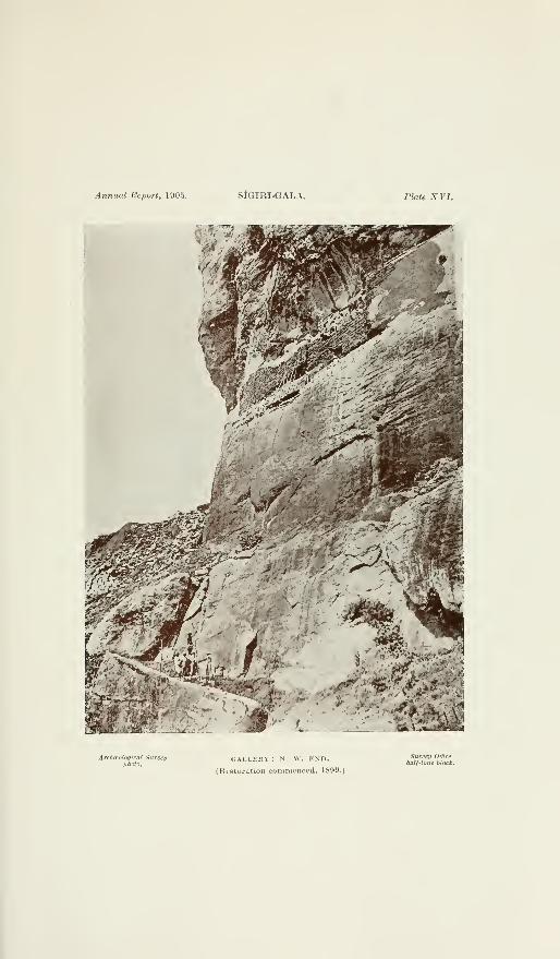
Annual Report, 1905. SlGIRI-GALA. Plate XVI.
>^?:^''
»i _. _. . .
/J?
Archceolofjical Survej/photo.
GALLERY : N. W. END.
(Restoration commenced, 1899.
Survey Office
half-tone block.


Annual Report, 1905. SfGIRI-GALA. Plate XVII.
• -?R'"* :*.-^'--'
Arcfueological SurveypltutQ.
GALLERY : N. W. END.
(Under restoration. 1900.)
Survey Office
hai/-tune block.


Anrmal Report, 1905. SlGIRI-GALA. Plate XVIII.
'TTTT^
>
- <«>-^ >-^'*'^
i
Archceologicai Surveyphoto.
GALLERY : N. W. END AND N. STRETCH.
(Under restoration, 1901.)
Survey Office
halt-tone block.


Anmial Bcport. 1905. SlGlRI-OALA. PIrite XIX.
Archteoloqit-at Surveyphoto.
OALLEKY : N. W. END.
(Inside, restored, 1902.)
Stirvei/ Office
half-tone block.


Annual Report, 1905. SlGIRI-GALA. Plate XX.
ArchecologKai Surveyphoto.
gallery: n. w. end.
(Inside, restored, 1902.)
Survey Office
hall-tone block.


1-1
1^
a-
MI—
(
o1—100
ICo
0^
"Ssss
i^^'
.«*'
< H^^S/r .',
. '' ;£^'
H
S .2
'I c
5 ?>
6i


Annual Report, 1905. SiaiKl-UALA. Pkite XXII.
IW
*1^.
ATchieological Surveyphoto.
GALLEHV: N. STRETCH.
(Vnder i-psturation, 1003.)
Surveif Office
hall-tone Uock.


Annual Report, 1906. StGIRI-GALA Plate XXIIl.
Areh(Bolo(jical Surveyphoto.
GALLERY : N. STRETCH.
(Restored, 1905.)
Sdri'fi/ Office
hall-tone block.


Annual Report, 1905. SlGIRI-GALA. Plate XXIV.
Archceoloqical Survey'photo.
GALLERY : NORTH STRETCH E. END.
(Restored, 1905.)
Survey Office
hail-lone block.


Annual Report, 1905. SIGIRI-GALA. Plate XXV.
frr^*-"
Archmologic(U Surveyphoto.
GALLERY : NORTH STRETCH.
(Restored, 1905.)
Survey Officehalf-tone block.


t1
<<!
OMMo
o
O
s
i
UoHmAnCO
KHBO
3°


Annual Report, 1905. SlGIRl-GALA. Plate XXVI 1.
iiiir^-—
A.Tohaolo<iical Surveyphoto.
FRESCO POCKETS A, B.
(Photographing from mid-air, 1898.)
Survey Office
half-tone block.


I
OI
I—
I
«I—
I
O03
o05
1
' {'
\
§1
m 2
a.
O
it
I


I
<
oIM
P3
oto
o
a.
s
II
O oa; c


an
<
o
s-2
O03
§
g
H


Annual Reporl, 1905. SIGIRI-GALA. Plate XXXI.
Archceological SurveyphOtOi
FRESCO POCKET, A.
(Wired in and bridged, 1905.)
Surveii Ofieehalf-tone block.


Annual Report, 1905. SIGIRI-GALA. Plate XXXII.
ArcJmological Sumei/photo.
FRESCO POCKET, B.
(Wired in and bridged, 1905.)
Siifi'fj/ Office
hal/-tone block.


oI
I—
I
-202
o
o
s
fes
"
ij

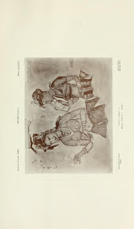
<OMI—
I
O
>(3O
«


XSki
c
<
OM
O
ino
51.(I)
I
H


<
MAI—
I
o
o
»**
eSSs
a "Z-
a


'
^v • T7- V "-^ ' lag
t
^ ^'"^ vl{^'^i&mI^IUWAEA:INNER CITY
PORT or
% A^ Scale. 72 FcpI to «'
'


D3489.1
A261905
Ceylon. Archaeological Dept.Report on the archaeological
survey of Ceylon
PLEASE DO NOT REMOVE
CARDS OR SLIPS FROM THIS POCKET
UNIVERSITY OF TORONTO LIBRARY

Copyright © 2022 FDOKUMEN