
RENCANA PEMBELAJARAN SEMESTER (RPS) MATA KULIAH
144
1 RENCANA PEMBELAJARAN SEMESTER (RPS) MATA KULIAH: IMPLEMENTASI DAN INTEGRASI SISTEM INFORMASI PROGRAM STUDI S1 SISTEM INFORMASI FAKULTAS TEKNOLOGI INFORMASI UNIVERSITAS ANDALAS 2017 2 Mata kuliah : Implementasi Dan Integrasi Sistem Informasi Kode Mata kuliah : TIK301 S K S : 3 SKS Prodi Konsentrasi : Sistem Informasi Semester : 5 Kode Dosen : 196404091995121001 A. Deskripsi Mata kuliah Mata kuliah ini membahas tentang tinjauan umum pengujian, implementasi dan pemeliharaan sistem, pentingnya testing bagi organisasi sistem informasi (SI), siklus hidup testing dan integrasinya di dalam siklus hidup pengembangan SI. B. Capaian Pembelajaran (Kompetensi yang diharapkan) Capaian pembelajaran mata kuliah : 1. Mahasiswa mampu memahami langkah-langkah agar dapat mengorganisir pengembangan SI 2. Mahasiswa mampu memahami dasar, strategi dan teknik pengujian terhadap SI. 3. Mahasiswa mampu memahami langkah-langkah yang dibutuhkan agar sistem baru siap untuk diimplementasikan. 4. Memahami prosedur dan alat untuk pemeliharaan sistem. C. Capaian Pembelajaran dan Materi Pembahasan setiap pertemuan Pertemuan Kemampuan akhir yg diharapkan Materi Pembelajaran (Bahan Kajian) 1, 2 Memahami langkah-langkah agar dapat mengorganisir pengembangan SI Pengembangan SI 3, 4, 5 Memahami dasar, strategi dan teknik pengujian terhadap SI Dasar-dasar, strategi dan teknik pengujian SI 6, 7 Memahami langkah-langkah yang dibutuhkan agar sistem baru siap untuk diimplementasikan Implementasi sistem 8 Evaluasi Tengah Semester 9,10 Memahami langkah-langkah yang dibutuhkan agar sistem baru siap untuk diimplementasikan Implementasi sistem 11 Memahami prosedur dan alat untuk pemeliharaan sistem Pemeliharaan sistem
-
Upload
khangminh22 -
Category
Documents
-
view
1 -
download
0
Transcript of RENCANA PEMBELAJARAN SEMESTER (RPS) MATA KULIAH

1
RENCANA PEMBELAJARAN SEMESTER
(RPS)
MATA KULIAH: IMPLEMENTASI DAN INTEGRASI SISTEM INFORMASI
PROGRAM STUDI S1 SISTEM INFORMASI
FAKULTAS TEKNOLOGI INFORMASI
UNIVERSITAS ANDALAS
2017
2
Mata kuliah : Implementasi Dan Integrasi Sistem Informasi Kode Mata kuliah : TIK301 S K S : 3 SKS Prodi Konsentrasi : Sistem Informasi Semester : 5 Kode Dosen : 196404091995121001 A. Deskripsi Mata kuliah
Mata kuliah ini membahas tentang tinjauan umum pengujian, implementasi dan
pemeliharaan sistem, pentingnya testing bagi organisasi sistem informasi (SI), siklus
hidup testing dan integrasinya di dalam siklus hidup pengembangan SI.
B. Capaian Pembelajaran (Kompetensi yang diharapkan)
Capaian pembelajaran mata kuliah : 1. Mahasiswa mampu memahami langkah-langkah agar dapat mengorganisir
pengembangan SI 2. Mahasiswa mampu memahami dasar, strategi dan teknik pengujian terhadap SI. 3. Mahasiswa mampu memahami langkah-langkah yang dibutuhkan agar sistem
baru siap untuk diimplementasikan. 4. Memahami prosedur dan alat untuk pemeliharaan sistem.
C. Capaian Pembelajaran dan Materi Pembahasan setiap pertemuan
Pertemuan Kemampuan akhir yg diharapkan
Materi Pembelajaran (Bahan Kajian)
1, 2 Memahami langkah-langkah agar dapat mengorganisir pengembangan SI
Pengembangan SI
3, 4, 5
Memahami dasar, strategi dan teknik pengujian terhadap SI
Dasar-dasar, strategi dan teknik pengujian SI
6, 7 Memahami langkah-langkah yang dibutuhkan agar sistem baru siap untuk diimplementasikan
Implementasi sistem
8 Evaluasi Tengah Semester
9,10 Memahami langkah-langkah yang dibutuhkan agar sistem baru siap untuk diimplementasikan
Implementasi sistem
11 Memahami prosedur dan alat untuk pemeliharaan sistem
Pemeliharaan sistem

3
Pertemuan Kemampuan akhir yg diharapkan
Materi Pembelajaran (Bahan Kajian)
12, 13, 14, 15
Mahasiswa mampu memahami langkah-langkah yang dibutuhkan agar sistem baru siap untuk diimplementasikan
Presentasi laporan tugas
16 Evaluasi Akhir Semester
D. Kemampuan Akhir Hard skills dan Softskill melalui Mata Kuliah
Kemampuan Hardskills Kemampuan Softskills:
1. Memahami langkah-langkah dalam mengorganisir pengembangan SI
2. Memahami dasar, strategi dan teknik pengujian terhadap SI.
3. Memahami langkah-langkah yang dibutuhkan agar sistem baru siap untuk diimplementasikan.
4. Memahami prosedur dan alat untuk pemeliharaan sistem.
1. Bekerjasama dalam tim 2. Komunikasi secara efektif
E. Strategi Perkuliahan
Perkuliahan akan diberikan dalam 16 kali pertemuan, termasuk di dalamnya ujian tengah semester (UTS) dan ujian akhir semester (UAS) dalam bentuk Tugas besar. Kegiatan tatap muka diisi dengan diskusi, presentasi dan tugas aplikasi. Kegiatan mandiri diisi dengan penelaahan/pengkajian teori pada buku/literatur yang dianjurkan. Kegiatan mandiri ini wajib dilakukan oleh setiap peserta di luar kegiatan tatap muka. Kegiatan terstruktur diisi dengan tugas-tugas pengayaan dan pendalaman. Kehadiran mahasiswa dalam perkuliahan minimal 75 persen dari jumlah pertemuan yang diselenggarakan.
F. Evaluasi Perkuliahan
Keberhasilan dalam mengikuti mata kuliah ini didasarkan atas penilaian terhadap hasil-hasil pekerjaan mahasiswa/ Tugas besar, yang memenuhi persyaratan kehadiran minimal 75%, ujian tengah semester, dan ujian akhir semester. Skor akhir akan diolah dengan menggunakan Acuan Patokan, dan dikonversi ke dalam nilai A B C D E.
G. Sumber rujukan
4
1. D. Suryadi HS dan Bunawan. Pengantar Implementasi Dan Pemeliharaan Sistem Informasi. Penerbit Gunadarma.
2. Roger S. Pressman. Software Engineering : A practitioner’s Approach. McGraw-Hill.
H. Penanggung Jawab Matakuliah 1. Pengampu mata kulaiah
Prof. Dr. Surya Afnarius

5
REN
CA
NA
PEM
BEL
AJA
RA
N S
EMES
TER
(R
PS)
P
RO
GR
AM
STU
DI :
Sis
tem
Info
rmas
i FA
KU
LTA
S /P
Ps:
Tek
no
logi
Info
rmas
i U
NIV
ERSI
TAS
AN
DA
LAS
MA
TA
KU
LIA
H
KO
DE
Ru
mp
un
MK
B
OB
OT
(sk
s)
SEM
ESTE
R
Tgl P
en
yusu
nan
Imp
lem
en
tasi
Dan
Inte
gras
i Sis
tem
Info
rmas
i TS
I30
1 M
atak
ulia
h In
ti K
eilm
uan
3
5
2
-8-2
01
6
OTO
RIS
ASI
Do
sen
Pe
nge
mb
ang
RP
S K
oo
rdin
ato
r R
um
pu
n M
K
Ka
Pro
gram
Stu
di
Cap
aian
Pe
mb
elaj
aran
(C
P)
Cat
atan
: S
: Sik
ap
P :
Pen
geta
hu
an
KU
: K
ete
ram
pila
n U
mu
m
KK
: K
eter
amp
ilan
Kh
usu
s
CP
Pro
gram
Stu
di
S9
Men
un
jukk
an s
ikap
ber
tan
ggu
ngj
awab
ata
s p
eker
jaan
di b
idan
g ke
ahlia
nn
ya s
ecar
a m
and
iri
P1
Men
guas
ai k
on
sep
teo
riti
s b
idan
g p
enge
tah
uan
Sis
tem
In
form
asi
seca
ra u
mu
m d
an k
on
sep
teo
riti
s b
agia
n k
hu
sus
dal
am b
idan
g p
enge
tah
uan
te
rseb
ut
seca
ra m
end
alam
, se
rta
mam
pu
mem
form
ula
sika
n p
enye
lesa
ian
mas
alah
p
rose
du
ral.
P2
Men
guas
ai k
on
sep
teo
riti
s ya
ng
men
gkaj
i, m
ener
apka
n d
an m
enge
mb
angk
an s
erta
mam
pu
mem
form
ula
sika
n d
an
mam
pu
men
gam
bil
kep
utu
san
yan
g te
pat
dal
am p
enye
lesa
ian
mas
alah
.
KU
2
Mam
pu
men
un
jukk
an k
iner
ja m
and
iri,
ber
mu
tu, d
an t
eru
kur;
KU
10
M
amp
u m
elak
uka
n a
nal
isis
& d
esai
n d
enga
n m
engg
un
akan
kai
dah
rek
ayas
a so
ftw
are
dan
har
dw
are
sert
a al
gori
tma
den
gan
car
a m
engg
un
akan
to
ols
dan
dap
at m
enu
nju
kkan
has
il d
an k
on
dis
i yan
g m
aksi
mal
un
tuk
aplik
asi b
isn
is.
KU
11
M
emili
ki k
emam
pu
an u
ntu
k m
enja
di t
en
aga
pro
fesi
on
al u
ntu
k p
engo
lah
an b
asis
dat
a, r
ekay
asa
SI, j
arin
gan
ko
mp
ute
r,
kom
pu
ter
graf
is,
dan
ap
likas
i m
ult
imed
ia s
erta
mem
iliki
ke
mam
pu
an m
enu
lis l
apo
ran
pen
elit
ian
den
gan
bai
k se
rta
men
gelo
la p
roye
k Si
stem
Info
rmas
i, m
emp
rese
nta
sika
n k
arya
ter
seb
ut.
KK
3 M
amp
u
mem
elih
ara
dan
m
enge
mb
angk
an
sist
em
dat
abas
e (M
sSQ
L/O
racl
e/P
ost
Gre
SQL)
ya
ng
dig
un
akan
o
leh
p
eru
sah
aan
un
tuk
men
yim
pan
, m
enga
nal
isis
, d
an m
enga
mb
il d
ata
sert
a b
erta
ngg
un
g ja
wab
te
rhad
ap k
iner
ja,
inte
grit
as d
an k
eam
anan
dat
abas
e.
CP
Mat
a K
ulia
h
1 M
ahas
isw
a m
amp
u m
emah
ami l
angk
ah-l
angk
ah a
gar
dap
at m
engo
rgan
isir
pen
gem
ban
gan
SI.
(S9
, P1
,P2
, KU
10
, K
U11
)
2 M
ahas
isw
a m
amp
u m
emah
ami d
asar
, str
ateg
i dan
tek
nik
pen
gujia
n t
erh
adap
SI.
(S9
, P1
, P2
, KU
2,K
U1
0, K
U1
1, K
K3
)
6
3 M
ahas
isw
a m
amp
u m
emah
ami l
angk
ah-l
angk
ah y
ang
dib
utu
hka
n a
gar
sist
em b
aru
sia
p u
ntu
k d
iimp
lem
enta
sika
n.
(S9
, KU
2,K
U1
0, K
U1
1, K
K3
)
4 M
emah
ami p
rose
du
r d
an a
lat
un
tuk
pem
elih
araa
n s
iste
m. (
S9, K
U2
,KU
10
, KU
11
, KK
3)
5 M
ahas
isw
a m
emili
ki k
emam
pu
an s
oft
skill
dal
am p
emb
elaj
aran
ber
up
a:
- M
amp
u b
erko
mu
nik
asi l
isan
den
gan
bai
k -
Mam
pu
bek
erja
sam
a d
alam
kel
om
po
k -
Mam
pu
men
gelo
la /
lead
ersh
ip d
alam
kel
om
po
k.
De
skri
psi
Sin
gkat
M
ata
Ku
liah
M
ata
kulia
h in
i mem
bah
as t
en
tan
g ti
nja
uan
um
um
pen
gujia
n, i
mp
lem
enta
si d
an p
emel
ihar
aan
sis
tem
, hu
bu
nga
n a
nta
ra
test
ing
den
gan
ku
alit
as s
oft
war
e, d
an p
enti
ngn
ya t
est
ing
bag
i org
anis
asi s
iste
m in
form
asi (
SI),
sik
lus
hid
up
tes
tin
g d
an
inte
gras
inya
di d
alam
sik
lus
hid
up
pen
gem
ban
gan
SI.
Mat
eri
Pe
mb
elaj
aran
/ P
oko
k B
ahas
an
Mat
eri A
jar
: P
enge
mb
anga
n S
I D
asar
, str
ateg
i dan
tek
nik
pen
gujia
n S
I Im
ple
men
tasi
sis
tem
P
emel
ihar
aan
sis
tem
Pu
stak
a U
tam
a :
1.
D. S
ury
adi H
S d
an B
un
awan
. Pen
ga
nta
r Im
ple
men
tasi
Da
n P
emel
iha
raa
n S
iste
m In
form
asi
. Pen
erb
it G
un
adar
ma.
2
. R
oge
r S.
Pre
ssm
an. S
oft
wa
re E
ng
inee
rin
g :
A p
ract
itio
ner’
s A
pp
roa
ch. M
cGra
w-H
ill.
Pe
nd
uku
ng
:
-
Med
ia P
em
bel
ajar
an
Pe
ran
gkat
Lu
nak
: P
era
ngk
at k
eras
:
- In
focu
s
Team
Tea
chin
g 1
. Pro
f. S
ury
a A
fnar
ius,
Ph
D
Ass
essm
en
t
Mat
aku
liah
Sya
rat
-

7
Mg
Ke-
K
emam
pu
an a
khir
yg
dih
arap
kan
Bah
an K
ajia
n
(Mat
eri
Aja
r)
Dan
Re
fere
nsi
Met
od
e P
emb
elaj
aran
dan
A
loka
si W
aktu
P
enga
lam
an
Bel
ajar
M
ahas
isw
a
Kre
teri
a (I
nd
ikat
or)
P
enila
ian
B
ob
ot
Pen
ilan
(%
)
(1)
(2)
(3)
(4)
(5)
(6)
(7)
1, 2
Mem
aham
i lan
gkah
-la
ngk
ah a
gar
dap
at
men
gorg
anis
ir
pen
gem
ban
gan
SI (
S9,
P1
,P2
, KU
10, K
U11
)
Pen
gem
ban
gan
SI
K
ulia
h d
an d
isku
si,
(TM
;2x(
3x5
0”)
Mah
asis
wa
mem
ben
tuk
kelo
mp
ok
dan
men
cari
info
rmas
i d
ari b
erb
agai
su
mb
er
(ter
uta
ma
Inte
rnet
).
3, 4
, 5
Mem
aham
i das
ar,
stra
tegi
dan
te
knik
p
engu
jian
ter
had
ap S
I (P
1,P
2, S
9, K
U2
,KU
10,
KU
11
, KK
3)
Das
ar, s
trat
egi d
an t
ekn
ik
pen
gujia
n S
I K
ulia
h d
an d
isku
si,
(TM
;3x(
3x5
0”)
Mah
asis
wa
mem
ben
tuk
kelo
mp
ok
dan
men
cari
info
rmas
i d
ari b
erb
agai
su
mb
er
(ter
uta
ma
Inte
rnet
).
6,7
M
ahas
isw
a m
amp
u
mem
aham
i lan
gkah
-la
ngk
ah y
ang
dib
utu
hka
n a
gar
sist
em
bar
u s
iap
un
tuk
diim
ple
men
tasi
kan
(S9
, K
U2
,KU
10
, KU
11
, KK
3)
Imp
lem
enta
si s
iste
m
Ku
liah
dan
dis
kusi
, (T
M;2
x(3
x50
”)
Mah
asis
wa
mem
ben
tuk
kelo
mp
ok
dan
men
cari
in
form
asi d
ari b
erb
agai
su
mb
er (
teru
tam
a In
tern
et).
8 U
TS
P
erke
mb
anga
n t
uga
s b
esar
2
0
9,1
0
Mah
asis
wa
mam
pu
m
emah
ami l
angk
ah-
lan
gkah
yan
g d
ibu
tuh
kan
aga
r si
stem
b
aru
sia
p u
ntu
k d
iimp
lem
enta
sika
n (
S9,
KU
2,K
U1
0, K
U1
1, K
K3
)
Imp
lem
enta
si s
iste
m
Ku
liah
dan
dis
kusi
, (T
M;2
x(3
x50
”)
Mah
asis
wa
mem
ben
tuk
kelo
mp
ok
dan
men
cari
in
form
asi d
ari b
erb
agai
su
mb
er (
teru
tam
a In
tern
et).
11
Mem
aham
i pro
sed
ur
dan
ala
t u
ntu
k p
emel
ihar
aan
sis
tem
Pem
elih
araa
n s
iste
m
Ku
liah
dan
dis
kusi
, (T
M;1
x(3
x50
”)
Mah
asis
wa
mem
ben
tuk
kelo
mp
ok
dan
men
cari
in
form
asi d
ari b
erb
agai
8
Mg
Ke-
K
emam
pu
an a
khir
yg
dih
arap
kan
Bah
an K
ajia
n
(Mat
eri
Aja
r)
Dan
Re
fere
nsi
Met
od
e P
emb
elaj
aran
dan
A
loka
si W
aktu
P
enga
lam
an
Bel
ajar
M
ahas
isw
a
Kre
teri
a (I
nd
ikat
or)
P
enila
ian
B
ob
ot
Pen
ilan
(%
) (S
9, K
U2
,KU
10
, KU
11
, K
K3
) su
mb
er (
teru
tam
a In
tern
et).
12
, 13
, 1
4, 1
5
Mah
asis
wa
mam
pu
m
emah
ami l
angk
ah-
lan
gkah
yan
g d
ibu
tuh
kan
aga
r si
stem
b
aru
sia
p u
ntu
k d
iimp
lem
enta
sika
n (
S9,
KU
2,K
U1
0, K
U1
1, K
K3
)
Lap
ora
n t
uga
s Im
ple
men
tasi
SI
P
rese
nta
si la
po
ran
(T
M;4
x(3
x50
”)
Pre
sen
tasi
16
UA
S
Tuga
s b
esar
8
0

1
PROGRAM STUDI : Sistem Informasi FAKULTAS /PPs: Teknologi Informasi UNIVERSITAS ANDALAS
RENCANA TUGAS MAHASISWA
MATA KULIAH Implementasi Dan Integrasi Sistem Informasi
KODE TSI301 sks 3 SEMESTER 5
DOSEN PENGAMPU
Prof. Surya Afnarius, PhD
BENTUK TUGAS
Final Project
JUDUL TUGAS
Tugas: Final Project: Mengimplementasikan SI dan mempresentasikan.
SUB CAPAIAN PEMBELAJARAN MATA KULIAH
- Mahasiswa mampu memahami langkah-langkah yang dibutuhkan agar sistem baru siap untuk diimplementasikan
DISKRIPSI TUGAS Mengimplementasikan satu SI METODE PENGERJAAN TUGAS
1. Memilih satu SI; 2. Mempelajari cara kerja SI; 3. Membangun database SI; 4. Menghasilkan luaran SI; 5. Menyusun laporan; 6. Menyusun bahan & slide presentasi laporan; 7. Presentasi laporan di klas.
BENTUK DAN FORMAT LUARAN
a. Obyek Garapan: satu SI b. Bentuk Luaran:
1. Laporan ditulis dengan MS Word dengan sistematika dan format sesuai dengan standar panduan penulisan, dikumpulkan dengan format ekstensi (*.rtf), dengan sistimatika nama file: (Tugas-laporan-no nrpmhs-nama depan mhs.rtf);
2. Slide Presentasi PowerPoint, terdiri dari : Text, grafik, tabel, gambar, animasi ataupun video clips, minimum 10 slide. Dikumpulkan dlm bentuk softcopyformat ekstensi (*.ppt), dengan sistimatikan nama file: (Tugas-Slide-no nrpmhs-nama depan mhs.ppt);
INDIKATOR, KRETERIA DAN BOBOT PENILAIAN
a. Laporan (50%) Kesesuaian data di dalam database dengan luaran yang dihasilkan.
b. Penyusunan Slide Presentasi (bobot 20%) Jelas dan konsisten, Sedehana & inovative, menampilkan gambar & blok sistem, tulisan menggunakan font yang mudah dibaca, jika diperlukan didukung dengan gambar dan vedio clip yang relevant.
c. Presentasi (bobot 30%) Bahasa komunikatif, penguasaan materi, penguasaan audiensi, pengendalian waktu (15 menit presentasi + 5 menit diskusi), kejelasan & ketajaman paparan, penguasaan media presentasi.
JADWAL PELAKSANAAN
Implementasi SI Menyusun laporan
Minggu I s/d Minggu 11 Minggu 12 s/d Minggu 13
2
Presentasi laporan Pengumuman nilai
Minggu 14 s/d 15 Dua minggu setelah UAS
LAIN-LAIN
Bobot penilaian tugas ini adalah 100% penilaian mata kuliah ini; Tugas dikerjakan dan dipresentasikan secara kelompok;
DAFTAR RUJUKAN
- D. Suryadi HS dan Bunawan. Pengantar Implementasi Dan Pemeliharaan Sistem Informasi. Penerbit Gunadarma.

Minggu 1 dan 2
Pengembangan Sistem
Bahan yang perlu dibaca sebagai persiapan diskusi dapat dilihat pada situs ini:
http://elearning.gunadarma.ac.id/docmodul/peng_implementasi_pmliharaan_si/bab1-
pengembangan_perangkat_lunak.pdf

The Urban and Regional Information Systems Association1460 Renaissance Drive, Suite 305Park Ridge, IL 60068
QUICK GUIDE TO GISIMPLEMENTATIONAND MANAGEMENT
By Rebecca Somers
Somers St.ClaireGIS Management Consultants3157 Babashaw Ct.Fairfax, VA [email protected]
Copyright ©2001 by the Urban and Regional Information Systems Association (URISA),1460 Renaissance Drive,Suite 305, Park Ridge, IL 60068, (847) 824-6300, www.urisa.org.
All rights reserved including the rights of reproduction and use in any form or by any means, including the making ofcopies by any photo process or by any electronic or mechanical device (printed, written, or oral), or recording forsound or visual reproduction, or for use in any knowledge or retrieval system or device, unless permission in writing isobtained from the copyright proprietor.Printed in the United StatesISBN #: 0-916848-33-7
This Quick Study is one of URISA’s series on GIS implementation. Complementary titles include JumpstartingGIS: How Local Governments Can Get Started In GIS With Limited Resources and GIS Procurement and RFPDevelopment.

GIS Implementation and Management 3
TABLE OF CONTENTS
INTRODUCTION 5Types of GISs 5Organizational Approaches to GIS Implementation and Management 6Perspective of This Quick Study 6
GIS IMPLEMENTATION 7Overview of the GIS Implementation Process 7Planning a GIS 7Analyzing Requirements 9Designing the GIS 11Building the GIS 13Operating the GIS 15
GIS MANAGEMENT 17Managing the GIS Implementation Process 17Developing an Implementation Plan 18Cost/Benefit Analysis and Budgeting 18Managing GIS Operations 19Developing Policies and Procedures 20Organizing and Leading GIS Participants 22Staffing 25Training and Education 27Other Management Issues 28
SUMMARY 29
REFERENCES 31
ABOUT THE AUTHOR 33

GIS Implementation and Management 5
Geographic information system (GIS) implementationand management can be a complex subject. It requiressubstanial background and skills, not only in GIS but inInformation Techology (IT), management, and projectmanagement. One of the hardest aspects is putting allthe pieces together—identifying, organizing, planning,and managing all the components of GISimplementation and management. For a GIS effort tobe successful, all of these components must be carefullycoordinated and integrated.
This Quick Study provides an overview of GISimplementation and management. It discusses thesteps and activities involved in implementing a GISproject or program, as well management approachesand issues related to various aspects of GIS. This is ageneralized, introductory-level guide that is intendedto provide a framework for approaching GISimplementation and management. It references othersources that provide more in-depth discussion ofparticular topics.
Types of GISsA GIS comprises system components, data, people,and procedures. All of these must be considered
INTRODUCTION
equally and together when implementing andmanaging a GIS.
GISs can be classified as projects and programs,ranging from small efforts to large complexundertakings. A project is a one-time effort,developing a GIS that will serve a specific short-termproject. Examples of such projects might include theperformance of an environmental analysis, thedevelopment of a long-range land use plan, or thedesign of a park. Most GISs, however, don’t usuallydisappear when the designated project is over. TheGIS developed to plan and construct a facility suchas a park or a community could then become a long-term management tool for that facility. Ongoing GISsare often termed programs. Although they may startout as projects, the goal of these programs is todevelop a lasting facility that will aide theorganization’s work. A GIS project or program maybe small and simple, involving limited software, data,and users; it may be large and complex, involvingmyriad data sets, applications, and users and complexsystems and databases; or it could fall anywhere inbetween (Somers 2002).
6 GIS Implementation and Management
Organizational Approaches to GISImplementation and ManagementDifferent types of organizations implement GISsdifferently. Although each organization’s GIS isunique, their implementation approaches and GIScharacteristics can be characterized by organizationtype.
Most local government GISs are multipurpose,comprehensive, enterprise-wide systems. They aredesigned to serve most of the organization’s spatialdata handling needs, integrate its spatial data, andmake the data accessible to all users and departments.The data are usually large scale, based on high-accuracy parcel information, although localgovernments also use some smaller-scale, generalizeddata (FGDC 1997). Most local governments use acoordinated GIS implementation approach thatminimizes redundancy and incompatibilities in dataand systems. Leveraging GIS efforts and assets isimportant to local governments because thesesystems can be very expensive.
The approaches that utilities, private sector firms, andother organizations take in developing and runningtheir GISs have some similarities with localgovernment approaches, but also some differences.Utilities, like local governments, developcomprehensive spatial data systems and integratethem with other data and systems, such as facilitiesmanagement, work order management, customerinformation, and facilities modeling. Also like localgovernments, much of utilities’ critical informationis high-accuracy, high-resolution data, although theyalso user smaller scale data over large areas.
Private-sector organizations, on the other hand, oftentake less comprehensive approaches to GIS
development. For example, the GIS resourcesdeveloped in professional services firms are usuallyintended to serve specific projects or clients. The dataand applications developed for each project may haveno relation to those developed for other projects, soproject GISs are implemented independently,focusing only on each project’s needs. Theindependent development of specific GISs within anorganization is a business-tools approach. Thisapproach is also used by other types of companiesthat develop limited GISs to serve such functionalareas as marketing, customer service, and facilitiesplanning. These GISs may cover the same geographicareas, but the costs of developing them are usually low,business units are independent, and the costs ofcoordination may outweigh the savings achieved bycoordination efforts. Still other organizations take aservice-resource approach to GIS development. Inthis model, GIS support services, and perhaps dataresources, are developed and made available to theoperating units. This approach benefits the operatingunits and the company as a whole, but does notinvolve the extensive coordination, comprehensiveplanning, and enforced standards that the enterpriseapproach does (Somers 1998, 2002).
Perspective of This Quick StudyTo simplify and integrate discussion, as well as toensure that the material is most relevant to thosedeveloping GISs in urban and regional settings, thisQuick Study approaches the topic mostly from theperspective of developing and managing a typicallocal government GIS. However, the discussion is justas pertinent to other types of organizations followingthe other GIS organization models.

GIS Implementation and Management 7
The first aspect of understanding and successfullyaccomplishing GIS implementation and managementis to fully understand the GIS implementationprocess.
Overview of the GISImplementation ProcessAlthough organizations differ in the types of GISsthey build, most follow the same basic GISimplementation process. It is a structured process thatensures that the GIS will meet users’ needs. Thisdiscussion focuses on the implementation stepsthemselves and the technical components they yeild,but there also are management aspects to eachactivity.
The process involves five basic phases:
� planning—defining the scope of the GIS anddeveloping a general plan;
� analysis—determining users’ specific GISrequirements;
� design—integrating all requirements anddeveloping GIS specifications;
� acquisition and development—acquiringsoftware, hardware, and data, and putting them
GIS IMPLEMENTATION
together in a system tailored to theorganization; and
� operations and maintenance—using the GIS andmaintaining the system.
The process is illustrated in Figure 1. It includesfeedback loops from each step indicating thatinformation gained in one task may require re-examining a previous task. For example, analysis ofusers’ data needs in step two may necessitate goingback to the planning step and re-examining goals orincreasing the budget to accommodate the neededdata. (Somers 1996, 2002).
Figure 1: The GIS Implementation Process
(Somers 1993–2001)
8 GIS Implementation and Management
The following discussion provides an overview ofthese tasks from the viewpoint of a GIS program ofmoderate to high complexity, to ensure that all pointscan be covered. The tasks discussed are crucial for GISprograms of this type. The same tasks andconsiderations also apply to simpler and smaller GISprojects and programs, but can be more easilyaccomplished for those types of efforts.
Planning a GISPlanning is the first step in developing any GIS.Thorough planning lays a solid foundation for all thesubsequent steps of GIS implementation and helpsan organization avoid costly mistakes. Whatever thesize or type of the GIS, it is necessary to address somebasic aspects before moving ahead with detailedtechnical work.
Define the scope and nature of the GIS. Determinethe long-term purpose and role of the GIS.
� Will it be a one-time project or an ongoingprogram?
� Will it be used for all the organization’s spatialdata handling or for only a specific subset offunctions, such as mapping?
� Will most people in the organization use it or willusers be limited in number or job function?
� Will this GIS activity be part of a larger GIS effort?� Will spatial data and technology be integrated
with the organization’s other data and systems?� Will GIS change the way the organization does
business or will its impacts be limited?
These questions help establish the scope and characterof the GIS—whether it will be a simple work toollimited to specific tasks, an enterprise-wideframework that organizes and integrates spatial dataand changes the way the organization operates, oranywhere in between. The scope of the GIS guides allof the remaining planning tasks and implementationtasks (Somers 1996, 2002).
Identify the required participants and resources.The scope of the GIS determines the resources andthat will be required to define and implement it.Consider several perspectives.
� Users and stakeholders. Ensure that the end-usersand beneficiaries are adequately involved. Forexample, if the GIS will be an enterprise-widesystem serving many different types of uses andapplications in many departments, thenrepresentatives from those areas must be involvedin the GIS definition, design, andimplementation. They represent the end-userperspectives and their involvement will ensurethat all users’ requirements are met.
� Management and policy makers. Large enterpriseGISs often require the involvement of topmanagement and policy makers to ensure that theGIS fulfills their organizational vision, as well asto ensure that it has their support.
� Required skills. What skills will be needed to carryout GIS implementation? The scope and natureof the GIS effort will determine the expertiserequired to design and implement it. Requiredskills might be added through education andtraining, including specific people on the team,or obtaining outside assistance. It is important torecognize which activities and skills can bedeveloped or obtained in-house and which onesrequire outside assistance. Consultants can helpwith complex tasks requiring specific GISknowledge and experience, such as GIS strategicplanning, requirements analysis, system anddatabase design, procurement assistance, andimplementation planning. Contractors can alsoperform major system building tasks such assystems integration, application development,and data development. Crucial tasks that must behandled by organizational staff, however, includeproject management, leadership, and activeparticipation in analysis, design, andimplementation.

GIS Implementation and Management 9
� Project management and leadership. For GIS efforts ofeven modest size, it is usually necessary to form ateam and assign a leader. Even if things appearsimple at this stage, they will get much more complexin the course of developing the GIS and a projectmanager will be necessary (Somers 2002).
Arrange for appropriate GIS education andbackground information. To work effectively, mostGIS implementors and participants require someGIS education. Providing organized GIS educationin the planning phase is especially important forlarge projects with many diverse participants. Eachparticipant must attain an appropriate level of GISknowledge to participate effectively in the planningand analysis activities. This may involve taking shortcourses, attending GIS conferences or trade shows,reading, or attending in-house educational events.In any case, education should be tailored toindividuals in terms of their backgrounds, how theywill use the GIS, and how they will participate in theGIS development process (Somers 1993—2001,2002).
Develop resource and benefit estimates. The scopeof the GIS determines initial estimates. The nature ofthe uses, the data, and the system provide indicatorsof costs. General estimates can be developed basedon these factors: whether there will be a few users orhundreds of users; whether the largest portion willbe using professional GIS, desktop, or Web-basedsystems; whether there will be a handful of data setsor hundreds; and whether the data will be large- orsmall-scale. These factors will provide indications ofgeneral cost levels—whether the GIS will costhundreds, thousands, or millions of dollars. Likewise,the scope and nature of the GIS provide generalindicators of benefits levels. Moderate benefits will begained from map creation; larger benefits can begained from data and map update; and the highestlevels of benefits can be realized from data access,manipulation, and analysis. Together, these estimatescan provide a broad picture of the money, time, and
effort required to implement the GIS and the benefitsthe system will provide. (Somers 1993—2001, 2002).
Conduct Strategic Planning. Planning a largecomplex GIS may take months. For these types ofprojects a formal GIS strategic planning approach isrequired. Planning a smaller, simpler effort may takeonly a few days and may be done through an informal,yet still analytical method. In any case, however,questions concerning the scope of the GIS, theparticipants and their roles and skills, and resourcerequirements must be addressed before moving on(Somers 1996, 2002). GIS strategic planning isdescribed in Somers (1999b).
Analyzing RequirementsAlthough people usually have general ideas of what theyneed from a GIS, specific requirements analysis is neededto provide the necessary detailed information forsuccessful GIS implementation. In this task, the futureuses of GIS and the current spatial data handlingsituation are examined in analytical detail. The goal isto identify the functional and data needs of the GISparticipants and users, as well as the organizationalenvironment.
Analysis process. Identify all the work processes thatinvolve spatial data and will use GIS. The GIS scopedefined in the planning task guides the identificationof these processes and users. In large organizationswhere GIS will be widely used , this can be a complextask, and it is common to miss future GIS users—theymay be using non-graphic forms of spatial data todayand not be apparent future GIS users. It is importantto identify as many of the future users of the GIS aspossible, even if they may not come online for a longtime. Analyzing their future needs and building thoseconsiderations into the GIS design andimplementation will ensure that the system can beexpanded to accommodate them when the timecomes.
10 GIS Implementation and Management
A business process analysis approach is very usefulin analyzing GIS requirements. This approachexamines each current and planned work process andidentifies the steps and the data involved. It focuseson the goal, input, output, and steps of the processand the data used to perform it. Tasks and decisionsperformed by individuals and work units are mappedout. Specific data, sources, characteristics, and flowsand links to other work processes and systems areidentified. In the course of the analysis, desiredchanges are also noted, based on the incorporationof GIS into the process and any other changes theorganization may be planning. The goal is to definefuture GIS-based work processes. This businessprocess analysis method provides all the componentsthat describe each user’s GIS needs. Another benefitof this approach is that it prevents the meretransposition of current manual operations intoGIS—thereby helping users and organizations makethe best use of the power of GIS technology.
The organizational environment must also beconsidered. It presents conditions, constraints, andopportunities that affect GIS requirements andbusiness process analysis. For example, theorganization may have standards that must befollowed, regulatory requirements to meet, or policiesthat affect the way it does business and the way GISmust fit that business, and these conditions must befactored in. They may affect individual work processesas well as the overall requirements for the GIS (Somers1993—2001, 2002).
Performing the analysis. The requirements analysisis accomplished through user interviews and worksessions. If the planned GIS is small this task may berelatively simple, but it should still be approachedusing analytical methods that will produce therequired information. The implementor must take aclose look at how he or she intends to work andbeware of assumptions about data and software. Heor she must also be sure to identify the individualwork processes and planned uses of the GIS. They
may involve different data and functionalityrequirements.
Usually, a planned GIS involves many usersperforming many different work processes in differentparts of the organization. They have differentviewpoints, different missions and activities, anddifferent needs for spatial data and processing tools.The GIS implementor or analyst must work with eachindividual user or group to perform the businessprocess analysis. The analyst needs skill andexperience in business process analysis to do thiseffectively. Users’ GIS education, provided in theplanning task, also is important. They need tounderstand the basic tools that GIS can provide inorder to effectively collaborate with the analyst todesign their future GIS work process and to ensurethat all their requirements are addressed (Somers1993—2001, 2002).
Analysis results. The requirements analysis resultsin a clear, documented specification of users’ detailedGIS needs as well as organizational support factors.There are several major products.
� A description and diagram of each future GISwork process and its functional and data needs.Many of these future work processes will becomeapplications.
� Any constraints, opportunities, or problemsassociated with individual work processes, usergroups, or the organization a whole.
� The expected benefits and costs of the GIS.Benefits, such as decreases in work time or stafflevels and increases in levels of service areidentified in the course of analyzing each workprocess and the improvements that GIS will bringto it. Cost estimates are improved throughanalysis of the work processes that providesinformation about required GIS data andfunctionality requirements, and the number ofpeople who will use various GIS components.

GIS Implementation and Management 11
Some of this information will contribute to thetechnical implementation of the GIS; some will beused in the project and GIS managementcomponents. All of these products are necessary tobuild an effective GIS, but they are just pieces—theyare not sufficient to proceed with GISimplementation. They must be put together in thenext step (Somers 1993—2001, 2002).
Designing the GISThe design task involves putting the componentstogether: determining the characteristics andcombination of software, hardware, data, processes,and people that will meet the organization’s GIS needs.The challenge is to combine the organization’s overallgoals for GIS and the specific needs of the diverseusers and applications, while developing an integratedand effective design. Developing this design is acrucial step prior to obtaining and implementing anyGIS components.
Database design. Data are the most importantcompoment of a GIS and should be given primaryconsideration. Case studies and industry experienceindicate that organizations generally spend the largestportion—as much as 80%—of their GIS budgets ondata. Accordingly, the largest portion of effort andconsideration should be spent on the GIS data—rather than the disproportional attention most peopledevote to technology. A GIS is, after all, a tool to useand maintain spatial data, so system design shouldfocus on the data needed to do the organization’s workand how they are to be handled.
Detailed discussions of GIS databases and theirdesign can be found in various sources includinguniversity, professional certificate, and professionalassociation courses, as well as publications such asBossler (2002) and Walls (1999). At this point in theGIS development process, each organization mustdefine its own GIS database. The individual datarequirements of users and work processes are
combined into an integrated design. The goal isusually to develop one version of a shared databasethat meets all users’ needs with minimum redundancyand maximum usefulness and accessibility. Thedesign addresses several aspects of the data.
� Data characteristics are defined to suit thecombined users’ requirements. Each data entityis described in terms of data type, format,accuracy or resolution, attributes, amount, source,and maintenance responsibility and standards.
� Data relationships are identified and describedthrough a data model.
� Data access and handling requirements aredescribed, ensuring that each user andapplication will have access to needed data inrequired form.
� Data security needs are identified.� Temporal aspects are identified to support
applications and data management functionssuch as time series analysis, planning senarios,backup, archive, and retrieval.
� Metadata are identified at the appropriate leveland in terms of how they will be used.
� The landbase or basemap is defined, based onusers’ needs. Content, accuracy, and maintenanceprocedures for this data set will affect mostapplications and users. This data set usuallyinvolves some of the largest creation or conversioncosts, but also may provide opportunities for directpurchase and/or sharing.
For a large organization developing an enterprise GIS,the database design can be a very complex process,but it is necessary to fully support future applicationsand system growth and integration. Although it ispossible to load data into a GIS without a completedata model, its future usefulness will be limited(Somers 2002).
12 GIS Implementation and Management
Software and applications. The required functionsof the GIS software and applications are derived fromthe users’ operational needs and the database supportrequirements. GIS software is discussed in a numberof sources, including Bossler (2002) and Clarke(2000). As with the database design, the design stepis the point at which an organization identifies itsspecific software needs to support its specificapplications and environment. This is not yet thepoint to select software, but to develop acomprehensive description of what will be needed interms of functionality. There are several importantaspects to consider:
� Applications support. What functions will theapplications perform and what basic GIS softwaretools will be needed to support applicationsdevelopment?
� Data support. What functions and features areneeded to support the database design increation, operation, use, and maintenanceactivities?
� Data access. What types of data access tools willbe needed by users?
� Data integration. What are the data and systemsintegration requirements?
� Performance. What are the performancerequirements for applications and for otheraspects of system operation?
Large organizations implementing enterprise GISsusually try to minimize the number of different GISsoftware packages that they use. Software compatibilityamong users is important not just for data sharing, butalso for system support. Therefore, these organizationsseek to develop a comprehensive set of systemspecifications that will help them choose a suite ofproducts that will meet all users’ needs. Someonedeveloping a GIS solely for their own use has morelatitude in choosing whichever software package mostclosely matches their specific needs, but they may wantto consider outside compatibility and standards for thepurposes of future data sharing (Somers 2002).
Overall system design and integration. Theorganization’s needs for data and systems interfacesand integration are derived in the planning andrequirements analysis tasks. At this point, those needsmust be examined and defined in terms of the systemdesign—specifically which data or aspects of the GISmust interface or integrate with other data andsystems. A small GIS may be a viable stand-alonesystem for a specific user or project. Largerorganizations, such as local governments, usuallymust integrate their GISs with systems and databasesthat support functions such as permitting, emergencyresponse, and asset inventory and management(Somers 2002).
Management components. The GIS design shouldinclude not only the technical components of thesystem but also the management components that willsupport them. Standards and procedures for databasedevelopment, data maintenance, data management,system support and management, user support, andproject management and coordination must bedeveloped, based on the characteristics of the GISdesign and the environment and users that are to besupported. It is necessary to develop the managementdesign at this stage because it affects other aspects ofdesign as they affect it. For example, if a certain dataset is unsupportable as initially designed, it must beredesigned now. Another reason that the managementcomponents must be designed now is that some ofthe components will soon be needed in theimplementation process (Somers 2002).
Design results. The design activity results in severalimportant products:
� database design, including data descriptions, datamodel, and metadata specifications;
� applications descriptions;� correlations among data, application, and users;� general architecture for the GIS system and its
integration with other systems and databases;� management and organization components (see
next section for discussion);

GIS Implementation and Management 13
� cost/benefit analysis and budget (see next sectionfor discussion); and
� an implementation plan (see next section fordiscussion).
All of these components work together so they mustbe developed and completed together. If emphasis isgiven to some aspects while others are neglected, theGIS components can get out of sync, leading to laterproblems (Somers 2002). Detailed discussions of theGIS design process can be found in DeMers (2000)and Marble (1994).
Building the GISThe process of acquiring and developing GIScomponents and building them into the needed GISshould be a straightforward, albeit complex, processthat flows directly from the requirements analysis anddesign. To many, the task of GIS procurement—understanding and choosing among the manyalternatives—is daunting. However, if the work donein the requirements analysis and design tasks isthorough, then selecting, procuring, and developingGIS components should not be difficult. It may stillbe complex and time- and resource-consuming, butthe decisions and tasks should be results of followingthe specifications and plans developed in the designphase. It is a matter of transforming the GISrequirements into product and task specifications andevaluating available components and methodsaccording to criteria developed during therequirements analysis. The main GIS components tobe acquired usually are GIS software and hardware,applications, data, and systems integration. A varietyof system and data development activities may alsobe required to complete the GIS components,including applications and other softwaredevelopment, database design, and system installationand integration (Somers 1993—2001, 2002).
GIS systems and applications. GIS software is often
what people focus on in GIS acquisition, but the othercomponents are equally important and must beintegrated. GIS software packages provide the basictools for input, editing, storage, maintenance,management, access and retrieval, manipulation,analysis, display and output of spatial data. (Thesetools and packages and their capabilities are describedin a number of sources, including Bossler (2002) andClarke (2000).) These packages alone may satisfysome users’ needs, and most applications will be builtwith these tools. So the challenge is to select the GISpackage or software suite that best meets theorganization’s needs. A detailed specification is crucialin doing this. It provides the standard against whichall alternatives will be evaluated. GIS hardware needsare usually determined by the software capabilitiesand data that must be supported, as well as theorganization’s other systems environmentconsiderations. GIS system components are usuallybought off-the-shelf, if possible. Some applicationspackages are also available; others must be developedto specification. Organizations then further tailor andintegrate these components as needed (Somers1993—2001, 2002).
Data. Database implementation also presents manyoptions. Depending on the type of data needed, thedata sources available, and the costs associated withdifferent sources and methods, an organization maychoose to buy, license, collect, or convert the neededspatial data. And within each of these different sourceand method categories there are many choices. Aswith software selection, the challenge is to find themost cost-effective alternative that meets theorganization’s needs, and the way to do this is to havea detailed data specification against which to comparealternatives. If the organization is developing orconverting the data itself, then the detailedspecification provides the guidelines for performingthose tasks.
For many organizations—particularly local
14 GIS Implementation and Management
governments—database development will be thebiggest part of their GIS effort. So to ensure cost-effective and timely data development, manyorganizations contract out the creation andconversion of their data. Local governments, forexample, often contract out their basemap(planimetric, topographic, geodetic control, anddigital orthophoto) creation and parcel dataconversion. Other types of organizations may acquireGIS as a tool to handle the data they create or obtainin the course of their operations and may have littleor no basemap development needs. Still otherorganizations buy or license much of their data(Somers 1996). Many different books and papersdiscuss different types of GIS data development. GISimplementors must identify the methods that suittheir particular GIS data and adapt basic spatial datainput processes to their own specifications.
Whatever the method or source for data development,quality assurance must be given the highest attention.Quality control requirements should be built into therequest for proposal (RFP) or data developmentspecifications; the vendor or production group mustrespond to them, assuring the quality of the datathroughout the creation process; and the user mustverify data quality upon delivery and maintain itthereafter. Data quality and other qualificationsshould also be documented in the metadata (Somers1993—2001, 2002).
Systems integration. Organizations today—particularly local governments—need theirsystems and data to work together in an enterprisemode to handle their day-to-day needs efficiently,as well as to respond quickly to new needs andemergencies. Although many GISs still exist asstand-alone systems, the increased activity in datatransfers and systems interfaces, and the increasingdemand that this occur immediately andtransparently, makes this integration need clear.The overall GIS design will indicate the needs forsystem integration, and it is usually most efficientto handle systems integration concurrent with GIS
system components and data development.Although systems can be integrated later,backtracking and extra work and expenditures arelikely to be encountered in that approach.Therefore, systems integration is increasingly acommon part of GIS acquisition and development.
Procuring GIS products and services. Dependingon the organization and the GIS, any of a variety ofmethods may be employed for the acquisition ofsystem components. Many public sectororganizations must follow formal RFP procedures.The GIS design and plan components comprise thetechnical specifications while the organization maysupply required “boilerplate” content and procedures.Other organizations may be free to acquire productsand services through less formal means. In either case,however, GIS product and service specificationsshould be thoroughly documented and thealternatives should be evaluated against thosespecifications. A large, formal selection processusually involves evaluating written responses to theRFP specifications, and then meeting with short-listed vendors to conduct a more detailed evaluation.Evaluation criteria include not only the vendor’sresponse to the specifications and requirements, butalso their demonstrated ability to meet theorganization’s needs, experience, track record, costs,and other factors identified in advance. Implementorsof small GISs may not have the resources oropportunities to conduct such an in-depth evaluation,but should still screen vendors according todocumented requirements, and then look moreclosely at a small set of viable alternatives. ManagingGIS product and service contracts effectively is asimportant as making the right vendor selection. Clearcontract operating procedures, plans, and schedulesmust be developed, and reports must be regular anduseful. Vendor responsibilities and deliverables mustbe clearly specified and the client’s responsibilitiesmust be also specified and agreed upon (Somers2002). A detailed discussion of GIS procurement andRFP development can be found in Ibaugh (2001a).

GIS Implementation and Management 15
Operating the GISFor most organizations, putting a GIS into operationis a lengthy process that requires careful management.The organization must be able to continue its workwithout interruption or slowdown while the GIS isbeing implemented. And for local governments andother large GISs, this could take years.
In most organizations, a large GIS is implemented inphases for two main reasons: 1) there are usually toomany datasets, system components, and applicationsto implement all at once, and 2) providing earlyproducts from the system builds acceptance. Decidingwhich data to develop first and/or which users tosupply with system access depends on the analysisdone in the design task. That analysis should revealfactors such as which applications and users needwhich data sets and software functionality and whatthe costs and benefits of those applications will be.These factors, in addition to other organizationalpriorities and opportunities, will reveal advantageousstarting points. Organizations often choose toimplement those parts of the system that require theleast amount of time, money, and effort in order toget early, cost-effective benefits from the GIS. Thedemonstration of early GIS use can often satisfy manyusers and managers and build support and resourcesfor further development.
For complex applications and aspects of the system,organizations also develop pilot projects beforeproceeding with full implementation. The pilotproject comprises a representative, yet relatively small,set of the data, system capabilities, applications, andprocedures. It gives the GIS implementors and usersthe opportunity to evaluate the software, data, andprocedures and make necessary changes beforecommitting full funding and effort. In addition tophased development and pilot projects, there are otherconsiderations and methods for introducing GISoperations into the organization, includingdeveloping test systems, operating parallel systems,and managing switchovers. (Somers 2002)
Finally, recognize that the GIS is not “finished” whenit is put into operation. This is just the beginning ofthe next phase of the system life cycle. In addition tooperating the GIS, ongoing system enhancements areusually required, particularly for large enterprise-wide GISs. An important aspect of successfullyhandling the life cycle is user feedback—a veryimportant feedback loop in this process. The nextsection discusses some of the key aspects of GISoperations management.

GIS Implementation and Management 17
Management approaches are as important to GISsuccess as are technical matters. Furthermore, allphases and components of GIS development andoperation have management aspects.
Some of the key components of GIS managementinclude:
� managing the GIS implementation process;� developing an implementation plan;� budgeting and cost/benefit analysis;� managing GIS operations;� developing policies and procedures for GIS
implementation and operation;� organizing and leading GIS participants;� staffing; and� training and education.
Managing the GIS ImplementationProcessLike any technology development project—or anycomplex project—managing the GIS implementationprocess described in the first section requires goodproject management skills. All steps and aspects ofthe implementation process must be well managed.There are myriad sources of information on project
management, including Kerzner (2001). Any GISproject manager must have knowledge and skill inthese matters and must be able to adapt them to theirGIS project. Like any project, GIS projectmanagement requires:
� a skilled, experiences, respected project manager;� thorough, well documented planning;� effective monitoring;� effective reporting;� timely adjustments;� effective resource planning and management;� effective communications; and� applying the right resources at the right time.
In addition, however, GIS project managementrequires advanced project management skills andtechniques, including:
� more complex planning;� adapting to a changing environment;� dealing with uncertainty;� assessing and mitigating risk;� dealing effectively with inherent gaps in
participants’ and management’s understanding ofthe technology;
GIS MANAGEMENT
18 GIS Implementation and Management
� monitoring multiple activities on differentschedules;
� flexibility;� difficulty in obtaining and retaining resources;� increased communication needs;� working with a variety of partners;� changing technology;� accommodating existing technology, data, and
systems; and� leadership.
The required knowledge, skills, and experience canbe a tall order for any manager, let alone a technicalprofessional with little management experience; yetthis situation is encountered by many GIS managerswho come from a technical or applications-specificbackground (Somers 1999—2001).
Developing an Implementation PlanOne of the most important tasks and tools inmanaging GIS implementation is developing aneffective implementation plan. As discussed earlier,the general plan is conceived during the planning task,then a detailed GIS implementation plan is developedbased on the detailed information identified in therequirements analysis and developed in the designtask. The implementation plan spells out all tasksincluding data development, system acquisition anddevelopment, organizational development, and GISmanagement. It describes the tasks, schedule,resources, and responsibilities for realizing all detailsspecified in the GIS design, and provides a road mapand management tool for doing so.
A typical implementation plan would include severalkey components:
� GIS vision and scope;� participants’ roles, responsibilities, and
organization;
� GIS design—database design, applications,software requirements, hardware, requirements,and integration;
� implementation tasks—data acquisition,creation, and/or conversion; system acquisitionand development; organizational development,including staffing and training; and taskresponsibilities;
� implementation schedule, including a detailedschedule of tasks and milestones;
� budget; and� management procedures.
The need for a detailed implementation plan andproject manager is evident for large GIS projects thatcan take many years and millions of dollars tocomplete. However, detailed planning is necessaryeven for small systems. Without a plan, significantmoney and time can be lost through mismanagement.Documenting even a simple plan ensures that allaspects are covered (Somers 2002).
The implementation process described in the firstsection can provide general guidance for developingan implementation plan, but it is important to notethat every organization’s GIS is unique, and therefore,every organization must develop its own plan basedon its own needs. And a thorough plan is crucial toGIS success. The plan itself may contain strategies tojump-start the GIS implementation, using techniquesand resources discussed by Ibaugh (2001b), but a planmust still be developed.
Cost/Benefit Analysis andBudgetingTwo of the key questions for most organizations arehow much will the GIS cost and what is the cost/benefit tradeoff? The answers for every organizationare different. The resource requirements for anyparticular GIS depend on the organization’s needs. So,as with all other GIS components, the resource

GIS Implementation and Management 19
requirements are derived from the planning, analysis,and design steps.
Determining costs. Initial cost estimates for the GISare established in the planning task. Then in theanalysis and design tasks, detailed information iscollected that provides additional information neededto calculate costs. The combined costs for thedevelopment and operation of the GIS include thefollowing components:
� hardware purchase, upgrade, and maintenance;� software purchase, development, enhancement,
and upgrade;� software support;� systems integration;� database design and development;� data purchase, license, conversion, collection, and
creation;� data maintenance and enhancement;� data preparation;� quality control and assurance;� training—initial and ongoing;� on the job learning;� recruiting and hiring;� system maintenance and enhancement;� staff;� consulting and services; and� management time.
Unfortunately, there are no simple sources to obtainthese costs. Each organization must estimate thembased on their own requirements analysis,environment, GIS and systems developmentknowledge, and specific quotes from vendors (Somers1993—2001, 2002).
Cost/benefit analysis. The development andoperational costs are offset by the benefits that the GISwill provide. Tangible benefits include costs that canbe avoided by using GIS to provide the needed dataor functions and costs that can be reduced byperforming tasks more efficiently with GIS.Depending on the organization, benefits may also
include income and profit. Intangible benefits aredifficult to quantity and, therefore, cannot be factoredinto the numerical part of the cost-benefit analysis,but they are often some of the most important benefitsand should be identified. Such benefits may includebetter products, better service to citizens, and betterplanning or analysis results.
Once the costs and benefits have been identified, theymust be transformed into an analysis and anevaluation method that can be used by theorganization. Some are concerned with total costs vs.total benefits and payback periods. Others areinterested in comparative measures, such as internalrate of return or net present value, that they can useto evaluate GIS investments with respect to otherinvestments. Therefore, the GIS implementor musttranslate the cost/benefit figures into analyses andmeasures that can be used effectively by theirorganization’s management (Somers 1993—2001,2002).
Managing GIS OperationsManaging a GIS operation involves many of the sametasks and issues involved in running any informationsystem or data center. Key tasks include:
� system administration;� data administration and database management;� data access, dissemination, and distribution;� system and data security;� user support;� obtaining user feedback;� development and maintenance of systems
interfaces and integration;� application development and maintenance;� system enhancement and migrations;� ongoing coordination with users, participants,
stakeholders, and management; and� training.
20 GIS Implementation and Management
The strategies, techniques, skills, knowledge requiredto successfully perform these tasks are IT-oriented.This fact alone underscores the important role of ITmanagement knowledge and skill in GISimplementation and management. In addition,however, the specific characteristics of GIS systems,data, applications, and use require that IT techniquesbe adapted to GIS environments and that staff beknowledgeable about GIS systems.
In addition to typical IT operations tasks, GISenvironments have some unique demands and tasks.
� Database production and maintenance. Typically,users are responsible for the maintenance of theirown data sets, as they were before GIS, while GISmanagement may be responsible for some basiccorporate data such as the landbase. In any event,however, data production as a task is fairly uniqueto GIS environments. In more typical ITenvironments, data maintenance is a result ofregular operations. (Of course, this should be agoal in GIS also, but still, some data sets such asbasemaps require specific maintenanceattention.)
� Education. Although any IT shop may beresponsible for making sure that its users areadequately trained, the need for GIS educationgenerally exceeds these common trainingprocedures. This is due to the relative newness ofGIS and may wane in time.
� Outreach. Again, because GIS is still relatively newto most organizations, there is often a need toconduct GIS promotion and active outreach tousers, stakeholders, managers, and communities.
� Special projects. A GIS is designed to meet theusual needs of its users—they are provided withdata access, system capabilities, and training toperform their daily work processes. However, itis common that users will occasionally need GISdata, assistance, and products that exceed theirusual capabilities. Perhaps they need to producelarge maps for an emergency or a specialpresentation, or to perform a one-time
sophisticated analysis. Therefore, manyenterprise GISs set up special project offices orservices to meet these needs (Somers 1993—2001).
Developing Policies and ProceduresEffective policies and procedures form the foundationfor the successful development, operation, andmanagement of a GIS. Although common practice,professional judgment, and unwritten guidelines andprocesses may suffice in some situations for sometime, complex GIS operations need writtenguidelines. In management science and practice, theneed for organizational policies and procedures iswidely recognized. Project management booksidentify policy and procedural documentation as akey project communication tool. Polices andprocedures facilitate communication in amultidimensional environment and prevent thenatural tendency for communications to get filteredand somewhat distorted (Kerzner 2001). In multi-participant GIS environments, in particular,procedures provide a mechanism for coordinatingactivities. Studies have shown that increasedformalization improved the flow of information(Obermeyer and Pinto 1994). Finally,institutionalizing policies and processes capturesexisting knowledge and ensures that the GISoperation will survive the passing of time, increasingcomplexity, and staff turnover.
The results of not having formal policies andprocedures include:
� deviations from established data standards,including those for data accuracy, representation,metadata, symbology, and structure;
� out-of-date and/or out-of-sync data;� deterioration of data quality and reliability;� users not knowing how to obtain data or services
or get their questions answered;� unmanaged data distribution;� duplicated and/or conflicting efforts;

GIS Implementation and Management 21
� wasted resources;� delays in system development and operational;� confusion and frustration;� lack of cooperation;� increased legal liability;� reduced management and political support; and� potential project failure.
To avoid these problems, most GIS programs needwritten GIS policies and procedures. Policies providethe “what” and “why,” and establish broad operatingguidelines; procedures explain how (Somers 2001).
GIS policies. Policies represent the results of decision-making. For large GISs, decision-making involvesindividuals and groups with diverse interests,activities, and viewpoints. So the challenges are todevelop effective group decision-making processes,and then to represent those decisions in workablepolicies. The specific components for eachorganization’s GIS policies will vary, depending on thecharacteristics of the organization and the GIS;however, policies for a typical enterprise-wide GISshould include guidelines related to several keycomponents.
� The GIS vision or mission: a concise statementthat articulates the purpose and nature of the GISfor the organization—what participants envisionthe GIS will be and how it will affect theorganization’s overall operation (Somers 1999a).
� Guiding principles: general operating guidelinesbased on the GIS vision.
� Key objectives: overall, long-range goals thatrelate directly to the GIS vision or mission.Although specific goals and objectives will ariseand change with the GIS strategic planning andannual implementation planning cycles, these keypolicy-related objectives provide guidance forthose activities and ensure that immediate needsdo not drive the project off track.
� Coordination: how participants will becoordinated and the responsibilities and roles ofthe committees, groups, and individuals involvedin the GIS.
� Data management: general principles of datamanagement, plus any special provisions andconcerns, such as security.
� Data distribution: identification of the types ofdata that will be made available, the means ofaccess and distribution, and guidelines for datasharing, pricing, and privacy.
� System management: general guidelines for howthe system will be managed to ensure a reliableoperating environment for users.
� Standards and procedures: guiding principles forestablishing, developing, operationalizing,enforcing, and changing GIS standards andprocedures and any organizational or industrystandards that are to be used.
These policy components support the GISenvironment and form the foundation for thedevelopment of all other management and technicalprocedures. Developing an integrated policyframework ensures that subsequent procedures arecompatible and consistent (Somers 2001).
GIS procedures. Procedures provide the details forperforming specific processes. Formalized proceduresensure that the methods are clear. They capture theknowledge about performing processes and theyinstitutionalize the processes so they can be performedby anyone. It is still important that the person performingthe procedure has adequate knowledge, training, andprofessional judgment, but written procedures reduceambiguity, confusion, and the potential for differentpeople to interpret the same process in different ways.
Procedures will vary widely among organizations,depending on the characteristics of the organizationand of its GIS. However, there are some key areaswhere formal procedures are needed to effectivelydevelop and operate a GIS.
22 GIS Implementation and Management
� Database development: How each data set isconstructed, including the technical standards,metadata, and responsibilities.
� Database maintenance: Technical databasemanagement, enterprise database management,and the maintenance of each shared data setwithin operating departments.
� Data distribution: Placing a request, fulfilling arequest, regular ongoing distribution, pricing andcollecting funds, and distributing funds.
� Evaluating proposed data sets, applications, andsystem extensions: How plans are submitted, towhom, how they are justified, how they areevaluated, and how they are approved.
� Planning: Periodic strategic planning,development of annual plans, and ongoingplanning.
� Quality control: Quality control aspects built intoeach data set development and maintenanceprocedure and other system development andoperations processes as appropiate.
� User support: How requests and questions areplaced, and to whom they are directed; howrequests will be routed; how they will be resolved;response times; and satisfaction criteria.
Procedures will vary among different processeswithin the same organization, depending on the task,but there are some key components of all procedures.
� Reasons and goals—why the process exists.� Who performs the procedure.� Procedure steps. These may be described in a
variety of ways, depending on the specificprocess, and organizational and GIS standards.For simple tasks a narrative approach may suffice;for complex tasks, a flowchart approach may beclearest; for processes involving manyparticipants, a playscript may be easiest to follow.
� Resources to be used in the process.� Outputs, results, or documentation.
Each procedure should be described in the form mostsuitable to the process, however, following the sameformat among procedures makes them more readilyunderstandable. A standard method fordisseminating procedures should also bedeveloped—whether it is in a handbook, online, orin some other format (Somers 2001).
Organizing and Leading GISParticipantsThere are many aspects to organizing, coordinating,and leading GIS participants within and outside theorganization, as well as coordinating withorganizational management and executives.
Coordinating GIS participants. Much of the powerof GIS derives from sharing databases and systemfacilities among users in different departments, butthis sharing and collaborative effort creates a complexenvironment. Coordinating multiple GIS users withinan organization involves two perspectives: addressingthe varied interests of the participants andestablishing lateral management in a verticallystructured organization. Participants bring manydifferent interests, application needs, data needs,priorities, organizational issues and political intereststo the GIS and methods are needed to address thesevaried interests and develop the necessarycompromises.
Most organizations developing enterprise-wide GISsuse similar committee and team structures tocoordinate participants and guide GIS development.Figure 2 illustrates this model. The common modelaccommodates different levels of participants’ interestin the GIS: An executive committee provides policyguidance and support to the GIS; a technicalcommittee provides the input and technical guidancefor development and operations of the GIS; and ausers’ group (often formed once the GIS isoperational) provides a forum for user discussion andinput. A GIS manager coordinates these committees

GIS Implementation and Management 23
or groups and manages the system’s implementationand operational efforts. The GIS manager is assisted,to the extent necessary, by a support staff.
This model is used and adapted by most localgovernments, state GIS efforts, and otherorganizations (and the fact that most of theseorganizations arrived at this same modelindependently indicates its universal benefits). Thesebenefits include necessary lateral communicationchannels and management lines, team-basedworkgroups, a focus on the GIS project, and anidentified project leader. The phenomena that providethese benefits, however, also introduce someproblems. These include “matrix-management”problems, delays involved in working with teams,group dynamics and conflicts that develop in a teamsituation, mismatches between GIS visibility andprogress, and the potential that the project manager’sgrowing management responsibilities may conflictwith the GIS priorities (Somers 1994). Managementtechniques that address these potential problem areasinclude establishing clear charters for each committee,and ensuring that each committee confines its
Figure 2: GIS Coordination Structures
discussions and activities to its charter; establishingclear operating procedures for each committee andamong the committees and staff; maintaining teamsof workable sizes; and ensuring that committeemembers allocate adequate time for GIS work. Oneof the biggest challenges faced by smallerorganizations to accomplish all the work of thedifferent types of committees and staff when thenumbers and time availability of participants and staffare limited (Somers 1994, 1995).
Communication. Communication is crucial to thesuccess of a multiparticipant GIS, but it can be timeconsuming: communication requirements growaccording to the number of participants and theirdifferences in applications, professional backgrounds,priorities, organizational interests, and personalagendas. All involved parties—future users, as wellas committee members—must be kept in thecommunication network from the time they are firstcontacted throughout the project life cycle. First,carefully tailored and timed education and trainingmust be provided to the various participants: Then,they must be informed of project developments andreceive GIS education and updates on a regular basis.In addition, the project manager must remain opento users’ concerns and additional requests andadequate project staff resources must be available toprovide the communications required to support theGIS community (Somers 1998a).
Leadership and executive support. In a large,multiparticipant GIS project, two types of leadershipare crucial to success: someone to manage the GISand someone to provide policy-level direction andsupport. The GIS manager coordinates the networkof committees and participants. He or she must beable to work with diverse individuals and groups,manage teams, motivate, and lead. In addition, aproject champion is needed to provide executive levelsupport and influence. The project manager canfunction in a dual role as an effective projectchampion only if he or she is also an executive.Executive-level support and efforts are often needed
(Somers 1993-2001)
24 GIS Implementation and Management
to initiate the GIS and ensure continued political andfinancial support in the face of pressures that woulderode it’s resources and delay its implementation(Somers 1995, 1997, 1998a).
Management and control. Basically, GIS control andmanagement may be centralized or decentralized. Inan enterprise model, the challenge is to maintaincentralized GIS management while providingdistributed GIS operation. Centralized managementincludes coordination of participants, system anddatabase development, data management, systemsupport, staff coordination, training, and usersupport. Decentralized user activities usually includeGIS operation and use, data creation and maintenance(within established guidelines), and some applicationdevelopment. While this model may be conceptuallysimple, in operation, it is difficult to maintain thebalance between centralized control anddecentralized operation.
One of the biggest factors affecting the success of thisbalance, and of the GIS itself, is the organizationallocation of the GIS management. There are three basicareas in which the GIS management could be placed—in a line organization, in a support area, or at theexecutive level. Each of these locations has itsadvantages and disadvantages. Location in a lineorganization places GIS management within anoperating unit such as planning or public works. Theadvantages of this placement include the directconnection of GIS to an operational need and budget,and autonomous control of the development effort. Ifthe GIS is to serve users in other departments, however,such a location can be a disadvantage in terms ofcoordination difficulties, lack of inherent authority, lackof visibility, and possibly a weak budget position.Location in a support unit includes such departmentsas information systems, technology support, ormanagement services. Advantages of this placementinclude the institutionalization of GIS within anexisting support environment, a professional andobjective image for the GIS and its personnel, andseparation of the GIS budget and operations from that
for the line departments. Disadvantages involve theperception that the GIS staff is removed fromoperational needs, a potentially weak budget position,and difficulties in integrating GIS into the operationalunits of the organization. Location at the executive levelinvolves the GIS manager reporting to one of the topdecision makers in the organization, such as the countyexecutive. Advantages include high visibility, inherentauthority, top executive support, and a strong budgetposition. Disadvantages may include a perception onthe users’ part that the GIS management is too farremoved from operational concerns, too muchvisibility in a highly political atmosphere or time, anddifficulties in integrating GIS into operations. Anadditional problem with executive-level GIS placementis that the GIS may evolve into a department, leadingto unforeseen obstacles.
Experiences of many organizations havedemonstrated these advantages and disadvantages.For example, in the past, many local government GISprojects were initiated in line departments becauseof the inherent advantages of being tied directly toan operational need, as well as the direct support andcontrol of a manager who saw the need for GIS. Assuch projects expanded to serve other departments,however, coordination difficulties arose. A trend inlocal government is to place GIS within the ITdepartment, in recognition of the fact that spatial datais a valuable organizational resource that must beintegrated and managed along with the organization’sother data and IT resources. GIS projects andprograms often move within the organization overtime. The common move is “up” from line levels tosupport or executive levels. When projects areinitiated as mulitparticipant efforts, they are usuallyplaced at higher levels in the organization than whenthey are initiated as single-purpose systems. GISmanagement may also move when the project passesfrom the developmental stage to the operational stage(Somers 1990, 1994, 1998a).

GIS Implementation and Management 25
StaffingPeople are an important component of a GIS. MostGIS managers attribute many of their successes toskilled personnel and many failures to lack of trainedstaff. Unfortunately, GIS professionals are hard to findand retain. Local governments, in particular, oftenserve as training grounds for GIS personnel. In orderto avoid an expensive hire-train-rehire cycle, anorganization must carefully design and implement itsGIS staff plan, with special attention to staff retentionand knowledge transfer. Important issues includeestablishing staff responsibilities, staff configuration,position requirements, position descriptions and payscales, job classes and career paths, staffing, andtraining (Somers 1998a). Most components of thesehuman resource issues are the same for GIS as for anyprofession or operational area, particularlytechnology-related ones. Factors that make the GISpersonnel issues unique relate largely to the relativenewness of the technology, its relationship to otherIT activities in the organization, and the currentmarket conditions for GIS-trained personnel.
GIS personnel planning for any organization flowsfrom the GIS design and operational characteristics.These will drive the staff needs, position descriptionsand qualifications, the staffing process, and thetraining needs. For an extensive GIS implementation,personnel issues may be significant. The organizationmay need to establish a new class of GIS-relatedpositions to support the system. However, staffdevelopment should not be a goal in itself. In general,it is probably best to limit the GIS-specific staff in anorganization. A guiding principle in GIS staffdevelopment should be that GIS is meant to be a worktool for users. System use and operation, and thereforeskills, should be kept as close to the user as possible,while not overburdening them, and still ensuring theyare provided with an adequate level of support fromthe GIS group (Somers 1994).
Staff design. How many people and what skills andactivities will be needed to run the GIS? Specific GISstaff positions, their responsibilities and activities, and
how they work together are based on the size andcharacter of the GIS to be supported. GIS staff sizesvary widely among organizations. An extensive GISmay have more than 20 GIS staff members. Manysmaller organizations make due with five or fewerpeople. The Framework Data Survey (Somers 1999a)provides a snapshot of this phenomenon. Whetherthe staff numbers are large or small, however, specificduties should be identified and grouped accordingly.Although organizations develop specific activity areasor responsibilities to suit their specific GIS andenvironment, activities usually fall into four areas (seeFigure 3):
� Management, including implementation projectmanagement and GIS operations management.Even though teams and committees are involvedin GIS development and operations, effectivemanagement is best accomplished when oneperson serves as GIS manager. The GIS manageralso coordinates the participant environment,represents GIS to management, and manages thestaff and all contractors involved in GISimplementation and operation (although specificproject managers may be assigned to specificcontracts).
Figure 3: GIS Support Group Structure
(Somers 1993-2001)
26 GIS Implementation and Management
� Systems support, including systemadministration, database management, systemaccess and security, and programming andapplications development and support.Individual positions in this general area have astrong IT orientation.
� User support, including help desk, troubleshooting, training, assistance, outreach, dataaccess and dissemination, and analysis requiredto develop new system capabilities to meet users’needs. Positions in this area require GIS and ITbackground, as well as analytical skills and anability to work with users.
� Production. Some GIS installations includesignificant data production, such as landbase. Themost important knowledge required here is anunderstanding of the organization’s data coupledwith the skills to operate the GIS to ensure thatthe database has built-in integrity.
While these categories serve as a general model, thereare many variations. For example, some GIS staffs donot perform any data production. Others may includedata access with the production function. Still otherssupport large systems and perform a lot of systemdevelopment, and therefore have separate areas forsystems support and applications support. The key isto recognize the important functions for theparticular GIS and design the staff accordingly.
� Identify the activities required to support the GIS.(Derive functional areas, staffing levels, and stafforganization from this.)
� Determine staff tasks and responsibilities.(Derive position descriptions from this.)
� Determine activities and knowledge and skillsneeded to perform the tasks. (Derive positionqualifications from this.)
� Identify individuals suitable for the positions.� Identify training required to bring staff up to the
qualifications level needed to perform in thatcapacity.
With advance planning, an organization canmaximize its use of existing staff and help them makethe transition to GIS (Somers 1993-2001).
Using contractors and consultants effectively. Asmentioned earlier, consultants and contractors canperform many of the functions needed to implementand operate a GIS. It is particularly common thatconsultants are used to perform one-time tasks thatrequire specialized skills and experience and must bedone efficiently and quickly. Such tasks include GISplanning, requirements analysis, database design,system design, RFP development and procurementassistance, systems integration, applicationdevelopment, data collection and conversion, andimplementation planning and assistance. Someorganizations also use consultants and contractors forspecific tasks that arise in GIS operation, such asproject review and systems migration, as well as on-going operational activities such as systemsadministration, application development, andtraining.
Contracting offers many advantages:
� Expertise. Contracting provides immediate accessto specialized expertise. In fact, this is the primaryreason to consider contracting.
� Timeliness. On certain tasks, time is of the essence.Organizations become frustrated when GISplanning and analysis take too long. Consultantscan perform these tasks more quickly than canorganizational staff and they can also provideuseful documentation and justification tomanagement and participants. For tasks like dataproduction or systems development, contractorscan provide extensive facilities and resources toaccomplish the tasks much more quickly than theorganization can. Furthermore a long drawn outsystems or data development process performedin-house creates myriad operational problems.
� Flexibility. Contract arrangements can betemporary and project- or task-related, allowingthe organization to quickly adjust staff levels and

GIS Implementation and Management 27
skills as project demands change.� Cost effectiveness. Although contract costs may
appear to be higher on the surface, they areusually an equally or more cost-effective way ofperforming the work. A contractor’s hourly ratethat appears to be three times the hourly rate ofan employee, for example, includes salary,benefits, management overhead, office space,training, and other components, not to mentiona higher level of expertise. Furthermore, the GISmarket is active and competitive enough to causemost contractors rates to be quite competitive.
� Risk reduction. The contractor can assume the riskfor delays, cost overruns, or correcting defects.
Contracting also presents certain challenges:
� Contract constraints. Flexibility may be limited byconstraints built into the contract, particularlyfixed-price contracts.
� Management costs. The organization must stilldevote time to contract management. And thelarger, more complex, or more numerous thecontracts, the more time that is required. Inaddition, contract management in itself is aspecialized expertise. And ultimately theresponsibility for successful work falls on themanager who hires the contractors.
� Staff integration difficulties. Although onepotential use of contractors is to fulfill the dutiesof staff positions, because the individuals arecontractors rather than employees, there arelimitations to how freely they can be mixed intothe staff.
Additional contract issues include ownership not onlyof the work product, but of the knowledge involved indeveloping it (on both sides); technology and knowledgetransfer; finding contractors with the required skills andexperience and confirming that expertise; and ensuringthat the contractor assigns the right people to the projectfor the time needed (Somers 1999c).
Training and EducationGIS staff and users need to be adequately trained andeducated to use the GIS effectively. They must not onlyknow how to use the GIS tools, but they mustunderstand the purpose, structure, and implicationsof the system and the data they create and use.Furthermore, as noted above, advance planning anda well-run training and education program increasethe potential for using existing staff in “GIS positions.”There are several advantages to training existingemployees to run the GIS.
� The individuals are already employees. They havedemonstrated their work performance andinterest in the organization. Also, recruiting andorientation costs can be avoided. Furthermore,most employees are eager to improve their skillsand career potential. Helping them do this buildsgoodwill and fortifies the team atmosphere.
� GIS is a work tool. In any organization, theemphasis should be on using GIS tools effectively,not setting up separate functional areas aroundGIS. So, although it may be necessary to set up aGIS support team with specialized positions,training existing staff for those positionsreinforces the view that GIS is a tool that anyonecan learn to use.
� Training is becoming more accessible. Todaythere are myriad GIS training resources: courses,degree programs, certificate programs, shortworkshops, publications, distance learning, andonline programs are the most common.
Training also has its limitations.
� Some tasks may be beyond the reach of existingstaff. Specific jobs may require GIS professionals.And existing staff may not have the interest, time,or required background to undertake GIStraining, especially extensive technical training.Furthermore, additional staff may be required toaccomplish specific functions.
28 GIS Implementation and Management
� In spite of best intentions on both sides,employees are free to leave. After GIS training,particularly in government organizations wherecompensation is limited, employees often moveto better paying jobs. Pre-training contracts maymitigate this problem.
� Training resources may be limited. There may notbe enough money, time, or training opportunitiesto accomplish the desired training (Somers1999c.)
Still, an ongoing training and education program is avital part of a successful GIS operation.
Other Management IssuesWithin the constraints of this guide, only a briefoverview of some of the prominent GIS managementissues has been provided. Effective GIS management,however, requires in-depth knowledge and skill inmany areas of management science, organizationaldesign and development, and project management,including:
� organizational adoption of new technology;� technology management;� information management;� data privacy;� organization design and development;� organizational dynamics;� human resources management;� project management;� financial planning;� strategic planning; and� public administration.
GIS managers and their team members andorganizations must draw from these fields and adaptthem to GIS. Obermeyer and Pinto (1994) provide agood overview of many of these managementconcepts, their sources, and their potentialadaptations to the field of GIS management.
Perhaps the most important point about GISmanagement is that there is no silver bullet or list of10 simple things you can do to be successful. The keyis to make everything work together, applying theright knowledge, strategies, and techniques in theright combination at the right time.

GIS Implementation and Management 29
GIS implementation and management present manychallenges. Furthermore, these very challenges, whenhandled correctly, also indicate the keys to successfulGIS implementation and management. For localgovernments and other organizations developinglarge, enterprise-wide, complex GISs, severalstrategies and skills are crucial to success:
� Effective planning. A formal strategic planningmethodology is required for large complexprojects, but smaller efforts still requirestructured, detailed planning.
� Requirements-based GIS development. Spatialdata and systems are big investments. It is crucialto understand the organization’s entire set ofrequirements and specifications before selectingor developing data and systems. Mistakes causedby hasty or ill-informed decisions or assumptionscan be very costly—particularly since theyusually entail not only the original expenditures,but also investments made on top ofinappropriate systems or data.
� Skilled GIS leadership and management. A largeproject with many participants requiresleadership as well as good project management.
SUMMARY
� User involvement, coordination, andcommunication. Effective structures, policies, andprocedures must be developed for organizing,coordinating, and communicating with the usercommunity. Involving users in the design of thesystem is also a major factor in ultimate GISacceptance and adoption (Eason 1988).
� Executive-led support. Large projects that involvemany different departments or user groups andentail significant resources require uppermanagement understanding, support, anddirection.
� Education and training. Ensuring that GISimplementors and users as well as organizationalmanagers have adequate GIS information andtraining is crucial to successful, cost-effective GISdevelopment, adoption, and use.
� Starting small. Providing useful results andproducts early in the process and for minimumexpenditures has been a key success factor forcountless GIS projects. However, the strategy ofstarting small should not be confused withstarting with no planning.
30 GIS Implementation and Management
� Change order management. A large GIS project canget swamped with constant requests for additionsand changes. As participants’ GIS knowledge andexposure grows, so do their demands. Effectivechange order management is crucial to keepingthe project and system on track with the designand on schedule and within budget.
� Managing risk. Assessing organizational risk at theoutset of the project and developingimplementation methods that contain andminimize it increase the chances of projectsuccess (Croswell 1991).
� Politics. Successful navigation of theorganization’s politics and culture is necessary togain and maintain support for the GIS (Somers1998b, 2002).
Small GISs may have fewer or smaller challenges, butstill require attention to a few key points in order tobe successful.
� Planning and analysis. Many people implementingsmall GIS projects assume that planning andanalysis are not necessary. They believe they knowwhat they need from their GIS and how to buildit. By the same token, however, if they have a clearidea of what they need, then planning andanalysis should be fast and easy. And these tasksare still necessary to ensure that all importantaspects are covered and that small, seeminglyobvious decisions do not lead to later problems.
� Following the GIS implementation process.Likewise, it is important to follow all the steps ofthe GIS implementation process. The tasks maybe easy and quick for small systems, so it shouldnot be a burden, and the process provides asafeguard in making sound GIS investments.
� Data quality. Developers of small systems oftenhave limited resources and end up obtaining ordeveloping inadequate data. Furthermore, theyinvest additional money and time in those data. Dataare an investment and it is important to look aheadand ensure that the data that meet immediaterequirements also will serve long-term needs. Again,the steps and methods of the GIS implementationprocess help implementors do this.
� Avoiding unnecessary expenditures. Limited GISprojects may be able to make due with limitedGIS data and software. However, someimplementors spend more money on moresophisticated software and data than they needand more time learning and using those systemsthan they would have spent on simpler systems.Again, the analyses done in the GISimplementation process will help implementorsselect appropriate GIS components (Somers1993–2001, 1998b, 2002).
The need for to planning and analysis and anorganized implementation approach to GISimplementation and management cannot be stressedenough. The continuing trends of more powerfultechnology at lower costs and increasing availabilityof data coupled with the need and/or pressure todevelop GIS solutions quickly has led manyorganizations to jump into GIS with inadequatepreparation. In these cases, they may develop usefulapplications and data fairly quickly, but set themselvesup for time-consuming, expensive, and frustratingproblems later. Experience has shown that many ofthese later problems—whether they appear to becaused by data, system, procedural, personnel, orother sources—actually originate in inadequateplanning and management. And myriad successfulGISs have shown that it is the effective managementof the geospatial technology and data that makes forGIS success.

GIS Implementation and Management 31
Bossler, J. (Ed.), 2002 (in press), Manual of GeospatialScience and Technology. (London: Taylor andFrancis).
Clarke, K., 2000, Getting Started With GIS, 3rd Ed.(Upper Saddle River, NJ: Prentice-Hall).
Croswell, P. 1991, Obstacles to GIS Implementationand Guidelines to Increase Opportunities forSuccess. Journal of the Urban and RegionalInformation Systems Association, 3 (1), 43-56.
Eason, K., 1988, Information Technology andorganizational Change. (London: Taylor andFrancis).
DeMers, M. 2000, Fundamentals of GeographicInformation Systems, 2nd ed. (New York: JohnWiley & Sons.)
Federal Geographic Data Committee, 1997,Framework Introduction and Guide.(Washington, DC: FGDC).
Ibaugh, A., 2001a, GIS Procurement and RFPDevelopment. (Chicago: URISA).
Ibaugh, A., 2001b, Jumpstarting GIS: How LocalGovernments Can Get Started In GIS With LimitedResources. (Chicago: URISA).
Kerzner, H., 2001, Project Management,7th Ed. (NewYork: John Wiley & Sons, Inc.).
Marble, D. 1994, An Introduction to the StructuredDesign of Geographic Informaiton Systems (SourceBook, Association for Geographic Information).(London: John Wiley & Sons)
Obermeyer, N., and J. Pinto, 1994, ManagingGeographic Information Systems. (New York:Guilford Press). (2nd Edition forthcoming, 2002).
Somers, R., 2002 (in press), Carrying Out A GISProject. In Bossler, J. (Ed.), Manual of GeospatialScience and Technology. (London: Taylor andFrancis).
Somers, R., 2001, Can I Get That In Writing? GISPolicies and Procedures. GeoSpatial Solutions.11(4), 20-23
Somers, R., 1999a, Framework Data SurveyPreliminary Report. Supplement to Geo InfoSystems, September 1999.
Somers, R., 1999b, GIS Strategic Planning. Geo InfoSystems. February 1999, pp. 18-22.
Somers, R., 1999c, Hire, Rent, or Train? Geo InfoSystems. May 1999, pp. 20-25.
Somers, R., 1999-2001, Getting Into GIS Without GoingBroke Workbook. (Fairfax, VA: Somers-St.Claire).
Somers, R., 1998a, Building Your GIS From theGround Up. American City and County. April1998, pp. 24-41.
REFERENCES
32 GIS Implementation and Management
Somers, R., 1998b, Developing GIS ManagementStrategies for an Organization. Journal of HousingResearch, 9 (1), 157-178.
Somers, R., 1996, How to Implement a GIS. Geo InfoSystems, 6 (1), 18-21.
Somers, R., 1995, Making the GIS CommitteeEnvironment Work. Geo Info Systems, 5 (1),20-22.
Somers, R., 1994, GIS Organization and Staffing.Urban and Regional Information SystemsAssociation 1994 Annual Conference Proceedings,1, 41-52. Milwaukee, WI. (Washington, DC:URISA).
Somers, R., 1993-2001, GIS Implementation andManagement Workbooks. (Fairfax, VA: Somers-St.Claire).
Somers, R., 1990, GIS in Local Government: WhereDo You Place the GIS? GIS World, 3 (2), 38-41.
Walls, M., 1999, Data Modeling. (Chicago: URISA).
GIS Implementation and Management 33
Rebecca Somers is a consultant specializing ingeographic information system management andimplementation and is president of Somers-St.Clairein Fairfax, Virginia. Ms. Somers has more than 20years experience helping government agencies,companies, and nonprofit organizations develop GISprojects, publications, and instructional resources.Her education includes a M.A. and B.A. from the State
ABOUT THE AUTHOR
University of New York at Buffalo, specializing in GIS,and postgraduate work in business management. Shehas published dozens of articles on GIS planning,development, and management, and writes the GISManagement Strategies column for GeospatialSolutions. She is also a prominent GIS workshopinstructor and speaker.
Minggu 3, 4 dan 5
Dasar, strategi dan teknik pengujian SI
Memahami dasar, strategi dan teknik pengujian terhadap SI
Bahan yang perlu dibaca sebagai persiapan diskusi dapat dilihat pada situs ini:
http://elearning.gunadarma.ac.id/docmodul/peng_implementasi_pmliharaan_si/bab4-
pengujian_perangkat_lunak.pdf
http://web.unair.ac.id/admin/file/f_33720_rpl_8_Pengujian_Perangkat_Lunak.pdf

Minggu 6, 7, 8 dan 9
Implementasi sistem
memahami langkah-langkah yang dibutuhkan agar sistem baru siap untuk
diimplementasikan
Bahan yang perlu dibaca sebagai persiapan diskusi dapat dilihat pada situs ini:
http://elearning.gunadarma.ac.id/docmodul/peng_implementasi_pmliharaan_si/bab5-
pengimplementasian_sistem.pdf
National Center for Geographic Information and Analysis
Understanding Guidance on GIS Implementation:
A Comprehensive Literature Review
by
Roberto Ferrari and Harlan Onsrud
University of Maine
Technical Report 95-13 December 1995

Understanding Guidance on GIS Implementation: A Comprehensive Literature Review
Abstract This technical report reviews the literature that provides guidance on GIS
implementation. It defines Guiding Literature and five Classes of publications included therein. It reviews a representative number of publications of each Class and organizes the proposals by subject. In addition, it analyses the Guiding Literature in terms of issues addressed, theoretical consistency, and theoretical diversity. The contributions of this report are two fold. First, it documents a comprehensive review of the literature on GIS implementation. It can be used as an easy-reference to the Guiding Literature as well as to proposals on one specific subject. The second basic contribution of this report is concerned not with the adequacy of the theories themselves but with their organization for practical use. The results suggest that the current theories need to be organized in a single, comprehensive guide.
Roberto Ferrari Harlan J. Onsrud
National Center for Geographic Information and Analysis
Department of Spatial Information Science and Engineering University of Maine
Orono, ME 04469-5711
Acknowledgments This research has been partially supported by the following institutions: - National Center for Geographic Information and Analysis (NCGIA),
University of Maine. Orono - ME, USA; - Coordenacao de Aperfeicoamento de Pessoal de Nivel Superior (CAPES)
Brasilia - DF, Brazil; and the - Universidade Federal de Sao Carlos. Sao Carlos - SP, Brazil.
The opinions, conclusions, and recommendations of this Technical Report represent the view of the authors but do not necessarily represent the view of the sponsoring organizations.

Outline
Part I: Definition of Goals and Scope
1- Introduction 2- Framework for Classification and Comparison
2.1- Defining Guiding Literature 2.2- Classes of Guiding Literature 2.3- Specific Issues on GIS Implementation 2.4- Target or Primarily Addressed Goals
Part II: Description of Proposals and Intra-Classes Comparison
3- Overview (index) and General Features/other classes 4- Implementation Strategies
4.1- The Dual-track Implementation of Somers 4.2- Iterative Prototyping of Peuquet & Bacastow 4.3- CDS/LG-GIS from Ferrari and Garcia 4.4- The Hedges' Incremental Implementation & Re-Engineering 4.5- The Proactive Approach of Anderson 4.6- Other Proposals at a Strategical and Overall Level 4.7- Coverage Analysis and Content Comparison 4.8- Class Overview
5- Implementation Methodologies
5.1 - The Methodology of Antenucci and Others 5.2- The GIS SDLC of Love 5.3- The GIS Acquisition Model of Clarke 5.4- The General Implementation Guide of Vastag and Others 5.5- The Steps Toward Land Record Modernization of Ventura 5.6- Other Proposals with Related Exposition Pattern 5.7- Coverage Analysis and Content Comparison
6- Success Factors
6.1- The Dependencies and Success Factors of Croswell 6.2- The Dependencies of Ventura, Huxhold, Brown and Moyer 6.3- The Success Factors of Engelken 6.4- The Success Factors of Koller 6.5- Other Proposals with Similar Exposition Pattern 6.6- Coverage Analysis and Content Comparison 6.7- Class Overview
7- Research Findings
7.1- The Findings of Campbell and Masser 7.2- The Survey of Onsrud and Pinto 7.3- The Survey and Case Studies of Budic
7.4- The Proposals of Pinto and Azad 7.5- The Survey of Azad and Wiggins 7.6- Proposals with Similar Exposition Pattern 7.7- Coverage Analysis and Content Comparison
8- Implementation Guides 8.1- The Management Framework of Huxhold and Levinsohn 8.2- The Manager's Guide to GIS of Korte 8.3- The Guide to GIS Planning and Implementation of PTI and ICMA 8.4- Other Implementation Guides 8.5- Coverage Analysis and Content Comparison 8.6- Class Overview
Part III: Overall Analysis and Comparison 9- Summary of Proposals on Each Group of Issues
9.1 - The Issues on the Information System Design Group 9.2- The Issues of the Overall Strategy Group 9.3- The Issues of the Project Enabling Strategies Group 9.4- The Issues of the Project & System Management Group
10- Coverage analysis 11 - Theoretical Consistency 12- Theoretical Diversity
Part IV: Conclusions and Bibliographic References 13- Conclusions 14- Bibliographic References

Part I: Definition of Goals and Scope
1- Introduction
This report is part of a research project that will result in a comprehensive guide to GIS
implementation. The most basic step toward the development of such a guide is understanding and documenting the current ideas on the subject. This is a first concern of the report. A second concern is to verify whether or not those ideas are organized in a convenient guide for the practitioner. It is not a goal of this report to contradict any idea or to propose new ones. Instead, the focus is actually on organizing the current ideas in an objective and understandable package. In other words, this report addresses the following questions: What does the literature say about GIS implementation? Are the proposals compatible among themselves or are they contradictory? What are the alternative approaches? Are the ideas organized in a comprehensive guide for practitioners?
The publications on GIS implementation are very heterogeneous regarding how the
proposals are presented. For example, some proposals are presented as "steps to GIS implementation" while other are presented as lists of "success factors". How can we compare ideas from a list of success factors with step-by-step directions? It is difficult to compare the whole list of success factors with step-by-step directions as a whole, but it is easier to compare what both publications say about one specific issue such as pilot projects. Thus, in order to ease the comparison of ideas, we have defined a set of specific issues on GIS implementation and organized the proposals according to each subject.
This report is organized in four parts. In Part I (Section I and Section 2) we present the
goals and scope of the report. Section 2 presents a framework for organization and comparison of theories concerning GIS implementation. This framework defines the criteria for literature selection, the classes of literature fulfilling such criteria (or Classes of Guiding Literature), and the specific issues on GIS implementation. Part II overviews a representative sample of the Guiding Literature. Section 3 presents some general features and Sections 4 to 8 describe and analyze separately each class of Guiding Literature. Part III comprises the overall analysis and comparisons. Section 9 presents a summary of the proposals on each issue defined in the framework, and Section 10 analyzes the coverage of each class of proposals (which issues are addressed). Section 11 and 12 verify respectively the theoretical consistency and diversity of the proposals. In Part IV we present our conclusions and the bibliographic references.
2- Framework for Classification and Comparison
In this Section we define the term "Guiding Literature" for GIS implementation, and five
"Classes" of Guiding Literature. We also define a set of specific issues on GIS implementation.
2.1- Defining Guiding Literature One can identify findings concerning GIS implementation in most parts of the GIS
literature, or even in the literature from other fields. For example, one can identify findings about GIS implementation in implementation histories. However, the main objective of these implementation histories is not guiding GIS implementation but, instead, reporting about the
implementation in one specific organization: Describing its applications, the major problems, the solutions adopted, the next steps, etc.
We defined as Guiding Literature that literature whose main purpose is to provide
guidance for the process of GIS implementation. We defined three specific characteristics of (or criteria for) the Guiding Literature:
- Literature specific to GIS field; - Literature whose explicit purpose is to give directions for GIS implementation; - Literature whose directions refer to the implementation process as a whole and not only to part of the process. Due to the first criterion we exclude, for example, all the literature on implementation of
information systems in a general sense because this literature is not specific to GIS. The second criterion excludes, for example, the implementation histories (such as [BARLAZ90, DOUGLAS91, EDMONDSON91, HOBBS94, JONES93, JUHL94, MORRISON93, SCIULL191, SUSSMAN93]) because they do not have 'providing guidance' as a main, explicit purpose. Finally, the third criterion excludes the literature limited to address one specific issue of GIS implementation because the main purpose in this case is not to guide the implementation process as a whole, but only part of the process. Examples of this kind of literature are:
- Cost-benefit evaluation [ROURK93a, ROURK93b, EPSTEIN91, ALSTON92, GILLESPIE94, DICKINSON88, JACKSON94, POE92, ROGERS93, CALKINS91, WILCOX90, SMITH92]; - User needs assessment [WIGGINS91]; - Data modeling [EGENHOFER92], [HAZELTON92]; - Data acquisition, data conversion [NOONAN92], [BACHMANN921, [SOMERS92], [CANNISTRA94], [PATTERSON941, [MONTGOMERY93]; - Data sharing [SCHALL94], [JONES921, [PASCARELLA94], JONSRUD95]. The literature excluded by the selection criteria is valuable for understanding GIS
implementation. However, for the goals of this paper, it has secondary importance in relation to the literature which fulfills all three criteria because this last literature is primarily intended to guide implementation of GIS as a whole, while the former is not.
2.2- Classes of Guiding Literature
We identified five basic classes of literature fulfilling the selection criteria, or Classes of
Guiding Literature: - Implementation Methodologies. The Implementation Methodologies are the proposals intended to teach someone how to implement GIS, through step-by-step directions. They usually address primarily the implementation of the (geographic) information system

itself, looking like an adaptation of a methodology for information systems design. The steps are usually phases of the information system design process (such as user needs analysis, database modeling, etc.). The discussions about topics not directly related with information system design (such as GIS staffing and system management) are inserted in this main discussion (system design); - Implementation Strategies . The Implementation Strategies are similar to the Implementation Methodologies but they address GIS implementation in a more generic way. They usually propose general and broad stages or phases to GIS implementation. Some of these stages can look like the steps from the Implementation Methodologies, but their focus is not on guiding the design of the information system itself. Instead, they focus on the strategic planing of the implementation process, on proposing the implementation pace and scope, on how to prioritize applications, on how to manage user resistance and unwillingness of managers, etc.; - Success Factors & Dependencies. This class incorporates the literature that proposes lists of key determinants of implementation success. These key determinants of success can be generic strategies/activities that must be adopted /carried out (such as getting top management support, involving users in design, etc.) or conditions that ease or hinder the implementation (such as resistance to change, lack of data or personal skills, etc.); - Research Findings. The Research Findings class includes the literature that presents results of research projects on GIS implementation. The papers usually involve theoretical discussions, description of some sort of field surveys and/or case-studies, and, finally, the statement of research conclusions (or findings). Some of these findings assume a format very similar to that one typical of the Success Factors & Dependencies class; - Implementation Guides. Implementation Guides are the books whose primary goal (of the whole book) is to guide GIS implementation. Some of their directions are presented through a combination of presentation formats adopted by other classes (such as step-by-step directions and list of success factors).
2.3- Specific Issues on GIS Implementation Through a thorough reading of the Guiding Literature, we constructed a list of the
primary specific issues on GIS implementation discussed in the literature. We grouped the issues under four broad themes, as shown in the rows of Table 2.1. The first group of issues, Overall Strategy, refers to the strategic planing of the implementation process. The issues of this group are: The role of strategic planning and organizational risk evaluation; and the recommended implementation pace and scope (departmental or organization-wide system, full & fast or gradual implementation, etc.). The Information System Design group comprises the issues directly related to the technical design of the information system. We selected the issues: Implementation plan; GIS design model (design activities, and their sequence); The role & position of pilot project; and Detailed design techniques (techniques of data modeling, cost-benefit analysis, etc.). The issues of the Project Enabling Strategies group refer to the management of difficulties for project enablement: How to get and sustain top level support; How to manage organizational conflicts and user resistance; Funding strategies (cost sharing and cost allocation); Communication channels and project marketing; and Training strategy and roles. Project &
System Management group includes issues related to the management of the implementation process and start up of management routines for the operational system. The issues selected for this group are: System location & coordination bodies (project/system management under control of planning department, under direct control of top-level managers, board of representatives, etc.); GIS staffing (required positions) and the role of consultants & contractors; Project control (schedule, budget, etc.); and Management of risks and of the information system function & strategy (strategic evaluation of the project results in comparison with the initial strategic planning and risk assessment).
We will use a Table similar to Table 2.1 for showing the coverage of the methods set
forth by each of the primary references we cover in this report. The last three columns indicate how the issues are addressed. The column "Mention" indicates that the publication mentions the importance of considering that specific issue during GIS implementation but does not present any proposal concerning how or when to do that. For example, we would indicate "mention" if a publication states that it is very important to get top level support but does not suggest how to get such a support. One example of a "Generic Proposal" is getting top-management support through education of leaders (without further details). One example of a "Detailed Proposal" would be the discussions of an alternative strategy for GIS implementation as a mechanism to get top-level support (how to obtain short-term results, low initial investments, how to prioritize applications in order to ease obtaining top-level support, etc.).
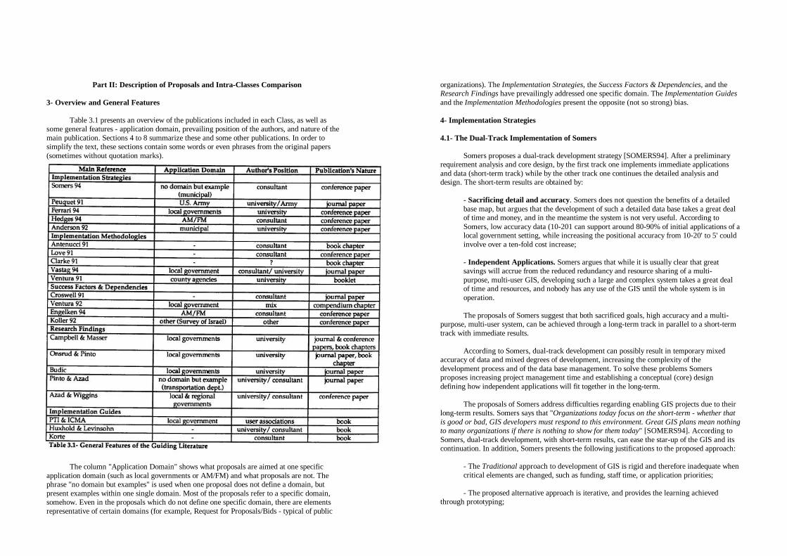
Part II: Description of Proposals and Intra-Classes Comparison
3- Overview and General Features Table 3.1 presents an overview of the publications included in each Class, as well as
some general features - application domain, prevailing position of the authors, and nature of the main publication. Sections 4 to 8 summarize these and some other publications. In order to simplify the text, these sections contain some words or even phrases from the original papers (sometimes without quotation marks).
The column "Application Domain" shows what proposals are aimed at one specific
application domain (such as local governments or AM/FM) and what proposals are not. The phrase "no domain but examples" is used when one proposal does not define a domain, but present examples within one single domain. Most of the proposals refer to a specific domain, somehow. Even in the proposals which do not define one specific domain, there are elements representative of certain domains (for example, Request for Proposals/Bids - typical of public
organizations). The Implementation Strategies, the Success Factors & Dependencies, and the Research Findings have prevailingly addressed one specific domain. The Implementation Guides and the Implementation Methodologies present the opposite (not so strong) bias.
4- Implementation Strategies
4.1- The Dual-Track Implementation of Somers
Somers proposes a dual-track development strategy [SOMERS94]. After a preliminary
requirement analysis and core design, by the first track one implements immediate applications and data (short-term track) while by the other track one continues the detailed analysis and design. The short-term results are obtained by:
- Sacrificing detail and accuracy. Somers does not question the benefits of a detailed base map, but argues that the development of such a detailed data base takes a great deal of time and money, and in the meantime the system is not very useful. According to Somers, low accuracy data (10-201 can support around 80-90% of initial applications of a local government setting, while increasing the positional accuracy from 10-20' to 5' could involve over a ten-fold cost increase; - Independent Applications. Somers argues that while it is usually clear that great savings will accrue from the reduced redundancy and resource sharing of a multi-purpose, multi-user GIS, developing such a large and complex system takes a great deal of time and resources, and nobody has any use of the GIS until the whole system is in operation. The proposals of Somers suggest that both sacrificed goals, high accuracy and a multi-
purpose, multi-user system, can be achieved through a long-term track in parallel to a short-term track with immediate results.
According to Somers, dual-track development can possibly result in temporary mixed
accuracy of data and mixed degrees of development, increasing the complexity of the development process and of the data base management. To solve these problems Somers proposes increasing project management time and establishing a conceptual (core) design defining how independent applications will fit together in the long-term.
The proposals of Somers address difficulties regarding enabling GIS projects due to their
long-term results. Somers says that "Organizations today focus on the short-term - whether that is good or bad, GIS developers must respond to this environment. Great GIS plans mean nothing to many organizations if there is nothing to show for them today" [SOMERS94]. According to Somers, dual-track development, with short-term results, can ease the star-up of the GIS and its continuation. In addition, Somers presents the following justifications to the proposed approach:
- The Traditional approach to development of GIS is rigid and therefore inadequate when critical elements are changed, such as funding, staff time, or application priorities; - The proposed alternative approach is iterative, and provides the learning achieved
through prototyping;

- It may be the case that some departments are ahead of the corporate staff in recognizing the need of GIS;
- New opportunities arose in the market: Acquiring commercial, public, or third-party data as well as simplified and application-specific software.
4.2- Iterative Prototyping of Peuquet & Bacastow
Peuquet and Bacastow presented a case study of GIS development in the US. Army [PEUQUET91] and pointed out the following findings:
- The classical project life-cycle does not work well when the project involves the initial introduction of a given technology within any organization (because functional and organizational requirements can not be defined in advance of using the technology); - There must be an organizational recognition of the need for, and a strong commitment to, significant changes in the organizational structure. The determination of this structure and how the GIS is to function within the organization must be included as an integral part of the development process; - The involvement of the entire organization is essential for a successful first development effort. Based on these findings the authors proposed iterative prototyping with a gestalt view as an overall implementation strategy. After defining a preliminary set of requirements, a working model is developed and implemented, provoking experimental organizational changes. Both the functional and the organizational requirements are derived and tested through iterations including organizational changes (in incremental steps). The basic heuristic is empirical experimentation, as opposed to pre-specification. The authors also mention the need for a carefully balanced development team, and a figure (who they name "system mentor" ) providing guidance and neutral "company" view to ensure that the objectives of the development are not exclusively driven by technology or by particular interests. According to the authors, the advantages of using such an iterative approach are: - Lower level of risk (comparing to the traditional approach), since ideas are tested incrementally; - Greater responsiveness to change, since the agreement to use and evaluate such a gestalt prototype constitutes an implied contract for change (including managers and users); - Gradually familiarizing the user with the technology from a realistic and contextual point of view; - Refining requirements; - Project flexibility.
4.3- CDS/LG-GIS, of Ferrari and Garcia Ferrari and Garcia pointed out the difficulties for implementation of GIS in Brazilian
local governments (difficulties for the persuasion of managers, difficulties in sustaining the project due to long-term results and changes in elected officials, etc.) and proposed an implementation strategy for that environment [FERRARI94].
The proposed strategy comprises three general phases. The main goal of the first phase,
Persuasion is to convince top level managers to try the technology. In Persuasion phase a GIS project should be inserted in a Sectorial Evolution Proposal - SEP. The SEPs should address problems which are exerting high political or economical impact on one particular organization. Each SEP involves the identification of a problem, of a solution, of supporting needs (such as information needs), and of alternative solutions (one of them including GIS). The SEPs can also include a pilot-project to ensure technical viability, and to establish a concrete link between the SEP and the GIS. Since in this phase there is not funding commitment to GIS, the development of a pilot project can be supported by other organizations interested in future technical or commercial relationships, or must be restricted to the department's financial autonomy.
The main goals of the second phase, Familiarization, are: Familiarizing users with GIS
and new work methods; Getting commitment from users and top managers; And diffusing such conditions throughout the organization(s). The proposed approach is the incremental diffusion of small and independent applications throughout the departments or organizations composing the municipal administration. Like in the Persuasion phase, the applications should be inserted in SEPs, but no longer under a pilot project status. The SEPs and involved applications should be effectively implemented, provoking changes in the operational routines.
The Globalization phase consists of an inter-departmental or inter-organizational effort
for the planning of a integrated system to be implemented within a medium to long-term horizon. The idea of several independent applications should now be replaced by the view of an integrated system sharing data, data acquisition and maintenance processes, and support activities. Like in the other phases, the GIS applications are designed to support plans for organizational evolution.
The authors argue that their proposal address, first, the production of a "good quality
GIS" by fulfilling real information needs (supporting problem resolution or organizational evolution). This can be achieved by inserting GIS projects in "Evolution Plans". A second goal is to enable the project. They argue that it is easier to obtain and to show benefits from SEPs than from a GIS project itself, easing the persuasion of managers. The authors also argue that the two first phases are a preparation of the organization(s) to take part in a (bigger, more complex, long-term, and expensive) multi-participant project, familiarizing the users and increasing the commitment throughout the organization(s). 4.4- The Hedges' Incremental Implementation & Re-Engineering
Hedges proposes an overall implementation strategy for the utilities environment
[HEDGES94]. Hedges criticizes other approaches historically adopted. According to Hedges, the initial departmental projects have shown a limited impact and a tendency to mechanize existing processes while the early enterprise-wide AM/FM projects have shown enterprise-wide impact but long development cycles. Hedges also consider inadequate either process re-engineering

prior to AM/FM development (long-term approach, when possible) or AM/FM implementation prior to process re-engineering (because it can automate data no longer required).
The proposed approach is incremental implementation of AM/FM as a mechanism to
supprt process re-engineering. The author argues that the long implementation cycles of traditional AM/FM projects have become unacceptable for many utility executives, and that an incremental implementation approach tend to justify continued internal funding and support. Such an incremental approach can also signal about the "workability" of the overall technology, and allow the project team to mature and become independent of continued third-party assistance. The proposed features for the basic applications are: Small, inexpensive, fast, easy development, visible results, and leveraged (built as much as possible upon the preceding modules). The proposed system architecture comprehends a corporate database, distributed computing (client-server), open system architecture (interoperability), and AM/FM/GIS as a core (enterprise-wide) systems technology.
According to Hedges, the steps to develop a successful implementation plan for the
incremental AM/FM implementation & re-engineering are: - Business area analysis to identify and prioritize the business processes to be re-engineered and/or automated; - Initial high-level assessment of AM/FM technology and geographic database requirements;
- Assessment of potential data sources and conversion requirements (data source matrix); - Anticipating, at a high level, the benefits that will be achieved through each one of the processes to be re-engineered; - Developing an implementation plan. Each implementation module should be small, fast, visible, etc.; - Developing a detailed cost/benefit analysis, and detailed implementation plan for each implementation module; - Managing the implementation of each module minimizing "scope creep" (additions should be implemented in future modules).
4.5- The Proactive Approach of Anderson Anderson proposed a "proactive approach for the introduction of GIS technology"
[ANDERSON92]. Anderson argues that in the traditional GIS technology transfer process, user participation is restricted to interviews in the needs assessment phase. User resistance is a reaction (Anderson name "reactive" such a traditional approach). In the proposed "proactive" approach, Anderson advocates extensive user participation (affected people) not only in needs assessment, but in all phases of GIS technology transfer.
Anderson addresses GIS implementation through five non linear phases "occurring
concurrently and occasionally repeated within a subsequent phase": (1) Participation (GIS
education and communication); (2) Context Evaluation (by an "open court"); (3) Vision Creation ("created consensually', instead of by a "small group of GIS advocates"); (4) Change (to assess "openly and realistically" any organizational changes required for the implementation of the proposed vision); And (5) Implementation (formal analysis and design using a structured system-development methodology).
4.6- Other Implementation Strategies
Born and Jansen-Dittmer [BORN93] propose that the responsibility for GIS
implementation and definition of its goals should he on top management. The goals "should be an improvement of the strategic position of the organization" (pg. 157), and (should be) "defined in the field of market goals"(pg. 163). They believe that, following this strategy, "the consequent goal orientation can be ensured and the effect on the organization culture can be controlled" (pg. 164).
Roe [ROE91] proposes "an organizational approach to implement GIS", arguing that the
focus of system implementation should not be to automate but, instead, to improve management practice. According to the author, this correct focus can be achieved through socio-technical system design (referring the approach proposed by Eason [EASON89]). Roe agrees with Chrisman [CHRISMAN87] when suggests that one goal of GIS implementation and use should be to demonstrate that people are treated more equitably.
The model proposed by MacNeill and Allan [MACNEILL94] is based on an adaptation
process applied to an initial system. The model associates prototyping, user needs assessment, and eventual creation of new applications with new data availability. Each cycle is a response to the availability of new data.
Kevany and Barrowman [KEVANY90] argued that a low cost GIS configuration can
satisfy most or all requirements of some organizations, and it can provide an interim solution for larger organizations. In addition, they suggest that a low-cost configuration can ease initial justification and the procurement procedures, and can be used as a training tool.
4.7- Coverage Analysis and Content Comparison
Table 4.1 summarizes the coverage of the Implementation Strategies. The letters printed
into the table's cells identify the proposals through their author's initials. The letter "A" identifies [ANDERSON92], "F'-[FERRAR194], "H" - [HEDGES94], "P" - [PEUQUET91], and "S" identifies [SOMERS94].
4.7.1- Strategic Planning and Risk Evaluation
Hedges proposes, as a first step in a GIS implementation project, a business area analysis
for identifying and prioritizing the business processes to be re-engineered and/or automated. For the definition of the initial applications, Ferrari and Garcia recommend elaborating Sectorial Evolution Proposals addressing areas of high economical or political impact. Somers included strategic planning in the proposed strategy but without further explanations about its role. Somers also mentioned the importance of performing an environmental risk evaluation before defining an implementation strategy. A similar reference was made by Ferrari and Garcia.

4.7.2- Implementation Pace and Scope
We identified three main proposals regarding implementation pace. Peuquet and
Bacastow proposed iterative prototyping with a gestalt view for the initial introduction of GIS technology, arguing that the approach is adequate to derive technical and organizational requirements, that it presents lower risk than traditional approaches, and that it produces gradual commitment among users and managers. Ferrari and Garcia proposed a three-stage approach: small, independent applications in the two initial phases of implementation, and a global, (multi) organization-wide planning and implementation. They argue that the two first phases ("Persuasion" and "Familiarization") are a preparation of the organization to take part in a bigger multi-participant project (in the third phase, "Globalization"). Somers proposed dual-track implementation. After a preliminary requirements analysis and core design, one short-term track based on independent, small, low accuracy applications, and a long-term track pursuing a multi-purpose, highly accurate GIS. The goal of the short-term track is to ease getting and maintaining top-management support. Both Ferrari & Garcia and Somers propose small and independent applications in the short-term, and a (multi) organization-wide system in the long-term The actually intended scope is the (multi) organization-wide one. The short-term scope is only an enabling strategy. No other proposal argued the contrary.
In addition to those three main proposals, Hedges advocated incremental implementation combined with process re-engineering for utility companies, and Kevany & Barrowman suggested low-cost configurations as an interim solution for counties. Both proposals agree with the prevailing idea of short-term results and low initial investments in order to ease top-management persuasion. "Incremental" implementation was also advocated in [AL-ANKARY91, FOX91, YEH91].
4.7.3- Enabling Issues
The main concern of the Implementation Strategies included in this section are enabling
issues. The proposals of Somers, Ferrari & Garcia, Hedges, and Kevany & Barrowman focus on obtaining top-management support. To ease getting such a support, they proposed short-term results, low-initial investment, and defining goals on the business field. Anderson's and Peuquet & Bacastow's proposals focus on user resistance and organizational conflicts. They propose intensive user participation in design and decisions. Anderson proposes a "Proactive" approach in which the GIS vision is created "consensually”. Peuquet & Bacastow propose iterative prototyping with gradual introduction of changes.
4.7.4- Training Strategy and Role
Training was addressed also as an enabling concern. Ferrari & Garcia proposed one
phase, named Familiarization, whose main goal is to familiarize users with GIS and with new work methods. Familiarization is achieved through use of small and independent applications. They argue that the Persuasion and Familiarization phases are necessary to prepare the organization to take part in larger projects. Somers and Kevany & Barrowman cited training as an additional benefit of the strategy they propose. Kevany & Barrowman argued that an intermediate low cost configuration can be used as a training tool. Somers argued that the dual-track approach provides the learning achieved through prototyping.
5- Implementation Methodologies
5.1- The Methodology of Antenucci and Others
One of the chapters of the book of Antenucci, Brown, Croswell, Kevany and Archer
[ANTENUCCI91] presents a methodology for GIS implementation. The methodology comprehends five stages and seventeen steps, presented bellow. Figure 5.1 presents the temporal view of the five stages.
Stage 1: Concept. The Concept Stage is composed by user requirements analysis and feasibility evaluation (Steps One and Two).
Step 1: Requirement Analysis. The objective of Step One is to assess requirements for the GIS based on user-supplied information. Requirement analysis involves identifying the organizations and groups that may benefit from the GIS and dividing them into functional areas and levels of significance. Individual representatives with knowledge of the organization should participate in the analysis. It may be necessary to provide a basic training to the participants through workshops, conference attendance, or other techniques. The analysis should be conducted by a combination of internal staff and outside consultants;

Step 2: Feasibility Evaluation. The feasibility evaluation is based on a cost-benefit analysis. The authors recommend to include in such analysis a period of seven to ten years, and the participation of a consulting expert ;
Stage 2: Design. If the result of the feasibility study is a decision to proceed the GIS implementation, the project enters the Design Stage. Design Stage comprehends the implementation plan (Step 3), and System & Database design (Steps 4 and 5).
Step 3: Implementation Plan. The implementation plan defines and controls all subsequent steps in the process. It should identify and describe individual tasks, assign responsibilities and resources for each task, indicate relationships among tasks, define products and milestones, and establish a schedule. A computer-based project management program may be used to update the plan and to monitor and report on its status;
Step 4: System Design produces specifications to guide software acquisition;
Step 5: Data Base Design develops specifications to create and maintain the database, and to guide the acquisition of database services;
Stage 3: Development. In the development stage, an organization acquires GIS software, hardware, and data conversion services, and develops procedures to operate the system. These activities can occur in parallel. Step 6: System Acquisition. Request for proposals, evaluation, and system acquisition;
Step 7: Data Base Acquisition. Same as Step 6;
Step 8: Organization, Staffing and Training. According to the authors, the most appropriate approach to GIS organization varies from project to project. For multi-participant projects, the organizational structure may be centralized, with one body providing GIS services to the participants, or it may be distributed, with each participant operating independently of the others (in this case, standards for sharing data and resources should be established). Overall management of multi-
participant projects may be assigned to a single organization or to a policy board of representatives from the participating organizations. Within one single organization, the GIS responsibility may be assigned to an existing unit, a new GIS unit can be created and placed in an existing department, or an independent GIS department may be created. Whether shared or operated by a single organization, a project manager responsible for all aspects of implementation is necessary. Regarding staffing, the authors suggest specific functions such as implementation project manager, system manager, data base administrator, system analysts, programmers, and operators. Regarding training, the authors propose different types of training. The GIS manager and key support staff should receive the most intense training, representatives from user organizations should be trained on system use and operation, and managers throughout the organization should receive training on GIS applications and opportunities. The training may be provided by the software vendor or by other organizations. The authors also suggest to encourage attendance to GIS workshops, conferences and other events.
Step 9: Operating Procedure Preparation. Before installation and operation of the system, the organization should design the operating procedures to be embedded in the organization's routines. These procedures govern all aspects of system's operation and management such as back-up of data base and software, management of maintenance contracts, support for system users, and authorization for application development and installation;
Step 10: Site Preparation. Selection of optimal locations, installation of adequate power supply, air-conditioned, etc.; Stage 4: Operation. Operation Stage comprehends the following five interdependent steps: System installation, pilot project, data conversion, application development, and conversion to automated operations (Steps 11 to 15). Step 11: System Installation. This step includes system delivery and installation, and the acceptance tests;
Step 12: Pilot Project. The authors mention that one of the major purposes of the pilot project is to anticipate technical problems. They also suggest other possible objectives such as to verify procedures for database development, to verify the estimates of costs and benefits, and to provide hands-on training for staff. They propose developing the pilot for a small geographic area which is representative of typical or critical conditions. They also argue that, since the pilot frequently takes place before the in-house staff has obtained adequate experience, a consultant may conduct some aspects of the pilot;
Step 13: Data Conversion comprehends data base loading with quality-control. Only a portion of the data base may be initially converted. The remainder of the data is loaded in phases as it becomes available from compilation and digitizing activities;

Step 14: Applications Development. The authors suggest that sophisticated application programs should be acquired from the GIS vendor, from third-party firms, or from other organizations which use the same software;
Step 15: Conversion to Automated Operations, possibly in phases over an extended period of time; Stage 5: Audit.
Step 16: System Review. The authors propose periodic reviews (or audits) to keep the project on track (or to bring it back). A review should be similar to the procedures used to develop the initial plans for system implementation. The audit culminates with a revised statement of goals, policies, procedures, and actions to be taken within specific time frames and budgets;
Step 17: System Expansion is a special case of audit intended to support system expansion. The authors suggested that organizational support can be built and maintained through a
favorable cost-benefit analysis, through top-down political influence, or through education.
5.2- The GIS SDLC of Love Love presented a GIS SDLC (System Development Life Cycle) [LOVE91] which
embraces technical methodologies from sources in both MIS and GIS fields. Love considers the SDLC an "humanistic approach" (pg. 483) aimed at to ensure that customer and contractor understand and share the same view about all aspects of the GIS project under development. The general goal is to deliver, within the defined budget and deadlines, a system which actually satisfies user requirements. The proposed methodology consists of 8 stages:
Stage 1: Implementation Plan. According to Love, the implementation plan is a detailed expansion of the SDLC describing each step in the process from the issuing of the job brief to the final evaluation; Stage 2: Familiarization. The main goal of this stage is to familiarize the designer (contractor) with the organization and its people. Familiarization stage is a period of intense interaction between contractor and user: Workshops, informal interviews with management and users, etc.; Stage 3: Pilot Study. Stages 3,4,5, and 6 compose system definition. The pilot study comprehends a working model of a GIS over a limited geographic area. Its goal is to improve communication between contractor and users; Stage 4: Requirements Formulation and Analysis. Love proposes to define user requirements through questionnaires and workshop sessions with all users involved. The questionnaires ask the users the objectives, functions and processes of organization's departments, problems and possible solutions, data deficiencies, their individual expectations of a GIS, their "wish list", etc. The workshops give users an exposure to the pilot system. Love says that the workshops are designed to "stimulate the imagination of
the users and to set the context for the questionnaires" (pg. 480). This Stage also involves the compilation of a Resource Inventory including hardware and software available for the project, data, and user attitudes (positive/negative); Stage 5: System Specification and Design Document. This document details alternative solutions for achieving the requirements, and becomes the Implementation Report which is submitted to management for approval; Stage 6: Database Schema Design; Stage 7. Program Design and Development. Love proposes adopting an interative prototype approach with a series of check points for evaluation and feedback from users; Stage 8: Operational System Installation. According to Love, as a result of the iterative prototype approach system installation is a relatively short process.
5.3- The GIS Acquisition Model of Clarke
Clarke proposed a general model for GIS acquisition comprising four stages and fourteen steps [CLARKE91].
Stage 1: Analysis of Requirements. According to Clarke, this first stage is an iterative process for identifying and refining user requirements.
Step 1: Definition of Objectives. In this step one should define the scope and objectives of GIS acquisition and obtain support from management and users. The objectives should be stated from management's perspective, they should focus on results, and should be measurable. Users must understand that the project will result in benefits for them;
Step 2: User Requirement Analysis. Through interviews, documentation reviews, and workshops, one should identify the required information products and related information;
Step 3: Preliminary Design includes preliminary functional and database specifications and a market survey of potential system suppliers;
Step 4: Cost-Benefit Analysis. The costs, benefits, changes in roles and procedures, and risks of failure should be measured against the alternative of continuing with the current data, processes, and information products. The cost-benefit analysis may indicate whether the project should proceed, should be postponed, or whether the objectives, requirements, and design must be improved. Three categories of GIS benefits may be defined: efficiency (time and cost savings through faster data processing or reduction of duplicated effort), effectiveness (improvements in the decision-making process caused by more timely or new information), and intangible (improved public image, improved cooperation through data sharing, increased staff professionalism and morale, etc.);

Step 5: Pilot Study. The primary objective of pilot study is to test the preliminary GIS design before finalizing the system specifications and committing major resources. Secondary objectives are to develop the understanding on and confidence in GIS. The pilot should include a representative data set (for example, all kinds of data but only for a small geographic area). The hardware and software for the pilot may be leased, and should not imply in commitment to future purchase,
Stage 2: Specification of Requirements. In this second stage user requirements are developed into a specification and request for proposals document,
Step 6: Final Design includes finalizing the functional and database specifications, performance specifications, and constraints.
Step 7: Request for Proposals combining the specification with the contractual requirements of the agency, Stage 3: Evaluation of alternatives. This third stage comprises three successive evaluations (steps 8 to 10);
Step 8: "Shortlisting". The proposals which failure to meet mandatory requirements, or with too generic responses, should be eliminated. The remaining proposals should be evaluated through a scoring system based on the fulfillment or not of system requirements.
Step 9: Benchmark Testing for refining the preliminary scores. Clarke recommends to apply the benchmark tests to a maximum of five systems, selected through the preliminary evaluation (shortlist);
Step 10: Cost-Effectiveness Evaluation. The ratios of scored benefits versus costs (of a normalized hardware configuration) should be determined. The costs should include the operating costs for a nominal system life (at least five years) to ensure that the original cost-benefit analysis remains valid.
Stage 4: Implementation of the System;
Step 11: Implementation Plan. The implementation plan involves defining priorities, defining and scheduling tasks, and developing a resource budget and management plan. Clarke suggests to prioritize products with positive results early in the implementation;
Step 12: Contract; Step 13: Acceptance Testing, including tests of functionality, performance and
reliability (availability and recovery);
Step 14: Implementation. Implementation step comprehends training users and support staff, performing initial data capture and product development, and introducing performance monitoring as a system management task.
5.4- The General Implementation Guide of Vastag and Others
Vastag, Thum, and Niemann proposed a general guide for LIS/GIS implementation which, according to the authors, should be adapted to the unique circumstances of each local government [VASTAG94]. The proposed guide involves the following stages:
- Awareness should be generated by a person who is willing to champion LIS/GIS (the "White Knight"). The authors understand that such a "White Knight" should ensure that the use of LIS/GIS is prudent and ethical. They include as examples of possible benefits of GIS/LIS better public access to information and more citizen involvement in the land planning and development process; - Feasibility stage includes organizational needs assessment, organizational requirement analysis, and feasibility determination. The organizational needs assessment will help determine the overall scope of the system in terms of people, institutions, and applications. The organizational requirements analysis sorts out which individuals are interested in employing LIS/GIS, and what expertise they have; - Conceptual Design stage comprises user needs assessment, user requirement analysis, application & database conceptualization, and system development plan. User needs assessment differs from the organizational needs assessment because it is a detailed assessment designed to gather specific information for producing technical specifications. In user needs assessment one should gather information about data, procedures, and products. The information can be obtained through mandate/statute reviews, construction of data-flow diagrams, questionnaires and interviews. Requirement analysis determines the hardware, software, communications, personnel and training requirements. In application & database conceptualization, one must identify priority applications and the data needed to support them. The system development plan defines the procedures and timelines for completing implementation; - Development stage comprehends initial technology acquisition & installation, application prototype/database physical design/quality assurance, pilot project (application & database development and evaluation), and system operation plan. The pilot project is used to evaluate the database and applications. System operation plan lays out the tasks necessary for full implementation. According to the authors, at this point, the team should address the issue of interagency data integration; and - Operation stage consists of application development and implementation/database development (full scale data conversion), application & database maintenance, and system audit/evaluation. The authors understand that the team must evaluate the system periodically to ensure that it is progressing in the right direction. The authors also propose that LIS/GIS must, by its very nature, be an integrated program
from top to bottom, from one organization to another.

5.5- The Steps Toward Land Record Modernization of Ventura Ventura suggests that an automated land information system (LIS) is a necessary
component of an overall land records modernization plan [VENTURA91] (see also [VENTURA93] and [VONDEROHE91]). One assumption of the proposal of Ventura is that the envisioned system is a multipurpose LIS. The author argues that: "Although it may require more effort to start a system that meets the needs of many groups, long run benefits are more likely to result, and the benefits are likely to be larger" (pg. 2). Another assumption is that the agencies will be starting implementation with relatively little automated geographic data. Ventura proposed six steps toward land record modernization, described bellow. Step 1: Technology Introduction
The purpose of this first step is to introduce an organization to the new concepts and
methods, and to introduce potential users to the implementation process. The author presents five kinds of activities involved in this first step: (1) Identifying the people who will have the lead responsibility for system implementation; (2) Educating the leaders in all aspects of GIS implementation; (3) Convincing decision-makers that changes are needed; (4) Conducting a preliminary census of spatial data users (it can be used to select initial project participants, and to identify basic data resources and custodians); and (5) Introducing potential users to the technology. Ventura suggests to include initially those departments which record or produce basic spatial data, or which are large-volume users. Other users can be included when the system is technically mature. Ventura also suggest that in situations where there is little experience with LIS., it may be appropriate to start small, with only a few participants. The author understands that education is a valuable tool for overcoming some of the fear of change, and that the best arguments for persuasion of management or elected officials are those based in costs and benefits. Educational activities may include site visits, workshops, short courses, and technical readings. Step 2: User Needs Assessment
Ventura presents two purposes for user needs assessment: (1) To help understand current
land information systems, and (2) to provide detailed information for components and applications of the new automated system. The author proposed a Conceptual Assessment of the system, or the assessment of its overall scope in terms of people, institutions and applications. The major elements to be identified are: the goals of the system (whether primarily a land records system or whether a planning system or other), the bounds of the project (who is included, geographic extent, layers included), general time lines and development stages (priorities for application development), connections of the LIS with other information systems or databases, and the responsibilities of each participant. Ventura suggested to discuss these ideas with a small group first (possibly the LIS steering committee). The Detailed Assessment starts after agreement on the general goals and scope of the LIS is reached. This detailed information should be gathered from potential users through questionnaires, interviews, mandate reviews, and data flow diagrams. Information about data (data sources, flows, transactions, updates, and data models), processes (mandates, procedures, applications, and analysis), and products (information products, advantages of LIS) should be gathered.
Step 3: System Requirement Analysis According to the author, in this step one should determine the appropriate software and
hardware based on the results of needs assessment. Ventura presented five major elements of system requirement analysis:
- Determining software functionality, by ranking priorities in application development as what is essential, what is desirable, and what would be nice to have, - Determining hardware requirements in terms of type of operating system, speed/ memory of CPU, size of hard disk, compatibility with computing environment, and network / distributed processing capabilities; - Defining the degree of system customization, required data accuracy, approach for partitioning space (layers, raster or vector), etc.; - Plans for the transition to automated operations such as staff responsibilities and
database maintenance procedures; and - Request for proposals.
Steps 4, 5 and 6 The author presents only an overview of the last three steps: - (4) System Design defining application modules, database models, specification of hardware & software, and administrative framework; - (5) Implementation plan including definition of tasks, responsibilities, needed resources (funds, data, staff), and timelines; and - (6) Pilot projects providing experience on a small scale before full commitment to new methods.
5.6- Other Implementation Methodologies Kevany presented an Automation Roadmap for startup of an MPLIS (Multi Purpose LIS)
automation project [KEVANY93]. The Roadmap of Kevany comprises twelve basic task areas: Requirement analysis, conceptual design and feasibility study, strategic & implementation plan, organization & staff training, system design, database design, system acquisition, system installation, database development (including data loading), application programs & operating procedures development, pilot project, and automated operations & maintenance. The basic content of Kevany's proposal is equivalent to another proposal of Kevany & others [ANTENUCCI91], described in section 5.1 of this report. Joffe [JOFFE90] presented an outline of GIS development consisting of five stages: Strategic planning, system specification, database construction, system implementation, and ongoing operations. De Man [De Man90] argued that to ensure coherence in the various decisions and choices concerning GIS planning and design one should develop a strategic information plan at the "object system" level. De Man's approach to GIS planning and design involves identifying the "Relevant Decision Areas" and determining

which decisions must be taken now and which ones may be left open to permit more confident choices in the future. Teixeira & others [TEIXEIRA93] propose three phases to GIS implementation: Preliminary design, design and implementation, and normal operation. Aronoff [ARONOFF89] presented a framework for implementation covering the entire technology transfer process, from awareness to adoption (incorporation in day-to-day activities). The proposed framework consists of six phases: Awareness and sale of ideas, developing system requirements, evaluation of alternative systems, system justification and development of an implementation plan, system acquisition and start-up, and the operational system. Dias [DIAS93] proposed four steps for GIS implementation: User requirement analysis, cost-benefit analysis, implementation plan, and tasks specification.
5.7- Coverage Analysis and Content Comparison
Table 5.1 presents the coverage of the Implementation Methodologies. The letters printed
into the table's cells identify the proposals through their author's initials. The letter "A" identifies [ANTENUCCI91], "C” identifies [CLARKE91], "L" - [LOVE91], "Va" - [VASTAG94], and "V" - [VENTURA91]. The Implementation Methodologies addressed prevailingly the Information System Design group. Most of the proposals were included in the discussion about GIS design model.
5.7.1- GIS Design Model
Table 5.2 presents a summary of the proposed GIS design models. The vertical
dimension represents time or sequence of events. For example, in the first column (Antenucci & others), feasibility/C-B (feasibility or cost-benefit analysis) is placed bellow of needs analysis. This means that feasibility should be performed after needs analysis. We changed some original words of the models to ease comparisons.
As shown in Table 5.2, the relative position of some tasks differs from one model to
another. We discuss some of these differences bellow.
Position of User Needs in relation to the definition of project scope and goals. Ventura, Vastag & others, and Clarke place the definition of goals and scope before (a
comprehensive) user needs assessment. In this case the role of user needs assessment would be to gather detailed information for system design and specification. Love, and Antenucci & others propose no mechanism for definition of goals and scope before needs assessment. In this last case the role of needs assessment includes the definition of goals and scope (such a definition would be -based on the results of needs assessment).
Position of Feasibility or Cost-Benefit Analysis.
For all the models feasibility analysis is a basis for project approval and commitment of
funds. The difference lies on how many tasks are performed before feasibility analysis and before project approval. Antenucci & others and Clarke place feasibility analysis after user needs assessment while Vastag & others place it before. Note that the tasks performed before project approval must be funded or enabled some other way (because the "approval" of funds/ resources comes after that).
Position of Pilot Project. All the models include a pilot project but they do not agree about its relative position.
Love places the pilot before (and during) user needs assessment. In the proposal of Clarke, the pilot is positioned after a preliminary design and before system specification. Vastag & others, Ventura, and Antenucci & others place the pilot after system design. If the pilot is placed after the design, its main role will be to test such a design. By the other hand, if the pilot is placed before (or during) needs assessment and system conception, it can be used as a mechanism of communication between users and developer, helping the assessment of user needs and system definition.
Position of Implementation Plan.
Love recommended to place the implementation plan as the first implementation activity.
Antenucci & others and Vastag & others place it after user needs assessment and feasibility analysis, and before detailed design. Clarke and Ventura position the implementation plan after system conception and design. The most immediate consequence of the position of the implementation plan is how many activities it will help coordinate: All the activities, including user needs assessment and design, or only the effective implementation (acceptance test, data base loading, etc.).
1. User needs analysis

Training, Education, and Awareness Generation. Vastag & others proposed awareness generation (through GIS championing) as a first
stage. Ventura included education of leaders in the beginning of the implementation process as well. In both cases the main goal is to obtain support for the project. Antenucci & others and Clarke included training as an activity of the implementation process, but not in its beginning. In this last case, the training program addressed system operation and use.
5.7.2- Implementation Pace and Scope
Ventura and Vastag & others suggest that the envisioned scope of LIS/GIS
implementation should be an integrated, multipurpose system. In situations where there are little experience about LIS, Ventura suggests to "start small" and that the departments which record or produce basic spatial data, or which are large-volume users, should be addressed first.
6- Success Factors & Dependencies
6.1- The Dependencies and Success Factors of Croswell Croswell reviewed GIS implementation histories and other information system literature
and synthesized the obstacles for GIS implementation reported therein [CROSWELL91]. Croswell pointed out major groups of obstacles:
2. According to Figure 5.2, all the activities included in the stages Development, Operation and Audit can occur in parallel, as well as part of the Design stage. In this Table, this means that all tasks bellow "system & DB design" can occur in parallel. We will consider such a parallelism in our analysis, when pertinent. In the other proposals, we represent parallelism between two tasks by joining them in a single task (for example as in "Pilot" & "Design Evaluation", in the Vastag & other's model).
- Planning/ Management Support (lack of, or inadequate implementation plan, lack of understanding or commitment by management, and inadequate high-level support or mandate); - Organizational Coordination of Conflicts (inadequate coordination or communication among participants, internal power struggles, and conflicts with main data processing organization); - Training/Understanding of Technology (insensitivity to cultural/cognitive issues, poor system documentation, lack of trained staff or recruitment problems, and lack of understanding of the technology); and - Data and Software Standards / Data Integration (data integration or inconsistency problems, no accepted standards for procedures or data). Based on this study Croswell presented the following guidelines to "increase the
opportunities for success" in GIS implementation: - Perform an Initial Evaluation of Organizational Risk - An evaluation of the readiness of the organization to accept and effectively use the technology. The project implementation pace should be based on the results of the risk assessment. If the managers or users are not ready to accept the GIS, additional education may be necessary before proceeding; - Get Commitment from Management. According to Croswell, the real benefits of GIS technology lie on the organization-wide integration, and this integration requires support from management; - Assign a GIS Manager Early in the Project; - Adopt a Structured Approach for System Development. Croswell suggests to consider the use of a prototype project to test the database design and GIS applications; - Involve Users in Design to provide accuracy in requirements assessment and to encourage a cooperative spirit, - Formulate a Goal-Oriented Plan and Schedule. The implementation plan should describe implementation steps, milestones, the responsibilities of those involved (staff, managers, outside contractors), staff time requirements, etc.; - Develop a Project Organization that Encourages Cooperation and Consensus. Croswell suggests two main coordination bodies, the Policy body and the technical body. The former, consisting of top-level management and senior managers from the major departments involved in the project, is responsible for decisions on major issues and development milestones of the project. This group should resolve problems of interdepartmental coordination. Croswell also suggests that management can encourage communication and coordination between multiple departments by dispel fears associated with new technology (loss of job, prestige, or authority) and by defining organizational-

wide goals and benefits. The technical body comprises mid-level managers and technical staff. It is responsible for the detailed issues of system planning and implementation; - Allocate Sufficient Staff Time; - Keep Users, Managers, and Constituents Informed through periodic presentations by the GIS manager and newsletters even after the system is operational; and - Provide Education and Training at All Implementation Stages. Before selection of GIS hardware and software, educational activities may involve seminars on GIS concepts, presentations by vendors, and attendance at conferences. After hardware and software selection, specific training to different users and a continuing education in-house program to new users should be provided.
6.2- The Dependencies of Ventura, Huxhold, Brown and Moyer Ventura and others presented the barriers from the traditional organizational structure to
implementation of MPLIS (multi-purpose land information systems) [VENTURA92]. They argue that "Recognizing these barriers should be helpful in developing a program to move from current manual or semi-automated procedures to an MPLIS, and managing it in such a way as to ensure its long-term success" (pg. 4). Those barriers are:
- Departmentalization (the organization-wide goals become secondary); - Inter-professional Barriers. According to the authors, the diversity of professions, background, and knowledge results in different values and expectations and makes communication more difficult; - Resistance to change. Individuals may view changes as threatening their jobs, as difficult, unnecessary, or as a mistake (personal inertia). Resistance to change may also occur when there is substantial investment in existing procedures or when there is "something to hide" - like poorly managed or incomplete data (organizational inertia); and - Lack of access to (new) skills necessary for the design and management of the MPLIS. The authors also propose the following "organizational keys in moving toward an MPLIS ": - Getting top level management support before, or at least early in, the development process. The authors argue, however, that the lack of such support is not a fatal flaw, and that through cooperative agreements it is possible to get the necessary funds (see also the topic "cost sharing", bellow). - Committees to support MPLIS development (steering committee, or policy body, and technical committee); - Cost sharing among the participants, as "An alternative to acquiring the up-front budgetary support necessary for an MPLIS.." (pg. 10);
- System location. The authors proposed two approaches: (1) Creating a whole new organization, or (2) dividing the responsibility between the data processing department (hardware and software) and each other functional unit (maintaining the records for that particular file); - Economic factors. It is recommended to define the costs and benefits of the MPLIS and to document the costs of the current manual system in order to build the necessary management support; - Technical factors (the form and quality of existing records, and the suitability of existing hardware and software for new or expanded applications); - Personal factors (level of education, exposure to and experience with computing and LIS, personal motivation); - Personnel factors (the need to train or hire the competent staff necessary, and the need to keep the staff, once it is in place). The authors suggest to develop a personnel plan defining the positions required to develop and operate an MPLIS, and an ongoing training program to keep staff up-to-date. They suggest some specific MPLIS personnel functions: MPLIS manager, MPLJS (or GIS) analyst, MPLIS system administrator, MPLIS data base administrator, MPLIS programmer, MPLIS processor (or a "super user"), MPLIS Digitizer, and other possible functions (cartographers, draftsmen, and photogrammetrists).
6.3- The Success Factors of Engelken Engelken presented three critical elements for the success of AM/FM projects
[ENGELKEN94]: - The right person at the helm of the project. Engelken argues that the project manager must have high level of both intellectual energy (intellectual capacity to understand and solve complex issues) and personal energy (capacity to establish and maintain personal relationships at all levels within the organization). According to the author, communication can make the difference between a project being a technical success or being recognized as a business success; - The right environment in the company for foster success. Engelken argues that projects can fail if they are out of phase with the readiness of the organization to embrace it, and proposes two ways for assessing and cultivating the right environment- (1) Through education of users and executives, and (2) by conducting an initial feasibility study comprising a business case for the project on the basis of both economic and strategic criteria and a measure of the receptiveness for the project among executives and users. The author also argues that the project must provide regular usable deliverables to maintain continued support; and - A good plan identifying all necessary steps to achieve clearly defined goals within realistic time frames and resources.

Engelken also proposes practical project management tips to increase the chances of success:
- Use a computerized project scheduling tool; - Be sensitive to project risks and develop contingency and risk mitigation plans as these risks begin to materialize, and - Provide for both project 'contingency' and project 'discovery' budgets within the project plan.
6.4- The Success Factors of Koller Koller [KOLLER93] analyzed the factors that limit the introduction of innovations in
large western organizations and proposed a set of success factors to overcome these impediments in similarly conservative environments:
- Obtaining top management support; - Providing appropriate training to management and professional workers; - Associating monetary and other incentives (for the workers) to productivity gains based on the new technology; - Delaying criticism until the original idea has at least been developed into a clearer concept; - Modifying the organizational climate to allow mistakes and to encourage the taking of calculated risks; - Allocating special management time and effort to start-up projects; - Opening informal lines of communication between departments that are participating in the innovation; and - Patience. Koller also presented a case study of successful GIS introduction (Survey of Israel), and
attributed the implementation success to a people-oriented philosophy, saying: "..much managerial effort was spent on interdepartmental persuasion, interpersonal communication, incentives to the individuals involved, political infighting, training, appropriate changes to the physical (and psychosocial) environment, and marketing the project to outside bodies" (pg. 78).
6.5- Other Success Factors
DiSera [DiSERA93] pointed out the main obstacles for the introduction of an
organization-wide AM/FM system in a large public utility.: - Different priorities between departments;
- Management commitment. DiSera argues that many upper level managers do not understand the technology, its potential for decision support, and the need for an organization-wide implementation strategy; - Territorialism (power struggles regarding information property and control, fears about budget cuts or loss of power, etc.); - Political constraints. DiSera mentions that AM/FM projects need the support from elected officials, who tend to think in terms of short-term results (within one electoral term). Their short-term thinking makes difficult a long-term funding commitment, and creates an ongoing threat of discontinuity in development; and - Funding strategy (difficulties to achieve agreement about cost distribution among departments or about cost recovery involving service rate increases). DiSera argues that by acknowledging and addressing those obstacles the utility company
will help ensure organizational acceptance and support (ultimately resulting in a successful implementation and long-term viability).
Antenucci, Brown, Croswell, Kevany and Archer [ANTENUCC191] (pg. 235) presented
the elements of success in GIS implementation: Rigorous planning, focused requirements;, realistic appraisal of effort, dedicated and motivated staff, adequate finance plan, thoughtful time, and balanced expectations. Ferrari and Garcia [FERRARI94] (pg. 34) pointed out characteristics of the environment which hinder GIS implementation: Difficulties to convince managers due to (only) long-term benefits, inconsistent data, difficulties for coordinating multi-departmental needs, non-familiarized users, lack of planning practice and governmental stimulus to planning, and resistance to change. Hawkes [HAWKES92] presented factors for success in a multi-user, multi-vendor GIS project: Strong executive commitment and solid budgetary commitment, strong project management, common goals and focus, high-quality data, and easy of access and updating. The proposals of Korte [KORTE92] and PTI & ICMA [PT191] include Success Factors & Dependencies too, but they are described in Section 8.
6.6- Coverage Analysis and Content Comparison
Table 6.1 presents the coverage of the Success Factors and Dependencies. The letters
printed into the table's cells identify the proposals through their author's initials. The letter "C" identifies [CROSWELL91], "E" identifies [ENGELKEN94], "K" - [KOLLER93], and N" identifies [VENTURA92]. A prevailing feature of the Success Factors & Dependencies is that the proposals are generic. They do not focus on any specific group. The only issue which received more than one specific proposal is System Location/ Coordination Bodies.
6.6.1- Strategical Planning and Risk Evaluation
Croswell and Engelken propose to assess the organization's readiness to embrace GIS.
Engelken also proposes a business case based in economic and strategic criteria.

6.6.2- Implementation Pace and Scope Croswell argues that the real benefits of GIS lie on organization-wide integration. Korte
suggests the same idea. Elgenken suggests that the project should provide regular deliverables to maintain continued support. Croswell understands that the definition of the implementation pace should be based on a organizational risk evaluation. 6.6-3- Implementation Plan
Engelken understands that the implementation plan should be sensitive to project risks,
and should involve contingency plans and risk mitigation plans as these risks begin to materialize. Elgenken also recommends to provide budgets for project contingency and discovery, and to use a computerized project scheduling tool. Koller suggests to allocate special management time to start-up projects. Croswell described the general goals of a implementation plan: Sequence of events, schedule, responsibilities, etc. 6.6.4- Top Level Persuasion/ Support
Ventura & others indicated getting top level support early as a key factor to
implementation success. To get top-level support, they propose to evaluate the costs and benefits of the multi-participant LIS and the costs of the current manual system. The authors argue, however, that the lack of top level support is not a "fatal flaw", and that through cooperative agreements it is possible to get the necessary funds. 6.6-5- Organizational Conflicts/ User Resistance
Koller proposes to provide monetary and other incentives (for the workers) due to
productivity gains based on the new technology. Croswell proposes user involvement and organizational-wide goals and benefits. In addition, Croswell suggests that a policy body should be responsible for solving problems of departmental coordination. 6.6.6- Funding Strategies
Ventura & others suggested cost sharing as a strategy for project funding.
6.6.7- Communication Channels/ Project Marketing
Croswell proposes to keep users, managers, and constituents informed through periodic
presentations by the GIS manager and newsletters even after the system is operational. According to Engelken, communication can make a difference between a project being a technical success and being a business success. Engelken suggests that the project manager should establish and maintain personal relationships at all levels of the organization. 6.6.8- Training Strategy and Role
Croswell proposes to provide education and training during all implementation stages.
Before software selection, educational activities may include seminars, presentations, and attendance at conferences. After system selection, specific training and an in-house program to train new users should be provided.
6.6.9- System Location/ Coordination Bodies
Croswell proposed two main coordination bodies: (1) The policy body, formed by top-
level managers and senior managers from major departments involved, and (2) the technical body, comprising mid-level managers and technical staff. The policy body is responsible for the major decisions and for coordination of conflicts while the technical body should deal with detailed issues of planning and implementation. Croswell also suggest to assign a GIS manager early in the project. Ventura & others propose a similar project organization: Steering committee (or policy body), and technical committee. They also proposed two approaches for system location: (1) Creating a whole new organization, or (2) dividing the responsibility between the data processing department (hardware and software) and each other functional unit. 6.6.10- GIS Staffing, Consultant & Contractors
Ventura & others suggested personnel functions such as MPLIS (Multi-purpose Land
Information System) manager, MPLIS analyst, MPLIS system administrator, MPLIS database administrator, MPLIS programmer, and MPLIS digitizer.

7- Research Findings 7.1- The Findings of Campbell and Masser
Campbell and Masser performed a series of studies related to GIS adoption. They
conducted two surveys (1991 and 1993) in all the 514 British local government authorities, addressing both GIS users and non-users [CAMPBELL92b, MASSER94b, MASSER93]. They also conducted 12 case studies in British local governments [CAMPBELL94], interviews with system designers and users in Massachusetts and Vermont [CAMPBELL92a], and other analysis [CAMPBELL93, CAMPBELL91]. We report bellow some of the findings from these studies. Overview of GIS Adoption
Table 7.1 shows the evolution of GIS adoption in British local governments between
1991 and 1993. Spatial, Demographic and Political Influences on GIS Adoption
Masser presents a statistical analysis about the influences of population size, rate of
growth, and agency location (north or south of Great Britain) on GIS adoption in British local governments [MASSER93]. The author concludes that, statistically, population size is the most important predictor of GIS adoption, that the effect of the agency's location (North or South) is not so important, and that the rate of growth (increasing or decreasing) and the political party influence is minimal. Perceived Benefits, and Nature of Use
The authors analyzed the perceived benefits from GIS introduction of GIS. In the Survey
of 1991, 60% of the respondents as the most important ones "improved information processing facilities" (such as data integration and better access to information). A further 31% stressed better quality in decisions (at the operational level - 38%, managerial level - 28.8%, and strategical level - 25%), and only around 6% linked the main benefits to savings. Based on the majority of respondents who perceived "a greater range of tools with which to display and analyze information" rather than more fundamental administrative advances, Campbell suggest s that GIS had exerted a limited impact on those organizations [CAMPBELL93]. The findings of the twelve case studies confirm a limited impact, even after a minimum of two years of experience [CAMPBELL94]. Campbell reports that only three of the case studies had reached the stage where at least one application was being employed by end users. A further seven were either still developing the system or had achieved an operational application but it was not being used. Two remaining case studies had abandoned the development. Most of the applications being developed aimed to assist operational activities. The key application area for most authorities were automated mapping facilities.
Campbell reports similar findings from the interviews performed in Massachusetts and
Vermont [CAMPBELL92a]. Campbell mentions that a number of agencies with technically operational systems felt frustrated by the limited use of these facilities by professional staff and decision-makers. The main concerns at that time were ownership and control of information, and how to ensure that this information will be utilized within the policy-making process. According to Campbell, a number of individuals suggested that a more effective GIS utilization would have been assisted by addressing such matters at the project start-up rather then part way ahead. Corporate Versus Departmental Approach
Campbell and Masser reported that there is a 50:50 split between a more corporate and
departmental approaches in British local governments [MASSER94a]. Regarding the influence of the adopted approach on the perceived benefits of the GIS, Campbell mention that "Mere appears to be little support for the suggestion that strategic and efficiency type benefits are associated with corporate systems" [CAMPBELL93].
Campbell points out the main advantages and disadvantages of the corporate and
departmental approaches to GIS implementation Table 7.2 resents some of the suggested advantages and disadvantages.
Typology of GIS Implementation
Based in the broad trends revealed by the survey findings, Campbell identified a three-
fold typology of system implementation [CAMPBELL93]:
- Classically corporate. This implementation style occurs when a large number of departments (possibly the whole authority) participate in the project, and when the lead is taken by the computer services or planning department. This approach has been adopted by 15% of the surveyed organizations; - Theoretically pragmatically corporate. This style is characterized by the involvement of only three or four departments with the lead taken by the computing or technical service type department (in certain cases involving joint responsibility for the project). This approach can arise from a pragmatic decision amongst departments to pool resources, or from attempts to a coordinated and wide-ranging implementation which have fallen short of this goal. This approach was found in around 35% of the surveyed systems; - Fiercely independent. This approach occurs when the introduction is conducted by a single department. The department is likely to be involved with technical services, to have considerable experience on information handling, and to have in-house technical expertise. This approach was adopted by around 50% of the surveyed systems. According to the identified trends, in all the three approaches the GIS is not expected to
provide, primarily, improvements in efficiency or in the quality of decisions. It is likely to enhance the information processing facilities, instead.
Four Success Factors Campbell proposes four factors which enhance the chances of achieving successful
implementation [CAMPBELL94]: - Simple applications producing information which is fundamental to the work of potential users; - An awareness of the limitations of the organization in terms of the range of available resources; - User-directed implementation; and - A large measure of stability with respect to the general organizational context and personnel, or an ability to cope with change. 7.2- The Survey of Onsrud and Pinto Onsrud and Pinto performed a large-scale survey in local government organizations that
had acquired GIS technologies [ONSRUD93a, PINT093]. They asked the respondents to indicate:
- The relative importance of some selected factors to the successful adoption of GIS in their organizations; - The sequence of steps taken to GIS acquisition; - Their perceptions about the usefulness and value of GIS to their organizations; and
- General features of the respondents and of their organizations. The survey obtained a response rate of 50 percent (256 responses). The sections bellow
show the results of statistical analysis performed on the survey's responses, and the authors' conclusions. The Factors Predictive of Success
The research defined eleven groups of factors (independent variables) possibly predictive
of success in GIS adoption (dependent variable). The authors employed three measures of success: "Perceived Value", "System Use", and a combination of both. For the measure "system use", the independent variables which were found statistically significant are "Utility" and "History of Past Failures" ("Utility" refers to the advantages of the new system over current processes, adequate data accuracy, consistency with organizational goals, easy of generating results, and to the ability to expand the types of uses in the future). In other words, the system is perceived as useful when members of the organization perceive the advantage of the new system over the old methods, when those members have had experience with past computer systems failures, and so on. By another viewpoint, the system is most likely to be used when such conditions are present. For the measure "Perceived Value", the significant groups of factors are "Utility", "Ease of Use" (availability of existing data, ease of data transfer, availability of skilled people, GIS compatibility with existing computer systems), "History of Past Failures", and "Proximity to Other Users". These results mean that the GIS is most likely to be (perceived as) valuable to the organization when it is easy to assimilate and use, when the users perceive its advantages over old methods, and so on. For the "aggregate measure of success", defined by a combination of both variables "System Use" and "Perceived Value", the factors significant factors are "Utility", "Ease of Use", "History of Past Failures", and "Cost". The factor "Cost" (cost of hardware and software, data entry, cost of retraining staff, and easy of pilot study) is relevant in a negative sense. Cost is regarded as an unimportant factor by those more successful adopters, and as important by those less successful. The authors suggest that the lack of pressing concerns about costs is a significant predictor of the perceived success. The authors highlight that "Utility" and "History of Past Failures" are significant in all the three measures. The Steps to GIS Acquisition
The questionnaires suggested possible steps to GIS acquisition. The respondents were
asked to rank order these steps to most accurately represent the progression of events in their organizations. The results of this analysis include the percentage of respondents indicating that one specific step was undertaken, and the prevailing order in which those steps were executed:
- (1) Seek and acquire a GIS consultant (undertaken by 55% of the respondents); - (2) Prepare informal proposal for GIS introduction (78%); - (3) Identify GIS user needs (93%); - (4) Seek staff support for GIS (87%); - (5) Match GIS to tasks and problems (85%); - (6) Identify GIS location within organization (83%); - (7) Prepare formal proposal for GIS introduction (76%); - (8) Undertake request for proposal - RFP (80%); - (9) Conduct a pilot project (76%);

- (10) Enter a contract for purchase (96%); - (11) Acquire GIS technology (100%). According to the authors, the steps 4, 5, and 6 were always grouped strongly together,
suggesting that these steps typically occur simultaneously with each other (or that their order is inconsequential). They also suggest that those more successful in their ultimate use tend to progress the acquisition through overlapping steps.
The authors performed the same statistical analysis using different subgroups of
respondents (more/less successful). but they have not found significant differences on the sequence of steps. Other results are presented in [PRJT093]. A background discussion on their research is presented in [ONSRUD91, ONSRUD92].
7.3- The Survey and Case Studies of Budic
Budic conducted four case-studies and a survey (99 respondents) in local government
agencies of the United States [BUDIC93a]. The goal of the research was to identify the factors affecting success in GIS adoption. "Adoption" was measured in terms of organizational adoption (utilization of the technology for performing organizational tasks) and individual adoption (level, type and intensity of utilization of the technology by staff members, for organizational purposes).
The possible factors influencing adoption success were organized in personal factors, GIS management activities, organizational environment, and organizational internal context. The research results show that the significant factors are: - Personal factors: Perceived relative advantage from GIS technology, Compatibility with previous computer experience; Exposure to GIS technology, Communication behavior (networking); and Attitude toward work-related change, - GIS Management: Provision of incentives for prospective users; GIS training; Securing financial resources; Initiation of tandem structure (manager-technician team); Commitment; - Organizational Environment: Political support; Governmental mandates; Provision of external funding; Size of the jurisdiction; Variability of the jurisdiction (rate of growth); - Organizational Internal Context: Organizational conflict, Organizational change/ stability; Motivation for incorporation of GIS technology; Resources (financial, human, technological). Based on these results, Budic proposes directions for designing policies for the successful diffusion of GIS technology. According to Budic, the prime element of such a policy would be to seek political support for GIS during its initiation. Other fundamental element would be the choice of the implementation strategy. Budic identifies three GIS implementation approaches: (1) Planned (comprehensive approach; (2) Incremental approach; and (3) Experimental approach. Budic suggests that the Planned approach is the most likely to lead to successful implementation of GIS (its full incorporation into organizational functions). The main difference between the Budic's Planned approach and the other two lies on the amount of management action. The Planned approach involves extensive GIS management activities intended to foster d individual and organizational adoption. Budic understands that GIS management may
influence individual employees and eliminate effects of negative attitudes. For example, Budic suggests that providing incentives to individual employees who are using GIS may change their perception of personal benefits from the project. Budic concludes that GIS management can speed up the diffusion of GIS technology by reducing anxiety and fear of GIS due to complexity, facilitating contacts between GIS users and non-users, increasing the exposure to the technology, building confidence in working with computers, showing GIS-related (organizational and personal) benefits, providing conditions for gradual change, and facilitating the acquisition of GIS-knowledge. Other results are presented in [BUDIC93b, BUDIC94].
7.4- The Proposals of Pinto and Azad Pinto and Azad studied the influence of organizational politics in GIS implementation
success [PINT094]. They presented a bibliographic review on organizational political behavior (OPB) and proposed a framework defining the ways politics can help or hinder GIS implementation. The authors proposed two managerial principles to promote success in GIS implementations:
- (Principle 1) Learn and cultivate "positive" OPB. The authors define three possible political attitudes: The “naive" or apolitical attitude (willingness to ignore organizational politics); The "shark" attitude (express purpose of using politics and aggressive manipulation to "reach the top"); And "political sensibility". They understand that both the "naive" and the "shark" attitudes are inadequate, and suggest a "politically sensible" attitude. By such an attitude, one regards OPB as necessary to advance the department's goals, and uses negotiation and bargaining, networking, expanding connections, and one uses the system to give and receive favors, - (Principle 2) Understand, accept, and practice "WIIFM". "WIIFM" is an acronym which means "What's In It For Me?". The authors mention that there are situations in which managers feel frustrated when fail to convince other departments and individuals to support GIS implementation. They suggest that other departments are not likely to offer their help and support unless they perceive that it is in their interests to do so. They argue that simply assuming that these departments understand the value of GIS is simplistic and usually wrong. The authors presented two case studies to illustrate the proposed principles. They suggest
that the major opportunities for "positive" use of organizational politics occur when the organization faces controversial decisions such as decisions about the organizational location of GIS unit, the scale of the base map, priorities for application development, software and hardware platform, and job re-classifications.
7.5- The Survey of Azad and Wiggins
Azad and Wiggins surveyed work-units of 14 local and regional government
organizations. The study involved 12 to 18 persons in each organization, in a total of 150 persons [AZAD93a]. Based on the results of this survey, the authors proposed the properties of successful implementation processes. "Success" was evaluated in terms of user satisfaction, perceived usefulness, and ease of use. The authors grouped the strongest predictors of success in three categories:

- Flexible plans. The authors observed that precise plans were typically rigid and centralized, allowing little opportunity for technology adaptation, task reinvention, experimentation, or even mid course correction.
They also observed that in the most successful cities, planning efforts gave balanced attention to social and technical components;
- Organizational actions. Organizational actions include the use of champions, user involvement in all decisions, providing users with high-quality and long-term learning support, and top management support; - Commitment to change or the group's attitude toward change (positive or negative). The authors suggest that resistance to change is observed more often in organizations than in its employees. For example, they mention that organizations are reluctant to invest in training their employees, and seldom acknowledge changes in employee skills, tasks, or performance with changes in job titles or in their salaries.
The Taxonomy of GIS Outcomes of Azad, and Other Survey Results In another study [AZAD93b] Azad proposes a taxonomy to assess and measure success
in GIS implementation. Success is measured in terms of the quality of the GIS, the quality of geographic information, and in terms of the influence the GIS has on individuals and organizations - use, user satisfaction, individual effectiveness, and organizational effectiveness. Wiggins reports other survey results in [WIGGINS93].
7.6- Other Research Findings
Obermeyer and Pinto's book [OBERMEYER94] presents a literature review and
background discussions on topics such as the definition of implementation success, critical factors for system implementation, overview of the role of management in an organization, the basic elements of a MIS (management information system), the relationship between geographic information and MIS, principles of map representation, economic justification for GIS, and geographic information sharing. Eason [EASON93a, EASON93b] suggested that a major obstacle to the diffusion of advanced information systems, and GIS, is the lack of effective means of gaining organizational and user acceptance. As an answer, Eason proposed an alternative model for system design which, different from the "technocentric" design methods, is user-centered. The basic strategy of Eason's model is to serve both organizational and human objectives. Other examples of Research Findings are [CULLIS94], [BACON91], and the papers of [MASSER93b].
7.7- Coverage Analysis and Content Comparison
Table 7.3 presents the coverage of the Research Findings. The letters printed into the
table's cells identify the proposals through their author's initials. The letter "A" identifies Azad and Wiggins, the letter "B" identifies Budic, "C" identifies Campbell and Masser, "Or”- Onsrud and Pinto, and "P" identifies Pinto and Azad. As shown in Table 7.3, the Research Findings are characterized by a low coverage. Most part of the proposals were classified as "generic
proposals". The unique issue addressed by more than one proposal is "Organizational Conflicts/ User Resistance".
7.7.1- Implementation Pace and Scope
Campbell states that "there appears to be little support for the suggestion that strategic
and efficiency type benefits are associated with corporate systems".
7.7.2- Implementation Plan Based on their findings, Azad and Wiggins suggested "flexible plans" allowing task
reinvention, experimentation, or even mid course correction.
7.7-3- GIS Design Model Onsrud and Pinto point out a sequence of steps to GIS acquisition: Seek and acquire a
GIS consultant, prepare informal proposal for GIS introduction, identify GIS user needs, seek staff support for GIS, match GIS to tasks and problems, identify GIS location within organization, prepare formal proposal for GIS introduction, undertake request for proposal - RFP, conduct a pilot project, enter a contract for purchase, and acquire GIS technology. 7.7.4- Organizational Conflicts and User Resistance
Budic understands that GIS management may influence individual employees and
eliminate negative attitudes. For example, Budic suggest that providing incentives to individual employees who are using GIS may change their perception of personal benefits from the project. Pinto and Azad suggest two principles: (1) Learn and cultivate "positive" OPB (using negotiation, bargaining, networking, expanding connections, and using the system to give and receive favors); and (2) Understand, accept, and practice “WIIFM" (What's In It For Me?"). They suggest that no department is likely to support GIS unless they perceive that it is in their interests to do so.
7.7-5- System Location/Coordination Bodies
Campbell identified three approaches to system location: - Classically corporate (centered lead, including all the departments); - Theoretically/ pragmatically corporate (involving only three or four departments with the lead taken by the computing or by a technical service type department); and - Fiercely independent.
7.8.6- GIS Staffing, Consultant & Contractors Onsrud and Pinto suggest to hire a consultant as a first step to GIS acquisition.
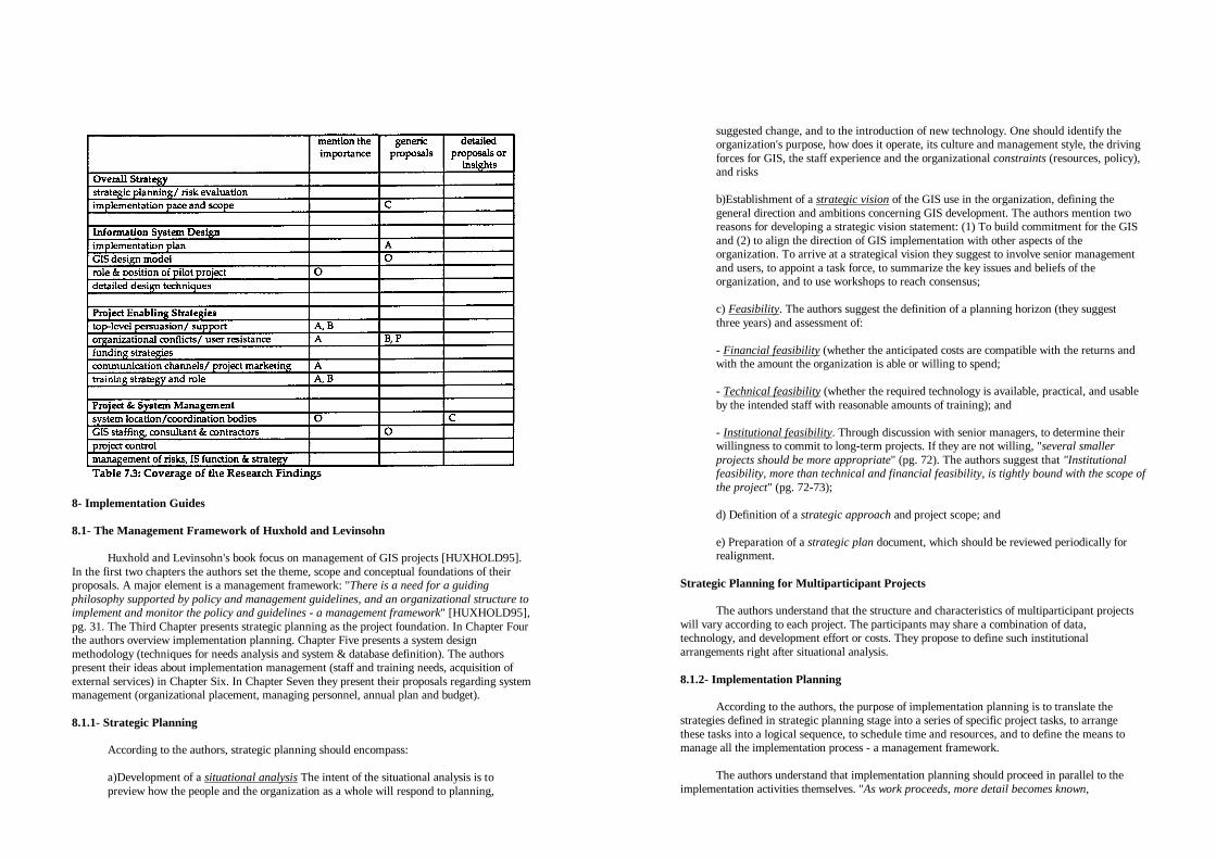
8- Implementation Guides
8.1- The Management Framework of Huxhold and Levinsohn Huxhold and Levinsohn's book focus on management of GIS projects [HUXHOLD95].
In the first two chapters the authors set the theme, scope and conceptual foundations of their proposals. A major element is a management framework: "There is a need for a guiding philosophy supported by policy and management guidelines, and an organizational structure to implement and monitor the policy and guidelines - a management framework" [HUXHOLD95], pg. 31. The Third Chapter presents strategic planning as the project foundation. In Chapter Four the authors overview implementation planning. Chapter Five presents a system design methodology (techniques for needs analysis and system & database definition). The authors present their ideas about implementation management (staff and training needs, acquisition of external services) in Chapter Six. In Chapter Seven they present their proposals regarding system management (organizational placement, managing personnel, annual plan and budget).
8.1.1- Strategic Planning
According to the authors, strategic planning should encompass: a)Development of a situational analysis The intent of the situational analysis is to preview how the people and the organization as a whole will respond to planning,
suggested change, and to the introduction of new technology. One should identify the organization's purpose, how does it operate, its culture and management style, the driving forces for GIS, the staff experience and the organizational constraints (resources, policy), and risks b)Establishment of a strategic vision of the GIS use in the organization, defining the general direction and ambitions concerning GIS development. The authors mention two reasons for developing a strategic vision statement: (1) To build commitment for the GIS and (2) to align the direction of GIS implementation with other aspects of the organization. To arrive at a strategical vision they suggest to involve senior management and users, to appoint a task force, to summarize the key issues and beliefs of the organization, and to use workshops to reach consensus; c) Feasibility. The authors suggest the definition of a planning horizon (they suggest three years) and assessment of: - Financial feasibility (whether the anticipated costs are compatible with the returns and with the amount the organization is able or willing to spend; - Technical feasibility (whether the required technology is available, practical, and usable by the intended staff with reasonable amounts of training); and - Institutional feasibility. Through discussion with senior managers, to determine their willingness to commit to long-term projects. If they are not willing, "several smaller projects should be more appropriate" (pg. 72). The authors suggest that "Institutional feasibility, more than technical and financial feasibility, is tightly bound with the scope of the project" (pg. 72-73); d) Definition of a strategic approach and project scope; and e) Preparation of a strategic plan document, which should be reviewed periodically for realignment.
Strategic Planning for Multiparticipant Projects The authors understand that the structure and characteristics of multiparticipant projects
will vary according to each project. The participants may share a combination of data, technology, and development effort or costs. They propose to define such institutional arrangements right after situational analysis.
8.1.2- Implementation Planning
According to the authors, the purpose of implementation planning is to translate the
strategies defined in strategic planning stage into a series of specific project tasks, to arrange these tasks into a logical sequence, to schedule time and resources, and to define the means to manage all the implementation process - a management framework.
The authors understand that implementation planning should proceed in parallel to the
implementation activities themselves. "As work proceeds, more detail becomes known,

permitting more detailed planning" (pg. 91). As a general rule, the authors suggest a detailed planning for the next 3 months. They present the general stages of the implementation process and their connections with the management framework (for details, see Figure 4.1 of the Huxhold and Levinsohn's book, at page 90):
- Based on the strategic planning, project initiation and start-up plan; - User needs analysis; - General design and specifications; - Applications planning and selection (and definition of the implementation management framework); - Detailed design, specifications, and implementation of each application; - Operation & maintenance, and annual operating plan (and definition of the operating management framework). The authors presented an outline for the implementation plan a) Introduction; b) Background. Review of the strategic vision and other relevant background information; c) Scope and Objectives of Project (restatement, as a reminder); d) Conceptual Overview. The business functions that will be supported (and how), the data that will be converted, the units that will be affected, and the overall sequence of development - who will be affected first (and why); e) The Management Framework. The participants, their roles and responsibilities, the committee and work group structure, their members and authority; f) Task descriptions (major steps); g) Schedule; h) Budget. Present the current, committed, and planned budgets for the project; i) Administration. Description of how the project will be administrated: Management authority, administration of funds, personnel management, contracting practices and restrictions, standards/architecture, and other administrative policies, restrictions, or special dispensations. The authors also suggest to include frequent review points, to make no individual task
longer than 5 days, to ensure that there is a person responsible for each task, and to use a pilot project to deal with uncertainty. As an example of management framework, the authors suggest the following elements:
- Management authority (steering committee), composed of policy makers and department heads of sponsoring agencies, which is responsible for policy decisions, approval of plans, resource allocation and conflict resolution; - Liaison committee, composed of management representatives from interested (but not sponsoring) agencies, which is responsible for project monitoring/ communication; - User working group, composed of line managers and professionals from sponsoring agencies, which is responsible for facilitating needs analysis and design studies, and for reviewing project plans and specifications; - Design and implementation group, composed of project manager, and of internal or contracted analysts and programmers; and - Project management team, composed of project manager, project leader(s) and end-user appointments, which is responsible for project plans and deliverables, and for coordination of GIS implementation.
8.1.3- System Design Methodology The authors propose a functional approach to system design, comprising the following
elements: - Documentation of the current physical model of the organization. All the organizational units should be identified as well as their functions which require maps or other geographic information; - Development of the current logical model of the system, allowing top management to review the efficiency of current system and to identify possible changes; - Defining the new logical model of the system; - Definition of data requirements.: (1) An inventory of geographic information needs (a description of each required maps or drawings); (2) A map inventory (characterization of all maps and drawings currently used by potential users); and (3) An information needs matrix. defining the importance of each component of the map inventory (one dimension of the matrix) for each one of the functions surveyed (the second dimension). This matrix can be helpful for setting priorities regarding applications, and for determining the contents of a shared database; -Definition of requirements for applications (inputs and outputs of each function); - Prioritizing applications; and - Defining hardware and software requirements.

8.1.4- Implementation Management The authors suggest the staff positions and differentiated training program presented in
Table 8.1. They also present a table of products and services which, depending on the type of organization, may be/will almost certainly be externally acquired. For example, they suggest that municipal organizations will "almost certainly " acquire external consultancy on information technology, GIS hardware, GIS software and related technologies, and document imaging.
Huxhold and Levinsohn outline the steps of a procurement process: Gathering
information about products and services, elaborating functional specifications and request for proposals, evaluation of proposals, benchmark test, selection and negotiation, and follow-up (notification of unsuccessful respondents and debriefing). They also suggest:
- The possibility of including pilot projects; - The importance of project reporting activities, demonstrations, and presentations; - Alternative ways to manage the transition to an operational system: The directive change (imposed by commands and edits), and the participative change (acceptance and commitment before change).
8.1.5- Managing the System The authors point out four required activities for the management of an operational GIS: - Determining the most effective organizational placement for the GIS. The authors propose three alternatives: (1) The GIS under control of an operating unit of the organization, (2) the GIS under control of an administrative or other enterprise-wide organizational unit, and (3) the GIS under direct control of the top elected official; - Retaining and managing qualified staff by providing clearly defined job descriptions and career progression opportunities, by allowing autonomy over user relations and task completion, by involving staff with challenging technologies; and by acknowledging staff of their role in the overall mission of the unit and of the organization as a whole; - Preparing an annual budget distributing the costs across all users according to their request for GIS services and their utilization of the system. The authors propose two general methods: (1) The allocated method, which establishes funds directly in user
department budgets, and (2) the centralized method, which establishes funds in a separate budget account for the entire organization; and - Using a project management system that can identify, describe, and report about all work of the GIS unit. All the activities should be defined as projects - either direct projects (new applications, requested changes, installation of software or equipment, etc.), or indirect projects (routine problem resolution, administration or support activities such as back-ups, preventive maintenance, etc.). All the work requests and other planned projects should be organized in a annual work plan. The annual work plan should be a basis for fund and project approval, definition of priorities, staff allocation, etc. It can be also used to monitoring the status of each project, staff performance, etc.
8.2- The Manager's Guide to GIS, of Korte The book of Korte is intended to be a "non-technical manager's guide to evaluating the
need for and implementing a geographic information system" [KORTE92]. The book is divided in two parts. The first part defines a GIS, presents a typical local government GIS, and reviews four leading GIS software products (Chapters One to Four). The second part, which contains directions for selecting and implementing a GIS, is described bellow.
8.2.1- The Seventeen Steps for Selecting and Installing a GIS
The seventeen steps of Korte are divided into three phases: Planning, Analysis, and
Implementation. Phase One: Planning Step 1: Develop a Project Plan. The plan may be simply these seventeen steps, but it should also assign responsibilities, define a schedule and a budget; Step 2: Obtain Study Approval (the approval is only for the plan, and not for all the process); Step 3: Educate Managers from the departments which might eventually use the system. It is suggested a half-day technology seminar consisting of an overview of GIS technology, applications, costs, benefits, and pitfalls. Alternative techniques are to bring a system in for demonstration, or to arrange for the managers to attend a GIS conference; Step 4: Review Existing Operations and Needs. The operations of all potential GIS users should be examined. The process should include a review of the mission and organization of each department, of how it collects, uses, analyzes, and distributes geographic data, and of the needs and problems it has when using this data; Phase two: Analysis Step 5: Analysis and Recommendations. The collected data is analyzed to determine whether the GIS is feasible or not. The report should describe potential GIS uses, the GIS database, sources of data, required software functions, and needs regarding new staff

positions and training. It should also include a cost-benefit analysis and a detailed plan with schedule and budget; Step 6: Obtain Pilot Project Approval Step 7: Prepare Functional Specifications and Standards. The results of the previous analysis are reformatted for presentation to vendors; Step 8: Solicit Vendors - Request for Bid (RFB) and Request for Proposals (RFP); Step 9: Evaluate Bids and Proposals. Select Vendors; Phase Three: Implementation Step 10: Detailed Database Design. Once hardware and software is selected, it is possible to refine the schematic database design into a detailed design for that specific system; Step 11: Conduct a Pilot Project. The key goals of the pilot are to test the detailed database design and the cost estimates for data conversion. Management can, then, make a final decision about proceeding with, delay, or cancel the GIS project before major expenditures are made, Step 12: Refine the Detailed Database Design Step 13: Database Conversion Step 14: Procure GIS Hardware and Software. If the database conversion is done in-house, the users should be trained and at least part of the system must be purchased and installed before this work can begin; Step 15: Train Users. The training must be completed in time for users to take over database maintenance; Step 16: Test and Correct the Data; Step 17: Maintain the Data. The entire maintenance process should be planned in advance. This requires two supporting efforts: Ongoing training for new users, and user support for operating problems and software customization;
8.2.2- The Pitfalls and the Keys to Successful Implementation In Chapter Eighth Korte discusses the Keys to Successful Implementation, and in the
subsequent chapter the author presents The Piqalls of a GIS. The Korte's keys to successful implementation are:
- Management support. Obtaining full top management support (and not a partial approval), even if this implies in a delay before starting the project;
- Data conversion. The largest portion of the cost of a GIS program is data conversion. Therefore, it is important to carefully consider which information is really necessary; - Database maintenance. The GIS implementation plan should ensure that all the resources needed to take over database maintenance are available in advance of database delivery; - Training (initial training following system installation and a program to train new users; - User support and software customization. A GIS package will not provide optimal use of the technology unless it is customized for particular user's needs; - Database cost sharing between institutions interested in data for the same geographic area. The common pitfalls of a GIS are: - Failure to consider risks; Failure to done goals. Without clearly defined goals there are no measures for success; - Overstating benefits; - Experimental projects. When an organization interested in GIS decides to give it a try, the GIS receives too-little funds, support, and priority to have a real chance of success. The organization may eventually become convinced that the technology does work, but it must still start from scratch to develop plans for a truly effective GIS program; - No longterm planning. Once defined the goals, plans covering the sequence of events, schedule, and assignment of responsibilities should be defined. The plans should be tailored for the eventual implementation of a fully integrated GIS; - Lack of management support; Lack of user training; Lack of user support; - Lack of user involvement. Without user involvement the project loses the background from their experience, and a sense of indifference or hostility toward the new system is created; - Systems that cannot be expanded or modified; - Budget overrun (or budget underestimation); -Failure to report results to top management, regardless of whether those results are good or bad.
8.2-3- Others Chapters of Part H In Chapter Six Korte highlights the importance of a planning process as a first
implementation step. Korte presents the ways an implementation plan may help ensure success. It may sort out implementation issues and guide the implementation, set goals and a measure for

success. According to Korte, some typical components of a GIS plan are: Introduction and background, existing operations, current limitations and needs, general GIS requirements, conceptual database design, implementation phases and schedule, and expected costs and benefits.
Chapter Ten advocates the use of a consultant in the strategic decisions made during the
planning process, and lists the typical objectives of consultants' services: Review and document the current procedures for handling land records, document the problems, limitations, data, processing requirements, and potential applications, develop the GIS conceptual design, implementation plan, cost estimates, and specifications. Chapter Seven addresses GIS software selection. Chapter Eleven describes basic staff positions or functions: GIS manager, GIS database manager, cartographer, system manager, and programmer. In Chapter Twelve Korte presents the types of costs (hardware and software, database creation, and maintenance ), the "s of savings a GIS can provide (more cost-effective decisions, improvements in productivity, and cost avoidance), and a sample calculation for determining the hourly cost of GIS operation. Chapter Thirteen presents the factors to be considered when defining base map accuracy, and Chapter Fourteen brings suggestions to overcome common problems in getting data from CAD systems into a GIS. Chapter Fifteen presents a case study of GIS implementation.
8.3- The Guide to GIS Planning and Implementation of P11 & ICMA
Public Technology inc. (PTI) and International City Management Association (ICMA)
published a local government guide for GIS planning and implementation [PTI91] . We will reference these institutions as the "authors" of the Guide.
8.3.1- Introduction and Summary of Critical Success Factors
The first Chapter defines GIS, proposes its objectives, suggests possible data and
applications, and presents examples of estimates of GIS costs and potential benefits. Then a summary of critical success factors for GIS implementation is presented. The success factors are divided in three categories: Policy, management, and technology:
(Policy)
- One should verify whether or not the "GIS solution" fits the jurisdiction's long-term goals and overall information master plan. Although GIS can be an extremely important part of government planning and problem solving, it is not the total solution; - Obtaining the understanding and support of top management to conduct an accurate GIS needs assessment is a crucial first step. If a decision is made to implement GIS, the continued involvement of a top-level champion for the entire project is critical to success; - A GIS usually requires partnerships for sharing data, development and equipment costs. Potential partners are adjacent cities and counties, utilities, and other regional authorities; - A GIS is a long-term venture that requires a long-term resource commitment. Responsibility for the GIS should be centralized (one unit within the jurisdiction should be charged with overall responsibility). The designated GIS organization should have a dearly defined service orientation toward user departments;
- Local governments should examine revenue opportunities in sales of products to other departments and to external groups including the private sector, other governments, school boards, and utilities. Without some mechanism to price the information, the city departments may not be efficient in the use of this resource. The local government should conduct a brief market assessment of the potential demand for outputs from the GIS;
(Management) - A GIS is a multi-departmental management tool that can integrate departmental decision making. Despite of its cross-departmental nature and capabilities, it is important to keep expectations and time lines realistic, with a phased startup that all departments agree on, and with visible 'early' results; - Do not hesitate to use experts during some phases of implementation. Depending on the in-house expertise and system requirements, consulting may be desirable for management of multi-department or multi-agency GIS, cartographic and related data conversion, bid evaluation and negotiations, feasibility study, hardware & software installation and database design, application development, and marketing of GIS products and services; - Use team-building and inter-group activities to create an environment of confidence, commitment, and participation; - Follow an implementation plan. Breaking the tasks down into identifiable and manageable steps helps to keep the GIS teams on track. Each phase results in a product or report, a tangible goal for the teams to work toward, as well as a tool for management in gauging progress; - Make sure the priority applications drive the choice of a GIS; - Chose the first applications strategically. Select that ones with high potential of success and visibility. Identify a champion who can "spread the word". The authors quote and highlight the words of Habern W. Freeman, from Harford County, Maryland: "My approach to acquisition of GIS/LIS is political, but above all practical. To sell GIS to elected officials, council members, or commissioners, you must first show an immediate product, such as a land-use map with zoning, sewers, roads, etc. It's almost certain that if you first try to convince elected officials to spend millions of dollars to collect information in order to have a product in five years, you will be doomed to failure"; - Maintain a clear distinction between the data conversion process and applications development; - Use membership in organizations and associations to build local capacity;
(Technology) - When choosing GIS vendors for hardware and software, take into account vendor reliability, system flexibility, and existing hardware and databases.

8.3.2- Policy Issues and Implications Chapter Two suggests policies to drive GIS implementation.
Guidelines for Planning Teams The guide recommends that policy makers should direct the GIS needs assessment team
to answer questions such as: - What problems does a GIS solve? Does a GIS improve services to residents and the business community? How can we quantify this improvement? - How important are cost savings resulting from a GIS, and how are the savings calculated? - How soon will GIS products be available? What is the timetable? - How do we prepare our organization to assimilate a GIS? How will we manage risk? - What are the advantages and tradeoffs of working jointly with partners to share costs? - Can we sell access to our GIS? Scope, Ownership, and GIS Configuration The authors present some possible GIS configurations: - Single department GIS; - Shared GIS dominated by single department; - Multidepartmental GIS, typically managed by a separate office or by the information services department. According to the authors, multidepartmental GIS, though desirable, may not work in the local context due to lack of departmental cooperation. In this last case, another alternative is to use small-scale packages; - Multiagency GIS, where costs and responsibilities are shared among more than one local government unit, or between a number of governmental or non-governmental partners.
Suggestions Regarding Public Access
Regarding electronic access to GIS products and services, the authors suggest: - Find out the state regulations about revenues from local government databases; - Know the market; and
- Consult with the city or county attorney on privacy, security, and responsibility over inaccuracies. Funding Sources The authors also present examples of funding strategies adopted by several local
governments.
8.3.3- The Steps to GIS, and Other Management Issues in Its Planning and Implementation Chapter Three presents the following steps to GIS planning and procurement: - Step 1: Obtaining Top Management Support - Step 2: Establishing the GIS project Team. Two teams are suggested, the policy team and the implementation or technical team. The policy team, which includes top managers, should make the final decisions on goals and resource allocation, and provide general guidance to the technical team. A project leader or coordinator should be assigned. The technical team should include professionals from all the involved departments. It is also suggested to use a consultant to complement in-house available skills; - Step 3: Needs Assessment. The Guide presents two components of needs assessment: An inventory of current information resources and an exploration on their gaps. Through interviews, questionnaires, and document review, all potential resources should be inventoried (that includes automated resources, manual processes and files, and personnel). The authors advocate a very thorough analysis of needs. They state that 'It is often not readily apparent which processes can benefit from GIS technology, so it is always better not to exclude any information during the inventory of resources" (pg. 46). They also suggest that the most valuable outcome of a very thorough needs analysis is the gradual evolution of an organization-wide perspective by the team members; - Step 4: Preparing a Preliminary Implementation Plan. This step should translate the results of needs analysis into project design and functional requirements. The implementation plan should meet the long-term strategic objectives, and the short-term delivery of applications within clear budget limits. The plan should define specific stages, applications, equipment, personnel, timetables, and cost estimates. Key elements to be identified are major GIS applications, functions, priorities, the early applications, any known limitations (such as existing systems), cartographic data maintenance needs, links or enhancements to existing automated systems, project benefits, costs and risks, and project time frames and milestones. The expected total duration of the project, the approximate total annual costs, and the project management structure may also be recommended. The preliminary implementation plan should then be presented to the policy team; - Step 5: Beginning the GIS Procurement Process. The policy team reviews the preliminary recommendations, and agree to fund the project. The implementation plan may be refined to reflect or emphasize the management priorities;

- Step 6: Appointing a Selection Committee. The selection committee may have representatives from the policy and technical teams, line departments, and information services department; - Step 7: Requesting Proposals - Step 8: Evaluating and selecting Vendors. Such an evaluation proceeds with the disqualification of all bids that do not meet the mandatory criteria, in-depth review of the finalists, benchmark testing, and selection of the first-choice vendor for negotiations; - Step 9: Negotiating and Awarding a Contract. The first-choice vendor should be notified that if the negotiations fail, the selection committee reserves the right to discontinue the negotiations and begin to negotiate with the second finalist. The objectives of negotiation can include a reduction of item pricing, hardware or software loans, trial periods or evaluation period discounts, additional no-charge installation assistance, consulting, training, or other advantages. The client must share with the prospective GIS supplier all the perceived risks and costs that are unacceptable. The vendor is then asked to minimize or share such risks
Installation (installation activities are not presented as steps) Installation includes prototype project, cartographic data conversion, database design and
(high-priority) applications development, full-scale implementation (priority should be given to core applications such as map maintenance), establishing processes and responsibilities for system support, documentation, and training.
8.3.4- Technological Issues and Future Trends
The last two chapters of PTI & ICMA's Guide present technical definitions (GIS/LIS,
AM/FM systems, CADD systems), a review of GIS technology (software, platforms, functions and capabilities, network, database issues), and future trends.
8.4- Other Implementation Guides
The Federal Geodetic Control Committee (FGCQ published a guidebook intended
primarily for the people who must evaluate, plan and implement land information systems at the local level [BROWN89-94]. As the chapters of such a guidebook have been written by different authors and in different times, we choose analyzing each chapter separately. Other related literature is [FORREST90].
8.5- Coverage Analysis and Content Comparison
Table 8.2 presents the coverage of the Implementation Guides. The letters printed into the
table's cells identify the proposals through their author's initials. The letter "H" identifies [HUXHOLD95], "K" identifies [KORTE92], and "I"', identifies [PT191]. The Implementation Guides addressed prevailingly two groups of issues: Information System Design and Project & System Management. Other issues with a reasonable coverage are Implementation Pace and Scope and Funding Strategies. The issue Training Strategy and Role received only generic proposals.
8.5.1- Strategic Planning
Huxhold and Levinsohn's proposal about strategic planning comprises situational
analysis, establishment of a strategic vision, assessment of financial feasibility, technical feasibility and institutional feasibility (willingness of managers to commit to long-term projects);, definition of strategic approach and project scope, and preparation of a strategic plan document which should be reviewed periodically.
8.5.2- Pace and Scope
Huxhold and Levinsohn propose that the definition of the scope of the project should be
based on the institutional feasibility assessment (part of the strategic planning process). If senior managers are not willing to commit to long-term projects, the authors understand that several smaller projects should be more appropriate. PTI and ICMA consider a multidepartmental, organization-wide approach desirable, but they suggest small-scale packages as an alternative for those cases where there is lack of departmental cooperation and agreement. They also suggest short-term delivery of applications (with "visible" early results). Korte suggests long-term planning for a fully integrated GIS.
8.5.3- System Design Model
Table 8.3 presents a summary of the proposed GIS design models. We identified two
main innovative features in these models (see also discussion in Section 5.7): - Huxhold and Levinsohn placed Strategic Planning as a foundation of the implementation process (this is not emphasized in any other model); - The model of Korte includes three opportunities for project approval. The first opportunity is a Study Approval. After user needs analysis and general system conception, Korte suggest an approval for development of the pilot project, and after the development of the pilot there is a final decision to proceed, delay, or cancel the project before full data conversion.

8.5.4- Implementation Plan The PTI and ICMA's proposal place the implementation plan after needs analysis. Korte
proposes a project plan as a first step of implementation and a detailed implementation plan after needs analysis and system conception. Huxhold and Levinsohn understand that the implementation plan should proceed in parallel with the implementation activities. They suggest a start-up plan after strategic planning and, as a general rule, a detailed plan for the next three months.
8.5.5- Pilot
Huxhold and Levinsohn suggest to include a pilot project in the implementation process
to build understanding, reduce uncertainty and risks, and to determine the impact on operations and procedures. They do not suggest a specific position for the pilot within the GIS design model. Korte and PTI & ICMA place the pilot after detailed design and before full data conversion. Korte suggests that the key goals of the pilot are to test the detailed database design and the cost estimates for data conversion.
8.5.6- Detailed Design Techniques
Huxhold and Levinsohn's Guide contains a detailed description of techniques for the
needs analysis, application design, definition of priorities, and shared database design. Korte describes techniques to assess implementation costs and the cost of hourly operation. PIT and ICMA detail techniques to elaborate Request for Proposals (RFPs).
8.5.7- Funding Strategies
Huxhold and Levinsohn propose to distribute costs across all users according to their
request for GIS services and their utilization of the system. The authors propose two budgetting methods: (1) The allocated method, which establishes funds directly in user department budgets, and (2) the centralized method, which establishes funds in a separate budget account for the entire organization. Korte and the PTI & ICMA's Guide suggest cost sharing between institutions interested in data covering the same geographic area. PTI and ICMA also suggest to examine revenue opportunities in sales of products.
8.5.8- Training strategy and role
Huxhold and Levinsohn presented a sample of GIS education & training program (see
Table 8.1 in Section 8.1.0 Korte's and the PTI & ICMA's proposals include a training program after system installation, suggesting an orientation toward system operation. In addition, Korte mentions the importance of an ongoing program to train new users, and PTI and ICMA suggest membership in users' associations.
8.5.9- System Location & Coordination Bodies
Huxhold and Levinsohn propose three alternatives for system coordination: (1) The GIS
under control of an operating unit of the organization; (2) The GIS under control of an administrative or other enterprise-wide organizational unit; and (3) GIS under direct control of the top elected official. PTI and ICMA's Guide presents similar configurations: Single department GIS, shared GIS donated by single department, multidepartmental GIS managed by a separate office or by the information services department, and multiagency GIS where the responsibilities are shared among the partners.

Regarding project coordination, the PIT & ICMA's Guide suggests a policy team (top managers, responsible for main decisions), a technical team, and a project leader. Huxhold and Levinsohn present an example of management framework composed by steering committee (policy makers/department heads of sponsoring agencies, responsible for major decisions), liaison committee (management representatives from interested, non-sponsoring agencies), user working group (line managers and professionals of sponsoring agencies, responsible for facilitating needs analysis and design studies), and project management team (project manager, leaders, and user appointments, responsible for coordination of GIS implementation).
8.5.10- GIS Staffing, Consultant & Contractors
PTI and ICMA recommend that, depending on the in-house expertise and system
requirements, consulting may be desirable for management of multi-department or multi-agency GIS, cartographic and related data conversion, bid evaluation and negotiations, feasibility study, hardware & software installation and database design, application development, and marketing of GIS products and services. Huxhold and Levinsohn presented a table of products and services which, depending on the type of organization, may be/will almost certainly be externally acquired. For example, they suggest that municipal organizations will "almost certainly " acquire external consultancy on information technology, GIS hardware, GIS software and related technologies, and document imaging. Korte advocates the use of a consultant in the strategic decisions made during the planning process, and lists the typical objectives of consultants' services: Review and document the current procedures for handling land records, document the problems, limitations, data, processing requirements, and potential applications, develop the GIS conceptual design, implementation plan, cost estimates, and specifications. Korte also describes basic staff positions or functions: GIS manager, GIS database manager, cartographer, system manager, and programmer.
8.5.11- Project Control
Huxhold and Levinsohn propose to include periodic reviews in the implementation plan,
to use a project management system, to define all activities as specific projects, and, when the system is operational, to prepare an annual budget and working plan to monitor the evolution of each specific project.
Part III: Overall Analysis and Comparison
9- Overview of the Proposals on Each Group of Issues
In this section we will present an overview of the proposals on each group of issues of
our framework. We will present the prevailing idea regarding each subject, or the main alternatives, without any reference to their authors. More detailed explanations on each issue are exposed in sections 4 to 8.
9.1- The Issues of the Information System Design Group
Information System Design group was addressed primarily by the proposals classified as
Implementation Methodologies and Implementation Guides. The focus of this group is on the issue GIS Design Model. Most of the proposals on the other issues were included in this main discussion.
9.1.1- The Alternative Models for System Design
Table 9.1 shows two basic models of GIS implementation. A key feature which
differentiates these two approaches is the role and position of user needs assessment. In the first model there is a preliminary definition of goals and scope, and user needs assessment is used only to collect information to support the detailed design and specification. A variation of this approach would be to define the project scope based on a situational and feasibility analysis, before user needs assessment. In the second model no previous definition of goals and project scope exists. In this last case, in addition to support detailed design, a comprehensive user needs assessment is used to help "discover" the best goals and scope for the project.
In addition, we identified the following alternative proposals concerning the position of
feasibility/cost-benefit analysis/project approval: - Feasibility analysis as one of the first task of implementation (before user needs assessment), and possibly based on a situational analysis; - After needs analysis (in this case, there should be another way to fund/enable the assessment of user needs); and - More than one single opportunity for project approval: Study approval (before user needs analysis), approval for development of pilot project (after user needs analysis), and final decision (after the pilot project).
9.1.2- Implementation Plan We identified different alternatives regarding the position of the implementation plan in
the design methodology. The implementation plan was positioned: - As a first phase of the implementation process; - After user needs analysis, and before system design;

- After user needs analysis and system design; - As a general project plan and first step of implementation, complemented by a detailed implementation plan after user needs analysis and system conception; - As a flexible plan, developed in parallel with the implementation activities themselves (detailed plans for the next three months of project). The most immediate consequence of the different approaches concerning the position of the implementation plan refers to the activities it will help coordinate - the implementation plan may comprehend all the activities (including user needs assessment and design), or only the effective implementation (database loading, acceptance test, user training). Sections 4 to 8 present several other generic proposals about the implementation plan such as: providing budgets for project "contingency" and "discovery".
9.1.3- Pilot Project Although there are several generic proposals about pilot project, we identified only two
basic alternatives concerning its role and position: - Before system design, to help defining system requirements; and - After system and database design, to test the design and cost estimations. Other proposed roles for the pilot are: Building understanding and training, determining the impact on operations and procedures, etc.
9.1.4- Detailed Design Techniques Some of the proposals that addressed the group System Design Model included detailed
design techniques for user needs analysis (and, possibly, design of applications and shared database); estimation of implementation costs and cost of GIS hourly operation; and elaboration of request for proposals (RFPs).
9.2- The Issues of the Overall Strategy Group This group was addressed primarily by the Implementation Strategies class. The main
concerns or motivations for most of the proposals are enabling issues - discussed in Section 9.3.
9.2.1- The Role of Strategic Planing We identified the following alternative focus in the proposals addressing strategic
planning: - Focus on business area analysis to identify and prioritize the business processes to be re-engineered or automated, or to identify the areas of high political or economical impact to be addressed first; and - Focus on situational analysis, organizational risk evaluation, assessment of the readiness of the organization to embrace the GIS project, assessment of the willingness of
managers to commit to long-term projects, etc. Most of the proposals suggest strategic planning/risk evaluation as a first step of the implementation process. A variation of this approach proposes, in addition to an initial effort, further developments in parallel to the implementation activities and periodic reviews.
9.2.2- Implementation Pace and Scope The prevailing proposal concerning the envisioned project scope is an organization-wide,
multipurpose (possibly multi-agency) system. Although we did not find any explicit proposal against this general idea, we have found two variations:
- Small or independent applications in the short-term (and organization-wide scope in the long term); - Organization-wide scope desirable, but small scale systems suggested as an alternative for situations where there is lack of departmental cooperation or agreement. Figure 9.1 illustrates the four main alternative approaches to implementation pace that we
identified in the surveyed literature. The three last approaches have a common feature: They do not agree with the "traditional" approach in which an user needs assessment and full system design are performed before obtaining the first practical results. They propose some instance of short-term results before (multi-phase), in parallel to (multi-track), or in substitution to (iterative prototyping) the detailed analysis and design of a multipurpose GIS. Most of the generic proposals concerning implementation pace corroborate the strategy of short-term results. Their major concern usually is obtaining and sustaining top level support.

Note that the "traditional" approach can include "incremental implementation".
Incremental implementation in this case refers to a phased development of application programs, database loading and transition to new operations, according to the priorities defined in an implementation plan. The key feature differentiating the "traditional" approach from the other is not the "implementation itself', but the global system conception before any short-term result.
9.3- The Issues of the Project Enabling Strategies Group
The most detailed proposals on enabling issues come from the Implementation Strategies
class (specially on the issues obtaining top level support, decreasing user resistance, and familiarizing users).
9.3.1- Proposals About Top-Level Persuasion/Support
We identified three basic approaches for gaining and sustaining top-management support: - Through a favorable cost-benefit analysis, - Through education of leaders/awareness generation in the beginning of the implementation process; and - Through an overall implementation strategy that eases the persuasion of top-level managers (short-term results, low initial investments, etc. See more details about these strategies in Section 9.2 and in Section 4).
9.3.2- Proposals on Organizational Conflicts and User Resistance We found three similar approaches concerning user resistance (major concern) and
organizational conflicts. We will present below some specific terms of each approach, and their main alternative focus:
- Interative prototyping, gradual/experimental system conception and introduction of changes; - "Proactive" approach (instead of 'Reactive"), emphasizing extensive user participation in design and decisions (decisions are taken "consensually" or by an "open court"); - User-centered design, emphasizing the creation of a socio-technical system to serve organizational and human objectives and evolutionary growth. Another proposal concerning user resistance is eliminating negative personal attitudes through management activities such as providing incentives to individual employees who are using GIS technology. The proposals whose main focus is on organizational conflicts are: - Defining organization-wide goals and benefits; and - Using "positive" organizational political behavior (OPB): negotiation, bargaining, networking, expanding connections, using the system to give and receive favors, etc.
9.3-3- Funding Strategies The proposed funding strategies are: - Cost sharing among different organizations interested in data about the same geographic area; - Revenue opportunities in sales of GIS products; - Distributing costs across all users according to their request for GIS services, through one of these two methods: (1) Allocated method - establishes funds directly in the user department; and (2) Centralized method -establishes funds in a separate budget account for the entire organization.
9.3-4- Communication Channels/Project Marketing The proposals concerning communication channels/project marketing are very generic.
They usually mention the importance of communication channels (such as reporting processes, presentations, informal lines of communication, etc.) for project success.
9.3.5- Training Strategy and Role
We identified the following approaches for training/education programs: - Education of leaders/awareness generation in the beginning of the implementation process. The main objective in this case is obtaining support;

- Training after system design and implementation. In this case the training is directed to system operation and use; - Phase of familiarization based on small and independent applications. The major concern in this approach is familiarizing the users with GIS and enabling them to participate in bigger organization-wide projects; - Ongoing training program to train new users; - Complementary educational activities: Membership in user associations, attendance at workshops, etc.; - Different training programs for different classes of users. For example, different approaches for Senior Managers (training on benefits and implications of GIS - start of GIS planning), Project Team (training on GIS concepts and GIS management - prior to project start), Operations Staff (GIS operation - prior to needs analysis), System Staff (GIS design techniques and software customization - prior to installation and testing); Non-Technical End Users (familiarization/GIS use - during GIS planning); and Business Unit Managers (Familiarization/Resource allocation - during the entire process).
9.4- The Issues of the Project & System Management Group Most parts of the specific proposals in this group address the issue System
Location/Coordination Bodies. The other issues were usually addressed with very generic proposals.
9.4.1- Project Coordination Bodies
We found similar proposals about project coordination structures. They propose two main
bodies: - A technical body or project team, composed by GIS staff and mid-level managers, responsible for performing the detailed planning and implementation activities; and - A policy body or steering committee, composed by top-level managers and representatives of the (main) departments involved, responsible for the main decision and for coordination of conflicts. Another structure proposed was the Liaison Committee, composed of
managers/representatives from non-sponsoring agencies, responsible for facilitating needs analysis and design studies. In addition, several proposals highlighted the importance of assigning a GIS project manager early in the implementation process.
9.41- System Location
We identified several alternatives for system location. The most basic choice is whether
the system will be either a single-departmental system, independent systems, or either a multi-
participant or shared system. Figure 9.2 presents the main alternative locations for multi-participant GIS.
An additional alternative for system location is dividing the responsibility between the
department of information services (hardware and software) and all other department involved. Another proposal classified the systems which involve all the departments as "classically corporate", and the systems which involve only three or four departments as "theoretically/pragmatically corporate".
9.4.3- GIS Staffing and the Role of Consultants & Contractors
The use of consultants and contractors was proposed as dependent on the in-house
expertise, and on the intended domain (utilities, local government, etc.). For example, one proposal states that for municipal applications the need of consultancy on information technologies, GIS hardware, GIS (software and related technologies), and document imaging is "almost certain". Another proposal advocates using a consultant during the planning process in activities such as reviewing current procedures, documenting problems and limitations, documenting data processing requirements and application, developing a GIS conceptual design, implementation plan, cost estimates, and specification for purchasing. Using contractors in activities such as system management, data conversion, application development, and in marketing of GIS products was also suggested. The functions/positions proposed for GIS staffing are GIS manager/implementation project manager, system administrator, database administrator, GIS analyst, programmer, digitizer, cartographer, and operator.

9.4.4- Project Control and Management of System Function, Goals and Strategy Very few proposals have addressed these issues. It was proposed that project control be
based on check-points defined in the implementation plan, and the possible use of a project management tool for monitoring and reporting about the project. Regarding management of risks, system function and implementation strategy, we found only generic proposals including stages such as "audit" or "review" after most part of implementation activities, or proposals suggesting periodic reviews of the strategic planing document during the implementation process. 10- Coverage Analysis
The theme GIS Implementation is very broad - it can involve the choice of GIS software,
data acquisition, strategic partnerships, project management, etc. It is not surprising that some papers of the Guiding Literature address or emphasize different issues that others. Table 10.1 summarizes the coverage of the Classes of Guiding Literature. We selected a set of publications of each class and verified what issues these publications address (and how specific are the proposals). The letters printed into the table's cells identify the publications through their authors' initials. The lowest row works as a legend for the upper cells. For example, the first three columns of Table 10.1 refer to the publications representing the Implementation Strategies class. In these columns the letter "A" identifies [ANDERSON92], the letter "F” identifies [FERRAR194], "H” identifies [HEDGES94], and so on. In the next three columns (Implementation Methodologies), the letter "A" identifies [ANTENUCC191], "C" identifies [CLARKE91], "L" identifies [LOVE91], and so on.
As Table 10.1 shows, the Implementation Strategies address basically two groups of
issues: Overall Strategy and Project Enabling Strategies. The enabling issues are presented as the main motivation for the proposed alternative strategies for GIS implementation. For example, all the Implementation Strategies propose some sort of short-term results as a mechanism to ease obtaining top-level support.
The Implementation Methodologies address primarily the issues on the Information
System Design group. They also address most part of the issues from the other groups, but only with generic proposals. Their main focus is on the GIS design model (the sequence of activities, or steps) and all the suggestions on other issues are included in this main discussion. The Implementation Guides present a two fold focus. They focus on the Information System Design Group, like the Implementation Methodologies, but they also present a strong coverage of the issues of the Project & System Management group. The other issues received prevailingly generic proposals.
The Success Factors & Dependencies do not focus in any specific group of issues.
Instead, their generic proposals are distributed over all the four groups. The Research Findings have a similar coverage. They usually present theoretical considerations and research results as a strong foundation of their proposals, and in this sense they differ from the Success Factors & Dependencies. But the conclusions of the Research Findings, where they present most part of their practical proposals, are as generic as the Success Factors & Dependencies, and part of them have the same style. For example, some research results define "variables predictive of successful outcomes" [AZAD93a], "factors affecting GIS adoption" [BUDIC93a], or "factors
that are critical for successful system adoption after acquisition" [ONSRUD93]. The meaning of these three descriptions of results is very similar to success factors".
All the issues of Table 10.1 were addressed. Most part of them were addressed with a
reasonable amount of detailed proposals. Only the issues "Communication Channels/Project Marketing" and "Management of) Risks, GIS Function and Implementation Strategy" have not received any detailed proposal. The issue "Project Control" received a very low coverage as well.
Table 10.2 summarizes the coverage of the Classes of Guiding Literature. One Class has
a "FOCUS" associated to one specific group of issues when this group is addressed with "detailed proposals" by most part of the literature included in that Class. The symbol "some" indicates that such a group received secondary consideration (prevailingly through "generic proposals" or "mention"). The symbol "-" means that the group of issues is not addressed at all by the corresponding Class. Table 10.2 shows that no single publication, or even no single class, presented a "FOCUS" in all the four groups of issues. Even the Implementation Guides are not fully -comprehensive in this sense. However, all the four groups received at least one "FOCUS". This means that there are well developed theories (several "detailed proposals") on all the four groups of issues but these theories are not organized in a single package. In order to have access to well developed theories on all the four groups of issues, one has to gather information from several sources, and from more than one Class of Guiding Literature (does this constitute a problem?).

11- Theoretical Consistency The Overall Strategy and the Project Enabling Strategies groups received a “FOCUS" from the class Implementation Strategies (Table 10.2). The other two groups of issues received a “FOCUS" from the Implementation Methodologies and Implementation Guides. We verified if the proposals on the Overall Strategy and Enabling Issues groups are compatible with the proposals on the two other groups. We have not found a clear relationship between the proposals on these two former groups with the proposals on the group Project & System Management. But we have found a relationship between the Overall Strategy group and the Information System Design group.
One key issue on the Overall Strategy group is the proposed implementation pace. All the
Implementation Strategies propose some form of short-term results in order to ease getting and sustaining top-level support, decreasing user resistance, or familiarizing users. Instead of a comprehensive, organization-wide user needs assessment and system design, the Implementation Strategies propose to start with small and independent applications (before a comprehensive planning process); Or to perform only a core design followed by a dual-track implementation process (one track with short-term results and the other one comprehensive, long-term focused); Or to implement GIS through iterative cycles of development, use, improvement of user skills and system capabilities. The key, common point is the absence of a single design process comprising all the final, envisioned scope (usually an organization-wide system) before obtaining the first practical results.
The overall strategy and implementation pace have a straight relationship with the issue
"GIS design model", from the Information System Design group. We found two basic models of GIS design. A feature which differentiate these two basic approaches is the role and position attributed to user needs assessment. In one model there is a preliminary definition of goals and scope, and the main utility of user needs assessment is to collect information for the detailed design and specification. In the other model there is not a definition of goals and scope before user needs assessment. In this case, a comprehensive user needs assessment is used to help defining the most adequate goals and scope for the project. Despite this basic difference, both models have a common feature: Both involve a comprehensive process of system design before the implementation itself and, therefore, before obtaining the first practical results. Figure 11.1 illustrates these two models of GIS design ("a" and "b") and a generalization ("c"). Note that the implementation itself can be phased. The key common feature is the full GIS design comprising all the envisioned scope, and before obtaining the first practical results. Surprisingly, this key common feature of the two basic models of GIS design is precisely the opposite approach to that one consensually advocated by the Implementation Strategies (absence of a design process comprising all the intended scope before the first practical results).

Although the GIS design models present this "global design" bias, one can not say that their authors actually advocate a global design before some short-term results. In fact some of the proposals which focus on "GIS design model" addressed the issue "implementation pace" with "generic proposals" (see Table 10.1 and 10.2) and recommended, for certain cases, short-term results or small projects. So, it is possible that these publications treat -implementation pace" and "GIS design model" as separate issues and while they teach "GIS design model" they do not intend to address strategic issues like implementation pace. A problem still remains: One needs to learn about GIS design model, one needs to learn about the strategic issues (like implementation pace), and the theories addressing both subjects must be compatible. However, according to the analysis above, they are not.
12- Theoretical Diversity The coverage analysis has shown that most issues are addressed by more than one
publication and, in some instances, by more than one kind of publication. Having several proposals on one single issue does not necessarily mean that there are different theories in that issue because all the proposals can be consensual.
We studied the Guiding Literature to determine its Theoretical Diversity: If the different
proposals on one single issue are consensual, complementary, or alternative (mutually exclusive). Table 12.1 shows which one of these qualifiers best characterize the set of proposals on each issue. The attribute inconclusive means that the proposals on that issue are not clearly characterized by any of the former qualifiers. For example, the issue "communication channels/ project marketing" is inconclusive because it received no "detailed proposals" (see Table 10.1). Some issues are characterized by a combination of qualifiers. The combination "qualifier a AND qualifier b means that part of the proposals are best described by "a" while other part is best described by "b". For example, the issue "implementation pace and scope" is consensual in the sense that all the proposals involve some sort of short term results. But the proposals disagree
about how to achieve such results and, therefore, they are also alternative. The combination "a OR b” means that one can understand that set of proposals as being either "a" or "b".
According to Table 12.1, the proposals on most part of the "conclusive" issues are either
complementary or alternative (or a combination of both). If the alternative approaches come from different publications, one needs to consult these various publications to be able to choose the most adequate approach for one's needs. The same applies for someone interested in having access to complementary theories.

Part IV: Conclusions and Bibliographic References
13- Conclusions
In this report we have presented a comprehensive review of the literature intended to
provide guidance on GIS implementation. We have defined the term Guiding Literature, five basic Classes of publications, and a set of specific issues. We have reviewed a representative number of publications from each Class, organizing their proposals by subject. We have also analyzed the coverage, theoretical consistency, and the theoretical diversity of the Guiding literature. The results of our analysis have shown that there are well developed theories but that these theories are not organized in a single publication or even in a single Class of publications. Some issues are conveniently addressed by one Class while other issues are adequately addressed only by another Class. The analysis has also shown that theories from different sources, addressing different issues, are sometimes inconsistent among themselves. We found alternative approaches concerning several issues. In most part of them, each publication advocates its own approach without presenting other alternatives.
We understand that this report presents two basic contributions. First, it documents a
comprehensive review of the literature on GIS implementation. It can be used as an easy-reference to the Guiding Literature. It organizes the proposals from several sources by subject, enabling comparisons. In other words, it answers the first set of questions stated in Section 1: What does the literature say about GIS implementation? What are the alternative approaches? A second basic contribution of this report is concerned not with the adequacy of the theories themselves but with their organization. By analyzing the coverage, the theoretical consistency, and the theoretical diversity of the Guiding Literature this report addresses a second set of questions from its introduction: Are the proposals compatible among themselves or are they contradictory? Are the ideas organized in a comprehensive guide for practitioners?
Several of the publications analyzed in this report include reviews including or even
emphasizing the study of literature from other fields such as theory of innovations and implementation of information systems in a general sense. This report differs from those publications because it does not address the literature from other fields at all , but only the literature explicitly directed to the implementation of GIS. Other proposals presented a review restricted to the GIS field but in a limited scope. For example, Onsrud and others [ONSRUD93b] review a sample of academic studies on GIS implementation in U.S. local governments (such as those proposals classified as Research Findings, described in Section 7 of this Report) and do not review non-academic proposals on GIS implementation (such as some of those described in Sections 4, 5, 6 and 8). This report is unique in that it presents a comprehensive literature review documenting what the (GIS) literature says about GIS implementation.
This report does not contradict any proposal, it does not state what alternative approach is
appropriate for specific situations, and it does not present any new idea. All these activities are beyond its goals and scope. We understand that documenting what the literature says was a first necessary step toward the development of a comprehensive guide for GIS implementation - our long-term goal.
14- Bibliographic References
[ANTEN UCC191] ANTEN UCCI, J. C.; BROWN, K.; CROSWELL, P. L.; KEVANY, M. K.; ARCHER, H.; "Geographic Information Systems: A Guide to the Technology". Van Nostrand Reinold, New York, 1991.
[AL-ANKARY91] AL-ANKARY, K.M.; "An Incremental Approach for Establishing a GIS in a
Developing Country: Saudi Arabia". International Journal of Geographic Information Systems V.5 N.1, January-March 1991, pp. 85-98.
[ALSTON92] ALSTON, R. A.; DONELAN, D.; "A GIS Is a Terrible Thing to Waste!
Comprehensive Cost-Benefit Analysis of Geographic Infon-nation Systems". Proceedings of the 20th Annual Conference of the Australasian URISA. Gold Coast, Australia, November 25-27 1992, pp. 390-394.
[ANDERSON92] ANDERSON, C.S.; "GIS Development Process: A Proactive Approach to the
Introduction of GIS Technology". Proceedings of the 1992 GIS/LIS Conference, San Jose, California, 10-12 November, V.1, pp. 1-10.
[ARONOFF89] ARONOFF, S.; Geographic Information Systems: A Management Perspective".
WDL Publications, Ottawa, Canada, 1989. [AVISON88] AVISON, D. E.; FITZGERALD, G.; "Information Systems Development: Current
Themes and Future Directions". Information and Software Technology V. 30, N. 8, October 1988, pp. 458466.
[AVISON91] AVISON, D. E.; WOOD-HARPER, A. T.; "Information Systems Development
Research: An Exploration of Ideas in Practice". The Computer Journal, V. 34, N. 2, April 1991, pp. 98-112.
[AZAD93a] AZAD, B.; WIGGINS, L.; "Institutional Issues in the Transfer of GIS Technology
to Organizations: The People Gone Missing". First Sharjah Conference on Geographic Information Systems and Applications, Sharjah, United Arab Emirates, February 8-10,1993.
[AZAD93b] AZAD, B; "Theory and Measurement in GIS Implementation Research: Critique
and Proposals". Third International Conference of Computers in Urban and Planning and Management, Atlanta, USA, July 23-25,1993.
[BACHMANN92] BACHMANN, C.; KIERNAN, B. D.; Lock-Stepping to Develop a Benefits-
Driven Conversion Strategy". GIS World V. 5 N. 9, September 1992, pp. 34-36. [BACON91] BACON, C. J.; "Organizational Modeling and Analysis for GIS Design in Local
Authorities". The 19th Annual Conference of the Australasian Urban and Regional Information Systems Association inc. Wellington, New Zealand, November 19-22,1991, pp. 98-105.
[BARLAZ90] BARLAZ, E. C.; "Application Tracking in Franklin Township: A Phased
Implementation Approach". Proceedings of the 1990 URISA Conference. Edmonton, Alberta, August 12-16, pp. 1-6.

[BORN93] BORN, J.; JANSEN-DITTMER, H.; "The Role of Top Management in GIS
Projects". Proceedings of the EGIS'93, Genoa - Italy, March 29 - April 1, 1993, V.1, pp.156-165.
[BROWN89-94] BROWN, P. M.; MOYER, D. D. (eds.); "Multipurpose Land Information
Systems: The Guidebook". The Federal Geodetic Control Committee (FGCC), Rockville - MD, 1989-1994.
[BUDIC93a] BUDIC, Z. D.; "Human and Institutional Factors in GIS Implementation by Local
Governments". PhD Dissertation. Department of City and Regional Planning, University of North Carolina at Chapel Hill, 1993.
[BUDIC93b] BUDIC, Z. D.; "GIS Use Among Southeastern Local Governments". URISA
journal V. 5 N. 1, Spring 1993, pp. 4-17. [BUDIC94] BUDIC, Z. D.; "Effectiveness of Geographic Information Systems in Local
Government Planning". Journal of the American Planning Association, V. 60, N. 2, Spring 1994, pp. 244-263.
[CALKINS91] CALKINS, H. W.; OBERMEYER, N. J.; "Taxonomy for Surveying the Use and
Value of Geographical Information". International Journal of Geographic Information Systems V. 5, N. 3, July-September 1991, pp. 341-351.
[CAMPBELL91] CAMPBELL, H. J.; "Organizational Issues in Managing Geographic
Information". In: Handling Geographical Information: Methodology and Potential Applications, Ian Masser and Michael Blakemore (eds.). Longman Scientific & Technical/John Wiley & Sons inc., New York - USA, 1991, pp. 259-282.
1CAMPBELL92a] CAMPBELL, H. J.; "Organizational Issues and the Implementation of GIS in
Massachusetts and Vermont: Some Lessons for the United Kingdom". Environment and Planning B: Planning and Design V. 19, 1992, pp. 85-95.
[CAMPBELL92b] CAMPBELL, H. J.; MASSER, I.; "GIS in Local Government: Some Findings
from Great Britain". International Journal of Geographic Information System, V. 6 N. 6, November-December 1992, pp. 529-546.
ICAMPBELL93] CAMPBELL, H. J.; "GIS Implementation in British Local Government". In:
Diffusion of Geographic Information Technologies. Ian Masser and Harlan J. Onsrud (eds.), Kluwer Academic Publishers, Dordrecht - The Netherlands, 1993, pp. 117-146.
ICAMPBELL94] CAMPBELL, H. J.; "How Effective Are GIS in Practice? A Case Study of
British Local Government". International Journal of Geographical Information Systems, V. 8, N. 3, May-June 1994, pp. 309-325.
ICANNISTRA94] CANNISTRA, J.; GOODEN, R.; "A Guide to Acquiring Digital
Orthophotography". GIS World V. 7, N. 7, July 1994, pp. 42-45.
ICHRISMAN87] CHRISMAN, N.R.; "Design of Geographic Information Systems Based on Social and Cultural Goals". Photogrammetric Engineering and Remote Sensing V.53 N.10, October 1987, pp. 1367-1370 (as cited by [ROE911).
[CLARKE91] CLARKE, A. L.; "GIS Specification, Evaluation, and Implementation". In:
Geographic Information Systems: Principles and Applications, V. 1, pp. 477488. David J. Maguire, Michael Goodchild, and David W. Rhind, eds.. Longman Scientific & Technical, and John Willey & Sons inc., New York, 1991.
ICROSWELL91] CROSWELL, P.L.; "Obstacles to GIS Implementation and Guidelines to
Increase the Opportunities for Success". URISA journal V.3 N.1, Spring 1991, pp. 43-57. [CULIS94] CULIS, B. J.; "A Strategy for Assessing Organizational GIS Adoption Success".
Proceedings of the GIS/LIS'94. October 25-27, Phoenix - Arizona, pp. 208-217. [DE MAN90] DE MAN, W. H. E.; "Establishing a Geographical Information System in Relation
to Its Use: A Process of Strategic Choices". In: Introductory Readings in Geographic Information Systems, Donna Peuquet and Duane F. Marble eds., Taylor & Francis, London - UK, 1990, pp. 324-340.
[DIAS931 DIAS, R. W.; "Geoprocessing Driving Plans: Development and Applications".
Proceedings of the IV Latin-American Conference on Geographic Information Systems. Sao Paulo - Brazil, July 7-9 1993, pp. 687-707 (in Portuguese).
I DICKINSON881 DICKINSON, H. J.; CALKINS, H. W.; "The Econon-dc Evaluation of
Implementing a GIS". International journal of Geographic Information Systems V. 2 N. 4, October-December 1998, pp. 307-327.
[DiSERA93] DiSERA, D. P.; "A Case Study of Organization Obstacles Associated with AM/FM
Development". Proceedings of the XVI AM/ FM International Conference, Orlando - Florida, March 22-25 1993, pp. 345-348.
[DOUGLAS91] DOUGLAS, T. J.; "Southern California Consortium Develops a GIS Data
Base". Geo Info Systems V. I N. 1, January 1991, pp. 41-45. [EASON88] EASON, K.; "Information Technology and Organizational Change". Taylor &
Francis, Philadelphia, 1988. [EASON93a] EASON, K. D.; "Gaining User and Organizational Acceptance for Advanced
Information Systems". In: Diffusion and Use of Geographic Information Technologies. Ian Masser and Harlan J. Onsrud (eds.). Kluwer Academic Publishers, Dordrech - The Neetherlands, 1993, pp. 27-44.
[EASON93b] EASON, K. D.; "Planning for Change: Introducing a Geographical Information
System". In: Human Factors in Geographical Information Systems. David Medyckyj-Scott and Hilary M. Hearnshaw (eds.). Belhaven Press, London - UK, 1993, pp. 199-210.

[EDMONDSON91] EDMONDSON, P. H.; "Addressing Organizational Impacts Affected by the Transition from a Centralized GIS to a Distributed GIS". Proceedings of the 1993 URISA Conference. San Francisco, CA, August 11-15, pp. 42-55.
[ENGELKEN94] ENGELKEN, L. J.; "Project Management Tips for AM/FM Project Planning
and Implementation". Proceedings of the XVII AM /FM International Conference, Denver - Colorado, March 14-17 1994, pp. 188-193.
[EGENHOFER92] EGENHOFER, M. J.; FRANK, A. U.; "Object-Oriented Modeling for GIS".
URISA journal V. 4, N. 2, Fall 1992, pp. 3-19. [EPSTEIN91] EPSTEIN, M. L.; "Developing the Most Successful GIS Cost-Benefit Analysis".
Proceedings of the 19th Annual Conference of the Australasian URISA. Wellington, New Zealand, November 19-22 1991, pp. 485-500.
[FERRAR194] FERRARI JR., R.; GARCIA NETO, A.; "Proposal of a Strategy for
Implementation of GIS in Brazilian Local Governments". Proceedings of the GIS Brasil'94. Curitiba - Brazil, October 17-21 1994, pp. 3140 (in Portuguese).
[FORREST90] FORREST, E.; MONTGOMERY, G. E.; JUHL, G. M.; "Intelligent
Infrastructure Workbook": A Management-Level Primer on GIS". A-E-C Automation Newsletter, Fountain Hills - AZ, 1990.
[FOX91] FOX, J.M.; "Spatial Information for Resource Management in Asia: a Review of
Institutional Issues". International Journal of Geographic Information Systems V.5 N.1, January-March 1991, pp. 59-72.
[GILLESPIE94] GILLESPIE, S. R.; "Measuring the Benefits of GIS Use: Two Transportation
Case Studies". URISA Journal V. 6 N. 2, Fall 1994, pp. 62-67. [HAWKES92] HAWKES, G. D.; "Multi-User, Multi-Vendor GIS Project Implementation".
URISA Conference Proceedings V. 2, William Mumbleau and Mark J. Salling Eds., Washington - DC, July 12-16 1992, pp. 111-121.
[HAZELTON92] HAZELTON, N. W. J.; LEAHY, F. J.; WILLIAMSON, 1. P.; "Integrating
Dynamic Modeling and Geographic Information Systems. URISA journal V. 4, N. 2, Fall 1992, pp. 47-58.
[HEDGES94] HEDGES, E.T.; "Supporting Process Re-Engineering Through Incremental
AM/FM Implementation". Proceedings of the XVII Annual AM/FM International Conference, Denver, Colorado, March 14-17,1994.
[HOBBS94] HOBBS, J. L.; "A Fast-Track AM/FM Implementation, 36 Months, Start to Finish".
Proceedings of the XVII AM/FM International Annual Conference. Denver, Colorado, March 14-17 1994, pp. 8-17.
[HUXHOLD95] HUXHOLD, W. E.; LEVINSOHN, A. G.; "Managing Geographic Information
Systems Projects". Oxford University Press, New York, 1995.
[JACKSON94] JACKSON, J.; "Methods for Quantifying Application Development Costs". Proceedings of the 1994 URISA Conference, Milwaukee, V. 1, pp. 69-78.
[JOFFE90] JOFFE, B. A.; "Managing GIS Effectively: Real Experiences from Mature Systems".
Proceedings of the 1990 URISA Conference. Willian Bamberger, Edt. Edmonton, Alberta, August 12-16, pp. 45-51.
[JONES93] JONES, J. T.; "Creating a Cooperative Environment for Successful County Wide
GIS". Proceedings of the 1993 URISA Conference. July 25-29, Atlanta, Georgia, pp. 81-93. [JONES94] JONES, J. T.; SLUTZAH, R. P.; "A Framework for Multiparticipant / Cooperative
GIS: Process, Public Records and Data Products". Proceedings of the URISA Conference. Milwuaukee, 1994, V. 1, pp. 92-101.
[JUHL94] JUHL, G. M.; "Coping with Rapid Development: County 'Reinvents' Government
with GIS Assistance". GIS World V. 7 N. 1, January 1994, pp. 3034. [KEVANY90] KEVANY, M.J.; BARROWMAN, G.; "The Role of a Low-Cost Configuration in
a County GIS". Proceedings of the 1990 URISA Annual Conference, Frank Westerlund, Ed., Edmonton, Alberta - Canada, August 12-16, V. 4, pp. 288-296.
[KEVANY93] KEVANY, M. J.; "Guidelines for Automation". In: "Multipurpose Land
Information Systems: The Guidebook" 23:1-47, Patricia M. Brown and D. David Moyer, eds. The Federal Geodetic Control Committee (FGC0, Rochville - MD, December 1993 (Chapter 23).
[KOLLER93] KOLLER, Z.; "Bringing about Technological Change in a Conservative
Organization - a Case Study of GIS Implementation". Proceedings of the Thirteenth Annual ESRI User Conference V. 2,1993, pp. 371-378.
[KORTE92] KORTE, J. B.; "The GIS Book". OnWoed Press, Santa Fe - NM, 1992. [LOVE91] LOVE, W. R.; "GIS Design and Implementation: A Successful Methodology".
Proceedings of the Annual Conference of the Australasian URISA. Wellington, New Zealand, November 19-22,1991, pp. 474-484.
[MACNEILL94] MACNEILL, R.J.; ALLAN, R.C.; "Changes in LIS Implementation
Methodology". XX FIG International Congress, Melbourne, Australia, March 5-12 1994, pp. 491499.
[MASSER93] MASSER, I.; "GIS Implementation in British Local Government". In: Diffusion
of Geographic Information Technologies. Ian Masser and Harlan J. Onsrud (eds.), Kluwer Academic Publishers, Dordrecht -The Netherlands, 1993, pp. 99-115.
[MASSER94a] MASSER, L; CAMPBELL, H. J.; "Information Sharing and the Implementation
of GIS: Some Key Issues". In: Innovations in GIS: Selected Papers from the First National Conference on GIS UK. Michael Worboys (ed.), Taylor & Francis, London - UKm 1994, pp. 217-227.

[MASSER94b] MASSER, I.; CAMPBELL, H. J.; "Monitoring the Take-Up of GIS in British Local Government". Proceedings of the 1994 URISA Conference. Phoenix - Arizona, October 25-27, pp. 745-754.
[MONTGOMERY93] MONTGOMERY, G. E.; SCHUCH, H. C.; "GIS Data Conversion
Handbook". GIS World, Inc., Fort Collins, Colorado, USA, 1993. [MORRISON93] MORRISON, R. A.; "County-Wide Multipurpose Cadastre GIS
Implementation - A Case Study". Proceedings of the 1993 URISA Conference. July 25-29, Atlanta, Georgia, pp. 76-85.
[NOONAN92] NOONAN, P.; Staged' Land Base Precision Development Strategy". Proceedings
of the URISA Conference. Washington D.C., July 12-16,1992. V. 1, pp. 67-78. [OBERMEYER94] OBERMEYER, N. J.; PINTO, J. K.; "Managing Geographic Information
Systems". The Guilford Press, New York, 1994. [ONSRUD91] ONSRUD, H. J.; PINTO, J. K.; "Diffusion of Geographic Information
Innovations". International Journal of Geographic Information System V. 5 N. 4, October-December 1991, pp. 447-467.
[ONSRUD92] ONSRUD, H. J.; PINTO, J. K.; AZAD, B.; "Case Study Research Methods for
Geographic Information Systems". URISA Journal V. 4 N. 1, Spring 1992, pp. 32-44. [ONSRUD93] ONSRUD, H. J.; PINTO, J. K.; "Evaluating Correlates of GIS Adoption Success
and the Decision Process of GIS Acquisition". URISA journal, V. 5 N. 1, Spring 1993, pp. 18-39.
[ONSRUD95] ONSRUD, H. J.; RUSHTON, G.; (eds.) "Sharing Geographic Information".
Center for Urban Policy Research, New Brunswick, New Jersey, 1995. [PASCARELLA94] PASCARELLA, L.; "Multi-Participant GIS - A Participant View".
Proceedings of the URISA Conference, Milwaukee, 1994, V. 1, pp. 102-109. [PAT-FERSON94] PATTERSON, B. L.; "Basemap Creation: Making Many Small Pieces Into
One". Proceedings of the URISA Conference. Milwaukee, 1994, V. 1, pp. 110-121. [PEUQUET91] PEUQUET, D.J.; BACASTOW, T.; "Organizational Issues in the Development
of Geographic Information Systems: A Case Study of U.S. Army Topographic Information SysterW'. Intemational journal of Geographic Information Systems, V.5 N.3, July-September 1991, pp. 303-319.
[PINTO93] PINTO, J. K.; ONSRUD, H. J.; "Correlating Adoption Factors and Adopter
Characteristics with Successful Use of Geographic Information Systems". In: Diffusion and Use of Geographic Information Technologies". Ian Masser and Harlan J. Onsrud (eds.), Kluwer Academic Publishers, Dordrecht - The Netherlands, 1993, pp. 165-194.
[PINTO94] PINTO, J. K.; AZAD, B.; "The Role of Organizational Politics in GIS
Implementation". URISA journal V. 6, N. 2, Fall 1994, pp. 35-61.
[POE92] POE, G. L.; BISHOP, R. C.; COCHRANE, J. A.; "Benefit-Cost Principles for Land
Information Systems". URISA Journal V. 4 N. 2, Fall 1992, pp. 20-30. [PT191] Public Technology, inc. (PTI); International City Management Association (ICMA);
"The Local Government Guide to Geographic Information Systems: Planning and Implementation". PTI and ICMA, Washington - DC, 1991.
[ROE91] ROE, G.V.; "An Organizational Approach to Implementing GIS". URISA Journal V.3
N 2, Fall 91, pp. 81-84. [ROGERS93] ROGERS, R. C.'"How to Measure GIS Productivity". GIS World V. 6, N. 7, July
1993, pp. 56-59. [ROURK93a] ROURK, R. W.; "How Good Is GIS? An Evaluation of GIS Operational
Effectiveness in Local Government". Proceedings of the 1993 URISA Conference. Atlanta, Georgia, July 25-29,1993, V. 11, pp. 10-23.
[ROURK93b] ROURK, R. W.; "How Good Is GIS in Local Government?". GIS World Special
Issue, June 1993, pp. 52-56. [SCHALL94] SCHALL, L. J.; "Advantages of AM/FM/GIS Pilot Studies and Shared-Cost Base
Maps". Proceedings of the XVII AM/FM International Annual Conference. Denver, Colorado, March 14-17,1994, pp. 178-185.
[SCIULL191] SCIULLI, A. G.; "Pittsburg's AM/FM Strategies". Geo Info Systems V. 1, N. 3,
March 1991, pp. 3842. [SMITH92] SM ITH, D. A.; " Assessing Costs and Benefits of Geographical Information
Systems: Methodological and Implementation Issues". International Journal of Geographic Information Systems V. 6 N. 3, May-June 1992, pp. 247-256.
[SOMERS92] SOMERS, R.; SINGH, Y.; "Developing an Accurate Database Using GPS". GIS
World V. 5, N. 2, February 1992, pp. 22-24. [SOMERS94] SOMERS, R.; "Alternative Development Strategies". In: Proceedings of the
GIS/LIS'94. Phoenix, Arizona, October 25-27 1994, pp. 706-715. [SUSSMAN93] SUSSMAN, R.; "Municipal GIS and the Enterprise Data Model". International
Journal of Geographic Information Systems V. 7 N. 4, July-August 1993, pp. 367-377. [TEIXEIRA93] TEIXEIRA, A. L.; et al.; "The A-B-C of a GIS Implementation". Fator GIS V. 1,
N. 3, October -December 1993, pp. 10-15 (in Portuguese). [VASTAG94] VASTAG, P. H.; THUM, P. G.; NIEMANN JR, B. J.; "Project LOCALIS:
Implementing LIS/GIS in Local Government". URISA journal V. 6, N. 2, Fall 1994, pp. 78-83.

[VENTURA91] VENTURA, S. J.; "Implementation of Land Information Systems in Local Government - Steps Toward Land Records Modernization in Wisconsin". Wisconsin State Cartographer's Office. Madison, WI, 1991.
[VENTURA92] VENTURA, S. J.; HUXHOLD, W. E.; BROWN, P. M.; MOYER, D. D.;
"Organizational Context". In: "Multipurpose Land Information Systems: The Guidebook" 8:1-21, Patricia M. Brown and D. David Moyer, Eds. The Federal Geodetic Control Committee (FGCC), Rockville - MD, January 1992 (Chapter 8).
[VENTURA93] VENTURA, S.. ).;"Getting Started: How to Organize Your Improvement
Efforts". In: "Multipurpose Land Information Systems: The Guidebook" 14:1-41, Patricia M. Brown and D. David Moyer, eds. The Federal Geodetic Control Committee (FGCC), Rochville - MD, January 1993 (Chapter 14).
[VONDEROHE91] VONDEROHE, A. P.; GURDA, R. F.; VENTURA, S. J.; THUM, P. G.; In:
"Introduction to Local Land Information Systems for Wisconsin's Future", Wisconsin State Cartographer's Office, Madison - WI, 1991, Chapter 6, pp. 47-52.
[WIGGINS93] WIGGINS, L. L.; "Diffusion and Use of Geograohic Information Systems in
Public Sector Agencies in the United States". In: Diffusion of Geographic Information Technologies", Ian Masser and Harlan J. Onsrud (eds.), Kluwer Academic Publishers, Dordrecht - The Neetherlands, 1993, pp. 147-163.
[WIGGINS95] WIGGINS, L. L.; FRENCH, S. P.; "GIS: Assessing Your Needs and Choosing a
System". American Planning Association, Chicago, IL, 1991. [WILCOX90] WILCOX, D.; "Concerning'The Economic Evaluation of Implementing a GIS"'.
International journal of Geographic Information Systems V. 4 N. 2, April-Jun 1990, pp. 203-210.
[YEH91] YEH, A.G-O.; "The Development and Applications of GIS for Urban and Regional
Planning in Developing Countries". International journal of Geographic Information Systems V.5 N.1, January-March 1991, pp. 5-27.
The effective implementation of GIS in Local
Government using diffusion theory
Phillip Dooley
Thesis submitted for the
Degree of Masters in Applied Science
(GIS)
June 2001
Department of Geomatics
Faculty of Engineering
The University of Melbourne

i
Abstract
Geographical Information Systems (GIS) are proving difficult to both define and
effectively implement in Victorian Local Government. Current innovation diffusion
theory, and emerging GIS and IS implementation theory are used to develop a framework
for the implementation of either a new GIS, or for improving a currently ineffective GIS.
The thesis describes a method of practically redefining GIS in the Local Government
environment and then applying diffusion principles during the implementation of GIS.
The first area of new investigation in the thesis is the approach to defining the GIS
requirements of Local Government. In this thesis, GIS in Local Government is defined by
starting with the business requirements and then letting them define the high level
technical and functional requirements. This obtains a different answer from the traditional
approach of assuming that current generic high level technical and functional definitions
of GIS are correct, and that implementation is a selection and fine tuning process. The
new approach is based mainly on the “productional perspective” developed in recent
theoretical GIS diffusion studies. The major difference is that GIS implementation in
Local Government does not necessarily include the requirement for the design and
construction of a specific GIS database. The GIS simply consists of graphical maps that
spatially index and read existing non spatial databases within the Local Government IS
environment.
The second area of new investigation is the practical effects of diffusion forces during
implementation. While the productional perspective was developed partially from
diffusion theory, the basic concepts of diffusion theory were reapplied directly to events
during GIS implementation in Local Government. Many specific aspects of
implementation are identified as being influenced directly by basic diffusion forces.
Measures for positively allowing for these are developed during this thesis.
The outcome of the thesis reflects both the theoretical background studied, and the
extensive practical experience of the author obtained during the implementation of GIS in
about 30 Local Governments.
ii
Declaration
This is to certify that:
(i) the thesis comprises only my original work.
(ii) due acknowledgment has been made in the text to all other materials used.
(iii) the thesis is approximately 30,000 words in length, exclusive of tables, maps,
bibliographies, appendices and footnotes.
…………………………………….
(Phillip J Dooley)

iii
Acknowledgements
I would like to thank my many clients for the support and trust to allow me to research
and implement many of the techniques described in this thesis. In particular I would like
to thank the City of Port Phillip and the City of Bayside.
I would like to thank Tai On Chan for the many discussions which assisted me to relate
the theory of diffusion to what was occurring in practice while managing GIS
implementations.
I would also like to thank the other Directors of Dooley Mitchell and Morrison Pty Ltd,
for their support in allowing the flexibility required for me to undertake this research
while still remaining an active partner in the company.
Many thanks to Professor Ian Williamson, my supervisor, for appropriately encouraging
and guiding me through this research, and for giving me the insight to see the bigger
picture of the purpose of research.
Last but not least, I would like to thank my wife and family for the support and sacrifice
necessary to allow me to undertake this work.
iv
Contents
ABSTRACT .................................................................................................................................................... I
DECLARATION ............................................................................................................................................. ii
ACKNOWLEDGEMENTS........................................................................................................................... iii
1 INTRODUCTION ................................................................................................................................. 1
1.1 BACKGROUND ............................................................................................................................. 1 1.2 OBJECTIVES .................................................................................................................................. 2 1.3 METHODOLOGY .......................................................................................................................... 2 1.4 HYPOTHESIS ................................................................................................................................. 4 1.5 SCOPE ............................................................................................................................................. 4 1.6 ASSUMPTIONS ............................................................................................................................. 5 1.7 STRUCTURE .................................................................................................................................. 5
1.7.1 Theory of Diffusion (Chapter 2) .............................................................................................. 5 1.7.2 GIS Implementation Theory (Chapter 3) ................................................................................. 6 1.7.3 Local Government (Chapter 4) ................................................................................................ 6 1.7.4 A Geographical Information System (Chapter 5) .................................................................... 6 1.7.5 Definition of GIS in Local Government (Chapter 6) ............................................................... 7 1.7.6 Implementation of GIS in Local Government (Chapter 7)....................................................... 7 1.7.7 Conclusion and Recommendations (Chapter 8) ...................................................................... 7 1.7.8 Thesis Structure Summary ....................................................................................................... 8
1.8 CONCLUSION ............................................................................................................................... 8
2 THEORY OF DIFFUSION .................................................................................................................. 9
2.1 INTRODUCTION ........................................................................................................................... 9 2.2 DIFFUSION THEORY ................................................................................................................. 10
2.2.1 Innovation .............................................................................................................................. 10 2.2.2 Communication ...................................................................................................................... 12 2.2.3 Over Time .............................................................................................................................. 15 2.2.4 Through a Social System ....................................................................................................... 18
2.3 THE INNOVATION DEVELOPMENT PROCESS ..................................................................... 19 2.3.1 Recognition of a Problem or Need......................................................................................... 20 2.3.2 Research ................................................................................................................................ 20 2.3.3 Development .......................................................................................................................... 21 2.3.4 Commercialisation ................................................................................................................. 22 2.3.5 Diffusion and Adoption .......................................................................................................... 22 2.3.6 Consequences ........................................................................................................................ 22 2.3.7 Summary ................................................................................................................................ 23
2.4 INDIVIDUAL INNOVATION DECISION PROCESS ................................................................ 23 2.4.1 Definition ............................................................................................................................... 23 2.4.2 Decision Process ................................................................................................................... 24 2.4.3 Summary ................................................................................................................................ 26
2.5 THE ORGANISATIONAL INNOVATION PROCESS ............................................................... 26 2.5.1 Overview ................................................................................................................................ 26 2.5.2 The Structure of Organisations .............................................................................................. 26 2.5.3 The Organisation Innovation Process ................................................................................... 28
2.6 RELATIONSHIPS BETWEEN DIFFUSION COMPONENTS ................................................... 30 2.7 SUMMARY .................................................................................................................................. 31

v
3 IMPLEMENTATION THEORY ....................................................................................................... 32
3.1 INTRODUCTION ......................................................................................................................... 32 3.2 THE RELATIONSHIP BETWEEN GIS AND IS ......................................................................... 32
3.2.1 Industry Views ....................................................................................................................... 33 3.2.2 Conclusion ............................................................................................................................. 34
3.3 INFORMATION SYSTEMS DEVELOPMENT .......................................................................... 34 3.4 INFORMATION SYSTEM THEORETICAL APPROACHES .................................................... 36
3.4.1 A Sociotechnical System Perspective ..................................................................................... 37 3.4.2 Organisational Impact on Information System Implementations .......................................... 39 3.4.3 System Analysis Considerations ............................................................................................ 40 3.4.4 Prototyping ............................................................................................................................ 42 3.4.5 Purchase of Application Software Packages ......................................................................... 43 3.4.6 Information System Perceptions of Success Factors ............................................................. 44
3.5 CURRENT GIS IMPLEMENTATION THEORY ........................................................................ 46 3.5.1 Summary of Core GIS Implementation Strategies ................................................................. 47 3.5.2 Issues of GIS Implementation ................................................................................................ 50
3.6 CURRENT IMPLEMENTATION PATTERNS ........................................................................... 54 3.6.1 Opportunistic Implementation ............................................................................................... 55 3.6.2 Systematic GIS development .................................................................................................. 56 3.6.3 Opportunistic–Infrastructure and Business process .............................................................. 56 3.6.4 Integrated Software Installation ............................................................................................ 57 3.6.5 Discussion .............................................................................................................................. 57
3.7 SUMMARY .................................................................................................................................. 57
4 LOCAL GOVERNMENT STRUCTURE ......................................................................................... 58
4.1 THE EXTERNAL ENVIRONMENT ............................................................................................ 58 4.2 LOCAL GOVERNMENT STRUCTURE ..................................................................................... 59 4.3 LOCAL GOVERNMENT FUNCTION ........................................................................................ 61 4.4 LOCAL GOVERNMENT IT STRUCTURE ................................................................................. 63 4.5 SUMMARY .................................................................................................................................. 65
5 GEOGRAPHICAL INFORMATION SYSTEMS AND DIFFUSION ........................................... 66
5.1 INTRODUCTION ......................................................................................................................... 66 5.2 IDENTIFICATIONAL PERSPECTIVE OF GIS .......................................................................... 66 5.3 TECHNOLOGICAL PERSPECTIVE OF GIS .............................................................................. 67
5.3.1 Structural Definitions of GIS ................................................................................................. 67 5.3.2 Functional Perspectives of GIS ............................................................................................. 68
5.4 ORGANISATIONAL PERSPECTIVES ....................................................................................... 70 5.5 PRODUCTIONAL PERSPECTIVE OF GIS ................................................................................ 71
5.5.1 Infrastructure GIS .................................................................................................................. 72 5.5.2 Business Process GIS ............................................................................................................ 72 5.5.3 The Relationship between Infrastructure and Business Process GIS .................................... 73
5.6 EMERGING GIS IMPLEMENTATION TECHNIQUES ............................................................. 75 5.7 SUMMARY .................................................................................................................................. 77
6 THE DEFINITION OF GIS IN LOCAL GOVERNMENT ............................................................ 78
6.1 CURRENT GIS IMPLEMENTATION ENVIRONMENT IN LOCAL GOVERNMENT............ 79 6.2 BUSINESS PROCESS GIS IN LOCAL GOVERNMENT ........................................................... 80
6.2.1 Business Process GIS Framework ......................................................................................... 81 6.2.2 Simple Desktop Mapping ....................................................................................................... 82 6.2.3 Spatial Analysis ..................................................................................................................... 84 6.2.4 The Geographical Data Storage view of GIS ........................................................................ 87 6.2.5 Discussion on the Database View of GIS .............................................................................. 89 6.2.6 Viewing of Corporate Data (Interfacing) .............................................................................. 91 6.2.7 Access to Corporate Systems (Integration) ............................................................................ 94
vi
6.2.8 Business Process GIS Priorities ............................................................................................ 97 6.2.9 Summary of Business Process GIS ........................................................................................ 99
6.3 INFRASTRUCTURE GIS IN LOCAL GOVERNMENT ............................................................. 99 6.3.1 Data ....................................................................................................................................... 99 6.3.2 Information Technology ....................................................................................................... 101 6.3.3 Standards ............................................................................................................................. 103 6.3.4 People with Expertise .......................................................................................................... 103 6.3.5 Organisational Setting ......................................................................................................... 105
6.4 SUMMARY ................................................................................................................................ 107
7 THE IMPLEMENTATION OF GIS IN LOCAL GOVERNMENT ............................................ 109
7.1 INTRODUCTION ....................................................................................................................... 109 7.2 RELEVANCE OF THE THEORETICAL BACKGROUNDS .................................................... 110
7.2.1 The Importance of the IT Component of GIS ....................................................................... 110 7.2.2 Discussion on Relevance of GIS Based Theory ................................................................... 111
7.3 HIGH LEVEL GIS IMPLEMENTATION PROCESSES ............................................................ 113 7.3.1 The Implementation Process ................................................................................................ 114 7.3.2 The User Needs Analysis ..................................................................................................... 114
7.4 MEASUREMENT OF CURRENT GIS STATUS ....................................................................... 117 7.5 DETERMINATION OF BUSINESS PROCESS REQUIREMENTS AND DIFFUSION
IMPACTS ................................................................................................................................................ 121 7.5.1 Diffusion Impacts ................................................................................................................. 121 7.5.2 Simple Desktop Mapping ..................................................................................................... 122 7.5.3 Spatial Analysis View of GIS ............................................................................................... 124 7.5.4 The Geographical Data Storage view of GIS ...................................................................... 125 7.5.5 Viewing of Corporate Data.................................................................................................. 126 7.5.6 Access to Corporate Systems (Integration) .......................................................................... 128
7.6 INFRASTRUCTURE GIS AND DIFFUSION IMPACTS .......................................................... 129 7.6.1 Data ..................................................................................................................................... 130 7.6.2 Information Technology ....................................................................................................... 130 7.6.3 Standards ............................................................................................................................. 130 7.6.4 People with Expertise .......................................................................................................... 131 7.6.5 Organisational Setting ......................................................................................................... 133
7.7 SUMMARY ................................................................................................................................ 135
8 CONCLUSION AND RECOMMENDATIONS ............................................................................. 136
8.1 SUMMARY OF THE GIS IMPLEMENTATION FRAMEWORK .............................................................. 136 8.1.1 The Definition of GIS in Local Government ........................................................................ 137 8.1.2 The Implementation of GIS in Local Government ............................................................... 138
8.2 DIFFUSION DYNAMICS .......................................................................................................... 139 8.3 FURTHER RESEARCH ............................................................................................................. 141 8.4 CONCLUSION ........................................................................................................................... 143
APPENDIX A ............................................................................................................................................. 150
Fitzgerald, M., Dooley, P. and Chan, T.O., 1999, Just when you thought you had finished
the GIS implementation (Hong Kong: Infrastructure ‟99, Conference for Local Government
and Public Authorities).

vii
List of Figures
Figure 1.1 Thesis Structure ........................................................................................... 8
Figure 2.1 The Categorisation of Adopters over Time (Adapted from Rogers
(1995, p262)) ............................................................................................. 16
Figure 2.2 Innovation Development Process (Adapted from Rogers
(1995, p133)) ............................................................................................. 20
Figure 2.3 The Innovation-Decision Process (adapted from Rogers
(1995, p163)) ............................................................................................. 24
Figure 2.4 Five stages in the Innovation process in an Organisation
(adapted from Rogers (1995, p392)) ......................................................... 28
Figure 3.1 Mediating factors between organisations and information
technology (Adapted from Laudon and Laudon (1988, p75)) ................... 37
Figure 4.1 Typical Local Government Structure ........................................................ 60
Figure 4.2 Information technology structure at the City of Port Phillip.
(Adapted from Fitzgerald, Dooley and Chan (1999)) ............................... 64
Figure 5.1 Options for Infrastructure GIS support for a Business Process GIS ......... 74
Figure 5.2. A 3-stage approach to GIS development. (Adapted from
Fitzgerald, Dooley and Chan (1999)) ........................................................ 75
Figure 6.1 The role of GIS when viewing corporate data. .......................................... 91
Figure 6.2 The role of GIS when integrating with corporate systems. ....................... 95
Figure 6.3 The place of GIS in the Information technology structure
at the City of Port Phillip. (Adapted from Fitzgerald et al (1999)) ........... 97
Figure 6.4 GIS knowledge and people framework ................................................... 103
Figure 6.5 Management structure for GIS ................................................................ 105
Figure 6.6 Overall productional perspective framework for Local Government ...... 107
Figure 7.1 A 3-stage approach to GIS development. (Fitzgerald et al (1999)) ......... 113
Figure 7.2 City of Port Phillip GIS development at the end of Stage 2.
(Adapted from Fitzgerald et al (1999)) .................................................... 118
viii
Figure 7.3 City of Port Phillip GIS development 12 months into Stage 3.
(Adapted from Fitzgerald et al (1999)) .................................................... 119
Figure 7.4 Template for specifying corporate data viewing requirements ............... 126
Figure 7.5 Template for specifying requirements for GIS access to
corporate systems..................................................................................... 128
Figure 8.1 Productional perspective summary diagram ............................................ 137
Figure 8.2 A 3-stage approach to GIS development. (Fitzgerald et al (1999)) ......... 138
Figure 8.3 The categorisation of adopters over time. (Adapted from Rogers
(1995, p262)) ........................................................................................... 140
List of Tables
Table 3.1 Table of opinions on GIS / IT relationships .............................................. 34
Table 3.2 Implementation Considerations (Adapted from Ferrari and
Onsrud (1995, p5) ...................................................................................... 50
Table 5.1 Components of a GIS (Adapted from Chan and Williamson (1995)) ....... 71
Table 6.1 Business process GIS priorities for a typical Local Government .............. 98
Table 6.2 Business process GIS requirements of typical Local Government
business units ............................................................................................. 98
Table 7.1 Indicative frequency of GIS usage .......................................................... 117

1
1 INTRODUCTION
1.1 BACKGROUND
Currently there is no common strategy for successful Geographic Information System
(GIS) implementation in Local Government. There are varying perceptions of what GIS
is and how it should be implemented. While being considered a part of Information
Technology, GIS has some critical differences. This causes both the implementation
processes and results to vary widely. Depending on the criteria of success, the experience
of the author is that over half of all current GIS implementations in Local Government in
Victoria do not deliver substantial economic benefit.
Local Government commonly believes that GIS implementation consists of the purchase
of software and data, however it has become apparent that a successful implementation is
much more complex and extends over several years. Masser and Onsrud (1993) described
the current situation as follows: “The present scene has been characterised as vendors
„throwing bricks‟ leaving the clients to „build the house.‟ An important research theme
would be to model what different clients need in order to „build the house‟ with the
practical target of defining possible sources of such support.” (Masser and Onsrud, 1993)
This thesis aims to look at the “build the house” component, and assumes that the vendor
may have already “thrown the bricks”.
Diffusion theory, mainly developed in North America and the United Kingdom, provides
a body of research within which to quantify and investigate the factors that must be
considered during a full Local Government GIS implementation. “Diffusion is the
process by which an innovation is communicated through certain channels over time
and among the members of a social system.” (Rogers, 1995)
There has been considerable research into the effects of diffusion on GIS
implementations in general, and into implementation methods in the Information Systems
2
(IS) environment. However, the question of predicting how diffusion will specifically
affect the future implementation of GIS in a Local Government requires more
investigation.
If GIS is to become an effective part of Local Government Business Process, then a
generic implementation framework must be developed that includes an allowance for
diffusion theory.
1.2 OBJECTIVES
Using the above definition of diffusion, the aim of the thesis is to define a process by
which GIS (an innovation) can be effectively implemented (communicated through
certain channels over time) in Local Government (among members of a social system).
Thus the main objective of the thesis is the application of diffusion theory to current IS
and GIS implementation theory and practices to improve GIS implementations in Local
Government in Victoria. This will be done by developing a new GIS implementation
framework for Local Government that caters for the influence of diffusion, and is flexible
enough to work in any Local Government.
1.3 METHODOLOGY
The thesis has three core components:
1. A background section where the setting and current research in the relevant areas is
reviewed and understood.
2. A research section where the background is cohesively combined to develop a new
GIS implementation framework for Victorian Local Government.
3. A research section where the forces of diffusion are identified and discussed against
relevant parts of the new implementation framework.
The background section starts by reviewing basic diffusion theory. This has two
applications during the thesis: as a basis for the more advanced GIS implementation

3
theory reviewed in Chapter 3, and as a source of all of the direct diffusion influences that
are identified in Chapter 7 as occurring during GIS implementation. This chapter covers
all of the main diffusion theory components and dynamics, from which the relevant parts
are selected during the rest of the thesis. The third chapter reviews three main sources of
implementation theory: the body of theory used for implementing Information
Technology and Information Systems, the theory used for implementing GIS, and the
emerging implementation theory by people like Chan, Williamson and Masser which is
based on diffusion theory. Again this chapter discusses a broad range of theories, some of
which are not used, but have been included here to show they have been considered. The
fourth chapter describes the typical structure of Local Government in Victoria. The fifth
chapter briefly defines GIS from the traditional technical and identificational
perspectives, and then describes the emerging organisational and productional
perspectives of GIS.
The most important background theories used in the thesis are the emerging GIS
implementation theory and the redefining of GIS from a productional perspective. These
are both mainly developed in the various works of Masser, and Chan and Williamson.
Core diffusion theory is also important because it is the basis of these works, and also
directly identifiable and active during GIS implementation in Local Government.
The first research sections combine the current body of research to develop a new GIS
implementation framework for Local Government. The framework provides a new
method for defining GIS in each Local Government from a business process perspective.
In Chapter 7 the influences of diffusion are then identified within this framework, and the
framework is evaluated for its effectiveness against the influences of diffusion, and thus
the ability to make a GIS implementation successful.
The framework developed includes steps for identifying clear definitions of GIS as an
innovation in the relevant Local Government environment, and the ability to measure a
successful implementation. “How one should measure or evaluate „effective use‟,
4
„optimal use‟, and „use success‟ remains as a significant research challenge.” (Masser
and Onsrud, 1993)
1.4 HYPOTHESIS
That in order for a Local Government GIS implementation to be successful, it is
necessary to develop an implementation process that allows for the influences of
diffusion.
1.5 SCOPE
Certain software characteristics may be dictated by the diffusion process, however this
thesis must be independent of the current technical ability of GIS software, and
concentrate on the innovation characteristic of GIS.
In order to focus the thesis, the definition of the type of GIS implementation being
considered is further bounded by the following:
(1) An emphasis in the perspective of this thesis is the innovation of GIS as the
mapping of current corporate data, as distinct from the efficient managing of current
spatial data. Most current Local Government GIS research refers to the latter only
(Campbell and Masser, 1995).
(2) The success of GIS implementation depends on a suitable IT environment. The
new implementation model must be able to identify and measure the impact of IT
deficiencies, however a GIS implementation must be separated from an IT hardware/
software implementation.
The thesis assumes that all Victorian Local Governments have some GIS knowledge and
technology, however they may not currently be obtaining full economic benefit from this.
The knowledge has been partly obtained from State Government initiatives for all Local
Governments to participate in the maintenance in the state‟s digital map infrastructure.

5
The methodology developed must firstly measure the current level of GIS diffusion and
thus the current level of economic benefit. Secondly, it must develop a strategy to move
the organisation to the state of obtaining the full benefit of GIS.
“Is the dawning of the information age, if that is what is taking place, about
technological innovation or the capacity of organisations to absorb change?” (Campbell
and Masser, 1995)
1.6 ASSUMPTIONS
It is assumed that GIS is usually of benefit to a Local Government, and that the need for a
GIS implementation does not need to be justified.
1.7 STRUCTURE
The structure of the thesis is as follows:
1.7.1 THEORY OF DIFFUSION (CHAPTER 2)
Chapter 2 aims to address the framework for the “effectively implemented
(communicated through certain channels over time)” component of the thesis.
In order to develop a methodology that includes diffusion factors, Chapter 2 describes the
components and relationships defined in basic diffusion theory. There has been
considerable research into diffusion itself, and particularly in the general GIS
environment. The current research into diffusion of GIS in Local Government has been
more a case of measuring GIS penetration at a particular point in time rather than
predicting the diffusion dynamics during and after implementation. The emphasis of this
thesis is the prediction of the diffusion dynamics, so a combination of generic diffusion
theory and current diffusion research into State Government will be the theoretical basis
of the new research.
6
1.7.2 GIS IMPLEMENTATION THEORY (CHAPTER 3)
The chapter starts with a discussion on the relationship between Information Systems and
GIS, and thus the best theoretical basis for GIS implementation. It then gives an overview
of both bodies of theory, and the emerging theories which combine both of the previous
theories with diffusion theory.
1.7.3 LOCAL GOVERNMENT (CHAPTER 4)
Chapter 4 will define the generic setting for the thesis. This will describe the social
system (Local Government) from both a functional and structural perspective as it exists
in Victoria.
There are many definitions of GIS used, and the structure of Local Government can vary
widely and is not well documented. In the case of Victorian Local Government, the
structure of the social system becomes complex because of the “Purchaser/Provider
Model” which has resulted in the tendering and fragmentation of Local Government.
There are at least three social systems in Local Government: the State/Country, an
individual Local Government, and a Business Unit within a Local Government.
1.7.4 A GEOGRAPHICAL INFORMATION SYSTEM (CHAPTER 5)
This chapter clarifies the definition of GIS from the identificational perspective, the
technological perspective (both structural and functional), and then describes the new
productional perspective currently being developed by Chan and Williamson. Their
productional perspective gives the implementation framework for the rest of the thesis.
The chapter also discusses the emerging GIS implementation theories that are based on
the productional perspective. These are the works where Chan and Williamson have used
diffusion theory to enhance both the definitions of GIS and GIS implementation theory.

7
1.7.5 DEFINITION OF GIS IN LOCAL GOVERNMENT (CHAPTER 6)
This chapter defines GIS in the local government environment from the theoretical
framework in Chapter 5. The chapter quantifies and expands the definitions of both
Business Process GIS and Infrastructure GIS. While the chapter starts with existing
theory, it develops extra definitions of GIS that are not derived from current theory, and
makes a major contribution towards defining the current theory in practical and
quantifiable terms in the Local Government environment. In particular the definition of
Business Process GIS is greatly developed from the current theoretical base.
1.7.6 IMPLEMENTATION OF GIS IN LOCAL GOVERNMENT (CHAPTER 7)
The thesis tests the hypothesis that diffusion affects the implementation of GIS by further
developing the implementation framework and identifying all of the components that are
affected by diffusion. This is done by describing a high level, non technical
implementation process, emphasising the areas where diffusion occurs.
1.7.7 CONCLUSION AND RECOMMENDATIONS (CHAPTER 8)
The main conclusion is that the effect of diffusion on GIS implementation in Local
Government is substantial and that it is possible to implement GIS effectively by
allowing for these effects.
8
1.7.8 THESIS STRUCTURE SUMMARY
Figure 1.1 Thesis Structure
1.8 CONCLUSION
While it is accepted that GIS is of benefit to Local Government, there is no clear process
for quantifying and then obtaining that benefit. The process must look at implementation
from all aspects of the organisation, not just the technical detail. The most difficult aspect
is the fact that GIS is a new technology, and thus strongly influenced by the diffusion
process that occurs with any innovation.
This chapter described how this problem occurs and outlined the steps that this thesis will
go through to research the existing theoretical base and then derive and apply the
necessary diffusion principals to solve the problem.
Chapter 2
DIFFUSION THEORY
Chapter 3
IMPLEMENTATION
THEORY
Chapter 4
LOCAL
GOVERNMENT
STRUCTURE
The Social Setting
Chapter 8
CONCLUSION Chapter 5
GIS FRAMEWORK
BASED ON
DIFFUSION
The Innovation
Chapter 6
FRAMEWORK FOR
DEFINING GIS IN
LOCAL
GOVERNMENT
Chapter 7
IMPLEMENTING GIS
IN LOCAL
GOVERNMENT
Communication & Time

9
2 THEORY OF DIFFUSION
2.1 INTRODUCTION
This chapter aims to describe the concepts, terms and dynamics of diffusion theory that
are the basis of this thesis. The initial theory comes from Diffusion of Innovations by
Everett M. Rogers, which itself is a summary of the current status of diffusion theory. As
well as Rogers‟ current work (1995), the 1962 version of Rogers is referenced where
some of the concepts are put in a more concise manner. The body of work by Rogers is
seen as a better theoretical basis for this thesis than a lot of the recent more applied work.
The communication and adoption of an innovation (GIS) by a social system (Local
Government), occurs within three main frameworks that are described by Rogers (1995):
1. The innovation development process covers the time from the identification of a
problem, through the creation and commercialisation of an innovation to assist in
the problem solution, to the adoption of a solution to the original problem.
2. After commercialisation, the diffusion of an innovation through an organisation
occurs where a target social system, such as a Local Government business unit,
collectively decides to adopt an innovation.
3. Within the target social system, there is also the innovation–decision process,
which like the second framework starts when the innovation has been
commercialised. This is the process that an individual would go through in deciding
to adopt the innovation and occurs in parallel to the organisation diffusion process,
although an individual may adopt an innovation outside the organisational
structure.
10
These frameworks exist for each combination of commercialised innovation and social
system, and the diffusion process itself is a dynamic that occurs across all three settings.
Previous work has not, however, combined the three frameworks; this will be discussed
later in the thesis.
The following sections describe diffusion itself, and then the three frameworks within
which it operates. As this thesis is concentrating on predicting diffusion forces, the
relevant concepts will be covered in more detail than other components of diffusion
theory.
2.2 DIFFUSION THEORY
At the heart of diffusion theory remains the following definition:
“Diffusion is the process by which an innovation is communicated through certain
channels over time and among the members of a social system.” (Rogers, 1995).
The various components of the definition will be defined and explained.
2.2.1 INNOVATION
Chapter 2.3 will fully describe the innovation development process, which is why an
innovation occurs and how an innovation develops to become available to a target
community. The diffusion process occurs in conjunction with the innovation development
process, thus the two have to be considered in parallel. This section will concentrate on
the characteristics of an innovation.
An innovation is an idea that is perceived as new to an individual. It may not be new to a
similar person in a different social system, however the term innovation is defined
relative to the perception of the target social system, not the technical aspects of the
innovation. This is the main difference between an innovation and technology. An
innovation does not have to be stimulated by a problem in the target social system, but
may have already occurred in a similar social system. There is, however, always an
element of reinvention of an innovation when adopted by a different social system.

11
Rogers (1962) defined five characteristics of an innovation that will have a major impact
on the rate of adoption:
1. Relative advantage;
2. Compatibility;
3. Complexity;
4. Divisibility;
5. Communicability.
If the rate of adoption of GIS is to be increased, these characteristics become important.
RELATIVE ADVANTAGE
The innovation must deliver an advantage relative to the status quo. The absolute details
of the advantage an innovation will give are not as important as the advantage relative to
the current local environment. If the local environment is not conducive to taking
advantage of the innovation, then the adoption rate will be slower. Economic
performance is one part of relative advantage.
COMPATIBILITY
The compatibility of an innovation with existing systems will affect the rate of adoption,
and in fact adoption of an innovation may be triggered by the adoption of another
compatible innovation. This compatibility can be seen in the common use of video
recorders. The innovation of the video recorder would not have been successful without
the previous innovation of the television. Similarly, the use of GIS on the Windows
operating system is another example of one innovation depending on a previous one.
COMPLEXITY
The rate of adoption will be affected by the perceived complexity of the innovation,
which is more important than the actual complexity. The potential end user will adopt
more quickly if they perceive the innovation as being simple.
12
DIVISIBILITY
If the innovation can be implemented in parts or tried over time, then the decision to
adopt will be faster. This particularly applies among early adopters.
COMMUNICABILITY
Innovations are not likely to be adopted quickly through a social system if the results are
not easily visible to the other members of the system. Success has to be able to be
demonstrated and understood.
SUMMARY
In assisting and predicting the diffusion of an innovation, the five innovation
characteristics must be identified and strengthened in order for diffusion to occur
efficiently. If GIS is the innovation being considered, then the core aspect of this thesis is
the identification and presentation of these characteristics during GIS implementation, not
the technical definition of the GIS product.
2.2.2 COMMUNICATION
An innovation may commonly be communicated during the diffusion process through
several channels. The main types of communication channels correlate to the position on
the diffusion time scale, as explained in the next section, however there are several
generic types of communicators and several dynamics that are important.
HOMOPHILY
“Homophily is the degree to which two or more individuals who interact are similar in
certain attributes, such as beliefs, education, social status and the like.” (Rogers, 1995).
The opposite of this is heterophily, which is where two individuals have very different
backgrounds. The effectiveness of communication is directly proportional to the degree
of homophily between the individuals.

13
COSMOPOLITENESS
“Cosmopoliteness is the degree to which an individual‟s orientation is external to a
particular social system.” (Rogers, 1962). Some people only communicate within their
social system, while others have a variety of information sources, for example the
Internet. This will be a core indicator of their receptiveness to change.
THE CHANGE AGENT
“A change agent is a professional person who attempts to influence adoption decisions in
a direction that he feels is desirable.” (Rogers, 1962). Change agents are usually not part
of the target social system, or part of the technical group that commercialised the
innovation. More commonly they are likely to be professionals with the skill to
communicate effectively in a homophilious manner with both the creators of the
innovation and the recipients, without belonging to either group, i.e., in a bridging role.
Typically they have good technical knowledge and the ability to communicate this
knowledge in the form of concepts that the target social system will understand. The role
of the change agent is examined in detail, as this role is synonymous with the role of a
GIS Project Manager.
Rogers (1995) identifies seven key roles that are necessary for a change agent to
undertake to introduce an innovation:
1. To develop a need for change. The client needs to be aware and accept the need for
change. This occurs through the change agent, who makes the client aware of current
problems, points out new options available in solving them, and convinces the client
that they have the ability to solve the problems.
2. To establish an information-exchange relationship. The change agent has to obtain
the client‟s trust and be perceived as credible. The credibility of the innovation in the
eyes of the client is directly related to the credibility of the change agent.
3. To diagnose problems. The change agent must relate the introduction of the
innovation to the operational problems of the client, in terms that the client
understands.
14
4. To create an intent in the client to change. The aim of the above three steps is to
create positive motivation for the client to change to the new innovation.
5. To translate an intent to action. The change agent can indirectly influence the
client‟s decision to adopt an innovation through opinion leaders and peers.
6. To stabilise adoption and prevent discontinuance. Once adoption has occurred, the
change agent has the role of reinforcing the reasons for adopting the innovation, and
thus preventing discontinuance.
7. To achieve a terminal relationship. Over time the role of the change agent should
diminish until it is no longer required. This is during the later part of the diffusion
process.
Research shows that some of the core characteristics of a change agent that cause failure
are: Personality (28%), training (15%), vocational interests (11%), attitudes (9%) and
learning ability (0%) (Rogers, 1962). The critical point is that a change agent‟s
communication ability is more important than their technical knowledge.
OPINION LEADERS
“Opinion leaders are defined as those individuals from whom others seek information
and advice.” (Rogers, 1962). Typically opinion leaders are the people who influence the
decisions of others within the social system. Opinion leaders differ from innovators in
that they have followers throughout the social system, and their role in the diffusion
process is critical.
In analysing the relationship between change agents and opinion leaders, Rogers (1995)
makes the following generalisation: “Change agent success in securing the adoption of
innovations by clients is positively related to the extent that he or she works through
opinion leaders.”
DECENTRALISED DIFFUSION SYSTEMS
Decentralised diffusion systems contrast to centralised diffusion systems in that the
spread of knowledge is not controlled in a linear manner and directed totally through a

15
single change agent. Diffusion occurs more naturally starting from innovators within the
social system in a manner controlled by the social system. Key characteristics are the
wide sharing of power among members of the social system, and high levels of
reinvention during the diffusion process. The two diffusion systems can be combined to
form a hybrid system where required.
2.2.3 OVER TIME
Rogers (1962) defined two main time dynamics that occur, namely adoption and
diffusion.
The diffusion process is the spread of a new idea from its source of invention or creation
to its ultimate users or adopters.
Adoption is the decision to continue full use of an innovation.
The adoption process differs from the diffusion process in that adoption is the process
between a person hearing about an innovation and that person deciding to use the
innovation. Diffusion is about the spread of an innovation from the source to the eventual
adopter, thus the diffusion period is the time from the first awareness to the last adopter in
a given social system. Adoption is a process that occurs within the diffusion process that
relates to an individual. The adoption process that relates to an individual is fully
explored in Section 2.4.
DIFFUSION
History shows that there is a considerable time lag (Rogers discusses this in terms of
years) between the discovery of an innovation and the wide adoption of the innovation by
the general public. The process of deciding to adopt the innovation in the intervening
period is known as diffusion. The time taken for an individual to decide to adopt an
innovation will have a normal distribution, and the position of individuals across the
time/distribution curve will be determined by their personality and standing in the social
system. The time taken by individuals to adopt an innovation when compared to the
average of the social system can be divided into several categories: “innovators, early
adopters, early majority, late majority and laggards.” (Rogers, 1962).
16
Each of these categories can be superimposed on a normal distribution to the relative
proportions of each category and how they relate to the time scale of the innovation
adoption.
TIME
Figure 2.1 The Categorisation of Adopters over Time. (Adapted from Rogers
(1995, p262))
There is a large degree of dependency between the types over time. For example, if there
are no innovators in the social system interested in the innovation, then it is unlikely that
an early adopter would adopt the innovation.
ADOPTER CATEGORIES
The identification of the people who fit the various adopter categories, and thus perform
the diffusion process, is a fundamental part of a GIS implementation. The following are
typical profiles of the five adopter categories:
(1) Innovators:
Innovators will always be the first to adopt, and will form a very small percentage of the
social system. They will have outgoing personalities and actively seek innovations to
adopt, in a similar manner to seeking dangerous sports. They will not conform locally and
will have a very wide circle of external contacts. The following are some of their
common characteristics:
Innovators will have a high deviation from the considered norm of their social
system, and a low level of conformity.
EARLY
MAJORITY
34%
EARLY
ADOPTERS
13.5%
LATE
MAJORITY
34%
LAGGARDS
16%
INNOVATORS
2.5%

17
Innovators usually belong to cliques and organisations consisting of other innovators.
The critical role of an innovator is to introduce the innovation from external sources
to the opinion leaders of the social system. Innovators themselves will not be opinion
leaders.
Innovators lack respect in a social system, which is why the early adopters are so
important.
(2) Early Adopters:
These differ from the innovators in that they are considered normal by the social system.
They are usually a reference point for acceptable behaviour for the rest of the community,
and often the opinion leaders. An early adopter would adopt the innovation before 85% of
the social system.
The identification of early adopters is critical to the diffusion of an innovation, and the
following core characteristics have been identified:
Early adopters will have a different mental ability to the rest of their social setting, as
they have no reference points within their local community.
Early adopters will be more cosmopolite than later adopters.
Early adopters will lead opinion in the social system.
Early adopters will communicate with innovators more and see them as less deviant.
Early adopters will be younger.
Early adopters will use a wider source of information than late adopters and will
utilise the following communication channels:
o Impersonal sources.
o More cosmopolite sources more than local sources.
o Closer contact with the origin of the innovation.
o A wider source of information than late adopters.
(3) Early Majority:
These people are not leaders, but follow them very closely. They perform the critical role
of legitimising the innovation. The early majority would make up the balance of the first
18
50% of the adopters. Commonly an early majority would communicate with an early
adopter, but not an innovator.
(4) Late Majority:
These people will naturally follow the early majority because of weight of opinion, but
would not otherwise use the innovation. They are the majority of the second half of the
adopters.
(5) Laggards:
These people use the past as a reference point for their actions. They are not easily
swayed by popular opinion and are relatively isolated from the general community.
Adoption, if it occurs at all, may be a long time after the rest of the social system.
SUMMARY
Within these categories, effective communication rarely occurs outside adjacent
categories, which is usually the limit of the homophily. One of the differences between
early and late adopters is the ability for early adopters to visualise the concept in their
own situation, while late adopters wait to see it in action. This in turn affects the adoption
time, as early adopters do not necessarily become aware of the innovation earlier.
Research indicates that for the late majority the awareness to trial stage is substantially
longer than the trial to adoption stage, and the trial to adoption stage is proportionally
longer for early adopters. The encouragement of a free trial speeds up the whole adoption
process considerably.
2.2.4 THROUGH A SOCIAL SYSTEM
A social system is a population of individuals who are functionally differentiated and
engaged in collective problem solving behaviour (Rogers, 1962).
A social system has the core characteristic of a group of people who interact on an
ongoing basis, and have a common activity or cause. All of the previously described
personality types (early adopters, early majority etc.) will be found within any social

19
system A social system must have enough participants to enable statistical deviation to
occur.
Rogers (1962) identifies the two relevant activities within a social system as the
communication patterns and the authority/hierarchical structure. These have to be
identified as part of the definition of the relevant social system, as the social system is the
starting point for the identification of the other components of the diffusion of an
innovation. (The other starting point is the definition of the innovation itself.)
2.3 THE INNOVATION DEVELOPMENT PROCESS
In order to address the effective diffusion of an innovation within a given social system, it
is necessary to widen the scope of interest to the whole development process of the
innovation being considered. The process starts at the time when the need for the
innovation is recognised, and finishes with the complete adoption or rejection of the
innovation. While GIS is the core innovation being considered, this framework allows for
the invention of different GIS related innovations over time (reinvention), as technology
and perceptions change and GIS responds to different problems. Both the diffusion/
adoption process and the product implementation process are components of the
innovation development process.
“The innovation-development process consists of all the decisions and activities, and
their impacts, that occur from recognition of a need or problem, through research,
development, and commercialisation of an innovation, through diffusion and adoption of
the innovation by users, to its consequences.” (Rogers, 1995)
20
Rogers (1995) identifies six main steps in this process, as demonstrated in the following
diagram:
1 Needs 2 Research 3 Development 4 Commercialisation 5 Diffusion 6 Consequences
Problems Basic/Applied and Adoption
INNOVATION DEVELOPMENT PROCESS
Fig 2.2 Innovation Development Process. (Adapted from Rogers (1995, p133))
These steps need to be explored so they can be used as a framework for the rest of the
thesis. One of the critical questions to be answered during implementation is when the
invention of a new innovation occurs; as distinct from the reinvention, diffusion and
adoption of a current innovation.
2.3.1 RECOGNITION OF A PROBLEM OR NEED
This is the phase that prompts the research, and is stimulated by either a scientific or
political reaction to a problem. The identification of problems can either be random and
identified when they have an impact that requires a response, or identified as part of a
systematic review of a process. A third method of identification is the prediction of a
future problem that is solved in anticipation, possibly for commercial purposes.
The identification of operational problems that require an innovation for the solution can
also come from business process re-engineering that starts with systematic identification
of current operational problems.
2.3.2 RESEARCH
Once a problem is identified, there are several ways it can progress to a solution. There
are two building blocks used in the creation of an innovation that will solve a given
problem: basic research and applied research. Basic research is the advancement of
scientific research that does not necessarily aim to solve a practical problem. Basic
21
research would never develop software, for example. Applied research starts with the
basic research and applies it to practical problems to provide a path for a solution. This
phase of the development of an innovation would take the solution of the problem to
proof of concept stage.
The difference between an innovation and technology is explained in the previous
section, and in many cases they are synonymous.
The research phase may be simply finding the right combination of applied research for a
specific problem. Literature indicates that the research component is sometimes solved
accidentally while attempting to solve another problem (serendipity), and that the
solution is as likely to come from the end user as the research community.
This phase is very similar to the Information Systems (IS) process of converting a set of
operational problems to a set of user needs which are then converted to a set of functional
requirements, as detailed in later chapters. At this point it has thus been proven that
meeting the functional requirements will solve the problem, however it is not clear how
the functions will be performed in a technical sense.
The critical test of whether the innovation development process is occurring during
implementation is whether research, development and commercialisation is required to
solve the problem, or whether it is just a matter of adopting or reinventing a previously
commercialised solution.
2.3.3 DEVELOPMENT
Development takes the Research stage to the point where it can actually meet the needs of
the user. Often Research and Development (R&D) are undertaken together, however this
is not always the case. For example, a tender may be let for a software company to
develop a product from a set of functional requirements. A critical component of the
development phase is continuous feedback from the end users to ensure that the final
result meets the user requirements. The detail and accuracy of the functional requirements
22
will dictate the importance of feedback. Development cycles can vary from where all of
the possible end user feedback is contained in a specification, to where the product is
built entirely from a combination of trial and error and user feedback.
2.3.4 COMMERCIALISATION
“Commercialisation is the production, manufacturing, packaging, marketing, and
distribution of a product that embodies an innovation. It is the conversion of an idea from
research into a product or service for sale in the marketplace” (Rogers, 1995)
This phase is self-explanatory, however the extent to which an innovation is
commercialised depends on the size and number of the applicable social systems. If an
innovation is built for a specific purpose or business unit, then it will require very little
commercialisation. The quality of the commercialisation will impact on the diffusion of
the innovation.
2.3.5 DIFFUSION AND ADOPTION
Diffusion and adoption are the movement of the innovation into the social system, as
explained fully in the next section. One of the main decisions made in this stage is when
to start the diffusion or communication process through the target community.
Communication with the target social system prior to this phase may vary from no
contact at all to very close contact. This is the point where the communication process
commences on the whole target social system, not just a sample who have participated in
the development of the innovation.
The adoption process differs from the diffusion process in that adoption is the process
between a person hearing about an innovation and that person adopting the innovation.
Diffusion is about the spread of an innovation from the source to the eventual adopter.
2.3.6 CONSEQUENCES
There are two possible outcomes from the innovation development process, either the
initial problem is solved or it is not solved. The consequences are thus the impact of the

23
solution on the problem. These are commonly a combination of tangible and intangible
benefits, however tangible benefits are more easily quantified.
2.3.7 SUMMARY
These six phases are a higher-level structure within which an innovation is adopted or
rejected. The extent to which any phase occurs can vary greatly, as can the order, and a
test must be developed so that the person implementing the innovation clearly knows if
the innovation development cycle is required. If the innovation exists, it may just require
implementing or reinventing and then implementing.
2.4 INDIVIDUAL INNOVATION DECISION PROCESS
Arguably the most important innovation diffusion process that occurs is the individual
innovation decision process, which is where an individual person within the social system
decides to adopt the innovation. Unless this occurs within all of the other frameworks,
then the innovation is not utilised.
2.4.1 DEFINITION
“The innovation-decision process is the process through which an individual (or other
decision making unit) passes from first knowledge of an innovation to forming an attitude
toward the innovation, to a decision to adopt or reject, to implementation and use of the
new idea, and to confirmation of the decision.” (Rogers, 1995)
24
Rogers goes on to describe the process through the following diagram:
Figure 2.3 The Innovation-Decision Process. (Adapted from Rogers (1995, p163))
This figure shows the stages an individual goes through while making a decision on the
adoption of the innovation, and these will be explored in the next sections. This process
will later be adapted to the decision of an individual to adopt GIS.
2.4.2 DECISION PROCESS
The various stages that an individual goes through before adopting an innovation are now
described as follows:
KNOWLEDGE
This is where an individual first learns that an innovation has been commercialised to a
point where it may solve their particular problem. They may get this knowledge from
either within the social system or outside channels, such as a change agent or mass media.
The most likely source of the initial knowledge depends on an individual‟s personality,
and thus position in the social system.
Knowledge Persuasion Decision Implementation Confirmation
Adoption
Rejection
Communication Channel
Continued Adoption
Later Adoption
Continued Rejection
Discontinuance
PRIOR
CONDITIONS
characteristics,
1. Previous
practice.
2. Felt needs
problems
3. Innovativeness
4. Norms of the
social systems
Characteristics of
the Decision Making
Unit
1 Socioeconomic
characteristics
2 Personality
variables
3 Communication
behavior.
Perceived
Characteristics of the
Innovation.
1 Relative
Advantage
2 Compatibility
3 Complexity
4 Trialability
5 Observability

25
PERSUASION
Persuasion is the first proactive step taken to obtain further information about the
innovation. The critical components of an innovation that an individual will look for are
those described in 2.2.1 – relative advantage, compatibility, complexity, trialability and
observability. At this point the communication channel also becomes important, as
credibility of the source is necessary to move to the decision stage. The communication
channel that an individual finds most effective is dependent on their position in the social
structure (i.e., from early adopter to laggard, as described in 2.2.3). The necessary
outcome of the persuasion stage is to reduce the uncertainty and to give the innovation
credibility.
DECISION
The decision process is where the individual has enough information to make an
informed decision regarding the adoption or rejection of the innovation. An
organisational decision process may influence this decision, however an organisation
cannot effectively force an individual to adopt an innovation.
IMPLEMENTATION
Implementation is where the decision to adopt is acted on by taking the practical steps
required to implement the innovation. At this stage reinvention can occur, as the
individual decides precisely how the innovation should be utilised in their particular case.
CONFIRMATION
This is the stage where the final decision to continue adoption, adopt later, discontinue
adoption or to continue rejection occurs. If implementation has occurred, the options are
to decide to continue to adopt or to discontinue the adoption, while if implementation has
not occurred, the possible decisions are to adopt later or reject the innovation. This will
be partially based on communication with other similar members of the social system.
26
2.4.3 SUMMARY
These stages occur for all end users regardless of the other higher-level dynamics
occurring in the social system. The time for this to occur may vary from several years (for
a complex innovation) to a couple of days (for a simple innovation). In its simplest form,
the first four components (knowledge through to implementation) may occur during an
effective training session, and the fifth (confirmation) during the first few days of
effective use in the workplace.
2.5 THE ORGANISATIONAL INNOVATION PROCESS
2.5.1 OVERVIEW
The diffusion of an innovation starts at the identification of a problem and moves through
the phases of invention of the innovation to finish at the adoption of an innovation by an
individual. Rogers also identifies another important associated process that occurs within
this. That is, the diffusion process resulting in the adoption of an innovation by an
organisation.
2.5.2 THE STRUCTURE OF ORGANISATIONS
The first critical difference in organisational adoption (as opposed to individual adoption)
is the concept of collective and authority based innovation decisions. Rogers (1995)
identifies three types of innovation decisions:
Optional: Individual and independent adoption decisions.
Collective: Adoption decisions by consensus of the members of the system.
Authority: Relatively few individuals make the decision to adopt.
This introduces a more complex set of factors, which may impact on an individual‟s
decision to adopt an innovation. To determine whether this is occurring, the
characteristics of organisations themselves are investigated.

27
Rogers (1995) identifies the following five core components of an organisation:
1. Predetermined Goals. Organisations should have a formally specified aim and
method for achieving their goals. This usually correlates to the definition of a relevant
social system in this thesis, as the social system would be the employees or staff members
under the umbrella of the formal aim and method for achieving the goals.
2. Prescribed Roles. Tasks will be formally distributed among the members
according to their duties. Organisation charts and position descriptions define the formal
social structure.
3. Authority Structure. There is a set authority structure, with a hierarchy that
defines who is responsible to who. This is a direct contrast to the previously described
random distribution in a social system, and will impact on implementation methodology.
4. Rules and Regulation. All decision processes and actions may be specified by a
formal set of procedures, particularly if Quality Assurance is implemented. This can
result in a high level of social control, and thus impact heavily on the normal
communication processes in diffusion.
5. Informal Patterns. Regardless of the above formal structures, the people in the
organisation will form their own social structure, which will conform with those
discussed previously. This will result in the normal types of social communication also
occurring.
This structure has the ability to impact on normal diffusion processes that would occur by
individuals without these controls. This has to be investigated further so that the impact
of two parallel sets of forces is allowed for.
28
2.5.3 THE ORGANISATION INNOVATION PROCESS
The most relevant diffusion setting that applies to Local Government is the process
whereby an innovation is adopted by an organisation. Rogers (1995) combines the
previous research by Gerald Zaltman and others into this aspect and defines the following
two part, five stage process:
I. INITIATION II. IMPLEMENTATION
Decision
Figure 2.4 Five Stages in the Innovation Process in an Organisation. (Adapted
from Rogers (1995, p392))
The decision by an organisation to adopt the innovation clearly splits the process into two
parts, the initiation sub process and the implementation sub process. The five stages will
be explained further.
1. AGENDA SETTING (INITIATION)
The two core dynamics that occur in organisations all of the time are the identification
and prioritisation of problems and the search for solutions to these problems. As
described earlier, this process is also the trigger for the creation of an innovation. Thus
organisations are always either looking for available innovations or starting the creation
process of new ones.
This process can be accelerated when the members of an organisation perceive a
performance gap between their expectations and the reality. The phase of agenda setting
AGENDA
SETTING
CLARIFYING MATCHING REDEFINING
RESTRUCTURING
ROUTINISING
Decision
General organisational
problems that may
create a perceived
need for innovation.
Fitting a problem
from the organisation‟s
agenda with an
innovation.
The innovation is
modified and re-invented to fit the
organisation and
organisational structures are
altered.
The relationship
between the organisation and the
innovation is
defined more
clearly.
The innovation
becomes an ongoing element in
the organisation‟s
activities, and loses
its identity.

29
can take several years, and alternately can occur in reverse where organisations look for
useful solutions and then see if they have the problem.
2. MATCHING (INITIATION)
This is the stage when the problem is matched with an innovation that will solve the
problem. This is followed by a decision by the organisation on the suitability of the match
and thus either acceptance or rejection of the innovation as a general principle. The
decision to accept the innovation in principle is when the process moves from initiation to
implementation.
3. REDEFINING/RESTRUCTURING (IMPLEMENTATION)
Once the decision is made for the organisation to adopt the innovation, there are two
processes that occur, redefining the innovation to fit the organisation better (reinvention),
and restructuring the organisation to fit the innovation better. Both the innovation and the
organisation will change during this process. Typical organisational changes are the
creation of a unit within the organisation to take responsibility for the innovation, or a
fundamental change can occur in the way the organisation operates. The introduction of
internal email is an example of this.
One of the important dynamics that occurs when the innovation is computer related is the
creation of a state of uncertainty. There are three types of uncertainty that need to be
identified at this point:
1. Technical uncertainty, or the inability to precisely know how the new system will
perform technically in terms of speed, capacity and reliability etc.
2. Financial uncertainty, or the degree to which the innovation will deliver financial
benefits.
3. Social uncertainty, or the degree to which social uncertainty will be created during
implementation.
Rogers (1995) then draws the important correlation between uncertainty and the adoption
process: “Some innovations are so radical, and create such a high degree of uncertainty,
30
that they must be adopted through an innovation process that is relatively unstructured
and almost completely unroutine.”
At this point the other core component in the adoption process is the change agent. The
higher the level of uncertainty with the innovation, the greater the need for a change
agent.
4. CLARIFYING
Once the innovation starts to be put into widespread use, the members of the organisation
start to understand the innovation more clearly. This occurs partially with use, but more
importantly through communicating with other members who are also using the
innovation. Again Rogers (1995) makes an important observation: “Too-rapid
implementation of an innovation at the clarifying stage often leads to disastrous results.”
By the end of this phase, the members have a much clearer understanding of the
innovation being introduced.
5. ROUTINISING
This is the last phase of the introduction of the innovation, and is where the innovation
becomes an accepted part of the normal activities of the organisation. It is no longer
perceived as an innovation.
2.6 RELATIONSHIPS BETWEEN DIFFUSION COMPONENTS
This chapter has described the four components of diffusion (the innovation,
communication, time and the social system), and the three main frameworks within
which diffusion works. It is clear that the four diffusion components act in a co-ordinated
way. In the case of this research the innovation is GIS, the social setting is Local
Government, and the communication channels over time is the task of the
implementation.
The relationship between the frameworks within which diffusion operates is not so clear.
The three frameworks (the innovation development process, the diffusion of an

31
innovation through an organisation, and the innovation–decision process) exist for each
combination of commercialised innovation (e.g., GIS) and social system. The diffusion
process itself is a dynamic that occurs across all three settings. While all dynamics occur
together in a Local Government implementation, the current theoretical work does not
combine the frameworks in a logical manner, but rather presents them as separate bodies
of theory. While this thesis uses all components, the full integration of the three dynamics
remains a subject for future research.
The various diffusion dynamics and principles described operate naturally in society over
time. An understanding of them enables two courses of action, firstly to stop the naturally
occurring diffusion process from affecting an implementation in a negative way, and
secondly to run an implementation so that positive diffusion forces are used to maximum
advantage. These positive components have to be setup and managed during the
implementation.
2.7 SUMMARY
This chapter has described the various influences that make a person adopt an innovation,
which will later be used to determine why a staff member of a Local Government would
adopt GIS. While other sources of diffusion literature were read during the research,
Rogers provides a suitable clear and structured basis for further research into predicting
the diffusion forces in Local Government. Other research tends to apply diffusion
research in a manner that is not suitable for this.
Diffusion forces cause many current GIS implementations to fail because they are
unknowingly having a negative effect in the background, or the GIS implementation does
not reach its full potential because diffusion forces are not proactively applied. This
chapter has systematically described the various diffusion forces that can occur during an
innovation, and by the end of this thesis most components of this chapter will have been
applied to a Local Government GIS implementation. The task of this thesis is to put these
principles and dynamics into a practical context so that they can be deliberately and
effectively used during future GIS implementations.
32
3 IMPLEMENTATION THEORY
3.1 INTRODUCTION
“Implementation: All organisational activities working towards the adoption,
management, and routinisation of an innovation.” Laudon and Laudon (1998, 513)
The purpose of this chapter is to understand current implementation theory and practice,
and then later in the thesis the new research will build from this.
There are four backgrounds that are relevant to this thesis: current Information Systems
(IS) theory, current GIS implementation theory, current implementation practice (which
is not always based on any theory), and emerging implementation theory. The emerging
implementation theory starts to tie the previous three backgrounds together.
The IS theory concentrates on the implementation of Information Technology (IT), while
the GIS implementation theory starts with some IS theory and adds GIS specific
components. This chapter starts by examining briefly the relationship between IS and
GIS, which gives some priority between the two older theoretical bodies of research used
in this thesis.
3.2 THE RELATIONSHIP BETWEEN GIS AND IS
Because it is common practice in some literature to mix up the terms Information
Systems (IS) and Information Technology (IT), the difference is now discussed. IS refers
to the overall system that is being implemented, including the organisational and
management components for example. IT refers to the physical technology component of
IS, particularly the software, hardware and network components. Where the term IT is
used from another source, it is taken as referring to IS unless otherwise stated.

33
There are a number of theories on which to base the proposed implementation methods.
The question is whether to primarily base the new implementation methods on existing
GIS implementation theory, or on the Information Technology (IT) industry, which uses
Information Systems (IS) theory. This section will discuss the relationship between these
theories to justify the direction of the thesis.
The real question is whether GIS is a subset of IS or a special type that runs
approximately in parallel. If GIS is a subset of IS then the implementation theory
currently being utilised in the IS industry becomes relevant. It can then be modified for
the influence of diffusion and the introduction of a geographical component, accepting
that some of the current GIS implementation theory may already do this. If we accept that
GIS is not a direct subset of IS then this thesis has to extend the current GIS
implementation theory, and the current GIS theory should set the majority of the
theoretical background.
3.2.1 INDUSTRY VIEWS
Current industry discussion on the relationship between IS and GIS from a GIS editorial
point of view is relevant. Practice adopted by industry influences both the previous and
future nature of GIS. The perception that GIS is a part of IS will take priority over
working within a theoretical framework as was the case in the past.
GEOWorld (Dec 1998) wrote an industry trends article under the heading “GIS melts into
IT”, where they asked their editorial panel a series of questions on the relationship
between GIS and IT. The first question was: “ Given the rate of change of geographic
technology, from being GIS-centred to being IT-centred (in a world of distributed
technology), is GIS in danger of loosing its identity? In short, is it a good or bad thing
that GIS is being assimilated into IT?”
The twenty-three responses were graded to see if they agreed that GIS was in fact a part
of IT, whether GIS will lose its identity within IT and also whether it is a good or bad
thing. The results were as follows:
34
Yes % No % ?? %
Agree GIS is a part of IT. 22 95% 1 5% 0 -
Agree GIS is not losing its identity. 17 74% 0 0% 6 26%
Believe the assimilation is a good thing. 15 65% 2 9% 6 26%
Table 3.1 Table of opinions on GIS/IT relationships
Thus the current industry assumption is that GIS is a clearly identifiable part of IT (which
from the questions and answers can be taken to mean IS), and that the two are no longer
implemented as disparate systems.
Confirmation of the relevance of IT implementation management is shown in the 1998
AGI Source Book (Corbin, 1998), where sixty seven GIS consultants are listed as
available to manage GIS implementation projects. There are fifty-seven consultants who
use the “PRINCE” project management methodology, and fifty-three who use the
“SSADM” methodology. A large number can use both. Both of these methodologies are
IT industry standards for project management, and neither has been designed specifically
for GIS.
3.2.2 CONCLUSION
From the two perspectives of where the industry considers GIS to be and what type of
implementation methodology the industry considers appropriate to implement GIS, it
would appear that GIS is considered to fit under the IS umbrella. This thesis will thus
consider implementation from both the GIS and IS perspectives.
3.3 INFORMATION SYSTEMS DEVELOPMENT
The IS theory is treated as a body of research that is applicable to GIS implementation,
but is not mandatory to use. For this reason the theory will be summarised, concentrating
firstly on the aspects most commonly used by the GIS community, and then on the
aspects that may have the most relevance to this thesis.

35
Laudon and Laudon (1998) are used extensively in this chapter as a reference. Their book
is a good summary of the current theory and practice of Information Systems (IS) and the
relationship of IS with the commonly used term Information Technology (IT). Laudon
and Laudon (1998) describe the typical IT system development cycle as having the
following steps: systems analysis, systems design, programming, testing, conversion,
production and maintenance. These steps, as described below, are currently taught by
Laudon and Laudon (1998) as the classically correct approach to implementing an
Information System.
SYSTEMS ANALYSIS
Systems analysis is defined as the analysis of the problems that the organisation will try
to solve with an Information System. Systems analysis consists of defining the problem,
identifying its causes, specifying the solution, and identifying the information
requirements that must be met by a system solution. This component also includes a
feasibility study to address technical, economic and operational feasibility.
SYSTEMS DESIGN
Systems design details how the system will meet the information requirements as
specified by the systems analysis. There are three objectives: consider alternative
technology solutions, responsibility and management for the technical delivery of the
system, and detail the implementation specification, including managerial, organisational
and technological components.
PROGRAMMING
The programming stage encompasses the process of translating the system specifications
prepared during the design stage into program code.
TESTING
Testing is the process that determines whether the system produces the desired results
under known conditions.
36
CONVERSION
Conversion is the process of changing from the old system to the new. There are several
strategies for this: parallel, direct cut over, pilot and phased.
PRODUCTION AND MAINTENANCE
Production and maintenance is when the new system is reviewed by users and technical
specialists to determine how well it has met its original goals, followed by any
appropriate changes to correct errors, meet new requirements or improve processing
efficiency.
These steps are commonly used in isolation to implement GIS by the IS (IT) industry
treating the spatial information as another type of relational database. By treating the
spatial information as a database then a GIS implementation can be matched to the
accepted skill and position hierarchy used by the IS (IT) industry, and outwardly GIS
does look like any other software product. This type of implementation results in
software and geographical data being available at the desktop, however the true results
will be critically discredited later in the thesis.
3.4 INFORMATION SYSTEM THEORETICAL APPROACHES
The IS body of theory is substantially greater than the six IT steps in the previous chapter,
and can contribute valuable background in a similar manner to diffusion theory. In the
600+ pages of IS theory and practice documented by Laudon and Laudon (1998), GIS is
mentioned once as an application software available with word processors and
spreadsheets. This may be the correct place for the software component of GIS, however
the rest of the GIS theory may fit into the normal IS theory. With this qualification a
summary of other relevant components of IS (IT) implementation theory that may be
applicable to this thesis is now given. Some of these components are parts of the six core
IT systems development steps described in 3.2, some are options to, and some are factors
outside the six steps.
37
3.4.1 A SOCIOTECHNICAL SYSTEM PERSPECTIVE
Laudon and Laudon (1998) advocate a Sociotechnical System perspective to
implementation, and observed the trend that rapidly decreasing software costs and
growing power is not necessarily translating into greater profit or business benefit. They
make the following critical observation:
“We stress the need to optimise the performance of the system as a whole. Both the
technical and behavioural components need attention. This means that technology must
be changed and designed in such a way as to fit organisational and individual needs. At
times, the technology may have to be ‘de-optimised’ to accomplish this fit.
Organisations and individuals must also be changed …”
If you start with the optimum technology and the existing social system, both will require
changing until a middle ground that works is found. This will normally fail to be the best
technical solution to the problem but rather the result of a mutual influence of the two
factors on each other. Laudon and Laudon illustrated this with the following diagram:
Figure 3.1 Mediating Factors between Organisations and Information
Technology. (Adapted from Laudon and Laudon (1988, p75))
Environment
Culture
Structure
Standard procedures
Business processes
Politics
Management Decisions
Chance
Mediating Factors
ORGANISATIONS INFORMATION
TECHNOLOGY
38
The point is also made that this takes time. This concept agrees with diffusion theory and
is a critical component of GIS implementation. If the implementation of GIS requires the
mediating of an organisation with the technology, further explanation of the eight
mediating factors from the previous diagram is required.
ENVIRONMENT
Environment entails the external impacts on the organisation, particularly financial and
political. Environments can change much faster than organisations, and can cause the
failure of organisations. Changes in the external environment can greatly impact on IS
implementations.
CULTURE
Organisational culture is a set of fundamental assumptions about what products the
organisation produces, for whom and how and where they are produced. They are taken
for granted, and rarely documented or discussed. These assumptions dictate all of the
other components of an organisation.
STRUCTURE
There are several types of organisational structure possible, each requiring different
approaches to implementation. Examples are divisional bureaucracy and machine
bureaucracy. This will determine characteristics like how centralised authority is and how
quickly the environment can change.
STANDARD PROCEDURES
Standard operating procedures are a reasonably precise set of rules, procedures and
practices that develop over time to efficiently undertake the core tasks of the
organisation. These are not easily changed.
BUSINESS PROCESSES
Business processes are the way in which organisations co-ordinate and organise work
activities, information and knowledge to produce products or services. Standard operating
procedures are a subset of these.

39
POLITICS
Organisational politics occur because of the different positions and thus perspectives of
people towards the distribution of resources, rewards and punishments. These differences
will generate conflict and, more importantly, resistance to change.
MANAGEMENT DECISIONS
Management decisions control the way all of the above factors mediate the reaction
between the organisation and the new IS. Managers dictate timeframes and technical
specifications.
CHANCE
The outcome may be influenced by either good or bad luck, put another way, perfect
control is not possible when dealing with a social component.
3.4.2 ORGANISATIONAL IMPACT ON INFORMATION SYSTEM
IMPLEMENTATIONS
Laudon and Laudon (1998, p105) give the following check list in order of importance
when considering the organisational factors of an IS implementation:
The environment in which the organisation must function.
The structure of the organisation: hierarchy, specialisation, and standard operating
procedures.
The culture and politics of the organisation.
The type of the organisation.
The extent of support and understanding of top management.
The level of organisation at which the system resides.
The principal interest groups affected by the system.
The kinds of tasks, decisions, and business processes that the information system is
designed to assist.
The sentiments and attitudes of workers in the organisation who will be using the
information system.
40
The history of the organisation: past investments in information technology, existing
skills, important programs, and human resources.
This list is from an IS perspective and experience, and runs parallel with diffusion theory.
It will make a useful contrast to the GIS version of these factors.
3.4.3 SYSTEM ANALYSIS CONSIDERATIONS
The previous sections describe some of the external factors that have to be considered.
Laudon and Laudon (1988) also give more relevant detail on components of the first
implementation step, system analysis.
TASK 1 ORGANISATIONAL INFORMATION REQUIREMENTS
The first implementation task is linking the Information System to the business plan or
business needs by determining the organisational information requirements. There are
two methodologies detailed for establishing organisational information requirements,
enterprise analysis and critical success factors. These will be summarised.
Methodology 1 Enterprise Analysis (or Business Systems Planning)
“An analysis of the organisation wide information requirements by looking at the entire
organisation in terms of organisational units, functions, processes, and data elements,
helps identify the key entities and attributes in the organisation‟s data.” (Laudon and
Laudon, 1998).
The general principle is to take a wide sample of managers and identify their information
needs through a series of questions on what they do and how they do it. These results are
then aggregated and categorised across the organisation. This process is time consuming
and expensive, and may not result in a questioning of the way business is done.
Methodology 2 Critical Success Factors
Critical Success factors (CSFs) come from the operational goals of the organisation,
which are used to determine the information needs of the organisation. These are
determined from a smaller higher management group than the enterprise analysis
technique. This method initially makes no assumptions about the current processes or
organisational aspects, and will take advantage of the emerging environment from a

41
management point of view, as distinct from the existing productional perspective of the
lower levels of management.
TASK 2 ORGANISATIONAL CHANGE DECISIONS
The other core decision required at the start of the process is the extent of organisational
change that the implementation requires. There are four levels of change identified, each
delivering higher return but requiring higher risk.
Level 1 Automation is the use of technology to speed up existing tasks, which has
minimal organisational impact and minimal risk, but possibly highly
visible returns.
Level 2 Rationalisation is the next level past Automation, where existing business
processes are streamlined to allow better operating efficiency.
Level 3 Business Re-engineering includes automation and rationalisation, but
also questions all existing roles and business processes in the organisation
and then builds them again to take full advantage of the new IS being
implemented.
The five steps in Business re-engineering are:
1. Develop the business vision and process objectives.
2. Identify the processes to be redesigned.
3. Understand and measure the performance of existing processes.
4. Identify the opportunities for applying information technology.
5. Build a prototype of the new process.
This has a large and risky impact on the organisation and all of the
organisational factors discussed in the previous section need to be
considered.
Level 4 Paradigm Shift is the most radical, where the core nature of the business
and organisation is reconceptualised. This would be rarely done, and is not
considered further in this thesis.
42
TIMING CONSIDERATIONS
One of the main considerations when determining the level of change is timing. It is
possible to incrementally move down the list over time, and as the organisation is able to
change, so can the information technology be changed. Further consideration of timing of
change is duplicated in diffusion theory.
SUMMARY
Section 3.4.3 covered several core concepts that can be summarised as follows: There are
two methodologies given for measuring the organisational information requirements,
enterprise analysis and critical success factors. There are also four levels of organisational
change possible, ranging from automation through rationalisation and business process
re-engineering to paradigm shift.
These components match the traditional roles of business analyst and systems analyst in
the IT industry, and these decisions are undertaken as part of the core systems analysis
described in section 3.2.
3.4.4 PROTOTYPING
Prototyping is offered by Laudon and Laudon (1988) as an alternative approach to the
standard IS implementation cycle, where an experimental system is rapidly and
inexpensively built for users to evaluate. This is then used as the basis for the fine-tuning
of the full system. It allows for an iterative process of design by repeatedly redesigning
the system based on end user feedback. The steps are as follows:
1. Identify the user‟s basic needs.
2. Develop a working prototype, possibly using Computer Aided Software Engineering
(CASE) tools.
3. End user uses the prototype with a limited dataset.
4. Revise and enhance the prototype based on user feedback.
5. Repeat steps 3 and 4 until design is ready for full implementation.
6. Use the finished prototype as a final specification for the required application, or use
it as the final application itself.

43
The main reasons given for adopting prototyping are as follows:
Overcomes the situation where precise requirements are difficult to specify in
advance, particularly where the outcomes are decision orientated and the final user is
unsure what they need.
Enables the end user interface to be tested and fine tuned making the requirements
easier to predict.
Makes the organisation more involved in the implementation process, particularly the
final users of the system.
The main risk in prototyping is that it lacks the rigor and discipline of traditional
methods.
3.4.5 PURCHASE OF APPLICATION SOFTWARE PACKAGES
The third option described by Laudon and Laudon (1988) is the purchase of application
software packages that have already been written. There are three circumstances where
this is viewed as a favourable strategy:
1. Where functions are common to many organisations.
2. Where Information Systems resources are in short supply in-house.
3. Where desktop microcomputer applications are being developed for end users.
It is worth immediately noting that GIS in Local Government fits all three of these
criteria. The advantages and disadvantages of software packages are described as follows:
Advantages:
Software design and testing has already been done.
Updates and enhancements are easily incorporated.
Internal staff are not required for technical support.
Takes advantage of the experience of other similar organisations.
Software costs are fixed, increasing management support.
Eliminates major sources of internal organisational resistance by introducing a third
party.
44
Disadvantages:
Possibly not capable of the sophistication required by the organisation.
May only undertake the tasks required by the majority of the market.
Customisation may cause cost and support requirements to increase dramatically.
Very hard to mould fully to the organisation, thus forcing more organisational change
than would be required utilising traditional IS methods.
DISCUSSION ON GIS SOFTWARE PACKAGES
Although not documented as part of this thesis, the State of Victoria (Australia) has a
situation where 40% (30 of 78) of the Local Governments in the state have identical
application GIS software (Latitude). This GIS software has no database ability of its own,
but simply reads corporate data. Latitude users include the City of Port Phillip, which is
used as a reference for this thesis. From the known histories of most of the other twenty-
nine councils, the utilisation rate of the software varies from very high to not at all, with
some councils taking several years and several implementations to succeed. This situation
clearly indicates that choice of software may not be critical for GIS implementation
success in Local Government, and that this component of the implementation
methodology can be a minor part of this thesis. In particular this thesis will concentrate
on the non-software system development aspects of GIS implementation.
3.4.6 INFORMATION SYSTEM PERCEPTIONS OF SUCCESS FACTORS
The IS theory summarised by Laudon and Laudon (1988) also addresses from an IT
perspective two very relevant questions to this thesis: What is a successful
implementation and why do implementations fail? It is stated that as many as 75% of
large IT systems fail in that although they are in production, they are not delivering any
benefits.
MEASURING SUCCESS
The true measure of success is very subjective, however the IS industry considers the
following five criteria to be the most suitable, in order of importance:

45
1. High levels of system use, measured by user surveys or on line monitoring.
2. User satisfaction, measured by questionnaires including factors like accuracy,
timeliness and relevance. In particular the opinions of managers and the ability of the
system to deliver relevant information is important.
3. Favourable attitudes, about the system and the system staff.
4. Achieved objectives, compared to the original system goals.
5. Financial payoff, by either reducing costs or increasing output.
CAUSES OF IMPLEMENTATION SUCCESS AND FAILURE
At a higher level there is some consensus between the different implementation theories
on the causes of success and failure. The core reasons from the IS theory are worth
stating, even though in some cases they are identical to or derive from diffusion theory.
Laudon and Laudon (1998) give the failure to correctly manage the organisational impact
(as previously described) as the main reason for failure. They then go on to further
investigate particular instances where the environment, institutional features and
innovation provided are similar, yet the implementation outcomes are successful in some
instances and fail in others.
The main difference identified is the communication structure during the implementation
process. This can result in a lack of support from either senior management or at the grass
roots level. Implementation may fail if either support is missing. The diffusion theory
change agent is seen as synonymous with the role of the systems analyst, although the IS
view sees organisational change as a clinical process that can be defined in a similar
manner to defining software. This is however further clarified with the concept of a user-
designer communications gap.
The “user-designer communications gap” is defined as the difference in background,
interests, and priorities that impede communication and problem solving among end users
and information systems specialists (Laudon and Laudon, 1998). This communication
46
gap is noted as a critical cause of implementation failure, as also identified in diffusion
theory.
In summary Laudon and Laudon (1998) state that implementation outcome can be largely
determined by the following factors:
The role of users in the implementation process.
The degree of management support for the implementation effort.
The level of complexity and risk of the implementation project.
The quality of management of the implementation process.
SUMMARY
The IS theory described above provides a set of implementation issues, techniques and
measures that may be relevant to GIS implementation. These are referenced or used when
appropriate, and some of them run in parallel to core diffusion theory.
3.5 CURRENT GIS IMPLEMENTATION THEORY
The parallel body of research to IS that is relevant in this research is the body of GIS
implementation theory. While many would consider the work by the U.S. National Centre
for Geographical Information and Analysis (NCGIA) a logical starting point for this
component, the summary by Ferrari and Onsrud (1995) is considered to be of more
relevance. This is a comparison of twenty-two other works and books on GIS
implementation, and has an emphasis on the non-technical components. The work by the
U.S. National Centre for Geographical Information and Analysis has the construction of a
“GIS database” as the central implementation task, while this thesis later argues that this
is not a necessary component at all. Most of their methodology assumes that GIS does not
currently exist and concentrates on the technical aspects of implementation. The
background included in this thesis emphasises the non-technical components.

47
3.5.1 SUMMARY OF CORE GIS IMPLEMENTATION STRATEGIES
In contrast to the IS section, the various GIS implementation theories will be critically
analysed as they are summarised. This will emphasise the components that contribute
towards this thesis and justify making other components redundant. The literature
reviewed identifies five sources of literature that focus on the strategic planning of the
implementation process as distinct from the technical design of the information system
itself. It also identifies another three sources whose primary goal is to guide
implementation. These will now be summarised and analysed.
THE DUAL TRACK IMPLEMENTATION OF SOMERS
Somers (cited in Ferrari and Onsrud, 1995) proposes a dual track development strategy
for implementation of Local Government GIS, a short-term development of immediate
applications and a parallel long-term development of the full GIS. The reasoning is to
deliver early results at the expense of possible extra development costs and complexities.
The advantages also include extra learning through iterative prototyping, extra flexibility
and possibly the ability to start with existing application based software or data.
Analysis
This paper assumes that a core IS development process is essential, and particularly that
the final result will be a large complex single multi-purpose multi-user GIS, that in
particular requires high accuracy data. It is not necessarily true that this is the desired
outcome in Local Government. The core contribution of this paper is the recognition of
the need to deliver early results at the sacrifice of efficiency, and the need for flexibility
during implementation.
ITERATIVE PROTOTYPING OF PEUQUET AND BACASTOW
Peuquet and Bacastow (cited in Ferrari and Onsrud, 1995) based their research in the US
Army, and point out the following findings:
1. The classical project lifecycle does not work well because someone who has never
used the technology cannot define the functional and organisational requirements.
48
2. That the organisation must commit to significant change prior to commencing the
implementation process.
3. That the whole organisation must be involved in the development process.
The authors propose a series of iterative prototypes that both test the IS functional
requirements and the organisational change requirements at the same time, emphasising
the need for a balanced implementation team representing both technology and
organisational interests. The advantages they see of the iterative approach are:
Low level of risk as ideas are tested incrementally.
Greater responsiveness to change as managers and users are involved in the whole
process.
Gradual familiarisation of the user with the technology.
Refining of requirements and project flexibility.
Analysis
The concept of an iterative approach and all of the related advantages are transferable to
Local Government and are relevant to this thesis. This work reinforces the discrediting of
the traditional “project lifecycle” approach as discussed later. On the negative,
commitment to GIS is not a commitment to significant change. In the long term, GIS may
only need to deliver the routinisation of core tasks to be of benefit to some sections of
Local Government.
FERRARI AND GARCIA
Ferrari and Garcia (cited in Ferrari and Onsrud, 1995) propose a three-phase
implementation process – persuasion, familiarisation and globalisation – to overcome
persuasion of managers and sustaining support due to the long-term nature of the results.
The first phase is a Sectorial Evolution Process (SEP) where GIS is made a component of
a proposal to resolve operational problems within the organisation. The concept may be
technically tested but is not implemented and does not actually deliver any results in this
phase. The second phase, familiarisation, is where small independent GIS applications
based on the SEPs are implemented throughout the departments to deliver results and

49
provoke organisational change. The third phase, globalisation, is where the isolated
systems are integrated over a medium to long-term time frame into a corporate GIS.
Analysis
The overall concept is again one of incremental preparation of both the technology and
the organisation, which is utilised in this thesis. The only criticism is that managers do
not easily believe reports or pilots, and a direct move to phase two is preferable as
suggested by Chan and Williamson (1999a).
HEDGES INCREMENTAL IMPLEMENTATION AND RE-ENGINEERING
Hedges (cited in Ferrari and Onsrud, 1995) questions the impact of initial departmental
projects in the utility industry, while agreeing that enterprise wide implementations take
too long to deliver results. The solution suggested is the incremental implementation of
business process changes or process automations supported by small GIS modules over a
period of time. Initially a simple higher-level organisational GIS infrastructure is also
required.
Analysis
The incremental approach is suggested again. Hedges does not however see the ability to
mechanise existing processes as a positive outcome, and requires organisational change
to occur. Many benefits can occur before GIS requires organisational change.
OTHERS
There are several other authors who have proposed implementation strategies, and
generally the lessons are to tie the results back to organisational outcomes, prototyping
and initial interim low cost solutions.
DISCUSSION
There is a reasonable amount of commonality in these implementation strategies,
particularly in the concept of incremental and evolving implementation. This typically
uses short-term independent applications as an enabling technique for a long-term
organisation wide implementation. The authors analysed also identify the task of
50
moulding the technology with the organisation, as described previously, from an IS
perspective. These core concepts will be developed further in this thesis. They all assume
that business process re-engineering is necessary to obtain worthwhile benefits, without
giving credit to the benefits of implementing simple process automation. They also all
assume that in the long term an organisation needs to develop a complex “GIS database”
and run the full project implementation lifecycle. These two assumptions are not
necessarily correct, as will be discussed later in the thesis.
3.5.2 ISSUES OF GIS IMPLEMENTATION
Ferrari and Onsrud (1995) constructed the following set of common implementation
issues that enabled the comparison of various GIS implementation works:
Overall Strategy
Role of strategic planning or risk evaluation
Implementation pace and scope
Information System Design
Implementation plan
GIS design model
Role and position of pilot project
Detailed design techniques
Project Enabling Strategies
Top level persuasion/support
Organisational conflicts/user resistance
Funding strategies
Communication channels/project marketing
Training strategy and role
Project and System Management
System location/co-ordination bodies
GIS staffing, consultant and contractors
Project Control
Management of risks, IS function and strategy
Table 3.2 Implementation Considerations. (Adapted from Ferrari and Onsrud,
1995, p5))

51
As this list is in effect a checklist for GIS implementation, the main components are
described and the various options and conclusions detailed by Ferrari and Onsrud are
summarised against each as follows:
OVERALL STRATEGY
Overall strategy looks at the role of strategic planning, organisational risk evaluation and
implementation pace and scope. Most of these issues are already covered in the summary
of GIS implementation strategies.
The role of strategic planning or risk evaluation is identified with two alternative foci.
First, business area analysis where business processes, and thus the economic impact that
GIS implementation will affect, are addressed. The second given option is situational
analysis where risk evaluation and readiness to implement GIS are addressed. This is
suggested as the first phase in the implementation process.
Implementation pace and scope. The assumed scope of the implementations in the
reviewed literature were organisation wide with two variations, small applications in the
short term, moving to organisation wide in the long term, and small scale systems if there
is a lack of departmental co-operation. There is emphasis put on the early delivery of
results in most research, and little support for the traditional implementation model where
the whole system is designed and built as a single process.
INFORMATION SYSTEM DESIGN
This looks at the issues related to the technical delivery of the GIS software, hardware
and communication methods. This closely follows the IS methodology discussed
previously.
Implementation plan is discussed in terms of its position and thus content. In reality the
author of this thesis believes all projects should start with planning, and all projects
should have an overall plan with supplementary detailed plans for various components.
52
The overall plan must be done at the start, and it should detail when and what detailed
plans will be prepared along the way.
GIS design model contains discussion on when the user needs analysis should be
undertaken and whether the user needs or the higher-level business needs should dictate
the detailed functional design of the GIS. If the implementation is iterative, then design
will be iterative and so will all of the other components. This discussion does not appear
to contribute effectively to GIS implementation, as the only sustainable justification for
the implementation of GIS is improved business process. It needs to be determined for
each project whether this comes from the user‟s perspective or better meeting business
goals.
The role and position of pilot project is identified as either helping to define system
requirements or to test the design and cost estimates. In reality the further secondary roles
of building better understanding and training, determining the impact on operations etc.
are more important.
Detailed design techniques tend to follow the traditional IS systems implementation
practices for software design and construction.
PROJECT ENABLING STRATEGIES
Project enabling strategies cover the organisational components of GIS implementation,
particularly organisational support. Some of these components will be revisited in detail
in the later part of this thesis.
Top-level persuasion/support. There are three approaches identified for obtaining and
sustaining top-level management support: favourable cost-benefit, initial education/
awareness programs, and by providing short term results for low initial investment.
Organisational conflicts/user resistance were identified as able to be reduced through
three main approaches: iterative prototyping or gradual introduction of the changes,

53
proactive user involvement in the changes, and user centred or socio-technical emphasis
in the design. There was also a suggestion of, in effect, bribing the users to use the
product, through some sort of incentives.
There were three core funding strategies suggested: cost sharing between organisations,
revenue from sales of GIS products, and distributing costs across users on either a user
pays principle or proportional costing.
Communication channels/project marketing is always mentioned as an important
element, but with very little provided in the way of detailed solutions.
Training Strategy and Role is broken up into the following components:
Education of the leaders at the beginning of the implementation process;
Training after system design and implementation;
Familiarisation based on small independent applications;
Ongoing training programs for new users;
Complimentary educational programs, user associations etc.; and
Different training programs for different users.
There is no mention of training format or the importance of who the trainer is, which is a
core diffusion concept.
PROJECT AND SYSTEM MANAGEMENT
Project and system management issues relate to some of the organisational aspects of
GIS, in particular how it is co-ordinated and where it is located.
Co-ordination Bodies were generally proposed at two levels, a technical or project team
for implementation and planning activities, and a policy body or steering committee
responsible for the main decisions or for conflict resolution. The importance of a project
manager is generally emphasised.
54
System Location has been identified as either centrally controlled or distributed control
by a board of representatives. This issue will be discussed fully later in the thesis.
GIS Staffing, Consultant and Contractors. There is general consensus that Local
Government will require external professional assistance for implementation, and that
contractors would be used for one off data conversion and other tasks.
Project Control, Management of Risks etc. are not identified as requiring special
treatment because the implementation is GIS. Normal practice should be used.
DISCUSSION
This section gave a general overview of the components of a GIS implementation and a
base structure for part of this thesis. Some components, particularly the IS section, may
not be very relevant in the future, and some of the project and system management issues
require further investigation and development.
3.6 CURRENT IMPLEMENTATION PATTERNS
One of the core assumptions made in this thesis is that the Local Government already
owns GIS software. The ways this can occur will be discussed in the first part of this
section. This moves the emphasis in the rest of this thesis from being the background
theory in how to implement GIS software (the IT component of IS) to how to implement
the other components of an IS and thus a GIS. That is, the emphasis is on the innovation,
not the technology. This section will also give a perspective on how any existing GIS
software may have already been installed, and thus how to identify if any improvements
can be made.
A Local Government GIS implementation starts at the “decision to adopt” stage of
organisational diffusion theory. The implementation process must however also cater for
any previous GIS implementations. Until the organisation makes the decision to adopt,
organisation diffusion theory and implementation methodology cannot be applied
together.

55
The approach taken to implementing GIS varies widely with the background of the
person undertaking the task, and their perception of GIS. The most common
implementation patterns will be described and analysed in terms of their suitability for
future GIS implementation.
Chan and Williamson (1999a) identified four patterns of GIS development of a corporate
GIS: opportunistic, systematic, opportunistic–infrastructure and opportunistic–business
process. One of the initial implementation tasks will be to identify which one has
occurred and to what extent. The two extreme patterns, opportunistic and systematic,
which also match fiercely independent and classical corporate as identified by Campbell
and Masser (1995), will be discussed first.
3.6.1 OPPORTUNISTIC IMPLEMENTATION
Chan and Williamson (1999a) identified that the opportunistic pattern of implementation
results in isolated and uncoordinated GIS development that does not have higher-level
management support. Typically the implementation occurs in a single department, and is
known as fiercely independent by Campbell and Masser (1995), whose survey indicated
that this approach occurred in up to 50% of the GIS systems being implemented.
One of the ways Masser (1993) described this occurring is that software vendors simply
do the software component of the implementation and leave the client to do the rest. This
takes advantage of the common perception of GIS as a software package that comes in a
box in a similar manner to the Microsoft products. They are installed on a computer and
some relevant compatible maps loaded that have been supplied usually either by the
government or by the software supplier.
Chan and Williamson (1999a) identified that this pattern results in so much duplication
and inefficiency that in due course senior management will demand better coordination
and integration. This can be the point at which the methods developed in this thesis
would apply.
56
3.6.2 SYSTEMATIC GIS DEVELOPMENT
Systematic GIS development occurs when the organisation has made the decision to
adopt and commences an implementation process with secure funding and support from
all managers (Chan and Williamson, 1999a). Campbell and Masser (1995) called this
pattern classical corporate, and both sets of research identified that these types of
implementations were problematic. Campbell and Masser (1995) put the problems down
to technology limitations, while Chan and Williamson (1999a) identified that the system
does not survive the variations in commitment from the top, particularly when combined
with disagreement among stakeholders. Their joint conclusion is that these types of
implementations are unlikely to survive. The question of why this type of implementation
does not survive will be revisited when diffusion research is discussed more fully later.
While the suitability of a systematic approach is in question, the concepts must be
understood fully as it is the basis of many existing systems.
3.6.3 OPPORTUNISTIC–INFRASTRUCTURE AND BUSINESS PROCESS
Between the opportunistic and systematic approach are various hybrid approaches.
Campbell and Masser (1995) identified the theoretically pragmatic corporate style of
implementation in about 35% of local governments. This is described as a number of
departments co-operating in the implementation of GIS without any formal higher-level
control or co-ordination. Their observations were that these councils were experiencing a
wide range of problems, in particular data and organisational issues.
Chan and Williamson (1999a) also identified a similar middle ground, and identified the
characteristic of fluctuating support from senior management at different times. The
argument is that as an organisation undergoes normal change, this fluctuating support is a
reality in any organisation and the GIS must survive it. The systematic approach does not
survive the periods of low support. The reason that this is called opportunistic business
process and opportunistic infrastructure pattern is that both components are built, but in a
more random manner as support from senior management come and goes.
57
3.6.4 INTEGRATED SOFTWARE INSTALLATION
One emerging pattern that has not been identified in the previous GIS research but is
occurring frequently is the supply of GIS software as part of another application. The
organisation may or may not have made a conscious decision to purchase the GIS
software, or not even know they have it. The most common example of this is the
MapInfo based GIS that is supplied with every copy of Microsoft Office. This pattern is
being accelerated by Local Government IS suppliers who are starting to provide well-
developed and well-integrated GIS software with other corporate products. Both of these
can occur without the organisation or anyone in it making a decision to “adopt” GIS.
Thus an implementation can commonly start with suitable software being available on
every desktop. This type of implementation does not fail or succeed until an attempt is
made to follow one of the other patterns. This software is usually installed without any of
the normal GIS infrastructure and is commonly not used.
3.6.5 DISCUSSION
It is clear that a new implementation process has to be able to start in any one of the
above situations, and the first task is to determine the type of previous pattern that has
occurred. An implementation starting without any previous software or implementation
attempts is becoming rare, so the other task is to measure the degree to which the
components of a GIS exist.
3.7 SUMMARY
This chapter covered a diverse set of relevant theories that may apply to the
implementation of GIS in Local Government. The content emphasis has been on the non-
technical components, and the parts of the literature that do not relate to the specific
building of a “GIS database”. It also described a range of options for the current GIS
status if GIS is already installed in a Local Government and provided some background
theory for these options. These are relevant, as the implementation methodology
developed in this thesis will both have to measure the current implementation status and
then complete and/or remediate the current implementation.
58
4 LOCAL GOVERNMENT STRUCTURE
As the setting or social system on which this thesis is based is Local Government, then
the next task is to give an overview of the relevant social system from the perspectives of
function and structure. Because each Local Government can vary in both perspectives, a
core part of any implementation process will be the precise re-measurement of both
function and structure. This section will give a general overview, as well as a description
of the external environment in which Local Government operates.
There are at least three social systems in Local Government, the State/Country, an
individual Local Government and a Business Unit within a Local Government.
4.1 THE EXTERNAL ENVIRONMENT
The Victorian Public sector has been extensively reformed to ensure performance meets
both Australian and international standards. The main impact of this has been that “The
focus should be on delivery of services to entitled clients – not on the production of the
services themselves.” Vertican (1996). Local Government reform is one of the effects of
the National Competition Policy introduced by the Federal Government.
In 1994 Victorian Local Government was reviewed not only to implement a client/
provider model, but also in terms of the whole physical structure of Local Government
boundaries. The Impact Consulting Group (1994) were given the following terms of
reference by the Victorian Government:
Describe and quantify the benefits of amalgamating certain hypothetical council areas
in terms of improving the efficiency and effectiveness (capacity) of Local
Government in each area, with reference to any savings identified through
amalgamation in terms of reduction in unit costs and service delivery in
administration, capital works and recurrent expenditure;

59
Assess the most effective way of organising services in each of the amalgamated
council areas, whistle maintaining the existing standard of service and/or improving
the standard of service where this is warranted;
Configure the options for new management and service delivery systems for the
areas, including staff structures, locations of depots, service delivery points, etc; and
Make recommendations with respect to critical mass of new structures and service
delivery capacity within the broad framework of current service levels.
The resultant seventy-eight reports substantially detail the current Local Government
structure that evolved from the original 270+ councils in Victoria at that time. All
positions have been recreated and councillors were replaced with appointed
representatives for a period of eighteen months to undertake the restructure in all seventy-
eight new councils.
In addition to this restructure, councils were forced to reduce costs by 10% and let at least
50% of their budget out to private tender to test competitiveness. Local Government now
operates varying forms of a client/provider model where over 50% of council functions
are either publicly tendered every three years and existing staff compete for their previous
job, or have to prove efficiency in operation. A secondary impact of this is a new
management structure that is well educated in management and financial theory, not
necessarily from a Local Government background, and focused on business performance.
Most Local Government management positions operate on three year, performance based
contracts.
4.2 LOCAL GOVERNMENT STRUCTURE
The structure of Local Government determines the social setting or organisational context
into which GIS is to be introduced. The definition of the client/provider split is very
similar to the GIS definitions of infrastructure and business process, one performs the
actual business delivery whilst the other has a supporting and guiding role.
There are usually between three and four second level business units, approximately of
the following structure:
60
CORPORATE SUPPORT
This section would undertake the behind the scenes infrastructure that all business
functions require, usually covering financial control, IT support and general business
systems.
SERVICE DELIVERY
This section controls the actual delivery of service to the clients, utilising the
infrastructure provided by the corporate functions. This section traditionally contains the
service providers.
STRATEGIC PLANNING
Provides a strategic direction and technical/data support role for corporate decisions.
Typically this is a client role.
The following diagram shows the usual relationships between the three levels in a Local
Government.
Figure 4.1 Typical Local Government Structure
STRATEGIC
PLANNING
FUNCTION
CORPORATE
SERVICES
FUNCTION
CUSTOMER
SERVICES
FUNCTION
MANAGEMENT
COUNCILLORS
C.E.O.
BUSINESS
FUNCTION
BUSINESS
FUNCTION
BUSINESS
FUNCTION
BUSINESS
FUNCTION
BUSINESS
FUNCTION
BUSINESS
FUNCTION

61
What is actually on the respective client and provider side varies widely between councils
and will have to be re-measured for each implementation, however the two lines shown
are the two most common configurations. The first configuration is where all
possible business functions are on the provider side and the client simply manages the
contracts. The second configuration is where the customer interface is on the provider
side and the balance of the supporting business function is on the client side. The actual
third level managers can be on either side or 50% each side at the same time. The
structure of the social system becomes complex because of this “Purchaser/Provider
Model”, which results in more practical fragmentation of the organisation.
4.3 LOCAL GOVERNMENT FUNCTION
The functions that a Local Government performs normally correlate to the third level of
management in a Local Government, and there is typically between ten and thirty, third
level managers. A brief summary of the main functions (and thus organisational units or
social systems) that are performed in Local Government and their typical position is now
described:
Finance runs the overall financial control and allocates budget to respective second level
managers who in turn manage the third level budgets. Income is from both property rates
and State Government. All Local Governments have a finance role.
Valuations/Property determines the value of properties and thus in turn the income
sources for Local Government. The property aspect commonly includes control of
properties which local government owns, leases or manages for the State Government.
Rates collect the revenue for finance, based on the valuations of the properties.
Information Technology provides the IS for the whole organisation, including hardware,
networking and software. This occurs with varying degrees of control and co-ordination.
Customer Service communicates with the public and performs the traditional “front
desk” role. There are two models, one where a core unit takes all enquiries and one where
each second or possibly third level provides their own customer service.
62
Records Management controls and co-ordinates the documents and files that relate to
the whole organisational function. Again this can exist as a central unit or the function
can be dispersed throughout the organisation.
Human Resources provides an internal employment and staff liaison role for both the
client and sometimes the service providers.
Contract Management manages the interface between the client and the provider from a
legal perspective and sometimes from a practical perspective.
Strategic Planning provides information like population growth planning, building and
environmental controls, heritage studies etc. They may also have a high level input into
most of the services such as roads, parking and open space.
Statutory Planning provides the legal control over the various building, subdivision and
property development activities that Local Government is responsible for.
Environment Health provides the audit and regulation of the various food premises
from a public health point of view.
Parking and Traffic Management controls parking tickets and infringement notices, as
well as possibly some planning of issues such as disabled parking.
Events/Community Services co-ordinates the community events like sporting clubs,
festivals etc.
Technical Services/Design is the traditional road and storm water planning design and
maintenance control function. They may also provide the financial measurement of the
physical assets owned by council.
Road/Asset Maintenance undertakes the physical maintenance of the roads and storm
water under direction of Technical Services.
Parks and Gardens maintains the open space and gardens for the council. There is some
swap over between this role and the above two roles in some councils.
Children’s Services provides child immunisation and co-ordinates home care, infant
welfare etc to the under five year olds.
Aged and Disability Services provides home help, meal on wheels and runs elderly
citizens centres for the elderly.
(A notable exception in Victoria is that Local Government does not manage sewerage and
water supply.)

63
This description covers the core functions. Differences in actual business unit
configuration and percentage of resources allocated to each function will occur in each
case, but these can be easily measured through budget and staff numbers and then
allowed for during implementation.
4.4 LOCAL GOVERNMENT IT STRUCTURE
The status of the Information Systems can vary greatly from council to council. This does
however become relevant from a GIS point of view because it is now common to heavily
utilise the IT components, in particular the database management system, for the GIS
implementation. The question is whether any deficiencies in the council database
management system are the role of the GIS implementation, or should GIS
implementation be deferred until the IT systems are complete? Traditional GIS
implementation methodology had database development as a core task, however the
question as to whether this is still appropriate will be discussed fully in later chapters.
The typical IS structure described here is the basis of this thesis, and any work to take the
council‟s system to this standard is considered to be an IT task.
The following City of Port Phillip IT diagram is typical of the current IT structures within
Local Government.
64
Figure 4.2 Information technology structure at the City of Port Phillip. (Adapted
from Fitzgerald, Dooley, and Chan (1999))
The diagram shows that each business unit has desktop applications, business unit
systems and data, and access to corporate data.
It can be assumed that Local Government has at least a networked environment with
computers available at the desktop. The desktop will have electronic mail, word
processing, possibly document management systems, and any applications specific to the
business unit function. The corporate IT structure will consist of database management
functionality including accessibility functions, and associated hardware.
Any business unit will utilise corporate applications and data, as well applications and
data specific to the business unit. The data may or may not be kept with the corporate
data depending on the site. These components will be checked as part of any
implementation.
PCPC PCPC PCPC PCPC
Work
Flow
Document
Imaging MS Office Intranet E-mail GISGISGISFax
Internet
FMIS HRProperty/
RatingRecords
ORACLE Relational Data Base
HP9000 HP9000 NT
Service
Delivery
Business
Applications
Unit
Network/
Standalone
Various
OutboundApplications
Systems
D/Bases
Hardware
PCPC
65
4.5 SUMMARY
While there are differences between each Local Government, they basically work under
the same legal structure and perform the same duties to the public. Thus for the purposes
of GIS implementation we can make some assumptions on both structure and function
based on the averages of the whole state. This chapter described a typical Local
Government from both a structural and functional perspective, which allows the research
to assume some commonality and thus standardise some implementation tasks.
This chapter has defined one of the core components of diffusion theory, the social
system. Local Government structure defines the social system on which diffusion acts
while GIS is being implemented. By defining Local Government structure in functional
terms, we both break the organisation into the social systems within which diffusion acts,
and we form a framework for identifying the different GIS requirements within the
organisation. This is the starting point for an implementation.
66
5 GEOGRAPHICAL INFORMATION SYSTEMS
AND DIFFUSION
5.1 INTRODUCTION
The final set of theory that is required for this thesis is an understanding of GIS itself.
Chan and Williamson (1999b) clearly identified that the diffusion and adoption of GIS is
directly related to the various perceptions of a GIS. A manager, a GIS technician and an
end user may all have different perceptions of a GIS. Thus this chapter will concentrate
on the various perspectives of GIS, which in turn are the innovation characteristics of
GIS. It is important to restate that this thesis is about the corporate wide implementation
of GIS, and not just about GIS implementation in a single social system.
There are three perspectives of GIS identified by Chan and Williamson (1999b) that are
derived from current research, and one new one from their own research. They are
identificational, technological and organisational, and the new one is productional.
5.2 IDENTIFICATIONAL PERSPECTIVE OF GIS
GIS must have unique characteristics in the eyes of the end users that separate it from
other Information Systems. This is a critical component of an innovation and a
requirement of the diffusion processes. Chan and Williamson (1999b) cite several sources
of research that identify this perspective. They then summarise the two unique
characteristics of a GIS:
Data of entities and relationships managed within a spatial framework, which
includes any system that provides the answer to the simple question of „what is at a given
location?‟ (through a map query).
67
Ability to perform spatial analyses including operations like simple queries that return
answers to simple locational and conditional questions, through to complex modelling
processes.
The most critical aspect of the identificational perspective is that it is initially necessary
to raise the awareness of GIS in the organisation. By the time initial implementation
commences the need for this perspective may be gone. This perspective also helps GIS
compete against other solutions for the organisational problem, and underpins the other
GIS perspectives.
5.3 TECHNOLOGICAL PERSPECTIVE OF GIS
This perspective of GIS is the most common, and concentrates on what the GIS is
capable of doing technically. This perspective has two components, process based (which
describes GIS in terms of how it does the task), and application based (which describes
GIS in terms of what it can do for the business).
Castle (1993) defines these perspectives as structural (process) and functional
(application). Structural GIS can be defined in terms of what it is made of and functional
GIS can be defined in terms of what it can do. While the theory concentrates on the
structural definitions, many people would find the functional definitions more relevant.
5.3.1 STRUCTURAL DEFINITIONS OF GIS
The following summary from Chan and Williamson (1995) is a good overview of some
of the industry standard answers to the question “What is GIS?”.
“Dangermond (1988) saw GIS as consisting of five basic elements: data, hardware,
software, procedures and people.
Aronoff (1989) defined GIS as “a computer-based system that provides the following four
sets of capabilities to handle georeferenced data: 1. Input; 2. Data Management (data
storage and retrieval); 3. Manipulation and analysis; 4. Output”, all within a suitable
organisational framework.
68
Burrough (1990) considered that GIS has three components: hardware, software and the
organisational context.
More recently, to provide a comprehensive conceptual framework for discussing the
institutionalisation of GIS, Huxhold and Levison (1995) identified four elements of GIS:
the GIS paradigm, data management principles, technology and organisational setting.”
These definitions have a heavy emphasis on a structural rather than a functional
perspective, and are self-explanatory.
5.3.2 FUNCTIONAL PERSPECTIVES OF GIS
While GIS implementation arguably consists of effectively building the structural
components described in the previous section, we also have to look at GIS from a
functionality point of view. Firstly because the technical aspects of implementation must
relate to the functions GIS will perform, and secondly because an implementation
manager must relate to the managers and end users in terms they will understand. The
viewpoint of managers and stakeholders will be based on functionality not structure.
“A holistic understanding of GIS diffusion therefore requires understanding of how both
managers and other stakeholders view GIS.” (Chan and Williamson, 1999b)
The definition adopted by the AGI Source Book (Corbin, 1998) GIS dictionary appears to
be the best functional definition:
“A Geographical Information System (GIS) is a system for capturing, storing, checking,
integrating, manipulating, analysing and displaying data which are spatially referenced
to the earth.”
Maguire (1991) further develops this with the belief that the current theory can be
synthesised and presented as three distinct but overlapping views. These can be termed
the map, database and spatial view.

69
The map view focuses on the cartographic aspects of GIS. The core functionality
required and delivered is like a seamless and automatic map draw, where maps can be
displayed and manipulated in various combinations and need not have any attributes or
intelligence at all. Government mapping agencies typically use this type of GIS as an
alternate means for producing the traditional hard copy products.
The database view treats the maps as an extension of the database where database
records have correlating map objects that can find and display the database records. The
primary purpose of the database is the storage of the graphical objects, and the database is
seen as an integral part of a GIS.
The spatial analysis view emphasises the spatial analysis and modelling capabilities of
GIS. The emphasis is on geographical relationships and queries that cannot be performed
by traditional databases.
Maguire (1991) believes these three components can be parts of a single system while
being quite different in purpose and structure.
In practice implementation needs a bit more detail than this. Castle (1993) identifies nine
sets of functions that a GIS may be able to perform, however he also points out that a GIS
may only be capable of performing some of these functions.
1. Presentation and Thematic Mapping is the presentation of data on a map by
showing the relative position of the element or by showing the attribute data as a
colour.
2. Data Query is the ability to view existing corporate data on a map in a manner that
is more meaningful than existing methods, such as reports and spreadsheets. The
critical difference between this view and the database view of Maguire is that the
emphasis is on viewing existing corporate data, not specially captured data stored in
the GIS database. The corporate data simply has a spatial attribute and the database
management is done by the corporate database system.
3. Spatial query is the ability to use the map as a search tool for corporate data,
where the query pulls a copy of the corporate data back to the mapping
environment for viewing. This view differs from the data query in that instead of a
70
one to one relationship between the map element and the database record, there is a
spatial query in between.
4. Database Integration and Updating is where each record has a spatial attribute
(i.e., is geocoded). This attribute can be used to either update other components of
the database or join databases. Again this is corporate database manipulation
through a GIS interface.
5. Routing and Minimum Path is where an intelligent set of base data, usually road
centrelines, allows for the calculation of travel times and shortest path
determination between locations.
6. Buffering is where queries are performed based on relative position or proximity of
objects from each other.
7. Point-in-Polygoning is the ability to analyse a set of data points based on a second
set of data which is displayed as polygons or regions. Thus relationships can be
transferred without the data having the same spatial attributes.
8. Overlay is an extension of point-in polygoning where both data sets have polygons
as spatial attributes, and these polygons may or may not correlate. Castle (1993)
identifies four types of this functionality ranging from where the polygons are
identical to where attribute analysis occurs over non-correlating polygons.
9. Distance, Adjacency and Proximity Analysis is the ability to calculate these
values or relationships between various map elements directly from the geometry.
These nine functions appear to be a good practical summary of the functionality options
that are currently expected to be available from a GIS, and can be utilised as a subset of
the three Maguire (1991) views. The Castle list is used later as a more detailed
framework for discussion when the application of GIS in Local Government is addressed.
5.4 ORGANISATIONAL PERSPECTIVES
There is now a large body of research identifying that GIS implementation requires more
than just the technical aspects, and there have been various models developed to cater for
this. Chan and Williamson (1995) went on to distil the various theories on the
organisational aspects of GIS into the following five components: data, information
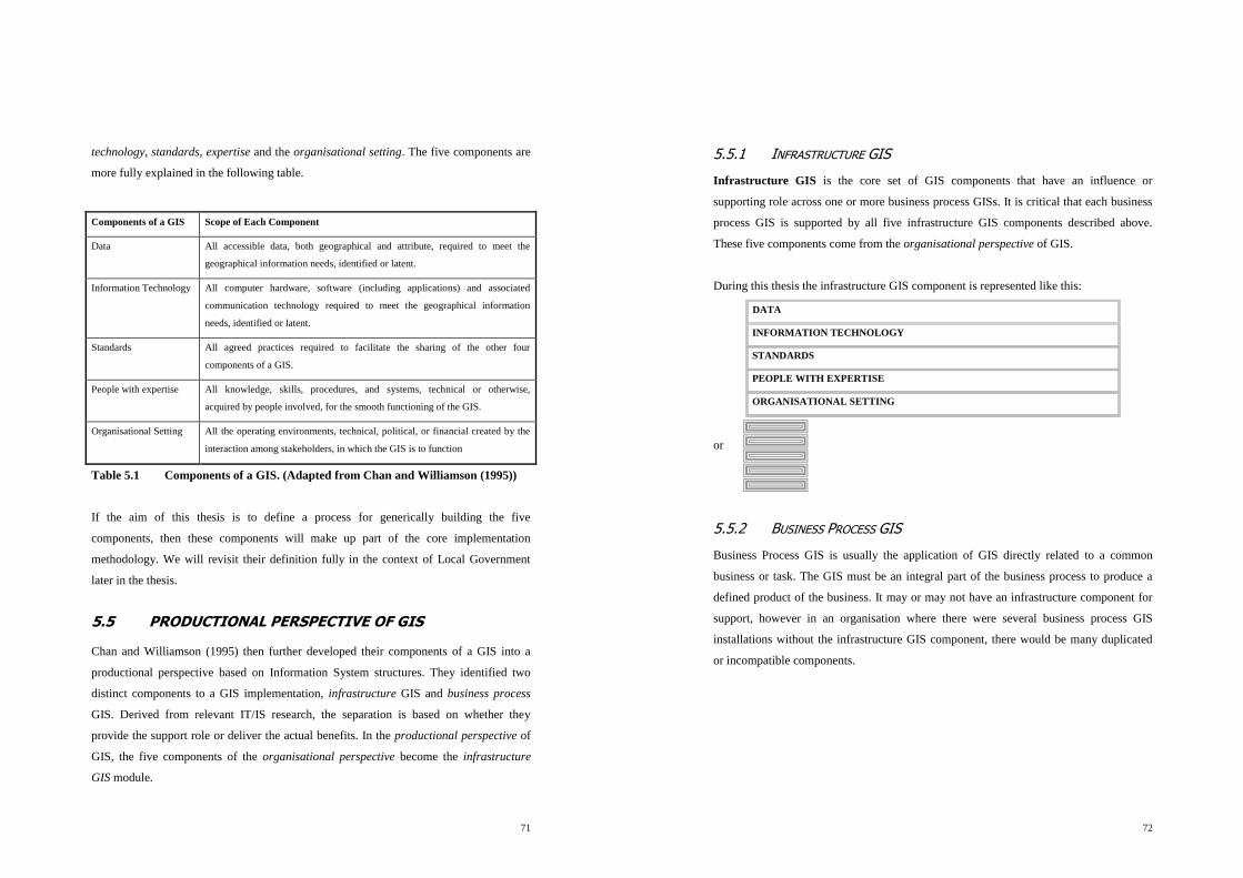
71
technology, standards, expertise and the organisational setting. The five components are
more fully explained in the following table.
Components of a GIS Scope of Each Component
Data All accessible data, both geographical and attribute, required to meet the
geographical information needs, identified or latent.
Information Technology All computer hardware, software (including applications) and associated
communication technology required to meet the geographical information
needs, identified or latent.
Standards All agreed practices required to facilitate the sharing of the other four
components of a GIS.
People with expertise All knowledge, skills, procedures, and systems, technical or otherwise,
acquired by people involved, for the smooth functioning of the GIS.
Organisational Setting All the operating environments, technical, political, or financial created by the
interaction among stakeholders, in which the GIS is to function
Table 5.1 Components of a GIS. (Adapted from Chan and Williamson (1995))
If the aim of this thesis is to define a process for generically building the five
components, then these components will make up part of the core implementation
methodology. We will revisit their definition fully in the context of Local Government
later in the thesis.
5.5 PRODUCTIONAL PERSPECTIVE OF GIS
Chan and Williamson (1995) then further developed their components of a GIS into a
productional perspective based on Information System structures. They identified two
distinct components to a GIS implementation, infrastructure GIS and business process
GIS. Derived from relevant IT/IS research, the separation is based on whether they
provide the support role or deliver the actual benefits. In the productional perspective of
GIS, the five components of the organisational perspective become the infrastructure
GIS module.
72
5.5.1 INFRASTRUCTURE GIS
Infrastructure GIS is the core set of GIS components that have an influence or
supporting role across one or more business process GISs. It is critical that each business
process GIS is supported by all five infrastructure GIS components described above.
These five components come from the organisational perspective of GIS.
During this thesis the infrastructure GIS component is represented like this:
DATA
INFORMATION TECHNOLOGY
STANDARDS
PEOPLE WITH EXPERTISE
ORGANISATIONAL SETTING
or
5.5.2 BUSINESS PROCESS GIS
Business Process GIS is usually the application of GIS directly related to a common
business or task. The GIS must be an integral part of the business process to produce a
defined product of the business. It may or may not have an infrastructure component for
support, however in an organisation where there were several business process GIS
installations without the infrastructure GIS component, there would be many duplicated
or incompatible components.

73
This thesis will represent modules of business process GIS like this:
or
5.5.3 THE RELATIONSHIP BETWEEN INFRASTRUCTURE AND BUSINESS
PROCESS GIS
Chan and Williamson then went on to identify that the relationship between
Infrastructure GIS and Business Process GIS could go across many levels of business
activity and organisation. For example one set of information technology may be suitable
for an organisation, but each business unit may require different sets of data or different
standards. These are often subsets of the main components for the whole organisation.
This concept may be extended over several levels of organisational definition. For
example a GIS user in a Local Government may obtain infrastructure GIS data from the
business unit Infrastructure GIS, the Local Government Infrastructure GIS and the state
wide infrastructure GIS.
ETC …
BUSINESS
PROCESS
1
BUSINESS
PROCESS
2
BUSINESS
PROCESS
3
BUSINESS
PROCESS
n
74
The organisational Infrastructure GIS support diagram for a Business Process GIS in an
organisation may look like either of the following diagrams:
Infrastructure GIS Business Process GIS
Fig 5.1 Options for Infrastructure GIS support for a Business Process GIS
In summary the required task is to identify and build the required business process GIS
modules for the organisation, and to support that with an appropriate infrastructure GIS.
The appropriate combinations have to be designed as part of any implementation.
f
r
e
d
Organisation 1 Organisation 2
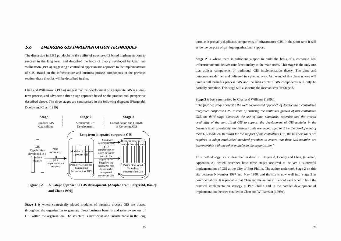
75
5.6 EMERGING GIS IMPLEMENTATION TECHNIQUES
The discussion in 3.6.2 put doubt on the ability of structured IS based implementations to
succeed in the long term, and described the body of theory developed by Chan and
Williamson (1999a) suggesting a controlled opportunistic approach to the implementation
of GIS. Based on the infrastructure and business process components in the previous
section, these theories will be described further.
Chan and Williamson (1999a) suggest that the development of a corporate GIS is a long-
term process, and advocate a three-stage approach based on the productional perspective
described above. The three stages are summarised in the following diagram: (Fitzgerald,
Dooley and Chan, 1999)
Stage 1 is where strategically placed modules of business process GIS are placed
throughout the organisation to generate direct business benefits and raise awareness of
GIS within the organisation. The structure is inefficient and unsustainable in the long
Stage 1 Stage 2 Stage 3
raise
awareness
&gain
organisational
support
Facilitate
development of
GIScapabilities in
other business
units in the
organisation
based on the
standards laid
down in the
integrated
corporate GIS
Structured GIS
Development
Long term integrated corporate GIS
Partially Developed
Centralised
Infrastructure GIS
Modules of business
process GIS
Random GIS
Capabilities
Consolidation and Growth
of Corporate GIS
Better Developed
Centralised
Infrastructure GIS
Business process GIS
in other business unitsGIS
Capabilities
developed in a
random
manner
Figure 5.2. A 3-stage approach to GIS development. (Adapted from Fitzgerald, Dooley
and Chan (1999))
76
term, as it probably duplicates components of infrastructure GIS. In the short term it will
serve the purpose of gaining organisational support.
Stage 2 is where there is sufficient support to build the basis of a corporate GIS
infrastructure and deliver core functionality to the main users. This stage is the only one
that utilises components of traditional GIS implementation theory. The aims and
outcomes are defined and delivered in a planned way. At the end of this phase no one will
have a full business process GIS and the infrastructure GIS components will only be
partially complete. This stage will also setup the mechanisms for Stage 3.
Stage 3 is best summarised by Chan and Williams (1999a):
“The first two stages describe the well documented approach of developing a centralised
integrated corporate GIS. Instead of ensuring the continued growth of this centralised
GIS, the third stage advocates the use of data, standards, expertise and the overall
credibility of the centralised GIS to support the development of GIS modules in the
business units. Eventually, the business units are encouraged to drive the development of
their GIS modules. In return for the support of the centralised GIS, the business units are
required to adopt established standard practices to ensure that their GIS modules are
interoperable with the other modules in the organisation.”
This methodology is also described in detail in Fitzgerald, Dooley and Chan, (attached,
Appendix A), which describes how these stages occurred to deliver a successful
implementation of GIS at the City of Port Phillip. The author undertook Stage 2 on this
site between November 1997 and May 1998, and the site is now well into Stage 3 as
described above. It is probable that Chan and the author influenced each other in both the
practical implementation strategy at Port Phillip and in the parallel development of
implementation theories detailed in Chan and Williamson (1999a).

77
5.7 SUMMARY
In this chapter we have identified that at the highest level the productional perspective of
GIS can be generically split into two distinct types, infrastructure GIS and business
process GIS. The business processes are typically described by the technical perspective
of GIS in the early theory, and are dependent on the structure of the target social system.
The infrastructure GIS is made up of five components, data, information technology,
standards, expertise and are derived from the organisational perspective of GIS. This
breakdown of GIS will be the high level framework for implementing GIS into Local
Government.
While the social system may never need to understand the structural or infrastructure
components, they along with the functional components are critical to successful
implementation from the perspective of an implementation manager.
Within the business process component, the technical perspective looked at the various
functions a GIS may perform, both as a high level grouping of three and then broke those
down to a further nine. These are however very generic, and are yet to be related to Local
Government in terms of their business processes. This is the task of the next chapter.
The chapter also tied together other parts of the theory to describe the current theoretical
approach to GIS implementation. This is based on three stages, random capabilities,
structured development and loosely structured consolidation and growth. These will be
further utilised in the following chapters.
78
6 THE DEFINITION OF GIS IN LOCAL
GOVERNMENT
The main aim of this chapter is to combine the previous theory with some experience of
the author to develop a new framework that describes GIS in Local Government. The
chapter starts with a summary of the current status of GIS in Local Government, and then
defines GIS within the theoretical framework. The following chapter then concentrates on
“how” to implement GIS in Local Government.
Primarily, the thesis will build on the works by Chan and Williamson using the
productional perspective of GIS, and starts by detailing a framework definition of GIS
within the infrastructure and business process GIS concepts discussed previously in the
theory. This will be a higher-level generic definition of GIS for Local Government in
Victoria, based on what is known to be common to all Local Governments. The
differences between individual Local Governments can then be measured as part of the
implementation process.
This chapter is derived from basic IS principles and the experience of the author, as
priority over older GIS based literature review. Use of a literature review to technically
define GIS would assume that the business processes are the same for all Local
Governments in the world. As identified previously, it is not the responsibility of
Victorian Local Government to administer sewerage and water assets. Thus previous
literature that includes these aspects does not provide a valid basis for Local Government
research in this instance. The absence of these functions moves the GIS emphasis away
from high positional accuracy of physical assets to mapping and interfacing/integrating
with corporate data/systems.

79
The five infrastructure components are expanded from the Chan and Williamson (1995)
components, while the five new business process components are developed as part of
this thesis, based on both theory and the experience of the author.
6.1 CURRENT GIS IMPLEMENTATION ENVIRONMENT IN
LOCAL GOVERNMENT
It will be necessary to give an overview of the status of GIS in Local Government in
order to define the typical starting point for implementation.
Informal surveys and onsite experience of the author indicate that about sixty of the
seventy-eight councils in Victoria currently have some sort of GIS capability. Of those
about thirty have Latitude, about ten have Easimaps and the other ten have either MapIt,
ArcInfo, Genamap or another package. Up to fifty Local Governments have single
MapInfo licences, either stand alone or in addition to other GIS software.
Latitude and Easimaps (existing in about 50% of the councils) are simple Windows based
GIS software packages written specifically for Local Government. They are both non
topological and run only in the Windows environment. Neither can be implemented using
the traditional IT systems development approach because the vendor fixes their
functionality. Neither are capable of full topological queries. The extent of the success of
these implementations varies, with the author being involved in over 50% of them. Some
Local Governments have only been successful on the second or third attempt at
implementation. To date there have been very few successful implementations using
State Government data, and it is usually necessary for an implementation to include the
reconstruction of suitable base mapping. This is not the focus of this thesis, but is relevant
in that it is one of the current major causes of implementation failure in the state.
The other ten sites using ArcInfo and other similar products have undertaken the
traditional IT system development cycle, with varying degrees of success. There are also
several sites with more than one software type.
80
Sites where more than 20% of the indoor staff is obtaining benefit from GIS would
number less than ten and are mostly Latitude sites. A common benchmark aim is 60% to
70% of the indoor staff in all Local Governments obtaining benefit from GIS. This figure
will be discussed further later in the thesis. As most Local Governments own GIS
software and some data, then the core aim of this thesis is to be able to increase effective
use of GIS either from the initial implementation or after the initial implementation. If
GIS is already being fully effectively used, then this thesis should be capable of providing
a methodology to prove this.
Because the core aim of this thesis is to raise the effective utilisation of GIS as distinct
from initially implementing the technology, then this also makes a lot of the current GIS
implementation theory irrelevant.
6.2 BUSINESS PROCESS GIS IN LOCAL GOVERNMENT
Because of the competitive nature of the Local Government Environment described
earlier, GIS will not be considered by a manager unless its introduction directly relates to
improved business process and thus performance. This may make GIS harder to justify
from the perspective of long term gain or intangible advantages. On the other hand
general performance incentives make the risk of GIS more attractive to a manager if
short-term business benefits can be proven to come from implementation. This
environmental factor is important to implementation techniques.
Because the emphasis of this thesis is on delivery of business benefits, the next step of the
thesis is to critically look at definitions of GIS from a business process perspective, and
apply them to Local Government. This will set the high level definitions of what is being
implemented to deliver business benefit to Local Government. The clarification of the
structural GIS components follows in the infrastructure GIS section of the chapter.
The thesis now answers the generic question, “How can GIS deliver business benefit to a
local government business unit?”

81
6.2.1 BUSINESS PROCESS GIS FRAMEWORK
When defining business process GIS for local government, it is first necessary to develop
a framework from the previous theory. This framework will contain the high level
definition of the components, and thus the implementation framework for the fine-tuning
of the business process GIS for an individual business unit during implementation.
When the theory in Chapter 3 is examined, the various IS methodologies (based on
systems analysis) can be summarised into the following sequential components:
What operational problems can GIS solve?
What is the GIS functionality that is required to solve the problem?
What are the technical requirements to deliver the functionality?
What are the data requirements to deliver the functionality?
These questions will be revisited in detail as part of the implementation methodology in
Chapter 7. The next sections will move through the traditional views and define them
within the four-part framework above. The previous perspectives and views can be cross-
matched with different parts in this framework, however the components are primarily
divided on the question, “What operational problems can GIS solve?” This new
breakdown is driven by the diffusion consideration that the implementation process
should be both communicated and performed in a structure that the managers and the
users can relate to.
The headings of the five new business process components come primarily from the
experience of the author from doing over twenty Local Government user needs analysis
reports within the above framework. Section 6.2 combines this with the previous theory
to detail the five new business process components for Local Government that are
developed by this thesis. The component being discussed is emphasised in the heading
using the framework from the diagrams from Section 5.5.2.
82
6.2.2 SIMPLE DESKTOP MAPPING
OVERVIEW OF BUSINESS PROCESS GIS COMPONENT 1
The greatest benefit of GIS to Local Government is the availability of mapping
information at the desktop and the ability to make simple A4 prints. (The ability to make
complex prints up to A0 is available if required.) The emphasis in delivering this
functionality is the word „simple‟, as to be effective the mapping need only contain the
following information:
Road reserves and property boundaries;
Road names, house numbers, reserve and main feature names; and
Possibly aerial photos if available.
Common examples of this functionality are:
Cut and paste a map into a report to help explain part of the report;
Attach the map to a customer request to clarify location; and
Look at a map on the screen while discussing an issue with a customer.
About 80% of all indoor staff would eventually benefit from this functionality, and it
moves the role of map production from a specialist field to a common task performed by
most people. It also moves mapping to people who would not traditionally be trained in
reading maps. This perspective does not require either a GIS database or a corporate
database, but simply consists of maps.
OPERATIONAL PROBLEM SOLVED
The users of this functionality previously have not had access to desktop mapping as part
of their daily workflow. This impedes their daily workflow because they cannot
communicate place or location effectively. The place communication requirement may be
either to them or from them. About 80% of all Local Government tasks have a place or
location attribute.
f
r
e
d
83
REQUIRED GIS FUNCTIONALITY
This problem is resolved by providing the ability to look at a meaningful map while
receiving advice or instruction, and the ability to create a meaningful map when giving
advice or instruction.
THEORETICAL BASIS
The simple desktop mapping perspective of GIS correlates to one of Maguire et al‟s core
three views of GIS and is widely documented and used in literature.
TECHNICAL REQUIREMENTS
To be able to look at a relevant map on the desktop.
To be able to navigate around the area of interest or to a new area of interest.
To be able to simply print the map.
To be able to include the map in a report.
To do so without substantially interrupting the current workflow (e.g., within 10 to 15
seconds).
DATA REQUIREMENTS
The data requirements are broken down into three components:
1. Screen navigation aids.
2. Parcel/occupancy shape and surrounding detail.
3. Cartographic detail, road names etc.
COMMENT
This business process GIS component corresponds to part of the Maguire map view as
described previously. In particular it performs the previously described cartographic
aspects of GIS, where maps can be displayed and manipulated in various combinations
and need not have any attributes or intelligence at all. The data and technical
requirements would be a minimum, and would be added to for each specific
implementation. While the data and technical requirements can be found in the theory,
they have been prioritised from the experience of the author. This is the GIS functionality
most commonly utilised by Local Government.
84
SIGNIFICANCE
This component is the least controversial both in terms of accepted need and
implementation detail or ability. It will not be given great detail for the rest of this thesis,
but continues to be of vital importance.
6.2.3 SPATIAL ANALYSIS
OVERVIEW OF BUSINESS PROCESS GIS COMPONENT 2
In simple terms Spatial Analysis means obtaining information about data in relation to
where it is placed on a map. These queries are usually split into two levels of complexity,
simple and complex. The reason for this split is that GIS software capability is also split
along this line, the complex spatial analysis usually being more expensive to purchase
and implement.
OPERATIONAL PROBLEM SOLVED
Queries need to be performed to analyse data in relation to other elements in the same
data set or other data sets with regard to their geographical relationship. The emphasis is
on geographical relationships and it is this form of query that cannot be performed by
traditional databases.
REQUIRED GIS FUNCTIONALITY
Functionality of current GIS systems can be divided into two categories: queries which
geographically select map elements, and queries that make new map shapes based on
spatial relationships. These are often referred to as simple and complex.
SIMPLE QUERIES
Simple place queries tend to be the analysis of a property in relation to layers that sit over
it. Examples include find properties in certain town planning zones and that are flood
prone, or all of the properties within a set distance from a new planning permit. They can
f
r
e
d

85
also be an analysis of the relationship between layers, calculated per property. The
simplest example of this is finding the adjoining neighbours for a planning permit.
Simple spatial analysis will be commonly utilised by council staff.
The commonly available simple spatial queries are:
Find adjacent map elements.
Find map elements within a radial distance.
Find map elements under a line.
Find map elements under a shape or polygon.
These queries may be combined with non-spatial criteria at the same time. They are
usually available from either a temporary point, an existing map object, or from a whole
map layer.
COMPLEX QUERIES
These queries are not property based, and are absolute calculations of relationships
between layers. An example of this is identifying potential residential development land
by selecting a combination of ideal criteria like slope, soil type, aspect, distance from
services etc.
There is usually a substantial cost and time penalty for initially implementing a GIS that
can perform large complex spatial queries. In technical terms, GIS that can perform
complex queries have a relationship based data structure. A common cause of
implementation failure is to concentrate on providing complex spatial analysis. There is
commonly no demonstrated need for corporate wide complex spatial analysis in Local
Government.
THEORETICAL BASIS
This view is also one of Maguire et al‟s core three views and is widely documented and
used in literature. Section 5.3.2 of this thesis, particularly the Castle components, also
provides the theoretical basis for this view.
86
TECHNICAL REQUIREMENTS
Any technical requirements past the ability to perform the four simple queries listed
above would be detailed during implementation.
DATA REQUIREMENTS
Where adjacency queries are required, then the graphical data should be regions or
polygons with no overlaps or slithers.
Otherwise all data requirements would be detailed during implementation when the
required queries are listed.
COMMENT
The ability to perform complex queries may alone dictate choice of software and thus the
cost of the whole implementation (it could double). These queries have to be separately
justified during an implementation, as currently only a small percentage of Victorian
Local Governments have the need or ability to perform complex spatial queries.
Currently Latitude and Easimaps sites cannot perform complex spatial queries.
SIGNIFICANCE
Simple spatial queries are performed commonly in Local Government, complex queries
are not. The most common spatial query is finding the details of the next-door neighbours
to a property. Implementation should possibly investigate the option of utilising a bureau
service to perform complex queries if they occur infrequently.

87
6.2.4 THE GEOGRAPHICAL DATA STORAGE VIEW OF GIS
OVERVIEW OF BUSINESS PROCESS GIS COMPONENT 3
This is the next business benefit that GIS will deliver to Local Government. In effect the
GIS is a digital version of the existing plan drawers and filing cabinets that have made up
the traditional mapping section of Local Government. This would usually be within an
engineering section. While the drive for “efficiencies” in the Local Government
environment has seen the demise of the plan room or drafting section, in practice the need
has not gone away. Implementation of GIS usually shows a large pent-up demand for
even simple maps of council services and activities.
The main advantages of GIS over traditional means are:
The GIS can automate production of maps at various scales, depicting many themes,
singularly or in combination.
Using a GIS, maps need never be out of date, nor is basic map data ever drawn more
than once, thus saving time and effort.
It is common for the complex map production role to be replaced by part of the GIS
support role.
OPERATIONAL PROBLEM SOLVED
The organisation manages substantial volumes of mapping data, traditionally through a
series of indexed plan drawers, and needs to store, maintain and distribute these in an
efficient and cost effective manner. Currently users have to go to another building or plan
room to view the data.
f
r
e
d
88
REQUIRED GIS FUNCTIONALITY
The GIS needs to be able to store and retrieve these mapsheets so they are presented to
the user in an efficient and seamless manner. The GIS will also have to replace or utilise
the current maintenance procedures. (This will vary, depending on the current
maintenance procedures.)
THEORETICAL BASIS
This comes from one interpretation or part of the database view as described by Maguire
et al and others. See discussion on this in the following section.
TECHNICAL REQUIREMENTS
The maps will be stored in a digital indexed format.
The stored mapsheet information can be retrieved, distributed and displayed.
The various layers can be displayed and printed or analysed together.
DATA REQUIREMENTS
The elements will be indexed at least by attribute, layer and mapsheet. The data inputs are
determined site by site on an as required basis.
The timing of the loading of the various map layers is independent of the rest of the GIS
implementation, as it can be done as soon as the software is on the desktop. All that is
required is software and a base map. This means that layers can be loaded as available if
the data currently exists. In an implementation across many sections this does not often
have initial priority, but can occur soon after.
COMMENT
This is another part or interpretation of the map view perspective of GIS, where the core
functionality required and delivered is like a seamless and automatic map draw, where
maps can be displayed and manipulated in various combinations. Both the data and
technical requirements would be scoped in substantially more detail than the simple
requirements above. Making new map layers and making data with high absolute
positional accuracy is a common emphasis in a GIS implementation. This can delay
overall implementation by years and can be very expensive.

89
The current literature appears to be ambiguous in what the term “GIS database” means. Is
it a database containing data that comes from the GIS, where the database records are
geographical features and the associated attributes necessary for the functioning of the
GIS and the associated spatial analysis component? Alternately does the GIS database
duplicate or hold original corporate data that is not primarily geographic in nature, but
has a geographic attribute? Some literature intends it to do both. For this reason the term
GIS database has been avoided as a term for describing a core component of Local
Government GIS.
SIGNIFICANCE
This component is often given similar importance in Local Government to State
Government, where it is the primary GIS function in organisations such as the
Department of Natural Resources and Environment (e.g., storage of contours and water
courses across a whole state). The importance and cost benefit of delivering this in local
government may be marginal, and efficient technical delivery of this component during
an implementation does not appear to correlate to a successful implementation in the eyes
of the organisation. The data capture costs and the associated time delays are contrary to
the diffusion principle of the early delivery of results. The recommended strategy is to
implement GIS without either of these but to allow for them to occur as justified and
funded in the future.
6.2.5 DISCUSSION ON THE DATABASE VIEW OF GIS
This is not used as one of the core components of the thesis, but is discussed here because
of its historic prominence in GIS theory. The database view treats the maps as an
extension of the database where database records have correlating map objects that can
find and display the database records. The primary purpose of the database is the storage
of the graphical objects. This view is technology and IS infrastructure dependent. It was
developed before it was possible to easily merge spatial databases with corporate
databases. It also assumes that graphical data requires the power of a relational database
to be quickly available at the desktop and to be able to quickly perform spatial queries.
90
These assumptions relate to the assumption that full topology is necessary for successful
GIS implementation and flow through to the typical implementation techniques in GIS
literature. The author would question the relevance or validity of all of these assumptions
and makes the following points:
Local Government data sets are not large by some overseas standards, proven by the
fact that the City of Port Phillip GIS runs quickly and easily on a laptop computer and
is about 50 Mb in total (including software, maps and the property database).
The requirement for full topology has been negated in these datasets by the ability of
the current computers to regenerate spatial relationships each time a query is run with
no visible loss of performance.
There are other techniques available to obtain the necessary performance without
requiring either topology, database power, or for the map elements to be stored in a
database at all.
This view assumes that a GIS implementation provides its own IS infrastructure and
does not use that existing for other Local Government functions.
For this reason the database view of GIS is not disputed in relevance, however it is now
spread out through all of the other components. Changing technology has negated the
need to build a specific GIS database to duplicate the other existing corporate databases
or to deliver acceptable functionality and performance.
For the purposes of this thesis, the technical details of how the maps are stored, retrieved
or displayed are not critical, and are usually the responsibility of the software provider.
From the point of view of managing an implementation, content and performance of the
technical system are all that needs to be specified.
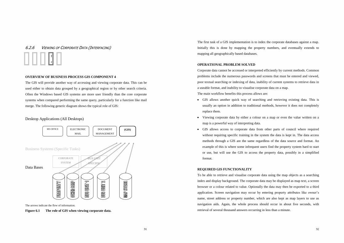
91
6.2.6 VIEWING OF CORPORATE DATA (INTERFACING)
OVERVIEW OF BUSINESS PROCESS GIS COMPONENT 4
The GIS will provide another way of accessing and viewing corporate data. This can be
used either to obtain data grouped by a geographical region or by other search criteria.
Often the Windows based GIS systems are more user friendly than the core corporate
systems when compared performing the same query, particularly for a function like mail
merge. The following generic diagram shows the typical role of GIS:
Desktop Applications (All Desktops)
Business Systems (Specific Tasks)
Data Bases
The arrows indicate the flow of information.
Figure 6.1 The role of GIS when viewing corporate data.
MS OFFICE
DOCUMENT
MANAGEMENT
ELECTRONIC
(GIS)
CORPORATE
SYSTEM
BUS UNIT
SPECIFIC
??? ??? MAPINF
O
f
r
e
d
92
The first task of a GIS implementation is to index the corporate databases against a map.
Initially this is done by mapping the property numbers, and eventually extends to
mapping all geographically based databases.
OPERATIONAL PROBLEM SOLVED
Corporate data cannot be accessed or interpreted efficiently by current methods. Common
problems include the numerous passwords and screens that must be entered and viewed,
poor textual searching or indexing of data, inability of current systems to retrieve data in
a useable format, and inability to visualise corporate data on a map.
The main workflow benefits this process allows are:
GIS allows another quick way of searching and retrieving existing data. This is
usually an option in addition to traditional methods, however it does not completely
replace them.
Viewing corporate data by either a colour on a map or even the value written on a
map is a powerful way of interpreting data.
GIS allows access to corporate data from other parts of council where required
without requiring specific training in the system the data is kept in. The data access
methods through a GIS are the same regardless of the data source and format. An
example of this is where some infrequent users find the property system hard to start
or use, but will use the GIS to access the property data, possibly in a simplified
format.
REQUIRED GIS FUNCTIONALITY
To be able to retrieve and visualise corporate data using the map objects as a searching
index and display background. The corporate data may be displayed as map text, a screen
browser or a colour related to value. Optionally the data may then be exported to a third
application. Screen navigation may occur by entering property attributes like owner‟s
name, street address or property number, which are also kept as map layers to use as
navigation aids. Again, the whole process should occur in about five seconds, with
retrieval of several thousand answers occurring in less than a minute.

93
THEORETICAL BASIS
This also comes from one interpretation or part of the database view as described by
Maguire and others. See discussion in 6.2.5.
TECHNICAL REQUIREMENTS
The GIS requires a link to the corporate data that is either live or utilises ODBC
technology. The precise details will be specified and scoped for every corporate database
being utilised.
DATA REQUIREMENTS
Ideally the corporate data should be read and retrieved directly. If this is not possible, a
copy may be temporarily brought into the GIS environment or an interim environment for
analysis.
The map elements must have the same structural rules as the corporate dataset being
accessed. There must be one element per corporate database record at the level the
database is being extracted, and a common linkage between the graphical element and the
textural database.
COMMENT
If we assume that the role of GIS is to improve core business process and function, then
the nature of GIS is dictated by the nature of the core business. In turn, the technical
function and characteristics of the GIS are dictated by the technical characteristics of the
core business process. This means that the GIS must use and visualise on a map the core
business or corporate data, not a set of specially built GIS data.
The previous three views of GIS are the traditional ones considered relevant to Local
Government, however all of these have started from the point of view that GIS is
implemented as an isolated and self-contained system. If we look at GIS from the
perspective of being part of the corporate IS, then a fourth view becomes the natural one
to initially implement.
94
SIGNIFICANCE
A core contribution of this thesis is the emphasis of a fourth primary view of GIS, being
the visualisation and manipulation on a map (or the geographic enabling) of existing
corporate data. The logic provided above and the experience of the author indicates that
this will be the primary view of GIS in Local Government in the future.
The critical difference between this view of GIS and the traditional database view is that
the database view assumes that the database is an integral part of the GIS (Maguire et al).
This view does not require the GIS to have a database at all, but rather the ability to
“map” the existing corporate database.
6.2.7 ACCESS TO CORPORATE SYSTEMS (INTEGRATION)
OVERVIEW OF BUSINESS PROCESS GIS COMPONENT 5
Related to Viewing of Corporate Data is the use of GIS to access and start corporate
systems on records that correlate to the property selected on a map. In Local
Governments where this functionality is available it is extensively used. The required
functionality allows a property to be selected on the map, and the normal work
environment (e.g., the property system or electronic document management system) to be
activated on the correct record ready for performance of normal tasks. This functionality
allows GIS to become a part of the current workflow, as distinct from the concept that
staff become “GIS Operators”.
f
r
e
d

95
The following generic diagram shows this integration:
The integration links are shown
Desktop Applications (All Desktops)
Business Systems (Specific Tasks)
Data Bases
Fig 6.2 The role of GIS when integrating with corporate systems.
OPERATIONAL PROBLEM SOLVED
The operational problem is starting the corporate systems on the correct record or
validating that the correct record is being used for data entry. The functionality is also an
extra visual check that the action is being undertaken against the correct record.
This functionality may only save minutes or seconds per use, but used many times per
day over the whole council would be a valuable source of time saving. Network
monitoring in councils where this functionality is available shows that the GIS software is
used as often as any other software package in the building except word processing and
the rating system (City of Knox, Melbourne), and that up to 70% of all staff use the GIS.
MS OFFICE
DOCUMENT
MANAGEMEN
T
ELECTRONIC
(GIS)
CORPORATE
SYSTEM
BUS UNIT
SPECIFIC
??? ??? MAPINF
O
96
REQUIRED GIS FUNCTIONALITY
The functionality that GIS provides is where the GIS is used to find a map object
representing a corporate record, the GIS then starts another corporate software
application on the required record. A variation of this is where the GIS is started by
another application and goes to the map position of the record being processed by the
other application. The two workflows can occur to different applications (i.e., property
and records system). This functionality also allows the printing of an associated map or
the checking that the other application is processing the correct record.
THEORETICAL BASIS
This view or use of GIS has not been found in literature and has come from the
experience of the author. This would have to be proven by case study, which is outside
the scope of this thesis.
TECHNICAL REQUIREMENTS
This will be specified site-by-site and application-by-application. A lot of the commonly
used Local Government applications and GIS software have already developed this link.
The availability of this functionality is a major determinant in the selection of GIS
software. In order of priority the GIS should at least be integrated with the property
system, the customer request system and the document tracking system. Other systems
can be integrated on an as needs basis.
DATA REQUIREMENTS
Again this will be developed site by site, and be derived from the corporate data business
rules. The data requirements are usually the same as the data-interfacing component.
COMMENT
This functionality is essential if GIS is to become part of the corporate culture as well as
part of the corporate IS environment. The new user perspective introduced by this section
assumes that GIS is part of the IS environment, and that they are not disparate systems.
The following diagram showing where GIS fits into the City of Port Phillip IS structure
illustrates this concept. Note the GIS does not have its own database.
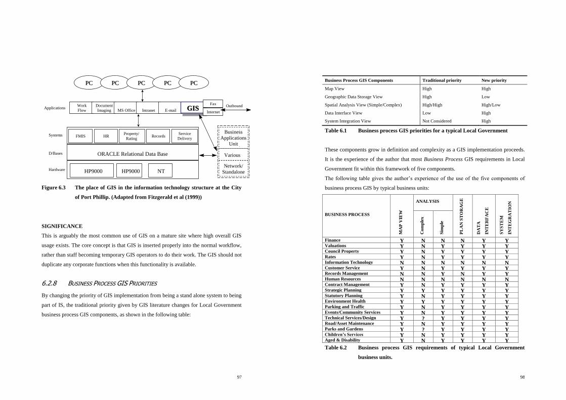
97
PCPC PCPC PCPC PCPC
Work
Flow
Document
Imaging MS Office Intranet E-mail GISGISGISFax
Internet
FMIS HRProperty/
RatingRecords
ORACLE Relational Data Base
HP9000 HP9000 NT
Service
Delivery
Business
Applications
Unit
Network/
Standalone
Various
OutboundApplications
Systems
D/Bases
Hardware
PCPC
Figure 6.3 The place of GIS in the information technology structure at the City
of Port Phillip. (Adapted from Fitzgerald et al (1999))
SIGNIFICANCE
This is arguably the most common use of GIS on a mature site where high overall GIS
usage exists. The core concept is that GIS is inserted properly into the normal workflow,
rather than staff becoming temporary GIS operators to do their work. The GIS should not
duplicate any corporate functions when this functionality is available.
6.2.8 BUSINESS PROCESS GIS PRIORITIES
By changing the priority of GIS implementation from being a stand alone system to being
part of IS, the traditional priority given by GIS literature changes for Local Government
business process GIS components, as shown in the following table:
98
Business Process GIS Components Traditional priority New priority
Map View High High
Geographic Data Storage View High Low
Spatial Analysis View (Simple/Complex) High/High High/Low
Data Interface View Low High
System Integration View Not Considered High
Table 6.1 Business process GIS priorities for a typical Local Government
These components grow in definition and complexity as a GIS implementation proceeds.
It is the experience of the author that most Business Process GIS requirements in Local
Government fit within this framework of five components.
The following table gives the author‟s experience of the use of the five components of
business process GIS by typical business units:
BUSINESS PROCESS
MA
P V
IEW
ANALYSIS
PL
AN
ST
OR
AG
E
DA
TA
INT
ER
FA
CE
SY
ST
EM
INT
EG
RA
TIO
N
Co
mp
lex
Sim
ple
Finance Y N N N Y Y Valuations Y N Y Y Y Y Council Property Y N Y Y Y Y Rates Y N Y Y Y Y Information Technology N N N N N N Customer Service Y N Y Y Y Y Records Management N N Y N Y Y Human Resources N N N N N N Contract Management Y N Y Y Y Y Strategic Planning Y Y Y Y Y Y Statutory Planning Y N Y Y Y Y Environment Health Y Y Y Y Y Y Parking and Traffic
Management
Y N Y Y Y Y Events/Community Services Y N Y Y Y Y Technical Services/Design Y ? Y Y Y Y Road/Asset Maintenance Y N Y Y Y Y Parks and Gardens Y ? Y Y Y Y Children’s Services
Home Services
Y N Y Y Y Y Aged & Disability
Community Services
Y N Y Y Y Y
Table 6.2 Business process GIS requirements of typical Local Government
business units.

99
This table shows the corporate functions that require the three traditional and two newer
GIS components. An implementation will eventually need to check all answers, however
this table would be a suitable generic starting point, from the experience of the author.
6.2.9 SUMMARY OF BUSINESS PROCESS GIS
This section has described all five GIS Business Process components and their relevance
to Local Government. The genetic framework for determining the business process
outcomes of the GIS implementation described has also been found by the author to work
in any Local Government social system. The second half of this Chapter now describes
the supporting GIS infrastructure, while the next Chapter describes how to deliver these
outcomes whilst utilising diffusion principles.
6.3 INFRASTRUCTURE GIS IN LOCAL GOVERNMENT
The previous section gave a framework for defining what is to be delivered to the desktop
as business process GIS. The next question is what infrastructure GIS do we have to put
in place for the delivery, co-ordination and support of the various business process GIS
implementations across the organisation. The components are well defined by Chan and
Williamson in various papers, the purpose of this section is to give them some detail and
practical content.
6.3.1 DATA
“All accessible data, both geographical and attribute, required to meet the geographical
information needs, identified or latent.” (Chan and Williamson, 1995)
This component is the most complex and possibly the most well developed outside IT.
The contents of this section are based on the theory in previous chapters and the work by
the author at the City of Port Phillip. The work done at Port Phillip in data structures and
hierarchies for Local Government is extensive, and would require a thesis of its own to
fully document and prove. Parts of this work are described in Fitzgerald, Dooley and
Chan (1999), attached as Appendix A.
100
In order to provide an effective data infrastructure, all data is categorised in three types as
utilised at the City of Port Phillip:
CORE DATA:
Funded, created and maintained by the GIS Unit for use by the entire organisation as
required. For example, the base map (private and public land and road reserves), road
names and street address numbers.
SHARED DATA:
Created and maintained by a specific unit, but viewed via GIS by the wider organisation.
For example, street trees or planning scheme zones.
UNIT SPECIFIC DATA:
Data that is created and maintained by one unit and will not be viewed by the wider
organisation because other units have no (practical GIS) use for the data or the data is
confidential. The GIS Unit will not fund the collection or maintenance of this data but
will provide technical assistance.
The core differences between the data types are the ownership, maintenance
responsibilities, access rights and collection funding arrangements. These become critical
in phase three of the implementation where the GIS role moves from one of control to
loose co-ordination and facilitation.
DATABASE LINKAGE LAYERS
The core task in defining GIS requirements for Local Government is to start with the
corporate activities that have a geographical attribute, and to aggregate these into
common groups for use in a GIS (i.e., use on a map). The common groupings of
corporate data may have already done this. These groupings will lead the definition of
GIS data requirements and show the components that will require the corporate data view
of GIS.

101
The activities of Local Government can be broken down into five distinct groups by
simply asking, where do the activities of the business occur? The four types of
geographical areas that most business units primarily administer are private property,
roads and related assets, open or public space and those whose analysis operates at
higher level regions like census or contract areas. The first three of the four geographical
regions are mutually exclusive. (A GIS that links to databases through points and not
regions loses a lot of its effectiveness.) There is also a fifth option, those whose activities
do not have a geographical component. Most business process/business units can be
clearly assigned one of these four core geographical bases for activities and thus their
corporate and GIS data requirements.
In order for Local Government to see a large amount of its business process in a GIS the
only requirements are a set of graphical objects that match their corporate records. This
can be made for each of the three mutually exclusive geographical types: private
property, roads and assets, and public space; which together make a complete
geographical coverage of a Local Government area. By definition, to represent these
mutually exclusive geographical types, the graphical objects must be regions or polygons
whose extent represents the area of influence of the business process.
6.3.2 INFORMATION TECHNOLOGY
“All computer hardware, software (including applications) and associated
communication technology required to meet the geographical information needs,
identified or latent.” (Chan and Williamson, 1995)
A brief description of the IT components required to be considered are as follows:
HARDWARE
It is becoming rare that a Local Government GIS implementation requires new hardware.
Operational GIS data and software rarely exceeds 50 to 100 Mb, with the whole
maintenance data set rarely exceeding 2 Gb. Hard drives of this size cost a few hundred
dollars. Server capacity utilised by GIS should be minor in a similar manner. The
102
exception to this rule is where imagery is put on the desktop. This must be independently
scoped, due to its large file sizes (up to 8Mb files to a possible total of many Gb).
SOFTWARE
This component will be discussed fully in the implementation chapters, however the
software to be considered is the actual desktop GIS software, as well as interfacing and
integration applications. The immediate core requirement is that the GIS software be fully
compatible with the current IT systems, whatever they may be.
COMMUNICATIONS
Traditionally this means network considerations for the communication of information
between the server and the desktop. While there is much current discussion about Internet
applications, the Internet is only another method of communicating between the server
and the desktop. Currently Internet GIS applications are not as efficient as existing
networked systems within a Local Government building or even over wide area networks.
They also make the server do all of the processing, which is proving to be the weakest
technical link.
The business requirements of the end user relate to performance, which is dictated by
network or communication speed. They do not care what the technology to deliver it is.
COMMENT
The IT components are becoming the least critical of the GIS infrastructure components.
Software development no longer concentrates on more power or speed, hardware is
mostly not a consideration, and communication is close to the point where all staff and
most constituents of a Local Government can retrieve GIS information within seconds.
As identified in Chapter 3, however, the limiting factor is the socialisation of the
technology, not the technology itself. Thus the results of this thesis should be technology
independent.

103
6.3.3 STANDARDS
“All agreed practices required to facilitate the sharing of the other four components of a
GIS.” (Chan and Williamson, 1995)
As implementation processes are developed they are documented as standards. The main
initial requirements for standards are as follows:
Data model and data dictionaries.
Associated data structure and components.
User control.
IT protocols.
Layer/data lists and controls.
6.3.4 PEOPLE WITH EXPERTISE
“All knowledge, skills, procedures, and systems, technical or otherwise, acquired by
people involved, for the smooth functioning of the GIS.” (Chan and Williamson, 1995)
The framework developed for this component is represented by the following diagram:
External
Support
Internal
GIS Expertise
Key GIS User
End User
Figure 6.4 GIS knowledge and people framework.
SOFTWARE
SUPPORT
INDUSTRY
SUPPORT
IT
KNOWLEDGE
MAPPING
KNOWLEDGE
KEY USERS
KEY USERS
NORMAL
USERS
LOCAL
GOVERNMENT
KNOWLEDGE
STRATEGIC
SUPPORT
104
This diagram has been tested practically by the author on several sites. The GIS
knowledge is spread through this four level hierarchy, as follows:
EXTERNAL SUPPORT
There are certain components of expertise that are not worth keeping within a Local
Government. Software expertise should, where possible, lever off the experience of the
rest of the industry rather than run a parallel set of research and development. Local
Governments should, where possible, use software suppliers that have at least ten other
Local Governments utilising their GIS products. Local Governments should also continue
to initially use their change agent, and continue to get strategic consultancy advice in the
long term. Software vendors cannot give unbiased strategic advice unless it falls within
their product range. The third area of external support is the Local Government GIS
community, particularly with regard to data issues and relationships with State
Government.
INTERNAL GIS EXPERTISE
The GIS section of a Local Government should be small but requires a wide range of
expertise. With this support model, indicative sizing would be one GIS person for 60
users, however it is possible for three GIS officers to support up to 500 users.
The core knowledge requirements in the GIS section in order of priority are:
Knowledge of how local government works.
Knowledge of mapping, digital data and projection principles.
IT support knowledge.
GIS theoretical knowledge.
KEY GIS USER
Each business unit has a “Key” or “Power” GIS user identified. Their role is to be the
first line of technical support for the rest of the users in the business unit, and to initially
train the users. These people are given more extensive training than the rest of the users

105
and it is their role to keep the GIS relevant to the business needs of the business unit. To
some extent, only the key users liaise with the GIS section.
END USERS
End users are precisely as the term suggests. They make up the rest of the staff in the
business units who will use GIS. A rule of thumb is that 70% of Local Government staff
will use GIS.
6.3.5 ORGANISATIONAL SETTING
“All the operating environments, technical, political, or financial created by the
interaction among stakeholders, in which the GIS is to function” (Chan and Williamson,
1995)
The preferred management structure for GIS within a Local Government organisation is
as follows:
Figure 6.5 Management structure for GIS
CEO COMMITTEE OF SECOND AND/OR THIRD
LEVEL MANAGERS
NEUTRAL
MANAGER
GIS STAFF AS REQUIRED
GIS STAFF AS REQUIRED
GIS STAFF AS REQUIRED
GIS STAFF AS REQUIRED
PROJECT MANAGER
(ONLY DURING STAGE 2)
KEY AND NORMAL
USERS
IT
SECT
ION
IT
SECT
ION
IT
SECT
ION
IT
SECT
ION
106
Ideally the GIS section should be as neutral as possible, and thus, if possible, it should not
be a part of any other business unit. It will however require the following controls and
mechanisms:
ULTIMATE CONTROL
The Chief Executive Officer (CEO) of a Local Government has ultimate control over all
activities including GIS. Ideally however, GIS should sit directly under the CEO in a
similar manner to that of special projects, human resources or economic development.
The CEO may delegate the practical responsibility.
DAY TO DAY ACTIVITIES
Someone has to supervise the daily activities of the GIS section with regard to issues such
as employment, timesheets, staff performance reviews, leave, budget, office issues etc.
GIS IMPLEMENTATION DIRECTION
Ideally a committee should strategically control the GIS section. This committee should
as a minimum be comprised of the group of people who made the decision to adopt on
behalf of the organisation. Their key role is keeping the GIS relevant to the overall
business needs of the organisation. They manage the infrastructure GIS component so
that the demands of the various business units are balanced and put in the perspective of
the organisational Key Performance Indicators (KPIs) and business plan. This helps
remove the GIS from internal party politics.
Other structures do work, but usually with more difficulty.

107
6.4 SUMMARY
This chapter has put a Local Government perspective on the current theoretical
framework that defines GIS. A summary of the framework within which GIS will be
implemented is shown in the following diagram:
BUSINESS PROCESS GIS
SIM
PL
E
DE
SK
TO
P M
AP
PIN
G
SP
AT
IAL
AN
AL
YS
IS
GE
OG
RA
PH
ICA
L
DA
TA
ST
OR
AG
E
VIE
WIN
G O
F C
OR
PO
RA
TE
DA
TA
AC
CE
SS
TO
CO
RP
OR
AT
E
SY
ST
EM
DATA
INFORMATION TECHNOLOGY
STANDARDS
PEOPLE WITH EXPERTISE
ORGANISATIONAL SETTING
INFRASTRUCTURE GIS
Figure 6.6 Overall productional perspective framework for Local Government.
This diagram can be applied to any level of social system within Local Government. This
template can be used during implementation to precisely define the GIS innovation for
each Local Government business process (and social system), and to build the GIS
infrastructure components necessary to provide this.
108
DIFFUSION DISCUSSION
This chapter has performed the critical diffusion task of redefining GIS in terms of the
Local Government problems it will solve. This is essential for the matching stage of the
organisational innovation process to occur, where the innovation is matched with the
problem prior to the organisation‟s decision to adopt (as described in 2.5.3). It is unlikely
that the people in a Local Government organisation would adopt any of the traditional
GIS perspectives because they cannot relate them to the problems they need to solve.

109
7 THE IMPLEMENTATION OF GIS IN LOCAL
GOVERNMENT
7.1 INTRODUCTION
The hypothesis of this thesis is:
“That in order for a Local Government GIS implementation to be successful, it is
necessary to develop an implementation process that allows for the influence of
diffusion.”
This chapter proves the hypothesis to be justified by describing an implementation
process that contains a substantial number of components that allow for diffusion to be
identified and managed.
The previous chapter gave a framework within which to define GIS in a Local
Government setting. The task now is to add some communication over time
(implementation dynamics) which actually add the innovation to the social setting (or add
the GIS framework to the Local Government environment).
It is the opinion of the author that the answer to how to implement GIS in Local
Government has not been clearly laid out in any of the theory discussed so far, but rather
lies in a combination of them all.
The implementation of GIS will fit within the following generic questions:
1. Where are you now?
2. Where do you wish to go?
3. How do you get there?
These can be converted to the following implementation steps using the framework from
Chapter 6, as follows:
110
1. Measure the current status.
2. Determine the required GIS business process outcomes.
3. Determine the required GIS infrastructure to deliver the business process outcomes.
4. Implement the requirements determined in 1 to 3.
This chapter will start with some more detailed discussion on the relative importance of
the various theoretical backgrounds, and then detail the four steps outlined above.
Diffusion forces occur at all steps, and thus diffusion will be a focus of the chapter, rather
than this chapter concentrating on covering all of the mechanical implementation steps in
detail.
7.2 RELEVANCE OF THE THEORETICAL BACKGROUNDS
7.2.1 THE IMPORTANCE OF THE IT COMPONENT OF GIS
In the previous chapter the emphasis of GIS implementation moved from a stand-alone
system delivering primarily only the first three traditional business process GIS functions,
to being a part of the corporate system. GIS now primarily undertakes corporate data
interfacing and corporate system integration, with less emphasis on the traditional roles of
complex spatial analysis and map storage functions. In re-defining GIS, it has naturally
moved into mainstream IT. Theoretically, then, we should be able to implement GIS
using the general IS frameworks, without needing all of the IT components for technical
delivery.
The technical composition of the IT component of GIS is rapidly becoming identical to
most other IT components. For example maps are becoming simply a corporate database
record with a geographical attribute. As stated in the introduction, “An emphasis in the
perspective of this thesis is the innovation of GIS as the mapping of current corporate
data, as distinct from the efficient managing of current spatial data. Most current Local
Government GIS research refers to the latter only.”

111
Laudon and Laudon (1998) list GIS software with word processors, spreadsheet packages
and other application package software. It is already occurring that powerful GIS
software is coming preloaded on a high percentage of Local Government computers, and
implementation methodology will not require the building of GIS software or user
interfaces from first principles. Additionally the database design component may consist
of simply adding geographical identifiers to existing corporate data infrastructures. This
confirms that the thesis can be based on modified IS implementation methodology with
the emphasis on the management and organisational components. This is used in
preference to previous GIS implementation methodology that concentrated on GIS
system design. Put another way, the area of interest is implementing GIS the innovation,
not GIS the technology. Campbell (1995, p11) clearly makes this point.
7.2.2 DISCUSSION ON RELEVANCE OF GIS BASED THEORY
The approach of most of the GIS implementation theory studies detailed has been to start
with the typical IS implementation theory from a technical perspective and then address
the factors that have to be added to make GIS work. In fact the IS software/system
implementation theory should not be central to GIS implementation theory. The
technology component is an optional component of an implementation methodology that
otherwise allows for the innovation characteristics of GIS by applying diffusion theory. A
lot of the factors identified by GIS implementation theory are caused by innovation
characteristics, and a lot of the answers correlate to diffusion theory, but the core
technical IS framework used in the GIS research to implement the technology is not
necessarily relevant.
The following general observations are made by the author of this thesis with respect to
the various GIS implementation studies and comparisons:
1. There is no attempt to allow for variations caused by the differences in the application
or perception of GIS when studying implementation. It is usually assumed that each
stakeholder has the same definition of GIS. For example, the implementation of GIS
into an organisation that administers physical assets is very different to an
112
organisation whose primary role is land administration, even within the same Local
Government.
2. Direct comparisons are made between implementation studies of vastly differing
organisations, for example, Local Governments can have between twenty and many
thousands of computers and thus potential GIS users. Current implementation
methodologies are not necessarily scalable.
3. No provision is made for previous opportunistic or failed systematic GIS
implementations, while research is dictating that GIS implementation is unlikely to
succeed unless either of these have already occurred (Chan and Williamson, 1999a).
4. The timings revolve around the software/systems development cycle, which may not
be required in future implementations. Investigation into the order or importance of
timing of the other components is deficient.
These studies are however still very relevant to this thesis in that they raise non-technical
issues that have to be addressed during GIS implementation.

113
7.3 HIGH LEVEL GIS IMPLEMENTATION PROCESSES
The emerging implementation works by Chan and Williamson will be used at the higher
level to manage the GIS implementation process. This implementation theory is detailed
in Chapter 5.6 and is summarised in the following diagram:
Almost all Local Governments are going to be somewhere between stages one and three.
The following is a very common scenario:
A mature GIS sits in the engineering section, which fully provides the map storage
perspective and some of the mapping perspectives. Viewing software is available at the
desktop but is not being used. There is no integration or interfacing available and the
users do not know it is possible.
This would be a typical target for the processes developed in this thesis, however the
target range is from no GIS capabilities, to a fully mature site where the framework from
this thesis will only undertake fine-tuning.
Stage 1 Stage 2 Stage 3
raise
awareness
&gain
organisational
support
Facilitate
development of
GIScapabilities in
other business
units in the
organisation
based on the
standards laid
down in the
integrated
corporate GIS
Structured GIS
Development
Long term integrated corporate GIS
Partially Developed
Centralised
Infrastructure GIS
Modules of business
process GIS
Random GIS
Capabilities
Consolidation and Growth
of Corporate GIS
Better Developed
Centralised
Infrastructure GIS
Business process GIS
in other business unitsGIS
Capabilities
developed in a
random
manner
Figure 7.1 A 3-stage approach to GIS development. (Fitzgerald et al, 1999)
114
Clearly the main implementation tasks are to measure the current status, identify the
desired result and plan the processes to achieve these. The process is a type of gap
analysis.
Stages 1 and 3 occur naturally within the organisation, while Stage 2, which includes the
setup for Stage 3, is done as a dedicated implementation project. Stage 2 is the subject of
the remainder of this thesis.
7.3.1 THE IMPLEMENTATION PROCESS
As stated in the introduction, the four steps to implement GIS are as follows:
1. Measure the current status.
2. Determine the required GIS business process outcomes.
3. Determine the required GIS infrastructure to deliver the business process outcomes.
4. Implement the requirements determined in points 1 to 3.
Steps 1 to 3 are done as a report, with the facts being collected and documented as part of
a User Needs Analysis. This is the first step of Stage 2 of the Chan and Williamson three
stage process described above. There are several very important roles of the user needs
analysis from a diffusion perspective that are not contained in the typical IS
methodology.
7.3.2 THE USER NEEDS ANALYSIS
A user needs analysis should be officially undertaken to gather the information required
to do the implementation as detailed in the rest of this chapter. An experienced operator
will know most of the answers before it is started, which overcomes the problem of the
user not being able to communicate their needs until they have used, or understand, a
GIS. The interviews, which are conducted as a needs gathering process, have some other
important aims:
CHANGE AGENT.
The person who undertakes the user needs analysis must be the change agent as defined
by Rogers and described in Chapter 2.2.2. The change agent performs a critical role in the

115
diffusion process, and the first five of the seven key roles of a change agent defined by
Rogers are now revisited:
Develop a need for change: The user needs should point out current problems and
explain how GIS is a viable option for solving them. More importantly the change agent
must convince the client that he has the ability to solve the problems.
Obtain the clients trust: The credibility of the GIS in the eyes of the client is directly
related to the credibility of the change agent.
Diagnose problems: The change agent must relate the innovation to the client in terms
the client understands. Part of this process involves redefining the current perceptions of
GIS from the productional perspective. This moves the GIS implementation framework
into terms the client will understand.
Create an intent to change: The result of doing the above three steps correctly is that
the client is positively motivated to change to the new innovation.
To translate an intent to action: The change agent also has to convince opinion leaders
and near peers to influence the client‟s decision to adopt. The user needs must cover these
people as well.
(The remaining last two roles are to prevent discontinuance and achieve a terminal
relationship, and are done after implementation.)
OPINION LEADERS
These people must be identified and made an integral part of the user needs. Opinion
leaders are defined as those individuals from whom others seek information and advice
(Rogers, 1962, pp17). Typically opinion leaders are the people who influence the
decisions of others within the social system. In analysing the relationship between change
agents and opinion leaders, Rogers (1995) makes the following generalisation:
“Change agent success in securing the adoption of innovations by clients is positively
related to the extent that he or she works through opinion leaders.”
116
INFORMAL SOCIAL PATTERNS
Informal patterns of communication must be allowed for, as the diffusion process will
travel through these faster than through the formal patterns. For example, managers do
not always take advice directly from the people who technically answer to them, but
rather can take advice from another staff member who they are in social contact with, or
know from previous employment.
CREATING A SENSE OF INVOLVEMENT.
All of the research indicates that unless the social system feels involved in the
implementation process, then the implementation is unlikely to succeed. The involvement
in the user needs may be more important from a perception point of view than from a
practical input point of view.
GENERIC STRUCTURE
Apart from the above considerations, the user needs analysis is an information gathering
exercise. In fitting the user requirements to the GIS framework, the following questions
are a suggested sequence. These fit the IT principles detailed earlier in the thesis.
What are the business processes of the business unit?
What are the operational problems in undertaking these processes?
Which of these problems have a spatial component?
Which could be solved by GIS technology using a component of the productional
perspective?
What are the technical and data requirements (infrastructure components) to solve the
problem?
Is it economical or practical to use GIS?
Where does the solution fit within the framework of five business process GIS
components?
Would any of these components that do not apparently solve business problems be of
benefit to the business?
Most or all of the results will fit into the framework developed in this thesis. The
requirements of any that do not, will have to be worked through from IS first principles.

117
7.4 MEASUREMENT OF CURRENT GIS STATUS
BUSINESS PROCESS GIS STATUS
In a given business unit, the current measurement is simply the number of indoor staff
using this functionality, not the number of people the functionality is available to. If the
site appears to have GIS being commonly used at the desktop, then the first
implementation task is to conduct a user survey of the frequency of GIS use, both overall
and for each business process component. This will also determine whether the various
business process GIS components are innovations or not. The author is currently
collecting statistics on this to allow benchmarking between implementations, however
this is not part of the thesis and is in the early stages. Indicative figures are that on a
mature site 80% of all indoor staff use the GIS, 40% daily or more, 20% weekly and 20%
occasionally.
The following are results from user surveys at the City of Cairns and the City of Port
Phillip, and are of potential GIS users who have been given the software:
How often do
you use GIS?
City of Port Phillip Cairns City Council
Number of Users % Number of
Users %
Daily 42 58 92 54
Weekly 4 5 38 22
Occasionally 15 21 32 19
Never 4 5 9 5
No response 8 11 0
Total 73 100 171 100
Table 7.1 Indicative frequency of GIS usage.
While these figures have not necessarily been rigorously collected, they are indicative of
the usage rates achievable.
The task in future is to break down the user survey not only into how often GIS is used,
but also how often each of the five business process components is used. Lower use
118
numbers can be either because one is not available or does not work well or, alternatively,
one of the many other causes of implementation failure.
INFRASTRUCTURE GIS STATUS
The status of the infrastructure component of the GIS has to be documented. Section 6.3
details the required components, and is thus a checklist for detailing both the current
status and the future requirements.
The aim of Stage 2 is to ensure there is enough GIS infrastructure to support the initial
roll-out, and the means for it to grow to completion during Stage 3. The following
diagrams are from the paper by Fitzgerald, Dooley and Chan (1999), which show the
percentages of Infrastructure GIS at the end of Stage 2 and twelve months into Stage 3
for the City of Port Phillip Implementation. The diagrams also show the extent of GIS
implementation among the various business units at those stages.
Figure 7.2 City of Port Phillip GIS development at the end of Stage 2. (Adapted
from Fitzgerald et al (1999))
Figure 4. Stage 2 of GIS development at Port
Phillip, April 1998
Organisational setting
Organisational setting
Organisational setting
Organisational setting
People with GIS expertise
People with GIS expertise
People with GIS expertise
People with GIS expertise
Information Technology
Information Technology
Information Technology
Information Technology
Standards
Standards
Standards
Standards
Data
Data
Data
Data
50%
5-10%
30%
50%
70%
Customer
Services
Strategic
Planning
33%
67% 33% 33%
Infrastructure
Modules of business process GIS
Centralised infrastructure GIS
Planning &
Building
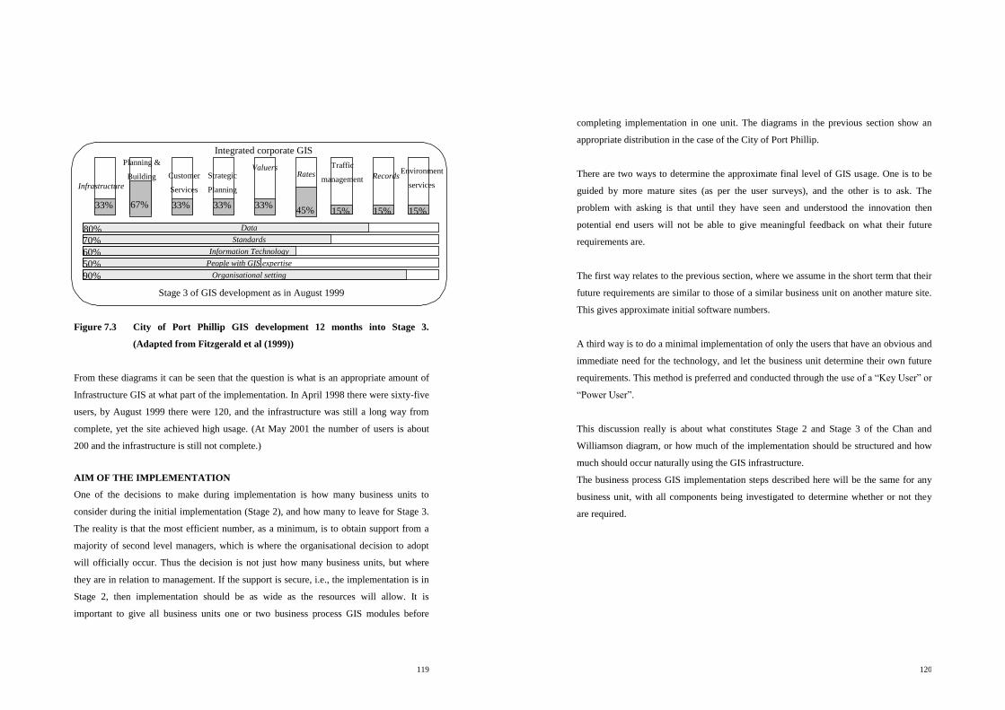
119
Stage 3 of GIS development as in August 1999
Figure 7.3 City of Port Phillip GIS development 12 months into Stage 3.
(Adapted from Fitzgerald et al (1999))
From these diagrams it can be seen that the question is what is an appropriate amount of
Infrastructure GIS at what part of the implementation. In April 1998 there were sixty-five
users, by August 1999 there were 120, and the infrastructure was still a long way from
complete, yet the site achieved high usage. (At May 2001 the number of users is about
200 and the infrastructure is still not complete.)
AIM OF THE IMPLEMENTATION
One of the decisions to make during implementation is how many business units to
consider during the initial implementation (Stage 2), and how many to leave for Stage 3.
The reality is that the most efficient number, as a minimum, is to obtain support from a
majority of second level managers, which is where the organisational decision to adopt
will officially occur. Thus the decision is not just how many business units, but where
they are in relation to management. If the support is secure, i.e., the implementation is in
Stage 2, then implementation should be as wide as the resources will allow. It is
important to give all business units one or two business process GIS modules before
Integrated corporate GIS
Customer
Services
Strategic
Planning
33%
67% 33% 33%
Infrastructure
Infrastructure
Infrastructure
Infrastructure
80%
70%
60%
50%
90% Organisational setting
Organisational setting
Organisational setting
Organisational setting
People with GIS expertise
People with GIS expertise
People with GIS expertise
People with GIS expertise
Information Technology
Information Technology
Information Technology
Information Technology
Standards
Standards
Standards
Standards
Data
Data
Data
Data
Traffic
management
Records
Records
Records
Records
33%
45% 15%
Valuers
Valuers
Valuers
Valuers
Environment
services
15%
Rates
Rates
Rates
Rates
15%
Planning &
Building
120
completing implementation in one unit. The diagrams in the previous section show an
appropriate distribution in the case of the City of Port Phillip.
There are two ways to determine the approximate final level of GIS usage. One is to be
guided by more mature sites (as per the user surveys), and the other is to ask. The
problem with asking is that until they have seen and understood the innovation then
potential end users will not be able to give meaningful feedback on what their future
requirements are.
The first way relates to the previous section, where we assume in the short term that their
future requirements are similar to those of a similar business unit on another mature site.
This gives approximate initial software numbers.
A third way is to do a minimal implementation of only the users that have an obvious and
immediate need for the technology, and let the business unit determine their own future
requirements. This method is preferred and conducted through the use of a “Key User” or
“Power User”.
This discussion really is about what constitutes Stage 2 and Stage 3 of the Chan and
Williamson diagram, or how much of the implementation should be structured and how
much should occur naturally using the GIS infrastructure.
The business process GIS implementation steps described here will be the same for any
business unit, with all components being investigated to determine whether or not they
are required.

121
7.5 DETERMINATION OF BUSINESS PROCESS
REQUIREMENTS AND DIFFUSION IMPACTS
7.5.1 DIFFUSION IMPACTS
There are several diffusion impacts that are critical to the delivery of GIS business
process components. Rogers (1995) defines five characteristics of an innovation that will
have a major impact on the rate of adoption that can be related directly to the nature of
the business process GIS component (innovation).
RELATIVE ADVANTAGE
One of the core dimensions that users will judge relative advantage against is time taken
to complete the task. The innovation must fit into the current work flow, which means,
for example, that a user must be able to start the GIS and undertake the task while on the
phone. Time is perceived to be a more important relative advantage than the true
advantage of better performance or more accurate information.
COMPATIBILITY
If the GIS does not have the same “look and feel”, and appear to be compatible with the
other systems used on a daily basis, then the rate of adoption will be slower. Practical
examples are that if the current operating system is Windows based, then the GIS should
use standard Windows print dialogue boxes, screen navigation tools, etc. It should feel
like a part of the trusted system.
COMPLEXITY
From the experience of the author, acceptable GIS complexity for a first time user would
mean that initial training should take about one hour. The user should be able to perform
the task on the first attempt, and a set of instructions should fit on one page.
122
DIVISIBILITY
A user should be able to try each of the processes by themselves without having to do any
setup or other tasks first if they do not wish to. This isolates all of the tasks into small
separate components that can be individually tried by a user.
COMMUNICABILITY
People will use GIS if they see their peers using it. Because the innovation occurs at the
desktop then this will naturally occur in a successful implementation.
The thesis now discusses the diffusion impacts on the delivery of business process GIS
for each of the five components, where each component has different diffusion forces
occurring during implementation.
7.5.2 SIMPLE DESKTOP MAPPING
IMPLEMENTATION CONSIDERATIONS
In order to meet the trialability/divisibility criteria, this task should be the first one given
to a new user. It is one of the easiest to deliver and provides the most beneficial result.
DIFFUSION IMPACTS.
The following specific diffusion forces will operate on this business process GIS.
Mapping Characteristics
The contents of the screen mapping should be as close as possible to the hard copy
mapping currently being used throughout the organisation. This is a typical need to
socialise the technology or to minimise changes to the current culture. Particular care
should be taken of the cartographic content (as people still judge the quality of the maps
by the presentation of the text). A core implementation task will be to make the text
cartographically acceptable, something that no longer has priority in the various State
Government mapping agencies. An example is the Department of Infrastructure planning

123
maps which no longer contain crown descriptions. In some cases councils paid to have
them entered again privately.
If topographic mapping is in common use, then the GIS can be run with the topographic
mapping visible and the cadastral base as an invisible set of intelligence for the other GIS
functions.
Screen Colours
One of the most subtle requirements of desktop mapping is choice of colours. Experience
has shown that if a linework/background combination of black/white is used then there
will be substantial end user resistance to use of the GIS outside the traditional mapping
areas. The perception is simple, that the contents of the screen contain one of those
complicated drawings that only engineers could understand. The immediate conclusion
by a potential GIS user is that they would not be qualified or experienced enough to
understand one of those systems and they simply refuse to use the GIS. This paragraph
contains enough potential research by itself to be outside the scope of this thesis, however
it is a valid implementation consideration.
Intuitive Screen Navigation
In a related matter to colours (and for similar reasons), the end user must be able to find
their way around the screen without any formal training in map reading or an
understanding of map scale. Again this is based on practical experience, and is worthy of
more formal research outside this thesis.
The concept of intuitive screen navigation is that at any time on the screen there are three
or four objects with which the user would identify. For example, many end users would
not identify with objects on a cadastral map. One way of delivering this functionality is to
have photography on the screen at all times, however this cannot be at the sacrifice of
system performance. An alternate method is to make the prominent features on the screen
the geographical features people see from a car, commonly water features, parks,
churches, schools and public buildings. This layer must be constructed prior to
124
implementation, and again choice of colour or, more importantly, intensity will be
important. The screen should generally be pale and non-threatening.
7.5.3 SPATIAL ANALYSIS VIEW OF GIS
IMPLEMENTATION CONSIDERATIONS
As stated previously, the request for complex queries has to be treated carefully. Do the
business processes really require the complex queries to function or does the staff
member think they would be handy? Does more than one person do the complex queries,
and does this warrant a whole system upgrade in price and complexity? Are the complex
queries run frequently, or would it be more economical to get them run by an external
bureau? The requirement for complex queries may alone determine the technical
requirements of the software choice.
TIMING DEPENDENCIES
This component should be made available after simple mapping, and with or after data
interfacing. Some types will be the most complex for the end users to perform and done
the least often, while the neighbourhood query will be used the most often on all sites. On
average this function is used about every two hours in the City of Port Phillip.
DIFFUSION IMPACTS
The insistence by a part of an organisation that complex spatial analysis is required has
the effect of dramatically slowing down all aspects of the diffusion process. The higher
the requirements the higher the risk of stalling the GIS implementation regardless of the
money spent. By insisting on complex spatial analysis, the training times for a GIS
administrator can go from one week to two years to learn the software alone. The training
times for an end user can go from four hours to two weeks. These differences are
dramatic and impact heavily on the diffusion process.
One common scenario is that GIS software is evaluated for Local Government suitability
based on the ability of the software to perform complex spatial analysis. The resultant
short list can exclude the GIS products that do four out of the five core tasks well but
only do simple spatial analysis. These implementations rarely succeed in the long term.

125
7.5.4 THE GEOGRAPHICAL DATA STORAGE VIEW OF GIS
IMPLEMENTATION CONSIDERATIONS
The delivery of this functionality has no dependencies on any of the other four
components, i.e., the other four can be delivered without this component and this
component does not need any of the other four to function, with the possible exception of
some base mapping. This means that the requirement for this functionality at the desktop
should be put through a traditional cost-benefit form of analysis, and not be considered
with the other business process GIS components. In order for engineering or planning
type mapping layers to be funded from the corporate implementation budget, then the
benefit would have to pass across a high percentage of the business units. The mechanics
for determining if map drawer contents are core layers are covered in the committee
section of the organisational component of the infrastructure GIS.
What is important to consider during implementation is that the GIS infrastructure must
enable a business unit to capture their own map layers and obtain this functionality if
needed without duplicating any of the other infrastructure GIS components.
DIFFUSION IMPACTS
Delivery of this functionality can be both time consuming and expensive, and rarely
justifies being taken from a corporate budget. Most existing hard copy mapping is only
used by either engineers or town planners. The common implementation mistake is to use
the corporate GIS budget for this task alone. At the end of the expenditure there are no
benefits at all to about 70% of the staff and no visible operational benefits to senior
management because the system has only replaced an existing system. A large part of the
existing GIS implementation research concludes by identifying this fact without any real
practical definition of the options detailed in this thesis for quick delivery of visible
business benefits.
126
7.5.5 VIEWING OF CORPORATE DATA
IMPLEMENTATION CONSIDERATIONS
Measurement of Current Status.
In order to measure the current status of data integration within a business unit, it is
necessary to draw the corporate information diagram for that business unit. The typical
setup is as follows:
Desktop Applications (All Desktops)
Business Systems (Specific Tasks)
DATA BASES
The arrows indicate the flow of information.
Figure 7.4 Template for specifying corporate data viewing requirements.
The determination of future requirements is simply the completion of the above diagram
for each business unit, covering all data interfacing connections and technically
specifying how they will work.
MS OFFICE
DOCUMENT
MANAGEMEN
T
ELECTRONIC
(GIS)
CORPORATE
SYSTEM
BUSINESS UNIT
SPECIFIC
??? ??? MAPINF
O

127
IT CONSIDERATIONS
This functionality requires systems that have common communication protocols, for
example, Windows Dynamic Data Exchange (DDE). It also assumes a networked
environment.
DATA CONSIDERATIONS
The requirements are the screen navigation tools and base mapping from the map view
component, and a base set of corporate polygons to be specified in the data component of
the infrastructure.
TIMING DEPENDENCIES
This should be the first functionality implemented along with the map view. The highest
priority and largest task of the implementation will be to make the core set of corporate
polygons.
DIFFUSION IMPACTS
All five characteristics of an innovation will again have a major impact on the rate of
adoption. As well as the generic impacts, the following considerations apply:
Relative Advantage
This innovation is capable of substantially improving the current work flow, partially due
to the fact that a good GIS user interface will be easier to use than the normal corporate
ones. This functionality commonly is used for non-spatial queries. Again speed is
essential, but achievable with the correct setup. Powerful databases such as Oracle are
proving to be slower in practice than the previous systems.
Compatibility
This functionality will not be possible unless the systems are compatible.
Complexity
It is common to find staff using this functionality because they find the corporate systems
too complex.
Divisibility
A user should be able to try this functionality by itself without having to do any setup if
they do not wish to. Queries should be preset for the relevant business unit and data.
128
7.5.6 ACCESS TO CORPORATE SYSTEMS (INTEGRATION)
IMPLEMENTATION CONSIDERATIONS
Measurement of Current Status.
The diagram required to specify this functionality is similar to the previous one as
follows:
The integration links are shown
Desktop Applications (All Desktops)
Business Systems (Specific Tasks)
Data Bases
Figure 7.5 Template for specifying requirements for GIS access to corporate
systems.
Again, the future requirements are the completion of the above diagram and the
specification of how the integration will work.
MS OFFICE
DOCUMENT
MANAGEMEN
T
ELECTRONIC
(GIS)
CORPORATE
SYSTEM
(PROPERTY)
BUSINESS UNIT
SPECIFIC
APPLICATION
??? ??? MAPINF
O
129
IT CONSIDERATIONS
This functionality requires systems that have common communication protocols, for
example, Windows Dynamic Data Exchange (DDE). It also assumes a networked
environment. Achieving this functionality will be more costly and time consuming than
interfacing. Choice of GIS software will be impacted heavily by the availability of
existing integration software.
DATA CONSIDERATIONS
The requirements are identical to those of interfacing.
TIMING DEPENDENCIES
This functionality would not initially be rolled out unless the integration between the
chosen GIS and the other applications is already done. Otherwise it can wait for up to
several years, as the map view and the interfacing view will give the GIS enough
momentum to survive.
DIFFUSION IMPACTS
Delivery of this must again meet all of the previously described Rogers‟ criteria. This
level of integration completes the merging of GIS with IS and will speed up the diffusion
process considerably.
7.6 INFRASTRUCTURE GIS AND DIFFUSION IMPACTS
The five components of Infrastructure GIS have specific diffusion considerations for
implementation. The emphasis in this section is on standards, and in particular people and
organisational issues. The components of IT and data have been indirectly covered while
specifying business process performance and content, and are the two components that
current practice and theory has documented well.
130
7.6.1 DATA
DIFFUSION IMPACTS
People do not naturally have a mapping culture. We are taught to read and write at
school, but are only taught to read a map if it is a core part of our profession. A GIS
implementation will deliver mapping to people who turn the road map around every time
they go around a corner. The screen must at all times have features visible that the
average person can identify with, as discussed previously.
As discussed in the previous section, the data structure must reflect the characteristics of
the data being mapped, and thus the business processes being undertaken outside the GIS.
Again, fit with current culture and practices is an important diffusion principal.
7.6.2 INFORMATION TECHNOLOGY
DIFFUSION IMPACTS
Treating GIS as simply another IT implementation usually fails. There are two main
differences between GIS and IT, the unique characteristics of a mapping culture and the
digital structure of map data.
Quick delivery of a map to a GIS screen, and of text to a spreadsheet, are two different
concepts. IT principles usually do not achieve the speed necessary to regenerate the
screen within five seconds at any zoom, and a slow screen regeneration time will be fatal
to an implementation. Specific research is required to deliver GIS data to a user in
acceptable times as discussed elsewhere.
7.6.3 STANDARDS
IMPLEMENTATION CONSIDERATIONS
The initial system can be implemented with a set of standards provided by a consultant,
and the proper organisational standards can be put in place after implementation.

131
DIFFUSION IMPACTS
By not waiting for proper standards to be developed, the implementation will achieve the
core diffusion aim of early delivery of tangible results. Practical experience has shown
that standards can be finished many months after the initial Stage 2 implementation.
7.6.4 PEOPLE WITH EXPERTISE
IMPLEMENTATION CONSIDERATIONS
The current GIS staff and users have to be fitted against this model in the previous
chapter for practical skills and the roles discussed in the diffusion considerations.
All of the roles described in the initial description of the people component have to be
filled for the effective implementation of GIS if there are to be more than sixty users. The
minimum is all of the external support sources, assuming the consultant is a suitable
change agent, at least one GIS officer, one key user per business unit (may be part-time),
and the users. The question is, can one person do all of the tasks on a small site?
Diffusion theory tells us that an external change agent is essential; after that the
personality of the GIS officer becomes critical if they are to hold the key user role as
well.
Diffusion theory states that you will never get all people in a social system (business unit)
to adopt an innovation in the initial stages. Laggards, by definition, may take years to
change their ways. Effective transfer of GIS knowledge through an organisation will take
years to complete; the core implementation task is to set up the processes to allow this to
occur.
TIMING DEPENDENCIES
Ideally GIS should be implemented in a business unit in the following order:
1. Install a preliminary GIS environment with the key user.
2. Give the key user several days training and editing rights to the environment.
132
3. With the GIS officer spend up to six months fine-tuning the environment so that it
precisely meets the needs of the business unit.
4. Implement this environment with the rest of the staff in the business unit.
As an option, implement a safe generic environment with the rest of the staff at the same
time as the key user is initially trained.
Continue to have the key user one generation ahead of the rest of the users, to allow a
slow transfer of ownership to the business unit as the implementation enters Stage 3.
Business units are encouraged to drive the development of their own GIS modules by
encouraging experimentation and feedback. Allow different business units to enter Stage
3 at different times.
This system will drive most of the scheduling considerations for implementation.
DIFFUSION IMPACTS
This people model comes straight from diffusion theory, where the external consultant is
the change agent and the key user is the early adopter and opinion leader. It is designed to
overcome the following diffusion problems:
84% of the GIS users in a Business Unit (social system) are early majority, late
majority or laggards. They will usually only change their ways if the lead comes from
within the social system, which is the role of the key user.
The key user must have the early adopter characteristics as defined in Section 2.2.3.
This is a critical role in the innovation diffusion process, and the wrong key user will
cause the implementation to fail within that business unit. A very good GIS officer
may also be capable of filling the early adopter role from outside the Business Unit if
they are from a Local Government background. They must also have early adopter
characteristics and be known to the other members of the Business Unit.
The key user has the role of making sure that the GIS innovation is relevant to the
business unit. This person will have enough knowledge of both GIS and the business
unit to make sure that what is implemented has the five characteristics identified by
Rogers as having a major impact on the diffusion process. The five characteristics of

133
innovations utilised are: (1) relative advantage, (2) compatibility, (3) complexity, (4)
divisibility, (5) communicability. (Rogers, 1962)
The external consultant must perform the role of the change agent. If a project
manager does not have change agent characteristics then a separate change agent will
be necessary. Implementation will probably fail without an effective change agent,
and the GIS officer cannot be the change agent. The role of the change agent is
clearly defined as part of the user needs requirements in Section 7.3.2.
The change agent must identify and utilise the informal social system to enhance the
diffusion process through the organisation as a whole as well as through individual
Business Units.
7.6.5 ORGANISATIONAL SETTING
IMPLEMENTATION CONSIDERATIONS
One of the interesting questions will be, where is the committee? If it does not already
exist then how has the organisation made the decision to adopt, and if this is not readily
evident then is an organisational implementation really occurring? The one change that
can be made to the diagram is that the CEO can be replaced by a second level manager,
and the committee can be made up of third level managers. The committee must be
representative of the whole organisation.
The roles and responsibilities have to be clearly set up, particularly for the committee.
Considerations like budget procedures and resource allocation of the GIS section will be
important ongoing considerations.
A structure suitable for the future needs to be set up, preferably along the lines shown in
Figure 6.5. This component must however be flexible enough to cater for the subtle
variations in each organisation.
The Relationship With IS
If GIS is part of IS then the IS strategy should include GIS at a high level. If the IS
consultant does not understand GIS, then GIS will not be in the IS plan. GIS may cause a
134
rewrite of the IS strategy in the long term, but in the short term it should only educate
both the IS consultant and the organisation by being implemented in parallel with the IS
strategy.
TIMING DEPENDENCIES
The organisational structure must be in place as the first users are implemented.
Depending on the history the users may wish a far greater say along the way as well.
DIFFUSION IMPACTS
The committee will perform the organisational innovation process as defined by Rogers,
and described in section 2.5.3. The three-step implementation process developed by Chan
and Williamson and being used in this thesis also fits into this process identified by
Rogers. The committee was probably responsible for making the organisational decision
to adopt, which is the end of Rogers‟ Stage 2 (matching). The remaining steps the
committee has to control are:
Redefining/Restructuring (Implementation)
This equates to Stages 2 and 3 of the implementation where the GIS (innovation) is
restructured until it fits the organisation. This takes a substantial amount of time, and
cannot be accelerated or pre-empted by any clinical IS based process during initial
implementation. It must also be performed by the organisation and cannot be conducted
by an external consultant. This is a higher-level repeat of the role of the key user in fitting
the innovation with the business process.
Clarifying
This is the stage where the use of the innovation is becoming widespread and the users
are starting to confirm with each other that the innovation fits the organisation. This is
part of Stage 3 of the implementation where the official implementation has finished and
the organisation has taken ownership.
Routinising
This is where all components of GIS are an accepted part of the workflow in all relevant
Business Units. This may take five to seven years from the decision by the organisation

135
to adopt. At this point the committee may no longer be needed and GIS will be as
familiar as word processing.
Rogers also identifies the need for an innovation champion at the organisational level.
Possibly this could be a small group within the organisation.
7.7 SUMMARY
This chapter is based on the assumption that a Phase 2 implementation of a corporate GIS
in Local Government consists of writing an implementation strategy and then following
the strategy. The previous chapter provided the structure for the strategy and this chapter
provided some of the diffusion considerations required for GIS implementation to be
successful.
As a standard, GIS implementation strategy will aggregate the correlating components
from Chapters 6 and 7 for the productional perspective of GIS. This chapter will form
part of the framework for the actual implementation. The framework described includes a
report that should scope the implementation to the end of Stage 2, and does not have
long-term detail. During Stage 3 the GIS infrastructure will automatically generate
ongoing direction at the appropriate time, and therefore does not need to be described in
this thesis. This process has been tested by the author, and has become a standard
implementation procedure. Appendix A is a detailed example of how this works.
From the content of this chapter there is no doubt that diffusion has a major influence on
all aspects of a GIS implementation process.
136
8 CONCLUSION AND RECOMMENDATIONS
Previous research into diffusion into Local Government has been more a case of
measuring current GIS penetration after implementation has occurred, not predicting
what will happen and how to cater for it.
The thesis looks at the process of adoption from the decision to adopt GIS technology on
a corporate basis to the point where the implementation has delivered effective use. The
emphasis is thus on the processes that occur over time within an organisation, not the
comparative adoption between organisations at a point in time, or the typical profile of an
organisation that would adopt GIS.
8.1 SUMMARY OF THE GIS IMPLEMENTATION
FRAMEWORK
There are two clear new areas of research in this thesis, the development of a new
framework for the definition of GIS within the Local Government environment, and the
application of this framework including diffusion. The new work is a combination of
Chapters 2 to 5 and ten years of consulting experience undertaking Local Government
GIS implementations. This new framework for the definition and implementation of GIS
is summarised in the next two sections:

137
8.1.1 THE DEFINITION OF GIS IN LOCAL GOVERNMENT
In order to define how to effectively implement GIS it has been necessary firstly to
redefine GIS itself, particularly the aspect of corporate systems integration, which is not
discussed in the current theory. A detailed framework within which GIS can be clearly
quantified has been built from the productional perspective as developed by Chan and
Williamson (1995), and summarised in the following diagram.
Figure 8.1 Productional perspective summary diagram.
This diagram is produced in Detail in Figure 6.6.
While the Infrastructure GIS components are well documented, particularly from a State
Government perspective, the Business Process GIS components have been developed for
Local Government as part of this thesis. Associated with diffusion theory is the need to
define an innovation in terms of the problems it will solve. This caused the need to move
the current definitions of GIS from technical and functional perspectives to a set of new
definitions within the productional perspective described above. Many of the current GIS
implementation problems in Local Government come from a lack of a structured
framework within which to define GIS, and this structured framework constitutes a major
part of the new work in Chapter 6.
f
r
e
d
BUSINESS PROCESS GIS
COMPONENTS
INFRASTRUCTURE GIS
COMPONENTS
138
8.1.2 THE IMPLEMENTATION OF GIS IN LOCAL GOVERNMENT
Chapter 7 does not give a precise set of technical steps for implementing GIS, but rather a
high level process for delivering GIS as defined by applying the framework developed in
Chapter 6. In simple form, the process is to apply the framework to define GIS for the
Local Government, undertake “gap analysis” to determine the current status, and define
the necessary steps to complete the implementation.
A CONTROLLED OPPORTUNISTIC APPROACH
The only effective way to implement GIS is a controlled opportunistic approach as
suggested by Chan and Williamson (1999a). This has been put into practice by the author
at the City of Port Phillip and several other sites. A GIS implementation project as
detailed in Chapter 7 can only be Stage 2 of the whole process.
This approach has three stages, which are summarised in the following diagram,
(Fitzgerald, Dooley and Chan, 1999)
Figure 8.2 A 3-stage approach to GIS development. (Fitzgerald et al, 1999)
Stage one will occur naturally, and is part of the organisational diffusion process Most
Local Governments are at least somewhere in Stage 1. Stage 3 also occurs naturally from
Stage 1 Stage 2 Stage 3
raise
awareness
&gain
organisational
support
Facilitate
development of
GIScapabilities in
other business
units in the
organisation
based on the
standards laid
down in the
integrated
corporate GIS
Structured GIS
Development
Long term integrated corporate GIS
Partially Developed
Centralised
Infrastructure GIS
Modules of business
process GIS
Random GIS
Capabilities
Consolidation and Growth
of Corporate GIS
Better Developed
Centralised
Infrastructure GIS
Business process GIS
in other business unitsGIS
Capabilities
developed in a
random
manner

139
the Infrastructure GIS setup in Stage 2. Thus this thesis concentrates on Stage 2, which is
the move to a true corporate GIS.
GIS IMPLEMENTATION STEPS
The implementation of GIS will fit within the following generic questions:
1. Where are you now?
2. Where do you wish to go?
3. How do you get there?
Most of the current implementation theory from both GIS and IS is based on these
questions, except stated in a more complicated way. These steps convert to GIS
implementation in Local Government as follows:
1. Measure the current status.
2. Determine the required GIS business process outcomes.
3. Determine the required GIS infrastructure to deliver the business process outcomes.
4. Implement the requirements determined in 1 to 3.
Steps 1 to 3 are determined through a user needs analysis and report, which then becomes
the implementation plan. Chapter 7 describes a structure for the non-technical contents of
a report, with emphasis on the diffusion impacts.
8.2 DIFFUSION DYNAMICS
The thesis has documented a substantial number of critical diffusion dynamics that are
occurring during a GIS implementation in Local Government. If the implementation
allows for these dynamics then it will be successful. If the implementation ignores them
then they will either work against or stop an effective implementation. This has also been
the practical experience of the author in about thirty Local Government GIS
implementations. The main ones are summarised here:
COMMUNICATION CHANNELS
Diffusion theory discusses effective communication channels extensively, and it is
necessary to put almost all of the theory in Chapter 2 in place for an effective
implementation. This means that the same person who manages the project on a day-to-
140
day basis must do the user needs analysis and must communicate with the end users of
the GIS during Stage 2 of the implementation. The core characteristics of this person are
that they must:
be external to the organisation to be an effective change agent;
have a high level of Homophily with the end users;
have a reasonable level of technical competence; and
be able to identify and manage the internal communication channels, including the
opinion leaders.
These characteristics are directly from diffusion theory.
The following diagram applies to all local government GIS implementations.
TIME
Figure 8.3 The categorisation of adopters over time. (Adapted from Rogers
(1995, p262))
The project manager must grade all business units by these categories and accept that the
the following diffusion dynamics will occur:
50% of staff members will not immediately use the technology.
The project manager must identify and work closely with the early adopters, whilst
not confusing them with the innovators.
Full implementation and effective use will continue for several years before laggards
use GIS. This will be well into Stage 3 and past the official implementation (Stage 2).
EARLY
MAJORITY
34%
EARLY
ADOPTERS
13.5%
LATE
MAJORITY
34% LAGGARDS
16%
INNOVATORS
2.5%

141
SOCIALISATION OF THE TECHNOLOGY
Both IS and diffusion theory give clear guidelines for the socialisation of the technology,
and state the importance of deliberately undertaking this task. Technical design and
capacity of GIS software now far exceeds the requirements of a Local Government at an
affordable price. It is arguable that the only software selection criteria should be proof
that the software works on another comparable site, and has a high utilisation rate. This
means that it has been sufficiently socialised on that site.
SCOPE OF IMPLEMENTATION
As described in the thesis, there are many situations where identical software is
successful in one Local Government and not in another. Software must be useable, and
the recommended test of this is by demonstration on comparable sites. Map data needs to
be accurate but GIS can be successfully implemented with aerial photos, corporate
polygons and some descriptive text only. The scope of GIS implementation must extend
to people, standards and the organisational dynamics. These are the components where
most of the diffusion forces operate. This thesis concentrated on defining and detailing
these components.
8.3 FURTHER RESEARCH
There are many areas discussed in this thesis that did not receive the focus they deserved.
The main ones are discussed below.
THE GIS DATABASE
The clarification of the relationship between GIS and databases requires further research.
Does a GIS need a database? Precisely what is the current research referring to when it
uses this term? The business process perspectives developed in this thesis that relate to
databases, integration and interfacing have not been done justice, and have partially been
developed from the experience of the author. This area is worthy of further investigation.
142
SOCIALISATION OF THE TECHNOLOGY
The issue of how best to optimise the technical aspects of GIS to fit the social setting has
been briefly described in relation to several components, but requires more research.
Issues like screen colours and intuitive screen navigation have been discussed mainly
from the experience of the author, and are worthy of more rigorous research. This should
extend to examining the graphical user interface, with particular emphasis on issues such
as button symbols. While these concepts fit into diffusion theory, they also move into the
larger area of software design. These issues have not been researched comprehensively
from a GIS perspective.
CORE MAP STRUCTURE
There is extensive research required to determine the core mapping requirements of a
Local Government. The required characteristics of GIS base mapping are determined by
the business rules of the corporate data being mapped. What is the relationship between
these and the data being provided by State Governments, and how are the two best
merged and derived from each other? The opinion of the author is that many GIS
implementations fail because GIS is implemented with State Government data that is
incompatible with the Local Government business processes.
RELATIONSHIPS WITH IS
The issue of the relationship between IS and GIS within a Local Government
organisation is highlighted when both strategies are being prepared, often at the same
time. In reality GIS is a subset of an IS report, and IT is a subset of a GIS report. Whose
strategy should include what components? Should either committee answer to each other?
Is one a subset of the other, or does GIS have a clearly complimentary role to IT? An
associated question is, should GIS include the role of data co-ordination and quality
checking, regardless of whether the data will be displayed on the GIS? The experience of
the author is that compatible skill sets make this a logical progression within Local
Government. Does GIS manage data and IS manage technology?

143
RELATIONSHIPS BETWEEN DIFFUSION DYNAMICS
There are several sets of diffusion forces that operate on a person when deciding to adopt
GIS. The two main ones are the organisational diffusion forces and the individual
innovation decision process. The third process is the definition of and development of the
GIS innovation itself. While the thesis has attempted to allow for all of these occurring
during an implementation, precisely how they affect and interact with each other is not
documented or researched at all, even by Rogers.
CYCLICAL REINVENTION
Because the critical component of an innovation is the “relative advantage” aspect, the
definition of the GIS innovation may occur several times within Local Government. GIS
must be continually reinvented by starting with the definition of the target social system
to which the innovation will give relative advantage. This cyclical reinvention of GIS is
an important part of the implementation process that has not been investigated fully in
this thesis.
8.4 CONCLUSION
The main conclusion of the thesis is that diffusion forces have a major effect on GIS
implementation in Local Government. This fully supports the hypothesis, “That in order
for a Local Government GIS implementation to be successful, it is necessary to develop
an implementation process that allows for the influence of diffusion.”
The thesis has clearly identified and quantified some of these influences. Since diffusion
forces work on the innovation characteristics of GIS, it has been necessary to redefine
GIS from a productional perspective. This is the perspective which defines GIS as an
innovation, and thus introduces the diffusion forces. This allows the diffusion effects to
be put into the implementation process, which is the main outcome of this thesis.
144
References and Selected Bibliography
Bundock, L., 1996, Factors that influence the success of a GIS application
implementation. In Proceedings of the 24th
Annual International Conference and
Technical Exhibition of the Australasian Urban and Regional Information Systems
Association Incorporated (Hobart 25th
–29th
November 1996: AURISA ‟96 Hobart), pp48-
57.
Campbell, H., 1996, Theoretical perspectives on the diffusion of GIS technologies. In
GIS Diffusion: The adoption and use of Geographical Information Systems in Local
Government in Europe, edited by I. Masser, H. Campbell, and M. Craglia (London, UK;
Bristol, PA: Taylor and Francis), 23-45.
Campbell, H. and Masser, I., 1995, GIS and Organisations (London, UK; Bristol, PA:
Taylor and Francis).
Castle, G.H., 1993, Profiting from a Geographic Information System. (Fort Collins,
Colorado : GIS World Book, GIS World Inc).
Chan, T.O. and Williamson, I.P., 1995, Justification of GIS as an infrastructure
investment – some observations regarding GIS management in Victoria. In Proceedings
of the 23rd
Annual Conference and Technical Exhibition of the Australasian Urban and
Regional Information Systems Association Incorporated (Melbourne, 20th
–24th
November
1995: AURISA ‟95) 492-503.
Chan. T.O. and Williamson. I.P., 1996, The complimentary development of GIS and
information technology within a government organisation. In Proceedings of the 37th
Australian Surveyors Congress (Perth, 13th
–18th
April 1996: The Institution of Surveyors
Australia, West Australian Division) 445-454.

145
Chan, T.O. and Williamson, I.P., 1999a, Long term management of a corporate GIS.
International Journal of Geographical Information Science, as submitted for publication
in 1999.
Chan, T.O. and Williamson, I.P., 1999b, The different identities of GIS and GIS
diffusion. International Journal of Geographical Information Science, Taylor and
Francis, 13(3), 267-281.
Chan, T.O., 1998, The dynamics of Diffusion of Corporate GIS. Doctor of Philosophy,
The University of Melbourne.
Corbin, C., 1998, The AGI source book for geographic information systems 1998/1999
(London: The Association for Geographic Information).
Craglia, W.J. and Masser, I., 1996, Introduction. In GIS Diffusion: The adoption and use
of Geographical Information Systems in Local Government in Europe, edited by
I. Masser, H. Campbell and M. Craglia (London, UK; Bristol, PA: Taylor and Francis),
1-6.
Eason, K.D., 1993, Gaining user and organisational acceptance for advanced information
systems. In Diffusion and Use of Geographic Information Technologies, edited by
I. Masser and H.J. Onsrud (Dordrecht/Boston/London: Kluwer Academic Publishers),
27-44.
Ferrari, R. and Onsrud, H.J., 1995, Understanding Guidance on GIS Implementation: A
Comprehensive Literature Review. Technical Report (No. 95-13). National Centre for
Geographic Information Analysis (NCGIA).
Fitzgerald, M., Dooley, P. and Chan, T.O., 1999, Just when you thought you had finished
the GIS implementation (Hong Kong: Infrastructure ‟99, Conference for Local
Government and Public Authorities. Proceedings not obtained.).
146
GEOWorld, Dec 1998, “GIS melts into IT”, editorial panel.
Goodman, P.S., 1993, Implementation of new information technology. In Diffusion and
Use of Geographic Information Technologies, edited by I. Masser and H.J. Onsrud
(Dordrecht/Boston/London: Kluwer Academic Publishers), 45-58.
Impact Consulting Group, 1994, Review of municipal structures in the middle and outer
Melbourne metropolitan area (Consultants report to the Victorian Local Government
Board).
Laudon, K.C. and Laudon, J.P., 1998, Management Information Systems, New
Approaches to Organisation and Technology, Fifth Edition (New Jersey: Prentice Hall).
Maguire, D.J., 1991, An overview and definition of GIS. In Geographical Information
Systems Principles and Applications, edited by D.J. Maguire, M.F. Goodchild and D.W.
Rhind (New York: Longman Scientific and Technical; John Wiley and Sons Inc.), 9-20
Marr, A.J. and Benwell, G.L., 1996, Maturing GIS in New Zealand Local Government.
In Proceedings of the 8th
Annual Colloquium of the Spatial Information Research Centre
(University of Otago, Dunedin, New Zealand: Spatial Information Research Centre,
University of Otago).
Masser, I., 1993, The diffusion of GIS in British Local Government. In Diffusion and Use
of Geographic Information Technologies, edited by I. Masser and H.J. Onsrud.
(Dordrecht/Boston/London: Kluwer Academic Publishers), 99-116.
Masser, I. and Campbell, H., 1996, Great Britain: The dynamics of GIS diffusion. In GIS
Diffusion: The adoption and use of Geographical Information Systems in Local
Government in Europe, edited by I. Masser, H. Campbell and M. Craglia. (London, UK;
Bristol, PA: Taylor and Francis), 49-66.

147
Masser, I. and Craglia, M., 1996, A comparative evaluation of GIS diffusion in local
government in nine European countries. In GIS Diffusion: The adoption and use of
Geographical Information Systems in Local Government in Europe, edited by I. Masser,
H. Campbell and M. Craglia. (London, UK; Bristol, PA: Taylor and Francis), 211-233.
Masser, I. and Onsrud, H.J. (Eds), 1993, Diffusion and Use of Geographic Information
Technologies, NATO ASI Series, Series D: Behavioral and Social Sciences – Vol 70
(Dordrecht/Boston/London: Kluwer Academic Publishers).
Masser, I. and Onsrud, H.J., 1993, Diffusion and use of Geographic Technologies: an
introduction. In Diffusion and Use of Geographic Information Technologies, edited by
I. Masser and H.J. Onsrud (Dordrecht/Boston/London: Kluwer Academic Publishers),
1-8.
Masser I., Campbell H. and Craglia, M., 1996, GIS Diffusion. The adoption and use of
Geographical Information Systems in Local Government in Europe. (London: Taylor and
Francis).
Onsrud, H.J. and Pinto, J.K., 1991, Diffusion of geographic information innovations. Int.
J. Geographic Information Systems, 5(4), 447-467.
Onsrud, H.J. and Pinto, J.K., 1993, Evaluating correlates of GIS adoption success and the
decision process of GIS acquisition. URISA Journal, 5(1, Spring), 18-39.
Pinto, J.K. and Onsrud, H.J., 1993, Correlating adoption factors and adopter
characteristics with successful use of geographic information systems. In Diffusion and
Use of Geographic Information Technologies, edited by I. Masser and H.J. Onsrud
(Dordrecht/Boston/London: Kluwer Academic Publishers), 165-194.
Rogers, E.M., 1962, Diffusion of Innovations (New York: The Free Press).
148
Rogers, E.M., 1993, The diffusion of innovation model. In Diffusion and Use of
Geographic Information Technologies, edited by I. Masser and H.J. Onsrud
(Dordrecht/Boston/London: Kluwer Academic Publishers), 9-24.
Rogers, E.M., 1995, Diffusion of Innovations, Fourth Edition (New York: The Free
Press).
Schmidt, K., 1994, Establishing GIS functionality in the Operations of Local
Government. In URISA (1994), 60-68.
Somers, R., 1996, Managing GIS: What do we really know? In Proceedings of the
Conference on „Managing Geographic Information Systems for Success‟ (Melbourne:
Centre for Geographic Information Systems and Modelling, The University of
Melbourne), 1-10.
Sousa, G. and Eckstein, C., 1997, Implementing and Integrating GIS: The Business of
Watershed Management. In URISA 97 (for the 1997 URISA conference in Toronto, pages
unknown).
Vertigan, M., 1996, Choice and Contestability: Keys to Effective Public Sector
Performance, Paper presented to the Institute of Public Administration Australian
Leadership Forum.
Wegener, M. and Masser, I., 1996, Brave new GIS worlds. In GIS Diffusion: The
adoption and use of Geographical Information Systems in Local Government in Europe,
edited by I. Masser, H. Campbell and M. Craglia (London, UK; Bristol, PA: Taylor and
Francis), 1-6.
Williams, G., 1996, GIS Streamlines City‟s Information. In GIS World (October 1996),
54-56.

149
Wiley, L., 1997, Think Evolution not Revolution, for Effective GIS Implementation. In
GIS World, (April 1997), 48-51.
Zwart, P.R., 1993, “Embodied GIS – a concept for GIS diffusion.” In Diffusion and Use
of Geographic Information Technologies, edited by I. Masser and H.J. Onsrud.
(Dordrecht/Boston/London: Kluwer Academic Publishers), 195-204.
150
Appendix A