Remote sensing documentation of historic rangeland remediation treatments in southern New Mexico
25
See discussions, stats, and author profiles for this publication at: https://www.researchgate.net/publication/223440190 Remote sensing documentation of historic rangeland remediation treatments in southern New Mexico Article in Journal of Arid Environments · April 2002 DOI: 10.1006/jare.2001.0865 CITATIONS 28 READS 50 9 authors, including: Some of the authors of this publication are also working on these related projects: Sustainable Land Management and Climate Change Mitigation Co-Benefits View project Albert Rango United States Department of Agri… 76 PUBLICATIONS 2,100 CITATIONS SEE PROFILE Laura Huenneke Northern Arizona University 63 PUBLICATIONS 12,020 CITATIONS SEE PROFILE All content following this page was uploaded by Kris M. Havstad on 29 December 2014. The user has requested enhancement of the downloaded file.
Transcript of Remote sensing documentation of historic rangeland remediation treatments in southern New Mexico
Seediscussions,stats,andauthorprofilesforthispublicationat:https://www.researchgate.net/publication/223440190
RemotesensingdocumentationofhistoricrangelandremediationtreatmentsinsouthernNewMexico
ArticleinJournalofAridEnvironments·April2002
DOI:10.1006/jare.2001.0865
CITATIONS
28
READS
50
9authors,including:
Someoftheauthorsofthispublicationarealsoworkingontheserelatedprojects:
SustainableLandManagementandClimateChangeMitigationCo-BenefitsView
project
AlbertRango
UnitedStatesDepartmentofAgri…
76PUBLICATIONS2,100CITATIONS
SEEPROFILE
LauraHuenneke
NorthernArizonaUniversity
63PUBLICATIONS12,020CITATIONS
SEEPROFILE
AllcontentfollowingthispagewasuploadedbyKrisM.Havstadon29December2014.
Theuserhasrequestedenhancementofthedownloadedfile.

Journal of Arid Environments (2002) 50: 549–572doi:10.1006/jare.2001.0865, available online at http://www.idealibrary.com on
Remote sensing documentation of historic rangelandremediation treatments in southern New Mexico
Albert Rango*w, Sarah Gosleez, Jeff Herrickz, Mark Choppingw,Kris Havstadz, Laura Huenneke}, Robert Gibbensz, Reldon Beckz &
Robert McNeelyz
wHydrology Laboratory, Agricultural Research Service, Beltsville, MD20705, U.S.A.
zJornada Experimental Range, Agricultural Research Service, Las Cruces,NM 88003, U.S.A.
}Department of Biology, New Mexico State University, Las Cruces, NM88003, U.S.A.
zDepartment of Animal and Range Sciences, New Mexico State University,Las Cruces, NM 88003, U.S.A.
(Received 7 February 2001, accepted 21 May 2001)
The Jornada Experimental Range and the New Mexico State UniversityChihuahuan Desert Rangeland Research Center are fruitful areas to studythe long-term effects of rangeland remediation treatments which started inthe 1930s. A number of diverse manipulations were completed under thedirection of federal agency and university scientists, and abundant remotesensing imagery is available to assist in relocating the treatments andevaluating their success. This is particularly important because few of thetreatments were maintained following the loss of scientific personnelcoinciding with the start of World War II, and most records of CivilianConservation Corps scientific work were lost with the disbanding of theagency in 1942. Aerial photography, which was systematically used to imagethe United States beginning in the 1930s, can be used to identify types oftreatments, measure areal coverage, estimate longevity, and help planlocations for new experiments. No long-lasting vegetation response couldbe determined for contour terraces, brush water spreaders, strips grubbedfree of shrubs (despite the fact that these strips have remained visible for 65years), and mechanical rootplowing and seeding. Distinct positive, long-termvegetation responses could be seen in aerial photos for water retention dikes,certain fenced exclosures, and some boundaries where different landmanagement practices meet. It appears from both aerial photos and existingconventional records that experimental manipulation of rangelands has oftenbeen ineffective on the landscape scale because treatments are not performedover large enough contiguous areas and hydrological and ecological processesoverwhelm the treatments. In addition, treatments are not maintained overtime, treatment evaluation periods are sometimes too short, multi-purpose
$Corresponding author.
0140-1963/02/040549 + 24 $35.00/0 # 2002 Elsevier Science Ltd.
550 A. RANGO ET AL.
treatments are not used to maximize effects, and treatments are often notlocated in appropriate sites.
# 2002 Elsevier Science Ltd.
Keywords: rangeland remediation, remote sensing, aerial photography,shrub removal, water spreading, new Mexico
Introduction
Rangeland makes up 50–70% of the world’s landmass (Holechek et al., 1995).According to Holechek et al. (1995), rangeland is defined as uncultivated land thatwill provide the necessities of life for grazing and browsing animals and thereforeincludes deserts, forests, and all natural grasslands. The amount of arid and semi-aridlands on the earth’s surface ranges from 33 to 43% of the total land area depending onwhether the classification is based on drainage effectiveness, vegetation, climate, orsoils (Walton, 1969). For practical purposes, most of the arid and semi-arid land israngeland which means that well over 50% of the world’s rangeland is also arid orsemi-arid. Whether the objective is to have a highly productive range for livestockgrazing or to enhance biodiversity, improve ecosystem health, produce high-qualitywater or sequester carbon, rangeland areas are extremely valuable and worthpreserving in optimum conditions. Since about 1850, shrubs has been displacinggrasses on south-western U.S. rangelands and resource scientists have madenumerous attempts to rehabilitate degraded rangelands and reverse the trend towardshrub domination. The need for such attempts has been evident all over the south-west since the early 1900s (Griffiths, 1901), and it was reported by Wilson (1931) thatdegraded rangelands of the south-west were beyond natural recovery. With thecreation of the Civilian Conservation Corps (CCC) in 1933, significant humanresources became available which could be directed to attempts to rehabilitatedegraded rangelands. The CCC camps in New Mexico provided 50,000 young menfor various types of productive work (including rangeland rehabilitation) in the state(Melzer, 2000). Although this agency’s labor-intensive activities ended with thedisbanding of the CCC in 1942, efforts to treat degraded rangeland with newtechnologies continue through the present day.
In south central New Mexico, the Jornada basin (about 37 km north of Las Cruces)is an ideal area to study historic rangeland remediation treatments. The Jornada basinis located between the Rio Grande floodplain (elevation 1186 m) on the west and thecrest of the San Andres Mountains (2833 m) on the east. Located in the basin are twolong-term rangeland research sites. The Jornada Experimental Range (JER) of theU.S. Department of Agriculture (USDA) was established in 1912 under thejurisdiction of the Bureau of Plant Industry, transferred to the U.S. Forest Servicein 1915, and finally to the Agricultural Research Service (ARS) in 1954. The JERencompasses 783 km2, making it the largest ARS field station. Adjacent to and south-west of the JER is the New Mexico State University Chihuahuan Desert RangelandResearch Center (CDRRC), formerly known as the New Mexico AgriculturalExperiment Station College Ranch, or simply the College Ranch. The CDRRC wasgiven to the State of New Mexico in 1927 by Congress and covers 259 km2. TheJornada Basin Long-Term Ecological Research (LTER) program was begun in 1982under the auspices of the National Science Foundation, and LTER studies are locatedon both experimental ranges. Figure 1 shows the relative locations of the JER andCDRRC along with specific locations of LTER and other research sites in the JornadaBasin. Both the JER and CDRRC had significant CCC rangeland rehabilitationactivities in the 1930s under the direction of rangeland scientists from the ForestService, Soil Conservation Service, New Mexico A&M College (now New Mexico

Figure 1. Location of the Jornada Experimental Range (JER) (783 km2) and the New MexicoState University Chihuahuan Desert Rangeland Research Center (CDRRC) (259 km2)experimental ranges and sites for long-term studies: , Jornada Experimental Range; ,Chihuahuan Desert Rangeland Research Center; , Raingauges; , LTER Transect; , Netprimary production; , Permanent quadrats.
RANGELAND REMEDIATION TREATMENTS 551
State University) and other associated agencies. In fact, as many as four CCC campswere located on JER and CDRRC lands.
Although remediation treatments were numerous in the 1930s, it is generallydifficult to find out precisely what was done and where, and what were the specificobjectives of treatments. Experiments were poorly documented because severaldifferent agencies were involved. Although they supplied labor for the remediationtreatments, the CCC apparently kept few records on the scientific objectives of theiractivities, and most records that were kept have been lost since the CCC’s disbandingin 1942. The CCC, with co-operation of personnel from the land managementagencies, did publish a series of conservation reports, and two of them dealtparticularly with rangeland rehabilitation (Bailey & Croft, 1937; Cassady &Glendening, 1940). These reports document the kinds of treatments put in by theCCC, but do not deal with specific areas to any great degree.
Records of the other agencies regarding the rangeland treatments applied are notespecially good either. Most references made to the treatments are of a very general

552 A. RANGO ET AL.
nature. Compounding this lack of specificity is the possible disposal of old records inperiodic cleanup activities. Much of the specific documentation needed to pinpointthe exact nature of the remediation efforts was either lost or never recorded to beginwith. It is possible that documentation was planned to be completed after thetreatments were applied, but the outbreak of World War II at the end of 1941 divertedmany scientific personnel to other activities until 1946. As a result, many treatmentswere never properly documented, and many treatments were never properly evaluatedor assessed with regard to effectiveness when, and if, the scientists returned after thewar. One of the few attempts to draw together documentation of treatments andevaluation of results was done by Valentine (1947) for a number of the areas on theCDRRC. Despite this work, a significant number of treated areas remainundocumented.
Although rangeland remediation treatments range from the water spreading andretention structures of the CCC to more recent rootplowing and seeding activities, theoverall aim of the treatments was to stop the advance of shrubs into desert grasslands,reverse the trend of desertification, and reestablish the perennial grass cover.Treatment ‘effectiveness’ is defined both here and in historical reports (e.g. Valentine,1947) as the establishment and relative persistence of grass cover in the treated area.
About the same time as the CCC treatments were applied, a new type ofobservation capability was being applied, namely, remote sensing in the form of aerialphotography. An improved camera for producing vertical aerial photographs withminimal distortion was developed by Sherman Fairchild in 1917 for the U.S. military(Thompson & Gruner, 1980). By the early 1930s, the USDA started to systematicallyphotograph agricultural lands in all states. Black and white aerial photographiccoverage over parts of the Jornada basin began in 1935. Aerial coverage has continuedto the present day in association with nationwide mapping projects or various remotesensing research projects where color infrared photography is flown for comparisonwith new types of remote sensing instrumentation. Fortunately, these early andsubsequent aerial photos have been archived and are available for analysis today.Unfortunately, images from various years are scattered among different archivingfacilities across the country. This aerial photographic imagery should assist indocumenting treatment extent, pattern, longevity, and resultant effects. Aerial photosare simple to use and interpret, and they are relatively inexpensive to obtain.
Using historical aerial photography (and comparable resolution satellite images)along with little known archival file information, the objectives of this study were toexamine and evaluate the rangeland treatments and manipulations (sometimesconducted over large areas) that were made, starting in the 1930s, on the seeminglyundisturbed landscapes of arid southern New Mexico. By learning more about long-term impacts and effectiveness of different treatments, we hope to improve theplanning of current-day approaches to rehabilitation of desert ecosystems.
Methods
For use in identification of the rangeland treatments, basic air photo interpretationwas employed and variations in key characteristicsFshape, size, pattern, tone, andlocationFwere used to compare effectiveness and temporal duration. Medium-scaleaerial photography as used in this study (1:6000 to about 1:40,000 scale) has beenused previously in rangeland studies. This kind of aerial photography has been foundto be applicable to rangelands for detailed vegetation mapping, assessment of rodentactivities, delineation of erosion features, condition and trend assessment, planningwithin allotments, and change detection (Carneggie et al., 1983). The addition ofcolor infrared photography can be of assistance in extending the applications to

RANGELAND REMEDIATION TREATMENTS 553
habitat assessment and ecosystem surveys (Tueller, 1982). Generally, the groundresolution of medium-scale aerial photos is 2 m or better.
Aerial photographic databases and mosaic indexes were searched for the Jornadabasin, and photographic contact prints and negatives were ordered for each scene ofinterest over the basin. For reproduction and analysis purposes, both prints andnegatives were scanned to digital image files for subsequent computer processing.When compared, the scanned negatives seem to possess more information thanscanned prints of the same frame, so they are more useful for analysis. Aerial coverageof the CDRRC was flown in December 1936, just 4 months after some of the majortreatments on the CDRRC were applied. Both CDRRC and JER were flown in March1937 providing more widespread coverage of the area. Both the 1936 and 1937 datawere flown by SCS at a scale of 1:31,680. The next coverage in October andDecember 1947 was provided of the CDRRC at a scale of 1:10,560 as a result of alower flight altitude. This provided higher resolution views of the treatments andexclosures in place. Although aerial photography was flown over the western part ofthe CDRRC along the Rio Grande River in 1955, 1960, 1967, and 1969, none ofthese flights covered rangeland treatments of interest as shown in 1936, 1937, and1947 air photos.
Flights in February and March 1974, however, covered all the relevant CDRRCand JER areas and were flown at a scale of 1:40,000. Additional flights and photoswere available in 1986, 1996, and 1998–2000. The 1996 aerial photos are USGSdigital orthophoto products. There was a large gap of coverage over the treatmentsfrom 1947 to 1974, and several approaches were attempted to fill that gap withcomparable resolution imagery. Additional databases are being searched to find airphoto imagery that may not be in the normal archival facilities. Recently, declassifiedmilitary satellite images from post-1960 have been acquired, although not alltreatment areas are covered by the satellite data. For several of the years from the mid-1960s to the mid-1980s, the military satellite images were used to partially fill gaps inthe aerial photo coverage. More recent developments in very high-resolution imagingfrom satellites, such as the 1 m panchromatic imagery from the IKONOS satellite,have produced products comparable with the aerial photos.
The development of information on the rangeland treatments progressed asdifferent photographs were received. Initially, the 1974 and 1986 aerial photos wereavailable, and these images were examined for the entire Jornada Basin. It becameevident that a number of anthropogenic features stood out, and scientists at JER andCDRRC were able to explain some treatments in a number of areas; however, many ofthe treatments remained unexplained. Additional examination of the treatmentsincluded numerous field trips to the sites of interest. More documentation wasobtained in this manner, followed by perusal of various aerial photo archives. Thisallowed acquisition of additional aerial photos over sites of interest in order to identifywhen treatments were applied to the landscape and how long it took for them todisappear. Declassified photos from the military satellites were obtained over some ofthe treatments when it was evident that aerial photography did not exist for extendedperiods. Most of the analysis in identifying treatments involved scanning of the aerialphotos, creation of digital files, and computer analysis and display.
To assist in reconstructing characteristics of various treatments and their originalobjectives, several other sources were exploited. Files of unpublished data, internalreports, and published papers at both JER and CDRRC were searched to see if anyground photos, maps, or notes about the treatments existed. Finally, major archivessuch as the National Agricultural Library and the National Archives were searched tosee if any old documentation about the treatments could be found that was nototherwise available.
For most of the rangeland rehabilitation treatments identified with remotely senseddata, there is at least partial documentation regarding objectives, type of treatment,

554 A. RANGO ET AL.
and sometimes an evaluation of treatment effectiveness. Many of the evaluations wereperformed by Valentine (1947). In the following discussion, plant species are namedaccording to Correll & Johnston (1970), except for grasses, named according to Allred(1993). Those few species not found in Texas are named following Kearney & Pebbles(1964).
Identification of treatments and evaluations of
effectiveness
By inspection of aerial photography that started in 1936, we found evidence of severaldifferent types of manipulation of vegetation and of the soil surface. Thesemanipulations are comprised of CCC water spreading or retention treatments(including contour terraces, brush water spreaders, and alternating grubbed andungrubbed strips), revegetation exclosures, undocumented plot studies involvingvegetation treatments, rootplow and seeding operations, and water retention dikes.Most of the CCC water spreading and retention treatments appeared to have beenapplied during the period 1935–1940, mechanical disturbance of the surface andseeding was mostly from 1964 to 1980, and some manipulations of surface drainage topromote grass growth was resumed in the period 1975–1985.
Contour terraces
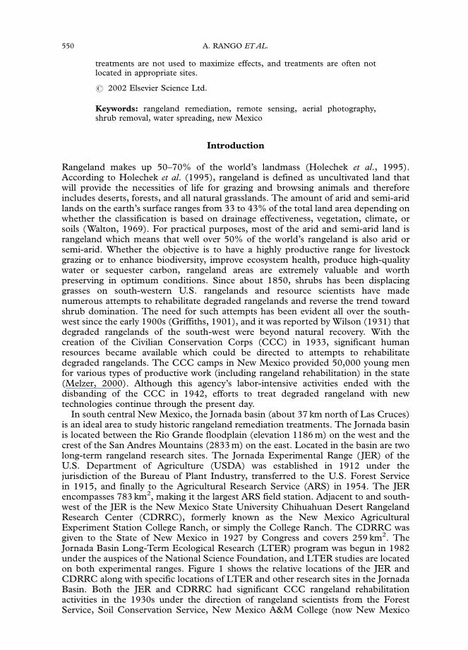
Pasture 9 on the CDRRC was the site of large rangeland remediation treatmentsinvolving water retention and spreading. In this case, 21 contour terraces with a totallength of about 24 km covering about 85 ha were constructed by CCC labor in 1935on a 3–5% slope on the north side of Summerford Mountain extending almost downto the CDRRC Headquarters. The terraces, made with a road grader (Valentine,1947), were about 2?5 m wide. These terraces were built at 1?8 m contour intervals sothat the horizontal distance between contour terraces is about 30?5 m at the top of theslope where it is steeper and about 91?4 m down closer to the Jornada Plain and theCDRRC Headquarters. After construction, some of the terraces were seeded tovarious native grasses. This seeding or an accumulation of native seeds from upslopesource areas was associated with limited concentration of vegetation behind theterraces which was visible in the 1936 aerial photography as shown in Fig. 2 (locationA). Adjacent to this area and to the south-east, more closely spaced contour furrowswere constructed over about 6?1 ha but at a contour interval of 0?31 m so that thehorizontal distance between furrows is only about 7?6 m (see enlargement, Fig. 2, insetC). In the central west part of the contour terraces there is a similar area with eventighter interval contour furrows (see enlargement, Fig. 2, inset B). Figure 3(b) is a linedrawing from the files of the NMSU Department of Animal and Range Sciencesdocumenting the pattern compared with the 1947 aerial photo of the same area. In1937, ponded water broke through many of the terraces. Rock weeps were laterinstalled in the terraces to slowly release the water and prevent future breaches of theterraces (see Fig. 3(c)). Today only the rock weeps remain as evidence of the terracelocation. By the time of the 1947 image in Fig. 3(a), the tightly contoured treatmentsat locations (B) and (C) in Fig. 2 had nearly faded away except for a few remnants.
For the contour terraces in CDRRC pasture 9, data from 11 1-m square quadratswere evaluated. In areas where no seeding occurred, only short-lived species likesnakeweed (Xanthocephalum spp.) and fluffgrass (Dasyochloa pulchella) experiencedtemporary increases both above and below the terraces. More desirable species likeblack grama (Bouteloua eriopoda) were generally not present to begin with, and verylittle expansion from areas where it was present was noted in the decade after the
Figure 2. Contour terraces constructed in 1935 in CDRRC pasture 9 as evident in 1936 aerialphotography at location (A). More closely spaced contour furrows are located at (B) and (C).Inset (B) is a 5?8� enlargement, inset (C) is a 2?8� enlargement.
RANGELAND REMEDIATION TREATMENTS 555
terraces were constructed (Valentine, 1947). On and beside terraces that were seededwith several grasses, several locations experienced moderate growth but the arealextent of the response was very limited, and most of the plants remaining today arenative species represented in the pre-existing vegetation. The overall evaluation byValentine (1947) was that, in general, little vegetation improvement could beattributed to the terraces.
Brush water spreaders
In the same general area of CDRRC, but in adjacent pasture 8, brush water spreaderswere constructed in 1937. The spreaders were made of brush gathered locally andwere held down by wire ties at 60–90 cm intervals across the spreader, and the knottedends of the ties were anchored in the ground with a driving tool (Valentine, 1947).
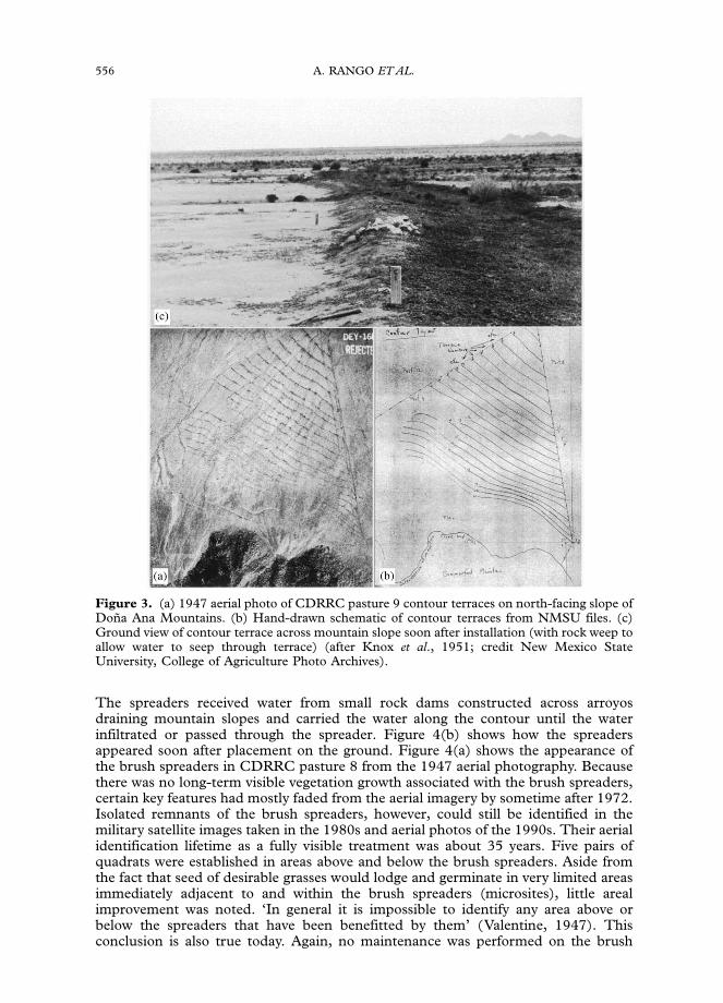
Figure 3. (a) 1947 aerial photo of CDRRC pasture 9 contour terraces on north-facing slope ofDona Ana Mountains. (b) Hand-drawn schematic of contour terraces from NMSU files. (c)Ground view of contour terrace across mountain slope soon after installation (with rock weep toallow water to seep through terrace) (after Knox et al., 1951; credit New Mexico StateUniversity, College of Agriculture Photo Archives).
556 A. RANGO ET AL.
The spreaders received water from small rock dams constructed across arroyosdraining mountain slopes and carried the water along the contour until the waterinfiltrated or passed through the spreader. Figure 4(b) shows how the spreadersappeared soon after placement on the ground. Figure 4(a) shows the appearance ofthe brush spreaders in CDRRC pasture 8 from the 1947 aerial photography. Becausethere was no long-term visible vegetation growth associated with the brush spreaders,certain key features had mostly faded from the aerial imagery by sometime after 1972.Isolated remnants of the brush spreaders, however, could still be identified in themilitary satellite images taken in the 1980s and aerial photos of the 1990s. Their aerialidentification lifetime as a fully visible treatment was about 35 years. Five pairs ofquadrats were established in areas above and below the brush spreaders. Aside fromthe fact that seed of desirable grasses would lodge and germinate in very limited areasimmediately adjacent to and within the brush spreaders (microsites), little arealimprovement was noted. ‘In general it is impossible to identify any area above orbelow the spreaders that have been benefitted by them’ (Valentine, 1947). Thisconclusion is also true today. Again, no maintenance was performed on the brush
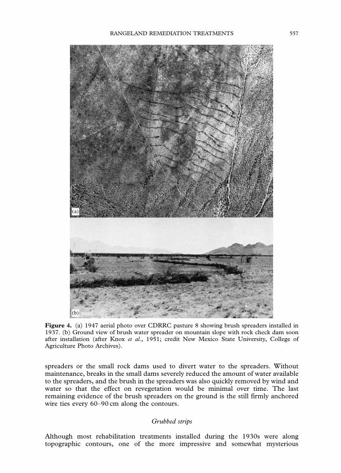
Figure 4. (a) 1947 aerial photo over CDRRC pasture 8 showing brush spreaders installed in1937. (b) Ground view of brush water spreader on mountain slope with rock check dam soonafter installation (after Knox et al., 1951; credit New Mexico State University, College ofAgriculture Photo Archives).
RANGELAND REMEDIATION TREATMENTS 557
spreaders or the small rock dams used to divert water to the spreaders. Withoutmaintenance, breaks in the small dams severely reduced the amount of water availableto the spreaders, and the brush in the spreaders was also quickly removed by wind andwater so that the effect on revegetation would be minimal over time. The lastremaining evidence of the brush spreaders on the ground is the still firmly anchoredwire ties every 60–90 cm along the contours.
Grubbed strips
Although most rehabilitation treatments installed during the 1930s were alongtopographic contours, one of the more impressive and somewhat mysterious

558 A. RANGO ET AL.
treatments was not contour referenced. In July–August 1936, with the assistanceof the Soil Conservation Service and the Civilian Conservation Corps (CCC),creosote (Larrea tridentata) and tarbush (Flourensia cernua) shrubs were removed atthe root level (grubbed) from 89 ha of rangeland in pasture 10 of the CDRRC.Honey mesquite (Prosopis glandulosa) and yucca (Yucca spp.) plants were leftundisturbed. Although not much different in total area from the contour terraces inpasture 9, the geometry of the treatments was striking. The grubbing wasdone in straight linear strips 30?5 m wide and 3?1 km long. There were five grubbedstrips separated by 15?25 m wide ungrubbed strips. Brush from the grubbed strips waspiled at the west edge of the ungrubbed strips, probably to slow the flow ofwater off the grubbed strips. According to file records, on October 10, 1939, creosoteand tarbush were again removed from the middle 30?5 m grubbed strip. Thegrubbed strip to the east of the middle strip was also grubbed again on October 10,1939, but this time all shrubsFincluding mesquite and yuccaFwere removed. It isstated in reports (Agricultural Experiment Station, 1940) that the regrubbed areaswould be kept free of brush whenever necessary. However, the 1939 regrubbing wasapparently the last shrub removal treatment the strips received, probably because ofthe occurrence of World War II and the loss of the labor force on the experimentalranges. It was not clear from records whether this retreatment of two strips wasconducted just in a limited portion of the study area or if the regrubbing was carriedout over the entire length of the strips (3?1 km). Close examination of 1947 aerialphotos, however, shows that these 1939 treatments were confined to a small portion ofthe strips.
Two aspects of this treatment are unusual. First, the treatment, which extended toplacement of brush piles, was performed in a straight line and not on a topographiccontour as nearly all other similar brush-related treatments were in this region.Second, the area of the treatments is unusually large and very visible when flying overthe region.
From aerial photographs taken by the Soil Conservation Service in December 1936the pattern of treatment approximately 4 months after grubbing is clearly illustrated inFig. 5(a). In addition to the five aforementioned grubbed strips, a sixth grubbed stripin the north-east sector was started but never completed. This sixth strip runs forabout 235 m. It is not clear whether it was intended to run the whole length of thepattern, or if it had another purpose. It is never mentioned in any reports stillavailable. It should be noted that some small square exclosures were constructedadjacent to the west side of the pattern which remain undocumented. Current dayinspection seems to indicate that at least a part of these exclosures was cleared ofshrubs and used to plant four-wing desert saltbush (Atriplex canescens), black grama,and other seeded species.
The long parallel strips in pasture 10 are visible in every image we have which coversthat area from 1936 up until the present day. Figure 5(a–e) shows a temporal sequencefrom 1936 to 1998, and it is evident that the strips are still visible from above althoughit is much more difficult to detect them on the ground. However, when a temporalsequence of aerial photos for the contour terraces in pasture 9 was examined, it is clearthat these features had almost entirely faded away in 40 years. There are perhaps tworeasons for the persistent visibility over time of the grubbed strips. First, a much largercontiguous area was treated (30?5 m wide strips) compared with the contour terraces(about 5?0 m wide terraces and borrow pits combined). Therefore, a stronger contrastwith the surrounding undisturbed desert vegetation and soil complex is provided inthe grubbed area which has remained fully visible for a longer period (at least 65years). Second, the pattern of disturbance is much more geometrical for the grubbedstrips, and they stand out more than do the more natural patterns of contourstructures. The blending of the treated area with undisturbed adjacent vegetationtakes place more rapidly in the contour treatments. Despite the fact that the grubbed

Figure 5. Temporal sequence of (a) 1936, (b) 1947, (c) 1974, (d) 1986, and (e) 1998 aerialphotos of alternating grubbed and ungrubbed straight line strips in CDRRC pasture 10. At thewest end of the ungrubbed strips, brush from the grubbed strips was piled. White square A in5(b) represents the image area in Fig. 6(a).
RANGELAND REMEDIATION TREATMENTS 559
strips are the single largest treated area in the Jornada basin, Valentine (1947) did notinclude an overall evaluation of the strip treatments in his report.
Revegetation exclosures
In association with treatments like the parallel strips, various exclosures were set up tostudy ‘the revegetation of south-western ranges by controlled grazing, utilization ofrunoff water, and reseeding’ (Agricultural Experiment Station, 1936). As an example,in the northern part of the strip pattern where the 1939 regrubbing took place, a2?43 ha rabbit-proof exclosure (#17 in the CDRRC numbering scheme) wasestablished in 1939 to study the effects of rabbit grazing on vegetation compositionin this treated area. In the exclosure, 32 subplots in squares of 7?62 m on a side wereset up in the middle strip regrubbed of creosote and tarbush in 1939, 32 moresubplots in the strip just east of the middle strip and regrubbed of all shrubs in 1939,and a final 32 in an ungrubbed strip. A similar number of subplots located in the sameway were established south of the rabbit-proof exclosure (see Fig. 6(b) from NMSUDepartment of Animal and Range Sciences files). Figure 6(a) (which appears assquare A in the 1947 coverage in Fig. 5) shows this same area as it appeared on 1947aerial photography; a careful inspection reveals the fence boundary of Exclosure 17which is highlighted with white arrows. Because this entire area is in CDRRC pasture10, which was ungrazed by cattle, all subplots were protected from the effects of cattlegrazing.

Figure 6. (a) 1947 aerial photo of CDRRC exclosure 17 (as defined by white corner arrows) inthe parallel strips. (b) Hand drawing of exclosure 17 experimental design from NMSU files.
560 A. RANGO ET AL.
Some conclusions specific to Exclosure 17 were made. Exclusion of rabbits from thefully grubbed strip resulted in a noticeable growth response in the first year (1940) ofdropseed grass (Sporobolus spp.) and fluffgrass compared with outside the exclosure(Agricultural Experiment Station, 1940). Much higher than normal rainfall in 1941allowed continued improvement inside the exclosure with impressive growth of sixdifferent grasses and 15 different forbs compared with outside the exclosure(Agricultural Experiment Station, 1941). Further evaluations were not made, andthe plots and strips were not maintained, contrary to indications in 1940 that theywould be (Agricultural Experiment Station, 1940). The area of the grubbed stripstoday seems to have returned to shrub domination with very little grass growth. Thefencing for Exclosure 17 has broken down and is visible only in a few spots where ithas been protected by shrubs.
To the north of the strips and of Exclosure 17, a second exclosure (#18), also inpasture 10, was set up to determine the joint effects of cattle and rodents on varioustypes of land terracing, the singular effect of rodents on the contour terraces, and theability of the contours to increase natural forage production with the completeexclusion of cattle and rodents (Agricultural Experiment Station, 1940). Exclosure 18comprises five contiguous plots in low-condition grassland fenced to exclude rodentsand five similar adjacent plots not protected from rodents. The fence for Exclosure 18,which was constructed in 1939, is visible on the 1947 air photo and encloses 5 ha(Fig. 7). The unfenced treatment plots adjacent to Exclosure 18 are also visible inFig. 7. The two sets of five plots were meant to assess rodent effects on vegetationassociated with various contouring treatments and include ridge contours (9–14 mspacing), large ripper furrows (3–4 m spacing), double furrows (8–11 m spacing), acontrol, and small single furrows (l–2 m spacing) in order from south to north(Valentine, 1947). It is interesting to note that in addition to these ten plots,inspection of the aerial photos reveals many similar contour treatments scattered overthis entire area of CDRRC, most of which are undocumented.
There is very little evidence today that Exclosure 18 ever existed other than somevery regular rows of wooden stakes delineating some plot boundaries. All fencing hasbeen removed from the area. Valentine (1947) pointed out that soil moisturemeasurements in and around Exclosure 18 revealed that none of the contourtreatments provided any increase in soil moisture. The lack of response in perennial

Figure 7. 1947 aerial photo of CDRRC exclosure 18. Five plots are inside the exclosure asdelineated by the dark fence line (and protected from rodent effects) and five more identicalplots are outside the fence to the east (and not protected from rodent effects).
RANGELAND REMEDIATION TREATMENTS 561
grass growth in this area was probably associated with this lack of moistureenhancement. Valentine (1947) speculated that grass growth at this site, unlike othersites where exclusion of rodents and rabbits resulted in an improvement in vegetationgrowth, was more constrained by the poor water-holding capacity of the soil (coarsesandy loam over coarse sand) which most likely prevented the contouring strategiesfrom being effective in producing increased grass growth.
Undocumented plots
An area on JER pasture 6, that was first noticed when the aerial photography wasexamined, remains very much a mystery. This pattern of plots, which still has woodenstakes marking the plot corners (dimensions of 7?5� 30 m2), remains quite visible

Figure 8. 1974 aerial photo of JER pasture 6 south and west of Dona Ana Revegetation andRain Gauge Enclosure where a rectangular plot pattern of unknown treatments exists.
562 A. RANGO ET AL.
because it covers a large, remote area (26?5 ha) south and west of the Dona AnaRevegetation and Rain Gauge Enclosure. About one-half of these plots actually are inthe North Plot of the larger Dona Ana Exclosure (formerly known as the MoistureConservation Exclosure). Today, some of these undocumented plots remain nearlyfree of any vegetation, whereas others are covered by a sparse vegetation, and othershave a normal shrub cover consisting mostly of creosote. No one interviewed or takento see these plots in 2000 was previously aware of their existence. No reference tothese plots was found in existing reports or files. They are not present on the 1937aerial photography and were first noticed on the 1974 aerial photography (see Fig. 8).Because of the extent of these plots and the labor required to put them in andmanipulate the vegetation, it is likely that they were established in the late 1930s orearly 1940s before the CCC left the region. It is very unusual that no reference ordocumentation could be found considering the effort that was required to work in thisremote region. Uncovering additional details about these plots would be valuable forretrospective studies. Initially, it appeared that there was a large gap in aerial photocoverage over this portion of the Jornada basin between 1937 and 1974. Recently,military and private company aerial photos from 1940s to 1950s were located andordered for this region. When received, they should help determine at least when theplots were installed.
Rootplow–seeding patterns
In the period after World War II, individual rangeland remediation treatments did notcover areas as large as in the 1930s, but these more recent treatments were better

RANGELAND REMEDIATION TREATMENTS 563
documented. Numerous implements were designed to exploit the ever increasingpower of agricultural and civil engineering machinery to remove shrubs, prepareseedbeds, create small pits where water could accumulate, and plant seeds. The aridland seeder, a machine which accomplished all these operations in a single pass, wasdeveloped at JER in 1967 and tested during the 1960s and 1970s (Herbel et al., 1973;Abernathy & Herbel, 1973). Figure 9 shows an aerial photo of the pattern of aprecursor to the arid land seeder machine in JER pasture 6 in a tarbush area taken in1974. In the period 1964–1966, a road grader and accompanying seeding machine, asseen in Fig. 10, were used in the area shown in Fig. 9 in an attempt to replace tarbushwith grass and to perfect techniques using heavy machinery. In some tests, pits weremade by the end of the road grader blade and then seeded. This type of pit pattern islikely seen in the third strip from the west and the eastern-most strip in Fig. 9. To thenorth-east of the major pattern, several additional patterns are evident indicating that
Figure 9. 1974 aerial photo of JER pasture 6 east side showing surface patterns left by roadgrader and seeding machines.

Figure 10. Road grader and grass seeding equipment operating in tarbush area of JER pasture6 in 1964.
564 A. RANGO ET AL.
seeding methods which produced less surface disturbance were also tested.Treatments with the final version of the arid land seeder display patterns much moremuted or homogeneous than those in Fig. 9. All these treatments, however, resulted inrelatively high levels of soil surface disturbance which increased erosion susceptibility(Herrick et al., 1997). They also required significant energy inputs and the availabilityand maintenance of expensive machinery.
Use of the arid land seeder that was eventually developed was not confined to theJER, and results in 23 2-ha plots across southern New Mexico were evaluated.Approximately 50% of the seedings were considered to be successful 6 years afterseeding (Herbel et al., 1973) based on six levels of subjective assessments at each ofthe 23 plots. Drought was cited as the primary reason for failure, combined withhighly erosive sites or ones subject to formation of hard surface crusts (Herbel et al.,1973). Because of drought and unfavorable soil conditions at Jornada, all of the sevenJER plots treated with the rootplow–seeder were unsuccessful in causing grassregrowth.
Water retention dikes
In 1981 at the south end of JER pasture 6, 12 slightly crescent-shaped dikes designedto impound about 15 cm of water before any excess overflowed around the ends of thedikes were built (Tromble, 1981). The dikes are about 30 cm high and about 60 mlong. The gravelly-loam soils of the impoundment areas were rootplowed to eradicateshrubs and drill-seeded with sudangrass (Sorghum bicolor spp. drummondii), bluepanicgrass (Panicum antidotale), alkali sacaton (Sporobolus airoides), and Lehmanlovegrass (Eragrostis lehmanniana) according to JER annual progress reports. Seededspecies have not survived, but the more favorable environment created by the dikeshas led to relatively lush growth of native species, and the dike area in recent imageryhas a much lower reflectance (see Fig. 11(a)) indicating significant vegetation growthcovering the normally highly reflective soils as shown in the ground view in Fig. 11(b).This reinvasion by native species has also occurred on other areas where

Figure 11. (a) 1986 aerial photo of JER pasture 6 west side showing 12 dikes constructed toretain surface runoff for infiltration and combined with seeding of various grasses (white arrowspoint to abundant vegetation growth areas upslope from dikes. (b) Ground view of grass andassociated vegetation growth upslope from dikes in (a) taken in 1999.
RANGELAND REMEDIATION TREATMENTS 565
impoundment dikes were built. For example, five concentric 7?5 cm high dikes wereestablished on a fine-textured soil in 1975 in an area with virtually no perennial plantcover. During the next 4 years, various treatments were applied including discplowing, seeding and, in 1979, the application of municipal biosolids. The experimentwas abandoned in 1980 because of the lack of plant establishment and the costs ofmaintaining the dikes. By 1984, there were still very few plants growing between thedikes. Significant recovery of native species was recorded, however, when the site wasresurveyed in 1997 (Walton et al., 2001). The patterns are now clearly visible fromaerial photographs. Like the other dikes, most of the plants established on the sitewere native species which colonized from the pre-existing seed bank or thesurrounding area. In arid regions, significant rainfall events and subsequent runoff

566 A. RANGO ET AL.
are not frequent, so it may be necessary to maintain the treatments for longer periodsthan would be necessary in humid regions in order to encounter the precipitationevents that would activate the treatments or support plant response.
Fenceline contrasts
Fenceline contrasts are common features in aerial or satellite photography wheretreatments have been instituted or where different land ownerships or managementpractices meet. The reasons for the strong contrasts across fences include grazingrestrictions (a passive treatment), different stocking levels or patterns, distance fromwater sources, and differing treatments as well as natural soil, water and vegetationdiscontinuities that might parallel fence lines. Improved resolution images fromsatellites, like the recently launched IKONOS, can show fenceline contrasts in afashion comparable with aerial photography. An example of fenceline contrasts isshown near the center of Fig. 12 which is 1–2 m resolution IKONOS satellite imagerylocated over the boundary intersections of the CDRRC, JER, and Bureau of LandManagement (BLM) lands (to the northwest). The sharpest fenceline contrast isbetween the northern edge of CDRRC pasture 3N and the BLM lands to the north atlocation A. In contrast to CDRRC and JER lands shown in Fig. 12, where herbicideshave been applied at different times in the past to control the shrubs, the BLM land tothe north has never been herbicided. The BLM land has been heavily grazed for longperiods, and shrubs dominate the vegetation cover as opposed to portions of CDRRCand JER where black grama remains. A ground view of the fenceline contrasts betweenCDRRC and BLM at location A is shown in Fig. 13. The fenceline contrast atlocation B in Fig. 12 is a black grama exclosure established in the 1950s that wassubjected to different grazing intensities until the mid-1960s and then eventuallyexcluded from grazing entirely. Today the black grama in the exclosure is in very goodcondition.
Temporal visibility of treatments using remote sensing
Monitoring the length of time that the rangeland treatments were visible with remotesensing data was complicated by the fact that aerial photography was not alwaysavailable over all the treatments. Declassified military satellite images from 1968,1972, and 1983 were used to increase the number of photos over the treatment areas.Not all of the treatments in this study were covered by military satellite images becauseof the restricted areal coverage available. The appearance of rangeland treatmentsfrom 1936 to 1996 could only be assessed for the contour terraces (Fig. 2), the brushspreaders (Fig. 4), the grubbed strips (Fig. 5), and Exclosure 18 (Fig. 7), all of whichare on the CDRRC.
Six years of photo coverage were used to observe the particular treatments as shownin Table 1. The first year that the treatment was observed (1936 or 1947) was used asa baseline against which to compare the appearance in subsequent years. When somekey features in each treatment had disappeared, the treatments were deemed onlypartly visible. It can be seen from Table 1 that the large contour terraces (Fig. 2(A))persisted for at least 37 years before their identification became problematic. Parts ofthe terraces could still be discerned in 1996. The tightly spaced contours in Fig. 2B, Cwere difficult to identify 12 years after installation and faded away entirely sometimebetween 1947 and 1968. The brush spreaders were easily observed for 35 years andbecame difficult to see after 1972, although traces of the spreaders are still visibletoday. Exclosure 18 was only visible in certain parts, probably because fencing wasremoved in the period 1947–1983 combined with natural degradation of the enclosedcontour structures. After 1983, Exclosure 18 could no longer be identified, and no

Figure 12. IKONOS panchromatic image over CDRRC, JER, and BLM lands taken on July20, 2000. Location (A) is the fenceline contrast between CDRRC pasture 3N and BLM lands.Location (B) is a black grama exclosure. Inset (A) is a 4?7� enlargement and inset (B) is a6?4� enlargement.
RANGELAND REMEDIATION TREATMENTS 567
fencing remains on the ground. Only the 3?1 km long grubbed strips remained highlyvisible during the entire period of record, thus indicating that, from an aerialperspective, their lifetime exceeds 60 years.
Discussion
Guidance for location of new treatments or experiments
Because of extensive existing aerial photography and satellite images, the remotesensing data base resource should be exploited whenever remediation or restoration

Figure 13. Ground view of the fenceline contrast shown in Fig. 12, inset (A) with BLM landon the left and CDRRC land on the right.
Table 1. Longevity of remediation treatments in aerial and satellite photos in theJornada basin
Year of observation
Treatment Year treatmentconstructed
1936 1947 1968 1972 1983 1996
Contour terraces (Fig. 2(A)) 1935 y y y y p pContour terraces (Fig. 2(B)) 1935 y p n n n nContour terraces (Fig. 2(C)) 1935 y p n n n nBrush spreader (Fig. 4(a)) 1937 F y y y p pGrubbed strips (Fig. 5) 1036 y y y y y yExclosure 18 (Fig. 7) 1939 F y p p p n
Observation key: yFtreatment observed with all original features visible, pFpartially visible with somekey features observed, nFtreatment no longer visible.
568 A. RANGO ET AL.
activities are proposed. It is an excellent way to become familiar with the study area ofinterest. This is especially true for students, scientists, or ranch managers who may benew to a particular location. The remote sensing data can be used to build upknowledge of the type of treatments already applied in the area and their resultingeffects. Where natural or artificial boundaries exist, remote sensing data can be used todetermine where to locate supplemental ground measurements to aid in the design ofnew experiments.
Because the historical manipulations are difficult to detect on the ground, newtreatments and studies may accidentally be located in previously affected areas. Forexample, long-term plots were established in 1989 by the Jornada Basin Long-TermEcological Research (LTER) program to monitor above-ground plant compositionand net primary productivity. Two of the plots located in creosote bush ecosystems fallin or near the parallel grubbed strips described previously. In portions of these plots,then, plant density and size may be smaller than in surrounding untreated areas.Assumptions that the plots reflect maximum plant biomass for undisturbed sites

RANGELAND REMEDIATION TREATMENTS 569
would therefore be in error. An accurate understanding of how plant productivity andecosystem structure are related to historic disturbance depends on being able toreconstruct plot histories; the current study demonstrates the value of archivalinformation in documenting historical treatments no longer conspicuous on theground.
Effectiveness at landscape scales
Experimental manipulations of rangeland on the scale of small plots have for the mostpart been ineffective because there was no way to prevent processes occurring acrosslandscape units as a whole from overwhelming the treatments. Examples of theseprocesses are rainfall-runoff generation, soil erosion, fluxes of water, nutrients, andseeds down the topographic slope, and drought. In addition to the fact that thetreatments were not performed over large enough or contiguous areas, there wereother reasons contributing to failure of the experimental manipulations. These reasonsinclude: (a) maintenance of treatments not included as a continuing activity in theexperiment design; (b) evaluation of success of some treatments was over periodsshorter than the return period of significant meteorological events that would interactpositively with the treatment; (c) treatments were usually for a single purpose and didnot include complementary or multi-purpose treatments to maximize effects; and (d)location of treatments were for the most part not in favorable sites that would respondin a very positive way to the treatment (so-called ‘trigger sites’).
To have an effect at the landscape scale, treatments have to be conducted at a scalecomparable to processes active across the landscape. As an example, Exclosure 18 onthe CDRRC, with various types of contour furrowing, was relatively small (5 ha), sotreatments were compromised in a relatively short period of time as a result of runoffand erosion processes originating outside the treatment area. Even treatments overrelatively large areas did not have a high chance of success because the treatments werenot maintained over time. Large features such as the linear grubbed (shrub-free) stripsthat run for 3?1 km across contours on the south-eastern part of the College Ranchhave nearly faded away due to a nearly constant flux of water, nutrients, and seedstransported down slope from the mountains allowing shrub reestablishment. Severalarroyos cut through the strips in their course from the slopes of SummerfordMountain down to the Jornada plain. The large areal extent of these treatments hasallowed them to be visible for more than 60 years, but it is apparent that they will soonvanish from the landscape as a result of the lack of provision for maintaining theshrub-free strips. By viewing the changing appearance of the various remediationtreatments from the ground and from aerial photos, it is apparent that periodicmaintenance of the treatments is necessary even in arid and semi-arid regions. In mostcases, treatments would need to be updated or maintained at 10-yr intervals orshorter. Although complete shrub reinfestation on the JER is estimated to take about25 years (for tarbush) (New Mexico College of A and M.A. and Southwestern Forestand Range Experiment Station, 1946), maintenance should be conducted much morefrequently because grubbing is more effective, easier, and less expensive when shrubsare young (Agricultural Experiment Station, 1949).
Many treatments are part of experiments that are only evaluated for a limited timeperiod. In most cases, this time period is much shorter than the return period ofsignificant hydrometeorological events (e.g. 50 yr or 100 yr flood) that are needed toactivate the treatment in arid regions. On the other hand, extreme climate events suchas drought can persist for very long periods so that vegetation associated with effectivetreatments is eventually eliminated. In the area of the 12 dikes constructed in JERpasture 6, brush was controlled by rootplowing, four species of grass were seeded witha drill prior to the summer rainy season, and water retained behind the dikes was

570 A. RANGO ET AL.
available for vegetation growth. Possibly because of the three-pronged attack, this sitehas allowed reestablishment of native vegetation cover which can be seen quite easilyin aerial photo images from 1986 and in the 1990s. Treatments such as these waterretention dikes may be successful because they are located in areas favorable forchange. Remote sensing would be effective in identifying areas with a high potentialfor change, or trigger sites, because it can be used to locate ecotones and areas ofresource accumulation. It may be easier to cause change by locating a remediationtreatment in a trigger site zone. Other types of trigger sites may encourageimprovement in larger areas by natural spread from the treated portion. Thus, thetrigger site concept can refer both to how easy it is to trigger changes, and to thepossibility that a change in one part of the landscape may trigger changes insurrounding areas. This trigger site concept was presented in 1939 in internal Jornadareports (Southwestern Forest and Range Experiment Station, 1939). No definitiveconfirmation of this ‘trigger site’ theory has yet been established, and it is animportant area for future research.
Conclusions
Despite the fact that there are vast areas of public and private lands in the arid south-west U.S. of seemingly undisturbed landscapes, there is a complex array of rangelandremediation treatments present that in most cases is not easily detectable from theground. These manipulated areas extend back to the early part of the 20th centuryand all the way up to the year 2000. Usually, the older manipulations do not havesignificant documentation of location, type of treatment, scientific objectives, or anevaluation of effectiveness. Fortunately, there are ways to reconstruct the history oftreatments that involve file searches of archival information and exploitation of theever-growing remote sensing database.
One of the most simple kinds of remote sensing data, namely, aerial photography,can be the most valuable. Not only can the air photos provide a historical, temporal,and areal perspective of rangeland remediation treatments, but techniques used inanalysis are simple and easily transferred to users. For the Jornada basin, aerial photocoverage was available and acquired for the years 1936,1937,1947,1974,1986, and1996–1999. For specific study areas, comparable declassified military satellite imagerywas obtained for the 1960s, 1970s, and 1980s. High-resolution multi-spectral datafrom the IKONOS satellite with resolutions comparable with the aerial photos wereobtained for July 2000.
Using the aerial photos, it was possible to identify contour terraces and associatedcontour structures (with furrow spacing as small as l–2 m), brush water spreaders,long parallel strips with different grubbing patterns, revegetation exclosures of varioustypes, mechanical rootplow and seeding patterns, water retention dikes, sharpfenceline contrasts, and a mysterious network of plots with, so far, unspecifiedtreatments. When the air photo record was supplemented with declassified militaryphotos, it was possible to delineate the length of time that the various plots were visiblewith a recognizable pattern from an aerial perspective. For the treatments monitoredover time, the 3?1 km long grubbed strips were the most persistent and are still easilyvisible today even in their 65th year. The brush spreaders and the large contourterraces lasted about 35 years before their identification became difficult. Tightlyspaced contours faded away much faster than the large contour terraces.
Based on existing literature and air photo evaluations, no positive vegetationresponse, such as expansion of native grasses, could be detected for the contourtreatments, brush water spreaders, and grubbed strips. The treatments that seemed to

RANGELAND REMEDIATION TREATMENTS 571
have a definite positive response visible from aerial photography were water retentiondikes and certain exclosures.
By identifying the location and type of historical treatments, aerial photography canbe used to provide a template over rangeland areas. This template can be usedeffectively to decide the location of new rangeland treatments or other forms ofexperimental studies so as to avoid contamination by past treatments. Additionally,the template can also be used to locate transects and quadrats for current daymeasurements to evaluate the effects of the past rehabilitation attempts and evaluatethe potential of future treatments. Keeping track of the cumulative manipulationswould be facilitated by combining digitized aerial photography with a GeographicInformation System.
It appears from both aerial photos and existing conventional documentation thatexperimental manipulation of rangelands at the small plot scale has generally beenineffective on the landscape unit scale. The reasons for this ineffectiveness includetreated areas not large enough, regular treatment maintenance not provided,evaluation periods sometimes too short, multi-purpose treatments not usuallyperformed, and treatments located in unfavorable sites to trigger a positive vegetationresponse.
There are several aerial photo archives that can be searched to determine what dataare available for specific arid rangeland areas in the United States. These data areusually available for ordering at reasonable prices. These facilities include the AerialPhotography Field Office, Farm Service Agency, USDA (www.apfo.usda.gov/orderingimagery.html), the National Archives (www.nara.gov/research/ordering/ma-pordr.html), the US. Geological Survey (edcsnsl7.cr.usgs.gov/EarthExplorer/), andthe Fairchild Aerial Photography Collection at Whittier College (www.whittier.edu/fairchild/home.html).
The authors would like to thank Mr Chris Pooley at ARS-Beltsville for data processing and
figure preparation, Mr John Smith for historical research on the JER, Ms Barbara Nolen atNMSU for assistance in acquiring aerial photography, Mr Victor Espinoza at NMSU for
assistance in obtaining photos from the Photo Archives of the College of Agriculture and HomeEconomics, and Ms Shelley Shupp at ARS-Beltsville for word processing support.
References
Abernathy, G.H. & Herbel, C.H. (1973). Brush eradicating, basin pitting, and seeding machinefor arid to semiarid rangeland. Journal of Range Management, 26: 189–192.
Agricultural Experiment Station (1936). Forty-seventh Annual Report. New Mexico College ofAgriculture and Mechanical Arts, State College, NM, 1935–1936.
Agricultural Experiment Station (1940). Fifty-first Annual Report. New Mexico College ofAgriculture and Mechanical Arts, State College, NM, 1939–1940.
Agricultural Experiment Station (1941). Fifty-second Annual Report. New Mexico College ofAgriculture and Mechanical Arts, State College, NM, 1940–1941.
Agricultural Experiment Station (1949). Sixtieth Annual Report. New Mexico College ofAgriculture and Mechanical Arts, State College, NM, 1948–1949.
Allred, K.W. (1993). A Field Guide to the Grasses of New Mexico. Las Cruces, NM: Department ofAgricultural Communications, New Mexico State University, 259 pp.
Bailey, R.W. & Croft, A.R. (1937). Contour-trenches control floods and erosion on range lands,Emergency Conservation Work, Forestry Publication No. 4, Washington, DC. 22 pp.
Carneggie, D.M., Schrumpf, B.J. & Mouat, D.A. (1983). Rangeland applications. In: Colwell,R.N. (Ed.), Manual of Remote Sensing, pp. 2325–2384. American Society of Photogrammetry,Falls Church, VA. 2440 pp.
572 A. RANGO ET AL.
Cassady, J.T. & Glendening, G.E. (1940). Revegetating semidesert range lands in the Southwest,Civilian Conservation Corps, Federal Security Agency, Forestry Publication No. 8,Washington DC. 22 pp.
Correll, D.S. & Johnston, M.C. (1970). Manual of the Vascular Plants of Texas. Remer, TX: TexasResearch Foundation, 1881 pp.
Griffiths, D.A. (1901). Range improvement in Arizona. Bureau of Plant Industry Bulletin 4, U.S.Department of Agriculture.
Herbel, C.H., Abernathy, G.H., Yarbrough, C.C. & Gerdner, D.K. (1973). Rootplowing andseeding arid rangelands in the Southwest. Journal of Range Management, 26: 193–197.
Herrick, J.E., Havstad, K.M. & Coffin, D.P. (1997). Rethinking remediation technologies fordesertified landscapes. Journal of Soil and Water Conservation, 52: 220–225.
Holechek, J.L., Pieper, R.D. & Herbel, C.H. (1995). Range ManagementFPrinciples and Practice.Englewood Cliffs, NJ: Prentice-Hall. 526 pp.
Kearney, T.H. & Peebles, R.H. (1964). Arizona Flora. Berkeley, CA: University of CaliforniaPress, 1085 pp.
Knox, J.H., Watkins, W.E., Koger, M. & Valentine, K.A. (1951). Research on the College Ranch,Agricultural Experiment Station, New Mexico College of Agricultural and Mechanical Arts,Bulletin 359, State College, NM. 33 pp.
Melzer, R. (2000). Coming of Age in the Great Depression: The Civilian Conservation CorpsExperience in New Mexico, 1933–1942. Las Cruces, NM: Yucca Tree Press. 308 pp.
New Mexico College of A. and M.A. & Southwestern Forest and Range Experiment Station(1946). Ranch day, October 14, 1946. Experimental Ranch and Jornada Experimental Range.
Southwestern Forest and Range Experiment Station (1939). Notes from the JornadaExperimental Range, Las Cruces, Forest Service. USDA, January 3, 1939. 20 pp.
Thompson, M.M. & Gruner, H. (1980). Foundations in photogrammetry, In: Slama, C. C.,Theurer, C. & Henriksen, S.W. (Eds), Manual of Photogrammetry, pp. l–36. Falls Church, VA:American Society of Photogrammetry, 1056 pp.
Tromble, J.M. (1981). Rangeland ponding dikes: design criteria. Journal of Range Management,36: 128–130.
Tueller, P.T. (1982). Remote sensing in range management, In: Johannsen, C.J. & Sanders, J.L.(Eds), Remote Sensing for Resource Management, pp. 125–140. Ankeny, IA: Soil ConservationSociety of America. 665 pp.
Valentine, K.A. (1947). Effect of water-retaining and water-spreading structures in revegetatingsemidesert rangeland. Agricultural Experiment Station, New Mexico College of A. and M.A.,Bulletin 341, State College, NM. 22 pp.
Walton, K. (1969). The Arid Zones. Chicago: Aldine Publishing Company. 175 pp.Walton, M., Herrick, J.E., & Gibbens, R.P. Persistence of municipal biosolids in a Chihuahuan
Desert rangeland 18 years after application. Arid Land Research and Management, 15:223–232.
Wilson, C.P. (1931). The artificial reseeding of New Mexico ranges. Agricultural ExperimentStation, New Mexico College of A. and M.A., Bulletin 169, State College, NM.