Regional gravimetric quasi-geoid model and transformation surface to national height system for...
22
Stud. Geophys. Geod., 55 (2011), 557578, DOI: 10.1007/s11200-010-9023-z 557 © 2011 Inst. Geophys. AS CR, Prague Regional gravimetric quasi-geoid model and transformation surface to national height system for Turkey (THG-09) ALI KILIÇOĞLU * , AHMET DIRENÇ, HASAN YILDIZ, MURAT BÖLME, BAHADIR AKTUĞ, MEHMET SIMAV AND ONUR LENK Geodesy Department, General Command of Mapping, TR-06100, Ankara, Turkey ([email protected]) Received: February 24, 2010; Revised: July 27, 2010; Accepted: November 18, 2010 ABSTRACT Turkish regional geoid models have been developed by employing a reference earth gravitational model, surface gravity observations and digital terrain models. The gravimetric geoid models provide a ready transformation from ellipsoidal heights to the orthometric heights through the use of GPS/leveling geoid heights determined through the national geodetic networks. The recent gravimetric models for Turkish territory were computed depending on OSU91 (TG-91) and EGM96 (TG-03) earth gravitational models. The release of the Earth Gravitational Model 2008 (EGM08), the collection of new surface gravity observations, the advanced satellite altimetry-derived gravity over the sea, and the availability of the high resolution digital terrain model have encouraged us to compute a new geoid model for Turkey. We used the Remove-Restore procedure based on EGM08 and applied Residual Terrain Model (RTM) reduction of the surface gravity data. Fast Fourier Transformation (FFT) was then used to obtain the residual quasi- geoid from the reduced gravity. We restored the individual contributions of EGM08 and RTM to the whole quasi-geoid height (TQG-09). Since the Helmert orthometric height system is adopted in Turkey, the quasi-geoid model (TQG-09) was then converted to the geoid model (TG-09) by making use of Bouguer gravity anomalies and digital terrain model. After all we combined a gravimetric geoid model with GPS/leveling geoid heights in order to obtain a hybrid geoid model (THG-09) (or a transformation surface) to be used in GPS applications. The RMS of the post-fit residuals after the combination was found to be 0.95 cm, which represents the internal precision of the final combination. And finally, we tested the hybrid geoid model with GPS/leveling data, which were not used in the combination, to assess the external accuracy. Results show that the external accuracy of the THG-09 model is 8.4 cm, a precision previously not achieved in Turkey until this study. K e y w o r d s : gravity, geoid, height system, GPS, leveling, transformation surface, EGM08 * The manuscript solely reflects the personal views of the author and does not necessarily represent the views, positions, strategies or opinions of Turkish Armed Forces.
Transcript of Regional gravimetric quasi-geoid model and transformation surface to national height system for...

Stud. Geophys. Geod., 55 (2011), 557578, DOI: 10.1007/s11200-010-9023-z 557 © 2011 Inst. Geophys. AS CR, Prague
Regional gravimetric quasi-geoid model and transformation surface to national height system for Turkey (THG-09)
ALI KILIÇOĞLU*, AHMET DIRENÇ, HASAN YILDIZ, MURAT BÖLME, BAHADIR AKTUĞ, MEHMET SIMAV AND ONUR LENK
Geodesy Department, General Command of Mapping, TR-06100, Ankara, Turkey ([email protected])
Received: February 24, 2010; Revised: July 27, 2010; Accepted: November 18, 2010
ABSTRACT
Turkish regional geoid models have been developed by employing a reference earth gravitational model, surface gravity observations and digital terrain models. The gravimetric geoid models provide a ready transformation from ellipsoidal heights to the orthometric heights through the use of GPS/leveling geoid heights determined through the national geodetic networks. The recent gravimetric models for Turkish territory were computed depending on OSU91 (TG-91) and EGM96 (TG-03) earth gravitational models. The release of the Earth Gravitational Model 2008 (EGM08), the collection of new surface gravity observations, the advanced satellite altimetry-derived gravity over the sea, and the availability of the high resolution digital terrain model have encouraged us to compute a new geoid model for Turkey. We used the Remove-Restore procedure based on EGM08 and applied Residual Terrain Model (RTM) reduction of the surface gravity data. Fast Fourier Transformation (FFT) was then used to obtain the residual quasi-geoid from the reduced gravity. We restored the individual contributions of EGM08 and RTM to the whole quasi-geoid height (TQG-09). Since the Helmert orthometric height system is adopted in Turkey, the quasi-geoid model (TQG-09) was then converted to the geoid model (TG-09) by making use of Bouguer gravity anomalies and digital terrain model. After all we combined a gravimetric geoid model with GPS/leveling geoid heights in order to obtain a hybrid geoid model (THG-09) (or a transformation surface) to be used in GPS applications. The RMS of the post-fit residuals after the combination was found to be 0.95 cm, which represents the internal precision of the final combination. And finally, we tested the hybrid geoid model with GPS/leveling data, which were not used in the combination, to assess the external accuracy. Results show that the external accuracy of the THG-09 model is 8.4 cm, a precision previously not achieved in Turkey until this study.
Ke y wo rd s : gravity, geoid, height system, GPS, leveling, transformation surface,
EGM08 * The manuscript solely reflects the personal views of the author and does not necessarily represent the views, positions, strategies or opinions of Turkish Armed Forces.

A. Kılıçoğlu et al.
558 Stud. Geophys. Geod., 55 (2011)
1. INTRODUCTION
The surface of the oceans, after some slight idealization, is part of a certain level surface. This particular equipotential surface was proposed as the “mathematical figure of the earth” by F.C.Gauss, and was later termed “the geoid” (Heiskanen and Moritz, 1967, p. 49; Hoffmann-Wellenhof and Moritz, 2005, p. 46). The geoid is still considered as the fundamental surface of physical geodesy. In practice, we take the geoid into account during GPS positioning. It is well known that the difference between the orthometric height and the ellipsoidal height is called the geoid height. The geoid surface is computed with respect to the ellipsoid surface. If the geoid height is known everywhere, then the GPS derived ellipsoidal height can simply be converted into the orthometric height by subtracting the geoid height.
The geoid height is a function of the disturbing potential, which is given as the difference between the Earth’s gravity potential and the normal potential, and is strictly related to the fundamental equation of the physical geodesy, that links the observables (e.g. gravity) to derivatives of the disturbing potential (e.g. geoid height) as
2 Tg TR r
, (1)
where g is the gravity anomaly, T is the disturbing potential, T r is the vertical gradient of the disturbing potential and R is the radius of the Earth. This fundamental equation of the physical geodesy constitutes a Boundary Value Problem (known as 1st BVP), in which geoid is the boundary surface and the gravity anomalies must be reduced to it. The gravity anomaly is the main observable when computing the geoid height with respect to an ellipsoid. Stokes formula gives a solution to the Eq.(1), and may be used to determine the geoid from the observed gravity through the combination of the well-known Bruns’ equation.
The geoid computations in Turkey date back to 1970’s and have been going on recently. Ayan (1976, 1978) and Gurkan (1978) have used deflections of the vertical data at 98 stations. Southwestern Anatolia Doppler Geoid was computed by Ayhan et al. (1987). After the public release of the global geopotential models and the availability of the gravity and terrain elevation data, the first gravimetric geoid model of Turkey (TG-91) was computed (Ayhan, 1993). Meanwhile TRANSIT Doppler observations in Turkey were adjusted to establish a Turkish Doppler Datum (Ayhan and Kılıçoğlu, unpublished results). Then the Turkish Doppler Geoid (TDG-92) was computed, which was the first regional geoid model in Turkey developed by making use of ellipsoidal heights from satellite data and the leveled orthometric heights at 184 collocated points. The Turkish Astrogeodetic Geoid (TAG-94) was computed by astrogravimetric leveling technique using the deflections of the vertical at 200 stations of the national horizontal control network (Ayhan and Alp, 1994). After the release of the global geopotential models to the geodetic community and availability of surface gravity, GPS/leveling derived geoid heights and the digital terrain models the new gravimetric geoid models for Turkey have been computed by the well known Remove-Restore method. The first among them was TG-91 (Ayhan, 1993), then subsequently came TG-99A (Kılıçoğlu, unpublished results) and TG-03 (Kılıçoğlu et al., 2005). The establishment of the Turkish National GPS
Regional gravimetric quasi-geoid model and transformation surface for Turkey
Stud. Geophys. Geod., 55 (2011) 559
Network (Ayhan et al., 2002) played an important role in the combination of the gravimetric and GPS/leveling geoid models, since it provides a consistent and a reliable set of ellipsoidal heights for the collocated stations.
The last geoid model TG-03 was based on EGM96 as the reference field. After the release of EGM08 (Pavlis et al., 2008) we have faced a new era; an earth gravitational model to degree and order 2160 (5 5 resolution on the surface of the earth). Meanwhile we have collected more and new surface gravity and GPS/leveling data on the Turkish territory, obtained up-to-date satellite altimetry derived gravity anomaly on the sea surface (Andersen et al., 2008), and prepared a 90 m resolution digital terrain model for Turkey and surrounding regions. Moreover, the release of the EGM08 along with the new and more data then before has brought us to develop a new gravimetric geoid model for Turkey. We used mainly the Gravsoft package (Tscherning et al., 1994) for the computations in a Remove-Restore procedure, and Generic Mapping Tools (Wessel and Smith, 2002) for some of the computations and displaying the results.
2. DATA USED
A new Earth Gravitational Model (EGM08) to degree and order 2160 was released to the geodetic community. EGM08 incorporates 5 5 gravity anomalies and has benefited from the latest GRACE solutions. Improved altimetry-derived gravity anomalies and its implied Dynamic Ocean Topography model were also used in the computations (Pavlis et al., 2008). The gravity anomaly and quasi-geoid height computations were achieved by using HARMONIC_SYNTHESIS software provided with the EGM08 coefficients (Holmes and Pavlis, 2006).
We used new surface gravity data (Kılıçoğlu et al, 2010), 1 1 resolution satellite altimetry derived gravity anomalies on the sea surface (Andersen et al., 2008), ~ 2700 GPS/leveling derived (quasi)geoid height data, and 3 3 resolution digital terrain model, including bathymetry for the computation area, bounded by latitudes 3543 North, and longitudes 2546 East.
Surface free air gravity anomalies at 262400 stations in Turkey were then used for the geoid computation. The surface gravity data were observed by General Command of Mapping (HGK), Turkish Petroleum Agency (TPAO) and Directorate of Mineral Research and Exploration (MTA). The gravity observations were carried out by using LaCoste&Romberg and Scintrex Gravimeters with reference to Turkish National Gravity Network, of which point gravity accuracies vary between 0.07 mGal to 0.19 mGal. Surface gravity anomalies were computed in Turkish National Gravity Network (TTGA-99) and referred to GRS80 normal gravity field. TTGA-99 and IGSN71 might be considered identical since the difference between the two is 3.3 Gal that was obtained from the observations at Ankara IGSN71 station (Demir et al., 2006).
The newest release of the DNSC08 suite of 1 1 ocean wide field is used in the computations. DNSC08 global gravity anomaly field is developed from satellite altimetry observations, and an update of DNSC07 using EGM08 as reference that augments the marine gravity field on land. Significant improvement at short scales in polar and coastal region has been reported (Andersen et al., 2008, 2010).

A. Kılıçoğlu et al.
560 Stud. Geophys. Geod., 55 (2011)
Collocated GPS/leveling stations, at which both ellipsoidal and orthometric heights are known, are necessary so as to combine the resulting gravimetric geoid with the national leveling network. For this aim, 203 of the Turkish National Fundamental GPS Network (TUTGA) stations were connected to Turkish National Vertical Control Network (TUDKA) bench marks by precise leveling. In addition to those 203 stations, 2714 GPS/leveling stations have been established by the surveying companies in various cadastral projects conducted by General Directorate of Cadastre and Register (TKGM). After elimination of the outliers due to large discrepancies between observed and computed geoid heights, a total number of 2464 GPS/leveling stations were made available with the ellipsoidal heights in TUTGA and orthometric heights in TUDKA. The geoid heights of the collocated stations were computed by subtracting the TUDKA orthometric heights from the TUTGA ellipsoidal heights.
Turkish National Vertical Control Network was re-adjusted due to two Marmara earthquakes which occurred in 1999 (TUDKA99), with of 243 lines of 25680 points with a total length of 29316 km. The vertical datum of TUDKA99 was defined with the arithmetic mean of the instantaneous sea level measurements recorded at the Antalya tide gauge between 1936 and 1971. The geopotential value for the datum point was determined by making use of the gravity value referred to IGSN71. In the network adjustment, the geopotential numbers were used as observations; then, geopotential numbers, Helmert orthometric heights and Molodensky normal heights of all network stations were estimated. The gravity values were used for the calculation of geopotential number differences between network stations. The adjustment resulted in point heights of precisions varying from 0.3 cm to 9.0 cm depending on the distance from the datum point. The Helmert orthometric height system was selected to be used in Turkey for all geodetic and practical applications, although normal heights of network points were computed as well (Ayhan and Demir, 1992; Demir and Cingoz, unpublished results).
The Turkish National Fundamental GPS Network (TNFGN) was established in 2001 (Ayhan et al., 2002), and a number of the stations have been re-surveyed due to the earthquakes during the surveying period and for determining the linear changes of the coordinates. Individual GPS campaign observations were processed by using Bernese v4.0-v5.0 software (Rothacher and Mervart, 1996) and the combination was implemented through GLOBK v5.06 software (Herring, 1998). Standard IGS orbit and earth orientation products were incorporated into the analyses together with the sufficient number of IGS permanent site observations. For each network station 3-D coordinates and its associated velocities were computed in ITRF96 No-net rotation frame. The positional accuracy of the stations is about 13 cm while the relative accuracy is better than about 0.01 ppm. Within the re-establishment of TNFGN GPS data between 1992 through 2008 were processed, and loosely-constrained campaign solutions were combined to determine station coordinates (Aktuğ et al., 2009).
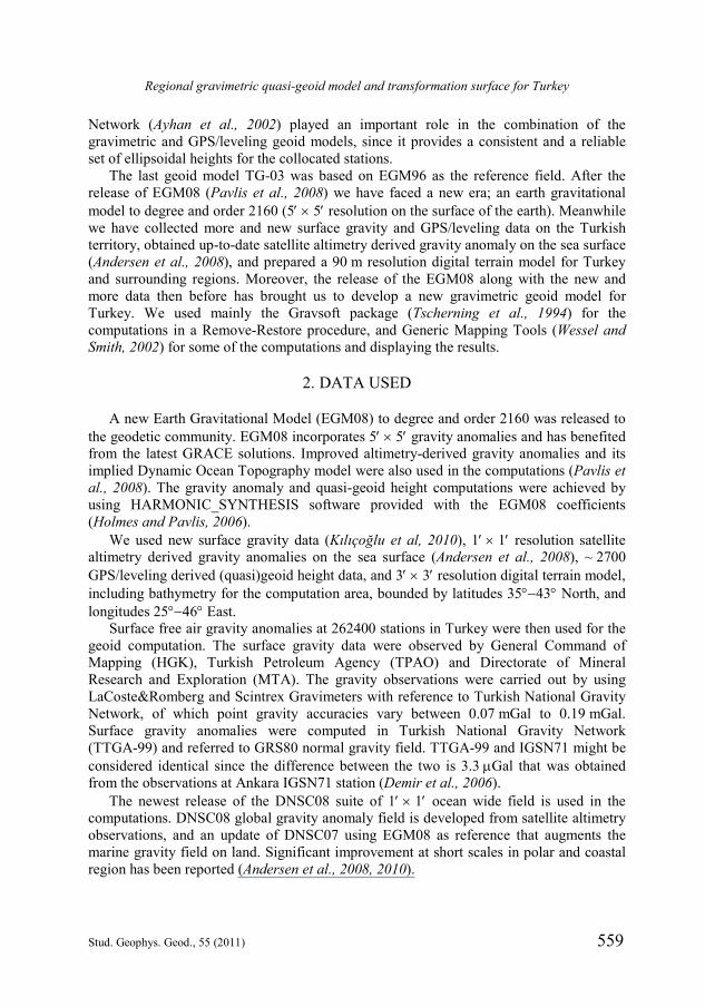
We used a digital terrain model (DTM) to account for terrain effects in the computations (Fig. 1). The spatial resolution of the DTM is 3 3 corresponding to the average distance of ~ 90 m between grid nodes. The elevation data were basically produced by digitizing the elevation contours of 1/250 K scale topographic map sheets, with an height error of approximately 25 m. We also produced the 5 5 resolution DTM for various purposes by filtering of the grid data.
Regional gravimetric quasi-geoid model and transformation surface for Turkey
Stud. Geophys. Geod., 55 (2011) 561
3. METHODOLOGY AND COMPUTATION
Determination of the gravimetric geoid model is generally achieved by the application of the famous Stokes’ formula, which requires density information at every point between physical earth and the geoid. Stokes integral must be applied over the boundary surface, “the geoid” (Hofmann-Wellenhof and Moritz, 2005; Heiskanen and Moritz, 1967). One can find alternative methods to compute the gravimetric geoid model in the literature. Here we would like to give references to some of the methods for geoid computation. Determination of the geoid may be achieved by the Remove-Compute-Restore (RCR) Method (Tscherning, 1994; Forsberg, 1984, 1994, 1998; Forsberg et al., 2003), Stokes-Helmert Method (Ellman and Vaníček, 2007) or Least Squares Modification of Stokes’ Formula with or without Additive Corrections Method (Kiamehr, 2006; Kiamehr and Sjöberg, 2006; Agren et al., unpublished results). A detailed investigation on the geoid determination methods is given by Ulotu (2009). In this study, the basic information related to the geoid computation will be given. More detailed information has been given by Heiskanen and Moritz (1967), Hoffmann-Wellenhof and Moritz (2005), IGeS (1998).
The density distribution of the masses at every point between the Earth’s surface and the geoid must be known in order to determine the geoid with the Stokes’ formula. Molodensky proposed that the physical surface of the Earth can be determined from the
Fig. 1. The topography of Turkey and the surrounding region as plotted in 3 3 (~90 m) resolution digital terrain model. Main statistics is in meters (Min = 4573, Max = 5468, Mean = 166, St.Dev. = 1373). The figure shows the computation area.

A. Kılıçoğlu et al.
562 Stud. Geophys. Geod., 55 (2011)
observables of the Earth’s potential alone, without using the density of the crust. The gravimetric solution of the Stokes’ integral may be modified for this purpose in order to determine the height anomaly rather than geoid height (Hoffmann-Wellenhof and Moritz, 2005).
The height anomaly () may be considered as the distance between the geopotential surface at the surface point P (W = WP = const) and the corresponding spheropotential surface at the point Q (U = UQ = WP = const). Moreover, one may define the height anomaly at surface point P (P) by using the Bruns’ formula as follows
P P PP
Q Q
T W U
. (2)
One may also plot the height anomalies above the ellipsoid, just like the geoid heights. In this way we get a geoid-like surface called “the quasi-geoid” by Molodensky.
In this study, we chose the quasi-geoid determination method by applying the FFT technique in the “Remove-Compute-Restore” (RCR) method (Forsberg, 1998). In the chosen method, the height anomaly (quasi-geoid height ) is determined since the surface gravity anomaly, rather than gravity anomaly at the geoid, is used in the Molodensky solution (Forsberg, 1994; Forsberg et al., 2003; Hofmann-Wellenhof and Moritz, 2005, p. 306, Eq.[8.57]). The relation between the surface gravity anomaly and the height anomaly (via the disturbing potential) may be given as follows, the first term of which is given by Stokes’ formula
14R g g S dp
. (3)
Eq.(3) is called Molodensky Formula (Hofmann-Wellenhof and Moritz, 2005, p. 325) and the so-called Molodensky 1g term
1 Pgg h hr
. (4)
The equations above geometrically mean that the free air gravity anomalies must be analytically or harmonically continued (reduced) from the ground to the level of computation point. The resulting gravity anomaly is called harmonic gravity anomaly 1g g . Thus the reference level would be different for any of the computation points. (Hofmann-Wellenhof and Moritz, 2005, p. 325) suggests that Molodensky 1g term represents the effect of topography, and it can be neglected when the appropriate terrain reductions are used (Schwarz et al., 1990). This equation is further investigated by Forsberg (1998, p. 113, Eq.[23]) in which it is suggested that the Molodensky correction (g1) is eliminated for practical purposes when the RTM contribution, as well as the EGM gravity anomaly, are removed from the observed surface gravity anomaly prior to the computations. Thus, the residual part of the quasi-geoid then may be obtained by the solution of the Eq.(3) by replacing g instead of 1g g .

Regional gravimetric quasi-geoid model and transformation surface for Turkey
Stud. Geophys. Geod., 55 (2011) 563
Moreover, the anomalous gravity potential T is split into three parts:
EGM RTM REST T T T , (5)
where TEGM is the effect of the Earth’s gravitational model (long-wavelength part), TRTM is the part that stems from the residual terrain (short-wavelength part) and TRES is the residual (i.e. the unmodelled) gravity information (medium-wavelength part). Just like the anomalous potential, the height anomaly (quasi-geoid) may be split into three parts as well:
EGM RTM RES . (6)
Computation of the EGM may be achieved through the coefficient set of an Earth’s Gravitational Model (EGM) such as EGM08 (Fig. 2).
Actually EGM08 fully represents the total mass of the Earth, and thus the topography above the geoid. Therefore, EGM08 derived gravity anomaly refers to the Earth’s surface carrying the effect of topography to a certain resolution. It means that medium and long wavelengths of the topography have already been taken into account, but the short wavelength is yet to be computed. The effect of the difference between actual topography and the one used in EGM may be determined by the Residual Terrain Model (RTM) (Forsberg, 1984, 1994). This is usually done by choosing a smooth reference elevation surface, and computationally removing masses above this elevation and filling up the valleys below. The reference elevation surface could be any smooth surface, and may be determined from a high resolution digital terrain model by filtering. We chose a 5 5 resolution reference surface filtered from a high resolution (3 3) digital terrain model.
Fig. 2. EGM08 height anomalies computed for Turkey and surrounding area (Min = 4.49 m, Max = 43.88 m, Mean = 28.96 m, St.Dev. = 8.27 m).

A. Kılıçoğlu et al.
564 Stud. Geophys. Geod., 55 (2011)
The RTM effect, here is the effect of the difference between high resolution and low resolution terrain, must be removed from the observed gravity anomaly, and then restored to computed height anomaly. Since the density anomalies (masses above and valleys below) have oscillating positive and negative values, the integrations for gravity field effects cancel each other after a suitable distance from the computation point (or outside a spherical cap with a radius selected practically).
The computation of EGM and RTM is straightforward provided that harmonic coefficients and digital terrain model be available. Moreover, the problem of determination of the height anomaly reduces to the determination of the residual quasi-geoid from the residual gravity anomaly on the Earth’s surface.
Terrain effects may be removed in a consistent RTM terrain data reduction, taking into account the topographic irregularities relative to the mean height surface. RES is computed from the residual gravity anomaly (gRES), which is obtained by subtracting (Remove step) the EGM (gEGM) and RTM (gRTM) contributions to gravity anomaly from the surface gravity anomalies (Tscherning, 1994; Tschernig et al., 1994). Residual gravity anomalies are in principle converted into residual geoid undulations by spherical FFT evaluation using an improved multi-band formulation (Forsberg and Sideris, 1993).
As partly described before, in the “Remove” process; residual gravity anomalies may be defined, by the combination of EGM and residual terrain model (RTM) contributions, as follows
RES P EGM RTMg g g g . (7)
Figs. 35 show EGM (gEGM), RTM (gRTM) and the residual (gRES) gravity anomalies respectively over the computation area that covers Turkey and surrounding region, bounded by latitudes 3543N, and longitudes 2546E. The statistics of the both observed and computed gravity anomalies are given in Table 1.
After the Remove step, the residual quasi-geoid heights (RES) were then computed by FFT solution of the Eq.(3), by replacing the term 1g g with gRES. By expressing Eq.(3) as a convolution integral in both latitude and longitude, we here use the multi-band 2-D spherical FFT technique (Forsberg and Sideris, 1993; Schwarz et al., 1990).
We implemented the 2-D spherical FFT technique to compute the exact values along nine reference parallels in the computation area (Omang and Forsberg, 2002).
Table 1. Statistics of the observed and computed gravity anomalies.
OBSg [mGal]
EGMg [mGal]
RTMg [mGal]
RESg [mGal]
Min 96.4 84.6 152.3 281.7 Max 264.5 250.2 148.9 183.1
Mean 54.0 45.6 3.2 11.6 St.Dev. 42.2 38.9 28.4 27.7

Regional gravimetric quasi-geoid model and transformation surface for Turkey
Stud. Geophys. Geod., 55 (2011) 565
Fig. 3. EGM08 ( EGMg ) gravity anomalies computed at the observation points over the computation area (Min = 235 mGal, Max = 250 mGal, Mean = 22 mGal, St.Dev. = 56 mGal).
Fig. 4. The effect of the RTM ( RTMg - the difference between high resolution (3 3) and reference terrain (5 5)) on gravity anomalies computed at the observation points over the computation area (Min = 152 mGal, Max = 149 mGal, Mean = 2 mGal, St.Dev. = 22 mGal).

A. Kılıçoğlu et al.
566 Stud. Geophys. Geod., 55 (2011)
To prevent the influence of the local gravity data on the longest wavelengths we use modifications of the Stokes kernel S (Vaníček and Kleusberg, 1987; Forsberg and Featherstone, 1998; Featherstone and Sideris, 1998; Forsberg et al., 2003). The technique is a modified Wong-Gore method (Wong and Gore, 1969), in which the modified kernel modS has the following expression:
1
2
2 1 cos1
N
mod nn
nS S n Pn
, (8a)
where the coefficient n increases linearly from 0 to 1 between degrees N1 and N2:
1
21 2
2 1
2
1 for 2 ,
for ,
0 for .
n NN nn N n N
N NN n
(8b)
The coefficients of N1 and N2 are determined through trial and error or experience. GPS-leveling data are typically used in the optimization of N1 and N2 therefore we fitted the gravimetric geoid computed by each of the different kernel modifications to the
Fig. 5. Residual gravity anomalies ( RESg ) computed over the computation area (Min = 282 mGal, Max = 183 mGal, Mean = 7 mGal, St.Dev. = 22 mGal).

Regional gravimetric quasi-geoid model and transformation surface for Turkey
Stud. Geophys. Geod., 55 (2011) 567
GPS/leveling points in order to determine the optimum coefficients of N1 and N2. Table 2 shows of results for the fits of the different GPS/leveling points. We chose the kernel modification degree band as N1 = 120 and N2 = 130 according to the results from the fit to the GPS/leveling points in Table 2.
As the residual quasi-geoid heights were computed as described above, EGM EGM (Fig. 2) and RTM RTM contributions to the quasi-geoid heights were
computed and restored to residual quasi-geoid RES so as to obtain the regional
gravimetric quasi-geoid model TQG-06 . Figs. 6 and 7 show the residual and RTM
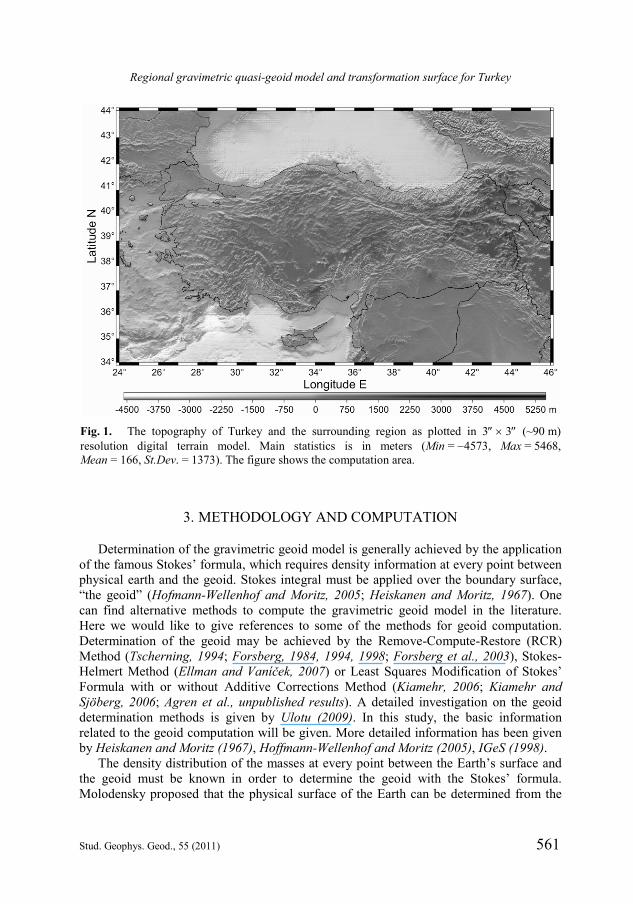
quasi-geoid parts and Fig. 8 shows the final quasi-geoid model after the “Restore” step. Table 3 shows the basic statistics of the data used in the “Remove”, “Compute” and “Restore” steps. As it is seen from the Table 3; EGM contribution to the quasi-geoid is the biggest part to be restored. Moreover, RTM and RES are rather small as compared to EGM part. Statistics show that EGM constitutes the large wavelengths of the quasi-geoid while RTM and RES constitute the medium and short wavelengths.
Since the Helmert orthometric height system is in use in Turkey, we need to convert the gravimetric quasi-geoid (TQG-09) to the geoid by means of the equation below (Heiskanen and Moritz, 1967, p. 327; Jekeli, 2000; Hofmann-Wellenhof and Moritz, 2005, p. 327)
Table 2. Statistics of the fit of the gravimetric geoid to the primary GPS/leveling points for different kernel modifications (in meters). See text for the meaning of numbers in bold italics.
1N 2N Min Max Mean St.Dev.
50 60 1.873 0.178 1.045 0.357 60 70 1.861 0.010 1.046 0.312 70 80 1.774 0.001 1.040 0.290 80 90 1.752 0.031 1.035 0.282 90 100 1.784 0.069 1.032 0.275
100 110 1.786 0.096 1.030 0.271 110 120 1.820 0.116 1.026 0.266 120 130 1.860 0.132 1.023 0.265 130 140 1.920 0.137 1.022 0.270 140 150 1.983 0.129 1.021 0.276 150 160 2.025 0.116 1.020 0.281 160 170 2.054 0.115 1.020 0.286 170 180 2.091 0.133 1.022 0.291 180 190 2.139 0.166 1.023 0.296 190 200 2.180 0.199 1.023 0.299 200 210 2.203 0.223 1.023 0.301

A. Kılıçoğlu et al.
568 Stud. Geophys. Geod., 55 (2011)
Fig. 6. Residual gravimetric quasi-geoid part RES for Turkey (TQG-09) (Min = 1.64 m,
Max = 1.30 m, Mean = 0.00 m, St.Dev. = 0.25m).
Fig. 7. Residual terrain model contribution RTM to the quasi-geoid heights for Turkey (TQG-09) (Min = 1.47 m, Max = 2.46 m, Mean = 0.04 m, St.Dev. = 0.35 m).
Regional gravimetric quasi-geoid model and transformation surface for Turkey
Stud. Geophys. Geod., 55 (2011) 569
BTG-09 TQG-09 TQG-09
ggN H H
, (9)
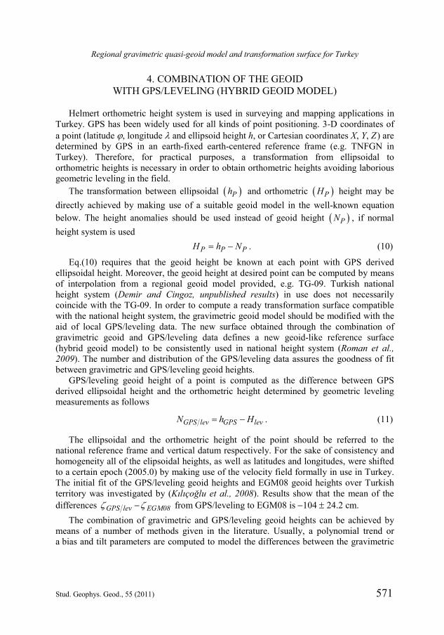
where, g is the mean gravity along the plumb line between geoid and the ground, and is the mean normal gravity along the plumb line between ellipsoid and the telluroid. The second term in the Eq.(9) constitutes the correction to the quasi-geoid (TQG-09) so as to obtain the corresponding geoid model (TG-09). The correction from to N and the TG-09 geoid model are shown in Figs. 9 and 10, respectively.
Fig. 8. Regional gravimetric quasi-geoid model of Turkey (TQG-09). Computed through the sum of the individual contributions of EGM, RTM and RES quasi-geoid
TQG-09 EGM RTM RES (Min = 4.47 m, Max = 44.77 m, Mean 29.00 m,
St.Dev. = 8.33 m).
Table 3. Statistics of the data employed in compute and restore steps.
EGM [m] RTM [m] RES [m] TQG-09 [m]
Min 4.49 1.47 1.64 4.47 Max 43.88 2.46 1.30 44.77
Mean 28.96 0.04 0.00 29.00 St.Dev. 8.27 0.35 0.25 8.33
A. Kılıçoğlu et al.
570 Stud. Geophys. Geod., 55 (2011)
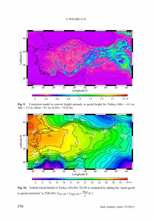
Fig. 9. Correction model to convert height anomaly to geoid height for Turkey (Min = 0.1 m, Max = 2.5 m, Mean = 0.1 m, St.Dev. = 0.22 m).
Fig. 10. Turkish Geoid Model of Turkey (TG-09). TG-09 is computed by adding the “quasi-geoid
to geoid correction” to TQG-09 ( BTG-09 TQG-09
gN H
).
Regional gravimetric quasi-geoid model and transformation surface for Turkey
Stud. Geophys. Geod., 55 (2011) 571
4. COMBINATION OF THE GEOID WITH GPS/LEVELING (HYBRID GEOID MODEL)
Helmert orthometric height system is used in surveying and mapping applications in Turkey. GPS has been widely used for all kinds of point positioning. 3-D coordinates of a point (latitude , longitude and ellipsoid height h, or Cartesian coordinates X, Y, Z) are determined by GPS in an earth-fixed earth-centered reference frame (e.g. TNFGN in Turkey). Therefore, for practical purposes, a transformation from ellipsoidal to orthometric heights is necessary in order to obtain orthometric heights avoiding laborious geometric leveling in the field.
The transformation between ellipsoidal Ph and orthometric PH height may be directly achieved by making use of a suitable geoid model in the well-known equation below. The height anomalies should be used instead of geoid height PN , if normal height system is used P P PH h N . (10)
Eq.(10) requires that the geoid height be known at each point with GPS derived ellipsoidal height. Moreover, the geoid height at desired point can be computed by means of interpolation from a regional geoid model provided, e.g. TG-09. Turkish national height system (Demir and Cingoz, unpublished results) in use does not necessarily coincide with the TG-09. In order to compute a ready transformation surface compatible with the national height system, the gravimetric geoid model should be modified with the aid of local GPS/leveling data. The new surface obtained through the combination of gravimetric geoid and GPS/leveling data defines a new geoid-like reference surface (hybrid geoid model) to be consistently used in national height system (Roman et al., 2009). The number and distribution of the GPS/leveling data assures the goodness of fit between gravimetric and GPS/leveling geoid heights.
GPS/leveling geoid height of a point is computed as the difference between GPS derived ellipsoidal height and the orthometric height determined by geometric leveling measurements as follows
GPS lev GPS levN h H . (11)
The ellipsoidal and the orthometric height of the point should be referred to the national reference frame and vertical datum respectively. For the sake of consistency and homogeneity all of the elipsoidal heights, as well as latitudes and longitudes, were shifted to a certain epoch (2005.0) by making use of the velocity field formally in use in Turkey. The initial fit of the GPS/leveling geoid heights and EGM08 geoid heights over Turkish territory was investigated by (Kılıçoğlu et al., 2008). Results show that the mean of the differences GPS lev EGM08 from GPS/leveling to EGM08 is 104 24.2 cm.
The combination of gravimetric and GPS/leveling geoid heights can be achieved by means of a number of methods given in the literature. Usually, a polynomial trend or a bias and tilt parameters are computed to model the differences between the gravimetric

A. Kılıçoğlu et al.
572 Stud. Geophys. Geod., 55 (2011)
and the GPS/leveling geoid heights. The model given below has been used in Kılıçoğlu and Fırat (unpublished results).
The differences GPS lev TG-09dN N N between gravimetric TG-09N and
GPS/leveling GPS levN geoid heights at collocated stations are used as observations in
this study. The differences dN may be modeled by a polynomial as representing the trend t in the
observations. The trend value ti at each collocated station may be given as a polynomial, which defines an analytical surface and can be computed at any point in the area.
Moreover, the trend value at any point with known coordinates can be easily predicted by using the estimated trend parameters.
The residual observations rNi are calculated by subtracting the trend ti value from observations dNi at collocated points:
i i irN dN t . (12)
The residual observations rNi may be modeled and gridded by various methods such as collocation, weighted mean interpolation, kriging or polynomial regression. In this study, adjustable tension continuous curvature surface gridding algorithm given in Generic Mapping Tools (Smith and Wessel, 1990; Wessel and Smith, 2002) is used to model the residual geoid heights rNi.
The gravimetric geoid heights TG-09N , trend values ti, and modeled residuals rNi can be computed on selected grid nodes with coordinates (latitude, longitude and ellipsoid height). Then the three grid files may be added up to yield the hybrid geoid heights THG-09N on the same grid specified:
THG-09 TG-09N N t rN . (13)
Eq.(13) gives a new transformation surface (THG-09), compatible with national height system and vertical datum, for the determination of orthometric heights directly from GPS derived ellipsoidal heights as follows:
GPS THG-09H h N . (14)
The combination model given above is well implemented in GMT (Wessel and Smith, 2002), and a script to achieve the combination is prepared by the author. One may find various options for de-trending and gridding of the observations in GMT.
The THG-09 is subject to an external and an internal check in order to detect the inconsistencies and possible errors. As an external check, the observed GPS/leveling geoid heights at the collocated points, which were not used in the combination, may be compared with the ones interpolated from THG-09. Then, the statistics of the differences between computed and observed values (co) gives an evidence of accuracy of the combined geoid. The computed geoid heights interpolated from THG-09 were then compared to observed ones, and the statistics of the differences are given in Table 4.
An internal check for THG-09 could be the computation of post-fit geoid residuals at the collocated points, which were used in the combination process. The post-fit residuals

Regional gravimetric quasi-geoid model and transformation surface for Turkey
Stud. Geophys. Geod., 55 (2011) 573
at the collocated stations were computed by subtracting the computed (interpolated from THG-09) geoid heights from the observed (GPS/lev) ones. The statistics of the post-fit residuals are given in Table 4.
Both the regional geoid model and the height system bias parameter would be estimated by making use of gravity anomaly, precise leveling and GPS/leveling data in a Least Squares Collocation solution. This bias adjustment minimizes the difference between the gravimetric geoid height anomalies with respect to GPS/leveling data and the standard deviation of the differences decreases drastically. Moreover, the bias adjustment may be a good alternative for the fitting of the final gravimetric geoid as is generally done when using FFT methods (Sadiq et al., 2009). In this study, we would like to compute a regional transformation surface rather than a bias parameter. We believe that the differences between regional gravimetric geoid model and the GPS/leveling geoid heights at collocated stations depend on the local deformations of the leveling network, which are not homogeneous over the area.
The possible vertical deformation in both the leveling network and the vertical datum play an important role in the combination of the gravimetric and GPS/leveling geoid heights. Since vertical control network dates back to early 1900s, the vertical deformation rates reflect the stability and the accuracy of the leveling network. The vertical deformation rate field of Turkey (Fig. 11) can hardly be associated with the general tectonic framework of the region, while it could represent the local or the regional deformation. The velocities in the north of the North Anatolian Fault System obviously show the stability of the Eurasian plate. The deformation in the south Marmara region, northwest Aegean region, and eastern Anatolia may be associated with the on-going tectonic phenomena in Anatolia and the surrounding regions. On the other hand, the large vertical deformation in central Anatolia needs explanation and more investigation. The arrows in Fig. 11 correspond to the vertical displacement in a year, or in other words, the vertical deformation along the direction of the topographic heights. The total vertical deformations can easily reach up to 20 cm in ten years. Considering the time span past from the last spirit leveling observations (1990) in the vertical control network, the deformation could be as much as 40 cm, which may cause warping of the gravimetric (quasi-)geoid model to fit the GPS/leveling geoid heights. In this respect, the geoid heights derived from the GPS/leveling are not necessarily correct with respect to
Table 4. The statistics of the computed and observed values THG-09 GPS lev for internal
and external check of the THG-09. The GPS/lev stations, which were employed in the combination process and the rest of the stations, are used for the internal (post-fit residuals) and external check.
Internal Check [cm] External Check [cm]
Number of Stations 625 1839 Min 8.4 67.4 Max 10.8 56.5
Mean 0.0 1.3 St.Dev. 1.0 8.4

A. Kılıçoğlu et al.
574 Stud. Geophys. Geod., 55 (2011)
gravimetric geoid heights. That’s why the term “transformation surface” is preferred over “corrector surface”, which has been widely used in the literature. Due to the direct connection of the orthometric heights with the GPS/leveling geoid, it is expected that the active tectonics should have a direct impact on the computed “transformation surface”. On the other hand, the changes in vertical may have non-linear components, and are relatively more subject to the physical environment and climate conditions, yielding large uncertainties in the vertical deformation rates. Furthermore, as opposed to the horizontal velocities, the vertical deformation rates are less correlated in spatial domain, which disables to establish a direct connection of the warping of the geoid with the GPS-derived vertical deformation rates.
5. RESULTS AND DISCUSSION
Global Navigation Satellite Systems (GNSS) are the most popular and the fundamental positioning tools for all scientific and practical purposes. Since, GNSS produce ellipsoidal heights instead of orthometric heights, extra effort is required to obtain orthometric heights, which are defined in Earth’s gravity potential, and which must be used in surveying applications. A suitable geoid model with sufficient accuracy, consistent with the national height system and national vertical datum, is the straight-forward solution to the problem of the orthometric height determination directly with GNSS positioning. Otherwise, relatively time-consuming and expensive spirit-leveling would have to be carried out in all types of engineering projects. Surveyors anywhere in the world need
Fig. 11. Vertical deformation rate field of Turkey as deduced from repeated GPS observations from 19922008. The velocity field is determined with respect to ITRF2005. The velocities are given in mm/yr at level (Aktuğ et al., 2009).

Regional gravimetric quasi-geoid model and transformation surface for Turkey
Stud. Geophys. Geod., 55 (2011) 575
a transformation surface that makes it possible to convert ellipsoidal heights to orthometric heights by no means of extra field work. The so-called transformation surface could be regarded as a reference surface for geo-referencing, positioning and navigation.
In this study, we basically computed a quasi-geoid height model for Turkey with remove-compute-restore method following the Molodensky approach. Then we converted quasi-geoid (TQG-09) to geoid (TG-09), and finally combined resulting geoid with GPS/leveling geoid heights in order to obtain a transformation surface (THG-09) to be used to compute orthometric heights from ellipsoidal heights. While all these are geoid-like surfaces, none of them are the same. The term transformation surface reflects the fact that this is neither a geoid nor a quasi-geoid, but a surface designed to model the base of the Turkish Vertical Control Network, which has been distorted in time. Since the Turkish Vertical Control Network is not expected to be revised in the near future, it is necessary to warp the new gravimetric geoid model to fit the vertical datum (Featherstone, 1998). The basic statistics of the computed models are given in Table 3. The resulting transformation surface has been tested both internally and externally. As a result, the external accuracy of the THG-09 may be given as 8.4 cm, with the internal precision is 0.95 cm. However, some local works with TG03 geoid model have given better results, e.g. Erol et al. (2009) found 4.9 cm, and Kılıçoğlu et al. (unpublished results) found 2.0 cm external accuracies in local areas.
The previous model computed for Turkey was the TG-03 (Kılıçoğlu et al., 2005). We used more gravity data (~ 262400), satellite altimetry derived gravity model (DNSC08), a higher resolution DTM (90 m), a new global gravitational model (EGM08) and a larger number of GPS/leveling stations (~ 2700). The Least Squares Collocation method was chosen in the computation of TG-03. TQG-09 was computed by FFT method due to computation burden of huge data set. The use of modified Stokes’ kernels helps to keep information at longer wavelengths from the reference models. The new and the old geoid models have accuracies of 14.5 cm and 8.4 cm for the TG-03 and THG-09, respectively. The new hybrid geoid model (THG-09) will be used as the basis surface for the Turkish National Vertical Datum, as well as for the connection of the vertical datums of the Turkish islands.
TG-09, apparently reflects the topographical shape of the Anatolia as geoid heights increase from the southern and northern coasts to the inner land. The geoid undulations in Turkey decrease from the north-west towards the east. This might be caused by the difference in the long wavelength between the level ellipsoid and the geoid. Such regional gravimetric geoids, based on a global geopotential model, are computed by using local data, and thus do not contain full information of the global geopotential models. The analysis of this decrease and other geoid features may be useful in geophysics. The TG-09 geoid model shows strong correlation with conspicuous topographic features like mountains. TG-09 can constrain the limiting depths of some geological features of the Turkey’s subsurface, and is very useful in the gravity and magnetic modeling of the subsurface. It can also lead to the precise mapping of the positions of some tectonic features and completion of their geological and geophysical studies using independent data and method. The geodynamic investigation of the geoid model, including the vertical velocity field, is left for further studies.

A. Kılıçoğlu et al.
576 Stud. Geophys. Geod., 55 (2011)
We believe that the determination of the 1-cm geoid model has not been achieved with the data and models given in this study. However, the theory, data collection (airborne and surface gravity measurements, DEM and topographical density) and computer capability are improving so rapidly that such an objective for Turkey could be highly feasible in a reasonable future. The actual accuracy, of course, depends on the available data, their accuracy, and their spatial distribution.
The importance and necessity of quality terrestrial gravity data of sound distribution, for the determination of accurate precise geoid model has neither changed nor expected to be replaced in the near future. Besides, Digital Terrain Models with higher resolution and accuracy are supposed to be produced in the future. We believe that EGM08 will last for several more years until satellite gravity missions and other sources of Earth’s gravity field lead to a new one.
The followings may be recommended for the achievement of the 1-cm Turkish geoid model. A new, consistent, and precise surface gravity observation set helps in the achievement of a new precise geoid. Airborne gravity surveys may be carried out especially in remote areas. Gravity datum, which was determined by absolute gravity, must be regularly monitored in time. The vertical velocity field and deformations in the leveling network must be further investigated, and monitored in time. More and stable GPS/leveling stations must be established in order to assure direct transformation between new geoid and old leveling network and geoid models. Topographic density model and new geoid computation approaches must be further investigated and carried out.
Acknowledgements: General Directorate of Mineral Research and Exploration (MTA), Turkish
Petroleum Company (TPAO) and General Directorate of Land Register and Cadastre (TKGM) are acknowledged for providing gravity observations and GPS/leveling data respectively. The authors also would like to thank to the associate editor Lars Sjöberg and three anonymous reviewers for improving the manuscript with valuable suggestions and comments.
References Aktuğ B., Kılıçoğlu A., Lenk O. and Gürdal M.A., 2009. Establishment of regional reference frames
for detecting active deformation areas in Anatolia. Stud. Geophys. Geod., 53, 169183. Andersen O.B., Knudsen P. and Berry P.A.M., 2010. The DNSC08GRA global marine gravity field
from double retracked satellite altimetry. J. Geodesy., 84, 191199, DOI: 10.1007/s00190-009-0355-9.
Ayan T., 1976. Astrogeodetic Geoid Determination of Turkey. Ph.D.Thesis. University of Karlsruhe, Karlsruhe, Germany.
Ayan T., 1978. Turkish geoid. Turkish Journal of Mapping (Harita Dergisi), No.85, 517 (in Turkish).
Ayhan M.E., 1993. Geoid determination in Turkey (TG-91). Bull. Geod., 167, 1022. Ayhan M.E. and Alp O., 1994. Turkish Astrogeodetic Geoid - 1994 (TAG-94). Interim Report No.
Jeof-94-2. Geodesy Department, GCM, Ankara, Turkey (in Turkish). Ayhan M.E. and Demir C., 1992. Turkish National Vertical Control Network-1992. Turkish Journal
of Mapping (Harita Dergisi), No.109, 117 (in Turkish) Ayhan M.E., Bank E., Lenk O. and Şeker H.A., 1987. South-Western Anatolia (Aegean Region)
Doppler geoid. Boll. Geod. Sci. Aff., XLVI, No.4, 293308.
Regional gravimetric quasi-geoid model and transformation surface for Turkey
Stud. Geophys. Geod., 55 (2011) 577
Ayhan M.E., Demir C., Lenk O., Kılıçoğlu A., Aktug B., Acikgoz M., Firat O., Sengun Y.S., Cingoz A., Gurdal M.A., Kurt A.I., Ocak M., Turkezer A., Yildiz H., Bayazit N., Ata M., Caglar Y. and Ozerkan A., 2002. Turkish National Fundamental GPS Network; 1999A (TUTGA-99A), Turkish Journal of Mapping (Harita Dergisi), Special Issue 16, (in Turkish).
Demir C., Kılıçoğlu A. and Fırat O., 2006. Fundamental gravity network of Turkey-1999. Turkish Journal of Mapping (Harita Dergisi), No.136, 5063 (in Turkish).
Ellmann A. and Vaníček P., 2007. UNB application of Stokes-Helmert’s approach to geoid model computation. J. Geodyn., 43, 200213.
Erol B., Sideris M.G. and Celik R.N., 2009. Comparison of global geopotential models from the CHAMP and GRACE Missions for regional geoid modeling in Turkey. Stud. Geophys. Geod., 53, 419441.
Featherstone W.E., 1998. Do we need a gravimetric geoid or a model of the base of the Australian Height Datum to transform GPS heights? The Australian Surveyor, 43, 273280.
Featherstone W.A. and Sideris M., 1998. Modified kernels in spectral geoid determination: First results from western Australia. In: Forsberg R., Feissl M. and Dietrich R. (Eds.), Geodesy on the Move: Gravity, Geoids, Geodynamics, and Antarctica. International Association of Geodesy Symposia, 119. Springer-Verlag, Berlin, Germany, 188193.
Forsberg R., 1984. A Study of Terrain Reductions, Density Anomalies and Geophysical Inversion Methods in Gravity Field Modeling. Report No.355, Ohio State University, Columbus, Ohio.
Forsberg R., 1994. Terrain Effects in Geoid Computations. Lecture Notes, International School for the Determination and Use of Geoid. International Geoid Service, DIIAR Politecnico Di Milano, Italy.
Forsberg R., 1998. The use of spectral techniques in gravity field modeling: trends and perspectives. Phys. Chem. Earth, 23, 3139.
Forsberg R. and Featherstone W.E., 1998. Geoids and cap sizes. In: Forsberg R., Feissl M. and Dietrich R. (Eds.), Geodesy on the Move: Gravity, Geoids, Geodynamics, and Antarctica. International Association of Geodesy Symposia, 119. Springer-Verlag, Berlin, Germany, 194200.
Forsberg R. and Sideris M., 1993. Geoid computations by the multi-band spherical FFT approach. Manuscripta Geodaetica, 18, 8290.
Forsberg R., Strykowski G., Iliffe J.C., Ziebart M., Cross P.A., Tscherning C.C., Cruddace P., Stewart K., Bray C. and Finch O., 2003. OSGM02: A new geoid model of the British Isles. In: Tziavos I.N. (Ed.), Gravity and Geoid 2002. Editions Ziti, Thessaloniki, Greece, 132137.
Gurkan O., 1978. Deformation of Astrogeodetic Networks and Turkish First Order Triangulation Network. Karadeniz Technical University (KTU) Publication No.104, Trabzon, Turkey.
Heiskanen W.A. and Moritz H., 1967. Physical Geodesy. W.H. Freeman and Company, San Francisco, London.
Herring T.A., 1998. GLOBK: Global Kalman filter VLBI and GPS Analysis Program, Version 4.1. Massachusetts Institute of Technology, Cambridge, MA.
Hofmann-Wellenhof B. and Moritz H., 2005. Physical Geodesy. Springer-Verlag, Wien, New York. Holmes S.A. and Pavlis N.K., 2006. A Fortran Program for Very-High-Degree Harmonic Synthesis,
Version 05/01/2006 (http://earth-info.nga.mil/GandG/wgs84/gravitymod/new_egm /new_egm.html).
IGeS, 1998. Lecture Notes of the International Geoid School for the Determination and Use of the Geoid. (http://www.iges.polimi.it).
Jekeli C., 2000. Heights, the Geopotential, and Vertical Datums. Report No.459, Ohio State University, Columbus, Ohio.

A. Kılıçoğlu et al.
578 Stud. Geophys. Geod., 55 (2011)
Kiamehr R., 2006. Precise Gravimetric Geoid Model for Iran Based on GRACE and SRTM Data and the Least Squares Modification of Stokes’ Formula with Some Geodynamics Interpretations. Ph.D. Thesis. Division of Geodesy, Royal Institute of Technology (KTH), Stockholm, Sweden.
Kiamehr R. and Sjöberg L.E., 2006. KTH-GEOLAB Scientific Software for Precise Geoid Model Determination Based on the Least Squares Modification of Stokes Formula (LSMS). Technical Manual. Division of Geodesy, Royal Institute of Technology (KTH), Stockholm, Sweden.
Kılıçoğlu A., Direnç A., Simav M., Lenk O., Aktuğ B. and Yıldız H., 2008. Evaluation of The Earth Gravitational Model 2008 in Turkey. Newton’s Bulletin, Special Issue: External Quality Evaluation Reports of EGM08, 4, 144164.
Kılıçoğlu A., Firat O. and Demir C., 2005. Observations and methods used in the computation of new Turkish geoid (TG-03). Proceedings of the Geoid and Vertical Datum Workshop, Scientific Meeting of TNGC. Karadeniz Technical University, Trabzon, Turkey, ISBN: 975-6983-48-5.
Kılıçoğlu A., Lenk O., Direnç A., Simav M., Yıldız H., Aktuğ B., Türkezer A., Göçmen C., Paslı E. and Akçakaya M., 2010. Isostatic gravity anomaly map of Turkey. Turkish Journal of Mapping (Harita Dergisi), 144, 119.
Omang O.C.D. and Forsberg R., 2002. The northern European geoid: a case study on long-wavelength geoid errors. J. Geodesy, 76, 369380.
Pavlis N.K., Holmes S.A., Kenyon S.C. and Factor J.K., 2008. An Earth Gravitational Model to Degree 2160: EGM2008. Geophysical Research Abstracts, 10, 2-2-2008. Full version released by National Geospatial-Intelligence Agency, Bethesda, MD (http://www.dgfi.badw.de /typo3_mt/fileadmin/2kolloquium_muc/2008-10-08/Bosch/EGM2008.pdf).
Rothacher M. and Mervart L., 1996. BERNESE GPS Software, Version 4.0. Astronomical Institute, University of Bern. Switzerland.
Sadiq M., Tscherning C.C. and Ahmad Z., 2009. An estimation of the height system bias parameter N0 using least squares collocation from observed gravity and GPS/leveling data. Stud. Geophys. Geod., 53, 375388.
Schwarz K.P., Sideris M.G. and Forsberg R., 1990. The use of FFT techniques in physical geodesy. Geophys. J. Int., 100, 485514.
Smith W.H.F. and Wessel P., 1990. Gridding with continuous curvature splines in tension. Geophysics, 55, 293305.
Tscherning C.C., 1994. Geoid determination by Least Squares Collocation using GRAVSOFT. Lecture Notes, International School for the Determination and Use of Geoid. International Geoid Service, DIIAR Politecnico Di Milano, Italy.
Tscherning C.C., Knudsen P. and Forsberg R., 1994. Description of the GRAVSOFT package. Technical Report. Geophysical Institute, University of Copenhagen, Copenhagen, Denmark.
Ulotu P.E., 2009. Geoid Model of Tanzania from Sparse and Varying Gravity Data Density by the KTH Method. Ph.D. Thesis. Division of Geodesy, Royal Institute of Technology (KTH), Stockholm, Sweden.
Vaníček P. and Kleusberg A., 1987. The Canadian geoid - Stokesian approach. Manuscripta Geodaetica, 12, 8698.
Wessel P. and Smith W.H.F., 2002. The Generic Mapping Tools (GMT) V3.4.1. Laboratory for Satellite Altimetry, School of Ocean and Earth Science and Technology, University of Hawaii at Manoa, Hawaii.
Wong L. and Gore R., 1969. Accuracy of geoid heights from modified Stokes kernels. Geophys. J. Roy. Astron. Soc., 18, 8191.