Recent glacier changes in the Alps observed by satellite: Consequences for future monitoring...
12
Recent glacier changes in the Alps observed by satellite: Consequences for future monitoring strategies Frank Paul a, ⁎ , Andreas Kääb b , Wilfried Haeberli a a Department of Geography, University of Zurich, 8057 Zurich, Switzerland b Department of Geosciences, University of Oslo, 316 Oslo, Norway Received 19 August 2005; accepted 21 July 2006 Available online 18 September 2006 Abstract The new satellite-derived Swiss glacier inventory revealed that mean glacier area loss per decade from 1985 to 1998/99 has accelerated by a factor of seven compared to the period 1850–1973. Moreover, the satellite data display much evidence that down- wasting (i.e. stationary thinning) has become a major source of glacier mass loss, an observation that is confirmed by in situ mass balance measurements. Many of the observed changes (growing rock outcrops, tongue separation, formation of pro-glacial lakes, albedo lowering, collapse structures) are related to positive feedbacks which accelerate further glacier disintegration once they are initiated. As such, it is unlikely that the recent trend of glacier wastage will stop (or reverse) in the near future. In view of the rapid non-uniform geometry changes, special challenges emerged for the recently established tiered glacier monitoring strategy within the framework of the Global Climate/Terrestrial Observing System (GCOS/GTOS). The challenges include: (1) loss of mass balance series due to disintegrating glaciers, (2) problematic extrapolation of index stake measurements from a calibration period under different climate conditions, (3) critical evaluation of measured length changes, (4) establishment of an operational glacier inventorying strategy using satellite data and (5) the calculation of new topographic parameters after glacier split up that can be compared to previous parameters. © 2006 Elsevier B.V. All rights reserved. Keywords: Alpine glacier change; multispectral satellite data; glacier monitoring 1. Introduction Changes in glacier length are widely recognized as the most reliable and most easily observed terrestrial indicators of climate change (IPCC, 2001; Haeberli, 2004). This is mainly due to the clearly recognizable retreat of many larger valley glaciers over more than 2 km in reaction to a temperature increase of only 1 K since 1850, which is hardly noticeable otherwise. This retreat signal has been of uniform and global character (Grove, 1988; Hoelzle et al., 2003) with short, inter- mittent periods of readvance in the 1920s and 1970s. The strong advance of several glaciers on the west coasts of Norway and New Zealand during the 1990s was mostly due to enhanced winter precipitation and does not contradict the general warming trend, as these maritime glaciers with a high mass turnover are much more sensitive to changes in precipitation than to Global and Planetary Change 56 (2007) 111 – 122 www.elsevier.com/locate/gloplacha ⁎ Corresponding author. Department of Geography, Glaciology and Geomorphodynamics Group, University of Zurich, Winterthurer Strasse 190, CH- 8057 Zurich, Switzerland. Tel.: +41 1 635 5175; fax: +41 1635 6848. E-mail address: [email protected] (F. Paul). 0921-8181/$ - see front matter © 2006 Elsevier B.V. All rights reserved. doi:10.1016/j.gloplacha.2006.07.007
-
Upload
independent -
Category
Documents
-
view
3 -
download
0
Transcript of Recent glacier changes in the Alps observed by satellite: Consequences for future monitoring...

e 56 (2007) 111ndash122wwwelseviercomlocategloplacha
Global and Planetary Chang
Recent glacier changes in the Alps observed by satelliteConsequences for future monitoring strategies
Frank Paul a Andreas Kaumlaumlb b Wilfried Haeberli a
a Department of Geography University of Zurich 8057 Zurich Switzerlandb Department of Geosciences University of Oslo 316 Oslo Norway
Received 19 August 2005 accepted 21 July 2006Available online 18 September 2006
Abstract
The new satellite-derived Swiss glacier inventory revealed that mean glacier area loss per decade from 1985 to 199899 hasaccelerated by a factor of seven compared to the period 1850ndash1973 Moreover the satellite data display much evidence that down-wasting (ie stationary thinning) has become a major source of glacier mass loss an observation that is confirmed by in situ massbalance measurements Many of the observed changes (growing rock outcrops tongue separation formation of pro-glacial lakesalbedo lowering collapse structures) are related to positive feedbacks which accelerate further glacier disintegration once they areinitiated As such it is unlikely that the recent trend of glacier wastage will stop (or reverse) in the near future In view of the rapidnon-uniform geometry changes special challenges emerged for the recently established tiered glacier monitoring strategy withinthe framework of the Global ClimateTerrestrial Observing System (GCOSGTOS) The challenges include (1) loss of massbalance series due to disintegrating glaciers (2) problematic extrapolation of index stake measurements from a calibration periodunder different climate conditions (3) critical evaluation of measured length changes (4) establishment of an operational glacierinventorying strategy using satellite data and (5) the calculation of new topographic parameters after glacier split up that can becompared to previous parameterscopy 2006 Elsevier BV All rights reserved
Keywords Alpine glacier change multispectral satellite data glacier monitoring
1 Introduction
Changes in glacier length are widely recognized asthe most reliable and most easily observed terrestrialindicators of climate change (IPCC 2001 Haeberli2004) This is mainly due to the clearly recognizable
Corresponding author Department of Geography Glaciology andGeomorphodynamics Group University of Zurich WinterthurerStrasse 190 CH- 8057 Zurich Switzerland Tel +41 1 635 5175fax +41 1635 6848
E-mail address fpaulgeounizhch (F Paul)
0921-8181$ - see front matter copy 2006 Elsevier BV All rights reserveddoi101016jgloplacha200607007
retreat of many larger valley glaciers over more than2 km in reaction to a temperature increase of only 1 Ksince 1850 which is hardly noticeable otherwise Thisretreat signal has been of uniform and global character(Grove 1988 Hoelzle et al 2003) with short inter-mittent periods of readvance in the 1920s and 1970sThe strong advance of several glaciers on the westcoasts of Norway and New Zealand during the 1990swas mostly due to enhanced winter precipitation anddoes not contradict the general warming trend as thesemaritime glaciers with a high mass turnover are muchmore sensitive to changes in precipitation than to
112 F Paul et al Global and Planetary Change 56 (2007) 111ndash122
temperature (Oerlemans and Reichert 2000) In theAlps glacier fluctuations are well documented (paint-ings photos field surveys) due to a relative easy access(eg Zumbuumlhl and Holzhauser 1988) tourism (Zaumlngland Hamberger 2004) and initiation of the lengthmeasurement network in 1893 by Forel (cf Haeberliet al 1998) The number of annually measured lengthchanges increased from about 50 in the beginning tonearly 250 in 2000 with most glacier types being cov-ered (Zemp et al in press) However there is a strongbias towards larger glaciers in the length measurementsample due to the remote location of most small gla-ciers As such the changes of the latter are less welldocumented and the retreat signal is dominated by largevalley and mountain glaciers While the valley glaciersreflect the secular trend mountain glaciers reveal de-cadal oscillations in the climate signal (Hoelzle et al2003) ie the advance period of the 1920s and 1970sThe related changes of small glaciers are best assessedby repeated inventories that can be obtained frommultispectral satellite data (eg Paul 2002a Paul et al2002)
Due to their function as terrestrial key indicators forclimate change detection glacier monitoring is imple-mented in the Global ClimateTerrestrial ObservingSystem (GCOS GTOS) and follows a Global Hierar-chical Observing Strategy (GHOST) of tiers that in-clude (1) intensive and integrated experimental sites(improvement of process understanding) (2) process-oriented mass balance studies within major climaticzones (with winter and summer balance measurements)(3) glacier mass changes within major mountain systems(calculating mass balance from reduced stake networksby spatial interpolation about 50 glaciers worldwide)(4) long-term length change measurements at about tensites within each mountain range (about 500 glaciersworldwide also a key element for reconstructing pastclimate conditions simple index) and (5) repeated gla-cier inventories from satellite data that provide basicdata sets for comparative studies (see Haeberli et al2000 2002)
The recent analysis of satellite data revealed a strongacceleration of glacier shrinkage in the Alps since 1985with a mean decadal rate of area reduction seven timeshigher than during the 1850ndash1973 period (Paul et al2004a) The strong acceleration of glacier shrinkage (insize and thickness) has also been observed in severalother places around the world (Jianping et al 2004Khromova et al 2003 Ramirez et al 2001) by appli-cation of new technologies like laser profiling (Arendtet al 2002) radar altimetry (Rignot et al 2003) andanalysis of global mass balance data (Haeberli et al
1999 Dyurgerov and Meier 2000) Although changesin glacier thickness can not be measured directly fromoptical satellite data the analysis of image time seriesgives indirect evidence that down-wasting (ie station-ary thinning) has become a major source of Alpineglacier mass loss during the past 20 years This was alsoconfirmed by the mainly negative mean mass balancesof ten Alpine glaciers since 1980 (Frauenfelder et al2005) In particular the extraordinary hot summer of2003 (Schaumlr et al 2004) had major impacts on Alpineglaciers (Frauenfelder et al 2005) by initiating adverseeffects that are discussed in detail below
In this paper we present examples for the observa-tions made by Landsat Thematic Mapper (TM) andASTER satellite data throughout the Alps discuss thetheoretical background of the analysis and show conse-quences for future glacier development We close with adiscussion of the resulting challenges for future glaciermonitoring
2 Study sites and methods applied
The satellite-based observations are exemplified forseveral test sites throughout the entire European Alps(Fig 1) The examples discussed cover various climaticregions and include glaciers of different exposition andsize However for better visibility of the changes wehave selected some of the more prominent examples Inprinciple the changes can be observed in every regionof the Alps but not necessarily for all in the sameregion
The analysis is based on multispectral optical satel-lite data and relies on a spectral channel in the middleinfrared part of the spectrum (around 15 μm) wheresnow and ice exhibit a very low reflection (cf Fig 3)compared to clouds and most other natural surfacesexcept water (eg Dozier 1989) In order to study gla-cier changes cloud-free images acquired at the end ofthe ablation season in a year without snow outside ofglacier areas have to be used Due to the often unstableweather conditions in the Alps during autumn only afew years match all conditions These years determinethe selection of scenes presented here The corpus ofscenes analysed is summarized in Table 1
21 Qualitative interpretation of image time series
Avery efficient tool for rapid change detection analy-sis from Landsat Thematic Mapper (TM) raw data areanimated image sequences (flicker images) from falsecolour composites using bands 5 4 and 3 as red greenand blue respectively They show clouds in white
Fig 1 Overview of the test sites selected for this study The background image is acquired by MODIS at 1 November 2003 (copy NASA GSFC) Thenumbers indicate the respective Figures
113F Paul et al Global and Planetary Change 56 (2007) 111ndash122
glaciers (ie snow and ice) in blue-green lakes in bluebare rock in pink to purple and vegetation in yellow togreen This band combination is also used for Figs 2 4and 5) and widely applied for image quicklooks fromTM data (eg httpglovisusgsgov) as the overallquality of a scene can be determined very easily ForLandsat TM data a relative image matching with a fewunchanged ground control points (GCPs) works quitewell as the orbit of Landsat has been very stable for morethan 20 years If enough images are available also morethan two images can be animated to follow glacierchange with time in more detail However the imagesshould be acquired around the same date in the year toavoid too large changes of the cast shadow zones whichdisturb the visual analysis One restriction is that the sizeof the image frames selected for animation must besmaller than screen size For the comparably small gla-ciers in the Alps this is not a problem as most individualmountain ranges are not exceeding 40 km which is
Table 1Overview of the satellite scenes applied in this study
Nr Sensor Date Path-row Figures
1 Landsat TM 3091985 193ndash27 2g 4a 5a2 Landsat TM 2891985 195ndash28 2a 2d 3a3 Landsat TM 1391999 193ndash27 2h4 Landsat TM 3181998 195ndash28 2b 2e5 Landsat TM 3072003 193ndash27 2i 4b 5b 6e6 Landsat TM 1382003 195ndash28 2f 3b 6f7 ASTER 2382003 193ndash27 6c8 ASTER 892004 195ndash27 2c 6b9 ASTER 892004 195ndash28 6a10 ASTER 1092004 192ndash27 6d
about 1200 pixels at the original resolution of about30 m Although resampling can be used to increase thecovered area the relative matching worsens for largerregions due to increasing geometric distortions (Paul2002a) The changes taking place are clearly visible evenif the colour balance from the individual image frames isslightly different Mostly public domain image proces-sing tools can be used to adjust the colours Apart fromchanges in glacier length in particular new rock outcropsand the formation of new lakes can be assessed quicklyIn a high-speed mode interesting details of individualglacier dynamics can be followed They clearly indicatethat frontal glacier recession is often coupled to a lateralglacier thinning of a similar magnitude Anotherinteresting application of such image sequences isprovided by the Internet or computer presentationsapart from animated GIF images with a prescribed speedboth media allow an interactive change using a lsquomouseoverrsquo command or a toggling (back and forth) betweentwo slides (Kaumlaumlb et al 2003a) In summary followingglacier changes by animation of image sequences ismuch more instructive and plausible than overlay ofoutlines as visual perception is trained to recognizechanges (eg Bruce et al 2003)
22 Quantitative analysis from multispectral glacierclassification
In high-mountain topography exact orthorectificationof satellite data is required if glacier outlines are com-bined with other sources of georeferenced information(eg other satellite sensors or digitized outlines of for-mer glacier extent) This requires a high-resolution
114 F Paul et al Global and Planetary Change 56 (2007) 111ndash122
digital elevation model (DEM) of appropriate accuracyas well as accurate topographic maps for collection ofGCPs (Paul 2004) Both data sources are available forthe countries of the Alpine region However accurateDEM data can be very expensive for the area coveredby a single TM full scene For glacier studies in otherremote regions the availability of the SRTM 3 arcsecond (about 90 m) resolution DEM (Rabus et al2003) that can be down-loaded for free from an NASAftp-server (ftp e0mss21uecsnasagovsrtm) wasextremely valuable as it can also be used as a sourceof GCPs (Kaumlaumlb 2005) Where SRTM3 data is notavailable (voids north of 61deg N and south of 57deg S) theDEM generation from ASTER stereo data has proven tobe very useful for orthorectification and other purposes(eg Kaumlaumlb et al 2005 Paul and Kaumlaumlb 2005) Despitethe somewhat higher resolution of an ASTER DEM(about 30 m) the accuracy of the elevation values ob-tained are similar to the SRTM3 DEM in high-mountaintopography (Eckert et al 2005 Kaumlaumlb 2005 Toutin2002)
Due to the distinct spectral properties of ice andsnow the classification of debris-free glaciers is quiteeasy from thresholded ratio images (eg Paul et al2002 Kaumlaumlb et al 2003b Paul et al 2003) Most ef-fective for automated glacier mapping is a TM band 35ratio (AST 24) in combination with an additionalthreshold in band TM1 (AST1) for discrimination ofsnow or ice in regions of shadow casted by the terrainfrom rock (Bishop et al 2004 Paul and Kaumlaumlb 2005)Compared to the TM 45 ratio which can also beapplied efficiently (eg Jacobs et al 1997 Sidjak andWheate 1999 Albert 2002 Paul 2002b) the TM35ratio also maps all water bodies (clear and turbid) asglaciers which requires additional post-processing Onthe other hand the interference with vegetation in shadeis less pronounced and in very deep shadows ice is stillmapped completely Thus the more suitable band com-bination (ie less work is required for post-processing)should be selected depending on the image content(shadow vegetation water) Heavily debris-coveredglacier parts cannot be mapped by either method due totheir spectral similarity with the surrounding terrainSome promising techniques that include DEM informa-tion and neighbourhood analysis (Bishop et al 2001Paul et al 2004b) or utilize the thermal band (Taschnerand Ranzi 2002) have nevertheless been developedThe quantitative analysis of glacier change is stronglyfacilitated by application of GIS techniques (Paul2002b Paul et al 2002) which allow for the automatedextraction of individual glaciers from the classifiedsatellite map according to predefined glacier basins as
well as the calculation of 3D glacier parameters (egslope aspect lowest and highest glacier elevation) incombination with a DEM (Kaumlaumlb et al 2002 Paul2004)
3 Observed changes
31 The new Swiss glacier inventory 2000
Specific results of glacier changes in Switzerlandfrom 1973 to 1985 to 2000 as well as an extrapolation tothe entire Alps have been reported in Paul (2004) andPaul et al (2004a) Thus we will summarize here onlythe main results which support the observations madethroughout the Alps In Switzerland glaciers lost about18 of their area from 1985 to 199899 (from 1973 to1985 the change is only minus1) This corresponds to anaverage relative area loss of 14 per decade which isabout seven times higher than the decadal loss ratebetween 1850 and 1973 (minus22) There is an evenhigher relative loss of area towards smaller glaciers butthe scatter among values increases as well indicating avery specific behaviour of individual glaciers that aresmaller than 1 km2 Such small glaciers account also fora major part (44) of the total area loss since 1973although they cover only 18 of the total area in 1973As most of these small glaciers are not covered by thelength measurement network satellite data are the mostefficient way to assess their changes in full Such dataalso reveal that non-uniform geometry changes (ie notrelated to active glacier retreat) can occur everywhereon a glacier They are mainly indicated by increasingregions with rock outcrops inside of glaciers as well as ashrinkage along the entire glacier perimeter includingthe accumulation area
32 Down-wasting glaciers
According to the mass balance data from ten Alpineglaciers (IUGG(CCS)UNEPUNESCOWMO 2005)the mean cumulative specific mass loss was about 17 mwater equivalent (we) between 1981 and 2003 corre-sponding to about minus08 m we per year This is aboutthree times the long-term mean value for the 20th cen-tury of minus027 m we (Haeberli and Hoelzle 1995Hoelzle et al 2003) Apart from 3 years (1984 1995and 2001) with small mass gains all years since 1981exhibit mass losses A linear trend line on the data pointssuggests an increasing speed of glacier mass lossindicating that glaciers were not able to primarily adjustto the current climatic conditions by a dynamic retreattowards higher elevations with cooler temperatures
115F Paul et al Global and Planetary Change 56 (2007) 111ndash122
Instead the reduction in driving stress and flow facili-tates down-wasting which even results in an elevationlowering of the glacier surface The continuous massloss has also diminished or even eliminated most of thefirn reserves from previous years as the equilibrium linewas generally above its steady-state position and quiteoften even above the highest glacier point Thus thedecreasing mass flux from the accumulation area hasalso steadily lowered the ice flow velocity (eg Herrenet al 2002) which in turn led to many of the observeddisintegration features (hollows within a glacier cavesand deep tunnels at the glacier front)
33 Observations from satellite imagery
Although glacier thinning cannot be directly mea-sured from Landsat or ASTER data (the latter allows atleast the creation of a DEM that can be compared toprevious DEMs eg Berthier et al 2004 Kaumlaumlb 2004)the observed changes provide evidence that massiveglacier down-wasting took place during the past two
Fig 2 Three small mountain glaciers which disintegrate due to down-wastingin 1998 and c) in 2004 which has already disappeared d) Cavagnoli Glacier (4tongue (please note the small Vallegia Glacier in the upper right is nearly unchin 2003 displays increasing areas with rock outcrops that will separate the g
decades The major indicators of down-wasting thathave been observed on Landsat images are growingrock outcrops separation from tributaries formation ofpro-glacial lakes non-uniform geometry changes egdisintegration and shrinkage along the entire perimeterSuch changes can be observed throughout the entireAlps independent of the precipitation regime glaciersize or exposition In some regions nearly all of thesechanges could be observed at the same time In thefollowing section we discuss some of the more extremeexamples for better visibility of the processes involvedHowever it should be noted that individual glaciers withlittle or no change can often be found in the same regionor even adjacent to a disintegrating glacier The reasonfor this high-variability over short distances has not beendetermined yet
34 Examples
In Fig 2 we show smaller mountain glaciers locatedin three different regions (grey circles in Fig 1) for three
the scale indicates 500 m a) Taelli Glacier (465deg N 76deg E) in 1985 b)65deg N 85deg E) in 1985 e) in 1998 and f) 2003 with an almost separatedanged) g) Caresegraver Glacier (465deg N 107deg E) in 1985 h) in 1999 and i)lacier into several smaller parts in the near future
116 F Paul et al Global and Planetary Change 56 (2007) 111ndash122
points in time (1985ndash199899ndash2003) The first is TaelliGlacier (Fig 2andashc) in the Wildstrubel region which issituated at the northern rim of the Alps and receiveshigh amounts of precipitation (Schwarb et al 2001) Thesecond one is Cavagnoli Glacier (Fig 2dndashf ) which islocated near the Nufenenpass and close to the two massbalance glaciers Gries and Basogravedino near a localmaximum of annual precipitation (Schwarb et al2001) The third one is Caresegraver Glacier (Fig 2gndashi) inthe OrtlerndashCevedale Group (Italy) which is locatedunder somewhat more continental (drier) conditions Allthree glaciers are placed at about the same geographicallatitude (465deg N) and clearly demonstrate how fastdisintegration has proceeded in the last 20 years WhileTaelli Glacier has already disintegrated into several smallpatches of ice remnants Cavagnoli Glacier will likelyfollow next and the somewhat larger Caresegraver Glaciershows rapidly growing regions with rock outcrops Un-fortunately the latter is one of the few Tier 3 monitoringsites (Haeberli 2004) with a long-term series of massbalance measurements starting in 1967 (Carturan 2002)A common characteristic of all three glaciers is that theyare comparably flat and not protectedmuch by rockwallsfrom direct solar radiation during summer As such theirdisintegration will most-likely continue in the followingyears as positive feedbacks can accelerate the down-wasting even further (see Section 4)
Fig 3 The region around Sources de l Arc Glacier (444deg N 72deg E) in the Gand b) 2003 Circles depict interesting regions of change and point to the samO = rock Outcrops T = Tongue separation D = Disintegration and R = stro
Somewhat larger regions are selected for Figs 3ndash5(black squares in Fig 1) They are located in the GranParadiso mountain range (Fig 3) in the southwesternpart of the Alps (FRI) the Bernina group (Fig 4) in thecentral-southern part (CHI) and in the Oumltztaler Alps(Fig 5) in the central-northern part (AI) In all threeregions several processes resulting from the overallglacier down-wasting or shrinkage are visible Thecorresponding phenomena are marked by an arrow orcircle and include (L) formation or growing of pro-glacial lakes (O) new rock outcrops (T) tongue sepa-ration (R) strong retreat and (D) disintegration Againit is obvious that the observed changes took place on anAlpine-wide scale but nearly unchanged glaciers canoften be found within the same region This aspectunderlines the importance of satellite data for assess-ment of glacier changes as the behaviour of an indivi-dual glacier might not optimally reflect the overall trend
The final examples in Fig 6 (black circles in Fig 1)show recently formed pro-glacial lakes which canclearly be detected by flicker-image analysis and whichmight already be or become a source of glacial hazards(Kaumlaumlb et al 2005) They are so numerous that an inte-grated approach of automatic detection from satellitedata and classification of their hazard potential by meansof GIS-based modelling should be applied (Huggel2004 Huggel et al 2004) In this context important
ran Paradiso Group (size is 7 by 9 km) as seen in TM band 5 in a) 1985e location in both images letters denote L = Lake formationgrowthng Retreat
Fig 4 The region along the SwissItalian border in the Bernina Region (image size is 153 by 84 km) in a TM 5 4 3 false colour composite with PizBernina near the image centre (464deg N 99deg E) in a) 1985 and b) 2003 For the letter code see Fig 3
117F Paul et al Global and Planetary Change 56 (2007) 111ndash122
aspects for all lakes concern the question whether theyare bounded by bed rock or morainic material whetherice or rock avalanches from higher up can reach the lake
Fig 5 The region along the AustrianItalian border in the Oumltztaler Alps (imagglacier Gurgler Ferner (468deg N 109deg E) in the image centre as seen from L
and whether there is a potential for further growth (egHuggel et al 2003) However for such studies DEMdata must be analysed as well and this is not the scope of
e size is 105 by 81 km) with the comparably large (ca 10 km2) valleyandsat TM in a) 1985 and b) 2003 For the letter code see Fig 3
Fig 6 Lakes that have been formed at several glaciers throughout the Alps (see Fig 1 for location) in recent years due to glacier retreat a) at MontetGlacier (Gran Paradiso F) b) at Plaine Morte Glacier (Wildstrubel CH) c) at the glacier front of Schweikart Ferner (Kaunertal AU) d) at SeekarGlacier (Hohe Tauern AU) e) at Palue Glacier (near Berninapass CH) and f ) at Trift Glacier (near Sustenpass CH) The white scale bar on eachfigure indicates 500 m north is always at top
118 F Paul et al Global and Planetary Change 56 (2007) 111ndash122
this study While four lakes (Fig 6andashd) are covered byrecent 15 m resolution ASTER data (with AST 3 2 1 asRGB) from 200304 two other lakes (Fig 6e and f ) aredepicted with TM data from 2003 (see overview inTable 1) All lakes shown were more or less completelycovered by glacier ice in 1985 and the lake at TriftGlacier (Fig 6e) did even not appear before 1998 Apartfrom the lake in Fig 6d there is a potential for furthergrowth of all other lakes as they are still in contactwith retreating glaciers An automatic camera has beeninstalled to monitor the further evolution of Trift Glacierand its lake (httppeopleeeethzch~glacierimagestrift_acamjpg)
4 Discussion
Most of the observed changes are related to positivefeedbacks ie once started they have the tendency tointensify further The formation of pro-glacial lakes thatare in contact with a glacier tongue often leads to rapidfurther growth as the water can get warmer than 0deg andcause additional ice melt (so called thermokarst) Athermally driven internal circulation erodes the ice at thewaterline and leads to the formation of ice cliffs with therelated calving events (Kaumlaumlb and Haeberli 2001) Rapidretreat of glacier tongues in the course of their floodingby artificial lakes (hydro-power) has been frequently
observed This process was also one reason for the recentrapid disintegration of an entire tongue at Trift Glacier(Fig 6f ) Where the growth of such lakes is not limitedby topography (rising bedrock) the glaciers mightshrink until they loose contact with the lake or untilthe ice flux is in balance with the enhanced melting
Due to their lower albedo and thermal inertia new rockoutcrops heat upmore quickly than the surrounding ice (orsnow) and emit this heat also after local sunset and duringnight This process can very efficiently create a small gapbetween the rock and the ice which further grows byturbulent heat fluxes As such rock outcrops that appearsomewhere within a glacier (depending on the bedrocktopography) are very efficient in separating a glacier intosmaller parts (Figs 2ndash5) Once several rock outcrops haveseparated a part of a glacier from the accumulation areathe dead ice body will melt down quickly (at least if notprotected by a thick debris cover) This is also due to thehigher amounts of thermal heating from the surroundingrock and the larger parts of surface area exposed toturbulent heat fluxes As a result of the overall down-wasting the rock outcrops appear at first on steep slopeswhere glaciers are relatively thin At these locationsglaciers can be separated very effectively from tributaries(which may have an accumulation region at higherelevations than the remaining glacier) or even loose theirentire tongues Both processes have been followed on
119F Paul et al Global and Planetary Change 56 (2007) 111ndash122
multi-temporal satellite images for several glaciers (seeexamples in Figs 2ndash5) All of the processes describedabove tend to considerably reduce the mass flux and maylead to further collapse structures (hollows tunnels) thatenlarge very fast by turbulent heat fluxes or accumulationof melt water These structures can be observed today inmany glaciers but are difficult to detect on satelliteimagery as they are generally quite small
Another important aspect that could be observed isthe gradual lowering of glacier albedo (in the ablationzone) in the course of the past 20 years reaching valuesas low as 015 in 2003 (Paul et al 2005) Apart fromSaharian dust fall (occurring often in spring time) thatcould heavily decrease glacier albedo locally andtemporarily it seems that albedo decreased steadily asa result of the mainly negative mass balances since1981 The effect is two-fold one is the strong accu-mulation of soot dust and other aerosols during long-lasting periods of fair weather (which are generallyrelated to years with negative mass balance) Suchparticles could only be removed by very heavy preci-pitation events as the material has a tendency to meltitself a few millimetres into the ice The second aspect isthe unveiling of dark firn bands from previous yearsthat are getting even darker since precipitation mostlyfalls as snow at these altitudes (no washing away ofparticles by heavy rain) In the Alps glacier albedoexerts a major influence on the energy balance (egKlok and Oerlemans 2002 Paul et al 2005) and thuson the summer ablation which governs the variability ofthe annual balance for most glaciers (Oerlemans andReichert 2000) The decreasing glacier albedo is alsopart of a positive feedback that enhances glacier melteven more
In total all the processes observed here act togetherand in the same direction leading to a self-acceleration ofglacier decline It can be assumed that it will be verydifficult to stop this process for several reasons (1) Mostglaciers have lost all of their firn reserves from the 1970sand would need several years with large amounts of snowinwinter (and little ablation in summer) to gain somemassthat could then be redistributed by increased flow velocityto the glacier front Although changes in precipitation aredifficult to predict it seems unlikely that the requiredincrease of more than 50 (eg Kuhn 1989) will takeplace (2) There is a general trend of increasingtemperatures in the future as predicted by nearly allclimate models (eg Raumlisaumlnen et al 2004) This wouldfurther enhance the observed changes and also makes therequired snowfall in summer less probable (3) Even thestill flowing and fast-reacting steeper mountain glaciershave response times of several years and their actual shape
is not yet in balance with current climatic conditions Assuch theywould continue to retreat for several more yearseven if temperatures are not increasing any further
5 Consequences for future glacier monitoring
Important environmental changes must be expectedto accompany further shrinkage or disappearance ofmountain glaciers (eg landscape alteration seasonalityeffects in the water cycle slope stability and complexnatural hazards cf Watson and Haeberli 2004) Besidessuch aspects of general significance with respect toclimate change specific and new challenges result forthe integrated multilevel (lsquotieredrsquo) glacier monitoringstrategy as described in the introduction (Haeberli et al2000 2002 Haeberli 2004)
mdash Tier 1 observations along environmental gradientsshould strengthen the focus on interactions andfeedbacks between elements with highly variableresponse characteristics (snow glaciers frozenground water cycle soils meadows forests etc)within and between altitudinal belts in mountainareas in order to improve our understanding ofdisequilibrium which tend to develop more andmore with increasing deviation of geo-and eco-systems from dynamic equilibrium conditions
mdash Glaciers at tier 2 sites form the primary basis fordevelopment calibration and validation of nu-merical models as much of the fundamentalprocess understanding is generated here Theirstudy should continue as long and intensively aspossible However it has to be taken into accountthat inter- and extrapolation of such measurementsin space and time is getting more difficult due torapidly and drastically changing glacier geome-tries individual parts of Vernagtferner for in-stance are likely to separate in the near future afate which would be comparable to the evolutionof Caresegraver Glacier
mdash At tier 3 sites interpolation techniques applied toglaciers with index measurements should be re-evaluated in view of the new conditions comparedto the calibration period (for instance missingaccumulation area) and rapidly changing geome-tries by using distributed mass balance modelsand corresponding interpolation schemes appliedby using GIS techniques This level of observa-tion is becoming more important because
mdash length change measurements analysed at tier 4level are among the most heavily affected parts ofmodern monitoring strategies In addition to
120 F Paul et al Global and Planetary Change 56 (2007) 111ndash122
selection criteria applied before (no flow instabi-lities no calvingavalanching no heavy debriscover no disconnecting tongues) the transitionfrom active retreat to downwasting or even col-lapse behaviour increasingly limits possibilitiesof glaciological and climatological interpretationThe spatial representativity of observed glacierscan and should nevertheless be enhanced byusing satellite measurements on a larger numberof specifically selected glaciers at time intervals ofroughly 10 years
mdash Repeated glacier inventories (tier 5) from fast(operational) processing of satellite images andGIS-based post-processing including DEM fu-sion should be repeated at a higher frequency (5to 10 years) than previously planned (a few de-cades) in order to reveal collapse features or newlakes and to increase the number of observationsThe separation of glaciers into many small gla-ciers thereby causes the need to design new (andconsistent) hydrological numbering schemeswhich allow the automated analysis of changingglacier parameters through time
The fact that detailed baseline data for many cli-matologically interesting regions are still missing in theworld glacier inventory (eg Arctic Canada) remains aspecial challenge for worldwide glacier monitoring Theproject Global Land Ice Measurements from Space(GLIMS) is promising (Bishop et al 2004) but it hasbecome difficult to obtain global coverage from 60times60 km satellite scenes As such the huge archives withLandsat TM and undisturbed ETM+data (before thescan-line corrector fails) should be considered for gen-erating glacier inventories as well
6 Conclusion
The qualitative analysis of multispectral satelliteimagery revealed clear but indirect evidence of massiveglacier down-wasting in the European Alps since 1985The changes can easily be detected with animated multi-temporal false colour images which only require relativeimage matching Most of the observed changes (eggrowing regions with rock outcrops separation fromtributaries formation of pro-glacial lakes) are related topositive feedbacks which will further accelerate glacierdisintegration in the near future A soon termination ofthis process is unlikely as most glaciers are still far froma steady-state position most firn reserves from previousyears disappeared and climate models predict a furthertemperature increase in the future This poses several
new challenges for the recently established tiered glaciermonitoring strategy as the rapid changes in glaciergeometry (up to disintegration) are difficult to cover Inparticular tiers 2 to 4 suffer from the recent rapidchanges A large contribution could thus be made fromthe GLIMS project by generating baseline glacier in-ventory data and DEM information through its regionalcentres for rapid assessment of ongoing changes
Acknowledgements
We would like to thank R Armstrong one anony-mous reviewer and the scientific editor C Schneiderfor their valuable comments on the manuscript Thiswork has been funded by two grants from the SwissNational Science Foundation (21-5407398 and 21-105214 1) The ASTER scenes used in this study wereprovided within the framework of the GLIMS projectthrough the EROS data centre and are courtesy ofNASAGSFCMETI ERSDACJAROS and the USJapan ASTER science team K Hammes helped toimprove the English
References
Albert T 2002 Evaluation of remote sensing techniques for ice-areaclassification applied to the Tropical Quelccaya ice cap Peru PolarGeography 26 (3) 210ndash226
Arendt AA Echelmeyer KA Harrison WD Lingle CSValentin VB 2002 Rapid wastage of Alaska glaciers and theircontribution to rising sea level Science 297 (5580) 382ndash386
Berthier E Arnaud Y Baratoux D Vincent C Regravemy F 2004Recent rapid thinning of the ldquoMer de Glacerdquo glacier derived fromsatellite optical images Geophysical Research Letters 31L17401
Bishop MP Bonk R Kamp U Shroder Jr JF 2001 Terrainanalysis and data modeling for alpine glacier mapping PolarGeography 25 (3) 182ndash201
Bishop MP et al 2004 Global Land Ice Measurements From Space(GLIMS) remote sensing and GIS investigations of the Earthscryosphere Geocarto International 19 (2) 57ndash85
Bruce V Green PR Georgeson MA 2003 Visual PerceptionPhysiology Psychology and Ecology 4th ed Psychology Press464 pp
Carturan L 2002 Il ghiacciaio del Caresegraver la piugrave lunga serie italianadi bilancio di massa Nimbus 2324 60ndash69
Dozier J 1989 Spectral signature of alpine snow cover from Landsat5 TM Remote Sensing of Environment 28 9ndash22
Dyurgerov MB Meier MF 2000 Twentieth century climatechange evidence from small glaciers Proceedings of the NationalAcademy of Sciences 97 (4) 1406ndash1411
Eckert S Kellenberger T Itten K 2005 Accuracy assessment ofautomatically derived digital elevation models from ASTER datain mountainous terrain International Journal of Remote Sensing26 (9) 1943ndash1957
Frauenfelder R Zemp M Haeberli W Hoelzle M 2005Worldwide glacier mass balance measurements trends and first
121F Paul et al Global and Planetary Change 56 (2007) 111ndash122
results of an extraordinary year in Central Europe Ice and ClimateNews 6 9ndash10
Grove JM 1988 The Little Ice Age Methuen LondonHaeberli W 2004 Glaciers and ice caps historical background and
strategies of world-wide monitoring In Bamber JL Payne AJ(Eds) Mass Balance of the Cryosphere Observations andModelling of Contemporary and Future Change CambridgeUniversity Press pp 559ndash578
Haeberli W Hoelzle M 1995 Application of inventory data forestimating characteristics of and regional climate-change effects onmountain glaciers a pilot study with the European Alps Annals ofGlaciology 21 206ndash212
Haeberli W Hoelzle M Suter S (Eds) 1998 Into the secondcentury of worldwide glacier monitoring prospects and strategiesUNESCO Studies and Reports in Hydrology vol 56 UNESCOPublishing Paris
Haeberli W Frauenfelder R Hoelzle M Maisch M 1999 Ratesand acceleration trends of global glacier mass changes Geogra-fiska Annaler 81A (4) 585ndash591
Haeberli W Cihlar J Barry R 2000 Glacier monitoring within theGlobal Climate Observing System Annals of Glaciology 31241ndash246
Haeberli W Maisch M Paul F 2002 Mountain glaciers in globalclimate-related observation networks WMO Bulletin 51 (1) 18ndash25
Herren E Bauder A Hoelzle M Maisch M (Eds) 2002 TheSwiss glaciers 19992000 and 20002001 Glaciological Commis-sion of the Swiss Academy of Sciences and Laboratory ofHydraulics Hydrology and Glaciology at the Federal Institute ofTechnology Zurich Glaciological Report vol 121122
Hoelzle M Haeberli W Dischl M Peschke W 2003 Secularglacier mass balances derived from cumulative glacier lengthchanges Global and Planetary Change 36 (4) 295ndash306
Huggel C 2004 Assessment of glacial hazards based on remotesensing and GIS modeling PhD thesis Department of GeographyUniversity of Zurich Schriftenreihe Physische Geographie 44
Huggel C Kaumlaumlb A Haeberli W Krummenacher B 2003Regional-scale GIS-models for assessment of hazards from glacierlake outbursts evaluation and application in the Swiss AlpsNatural Hazards and Earth System Sciences 3 (6) 647ndash662
Huggel C Haeberli W Kaumlaumlb A Bieri D Richardson S 2004Assessment procedures for glacial hazards in the Swiss AlpsCanadian Geotechnical Journal 41 (6) 1068ndash1083
IPCC 2001 Climate change 2001 The scientific basis Contributionof Working Group I to the Third Assessment Report of the Inter-governmental Panel on Climate Change Cambridge UniversityPress Cambridge UK
IUGG(CCS)UNEPUNESCOWMO 2005 In Haeberli W NoetzliJ Zemp M Baumann S Frauenfelder R Hoelzle M (Eds)Glacier Mass Balance Bulletin vol 8 World Glacier MonitoringService Zurich 100pp
Jacobs JD Simms EL Simms A 1997 Recession of the southernpart of Barnes Ice Cap Baffin Island Canada between 1961 and1993 determined from digital mapping of Landsat TM Journal ofGlaciology 43 (143) 98ndash102
Jianping Y Yongjian D Rensheng C Shiyin L Anxin L 2004Causes of glacier change in the source regions of the Yangtze andYellow rivers on the Tibetan Plateau Journal of Glaciology 49(167) 539ndash546
Kaumlaumlb A 2004 Mountain glaciers and permafrost creep Researchperspectives from earth observation and geoinformatic technolo-gies Habilitation thesis Department of Geography University ofZurich Schriftenreihe Physische Geographie 48 204 pages
Kaumlaumlb A 2005 Combination of SRTM3 and repeat ASTER data forderiving alpine glacier flow velocities in the Bhutan HimalayaRemote Sensing of Environment 94 (4) 463ndash474
Kaumlaumlb A Haeberli W 2001 Evolution of a high-mountainthermokarst lake in the Swiss Alps Arctic Antarctic and AlpineResearch 33 (4) 385ndash390
Kaumlaumlb A Paul F Maisch M Hoelzle M Haeberli W 2002 Thenew remote-sensing-derived Swiss glacier inventory II Firstresults Annals of Glaciology 34 362ndash366
Kaumlaumlb A Isakowski Y Paul F Neumann A 2003a Glaziale undperiglaziale Prozesse Von der statischen zur dynamischenVisualisierung Kartographische Nachrichten 5 206ndash212
Kaumlaumlb A Paul F Huggel C Kieffer H Kargel J Wessels R2003b Glacier monitoring from ASTER imagery accuracy andapplications EARSeL eProceedings 2 43ndash53 (CD-ROM)
Kaumlaumlb A Huggel C Fischer L Guex S Paul F Roer ISalzmann N Schlaefli S Schmutz K Schneider D Strozzi TWeidmann Y 2005 Remote sensing of glacier-and permafrost-related hazards in high mountains an overview Natural Hazardsand Earth System Science 5 (4) 527ndash554
Khromova TE Dyurgerov MB Barry RG 2003 Late-twentiethcentury changes in glacier extent in the Ak-shirak Range CentralAsia determined from historical data and ASTER imagery Geo-physical Research Letters 30 (16) 1863
Klok EJ Oerlemans J 2002 Model study of the spatial distributionof the energy and mass balance of Morteratschgletscher Switzer-land Journal of Glaciology 48 (163) 505ndash518
KuhnM 1989 The response of the equilibrium line altitude to climaticfluctuations theory and observations In Oerlemans J (Ed) GlacierFluctuations and Climatic Change Kluwer Dodrecht pp 407ndash417
Oerlemans J Reichert BK 2000 Relating glacier mass balance tometeorological data using a Seasonal Sensitivity Characteristic(SSC) Journal of Glaciology 46 (152) 1ndash6
Paul F 2002a Changes in glacier area in Tyrol Austria between1969 and 1992 derived from Landsat 5 TM and Austrian GlacierInventory data International Journal of Remote Sensing 23 (4)787ndash799
Paul F 2002b Combined technologies allow rapid analysis of glacierchanges EOS Transactions American Geophysical Union 83(23) 253 260 261
Paul F 2004 The new Swiss glacier inventory 2000 mdash Applicationof remote sensing and GIS PhD thesis Department of GeographyUniversity of Zurich httpwwwdissertationenunizhch2004paulabstracthtml
Paul F Kaumlaumlb A 2005 Perspectives on the production of a glacierinventory from multispectral satellite data in the Canadian ArcticCumberland Peninsula Baffin Island Annals of Glaciology 4259ndash66
Paul F Kaumlaumlb A Maisch M Kellenberger T Haeberli W 2002The new remote-sensing-derived Swiss glacier inventory IMethods Annals of Glaciology 34 355ndash361
Paul F Huggel C Kaumlaumlb A Kellenberger T 2003 Comparison ofTM-derived glacier areas with higher resolution data sets EARSeLWorkshop on Remote Sensing of Land Ice and Snow Bern 11-1332002 EARSeL eProceedings 2 15ndash21 (CD-ROM)
Paul F Kaumlaumlb A Maisch M Kellenberger TW Haeberli W2004a Rapid disintegration of Alpine glaciers observed withsatellite data Geophysical Research Letters 31 L21402
Paul F Huggel C Kaumlaumlb A 2004b Combining satellitemultispectral image data and a digital elevation model for mappingof debris-covered glaciers Remote Sensing of Environment 89 (4)510ndash518
122 F Paul et al Global and Planetary Change 56 (2007) 111ndash122
Paul F Machguth H Kaumlaumlb A 2005 On the impact of glacier albedounder conditions of extreme glacier melt the summer of 2003 in theAlps EARSeL eProceedings 4 (2) 139ndash149 (CD-ROM)
Rabus B Eineder M Roth A Bamler R 2003 The shuttle radartopography mission mdash a new class of digital elevation modelsacquired by spaceborne radar ISPRS Journal of Photogrammetryand Remote Sensing 57 (4) 241ndash262
Raumlisaumlnen J Hansson U Ullerstig A Doumlscher R Graham LPJones C Meier HEM Samuelsson P Willegraven U 2004European climate in the late twenty-first century regional simula-tions with two driving global models and two forcing scenariosClimate Dynamics 22 13ndash31
Ramirez E Francou B Ribstein P Descloitres M Gueacuterin RMendoza J Gallaire R Pouyaud B Jordan E 2001 Smallglaciers disappearing in the tropical Andes a case-study in BoliviaGlacier Chacaltaya (16deg S) Journal of Glaciology 47 (157)187ndash194 (Abstract)
Rignot E Rivera A Casassa G 2003 Contribution of thePatagonia Icefields of South America to sea level rise Science 302(5644) 434ndash437
Schaumlr C Vidale PL Luumlthi D Frei C Haumlberli C Liniger MAppenzeller C 2004 The role of increasing temperaturevariability in European summer heatwaves Nature 427 (6972)332ndash336
Schwarb M Daly C Frei C Schaumlr C 2001 Mean annualprecipitation in the European Alps 1971ndash1990 Hydrological Atlasof Switzerland Landeshydrologie und Geologie Bern Plate 26
Sidjak RW Wheate RD 1999 Glacier mapping of the Illecillewaeticefield British Columbia Canada using Landsat TM and digitalelevation data International Journal of Remote Sensing 20 (2)273ndash284
Taschner S Ranzi R 2002 Landsat-TM and ASTER data formonitoring a debris covered glacier in the Italian Alps within theGLIMS project Proceedings IGARSS vol 4 pp 1044ndash1046
Toutin T 2002 Three-dimensional topographic mapping withASTER stereo data in rugged topography IEEE Transactions onGeoscience and Remote Sensing 40 (10) 2241ndash2247
Watson RT Haeberli W 2004 Environmental threats mitigationstrategies and high-mountain areas Royal Colloquium Moun-tain Areasmdash a Global Resource Ambio Special Report vol 13pp 2ndash10
Zaumlngl W Hamberger S 2004 Gletscher im Treibhaus Einefotografische Zeitreise in die alpine Eiswelt Tecklenborg VerlagSteinfurth
Zemp M Paul F Hoelzle M Haeberli W in press Alpine glacierfluctuations 1850ndash2000 An overview and spatio-temporalanalysis of available data and its representativity In Orlove BWiegandt E Luckman B (Eds) The Darkening Peaks GlacialRetreat in Scientific and Social Context University of CaliforniaPress
Zumbuumlhl HJ Holzhauser H 1988 Alpengletscher in der kleinenEiszeit Die Alpen (Sonderheft des Schweizer Alpenclubs SAC)vol 64 322 pp
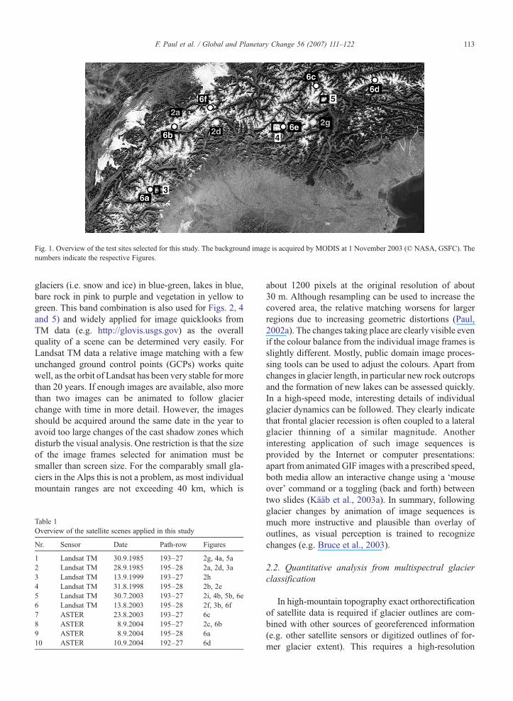
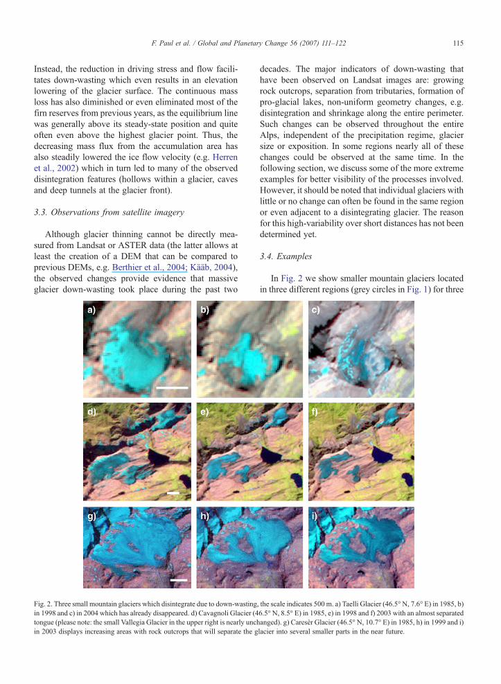
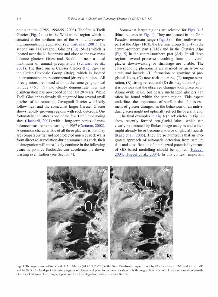
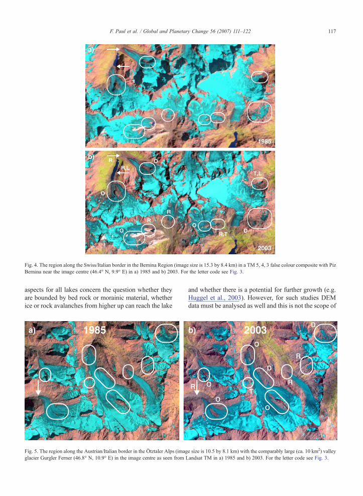
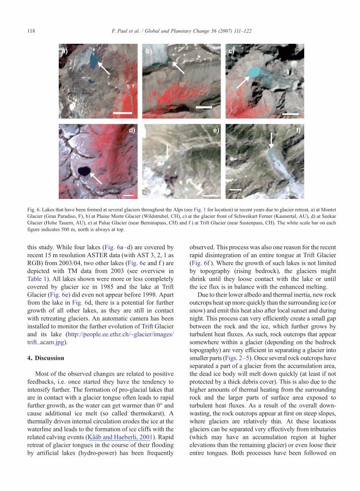