


READY RECKONER OF WORLD GEOGRAPHY ...
54
READY RECKONER OF WORLD GEOGRAPHY www.laexias.com https://elearn.laex.in
-
Upload
khangminh22 -
Category
Documents
-
view
1 -
download
0
Transcript of READY RECKONER OF WORLD GEOGRAPHY ...
READY RECKONER OF WORLD GEOGRAPHY
www.laexias.com https://elearn.laex.in
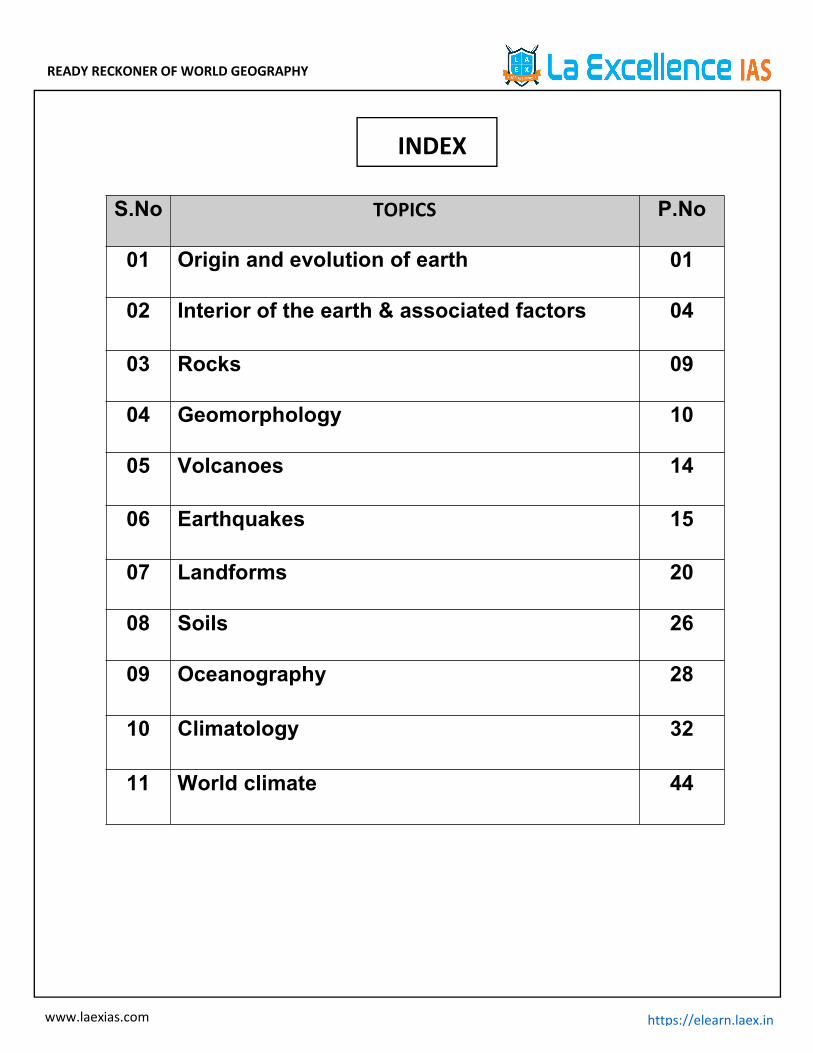
S.No TOPICS P.No
01 Origin and evolution of earth 01
02 Interior of the earth & associated factors 04
03 Rocks 09
04 Geomorphology 10
05 Volcanoes 14
06 Earthquakes 15
07 Landforms 20
08 Soils 26
09 Oceanography 28
10 Climatology 32
11 World climate 44
INDEX
READY RECKONER OF WORLD GEOGRAPHY
1www.laexias.com https://elearn.laex.in
1. ORIGIN AND EVOLUTION OF EARTH
The Universe, solar system, origin and evolution of theearth, earth movements and related aspects, geologicaltime scale, interior of the earth, formation of earth’s crust,oceans and atmosphere
Origin of earth:
Nebular hypothesis by Immanuel kant
Later revised by Laplace
The planets were formed out of a cloud materialassociated with a youthful sun which was slowlyrotating.
Later revised by Carl Weizascar and Otto Schmidt. Sun was surrounded by solar nebula containing
mostly hydrogen, helium and other dust particles. Thefriction and collision of particles led to formation ofdisk shaped cloud.
Planets are formed through accretion(growth bygradual accumulation of matter)
Origin of Universe:
Big bang theory/expanding universe hypothesis: byEdwin Hubble. Stages –
As the time passes galaxies further move apart. Though space between the galaxies is increasing there
is no expansion of galaxies.
Stages in development of universe
All the matter was a tiny ball of unimaginably smallvolume, with infinite temperature and infinite density.
At the Big Bang the “tiny ball” exploded violentlywhich led to huge expansion.
Within 300,000 years from the Big Bang, temperaturedropped to 4,500 K (Kelvin) and gave rise to atomicmatter. The universe became transparent.
Star Formation:
Due to uneven distribution of matter and energy inthe early universe led to initial density differences ingravitational forces and it caused the matter to getdrawn together bases for development of galaxies.
A galaxy starts to form by accumulation of hydrogengas in the form of a very large cloud called nebula.
Nebula -> localised clumps of gas
That led to formation of gaseous bodies -> formation ofstars.
Formation of Planets:
Stages in the Development of Planets: The stars are localized lumps of gas within a nebula,
gravitational force within the lumps lead to formationof a core to the gas cloud and a huge rotating disc ofgas and dust developed around the gas core.
Gas cloud ->condenses->matter around the coredevelops into small- round objects by the process ofcohesion->planetesimals.
These large number of small planetesimals accrete toform a fewer large bodies in the form of planets.
Solar System:
Our solar system consists of the sun (the star), 8planets, more than 200 moons, millions of smallerbodies like asteroids and comets and huge quantity ofdust-grains and gases.
Mercury, Venus, Earth and Mars are called as theInner planets/Terrestrial planets, as they lie betweenthe sun and the belt of asteroids the other fourplanets are called the outer planets/ Jovian planets.
Sun–The solar atmosphere consists ofthe photosphere, chromosphere, and the corona.
Photosphere is the bright outer layer of the Sun thatemits most of the radiation.
Just above the photosphere is the Chromosphere. It isrelatively a thin layer of burning gases.
Corona is a distinctive atmosphere of plasma thatsurrounds the Sun and other celestial bodies.
The corona is usually hidden by the bright light of theSun's surface. That makes it difficult to see withoutusing special instruments. However, the corona canbe seen during a total solar eclipse.
The corona’s high temperatures are a bit of a mystery.Imagine that you’re sitting next to a campfire. It’s niceand warm. But when you walk away from the fire, you
READY RECKONER OF WORLD GEOGRAPHY
2www.laexias.com https://elearn.laex.in
feel cooler. This is the opposite of what seems tohappen on the Sun.
Astronomers have been trying to solve this mysteryfor a long time. The corona is in the outer layer of theSun’s atmosphere—far from its surface. Yet thecorona is hundreds of times hotter than the Sun’ssurface.
A NASA mission called IRIS may have provided onepossible answer. The mission discovered packets ofvery hot material called "heat bombs" that travelfrom the Sun into the corona. In the corona, the heatbombs explode and release their energy as heat. Butastronomers think that this is only one of many waysin which the corona is heated.
A dark patch on the surface of the Sun is known asSunspot.
Solar Wind is a stream of energized, charged particles,primarily electrons and protons, flowing outwardfrom the Sun.
Solar flares are a magnetic storm on the Sun whichappears to be a very bright spot and is a gaseoussurface eruption.
Mercury–Mercury is the smallest planet in our solarsystem
It is the closest planet to the Sun at a distance ofabout 36 million miles
One day on Mercury (the time it takes for Mercury torotate or spin once with respect to the stars) takes 59Earth days.
Mercury makes a complete orbit around the Sun (ayear in Mercury time) in just 88 Earth days
Mercury has no moons. The two spacecraft of ESA-JAXA's BepiColombo are en
route to Mercury. NASA's Mariner 10 was the firstmission to explore Mercury. NASA's MESSENGER wasthe first to orbit the innermost planet.
Venus– Venus is the second closest planet to the sunat a distance of about 67 million miles
One day on Venus lasts 243 Earth days because Venusspins backwards, with its sun rising in the west andsetting in the east.
Venus has no moons and no rings.
Venus is the brightest planet in the solar system andis the third brightest object visible from earth afterthe sun and the moon.
Venus is sometimes called Earth’s sister planet orEarth’s twin because of their similar size, mass,proximity to the Sun, bulk composition and presenceof similar physical features such as high plateaus,folded mountain belts, numerous volcanoes, etc.
In the ancient literature, Venus was often referred toas the morning star and evening star.
Earth – Discussed in detail in later part. satellite moon(revolves eastward once in 27 days) Moon - only natural satellite of the earth. Darwin suggested that the earth and moon formed
a single rapidly rotating body. The whole massbecame a dumbbell shaped body and later it broke.
Present scientists believed that formation of moonis an outcome of “the big splat” which blasted alarge part of earth into space.
This blasted material continued to orbit the earthand formed into moon.
Mars – dark patches, it possesses an atmosphere ofmostly carbon dioxide. Mars is often referred to asthe “Red Planet” because of the reddish iron oxideprevalent on its surface.
Mars has two irregularly shaped moons, Phobos andDeimos, which are thought to be captured asteroids.
Martian year is of 687 days and Martian day is 24h37m.
Jupiter – Largest outer planet; composed of hydrogen,helium and methane. It has circular light and darkband with outer rings, very cold (-130℃). Jupiterrotates once about every 10 hours (a Jovian day), buttakes about 12 Earth years to complete one orbit ofthe Sun (a Jovian year).
In 1979 the Voyager mission discovered Jupiter’s faintring system. All four giant planets in our solar systemhave ring systems.
Jupiter has 53 named moons and another 26 awaitingofficial names.
Saturn–It is composed mostly of hydrogen, andhelium. Saturn takes about 10.7 hours (no one knowsprecisely) to rotate on its axis once—a Saturn “day”—and 29 Earth years to orbit the sun.

READY RECKONER OF WORLD GEOGRAPHY
3www.laexias.com https://elearn.laex.in
Saturn has 53 known moons with an additional 29moons awaiting confirmation of their discovery—thatis a total of 82 moons.
Saturn has the most spectacular ring system, withseven rings and several gaps and divisions betweenthem.
Few missions have visited Saturn: Pioneer 11 andVoyagers 1 and 2 flew by; But Cassini orbited Saturn294 times from 2004 to 2017.
Uranus – Uranus orbits our Sun, a star, and is theseventh planet from the Sun at a distance of about1.8 billion miles
Uranus takes about 17 hours to rotate once (aUranian day), and about 84 Earth years to completean orbit of the Sun (a Uranian year).
Uranus is an ice giant. Most of its mass is a hot, densefluid of "icy" materials – water, methane andammonia – above a small rocky core.
ranus has 27 known moons, and they are named aftercharacters from the works of William Shakespeareand Alexander Pope.
Uranus has 13 known rings. The inner rings arenarrow and dark and the outer rings are brightlycolored.
Voyager 2 is the only spacecraft to fly by Uranus. Like Venus, Uranus rotates east to west Neptune –Neptune orbits our Sun, a star, and is the
eighth planet from the Sun at a distance of about 2.8billion miles
Neptune takes about 16 hours to rotate once (aNeptunian day), and about 165 Earth years to orbitthe sun (a Neptunian year)
Neptune is an ice giant. Most of its mass is a hot,dense fluid of "icy" materials – water, methane andammonia – above a small rocky core.
Neptune has 14 known moons which are named aftersea gods and nymphs in Greek mythology.
Voyager 2 is the only spacecraft to have visitedNeptune.
The Kuiper belt is a great ring of debris similar to theasteroid belt, but consisting mainly of objectscomposed primarily of ice.
Inner versus outer planets
Celestial bodies: Any natural body outside of theEarth's atmosphere.
Asteroids: Small rocky body orbiting the sun. Largenumbers of these, ranging enormously in size, arefound between the orbits of Mars and Jupiter.
Dwarf Planet: Dwarf planets are heavenly bodies thatare too small to be considered a planet but too largeto fall under smaller categories. The InternationalAstronomical Unit defines a planet as something thatobeys the following criteria: To be in orbit around the Sun Has enough gravity to pull its own mass into a
round shape Has cleared its orbit of smaller objects
Comets: a celestial object consisting of a nucleus ofice and dust and, when near the sun, a ‘tail’ of gas anddust particles pointing away from the sun.
Meteors/Meteoroids: A meteor is an asteroid orother object that burns and vaporizes upon entry intothe Earth's atmosphere; meteors are commonlyknown as "shooting stars." If a meteor survives theplunge through the atmosphere and lands on thesurface, it's known as a meteorite.Geological Time Scale:

READY RECKONER OF WORLD GEOGRAPHY
5www.laexias.com https://elearn.laex.in
2.INTERIOR OF THE EARTH ANDASSOCIATED FACTORS
Evolution of Earth:Evolution of Lithosphere: The earth was mostly in a volatile state during its
primordial stage. Due to gradual increase in density the temperature
inside has increased. As a result the material inside started getting
separated depending on their densities. This allowed heavier materials (like iron) to sink
towards the centre of the Earth and the lighter onesto move towards the surface. With passage of time itcooled further and solidified and condensed into asmaller size.
This later led to the development of the outer surfacein the form of a crust.
Evolution of Atmosphere: There are three stages in the evolution of the present
atmosphere. First stage is marked by the loss of primordial
atmosphere. Second stage, the hot interior of the earth
contributed to the evolution of the atmosphere. Finally, the composition of the atmosphere was
modified by the living world through the process ofphotosynthesis.
The early atmosphere largely contained water vapor,nitrogen, carbon dioxide, methane, ammonia andvery little of free oxygen.
The process through which the gases were outpouredfrom the interior is called degassing.
Continuous volcanic eruptions contributed watervapor and gases to the atmosphere.
Evolution of Hydrosphere: As the earth cooled, the water vapour released
started getting condensed.
The carbon dioxide in the atmosphere got dissolved inrainwater and the temperature further decreasedcausing more condensation and more rains.
The rainwater falling onto the surface got collected inthe depressions to give rise to oceans.
The earth’s oceans were formed within 500 millionyears from the formation of the earth.
However, around 2,500-3,000 million years beforethe present, the process of photosynthesis gotevolved. Life was confined to the oceans for a longtime.
Oceans began to have the contribution of oxygenthrough the process of photosynthesis. Eventually,oceans were saturated with oxygen, and 2,000 millionyears ago, oxygen began to flood the atmosphere.
Structure of Earth: The structure of the earth’s interior is made up of
several concentric layers. Broadly three layers can beidentified—Crust, Mantle and the Core.
Crust: Crust is the outer thin layer with a total thickness
normally between 30-50 km. The thickness of thecrust varies under the oceanic -thinner (5-30 Km) andcontinental areas- thick (50-70 Km).
The mean density of oceanic crust is 2.7g/cm3
Basalt is found in oceanic crust. The continental crust is thicker in the areas of major
mountain systems. It forms 5-10 per cent of the earth’s volume. Mohorovicic (Moho) discontinuity forms the
boundary between crust and outer –outer mantle. The continents are composed of sial while the oceans
are composed of sima
Mantle: The mantle extends to a depth of 2,900 km.The crust
and the uppermost part of the mantle arecalled lithosphere. Its thickness ranges from 10-200km.
The lower mantle extends beyond the asthenosphere.It is in solid state.

READY RECKONER OF WORLD GEOGRAPHY
6www.laexias.com https://elearn.laex.in
The density of mantle varies between 2.9 and 3.3. It is composed of solid rock and magma. It forms 83 per cent of the earth’s volume
Asthenosphere: The upper portion of the mantle is called
asthenosphere. Asthenosphere is a plastic zone in mantle It is considered to be extending up to 400 km. It is the main source of magma and is more fluidic in
natureCore: Lies between 2900 km and 6400 km below the earth’s
surface. Accounts for 16 per cent of the earth’s volume. Core has the heaviest mineral materials of highest
density. It is composed of nickel and iron [Nife]. The outer core is liquid while the inner core is solid. Gutenberg Discontinuity lies between the mantle and
the outer core.
Composition of Earth Crust:Sl.No.
Elements By Weight(%)
1. Oxygen 46.602. Silicon 27.723. Aluminium 8.134. Iron 5.005. Calcium 3.636. Sodium 2.837. Potassium 2.598. Magnesium 2.099. Others 1.41
Sources of information about earth interior,
1. Direct sources- surface rock obtained by Oceandrilling, mining and volcanic eruptions.
2. Indirect sources- Analysis of properties of matter like
temperaturewhich increase with the increasingdistance from the surface towardsinterior in deeperdepths, pressure and density of material alsoincreases with depth.
Meteors these solid bodies structure and material issimilar to earth.
Gravity anomaly which gives us the informationabout distribution of mass of material in the crust ofearth.
It is greater near the poles and less at equator. Magnetic surveys gives information about magnetic
material distribution in crustal portion. Seismic activity important source about interiors of
earth.
Chemical composition of the Earth
Motions of Earth:Rotation of Earth: Earth rotates along its axis from west to east. It takes approximately 24 hrs to complete on rotation. Days and nights occur due to rotation of the earth. The circle that divides the day from night on the globe
is called the circle of illumination. Earth rotates on a tilted axis. Earth’s rotational axis
makes an angle of 23.5° with the normal i.e. it makesan angle of 66.5° with the orbital plane. Orbital planeis the plane of earth’s orbit around the Sun.
Rotation Movement of earth on its axis – 24 hours –Earth day.

READY RECKONER OF WORLD GEOGRAPHY
7www.laexias.com https://elearn.laex.in
Revolution of Earth: The motion of the earth around the sunwhich spins in
an elliptical orbit is called revolution. It takes 365¼days (one year) to revolve around the sun. Six hourssaved every year are added to make one day (24hours) over a span of four years. This surplus day isadded to the month of February. Thus every fourthyear, February is of 29 days instead of 28 days. Such ayear with 366 days is called a leap year.
Revolution leads to change in Seasons.
Seasons Summer Solistice On 21st June, the Northern hemisphere is tilted
towards the sun. The rays of the sun fall directly onthe Tropic of Cancer. As a result, these areas receivemore heat.
The areas near the poles receive less heat as the raysof the sun are slanting.
The north pole is inclined towards the sun and theplaces beyond the Arctic Circle experience continuousdaylight for about six months.
Since a large portion of the northern hemisphere isgetting light from the sun, it is summer in the regionsnorth of the equator. The longest day and theshortest night at these places occur on 21st June.
At this time in the southern hemisphere all theseconditions are reversed. It is winter season there. Thenights are longer than the days. This position of theearth is called the summer solstice.
Winter Solistice: On 22nd December, the Tropic of Capricorn receives
direct rays of the sun as the south pole tilts towards it.As the sun’s rays fall vertically at the Tropic ofCapricorn (23½° s), a larger portion of the southernhemisphere gets light.
Therefore, it is summer in the southern hemispherewith longer days and shorter nights. The reversehappens in the northern hemisphere and itexperiences winter. This position of the earth is calledthewinter solstice.
Equinox: On 21st March and September 23rd, direct rays of
the sun fall on the equator. At this position, neither ofthe poles is tilted towards the sun; so, the wholeearth experiences equal days and equal nights. This iscalled an equinox.
On 23rd September, it is autumn season [seasonafter summer and before the beginning of winter] inthe northern hemisphere and spring season [seasonafter winter and before the beginning of summer] inthe southern hemisphere.
The opposite is the case on 21st March, when it isspring in the northern hemisphere and autumn in thesouthern hemisphere.
RotationDays and Nights. Revolution Seasons.

READY RECKONER OF WORLD GEOGRAPHY
8www.laexias.com https://elearn.laex.in
Latitudes and longitudes:
Latitude Longitude The angular distance of a
place north or south of theearth's equator
Equator = 0° Latitude Latitudes are named south
and north of equator Their length decreases from
equator to poles Equator has the maximum
length also called as greatcircle
Equator, Tropic of Cancer23.5° N, Tropic of Capricorn23.5° S, Arctic circle 66.5° N,Antarctic circle 66.5° S,North Pole 90° N and SouthPole 90° S are importantlatitudes
They help in determiningthe intensity of sunlightreceived at a point
They divide earth intotorrid, temperate and frigidzones
The angular distanceof a place east orwest of theGreenwichmeridian,
Prime meridian =longitude
Longitudes arenamed east or westof prime meridian
All longitudes areequal in length
Prime meridian 0°and InternationalDate Line 180° E or180° W areimportant longitudes
Used to determinetime and dateat alocation
Both are used to determine the location of a point on earth.The location is identified with Co-ordinates
Latitude: Angular distance measured north or southof the equator. Project a line from a given point ‘p’ onthe earth’s surface to the centre of the earth. Anglebetween this line and the equatorial plane is themeasure of latitude of point ‘p’.
Latitude varies from 00 to 900 north and south. Longitude: Angular distance between the meridian
passing through a given point and the prime meridian. A longitude varies from 00 to 1800 east or west.
Greenwich Meridian Time: Equator is centrally placed between the poles, any
meridian could be taken to begin the numbering oflongitude. It was finally decided in 1884, byinternational agreement, to choose as the zeromeridian the one which passes through the RoyalAstronomical Observatory at Greenwich, nearLondon.
• This is the Prime Meridian (0°) from which all othermeridians radiate eastwards and westwards up to180°.
• They help to determine local time.• One revolution of 360° earth takes 24hours, therefore
in 1hour it traverse 15° or in 4 mins 1°• Places east of Greenwich see the sun earlier and gain
time(EAST-GAIN-ADD), whereas places west of Greenwich seethe sun later and lose time (WEST-LOSE-SUBSTRACT).International Date Line
READY RECKONER OF WORLD GEOGRAPHY
9www.laexias.com https://elearn.laex.in
The International Date Line serves as the "line ofdemarcation" between two consecutive calendardates. It passes through the mid-Pacific Ocean androughly follows a 180 degrees at the Bering Strait, Fiji,Tonga and other islands longitude, north-south lineon the Earth. It is located halfway round the worldfrom the prime meridian.
International Date Line is where the date changes byexactly one day when it is crossed. A travellercrossing the date line from east to west loses a dayand while crossing the dateline from west to east hegains a day.
Indian Standard Time:
The standard meridian of India is the 82.5º eastlongitude which passes through Allahabad. This is five anda half hours ahead of 0ºmeridian (Greenwich).Day Light Saving: Many parts of North America and Europe follow what
is called Daylight Saving Time (DST). It’s a practice by which all the clocks in these places
are moved forward by an hour during the summermonths and brought back during the winter to utilisethe long-lasting sunlight in summer and save energy.
India follows a single time zone of 82.5°E, Northeastregion are demanding for a separate time zone as thesun rises as early as four in the morning and in winterit sets by four in the evening.
3. ROCKS
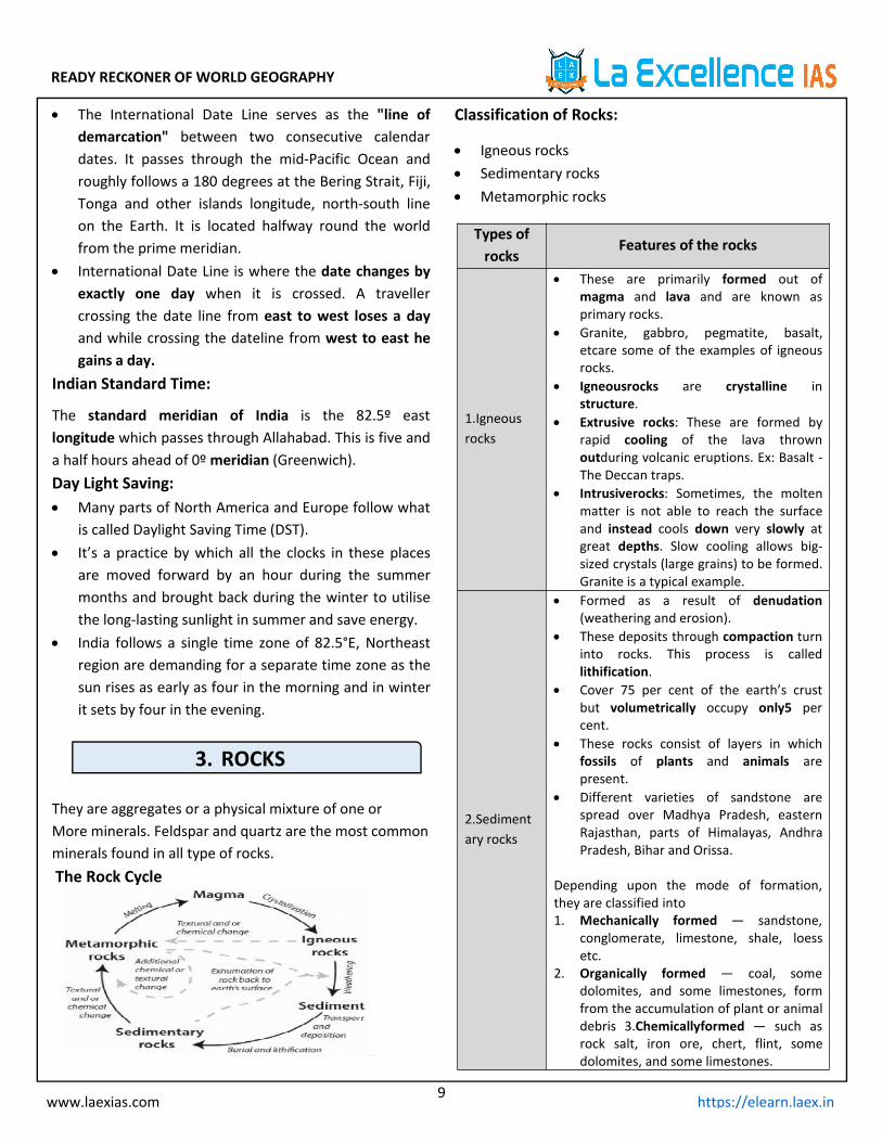
They are aggregates or a physical mixture of one orMore minerals. Feldspar and quartz are the most commonminerals found in all type of rocks.The Rock Cycle
Classification of Rocks:
Igneous rocks Sedimentary rocks Metamorphic rocks
Types ofrocks
Features of the rocks
1.Igneousrocks
These are primarily formed out ofmagma and lava and are known asprimary rocks.
Granite, gabbro, pegmatite, basalt,etcare some of the examples of igneousrocks.
Igneousrocks are crystalline instructure.
Extrusive rocks: These are formed byrapid cooling of the lava thrownoutduring volcanic eruptions. Ex: Basalt -The Deccan traps.
Intrusiverocks: Sometimes, the moltenmatter is not able to reach the surfaceand instead cools down very slowly atgreat depths. Slow cooling allows big-sized crystals (large grains) to be formed.Granite is a typical example.
2.Sedimentary rocks
Formed as a result of denudation(weathering and erosion).
These deposits through compaction turninto rocks. This process is calledlithification.
Cover 75 per cent of the earth’s crustbut volumetrically occupy only5 percent.
These rocks consist of layers in whichfossils of plants and animals arepresent.
Different varieties of sandstone arespread over Madhya Pradesh, easternRajasthan, parts of Himalayas, AndhraPradesh, Bihar and Orissa.
Depending upon the mode of formation,they are classified into1. Mechanically formed — sandstone,
conglomerate, limestone, shale, loessetc.
2. Organically formed — coal, somedolomites, and some limestones, formfrom the accumulation of plant or animaldebris 3.Chemicallyformed — such asrock salt, iron ore, chert, flint, somedolomites, and some limestones.

READY RECKONER OF WORLD GEOGRAPHY
10www.laexias.com https://elearn.laex.in
3.Metamorphic rocks
Form under the action of pressure,volume and temperature (PVT) changes.
Metamorphism occurs when rocks areforced down to lower levels by tectonicor recrystallisation and reorganizationof materials.
In the process of metamorphism in somerocks grains or minerals get arranged inlayers or lines called as foliation orlineation.
Banding: minerals of different groupsarranged into alternating thin andthick layers appearing in light anddark shades.
Some Examples of Metamorphism:
4. GEOMORPHOLOGY
Geomorphology is the study of the physical featuresof the surface of the earth and their relation to itsgeological structures.
Geomorphic Process - The formation anddeformation of landforms on the surface of the earthare a continuous process which is due to thecontinuous influence of external and internal forces.
Earth Movements and Landforms:Earth is undergoing deformations due to,
1. The heat generated by the radioactive elements inearth’s interior.
2. Movement of the crustal plates due to tectogenesis.
3. Forces generated by rotation of the earth.
4. Climatic factors like winds, precipitation, pressurebelts etc.
Based on the above diagram we can see earthmovements can be majorly classified into,
1. Endogenetic movement2. Exogenetic movement
1. EndogeneticMovements:
Movements inside the earth’s crust or interaction ofmatter and temperature generates these forces. Theearth movements are mainly of twotypes: diastrophism/ slow and the suddenmovements.
The energy emanating within the earthby radioactivity, rotational and tidal forces , frictionand primordial heat from early earth are the mainforce behind these movements.
This energy due to geothermal gradients and heatflow from within induces diastrophism (slowmovements) and volcanism(sudden movements) inthe lithosphere, thereby causing PVT (pressure,volume and temperature) changes.
Diastrophism/ Slow Movements: Diastrophic forces refer to forces generated by the
movement of the solid material of the earth’s crust. All processes like plate tectonics, orogenisis,
epirogenisis, earth quake etc that move, elevate orbuild up portions of the earth’s crust crust comeunder diastrophism.EpirogenicOr Continent Forming Movements:
Epirogenic movement is vertical movement of theearth along the radius of earth crust.
It is continental building process which involves upliftor warping/subsidence of large parts of the earth’scrust.
Uplift: Due to vertical movement of the earth some earth
crust emerges there by leading to elevations/upliftment.
Raised beaches, elevated wave-cut terraces, sea cavesand fossiliferous beds above sea level are evidencesof uplift.
READY RECKONER OF WORLD GEOGRAPHY
11www.laexias.com https://elearn.laex.in
Ex: The Sierra Nevada in North America, Black ForestMountains in Germany are examples of upliftmountains. Raised beaches along the Kathiawar,Nellore, and Thirunelveli coasts.
Subsidence: Due to vertical movement of the earth some earth
crust submerges there by leading subsidence.
Ex: 1. Mammoth cave system in Kentucky, Karsttopography in southern china, Andes of SouthAmerica.
2. Presence of peat and lignite beds below the sealevel in Thirunelveli and the Sunderbans is anexample of subsidence.
3. The Andamans and Nicobars have been isolatedfrom the Arakan coast by submergence of theintervening land.
Orogenicor the Mountain-Building Movements: Orogenic movements are horizontal movements
which involvesmountain building through severefolding and faulting, act tangentially to the earthsurface.
These horizontal movements can be through forces ofcompression and forces of tension.
1. Forces of Compression: Are the forces which push rock strata against a hard
plane from one side or from both sides. Thesecompressional forces lead to the bending of rocklayers and thus lead to the formation of FoldMountains.Ex: Himalayas, the Rockies (N. America), the Andes (S.America), the Alps (Europe) etc.
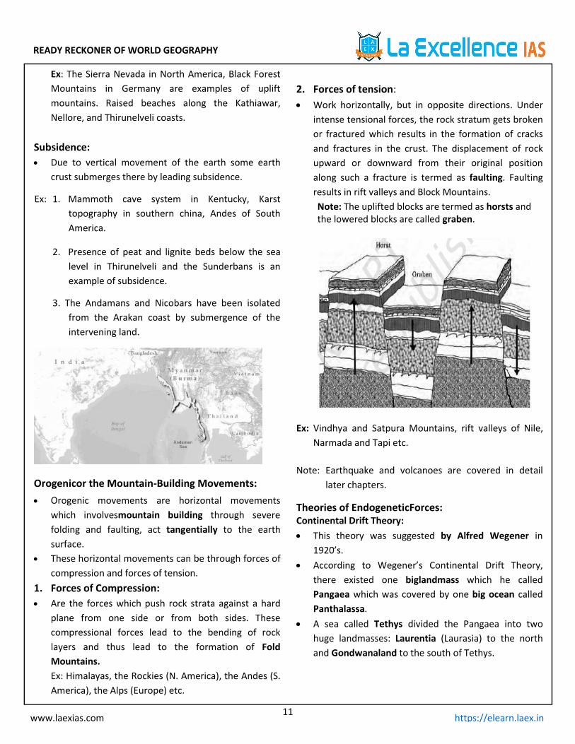
2. Forces of tension: Work horizontally, but in opposite directions. Under
intense tensional forces, the rock stratum gets brokenor fractured which results in the formation of cracksand fractures in the crust. The displacement of rockupward or downward from their original positionalong such a fracture is termed as faulting. Faultingresults in rift valleys and Block Mountains.Note: The uplifted blocks are termed as horsts andthe lowered blocks are called graben.
Ex: Vindhya and Satpura Mountains, rift valleys of Nile,Narmada and Tapi etc.
Note: Earthquake and volcanoes are covered in detaillater chapters.
Theories of EndogeneticForces:Continental Drift Theory: This theory was suggested by Alfred Wegener in
1920’s. According to Wegener’s Continental Drift Theory,
there existed one biglandmass which he calledPangaea which was covered by one big ocean calledPanthalassa.
A sea called Tethys divided the Pangaea into twohuge landmasses: Laurentia (Laurasia) to the northand Gondwanaland to the south of Tethys.
READY RECKONER OF WORLD GEOGRAPHY
12www.laexias.com https://elearn.laex.in
Drift started around 200 million years ago (MesozoicEra), and the continents began to break up and driftaway from one another.
Force for Continental Drift:The drift was in two directions,1. Equator wards due to the interaction of forces of
gravity, pole-fleeing force (earth has bulge at theequator due to rotation of earth) and buoyancy.
2. Westwards due to tidal currents because of theearth’s motion.Tidal force is due to the attraction of the moon andthe sun that develops tides in oceanic waters.
Evidence in support of Continental Drift:
South America and Africa seem to fit in with eachother, especially, the bulge of Brazil fits into the Gulfof Guinea.
Greenland seems to fit in well with Ellesmere andBaffin islands.
The west coast of India, Madagascar and Africa seemto have been joined i.e identical species of plants andanimals are found on either side.
North and South America on one side and Africa andEurope on the other fit along the mid-Atlantic ridge.
The Caledonian and Hercynian mountains of Europeand the Appalachians of USA seem to be onecontinuous series.
Criticism:
Coastlines are a temporary feature and are liable tochange.
Continental Drift Theory shifts India’s position toomuch to the south, distorting its relation with theMediterranean Sea and the Alps.
The mountains do not always exhibit geologicalaffinity.
Convectional Theory: Arthur Holmes in 1930s discussed the possibility of
convection currents in the mantle.
These currents are generated due to radioactiveelements causing thermal differences in mantle.
According to this theory, the intense heat generatedby radioactive substances in the mantle seeks a pathto escape, and gives rise to the formation ofconvention currents in the mantle.
Wherever rising limbs of these currentsmeet, oceanic ridges are formed on the sea floor andwherever the falling limbsmeet, trenches are formed.
Sea Floor Spreading: The idea that the seafloor itself moves as it expands
from a central axis was proposed by Harry Hess. Continued with convectional theory ie., intense heat
tries to escape leads to convectional current meetingof rising limbs causes ridges and falling limbs trenches.
Seafloor spreading is a process that occurs at mid-ocean ridges, where new oceanic crust is formedthrough volcanic activity and then gradually movesaway from the ridge.
Seafloor spreading helps explain continental drift inthe theory of plate tectonics.
When oceanic plates diverge, tensional stress causesfractures to occur in the lithosphere,basaltic magmarises up the fractures and cools on the ocean floor toform new sea floor.
Older rocks will be found farther away from thespreading zone while younger rocks will be foundnearer to the spreading zone.
Plate Tectonic Theory:
In 1967, McKenzie and Parker suggested the theory ofplate tectonics.
According to the theory of plate tectonics, the earth’slithosphere is broken into distinct plates which arefloating on asthenosphere (upper mantle). Platesmove horizontally over the asthenosphere as rigidunits.
The lithosphere includes the crust and top mantlewith its thickness range varying between 5-100 km inoceanic parts and about 200 km in the continentalareas.

READY RECKONER OF WORLD GEOGRAPHY
13www.laexias.com https://elearn.laex.in
Lithospheric plates (crustal plates, tectonic plates)vary from minor plates to major plates, continentalplates (Arabian plate) to oceanic plates (Pacific plate),sometime a combination of both continental andoceanic plates (Indo-Australian plate).
Rates of Plate Movement
The Arctic Ridge has the slowest rate (less than 2.5cm/yr.), and the East Pacific Rise in the South Pacific[about 3,400 km west of Chile], has the fastest rate(more than 15 cm/yr.).
Indian plate’s movement during its journey fromsouth to equator was one of the fastest platemovements.
Types of plate boundaries:Plate Boundaries are of three types, based on the nature
of interaction.
Boundaryinteraction
Features of the interaction
1.Divergence formingDivergent Edge or theConstructive Edge
In plate tectonics, a divergentboundary or divergent plateboundary (also known as aconstructive boundary or anextensional boundary) is alinear feature that existsbetween two tectonic platesthat are moving away fromeach other. Interaction of thistype leads to formation ofmid-oceanic trenches and riftvalleys.
Earthquakes are commonalong divergent edges.
2.Convergenceforming ConvergentEdge or DestructiveEdge
In this kind of interaction, twolithospheric plates collideagainst each other.The zone of collision mayundergo crumpling andfolding and folded mountainsmay emerge.
This is an orogenic collision.Himalayan Boundary Fault isone such example.
When one of the plates is anoceanic plate, it getsembedded in the softerasthenosphere of thecontinental plate and as aresult, trenches are formed
3. Transform fault
Formed when two platesmove past each other.
In this kind of interaction, twoplates grind against eachother and there is no creationor destruction of landform butonly deformation of theexisting landform.
Example: San Andreas Fault (USA)
Convergent boundaries are of 3 types,1. Ocean-Ocean Convergent Plate Boundary
When two oceanic plates meet and collide againsteach other, the denser of the two plates is pulled

READY RECKONER OF WORLD GEOGRAPHY
14www.laexias.com https://elearn.laex.in
under the other and is subducted. It descends into theasthenosphere leading to generation of new magma.
The resulting body of many volcanoes and volcanicrocks is called an island volcanic arc.
Examples of such arcs are Japan, the Philippines, theTonga Islands, the Aleutian Islands, and the WestIndies Islands etc.
2. Ocean-Continental Convergent Boundary:When an oceanic plate collides with a continentalplate, the oceanic plate is always pulled under andsubducted because it is denser than the continentalplate. When the oceanic plate is subducted under thecontinental plate, it leads to the generation of newmagma, which upwells and forms volcanoes on thenon-subducting plate, or the continental plate. Theresulting body of such an interaction leads to theformation of continental volcanic arcs.
The most visible example is Andes Mountains off thewest coast of the U.S.
3. Continent-Continent convergent BoundaryWhen the continent and continent converge, thecrust at both the sides is too light and buoyant to besubducted, so neither plate is subducted in continent-continent convergent boundary. Both continentalmasses press against the other, and both becomecompressed and ultimately fused into a single blockwith a folded mountain belt forming between them.Example: Himalayas
5. VOLCANOES
Volcanism includes the movement of molten rock(magma) onto or toward the earth’s surface
A volcano is formed when the molten magma in theearth’s interior escapes through the crust by ventsand fissures in the crust, accompanied by steam,gases (hydrogen sulphide, sulphur dioxide, hydrogenchloride, carbon dioxide) and pyroclastic material.
Pyroclastic-adjective of or denoting rock fragments orash erupted by a volcano, especially as a hot, dense,destructive flow
Classification of Volcanoes –
Types of Lava:
1. Acidic – light coloured, highly viscous, flow slowly,steep-sided, lead to explosion throwing out pyroclastsor bombs, forming spine or plug at craters
2. Basic– hottest, highly fluid, rich in iron andmagnesium, lack silica, dark colour, highly fluid, flowquietly, forms thin sheets and spread over large areaforming shield or dome.
Volcanoes are also classified as Intrusive andExtrusive landforms
Intrusive Landforms:Sometimes, the molten matter is not able to reach thesurface and instead cools down very slowly at greatdepths. Slow cooling allows big-sized crystals (large grains)to be formed. Granite is a typical example. These rocksappear on the surface only after being uplifted anddenuded.
READY RECKONER OF WORLD GEOGRAPHY
15www.laexias.com https://elearn.laex.in
Molten magma intrusion horizontally along the bed ofsedimentary planes is called sills.
Molten magma intrusion vertically along the walls ofigneous rocks are called as dykes.
Types of igneous intrusions,
1. Laccolith- igneous mound with a doem shaped uppersurface
2. Lopolith- saucer shaped3. Phacolith-lens shaped mass of igneous rock4. Batholith- huge mass of igneous rockExtrusive Landforms:hot magma from inside the Earth flows out (extrudes)onto the surface as lava or explodes violently into theatmosphere to fall back as pyroclastics .This is as opposedto intrusive rock formation, in which magma does notreach the earth surface.Various extrusive landforms are, Lava Plains and Basalt Plateaux fluid – Snake basin,
USA; Deccan; Iceland Lava domes or shield volcanoes – volcanic cones –
Mauna Loa and Kilauea. Ash and cinder cones – less fluid – large crater and
steep slope – small volcano in groups – Mt. Nauvoo(Naples) and Mt. Paricutin (Mexico) Lava tongues andlava dammed lakes – confined in valleys Lava bridges .
Lava tunnels Volcanic dust – fine particles. Dust and Ash – black snowComposite Cones are most commonly called asStratocones with main conduit and subsidiary dykes andpipes
Mt. Etna (Sicily, Italy) best example of parasitic cone. Interesting composite volcano-Mt. Stromboli
(Lighthouse of Mediterranean)
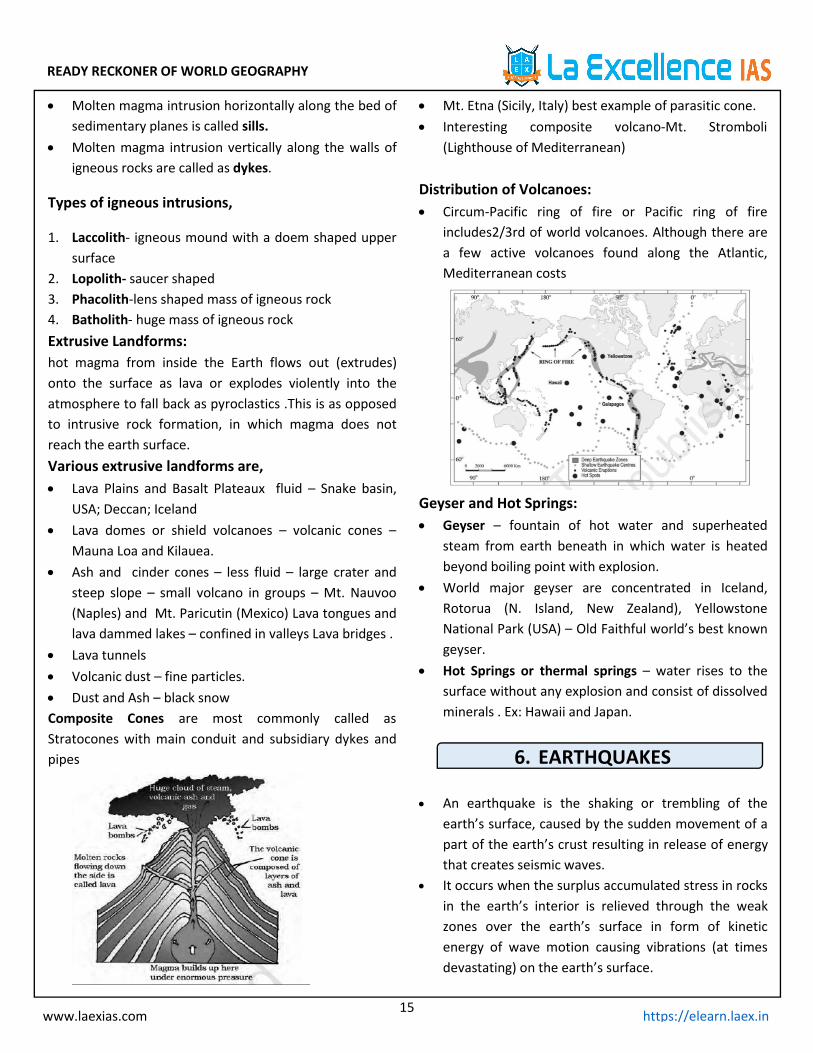
Distribution of Volcanoes: Circum-Pacific ring of fire or Pacific ring of fire
includes2/3rd of world volcanoes. Although there area few active volcanoes found along the Atlantic,Mediterranean costs
Geyser and Hot Springs: Geyser – fountain of hot water and superheated
steam from earth beneath in which water is heatedbeyond boiling point with explosion.
World major geyser are concentrated in Iceland,Rotorua (N. Island, New Zealand), YellowstoneNational Park (USA) – Old Faithful world’s best knowngeyser.
Hot Springs or thermal springs – water rises to thesurface without any explosion and consist of dissolvedminerals . Ex: Hawaii and Japan.
6. EARTHQUAKES
An earthquake is the shaking or trembling of theearth’s surface, caused by the sudden movement of apart of the earth’s crust resulting in release of energythat creates seismic waves.
It occurs when the surplus accumulated stress in rocksin the earth’s interior is relieved through the weakzones over the earth’s surface in form of kineticenergy of wave motion causing vibrations (at timesdevastating) on the earth’s surface.
READY RECKONER OF WORLD GEOGRAPHY
16www.laexias.com https://elearn.laex.in
Focus - The place of origin of an earthquake inside theearth.
Epicentre - Point on the earth’s surface verticallyabove the focus. Maximum damage is caused at theepicentre.
Wave Velocity - 5 to 8 km per second through theouter part of the crust but travel faster with depth.
Isoseismic Line - A line connecting all points on thesurface of the earth where the intensity is the same.
Earth quake magnitude is measured by Richter scale,intensity is measured byMercalli.
Causes:1. Compressional or tensional stresses built up at the
margins of the huge moving lithospheric plates.2. Sudden release of stress along a fault, or fracture in
the earth’s crust.3. Constant change in volume and density of rocks due
to intense temperature and pressure in the earth’sinterior.
4. Human induced earth quake
Earthquake Waves: Seismic waves are produced when some form of
energy stored in Earth’s crust is suddenly released,due to slipping of land, these waves will travel in alldirections.
Types of Seismic Waves Earthquake waves are of two types — Body waves
and Surface waves.
Body waves are generated due to the release ofenergy at the focus and move in all directionstravelling through the body of the earth. Hence, thename body waves.
Body waves interact with the surface rocks andgenerate new set of waves called surface waves,these waves move along the surface and are alsomore destructive (Rayleigh) than body waves
Body Waves:There are two types of body waves -
1. Primary waves or P waves (longitudinal)
Also called as the longitudinal or compressional waves. Analogous to sound waves. Particles of the medium vibrate along the direction of
propagation of the wave. P-waves move faster and are the first to arrive at the
surface. These waves are of high frequency. They can travel in all mediums. Velocity of P waves in Solids > Liquids > Gases. Their velocity depends on shear strength or elasticity
of the material.
2. Secondary waves or S waves (transverse)(leastdestructive)
Also called as transverse or distortional waves. Analogous to water ripples or light waves. S-waves arrive at the surface with some time lag. A secondary wave cannot pass through liquids or
gases. These waves are of high frequency waves. Travel at varying velocities (proportional to shear
strength) through the solid part of the Earth’s crust,mantle.
Surface Waves:
1. L waves:
Confined to the surface of the crust, Love wavesproduce entirely horizontal motion. They are muchslower than body waves but are faster than Rayleigh.
2. Rayleigh waves:
These waves follow an elliptical motion.
READY RECKONER OF WORLD GEOGRAPHY
17www.laexias.com https://elearn.laex.in
A Rayleigh wave rolls along the ground just like awave rolls across a lake or an ocean. Because it rolls,it moves the ground up and down and side-to-side inthe same direction that the wave is moving.
Most of the shaking felt from an earthquake is due tothe Rayleigh wave.
Earthquakes and Plate Tectonics:
As per Plate tectonics earthquakes are a consequenceof inter-plate interaction, along the convergentboundary. Compressive forces crush and causeearthquakes, while along divergent boundary tensileforces stretch and snap the earth creatingearthquakes.
Earthquakes can also be due to plate motions and thefriction of lithospheric plates while they drift alongasthenosphere.
Divergent boundaries and convergent boundariesbetween two continental plates will only haveshallow focus earthquake.
Intermediate and deep focus earthquakes are almostentirely limited to ocean floor subduction.
Propagation of Earthquake Waves in Earth’s Interiors:
The velocity of waves changes as they travel throughmaterials with different elasticity. The more elasticthe material is the higher is the velocity. Theirdirection also changes as they reflect or refract whencoming across materials with different densities.
P-waves vibrate parallel to the direction of thewave.As a result, it creates density differences in thematerial leading to stretching and squeezing of thematerial.
The direction of vibrations of S-waves isperpendicular to the wave direction in the verticalplane. Hence, they create troughs and crests in thematerial through which they pass.
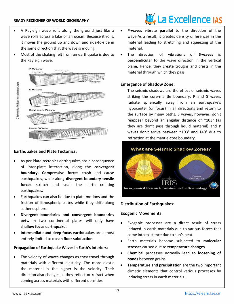
Emergence of Shadow Zone:The seismic shadows are the effect of seismic wavesstriking the core-mantle boundary. P and S wavesradiate spherically away from an earthquake'shypocenter (or focus) in all directions and return tothe surface by many paths. S waves, however, don'treappear beyond an angular distance of ~103° (asthey are don’t pass through liquid material) and Pwaves don't arrive between ~103° and 140° due torefraction at the mantle-core boundary.
Distribution of Earthquakes:
Exogenic Movements:
Exogenic processes are a direct result of stressinduced in earth materials due to various forces thatcome into existence due to sun’s heat.
Earth materials become subjected to molecularstresses caused due to temperature changes.
Chemical processes normally lead to loosening ofbonds between grains.
Temperature and precipitation are the two importantclimatic elements that control various processes byinducing stress in earth materials.
READY RECKONER OF WORLD GEOGRAPHY
18www.laexias.com https://elearn.laex.in
Geomorphic agent: An exogenic element ofnature(like water, ice, wind, etc) capable of acquiringand transporting earth materials can be called ageomorphic agent.
Denudation- the process of wearing away the earththat causes general lowering and levelling out of thesurface.
Denudation Involves 4 Processes:
1. Weathering- gradual disintegration of rocks byatmospheric or weather forces.
2. Erosion – active wearing of earth surface by agentslike water, wind,ice etc.
3. Transportation- removal of eroded debris to newpositions.
4. Deposition – dumping of debris in certain parts ofearth.
Warm wet climate promotes rapid chemicalweathering while dry climate provide good conditionsfor physical weathering
Chemical Weathering: Extremely slow and gradual decomposition of rocks
due to exposure to air and water
Regolith -mineral remains of decomposed rocks. When a soil cover on the rock exists, chemical
weathering of the rock enhances because the soilabsorbs rain water and keeps the underlying rock incontact with this moisture.
Types of Chemical weathering:1. Solution Many minerals are dissolved by water especially with
rain water which contains enough carbon dioxide tomake it a weak acid.
Ex: in limestone region, rocks made of calcium carbonateget dissolved in rain water, widening joints resultingin crumbling of rocks.
2. Oxidation: Weathering by reaction of oxygen in presence of air
and water with minerals present in the rock
Ex: rocks contain certain amount of iron, which incontact with air changes into iron oxide leading torust.
3. Decomposition by Organic Acids Soils consist of certain bacterias which thrive on the
rock surface, they produce acids when dissolved inwater.Ex: Microoragnisms, mosses or lichens
4. Carbonation Reaction of carbonate and bicarbonate with minerals
which helps in breaking down of feldspars andcarbonate minerals.
5. Hydration Chemical addition of water. Minerals absorb water
and expand which causes an increase in volume ofmaterial itself or rock.
Physical Weathering: Also known as Mechanical Weathering , it is physical
Disintegration of rocks
Types of physical weathering,1. Temperature changes
Mainly in dry desert areas, hot at day and cold bynight, Leads to expansion and contraction of rocksetting up stresses in the rock. Finally leading to itsdisintegration
2. Repeated wetting and drying Stresses are naturally greatest near the surface and
where there are sharp angles in the rock, finally itleads to peeling off of rock’s outer layer called asexfoliation.
Exfoliation also takes place by repeated wetting anddrying of rocks surface as during wetting its outerlayer absorbs moisture and expand; when they drythis moisture evaporates and they quickly shrinks,finally leading to peeling of outer layer of the rock
3. Frost At high altitudes and cold climates where during day
cracks and joints inside rock fill with water and during
READY RECKONER OF WORLD GEOGRAPHY
19www.laexias.com https://elearn.laex.in
night they get frozen. With repeated freeze /thawcycles, rock breaks into pieces
4. Biotic factors vegetation grows into crevices of rock cracks or in
courtyards as plant grows roots penentrate weakenthe rock.
5. Salt weathering
Salts in rocks expand due to thermal action, hydrationand crystallisation.
Mass Movement: Movement of weathered material down the slope
due to gravitational forces Movement can be slow or sudden, depending on the
slope gradient, weight of debris and lubricatingmoisture supplied by rainwater
Types of mass movements are,A. Slow movement1. Soil creep Slow and gradual process continuous movement of
downhill slopes Common in damp soils where water act as lubricant
2. Soil Flow: Soil is saturated with water and individual particles
are suspended in water, they start moving like a liquid.The gradual movement of wet soil or other materialdown a slope, especially where frozen subsoil acts asa barrier to the percolation of water.
B. Rapid movements
1. Earthflow: Movement of water saturated clayey or silty earth
materials down low angle terraces.flow of water thatcontains large amounts of suspended particles and silt.
2. Mudflow:
Flow of water that contains large amounts ofsuspended particles and silt.
3. Landslides (Slumping and Sliding):
Occur on steep slopes, slope undercut by river or seaor by lubricating action of rain water.
Slumping is permeable layer overlie overimpermeable clay, which acts as a slippery surface.
GroundWater: Hydrological cycle is process of circulation of water
between land, sea and atmosphere. Ground water plays major role in weathering and
mass movement.
Volume of ground water depends on climate, Dry climate – precipitation is evaporated quickly and
little moisture percolate into ground. Humid areas – most water runs off and sinks into
ground Porous Rocks – sandstone – many pore spaces exists
(water is absorbed and stored) Permeable or pervious rocks - allow water to pass
through them Impermeable – Clay is highly porous as made of many
fine particles but spaces are very small and particlecannot move.
Water Table: Water moves down by gravity and reach impermeable
layer through which it cannot pass. If no outlet isthere, water accumulates above impermeable rocksand saturates the rocks. Water store in the permeablerock is known as aquifer. Surface of saturated area iscalled water table.
Water table is far below surface in hill tops but closeto surface in valleys and flat low lying areas causingwater logging.
Springs A spring is a point at which water flows from an
aquifer to the Earth's surface. It is a component of thehydrosphere.
Minerals become dissolved in the water as it movesthrough the underground rocks. This is why springwater is often bottled and sold as mineral water.
READY RECKONER OF WORLD GEOGRAPHY
20www.laexias.com https://elearn.laex.in
Wells Hole is bored until it reaches water table of
permanent depth with continuous flow of water Aquifer is saturated to the brim of the basin. Water is
trapped in the aquifer under pressure and when wellis bored, pressure of water downwards forces thewater up the bore hole to gush as fountain. Aftersometime pressure decreases and pumping is notrequired.
This water is unsuitable for agriculture as it is hot andcontains lots of mineral salts.
Islands and Coral Reefs• Land surrounded by water on all sides, may occur
individually or in group.Coral Reefs Coral Polyps – calcareous algae, shell forming
creatures and lime secreting plants live in largecolonies. When polyp die, skeleton are cemented intocoralline limestone.
Non reef building species – precious coral of PacificOcean & Red coral of Mediterranean Sea.
Conditions for coral formation-
1. Survive best in warmer tropical seas.2. Water temperature must not be below 20 C.3. Not flourish in cold currents due to upwelling of
cold waters from depth that cools the warm watersurface.
4. Depth of water should not exceed 30 fathoms or180 feet as beyond it sunlight is too faint.
5. Shallow water of less than 100 feet is ideal.6. Water should be saltish and free from sediments -
corals are best developed on seaward side ofreef – abundant supply of clear oxygenated water.
Types of Coral Reefs
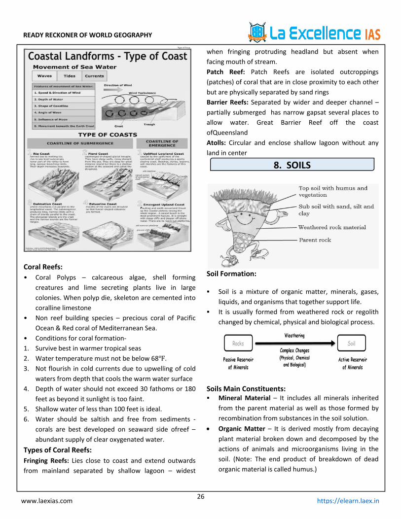
1.Fringing Reefs: Lies close to coast and extend outwardsfrommainland separated by shallow lagoon – widestwhenfringing protruding headland but absent when facingmouth of stream.
2.Patch Reef: Patch Reefs are isolated outcroppings(patches) of coral that are in close proximity to each otherbut are physically separated by sand rings.
3.Barrier Reefs: Separated by wider and deeper channel –partially submerged has narrow gaps at several places toallow water. Great Barrier Reef off the coast ofQueensland.
4.Atolls: Circular and enclose shallow lagoon without anyland in centre.
7. LANDFORMS
Landforms Created by Running Water:Course of a river
The youngstage
Predominant action is vertical corrosion(corrosion- it is the gradual destructionof materials by chemical and/orelectrochemical reaction with theirenvironment)
Gorges and canyons are formed duringthis stage (A canyonorgorge is a deepcleft between escarpments or cliffsresulting from weathering and theerosive activity of a river )
River capture- river capture is naturaldiversion of the headwaters of onestream into the channel of another,typically resulting from rapid headwarderosion by the latter stream)
Rapids, cataracts and waterfalls- Rapidsare stream sections with extremelystrong currents, numerous obstacles, andsteps in their streambeds. A waterfall is avertical drop in a streambed. Both aresites of vigorous erosion. Rapids oftenform where resistant bedrock confines astream to a narrow channel, and forcesan increase in water velocity.
Middle orvalleycourse
Meanders -a winding curve or bend of ariver
River cliffs and slip-off slopes
Lower orplain course
Flood plains- An area of low-lying groundadjacent to a river, formed mainly ofriver sediments and subject to flooding.
Ox-bow lakes- it is a U-shaped lake thatforms when a wide meander from themain stem of a river is cut off, creating afree-standing body of water.
Delta- a triangular tract of sedimentdeposited at the mouth of a river,typically where it diverges into severaloutlets.
READY RECKONER OF WORLD GEOGRAPHY
21www.laexias.com https://elearn.laex.in
Erosional land forms of running water:
potholes Circular depressions on rocky beds of hills.They are formed because of steam erosionaided by abrasion of rock fragments.
Plungepools
Large and deep holes at the base ofwaterfalls are called plunge pools.
Riverterraces
They result due to vertical erosion bythe stream into its own depositionalfloodplain.
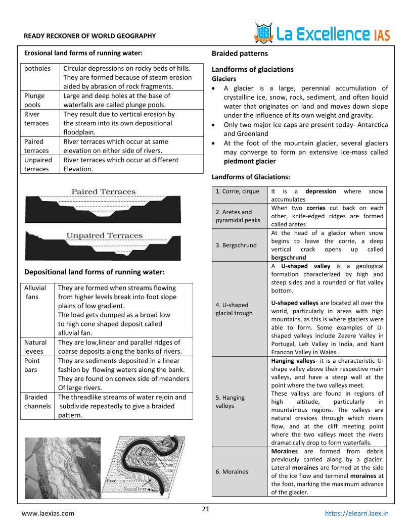
Pairedterraces
River terraces which occur at sameelevation on either side of rivers.
Unpairedterraces
River terraces which occur at differentElevation.
Depositional land forms of running water:
Alluvialfans
They are formed when streams flowingfrom higher levels break into foot slopeplains of low gradient.The load gets dumped as a broad lowto high cone shaped deposit calledalluvial fan.
Naturallevees
They are low,linear and parallel ridges ofcoarse deposits along the banks of rivers.
Pointbars
They are sediments deposited in a linearfashion by flowing waters along the bank.They are found on convex side of meandersOf large rivers.
Braidedchannels
The threadlike streams of water rejoin andsubdivide repeatedly to give a braidedpattern.
Braided patterns
Landforms of glaciationsGlaciers A glacier is a large, perennial accumulation of
crystalline ice, snow, rock, sediment, and often liquidwater that originates on land and moves down slopeunder the influence of its own weight and gravity.
Only two major ice caps are present today- Antarcticaand Greenland
At the foot of the mountain glacier, several glaciersmay converge to form an extensive ice-mass calledpiedmont glacier
Landforms of Glaciations:
1. Corrie, cirque It is a depression where snowaccumulates
2. Aretes andpyramidal peaks
When two corries cut back on eachother, knife-edged ridges are formedcalled aretes
3. Bergschrund
At the head of a glacier when snowbegins to leave the corrie, a deepvertical crack opens up calledbergschrund
4. U-shapedglacial trough
A U-shaped valley is a geologicalformation characterized by high andsteep sides and a rounded or flat valleybottom.
U-shaped valleys are located all over theworld, particularly in areas with highmountains, as this is where glaciers wereable to form. Some examples of U-shaped valleys include Zezere Valley inPortugal, Leh Valley in India, and NantFrancon Valley in Wales.
5. Hangingvalleys
Hanging valleys- it is a characteristic U-shape valley above their respective mainvalleys, and have a steep wall at thepoint where the two valleys meet.These valleys are found in regions ofhigh altitude, particularly inmountainous regions. The valleys arenatural crevices through which riversflow, and at the cliff meeting pointwhere the two valleys meet the riversdramatically drop to form waterfalls.
6. Moraines
Moraines are formed from debrispreviously carried along by a glacier.Lateral moraines are formed at the sideof the ice flow and terminal moraines atthe foot, marking the maximum advanceof the glacier.

READY RECKONER OF WORLD GEOGRAPHY
22www.laexias.com https://elearn.laex.in
Landforms of Glaciated Lowlands:
1. Rochemountains
It is glaciated bedrock surface, usually inthe form of rounded knobs.
2. Craig andtail
Craigis a rocky hill or mountain, generallyisolated from other high ground.
3. Boulder clayor glacial till
Boulder clay containing many large stonesand boulders, formed by deposition frommelting glaciers and ice sheets.
4. ErraticAn erratic is a piece of rock that has beeneroded and transported by a glacier to adifferent area.
5. DrumlinsDrumlins are elongated, teardrop-shapedhills of rock, sand, and gravel that formedunder moving glacierice.
6. Eskers Eskeris a long, winding ridge of stratifiedsand and gravel.
7. Outwashplains
It is a plain formed of glacial sedimentsdeposited by melt water outwash at theterminus of a glacier.
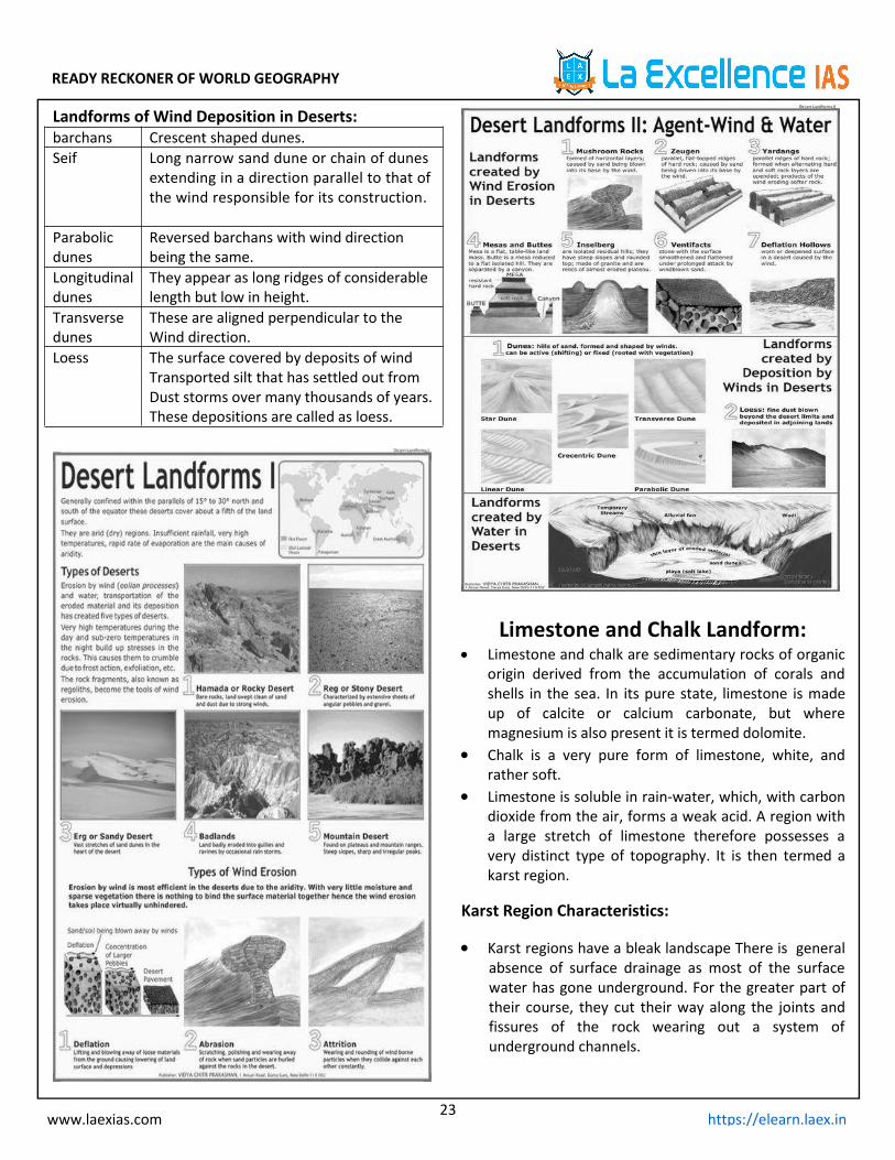
Arid or Desert Landforms:
Almost all deserts lie between 15 to 30 degree northand south of the equator
They lie in trade wind belt on the western part of thecontinents where trade winds are off-shore. They arebathed by cold currents. These currents are devoid ofany moisture
Distinct Desert Types:
1. Hamada orrocky desert
It is a type of desert landscape consistingof high, largely barren, hard rockyplateaus, where most of the sand has beenremoved by deflation.
2. Reg or stonydesert
Desert surface covered with closelypacked, interlocking angular or roundedrock fragments of pebble and cobble size
3. Erg or sandydesert
An erg desert is a broad, flat area of desertcovered with wind-swept sand with littleor no vegetative cover.
4. Badlands
Badlands are a type of dry terrain wheresofter sedimentary rocks and clay-rich soilshave been extensively eroded by wind andwater.
5. Mountaindeserts
Found on plateaus and mountain ranges.Steepslopes, sharp and irregularpeaksare common
Landforms of Wind Erosion in Deserts:1. Rockpedestals ormushroomrocks or gour
A mushroom rock, also called rock pedestal,is a naturally occurring rock whose shape, asits name implies, resembles a mushroom, byerosion and weathering.
2. ZeugenA Zeugen is formed in desert area wherealternating horizontal layers of hard and softrocks occur.
3. Yardangs
a sharp irregular ridge of sand lying in thedirection of the prevailing wind in exposeddesert regions, formed by the wind erosion ofadjacent material which is less resistant.
4. Mesas andbuttes
A mesa is an isolated, flat-topped hill ormountain with steep sides that is smaller inarea than a plateau. A butte is also a flat-topped hill with steep sides, though smaller inarea than a mesa.
5. Inselberg
An inselberg or monadnock is an isolatedrock hill, knob, ridge, or small mountain thatrises abruptly from a gently sloping orvirtually level surrounding plain.
6. Ventifacts a stone shaped by the erosive action of wind-blown sand.
7. Deflationhollows
Dune deflation hollows are where wind hasremoved sand down to a level where a layerof particles too heavy for the wind to movestabilizes the sand and prevents the surfacebeing lowered further.
READY RECKONER OF WORLD GEOGRAPHY
23www.laexias.com https://elearn.laex.in
Landforms of Wind Deposition in Deserts:barchans Crescent shaped dunes.Seif Long narrow sand dune or chain of dunes
extending in a direction parallel to that ofthe wind responsible for its construction.
Parabolicdunes
Reversed barchans with wind directionbeing the same.
Longitudinaldunes
They appear as long ridges of considerablelength but low in height.
Transversedunes
These are aligned perpendicular to theWind direction.
Loess The surface covered by deposits of windTransported silt that has settled out fromDust storms over many thousands of years.These depositions are called as loess.
Limestone and Chalk Landform: Limestone and chalk are sedimentary rocks of organic
origin derived from the accumulation of corals andshells in the sea. In its pure state, limestone is madeup of calcite or calcium carbonate, but wheremagnesium is also present it is termed dolomite.
Chalk is a very pure form of limestone, white, andrather soft.
Limestone is soluble in rain-water, which, with carbondioxide from the air, forms a weak acid. A region witha large stretch of limestone therefore possesses avery distinct type of topography. It is then termed akarst region.
Karst Region Characteristics:
Karst regions have a bleak landscape There is generalabsence of surface drainage as most of the surfacewater has gone underground. For the greater part oftheir course, they cut their way along the joints andfissures of the rock wearing out a system ofunderground channels.

READY RECKONER OF WORLD GEOGRAPHY
24www.laexias.com https://elearn.laex.in
1. Limestonepavement
A limestone pavement is a flat expanse ofexposed limestone formed by a combinationof chemical weathering and erosion
2. Grikes andclints
Pavements are made up of two separate butintegral parts known as clints and grykes.Clints are the blocks of limestone thatconstitute the paving. Grykes are thefissures that isolate the individual clints.
3. Swallowholes
They are small depressions carved out bysolution where rain water sinks into thelimestone at the zone of weakness. It is alsoknown as sinkholes
4. Limestonegorges
These are created where the roof of a largeunderground cavern collapses, to create asteep sided gorge with a river running in thebottom.
5. ResurgenceWhen water flows down a swallow hole itflows underground along bedding planes anddown joints.
6. Uvalaa closed karst depression, a terrain formusually of elongated or compound structureand of larger size than that of sinkholes.
7. Polje It is an elongated basin having a flat floorand steep walls
8. Stalacites A stalactite is a type of formation that hangsfrom the ceiling of caves.
9. StalagmitesA stalagmite is a type of rock formation thatrises from the floor of a cave due to theaccumulation of material deposited on thefloor from ceiling drippings.
Coastal landforms:Coastal landforms, any relief features present along thecoast.
Coastal features of Erosion:
1. Capes andbays
Cape is a piece or point of land, extendingbeyond the adjacent coast into a sea orlake.
Bay is a body of water (especially the sea)more or less three-quarters surroundedby land.
2. Cliffs andwave cutplatforms
Cliffs are formed as erosion landforms bythe processes of weathering and erosion.Cliffs are usually formed by rock that isresistant to weathering and erosion.
Wave-cut platforms form whendestructive waves hit against the cliffface, causing an undercut between thehigh and low water marks, mainly as aresult of abrasion, corrosion andhydraulic action, creating a wave-cutnotch.
3. Cave, arch,stack andstump
Caves occur when waves force their wayinto cracks in the cliff face. The watercontains sand and other materials thatgrind away at the rock until the cracksbecome a cave.If the cave is formed in a headland, it mayeventually break through to the otherside forming an arch.
The arch will gradually become biggeruntil it can no longer support the top ofthe arch. When the arch collapses, itleaves the headland on one side and astack.The stack will be attacked at the base inthe same way that a wave-cut notch isformed. This weakens the structure and itwill eventually collapse to form a stump.
4. Geous andgloups
Geous is an inlet, a gully or a narrow anddeep cleft in the face of a cliff.
Gloupsa blow hole, where a chimney hasdeveloped behind the cliff face, oftenabove a cave, and spray is blasted outduring high seas.
Coastal Features of Deposition:
1. BeachesA beach is a landform alongside a body ofwater which consists of loose particles ofrock, sand etc
2. Bars andspits
A spit is an extended stretch of beachmaterial that projects out to sea and is joinedto the mainland at one end.
When the ridge of shingle beach which isarmoured with pebbles is formed across themouth of a river or the entrance to a bay it iscalled as bar
3. Marinedunes anddunes belt
With the force of on-shore winds, a largeamount of coastal sand is driven landwardsforming extensive marine dunes that stretchinto dune belts

READY RECKONER OF WORLD GEOGRAPHY
25www.laexias.com https://elearn.laex.in
Types of Coasts:
1. Coastlines ofsubmergence
Submergent Coasts are those thathave been flooded by ocean watersbecause of a relative rise in theelevation of sea level at that location.
2. Coastlines ofemergence
Emergent coasts are a result of localtectonic uplift of the land surface or afall in the elevation of sea levelbecause of a reduction in the watervolume of ocean basins. Quite often,emergent coasts have rockycoastlines with cliffs and nearly flatplatforms that extend inland whereolder coastal plains have beentectonically raised and are nowelevated above the modern land andwater interface.
Coastlines of Submergence:
1. Ria coastsRia is a coastal formation that was once ariver valley. It is found along an un-glaciated land.
2. Fiord coastsFiords are submerged U-shaped glacialtroughs. They mark the paths of glaciersthat plunged down from the highlands
3. Dalamationcoasts
It a type of coastline formed when acontinental fold region is submerged but itsterrain basically preserves itscorrespondence to the tectonic structures..
4. Estuarinecoasts
An estuary is a partially enclosed coastalbody of brackish water with one or morerivers or streams flowing into it, and with afree connection to the open sea
Coastlines of Emergence:
1. Upliftedlowland coast
The uplift of the continental shelf producessmooth, gently slopingcoastallowland. Theoffshore waters are shallow with lagoons,salt-marshes and mud-flats
2. Emergentupland coast
Faulting and earth movement may thrust upcoastal plateau so that the whole region israised with consequent emergent features. Araised beach is the most significant example.
READY RECKONER OF WORLD GEOGRAPHY
26www.laexias.com https://elearn.laex.in
Coral Reefs:• Coral Polyps – calcareous algae, shell forming
creatures and lime secreting plants live in largecolonies. When polyp die, skeleton are cemented intocoralline limestone
• Non reef building species – precious coral of PacificOcean & Red coral of Mediterranean Sea.
• Conditions for coral formation-1. Survive best in warmer tropical seas2. Water temperature must not be below 68℉.3. Not flourish in cold currents due to upwelling of cold
waters from depth that cools the warm water surface4. Depth of water should not exceed 30 fathoms or 180
feet as beyond it sunlight is too faint.5. Shallow water of less than 100 feet is ideal.6. Water should be saltish and free from sediments -
corals are best developed on seaward side ofreef –abundant supply of clear oxygenated water.
Types of Coral Reefs:Fringing Reefs: Lies close to coast and extend outwardsfrom mainland separated by shallow lagoon – widest
when fringing protruding headland but absent whenfacing mouth of stream.Patch Reef: Patch Reefs are isolated outcroppings(patches) of coral that are in close proximity to each otherbut are physically separated by sand ringsBarrier Reefs: Separated by wider and deeper channel –partially submerged has narrow gapsat several places toallow water. Great Barrier Reef off the coastofQueenslandAtolls: Circular and enclose shallow lagoon without anyland in center
8. SOILS
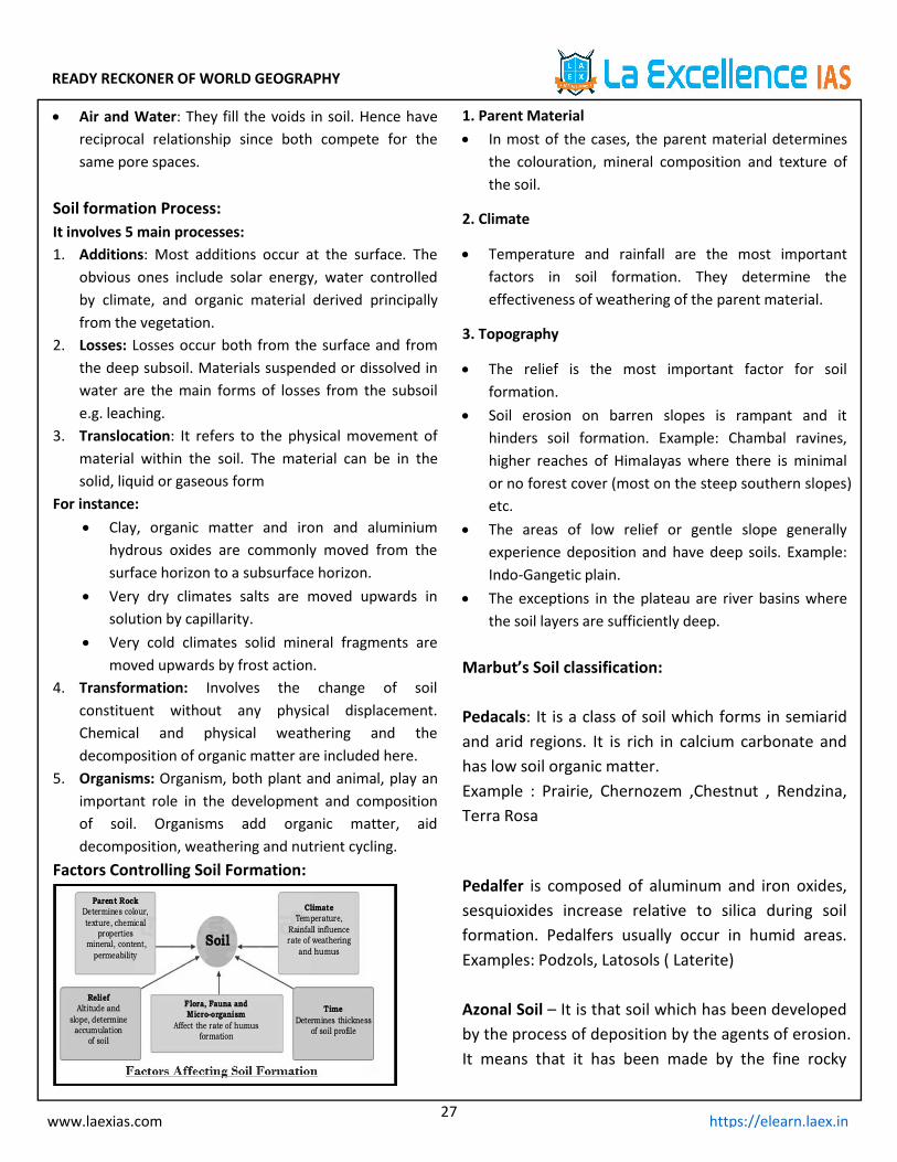
Soil Formation:
Soil is a mixture of organic matter, minerals, gases,liquids, and organisms that together support life.
It is usually formed from weathered rock or regolithchanged by chemical, physical and biological process.
Soils Main Constituents: Mineral Material – It includes all minerals inherited
from the parent material as well as those formed byrecombination from substances in the soil solution.
Organic Matter – It is derived mostly from decayingplant material broken down and decomposed by theactions of animals and microorganisms living in thesoil. (Note: The end product of breakdown of deadorganic material is called humus.)
READY RECKONER OF WORLD GEOGRAPHY
27www.laexias.com https://elearn.laex.in
Air and Water: They fill the voids in soil. Hence havereciprocal relationship since both compete for thesame pore spaces.
Soil formation Process:It involves 5 main processes:1. Additions: Most additions occur at the surface. The
obvious ones include solar energy, water controlledby climate, and organic material derived principallyfrom the vegetation.
2. Losses: Losses occur both from the surface and fromthe deep subsoil. Materials suspended or dissolved inwater are the main forms of losses from the subsoile.g. leaching.
3. Translocation: It refers to the physical movement ofmaterial within the soil. The material can be in thesolid, liquid or gaseous form
For instance: Clay, organic matter and iron and aluminium
hydrous oxides are commonly moved from thesurface horizon to a subsurface horizon.
Very dry climates salts are moved upwards insolution by capillarity.
Very cold climates solid mineral fragments aremoved upwards by frost action.
4. Transformation: Involves the change of soilconstituent without any physical displacement.Chemical and physical weathering and thedecomposition of organic matter are included here.
5. Organisms: Organism, both plant and animal, play animportant role in the development and compositionof soil. Organisms add organic matter, aiddecomposition, weathering and nutrient cycling.
Factors Controlling Soil Formation:
1. Parent Material In most of the cases, the parent material determines
the colouration, mineral composition and texture ofthe soil.
2. Climate
Temperature and rainfall are the most importantfactors in soil formation. They determine theeffectiveness of weathering of the parent material.
3. Topography
The relief is the most important factor for soilformation.
Soil erosion on barren slopes is rampant and ithinders soil formation. Example: Chambal ravines,higher reaches of Himalayas where there is minimalor no forest cover (most on the steep southern slopes)etc.
The areas of low relief or gentle slope generallyexperience deposition and have deep soils. Example:Indo-Gangetic plain.
The exceptions in the plateau are river basins wherethe soil layers are sufficiently deep.
Marbut’s Soil classification:
Pedacals: It is a class of soil which forms in semiaridand arid regions. It is rich in calcium carbonate andhas low soil organic matter.Example : Prairie, Chernozem ,Chestnut , Rendzina,Terra Rosa
Pedalfer is composed of aluminum and iron oxides,sesquioxides increase relative to silica during soilformation. Pedalfers usually occur in humid areas.Examples: Podzols, Latosols ( Laterite)
Azonal Soil – It is that soil which has been developedby the process of deposition by the agents of erosion.It means that it has been made by the fine rocky
READY RECKONER OF WORLD GEOGRAPHY
28www.laexias.com https://elearn.laex.in
particles transported from the far-off regions. Theseare immature soils and lack well-developed soilprofiles.Example: Alluvial and Mountain soils.
9. OCEANOGRAPHY
Oceans: Oceans: 70% or 140 million square miles area is
comprised by oceans Oceanography: Science of oceans and deep seas.
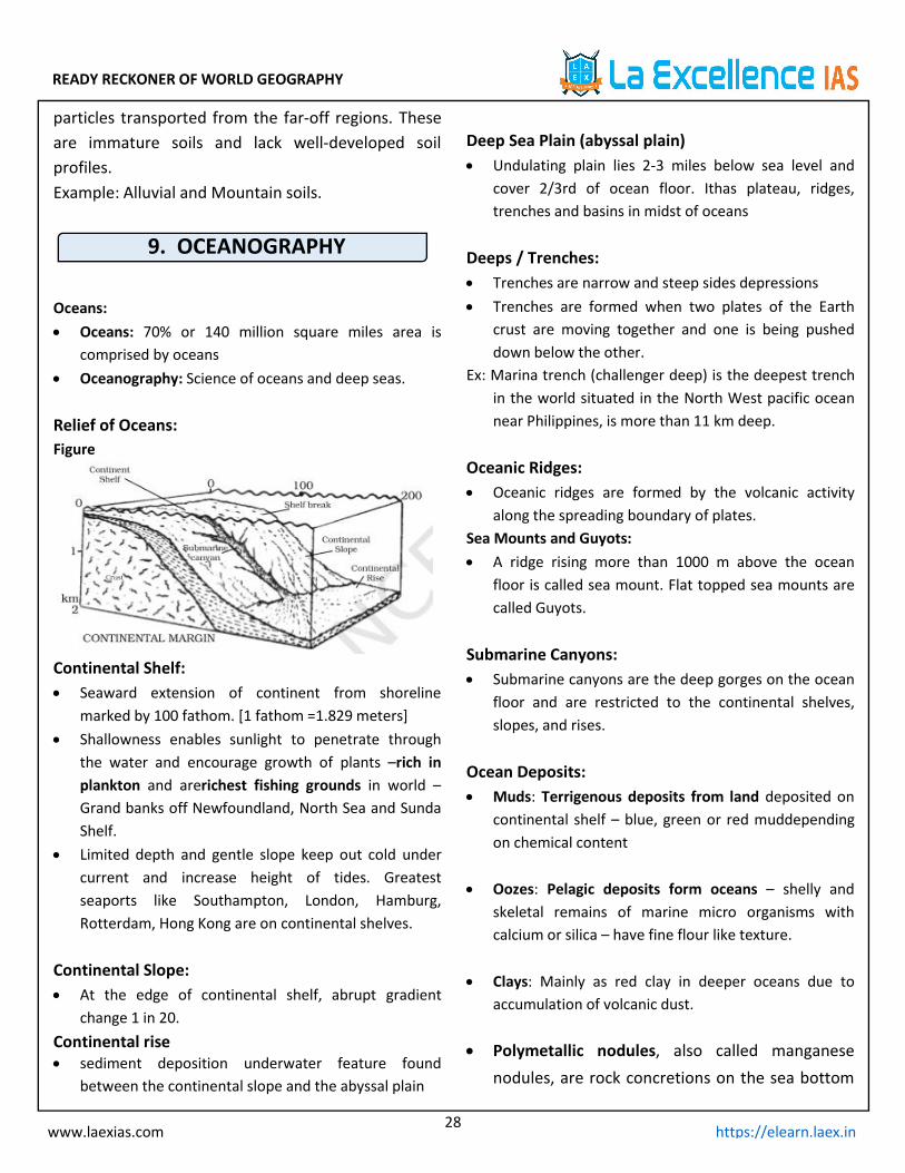
Relief of Oceans:Figure
Continental Shelf: Seaward extension of continent from shoreline
marked by 100 fathom. [1 fathom =1.829 meters] Shallowness enables sunlight to penetrate through
the water and encourage growth of plants –rich inplankton and arerichest fishing grounds in world –Grand banks off Newfoundland, North Sea and SundaShelf.
Limited depth and gentle slope keep out cold undercurrent and increase height of tides. Greatestseaports like Southampton, London, Hamburg,Rotterdam, Hong Kong are on continental shelves.
Continental Slope: At the edge of continental shelf, abrupt gradient
change 1 in 20.Continental rise sediment deposition underwater feature found
between the continental slope and the abyssal plain
Deep Sea Plain (abyssal plain) Undulating plain lies 2-3 miles below sea level and
cover 2/3rd of ocean floor. Ithas plateau, ridges,trenches and basins in midst of oceans
Deeps / Trenches: Trenches are narrow and steep sides depressions Trenches are formed when two plates of the Earth
crust are moving together and one is being pusheddown below the other.
Ex: Marina trench (challenger deep) is the deepest trenchin the world situated in the North West pacific oceannear Philippines, is more than 11 km deep.
Oceanic Ridges: Oceanic ridges are formed by the volcanic activity
along the spreading boundary of plates.Sea Mounts and Guyots: A ridge rising more than 1000 m above the ocean
floor is called sea mount. Flat topped sea mounts arecalled Guyots.
Submarine Canyons: Submarine canyons are the deep gorges on the ocean
floor and are restricted to the continental shelves,slopes, and rises.
Ocean Deposits: Muds: Terrigenous deposits from land deposited on
continental shelf – blue, green or red muddependingon chemical content
Oozes: Pelagic deposits form oceans – shelly andskeletal remains of marine micro organisms withcalcium or silica – have fine flour like texture.
Clays: Mainly as red clay in deeper oceans due toaccumulation of volcanic dust.
Polymetallic nodules, also called manganesenodules, are rock concretions on the sea bottom
READY RECKONER OF WORLD GEOGRAPHY
29www.laexias.com https://elearn.laex.in
formed of concentric layers of iron andmanganese hydroxides around a core. As nodulescan be found in vast quantities, and containvaluable metals, deposits have been identified ashaving economic interest
Salinity Degree of saltness in water NaCl or common salt form 77% of dissolved mineral
matter. Other salts include magnesium, calcium,potassium.
Due to free movement, salts remain remarkablyconstant in all oceans and even at great depths– butdegree of concentration varies
Average salinity is 35.2 parts per thousand. Baltic Sea (dilution of fresh water) – salinity is 7 parts
per thousand. Red Sea – much surface evaporation and fewer rivers
draining into it – salinity is 39 parts per thousand Caspian Sea – enclosed sea with salinity at 180 Dead Sea it is around 250. Lake Van (Asia Minor) at 330 highest salinity. With high density in Lake Van and Dead Sea it is
impossible to sink (beginner swimmers find it easierto float).
Salinity is Affected by:1. Rate of evaporation: water fringing the High pressure
belts of trade wind desertshave Highsalinity caused byhigh temperature and low humidity.Temperate oceans have low salinity due to lowerevaporation & temperature.
2. Fresh water is added by precipitation, streams andicebergs – salinity is low in equatorial region due toheavy rainfall and high relative humidity.
Baltic, Arctic and Antarctic waters have lowsalinitydue to colder climate and little evaporation – as wateris added by melting of icebergs and rivers.
3. Degree of water mixing by currents: Water does notmix freely with ocean waters in enclosed seas andsalinity is high.
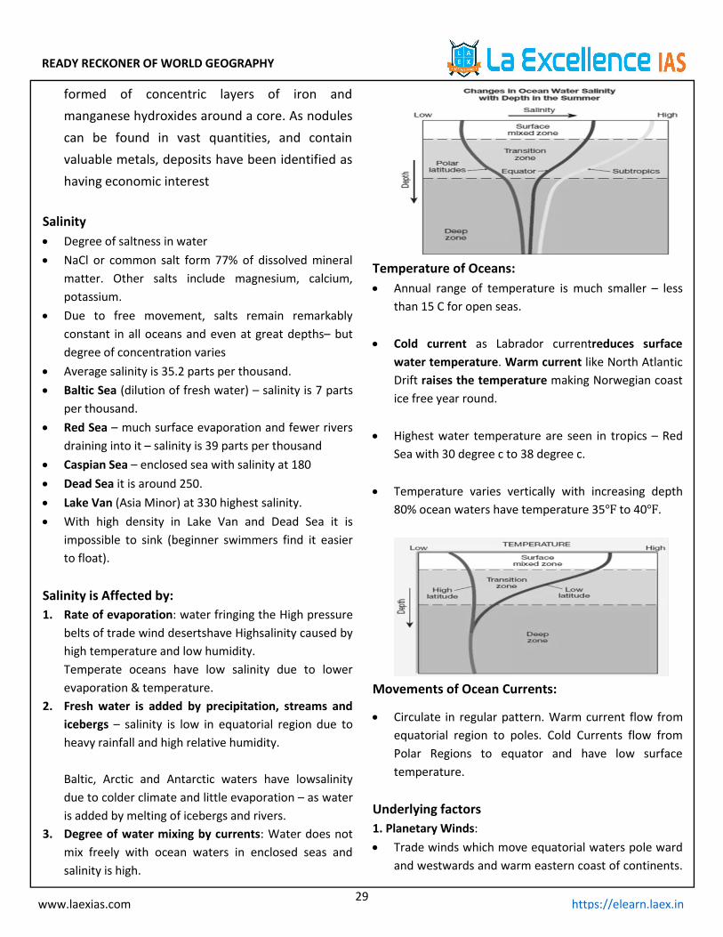
Temperature of Oceans: Annual range of temperature is much smaller – less
than 15 C for open seas.
Cold current as Labrador currentreduces surfacewater temperature. Warm current like North AtlanticDrift raises the temperature making Norwegian coastice free year round.
Highest water temperature are seen in tropics – RedSea with 30 degree c to 38 degree c.
Temperature varies vertically with increasing depth80% ocean waters have temperature 35℉ to 40℉.
Movements of Ocean Currents:
Circulate in regular pattern. Warm current flow fromequatorial region to poles. Cold Currents flow fromPolar Regions to equator and have low surfacetemperature.
Underlying factors1. Planetary Winds: Trade winds which move equatorial waters pole ward
and westwards and warm eastern coast of continents.
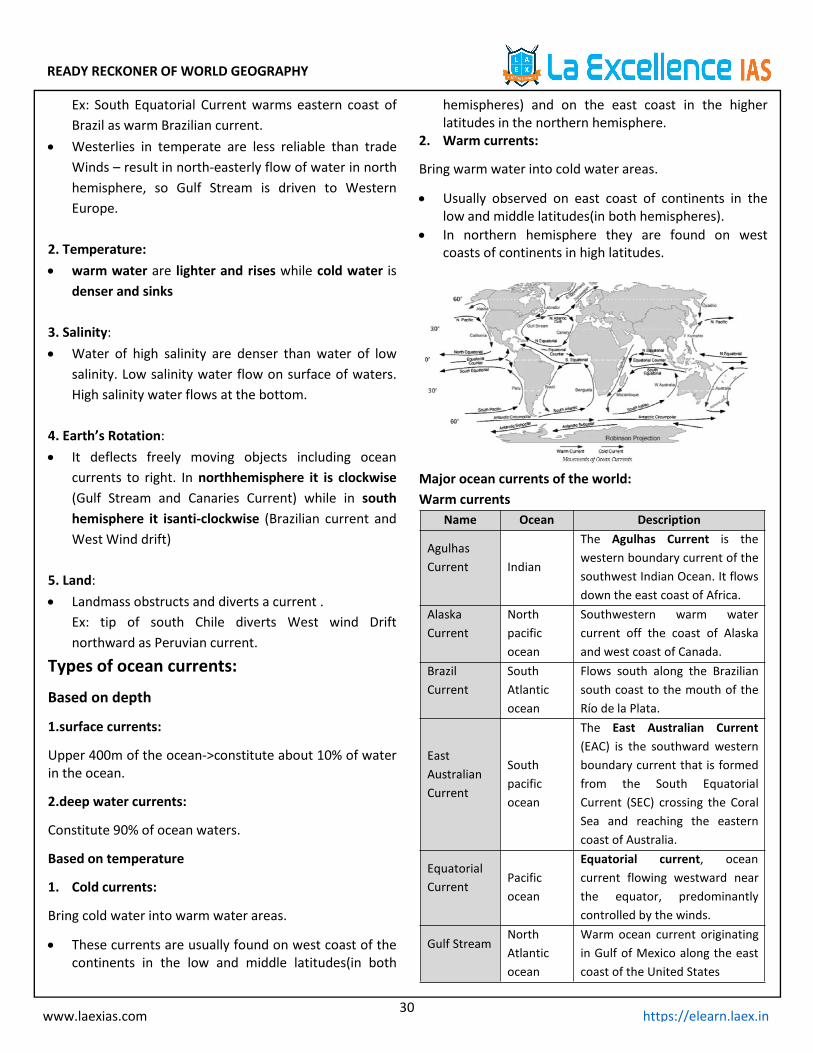
READY RECKONER OF WORLD GEOGRAPHY
30www.laexias.com https://elearn.laex.in
Ex: South Equatorial Current warms eastern coast ofBrazil as warm Brazilian current.
Westerlies in temperate are less reliable than tradeWinds – result in north-easterly flow of water in northhemisphere, so Gulf Stream is driven to WesternEurope.
2. Temperature: warm water are lighter and rises while cold water is
denser and sinks
3. Salinity: Water of high salinity are denser than water of low
salinity. Low salinity water flow on surface of waters.High salinity water flows at the bottom.
4. Earth’s Rotation: It deflects freely moving objects including ocean
currents to right. In northhemisphere it is clockwise(Gulf Stream and Canaries Current) while in southhemisphere it isanti-clockwise (Brazilian current andWest Wind drift)
5. Land: Landmass obstructs and diverts a current .
Ex: tip of south Chile diverts West wind Driftnorthward as Peruvian current.
Types of ocean currents:
Based on depth
1.surface currents:
Upper 400m of the ocean->constitute about 10% of waterin the ocean.
2.deep water currents:
Constitute 90% of ocean waters.
Based on temperature
1. Cold currents:
Bring cold water into warm water areas.
These currents are usually found on west coast of thecontinents in the low and middle latitudes(in both
hemispheres) and on the east coast in the higherlatitudes in the northern hemisphere.
2. Warm currents:
Bring warm water into cold water areas.
Usually observed on east coast of continents in thelow and middle latitudes(in both hemispheres).
In northern hemisphere they are found on westcoasts of continents in high latitudes.
Major ocean currents of the world:Warm currents
Name Ocean Description
AgulhasCurrent Indian
The Agulhas Current is thewestern boundary current of thesouthwest Indian Ocean. It flowsdown the east coast of Africa.
AlaskaCurrent
Northpacificocean
Southwestern warm watercurrent off the coast of Alaskaand west coast of Canada.
BrazilCurrent
SouthAtlanticocean
Flows south along the Braziliansouth coast to the mouth of theRío de la Plata.
EastAustralianCurrent
Southpacificocean
The East Australian Current(EAC) is the southward westernboundary current that is formedfrom the South EquatorialCurrent (SEC) crossing the CoralSea and reaching the easterncoast of Australia.
EquatorialCurrent
Pacificocean
Equatorial current, oceancurrent flowing westward nearthe equator, predominantlycontrolled by the winds.
Gulf StreamNorthAtlanticocean
Warm ocean current originatingin Gulf of Mexico along the eastcoast of the United States
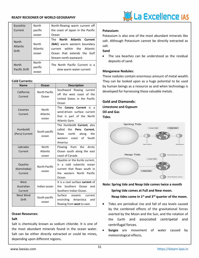
READY RECKONER OF WORLD GEOGRAPHY
31www.laexias.com https://elearn.laex.in
KuroshioCurrent
Northpacificocean
North-flowing warm current offthe coast of Japan in the PacificOcean
NorthAtlanticDrift
NorthAtlanticocean
The North Atlantic Current(NAC) warm western boundarycurrent within the AtlanticOcean that extends the GulfStream north-eastward.
NorthPacific Drift
Northpacificocean
The North Pacific Current is aslow warm water current
Cold Currents:Name Ocean Description
CaliforniaCurrent
North PacificOcean
Southward flowing currentoff the west coast of theUnited States in the PacificOcean
CanariesCurrent
NorthAtlanticocean
The Canary Current is awind-driven surface currentthat is part of the NorthAtlantic Gyre.
Humboldt(Peru) Current
South pacificocean
The Humboldt Current, alsocalled the Peru Current,flows north along thewestern coast of SouthAmerica
LabradorCurrent
NorthAtlanticocean
Flowing from the ArcticOcean south along the eastcoast of Canada
Oyashio(Kamchatka)
Current
North Pacificocean
Oyashio or the Kurile current,is a cold subarctic oceancurrent that flows south inthe western North PacificOcean.
WestAustralianCurrent
Indian oceanIt is a cool surface current ofthe Southern Ocean andSouthern Indian Ocean.
West WindDrift
South pacificocean
Surface oceanic currentencircling Antarctica andflowing fromwest to east.
Ocean Resources:SaltSalt is chemically known as sodium chloride. It is one ofthe most abundant minerals found in the ocean water.Salt can be either directly extracted or could be mines,depending upon different regions.
Potassium:Potassium is also one of the most abundant minerals likesalt. Although Potassium cannot be directly extracted assalt.Sand The sea beaches can be understood as the residual
deposits of sand.
Manganese Nodules:These nodules contain enormous amount of metal wealth.They can be looked upon as a huge potential to be usedby human beings as a resource as and when technology isdeveloped for harnessing these valuable metals.
Gold and Diamonds:Limestone and GypsumOil and GasTides
Note: Spring tide and Neap tide comes twice a month
Spring tide comes at Full and New moon.
Neap tides come in 1st and 3rd quarter of the moon.
Tides are periodical rise and fall of sea levels causedby the combined effects of the gravitational forcesexerted by the Moon and the Sun, and the rotation ofthe Earth and associated centripetal andcentrifugal forces.
Surges are movement of water caused bymeteorological effects.
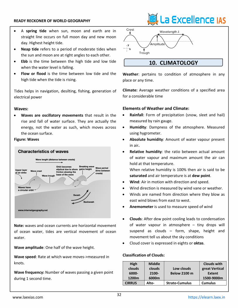
READY RECKONER OF WORLD GEOGRAPHY
32www.laexias.com https://elearn.laex.in
A spring tide when sun, moon and earth are instraight line occurs on full moon day and new moonday. Highest height tide.
Neap tide refers to a period of moderate tides whenthe sun and moon are at right angles to each other.
Ebb is the time between the high tide and low tidewhen the water level is falling.
Flow or flood is the time between low tide and thehigh tide when the tide is rising.
Tides helps in navigation, desilting, fishing, generation ofelectrical power
Waves: Waves are oscillatory movements that result in the
rise and fall of water surface. They are actually theenergy, not the water as such, which moves acrossthe ocean surface.
Figure: Waves
Note: waves and ocean currents are horizontal movementof ocean water, tides are vertical movement of oceanwater.
Wave amplitude: One half of the wave height.
Wave speed: Rate at which wave moves->measured inknots.
Wave frequency: Number of waves passing a given pointduring 1 second time.
10. CLIMATOLOGY
Weather: pertains to condition of atmosphere in anyplace or any time.
Climate: Average weather conditions of a specified areafor a considerable time
Elements of Weather and Climate: Rainfall: Form of precipitation (snow, sleet and hail)
measured by rain gauge. Humidity: Dampness of the atmosphere. Measured
using hygrometer. Absolute humidity: Amount of water vapour present
in air. Relative humidity: the ratio between actual amount
of water vapour and maximum amount the air canhold at that temperature.When relative humidity is 100% then air is said to besaturated and air temperature is at dew point.
Wind: Air in motion with direction and speed. Wind direction is measured by wind vane or weather. Winds are named from direction where they blow as
east wind blows from east to west. Anemometer is used to measure speed of wind
Clouds: After dew point cooling leads to condensationof water vapour in atmosphere – tiny drops willsuspend as clouds – form, shape, height andmovement tell us about the sky conditions
Cloud cover is expressed in eights or oktas.
Classification of Clouds:
Highclouds6000-1200m
Middleclouds2100-6000m
Low cloudsBelow 2100 m
Clouds withgreat Vertical
Extent1500-9000m
CIRRUS Alto- Strato-Cumulus Cumulus
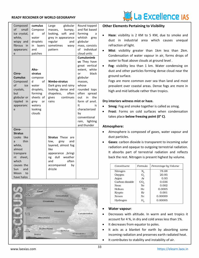
READY RECKONER OF WORLD GEOGRAPHY
33www.laexias.com https://elearn.laex.in
Composedof smallice crystal,white,wispy andfibrous inappearance
cumulusComposed ofwaterdropletsin layersandpatches
Large globularmasses, bumpy,looking, soft andgrey in appearanceregular andsometimes wavypattern
Round toppedand flat basedforming awhitish greyglobularmass, consistsof individualcloud units
Cirro-CumulusComposedof icecrystals,butglobular orrippled inappearance
Alto-stratuscomposed ofwaterdroplets,formingsheets ofgrey orwaterylookingclouds
Nimbo-stratusDark grey and rainylooking, dense andshapeless, oftengives continuesrains
Cumulonimbus They havegreat verticalextent, whiteor blackglobularmasses,whoserounded topsoften spreadout in theform of anvil.It ischaracterizedbyconventionalrain, lightingand thunder
Cirro-StratusLooks likea thinwhite,almosttransparent sheet,whichcauses theSun andMoon tohave halos
Stratus These arelow, grey andlayered, almost foglikeappearance ,bringing dull weatherand oftenaccompanied bydrizzle
Other Elements Pertaining to Visibility
Haze: visibility is 2 KM to 5 KM, due to smoke anddust in industrial area which causes unequalrefraction of light.
Mist: visibility greater than 1km less than 2km.Condensation of water vapour in air, forms drops ofwater to float above clouds at ground level .
Fog: visibility less than 1 km. Water condensing ondust and other particles forming dense cloud near theground surface.Fogs are more common over sea than land and mostprevalent over coastal areas. Dense fogs are more inhigh and mid latitude rather than tropics.
Dry interiors witness mist or haze. Smog: Fog and smoke together is called as smog. Frost: Forms on cold surfaces when condensation
takes place below freezing point (0° C).
Atmosphere: Atmosphere is composed of gases, water vapour and
dust particles. Gases: carbon dioxide is transparent to incoming solar
radiation and opaque to outgoing terrestrial radiation.It absorbs part of terrestrial radiation and reflectsback the rest. Nitrogen is present highest by volume.
Water vapour: Decreases with altitude. In warm and wet tropics it
account for 4 %, in dry and cold areas less than 1%. It decreases from equator to poles. It acts as a blanket for earth by absorbing some
incoming radiation and preserves earth radiated heat. It contributes to stability and instability of air.
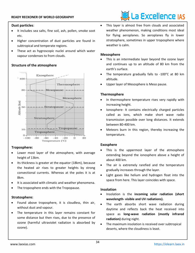
READY RECKONER OF WORLD GEOGRAPHY
34www.laexias.com https://elearn.laex.in
Dust particles: It includes sea salts, fine soil, ash, pollen, smoke soot
etc. Higher concentration of dust particles are found in
subtropical and temperate regions. These act as hygroscopic nuclei around which water
vapour condenses to from clouds.
Structure of the atmosphere
Troposphere: Lower most layer of the atmosphere, with average
height of 13km. Its thickness is greater at the equator (18km), because
the heated air rises to greater heights by strongconvectional currents. Whereas at the poles it is at8km.
It is associated with climatic and weather phenomena. The troposphere ends with the Tropopause.
Stratosphere: Found above troposphere, it is cloudless, thin air,
without dust and vapour. The temperature in this layer remains constant for
some distance but then rises, due to the presence ofozone (harmful ultraviolet radiation is absorbed byozone).
This layer is almost free from clouds and associatedweather phenomenon, making conditions most idealfor flying aeroplanes. So aeroplanes fly in lowerstratosphere, sometimes in upper troposphere whereweather is calm.
Mesosphere This is an intermediate layer beyond the ozone layer
and continues up to an altitude of 80 km from theearth’s surface.
The temperature gradually falls to -100°C at 80 kmaltitude.
Upper layer of Mesosphere is Meso pause.
Thermosphere In thermosphere temperature rises very rapidly with
increasing height. Ionosphere- It contains electrically charged particles
called as ions, which make short wave radiotransmission possible over long distances. It extendsbetween 80-400 km.
Meteors burn in this region, thereby increasing thetemperature.
Exosphere This is the uppermost layer of the atmosphere
extending beyond the ionosphere above a height ofabout 400 km.
The air is extremely rarefied and the temperaturegradually increases through the layer.
Light gases like helium and hydrogen float into thespace from here. This layer coincides with space.
Insolation Insolation is the incoming solar radiation (short
wavelength- visible and UV radiations). The earth absorbs short wave radiation during
daytime and reflects back the heat received intospace as long-wave radiation (mostly infraredradiation) during night.
The maximum insolation is received over subtropicaldeserts, where the cloudiness is least.
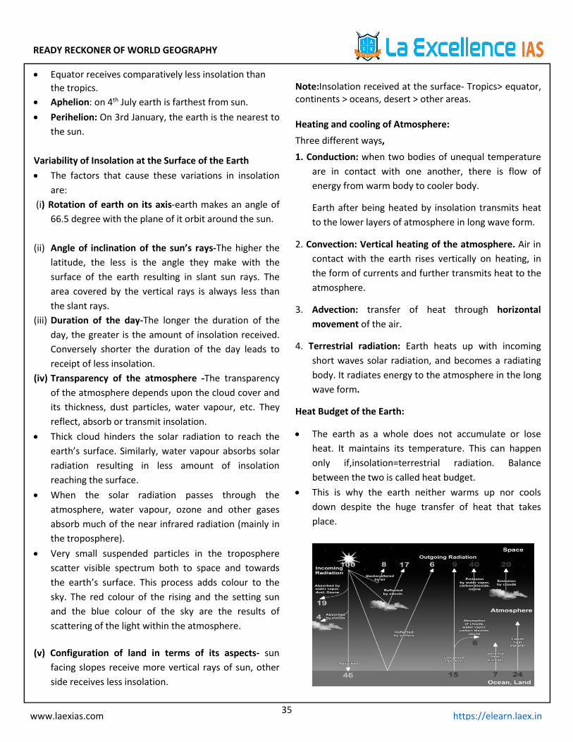
READY RECKONER OF WORLD GEOGRAPHY
35www.laexias.com https://elearn.laex.in
Equator receives comparatively less insolation thanthe tropics.
Aphelion: on 4th July earth is farthest from sun. Perihelion: On 3rd January, the earth is the nearest to
the sun.
Variability of Insolation at the Surface of the Earth The factors that cause these variations in insolation
are:(i) Rotation of earth on its axis-earth makes an angle of
66.5 degree with the plane of it orbit around the sun.
(ii) Angle of inclination of the sun’s rays-The higher thelatitude, the less is the angle they make with thesurface of the earth resulting in slant sun rays. Thearea covered by the vertical rays is always less thanthe slant rays.
(iii) Duration of the day-The longer the duration of theday, the greater is the amount of insolation received.Conversely shorter the duration of the day leads toreceipt of less insolation.
(iv) Transparency of the atmosphere -The transparencyof the atmosphere depends upon the cloud cover andits thickness, dust particles, water vapour, etc. Theyreflect, absorb or transmit insolation.
Thick cloud hinders the solar radiation to reach theearth’s surface. Similarly, water vapour absorbs solarradiation resulting in less amount of insolationreaching the surface.
When the solar radiation passes through theatmosphere, water vapour, ozone and other gasesabsorb much of the near infrared radiation (mainly inthe troposphere).
Very small suspended particles in the tropospherescatter visible spectrum both to space and towardsthe earth’s surface. This process adds colour to thesky. The red colour of the rising and the setting sunand the blue colour of the sky are the results ofscattering of the light within the atmosphere.
(v) Configuration of land in terms of its aspects- sunfacing slopes receive more vertical rays of sun, otherside receives less insolation.
Note:Insolation received at the surface- Tropics> equator,continents > oceans, desert > other areas.
Heating and cooling of Atmosphere:Three different ways,1. Conduction: when two bodies of unequal temperature
are in contact with one another, there is flow ofenergy from warm body to cooler body.
Earth after being heated by insolation transmits heatto the lower layers of atmosphere in long wave form.
2. Convection: Vertical heating of the atmosphere. Air incontact with the earth rises vertically on heating, inthe form of currents and further transmits heat to theatmosphere.
3. Advection: transfer of heat through horizontalmovement of the air.
4. Terrestrial radiation: Earth heats up with incomingshort waves solar radiation, and becomes a radiatingbody. It radiates energy to the atmosphere in the longwave form.
Heat Budget of the Earth:
The earth as a whole does not accumulate or loseheat. It maintains its temperature. This can happenonly if,insolation=terrestrial radiation. Balancebetween the two is called heat budget.
This is why the earth neither warms up nor coolsdown despite the huge transfer of heat that takesplace.

READY RECKONER OF WORLD GEOGRAPHY
36www.laexias.com https://elearn.laex.in
Albedo: Reflected amount of radiation from the earth surface. The value of albedo will be different for different
surfaces. Because of the effect of albedo, highly developed
areas such as urban cities can experience higheraverage temperatures than the surrounding suburbanor rural areas, a phenomenon known as the “UrbanHeat Island Effect”.
Highest albedo- snow > clouds> sand> grass> crops>forest
Elements of Climate and Factors Affecting ThemThe temperature of air at any place is influenced by
1. Latitude: The temperature of a place depends on theinsolation received. Where ever there is vertical raysof sun, intense heating happens. Slant rays causes lessheating and temperature also less.
2. Altitude: The atmosphere is indirectly heated byterrestrial radiation from below through conduction.The temperature generally decreases with increasingheight. The rate of decrease of temperature withheight is termed as the Normal lapse rate. It is 6.5°Cper 1,000 m.
3. Continentality: Land is heated more quickly thanwater , because of higher specific heat of water.There by causing warm summers, cool winters andgreat temperature range for continental interiors.
4. Ocean Currents and Air Mass: Like the land and seabreezes, the passage of air masses also affects thetemperature. The places, which come under theinfluence of warm air-masses experience highertemperature and the places that come under theinfluence of cold air masses experience lowtemperature.
Similarly, the places located on the coast where the warmocean currents flow record higher temperature than theplaces located on the coast where the cold currents flow.
5. Slope, Shelter and Aspect: Steep slope experiences arapid change in temperature. Mountain ranges havingEast west alignment have higher temperature onsouth facing sunny slope (good for vine cultivation)than thenorth facing sheltered slope.
Hot day followed by calm night ,air cools more rapidlyover higher grounds and may induce cold heavy air toflow down the slope and accumulate in valley bottompushing warm air upwards(temperature would belower in valley than above this reversal of lapse rate iscalled as Temperature Inversion)
6. Distance from the Sea: Compared to land, the seagets heated slowly and loses heat slowly. Land heatsup and cools down quickly. Therefore, the variation intemperature over the sea is less compared to land.The places situated near the sea come under themoderating influence of the sea and land breezeswhich moderate the temperature.
7. Natural Vegetation and Soil –Thick foliage of Amazoncuts incoming insolation and sunlight does not reachground.
In day trees loose water by evapo-transpiration so theair above is cooled.
Light soil reflects more heat than darker soil which isbetter absorbers.
Dry soil like sand are more sensitive to temperaturechanges while wet soil retain moisture and warm upand cool down more slowly.
Inversion of Temperature:
Normally, temperature decreases with increase inelevation. It is called normal lapse rate. At times, thesituations is reversed and the normal lapse rate isinverted. It is called Inversion of temperature.
A long winter night with clear skies and still air is idealsituation for inversion. The heat of the day is radiatedoff during the night, and by early morning hours, theearth is cooler than the air above. Over polar areas,temperature inversion is normal throughout the year.
READY RECKONER OF WORLD GEOGRAPHY
37www.laexias.com https://elearn.laex.in
Surface inversion : promotes stability in the lowerlayers of the atmosphere. Smoke and dust particlesget collected beneath the inversion layer and spreadhorizontally to fill the lower strata of the atmosphere.Dense fogs in mornings are common occurrencesespecially during winter season. This inversioncommonly lasts for few hours until the sun comes upand begins to warm the earth.
The inversion takes place in hills and mountains dueto air drainage. Cold air at the hills and mountains,produced during night, flows under the influence ofgravity. Being heavy and dense, the cold air actsalmost like water and moves down the slope to pileup deeply in pockets and valley bottoms with warmair above. This is called air drainage. It protects plantsfrom frost damages.
Precipitation: The process of continuous condensation in free air
helps the condensed particles to grow in size. Whenthe resistance of the air fails to hold them against theforce of gravity, they fall on to the earth’s surface. Soafter the condensation of water vapour, the release ofmoisture is known as precipitation.
In simple terms we can summarise precipitation asthe following
Rainfall: drop size more than 0.5 mm. Virga: raindrops evaporate before reaching the earth. Drizzle: light rainfall; drop size less than 0.5 mm. Mist: evaporation occurs before reaching the ground
leading to foggy weather. Snowfall: fine flakes of snow fall when the
temperature is less than 0°C. Sleet: frozen raindrops and refrozen melted snow;
mixture of snow and rain or merely partially meltedsnow.
Hail: precipitation in the form of hard rounded pelletsis known as hail; 5 mm and 50 mm.
Types of Rainfall:
On the basis of origin, rainfall may be classified into threemain types,1. Convectional rainfall: The, air on being heated,
becomes light and rises up in convection currents. Asit rises, it expands and loses heat and consequently,condensation takes place and cumulous clouds areformed. With thunder and lightning, heavy rainfalltakes place.
Common in summer/ hot days/ equatorial regions/earth’s interiors.
2. Orographic rainfall or relief rain: When the saturatedair mass comes across a mountain, it is forced toascend and as it rises, it expands; the temperaturefalls, and the moisture is condensed.
After giving rain on the windward side, when thesewinds reach the other slope, they descend, and theirtemperature rises, leeward slopes remain rainless anddry. Leeward side also called as rain shadow region.
3. Cyclonic or Frontal Rain: purely associated withcyclonic activity. Tropicl regions with cyclones andtemperate regions with depressions. When two airmasses with different temperatures meet, turbulentconditions are produced. Along the front convectionoccurs and causes precipitation. This is called Frontalrainfall.
Polar Vortex: The Earth's atmosphere has two polar vortices which
are overlying the North and South Poles. Each polarvortex is a persistent, large-scale, low-pressure zone,that rotates counter-clockwise at the North Pole(called a cyclone) and clockwise at the South Pole, i.e.,both polar vortices rotate eastward around the poles.
These cold blasts of arctic air are bottled up by thestrong jet stream or polar jet stream which iscirculated at the high latitudes.
Even though research claims that there is no directrelation between the Polar Vortex and Indian weatherbut the Arctic winds influence atmospheric circula -tions, weather systems, including the westerndisturbance.
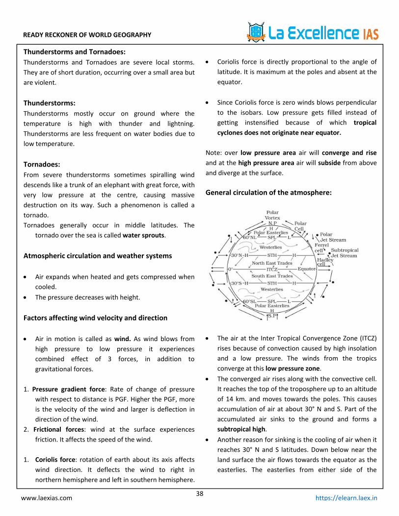
READY RECKONER OF WORLD GEOGRAPHY
38www.laexias.com https://elearn.laex.in
Thunderstorms and Tornadoes:Thunderstorms and Tornadoes are severe local storms.They are of short duration, occurring over a small area butare violent.
Thunderstorms:Thunderstorms mostly occur on ground where thetemperature is high with thunder and lightning.Thunderstorms are less frequent on water bodies due tolow temperature.
Tornadoes:From severe thunderstorms sometimes spiralling winddescends like a trunk of an elephant with great force, withvery low pressure at the centre, causing massivedestruction on its way. Such a phenomenon is called atornado.Tornadoes generally occur in middle latitudes. The
tornado over the sea is calledwater sprouts.
Atmospheric circulation and weather systems
Air expands when heated and gets compressed whencooled.
The pressure decreases with height.
Factors affecting wind velocity and direction
Air in motion is called as wind. As wind blows fromhigh pressure to low pressure it experiencescombined effect of 3 forces, in addition togravitational forces.
1. Pressure gradient force: Rate of change of pressurewith respect to distance is PGF. Higher the PGF, moreis the velocity of the wind and larger is deflection indirection of the wind.
2. Frictional forces: wind at the surface experiencesfriction. It affects the speed of the wind.
1. Coriolis force: rotation of earth about its axis affectswind direction. It deflects the wind to right innorthern hemisphere and left in southern hemisphere.
Coriolis force is directly proportional to the angle oflatitude. It is maximum at the poles and absent at theequator.
Since Coriolis force is zero winds blows perpendicularto the isobars. Low pressure gets filled instead ofgetting instensified because of which tropicalcyclones does not originate near equator.
Note: over low pressure area air will converge and riseand at the high pressure area air will subside from aboveand diverge at the surface.
General circulation of the atmosphere:
The air at the Inter Tropical Convergence Zone (ITCZ)rises because of convection caused by high insolationand a low pressure. The winds from the tropicsconverge at this low pressure zone.
The converged air rises along with the convective cell.It reaches the top of the troposphere up to an altitudeof 14 km. and moves towards the poles. This causesaccumulation of air at about 30° N and S. Part of theaccumulated air sinks to the ground and forms asubtropical high.
Another reason for sinking is the cooling of air when itreaches 30° N and S latitudes. Down below near theland surface the air flows towards the equator as theeasterlies. The easterlies from either side of the
READY RECKONER OF WORLD GEOGRAPHY
39www.laexias.com https://elearn.laex.in
equator converge in the Inter Tropical ConvergenceZone (ITCZ).
Such circulations from the surface upwards and vice-versa are called cells. Such a cell in the tropics is calledHadley Cell.
In the middle latitudes the circulation is that ofsinking cold air that comes from the poles and therising warm air that blows from the subtropical high.At the surface these winds are called westerlies andthe cell is known as the Ferrel cell.
At polar latitudes the cold dense air subsides near thepoles and blows towards middle latitudes as the polareasterlies. This cell is called the polar cell.
These three cells set the pattern for the generalcirculation of the atmosphere. The transfer of heatenergy form lower latitudes to higher latitudesmaintains the general circulation.
Pressure BeltsThere are distinctly identifiable zones of homogeneoushorizontal pressure regimes or ‘pressure belts’. On theearth’s surface, the following are the various pressurebelts1. Equatorial low.2. The sub-tropical highs.3. The sub-polar lows.4. The polar highs.
Equatorial Low Pressure Belt or ‘Doldrums’ Lies between 10°N and 10°S latitudes. Width may vary between 5°N and 5°S and 20°N and
20°S. This belt happens to be the zone of convergence of
trade winds from two hemispheres from sub-tropicalhigh pressure belts.
This belt is also called the Doldrums, because of theextremely calm air movements.
The position of the belt varies with the apparentmovement of the Sun.
Formation: As this region lies along the equator, itreceives highest amount of insolation. Due to intenseheating, air gets warmed up and rises over theequatorial region (convection).Whenever there is
vertically upward movement of air, the region at thesurface will be at low pressure. Thus the belt alongthe equator is called equatorial low pressure belt.
Climate: This belt is characterized by extremely lowpressure with calm conditions. Vertical winds(convection) carrying moisture form cumulonimbusclouds and lead to thunderstorms (convectionalrainfall).
Sub-Tropical High Pressure Belt or Horse Latitudes The corresponding latitudes of sub-tropical high
pressure belt are called horse latitudes. After saturation (complete loss of moisture) at the
Inter Tropical Convergence Zone (ITCZ), the airmoving away from equatorial low pressure belt in theupper troposphere becomes dry and cold. This dryand cold wind subsides at 30°N and S.
So the high pressure along this belt is due tosubsidence of air coming from the equatorial regionwhich descends after becoming heavy. The highpressure is also due to the blocking effect of air atupper levels because of the Coriolis force.
The subsiding air is warm and dry; therefore, most of thedeserts are present along this belt, in both hemispheres.This belt is frequently invaded by tropical and extra-tropical disturbances.
Sub-Polar Low Pressure Belt Located between 45°N and S latitudes and the Arctic
and the Antarctic circles (66.5° N and S latitudes) These are dynamically produced due to1. Coriolis Force produced by rotation of the earth on its
axis,2. Ascent of air as a result of convergence of Westerlies
and polar easterlies. Due to a great contrast between the temperatures of
the winds from sub-tropical and polar source regions,extra tropical cyclonic storms or lows’ (temperatecyclones or frontal cyclones) are produced in thisregion
READY RECKONER OF WORLD GEOGRAPHY
40www.laexias.com https://elearn.laex.in
Polar High Pressure Belt: The polar highs are small in area and extend around
the poles. They lie around poles between 80 – 90° Nand S latitudes.
The air from sub-polar low pressure belts aftersaturation becomes dry. This dry air becomes coldwhile moving towards poles through uppertroposphere.
The lowest temperatures are found over the poles.Planetary Winds:The winds blowing throughout the year from highpressure belts to low pressure belts in the same directionare called “planetary or prevailing winds”.
Due to the effect of the rotation of the earth, thedirection of the winds tends to deflect, instead of blowingdirectly from one pressure belt to another. These windsblow throughout the year and are controlled by thelatitudinal pressure belts. They blow over vast area ofcontinents and oceans.
The main planetary winds are:1. Trade winds2. Westerlies3. Polar Easterlies
Planetarywind Features
Tradewinds
Trade winds blow in a belt lying between5°N-30°N in the northern hemisphere and5°S-30°S in the southern hemisphere
There is low pressure on the equator,while high pressure at the sub tropics. So,air moves from tropics toward equator.
The trade winds in the Northern-Hemisphere blow from the north-eastdirection due to the deflection of thewind caused by the rotation of the Earthand so are called North-East Trades.
Similarly, the trade winds in the Southern-Hemisphere blow from the South-Eastdirection and thus called south-EastTrades.
They are also known as Tropicaleasterlies.
Westerlies
The Westerlies blow from sub tropicalhigh pressure belts towards sub-polar lowpressure belts.
The Westerlies of Southern Hemisphereblow with great strength and constant indirection than Northern Hemisphere.
Under the Coriolis force effect, theWesterlies become the South-Westerliesin the northern hemisphere and theNorth-Westerlies in the southernhemisphere.
Westerlies winds are named as roaringforties, furious fifties, screaming sixtiesbased on the speed of the wind
Polareasterlies
The Polar easterlies are dry, coldprevailing winds that blow from the Polarhigh pressure belts to the Temperaturelow pressure belts
They are extremely cold winds as theyblow from the Tundra and Icecap regions.The Polar Easterlies are more regular inthe southern hemisphere than in thenorthern hemisphere.
Unlike the Westerlies, the polar easterliesare often weak and irregular.
Local Winds: Local winds occur on a small spatial scale. The main
types of local winds are: Sea breezes and landbreezes, Anabatic and katabatic winds, and otherlocal winds.
Due to differential heating of land surface. Sea Breeze: Day time – land gets heated - warm air
rises up – Low pressure develops – sea being lesswarm, develops high pressure there by winds blowfrom sea to land causing sea breeze
Land Breeze: Night – land cools faster than sea, highpressure over land, low pressure over ocean – windsblow from land towards sea.
Katabatic Wind: It is the generic term for down slopewinds flowing from high elevations of mountains,plateaus, and hills down their slopes to the valleys orplanes below. It is adiabatically warmed.
Anabatic Wind: Air flow travelling up a facing slope of anorographic surface.

READY RECKONER OF WORLD GEOGRAPHY
41www.laexias.com https://elearn.laex.in
Wind Nature Region
Land Breeze WarmBlows From Land toSea
Chinook WarmRockies (USA And
Canada)
Fohn Warm Alps/Europe
Khamsin Hot Egypt
Harmattan Hot
Sahara to GuineaCoast
(Ghana, Nigeria etc.)
BrickFelder Hot Australia
Norwester Hot New Zealand
BlackRoller Hot North America
Kalbaisakhi Hot North India
Sirocco Hot North Africa
Mistral ColdFrance toMediterranean
(Rhine valley)
Levanter Cold Spain
Blizzard Cold Siberia, Canada, USA
Air Masses: When the air remains over a homogenous area for a
sufficiently longer time, it acquires the characteristicsof the area.
The air with distinctive characteristics in terms oftemperature and humidity is called an air mass. It is alarge body of air having little horizontal variation intemperature and moisture.
The main source regions are the high pressure beltsin the sub tropics (giving rise to tropical air
masses)and around the poles (the source for polar airmasses).
Areas with high pressure but little pressuredifference or pressure gradient are ideal sourceregions for development of Air masses
Tropical air masses are warm and polar air masses arecold.
Air Masses and Source Region:There are five major source regions. These are:1. Warm tropical and subtropical oceans;2. The subtropical hot deserts;3. The relatively cold high latitude oceans;4. The very cold snow covered continents in high
latitudes;5. Permanently ice covered continents in the Arctic and
Antarctica.
Influence of Air mass and World Weather:
The air masses carry atmospheric moisture fromoceans to continents and cause precipitation overlandmasses
They transport latent heat, thus removing thelatitudinal heat balance.
Most of the migratory atmospheric disturbances suchas cyclones and storms originate at the contact zonebetween different air masses and the weatherassociated with these disturbances is determined bycharacteristics of the air masses involved.
Fronts:When two different air masses meet theboundary zone between them is called front.
Frontogenesis: The process of formation of fronts.
4 types of fronts: Cold front: The contact zone when the cold air
moves towards the warm air mass. Warm front: The contact zone where the warm
air mass moves towards the cold air mass. Occluded front: If an air mass is fully lifted above
the land surface. Stationary front:When the front remains
stationary.

READY RECKONER OF WORLD GEOGRAPHY
42www.laexias.com https://elearn.laex.in
Jet stream Jet streams are relatively narrow bands of strong
wind in the upper levels of the atmosphere. Thewinds blow from west to east in jet streams but theflow often shifts to the north and south. Jet streamsfollow the boundaries between hot and cold air.
Since these hot and cold air boundaries are mostpronounced in winter, jet streams are the strongestfor both the northern and southern hemispherewinters.
The strongest jet streams are the polar jets, weaker issubtropical jets
Jet Streams and its Influence on Indian Monsoons:Somali Jet: The progress of the southwest monsoon towards
India is greatly aided by the onset of Somali jet thattransits Kenya, Somalia and Sahel.
It strengthens permanent high near Madagascar andalso helps to drive S-W monsoons towards India at agreater pace and intensity.
The peculiar feature of Somali Current is reversal indirectionwith the onset of the summer monsoon.Tropical easterly jet stream
There are major high velocity winds in the lowertroposphere called low-level jets (LLJs).
In the tropics, the most prominent of these are theSomali Jet and the African Easterly Jet [TropicalEasterly Jet].
The formation of TEJ results in the reversal of upperair circulation patterns [High pressure switches tolow pressure] and leads to the quick onset ofmonsoons.
The easterly jet does not come into existence if thesnow over the Tibet Plateau does not melt. Thishampers the occurrence of rainfall in India.
Cyclone:Features of a Cyclone: It is large system of winds that circulates about a
centre of low atmospheric pressure in a counter-clockwise direction north of the Equator and in aclockwise direction to the south.
Cyclonic winds move across nearly all regions of theEarth except the equatorial belt
Anticyclones, wind systems that rotate about a high-pressure centre. Anticyclones are so called becausethey have a flow opposite to that of cyclones—i.e., anoutward-spiralling motion, with the winds rotatingclockwise in the Northern Hemisphere and counter-clockwise in the Southern.
Energy source of Cyclones The fuel for a tropical cyclone is provided by a
transfer of water vapour and heat from the warmocean to the overlying air, primarily by evaporationfrom the sea surface.
The temperature difference between the warm risingair and the cooler environment causes the rising air tobecome buoyant, further enhancing its upwardmovement.
Conditions ideal for the formation of cyclones Sufficiently warm sea surface temperatures higher
than 27 degree Atmospheric instability High humidity in the lower to middle levels of the
troposphere Enough Coriolis force to develop a low-pressure
centre A pre-existing low-level focus or disturbance Low vertical wind shear Upper divergence above the sea level system
Anticyclones: An anti-cyclone, as a high pressure area is a large
atmospheric circulation system with the wind flowingclockwise around it in the Northern Hemisphere, andcounter-clockwise in the Southern Hemisphere.
Anticyclones form from air masses cooler than theirsurrounding, leads to contraction of air making itdenser, thereby increasing surface air pressure.
Calm settled weather is usually synonymous withanticyclones in temperate latitudes. Anticyclones aretypically relatively slow moving features
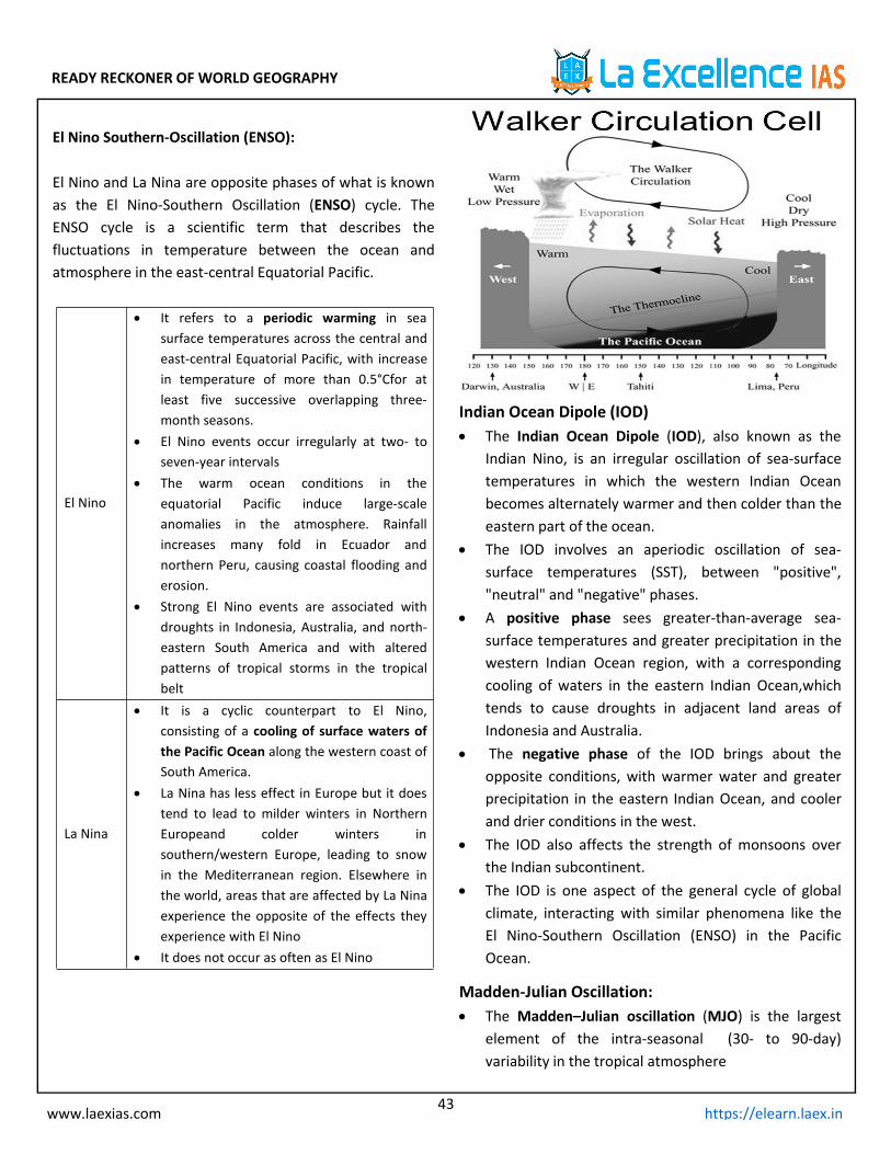
READY RECKONER OF WORLD GEOGRAPHY
43www.laexias.com https://elearn.laex.in
El Nino Southern-Oscillation (ENSO):
El Nino and La Nina are opposite phases of what is knownas the El Nino-Southern Oscillation (ENSO) cycle. TheENSO cycle is a scientific term that describes thefluctuations in temperature between the ocean andatmosphere in the east-central Equatorial Pacific.
El Nino
It refers to a periodic warming in seasurface temperatures across the central andeast-central Equatorial Pacific, with increasein temperature of more than 0.5°Cfor atleast five successive overlapping three-month seasons.
El Nino events occur irregularly at two- toseven-year intervals
The warm ocean conditions in theequatorial Pacific induce large-scaleanomalies in the atmosphere. Rainfallincreases many fold in Ecuador andnorthern Peru, causing coastal flooding anderosion.
Strong El Nino events are associated withdroughts in Indonesia, Australia, and north-eastern South America and with alteredpatterns of tropical storms in the tropicalbelt
La Nina
It is a cyclic counterpart to El Nino,consisting of a cooling of surface waters ofthe Pacific Ocean along the western coast ofSouth America.
La Nina has less effect in Europe but it doestend to lead to milder winters in NorthernEuropeand colder winters insouthern/western Europe, leading to snowin the Mediterranean region. Elsewhere inthe world, areas that are affected by La Ninaexperience the opposite of the effects theyexperience with El Nino
It does not occur as often as El Nino
Indian Ocean Dipole (IOD) The Indian Ocean Dipole (IOD), also known as the
Indian Nino, is an irregular oscillation of sea-surfacetemperatures in which the western Indian Oceanbecomes alternately warmer and then colder than theeastern part of the ocean.
The IOD involves an aperiodic oscillation of sea-surface temperatures (SST), between "positive","neutral" and "negative" phases.
A positive phase sees greater-than-average sea-surface temperatures and greater precipitation in thewestern Indian Ocean region, with a correspondingcooling of waters in the eastern Indian Ocean,whichtends to cause droughts in adjacent land areas ofIndonesia and Australia.
The negative phase of the IOD brings about theopposite conditions, with warmer water and greaterprecipitation in the eastern Indian Ocean, and coolerand drier conditions in the west.
The IOD also affects the strength of monsoons overthe Indian subcontinent.
The IOD is one aspect of the general cycle of globalclimate, interacting with similar phenomena like theEl Nino-Southern Oscillation (ENSO) in the PacificOcean.
Madden-Julian Oscillation: The Madden–Julian oscillation (MJO) is the largest
element of the intra-seasonal (30- to 90-day)variability in the tropical atmosphere
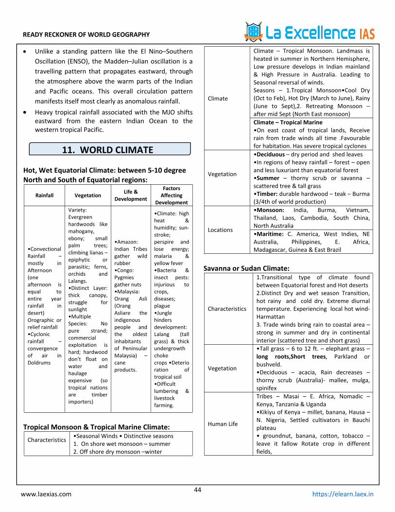
READY RECKONER OF WORLD GEOGRAPHY
44www.laexias.com https://elearn.laex.in
Unlike a standing pattern like the El Nino–SouthernOscillation (ENSO), the Madden–Julian oscillation is atravelling pattern that propagates eastward, throughthe atmosphere above the warm parts of the Indianand Pacific oceans. This overall circulation patternmanifests itself most clearly as anomalous rainfall.
Heavy tropical rainfall associated with the MJO shiftseastward from the eastern Indian Ocean to thewestern tropical Pacific.
11. WORLD CLIMATE
Hot, Wet Equatorial Climate: between 5-10 degreeNorth and South of Equatorial regions:
Rainfall Vegetation Life &Development
FactorsAffecting
Development
•ConvectionalRainfall –mostly inAfternoon(oneafternoon isequal toentire yearrainfall indesert)Orographic orrelief rainfall•Cyclonicrainfall –convergenceof air inDoldrums
Variety:Evergreenhardwoods likemahogany,ebony; smallpalm trees;climbing lianas –epiphytic orparasitic; ferns,orchids andLalangs.•Distinct Layer:thick canopy,struggle forsunlight•MultipleSpecies: Nopure strand;commercialexploitation ishard; hardwooddon’t float onwater andhaulageexpensive (sotropical nationsare timberimporters)
•Amazon:Indian Tribesgather wildrubber•Congo:Pygmiesgather nuts•Malaysia:Orang Asli(OrangAsliare theindigenouspeople andthe oldestinhabitantsof PeninsularMalaysia) –caneproducts.
•Climate: highheat &humidity; sun-stroke;perspire andlose energy;malaria &yellow fever•Bacteria &insect pests:injurious tocrops,diseases;plague•Junglehindersdevelopment:Lalang (tallgrass) & thickundergrowthchokecrops •Deterioration oftropical soil•Difficultlumbering &livestockfarming.
Tropical Monsoon & Tropical Marine Climate:
Characteristics •Seasonal Winds • Distinctive seasons1. On shore wet monsoon – summer2. Off shore dry monsoon –winter
Climate
Climate – Tropical Monsoon. Landmass isheated in summer in Northern Hemisphere,Low pressure develops in Indian mainland& High Pressure in Australia. Leading toSeasonal reversal of winds.Seasons – 1.Tropical Monsoon•Cool Dry(Oct to Feb), Hot Dry (March to June), Rainy(June to Sept),2. Retreating Monsoon –after mid Sept (North East monsoon)Climate – Tropical Marine•On east coast of tropical lands, Receiverain from trade winds all time .Favourablefor habitation. Has severe tropical cyclones
Vegetation
•Deciduous – dry period and shed leaves•In regions of heavy rainfall – forest – openand less luxuriant than equatorial forest•Summer – thorny scrub or savanna –scattered tree & tall grass•Timber: durable hardwood – teak – Burma(3/4th of world production)
Locations
•Monsoon: India, Burma, Vietnam,Thailand, Laos, Cambodia, South China,North Australia•Maritime: C. America, West Indies, NEAustralia, Philippines, E. Africa,Madagascar, Guinea & East Brazil
Savanna or Sudan Climate:
Characteristics
1.Transitional type of climate foundbetween Equatorial forest and Hot deserts2.Distinct Dry and wet season Transition,hot rainy and cold dry. Extreme diurnaltemperature. Experiencing local hot wind-Harmattan3. Trade winds bring rain to coastal area –strong in summer and dry in continentalinterior (scattered tree and short grass)
Vegetation
•Tall grass – 6 to 12 ft. – elephant grass –long roots,Short trees, Parkland orbushveld.•Deciduous – acacia, Rain decreases –thorny scrub (Australia)- mallee, mulga,spinifex
Human Life
Tribes – Masai – E. Africa, Nomadic –Kenya, Tanzania & Uganda•Kikiyu of Kenya – millet, banana, Hausa –N. Nigeria, Settled cultivators in Bauchiplateau• groundnut, banana, cotton, tobacco –leave it fallow Rotate crop in differentfields,
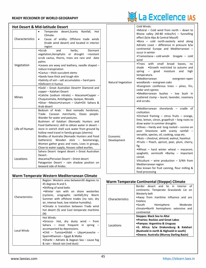
READY RECKONER OF WORLD GEOGRAPHY
45www.laexias.com https://elearn.laex.in
Hot Desert & Mid-latitude Desert
Characteristics
Temperate desert,Scanty Rainfall, HotClimate.
Cause of aridity- Offshore trade winds(trade wind desert) and located in interiorregion
Vegetation
•Scrub and herbs, Dormantvegetation,Xerophytic or drought –resistantscrub cactus, thorns, trees are rare and datepalms•Leaves are waxy and leathery, needle shaped –reduce transpiration•Cactus – thick succulent stems•Seeds have thick and tough skin•Salinity of soil – salt accumulates – hard pans•Deficient in humus
Mines
•Gold – Great Australian Desert• Diamond andcopper – Kalahari Desert•Caliche (sodium nitrate) – Atacama•Copper –Chuquicamata, Antofagasta, Iquique, Nevada•Silver –Mexico•Uranium – Utah•Oil- Sahara &Arab desert
Life of Human
Bedouin of Arab: - Best nomadic herdsman,Trade- Caravan merchants, Oases people-Wander for water and pastures.Bushmen of Kalahari (Nomadic Hunters andFood Gatherers): skill to obtain water in desert –store in ostrich shell suck water from ground byhollow reed travel in family groups (sherms)Bindibu of Australia (Nomadic Hunters and FoodGatherers): Wooden stick – boomerangs,Women gather grass and roots, Lives in groups,Close to water supply, Houses called wurlies.
Locations
Sahara Desert -largest desert > Great AustralianDesert.Atacama/Peruvian Desert – Driest desertPatagonian Desert – rain shadow position onleeward side of Andes.
Warm Temperate Western Mediterranean Climate
Characteristics
Region: Western area between30 degrees to45 degrees N and S.•Shifting of wind belts•Winter rain with on shore westerlies(cyclonic, orographic rainfall),Dry WarmSummer with offshore trades (no rain, dryair, intense heat, low relative humidity).•Climate is transition between Trade windhot desert (S) and Cool temperate maritime(N)
Local Winds
Hot Winds:•Sirocco- Hot, dry dusty wind – fromSahara – most frequent in spring –accompanied by depressions.•Chili – Tunisia•Ghibli – Libya•Leveche –Spain•Khamsin – Egypt & Malta•Gharbi – Adriatic & Aegean Sea – cause fog& rain – blood rain (red dust)
Cold Winds:•Mistral – Cold wind from north – down toRhone valley (40-80 miles/hr) – funnellingeffect (b/w Alps & Central Massif)•Bora – cold north-easterly wind alongAdriatic coast – difference in pressure b/wcontinental Europe and Mediterranean –occur in winter•Tramontana – cold wind• Gregale – coldwind
Natural Vegetation
•Trees with small broad leaves, noshade •Growth restricted to autumn andspring – good moisture and hightemperature.•Mediterranean evergreen–openwoodlands – evergreen oaks•Evergreen coniferous trees – pines, firs,cedar and cypress•Mediterranean bushes – low bush inscattered clump – laurel, lavender, rosemaryand scrubs.
EconomicDevelopment
•Mediterranean shorelands – cradle ofcivilization•Orchard framing – citrus fruits – orange,lime, lemon, citron, grapefruit – long roots todraw water in summer droughts•Olives – Hardy and long rooted – survive onpoor limestone with scanty rainfall –versatile, species, oil, cooking, soap etc.•Nuts – chestnut, almond, walnut, hazelnut•Fruits – Peach, apricot, pear, plum, cherry,fig•Wheat – hard winter wheat – macaroni,spaghetti, vermicelli •Barley – importantcereal.Viticulture – wine production – 3/4th fromMediterranean regionAlso known for fruit canning, flour milling &food processing
Warm Temperate Continental (Steppe) Climate
Characteristics
Border desert and lie in interior ofcontinents: Temperate Grasslands Lie onWesterly belt•Away from maritime influence and aretreeless•South Hemisphere: Moderateclimate•North hemisphere: extensive andcontinental
Locations
Steppes: Black Sea to Altai•Prairies: Rockies and Great Lakes•Pampas: Argentina & Uruguay•S. Africa: b/w Drakensburg & Kalahari(Bushveld in north & Highveld in south)•Downs: Australia (Murray Darling Basin)
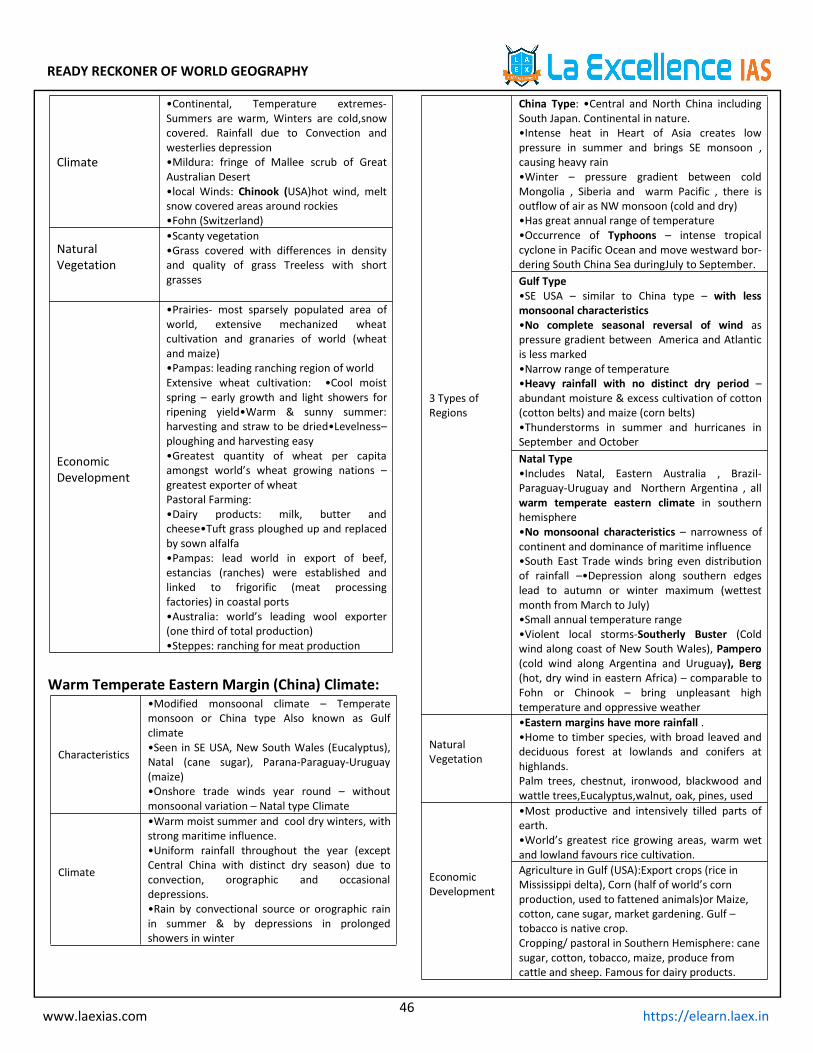
READY RECKONER OF WORLD GEOGRAPHY
46www.laexias.com https://elearn.laex.in
Climate
•Continental, Temperature extremes-Summers are warm, Winters are cold,snowcovered. Rainfall due to Convection andwesterlies depression•Mildura: fringe of Mallee scrub of GreatAustralian Desert•local Winds: Chinook (USA)hot wind, meltsnow covered areas around rockies•Fohn (Switzerland)
NaturalVegetation
•Scanty vegetation•Grass covered with differences in densityand quality of grass Treeless with shortgrasses
EconomicDevelopment
•Prairies- most sparsely populated area ofworld, extensive mechanized wheatcultivation and granaries of world (wheatand maize)•Pampas: leading ranching region of worldExtensive wheat cultivation: •Cool moistspring – early growth and light showers forripening yield•Warm & sunny summer:harvesting and straw to be dried•Levelness–ploughing and harvesting easy•Greatest quantity of wheat per capitaamongst world’s wheat growing nations –greatest exporter of wheatPastoral Farming:•Dairy products: milk, butter andcheese•Tuft grass ploughed up and replacedby sown alfalfa•Pampas: lead world in export of beef,estancias (ranches) were established andlinked to frigorific (meat processingfactories) in coastal ports•Australia: world’s leading wool exporter(one third of total production)•Steppes: ranching for meat production
Warm Temperate Eastern Margin (China) Climate:
Characteristics
•Modified monsoonal climate – Temperatemonsoon or China type Also known as Gulfclimate•Seen in SE USA, New South Wales (Eucalyptus),Natal (cane sugar), Parana-Paraguay-Uruguay(maize)•Onshore trade winds year round – withoutmonsoonal variation – Natal type Climate
Climate
•Warm moist summer and cool dry winters, withstrong maritime influence.•Uniform rainfall throughout the year (exceptCentral China with distinct dry season) due toconvection, orographic and occasionaldepressions.•Rain by convectional source or orographic rainin summer & by depressions in prolongedshowers in winter
3 Types ofRegions
China Type: •Central and North China includingSouth Japan. Continental in nature.•Intense heat in Heart of Asia creates lowpressure in summer and brings SE monsoon ,causing heavy rain•Winter – pressure gradient between coldMongolia , Siberia and warm Pacific , there isoutflow of air as NW monsoon (cold and dry)•Has great annual range of temperature•Occurrence of Typhoons – intense tropicalcyclone in Pacific Ocean and move westward bor-dering South China Sea duringJuly to September.Gulf Type•SE USA – similar to China type – with lessmonsoonal characteristics•No complete seasonal reversal of wind aspressure gradient between America and Atlanticis less marked•Narrow range of temperature•Heavy rainfall with no distinct dry period –abundant moisture & excess cultivation of cotton(cotton belts) and maize (corn belts)•Thunderstorms in summer and hurricanes inSeptember and OctoberNatal Type•Includes Natal, Eastern Australia , Brazil-Paraguay-Uruguay and Northern Argentina , allwarm temperate eastern climate in southernhemisphere•No monsoonal characteristics – narrowness ofcontinent and dominance of maritime influence•South East Trade winds bring even distributionof rainfall –•Depression along southern edgeslead to autumn or winter maximum (wettestmonth from March to July)•Small annual temperature range•Violent local storms-Southerly Buster (Coldwind along coast of New South Wales), Pampero(cold wind along Argentina and Uruguay), Berg(hot, dry wind in eastern Africa) – comparable toFohn or Chinook – bring unpleasant hightemperature and oppressive weather
NaturalVegetation
•Eastern margins have more rainfall .•Home to timber species, with broad leaved anddeciduous forest at lowlands and conifers athighlands.Palm trees, chestnut, ironwood, blackwood andwattle trees,Eucalyptus,walnut, oak, pines, used
EconomicDevelopment
•Most productive and intensively tilled parts ofearth.•World’s greatest rice growing areas, warm wetand lowland favours rice cultivation.Agriculture in Gulf (USA):Export crops (rice inMississippi delta), Corn (half of world’s cornproduction, used to fattened animals)or Maize,cotton, cane sugar, market gardening. Gulf –tobacco is native crop.Cropping/ pastoral in Southern Hemisphere: canesugar, cotton, tobacco, maize, produce fromcattle and sheep. Famous for dairy products.

READY RECKONER OF WORLD GEOGRAPHY
47www.laexias.com https://elearn.laex.in
Warm Temperate Western Margin (British) Climate:
Characteristics
Under permanent influence of Westerlies,Cyclonic activity, Oceanic influence
Also called North-West European MaritimeClimate
N. America ,S. hemisphere – New Zealand,Tasmania and Chile
Climate
Ideal climate for maximum comfort andmental alertness , equable climate withwarm summers and mild winters
Warming effect of warm North AtlanticDrift and South Westerlies
Precipitation: Rainfall throughout theyear.Western margins have highest rainfall(as rain bearing winds come from west),there by western slopes of Southern Alpshave more rainfall compared to Canterburyplains (rain shadow area) .
NaturalVegetation
•Deciduous forest -Shed leaves in winters – toprotect against snow and frost.•Valuable temperate hardwood: Oak, elm, birch,beech, poplar, Willows, Alder, Aspen•Other species – elsewhere – chestnut, maple,lime, eucalyptus, conifers.
EconomicDevelopment
•NW Europe: Little surplus for export and a netimporter of food crop mainly wheat•Fishing: Britain, Norway & British Columbia•Netherlands: horticultural and Dairy Industry(Britain, Denmark)•Australia: High speed boats ply across BassStrait and Tasmania named as garden stateMixed Farming•Both arable farming(potato, wheat , barley,beet sugar, cash crop and fodder crop etc) andpastoral framing(pigs, poultry, sheep rearing)
Cool Temperate Continental (Siberian) Climate:Due to extreme climatic condition- cold pole ofearth
Characteristics
Broad E-W spread- Merge with Arctic tundra innorth and Steppes in south. Also called sub artic.• evergreen coniferous – continuous belt in northCalled Taiga – Siberia•Absent in South Hemisphere – narrowness ofsouthern continents in high latitude and strongoceanic influence•Coniferous (S. Hemisphere)only in mountain uplands
Climate
•Cold long winters and cool brief summers, withrainfalls throughout the year.•Winds – Blizzards of Canada and Buran of Europe•Conifers – require little moisture and transpireless are best suited•Low temperature, low evaporation & highrelative humidity•Permanent snowfields are absent (as in Alps &Himalayas) due to melting in spring & summerFrozen rivers are thawed causing rise in waterlevel & floods.
Vegetation
•Greatest softwood production – USSR, USA<Canada &Fennoscandia (Finland, Norway,Sweden)•Taiga (Siberia) – richest source of temperatesoftwood Occur in pure strands – good forcommercial exploitation. 4 main species – Pine,Fir, Spruce & LarchConiferous:•Uniform, straight, tall•No annual replacement ofnew leaves .Food stored in trunks and bark is thickto protect trunk from cold•Conical in shape to prevent snow accumulation•Leaves are small, thick, leathery and needle-shaped
EconomicDevelopment
•Many areas are untouched in Canada, E. Europeand Asiatic Russia. Lumbering – transported tosaw mills. Fur farms, paper making, matches,newsprint firms are well established.
Cool Temperate Eastern Margin (Laurentian):
Characteristics
•Intermediate between British and Siberianclimate•Both maritime and continentalOnly in 2 regions: 1.NE USA, E. Canada or AmericaRegion and 2. E. Asia, E. Siberia, N. China, Manchuria,Korea & N. Japan – Asiatic Region. •Absent in SH –small section of continents, oceanic influence andclimate is equable•Only exception could be E.Patagonia- Westerlies don’t reach causing aridity(rain shadow desert)
Climate
•Cold dry winters – temperature below freezingpoint, winds are dry westerlies from continentalinterior•Warm wet summers (has cooling effect of offshorecold currents)•Rainfall – year-round
NaturalVegetation
•Cool temperate forest. Coniferous trees north oflatitude .Lumbering is main activity – timber asexport item•Fir,spruce and larch ,oak, beech, maple, birch arethe trees found.•Trees occur in pure stands – easy commercialexploitation Canada – greater reserve of coniferoussoftwoods
EconomicDevelopment
•Lumbering – timber, paper and pulp industriesAgriculture – potatoes on podzolized soil, oats andbarley•Asiatic region –Soyabeans (N. China, Manchuria &Korea), groundnut, sesame, rapeseed, tung oil andmulberry•Annapolis valley in Nova Scotia – world’s mostrenowned region of apples Fishing- major activity in this region- as warm
and cold current mixes.World’s largest fishingground on Grand Banks of Newfoundland. Seaweed cultivation, oyster cultivation etc is mostcommon specifically in Japan (with rich planktongrowth on continental shelves, upwelling ofwaters)

READY RECKONER OF WORLD GEOGRAPHY
48www.laexias.com https://elearn.laex.in
Arctic or Polar Climate:
Characteristics
North of Arctic Circle: Ice-Caps –Greenland and highland of high latituderegions – permanent snow cover•Tundra climate – lowlands with few icefree months – coastal Greenland, NorthCanada, Alaska and Arctic seaboard ofEurasia
Climate
•Very low temperature •Winters – longand severe (weeks of continuousdarkness)•Summers – cool and brief, Sun raysoccur as faint rays – reflected by groundsnow or ice melting•Soil water is frozen and summer heatcan thaw for 6 inch of soil•Frost and blizzards are commonly seen•Coastal Areas – Warm water meetscold land then thick fog develops•Precipitation as snow in winters andvaries from ice crystals to snowflakes•Anticyclones over ice caps• Coastalareas – cyclones
Vegetation
•Tundra type – few plants can survive –deficiency in heat, frozen soil.•No trees, Mosses, lichens and sedgesare present.•Drainage is poor – subsoil ispermanently frozen Birch, willow and alder, reindeer
moss, arctic flowers as arctic prairiesare commonly found
HumanActivities
Confined to coasts: Plateaus andmountains are inhabitable and snowcovered•Semi-nomadic life : Eskimos – around28,000 – hunters, fishers, food gatherersNomads of Eurasia:•Lapps – N. Finlandand Scandinavia•Samoyeds inSiberia•Yakuts in LenaBasin•Koryak&Chuckchi in NE AsiaDiscovery of minerals: •Gold –Alaska, •Nickel – Petsamo,USSR, •Petroleum – Kenai Peninsula,Alaska, •Copper – Rankin Inlet,Canada, •Coal – Spitsbergen andAlaska, •Iron Ore – Lake Superior & nowLabrador (railway line to bring ores to St.Lawrence River); Kiruna and Gallivare in
Sweden•Trying to grow hardy cereals for localneeds in Arctic lowlands with warmcurrents and higher temperatures.
Deepest Point on the Ocean:
Ocean Deepest point
Pacific Mariana Trench
Atlantic Puerto Rio Trench
Indian Java Trench
Arctic Eurasian Basin
Important Canals of the World:
Canal Connects
Panama Pacific Ocean with Atlantic Ocean
Suez Mediterranean Sea to Red sea
Erie Atlantic Ocean to Great Lakes
KeinNorth sea to BalticSea
Major lakes of the World
Lakes Location
Caspian Asia
SuperiorCanada andUSA
Victoria Africa
Huron Canada and USA
Tanganyika Africa
Baikal Russia
Great Bear Canada
Aral Kazakhstan
Great Slave Canada

READY RECKONER OF WORLD GEOGRAPHY
49www.laexias.com https://elearn.laex.in
Highest /Lowest Point of Various Continents:
ContinentHighest point(m)
Lowest point(m)
Asia Mt Everest(8850) Dead Sea(-396)
AfricaMTKilimanjaro(5951)
Lake Assal(-151)
North America Mt Mckinley(6252)
Death Valley(-87)
South AmericaMtAconcagua(7026)
Valdes Penins+ula(40)
AntarcticaVinsonMassif(5189)
BentleySubglacial
Trench (-2538)
Europe Mt EI’sBrus(5687)
Caspian Sea(-28)
AustralianKoscuisko Lake Eyre(-16)
argest Geographical Features in the World:
Feature Name
Largest Continent Asia
Largest Ocean Pacific Ocean
Largest Bay Bay of Bengal
Largest Gulf Gulf of Mexico
Largest Peninsula Arabian Peninsula
Largest Island Greenland
Largest Coral Reef
Great Barrier Reef
(Australi)
Largest and HighestPlateau Pamir (Tibet, China)
Related Fact Name of the Lake
Deepest lake in the worldBaikal (fresh water)inRussia
Largest fresh water lake
Lake Superior, betweenCanada
and the USA
Caspian Sea, bounded byIran,
Largest lake in the worldRussia, Kazhakistan,Azerbaijan
and Turkmenistan.
Saltiest lake in the world
Dead Sea bounded byIsrael,
Jordan and west bank
Lowest lake in the world
Dead Sea between Israeland
Jordan
Sambhar lake in RajasthanLargest lake in India
Largest fresh-water lakein India
Kolleru lake in AndhraPradesh
Largest coastal lagoon inIndia Chilka lake in Orissa
Sriharikota island islocated in
Pulicat lake in AndhraPradesh
Country known as land of thousand lakes – Finland
Canals and Straits:
Strait /Canal
Land MassesDivided
Water BodiesJoined
Suez CanalRuns through Egypt Mediterranean
and Red Sea
Kiel Canal Runs through
Germany
North Sea and
Baltic Sea
Bering Strait Alaska and Siberia Pacific and Arctic
Palk Strait India and Sri Lanka
Bay of Bengal and
Gulf of Mannar
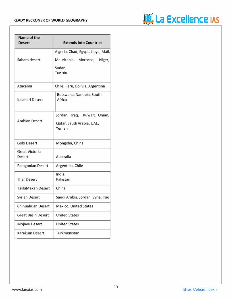
READY RECKONER OF WORLD GEOGRAPHY
50www.laexias.com https://elearn.laex.in
Name of theDesert Extends into Countries
Algeria, Chad, Egypt, Libya, Mail,
Sahara desert Mauritania, Morocco, Niger,
Sudan,Tunisia
Atacama Chile, Peru, Bolivia, Argentina
Kalahari DesertBotswana, Namibia, SouthAfrica
Arabian DesertJordan, Iraq, Kuwait, Oman,
Qatar, Saudi Arabia, UAE,Yemen
Gobi Desert Mongolia, China
Great VictoriaDesert Australia
Patagonian Desert Argentina, Chile
Thar DesertIndia,Pakistan
TaklaMakan Desert China
Syrian Desert Saudi Arabia, Jordan, Syria, Iraq
Chihuahuan Desert Mexico, United States
Great Basin Desert United States
Mojave Desert United States
Karakum Desert Turkmenistan