RC Newcomb and D, H, Hart Open-file report
276
UNITED STATES DEPARTMENT OF THE INTERIOR GEOLOGICAL SURVEY PRELIMINARY REPORT ON THE GROUND-WATER RESOURCES OF THE KLAMATH RIVER BASIN, OREGON By R. C. Newcomb and D, H, Hart Open-file report; subject to revision* Prepared in cooperation with the Oregon State Engineer, the U. S. Bureau of Reclamation, and the California Division of Water Resources July 1958
-
Upload
khangminh22 -
Category
Documents
-
view
0 -
download
0
Transcript of RC Newcomb and D, H, Hart Open-file report

UNITED STATESDEPARTMENT OF THE INTERIOR
GEOLOGICAL SURVEY
PRELIMINARY REPORT ON THE GROUND-WATER RESOURCES OF THE KLAMATH
RIVER BASIN, OREGON
By
R. C. Newcomb and D, H, Hart
Open-file report; subject to revision*
Prepared in cooperation with the Oregon State Engineer, the U. S. Bureau of Reclamation, and the California Division of Water Resources
July 1958

r

? > t: .l- V. I'
UNITED STATESDEPAHTMENT OF THE INTERIOR
GECI,OGICAt, SURVEY
PRELIMINAEY REPORT ON THE GROUND-WATER RESOURCES OP THE KLAHAIH
RICTSR BASIN, OREGON
ByR* C* Newcomb and B* H. Hart
Open-file report; subject to revision.
Prepared in cooperation with the Oregon State Engineer, the U. S» Bureau of Reclamation, and the California Division of Water Resources
July 1958


CONTENTS
Page
Abstract .**.*«**«**.«,«,,.**«,,«.. 1
Introduction **.. ».»*...*..,*,* *« 5
Purpose and organization of the investigation . * « . 5
Geography and general physiography of the basin * * 6
Size and shape of the basin *. *** *« * 6
Hocks composing the basin ......» «..« 7
Drainage .*. **.».«*«*»»**** «* 8
Surface water ..*. *».**...,.. 8
Ground water .*«««.** ***»*.*.«» 10
Population and settlement «, ««..«.« ... 11
Vegetation ,. ***. ..»...*»* **** 12
Climate * ....................... 13
Precipitation .**.*.»« ..«»* ** * 13
Temperature «*»* ****... * .*» lii
Evaporation . *..«.» »** »**»«« 15
Well-numbering system ...*«. »* « **. 15
Acknowledgments ..* *..«** ***»** 16
Occurrence of the ground water .*.**.** *.* 1?
Geologic setting *.. «.* ** *«** * 17
General occurrence of the rock units .«..«** 17
Stratigraphy ....*....* * .*.«. 19
Pre-Tertiary rocks ...** *«** *« 19
Umpqua formation *«* .*** .** 19
Volcanic rocks of western Cascades ...... 19


Occurrence of ground water - Continued
Geologic setting - Continued
Stratigraphy - Continued
Volcanic rocks of high Cascades ....... 20
Intrusive rocks ...*........... 23
Volcanic lava rocks of Quaternary age * * « . 23
Pumice of Quaternary age ..*.««.«.» 21*
Alluvium ........ .........* 25
Tectonic structure of the rocks ......... 27
General situation of the f&amath River basin area ........ ........ 2?
Block faulting ............... 27
Characteristics of the aquifers ......... 29
Lower lava rocks .............. 29
Upper lava rocks .............. 30
Alluvium of Quaternary age ......... 30
Pumice of Quaternary age .......... 31
Hydrologic conditions ................... 31
Shape and extent of the principal ground-water bodies 31
Ground water of the Klamath Marsh area *.*«.« 32
Ground water of the Sprague River valley . . . . . 33
Ground water of the slope of the Cascade Range » . 3k
Ground water of the Lost River drainage system . . 35>
Some hydraulic characteristics of ground water .... 36
Discharge of ground water ............... 37
ii


Page
Occurrence of ground water - Continued
Hydrologic conditions - Continued
Discharge of the ground water * Continued
Source «**»*,**«««**« * * 37
Quantity .... ......... ..* 38
Recharge to the ground water * * * **«*» WL
Relation of ground water to basin runoff » . * « hk
Use of the ground water ....,,..*. .,* *» h6
Irrigation . . .««»** **** **»»»** 1*6
PubXicrisiipply ,,, ...**«.******.«** W
Dome s;oixi .Supply ,;..........*..-..** li?
SadNist^fal-"supply »' *»*- *^ tf . .*.».....** 1*8
Total 'withdrawal ; olP^ground water . * * * ** W
Potential -for future de^relopneBt *,» ^9
Quality of the ground water ....««..,....*.* $0
General-dharacter of-the waier-.«*-. .. *... * 50
Water of poor Quality ,.; * ** *« 50
Important irdnor Chirac Eristics of th$-ground water . « 51
Boron .«.,,.. .........*..«* 51
Fluoride . *.***»,*«. * *« * 51
Iron ....................... 52
Gaseous constituents ..«.. *** .*.. 52
Temperature ,.«,«,* ,,,.,«,.«* * 53
Records for wells, springs, and chemical quality of water . 5U
References cited . ««.»»... » .* * *.*
iii

ILLUSTRATIONS
Following page
Plate 1. Map of Oregon showing area coveredby this investigation ........ 1
2* Map of the Klamath River basin, Oregon shewing location cf representative wells and springs (in k parts) . . . In pocket
3. Geologic map of the Klamath Riverbasin, Oregon (in k parts) . . . . . In pocket
U* Precipitation at Klamath Falls during climatic years ending September 30 of each year, 1905-53 » 13
5* Average monthly rainfall at fourstations in the Klamath River basinand average monthly evaporationat Medford .............. 13
6,7,8.Hydrographs of eight observation wellsin the Klamath River basin ...... i(3
9. Discharge of Spring Creek and BigSpring Creek compared with accumulated deviation of yearly precipitation from normal at Chiloquin , V . V: » ; * . Wt
10. Discharge of Fort Creek, Crooked Creek, and Wood River compared with accurcu- lated deviation of yearly precipitation from normal at Klamath Falls . « . . . U5
iv


TABLES
Table 1, Representative wells in the KlamathRiver basin *,.**,«...* «* 56
2. Materials penetrated by representativewells in the Klamath River basin ...... 176
3. Representative springs in the KlamathRiver basin . *,,««.* «.*«»* 220
iu Chemical analyses of ground water inthe Klamath River basin ........... 236
f>. Discharge measurements of streams andsprings in the Klamath River basin , . . . .
6. Measurements of depth to water below landsurface in observation wells, 195&-56 * « 2li3


PRELIMINARY REPORT' ON THE G&OTO4MBR RESOURCES OP THE KUmTH ROVER BASIN, OREGON. . ..
By
R. "C. Newcomb and t). H. Hart
The Klamath River basin, including the adjacent Lost River basin,
includes about 5, £00 square miles of plateaus, mountain-slopes and
valley plains in south -central Oregon* The valley plains range in
altitude from about 1*,100 feet in the south to more than U,J>00 feet
at the northern end 5 the mountain and plateau lands rise to an average
altitude of 6,000 feet at the drainage divide, some peaks rising above ; "*!
9,000 feet. The western quarter of the basin is on the eastern slope
of the Cascade Range and the remainder consists of plateaus, mountains,
and valleys of the basin-and -range type*
The rocks of the Klamath River basin range in age from Recent to
Me so zoic. At the southwest side of the basin in Oregon, pre-Tertiary
raetaraorphic, igneous, and sedimentary rocks, which form extensive areas
farther west, are overlain by sedimentary rocks of Eocene age and volcanic
rocks of Eocene and Oligocene age. These early Tertiary rocks dip ''east
toward the central part of the Klamath River basin, the complex "volcanic
rocks of high Cascades" include three units: The lowest unit consists of
a sequence of basaltic lava flows about 800 f eet thick; the medial unit is
composed of volcanic-sedimentary and sedimentary rocks the Yonna formation-
200 to 2,000 feet thick; the uppermost unit is a sequence of basaltic lava» ' . , , ' * "
flows commonly about 200 feet thick. These rocks dip east from the Cascade
Unpublished records subject to revision

2
Range and are the main bedrock formations beneath most of the basin.
Extensive pumice deposits* which emanated from ancestral Mount Mazama,
cover large areas in the northwestern part of the basin*
The basin has an overall synclinal structure open to the south at
the California boundary where it continues as the Klamath Lake basin in
California* The older rocks dip into the basin in monoclinal fashion
from the adjoining drainage basins* The rooks are broken along rudely
rectangular nets of closely spaced normal faults, the most prominent
set of which trends northwest* The network of fault displacements
includes two main grabens, the Klarmth and the LangeH, which were
downthrown approximately 500 and 1,000 fest, respectively.
The average annual precipitation varies with the altitude, the
higher parts of the Cascade Range getting more than 60 inches, and
the semiarid valley plains receive as little as 13 inches in some places.
Most precipitation occurs in the winter. .
The principal tributaries, Williamson and Sprague Rivers, rise near
the higher parts of the eastern rim of the basin, flow through narrow
valley plains to the weotem part, and discharge into Upper Klaraath Lake.
Wood River and associated creeks also empty into Upper Klamath Lake after
draining southward along the eastern foot of the Cascade Range* The
Klamath River receives the outflow from Upper Klamath Lake, via Lihk
River and Lake Ewauna, and flows southwestward through Keno Gap and
hence through a youthful canyon, to its lower valley
SB California.
The ground water occurs largely in an unconfined, or water-table,
condition, though areas of local confinement are present* The regional
Unpublished records subject to revision.

r~
>
-i
m
Mop
of
"the
S
tate
o
f O
reg
on
show
ing
are
a
co
ve
red
by
th
is
investigation


is graded to water table / a base level about equal to that of the major drainage.
.?: : . : , i- -.; ; :-.* .where wa£©jris- confined, on the valley plains. The slope of the water tafele, az/the piezometric
surface is downstream at about the same grade as that of the surface
drainage in each of the larger valleys, and ground^water divides occur
between the upper parts of adjacent major valleys* The principal water
bearing units are the lower lava rocks and upper lava rocks of the
"volcanic rocks of high Cascades,* the pumice of Quaternary age, and
the alltiviura. In places layers of coarse fragmental material in the
lonna formation (Newcomb, 1958) also transmit water. The water-bearing
units, especially the breccia layers of the lava rocks and the pumice,
yield large amounts of water to wells and provide natural discharge
outlets for the ground water.
The spring outflows to the WiHiamson and Wood Rivers-Crooked
Creek drainage, measured in September and October 1955, were at a rate
equivalent to about 700,000 acre-feet per year* The spring outflows
into the Sprague River were at a rate equal to 2li5,000 acre-feet per
year* Large springs occur along the edges of Upper Klamath Lake but
their discharges could not be measured, and the known spring discharge
from the lower lava rocks in the river canyon below Keno was not
measured. The spring discharge into Lost River in the reach from
Bonanza to Harpold Bridge was at a rate equivalent to 75,000 acre-feet
per year.
Much of the water discharged from springs is used for irrigation
during the growing season, but ground water has not been extensively
Unpublished records subject to revision

developed *# mms^of wells except in 1&e 'toma faliey -and other
local areas, the total withdrawal of ground water from wells in
195U was only about 30,000 acre-feet, of which 27,000 was used for
irrigation.
The ground water is of excellent quality in general, but sodium
sulfate water occurs in the belts of warm rock along some faults
and alkali bicarbonate water is present in the main evapotranspiration
basins.
Unpublished records subject to revision

> V : Purpose and Organigatj.o^ at the Investigation >, -..»>.- - 1 ;
. The iintestigation was requested by the. agencies and commissions ,
charged with the administration and development of,water resources in
Oregon and California. Its main objectives were?
1* Recognition and inyentory p£ the ground-water,contributions
,. . to the surface water in the Klamath Basin and any significant
.. ... diversions, of,surface;water .to -toe ground-water,reservoirs,
. ,as well ;as Bi@iificant .diversions of water from or into. /
the basin through percolation of ground,water*.- ;.
2. Recognition of the principal factors governing the ground-water
regimen and the water resources available for development*
3. Collection of geologic and hydrologic information'pertinent
to the development and use of the ground-water resources*
Hie funds were supplied from the Geological Surveyfs cooperative
program with the Oregon Staie Engineer, by transfer from the U. S«
Bureau of Reclamation, and from the Geological Survey^ cooperative
program with the California Division of Mater Resources.
The available data were collected on significant wells, including
all irrigation and large public-supply or industrial wells* The larger
springs were studied and their yields determined, chiefly by measurement
. . . .. ^ . .- , -. - - Unpublished records subject to revision

of the effluent streams* The geologic fabric of the basin was determined
by reconnaissance mapping aad checking of existing geologic maps, such
as those of Crater Lake Park and the lonna-Swmn Lake valleys* Th^ field
work m* carried «a charing the Oapt 6 months of
The base map used, for plates 2 and 3 was compiled by piecing
together parts from nine different maps* The horizontal control was
founded on the map of the Klaraath Protective District* Lack of time and
finances precluded construction of a better finished base. Plans for
later revision and publication of this Report foresee tile use of
topographic quadrangle maps now in preparation or in planning stage*
Geography and General Ftysjflgyi^^
Size and Shape of the Basin
The drainage basin of the Klamath River in Oregon comprises about
square miles* The main part of the basin is roughly equidimen-
sional, extending northward as much as 90 miles from latitude 1*2°, the
Oregon-California boundary* and westward an average of about 80 miles
from longitude 120oli5f . The basin contains parts of two main physio*
graphic divisions of the United States the northwest corner of the
Basin and Hange province and a part of the Sierra-Cascade province
CFenneman,. 1931)*
The headwaters of the Klamath River gather mainly from the east,
north* and west. On the east, streams drain a complex terrain of plateau,
butte, mountain, and canyon lands that slope up from the valley-floor
levels of about It, 200 feet to reach altitudes of about 6,000 feet. Many
Unpublished records subject to revision

buttes and mountains rise still higher* Hie -highest:
Mountain and Yamsay Mountain, reach altitudes of 8,36k feet and. 8,100 feet
respectively. The northern part of the^basin is similar to the eastern
part but is loner* The plateaus .'and^jaauntainc*. «ueh as those making up
the TifelkerRim. district,, have a general al$iteide~ of^$$500 feet *ad «. > s..
maximum of ?,0?8 feet. on Walker Mountain* The western part of the basin, .*.* »'. * t," . .,
is formed by the more abrupt slope of the Cascade Mountains, and in . ***. .' ' *'
general, south of Mount Mc&oughlln, by -fee southeast- and south-sloping
plateaus that comprise that part of the Central Cascade Mountains section
(Fenneman) where the true crest of the Cascades is less definite* The
drainage divide in the Cascade Mountains occurs at a common altitude of
about 6, i>00 feet. with many eminences rising. abovo that - level, Mountr, ' * t ' .' ;,'.'.
McLoughlin reaches 9,?60 feet1 and Mount .Jhielsan, 9A?3«fee^-
The drainage divide separates the Klaroath River watershed from
that of the Rogue River on the west, the Deschutes River on the north,
and Goose Lake, or the Pitt River, on the east.
. Rocks Composing the Basin '
The uplands are composed almost entirely of volcanic rocks, mostly
basaltic and andesitic lava flows* The floors of the valley plains are
formed across alluvial fill which covers downthrown or downwarped blocks
of the bedrock* Several valleys, notably the Sprague River and Tonna
Valleys, are partly erosional surfaces cut across the soft tuffs and
diatomaeeous strata of the Yonna formation. . .
^published records subject to revision
8
Drainage
Surface Wateri
Itoe valley plains are imperfectly connected \sy a rudely integrated
drainage system which culminates downstream in the Klamath River proper*
The Williamson River, the principal hteadwafcer stream, rises in a spring
sione in the SEj sec* it, T. 33 S*, R« 11 £« While flowing northward for
16 miles, it receives the inflow from several springs and from Deep and
Jackson Creeks, which drain the west side of Tamsay Mountain, and from
Jack Creek, which drains the northeastern part of the basin* It then
turns westward and flows about h miles across a pumice plain to the
northeastern end of the Klamath Marsh. In Klamath Marsh it receives
the inflow of Big Spring Creek and other smaller creeks* Two of these,
Scott and Sand Creeks, drain from the east side of Mount Mazaraa, the
mountain in which Crater Lake is situated. From Klamath Harsh the
Williamson River flows over a lava-rock rim near Kirk, descending about
300 feet in 5> miles, and continues south where it discharges into Tapper
Klamath Lake after receiving the Spring Creek and Sprague River inflows
(see pi* 2).
The north and south forks of the-Sprague liver rise on the flanks of
Gearhart Mountain at the eastern side of the basin and join about h ,
miles northwest of HLy to form the main river* After flowing through
toe Beatty Gap# the Sprague River is joined by the Sycan River from
the north. Several creeks and springs enter the river as it flows an
airline distance of 2f> miles westward, through the lowland known as
the Sprague River valley, to its confluence with the Williamson River
near Chiloquin. The ¥bod River and Sevenmile Creek separately * drain
Unpublished records subject to revision

southward into Agency Lake, which is a northern lobe, of Dfcqper Klamath
Lake now nearly separated by the encroachment of the delta of the
Williamson River, .
Along the western side of Upper JOLamatfa Lake, several creeks ..<**> ^ .
including'Threemile, Cherry, Rock, Fourmile, and Rocky Creeks ea$*r
from the Cascade slope* The surface of Upper Klamath Lake stands near
U,lliO ft in altitude but varies several feet and is controlled in part,
for power generation and irrigation, by a dam in the outlet trench* .
The outflow from Upper Klamath Lake is through Link River, a short,
narrow, rockbound trench which descends about 1*0 ft to the small lake
known as Lake Ewauna. Out of Lake Ewatina the main stem of the Klamath
River flows along the northwest side of the extensive lowland known asand marsh
Klamath Valley and the wide playa/known as Lower Klamath Lake, to pass
over lava-rock ridges near Keno at an altitude of about it,0|?0 feet* The river
descends through a deep youthful canyon below Keno and crosses into the
State of California at an altitude of about 2,?5>0 feet. Below Keno*.
Spencer Creek drainage enters the river and Jenny Creek flows . .
south to-«nter the river in Calif ornia*
The Lost River basin is a separate river basin, but because
use of its-water for irrigation is so greatly integrated with
that of the KUmath River, and,'because in part it occupies the same
structural basin, it is included in'this paper as part of the Klamath
Basin in Oregon* The headwaters of the Lost River gather in the mountains "
and plateaus forming the youthful topography athwart the Oregon-California
line east..- «of.. , the Klamath Valley and Tule Lake basin* Barnes Creek
rises on the plateaus at the eastern edge of the drainage basin, Miller
if *> *' * /- ; " * ; " *t*" *"- * *, *" « JL* . ,\ - ' * v»J
. m . . - -. ift^ufelisned records subject to revision

10
Creek flows from the escarpment of the Oerber Rim (where Drainage .. -
is collected in the fault graben occupied by Gerber Reservoir), and
Clear Creek forms on the plateaus east of Tule Lake basin in California.
There are storage reservoirs on the tributaries, the outflow of which Us used
mainly for Irrigation* Through Olene Gap the Xost River enters the
KLamatfe Valley at an altitude of about fc,100 feet and flows south arcmnd
the east side to discharge into Tule Lake, a lake-sump whose bed stands
about \j$ feet below: the f&bor of Lower Klamath Lake, from which it is
separated by narrow fault ridges*
Ground Water
Part of the precipitation that infiltrates to the regional ground-waterperched
body .and to local /, bodies reaches the surface streams from a few large
springs, from a great number of medium-sized springs, and rarely, from
a great number of small seepage springs* The upland areas contain
thousands of small springs which represent local infiltration that has
become perched upon less permeable layers of rock and brought laterally
to the slope on which it emerges* So common is the occurrence of such
small springs that the uplands of even the drier sections of the basin
are relatively well watered for stock. The discharge from this type of
small spring commonly occurs above the regional water table ami does not
reach a stream before again Infiltrating or being consumed by evapo-
transpiration. Where the volume of saturated rock is larger and
infiltration recharge more abundant, medium-sized springs emerge in
places that are at the level of the perched or the regional water table*
Such springs commonly discharge fifty to several hundred gallons a minute
Unpublished records subject to revision

11
and contribute to the flow of many of the ..streams*
The main outlets for the ground water occur where valleys-
intersect both the regional water table and highly permeable
rocks. Most such outlets commonly releaselarge flows ranging from 10 .
to more than 300 cubic feet of water per second* Suck, large spring
flows emerge in the lowland reached of most of the larger streams and in fee spring
the lakes. There/discharges form a large, part of the base flow of
the KLaraath River, The magnitude and sources of several mush springs .
are .described in detail beyond. .. , - .
Population and Settlement * * ' ' '. f .
The valley plains and the adjacent slopes of the valleys are
farmed, grazed, or occupied by lakes and reservoirs* Extensive
settlement of the region is limited to the low-lying valley plains^
Minor settlements exist near' recreational areas, lumbering operations,
and livestock asanching units in the higher jfiistricts. w
Klamath Falls, with a population of 15,875* is the largest city, and is
followed by Merrill (835), Malin (592), Keno, and smaller towns in the
main Klamath and Tule Lake' valleys; by Bonanza (259) and Dairy' in Tonna
Valley of the Lost River basinj by"Chiloquin_(668), Ely, Beatty* and
Sprague River (town) in the Sprague and Williamson River valleys, and
by Ghemult at the northern limits of the basin*
Unpublished records subject to revision

12
Vegetation
Except for the valley plains, a few dry hillsides, and some
mountain meadows and marshes, the whole basin is forested. Ponderosa
pine, Douglas fir, lodgepole pine, sugar pine, hemlock, and cedar are
idle main types of trees. Different types are predominant in certain
environments ** the Douglas fir, hemlock, and cedar are on the cool,
damp slopes of the Cascade Range, the lodgepole pine on the pumiceous
soils of the northwestern part of the basin* and the.ponderosa pine and
sugar pine in the districts of intermediate moisture and altitude, where
the bedrock soils are at or near the surface*
The brushy types of vegetation also vary with toe altitttde,
soil, and moisture conditions* Slick-leafed buck brushes, mountain
laurel, mountain mahogany, bitterbrush, shadscale each predominates in
certain environment* There are only minor amounts of sagebrush such as
predominates in the Oregon plateaus to the east of the KLamath Basin*
The principal farm crops are irrigated, but some dryland grain is
grown, largely on the higher parts of the valley plains* The main
crops are hay (both alfalfa and grass), grains, potatoes, and forage
grasses*
Unpublished records subject to revision

13
Precipitation
Tftere are long-term cyclic variations in the amount of rainfall,
though these are but partly shown in the 51-^ear record accumulated to»'«'"' .. ' ' *
date (see pi. !*) The annual rainfall cycle in the Klamath Basin is
characterized by the variation common to most of the Pacific Northwest "* ' . r .- . . '
a dry summer and fall with most of the moisture coming in the winter
months* A secondary, or minor, rainy period commonly occurs in June*
The amount of moisture falling at any place is in direct relation to the
altitude, though that rule has some exceptions* In general, the higher
parts of the Cascade slope receive the most precipitation (60.U inches
shown for Crater lake on pi* 5), while other high points such as Qearhart
Mountain, Tamsay Mountain, and Walker Rim may receive but slightly smaller
amounts* Though records are inadequate for a conclusive statement, it
appears that precipitation also may be progressively less to the east» - . ' *
within the basin* Die least precipitation is recorded on the lowest
valley plains, where the following annual average amounts have been
computed from the weather records for the climatic years shown* Klamath
Palls, 190548, 12.92 inches* Tonna, 1908-1*8, 13*35 inches! CMloquin, * ' T-. ' ' ' ' '
1912-U8, 16,£l inches (Meyers and Newcomb, 1952)* Much of the winter
precipitation comes as snow, and the'proportion is progressively greater
with increased altitude* The valley plains seldom receive an accumulation
of more than a foot of snow, but depths of 5 to 10 feet are built up on
the higher uplands by spring of most years* The lowland snow is commonly
gone by April but the upland snow on the north slopes and shady locations
may persist well into the sAaBfBner, .and;on; a few of the higher parts of
Unpublished records subject to revision

Ill
the Cascade Mountains some snow accumulations melt away in only the
warmest summers, like those of 1952 and 1953*
Temperature
The basin has warm, dry summers and cool, more humid winters. On
the valley plains the warmest weather usually occurs in July* and the
coldest in January. For the period 192U-W at the Yonna station the
highest monthly average temperature for July was 65*7° F and the lowest
roonthly average temperature for January was 27*3° F, The respective
temperatures for the same period at the Chiloquin station were 61*1° F
for July and 26.2° F for January* The average annual temperatures for
these years were 1*6 F at Yonna and U3° F at Chiloquin (Meyers and
Newcomb, 1952)*
Hie average ptfwing season, which is commonly taken as the period
of no subfreezing temperatures, varies in length with local conditions
such as altitude, air drainage, and exposure to sunshine* During the
years 192U-U8 the frost-free period at Tonna averaged 103 days (June 3
to September 13) but ranged from 175 days in 19i|0 to less than 30 days
in 1930, Such a 103-day season may be about average for the valley
plains of the Klamath Basin in Oregon, but it is common belief that
the growing season of the lowlands lengthens progressively southward
with the decrease in altitude in the basin*
Unpublished records subject to

^506JT^^3A' 4 "+ : * -4-vj'9IMIQN3,
ir'U^puvwni)LJ_J jL^O-i-i.;
-rt-f-Hi^id
- "^-t_i-4-^-4-4^.-.J ! : i . V r <
* 1 " * t \ * I » - ^*- ;f "S -*" Ifc » * ' " r : '
.< j L -' . ' ' ^ V'1- ' <f .-; ~- ^- »ij-
:"t t OTTT
39 VH3AV
?^v. .'^"T-*""*^ >T*4-*"v -i -i
* -~~r ' + f -t- -;-*-* » _ -***4-*-' -***"'-*1 >--- -
-t,, ' .- * .'._;' . '
.! -1.. 4 : * . «^
\i '" * ~ . T:i"T * Tl""^"1
T~r~r'pr~T~? "r 'J " '- -;' t ? »'-,-. --r,J ,^- -rA
rA Ai | ^ "" y i ;,' ^ , ' '^ ! j '.'. .' ,'t i *'
04.'^444. « ;g~r. T^TL 3
P- trr-t-r-tT __ 4.-.u.,, .#.., ,-.^- X x v-«~rjs , x^1 * T »*. _,.-LMc-. . -*
*-r^t s^rte
It r-r» j i j '--< i. » ^-j «, i- ' ' ^ i .t»«-*.*'^ * Cj*l " 'T' **'-
ltl-.V L-^ I I-,' 44 u


TE 5J
AVERAGE(in)
n ana ; a/-j-j--: ,. ,--r J J-r-.-i-v;
. .! : .i:a-
~ "r :~T"" J-:T""!~" ~ ;'
i^ri'ri4--H-^4-i
~T- - :-*-A-.7
--s-4-_ ^.^v t - v f ,
,3 :.«:._.
< _ cn&£*.'.
ONFALL
- --rr- T-^-i-: ipd , 1935- . »_,r^,_>ip^,iC.
AT F<tUR ; STATIONS INMT --.-T -.--.-- _ -~^~- j --,- -r -i--r-»
APORATIC^._...._?AM

Evaporation
The nearest station at which a record of evaporation has been kept
is Medford, at 1*1*00 feet altitude in the Bogoe Biver basin. 5$ wiles
west of Klamath Falls* Average annual evaporation from a class A Heather
Bureau'pan at Medford for the period 1910-48 was about i& inches (pi, 5)*
This figure way be low for : tHe Klamath River basin, but monthly distrib
ution of'evaporation at the two stations probably is comparable,
A series of lysimeter and evaporation experiments by the U". S** '
Bureau of Reclamation in 1909 is reported (Henshaw, 1912, p.' 17-18)
to have yielded records which show that transpiration from the tules" and evaporation
/together, at an area on Lower Klamath Lake, consumed water<equivalent, . of k, 78 feet of water over, .the area
to a depth/' during the *> months, May to September* Presumably the
evaporation exceeds 1*6 inches'per year in most parts of the Klamath
River basin and in places may even reach or exceed $0 inches*
WeH*flumbering System __ ^» ' t MMMMMMMMHqpHMHMPMMMMHHMMM*' '
In this.report each well and spring is designated by a symbol
which indicates its location according to the official rectangular
survey of public lands* For example, the symbol "37/HJH3Q." refers tor s.
a well (or spring) in sec. 2, T. 37 S*, R. llj E* The letter "H11 after
the section number refers to a UO-acre subdivision of the section
according to the following diagram, and the number "1" to the first
D
E
M
N
C
P
L
P
B
G
K
Q
A
H
J
R
Unpublished records subject to revision

16
well (or spring) visited in that particular iiO-acre tract. The
townships in which wells and springs are located are all south of the
Willamette baseline and the ranges are all east of the Willamette prime
meridian,
Acknowledgments
Help In the collection of well data was supplied by the following
well drillers8 John Van Meter, Storey Bros*, Hartley Bros*, W. L, Eartley
& son, C« V. Enloe, and Vochatzer Bros. NTS. Jack Wilson supplied data
from the records of the late 'Jack Wilson*
The Klaroath Protective District, through the State of Oregon Board
of Forestry, supplied the map used as horizontal control for the prepar
ation of plates 2 and 3. The Bureau of Indian Affairs furnished the,
topographic map of the Klamath Indian Reservation* The tf* S» Forest
Service furnished maps and aerial |ihotos of the National Forest lands*
Some data on ground water were made available by the Bureau of Reclamation*
Well owners and'otherewsre wholeheartedly cooperative with efforts to
collect the ground-water data. : - ^
Unpublished records subject to revision
17
OCCURRENCE OF THE GROUND WATER
c' Settin
General Occtttrence of the look Ifeits
Esstentially all the consolidated rodcs of the basin are volcanic
and volcanic'sedirnentary tyfyes -except those i» a relatively small area
in the Jenny Creek region at the basin's southwest corner, where older
metamorphic, igneous, and sedinerrfcary rooks occur. The distribution of
the main rock groups is shown on plate 3.
The series of old lava flows called "volcanic rocks of Western
Cascades" (Callaghan and Buddington, 1938, pl« l), shown by the symbol
"Two" on plate '3C, dips generally eastward along the west slope of
the Cascade Mountains and passes beneath the overlying "volcanic rooks
of high Cascades" (idem, pi* 1). The ; volcanic rooks of high Cascades
continue eastward into the Klaraath Basin, where they constitute the
greater part of the bedroW fet ftntt near the earth *s surface.
The volcanic rocks of high Cascades in the-Klamath Basin consist
of two types: {!} a basaltic lava rook and sedimentary series that
occurs over most of the basin, and (2) an aztdesitic lava rook that'
apparently lacks the sedimentary units. ' The >andesitic unit occurs in
the Walker Rim 'and in the Cascade Mountains slope west of Chemult at
the north end of the basin* The relations -between the andesitic type
and the basaltic type ("Tea" and "Tcu" respectively on pl» 3) were not
determined! the dashed line separating the two and the arbitrary
boundary beneath the Quaternary materials near Crater Lake on plate 3
are only approximations of their contact, which may, instead, be a wide
transitional zone in which the two types of volcanic rook interfinger.
'" " '. BnpiiblJished records subject to revision

18
The basaltic rock is the principal bedrock and strongly influences
the ground-water regimen in much of the basin. The rock unit is described
in mdre detail below* The andesitic rock is believed to be far less
permeable than the basalt and to transmit a great deal less ground water.
The classification "volcanic rocks of Quaternary ag«n include many
youthful cinder cones and lava flows that are younger than the tapperstost
of the rocks distinguished as the" volcanie rocks of high Cascades -
in the Klamath Basin* The youthful lava flows, cinder oones, and
pyroclastic deposits are designated by the symbol ttQv" on plate 3,
though undoubtedly a great many additional occurrences were not distin
guished from the younger parts of the underlying volcanic rocks of high
Cascades* The vast pumice fields, of airborne and flow pondca identified
by the symbol MQp" on plate 3, are shown largely as mapped by Sowell
Williams (I9li2). Mapping of the pumice as a unit separate from the other
volcanic rocks of Quaternary age is desirable because of its special
significance to the occurrence of some of the ground water, .
The alluvial deposits that underlie some of the valley plains
consist largely of fine-grained clastic material, peat, volcanio ash,
and reworked pumice, Many of the smaller areas of alluvium in the
upland meadow* are not shown on plate 3*
Unpublished records subject to revision
19
Stratigraphy
Pre«ffertfery rooks* « Me tanwrphic, .igneous,- and sedimentary rooks
of Mesozoic and -earlier age drop out.in.-fche southwest corner of the basin*
These rooks are napped and described in a previous work (Welle, 1039)*
They are essentially tight, non-water-bearing rocks and, except for
the overlying soil: zones, do not accept or store significant Quantities
of water, .. - \ . - . .-
ftnpqua f ormation* ~» Dipping eastward off the east side of the ,
pre-Tertiary rocks is a sedi»ea«ary fotroation of Eocene age known
as the Urapqua formation* It is exposed in only about 3 square miles of
this basin but is much more extensively exposed farther north in the
Rogue River basin and farther south in the KLamath River valley in :
California* The sandstone, shale, and conglomerate of this formation .
are tight and generally not .water bearing; moreover, $h«- ground water
present contains a relatively large amount of dissolved solids and is
of poor quality particularly . - below the first 100 feet in deptfc ,
Extensive data on the ground-water characteristics of the ^5>qua
formation and older rocks in the Rogue River basin have been collected
in a -^tudy of "that basin, .<-...* .. . ^
Volcanic . rocks of Western Cascades, *-. A broad belt of |»rtly altered
lava flows and interbedded tuffs extends in. a north-south direction along
the west Slope of the Cascade Mountains in the Rogue River basin* The
rocks crop out in the southwestern part of the Klama-th River basin and
continue more extensively " In the KLamath River valley in California
("Trow" on pi* 3)* The members ofrthe unit are «Lg|it and generally
Unpublished records subject to revision

20
are not water bearing* Apparently the flows and interbedded tuffs were
unusually tight and nonporous when they originally solidified, and
subsequent low-degree alterations along with tectonic deformation and
some intricate shearing have left ttrem relatively impermeable. Both
the low permeability and the eastward dip beneath the overlying rocks
that extend into the Klaroath Basin are of importance to the ground-
water situation in the Klamath Basin* The volcanic rooks of Western
Cascades are exposed in the Rogue River basin for a thickness of 3*©00
to 5,000 feet and dip 10° to 30° eastward (Wells, 19l;2). They continue
the general eastward dip in the Klaraath Basin and they crop out on the
slopes aVprogressively lower altitudes east»ard^ :being exposed in tfce
lowest 200 oi*300 feet of th& Ktattath River canyon in,Oregon*
Volcanic rocks of High Cascades* - Ibis unit, whose name originated
with Callagfran and Buddington (3JB8), includes two types of rock in
the KLamath River basin the subordinate^ andesitic type and the
predominant, basaltic type* The latter includes a medial zone of tuff
sedimentary-rooks, the Tonna formation.
The andesitio type consists of both massive and platy lava flows,
bluish gray in color, porphyritic, and of varying grain sizes. Most
of the groundmass is microcrystalline, dense, and nonpofcous. The
andesite contains few, if any, interbedded tuffs or sedimentary deposits.
Several hundred feet of the andesitic flows are exposed in the north
escarpments of Walker Rim, and about 800 feet in the walls of the Uttle
Deschutes River canyon northwest of Chemult. ' Flow breocias and other
highly permeable materials seen to be lacking^and the area of the
Iftipublished records subject to revision
21
andesitic rock is devoid of large' springs, lie rock seems to exclude
most of the water; it serves as a perching layer, and snail springs
having flows up to about 50''gallons per minute (gpm) are common at the.'" *' ~ r *
downslope end of bodies of overburden piunice, soil, and alluvial or
slope debris. . ,
The basaltic unit occurs in the Cascade Mountains south of Crater
Lake and extends eastward as the prevailing bedrock through the Klamath
Basin into Lake Count? oh the east and into California on the south.
A representative section consists as follows (from the top down): Tipper lava rocks: About 50-200 feet thick, dark gray, .brown, and 'black udcrocrystalline ancLaphaniile lava .with as much as"30 or 1|0 percent of flow brecciai ' , .. , In most places this unit is essentially a caprock lava
. having remarkable continuiigr in view of its thinness. On plate 3, a large part of the material marked by the inclusive symbol "Tcu11 is actually the upper lava rocks, but because the rocks were not mapped in detail and the scale of the map does not permit showing'the lesser areas of the Tonna formation and lower lava rocks, the inclusive symbol was used. The upper lava rocks, where they lie below the water table or where they contain a body of perched water, yield large amounts of water to wells and springs. '
lonna formation: A volcanic-sedimentary and sedimentary unit that varies in thickness generally from 200 to 1,000 feet; though it-feathers out completely in certain places where it is not present. between the two lava- rock units, and in other places- it increases to nearly 2,000 feet in thickness. The unit in the type area was described in detail by Meyers and Uewcomb (1952). and' it was named to lonna formation by Newcomb (1958). It consists of a'lower phase that is predominantly of sedimentary origin and an upper phase of largely vol canic fragmentary materials referred to as volcanic- sedimentary deposits in this report. In and around the type area in the Tonna Valley the sedimentary phase is largely diatom!te, stratified sandstone, laminated silt- stone, water-laid ash, and basaltic lapilli tuff, part of which was laid down in water. The upper, or volcanic- sedimentary phase, is largely brown basaltic lapilli tuff of great lithologic variation. The formation is
" ' ' i ' , *',Unpublished records subject to revision

cut by many basalt dikes and in places includes a few basaltic flows* The Tonna formation is considered to be of middle Pliocene age on the basis of a few fresh water she!3s and a vertebrate fossil determination (Meyers and Uewcomb, 1952, p. 39-4i0). !Ehe formation seems to have been deposited under lacustrine and volcanic-plain conditions throughout an area that extends from the flanks of the Cascade Mountains in Oregon eastward into Lake County and from the andesitic rocks of Walker Rim southward into California* On plate 3 the Tonna formation is shown wherever it was found in extensive outcrops* Small exposures are included with the upper (and lower) lava rocks under the inclusive symbol "Tcu* 11 The Yonna formation in general is nonwater-bearing material, but some of the coarser agglomeratic tuff layers transmit water in a few places, notably in'the upper part of the Sprague and Williamson River valleys.
Lower lava rocksj Basaltic lava flows compose the lowest * unit* They crop out in the canyon of jfche.JCLaiaath 'Rivjer
below Keno,. where they., overlie the volcanic' rocks of Western Cascades, in the Cave Mountain- constriction, or "Ghiloquin, Rapids" of tbe. Sprague River near GhiloQuin, in Lost River bank at Harpold Bam, and in several mountain slopes* In only a few places were the lower lava rocks mapped in sufficient detail to permit showing on plate 3j elsewhere the unit was- included with the other units as "Ten," volcanic rocks of high Cascades undifferentiated. The lava was extruded onto an erosion surface having considerable relief* The full thickness of the unit is not known? in the Klamatk Canyon below Keno it is a&out 800 feet. The lower lava rocks constitute "a moderate to good water-bearing material, tnough not quite so permeable as the average of the upper lava rocks* Wells extending 100 to 300 feet below the water table in the lower lava-rock unit obtain large supplies of water*
The relations of the basaltic part of the volcanic rocks of high Cascades,
as used in this report, to those rocks ad considered by earlier workers
are shown on the chart below:
Unpublished records subject to revision

23
e»*<D O
.?*§
,§0)0500
H G>E1
r~+C~w^Q£(DO0
H£
Gallaghan 1938
1 :;Pli 1- .-^
,r S '* .
Volcanic .rocks ofhighCascades
i»
;:- -..-.JfeoW! ..»*«: ^r-iV .rM8J«».»tti <' - ',!. ' -^hi*--1?ep0r*'-2:- :.'.- * 1937 Ifawsorab, 1952 1953
' r-pl»-5 -C'.* r..;.: \v/-.-3Ptl« 2 .. :.-. .- ^'^ ^^- i^ .:,-.--
..';
«^-»c-
^§S
H
ti
* -. » * « »».. *
)livine basalt Unconformlig^ ")iatomite andissociated <'sediments4fe<jonjf6rifli%y'*uower lavajeries
i
H*
S'
gS
.., / , , r. , .
Opper lava rocks' *** ' ' j^ 1^,^ _ ^^ .^iMoontOTmitgr-
Sedimentary rocks>f Tertiary age-Ifoconforrai'tgr-xjwer lava rocks
< s
¥d Q)
84> TO sEJ dg1oO
«Hjr<AH
' *..« -.. - ' : . v^
fyper lava rocksn^iconfftrmlty-
. r -i :ibnna formation Ifticonf ormity-*ower lava rocks .
"~ ~
; *
Jfetrusive rooks* The Pliocene rocks described above have been
intruded by basaltic dikes and by plugs and stocks of igneous materials*
The larger intrusive bodies occur in the areas of greatest upwarp,
such as Gearhart Mountain and Yainax But%, A few of these - . ./ i* .- ..' ;- .:": ; :/ " : "' - ' . ' ..--..-
'Intrus^a^gg^g-are gfcfc&n oh plate 3. -.The mapping did not include
detailed delineation of other intrusives that are known to occur,* *,*
especially in the district about Gearhart Mountain* The intrusive
rocks are largely dense, massive, prophyritic to holociystalline kf'f . . ' "V . " ' ' *" I ' *" .-" ' *» 1 <"v" ' "* .' '.- .' ,'ju ' .
even coarsely crystalline* They are tight and largely nonwater bearing*
Volcanic lava rocks of Quaternary age»~~ The volcanic rocks (flows,1 " ' "in "'" " ' '...'.' " '".V "" T . ' ' " U . " 1 " " " a " ...- ; r . *'\ ..< ! *' t , . ' ; . « . - * ', i ^ ' -
cinders, and fragraentaries)that followed the deformation of the basalticf > '.'i ..' "? ' » * > -i it' ' ' " v '* ' -?'i-fc"/j .) .*.'''. *JJ
and andesitic phases of the volcanic rooks of high Cascades are considered »«f « -, . -v.^.'" "V i - *" <f . ''' jr *'. , ' ; . \".r '' ". '. .-'. ;}'«!* "*? ' '.'-«i.':^-r" .'' .. " ' ' ?-" ->'"-'-'.' - »'v'- *«.. '
in this report to be largely, if not entirely, of Quaternary age* Such ., .". , :-. ;v^.. ^- -$ v\-" ?.:« *<' vt * "": '-'^^ ^''' 'U> csTi?^ - ' -.'^:i?:i"*
classification follows WLlllams (I9li2, p* 19) rather than Callaghan and % ; .- ;.,_ **< -.- -..-... ' .' * : . .'-'^ "^ *-^ *V.^ ->^-^ J-/,^r ^;v:
Buddington (1938, pi* 1), who included rocks of Quaternary age in their
.-' > '"* ; - ; -*' - * ^--'^l^ii^biished records subject to revision

volcanic rocks of high Cascades. The vast pumice extrusions from Mount.
Mazama, the ancestral mountain whose crater now is occupied by Crater Lake, are considered separately for hydrologic reasons*
The lava flows from Mount Mazama constitute the bulk of these
rocks. They are andesitic and dacitic flows and associated fragmentary
deposits that descended from Mount Mazama but did not reach the low*
lands* numerous cinder cones and smaller lava vents are shown on
plate 3, mostly as given by Williams (19U2, pl« 3)*
A large, and apparently single, flow of basaltic rock extends
south and west from Fuego Mountain and now forms the caprock of the
mesa known as the "Knot Table Land*1 in the Sprague Hiver valley. Two
other areas of young lava farther east help mark the former route of
an ancestral valley now lying north of the floor of Sprague River valley*
Adjacent and higher lava mesas that circle the north side of the Black
Hills were included in the Quaternary lavas by Moore (1937, pi* 5)
but have been referred to the latter part of the Pliocene "upper lava
rocks* in this report because they were somewhat deformed prior to
the extrusion of the young lava of the Knot Table land*
Pumice of Quaternary age.** Ancestral Mount Mazama emitted great
amounts of airborne pumice and later flow-avalanche pumice. The extent
of these deposits as a mappable unit is shown on plate 3, largely after
Williams (192*2, pi* 3)* The main body of the pumice extending south
from Chemult to Kirk and west of the Klamath Marsh lies beneath a vast
plain called the "Mazama pumice plain" in this report* The pumice
blankets much of the slope of the Mount Mazama upland and forms nearly
the whole: slope and flat of this great "Mazama pumice plain." It.
Unpublished records subject to revision
25
appears, to; .average about 7J? feek thick .along^Highway °2, but it, tapers
.to a thip edge along .the, east side of Klamath Marsh, Probably it buried
a region of varied but small relief so its thickness differs some from
place to place * The earlier1 airborne pumice mantles much of the upland
eastward from Elamath Harsh past Taraeay Mountain and northward beyond
Walker Him, The age of the pumice was estimated by Williams (p> lilt)
to be only about £,000 ye$a&$, so it undoubtedly followed much of the
alluvial deposition of Qtasterjiary age* Later dating of the avalanche
pumice by the radioactive carbon method is reported to have placed
the age as 6,250, +25d years (Harry;.C,« Parker, U. -S*r Park,-/-' ;. ,
Service, oral report, 1$5W* ...-.:-;.-
The pumice is an excellent medium fort the'infiltration of precipita
tion and; its/lateral permeability is moderately high. The lower ends of-
the .pockets of pumice on the tqpQLand provide ntmterfcus. small springs of
importance to stock watering. Together wiH* the underlying-lava rocks,
the pumice transmits a large amount of ground water that percolates
eastward and southward' to the large spring outlets at Klamath Marsh,
the lower, tlliamson River, and the Wood River- The pumice beneath
the alluvium supplies water to well-s in* the 'Port Klamath area at the
north end of the Ifcper Klamath Lake,, and low-lying bodies of pwnice
supply water to, shallow wells in many, of the creek valleys on; the east
side of Klamath Harsh. . . - ' -. .
Alluvium^-** Host of the valley plains of the upland meadows and
lakes are underlain by silt, sand, clay, volcanic ash, peat, diatomaceous
materials, and slope debris* In some of the larger valleys the thickness
of the deposits may be several hundred feet, but in general the thickness
is not so great nor the .bedi»©dtc, beneath the valley so deep as might be
Unpublished records subject to revision

26
judged from the steepness and height of the upwardly displaced escarpments
that form the valley walls*the
Parts of the plains of/Sprague River valley, Yorraa Valley, Poe and
Valley,/Langell Valley, and much of the northern part of KLaraatb Valley
are cut across the soft rocks of the Xonna formation and do not have
thick or extensive deposits of alluvium. In Sycan Marsh and Klamatfe
Marsh the thickness of alluvium and pumice of Quaternary age may not
exceed 300 feet* The Upper Klamath Lake basin, the Lower Klaroath Lake
basin* and the Tule Lake basin contain widespread bodies of alluviumdepth*
whieh in places may extend to considerable/ The log of the Tule Lake
(city) well in California indicates that there may be as much as 600 feet
of alluvium there* In the Merrill wells about 200 feet of alluvium
overlies the bedrock* Probably there are few places, even in the larger
and deeper basins, where the thickness of the alluvium exceeds lf 000 feet*
Owing to the failure of many drilling records to distinguish between
alluvial deposits and the softer parts of .the "chalk rook11 of the lonna
formation, the true thickness of the alluvium at many plac*« Is not
known* The alluvium is largely fine grained and
does not yield water readily to wells. In most places stapP&tes large
enough for household use are obtained from wells in san^y beds of
the alluvium*
Unpublished records subject to revision

27
Tectonic Structtire of the Books
iiit ...of the jpfMQttte^^^.jxr!^~ The rooks of
Tertiary age in the westernmost part of *h%-Klamath basin and in the
adjacent Rogue River basin; are inclined easfr&rd* In the Winter Ridge
and the highlands west of .Goose Lake, at the: .east side of the Klamath
River basin, the rocks of Tertiary age dip westward* Likewise., the
rocks of Walker Rim dip southward into the 1 basin. Thus, the general
bedrock struct-are.-oJt. thejKlainath River basin is synclinal, there being
a plunge, 0r.oBe|i;iiig, ta the south. , .
Within, the area of'the syncline, and,-upon; an erosional surface
carved at least)..partly across volcanic rocks cf Eocene age 1,200 to'feet
about 3,000 / of volcanic flows, volcanic-sedimentary rocks,-and
sedimentary rocks were laid down, .largely in Pliocene time*
I%c»ck faulting* » Sometime after the deposition and local erosion
of the upper lava-rock unit, probably during middle and late Pleistocene
time, the region underwent deformation of a type known as block faulting.
Apparently, .arching or bending was subordinate to the failure of ttie
rocks along-multiple fractures* which have a definite and consistent
pattern* Many principal fault displacements are shown on plate 3«
Most of the fault, blocks outlined on the map are .oat by multiple lesser
faults which follow .the general-trends and patterns of the principal faults*
The planes of movement along the larger faults are visible in many
places*. Conspicuous among these are the well-known slickensides exposed
by cuts and quarries on the .east and west sides of Bpper ELamath Lake
in sec* .2k9 T* 37 S*,, R. 8 E., and in the NEj sec* 6, T, 38 S«, R, B E9
Those faults arc norjnal,.....;, v^' -» with planes dipping about 60°
toward the downthrown side. - A34 the -other faults observed in .this block-
.Pnpublished records subject to revision

28
fault pattern also are normal, indicating tfiat they were formed by
tensional stress*.,
The principal significance of the faults on the occurrence #fwater
ground / arises from their control of the vertical position of the main
aquifers"*-the upper lava rocks and the lower lava rocks* Also the
fault-fracture zones provide permeable avenues along which the ground
water in many places gains vertical hydraulic continuity. The visible
fault zones exhibit cracked and disjointed bands in which the most severely
crushed and sheared parts represent the interfaces along which the
greatest displacement of the rook took place* In the lava rocks these
fault zones do not, in themselves, constitute barriers to the horizontal
movement of ground water in most of the situations observed. Their
marginal areas of broken and disjointed rock in places permit ready
percolation of water, and many Of the fault zones provide routes for
the emergence of ground water from the lava rocks* The Saolt zones
observed in the less competent materials of the leama foasa&tion consist
of jumbled, disheveled materials adjacent to rather sharp and dean
lines of fracture* These fault zones lack t^ peraeabi^iy neoecsary
for appreciable movement of ground water*
The block faulting is ©?ea£ly intensified in tfee vicinity of the
down-droned trenchlike blocks that form the KLa»ath graben and the
Langell graben. Major faults- trending northerly along the west side of
the Klamath graben and the major faults that trend nortfatmetegrly along
the east side of the graben seem to intersect beneath the volcaErtio
rocks of Quaternary age of ancestral Itount Mazama, To the nortlxekist
and 'the west the faulting is less extensive than in the vicinity of
the laamath and Langell grabens, but the prefca^^
flfapublished records subject to revision

block faulting and the northwesterly trends continue to the north and
east into Lake Qounty and, -to a lesser extent, westward into the
Rogue River basin. . ,
Characteristics of the Aquifers v
, The principal water-bearing rocks in the basin, from oldest to
youngest, ares lower lava rocks,' upper lava rooks (both are units of
the volcanics of high Cascades), alluvium of Qimternary age, and pumice-'
of Quaternary age*. In addition, a few coarsely bedded layers in the -
Tonna foliation yield ground water to wells and 'springs in the upper
Sprague an^ Williamson River valleys*
Loweir ra rocks* ~~ These lava rocks contain scoriaceous and "
fractured interflow zones:, that readily transmit K^tter. The -porous.: fteee movement of
interflow zones overlap and, inierlinger -sufficiently" to allow
water vertically across .-the layers* In the Tonim and Swan Lake Valleys' '''
about cme-third of the Ictf/er lava rocks penet'fated by wells have been /;'
logged as ''porous, water bearing. M That they lie beneath the Yonna
formation over wide areas, undoubtedly lessens the opportunity for
recharge to. reach, the Itiwer lava rocks* However, in the slop^^bf the
Cascade , Range and in the mountainous: fault blocks, the lower lava
rocks are open to recharge, from the surface* In much of the basin
the lower- lava rocks >.-serye as a relatively deep layer of transmission
for the regional body- :0f ground water* The main points of surface '
discharge of the ground water are believed to be the fault escarp- v
ments at the foot of the Cascade slope, Karakaun Spring in the Sprague
River, the Rarpold Bam area on Lost River, and the canyon of the Klamath
- ;-.;- * : .v^.»t^« civ;x : : ;, Ifepublished records subject to revision

30
River where the-JLower lava rocks df/high'(^asades^isverlie ttee less *
permeable'.volcanic rocka of Western Cascades (shown on pi. 3)*
tfeper lava rocks, These basaltic lavas, where they are more than
one flow thick, contain a large proportion of flow breccia, porous,
scoriaceous interflow zones, and other permeable rock. In the wells, in
tonna and Swan Lake Valleys about two-thirds of this unit was logged as
"porous, water-bearing rock* 11 Besides the myriad small springs in the
upland areas, this unit provides notable outflows of ground water in
the Bly section of the Sprague River valley, in Whisky Creek below
Beatty, in Bonanza Springs of the Lost River valley, in Spring Creekthe -
north of Chiloquin, and possibly in/Wood River and Crooked Creek Springs*
AlXuyium ofQuaternary ag;e* The alluvial fill beneath the valley
plains is relatively fine grained but nevertheless is able to-.. .
accept the infiltration of much of the precipitation and some of the
surface flow* In the Swan Lake Valley the alluvium contains a perchedfrom which water
ground-water body / , cascades underground to the regional water table
at the south, west, and east sides of the valley floor (Meyers and' a
Newcomb, 1?£2, p. 5>S>)* In other valleys the alluvium is/substantial
reservoir from which ground water is passed to the surface drainage or .
to the more permeable aquifers* There are few places where the alluvium
win provide large or even moderate yields to wells* but both beneath
the slopes and the valley plains it does furnish a large aggregate storage
for recharging the deeper aquifers, inrfche I
Unpublished records subject to revision

Pumice of Quaternary >age«rr" The, large areas of migd.ce provide a
.great space for, storage of ground water. The airborne pumice extends t
much more widely than the later flow pumice but is thinner. Although
the flow jSuralcusr includes some seraiconaclidated layers '
that are of low permeability, very little .of it excludes downward
percolation of water* Of the mountain streams that flow onto the pumice
plain, only Scott and Sand Creeks succeed in reaching the Klamath Marsh ..^
with even a part of their jaow* Contours that show -the altitude of .
the water table in the pumice (and ,in the underlying alluvium and
volcanic rocks) are shown on plate 2* Notable discharge outlets for
the ground water from the pumice are Big Spring, Spring Creek, the Wood
River, and Crooked -Creek Springs. ...... , - . v . . .; , ... .<r
bydrologic Conditions
' ' Shape and Extent of the Principal Ground-Water Bodies
Data on wells and springs indicate that the regional body of ground
water has a water level near the local base level of the major streams,
Although this ground-water body is a/hydrologic unit, interstream divides
separate it into four .main segments which are treated below as ,
hydrologic subunits. The areas constituting these subunits are (1}
the Klamath^Marsh area, (2) the Sprague River valley, (3) the Cascade
Mountain slope south of Annie Creek valley, and (b) the valleys Of; "; ' ; . V/. '.:t.T }'..-:. *:.C) :i" :-^-^ r.,:.v- -.r.»j -,' ' :
the Lost River drainage system in Oregon* . '
The inward dip of the rock strata at the west, north, and east : " : .;.,* 'f V-- ;*-;; : f .;«.; \ '. 4 /^ t.-r-v^o ' ! j-' : o - '' .
sides of idle basin, along with the low permeability of the older
underlying rocks in the west side of idle basin, creates a condition
which largely prevents natural ground-vater diversions out of the
Unpublished records subject to revision

32
Klamath Basin in Oregon* The known and interpolated slopes of the
regional water table are inward, away from the drainage divides, andthere are
substantiate the hypothesis thai/ no significant natural diversions of
ground water from the Idamath Basin in Oregon.is
Ground /Kttter of the Klamath Mar^i area. - Included in this
the; Fort KLamath plain north of Upper Gamath Lake, the JOamth Marsh ,.
proper, the Maaama pumice plain west and north of the uiarsh, and th*~
upper Williameon River valley with tha slope north and east therefrom
to the basin drainage divide. A generalized regional water-table map t .
of the area was drawn from water levels measured in I9$k in widely
scattered wells and springs (see pie, 2A, 2B, and 2C). The contours
show the general shape of the water table beneath the plSin and its
effluence from, the large springs that discharge much of the, ground
water from this area*
Along the east and west flanks of the Mazama pumice plain northwest Klaatti? - ,-; .
, the ground water moves on a broad front toward the center of
the plain. The average slope of the water table is 10 to 20 feet
per mile* The ground-water trough beneath the central part of the plain
slopes about 2 feet per mile toward the marsh* A channel deposit of highly
permeable alluvial material, probably gravel for the most part, underlies
the pumice. Probably this gravel was deposited along the drainage axis of" surface :.-,,' . / . ' - ' . ,- . : .
the pre-pumice land /by ancient streams flowing off the Cascade Range*edge . . .. -.., -. ' ' ' -.- . '
Big Springs at the northwest./of the marsh is the main orifice which dis
charges the upper part of this ground water* Southward beneath the
Mazama pumice plain the ground-water gradient averages about 8 feet per
mile, but steepens to about * 25 feet per mile farther south near Spring
Unpublished records subject to revision

33
H114 and.the Wood River valley* .TtoSaWood J&ver Springs, the Fish Hatchery
springs, and the Spring Creek springs, are the main surface outlets of
this large ground-water body. i
; In the vicinity of Chiloqxdn the water-table contours indicate that
this ground-water body is joined by ground water percolating westward .
from the Sprague River valley* Southward from Chiloquin, the water-, -.
table contours show that the water table slopes about 10 feet per mile*. /
on a.broad front toward Upper Klamath Lake. '-..'
Grcand water of the Sprague River valley, A generalized water-table
contour map of this area, drawn from water levels measured in 19f>U, is
shown on plates 20 and 2D. In the upper Sprague River valley above Beatty
Gap (1 mile northeast of Beatty) well data were insufficient for the .,.-:
construction of water-table contours. v '"? *'
In general, the.water table .in the area between the communities of
Sprague River (town) and Beatty has a troughlike shape. On the upland
south of-the valley, the. altitude of the water, in well 36/LO-29ML is
reported to be about 1^39£ feet, which is above the highest levels -of
the water surface in the wells of the valley floor, indicating that there,
is a /ground-water divide between the: Sprague River valley and Yonna
Valley of the Lost River basin to the south. Well-36/10-2910. .is dose to
the topographic divide, and probably is also near the ground-water divide
between the two valleys* The average ground-water gradient northward
from this divide is.about 30 feet per mile to the level of the Sprague
River.
., : . . ; .Ifcigublished records subject to revision

At weH 3iiAl~3lj$llj on the north slope of. the Sprague Riser
the reported water-table altitude is about U,590 feet, which is higher
than the altitude of Klamath Marsh, Therefore, a ground-water divide
must exist between the Klamath Marsh area and the Sprague River valley5
it probably lies along a line passing somewhere in the vicinity of the
Fuego Mountain upland* The slope of the water table southward toward
the Sprague River is rather gentle, about 12 feet per mile beneath the
upland* but near the river it steepens to about 25 feet per mile as the
water table beneath the tablelands descends to the level of the valley
floor.
Downstream from the town of Spragu© River the slope of the water
table descends at a rate approximately equal to the gradient of the river,
about $ feet per mile* At Braymill the river enters a basalt canyon,
the Chiloquin Narrows, and drops hO feet in a little wore tt?an a mile*
The shape of the water-table contours above, and below the rapids suggests
that the ground-water gradient also steepens at that locality. Farther
downgradient the ground water merges to the west with .the ground water
from the Klamath Marsh .area* .
Ground water of jthe slope of the Cascade Range**-South of the Annie
Creek valley the basaltic rocks of the volcanic rocks of high Cascades,
some younger volcanic rocks, and possible small areas of the older rocks
form the relatively rugged mountain terrain*. There,is moderately thick
soil or slope debris, and some alluvial deposits occur in the larger
creek valleys.
Unpublished records subject to revision

Some large springs issue near "the' *$oot of' the escarpfetots andIV '. *t* **i.'>*1 .rt .V t .'.'" ' 1 ' ' ' '» * -; ! *' r ; * ; « 'j
a great many moderate-sized and anall springs discharge to the creeks
and marshes. Sevenmile Creek flowed'8? cui)ic feet per second (cfs> on
October 5* 195i, 'from sources that were largely ground water, JfereS Egg Spring* >, . .......... . ....... ... . . .. ... ..,/.' Spring Creek, Threemile Creek, anH Nannie Creek added an additional
18 cf s in October 1954. * '
Ground water, of .ttte Lost Riyjer l<^rainape
subuniti lAcludtes iye j valleys namely Langell Valley, Tonna Valley,
Swan Lake. Valley, Poe Valley, and KLamath Valley, There is sufficient
information, for the construction of a water-table contour map only in
Swan Lake and Tonna.Valleys (pi. 2D), Water-level information for the
other valleys is sufficient only to indicate that the water table in them,'.' *like that in Swan Lake,and Yonna Valleys, slopes, generally' toward the
Lost Rivexv That river seemingly is the, local base level for ground
water moving beneath all five of these closely related valleys. .
In the upper reaches of Swan Lake and Yonna Valleys- the ground-- ..... ^. j ;_ ' ' ' ' »
water gradient, so far -. as is known, is 4ecrea^lng at, about 20 feet p«fr :
mile. Beneath the floor of t^e central.part of Swan Lake
the regional water .table flattens, its slope deereasirg to approximatelyfeet "' ::V4 " '*- - "''"' f ' "-' *"' ' "' ' ' " : ': 10 ./ per ndle. The water-table contours shown on pilate 2D represent
. 7.. -". } ..'... '..' ' .,.-"/." ' i -', ' i, ,>" -' \~. ' '-.1 £ > * -T -'A'.- j. .' - ' >'?.'
ttie piezome.tric surface of the regional ground-water boc^y whose water^ .
percolates southward through the basalt aquifers underlying the valley.- -. .' ; ..." ; ..;: . " t^-'--: '. -.. ?.- .' .»*:". .-. - / " : -. :." :. v .«\:'.* N--'= ?'. : -
at depth, A second set of contours (shown by dotted lines) represents '*; - ' ' .' T ~'. " A. Vs-: ''' : i." >.; .¥d«c^.^ift?,.^^ - . ..*-..the level of the perched water in the permeable layers «of the valley, fill,:-, .,-' <-.. ; --w-f ..v;-,-.' -'^- J-:'. ,i>.V.V- -k:,- ...fef'-^t^ «J.r ' >-.-V - .-.-:
The perched water table is maoh flatter than the regional water table.. s.3*: ., , -"<, ..--..- .:" >.- ^'- Kil.^r-. -^r^v. ,;; -r.: .'.,> T*; :.:;< I < ->' .- -: ...
and slopes generally toward the sides of the valley, wjhere part of the,..,' ; ' .-, i!^ -.'*','' ?:& "'?£.''' .''fr*-' "* ?' ?'. ' $ ''' ' - >" ' 'I'''-"'
records subject to revision

36
perched water descends within a rather short distance, through the
talus and bedrock, to the regional water table*
The regional water tables beneath Swan Lake and lonna Valleys
merge in the icinTfcy of^PineTlat into'one uniform slopd, which * ' ~
continues 'southward to the lost I&veir<MvsThe water table between Pine.. ; t
Flat jand ;Poe Valley slopes about 2 feet per mile* ,
Some Hydraulic Characteristics of Ground Hater
Below the level of the regional water table the pores of all rook
materials are saturated, Inhere .the gronnd^water..body ..is .uneonfined,
the water surface is at atmospheric pressure only and the water per-
colaies' under the force of gravity, in the dijrectierh of the hydraulic
gradient^ from areas of recharge toward arefcs
of discharge* In places where relatively impermeable material, such as
clay or silt, forms a sloping, less permeable blanket over a part ofconfined, or .
the water-bearing material, a/ artesian condition may exist../ Such
^/ In general, hyd^ologistsuse the word "artesSin11 to aean ai^r confined water, whether or not wells tapping it will flow at Idle land surface. Most dictionaries still use the old definition of water tfeat flows at the surface* Some popular usage is still more loose, meaning water from any deep well^ or even any drilled well.
a confining layer occurs in the vicinity of Port Klamath, where a layer/
blue clay, probably deposited in Upper KLamatb lake, confines the ground
water in the alluvium and underlying bedrock. The water rises in wells
to an altitude considerably higher than the surrounding land surface.
Pressure measurements in the artesian sells near Fort
Klamath (wells 33/7|-l6Rl and -22Jl) indicate that the confining layer
of blue clay terminates where the pumice disappears beneath the alluvium,
about a mile north of Fort Klamath (see pi. 30).
Ifapublished records subject to revision
37
Confined ground water oc,<jurs;ajLsa :in,places beneath the Klaraattv ^».
Harsh, plain and in the Sprague River valley above Sprague River (town),,, ^
In the Sprague River valley the confining layer is "chalk ,r$ck« (elay, .. . 4
volcanic ash, diatomite, and tuff) the less permeable part of,the Yonna.,; .,.
formation, and in -j^e Klamath Harsh area the tighter layers of .Jhe flow
pumice or interbedded valley alluvium may form the confining layers for .. :
the local artesian water* ,. , , - >f i.
Discharge of the Ground Water
Soiirce< ""» The tapper and lower lava rocks and the pumice of
Quaternary age are the materials from whicgr most of ihe large springs
emerge; The springs that flow from the basalt occur mainly where
porous water-bearing sections of the basalt are exposed at the land
surface by faults, erosion, or other geologic conditions* The Spring
Creek Spring (33/7-32A1), located at the base'of an escarpment, is.,(:*,', ' ?
a typical example of flow from & basalt aquifer exposed by uplift along
a fault* Other large springs of this type are Wood River Spring, the
Fish Hatchery Springs, and Agency Spring, all flowing from the basalt. ? %* . . . , " j ' p, , » -'" ' r
at the base of the escarpment on the east side of the Fort Klamath
plain* Bonanza Spring (39Al<"1OQl)V alth°ugh not a^ ^e ^Be of an
escarpment, is on the trace of a fault and discharges water from the
upper lava rock at, and slightly above, the level of the Lost River*
The pumice beneath the plain north and west of the Klamath Marsh
is also a major aquifer feeding water to several springs discharging *
from the eurficiai'pumice deposits. Big Spring (30/8-16Q1), the " ' '-."MA" .' ' *' -r ,-.-. ... '
largest of this type, occurs at the edge of the pumice plain,
Jv tfepublished records^ subject to revision . ...

38
near the contact of the pumice and the alluvium of the marsh. This
spring occurs approximately cm the plain's central axis, beneath which,
underlying the pumice, may be a concentration of coarser, more permeable
material acting as a conduit for the water*
At ike source of the Williarason River (in Tf»8» 32 and 33 S*, B» 11 E.)
several ^pring& discharge froa a layer of powte aggl<HB0fat® in the Teflsna
formation underlying the upper lava rocks* Water percolating downward
through the basalt beneath the slope of Yamsay Mountain apparently is
accumulated in the upper part of these sedimentary beds and discharged
at points where their porous members are exposed by erosion or faulting*
The spring at the head of the Williamson River (33/ll~ljNl) and Wickiup
Spring (32/11-17KL) are two of the largest springs emitting water from
those beds* These and other springs in the area are the major source
of the upper Williamson River above Klamath Marsh during the base-flow
period from June to October*
Quantity^ The water discharged by the various streams and springs
in the basin was measured, where possible, during the months of September
and October 19$h9 when practically all the flow could be classified as
ground-water effluent. In order to evaluate the natural ground-water
discharge in the basin, the streams and springs shown in table 5 have
been grouped into their respective subbasins and listed in order as they
enter the river, starting at the sources of the Williamson and Sprague
Rivers*
About 3»8 cfs of the measured flow of Big Spring Creek is furnishedv , , ' * ,_ . ' ', . . *.". . r ' '
by flow from wells 30/8-22D1 and -22Q1, located in the creek channel. In
the marsh, about 10 additional wells flow free throughout the year* They
have an aggregate yield of about 6*7 e£s* or U,800 acre-.fee;t per year*
tfapublished records subject to revision

39.
(An acre-foot is -143,^60 cubic £ee%'tthe amount of water th&t-wiH cover :
an acre of ground to a dept^-of ;1 IfceJk) 'Most of these wells, which were
constructed during the drought P£ the, ,1930's> reportedly started flowing
for the first time in the spring of 1952* Almost the entire ground-water
discharge from the Mazaraa pumice plain north of Kirk and Fort Klamath
emerges from the large springs on the plain and from the springs at the :and the springs on
base of Spring Hill, These springs are Big Springs/ Spring Creek, Wood
River, and the lower Williamson Elver springs between Kirk and Spring
Creek. They .discharged approximately 700,000 acre-feet of ground water
in 19f>iu The discharge computation is based on the assumption that-toe
measurements made in.September and October 1951* are representative of
the average flow from the springs for the entire year* Lack of
information on seasonal variations, in the flow of the springs prevents ,:.
appraisal of the validity of that assumption* . ,
The discharge of several large springs in the channel of Sprague
River near Kamkaun Spring oould.be computed by measuring the flow of
the river above, and below the, springs* The measurements of the north
and south forks of the Sprague River and their tributaries (see table 5)
on the slopes, adjacent to the .upper Sprague River valley show that the
total discharge was 65 cfs less than that, measured the same day, farther
downstream, at the Beatty Gap gaging station 1 mile .northeast of Beatty.
The increase in flow above Beatty Gap probably is effluent ground water
from the younger alluvium which borders the river* Its source may be in
part, return irrigation water, and in part drainage water from the under*
lying.basalt reaching the surface through the alluvium. The minimum flow
of the Sprague River near Chilcquin, without diversions (see "table 5),
,T.\ .- -. * Unpublished records subject to revision

liO
plus ; evaporation, .frow. more 1&an a hundred mile^ of river surf ace should. * - ' xT - ' * . . ' »*.,* \. '. JL
approximate the average yearly discharge of grourid^water effluent into
1die river o This amounts to about 2li5,600 acre-feet; per 3^ar*
Along the west side of Upper Klaniath lake one large spring-fed
stream, Sevenmile Creek, and several smaller ones discharge an eBtimated
1*0,000 acre-feet 'of ground water into Tipper :j3&matli fcake eacfe year {see
table 5) » Other large springs occur in Pelican Bay and other points
along the t£>per Klamath lake shores but cannot be measured accurately*
Considerable inflow is added to the Klamath liver from numerous
springs in a 9-mile stretch of the river canyon below the Highway 66
bridge which is in sec* 31, T« 39 S,, E« ? B« Local residents report
that a few of the 3a£gest springs may be seen in the bottom of the canyon
when the river is at low stage* Undoubtedly many more springs occur in
the river bed, where permeable water-bearing zones of the lower lava rock
have been cut through by the canyfn. Below that* reach the river cuts
into older rocks that are practically impermeable 5 therefore, little or
no ground -water is believed to enter the Tiver in Oregon downstream from
sec, 3, T* III S., R. 6 E#
The inflow to Lost River from a 6-mile reach that includes Bonanza
Spring amounts to about 100 cfs at periods of low flow in the river
(see table S)« The part of Bonansa Spring that is visible and directly "
measurable supplies about 20 cfs of this flow* The rest of the flow
must come from inconspicuous spring orifices in the bed of th« river.
About 10 river miles below Harpold Dam, in the vicinity of Olene, a fewthe
springs add an unknown quantity of water to the summer flow dJ^Ix>st Rivelr*
The largest of these springs (39A^3L9M1} flows about 7 f s$ aciiordiag
to the report of the landowner*
Unpublished records subject to revision

Recharge, tc
The infiltration to the ground, wate$ which ultimately returns to
the Burface as spring,.discharge to tl^e ctreams, occurs mainly on the
upland areas at places where.the more permeable are .,-*«.'.' ..-.:.
exposed, and on the vast pumice plains and slopes that lie to the north,
east, and south of Crater.iake. On these areas direct infiltration of
rainfall.and snowmelt accounts for the greater part of the ground-water
recharge* Additional water reaches the ground-water body from a few
small streams that flow off the east slope of the Cascades and sink into
the pumice plain along the western margin of the Klamath Marsh* Sand,the
Scott, and Miller Creeks are/largest of these streams* In some years
part of the flow of Scott Creek and Sand Creek reaches the marsh or is,
used for irrigation on the lands along the west side of the marsh*
Measurements of MilJLer Creek from October 1, 1913, to September 30, 1911**
give the total runoff for this stream during the water year 191ii asfeet
12,liOO acre-/ (Qrover, 1917)* This is the onjy. year,-for which complete
discharge records are available on any of these streams that sink
completely into the pumice* Measurements made during this investigation,
September and October 195k,, show the combined .flow of these*-three,. ; -
streams to be about iiQ, cfs (Miller Creek measured at the present Highway
97 and Sand and Scott Creeks at the,old Highway 97). This quantity of_ *>t.M""* -..i- » , - * . -that
water would indicate/these creeks contribute a minimum yearly recharge of
about 30,000 acre-feet to ground^water in the... pumice*
As previously. stated, the average annual precipitation over the basin
ranges from Hi inches at Klamath Falls to more than 60 inches at Crater
Lake* At Chemult (altitude it,7^0 feet) the average precipitation for
Unpublished records subject to revision

the 16 water years 1938 through 1953 was slightly more than 27 inches*
As the average altitude of the pumice plain and upland north of Kirk ±a
a little higher than Chemult, the average annual precipitation on that
I,l400*"square-mile area Is estimated to be about 30 inches, or roughly
half that at Grater Lake* Because the pumice is highly permeable,
probably not less than 10 to 12 inches of the precipitation reaches the
water table as recharge* This much infiltration would equal 750,000 to
900,000 acre-feet a year in this area and probably is a conservative
estimate* The measured 700,000 acre-feet of discharge from springs of this
area in 1951* (see p. 39) sufficiently approximates the figure of 750,000
to 900,000 acre-feet, obtained above from recharge estimates, to sub-
.stantiate the estimate of 10 to 1? inches as being of the correct order
of magnitude for the average annual recharge to the ground water*
Recharge in the sprague River basin occurs mostly on the uplands
above the valley floor where the porous members of the rock units are
exposed or sufficiently broken to allow the percolation of the water*
The valley plains probably receive about the same amount of precipitation
as Chiloquin, 18 inches, of which most may run off, be evaporated, or be
transpired* On the upland recharge area, comprising about 1,000 square
miles, the average annual precipitation Is probably about 20 to 25 inches*
Computations made from the base-flow measurements of the river at Chiloquin
show that the Sprague River gains about 214.5,000 acre-feet per year from
spring discharge* Such a figure would indicate an average discharge equal
to IjJ inches of water infiltration over the 1,000-square-mile area.
Unpublished records subject to revision

The main area of recharge" jtor fthe^subvalleys in the lost River
drainage -system consists of the uplands north 'and east of the Swan Lake
and Tonna Valleys, The basalt on the -upland east'of Langell Valley is
not thick enough to contain nhk^ growndnirater in storage end the infil
tration largely drains off into the -stream valleys that have.ctlt through
the basalt cap to the less permeable tuffs of the Yonna formation.
Recharge to the ground water of the Swan Lake-Xonna Valleys was .
estimated (Meyers and Newcomb, r .195fc) to foe about 25,000 acrerfeet annually.
This amount was computed by assuming that,about 2 inches of idle annual
precipitation reaches the water table as recharge. Water levels of three
wells that tap the basalt in Tonna Valley (see pis* 6 and 7). "show a .
general rise from 19U8 to about June 195&* After this rise there appears
to have been a steady level followed.by a slight decline <durlng 1953 .
and 19S>1*) which may reflect (l) a previous period of deficient recharge,
or (2) a period during which .withdrawal from wells exceeded the annual
recharge.- Hie downward trend has not extended long enough to, indicate
which situation exists* However, existence of a similar decline in the
level of the £erched water, from which water is pumped (see pi.-B). "' ' ,
Indicates that a lower rate o£ recharge-may be the cause of the decline
in the level of -the regional water table ctarlng 1955 and 19$lu} About
7>5>00 acre-feet of -wa'te* was pimped,from wells^ for irrigation .
in those valleys in 195iu ~< ; < -. » "
Obviously, the quantities of recharge presented above for sections
of the Klaraath Basin are rough estimates that are subject- to revision :
as better data.and methods of estimation come into use« ,- . .- ' J
Unpublished records subject to revision

Ut
Relation of Ground Water to Basin Runoff
The surface discharge from the basin during the late summer and
early fall comes largely from ground water. During this period there is
practically no runoff from snowmeltj only a little, if any, of the ,
summer precipitation reaches the streams, and the channel storage,
reservoir storage, and irrigation-drainage additions in Oregon are
negligible* As data are lacking on the variation of the discharge from
the springs throughout the year, the base flow daring September and
October was tentatively taken as the average rate of discharge from the
ground water throughout the year*
In general, even though some lag in time is involved, the quantity
of ground water supplied to the streams is proportional to the amount of
water in storage in the aquifers* Plate 9 shows the discharge of Spring
Creek and Big Spring Greek as eompared with the accumulated deviation fromThe
the average precipitation at Chiloquin, /discharge of these springs showed
a steady decline from 1916 to 1930, when Big Spring Creek went dry*
Spring Creek continued to flow through the thirties and forties but
probably at a reduced rate (no measurements were made from 1931* to 191*9)*
Big Spring Greek was still dry September 15, 1950, and the first
measurement (28*3 ofs) after the discharge recommenced was made September
1, 1951. The flow of Spring Creek in July 193U was 26? cfs (see pi. 9)t .
which coincides with the lowest point on the accumulated deviation curve
for precipitation* This is also considered to be the lowest point in any
long-term curve showing the amount of precipitation available to recharge
the ground water* Though the infiltration to ground-water storage should
have leveled off in 1935, and possibly began increasing in 1936, the minimum
Unpublished records subject to revision

O)


DEC
. m


PLATE 8
. LJ-1..U -
.hi l-i-H:
r_Li.i_~ ! i L ii
. Q T U. 5 <
o a. K- > oD LU O O UJ< CO O Z Q
1952 19 53 _. 19 54 _ 19 55 19_56.__


the flows of/Spring Creek springs cannot be.postulated for the period of no
record, 193S-W* because the time lag between recharge and discharge is
not evident-from tbe-records.' . . .>.«-.
Big.Spring apparently is an overflow point where the ground-water
body discharges at the surface only when the level of the water table is
above the average position, The record of flow and nonflow for Bigthe
Spring when compared with/accumulative deviation curve (pi. 9) graphically
indicates this conclusion* After the precipitation curve (accumulative
deviation from normal) crossed the zero-percent line (about 1923) and .
continued a steady decline, it took about 8 years for the spring to go dry*
The accumulative precipitation curve continued to decline until 193$ and
in 1936 started an. upward swing*. The curve again reached .tfae zero-percent
line on its upward trend in 3.91*3* and Big Spring Creek started flowing
again in 1951 a 8 years, later. Therefore, in summary, it appears that
the flow of Big Spring will.continue when the annual precipitation stays -,
at normal or slightly above, will increase after a rise in the accumulative
deviation, and will decrease after the accumulative precipitation .
curve crosses and goes below the 3,ine of zero deviation from normal*
Discharge measurements on Wood River, Fort Creek, and Crooked Creek,
are shown on plate. 10. The discharge measurement records of Fort and
Crooked Creeks contain so,few data that compa rife on'.with- .. .. c~< .
other records is not justified* Measurements on Wood River include , ' -..
undetermined amounts of surface runoff from Annie and Sun Creeks. However,
the record does show the similarity between the amounts of spring dis-
charge and the accumulative deviation, from normal precipitation.
; ,;.; :,,-.; : : tJfopublished records subject to revision

USE OF THE GROUND WATER
As previously mentioned, on the KLamath Harsh there are about 10
free»flowing wells that discharge a total of about 6.7 cf s, or about
t,8Q0 acre^feet of watsrper year^.-Mostfof' these wells are used
approximately 3 months of each year to irrigate natiirs pasture on the
marsh. This is the only irrigation use of ground water from wells on
the KLamatJi Marsh and it amounts to about 1,200 acre- feel; per year. Shegoes
flow fross 2 other wells/ $%$$&&? to Big Springs Creek| -
for irrigation when a part of the oreek is turned out
onto the pastures*
In the Sprague River valley there are 10 wells, each flowing or
being pumped at rates of UOO to I*, 000 gpm, They are used an average of
3 months ea^fa year to irrigate pasture and grain. Most of the flowing
wells are equipped with shutofT valves and flow only during the
irrigation season* The aggregate withdrawal of ground water from these 10
wells is about 20,000 gpm for 90 days, or roughly 8,000 acre-feet per year.
All the wells are in ?* 36 S 0 , Rs* 10 and 11 £,, and are described in
table 1.
In Swan Lake and Toima Valleys 7 wells produced 6,000 acre-fe^t of
ground water per year from 1950 to 1952, for the irrigation of about 3,600
acres. Several additional wells have been put into operation since that
time and the total ground-water withdrawal is now estimated at about 7,500
acre-feet per year. -
In the Poe Valley about 660 acre-feet of waiter is pumped for
irrigation each year from 3 wells*
Unpublished records subject to revision

1*7
In the Langell Valley U wells furnish about 1,1*00 acre-feet of
water duriiig a 3~month irrigation season.
South of Poe Valley near the California line, in the Merrill and
Malin (Sand Hollow) areas 7 wells are used to irrigate some of the
slopes outside the irrigation district which uses water from Lost River*
These 7 wells discharge about 8,000 acre-feet of water during the 3-month
irrigation season.
The total withdrawal from wells for irrigation in the Klamath River
basin as of 1955 is estimated to be about 27,000 acre-feet per year.
An additional 3,600 acre-feet flows from wells into the streams* This
withdrawal by wells is independent of the water from springs, which is
accounted for under surface-water rights.
Public Supply
Klamath Falls is supplied with municipal water from 8 wells located
on the east side of the Link River (see table 1). On the basis of a
normal per capita use of about 60 gallons per day, the average daily
withdrawal for Klamath Falls is estimated to be about a million gallons,
or 1,100 acre-feet per year.
Chiloquin, Merrill, add Malin, each having two wells, withdraw an
average daily total of about 65,000 gallons, or 75 acre-feet per year*
The combined withdrawal for public supply in the basin thus is about
1,200 acre-feet of ground water per year.
Domestic Supply
Of the three or four thousand wells drilled for domestic use in
the Klamath River basin, more than 500 representative wells are described
in table 1.
Unpublished records subject to revision

The population of the Klamath River basin outside of incorporated
communities was 3t,l80 in 1950. The per capita rural use of water is
normally about the same as that of small residential communities without
industry 30 gpd* Therefore, the domestic use of ground water is roughly
700,000 gpd, or about l6o acre-feet per year*
Industrial Supply
Except for the sawmills and timber-processing plants, sueh as one
large hardboard plant, industry in the Klamath basin in Oregon does not
use much water. The hardboard plant, the only large industry outside
Klamath Falls, uses about 100,000 gpd from 2 wells and 1 spring, or about
100 acre-feet per year.
The main use of ground water by industry within Klamath Palls is for
heating. Hot-water wells and springs are used to heat many residences
and for special heating tasks. Several commercial buildings in the city
are heated entirely by hot water from wells. Other uses include the
heating of inclined sections of road pavement and the thermal protection
of the foundations of a commercial ice plant* The total amount of hot
water used for these purposes is probably not more than 1,000 acre-feet
per year.
Total Withdrawal of Ground Kater
The amount of ground water withdrawn totals about 30,000 acre-feet
per year under the following categories:
Use Acre-feet per year
Irrigation 27,000 Public supply 1,200 Domestic supply 760 Industrial supply
(cool water 110 acre-ft)(hot water 1,000 acre-ft) 1,110
Rounded total, 30,000
Unpublished records subject to revision

lj
H
-
,_;
i--,
'»
; :-- -
? .
r
-
i -i . i
i:!
<
'
.'
r
-
-
"
-
i
"
-
.
J
"
"
-
.
-
;
.
'
:7
'-
-
3.
-
.
.
,
1
'
~-\
\
V
^
r
>'
'
-.
-
',
-
f
]
~
:
-
_
'.-
;
* <
-
-
..
..
i-
~
~
-
,.
- ]
. j\j
..
-;
.
-
«;
*.-
-
"
.
-
'
~
. i
^
'
-
-.
- . ~
..
-1
-
| J
r1'1'
:ijL .P
f
|
1
iFi1 FJ
i tI
^J!
TI"
1h {
t.1.-l -
.! i
I
4
.
-
-
"*
-
-
...
,
i
-
_
"- -
i
'.
:
-
- J
'
!-
._
r.
--
r
-
-
.
-
'
J
-
-
;
Ij
\;
.L4,
i
i
;it
---
i:tT4-j..i.
^
i
? f
J
1:
-
-
-
-
-
-
"
-
_.
-
~
-
-
-
--
~
;
.
-
"
11'
.
-
-
-
"
:
--
'
J
r
-
-
-
...
-
-
.
-
-
"
-
-
-
-
,
-
-
-
'-
-
-
-
.
--
-
'
.
-
. .
T
"
-
-
-
-
-
-
'
-
-
"
J
-
-
-
"
.
-
"
h
J'
J
^
-
"
,
;
'
'
-
-
"
"
^
-
;..
.
*
!
'
1
-
"*
-
-
r
;
-
-
-
'
,
-j
--
'
-
"
-
-
;
1\.'
<i
J < « <«
j <'i
""
.
-'
1
!
F
1
I2^
^a,°-i:,i1~
.
3?t-
P H
1il1
1.|J
1iI J
1j
I
-
w
-
3<J
2
-
-
.
f
-
£
0
7
SO
-
-
H
..
w
-
0
-
e.O
-
e
-
-
'
^
.
-
-
_
-
-
.--
;.
i!.
si1!°0
ii°*
iis3
-|E
0uri,I i u
(1**
v^<U0
0)
0
'I IsiS
fT
.
iJ..
-
-
-
-
.,
."
»
'
r/
j
IV-f
1-Iii
;
!--,
J
1
inI V7
'tO<
!
hi i:'1
"1
i li,
~vy i
- 'R.
ft
-
:?
j,-.-^
.i.
; t.]-;
j i [ i I. 1 , i.' ! 1 ' ; \l i i i t * | Proceeding ^rom left 1 La ri
I excessive; triedipitofibn'd. i. :. ! r - ! ? i-f i TM !prjecip|tptio
1 ; X :)i , ! i ' I l/J ., i N { i 'Xl-! U Jh ;.J » /5 » i i I
4^^! !(f! !!l« : «,!
rrjTrrTTrn 11''?:', ti .mig (iipe indicotesj -'a-, pje'ridd of
foiling Knei c period of (deficieij l i ';:.!. IiJi! : tii r

Potei&iai fbr* j&fee /'
The presence of aquifers such "as 'the tasaltic lava rocker and
the pumice in areas having transportation and raw-material resourcesT" "'' " ?,<-i. .' : !.! , ;. '.*' '*
suggests that the industrial needs for ground water may expand in
the future.' } ?v " ' -- . -
Many more areas of adequate soils and satisfactory growing
conditions may be found suitable for irrigation by ground water*
Especially significant is the capacity of the aquifers to supply ground i'.'... t " -water for irrigation in some places above the levels of canals and in
.' _* > .--. .,. . . . . ' f water-shcrt districts where it can supplement the present irrigation
supply from surface-^water sources* * ' **
Data on the withdrawal of water from wells indicate that' tfcls
water source is being 'utilised. at present. on a scale i that is' rather..s-'.-i'.hC .. - ;,'"-.«.
small in comparison to the potentialities'*
.,. Unpublished records subject to revision

So
TOL3TT OF THE GROU!ID 1/&TER
Qenera^ Jiarac.ter of the
In the stucfor of the chemical quality of the ground water,
comprehensive analyses were made by the Geological Survey of water
from 12 wells and 1 spring. Additional analyses of water from it wells
and 1 spring were obtained from other sources* Field analyses were
made for hardness or chloride of water from 135 wells and 1*2 springs*
The results of the analyses are shown in table h and in columns 16 and
17 of table 1*
Except for that f xom, a few sources, *toe ground water in the Klamathof quality for irrigation and other uses*
River basin is^xcelleny, The water is soft or but moderately hard and
is suitable for most uses* In a few small areas, however* some ground
water may be of inferior quality.
The ground water discharging from the major springs* and tapped
by wells above those oirblets, is largely soft and of low salinity*
Some wells, obtaining ground water in places where it is less actively
moving from points of recharge to known points of discharge, yield
water that is moderately hard to hard* The basalt yields water of
varying degrees of hardness* Some wells that tap water in the alluvium,
the Yonna formation, and basalt aquifers, (see table 1) yield hard water*
Water of Poor Quality
Hie ground water of inferior quality occurs in two situations*
(1) The wafcra and hot water in the warm rocks coincident with certain
fault zones and (2) the water of normal temperature in the alluvium
adjacent to the evaporation basins of Lower Klamath Lake and Tule Lake*
The warm and hot water occurs along fault zones, particularly at Olene
Unpublished records subject to revision

c-'i v ' v --.-.;; JL' -i! ;- f rj.-;.. i s -s oncd.131 *a -curt
51
Gap, south of Lorella in Laagell Valley* and east and above the hot-
spring area in the eastern part of Klamath Falls* The high-temperature
ground waters contain considerable amounts or sodium sulf ate and lack
the normal amounts of magnesium (see table It)*
In some of the alluvium near evaporation areas in the Tule Lake
and Lower Klamath Lake basins the ground water contains objectionable
concentrations of sodium bicarbonate. In a few places it contains
concentrations that make the water undesirable for irrigation use.
Minor ;<a»ateB. s .rcaand.
Boron
' Boron in small quantities is essential for all plant growth butit
in slightly larger quantities/may be harmful. The most sensitive crops
may be injured by water having more than 0»33 ppm of boron. More
tolerant crops may be irrigated without harmful effects with water
having as much as 3«7S> ppm of boron (Scofield, 1936),
All the water samples analyzed contained less than 1.0 ppm of
boron (see table b)« The highest concentration^ 0.96 ppm, represents
a water sample from well 38/9-28H1, a hot-water well used for heating in
Klamath Falls. In most water used for irrigation within the basin
the concentration of boron ranges from 0 to 0.0$ ppm.
Fluoride
Drinking water having a fluoride content ranging from 0.5 to 1.5 Ppm
is considered beneficial to children's teeth during the formative period
usually between the ages of k and 12 years (Dean, 1936)*. Water having
a fluoride concentration greater than 1.5 ppm, when used for a long time
Unpublished records subject to revision

during the calcification of the teeth, may cause a mottling of the
enamel* Water analyzed'for fluoride had concentrations below or within
the commonly accepted limits for drinking water.
Iron
The permissible amount of iron in good domestic water, is considered
to be about 0*3 ppm. Concentrations greater than this will ..stain ..
laundry, fixtures and utensils. Th$ pumice and sand tapped-by * *~
well 31/?""2ljDl yields water that contains O.U8 ppm of iron. Of the waters
tested., this supply is the only one that contained excess-Iron. Owners
of several wells whose waters were not analyzed reported that the water
from their wells stained plumbing fixtures* Host of these reportedly,
iron-bearing waters come from red cindery zones in the basalt.
Gaseous Constituents , . .
A few wells obtaining water from the lava rocks are.reported to give
off a slight to moderately; strong odor of hydrogen sulfidle. A small
amount of hydrogen eulfide is normal for waters in the basalt of the
Pacific Northwest. .At least part of the gas represents volcanic
emanations trapped in the, rocks or decomposition of .sulfides of iron in
the lava rock (Jfeyers and Newcorab, 1952)* .. : ,t
Four wells5 UOO to 15300 feet deep, in alluvial deposits of the
KLamath Valley are reported unusable because of an excessive amount of
gas in the water. Undoubtedly many peaty beds are present in these
valley-fill deposits and when penetrated by wells they may release
a mixture of gases (probably mostly methane, carbon dioxide, hjrdrogen, nitrogen). ;> ,
sulfide, and / The removal of these gases, which ban be "accomplished
Unpublished records subject to revision

53
easily ty a^ratipoa_,iBakes the water usable for japst purposes.
-.;..... . -.- Tenperature - . . . .
The .waters from wells and sprigs throughout the basin have ...
considerable Itenpe^ These differences cannot be
explained wholly by the increase doe to the earth*? temperature gradient*of tfce water
Contact/with zones of warm or hot rook probably is tile win eau^e of
their .abnonsBl., heat. Good exas^les of heating by.«vbh^oontafe* are the
waters in the wells and springs in the Rot Springs addition of Klagath
Palls, where the water temperature ranges from 10P° F to more than 220°F.
hot walls and springs examined are in, or very near, knownand the valleys of the Lost River basin
Other wells in the Spragua River valley/prodttce water that is oon»
sidera^ly above the "normal" teig>e^tur*s ( fhwnaalM is considered to be
the Man annual atmospheric teiiper^ rise with
depth dtje to the ©a^th^ten^erature gradient,- wlii«h is you^iiy 1°F for water is not of sriffidently high ten^peratttre to be called «hot.» Water from
well 36A1-17B1 in the Sprague River Valley has a t©u?>erature of 70° F,
which is approxiiaately 20° above norwal. Several other wells in this
area, above the town of Sprague River, tap waijer whose teji^jerature is ^
to 20 above normal. These wells tap water in ttie basalt and "sand**
layers under the thick "cha^c rock" layer* Jn the Poe Valley, water from
well 140/11-2A1 baa a ten^perature of 83°F, whioh is 36° aboy» th« .nonaal.
^feter from well U/12-12Q1, in Sand Hollow, is 23° above norml* These
are only two of the many wells that produce ground water 10° to 3d0
above the nornal. These warm waters indicate tiiat the earth^teflgperatttre
gradient muet be greater than normal, .at .least <4a part a* a,>esttlt qcf
the haat. .effects 'of. fftult aon©s* - , - -^ ; ^K,^ -,^ :,
, , Y . l^ablidied records subject to revision

RECORDS KB mX&SpBXIi&: AHD CHEMICAL QQftLITT .OP' " * ' ' *
The remainder of the report contains 6 tables giving pertinent
information on the representative wells and ^rlngs in,the,^asin..
Table,! is a listing of data for the walls shown on. plate 2*
^.depthsiof theuell? (col. fy and the water levels
(col. 12 )f reported to the nearest hundredth of a foot, were measured
by the Geological Survey; those in whole feet were reported by driller
or owner, .The yield shown in, column UrlaHaot necessarily the, in'yield of the puwp ''
q£ which the well is capable, .bat siiigpiy jfe^e/ (in most cas^s estiiaated
from, the piae of the pun?) on the well). .Host, wells have po,t«oiital^yie;lds
greater than those shown in coluain Ik* . ,
StateiJients on occurrence/of the .g^oun^ water at each well (col,
have: been interpreted from, the recor^ of that particular well an4 «ay
seem to involve some inoonsistencie^r^fpr escawple, for,, certain we3JLs .-," *' « ; "*> : . * >'' ' '
, ta^ tjie. regional body of unconf ined water, the occurrence may be
as confined because local bedg of nonwater-t)earing tnaterial excluded.i. ' ,. i , ~f ' . .
water from, the well until it extended some depth below^ .tfe^ noraalx« ' » »«,' V K .V.tt
the ,water table in the vicinity* » .,.. ..... ^ .. ...,, *.,*>
^prjasetttai^w logs, : of, nearly 100 wells shown in ta^Le. l.^d on
^a^i. 2 are given in table 2* The atra]bigra,pihic headings were inserted
by the authors* The drillei*1 terms are g^yeji, f or the materl«tLsf . ,
penetrated and in some places 1&e. authors* interpretations, of tjiese
follow- in jparentlxeses, Tb^ .drjl^ers1 term "chalk rock" is
applied, to tfrfi: white, or light-colored, volcanic ash, dia*;pii&te |$ff* °*.
clay of the Tonna formation. The. term "chalk11 is applied, to;;,^e l^ss .
compact varieties of these materials* Somf drillers* .terms for tfce/
records subject to revision

55
materials encountered in wells, are given in quotation marks where it is
believed that other classifications may be possible*
Table 3 contains "basic data on the representative springs showa
on*plate : 2.
The chemical analyses listed in table It. were made of representative -'.*... . '.
samples of the ground water by the Geological Survey and others as
noted in the footnotes*
Measurements of spring and stream discharge are summarized in
''''' Table ': 6 is a" compilation of water levels in observation wells
measured- periodically during the investigation*
if-'I-
Unpublished- records subject to revision

56
Table 1.- Representative Wells
of wells
Topography where well is located: P, plain; S, slope; U, upland* Altitudes
of well construction: Bd, bored; Dg, dug; Dn, driven; Dr, drilled* Ground-water occurrences C, confined; P, perched; U, Ifaconfined. Mater-level information 8 Depths and water levels expressed in feet and
feet were reported by owner or driller. P, flowing well, static level
of pmap* C, centrifugal; J, jet; H,n<enaf P^. plunger* S, - Use of waters D, domestic; H, heating (space); Ind, industrial;
S, stock* Chemical values given in columns 16 and 1? determined by field methods.
Wellno.
w
Owner oroccupant of property
(2)
H0
<D )>I *O <O
Ctj rO
H ctfT3 4^ (D
N^?
f£j "T* O
ctf S ctft | U.J
oh M 43a ll(3)
(D
^
(U)
0
*tHV-,
<r{4^
(5)
09
O
.Sh1g
S
(6)
ttOC H
OX~N
CH -PO 0
04> v^'
1
(7)
Water-bearing zoneor zones
1O * *" »
A3 A*1^
(8)
10
C IDJ2 ©o <HS~
(9)
Character-.AOI
materials
(10)
T» 27 S.. R> 8 E,
21KL Q. ¥. Damon P Dr 220 ii,755
6 220 25 15 Pumice 85 1 Rock
21K1 Ray Damell
T. 28 S
Dg 37.9 1*6 38 27 11 Pumice
8 E.
17K1 Southern Pacific Co. P Dr 161 8 161 156 5 Sand andgravel
20E1 Qrady Gooch
20E2 J. K. Pinkley
Dr 120
Dr
Basalt
do*
Unpublished records subject to revision
57
in -Hie Klaroath River Basin
is shown on plate 2j
determined by altimeter and map interpolation
decimals were measured by the Geological Survey; those given in whole not known; plus measurement, static level above the surface*
turbine; T, turbine*irrigation; N, none; 0, observation; PS, public supply; RR, railroad;
$
o6
Water level
<D
o c<D CDfeH
Date
'«m
O *H
Chemical characterof thewater
a *oH
Remarks
11) (13) 11*) (15) (is (19)
N N
P .28*85 8/26/5U J, 20 D . Ill U
Materials penetrated were . pumice,M 0. to UO ft, rock UO to 220 tt; no water encountered below 85 ft*
Supplies motel*
C 28(7) 10AV26 P, 25 RR ' '
U 80 J, 10 D
0 91.U9 8/26/5U S, 10 D 16 2
Diamond lake station well; see table 2 for log*
Supplies motel and service station*
Supplies restaurant, service station and cabins*
Unpublished records subject to revision

Table 1.- Representative Well
Well no.
(1)
0wne# or occupant of property
(2)
Topography and ap- pro^dmate altitude (feet above sea level)
-
.. (3)
0)
U).
*"+. P0)P4-1
Xrf'
$P.
8
(5)
ta.aneter (inches)
(6)
bn5 .00pj0
%s1
(7)
Water-bearing zone or zones
1 S 43*
Q>
$$,r(8)
Thickness (feet)
(9)'
Character of
materials
do)
T» 28 « 9 E«
21E1 Brooks-Scanlon Co. Tl 670 13. . IT it8Q . Basalt
TV 29 8.. R, 8 E»
6N1 John Zbinben PI
7R1 Southern Pacific Co* P
32L1 Weyerhaeuser Tiiriber Co.
J. 0*Coanor
T, 29 S« f R« 10E«
19D1 KLamath Indian Re&ervation
t 30 3
6A1 Klamath Indian Reservation
« 7 E*
Dr 6 80 100 Gravel
Dr 128 8 6lt 96 32" Basalt
Dr
P Dr $2.5 6 li,620
P Dr 185.5 8 li,600
P Dr 205 6-h
Pumice
11G1 do*
T«.3Q 8 E.
6K1 Raymond Logging Co*
Dr 122,8 6
Dr Ilj3 8 30 Sand, black
Unpublished records subject to revision

GoOD
M 00 >o
vn NO
O&
Sw
2, *
O
O
O
w M^« F2 s 3 ua ^9 -
<*
<ST »i
.' Ir* g «r
ro
o>
jo»
O 8 2*
c*-
* -
*v 2 ri
*<
-E" o
a>
v*>
»vO
Kj
S 8
S
CO
.C
*9b Q
»
* J^* "
VO saS
<S
O
O*
<D»
c « 00
Gro
und-
wat
er
occu
rren
ce
Fee
t be
low
land
-sur
face
datu
m ft) sr
f g-
type
of pu
mp and
its yield
(gpm)
Use
Har
dnes
s as
CaC
(>3
Chl
orid
e
to
i3r
SO
**
9
ct
O
P»
P>
(0
Ml
O
O
* f&
Tem
pera
ture
$
B 9. O S &
vn

60
Table I*- Representative Wells
Wellno.
*, ,~..,
ax
Owner or occupantof property
. .^ . . .......
- m
' f ':'\ <D ® . S^ ^CO mi-p-tf
TJ «H V C -P co
, cC 0) JC <D Op.-«P JDcc) cb cDt* 6O.! «(*4 "P
IM;*(3)
, ,...
Q>
^
(*>,
-P
<D
£p,fl)
(5)
*^sCO
JSg*
. -P
S
(6)
S' -m05. O
P43 PI-;
cn
Water-bearing zoneor zones
» 1» » » >»^ «
1
O X~N
45 4»<D
C CD
IT;t C^ iv O /
o-I^pA! <Po o H «H
(9)~
Character of
materials
... - «._
'(10)
T. 30 S*, R» 1 E» - Continued
J».P.
22D1 do*
P Dr 3U*7 2 U,535
P Dr 90 6 50
Pumice
Basalt
2201 do* Dr
22K1
23A1,
23E1
do*
do.
do*
do* .
P Dr 65 6 U,530
P Dr 59.1 6
p Dr 190 6 U,525
P Dr 100 6
P Dr U,525
6 *
Unpublished records subject to revision

§
* t* V> CO
U>, ro ^
JS vn
ro
QDC
D
I K
i?-,
^CD
I CD
£&
Pj2
» er
o. (9
&* M'
PS o a
.-S r '« o* 1ro
ro ro e r 9*. $
l
ff
.rl*
5.2
. 2
e* c
f O
Oo
o r
o!-
*«"*&
D> »' » I-
3 g 0»
8*.
o u>
?8 H * vn
6 3 a CD Q>
C*
vn
ro U>
I:.
o
a * p\
S S3
S
a
ss
ro
vn ro
ro vn CO
Ground-water
occu
rren
ce
Feet below
land
-sur
face
datu
m sr
* 1
Hyp
e of
pum
p an
d it
s yie
ld (
gpm
)
Use
Hardness
as C
aC03
Chlo
ride
§0)
O
i 3
c*-
O
P f*
CD
Hj
O
O «
P
.0
H
»
Tte
mpe
ratu
re
(°P
)
I I Cd
o> O g § a,

H* & A
O.
O
O a w CJ.
0> !
g- os g
CO
8
g£
§a
P a
.s-*
I I I f
ON
ic Vn ON
U> O CO s
8-
o
o 31
vn
s o ON
? rovn ON
oo
ON
i
fO
H
H1
U>
VA>
p
SB
CO
<6
» !?
'co
i-ia»
&
i 1*3
Ou
Jj t~3
i i?
o g
o8
co
H.
toW
.
*
l-fc
0
H.
» o
_
SO
» C
O
, .«
f 1
f "
^ r
'*
f "
tr
* |
vn
vn
vn
vn
vn
H»
£r*
v*>
v*>
vn
vn
g
o
ON
vn
-t2"*
^n
&fc
j tJ
t?
O
t?
C
Lfi
»i ot>
*T
H
8 «
o a
b<t
i r y
ON
ON
ro
ro
oo
\o
O
|j
|0^'
~
4=-
fO
" |-»
,
CD
H*.
^
,- .j
coo
p S
§ 3
M 3
H*
O»
f*
- P*
&£"
8
co 8
s §
1
'p s 2 t » S 3 oa 3 o
^ ^
rj
(p .°» O 3
^ o
1 § 1
Topo
grap
hy a
nd a
p
prox
imat
e al
titu
de
(fee
t ab
ove
sea
leve
l)
Hyp
e
ttept
h (f
eet)
Dia
met
er (
inch
es)
Dep
th o
f ca
sing
Ttep
th t
o to
p (f
eet)
Thi
ckne
ss
(fee
t) ef
g(D
OT
E ?
01
»4
Water-bearing zone
or zones
H i 09 3 1 H»
ON
10

a
a
a
a
cj
15
VA
G
*$
f
\o
o
vn
u>V
jj V
jj
^^
^30
^30
OO
7^
^
7>
7>5
<
<
^
^vn
. VA
vn
. vn
vn
.FO
if
J2T
J2
T
jr*
i^j
'"Ij
^^
J2J
J2!
*
«
V |_t
VA
VA*
VA"
&
S!
CO
. CO
CO
-'
-
a
a
a
a
a
ro r
o to
IN>
*
NO
VA
ON Co
oa
NO
S
ONNO
^
"J^-
^J
>7>
"J
^'V
1^**
X
»*
Xj^
0^
^^ J
-*1*
' ' "
f
1?
<?
^4^
VA
g*j
H
CJJ
CO
XA ro
W
" "
M
w
"
4S
O
rt* o
* cj*
w
, 9
l~
* A
K
^
3£j ^ 9
w
n 3
OP
O^.;Q
^rt
filS
£l ^'S
tj
*
®
& Q
}_
i M
S
-
Q«<
«
HH
*P
»
O
O
K* O
«
V O
^
*
F'H
'd
c»-
»-^
Stl
-fcfi
.1"
flnaT
n*
JgfO
flU
fll
B>H
3
cr «
* S
W
cr H
'
>-.S
tt
Q
k
O H
> *
8>
R>
3!
|^*
< .S
'
"P
Uft
: vl^
fid
"
*0
°* j-
tirt
: '
<s
oT
rf1**
a. P
10
f*O
<|
3
' ' H
* " t
3 O
^
M
ffi
w
^ 9
o. 9»
<B
., ffl
o
. Q
n 5
a*
ON
rf*
I-*
*
' ,
09
O*3
tf
3
' ' Cu
,
- w
M'
' ' e*
*1
C5
^n
? V
* *
" T
O
*^y
- V
S»g
, **
co
S
*C^*
' S5
'
C^ 0
' £3
* (0
S
'- O
0
P-e
J-®
p
g1^
S
-O.P
*-
- .
»T
Oc*-
o o
a.
p,
o.
68 a
* H.
«
' '
* l-
r..
^
»<u}'
n
*
D
ID
n
^ 2&
Z
5
' *
, ^^
*y^
^V*
> O
C
i
C»"
^ *
O
S
*
O
3
H r
*
'. i
' *1
3
»^ «
f O
.
'-
<*
d-»
«
1 B H
Sf*
2
D
- S3
-»
'!g
0
1 *
Cf*
' >
3fi
> i '
a
' .
Q tt
j-i ii P ro -p u> j2 N
«X
VA
v^*
I-1
ON "P*
"-' H* CD .'"i
*^-
N NO
ta*o
una-
wat
eroc
curr
ence
Fee
t be
low
g
land-s
urf
ace
g-da
tum
1
t^f
^^
CD
T^pe
of
piam
p an
dit
s y
ield
(g
pm)
Use
Har
dnes
s ^
B* §
as C
aCO-
? *i
§
§ i
J
£L ,
+ r
» <u
D
.
Chl
orid
e »S
^
S" P
»H
"*
Tem
pera
ture
(°P
)
CD 01
H. ^. <o P 3 § rr » I Ctf P 03 3 1 f c»- S* 1

Table 1,- Representative Well!
Well no.
(D
Owner or occupant of properly
(2)
Topography and ap proximate altitude (feet above sea level)
(3)
0)
£
U>
0> 0>«H
(5)
tHameter (Inches)
(6)
bo
00cd oCM O
(7)
Water-bearing zone or zones
f
*843CJ
(8)
Ihickness (feet)
(9)
Character of
materials
(10)
T« 31
T« 31 $*...* 8 E*
5B1 L. Royce P
Dr 61 ... 10
Dr 110
U8 13 and
100 f 0 Sand and gravel
7KL W* M. Zumburn Dr 62 10 Basalt(?)
P Dr 127 6 U,533
125 2 Gravel
V ' ' : '»^:?{, to "t V-- «."fi
9G1 KLaroath Indian,,^ Reservation
Raymond Logging Co
f i:I*a>
20A1 Klamath Indian
P Dr li»,.8 6
Dr 85.5 6 9b
P Dg U,£LO
revision
Pumice
do*
do*

vn
o S- § -.H
CD i3
Htj
CU
TJ
<D
|S|^
- "|
Q* I I-1
£ o gg.
*¥iftf
S
S
ro
* vn
ro oo > s **J
O tf .p. ' +*
'. g. £'
I &
o &M
£j^
J. ON -4 I fr &
< rvx
vni
VA
VJT
ON
CO
Grou
nd-w
ater
oc
curr
ence
Feet below
land-s
urf
ace
datu
m
*
of p
timp
and
its y
ield
(g
pm)
Use
Har
dnes
s t*
as
CaC
03
*§
Chl
orid
eff
8»
(D
O 3
&
Temp
erat
ure
(°F)
o> s- CO
(D 3 3)
I O S i
vn

1 .f
i>g
g $.
.??
.i,f
1
I :l
W
. -
- -
»
~ S
»
H
VO
. ' ~
<D
\ *1
*
55
°
|B
» "
' $S
*2.
f"
* *
* .
""
J3
» -
*4
"'»
H
* ®
*4
*"''
nt
* t"
it
' l«
» '
* *
M
ut>
f~*
L*J
(^
U>J
»
*>1
Jo
*.?
-f |5»
T
r3tw
H j\j
*^
j ' "
'' .'\
H»
*t#
W
t to
Jo_«
co
:. H*
fe,
J"4
; §
i'
- .";
i ?*'
: l,
& °
'";
'. -'
"
*L
/
-.; ,.
* i*
:: "
'
/iX
*. .
- «
^
C^j
*
' -
, O
.
' -
w,
/' '(D
_.<
"' ":
";*
:< CO
- !*
4 O
' .
O
. ~
^'
O^
**
fjz
r"J
0
'' ,
-'-
'
"
O
jH
...
. .
"* *-.
M
' ^
e^
l?3
vi
'"'
* '
®*
"
...
..*_f
c i~
-
t-
t
jtr
f
fs-
£r*
VA
JS*
? X
A*K
>V
AtriV
AV
A
SfifT
i0
tfO
VA
i>
>p|?V
{'
W
0
W
-j3
O
O
VA
C5V
A
&r
O
-P^
W
^ ^
^_^
^^^
. .
- -
i k_
* >
^
|
I ^f
C
^l
^^
8\fp
oo
**
^ ON
AS>
^' ^»
O
NO
O
IN
> GO
O
O
t*
^
..-
H
!V>
ON
O
NO
NO
N
CO
O
C
O
ON
NO
NO
ON
CO«.
! O
O
IJ£
> C
O
O
O->
» «»
>'
- <S
'.-
- -v
S
"
O
-rVA
CN
N
O
CD
' i\>
co
f^
CO
CO
O
g> g
« W
l
"* '*
****
??
*** * '
Q_,
4{i
2u f
l9 Ou
' s±
^1*1.
^
iB 8
'" a*
: "'
' '
& «
®
eg 9
3 X N S £ VA 2^ 3 ^ s o
gg Owner or occupant
of
property
Top
ogra
phy
and
ap
prox
imat
e al
titu
de
(fee
t ab
ove
sea
leve
l)
Type
Ttep
th (
feet
)
tHai
aete
r (i
nche
s)
Dep
th o
f ca
sing
Tfep
th t
o t
op
3 (f
eet)
|
n
^ M
Thi
ckne
ss
** cr
(f
eet)
§
2
go
S 3-
3*
CO
3
p.
o o
H
<D H» 1 1 OB 8 J» I p

oo I
INO""
s. NO
vn
vnV*
> VA
)\
O
a: 00
vnu>
S
o
Sf\
> o
S3!
0 § 3
as P*
r" k
p> "»^^
cr
5»
SI
«E|
P 0
* ^
TO w
0
Ou
t~* 8 09 0
. *"
vn ^
ON
CD
Gro
und-
wat
er
occu
rren
ce
Fee
t be
low
land
-sur
face
datum P
? H* 1
Type o
f pu
mp a
nd
its yield
(gpm)
Use
Har
dnes
s as
CaC
03
Chl
orid
e<D
§ §
P
(DP
P
* Q
O
c*
* P
,<
b H
»
Tem
pera
ture
(°P
)
0)
0 3 P td
P CO o 3 c<-
t-* §
CK

68
Table I,- Representative Well!
Wellno.
(1)
Owner or occupantof property
(2)
1tit) 1-4CO f3
C-P mrt H
CD <D
K «H 43
III(3)
0)o,P
(4)
X-v
0)<s5*
(5)
* *CO
£g
^
fe5B
S
(6)
to
mcd 0
«Ho4*
1
(7)
Water-bearing zoneor zones
1 S^PtC S
r(8)
0)09§49
t) 0
(9)
Characteror
materials
(10)
30P1 do.
t« 32. S.»» R. 8 S« - Continued
P Dr
Dr
""' T, 32 8, .. R« 1U £,.
ZLE1 do.
i '.V-V'"*; . -'*: !-< ' iJ .', ;.. J*. ..'H-; ,.''.
13Q1 Seth Dl*on P
36E1 do. Pi
T. 3^ Sv< R, 7» E.
Seth Dixon P
220
17P1 Stewart Nicholson P Dr IjlOU,190 .
Unpublished i^obrcts :wib^ec-t to revision
8
Dr 300 6
Dg 12 2U
Dr 355 3
Dr 110 2
Dr 16U 3 160
10 2 Gravel
-*
A-At ?v;;ft
200 Sand

oo ON
oQ
o
$vt
o VA w
o
VA
»
ro
; t.
w
£ a
ct
a
j-~ re.
-4
' 'C
O
ON
* *
;, '
o rg.
" O
O
OO
.,
jj?
D?t->
d
o
«T»
O
O
O«
%»
S S
'*
O
CO
W
CO
o" O
N-,
-
tt
H*
<D
3 *
d 01
O
(D
O
r*
1 O
Cj
" g*
JC
* r^
<C*
O ^
<? 8
1 g |
| *
,to
s H
o
*^
t*5
3-
®
H
0
g*
r«-j
i
. » 3
- Q
D.
«! ;
iJ»
' !
*s
**^
^^*
"^^
^
E* !
tf%
^^
?j
( _,
^^
/%
' *
~* tt
I"
* ct
* '
S*
"
i *
* §?«
.
"US
'O
X
SJ
1
*
C*
HJ
^ I-1 ro ^^^ E ^ VJl
"p" S S CO NO
Gro
und-
wat
eroc
curr
ence
Fee
t be
low
land-s
urf
ace
datu
m » if
si CD
Type
of
pum
p an
d it
s y
ield
(g
pm)
Use
Har
dnes
s ^
as C
aC03
*§
§
Chl
orid
e S
h
E
»9
0)
0
»1
3
K O
P
H
> H
» O
O
« £
,
Tem
pera
ture
(°
F)
S)
(D 1
H*
^.
(D ? » I 03
CO 1 O g CT* g- i a

Table 1.- Representative Well
Wellno.
(1)
Owner or occupantof property
(2)
I1 Q) <D
PUT5 HCtJ 3
'O «f-{ Q) C -P 03
A 0) Op. a _o OtJ Cd Q)
OJ 5 4i
a T$ <D O 4>
(3)
»P
U)
4^ <D
&
5ft1
(5)
^^m
1 H
fc5
E
ft
(6)
bo5(0cU O
«H0
pa fi
(7)
Water-bearing zoneor zones
S$^<c ©
r(8)
01 09
o o3g-
(9)
Character of
materials
(10)
T, 33 S.« Rv7lrE»* Continued
18Q1 E. Nicholson P Dr 280 3 280 279' '1
River 'Mptel
26E1 W» M, Zisaburn
'32C1 '
Dr do.
P
P
35KL Pope
Dr 27U 2 271* 273 1 do*
Dr 2^ ; ,
Dr 260 2 160 259 1 Sand, black
Dr 368 3 360 365 3 Gravel f
8«J1 Yamsay Cattle Co.
9KL do,'* 'JtJ S~'.XS*? '\V $ '$ /* *.':'"»:' ' "
0 Dr 150 "Rock*1
U Dr 12
1A1 Bob
1H1 Paul Wampler
P Dr 190 3 180 180 10 Sand, coarse, U*150 blade
Dr 90.5 6' Sand
Ifepublished records subject to revision
, ll
. J
'. "
>!.':
oo
oo
oo^oooo
. *fc
<fe
' '
A
p
H»
~
, R
^53
^^
^'v
-C
r*
OO
^^^
^3
i
^^3
^*^J
^"
Sl
M
h-»
S|_
* |>
j C
_l ^
^
T>
I?
?O
N
O
*4
^
"^
£»
\n
\n
o4=
- 4=
-
:" '
' Ij
* -'-, ;
-. .,
vn
-;
w r
M
^
4^
H '
H*
OO
N
O
OO
N
O\O
N
O
^x*
^x
*"*%
, ""
X*
VT
\ 1
^ \^
X
VTX
VJT»
V
l%V
l^
O^
£j*
^i1
" ^2
^
-P?*
s;
s;
> o
&s
o
s
si
o
s
ovn
"
8
» «"
g1
oi
I -.
... :-
«M!
u. *
e-
~a>
B-
to
to
to
vn
vn
VA
: co
' r?
"->. ? ~
*. .'<
"<
' ':
'
* "^
v
'*
~
'" ""
"
|r*
ir*
|r*
fir
c-
ro
!p*
' 10
w
v*
>O
>
"" I
H*
txl
S*
J^
»rj
>rj
hrt
*a^
JQ
hqj
Ip
po
1 ?S
§3
oviS
P'S
o
-S
* »|
0*
io
f-1*
o>
<o
<D
9>
vncO
-P®
asl
S
o
. ^
a3M
W
cf^
O.0
. v*
> £*
^
cf
«
f-*
»
OJ
P
C*
O*
H» *
3 "
CD
H*
- .
»
. vn
»
Q
PJ
i-b #
vn
c*
s»
H» P
oi
m
. 0
»».
'
too
1 ?
<D
TO
p
o
cr»
3e
T'
c**
<r
w
cr
2
." *®
f»2
^fi^
-S
S
c*
J2"
M
9
HfS
«*
.^
*s_
c*-
w
O»
- 3 ft
S'-m
S
*L
«*
<:*
2
**"
O
i __.
P»
-:c
r
O
cr.
^^C
J-H
§
Bf3
fO
O
O
' ft
1
d*
' C
) 5*
» sJ
"2S
IfSS
"
. °
9O
TJ
CD
*tJ
.1 - .
.
Ca
a
:-
B>
inH
-
g
toi
-0
<6
d>
o
».
H
& o*
S
ON
'
w
^i"*
* w
1^
3.'
H*
S
' O
O*
- O
u W
J"
1 O
-3
.-_;
fiS
O.
"
H1
- .
'fO
* '
-
< f-
j Q
, f^
5 *4
" '
, |"
* §
' "
K .
9* vn
p
o
*;!
<
«1
B>
*
* <D
<&
"
S?
cr
. ro
, .,
P.
el-
.«&
H
*,
.vu
eL
.Hjw
rw
,. -
"" -'-
» er
j\>
i~»
-, '.
vn
.. c»>
*i
aH»
I
0S
b'
^
;-
B- -v
,
vne*
-
- * «
*? "
;.
., O
.-
,*'
- -'.
4 ?
;
' ''.»
". tf
'» i
-t
v'.
-V-
H p ro «s**
,
x-v c X-N
"-"
x-x VJT
x-x ON x v
^J
"^ co H»
Gro
un
d-w
ate
r o
ccu
rre
nce
Fe
et
belo
w
s;la
nd
-su
rfa
ce
g-
datu
m
*i ^j
O
(0
(?
Typ
e of
pum
p an
dits y
ield
(g
pm)
Use
Hard
ness
£
§
§as
C
aCO
-} *§
§
^ i
^
w_.
r+
0
fi)
C.
x->
CD
H»
O
O
Chlo
ride
«8 *
* f H
»^
**
Te
mp
era
ture
(°
F)
(D CO
H*
D S a p w f(D Gd 0) CO
H-
3 1 O
O tr** S* >j ex

8r
"^
JXI
*
,..
8
S
I
*;. »i t.
o
&
& 8
M $ f 01 § <"""»
§ E J^J & H» s E Ox *s M *'
.
GO S£
g S
<? 5* &l
* u> *- w * ^J\
|A|
" 1 O 1 o*
^_^ I-* 't
^w
x^>
^.^
^"^ £ vn S ^^
- ^>3 oa %*-'
^"*
%
sO x-s s
- *
13
CDa
H* ?
Hi
W
^
O*o (D
O
*1
Oct*
f ct
-
Top
o^ra
pl^r
and
ap
pr
oxim
ate
alti
tude
(fee
t ab
ove
sea
leve
l)
^e
Dep
th (
feet
)
Dia
met
er
(inc
hes)
Dep
th o
f ca
sing
Dep
th t
o to
p ^
(fee
t)
|1
T o
<T
hick
ness
**
^(f
eet)
g
2
SO
»
H
«P*
CO
3
*of
""T
H
i P
M
H
- 0
0
P- $
S09
<»
0* H (D M 1 2 A CO (D c*-
S-c»^ ! I
fO

cs
cj
«
a
«
o
<=J
^°
; *
' v*
£
co
vo
^§
45*
- *^
'
0°
^
* *
*
\o
§ §
§ ^
| |
m _
f
f
ttf
X
^
|"»
*
fjN
IV
&
pi
B
g
4=*
vn
4=-
^
LM
| kvl
X^
<*
S2
G
*4
"l
itfi
*r-
3
i~3
«~3
WJ
»^
"»
^~
" ^
O
o
o
vri
vn
fo
vn
3 _
« 8
^ w
wsso
1!
*
8
^
" ft
VA
0
g
,'4r»
- '
ro,
v .
*="
&*'
&
*;
:*
& !
$ ;
s s
g
s. "
<1
<
co
*rJ
S?
3
5*
3*
c-j
iMM
Mk
S
3H
»
H»
js
»
ro H
1 0
8s
ST
S
*&
5T"*
3S
xi»
5r
P
H»
5
.o r
o o 3
o
2
5
IS
5^_3xS
S
x\
LJ
LJ
»S
C
O (
D 'H
* ^t
*P
OQ
c** Q
O O
S 5
OP
»
RH
-Koaet-
5
. w
cj-
g,
, «oj3
?srg
»oj
*:*
I -
J»ii
1 1^
1 !
: 5«S
t:1
-:;p .
. p
g- sg
-^
is H
B" -
^ t
~I
§-*>'
*o
a ~
a H
SM
> 3
o
.: &
t
a«
g-B
mI
? '-
? »
I
s*,:
£
a '.
J ;
S'
, «
»°J|
^' H
?''
! I&
J g
'
1 "
1' -J-
1^";
H
"- *
8
S 0
1 o
8
:
5-
.
Rm
^?P
i - |
283.
§
r .
S .
g3|g
g.
?
.jW
g-
,. *
g. ~
|.a
HrM.
1 1;
*=-
1 :
~ -
* .
tJII
§ .
*&»
i =
3
''S
-88
X~
s
H*
X-N g *?"
vn X-N ON
-0 CO §
Gro
und-
wat
er
occu
rren
ce
Fee
t be
low
g
land-s
urf
ace
g-
datu
m
* *
t^
CD
J»
M
lype
of
pum
p an
d it
s y
ield
(g
pm)
Use
Har
dnes
s ^
B* S
as
CaC
O-}
"1 §
^
i, ,.
,,C
f i*
O
fl»
&x-
> (D
M
j O
O
Chl
orid
e *§
**
§T H
»
Tem
pera
ture
(°
F)
§ CO
H»
9 (D S
» Cfl
CO 1 O O S I

71*'
Table l t- Representative Wel
Wellno.
(1)
Owner or occupantof properly
(2)
31 <D <D
6<*O p"400 0
P 00TJ *H flJ CJ -P BO
00 <De* ^ C Q) O
00 cti Cfltj! 5 43
Hi(3)
0)
S
M
p<D<D
S '
Q, JfP
(5)
s~^.COSJA
§ H
Jn
^
6
S(6)
tt>d
H 030}o
^HO
^p
I(7)
Water-bearing zoneor zones
§ "*^
$^ C <D«tD ^ujr(8)
01 CO
O V2-(9)
Characterof
materials
(10)
C« L; Lcreuz
I Mrs. A. De3ortoli
2H1 W* M. Zumbum<, :. .; '-. .. , -,t : . -,.-..
IjHl Hawkine Cattle Co.
Continued
? Dr
P
P
6 100
Dg 10 b8
Dr 250 2
Dr 185 2
10
zone in basalt
Alluvium
Sand
do*
19L1 w. M. Bray
Lee Hatcher
28C1 R. H* Mettle
33H2 H. D« Rafter
36Q1 Edna Stanton
P Dr 165 6 M80
Dr 290
Dr 82
S Dg 1)0 60 it,300
P Dr 101.6 6 - / ' ' .- '*' ' U,182 >: : Unpublished records subject to revision
\ ,-

o .r
o
ro
CO
CO
>» \
c^
o
»tj*»
1*
<*
o
vn
ro
t»
t»
co
U>
roro o
v/x09 »-"
!PI>
O»
ON
O
: *
H»v
n»j
3«h»4
«-*
ef
J" »
$» <
£ W
B
:i?8-
jttB
»S «&
ai1? it 3.1
I H
T
o ro
vn
o I f o I £ 03
vn C<
%» vn I
J=-
s; o
ro VJl ON CO
Grou
nd-w
ater
oc
curr
ence
Feet below
land-surface
datu
m o 01I
Type o
f pump a
nd
its yield
(gpm
)
Use
Hardness G
as C
aC03
*g
Chl
orid
e
5 43
c+ O
B» H-
0> MJ O O
^*J
ff^ 0^
.0)
H*
Temp
erat
ure
(°F)
0)
I
(3 I CO H.
D i o § g

1 ?
*
f-'
I
: 9
1 |
jy«
ji
,--1 £
» ''.*
' s
"^ a
v *^
^
ft
* C5
V
- 5
* *
**
<«
*'«
' ~
=*^.
*M
<3
§*
-; w VV
*.
* £
*'
° 'I
t !: o
* I*3
.21
v.
,
CO
H
» CO
'-
JQ.
<D
§C/>
".sr
. *
o »
' ^r
a*
: , »
<w
.O
f*
"' -C
J ' '
,
: '
',
" O
'
,' IP
*:
W
O
«3tf
. «
,^
J
^
'. ..
- *
?
' . -
f
v:0>
-«
H
IS
O
O .
.
t1*
^ f
*
":
' '
'
V>
' : "-
<:"
ffl-
CO
^T
J- ^t
f ff
^ ' '
*X
J ^O
^*
2
f»«
pw"
t^»
§> "
^^
f"
f**
f**
* r
- 3.
*^
*^
' ^T
^^
tora
HH
^M
NO
ro
ro
v
i(J
» \f
j *
J Q
o VJ
L)
ON
.
~«3
^3
Svn
VA
^ -
o
o
o
. . o
o
^tf
td
tJ
C
J t^
tJ
tJ
-4,,
.
VA
. V
A
; ;-,
"^
"*^*
P^
v*»
O
o
ro
co
N^O
fO
GO
O
N
OO
O
N
OO
ON
I"*"
VA
1
;,to ro
*
/
&
Q
CO* '
Q+ -
r\**
f^*
M "*
jBy
^S
Ou
» -
Br.
*y
5^
iff
T^»
»* ^C
»
! O
O
O
»*
p^
o^
r*
^ »" -"
-
H*
K*
" .
5v o
«
dK-
*
»
"p S S / x
Ul S 3 3 3 1^ S
3
0? Owner or occupant
of
property
Top
ogra
phy
and
ap
prox
imat
e al
titu
de
(fee
t ab
ove
sea
leve
l)
Type
"Dep
th (f
eet)
Dia
met
er
(inch
es)
Dep
th o
f ca
sin
g
Dep
th t
o t
op
^ (f
eet)
g.
Thi
ckne
ss
** a-
(f
eet)
g
2
go
§ ?
. a*
OB
3
i_i«
{5
O
& sr
s»
«5
feble
1
.- Representative
Wellj

» * s. a CJ.
o k s ^ vn CO
HI o
r TO
<§ >
?" *'
^Q
"* 0
)
?**b
> u;
is I U*£
o. s
o
a*^*
S .
<
» 8 w t*- S
o * ro ^ ss
VA *r
HI
« ^ W
g OO vn c« % u*
W
a
P c« % s a
? CX> ff W
fO G vn ON
OO
Gro
und-
wat
er
occu
rren
ce
Fee
t be
low
land-surface
datum 0)
f !
l^pe
of
ptan
p an
d it
s y
ield
(g
pm)
Use
Har
dnes
s f&
as
CaC
03
*§
Chl
orid
e *S
Z§
§ 58
ef
O
«o
P-
CD
Mj
O
O*i
c*
- P
, .0
H
Tem
pera
ture
en
£ [CD P W
IH
'3 f § C
L

Table 1.- Representative We:
Wellno.
a)
Owner or occupantof property
(2)
f1 <D <D&T5 HSi =i p ft]C «^3 0}rtls «j? <D O
rt CD rt«5 «rt -P
III
(3)
0)
J?
(4).
430)0)
«H**^
FP
(5)
^-sto
1 H(H0^
6
S
(6)
tno C H COCD O
VHO
p*(7)
Water-bearing zoneor zones
J* P
55«C W4> <«H
(8)
0) W<D*~> C43
O ®*rt *^i^C %^^
(9)
Characterof
materials
do)T* 35 S .». R« 7 E.
7D1 W. JE. Davis
4 -» f vV '^ . A.». ».>>'
7F1 Plantz Bros.
% ; do* '-' . .Jci;;;'. - " » ./>?. ..«v. ; -
32J1 Ivan Doak
3UN1 Mrs. Elsie Burton
T."35 8.. R* 8
6C1 Itenry Wolf
Continued
S Dg 18
S Dr 68 k,l#
U Dr 138
U Br 152
Dr
Dr 290
Unpublished records subject to revision
8 12 JL1 U Gravel, coarse
62 1; do.
ItO 98 Sand and gravel
do*
P Dr 80 6 U,180
Sand, fine
Dr 350 6 20 350 Sand
Dr 510 12 156 175 3 Pea gravel
6 60
Chalk rock

CO
.f H»
H- 3- o
o a 08 Of
C4.
(D
O d- d-
O p. §
O Ov
» CD
otf
vn co
ro I
©
ON GO
o.
P
co
O
CD30i
*
ro 05 w 8 et- g
*a
ct
cj
£r
ro
a i «
i f
§ ^
v*>
ir-
CD
o
vn
»
CO
, J3
1 «
|
Sf
MH
£|
cj*
ft3
J"i
*"&
ct"
u)
^s
«?!
t-fc
Q A
°* -i^
ir
i± s
« '
>~i
S H
S 9
**
^
IP
©
H
CO
s!*
w c
tQfO
*0
M
v ft^
OCI
H
*,
\A
O
H p
H
S
' §
?» m
^
1
^^|
o
. : n
v/irf
- H»
(D
O
O
H«
p ^ § ? vn § § CO «
urou
na-w
auer
occ
urr
ence
Fee
t be
low
g!
lan
d-s
urf
ace
g-
datu
m
^ 3tJ
(D
P
t
'
(0
Type
of
pum
p an
d it
s y
ield
(g
pm)
Use
Har
dnes
s £*
§*
§as
CaC
O-}
*i §
*
i ^
^
o ^
a«"
> (
D H
j O
O
Chl
orid
e S
**
S" &
«E
^
Tem
pera
ture
(°
P)
(D » en
H*
3 5 (D P fd (D CO Qj
CO ^ i - Continued

Table I,- Representative We:
Well no.
(1)
Owner or occupant of property
(2)
I1 <D <D
PUTS H
3 «JT? «rl <D C -P GO «JH
«8 <D
03 ofi c8L| tiCu «*j *PO W <p
fi|it(3)
0)
§
(4)
^
<D
£Q,XP
(5)
X^s
COJl1$
S(6)
tn C
H 0)
o
O
rfS*pp.a
(7)
Water-bearing zoneor zones
1$ 4>
(I),C <D^^ ^4I1"
(8) ,
01n0) ^*N^^ «4^
*f*l ^He^
(9)
Character of
materials
(10)
T. 35 S.» R. 9 E.
10H1 Evelyn :Cheraldd i ' '-' V- f" .- ' ' ,
13N1 Calvia Barney
36E1 David G. Sheen
T» 3S;8V R. 10 E.
19B1 Ted Grume
Continued
P Dr 80
Dg 13 60 13
Dg 18,5 18 19
P Dr 360 6 70 U,350
Alluvitim
do.
Sand
21D1 do. .-
3m;^terlB0^r ;";
22KL L. G. Griffith
P Dr 280
P Dr 62.2r '; '
S Dr U|600
6
6
8
do.
J. R. Morgan
. G.
Dr 612 8
S ; Dr' 987 . ^
V«\"- ".^ , Chalk rock
. , ..published records subject to revision
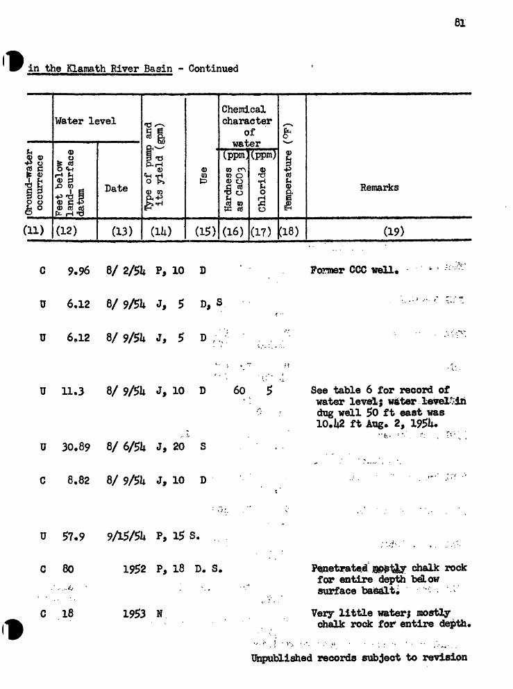
o
o
a
o
a
a
a
a
o
*-
v QJ
> V
n V*
J M
C
O^-O
-J
OoO
H
1 C
NQ
^V
O*
* *
-»
* *
\O
CO
C
O
V*>
H1
H
NQ
ro
\o
to
ro
ON
VD
CD
C
O
CO
C
O
CO
C
O>
,.
""S
^
%^
^^^
X^
*^^
"X,^
! <
^"*
^^
^**
^^
^^i
» «_
i \n
. vo
o\
\o
\o
vo
tovn
v
n^t
vt
v/t
VA
\5tvrt\5t
v*
>io
45-
45
-jr
-
tr
45
-4
=-*
r
ss
^^
^<
f*
J^
£*+
***
't-»
M
H
1 fO
I-
1 H
os
vn.
o
O
O
vn
vn
OCO
t*
*»
WC
O
W
OO
tt
« %n
?
' ..r
\
r ;'.
'--
«
. .-
.8
.-..
1
i
' '
°
r f
g. ;
.._;'-
:" '
;
' rt
, V
l :
; -H
- -
' '.-
'
' ""
'JU
: ',.-;'
1 -
***
<|
*«
t CO
^
'
tQ S
O
§*
S S
§
8- F*
S^
$* 1
I*
« £ | ||
H^H
-I
0*
o.
P o*
5 S
*' "
* **"
*"* §
m 8
&
. «
O
P
. w
^^
' |
^" V
£J «
» O
^ .
O
" O
ft
1^
S*W
;
'
"
,-r
» H
i O
C
"
§
** S*
*^
-*c:
§ *
M^f
r *
0*
1
efo
.
"H
! O
|J» S
£»
Ft*
, -
, V
Q r
f*
* O
'
*"
8,
2|
'gl:
-
' ^8
8*^
«a,
>
ttjP»
*
»*!
* *§S
joP.
*"
Ȥ1
3
'
"::
'' ?
o? *
^ .-' '
''i'.
/f
' 'V
*
»^j
«j 'P
ro s*^
H*
V*>
""^
& *^s
t*~^
.
vn "^-^
*P ON 5 v-" O3
s~
\
NO
irro
una-
wau
er
occu
rren
ce
Fee
t be
low
gl
la
nd-s
urf
ace
g
datu
m
n <O
CD
^ (D
Type
of
p-um
p an
dit
s y
ield
(g
pm)
Use
Har
dnes
s ^
B* §
as C
aC03
"g
§
J? §
_? ^ ,+
0
fl?
&«^
* CD
H
j O
O
Chl
orid
e 33
**
g" &
-E
**T
empe
ratu
re
(°F
)
S? Q | W
0 e 9 CD 1 cr W 1? (D Gd 0} S* I o o {^p ff 1 -

Table I.- Representative We:
Wellno.
(1)
Owner °r occupantof property
(2)
,.1fl^'O r~4
P rtd -P m
£(D 6p.-'p ,0
fc J 439 o ®
fi&£(3)
0)
S
U).
PV(D
5tP
(5)
*^s,
CD
fCg
5
^(6)
ttDc H
O«MO
5as(7)
Water-bearing zoneor zones
1-O *~^4543
<D & (D«4^ ^k4r(8)
(0 (0
iS $*r{ ^He-
(9)
Character of
materials
(10)
T» 35 , 12 E.
26ML J» Foster; Estate .
2?G1 Sam Godowa
27Q1 Henry Noneo
32G1
;- ;- . .- .-.';
3to Joseph Godowa '
i -1 * 1 '"..' 3SD1 Andy Foster
T. 35 Sv R. lit E,
29B1 Mrs* F. Obenchain
31J1 Harry Obenchain
32N1 0* H. Osbom
/--: : f; 36^,^6-Ei
It,37<
PI*>38(
P U,36|
H Ii,5a
P*
Ph,hO(
SU,5o<
S
P 1*»38<
Dr D
Dr 3
Dr* >
Dr )j
Dr<\ j
Dg 3yJ
Dr 3
Dr D
Dr 3
300
5po
5oo
900
8.
100
*09
270¥ ;'
6
6
*6
,26
k 22*
6;
6
'. *. v
8
% T , ,-
3L1 Robert Sloan Dr 80*2 6
3P1 .do* : , , -, P Dr 116 6 116
Unpublished records subject to revision
Basaltic "cinders*1
"Quicksand"

03
***
°
o
cj
o
; . o
o
o
o
. "
t*
w
-
; vi
H»
~j
o\
o\
- IT
- -w
r :
co
o NO
*L
* *
...
'*--.;
«a
g »
J-
S
CO
.
ff
j^»
1^
5 «^
j !*
-;-
. .
H*
H»
, >
j H
45?
4?
^P9
GO
,PJ!>
\o
o c
o co
co
fr-1
^
^
H
.£
^
-T
^ ^
^ ^
Q
Hi
Hi
Hi
" V
i §
^ ^^
^
Uw
fc*r
*r-4
s-
45-
|r-i
\>
&
*Z
*^w
^ &i
as
izi
*rt
SB;
as<
% <+
_ .^*
* "^
**
, »
VJJ
tf
vny
o o
u>i^j
|_4
t,j
tJfe!
tl*»C
»
O
25
SI
»
v
J
w
.»
".*
T.
,
"
', /l
-
8 "*
' "A
'"
"
'
?
- -
-v'H
-
'
:3
- "
co
. ' '>
.'
1' -
"" ;:
S '
.
."*
* '
' !
'"
\ri
''
9 »\ e
*- ' *
\"
$
8
§
i tr
%
&
0)
3|°
g ';
g,
&'»
"&
-'
» ? 1
.'
% I
I i:
I;,
:L
i
'"
**
" **
" <
****':
* '
®
,' *
' O*
'
Si
" \r
[ '
» C*
*-
' /
t '
ife
§»
'»
"."
§
- @
i*
©
' ""
w cy
*
* - "
*
i g,
; -
., *
-. -
*^ .:
5. 8
' - '.-
: - ;^
"^
'
-9
" -.,-.,,
H H* ro 6 g. ^
^^
x^>
VJl
*P o^ ^~
v
**^ *^x OD
^^ H*
tjro
una-
wau
er
occ
urr
ence
Fee
t be
low
g
lan
d-s
urf
ace
g-
datu
m
*i H* <
t?
(D
lype
of
pum
p an
dit
s y
ield
(g
pm)
Use
Har
dnes
s ^
§ §
as C
aC03
"^
§
Q i
x->
<D
V-b
O
O
Ch
lori
de
£ *
* g"
M3
^**
-
Tem
pera
ture
(°
F)
w i a 0)
H*
D Q P £T I (D i? CO
p.
D 1 O O D S* 9 § CL
OS

Table I,- Representative We
Wellno.
(i)
Owner or occupantof property
(2) i
?*
1 <D <US^ «"*cti p
P cdT? *H 4)Sis«»J^4 <D O*
CtJ CD 03
|| "g
fife^
(3)
9)
1?
(4)
^
0)<£^-x
51(5)
x- sro
gi-
fn
$is
(6)
to
COcd o
*HO
0,a(7)
Water-bearing zoneor zones
& p5 4>
A 0}L |,^ ^|r(8)
0)w85S-"
(9)
Characterof
materials
(10)
Tr M 8+.g . R, 6 E,
10K1 Fish & Car3|Sta«ora .
T. 36 S,. R« 7 B.E. ! '
Continued
P Dg
J, MiUer
9Q1 G* E* Johnson
15K1 Tony Zadina
15K2 Laima Lisnber Co*
J. L. Hobadc
15Q1 Wra. Helm
8
Dr 130
P Dr U85 6
P Dr 280 6 Sand, fine
Dr 250
Dr 160
6 22*0 2iiO 10 Basalt 90 150 Alluvium
Dr ;200 6 200 170 30 Gravel
P Dr 6 200 9 Sand, fine
T« 36 S_«.« R« 10 E.
2P1 Irw^i Crume P Dr 625 6
P Dr 3kOU,335
IJnpublish^<i records subject to revision
230-UO Basalt

*! O d
\o 8 CO OO vn
40 v*> vn
ro 8 S
8 O
£1 *b. ut *f r.
I
* 5
S
H»
vO
U> 10 vn a. I g.
svn
u* I-1
vn ON CO
H*
\O
Gro
und-
wat
er
occu
rren
ce
Fee
t be
low
land-s
urf
ace
datu
mtf
Type
of
pxim
p an
d it
s y
ield
(g
pm)
Use
Har
dnes
s f&
as
CaC
03
*§
Chl
orid
e<*
o
P P-
O
H»
O
O *
c*
- J»
(D
H»
Tem
pera
ture
CO
i CD 6 i $ w 0>
CO
H»
O o § a

86
Table I,- Reresentative
Wellno.
(1)
Owner °r occupantof property
(2)
I1 Q) <Dfr'S HCO p_ 45 cfl
*O *H Q) C-P co
TO <D
JG Q) OP--P .O
L| gCU «r-j *PO W <D P< Q Q)
P* p^v-'
(3)
Q)
§
-
U).
^
<D
£5PIQ>^
(5)
X x
CO
1 H
^
.P
(6)
bo c Hsto o
oxj43p- jpc
(7)
Water-bearing zoneor zones
1 P^
0)jj^ ^)jjj ^u * Q.%^^
t(8)
0) 09
VJ (I)0 Q)
*f"l *M*"""
(9)
Character of
materials
(10)
T, 36 S«. R« 10 E« * Continued
3Q1 Irwin Grume
IjEL
6R1 Joe LaHoda
9KL H. T. Bobbins
do*, if.'
9R2
11P1 Great Northern RR
13F1 Ivy C, Clark
P
U,3
P^>3
P k»3
P b,3
P ^*3
P t,ap
Dr ItOO lliO
Dr 35
Dr ij20 iiO
Dr itOO 50 (?)
Dr 70 ,
Dr 600 LO
Dr hOO
6 " lilj^
6
10-6 61^ ,
k . :r-,,6 11 37
570
12 L2 320
Sind: 'and chalk
Sand and pumide
4 . j, / ' « *
. 18 Sand, blue
30 Basalt
80 Sand, blacl
P Dr^. i12 ' '
Carnini
110)3 C* R* Williams
P Dr 260 8 36 225 35 Sand, black
Dr 122
MbJttbV %o revision

Hf B-* CD
Q, I O CJ
U ca
o e«- S' I
H*
CO
* U)
00
vn \n
0 C*1 s.
o
CO
M
OH
* Hf
CD
<
6*l
01
(D
m
o
"f
ftp0>
o
o
- ro
CO
VJX
VO
w-
v?t
^** 8
»
ON
ON
\n
vn
O C
O 3
Ht
cw
vn
?' t-
vn oa
S
CO
CD
!°»*
1 I
8ro
p
VO Q
VX
PI -
03 U> vn ON O3
Grou
nd-w
ater
oc
curr
ence
Feet
below
land
-sur
face
datu
m » CO
§r i
l^pe
of
p-uii
rp a
nd
its y
ield
(g
pm)
Use
Har
dnes
s as
CaC
03"
Chl
orid
e
o o
sr s
r£
03
(D
c«-
O
P>
F*
CD
H»
O
O
Tem
pera
ture
(°
F)
Q » 03
D
CO
0) 0)
CO D* I O § a.
c»

|-J
fj
f-f
fN>
i-4
I"**
fO»
*-' * '.
O
' 5j
' O
H
i »
*
';'O
»
^,
*"3
:"-»V
£ !=
B;
-. !§
!ij -
I* -§
-<
i-.f £
'
'*
^5
" *'
3"
P5
S
'. -
P- *
^
""
,*",
" '
M0
' *
w
- *
53
, ""
f n
*, '
M
&
V K
"*
" :
^
'
./
'-
H
3
V
" '
S
. ;
. ;"
. w
S- -:
-
w.-
, .
^
^
«
8 ^
S"
S
^|
tJ
tJ
tl
tJ
t^
t!^
t*'
vff
»i
fj
^ 4
»T
<T
o.
Q>
ON
fO
&
* O
O
o
o
v*>
o
o
o
i-i
H
*-
* *
*~*
fc-
ON
ON
fO
ON
IV)
fO
|^
fo
--.
. \n
\' :
45"
£"
'.
4^
' ''
-' '
r" OC
t ' |
Q
-' '
O
' "'
O
*O
"
O'.'"
.,r
''s'
o
-'"
' "
*j»
-'f
VA
-*o
v-"
o
'i. '
"C
GO
^%
»>
'/.
H*
U*
-'O
"
'' O
""1 .
o
^o
^o
VA
o
o
m
w
w
in /
(^ ^
ta
Cb
CL
D«
v--
01
. '.-
" o ,
p
O
O
O^F
"C
u'O
t.,
p
j$
,-
* .,-.
; *
v p
i*'O
'
* J
S
**"
^'
%M
^
V*
s TO S & » s 3 o» vO 1
O M
.
H Owner or occupant
of
property
Top
ogra
phy
and
ap
prox
imat
e alt
itude
(feet
abov
e se
a le
vel)
Type
Tte
pth
(fee
t)
TU
amet
er
(inch
es)
Dep
th o
f ca
sin
g
^pth
to t
op
^ (f
eet)
|
,
.
,.<
- T-
r
^ ^
Thi
ckne
ss
** ^
(fee
t)
§ 2
go
S3.
»
ar
co 3
Sfo
§
**1
H
I Q>
M
H
- 0
0
$
$
§
00
»*
Table
1
.- Representative Wel
l

o
M H
JO
H
^5t
*r-|\
> IT ro
0 I-1
M
U>
flu
VA)
f*-
1
8 if
O
H*
IM
W
.
<D
B
»*5
vn K)
CO
h>'
g§.
» p?
®81
$ sr
? H
j
O
P5*
»* OO
Q vn
0
CJ
CJ
CJ,
* v*»
-
,'
' IN
> O
N
Vn
&" '
<,
» .
;vn
^
' '
«£?
^*
^PO
N
^O
VTl
H
1,-5,
^s
r^*>,
?s.
v2
"^^
^ ^^T
L C*
1* Q&
a
a
1-3o o
&
&
eft s. V*>
ggS
J*
0*
0
I !*
»
<D
£
11 o
®
^£8
S
3Bg-
ll I
l«s
ijf
vn ©
**4
®
vn
w* 3
H*
2. 5*
" H,
'^fl
S'f
ti
Krf
- ^
H»i
-Q
8*
1 S*
8
3
?
' flu
CD
* H
1 0>
Q
j *
|iM
j {0
^|
Vj^
C
2t
i "^
g* t
j*
OQ
. O
N
ON
rf-
CD
w
O
* O
O
to
Cj
c*
" l^
« M
h !
,
9> H
^ §
ir
-^S
pkf
A^
Ul
^^J
tf^%
fc
"4t
t*^
§O
%
I-
*O
H
t O
;";
5
c*
3
O.
* f
r^j
EiM
*t
H* ro *>-» u> <^% ^-^
vn ON -0 CO v "p
NO
Gro
und-
wat
eroc
curr
ence
Fee
t be
low
g
land-s
urf
ace
gda
tum
H H
^ 3
O
CDe<
- CD
T^pe
of
pum
p an
dit
s yie
ld (
gpm
)
Use
Har
dnes
s t&
8-
§
as C
aCO
^ *§
§
S? i
^ ^
o
3
C.
^->
CD
Hs
O
0
Ch
lori
de
$ *
* g"
& E
H
Tem
pera
ture
(°
F)
jjj
CD LJ
g-
CO
H»
3 CD P § §
«3l
% CD
" Gd CO 3* 1 0 § c*-
S* 1 a

.ro
o a. on CJ
..o
*-*
oo
f ro
ro
I ca * H*
O
§ :-.
*:
1«»
5*
,0-<
S
T ca
ca
a
o
o CO H
*-*
U> \n
roro
oo
\n H ro §ON
K ro
oo
o vn
o
a> ro I
*-* 3 S1 »tJ ? u> § 8 S U> :s H
O>
.51 o ts QJ
H
* V a » » fc t ft i*H >-x ?O >^x
U>
v_^
4N V- *
\J\
^~s
s~*
O}
^ v>
^ oa v_^
>*N
NO
N^»
X^»
H
O V--
"
g| « H Owne
r or occupant
of
property
Top
ogra
phy
and
ap
prox
imat
e al
titu
de
(fee
t ab
ove
sea
leve
l)
Type
Dep
th (
feet
)
Dia
met
er
(inc
hes)
Dep
th o
f ca
sing
Dep
th t
o to
p (f
eet)
Thi
ckne
ss
(fee
t) §0
ji* *
P*
(b o
^3.
^8
& ?
CO
^
Water-bearing zone
or zones
Table
1
.- Representative Wel
l

o
OO
CO I s
10
t*
1 I
*£$'
- ^-
*
Oo
10 vn .00
JOO
vri
ro VA
ro rO
-fO
IN)
-^3
" O
O jo
8
Sf
o tajj & 53 |j» 3 . 3
:
3 g. c* £r
; - ri^j L
M^
P ro § P *
/ -s vn " *
P S £j ^" oo ^-%
I-J
Gro
und-
wat
eroc
curr
ence
Fee
t be
low
g
land-s
urf
ace
<£da
tum
>i 1
O
(D
TVpe
of
pum
p an
d it
s y
ield
(g
pm)
Use
Har
dnes
s G"
B-
§as
CaC
03
*§ §
S
Iy ^
o
oa
D.
<->
<D
1-^
O
O
Chl
orid
e S
**
g" f
rE
^
Tem
pera
ture
(°
F)
i1 i 1 « GO
H*
3 (D 13 P S tu
0) CO 3* 1 O o 9 t? i a

5J
H*
H
g
' u>
^
*w?>
I?
? P
' ?" -
P *
w ?"
5
S? K
p%
Jrj.
nj
c_*
*^CO
fff
c
* H
! «*
CJ
/ft
jQ
' LA
) ! *
* "
: ^J
| «3
>l*j
.-;-
.-^®
^.
'^
'a
'
o
. '
- »i
\
o.
ON
*?
ON
R
.**
,.'
fj,"
o>
.
o
;
;- O
. -
,"»
_»
.
'B
a«
'H'^
?
^ J|
:
H
, g
oa
3 co
8*;T
-fi»
' ;
- ':^'
'-;
'
."
- H
-
' H
.:- ;
f
- -O
. -.
,« -'-
-'
.. "'-
. .
*r
f
O'
" M
«*" '*.'
O
*
-.-:*
-
' -
. '
fr :; '
- .""
-'".-.
! :
' '
7
g
M
H*
M
" ^
JJ
(0
C:
H1
-"3
V*J
l\>
ON
M
-.fcfS
tf
Q2
?
v*
*v
no
|rO
OO
O
O
Ov
po
vn
... -
w
Jr-
" '
l-»to
C
O
ON
O
OO
NfO
ON
ON
OQ
ON
O
N
IO^
2P
- - -
*o
'O .,
O
"
O
; PO
oo
- *
-' " o
',".
' O
OO
.
' O
ON
0*
, "^
* O
O
*
* Q
f
cr
* «
kp
J
.-..».
3 ?o S i Ut 3 3 CO vO o
gl Owne
r or occupant
of
property
Topo
grap
hy a
nd a
p
prox
imat
e al
titu
de
(fee
t ab
ove
sea
leve
l)
Qrp
e
ttept
h (f
eet)
Dia
met
er (
inch
es)
Dep
th o
f ca
sing
Dep
th t
o to
p ^
(fee
t)
S.S
7 T
hick
ness
o*
(f
eet)
§
2
So
§ J
3. 3*
OB
i"j
*"i
Mj
Q)
M
M*
O
O
^ft
wl
(D
M
1 DO 1 S

,.
cj
o
o
a
o
o
o
o
o
a
cj
H
-" ";
. 5.
U"
,.-
* H
VA
^
» .
0*<
(°
|L
. ,^
.
*
CO
V
A
' O
O
OO
O
6 G
O
OO
fO
O
O
OD
->
^^
-s,\\>
X^>
^
^
H
H1
^^
^0
^
^
^i
_pi
^i
0^
^i-
^s
]pi
|s*
j*»
^r"
IT*
»ij
t«
, a
a
ss
s
as
is!
ss
*Ti
*H
% %
**"
* *»
H
H
f?.
.. O
,;
, O
...
. ;-
U»
0
" °*
/ *
CO
W
.u *
* "^
^
VW»
""
' '
" "
" '
. -
; ... '
pi
v "
' *
\J\
' ^"
ff
Vrt
' V
A
NA
V
A
*SBj
hrt
*3
Bj
*3Bj
*
fa
*<^|
,
OG
6 3
08
CO
1
0)*
-
r -
. "
«j
M
(D i"
-
O
* *
-' C
? - "
-. ,'v
XA
O
, -, '
«
Pj
O
^ ; '
- =
/ .
i,
S /:
' "
.. ;
^ ?;
':-? !'
-.
H «o g'
1 VA o § OO §
urou
na-w
aTje
r occ
urr
ence
Fee
t be
low
g
lan
d-s
urf
ace
g-
datu
m
*i
« i
Type
of
pum
p an
d it
s y
ield
(g
pm)
Use
Har
dnes
s f&
§
S
as C
aCO
T *§
§
Si
,,..,.
M,
..C
- *
0
03
&*~*
a>
n> a
o
Ch
lori
de
*§ *
* §T
&
«E
**T
empe
ratu
re
(°F
)
09
3
(D S R 3 1 O § a

Table I,- Representative Well!
Wellno.
a)
Owner or occupantof property
(2)
g1 Q) <D&*S Hco p P cd
*O *r*l w C3 P w
b gJM (D Op...p ,0 C(5 eti Q)
fc^ 43
ill(3)
<D
J?
(4)
x-v
O0)
5£p
(5)
CO
SA
£4
5§S
(6)
fcOc H 03rt O
*HO
51(7)
Water-bearing zoneor zones
1 P 4^
Q) «C <l> i^ fci
(8)
Q)to<D ^"^ C-P
f, $
(9)
Characterof
materials
(10)
T, 36 R« 12 g. - Continued
Dr ltf.9 6Beatty Recreation Hall PU,3ii5
23U Walter Scott P Dr 299
T« 365,, R, 13 E. -,'«..,,.: . . ' , -
Quincy Baker P Dr
22KL Ployd Hartin P Dr 165 6 M35
T, 36 S«» R, lit E,
0. H, Osbom , , P
10B1 F. W#
liiBl F. W, Obenchaln*.! *,
17B1 P. W* Hyde**
20P1 John Roberts
22G1 F. W*
Dg 28.1 30
Dr ii90 6
U Dr 128 8 U,3?0
S Dr 173.5 6 U,370
15 Basalt : " breccia
\6 2k Allt^vium
5 Basalt - cinders
P1
S
Dg 16 36 16 k 12 Alluvium
Dr 90 6
25E1 Walter Campbell Dr Basalt(?)
Unpublished records subject to revision

C3
cj
<4
d
cj
cj
c|
.:
. <=
} C3
O
V
o
u*
.
vn
- '
H"
'-.
, O
<
NO
l~
* -3
°*
*" >
N
**
'?
ui
vn
- *o
NO
H
jo
ro
vn
vn
oo
vn
, H*
oo
oo
oo
OT
oo
oo
7^
H^
P"
" H
" H
.
M"
NO
""
^N.*
^S
»
*^»
'
'^S
»
""^S
fc
^S
vn
vn
vn
vn
vn
vn
vntr
*ti
OC
^^^C
H
^3^C
*
1^4
' L
.J
' L
^I
\jj
I -
; \jj
o
vriv
no
vn
vn
o
vn W
;::
:* x
.'<
**...
-<,
,
St
' :
'-'
V?
: 2
; ,"
,;"
..5
<
: a S
i*'
*o
»^i
-to
'
w
t>
-. w
3«g
» jT
t ^ r
_^
g*
m
' Q
} |»
J ^
S
(y
9 3
t-J
O
^p*
CD-
f O
j ^^
***
« S
^
CD
3,^iHO
> !?
I '1
*
*"' **"
S3
** a
*.'"Of
t Jt
t C
jfr
ra^"
1" $*
"? »^
v '
C^
^*
C
J*
- v
t~
T^
'
09
P*
*^ 3
' zl
'
' O
'
' Ij
f P
- *
3
.' *
p*
)~l
Q|
jfc
$
ON
O
'W
U
J ^
2.
3 O
*
* "'!
"&
B'
8>
O
" *
, *
Hi
<0
SJ '
*
, |S
" =
O
ef'..
H
* H
i -
, ,O
.
O
<D '
-*
-. 01
ir
*$
w,.
. ..<
**<*
* '
' ;.
,"
>- :
Ct*
08 '&
®
* ,
' *j
f " v
«-.«
»fC
^ *J
s
51
"*
®-
' *^
K
*
^Sc*-
*
8
x
*%
.' ><
2.
' '«
O
H^
D'
O
,
. O j
jr '.
i ,
. gH
O
*
Jl
*^i
" 'S
* w
. ^*
'S
vi O-
^
ft-'*
''V51
> ^^*
8 I
^»
*
H*
i^ K* ro § g.
v-x ^_^
vn X-N
I-
1
ON *^N
. 5 CO H*
^S
urou
na-w
ater
occu
rren
ce
Fee
t be
low
g
land-s
urf
ace
g-
datu
m
^
3tJ
CD
0)
M
?
Type
of
pum
p an
dit
s y
ield
(gp
m)
Use
Har
dnes
s ^
8* §
as C
aCO-
5 *S
§
£j i
^ w_
. rf-
o
o»
D.
x^ C
D H
J O
O
Chl
orid
e «S
**
S" H
»
Tem
pera
ture
(°
F)
§» s- CO
H»
3 e >j P n* I 03 3. 3 1 O
O 3
d- 1 a*
vn

.10
_ -33 cu
.w 9 ICO »
H s
OS
t C
»
O*«.
\A* w
u»
o
o »
CO
s
\n
roto
. *
-^ t-
t
SE
j' *
'*"
O
O *? **
V**
O.
rSi »
c»
oo
§
V*
Go CO
V*
co o * * t a.
3 M VA)
X- X vn ^ / s s vO *-*>
»
.§l Owner or occupant
of
property
Top
ogra
phy
and
ap
prox
imat
e alt
itude
(feet
abov
e se
a le
vel
)
Type
Dep
th (f
eet)
Dia
met
er
(inch
es)
Dep
th o
f ca
sing
Dep
th t
o t
op
3 (f
eet)
g.
Thi
ckne
ss
** i-
(f
eet)
g
21 '
T
'
3
H
gO
»
H«
J3*
CO
£«S
1 (D 1 i DO i

c3
cjcS
c{.
. o
o
cj
c{
: r
CO
rO
h-
» C
D
, ~.
v --
£5
SO
V*
> J~
'"'
CD
: -
"'^
oo
^
^*
"^
f>
^sa
> so
"V
j v.
' "
NO
\ \
.'.Vi
l^-er-so
QN
O
ooi=
-O
N
vn
m
o
\n
o
vn
--,' -.
Q
t t|
oo
co
roO
O
CO
. SO
£
..
- 0
s v*
> ro
H.
< "S
. ON
f
°
-fiU *1
^S
'S
*
s-IS
110
HI
Cp
p^
3
(D
O
® p
(D
Q
P-i
Q
{3
O
H
CO
w«
(D0>
<7
* *
}J.
p,
w
O
<D 0
wP
*3
*^*
$**
^""^
CO
f^
r ^|
) {D
jg
_ 23
r^
c>
^ n
*
r>f»
M
jf ®
®
*"$
OB
C^
" S*
O
u %
w
P* O
* *O
'
SO
O
f *c
$ Ju
G>
CD
»
Q«
O
' <D
-a»
mw
^
gs!l-
JD
.O
^
fD
.
* '«
"
* -
' ^J\\
y\.
Q
Qt
&
c*1
O
CO
O
"' "
*^
C*"
C**
r^
*»
wS"»
E ro §.
1 vn ON
"p" co NO
urou
na-w
a^er
oc
curr
ence
Fee
t be
low
g
land-s
urf
ace
g-
datu
m
^
-
Sw
0)
0)
I *
*Ty
pe o
f pu
mp
and
its y
ield
(gp
m)
Use
Har
dnes
s t&
§
§as
CaC
Oq
g p
« g
, ...r
, >
w *
o P
5 M-
x-%
<D
H>
O
O
Chl
orid
e §
^
S" H
» g
^*j *~
-
Tem
pera
ture
(°
P)
Remarks
CD tjj
03 CO
H« 1 O
0 ci- fr § Ou

fr*
f M
M
1
0
^
t-i
:-H
*
.
«4?
r-,
- -
- -
-
~.
_ -
"
-*
{P-
f*
33
St
'". *'"
"""
S^
Jb
*""
* *
*
*f~
, '
*
"
' '
«
^ C8
'!
*'»
*
. -'
1*
-?
*
?
?
.
- :
: *°
^.
'^ '~J
:" as
s?
o?
'-c
fc-' '
W
-;-
g*.
,:'&
J
p|
g"
g;
r 3
;'H
lT
lv f
t'
!3
H*
J*
" ''
...
O
'
a.
a> =
01
i*
-
. $g
";' 1
s 7
11
i^i
"i-
': -
:i: -.
v.
r- -
S*
; v
; .
' ,.
,;
^ 2
*
^
^
^
^
W
CO
COrf
',
*r-
4=-
|r*
|r*
jrr
fr
fr
frnj
i-j
t-j
H*
ro
PO
ro
u>
ro
p»
OD
oo
o>
ororo
ro
->3
Q ON
--a
O
O
NO
O
OO
? *
^ "
* *
u *
^ -
o
o
ON
\n
ro
ro
vn
So
vn
vn
ou
>
»°
*H
b
;.
-^
V
|-»
H
H
M
M.
I-4
- .
.00
O
ON
O>
O
Q.-
O
l\3
'*
"
ro
ovv
* '"
r"
fc^
"i»V
k |i»
l ^^
"**
*
g
3
S
vn
- S
B
»ir
6^
»«
-
' '
p S
- *a
2
5?»
**
SS r
*
t~*
*^-^*
*
»
3
l
" ^
- c
' *
' J& w
."'
' 6
J*
. -
*" *
1v»
w
" J
»
.
^J
CO
W
* :
o
.*
**tf 1* ro 8
»4 §,
CO pj
: f. *
r a
: ft »
U)
CO * * ^^3
nrt
* 1 O
O a g CU
^_^
l«j
>«x
>!3 s~*
" ^ e VA S X
""S
^J S 2 5 o
3
(D0
M«
H O
Hi)
m
^
S
1
§ 1
Topo
erap
hy a
nd a
ppr
oxim
ate
alti
tude
(fee
t ab
ove
sea
leve
l)
T*pe
"Dep
th (
feet
)
t&am
eter
(in
ches
)
Dep
th o
f ca
sing
Ttept
h to
top
^
(fee
t)
|1
o *<
Ihic
knes
s **
a*(f
eet)
g
g
So
S3-
3*
tt
34
H,
Q>
C9H*
* O
O
Q)
cf*
J3b
tf^
A
(JD
0* H M 1 CO Cl>
3 I 2 J»A
£2
ib
^
ED
*5
1^^
[P JA«
NO

ro co * g >o
.o. 23 O o
8b
£
t* NO:,
\o;-
CO
CO
CO vn
.
v«»
, vn
*t»
_
CO
(D
3
<&
Q_ CO ^
* H
* a,-
*"»
O
SN k CO vx vn
c+
a
O £ CO
o V* I L-^a t» « CO 8 VA)
01 . C f<D H
j
o a- CO
o & p CO
£ H
O
NO s .CO
8
O*
o v*>
fl * J.
« CO CO
ro vn ON
CO
NO
Ground-water
occu
rren
ce
Feet
below
land-surface
datu
m o
ff
I
Type o
f pump a
nd
its yield
(gpm
)
Use
Hardness
as C
aC03
Chl
orid
e
g co
CDc* o 3
&CD Hj O O
Tem
pera
ture
§? i CO
0 I p g (D O § o.
NO

fif-»
IO
v
t»
O
eft
I §'
0 ^p
9 'Cft fe '
j-'ON
0
U> 0
oo IT"
O*
ON
IO \n ON
td
»
lr» t o>
Jf
KU
)-'
W
, P o 0
H O *i ro
ro ON
- £
a O)
gi.
-" »
COO
.
8 08 K vn ON
o» *
to 8 H» O
N fO
I ON
f 2 S
§
|<
,;.
w S
pi
'" *
3a
d*
f;l o. o $
ro
CD K \n
al|
H&
WJ.
2's
(»
*-3
U»
"**
0> M t § 0)
Q.
x- v ^ ^> <^ *~~
* fc ^ o ^3 0> x~"'
NO o
Ji
O
£ *
^
0 8
*a>
o^
o 1 d-
Topo
grap
hy a
nd a
p
prox
imat
e al
titu
de
(fee
t ab
ove
sea
leve
l)
T^e
T)ep
th (
feet
)
TUam
eter
(in
ches
)
Dep
th o
f ca
sing
Dep
th t
o to
p(f
eet)
Thi
ckne
ss(f
eet) g
o Sf
H*
P>
w
O
.J^^
^"
H ^f
t|_
l»
Jj
C9
rt*H
d>
co
> *
^
0? *^ tS
I (6 n CO
9 tsi o i
H
(P 3 CO s I i

H
f\>
vn
OO ON
*? S1" 0
0 I r I <? $ si 00
03 S
o § s
H»H
.
o s S4
II W8*
^*<
i '
«* 00
§ I t CO
VA>
25
fio * P I vn
o
ro u> VJV
O3
Ground-water
occu
rren
ce
Feet
below
land-s
urf
ace
datu
m 0)
s IType o
f pi
amp an
d it
s yield
(gpm
)
Use
Hard
ness
as Chlo
ride
S P-
ct- o
CD H»
o o
Temp
erat
ure
(°F)
8?
(0 3 f ct- I a

Table I,- Representative We:
Wellno.
(D
Owner or occupantof property
(2)
II Q> 0)&*2 H
CO p_ -P C8rO *ri 4) C-P WSH
CtJ CC) RjL| 0CU «fl <PO M CD
fife^(3)
<D
S
U)
^^
0)
£aj?P
(5)
CO
g H
^
^
(6)
tkO H (0cd o
O
jg-1^a.1
(7)
Water-bearing zoneor zones
1 8 4^
0)A 0) ^d (fcJ!""(8)
01o>
H <*H
(9)
Character of
materials
(10)
T, 38 S,, R. 9
19A1 C. A. Tottns
19A2 Oino Carnini
Continued
DrD 21 '10basaltic
Dr 192 8 , A ,,
Dr 190 8 52 115 5 Tuff, i .
Dr 330 8 60 Basalt
Dr 235, 8 lOp , t . , Sano^SU^k
Dr 310 8
Dr 290 * 6 60 '' ;> ' * * Ui.t\>.i 2
* fBasalt
515
28F1 U. S, Veterans S Dr Administration U,U35
dUnpublished records subject to revision
12
20 U60 ItB
do

£ £ £
«
a
9^* a
O
, H
a s.
I f
&
:-- c*
.'
0) & ;
? §
*t*
*t* vn
$ CO o
t»
CJ
H
Ct v 8 t)
l-»
JO 4=-
»-3
s 8 £
I
^s? s- o* ff ^ s
;,? C*1
.'>
vn
Ground-water
occurrence
Feet
below
land-surface
datu
m
of p
ump
and
its yi
eld
(gpra)
Use
Hard
ness
as C
aC03
Chl
orid
e
8-S
JB
(D
C+
O
CD
H>
O
0>
Temp
erat
ure
(°F)
CO
f I 4 s? 3 I O S 0.

?.ro
fO
ro
N»
^
KL
££i
CO
' ;*
Co
CO
CO
CO
CO
*7
2y
* ^
-^ : '«
SB!
i ' t
s
s
«jji ^
ss
**
£!V
O
,;. ; -
. "
Q®
-'
"
£
*""*
^
, ^
j*
^
*--
? "
T
P*
O
- V
-ft
- *3
f X
* -r
1' A-
W
'*
' S
« '
« «
' '''
r-*
^
"-: g£
*,i
» 3
" ''
:"-' ';"
.-*
*
' ' g
, g
g>
!- g
V* £,
':* ?
4
£*fa
**
I**
**
*
Vfo
. |
"^
^4
'' -v
JK*
i*w-
' '.
" -i
5**"
'»'
^
*" *
^r
*!' ^J
* '
S?
' ^"
iS' -;
Q
V
'..S*
- ^
-"""
§ ;
'':- '":
r>
-.
* '*'
jj?
--
-*
-«'
A i
!iv
/'S*
'*'^-
'^ -
-'-;-';:;
..-: ^
;/ S"
'v V-
2'v
rv;
'* .
"'
Ql
r
'. £**
-'-j
- -
t
~f
~ '
*
'"
'
' '
^*
" *."
*
' S
'
'\
* §
:"-- If
''"
5 |
^= S
'!' £
£ ;v
» '
";* .,
|:."^
* j
,.';
S
?
'^»
"*'
: *
''
V
.«-
N-T
. if"
" V"
'
*§*
- s
-:-:
:-
-"'
"*
- «.
Q)
. ,
"^|
" ,
" "
"'
.'_, 3
' .-'-
-"
. -
': .
-
'£.
O
i .
'- /
».-
" .
" - /
.'.:
. .'-'
-'
,-,:
.-'
.' '.
".'^
^
'
x '
V ,"
" ' '
-",
' . ;
.' '-.
' '
.<- :
'. :'
i-
.M
«*
'-' *v
"''
"'
- >d
" "'
.": *tf
".'
m
'r«'
'" '."-*
*t>
' .'V
Co
'©>
...~
O
42*"
' '"|!
r* £
" 4S
" fc
* 45
" -P
*'J
M
.
*J
-» v
*|
-»
H
>-
I-1
I-4
IO
1 |
Jf §
9 ?
: 9
' ?
9t~r
s
£*
IO
N»
f^
' '
-J
V*>
U>
fi
CD
RS
O
^JX
CO
CO
- -.:
- ^
''
' '
~*K
O
M
H
C
NC
O
">
i Q
,p
- 03
CO
'""
l ""
i J
v '
r~» i «
* "
u
l^ '
\
r*^
*
VA*
r
»^
>»
^
.- -^
^
fO
- '
CO
VA
"C
O
VO^«
O
,- t
.
ro
-. o
so G
O
;j £r
\n
^*^»
w
w
p W
|H
1 I
*;»
:Jf $
8 \S
>S
:?
' v
. ;
%
« "
-..''
fl
k% «
' w
t&
-
'
' *
**
*
'\j
ft
? "."
'
»^
K>
O* f
s^
O
* v
VX
}
» 15
" O
* I*
1*W
tt
j 9
W
pT
x -
' OB
|B
>
CO
P>
Q
, m
'»
'- {
" O
tt
O
f Q
t r-
tK
O
Jp
.
O<
Hb
p
, p
O
*p,
.
H
.'-5
:
0
e«-H
..-.-
£
^
* v
fi *,
..-
«»
,^
---s
«t
->
®
' *
«*
"...
...
**
3E*
"" X
,- ,
,-;
-o
-c
* CO
CO * » 'O * t o o.
x»v H "
.^ s Ul i NJt 2^ x v
>~~*
. CO x*
^v
vO "5 o
-^3
(DO
H
^
H*
O
Sr
Hi
ffl
fv
"S
0-8
*10>
O
*< 2
ci* °
4^ g C
*
Top
oera
phy
and
ap
prox
imat
e alt
itude
(feet
abov
e se
a le
vel
)
lype
T)ep
th (f
eet)
^Uam
eter
(i
nch
es)
Dep
th o
f ca
sing
^pth
to t
op
(feet)
Thi
ckne
ss(f
eet) S
o
**yd*
0)
w
O
*5
& 1
9i
OJ5 n
69
«b
O
flft
tt 3 TO M 0 §
$ & H
(D H 1 M 2 A CO CD
3 S s* 2 (D |

oO o 4*
O
I JV>
ft CO
io
*tt
9 CD I: ~ *:
* *'
vn ON CO
Oou
nd-w
ater
oc
curr
ence
Fee
t be
low
land-s
urf
ace
datu
m
CD
of
p-um
p an
d it
s y
ield
(gp
m)
Use
Har
dnes
s as
CaC
Oj
Chl
orid
eH
o S
ICD
H
» O
O
.CD
H*
Tem
pera
ture
(°
F)
<D P P tu 0>
CO
H-
3 O s c*
1

Table I,- Representative We]
Wellno.
(1)
Owner or occupantof property
(2)
II <D 0)
fk**u r^t05 J «jlg«H <D C-P CO
Jf*^ fl) OO.- ^^ o tti cti cStf ^1O.! «-j <p
^ °^s(3)
Q>
^
(4)
^-^
0)
it5cuFP
(5)
x~sm^§ H
^
ff
(6)
60
H 00oj o
oyC*-|^
1
(7)
Water-bearing zoneor zones
f 8 +>
<D C CD^^ ^>j
(8)
0) CO
g-(9)
Character of
materials
(10)
t 36 S*« R. 9 E. - Continued
28P2 J, B.'Frieeen P Dr 56U lt,110
8 260| 275 178 Basalt
29JTZ Motors Dr 272 10 31 215 57 do.
HotelM06
Dr 650 10 150
32E1
32E2 '- rJ */c^r rftiff t ' L
Dr
P1^,088
90 12
Dr 90 12 76
Dr 190 12-8 11*0
s.r
32EU do, Dr 93 10-8 90 86 7 Basaltbreccia
.B*kr. 75 12 52 52 23 do.
^published records subject to revision

oo
O
CO3
S NO g
S 4-?,
4
l°! g
O\S
«
J=-
gO
335S
00
g fO *
ro M
VA
O a> NO
Gro
und-
wat
er
occu
rren
ce
Fee
t be
low
land-s
urf
ace
datu
m (0 ?
C
i
lype
of
p-uin
p an
d it
s yie
ld (
gpm
)
Har
dnes
s as
CaC
03
Chl
orid
e
§o>
CD
*1
3
o c>
P-H
» O
O
0*
H»
* O g e+
Tem
pera
ture
CO

g: H*
U> ss
GB I
*v C
* '
§
ON
r s
ro VA f\>
O VA
CO
u>
2 -
* IT
*
vn
ro
ON ro &
3$ Q
fr Q
}i-S
'iB
CL
p
C*
0 a
***
*
'."*
*^
-** f
' *:
: f
'8*
* -
*
r3* .
*p ,
c*-
; w.
»
co--
"
co
f :
' ; ;-.-;
t c
»t
-.. <
- .
',.
:. .-
y-.-
.
vo,:.,
., . ,
'
, .
: r
tj
*rl
*XJ
4T-7
. tr
*
r i
*»'.*
«
n.
S'--
SSL
S
. v
P
Co
co
g-J
C
D
C»
3
? 9
9 f
* 3
ivn
O
-a
H
H
H
ON
U>
U>
ON
-^
VA
CO
U
> -4
§
^
«
ss §
§
A
».. ^
O7
V*a
&
&
tS
to
w t
o j*
B
O*
09 (T
O *
\
S
?
Jf|»
'*
1 "
;
hJ
X N
\)
VjJ
x-s
JS-
x->
.
VA -2^ -j
*~s
'& vO
^ s
H
O VM
^
3
(D.°
K
O
SP
H>
§
3 o «" CB
O**
2^i
g c+-
Top
ogra
phy
and
ap
prox
imat
e al
titu
de
(fee
t ab
ove
sea
leve
l)
Type
Dep
th (
feet
)
tJia
met
er (
inch
es)
Dep
th o
f ca
sing
Dep
th t
o to
p (f
eet)
Thi
ckne
ss
(fee
t) §0
o*H
> g
{D
O
T
P. ^8 P.
srea
»i
Water-bearing zone
or zones
^9 6 H
(D H«
II 3 CO
(D
3
c*
91
c*- ? 1

I a.
o I 01
WM
V* g ** g-
o t CO fc
o
!T -a
ro r o*2.
5
ff&
°*d M m
ro 3 § oa
». g
IT
t
O
!? >«
ON
N
O i g
r-
O
, Ao
*;
co
Ground-water
occu
rren
ce
Feet
below
land-s
urf
ace
datu
m
Type
of
ptim
p an
d it
s yie
ld (
gpm
)
Use
Har
dnes
s %
as C
aCC>
3 |
Chl
orid
e §
§ §
s S
ic+
O
P
P-
<D
H»
O
O^
<*
9>
.0)
l-»
1
Tem
pera
ture
(°F
)
f p I pi 3 O §

Cj
VjJ
V*
) V*
>
VA!
VA>
VA>
3
V*>
Vj*>
W
} VA
) V
*l
JVJ
a 2
J3
M
S
S
^cr
,_*
»' ';
3*
-
' J>
".f
if*
^
^l$
j "'
'"f
$
f,
"^ L
fcfj
O
Q&
'
''if1
«Ej
i 'i
M^P
1'*
.£
*^5
'-'
'
t *1
" <
, '
£*
' H
I
S
,-',.
§
^
*?,
?'''I
.^
vj.
*' '
fj^
*
- 'o
r-
!'
'' ©
*'*
i*»
*t
''. *
*4O
* ';
j;%-
v HJ»
''I
J4!
vS
^
' 'J
( '
6".
'
"! ','
CO
'
^-..
. ;
1*
"
$$
.*t.
» ^
!'
i ,
' '
-
' \
' *
i 0
-,
!
*
V i
:' £-
'';
:/:
'' '"'
' ' "'
";>
^-^'
-^
^ r
':: *>
/ *
'', -
"'
'' *
-^ ***
* ,'''*
^ , '
*^
- cr
" "^
^
'
"'f
"^
-
±r
* !»
f- -*J
r* t'
'''"'IS
*JH»
'
ir*i
t
",;
^
> ...
V
'" V
;^
|H
%|.|y
!*'-
*|
o* :
;" o
2
* <E>
^
o
O
"' O
'
io''*
t .' ;'
t 10
3
E
'' o
-s '
U
f
5>
S> '
:£ o
B"
g
- H
4 |
. ^
^
' 'a
VA
*^
V
A
VA
W
O
3i\5
O
l\3
C
f O
N
+ *
(A
o
co
vh
IN>
VA
O\
i\
ON
O
O
O
V
O
ro
o
o
l:'; '
o
o
5
Q
v,
' '
S
' V
A4
W
8
0
. V
A
-"^ *
^ *
* _£
"""**
VA
;iil
''il
'ON
-
P
CO
tfl
2*
' ,
Q
) '
S»5
T'1 R
*'" ^
Sp»
'
0
M
O
H*
«t
*
»
"> > '-r!
' '
iv
, ,
^
^ x >nt S x-x ^ ^~> ^b ut o 3 oa "
"^
/^*^
V
vO x-s H s
0
CD,°
K PM
j ff
l
? o
4| d
-
Top
oera
phy
and
ap
prox
imat
e al
titu
de
(fee
t ab
ove
sea
leve
l)
Type
TJep
th (
feet
)
Dia
met
er (
inch
es)
Dep
th o
f ca
sing
Dep
th t
o to
p ^
(fee
t)
g.
-fT
1 -
r.
K r
ifduu
_. <
(fee
t)
g 2
J5
Ta
o
CD H»
w
O
T
1
Ml
g»
N
H»
O
O0>
. e+
- 3
HO
<D
CO
^
g H
(D 1 II ^*J CO § c^* {JJ c*- a 1

*-.-
* **
1-1f».
-tf
O# '
0»"
W
rrs?
8;
O
ro vn C»
Ground-water
occu
rren
ce
Feet
below
land-s
urf
ace
datu
m sr of p
xanp
and
it
s yie
ld
Use
Har
dnes
s
as C
aC03
'§
Chl
orid
eO
Tem
pera
ture
(°
F)
GO
ff S)
O g c* g

112
Table 1,- Representative Wellsg
Wellno.
a)
Owner or occupantof property
(2)
I1 0) <D
M"i *w i"^
£ « Q.H 0) CJ -P CO
eU <D
rG <D O
ctf cd ctffclj 4>al|
(3)
0)p,
§
(4)
^0)
£
pp*
(5)
X~S
CO
£g^
(H
5
S
(6)
CkO
COCt5 O
C|_jo
£Fa
(7)
^ater-bearing zoneor zones
1 S 45Jg g«l«5 Cfcjr(8)
0103
"o (8gtl
(9)
Characterof
materials
(10)
Tt 38 Sv R. 10 E>
George M; Staey *P Dr
13D1 Lv M Hankins p
284 12 '60
Dr 220.9 16
Allttvium; lava rook
216 $ Red cinders
KLamath Oowfcy zr ~ p Dr
<J^:Mitdi«n Dp $21*
5 50
20D1 Dave Liskey Estate P Dr 1,1UO 12
329 Lava boulder and cinders
26Ct Dave Mskey Estate" Dr 582 16 15 560 21 Porouslava rock
5P1 Leonard Hitter
6N1 J; P, Colahan
U Dr 200 16 12 181 19 Brokenlava rock
Dr 8 20 135 Sand
325 ' 16 -18 315 10 Cinders
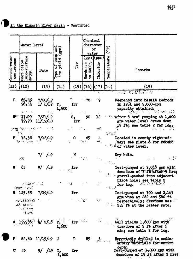
CD
fO
oo
ro * CO
V
A
i
:, $
» V*
< 73?
»:
Vl\ !
a CO !T
vn
i co
r\n
0
\n 8
I tr g.o ^
6
">&
g
SVM
rt-
&
fO>
O.
a> s»i
i-'S
^S
'
6.4
vn oo
Gro
und-
wat
er
occu
rren
ce
Fee
t be
low
land-s
urf
ace
datu
m 0) sr1
Type
of
pum
p an
d it
s yie
ld (
gpm
)
Use
Har
dnes
s as C
hlor
ide
*§
0)
(D
o2
PH
» O
Ttem
pera
ture
(°F
)
ff P I hJ s? O g ct- I

Table I.- Representative Well
Wellno.
(1)
Owner or occupantof property
(2)
f| Q) <D&T5 HCO £f
4^ COT3^ 0)d -P cocC H
&*s *§L^ fJCU fM +^
Row_O f^ «HSH pL( v»^
(3)
«e?
U).
<^>(D<D
«H
£p,JS?p
(5)
CO
x«
g
S
.p
(6)
(xoc H COCO O
O1^~*
4^g1
^
(7) ,
Water-bearing zoneor zones
S$?
0)& <D£ <Sfj .^-LLT^
fl)
(8)
CO CO§*3O Q) H <M
P
(9)
Character of
materials
(10)
T, 38 S»j R» 11 E, - Continued
7B1 S, Hartaler , S Dr 19i* , 20
\ I * '
tcT Christine Williams P
7M1 Louis Tofel
9K1 Cox Bros*
P 1
SU,370
Dr 586 16
Dr 260 12
Dr 320 8
17A1 do*
Ern3,e Hitter
Haskijis & Co«
Fred Rueck
Dr
P Dr 14,182
S Dr
P Dr 14,160
" .- *»', ',' ,','; .;» ' * « ..
Unpublished, records subject to revision
Basalt
56.7 19 Brokenrode
220 16
18 Red and gray cinders
310 10 Lava rock
do*
12 100
178 16 20 55 120 Brokenlava rock
Dr 226.8 10 85 77 Sandstone seams in yellow shale
211 6 v 178 210 1 Broken .lava rock
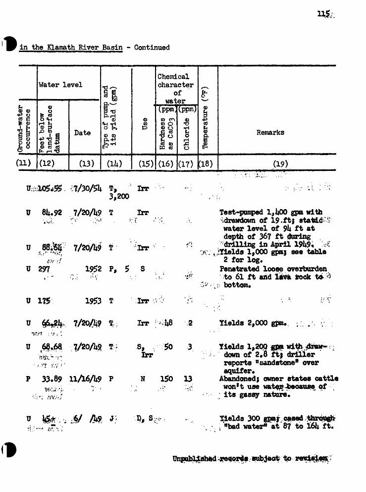
CO 6 ca
c:
a*»
V*
,-- >
1
c» >
. x> I
f '
»
; C
jr
."** -4
'>Q
*V
Q
>4
,*a
Vfl !-»
VI
&i\> \n
to
a M*
O o.
OO
fr IT
Sf
<JD
a>
o
H>«»
£2 A
M
*-*
y%
/-k
rih
^*j
j| *
%jj
. > *
r*^
\O
*§
* P
N
C
T
* O
* f
t_ >
o^
o
9
ro ON CD
VO
Ground-water
occu
rren
ce
Fee
t be
low
land-s
urf
ace
datu
m o CD
I M
Type
of
pum
p an
d it
s yie
ld
Use
Har
dnes
s as
CaC
03
Chl
orid
e
§ § 0>
CD
5O
Tem
pera
ture
CO
f CO
H-
D O § S a

Uo
Table I.- Representative Well
Wellno.
(1)
Owner °r occupantof property
(2)
I&T3 r~tCD Cf
-P <t) T3 «H ft) d -P co
TO <De» ^
»*^ CD OP. «P ,O co cb coLI 6
E K <D O Q>
(3)
Q>
S
(4)
0)
£5P.P
(5)
x->CO
8 H
^
S
(6)
5COcctO
O
CJ4>
*
(7)
Water-bearing zoneor zones
$ Stp
0).C 0)-j > Cfc-ir(8)
CO CO
VJ <|)0 <D
*r*f m
(9)
Character of
materials
(10)
f» 38 8., R« lit B»
2P1 J. Angel P Dr 16 Lava rock
3J1
Jr* If,; BankingO' , - . ;>-.~ t f.
7Q1 do.
10F1 J* N. Drew
11H1 Bradley Estate
Dr
Dr
fl Br 14,190
S Dr
583 18 31 556 , 27 do.
19k 16 20 110 8U Brokenporous
22lt 16
200 16
faO do*
do,
P Dr 285 6 kQ 272 13 Broken k,178 ; , f . lava rock
P Dr 221* 16 20 2Hi 10 Broken,porous
lava rock
Joe Sierra .P Dr .280 16 8 272 8 Brokenlava rock
12M1 Challis P Dr 1*25 12 18 1*01 2k Porous k,l56 s lava rock
Unpubli^ied records subject to revision

* ;.
u>
Co
'CO
\O
-^ 8
vn
VAON
vn
c»-
vn
a
H*
sg a*
SC
b r~
*M3
Q
O
H-
S
OJ3
IO
OQ
cs
<i
vn
vn
5 5 IO
(D
p
b
S"O
f-
r c»
^
» * &
cfr
O
M<
1Q
I*
J ^
HI«
»O\
§^ H»*»
; 1 **
& u, s
a*
a vn
^
tH
r
S 8
a «
&c*
d-
*i o
o*.+a
PS
°P
, CD
W
IV
)
Is
"3v
. v*>
P
CO
vn ON oo
Gro
und-
wat
er
occu
rren
ce
Fee
t be
low
land-s
urf
ace
datu
m P o>
f
Type
of
pum
p an
d it
s y
ield
(gp
m)
Use
Har
dnes
s as
CaC
03
Chl
orid
e
S-
c«- o
3(D
H
, O
»*
c»-
g 0>
Tem
pera
ture
Re rks
P dd
P CO
H«
3 I f 0.

118
Table 1,- Representative Well
Wellno.
a)
Owner °r occupantof property
(2)
II Q> 0)
Dn'O H
P CO'O *H ft) C -P Wctf H
Ctf 0)
fl"P 43 CO CD 03
ID
£&.£
(3)
0)
J?
U).
p0)
«H
5Q,
»
(5)
CO
JB H
t,0)
S
(6)
bo C
Hto00o
0
435
1
(7)
Water-bearing zoneor zones
S$
V)
r(8)
0) W
*r*i "'"i
(9)
Character of
materials
(10)
12M2
T, 3$ S.» R> 111 E« - Continued
Challie P Br 1*,162
150
- - , x..
12 5 1W 2 Red porous lava rook
1301
13N1 William Konig
P Dr 183 16
P Dr 600 20 16
-. f V j.
161 22 Broken lava rock andcinders . * . ,* *\'
Diatomacepus ash
13P1'
OirinU*200
Dr
Dr 60
16 16 i|68 17 aroken lavmrock and , oirfders
6 22 19 1*1 Brokenlava rock
. ;
l£Rl t. M. Hankins Dr 12 362 133 Lava rockand cinders
23F1 Clif Dr 286 12 lit 225 61 Porouslava rock
Unpublished records subject to revision

v'-
.^
t>-
<-.'
H»
O.
* ^
-
cfw
to
ct
-«r
g. r
o »
H P
w*8
H^*
INS
I
-. CO
ON
f\>
fO
'vn
-
\0 0
0
NO vn-
a ? vn 09
S»J
w
tri
B-'d
*s
H- s
: jf
<B
O
<D
O
8> *
S
:? ,vn
oo NO vn
s: a vn 3
C vn ON O3
H*
NO
Ground-water
occu
rren
ce
Feet below
land-s
urf
ace
datu
mCD
Type
of
pum
p an
d it
s yie
ld
Use
Har
dnes
s £
as C
aC03
Chl
orid
e
£S
£
Jtt
O
cf-
O
»
H"
ro
H> o
o
^
c*-
8*
0>
l-»
Item
pera
ture
(°
F)
CD CD
s- 0 p 9 9. O § c*-

120:
Table I,- Representative Well;
Wellno.
(1)
Owner °r occupantof property
(2)
I1 0) <DP^-O HCD Cf
*v^ Ct/
d-p cort 0)
J^O) ^fi-P J3 flj cC oj
|f|S ^,il
(3)
<D
§
(4)
^~v
0)
£^
1
(5)
x~\GO
fC
1 HIn
5iF
(6)
bfiC«HraCO O
o
1e(7)
Water-bearing zoneor zones
S 2
<D
*(8)
01 GO
.V (1)O flt)
*
(9)
Character of
materials
(10)
T» 38 S,» R, Hi: E» » Continued
m.
2®i; - '
25EL
'»'". 26H1
29B1
2£ri
Virgil Schmoe
ffes£khs;& Co, ''- - ' ;-* . - ; J . . ' >
'"'I '.
Richard Hoef fler
Cliff Seward
L* M. Hankins '
Guy Barton
P Dr 996 20 880 \U9 k,l66
P Dr 981* 18 kO 981t 11U.i^o'
P Dr 276 19it 82. v , '.,
P Dr 191 20 20 183 8U,162
S Dr :ij.,206
S 'Dr 136 16 60 100. v 36U,207
Lava rock and cinders
Brokenburntlava rock
Lava rock.-".'* .';v .
Brokenlava
Lsva rock
Porouslava rock
30M1 L. M. Hankins
W.-'l, Iflfoytall
Dr 281 16 223 22 Lava rock
P Dr 175 120
i )' ,- 30RTf do Dr 12
18 Broken lava rock and cinders
123 22 Cinders
32Q1 L.- Lv f»orterfi*ld P Dr 197 16 6h 130 6? do.
Unpublished records subject to revision

o
a
-4
. O
9
4=*
V*>
O9
U>
ro
W
M>
3
8
\5 vn
rt*r
IN5
'-'N
O >3
rv»
vn
i=-w
cj
-... a
:>
, i-.
s
NO ;:» g »*
ON NO vn
CJ
vnyi ro
£ ro
fO vn »-*
ON
OD
NO
Grou
nd-w
ater
oc
curr
ence
Feet
below
land-s
urf
ace
datu
m g-
£ tf
Type
of
pum
p an
d it
s yie
ld (
gpm
)
Use
Har
dnes
s as
CaC
03
Chl
orid
e
§ p
o>c*-
o P
P-
o> H»
o o
Tem
pera
ture
CO
(D p 03
H»
3 O § c*- § a

Table I,- Representative Well
Wellno.
a)
Owner or occupantof property
(2)
ftE
1 <D 0) R'O HCO 3
C -P ni?§03 ttj rtL| jfjjQ.i uJ ^d
CL O 0)fifeii(3)
Q>
1?
(4)
^-^
<D
*H
5CU
(5)
<D
g H
Q^
S
(6)
bo H
SCO O
O
jftj*>
1
(7)
Water-bearing zoneor zones
1 8 4^
0)-jrS ft |
(8)
0) 00
«5d 9)O <Da-
(9)
Character of
materials
(10)
T, 38 S,, R, IliE, - Continued
33F1: Baa
3100., t. Norton
SMIO
SM30
S
Dr
Dr
Dr
96
200
57 '
6
16
10
Basalt
do* r,
do*
Dr 55*1 16>
Br itfO 18
18 39 Broken lava v rp*$k atfti cinders
T. 8 S... R>
32N1
_ 22EL'
36R1 Q« L. Moore
& 6 80 22b 26 Lava rock
39*$' 8
Dr 300 10?
S Dr 108 i,120
Unpublished records sublet to revision
Basalt(?)
Basalt
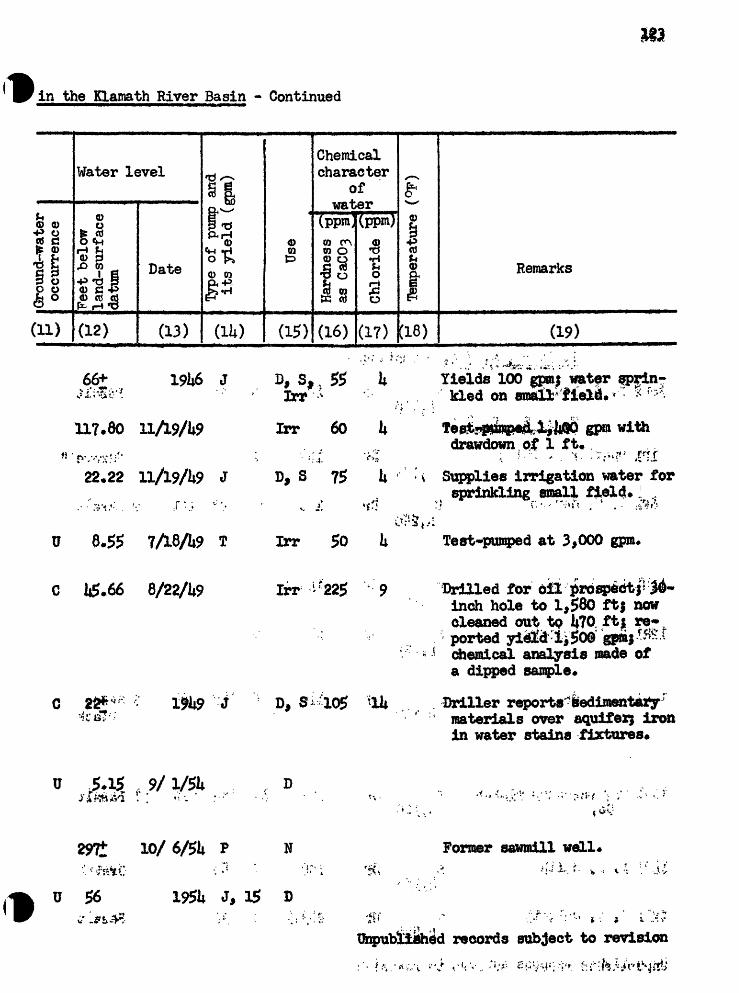
' -
i» ov
4
v
;&
4*
**'
O. 3 I tt * it fl>
O
8
Vli.
h^|
-
CO I
O I ro
to VI
CO tn.
vn t H3
S
?
»O »O
f-'.0
>
ill?
}§ i
Coco
«r-
"';
«r-
g
CO VA ON I-
1
CO
Gro
und-
wat
er
occu
rren
ce
Fee
t be
low
land-s
urf
ace
datu
m *
I I »-*
of p
ump
and
its yield
(gpm)
Use
Har
dnes
s as
CaC
03
Chl
orid
e
§ §d- o 3
P-
CD H,
o>1
c*
Item
pera
ture
at
(D 0
0> ft!
O § d- §

Table 1,- Representative Well
Wellno.
a)
Owner or occupantof property
(2)
i=r
1 0) 0)&*S HCO P _ -P CO'O *H 0 C P WCO H
cfl <D
cd tti cd
|||(3)
0
1?
(1)
^
(D<»
^«
5
1
(5)
m
£ H
5
I
(6)
CuOc HmCOo
0
5 1
(7)
Water-bearing zoneor zones
1 S^p
<DJ^t ft |
(8)
0) W
P
(9)
Character of
materials
(10)
1P1 Charles M* Ohles
L* W» Soukup
T« 39 S«A R» 7 S» - Continued
Howard S Dr 20U
T« 39 S«. E«, J8 £
P Dr Iit8M75
U Dr 170
6 25
12
20 98 161
Basalt
r ' . i,"» ; -».;.
ttGraveln
,* .' * »* »
9 Basalt
Lee HoUiday
12R1 H, W. Leitzke
13A1 do.
Dr
Dr 270
Dr 110 8 110 98
1UQ1 L. A« 5*&th
22L1 D* B« Colwell
Unpublished records subject to revision
S Dr 150 6 50 U»130
S Dr 283.5 8 36
13J1 Weyerhaeuser Timber S Dr 817 12 19U 229 1 51 Basalt Co. ii,120
Gravel
Basalt

£1
0 OO
a
*-
w
\A S3
/;
3? H
» cj
d4(d
*f
i*
HK
o B
5 2
p.
c*
E1^
11*^
^^
^N
B
®
cu<
3 H
*w
c*
- o
*-» »
i «
o*
H^
OS
g-O
.*&*
' J^r
f
S.
P.*\«
> o
i »i?
gS
llH
-iS*
Pv-.O
tB
I0
<6
15
3-
00 'sr
**4
VO vn coO
N
I-*
-4 oo VO
Gro
und-
wat
er
occu
rren
ce
Fee
t be
low
land-s
urf
ace
datu
m (B sr of p
ump
and
its
yie
ld (
gpm
)
Use
Hard
ness
as C
aC03
*
Chl
orid
esr°
&» <D
2&M
» O
p
Tem
pera
ture
(°P
)
S (D V
CO H. o I § a

* S. O
'g
a #
ta
cov
CO03
S S
P O CD
Q,
O
%,, a*
|_;
?j*
' -
'fir
'"""
'
*
* 'C
'
''3» -,. -
.*
;
W
H
'*d:
;"
»
CO
CO
CO
',
COf"
*"*
£
?"*
'
£m
*
^C
f**
%i»
W
40
^
to
10
10
£J8
VA
\n
10
O
O
vt
t^
t|
O
CJ
§ I
i §
KM
! |p
«t
rtxf
5^
u)
fflf
* *
Cfi
6S"*
! m
fl
§
0,
O,
-.,
P
H
C>
0
:
et-
&*
* * "
'^
ro
J-*
9
£^
^O
(5CQ
t»
* » » ^O
COV P vn
* - ^
* UJ CO « t 03 f 'A
"P ?o S t VI S 3 o> vO O
3
(D
O
M
« H Owne
r °r occupant
of
property
Top
ogra
phy
and
ap
prox
imat
e al
titu
de
(fee
t ab
ove
sea
leve
l)
Type
Dep
th (
feet
)
Dia
met
er
(inc
hes)
Dep
th o
f ca
sing
Dep
th t
o to
p ^
(fee
t)
&
8o
4 T
hick
ness
**
i*
(fee
t)
§ 2
?3
*^
SO
<D
H*
cr
to
3
sf
B ^
*i MJ
p
caI *
* O
O
P?
C^
" 3
0)
»^
0* H
M 1 DO
A C*
03

O
CO
09
ro c,
t,e-
i< O
H 8
00
ro
2 to O.
0> §
r- I
g-P I
| J
1&
*
H
',fS
V00
-«a O
(DB
8 §
§
^
C*
CD 4
> ">
CM
« VA W
ICO « 8 w
Sl§
&
«ig
» »
H1
0>
O
"p
Pff
e
niT
3a
* I-1
f\V »: '-!
3|-
/
*rr, 09
t».
ro
I-1
u> vn ON oo
Gro
und-
wat
er
occu
rren
ce
Fee
t be
low
land
-sur
face
datum
of p
ump
and
its yield
(gpra)
Use
Har
dnes
s as
CaC
03
Chl
orid
e
8-9
§
P
(D
S
43
g-o
eP
.H
jo
Tem
pera
ture
(°
F)
<D g- CO
s- I p O § § a.
S- E. 3 O i 10 O.
(D
O
ro
?'
^
S I
H CD P ff'
O- *
'&i-e
t Q
!-;
;r y
H
-J O *
, *« 8 !o
M -a VA
fO
SO
J*,g:
<D
' *
. »!
.
-V ^
-r. a w
^_
w
«l=
- *r
U-
4T
*
«*
8 g
VA
\n
O 00
oo H*
VA
l*i
£* i* W- n
x^
*
-!
& o ..o.
;O "» »tj
-5 p
? I & *0
O «* «>
» 4
8
O>
ON
«-J
O
i
9
c* a; f g Sf VA § g
i
T.
39
S.f E, 9
E» - Continued
s. ' S 2 e VA S 3 oa .e o
~ J
3
(P Owner °r occupant
of
property
Top
ogra
phy
and
ap
prox
imat
e alt
itu
de
(fee
t ab
ove
sea
level
)
type
Tte
pth
(fee
t)
TU
amet
er
(in
ches
)
Dep
th o
f ca
sin
g
Dep
th t
o t
op
(fee
t)
Thi
ckne
ss
(fee
t) §0
*y
Water-bearing zone
or zones
I (D
r> CO

.o g«
6 «
^o
* SO Vrf ir-
vn
a
W1fc
:O
O
1
^
m ft
ly
1^
a _
_,;'-
;:
g,S
3
M
f
fiX
*
?._
<0
W .
CD
H3
Sj
O
0>
TO g
,P
SO
«
S
* ef
-a-
s ©
*g-A
*«
»
*<
&I
8 S
S1M
Si
$»"
p»
f,«
0*«
fOp
j
l& K&
w *-
* £
" ^
*».
0>
P:
<W V
UN
>?l
, *^
^
a
a
t-«
1-1
o
o
8 d|r
A
£ , \
1.9
f;
4i 8
*
ft! -
ro vn CD
Gro
und-
wat
er
occu
rren
ce
Fee
t be
low
land-s
urf
ace
datu
m *
p^ ?
of pum
p an
d it
s yield
(gpm
)
Use
Hard
ness
as C
aC03
Chl
orid
e
§§
§H-
O P P-
CD H>
Q
Item
pera
ture
CO
p £0 O I
- CD §
fO,:
^ i
P &
§ 09
va
*^
O>
ON
3
.*=
F
F
^"
COs
O
I t»I
i td r r
9 S»
8 8
H 8
P S
"»
O
'
rjj
|-r/
; £
1:
5'
' *T-
£
S *
p*
<
C
^j
i^a
: S '
N
O
M ' *
W
*-3
?*
. s*
.
«# *
r"*
*r'*
' 81
1 S ss
^'
Ko
38
', -
'-*
I '
pi*
*
;',
" 'V
fQ
. ' ;
ft.
**
f
" .
' -
P ^-v ?o S s W
l -2^ x-v CO ^**% vO ^ 0.
^
O 9
H9
5
"8 o
5 i
TJ CD
O*i
Sch
^ ^^1Cr
Topo
«?ra
phy
and
ap
prox
imat
e al
titu
de
(fee
t ab
ove
sea
leve
l)
type
ttept
h (f
eet)
T)ia
met
er (
inch
es)
Dep
th o
f ca
sing
^pth
to
top
^(f
eet)
g.
""""
'"
' O
*1
Thi
ckne
ss
^ t
(fee
t)
§ S
go
o»
H.
S3*
CO 3
CD
O ^
^
H^
p
CJM
* O
O
J»
rt-
3H
0>
O
CO
»*
H »
1 H CD H 1 I Ci CO 3 I S CD l^t
u> P

a
a IV
ON
O
CJ
H
S
vr
IT-
^^
^
NO y^
U) to MX
10
*o %» o
txf
CO
§ in « o
6
. 2 P
I'
ro VA ON C»
VO
Grou
nd-w
ater
oc
curr
ence
Feet
below
land-s
urf
ace
datu
m P t
f 3
Type o
f pu
mp a
nd
its yield
(gpm
)
Use
Har
dnes
s G
as
CaC
03
*§
Chl
orid
e »8
o o <D
o P
M-
M» o
o1
e«
- P
. 0)
l-»
if
* §
Tem
pera
ture
(°
P)
g- 0)
cs (D P w
P CO o § c*-
fc^ § 0.

Table 1.- Representative Wella
Wellno.
a)
Owner or occupantof property
(2)
11 (I) 0) &t5 H_ -P «J*O *H Q)C -P W
ctf 0)
JM CD O
cC cti cC
f 4>Q)
S&5
(3)
0)PL,
^
M
^
<U0)
£*P
(5)
CO£I HhJS
fl(6)
to c H 03t6 O
VlO
£9-a(7)
Water-bearing zoneor zones
1O '"""*
<t>4^ {^_ll"~
(8)
COBO
"o $ tH ^Hg^
(9)
Characterof
materials
(10)
T« 39
al^fOa Henley School
R« 9 E« - Continued
- .- ,- Pf105
Dr 250 Sand
Stoute, I Dr ^085
1*68 1*65 2 Basalt
. . . .
2901 Ralph Waggoner Dr 1,300 6 Alluvium
31HL 3l«i Gray.
"'!', TV? ^/"U -
32P1 Fred Peters
32Q1 Joe Milan!
33R1 Don E* Johnson
Dr 177 8 ill 165 12 Basalt(?)
Dr Ui5 8 10 ' 85' 60 do.
Dr
31|E1 .U.' S Air Force T -. \ . S Dr,".>!,*. <«^.*- T^k.'** ^
> ' : ^,300
3l|Pl Earl W. Mack P Dr '- - . -,-: -/, .,: -.^115.-'.: ;
records subject to revision
Dr 110 6
81*
500
6
8 10.6
Basalt (?)
do.
do*
756 10 1*05 7li5 8 do.

vn
vro
-
VA
VA tt CO
H
-4 » .VA
to.
\010 o ro
o
U> sj
O * CD
h*
ro VJT
CD
Gro
und-
wat
er
occu
rren
ce
Feet
below
land-surface
datu
m Sf
Type
of
pum
p an
d it
s y
ield
(gp
m)
Use
Har
dnes
s as
CaC
C>3
Chl
orid
e
8-S
»
<D
O
»
P-
Tem
pera
ture
(°
F)
(D f5 f c*- I ex

Table 1,- Representative Wella
Well no.
(1)
Owner or occupant of property
(2)
Topography and ap proximate altitude (feet above sea level)
(3)
0)
(4)
s-^
<D 0)
(5)
TUameter (inches)
(6)
to d HtoOj O
O
!(7)
Water-bearing zone or zones
1
<DX! <D
P
(8) j
Thickness (feet)
(9)
Character of
materials
(10)
T« 39 S«, R» 10 E, 7C1 Don Kenyan . . , S
t?^U-.
7H1 Sst&r'Hewell' i; l*,195
Dr
Br
312
230
.'v,.- ' =;.JJ..
601 Andrew Collier
.8 275 37 Lavacinders
6 2*2 180 50 Sand
Dr 1,200 10 180
8J1 Mfe, Calvary Cemetery S Dr 380 8I*,200
Dr $00 8
$0. C. E. Dunn
12H1 -John Marshall
13J1 <T;1U 1
13Q1 Rex E. High
11*83. do.
' i- ' ;
Henry
Dr l,3itO 12 20 1,QQO ,1 Sand .
1it,130
tit,08o
3
Dr
Dr
80
ko
120
6
tf
8
ItO
SMfco
S Dr 720 U,150
Unpublished records subject (to revision
* ilQO
Dr 1,276 6 10
i-
Chalk rock
do.
Chalk rock

ti'
u> II
,i* ID-
<35l
-'An
'-U
ro §
,J-t
»tJ
f I to*
*ll t&o.
*u
»
I ?l
lft
t., ra
C.t * i
o> a:
c* 8 09 oo
to 10
MV ro
O O
21!
|S
ff fs^ o
ss
. at
h p
i
_
«^*
" J8
r.o-
-I
>;;
09 5 ?
.» I I*>
-n »^»
?j »
0)
ro
O
ro VA ON
00
Gro
und-
wat
er
occu
rren
ce
Fee
t be
low
lan
d-s
urf
ace
datu
m
£ (D
Type o
f pump a
nd
its yield
(gpm)
Use
Har
dnes
s G*
as
CaC
03
*§
Chl
orid
e §
8-9
?o
o
c*
- 8>
Temp
erat
ure
i CO
H*
(0 CO O § CL

136'
Table 1.- Representative Well
Wellno.
a)
Owner or occupantof property
(2)
I1 Q) 0)
S1«I S "
CQ <D
_c*| fl) O£i,<fJ ^octi oj cdL| &DJ ^J «^3Q y <DP- O <D
(3)
0)Q,
£
M
^^
0}<D
«H
5p tQ)P
(5)
<^N
ID
Jlg
^
f [
5
S
(6)
bo5 HSCD O
Cj_jO
jU*f^
1
(7)
Water-bearing zoneor zones
S&'+>
<D^a 0)«P «Hr(8)
m60
S ^-> 4*7
Vj QJO (D
V*l M 1
(9)
Character_x»Of
materials
(10)
Henry Grimes
E» A. Eggers
U 10 E« - Continued
Dr
Lewis
S
S.* 1
'.' S
300 6 20
Dr ItOO 6
blade
Basalt
Dr 511 6 60 509 1 Sand,unite
16Jl Henry Grimes
' ,''. . V
18D1 W. F. Hilyarg
18E1 I. J, Dixon , -.
19K3. ^>1* filton .. ;<-.*
21P1 N. W. Banta P
Sk,l80
SIi,200
SU,210
t
Dr
Dr
Dr
Dr
800
201*
80 !
115 '
6 60
6 '"
«,
6 ' 5 60
2
Sand,black
"Quicksand"
. . -». »« . ; < v ?,:. >' 20 Sand,
black
Sand
Dr 276 5 63 27fe 2 Grawl
Benny Babson ' :>/ , ,. P
28C1 «.
Unpublished records sul^ect to
br
Dr 71*0 6 ^ Sand, black M

*P r»
--
S .;
so
ca
'a ;.;'a
a<i
its .*,.
vfl
\nft
' -.
&
f?
ft"*
;
sV
A
W
-. »
r?
s* & I:
?*-
It-
ft
CE>-
ft-
f « IT a
a
u> is
JP
,> 8 a
?i :
£9 f
ft »l
J* t *
ro u» vn i-* ON
CD
NO
Grou
nd-w
ater
oc
curr
ence
Feet
below
land-s
urf
ace
datu
m tf
g-
Type o
f pump a
nd
its yield
(gpm
)
Use
Har
dnes
s
Chl
orid
e
B- §
CD
H>
O11
s
Tem
pera
ture
(°F
)
GO
3 CD
0} £r CD CO
H' o Q

138
Table 1.- Representative Well
Wellno.
a)
Owner or occupantof property
(2)
I1 Q> <D
Q-f *o r^rt S tsTJ *H Q) C-P 03
fe^ j£ C 0} Op.. 45 ,0co cti tdL) 6b.1 »H *p
III
(3)
1)
^
U)
^^
rtj
tf}
^^
P,
P
(5)
<^-N
03
g
i
fc<D P
S
(6)
Ctt
(0td o
C>_|0
Jf* p1
(7)
Water-bearing zoneor zones
1O <*<~v
0)XJ Q) P «H
(8)
mCO
§43^d <DO <D
g^
(9)
Characterof
materials
(10)
T» 39 S», R, 10 E, <* Continued
2951 aien'Dehlinger ":.?"» * Dr 350 6 31*8 2 Basalt
29D1 C, R. Millard
%*,£::: - - ', / '
3U1 W. Woodard
3N1 J, Haeeltine
P Dr 200
T, 39 8>.« R> XI
Sand
P Dr 118 6 9k 112 6 do.
Dr 312
Dr iiOO 6 100 360 kO Lava rook
¥, Haley
, :'^n ' ' " /:.! ,., * * 'i -6D1 R»" House V *
8J1 W» H* Cacebeer
9R1 J, Davidscn
Dr 316 6 68 288 28 Broken lararock and red cinders
Dr 96 6 71 92 k Red cinders
Dr ii60 8 h$0 10 Lava rock
Dr 283- , 6 ,||D 874 .7 Brownlava rock
Unpublished records subject to revision

NO gi NO CO
NO
CD \n
vn
s
H*
NO O ** s t=,
t»
H«r £
ra vn ON CO
Grou
nd-w
ater
oc
curr
ence
Feet below
land-s
urf
ace
datu
m o
f s
Type
of
pum
p an
d it
s y
ield
Use
Hard
ness
as C
aC03
*
Chlo
ride
If
d-
O
0)
P-
<D
H»
O
O4
c*
- 0>
g
Temp
erat
ure
CD 3- CO
5- I P £0 (D CO O I

Table l t- Representative We!
Well no.
a)
Owner or occupant of property
(2)
Topography and ap proximate altitude (feet above sea level)
(3)
Q)
(4)
0} <D
|
(5)
Diameter (inches)
(6)
ttOc-HSO
O
5p- 8
(7)
Water-bearing zone or zones
^5 ^5
<DA 0)*J fc«
(8)
Thickness (feet)
(9)
Character of
materials
(10)
S*. R, 11 B« » Continued
^ . x'vi %2. ". '.* ,.
10N1 Bob Hartley
12Glv~B; Ei
13H1- »-<M*9*s- Walker
16J1 Mary Schroitt
^ rt&V-*","-' -MI-: ,-.r : '":' ' 19Nl;; ^iaainath County
*'*, \'i«'.>^ -^ <J ; V-. ,
20G1 Homer-Bolt
-'* .?
Br
Dr
U,250
;v-s . ( I
s Br
' rS Ihr
S Dr U,170
3 Broken rock
166 6 UO 163 3 Brown.
Dr 180
2U3
80 100 Basalt
U8
312 ' 10-8 25
16 20
Basalt
cte.
I
* \T'- VI' "JbNi K*
n!^t *-. ». 7- *"?*.#
36R1 tester
30iH- liH
»' » N . " V-''i.v
30P1 Ii* B* Holzhauser
i*,230
S Dr
subject
5* .-, 12
16- 12
96
Dr it?6 6
Basalt
do*

cs NO vn g
8 »
o »V
O *=-
NO»
co
ON
» |S>
\n vn V*>
{:
ro c vn M
ON
»-*
09
NO
Grou
nd-w
ater
oc
curr
ence
Feet
below
land-surface
datu
m
1of
pump
and
its yield
(gpm
)
Use
Hardness
as C
aC03
Chlo
ride
»S
V>
(D
o 3
p.H> O O
.STP.
Tte
mpe
ratu
re
CO
(D J=d w CO f I a

Table 1.- Representative Well
Wellno.
(1)
Owner or occupantof property
(2)
91 <D 0fli'D i-4CO P
«P CO
C! -P 03COH
»C fl) O
Ctf TO fl3
fejj -P
PL o <UEH CL^.-'
(3)
0Oi
S
(4)
430)
<£
P
(5)
^-s03
JB8 HI* P
iS
(6)
to a H (0cd 0
^_)o
gt(7)
Water-bearing zoneor zones
1 S +=T
0) P <*H
(8)
0)n
o ®*rt ^HI
(9)
CharacterOx
materials
(10)
T. 39 S,* R» 111 E,
& Ii.
6B1 f
P : Dr U,205
260 16 21 ISO 110 Bawlt
Dr ' Ii55 3.6 170 : 380 75ciwtei
10B2 L» J* Horton Br 50.9 16 30 ll* k7 Broken lave : ." t' rjo^a^i
cinders
12H1 A. E. Borgdorf
"Virgil SehB»e
P 1
P
Dr 217 6 i|2 177
Dr 2,510 12!
Broken lava rook
Basalt(?)
20K1 Frank Sullivan
22Jl P. T. Hatchett
S Dr M90
S DrU»ioo
Dr 900 12/, lip
Sand,white
rook
, . - ,. . . Unpublished records subject to revision

o
a
cj
8? i 8
£
ȣ
vn W
'o
03
C-
JR*
*~
CO i
*^ o
oa
<r
a
i> 'ft
?
l
>«*Q
X'
o>jr
.. i.
i
t* I
* ?>
H
'-"
"
11
ro u> vn CO
SO
Ground-water
occu
rren
ce
Feet
below
land-s
urf
ace
datu
m 0> sr1
of pum
p an
d It
s yi
eld
(gpm)
Use
Har
dnes
s as
CaC
03
Chl
orid
ei
Tem
pera
ture
(°
P)
i »
P i a.

Table 1.- Representative Welli
Wellno.
(1)
Owner or occupantof property
(2)
I1 0) 0)S<T2 -*
CO S3 P flj
*O <H tt) C «P co" S »P-P JDcd cts cdfe5 4^O ?s OI"R^
(3)
Q>
S
(^)
s-^
0>
H
I"P
(5)
CO
g
^
$
#
(6)
to C H CO05 O
o
50,
S
(7)
Water-bearing zoneor zones
1 P 4^
C <D*4^ ^i^^ *^<ur-* fll
(8)
CO CO
S ^-- ,1^
"o o*r4 4-1e^
(9)
Character of
materials
(10)
28R1
T* 39 S«« R* 111 E« - Continued
^iskey -., f P ".- r ..-;-. ----- M-5o
ndo* . ,, ,.,..-.». -S I /' ../.' *. "!'. MOO
-'; - .- -. ,. . -« '..
^* \io5;VA -:^i- ~ . . . '"",' /fi^Iwppi . P
^,, 4 . -,. - t>. . .
" * dOwv * r. - - *
r - 1*^130
jr Railing ' S
Dr
Dr
Dr
3>"
Dr
Dr
Dr
Hi2
251 i
U60
1 -2liO '
32ib
220
12.ft)
6
6 60<n
6
6
6
30C1 Taylor High Dr 62
33B1 1. F1 .
T> 39 St.
S 1
P
12 E.
Dr 300
Dg
6E1
Jerry McCartie
do.
S Dr li,260
S Dr 125
12
Chalk rock
5U 36
322 20 Basalt
200 20 do.
52 58 7 do*
210 2 Sand layers
Alluvium
95 30 Basalt
do.
Unpublished records subject to revision

-
.-
~»?
* rii
' *! f S
» ! .»
o
vn
CO
. \n
.f
^^a^aaaa
ro
t-*^,
vn
# ro
^.
...> H
<c
*v*>
y\
iv
o?r
vn
i?,
ui
£ p
,5
vA
"0\
V*)
^
,O2>
O
O
CO
v^
v^i,
v^x
vj\
vrx
v/\
vj\
V^l
{*
?*
t£f"
^*
" X2
1" £
!"
£r**
*
C3
^
^
^
J»
^
Oi.
VA
o
vn
vn
-
o
vne»
«
0
o
u
aco
*»
*.*
w^
2;
%CO
C
O.>
C
O,..
, CO
,
CO
CO-'"
*
f"
:"
s:i-
Sf
i ,
"
^
;
"*-:'.
,"
.'
*>?
.*
'-"'
. *''»
*
, .
, >
. "
.
g- 1
1 if
L
O*
(J
O
O*
* *
g»
a
S
H P
;s
f*-*
v*»
S *
C.;.
_
S
ON
*'
* J3
* C
rf
f"
*
^
' "*
*?
Vr
' /
Q v",
'-^r *
i m
^
i
i .*.
vft
^J
' *
,
_Q
. _,
%
|5
" ^CR
.' .
" 't
-_'^-
.«
^
g /-> ro g *p ^^^ 5 x
-s I-*
S *^*
v 5 i-* CO **-* "p \o
Gro
und-
wat
er
occu
rren
ce
Fee
t be
low
land-s
urf
ace
datu
m o sr
Si 1 1 (D
lype
of
pum
p an
dit
s y
ield
(gp
m)
Use
Har
dnes
s t&
§
§as
CaC
03
*S i
£_£|
fl>
0 ^
3
h o
fi>
p.
H>
O
O
Chl
orid
e S
11 o
^
Tem
pera
ture
(°
F)
w (D ^5 » en
s- (D 3 i £f ! w CO H. i c? 3
c*-
S* i a

f ..
g-
g .
g |
| |
g |
g D
3Of* &
to
t,
',-
am
ft)
P
*
*
f /
»
.,
g.
, a
&
£
*
10
£ ,
. 1
« 3
<F ?:
i<£
d
:; £
!."
^**
Ai
53
in
. "
' fs!
W
i |
>7
if
< '
^5
. ^
?
§^
i«A
w
^s
M
l 2
' iff
M
3-
-^
C
09
. .
%4p
*
' "-
|9
- »
Mr-
j
*»
"-
§
jh
L. «
J
'! - I*
* '
s 1
'^l
i* *
J--
i ;
.; :
.. 4*
*
T1
;' §
i I8
Cfc
.
- *
. OJ
ji«
<
&_ '.
' j«
i§
- '- '
: '-
»x> '
' > *
>j.ig"
ttf
ACO
CO
^
W,^
05^
03,-
.01
r-^lr-
03
Cr°
*
*
M -'f
£~
f~
f
f
»
*
*
4^4"
£"|
llffffffffff???
? 9
9 f
§ §
eON
ON
<
M j
' -*
- O
O
H*
* C
O
tj X>
U
1 »
0
! ft>
H
» i
8" P
.,|
* C*
- <&
-.'
^
»i "
.
Er-
ON
ON
K
1
C>
J~
*2
>
MJ-
n o
o
oo
o
-.;
xn
4 .. v*
- o
^o-:
.
j»
js
ON
CO
ON
ON
ON
V .
' '
X
*
-'-,
P>
S3
? S
? .
« Q
t IP
r
* '^v
y E
EL
B fe"
f |.
v-
E-*
-
s
- »
' *s?
Si
"X 6
» ..
9*
< -
*T "
" "j-
2
d-
;, &
.,>
»-f
.:
-?
,-.?
ct-
.,,,
.»
8 §
. ,
..a
4 --
.-.
c-;.
"-
-t
3 S s s Ut s 2 0?
x**v cS o
^ ,a« o o
Hj
m
1
o3" (D
O
** 2
Ch
O
^ fi 0 9> s
Top
ogra
phy
and
ap
prox
imat
e al
titu
de
(fee
t ab
ove
sea
leve
l)
"typ
e
ttep
th (
feet
)
TUam
eter
(i
nche
s)
Dep
th o
f ca
sing
^p
th t
o to
p ^
(fee
t)
&
(P""
""""
O
T
Thi
ckne
ss
** a-
(fee
t)
§ 2
SO
«
H-
13*
CO 3
ST«
S w
Q>
O
*S*1
H> P
e*
|_i*
o
Oft^
c1^
* £9
|ww
^K
^^
o> *i
H1 f:
1 H (1) HI 1 J5 r^ CO » 1 f 1 H*

CO ?ai
a PJ .-,«%
Si»
s w*
CO
«f* vn 09
cu
<u%
%»
v\
\n
CO
CO
if* s tJ
t^
09
GO
O i* CO
>,
» >
S
_ji«
£
.«*
**
cn
IMP 3
8
*
ro *-» UJ vn ON
GO
Ground-water
occu
rren
ce
Feet
below
land-s
urf
ace
datu
m if
*
of
pum
p an
d it
s y
ield
(g
pm)
Use
Har
dnes
s £"
as
CaC
03
*§
Chl
orid
e
S-rr
s
jo CD
d-
O 3
P-
CD
H,
O
O
" .S
t
Item
pera
ture
g. CO
ff p td 00
H»
9 I O § a,
|2
« 9 I ro ^
o
S
VA
w
SP H
» to
ffOB
H»
VO *
» » C
a> *
CD ^
o
HI
*
rr
r^
^_
r r
§a
u» toU
* co
9S
I}.A
c*
S?
3
0)
H»
Top
ogra
phy
and
ap
prox
imat
e al
titu
de
(fee
t ab
ove
sea
leve
l)
Type
ttep
th (
feet
)
Dia
met
er (
inch
es)
Dep
th o
f ca
sing
Ttep
th t
o to
p (f
eet)
Thi
ckne
ss
(fee
t) go §*
» o
*5P
c+
H
(D09
4
W» M O
(t I CO
3 ff f

O UT
HI
w
ro « I 4- i ..CO
* <b
a*
a^
a
o »
»T£
5 0 <
ft<8
II ?£
r"5«
o
o
o
vn
*" *
fo
o
CO
CO
H.M
I » o
a *
^
COCO
N- 10
r
i-»00
'
O>
CD
C
O ! o>
» » v>,
ro vn CD
Ground-water
occu
rren
ce
Fee
t be
low
land-s
urf
ace
datu
m 0)
Type o
f pump a
nd
its yield
(gpm)
Use
Har
dnes
s as
CaC
03
Chl
orid
e
v H
sc^
O
6^
P*
<D
H»
O
p
Tem
pera
ture
0)
* B- I CO 3 I O o 3 cx

Table I.- Representative Well;
Wellno.
(D
Owner or occupantof property
(2)
11 Q> 0>
P,^ *^J pwfCtf £lf
TJvH <D C-P eo
b^ Sa-p X)
P
«&.!(3)
Q)CLi
^
(*)
P 0}0)
5PL,(rt
(5)
,^«x
03
g H
(H
f
(6)
bo H (0rt o
«Ho
J3 P
1
(7)
Water-bearing zoneor zones
S 8 +>
0)C* Q)
4» <>H
(8)
01CO
JX <DO 0)
^1 *H
(9)
Character_pOI
materials
(10)
T. 39 $. R. 13 B. - Continued
31N1 W. D. Campbell S Dr
6H1 R. M, McVeight*.f t,, '. .., «
7A1 R. A. Cobpsr
ft Dr 219 5 3*900 , , ( . r .,
'tr181
Basalt'
do.
X .:. U
do.. ., ..3*900'» : * * *"' f ft* / &» fr
11HI U* S.'jtir Force * U Dr 1,310 12-8 l,tOO 1,192 118 do.^ « ' - : ' ; -;''-:.' .v ^,900 - - -; ' '- : > ; "
T li^ O o M *n* * V itMir O 0 * Xwv U w>
6C1 Oregon Hlglasray Dept» S Br 292 *v/ i; doV
'Hereford S Dr 90
3liFl Henzel Bros. PI
Tt liO.S»jn R^ 9 E«
2J1 A. J» Manning P
Dr 127 10 72 ICE 26 do*
Dr 1,965 10
3Q1 Robert Stewart
SD1 W, H. Hcmilan
i v -,-*, -^ ,» "
9HL WiUiamGray
P 1
P
Dr 60 6 39 55 5 Sand
»' 'U 4' '* '.-.',,. ;i't'^- ' k , ^M
Dg 210 U8 ^
Dr 500 6 170 US8 2 Sand and
CO I GO
H
O *ro fO O CO S?
i\> a> vn
*
c«- o
1 x*
*t0
flip to
09O H P
- ..
I*"*
S" f"
CB
a fe VjJ W §
* £
» 3 si
K A
O*
jrl
r t»
s §'
C.
H
*0g£
II
J
1*
J ro g 1 vn ON -4 CO I
Gro
und-
wat
er
occu
rren
ce
Fee
t be
low
la
nd-s
urf
ace
datu
m to
s; 1Ty
pe o
f pu
mp
and
its y
ield
(g
pra)
Use
Har
dnes
s G"
as
CaC
03
fl i
-d
C
hlor
ide
*S ^
V
(D
*^
3
h O
(o
H
* H
» O
O
e+
0>
0
f-»
Tem
pera
ture
(°
P)
en
H»
3 (D g I tj
Cr
CD CO 1 O § d- g CL

Table 1,- Representative Well;
Wellno.
a)
Owner or occupantof property
(2)
f1 Q> CD§'!§ r~4
P cd On-l fl> CJ 43 W
^ £ji*! QJ OO . ^JD ipcti nj cti
ol o
l*s,5(3)
<DQ,
^
(4)
x1^,"S^5i
(5)
X~x
TO
1 H
fc5
is(6)
to H 03flj O
Cj_|0
fa(7)
Water-bearing zoneor zones
f$ +»
<D
F(8)
01CO
IIe^
(9)
Characterof
materials
(10)
T« i|0 S,, R. 9 E« ~ Continued
10C1 W, Harnsberger P Dr Sand
13KL Jack O1 Connor
27L1 L. Motschenbacher S
Dr 300 6 87 275 . .2 Agglomerate
Dr 155 6 £02 1^8 2 do*
36KL
*.*' "
,7J1 :
8B1
17F1
i8m"!
25M1
27A1
Oscar
Ralph
Baker
.'has.* R..
Hill
TOHL, Jackson
V. H. Berry
Elliot» ; * % '
C$frl<
Ervin
V. E,
3S Hatney
Johnson ,/^ , ,
.Jtoford,
S
^OE.
P k>ol
Pt,rt
S; t ^»0<
P%o<
;' ' " - 1?./v U,d
s " ' it,if
s
Dr >0
Dr 36
Dr 8
Dr X)
Dr30
Dr 36
Dr >0
Dr
327
38U
135
120
tto
U66
100
620
6 1*0 313
6-lt 125 376
.6 50 125
6
8
6 U65
6 . .» > * ' -
6.
1U Sand, black
8 Sand and gravel
10 Sand, black
1 Gravel, coarse
Unpublished records subject to revision

&
O
C3
CJ
O
;«;C
J
1»)
C"
''
:
'v-
''w
Mo
o
v*
^
*o
a
MI-
1
s. s
^
»"
CO
GO
5 w co so»
s
a
n*
.^ «
a
a
£
l\>
VA
, U
* "
0*
F '
-* .
**
° -CD
vjtv
- J
*. v*>
*"*
' M
N
O
§ ^
^ ^
££
?
*-i
W
'
Vt
W
\AM
O
V*
> IN
> 15
"
l»
U>
p
o
>n
CO,
. CO
CO
CO
v
CO
1 *'^
I «
? -
|
Is" |
* ;
J ;
<>/^
1 S
^
': ^
**'
O* -
O» §
*'*
' *
K " ';
3 ^
£
5
i-1 ii o ro § 1 § 0s § H*
CO
"P NO
urou
na-w
ater
occu
rren
ce
Fee
t be
low
g
land
-sur
face
g-
da
tum
*< 3
tf
CD
i»
»-*
Type
of
pum
p an
d it
s y
ield
(gp
m)
Use
Har
dnes
s !?
§
§as
CaC
CH
"S §
S?
i *
^ M
. o a
s e.
<-«
CD
Hj
O
O
Chl
orid
e §
^
? M
3
<
Tem
pera
ture
(°P
)
s? * CO
H*
(D Klanath
River
Basin - Continue
d

3
P
£"
\£
V*>
fO
O
N
Ca
pt.
e*
>
frt
»
-- a
3 H
P
R
|«
* p
p
,v p
g,
. 3*
CB
*
O.
" 8
3.
*
'; _
P»
HI
. C
^
3
t
jfj
gS
joj
s
a>
o
* IT
o
,
|_i
hri
LJ*
g~
£
£
fc o
H
»*
g
o
W
i5
- .S
H
'
"'* CO
(ft
3
w
'
£
3
S
: -
00
00
CO
OQ
C
3k
O
H»
(0
* g
fc
$
t=C
t '
1 f £
E?'
Is"
-Cr
-t=*
4S-
*r
Cr
£f
5%
rvr
cr
^^
+ &
I-**-*
H
HH
*
OO
i
ON
\**
J-»
O
O
"O
*»J
i o
VA
o
w«>
i?*
\A
GO
Si £?**?
w
. &
S^
t?t
g. .
--. *
ON
; 'V
n
f"
H
-4
I-*
O
«
8 «
!S «
§
0
" H
'
"ro
ON
ot>
o»
ON
ON
to'
r . -j
f-»
O
'
,
O V
l\
0
l\
*
'
IO I
SD ^
^
'
' fZ
. "-I
'
.
'§ u
V
**
*»
CO
g>
Ctai
* cl
^
Eg
iZ
a*
g
3
\ "''
£T
v*
> gap
3i
w
tr*
W
.
"H i~
i fj
p*
r* *
t*
3 ^j
^*3k
* J«
^ *
";
W
f*"
»^
O
*
i a
S
a o" » * o
i *tf
>tJ
»TJ
¥*
£r
&-
4=-
*
V
*»
|
S S
34
M
^.
M
S-
* ^3
vZ
7 C
* !*
*
O.
? £
s e
\ o
. .
o
IP*»,-
* . ^ .
ON
ON
ON
C
, ^>
10
O
9 to
rr
>
. Q
K>
-0
0
O3
| jtt
^3
4
* -
O ^
»g,
*a
.
- ?o VA
)
x-x
^>
-
UX S 3 CO vO X S t-J
o X
.X
3
CD Owner o1* occupant
of
property
Top
ogra
phy
and
ap
prox
imat
e alt
itude
(feet
abov
e se
a le
vel)
Type
T)ep
th (f
eet)
Dia
met
er
(inch
es)
Dep
th o
f ca
sing
Dep
th t
o t
op
^ (f
eet)
|
""""
"""
O
H
Thi
ckne
ss
** i-
(f
eet)
§
2
go
§
§
J3*
CO 3
C
f g
0«
J w
O
<l
I
M, »
N
H»
0
0
P)
cf*
pi
CO
^1
g 0)
HI 1 A
CO 1 c*-
(D ^ P
Cj
O
* C
J
n
CO ON
-s- J" !2
:
C*
:Y
o
a
c» 1 °
vn
t-*
ro vn
vn O
IT-
Ov
, 4T
-
Too
vn8-'
cj
ro oO a
H s vn
cj
ci ' >vJ>
fi*
vn \A
Q>
sj|*
,«
^^
t"J*
^*
*f~
j
X^
X^
tr
X»
« 8 CO 1 ij
ji'
J?
? <
H
:
* {£
^i 3
;
a,
® H
.^
;-fj
> 10
O?-
- '
*
t^j
LMM
!
p ro s-+
*1
^ v*> N.^
"
/-~
*
M vn p S ,*-v I-
1 -J oo sur
ouna
-wa^
er
occu
rren
ce
Fee
t be
low
land-s
urf
ace
datu
m ^^ (0 w
s; S" i H 3 (D
Type
of
pum
p an
dit
s y
ield
(g
pm)
Use
Har
dnes
s tT
B-
§as
CaC
O^
"i §
J?
S^
J-^
-f-
r.
o%
Ci.
*^«
<D
H»
O
O
Chl
orid
e 8 *
* ? S
*
Tem
pera
ture
(°
P)
» CD 1
= 0 3 § g^ » Id s o 1 a
ft) GO 1 3 g a
vn

Table 1,- Representative Wells
Wellno.
a)
Owner or occupantof property
(2)
&
1 0) <D P<*O H** £ <Q
"O *H Q) C -P co;?ip. A3 _O
cO oj ctffc5 4^
S"S <SP* pu»^
(3)
»P
(4)
x *43 0)
55I1p
(5)
CO
JBS H
JHJS
S
(6)
bo d H (0CT5 O
O
51(7)
Water-bearing zoneor zones
1O ''-^
+5 4^0>
^f^ ^D-j^ ^. *
p^
(8)
W W
"S 8>*t* *H
(9)
Character of
materials
(10)
T l»rt C2 T) "I *l T? _1i1j3i_~i*JL_£l2-^5L.£i*
A. W« -Shatgpp * -: ~s
Continued
Dr 1,000 13 fOO 300 Basalt
12D1 InLng Ross-
1261 ¥, Rajnus
S 'Dr -^65 6 33 ht li)5
«Rock ' (agglomerate )
Dr 193 ' 6 .6 18? 6 Sand,black
13F1 Jerry Ra jnus
13KL do*
36P1 Carl Ciyah
36R1 Rudolph Paygr
3Q1 John HcFall
S../ -v- J
S 1
' > ;-S * ' i
U 12 E»
Dr 300 12 Basalt
Dr
Dr 155 8 5 128 25 Sandstone153 2 San?
Dg5,050
6B1 P* 0. Freuer S Dr
Unpublished records subject to revision
Dr 132 112 20 Conglomerate
Alluvium
Basalt

O
roS
so S o>
c,
sl=
"
W
s CO
iS < * 8- W a.IF
»
* N>
O
Q.
«S
3
SL 5
»-*
o Q
3 9
2.^
ST
Si"I-
1 i
OO
)§3'B
Og
o «» °
9-
fc co CO 8 I O
H»
O CD vn
ro u> vn »-*
OO
Grou
nd-w
ater
occurrence
Feet
below
lan
d-s
urf
ace
datu
m o>
s Iof
pum
p an
d it
s yie
ld (
gpm
)
Use
Har
dnes
s as
CaC
03
Chl
orid
e£
pP>
CD
"*
3(U
p
.H
» O
O
Tem
pera
ture
Re rks
D
CD CIJ ca^
D*
I o § s § a

158; ''
Table I,- Representative We:
Wellno.
CD
Owner or occupantof property
(2)
1I Q) Q)
P<TJ r-4W ft
P CD 'O «H Q) C -P ca
CtJ <D
p.-«P JD CO co' OS
fc^ 43
Hi(3)
Q>
§
(4)
<UCH
£i1P
(5)
CO
| H
^
1
S(6)
tun5toCD 0
0
f1(7)
Water-bearing zoneor zones
15 4»
Q>
r(8)
00 COfi 1^vj Q) 0 0)
(9)
Character of
materials
(10)
6Gl fr. 0». Freuer
T, fro 8+^ R« 12 E« - Continued
.,S Dr 21*0
**.-"- : --< 20 150 10 Basalt ,: 215 .23
: ' ' '" '- :V :? .-»
10B1 John McFall
18D1.' l(uj. Kajnus
31J1 Hugh' Rick
31Q1, Richard Craven
33KL T» E. Weatherl^r
3ltKL A* Cr. Gross
U Dr 5,050
S Dr
S
S "., " I
33 E,
1B1 R. A. Smith
1J1 Robert R. Davis
Dr
Dr
Dr
10
550 . 16 . .£
175
153
110
10
8
6
Dr 625 16
Dr 180 6
Dr 67
Unpublished records eabjeot to revision
Chalk rock(?)
Basalt
Sand, . black
f21 127 26 Sand, brown
and black
Basalt
Alluvium
do*

o
8H
1b CO
CO
8 vn COCO
e S CO o CO
8§ §
^n* 8
vn
«
g »
8.8
o-t*'
l3 h?
»P
ON oo
Grou
nd-w
ater
occurrence
Feet below
land-s
urf
ace
datu
m
* 1
Type o
f pump a
nd
its yi
eld
(gpm)
Use
Hardness
as CaC
03
*
Chlo
ride
§ $°&§ P
(D
_ 2 EL
^S
-g
Temperature
CD w
3
(D
P » I CO 3* I O s H- 1 a
tt

160
Table I,- Representative Wa
Wellno.
(1)
Owner or occupantof property
(2)
3t>
1 Q> <DPit? HCD ft
C -P md <D
^* (D O
cfl CD tdfc5 4*O W <D
^|5
(3)
(D
S
M
4^0>
«HV-'
51"P
(5)
CO
1 ^^ P
S(6)
toSmcd o
^_,0
5Q,
S
(7)
Water-bearing zoneor zones
O3
Ox-. 4*9 «|^
<DA <D^1^ ft Ir(8)
09 09
O <D rH **H&~
(9)
Characterof
materials
(10)
T« 1*0 S«, R, 13 E. ~ Continued
281
2F1' ' , :
3D1
ItGl
3. B« Cambell
.» «sert Dehlinger: i t
bzhugft', '' i", 'C . ' ,'
-4. ' . ..,.-,
L, Harris and . >n
^y Walker
Roberts
E. Monrow
C* Johnson
W. Dearborn
.ter Smirh, Sr.
wtt
P, - ^
' S1*,165
Pli«ll*0
S
P
P
P;; W2
S1*,300
. SU,220
S1*,300
P
Dr
Dr
Dr '
Dg
Dr
Dr
Dr
Dg
DrV,
Dr
Dr
120
160
8£
62
30
61*
68
15
150
89
190
6
12
,6
1*8
6.«*
6
12
1 t
-
8 ;
6
610K1 Brewtt
Unpublished records subject to revision
Basalt
do.
59 80 5-:Sand, Tine
Basalt , <.
do.
61 7 do.
20 25 Alluvium
Chalk rock?

o
a
a
*
a
o63 1-1
** &
S M
S\
-S
\*> S
,00
^
' "
' 1"
"*
* »*
'
IlllS
IS
^i
£c-
c«
c,
e«
c,
£?£
*-«
«.***»*» *
u
j-j
i-j
H»
ro
to
jovno
v*>
ovnvnvn.oo
M
t>
C»
tJ
t*-T
"^
k J
H
^
H"l
t"
J
|^J
t*
*
%*
W
t/
w
*>
co
co
co
co
««a
ro
R
ON
.00
°
*§
10
vn
. -»
^ 1 ;
* .
» .
<B.
.- -
p,-
-
- kr
* triC
ft
S
«^.*
S o
'
0
®
o &
3- S
S ff
|"
^S.
ff :
8" §
M P
!
$
' S
§
o o.
a-
to
1 : %i
g-
. t
9-o v
,- w
si '§
* »
^
^
' 'i
Q*
-
?
- rt
- **
'»
' TO
a »
S
3
, .
. tx
cf
. ;-
1
$',;
_;
' '.
?r
^
: |
'
-
t^J
J
p ro *"***
i
/ >» £. <
^-N
>*^'
j~-*
+
vn X-N ON "P * -'
M
CX3
.*""
"'
-. «rj
vo i. "
arou
na-w
a^er
oc
curr
ence
Fee
t be
low
g
lan
d-s
urf
ace
g-da
tum
^ i-»
t^
(D(U
H
*S"
l^pe
of
pum
p an
dit
s y
ield
(g
pm)
Use
Har
dnes
s £
§ g
as
CaC
03
*g §
4
i.V
^
4- 0
01
& <
-> (
D t-b
O
O
Chlo
ride
«S *
* S"
& E
4
Tem
pera
ture
(°
F)
S1 *i CO
S* £ kj (D 3 i s* w i tlX
r
03 H-
3*
1 O 0 3 I cx

162
Table I.- Representative We:
Wellno.
(1)
Owner or occupantof property
(2)
t=r
1 ® OJP)^5 p»4cd j^ p ct)
*C5 «H <1) CJ P WedH
flj c6 cdfe5 4*
111(3)
<D
S1
U).
*^^>
0)O
v
5I1P
(5)
X-s
CO
CgT»
5
1
S
(6)
tunc H
O
0
5
1
(7).
Water-bearing zoneor zones
f$?
9>f\ 1)V> fc_lr(*)
01 GO
W Q)
O 0) H<H
(9)
Character of
materials
(10.)
Y, UP S«» R. 13 E«
12R1 Caldwell Bros*
13J1 Eugene Wall
S. W* Brown
Continued
Br 90
P Br 100 5 U,135
P" Br 335 6 Chalk rock?..*.? -:. ' t<. -'I:* ' '*' ^ . ,: Uj*35
23J1
2iiMl
6K1
610.1 V
7G1f *»
18C1
Anton duty P U>137
do. P
T. hO S 9 » R, 11* E.
U, S. Soil Conser- Svation Service U, 220
M. X. Undsay -^ v«t ; i' * * ' ' '. ' li,lB
W. E. Flescher S,- « .. - ' , ' '\li » * * *"* v "^' "''' t * } *1 *ff\ ""' - .' . ,'v , '. : ; .'..--^; t '*4-*'L *u
Welsh S
Br
Br
Br
fir
Dg
Br
107 ; ,,6
75 r 7
UOO 12
80 6
32
8ij. 6
Basalt
66 18 Basalt
P Br 86 6 4 U,138
18L1 Lloyd GiftU,138
18R1 do. P Br. , 198 6 6& 60138 Basalt
Unpublished records subject to revision

C3
C
C3
CJC
3
c3
c}0
<^
tt
H
H
W
»-
M
&
£i
ho
ro
\o
VA
ui
vn
"a
*»
£
^.
* -
fcj%
NO
N*
VA
vr£r
P
^
^
^
i i_
i V
A
H
H4
NO
*
VA
NO
*"*>
i ^O
^O
"^
X,
NO
^s
»i
vn
VA
VA
NA
VA
VA
VAi
gi
^i
4^
4^-
*r-
ir-
<=-
o*
c*'
^*
%?*
<?
^*
^
*>_
*uj
: K
J M
-H
* IN
? H
» b'
VA
V
A
VA
V»
> O
O
O
O
jT .
k_
CO
Cf
g? 1 e 1 s. Set*
(0
o
DO
CD
O
ffi
?*"
o»
w S
w £,«
**.
!
O
*l!'
C<"
V*
S E! s
3 o>
. JS
»j
'*
W»
fcJ
CA
fis
H*
«3
2
E*o
s
w
W
f'
o
^
tf
«
o
ei
** *
1 CO
CO
CO
ki
,. v
**'
'i
- s.
to i*
B1 S
°v**
1-^
?
¥ a*
0*
c5
* c*
"H
^
' c»
- §*
o
S
a1
S
S
O
H
ft*
§
O
S
" 3 S
* S"
tf
l_j
o
Q
'' v
fi.
^* -
» *^
O
O
S
S
an
JV
*
£
a
V*'
'fc
* *
?1!
V*
> *
" '
^
: ^
W
'
-, .'#
> ;
m«M
®
^
- V
- '
;. B
'-d-
':
(0
*^
H S P VA* *P
***'
VA
S *
P Q\
^v
**
^
^^J
'
oo Pvo".
urou
na-T
raue
r oc
curr
ence
Fee
t be
low
g
land-s
urf
ace
g-da
tum
^ !S
tJ
CDfly
|»
f
CD
l^pe
of
piam
p an
dit
s y
ield
(g
pm)
Use
Har
dnes
s t&
B-
§as
CaC
03 1
|0||
x-»
0>
H
j O
O
Ch
lori
de
-8 ^
o"
H»
3
^^*
^
Tem
pera
ture
(°
F)
V ' |, '-* »'.
iwCO
- -
""- I
.%
>-
s- (D i S
? ^ P CO 0* 1 O § c* t »- 5 i a
n

16U
Table 1,- Representative We:
Wellno.
(1)
Owner or occupantof property
(2)
i=r
\ Q) 0)B'TS HCO ft
T3 *H Q) CJ -P ca^'rt a)
J^ q> ^cfl co c8t* *ff *^pL p <|)
EH fL,*^
(3)
Q)
^
M
4^ 0^CD
fA}
(5)
CO
1*H
^0?
f(6)
bo5mo
0
.c p
1(7)
Water-bearing zoneor zones
i PS 43
Q)jf*] QJ4% fcir(8)
(0n
gs
(9)
Characterof
materials
(10)
T« UP S«j R, lit E« - Continued ' 19KL John L. Sullivan P Dr 100
32B1 Eric Furlundv- "-'/'I
3210. Fred Furlund
S I
S
Dr 50 6
Dr 255 12
2*8 2 "Sandy zone"
130 12U Basalt
T, lq
16A1 Perry Langer
OJCkxraior
a 8 E>
9 E
S
B.
Town of Iferriii
.*&:t£«"Barney. .., ,,.- S
153 BasaltDr 162 18
Dr 1*00, 6
Dr 1,088 12 119 lOitf 1*1 Basalt 8 102ii
Dr 5kO 12*- 21 l&k 1*6 Agglomerate 10 r ,! '.'V <?)
Dr 330 12
Unpublished records subject to revision
Gravel,
in the Klamath River Basin - Continued
165
Ground-water occurrence
(11)
Water level
Feet below land-surface
datum
(12)
Date
(13)
p<
O p^
0> CO p, -p
l5
(1U)
<D
5
(15)
Chemical character
of water
«> en03 O 0) OC rt o o
Is(16)
Chloride S3 s«-
(17)
Temperature (°F)
(18)
Remarks
(19)
U 6-8 .95k J, 5 D
U 8/.5/5U-
C 7.6 8/ 5/5U B, S
Owner reports U8 ,ft of basalt above aquifer*
Owner reports 130 ft of silt, sand* and "chalk rock1* above aquifer and a sandy and silty zone below aquifer5 drilled for irrigation but inadequately cased| caving resulted*
U 3*5 12/22/& Irr Hot used much*
U100 1951* J, :5 D, S
U U7 ll/ /39 T,350
69 See table 2 for log and table U for chemical analysis of water*
U 82 5/ /Sh N
UU8
Irr
195U T, Irr 1,000
7vfeter level draws down 38 ft ., when pumped at 1,000 gpmj see
table & fox* log*
Water level draws down,-about iift when pumped at 1,000 gpm*
Itopublished. records .subject to revision

166
Table 1.- Representative We
Wellno.
a)
Owner or occupantof property
(2)
^1 <D <U
M<*O r*4CO ft
4^ C6
C 43 03
j^lcd cS cdL{ Eu! tpt 4^
I||
(3)
0)
£?
(4)
"^
(U
£5QLFP
(5)
X»s
03
C
§
^4»
S
(6)
toc H
SCOO
Oj*^)
1
(7)
Water-bearing zoneor zones
1$ 4>
0)«Ci <|)
r(8)
0)n
^ (PU <D
(9)
Character of
materials
(10)
T« iq S, f R« 10 E« - Continued
8R1 E. M. Hitchell U Dr 106
9L1 Wendel Moore S Dr 781 12 21 600181 Sand M20
1GL1 Fatherington Bros* S
11H1 Leo McKoen.
Dr 678 12 17 610. 27 «rock»..(agglomerate?)
Dr 180 6 60 115 27 Sand and chalkrock
0. N, Hodges
17D1 E. H. Mitchell
T, 111 S,,
U,093
R. n E.
Dr
Dr
1Q1 H. Clark P Dr U,063
26$
160
83
6 1*3 260 1 Sand
Handle Pope
5A1 Bernicemison S Dr 300
tJ ,- Dr 157 U,200
82 /V "l Sand -
6 18 ll|0 17, -Basalt.
6&L Walgreri . J'P Dr 107
^piililti6h6cjl records sub3ect to revision
10
6
do.
Alltcvtom

cjcjcj
<=}
a
cj
c!
<=}
a^d
i_*
£ -
VjJ
V»>
-'
-t"
-P1""
Sii
ro
u>
VA
O
M
3 O
ao
.
VA
k-
. ;-.
:: \\
-
vo yi'
^"
£>
i*»
- ^
H.: >
-V
^,
- >
SN
. -
>
SN
. ^S
*
^S
. A
,
**
*
*
J°
^
:":;
^*
-
^*
",^°^
i i
i *
i »
H*
H*
" H
* W
'
VA
V
A
O
VA
. V
A
Vft
0
M
t3
t^
O
. _ .
"
fc*
f
»,»
fcj
»
w
^»
^
2«
^*
'5
2
^"
CO
CO "
CO
CO
i-»
CO
|.t t
I «
i «
1
8OO
V>>
; ro
ro
<-'-
§J
"
. v
-
H
" vn
'
f *
« s
P*
f, -1
-t
"
'.*
'*.
"1
"' -
S*
-o
ON
^ °>
S^
CN
-
*S3
* J2
T
OO
~<
J Iv
w
> ,
,CD
:
a
&
»*rJ
' = 9
_
S
> ^i
-, ^
r(l M
.ST
. §?
g :*
8 &
8B
v -
Sf
g*|.3
. *S
8-
§5&
§
: g
. . H
.-'S
PS
^
"pgp
PS®
sj
S §
;2
,.
pro
N
c*"
®*
i®®
»r<
'i-i
S'S
"i-
j *1~
ra
'
^
£ ^
cf
£ !
W
®y
^1
3
^3
i ^ -
"«*
'*
c
D.
CD
O
H»*
SC
D
I^'Q
'CD
®
*9
P.
5*"#
"'
3
4.
roP
.J=
-
wO
t3
OC
Df-»
gH
6-
I
' "
SS
^
- l°
2P
:.li|8
^P
-o.
"In.
y.i
:I
! s
?^5
-:' Is
-.!1!
" 1^
8 £°
-l p.-
«*
. i_«
o
S-
* o.
ro
« ro
to
-p»
o» o,
:*
^ :
JT
H,S:
.
eg
w"
0 V
o.
ff^a
:*r
V0
?
o- ^
-
' J5
5*
Hi
0 Q
TO
W
&
-Q
*; :
2
* *
S"S
-
*
5.
n» r
t. rg
* w
§
:te
8
§P
H
:
^tP
@
oo
^S
p
Q
P,
-^o,
^ *l
. -
^
fl»
c»c«
- g
ct-
: »
^
{§
-i
Sj
CD
*^
^,
w
J:
ra
J 9-
"73
CO
- CD
O
v*
CD
*~\
h* ro N-»
»
,
H*"
/^N vn X N
§ CO
VO
Gro
und-
wat
er
occ
urr
ence
Fee
t be
low
g
lan
d-s
urf
ace
g-
datu
m
* 3O
CD
Type
o
f pu
mp
and
its y
ield
(g
pm)
Use
Har
dnes
s *&
s*
ar
as C
aC03
*g
g
58
. ->
^ r
f- o
rf
C.
<->
CD
Hj
O
O
Chl
orid
e §
*"*
oT H
» E
"*
Tem
pera
ture
(°
P)
s 01
D
CD
P> CO 1 O
O £ o.

168
Table I.- Representative We
Wellno.
a)
Owner or occupantof property
(2)
.1cti 4 3 H
P COa -p er>t6 fH
rC Q) O
CD CD CO
fc Jj +sO M (D
££,£
(3)
0)Qj
§
U)
4^<D
£S&(5
(5)
/^->CO
A|in P
S
(6)
s? H COC0 O
*HO
4»0,a
(7)
Water-bearing zoneor zones
f^tp
0)JC 0) P «H
(8)
01w
vj <D 0 <D
g"-
(9)
Characterof
materials
(10)
7D1 John O'Neil
9B1 Leland Pope
T* J& S«, R» 11.E* - Continued
Dr 770li,066
8 £L 730 UO Sand layers
Dr 178 6 50 177 1 Sand
Jack RatliflF. Jr.. P Dr l»65 6M59
llCt Adolph.Sacka>.< '.. "
12H1 Wilford Dixon
12H2 do*
lilLl J. R. Katliff
Dr 130
Alluvium' ^
6 UO 90 Basalt
"' '' fi'« P Dr 7i5 10 255 : 255 Sand layers
' , f ;
P - : ; Dr 820 : 6 81* ' 90295 do.
16J1 L. R. Neel
18M1 G. C. Haskins
Dr 200 6
P : Dr 110 6
Dr 200
Alluvium
do*
do*
P Dr 170 6 U,067
T* la S a , R* 12 E*
1Q1 J. V* Rajnus S Dr ^00 12
Unpublished records subject to revision
Basalt

l-» CO *r
B H-
O 3; CO
'< p.- §
ro
8 co
S W
B
oo
vn
oo
vn
6 CO
iF
co
»^l
0>
HCD ro
c«
-ro
ft
g-
s w CO vn
NO * tt W CO vn i ^ (D O
O 2. O $
v« vt S' CO vn
H>
CD
ro H1
U>
VA ON 00
Gro
und-
wat
er
occu
rren
ce
Fee
t be
low
land-s
urf
ace
datu
m o 0)
c*-
CO
* tf CD
Use
Har
dnes
s as
CaC
03
Chl
orid
e£
o (u
P*H
» O
O
§T H
»
Tem
pera
ture
(°
F)
CO CO
H*
3 $ CD 3 I O § ex
VO

170
Table I.- Reresentative
Wellno.
(D
Owner or occupantof property
(2)
I1 <D 0)
&i"U r-4cd ft p cdTJ *H (Ud -p mcd H
A (D Ocd txi cdLi f3K w3 -p
III(3)
»t?
U).
450}
£!pdio>
(5)
* « > 03
| H
LI P
S
(6)
S1 H
SCO O
Oj?2"p
,1(7)
Water-bearing zoneor zones
S P* 4^
<D£ ,<D P «H
(8)
0) W§*^P
^ a)U Q>
(9)
Character of
materials
. do).,., r To... Ill;-S« A. R» 12 ;E« -Continued '
£' *.''&» Sootgb ", S Dr 173 . 6 lil. 82 1 Chalk rock
Albert Stastny
George Smally
5C1 G. M. Freitag
6F1 Cartwright
10H1 E* &enyon
11C1 John McAulif fe
11L1 F* F. King
12B1 L* 5* Schriner
P Dr 76 14,110
h Alluvium
Dr 209 6 17 200 9 Basalt
Dr 167 8 13 160 6 do*
S Dr 70
P Dr 325 ,8
Dr 19k 6 58. Sand
Dr
Dr 200 198 , 2 Basalt
12G1 Frye & Barney
12H1 do.
S Dr 126 8
S Dr 300 16- -£6 : 165 135 do*
Unpublished records subject to revision

CO
-J
VI
co
13 '*:
CJ CO
» a 9
IS CO
CO
a
/*
"j
K^T
. *'|j
" ''
*
l\3
vn
o
CO
CO
w
co
e?
O#S
» |-»
(D
£ »
i^S
2®
g,
PM
H
<D
?*
H»
fe-e
*-
*"
£.
^2
O
PJ
g,
*4
? I
O
x S
»g
g-
Sp
ra
Q 5*
§-
fft
^j
jp
GU
d-
tJ
H»
;. "
S
Sf
Q)
SJ
O
O
»
§
ade
i. ?s
^ ff
**i
E p "^ u> S <^-N
,
vn I § CD §
:
(S^o
und-
wat
er
occu
rren
ce
Fee
t be
low
g
land-s
urf
ace
g-
datu
m
*
w M
Type
of
p-um
p an
d it
s y
ield
(g
pm)
Use
Har
dnes
s ^
§ §
as
CaC
03
"g §
S?
i^ ^ r+
rt
ft?
C.
^-»
<D
Hj
O
O
Chl
orid
e S
**
g" ?
Tte
mpe
ratu
re
(°F
)
i*
»
CD
';-
S- Cfl
H- g: Klamat
h River
Basin
- Continued

172
Table I.- Reresentative
Wellno.
(1)
Owner or occupantof property
(2)
1
CO J3 P CO
'O «H fl) C 4» COCOH
cti o>
Ct) CO CO
&J] 4»
III
(3)
«1?
U)
43(U<D
<H
5
fP
(5)
X~N
GO
H
0)
is
(6)
tuO
5(0
o
0
51
(7)
Water-bearing zoneor zones
S.gtp
<D4^ ^4r(8)
00 00
vj m O fl>
fi^
(9)
Character of
materials
(10)
13A1 Leslie Unruh
15*1 Town of Malin
R» 12 $ - Continued
S Dr .4,135
P Dr
15F2 ~ do». .
30
Dr 32? 10-8 ,
Sand and gravel(?)
. do* .,
1901 D» P, Held
2i|KL W. G. Dalton
T« 10. S,. R» : ,13 B.
Frank Grohs U
13J1 McRenolds
18P1 Lovehess Lumber Co. S
19D1 ' * >"' > - /.' ' < * -v " t
Dg 30 ' *
Dr 751 8 180 611 32 Sand laminae
Dr
Dr 35 6, 22
Dr 55 6 k9
Alluvium
Chalk rock
P Dr 1UO t .-6 i|it 138 2 Sand,, ooarce U,085
Unpublished records subject to revision

g I
a 3 o I 01 I I
8 Q,
».
a>
P J5 (D
NO
H
NO
\O
j\
vn
vri
jr*
« -pr
*
8 :
v*>
CJ
CO
a vn . oo \ X) 5 CO o* o. I
So,
S CO
\A
.pr
vn CO
08
H
oo
Oa>
3
CD d
H*
a>
M NO rr
\>>
VA 8
w
t-» NO ^
o VJ1
CO
UJ I-1
va ON CX
>
Ground-water
occurrence
Feet
below
land
-sur
face
datu
m 0)
c* CD
of p
-ump
and
it
s y
ield
Use
Har
dnes
s as
CaC
03
Ch
lori
de
{B
^3
ci-
O
P
P-
CD
H»
O
Oc«
- P
..O
Tem
pera
ture
(°F
)
CD 01
(D » o § Ci- § a.

ilk
Table 1,- Representative Wella
Wellno.
(1)
Owner °r occupantof property
(2)
11 <D <DP<T5 H* S
TJ.H 0>
COH CO <D
_*^ (D OP'*P fO Cfl cti 05
43
BR£(3)
»P
(4)
x-*k
0)
s-«
5P,£P
(5)
*~~* CO
»c1 H$
S
(6)
boc
H (0COo
of*531
(7)
Water-bearing zoneor zones
f 8 +»
0>^! <D*^ Rir(8)
COwS ^ 43V{ fljO $
fi^
(9)
Character of
materials
(10)
T, hi S.» R« 13 E, - Continued
P Dr 13619E1 P. Blohm
19F1 Lovenees Lumber Co. 8
R,
Charles Kilgore
do*
Dr 319 10 92 96 13. Basalt2?8 5
Dr 1I?0 6
Dr 210 16- 12
do*
8 70 2 Basalt breccia 170 8 do*
18G1 Stanley Johnson - - Dr 108 66 10U U Basalt
Unpublished records subject to revision

g Qb 3 O I 01 I V 5 si
H
H 8 VA
*=
"
O .«
H k
c{ CO
VA
V
A
^a
o
: .*
CD
V
A CD CO
®§
3 g
QB
*--*
O
O
fc?
. :1 8
-*
c} u>
o VA 8. o'
<*
co
'
fO'
U) vn.
oo
NO
C^o
und-
wat
er
occu
rren
ce
Fee
t be
low
lan
d-s
urf
ace
datu
m P srl^
rpe
of p
tunp
and
it
s yie
ld i(
-gpm
)
Use
Hard
ness
'a
s Ca
C03
Chlo
ride
?&g P
p.
Tte
mpe
ratu
re
R Lrks
g CD 3 P & ? 1 ca o § c*- * § a
VA

176
Table 2.- Materials Penetrated by Representative Wells /Tentative stratigraphic designations by R* C. Newcoml7
28/8-17K1. Southern Pacific Go* Diamond Lake Station well. Drilled byA* M. Jannsen, 1926
*,^. .. .. -. jiicaiess epth !teterial8 (feet) (feet)
Pumice of Mount MazamaiPoroice *».* ** «».««« «» «» » * 65 65
Old pyroclastic and alluvial deposits)Sand and gravel ..*..«.«.....*..*... IS 80Sand, gravel, and clay .*.......«*. .* » 1*2 122Sand and gravel .....«..*..«« .«.««. 28 1$0Sand .......................... k 15USand and boulders »«......«....«... * 2 156Sand and gravel ..».»..«»....... » . 5 16U
29/8-7RU Southern Pacific Co* Tamsay Station well* Drilled by:. ' ' ' . - " ' E..V* Enloe, 1926 ,.' ;'. V
,..«','. ' . t ',' *" j ~ ' *t»mnice *of Mount laiaaiaa with interbeclded pyroclastics
ahd alluvium* Pumice ,,.**.;*., i ............ , 35 35Sand, black, dry . »...«.....*.»...«.. 8, Ii3Pumice, white ^ ................. «.f v v%0- 53Qla^, brown . ;% ',.. .> . ';. ....... ... . . . . . > 62
Volcanic 'rocks, undifferentiatedtBasalt, bluish * f ..,«.*....... »,.. . . .\2Av' ''
, Basalt, honeycombed and wa tier-bearing inlower lit -Pt -. « . . V . > . .............. 22 128
30/8-30G1. 1 Souitoern Pacific Cp» Lena Station well* Drilled ' ' " ; V. Enloe, 192U
' * v - J> ............ . .... .. . . ...
hamice of - Mount, riasaraa and interbedded alluvium: ; -
Sand ., .- . . ^ i. .^ * '_ . » f .,*..i ., *?'»!* * »
, , .
k 1
272
198
. . MI *
18 19i{6
6775
Dhpublished records subject to revision

1??
Table 2,- Materials Penetrated by Representative Wells - Continued
31/7-2UG1* j. Ball* Sand Creek Service Station well. Drilled by, 19U9 ;,: <. : ..
Biidcness Depth (feet)' (feet)
$$5$pe of Mount; Mazaraa:
Pumice, light-Dink* firm «Pundce, oarjc-pit^., firm «
Pumice and coaeee sand, eon Pumice and sand, water-beai
12... 6
16.... 11** . . 6
7
12 18 3U lift
;5U61
31/15-32B1. Weyerhaeuser Timber Co. Pole Butte Camp well. Drilled. fcgr W. L. Hartley $
Volcanic and sedimentary^?) rocice, undif£©rentiated:Basalt ......................... 62 62"Sandstone" (tuff?) * ... * . ... , .. * . » -..'.* . 78- H*0Cinders (Pumiceous fragments) *»«*.**.*«*«* 1* ll»UBasalt .I.................. ., ., .. .. . U . . . 15 159Clay ....... . > ....... .v . ..... ^ . ... ... if 163Basalt V . . .... ... . .......... .-. . * . . 196 359Cinders . ............ . ......*.... 11 370Basalt;. .................. .. . .... . . 12 382Cinders, loose ...% . ;./» ...«*...*.»>..«. v 24 396Basalt, lowest 3 ft broken ...... . ........ 31 1*27Basalt ..... ... .............. * -V,. . 31 158Cinders . * . . ... .... ... ... v .... . . . . ... 9 1*6?
. Basalt ......................... 92 -559- Cinders . , .... . . ... ... ... . . , ......... . : 3 562
Basalt, broken, water-bearing at bottom ««...««. 201* 766Basalt ......................... 87 853Sandstone ....................... 20 673Basalt and green sand, water-bearing streaks ...«*» -152 1,025Easalt *«*.»«..«»...*..... . . o . * * 15 l^OljOL
Unpublished records subject to revision

178
Table 2«- Materials Penetrated by Representative Wells - Continued
3U/6-11K1. Christian Church, Sevenmile Creek Camp. Drilled byC, Hartley, 195U
.Alluvial deposits:
Clay, red ....... ................ 18 .18Gravel, fine .....«........*....*.. 7 25Gravel, coarse .......... ........... 59 81tClay ........................... Wi 128Shale (or compact clay) ................. Hi
Lava rocks, undifferentiatediLava, hard, blue» water-bearing ««..,« . . . . . * . ____ 3
35/7-5P1. Mrs* Cora Crystal* Drilled toy J. Wilson,
Yonna forwationjSandstone, brown ....«.......«....*«*. 6 10Hock, blue, very hard (agglomerate?) ........... 8 18Rock, gray (tuff?) .................... 12 30Gravel ... .».. « ««*.««»*«.*«»«« 25 55Gravel, fine and coarse (tuff?) ............. 190 2ii5Shale, green and blue .^. ............... 2ii5 U90Rock, gray ........................ 100 590Sand, water-bearing (sandy tuff?) ............ 10 600Clay and coarse sand ................... 20 520Rock, gray (tuff) .................... 25 6it5Clay, blue (fine-grained tuff?) ............. 5p 695
Lower lava rocks (?)«Rock, black ,.*...*......*«.,.... ..«.' ' 28
35/7-7F1* Plantz Bros.AHuviusu: ""' :/ - '-..- -i .-... -- r.i. . _. -......-.. ...-...-... .,. -- ..n..:. _r.r-i .-
Soil ........................... n 11Gravel .......................... U 15Sand ........................... 3 18
Alluvium or Yonna forma tion(?)jClay, blue ........................ Wt 62Gravel ................... Q «.. U 66Sand . ...... . 9 ......... .. .. ^ ........ 2 68
Unpublished records subject to revision

Table 2.- Materials Penetrated tgr Representative Well's' - Coritiirasd
35/7-314N1. Mrs* Elsie Burton; Drilled by J, Wilson, 1?50 '',""",
36AO-6KU Joe LaHoda* Drilled by J. VanJfeter, 19ii9
Alluvium*Soil, hardpan, and gtuubo ,...,.....,,,* 10.. . 10Clay, yellow, san$r * ...«*.«.. 31; UiSand, fine, .with clay * »* . , , . . V. . '.V.V.* ] * h $Gravel, coarse « . . ..*...'. . *....,. » * ' * k $2Clay, yellbwr top k ft, blue and brown " . ,« /'«.,.. ' . 38 . 90Sand, brown, very fine «....'.. .«...« * * t IkClay, yeUcrir, sticky* . .*...... . ". V. '* SliClay, blue, san^r « »* .».*««. **%*** 3?Sand, fine, with dark silt .............. 65 260Silt and sand, muddy, interbedded ........ « 52 312Clay, yellow, sancty ,..«.*.........*« . 61; 376day, gray and green ....«.....*.*..*« 9ii U?0Gravel and sand,. fine. *...*........** 20 1;90Clay, gray - . . * . » * « * , . . . . » « ^ » 20 .510
, day, and hardpap .«.....«.. V * * * c , 8 ,Yonna formations .,,.. « Cballc'rock, yellow: .(diatondte or volcanic asxh) - » V* > 7 Chalk rock, green .».. .... « . * ......*. .125Sand (tuff?), black, water-bearing ......*.«.. 3 Ht3Sand (tuff?) and chalk rock .............. o 15 158Pumice (pumiceous tuff?), water-bearing .**«.* * 3 161 Chalk rock, green . ...««o ........ .»..*. 8U 21^5Sand and gravel (agglomerate?), blaok ..«.« «*« 36 281 Sand, cinders, pumice, and gravel (volcanic tuff breccia?) ................ o ...... 50 331
Chalk rock »..»«..»*..*..****»***. k 335 Sand, packed, and gravel (agglomerate?) ....«..«. 13 3i).8Chalk rock ............. »..*».»0.«» 72 U20
Unpublished records subject to j-evision

180
Table 2,- Materials Penetrated by Representative Wells - Continued
36/LO-9R2. H. T. Bobbins* Drilled by J. VanMeter, 19h9
fleet) (feet)Alluvium:
Soil and hardpan **»*.,*« ,.«,*,*.** h hlonna formations
Chalk rock ...................... Ill 18Sand (toff?) ,*.**.*...*.....,.... 5 23Chalk rock » *«*.«* V* .»*» «..*.« lU 37 Sand, black (tuff?), water-bearing .*...*.... 18 55
_.. Chalk rock » . . . » .«. .« . .... . . .» > . . > » « J15 .-.' 70
36AO-llO)l. Mario Camini. Drilled by J* VanMeter,
Gravel, bound with clay »»* *«*»»***«*» 5 $ Yonna formation:
Chalk rook «..»« »««« * » *««»*. 20 25Sand and gravel (agglomerate?) «.«*« ***. 6 31Chalk rock ».«»*«*...,.*«.. . v* » ?8 ,109Sand, black (basaltic tuff?) ...... 0 ..... 3 112Chalk rock and sand (tuff?) ,.*.« **.,... 37 lit?Chalk rock .,». . .......*..«.«.*. ?6 2^5Sand, black (tuff?) ........ 0 ,<..*... 3$ 260
Unpublished records subject to revision

Table- 2-~ Materials Penetrated by Representative Wells » Continued
36AO~29HL. Klamath Indian Reservation. Squaw Flat well* Drilled , . , ty .C. VanJkter, 1935 . ...... .... .
Materials Thickness Depth (feet) (feet)
Soil and boulders ................... k' hLava rocks undif ferentiatedt *
Basalt . . ... .....* . . . v . . i . . . . ; . * 30 3kBasalt, hard, red ...»........*». i .... Ik U8Basalt, Creviced «... . . * . . .......... 21 69Volcanic sandstone (interbedded tuff?) ........ 16 85Basalt, creviced , , » *...... » ,....,.* . * . * . * 17 ^102Basalt and volcanic ash ................ 13 115Basalt, creviced ................... 15 130Basalt and volcanic ash, loose ............ 10 lUOBasalt, creviced ................... 7 lit?Sandstone, volcanic (tuff interbed) .......... 9 156
...C&nders, loose (tuff breccia). > ............ 36 192Basalt, creviced ................... 6 198Diorite (porptyritic lava rock?) .......... ; . 10 208Basalt, creviced 321-333 .............«* -11*3 351Basalt, broken . ........ 4- . . « . . 4 . . * . 19 370Diorite, creviced (porphyritlc lava rock?) ...... 17 387Basalt, red, loose fragments ......*.*..*. 18 U05Basalt, creviced ................... Ik 1)19Basalt, crevicedY water-bearing » ... . . . . . * 21 kkO
36A1-25R1. W. M. T«illiBmson. Drilled by J. -Wilson, 15^8
Soil and liardpan . . . -.' . . . . . .' . .', ...... 9 9Tonna formattoi: ... , . - .
Chalk rock ...................... 11 20Sand, black, water-bearing .............. 15 35Sand, black ..................... 35 70Sandrock, black ................... 10 80Clay, yellow, sandy, water-bearing .......... k 82;Sand, fine (tuff?) .................. 21 1Q5Gravel, coarse, and pumice, brown (agglomerate?) ... 25 130 Rock, gray, hard, and gravel (agglomerate?),water-bearing .. ................. it5 175
Cinders, gray, hard ................. 37 212Rook, hard, gray (tuff?) ............... 8 220Cinders, hard* broken, water-bearing «. »..« «» 3 223
Unpublished records subject to revision

182
Table 2,- Materials Penetrated by Representative Wells - Continued
36A2-90U L. 1. Crawford, Drilled Igr W. L» Hartley & Son, 1956
Tonna formation!
Sand, bla,ck, and sandstone,
Sand, black, water-bearing <
Thickness Depth ^feet) (feet)
* - . . 3 3
. . * . 57 6a3O QQ
... * 190 26U
. » , * 20 300
. . ..... . 2 730
36AU-27P1. Henry Gerber. Drilled by W» L* Hartley & Son, 1956
Soil . *. .'... «.
Upper lava rocks;
Tonna formation:
Lower lava rocks:
,.....* ... 8. . * . * . t - . 32, . . *, .......... ,39
. ... .. 81*
..»...*.. 3P ..'. 11.....*..» 81
.*.....*. 63,»..,..,. 20......... 2 ....; «..; - -30....<..,.* 38.
8iiO79
163
. 193"20lt *
285
3W363 ,370to-438.
tftipublished records subject to revision

183
(Jfe ,.,.,-.. .,...,,... :. .,, .. - . . < - ,1 9 ' Table 2«- Mterials Penetrated by Representative Wells - Continued
37/9-liEU R. D* Dehlinger* Drilled by W. Haria'ey, 19t9 ' - J --..'..
_. . . .'. . ThiCKness Deplii ... ,. ... Materials., . .. .t***4,\. ^^^(fast)-
Yonna formations . . * ..Chalk (diatomite or'volcanic ash). . « * , . . . « 158 158Sandstone and boulders ...... « ««* » e 'Si 212
Lower lava rocksi . *Ceriders^ red . * **> * *' * * * ~ 39 ' '251'Rock, gray, and cinders ..*,..**..« 65 316Lava, porous, broken; water-bearing . »,».»» 3U 350Basalt, hard « .................... 3 353
37/9-36EL. Marshal^ Bros. Drilled by Kr hartley,,19U9 -j ' '
Alluvium, undifierentiatect: ^ T \soii ...*»....»,....,..**;......., u ; k .Clay, 1 yellow »'»',"« .'" '. » *. ....'* . . * . . 19 23Clay, yellow, and small boulders ... ,* * 2 25Clay, yellow *..*..*.............. 10 35
Yonna formationsSand, black V , * * * . . « * * * « * . .. « » . Trace 35 Shale, blue ..* .. *.,.......,**. 23 58
. *»~' f 'm "V" - - ., , - - ,. Mfl . . ' f , ftSandstone * » »* *««*» ** «* ° 6UClay, blue, with sandstone streaks .«.« «...» U8 JL12Sandstone,, yellow* *** ** **»»» **** b 116Shale, blue ...to..*,*...*...**.* ?U 190Clay, sandy, brown ...*......».«..«« 5. '195Sand and shale layers, blue .. «...» 22 21?Shale, blue ..........**......... 5 222Sandstone, blue ««.»«. «, *»«..*«,«,«* >2b 2ii6
Lower lava rocks: . . . .. , , , . .Lava* porous* water-tbearJjtiff. .* ....««**. ' " jt^-' 250
-Unpubiishefd records subjept to revision

Table 2,- Materials Penetrated by Representative Wells - Continued
37AO~19H1. H. D. Nhiteline. Drilled ;by C. Coleman, 191*6
Materials (feet) (feet)
Yonna formation tChalk (diatondte or volcanic ash) «« **** * 2k 21* Sand, black, layered with "gravels" (some water) * * 91 H5> Clay, white ..................... 30Sandstone, black, and "fijravel": water-bearing * « 10
37/10-30B1, Fred Coleman. Drilled by K. Hartley,
Soil, sandy, brown .................. $ 5Yonna formation:
Sandstone and "gravel" ................ 27 32Cinders, black, and "gravel" water-bearing *.*« « . 66 ^98
Lower lava rocks or interflow(f):Basalt, hard .»,... c «..«.....**.*. 2 . .3JDO
37Ali-2l|Hl. S. K. Hartzler. Drilled by C* M. Vochataer,
Tonna formation with baealli interflow or jLntrusiva(?):Sandstone, yellow ......^............ k&Shale, blue ...................... 1QBasalt, hard, black ............. .... 25 U{0Shale, blue ........ ........... . * 19U 33U
Lower lava rocks:Basalt, hard, black .................. 8Clay, soft, blue ................... UBasalt, hard, black .................. 8?Lava, porous, water-bearing .............. 10Basalt> hard '« « .< . > ., , .............. 37 u87
Unpublished records subject to revision

185
Table 2.~ Material* femtrated bgr Representative Wells - Continued
38/9-19A1. C. A. Tobins* Drilled by: j. Wilson, ;
, Materials
Alluviums
Yonna formations Chalk rock, yellow (diatomite or volcanic ash) ,
Cinders and lava (agglomerate )* water-bearing *
(feet)
» . « 8
. . :v- 50'.- . ^,t\ .. -.'. 2
.* . . * 235
* . . * 203<
. . . . 10
. .*-; ^ 10 ,
(feet)
8
58Oftyv92
120
175105195
38/9-28DU. J. R« Howard. Drilled by Wilson Drilling Co., 1951*
Fill . . . «'. . . . .".'./. .'. . . *J . . . V . . , , . l b 6Alluvium:
.Boulders * .* .» * ,* .«>-*,,» *4 *, » , _.« .*. * U 10 Clay, brown .* «*«.« ...«. * -.'« '. * . 25 35
Tonna formationsChalk rock, white, with thin layers of white olay ... 135 170 Shale, red and brown ,. ..*........***. 27 197Conglomerate, blue ** *»** **» *:»*« 53 250 Shale, blue * » .. .« .» * 15 265Rock (tufft) with layers of shale ........... t 2$ 290Rock (basaltic sandstone?>,"blue ,., *..» » 17 .307 Shale, brown, with "ttiin hard layers »* .«» . »»* 33 3bO Shale, blue *.... *. 4 ........*..... 15 . 355
Lower lava rocks(?): . . . . Rock, blue and black, water-bearing -from. 1*25 to Itii5 ft
and from ii6o to 500 ft ....*.,***...* 160
Uhjpublished records subject to revision

186
Table 2,~ Materials Penetrated by Representative Wells ~ Continued
38/9*261*1. P. H. Marks* Drilled by C. Van Meter, 19l|0
icknessfA . A f . N(feet feet)Alluviums
Soil and clay .................... ,11 11Yonna formation!
Shale and clay (soft shale) in layers *..«.*.* 117 128 Shale, water-bearing ........«...*«.«. , 3 131Shale and clay in layers .*.....,*..,*. 3h 165Shale, water-bearing .....,,. «.*.».. 1 166Shale and clay in layers .«.»....«*..** 29 195
Lower lava rocks?Basalt, with clay-filled seams « . . . . . . . . . . ,.115 310Basalt, creviced, water-bearing ...,....*.* l| 311Conglomerate, hard (lava breccia) ,«....... . If 313Shale . .V, .'. ..,........«... . 2 315Diorite, creviced (porphyritic basalt?) ....... 13 328Basalt, calcite-filled seams ...« « « * ____ 30 356
38/9-28N1. Medo-Land Creamery. Drilled by J. Wilson,, 19ii5
^^ and <Jlay . . * * *; ." i . » * . . V .r V" » ^ V .T * 7 " ^Yonna formation(?):
Shale, hard ..................... 68 ?5Clay, yellow ..*,....,...,...,.,*« 1? 92
Unde signs ted (faulted blocks or indiscriroinately logged)!Basalt, mixed witto clay ............... .190 282^Diorite11 ...................... 18 300Basalt *with clay seams .......+ ...... 20 320«Diorite» . . . * * ».» .. ....,*. 5 325Basalt with clay seams ......*....««.. 172 1^9?Shale and clay ....... ........... 8 505Basalt with clay seams ............... 10 515Basalt ,. ...,.« *.....»*...... ll 529"Shale" uppermost 2k ft water bearing ......* 53 582Basalt with clay seams ............... 18 600Shale and clay lowest 11 ft hard shale ....... 73 673"Diorite" ..... ................ h2 715Basalt with clay seams ...*..«»..*.... 35 750Shale and clay* pinjc . » . *-.-?.-*. ****** !.*.* *u ?^ ^ ^^Notes Log of nearer well at the Coca-Cola.Bottling Works shows xonna
formation to 1*88 ft and lower lava rocks to bottom at 875 ft«
Unpublished records subject to revision

1ST
Table 2.- Materials Penetrated by Representative Wells - Continued' ,, >.», * . ».-...30/9-28R*.., «?» B« JPriesen. jpfraied bgr C. VitilfBtejr, 19j*l*
*,.'' > ^' '" ' 4
- : - : - i "''« ' - - -Materials -.'* '.
Alluviums
Yonna formation: . . , . . . . , .» Shale, sandyj sandy layers have flowing
artesian water « . . * * . * . ' .'«>»' . * . .
Basalt, hard (interflow or bed of hard agglomerate)
Lower lava rocks t . .. ., ,.
Undesignated (possibly downfaul ted -Yoniia formation) t
Ito: .ckness \^ee<b?
t*3
.'.-. ; . :W 'u*
* - .- . 7
18 27329
. V 13201*
»- . 33** . 26
59. 25
1*9
17
, . 1*9 ,* * .58
1*
Depte (fee^)
1*3
S3, 67
12811(6 173176205
218:23821*22753013603851*31*1*36Ii53
50256056b
Unpublished records subject to revision

188
Table 2*~ Materials Penetrated by Representative Wells - Continued
38/9-29J2, Balsiger Motors* Drilled by J. Wilson, 19U8
38/9-32EU. Oregon Water Corp. Klawath cilgr well no» h
Soil, clay, boulders ***. *»,,* «»**»»* 30 ., 30,tapper lava rocks 8 :
Boulders, loose «..«.,« ....,......,, $ 35Basalt, gray ..........;. .;;...,.. . s ,Ji$ 80
Yonna formation! , . ,Shale, brown, layers of hard strata in lowest 15 ft % . 135 215
Itower lava rocks* - Basalt .,..... « * ..,«. «,...,..,: $7
^
Black soil and gravel .....*. o .*...... 5 5lonaa formations . ... Clay with little boulders (tuff breccia?) .....** 19 *. ,2tSandstone . ............... .... » . . . 8 32
Lava rocks (undifferentiated):Boulders (lava breccia) . ,.*..*.« « * * * * * * 5 3? Cinders (lava breccia) ...«.*.«...«. . , . 8 2i5 Rock, blue, hard . . * ...,...,.,... *^. 10 55 Boulders, hard, 6- to 10-inch diameter, in fine
sand (toffaceous basalt breccia?) ....«..«.* 10 65 Rock, brittle, in fine sand (tuffaceousbasalt breccia?) ».«..*.**** , , * . 9 » ., 7 ?2
Boulders, hard, in fine sand (tuffaceousbasalt breccia?) ..*«**..****«* " "' " 6 ?8
Rock, blue, hard ................... k 82Clay, white, brittle ................. -1/6 82-1/6Rock, blue, hard ,...,« ,.«.»*«.**.. 3-5/6 166 Sand and gravel with small boulders
(agglomerate), water-bearing .......*.... h 90No record ..*»..,..,..,..,.*..,*. 3 93
Unpublished records subject to revision
Table 2. - Materials Penetrated by Representative Wells .- Continued
39/8-32E8, Oregon Water Corp/ Klamth city well no. 8. Drilled in 1930
Materials ..-,.. Thickness Depth(feetl
Gravel and boulders , V * .. . , ". ..'..«.*. .73 73lonna formation or upper lava rocks(?): ,.!
Shale, yellow, and rock , .......'. ..,.... 1 .IkRock, seamy . . . « V * » V .' ' . * » * * * ' 8 8£Rock and chalk rock , * .* * . . v . . * * . ...... 20 1&2Rock, loose, some sand * « * * * .*.... 56 158tavji rock, soft, and day (tuff?) * v * . .*.',... 8 166
Tonha formatdon* - " . . /Gravely chalk rock and sandstone * , v . ...... 20Shale, brown, with some sand . ........ . . . . 13 -Sandstone, with streaks of clay ............ 96 295Sandstone, gray .................... 36 331Sandstone with clay arid basalt fragments ... . . . . ' 72 2t03Saiidstone, little'gravel ............. .V 20 .1^5Sandstone, and varicolored shale ............ 96 519"Shell rock" (laminated soft and hard shale?) . . . . . Ik 533 (Sandstone, hard ................ . « . , 35 568'Gravel, hard (conglomerate or*agglomerate?) ...... 9 577Rock, black, hard l(rava flow or agglomerate?) . . . ... 10 '. 58?Rock, porous, artesian water (lava flow or agglomerate?) ' 12 $99Rook, black, hard,' slolid (lava flow or agglomerate?), . 26 .,625Conglomerate ............... .'. V. . . hk \ 669Shale . . . . . .-. » ....... .'. ...... . . . 11 686Conglomerate . . . ....... . . . . , « . « . * 9 689Chalk rock . * . . . . . . . . . . . .'. . . . . . . . 6 695Rock, dark, hard (agglomerate?) ............ 50 7U5Conglomerate * ....... . . . . . i'i . . * ' .". 3? 783Shale, soft, blue * . »«. ... . * . . « * . . . . « » !ltO 823Sand, cray, with a little gravel ..»*...** .'. - 27 850;:
Unpublished records subject to revision

Table 2.- Materials Penetrated by Representative Wells - continued
38/9-32HU* Oregon Water Corp. Fifth and Elm Streets, Drilled byE. E. Storey, 1953
Soil and hardpan ........... , . « » ' * 15 15Tonim formation:
Chalk rock and shale, caving ............. 15 30Sandstone ....................... 7 37Chalk rock, white ................... 18 5§Clay, bluish-green .................. .. 6X) 135BoulderC?) ....... ...... ......... 3 138Clay, green *.*,.«....,«...».*.,, 53 l^LBasalt, gray (basaltic agglomerate or sill?) « . . . « 11 202Shale ...................««.,.»;.. 3U 236Basalt, gray (basaltic agglomerate or sill?) . * . 16 252Qlay, green ..*.....,,........ . *, , 63 315Qravel; small amount of water ...».«..« «. 1 316Shale .....«...*+....... .-.. , . ; . 39 355Basalt, gray (boulder?) ...............Shale .......I.".;.......'..'...... 2
Lower lava rockssfe-salt, black .................. e, V 7 366Basalt, gray, water-bearing at iiOO to 510 ft * 21U 580Basalt, red, water-bearing .,.,.......*.. ' 3 583Basalt, reddish-brown ................ 62 6b5Basalt, gray ..................... 10 6j?5Basalt, grayish-black ................ '3$ 6^Basalt, red; small amount of water .......... ' l& 733Shale, blue, sticky (interbed) * »V.V« «*« * v 37" :^TOShale, brown, sticky (interbed) ........... 11 f8lBasalt, hard, black ................. 19 .800Shale, brownish-black, sandy (tufff interbed)^ . . . « 25 / 6*25Shale, bluish-black .«.,»«..».» -^ c>->: » r- .'
38AO-13D1. L. M. Hankins* Drilled by K. Hartley,
lounger alluvial deposits:'Soil ......................... 3 3Clay, yellow <,.................... 28 31
Upper lava rocks: Lava rock, black, porous ............... h$ 76Ash, black ...................... 11 8?Lava rock, porous .................. 53 12*0Basalt, hard, blue .................. itO 180Lava rock, porous .................. 36 216Cinders, red . . .................. 5 221
Unpublished records subject to revision

I ! Table 2.- Material a Penetrated, by Representative Wells * Continued
38AO-25A1. Q. C. Mitphell* Drilled by Wilson filling; Co., 19k? * .,~ ' '" L ~ '" '" ' " Deptfc
Soil, sandy, brown ...*..........,.,... 5 5Alluvium and Yonna fqmjation, undifferentiated:
Sand and clay, brot«n * * , , ... «. « ... ,«« 19 24Sand, coarse, brown (some perched water) ........ h 28Clay, bluer .......... _. .................. 2? 55Clay witfe sand, brown ....... .t .......... 15 70Sandstone and "shale* ** brown . . . * * * * * . * ...» * * 12 82 Gravel and Hcinders, w 1/8- to 1/2-inchi diameter
(some water) ..................... 3 85Sandstone, blue ......... ............ 2 8?Clay, blue and yellow, and sand ...... . . . * . 6 93Gravel, colored | contains obsidian pebbles (some' water)* 3 96Clay, tan .... ................... 2 98Gravel, colored, 1/8- to 1-inch diameter (some water). * 3 101Sand, coarse, colored «»*»,...«.«»***«* 2 103Clay, yellow ....... .............. 5 108 .Chalk; gray' CdiatOirdU o,r;-vdl<^ttic,a8h) * . . .,.** . . t . 22 \ ' 130 *Shale, blue, semihard .'«.'........«..... 37 16?Clay, brown, very sticky ....... ..^ « . . , . . . h 171 .Chalk, blue ..,..* ................ 21 1?8 ;Clay, rusty color .*.*.....*...*..*.. 1; 202Chalk, blue ......... . t . ........... 6 208Shale, sandy, black . ....... ..... ....... k 212day, rusty color, semihard .............. 38 250Clay, lowest h ft .gray and brown ............ 6U 3HiShale, gray .. *:;,%....«.,*.,..***.. . .. .. . 2 316Gravel varicolored ...... ........... « . I 317Sandstone, hard, varicolored .............. 6 323Clay, brown . . . . * .............. . ; . k 327Sandstone, hard, varicolored .............. 2 329
Lava rocks, undifferentlateds .Lava, broken, and boulders . .............. 5 ' 33UChalk, white (volcanic^ash?) ...... . . . .': .-. . k -*338 .Lava rock, hard, black ............... . * 8 3i{6Chalk, gray (volcanic ash?) .............. 8 35b ;Lava rock . . . . . . ... . . . ... .'* * . f . .'. 6 360Chalk, green (volcanic ash?) ........... V . 29-'" ' 389Lava rock . ............'......... v. lit b03 ,Chalk, gray (volcanic ash?) .............. 10 tt!3Shale, black (volcanic ash?) . ..........'... 5 . W-8 /Chalk, green, and "rock shells" .......... . . 11 * 1^29Lava rock, hard, black* ..............;.. 56 U85Basalt .................. . :.: . .-. >. ; '3' V/ *W»
' Rock and cinders, r«d 5 water-bearing . -. . ... . .... 12 ~ 500Lava rock, water-bearing .....*.......» 20 520La,va boulders and cinders; water-bearing ... » . . . , T lt 52U
Unpublished records subject to revision

192
Table 2.- Materials Penetrated b^ Itepre^ntative Wells - Continued
38A1-5P1. Leonard Hitter. DrUlkl toy F. feilton,
Thickness HDepth
lounger alluvial deposits: *Soil, sandy *.........*..».......« I* kClay ..... ....<,. * *».*... :. . * «» 4 *' 26> 36
Tonna formation(?}t '' Shale, blue .........*.,......,..* iS ; : 65Sandstone » « . . « « . * i* i 1 « . -..-,> j. , *. * ' "' ' 2'-''": C"6t Shale, blue' (some water at 128 ft) a ,. -i -* '."« ' t 4 i $11 ' Sandstone^ black ........... . . .W » , *t
liowier lava,rocks: . . Lava rock| rust-boated, "gravel in cracks in rock'1 '
38/11-6N1. J. P. Colahan, Drilled by H. kiltoh,
Soil, sanqy ........... 0 ....«..«.. - 'o" * ofYonna formation:
Chalk (diatomite and/or volcanic ash) « ........ &*? 95Sand, fine, black; some water ......... 4 « * * 1 96Chalk (diatomite or volcanic ash) ........... h$ li*lSandstone, brown ....... ............ "12 153Chalk (diatomite or volcanic ash) . . . . . . . . * . . 5? 210
Lower lava rocks(?)t . : : -Rock, lava, hard, red ................. ?5 V26?Shale, brown *.....*«.»....«.«**«.« 20Sand, brown; some'water .. ^ ............. 5Bock and cinders» water-bearing ....... . '_» _ . 15
38/11-m. Louis Tofel, Jr» Drilled by owner, 191*8
Sand ..................*.....* 1 .' 1Alluvium: * ' '"
Sandstone ...,.......*........*. 28^ 29Chalk, yellow (diatomite or volcanic ash) ...... 66 9$Gravel; some water ..........*« . . 2 91
I%>per lava rocks: .,.-. Rock (lava rock?) .................. «0 13?Lava rock, broken^ red} some water .......... 92 229Rock (lava rock?) ,........... 8 237Clay, gray ...................... ^5 . ^2Cindersv redp gravi water-bearing . . . V t f * .3.0; zoo r
Uhpublished records subject to resdsion ~

» Table 2.- Materials - Penetrated, by .Representative Wells - Continued
38AlihllHl* Bradley Estate* Drilled byF* Hilton, 19W .
. . . .
Alluvium: Soil, sancfr ...,..»..........'. '. . V. '. . *7 7Clay, brown, ^ardpan" ................. | 7|
Yonaa formations " ? . »Shale, blue ...'.;.'....'....*/.". l.'. '.". *'. . .tei - 50Sandstone, brown « *, » . ' ' ' « .'. * '» '».^'%.» » """2 "' 52 Shale, blue , ... V. ... V.'. . ... . *. *. . . '. . ll|2 ? "191*Sandstone, black . '. *. * '. . . . . '. \ . . . '. . . 9 \\ 20 *. 2Jli
Lower lava rocks: ' ' / Lava rock« porous^ broken, black, water-bearing ..... 10 22b;
38/HJ-12ML. Prank Challis. Drilled lay G. Hartley, 19il2 ' " ' '* .-.. **,..-AUuviixra* ', .
Soil, sandy. .*... ...,....,...* « . . 10 10Yoxma formatlont
Chalk, blue (volcanic ash?) ... . . . . ...'..'. . . 60 , 70Gravel, and fine sand (some water) ......«..*. 3 73Chalk, blue (volcanic ash?) .... ....... . * * . 227 300Gravel, coarse ..................... 8 308Chalk, blue (volcanic ash?) ...«.*...**.*... 72 380Sandstone, yellow ........... » . ....... 1 381Chalk (diatonite or volcanic ash) ............ 19 i|00
Q>per lava rock(?)tLava rock, hard .............I....... 1 U01Lava rock, porous, blocky, water-bearine .'. » * . . . . 2it
38.-11J-12M?. Prank Challis. Drilled by Stuart, 19l|2 ,' .
Aliuvium and Yonna forinat&ons , i r > , ,:r r Chalk (diatoraite or volcanic ash or clay). . ...... 'lUO 11|0
tapper lava rocks: Cinders ............... . ......... 8 11*8Lava rock, porous, red*, water-bearing '.. « . . .. . 2 150
Unpublished records subject to revision

Table 2»- Materials Penetrated by Representative r-tttfLl-s' - Continued
38/Ll|~l5Hl. L. M. Hankins* Drilled by C. Vochatsser, 19W' ;|-T::; " r" ~ " " ri " ~ . "*" . '^f 1-'". " imickneas beptti
Materials JfeetK (feet
soil ..,.... ... « . .. .,. a XYorina formation!
Sand .*..*.*..,...... .<...... . ii 6Clay ......................... 32 35Rock (sedimentary) .................. 12 50Shale (a little water) **,....**,..«* * 2 £2Sand » «».«»«..** « « **«***** 2 5UShale . . «.. .. .. .. . . . * . , ISa a*5Rock, black (sandstone of basaltic materials?) * * 6 251Shale ......**... . . . * . . * ..*»** 21 2?2Rock ......................... 16 288Shale ........................ 10 298Rock ......................... 20 318Shale ........................ 10 328Rock ......................... 5 333Shale ........................ 5 338Rock *.....,.,*.,*......*.,... 5 3ii3Shale ....., ........,..., .,. 19 362
Lower lava rocksLava rock, water-bearing , .............. 70 ij32Cinders, red, water-bearing ............. 15 Ui?Cinders and brown clay ....,.........<>. 1 l$kLava rook and cinders, water^bearine » » « * » » ill
Cliff Sewald. Drilled by F. Hilton,
J Topsoil . .r i «", . / . , , , . « V .'"''."," « V * * V i 1 1lonna formation:
Sandstone and clay seams ........».....* 13 1UChalk (diatomite or volcanic ash) ........... 31 Ij5Sand, blacks some water ................ 1 i|6Chalk (diatomite or volcanic ash) * . . * * .»*... 151* 200.Sand and chalk (a little water) ......... o .. 25 225
Lower lava rocks(?)sLava rock, porous, black, water-bearing ........ 30 255Sand, black, fine; some water . * . . * * . . « * « 1 256Lava rock, porous, blacky water-bearing « » '- » * - lit 2?0Sand, black, fine; some water ............. 2 2?2Lava rock, porous, black, water-bearing ........ 13 285Sand, black, fine *.. o ..,*.,,. e .=.... 1 286
Unpublished records subject to revision

us
v.*. . ..;-< -" .;. '....: « v* ', - ". -. » *. -. -. - .v.:, Table 2. -Materials Penetrated by Representative Wells.- Continued
. : , " '' * ' ; ;.' .? , -" .
JSahnoe.
MaterLl8 ~~ ^Kickne^-lJiMf_H»ttOBitt»^.:.v: . ... (feet) (feet)
Alluviums '-. ... . ... , .... , .- ,-/.-;Soil, sancfcr ..*......,...,.«,*,... i 2 ,., 2Gravel^ cenented .**«« *»«..' «.vv .« « ' *2 : '4 Clay j brown,» **« « * . . .. . . * . « .- ; 31. 35
Tonna formations . ... ... , .,- " > green ....»....«......*.... . 20 55> « ^ . *.«...*««. ««..«..«* . 1 56
Shale, blue ., . V. . . ' . . * . . ......... 157 213Sand, black ... «... .... ....*.». 3 216Shale, green ... *........»....*.* itf8 69bSandstone, green .......»..«........* 2 696^Shale, green . . . n « . . . » * . . «, ^ » »^,,,,,r ... ,6*99^ . Sandstone, green ...« »*..»..*». . . 7 .' " **"2 7^1* Shale, green ~. ................ . . . V , .6tt ?6^Sandstone, black ,.,.............,*. , .18 .783Shale, green ..............«.*.... Vt> 797Sand ......................... -w-5-f.^ 800 ; ;Shale, sandy « * **«.*«.**!» * . . /fo57';:^ rv.w?" ^Lower lava rockst ' "" , - *" ,.;:,;' ' "'." """ ".'
Lava rook, black ..,...,.....*.*.... iO 8?7Cinders, red ..................... 3 880Lava rocks, black .,.,,.... ......... 10U
_JLairo: rocks, broken, and yellow cinders . . ._,L« . . :..,_.... 12.r ....
38Ali-26Hl. Cliff Sfcwald* Drilled by F; Hilton and K; Hartley, 19^8
.* , i ..'..'.' - fc " £ J.
.-..-...; ; -.--VV 61*0
Topsoil , . . .T'.'. .'. . ......Yonna formation:
Sandstone, kbuff .' < *\ ; ", ** *Shaite, 'blue . . . . v» '"'*" . . . . . .^-. . . .Sand ........... . . , . * . »:. .... .,j». 1 W.Shale, blue ..................... 30 71Sand ........................ 1 72Shale, blue ..................... 32 lOi*Sand ........................ 2 106
T Shale,-*ltt0 ......... * * * 65 171Lo*er lava-rocket * . . * fl Lava, dense, black --------.- .* 12 1W
broken T and mlloff : jsincters . . . * . . .
Ifepublished records subject to revision
Table 2.~ Materials Penetrated }yy Representative Well* - Continued
38/11J-30EU W. L, Whytall. Drilled by F* Hilton, 19U7
Materials ness Depth
Alluvium: ,Soil, eancjy ....** ......**....,.. .* 15 c r IS
I^per lava rocks: .. . ,Boulders, hard, with loose cinders «««.«««**, 125Lava rock, hard ,.*.,... *..,......., 1?Boulders, hard, with cinders ..*...*.,,.,*. 8Cinders *««*.««*«««4««. «««***« «_» 10. ,
38Ali-32Gl. L. L* Porterfield. Brilled by P. MeQinley, 19U8
Soil, sandy «.«***.*« »*« . 4 .«.»«* 10 10 Shale, blue ...................... 120 130
Upper lava rocks s * .......Rock, gray, and cinders «*****. **« ««* 65 195 Cinders, red, water-bearing ....... ...... 2 ,197
39/8-6F1. L* w. Soukup, Round Lake well. Drilled by £ E, Storey,
iliuvium?Clay .. ... ,... , «.. ..... 20 20
Dipper lava rocks s Boulders . ^ ...................... 90 110Clay, red * * * * » « ****** * » '* * * > 115 Basalt, red ............. ........ 15 130Shale, brown ...................... 5 135Basalt ......................... -26 161
Unpublished records subject to revision

table 2»* Materials Penetrated by Representative Wells - Continued'«* * *
39/8-13A1, H*; -W. Leit*ke. - Drilled by JT. Wilson,
39/9-9KU Great Northern Railway,
Soil and hardpan *»,..* * t * ** *« " Hi '" lUTonna formation: * * \ t .
Chalkrock, gray .*..«,-...,.....,..» 13 2?Clay and sand « * . ^ « ^ ^ ...*« *. ...... 9 36Gravel and clay, brown -«..,* ... ., V * * * * 16 52Cinders, red (tuff?) ... . .".'.*...* ... 8 60Clay, dark brown , .«.,».. .». «»«»*.*.*, ? 6?Cinders, red ............ \ ,*,..*.,.. 18 85Clay, black, hard «..**.*. * ««*«** « 13 98Sand, black, water-bearing .,*,.,,«' » .«,. 5 103
Lower lava rocks (?): ' ^ ,Rook, hard , . , ...*». ,.,*,..,.....,.. ? 110
39/8-13Jl» Wayerhaeuser Timber Co;. Well no« 2» Drilled IqrW. Hartley, 1929
Tonna forraationv " : - "'" ""' ' ' "''V.V-- '.'.'.' ". ^ "] "'^ "-
Chalfcrock, wb±te« * . "". ...,...-. >* . 35. .. 35Clay? dark ».. «. *.*....«*..*;, 10 i)5Shale, and rook »«««. .«,. ».»«.,. 30 75
, Shale, black *,.. *«»,,, « I . ».*« ' 65 1UOLower lava rocke: «"".',, -* - - .. / « -Rock, hard ....................... >* l£ 185Rock, black ... .**.........*.**.... lib 229Rock and a little "shale" . .~V; ;...; ;.»... 'U 2ljORock .......................... 18 ""258Rock, hard, brittle .................. 22 280Rock, black ...................... 537 817
Yonna fomationt «... .Clay, blue, and chalk rock, white . . . . . . . . . * ! * '207 207Rock, hard ......««..,.,.....* ...... 58 2li5
^ Sandstone, black ...... ^ .....'*.'...... 5 250Clay, white ...................... 13< 263
Lower lava rocks* - . . , . ^;;, porous, water-bearing ,.....*...*»« _ 73 336
Ifapublished records subject t6 revision

198
Table 2*~ Materials Penetrated by Bepresentative Wells - Continued
39/9-16E1* T. P. Packing Co* Drilled tgr B. B. Storey, 195U
(feet) (feet)Soil ..I,..*...*.,.,......**. 6 6
Alluvium or lonna forma tion(?):Chalk, white .................... 29 3$Clay, green, little water ............. Ij5 80Clay, green, more water »«,*«« * *» 105 185
Yonna formations Clay, green , ................... litO 325Shale, green .................... 16$ J$QClay, blue «..*.«.*..*.*. *....* 35 5*5Clay, blue, and sand ** .;*«««**««« 25 550 Shale, blue, hard ......... ....... 60 610Bock (boulder or ledge) .............. 1 611Clay, black; some water * **,*.* . . * * . h 615
Lower lava rocks s Basalt, black . . + * . . _ . ........... * ___ 3 618
39/9-18M1, Weyerhaeuser Timber Co, Well no* 3 Brilled,
* sol * . * * .'»«" * * . . * . . * ; * * * ; -zYonna formation* '
"Mud" and sandstone * »»*«..* ' ** « 6 18 "Mud" and sand ...,......*....,... 22 faOSandstone and gravel ........ 4 ....... 70 110
lower lava rocks:_.Rock (basalt) .....*,.*.....,**. *_____67 177
39/9-18M2. Weywrhaeuser Timber Co. VfeU no iu-Drilled-byW. L. Hartley & Son, 1956
torma formationsSandstone ........ *...*.. ....* 8 8Sandstone and boulders * ..«««» *.*** 30 38 Shale and boulders . . . . . .......... 17 55Sandstone and boulders « * ****»* ** 10 65 Lava rock ...................... 13 78Sandstone and boulders ............... Hi 92
Lower lava rocks: Lava rock (water) ....*..*.......... 36 128Sandstone and boulders «.* »*.* * *** 17 U*5 Lava rock ..........,.........** 100 21^5Volcanic breccia, like sandstone .......... 27 272Lava rock, water-bearing from Itl5 to i±20, at ii6ii,
and from 512 to 52k * * * * * ,'» * * * * * * .* * 273 5U5subject to revision

Tables 2,» Materials Penetrated by Representative Wells - Continued
39/9-158)1. Weyerhaeuser Timber Co. Well no* 1* Drilled, 1928
-55No record .......,..;.,*...» . . , >, . . * 586 586
Lower lava rocks: Rock, black ..................... 12 JogBasalt ....................... 2 600Rock, black and hard . ' *»»'* t * "t y.7 717 Shale and rock, KUck ...... '. ......... 78 795
39/9-2681. Ployd Stoute.. Drilled by E. B. Storey, 1?53
No record} old well Y. .'. W * * . ." WV « . . * 115Yonna formations . ' * *Clay, blue ....... ^ ............... 135Shale, greenish .................... ?8 328
Lower lava rockst .Basalt, black .................... 137 1)65Basalt, water-bearing ....*....,....... 2 1^6?Basalt ...... . . j *....*.*....» * . 1 Ii68
39/9-31KL. C. L. Gray. Drilled by E. E, Storey, 195U
an iardpan , . ,.' * . . . . . . . # . . ^LO 10Yonna formations ' ' '.
Chalk rock, white, with sand ........,...; 10 20Clay, bluish-green .................. ll;2; 162
Lower lava rocks:Basalt, black .................... 3 165Clay, blue ...................... 11 176Basalt, black ..*«,.....,«... .^ 1 177
39/9-32P1, Fred Peters. Drilled by E. E. Storey,
Soil . . ....................... >""';' ^Yonna formation: , >
Chalk rock, white .................. 30 35Clay, blue ...................... 50 85
Lower lava rocks $Basalt, black . . . . . ..............____60 Ht5
Unpublished records subject to revision

Table 2,- Materials Penetrated by Representative Wells - Continued
39/9-3WL. U9 S, Air Force. Drilled by K, Hartley,
... ,,, ,, . *"' ,.> . . ,. ckness-- tepth Materials feet) (feet)
39/11-5Q1* W. Oberheide, Drilled by W, Hartley, 19ii6
Soil and shale, yellow ,,*»,..«,,«.,,,* ""51. 02TJppe? lava rocks*
Lava, burned ..................... 1*2 $kLavaj, black j dense .,,..*.........«.. 7 101Lava,, red . *««««***««« **««» * ^-7 118"Bcjuidersp !: basaltic .«*««,*.*.*»« .., 6 12ii
.Lava,, burned * . * « * . » « « V * . . * . « * * 22 Iii6Yonna formations
Sand ......................... 100 2ii6Shale ..*......*..,.....*..... Ii5 291Lava, black ..,*..,,.....«,..,*.. 12 303Shale, gray, hard . * .. * 0 ......*./..* 29 332Shale, blue. .....*«»'*>.,« .* , « » >. * . .8 3l$rClay and shale .................... U6 386Shale, gray, hard **.....«.....*..«. 2U ' UlO
lava rocks:Lava, black, dense *.««...,..... «.* 37 1)47Basalt, blue, very dense ............... 26 k?3Lava, porous, black (water) ...,.....*./* 15Lava, red, cinderis » « *»«« « « *»*«»* 12
Soil .........'.....' ..,« ..* ..' . 6 6Quicksand ,.......*.. ... *..«.. 8 IkClay, yellow ..,-.. .... ........... . 103 117
lava rocks s Lava rock, water-bearing «..*.........,« 38 355Cinders, red, water-bearine . * »* * « .' *' «'. 2 . 1S>7
39/U-£a« R- House. Drilled by W. Hartley, 19li3
Soil V . «'« '. .V. * .'W.V.'.V. 8 " H*lava rocks*
Lava rock, broken, and'"chalk" seams ......../ &h 92.Cinders, dark>red» watei^^bearing .«« 9 »*»o»*« ._ h___96
tISipubliched records subject to revision

Table 2,» Materials Penetrated fry Representative Wells - Continued'" . i:: .
39A1-3.QKU Bob Hartley* Drilled by R. Hartley, 19W ' .- . .
' ~ Thickness Depth" ' CfeetT
Alluvium! ,: ; . .Soil .........».........;.... ; 8 8Quicksand ., ......««.,,..,.. ? 15Chalk, yellow (diatomite or volcanic ash) ...... 23 38Chalk, green (volcanic ash?) *............ 122 160Sandstone, brown * «« . *««**.. « * «* 3 163Upper lava rocket ' . . ;Lava rock, brown ».,. ......*. *«* « 3 _ ; 346;
39/llJ-SDl. L« L. Porterfield, fii south end of Pine Plat S?-:. PrlUe^ byP. McOinley, I9l*6
AlluviumsttDirt,« black . . . . . . . . . .. .*... . -. . . .19 19Boulders .. * « *.. .«*'«' ».- ' - * 2- 21"Dirt" (a little water at 50 ft) ............... "31 52
Tapper lava rocksi ' » . Basalt rock ..,».....,.«.......*.. 89 litlSand (a little water) ................. -9 150Basalt rook« water-bearing ' . «». « * .^ 110 2JSQ
39/ll|-l(B2. L. J, Horton. At southwest edge of lozma Valley* Drilledby F. Hilton, 19U9
illuviumt / Soil, bjack .... .... ................ 3 3Hardpan, yellojw (olay) ...*.. ..«...... 11 lit
Upper lava rocks: . Lava rock, broken* and yellow cinders .....*.* . hi___61
39/lif"a2HU A. B. Burgdorf. Drilled^by W.^Hartley,
Alluvium:Chalk, yellow (diatomite or volcanic ash) ....... 31 31Chalk, blue (volcanic ash?) .............. 12*6 177
Upper lava rocks: Lava rock, broken, blue > « « ..>«*.» iiO 217
Unpublished records subject* to revision

202
Table 2, - Materials Penetrated ty Representative Welle - Continued
39/HI-22J1. P, T« Hatchet. $a north part of Foe Valley. DrilledR. and W* Hartley,
ft eet (feet)Alluviums ,' ...
Soil, sandy ...,*,......... . . . ^ ^ * , 12 ,lonna formation: :
Shale, bliiish^-green * «.*»..««<,..« * ,. . :. .. 382Basalt, hard (sill or interflow) ...*..<.,.* 16Shale, bluish-green ......«.*......«*. 90 502
Lower lava rock: . .-._,. ,. ; ,Lava rock^ broken (some waier) * ' "#' . ' * "* * ' ' 36 $38Basalt « .. ..«.......,....«*.,., 362 900 ^.
39/ll|-30Cl» Taylor Highr Drilled ly C. VanMeter, 19ii3
Soil ..,,*« '^' I * * * » . « . ,. , . . » * ,. * * « "1 """^T Fault-jumbled or disturbed materials . ;
Chalk, sticky .................... 2k 2?Sandstone, water-bearing ««»..«,.. ***.* 6 33^salt . ^ *.. ..,. ......,....« *. 3 36
" Hardpan ....................... 3 39Boulders and clay (sloughs off) **..*« * « 6 1*5
U^per(?) lava rocks:Basalt, solid .................... 13 58Basalt, creviced *«*«».**«.« ***«»* »_____7___6$
39/ili-31Ll, Virgil Holmes. Drilled by C. VanMeter,'1935 "*" * ,
Soil". . V .. o .................. 4 2 2lonna formations... .Chalk .$pok ..... .... * ... * ... * * * . . . y*8 . -^
vSatid^tone, water-bearing a**.......*.... "5 125Chalk rock ...*...*..,.,*........ 85 210Sana streaks, water-bearing ..,«,«»*.««*« 2 212Chalk rock .................... 88 300
Unpublished records subject to revision

Table 2.- Materials Penetrated by Representative Wells r Continued
39/12-3liRl. Bruce Belter. Drilled by Cv VanMeter,
Materials Thickness Depth (feet) (feet)
Soil and hardpan .................... & 8Upper lava rocks: ... .... ...Lava ................ '. ......... 52 60Hardpan (interflow tuff) » * .. . . * , . + . . . . . . . 12 72Lava .../...**....,,,»...*.«.... 7 79
Yonna formation* ...... , , ' vConglomerate, small boulders and clay ... . . . * * . 12 91Cinders, packed j small amount of water . . . . . * . ... . h 95"Lava, 1* porous (agglomerate) *..*....*«.... 28 123Chalk rock ..... f ................... 1*2 165Chalk rock, gravelly; some water ..««....«».« 5 170Shale, "slick" ..................... 26 196Boulders and clay .«.«..«....*,»««..» Ik 210Boulders, large (coarse agglomerate?) ......... 15 225Chalk rock, sandy «..»..,*..««»« . . . . * h9 21kConglomerate .««. «. ................ 7 28lChalk rock, sandy ......... , . ........ 6 287'
Lower lava rocks:Basalt .................. ...... 23 310"Diorite1' . ... ........... v. ...... 25 335Basalt, red (top of^flow) ........ t . « V. . . k 339Basalt . *, . . . * -. . ...'...... .. . ... «*,* * , Jw 3y3Basalt, red (top of flow) ...... .... 9 ... 3 386Basalt ,.....*,.......*......... 7 393Basalt, water-bearing .........«.....*. 2 .395Basalt ............... 4 . » ....... 8 ti03
liO/9-301* SdWrt Stewart. Drilled by Storey Bros., 19U8
Soil ........................ * . ^ I® USlonna formation: ^ .; ».Sandrock ......,*................. '; 13j "18Chalk rock, blue .................... 37 ,55Sand, black, and chalk -rock * . . . . . . . « . . » . . _' 5 60
Unpublished records subject to revision

Table 2,- Materials Penetrated by Representative Wells * Continued
I*0/9~9HL. William Gray* Drilled by E, %. Storey, 1903
Materials Thickness Depth (feet) (feet)
Alluvium* ... , .Boulders and clay ................... 20 20
Yoiana formations . - , , .Clay, brown ..*........*,... *. -. . . . . 35 55Rock (sandstone or agglomerate?) ........... 2$. 60Clay, black, sandy (tuff?) .«......,..«.. 2i£ 325Hock (sandstone or agglomerate?) ........... 25 350Shale, black ..................... 13&, ij.86Sand and gravel (agglomerate?), water-bearing * * 2 lt5OShale* tan . . < rv-:i* ;*-: -^'.r*- »- J.L*. -.*'-v^'-^r'.^TVy ! *.:l.-.-Li-.--- ^ 500
i. ' Jack ©'ionnor, Drilled by.J. Wilson, 1952 -
Soil a«d nardpan . * * V~» "V"« »\ 4. » » V~ "''. iS Yonna formations
Chalk rock, white .................. 1 25SHardpan" ...................... 10 35Shale, blue (hard water) ............. . . 20 55Shale, black .- ... . . * ... ... * . , ........ 230 2?5Gravel (agglomerate?), water-bearing ......... 2 27?Shale, green . .*»..*... . 9 «. « ..... 23 300
bO/9-27Ul. L. Motschenbacher. Drilled by E. E. Storey, 1953
Alluvium (scwne fatilWisturbeySoil, boulders and clay ................ 63 63
Yonna fonaation* ....*"' . ,Boulders and sand (agglomerate?): ........... 1*2 105Sandstone .........»».*.*.**.*,..** . . 2? 132Hock, gray (tuff or agglomerate?) * ., . . . . *, .. .« 16- llifl
, Rock,, water-bearing (tuff or agglomerate?) * . . * » 2 . IJp Sandstone, blue .............,* * ." ....' 5 155
Unpublished records subject to revision

mTable 2. - Materials Penetrated by Representative Wells - Continued
UO/9-36KU Oscar Baker. Drilled by J. VanMeter, 1950 -
». wrft. inicitoesa riepli ________ ... . M?terlal8_____....... (fe.et> tfeet)
Soil and hardpan .................... 2| 2jTonna formation^ *
Chalk rook, white .................I. 18|. 21Chalk rock, green' ................... 236 25?Sand, black, "seepage water" .............. 1 258Chalk rock, green ................... 25 263Chalk rock and sand .................. 22 305Chalk rock, green .................. i 8 313Sand, black, water-bearing . . . . . . . . . . . . . . lit 32?
UO/10-6Q1. Ralph Hill. Drilled by C. VanMeter, 19i|l'"'
Soil .......................... 10 10Sand, coarse, and gravel} water-bearing ........ * 26 36Sand, muddy .. .««.; .* ..*.....«. '.'' . 60 96
Tonna fornationt Chalk rock ....................... 22k 320day, sandy ...................... 56 376Sand, coarse, and gravel with streaks of clay,
water-bearing ....... . . ......... . . . . 6 3&U
i;OAo-7Jl. Tom Jackson* Drilled by E, E. Storey, 1953
Soil .......................... 3 3"Sandstone*1 ...................... 'U 7Clay, sari<3y *..*.........,*.«..... 15 22Sand, running ..................... 3 25
Tonna formation: Chalk rock, blue, sandy (tuff?) ............ 35 60Chalk rock, black, sandy (toff?) ............ 65 125Sand, black, vater-bearine ........ .»..«.. 10 _ 135
Unpublished records subject to revision

206
Table 2*« Materials Penetrated by Representative Wells - Continued
fcoAo-28Bl. C» W. Lewis* Drilled by J. Wilson,; 1952
SberSI^" ^f"!?8 "'/^../._. .- _.. .. _ _ T .._..._ i .... .. .. r _;. ^ _. _ n T . ._ .... (feet) (feet)Alluvium* . .
Sand .....*«......... * *...»«*.» 23 23Mod, blue ............. o ...... e .. 5 23Gravel *...,...«',«.......,...... 3 31Sand .*....,..............,.. . ... 37 66Sand and clay ..«».*............«,. 15 83
Tpnna foraationj Chalk rock (tuff, diatomite, etc.?) .....*..»» 3lti 393Sandstone ........«..*.*»..« ... . . . . 3$ 1^8Sand, black_ _ ' .* .*«..*« i .> * » . * « _i*'^ik_i_
bO/10»3iiKL. E. C. Leraler. Drilled ty J. Wilson, 19U9Alluvium* " ' " "' "" " "" '" ' rr " '" ; "' " 1V "' L ""' :' " '" "'" " "-»-".-; ^ 1 - 1 ^.-
SOIL ............................ 5 5Ctoalk, -Hhite ...................... 23 28
Tonna formationsSand rock *..«.«».»« * ..«.* **** 20 U8 llQuicksand» ...................... 82 130Chalk rock ............. Y . * . . . . . '.. 108 238Gravel « «*»»*«. *.«*«<>««>»»«0*. .____"2 __ _ _
UOA1-3A1. Melvin Piegi. Drilled by C. TTanJSfeter, 19il2
Soil .,.......,.*.......*... . * . 28Chalk5 seep of water at 75 ft ......*..*.** 93 95
Tonna forruationt ,
CTnalk rock . . ... . /. ._. .'. ^ .*. .'.«.. « . . 55 152Sandstone, water-bearing ........... ..*. 1 153Chalk rock ....................... ?00 353"Limestone.," hard, blue, water-bearing ..*.....* 16 369Chalk rock, sticky .«..«* «* .. « ».* 171- $U&Shale and chalk rock, in layers ........... 9 62 602"Slate," hard ...................... 5 607Chalk rock and "slate," in layers .*»«».«..* 53 660«Limestons,n hard ................ . * . 22 682!*Slate,» hard .................. ... 20 702Shale, hard» water-bearing » y * » .» »r 20
Unpublished records subject to revision

Table 2.- Materials Penetrated by-Representative Wells « Cotttiraied
I|0/L1-12D1» ;3rving Ro$sf _, JQfrilled by V Wilson, 19i|6
^^ '- *%ssr^is&
UOA1-36P1. Carl Clyah. Drilled by J. ^^nMetar, 19U9
Alluvium and Yonna formation (?)* , . . : Chalk rock, small amount of water . . . -. «* «.«*.«.. 70 70
Yonna formation! ..,.,..: * Chalk rock .............. * . .* ......... 065 2*35
Lower lava rocks(?)t . . . , . * - =, : Rock, gray . ... . ^ ^ ................ 6 WilRock, black .....* ...... 9 ^ ..,... >. % 2»i)5Rook, water-bearing *,*..,,....,.......» 15 -460Conglomerate ...................... 5'
1*OA1-13P1. Wra. Rajnus. Drilled by C. Hartley, 1952
Soil and decomposed brown sandstone . . . Yonna formation:
Clay ...... ............
Lower lava rocks:
Basalt . . , * . ............
........ lib
........ 30
........ 90
21*
ft.....>.« 26
........ 39
;;> 20i
6090
180 ,
,.,2Q5
" 2ii5261'3do
ravelly son ....................... If ifUpper lava rocks s
Boulders and gravel ...............*..« 10f 12Boulders .....,..........*.....*.» 5 17Basalt, blue ...................... 10 27Crevice filled with clay ................ 2 29Basalt, red ....................... 15 Ui
Yonna formation:Sandstone, brown ....,..,.......»..*. 8U 126Sandstone, black, water-bearing ............. 25 153Sand. Water-bearing .......».......*.. . _ 2 155
Unpublished records subject to revision

208
Table 2.- Materials Penetrated by Representative Wells - Continued
1<OA1-36R1. Rudolph Paygr. Drilled by J, VanMeter,
lcness '(feet) (feet)
* 0. Freuer.. Prilled by^ E. p. Storey, , 1?53
Alluvium: - . .' . .',..'. ,.*,.,, , ...Soil ........ . .. ... . * ... . . , . .-» * 5 5Sand and boulders «.*«......... * , * . . . 7 12Chalk .....................I... 18 ... 30
tJpperlava rocks: . " ' . Boulders .....I*...,............. * 8 38Rock, solid, gray ................... 7 15Rock, solid, brown ......... ....... f .. . 9 5t"Quartzite" ................. f .... 3 57Basalt "conglomerate11 and.^uartzite11 ......... 10 67Basalt, black . . . .................. 25 - - 92Basalt and red clay; small seep of water from crevice ..................... 3 95
Basalt, black ................... . 17 112Yonna formations
Conglomerate, coarse sandstone, shale, red clay, chalk, gray clay, etc.; water-bearine ..... ... 20 132
Soil ....... . ...,,......,,. f . . . . 4 . ' ' .', ^Gravel and clay ...... ..... »...».. 11 X5
lava rocks:Rock, creviced ............. . . . . V . * 135 3:56Basalt, water-bearing ................ 10 160Basalt, blue ..................... 55 215Basalt, black, water-bearing ............. 23 238Basalt, black . . . . . ,..«,.,...»..*..» 2
Unpublished records subject to revision

3Df
Table 2.- Materials Penetrated by Representative Wells - Continued
iiOA2"!6Dl. Wm* Rajnus, Drilled by J.. Wilson, 19U7 and 1950
Materials
Soil and sandy clay »... ..»..«*,... 6 6Upper lava rocks (?)sRock, gray .....**.......*....». U* 20Hock, blue ..«..». . .,...,,*... 10 30Rock, green ...« *.«,.. « .... .. k 3kRock, black I....*.*...........*. 26 60
Yonna formations . . , .Shale, brown ..,..*...... . ... « 5 65Sand and gravel, black (tuff?) « *. .*«»«« -10 75Sandrock, brown .«.*.., f . ......«* 8 83Rook and gravel (agglomerate?) ,...,....;» ill 12kCinders, red; some water .....*.*... .. -9 333Basalt (basaltic agglomerate?) ,..,» »...*.' 31 16k"Diorite" (basaltic agglomerate?) .......... -18 182Cinders (tuff breccia?) * . * . * . * . » ... ... 17 199Rock, gray, with seams (tuff?) ... *..* *. 11 210Conglomerate, brown .*.....*......... 5 215Gravel, brown, with hard laminae .......... id 256Rock, gray, hard (tuff?) ......... . . . . . U 260Rock, gray, hard (tuff?) (most of cuttings lost) . . ' . 5 265Sandrock, black, lowest 3 ft gray'* .,.,.,.,. 8 273Sand, fine ...................... 7 280Rock, black (agglomerate) .............. .15 295Shale, brown ..................... 27 322"Crevices" ...................... 15 337Shale. ........................ 158 U95"Crevices" ...................... 10 505Conglomerate, broken, and shale ..........* li£ 550
Lower lava rocks: ";Basalt ........ .'.."". ............. , . at 550
Unpublished records subject to revision

ao
Table 2.- Materials Penetrated by Representative Wells - Continued
140/12-3101, Richard Graven. Drilled by J. VanMeter, 1950
Materials
Upper lava rocks i
Sand and chalk conglomerate (interbed?) . .
lonna formations
Thickness (feet)
.-. . . . . 18 ,
...... 3
. . . ... 22
...... 11
. « . . ... . h
...... 25
...... 6».**** 7...... 3...... 6
i ...... 3...... 8...... 3...... 11...... 13...... 1...... 16...... 10
Depth (feet)18
;2113Sk5860657178818788:
919910211312612?Iit3153
UOA3-3D1. Fitzhugh. Drilled by J. Wilson, 191*8
, Soil and boulders ^. «..*...**..«««*.» 7 7Tonna formations
Clay, brown ...................... 2ii 31Sand, black, water-bearing .............. 2 33Clay, pink ...................... 37 70.Glay, blue ...................... 10 80Sand, fine, water-toearing ..««*.««...**»« 5___85
records isubject to revision

211
Table 2.- Materials Penetrated by Representative Wells * Continued
10./9-2R1. City of Merrill* Drilled iy C. ianlfeter, 1939 .
; , iwwto ";::. . ....; :... . ' Alluvium
Clay, gravelly, witH layers of water-bearing gahd . ». . .
Clay .......*....... ...,.,.... ^ ...
Yonna formation(t): *
Chalk rock with thin layers of water-bearing sand ...
lonna formations
Lower lava rocks:
ttiickness (feet)
103078h
9112
^
18
klit
1
991
1751 .
93,186J
60^39,
2
(fee*)
101)0
118122213225
230224
316tooIP!
530531706707800986|
IjQlrf
1.088
Unpublidaed records subject to revision

212
Table 2*- Materials Penetrated tiy Representative Wells - Continued
ljl/10-itJl. M. J. Bames. Drilled by 0, Storey, 195it._-_-__--~~_~ M . _ .. Tnicicness Depth
______________ Materials ______ . (feet> (feet)
Soil and gravel .................... 15 15Yonna formations *.". '"
Chalk rock, white ......... ......... 65 80Clay, blue ... ^ .................. 2|3 123Gravel, cemented (tuff?) *«».,«...*.,.*. 175 2^8Basalt, gray (agglomerate?) .............. it 302Gravel, cemented ................... 8 310Basalt, gray (agglomerate?) .............. 13 323Gravel, cemented, gray ...^. ........... 18Clay, blue ....................... 53Basalt, gray ^agglomerate?) .............. 11Gravel, cemented .............. . . .... 10Shale, blue and gray .................. 10Shale, blue . ............. ....... 8
Lower lava rocks(?)*Basalt ... *....*................ 9"Shale" with hard laminae *.........*.. . 16Hock ......................... 5"Shale" with hard laminae .............. $ k!%Rock .......................... 10 i$2"Shale" with hard laminae . ............. 12 h9hHock, water-bearing »..«......*.*.... 11 505"Shale," blue ..................... 13 518Hock, water-bearing ...*.»*««*«««.«.. it 522 Hocky-"shale," water"bearing . . . f * . «, ^ .. ».; .. *, . 18
itl/10-91.1. Wendell Moore. Drilled ty J. Wilson, 19it9
Soil, ciay and gravel .... . .... » V . . . . . . 20' 55"Yonna formation:
Chalk rock, yellow . *....,,...«....»« 15 35Sandrock, black, water-bearing * .,«.«..««« 15 50Chalk rock, yellow ..*.«*.....«.* «** 15 ^5Chalk rock, blackish ................. 110 175Cinders, black with hard laminae ..*.« *..* 35 210Sandrock, black *«.....*....«.»..... 6 216Chalk rock, brown *..* «.«...*«. ** » 38ii 600Sand, black, water-bearing «.».**..«a.*.« 100 700Hock, some gravel and sand »..*« .......* 15 715Sand ........ ........... o ....« 66 781
Unpublished records subject to revision

fable 2«- Materials Penetrated by Representative Wells - Continued^
la Ao-lOLl. Fatfcerington- Bros, Brilled" by Storey Bros* , 1950
ifc^«^o-i« Materials
Soil and hardpan «.........*«.»..,»« 11 11lonna formation* , ...C&alk rock, lowest 125^ white and blue .,...*. 159 l?O"Rock" ..,.;.*,...,...,. ,.....* 2 172Shale, blue, lowest 1? ft rocklike .*«...,...< ,2U 196"Rock" . .....a...."..,......*... 6 203Clay, lowest 22 ft black V/* ..,....,*... 21* 226"Rock11 ».. «,.*,. .'.*'/*'. «. .* * 2f 2J2&COayt, hard^ macky sticky /. . . , . * ^ * * , * . 62 51,0Chalk rock, blue, gritty ..*,*«,«*. ***. 149 ll$9"Rock" .......».**.»......,..*. 2 li&LOialk rock ,..... « .,.. . .... l| 1*62nRoclc« ..,*.« .* p ... 4 ...,«...,. J |-r 1*63Qialk rockj gravelly ».«*..*..* .«, «» 2 1*65"Roc>:» .;';,.';..,.;<»**.*..»...,. 1 1*66Chalk rqck^ gravelly ... *.. .« . . «..**. 2 1)60
lonna foniition(?): , ;"Rock" ,*.».:. t .^. **.-..*,.",*«.*.. 19 1*B?Clay . - . . * * . . *.. ..,.»,. .,* ...,.** ^"Rock" .....<.*...,.......»,«»... 8Clay »-»->..v. . »... ...« . ?"Rock" ..,..,,........ , . ....... . . 110 615Clay, red and blue ....*...*..*...,.. U; 629"Hock" .1 . .A ,..*«.......,.... .. .... 1 . 630day, so£t ........... 9 .......... 11 614"RockJ" wa^ter«43earinig (agglomerate?)!
no cuttings returned ,*.*,.,...*«**, 25 666Clay ..................... .. 1 667Gravel, water-bearing .*..»«..«« «...« 1 668Chalk rock, gravelly ,««*.....,....... 10 678
Leo McKoen. Drilled l^y J. VanMetery.1952;
Alluviums Soil and hardpan ................... 5 5Chalk, yellow (top 20 ft) and blue, sandy ...... 55 60Chalk, blue ... .................. 53 113Chalk and sand .................... 6 119Chalk green, with streaks of coarse sand in
lowest 20 ft ................... 1|6 165Chalk, yellow ............. ..'. .. -»: ... 6 171Sand .................... . . . . . I 172Chalk, yellow . « . . . . . . . . . . » . . . . . . . 8 180
Unpublished records subject to revision

alt
Table 2.- Materials Penetrated by Representative Wells - Continued
Handle Pope. Drilled by J. Wilson, 19l|6
i
i
Depth (feet) (feet)
Soil ,«....»».,.,.«,,»«.«**,*, U 1;tapper lava rocks (probably faulted)* -
Boulders ..a....,*...........,., ii6 £0Cinders ....*.*«..*....«. . . . . . * * 20 70Boulders; lost water in crevice ,,.».* ..» . 17Boulders « .....,»,.*».», ..,. . ..,- 21Cinders ... 9 ...».«*«..,.,...... 1?Basalt, creviced .».«**.....<.*« *.. 13 138Sandrock, water-bearing .....* *.*«.* 2Basalt, creviced, water-bearing » .««««*..*..<. 17
. John 0»Neil. Drilled by- C. Vanlfeter,ATtoviurat : ' »'."" "" ;- m ;- -'-_ ". ',''."."; .; . ",»-V.V '.\.'. . . ,
Soil and clay .......«....«..,.*.*. 12 12Quicksand «. * *«**»* «**»*«*»*« Jb 1^ Shale, water-bearing * ..*.... *«*.« * 5 21Chalk, little water at bottom .. 0 .......... 159 . 1^>
Yonna formation(7): ,Chalk .« .... . . » * * \. * . * * 119 299
Yonna formations - " - ' Sandstone, water-bearing * « 0 *......... 1 300Chalk rock ...................... Jb30 ?30Chalk rock* with layers of water-bearing sand «. . *.- _ J40
Unpublished records-subject to revision.

215
Table 2.- Materials Penetrated by Representative Malls - Continued
iil/ll-12H2. Wilf ord Dixon. Drilled by J. Wilson,
Alluvium ' " *"'...-Soil ......................... 6 6Quicksand, water-bearing *...«..,*,...«. 6 ' 12Sand, packe^, water-bearing ...«.......«, 36 1|8Puraice, coarse, water-bearing ....... ..».. 2 SOSand* packed, and clay) some 'water « » ««»* 2$ ?5Clay ......................... 15 90Sand, water-bearing «* .*» . **« 3 93Clay ......................... 19 112
lonna fomationsSand and clay, interlayered, water-bearing *...*. 23 13$Chalk rock with some water-bearing sand layers . . * . 250 385Chalk rock ........ ............. 335 720Sand .I.......;......*.....*.. / 2 722<%alk rook ...................... 8 730Clay, bentonite, swells .*.**«***»»»«.» 5 735Shale, sandy ........ J ...*..+ ..... 10 ?l(5
Lower lava rocks «Basalt, creviced, clay seams, water-bearing,
sons gas in water *....' ....... . 75
10/L2-5C1. 0. M, Preitag. Drilled by £,' E* Storey, 195U
Soil and loose touidera . . . . . . . . .. . . . . . . 10 1OVpper lava rookss
Rock, tan ....................... l£ $5Boulders ....................... 15 70Basalt, red ...................... 25 95Basalt, gray ...*.**.... *.*« Ii5 ' .11*0Shale (tuffaceous interbed?) ............. 20 160Basalt, black, water-bearing .. *«....« 6 166Basalt, red . ..................... 1 167
Unpublished records subject to revision

216
Table 2»- Materials Penetrated by Representative Wells - Continued
J4/L2-12H1. P*y« & Barney,, BriUsd fey J. VaaMeter,, 1953 *
inickness
Alluviumi . ;Soil, hardpan, sand, clay, small rocks »..*..,« 11 . 11Bo/olders and clay *,. V» . . ,, v »!»> ., * *, »> * T, 21 32
Yonna formation (?) (may be faulted material toward the top): ; ' .Clay, gravel and sand '. * '. '. *, \» , \ »'* * . « . * '" 6$ 97Clay, blue ***«»* ** « « * « -^ .^ *«*** ;6 ; 103Clay, yellow . . t , . ^ ..*,,,,"..,* * , , * , .5* 1C6|Sandstone, soft . ^ * » ^ .«.«««. .. 3§ , 112Sandstone, medium-hard *.. ^ . «... f «.,,« t 2 1114.Clay and sand .................... : 8 122Sandstone ** ^ « * «. * f .-0 ,« « * .* * ,*,^ ; . 11 333play and gravel * . ^ « « « ; «.,t ,* * » *. » * *:.* » . , 9Sand, packed, and gravel * . .«»..»..*»*. 1
Low«r lava rocks: ."'.,' ,*!.,*. ,Basalt, blue, 6revic6d ^ ««,***« * : ^ « <i t , . =?Bowlders, sand and gravel ,«*«., ,«..««« 18 168Basalt, shattered, an4 clay, ,..,^....*.M , 4$ -183Boulders, sand and gravel ».****«* «* * 9, 192Basalt, vesicular . . , « * *«-.;«.*,. . * * * A? , \ 209Boulders and gravel .,.*»***«*»«.»*** 3 .212" Basalt," bi*dwn' ."»".. ' .-'; ;'*; % «'. '. V.wV ,T'«1%% "' "" 'f^'-aS'Boulders and sand «.... »«..***..<>.. 2 215"Quartssite11 fl .... c ...*..,..,.*... 3 218Basalt, broken ««..«*«.*«*»«*»*«.* 1 219"Sandstone," red »......,«.*.» « » « * 6 225Basalt, broken ,*.,..,..*.. «"" ..... '9' 23U
' Boulder's,: grtvel alitJ-s^^W r V" V Y> >' f? V**;:.^ t *> ; -"''*- --5.'^Sandstone" .. «««,».*.« .*..'.*.«* ? -1 , ,Boulders, gravel 'and s^nd *«*^«) *< « < * , 6Boulders, sandstone and gravel «« *«* «*»« ^^fBasalt, broken *«« * **.* ***«***. la1Boulders, ;gravel, and clay ..,,,......*.. , 7iBasalt, red, cinders and "gravel11 ..« .. ».« 11 2?BSandstone" (tufj? interbed?) i . t , , * « . * * , * . .:.-;,;? ^?Conglomerate (breccia? )««««*«*««*«*»* o H5 JQQ
Unpublished records subject to revision

at
Table 2;- Materials Penetrated by Representative tyells. - Continued
la/12-2ljML. w. C. Daltonv Drilled \& C. VanMeitexi, 19l*2
.AUtnriun and Tonna formation (?):
Chalk rock .... ,..,.«.... ....; . » . . lot 185Chalk rock, streaks of pumice, sand and gravel . . . . Ib 199Chalk rock, sticky , .................... 101 300
Tonna fonnatiohs ........Shale, some water ......*.....*.*.,*.*. , 2 302Chalk rock ........................... 18 320Sandstone (with fossil bones and shells) ....... 12 332Chalk rock .....,......*......... 2?5 607Bentonite ....................... h 611Chalk rock, thin beds of water-bearing sand . * . . . 32 6ii3Sandrock, hard .....*......./«*.... 103-Chalk rock . .. . . . .. .... . .. .... * . 7
l^ipablished records subject to revision

218
Table 2.~ iiaterials Penetrated by Representative Wells * Continued
1*1/13-19F1. Loveness IJuraber Co. Drilled by F. VanMeter, 19U8
M-4.~~4.-i- Thickness Depth Materials (feet) (feet)
Sand and boulders ««.....,,..,..«. .. 3 3Tonna formation(?); .
Sand, packed (chalk 18-21 ft) .......... ... . 2U - 2?Sand, black, water-bearing .............. 5 32Chalk rock, gray and green *....,....«..« 21 53Sand; little water .................. 10 63Sand, packed ».,* .*«.......<,.....* 3 66Sand, black, coarse-. .*.,.........*... 2 68Sand, brown *..........*..*..*.«.. k 72Gravel, fine, and coarse sand * .,.......,« 1 73Basalt, broken, and bounders ............. 6 79"Conglomerate," clay binder »........,..«. 12 91Basalt, black . * * . »'«***»»,.«*»* . * * . 5 96Basalt, creviced, water-bearing (water, level dropped) . 13 109Basalt, red ...*.»..........«...« 7 116Basalt, broken in top 3 ft .. ,..'.« » , . . » 25 lip.Basalt, red ...................... 8 ll;9Clay, and gravel, soft (tuff interbedf) «......* 15 161*Basalt .« «............. ,..... it 168"Conglomerate, 11 hard ................. 6 17U"Conglomerate," basalt slag, cinders and red rock
(agglomerate interbed?) .............. 2 1?6Basalt, creviced in lowest 2 ft. .. Q ........ 5 181"Diorite," blue .................... 8 189"Conglomerate," hard ................. 20 209"Diorite" ....................... k 213Basalt, clay-bound cubical jointing ***.«..... it 217"Diorite," blue .................... 10 22?"Conglomerate" (agglomerate interbedt) ........ 28 255Basalt, creviced in top 3 ft ............. 23 278Basalt, broken^ some water in top 5ft. ....... 17 295"Granite," black ................... 18 313Conglomerate . . ... ^ ».....«..*...* .____6 319
Unpublished records subject to revision

'1V* '
'. . ' V '.'. f'*- > --S * "*'
* > '
..V.
:" ' '
---7-:-J s ""T f V. ^
* * **'
-.* ' ,»« .''. »* - -* , t

220
Table 3,~ Representative Springs fl
Topography: S, slope to valleys P, plain; U, upland. Yield: (e) estimated5 (m) measuredj (r) reported
Springno*
a>
Owner
(2)
Spring name
(3)
ft d> 5>* & H (Waterbearing& o S materialj^) *H QJ I
1^1
(W (S)
28/8-2341 U* S, Forest Service Hook-Spring
30/8~16Q1 J* P. McAuliffe Big Spring
tJ Pumice
do*
30/8-22D2 do*
31/6-19EL National Park Service
32/8~2l|£L Klamath Indian Reservation
Lenz(?) Spring P
Annie Spring
Bice Crane Spring
& do.
S 6,006 Pumice and lava rock
P U,600± Pundce
S h,775t Pumice and lava rock
32AO-27N1 do.
32A1-17P1 Tamsay Cattle Co. Wickijap Spring S it,600± do.
33/7-32A1 Klaraatii Indian Reservation
Spring Creek Basalt
Unpublished records subject to revision

i z: ; J» 5- a 3 ! W
00
» H $ $ *r co ^
S?*1
^is
i§CJ
» H
AG
)
1SS
^M
-IS
r >
*««S
fl a&
2a § §
8
«-* o
6
££op
jj
s.a
9*
§
is«r
5Tea
o> o
O
<D
VN
.H
a> M» t
03
Is
fO
o>
iCD ro
#
va I
O» ro
Har
dnes
s as
(p
arts
per
mil
lion
)C
hlor
ide
(Cl)
(p
arts
pe
r m
illi
on)
Tem
pera
ture
(°F
)
ro

222
Table 3*- Representative Springs in
Springno*
a)
Owner
(2)
Spring name
(3)
Topographyand
altitude(ft abovesee level)
(W
Water-bearingmaterial
(5)
33/7I-3KL Wood River Springs
Basalt
KLaraath Indian Reservation
Williarason River S Springs
i*,600-Agglomeratelayers of the
. Yonna £orniation
33/ll*9M2 Yamsay Cattle Co* Tamsay(?) S It,6o<4 Pumice
3U/6-2C1 U» S. Forest Service Mares EggSpring
3V7-18P1 Klawa&i Indian Reservation
P k,l6o Basalt
Agency Springs S ii,175 do*
3V7|*1P1 Oregon StateFisheries Bept*
do.
Unpublished records subject to revision

O\ o> H*
O PO
Hardness a
s CaCOo
(par
ts P
er million)
Chlo
ride
(£
1) (p
arts
pe
r mi
llio
n)
Iteiaperature
(°F)
ro

22k
Table 3** Representative Springs in
Springno.
CD .
Owner
(2)
Spring name
(3)
Topographyandaltitude(ft abovesea level)
' (W
Water-bearingmaterials
(5)
3U/3-22D1 Hagelstein Bros. Crawford Springs P U*2?0 Basalt
Rowland Lelo and Frank Stammers
3V8-26G1 Ida Corbell
Kamkaun Springs P li,37St do*
do.
do* do.
3U/8-33H1 H, D» Rafter Poisice
Klamath Indian Reservation
Godowa Spring S 5^550^ Basalt
35A2-28N1 do. P i|.J300£ Ptmiice
36/6-3K1 Olive Johnson Harriman Spring P Basalt, breccia
36/7|-19Dl U. :S. forest Service
Bud Spring do,
Unpublished records subject to revision

H- a. I a o» C
fc o 8-
ff i !
(D
ro to I VX
O
..
O
»TJ
3
*3
E
P »
J2
<D §
<o
88
?f
CO
§5
af
e
(D
fl9 5O n
v *^
^^
<tt
W
0>
PO*-
>O
'i^
O
« -5
tofi
1 «
« vn.
{n
a
a. ro
V\
8 &
CD
sr
Har
dnes
s as
(art
s p
er m
illi
on)
IE
Ctil
ori
de
(/I)
(p
arts
pe
r m
illi
on)
Ttem
pera
ture
(°P
)
9
<0 $ I 9 &

226
Table 3*- Representative Springs in
Springno*
a)
t-
Owner
(2)
.Spring name
(3)
Topographyand
altitude(ft abovesea level)
(«
Water-bearingmaterials
(5)
36/12-18C1 L. L. Jackson S Basalt(?)
36/12-19U Dell Smith S I*,310 do.
367l2-2liEL B, 0^' Givan do.
36A2-3CKJ1 J, B. Casey S Ii,3l5 Basalt
36A2-31E1 B, 0. Schohchin lA/hisky Spring S I*,3l£ do.
Weyerhaeuser Timber Co*
Salt Spring do,
37/9-6E1 Klamath County Barclay Springs S l*,ll£ Basalt talus
Unpublished records subject to revision

OB
c**
O p
t-^
T
O*o
O & c*
* *
O\0
>
SCO vn
4=
-
iss-
fTO
, O
3S.8
* 0t
j ct
* CD
O
-
&1
o § ft
*
8 i CD
vn
i=-
».a
a
oa
o
<D
O
O
'N
-X
O
> *
' 5 -J
« -4
CD
.**
I2§
ICP
Q »^
I? 1 a. i <D
a «v
N-X
**>
'
-4 ***
*~*
OO
w x-*
v*
' s <^«»
***f
*~* ro Nw
'
<^N
*~
*
?
O 1
C!
O ,-
JI-*
'!
: i l
1
Har
dnes
s a's
CaC
Oo
] fp
ffY*t
Q pp
r ir|^
"ljL1
rin)
fC
hlor
ide
(Cl)
(p
arts
*D
^U*
in LI
I! "io
i^ i
Tem
pera
ture
(°
F)
§ :
C8

228
Table 3«~ Representative 'Springs in
Springno.
CD
Owner
(2)
Spring name
(3>
Topographyand
altitude(ft abovesee level)
<M
Hater-bearingmaterials
(5)
37/9-7F1 0, CU Horn S U,l60 Basalt talus
37/9*7Kl Tom Brown Hummingbird Springs
do*
37/9-11K1 C. L. Janssen Janssen Springs S ij.,820 Basalt
37/9-22E1 J, Nhiteline Miitelihe Springs S ij.,500 Agglomerate layerin Yonna formation
37/10-6L1 A. R. Devincenzi Edgewood Springs S ij.,500 Basalt
38/9-29J1 Balsiger Moto© Co. Balsiger Hot S lj.,110 do.Springs
38/11J-15C1 Orrin Hankins S ij.,200 do.
38/15-18P1 Robinson Spring S 5>*lf?0j; do.
Unpublished records subject to revision

the Klamath River Basin - .Continued
229
Occurrence
(6)
«< «.. .
Yield
"c£51onsper
minute
(?)
Date
(8)
Use
(9)
Hardness as CaCOj I (parts per million) \
(10)
Chloride (Cl) (parts!
per million) I
(ii)
Temperature (°F) I
[12)
1 %
Remarks
(13) -
At foot of fault scarp
do.
Between basalt flows
Outcrop of aquifer
200 ll/2ijA9 (e)
100 U/2VU9 (e)
B, 50 3
Err
50 3S
$00 H/17/U9(e)
(r)
S 1|0
UA7A9 Df 1*5
Between basalt flows . 2,500 llA8A9(e)
D,5
Outflow from regional ground-water bo<5fer after passing across hot fault zone
May be on trace of fault
Contact between basalt flows
100 12/20/5U (e)
11/13A9 B 50 it
150 9/1/51* (e)
1*9 A 100-f t rocked-up tunnel into talus5 water ditched to irrigate approxim ately 1 acre of land*
k9 Covered and piped to storage tank.
50 Yield reported to vary with precipitation*
50 Reported to fluctuate with a lag of about a year behind pre cipitation*
52 Flow reported to fluc tuate slightly .and to increase in the spring of the year.
179 Used for heating large automobile shop*
51 Basalt overlain by impervious clay*
Impounded by small earth dam*
Unpublished records subject to revision

230
Table 3«~ Representative Springs in
Springno*
a)
Owner
(2)
Spring name
(3}
Topographyand
altitude(ft abovesea level)
(h)
Water-bearingmaterials
f*V
39/8-1311 Lee Bolliday Alluvium
39/8-2701 D, E« Colwell P 1*,110 Basalt
39/9-18P1 Weyerhaeuser Timber Co.
Hardboard Spring P
39AO-3AHL I«o Donovan dene Hot Springs
39/LO-0.2iM2 Dr. A. 0* Roeniche dene Hot Spring S Ufl60(part of group)
do*
39AO-22K1 Dr* Paul Sharp Crystal Spring S U,l60 Basalt
39A1-10Q1 .Cecil Hunt and others
Bonanza Springs P 1^,107 do*
Unpublished records subject to revision

231
the Elamath River Basin * Continued
^
Occurrence
(6)
, . > t » £-"*? »'
rallonsper
dnute
P>
Date
(8)
Use
(9)
^1O T*$$
»^S tHag°<D a
f»"
MQC
IB N*.
10 )
I0,^^
/*v^ e^"""H
$31*O ^
1-4 0JS P0
(11)
rf N
^N^
ICS)fc-i
(12)
Remarks
(13)
Probably outflow from regional ground-water body in basalt, mov ing into alluvium and then discharging
Contact between basalt flows
(e)12/ 6/$k D
Ii5o (r)
135 (r)
On trace of major fault
do*
Outflow at the base of the upper lava rocks
On trace of inter* secting fault zones in bedrock
900 (r)
8,960 to
9,870 (r)
12/ 6/5Ii D $6 6
/I|0ind:i58 5
U/2VU9 D 115 38
12/ 9/Sfc H 106 67
12AO/5U S
70 Well drilled in spring obtained no increase in water; well pene trated peat soil to 10 ft, blue clay 10 to 50 ft, basalt 50 to 90 ft*
60 Located on edge of valley floor at base of slope from upland*
70 Used by the hardboard plant; see table li for partial analysis of water*
125 Several orifices on banks of Lost River j all orifices located on same fault trace*
158 Used for heating res* idence and small shop by gravity flow through radiators*
78 Fish pond formed by small dam at spring*.
59 Includes several ori fices on banks of Lost River$ discharge of all orifices in cluded in 8,980- to 9j870-flow reported by 1 owners essentially the entire flow of Lost River during sum mer and fall 5 see

232
Table 3.- Representative Springs in
Springno*
M
Owner
(2)
Spring name
(3)
Topographyand
altitude(ft abovesea level)
(W
Water-bearingmaterials
'.<?>'
39Al|~lGBl I* J* Horton Shook Springs S 1*,110 Vesicular basalt
High Bros S li,100 Basalt
Gerber Ranch (?) Casebeer Spring S 5,05oi do.
« 0, Freuer do.
ij.O/13-lOEl Walter Smith, Jr* Big Hot Spring P li,l!>0 Basalt -ferough alluvium
Harry Martin S i;,2liO Basalt
Unpublished records subject to revision

: o C*
o-S
1(D
ttt
0> CJ
. I S
s1 <*a
P§ Q
d- co
£ a £ <D
® Q
v
xo
Jt
fts|
sS
I'S.
8*H
§ § 5
a
CD &f?
Q °
" "5
©
Q
Q" <
D .
|3 (T
O o
no.
o.
^e
to»>
I CO VO
2 3 o> NO s p s §
f 'l1f CD
"*-
i j^H
fp $
Har
dnes
s as
CaC
oo
Chlo
ride
(Cl)
(P
arts
* p
er m
illi
on)
Tem
pera
ture
(°
?)
? <a
*

Table 3«~ Representative Springs in
Springno*
CD
Owner
(2)
Spring name
(3)
Topographyand
altitude(ft abovesea level)
(U)
Water-bearingmaterials
(5)
tO/lU-6Gl Joe Patucek S 1|,210 Basalt
Mrs. Kilgore do.
U1/15-16N1 U. S. Government do.
ttopublished records subject to revision
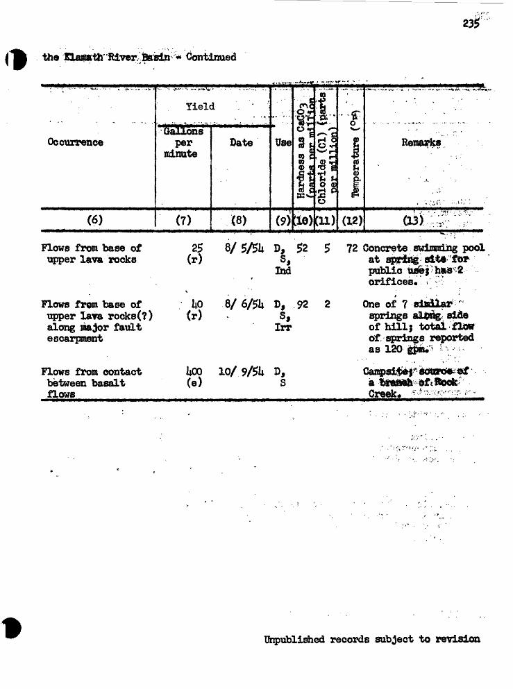
the Klaiath River. Basin - Continued
235
. . . ., ......
Occurrence
(6)
Flows from base of upper lava rocks
Yiel(. . . . , » .
Gallons per
minute
(7)
2f> (r)
1 . ' '"
Date
(8)
8/5/5U
Use
(9)
D,s,
Ibd
fe
Hardness as C fruuHbii T»«T» mi
lie)
52
1%*+*-.
i Chloride' (Cl) L. t>er million)
(11)
5
O
<D
(12)
72
. ..- - ,. - - ...,^^- ... .»> ..- ,-.-..
Remarks
osi';-^'"?' ' :
Concrete swiiraning pool at spring site for public ufi&j has 2 orifices. -!"
Flows from base of I|0 upper lava rocks(?) (r) along major fault escarpment
Flows from contact UOO between basalt (e) flows
D, 92 2 Sf Irr
10/9/5U
f
One of 7 similar ' springs alsng- side of hill; total flow of springs reported as 120
a braneh of.RockCreek. *-*"--w- :?
Unpublished records subject to revision

236
Table lu- Chemical Analyses of Ground( 'V**1^
Analyses by U. S. Geological
Veil or spring no* Date of collection
Dissolved solids -(Total).
Hardness as CaC03(Calcium, rtagnesium)
Sodium-Adsorption ratio
Percent soditun Specific conductance
(microidios at 25° C)
2-19-55 U410-52 , U-19-ltf
Temperature ,(°JP) .Silica (SiOa) * ' ' -39Iron (Fe) V r :
(Total) ; ': ' . >'. t*to(In solution) V [ : .lj8
Calcium (Ca) - .......,...' __ 3.6HagnesiuBi Ofe) .-. . . ^* U»c5r~Sodium (Ka) .. . ..,. "i^.Potassium (K). - - -jg.
Bicarbonate (HCX)3 ) A>o , *Carbonate (C03)Sulfftte (S0[j) * ^:,^3Chloride (ca) . -.--^8Fluorine (p) «S ,«Nitrate (NO^) * *0-Boron C?J »6ii
" -Jg T--
; to-.;
17.01
iuo
5*8i;r "w
38'' ''I 2
:-.%8,-' -.2
.0
.1
" r «$ -. i<551
- ; , ' * '' f *'"'.03.02
13 15 -3- .,U .^
- 22 "^ ' «*» ., '. ....
105 128 " ' >- * * " * - *
5.3 i*k& m <r . ^»w^
Is ' 149* ' """
/ ' " "* .#0' ;: "''
83
22
1.5
59
1127.5
.7
62.?
a Analysis by U. S. Bureau of Reclamationb Analysis by Charlton Laboratories, Inc., Portland*c Analysis by Bennetts, Tacoiaa*^Contains equivalent of k ppm 003.(S) spring.
11»7
0
5*
7ur
158
' ' .1 ,
25a»
T*T
Unpublished records subject to revision

/^ Water In the KUwath River, Bfitsin( p in parts per million, '
Survey unless otherwise indicated. )
38/9-28N1 38/9-2®>2 , 38/9*33Dl 38/9-35Elb 38/L14-12M1 38/Lli~30Ql 39/9-i&rio
17881
.6k
.0
23.0
213
328
1*035k1.2.0,96
833
5819
12
88
Ifl608.8
161*87
.0
.0
25.0*th
32. , 8
ii31...: 561.6.0.91
881
6223
12
88
. 1*230*8«7 "
16083
.0
.0
22.0
2073.8
*W
39350
1*1*.2 7t
8i2
5516
12
88
1,100 8.5 -
125 5170 32
.0 .01*
3821 '21
i2%
380 16'53 '^6.2
.217
.(XL
784 261* :
I& 1820
6.9
20
i»09-SUO. 7.5-
61 701*7
.oU JA
.03
u*8.8
20
Ifil* 11*52.96.6 5.0.2.1**01
161 158
71 H 30 .$
*"' ' 1.0. ' ' -v, ..,.; '3a
200- 7,7 7^7
Unpublished records subject to revision

238
Table It.- Chemical iialyse^ of Oroxnid Water
WelX or spring no. Date %f collection
Temperature (PF)" ,. ....... ,^Silica (Si02 ) 38 Iron (Fe)(Total) «l6 *36 (in solution) »0l ^03
Calcium (Ca) 5«ii 13Magnesium (Mg) 19 .6 7*2Sodium (Ka) ^Potassium (K) J1J*
Bicarbonate (11003) 796 133 xo6Carbonate (003)Sulfate (SO^) 00 2.5Chloride (Cl) 9,1 12 7 1.7Fluoride (F) .3.2Nitrate (N03) « .0 ^6Boron (B) ,01
Dissolved solids(Total) 180 723 186 129
Hardnass as CaC03(Calcium, magnesium) 31^ 52 Noncarbonate ' 0 0
Sodium-Adsorption ratio (SAR) 43
Percent sodium 33 Specific conductance
(microwhos at 25° C) 2i(0 165 P8 ; 8.5 - 7.9
b Analyses by Charlton Laboratories, Inc., Portland, d Analyses Isy Northwest Testing Laboratory, Seattle. S spring.
Unpublished records subject to revision

o.
COf»«
|
f>A
1H
V
0G
OH
O O
*
*
O
i-l3
go
; *
*V
>O
O
\
O\*
r-f
oo
. *
*
H r-i r-i
03N
O C
O H
CO
O
H H
*1
A* *
Q\
NO
O
t«\ p
-CM
CM
* E*.
oC
ViCVI
\O*
O
\O
CO
GO«
"<£:
TJ

Table 5.* Discharge and Ten^erature of Streams and Sjpringstheftaraa& Hw Basin '
:; '. ./' ' .' .-/ '. ' .--,., ""; -, » ; " , - . TemperatureDate of ' ; , -. Location of/ ', '" " Discharge of water
^^^ V '. "" "Coif tti ,Wllllamson giver and trjbiirtaries above the &lamath Mar^i
Sept, 16 Williameon River NWj sec. 1, T« 33 S., 7$«2iOR. ? E* below
Spring
17 Beep creek SW| sec* 22, T. 31 S., 1*03R, 11 £ at
17 Aspen Creek Ntf| Bee. 21, T. 31 S., 2*90R. 11 E.
17 Irving Creek SEj sec. 19» T. 30 S., l.$lR« 11 E«
17 Jackson Creek SW| sec. 7> T. 30 S,, b«66R. 11 E.
29 Williamson Rover SV^ sec* 17* T. 30 S., 70.67 52R. 10 E. t near Kijbtredge Ranch
29 Three Greeks SWj sec. 28, T* 29 S., .35R. 9 E», at mouth
29 Big Spring Creek SE^ sec. 22, T. 30 S., 89.20 hk and diversion R. 8 E*
Williamson River and tribataries below Klamath Marsh
Sept. ,.3,6. ,*&niajiflmmver*,M B*O. 1,-T. 33 S., .,, J9*7' *R." 7~Ei> near-Kirk" - '
16 do* Sec. 2, T, 3k S« f 123*0R« 7 E., at former gaging station above Spring Creek
22 Spring Creek NEj sec. 9, T. 3k S,, 307 at mouth R. 7 S.
16 WUliamson River* Sec. 3, T. 35 S., 75kR. 7 E., nearChiloquln
^Established USGS Gaging station* Unpublished reftsords stibject to revision

Table f>,~ Discharge and Temperature of Streams and Springs - Contintted
Bate of Location of measurement /Stream or spring measuring siteg^ T^E^*?J^? BLii^.._ _._y??'?:l>"?'ll*jBH*>J"l|g^B^ _^9f^^-^:S*-^ ^ . _^,_ ___ v .!_.
Sprague River an<d its tributaries
TemperatureDischarge of water \(cfs)
SEj Sec, 8, T. 37 S0 , R* 15 E«, U miles east of Bly
Sept* 28 . Sprague River South Fork
25 Sprague River Nttf sec* 5> T« 36 S., (North Fork R. lU E. below diversion)
23 Sycan River
23 Long Creek
2ii Svcan River
SEj sec. 21, T. 32 S,, R. ~Lh E.j at ZX Ranch
sec* 1*, T. 32 S., R. 13 E.
sec. 10, T. 33 S., R. 13 E., at Svcan Guard Station
13.63
26*11
28 Sprague River NEj sec. 10, T. 36 S., 13.50> (North Fork R. 11* E. diversion)
25 Meryl Creek SE| sec. 30, T. 35 S», Iiu33R ^L ii T? * ^tf X!t*
28 Five Mile Creek NEj sec. 3k9 T» 35 S,, 20.20 and diversion R. 13 E.
28 Sprague River* SEj sec. 13, T. 36 S., 155R. 12 E., ij miles east of Beatty
7.8l
15.50
9.19
25 Sycan River SE| sec, 3k, T* 35 S., 33»0R. 12 E<,, 3 miles north of Beatty
29 Kamkaun Spring SEj sec. 25, T« 31* S., 65.81*R* 8 E0 , at mouth
29 Sprague River* KE-J sec. 35, T. 3k S., 330
50
58
1*8
56
55
51
51*
52
NE| sec. 35, T. 34 S., R* 7 E«> near Chiloquin
^Established USGS Gaging station*
Unpublished records subject to revision

Table 5»- Discharge and Temperature of Streams and Springs ~ Continued
TemperatureBate of Location of Discharge of water
Stream or sgring aeasurin slte (of s) (°f -195b Drainage into tfcper Ktamath Lake other than Williamson River
Oct. b Annie Creek ' SEj sec. 25, T. 33 S*, 63.57 b2R* 6 E*
b Fort Creek and * NWj sec. 26, T* 33 S», 96*92 b9 diversion R. ?f E«
b Crooked Creek SWj- sec. 1, T. 3b S», b3*ltb b7R» ?| E., 100 ft above
Sept, 29 Agency Spring STtf| sec. 18, T. 3b S.,R. 7 B«, at Klamath Indian Agency
17 Wood River* m% sec. 22, T. 33 S0 bb5, 7| E., at Fort '
Oct. 5 Sevenndle Creek SW| sec. 36, T. 33 S., 86*83 b3- R. 6 E. ' v.
5 Mares Egg Spring NEj sec* 25 T0 3U S., 11*57 b5R. 6 E.
5 Threemlle Creek SEj sec. 29 T* 3U S., .91 b3R« 6 E.
5 Nannie Creek SWj sec. 10, T» 3b S*, 5«51 bbR. 6 E*
Lost River and Spencer Creek
Oct 6 Spencer Creek Sl^J sec. 20, T. 39 S., 25o58 bbR. 7 E.
1953
Oct. 22 Lost River* Sec. 18, T* 39 S*, 38*5R. 12 E», 3 miles SE of Bonanza
22 Lost River* SEj sec. 19, T. 39 S., Ib3R* 11 E., 3 miles SW of Bonanssa
195b . ..' do* 115 ........ ....l.
^Established U3GS gaging station. Unpublished records subject to revision

Table 6«- Meaguents of Det to Water in -Observation Weils»(barometric) determined by means of aneroid baroaeter;
"(map) estimated from topographic map^7 (Water levels ^re in *K feet below land-surface datum*)
29/8~3ijDl. Jack O1 Conn or. Altitude of land surface, U,620 ft (barometric)
Date Water levelAug. 19, 1951* Oct. 26 Nov. 18 Nov* 23
28.28 30.03 .. 31.19 31.UO
Date Water levelDec. 18, 195U" *
!. June 27, 1955 Aug« 25
32.58 36»S7 36*65
- *. -9
29/LO-1SD1* Klamath Indian Reservation, Altitude of land surface,U,535 ft (barometric)
Aug. 31, 195kOct. 6
26Nov. 18
23Dec. 1
18
23.7323.6223.8723.9123*96
r 23.852U.15
Jan, 1, 1955Feb. 1Mar. hApr. 5June 30Aug. 26Oct. 11, 1956
r 23*76r 23.58r 2iu35r 2kii6
21^.532iu9620.98
r From automatic recorder charto
30/7-6&1. Klamath Sidian Reservation. Altitude of land surface,ft (barometric)
Aug. 27, 195U Oct. 26 Nov. 23
18U.95 I81u8k I8lt.79
June 27, 1955 Aug. 26
185.16 185.50
30/7-11G1. Klamath Indian Reservation. Altitude of land surface,U,625 ft (barometric)
Aug. 27, 1951*Septo£9.Oct. 15
26Nov. 23
56.7U57.3957.W56.2956.31
Dec. 18, 195UJune 27, 1955Aug. 26Oct. 11, 1956Dec. 22
56.14157-ilO58.0657.60$7.56
Unpublished records subject to revision

Table 6.- Measurements of Depth to Water in Observation Wells »' Continued Jl
Claudia L. -Lorenz, Altitude of land surface, k,l86 ft (barometric)
DateAug. 2, 195k Oct. 27 Dec. 19" Feb. 16, 1955
Water level1.02 .85 .85
1.67
DateJune 29, 1955 Aug. 26 Oct. 11, 1956 Dec. 22
Water levell.lk 1.51 .31 05
-
3V8-36Q1* Edna Stantoru Altitude of land surface, 1*»182 ft (baroraeteto)
Aug. 9* 195k 1MOct. 27 9*88Doc. 19 10.33June Jg9* 1955 su 95
Aug. 26, 1955 Apr. 8, 1956 Octf 11 Dec. 22
10.82l.l«5 8.809.39
35/7-5F1. Cora Crystal. Altitude of land surface, k919h ft (barometric)
Nov. 29, 195k Dec. 18 26.53
26.91
Aug. 25, 1955 Apr. 8, 1956
27.1625.56
35AQ-19B1. Ted Crurae. Altitude of land surface, k,3$Cf ft (barometric)
Aug. 2, 195U 10.8Oct. 27 16,37Dec. 19 23.3if*Feb* 16, 1955 18.0k
June 29, 1955 Aug. 26 Apr. 8 , 1956 Oct. 11
21.3318.376.98
11.69on
35/12-27Q1. Henry Noneo. Altitude of land surface, k,365£ ft (barometric)
Aug. 7, 195k 9.0kOct. 2? , 9.17Apr. 8, 1956 8.89
Oct. 11, 1956 Dec. 21
10*83 8.0k
ihpublished records subject to revision

;f1fc| Table 6.- Measurements of Depth to Water - Continued
36AO-H*K2. Ivy dark. Altitude of land surface, ^,31*5 ft (map)
Date Water level Date Water levelAug. 5, 195k 25.90Oct. 27 2lu09Dec* 19 ' 2iu01Seb,. 16, 19. .. 22.86
June 29, 1955 Aug. 26 Apr. 8, 1956 .Oct.. 11
23.81* 26.91 25.51 2iu8l
36/H-29tt. W. If* Williams.' Altitude of land surface, U,380 ft (map)
Oct. 27, 195U * 9*88Doc. 19 . , ' 10.02Feb. 16, 1955 9.69June 29 37.00*
Aug. 26, 1955 Apr. 6, 1956 Oct. 11 Dec. 21
9.638.359.269.82
#Pump on (measured with electric tape)...
36A2-UjMU Beatty Recreation Hall. Altitude of land surface, It,3ii5 ft (map)
Aug. 10, 195U ... .6. aOct. 27 6.52Dec. 19 6.51Jure 2Q 195 6.35
Aug.. 26, 1955 Apr. 6, 1956 Oct« 11 Dec. 21
3.6k.90
2.80
36AU-17B1* E. w. Hyde. Altitude of land surface, ii,370 ft (map)
g. Oct. 27 Dec. 19 ' June 2 1955
51.5551.7552.0352.36
^^Augr"2671.955 Apr. 6, 1956 Oct. 11 Dec* 21
52.6?51.19 50.78"
51*02
39A3.J-2831. W. Tubach. Altitude of land surface, ii,105 ft (map)
Aug. 27, 195U 10.066ct* 28 9.80Dec. 17 9cii6Feb. 18, 1955 9.05
June 28, 1955 8.?5Aug. 25 " ' 6.50Apr. 7, 1956 - 8.ii3Det. 11 11.88Dec, 20 8.6k
Unpublished records .subject to revision

2U6
Table 6.- Measurements of Depth to Water * Continued
39/12-29K1. Jack Weimer, Altitude of land surface, fc,lJjQ ft (map)
Date ( Water levelAug* 11, 1951* Oct. 28 Dsc* 17 Feb. 18, 1955 June 28, .
17,69 22.62 2i*.25 25.1*6 18,20
DateAug. 25, 1955 Apr« 7, 1956 Oct. 10 Dec, 21
Water level16.31* 21.33 16.71 22.07
39/12-36L1. Hoyd Grawford. Altitude of land surface, k,l50 ft (map)
Aug. 19 1951* 35.21*Get* 28 3?.1*0Dec. 17 39*27Feb, 18, 1955 1*1.1*2June 28 37.82
Aug, 25, 1955 Apr. 7, 1956 Oct. 10 Dec, 21
36.09 38.13 3U.55
. A. W, Schaupp. Altitude of land surface, I*,l50>ft (map)
Aug. 21, 1951*Oct. 28Dec. 17Feb, 18, 1955Jiaae 28
10.7710.5710.3211,31*11,53
Aug. 25, 1955Apr. 7, 1956Got. 10Dec. 20
11,868.38
10.6010.1*1
1*1/11 ~9B1. Leland Pope, Altitude of land surface, U,066 ft (map)
Sept* 9, 195k Got, 29 Dec. 3.7
29.98 29*58
Feb. 18, 1955 June 28
. 25
3k.0k 32,56 31,29
i*lA2-3El. Albert Stastny, Altitude of land surface, U,110 ft (map)
A«g. 31, 1951*Oct. 28Dec, 17Feb. 18, 1955June 23
0.791.001.10.75
1.00
Aug* 25, 1955Apr, 7, 1956Oct. 10Dec. 20
1.37.82
2.723.11
Unpublished records subject to revision

afe?
Table 6«- Measurements of Depth to Water * Continued
ltlA2*12HX. Frye & Barney0 Altitude of land surface, ii,220 ft (nap)
Date Water, level .Oct. 28, l9Sh 167.82 Dec*. 17 ... , 167.6? Feb. 18, 1955 167.65 June 28 187.05*
Cate,Aug. 25, 1955 Apr. 7, 1956 Oct, 10 Dec, 20
Water levelI83*li2*
16^82
on*
la/12-19CJ1. D. P. Beid. Altitude of land surface, I*,0l5 ft
Aug. 31, 19514Got, 29Dec. 1?Feb. 18, 1955June 28
11.377*1£6^77 .6.839.25
Aug. 25, 1955Apr. 7, 1956Oct. 10Dec. 20
6.003*86h*9ki*.83
lilAit-7Rl. CJharles Kilgore. Altitude of land surface, Ii,l50 ft (barometric)
Aug* k, 195k 17-(^ Augo 25, 1^5 " 17^ilOct. 28 17.77 Apr. 7, 1956 I6,k2Dec. 17 17.99 Oct. 10 17.08Feb. 18, 1955 17.66 Dec, a 17.02June 28 17.55 ; _____
Ifepublished records subject to revision

CUED
Callaghan, Eugene, and Buddington, A. F., 1938, Metalliferous mineral deposits of the Cascade Range in Oregon: U, S. Geol, Survey Bull? 893*
Dean, H* T*, 1936, Chronic endemic flourosis: Am* Med. Assoc. Jour*, 107, p. 12-69-1272,
Fenneman, N, M«, 1931, Physiography of western United States: Hew York, MgQraw-Hill Book Co., Inc., map*
Grover, N* C*, 1917, Surface water supply of the United States, 191k, Fart 11, Pacific slope basins in California: U« 8. Geol* Survey Water Supply Paper 391*
Henshaw, P. F., 1912, Preliminary report on water resources of KLaraath Indian Reservation, Oregon: U* S. Geol* Survey, open-file report (typewritten)*
Merewether, £* A., 1953, The geology of the lower Sprague Elver area, Kiamath County, Oregon: Univ. Oregon thesis for Master of Science degree.
Meyers, J. B*, and Hewcomb, R. C«, 1952, Geology and ground -water resources of the Swan Lake-Yonna Valleys area, Kiamath County, Oregon? U. S. 0eol« Survey open-file report (duplicated).
Newcomb, R. C*, 1953, lonna formation of the Kiamath Eiver basin, Oregon: Northwest Science, vol* 325 no. 2, p. ill -1*8.
Moore,, B« N., 1937, Nonmetallic mineral resources of eastern Oregon: U. S» Geol* Survey BuH* 875.
Scofield, C« S., 1936, The salinity of irrigation water: Smithsonian Inst. Ann. Rept* 1935, p* 275-287.
Wells, F.G., 1939* Preliminary geologic map of the Medford quadrangle, Cregon: Oreg* Dept« Geology and ifin. Industries*
kT'.lii«,ms, Howell, 19^> The Geology of Crater Lake National Park, Oregon: Carnegie Jhst. Wash. Puv. 5^0*