Rachenahalli – Containment of a Kere – A Visual Essay
17
Rachenahalli – Containment of a Kere – A Visual Essay Rohan D’Souza Introduction The lakes of Bangalore, as they are more popularly known, are very really tanks which are part of an intricate man made system which took centuries to develop. This system displayed man’s ingenuity at tapping rainwater in a place where there was no river. The tanks or to use the more appropriate local term, kere, are a series of water overflows guided and reconfigured into a chain of interconnected water bodies. These interfaced with each other through wetlands and canals or rajakaluves allowing for a controlled and guided descent of rainwater down the three valleys in Bangalore. Through this, one of the older rainwater harvesting systems was put into practice. A socio-economic system developed around these keres which utilised the different parts of the kere and merged social systems with maintenance of these water bodies. The water from the kere itself was used for various purposes such as household needs, irrigation, washing clothes and cattle. Among the economic activities that subsisted around the keres were fishing and agriculture. The latter primarily happened in the ‘wetlands’ downstream of the kere. A bund was built to give birth to the kere so that flowing streams of water were stopped and a water body developed around that. The wetlands downstream of the bund benefitted from the overflow. This happened through sluice mechanisms built into the bund. These helped regulate the flow of water into the wetlands. The canals or rajakaluves captured the overflows from the ends of the bunds and transported the water to the next kere in the chain of keres and so on. They also helped channel water into the wetlands for irrigation. The wetlands were primarily used to grow water intensive crops such as rice or sugarcane in some cases. The keres and associated land such as the wetlands also nurtured a range of flora and fauna, ranging from a wide variety of birds to aquatic creatures. A community management system developed around these keres which involved various communities to perform specific functions in maintaining the keres. This included the ‘Neergunti’ community which maintained the rajakaluves. Other communities were responsible for de-silting the kere; still others were involved in maintaining the bunds. This was of course juxtaposed over the existing caste systems in each of the villages where the keres were located. An Inam system which rewarded maintenance tasks with the grant of land also Rajakaluve Overflow Sluice mechanism
-
Upload
independent -
Category
Documents
-
view
2 -
download
0
Transcript of Rachenahalli – Containment of a Kere – A Visual Essay

Rachenahalli – Containment of a Kere – A Visual Essay
Rohan D’Souza
Introduction
The lakes of Bangalore, as they are more popularly known, are very really tanks which are
part of an intricate man made system which took centuries to develop. This system displayed
man’s ingenuity at tapping rainwater in a place where there was no river. The tanks or to use
the more appropriate local term, kere, are a series of water overflows guided and reconfigured
into a chain of interconnected water bodies. These interfaced with each other through
wetlands and canals or rajakaluves allowing for a controlled and guided descent of rainwater
down the three valleys in Bangalore. Through this, one of the older rainwater harvesting
systems was put into practice.
A socio-economic system developed around
these keres which utilised the different parts
of the kere and merged social systems with
maintenance of these water bodies. The
water from the kere itself was used for
various purposes such as household needs,
irrigation, washing clothes and cattle.
Among the economic activities that
subsisted around the keres were fishing and
agriculture. The latter primarily happened in
the ‘wetlands’ downstream of the kere. A
bund was built to give birth to the kere so
that flowing streams of water were stopped and a water body developed around that. The
wetlands downstream of the bund benefitted from the overflow. This happened through sluice
mechanisms built into the bund. These helped
regulate the flow of water into the wetlands. The
canals or rajakaluves captured the overflows from
the ends of the bunds and transported the water to
the next kere in the chain of keres and so on. They
also helped channel water into the wetlands for
irrigation. The wetlands were primarily used to
grow water intensive crops such as rice or
sugarcane in some cases. The keres and associated
land such as the wetlands also nurtured a range of flora and fauna, ranging from a wide
variety of birds to aquatic creatures.
A community management system developed around these keres which involved various
communities to perform specific functions in
maintaining the keres. This included the
‘Neergunti’ community which maintained the
rajakaluves. Other communities were
responsible for de-silting the kere; still others
were involved in maintaining the bunds. This
was of course juxtaposed over the existing caste
systems in each of the villages where the keres
were located. An Inam system which rewarded
maintenance tasks with the grant of land also
Rajakaluve
Overflow
Sluice mechanism

existed. Who was granted what type of land; productive and fertile wetlands or relatively
infertile dry lands, also to some extent depended on one’s location in the caste hierarchy.
As Bangalore urbanised, two factors started kicking in which rang a death knell to this
complex tank system. One was the demand for land in a quickly sprawling and populating
city and the other was the corresponding increased demand for potable water. The latter was
met to some extent by tapping of water sources
such as the Cauvery River, located over 100
kilometres from Bangalore, at high costs of
transportation (pumping). As both these factors
started playing out gradually from the late 1970s
onwards, when Bangalore started receiving
Cauvery water, and in a more accelerated manner
from the 1990s onwards when the Information
Technology boom happened, keres started
shrinking in size or disappearing altogether to be
replaced by bus stands, stadiums, layouts,
commercial complexes. The connecting system of
Kere – Wetlands/Rajakaluve – Kere started being
replaced by Kere - Built up land – Kere. Thus the interconnectedness of the keres started
diminishing and the ‘containment’ of keres became the focus. This was accompanied by the
increased dumping of mostly untreated sewerage and industrial effluents into the water
bodies, polluting them and also converting them from seasonal water bodies into perennial
ones.
This containment was largely done by the
various civic agencies such as Bangalore
City Corporation (now the BBMP), the
municipal corporation, Bangalore
Development Authority (BDA), the land use
zoning authority, Lake Development
Authority (LDA), entrusted with the
development and maintenance of the keres.
This containment went hand in hand with a
repositioning of these keres. What were
once socio-economic-ecological systems
with a well-defined community
management system now began being
converted to mostly social, primarily recreation/entertainment focused systems, catering to
newer user groups. Thus the keres of Bangalore started being converted into lakes. The Forest
Department which was involved in maintenance of some of the keres for sometime from the
1980s to early 2000s were also responsible to some extent in the change of this discourse.
The new label, lake, was here to stay!
After that introduction, which is based on several years of research that I have done involving
several keres, I will attempt to present the structural transformation of keres visually. For this,
I will focus on one particular kere, Rachenahalli located in north Bangalore.
Buildings and debris near a
kere
Sewage and industrial effluents
in a rajakaluve of a kere
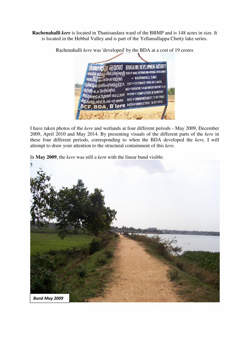
Rachenahalli kere is located in Thanisandara ward of the BBMP and is 148 acres in size. It
is located in the Hebbal Valley and is part of the Yellamallappa Chetty lake series.
Rachenahalli kere was 'developed' by the BDA at a cost of 19 crores
I have taken photos of the kere and wetlands at four different periods - May 2009, December
2009, April 2010 and May 2014. By presenting visuals of the different parts of the kere in
these four different periods, corresponding to when the BDA developed the kere, I will
attempt to draw your attention to the structural containment of this kere.
In May 2009, the kere was still a kere with the linear bund visible.
Bund May 2009

The wetlands were also fairly clearly visible. Agriculture already ceased to be practised here.
The rajakaluve from the overflow located at the eastern end of the bund which carried the
water to the next kere in the chain of keres. In this case, the Kalkere kere.
Wetlands May 2009
Rajakaluve May 2009

In December 2009, BDA had already breached the bund and emptied the water body.
This gave me a chance to get into the tank bed and take pictures including of the sluice
mechanism from the tank bed side. This helped record an image of a system for posterity,
which was going to be demolished shortly as the bund was being reworked.
Bund breach
December 2009
Sluice Mechanism kere
side December 2009

On the wetland side of the bund, was the other part of the sluice mechanism through which
kere water entered and irrigated these lands.
The kere bed was mostly dry now apart from few pools of water. In this interim period,
several people and flora and fauna that depended on the kere were left stranded. The former
included people who washed clothes, bathed, fished and the latter included several aquatic
plants, animals and birds.
Sluice Mechanism wetlands
side December 2009
Kere bed view December 2009

The only people who seemed to benefit at this point of the kere re-engineering, apart from of
course the BDA, were those engaged in sand mining from the kere bed.
In April 2010, the redesign work was in full swing. That gave me a chance to document
much of the ongoing work including creation of a walking path around the kere. This of
course is in the tank bed, thus eating into the water spread
area.
Kere bed sand mining December 2009
Kere walking path construction April 2010

The diminishing of the water spread area can be clearly seen when contrasted with a similar
view of the kere from December 2009. The house which just about oversaw the water body
was now a walking path away from it.
The bund was reworked and widened.
Kere eastern shore view May 2009
Kere bund reworking April 2010

This resulted in a loss of structures from a former system such as the sluice mechanism. This
added to the containment of the overflowing nature of the kere system. The photo below
shows where one of the sluice mechanisms of the kere was located.
The bed of the kere by now had dried up completely causing further difficulty to those who
survived on it, namely locals dependent on it for washing needs, fishermen and flora and
fauna.
Location of former sluice mechanism April 2010
Dry tank bed April 2010
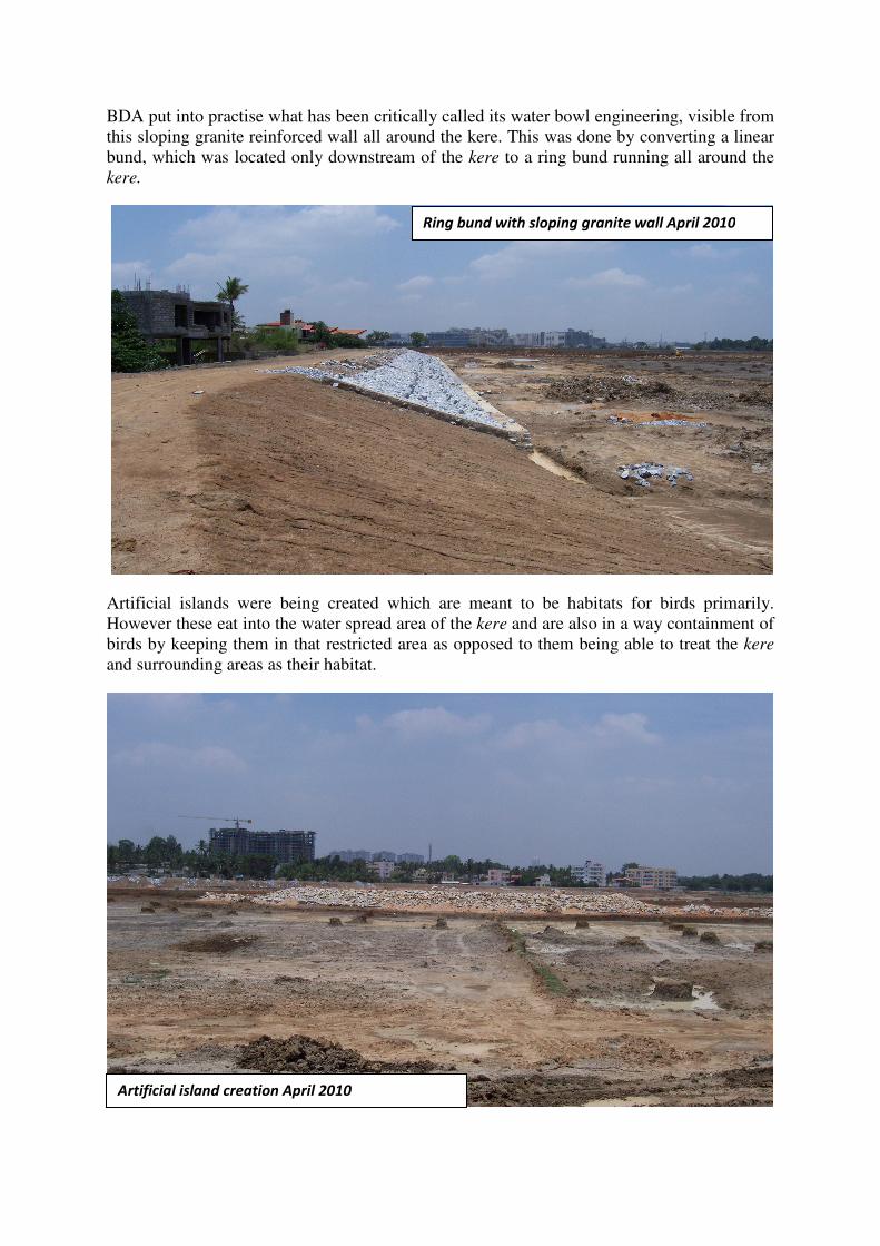
BDA put into practise what has been critically called its water bowl engineering, visible from
this sloping granite reinforced wall all around the kere. This was done by converting a linear
bund, which was located only downstream of the kere to a ring bund running all around the
kere.
Artificial islands were being created which are meant to be habitats for birds primarily.
However these eat into the water spread area of the kere and are also in a way containment of
birds by keeping them in that restricted area as opposed to them being able to treat the kere
and surrounding areas as their habitat.
Ring bund with sloping granite wall April 2010
Artificial island creation April 2010

The reworking of the bund was taking place which resulted in it becoming wide...
Wider than earlier...
Bund April 2010
Bund May 2009

The direction the work was heading in 2010 seemed that it will result in the kere becoming a
water bowl that collects water in a circular structure as opposed to a sloping bed with
differing depths. This is done with the help of a ring bund all around the water body. This
would replace a linear bund, where the role of the bund was to dam the stream of water and
manage the overflow. Stretches of kere-wetland-kere will get broken so that land is freed up
between and around the keres for development. Was all this just my speculation, assumption
or just plain paranoia?
To check this, I made yet another trip to the kere, this time in April 2014, by when the kere
development was over and the water body would have hopefully been filled. This is what I
discovered.
The bund was now circular and curled all around the kere.
View of kere 2014

The previous linear bund has now become a part of the new ring bund now and can’t be differentiated
from the rest of the bund. There were no signs of the sluice mechanisms which have been built over
and relegated to posterity by particular notions of development.
The rajakaluve now has been fenced, just like the rest of the kere.
Bund April 2014
Overflow and rajakaluve April 2014

The kere was now securely ‘bunded’and fenced all around. While some would argue that fencing
prevents encroachment, one could also say that fencing limits the water spread area of what are meant
to be water bodies whose boundaries fluctuate based on the amount of rainfall and season. This of
course has changed now with the perennial nature of the keres with sewage and other waste water
flowing into them through the year. Therefore a new fixity has come to their boundaries and thus the
need to fence them in?
Kere view from outside fence April 2014
Rajakaluve and Kere fences April 2014

A peek from the bund onto the wetlands showed that most part of the wetlands remained as they were
in 2009-2010 but many new buildings seemed to have come up and are closing in on the wetlands and
the kere.
As compared to 2009

A view of the western shore of the kere also shows growing number and density of structures. This
could mean a depletion of groundwater as well increased discharge of sewage into keres.
This one would say is inevitable in a growing city like Bangalore. True, but what are the implications
on traditional and useful social-ecological systems such as the kere system of Bangalore? Should they
be conserved, as far as possible, as what they were or should they be re-engineered into ‘lakes’ and
thus be contained? Should keres be ringed, fenced and converted into water bowls so that land around
them is freed for such real estate growth? This in turn disrupting ecological logic and leading to
flooding on the one hand and depletion of groundwater on the other as well as the loss of urban
biodiversity.
Can we not look at urban conservation more creatively and see the possibilities that such systems can
offer, such as that of urban agriculture in the wetlands? Is retention of the overflow system possible so
that there are stretches of water bodies linked to each other through open unbuilt land within a
concreted landscape, thus encouraging biodiversity and also helping water sustainability? The
possibilities of urban agriculture offer not just crops with lower food footprints but also livelihood
options. However, the tug of real estate and the monetary windfalls it offers in Bangalore can be hard
to resist, especially given that agriculture is increasing becoming unsustainable and unprofitable for
small land holders.
Is this model of development that is so much in vogue now across the country, the only way ahead?
Are centralised management systems of natural resources the best way to conserve and preserve
them? Can the social and the ecological coexist in a fast changing urban landscape in a manner which
benefits both?
Kere west shore view April 2014
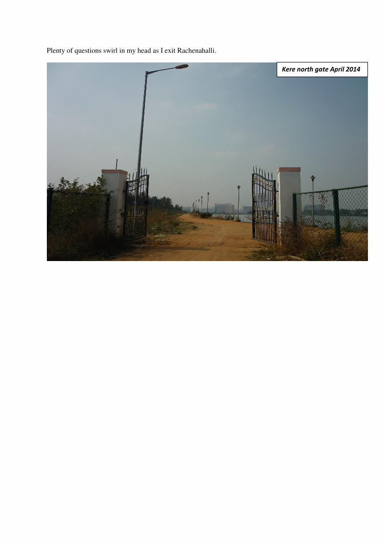
Plenty of questions swirl in my head as I exit Rachenahalli.
Kere north gate April 2014