Putting to rest WISHE-ful misconceptions for tropical cyclone intensification
18
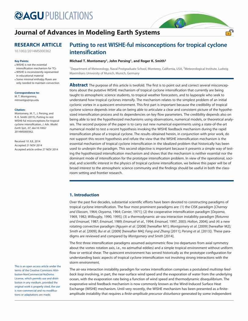
RESEARCH ARTICLE 10.1002/2014MS000362 Putting to rest WISHE-ful misconceptions for tropical cyclone intensification Michael T. Montomery 1 , John Persing 1 , and Roger K. Smith 2 1 Department of Meteorology, Naval Postgraduate School, Monterey, California, USA, 2 Meteorological Institute, Ludwig Maximilians University of Munich, Munich, Germany Abstract The purpose of this article is twofold. The first is to point out and correct several misconcep- tions about the putative WISHE mechanism of tropical cyclone intensification that currently are being taught to atmospheric science students, to tropical weather forecasters, and to laypeople who seek to understand how tropical cyclones intensify. The mechanism relates to the simplest problem of an initial cyclonic vortex in a quiescent environment. This first part is important because the credibility of tropical cyclone science depends inter alia on being able to articulate a clear and consistent picture of the hypothe- sized intensification process and its dependencies on key flow parameters. The credibility depends also on being able to test the hypothesized mechanisms using observations, numerical models, or theoretical analy- ses. The second purpose of the paper is to carry out new numerical experiments using a state-of-the-art numerical model to test a recent hypothesis invoking the WISHE feedback mechanism during the rapid intensification phase of a tropical cyclone. The results obtained herein, in conjunction with prior work, do not support this recent hypothesis and refute the view that the WISHE intensification mechanism is the essential mechanism of tropical cyclone intensification in the idealized problem that historically has been used to underpin the paradigm. This second objective is important because it presents a simple way of test- ing the hypothesized intensification mechanism and shows that the mechanism is neither essential nor the dominant mode of intensification for the prototype intensification problem. In view of the operational, soci- etal, and scientific interest in the physics of tropical cyclone intensification, we believe this paper will be of broad interest to the atmospheric science community and the findings should be useful in both the class- room setting and frontier research. 1. Introduction Over the past five decades, substantial scientific efforts have been devoted to constructing paradigms of tropical cyclone intensification. The four most prominent paradigms are: (1) the CISK paradigm [Charney and Eliassen, 1964; Ooyama, 1964; Carrier, 1971]; (2) the cooperative intensification paradigm [Ooyama, 1969, 1982; Willougby, 1990, 1995]; (3) a thermodynamic air-sea interaction instability paradigm [Rotunno and Emanuel, 1987; Emanuel, 1989; Emanuel et al., 1994; Emanuel, 1997, 2003; Holton, 2004]; and (4) a new rotating convective paradigm (Nguyen et al. [2008] [hereafter M1]; Montgomery et al. [2009] [hereafter M2]; Smith et al. [2009]; Bui et al. [2009] [hereafter M4]; Fang and Zhang [2011]; Persing et al. [2013]). These para- digms are reviewed and compared by Montgomery and Smith [2014]. The first three intensification paradigms assumed axisymmetric flow (no departures from axial symmetry about the vortex rotation axis, i.e., no azimuthal eddies) and a simple tropical environment without uniform flow or vertical shear. The quiescent environment has served historically as the prototype configuration for understanding basic aspects of tropical cyclone intensification not involving strong interactions with the storm environment. The air-sea interaction instability paradigm for vortex intensification comprises a postulated multistep feed- back loop involving, in part, the near-surface wind speed and the evaporation of water from the underlying ocean, with the evaporation rate being a function of wind speed and thermodynamic disequilibrium. The evaporative-wind feedback mechanism is now commonly known as the Wind-Induced Surface Heat Exchange (WISHE) mechanism. Until very recently, the WISHE mechanism has been presented as a finite- amplitude instability that requires a finite-amplitude precursor disturbance generated by some independent Key Points: WISHE is not the essential intensification mechanism for TCs WISHE is inconsistently represented in educational material Some minimal enthalpy fluxes are only needed to maintain convection Correspondence to: M. T. Montgomery, [email protected] Citation: Montomery, M. T., J. Persing, and R. K. Smith (2015), Putting to rest WISHE-ful misconceptions for tropical cyclone intensification, J. Adv. Model. Earth Syst., 07, doi:10.1002/ 2014MS000362. Received 10 JUL 2014 Accepted 21 NOV 2014 Accepted article online 27 NOV 2014 This is an open access article under the terms of the Creative Commons Attri- bution-NonCommercial-NoDerivs License, which permits use and distri- bution in any medium, provided the original work is properly cited, the use is non-commercial and no modifica- tions or adaptations are made. Journal of Advances in Modeling Earth Systems PUBLICATIONS
-
Upload
independent -
Category
Documents
-
view
5 -
download
0
Transcript of Putting to rest WISHE-ful misconceptions for tropical cyclone intensification
RESEARCH ARTICLE10.1002/2014MS000362
Putting to rest WISHE-ful misconceptions for tropical cycloneintensificationMichael T. Montomery1, John Persing1, and Roger K. Smith2
1Department of Meteorology, Naval Postgraduate School, Monterey, California, USA, 2Meteorological Institute, LudwigMaximilians University of Munich, Munich, Germany
Abstract The purpose of this article is twofold. The first is to point out and correct several misconcep-tions about the putative WISHE mechanism of tropical cyclone intensification that currently are beingtaught to atmospheric science students, to tropical weather forecasters, and to laypeople who seek tounderstand how tropical cyclones intensify. The mechanism relates to the simplest problem of an initialcyclonic vortex in a quiescent environment. This first part is important because the credibility of tropicalcyclone science depends inter alia on being able to articulate a clear and consistent picture of the hypothe-sized intensification process and its dependencies on key flow parameters. The credibility depends also onbeing able to test the hypothesized mechanisms using observations, numerical models, or theoretical analy-ses. The second purpose of the paper is to carry out new numerical experiments using a state-of-the-artnumerical model to test a recent hypothesis invoking the WISHE feedback mechanism during the rapidintensification phase of a tropical cyclone. The results obtained herein, in conjunction with prior work, donot support this recent hypothesis and refute the view that the WISHE intensification mechanism is theessential mechanism of tropical cyclone intensification in the idealized problem that historically has beenused to underpin the paradigm. This second objective is important because it presents a simple way of test-ing the hypothesized intensification mechanism and shows that the mechanism is neither essential nor thedominant mode of intensification for the prototype intensification problem. In view of the operational, soci-etal, and scientific interest in the physics of tropical cyclone intensification, we believe this paper will be ofbroad interest to the atmospheric science community and the findings should be useful in both the class-room setting and frontier research.
1. Introduction
Over the past five decades, substantial scientific efforts have been devoted to constructing paradigms oftropical cyclone intensification. The four most prominent paradigms are: (1) the CISK paradigm [Charneyand Eliassen, 1964; Ooyama, 1964; Carrier, 1971]; (2) the cooperative intensification paradigm [Ooyama,1969, 1982; Willougby, 1990, 1995]; (3) a thermodynamic air-sea interaction instability paradigm [Rotunnoand Emanuel, 1987; Emanuel, 1989; Emanuel et al., 1994; Emanuel, 1997, 2003; Holton, 2004]; and (4) a newrotating convective paradigm (Nguyen et al. [2008] [hereafter M1]; Montgomery et al. [2009] [hereafter M2];Smith et al. [2009]; Bui et al. [2009] [hereafter M4]; Fang and Zhang [2011]; Persing et al. [2013]). These para-digms are reviewed and compared by Montgomery and Smith [2014].
The first three intensification paradigms assumed axisymmetric flow (no departures from axial symmetryabout the vortex rotation axis, i.e., no azimuthal eddies) and a simple tropical environment without uniformflow or vertical shear. The quiescent environment has served historically as the prototype configuration forunderstanding basic aspects of tropical cyclone intensification not involving strong interactions with thestorm environment.
The air-sea interaction instability paradigm for vortex intensification comprises a postulated multistep feed-back loop involving, in part, the near-surface wind speed and the evaporation of water from the underlyingocean, with the evaporation rate being a function of wind speed and thermodynamic disequilibrium. Theevaporative-wind feedback mechanism is now commonly known as the Wind-Induced Surface HeatExchange (WISHE) mechanism. Until very recently, the WISHE mechanism has been presented as a finite-amplitude instability that requires a finite-amplitude precursor disturbance generated by some independent
Key Points:! WISHE is not the essential
intensification mechanism for TCs! WISHE is inconsistently represented
in educational material! Some minimal enthalpy fluxes are
only needed to maintain convection
Correspondence to:M. T. Montgomery,[email protected]
Citation:Montomery, M. T., J. Persing, andR. K. Smith (2015), Putting to restWISHE-ful misconceptions for tropicalcyclone intensification, J. Adv. Model.Earth Syst., 07, doi:10.1002/2014MS000362.
Received 10 JUL 2014Accepted 21 NOV 2014Accepted article online 27 NOV 2014
This is an open access article under theterms of the Creative Commons Attri-bution-NonCommercial-NoDerivsLicense, which permits use and distri-bution in any medium, provided theoriginal work is properly cited, the useis non-commercial and no modifica-tions or adaptations are made.
MONTOMERY ET AL. VC 2014. The Authors. 1
Journal of Advances in Modeling Earth Systems
PUBLICATIONS

means (such as an easterly wave) to ‘‘kick start the heat engine’’ [cf. Hakim, 2011; Holton and Hakim, 2012, tobe discussed later].
While the evaporation of water from the underlying ocean had been long recognized as the energy sourcefor tropical cyclones [Kleinschmidt, 1951; Riehl, 1954; Malkus and Riehl, 1960; Ooyama, 1969], Emanuel’s con-tributions with colleagues refocused attention on the air-sea interaction aspects of the intensification pro-cess. Instead of viewing latent heat release in deep convective towers as the ‘‘driving mechanism’’ forvortex amplification, Emanuel showed that certain aspects of these storms could be understood in terms ofa simple time-dependent, axisymmetric model [Emanuel, 1989] in which the latent heat release was implicit.Moreover, Rotunno and Emanuel op. cit. emphasized also the nonnecessity of convective available potentialenergy in the storm environment for intensification.
In this paper, the term ‘‘WISHE mechanism’’ will be used with its widely accepted meaning [e.g., Holton,2004] as an amplification mechanism (i.e., a feedback process) that supports an intensifying tropical cyclone.We say more about the details of this envisaged mechanism below. In some subcircles, however, the term‘‘WISHE mechanism’’ is being used more loosely as simply the bulk-aerodynamic transfer of moist enthalpyfrom the ocean to the atmosphere by the local prevailing winds. In this view, the term ‘‘WISHE mechanism’’is indistinguishable from ‘‘bulk-aerodynamic enthalpy transfer’’, and the latter is arguably more meaningfulthan its corresponding acronym. Here the enthalpy flux is invoked to offset the entrainment of drier air aloftinto the boundary layer by convective and mesoscale downdrafts so that convective activity in the storm’scentral region can be maintained. We find this definition too imprecise to be useful in a quantitative settingbecause such a mechanism would operate throughout the broad-scale summertime tropics in the tradeeasterlies and/or monsoonal westerlies and is not special to tropical cyclone intensification. Moreover, thisview is historically inconsistent because the air-sea interaction instability was articulated first withoutexplicit consideration of downdrafts [Rotunno and Emanuel, 1987, section 5]; the effects of downdrafts onintensification process are refinements of the envisaged development process. Our stance is supported bya leading tropical meteorologist and coworkers [Molinari et al., 2004] who wrote:
‘‘The wind-induced surface heat exchange (WISHE) theory of Emanuel [1986] and Rotunno and Emanuel[1987] has continued to be refined [e.g., Emanuel, 1989, 1997]. The essence of the theory has remained thesame, however: the pre-hurricane vortex must be of finite amplitude to develop, axisymmetry and slantwiseneutrality are assumed, and development occurs basically as a feedback between surface wind speed andspeed-dependent surface moist entropy flux. The WISHE-based developing hurricane contains no colddowndrafts nor strongly buoyant updrafts, and no asymmetric convection.’’
Like the first three paradigms, the rotating convective paradigm is illustrated most easily for the prototypeintensification problem as defined in M1 involving a quiescent environment, a circularly symmetric, cloud-free, cyclonic initial vortex of finite amplitude (say at or below tropical storm strength), a three-dimensionalrepresentation of explicit moist convection, and explicit air-sea transfer of momentum and latent and sensi-ble heat. Unlike the first three paradigms, the rotating convective paradigm is intrinsically three-dimensional, but it contains an azimuthally averaged (mean field) dynamics that is forced in part by theaveraged eddy momentum and eddy heat fluxes and their divergence, etc. The mean field dynamics of therotating convection paradigm constitute an extended cooperative intensification paradigm in which eddyprocesses can contribute positively to amplifying the tangential winds of the vortex [Persing et al., 2013].The positive contribution to vortex spin up by eddy processes demonstrated in Persing et al. [2013] con-trasts with previous assumptions and speculation of the downgradient action of asymmetric motions(referred to as ‘‘turbulence,’’ but including vortical convection and vortex Rossby waves and their wave-mean flow and wave-wave interactions), which would lead to spin down [Bryan et al., 2010].
The similarities and differences of the foregoing intensification paradigms are discussed by Montgomeryand Smith [2014]. The findings of Persing et al. [2013] suggest that previous studies using strictly axisymmet-ric models, and their attendant phenomenology of axisymmetric convective rings, have intrinsic limitationsfor understanding the intensification process.
Despite this significant progress in understanding tropical cyclone intensification in three dimensions andthe demonstration in M2 that the WISHE mechanism is not essential to explain intensification, the WISHEintensification paradigm continues to be entrenched in meteorological descriptions of the intensification
Journal of Advances in Modeling Earth Systems 10.1002/2014MS000362
MONTOMERY ET AL. VC 2014. The Authors. 2
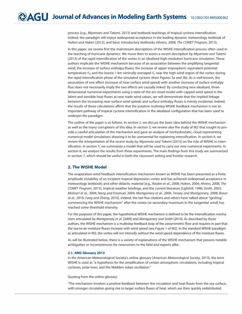
process [e.g., Miyamoto and Takemi, 2013] and textbook teachings of tropical cyclone intensification.Indeed, the paradigm still enjoys widespread acceptance in the leading dynamic meteorology textbook ofHolton and Hakim [2012], and basic introductory textbooks [Ahrens, 2008; The COMET Program, 2013].
In this paper, we review first the mainstream descriptions of the WISHE intensification process often used inthe teaching of hurricane dynamics. We move then to assess a recent description by Miyamoto and Takemi[2013] of the rapid intensification of the vortex in an idealized high-resolution hurricane simulation. Theseauthors implicate the WISHE mechanism because of an association between the amplifying tangentialwind; the increase of surface enthalpy fluxes; the increase of upper tropospheric equivalent potentialtemperature he; and the lowest 1 km vertically-averaged he near the high wind region of the vortex duringthe rapid intensification phase of the simulated cyclone (their Figures 3a and 3b). As is well known, theassociation of one effect (increase of near-surface wind speed) with another (increase of surface enthalpyflux) does not necessarily imply the two effects are causally linked. By conducting new idealized, three-dimensional numerical experiments using a state-of-the-art cloud model with capped wind speed in thelatent and sensible heat fluxes at near trade wind values, we will demonstrate that the implied linkagebetween the increasing near-surface wind speeds and surface enthalpy fluxes is merely incidental. Indeed,the results of these calculations affirm that the putative multistep WISHE feedback mechanism is not animportant pathway of tropical cyclone intensification in the idealized configuration that has been used tounderpin the paradigm.
The outline of the paper is as follows. In section 2, we discuss the basic idea behind the WISHE mechanismas well as the many corruptions of this idea. In section 3, we review also the study of M2 that sought to pro-vide a careful articulation of the mechanism and gave an analysis of nonhydrostatic, cloud representingnumerical model simulations showing it to be unessential for explaining intensification. In section 4, wereview the interpretation of the recent study by Miyamoto and Takemi [2013] on the role of WISHE in inten-sification. In section 5, we summarize a model that will be used to carry out new numerical experiments. Insection 6, we analyze the results from these experiments. The main findings from this study are summarizedin section 7, which should be useful in both the classroom setting and frontier research.
2. The WISHE Model
The evaporation-wind feedback intensification mechanism known as WISHE has been presented as a finiteamplitude instability of an incipient tropical depression vortex and has achieved widespread acceptance inmeteorology textbooks and other didactic material [e.g., Rauber et al., 2008; Holton, 2004; Ahrens, 2008; TheCOMET Program, 2013], tropical weather briefings, and the current literature [Lighthill, 1998; Smith, 2003;Molinari et al., 2004; Nong and Emanuel, 2004; Montgomery et al., 2006; Terwey and Montgomery, 2008; Braunet al., 2010; Fang and Zhang, 2010]. Indeed, the last five citations and others have talked about ‘‘igniting/commencing the WISHE mechanism’’ after the vortex (or secondary maximum in the tangential wind) hasreached some threshold intensity.
For the purposes of this paper, the hypothetical WISHE mechanism is defined to be the intensification mecha-nism articulated by Montgomery et al. [2009] and Montgomery and Smith [2014]. As described by thoseauthors, the WISHE mechanism is a multistep feedback loop of the axisymmetric flow and requires in part thatthe sea-to-air moisture fluxes increase with wind speed (see Figure 1 of M2). In the standard WISHE paradigmas articulated in M2, the vortex will not intensify without the wind-speed dependence of the moisture fluxes.
As will be illustrated below, there is a variety of explanations of the WISHE mechanism that possess notableambiguities or inconsistencies for newcomers to the field and experts alike.
2.1. AMS Glossary 2013In the American Meteorological Society’s online glossary [American Meteorological Society, 2013], the termWISHE is used as ‘‘a hypothesis for the amplification of certain atmospheric circulations, including tropicalcyclones, polar lows, and the Madden-Julian oscillation.’’
Quoting from the online glossary:
‘‘The mechanism involves a positive feedback between the circulation and heat fluxes from the sea surface,with stronger circulation giving rise to larger surface fluxes of heat, which are then quickly redistributed
Journal of Advances in Modeling Earth Systems 10.1002/2014MS000362
MONTOMERY ET AL. VC 2014. The Authors. 3

aloft by convection, in turn strengthening the circulation. In this theory, emphasis is placed on the surfacefluxes as the principal rate-limiting process; convection serves only to redistribute heat. This can be con-trasted with conditional instability of the second kind (CISK), in which circulations amplify through theirinteraction with the convection itself.’’
Although the AMS explanation appears to share some similarity with the explanation presented in M2 forthe problem of tropical cyclone intensification, there is ambiguity about which circulation is pertinent tothe feedback process and what circulation is being amplified (i.e., the primary (swirling) or secondary (over-turning) circulation, or the juxtaposition of both?). Also, the connection between the redistribution of heataloft and the strengthening of the primary circulation is not clearly explained. What physical mechanism(s)are envisaged to strengthen the circulation(s)? The explanation fails also to mention whether the feedbackprocess requires a finite-amplitude initiating disturbance as originally presented [Rotunno and Emanuel,1987; Emanuel, 1989, 1991]. Finally, the explanation implies that the intensification rate is limited by the sur-face heat fluxes suggesting that, if the heat fluxes are greatly reduced from their nominal values, the intensi-fication rate should be greatly reduced also. (As will be demonstrated later, this putative rate limitingproperty does not hold true when the heat fluxes in the high-wind region are effectively reduced by a factorof four, and thus this property does not appear to hold true in general.) The increase in the rate of surfaceheat transfer with increasing winds is noted explicitly.
2.2. Wikipedia [2013]
From Wikipedia [Wikipedia, 2013], the description of WISHE is as follows:
‘‘The wind-induced surface heat exchange (WISHE) is a positive feedback mechanism between the oceanand atmosphere in which a stronger ocean-to-atmosphere heat flux results in a stronger atmospheric circu-lation, which results in a strong heat flux. It has been hypothesized that this is the mechanism by which lowpressure areas in the tropics develop into tropical cyclones’’.
As with the AMS Glossary description, it is not clear what circulation is pertinent to the feedback mechanismand what circulation is being amplified. Also, it is strictly unclear what type of heat transfer is involved (i.e.,sensible, latent or radiative heat transfer?). How precisely does the ‘‘stronger ocean-to-atmosphere heatflux’’ lead to a stronger atmospheric circulation? Interestingly, no explicit mention is given to the wind-speed-dependent nature of the heat flux.
2.3. Rauber et al. [2008]In their textbook covering severe and hazardous weather, the authors present an informative chapter onTropical Cyclones [Rauber et al., 2008, Chapter 24]. In this chapter, on pages 485–487, the authors pose theimportant question of ‘‘How thunderstorms organize into a hurricane’’? They state that when the knownnecessary environmental conditions for development are met, ‘‘individual thunderstorms can quickly organ-ize into a vortex.’’ They go on to state that ‘‘scientists are still studying this process. The most promisingtheory about how this happens, called Wind Induced Heat Exchange (WISHE), considers the feedback thatoccurs between the heat and moisture transfer from the ocean surface and the development of the vortex(Figure 24.18).’’
Their view of the WISHE feedback mechanism is described succinctly in the caption for their Figure 24.18:
‘‘… Tropical cyclone intensification occurs as sensible and latent heat and moisture are extracted from theocean surface by the action of the wind, and carried into the core of the tropical depression. Subsidence inthe center of the cloud cluster leads to adiabatic warming and the lowering of surface pressure, intensifyingthe surface winds, and significantly increasing the rate of transfer of heat from the ocean to the atmos-phere. The heat is transferred upward to the tropopause with the developing eyewall.’’
Unlike the WISHE mechanism as explained in M2 or the AMS Glossary, adiabatic warming on account ofsubsidence in the central region of the cloud cluster is envisaged to create the warming of the troposphere,which is then linked hydrostatically to the surface pressure drop and the presumed increase in maximum
Journal of Advances in Modeling Earth Systems 10.1002/2014MS000362
MONTOMERY ET AL. VC 2014. The Authors. 4
tangential wind speed, and so on. The increase in the rate of heat transfer with increasing winds is notedexplicitly.
2.4. Fang and Zhang [2010]In their study examining the initial development and genesis of Hurricane Dolly (2008), Fang and Zhang[2010, p. 655–656] summarized their view on the CISK and WISHE paradigms and in particular ‘‘the way inwhich mesoscale deep convection is organized to form a larger-scale TC (tropical cyclone - our addition)vortex. … In the framework of WISHE, winds associated with a surface vortex enhance fluxes of sensibleand latent heat from the ocean surface, and vigorous convection transports the energy from the ocean sur-face to the upper troposphere and then fuels the intensification of the vortex.’’
A question that arises in this explanation of the WISHE development process is how does the transport ofenergy from the ocean surface to the upper troposphere ‘‘fuel the intensification of the vortex’’? In particu-lar, how does the vortex actually intensify by upward energy transport?
2.5. Kepert [2011]Kepert [2011, p. 13] presents WISHE in the context of a steady state vortex as ‘‘The role of the surfaceenthalpy fluxes in making the expansion of the inflowing boundary layer air isothermal rather than adia-batic … ’’. Thus Kepert appears to associate the elevation of boundary-layer he with just the sensible heat-ing. Despite this, Kepert does not mention the necessity of the wind-speed dependence of the surface heatfluxes and does not make a distinction between dry and moist enthalpy in his discussion.
2.6. The COMET Program: Introduction to Tropical Meteorology, Chapter 8, Tropical Cyclones 2013The public-domain web course provided by The COMET Program [2013] supports the education and trainingfor the environmental sciences. Chapter 8 of the course offers a useful overview of basic tropical cyclone sci-ence. However, in the presentation, the WISHE acronym appears to have two different meanings.
In their section 8.4.1.2, the acronym WISHE first appears in the subsection title as an overarching acronymfor ‘‘the Carnot cycle theory of potential intensity’’ [Emanuel, 1986, 1988]. On page 50, the tutorial states:
‘‘An alternative view of a tropical cyclone is to consider it to be a closed system, a ‘Carnot engine’ [Emanuel,1986, 1988] (Figure 8.32), rather than the moist, frictionally driven convective ‘chimney’ of CISK. A Carnotengine is a closed system in which heat energy is converted to mechanical energy. As with the CISK theory,this WISHE tropical cyclone intensity theory relies on the presence of a finite amplitude incipient disturb-ance [Wroe and Barnes, 2003].’’
In the foregoing paragraph, WISHE is used as a theory for tropical cyclone potential intensity, and neitherthe wind-speed dependence of the fluxes of latent and sensible heat nor the putative wind-evaporativefeedback mechanism that supports the intensification of the vortex are mentioned. Consistent with priorviews of the WISHE concept by Emanuel [1989, 1991] and Emanuel et al. [1994], WISHE is presented as a pro-cess that will not operate without a finite-amplitude initial disturbance. (We will return to this latter point alittle later.) However, the CISK theory is incorrectly implied (via a citation to Wroe and Barnes [2003]) to be afinite-amplitude instability [see Montgomery and Smith, 2014, and refs. for the CISK paradigm].
The discussion in this section of the COMET tutorial equates WISHE with the steady state ‘‘Carnot cycle’’theory for potential intensity [Emanuel, 1986, 1988], which is now understood to be only a theory for themaximum gradient wind. The Carnot cycle theory has been shown to have both practical and fundamentallimitations to the originally advertized ‘‘upper bound/maximum intensity’’ for tropical cyclone intensity[Montgomery et al., 2006; Bell and Montgomery, 2008; Smith et al., 2008; Bryan and Rotunno, 2009]. Moreover,questions have been raised recently about whether a realistic global steady state solution (presumed in thetheory) is even possible without imposing an external cyclonic torque to offset the sink of cyclonic relativeangular momentum that is lost to the sea by surface friction [Smith et al., 2014]. These technical points not-withstanding, in this section 8.4.1.2 where the WISHE term is first introduced, it is used as shorthand for theCarnot cycle potential intensity theory and not as an acronym for a vortex intensification mechanism. Infact, the steady state Carnot cycle model [Emanuel, 1986, 1988, 1991] was constructed without explicitlyinvoking the hypothetical feedback mechanism.
Journal of Advances in Modeling Earth Systems 10.1002/2014MS000362
MONTOMERY ET AL. VC 2014. The Authors. 5

In the subsequent section 8.4.3 entitled ‘‘Links between Inner Core Dynamics, Cyclone Structure and Inten-sity’’, one does find an intimation to WISHE as an intensification mechanism:
‘‘As we have discussed, the key to a storm maintaining its current intensity or intensifying further is themaintenance of the deep convection surrounding its core. Maintenance of intensification by the WISHE pro-cess (described in Section 8.4.1.2) (our emphasis) requires a very moist boundary layer [Bister, 2001]. Subsatu-rated convective downdrafts will lower the relative humidity (and thus, the moist static energy) of theboundary layer [Emanuel, 1995], limiting the energy available to the storm. It will take a number of hours forevaporation to recover the boundary layer moisture before intensification can resume’’.
Here, the evaporation of surface water is mentioned explicitly, but again neither the wind-speed depend-ence of the evaporation rate nor the multistep process that comprises the putative intensification mecha-nism is explicitly mentioned. Also, it is not explained how moist the boundary layer must become for theWISHE intensification process to resume or be maintained.
2.7. Holton [2004]In section 9.7.2 of Holton [2004] entitled ‘‘Hurricane Development’’, there is a summary of the WISHEmechanism. In this section, the classical (linear) CISK and modern WISHE models are compared (seeMontgomery and Smith [2014] for a contemporary comparison of these two intensification paradigmsand a detailed discussion of their strengths and weaknesses). Although not the focus of the currentstudy, the CISK theory is no longer considered a viable model for tropical cyclone intensification forseveral reasons. One of the reasons is because there is little evidence that the envisaged organizedinteraction between the cumulus-scale and the large-scale moisture convergence leads to a lineargrowth rate maximum on the observed spatial scale of hurricanes. Another reason is furnished by anargument articulated by Raymond and Emanuel [1993] who concluded that the CISK closure for tropicalcyclone vortices ‘‘fundamentally violates causality because convection is not caused by the macroscalewater supply’’.
Holton’s description of WISHE is as follows:
‘‘According to the WISHE view, illustrated schematically in Figure 9.15b, the potential energy for hurricanesarises from the thermodynamic disequilibrium between the atmosphere and the underlying ocean. Theefficacy of air-sea interaction in providing potential energy to balance frictional dissipation depends on therate of transfer of latent heat from the ocean to the atmosphere. This is a function of surface wind speed;strong surface winds, which produce a rough sea surface, can increase the evaporation rate greatly. Thus,hurricane development depends on the presence of a finite-amplitude initiating disturbance, such as anequatorial wave, to provide the winds required to produce strong evaporation. Given a suitable initial dis-turbance, a feedback may occur in which an increase in inward spiraling surface winds increases the rate ofmoisture transfer from the ocean, which by bringing the boundary layer toward saturation increases theintensity of the convection, which further increases the secondary circulation (our emphasis)’’.
The description of the feedback process is presented in the system-scale context, presumably for the azimu-thally averaged component of the flow, and explicitly notes the wind-speed dependence of the moisturefluxes as well as the importance of bringing the boundary layer toward saturation. The description notesalso the necessity of an initiating disturbance of possibly independent origin. However, it is unclear to uswhat specific metric is meant by ‘‘increases the intensity of convection’’ and by what process(es) theincrease in convective intensity results in an increase in the secondary circulation. The increase of the sec-ondary circulation leads presumably to an increase of the primary circulation by angular momentum con-siderations, but the description is silent about this.
In basic terms, convective intensity could be measured by a local vertical velocity maximum, a local upwardmass flux, a local diabatic heating rate, a local updraft buoyancy, or corresponding azimuthal averages ofthese quantities assuming the presence of a population of clouds and a robust and well-defined mesoscalecirculation center, so that a traditional ‘‘mean-eddy’’ partitioning is meaningful. However, these local inten-sity measures are generally distinct metrics. Moreover, their azimuthal averages cannot be expected to
Journal of Advances in Modeling Earth Systems 10.1002/2014MS000362
MONTOMERY ET AL. VC 2014. The Authors. 6
behave like their local counterparts [Persing et al., 2013]. It is certainly physically incorrect to assume that allthe mass that converges in the boundary layer can be ventilated by the convection, since the ability of theconvection to ‘‘ventilate’’ the converged mass depends inter alia on the buoyancy of the convectiveupdrafts, which, in turn, depends not just on whether the boundary layer air is near saturation, but on thethermodynamic properties of the converged air in relation to the stability of the air in the vortex aloft. Also,the vertical mass flux out of the boundary layer alone does not determine the diabatic heating rate withindeep convection, or the radial gradient of this heating rate. However, it is precisely the radial gradient ofthe heating rate and its vertical profile that would determine the axisymmetric balance response of the vor-tex above the boundary layer (e.g., M4, and refs. therein). In short, one must be cautious of discussing afeedback with convection without considering a model or parameterization of convection. Indeed, differentconvective parameterizations can lead to quite different outcomes (see e.g., Zhu et al. [2001]) and oneclosure on cloud base mass flux that sets it equal to the mass convergence in the boundary layer is knownto be unrealistic [Raymond and Emanuel, 1993].
2.8. Holton and Hakim [2012]In the latest update to Holton’s text [Holton and Hakim, 2012], there appears to be no difference in thedescription of the feedback process described above, and so the foregoing assessment continues to holdtrue. However, there is a significant deviation from the traditional viewpoint that the WISHE mechanismrequires a finite amplitude initiating disturbance (p321): ‘‘While it appears that observed cases of tropicalcyclogenesis require finite-amplitude initial disturbances, the reason is likely that such disturbances requirea shorter period of time to reach maturity. As initial disturbance amplitude decreases, the time required toreach maturity increases, as does the probability of adverse environmental factors disrupting the process.’’The basis for this updated viewpoint appears to be rooted in the results presented in Hakim [2011] using astrictly axisymmetric numerical model to study tropical cyclogenesis and statistically steady hurricanes for400 days. Inferring from what is presented in Hakim [2011] and the updated version of Holton’s textbook,the WISHE mechanism and the problem of tropical cyclogenesis for an idealized quiescent atmosphereappear now to have descended to a CISK-like realm of a linear axisymmetric instability of the tropicalatmosphere!
Observations have long suggested that tropical cyclogenesis is far from an axisymmetric process [e.g.,Ooyama, 1982; Montgomery and Enagonio, 1998]. In view of the findings from Persing et al. [2013] summar-ized in the Introduction, one should be extremely cautious in a textbook when drawing inferences aboutthe convective organization process in a three-dimensional tropical atmosphere using results from a strictlyaxisymmetric model and its corresponding phenomenology of moist convective rings, especially whenthese rings occur at large radius.
2.9. SummaryExamination of the widely available published literature reveals that there are sometimes contradictory defi-nitions of WISHE as well as ambiguous and generally incomplete descriptions of the putative intensificationmechanism. This is an undesirable state of affairs for students, researchers, forecasters, and the informed layperson who desire a clear understanding of how tropical cyclones intensify for the prototypical problem ofan initially unsaturated balanced cyclonic vortex in a quiescent environment on an f-plane.
3. M2 Summary
As discussed in the foregoing section, the WISHE theory continues to be the widely accepted explanation oftropical cyclone intensification. However, M2 presented a critical examination of the base hypothesis:namely, that the positive feedback between surface moisture fluxes and surface wind speed (a function ofvortex intensity) is the root cause of tropical cyclone intensification. Their study used both the MM5 numeri-cal model [Dudhia, 1993; Grell et al., 1995] with a finest grid mesh spacing of 1.67 km and the Rotunno andEmanuel [1987] axisymmetric hurricane model with a horizontal mesh spacing of 3 km. On the whole, theaxisymmetric results confirmed the results of the MM5 model, the latter of which will be the focus of thisdiscussion. The environmental parameters of the idealized MM5 experiments were similar to those ofRotunno and Emanuel [1987]: an environment without vertical environmental wind shear, an initial
Journal of Advances in Modeling Earth Systems 10.1002/2014MS000362
MONTOMERY ET AL. VC 2014. The Authors. 7
atmosphere that is nearly neutral to convective instability (very low CAPE), and what is traditionally consid-ered to be a marginal sea surface temperature for hurricane development (27 C).
M2 analyzed experiments designed specifically to suppress the standard WISHE feedback loop as describedabove. The suppression was executed by capping the value of surface wind speed to near trade wind values(" 5–10 m s21) where it appears in the bulk aerodynamic scheme for moisture and sensible heat exchange.The surface scheme is posed as a function of near-surface wind speed and air-sea disequilibrium of mois-ture and heat (see M2 and M1 for details). Numerical experiments using the MM5 model were presentedwith and without evaporative downdrafts to show that intensification from a finite-amplitude initial cyclonicvortex does not require this hypothesized evaporation-wind feedback process. Thus the results were shownto transcend the specific representation of the rain-out process and related thermodynamical processes.
Compared to a control experiment without capping of the wind speed in the surface heat fluxes, thecapped experiment did not fail to intensify, being only delayed in its initial gestation period by approxi-mately 1 h and never being more than 15 m s21 weaker than the control. Moreover, the vortex still intensi-fied by the same pathway identified in the control experiments via the generation of locally buoyantvortical hot towers (VHTs) and the convergence of absolute angular momentum that the aggregate VHTsinduce just above and within the boundary layer. Although the surface fluxes were artificially reduced inmagnitude, they were nonetheless sufficient to restore the value of boundary layer equivalent potentialtemperature (he) that had been reduced by downdrafts outside the eyewall to values sufficient to supportdevelopment of eyewall convection in the form of VHTs. The insight that emerged from these experimentswas that only modest enthalpy fluxes were necessary to support the intensification process, far less thanpreviously assumed, and the hypothetical evaporative-wind feedback mechanism was not important.
3.1. Open IssuesAlthough M2 advocated further tests of their results, the evidence presented therein seemed sufficient todemonstrate the nonessential nature of the WISHE mechanism to the tropical cyclone intensification pro-cess. However, since the findings of M2 were restricted to only two models (the MM5 and the axisymmetricRotunno and Emanuel [1987] model) at marginally cloud-resolving scales, critiques could be levied that fur-ther tests using more advanced models, higher resolution, more sophisticated microphysics, and boundarylayer formulations, etc., are still warranted. To partly address these concerns, we will revisit the intensifica-tion phase of a small suite of idealized hurricane simulations using the state-of-art cloud model CM1 [Bryanand Fritsch, 2002].
4. A Recent Invocation of the WISHE Mechanism: Miyamoto and Takemi [2013]
As summarized in the Introduction, the new experiments conducted herein are motivated in part by thestudy of Miyamoto and Takemi [2013], who attempted to understand the transition between their simulatedslow intensification phase (phase 1) and the rapid intensification (RI) phase (phase 2) of their simulated hur-ricanes as illustrated in their Figure 3. In their study, they described WISHE as a theory for the spontaneousintensification process (p112, right column):
‘‘Given a cyclonic disturbance on the warm ocean, winds at the ocean surface drive sea surface enthalpyfluxes and the increased enthalpy fluxes, whose magnitude approximately depends linearly on the windspeed, enhance the radial gradient of equivalent potential temperature he in the upper troposphere, whichin turn accelerates the tangential wind in the lowest layer of the atmosphere (our emphasis) (See Figure 1 ofMontgomery et al. [2009]). Such a spontaneous intensification is one of the fastest intensifying processesthat a TC (tropical cyclone, our addition) experiences during its lifetime and therefore is referred to as RI inthis study’’.
From the cited passage, it is unclear how the radial gradient of he is enhanced in the upper troposphereand how this enhancement causes an acceleration of the tangential wind in the boundary layer (‘‘the lowestlayer of the atmosphere’’). The explanation provided in M2 invoked the lofting of the hypotheticallyenhanced boundary layer he into the upper troposphere and the conversion between latent heat and sensi-ble heat during the phase change of water vapor to liquid water to yield an increase of the virtual
Journal of Advances in Modeling Earth Systems 10.1002/2014MS000362
MONTOMERY ET AL. VC 2014. The Authors. 8

temperature aloft. The tangential wind increase at the top of the boundary layer associated with thehypothesized increase in radial he gradient was argued (following Emanuel [1986]) to be a consequence ofintegrating the axisymmetric thermal wind equation, together with a reversible Maxwell thermodynamicrelation, downward along the absolute angular momentum surface that passes through the radius ofmaximum tangential wind at the top of the boundary layer (see Figure 1 of M2 and accompanyingdiscussion).
(As a point of clarification, nowhere in M2 was the association between WISHE and RI ever made. The WISHEschematic articulated by M2 explains physically only the sign of the tangential wind tendency in the coreregion at the top of the boundary layer; it does not provide a means for quantifying the tendency. Efforts toquantify the tendency of the tangential wind associated with the hypothesized WISHE mechanism havebeen made by others, but these efforts fall short of an acceptable intensification theory for one reason oranother [see Montgomery and Smith, 2014 for more details].)
These technical points notwithstanding, it seems clear that Miyamoto and Takemi [2013] effectively equatethe RI process with the hypothesized WISHE mechanism. This interpretation is solidified by their own discus-sion of their Figure 3b, which is based on a time series of the surface enthalpy flux and the vertically aver-aged he in the lowest 1 km at the radius of maximum tangential wind:
‘‘The results shown in Figure 3 as well as the angular momentum field strongly suggest that during phase 2,the simulated TC vortex intensifies through the WISHE mechanism that is a spontaneous intensifying pro-cess, as described in the introduction.’’
In their Conclusion section (p127, rc), they appear to temper this inference somewhat:
‘‘To examine the mechanism for the transition of TCs to the RI phase, numerical experiments are carried outby using a three-dimensional, fully-compressible numerical model (WRF). … Specific analysis focusing onthe intensification phase including the RI phase of the simulated TC, reveals the following points. The WISHEmechanism seems to play a role in the RI (phase 2) of the simulated TC (Figure 3). (our emphasis) …’’
Nevertheless, on the basis of their own descriptions, it seems indisputable that Miyamoto and Takemi impli-cate an important role for the WISHE mechanism during the RI phase of their simulated storms. This implica-tion seems to originate from their Figures 3a and 3b, which naively suggests a link between the amplifyingtangential winds and the increase of surface enthalpy fluxes during the rapid intensification phase of thesimulated vortex. However, as is well known, the association of one effect with another does not necessarilyimply that the two effects are causally linked.
By suppressing the wind-speed dependence of the enthalpy fluxes in the state-of-the-art CM1 model, wedemonstrate in the next section that the implied association between the amplifying tangential winds andthe increase of surface enthaply fluxes during the rapid intensification phase of the simulated vortex islargely coincidental. The new simulation experiments will be shown also to support all of the key findingsand interpretations of M2, and the summary thereof provided in the Introduction.
5. The Model and the Numerical Experiments
The model to be used in the examination of the putative WISHE mechanism is the numerical model CM1version 14, a nonhydrostatic and fully compressible cloud model [Bryan and Fritsch, 2002]. (For a completedescription of the three-dimensional model and variable definitions, see the technical document ‘‘The gov-erning equations for CM1’’, available for download at http://www.mmm.ucar.edu/people/bryan/cm1 andfrom G. Bryan.)
5.1. The Model Set UpThe control simulation, denoted as ‘‘EX-1’’, is the ‘‘3D3k’’ simulation of Persing et al. [2013]. Ice microphysicalprocesses and dissipative heating are neglected for simplicity. The reference sounding is a nearly moist-neutral sounding generated from the Rotunno and Emanuel [1987] model. Radiative effects are representedcrudely by a simple Newtonian relaxation to the potential temperature of the basic state sounding, cappedto 2 K d21. A simple rainfall scheme is used with fixed fall speed of 7 m s21. Calculations are carried out onan f-plane corresponding to 20# N with a fixed sea surface temperature (SST) of 299.3 K.
Journal of Advances in Modeling Earth Systems 10.1002/2014MS000362
MONTOMERY ET AL. VC 2014. The Authors. 9
Subgrid-scale turbulence is represented by choosing the available option (‘‘iturb53’’) in the model, which isdesigned for problems that do not resolve any part of the turbulent Kolmogorov inertial range. This option fol-lows Smagorinsky [1963] and Lilly [1962]. The horizontal and vertical mixing lengths required in this subgrid-scale formulation are chosen to be consistent with recent observations of intense hurricanes at the base ofthe eyewall region for horizontal wind speeds $ 50 m s21 [Zhang and Montgomery, 2012; Zhang et al., 2011]:lh 5 700 m and lv 5 50 m, where lh and lv are the horizontal and vertical mixing lengths, respectively.
The air-sea interaction is modeled using bulk aerodynamic formulae, with bulk enthalpy coefficient Ck51:2931023 and a surface drag coefficient that is twice that value, i.e., CD52:5831023. The value of Ck isclose to the mean value (1:231023) derived from the Coupled Boundary Layers/Air-Sea Transfer (CBLAST)experiment (Figure 6 of Black et al. [2007]; Figure 4 of Zhang et al. [2007]), a recent laboratory study (Figure1 of Haus et al. [2010]) near and slightly above marginal hurricane wind speeds, and an energy and absoluteangular momentum budget analysis of the lower-tropospheric eyewall region at major hurricane windspeeds [Bell et al., 2012]. The drag coefficient is close to the estimated mean value of CD52:431023 fromthe CBLAST-derived observations for major hurricane wind speeds [Bell et al., 2012].
In the center of the computational domain (400 by 400 km), a fine mesh region is employed with a gridspacing of 3 km in the horizontal. This fine grid mesh is then stretched gradually outside this region to asquare outer boundary of the 2880 by 2880 km model domain. The vertical grid mesh with 40 points isstretched gradually up to the 25 km top boundary, with 25 m spacing at the lowest model level.
5.2. The ExperimentsIn addition to the control experiment EX-1 as described above, two ‘‘capped flux’’ simulations are carried out.
These are like the control experiment, except that the wind speed is capped in bulk aerodynamic formulaefor the surface exchanges of moisture and potential temperature. The capped wind speed (cap) has amaximum fixed value (10 m s21 for ‘‘EX-2’’, 5 m s21 for ‘‘EX-3’’)
w0h0 ;w0q0vn o
5Ck c hs2h25; q?v;s2qv;25
! "n o(1)
which shows, respectively, the resulting parameterized surface sensible and latent heat fluxes. Here Ck is thebulk aerodynamic coefficient for enthalpy as defined above, c5min cap;
ffiffiffiffiffiffiffiffiffiffiffiffiffiffiffiffiffiffiffiffiffiffiu2
x;251u2y;25
qn ois the capped, near-
surface wind speed (first gridlevel z 5 25 m) in the simulationCartesian geometry, hs2h25 isthe simulated air-sea disequili-brium of potential temperaturebetween first grid level and theocean value, which is a functionof surface pressure and a SST of26.13 C. Also, q?v;s2qv;25 is the
air-sea disequilibrium of vapormixing ratio between first gridlevel and the saturated value atthe ocean surface, which is alsoa function of surface pressureand SST. Since the putativeWISHE mechanism positsamong other things a coopera-tive interaction between surfacewind speed and the surface flux,the proposed experimentpresents a situation lacking theWISHE mechanism.
The same initial vortex is usedfor all simulations. The initial
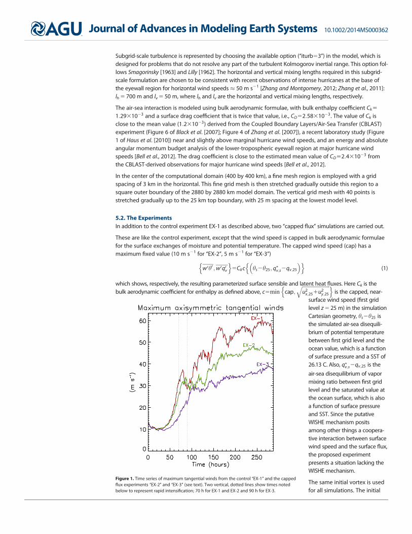
Figure 1. Time series of maximum tangential winds from the control ‘‘EX-1’’ and the cappedflux experiments ‘‘EX-2’’ and ‘‘EX-3’’ (see text). Two vertical, dotted lines show times notedbelow to represent rapid intensification; 70 h for EX-1 and EX-2 and 90 h for EX-3.
Journal of Advances in Modeling Earth Systems 10.1002/2014MS000362
MONTOMERY ET AL. VC 2014. The Authors. 10
radial and vertical velocity isset to zero. The initial tangen-tial velocity is taken to be ingradient wind balance with amaximum of 13 m s21 at thesurface at 100 km radius fromthe center of circulation. Thetangential velocity variessmoothly in space and tends tozero at large radii: it is effec-tively zero beyond 400 kmradius and above z520 km.
6. Results
The evolution of intensity(measured by the maximumvalue of azimuthally averagedtangential winds in thedomain; Figure 1) is quite simi-
lar for both EX-1 and EX-2 experiments during spin-up to hurricane intensity (33 m s21) by 90 h, with EX-2lagging the control only slightly. In fact, the maximum intensification rate for EX-1 and EX-2 is quantitativelysimilar ($ 16 m s21 in 20 h versus 15 m s21 in 20 h, respectively). A slower rate of intensification occurs inEX-2 beyond this time. The maximum of 48 ms21 is attained after 260 h and is somewhat weaker than the60 ms21 maximum found in the control experiment. These results affirm the findings of M2 that the putativeWISHE mechanism is not necessary for a developing tropical cyclone to reach hurricane intensity, nor for thefurther development of that storm. Some surface fluxes of enthalpy are necessary for intensification. Indeed, aseparate simulation (not shown) without any surface flux of heat and moisture fails to intensify at all. However,the addition of just a minimal supply of enthalpy in the EX-3 simulation is sufficient.
The surface heat flux (Figure 2)
H5cpqw0h01Lvqw0q0v (2)
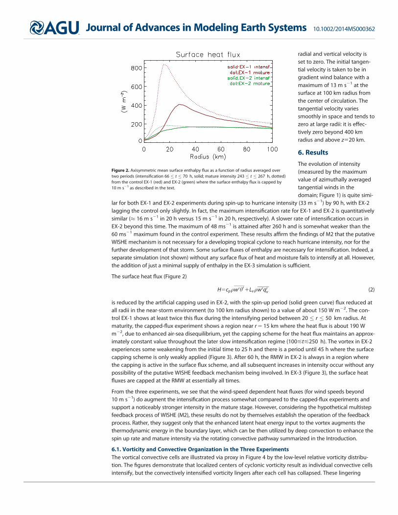
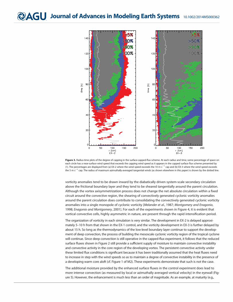
is reduced by the artificial capping used in EX-2, with the spin-up period (solid green curve) flux reduced atall radii in the near-storm environment (to 100 km radius shown) to a value of about 150 W m22. The con-trol EX-1 shows at least twice this flux during the intensifying period between 20 % r % 50 km radius. Atmaturity, the capped-flux experiment shows a region near r 5 15 km where the heat flux is about 190 Wm22, due to enhanced air-sea disequilibrium, yet the capping scheme for the heat flux maintains an approx-imately constant value throughout the later slow intensification regime (100!t!250 h). The vortex in EX-2experiences some weakening from the initial time to 25 h and there is a period until 45 h where the surfacecapping scheme is only weakly applied (Figure 3). After 60 h, the RMW in EX-2 is always in a region wherethe capping is active in the surface flux scheme, and all subsequent increases in intensity occur without anypossibility of the putative WISHE feedback mechanism being involved. In EX-3 (Figure 3), the surface heatfluxes are capped at the RMW at essentially all times.
From the three experiments, we see that the wind-speed dependent heat fluxes (for wind speeds beyond10 m s21) do augment the intensification process somewhat compared to the capped-flux experiments andsupport a noticeably stronger intensity in the mature stage. However, considering the hypothetical multistepfeedback process of WISHE (M2), these results do not by themselves establish the operation of the feedbackprocess. Rather, they suggest only that the enhanced latent heat energy input to the vortex augments thethermodynamic energy in the boundary layer, which can be then utilized by deep convection to enhance thespin up rate and mature intensity via the rotating convective pathway summarized in the Introduction.
6.1. Vorticity and Convective Organization in the Three ExperimentsThe vortical convective cells are illustrated via proxy in Figure 4 by the low-level relative vorticity distribu-tion. The figures demonstrate that localized centers of cyclonic vorticity result as individual convective cellsintensify, but the convectively intensified vorticity lingers after each cell has collapsed. These lingering
Figure 2. Axisymmetric mean surface enthalpy flux as a function of radius averaged overtwo periods (intensification 66 % t % 70 h, solid; mature intensity 243 % t % 267 h, dotted)from the control EX-1 (red) and EX-2 (green) where the surface enthalpy flux is capped by10 m s21 as described in the text.
Journal of Advances in Modeling Earth Systems 10.1002/2014MS000362
MONTOMERY ET AL. VC 2014. The Authors. 11
vorticity anomalies tend to be drawn inward by the diabatically driven system-scale secondary circulationabove the frictional boundary layer and they tend to be sheared tangentially around the parent circulation.Although the vortex axisymmetrization process does not change the net absolute circulation within a fixedcircuit around the convective region, the shearing of convectively generated cyclonic vorticity anomaliesaround the parent circulation does contribute to consolidating the convectively generated cyclonic vorticityanomalies into a single monopole of cyclonic vorticity [Melander et al., 1987; Montgomery and Enagonio,1998; Enagonio and Montgomery, 2001]. For each of the experiments shown in Figure 4, it is evident thatvortical convective cells, highly asymmetric in nature, are present through the rapid intensification period.
The organization of vorticity in each simulation is very similar. The development in EX-2 is delayed approxi-mately 5–10 h from that shown in the EX-1 control, and the vorticity development in EX-3 is further delayed byabout 15 h. So long as the thermodynamics of the low-level boundary layer continue to support the develop-ment of deep convection, the process of building the mesoscale cyclonic vorticity region of the tropical cyclonewill continue. Since deep convection is still operative in the capped-flux experiment, it follows that the reducedsurface fluxes shown in Figure 2 still provide a sufficient supply of moisture to maintain convective instabilityand convective activity in the core region of the developing vortex. The persistent convective activity underthese limited flux conditions is significant because it has been traditionally assumed that the heat fluxes needto increase in step with the wind speeds so as to maintain a degree of convective instability in the presence ofa developing warm core aloft (cf. Figure 1 of M2). These experiments demonstrate that such is not the case.
The additional moisture provided by the enhanced surface fluxes in the control experiment does lead tomore intense convection (as measured by local or azimuthally averaged vertical velocity) in the eyewall (Fig-ure 5). However, the enhancement is much less than an order of magnitude. As an example, at maturity (e.g.,
Figure 3. Radius-time plots of the degree of capping in the surface-capped-flux scheme. At each radius and time, some percentage of space oneach circle has a near-surface wind speed that exceeds the capping wind speed as it appears in the capped surface flux scheme presented by(1). The percentages are displayed from (a) EX-2 where the wind speed exceeds the 10 m s21 cap and (b) EX-3 where the wind speed exceedsthe 5 m s21 cap. The radius of maximum azimuthally-averaged tangential winds (as shown elsewhere in this paper) is shown by the dotted line.
Journal of Advances in Modeling Earth Systems 10.1002/2014MS000362
MONTOMERY ET AL. VC 2014. The Authors. 12

Figure 4. Plan-view plots of vertical vorticity f3104 at the height z 5 1 km level at a sequence of times through rapid intensification for (left) the control EX-1, (middle) EX-2 with fluxescapped to 10 m s21, and (right) EX-3 with fluxes capped to 5 m s21. White shading shows values less than 1 s21, with blue contour of 23 and 21 s21; gray shading shows valuesbetween 1 and 10 s21, with black contours of 3 and 6 s21; orange shading shows values between 10 and 30 s21, with red contour of 20 s21; red shading shows values greater than30 s21, with white contour of 40 s21. The small, white circle at the origin marks the center of coordinates.
Journal of Advances in Modeling Earth Systems 10.1002/2014MS000362
MONTOMERY ET AL. VC 2014. The Authors. 13

t> 150 h) the typical maximum values of azimuthally averaged vertical velocity in the control EX-1 are 3 m s21
or more. In EX-2 with capped surface fluxes, the corresponding maximum values are still more than 2 m s21.
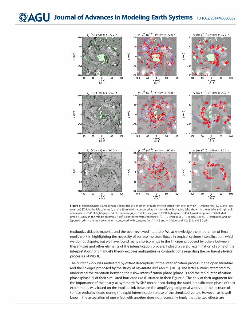
Figure 6 (right column) demonstrates that convection at a time of peak intensification for each simulationremains highly cellular even as a prominent band is organizing into a nascent eyewall. The low-level he pre-sented in Figure 6 (left column) represents the midpoint of a broad-scale (r < 100 km; Figure 7) warmingand moistening at the lowest model levels. The effects of cold-pools, found near deep convection, becomeless prominent after this time (see also M2). The simulations with capped wind speed in the heat fluxeshave smaller values of near-surface he overall, but the convective organization appears to be quite similar.While the vertical motion field is highly localized into cells, the vertical vorticity f (Figure 6, middle column)shows a combination of the highly cellular organization associated with recent convection together with amesoscale core of cyclonic vorticity that reflects the aggregate effect of prior convective events.
7. Conclusions
The multistep evaporative-wind feedback mechanism of tropical cyclone intensification known as ‘‘theWISHE mechanism’’ continues to be the widely accepted explanation of tropical cyclone intensification in
Figure 5. Radius versus time contours of azimuthally-averaged vertical velocity <w> at the height of typical maximum mean updraft z 5 7 km from (left) the control EX-1, (middle) EX-2and (right) EX-3. Contours (m s21) shown are 20.4 and 20.2 (blue), 0 (gray), 0.2 and 0.4 (pink), 1, 2 and 3 (red).
Journal of Advances in Modeling Earth Systems 10.1002/2014MS000362
MONTOMERY ET AL. VC 2014. The Authors. 14
textbooks, didactic material, and the peer-reviewed literature. We acknowledge the importance of Ema-nuel’s work in highlighting the necessity of surface moisture fluxes in tropical cyclone intensification, whichwe do not dispute, but we have found many shortcomings in the linkages proposed by others betweenthese fluxes and other elements of the intensification process. Indeed, a careful examination of some of theinterpretations of Emanuel’s theory exposes ambiguities or contradictions regarding the pertinent physicalprocesses of WISHE.
The current work was motivated by extant descriptions of the intensification process in the open literatureand the linkages proposed by the study of Miyamoto and Takemi [2013]. The latter authors attempted tounderstand the transition between their slow intensification phase (phase 1) and the rapid intensificationphase (phase 2) of their simulated hurricanes as illustrated in their Figure 3. The crux of their argument forthe importance of the nearly-axisymmetric WISHE mechanism during the rapid intensification phase of theirexperiments was based on the implied link between the amplifying tangential winds and the increase ofsurface enthalpy fluxes during the rapid intensification phase of the simulated vortex. However, as is wellknown, the association of one effect with another does not necessarily imply that the two effects are
Figure 6. Thermodynamic and dynamic quantities at a moment of rapid intensification from (first row) EX-1, (middle row) EX-2, and (bot-tom row) EX-3. In the left column, he at the 25-m level is contoured at 1 K intervals with shading (also shown in the middle and right col-umns) white <346 K, light gray< 348 K, medium gray< 350 K, dark gray< 352 K, light green< 354 K, medium green< 356 K, darkgreen> 358 K. In the middle column, f3104 is contoured with contours (s21) 210 (thick blue), 23 (blue), 3 (red), 10 (thick red), and 30(spotted red). In the right column, w is contoured with contours (m s21) 22 and 21 (blue) and 1, 2, 3, 4, and 5 (red).
Journal of Advances in Modeling Earth Systems 10.1002/2014MS000362
MONTOMERY ET AL. VC 2014. The Authors. 15

causally linked. To test the Miyamoto and Takemi inference, we conducted new idealized three-dimensionalnumerical experiments using a state-of-the-art cloud model with capped wind speed in the latent and sen-sible heat fluxes at near trade wind values. The results of the experiments demonstrate that their impliedlinkage between near-surface wind speed and surface enthalpy fluxes is merely incidental. The results ofthe new calculations affirm prior work showing that the putative multistep WISHE feedback mechanism isnot a dominant pathway of tropical cyclone intensification in the idealized configuration that has beenused to underpin the paradigm.
Taken together the calculations presented herein and those in Montgomery et al. [2009] refute the priorview that the WISHE mechanism is the essential and dominant mode of tropical cyclone intensification inthe prototype problem. For these reasons, we recommend that the hypothesized WISHE feedback mecha-nism be highly qualified in the classroom and/or discussions. A more complete framework, like that ofMontgomery and Smith [2014], that includes rotating convection as an element of the intensification mecha-nism would seem to be necessary to describe and understand the simulated development process in three-dimensional models and the intensification of real storms.
ReferencesAhrens, C. D. (2008), Meteorology Today: An Introduction to Weather, Climate and The Environment, 624 pp., Thomson Brooks/Cole, Stam-
ford, Conn.American Meteorological Society (2013), Wind-induced surface heat exchange, in Glossary of Meteorology, Amer. Meteorol. Soc., Boston,
USA. [Available at http://glossary.ametsoc.org/wiki/Wind-induced_surface_heat_exchange, last accessed 30 October 2013.]Bell, M. M., and M. T. Montgomery (2008), Observed structure, evolution and potential intensity of category 5 Hurricane Isabel (2003) from
12–14 September, Mon. Weather Rev., 136, 2023–2046.Bell, M. M., M. T. Montgomery, and W.-C. Lee (2012), An axisymmetric view of concentric eyewall evolution in Hurricane Rita (2005), J.
Atmos. Sci., 69, 2414–2432.Bister, M. (2001), Effect of peripheral convection on tropical cyclone formation, J. Atmos. Sci., 58, 3453–3476.Black, P. G., E. A. D’Asaro, T. B. Sanford, W. M. Drennan, J. A. Zhang, J. R. French, P. P. Niiler, E. J. Terrill, and E. J. Walsh (2007), Air-sea
exchange in hurricanes: Synthesis of observations from the coupled boundary layer air-sea transfer experiment, Bull. Am. Meteorol. Soc.,88, 257–374.
Braun, S. A., M. T. Montgomery, M. J. Mallen, and P. D. Reasor (2010), Simulation and interpretation of the genesis of Tropical Storm Gert(2005) as part of the NASA Tropical Cloud Systems and Processes Experiment, J. Atmos. Sci., 67, 999–1025.
Bryan, G. H., and J. M. Fritsch (2002), A benchmark simulation for moist nonhydrostatic numerical model, Mon. Weather Rev., 130, 2917–2928.
Bryan, G. H., and R. Rotunno (2009), Evaluation of an analytical model for the maximum intensity of tropical cyclones, J. Atmos. Sci., 66,3042–3060.
Bryan, G. H., R. Rotunno, and Y. Chen (2010), The effects of turbulence on hurricane intensity, paper presented at 29th Conference on Hurri-canes and Tropical Meteorology, p. 8C.7, Amer. Meteorol. Soc., Tucson, Ariz.
Figure 7. Azimuthally-averaged <he> at z525 m from (left) EX-1, (middle) EX-2, and (right) EX-3 with contours at 1 K intervals with shading white< 346 K, light gray< 348 K, mediumgray< 350 K, dark gray< 352 K, light green< 352 K, medium green< 354 K, dark green> 354 K.
AcknowledgmentsData supporting all figures is availableat: https://www.dropbox.com/sh/ptlm2j07133p3dq/AACwCDLlLMP1x06ROf-FBAHza?dl50. This work wassupported in part by the NationalScience Foundation Award AGS0733380, and AGS-1313948, The Officeof Naval Research (ONR), throughaward N0001411WX20095, NationalAeronautics and Space Administration(NASA) grant NNG11PK021 and the U.S. Naval Postgraduate School. M.T.M.wishes to thank JM, JEM, LKP, MPM,and PCM for their support. R.K.S. isgrateful for support from the GermanResearch Council (DeutscheForschungsgemeinschaft) under GrantSM30-23. We also thank Gerard Kilroyfor his assistance preparing figures.
Journal of Advances in Modeling Earth Systems 10.1002/2014MS000362
MONTOMERY ET AL. VC 2014. The Authors. 16

Bui, H. H., R. K. Smith, M. T. Montgomery, and J. Peng (2009), Balance and unbalanced aspects of tropical cyclone intensification, Q. J. R.Meteorol. Soc., 135, 1715–1731.
Carrier, G. F. (1971), The intensification of hurricanes, J. Fluid Mech., 49, 145–158.Charney, J. G., and A. Eliassen (1964), On the growth of the hurricane depression, J. Atmos. Sci., 21, 68–75.Dudhia, J. (1993), A non-hydrostatic version of the Penn State-NCAR mesoscale model: Validation tests and simulation of an Atlantic
cyclone and cold front, Mon. Weather Rev., 121, 1493–1513.Emanuel, K. A. (1986), An air-sea interaction theory for tropical cyclones. Part I: Steady state maintenance, J. Atmos. Sci., 43, 585–604.Emanuel, K. A. (1988), The maximum intensity of hurricanes, J. Atmos. Sci., 45, 1143–1155.Emanuel, K. A. (1989), The finite amplitude nature of tropical cyclogenesis, J. Atmos. Sci., 46, 3431–3456.Emanuel, K. A. (1991), The theory of hurricanes, Annu. Rev. Fluid Mech., 23, 179–196.Emanuel, K. A. (1995), Sensitivity of tropical cyclone to surface exchange coefficients and a revised steady-state model incorporating eye
dynamics, J. Atmos. Sci., 52, 3969–3976.Emanuel, K. A. (1997), Some aspects of hurricane inner-core dynamics and energetics, J. Atmos. Sci., 54, 1014–1026.Emanuel, K. A. (2003), Tropical cyclones, Annu. Rev. Earth Planet. Sci., 31, 75–104.Emanuel, K. A., J. D. Neelin, and C. S. Bretherton (1994), On large-scale circulations of convecting atmospheres, Q. J. R. Meteorol. Soc., 120,
1111–1143.Enagonio, J., and M. T. Montgomery (2001), Tropical cyclogenesis via convectively forced vortex Rossby waves in a shallow water primitive
equation model, J. Atmos. Sci., 58, 685–705.Fang, J., and F. Zhang (2010), Initial development and genesis of Hurricane Dolly (2008), J. Atmos. Sci., 67, 655–672.Fang, J., and F. Zhang (2011), Evolution of multiscale vortices in the development of Hurricane Dolly (2008), J. Atmos. Sci., 68, 103–122.Grell, G. A., J. Dudhia, and D. R. Stauffer (1995), A description of the fifth generation Penn State/NCAR mesoscale model (MM5), NCAR Tech.
Note TN-3981STR, Natl. Cent. for Atmos. Res., Boulder, Colo.Hakim, G. J. (2011), The mean state of axisymmetric hurricanes in statistical equilibrium, J. Atmos. Sci., 37, 515–533.Haus, B. K., D. Jeong, M. A. Donelan, J. A. Zhang, and I. Savelyev (2010), Relative rate of sea-air heat transfer and frictional drag in very high
winds, Geophys. Res. Lett., 37, L07802, doi:10.1029/2009GL042206.Holton, J. R. (2004), An Introduction to Dynamic Meteorology, 4 ed., 535 pp., Academic, San Diego, Calif.Holton, J. R., and G. Hakim (2012), An Introduction to Dynamic Meteorology, 5 ed., 552 pp., Academic, San Diego, Calif.Kepert, J. D. (2011), Tropical cyclone structure and dynamics, in Global Perspectives on Tropical Cyclones: From Science to Mitigation, World
Scientific Series on Asia-Pacific Weather and Climate, vol. 4, edited by Johnny C. L. Chan and Jeffrey D. Kepert, 448 pp., World Sci. Publ.Co., Singapore.
Kleinschmidt, E. (1951), Grundlagen einer Theorie der tropischen Zyklonen, Arch. Meteorol. Geophys. Bioklimatol., Ser. A, 4, 53–72.Lighthill, J. (1998), Fluid mechanics of tropical cyclones, Theor. Comput. Fluid. Dyn., 10, 3–21.Lilly, D. K. (1962), On the numerical simulation of buoyant convection, Tellus, 14, 148–172.Malkus, J. S., and H. Riehl (1960), On the dynamics and energy transformations in steady-state hurricanes, Tellus, 12, 1–20.Melander, M. V., J. C. McWilliams, and N. J. Zabusky (1987), Axisymmetrization and vorticity-gradient intensification of an isolated two-
dimensional vortex through filamentation, J. Fluid Mech., 178, 137–159.Miyamoto, Y., and T. Takemi (2013), A transition mechanism for the spontaneous axisymmetric intensification of tropical cyclones, J. Atmos.
Sci., 70, 112–129.Molinari, J., D. Vollaro, and K. L. Corbosiero (2004), Tropical cyclone formation in a sheared environment: A case study, J. Atmos. Sci., 61,
3176–3207.Montgomery, M. T., and J. Enagonio (1998), Tropical cyclongenesis via convectively forced vortex Rossby waves in a three-dimensional
quasigeostrophic model, J. Atmos. Sci., 55, 2176–3207.Montgomery, M. T., and R. K. Smith (2014), Paradigms for tropical cyclone intensification, Aust. Meteorol. Ocean. J. (Bruce Morton Memorial
Volume), 64, 37–66.Montgomery, M. T., M. E. Nicholls, T. A. Cram, and A. B. Saunders (2006), A vortical hot tower route to tropical cyclogenesis, J. Atmos. Sci.,
63, 355–386.Montgomery, M. T., S. V. Nguyen, R. K. Smith, and J. Persing (2009), Do tropical cyclones intensify by WISHE?, Q. J. R. Meteorol. Soc., 135,
1697–1714.Nguyen, S. V., R. K. Smith, and M. T. Montgomery (2008), Tropical-cyclone intensification and predictability in three dimensions, Q. J. R.
Meteorol. Soc., 134, 563–582.Nong, S., and K. A. Emanuel (2004), A numerical study of the genesis of concentric eyewalls in hurricanes, Q. J. R. Meteorol. Soc., 129, 3323–
3338.Ooyama, K. V. (1964), A dynamical model for the study of tropical cyclone development, Geophys. Int., 4, 187–198.Ooyama, K. V. (1969), Numerical simulation of the life cycle of tropical cyclones, J. Atmos. Sci., 26, 3–40.Ooyama, K. V. (1982), Conceptual evolution of the theory and modeling of the tropical cyclone, J. Meteorol. Soc. Jpn., 60, 369–380.Persing, J., M. T. Montgomery, J. C. McWilliams, and R. K. Smith (2013), Asymmetric and axisymmetric dynamics of tropical cyclones, Atmos.
Chem. Phys. Discuss., 13, 13,323–13,438.Rauber, R. M., J. E. Walsh, and D. J. Charlevoix (2008), Severe and Hazardous Weather: An Introduction to High Impact Meteorology, 3 ed., 642
pp., Kendall/Hunt Publ. Co., Dubuque, Iowa.Raymond, D. J., and K. Emanuel (1993), The Kuo cumulus parameterization: The representation of cumulus convection in numerical mod-
els, Meteorol. Monogr., 46, 145–150, Amer. Meteorol. Soc., Boston, USA.Riehl, H. (1954), Tropical Meteorology, 392 pp., McGraw-Hill.Rotunno, R., and K. A. Emanuel (1987), An air-sea interaction theory for tropical cyclones. Part II: Evolutionary study using a nonhydrostatic
axisymmetric numerical model, J. Atmos. Sci., 44, 542–561.Smagorinsky, J. (1963), General circulation experiments with the primitive equations. I: The basic experiment, Mon. Weather Rev., 91, 99–
164.Smith, R. K. (2003), A simple model of the hurricane boundary layer, Q.. J. R. Meteorol. Soc., 129, 1007–1027.Smith, R. K., M. T. Montgomery, and S. Vogl (2008), A critique of Emanuel’s hurricane model and potential intensity theory, Q. J. R. Meteorol.
Soc., 134, 551–561.Smith, R. K., M. T. Montgomery, and V. S. Nguyen (2009), Tropical-cyclone spin up revisited, Q. J. R. Meteorol. Soc., 135, 1321–1335.Smith, R. K., M. T. Montgomery, and J. Persing (2014), On steady-state tropical cyclones, Q. J. R. Meteorol. Soc., 139, 1–15, doi:10.1002/
qj.2329.
Journal of Advances in Modeling Earth Systems 10.1002/2014MS000362
MONTOMERY ET AL. VC 2014. The Authors. 17

Terwey, W. D., and M. T. Montgomery (2008), Secondary eyewall formation in two idealized, full-physics modeled hurricanes, J. Geophys.Res., 113, D12112, doi:10.1029/2007JD008897.
The COMET Program (2013), Introduction to Tropical Meteorology, 2nd ed., Chap 8: Tropical Cyclones, Univ. Corp. for Atmos. Res., Boulder,Colo. [Available at http://www.meted.ucar.edu/training_module.php?id5868, last accessed 16 September 2013]
Wikipedia (2013), Wind-Induced Surface Heat Exchange.[Available at http://en.wikipedia.org/wiki/WISHE, last accessed 30 October 2013]Willougby, H. E. (1990), Temporal changes of the primary circulation in tropical cyclones, J. Atmos. Sci., 47, 242–264.Willougby, H. E. (1995), Mature structure and evolution, in Global Perspectives on Tropical Cyclones, edited by R. L. Elsberry, WMO/TD-No
693, pp. 21–62, World Meteorol. Organ., Geneva.Wroe, D. R., and G. M. Barnes (2003), Inflow layer energetic of Hurricane Bonnie (1998) near landfall, Mon. Weather Rev., 131, 1600–1612.Zhang, J. A., and M. T. Montgomery (2012), Observational estimates of the horizontal eddy diffusivity and mixing length in the low-level
region of intense hurricanes, J. Atmos. Sci., 69, 1306–1316.Zhang, J. A., W. M. Drennan, P. G. Black, and J. R. French (2007), Turbulence structure of the hurricane boundary layer between the outer
rainbands, J. Atmos. Sci., 66, 2455–2467.Zhang, J. A., F. D. Marks, M. T. Montgomery, and S. Lorsolo (2011), An estimation of turbulent characteristics in the low-level region of
intense Hurricanes Allen (1980) and Hugo (1989), Mon. Weather Rev., 139, 1447–1462.Zhu, H., R. K. Smith, and W. Ulrich (2001), A minimal three-dimensional tropical cyclone model, J. Atmos. Sci., 58, 1924–1944.
Journal of Advances in Modeling Earth Systems 10.1002/2014MS000362
MONTOMERY ET AL. VC 2014. The Authors. 18