PROTECTION AND SUSTAINABLE ORGANISATION OF THE ...
122
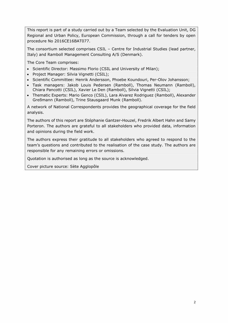
1 Ex post evaluation of major projects supported by the European Regional Development Fund (ERDF) and Cohesion Fund between 2000 and 2013 PROTECTION AND SUSTAINABLE ORGANISATION OF THE LIDO FROM SETE TO MARSEILLAN France 23 March 2019
-
Upload
khangminh22 -
Category
Documents
-
view
5 -
download
0
Transcript of PROTECTION AND SUSTAINABLE ORGANISATION OF THE ...
1
Ex post evaluation of major projects supported by the
European Regional Development Fund (ERDF) and Cohesion
Fund between 2000 and 2013
PROTECTION AND SUSTAINABLE ORGANISATION OF THE LIDO FROM
SETE TO MARSEILLAN
France
23 March 2019
2
This report is part of a study carried out by a Team selected by the Evaluation Unit, DG
Regional and Urban Policy, European Commission, through a call for tenders by open
procedure No 2016CE16BAT077.
The consortium selected comprises CSIL – Centre for Industrial Studies (lead partner,
Italy) and Ramboll Management Consulting A/S (Denmark).
The Core Team comprises:
• Scientific Director: Massimo Florio (CSIL and University of Milan);
• Project Manager: Silvia Vignetti (CSIL);
• Scientific Committee: Henrik Andersson, Phoebe Koundouri, Per-Olov Johansson;
• Task managers: Jakob Louis Pedersen (Ramboll), Thomas Neumann (Ramboll),
Chiara Pancotti (CSIL), Xavier Le Den (Ramboll), Silvia Vignetti (CSIL);
• Thematic Experts: Mario Genco (CSIL), Lara Alvarez Rodriguez (Ramboll), Alexander
Greßmann (Ramboll), Trine Stausgaard Munk (Ramboll).
A network of National Correspondents provides the geographical coverage for the field
analysis.
The authors of this report are Stéphanie Gantzer-Houzel, Fredrik Albert Hahn and Samy
Porteron. The authors are grateful to all stakeholders who provided data, information
and opinions during the field work.
The authors express their gratitude to all stakeholders who agreed to respond to the
team’s questions and contributed to the realisation of the case study. The authors are
responsible for any remaining errors or omissions.
Quotation is authorised as long as the source is acknowledged.
Cover picture source: Sète Agglopôle
3
TABLE OF CONTENTS
EXECUTIVE SUMMARY .................................................................................... 5
1. PROJECTS DESCRIPTION ........................................................................ 12
CONTEXT ............................................................................................... 13
PROJECT OBJECTIVES................................................................................. 22
STRUCTURAL FEATURES .............................................................................. 22
2. ORIGIN AND HISTORY ............................................................................ 24
BACKGROUND ......................................................................................... 24
FINANCING DECISION AND PROJECT IMPLEMENTATION ........................................... 27
CURRENT PERFORMANCE AND OTHER INVESTMENT NEEDS ....................................... 35
3. DESCRIPTION OF LONG-TERM EFFECTS .................................................. 40
KEY FINDINGS ......................................................................................... 40
EFFECTS RELATED TO ECONOMIC GROWTH ........................................................ 47
EFFECTS ON QUALITY OF LIFE AND WELL-BEING .................................................. 50
EFFECTS ON THE ENVIRONMENTAL SUSTAINABILITY .............................................. 53
EFFECTS RELATED TO DISTRIBUTIONAL ISSUES ................................................... 55
TIME SCALE AND NATURE OF THE EFFECTS ........................................................ 55
4. MECHANISMS AND DETERMINANTS OF THE OBSERVED PERFORMANCE . 57
RELATION WITH THE CONTEXT ...................................................................... 57
SELECTION PROCESS ................................................................................. 59
PROJECT DESIGN ...................................................................................... 61
FORECASTING CAPACITY ............................................................................. 63
PROJECT GOVERNANCE ............................................................................... 64
MANAGERIAL CAPACITY .............................................................................. 67
PROJECT BEHAVIORAL PATTERN ..................................................................... 67
5. FINAL ASSESSMENT ............................................................................... 69
PROJECT RELEVANCE AND COHERENCE ............................................................. 69
PROJECT EFFECTIVENESS ............................................................................ 70
PROJECT EFFICIENCY ................................................................................. 71
EU ADDED VALUE ..................................................................................... 72
FINAL ASSESSMENT ................................................................................... 73
6. CONCLUSIONS AND LESSONS LEARNED ................................................. 77
ANNEX I. METHODOLOGY OF EVALUATION ................................................... 79
ANNEX II. EX-POST COST-BENEFIT ANALYSIS REPORT ................................ 91
4
LIST OF ABREVIATIONS
CBA Cost-benefit analysis
CF Cohesion Fund
CNRS
CPER
DG REGIO
Centre National de Recherche Scientifique
Contrat de Plan Etat-Region
Directorate-General for Regional and Urban Policy
DREAL
EC
Direction régionale de l’Environnement et de l’Aménagement
European Commission
ERDF European Regional Development Fund
ESIF European Structural and Investment Funds
EU European Union
EUR Euro
FNADT
IGP
ISPA
Fond National d’Aménagement du Territoire
Indication Géographique Protégée
Instrument for structural policy for pre-accession
NUTS2 Nomenclature of Territorial Units for Statistics
SGAR
ToR
ZNIEFF
Secrétariat Général aux Affaires Regional Affairs1
Terms of References
Zones Naturelles d'Intérêt Ecologique Faunistique et Floristique
1 Managing Authority, ERDF OP 2007-2013 period
5
EXECUTIVE SUMMARY
This case study illustrates the story of the protection and sustainable organisation
of the lido from Sète to Marseillan, a major project co-financed by the European
Union (EU) during the programming period 2007-2013. More specifically, this is an ex-
post evaluation assessing the long-term effects produced by the investment and aimed
at disentangling the mechanisms and determinants likely to have contributed to produce
these effects. The analysis draws on an ex-post Cost-Benefit Analysis (CBA)2 and an
extensive set of qualitative evidence, both secondary (official reports and press articles,
books and research papers) and primary (site visits and interviews with key
stakeholders and experts have been carried out in November and December 20183).
OVERALL APPROACH AND METHODOLOGY
The Conceptual Framework delivered in the First Intermediate Report has been
developed to answer the evaluation questions included in the ToR, and further specified
and organised in accordance with the study team’s understanding. In particular, there
are three relevant dimensions of the analysis:
• The ‘WHAT’: this relates to the typologies of long-term contributions that can
be observed. The Team classified all the possible effects generated by
environment projects (including management and distribution of water; water
treatment; management of household and industrial waste; measure to preserve
the environment and prevent risks) under the four following categories:
‘Economic growth’; ‘Quality of life and well-being’ (i.e. factors that affect the
social development, the level of social satisfaction, the perceptions of users and
the whole population); ‘Effects related to environmental sustainability’ and
‘Distributional impacts’.
• The ‘WHEN’: this dimension relates to the point in the project’s lifetime at which
the effects materialise for the first time (short-term dimension) and stabilise
(long-term dimension). The proper timing of an evaluation and the role it can
have in relation to the project’s implementation is also discussed here.
• The ‘HOW’: this dimension entails reasoning on the elements, both external and
internal to the project, which have determined the observed causal chain of
effects to take place and influenced the observed project performance. To do this
the Team identified six stylised determinants of projects’ outcomes (relation with
the context; selection process; project design; forecasting capacity; project
governance; managerial capacity). The interplay of such determinants and their
influence on the project’s effects is crucial to understand the project’s final
performance.
The methodology developed to answer the evaluation questions consists of ex-
post Cost Benefit Analysis complemented by qualitative techniques (interviews,
surveys, searches of government and newspaper archives, etc.), combined in such a
way as to produce a project history. CBA is an appropriate analytical approach for
the ex-post evaluation because it can provide quantification and monetisation of some
of the long-term effects produced by the project (at least those also considered in the
2 Data, hypotheses and results are discussed in Annex II. 3 See Annex III for a detailed list of interviewees.
6
ex-ante CBA). However, the most important contribution of the CBA exercise is to
provide a framework of analysis to identify the most crucial aspects of the projects’ ex-
post performance and final outcome. It is worth noting that the purpose of this
evaluation is not to compare ex-ante and ex post CBAs and that the results of
these assessments are not easily comparable, because even if they rely on the
same principles and draw from the established CBA methodology, there are often
important differences between how the ex-ante and ex-post assessments were scoped
and what data were considered. Qualitative analysis on the other hand is more focussed
on understanding the determinants and causal chains of the delivery process as well as
to assess effects that may be difficult to translate in monetary terms.
MAIN PROJECT FEATURES
The project is located in the department of Hérault in the coastal region of
Languedoc-Roussillon, Occitany, in France. The coastline is a major strength of
Languedoc-Roussillon, both from an ecological and touristic point of view. The ‘lido’
from Sète to Marseillan is a 12km long sand strip linking the cities of Sète and
Marseillan and providing a natural barrier between the Mediterranean Sea and the
Thau lagoon, a 7500 hectares water pond, which is a hotspot for shellfish aquaculture
in the region. The entire area of the lido and the Thau lagoon is of high value from
the point of view of biodiversity. There are also economic activities on the lido,
ranging from aquaculture in the Thau lagoon, tourism (beaches), vine growing,
industrial activities (a bottling company), to commercial activities (mainly restaurants,
bars and nautical shops). Finally, a coastal road linking the cities of Sète and Marseillan
and the train line Montpellier-Narbonne, which continues to Spain are also passing
through the lido.
For many decades, the lido from Sète to Marseillan has been subject to natural
erosion, reducing the width of the beach by about 40% since 1954. This erosion has
been aggravated by the construction of a costal road directly on the beach in 1928,
which disrupted the natural function of dunes against erosion. Beyond the natural
phenomenon of coastal erosion, the lido was also facing other problems, mainly
linked with the coastal road: anarchical parking and camping on the side of the
coastal road, high levels of littering, noise pollution, high levels of accidents, chronic
congestion in the summer.
The major project ‘protection and sustainable organisation of the Lido from
Sète to Marseillan’ (CCI Number: 2007FR162PR005) consisted of a mix of land and
maritime works on the lido. It was done to protect it better against natural hazards
and to organize it in a sustainable way for human use. Land works involved mainly the
relocation of the coastal road behind a restored and revegetated dune cord, whereas
the maritime component consisted mainly of the installation of an innovative ‘wave
attenuator’ at sea4. The latter aimed at reducing erosion on the coastline. Further
accompanying works were part of the project: sand reloading of the beach to restore it
to its natural width of 70 meters and beach and road infrastructure (parking lots, a
cycling path, toilets and showers). The ‘ecoplage’ system was also to be tested as part
4 A ‘wave attenuator’ is a sort of ‘tube’, which is set up, parallel to the coastline (about 5-6 meters below
water) at a distance of about 400 meters from the coastline. This installation aims at reducing the impact of the strongest waves and storms in order to fight against coastal erosion.
7
of the maritime phase. It was supposed to accelerate the infiltration of water into the
sand on the beach and to stabilize it.
The total costs of the lido project at the time of the major project application was EUR
55 million in nominal terms, but only EUR 23 million were initially included in the EU
2007-2013 major project. These EUR 23 million corresponded to parts of the land
works and parts of the maritime works.
ERDF financing for the lido project, including grants from three programming periods5
amounts to EUR 10.9 million, out of which EUR 6.3 million correspond to ERDF
financing for the 2007-2013 major project.
PROJECT PERFORMANCE
Based on the findings of the analysis, the final assessment of the project performance
is presented, along a set of evaluation criteria.
Project relevance and coherence:
The project was relevant in the context where it was implemented: it addressed
both natural risks and other problems faced by the lido and it took into account the
ecological and economical context of the lido.
The project was in line with European and national recommendations on erosion: it was
the first project on the Languedoc-Roussillon coastline to implement the recommended
strategy of relocating assets in the hinterland, instead of protecting them against
erosion at all cost (in this case, it was the road, which was relocated behind a restored
dune cord).
In terms of internal coherence, the project components were consistent with the stated
objectives. Moreover, the project was in line with the objectives of the new national
strategy, which aimed at reducing erosion using ‘soft’ methods, instead of building hard
infrastructure at sea, which involve the risk of disrupting the coastline further
downstream.
In terms of external coherence, a major lack of coherence could be identified in the
urban development taking place nearby the lido: a new neighbourhood was authorised
by local authorities and built very close to the project area, next to the most fragile spot
of the lido. This is considered to be a major issue in the external coherence of local
policies, since risk mitigation projects are not meant at enabling the constructions of
new assets in areas, which are at risk.
External coherence of public policies in the environmental area is considered to be much
better with the protection of habitats and biodiversity being adequately ensured in the
future: the 2050 strategy of the Coastal Conservation Authority plans to protect the
entirety of the lido, if necessary, by buying land.
Project effectiveness
The project achieved its main objectives of restoring a normal functioning of the
coastline and ensuring a better protection against erosion, while maintaining the
mobility function of the coastal road and enabling the continuation of local economic
5 2000-2006, 2007-2013 and 2014-2020 programming periods
8
activities. It also achieved its objectives of restoring biodiversity on the dune cord and
of reducing pollution
The main economic benefit produced by the project consists in the sustained flow of
beach visitors resulting from decreased beach erosion. The project also has
environmental benefits in terms of preservation of ecosystems and carbon
sequestration. Due to its second component addressing problems linked with the coastal
road, the project has also a large number of co-benefits, ranging from a reduction of
road accidents, to a reduction of levels of noise and pollution for the City of Marseillan
(new bypass).
The existence of several project benefits determines the positive economic net present
value of the lido project even in scenarios where natural risks would materialise in a
more limited way or at a slower pace than initially expected. Even with significant
modifications of the risk parameters of the CBA, the economic net benefits remain
positive in the long-term.
Finally, the project can also be considered a technological success and a landmark into
the context of a wider policy shift toward the implementation of new, softer, techniques
to fight erosion.
Project efficiency
The lido project was delayed by several years compared to its initial schedule. Yet, this
is due to the decision to introduce a three-year testing phase for the maritime phase.
This proved to be an excellent decision, since the innovative systems installed did not
work right away as intended: the ‘ecoplage’ system, was proved ineffective and its
installation was discontinued; the second system, the ‘wave attenuator’ proved
successful after an initial failure.
It is difficult to assess cost-effectiveness fully, since the final total cost of the whole lido
project is not yet available (the maritime phase is still ongoing). Comparisons of total
costs incurred until now (about EUR 51.1 million, exclusive of VAT) with costs forecasted
ex-ante (EUR 55,1 million, exclusive of VAT) show that there has not been major cost
slippage. Only limited additional costs is expected to complete the final deployment of
the wave attenuator. Overall, value for money can be considered good: evidence show
that alternative designs could not have reached the same level of outputs in a cheaper
way. The project design chosen, despite being more expensive than other options,
enables to reach more benefits. The relationship between the outputs produced and the
resources to produce them appears to be good.
One element, which was underestimated in the project preparatory phase was the cost
of maintaining and repairing the wave attenuator system. In the initial phases of the
project, this cost proved higher than initially expected: in addition to about EUR 50,000
cost for regular maintenance, EUR 450,000 were incurred between 2013 and 2018 to
replace broken geotubes. However, following the initial learning phase with this new
system, costs are expected to go down when the project reaches its cruise speed.
EU added value
The EU added-value of this project can be considered high: first, the lido project
implements a new approach to coastal risks, which can, at least partly, be considered
the result of various European-wide cooperation projects (including the MESSINA and

9
the EROSION projects). The cost-benefit analysis, which was carried out before the
project, was the first CBA implemented for a project of that type in the region. It
involved cooperation between the beneficiary and Commission services and it still serves
as a reference point, since no systematic CBA is carried out for projects financed with
national money. It is difficult to conclude whether the project would or would not have
been carried out without the EU co-financing. On the one hand, with the EU cofinancing
representing only about a fifth of total cost, it is reasonable to argue that the project
could have been financed with national and local money. On the other hand, it was clear
from interviews that the decision to grant EU funds to the project acted as a leverage
to pool support from further local, regional and national financers. Finally, an interesting
effect of the ‘EU major project label’ is that it further reinforced the actual and perceived
need for local stakeholders to implement this project in a model way.
MECHANISMS AND DETERMINANTS
The long-run performance of the lido project described in the previous sections can be
explained along a series of mechanisms and determinants.
The relation with the context had a positive impact on the project’s effectiveness.
The need to act in order to protect the road in the short-term and in order to guarantee
the existence of a beach in the medium-term was the triggering effect for the
preparation of the project. In addition, the economic, social and environmental contexts
on the lido were rightly taken into account in the design of the overall project, which
leads to a large number of co-benefits. One may regret, though that the level of natural
risks to be avoided by the project was not more clearly documented in the preparatory
phase. Indeed, the higher the natural risks avoided by the project, the more impact the
project has and conversely. A better documentation of assumptions taken as to the level
of natural risk avoided would enable to compare the project’s performance with
assumptions taken initially.
The project selection was carried out in an adequate manner by an ad-hoc body of
involving both the State and Region, which compared needs along the whole Languedoc-
Roussillon coastline and ranked them according to their degree of urgency. Even if this
can be considered a good selection process, there are also signs that the level of local
support, which was strong, also played a role in the project selection. In addition, the
lido offered uncontroversial ground for testing new methods to fight erosion. This may
also have played a role in the selection process. All in all, the selection process is
assessed as enabling to select projects in an adequate way.
The project design was very relevant inasmuch as it enabled to tackle both natural
issues faced by the lido and other problems. The design was positively influenced by the
participation of external stakeholders, and in particular devolved services of the State.
Thanks to this external influence, an innovative design was chosen which proved not
only to be working, but also generated research material for the international scientific
community and interest by international policy makers facing similar issues.
Forecasting capacities can be considered mixed. Forecasting erosion trend is an
extremely delicate exercise. It was carried out in the framework of this project and as
part of regional efforts to select priority projects. Yet, the exercise falls short on mapping
all the natural risks faced by the lido, their probability of occurrence and likely impact.
This makes it difficult to fully confirm the level of risks avoided via the project and
therefore makes it more difficult to estimate the full extent of long-term effects. In the
10
same vein, forecasting concerning the demand side, and notably the evolution of beach
visitors was not based on very solid ground and proved to be overoptimistic.
Project governance was found to be mostly adequate, even if significant
weaknesses in local governance could be identified: indeed, in parallel to the
preparation of the lido risk mitigating project, a new neighbourhood was built close to
the area, which is prone to erosion risk in the long-term. This is a sign of a major lack
of coherence in local public policies.
Overall, project implementation shows a strong managerial capacity to face
unexpected problems. This contributed a great deal to the success of the
implementation phase of this project. The initial failure of the innovative wave
attenuator, could be bridged and appropriate solutions identified with the scientific
community.
CONCLUSIONS
The project is a success, since it achieved its objectives to restore a natural
functioning of the coastline and to fight erosion, while preserving the coastal road and
maintaining economic activity on the lido. The project has also achieved its
environmental objectives, mainly to restore a more natural environment on the lido and
to preserve its ecosystems. The project can also be considered a technological success
and a landmark into the context of a wider policy shift toward the implementation of
new, softer, techniques to fight erosion. The variety and number of benefits, including
both quantifiable and non-quantifiable ones, is also an indication that the project was
successful in addressing the wide-range of issues faced by the lido.
The project has large economic benefits, mainly in terms of the sustained flow of beach
visitors resulting from decreased beach erosion. But it has also achieved its objectives
of restoring biodiversity, mainly on the restored dune cord and of preserving the lido’s
ecosystems. Finally, the project is part of a larger plan by the French Authorities to
protect the lido and its exceptional biodiversity. Finally, the project has also a large
number of co-benefits, ranging from a reduction of road accidents, to a reduction of
levels of noise pollution and air pollution. This makes it a project with both an
environmental focus, and a larger number of other benefits.
There is still some uncertainty as to the extent of the long-term economic
benefits of the project. Indeed, the final assessment of long-term benefits is very
dependent from the level of natural risks which was avoided by the
implementation of the project. Yet, partly due to the difficulty of projecting erosion
trends in a reliable manner, and partly due to weaknesses in documenting all the risks
with their relevant probability of occurrence and their likely impact, some uncertainty
remain as to the extent of the risks avoided by the project in the long-term: indeed,
in a scenario where the beach would have been completely eroded by 2030, project’s
benefits are maximal, whereas net benefits decrease in cases where natural risks faced
by the lido are reduced or materialise later. This also highlights the critical importance
of adequately assessing the level of natural risks avoided for this type of risk mitigating
projects.
However, according to the results of the ex-post CBA, the economic net present
benefit of the project remains positive even if in scenarios where natural hazards
have less impact on the lido or materialise later than initially thought. This is due also
11
to the number of co-benefits reached by this project in terms of economic growth, well-
being and environmental issues.
12
1. PROJECTS DESCRIPTION
The ‘lido’ from Sète to Marseillan is a 12km long sand strip linking the cities of Sète
and Marseillan and providing a natural barrier between the Mediterranean Sea and the
Thau lagoon, a 7500 hectares water pond, which is a hotspot for shellfish aquaculture
in the region. The entire area of the lido and the Thau lagoon is of high value from
the point of view of biodiversity. The lido area is also an area of economic
activities ranging from aquaculture in the Thau lagoon, tourism (beaches), vine
growing (Indication Géographique Protégée (IGP) wine ‘Vin des sables’), industrial
activities (a bottling company), to commercial activities (mainly restaurants, bars and
nautical shops). It has also a connecting function: a coastal road links the cities of
Sète and Marseillan and the train line Montpellier-Narbonne, which continues to
Spain is also located on the lido.
For many decades, the lido from Sète to Marseillan has been subject to natural
erosion caused by sea waves, reducing the width of the beach by dozens of meters.
This erosion has been aggravated by the construction of a costal road directly on the
beach in 1928, which completely disrupted the natural function of dunes against
erosion: indeed, the coastal road blocks the natural processes of dune creation and
restricts the exchange of sand between the dunes and the beach, thereby contributing
to erosion.
Subject to strong tourism flows, the lido was also facing other problems: anarchical
parking and camping along the coastal road, directly on the beach and dunes did not
only contribute to further reducing the capacity of the natural environment to
regenerate, but also generated many negative externalities: pollution linked to waste,
noise pollution, high levels of accidents, chronic congestion in the summer.
Since the 1980s, several attempts were made to protect the lido against erosion.
The coastal road, which was regularly disrupted and partly destroyed by storms, was
protected by embankments. ‘Hard’ protections (spikes, stones, etc.) were also installed
at sea, with limited effectiveness. Despite all actions, the lido was in a difficult
situation at the beginning of the years 2000: in some places the beach had been
almost completely eaten up by the sea, which threatened the existence of the road in
the short term.
The major project ‘protection and durable installation of the Lido from Sète to
Marseillan’ (CCI Number: 2007FR162PR005) consisted of a mix of land and water
works on the lido in order to better protect it against natural hazards and to
organize it in a sustainable way for human use.
The total costs of the lido project at the time of the major project application was EUR
55 million in nominal terms, but only EUR 23 million were initially included in the EU
2007-2013 major project. These EUR 23 million corresponded to parts of the land
works and parts of the maritime works.
ERDF financing for the lido project, including grants from three programming periods6
amounts to EUR 10.9 million, out of which EUR 6.3 million correspond to ERDF
financing for the 2007-2013 major project.
6 2000-2006, 2007-2013 and 2014-2020 programming periods
13
The beneficiary of the project is the Urban community of Sète (‘Sète
Agglopôle’), which has been in charge of carrying all of the works planned in the
framework of the project. The managing authority at the time of the approval was
the General Secretariat for Regional Affairs (SGAR) – a devolved service of the
State, supported by various technical services of the State, the main one being the
environment department (DREAL). Since the 1st of January 2014, the managing
authority has changed. The Regional Council (Conseil Régional) is now acting as a
managing authority for the ERDF 2014-2020 programme. This change made it difficult
to trace staff working for the Managing Authority at the time of the approval of the
major project7 and to carry out interviews.
CONTEXT
The project is located in the Department of Hérault in the region of Languedoc-
Roussillon, Occitany in France. The coastline is a major strength of Languedoc-
Roussillon, both from an ecological and touristic point of view. The department of
Hérault is the first touristic department of the region Languedoc-Roussillon in
terms of the number of touristic nights with close to 40 million nights spent in the
department in 2017 8.
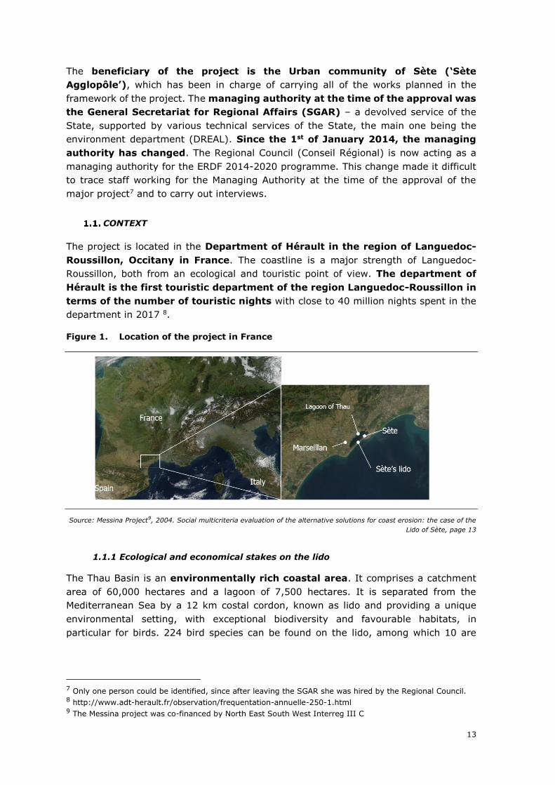
Figure 1. Location of the project in France
Source: Messina Project9, 2004. Social multicriteria evaluation of the alternative solutions for coast erosion: the case of the
Lido of Sète, page 13
1.1.1 Ecological and economical stakes on the lido
The Thau Basin is an environmentally rich coastal area. It comprises a catchment
area of 60,000 hectares and a lagoon of 7,500 hectares. It is separated from the
Mediterranean Sea by a 12 km costal cordon, known as lido and providing a unique
environmental setting, with exceptional biodiversity and favourable habitats, in
particular for birds. 224 bird species can be found on the lido, among which 10 are
7 Only one person could be identified, since after leaving the SGAR she was hired by the Regional Council. 8 http://www.adt-herault.fr/observation/frequentation-annuelle-250-1.html 9 The Messina project was co-financed by North East South West Interreg III C
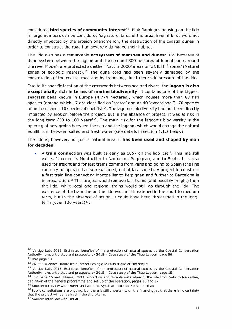
14
considered bird species of community interest10. Pink flamingos housing on the lido
in large numbers can be considered ‘signature’ birds of the area. Even if birds were not
directly impacted by the erosion phenomenon, the destruction of the coastal dunes in
order to construct the road had severely damaged their habitat.
The lido also has a remarkable ecosystem of marshes and dunes: 139 hectares of
dune system between the lagoon and the sea and 300 hectares of humid zone around
the river Moüe11 are protected as either ‘Natura 2000’ areas or ‘ZNIEFF12 zones’ (Natural
zones of ecologic interest).13 The dune cord had been severely damaged by the
construction of the coastal road and by trampling, due to touristic pressure of the lido.
Due to its specific location at the crossroads between sea and rivers, the lagoon is also
exceptionally rich in terms of marine biodiversity: it contains one of the biggest
seagrass beds known in Europe (4,774 hectares), which houses more than 88 fish
species (among which 17 are classified as ‘scarce’ and as 40 ‘exceptional’), 70 species
of molluscs and 110 species of shellfish14. The lagoon’s biodiversity had not been directly
impacted by erosion before the project, but in the absence of project, it was at risk in
the long term (50 to 100 years15). The main risk for the lagoon’s biodiversity is the
opening of new groins between the sea and the lagoon, which would change the natural
equilibrium between salted and fresh water (see details in section 1.1.2 below).
The lido is, however, not just a natural area, it has been used and shaped by man
for decades:
• A train connection was built as early as 1857 on the lido itself. This line still
exists. It connects Montpellier to Narbonne, Perpignan, and to Spain. It is also
used for freight and for fast trains coming from Paris and going to Spain (the line
can only be operated at normal speed, not at fast speed). A project to construct
a fast train line connecting Montpellier to Perpignan and further to Barcelona is
in preparation.16 This project would remove fast trains (and possibly freight) from
the lido, while local and regional trains would still go through the lido. The
existence of the train line on the lido was not threatened in the short to medium
term, but in the absence of action, it could have been threatened in the long-
term (over 100 years)17;
10 Vertigo Lab, 2015. Estimated benefice of the protection of natural spaces by the Coastal Conservation
Authority: present status and prospects by 2015 – Case study of the Thau Lagoon, page 56 11 Ibid page 13 12 ZNIEFF = Zones Naturelles d'Intérêt Ecologique Faunistique et Floristique 13 Vertigo Lab, 2015. Estimated benefice of the protection of natural spaces by the Coastal Conservation
Authority: present status and prospects by 2015 – Case study of the Thau Lagoon, page 15 14 Ibid page 16 and Urbanis, 2003. Protection and durable installation of the lido from Sète to Marseillan,
deginition of the general programme and set-up of the operation, pages 16 and 17 15 Source: interview with DREAL and with the Syndicat mixte du Bassin de Thau 16 Public consultations are ongoing, but there is still uncertainty on the financing, so that there is no certainty
that the project will be realised in the short-term. 17 Source: interview with DREAL
15
• A coastal road connects the city of Sète and the city of Marseillan, which are
located at the two edges of the lido. It takes about 20 minutes to connect Sète
(Corniche area) to Marseillan plage, whereas the alternative road would take
about one hour, going around the Thau lagoon. The road is also key for
economic activities on the lido (see below) and for tourism. In the summer,
and in particular at peak hours, it used to be affected by chronic congestion.
Tackling this issue was not the first priority of the project, but it is one of the
issues which was addressed via the project. As a result of the project, congestion
can be considered reduced, but not totally eliminated (see section 3 below for
more details). The existence of the coastal road was threatened in the short
term, especially on its most fragile edge close to Sète;
• Vineyards cover about 260 hectares of the lido producing a well-known wine,
which is grown in the sand (IGP ‘Vin des sables’, from 2019 replaced by AOP
‘Sable de Camargue’). No indication of turnover generated by the vineyard is
available. The vineyards would be threatened in the medium to long term if
erosion had continued;
• A bottling company has been operating on the lido (it used to belong to the
vineyard, but it is now owned by a different company). The bottling company
produces more than 60 million bottles a year, with a turnover of about EUR 80
million in 201718. Being located close to the railway line, the existence of the
bottling company would only be threatened in the long-term, in case of a major
threat on the existence of the lido as a whole;
• A campsite is also located on the lido. The campsite has 1,000 pitches, which
represents about one sixth of the total tourist accommodation capacity of the
Sète city. The turnover could not be obtained, but it can reasonably be estimated
between EUR 5 and 10 million annually19. Being located near the beach, the
campsite’s existence would have been threatened in the medium term in case of
no action;
• Eleven restaurants, bars and nautical shops are also operating on the beach.
They are all dismantled during the winter. The turnover generated by these
restaurants, bars and shops amounts to about EUR 5 million on the Sète side of
the lido (the lion’s share of the lido is located on the Sète municipality territory).
Economic activity on the beach would have been threatened in the short term in
the absence of project, since the beach would have disappeared in the short to
medium term.
• Finally, the Thau lagoon is a hot spot for aquaculture. Aquaculture is the second
agricultural economic activity in the Hérault department, after vine growing.20 It
generates a turnover of about EUR 40 million and provides 3,000 jobs.21 The
existence of the Thau lagoon and of its aquaculture were not threatened in the
short-term the absence of project, but a risk existed for the Thau lagoon in the
long-run in case of no action (50 to 100 years).
18 Source https://www.verif.com/societe/LISTEL-SAS-799294699/ 19 Source: author’s estimate 20 Vertigo Lab, 2015. Estimated benefice of the protection of natural spaces by the Coastal Conservation
Authority: present status and prospects by 2015 – Case study of the Thau Lagoon, page 23 21 Source Sète Agglopôle
16
Figure 2. Ecological and economical stakes of the lido
Source: author’s text on a picture provided by Sète Agglopôle
The number of visitors on the beaches between Sète and Marseillan is extremely
high. Before the project, it was estimated at 1 million per year, extrapolating counts
carried out in August 200222.
In 2012, a study estimated visitors on the beaches between Sète and Marseillan at about
850,00023. The study was carried out using a video tracking system which had initially
been installed on the beach to monitor erosion. According to this study, the actual
number of visitors on the beach before the project would be closer to 800,00024.
These numbers have to be interpreted with caution, since they are both based on
counts and extrapolations. It is unlikely that the number of beach goers has not gone
down since 2002, the explanation for differences between 2002 and 2012 numbers are
more to be found in the methods to count and extrapolate results: whereas in 2002, the
total amount of visitors was calculated extrapolating counts realised in a single month
(August 2002); the 2012 study uses numerous video images taken at different points
in time. The 2012 study is therefore considered to be more reliable than the 2002
study. The 2012 numbers have therefore been retained for the quantification of
effects (see also section 3 below).
No other further, more recent, studies could be identified on beach attendance on the
lido.
22 Ernst and Young, 2009. Ex-ante cost-benefit analysis of the Lido from Sète to Marseillan project, page 92 23 Y. Balouin and al., 2014. Automatic assessment and analysis of beach attendance using video images at
the Lido de Sète beach, France. In Ocean & Coastal Management 102 (2014) page 114-122, page 121 and 122 24 Ibid
17
1.1.2. Natural risks faced by the lido
Since the 1950s, the lido has been affected by coastal erosion: nearly 45 hectares
of beaches and dunes have disappeared into the sea between 1954 and 200025
between Sète and Le Cap d’Agde26. This represents about 40% of the overall beach
surface27.
The construction of the coastal road on the beach itself and over the old dune system
at the beginning of the twentieth century has decreased the capacity of the beach
to regenerate naturally. Not only does the road reduce the protective effect of the
dune system, but hard protections of the road (stones) worsen the erosion
phenomenon. As described in the MESSINA report, “the coastal road blocks the morpho-
dynamic processes of dune creation and restricts the sedimentary exchange between
the dune and the beach”, thereby contributing to erosion.28
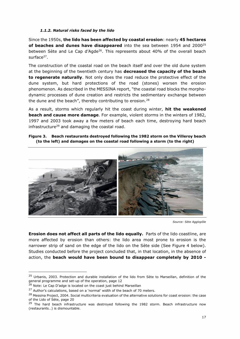
As a result, storms which regularly hit the coast during winter, hit the weakened
beach and cause more damage. For example, violent storms in the winters of 1982,
1997 and 2003 took away a few meters of beach each time, destroying hard beach
infrastructure29 and damaging the coastal road.
Figure 3. Beach restaurants destroyed following the 1982 storm on the Villeroy beach
(to the left) and damages on the coastal road following a storm (to the right)
Source: Sète Agglopôle
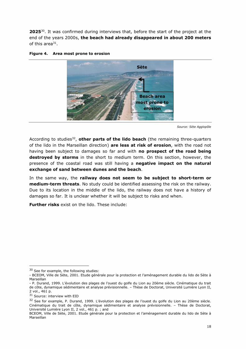
Erosion does not affect all parts of the lido equally. Parts of the lido coastline, are
more affected by erosion than others: the lido area most prone to erosion is the
narrower strip of sand on the edge of the lido on the Sète side (See Figure 4 below).
Studies conducted before the project concluded that, in that location, in the absence of
action, the beach would have been bound to disappear completely by 2010 -
25 Urbanis, 2003. Protection and durable installation of the lido from Sète to Marseillan, definition of the
general programme and set-up of the operation, page 12 26 Note: Le Cap D’adge is located on the coast just behind Marseillan 27 Author’s calculations, based on a ‘normal’ width of the beach of 70 meters. 28 Messina Project, 2004. Social multicriteria evaluation of the alternative solutions for coast erosion: the case
of the Lido of Sète, page 20 29 The hard beach infrastructure was destroyed following the 1982 storm. Beach infrastructure now
(restaurants…) is dismountable.
18
202530. It was confirmed during interviews that, before the start of the project at the
end of the years 2000s, the beach had already disappeared in about 200 meters
of this area31.
Figure 4. Area most prone to erosion
Source: Sète Agglopôle
According to studies32, other parts of the lido beach (the remaining three-quarters
of the lido in the Marseillan direction) are less at risk of erosion, with the road not
having been subject to damages so far and with no prospect of the road being
destroyed by storms in the short to medium term. On this section, however, the
presence of the coastal road was still having a negative impact on the natural
exchange of sand between dunes and the beach.
In the same way, the railway does not seem to be subject to short-term or
medium-term threats. No study could be identified assessing the risk on the railway.
Due to its location in the middle of the lido, the railway does not have a history of
damages so far. It is unclear whether it will be subject to risks and when.
Further risks exist on the lido. These include:
30 See for example, the following studies:
- BCEOM, Ville de Sète, 2001. Etude générale pour la protection et l’aménagement durable du lido de Sète à Marseillan - P. Durand, 1999. L’évolution des plages de l’ouest du golfe du Lion au 20ème siècle. Cinématique du trait de côte, dynamique sédimentaire et analyse prévisionnelle. – Thèse de Doctorat, Université Lumière Lyon II, 2 vol., 461 p. 31 Source: interview with EID 32 See for example, P. Durand, 1999. L’évolution des plages de l’ouest du golfe du Lion au 20ème siècle.
Cinématique du trait de côte, dynamique sédimentaire et analyse prévisionnelle. – Thèse de Doctorat, Université Lumière Lyon II, 2 vol., 461 p. ; and BCEOM, Ville de Sète, 2001. Etude générale pour la protection et l’aménagement durable du lido de Sète à Marseillan
Sète
Beach area
most prone to
erosion
19
• Flooding and risk of marine submersion: as water surrounds the lido from
all sides, both a risk of flooding (originating from fresh water coming from the
Thau lagoon) and a risk of marine submersion exist. The flooding risk mapping
of the city of Sète (‘PPRI’) distinguishes between an area (the beach and a few
meters further inland) which is at risk of sea submersion33 and the rest of the
lido where flooding risk exist, but mostly ‘from behind’, i.e. from the Thau lagoon.
The vineyard and the bottling company have never been affected by sea waves
so far34. The bottling company was affected by temporary flooding originating
from the Thau lagoon, which did not lead to the production being stopped35.
• Risk on the biological equilibrium of the lagoon: a fragile equilibrium exists
in the Thau lagoon between fresh water brought by the numerous rivers ending
up in the lagoon and salty water, which is brought from the sea to the lagoon
through channels. These channels are called ‘groins36’: two of these are
continuously bringing sea water to the lagoon, whereas two further ones only
become active during storms37. Coastal erosion combined with punctual storms
may open a new channel (this has occurred on the nearby lido of Frontignan
following the 1982 storm). The opening of new channels risk to change the
biological equilibrium of lagoon waters and put an end to aquaculture.
Even if this risk exists, the likelihood of occurrence and the timeframe could
not be identified with certainty. During interviews, this risk was never
mentioned as a short-term or medium-term risk, but rather as a long-term risk
(50 to 100 years38)
• Risks related to climate change and rise of sea levels also exist, but these risks
have not been analysed in detail in the framework of the project39. At the time
of the project preparation, there was no indication of the likely impact and of the
probability of occurrence, and there still is none, but these risks can be
considered to emerge in the long-term (over 100 years)40. Therefore they have
not been included in the effects of the projects
Overall, one has to acknowledge that projecting erosion trends and mapping
natural risks is a difficult and not necessarily precise process. However, from
studies obtained and interviews conducted, the following conclusions can be drawn:
• One section of the coastal road (close to the end of the Sète city) was at risk in
the short-term;
• The coastal road prevented the natural functioning of the beach and thereby
limited the protective role of dunes against erosion;
• The existence of a beach was at risk in the medium-term (the beach had
already disappeared on about 200 meters)
• All the other risks identified for the lido are rather to be considered long-term
rather than short or medium-term.
33 Plan de prevention des risques innondation, RD area in red on the map 34 Source: interview with the vineyard and the bottling company 35 Source: interview with the vineyard and the bottling company 36 Graus in French 37 Source: interview with the DDTM 38 Source : 50 years was mentioned during the interview with DREAL, whereas 100 years were mentioned
during the interview with the Syndicat Mixte du Bassin de Thau 39 Interview BRGM 40 Ibid
20
• The major project application presents all risks, without distinguishing between
these which are short-term, medium-term and long-term.
1.1.3. Other problems faced by the lido
Apart from natural risks, the lido was also facing a number of other problems:
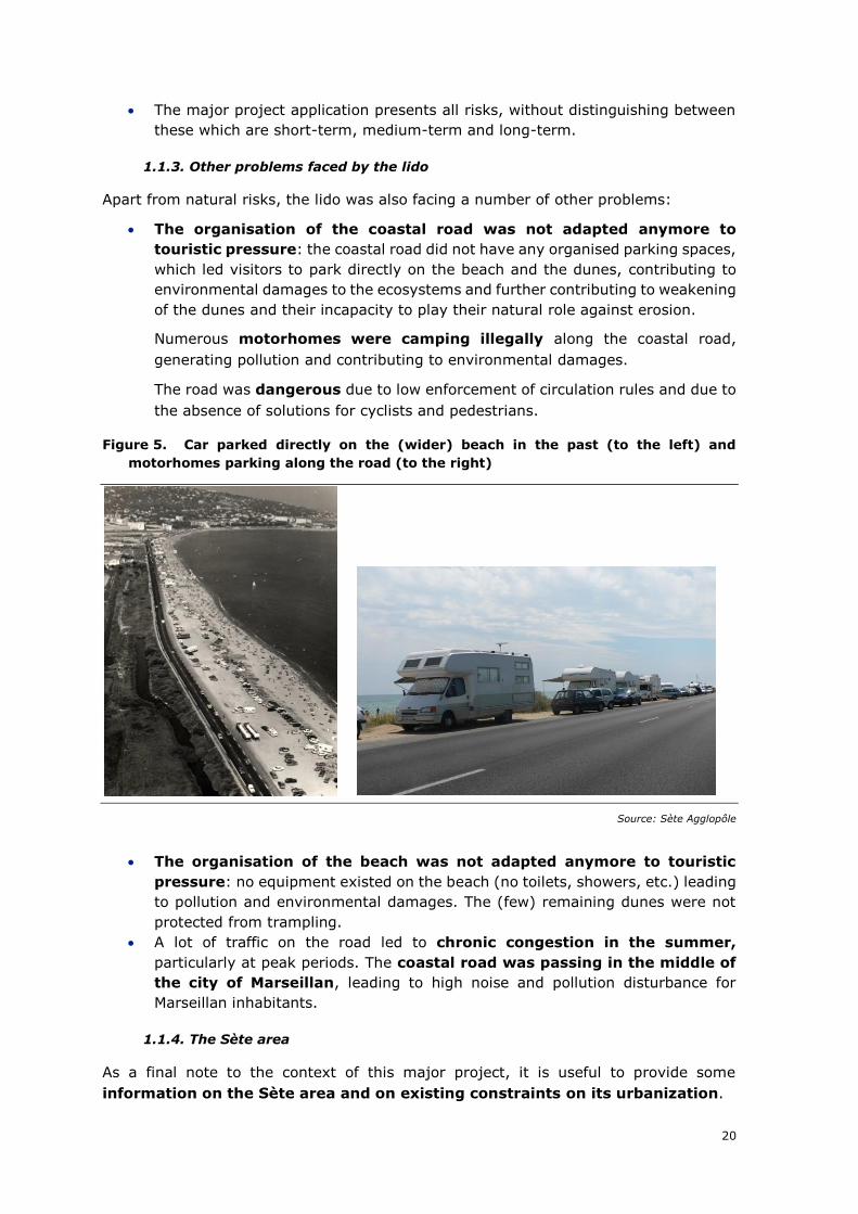
• The organisation of the coastal road was not adapted anymore to
touristic pressure: the coastal road did not have any organised parking spaces,
which led visitors to park directly on the beach and the dunes, contributing to
environmental damages to the ecosystems and further contributing to weakening
of the dunes and their incapacity to play their natural role against erosion.
Numerous motorhomes were camping illegally along the coastal road,
generating pollution and contributing to environmental damages.
The road was dangerous due to low enforcement of circulation rules and due to
the absence of solutions for cyclists and pedestrians.
Figure 5. Car parked directly on the (wider) beach in the past (to the left) and
motorhomes parking along the road (to the right)
Source: Sète Agglopôle
• The organisation of the beach was not adapted anymore to touristic
pressure: no equipment existed on the beach (no toilets, showers, etc.) leading
to pollution and environmental damages. The (few) remaining dunes were not
protected from trampling.
• A lot of traffic on the road led to chronic congestion in the summer,
particularly at peak periods. The coastal road was passing in the middle of
the city of Marseillan, leading to high noise and pollution disturbance for
Marseillan inhabitants.
1.1.4. The Sète area
As a final note to the context of this major project, it is useful to provide some
information on the Sète area and on existing constraints on its urbanization.
21
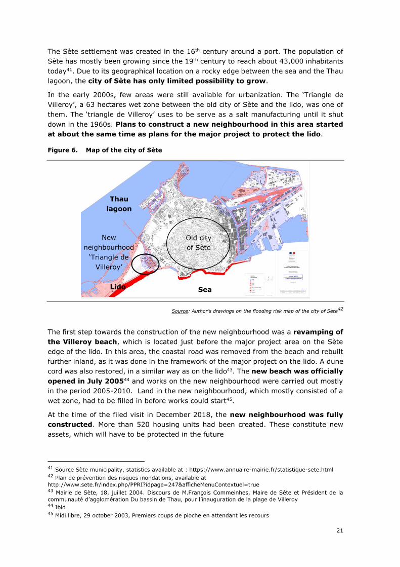
The Sète settlement was created in the 16th century around a port. The population of
Sète has mostly been growing since the 19th century to reach about 43,000 inhabitants
today41. Due to its geographical location on a rocky edge between the sea and the Thau
lagoon, the city of Sète has only limited possibility to grow.
In the early 2000s, few areas were still available for urbanization. The ‘Triangle de
Villeroy’, a 63 hectares wet zone between the old city of Sète and the lido, was one of
them. The ‘triangle de Villeroy’ uses to be serve as a salt manufacturing until it shut
down in the 1960s. Plans to construct a new neighbourhood in this area started
at about the same time as plans for the major project to protect the lido.
Figure 6. Map of the city of Sète
Source: Author’s drawings on the flooding risk map of the city of Sète42
The first step towards the construction of the new neighbourhood was a revamping of
the Villeroy beach, which is located just before the major project area on the Sète
edge of the lido. In this area, the coastal road was removed from the beach and rebuilt
further inland, as it was done in the framework of the major project on the lido. A dune
cord was also restored, in a similar way as on the lido43. The new beach was officially
opened in July 200544 and works on the new neighbourhood were carried out mostly
in the period 2005-2010. Land in the new neighbourhood, which mostly consisted of a
wet zone, had to be filled in before works could start45.
At the time of the filed visit in December 2018, the new neighbourhood was fully
constructed. More than 520 housing units had been created. These constitute new
assets, which will have to be protected in the future
41 Source Sète municipality, statistics available at : https://www.annuaire-mairie.fr/statistique-sete.html 42 Plan de prévention des risques inondations, available at
http://www.sete.fr/index.php/PPRI?idpage=247&afficheMenuContextuel=true 43 Mairie de Sète, 18, juillet 2004. Discours de M.François Commeinhes, Maire de Sète et Président de la
communauté d’agglomération Du bassin de Thau, pour l’inauguration de la plage de Villeroy 44 Ibid 45 Midi libre, 29 october 2003, Premiers coups de pioche en attendant les recours
Old city
of Sète
Sea
Thau
lagoon
New
neighbourhood
‘Triangle de
Villeroy’
Lido
22
PROJECT OBJECTIVES
The lido is a multifaceted project. The major project application and the cost-benefit
analysis present the project along four main objectives:
1. Restoring a normal functioning of the coastline and ensuring better
protection against erosion.
2. Protecting the natural environment (pond-edge wetlands and grey dunes)
and in particular, the natural area of ecological, fauna and floristic interest
(ZNIEFF) and the Natura 2000 Perimeter located in the northern part of the lido.
3. Maintaining the mobility function of the coastal road, which enables an
efficient link between the city of Sète and Marseillan
4. Maintaining local economic activities on the lido, and in particular tourism,
shellfish aquaculture in the Thau lagoon, wine-growing, research and
development
From interviews, it appears that order of priority was perceived differently by each
stakeholder group involved. For the municipalities and the community of municipalities
the objective of maintaining a road and a “workable” beach (i.e. enabling tourism)
was high on the agenda46. For devolved State services, an important objective was to
protect the train line47. The option to displace the train line was never considered,
so that no estimate of the cost that this would generate could be obtained. But displacing
a train line would be very costly.
In order to meet these objectives, a number of actions were planned. Two main
components of the projects were designed to respond both to natural challenges and
to other problems, namely:
• Component I: Protecting and restoring the natural balance of the coastline using
different techniques to fight against erosion, and
• Component II: Developing the access and reception equipment on the site,
which were non-existent before the start of the project.
Activities to be carried to on both components are described in the following section.
STRUCTURAL FEATURES
Activities to be carried out in the framework of the lido project and of its two components
are sketched out below:
Component I: Protection of the coastline and fight against erosion
The protection of the coastline against erosion was to be achieved using a combination
of land and maritime techniques:
46 Interviews Sète Agglopôle 47 Montel
23
• On land, a strategic relocation of the coastal road behind a restored dune
cord was to be the first step. This strategic relocation of the road would be
accompanied by a restoration of the destroyed dune cord, with a height of 2-3
meters wide on an active range of about 70 meters.
• Maritime methods would complement actions on the land. Maritime methods
would consist of:
i. Sand reloading:
An estimated volume of 600,000 m3 of sand would be reloaded in the
area to “refill” it with sand.
ii. Construction of an underwater wave attenuator
In parallel, an underwater wave attenuator would be constructed. A wave
attenuator is a sort of ‘tube’, which is set up, parallel to the coastline
(about 5-6 meters below water) at a distance of about 400 meters from
the coastline. This installation aims at reducing the impact of the
strongest waves and storms, by reducing sediments taken to the sea
during storms. This tube is an innovative tool, which has raised particular
interest in the scientific community.
iii. Installation of an ‘ecoplage’ system
Finally, an ‘ecoplage’ system would be installed. The ‘ecoplage’ system
accelerates the infiltration of water into the sand on the beach in order to
stabilize it. This system was also meant to make the reloading of sand
more effective and long-lasting.
Both the underwater wave attenuator and the ‘ecoplage system’ were
innovative solutions.
Component II: Development of the access and reception
equipment on the area
The second component of the lido project concerns works to revamp access to the
site and to install equipment. This component intends to provide responses to other
problems issues faced by the lido.
In particular, works included:
• The construction of a pedestrian and cyclist path behind the restored dune
cord;
• The construction of nine roundabouts to secure access to the coastal road and
parking spaces;
• The installation of equipment for users (toilets, showers and bus shelters);
• The reorganization of parking spaces;
• The by-pass of the city of Marseillan.
24
2. ORIGIN AND HISTORY
BACKGROUND
The project ‘protection and durable installation of the Lido from Sète to Marseillan’ is
the product of a long chain of reflections on the future of the coastline, its eco-
system and economy.
First reflections date back to the aftermath of the 1982 storm, which destroyed hard
beach infrastructure (restaurants) and which severely damaged and disrupted the
coastal road. At the time, the coastal road was a ‘national’ road48, which means that
devolved state services were responsible for repairing and maintaining it. The idea to
move the coastal road further back into land was already considered at the time. In
1984, land was bought by the state in order to prepare a potential displacement of the
road, but the project was not launched.
In 1997, a new violent storm hit the lido coast and severely damaged and disrupted
the coastal road again. This contributed to relaunching the project of removing the
road from the beach and of constructing a new road further towards the middle of the
lido. Around the same time, the road was ‘downgraded’ as a ‘local’ road, instead of a
‘national’ road, meaning that the municipalities of Sète and Marseillan were now
responsible for road repairs and for maintenance. According to historical data from the
Sète municipality, repair costs following a storm amounted to between EUR
150,000 and 250,000.49
Following the 1997 storm, a number of studies were launched to assess the situation
and to prepare options. The first study of these studies is the 2001 general study on
the protection and durable installation of the lido commissioned to the engineering
company BCEOM50.
At about the same time, at the beginning of the years 2000s, reflections on the future
of the coast were launched by State services. This was the start of the ‘Mission
interministérielle d’aménagement du littoral’,usually referred to as ‘Mission littorale’.
‘Mission littorale’ was co-presided by the State and the Region and led intense reflections
on the strategy to be applied across the coastline of Languedoc-Roussillon.
Indeed, the lido from Sète to Marseillan is far from being the only threatened area in
the region. Many other areas are threatened by erosion and climate change. In
addition some of the urbanization choices made in the 1960s (i.e. urbanization of some
of the ‘lidos’, urbanization too close to the sea…) did not prove right.
‘Mission littorale’ proved very important for all the coastal projects in the area. It was
the first initiative to assess in a consistent manner the situation of the whole
coastline, to reflect about strategies to be applied across the board and to
48 The road was « downgraded » to a local road at the end of the 1990s. The category of road has budgetary
implications, since ‘national’ roads are constructed and maintained by the state, whereas local roads are maintained by municipalities. The “downgrading” of the coastal road to a local road at the end of the 1990s also meant that repair costs following storm and regular maintenance costs would be borne by the two municipalities of Sète and Marseillan (the bulk being born by the municipality of Sète, since the majority of the lido belongs to the Sète territory. 49 Source Sète municipality 50 BCEOM, Ville de Sète, 2001. Etude générale pour la protection et l’aménagement durable du lido de Sète
à Marseillan
25
define priorities. It was also characterized by joint work between the different
levels of the administration, with a strong push from the central State. The key
role played by the State in ‘Mission littorale’ and in the projects which followed is also
illustrated by the nomination of a ‘Sous-Préfet’ dedicated to coastal issues. This was a
strong signal that coastal issues were given high priority in the region and that a
consistent approach needed to be followed.
‘Mission littorale’ also defined a key principle: any new project needed to be undertaken
at the right geographical scope, i.e. at the level of the sediment cell51. This is a
key principle, since projects of coastline protection may positively or negatively impact
other areas of the coastline. Work at the level of the sediment cell was imposed in order
to make sure that one project would not go against another project further downstream.
In its final stage, ‘Mission littorale’ prioritised projects on the Languedoc-Roussillon
coastline according to their degree of urgency. The lido from Sète to Marseillan was
classified as a priority 1 project (i.e. highest priority), together with 7 other
projects52.
Following the works of ‘Mission littorale’, eight projects were included in the Contract
between the State and the Region (Contrat de Plan Etat-Région).53 The ‘Contrat de Plan
Etat-Région’ guides public funding by the State and the Region for a predefined period
of time. It works in a similar way than an operational programme enabling different
levels of governance (in this case the central State and the Region) to agree on joint
priorities that will guide funding for a predefined period of time. In many cases, priorities
taken up in the ‘Contrat de Plan Etat-Région’ are quite similar to priorities included in
EU Operational Programmes, therefore ERDF funding in France often comes along side
funding from the State and the Region. This is also the case of the lido project.
The 2007-2013 CPER stresses the fact that the eight-project chosen were to be
implemented in an integrated manner54. This ‘integrated approach’ is described as
involving the following aspects: the selected projects “aim at implementing innovative
techniques to fight erosion on the coastline, while preserving a natural functioning of
the coastline […], at better managing tourism, at protecting the environment and at
raising awareness among the public about issues linked to preserving the coastline”55.
In parallel to ‘Mission littorale’, studies on the lido from Sète to Marseillan were providing
first results. The first BCEOM study analysed erosion trends and compared different
options to reduce erosion on the lido. It was complemented by a second study in 2003,
commissioned to the engineering company Urbanis56.
The two studies pointed that:
51 “A sediment cell is generally thought to be a closed system, which suggests that no sediment is transferred
from one cell to another. The boundaries of sediment cells are determined by the topography and shape of the coastline.” Source: http://thebritishgeographer.weebly.com/coastal-processes.html 52 Mission interministérielle d’aménagement du territoire, 2003. Orientations stratégiques pour la gestion de
l’érosion en Languedoc-Roussillon 53 Ibid, page 50 54 Ibid, page 51 55 Ibid, page 51 56 Urbanis, 2003. Protection and durable installation of the lido from Sète to Marseillan, definition of the
general programme and set-up of the operation
26
• erosive trends on parts of the lido areas were likely to continue if no action was
taken;
• sand losses due to storms were big and not be compensated in the existing
settings since dunes could not play their natural role due to the existence of the
coastal road;
• the presence of the coastal road reinforced erosion.
The studies concluded that the maintenance of the coastal road is incompatible
with the existence of a beach in the long run.
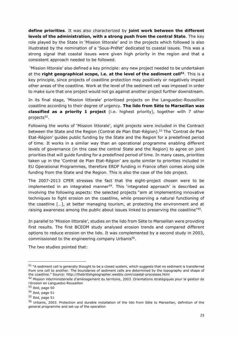
A set of options were then designed in the framework of the two studies.
Combining different options, two scenarios were developed based on the study BCEOM
and the URBANIS studies.
Scenarios retained after the URBANIS study
Options Estimated cost
(EUR 2001 price)
Keeping the coastal road in place, while putting
in place measures to protect it (periodic sand
reloading, protections at sea)
Between 27.7 and 33.6 million
Strategic retreat of the coastal road behind the
dunes. This option included actions to restore
the beach and dunes (between 15.6 and 17.7
M€) and the cost to move the coastal road
behind the newly restored dunes (valued at
9.15 M€).
Between 24.6 and 26.7 million
Source: ex-ante Cost-Benefit analysis
With the end of ‘Mission Littorale’s’ works around 2005 and their translation into regional
strategies, financial resources were also made available by the State, the Region and
the Department in order to kick start the priority projects on the Languedoc-Roussillon
coastline.
At about the same time, an EU-project commissioned by DG Environment, EUROSION,
studying erosion on the coastline, provided complementary thinking concerning the
need to integrate the coast and the risk of coastal erosion in plans and
investment decisions, and to provide a planned, globalized and clear response
to erosion problems.
Another EU co-financed project, ‘MESSINA57’ (developed with the support of the
Interreg programme IIIC) also took the lido from Sète to Marseillan as a case study,
testing ‘Social multicriteria evaluation’ for the options which were on the table to
fight coast erosion on the lido. It also provided maps of possible options, but none of
these options corresponds to the option finally retained. Indeed, at the time of the
57 Messina Project, 2004. Social multicriteria evaluation of the alternative solutions for coast erosion: the case
of the Lido of Sète
27
MESSINA project, the innovative solution of the wave attenuator had not yet been
considered.
FINANCING DECISION AND PROJECT IMPLEMENTATION
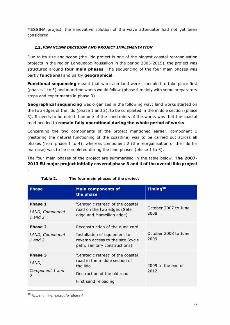
Due to its size and scope (the lido project is one of the biggest coastal reorganisation
projects in the region Languedoc-Roussillon in the period 2005-2015), the project was
structured around four main phases. The sequencing of the four main phases was
partly functional and partly geographical.
Functional sequencing meant that works on land were scheduled to take place first
(phases 1 to 3) and maritime works would follow (phase 4 mainly with some preparatory
steps and experiments in phase 3).
Geographical sequencing was organized in the following way: land works started on
the two edges of the lido (phase 1 and 2), to be completed in the middle section (phase
3). It needs to be noted than one of the constraints of the works was that the coastal
road needed to remain fully operational during the whole period of works.
Concerning the two components of the project mentioned earlier, component 1
(restoring the natural functioning of the coastline) was to be carried out across all
phases (from phase 1 to 4); whereas component 2 (the reorganisation of the lido for
man use) was to be completed during the land phases (phase 1 to 3).
The four main phases of the project are summarised in the table below. The 2007-
2013 EU major project initially covered phase 3 and 4 of the overall lido project
.
The four main phases of the project
Phase Main components of
the phase
Timing58
Phase 1
LAND, Component
1 and 2
‘Strategic retreat’ of the coastal
road on the two edges (Sète
edge and Marseillan edge)
October 2007 to June
2008
Phase 2
LAND, Component
1 and 2
Reconstruction of the dune cord
Installation of equipment to
revamp access to the site (cycle
path, sanitary constructions)
October 2008 to June
2009
Phase 3
LAND,
Component 1 and
2
‘Strategic retreat’ of the coastal
road in the middle section of
the lido
Destruction of the old road
First sand reloading
2009 to the end of
2012
58 Actual timing, except for phase 4
28
Phase Main components of
the phase
Timing58
Preparatory works for the
maritime phase
Phase 4
MARITIME
Component 1
Phase 4 deals with the maritime
works of the project. It was
meant to include the:
The construction of the
underwater wave attenuator;
The installation of the ‘ecoplage’
system; and
Further sand reloading
The initial timetable
for tranche 4 was
from the year 2011
until the end of 2012.
But the maritime
phase was finally
carried out between
2011 and 2018. (See
explanations below)
Source: Authors based on descriptions by Sète Agglopôle
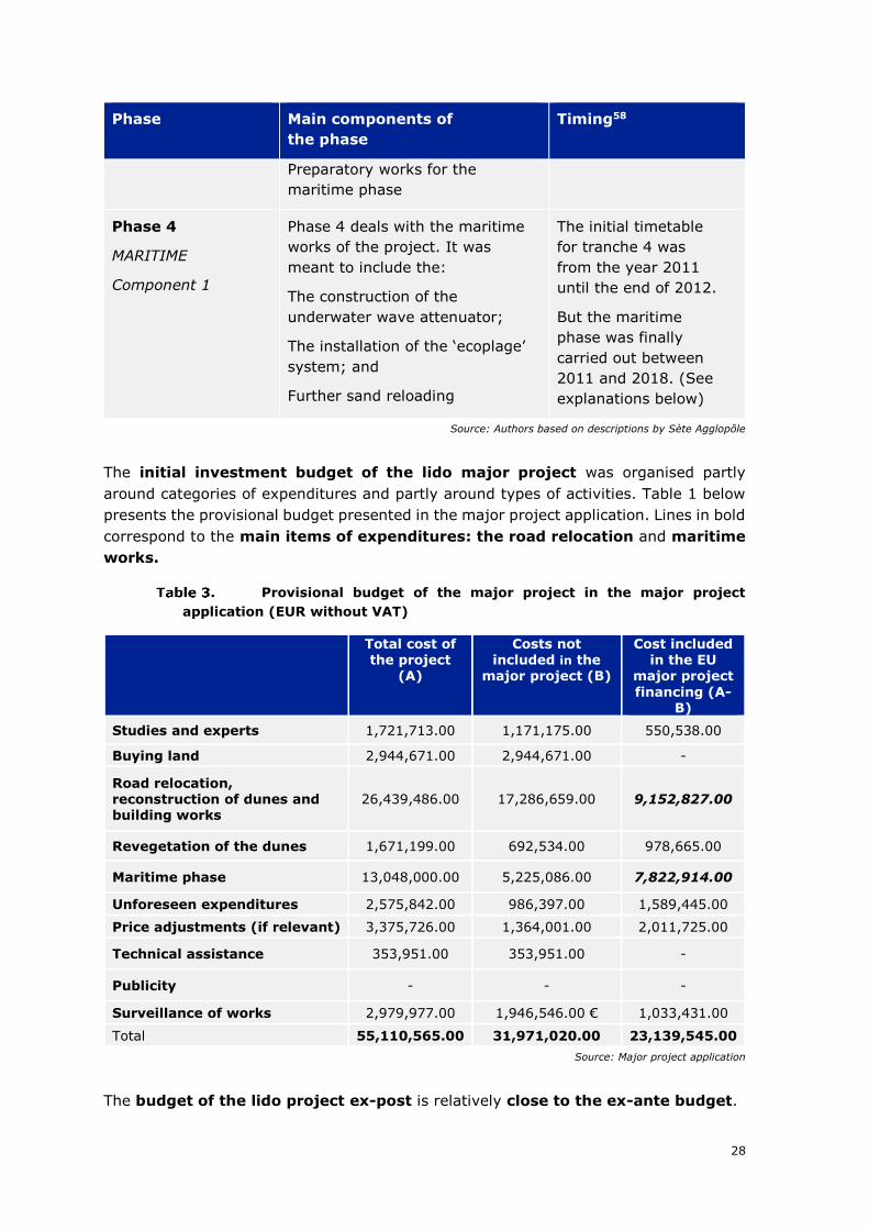
The initial investment budget of the lido major project was organised partly
around categories of expenditures and partly around types of activities. Table 1 below
presents the provisional budget presented in the major project application. Lines in bold
correspond to the main items of expenditures: the road relocation and maritime
works.
Provisional budget of the major project in the major project
application (EUR without VAT)
Total cost of the project
(A)
Costs not included in the
major project (B)
Cost included in the EU
major project
financing (A-B)
Studies and experts 1,721,713.00 1,171,175.00 550,538.00
Buying land 2,944,671.00 2,944,671.00 -
Road relocation, reconstruction of dunes and building works
26,439,486.00 17,286,659.00 9,152,827.00
Revegetation of the dunes 1,671,199.00 692,534.00 978,665.00
Maritime phase 13,048,000.00 5,225,086.00 7,822,914.00
Unforeseen expenditures 2,575,842.00 986,397.00 1,589,445.00
Price adjustments (if relevant) 3,375,726.00 1,364,001.00 2,011,725.00
Technical assistance 353,951.00 353,951.00 -
Publicity - - -
Surveillance of works 2,979,977.00 1,946,546.00 € 1,033,431.00
Total 55,110,565.00 31,971,020.00 23,139,545.00
Source: Major project application
The budget of the lido project ex-post is relatively close to the ex-ante budget.
29
• For the land phase, this is not surprising since a large share of works for that
phase had already been tendered before the major project application. A reliable
estimate of the cost of land works was therefore available when drafting the
major project application. A small cost overrun was incurred in the land phase.
• For the maritime phase, the initial budget was based on estimates, since the
maritime phase had not started at the time of the major project application. Yet,
final expenditure is reasonably close to estimates. It needs to be noted that the
maritime phase is still ongoing (see explanations below), so that a small amount
of the maritime phase works is not yet finalised (amounting to EUR 4.2 million).
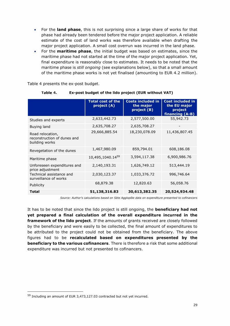
Table 4 presents the ex-post budget.
Ex-post budget of the lido project (EUR without VAT)
Total cost of the project (A)
Costs included in the major
project (B)
Cost included in the EU major
project financing (A-B)
Studies and experts 2,633,442.73 2,577,500.00 55,942.73
Buying land 2,635,708.27 2,635,708.27 -
Road relocation, reconstruction of dunes and building works
29,666,885.54 18,230,078.09 11,436,807.45
Revegetation of the dunes 1,467,980.09 859,794.01 608,186.08
Maritime phase 10,495,1040.1459 3,594,117.38 6,900,986.76
Unforeseen expenditures and price adjustment
2,140,193.31 1,626,749.12 513,444.19
Technical assistance and surveillance of works
2,030,123.37 1,033,376.72 996,746.64
Publicity 68,879.38 12,820.63 56,058.76
Total 51,138,316.83 30,613,382.35 20,524,934.48
Source: Author’s calculations based on Sète Agglopôle data on expenditure presented to cofinancers
It has to be noted that since the lido project is still ongoing, the beneficiary had not
yet prepared a final calculation of the overall expenditure incurred in the
framework of the lido project. If the amounts of grants received are closely followed
by the beneficiary and were easily to be collected, the final amount of expenditures to
be attributed to the project could not be obtained from the beneficiary. The above
figures had to be recalculated based on expenditures presented by the
beneficiary to the various cofinancers. There is therefore a risk that some additional
expenditure was incurred but not presented to cofinancers.
59 Including an amount of EUR 3,473,127.03 contracted but not yet incurred.
30
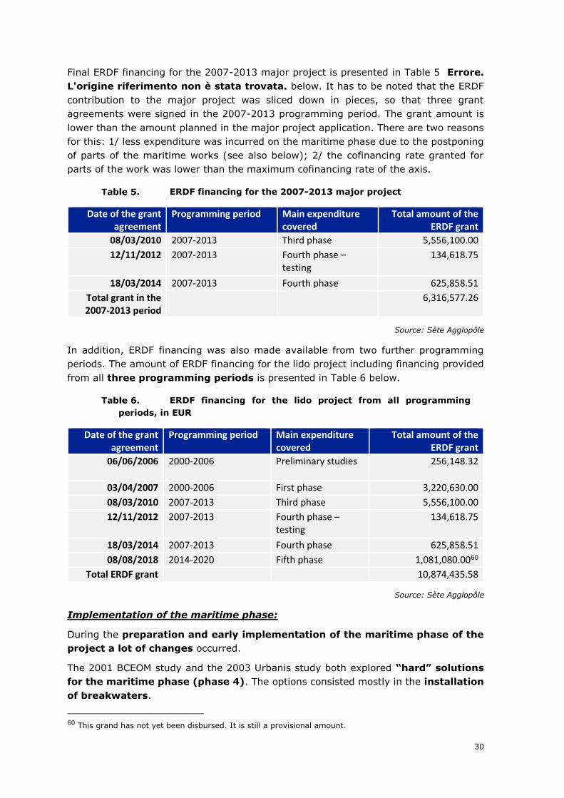
Final ERDF financing for the 2007-2013 major project is presented in Table 5 Errore.
L'origine riferimento non è stata trovata. below. It has to be noted that the ERDF
contribution to the major project was sliced down in pieces, so that three grant
agreements were signed in the 2007-2013 programming period. The grant amount is
lower than the amount planned in the major project application. There are two reasons
for this: 1/ less expenditure was incurred on the maritime phase due to the postponing
of parts of the maritime works (see also below); 2/ the cofinancing rate granted for
parts of the work was lower than the maximum cofinancing rate of the axis.
ERDF financing for the 2007-2013 major project
Date of the grant agreement
Programming period Main expenditure covered
Total amount of the ERDF grant
08/03/2010 2007-2013 Third phase 5,556,100.00
12/11/2012 2007-2013 Fourth phase – testing
134,618.75
18/03/2014 2007-2013 Fourth phase 625,858.51
Total grant in the 2007-2013 period
6,316,577.26
Source: Sète Agglopôle
In addition, ERDF financing was also made available from two further programming
periods. The amount of ERDF financing for the lido project including financing provided
from all three programming periods is presented in Table 6 below.
ERDF financing for the lido project from all programming
periods, in EUR
Date of the grant agreement
Programming period Main expenditure covered
Total amount of the ERDF grant
06/06/2006 2000-2006 Preliminary studies
256,148.32
03/04/2007 2000-2006 First phase 3,220,630.00
08/03/2010 2007-2013 Third phase 5,556,100.00
12/11/2012 2007-2013 Fourth phase – testing
134,618.75
18/03/2014 2007-2013 Fourth phase 625,858.51
08/08/2018 2014-2020 Fifth phase 1,081,080.0060
Total ERDF grant 10,874,435.58
Source: Sète Agglopôle
Implementation of the maritime phase:
During the preparation and early implementation of the maritime phase of the
project a lot of changes occurred.
The 2001 BCEOM study and the 2003 Urbanis study both explored “hard” solutions
for the maritime phase (phase 4). The options consisted mostly in the installation
of breakwaters.
60 This grand has not yet been disbursed. It is still a provisional amount.
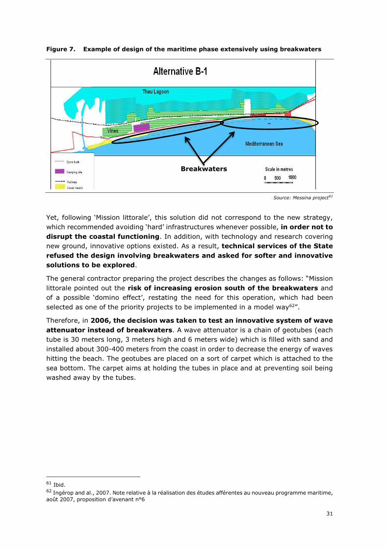
31
Figure 7. Example of design of the maritime phase extensively using breakwaters
Source: Messina project61
Yet, following ‘Mission littorale’, this solution did not correspond to the new strategy,
which recommended avoiding ‘hard’ infrastructures whenever possible, in order not to
disrupt the coastal functioning. In addition, with technology and research covering
new ground, innovative options existed. As a result, technical services of the State
refused the design involving breakwaters and asked for softer and innovative
solutions to be explored.
The general contractor preparing the project describes the changes as follows: “Mission
littorale pointed out the risk of increasing erosion south of the breakwaters and
of a possible ‘domino effect’, restating the need for this operation, which had been
selected as one of the priority projects to be implemented in a model way62”.
Therefore, in 2006, the decision was taken to test an innovative system of wave
attenuator instead of breakwaters. A wave attenuator is a chain of geotubes (each
tube is 30 meters long, 3 meters high and 6 meters wide) which is filled with sand and
installed about 300-400 meters from the coast in order to decrease the energy of waves
hitting the beach. The geotubes are placed on a sort of carpet which is attached to the
sea bottom. The carpet aims at holding the tubes in place and at preventing soil being
washed away by the tubes.
61 Ibid. 62 Ingérop and al., 2007. Note relative à la réalisation des études afférentes au nouveau programme maritime,
août 2007, proposition d’avenant n°6
Breakwaters
0
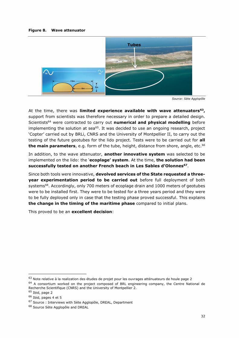
32
Figure 8. Wave attenuator
Source: Sète Agglopôle
At the time, there was limited experience available with wave attenuators63,
support from scientists was therefore necessary in order to prepare a detailed design.
Scientists64 were contracted to carry out numerical and physical modelling before
implementing the solution at sea65. It was decided to use an ongoing research, project
‘Copter’ carried out by BRLi, CNRS and the University of Montpellier II, to carry out the
testing of the future geotubes for the lido project. Tests were to be carried out for all
the main parameters, e.g. form of the tube, height, distance from shore, angle, etc.66
In addition, to the wave attenuator, another innovative system was selected to be
implemented on the lido: the ‘ecoplage’ system. At the time, the solution had been
successfully tested on another French beach in Les Sables d’Olonnes67.
Since both tools were innovative, devolved services of the State requested a three-
year experimentation period to be carried out before full deployment of both
systems68. Accordingly, only 700 meters of ecoplage drain and 1000 meters of geotubes
were to be installed first. They were to be tested for a three years period and they were
to be fully deployed only in case that the testing phase proved successful. This explains
the change in the timing of the maritime phase compared to initial plans.
This proved to be an excellent decision:
63 Note relative à la realization des études de projet pour les ouvrages atténuateurs de houle page 2 64 A consortium worked on the project composed of BRL engineering company, the Centre National de
Recherche Scientifique (CNRS) and the University of Montpellier 2. 65 Ibid, page 2 66 Ibid, pages 4 et 5 67 Source : Interviews with Sète Agglopôle, DREAL, Department 68 Source Sète Agglopôle and DREAL
Tubes
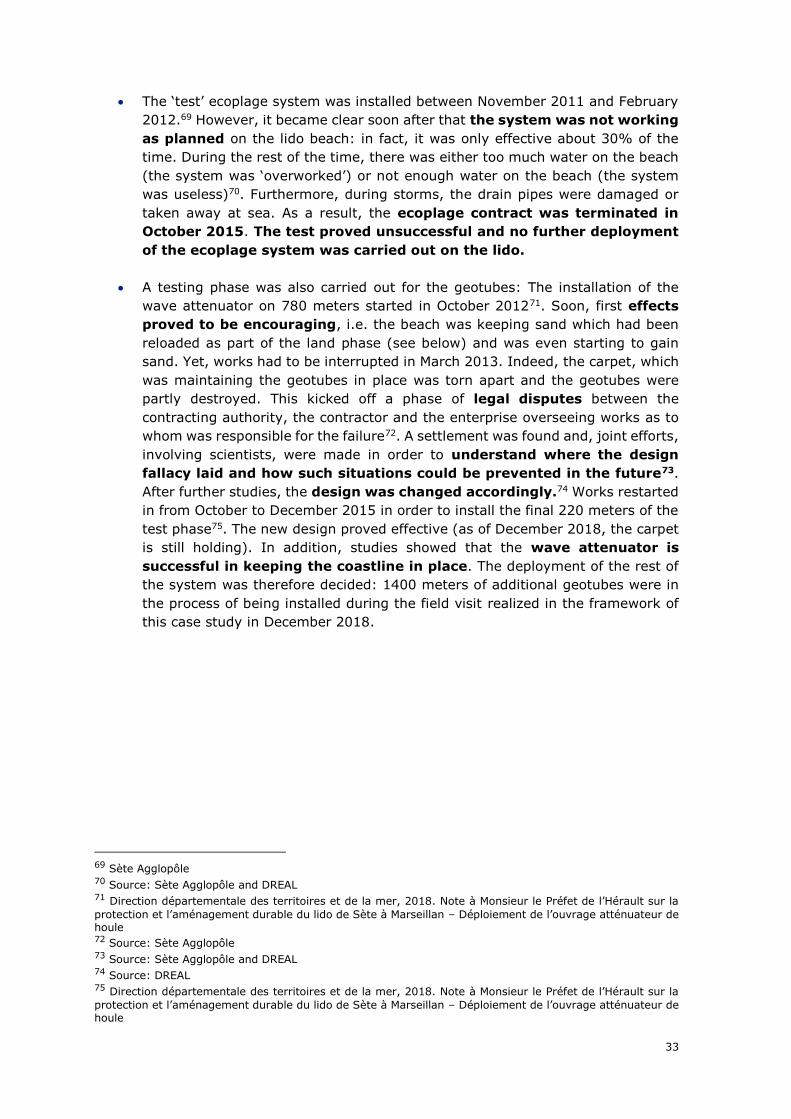
33
• The ‘test’ ecoplage system was installed between November 2011 and February
2012.69 However, it became clear soon after that the system was not working
as planned on the lido beach: in fact, it was only effective about 30% of the
time. During the rest of the time, there was either too much water on the beach
(the system was ‘overworked’) or not enough water on the beach (the system
was useless)70. Furthermore, during storms, the drain pipes were damaged or
taken away at sea. As a result, the ecoplage contract was terminated in
October 2015. The test proved unsuccessful and no further deployment
of the ecoplage system was carried out on the lido.
• A testing phase was also carried out for the geotubes: The installation of the
wave attenuator on 780 meters started in October 201271. Soon, first effects
proved to be encouraging, i.e. the beach was keeping sand which had been
reloaded as part of the land phase (see below) and was even starting to gain
sand. Yet, works had to be interrupted in March 2013. Indeed, the carpet, which
was maintaining the geotubes in place was torn apart and the geotubes were
partly destroyed. This kicked off a phase of legal disputes between the
contracting authority, the contractor and the enterprise overseeing works as to
whom was responsible for the failure72. A settlement was found and, joint efforts,
involving scientists, were made in order to understand where the design
fallacy laid and how such situations could be prevented in the future73.
After further studies, the design was changed accordingly.74 Works restarted
in from October to December 2015 in order to install the final 220 meters of the
test phase75. The new design proved effective (as of December 2018, the carpet
is still holding). In addition, studies showed that the wave attenuator is
successful in keeping the coastline in place. The deployment of the rest of
the system was therefore decided: 1400 meters of additional geotubes were in
the process of being installed during the field visit realized in the framework of
this case study in December 2018.
69 Sète Agglopôle 70 Source: Sète Agglopôle and DREAL 71 Direction départementale des territoires et de la mer, 2018. Note à Monsieur le Préfet de l’Hérault sur la
protection et l’aménagement durable du lido de Sète à Marseillan – Déploiement de l’ouvrage atténuateur de houle 72 Source: Sète Agglopôle 73 Source: Sète Agglopôle and DREAL 74 Source: DREAL 75 Direction départementale des territoires et de la mer, 2018. Note à Monsieur le Préfet de l’Hérault sur la
protection et l’aménagement durable du lido de Sète à Marseillan – Déploiement de l’ouvrage atténuateur de houle
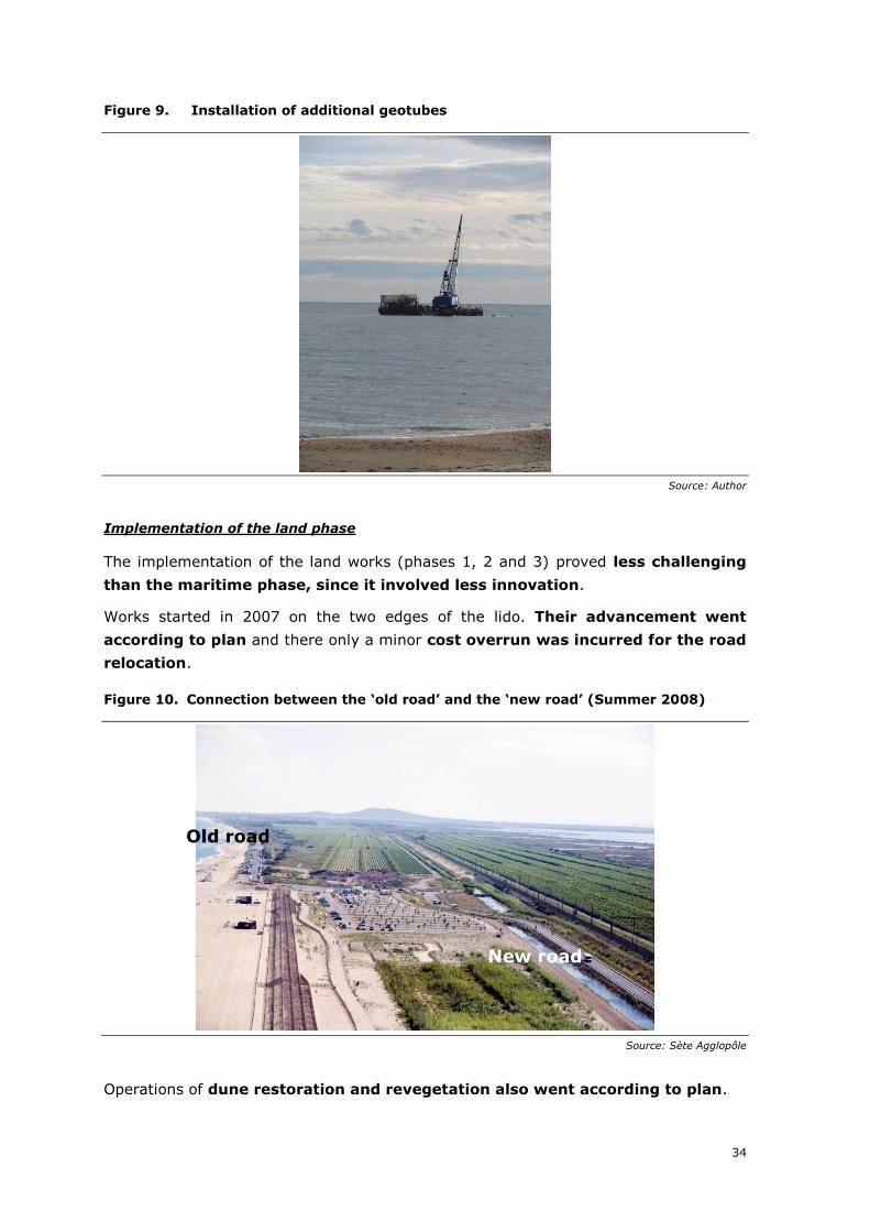
34
Figure 9. Installation of additional geotubes
Source: Author
Implementation of the land phase
The implementation of the land works (phases 1, 2 and 3) proved less challenging
than the maritime phase, since it involved less innovation.
Works started in 2007 on the two edges of the lido. Their advancement went
according to plan and there only a minor cost overrun was incurred for the road
relocation.
Figure 10. Connection between the ‘old road’ and the ‘new road’ (Summer 2008)
Source: Sète Agglopôle
Operations of dune restoration and revegetation also went according to plan.
New road
Old road
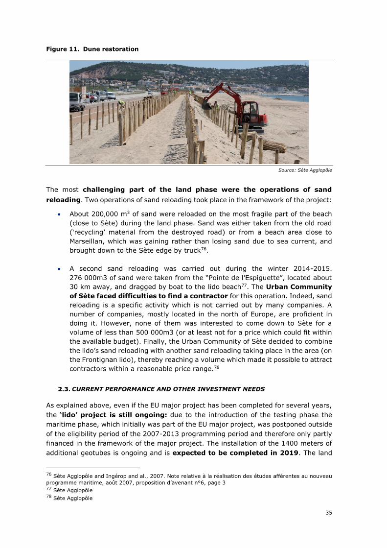
35
Figure 11. Dune restoration
Source: Sète Agglopôle
The most challenging part of the land phase were the operations of sand
reloading. Two operations of sand reloading took place in the framework of the project:
• About 200,000 m3 of sand were reloaded on the most fragile part of the beach
(close to Sète) during the land phase. Sand was either taken from the old road
(‘recycling’ material from the destroyed road) or from a beach area close to
Marseillan, which was gaining rather than losing sand due to sea current, and
brought down to the Sète edge by truck76.
• A second sand reloading was carried out during the winter 2014-2015.
276 000m3 of sand were taken from the “Pointe de l’Espiguette”, located about
30 km away, and dragged by boat to the lido beach77. The Urban Community
of Sète faced difficulties to find a contractor for this operation. Indeed, sand
reloading is a specific activity which is not carried out by many companies. A
number of companies, mostly located in the north of Europe, are proficient in
doing it. However, none of them was interested to come down to Sète for a
volume of less than 500 000m3 (or at least not for a price which could fit within
the available budget). Finally, the Urban Community of Sète decided to combine
the lido’s sand reloading with another sand reloading taking place in the area (on
the Frontignan lido), thereby reaching a volume which made it possible to attract
contractors within a reasonable price range.78
CURRENT PERFORMANCE AND OTHER INVESTMENT NEEDS
As explained above, even if the EU major project has been completed for several years,
the ‘lido’ project is still ongoing: due to the introduction of the testing phase the
maritime phase, which initially was part of the EU major project, was postponed outside
of the eligibility period of the 2007-2013 programming period and therefore only partly
financed in the framework of the major project. The installation of the 1400 meters of
additional geotubes is ongoing and is expected to be completed in 2019. The land
76 Sète Agglopôle and Ingérop and al., 2007. Note relative à la réalisation des études afférentes au nouveau
programme maritime, août 2007, proposition d’avenant n°6, page 3 77 Sète Agglopôle 78 Sète Agglopôle
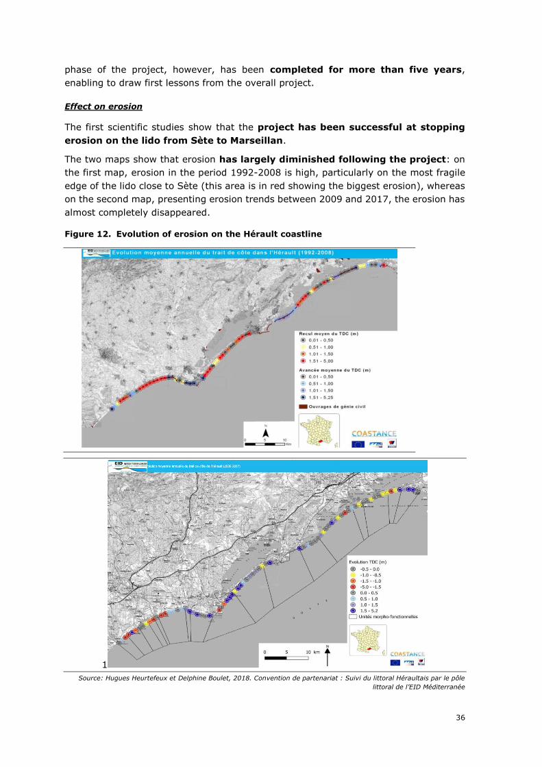
36
phase of the project, however, has been completed for more than five years,
enabling to draw first lessons from the overall project.
Effect on erosion
The first scientific studies show that the project has been successful at stopping
erosion on the lido from Sète to Marseillan.
The two maps show that erosion has largely diminished following the project: on
the first map, erosion in the period 1992-2008 is high, particularly on the most fragile
edge of the lido close to Sète (this area is in red showing the biggest erosion), whereas
on the second map, presenting erosion trends between 2009 and 2017, the erosion has
almost completely disappeared.
Figure 12. Evolution of erosion on the Hérault coastline
1
Source: Hugues Heurtefeux et Delphine Boulet, 2018. Convention de partenariat : Suivi du littoral Héraultais par le pôle
littoral de l’EID Méditerranée
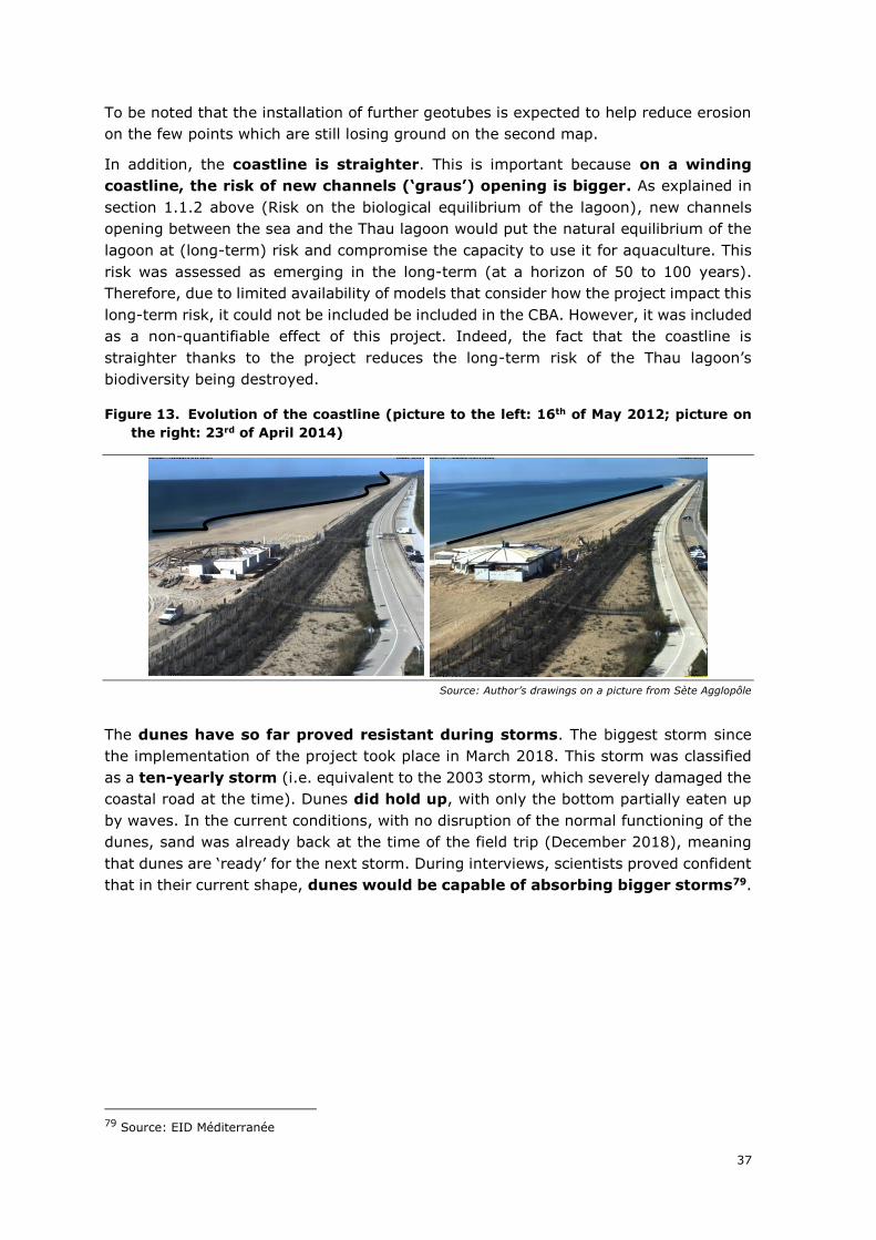
37
To be noted that the installation of further geotubes is expected to help reduce erosion
on the few points which are still losing ground on the second map.
In addition, the coastline is straighter. This is important because on a winding
coastline, the risk of new channels (‘graus’) opening is bigger. As explained in
section 1.1.2 above (Risk on the biological equilibrium of the lagoon), new channels
opening between the sea and the Thau lagoon would put the natural equilibrium of the
lagoon at (long-term) risk and compromise the capacity to use it for aquaculture. This
risk was assessed as emerging in the long-term (at a horizon of 50 to 100 years).
Therefore, due to limited availability of models that consider how the project impact this
long-term risk, it could not be included be included in the CBA. However, it was included
as a non-quantifiable effect of this project. Indeed, the fact that the coastline is
straighter thanks to the project reduces the long-term risk of the Thau lagoon’s
biodiversity being destroyed.
Figure 13. Evolution of the coastline (picture to the left: 16th of May 2012; picture on
the right: 23rd of April 2014)
Source: Author’s drawings on a picture from Sète Agglopôle
The dunes have so far proved resistant during storms. The biggest storm since
the implementation of the project took place in March 2018. This storm was classified
as a ten-yearly storm (i.e. equivalent to the 2003 storm, which severely damaged the
coastal road at the time). Dunes did hold up, with only the bottom partially eaten up
by waves. In the current conditions, with no disruption of the normal functioning of the
dunes, sand was already back at the time of the field trip (December 2018), meaning
that dunes are ‘ready’ for the next storm. During interviews, scientists proved confident
that in their current shape, dunes would be capable of absorbing bigger storms79.
79 Source: EID Méditerranée
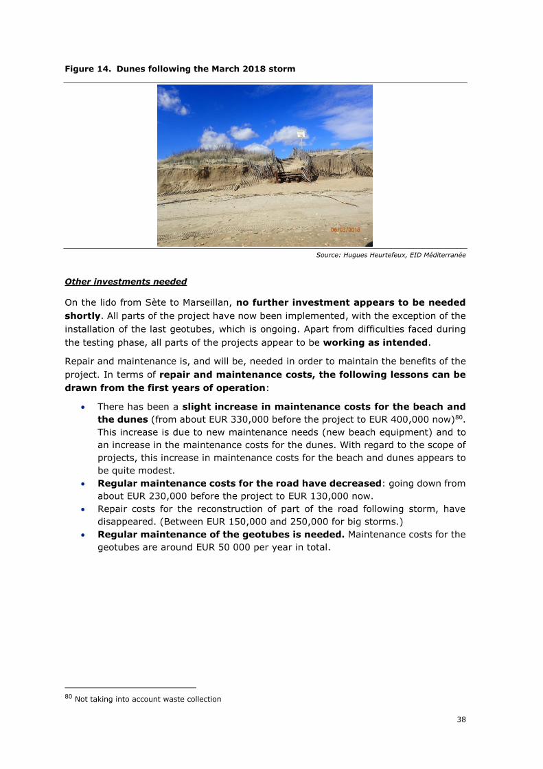
38
Figure 14. Dunes following the March 2018 storm
Source: Hugues Heurtefeux, EID Méditerranée
Other investments needed
On the lido from Sète to Marseillan, no further investment appears to be needed
shortly. All parts of the project have now been implemented, with the exception of the
installation of the last geotubes, which is ongoing. Apart from difficulties faced during
the testing phase, all parts of the projects appear to be working as intended.
Repair and maintenance is, and will be, needed in order to maintain the benefits of the
project. In terms of repair and maintenance costs, the following lessons can be
drawn from the first years of operation:
• There has been a slight increase in maintenance costs for the beach and
the dunes (from about EUR 330,000 before the project to EUR 400,000 now)80.
This increase is due to new maintenance needs (new beach equipment) and to
an increase in the maintenance costs for the dunes. With regard to the scope of
projects, this increase in maintenance costs for the beach and dunes appears to
be quite modest.
• Regular maintenance costs for the road have decreased: going down from
about EUR 230,000 before the project to EUR 130,000 now.
• Repair costs for the reconstruction of part of the road following storm, have
disappeared. (Between EUR 150,000 and 250,000 for big storms.)
• Regular maintenance of the geotubes is needed. Maintenance costs for the
geotubes are around EUR 50 000 per year in total.
80 Not taking into account waste collection
39
• The geotubes may also need to be replaced. Since 2013, 8 geotubes had to
be replaced following damages. These replacements generated costs of
about EUR 450,000. It is likely that these costs will decrease in the future.
Indeed, a learning phase was necessary in order to find the right maintenance
speed. A few geotubes seem to have gone lost due to the absence of timely
maintenance (e.i. if taken ‘early’ enough, repairs can be done easily, whereas if
the problem is not detected early enough, the geotubes deteriorate further and
need to be replaced). The Urban Community of Sète may face difficulties in the
future to replace geotubes: a specific boat is necessary to carry out the works.
So far, replacements of broken geotubes could be coupled with the installation
of new geotubes, thereby not generating additional cost for the boat. In the
future, a dedicated boat will need to be mobilised in order to replace the broken
geotubes. In all likelihood, geotubes will only be replaced once a significant
number of geotubes are broken, so that costs for the boat will only be
incurred from time to time. According to technicians, the effectiveness of the
wave attenuator is not jeopardized when a few tubes get broken. Effectiveness
is reduced only when a significant number of geotubes are damaged.81
Finally, due to changes in sand movements, which are due to the installation of
the wave-attenuator, the port of Marseillan has to be dragged more often than
before. This has generated costs, which had not been foreseen. Before the
project, the annual cost born by the municipality in order to drag the port was
around EUR 60,000. After the project, annual cost for dragging have gone up to
about EUR 120,00082.
All in all, maintenance costs of the new project have not increased in an
excessive way. However, further monitoring of repair and replacement costs for
the maritime system will be needed: in the first phase on the project, replacement
costs for the wave attenuator system appear to be non-negligible. It remains to be
seen whether they will decrease now that the initial learning phase is coming to an end,
or whether the system will remain relatively costly to operate.
Finally, further investment needs may be generated to adapt to the global
warming (rising sea-levels). However, at this point in time, no concrete and short-
term need has been identified.
81 Source: Sète Agglopôle 82 Source: city of Marseillan, technical services
40
3. DESCRIPTION OF LONG-TERM EFFECTS
This section describes the main long-term effects provided by the project. Four
categories of effects are presented: effects on economic growth, quality of life and well-
being, environmental sustainability, and distributional effects. For each effect, the
contribution of the project to the specific effect has been assessed. For the most relevant
effects, description of the timing of their materialisation and evolution is also provided.
Because of the variety of effects to be accounted for, a methodological approach
combining cost-benefit analysis and qualitative analysis has been used. The ex-
post CBA incorporates the micro level of analysis and focus on welfare effects which can
be monetised. Impacts for which a quantification and monetisation is not possible, have
been identified and analysed in qualitative terms. In addition to monetisation of
quantifiable effects, scores ranging from -5 to +5 have been assigned to each type of
quantifiable and non-quantifiable effects in order to highlight which are the most
important effects generated.
KEY FINDINGS
The main context feature of the lido prior to the project was that the lido beach and the
coastal road crossing the lido were at risk from coastal erosion.
In this analysis, an important assumption was made with regards to the counterfactual
scenario. The ex-ante CBA considered a counterfactual in which the beach and the road
is protected from erosion by hard measures and the beach is regularly re-nourished with
sand. However, devolved services of the state opposed this type of coastal protection
for two reasons: 1) although hard erosion protection measures can help to preserve a
specific point (the local beach), they disrupt sediment flows in the area and may
therefore cause aggravated erosion of the coast further downstream; 2) regular sand
refills are not sustainable because the region cannot supply enough sand for a regular
reloading of many beaches. The counterfactual adopted in the ex-ante CBA was
therefore unrealistic.
This study therefore adopts an alternative counterfactual scenario. By default,
a “do-nothing” scenario was not considered appropriate. Indeed, without intervention,
the coastal road would have been at high risk of being taken away by the sea in the
short-term. This is an implausible scenario, as this would have left the connection
between Sète and Marseillan broken and as it would have led to a permanent
interruption of all economic activity on the lido. Instead, a “do-minimum” scenario
was adopted, in which the most vulnerable section of the road is protected, whereas
the beach is left unprotected and is therefore at risk of eroding completely by 2030. In
order to keep a functioning coastal road, the most vulnerable section close to Sète is
relocated to the hinterland in order to prevent irrecoverable destruction to that section;
the rest of the road is operated as before, with regular repairs following storms. The
following table outlines how the observed and counterfactual scenarios relate to the
quantified effects.
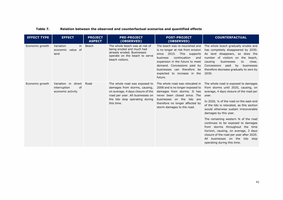
41
Relation between the observed and counterfactual scenarios and quantified effects
EFFECT TYPE EFFECT PROJECT ASPECT
PRE-PROJECT (OBSERVED)
POST-PROJECT (OBSERVED)
COUNTERFACTUAL
Economic growth Variation in
economic value of
land
Beach The whole beach was at risk of being eroded and much had already eroded. Businesses operate on the beach to serve
beach visitors.
The beach was re-nourished and
is no longer at risk from erosion
since 2010. This supports
business continuation and
expansion in the future to meet
demand. Concessions paid by
businesses can therefore be
expected to increase in the
future.
The whole beach gradually erodes and
has completely disappeared by 2030.
As land disappears, so does the
number of visitors on the beach,
causing businesses to close.
Concessions paid by businesses
therefore decrease gradually to zero by
2030.
Economic growth Variation in direct
interruption of
economic activity
Road The whole road was exposed to
damages from storms, causing,
on average, 4 days closure of the
road per year. All businesses on
the lido stop operating during
this time.
The whole road was relocated in
2008 and is no longer exposed to
damages from storms. It has
never been closed since. The
businesses on the lido are
therefore no longer affected by
storm damages to the road.
The whole road is exposed to damages
from storms until 2020, causing, on
average, 4 days closure of the road per
year.
In 2020, ¼ of the road on the east-end
of the lido is relocated, as this section
would otherwise sustain irrecoverable
damages by this year.
The remaining western ¾ of the road
continues to be exposed to damages
from storms throughout the time
horizon, causing, on average, 3 days
closure of the road per year after 2020.
All businesses on the lido stop
operating during this time.

42
EFFECT TYPE EFFECT PROJECT ASPECT
PRE-PROJECT (OBSERVED)
POST-PROJECT (OBSERVED)
COUNTERFACTUAL
Economic growth Variation in asset
losses
Road The whole road was exposed to
damages from storms, leading
to average repair costs of EUR
150,000 after minor storms and
EUR 200,000 after major
storms.
The whole road was relocated in
2008 and is no longer exposed to
damages from storms. No
repairs have been undertaken
due to storm damages since.
The whole road is exposed to damages
from storms until 2020, leading to
average repair costs of EUR 150,000
after minor storms and EUR 200,000
after major storms.
In 2020, ¼ of the road on the east-end
of the lido is relocated, as this section
would otherwise sustain irrecoverable
damages by this year.
The remaining western ¾ of the road
continues to be exposed to damages
from storms throughout the time
horizon, causing, on average, 3 days
closure of the road per year. All
businesses on the lido stop operating
during this time.
Quality of life and
wellbeing
Variation in
recreational
opportunities
Beach The whole beach was at risk of
being eroded and much had
already eroded. 800,000 visitors
were observed at the beach in
2002.
The beach was re-nourished and
is no longer at risk from erosion
since 2010. This supports a
growth in visitors since the 2002
observation indefinitely. The
recreational value of the beach is
therefore sustained in the
future.
The whole beach gradually erodes and
has completely disappeared by 2030.
As land disappears, so does the
number of visitors on the beach,
causing its recreational value to
diminish.
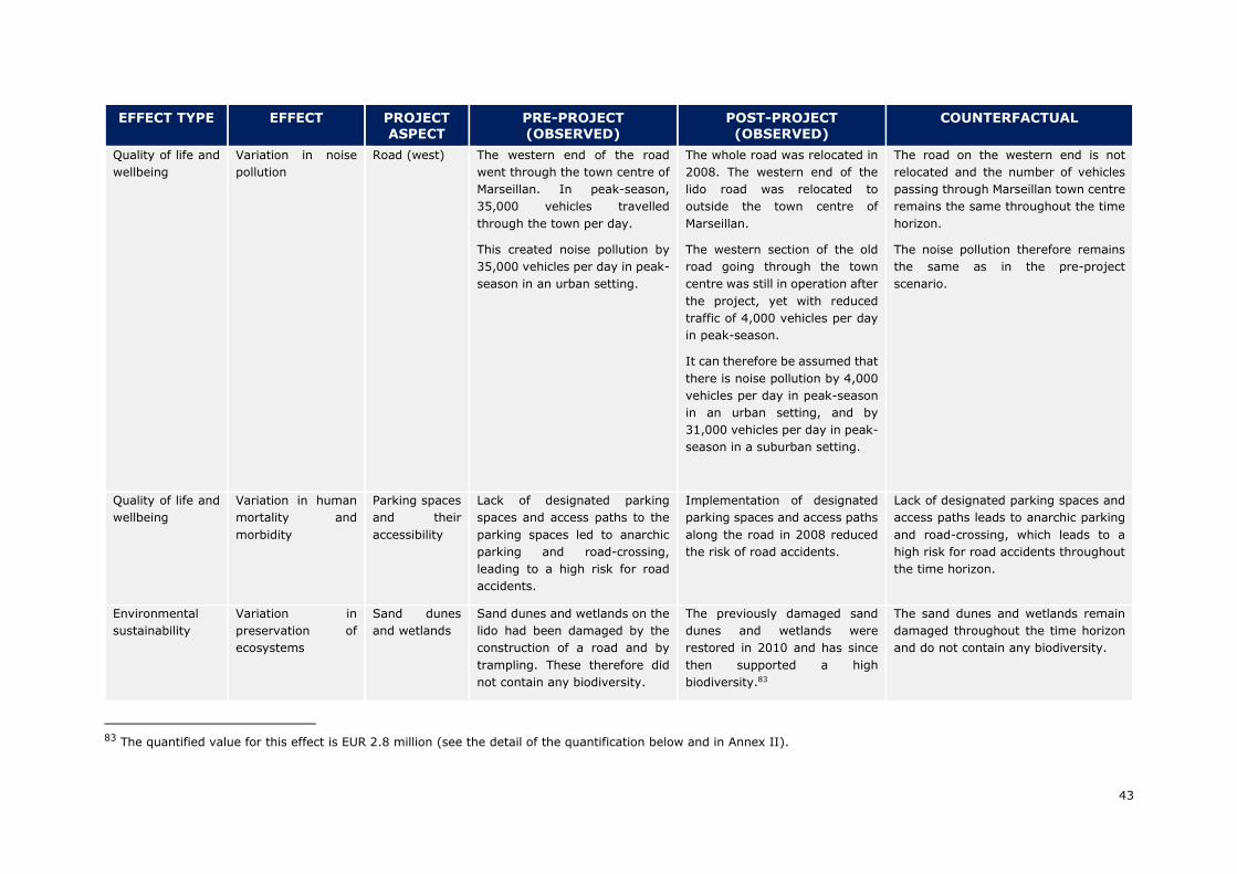
43
EFFECT TYPE EFFECT PROJECT ASPECT
PRE-PROJECT (OBSERVED)
POST-PROJECT (OBSERVED)
COUNTERFACTUAL
Quality of life and
wellbeing
Variation in noise
pollution
Road (west) The western end of the road
went through the town centre of
Marseillan. In peak-season,
35,000 vehicles travelled
through the town per day.
This created noise pollution by
35,000 vehicles per day in peak-
season in an urban setting.
The whole road was relocated in
2008. The western end of the
lido road was relocated to
outside the town centre of
Marseillan.
The western section of the old
road going through the town
centre was still in operation after
the project, yet with reduced
traffic of 4,000 vehicles per day
in peak-season.
It can therefore be assumed that
there is noise pollution by 4,000
vehicles per day in peak-season
in an urban setting, and by
31,000 vehicles per day in peak-
season in a suburban setting.
The road on the western end is not
relocated and the number of vehicles
passing through Marseillan town centre
remains the same throughout the time
horizon.
The noise pollution therefore remains
the same as in the pre-project
scenario.
Quality of life and
wellbeing
Variation in human
mortality and
morbidity
Parking spaces
and their
accessibility
Lack of designated parking
spaces and access paths to the
parking spaces led to anarchic
parking and road-crossing,
leading to a high risk for road
accidents.
Implementation of designated
parking spaces and access paths
along the road in 2008 reduced
the risk of road accidents.
Lack of designated parking spaces and
access paths leads to anarchic parking
and road-crossing, which leads to a
high risk for road accidents throughout
the time horizon.
Environmental
sustainability
Variation in
preservation of
ecosystems
Sand dunes
and wetlands
Sand dunes and wetlands on the
lido had been damaged by the
construction of a road and by
trampling. These therefore did
not contain any biodiversity.
The previously damaged sand
dunes and wetlands were
restored in 2010 and has since
then supported a high
biodiversity.83
The sand dunes and wetlands remain
damaged throughout the time horizon
and do not contain any biodiversity.
83 The quantified value for this effect is EUR 2.8 million (see the detail of the quantification below and in Annex II).
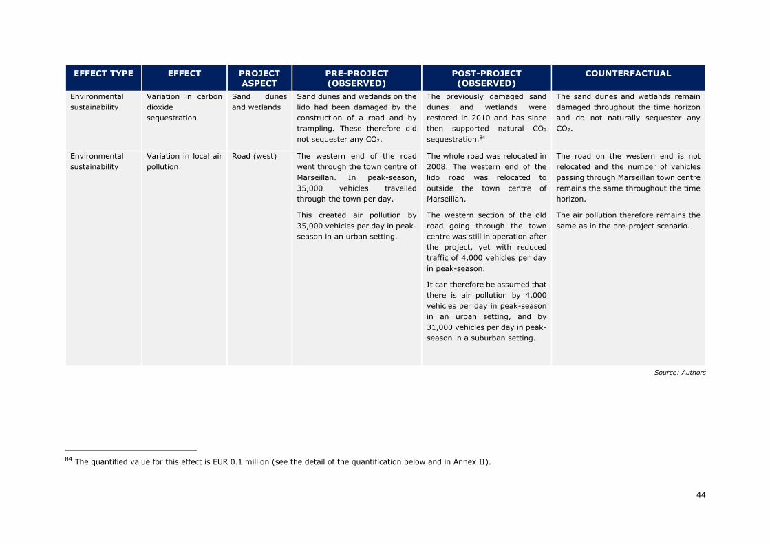
44
EFFECT TYPE EFFECT PROJECT ASPECT
PRE-PROJECT (OBSERVED)
POST-PROJECT (OBSERVED)
COUNTERFACTUAL
Environmental
sustainability
Variation in carbon
dioxide
sequestration
Sand dunes
and wetlands
Sand dunes and wetlands on the
lido had been damaged by the
construction of a road and by
trampling. These therefore did
not sequester any CO2.
The previously damaged sand
dunes and wetlands were
restored in 2010 and has since
then supported natural CO2
sequestration.84
The sand dunes and wetlands remain
damaged throughout the time horizon
and do not naturally sequester any
CO2.
Environmental
sustainability
Variation in local air
pollution
Road (west) The western end of the road
went through the town centre of
Marseillan. In peak-season,
35,000 vehicles travelled
through the town per day.
This created air pollution by
35,000 vehicles per day in peak-
season in an urban setting.
The whole road was relocated in
2008. The western end of the
lido road was relocated to
outside the town centre of
Marseillan.
The western section of the old
road going through the town
centre was still in operation after
the project, yet with reduced
traffic of 4,000 vehicles per day
in peak-season.
It can therefore be assumed that
there is air pollution by 4,000
vehicles per day in peak-season
in an urban setting, and by
31,000 vehicles per day in peak-
season in a suburban setting.
The road on the western end is not
relocated and the number of vehicles
passing through Marseillan town centre
remains the same throughout the time
horizon.
The air pollution therefore remains the
same as in the pre-project scenario.
Source: Authors
84 The quantified value for this effect is EUR 0.1 million (see the detail of the quantification below and in Annex II).
45
The results of Cost-Benefit Analysis, as included in the Annex II to this report indicate
that the project adds value to the European society under the social and economic points
of view. In the baseline case, the Socio-Economic Net Present Value (ENPV) equals EUR
95.8 million, with the applied discount rates of 2.78% backward and 3.69% forward,
whereas the Economic Internal Rate of Return is at the level of 8.08%. Also, the risk
analysis indicates that that the project has a negligible risk level: there is no risk that
the ENPV becomes negative and the risk that the ENPV becomes inferior to 57 million is
around 60%. The modifications in the critical variables, and notably of the erosion rate
of the beach, lead to a reduction of benefits linked with the recreational value of the
beach. The distribution of benefits in the CBA is presented in the figure below.
Figure 15. Main socioeconomic benefits
Source: Authors
The table below summarises the nature and strength of the project’s effects classified
under the above referred four categories (economic growth, quality of life and well-
being, environmental sustainability and distributional issues), as well as the territorial
levels where these are visible, and the time-horizon of their materialisation.
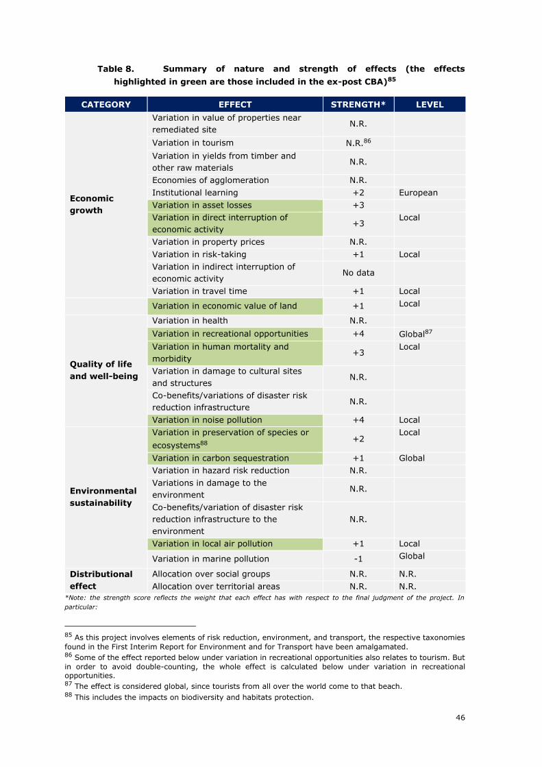
46
Summary of nature and strength of effects (the effects
highlighted in green are those included in the ex-post CBA)85
CATEGORY EFFECT STRENGTH* LEVEL
Economic
growth
Variation in value of properties near
remediated site N.R.
Variation in tourism N.R.86
Variation in yields from timber and
other raw materials N.R.
Economies of agglomeration N.R.
Institutional learning +2 European
Variation in asset losses +3
Variation in direct interruption of
economic activity +3
Local
Variation in property prices N.R.
Variation in risk-taking +1 Local
Variation in indirect interruption of
economic activity No data
Variation in travel time +1 Local
Variation in economic value of land +1 Local
Quality of life
and well-being
Variation in health N.R.
Variation in recreational opportunities +4 Global87
Variation in human mortality and
morbidity +3
Local
Variation in damage to cultural sites
and structures N.R.
Co-benefits/variations of disaster risk
reduction infrastructure N.R.
Variation in noise pollution +4 Local
Environmental
sustainability
Variation in preservation of species or
ecosystems88 +2
Local
Variation in carbon sequestration +1 Global
Variation in hazard risk reduction N.R.
Variations in damage to the
environment N.R.
Co-benefits/variation of disaster risk
reduction infrastructure to the
environment
N.R.
Variation in local air pollution +1 Local
Variation in marine pollution -1 Global
Distributional
effect
Allocation over social groups N.R. N.R.
Allocation over territorial areas N.R. N.R.
*Note: the strength score reflects the weight that each effect has with respect to the final judgment of the project. In
particular:
85 As this project involves elements of risk reduction, environment, and transport, the respective taxonomies
found in the First Interim Report for Environment and for Transport have been amalgamated. 86 Some of the effect reported below under variation in recreational opportunities also relates to tourism. But
in order to avoid double-counting, the whole effect is calculated below under variation in recreational opportunities. 87 The effect is considered global, since tourists from all over the world come to that beach. 88 This includes the impacts on biodiversity and habitats protection.
47
-5 = the effect is responsible of the negative performance of the project;
-4 = the effect has provided a negative contribution to the overall performance of the project;
-3 = the effect has contributed in a negative way to the performance but it was outweighed by other positive effects;
-2 = the effect has a slightly negative contribution to the project performance;
-1 = the effect is negative but almost negligible within the overall project performance;
0 = the effect has no impact on the project performance;
+1= the effect is positive but almost negligible within the overall project performance;
+2 = the effect has a slightly positive contribution to the project performance;
+3 = the effect has contributed in a positive way to the performance but it was outweighed by other positive effects;
+4 = the effect has provided a positive contribution to the overall performance of the project;
+5 = the effect is responsible of the positive performance of the project;
N.R. = The effect is not relevant for the specific project;
No data = The effect is potentially relevant, but no evidence on impacts is available. This shall be used only for relatively low
significant effects whose inclusion would in no case dramatically affect the overall assessment.
The following sub-chapters include some more detailed description of the effects
incorporated in the ex-post CBA and/or supported by available qualitative evidence
either from documental sources or interviews.
EFFECTS RELATED TO ECONOMIC GROWTH
Measurable effects
✓ Variation in economic value of land
Prior to the implementation of this project, the beach along the lido was under risk of
erosion. Over 45 hectares of beach eroded over the period 1954-2003. The erosion was
non-linear and was particularly aggravated by big storms (such as those from 1982 and
2003). According to Gervais et al (2012), the annual return period of storms that
damages the beach was 53% (including storms causing erosion of any magnitude). In
the counterfactual scenario, the beach would likely be completely eroded by 2030. As a
result of the project, the beach has been nourished to an average width of 70 m and is
no longer being eroded thanks to the relocation of the road, the restored protective
function of the dunes and the installation of the wave attenuator. Thus, a main benefit
of the project is the economic value of the land that would have been eroded in the
absence of intervention.
This benefit was estimated as the retained concessions paid by restaurants, cafes and
nautical shops located on the beach to the cities of Sète and Marseillan. Specifically,
data obtained on and the volume of concessions collected by the City of Sète between
2012-2018. These figures were used to calculate the average concessions paid by
businesses across this timespan per square metre of beach89. Considering that the City
of Sète collects concessions for about 4/5 of the beach, this value was adjusted upwards
to reflect the total concessions including also Marseillan city. This led to an estimated
concession paid per square metre of EUR 0.31 in 2018 values.90
89 This relies on the assumption that an increase or decrease in visitors will lead to an increase or decrease
of concessions, as business expand or shut down operations depending on the number of visitors attracted to the beach. 90 Although concession payments are related to the area of land given in concession and the specific activity
for which the land is used, it is here assumed that the number of businesses operating on the beach will expand as the number of visitors increase. Thus, concession payments can be expected to increase in the future.
48
The benefit thus equals the beach area which would have disappeared in the
counterfactual scenario multiplied by the value of the land per square metre (expressed
in average concessions per square metre). The discounted value of retained concessions
from local businesses on the beach was estimated at EUR 2.0 million.
✓ Variation in direct interruption of economic activity
Before this project, the economic activity on the lido would be affected in two major
ways. Firstly, the coastal road running across the lido would be closed, on average, 4
days per year due to storms. This would effectively halt all economic activity on the lido
during the road closure. Secondly, the erosion of the beach would reduce the size of the
beach over time and thus affect the number of visitors attending. In the counterfactual
scenario, the road would continue to be interrupted due to storm damages, albeit for 3
days per year after 2020 as one section of the road would have to be relocated to avoid
permanent closure. Moreover, the beach would gradually erode and eventually eliminate
the possibility to operate restaurants, cafes and nautical shops on the beach. Thanks to
the project, the whole road was relocated and there are no more road closures due to
storms, and none are expected in the future91. Moreover, the beach has stopped to
erode due to the protection implemented by the project.
This benefit has been estimated as the retained profits that, without the project, would
have been lost due to road closure. Due to the absence of reliable data on the profits of
businesses operating on the Sète beach, these have been excluded from the estimation.
Moreover, no data could be obtained on the profits of the vineyard present on the lido,
which, therefore, also was excluded from the estimate. To avoid double counting with
the estimate of the beach value in terms of recreational opportunities (see below), the
profits of the campsite has also been excluded from the estimate. Thus, only the bottling
plant profits have been considered in this analysis.
The profits that would have been lost due to road closure was calculated as the
proportion of days out of the year that the road would have been closed (4/365). The
benefit of avoided interruption of economic activity was estimated at EUR 0.7 million.
✓ Variation in asset losses
As mentioned above, the road on the lido was regularly damaged by storms before this
project. On average, this caused repair costs of EUR 150,000 after a minor storm and
EUR 200,000 after a major storm. According to Gervais et al (2012), the annual return
period was 13% for storms causing minor damages to the road and 27% for storms
causing major damages to the road. In the counterfactual scenario, the road continues
to suffer repair costs due to storm damages, although these are somewhat reduced
after 2020 when one section of the road is relocated to avoid permanent closure of the
road. After the road was relocated in 2008, it has not suffered any damages from storms
and is not expected by Sète Agglopôle to suffer such damages in the future.92 This
91 Source: interviews Sète Agglopôle, City of Sète, Bottling Company, Vineyard. 92 Note that in the counterfactual scenario, ¼ of the road is relocated in 2020 to prevent this section from
being completely eroded by the sea and causing the entire road to permanently close. Even though the remaining ¾ of the road is not at risk of being completely eroded by the sea, it still remains at risk from storms, which causes damages to the road. Thus, temporary road closure can be expected in the counterfactual scenario.
49
benefit has been calculated as the saved expected repair costs to the road due to future
storms had the road not been relocated and is estimated at EUR 1.8 million.
Non-measurable effects
The following non-measurable effects related to economic growth could be identified:
✓ Institutional learning
The lido from Sète to Marseillan has had spill-over effects in terms of improved know-
how and in terms of policy making.
In terms of know-how, the testing of innovative tools generated numerous spill-
over effects. Tests carried out on the wave attenuator did not only enable technological
progress on the system itself, but they also generated useful material for researchers
in many areas, such as the knowledge of wave dynamics.
Concerning the ‘ecoplage’ system, the situation is more blurred: following the decision
to stop the testing of the ‘ecoplage’ solution, the ‘ecoplage’ company went through
difficult times. However, if the individual effect on the company is negative, positive
effects are rather to be expected in terms of economic growth in the long run: indeed,
the system will not be installed on beaches with similar features than the lido, thereby
potentially saving public resources from ineffective use. In addition, in order to stay in
business, economic actors in the area will have to carry out further research to improve
and change the system in the long run, potentially leading to productivity gains.
In terms of policy making, the lido project has contributed to a wider policy shift in
the methods to control erosion: the project contributed to a more wide-spread
acceptation by policy-makers (and in particular local policy makers) that ‘hard’
protection is not the only solution, but that other methods can and should be employed.
The removal of the coastal road was the first project of ‘managed realignment’ in
Languedoc-Roussillon, i.e. a situation where assets (in this case, the road) are moved
back to the hinterland instead of defending them93. As one of the interviewees
explained: the lido project contributed to a process of ‘ripening’ of various stakeholders
in the area.94
✓ Qualitative evolution of beach-visitor flows
According to satisfaction surveys95, beach goers appreciate the more natural aspect of
the beach. With the proximity of the road, the lido beach used to be a no-go area for
users looking for a more “nature-oriented” experience. This has changed with the
project, which provides for different categories of beaches to satisfy different
categories of users: ‘urban beaches’ with all relevant equipment targeting people
looking for services and proximity to cities and holiday resorts are available on the two
edges of the lido; whereas ‘natural beaches’ without equipment, nearby road and with
restored dunes are available for customers looking for nature and quietness. According
93 Hugues Heurtefeux and al, 2011. Coastal Risk Management Modes: The Managed Realignment as a Risk
Conception More Integrated 94 Source: interview with the Coastal Conservation Authority 95 Source: interview with the Department
50
to interviews, this contributes to an evolution of tourism in the area, even if it is
difficult to quantify96.
✓ Variation in travel time
Before the project, the coastal road was not only disrupted several times during winter,
it was also affected by chronic congestion in the summer. Although this congestion
was mainly caused by too high traffic at peak time on a single lane road97, it was
reinforced by the anarchic parking brought about by a lack of official parking spaces
along the road at the lido.98 No reliable data could be identified comparing levels of
congestion before and after the project, however, interviews with local users
suggest that congestion has diminished in the summer as a result of the
construction of parking infrastructure99. Nevertheless, congestion has not
disappeared (especially at peak times, when people leave the beach), but this was not
the objective of the project and, with a view to the specificities of the lido (one unique
road, with one lane) some congestion in the summer is considered unavoidable. In
addition, in the winter, journey time on the new road is now more reliable, since there
are no more road closures.
EFFECTS ON QUALITY OF LIFE AND WELL-BEING
Measurable effects
✓ Variation in recreational opportunities
The most significant measurable effect that has been included in the CBA is the
preservation of the recreation value of the beach. Balouin et al (2014) estimated that
800,000 persons visited the beach in 2002. As the beach was at risk from coastal
erosion, the scope for recreation on the beach would decrease as the beach area would
gradually diminish. Thus, this benefit was estimated as the total willingness to pay of
visitors for recreation on the beach which would otherwise have disappeared100. Without
the project, the beach would have eroded, which would have led to a gradual reduction
in beach visitors until there is no beach left (hence zero visitors). With the project, a
growth in the number of visitors can be sustained indefinitely. The evolution of visitors
on the beach in the with-project and the without-project scenarios is detailed in the
graph below.
96 Source: Sète municipality 97 This situation is the same before and after the project. 98 Note that the counterfactual scenario does not consider the construction of parking spaces and accessibility
infrastructure along the road. 99 Source: interviews with the bottling company, ADENA, Sète Agglopôle, road users 100 Note that this method captures the social impact of the project on tourism as well as on beach aesthetics
and amenities.
51
Figure 16. Beach visitors with and without the project
Source: Authors
The travel cost method was used to estimate the total willingness to pay for beach
recreation. This entails summing the costs incurred by all visitors on travelling to the
beach, including expenditure on accommodation, as well as the value of the time spent
travelling. This calculation is based on the assumption that the proportion of visitors
being from the local department was 28.5% and that the remainder were tourists
originating from France and elsewhere. The number of local visitors was assumed to
grow at the same rate as the local population and the number of tourist visitors assumed
to grow at the same rate as tourism to the region. Moreover, the composition of the
tourist visitors in terms of origin was assumed to be the same composition of tourists
generally visiting the department (e.g. including 74% French, 7% German, and 7%
Dutch).
For French tourists, the modal split was 84% by car, 15% by train, and 1% by plane.
In the absence of similar information for visitors of other origins, the proportion of
visitors from each respective country staying in camping accommodation was assumed
to travel by car, and the remainder equally by train and plane, except for countries
outside Europe, for which all visitors were assumed to travel by plane.
Of the total travel costs and time, only a proportion corresponding to ¼ day out of the
entire stay was considered attributable to the willingness to pay for beach recreation,
as visitors likely would travel to the region for other reasons in addition to spending
time at the beach. The benefit of retained recreational opportunities from the
preservation of the beach was estimated at EUR 90.6 million.
✓ Variation in noise pollution
Prior to the project, 1 km of the western end of the road going across the lido went
through the town of Marseillan. At the time, 35,000 vehicles travelled through Marseillan
per day in peak-season101. Due to the relocation of the road, it was possible to create a
101 Source: City of Marseillan
0
200,000
400,000
600,000
800,000
1,000,000
1,200,000
1,400,000
Beach visitors (without) Beach visitors (with)
52
bypass of Marseillan, diverting traffic away from the town centre.102 As of 2018, 4,000
vehicles per day travel through Marseillan per day in peak-season, an 88.5% reduction
from before the project.103 This benefit has been estimated as the reduction in social
cost related to the reduction in noise pollution associated with the diversion of traffic
from an urban road to a sub-urban road.
To calculate this benefit, the number of vehicles travelling through Marseillan in the off-
peak season was assumed to be 11,000 before the project104, and 1,257 after the
project105. Based on estimates of the social cost of noise for urban and suburban
roads106, the benefit of reduced noise pollution in Marseillan town due to the road
relocation was estimated at EUR 26.0 million.
✓ Variation in human mortality and morbidity
Before the project, the coastal road running across the lido lacked designated parking
spaces and paths leading from the parking spaces to the beach. This resulted in a
situation where beach visitors would park their cars anarchically, leading to traffic
accidents, such as children running across the road from parked cars on the other side
of the road to reach the beach. In the period 1995-1999, there was on average 0.4
deaths, 2.2 serious injuries, and 9.4 slight injuries on the lido. As a result of the project,
however, improved infrastructure was built (including parking spaces and secure paths
going from these to the beach, roundabouts at the most dangerous crossings,
protections in the middle of the road preventing u-turns, etc.), with the effect that
accidents have been avoided.107 In the period 2007-2018, there was on average 0.3
deaths, 1.3 serious injuries, and 0.4 slight injuries on the lido. This benefit has thus
been estimated as the avoided social costs stemming from a reduction in accidents.
The social costs associated with accidents are EUR 2,223,000 for deaths, EUR 310,575
for serious injuries, and EUR 23,227 for slight injuries.108 Thus way, the benefit of
reduced accidents from improved access and infrastructure security was estimated at
EUR 25.9 million.
Non-measurable effects
✓ Variation in other recreational opportunities and landscape quality
The restoration of a site to a more ‘natural’ area has increased options for recreational
activities for residents (i.e. jogging, cycling, or roller-blading on the new ‘green path’).
From interview with users, the new ‘green path’ seems to be universally
appreciated.
As one employee of a local association for the protection of nature said:
102 Note that in the counterfactual scenario, the western end of the road going through the town of Marseillan
is only maintained and not relocated. 103 Source: City of Marseillan 104 Source: ex-ante CBA. 105 Source: own estimation assuming the same ratio between peak and off-peak traffic volumes as in the pre-
project situation. 106 Available in the First Interim Report of the ex-post evaluation of transport projects. 107 Note that in the counterfactual scenario, no parking spaces or other accessibility infrastructure is built. 108 In accordance with the First Interim Report of the ex-post evaluation of transport projects.
53
“One of the biggest strengths of the project is the landscape
quality which was reached, while managing to preserve the
different uses of the area (wine growing, natural spaces,
etc.). The new organisation of the lido has been carefully
thought out. I consider the lido revamping a success, in
particular compared with other coastline areas.109”
In a similar way, the presence of equipment (parking space, toilets, shower) adds
value to the user’s experience, in particular for residents. According to the Sète
municipality, there is a demand for equipment opening during winter (in particular
toilets on the green path); showing that recreational opportunities for locals have also
increased outside of the summer season.
EFFECTS ON THE ENVIRONMENTAL SUSTAINABILITY
The lido project was presented by the Sète Agglopôle in the major project application
as being mainly an environmental project. The lido project indeed has a number of
environmental effects.
Measurable effects
Environmental effects, which can be quantified, are the following:
✓ Variation in preservation of ecosystems
Prior to the project, the lido contained sand dunes and wetlands that previously had a
high biodiversity but they had been damaged by the construction of a road directly on
the beach in 1928 and by trampling. 15 hectares of sand dunes and 25 hectares of
wetlands were restored through the project. According to interviews, these areas restore
their full ecosystem potential as soon as three years after project implementation.110
It can be noted that the overall impact on the Natura 2000 and ZNIEFF zones located
on the lido is very positive, with the better organisation of the lido, enabling a more
efficient protection of these zones. Following the environmental impact assessment, a
few particular plant species, which were going to be impacted by the construction of the
new road, were also transplanted into protected zones.
This plays in with the strategy of the Coastal Conservation Authority, which has a view
to purchase the entire territory of the lido to protect it (to which it also has pre-emption
right in any purchase). To avoid double counting the aesthetic value restored
ecosystems may provide beach visitors, which is implicitly measured as the recreational
value of the beach (see above), this benefit is estimated as only the existence value111
of the increase in biodiversity caused by the project.
Using a benefit-transfer approach, the average existence value of biodiversity of coastal
wetlands in the UK, valued at EUR 3,805 per hectare (EUR 2018)112, was assumed to be
109 Source: interview with ADENA 110 Source: interview with the Coastal Conservation Authority 111 Existence value is the benefit people derive purely from knowing that biodiversity exists. 112 Source: Maddison et al. (2011)
54
the same for wetlands on the lido. As no monetised existence value of sand dunes could
be identified in the literature, it has been left out of this estimate, causing it to be an
underestimate. The benefit of improved biodiversity resultant from the restoration of
wetlands was estimated at EUR 2.8 million.
✓ Variations in carbon dioxide sequestration
In addition to enhancing biodiversity, the restoration of sand dunes and wetlands also
contribute to carbon sequestration. According to the UK Office for National Statistics
(2016), 1.25 tonnes of CO2 (tCO2) is sequestered per hectare of sand dunes per year,
and 2.25 tCO2 is sequestered per hectare of wetlands per year. In line with the First
Interim Report for Environment (pending), each tonne of CO2 is valued at EUR 29.1 with
a gradual increase in value in the future. Thus, the value of sequestered CO2 was
estimated by multiplying the number of hectares of sand dunes and wetlands with their
respective quantities of CO2 sequestered per year as well as the value per tonne of CO2.
The benefit of increased carbon sequestration resultant from the restoration of sand
dunes and wetlands was estimated at EUR 0.1 million.
✓ Variation in local air pollution
As with the reduced noise pollution, the reduction of local air pollution was brought
about by the establishment of a ring road outside Marseillan, which diverts traffic from
the city centre.113 The same assumptions regarding traffic flows in the estimation
variation in local air pollution.
As the overall amount of traffic is assumed to stay the same before and after the project,
only a reduction of local air pollution would be realised as a benefit. Due to lack of data,
only local air pollution in terms of particulate matter (PM) was considered114. It was
assumed that the PM emissions of the different vehicle types correspond to their average
emissions values in Europe, as specified in Ntziachristos and Samaras (2018). The local
emission levels were thus estimated by multiplying the average PM emissions per
vehicle type, by the number of respective vehicles passing through the road in Marseillan
town in the with-project scenario and without-project scenario. The annual tonnes of
emitted PM were then multiplied by the social cost per tonne of PM emissions associated
with an urban road (without project) and a suburban road (with project).
The benefit of reduced local air pollution in Marseillan town due to the road relocation
was estimated at EUR 1.8 million.
Non-measurable effects
✓ Variation in preservation of ecosystems
The project reduces the long-term risk on the existence of the Thau lagoon and of its
exceptional maritime biodiversity. Indeed, before the project, there was a bigger risk of
113 Note that in the counterfactual scenario, the western end of the road going through the town of Marseillan
is only maintained and not relocated. 114 However, local air pollution also contains other hazardous compounds such as nitrous oxide (NOx), sulphur
dioxide (SO2) and non-methane volatile organic compounds (NMVOC). The social cost of air pollution is therefore likely underestimated in this analysis.
55
new groins opening between the sea and the lagoon during a particularly strong storm.
As explained in section 1.1.2 above (Risk on the biological equilibrium of the lagoon),
new groins opening between the sea and the Thau lagoon would put at risk the natural
equilibrium of the lagoon and compromise its exceptional biodiversity.
It is difficult to assess the level of risk of new groins opening. Interviewees assessed the
risk as a long-term risk (likely to materialize in 50 to 100 years). Therefore, this effect
was not be included as a quantified effect in the CBA, which has a time-span of 35 years.
However, as a result of the project, the risk of groins opening on the lido has been
eliminated in the short-run, thereby protecting the Thau lagoon’s exceptional
biodiversity and its aquaculture.
✓ Variation in marine pollution
Marine pollution linked to damages in the geotubes and carpet which are part of the
wave attenuator have also brought a negative impact of the project. Damages to the
geotubes are mostly due to human factors, such as boats crashing, but geotubes can
also be damaged by storm or they can get worn out. Since 2013, six geotubes had to
be replaced following damages. Damages in geotubes led to plastic parts being taken
away at sea and to marine pollution. In general, plastic marine pollution has a tendency
to be broken down naturally into microplastics, which are then eaten by marine
creatures, and working its way through the food chain (Villarrubia-Gómez, Cornell &
Fabres 2018). As of 2018, the central services of the French state are working on a ban
of the use of plastic at sea. It is unclear whether systems like the wave attenuators will
be concerned by such a ban115.
EFFECTS RELATED TO DISTRIBUTIONAL ISSUES
The project did not produce significant effects in terms of either territorial or
social cohesion. Although the project was implemented within the framework of a plan
with the aim of preserving the coastline and its economic opportunities, the project did
not have significant effects on territorial and social cohesion.
TIME SCALE AND NATURE OF THE EFFECTS
The land phase of the project was completed in 2012, which means that consolidated
quantitative data and other pieces of evidence are available for slightly more than 5
years concerning the effect of land works. Concerning the maritime phase, first effects
could be observed, but full effects will only be seen when the final sections of the wave
attenuator will have been operated for a few years.
Therefore, only partial information could be collected to assess the time-scale of effects
materialisation in the longer run. Most of the observed effects materialised in the
medium to long-run and they are expected to be maintained, expect in case of
significant disruption in the functioning of the wave attenuator. The intensity of effects
may change to some extent during the project life time, subject to the evolution of
natural risks and to the effects of the wave attenuator in the long-run.
115 Source: Interview with DREAL
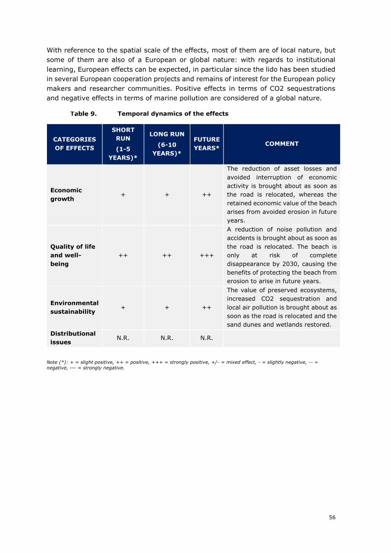
56
With reference to the spatial scale of the effects, most of them are of local nature, but
some of them are also of a European or global nature: with regards to institutional
learning, European effects can be expected, in particular since the lido has been studied
in several European cooperation projects and remains of interest for the European policy
makers and researcher communities. Positive effects in terms of CO2 sequestrations
and negative effects in terms of marine pollution are considered of a global nature.
Temporal dynamics of the effects
CATEGORIES
OF EFFECTS
SHORT
RUN
(1-5
YEARS)*
LONG RUN
(6-10
YEARS)*
FUTURE
YEARS* COMMENT
Economic
growth + + ++
The reduction of asset losses and
avoided interruption of economic
activity is brought about as soon as
the road is relocated, whereas the
retained economic value of the beach
arises from avoided erosion in future
years.
Quality of life
and well-
being
++ ++ +++
A reduction of noise pollution and
accidents is brought about as soon as
the road is relocated. The beach is
only at risk of complete
disappearance by 2030, causing the
benefits of protecting the beach from
erosion to arise in future years.
Environmental
sustainability + + ++
The value of preserved ecosystems,
increased CO2 sequestration and
local air pollution is brought about as
soon as the road is relocated and the
sand dunes and wetlands restored.
Distributional
issues N.R. N.R. N.R.
Note (*): + = slight positive, ++ = positive, +++ = strongly positive, +/- = mixed effect, - = slightly negative, -- =
negative, --- = strongly negative.

57
4. MECHANISMS AND DETERMINANTS OF THE OBSERVED
PERFORMANCE
In this section the key mechanisms and determinants of the long-term effects discussed
in the previous chapter are illustrated and discussed along the different phases of
the project cycle. The relative importance of each determinant for the project’s
final performance and the interplay between them and the observed outcomes is
discussed.
Determinants of project outcomes
DETERMINANT STRENGTH*
Relation with the context +4
Selection process +2
Project design +5
Forecasting capacity 0
Project governance +1
Managerial capacity +5
Note: * the strength score reflects the weight of the role that each determinant played with respect to the final judgment of
the project. In particular:
-5 = the determinant is responsible of the negative performance of the project;
-4 = the determinant provides a negative contribution to the overall performance of the project; -3 = the determinant contributes in a moderate negative way to the overall performance of the project;
-2 = the determinant has a slightly negative contribution to the project performance;
-1 = the determinant plays a negative but almost negligible role to explain the overall project performance; 0 = the
determinant does not play a role on the project performance;
+1= the determinant plays a positive but almost negligible role to explain the overall project performance; +2 = the
determinant has a slightly positive contribution to the project performance;
+3 = the determinant contributes in a moderate positive way to the performance;
+4 = the determinant provides a positive contribution to the overall performance of the project;
+5 = the determinant is responsible of the positive performance of the project.
RELATION WITH THE CONTEXT
Section 1 above presented in some detail the main elements of context for this
project. This section is organised around the same topics:
✓ Ecological and economical stakes on the lido:
Ecological stakes at hand on the lido were adequately taken into account in early
phases of the project. There was high awareness among all stakeholders involved in
the project that the destruction of the dune cord was not only detrimental in terms of
erosion, but that it also constituted an environmental loss, which needed to be
remedied.
The economic context was also correctly taken into account. Despite the fact that
several economic activities are mentioned in the major project application, the biggest
concern for the project promoter was tourism. Indeed, if threats on aquaculture in the
Thau lagoon and threats on economic activities operating on the lido (vineyard and
bottling company) can only be considered long term, the likely disappearance of the
coastal road in the short-term and the shrinking beach were putting at risk the whole
economy of the area. Maintaining tourism flows can be considered as one of the main
motives to act for the project promoter.
58
One may regret, though, that in the major project application, risks to economic
activities were not presented in a more granular way: indeed, it could have been made
clearer that risk was assessed short to medium term on tourism, whereas no short to
medium term risks seems to exist on aquaculture (according to interviews, risks would
exist if one considers a project lifespan of more than 100 years116).
✓ Natural risks faced by the lido
Natural risks were at the heart of the lido project. Yet one may regret that at the
time of preparing the project, a more detailed assessment of the levels of risk and
of their probability of occurrence was not carried out. Indeed, if some risks were
nearly certain to materialize in the short-term (disappearance of the road and of the
beach on the most fragile area of the coastline), others were and can still be considered
much longer term (risk of disappearance of the lagoon and of the aquaculture activities,
risk to the railway line). The major project application does make it very clear which
risks were taken into account and at which level.
From interviews, it seems the immediate threat to the road and the beach was perceived
by all stakeholders as already fully justifying the lido project, making it somehow
redundant to present and assess all other risks faced by the lido. Following this line of
reasoning, only short to medium term risks were included in the ex-post cost-benefit
analysis. This conservative approach still produced a positive net present value.
However, in the ex ante phase, a more precise estimation and presentation of all risks
(both short term and long term) and their likelihood of realisation would have been
welcome for a project, whose main aim is to mitigate risks. Indeed, an accurate
assessment and a clear presentation of the risk context would have made it possible to
have a more precise picture as to the level of damages avoided.
✓ Other problems faced by the lido
As described in section 1.1 above, the lido was facing a number of man-made issues,
which had a direct impact on people’s life in the area (anarchical parking, pollution,
noise, accidents...) and were considered by local stakeholders as negative in terms of
image for the Sète area. For the municipalities of Sète and Marseillan and the Urban
Community, the need to solve the other problems was therefore high on the agenda.
To some extent, a project which would have addressed the erosion issues, but which
would not have tackled the other problems, was not conceivable. From that point of
view, one of the strengths of the lido project, is that it provides answers to both the
natural and to the other problems faced by the lido. The ex-post CBA also shows that
an important part of the quantifiable benefits which arise from the project arise from
solving the other problems faced by the lido.
✓ Elements of context related to the Sète area
As described in section 1.1 above, the lido project was launched at about the same time
as the construction of a new neighbourhood on the edge of the city of ‘Sète’ close
to the weakest area of the lido. Even if this point is not mentioned in any of the planning
documents for the project, a connection can be made: the new neighbourhood is located
116 Interview with EID, DREAL
59
in an area where erosion trends are high117. These trends have less materialized so far,
because protections were constructed at sea in the 1980s.118 However, in the
absence of protections, this area would be vulnerable to erosion as well. To some extent,
this made the project even more necessary, since the project is indirectly going to
protect the new neighbourhood. However, this shows a lack of coherence of
public policies in the area (see also section 4 below on the project governance and
section 5.1 below on coherence).
To sum it up, the project was appropriate to the ecological, economical and social
contexts and it will remain relevant over years. It was also adequate to the
natural risks context, even if the likelihood of occurrence of risks and the scale of
damages to be expected could have been better documented in the major project
application. In fact, depending on the level of damages avoided, the economic net
present value varies significantly – even if in all cases it remains positive. The
construction of the new neighbourhood, even if disputable from the perspective of good
governance (see also the sub-section on project governance), makes the project even
more context-relevant in the long-run.
SELECTION PROCESS
As stated in section 2.1, the institutional process that led to the selection of this
project for national and EU funding was driven by the ‘Mission littorale’ as part
of a State-led effort to assess in a consistent manner the situation of the whole coastline,
to reflect about strategies to be applied across the board and to define priorities.
The selection process was based on a two-pronged analysis119:
• First, a study-based analysis of the coastal erosion hazard and risk
assessment, taking into account natural and other risks, which resulted in
a mapping of the level of risk for each sector of the coastline (including 6
available studies from both academic and public sector origins);
• Second, a multi-criteria mapping of the stakes pertaining to each coastline
sector along two axis: its socio-economic value and its environmental and
cultural significance; the socio-economic value attached to a specific sector
relates to the renewal costs for replacing damaged or destroyed facilities
weighted by their social impact (i.e. beach public attendance), it comprises items
ranging from housing density to the existence of public facilities or industrial and
economic activities; the environmental and cultural value of a sector took into
account 7 factors such as the existence of protected areas, the importance of
specific natural habitat or the presence of historic or archaeological sites.
117 See, for instance erosion maps here : http://littoral.languedocroussillon.fr/Actualisation-de-l-alea-
erosion.html 118 Source : interview with BRGM 119 Mission interministérielle d’aménagement du territoire, 2003. Orientations stratégiques pour la gestion de
l’érosion en Languedoc-Roussillon
60
As a result, a ranking of the coastline sectors’ value according to their relative
exposure to erosion-risk and their socio-economic and environmental significance was
discussed and established by ‘Mission littorale’.
Overall, this selection process seems well-designed and coherent: it was based
on a coherent and comprehensive assessment of the coastline as a whole and it relied
on a broad range of criteria, including the economic, social, environmental and cultural
value of each sector. However, this finding comes with some caveats: ‘Mission littorale’
was an ad hoc exercise which no longer exists. Accordingly, no interview could be
conducted during the field visit with any of its former members. In the same way, with
changes in the EU managing authority, no interview could be carried out with persons;
who took part in the selection of the lido project for EU co-financing. In addition, the
detailed scoring obtained by each project could not be reviewed. Since the major project
application does not present the results of the scoring, it is difficult to fully conclude on
the adequacy of the selection process.
Finally, alternative incentives for project selection may have had a sway in the
ranking process, namely: the lido was ‘ripe’ compared to other projects on the coastline
(preliminary studies were already available) and it benefited from strong local
support120. As a comparison, on another priority section selected by ‘Mission littorale’,
in the ‘Vias’ sector, a relocation project is still pending, due to financial and legal
difficulties linked with the scale of housing and economic assets displacement needed121.
It is therefore possible that the highest priority given to the lido project in ‘Mission
littorale’s works was also partly influenced by these context elements.
In addition, in the strategy of ‘Mission littorale’, the lido project is described as the first
possibility to test the ‘strategic relocation’ strategy instead of defending assets122.
During interviews, the lido project was also described by several actors as presenting
favourable grounds to test innovative tools (i.e. sector with economic assets, but where
the relocation would only concern a road, and where neither housing nor significant
economic assets would have to be displaced).
120 Source: interview with the Regional Council and DREAL 121 According to interviews, EUR 30 million will be necessary only for expropriations and with without counting
legal and social difficulties. 122 Mission interministérielle d’aménagement du territoire, 2003. Orientations stratégiques pour la gestion de
l’érosion en Languedoc-Roussillon
61
Overall, the following conclusion can be drawn: the selection process was based on the
right level of analysis and adequate criteria, namely, the whole coastline has been
assessed and several socio-economic criteria were used. Yet, it is likely that a number
of additional elements also played a role in the selection (local support, willingness
to test the ‘relocation’ strategy, willingness to find a suitable place for testing innovative
tools). These are not assessed as having a critical impact on the effectiveness of
the selection process: all urgent and valuable projects seem to have been selected.
The lido project may have benefited from an additional push, due to its short-term
feasibility and its favourable ground for testing.
PROJECT DESIGN
Main elements of the project’s design are presented in sections 1.3 and 2.2 above. As
above, this section will discuss both the project’s design, for the land phase and for the
maritime phase.
✓ Design of the land phase:
With the preliminary studies123, showing that, in the absence of action, the road’s
existence was threatened in the short-run, the ‘do nothing scenario’ was not
considered appropriate124. Indeed, as explained in section 1.1 above, the absence of
action in the short-run, the road would have been disrupted with a severe impact
on the local economic life. This option was a non-starter for local actors. This is
considered reasonable.
Two main options were therefore studied in the land phase:
1. Maintaining the road in its former location on the beach; and
2. Displacing the road further inland, close to the railway line
The option to keep the coastal road in place was assessed by BCEOM. According to
this study, maintaining the road in its former location would have required: the
reinforcement of embankments (rocks) and the construction of protection at sea
(breakwaters)125. In addition, regular reloading of sand would have been necessary.
With the refusal of state services to validate a solution involving breakwaters
due to their potential negative effect further downstream, this option was dismissed.
123 BCEOM, Ville de Sète, 2001. Etude générale pour la protection et l’aménagement durable du lido de Sète
à Marseillan and Urbanis, 2003. Protection and durable installation of the lido from Sète to Marseillan, definition of the general programme and set-up of the operation 124 See also the ex-ante cost-benefit analysis 125 BCEOM, Ville de Sète, 2001. Etude générale pour la protection et l’aménagement durable du lido de Sète
à Marseillan and Urbanis, 2003. Protection and durable installation of the lido from Sète to Marseillan, definition of the general programme and set-up of the operation
62
The option to displace the road was clearly the preferred option by local
stakeholders. Yet, in the case of the lido de Sète, this design is also the one which
made most sense: the option to remove the road from the beach and to relocate it
further inland, was the only option which enabled to 1/ restore a dune cord and give it
the possibility to play its natural role against erosion again and 2/ enable a
reorganization of the lido to also tackle the other problems.
The option to relocate the road only on the first section of the lido, i.e. close to
Sète where it was most fragile, was not assessed despite the fact that this option
corresponds to a ‘do minimum’ scenario. Indeed, it would have enabled to keep a
functional coastal road and railway, which were main objectives of stakeholders.
However, this option would have addressed neither the issues of the beach erosion (and
the corresponding expected reduction of tourism flows) nor the other problems faced
by the lido. In the CBA, where this ‘do minimum’ option is retained as counterfactual
scenario, it clearly falls short of providing as much benefits as the option retained.
Overall, the design chosen for the land phase therefore appears to be the best
one.
✓ Design of the maritime phase:
Several designs were considered for the maritime phase as well:
• The construction of groynes: A groyne is an active structure extending from the
shore into the sea, perpendicular or slightly oblique to the shoreline. Adequate
supply of sand and existence of some sediment transport are major conditions
for groynes’ effectiveness. This was not the case on the lido, therefore this option
was not considered appropriate for the lido case. In addition, this technique,
despite reducing erosion, would have made it difficult to keep a beach on the lido
in the long-term, which was also an absolute priority for local stakeholders126.
• Another design which was considered was the construction of breakwaters at
sea. This was the initial design choses by the Urban Community of Sète127. The
URBANIS study proposes several options as to the concrete design of these
breakwaters for the lido128.
Yet, following ‘Mission littorale’, the installation of hard infrastructure was not the
preferred option anymore, since it involved a risk of disrupting the coastal
functioning further downstream. In addition, new technologies were available.
In 2006, the decision therefore was taken to test the innovative wave attenuator instead
of the breakwaters. A posteriori, and despite problems in the testing phases, this
126 BCEOM, Ville de Sète, 2001. Etude générale pour la protection et l’aménagement durable du lido de Sète
à Marseillan and Urbanis, 2003. Protection and durable installation of the lido from Sète to Marseillan, definition of the general programme and set-up of the operation, page 22 127 Sète Agglopôle 128 Urbanis, 2003. Protection and durable installation of the lido from Sète to Marseillan, definition of the
general programme and set-up of the operation
63
appears to be the right choice. Not only has the wave attenuator been successful in
reducing erosion, but it has also proved interesting research and testing ground.
With regards to design of another part of the maritime project, the ‘ecoplage system’,
despite its clear failure, no evidence could be gathered that the ‘ecoplage’ failure
was due to a design fallacy.
In fact, as one interviewee stressed:
“We are all cleverer afterwards. At the time when the decision
was taken to test the ‘ecoplage’ system, there was no reason
to believe that it would not work on the lido. At the time, all
the stakeholders in the technical committee responsible for
overseeing project implementation agreed that it was worth
testing it. If failure is not an option, one does never carry out
any innovative project”129.
In addition, the ‘ecoplage’ system was correctly monitored130 and the decision to
interrupt the testing was taken in a timely manner. From that point of view there
is no evidence pointing at a faulty design for the ‘ecoplage’ part of the maritime phase.
All in all, the design of the maritime phase appears to be appropriate and innovative.
It is considered an important strength of the project.
FORECASTING CAPACITY
All the stakeholders met in the framework of this study, including scientists, pointed out
that forecasting erosion trends and natural hazards is a challenge. Concluding
on whether erosion forecasting was done correctly or not is therefore a delicate
matter. Yet, the following elements can be highlighted:
• Forecasting of erosion trends was done at the time in the framework of
‘Mission littorale’ and it continues to be done in the framework of regional
works131: for example, maps presenting the evolution of the coastline up to 2060
and 2100 with and without protections were prepared by the public research
institute BRGM132 (These maps were used to prepare the counterfactual scenario
for this case study). There is consensus that erosion trends would have
continued, especially on the most fragile part of the coastline close to Sète133,
even if the pace of this erosion is not fully clear.
129 Interview with the Department 130 The monitoring was done by BRGM. 131 See for instance the department contract with EID for coastline monitoring 132 See http://littoral-lro.brgm.fr/?page=carto&mapid=11 133 Source: all interviews. No one mentioned doubts on this point.
64
• More limited forecasting of other risks (sea-submersion, risk of groin
opening) was done at the time134. Yet, one also has to acknowledge that these
topics were probably less on the agenda at the time than now. One must regret
though, that with only limited forecasting done concerning these risks, they were
mentioned in the major project application without detailed explanations as to
their probability of occurrence and likely impact within the timeframe in
consideration for the major project135. For example, there is no evidence that
aquaculture in the Thau lagoon is threatened in the timeframe of this project.
Yet, maintaining economic activity, including aquaculture in the Thau lagoon was
mentioned as one of the project’s goal in the major project application.
• The number of visitors on the lido was not studied in a detailed way. Yet,
the need to maintain tourism flows on the lido was high up in the project
beneficiary’s mind and it is an important effect of the project. According to results
of later studies, the number of visitors on the lido was overestimated in 2002
(see section 1.1 above). This was due to the fact that the total number of visitors
on the lido beach was extrapolated using counts realised in a single month
(August 2002).
On the ‘cost’ side on the project, the actual level of expenditure incurred is quite close
to initial forecasts136. No significant cost overruns have been incurred, and this
despite the fact that several of the systems tested in the framework of the maritime
phase were innovative tools.
Overall, the forecasting capacity is considered to be mixed: forecasting was
carried out and there is consensus that short-term risks existed on the road and on the
beach in the weakest spot of the lido. Longer-term risks to be avoided could have been
either described in a more granular way in the major project application and forecasting
concerning the demand side (beach goers) could have been more precise. Overall, this
did not disproportionally affect project performance, since the design chosen was
adequate to mitigate both short-term and long-term risks and the project presents a
positive economic net present value, even without taking into account long-term risks
mitigated by the project.
PROJECT GOVERNANCE
Main stakeholders involved in this project are local stakeholders (the cities of Sète and
Marseillan and the Urban Community of Sète), regional stakeholders (the Regional
Council and the Department) and devolved services of the central state (the
environment services - DREAL, a Sous-Préfet du littoral, and the financing body
FNADT137).
134 Interview with EID and BRGM 135 Source: authors, based on interviews with EID, BRGM and the Thau basin Syndicat 136 This assessment is without regards to the caveat mentioned in section 2.2 above, namely:
It has to be noted that since the lido project is still ongoing, the beneficiary had not yet prepared a final calculation of the overall expenditure incurred in the framework of the lido project. If the amounts of grants received are closely followed by the beneficiary and were easily to be collected, the final amount of expenditures to be attributed to the project could not be obtained from the beneficiary. The above figures had to be recalculated based on expenditures presented by the beneficiary to the various cofinancers. There is therefore a risk that additional expenditure was incurred but not presented to cofinancers. 137 Fonds National d’Aménagement du Territoire
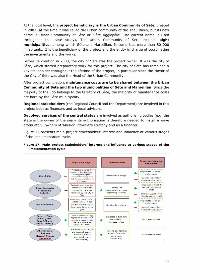
65
At the local level, the project beneficiary is the Urban Community of Sète, created
in 2003 (at the time it was called the Urban community of the Thau Basin, but its new
name is Urban Community of Sète or ‘Sète Agglopôle’. The current name is used
throughout this case study). The Urban Community of Sète includes eight
municipalities, among which Sète and Marseillan. It comprises more than 80 000
inhabitants. It is the beneficiary of the project and the entity in charge of coordinating
the investments and the works.
Before its creation in 2003, the city of Sète was the project owner. It was the city of
Sète, which started preparatory work for this project. The city of Sète has remained a
key stakeholder throughout the lifetime of the project, in particular since the Mayor of
the City of Sète was also the Head of the Urban Community.
After project completion, maintenance costs are to be shared between the Urban
Community of Sète and the two municipalities of Sète and Marseillan. Since the
majority of the lido belongs to the territory of Sète, the majority of maintenance costs
are born by the Sète municipality.
Regional stakeholders (the Regional Council and the Department) are involved in this
project both as financers and as local advisers.
Devolved services of the central states are involved as authorising bodies (e.g. the
state is the owner of the sea – its authorisation is therefore needed to install a wave
attenuator), owners of ‘Mission littorale’’s strategy and as a financer.
Figure 17 presents main project stakeholders’ interest and influence at various stages
of the implementation cycle.
Figure 17. Main project stakeholders’ interest and influence at various stages of the
implementation cycle
66
Source: author’s
Based on this description, there is a number of elements of good governance in
this project: external actors (in particular devolved services of the state, but also
the Regional Council and the department) played an active role in ensuring a balanced
design of the project. Testing phases which were imposed by technical services of the
state also proved to be effective in reducing a possible waste of resources (i.e. the
‘ecoplage’ system could be stopped on time, damages on the wave attenuator could be
reduced, since only part of the system was deployed in the first place). In addition,
governance bodies were created. This is the case, for example of the quarterly
technical committee, which was in charge of overseeing project
implementation and which took critical decisions138;
The involvement of the scientific community also proved to be a positive element of
governance139; in particular when it came to designing the details of the geotubes and
to find solutions to failures encountered during the testing phase.
On the other hand, a significant governance issue can be identified at local level:
the City of Sète which was the initial project owner and which remained a key
stakeholder after the creation of the Urban Community, had a strong interest in making
sure that the construction of the new neighbourhood close to the lido could take
place. It is unclear to what extent the urban development project was made possible
thanks to the implementation of the lido project, which protected the area close to the
new neighbourhood from erosion.
However, as one interviewee remarked:
“Projects to protect the coastline against erosion are meant
to protect existing assets, but better protection against
erosion is not meant to enable the construction of new assets,
which are ultimately going to be at risk140”.
In addition, another uncertainty exists concerning current and future governance of the
ex-post operation and maintenance of the project. As it is noted in section 2.3 above,
the operation of the wave attenuator system has proved more expensive than initially
thought. This is partly assessed as being due to the necessary learning process as to
how such a system should be maintained; but there is a risk that significant costs remain
to be borne by the Urban Community of Sète and the two cities of Sète and Marseillan.
So far, agreements concerning the repartition of maintenance costs between the three
bodies could be found, however this will need to be monitored.
Overall project governance is considered mixed. Where direct project governance
is good, there are mixed incentives at local level, which led to the construction of a new
neighbourhood close to the area, which is most at risk of erosion. Thanks to the
completion of the lido project, there is no immediate risk on the new neighbourhood.
However, the construction of a new neighbourhood close to an area, where heavy works
are undertaken to reduce erosion is considered a dysfunction in local governance.
138 For example, the decision to test innovative soft methods and the decision to stop the ecoplage testing. 139 Notably EID and BRGM 140 Opinion shared by various interviewees.
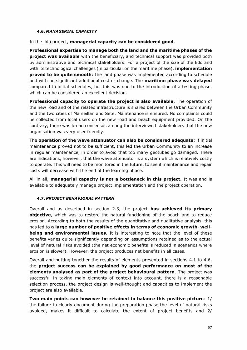
67
MANAGERIAL CAPACITY
In the lido project, managerial capacity can be considered good.
Professional expertise to manage both the land and the maritime phases of the
project was available with the beneficiary, and technical support was provided both
by administrative and technical stakeholders. For a project of the size of the lido and
with its technological challenges (in particular on the maritime phase), implementation
proved to be quite smooth: the land phase was implemented according to schedule
and with no significant additional cost or change. The maritime phase was delayed
compared to initial schedules, but this was due to the introduction of a testing phase,
which can be considered an excellent decision.
Professional capacity to operate the project is also available. The operation of
the new road and of the related infrastructure is shared between the Urban Community
and the two cities of Marseillan and Sète. Maintenance is ensured. No complaints could
be collected from local users on the new road and beach equipment provided. On the
contrary, there was broad consensus among the interviewed stakeholders that the new
organisation was very user friendly.
The operation of the wave attenuator can also be considered adequate: if initial
maintenance proved not to be sufficient, this led the Urban Community to an increase
in regular maintenance, in order to avoid that too many geotubes go damaged. There
are indications, however, that the wave attenuator is a system which is relatively costly
to operate. This will need to be monitored in the future, to see if maintenance and repair
costs will decrease with the end of the learning phase.
All in all, managerial capacity is not a bottleneck in this project. It was and is
available to adequately manage project implementation and the project operation.
PROJECT BEHAVIORAL PATTERN
Overall and as described in section 2.3, the project has achieved its primary
objective, which was to restore the natural functioning of the beach and to reduce
erosion. According to both the results of the quantitative and qualitative analysis, this
has led to a large number of positive effects in terms of economic growth, well-
being and environmental issues. It is interesting to note that the level of these
benefits varies quite significantly depending on assumptions retained as to the actual
level of natural risks avoided (the net economic benefits is reduced in scenarios where
erosion is slower). However, the project produces net benefits in all cases.
Overall and putting together the results of elements presented in sections 4.1 to 4.6,
the project success can be explained by good performance on most of the
elements analysed as part of the project behavioural pattern. The project was
successful in taking main elements of context into account, there is a reasonable
selection process, the project design is well-thought and capacities to implement the
project are also available.
Two main points can however be retained to balance this positive picture: 1/
the failure to clearly document during the preparation phase the level of natural risks
avoided, makes it difficult to calculate the extent of project benefits and 2/
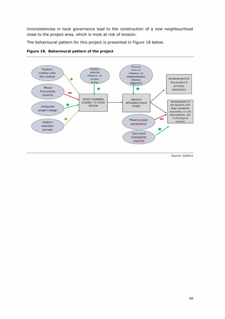
68
inconsistencies in local governance lead to the construction of a new neighbourhood
close to the project area, which is most at risk of erosion.
The behavioural pattern for this project is presented in Figure 18 below.
Figure 18. Behavioural pattern of the project
Source: Authors
69
5. FINAL ASSESSMENT
This section provides the final assessment of the project performance based on the
different findings produced by the project analysis both in terms of effects produced
by the project and measured through the CBA or the qualitative scoring
system, and the causal chain explaining the behaviour of the project in time.
Specifically, such assessment has been conducted through a structured set of evaluation
criteria, i.e. relevance, coherence, effectiveness, efficiency, EU added value. The
evaluation questions for each criterion are specified in the evaluation matrix presented
hereafter, which guides the final assessment.
PROJECT RELEVANCE AND COHERENCE
As explained above, the lido project is a multifaceted project, with multiple aims and
multiple components. This is considered mainly a strength, since the project is
relevant to both natural risks and the other problems faced by the lido. In
addition, the ecological and economical context of the lido were also taken into account
when designing the project.
The project was in line with European and national recommendations on erosion: it was
the first project on the Languedoc-Roussillon coastline to implement the recommended
strategy of relocating assets in the hinterland, instead of protecting them against
erosion at all cost (in this case, it was the road, which was relocated behind a restored
dune cord). The overall approach taken of relocating assets, instead of defending the
coastline at all costs is also in line with EU recommendations and good practices in this
area.
Relative weakness in the initial assessment of natural risks faced by the lido makes it
difficult to assess the level to which the project is relevant. Indeed, the level of
relevance of the project depends partly on the speed of coastal erosion and of the
occurrence of natural hazards in the area: if erosion trends continue at the same pace
than in the past or even increase on the lido, the relevance of the project will be
maximum (benefits may be higher than shown in the ex-post quantification realised in
the framework of this case study). Conversely, the stabilisation or the reduction of
erosion trends would reduce its overall relevance. It is interesting to note, however,
that, overall and in accordance with results of the ex-post CBA, the project appears to
keep net benefits, even in scenarios where erosion trends happen at a slower pace141.
Despite some uncertainty as to the level of relevance, it can therefore be
concluded that the project remains relevant to the natural risks context in all
scenarios.
The project’s relevance to the other problems faced by the lido is also
considered to be very high: the user experience on the road and the beach following
the project has been completely changed, with consensus among all actors interviewed
that the design of the new lido is a great success.
Overall, the design chosen enables to reach maximum coherence between actions
undertaken to address the natural issues faced by the lido and the other problems faced
141 For example, in a scenario, where only 80% of the beach is eroded by 2050 (i.e. erosion happens at a
slower pace) the project keeps positive net benefits
70
by the lido: in the ‘do the minimum’ scenario, which was retained for the counterfactual
scenario, the most pressing natural risks are tackled, but none of the positive
externalities concerning the other problems can be reached. Yet, the results of the ex-
post CBA show that solutions provided to the other problems (for example, reduction of
noise and air pollution affecting the city of Marseillan, reduction of accidents) are
important quantifiable benefits of the overall project.
In terms of internal coherence, the project components were consistent with
the stated objectives. Moreover, the project was in line with the objectives of the new
national strategy, which aimed at reducing erosion using ‘soft’ methods, instead of
building hard infrastructure at sea, which involve the risk to disrupt the coastline further
downstream.
In terms of external coherence, there is a major issue affecting the coherence of
public policies in the area, namely, the construction at the edge of the city of Sète,
on a former wet-land of a new neighbourhood, which is located very close to the most
fragile end of the lido. This made the lido project even more ‘necessary’ to some extent,
even if, as pointed out in several interviews, protections should be envisaged when
existing assets, which are difficult and costly to relocate are threatened; the construction
of new protections are not meant at enabling new constructions, which in the absence
of protections would be threatened by natural hazards. From this point of view there is
a substantial lack of coherence on public policies.
Coherence on the environmental side of the project is better: the initial aim to
better protect the lido’s natural spaces can be considered achieved: dunes have been
restored to their pre-road normal existence, with all the positive externalities related to
the provision of habitat for the local fauna and flora. Public policies can be considered
fully consistent in this area, since the Coastal Conservation Authority has bought
hundreds of hectares of land on the lido in order to ensure their protection. The Coastal
Conservation Authority’s strategy includes the objective to protect the entirety of the
lido, if necessary, by buying relevant land.
PROJECT EFFECTIVENESS
The objectives stated in the major project application have been achieved,
namely to restore a normal functioning of the coastline and ensure a better protection
against erosion, while maintaining the mobility function of the coastal road and
maintaining local economic activities. Environmental objectives of restoring the dune
cord to its natural shape and of protecting the lido’s biodiversity was reached too.
It is interesting to note that the number of project benefits is important for this project.
Indeed, the main quantifiable benefit of the project - the sustained flow of beach visitors
resulting from decreased beach erosion, varies quite significantly depending on
assumptions retained as to the level and speed of beach erosion. Yet, even in scenarios
where the beach erodes at a slower pace than retained in the ex-post quantification,
the socio-economic net present value of the lido project to remains positive.
This is also due to the fact that most of the other quantifiable benefits (reduction of road
accidents, reduction in levels of noise and air pollution, reduction in interruption of
economic activity) take place disregarding the level of natural risks realisation.
71
Concerning distributional issues, however, there is no evidence that the project has
had an impact on territorial or cohesion issues.
Finally, the project can also be considered a technological success and a landmark into
the context of a wider policy shift toward the implementation of new, softer, techniques
to fight erosion.
PROJECT EFFICIENCY
The project implementation went overall smoothly and did not suffer from
excessive delays and cost overruns. The maritime phase of the project lasted longer
than envisaged in the major project application, but the delay was due to introduction
of a three-year testing phase, which proved to be an excellent decision. Indeed, one of
the innovations tested, the ‘ecoplage’ system, proved ineffective on the lido and its
deployment could be interrupted on time. The second innovation, the wave attenuator,
only proved to be working after initial design issues could be solved. Overall, a full
deployment of the two innovations without testing phase would have led to a net loss.
Against a total initial investment cost of EUR 51.1 million (VAT excluded), the project
produces a net socioeconomic contribution to society until the assumed last year of the
project time horizon (2050), of EUR 95.8 million, with the applied discount rates of
2.78% backward and 3.69% forward, whereas the Economic Internal Rate of Return is
at the level of 8.08%. The main economic benefits produced by the project consist
in the sustained flow of beach visitors resulting from decreased beach erosion and in
the reduction of direct interruption of economic activity due to natural hazards. The
project also has environmental benefits, mainly in terms of preservation of ecosystems
and carbon sequestration. Due to its second component addressing other problems of
the lido, the project has also large co-benefits, ranging from a reduction of road
accidents, to a reduction of levels of noise and pollution for the City of Marseillan (new
bypass).
Concerning the overall cost incurred for the project, due to the sequencing of the overall
project, it is still too early to provide a final analysis. However, at the time of the
preparation of this report in December 2018, total cost incurred as presented to the
various co-financers was EUR 51,1 million, compared to a total cost planned in the major
project application of EUR 55,1 million (without VAT and in nominal terms). No major
cost slippage has therefore been incurred until December 2018. There is no reason
to believe that major cost-overrun will take place in the current last phase, involving
the final deployment of geotubes.
Overall, value for money can be considered good: evidence show that alternative
designs could not have reached the same level of outputs in a cheaper way. The project
design chosen, despite being more expensive than other options, enables to reach
numerous co-benefits. The relationship between the outputs produced and the
resources to produce them appears to be good.
The financial sustainability of the project during the project investment was guaranteed
by the funds provided by a mix of sources: the European Union, the State, the Region,
the Department and the Urban Community of Sète. On the contrary and as described in
section 4.5 above, maintenance costs are shared between the Urban Community of
Sète, the City of Sète and the City of Marseillan. These maintenance costs are covered
72
using the normal operating budgets of these entities. Some revenues are also generated
by the beach in the form of concessions granted by the Cities of Sète and Marseillan to
restaurants and nautical shops on the beach.
Compared to other solutions to fight erosion (e.g. the construction of hard
infrastructure), it has to be noted that the wave attenuator has significant maintenance
and replacement costs: regular maintenance costs about EUR 50,000 per year;
whereas EUR 450,000 were incurred between 2013 and 2018 to replace broken
geotubes. However, following an initial learning phase with this new system, costs linked
to the replacement of broken geotubes is expected to go down. Indeed, regular
maintenance has been increased compared to early phases of the project (to reach the
current EUR 50,000 per year). This increase in regular maintenance is expected to
enable issues to be detected in a more effective way and thereby to reduce the need to
replace broken geotubes completely.
All in all and factoring in reduced maintenance costs on other aspects (maintenance
costs of the road, cleaning the beach, etc.) maintenance costs of the lido do not
appear to have increased in an excessive way. Financial sustainability of
maintenance costs in the long run in ensured by their inclusion in the normal budgetary
procedures of the Cities of Sète and Marseillan and of the Urban Community of Sète.
EU ADDED VALUE
Overall, the EU added-value of this project can be considered high, based on the
following elements:
• The lido project is the first project in the region, which implements a new
approach to coastal risks (strategic relocation). This new approach can also be
considered partly the result of various European-wide cooperation
projects (including the MESSINA and the EROSION projects).
• The ex-ante cost-benefit analysis, which was carried out before the project, was
the first CBA implemented for a project of that type in the region. It involved
cooperation between Sète Agglopôle and Commission services, and in
particular DG REGIO;
• The decision to grant EU funds to the project acted as a leverage to pool
support from further local, regional and national financers.142 It is difficult
to conclude whether the project would or would not have been carried out
without the EU co-financing. On the one hand, with the EU co-financing
representing only about a fifth of total cost, it is reasonable to argue that the
project could have been financed with national and local money alone. On the
other hand, it was clear from interviews that the decision to grant EU funds to
the project acted as a leverage to pool support from further local, regional and
national financers;
• The decision to implement an innovative technical solution, namely the wave-
attenuator attracted a large interest from scientific communities across
Europe. Several spin-off research projects involving European partners are now
being implemented143.
142 Source: interview with Sète Agglopôle and regional financers 143 Source: interview with the Department
73
Finally, the issues at stake in this project are of high importance for the European Union
as a whole in future years. Indeed, many countries are faced with significant erosion
issues on their coastline and natural risks related to climate change and the rise of sea
levels will be high on the European agenda. Further EU action on related topics will
be necessary in future years and lessons from this project, both on the negative and
on the positive side, will be helpful to design better projects to either protect EU
coastlines or to relocate assets to the hinterland.
FINAL ASSESSMENT
The following table summarises the final assessment of the project along the five
evaluation criteria previously discussed. Overall, the project is considered a success. It
suffered from a number of infancy diseases, in particular sub-optimal forecasting of
natural risks, their probability of occurrence and their likely impact, and some optimism
bias on the demand side (in term of projecting beach visitors). Yet, a project design
addressing both natural issues and other problems faced by the lido coupled with outside
influence ensured that the project design chosen enabled to reach long-term
effectiveness.
There is, however, a major external coherence issues, since the risk mitigating lido
project was implemented in parallel to a new urban development project in an area at
risk of erosion.
Thanks to managerial capacity, project implementation proceeded smoothly, despite
delays linked to the introduction of a three-year testing phase for the new maritime
systems. The project also proved to be efficient in the use of public resources, with no
significant cost overrun incurred until December 2018. Some concerns remain as to
the cost of operating the new wave attenuator, which are higher than initially
forecasted. Yet, financial sustainability is ensured in the long-run since maintenance
costs of the restored beach and dunes and of the wave attenuators are covered by the
operating budgets of the Urban Community of Sète and of the two municipalities of Sète
and Marseillan.
The EU added value can be considered high in this project and in particular, since
European cooperation projects were instrumental in coming up with the new design and
since the ‘EU major project’ label increased the perceived need to be exemplary in the
implementation of the project. To what extent, the project contributes to territorial
cohesion is more difficult to say, but the project did enable to maintain economic
activities on the lido and to improve the citizens’ quality of life, in line with the overall
goals of EU cohesion policy.

74
Evaluation matrix
CRITERION EQ METHODOLOGY ASSESSMENT SCORE
Relevance
• To what extent the original objectives of the examined major project matched: o the existing development needs, o the priorities established at the
programme, national, and/or EU level.
• Where systems guiding the prioritization of individual investment projects within wider sectoral plans in place? Did the selection of the project follow such systems?
Historical reconstruction
The project was and over the years remained fully in line with initial objectives, even if the probability of occurrence of natural risks should have been made clearer in the initial stages of planning.
5
Coherence
• Are the project components in line with the stated project objectives?
• To what extent the examined the project was consistent with other national and/or EU interventions carried out in the same field and in the same area?
• How the synergies with existing investments were ensured?
Historical reconstruction
Partially consistent – there is consistency in terms of public policies to protect the environment, but not in terms of urban development.
3
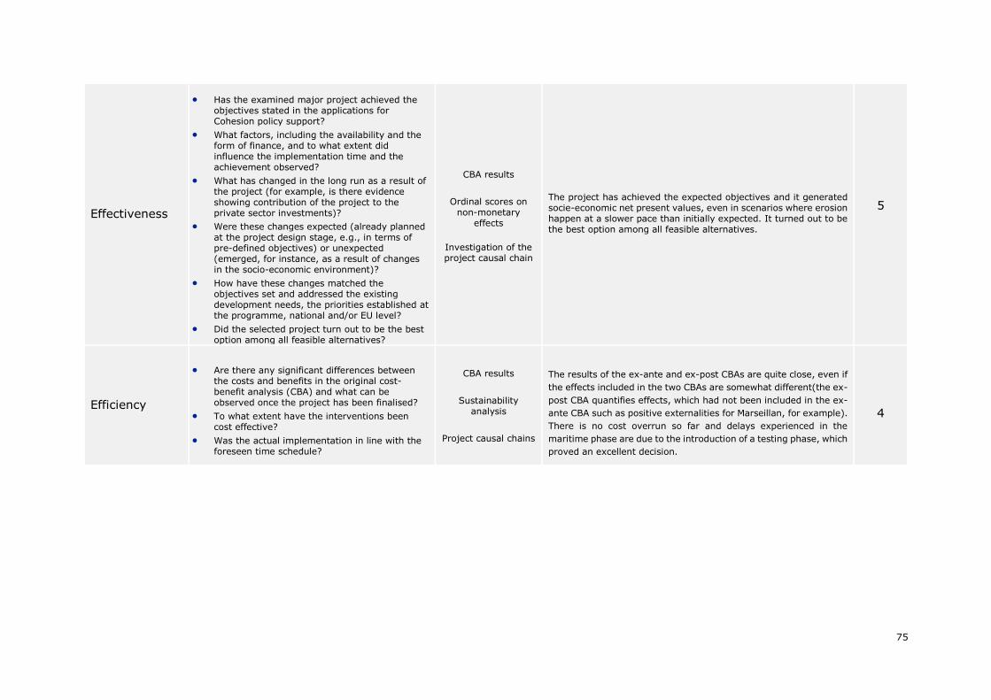
75
Effectiveness
• Has the examined major project achieved the objectives stated in the applications for Cohesion policy support?
• What factors, including the availability and the form of finance, and to what extent did influence the implementation time and the achievement observed?
• What has changed in the long run as a result of the project (for example, is there evidence showing contribution of the project to the private sector investments)?
• Were these changes expected (already planned at the project design stage, e.g., in terms of pre-defined objectives) or unexpected (emerged, for instance, as a result of changes in the socio-economic environment)?
• How have these changes matched the objectives set and addressed the existing development needs, the priorities established at the programme, national and/or EU level?
• Did the selected project turn out to be the best option among all feasible alternatives?
CBA results
Ordinal scores on non-monetary
effects
Investigation of the project causal chain
The project has achieved the expected objectives and it generated socie-economic net present values, even in scenarios where erosion happen at a slower pace than initially expected. It turned out to be the best option among all feasible alternatives.
5
Efficiency
• Are there any significant differences between the costs and benefits in the original cost-benefit analysis (CBA) and what can be observed once the project has been finalised?
• To what extent have the interventions been cost effective?
• Was the actual implementation in line with the foreseen time schedule?
CBA results
Sustainability analysis
Project causal chains
The results of the ex-ante and ex-post CBAs are quite close, even if
the effects included in the two CBAs are somewhat different(the ex-
post CBA quantifies effects, which had not been included in the ex-
ante CBA such as positive externalities for Marseillan, for example).
There is no cost overrun so far and delays experienced in the
maritime phase are due to the introduction of a testing phase, which
proved an excellent decision.
4
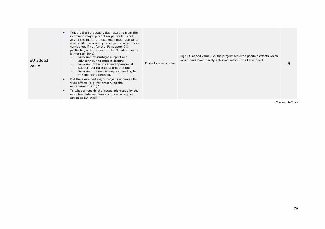
76
EU added
value
• What is the EU added value resulting from the examined major project (in particular, could any of the major projects examined, due to its risk profile, complexity or scope, have not been carried out if not for the EU support)? In particular, which aspect of the EU added value is more evident?: o Provision of strategic support and
advisory during project design; o Provision of technical and operational
support during project preparation; o Provision of financial support leading to
the financing decision.
• Did the examined major projects achieve EU-wide effects (e.g. for preserving the environment, etc.)?
• To what extent do the issues addressed by the examined interventions continue to require action at EU level?
Project causal chains
High EU added value, i.e. the project achieved positive effects which
would have been hardly achieved without the EU support 4
Source: Authors
77
6. CONCLUSIONS AND LESSONS LEARNED
The ex-post evaluation of the major project relating to the protection and sustainable
organisation of the lido from Sète to Marseillan shows that the project was successful
in providing an integrated response to all the challenges faced by the lido. The
results of the ex-post CBA confirm that the project was worth to be implemented from
a socio-economic standpoint. It can be noted, however, that whereas benefits linked to
the other problems revolved on the lido proved higher in the ex-post CBA than in the
ex-ante CBA, some uncertainty remains as to the extent of the net benefits linked with
the interventions to reduce natural risks.
This case study gives the opportunity to draw important lessons of more general
relevance.
• In risk reduction or mitigation projects, the assessment of natural risks
ex-ante is key. Correctly assessing natural risks may be a difficult exercise, in
particular when dealing with risks such as erosion, sea submersion or sea level
rise, which are difficult to predict. Yet, the socio-economic value of risk mitigating
projects is highly dependent on assumptions taken as to the level of risk avoided.
Therefore, it is crucial to recur to risk modelling tools and to systematically collect
information from past impacts. Also, assumptions as to the level of natural risks,
their probability of occurrence and their likely impact should be documented ex-
ante and followed-up during the lifetime of the project to ensure that lessons
from evolving risks can be drawn at all stages of the project lifetime.
• Participation of external stakeholders in the design and implementation
phase of risk mitigating projects can help to reduce local bias. In the lido
project, the involvement of devolved technical services of the State, experts from
the Regional Council and the Department proved important to select the right
design for the project and to ensure a smooth implementation. Yet, when it
comes to the nearby urban development project, one may regret that the local
governance ecosystem did not manage to ensure coherence in public policies on
that point.
• Introducing testing phases, when implementing innovative projects is a
good managerial decision, even if it can lead to delays in project
implementation. In the lido case, the decision to implement a three-year
testing phase did not only enable to avoid the deployment of an innovative tool,
which proved inadequate (the ‘ecoplage’ system), but it also enabled to correct
the design of the wave attenuator before its full deployment, thereby saving
millions of EUR.
• Innovative risk mitigating systems need to be followed up for several
years, before a full picture of their pros and cons can be drawn. The
innovative wave attenuator appears to be a big success. However, there are also
signs that maintenance costs are higher than initially expected. In addition,
additional dragging needs in the port of Marseillan, may indicate that this soft
method to reduce erosion also has an impact on sediment flows. Monitoring will
therefore be important over several years to fully assess the costs and benefits
of the wave attenuator in the long run.
78
• Relocation of economic assets and people are difficult decisions, which
face a lot of contradictory incentives. Even when governance systems
involving stakeholders at various administrative levels are in place, they do not
necessarily reach full coherence (as the urban development project shows). The
continuation of European cooperation projects and exchanges of good practices
in these areas are therefore particularly important to support local decision
makers.
79
ANNEX I. METHODOLOGY OF EVALUATION
This Annex summarises the methodological approach undertaken for carrying out the
project case studies and presented in the First Intermediate Report of this evaluation
study. The main objective is to provide the reader a concise account of the evaluation
framework in order to better understand the value and reach of the results of the
analysis as well as to enable him/her, if interested, to replicate this methodology.
The Annex is divided into four parts, following the four building blocks of the
methodological approach (mapping of effects; measuring the effects; understanding
effects; synthesis and conclusions) laid down in the First Intermediate Report. Three
evaluation questions, included in the ToR, guided the methodological design. They are:
• What kind of long term contribution can be identified for different types of
investment in the environment sector?
• How is this long term contribution generated for different types of
investments, i.e., what is the causal chain between certain short term and log-
term socio-economic returns from investments?
• What is the minimum and average time needed for a given long term
contribution to materialise and stabilise? What are these time spans for different
types of investments in the environment field?
MAPPING THE EFFECTS
The Team developed a classification of long-term effects, with the aim of identifying all
the possible impacts of environmental investments on social welfare. Under four broad
categories, a taxonomy of more specific long-term development effects of investment
projects has been developed. The definition of each type of effect is provided in the
Table below.
Far from being exhaustive, this list is intended to guide the evaluators in identifying, in
a consistent and comparable way, the most relevant effects that are expected to be
identified and included in the analysis. Additional effects could possibly be relevant in
specific cases and, if this is the case, they can be added in the analysis.
In researching all the possible long-term effects of project investments, it is
acknowledged that there could be a risk of duplication. In addition, the allocation of
some effects under different categories is to some extent arbitrary and thus it may
happen that categories overlap. That said, caution will be paid in order to avoid double
counting when performing the ex-post CBA.
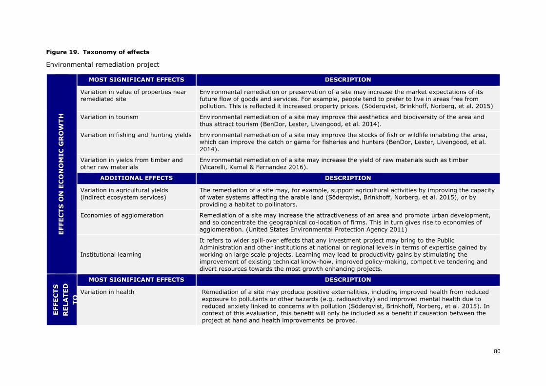
80
Figure 19. Taxonomy of effects
Environmental remediation project E
FFE
CT
S O
N E
CO
NO
MIC
GR
OW
TH
MOST SIGNIFICANT EFFECTS DESCRIPTION
Variation in value of properties near remediated site
Environmental remediation or preservation of a site may increase the market expectations of its future flow of goods and services. For example, people tend to prefer to live in areas free from pollution. This is reflected it increased property prices. (Söderqvist, Brinkhoff, Norberg, et al. 2015)
Variation in tourism Environmental remediation of a site may improve the aesthetics and biodiversity of the area and thus attract tourism (BenDor, Lester, Livengood, et al. 2014).
Variation in fishing and hunting yields Environmental remediation of a site may improve the stocks of fish or wildlife inhabiting the area, which can improve the catch or game for fisheries and hunters (BenDor, Lester, Livengood, et al.
2014).
Variation in yields from timber and other raw materials
Environmental remediation of a site may increase the yield of raw materials such as timber (Vicarelli, Kamal & Fernandez 2016).
ADDITIONAL EFFECTS DESCRIPTION
Variation in agricultural yields (indirect ecosystem services)
The remediation of a site may, for example, support agricultural activities by improving the capacity of water systems affecting the arable land (Söderqvist, Brinkhoff, Norberg, et al. 2015), or by
providing a habitat to pollinators.
Economies of agglomeration Remediation of a site may increase the attractiveness of an area and promote urban development, and so concentrate the geographical co-location of firms. This in turn gives rise to economies of agglomeration. (United States Environmental Protection Agency 2011)
Institutional learning
It refers to wider spill-over effects that any investment project may bring to the Public Administration and other institutions at national or regional levels in terms of expertise gained by working on large scale projects. Learning may lead to productivity gains by stimulating the improvement of existing technical know-how, improved policy-making, competitive tendering and
divert resources towards the most growth enhancing projects.
EFFE
CT
S
RE
LA
TE
D
TO
QU
ALIT
Y
OF L
IFE
AN
D W
ELL-
BEIN
G
MOST SIGNIFICANT EFFECTS DESCRIPTION
Variation in health Remediation of a site may produce positive externalities, including improved health from reduced
exposure to pollutants or other hazards (e.g. radioactivity) and improved mental health due to reduced anxiety linked to concerns with pollution (Söderqvist, Brinkhoff, Norberg, et al. 2015). In context of this evaluation, this benefit will only be included as a benefit if causation between the project at hand and health improvements be proved.
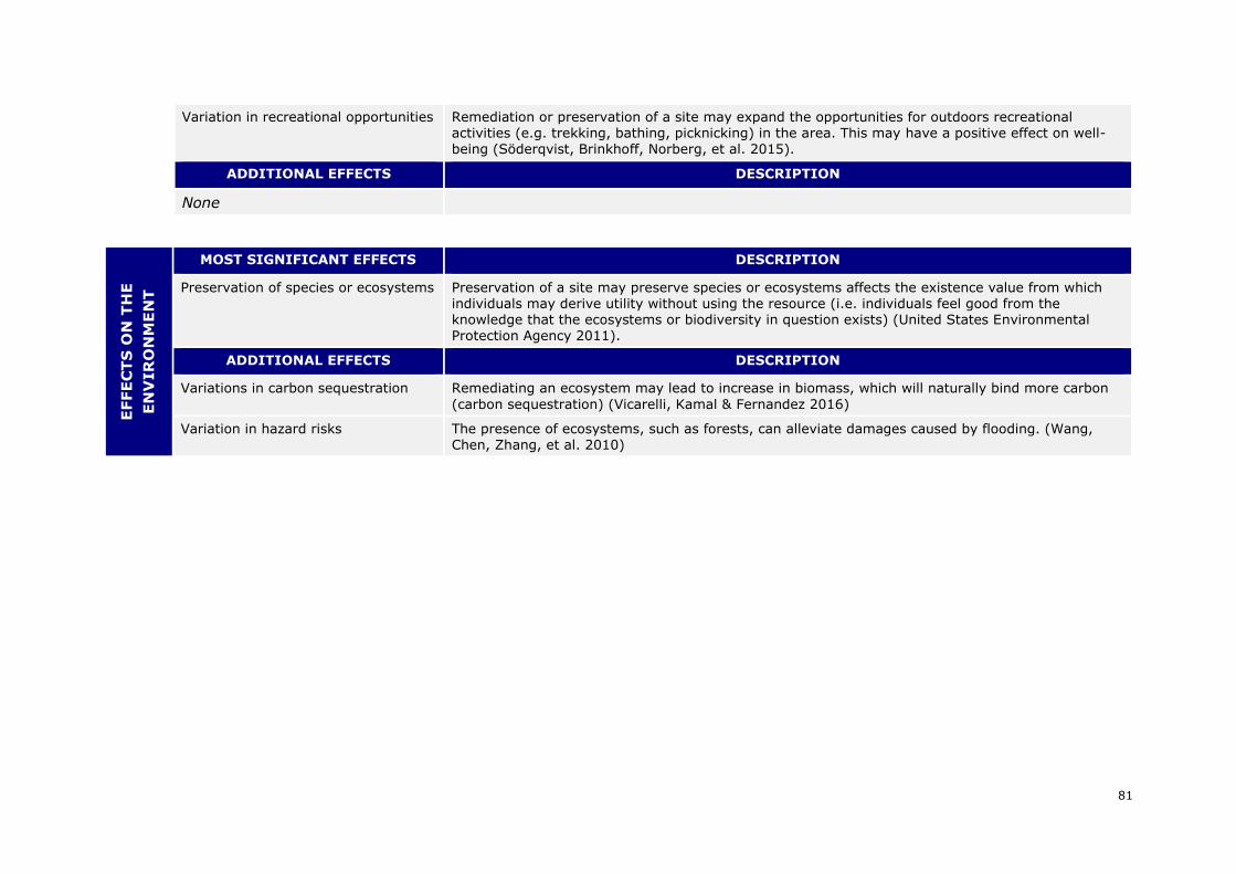
81
Variation in recreational opportunities Remediation or preservation of a site may expand the opportunities for outdoors recreational activities (e.g. trekking, bathing, picknicking) in the area. This may have a positive effect on well-being (Söderqvist, Brinkhoff, Norberg, et al. 2015).
ADDITIONAL EFFECTS DESCRIPTION
None
EFFE
CT
S O
N T
HE
EN
VIR
ON
ME
NT
MOST SIGNIFICANT EFFECTS DESCRIPTION
Preservation of species or ecosystems Preservation of a site may preserve species or ecosystems affects the existence value from which individuals may derive utility without using the resource (i.e. individuals feel good from the knowledge that the ecosystems or biodiversity in question exists) (United States Environmental Protection Agency 2011).
ADDITIONAL EFFECTS DESCRIPTION
Variations in carbon sequestration Remediating an ecosystem may lead to increase in biomass, which will naturally bind more carbon
(carbon sequestration) (Vicarelli, Kamal & Fernandez 2016)
Variation in hazard risks The presence of ecosystems, such as forests, can alleviate damages caused by flooding. (Wang, Chen, Zhang, et al. 2010)
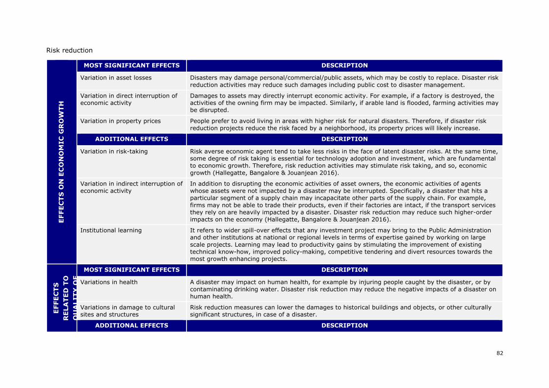
82
Risk reduction
EFFE
CT
S O
N E
CO
NO
MIC
GR
OW
TH
MOST SIGNIFICANT EFFECTS DESCRIPTION
Variation in asset losses Disasters may damage personal/commercial/public assets, which may be costly to replace. Disaster risk
reduction activities may reduce such damages including public cost to disaster management.
Variation in direct interruption of economic activity
Damages to assets may directly interrupt economic activity. For example, if a factory is destroyed, the activities of the owning firm may be impacted. Similarly, if arable land is flooded, farming activities may be disrupted.
Variation in property prices People prefer to avoid living in areas with higher risk for natural disasters. Therefore, if disaster risk
reduction projects reduce the risk faced by a neighborhood, its property prices will likely increase.
ADDITIONAL EFFECTS DESCRIPTION
Variation in risk-taking Risk averse economic agent tend to take less risks in the face of latent disaster risks. At the same time, some degree of risk taking is essential for technology adoption and investment, which are fundamental to economic growth. Therefore, risk reduction activities may stimulate risk taking, and so, economic
growth (Hallegatte, Bangalore & Jouanjean 2016).
Variation in indirect interruption of economic activity
In addition to disrupting the economic activities of asset owners, the economic activities of agents whose assets were not impacted by a disaster may be interrupted. Specifically, a disaster that hits a particular segment of a supply chain may incapacitate other parts of the supply chain. For example,
firms may not be able to trade their products, even if their factories are intact, if the transport services they rely on are heavily impacted by a disaster. Disaster risk reduction may reduce such higher-order
impacts on the economy (Hallegatte, Bangalore & Jouanjean 2016).
Institutional learning It refers to wider spill-over effects that any investment project may bring to the Public Administration and other institutions at national or regional levels in terms of expertise gained by working on large
scale projects. Learning may lead to productivity gains by stimulating the improvement of existing technical know-how, improved policy-making, competitive tendering and divert resources towards the most growth enhancing projects.
EFFE
CT
S
RE
LA
TE
D T
O
QU
ALIT
Y O
F
LIFE A
ND
WE
LL-B
EIN
G MOST SIGNIFICANT EFFECTS DESCRIPTION
Variations in health A disaster may impact on human health, for example by injuring people caught by the disaster, or by contaminating drinking water. Disaster risk reduction may reduce the negative impacts of a disaster on human health.
Variations in damage to cultural sites and structures
Risk reduction measures can lower the damages to historical buildings and objects, or other culturally significant structures, in case of a disaster.
ADDITIONAL EFFECTS DESCRIPTION
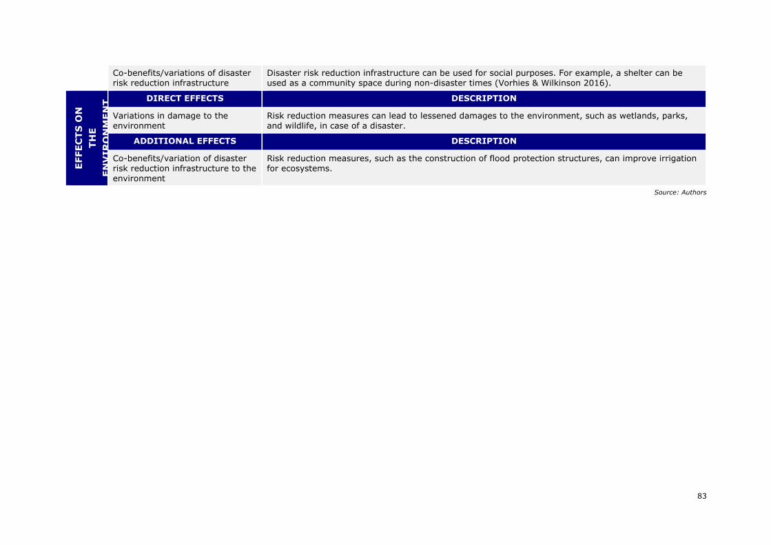
83
Co-benefits/variations of disaster risk reduction infrastructure
Disaster risk reduction infrastructure can be used for social purposes. For example, a shelter can be used as a community space during non-disaster times (Vorhies & Wilkinson 2016).
EFFE
CT
S O
N
TH
E
EN
VIR
ON
ME
NT
DIRECT EFFECTS DESCRIPTION
Variations in damage to the environment
Risk reduction measures can lead to lessened damages to the environment, such as wetlands, parks, and wildlife, in case of a disaster.
ADDITIONAL EFFECTS DESCRIPTION
Co-benefits/variation of disaster risk reduction infrastructure to the
environment
Risk reduction measures, such as the construction of flood protection structures, can improve irrigation for ecosystems.
Source: Authors
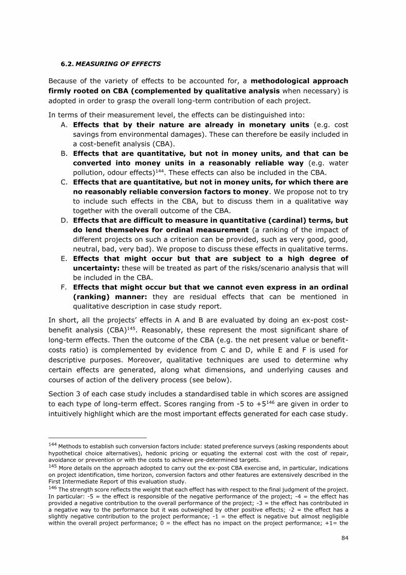
84
MEASURING OF EFFECTS
Because of the variety of effects to be accounted for, a methodological approach
firmly rooted on CBA (complemented by qualitative analysis when necessary) is
adopted in order to grasp the overall long-term contribution of each project.
In terms of their measurement level, the effects can be distinguished into:
A. Effects that by their nature are already in monetary units (e.g. cost
savings from environmental damages). These can therefore be easily included in
a cost-benefit analysis (CBA).
B. Effects that are quantitative, but not in money units, and that can be
converted into money units in a reasonably reliable way (e.g. water
pollution, odour effects)144. These effects can also be included in the CBA.
C. Effects that are quantitative, but not in money units, for which there are
no reasonably reliable conversion factors to money. We propose not to try
to include such effects in the CBA, but to discuss them in a qualitative way
together with the overall outcome of the CBA.
D. Effects that are difficult to measure in quantitative (cardinal) terms, but
do lend themselves for ordinal measurement (a ranking of the impact of
different projects on such a criterion can be provided, such as very good, good,
neutral, bad, very bad). We propose to discuss these effects in qualitative terms.
E. Effects that might occur but that are subject to a high degree of
uncertainty: these will be treated as part of the risks/scenario analysis that will
be included in the CBA.
F. Effects that might occur but that we cannot even express in an ordinal
(ranking) manner: they are residual effects that can be mentioned in
qualitative description in case study report.
In short, all the projects’ effects in A and B are evaluated by doing an ex-post cost-
benefit analysis (CBA)145. Reasonably, these represent the most significant share of
long-term effects. Then the outcome of the CBA (e.g. the net present value or benefit-
costs ratio) is complemented by evidence from C and D, while E and F is used for
descriptive purposes. Moreover, qualitative techniques are used to determine why
certain effects are generated, along what dimensions, and underlying causes and
courses of action of the delivery process (see below).
Section 3 of each case study includes a standardised table in which scores are assigned
to each type of long-term effect. Scores ranging from -5 to +5146 are given in order to
intuitively highlight which are the most important effects generated for each case study.
144 Methods to establish such conversion factors include: stated preference surveys (asking respondents about
hypothetical choice alternatives), hedonic pricing or equating the external cost with the cost of repair, avoidance or prevention or with the costs to achieve pre-determined targets. 145 More details on the approach adopted to carry out the ex-post CBA exercise and, in particular, indications
on project identification, time horizon, conversion factors and other features are extensively described in the First Intermediate Report of this evaluation study. 146 The strength score reflects the weight that each effect has with respect to the final judgment of the project.
In particular: -5 = the effect is responsible of the negative performance of the project; -4 = the effect has provided a negative contribution to the overall performance of the project; -3 = the effect has contributed in a negative way to the performance but it was outweighed by other positive effects; -2 = the effect has a slightly negative contribution to the project performance; -1 = the effect is negative but almost negligible within the overall project performance; 0 = the effect has no impact on the project performance; +1= the

85
UNDERSTANDING THE EFFECTS
Once the project effects have been identified and measured, and the causal chain linking
different categories of short-term and long-term effects has been investigated, the third
building block of the methodological approach entails reasoning on the elements, both
external and internal to the project, which have determined the observed causal chain
of effects to take place and influenced the observed project performance.
Taking inspiration from the literature on the success and failure of projects, and
particularly on costs overruns and demand shortfalls, and on the basis of the empirical
evidence which develops from European Commission (2012) six stylised determinants
of projects’ outcomes and their development over time have been identified (see table
below).
The interplay of such determinants may reinforce or dilute one effect over the other.
Moreover, each determinant may contribute, either positively or negatively to the
generation/speed up/slow-down of certain short-term or long-term effects. For this
reason it is important not only to understand the role that each determinants has on
the observed project outcome, but also their interplay in a dynamic perspective.
In doing this, it is useful to refer to stylised, typical “paths” of project behaviours
outlined in the following table. Such patterns capture common stories and reveal
recurring patterns of performance, as well as typical problems that may arise and
influence the chronicle of events. Case studies test the validity of such archetypes and
are used to specify in better nuances or suggest possible variations or additions.
Section 4 of each case study includes standardised tables in which scores are assigned
to each determinant. Scores ranging from -5 to +5 are given in order to intuitively
highlight which are the most relevant determinants explaining the project outcomes147.
Moreover, section 4 of each case study includes a graph describing the project’s
behavioural pattern, i.e. describing the chain of interlinked causes and effect
determining the project performance over time.
effect is positive but almost negligible within the overall project performance; +2 = the effect has a slightly positive contribution to the project performance; +3 = the effect has contributed in a positive way to the performance but it was outweighed by other positive effects; +4 = the effect has provided a positive contribution to the overall performance of the project; +5 = the effect is responsible of the positive performance of the project; N.R. = The effect is not relevant for the specific project; No data = The effect is potentially relevant, but no evidence on impacts is available. This shall be used only for relatively low significant effects whose inclusion would in no case dramatically affect the overall assessment. 147 The strength score reflects the weight of the role that each determinant played with respect to the final
judgment of the project. In particular: -5 = the determinant is responsible of the negative performance of the project; -4 = the determinant provides a negative contribution to the overall performance of the project; -3 = the determinant contributes in a moderate negative way to the overall performance of the project; -2 = the determinant has a slightly negative contribution to the project performance; -1 = the determinant plays a negative but almost negligible role to explain the overall project performance; 0 = the determinant does not play a role on the project performance; +1= the determinant plays a positive but almost negligible role to explain the overall project performance; +2 = the determinant has a slightly positive contribution to the project performance; +3 = the determinant contributes in a moderate positive way to the performance; +4 = the determinant provides a positive contribution to the overall performance of the project; +5 = the determinant is responsible of the positive performance of the project.
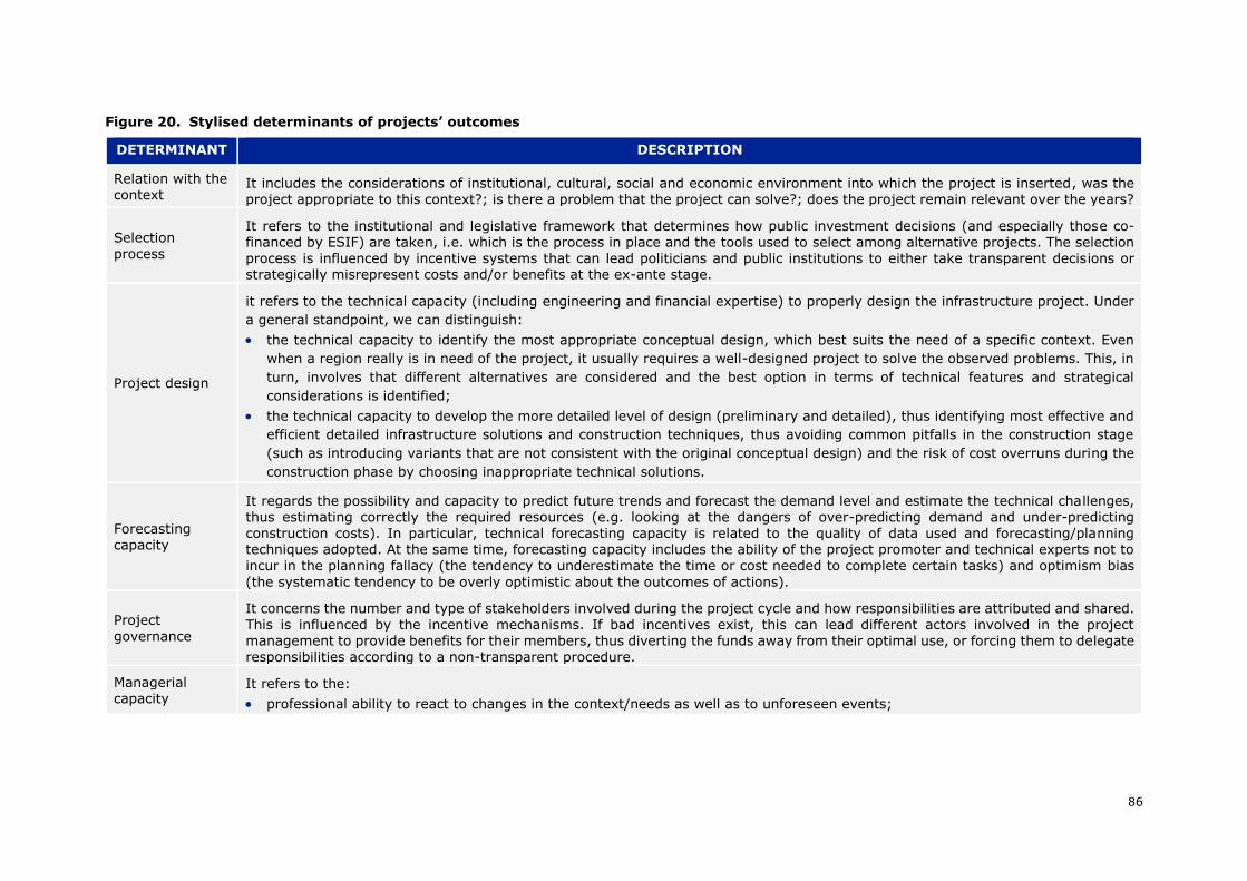
86
Figure 20. Stylised determinants of projects’ outcomes
DETERMINANT DESCRIPTION
Relation with the context
It includes the considerations of institutional, cultural, social and economic environment into which the project is inserted, was the project appropriate to this context?; is there a problem that the project can solve?; does the project remain relevant over the years?
Selection process
It refers to the institutional and legislative framework that determines how public investment decisions (and especially those co-financed by ESIF) are taken, i.e. which is the process in place and the tools used to select among alternative projects. The selection process is influenced by incentive systems that can lead politicians and public institutions to either take transparent decisions or strategically misrepresent costs and/or benefits at the ex-ante stage.
Project design
it refers to the technical capacity (including engineering and financial expertise) to properly design the infrastructure project. Under
a general standpoint, we can distinguish:
• the technical capacity to identify the most appropriate conceptual design, which best suits the need of a specific context. Even
when a region really is in need of the project, it usually requires a well-designed project to solve the observed problems. This, in
turn, involves that different alternatives are considered and the best option in terms of technical features and strategical
considerations is identified;
• the technical capacity to develop the more detailed level of design (preliminary and detailed), thus identifying most effective and
efficient detailed infrastructure solutions and construction techniques, thus avoiding common pitfalls in the construction stage
(such as introducing variants that are not consistent with the original conceptual design) and the risk of cost overruns during the
construction phase by choosing inappropriate technical solutions.
Forecasting capacity
It regards the possibility and capacity to predict future trends and forecast the demand level and estimate the technical challenges, thus estimating correctly the required resources (e.g. looking at the dangers of over-predicting demand and under-predicting construction costs). In particular, technical forecasting capacity is related to the quality of data used and forecasting/planning techniques adopted. At the same time, forecasting capacity includes the ability of the project promoter and technical experts not to incur in the planning fallacy (the tendency to underestimate the time or cost needed to complete certain tasks) and optimism bias
(the systematic tendency to be overly optimistic about the outcomes of actions).
Project governance
It concerns the number and type of stakeholders involved during the project cycle and how responsibilities are attributed and shared. This is influenced by the incentive mechanisms. If bad incentives exist, this can lead different actors involved in the project management to provide benefits for their members, thus diverting the funds away from their optimal use, or forcing them to delegate responsibilities according to a non-transparent procedure.
Managerial capacity
It refers to the:
• professional ability to react to changes in the context/needs as well as to unforeseen events;
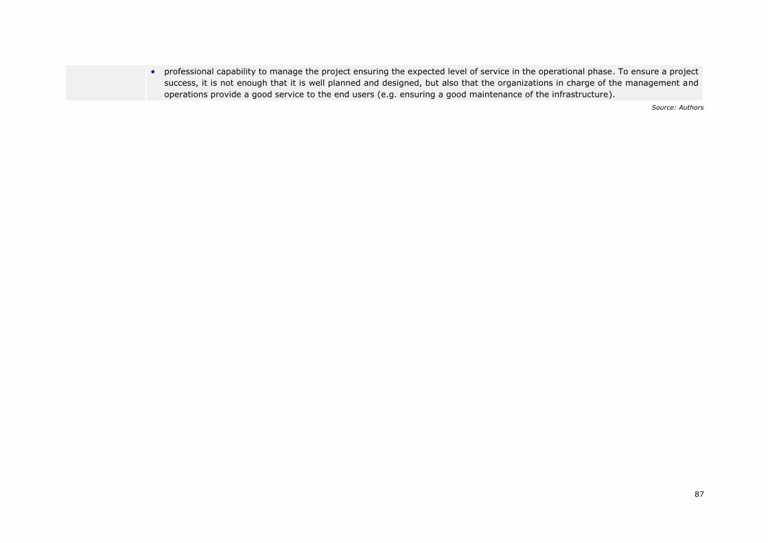
87
• professional capability to manage the project ensuring the expected level of service in the operational phase. To ensure a project
success, it is not enough that it is well planned and designed, but also that the organizations in charge of the management and
operations provide a good service to the end users (e.g. ensuring a good maintenance of the infrastructure).
Source: Authors
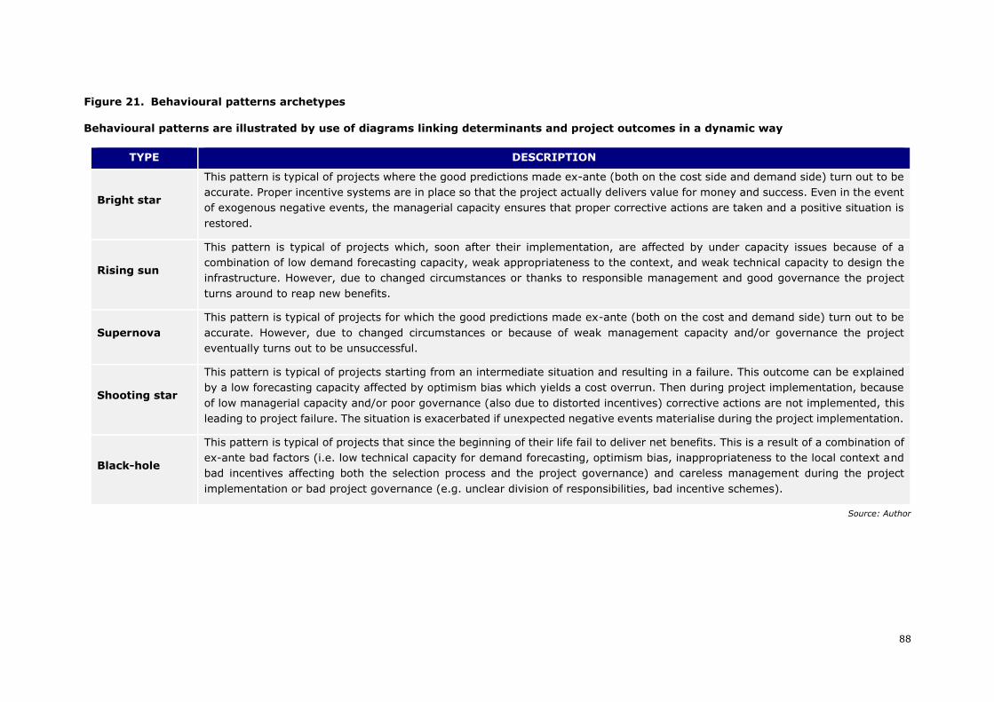
88
Figure 21. Behavioural patterns archetypes
Behavioural patterns are illustrated by use of diagrams linking determinants and project outcomes in a dynamic way
TYPE DESCRIPTION
Bright star
This pattern is typical of projects where the good predictions made ex-ante (both on the cost side and demand side) turn out to be
accurate. Proper incentive systems are in place so that the project actually delivers value for money and success. Even in the event
of exogenous negative events, the managerial capacity ensures that proper corrective actions are taken and a positive situation is
restored.
Rising sun
This pattern is typical of projects which, soon after their implementation, are affected by under capacity issues because of a
combination of low demand forecasting capacity, weak appropriateness to the context, and weak technical capacity to design the
infrastructure. However, due to changed circumstances or thanks to responsible management and good governance the project
turns around to reap new benefits.
Supernova
This pattern is typical of projects for which the good predictions made ex-ante (both on the cost and demand side) turn out to be
accurate. However, due to changed circumstances or because of weak management capacity and/or governance the project
eventually turns out to be unsuccessful.
Shooting star
This pattern is typical of projects starting from an intermediate situation and resulting in a failure. This outcome can be explained
by a low forecasting capacity affected by optimism bias which yields a cost overrun. Then during project implementation, because
of low managerial capacity and/or poor governance (also due to distorted incentives) corrective actions are not implemented, this
leading to project failure. The situation is exacerbated if unexpected negative events materialise during the project implementation.
Black-hole
This pattern is typical of projects that since the beginning of their life fail to deliver net benefits. This is a result of a combination of
ex-ante bad factors (i.e. low technical capacity for demand forecasting, optimism bias, inappropriateness to the local context and
bad incentives affecting both the selection process and the project governance) and careless management during the project
implementation or bad project governance (e.g. unclear division of responsibilities, bad incentive schemes).
Source: Author
Ex post evaluation of major projects supported by the European Regional Development
Fund (ERDF) and Cohesion Fund between 2000 and 2013
89
SYNTESIS AND CONCLUSIONS
Qualitative and quantitative findings are integrated in a narrative way, in order to
develop ten project ‘histories’ and to isolate and depict the main aspects behind the
project’s long-term performance. A final judgment on each project is then conveyed in
the case studies with an assessment structured along a set of evaluation criteria, as
suggested in the ToRs. Evaluation criteria are the following:
• Relevance (were the project objectives in line with the existing development
needs and the priorities at the programme, national and/or EU level?);
• Coherence (with other national and/or EU interventions in the same sector or
region);
• Effectiveness (were the stated objectives achieved, and in time? Did other effects
materialise? Were other possible options considered?);
• Efficiency (costs and benefits relative to each other and to their ex-ante values);
• EU added value (was EU support necessary, EU-wide effects, further EU action
required?).
Ex post evaluation of major projects supported by the European Regional Development
Fund (ERDF) and Cohesion Fund between 2000 and 2013
90
Ex post evaluation of major projects supported by the European Regional Development
Fund (ERDF) and Cohesion Fund between 2000 and 2013
91
ANNEX II. EX-POST COST-BENEFIT ANALYSIS REPORT
This Annex illustrates the ex-post CBA of the project under consideration, undertaken
to quantitatively assess the performance of the project. The methodology applied is in
line with the First Interim Report and, more generally, with the EC Guide (European
Commission, 2014). This annex aims to present in more detail the assumptions, results
of the CBA and the scenario analysis for the project under consideration.
METHODOLOGY, ASSUMPTION AND DATA GATHERING
In what follows, the main assumptions and the procedure of data gathering are
described in detail.
• Project identification
The unit of analysis of this CBA corresponds to the works for the protection and
sustainable organisation of the lido from Sète to Marseillan. This mainly entailed
the strategic relocation of the road behind a restored dune cord, and the
restoration of sand dunes and their revegetation, sand reloading and the
implementation of maritime solutions (in particular a wave-attenuator). The main
goals of the project were to restore a normal functioning of the coastline and
ensuring better protection against erosion, to protect the natural environment,
to maintaining the mobility function of the coastal road and to maintaining local
economic activities on the lido.
The land phases of the project were implemented from 2007 to 2012 as detailed
below. However, one phase of the project is still ongoing as of 2018 (the maritime
phase).
Synthesis of the interventions
ACTIVITY IMPLEMENTATION PERIOD
Preparatory studies 2001-2006
Road relocation 2007-2009
Sand reloading 2009-2012
Restoration and revegetation of sand
dunes
2008-2010
Maritime phase (wave attenuators) 2012-2019
Start of operational phase 2007
Source: Authors
• Time horizon
The time horizon for the CBA of the project is set to be 35 years (incl. 5 years of
construction). Accordingly, the timeframe for the project’s evaluation runs from
2005, when the first capital expenditure occurred, to 2040. A mix of historical
data from 2005 to 2018 (covering 13 years) and forecasts from 2018 to 2040
(covering 22 years) is used. Although coastal erosion prevention projects may
cause effects in the very long run (e.g. up to 100 years) (Defra 2009), this report
Ex post evaluation of major projects supported by the European Regional Development
Fund (ERDF) and Cohesion Fund between 2000 and 2013
92
adopts the minimum normal time horizon for risk reduction projects of 35 years
as specified in the First Interim Report (pending, p. 44)148. This means that risks
that are brought about by natural hazards, including climate change, in the very
long run (e.g. the flooding of the Thau lagoon as a result of sea level rise and
increased storm intensity) are not considered in this analysis.
• Constant prices and discount rates
In line with the guidelines of the First Interim Report, the CBA was performed
using constant prices. Historical data have been adjusted and converted into Euro
at 2018 prices by using the yearly average percentage variation of consumer
prices provided by the International Monetary Fund. As for data from 2018
onwards, they have been estimated in real terms (no inflation is considered).
Consistent with the choice of using constant prices, financial and social discount
rates have been adopted in real terms. Specifically, inflows and outflows of
financial analysis - for both the backward and forward periods of analysis – have
been discounted and capitalised using a 4% real rate, as suggested in the EC
CBA Guide (2014). With regard to the economic analysis, a real backward social
discount rate of 2.78% and a real forward social discount rate of 3.69%,
specifically calculated for France (see the First Interim Report for the calculation),
have been adopted.
• Without the project scenario
The main feature of the context of the Sète Lido prior to the project under
consideration was that the Lido beach and the coastal road crossing the lido were
at risk from coastal erosion.
In a do-nothing scenario, the entire stretch of the road along the Lido would
regularly suffer damages from storms, and an especially vulnerable section of
the road near Sète would ultimately disappear into the sea by 2010-2020149 As
this is an important transport connection between Sète and Marseillan150 and an
important condition to maintain economic activities, a permanent road
interruption would have negative effects on the local population and economic
activities. In addition, in scenarios with the strongest erosion trends, the beach
would be completely eroded by 2030151. As this scenario entails a near-complete
disruption of road transport on the lido and therefore of all economic activities
on the lido, it is implausible.
The ex-ante CBA, conducted in 2005, considers instead a scenario in which hard
measures are implemented to protect the beach and the road (e.g. hard
breakwaters constructed at sea) and the beach is artificially re-nourished on a
regular basis. At the time, however, devolved services of the central state
opposed this type of coastal protection for two reasons: 1) although the hard
erosion protection measures do preserve the local beach, it disrupts sediment
148 The ex-ante CBA employed a time horizon of 30 years. 149 BCEOM, Ville de Sète, 2001. Etude générale pour la protection et l’aménagement durable du lido de Sète
à Marseillan 150 It takes about 20 minutes to connect Sète (Corniche area) to Marseillan plage, whereas the alternative
road would take about one hour, going around the Thau lagoon 151 http://littoral.languedocroussillon.fr/Actualisation-de-l-alea-erosion.html
Ex post evaluation of major projects supported by the European Regional Development
Fund (ERDF) and Cohesion Fund between 2000 and 2013
93
flows in the area and therefore may cause aggravated erosion of the coast
elsewhere; 2) regular sand refills are not sustainable because there is not enough
sand in the region to supply this re-nourishment. The counterfactual adopted in
the ex-ante CBA was therefore unrealistic.
Instead, this CBA adopts a “do-minimum” scenario, in which the road is
maintained to ensure an open road transport connection between Sète and
Marseillan and the continuation of economic activity. An especially vulnerable
section of the road near Sète (at the east end of the lido), ¼ of the total length,
is at risk of being completely eroded by the sea by 2020. This necessitates a
relocation of this part of the road inland to prevent the road from becoming
inoperable. This vulnerable section of the road requires repairs due to damages
from storms until 2020. The remaining ¾ of the road needs to be repaired for
damages throughout the time horizon but is never at risk of being swallowed by
the sea. The beach is left unprotected from coastal erosion. This implies that a
vulnerable section of the beach, ¼ of the total length, disappears by 2010, and
the remainder of the beach disappears by 2030. Thus, this counterfactual entails
no other expenditure than the regular maintenance of the road and beach
(unrelated to erosion damages), repairs of the road due to erosion damages, and
the relocation of one section of the road.
• Data sources
This analysis relies on data collected from a multitude of sources. Financial data
(including capital and operating expenditure) was provided by Sète Agglopôle.
Data on beach and road erosion risk was collected via stakeholder interviews and
desk research152. Data on traffic in Marseillan153, accidents on the lido154, beach
maintenance155, road repair156, geotube repair157, and concessions of businesses
located on the beach158, was collected from stakeholders. Data on tourism159,
population160, beach visitors161 and other parameters was collected via desk
research.
152 Including Gervais et al. (2012) and the risk map available here:
http://littoral.languedocroussillon.fr/Actualisation-de-l-alea-erosion.html 153 City of Marseillan 154 Direction Départementale des Territoires et de la Mer 155 City of Sète and Sète Agglopôle 156 City of Sète 157 Sète Agglopôle 158 City of Sète 159 Hérault Tourisme (2018) 160 Including Insee (2017) 161 Balouin et al. (2014)
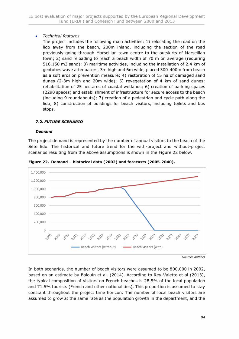
Ex post evaluation of major projects supported by the European Regional Development
Fund (ERDF) and Cohesion Fund between 2000 and 2013
94
• Technical features
The project includes the following main activities: 1) relocating the road on the
lido away from the beach, 200m inland, including the section of the road
previously going through Marseillan town centre to the outskirts of Marseillan
town; 2) sand reloading to reach a beach width of 70 m on average (requiring
516,150 m3 sand); 3) maritime activities, including the installation of 2.4 km of
geotubes wave attenuators, 3m high and 6m wide, placed 300-400m from beach
as a soft erosion prevention measure; 4) restoration of 15 ha of damaged sand
dunes (2-3m high and 20m wide); 5) revegetation of 4 km of sand dunes;
rehabilitation of 25 hectares of coastal wetlands; 6) creation of parking spaces
(2290 spaces) and establishment of infrastructure for secure access to the beach
(including 9 roundabouts); 7) creation of a pedestrian and cycle path along the
lido; 8) construction of buildings for beach visitors, including toilets and bus
stops.
FUTURE SCENARIO
Demand
The project demand is represented by the number of annual visitors to the beach of the
Sète lido. The historical and future trend for the with-project and without-project
scenarios resulting from the above assumptions is shown in the Figure 22 below.
Figure 22. Demand – historical data (2002) and forecasts (2005-2040).
Source: Authors
In both scenarios, the number of beach visitors were assumed to be 800,000 in 2002,
based on an estimate by Balouin et al. (2014). According to Rey-Valette et al (2013),
the typical composition of visitors on French beaches is 28.5% of the local population
and 71.5% tourists (French and other nationalities). This proportion is assumed to stay
constant throughout the project time horizon. The number of local beach visitors are
assumed to grow at the same rate as the population growth in the department, and the
0
200,000
400,000
600,000
800,000
1,000,000
1,200,000
1,400,000
Beach visitors (without) Beach visitors (with)
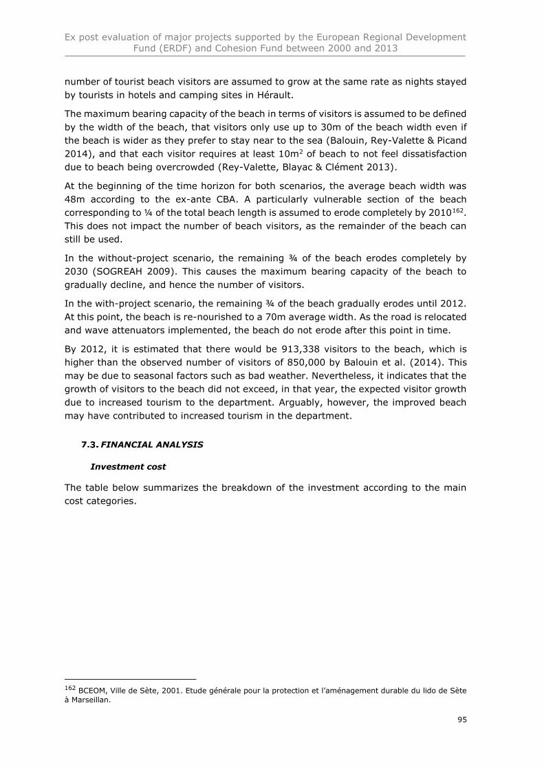
Ex post evaluation of major projects supported by the European Regional Development
Fund (ERDF) and Cohesion Fund between 2000 and 2013
95
number of tourist beach visitors are assumed to grow at the same rate as nights stayed
by tourists in hotels and camping sites in Hérault.
The maximum bearing capacity of the beach in terms of visitors is assumed to be defined
by the width of the beach, that visitors only use up to 30m of the beach width even if
the beach is wider as they prefer to stay near to the sea (Balouin, Rey-Valette & Picand
2014), and that each visitor requires at least 10m2 of beach to not feel dissatisfaction
due to beach being overcrowded (Rey-Valette, Blayac & Clément 2013).
At the beginning of the time horizon for both scenarios, the average beach width was
48m according to the ex-ante CBA. A particularly vulnerable section of the beach
corresponding to ¼ of the total beach length is assumed to erode completely by 2010162.
This does not impact the number of beach visitors, as the remainder of the beach can
still be used.
In the without-project scenario, the remaining ¾ of the beach erodes completely by
2030 (SOGREAH 2009). This causes the maximum bearing capacity of the beach to
gradually decline, and hence the number of visitors.
In the with-project scenario, the remaining ¾ of the beach gradually erodes until 2012.
At this point, the beach is re-nourished to a 70m average width. As the road is relocated
and wave attenuators implemented, the beach do not erode after this point in time.
By 2012, it is estimated that there would be 913,338 visitors to the beach, which is
higher than the observed number of visitors of 850,000 by Balouin et al. (2014). This
may be due to seasonal factors such as bad weather. Nevertheless, it indicates that the
growth of visitors to the beach did not exceed, in that year, the expected visitor growth
due to increased tourism to the department. Arguably, however, the improved beach
may have contributed to increased tourism in the department.
FINANCIAL ANALYSIS
Investment cost
The table below summarizes the breakdown of the investment according to the main
cost categories.
162 BCEOM, Ville de Sète, 2001. Etude générale pour la protection et l’aménagement durable du lido de Sète
à Marseillan.
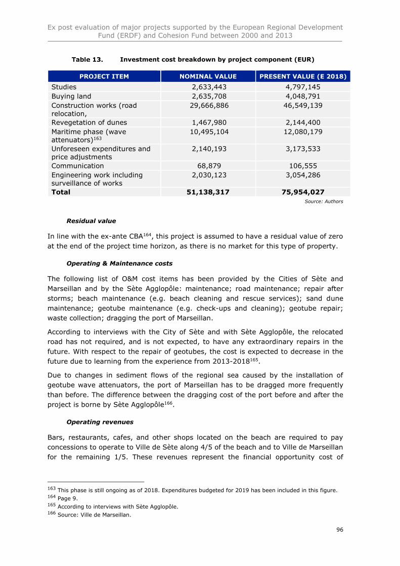
Ex post evaluation of major projects supported by the European Regional Development
Fund (ERDF) and Cohesion Fund between 2000 and 2013
96
Investment cost breakdown by project component (EUR)
PROJECT ITEM NOMINAL VALUE PRESENT VALUE (E 2018)
Studies 2,633,443 4,797,145
Buying land 2,635,708 4,048,791
Construction works (road
relocation,
29,666,886 46,549,139
Revegetation of dunes 1,467,980 2,144,400
Maritime phase (wave
attenuators)163
10,495,104 12,080,179
Unforeseen expenditures and
price adjustments
2,140,193 3,173,533
Communication 68,879 106,555
Engineering work including
surveillance of works
2,030,123 3,054,286
Total 51,138,317 75,954,027
Source: Authors
Residual value
In line with the ex-ante CBA164, this project is assumed to have a residual value of zero
at the end of the project time horizon, as there is no market for this type of property.
Operating & Maintenance costs
The following list of O&M cost items has been provided by the Cities of Sète and
Marseillan and by the Sète Agglopôle: maintenance; road maintenance; repair after
storms; beach maintenance (e.g. beach cleaning and rescue services); sand dune
maintenance; geotube maintenance (e.g. check-ups and cleaning); geotube repair;
waste collection; dragging the port of Marseillan.
According to interviews with the City of Sète and with Sète Agglopôle, the relocated
road has not required, and is not expected, to have any extraordinary repairs in the
future. With respect to the repair of geotubes, the cost is expected to decrease in the
future due to learning from the experience from 2013-2018165.
Due to changes in sediment flows of the regional sea caused by the installation of
geotube wave attenuators, the port of Marseillan has to be dragged more frequently
than before. The difference between the dragging cost of the port before and after the
project is borne by Sète Agglopôle166.
Operating revenues
Bars, restaurants, cafes, and other shops located on the beach are required to pay
concessions to operate to Ville de Sète along 4/5 of the beach and to Ville de Marseillan
for the remaining 1/5. These revenues represent the financial opportunity cost of
163 This phase is still ongoing as of 2018. Expenditures budgeted for 2019 has been included in this figure. 164 Page 9. 165 According to interviews with Sète Agglopôle. 166 Source: Ville de Marseillan.
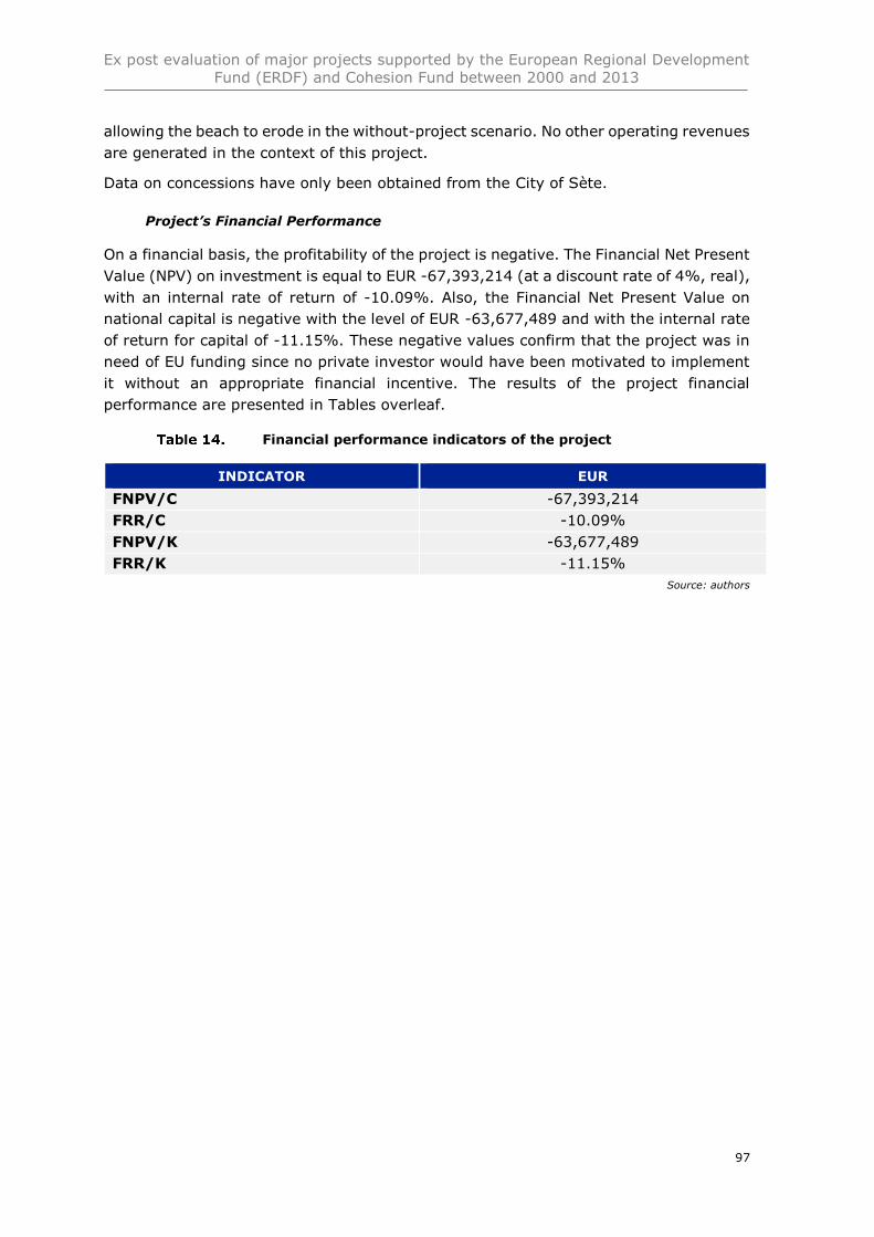
Ex post evaluation of major projects supported by the European Regional Development
Fund (ERDF) and Cohesion Fund between 2000 and 2013
97
allowing the beach to erode in the without-project scenario. No other operating revenues
are generated in the context of this project.
Data on concessions have only been obtained from the City of Sète.
Project’s Financial Performance
On a financial basis, the profitability of the project is negative. The Financial Net Present
Value (NPV) on investment is equal to EUR -67,393,214 (at a discount rate of 4%, real),
with an internal rate of return of -10.09%. Also, the Financial Net Present Value on
national capital is negative with the level of EUR -63,677,489 and with the internal rate
of return for capital of -11.15%. These negative values confirm that the project was in
need of EU funding since no private investor would have been motivated to implement
it without an appropriate financial incentive. The results of the project financial
performance are presented in Tables overleaf.
Financial performance indicators of the project
INDICATOR EUR
FNPV/C -67,393,214
FRR/C -10.09%
FNPV/K -63,677,489
FRR/K -11.15%
Source: authors
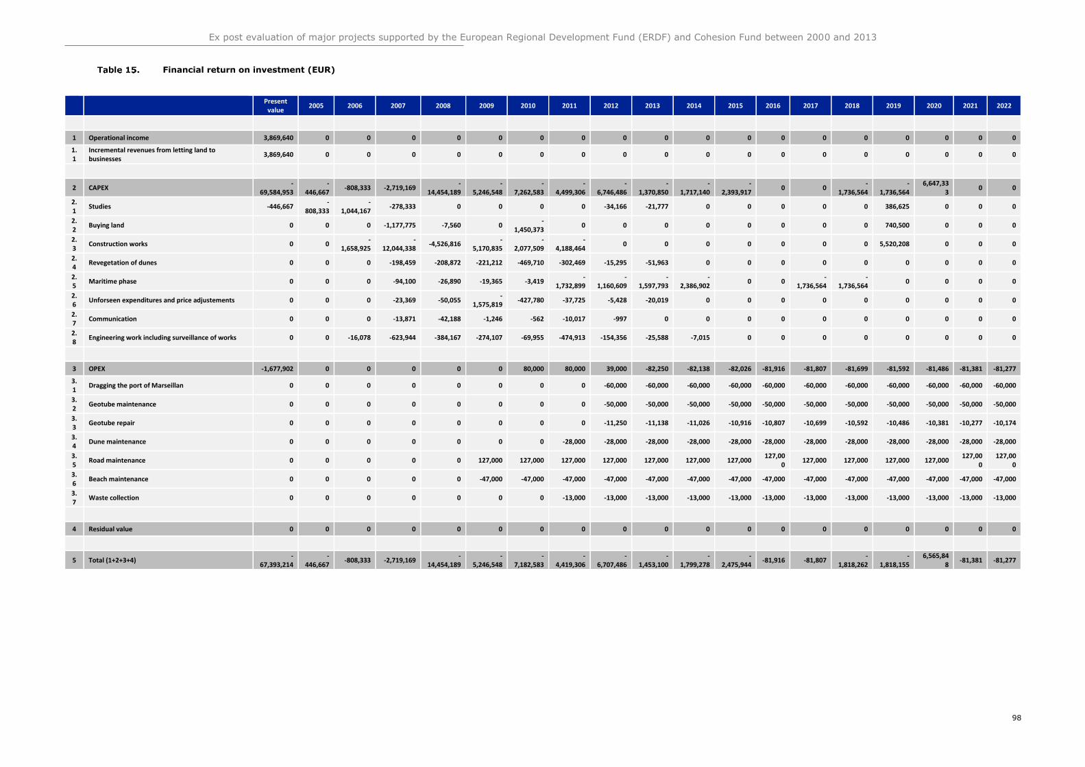
Ex post evaluation of major projects supported by the European Regional Development Fund (ERDF) and Cohesion Fund between 2000 and 2013
98
Financial return on investment (EUR)
Present value
2005 2006 2007 2008 2009 2010 2011 2012 2013 2014 2015 2016 2017 2018 2019 2020 2021 2022
1 Operational income 3,869,640 0 0 0 0 0 0 0 0 0 0 0 0 0 0 0 0 0 0
1.1
Incremental revenues from letting land to businesses
3,869,640 0 0 0 0 0 0 0 0 0 0 0 0 0 0 0 0 0 0
2 CAPEX -
69,584,953 -
446,667 -808,333 -2,719,169
-14,454,189
-5,246,548
-7,262,583
-4,499,306
-6,746,486
-1,370,850
-1,717,140
-2,393,917
0 0 -
1,736,564 -
1,736,564 6,647,33
3 0 0
2.1
Studies -446,667 -
808,333 -
1,044,167 -278,333 0 0 0 0 -34,166 -21,777 0 0 0 0 0 386,625 0 0 0
2.2
Buying land 0 0 0 -1,177,775 -7,560 0 -
1,450,373 0 0 0 0 0 0 0 0 740,500 0 0 0
2.3
Construction works 0 0 -
1,658,925 -
12,044,338 -4,526,816
-5,170,835
-2,077,509
-4,188,464
0 0 0 0 0 0 0 5,520,208 0 0 0
2.4
Revegetation of dunes 0 0 0 -198,459 -208,872 -221,212 -469,710 -302,469 -15,295 -51,963 0 0 0 0 0 0 0 0 0
2.5
Maritime phase 0 0 0 -94,100 -26,890 -19,365 -3,419 -
1,732,899 -
1,160,609 -
1,597,793 -
2,386,902 0 0
-1,736,564
-1,736,564
0 0 0 0
2.6
Unforseen expenditures and price adjustements 0 0 0 -23,369 -50,055 -
1,575,819 -427,780 -37,725 -5,428 -20,019 0 0 0 0 0 0 0 0 0
2.7
Communication 0 0 0 -13,871 -42,188 -1,246 -562 -10,017 -997 0 0 0 0 0 0 0 0 0 0
2.8
Engineering work including surveillance of works 0 0 -16,078 -623,944 -384,167 -274,107 -69,955 -474,913 -154,356 -25,588 -7,015 0 0 0 0 0 0 0 0
3 OPEX -1,677,902 0 0 0 0 0 80,000 80,000 39,000 -82,250 -82,138 -82,026 -81,916 -81,807 -81,699 -81,592 -81,486 -81,381 -81,277
3.1
Dragging the port of Marseillan 0 0 0 0 0 0 0 0 -60,000 -60,000 -60,000 -60,000 -60,000 -60,000 -60,000 -60,000 -60,000 -60,000 -60,000
3.2
Geotube maintenance 0 0 0 0 0 0 0 0 -50,000 -50,000 -50,000 -50,000 -50,000 -50,000 -50,000 -50,000 -50,000 -50,000 -50,000
3.3
Geotube repair 0 0 0 0 0 0 0 0 -11,250 -11,138 -11,026 -10,916 -10,807 -10,699 -10,592 -10,486 -10,381 -10,277 -10,174
3.4
Dune maintenance 0 0 0 0 0 0 0 -28,000 -28,000 -28,000 -28,000 -28,000 -28,000 -28,000 -28,000 -28,000 -28,000 -28,000 -28,000
3.5
Road maintenance 0 0 0 0 0 127,000 127,000 127,000 127,000 127,000 127,000 127,000 127,00
0 127,000 127,000 127,000 127,000
127,000
127,000
3.6
Beach maintenance 0 0 0 0 0 -47,000 -47,000 -47,000 -47,000 -47,000 -47,000 -47,000 -47,000 -47,000 -47,000 -47,000 -47,000 -47,000 -47,000
3.7
Waste collection 0 0 0 0 0 0 0 -13,000 -13,000 -13,000 -13,000 -13,000 -13,000 -13,000 -13,000 -13,000 -13,000 -13,000 -13,000
4 Residual value 0 0 0 0 0 0 0 0 0 0 0 0 0 0 0 0 0 0 0
5 Total (1+2+3+4) -
67,393,214 -
446,667 -808,333 -2,719,169
-14,454,189
-5,246,548
-7,182,583
-4,419,306
-6,707,486
-1,453,100
-1,799,278
-2,475,944
-81,916 -81,807 -
1,818,262 -
1,818,155 6,565,84
8 -81,381 -81,277
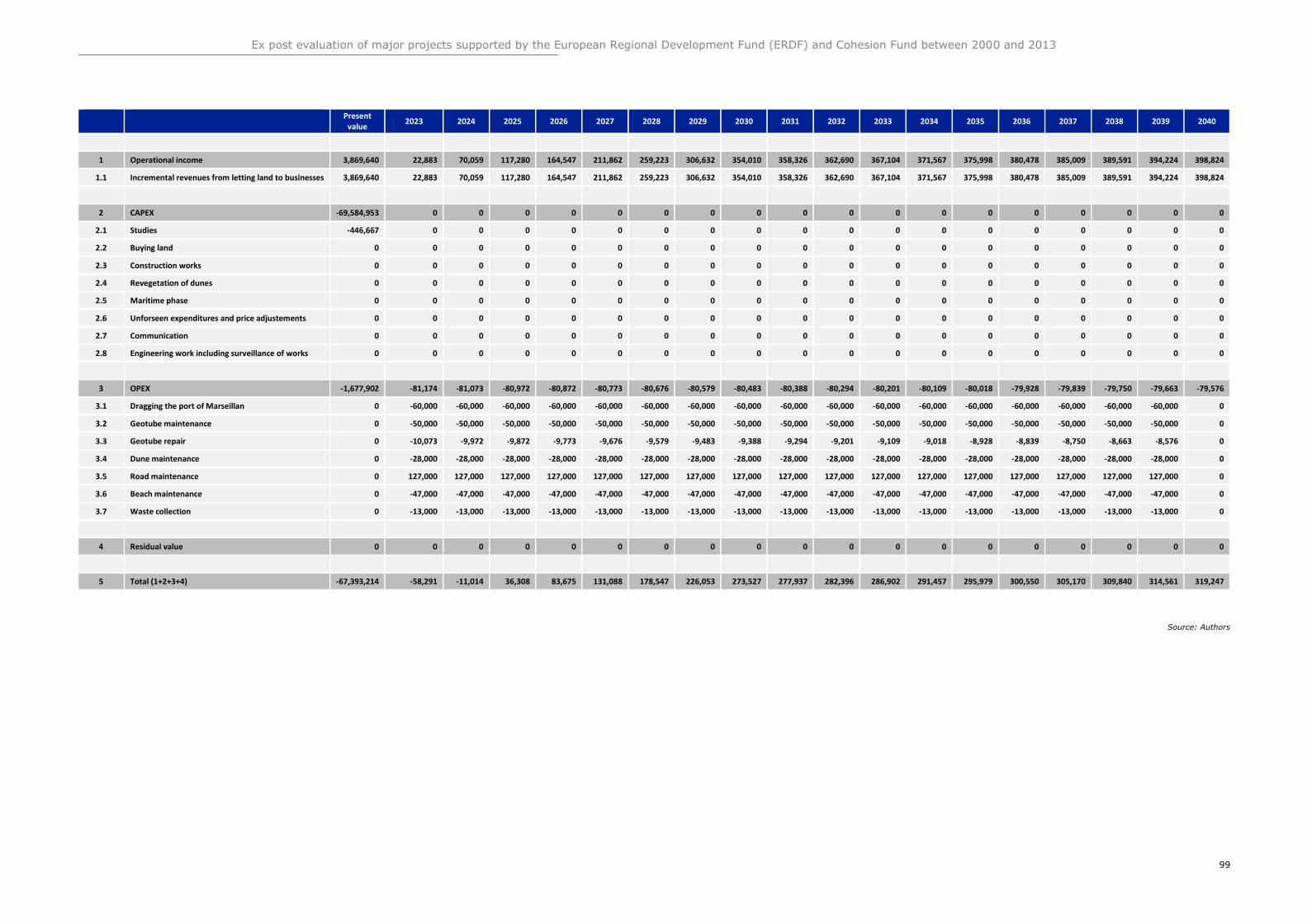
Ex post evaluation of major projects supported by the European Regional Development Fund (ERDF) and Cohesion Fund between 2000 and 2013
99
Present value
2023 2024 2025 2026 2027 2028 2029 2030 2031 2032 2033 2034 2035 2036 2037 2038 2039 2040
1 Operational income 3,869,640 22,883 70,059 117,280 164,547 211,862 259,223 306,632 354,010 358,326 362,690 367,104 371,567 375,998 380,478 385,009 389,591 394,224 398,824
1.1 Incremental revenues from letting land to businesses 3,869,640 22,883 70,059 117,280 164,547 211,862 259,223 306,632 354,010 358,326 362,690 367,104 371,567 375,998 380,478 385,009 389,591 394,224 398,824
2 CAPEX -69,584,953 0 0 0 0 0 0 0 0 0 0 0 0 0 0 0 0 0 0
2.1 Studies -446,667 0 0 0 0 0 0 0 0 0 0 0 0 0 0 0 0 0 0
2.2 Buying land 0 0 0 0 0 0 0 0 0 0 0 0 0 0 0 0 0 0 0
2.3 Construction works 0 0 0 0 0 0 0 0 0 0 0 0 0 0 0 0 0 0 0
2.4 Revegetation of dunes 0 0 0 0 0 0 0 0 0 0 0 0 0 0 0 0 0 0 0
2.5 Maritime phase 0 0 0 0 0 0 0 0 0 0 0 0 0 0 0 0 0 0 0
2.6 Unforseen expenditures and price adjustements 0 0 0 0 0 0 0 0 0 0 0 0 0 0 0 0 0 0 0
2.7 Communication 0 0 0 0 0 0 0 0 0 0 0 0 0 0 0 0 0 0 0
2.8 Engineering work including surveillance of works 0 0 0 0 0 0 0 0 0 0 0 0 0 0 0 0 0 0 0
3 OPEX -1,677,902 -81,174 -81,073 -80,972 -80,872 -80,773 -80,676 -80,579 -80,483 -80,388 -80,294 -80,201 -80,109 -80,018 -79,928 -79,839 -79,750 -79,663 -79,576
3.1 Dragging the port of Marseillan 0 -60,000 -60,000 -60,000 -60,000 -60,000 -60,000 -60,000 -60,000 -60,000 -60,000 -60,000 -60,000 -60,000 -60,000 -60,000 -60,000 -60,000 0
3.2 Geotube maintenance 0 -50,000 -50,000 -50,000 -50,000 -50,000 -50,000 -50,000 -50,000 -50,000 -50,000 -50,000 -50,000 -50,000 -50,000 -50,000 -50,000 -50,000 0
3.3 Geotube repair 0 -10,073 -9,972 -9,872 -9,773 -9,676 -9,579 -9,483 -9,388 -9,294 -9,201 -9,109 -9,018 -8,928 -8,839 -8,750 -8,663 -8,576 0
3.4 Dune maintenance 0 -28,000 -28,000 -28,000 -28,000 -28,000 -28,000 -28,000 -28,000 -28,000 -28,000 -28,000 -28,000 -28,000 -28,000 -28,000 -28,000 -28,000 0
3.5 Road maintenance 0 127,000 127,000 127,000 127,000 127,000 127,000 127,000 127,000 127,000 127,000 127,000 127,000 127,000 127,000 127,000 127,000 127,000 0
3.6 Beach maintenance 0 -47,000 -47,000 -47,000 -47,000 -47,000 -47,000 -47,000 -47,000 -47,000 -47,000 -47,000 -47,000 -47,000 -47,000 -47,000 -47,000 -47,000 0
3.7 Waste collection 0 -13,000 -13,000 -13,000 -13,000 -13,000 -13,000 -13,000 -13,000 -13,000 -13,000 -13,000 -13,000 -13,000 -13,000 -13,000 -13,000 -13,000 0
4 Residual value 0 0 0 0 0 0 0 0 0 0 0 0 0 0 0 0 0 0 0
5 Total (1+2+3+4) -67,393,214 -58,291 -11,014 36,308 83,675 131,088 178,547 226,053 273,527 277,937 282,396 286,902 291,457 295,979 300,550 305,170 309,840 314,561 319,247
Source: Authors
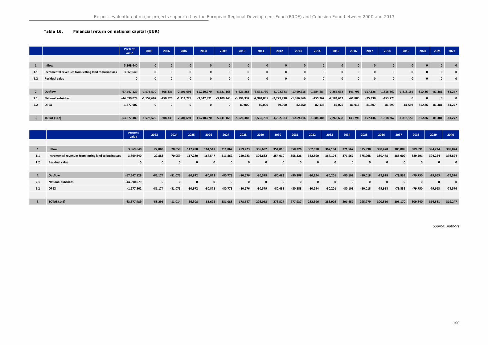
Ex post evaluation of major projects supported by the European Regional Development Fund (ERDF) and Cohesion Fund between 2000 and 2013
100
Financial return on national capital (EUR)
Present value
2005 2006 2007 2008 2009 2010 2011 2012 2013 2014 2015 2016 2017 2018 2019 2020 2021 2022
1 Inflow 3,869,640 0 0 0 0 0 0 0 0 0 0 0 0 0 0 0 0 0 0
1.1 Incremental revenues from letting land to businesses 3,869,640 0 0 0 0 0 0 0 0 0 0 0 0 0 0 0 0 0 0
1.2 Residual value 0 0 0 0 0 0 0 0 0 0 0 0 0 0 0 0 0 0 0
2 Outflow -67,547,129 -1,575,570 -808,333 -2,501,691 -11,210,270 -5,231,168 -5,626,383 -3,535,730 -4,702,383 -1,469,216 -1,684,484 -2,266,638 -143,796 -157,136 -1,818,262 -1,818,156 -81,486 -81,381 -81,277
2.1 National subsidies -44,090,079 -1,157,667 -250,926 -1,111,729 -9,342,891 -3,109,243 -3,794,337 -2,984,835 -2,779,710 -1,386,966 -255,262 -2,184,612 -61,880 -75,330 -453,773 0 0 0 0
2.2 OPEX -1,677,902 0 0 0 0 0 80,000 80,000 39,000 -82,250 -82,138 -82,026 -81,916 -81,807 -81,699 -81,592 -81,486 -81,381 -81,277
3 TOTAL (1+2) -63,677,489 -1,575,570 -808,333 -2,501,691 -11,210,270 -5,231,168 -5,626,383 -3,535,730 -4,702,383 -1,469,216 -1,684,484 -2,266,638 -143,796 -157,136 -1,818,262 -1,818,156 -81,486 -81,381 -81,277
Present value
2023 2024 2025 2026 2027 2028 2029 2030 2031 2032 2033 2034 2035 2036 2037 2038 2039 2040
1 Inflow 3,869,640 22,883 70,059 117,280 164,547 211,862 259,223 306,632 354,010 358,326 362,690 367,104 371,567 375,998 380,478 385,009 389,591 394,224 398,824
1.1 Incremental revenues from letting land to businesses 3,869,640 22,883 70,059 117,280 164,547 211,862 259,223 306,632 354,010 358,326 362,690 367,104 371,567 375,998 380,478 385,009 389,591 394,224 398,824
1.2 Residual value 0 0 0 0 0 0 0 0 0 0 0 0 0 0 0 0 0 0 0
2 Outflow -67,547,129 -81,174 -81,073 -80,972 -80,872 -80,773 -80,676 -80,579 -80,483 -80,388 -80,294 -80,201 -80,109 -80,018 -79,928 -79,839 -79,750 -79,663 -79,576
2.1 National subsidies -44,090,079 0 0 0 0 0 0 0 0 0 0 0 0 0 0 0 0 0 0
2.2 OPEX -1,677,902 -81,174 -81,073 -80,972 -80,872 -80,773 -80,676 -80,579 -80,483 -80,388 -80,294 -80,201 -80,109 -80,018 -79,928 -79,839 -79,750 -79,663 -79,576
3 TOTAL (1+2) -63,677,489 -58,291 -11,014 36,308 83,675 131,088 178,547 226,053 273,527 277,937 282,396 286,902 291,457 295,979 300,550 305,170 309,840 314,561 319,247
Source: Authors
Ex post evaluation of major projects supported by the European Regional Development
Fund (ERDF) and Cohesion Fund between 2000 and 2013
101
Financial Sustainability
This project is 100% funded by five public financing sources. At the EU level, it is funded
by the ERDF (22%), at the state level, it is funded by FNADT and DGIL (28%), at the
regional level it is funded by Languedoc-Roussillon Region (15%), at department level
it is funded by Conseil Général de l'Hérault (15%), and at the local level by Sète
Agglopôle (21%). The funding arrangement is set up such that any financing gap that
arises among the first four financing sources is covered by Sète Agglopôle. Therefore,
no issues with cash flows have been encountered nor are expected to arise for the
project. In addition, no loans have been taken to finance the project.
The operating costs are covered by Sète Agglopôle for the wave attenuator and shared
with the cities of Sète and Marseillan for other operating costs. Although concessions
are paid to the Cities of Sète and Marseillan from businesses operating on the beach,
these are not earmarked for operating costs of infrastructure built in this project.
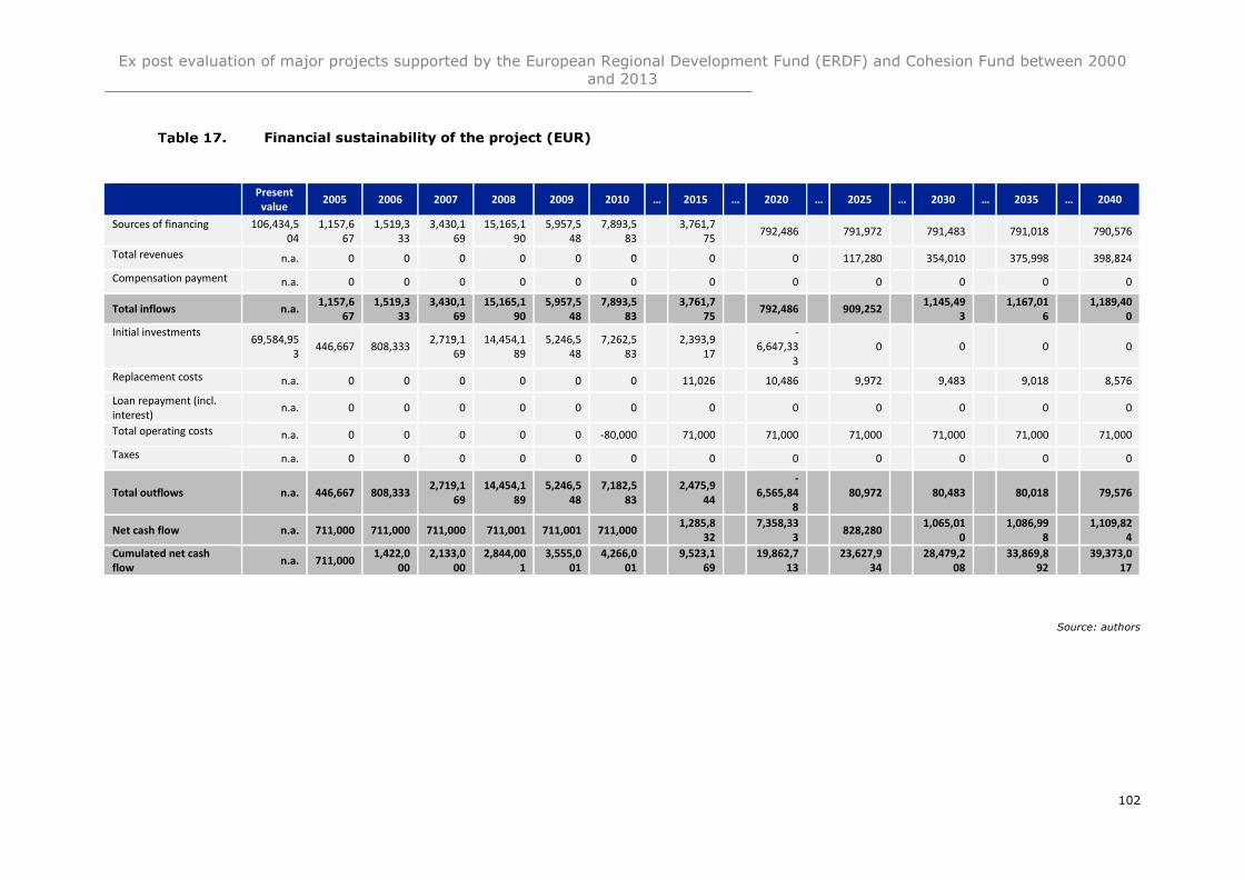
Ex post evaluation of major projects supported by the European Regional Development Fund (ERDF) and Cohesion Fund between 2000
and 2013
102
Financial sustainability of the project (EUR)
Present value
2005 2006 2007 2008 2009 2010 … 2015 … 2020 … 2025 … 2030 … 2035 … 2040
Sources of financing 106,434,504
1,157,667
1,519,333
3,430,169
15,165,190
5,957,548
7,893,583
3,761,7
75 792,486 791,972 791,483 791,018 790,576
Total revenues n.a. 0 0 0 0 0 0 0 0 117,280 354,010 375,998 398,824
Compensation payment n.a. 0 0 0 0 0 0 0 0 0 0 0 0
Total inflows n.a. 1,157,6
67 1,519,3
33 3,430,1
69 15,165,1
90 5,957,5
48 7,893,5
83
3,761,775
792,486 909,252 1,145,49
3
1,167,016
1,189,40
0
Initial investments 69,584,95
3 446,667 808,333
2,719,169
14,454,189
5,246,548
7,262,583
2,393,9
17
-6,647,33
3 0 0 0 0
Replacement costs n.a. 0 0 0 0 0 0 11,026 10,486 9,972 9,483 9,018 8,576
Loan repayment (incl. interest)
n.a. 0 0 0 0 0 0 0 0 0 0 0 0
Total operating costs n.a. 0 0 0 0 0 -80,000 71,000 71,000 71,000 71,000 71,000 71,000
Taxes n.a. 0 0 0 0 0 0 0 0 0 0 0 0
Total outflows n.a. 446,667 808,333 2,719,1
69 14,454,1
89 5,246,5
48 7,182,5
83
2,475,944
-
6,565,848
80,972 80,483 80,018 79,576
Net cash flow n.a. 711,000 711,000 711,000 711,001 711,001 711,000 1,285,8
32
7,358,333
828,280 1,065,01
0
1,086,998
1,109,82
4
Cumulated net cash flow
n.a. 711,000 1,422,0
00 2,133,0
00 2,844,00
1 3,555,0
01 4,266,0
01
9,523,169
19,862,7
13
23,627,934
28,479,2
08
33,869,892
39,373,0
17
Source: authors
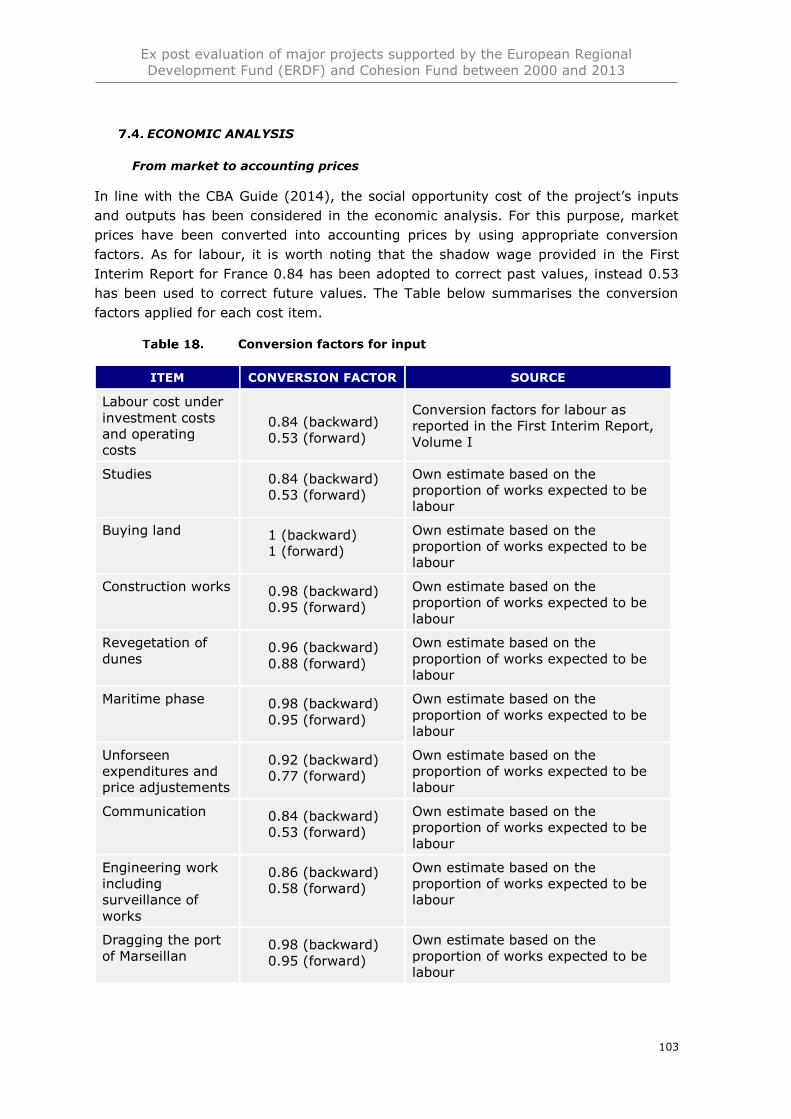
Ex post evaluation of major projects supported by the European Regional
Development Fund (ERDF) and Cohesion Fund between 2000 and 2013
103
ECONOMIC ANALYSIS
From market to accounting prices
In line with the CBA Guide (2014), the social opportunity cost of the project’s inputs
and outputs has been considered in the economic analysis. For this purpose, market
prices have been converted into accounting prices by using appropriate conversion
factors. As for labour, it is worth noting that the shadow wage provided in the First
Interim Report for France 0.84 has been adopted to correct past values, instead 0.53
has been used to correct future values. The Table below summarises the conversion
factors applied for each cost item.
Conversion factors for input
ITEM CONVERSION FACTOR SOURCE
Labour cost under
investment costs
and operating
costs
0.84 (backward)
0.53 (forward)
Conversion factors for labour as
reported in the First Interim Report,
Volume I
Studies 0.84 (backward)
0.53 (forward)
Own estimate based on the
proportion of works expected to be
labour
Buying land 1 (backward)
1 (forward)
Own estimate based on the
proportion of works expected to be
labour
Construction works 0.98 (backward)
0.95 (forward)
Own estimate based on the
proportion of works expected to be
labour
Revegetation of
dunes 0.96 (backward)
0.88 (forward)
Own estimate based on the
proportion of works expected to be
labour
Maritime phase 0.98 (backward)
0.95 (forward)
Own estimate based on the
proportion of works expected to be
labour
Unforseen
expenditures and
price adjustements
0.92 (backward)
0.77 (forward)
Own estimate based on the
proportion of works expected to be
labour
Communication 0.84 (backward)
0.53 (forward)
Own estimate based on the
proportion of works expected to be
labour
Engineering work
including
surveillance of
works
0.86 (backward)
0.58 (forward)
Own estimate based on the
proportion of works expected to be
labour
Dragging the port
of Marseillan 0.98 (backward)
0.95 (forward)
Own estimate based on the
proportion of works expected to be
labour
Ex post evaluation of major projects supported by the European Regional
Development Fund (ERDF) and Cohesion Fund between 2000 and 2013
104
Geotube
maintenance 0.84 (backward)
0.53 (forward)
Own estimate based on the
proportion of works expected to be
labour
Geotube repair 0.98 (backward)
0.95 (forward)
Own estimate based on the
proportion of works expected to be
labour
Dune maintenance 0.97 (backward)
0.91 (forward)
Own estimate based on the
proportion of works expected to be
labour
Road maintenance 0.98 (backward)
0.95 (forward)
Own estimate based on the
proportion of works expected to be
labour
Beach
maintenance 0.86 (backward)
0.58 (forward)
Own estimate based on the
proportion of works expected to be
labour
Waste collection 0.92 (backward)
0.77 (forward)
Own estimate based on the
proportion of works expected to be
labour
Source: Authors based on cited sources
Project’s effects
The nature of this project cuts across multiple thematic areas due to its variety of project
components. Therefore, the identified effects relate to the risk reduction aspect,
environment remediation, and transport aspects of the project. Overall, eight positive
impacts of the project have been quantified: reduction in asset losses, increase in
concessions from local businesses on the beach, reduction in direct interruption of
economic activity, increase in recreational opportunities, reduction of noise pollution,
reduction of accidents, reduction in local air pollution, increase in biodiversity, and
increase in carbon sequestration. No negative externalities were quantified.
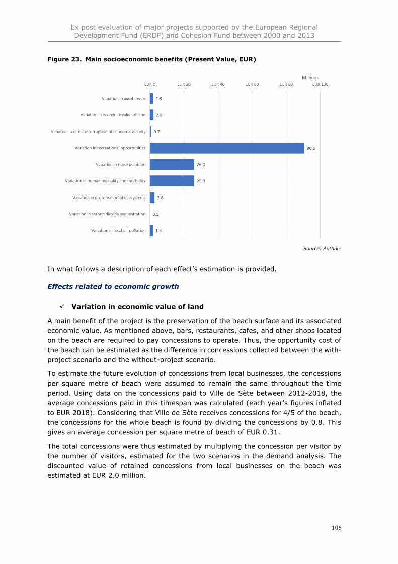
Ex post evaluation of major projects supported by the European Regional
Development Fund (ERDF) and Cohesion Fund between 2000 and 2013
105
Figure 23. Main socioeconomic benefits (Present Value, EUR)
Source: Authors
In what follows a description of each effect’s estimation is provided.
Effects related to economic growth
✓ Variation in economic value of land
A main benefit of the project is the preservation of the beach surface and its associated
economic value. As mentioned above, bars, restaurants, cafes, and other shops located
on the beach are required to pay concessions to operate. Thus, the opportunity cost of
the beach can be estimated as the difference in concessions collected between the with-
project scenario and the without-project scenario.
To estimate the future evolution of concessions from local businesses, the concessions
per square metre of beach were assumed to remain the same throughout the time
period. Using data on the concessions paid to Ville de Sète between 2012-2018, the
average concessions paid in this timespan was calculated (each year’s figures inflated
to EUR 2018). Considering that Ville de Sète receives concessions for 4/5 of the beach,
the concessions for the whole beach is found by dividing the concessions by 0.8. This
gives an average concession per square metre of beach of EUR 0.31.
The total concessions were thus estimated by multiplying the concession per visitor by
the number of visitors, estimated for the two scenarios in the demand analysis. The
discounted value of retained concessions from local businesses on the beach was
estimated at EUR 2.0 million.
Ex post evaluation of major projects supported by the European Regional
Development Fund (ERDF) and Cohesion Fund between 2000 and 2013
106
✓ Variation in asset losses
The variation in asset loss has been estimated as the difference in repair costs of the
road located on the lido between the with-project and without-project scenarios. Prior
to the project, the road was frequently damaged by storms, which incurred average
repair costs of EUR 150,000 after a minor storm and EUR 200,000 after a major storm.
Based on Gervais et al (2012), the annual return period was estimated to be 13% for
storms causing minor damages to the road and 27% for storms causing major damages
to the road prior to the road relocation.
In the with-project scenario, the expected repair costs per year until the road relocation
in 2008 was estimated by multiplying the return period for each storm category with its
respective annual return period. After the relocation of the road in 2008, the repair costs
due to storm damages were assumed to be zero for the remainder of the time horizon,
as interviews with Sète Agglopôle indicated that there have been no such damages so
far, and none are expected in the future.
In the without-project scenario, the expected annual repair costs are estimated as done
in the with-project scenario. However, in this scenario, the repair costs are assumed to
remain the same throughout the whole time period for the ¾ of the road that is less
vulnerable to disappearing into the sea. These repair costs are also incurred by the
vulnerable ¼ section of the road until 2020, in which year it is assumed to be relocated
inland to avoid complete immersion into the sea. After 2020, the relocated ¼ section of
the road does not incur any repair costs due to storm damages.
The discounted value of the avoided asset losses was estimated at EUR 1.8 million.
✓ Variation in direct interruption of economic activity
As the road was often subject to damages from storms, it would be closed, on average,
4 days per year, according to the ex-ante CBA. This would cause businesses located on
the lido to completely halt their operation for the days affected. The variation in direct
interruption of economic activity was estimated as a reduction in profits of businesses
located on the lido proportionate to the number of days in the year the road would be
closed. The camping site located on the lido has been excluded from this analysis, as its
inclusion would lead to double counting of expenditure by tourists on accommodation,
which is included in the estimation of variation of recreational opportunities using the
travel cost method (see below). Moreover, no reliable data on profits was found for the
vineyard located on the lido and the businesses operating on the beach. Thus, only the
bottling plant revenues were considered in this estimation.
In the with-project scenario, the road is assumed to be closed on average 4 days per
year until it is relocated in 2008. This causes a 4/365 reduction in profits of the bottling
plant. After 2008, the road is assumed to not be closed any days per year.167
In the without-project scenario, the road is assumed to be closed on average 4 days per
year until the vulnerable ¼ section of the road is relocated in 2020. After this relocation,
the road is assumed to be closed on average 3 days per year, a ¼ reduction in downtime
167 Interview Sète Agglopôle
Ex post evaluation of major projects supported by the European Regional
Development Fund (ERDF) and Cohesion Fund between 2000 and 2013
107
reflecting the assumption that the relocated section of the road will not suffer storm
damages and will not be a cause of road closure.
The benefit of avoided interruption of economic activity was estimated at EUR 0.7
million.
Effects related to quality of life and well-being
✓ Variation in recreational opportunities
The main benefit of this project is the preservation of the beach for recreational use.
The willingness to pay for recreation on the Sète lido was estimated using the travel
cost method. By aggregating the travel and accommodation costs, as well as the value
of time spent travelling, incurred by all visitors to the beach, the recreational value of
the beach is proxied (including its aesthetic value).
To estimate the travelling cost of visitors on the beach, it is necessary to know the origin
of the visitors. According to Rey-Valette et al (2013 p.7) the typical composition of
visitors on beaches in France is 28.5% local and 72.5% tourists (including French). The
composition was assumed to be the same on the Sète lido. The origin of tourist visitors
to the beach were then assumed to be proportional to the origin of tourists to the Hérault
department, including 74% French tourists and 7% Germany tourists, as well as 19%
from other countries (Hérault Tourisme 2018).
Local beach visitors were assumed to not spend anything on accommodation. Tourist
visitors were assumed to spend, on average, EUR 24.25 (2018 levels) on
accommodation, which was the average expenditure on accommodation in the Hérault
region by tourists in 2017 (Hérault Tourisme 2018).
Due to lack of information on the origin of tourists within their respective home
countries, it was assumed that beach visitors would travel from the capital of their
country. The travel cost and travel time then depends on the mode of travel chosen. It
was assumed that tourists would travel to the lido beach either by car, train, or by
airplane. The cost of travelling by car was assumed to be EUR € 0.33 per kilometre
travelled, which reflects average expenditure on fuel and maintenance costs Fraunhofer
Institute (2006). Train and airplane ticket prices were collected from travel agent
websites 90 days in advance of travel. The actual modal split of tourists could only be
obtained for French tourists. For tourists originating from other countries, the proportion
travelling by car was assumed to be the same as the proportion of tourists from the
respective countries staying in camping accommodation (as opposed to hotel
accommodation)168, whereas the remaining proportion of tourists were assumed to be
travelling equally much by train and plane. Tourists originating from outside Europe
were assumed to only travel by plane to Montpellier airport.
The expected travel time for local and tourist visitors from their respective capital cities
was collected from Google Maps. The value of time for visitors was adopted from the
Transport First Interim Report (2018).
168 This assumption was made on the basis that among French tourists, for which data on observed modal
split and choice of accommodation type exists for year 2012, the proportion staying in camping accommodation (70%) was similar to the proportion travelling by car (84%).
Ex post evaluation of major projects supported by the European Regional
Development Fund (ERDF) and Cohesion Fund between 2000 and 2013
108
The aggregate travel and accommodation costs and value of time was then estimated
by multiplying the proportion of beach visitors from each identified origin with their
respective travel costs and time of a journey in a single direction. As pointed out by
Balouin et al (2014), visitors to the Sète lido beach tend to stay on average 3 hours per
day on the beach. In addition, the tourist visitors were assumed to only spend one day
out of their entire stay in the region on the beach. Therefore, only the fraction of the
travel and accommodation costs and travel time corresponding to the proportion of time
spent on the beach out of their entire stays in the region were attributed to visiting the
Sète beach.
The benefit of retained recreational opportunities from the preservation of the beach
was estimated at EUR 90.6 million.
✓ Variation in noise pollution
Prior to the project, 1 km of the road going across the Sète lido went through the town
centre of Marseillan. When the road was relocated inland in 2008, a new ring road
outside the town of Marseillan was established. The social benefits of reduced noise
pollution is therefore estimated as the difference in noise pollution stemming from
diverted traffic from the town centre due to the road relocation.
According to the City of Marseillan, 35,000 vehicles travelled through the town centre
of Marseillan per day in high season prior to the project, as opposed to 4,000 vehicles
per day in peak season after the project. The traffic flow of 11,000 vehicles per day is
assumed for low-season prior to the, consistent with the ex-ante CBA. No information
could be obtained on the traffic flow in low-season after the project implementation.
Instead, the ratio of vehicles per day in low season to the vehicles per day in high season
is assumed to be the same before and after the project. Thus, the number of vehicles
passing through Marseillan after the project in low-season is assumed to be 1,257.
Peak season is assumed to correspond to three months of the year, and the low-season
to nine months of the year. Further, the composition of the traffic in terms of type of
vehicles is assumed to be the same as the average composition of traffic in France
(Commission des comptes des transports de la Nation 2016). The social cost of noise
pollution associated with each type of vehicle specified in the First Interim Report for
Transport (2018) was adopted. Assuming that the annual total number of vehicles is
assumed to be the same with and without the project, and that it stays constant for the
entire time horizon, the aggregate social cost was estimated as the number of vehicles
per type multiplied with their associated noise pollution cost for urban and suburban
roads per vehicle kilometre. Thus, the benefit of noise pollution reduction arises from
the diversion of traffic from an urban road to a suburban road.
The benefit of reduced noise pollution in Marseillan town due to the road relocation was
estimated at EUR 26.0 million.
✓ Variation in human mortality and morbidity
Prior to the project implementation, the coastal road was prone to accidents, as parking
and accessibility infrastructure (e.g. paths from parking spaces and roundabouts) was
lacking. To estimate the impact of the project on the social cost from accidents, two
Ex post evaluation of major projects supported by the European Regional
Development Fund (ERDF) and Cohesion Fund between 2000 and 2013
109
sets of data were used. One set contained the number of accidents of varying
seriousness that took place on the lido between 1995 and 1999. The second dataset
was obtained from the Prefecture, and detailed the number of accidents on the lido
between 2007 and 2018, that is, in the period of project implementation and after.
In the with-project scenario, the number of accidents per year before 2007 was assumed
to be the average accident rate of the period 1995-1999. After 2007, the real data was
used, and after 2018, the average accident rate per year in the period 2007-2018 was
used. In the without-project scenario, the number of accidents per year was assumed
to be the average annual accident rate of 1995-1999 throughout the entire time horizon.
For both scenarios, the social cost per accident was estimated by multiplying the cost
corresponding to the degree of seriousness specified in the First Interim Report for
Transport (2018).
The benefit of reduced accidents from improved access and infrastructure security was
estimated at EUR 25.9 million.
Effects related to environmental sustainability
✓ Variation in preservation of ecosystems
The project involved restauration of 15 hectares of sand dunes and 25 hectares of
wetlands. This may have led to an enhanced aesthetic value of the beach, which may
have attracted additional visitors to the area. Therefore, to avoid double-counting the
value of the beach as estimated in the recreational value of the beach using the travel
cost method, only the existence value of increased biodiversity was estimated in this
effect. Adopting the value of the biodiversity of coastal wetlands in the UK169 to the
French context, each hectare of wetlands is valued at EUR 3,805 (EUR 2018) on average
in 2018170. The adjustment was made by converting the value to EUR from GBP,
adjusting it in accordance with the proportional difference in GDP between the UK and
France and by the GDP elasticity of the willingness to pay for environmental
protection171. After inflating this value to EUR 2018, the value of wetland restoration
varies for each year (with a baseline value in 2010), depending on the annual GDP
growth.
No decomposed estimate for the value of coastal sand dunes could be identified in the
literature. Thus, with a benefit transfer approach, the increase in biodiversity resultant
from the restoration of wetlands was estimated by multiplying the number of hectares
of wetlands with its corresponding monetised biodiversity value.
The benefit of improved biodiversity resultant from the restoration of wetlands was
estimated at EUR 2.8 million.
169 Estimated by Maddison et al (2011). 170 Countries are expected to value the environment more as their incomes rise (Jacobsen & Hanley 2009). 171 Estimated as 0.38 by Jacobsen and Hanley (2009).
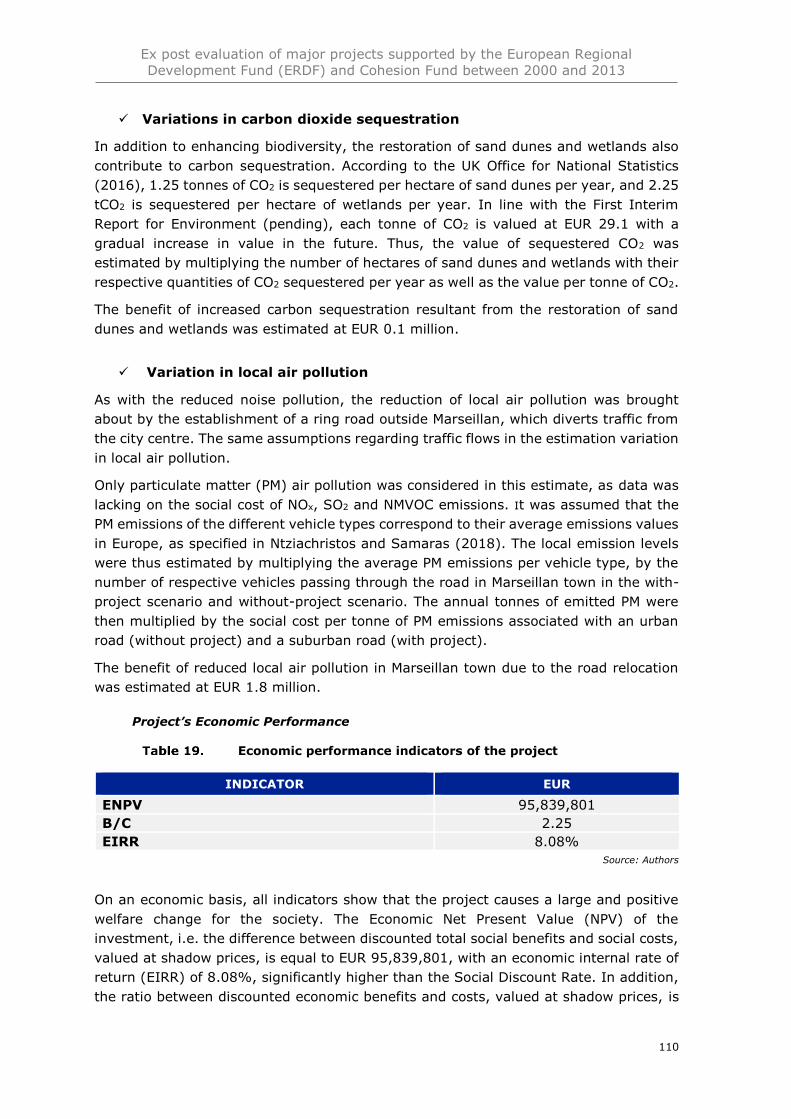
Ex post evaluation of major projects supported by the European Regional
Development Fund (ERDF) and Cohesion Fund between 2000 and 2013
110
✓ Variations in carbon dioxide sequestration
In addition to enhancing biodiversity, the restoration of sand dunes and wetlands also
contribute to carbon sequestration. According to the UK Office for National Statistics
(2016), 1.25 tonnes of CO2 is sequestered per hectare of sand dunes per year, and 2.25
tCO2 is sequestered per hectare of wetlands per year. In line with the First Interim
Report for Environment (pending), each tonne of CO2 is valued at EUR 29.1 with a
gradual increase in value in the future. Thus, the value of sequestered CO2 was
estimated by multiplying the number of hectares of sand dunes and wetlands with their
respective quantities of CO2 sequestered per year as well as the value per tonne of CO2.
The benefit of increased carbon sequestration resultant from the restoration of sand
dunes and wetlands was estimated at EUR 0.1 million.
✓ Variation in local air pollution
As with the reduced noise pollution, the reduction of local air pollution was brought
about by the establishment of a ring road outside Marseillan, which diverts traffic from
the city centre. The same assumptions regarding traffic flows in the estimation variation
in local air pollution.
Only particulate matter (PM) air pollution was considered in this estimate, as data was
lacking on the social cost of NOx, SO2 and NMVOC emissions. It was assumed that the
PM emissions of the different vehicle types correspond to their average emissions values
in Europe, as specified in Ntziachristos and Samaras (2018). The local emission levels
were thus estimated by multiplying the average PM emissions per vehicle type, by the
number of respective vehicles passing through the road in Marseillan town in the with-
project scenario and without-project scenario. The annual tonnes of emitted PM were
then multiplied by the social cost per tonne of PM emissions associated with an urban
road (without project) and a suburban road (with project).
The benefit of reduced local air pollution in Marseillan town due to the road relocation
was estimated at EUR 1.8 million.
Project’s Economic Performance
Economic performance indicators of the project
INDICATOR EUR
ENPV 95,839,801
B/C 2.25
EIRR 8.08%
Source: Authors
On an economic basis, all indicators show that the project causes a large and positive
welfare change for the society. The Economic Net Present Value (NPV) of the
investment, i.e. the difference between discounted total social benefits and social costs,
valued at shadow prices, is equal to EUR 95,839,801, with an economic internal rate of
return (EIRR) of 8.08%, significantly higher than the Social Discount Rate. In addition,
the ratio between discounted economic benefits and costs, valued at shadow prices, is
Ex post evaluation of major projects supported by the European Regional
Development Fund (ERDF) and Cohesion Fund between 2000 and 2013
111
2.25, thus suggesting that society is definitely better off with the project. The results of
the economic analysis are presented in the table below.
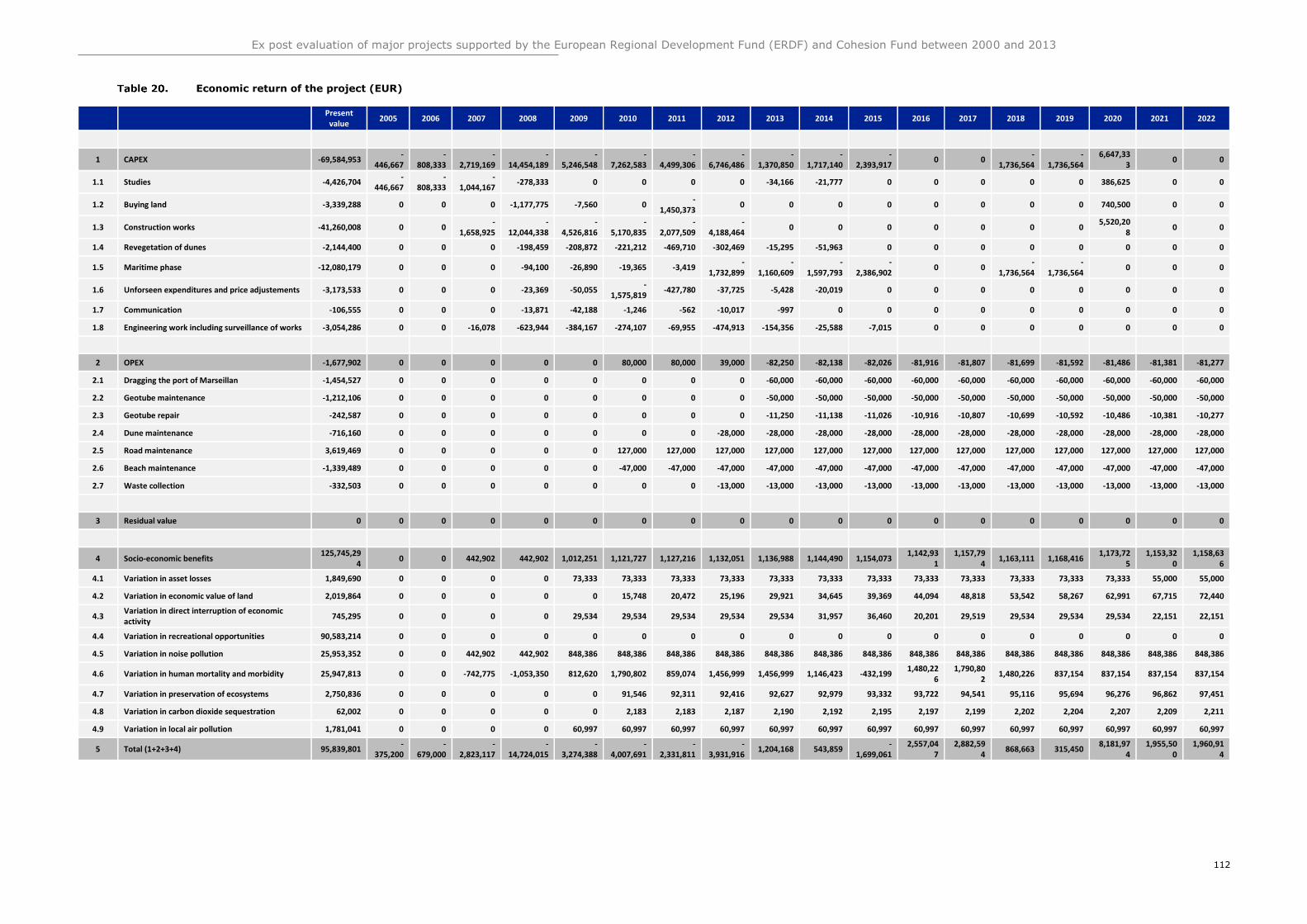
Ex post evaluation of major projects supported by the European Regional Development Fund (ERDF) and Cohesion Fund between 2000 and 2013
112
Economic return of the project (EUR)
Present value
2005 2006 2007 2008 2009 2010 2011 2012 2013 2014 2015 2016 2017 2018 2019 2020 2021 2022
1 CAPEX -69,584,953 -
446,667 -
808,333 -
2,719,169 -
14,454,189 -
5,246,548 -
7,262,583 -
4,499,306 -
6,746,486 -
1,370,850 -
1,717,140 -
2,393,917 0 0
-1,736,564
-1,736,564
6,647,333
0 0
1.1 Studies -4,426,704 -
446,667 -
808,333 -
1,044,167 -278,333 0 0 0 0 -34,166 -21,777 0 0 0 0 0 386,625 0 0
1.2 Buying land -3,339,288 0 0 0 -1,177,775 -7,560 0 -
1,450,373 0 0 0 0 0 0 0 0 740,500 0 0
1.3 Construction works -41,260,008 0 0 -
1,658,925 -
12,044,338 -
4,526,816 -
5,170,835 -
2,077,509 -
4,188,464 0 0 0 0 0 0 0
5,520,208
0 0
1.4 Revegetation of dunes -2,144,400 0 0 0 -198,459 -208,872 -221,212 -469,710 -302,469 -15,295 -51,963 0 0 0 0 0 0 0 0
1.5 Maritime phase -12,080,179 0 0 0 -94,100 -26,890 -19,365 -3,419 -
1,732,899 -
1,160,609 -
1,597,793 -
2,386,902 0 0
-1,736,564
-1,736,564
0 0 0
1.6 Unforseen expenditures and price adjustements -3,173,533 0 0 0 -23,369 -50,055 -
1,575,819 -427,780 -37,725 -5,428 -20,019 0 0 0 0 0 0 0 0
1.7 Communication -106,555 0 0 0 -13,871 -42,188 -1,246 -562 -10,017 -997 0 0 0 0 0 0 0 0 0
1.8 Engineering work including surveillance of works -3,054,286 0 0 -16,078 -623,944 -384,167 -274,107 -69,955 -474,913 -154,356 -25,588 -7,015 0 0 0 0 0 0 0
2 OPEX -1,677,902 0 0 0 0 0 80,000 80,000 39,000 -82,250 -82,138 -82,026 -81,916 -81,807 -81,699 -81,592 -81,486 -81,381 -81,277
2.1 Dragging the port of Marseillan -1,454,527 0 0 0 0 0 0 0 0 -60,000 -60,000 -60,000 -60,000 -60,000 -60,000 -60,000 -60,000 -60,000 -60,000
2.2 Geotube maintenance -1,212,106 0 0 0 0 0 0 0 0 -50,000 -50,000 -50,000 -50,000 -50,000 -50,000 -50,000 -50,000 -50,000 -50,000
2.3 Geotube repair -242,587 0 0 0 0 0 0 0 0 -11,250 -11,138 -11,026 -10,916 -10,807 -10,699 -10,592 -10,486 -10,381 -10,277
2.4 Dune maintenance -716,160 0 0 0 0 0 0 0 -28,000 -28,000 -28,000 -28,000 -28,000 -28,000 -28,000 -28,000 -28,000 -28,000 -28,000
2.5 Road maintenance 3,619,469 0 0 0 0 0 127,000 127,000 127,000 127,000 127,000 127,000 127,000 127,000 127,000 127,000 127,000 127,000 127,000
2.6 Beach maintenance -1,339,489 0 0 0 0 0 -47,000 -47,000 -47,000 -47,000 -47,000 -47,000 -47,000 -47,000 -47,000 -47,000 -47,000 -47,000 -47,000
2.7 Waste collection -332,503 0 0 0 0 0 0 0 -13,000 -13,000 -13,000 -13,000 -13,000 -13,000 -13,000 -13,000 -13,000 -13,000 -13,000
3 Residual value 0 0 0 0 0 0 0 0 0 0 0 0 0 0 0 0 0 0 0
4 Socio-economic benefits 125,745,29
4 0 0 442,902 442,902 1,012,251 1,121,727 1,127,216 1,132,051 1,136,988 1,144,490 1,154,073
1,142,931
1,157,794
1,163,111 1,168,416 1,173,72
5 1,153,32
0 1,158,63
6
4.1 Variation in asset losses 1,849,690 0 0 0 0 73,333 73,333 73,333 73,333 73,333 73,333 73,333 73,333 73,333 73,333 73,333 73,333 55,000 55,000
4.2 Variation in economic value of land 2,019,864 0 0 0 0 0 15,748 20,472 25,196 29,921 34,645 39,369 44,094 48,818 53,542 58,267 62,991 67,715 72,440
4.3 Variation in direct interruption of economic activity
745,295 0 0 0 0 29,534 29,534 29,534 29,534 29,534 31,957 36,460 20,201 29,519 29,534 29,534 29,534 22,151 22,151
4.4 Variation in recreational opportunities 90,583,214 0 0 0 0 0 0 0 0 0 0 0 0 0 0 0 0 0 0
4.5 Variation in noise pollution 25,953,352 0 0 442,902 442,902 848,386 848,386 848,386 848,386 848,386 848,386 848,386 848,386 848,386 848,386 848,386 848,386 848,386 848,386
4.6 Variation in human mortality and morbidity 25,947,813 0 0 -742,775 -1,053,350 812,620 1,790,802 859,074 1,456,999 1,456,999 1,146,423 -432,199 1,480,22
6 1,790,80
2 1,480,226 837,154 837,154 837,154 837,154
4.7 Variation in preservation of ecosystems 2,750,836 0 0 0 0 0 91,546 92,311 92,416 92,627 92,979 93,332 93,722 94,541 95,116 95,694 96,276 96,862 97,451
4.8 Variation in carbon dioxide sequestration 62,002 0 0 0 0 0 2,183 2,183 2,187 2,190 2,192 2,195 2,197 2,199 2,202 2,204 2,207 2,209 2,211
4.9 Variation in local air pollution 1,781,041 0 0 0 0 60,997 60,997 60,997 60,997 60,997 60,997 60,997 60,997 60,997 60,997 60,997 60,997 60,997 60,997
5 Total (1+2+3+4) 95,839,801 -
375,200 -
679,000 -
2,823,117 -
14,724,015 -
3,274,388 -
4,007,691 -
2,331,811 -
3,931,916 1,204,168 543,859
-1,699,061
2,557,047
2,882,594
868,663 315,450 8,181,97
4 1,955,50
0 1,960,91
4
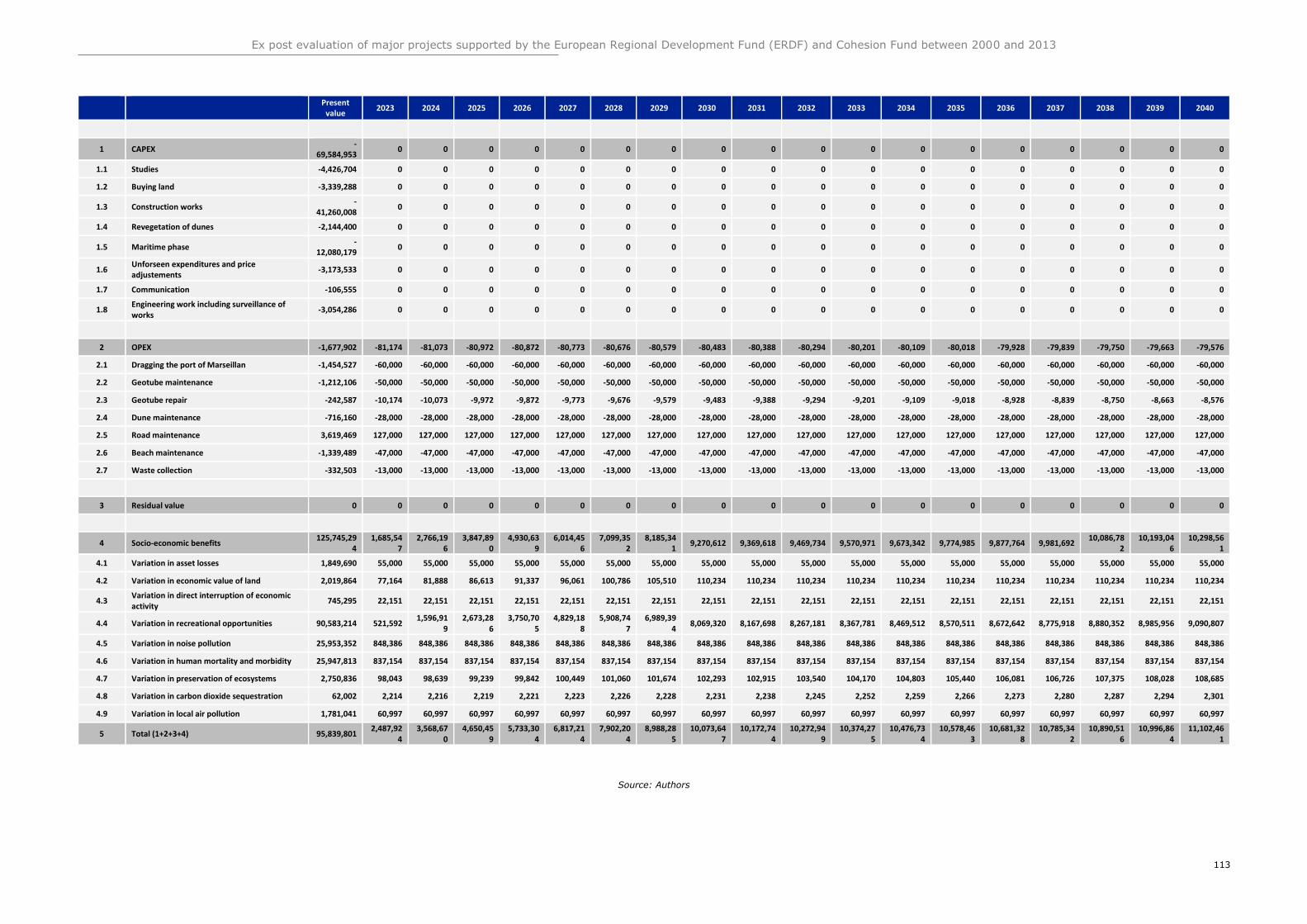
Ex post evaluation of major projects supported by the European Regional Development Fund (ERDF) and Cohesion Fund between 2000 and 2013
113
Present value
2023 2024 2025 2026 2027 2028 2029 2030 2031 2032 2033 2034 2035 2036 2037 2038 2039 2040
1 CAPEX -
69,584,953 0 0 0 0 0 0 0 0 0 0 0 0 0 0 0 0 0 0
1.1 Studies -4,426,704 0 0 0 0 0 0 0 0 0 0 0 0 0 0 0 0 0 0
1.2 Buying land -3,339,288 0 0 0 0 0 0 0 0 0 0 0 0 0 0 0 0 0 0
1.3 Construction works -
41,260,008 0 0 0 0 0 0 0 0 0 0 0 0 0 0 0 0 0 0
1.4 Revegetation of dunes -2,144,400 0 0 0 0 0 0 0 0 0 0 0 0 0 0 0 0 0 0
1.5 Maritime phase -
12,080,179 0 0 0 0 0 0 0 0 0 0 0 0 0 0 0 0 0 0
1.6 Unforseen expenditures and price adjustements
-3,173,533 0 0 0 0 0 0 0 0 0 0 0 0 0 0 0 0 0 0
1.7 Communication -106,555 0 0 0 0 0 0 0 0 0 0 0 0 0 0 0 0 0 0
1.8 Engineering work including surveillance of works
-3,054,286 0 0 0 0 0 0 0 0 0 0 0 0 0 0 0 0 0 0
2 OPEX -1,677,902 -81,174 -81,073 -80,972 -80,872 -80,773 -80,676 -80,579 -80,483 -80,388 -80,294 -80,201 -80,109 -80,018 -79,928 -79,839 -79,750 -79,663 -79,576
2.1 Dragging the port of Marseillan -1,454,527 -60,000 -60,000 -60,000 -60,000 -60,000 -60,000 -60,000 -60,000 -60,000 -60,000 -60,000 -60,000 -60,000 -60,000 -60,000 -60,000 -60,000 -60,000
2.2 Geotube maintenance -1,212,106 -50,000 -50,000 -50,000 -50,000 -50,000 -50,000 -50,000 -50,000 -50,000 -50,000 -50,000 -50,000 -50,000 -50,000 -50,000 -50,000 -50,000 -50,000
2.3 Geotube repair -242,587 -10,174 -10,073 -9,972 -9,872 -9,773 -9,676 -9,579 -9,483 -9,388 -9,294 -9,201 -9,109 -9,018 -8,928 -8,839 -8,750 -8,663 -8,576
2.4 Dune maintenance -716,160 -28,000 -28,000 -28,000 -28,000 -28,000 -28,000 -28,000 -28,000 -28,000 -28,000 -28,000 -28,000 -28,000 -28,000 -28,000 -28,000 -28,000 -28,000
2.5 Road maintenance 3,619,469 127,000 127,000 127,000 127,000 127,000 127,000 127,000 127,000 127,000 127,000 127,000 127,000 127,000 127,000 127,000 127,000 127,000 127,000
2.6 Beach maintenance -1,339,489 -47,000 -47,000 -47,000 -47,000 -47,000 -47,000 -47,000 -47,000 -47,000 -47,000 -47,000 -47,000 -47,000 -47,000 -47,000 -47,000 -47,000 -47,000
2.7 Waste collection -332,503 -13,000 -13,000 -13,000 -13,000 -13,000 -13,000 -13,000 -13,000 -13,000 -13,000 -13,000 -13,000 -13,000 -13,000 -13,000 -13,000 -13,000 -13,000
3 Residual value 0 0 0 0 0 0 0 0 0 0 0 0 0 0 0 0 0 0 0
4 Socio-economic benefits 125,745,29
4 1,685,54
7 2,766,19
6 3,847,89
0 4,930,63
9 6,014,45
6 7,099,35
2 8,185,34
1 9,270,612 9,369,618 9,469,734 9,570,971 9,673,342 9,774,985 9,877,764 9,981,692
10,086,782
10,193,046
10,298,561
4.1 Variation in asset losses 1,849,690 55,000 55,000 55,000 55,000 55,000 55,000 55,000 55,000 55,000 55,000 55,000 55,000 55,000 55,000 55,000 55,000 55,000 55,000
4.2 Variation in economic value of land 2,019,864 77,164 81,888 86,613 91,337 96,061 100,786 105,510 110,234 110,234 110,234 110,234 110,234 110,234 110,234 110,234 110,234 110,234 110,234
4.3 Variation in direct interruption of economic activity
745,295 22,151 22,151 22,151 22,151 22,151 22,151 22,151 22,151 22,151 22,151 22,151 22,151 22,151 22,151 22,151 22,151 22,151 22,151
4.4 Variation in recreational opportunities 90,583,214 521,592 1,596,91
9 2,673,28
6 3,750,70
5 4,829,18
8 5,908,74
7 6,989,39
4 8,069,320 8,167,698 8,267,181 8,367,781 8,469,512 8,570,511 8,672,642 8,775,918 8,880,352 8,985,956 9,090,807
4.5 Variation in noise pollution 25,953,352 848,386 848,386 848,386 848,386 848,386 848,386 848,386 848,386 848,386 848,386 848,386 848,386 848,386 848,386 848,386 848,386 848,386 848,386
4.6 Variation in human mortality and morbidity 25,947,813 837,154 837,154 837,154 837,154 837,154 837,154 837,154 837,154 837,154 837,154 837,154 837,154 837,154 837,154 837,154 837,154 837,154 837,154
4.7 Variation in preservation of ecosystems 2,750,836 98,043 98,639 99,239 99,842 100,449 101,060 101,674 102,293 102,915 103,540 104,170 104,803 105,440 106,081 106,726 107,375 108,028 108,685
4.8 Variation in carbon dioxide sequestration 62,002 2,214 2,216 2,219 2,221 2,223 2,226 2,228 2,231 2,238 2,245 2,252 2,259 2,266 2,273 2,280 2,287 2,294 2,301
4.9 Variation in local air pollution 1,781,041 60,997 60,997 60,997 60,997 60,997 60,997 60,997 60,997 60,997 60,997 60,997 60,997 60,997 60,997 60,997 60,997 60,997 60,997
5 Total (1+2+3+4) 95,839,801 2,487,92
4 3,568,67
0 4,650,45
9 5,733,30
4 6,817,21
4 7,902,20
4 8,988,28
5 10,073,64
7 10,172,74
4 10,272,94
9 10,374,27
5 10,476,73
4 10,578,46
3 10,681,32
8 10,785,34
2 10,890,51
6 10,996,86
4 11,102,46
1
Source: Authors
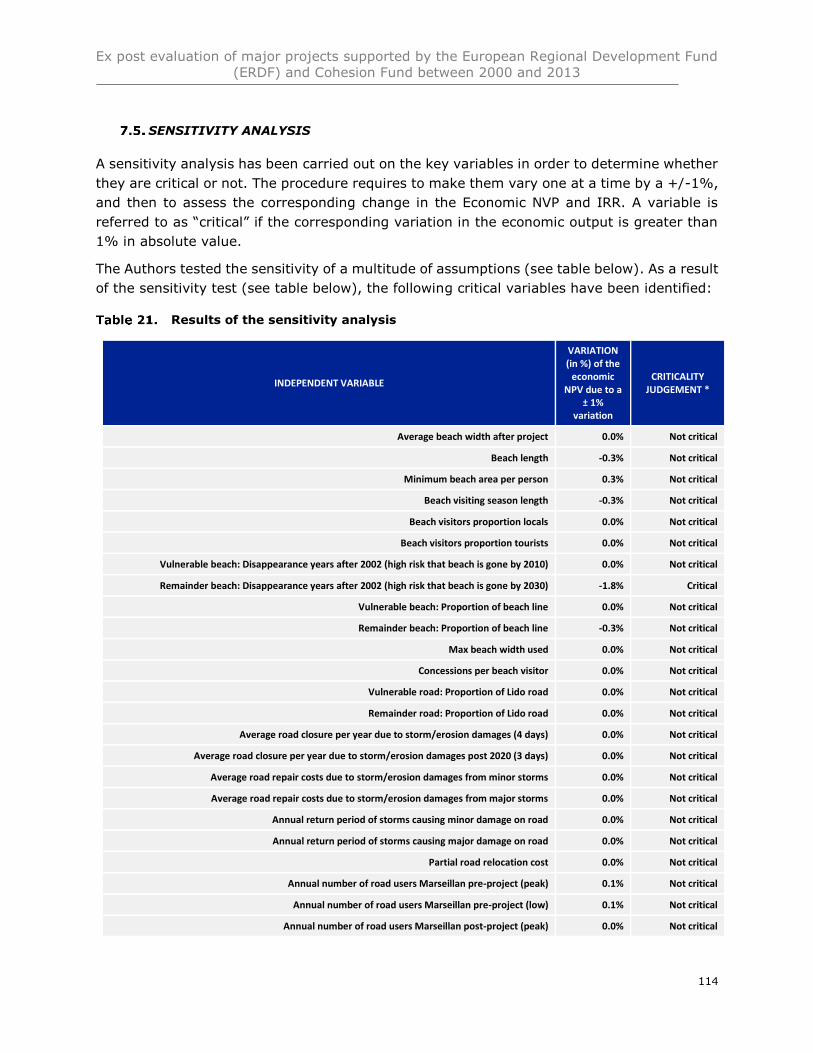
Ex post evaluation of major projects supported by the European Regional Development Fund
(ERDF) and Cohesion Fund between 2000 and 2013
114
SENSITIVITY ANALYSIS
A sensitivity analysis has been carried out on the key variables in order to determine whether
they are critical or not. The procedure requires to make them vary one at a time by a +/-1%,
and then to assess the corresponding change in the Economic NVP and IRR. A variable is
referred to as “critical” if the corresponding variation in the economic output is greater than
1% in absolute value.
The Authors tested the sensitivity of a multitude of assumptions (see table below). As a result
of the sensitivity test (see table below), the following critical variables have been identified:
Results of the sensitivity analysis
INDEPENDENT VARIABLE
VARIATION (in %) of the
economic NPV due to a
± 1% variation
CRITICALITY JUDGEMENT *
Average beach width after project 0.0% Not critical
Beach length -0.3% Not critical
Minimum beach area per person 0.3% Not critical
Beach visiting season length -0.3% Not critical
Beach visitors proportion locals 0.0% Not critical
Beach visitors proportion tourists 0.0% Not critical
Vulnerable beach: Disappearance years after 2002 (high risk that beach is gone by 2010) 0.0% Not critical
Remainder beach: Disappearance years after 2002 (high risk that beach is gone by 2030) -1.8% Critical
Vulnerable beach: Proportion of beach line 0.0% Not critical
Remainder beach: Proportion of beach line -0.3% Not critical
Max beach width used 0.0% Not critical
Concessions per beach visitor 0.0% Not critical
Vulnerable road: Proportion of Lido road 0.0% Not critical
Remainder road: Proportion of Lido road 0.0% Not critical
Average road closure per year due to storm/erosion damages (4 days) 0.0% Not critical
Average road closure per year due to storm/erosion damages post 2020 (3 days) 0.0% Not critical
Average road repair costs due to storm/erosion damages from minor storms 0.0% Not critical
Average road repair costs due to storm/erosion damages from major storms 0.0% Not critical
Annual return period of storms causing minor damage on road 0.0% Not critical
Annual return period of storms causing major damage on road 0.0% Not critical
Partial road relocation cost 0.0% Not critical
Annual number of road users Marseillan pre-project (peak) 0.1% Not critical
Annual number of road users Marseillan pre-project (low) 0.1% Not critical
Annual number of road users Marseillan post-project (peak) 0.0% Not critical
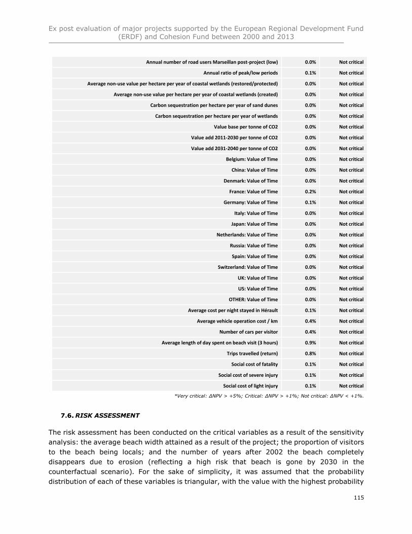
Ex post evaluation of major projects supported by the European Regional Development Fund
(ERDF) and Cohesion Fund between 2000 and 2013
115
Annual number of road users Marseillan post-project (low) 0.0% Not critical
Annual ratio of peak/low periods 0.1% Not critical
Average non-use value per hectare per year of coastal wetlands (restored/protected) 0.0% Not critical
Average non-use value per hectare per year of coastal wetlands (created) 0.0% Not critical
Carbon sequestration per hectare per year of sand dunes 0.0% Not critical
Carbon sequestration per hectare per year of wetlands 0.0% Not critical
Value base per tonne of CO2 0.0% Not critical
Value add 2011-2030 per tonne of CO2 0.0% Not critical
Value add 2031-2040 per tonne of CO2 0.0% Not critical
Belgium: Value of Time 0.0% Not critical
China: Value of Time 0.0% Not critical
Denmark: Value of Time 0.0% Not critical
France: Value of Time 0.2% Not critical
Germany: Value of Time 0.1% Not critical
Italy: Value of Time 0.0% Not critical
Japan: Value of Time 0.0% Not critical
Netherlands: Value of Time 0.0% Not critical
Russia: Value of Time 0.0% Not critical
Spain: Value of Time 0.0% Not critical
Switzerland: Value of Time 0.0% Not critical
UK: Value of Time 0.0% Not critical
US: Value of Time 0.0% Not critical
OTHER: Value of Time 0.0% Not critical
Average cost per night stayed in Hérault 0.1% Not critical
Average vehicle operation cost / km 0.4% Not critical
Number of cars per visitor 0.4% Not critical
Average length of day spent on beach visit (3 hours) 0.9% Not critical
Trips travelled (return) 0.8% Not critical
Social cost of fatality 0.1% Not critical
Social cost of severe injury 0.1% Not critical
Social cost of light injury 0.1% Not critical
*Very critical: ΔNPV > +5%; Critical: ΔNPV > +1%; Not critical: ΔNPV < +1%.
RISK ASSESSMENT
The risk assessment has been conducted on the critical variables as a result of the sensitivity
analysis: the average beach width attained as a result of the project; the proportion of visitors
to the beach being locals; and the number of years after 2002 the beach completely
disappears due to erosion (reflecting a high risk that beach is gone by 2030 in the
counterfactual scenario). For the sake of simplicity, it was assumed that the probability
distribution of each of these variables is triangular, with the value with the highest probability
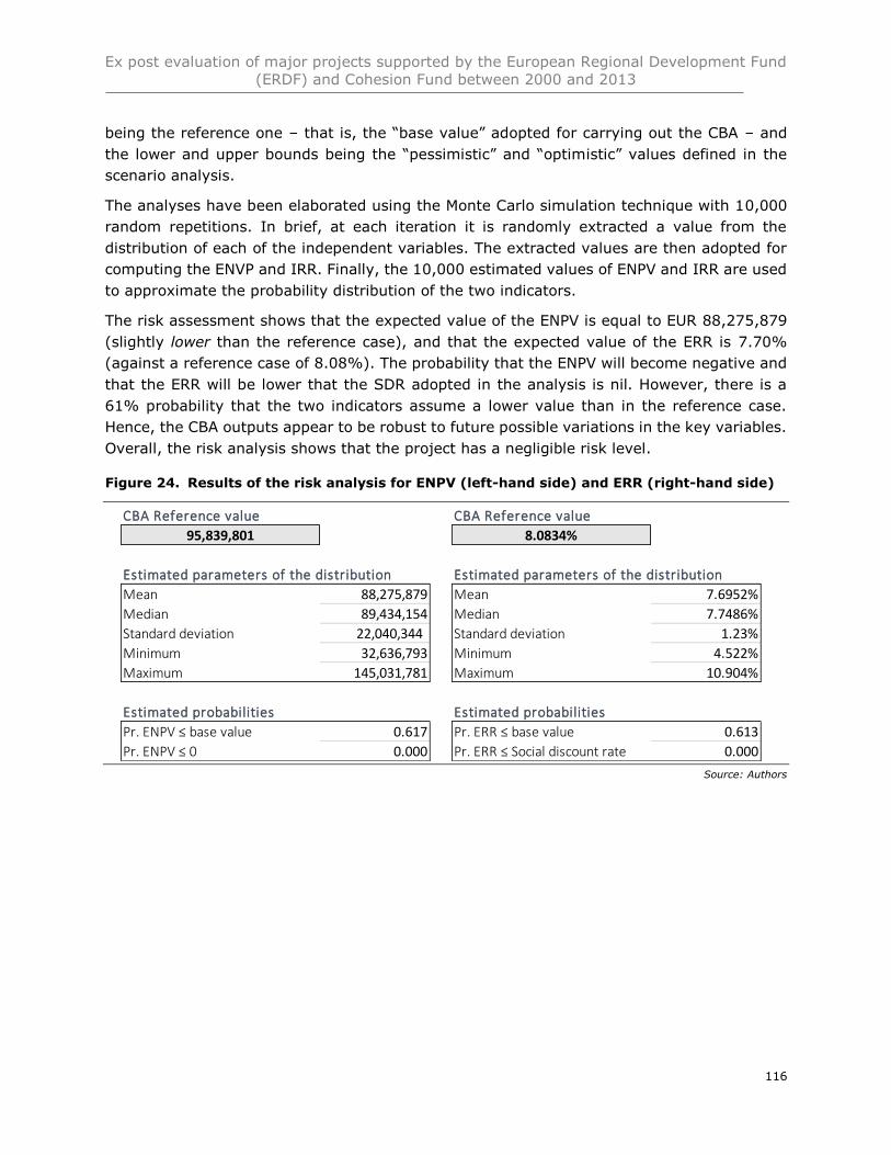
Ex post evaluation of major projects supported by the European Regional Development Fund
(ERDF) and Cohesion Fund between 2000 and 2013
116
being the reference one – that is, the “base value” adopted for carrying out the CBA – and
the lower and upper bounds being the “pessimistic” and “optimistic” values defined in the
scenario analysis.
The analyses have been elaborated using the Monte Carlo simulation technique with 10,000
random repetitions. In brief, at each iteration it is randomly extracted a value from the
distribution of each of the independent variables. The extracted values are then adopted for
computing the ENVP and IRR. Finally, the 10,000 estimated values of ENPV and IRR are used
to approximate the probability distribution of the two indicators.
The risk assessment shows that the expected value of the ENPV is equal to EUR 88,275,879
(slightly lower than the reference case), and that the expected value of the ERR is 7.70%
(against a reference case of 8.08%). The probability that the ENPV will become negative and
that the ERR will be lower that the SDR adopted in the analysis is nil. However, there is a
61% probability that the two indicators assume a lower value than in the reference case.
Hence, the CBA outputs appear to be robust to future possible variations in the key variables.
Overall, the risk analysis shows that the project has a negligible risk level.
Figure 24. Results of the risk analysis for ENPV (left-hand side) and ERR (right-hand side)
Source: Authors
CBA Reference value
95,839,801
Estimated parameters of the distribution
Mean 88,275,879
Median 89,434,154
Standard deviation 22,040,344
Minimum 32,636,793
Maximum 145,031,781
Estimated probabilities
Pr. ENPV ≤ base value 0.617
Pr. ENPV ≤ 0 0.000
CBA Reference value
8.0834%
Estimated parameters of the distribution
Mean 7.6952%
Median 7.7486%
Standard deviation 1.23%
Minimum 4.522%
Maximum 10.904%
Estimated probabilities
Pr. ERR ≤ base value 0.613
Pr. ERR ≤ Social discount rate 0.000
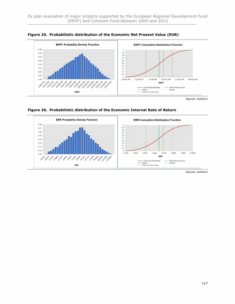
Ex post evaluation of major projects supported by the European Regional Development Fund
(ERDF) and Cohesion Fund between 2000 and 2013
117
Figure 25. Probabilistic distribution of the Economic Net Present Value (EUR)
Source: Authors
Figure 26. Probabilistic distribution of the Economic Internal Rate of Return
Source: Authors
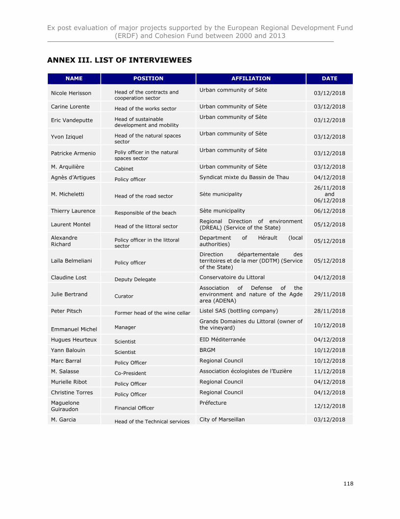
Ex post evaluation of major projects supported by the European Regional Development Fund
(ERDF) and Cohesion Fund between 2000 and 2013
118
ANNEX III. LIST OF INTERVIEWEES
NAME POSITION AFFILIATION DATE
Nicole Herisson Head of the contracts and cooperation sector
Urban community of Sète 03/12/2018
Carine Lorente Head of the works sector Urban community of Sète 03/12/2018
Eric Vandeputte Head of sustainable development and mobility
Urban community of Sète 03/12/2018
Yvon Iziquel Head of the natural spaces sector
Urban community of Sète 03/12/2018
Patricke Armenio Poliy officer in the natural spaces sector
Urban community of Sète 03/12/2018
M. Arquilière Cabinet Urban community of Sète 03/12/2018
Agnès d’Artigues Policy officer Syndicat mixte du Bassin de Thau 04/12/2018
M. Micheletti Head of the road sector Sète municipality 26/11/2018
and 06/12/2018
Thierry Laurence Responsible of the beach Sète municipality 06/12/2018
Laurent Montel Head of the littoral sector Regional Direction of environment (DREAL) (Service of the State)
05/12/2018
Alexandre
Richard Policy officer in the littoral sector
Department of Hérault (local
authorities) 05/12/2018
Laïla Belmeliani Policy officer
Direction départementale des territoires et de la mer (DDTM) (Service of the State)
05/12/2018
Claudine Lost Deputy Delegate Conservatoire du Littoral 04/12/2018
Julie Bertrand Curator
Association of Defense of the environment and nature of the Agde area (ADENA)
29/11/2018
Peter Pitsch Former head of the wine cellar Listel SAS (bottling company) 28/11/2018
Emmanuel Michel Manager Grands Domaines du Littoral (owner of the vineyard) 10/12/2018
Hugues Heurteux Scientist EID Méditerranée 04/12/2018
Yann Balouin Scientist BRGM 10/12/2018
Marc Barral Policy Officer Regional Council 10/12/2018
M. Salasse Co-President Association écologistes de l’Euzière 11/12/2018
Murielle Ribot Policy Officer Regional Council 04/12/2018
Christine Torres Policy Officer Regional Council 04/12/2018
Maguelone Guiraudon Financial Officer
Préfecture 12/12/2018
M. Garcia Head of the Technical services City of Marseillan 03/12/2018
Ex post evaluation of major projects supported by the European Regional Development Fund
(ERDF) and Cohesion Fund between 2000 and 2013
119
ANNEX IV. OTHER AD HOC ANALYSIS IF RELEVANT.
If needed, other annexes can be added (e.g. glossary, tables, maps)
Ex post evaluation of major projects supported by the European Regional Development Fund
(ERDF) and Cohesion Fund between 2000 and 2013
120
REFERENCES
BCEOM, Ville de Sète, 2001. Etude générale pour la protection et l’aménagement durable du
lido de Sète à Marseillan
BRGM, 2013. Suivi par vidéo numérique de l’expérimentation de techniques de protection du
littoral du lido de Sète à Marseillan – Rapport d’avancement Rapport final (BRGM/RP-62594-
FR)
BRGM, 2016. Suivi par vidéo numérique de l’expérimentation de techniques de protection du
littoral du lido de Sète à Marseillan – Volume 2 - Suivi du dispositif de drainage de plage
City of Sète, 2012. Plan de prévention des risques inondations, available at
http://www.sete.fr/index.php/PPRI?idpage=247&afficheMenuContextuel=true
Commission des comptes des transports de la Nation (2016) Les comptes des transports en
2016 - Tome 1. 196.
Conservatoire du littoral, 2015. Stratégie d’intervention 2015-2050 pour le Bassin de Thau
Defra (2009) Appraisal of flood and coastal erosion risk management
Direction départementale des territoires et de la mer, 2018. Note à Monsieur le Préfet de
l’Hérault sur la protection et l’aménagement durable du lido de Sète à Marseillan –
Déploiement de l’ouvrage atténuateur de houle
Ernst and Young, 2009. Ex-ante cost-benefit analysis of the Lido from Sète to Marseillan
project
Etat Français et Région Languedoc-Roussillon, Décembre 2006. Contrat de projets Etat-
Région Languedoc-Roussillon 2007-2013
Etat Français et Région Languedoc-Roussillon, Juillet 2015. Contrat de plan Etat-Région
Languedoc-Roussillon 2015-2020
Gervais, M., Balouin, Y. and Belon, R. (2012) Morphological response and coastal dynamics
associated with major storm events along the Gulf of Lions Coastline, France.
Geomorphology. [Online] 143–14469–80. Available at:
doi:10.1016/j.geomorph.2011.07.035.
Hérault Tourisme (2018) Observation. [Online]. 2018. ADT-Herault. Available at:
http://www.adt-herault.fr/observation-6-1.html (Accessed: 19 December 2018).
Hugues Heurtefeux and al, 2011. Coastal Risk Management Modes: The Managed Realignment
as a Risk Conception More Integrated
Ex post evaluation of major projects supported by the European Regional Development Fund
(ERDF) and Cohesion Fund between 2000 and 2013
121
Hugues Heurtefeux et Delphine Boulet, 2018. Convention de partenariat : Suivi du littoral
Héraultais par le pôle littoral de l’EID Méditerranée
Ingérop and al., 2007. Note relative à la réalisation des études afférentes au nouveau
programme maritime, août 2007, proposition d’avenant n°6
Insee (2017) Projections de population 2013-2050 pour les départements et les régions.
[Online]. 22 June 2017. Statistiques. Available at:
https://www.insee.fr/fr/statistiques/2859843 (Accessed: 19 December 2018).
Jacobsen, J.B. and Hanley, N. (2009) Are There Income Effects on Global Willingness to Pay
for Biodiversity Conservation? Environmental and Resource Economics. [Online] 43 (2),
137–160. Available at: doi:10.1007/s10640-008-9226-8.
Maddison, D., Morling, P., Morris, J., Mourato, S., et al. (2011) Economic Values from
Ecosystems. Technical Report. 86.
Mairie de Sète, 18, juillet 2005. Discours de M.François Commeinhes, Maire de Sète et
Président de la communauté d’agglomération Du bassin de Thau, pour l’inauguration de la
plage de Villeroy
Messina Project, 2004. Social multicriteria evaluation of the alternative solutions for coast
erosion: the case of the Lido of Sète
Midi libre, 18 January 2015. Lido de Sète à Marseillan : la nature gardera ses droits
Midi libre, 28 June 2012. Listel : le déménagement à Aigues-Mortes ne coule pas de source
Midi libre, 29 october 2003, Premiers coups de pioche en attendant les recours
Mission interministérielle d’aménagement du territoire, 2003. Orientations stratégiques pour
la gestion de l’érosion en Languedoc-Roussillon
Ntziachristos, L. and Samaras, Z. (2018) EMEP/EEA air pollutant emission inventory
guidebook 2016 – Update Jul. 2018 [Online]. Available at:
https://www.eea.europa.eu/publications/emep-eea-guidebook-2016/part-b-sectoral-
guidance-chapters/1-energy/1-a-combustion/1-a-3-b-i.
P. Durand, 1999. L’évolution des plages de l’ouest du golfe du Lion au 20ème siècle.
Cinématique du trait de côte, dynamique sédimentaire et analyse prévisionnelle. – Thèse de
Doctorat, Université Lumière Lyon II, 2 vol., 461 p.
Rey-Valette, H., Blayac, T. and Clément, V. (2013) Enquete de Satisfaction Concernant la
Protection et la Mise en Valeur des Plages Dans le Departement de L’Herault
Ex post evaluation of major projects supported by the European Regional Development Fund
(ERDF) and Cohesion Fund between 2000 and 2013
122
SOGREAH (2009) Actualisation de l’aléa érosion. [Online]. 2009. Littoral Languedoc
Roussillon. Available at: http://littoral.languedocroussillon.fr/Actualisation-de-l-alea-
erosion.html (Accessed: 19 December 2018).
UK Office for National Statistics (2016) Scoping UK coastal margin ecosystem accounts. 37.
Urbanis, 2003. Protection and durable installation of the lido from Sète to Marseillan, definition
of the general programme and set-up of the operation
Vertigo Lab, 2015. Estimated benefice of the protection of natural spaces by the Coastal
Conservation Authority: present status and prospects by 2015 – Case study of the Thau
Lagoon
Villarrubia-Gómez, P., Cornell, S.E. and Fabres, J. (2018) Marine plastic pollution as a
planetary boundary threat – The drifting piece in the sustainability puzzle. Marine Policy.
[Online] 96213–220. Available at: doi:10.1016/j.marpol.2017.11.035.
Y. Balouin and al., 2014. Automatic assessment and analysis of beach attendance using video
images at the Lido de Sète beach, France. In Ocean & Coastal Management 102 (2014) page
114-122