PROGRAMME - Eumetsat
33
PROGRAMME
-
Upload
khangminh22 -
Category
Documents
-
view
0 -
download
0
Transcript of PROGRAMME - Eumetsat

PROGRAMME

Download the App “The Event App” by EventsAIR. Open the App and insert the code “eumetsat”
Scan the QR code to download the App depending on your phone operating system.
Login with your email and password to unlock the full content end enjoy
the EUMETSAT Congress Information!
DOWNLOAD OUR NEW CONFERENCE MOBILE APPLICATION
CONFERENCE APP
VENUE MAP
Basilica Aemilia
BA Room 4 Poster and sponsor exhibition Coffee breaks
Sound Stage 10
Registration S10 Plenary S10 Avancorpo S10 Room 3
Sound Stage 1
Workshop room 1 (first floor)
Workshop room 2 (ground floor)
S10
BA
S1
S10
BA
S1
Metro line A, station Cinecittà
Pedestrian Entrance Via Tuscolana 1055

4 5
CONFERENCE SESSIONS GUIDE
SESSION New horizons for the Indian Ocean2
SESSIONSatellite datea in support of operational hydrology and water resources management6
SESSIONUse of data from current and future satellites in very high-resolution NWP models3
SESSION Use of satellite data in climate monitoring7
SESSIONAtmospheric composition: recent advances in satellite products and applications4
SESSION Next generation geostationary satellites8
Current and future satellite programmes and instrumentsSESSION 1
Marine environment monitoring: recent advances in satellite products and applicationsSESSION 5
PLENARY TALKS AND PANEL DISCUSSION
Monday14:00
Satellite data assimilation in the UK convective scale modelRoger Saunders, Met Office
Tuesday13:45
Update on satellite observation assimilation in mesoscale NWPVincent Guidard, Météo-France & CNRS/ CNRM - UMR3589
Wednesday13:45
Satellite observations in HARMONIE-AROME mesoscale models: Current status and future plan Roger Randriamampianina, met.no
Thursday13:45
The role of satellite data in nowcasting and warning operations Hans-Joachim Koppert, DWD Deutscher Wetterdienst
Friday13:15
PANEL DISCUSSION
Moderator: Mark Higgins, EUMETSATSpeakers: Vincent Guidard, Météo-France & CNRS/ CNRM - UMR3589 Hans-Joachim Koppert, DWD Deutscher Wetterdienst Roger Randriamampianina, met.no Roger Saunders, Met Office

6 7
08:00 Registration Stage 10
09:00 PLENARY SESSION S10 Plenary
11:15 Coffee break Basilica Aemilia
11:45 SESSION 1 S10 Plenary
SESSION 2 S10 Avancorpo
SESSION 4 BA Room 4
SESSION 5 S10 Room 313:00 Lunch break Basilica Aemilia
14:00 PLENARY SESSION S10 Plenary
14:45 SESSION 1 S10 Plenary
SESSION 2 S10 Avancorpo
SESSION 4 BA Room 4
SESSION 5 S10 Room 316:00 Coffee break Basilica Aemilia
16:30 SESSION 1 S10 Plenary
SESSION 2 S10 Avancorpo
SESSION 4 BA Room 4
SESSION 5 S10 Room 3
08:00 Registration Stage 10
09:00 SESSION 1 S10 Plenary
SESSION 4 BA Room 4
SESSION 7 S10 Avancorpo
SESSION 8 S10 Room 311:15 Coffee break Basilica Aemilia
11:45 SESSION 1 S10 Plenary
SESSION 4 BA Room 4
SESSION 7 S10 Avancorpo
SESSION 8 S10 Room 313:00 Lunch break Basilica Aemilia
14:00 PLENARY SESSION S10 Plenary
14:45 SESSION 1 S10 Plenary
SESSION 4 BA Room 4
SESSION 7 S10 Avancorpo
SESSION 8 S10 Room 316:00 Coffee break Basilica Aemilia
16:15 SESSION 1 S10 Plenary
SESSION 4 BA Room 4
SESSION 7 S10 Avancorpo
SESSION 8 S10 Room 3
MONDAY 2 OCT ROOM WEDNESDAY 4 OCT ROOMTUESDAY 3 OCT ROOM THURSDAY 5 OCT ROOM
FRIDAY 6 OCT ROOM
2-6 OCTIN A GLANCEWEEK
08:00 Registration Stage 10
09:00 SESSION 1 S10 Plenary
SESSION 4 BA Room 4
SESSION 5 S10 Room 3
SESSION 7 S10 Avancorpo10:30 Coffee break Basilica Aemilia
11:15 SESSION 1 S10 Plenary
SESSION 4 BA Room 4
SESSION 5 S10 Room 3
SESSION 7 S10 Avancorpo12:45 Lunch break Basilica Aemilia
13:45 PLENARY SESSION S10 Plenary
14:45 SESSION 1 S10 Plenary
SESSION 4 BA Room 4
SESSION 5 S10 Room 3
SESSION 7 S10 Avancorpo16:00 Poster Session/ Basilica Aemilia
COCKTAIL
08:00 Registration Stage 10
09:00 SESSION 1 S10 Plenary
SESSION 3 BA Room 4
SESSION 6 S10 Room 3
SESSION 7 S10 Avancorpo10:30 Coffee break Basilica Aemilia
11:15 SESSION 1 S10 Plenary
SESSION 3 BA Room 4
SESSION 6 S10 Room 3
SESSION 7 S10 Avancorpo12:45 Lunch break Basilica Aemilia
13:45 PLENARY SESSION S10 Plenary
14:45 SESSION 1 S10 Plenary
SESSION 3 BA Room 4
SESSION 6 S10 Room 3
SESSION 7 S10 Avancorpo16:00 Poster Session/ Basilica Aemilia
COCKTAIL
08:00 Registration Stage 10
09:00 SESSION 1 S10 Plenary
SESSION 3 BA Room 4
SESSION 6 S10 Room 3
SESSION 7 S10 Avancorpo10:30 Coffee break Basilica Aemilia
11:15 SESSION 1 S10 Plenary
SESSION 3 BA Room 4
SESSION 6 S10 Room 313:00 PANEL DISCUSSION S10 Plenary
13:30 Closing Ceremony S10 Plenary
8 9
Chai
r: H
irosh
i Kun
imat
su
(JM
A Ja
pan
Met
eoro
logi
cal A
genc
y)
Chai
r: Se
an B
urns
(EUM
ETSA
T)Ch
air:
Ram
Kum
ar D
hurm
ea (M
aurit
ius
Met
eoro
logi
cal S
ervi
ces)
08:30 WELCOME COFFEE AND REGISTRATION S10 Plenary
11:15 COFFEE BREAK / POSTER VIEWING
13:00 LUNCH 13:00 LUNCH
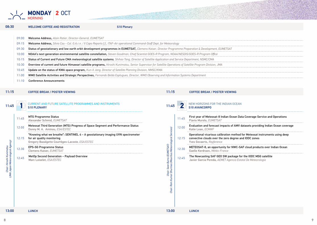
11:45MTG Programme StatusAlexander Schmid, EUMETSAT
12:00Meteosat Third Generation (MTG) Progress of Space Segment and Performance Status Donny M. A. Aminou, ESA/ESTEC
12:15“Knowing what we breathe”: SENTINEL 4 – A geostationary imaging UVN spectrometer for air quality monitoringGregory Bazalgette Courrèges-Lacoste, ESA/ESTEC
12:30EPS-SG Programme Status Clemens Kaiser, EUMETSAT
12:45MetOp Second Generation – Payload OverviewMarc Loiselet, ESA/ESTEC
11:15 COFFEE BREAK / POSTER VIEWING
09:00 Welcome Address, Alain Ratier, Director-General, EUMETSAT
09:15 Welcome Address, Silvio Cau - Col. G.A.r.n. / Il Capo Reparto f.f., ITAF-Air operational Command-Staff Dept. for Meteorology
09:30 Status of geostationary and low earth orbit development programmes in EUMETSAT, Clemens Kaiser, Director Programme Preparation & Development, EUMETSAT
10:00 NOAA’s next generation environmental satellite constellation, Steven Goodman, Chief Scientist GOES-R Program, NOAA/NESDIS/GOES-R Program Office
10:15 Status of Current and Future CMA meteorological satellite systems, Shihao Tang, Director of Satellite Application and Service Department, NSMC/CMA
10:30 Overview of current and future Himawari satellite programs, Hiroshi Kunimatsu, Senior Supervisor for Satellite Operations of Satellite Program Division, JMA
10:45 Update on the status of KMA space program, Kun-Il Jang, Director of Satellite Planning Division, NMSC/KMA
11:00 WMO Satellite Activities and Strategic Perspectives, Fernando Belda Esplugues, Director, WMO Observing and Information Systems Department
11:10 Conference Announcements
11:45First year of Meteosat-8 Indian Ocean Data Coverage Service and OperationsFlavio Murolo, EUMETSAT
12:00Evaluation and forecast impacts of AMV datasets providing Indian Ocean coverageKatie Lean, ECMWF
12:15Operational vicarious calibration method for Meteosat instruments using deep convective clouds over the zero degree and IODC zonesYves Govaerts, Rayference
12:30METEOSAT-8, an opportunity for NWC-SAF cloud products over Indian OceanGaelle Kerdraon, Météo-France
12:45The Nowcasting SAF GEO SW package for the IODC MSG satelliteJavier Garcia Pereda, AEMET Agencia Estatal De Meteorologia
2 OCTMORNINGMONDAY
11:45 1 CURRENT AND FUTURE SATELLITE PROGRAMMES AND INSTRUMENTS
S10 PLENARY 11:45 2 NEW HORIZONS FOR THE INDIAN OCEAN
S10 AVANCORPO

10 11
2 OCTMORNINGMONDAY
11:15 COFFEE BREAK / POSTER VIEWING 11:15 COFFEE BREAK / POSTER VIEWING
11:45
KEYNOTE ADDRESSMeasuring CO2 with GOSAT and OCO-2: Implications for Future Operational Space-Based Greenhouse Gas MeasurementsDavid Crisp, California Institute of Technology
12:15Progress on Greenhouse Gas Monitoring Satellite in ChinaXingying Zhang, NSMC/ CMA
12:30IASI satellite observation of pollutants over China during 10 yearsCathy Clerbaux, LATMOS/IPSL, Université Pierre et Marie Curie
12:45Changing distributions of carbon monoxide (CO) from climate and land use driven fire patterns Helen Worden, National Center For Atmospheric Research (NCAR)
11:45Sentinel-3A Marine Products in Operational Copernicus ServicesHilary Wilson, EUMETSAT Copernicus Programme Office
12:00S3-MPC implementation of OLCI CalVal planChristophe Lerebourg, ACRI-ST
12:15OLCI's smile on remote sensing reflectances over waterLena Katharina Kritten, Freie Universität Berlin
12:30Investigation of Arctic Waters by use of the Chlorophyll-a Fluorescence Signal from MERIS MeasurementsJuergen Fischer, Freie Universtät Berlin
12:45Haze Detection and Removal in Sentinel 3 OLCI Level 1B Imagery Using a New Multispectral Data Dehazing MethodStephan Recher, SCISYS Deutschland GmbH
Chai
r: Ha
yley
Ever
s-Ki
ng (P
lymou
th M
arin
e La
bora
tory
)
Chai
r: Cl
aude
Cam
y-Pe
yret
(IPS
L (U
PMC/
UVSQ
)
11:45 4
ATMOSPHERIC COMPOSITION: RECENT ADVANCES IN SATELLITE PRODUCTS AND APPLICATIONSBA ROOM 4
11:45 5
MARINE ENVIRONMENT MONITORING: RECENT ADVANCES IN SATELLITE PRODUCTS AND APPLICATIONSS10 ROOM 3
13:00 LUNCH 13:00 LUNCH
12 13
2 OCTAFTERNOONMONDAY
14:45Metop Second Generation – System OverviewMaurizio Betto, ESA/ESTEC
15:00Sentinel-5, the new generation European operational atmospheric chemistry mission in polar orbitDidier Martin, ESA
15:15Sentinel-5 Precursor – Status of the first Copernicus Atmospheric Chemistry Mission Claus Zehner, ESA
15:30The status of FY-3C and FY-4A in NWP and the preparation of FY-3D for NWPQifeng Lu, China Meteorological Administration (CMA)
15:45The sentinel-3 mission: Status and update on land & marine productsSusanne Mecklenburg, ESA
14:45SatCORPS Cloud Properties from METEOSAT-8 over the Indian Ocean RegionQing Trepte, SSAI Science Systems and Applications Inc.
15:00TOA solar and thermal fluxes from GERB-2 processing over the Indian Ocean Alessandro Ipe, RMI Royal Meteorological Institute of Belgium
15:15StormTrack algorithm validation over Indian Ocean using Meteosat 8 and the GPM - IMERG productMichele De Rosa, GEO-K s.r.l.
15:30Scientific and application potential of stereoscopic imagery based on Meteosat satellites.Ján Kaňák, SHMU Slovak Hydrometeorological Institute
Chai
r: Se
an B
urns
(EUM
ETSA
T)Ra
m K
umar
Dhu
rmea
(Mau
ritiu
s M
eteo
rolo
gica
l Ser
vice
s)
Chai
r: To
shiy
uki K
urin
o (W
MO)
Chai
r: Se
an B
urns
(EUM
ETSA
T)Ch
air:
Ram
Kum
ar D
hurm
ea (M
aurit
ius
Met
eoro
logi
cal S
ervi
ces)
Chai
r: M
arc
Lois
elet
(ESA
/EST
EC)
16:30The Sentinel-6 Poseidon-4 L1 Ground Prototype ProcessorMònica Roca, isardSAT
16:45Current state and prospects of Russian meteorological satellite constellationVasily Asmus, SRC Planeta
17:00Jason-CS Programme StatusClemens Kaiser, EUMETSAT
17:15Geostationary operational environmental satellites-R series (GOES-R) program overview and statusEdward Grigsby, NASA Goddard Space Flight Center
17:30The GOES-R Program Series: Development of one the World’s Most Innovative Operational Weather Product Generation SystemsEdward Grigsby, NASA Goddard Space Flight Center
17:45WMO WIGOS Vision/Space 2040Johannes Schmetz, WMO
16:30An autoregressive algorithm of solar irradiance forecasting in Reunion Island: First benefits of Meteosat-8 over Indian OceanSylvain Cros, Reuniwatt
16:45Stereo vision using the new dual view Meteosat Second Generation capability.Steven Dewitte, RMIB
17:00SEVIRI over the Indian Ocean, exploiting the capabilities of Meteosat-8 for retrieval of surface and aerosol properties in AfricaSimon Proud, University of Oxford
17:15Meteosat-8 radiance assimilation for solar irradiance forecasting using COSMO-KENDA over Reunion IslandSylvain Cros, Reuniwatt
16:00 COFFEE BREAK / POSTER VIEWING 16:00 COFFEE BREAK / POSTER VIEWING
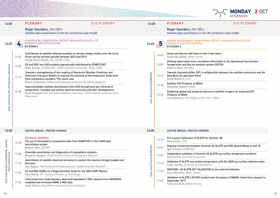
14:00 PLENARY S10 P L E N A R Y
Roger Saunders, Met OfficeSatellite data assimilation in the UK convective scale model
14:00 PLENARY S10 P L E N A R Y
Roger Saunders, Met OfficeSatellite data assimilation in the UK convective scale model
14:45 1 CURRENT AND FUTURE SATELLITE PROGRAMMES AND INSTRUMENTS
S10 PLENARY 14:45 2 NEW HORIZONS FOR THE INDIAN OCEAN
S10 AVANCORPO
14 15
14:45Contribution of satellite infrared sounders to climate change studies over the Arctic Ocean during summer periods between 2010 and 2016Claude Camy-Peyret, IPSL (UPMC/UVSQ)
15:00CO and SO2: two IASI products operationally distributed by EUMETCASTMaya George, LATMOS/IPSL, UPMC Sorbonne Universités, UVSQ, CNRS
15:15
Towards a strengthening of the coupling of Numerical Weather Prediction and Chemistry Transport Models to improve the retrieval of thermodynamic fields from infra-red passive sounders: The ozone caseOlivier Coopmann, CNRM Centre National de Recherches Météorologiques
15:30
Improved global methane distributions from IASI through joint pre-retrieval of temperature, humidity and surface spectral emissivity and other developmentsDiane Knappett, RAL Rutherford Appleton Laboratory / NCEO National Centre for Earth Observation
14:45Ocean and Sea Ice SAF plans in the 5 next yearsCécile Hernandez, Météo-France
15:00Utilising observation error correlation information in the Operational Sea Surface Temperature and Sea Ice Analysis system (OSTIA)Rebecca Reid, Met Office
15:15Towards improved drifter SST: a collaboration between the satellite community and the Data Buoy Co-operation PanelDavid Meldrum, DLM
15:30Satellite SST Products at NOAAAlexander Ignatov, NOAA
15:45Exploring spatial and temporal features in satellite imagery for improved SST Products at NOAAIrina Gladkova, City College of New York / NOAA
2 OCTAFTERNOONMONDAY
Chai
r: An
ne O
’Car
roll
(EUM
ETSA
T)
Chai
r: Da
vid
Cris
p (J
PL J
et P
ropu
lsio
n La
bora
tory
)
14:45 4
ATMOSPHERIC COMPOSITION: RECENT ADVANCES IN SATELLITE PRODUCTS AND APPLICATIONSBA ROOM 4
14:45 5
MARINE ENVIRONMENT MONITORING: RECENT ADVANCES IN SATELLITE PRODUCTS AND APPLICATIONSS10 ROOM 3
14:00 PLENARY S10 P L E N A R Y
Roger Saunders, Met OfficeSatellite data assimilation in the UK convective scale model
14:00 PLENARY S10 P L E N A R Y
Roger Saunders, Met OfficeSatellite data assimilation in the UK convective scale model
16:00 COFFEE BREAK / POSTER VIEWING 16:00 COFFEE BREAK / POSTER VIEWING
16:30
KEYNOTE ADDRESSThe use of atmospheric composition data from EUMETSAT in the CAMS data assimilation systemMelanie Ades, ECMWF
17:00Ensemble assimilation and diagnostics of tropospheric oxidantsBenjamin Gaubert, NCAR National Center of Atmospheric Research
17:15Assimilation of satellite observed ammonia to monitor the reactive nitrogen budget over GermanyArjo Segers, TNO Netherlands Organisation for Applied Scientific Research
17:30O3 and NO2 OSSEs on a Regional/Urban Scale for the GEO-CAPE MissionVijay Natraj, JPL/ California Institute of Technology
17:45Intercomparison study between observed tropospheric NO2 columns from MAXDOAS, modelled and retrieved GOME-2 NO2 data Andy Delcloo, Royal Meteorological Institute of Belgium
16:30Pre-Launch Calibration of SLSTR for Sentinel-3BDave Smith, STFC
16:45Ongoing comparison between Sentinel-3A SLSTR and IASI aboard Metop-A and –BIgor Tomazic, EUMETSAT
17:00Independent validation of Sentinel 3A SLSTR sea surface temperature productsGary Corlett, University of Leicester
17:15Validation of SLSTR sea surface temperature with the ISAR sea surface reference dataCraig Donlon, University of Southampton
17:30SENTINEL-3A SLSTR SST VALIDATION at low and mid-latitudesAnne Marsouin, Météo-France
17:45Validation of SLSTR L2P WST product over European in CMEMS chains from January to September 2017Francoise Orain, Météo-France
Chai
r: An
ne O
’Car
roll
(EUM
ETSA
T)
Chai
r: Ca
thy
Cler
baux
(LAT
MOS
/IPSL
, Uiv
ersi
té
Pier
re e
t Mar
ie C
urie
)

16 17
Chai
r: Ja
ck X
iong
(NAS
A)
Chai
r: Th
omas
P K
uros
u(J
et P
ropu
lsio
n La
bora
tory
/Cal
iforn
ia In
stitu
te o
f Tec
hnol
ogy)
3 OCTMORNINGTUESDAY
12:45 LUNCH
09:00Status of NASA's Atmospheric Infrared Sounder (AIRS) and CubeSat Infrared Atmospheric Sounder (CIRAS) ProjectsThomas Pagano, NASA/JPL
09:15Design and study of a low cost GNSS radio occultation constellation yielding 10,000 soundings per day Christine Fallet, CNES
09:30Microwat : A new Earth Explorer mission proposal to measure the Sea surface Temperature and the Sea Ice ConcentrationCatherine Prigent, Observatoire de Paris
09:45A new radiometer instrument for coastal altimetry Rolv Midthassel, ESA-ESTEC
10:00FORUM: a mission to characterise the far-infrared spectrum of the EarthLuca Palchetti, INO-CNR National Institute of Optics
10:15Assessing impacts of CubeSats and Geostationary satellites Microwave Sounders on Global NWP through OSSENarges Shahroudi, Riverside Technology Inc / NOAA/NESDIS/STAR
11:15Earth Observing SmallSats - Initial Successes and Future PromisesPhilip Ardanuy, Chief Science Officer, Innovim
11:30Quick regional OSSEs on CubeSat based IR/MW sounders on local severe storm forecastsAllen Huang, CIMSS Cooperative Institute for Meteorological Satellite Studies
11:45WIVERN – A Proposed Satellite to Observe Global Winds and Precipitation. Anthony Ilingworth, University of Reading
12:00Weather forecast for next generation very-high-resolution Earth imaging french satelliteSorel Matthieu, Météo-France
12:15Enterprise Approaches to Satellite Products and Systems in the Age of GEOSSSid Boukabara, NOAA/NESDIS/STAR
12:30FY-4 image navigation and registration On-orbit PerformanceLei Yang, CMA/NSMC National Satellite Meteorological Cente
Chai
r: An
thon
y Il
ingw
orth
(Uni
vers
ity o
f Rea
ding
)
09:00 1 CURRENT AND FUTURE SATELLITE PROGRAMMES AND INSTRUMENTS
S10 PLENARY
12:45 LUNCH
09:00Performance assessment of recently released OMPS data productsGlen Jaross, NASA Goddard Space Flight Center
09:15Joint Polar Satellite System Data Products and ApplicationsBonnie Reed, NOAA/NESDIS/JPSS
09:30Improving the design of NUCAPS trace gas products within applications – The value of a user-developer partnership Nadia Smith, Science and Technology Corporation
09:45JPSS Atmospheric Composition Products in support of FIREX and Future Field Campaigns Murty Divakarla, IM Systems Group, Inc.
10:00Operational Near-Real-Time total ozone retrieval algorithm for for TROPOMI/S5P and Sentinel 4 Klaus-Peter Heue, DLR-IMF Deutsches Zentrum für Luft- und Raumfahrt
10:15The Sentinel-4 and Sentinel-5 Missions and their atmospheric composition productsBen Veihelmann, ESA/ESTEC
11:15New products and future evolution of the Atmospheric Composition Monitoring SAF Seppo Hassinen, FMI Finnish Meteorological Institute
11:30Operational trace gas column observations from GOME-2 on MetopPieter Valks, DLR-IMF
11:45Understanding Differences in Satellite Records of Tropospheric Ozone Over the Past Decade Jessica Neu, NASA Jet Propulsion Laboratory, California Institue of Technology
12:00
The production of 20+ year height-resolved ozone data from GOME-class instruments for ESA-CCI and C3S Barry Latter, RAL Space, STFC Rutherford Appleton Laboratory / NCEO (National Centre for Earth Observation)
12:15
The use of QBO, ENSO, NAO perturbations in the evaluation of GOME-2A total ozone measurements Christos Zerefos, Research Center for Atmospheric Physics and Climatology of the Academy of Athens
12:30Tropospheric ozone columns in relation to El Niño and firesKlaus-Peter Heue, Dlr-imf Deutsches Zentrum Für Luft- Und Raumfahrt/ Institut Für Methodik Der Fernerkundung
Chai
r: Ch
risto
s Ze
refo
s (R
esea
rch
Cent
er fo
r Atm
osph
eric
Ph
ysic
s an
d Cl
imat
olog
y of
the
Acad
emy
of A
then
s)
09:00 4
ATMOSPHERIC COMPOSITION: RECENT ADVANCES IN SATELLITE PRODUCTS AND APPLICATIONSBA ROOM 4
10:30 COFFEE BREAK / POSTER VIEWING 10:30 COFFEE BREAK / POSTER VIEWING
18 19
Chai
r: Jo
rg S
chul
z (E
UMET
SAT)
3 OCTMORNINGTUESDAY
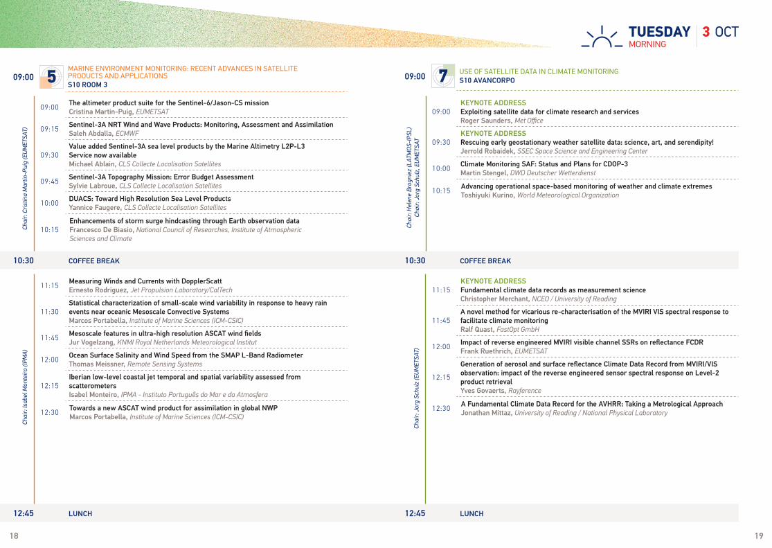
09:00The altimeter product suite for the Sentinel-6/Jason-CS missionCristina Martin-Puig, EUMETSAT
09:15Sentinel-3A NRT Wind and Wave Products: Monitoring, Assessment and AssimilationSaleh Abdalla, ECMWF
09:30Value added Sentinel-3A sea level products by the Marine Altimetry L2P-L3 Service now availableMichael Ablain, CLS Collecte Localisation Satellites
09:45Sentinel-3A Topography Mission: Error Budget AssessmentSylvie Labroue, CLS Collecte Localisation Satellites
10:00DUACS: Toward High Resolution Sea Level ProductsYannice Faugere, CLS Collecte Localisation Satellites
10:15Enhancements of storm surge hindcasting through Earth observation dataFrancesco De Biasio, National Council of Researches, Institute of Atmospheric Sciences and Climate
11:15Measuring Winds and Currents with DopplerScattErnesto Rodriguez, Jet Propulsion Laboratory/CalTech
11:30Statistical characterization of small-scale wind variability in response to heavy rain events near oceanic Mesoscale Convective SystemsMarcos Portabella, Institute of Marine Sciences (ICM-CSIC)
11:45Mesoscale features in ultra-high resolution ASCAT wind fieldsJur Vogelzang, KNMI Royal Netherlands Meteorological Institut
12:00Ocean Surface Salinity and Wind Speed from the SMAP L-Band RadiometerThomas Meissner, Remote Sensing Systems
12:15Iberian low-level coastal jet temporal and spatial variability assessed from scatterometersIsabel Monteiro, IPMA - Instituto Português do Mar e da Atmosfera
12:30Towards a new ASCAT wind product for assimilation in global NWPMarcos Portabella, Institute of Marine Sciences (ICM-CSIC)
Chai
r: Cr
istin
a M
artin
-Pui
g (E
UMET
SAT)
Ch
air:
Isab
el M
onte
iro (I
PMA)
09:00 5
MARINE ENVIRONMENT MONITORING: RECENT ADVANCES IN SATELLITE PRODUCTS AND APPLICATIONSS10 ROOM 3
09:00KEYNOTE ADDRESSExploiting satellite data for climate research and services Roger Saunders, Met Office
09:30KEYNOTE ADDRESSRescuing early geostationary weather satellite data: science, art, and serendipity!Jerrold Robaidek, SSEC Space Science and Engineering Center
10:00Climate Monitoring SAF: Status and Plans for CDOP-3Martin Stengel, DWD Deutscher Wetterdienst
10:15Advancing operational space-based monitoring of weather and climate extremesToshiyuki Kurino, World Meteorological Organization
11:15KEYNOTE ADDRESSFundamental climate data records as measurement scienceChristopher Merchant, NCEO / University of Reading
11:45A novel method for vicarious re-characterisation of the MVIRI VIS spectral response to facilitate climate monitoringRalf Quast, FastOpt GmbH
12:00Impact of reverse engineered MVIRI visible channel SSRs on reflectance FCDRFrank Ruethrich, EUMETSAT
12:15
Generation of aerosol and surface reflectance Climate Data Record from MVIRI/VIS observation: impact of the reverse engineered sensor spectral response on Level-2 product retrievalYves Govaerts, Rayference
12:30A Fundamental Climate Data Record for the AVHRR: Taking a Metrological ApproachJonathan Mittaz, University of Reading / National Physical Laboratory
Chai
r: H
elen
e Br
ogni
ez (L
ATM
OS-I
PSL)
Chai
r: Jo
rg S
chul
z, E
UMET
SAT
09:00 7 USE OF SATELLITE DATA IN CLIMATE MONITORING
S10 AVANCORPO
10:30 COFFEE BREAK 10:30 COFFEE BREAK
12:45 LUNCH 12:45 LUNCH

20 21
Chai
r: Th
omas
Pag
ano
(NAS
A/JP
L)
3 OCTAFTERNOONTUESDAY
14:30Ground validation assessments of GPM core observatory science requirementsErich Stocker, NASA Goddard Space Flight Center
14:45Effects of JPSS-1 ATMS Spectral Response Function and Antenna Pattern on Brightness Temperature SimulationsLin Lin, ESSIC/UMD / NOAA/STAR
15:00JPSS VIIRS Pre-launch Calibration and Performance AssessmentJack Xiong, NASA GSFC
15:15The new scatterometer onboard the EPS-SG platformsFrancesca Ticconi, EUMETSAT
15:30Statuts of IASI FM3R instrument and performance assessment after Metop-C thermal vacuum testsElsa Jacquette, CNES
15:45A consistent calibration strategy applied over the historical ISCCP B1U geostationary visible imager record.David Doellling, NASA Langley Research Center
13:45 PLENARY D ISCUSSION S10 P L E N A R Y
Vincent Guidard, Météo-France & CNRS / CNRM - UMR3589Update on satellite observation assimilation in mesoscale NWP
13:45 PLENARY D ISCUSSION S10 P L E N A R Y
Vincent Guidard, Météo-France & CNRS / CNRM - UMR3589Update on satellite observation assimilation in mesoscale NWP
14:30 1 CURRENT AND FUTURE SATELLITE PROGRAMMES AND INSTRUMENTS
S10 PLENARY
Chai
r: An
toni
a G
amba
cort
a (S
cien
ce a
nd T
echn
olog
y Co
rpor
atio
n (S
TC)
14:30Towards new constraints on the global tropospheric ozone budget: Satellite observations of peroxyacetyl nitrate (PAN)Vivienne Payne, JPL/Caltech
14:45Sun-induced vegetation fluorescence retrieval development using GOME-2 dataM. L. Kooreman, KNMI Royal Netherlands Meteorological Institute
15:00Satellite and Aircraft Observations of Cross-Tropopause Transport of Water Substance by ThunderstormsPao K. Wang, University of Wisconsin-Madison / Academia Sinica
15:15A new scientific product of water vapor derived from GOME, SCHIAMACHY and GOME-2 based on Advanced AMF AlgorithmYang Wang, Max Planck Institute for Chemistry
15:30Validation of the GOME-2 GDP 4.8 OClO product Gaia Pinardi, ISAB-BIRA Royal Belgium Institute for Space Aeronomy
15:45Satellite Observations of Tropospheric BrO over Salt Lakes and Northern High LatitudesThomas P Kurosu, Jet Propulsion Laboratory/California Institute of Technology
16:00
Random Projection Approach to the Global Scale Retrieval of Atmospheric Profiles of Greenhouse Gases and Pollutants from IASI with Improved Horizontal Spatial Resolution and PrecisionGuido Masiello, University of Basilicata
14:30 4
ATMOSPHERIC COMPOSITION: RECENT ADVANCES IN SATELLITE PRODUCTS AND APPLICATIONSBA ROOM 4
16:00 -18:00 POSTER SESSION B A S I L I C A A E M I L I ACOCKTAIL
16:00 -18:00 POSTER SESSION B A S I L I C A A E M I L I ACOCKTAIL

22 23
Chai
r: H
elen
e Br
ogni
ez (L
ATM
OS-I
PSL
Inst
itut P
ierr
e Si
mon
Lap
lace
)
14:30A High-Quality TRMM/GPM Brightness Temperature Reference Dataset for Climate ApplicationsWesley Berg, Colorado State University
14:45GSICS Infrared Reference Sensor Traceability and UncertaintyTim Hewison, EUMETSAT
15:00Extending the Recalibration of the HIRS Longwave Infrared Channels to Support Longterm Time Series StudiesBin Zhang, University of Maryland
15:15The AVHRR MITRAM visible calibration strategy designed for the NOAA degrading orbitDavid Doelling, NASA Langley Research Center
15:30Historical AVHRR data archived at ESA – a prerequisite for climate monitoringStefan Wunderle, University of Bern
14:30 7 USE OF SATELLITE DATA IN CLIMATE MONITORING
S10 AVANCORPO
Chai
r : H
ayle
y Ev
ers
King
(Ply
mou
th M
arin
e La
bora
tory
)
3 OCTAFTERNOONTUESDAY
14:30Transport efficiency of an Agulhas ring from combined satellite altimetry and Argo profilesGraham Quartly, Plymouth Marine Laboratory
14:45Comparisons of the first year of Sentinel-3 SLSTR sea surface temperatures with near-surface ARGO measurementsAndrew Harris, University of Maryland
15:00The diurnal cycle of sea-surface temperature and estimation of the heat budget of the Mediterranean SeaSalvatore Marullo, ENEA, Centro Ricerche Frascati
15:15SEVIRI Level 2 Processor for Surface Parameters: An application to Mediterranean SeaGuido Masiello, Università degli Studi della Basilicata / CINFAI
15:30Observed ice surface temperatures and the potential integration into a coupled ocean and sea ice modelTill Andreas Soya Rasmussen, DMI Danish Meteorological Institute
15:45A multi-surface performance assessment of the Sentinel-3A Surface Topography Mission Microwave Radiometer Bruno Picard, CLS Collecte Localisation Satellites
14:30 5
MARINE ENVIRONMENT MONITORING: RECENT ADVANCES IN SATELLITE PRODUCTS AND APPLICATIONSS10 ROOM 3
13:45 PLENARY D ISCUSSION S10 P L E N A R Y
Vincent Guidard, Météo-France & CNRS / CNRM - UMR3589Update on satellite observation assimilation in mesoscale NWP
13:45 PLENARY D ISCUSSION S10 P L E N A R Y
Vincent Guidard, Météo-France & CNRS / CNRM - UMR3589Update on satellite observation assimilation in mesoscale NWP
16:00 -18:00 POSTER SESSION B A S I L I C A A E M I L I ACOCKTAIL
16:00 -18:00 POSTER SESSION B A S I L I C A A E M I L I ACOCKTAIL

24 25
Chai
r: Lo
thar
Sch
ülle
r (EU
MET
SAT)
Chai
r: Ch
ristia
n Re
tsch
er (E
UMET
SAT)
4 OCTMORNINGWEDNESDAY
10:30 COFFEE BREAK / POSTER VIEWING 10:30 COFFEE BREAK / POSTER VIEWING
09:00Joint Polar Satellite System: the United States New Generation Civilian Polar Orbiting Environmental Satellite SystemBarbara Grofic, NASA/JPSS
09:15J1 Readiness from a Cal/Val PerspectiveJeffrey Weinrich, Science and Technology Corporation
09:30
NOAA’s Joint Polar Satellite System’s Proving Ground and Risk Reduction (PGRR) Program – Critical Capabilities Continue to Benefit NOAA Line Offices as Suomi NPP Transitions to JPSS-1Bill Sjoberg, NOAA JPSS
09:45An Analysis of Potential Polarization Induced Calibration Errors for the Cross-track Infrared Sounder (CrIS) SensorJoe Taylor, Space Science and Engineering Center
10:00
Double-Take: Possibilities for Improved Nocturnal Environment using VIIRS Day/Night Band sensors on Suomi NPP and JPSS-1William Straka III, Cooperative Institute for Meteorological Satellite Studies, University of Wisconsin-Madison
10:15Analysis of DCC Reflected Lunar Radiance Measured by the Suomi NPP VIIRS Day/Night BandChangyong Cao, NOAA
09:00Near-Real Time Atmosphere Products from Copernicus Sentinel-3Rosemary Munro, EUMETSAT
09:15A New Top-Down Approach for Directly Estimating Biomass Burning Emissions and Fuel Consumption from Geostationary Satellite Fire Radiative Power (FRP)Martin Wooster, King's College London
09:30How to use SEVIRI Fire Radiative Power in the Copernicus Atmosphere Monitoring ServiceJohannes W. Kaiser, Max Planck Institute for Chemistry
09:45Overview of GRASP algorithm developments and their potential for enhanced aerosol retrieval from 3MI/MetOp-SG, OLCI and SLSTR/Sentinel-3 and Sentinel-4 observationsOleg Dubovik, Laboratoire d’Optique Atmosphérique, CNRS / Université Lille -1
10:00An advanced initiative for tracking operationally aerosol events over the last decade based on MSG/SEVIRI satellite observationsDominique Carrer, UMR3589-CNRM
11:15KEYNOTE ADDRESSEUMETSAT Satellite Application Facility Network: Staring a new phaseLothar Schüller, EUMETSAT
11:45The Satellite Applications Facility on Land Surface Analysis: Evolution towards the Next Generation of EUMETSAT SatellitesIsabel Trigo, IPMA (Portuguese Institute of Sea and Atmosphere)
12:00ROM SAF plans and radio occultation product evolution towards EPS-SGKent Lauritsen, Danish Meteorological Institute
12:15The Nowcasting SAF (NWC SAF), current status and future plansXavier Calbet, AEMET Agencia Estatal De Meteorologia
12:30NWCSAF v2018 delivery: improvement of CI productJean-Marc Moisselin, Météo-France
11:15PMAp: Aerosol Optical Properties operational retrieval at global scale Alessandra Cacciari, EUMETSAT
11:30
Three- dimensional distribution of desert dust outbreaks derived from IASI satellite observationsGaëlle Dufour, LISA Laboratoire Interuniversitaire des Systèmes Amosphériques - CNRS/UPEC/UPD
11:45Use of satellite data for source detection and monitoring of dust aerosolSophie Vandenbussche, Royal Belgian Institute for Space Aeronomy
12:00Hourly retrieval of aerosol properties over sea and land from MSG/SEVIRI observations in the framework of the aerosol_cci projectMarta Luffarelli, Rayference
12:15Spaceborne lidar datasets: operational useFranco Marenco, Met Office
12:30Multisensor synergistic approach for volcano monitoring based on SEVIRI observationsLuca Merucci, INGV Istituto Nazionale di Geofisica e Vulcanologia
12:45First Look Dust and Smoke Imagery from GOES-16 Advanced Baseline Imager (ABI)Shobha Kondragunta, NOOA
Chai
r: Ch
risto
phe
Acca
dia
(EUM
ETSA
T)
Chai
r: Ro
sem
ary
Mun
ro (E
UMET
SAT)
09:00 1 CURRENT AND FUTURE SATELLITE PROGRAMMES AND INSTRUMENTS
S10 PLENARY 09:00 4
ATMOSPHERIC COMPOSITION: RECENT ADVANCES IN SATELLITE PRODUCTS AND APPLICATIONSBA ROOM 4
12:45 LUNCH 13:00 LUNCH

26 27
Chai
r: St
epha
n Bo
jinsk
i (W
orld
Met
eoro
logi
cal O
rgan
izat
ion)
Chai
r: Jo
achi
m S
aalm
uelle
r (EU
MET
SAT)
Chai
r: St
even
Goo
dman
(NOA
A N
ESDI
S)
Chai
r: To
shiy
uki K
urin
o (W
MO)
MORNING4 OCTWEDNESDAY
10:30 COFFEE BREAK / POSTER VIEWING
12:45 LUNCH 12:45 LUNCH
10:30 COFFEE BREAK / POSTER VIEWING
09:00Coordinated CDR Production Through a Network of Producers: SCOPE-CM’s EvolutionJeffrey Privette, NOAA's National Centers for Environmental Information
09:15A SCOPE-CM Project for the retrieval of Land Surface Albedo using imagery acquired by geostationary satellites.Alessio Lattanzio, EUMETSAT
09:30Multisensor albedo retrieval from polar-orbiting satellitesAku Riihelä, Finnish Meteorological Institute
09:45Global climate monitoring with GPS Radio Occultation dataHans Gleisner, Danish Meteorological Institute
10:00Sustained generation of upper tropospheric humidity datasetsLei Shi, NOAA/NESDIS/NCEI
10:15Re-calibration of Infrared and Water-Vapor channels of imagers on JMA’s historical geostationary meteorological satellites using HIRS dataTasuku Tabata, MSC/JMA
09:00An Overview of the Design and Development of the Geostationary Operational Environmental Satellite R-Series (GOES-R) Space Segment Pam Sullivan, NASA Goddard Space Flight Center
09:15An Early Look at the Imagery from the Advanced Baseline Imager (ABI) on GOES-16Daniel Lindsey, NOAA/NESDIS/STAR
09:30GOES-16 ABI ON-ORBIT PerformanceRobert Iacovazzi, NOAA/NESDIS/STAR
09:45GOES-R/16 Radiometric Traceability through Field Campaign and Comparisons with SNPP/MetOp RadiometersChangyong Cao, NOAA
10:00Meteosat Third Generation (MTG): FCI End-to-End PerformanceYannig Durand, ESA
11:15COSMO-SkyMed mission: contribution to climate change monitoringMaria Libera Battagliere, Italian Space Agency
11:30
KEYNOTE ADDRESSThe GEWEX water vapor assessment (G-VAP) – results from inter-comparisons and stability analysis.Marc Schröder, DWD Deutscher Wetterdienst
12:00Closing the loop: A virtual observatory for climate data quality earth observationsJoerg Schulz, EUMETSAT
12:15CIS-Troll-Match – a versatile tool for inter-comparison and validation of satellite measurements and moreMikhail Itkin, Norwegian Meteorological Institute
11:15Automated Volcanic Cloud Identification, Tracking, and Characterization Using Next Generation Meteorological SatellitesJohn Cintineo, SSEC / CMSS
11:30Next generation geostationary satellite observations in a multi-sensor severe weather nowcasting toolJohn Cintineo, SSEC / CMSS
11:45Rapidly Developing Cumulus Area (RDCA) detection using Himawari-8/9Hiroshi Suzue, MSC/JMA
12:00Where East Meets West: How Himawari-8 AHI Enables True Color Capabilities for GOES-R ABI Daniel Lindsey, MSC/JMA/NESDIS/STAR, Regional and Mesoscale Meteorology Branch
12:15Multispectral Imagery Applications for the New Generation Weather Satellites Curtis Seaman, CIRA Cooperative Institute for Research in the Atmosphere
12:30MTG-IRS: Introduction to Instrument Concept and Calibration PrinciplesEline Conijn, OHB System AG
09:00 8 NEXT GENERATION GEOSTATIONARY SATELLITES
S10 ROOM 309:00 7 USE OF SATELLITE DATA IN CLIMATE MONITORING
S10 AVANCORPO

28 29
AFTERNOON4 OCTWEDNESDAY
14:30GPM V05 Gridded Text ProductsErich Stocker, NASA Goddard Space Flight Center
14:45A novel active and passive microwave package for the investigation of Arctic mixed-phase cloudsMario Mech, Universität zu Köln
15:00In-Flight Characterization of Microwave Sounders With the MoonMartin Burgdorf, Universität Hamburg
15:15Approaches to Enhanced Temporal Sampling from NASA Earth Satellite MissionsJack Kaye, NASA Earth Science Division
15:30Noise performance of microwave humidity sounders over their life timeImke Hans, Universität Hamburg
14:30The characterisation of upper-tropospheric--lower-stratospheric secondary sulfate aerosols from thermal infrared satellite instruments in low Earth and geostationary orbit Pasquale Sellitto, LMD-ENS
14:45 OMI observations of bromine monoxide emissions from volcanoes Raid Suleiman, Harvard-Smithsonian Center for Astrophysics
15:0010 years of GOME-2 SO2 data: Volcanic eruptions and anthropogenic emissionsPascal Hedelt, DLR-IMF Deutsches Zentrum für Luft- und Raumfahrt/ Institut für Methodik der Fernerkundung
15:15Aviation meteorology: An icing detection product based on EUMETSAT dataAlessandra Lucia Zollo, Meteorological laboratory (METE), Italian Aerospace Research Center (CIRA)
15:30Multilayer Cloud Retrieval for CERES Using Multispectral Satellite Data With an Artificial Neural NetworkPatrick Minnis, NASA Langley Research Center
15:45NWC-SAF convective rainfall rate algorithm development for Himawari8 AHI over the Australian continent Mark Broomhall, Australian Bureau of Meteorology
16:15The EPS-SG Microwave Imager and Ice Cloud Imager: ground processing and development of Calibration/Validation activitiesChristophe Accadia, EUMETSAT
16:30Calibration and Validation activities for the EUMETSAT Polar System - Second Generation (EPS-SG) Visible/Infrared Imager (METimage)Christophe Accadia, EUMETSAT
16:45In-Orbit References for Microwave InstrumentsManik Bali, NOAA/NESDIS/STAR
17:00Building new uncertainty concepts into current and future missionsChristopher Merchant, NCEO / University of Reading
17:15Flux estimation for the Broad-Band Radiometer (BBR) on EarthCAREAlmudena Velazquez Blazquez, RMI Royal Meteorological Institute of Belgium
17:30
Parametric models of the angular dependence of satellite retrieved LST at global scale and using land surface classificationIsabel Trigo, Instituto Dom Luiz (IDL), University of Lisbon / IPMA - Instituto Potuguês do Mar e da Atmosfera
16:15
Operational cloud products from GOME-2 and perspectives for Sentinel-5P and Sentinel-4Ronny Lutz, DLR-IMF Deutsches Zentrum für Luft- und Raumfahrt/ Institut für Methodik der Fernerkundung
16:30Comparison between O2 A-band and O2-O2 band derived cloud properties from GOME-2Piet Stammes, KNMI Royal Netherlands Meteorological Institute
16:45A fast cloud retrieval algorithm from the oxygen B band for GOME-2 measurementsMarine Desmons, KNMI Royal Netherlands Meteorological Institute
17:00New Global Estimates of Cloud Water Content and Path from Satellite Imager DataWilliam Smith, NASA Langley Research Center
17:15Retrieval of liquid cloud properties from POLDER3/PARASOL instruement: A global visionLaurent C.-Labonnote, University of Lille, LOACh
air:
Mar
io M
ech
(Uni
vers
ität K
öln)
Chai
r: Pa
tric
k M
inni
s (N
ASA
Lang
ley
Rese
arch
Cen
ter)
13:45 PLENARY D ISCUSSION S10 P L E N A R Y
Roger Randriamampianina, met.noSatellite observations in HARMONIE-AROME mesoscale models: Current status and future plan
13:45 PLENARY D ISCUSSION S10 P L E N A R Y
Roger Randriamampianina, met.noSatellite observations in HARMONIE-AROME mesoscale models: Current status and future plan
14:30 1 CURRENT AND FUTURE SATELLITE PROGRAMMES AND INSTRUMENTS
S10 PLENARY 14:30 4
ATMOSPHERIC COMPOSITION: RECENT ADVANCES IN SATELLITE PRODUCTS AND APPLICATIONSBA ROOM 4
Chai
r: Pi
et S
tam
mes
(KN
MI R
oyal
Net
herla
nds
Met
eoro
logi
cal I
nstit
ute)
Chai
r: Ch
angy
ong
Cao
(NOA
A)
16:00 COFFEE BREAK / POSTER VIEWING16:00 COFFEE BREAK / POSTER VIEWING

30 31
Chai
r: Da
niel
e Bi
ron
(COM
et -
Cen
tro
Oper
ativ
o pe
r la
Met
eoro
logi
a)
Chai
r: M
arc
Schr
öder
(DW
D De
utsc
her W
ette
rdie
nst)
16:00 COFFEE BREAK / POSTER VIEWING 16:00 COFFEE BREAK / POSTER VIEWING
4 OCTAFTERNOONWEDNESDAY
16:15Polar air temperature estimated from satellite ice surface measurementsPia Nielsen-Englyst, Danish Meteorological Institute
16:30Observations of global variation of water vapor by using different observational Platforms and its impact on climate changeVenkata Subba Reddy, GITAM University, Dept. of Physics
16:45Influence of tropical cyclones in the North Atlantic Ocean on total column ozoneHumberto Barbosa, Laboratory for Analyzing and Processing Satellite Images (LAPIS), Federal University of Alagoas (UFAL)
17:00Smoke over Clouds - Radiative Effect Assessed with MSGHartwig Deneke, Leibniz Institute for Tropospheric Research
16:15KEYNOTE ADDRESSOperational Use of GOES-16 Imagery by the U.S. National Weather ServiceDaniel Lindsey, NOAA/NESDIS/STAR/RAMMB
16:45Resolving “hidden gravity waves” with Himawari-8 imagery and its application to aircraft-scale turbulenceAnthony Wimmers, University of Wisconsin - CIMSS
17:00Future plans for JMA's atmospheric motion vectorsKenichi Nonaka, JMA
17:15Geostationary satellites remote sensing for the energy management systemTakashi Nakajima, Tokai University
17:30WMO SCOPE-Nowcasting using new-generation satellite data: Progress and PerspectivesStephan Bojinski, World Meteorological Organization
14:30
KEYNOTE ADDRESSTwo heavy rain types over the humid East Asian summer environment observed from TRMM PR reflectivityB.J. Sohn, Seoul National University
15:00DAPAGLOCO - A global daily precipitation dataset from satellite and rain-gauge measurementsMarc Schröder, DWD Deutscher Wetterdienst
15:15Sea surface temperature climate data records from the ESA Climate Change InitiativeChristopher Merchant, NCEO / University of Reading
15:30The HOAPS Climatology V4: updates and results from comparisons to various satellite, buoy and ship data records.Karsten Fennig, DWD Deutscher Wetterdienst
14:30Galvanizing Excitement and Awareness Around the GOES-R Satellite Series with Science Teachers, Science Centers and TV BroadcastersMargaret Mooney, CIMSS Cooperative Institute for Meteorological Satellite Studies
14:45Light up the Sky for NOAA's Geostationary Lightning MapperSteven Goodman, NOAA NESDIS GOES-R Program Office
15:00A First Look at GOES-16 Operational Geostationary Lightning Mapper ObservationsGeoffrey Stano, NASA SPoRT / ENSCO Inc.
15:15Operational Lightning Products Improve Forecasting Capabilities in OPC and TAFB Offshore ZonesSteven Goodman, GOES-R Program Office
15:30Use of MTG-IRS proxy data for early detection of convective systemsAntonio Vocino, COMet - Centro Operativo per la Meteorologia
15:45Ready to Serve from an Operational Assignment in the GOES Constellation: GOES-16 Data and ServicesMatthew Seybold, NOAA/NESDIS/OSPO/SPSD
Chai
r: Jo
chen
Gra
ndel
l (EU
MET
SAT)
Chai
r: B.
J. S
ohn
(Seo
ul N
atio
nal U
nive
rsity
)
14:30 8 NEXT GENERATION GEOSTATIONARY SATELLITES
S10 ROOM 3
16:15 8 NEXT GENERATION GEOSTATIONARY SATELLITESS10 ROOM 3
14:30 7 USE OF SATELLITE DATA IN CLIMATE MONITORING
S10 AVANCORPO
16:15 7 USE OF SATELLITE DATA IN CLIMATE MONITORINGS10 AVANCORPO
13:45 PLENARY D ISCUSSION S10 P L E N A R Y
Roger Randriamampianina, met.noSatellite observations in HARMONIE-AROME mesoscale models: Current status and future plan
13:45 PLENARY D ISCUSSION S10 P L E N A R Y
Roger Randriamampianina, met.noSatellite observations in HARMONIE-AROME mesoscale models: Current status and future plan

32 33
Ch
air:
Lore
dana
Spe
zzi (
EUM
ETSA
T)
Chai
r: Ro
ger R
andr
iam
ampi
anin
a (N
orw
egia
n M
eteo
rolo
gica
l Ins
titut
e)
Chai
r: Ad
am D
ybbr
oe(S
MH
I Sw
edis
h M
eteo
rolo
gica
l and
Hyd
rolo
gica
l Ins
titut
e)
Chai
r: Re
gis
Bord
e (E
UMET
SAT)
5 OCTMORNINGTHURSDAY
10:30 COFFEE BREAK / POSTER VIEWING
12:45 LUNCH 12:45 LUNCH
10:30 COFFEE BREAK / POSTER VIEWING
09:00Suomi-NPP VIIRS Sensor Data Record (SDR) Reprocessing ImprovementsTaeyoung Choi, NOAA/NESDIS/STAR / Earth Resources Tech.
09:15Combination of VIIRS with CrIS for Improving Data Quality and UtilizationLikun Wang, University of Maryland
09:30The EUMETSAT Total Precipitable Water product algorithm for the Polar System - Second Generation (EPS-SG) Visible/Infrared Imager (METimage)Loredana Spezzi, EUMETSAT
09:45Land Surface Albedo from MSG and METOP Satellites: Method for retrieval, validation, and evolutionDominique Carrer, UMR3589-CNRM
10:00Generation of the new sensor image data from lower-resolution images – a MTG case studyJanja Avbelj, EUMETSAT
09:00
KEYNOTE ADDRESSNWP (Numerical Weather Prediction) SAF (Satellite Application Facilities): plans and future developments for CDOP-3Roger Saunders, Met Office
09:30Optimizing Space to Ground Optical Communications through Satellite Radiance Assimilation into a Numerical Cloud Forecasting ModelRandall Alliss, Northrop Grumman
09:45Deep-learning techniques for accurate global horizontal irradiance forecastingGiorgio Licciardi, Sol Invictus
10:00Comparison results of two clear channel selection methods used for cloudy sky data assimilationAhreum Lee, School of Earth and Environmental Sciences, Seoul National University
10:15Assimilation of Reconstructed Radiances from Principal Component compressed Hyperspectral Sounder IASI data in the ICON EnVarSilke May, DWD Deutscher Wetterdienst
11:15The EPS-SG 3MI co-registered level-1C and surface reflectance level-2 productRosemary Munro, EUMETSAT
11:30Calibration of hurricane-force wind observations from satellitesThomas Meissner, Remote Sensing Systems
11:45Ensuring high quality fire products from NOAA’s JPSS and GOES-R missionsShobha Kondragunta, NOAA
12:00
Rapid Acquisition, Processing, and Delivery of Advanced Infrared and Microwave Sounder Data from Polar Orbiting Satellites for Numerical Weather Prediction and other Time-Sensitive ApplicationsLiam Gumley, University of Wisconsin-Madison
12:153D wind fields extracted from EUMETSAT IASI Level2 productsOlivier Hautecoeur, METIS/EUMETSAT
11:15Asynchronous Assimilation of High Temporal/Spatial Geosynchronous Infrared Imaging Data – A Wind Field Analysis DemonstrationAllen Huang, SSEC/CIMSS UW-Madison
11:30Impact study on outer-loop iteration for all-sky microwave imager radiance assimilation at JMA’s global NWP systemMasahiro Kazumori, JMA Japan Meteorological Agency
11:45Dual-Scale Neighboring Ensemble Variational Assimilation of Satellite Microwave Imager Brightness Temperatures for Typhoon ETAUKazumasa Aonashi, Meteorological Research Institute JMA
12:00Assimilation of cloud-affected radiances in deep convection - a case studyJosef Schröttle, Herz, Data Assimilation Branch, Ludwig-maximilans-universität Munich
12:15Assimilation of AMSU-A in the presence of cloud and precipitationPeter Weston, ECMWF
12:30A Bayesian framework for the all-sky assimilation of SAPHIR/Megha-Tropiques observations within the Meteo-France global model ARPEGEPhilippe Chambon, CNRM Centre National de Recherches Météorologiques
09:00 1 CURRENT AND FUTURE SATELLITE PROGRAMMES AND INSTRUMENTS
S10 PLENARY 09:00 3
USE OF DATA FROM CURRENT AND FUTURE SATELLITES IN VERY HIGH-RESOLUTION NWP MODELSBA ROOM 4

34 35
Chai
r: Ra
lf Be
nnar
tz (U
nive
rsity
of W
isco
nsin
- M
adis
on)
5 OCTMORNINGTHURSDAY
12:45 LUNCH
10:30 COFFEE BREAK / POSTER VIEWING
09:00KEYNOTE ADDRESSCoupling of Surface and Cloud PropertiesSteve Ackerman, University of Wisconsin-Madison
09:30Quantifying the cloud radiative effect based on 35 years of AVHRR observationsMartin Stengel, DWD Deutscher Wetterdienst
09:45
A Meteosat Bayesian Cloud Fractional Cover Climate Data Record: evaluation, homogeneity assessment and intercomparison with existing climate data recordsJedrzej Bojanowski, Federal Office of Meteorology and Climatology MeteoSwiss / Remote Sensing Centre, Institute of Geodesy and Cartography
10:00ITCZ trend analysis via Geodesic P-spline smoothing of the AIRWAVE TCWV and Cloud datasetsElisa Castelli, CNR-ISAC
10:15Recent trends in cloudiness over the Arctic: Insights from CLARA-A2, PATMOS-x and ESA Cloud CCI long-term datasets Karl-Göran Karlsson, SMHI Swedish Meteorological and Hydrological Institute
11:15
KEYNOTE ADDRESSChanges in Boundary Layer Clouds and Estimation of Feedback Sensitivity Using the Multi-Decadal PATMOS-x AVHRR Cloud Satellite ClimatologyMichael Foster, University of Wisconsin - Madison
11:45Regional and global estimates of droplet number concentration of boundary layer clouds from visible/near-infrared observations Ralf Bennartz, University of Wisconsin - Madison / Vanderbilt University
12:00Evaluation and comparison of MSG SEVIRI retrievals of liquid water path with ship observationsHartwig Deneke, Leibniz Institute for Tropospheric Research
12:15The CMSAF CLARA-A2 satellite dataset simulatorSalomon Eliasson, Swedish Meteorological and Hydrological Institute
12:30Evaluating NASA S-NPP continuity cloud products for climate research using CALIPSO, CATS and Level-3 analysisSteve Ackerman, University of Wisconsin-Madison
Chai
r: St
eve
Acke
rman
(Uni
vers
ity o
f Wis
cons
in-M
adis
on)
Chai
r: Lo
thar
Sch
ülle
r (EU
MET
SAT)
Chai
r: Ch
ris K
idd
(Uni
vers
ity o
f Mar
ylan
d an
d N
ASA)
10:30 COFFEE BREAK / POSTER VIEWING
12:45 LUNCH
09:00
KEYNOTE ADDRESSAdvanced visualization of global total precipitable water with morphological compositing: A demonstration of 'MIMIC-TPW2'Anthony Wimmers, University of Wisconsin - CIMSS
09:30How can we improve satellite products and make them more useful in hydrological applications?Michal Kasina, IMGW-PIB Polish Institute of Meteorology and Water Management
09:45The H-SAF Consortium on the CDOP-3 : the challenge continuesFrancesco Zauli, Italian Air Force National Operational Centre for Meteorology
10:00Hydrological modelling using HSAF products in BulgariaGeorgy Koshinchanov, National Institute of Meteorology and Hydrology
10:15Consistency analysis of the water cycle from recently derived satellite products Ernesto Hugo Berbery, ESSIC/CICS, University of Maryland
11:15The use of high resolution SAR images from Sentinel-1 to detect avalanche debris in the French alpine regionsFatima Karbou, CNRM / METEO-FRANCE & CNRS
11:30Examining Severe Weather Damage and Flood Impacts through Synthetic Aperture Radar and Optical Imagery from the ESA Sentinel MissionsLori Schultz, University of Alabama in Huntsville/NASA MSFC SPoRT
11:45Using remote sensing and meteorological data for crop evapotranspiration estimation in RomaniaArgentina Teodora Nertan, National Meteorological Administration of Romania
Chai
r: An
thon
y W
imm
ers
(Uni
vers
ity o
f Wis
cons
in -
CIM
SS)
Chai
r: Fr
ance
sco
Zaul
i (Ita
lian
Air F
orce
Met
Ser
vice
)
09:00 6
SATELLITE DATA IN SUPPORT OF OPERATIONAL HYDROLOGY AND WATER RESOURCES MANAGEMENT S10 ROOM 3
09:00 7 USE OF SATELLITE DATA IN CLIMATE MONITORING
S10 AVANCORPO

36 37
14:30Forecasting surface solar irradiance by combining MSG-SEVIRI observations with a weather modelJan Fokke Meirink, KNMI Royal Netherlands Meteorological Institute
14:45Visualizing GOES-R and JPSS Satellite Data and Products with McIDASWilliam Straka III, SSEC Space Science And Engineering Center
15:0015:00 The next version of the NWCSAF/PPS processing packageAdam Dybbroe, SMHI Swedish Meteorological and Hydrological Institute
15:15SLSTR TCWV retrieval using the AIRWAVE approachElisa Castelli, CNR/ISAC Istituto di Scienze dell'Atmosfera e del Clima
5 OCTAFTERNOONTHURSDAY
14:30KEYNOTE ADDRESSExperimental assimilation of all-sky infrared radiances of Himawari-8Kozo Okamoto, MRI / JMA / AICS / RIKEN
14:45Towards the improvement of the assimilation of cloudy IASI observations in numerical weather predictionImane Farouk, CNRM
15:00Investigation of cloud information assimilation from visible and infrared SEVIRI radiances in the KENDA ensemble data assimilation at DWDChristina Köpken-Watts, DWD Deutscher Wetterdienst
15:15Development of km-scale Hybrid-4DVar System for Satellite Data AssimilationYasutaka Ikuta, JMA Japan Meteorological Agency
15:30Recent improvements in simulated satellite imagery to verify high resolution NWP model analyses and forecasts.Thomas Blackmore, Met Office
Chai
r: Ro
sem
ary
Mun
ro (E
UMET
SAT)
Chai
r: Ro
ger R
andr
iam
ampi
anin
a
(Nor
weg
ian
Met
eoro
logi
cal I
nstit
ute)
13:45 PLENARY D ISCUSSION S10 P L E N A R Y
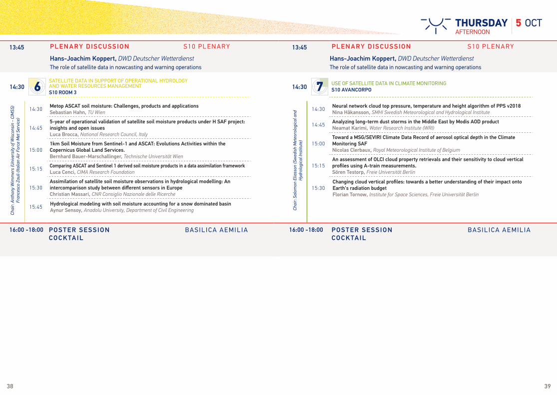
Hans-Joachim Koppert, DWD Deutscher Wetterdienst The role of satellite data in nowcasting and warning operations
13:45 PLENARY D ISCUSSION S10 P L E N A R Y
Hans-Joachim Koppert, DWD Deutscher Wetterdienst The role of satellite data in nowcasting and warning operations
14:30 1 CURRENT AND FUTURE SATELLITE PROGRAMMES AND INSTRUMENTS
S10 PLENARY 14:30 3
USE OF DATA FROM CURRENT AND FUTURE SATELLITES IN VERY HIGH-RESOLUTION NWP MODELSBA ROOM 4
16:00 -18:00 POSTER SESSION B A S I L I C A A E M I L I ACOCKTAIL
16:00 -18:00 POSTER SESSION B A S I L I C A A E M I L I ACOCKTAIL
38 39
14:30Metop ASCAT soil moisture: Challenges, products and applications Sebastian Hahn, TU Wien
14:455-year of operational validation of satellite soil moisture products under H SAF project: insights and open issuesLuca Brocca, National Research Council, Italy
15:001km Soil Moisture from Sentinel-1 and ASCAT: Evolutions Activities within the Copernicus Global Land Services.Bernhard Bauer-Marschallinger, Technische Universität Wien
15:15Comparing ASCAT and Sentinel 1 derived soil moisture products in a data assimilation frameworkLuca Cenci, CIMA Research Foundation
15:30Assimilation of satellite soil moisture observations in hydrological modelling: An intercomparison study between different sensors in EuropeChristian Massari, CNR Consiglio Nazionale delle Ricerche
15:45Hydrological modeling with soil moisture accounting for a snow dominated basinAynur Sensoy, Anadolu University, Department of Civil Engineering
14:30Neural network cloud top pressure, temperature and height algorithm of PPS v2018Nina Håkansson, SMHI Swedish Meteorological and Hydrological Institute
14:45Analyzing long-term dust storms in the Middle East by Modis AOD productNeamat Karimi, Water Research Institute (WRI)
15:00Toward a MSG/SEVIRI Climate Data Record of aerosol optical depth in the Climate Monitoring SAFNicolas Clerbaux, Royal Meteorological Institute of Belgium
15:15An assessment of OLCI cloud property retrievals and their sensitivity to cloud vertical profiles using A-train measurements.Sören Testorp, Freie Universität Berlin
15:30Changing cloud vertical profiles: towards a better understanding of their impact onto Earth's radiation budgetFlorian Tornow, Institute for Space Sciences, Freie Universität Berlin
Chai
r: An
thon
y W
imm
ers
(Uni
vers
ity o
f Wis
cons
in -
CIM
SS)
Fran
cesc
o Za
uli (
Italia
n Ai
r For
ce M
et S
ervi
ce)
Chai
r: Sa
lom
on E
liass
on (S
wed
ish
Met
eoro
logi
cal a
nd
Hyd
rolo
gica
l Ins
titut
e)
13:45 PLENARY D ISCUSSION S10 P L E N A R Y
Hans-Joachim Koppert, DWD Deutscher Wetterdienst The role of satellite data in nowcasting and warning operations
13:45 PLENARY D ISCUSSION S10 P L E N A R Y
Hans-Joachim Koppert, DWD Deutscher Wetterdienst The role of satellite data in nowcasting and warning operations
14:30 6
SATELLITE DATA IN SUPPORT OF OPERATIONAL HYDROLOGY AND WATER RESOURCES MANAGEMENT S10 ROOM 3
14:30 7 USE OF SATELLITE DATA IN CLIMATE MONITORING
S10 AVANCORPO
16:00 -18:00 POSTER SESSION B A S I L I C A A E M I L I ACOCKTAIL
16:00 -18:00 POSTER SESSION B A S I L I C A A E M I L I ACOCKTAIL
5 OCTAFTERNOONTHURSDAY
40 41
6 OCTMORNINGFRIDAY
Chai
r: An
toni
a Ga
mba
cort
a(S
cien
ce a
nd T
echn
olog
y Co
rpor
atio
n (S
TC)
Chai
r: Ch
ristin
a Kö
pken
-Wat
ts(D
WD
Deut
sche
r Wet
terd
iens
t)
10:30 COFFEE BREAK / POSTER VIEWING 10:30 COFFEE BREAK / POSTER VIEWING
09:00Measurements of the atmospheric conditions and composition by instruments onboard “Meteor-M N2”Alexander Polyakov, Saint-Petersburg State University
09:15Improve Convective Weather Nowcasts by coupling GOES-R Legacy Sounding NearCasts to Convective Initiation Products Ralph Petersen, University of Wisconsin-Madison, SSEC/CIMSS
09:30Integrating GRUAN Uncertainty In Atmospheric Sounding Profile Assessment Bomin Sun, NOAA/NESDIS/STAR & IMSG
09:45Dedicated Radiosondes and Value in Satellite Atmospheric Sounding Product AssessmentBomin Sun, NOAA/NESDIS/STAR & IMSG
10:003D Visualization WEB-portal for exploration of near real time MRT-IRS demonstration data: Case studiesMichal Koutek, KNMI Royal Netherlands Meteorological Institute
10:15Intercomparison of IASI impact assessment at global NWP centresVincent Guidard, CNRM Centre National de Recherches Météorologiques
09:00
KEYNOTE ADDRESSThe value of polar satellite direct broadcast data for nowcasting and short range weather forecastingMitchell Goldberg, NOAA/JPSS
09:30Assimilation of Himawari AHI and GOES-R ABI Data in the Advanced Research Weather Research and Forecast Model with High ResolutionsXiaolei Zou, Earth System Science Interdisciplinary Center, University of Maryland
09:45Integrated thunderstorm nowcast exploiting satellite, radar and very high-resolution NWP dataUlrich Hamann, Federal Office of Meteorology and Climatology MeteoSwiss
10:00The impact of SEVIRI radiances and AMV’s on the Met Office's new hourly 4DVAR high-resolution Nowcasting system.Graeme Kelly, MetOffice
10:15The assimilation experiments of Himawari-8 Clear Sky Radiance (CSR) data in Japan Meteorological Agency (JMA) NWP systemsIzumi Okabe, JMA Japan Meteorological Agency
11:15 A hybrid precipitation retrieval approach from VIIRS and ATMS on Suomi NPP. Andi Walther, University of Wisconsin-Madison
11:30 Development of Applications Enabled by the Atmospheric Infrared Sounder (AIRS)Bjorn Lambrigtsen, Jet Propulsion Laboratory
11:45Exploring the Effect of Vertical Wind Shear on Deep Convection Cloud-Top Flow Estimation with Next Generation Geostationary Satellite Super Rapid Scan Atmospheric Motion VectorsJason Apke, University of Alabama-Huntsville
12:00
Status of the NPP and J1 NOAA Unique Combined Atmospheric Processing System (NUCAPS) for atmospheric thermal sounding: Recent algorithm enhancements and near real time users applications.Antonia Gambacorta, Science and Technology Corporation (STC)
12:15Validation of Atmospheric Profile Retrievals from the SNPP and JPSS NOAA-Unique CrIS/ATMS Processing System (NUCAPS)Nicholas Nalli, NOAA/NESDIS/STAR / IMSG, Inc.
12:30 CSPP LEO Software: Supporting global direct broadcast polar orbiter satellite applicationsScott Mindock, CIMSS/SSEC
11:15Assessing the impact of ASCAT winds in a coupled atmosphere-wave-ocean assimilation systemGiovanna De Chiara, ECMWF
11:30Scatterometer Assimilation Experiments with HARMONIE Mesoscale Model over south-western EuropeIsabel Monteiro, IPMA - Instituto Português do Mar e da Atmosfera
11:45Use of satellite soil moisture information for Nowcasting-Short Range NWP forecastsParride Ferrante, EUMETSAT/COMET
12:00A Dynamic Infrared Land Surface Emissivity Atlas based on IASI RetrievalsRory Gray, Met Office
12:15Towards a better use of microwave radiances over land for NWP at DWDAna Fernandez Del Rio, DWD Deutscher Wetterdienst
12:30Application of aerosol data products from polar and geostationary satellites in data assimilation for medium-range visibility and air quality forecastingEdward J. Hyer, NRL 7544
Chai
r: Al
len
Hua
ng (S
SEC/
CIM
SS U
W-M
adis
on)
09:00 1 CURRENT AND FUTURE SATELLITE PROGRAMMES AND INSTRUMENTS
S10 PLENARY 09:00 3
USE OF DATA FROM CURRENT AND FUTURE SATELLITES IN VERY HIGH-RESOLUTION NWP MODELSBA ROOM 4
Chai
r: Bo
min
Sun
(NOO
A/N
ESDI
S/ST
AR &
IMSG
)
13:00 PANEL D ISCUSSION S10 P L E N A R Y
13:30
Moderator: Mark Higgins, EUMETSATSpeakers: Vincent Guidard, Météo-France & CNRS/ CNRM - UMR3589 Hans-Joachim Koppert DWD Deutscher Wetterdienst Roger Randriamampianina, met.no Roger Saunders, Met Office
CLOSING CEREMONY
13:00 PANEL D ISCUSSION S10 P L E N A R Y
13:30
Moderator: Mark Higgins, EUMETSATSpeakers: Vincent Guidard, Météo-France & CNRS/ CNRM - UMR3589 Hans-Joachim Koppert DWD Deutscher Wetterdienst Roger Randriamampianina, met.no Roger Saunders, Met Office
CLOSING CEREMONY

42 43
Chai
r: Ar
da S
orm
an (A
nado
lu U
nive
rsity
)Cha
ir: L
uca
Broc
ca (C
NR
Cons
iglio
Naz
iona
le d
elle
Ric
erch
e)
10:30 COFFEE BREAK / POSTER VIEWING
09:00Advancing precipitation science with the Global Precipitation Measurement missionErich Stocker, NASA GSFC
09:15Upgrading IMERG from Version 03 to 04 to 05George Huffman, NASA / University of Alabama in Huntsville
09:30NASA SPoRT Assessment and Application of GPM Rain Rates in Operational HydrologyGeorge Huffman, NASA / University of Alabama in Huntsville
09:45Passive Microwave Precipitation products in H-SAF: recent developments and related activities within the collaboration with GPMGiulia Panegrossi, CNR-ISAC
10:00Performances analysis of H SAF precipitation products through the combined use of radar and rain gauge European networksSilvia Puca, Italian Civil Protection Department
09:00Remote Sensing of Forest Coverage Based on Histogram and Pixel Decomposition ModelLixin Dong, China Meteorological Administration (CMA)
09:15The CAMS Radiation Service – radiative data products for the solar power communityNiels Killius, DLR-DFD Deutsches Zentrum für Luft- und Raumfahrt/ Deutsches
09:30An assessment of evapotranspiration trends within warm season in UkraineInna Semenova, Odessa State Environmental University
09:45A Climate Data Redord (CDR) of SEVIRI/MSG Vegetation parameters Francisco Javier García-Haro, Universitat de Valencia
11:15Inter-comparison of precipitation products over Western Europe from the EUMETSAT H-SAF and NASA PPSChris Kidd, NASA/Goddard Space Flight Center / University of Maryland
11:30How reliable are satellite precipitation estimates for driving hydrological models: a verification study over the Mediterranean areaStefania Camici, National Research Council, Italy
11:45Surface observation based validation of Metop/AVHRR and MSG/SEVIRI snow extent products 2015-2017Niilo Siljamo, FMI Finnish Meteorological Institute
12:00Contributions of SAR observations from Sentinel-1 to study snowpack physical properties in Alpine regionsGaëlle Veyssière, Météo-France - CNRS, CNRM UMR 3589, CEN, Grenoble, France
12:15Use of different satellite snow products in short term hydrological forecastingArda Sorman, Anadolu University, Department of Civil Engineering
Chai
r: Lo
thar
Sch
ülle
r (EU
MET
SAT) Ch
air:
Yves
Gov
aert
s (R
ayfe
renc
e)
09:00 6
SATELLITE DATA IN SUPPORT OF OPERATIONAL HYDROLOGY AND WATER RESOURCES MANAGEMENT S10 ROOM 3
09:00 7 USE OF SATELLITE DATA IN CLIMATE MONITORING
S10 AVANCORPO
6 OCTMORNINGFRIDAY
13:00 PANEL D ISCUSSION S10 P L E N A R Y
13:30
Moderator: Mark Higgins, EUMETSATSpeakers: Vincent Guidard, Météo-France & CNRS/ CNRM - UMR3589 Hans-Joachim Koppert DWD Deutscher Wetterdienst Roger Randriamampianina, met.no Roger Saunders, Met Office
CLOSING CEREMONY
13:00 PANEL D ISCUSSION S10 P L E N A R Y
13:30
Moderator: Mark Higgins, EUMETSATSpeakers: Vincent Guidard, Météo-France & CNRS/ CNRM - UMR3589 Hans-Joachim Koppert DWD Deutscher Wetterdienst Roger Randriamampianina, met.no Roger Saunders, Met Office
CLOSING CEREMONY

44 45
1.1(#447) EUMeTrain latest developmentsCarla Barroso, IPMA (Portuguese Institute of Sea and Atmosphere)
1.2(#76) Comparison of the MSG and MTG AMV algorithms using MSG dataRegis Borde, EUMETSAT
1.3(#401) LAI, FAPAR and FVC global products from EUMETSAT Polar SystemManuel Campos-Taberner, Universitat de Valencia
1.4(#404) Water stress correction of daily gross primary estimates for Europe and Africa using SEVIRI/MSG dataManuel Campos-Taberner, Universitat de Valencia
1.5(#56) MetOp/AVHRR infrared calibration using the VIIRS algorithm: exploring the radiometric traceability from prelaunch to on-orbitChangyong Cao, NOAA
1.6(#511) The Validation of ASCAT Soil Moisture Data with In-Situ MeasurementsRobert-Valentin Chiritescu, National Meteorological Administration of Romania
1.7(#143) Cloud top pressure retrieval from O2 A-band with multi-layer cloud flaggingMathieu Compiègne, HYGEOS
1.8(#574) Perspectives and use of the Fire Risk Map product of the LSA SAFCarlos DaCamara, Instituto Dom Luiz, Faculdade de Ciências, Universidade de Lisboa
1.9(#578) Validation over Portugal of the Burned Area product of the LSA SAFCarlos DaCamara, Instituto Dom Luiz, Faculdade de Ciências, Universidade de Lisboa
1.10(#394) The next version of the NWCSAF/PPS processing packageAdam Dybbroe, SMHI Swedish Meteorological and Hydrological Institute
1.11(#614) Intersatellite calibration of microwave radiometers for cubesats: Where are we going?Spencer Farrar, The Aerospace Corporation
1.12(#470) A Simplified High and Near-Constant Contrast Approach for the Display VIIRS Day/Night Band ImageryKim Hui Gaune, EUMETSAT
1.13(#283) Community Satellite Processing Package for LEO Satellites: Recent Progress and Support for JPSS-1Liam Gumley, University of Wisconsin-Madison
1.14(#151) Polar2Grid - Reprojecting Satellite Data Made EasyDavid Hoese, University of Wisconsin
1.15(#40) Nowcasting SAF products at the ESSL Testbed 2017Alois M. Holzer, ESSL, European Severe Storms Laboratory
1.16(#85) The diurnal and seasonal variation of COMS Infrared channels inter-calibrationKun-Il Jang, KMA Korea Meteorological Administration
1.17(#302) Current and Future Status of the JAXA’s Missions and Earth Observation Priority ResearchesMisako Kachi, Japan Aerospace Exploration Agency
1.18(#186) Weather simulator on a flash flood caseZsofia Kocsis, OMSZ Hungarian Meteorological Service
1.19(#197) The enhancements and improvements of the GNOS instrument on-board FengYun 3 series meteorology satellitesCongliang Liu, NSSC(National space science center, Chinese academy of sciences)
1.20(#484) Development of Microwave Imager Instrument for MetOp Second GenerationTito Lupi, OHB Italia Spa
1.21(#279) Clustering and Filtering Techniques for the Reduction of Noise in Geostationary Lightning Mapper DataDouglas Mach, Universities Space Research Association
1.22(#648) CSPP Geo Software for Processing GOES-R/16 Direct Broadcast DataGraeme Martin, Space Science and Engineering Center, University of Wisconsin-Madison
1.23(#251) ESA’s Soil Moisture and Ocean Salinity Mission – From science to operationsSusanne Mecklenburg, European Space Agency
1.24(#445) Verification of LSA SAF Solar Radiation Product over Slovenia for Advanced End-UsersBostjan Muri, Slovenian Environment Agency
1.25(#142) SIMBA and feasibility of absolute radiometers aboard cubesatsStijn Nevens, RMIB
1.26(#126) Performance of MSG/PPS CT product in fog classificationOana Nicola, National Meteorological Administration of Romania
1.27(#477) Optimal Non-linear Principal Component Analysis applied to IASI L1 DataMatteo Picchiani, Tor Vergata University - DICII
1.28(#629) ERS-1 scatterometer data (1991-1996): new ESA-ASPS reprocessing data monitoringSabrina Pinori, SERCO SpA
1.29(#547) On the Dependence of Satellite Soundings on Instrument Field-of-View SizeSimon Proud, University of Oxford
1 CURRENT AND FUTURE SATELLITE PROGRAMMES AND INSTRUMENTS
SESSIONPOSTER 1
1 CURRENT AND FUTURE SATELLITE PROGRAMMES AND INSTRUMENTS
POSTER SESSION IN BASILICA AEMILIA POSTER SESSION IN BASILICA AEMILIA

46 47
1.30
(#636) NOAA’s Joint Polar Satellite System’s (JPSS) Proving Ground and Risk Reduction (PGRR) Program – Successful PGRR Program Moves into the Future with the Launch of JPSS-1Jerrold Robaidek, Space Science and Engineering Center, University of Wisconsin-Madison
1.31
(#28) NOAA’s Joint Polar Satellite System’s (JPSS) Proving Ground and Risk Reduction (PGRR) Program – Successful PGRR Program Moves into the Future with the Launch of JPSS-1Bill Sjoberg, NOAA JPSS
1.32(#312) On the Dependence of Satellite Soundings on Instrument Field-of-View SizeWilliam Smith, University of Wisconsin, Hampton University
1.33(#271) Routine Validation of the GOES-R Multi-Satellite Processing System FrameworkWilliam C Straka III, SSEC/CIMSS
1.35(#489) EUMETSAT Marine Centre Latest Ocean Colour Cal/Val Results for the Sentinel-3 Ocean and Land Colour Instrument (OLCI)Malcolm Taberner, EUMETSAT
1.35(#548) JPSS-1 CrIS Radiometric Calibration and Post-Launch Cal/Val ActivitiesDavid Tobin, SSEC/CIMSS
1.36(#501) CrIS Raw Data Record Generator Simulation ToolDenis Tremblay, NOAA
1.37(#681) Introducing CALIPSO’s Version 4 Level 2 Lidar Data ProductsChip Trepte, NASA
1.38(#241) Hyperspectral IR cloudy radiance and jacobian simulations : comparison between RTTOV and VLIDORTJerome Vidot, CMS / Météo-France
1.39(#465) Assessment of GOES-16 ABI cloud products during post launch validationSteve Wanzong, University of Wisconsin-Madison, SSEC/CIMSS
1.40(#508) Stability Monitoring of the Advanced Microwave Radiometer onboard Jason-3Bin Zhang, University of Maryland
1.41(#507) VIIRS SDR data volume reduction and processing efficiency improvementsBin Zhang, University of Maryland
1.42(#504) Orbital and Equator Crossing Time Variation for Suomi-NPP, MetOp and JPSS-1 Sun-synchronous SatellitesBin Zhang, University of Maryland
1 CURRENT AND FUTURE SATELLITE PROGRAMMES AND INSTRUMENTS
SESSIONPOSTER
SESSIONPOSTER
SESSIONPOSTER
1
2.1(#369) Development of an operational tool for early detection of fire in the South West of Indian Ocean from Meteosat Second Generation satellite dataSylvain Cros, Reuniwatt
2 NEW HORIZONS FOR THE INDIAN OCEAN
2POSTER SESSION IN BASILICA AEMILIA POSTER SESSION IN BASILICA AEMILIA
POSTER SESSION IN BASILICA AEMILIA
3
3.1(#257) Tracking and forecasting Interaction between Tropical and Extra-Tropical Phenomenon: Contribution of Satellite ImageriesAbdou Adam Abdoul-Aziz Abébé, ASECNA
3.2(#260) Monitoring and forecasting dust haze over West Africa by combining satellites imageries and numerical weather prediction modelsAbdou Adam Abdoul-Aziz Abébé, ASECNA
3.3(#479) Evaluation of selected Numerical Weather Prediction models for a case of widespread rainfall over Central and Southern NigeriaChibuzo Agogbuo, Nigerian Meteorological Agency
3.4(#589) Evaluation of cloud discrimination schemes for Satellite data assimilation in the KMA numerical weather prediction systemJieun Cha, KAM
3.5(#206) Automated CB/TCU METAR using on radar and extrapolated satellite observationsPaul De Valk, KNMI Royal Netherlands Meteorological Institute
3.6(#60) NWP and Validation of Satellite data In EthiopiaKassa Fekadu, National Meteorological Agency of Ethiopia
3.7(#521) Fast and accurate hyperspectral radiative transfer simulations using Machine Learning techniquesStephan Havemann, Met Office
3 USE OF DATA FROM CURRENT AND FUTURE SATELLITES IN VERY HIGH-RESOLUTION NWP MODELS

48 49
3.8(#196) Use of satellite data for NWP at the Italian Air Force Meteorological CentreFrancesca Marcucci, COMet - Centro Operativo per la Meteorologia
3.9(#171) A new Hyperspectral InfraRed Land Emissivity Database for use in NWP Data AssimilationEster Nikolla, CIMSS Cooperative Institute for Meteorological Satellite Studies
3.10(#159) An Application of Upper Tropospheric Atmospheric Motion Vectors Derived from Himawari-8 Super Rapid Scans to Tropical Cyclone NowcastingRyo Oyama, Meteorological Research Institute / JMA Japan Meteorological Agency
3.11(#290) Improving polar low forecasting using satellite microwave dataAntonina Polezhayeva, Russian State Hydrometeorological University
3.12(#298) Performance of UM heavy rain forecasts over the Korean peninsula depending on rain typesJihoon Ryu, SNU
3.13(#449) An efficient method to generate synthetic satellite images in the visible spectrumJosef Schröttle, Herz
3.14(#608) Satellite-based discrimination between fog and stratus cloudsNatasa Strelec Mahovic, DMHZ Meteorological and Hydrological Service of Croatia
3.15(#433) A new RTTOV 12 profile dataset for visible to infrared atmospheric transmittanceJerome Vidot, CMS / Météo-France
3.16(#478) Preparing the assimilation of IASI-NG in NWP models: a first channel selectionFrancesca Vittorioso, CNRM - Umr3589 - Météo-france & CNRS
3.17(#227) Impacts of MHS data assimilation on the summer precipitation forecasts over the Northwestern ChinaXiaojing Yu, Insititute of Desert Meteorology,CMA
3 USE OF DATA FROM CURRENT AND FUTURE SATELLITES IN VERY HIGH-RESOLUTION NWP MODELS
3SESSIONPOSTER
POSTER SESSION IN BASILICA AEMILIA POSTER SESSION IN BASILICA AEMILIA
SESSIONPOSTER 4SESSION
POSTER
POSTER SESSION IN BASILICA AEMILIA
4 ATMOSPHERIC COMPOSITION: RECENT ADVANCES IN SATELLITE PRODUCTS AND APPLICATIONS
4.1(#258) Public and aeronautical forecasting in West Africa: Contribution of satellite imageriesAbdou Adam Abdoul-Aziz Abébé, ASECNA
4.2(#340) Multi-Species Analysis of Anthropogenic Pollution Using IASI DataAve Arellano, University of Arizona
4.3(#212) Exploiting the IASI spectrum for ash products from different volcanic eruptions.Maria Athanassiadou, Met Office
4.4(#86) COSMO-MUSCAT and RTTOV simulations of the sensitivity of SEVIRI Desert Dust RGB imagery to assumed dust optical propertiesJamie Banks, Leibniz Institute for Tropospheric Research
4.5(#373) Observation of the lowermost tropospheric ozone with a coupling approach to three spectral bands UV+VIS+TIR measured by IASI and GOME-2Yohann Chailleux, LISA-CNRS
4.6
(#208) Partial tropospheric columns versus vertical profiles: what is the most valuable information for an assimilation system used to analyze the European ozone distribution?Adriana Coman, LISA,UMR7583,CNRS/UPEC/UPD
4.7(#516) Using SEVIRI cloud time-series to assess the orbits number of LEO optical satellites for land mapping without cloud contaminationSylvain Cros, Reuniwatt
4.8(#623) Tropospheric HCHO retrieved from OMI, GOME(-2), and SCIAMACHY within the Quality Assurance For Essential Climate Variables (QA4ECV) project.Isabelle De Smedt, BIRA-IASB
4.9(#412) Validation of GOME-2A and gome-2B ozon profiles and tropospheric ozon column products in an operational context, using balloon sounding dataAndy Delcloo, RMI Royal Meteorological Institute of Belgium
4.10(#425) Validation of the absorbing aerosol height (AAH) products from GOME-2 instruments on-board MetOp-A and MetOp-B within the framework of the AC SAFAndy Delcloo, RMI Royal Meteorological Institute of Belgium
4.11
(#61) An OSSE estimation of the capacity of FCI to improve aerosols forecast, by assimilating observations of aerosols optical thickness in MOCAGE CTM: Preliminary resultsMaxence Descheemaecker, Météo-France
4.12(#531) JPSS Atmospheric Composition Products in support of Environmental Monitoring and Operational ApplicationsMurty Divakarla, NOAA/NESDIS/STAR
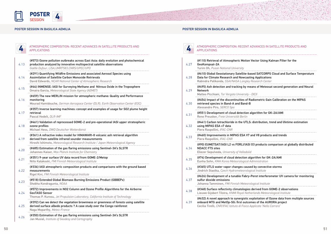
50 51
4.13(#573) Ozone pollution outbreaks across East Asia: daily evolution and photochemical production analyzed by innovative multispectral satellite observationsGaëlle Dufour, LISA,UMR7583,CNRS/UPEC/UPD
4.14(#291) Quantifying Wildfire Emissions and associated Aerosol Species using Assimilation of Satellite Carbon Monoxide RetrievalsDavid Edwards, NCAR National Center of Atmospheric Research
4.15(#44) INMENSE: IASI for Surveying Methane and Nitrous Oxide in the TroposphereOmaira Garcia, Meteorological State Agency (AEMET)
4.16(#659) The new MERLIN mission for atmospheric methane: Quality and Performance monitoringMourad Hamidouche, German Aerospace Center (DLR), Earth Observation Center (EOC)
4.17(#357) Inverse learning machines: concept and examples of usage for SO2 plume height retrievalPascal Hedelt, DLR-IMF
4.18(#461) Validation of reprocessed GOME-2 and pre-operational IASI upper stratospheric ozone profilesMichael Hess, DWD Deutscher Wetterdienst
4.19(#361) A refractive index model for HIMAWARI-8 volcanic ash retrieval algorithm derived from satellite infrared sounder measurementsHiroshi Ishimoto, Meteorological Research Institute / Japan Meteorological Agency
4.20(#685) Estimation of the gas flaring emissions using Sentinel-3A’s SLSTRJohannes Kaiser, Max Planck Institute for Chemistry
4.21(#351) 9-year surface UV data record from GOME-2/MetopNiilo Kalakoski, FMI Finnish Meteorological Institute
4.22(#336) IASI atmospheric composition products and comparisons with the ground based measurementsRigel Kivi, FMI Finnish Meteorological Institute
4.23(#518) Extended Global Biomass Burning Emissions Product (GBBEPx)Shobha Kondragunta, NOAA
4.24(#572) Improvements in NO2 Column and Ozone Profile Algorithms for the Airborne GeoTASO SensorThomas P. Kurosu, Jet Propulsion Laboratory, California Institute of Technology
4.25(#392) Can we detect the vegetation brownness or greenness of forests using satellite derived surface albedo products ? A case study over the Congo rainforestNaga Moparthy, Meteo-France
4.26(#350) Estimation of the gas flaring emissions using Sentinel-3A’s SLSTRJan Musial, Institute of Geodesy and Cartography
4 ATMOSPHERIC COMPOSITION: RECENT ADVANCES IN SATELLITE PRODUCTS AND APPLICATIONS 4 ATMOSPHERIC COMPOSITION: RECENT ADVANCES IN SATELLITE PRODUCTS AND
APPLICATIONS
4SESSIONPOSTER
POSTER SESSION IN BASILICA AEMILIA POSTER SESSION IN BASILICA AEMILIA
4.27(#110) Retrieval of Atmospheric Motion Vector Using Kalman Filter for the GeoKompsat-2AYurim Oh, Pusan National University
4.28(#610) Global Geostationary Satellite-based SATCORPS Cloud and Surface Temperature Data for Climate Research and Nowcasting ApplicationsRabindra Palikonda, SSAI/NASA Langley Research Center
4.29(#495) Ash detection and tracking by means of Meteosat second generation and Neural NetworkMatteo Picchiani, Tor Vergata University - DICII
4.30(#454) Impact of the discontinuities of Radiometric Gain Calibration on the MIPAS retrieved species in Band-A and Band-BAlessandro Piro, SERCO Spa
4.31(#551) Development of cloud detection algorithm for GK-2A/AMIRene Preusker, Freie Universität Berlin
4.32(#441) Carbon tetrachloride in the UTLS: distribution, trend and lifetime estimation using MIPAS ESA v7 dataPiera Raspollini, IFAC-CNR
4.33(#460) Improvements in MIPAS ESA V7 and V8 products and trendsPiera Raspollini, IFAC-CNR
4.34(#90) EUMETSAT/IASI L2 vs FORLI/IASI O3 products comparison at globally distributed NDACC FTS sitesEliezer Sepulveda, University of Valladolid
4.35(#74) Development of cloud detection algorithm for GK-2A/AMIEunha Sohn, KMA Korea Meteorological Administration
4.36(#365) UTLS water vapor changes caused by convective stormsJindrich Stastka, Czech Hydrometeorological Institute
4.37(#626) Development of a tunable Fabry-Perot interferometer UV camera for monitoring sulfur dioxide emissionsJohanna Tamminen, FMI Finnish Meteorological Institute
4.38(#348) Surface reflectivity climatologies derived from GOME-2 observationsLieuwe Gijsbert Tilstra, KNMI Royal Netherlands Meteorological Institute
4.39(#632) A novel approach to synergistic exploitation of Ozone data from multiple sources onboard MTG and MetOp-SG: first outcomes of the AURORA projectCecilia Tirelli, CNR/IFAC Istituto di Fisica Applicata ‘Nello Carrara’

52 53
4 ATMOSPHERIC COMPOSITION: RECENT ADVANCES IN SATELLITE PRODUCTS AND APPLICATIONS
4.40(#125) Reprocessed MetOp/GOME-2 vertical ozone profilesOlaf Tuinder, KNMI Royal Netherlands Meteorological Institute
4.41(#156) Improvements of the FRESCO cloud retrieval algorithm for GOME-2Ping Wang, KNMI Royal Netherlands Meteorological Institute
4.42(#399) O3 variability/trend in the troposphere and the stratosphere from IASI observations in 2008-2017Catherine Wespes, Université Libre de Bruxelles
4.43(#172) Data Analytics from Hyper-spectral Infrared Sounders in support of Government and commercial users and research field campaignsAshley Wheeler, Science and Technology Corporation (STC)
4.44(#91) New Satellite Based Measurements Of Lower-Tropospheric Methane: Validation, Sensitivity To Emissions, And Initial Trend ResultsJohn Worden, JPL/Caltech
4.45(#334) Inter-annual variations of nitrogen dioxide and formaldehyde over Greek urban sites detected from spaceIrene Zyrichidou, Aristotle University of Thessaloniki
4
SESSIONPOSTER
SESSIONPOSTER
SESSIONPOSTER
POSTER SESSION IN BASILICA AEMILIA POSTER SESSION IN BASILICA AEMILIA
POSTER SESSION IN BASILICA AEMILIA
5
5
5 MARINE ENVIRONMENT MONITORING: RECENT ADVANCES IN SATELLITE PRODUCTS AND APPLICATIONS
5 MARINE ENVIRONMENT MONITORING: RECENT ADVANCES IN SATELLITE PRODUCTS AND APPLICATIONS
5.1(#643) Characteristics of the Altimeter, Scatterometer and Model Surface Wind Speeds ErrorsSaleh Abdalla, ECMWF
5.2(#175) Towards convergent solutions for retracking conventional and delay doppler altimeter echoesJoel Dorandeu, CLS Collecte Localisation Satellites
5.3(#331) Improved sea ice products: concentration, drift and typeSteinar Eastwood, Norwegian Meteorological Institute
5.4(#192) Validation of High Latitude SLSTR SSTSteinar Eastwood, Norwegian Meteorological Institute
5.5(#229) Improvement of the dynamic atmospheric correction for delayed-time and operational applications of altimetryYannice Faugere, CLS Collecte Localisation Satellites
5.6(#176) Preliminary result of cross calibration of Himawari-8 IR data using Terra/MODIS SSTYukio Kurihara, JMA Japan Meteorological Agency
5.7(#384) Monitoring marine environment by means of the Robust Satellite Techniques approachTeodosio Lacava, CNR-IMAA
5.8(#472) Jason 3 performance assessment in the frame of CMEMMS sea level serviceOlivier Lauret, CLS Collecte Localisation Satellites
5.9(#245) Sea-ice cloud screening for Copernicus Sentinel-3 Sea and Land Surface Temperature RadiometerGian Luigi Liberti, ISAC-CNR
5.10(#275) Examining the impact of long waves on high-resolution SAR mode measurements using simulation and real dataSylvie Labroue, CLS Collecte Localisation Satellites
5.11(#422) A generic collaborative cal/val framework based on opensource softwareSylvie Labroue, CLS Collecte Localisation Satellites
5.12(#381) Validation of sea and land Ice Surface Temperature from Metop Infrared Atmospheric Sounding InterferometerPia Nielsen-Englyst, DMI Danish Meteorological Institute
5.13(#355) Assessment of Sentinel-3 SLSTR Sea Surface Temperature using improved drifting buoy measurementsAnne O’Carroll, EUMETSAT
5.14(#500) Analyses of SST in EUMETSAT Monitoring and Evaluation of Thematic Information from Space (METIS) online frameworkAnne O’Carroll, EUMETSAT
5.15(#529) A wet tropospheric correction retrieval dedicated to oceanic eddies and currents.Bruno Picard, CLS Collecte Localisation Satellites

54 55
5.16
(#440) Wet tropospheric correction retrieval on coastal regions: assessing the performances of a one-dimensional variational approach applied to high frequency observation channelsBruno Picard, CLS Collecte Localisation Satellites
5.17(#424) A generic collaborative cal/val framework based on opensource softwareJean-françois Piollé, IFREMER Institut Français de Recherche pour l’Exploitation de la Mer
5.18(#386) Wave Orbital Velocity Effect on Doppler Radar Altimetry for off-Nadir BeamsEugenio Pugliese Carratelli, CUGRI
5.19(#234) Sentinel-3 Altimetry Assessment over Multiple SurfacesGraham Quartly, Plymouth Marine Laboratory
5.20(#462) Spatio-temporal variability of the diurnal cycle of sea surface temperature.Stéphane Saux Picart, Météo-France
5.21(#236) Lake Ice Phenology Derived from VIIRS DataMelanie Sütterlin, Universität Bern
5.22(#490) Overview of Sentinel-3 SLSTR L1 and marine L2 productsIgor Tomazic, EUMETSAT
5.23
(#432) Ground-based and satellite measurements of Photosynthetically Active Radiation (PAR) in the central MediterraneanPamela Trisolino, Tuscia University and ENEA, Laboratory for Observations and Analyses of Earth and Climate
5.24(#321) ScatSat 1 winds from the OSI SAFAnton Verhoef, KNMI Royal Netherlands Meteorological Institute
5.25(#342) Improvements in variational ambiguity removal of scatterometer windsJur Vogelzang, KNMI Royal Netherlands Meteorological Institute
5.26
(#391) Sensitivity Analysis to Simulated Power Waveform of GNSS-R From Low Earth OrbitYingqiang Wang, Institute of Meteorology and Oceanography, PLA University of Science and Technology
5.27(#360) Degradation of the scatterometer wind data due to the presence of shipsStefano Zecchetto, National Research Council of Italy
5 MARINE ENVIRONMENT MONITORING: RECENT ADVANCES IN SATELLITE PRODUCTS AND APPLICATIONS
5SESSIONPOSTER
POSTER SESSION IN BASILICA AEMILIA POSTER SESSION IN BASILICA AEMILIA
SESSIONPOSTER
SESSIONPOSTER
6 SATELLITE DATA IN SUPPORT OF OPERATIONAL HYDROLOGY AND WATER RESOURCES MANAGEMENT
6
6.1(#339) LSA-SAF evapotranspiration and surface heat fluxes products 2.0Alirio Arboleda, RMI Royal Meteorological Institute of Belgium
6.2(#409) EUMETSAT H-SAF Precipitation Products Generation System at COMetDaniele Biron, COMet - Centro Operativo per la Meteorologia
6.3(#240) Study on Disaster Monitoring by using Feng-Yun Microwave Remote Sensing of ChinaHao Chen, Jiangsu Meteorogical Observatory
6.4(#239) Merging NWC SAF RDT product with weather radar based storm tracking and classification over Po valley, ItalyRoberto Cremonini, Arpa Piemonte
6.5(#54) Soil moisture downscaling meets big data processingStefano Elefante, Department of Geodesy and Geoinformation, University of Technology
6.6(#101) H-SAF root zone soil wetness products based on scatterometer observationsDavid Fairbairn, ECMWF
6.7(#620) The study on the H-SAF satellite liquid precipitation products behavior in reference to a limited scale rainfall eventRafal Iwanski, IMGW-PIB Polish Institute of Meteorology and Water Management
6.8(#129) Satellite monitoring of humic substances in Kyiv Reservoir (Ukraine)Oleksandr Kryvoshein, UHMI Ukrainian Hydrometeorological Research Institute
6.9(#367) Exploiting long-term series of AMSU data for implementing the Soil Wetness Variation IndexTeodosio Lacava, CNR-IMAA
6.10(#583) Ground validation of GPM DPR/GMI products using ground-based radar and gage networks over Korean peninsulaGyuwon Lee, Kyungpook National University
6.12(#200) The use of SEVIRI channel at 8.7 micron for change detection analysis and land cover classification over arid and semiarid environmentsGuido Masiello, Università degli Studi della Basilicata
6.13(#415) The EUMETSAT Satellite Application Facility in Support to Operational Hydrology and Water Management (H-SAF) – Status of the projectDavide Melfi, Italian Air Force Met Service
6.14(#256) Satellite Sounder Observations of Contrasting Tropospheric Moisture Transport Regimes: Saharan Air Layers, Hadley Cells, and Atmospheric RiversNicholas Nalli, NOAA/NESDIS/STAR
6.15(#55) Calibration of the Land Surface Model (CLM) through satellite observed soil moisture (ESA SM) in BulgariaOlga Nitcheva, Institute of Mechanics at the Bulgarian Academy of Sciences
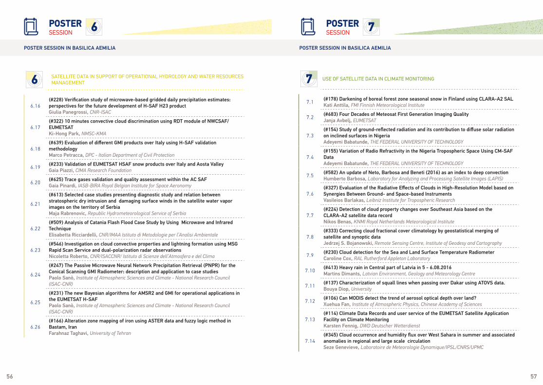
56 57
6.16(#228) Verification study of microwave-based gridded daily precipitation estimates: perspectives for the future development of H-SAF H23 productGiulia Panegrossi, CNR-ISAC
6.17(#322) 10 minutes convective cloud discrimination using RDT module of NWCSAF/EUMETSATKi-Hong Park, NMSC-KMA
6.18(#639) Evaluation of different GMI products over Italy using H-SAF validation methodologyMarco Petracca, DPC - Italian Department of Civil Protection
6.19(#233) Validation of EUMETSAT HSAF snow products over Italy and Aosta ValleyGaia Piazzi, CIMA Research Foundation
6.20(#625) Trace gases validation and quality assessment within the AC SAFGaia Pinardi, IASB-BIRA Royal Belgian Institute for Space Aeronomy
6.21
(#613) Selected case studies presenting diagnostic study and relation between stratospheric dry intrusion and damaging surface winds in the satellite water vapor images on the territory of SerbiaMaja Rabrenovic, Republic Hydrometeorological Service of Serbia
6.22(#509) Analysis of Catania Flash Flood Case Study by Using Microwave and Infrared TechniqueElisabetta Ricciardelli, CNR/IMAA Istituto di Metodologie per l’Analisi Ambientale
6.23(#546) Investigation on cloud convective properties and lightning formation using MSG Rapid Scan Service and dual-polarization radar observationsNicoletta Roberto, CNR/ISACCNR/ Istituto di Scienze dell’Atmosfera e del Clima
6.24
(#247) The Passive Microwave Neural Network Precipitation Retrieval (PNPR) for the Conical Scanning GMI Radiometer: description and application to case studiesPaolo Sanò, Institute of Atmospheric Sciences and Climate - National Research Council (ISAC-CNR)
6.25
(#231) The new Bayesian algorithms for AMSR2 and GMI for operational applications in the EUMETSAT H-SAFPaolo Sanò, Institute of Atmospheric Sciences and Climate - National Research Council (ISAC-CNR)
6.26(#166) Alteration zone mapping of iron using ASTER data and fuzzy logic method in Bastam, IranFarahnaz Taghavi, University of Tehran
6 SATELLITE DATA IN SUPPORT OF OPERATIONAL HYDROLOGY AND WATER RESOURCES MANAGEMENT
6SESSIONPOSTER
POSTER SESSION IN BASILICA AEMILIA POSTER SESSION IN BASILICA AEMILIA
SESSIONPOSTER
7 USE OF SATELLITE DATA IN CLIMATE MONITORING
7
7.1(#178) Darkening of boreal forest zone seasonal snow in Finland using CLARA-A2 SALKati Anttila, FMI Finnish Meteorological Institute
7.2(#683) Four Decades of Meteosat First Generation Imaging QualityJanja Avbelj, EUMETSAT
7.3(#154) Study of ground-reflected radiation and its contribution to diffuse solar radiation on inclined surfaces in NigeriaAdeyemi Babatunde, THE FEDERAL UNIVERSITY OF TECHNOLOGY
7.4(#155) Variation of Radio Refractivity in the Nigeria Tropospheric Space Using CM-SAF DataAdeyemi Babatunde, THE FEDERAL UNIVERSITY OF TECHNOLOGY
7.5(#582) An update of Neto, Barbosa and Beneti (2016) as an index to deep convectionHumberto Barbosa, Laboratory for Analyzing and Processing Satellite Images (LAPIS)
7.6(#327) Evaluation of the Radiative Effects of Clouds in High-Resolution Model based on Synergies Between Ground- and Space-based InstrumentsVasileios Barlakas, Leibniz Institute for Tropospheric Research
7.7(#224) Detection of cloud property changes over Southeast Asia based on the CLARA-A2 satellite data recordNikos Benas, KNMI Royal Netherlands Meteorological Institute
7.8(#333) Correcting cloud fractional cover climatology by geostatistical merging of satellite and synoptic dataJedrzej S. Bojanowski, Remote Sensing Centre, Institute of Geodesy and Cartography
7.9(#230) Cloud detection for the Sea and Land Surface Temperature RadiometerCaroline Cox, RAL Rutherford Appleton Laboratory
7.10(#413) Heavy rain in Central part of Latvia in 5 - 6.08.2016Martins Dimants, Latvian Environment, Geology and Meteorology Centre
7.11(#137) Characterization of squall lines when passing over Dakar using ATOVS data.Bouya Diop, University
7.12(#106) Can MODIS detect the trend of aerosol optical depth over land?Xuehua Fan, Institute of Atmospheric Physics, Chinese Academy of Sciences
7.13(#114) Climate Data Records and user service of the EUMETSAT Satellite Application Facility on Climate MonitoringKarsten Fennig, DWD Deutscher Wetterdienst
7.14(#345) Cloud occurrence and humidity flux over West Sahara in summer and associated anomalies in regional and large scale circulationSeze Genevieve, Laboratoire de Meteorologie Dynamique/IPSL/CNRS/UPMC

58 59
7.15(#450) A novel framework to harmonise satellite data series for climate applicationsRalf Giering, FastOpt GmbH
7.16(#606) GIS and remote sensing techniques in monitoring wildfire and land cover change in Miombo forest in TanzaniaGovernment Kabalimu, University of Dar Es Salaam
7.17(#527) NOAA series satellites clock drift error estimation and correction in SCOPE-CM AVHRR FCDR ProjectKarl-Göran Karlsson, SMHI Swedish Meteorological and Hydrological Institute
7.18(#219) Impact of using V4.10 Caliop level 2 cloud products when evaluating the CMSAF clara-a2 and other cloud data recordsKarl-Göran Karlsson, SMHI Swedish Meteorological and Hydrological Institute
7.19(#135) Optimal training of CM SAF and NWC SAF cloud detection algorithms using Calipso-Caliop cloud informationKarl-Göran Karlsson, SMHI Swedish Meteorological and Hydrological Institute
7.20(#42) Importance of Calibrated Satellite Data for Weather and Climate Monitoring and ForecastingGoitom Kelem, National Meteorological Agency of Ethiopia
7.21(#467) Statistical Retrieval of Temperature and Moisture Atmospheric Profiles Benefits from Spatial-Spectral Image CompressionValero Laparra, Image Processing Laboratory - Universitat de València
7.22(#474) Nonlinear statistical retrieval of land surface emissivity from infrared sounding dataValero Laparra, Image Processing Laboratory - Universitat de València
7.23(#473) Temperature Retrieval with Spatial Noise-aware dimensionality reductionValero Laparra, Image Processing Laboratory - Universitat de València
7.24(#73) Comparing three kinds of cloud data in Tibetan PlateaJian Liu, Satellite Meteorological Center
7.25(#103) Meteosat Second Generation cloud retrievals evaluated with airborne measurements during FennecFranco Marenco, Met Office
7.26
(#149) A new Fundamental Climate Data Record (FCDR) for almost 40 years of measurements from the High resolution Infrared Radiation Sounder (HIRS) based on a metrologically traceable uncertainty analysis.Jonathan Mittaz, University of Reading
7.27(#341) 1-km AVHRR cloud climatology over Central Europe derived by the Vectorized Earth Observation Retrieval (VEOR) and PyLAC softwareJan Musial, Institute of Geodesy and Cartography
7 USE OF SATELLITE DATA IN CLIMATE MONITORING 7 USE OF SATELLITE DATA IN CLIMATE MONITORING
7SESSIONPOSTER
POSTER SESSION IN BASILICA AEMILIA POSTER SESSION IN BASILICA AEMILIA
7.28(#510) Drought monitoring based on spatial data mining, using temporal NDVI and rainfall relationshipArgentina Teodora Nertan, National Meteorological Administration of Romania
7.29(#273) Spectral signatures of Earth’s climate variability over 5 years from CrIS, AIRS, and IASIEster Nikolla, CIMSS Cooperative Institute for Meteorological Satellite Studies
7.30(#23) Characterization of the Surface Radiation Budget using NASA and CM SAF Data over West African ClimateOlusola Ojo, Federal University of Technology, Akure
7.31(#469) Fast Cloud Detection over Landmarks in MSG/SEVIRI Image Time SeriesAdrian Perez-Suay, Image Processing Laboratory - Universitat de València
7.32(#647) Representation of the tropical free tropospheric humidity and its variability in large scale modelsLaurence Picon, LMD/University Pierre et Marie Curie
7.33(#464) Investigation of Januarys Polar Low genesis conditions over the North Atlantic using satellite, reanalysis and model data for the period between 2003 and 2011Ana Radovan, Universität Köln
7.34(#117) Algorithm for calculating the number of cloudy days using satellite data to estimate the distribution of solar power potentialLyudmila Shagarova, Ahmedsafin Institute of Hydrogeology and Environmental Geoscience
7.35(#438) Temperature and humidity retrieval algorithm development based on long-term HIRS observationsLei Shi, NOAA/NESDIS/NCEI
7.36(#565) Analyzing the global distribution and variability of high clouds based on 35 years of HIRS observationsMartin Stengel, DWD Deutscher Wetterdienst
7.37(#407) In field validation and climatological impact assessment of RST-FIRES vs other MSG-SEVIRI based algorithms for forest fire detectionValerio Tramutoli, University of Basilicata
7.38(#252) 17+ years of clear-sky 250-m composites from MODIS over Circumpolar Arctic region: Development and applications for climate change studiesAlexander Trishchenko, Canada Centre for Remote Sensing
7.39(#319 Long term climatological data records from scatterometer windsAnton Verhoef, KNMI Royal Netherlands Meteorological Institute
7.40(#555) Can we find robust definitions of Weather States to detect climate trends in a long-term Cloud Satellite Climatology data setAndi Walther, CIMSS Cooperative Institute for Meteorological Satellite Studies
60 61
7 USE OF SATELLITE DATA IN CLIMATE MONITORING
7.41(#388) The MPIC/DLR “climate” water vapour product: A consistent time-series of H2O columns from GOME/SCIAMACHY/GOME-2Yang Wang, Max Planck Institute for Chemistry
7.42(#202) Low cloudiness climatology based on CM-SAF dataMichal Zak, Czech Hydrometeorological Institute
7.43(#144) MetOp-A IASI Decadal Observation and Monitoring of Global Surface ParametersDaniel Zhou, NASA Langley Research Center
7SESSIONPOSTER
POSTER SESSION IN BASILICA AEMILIA POSTER SESSION IN BASILICA AEMILIA
SESSIONPOSTER
POSTER SESSION IN BASILICA AEMILIA
8
8
8 NEXT GENERATION GEOSTATIONARY SATELLITES
8.1(#410) Meteosat Third Generation Lightning Imager, the development of future operational user oriented applicationsDaniele Biron, COMet - Centro Operativo per la Meteorologia
8.2(#492) Applying Himawari and JPSS Satellite Products for Forecasting Rapid Cyclogenesis and Hurricane-force Wind EventsSteven Goodman, University of Maryland/ESSIC/CICS
8.3(#296) GOES-16 Advanced Baseline Imager (ABI) On-Orbit PerformancePaul Griffith, Harris Corporation
8.4(#301) The Rayleigh scattering calibration method applied to goes-16 ABIRobert Iacovazzi, NOAA/NESDIS/STAR
8.5(#277) From photons to pixels: Processing raw data from the advanced baseline imagerSatya Kalluri, NOAA/NESDIS/STAR
8.6(#556) Next Generation Geostationary Satellite Ground System Management – From Development to OperationsHeather Keller, NASA Goddard Space Flight Center
8.7(#459) MTG-FCI in-house Level-1 Reference Processor developmentMounir Lekouara, EUMETSAT
8.8(#480) GOES-R Pre-Launch System Testing: Lessons LearnedWayne Mackenzie, NOAA/NESDIS
8.9(#514) GOES-16 Post-Launch Testing StatusWayne Mackenzie, NOAA/NESDIS
8.10(#485) GOES-R Series ABI Mode and Mesoscale Domain Sector Request ProcessWayne Mackenzie, NOAA/NESDIS
8.11(#536) The applicability of MTG Lightning Imager in ScandinaviaAntti Mäkelä, FMI Finnish Meteorological Institute
8.12(#541) Coupled Satellite-based Methods to Nowcast Severe Storms 1–2 hours in the FutureJohn Mecikalski, University of Alabama in Huntsville
8.13(#332) The Status and strategies on development of the processing system for the meteorological products from Geo-KOMPSAT-2A measurementsMinseok Nam, NMSC-KMA
8.14(#611) GOES-16 Cloud Properties from the NASA LaRC SatCORPS: Initial results and comparisons with other dataRabindra Palikonda, SSAI/NASA Langley Research Center
8.15(#640) Space Mission FTIR Level 1 Processor Lessons Learned and New ChallengesGaetan Perron, ABB Inc. Measurement & Analytics
8.16(#566) Connecting with Operational Forecasters in the GOES-16 Era via the NOAA Satellite Proving Ground ProgramCurtis Seaman, CIRA Cooperative Institute for Research in the Atmosphere
8.17(#522) GOES-R Series ABI Mode and Mesoscale Domain Sector Request ProcessMatthew Seybold, NOAA/NESDIS
8.18(#617) Total Lightning Training for the Operational Application of GLMGeoffrey Stano, NASA SPoRT
8.19(#150) Impact of assimilating multispectral radiances from new generation geostationary satellites on global forecastsJudy St-James, Meteorological Service of Canada
8 NEXT GENERATION GEOSTATIONARY SATELLITES
SESSIONPOSTER

a Thales / Leonardo companya LEONARDO and THALES company
NETWORKING EVENTS EUMETSAT WOULD LIKE TO THANKTHE FOLLOWING SPONSORS
WELCOME DRINK
Cinecittà, conference venue 18:00 - 19:30
Early registration will take place on Sunday 1 October as from 16:00 at the conference venue Cinecittà in Studio 10 and is followed by a Welcome Drink from 18:00 -19:30 Entrance via: Via Tuscolana 1055, 00173 Rome
SUNDAY 1 OCT
ICEBREAKER
Cinecittà, conference venue, Ancient Rome Set 18:00 - 20:30
Entrance via: Via Tuscolana 1055, 00173 Rome With the contribution of: Thales Alenia Space
GUIDED TOUR Guided tour of Cinecittà Film Studios 18:30 - 20:00
The tours have to be booked in advance, please contact the registration desk Entrance via: Via Tuscolana 1055, 00173 Rome
CONFERENCE DINNER
Villa Miani 18:00 - 23:00
Via Trionfale 151, 00136 Rome, Italy Buses will depart Cinecittà Studios at 18:00 pm and take participants directly to the dinner venue. The return transfer will be made at 23:00 from Villa Miani to Rome Termini Ralway Station from where participants can take a taxi to their hotels. You can also make your own transport arrangements but please note that Rome metro generally stops operating at 23:30. With the contribution of: Airbus
MONDAY 2 OCT
WEDNESDAY 4 OCT
TUESDAY 3 OCT

• Régis Borde, EUMETSAT• Hélène Brogniez, Latmos• Sean Burns, EUMETSAT• Kumar Ram Dhurmea, Mauritius Meteorological Service• Hayley Evers-King, PML• Antonia Gambacorta, NOAA/STAR• Steven J. Goodman, NOAA• Jochen Grandell, EUMETSAT
• Hiroshi Kunimatsu, JMA• Rasmus Lindstrot, EUMETSAT• Roger Randriamampianina, met.no• Christian Retscher, EUMETSAT• Peter Schluessel, EUMETSAT• Lothar Schueller, EUMETSAT• Joerg Schulz, EUMETSAT• Anne O’Carroll, EUMETSAT• T. COL. Francsco Zauli, Comet
SCIENTIFIC PROGRAMMECOMMITTEE MEMBERS