program and abstracts - Atlantic Geoscience Society
68
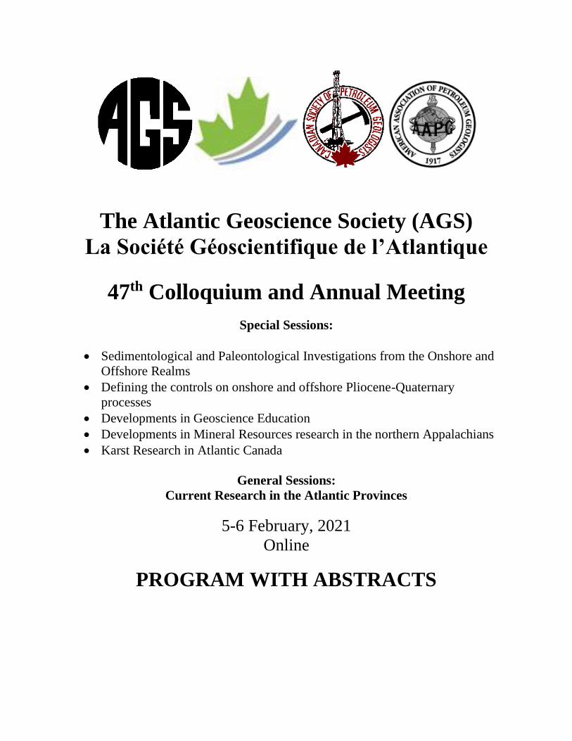
The Atlantic Geoscience Society (AGS) La Société Géoscientifique de l’Atlantique 47 th Colloquium and Annual Meeting Special Sessions: • Sedimentological and Paleontological Investigations from the Onshore and Offshore Realms • Defining the controls on onshore and offshore Pliocene-Quaternary processes • Developments in Geoscience Education • Developments in Mineral Resources research in the northern Appalachians • Karst Research in Atlantic Canada General Sessions: Current Research in the Atlantic Provinces 5-6 February, 2021 Online PROGRAM WITH ABSTRACTS
-
Upload
khangminh22 -
Category
Documents
-
view
2 -
download
0
Transcript of program and abstracts - Atlantic Geoscience Society
The Atlantic Geoscience Society (AGS)
La Société Géoscientifique de l’Atlantique
47th Colloquium and Annual Meeting
Special Sessions:
• Sedimentological and Paleontological Investigations from the Onshore and
Offshore Realms
• Defining the controls on onshore and offshore Pliocene-Quaternary
processes
• Developments in Geoscience Education
• Developments in Mineral Resources research in the northern Appalachians
• Karst Research in Atlantic Canada
General Sessions:
Current Research in the Atlantic Provinces
5-6 February, 2021
Online
PROGRAM WITH ABSTRACTS
2
We gratefully acknowledge sponsorship from the following companies and organizations:
Department of Energy and Resource
Development
Department of Energy and Mines:
Geological Survey Division
Petroleum Resources Branch
We are pleased you are able to attend the 47th Colloquium and Annual Meeting of the Atlantic
Geoscience Society. The AGS community has risen to the challenge to mount an excellent conference
like no other in these unprecedented times (how many more clichés can I squeeze in there?)
We will be hosting online up to three simultaneous sessions, with topics all across the geoscience
spectrum. We thank all who have submitted posters and papers as well as the session organizers and the
organizers of the three short course and workshop events associated with the Colloquium. On Saturday
the Society will conduct its annual general meeting and elect its new council. True to form, the 22
volunteers have stepped up to constitute the council for the upcoming year. AGS never seems to want for
eager contributors, whether it be scientific or service. In this volume you will find reports of the activity
of the Society over the past year.
Participants probably noticed that registration for this year’s meeting is much reduced, because we are not
able to meet in person in a regional hotel. Our benefit is, however, a loss to our usual hosting facilities, so
why not commit to enjoying their hospitality as soon as it is safe to do so.
We hope you will be able to use the weekend to renew old acquaintances, make new ones, and further the
aims of your Atlantic Geoscience Society.
The organizers: Donnelly Archibald, Rob Raeside, Chris White
3
ATLANTIC GEOSCIENCE SOCIETY
47th COLLOQUIUM AND ANNUAL GENERAL MEETING
5-6 February, 2021, online
PROGRAM SUMMARY
Monday, 1st February 2021
3.00 – 4.30 p.m. AGS Council meeting (MS-Teams)
Friday, 5th February 2021
9.00 – 4.00 p.m. Short Course: Applications of GIS (Geographical Information Systems) to Earth
Science" - Robin Adair, P.Geo.
1.00 – 5.00 p.m. Workshop: Looking to the Future; Equity, Diversity, and Inclusion as a way of being
in our discipline - Anne-Marie Ryan (Dalhousie University) and Deanne van
Rooyen (Cape Breton University)
7.00 – 9.00 p.m. Developments in Mineral Resource Research in the Northern Appalachians, Pitcher
Room
7.20 – 8.40 p.m. Karst Research in Atlantic Canada, Mayflower Room
8.40 – 10.00 p.m. Poster Session
Saturday, 6th February, 2021
8.00 – 10.20 a.m. General Session: Mineralogy, Petrology and Structural Geology, Violet Room
8.20 – 10.20 a.m. Sedimentological and Paleontological Investigations from the Onshore and Offshore
Realms, Mayflower Room
9.00 – 10.20 a.m. Developments in Mineral Resource research in the northern Appalachians, Pitcher
Room
10.20 – 10.40 a.m. Refreshment break
10.40 – 12.00 noon Developments in Geoscience Education, Mayflower Room
10.40 – 12.00 noon Defining the Controls on Onshore and Offshore Pliocene-Quaternary Processes,
Violet Room
11.00 – 12.00 noon Developments in Mineral Resource Research in the Northern Appalachians, Pitcher
Room
12.30 p.m. – 1.30 p.m. Annual General Meeting, Pitcher Room
2.00 – 3.40 p.m. Defining the Controls on Onshore and Offshore Pliocene-Quaternary Processes, Violet
Room
2.00 – 4.00 p.m. General Session: Geophysics and Environmental Geoscience, Mayflower Room
2.20 – 4.00 p.m. Developments in Mineral Resource research in the northern Appalachians, Pitcher
Room
4.00 – 5.00 p.m. Judges’ convention, Violet Room
7.00 p.m. Awards banquet – Dress up your table, find a great geo-background for your Zoom link,
and beam in for the announcements of the winners of the student poster and paper awards,
the Nelly Koziel Award, the Laing Ferguson Distinguished Service Award, and the Gesner
Medal.
Saturday, 13th February 2021
9.00 – 5.00 p.m. Short course: QAQC Methods in Geochemical Research and Mineral Exploration,
with a Focus on Gold Assay Quality Control" – Cliff Stanley, Ph.D., P.Geo. FCG.
4
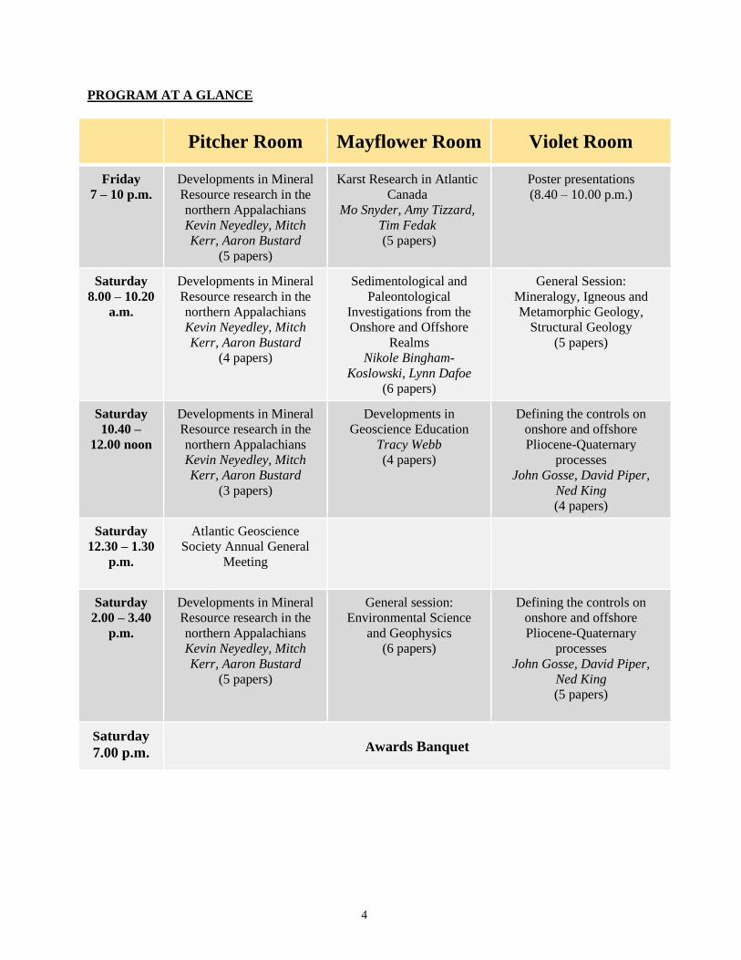
PROGRAM AT A GLANCE
Pitcher Room Mayflower Room Violet Room
Friday
7 – 10 p.m.
Developments in Mineral
Resource research in the
northern Appalachians
Kevin Neyedley, Mitch
Kerr, Aaron Bustard
(5 papers)
Karst Research in Atlantic
Canada
Mo Snyder, Amy Tizzard,
Tim Fedak
(5 papers)
Poster presentations
(8.40 – 10.00 p.m.)
Saturday
8.00 – 10.20
a.m.
Developments in Mineral
Resource research in the
northern Appalachians
Kevin Neyedley, Mitch
Kerr, Aaron Bustard
(4 papers)
Sedimentological and
Paleontological
Investigations from the
Onshore and Offshore
Realms
Nikole Bingham-
Koslowski, Lynn Dafoe
(6 papers)
General Session:
Mineralogy, Igneous and
Metamorphic Geology,
Structural Geology
(5 papers)
Saturday
10.40 –
12.00 noon
Developments in Mineral
Resource research in the
northern Appalachians
Kevin Neyedley, Mitch
Kerr, Aaron Bustard
(3 papers)
Developments in
Geoscience Education
Tracy Webb
(4 papers)
Defining the controls on
onshore and offshore
Pliocene-Quaternary
processes
John Gosse, David Piper,
Ned King
(4 papers)
Saturday
12.30 – 1.30
p.m.
Atlantic Geoscience
Society Annual General
Meeting
Saturday
2.00 – 3.40
p.m.
Developments in Mineral
Resource research in the
northern Appalachians
Kevin Neyedley, Mitch
Kerr, Aaron Bustard
(5 papers)
General session:
Environmental Science
and Geophysics
(6 papers)
Defining the controls on
onshore and offshore
Pliocene-Quaternary
processes
John Gosse, David Piper,
Ned King
(5 papers)
Saturday
7.00 p.m. Awards Banquet
5
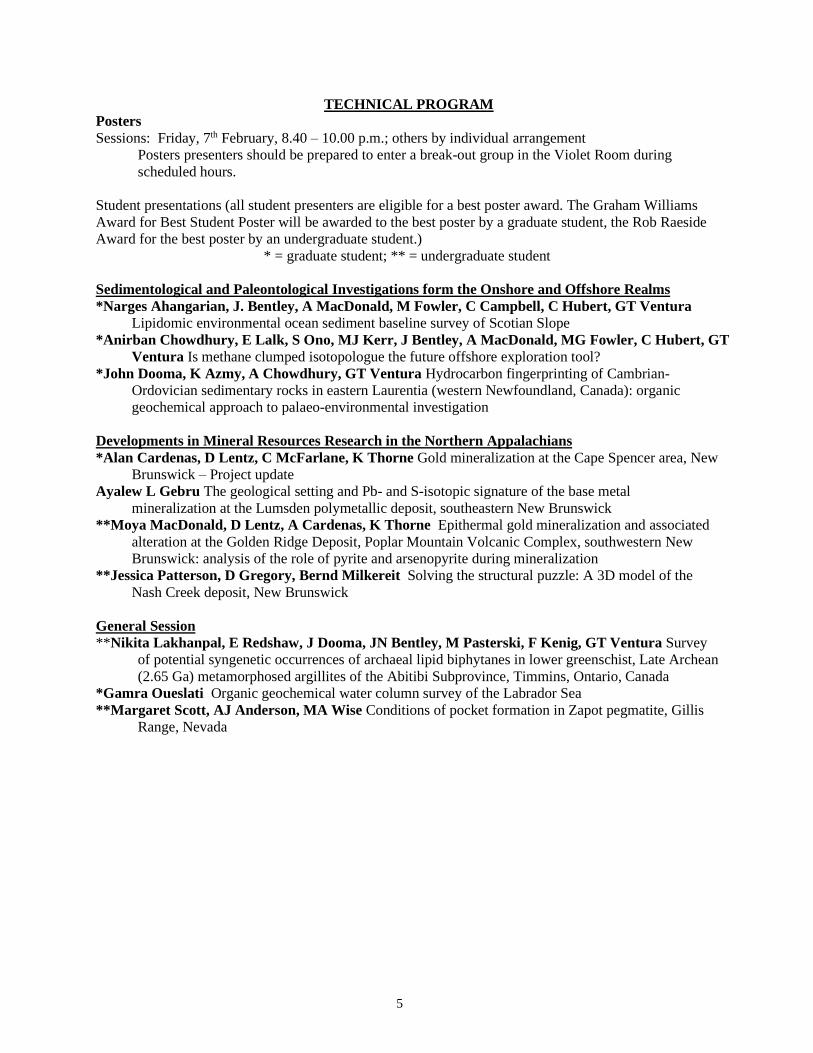
TECHNICAL PROGRAM
Posters
Sessions: Friday, 7th February, 8.40 – 10.00 p.m.; others by individual arrangement
Posters presenters should be prepared to enter a break-out group in the Violet Room during
scheduled hours.
Student presentations (all student presenters are eligible for a best poster award. The Graham Williams
Award for Best Student Poster will be awarded to the best poster by a graduate student, the Rob Raeside
Award for the best poster by an undergraduate student.)
* = graduate student; ** = undergraduate student
Sedimentological and Paleontological Investigations form the Onshore and Offshore Realms
*Narges Ahangarian, J. Bentley, A MacDonald, M Fowler, C Campbell, C Hubert, GT Ventura
Lipidomic environmental ocean sediment baseline survey of Scotian Slope
*Anirban Chowdhury, E Lalk, S Ono, MJ Kerr, J Bentley, A MacDonald, MG Fowler, C Hubert, GT
Ventura Is methane clumped isotopologue the future offshore exploration tool?
*John Dooma, K Azmy, A Chowdhury, GT Ventura Hydrocarbon fingerprinting of Cambrian-
Ordovician sedimentary rocks in eastern Laurentia (western Newfoundland, Canada): organic
geochemical approach to palaeo-environmental investigation
Developments in Mineral Resources Research in the Northern Appalachians
*Alan Cardenas, D Lentz, C McFarlane, K Thorne Gold mineralization at the Cape Spencer area, New
Brunswick – Project update
Ayalew L Gebru The geological setting and Pb- and S-isotopic signature of the base metal
mineralization at the Lumsden polymetallic deposit, southeastern New Brunswick
**Moya MacDonald, D Lentz, A Cardenas, K Thorne Epithermal gold mineralization and associated
alteration at the Golden Ridge Deposit, Poplar Mountain Volcanic Complex, southwestern New
Brunswick: analysis of the role of pyrite and arsenopyrite during mineralization
**Jessica Patterson, D Gregory, Bernd Milkereit Solving the structural puzzle: A 3D model of the
Nash Creek deposit, New Brunswick
General Session
**Nikita Lakhanpal, E Redshaw, J Dooma, JN Bentley, M Pasterski, F Kenig, GT Ventura Survey
of potential syngenetic occurrences of archaeal lipid biphytanes in lower greenschist, Late Archean
(2.65 Ga) metamorphosed argillites of the Abitibi Subprovince, Timmins, Ontario, Canada
*Gamra Oueslati Organic geochemical water column survey of the Labrador Sea
**Margaret Scott, AJ Anderson, MA Wise Conditions of pocket formation in Zapot pegmatite, Gillis
Range, Nevada

6
Oral Presentations:
All undergraduate student presenters are eligible for the Rupert MacNeill Award for the best
undergraduate student oral presentation and graduate students for the Sandra Barr Award for the
best graduate student oral presentation. **Undergraduate Student Presenter; *Graduate Student
Presenter.
Friday evening, 7.00 – 9.40 p.m., Pitcher Room
Developments in Mineral Resource Research in the Northern Appalachians
Host: Kevin Neyedley
7.00-7.40 Keynote Address: John F. Slack Potential for critical mineral deposits in Maine with
applications to the Maritimes
7.40-8.00 Alan J Anderson, Tanja Knoll and Ralf Schuster The temporal relationship between two
LCT pegmatites and the Streaked Mountain pegmatitic granite, Oxford County, Maine
8.00-8.20 *Luke Bickerton, Daniel J Kontak, Iain M Samson, J Brendan Murphy, Dawn Kellett,
Greg Dunning and Richard Stern Constraints on the emplacement of the South Mountain
Batholith using zircon petrochronology and implications for Sn-W metallogeny in the northern
Appalachians
8.20-8.40 Jacob Hanley, Travis Kendall and Brandon Boucher Characterizing the mineral domains
of Li-(Rb-Cs) enrichment at the East Kemptville Sn-(Cu-Zn-Ag) deposit, Nova Scotia, Canada
8.40-9.00 *Bryan Maciag, James M Brenan and Jacob Hanley Variation in the major and trace
element geochemistry of biotite and apatite from the South Mountain Batholith, Nova Scotia
Friday evening, 7.20 – 8.40 p.m., Mayflower Room
Karst research in Atlantic Canada
Host: Mo Snyder
7.20-7.40 Fred Baechler and Lynn Baechler Karst hydrogeology of the basal Windsor limestone at Glen
Morrison Cape Breton: preliminary findings
7.40-8.00 Ronnie Van Dommelen, Mitchell MacInnis, Derek Inglis and Gareth Hoar A Global
Navigation Satellite System (GNSS) system for monitoring ground movement
8.00-8.20 Amy Tizzard and Peter Horne The Disappearance of Slade Lake, Cumberland County, Nova
Scotia
8.20-8.40 Tim Fedak Reviewing 200 years of Nova Scotia geology: gypsum caves and mastodon
sinkholes
Saturday morning, 8.00 a.m. – 12.00 noon, Pitcher Room
Developments in Mineral Resource Research in the Northern Appalachians
Host: Mitch Kerr
9.00-9.20 Aaron L Bustard, David R Lentz and James A Walker Geochemical evaluation of
mineralization and igneous activity in the vicinity of the Elmtree deposit, northeastern New
Brunswick
9.20-9.40 Dustin RL Dahn, Aaron L Bustard, Anna Terekhova and Jacob Hanley Structural,
petrographic, and lithogeochemical analysis of the vein-hosted Williams Brook South gold
occurrence, north-central New Brunswick
9.40-10.00 *Hassan Heidarian, David R. Lentz, Christopher RM McFarland and Kathleen Thorne
U-Pb geochronologic and mineral-chemical results from apatite and titanite in the Clarence Stream
gold-antimony deposit, southwestern New Brunswick, Canada
10.00-10.20 *A Furlan, H Ugalde, A Ondercova and B Milkereit 3D modelling & synthesis of
geophysical data in Nash Creek, New Brunswick, Canada
---break---
7
11.00-11.20 Stephen J Piercey, Stephanie Brueckner, David Copeland, Graham D Layne, Maciej
Pawlukeiwicz, Jean-Luc Pilote and Samuel Ybarra Contrasting gold-bearing volcanogenic
massive sulfide (VMS) and orogenic gold deposits in the Baie Verte Peninsula, NL Appalachians
11.20-11.40 **Marie Flanagan and Alison Leitch Finding fault in a shear zone
11.40-12.00 Fergus Tweedale, Charles Banks and Ian Scanlon Field and petrographic reports on
mineral exploration at Castle Frederick
Saturday morning, 8.20 – 10.20 a.m., Mayflower Room
Sedimentological and Paleontological Investigations from the Onshore and Offshore Realms
Host: Nikole Bingham-Koslowski
8.20-8.40 David Lowe, RWC Arnott, Edward DeSantis and James Conliffe Groundwater silcrete in
the Potsdam Group, Ottawa Graben: A case example of shallow fault-controlled silicification and
desilicification in a tectonically active basin.
8.40-9.00 Nikole Bingham-Koslowski, Melissa Grey, James M Ehrman and Peir Pufahl
Investigating the relationship between the elemental composition of coprolites and trophic level: a
brief digest of Late Carboniferous coprolites from the Joggins Formation
9.00-9.20 Ricardo L Silva, Micha Ruhl, Cillian Barry, Matías Reolid, Wolfgang Ruebsam Pacing
of Late Pliensbachian and Early Toarcian carbon cycle perturbations and environmental change in
the westernmost Tethys (Betic Cordillera, Spain)
9.20-9.40 Ricardo L Silva, Grant Wach, Steven P Hesselbo, Micha Ruhl, Darragh O'Connor
Integrating coastal environments into our understanding of Early Cretaceous carbon cycle
perturbations and oceanic anoxic events (OAEs)
9.40-10.00 Lynn T Dafoe and Graham L Williams An integrated paleoenvironmental study of Lower
Cretaceous to lower Cenozoic strata of the Labrador margin, offshore eastern Canada
10.00-10.20 *Kenneth T Martins-Yellowe, Grant D Wach, Frank W Richards and Neil Watson
Crestal faulting: a source of trap integrity loss and gas migration in the Migrant Structure, Sable
Delta, Offshore Nova Scotia
---break---
Saturday morning, 10.40 – 12.00 noon, Mayflower Room
Developments in Geoscience Education
Host: Jason Loxton
10.40-11.00 Howard Donohoe, Regan Maloney and Danielle Serratos Empowering citizen science
and earth science literacy
11.00-11.20 Mike Finn, Chau Huynh, Jeff Calvert and Devita Naidu The CSEG Foundation Outreach
Programs: another approach to enhancing effective learning
11.20-11.40 Rilea Kynock Public opportunities to discover geoscience in industry from historic and
modern mining practices through the partnership of Atlantic Gold and the Moose River Gold Mines
Museum in Middle Musquodoboit, Nova Scotia
11.40-12.00 Jason Loxton Digital specimens as a substitute for the real thing in an introductory geology
lab: a real world trial
Saturday morning, 8.00 – 10.20 a.m., Violet Room
General Session: Mineralogy, Petrology and Structural Geology
Host: Robin Adair
8.00-8.20 **Bailey Milos and Yana Fedortchuk Experimental study of the formation conditions of
trigonal etch pits on diamonds
8
8.20-8.40 *Robin Adair, David R Lentz and Christopher RM McFarlane Insights into complex
titanian andradite crystal growth using micrometre GIS and 3D GIS applied to EPMA, µXRF, and
petrography
8.40-9.00 *Natashia Drage and James Brenan An experimental study of the effect of pressure on the
formation of chromite deposits
9.00-9.20 **Jessica Danielle Albert and Alexandra Arnott Study of silica-under saturated dykes of
the Bermuda basement
9.20-9.40 *Caleb J Grant, Sandra M Barr, Donnelly B Archibald and Deanne van Rooyen
Petrological and U-Pb zircon age constraints for metamorphic rocks of the northeastern Cape
Breton Highlands, Nova Scotia: New insights into the geological history of the Aspy terrane
9.40-10.00 Adrian F Park, Steven J Hinds and Susan C Johnson The Belleisle Fault at Beaver
Harbour, New Brunswick: where is it, what is it and when (and how) did it move?
10.00-10.20 John WF Waldron, Sandra M Barr, Phil JA McCausland, David I Schofield, L Wu, D
Reusch Kinematic models for the northern Appalachians and Caledonides
---break---
Saturday morning, 10.40 – 12.00 noon, Violet Room
Defining the Controls on Onshore and Offshore Pliocene-Quaternary processes
Host: John Gosse
10.40-11.00 Gordon DM Cameron and Edward L King Seabed evidence for a paleo-ice shelf along
the Newfoundland and Labrador continental margins
11.00-11.20 David Piper Relating thick proglacial mud successions to processes at ice-stream margins:
a tool for dating ice advances
11.20-11.40 David C Mosher and Gonzalos Yanez-Carrizo The elusive Continental Rise: Insights
from residual bathymetry analysis of the Northwest Atlantic Margin
11.40-12.00 Edward L King and Sydney Stashin Large scale Late Cenozoic to post-glacial growth
faulting in the northern sector of the Banks-Beaufort Basin, western Canadian Arctic
----- AGM in Pitcher Room 12.30 – 1.30 p.m.-----
Saturday afternoon, 2.00 p.m. – 3.40 noon, Pitcher Room
Developments in Mineral Resource Research in the Northern Appalachians
Host: Aaron Bustard
2.00-2.20 **Joshua Jackman, N. Welt, E Adlakha, J Hanley, M Kerr, N Kennedy and G Baldwin
Quartz-hosted fluid inclusions associated with polymetallic mineralization (Fe-Co-Ni-Cu-As-Ag-
Sb-Au-Pb), of the Nictaux Falls Dam, Lansdowne, and Cape Saint Mary’s occurrences in the
Meguma Terrane, Nova Scotia
2.20-2.40 *Naomi Welt, Joshua Jackman, Erin Adlakha, Natalie McNeil, Jacob Hanley, Mitchell
Kerr and Geoff Baldwin Characterization of polymetallic vein-type Meguma Au deposits:
Meguma’s lesser known Au deposit type
2.40-3.00 *Marko Szmihelsky, Stephen Piercey, David Copeland and Tanya Tettelaar Wallrock
alteration and gold-bearing vein paragenesis of a Meguma-hosted gold deposit: Goldboro, Nova
Scotia
3.00-3.20 Mitchell Kerr, Jacob Hanley and Daniel Kontak Application of bulk fluid volatile
chemistry to exploration for metasedimentary rock-hosted orogenic gold deposits: An example
from the Meguma terrane, Nova Scotia, Canada
3.20-3.40 Daniel J Kontak Microscopic insight into a Meguma gold deposit setting: Nature of
arsenopyrite beds at The Ovens
9
Saturday afternoon, 2.00 – 3.40 p.m., Mayflower Room
General Session: Geophysics and Environmental Geoscience
Host: Rob Raeside
2.00-2.20 **Sarah Green and Alison Leitch One city’s trash is a geophysics student’s treasure
2.20-2.40 Alison Leitch, Jiangguang Chen, Elliott Burden and Haranur Rashid A Tale of Two
Ponds
2.40-3.00 *Tayfun Turanli and Alison Leitch Analysis of Vertical Electrical Sounding (VES) data
over a prospective geothermal area in Turkey
3.00-3.20 **Madison Matthews and Anne Marie Ryan The relationship between selected metal
content of Nova Scotia soils and the underlying geology: Possible implications for public Health
3.20-3.40 **Anna Ryan and Markus Kienast Constraining the effect of a weakening Atlantic
Meridional Overturning Circulation on ocean temperatures in the Gulf of St. Lawrence over the
past 150 years
Saturday afternoon, 2.00 – 3.40 p.m., Violet Room
Defining the Controls on Onshore and Offshore Pliocene-Quaternary processes
Host: John Gosse
2.00-2.20 *Philip Sedore, Alexandre Normandeau and Vittorio Maselli Investigating the controls of
submarine landslides and associated hazards in Pangnirtung Fiord, Eastern Baffin Island (Nunavut)
2.20-2.40 ** Michael J Kishchuk, Panya S Lipovsky, Jeffrey D Bond and John C Gosse
Investigation of geological controls on radon concentration in surficial sediment in Whitehorse,
Yukon
2.40-3.00 *Cody Paige, John Gosse, Lukas Wacker, Eric Kirby, Eric McDonald, Annina
Margreth, and Nathaniel Lifton Combined soils and in situ 14C approach to evaluate erosion
of non-lithified landforms
3.00-3.20 Sophie L Norris, Matthew C Drew, Julia Fast and John C Gosse Quaternary glacial
erosion: a global review of process, measurement and rate
3.20-3.40 John C Gosse, Sydney Stashin and Neil Davies Advances in the chronostratigraphy of the
Beaufort Formation, Arctic Canada
10
ABSTRACTS
† a poster presentation * a graduate student paper **an undergraduate student paper
Insights into complex titanian andradite crystal growth using micrometre GIS and 3D GIS applied
to EPMA, µXRF, and petrography
*ROBIN ADAIR, DAVID R. LENTZ, AND CHRIS R.M. MCFARLANE
Department of Earth Sciences, University of New Brunswick, Fredericton, NB E3B 5A3, Canada
Crystal growth mechanisms are investigated using EPMA, µXRF, and petrology on a euhedral
andradite crystal from the Crowsnest Formation in southwestern Alberta. A micrometre scale, non-earth
geographical reference system is used to combine these datasets. In two dimensions, this approach
enhances interpretation of chemical, physical, and crystallostratigraphic relationships that are
demonstrated by crystal growth patterns and that define growth domains of unique character. Using an
idealized three-dimensional model of a euhedral garnet exhibiting {110} faces, a 3D-GIS analysis can
also be performed to investigate these various characteristics in 3D space within the crystal. A basal
section created in the plane of two crystallographic axes was cut in a sample garnet measuring 0.44
centimetres across. This plane cuts at or near the nucleation point of the crystal. Datasets from the above
analyses that include graphic as well as numerical point data were combined to map the growth history of
the garnet.
Three domains of crystal growth are defined. An initially formed core crystal, a first regrowth rim
(RR1) and a second regrowth rim (RR2) with a coupled dissolution-reprecipitation (CDRP) boundary
between RR1 and RR2. The core and the second regrowth domains exhibit rhythmic zonation in Ti, Fe,
V, Al, Mn, and Zr. All three domains can be defined on mean weight percent TiO2 as follows: 1) core –
4.58%, 2) RR1 – 3.31%, and 3) RR2 – 4.10%. The core garnet exhibits marked titanium enrichment
towards its original rim, culminating in a symmetrical spike high in the 6.6 weight percent TiO2 range.
Initial multivariant analyses demonstrates positive correlation between MgO and TiO2 and negative
correlation between TiO2 and SiO2 in all domains. Calculated garnet compositions (mol%) from EPMA
are andradite (mean = 68.1%), morimotoite (mean = 16.6%), grossular (mean = 5.6%), and schorlomite-
Al (mean = 5.15%). Titanium content can be shown to dictate the relative andradite versus
morimotoite/schorlomite-Al compositions with negative and positive correlations, respectively. This
suggests a proxy for silica saturation.
Demonstrated is that a euhedral garnet was initially formed with sharply increased TiO2 content
towards its rim and it did not undergo resorption. Regrowth followed by a somewhat TiO2 depleted
magma that was interrupted by a period of resorption (CDRP). Continued regrowth followed to form the
final euhedral crystal shape. The later period of regrowth on the original garnet occurred in a
crystallographic orientation that was both tilted and rotated, each at roughly 45°, from the original, and
initially formed, core crystal.
† *Environmental lipidomic baseline survey of the Scotian Margin
NARGES AHANGARIAN¹, JEREMY N. BENTLEY1, ADAM MACDONALD2, MARTIN FOWLER3, CALVIN
CAMPBELL4, CASEY HUBERT5 AND G. TODD VENTURA1
1. Department of Applied Science, Faculty of Geology, Saint Mary’s University, Halifax, Nova Scotia
B3H 3C3, Canada <[email protected]> 2. Nova Scotia Department of Energy and Mines,
1690 Hollis St., Halifax, Nova Scotia B3J 3J9, Canada. 3. Applied Petroleum Technology Ltd., Calgary,
Suite 400 119 - 14th Street NW, Calgary, Alberta T2N 1Z6, Canada. 4. Geological Survey of Canada-
11
Atlantic, Lands and Minerals Sector, Natural Resources Canada, Dartmouth, NS B2Y 4A.2 5. Department
of Biological Sciences, University of Calgary, Calgary, AB, T2N 1N4, Canada
The natural microbial community composition of ocean floor sediments for the Scotian Margin has
yet to be fully resolved. Such an environmental baseline study can be conducted by genomic and
lipidomic surveys of sediments collected from the ocean floor. For this investigation, we are applying
lipidomic techniques to resolve the microbial cellular membranes of bacteria and archaea that are hosted
in the upper 10 m of ocean floor sediments across the Scotian Margin. The Scotian Margin off the coast
of Nova Scotia is ~500 km in length and descends down to 4,000 m water depth. It is dominated by a
series of anastomosing sub-basins that are themselves stratigraphically disrupted by salt tectonic features.
Some of the basin sedimentation has resulted in active petroleum systems, which are expressed at the
ocean seafloor as active hydrocarbon seeps. These seeps may host unique microbial communities that
will be offset from the background microbiological ecology. We are extracting the intact polar lipids and
core lipids using high resolution, ultra-high performance liquid chromatography-quadrupole time of flight
mass spectrometry (UHPLC-qToF-MS). It is hypothesized that seep associated microbes may be
dependent on the natural occurrence of hydrocarbon thus having a distinct lipid diversity. We therefore
aim to use this environmental baseline survey to help differentiate the microbial community composition
of ambient sediments from those that have been impacted by hydrocarbon seepage. Thus far, we have
processed ~50 samples from various gravity and piston core samples that were collected across the
Scotian Margin. Ultimately, the results of this study will provide a lipid diversity map of Scotian Margin,
which contains information about the geochemical environmental conditions of the subsurface sediments,
taxonomy and metabolism of microorganisms, and improves the resolution of their activities.
**Study of silica-undersaturated dykes of the Bermuda basement
JESSICA DANIELLE ALBERT1 AND ALEXANDRA ARNOTT2
1. Department of Earth and Environmental Sciences, Dalhousie University, Halifax, Nova Scotia B3H
4R2, Canada <[email protected]> 2. Department of Earth and Environmental Sciences,
Dalhousie University, Halifax, Nova Scotia B3H 4R2, Canada
The Bermuda Islands are comprised of 181 carbonate islands on volcanic basement rocks of the
Bermuda Rise. Two deep drill cores extracted from the islands show the islands are capped with thick
limestone concealing the igneous basement rocks. The Bermuda Rise is significantly above sea-level
indicating smaller rates of subsidence in comparison to other Atlantic seamounts, due to further magmatic
activity after its original formation. It has been determined from the drill cores that the basement consists
of two distinct igneous rock types that are chemically and texturally distinct. The volcanic flows (100 Ma)
show classic mid-ocean ridge (MOR) basalt textures and mineralogy of pyroxene, plagioclase and altered
olivine and have been determined to have erupted at the MOR. The plutonic rocks observed in the two
cores are silica-undersaturated ultramafic sheeted dykes (30 Ma) and are metasomatized. The intrusions
are characterized by phenocrysts of olivine altered to hydrous iron-magnesium silicates, chemically and
optically zoned clinopyroxene with smaller phenocrysts of melilite, phlogopite, and secondary minerals.
The groundmass consists of clinopyroxene, biotite, melilite, oxides, and apatite. The groundmass is more
altered than the phenocrysts. The preliminary petrography and mineral chemistry suggest that the
intrusions are ultramafic lamprophyres. The clinopyroxenes found in the ultramafic lamprophyres have
chemical zoning with areas of high Mg, Al, and Ti concentrations. Therefore, analyzing the pyroxene
chemistry will allow an understanding of the emplacement and origin of melt.
12
The temporal relationship between two LCT pegmatites and the Streaked Mountain pegmatitic
granite, Oxford County, Maine.
ALAN J. ANDERSON1, TANJA KNOLL2 AND RALF SCHUSTER2
1. Department of Earth Sciences, St. Francis Xavier University, Antigonish, Nova Scotia
B2G 2W5,Canada <[email protected]> 2. Department of Geology, Geologische Bundesanstalt /
Geological Survey of Austria, Neulinggasse 38, 1030 Vienna, Austria
Precise age constraints on magmatic and regional tectono-thermal events are essential for elucidating
the petrogenesis of mineralized granitic pegmatites. Geochronological studies of granitic rocks in
southwestern Maine, report ages of 267.6 ± 7.9 Ma and 270.4 ± 8.1 Ma (U-Pb apatite) for the Mount
Mica and Emmons pegmatites, respectively, 283 ± 32 Ma (U-Pb zircon) for the Streak Mountain
pegmatitic granite, and 293 ± 2 Ma (U-Pb monazite) for the Sebago granite pluton. Previous workers have
suggested that lithium-cesium-tantalum (LCT) type pegmatites in the region were derived from spatially
associated pegmatitic leucogranite stocks, such as the beryl-bearing Streaked Mountain granite. However,
large uncertainty in the U-rich zircon age of the Streaked Mountain granite does not provide unambiguous
support for this hypothesis.
In order to better constrain the temporal relationship between the Streak Mountain pegmatitic granite
and the spatially associated LCT pegmatites, we determined the age of the granite by the Sm-Nd isochron
method using garnet and tourmaline separates. Our new Sm-Nd age of 287.9 ± 5.5 Ma indicates that
crystallization occurred between 10 and 20 Ma before emplacement of the Mount Mica and Emmons
pegmatites. It is therefore improbable that the Mount Mica pegmatite is the product a residual liquid
derived from the Streaked Mountain stock. This result demonstrates the need for more widespread Sm-Nd
dating of simple and geochemically evolved granites and pegmatites in the region in order to understand
the derivation and evolution of LCT pegmatite groups.
Karst hydrogeology of the basal Windsor limestone at Glen Morrison Cape Breton: preliminary
findings
FRED BAECHLER1 AND LYNN BAECHLER
1. EXP Services Inc., 301 Alexandra Street, Sydney, Nova Scotia B1P 6R7, Canada
Quarrying of the basal Windsor limestone 18 km southwest of Sydney, Cape Breton has been on-
going since 1993, exposing 10 hectares along 750 m of strike. This basal limestone has been referred to
as either the Glen Morrison or Maccumber Brook Formation. It dips to the northeast at 5 to 10 degrees
with an apparent thickness up to 15 m. It is underlain by conglomerates of the Grantmire Formation of
the Horton Group and overlain by shales of the Sydney River Formation of the Windsor group.
Geological assessments, visual observations and environmental monitoring over 27 years of operation
have identified a wide variety of micro and macro karst features exposed over 250 m of subcrop width, in
up to 20 m high quarry walls. These include paleo epikarst features over the top 1 to 5 meters of the
subcrop surface, including a variety of, as well as rapid transition between, karren features including pit
and tunnel, clint-and-grike, splitkarren, rundkarren, dolines, and possible Carboniferous paleokarst. At
depth features include schlottenkarren chimneys, solution walls following vertical jointing, solution along
sub-horizontal exfoliation planes, and horizontal caves along the contact with the Horton conglomerate.
However, these have been rendered essentially hydraulically inactive, having been infilled with glacial
till, which forms an up to 8 m thick cap over the subcrop. This suggests well developed karst prior to
Wisconsinan glaciation and perhaps earlier. Glacial overburden becomes thin and discontinuous along
strike to both the east and west of the quarry. The resultant exposed karst pavement exhibits boulder
fields, hydraulically active runnels, clint and grike, and nine springs ranging in Meinzer flow categories
13
from 4 to 8. Also present are three 5 to 8 m deep trenches carved into the limestone outcrop, trending
northeast-southwest at right angles to strike. Ground surface water interaction within the trenches create
influent streams, periodically dry river beds, a blind valley and swallet. The swallet can accept flows up to
at least 3400 USgpm. Dye testing noted groundwater flow did not follow northeast trend of the trenches
but instead was directed north along the master joint set, down both structural dip and topographic
gradient. Velocities of 120 m per hour were recorded during a 40 mm rainfall event.
*Constraints on the emplacement of the South Mountain Batholith using zircon petrochronology
and implications for Sn-W metallogeny in the northern Appalachians
LUKE BICKERTON1, DANIEL J. KONTAK1, IAIN M. SAMSON2,1, J. BRENDAN MURPHY3, DAWN KELLETT4,
GREG DUNNING5, AND RICHARD STERN6
1. Harquail School of Earth Sciences, Laurentian University, Sudbury, Ontario P3E 2C6, Canada
<[email protected]> 2. School of the Environment, University of Windsor, Windsor, Ontario N9B
3P4, Canada. 3. Department of Earth Sciences, St. Francis Xavier University, Antigonish, Nova Scotia
B2G 2W5, Canada. 4. Geological Survey of Canada, 1 Challenger Drive, Dartmouth, Nova Scotia B2Y
4A2. 5. Department of Earth Sciences, Memorial University, St. John’s, Newfoundland A1B 3X5, Canada.
6. Department of Earth and Atmospheric Sciences, University of Alberta, Edmonton, Alberta T6G 2R3,
Canada
A variety of sources have been proposed for the causative magmas related to Sn-W deposits,
including deep metasomatized mantle and enriched supracrustal sequences, the latter relating to anatexis
or contamination. Such magmas typically form multi-stage intrusive complexes and the associated Sn
deposits form in multiples. Here we explore aspects of Sn metallogeny in the northern Appalachians
through a study of the South Mountain Batholith (SMB, Nova Scotia). This multi-phase batholith hosts
numerous polymetallic (Sn, W, Mo, Cu, Ta, Nb, Zn) occurrences; however, the only significant Sn(-Zn-
Cu-Ag-In) deposit is at East Kemptville (EK) in the Davis Lake pluton (DLP). Timing of emplacement
and the nature of magma sources is assessed via U-Pb dating, REE chemistry and isotopic (Lu-Hf, δ18O)
characterisation of zircon samples from across the SMB.
CA-TIMS zircon dates indicate a transition from less-evolved granodiorite (378.7 ± 1.2 to 375.4 ± 0.8
Ma) to more evolved leucogranite (375.4 to 370.8 ± 0.8 Ma), reflecting ~10-15 m.y. of magmatic activity.
In situ SHRIMP, LA-MC-ICP-MS, and SIMS analyses of distinct CL-defined zircon domains reveal: 1)
autocrysts with ages coincident with the CA-TIMS results and δ18O between +7.3 and +9.1 ‰ (V-
SMOW), but the DLP is distinctly younger (365.3 ± 2.3 to 362.2 ± 3.4 Ma); 2) the δ18O for antecrystic
domains (+7.1 and +8.9 ‰) are similar to autocrystic rims, but generally record crystallization ages 3–15
Ma older than the autocrysts; 3) abundant xenocrystic cores of varied ages (~420 Ma to 2.2 Ga) with
distinct chemical and isotopic signatures; 4) zircon REE patterns and derived fO2 values are similar across
the SMB; and (5) the εHf signature in zircon autocrysts from the EK host pluton is higher (+1.74 to
+4.38) than from the rest of the SMB (-2.99 to +1.68).
These new data suggest the following in regards to the SMB: 1) its construction occurred over a
protracted interval spanning 15-20 m.y.; 2) variation in its zircon δ18O and εHf values suggests that a
mantle source with elevated δ18O and εHf values influenced its original melt; 3) contamination of the melt
via assimilation of the Meguma Supergroup country rocks was widespread; and 4) the DLP represents a
separate magmatic phase distinct petrogenetically from the rest of the SMB. These data strongly suggest
that Sn in the DLP and thus the EK deposit was likely introduced during a magmatic process distinct from
that which formed the rest of the SMB.
14
Investigating the relationship between the elemental composition of coprolites and trophic level: a
brief digest of Late Carboniferous coprolites from the Joggins Formation
NIKOLE BINGHAM-KOSLOWSKI1, MELISSA GREY2, JAMES M. EHRMAN3 AND PEIR PUFAHL4
1. Geological Survey of Canada (Central), Ottawa, Ontario K1A 0E8, Canada <nikole.bingham-
[email protected] 2. Department of Biology, Mount Allison University, Sackville, New Brunswick
E4L 1G7 Canada 3. Digital Microscopy Facility, Mount Allison University, Sackville, New Brunswick
E4L 1G7, Canada 4. Department of Geological Sciences and Geological Engineering, Queen’s
University, Kingston, Ontario K7L 3N6, Canada
Coprolites offer insights into the diets of the animals that produced them, and thereby also provide a
unique perspective of the paleoenvironments and paleoecosystems that existed during their deposition.
Late Carboniferous fish coprolites are abundant in the Joggins Formation at the Joggins Fossil Cliffs
UNESCO World Heritage Site (Joggins, Nova Scotia, Canada) and offer an opportunity to study the
lesser-understood aquatic realm. The research presented here builds on a previous study that used hand
samples and thin sections to classify coprolites into six morphotypes (conical, cylindrical, irregular, large,
small, and spiral). Collectively, these morphotypes were interpreted to represent four trophic levels, and
used to create a theoretical trophic pyramid for the Late Carboniferous aquatic realm at Joggins. This
study hypothesizes that coprolites of differing trophic levels should show discrepancies in elemental
composition due to dissimilar dietary requirements. If this hypothesis proves correct, chemical analyses of
coprolites and the substrates in which they are found could provide valuable paleoenvironmental
information and assist with the reconstruction of paleoecosystems and food webs throughout geological
history.
Scanning electron microscopy – energy dispersive x-ray spectroscopy (SEM–EDS) was conducted on
42 coprolites, with representatives of each morphotype, to test whether elemental variation occurs
between morphotypes reflecting variations in dietary requirements of the different trophic levels. SEM–
EDS analysis detected the presence of three main compounds in both the coprolites and the surrounding
substrate: FeS2, BaSO4, and ZnS. Of these, FeS2 and BaSO4 were detected more frequently than ZnS, and
the sulphates/sulphides are not mutually exclusive of one another, with the rare sample containing all
three and some samples being barren of any of these compounds. The sulphates/sulphides occur
commonly (but not exclusively) near the boundaries of the coprolites, which could suggest a possible
sulphur-based diagenetic crust. Furthermore, rare occurrences of zircon (substrate) and TiO2 (substrate
and coprolite) were identified in some samples during the analysis.
Initial examination of the results has produced no obvious relationship between the presence of FeS2,
BaSO4, and ZnS and morphotype/trophic level. Additional analyses (e.g., x-ray diffraction, carbon isotope
analysis, ICPMS etc.) are needed to further delineate the elemental composition of coprolites, determine
the origin of the various compounds detected, to establish the significance of the compounds, and to
investigate how they are related, if at all, to morphotype and, by extension, trophic level.
Geochemical evaluation of mineralization and igneous activity in the vicinity of the Elmtree deposit,
northeastern New Brunswick
AARON L. BUSTARD1,2, DAVID R. LENTZ2, AND JAMES A. WALKER1
1. Geological Surveys Branch, New Brunswick Department of Natural Resources and Energy
Development, 2574 Route 180, South Tetagouche, New Brunswick E2A 7B8, Canada
<[email protected]> 2. Department of Earth Sciences, University of New Brunswick, P.O. Box
4400, Fredericton, New Brunswick E3B 5A3, Canada
The Elmtree deposit is situated approximately 5 kilometres to the west of Petit Rocher and hosts a
resource of over 300,000 ounces of gold and subordinate polymetallic (Ag, Zn, Pb, Sb) mineralization in
15
three zones: the West Gabbro, South Gold, and Discovery zones. Ongoing work aims to identify controls
on mineralization and the potential for additional deposits in the region.
Lithogeochemical data was collected for several intrusive units: felsic and mafic dykes from the
South Gold Zone, the Nigadoo porphyry (located 6 km to the south-southeast), and dykes from the
Nigadoo Gold property (approximately 5 kilometres to the west). Mafic dykes at the South Gold Zone are
locally mineralized, fine to medium grained, and locally feldspar phyric. The mafic dykes have Zr/Y (4.4-
5.4, n = 3) and Ti/V (38.4-41.3) ratios consistent with within plate basalts, with some similarities to
volcanic arc basalts, and are more geochemically similar to basalts of the Dickie Cove, Dalhousie, and
Tobique groups than to the Quinn Point Group. Felsic dykes at the South Gold Zone are aphanitic,
feldspar to quartz phyric, post-date gold mineralization, and have crustal A-type compositions unlike
those of the major intrusions in the area (e.g., Antinouri Lake Granite, Nicholas Denys Granodiorite) and
known felsic volcanic units (e.g., Benjamin and Madisco Brook formations). To the west, at the Nigadoo
Gold property, unmineralized, unfoliated dacitic porphyry dykes that intrude the Melanson Brook
Fault/Ordovician-Silurian angular unconformity have chemistry comparable to the Nicholas Denys
Granodiorite. These observations indicate that the Melanson Brook Fault was the site of multiple episodes
of magmatic activity. Geochronological work is ongoing to identify the temporal, and possibly genetic,
relationship between magmatism and gold mineralization.
Comparison of mineralized and least-altered pairs of sedimentary and mafic dyke host rocks from
the South Gold and Discovery zones, and gabbro from the West Gabbro Zone reveal several systematic
lithogeochemical variations. Specifically, enrichments of Au, As, W, S, Sb, Rb, and K2O are recognized
in mineralized intervals across all host rock types, whereas depletions of Na2O in mineralized zones are
observed in all but the medium- to coarse-grained gabbro. These trends are consistent with observed
pervasive sericite alteration and are compatible with fluids derived from either a metamorphic or
magmatic source. Although the South Gold and Discovery zones are also host to base-metal
mineralization, the lack of base-metal enrichment with gold mineralization provides further evidence that
polymetallic mineralization was emplaced during a separate, later event.
Seabed evidence for a paleo-ice shelf along the Newfoundland and Labrador continental margins
GORDON D.M. CAMERON AND EDWARD L. KING
Natural Resources Canada, Geological Survey of Canada – Atlantic, 1 Challenger Drive, Dartmouth,
Nova Scotia B2Y 4A2, Canada <[email protected]>
A regionally coherent suite of erosional lineations along the outer Newfoundland and Labrador
continental shelves is imaged with Olex bathymetric rendering, supplemented locally with higher
resolution multibeam bathymetric and 3-D seismic-generated seabed imagery and seismic profile data.
They reveal a primarily erosive character of expansive lineations and broad planar ramps, cutting into
both till and Cretaceous-Cenozoic strata, found shallower than ~450 m water depth. Lineation fields cover
at least 25,000km2, in each area across NE Grand Bank, Flemish Cap and Makkovik Bank. These
lineations are flat-bottomed or V-shaped and range from ~5 to ~60 km long, up to 8km wide, with a max
depth of 28m. Orientations are strongly coherent, trend N-S, both parallel and across bathymetric trends.
Deep cuts on west Flemish Cap occur on a north-tilted erosional plane developed across the Cenozoic
strata. Branching and asymmetric pin-wheel-like eroded bedrock lineations are found in the eastern and
southern areas of Flemish Cap. These sometimes sinuous and irregular features shallow northeast to
southwest, are up to 40 kms long, 13 m high and are found between 230-330 m water depth. These
lineations developed when glacial ice differentially eroding up-dipping Cretaceous-Cenozoic beds that
rap around Flemish Cap, creating the pin-wheel appearance. These lineations have a different orientation
than the MSGLs where they intersect and may be from an earlier glaciation. A moraine identified for the
first time on Flemish Cap is found at the terminal end of bedrock and till gouging MSGLs, forming a
moraine up to 40 m high, 7.5 km wide and nearly 50 km long. We submit that an expansive ice shelf
16
generated the lineations, erosion ramps and moraine. It skirted the entire Labrador Shelf, sourced strongly
from Hudson Strait and recently recognized pathways across NE Newfoundland Shelf, splayed eastward
as it rode 150km across a strongly buttressing Grand Bank, overriding much of Flemish Cap which also
provided crucial pinning. We cannot yet develop strong arguments for the timing or duration of such an
ice shelf, but published works favor both a penultimate or younger glaciation. Multiple-age feature
inheritance is possible. Many of the morphologic details require further explanation in an ice shelf
context, including the role of sub-ice water and deforming sediment. The implications for a fundamental
shift in understanding ice shelf integrity, extent, flow pattern, dampened ocean calving, and deep ocean
sediment proxies like Heinrich events are strong, warranting further discussion and investigation.
† *Gold mineralization at the Cape Spencer area, New Brunswick – Project update
ALAN CARDENAS1 , DAVID LENTZ1 , CHRIS MCFARLANE1 AND KATHLEEN THORNE2
1. University of New Brunswick, Fredericton, New Brunswick E3B 5A3, Canada
<[email protected]> 2. Geological Surveys Branch, New Brunswick Department of Energy and
Resource Development, Fredericton, New Brunswick E3B 5H1, Canada
The Cape Spencer area is located 15 km southeast of Saint John in southern New Brunswick. Gold
mineralization has been identified in illitized (illite-carbonate ± quartz ± pyrite ± chlorite ± specularite),
pyrite-rich rocks of the Millican Lake Granite and the Cape Spencer Formation, along thrust faults and
folds, and in quartz ± carbonate veins with sulphides (pyrite ± chalcopyrite ± galena ± arsenopyrite ±
sphalerite). These styles of gold deposition related to major accretion-related faults and/or reactivation of
faults are consistent with the orogenic class of gold deposits; the gold system is associated with the
accretion of the Meguma terrane to southern New Brunswick.
Gold occurs in both the intensely illitized host rocks and the associated quartz-carbonate veins,
mainly parallel to the S2 cleavage. It is closely related with pyrite grains, present for the most part as
particles along fractures in grains or along grain margins, and to a lesser extent in particles within quartz
and carbonate in the vicinity of gold-bearing pyrite that commonly contains inclusions of chalcopyrite,
galena and arsenopyrite. These features were identified by detailed µXRF-EDS mapping and reflected
light microscopy of pyrite grains, following a paragenetic evaluation that resulted in the selection of
different pyrite-bearing assemblages with high Au grades, according to previous assays from drill core.
The presence of inclusions from host rocks in pyrite grains as well as the development of “pressure
shadows” point to pyrite growing contemporaneously with the alteration and strain.
Through the geochronological assessment of various parts of the area, including both the host rock
system and the mineralization system, a better understanding of the distribution of gold mineralization in
the region will be obtained, by constraining the source of the metals and chronologic information related
to ore deposition. The project goals are to identify the local to regional controls on mineralization, source
of fluids and gold, and determine its relative timing with respect to the tectonic evolution of the region.
Therefore U-Pb (zircon, apatite, rutile) and 40Ar/39Ar (illite) geochronology of the different fabric
elements and vein systems have been applied to constrain the timing of the mineralizing events. Both
µXRF-EDS mapping of thin sections and XRD have been used to help identify phases for in situ dating.
Additionally, LA-ICP-MS analysis on pyrites will ascertain the presence of refractory gold, and sulphur
and lead isotope geochemistry studies will assist in the characterization of the mineralizing fluids.
17
† *Is methane clumped isotopologue the future offshore exploration tool?
ANIRBAN CHOWDHURY1, ELLEN LALK2, SHUHEI ONO2, MITCHELL J. KERR1, JEREMY N. BENTLEY1, A.
MACDONALD3, MARTIN G. FOWLER4, CASEY R.J. HUBERT5 AND G. TODD VENTURA1
1. Department of Geology, Saint Mary’s University, Halifax, Nova Scotia B3H C3C, Canada
<[email protected]> 2. Department of Earth, Atmospheric, and Planetary Sciences,
Massachusetts Institute of Technology, Cambridge MA 02139, USA 3. Nova Scotia Department of Energy
and Mines, 1690 Hollis St., Halifax, Nova Scotia B3J 3J9, Canada 4. Applied Petroleum Technology Ltd.,
Calgary, Suite 400, 119 - 14th Street NW, Calgary, Alberta T2N 1Z6, Canada 5. Department of
Biological Sciences, University of Calgary, Calgary, Alberta T2N 1N4, Canada
In sedimentary basins, methane is produced by thermogenic cracking of deeply buried organic-rich
source rocks and through the reduction of CO2 or H2 and acetate by microbial methanogenesis.
Comparative gas speciation and stable isotopic compositional (δ13C and δD) analyses are traditionally
used to distinguish the origin and formation mechanism of methane gas. Recent advances in the
measurement of ‘clumped’ isotopologues of methane (Δ13CH3D and Δ12CH2D2) enables the determination
of the thermodynamic isotopic equilibrium of the gas from various sedimentary environments. We
therefore hypothesize a ‘clumped’ isotopologues study of the methane collected from the Scotian Margin
sediments and a reference sample from an abandoned gas well. These can be used to determine the burial
depths of methane producing source rock intervals. To do this, we are analyzing headspace-gas samples
obtained from piston and gravity core sediments collected on the Scotian Margin for cruises conducted
from 2015–2018. We have also analyzed a gas sample from the ExxonMobil Alma 4, an abandoned well
operated off Sable Island located on the Scotian Shelf. The extracted hydrocarbon gas from the 15 cores
(n=83 samples) all contain methane and in 3 cores ethane and propane (n=18 samples), which is
consistent with previous published reports studying gas collected from the bottom core rounds. The
methane concentration of 7 cores collected in 2015 and 2016 cruises have an average of 0.05 ppm (n=26
samples), while 8 cores sampled in 2018 is average to 0.003 ppm (n=57 samples). Methane core profiling
shows a putative concentration dip at 3.5–4.5 meters below sea floor, which may relate to the presence of
a sulfate-methane transition zone (SMTZ) at this depth. This study is expected to provide a better
understanding of the depth of gas formation, and therefore better constrain the maturity of underlying
source rocks across the margin. It may also further test the efficacy of using this isotope technique as a
tool for offshore gas exploration activities.
An integrated paleoenvironmental study of Lower Cretaceous to lower Cenozoic strata of the
Labrador margin, offshore eastern Canada
LYNN T. DAFOE1 and GRAHAM L. WILLIAMS1
1. Geological Survey of Canada, Bedford Institute of Oceanography, 1 Challenger Drive, Dartmouth,
Nova Scotia B2Y 4A2, Canada <[email protected]>
Rifting and opening of the Labrador Sea began in the Early Cretaceous and ceased in the latest
Eocene as the Greenland plate separated from the paleo-North American plate. A record of this tectonism
is preserved in the stratigraphic successions of the Hopedale and Saglek basins, respectively to the south
and north along the Labrador margin. Previous paleoenvironmental studies of these strata have primarily
focused on a single methodology using cuttings samples, typically microfossils or sedimentological
observations, to define paleoenvironments. In this study, we use conventional core intervals to combine
macroscopic observations of the sedimentology and ichnology with quantitative microscopic
palynological analyses of bisaccates, other miospores, dinoflagellate cysts (dinocysts), acritarchs, and
other palynomorphs to provide robust paleoenvironmental interpretations. The results are reported for 23
core intervals from 14 wells representing key intervals from the Early Cretaceous to basal Ypresian, with
18
palynological counts from a total of 64 samples. The sedimentological and ichnological observations
generally provide well defined interpretations of the paleoenvironment, while the palynomorph ratios
indicate an approximate distance from the shoreline. Lower Cretaceous mudstones are typically devoid of
dinocysts and acritarchs but contain bisaccates and other miospores: the palynological assemblages
combined with low diversity and low abundance trace fossil suites indicate a restricted (brackish) marine
embayment. Upper Cretaceous mudstones deposited in slope-equivalent and shelfal-equivalent water
depths show high proportions of dinocysts and acritarchs relative to miospores, as expected. The slope
strata are devoid of trace fossil suggesting reduced oxygenation, but fully marine Cruziana Ichnofacies
characterize bioturbated shelfal strata. The Upper Cretaceous, and Selandian–basal Ypresian deposits are
mostly deltaic, reflecting various depositional conditions. Storm- or wave-influenced deposits are
characterized by low dinocyst and acritarch abundances and weakly stressed expressions of the Cruziana
Ichnofacies. River-influenced deltaic strata mostly contain limited dinocyst and acritarch abundances with
sedimentary structures prevalent and highly stressed expressions of the Cruziana Ichnofacies are present.
River-dominated and tide-dominated (channel) strata lack marine palynomorph indicators, with
sedimentary structures predominating. Dinocyst and acritarch results tend to parallel trace fossil diversity
and abundance, but can be misleading in highly brackish settings where these marine indicators may not
be present. Palynomorph counts can, however, help to refine paleoenvironments from strata that contain
non-ubiquitous sedimentary features and can provide evidence of mixing of shallow and deeper water
settings, such as progradation of a delta into deeper water. Overall, integration of the two methodologies,
operating at very different scales, provides more robust paleoenvironmental interpretations.
Structural, petrographic, and lithogeochemical analysis of the vein-hosted Williams Brook South
gold occurrence, north-central New Brunswick
DUSTIN R.L. DAHN1, AARON L. BUSTARD1, ANNA TEREKHOVA2, AND JACOB HANLEY2
1. Geological Surveys Branch, New Brunswick Department of Natural Resources and Energy
Development, 2574 Route 180, South Tetagouche, NB, E2A 7B8 <[email protected]>; 2. Department
of Geology, Saint Mary’s University, Halifax, Nova Scotia B3H 3C3, Canada
The Williams Brook South occurrence is situated approximately ninety kilometres west of Bathurst in
north-central New Brunswick. The occurrence consists of a series of gold bearing quartz veins cutting
rhyolite host rocks exposed semi-continuously for approximately 150 metres. Current work takes
advantage of bed rock exposure created during recent mineral exploration in order to elucidate the
structural controls on mineralization and other characteristics to assist with exploration in the region.
Mineralized quartz veins at Williams Brook South are hosted predominantly in porphyritic to locally
fragmental rhyolite and to a lesser extent in adjacent siltstone and tuff which are all assigned to the
Wapske Formation (Tobique Group). Veins occur in several apparently cogenetic sets. Quartz veins are
up to two metres wide, typically vuggy, locally contain millimetre to centimetre scale fragments of
brecciated wall-rock, and contain minor syn-quartz sphalerite, chalcopyrite, and galena. Lithogeochemical
data from rhyolite samples indicate that host rocks are post-orogenic (A-type), compositionally
homogenous, and similar to rhyolite host-rocks at the Williams Brook Au occurrence located five
kilometres to the north-northwest. Preliminary analysis of primary aqueous-carbonic fluid inclusions in
quartz indicates the minimum temperatures of formation are between 300 and 314°C, pressures of at least
400-900 bar (2000-3500 metres depth; lithostatic P), and salinities between 4.2-5.6 wt% NaCl equivalent.
Structural analysis of the vein and fracture sets at Williams Brook South indicate that all of these
structural elements can be explained by a single deformational event characterized by sub-horizontal,
northwest-southeast directed shortening. This deformation manifests itself as ductile deformation in the
enclosing sedimentary units and as brittle deformation in the rhyolite. Veins within the rhyolite generally
correspond with extensional or shear planes, whereas fractures are related to compressional or shear
planes. The tectonic forces responsible for the generation of these features are attributed to regional
19
dextral transpression resulting from collision between the Gander and Avalon terranes during the Acadian
Orogeny. Mineralized veins also appear to be most common near the northern siltstone-rhyolite contact
indicating that contrast in host rock competencies may be an important for focusing strain and/or fluid
flow. These results indicate that host rock rheology is an important factor in the formation of gold
mineralization in the region, and that rhyolite units near regional structures (e.g., Rocky Brook-
Millstream, McCormack Brook, and Ramsay Brook faults) are prospective for gold mineralization.
Empowering citizen science and earth science literacy
HOWARD DONOHOE1, REGAN MALONEY2 AND DANIELLE SERRATOS2
1. Department of Geology, Saint Mary’s University, 923 Robie Street, Halifax, NS, B3H 3C3
<[email protected]> 2. Fundy Geological Museum, 162 Two Islands Road,
Parrsboro, NS, B0M 1S0
Citizen science and earth science literacy are important for the welfare of humankind due to the
increasing stresses resulting from the global climate crisis and rapid population growth. Citizen science
has a long and well-established history in the earth sciences. A meteorologist, Alfred Wegener,
consolidated the evidence for continental drift and publicized his thoughts. His insightful view of the
world was not accepted until a revolution in earth science thought occurred in the 1960s. Although trained
in scientific principles, Wegener applied this ability outside his field of knowledge and specialization.
Mary Anning was considered "the greatest fossilist the world ever knew" and yet she was an avocational
paleontologist with no formal training. She was the foremost expert on Jurassic marine reptile anatomy
during her lifetime and is responsible for countless specimens that have shaped the field of paleontology.
A local earth science enthusiast, Eldon George, became a self-taught citizen scientist. His work has
added to our knowledge of the Paleozoic and Mesozoic flora and fauna in the Parrsboro, NS region.
These three people from entirely different backgrounds are just a few examples of citizen scientists who
developed their own sense of earth science literacy We continue the work of earth science literacy
through geology courses in university, AGS’s EdGeo Program, Geology 12 in NS public schools, and in
the numerous outreach initiatives that promote an understanding of earth science like those found in
science museums all over Nova Scotia. For over twenty-five years, the former NS Department of Natural
Resources encouraged geoscientists to lead walks in provincial parks to interpret, explain, and connect
geological processes with modern human activity. Likewise, the Fundy Geological Museum in its 28
years of operation have encouraged people to be more aware of geological processes and their effect on
humans. All these outreach activities have a common thread of developing earth science literacy to be
relevant for current audiences. As the world becomes more populous, we need more people to become
aware of geological processes and potential hazards as well as resources. This literacy may well
encourage an increased number of citizen scientists who may then help with hazard and resource
identification and development and enforcement of public policies that benefit the planet and its
inhabitants for generations to come.
20
† *Hydrocarbon fingerprinting of Cambrian-Ordovician sedimentary rocks in eastern Laurentia
(western Newfoundland, Canada): organic geochemical approach to palaeo-environmental
investigation
JOHN DOOMA1, KAREM AZMY2, ANIRBAN CHOWDHURY1 AND G. TODD VENTURA1
1. Organic Geochemistry Lab, Saint Mary’s University, 923 Robie St. Halifax, NS, B3H 3C3
<[email protected]>; 2. Memorial University of Newfoundland, 9 Arctic Avenue, St. John’s,
Newfoundland and Labrador A1B 3X5, Canada
This study investigates marine carbonates and shales deposited as rhythmites from the lower
Shallow Bay Formation and upper Green Point Formation of the Cow Head Group, which marks a type
locality for the Cambrian-Ordovician boundary. Due to the lack of molecular evidence to characterize the
ancient geochemical environment of western Newfoundland, 24 samples were collected and processed for
their hydrocarbon biological markers. However, carbonate samples from the Lower and Upper Cambrian
contained relatively high extract yields that were not in accordance to the very low total organic carbon
values (n=8; 0.04–0.54 wt. %). These organic-lean samples were most likely contaminated by secondary
addition of organic matter and/or sample storage. Hydrocarbon biomarkers were measured for the
remaining 16 samples Lower to Upper Cambrian carbonates and the Cambrian-Ordovician shales. The
sample location further records the SPICE, post-SPICE, and HERB global carbon isotope excursions that
are strongly linked to eustatic sea-level fluctuations. The Ph/n-C18 and Pr/n-C17 ratios indicate the organic
matter (OM) for most of the samples was derived from mixed Type II/Type III kerogens common to
marginal marine settings. C27, C28, C29 αββ- and αα-steranes were dominated by C29 stigmastanes
implying the sedimentary organic matter was deposited in an open marine setting consistent with
sediment lithology and expected basin palaeo-geography. Pr/Ph ratios mostly record dysoxic conditions
with low gammacerane index values (avg. 2.0) suggesting minimal levels water column stratification.
However, a carbonate sample from the Lower Cambrian, global δ13C excursion SPICE event recorded an
exceptionally high value suggesting at least one temporal interval where oceanographic conditions
markedly changed. Periodic intervals of anoxia may have existed at the end of the HERB event, during
the transition into the Ordovician, and across a discrete interval of the Early Ordovician as evidenced by
low Pr/Ph values (<3). These events also record distinctive steranes/hopanes and Pr/Ph ratios displaying a
pronounced inverse relationship that implies systematic changes in organic matter input and redox
conditions that are similarly linked to oxygen drawdown from increased productivity in the water column.
V/Ni and V/Cr trace metal palaeo-redox and the Ni/Co palaeo-productivity parameter support these
findings. There is a narrow interval of anoxia in the Early Ordovician accompanied with increased
microbially-induced methane and sulfate oxidation shown by 3β-MHI and BNH/(30αβ + BNH). These
changes are likely the result of tectonic configuration of the Early Ordovician Taconic orogeny, which
allowed the full opening of the basin to the ocean.
*An experimental study of the effect of pressure on the formation of chromite deposits
NATASHIA DRAGE AND JAMES BRENAN
Department of Earth and Environmental Sciences, Dalhousie University, Halifax, Nova Scotia B3H 4R2,
Canada, <[email protected]>
Despite extensive research on the Bushveld Complex chromite deposits, the mechanism(s) that form
such anomalous chromite segregations remains uncertain. A recent study using the MELTS
thermodynamic model proposed that reduction of pressure upon magma ascent shifts the silicate-in
temperature to lower values, with the chromite-in temperature remaining unchanged, resulting in
chromite-alone crystallization and the formation of massive chromitites. This project aims to evaluate this
21
hypothesis through laboratory phase equilibrium experiments conducted at 0.1 MPa and 1 GPa employing
two bulk compositions. Composition 1 (C1) corresponds to the widely accepted parental magma of the
Bushveld chromitites, termed B1, and composition 2 (C2) is the same used in the recent MELTS
modeling study, which contrasts with C1 most significantly in Al2O3 (17.4 wt.% vs 11.8 wt.% in C1) and
MgO (6.7 wt.% vs 11.9 wt.% in C1) contents. Starting materials are synthesized from reagent grade
oxides and carbonates which were fused into a homogeneous glass, and contain ~970 and ~700 ppm Cr,
for C1 and C2, respectively. Thus far, experiments have been done at 0.1 MPa over the temperature
interval of 1170-1340°C and at the FMQ buffer. Samples were mounted on Fe-pre-saturated Ir wire loops
and equilibrated in a vertical tube, gas-mixing furnace for run durations of 24-48 hours. Results show that
the Cr# (Cr/(Cr+Al) in the C1 experimental chromite (0.7-0.75) is within the range of the most primitive
chromitites (~0.65-0.76) located in the Lower Critical Zone of the Bushveld. However, Cr# of
experimental chromite in C2 (0.6-0.63) is more consistent with the chromitites located in the Upper
Critical Zone (~0.59-0.76). The Fe# (Fe/(Fe+Mg) for experimental chromite in C1 (0.39-0.41) and C2
(0.44-0.48) are on the lower end of natural Bushveld chromitites (0.45-0.75) but slightly higher than
MELTS predictions (0.39-0.42). Experiments show that C1 agrees with the crystallization sequence
observed in the Lower Critical Zone with chromite + orthopyroxene on the liquidus at 1280°C.
Composition C2 crystallizes chromite-alone at 1280°C, followed by plagioclase + chromite at 1200°C
and plagioclase + chromite + orthopyroxene at 1170°C. Again, this composition is more reflective of the
Upper Critical Zone which is dominantly noritic. This sequence is also in agreement with the MELTS
modelling study, with the exception that chromite-alone crystallization in experiments begins at a higher
temperature (1280°C) than predicted (1230°C). Further experiments at high pressure will allow a more
complete evaluation of the pressure reduction model and the effect of pressure on chromite
crystallization.
Reviewing 200 years of Nova Scotia geology: gypsum caves and mastodon sinkholes
TIM FEDAK
Nova Scotia Museum, Halifax, Nova Scotia B3H 3A6, Canada. <[email protected]>
Solomon Thayer, from Lubec, Maine, wrote to Professor Cleaveland at Bowdoin College in October
1819, noting that around the Windsor gypsum quarries there were holes in the earth like tunnels or an
amphitheatre and these were formed by dissolution of the gypsum by water. As part of the first detailed
survey of Nova Scotia geology in 1833, Jackson and Alger noted that gypsum in the vicinity of Windsor,
abounds in conical or inverted funnel-shaped cavities. They also mention human remains had been found
associated with indigenous points in one of the local gypsum caves. The skeleton and artefacts were likely
later lost during the fire at King’s College. When Charles Lyell visited in 1842, he drew attention to the
fossil shells from the Windsor limestones along the Avon River, and much later, the International
Geological Congress fieldtrip to Atlantic Canada in 1913 provided important research contributions from
Jennison, Bell, and others, on the Windsor area gypsum and limestones. In the late 1950’s, William Take,
the Curator of Geology at the Nova Scotia Museum excavated beaver chewed wood and beaver bones
from a sinkhole structure in the gypsum fields at Milford. In the late 1980’s workers at the Bailey Quarry
near Windsor discovered a Mastodon tusk, but the largest discovery of Mastodons was made by Bob
Grantham in the early 1990s back at the Milford quarry. In 1992 and 1993, as Curator of Geology at the
Nova Scotia Museum, Grantham oversaw field work to collect the skull and large portions of the
postcranial skeletons of an adult and portions of a juvenile Mastodon, along with fossil turtles, insects,
wood and dung. Most recently, other Mastodon bones have been recovered from gypsum sinkhole
deposits from Little Narrows, Cape Breton, and Falcon-Lang and others have described Cretaceous aged
fill in the Windsor area gypsum that included the oldest pine fossils in the world. By providing an
overview of the history of geology research involving karst and sinkholes in Nova Scotia, this report
22
highlights the key topics of interest for engaging public and allowing discussion of fossils and evidence of
risk that demonstrates millions of years of karst terrain in Nova Scotia.
The CSEG Foundation Outreach Programs: another approach to enhancing effective learning
MIKE FINN1, P.GEOL., CHAU HUYNH2, JEFF CALVERT3 AND DEVITA NAIDU4
1. Denali Energy Solutions Inc., Calgary, Alberta T3B3L9, Canada. 2. Frontera Energy Corporation,
Calgary, Alberta T2R 1A7, Canada, 3. Repsol Oil and Gas, Calgary, Alberta T3G 3Y7, Canada. 4.
Hampson-Russel/CGG, Calgary, Alberta T2P 3C5, Canada
On April 30, 1949 eleven geophysicists met for an "informal" lunch in Calgary. From this the Canadian
Society of Exploration Geophysicists was born, formed to “increase (the) skill, knowledge and experience
in the field of exploration geophysics. In 1956 the CSEG Foundation established a scholarship program,
joined the Calgary Technical Library Advisory Committee and contributed financial resources to the
cause. In 1973 the Society’s University Liaison Committee, became active, marking the start of a long
history of outreach. In 2009 the CSEG established the Mentorship Program as part of its University
Student Outreach initiative. In 2014 the Emerging Professionals Program was established to help young
professionals transition into the industry by creating community, and opportunity for technical and soft
skill development.
Wikipedia defines Mentorship as “a relationship in which a more experienced or more
knowledgeable person helps to guide a less experienced or less knowledgeable person.” Traditionally, Oil
and Gas entities employed professionals that ranged in levels of experience from new graduates to 30+
years. As the industry evolved to a larger number of small entities, aggravated by business cycle
downturns and resulting in staff reductions, the number of senior staff in many organizations has
decreased dramatically. Training budget constraints have reduced or eliminated another source of
knowledge for young professionals to access. Professional and industry bodies have developed both
Continuous Professional Development requirements and mentorship programs to ensure all members
have professional growth opportunities.
While not perhaps considered to be teaching/learning in the classical or classroom sense, the
CSEG mentorship program nevertheless provides additional learning resources to its participants.
Coupled with the Emerging Professionals program, they represent a unique extension of the learning
experience. This session will outline the goals and approaches used by the CSEG to expand the total skills
package of those who avail themselves of the mentor programs.
**Finding fault in a shear zone
MARIE FLANAGAN AND ALISON LEITCH
1. Department of Earth Sciences, Memorial University of Newfoundland, St. John’s, Newfoundland and
Labrador, A1B 3X5, Canada <[email protected]>
Marathon Gold Corporation's Valentine Gold Property is located in west central Newfoundland. The
property has four known gold deposits in early exploration stages along 20 kilometres of northeast to
southwest trend. It is a future site for an open-pit gold mine, and upon completion, will be the largest gold
mine in Atlantic Canada. The Valentine Lake property contains orogenic-type quartz-tourmaline-pyrite
veins which are gold-bearing. These veins are structurally controlled, occurring along or proximal to the
Valentine Lake Shear Zone. The mineralization is found only on one side of the shear zone in intrusive
rocks, and is rare in the conglomerate on the other side. The area has considerable basaltic dykes, which
show up well when conducting a magnetic survey due to their proportions of magnetite. Though their
relationship to the mineralogy is uncertain, these dykes can help indicate structure. To further constrain
23
the location of the shear zone (and hence the mineralized region), a detailed magnetics survey was
conducted over a 200m x 300m section of a larger-scale magnetics study completed in 2014 using a GPS
enabled Overhauser magnetometer. Sixteen lines were traversed all together through a heavily wooded
area with thick soil and moss cover. The survey area also contained two roads and several anthropogenic
objects such as trucks, fuel tanks, and culverts. Magnetic susceptibility measurements of surrounding rock
types were taken to supplement data provided by Marathon Gold. With the collected data, total magnetic
intensity maps were created and further processed using pole reduction and first vertical derivative
computation. This helped identity a zone where the pattern of linear magnetic highs was offset, with
lesser magnetic intensity near the offset. This zone has been identified as a fault offset to the shear zone,
as the loss in magnetic intensity could be due to alteration or thinning of the basaltic dykes at the fault
boundary.
*3D modelling & synthesis of geophysical data in Nash Creek, New Brunswick, Canada
A. FURLAN1, H. UGALDE1, A. ONDERCOVA2, B. MILKEREIT2
1. Department of Earth Sciences, Brock University, St Catharines, Ontario L2S 3A1, Canada
<[email protected]> 2. Department of Earth Sciences, University of Toronto, Toronto, Ontario M5S
3B1
Since the development of the Bathurst Mining Camp (BMC) in the 1950’s, New Brunswick has been
characterized by its volcanogenic massive sulphide deposits. Early electromagnetic surveys had success
detecting ‘hotspot’ anomalies that lead to the development of mines such as Brunswick No. 6. While there
are 45 known deposits with the BMC, only 4 have been discovered since 1989. The decrease in
exploration can be attributed to several factors: fewer easy-to-detect geophysical targets, changing prices
of base metals, less economic incentive, and most importantly, lack of subsurface knowledge. As
exploration efforts expand and geophysical methods improve, regions such as Nash Creek show potential
to revitalize the mining industry of New Brunswick. Located within the Chaleur Bay Synclinorium, Nash
Creek plays host to Zn-Pb-Ag deposits. Like Bathurst, a plethora of airborne and ground-based
geophysical surveys have been conducted. Some 3D modeling has been completed but lacks geologic
control and was restricted in the number of datasets used. A true synthesis of all available geophysical
data has yet to be conducted. Thus, the purpose of this study is to construct a 3D geological model of the
Nash Creek exploration area using a multidisciplinary approach that can provide new exploration insights.
New software and more powerful computers make the construction of multiparameter 3D models highly
accessible, however, adding proper geological constraints to mitigate non-uniqueness is a problem that
cannot be solved by the many semi-automatic tools that have become popular over the past few years. In
this study we used borehole logs, petrophysical data and the limited mapping information available in the
area. By integrating all the data, we generated an initial geological model, which was then optimized to fit
the available geophysical information (EM, IP, magnetics, Lidar).
† The geological setting and Pb- and S-isotopic signature of the base metal mineralization at the
Lumsden polymetallic deposit, southeastern New Brunswick
AYALEW L. GEBRU
New Brunswick Department of Natural Resources and Energy Development, Geological Surveys Branch,
PO Box 6000, Fredericton, NB E3B 5H <[email protected]>
The Lumsden Zn-Cu-Pb deposit, situated within the eastern Caledonia Highlands of the Avalon Zone
in southeastern New Brunswick, is hosted by the highly deformed Crooked Creek Formation of the
Neoproterozoic Broad River Group. Major- and trace-element geochemical signatures of this volcano-
24
sedimentary sequence is consistent with an island arc convergent plate margin, which have been intruded
by several plutons ranging in age from ca. 693 to 564 Ma.
The epigenetic polymetallic mineralization is structurally-bound and most likely controlled by
Devonian to post-Devonian fault systems. Mineralization is hosted by impure dolomite and chloritized
felsic rocks, and predominantly consists of pyrite and sphalerite with lesser galena and chalcopyrite. Field
relations and petrographic observations suggest two main stages of mineralization: (1) sphalerite and iron
sulphide precipitated in the wall rocks during an early brittle-ductile shearing event, and (2) emplacement
of dolomite veins followed by subsequent fracturing and precipitation of pyrite, sphalerite, chalcopyrite
and galena.
Dolomitic rocks in the mineralized zone are enriched in Mg (7.55-13.5%), Ca (13.5- 18.5%) and Ba
(7-1220 ppm) and have relatively low abundances of Si (1.58-7.23%), Al (0.08-0.475%), Fe (1.45-
4.97%), Mn (1.4-5.99 %), Ti (<0.01%),Na (< 0.01%), K (<0.01%), and P (0.01-0.03%). The Zn-Cu-Pb
mineralization is associated with anomalous Ag, As, Bi, Cd, In, Mo, Se, Sn, Sb, and Te. Galena
mineralization controls the amount of Bi and Ag mobilized in the system, whereas sphalerite controls that
of Cd and to a lesser extent In. There is a strong correlation between Zn and Cu indicating that the two
elements may have mobilized together in the system. Alteration of the felsic host rocks is characterized
by strong leaching of Na and K.
Secondary Ion Mass Spectrometry analysis of galena yielded lead isotope ratios of 17.495-17.972 206Pb/204Pb, 15.431-15.625 207Pb/204Pb, and 37.215-37.887 208Pb/204Pb. Galena from dolomitic rocks
yielded Pb-Pb model ages of 518 and 471 Ma. Sulphur isotope analysis of pyrite and galena
yielded mean values of 34SV-CDT 23.2.and 25.8‰, respectively thus suggesting crustal sources for the
sulphur. The mineralization style, structural control, and sulphur isotope signature indicate that the
sulphur source for the mineralization may have been largely mobilized from the Carboniferous-aged
Windsor Group evaporites. Lead isotope signatures indicate the recycling of Pb into the mineralizing
systems from an older orogenic belt, most likely mafic volcanic rocks of the Broad River or Coldbrook
Group. This newly recognized polymetallic system has genetic similarities to Mississippi Valley-type
mineralization.
Advances in the chronostratigraphy of the Beaufort Formation, Arctic Canada
JOHN C. GOSSE1, SYDNEY STASHIN1 AND NEIL DAVIES2
1. Department of Earth and Environmental Sciences, Dalhousie University, 1355 Oxford Street, Halifax,
B3H 4R2, Nova Scotia, Canada <[email protected]> 2Department of Earth Sciences,
University of Cambridge, Cambridge CB2 3EQ,United Kingdom
The late Miocene and Pliocene Beaufort Formation and equivalent units throughout the Canadian
Arctic Archipelago captured a rich record of landscape evolution, Arctic paleoclimatology, and paleo-
ecosystem changes caused by a polar-amplification of global climate change and the opening of the
Northwest Passage. We provide new insights into the age, sedimentology, erosion rates, and range of
depositional environments through the Archipelago, with emphasis on new and previously investigated
sites with key paleoclimate and sedimentology data. Interpretation of previous and new cosmogenic
nuclide measurements in combination with previous lithospheric flexure modeling we are able to estimate
the paleo-erosion history throughout the region and suggest that the modern limited distribution of the
Beaufort Formation to the western archipelago is not only some 200 m thinner than it was, but that
equivalent age sediments once covered much of the entire Canadian Arctic region before it was an
archipelago.
25
*Petrological and U-Pb zircon age constraints for metamorphic rocks of the northeastern Cape
Breton Highlands, Nova Scotia: New insights into the geological history of the Aspy terrane
CALEB J. GRANT1, SANDRA M. BARR1, DONNELLY B. ARCHIBALD2 AND DEANNE VAN ROOYEN3
1. Department of Earth and Environmental Science, Acadia University, 15 University Ave, Wolfville,
Nova Scotia B4P 2R6, Canada <[email protected]> 2. Department of Earth Sciences, St. Francis
Xavier University, 5009 Chapel Square, Antigonish, Nova Scotia B2G 2W5, Canada 3. Department of
Mathematics, Physics, and Geology, Cape Breton University, Sydney, NS, B1P 6L2, Canada.
Geological mapping, petrological studies, and U-Pb (zircon) dating were done to better characterize
metasedimentary and metaigneous rock units in the northeastern Aspy terrane, Cape Breton Highlands,
Nova Scotia. Foliated biotite monzogranite of the newly recognized South Aspy River pluton has a
Silurian age (440.3 ± 2.1 Ma or 421.6 ± 4.0 Ma). An early Devonian age for the Glasgow Brook
granodiorite pluton was confirmed at 415.7 ± 2.7 Ma, consistent with a previously reported age of 416.0 ±
1.9 Ma. U-Pb (zircon) ages from the Cheticamp Lake Gneiss of 416.9 ± 1.3 Ma and 415.9 ± 1.9 Ma,
combined with mineralogical and textural similarities, suggest that the Cheticamp Lake orthogneiss and
Glasgow Brook pluton may be related. Both the South Aspy River pluton and Glasgow Brook pluton
were emplaced in a volcanic-arc tectonic setting and combined with ages of volcanic and plutonic rocks
from other parts of the Aspy terrane indicate an extended history of arc magmatism from the early
Silurian through the early Devonian. The plutonic units intruded metasedimentary rocks previously
assigned to the Money Point Group but now named the Little Southwest Brook formation. The youngest
detrital zircon population in a semi-pelitic schist sample provides a maximum depositional age of 441.2 ±
2.5 Ma. Mineral assemblages, lack of evidence for melting, and thermobarometry constrain peak prograde
metamorphic conditions to <650 °C at 5.5 – 7 kbar. Based on similar lithologies, including characteristic
pelitic rocks interlayered with amphibolite and marble as well as similar detrital zircon signatures, the
Little Southwest Brook formation is interpreted to be part of the Cape North Group and correlative with
high-grade metamorphic rocks elsewhere in the northern, western, and central Aspy terrane. The igneous,
metamorphic, and deformational history of the area records the Salinic and Acadian orogenies and the
Silurian-Devonian collision between the Aspy and Bras d'Or terranes within Ganderia.
**One city’s trash is a geophysics student’s treasure
SARAH GREENE AND ALISON LEITCH
Department of Earth Sciences, Memorial University, St. John’s, Newfoundland and Labrador A1B 3X5,
Canada <[email protected]>
The Robin Hood Bay landfill is located in the north-east part of St. John's, Newfoundland island. It is
the solid waste management facility for the City of St. John's and the greater Avalon region. It has been in
use since the 1940s, first by the American military before it was turned over to the City of St. John’s in
1963. In the past, there have been concerns of leachate penetrating groundwater at the site and draining
into the ocean and adjacent streams. In 2009, the landfill underwent a large-scale renovation. This
included adding a geosynthetic cover, creating regulations to residential dumping and adding gas and
groundwater monitoring wells to the site to counteract leachate seepage. The south-east corner of the
landfill, an area that has not been infilled with new waste since the 2009 renovations has been chosen as a
site for geophysics surveys. This is the first geophysical study that has been performed over the landfill,
despite being common practice in other landfills. It is the first step in the process of monitoring long-term
changes to the subsurface of Robin Hood Bay. The area studied is flat and grassy with an underlying layer
of cobblestone. Magnetics and DCR surveys were performed among other techniques. These are non-
invasive geophysical studies that provide a method in which to interpret the subsurface environment for
ground structure, water flow patterns and environmentally concerning anomalies. These include past
26
improper disposal of large metal objects and iron debris. The magnetics surveys used a GEMGSM-19GW
Overhauser Magnetometer in a grid formation to identify localized magnetic materials. The DCR surveys
were conducted with both a Schlumberger Vertical Electrical Sounding and Wenner Constant Separation
Transverse array in a south-west to north-east colinear manner in the study area.
Characterizing the mineral domains of Li-(Rb-Cs) enrichment at the East Kemptville
Sn-(Cu-Zn-Ag) deposit, Nova Scotia, Canada
JACOB HANLEY1, TRAVIS KENDALL1, AND BRANDON BOUCHER2
1.Department of Geology, Saint Mary’s University, Halifax, B3H3C3, Canada <[email protected]>
2.Department of Earth Sciences, University of New Brunswick, Fredericton, E3B 5A3, New Brunswick
The 385-368 Ma South Mountain Batholith comprises 11 plutonic centers, including the Davis
Lake Pluton that hosts the East Kemptville Sn-Cu-Zn-Ag deposit (mined 1985-1992). In addition to Sn,
other strategic elements of interest (e.g., group I alkali metals Li, Rb and Cs) have been the focus of
recent exploration. This study of the mineralized topaz-muscovite leucogranite intrusion and locally, and
its host metasedimentary rocks, describes the mineralogy and chemistry of Li-Rb-Cs characterized by
optical and scanning electron microscopy, IR and Raman spectroscopy, and laser ablation ICP-MS.
Bulk rock Li (up to ~3000 ppm) is controlled by mica abundance, highest in the metasedimentary
country rocks in the contact zone near the leucogranite, and comparable to low grade Li stock piles in
producing deposits in Canada (NA Lithium), Germany (Banacora), and the Czech Republic (Cinovac).
High bulk rock Sn concentrations (up to ~1 wt% Sn) are always associated with low Li concentrations (<
1500 ppm). Bulk rock Li-Rb-Cs correlate strongly and two trends are noted: (i) for the leucogranite
fractional crystallization led to increasing Li (up to ~1000 ppm), whereas (ii) in the
metasediments/contact zone, Li concentrations do not follow normal fractionation trends. In the
leucogranite, zinnwaldite-annite-phlogopite solid solution (“zap-ss”) is the main Li-Rb-Cs carrier (up to
~9500 ppm Rb and 1.4 wt.% Li; >70% of bulk rock Li) in contrast metasediments in the contact zone
where muscovite-trilithionite solid solution (“mt-ss”; up to ~9500 ppm Rb, and 1.4 wt.% Li) hosts >90%
of Li-Rb-Cs. The mt-ss replaces earlier zap-ss in the contact zone. Li-bearing micas in the contact zone
likely grew during contact metamorphism, augmented by the infiltration of early granite-derived fluids,
and later by fluids released during the chloritization of earlier zap-ss in the leucogranite.
Ternary Rb-Sn-Li and Nb-Li-Ta diagrams discriminate different Li domains by assay, clearly
separating metasediment, contact zone metasediment, and leucogranite/greisen. However, mineralogical
hosts for Li-Rb-Cs can only be differentiated using spectroscopy. In particular, IR spectroscopy may offer
cheap and portable technique to quickly screen samples for their Li content without assay. Elevated mt-ss
abundance is recognized through key absorption features near 1411 cm-1 (O-H bending) and 2200 cm-1
(Al-OH vibration) that shift to higher wavenumbers due to replacement of octahedral Al by Li. Notably,
the wavenumbers of diagnostic absorption features are insensitive to orientation/grain size, suggesting
that the method can be applied to drill core samples and does not require preconcentration/grain
orientation before analysis.
27
*U-Pb geochronologic and mineral-chemical results from apatite and titanite in the Clarence
Stream gold-antimony deposit, southwestern New Brunswick, Canada
HASSAN HEIDARIAN1, DAVID R. LENTZ1, CHRISTOPHER R.M. MCFARLANE1 AND KATHLEEN THORNE2
1. Department of Earth Sciences, University of New Brunswick, 2 Bailey Drive, Fredericton, New
Brunswick E3B 5A3, Canada <[email protected]> 2. Geological Surveys Branch, New Brunswick
Department of Energy and Resource Development, Fredericton, New Brunswick E3B 5H1, Canada
The Clarence Stream deposit in southwestern New Brunswick, consists of several antimony-bearing
gold mineralized zones hosted within large-scale structures in metasedimentary and metavolcanic
sequences of the Cookson and Mascarene groups, as well as several younger magmatic intrusive rocks,
consisting of gabbroic and intermediate dykes, and granitic pegmatite-aplite dykes. Mineral chemistry and
U-Pb geochronology of apatite and titanite in the South, George Murphy, Richard, and Jubilee zones
reveals details about the mineralizing fluids and timing of mineralization. Hydrothermal apatite and
titanite hosted in mineralized quartz veins were analyzed by in situ methods including microX-Ray
Fluorescence Spectrometry (µXRF) followed by laser ablation-inductively coupled plasma-mass
spectrometry (LA-ICP-MS).
The apatite chondrite-normalized REE plots illustrate LREEN and HREEN enrichment (0.95, 2.08)
and depletion (0.61, 1.94) patterns, pronounced negative ((Eu/Eu*)N, <0.80) and positive Eu anomalies
((Eu/Eu*)N, >0.82), in the South (CS332-264.5), Richard (BL12-117.5), and one of the Jubilee zone
samples (BL43-74.2). These different REE patterns show that the apatite formed during two different
stages from hydrothermal fluids under reducing to oxidizing environments. Apatite within the George
Murphy Zone sample (CL33-247.25) shows (LREE/HREE)N of 0.33 with negative Eu anomalies
((Eu/Eu*)N, <0.65), corresponding to crystallization in a reduced environment. The second sample from
the Jubilee Zone (BL19-44-303) shows (LREE/HREE)N of 0.73 with a positive Eu anomaly
((Eu/Eu*)N,>0.98), which formed in an oxidized environment. As the George Murphy, Richard, and
Jubilee zones are hosted within the same structure, their combined U-Pb age is 374±24 Ma.
Two mafic intrusive rocks from the West (CS13-329-14.8) and South (CS17-353-127) subzones of
the South Zone contain hydrothermal titanite. The chondrite-normalized REE plots in CS13-329-14.8
illustrate LREEN-depletion ((LREE/HREE)N, 0.18) with positive Eu anomalies ((Eu/Eu*)N, >1.29)
reflecting crystallization from a low oxygen fugacity fluid. However, CS17-353-127 shows LREEN-
enrichment ((LREE/HREE)N, 1.24) with positive to negative Eu anomalies ((Eu/Eu*)N, 2.40-0.61). These
positive to negative Eu anomalies could be representative of fluctuations from low to high oxygen
fugacity of the mineralizing fluid; combined U-Pb geochronology results from these two samples yielded
an age of 396.9 ±2.5 Ma.
Based on previous studies, the age of gold mineralization associated with the late phase of the
Magaguadavic Granite is 396.0 ± 0.5 Ma at the South Zone, which is confirmed by U-Pb geochronologic
data from hydrothermal titanite. The maximum age from apatite shows that the gold mineralization at the
George Murphy, Richard, and Jubilee zones is no older than the mineralization at the South Zone.
28
**Quartz-hosted fluid inclusions associated with polymetallic mineralization (Fe-Co-Ni-Cu-As-Ag-
Sb-Au-Pb), of the Nictaux Falls Dam, Lansdowne, and Cape Saint Mary’s occurrences in the
Meguma Terrane, Nova Scotia
J. JACKMAN1, N. WELT1, E. ADLAKHA1, J. HANLEY1, M. KERR1, N. KENNEDY1, G. BALDWIN2,
1. Department of Geology, Saint Mary’s University, Halifax, Nova Scotia B3H 3C3, Canada
<[email protected]>; 2. Nova Scotia Department of Energy and Mines, Halifax, Nova Scotia
B3J 2T9, Canada
This study is on quartz-hosted fluid inclusions (FI) from three metasediment-hosted polymetallic vein
occurrences [Nictaux Falls (Co-Ni-As-Au-Bi), Lansdowne (Zn-As-Ag-Sb-Au-Pb) and Cape Saint Mary’s
(Co-Ni-Cu-Zn-Ag-Sb-Au-Pb-Bi)] in the SW Meguma Terrane, NS. Similarities in host rock-type,
alteration, and metal association suggest a possible genetic link between these occurrences. This work
aims to establish the P-T-X of fluids associated with all three sites to confirm their genesis.
Nictaux Falls FI are classified into three types: type-1 are liquid-rich, two-phase (LH2O-NaCl+VH2O±CH4),
type-2 are liquid-rich, three-phase (LH2O-CaCl2-NaCl+VH2O±CH4+Shalite), and type-3 are single-phase (LH2O-CaCl2-
NaCl) inclusions. Textural observations indicate that types-1 and -2 inclusions are primary or pseudo-
secondary in origin, while type-3 inclusions are secondary. Most inclusions (all types) did not freeze
at/before -180°C, suggesting high divalent cation contents (likely Ca2+). Final ice melting temperatures
(Tmice) were -47.1°C (n = 1), -49.8°C (n = 1) and -40.1 to -51.1°C (n = 3), for the three respective fluid
types, suggesting minimum salinities of 43.2 wt% CaCl2equiv. Heating experiments yielded
homogenization temperatures (Th; to liquid) of 127-213°C (n = 6) and 194-202°C (n = 3) for types-1 and
2 fluids. Calculated isochore data for type-1 inclusion assemblages combined with chlorite thermometry
(~280°C) indicate a very low entrapment pressure (~110 bar).
Lansdowne FI are classified into four types: type-1 inclusions are single-phase (LH2O-CaCl2-NaCl±CH4)
inclusions, type-2a are liquid-rich, two- or three-phase (LH2O-NaCl+VCH4±CO2 or LH2O-NaCl+LCO2+VCH4), type-
2b are two phase (LH2O-NaCl+VCH4±CO2) vapour-rich inclusions, and type-2c inclusions are one-phase
(VCH4±CO2±H2O). Type-2 inclusions may occur in single assemblages. Crosscutting relationships show FI
are primary or pseudosecondary in secondary quartz coeval with mineralization. Type-1 inclusions show
Tmice between -44.0°C and -20.4°C (n = 26), suggesting salinities of 23.4 – 47.1 wt% CaCl2equiv. Many
type-1 inclusions did not freeze, suggesting high Ca2+. Type-2a inclusions show Tmice between -8.3 and -
3.9°C (n = 54), suggesting moderate to low-salinity (6 to 12 wt% NaClequiv). Only CH4-poor, type-2a
inclusions homogenized before decrepitation between 148-173°C (n = 7). Type-3 inclusions homogenized
to vapour between -110 and -92°C (n=10), indicating a very low entrapment pressure of ~150 bar.
The results of this study show that ore fluids at both Lansdowne and Nictaux Falls were variably Ca-
rich and highly saline in a near surface epigenetic environment. The co-entrapment of low salinity brines
and CH4 is unique to Lansdowne, where mingling between the two fluids is preserved in type-2
assemblages showing variable brine-hydrocarbon phase ratios. The characterization of Cape Saint Mary’s
samples is under way.
Application of bulk fluid volatile chemistry to exploration for metasedimentary rock-hosted
orogenic gold deposits: An example from the Meguma terrane, Nova Scotia, Canada
MITCHELL KERR1,2, JACOB HANLEY1 AND DANIEL KONTAK2
1. Department of Geology, Saint Mary’s University, Halifax, Nova Scotia B3H 3C3, Canada
<[email protected]>; 2. Harquail School of Earth Science, Laurentian University, Sudbury, Ontario
P3E 2C6, Canada
Disseminated Au deposits hosted in metasedimentary rocks present unique exploration challenges
because the Au is generally very fine-grained or refractory, and not vein-hosted. Exploration programs in
29
such settings rely on extensive lithogeochemical surveys, lesser structural analysis, and little emphasis on
ore-fluid geochemistry. The Moose River anticline (MRA) in the Lower Paleozoic Meguma terrane
(Nova Scotia, Canada) hosts several high-tonnage (~10-20 Mt), low-grade (≤1 – 4 g/t Au) Au deposits
comprised of disseminated ± quartz vein-hosted mineralization in metamudstones. Here, the Touquoy
deposit is used to evaluate a new approach to geochemical exploration by examining if the volatile
chemistry of host rocks preserves a signature related to Au mineralization, using a gas chromatographic
(GC) technique that analyzes bulk volatiles released from crushed rock. Since GC is a bulk analytical
technique, the volatile compositions of fluid inclusions were also investigated using laser Raman
microspectroscopy to reconcile bulk analyses with the composition and abundance of different inclusion
types. Inclusions in quartz pressure shadows associated with porphyroblasts host N2±CH4-dominant vapor
phases and represent wall rock-equilibrated fluids. In comparison, fluid inclusion vapor phases in quartz
veinlets crosscutting the metamudstones are more complex in composition and show a continuum
between CO2-dominant and N2±CH4-dominant compositions; the former is interpreted as the fluid
responsible for Au mineralization in the Meguma terrane (e.g., H2O-CO2±CH4±N2 fluids). GC shows
statistically significant differences between the bulk volatiles released from crushed metamudstones from
the Touquoy deposit (n = 21) and barren (n = 24) settings. Whereas the former commonly contain
detectable CO2 (50% of samples), only ~4% of metamudstones from barren settings along the MRA
contain CO2, yielding a t-test p-value of 0.0103 between the two sample populations. Additionally,
anomalous differences in abundances of released C3 (t-test p-value = 0.043) and C4 (t-test p-value =
0.03) hydrocarbons (HC) are recognized between the two populations, with Touquoy metamudstones
having higher Σ(C3)/CH4 and Σ(C4)/CH4 ratios compared to barren equivalents. The compositional
differences suggest that more aqueous-carbonic fluids infiltrated metamudstone units where locally
favourable physical and/or chemical conditions are present, resulting in increased Au endowment. The
relative increase in fluid flux, and thus Au grade, resulted in more trapped CO2 and modification to
hydrocarbon signatures through homologation and/or degradation reactions.
Tentatively, the results suggest that bulk analysis of volatiles released from fluid inclusions in
metamudstones may be a useful vectoring tool for disseminated Au mineralization in Meguma-type gold
systems and similar environments (e.g., Carlin-type).
Large scale late Cenozoic to post-glacial growth faulting in the northern sector of the Banks-
Beaufort- Basin, western Canadian Arctic
EDWARD L. KING1 AND SYDNEY STASHIN2
1. Natural Resources Canada, Geological Survey of Canada-Atlantic, Dartmouth, Nova Scotia B2Y 4A2,
Canada <[email protected]> 2. Department of Earth and Environmental Sciences, Dalhousie
University, B3H 4R2, Nova Scotia, Canada
The Cenozoic Banks-Beaufort Basin spans >1000 km from the Beaufort Shelf (SW) to M’Clure
Strait (NE). Offshore seismic and exploratory hydrocarbon wells are numerous within the analogous
Mackenzie Basin, beneath Beaufort Shelf, in the southwest, yet no offshore well control exists in the
north. A recently accessed industry multichannel seismic grid enables focus on the Neogene-Quaternary
stratigraphy for the Banks-Beaufort Basin. Strong faulting persists along the Banks Island shelf-break
between Amundsen Gulf and M’Clure Strait. Assessing the nature and timing of faulting is necessary to
mitigate geohazard risk. A series of deep-seated (>4 km) listric growth faults demonstrate periodic reactivation through
differential offsets upward through the undated strata. A limited chronology was establishing though
seismic ties to wells on Banks Island and correlation from the Mackenzie Basin. We subdivided the Plio-
Pleistocene section of Banks Island Shelf into six seaward thickening, aggradational units bounded by
planar, conformable horizons. The lowermost unit overlies a basin-wide unconformity previously
assigned late-Miocene to early Pliocene age buried over 1km at the shelf break. Two additional

30
uppermost units are erosion bound and attributed to a glacial origin. The two glacial units (<200 m thick)
attest to shelf-crossing glaciations on Banks Island Shelf. They are Shallow Bay Seq. equivalents as
defined on the Beaufort Shelf, apparently stratigraphically equivalent to the earliest and latest of multiple
glacial sequences preserved in nearby Amundsen Gulf.
Most faults dip steeply seaward, flattening at depth, with synthetic and antithetic components. They
number over 20; the most prominent are correlated across >75 km. Offset measurements on 15 seismic
transects across 12 traced horizons reveal >30% exceed 50 m while 60% exceed 25 m. The most recent
fault activity is closest to the shelf break where the aggradational wedge is thickest; the more landward
fault occurrences de-activated in the mid Pliocene. Maximum horizon offset through time decreases from
>200 m near the Miocene-Pliocene unconformity to >75m at the seabed, reflecting periodic re-activation.
The older glacial deposits are slightly more commonly offset than the younger deposits. This contrasts the
Beaufort Shelf where no faults are observed to cut even the oldest glaciated surfaces. Bathymetric
multibeam and ultra-high resolution sub-bottom profiler transects express >10 m throw across otherwise
extremely planar glacial erosion surfaces, a late glacial age canyon, and seabed iceberg scours. All are
attributed to the last glaciation. Seabed mud volcanoes and a ridge diaper, both with undiscernible
sediment cover, suggest recent fluids flux. These observations all point to an active fault system.
**Investigation of geological controls on radon concentration in surficial sediment in Whitehorse,
Yukon
MICHAEL J. KISHCHUK1, PANYA S. LIPOVSKY2, JEFFREY D. BOND2AND JOHN C. GOSSE1
1. Department of Earth and Environmental Sciences, Dalhousie University, Halifax, Nova Scotia B3H
4R2, Canada <[email protected]> 2. Yukon Geological Survey, P.O. Box 2703, Whitehorse, Yukon Y1A
1B5, Canada
Indoor concentrations of radon gas in excess of Health Canada guidelines have been reported
throughout the Whitehorse area, yet only cursory measurements have been made to determine the
concentration of radon in undisturbed near-surface settings. Radon-222 is a carcinogenic gas formed by
the decay of uranium in rock and sediment and is the second-leading cause of lung cancer in Canada.
Information about its occurrence is important for public health policy such as building codes. Prolonged
inhalation of radon-222 leads to radioactive daughter nuclides and heavy metals in lung tissue. While
bedrock is often considered the source of radon, the combination of uranium-poor bedrock and thick
sediment cover suggests that surficial sediment may be a primary source of radon around Whitehorse.
To evaluate radon sources and activity, we sampled 30 sites over summer 2020 representing a range
of bedrock and surficial sediment types. The underlying bedrock types are granodiorite, limestone, clastic
sedimentary, and basalt. The surficial sediment we classified genetically as till, glaciofluvial sand and
gravel, glaciolacustrine sediment (fine sand and silt), fluvial sand and gravel, and eolian sand. To
determine controlling factors we then compared mean radon concentration at each site to bedrock
lithology, thickness of surficial sediment, surficial sediment type, surficial sediment grain size
distribution, sediment maturity, and soil moisture.
We observed correlation between grain size distribution and radon concentration, with sediments
containing more silt and clay in their matrix displaying higher radon concentration. We also observed that
radon concentration is generally higher in less mature sediments (e.g. till) compared to more mature
sediments (e.g. fluvial and eolian sand). We observed no significant correlation between radon
concentration and bedrock lithology nor depth to bedrock. Our findings suggest that sediment maturity
and grain size are first order controlling factors of radon concentration in surficial sediment, and that
bedrock is neither the only nor the most important source of radon in the study area. We also observed
pronounced interseasonal variation at three long-term monitoring sites, but little intraseasonal variation
over the summer.
31
Microscopic insight into a Meguma gold deposit setting: Nature of arsenopyrite beds at The Ovens
DANIEL J. KONTAK
Harquail School of Earth Sciences, Laurentian University, Sudbury, ON, P3E 2C6,
Canada <[email protected]>
The Meguma terrane of southern Nova Scotia is well-known and studied for its slate-belt type
orogenic quartz-vein gold deposits (i.e., Meguma deposits). Of the numerous studies of these deposits, the
majority have focused at the macro-scale with emphasis on the host lithologies, structure, alteration and
vein types with supporting fluid inclusion, isotopic and age dating studies which together suggest a hybrid
metamorphic-magmatic model. In contrast, lesser attention has been given to micro-scale mineralogical
features which has, in recent years, become the focus of attention for such settings globally due to the
advent of LA-ICP-MS and related elemental mapping of sulfides. At the Ovens deposit, auriferous quartz
veins are localized to the hinge of a tight fold closure and cut metasiltstone and mudstone rocks which are
locally inundated with arsenopyrite (aspy) and best referred to as aspy beds. Previous work (i.e., Re-Os
aspy, 40Ar/39Ar whole rock, muscovite) constrains formation of the auriferous veins to ca. 405 Ma with a
later overprinting event at ca. 375 Ma. To better understand the nature and relevance of the aspy to the Au
event, a detailed SEM-EDS study was undertaken of these aspy-rich beds. Results indicate a complex
paragenesis in a general sequence of: 1) an early framboid-like porous pyrite (py1) locally recrystallized
to As-pyrite (py2) with cavities lined by zoned carbonate hosting Cu-Fe-Pb sulfides and monazite; 2) an
early matrix muscovite-Fe carbonate-rutile-apatite-gal assemblage (EA) overgrown by later pyrite (py3)
with inclusions of euhedral aspy (aspy1); 3) euhedral aspy (aspy2) overgrows and replaces py3, hosts
tourmaline, Fe(Ca-Mg-Mn) carbonates and overgrowths the EA noted before; 4) the host rock contains
resorbed detrital quartz with sub- to euhedral overgrowths that coexisting with abundant neomorphic
muscovite which together define a variable developed fabric; and 5) Fe-rich chlorite replaces the latter
muscovite. Disseminated in the matrix and sulfides are hydrothermal monazite and xenotime. These
observations reveal a complex paragenesis for these aspy beds which commenced with early diagenetic
py (py1) followed by subsequent periods of fluid ingress and new mineral growth (py2, py3, aspy1,
aspy2) accompanied by modification of earlier assembles. How this relates to the geotectonic evolution of
the setting, previous age dating and the implications for the Meguma Au event will also be addressed.
Public opportunities to discover geoscience in industry from historic and modern mining practices
through the partnership of Atlantic Gold and the Moose River Gold Mines Museum in Middle
Musquodoboit, Nova Scotia
RILEA KYNOCK
Atlantic Mining NS Inc., a wholly owned subsidiary of St. Barbara Limited, 409 Billybell Way,
Mooseland, Middle Musquodoboit, Nova Scotia B0N 1X0, Canada <[email protected]>
The best opportunities for learning geoscience and geoheritage are centred around “seeing and doing”,
often though field excursions that can cause barriers for people limited by travel and mobility. On the site
of Atlantic Gold’s Touquoy mine, there is accessible public infrastructure encouraging visitors to not only
closely park and behold the natural and engineered features of the pit but discover the history of mining in
the area and the community built around it. The Touquoy mine is a 1-2-hour drive from most mainland
cities. From the public viewing point, visitors can view the deep, benched walls showing pristine
examples of sedimentary layering, folds, faults and mineralized veins exposed in the hinge of the Moose
River Anticline. These features easily make visualizing geologic processes tangible to even novice
geology enthusiasts, available freely without cost or appointment. From Mooseland Road, there is also
visibility of the ore and waste stockpiles, tailings management facility, and processing plant exhibiting the
vast amount of geological and environmental engineering efforts involved in modern mining.
32
Neighbouring the mine, is the Moose River Gold Mines Museum that was established in 1986 in the
village’s historic one-room schoolhouse. While it holds the histories of early gold mining on the Eastern
Shore and the community of Moose River Gold Mines, its largest collection is centred on the Cave-in of
1936, which trapped three men, and the rescue effort that ensued. The event was the first for on the spot
news coverage in history and gained millions of listeners around the world. The museum is open for the
months of July and August, seven days a week from 10am till 4pm. In the off season it will open for tours
by appointment. The preserved history is a critical reminder for the safety perspective of mining. The
adits of those underground tunnels that trapped the three men for ten days are visible from the public
observation point, along with the geotechnical structures contributing to the collapse. The same
geotechnical predisposition affects the current pit and modern safety mechanisms are situated close to the
collapse site. The viewing point and Moose River Gold Mines Museum will remain accessible after the
inevitable closure of Touquoy, but visitors are encouraged to timely observe the mine in operation and see
the contrast of modern mining methods, technology, and safety from the ways of history.
† **Survey of potential syngenetic occurrences of archaeal lipid biphytanes in lower greenschist,
Late Archean (2.65 Ga) metamorphosed argillites of the Abitibi Subprovince, Timmins, Ontario,
Canada
NIKITA LAKHANPAL1, ELISH REDSHAW1, JOHN, M. DOOMA1, JEREMY, N. BENTLEY1, MICHAEL
PASTERSKI2, FABIEN KENIG2, G. TODD VENTURA1
1. Saint Mary’s University, 923 Robie St, Halifax, Nova Scotia B3N 3C3, Canada
<[email protected]> 2. University of Illinois at Chicago, Chicago, IL USA.
Molecular fossils (i.e. biomarkers) from ancient rocks are not expected to preserve if subsurface
temperatures reach above 200°C over extended periods of time. This makes reconstruction of the
microbial diversity of life using biomarkers highly problematic for rocks older than the Paleoproterozoic
Era (i.e. 2.5 Ga) where to date all known rocks have undergone at least some degree of metamorphism.
Nonetheless, biphytanes, which are archaeal lipid biomarker, were detected in lower greenschist
metamorphosed argillites (200–300 °C between 2,669 and 2,665 Ma) from the Abitibi province,
Timmins, ON, Canada. This work is highly controversial with many researchers favoring alternative
sources for the reported lipids that are significantly younger in age than their host rock. We hypothesize
that by using different extraction techniques, the sources of organic matter contamination can be more
clearly defined and an evaluation of biphytane host-rock syngeneity better evaluated. For this study, all
equipment was carefully solvent washed, combusted, or acid treated to remove laboratory sources of
contamination. Initial results have shown that different core or hand samples may have different
susceptibilities to secondary inputs of organic matter. Near surface collected hand samples were fissile
along their foliation planes and absorb water readily through foliation planes. These samples are therefore
removed from further study. For the drill core samples, which did not adsorb water, drill mud
contamination was evaluated and screened from the samples by an initial solvent wash that was followed
next, by grinding away ~1cm of the exterior layer of the core sample. The powder was then collected and
extracted for hydrocarbon biomarkers. These series of steps were then repeated until the core sample was
completely ground to powder. This technique has been performed on two core samples. The first did not
recover any biphytanes, but did display bacterial hopane and eukaryotic sterane biomarkers. A second
sample is still to be completed. It is hoped that these improved extraction methods can significantly
reduce potential sources of contamination in the resulting extracts to further help to constrain the age and
origin of the biphytane biomarkers.
33
A Tale of Two Ponds
ALISON LEITCH, JIANGGUANG CHEN, ELLIOTT BURDEN, HARANUR RASHID
Department of Earth Sciences, Memorial University of Newfoundland, St John’s, Newfoundland and
Labrador A1B 3X5, Canada
Bathymetry surveys of two small lakes in Newfoundland, in very different environments and
separated by hundreds of kilometres, were carried out using two different survey methods – ground
penetrating radar (GPR) and sonar. Tippings Pond, on the outskirts of the town of Cornerbrook in western
Newfoundland, is a popular recreation area. Grassy Pond, several kilometers inland from the Trans
Canada Highway in eastern Newfoundland, is within an undeveloped area accessible by skidoo in the
winter. Tippings Pond, roughly square with an area of 1.6 km2, is slightly salty, making it largely
impenetrable by radar. Sonar surveys revealed it to be bowl shaped and more than 26 m deep in the
centre. Grassy Pond, with an elongated shape 1.2 km2 in area, is very fresh, and GPR was able to image
structure in the soft sediment as well as the bedrock interface. The sediment interface is undulating and
shallow (up to 2.8 m deep) while the bedrock features sub-basins up to 8.3 m deep. Apart from revealing
the different structure of these two disparate ponds, the study outlined the strengths and limitations of the
two survey methods.
Groundwater silcrete in the Potsdam Group, Ottawa Graben: A case example of shallow fault-
controlled silicification and desilicification in a tectonically active basin
DAVID LOWE1, RWC ARNOTT2, EDWARD DESANTIS3 AND JAMES CONLIFFE4
1. Department of Earth Sciences, Memorial University, St. John’s, Newfoundland and Labrador A1B
3X5, Canada <[email protected]> 2. Department of Earth and Environmental Sciences, Ottawa, Ontario
K1N 6N5, Canada 3. Fisheries and Oceans Canada, Ottawa, Ontario K1A 0E6, Canada 4. Geologic
Survey Division, Newfoundland and Labrador Department of Industry, Energy and Technology, St.
John’s, Newfoundland and Labrador A1B 4J6, Canada
Silcrete forms by silicification of sediment or bedrock at the Earth’s surface due to soil-forming
processes (pedogenic silcrete), or in the shallow subsurface (< 100 m) along the water table (groundwater
silcrete). Unlike pedogenic silcretes, the origin of groundwater silcretes are poorly understood with
existing case studies highlighting near-surface silica flux, whereas extrabasinal sources and/or migration
of silica-bearing fluids along faults have not been demonstrated. Based on spatial and textural
characteristics of a groundwater silcrete from the Cambrian-Ordovician Potsdam Group in the Ottawa
Graben, however, a close association between the migration of silica-rich fluids and multiple northeast-
trending faults is suggested. This ≤ 150 cm thick silcrete horizon underlies an unconformity that caps a
succession of fluvial quartz arenite along the flanks of fault-bounded ridges of Grenville basement. The
silcrete horizon thickens toward these faults and shows a systematic change in morphology from nodular
to massive to brecciated. Cathodoluminescence reveals an early luminescent zoned cement (C1)
associated with silcrete formation, and a later massive non-luminescent cement (C2) that occurs as
overgrows filling remaining porosity in these and adjacent Potsdam strata. Fracturing and autoclastic
brecciation of silcrete occurs within tens of meters of faults and is characterized by jigsaw and collapse
breccia made up of silcrete clasts in a massive sand, kaolinite, and Fe-oxide matrix. Here it is speculated
that silica-rich fluids moved along faults and advected into adjacent Potsdam sediment where the effects
of pH change and evaporation promoted C1 precipitation. Later fracturing and migration of high pH
fluids near faults led to local C1 dissolution and autoclastic brecciation. Finally, C2 cements formed
throughout Potsdam strata following burial and pressure solution of non-silcretized arenite. Although the
source of silica and fluid reservoirs for C1 remains uncertain, the scarcity of remnant detrital feldspar or
unstable silicates in Potsdam strata suggests that the Grenville basement was the most likely source.
34
Ongoing fluid inclusion analyses of C1 cements aims to resolve fluid temperature and salinity conditions,
and a meteoric versus hydrothermal origin.
Student acceptance of digital specimens as a substitute for the real thing in an introductory
geology lab
JASON LOXTON
Department of Mathematics, Physics, and Geology, Cape Breton University, Sydney, Nova Scotia
B1P 6L2, Canada <[email protected]>
Over the past decade, there has been a dramatic expansion in the availability of digitized versions of
materials typically used in teaching geology labs (e.g., rock and mineral samples, sediment, and thin
sections). The shift to online delivery of courses and labs during the 2020 fall semester presented an
opportunity to test the effectiveness of these materials for instruction. While some schools opted to
deliver rock and mineral kits by mail, instructors at Cape Breton University shifted entirely to digital
resources to support introductory geology labs (GEOL 2101: Engineering Geology), while leaving the
overall content and structure of labs largely unchanged. Enrolled students were given an anonymous end
of term survey about their experience with three technologies: virtual microscopes, 3D digital models of
hand samples, and 360-degree panoramic photos of localities. 38 students responded (64% response rate).
Feedback on all three technologies was very positive, with 86-90% at least somewhat agreeing—and 44-
55% “strongly agreeing”—that these devices helped their learning. Additionally, 47-52% strongly agreed
that these technologies “replicated the experience of interacting with physical specimens or
environments,” and only 6-8% disagreeing. Written comments were overall positive, with emphasis on
their realism, variety, and interactivity, but several respondents noted missing the tactile aspect of
physical specimens, limitations of digital quality (resolution, lighting or contrast), or issues getting the
models to load. This latter problem was likely exacerbated by the fact that 31% of students were
accessing the course on a mobile device or tablet and/or had only low-speed Internet. While students,
overall endorsed these technologies, they were split on whether they would have preferred to have access
to mailed sample kits if given the option, with a moderate preference for mailed kits (42% mailed/34%
digital/24% neutral). Taken together, these data suggest that digital specimens provide an acceptable
alternative for delivering traditional introductory geology labs.
† **Epithermal gold mineralization and associated alteration at the Golden Ridge Deposit, Poplar
Mountain Volcanic Complex, southwestern New Brunswick: analysis of the role of pyrite and
arsenopyrite during mineralization
MOYA MACDONALD1, DAVID R. LENTZ2, ALAN CARDENAS2, AND KATHLEEN G. THORNE3
1. Department of Earth Sciences, University of New Brunswick, Fredericton, New Brunswick E3B 5A3,
Canada <[email protected]> 2. University of New Brunswick, Fredericton, New Brunswick E3B 5A3,
Canada 3. Geological Surveys Branch, New Brunswick Department of Energy and Resource
Development, Fredericton, New Brunswick E3B 5H1, Canada
The Middle Ordovician Poplar Mountain Volcanic Complex, southwestern New Brunswick, consists
of three main volcanic phases: porphyritic rhyodacite, rhyodacitic volcaniclastic rocks, and basaltic
volcanic rocks; previous U-Pb zircon dating indicates that these volcanic rocks formed at 459.0 ± 3.0 Ma.
Gold mineralization is associated with veining and associated illitic alteration that was dated using 40Ar/39Ar methods to be 411.0 ± 3.7 Ma, thus suggesting it to be considerably younger than the volcanic
sequence and possibly related to the Pokiok Batholith to the south. Based on gold assay data from
35
archived assessment file reports and relogging available drill core, gold mineralized stockwork-like
veining is mainly constrained to the porphyritic rhyodacite. The presence of gold appears to be restricted
to areas containing arsenopyrite, and to a lesser extent pyrite, as well as in areas of multiple quartz-
carbonate vein stockworks and areas of hydrothermal brecciation. Selected samples were analysed using
Instrumental Neutron Activation Analysis and Inductively Coupled Plasma-Optical Emission
Spectrometry and -Mass Spectrometry. Paragenetic examination of the complex veining helped select
various pyrite- and arsenopyrite-bearing assemblages for microX-Ray Fluorescence (µXRF) – Energy
Dispersive Spectrometry mapping; certain pyrites were chosen based on their size and textures, as well as
the Au grades of the corresponding samples. Using µXRF, two electrum grains were found within a
sample containing 10.2 g/t Au. There is also evidence of some arsenic zoning in pyrite within a few
samples, as well as S-As zoning in arsenopyrite overprinting some earlier pyrite that occurs as
disseminations. The purpose of this research is to determine if gold is refractory within pyrite and
arsenopyrite or if it is present as free gold or electrum. If gold was saturating during pyrite and/or
arsenopyrite formation, there should be a geochemical association between As, S, and Au, which is
evident in the bulk geochemical analyses. Laser Ablation Inductively Coupled Plasma – Mass
Spectrometry (LA-ICP-MS) analysis has been conducted on pyrites within six of the samples, as well as
elemental mapping of the six samples. From pyrite LA-ICP-MS analysis, samples contained values of up
to 210 ppm Au in association with As substitution; a geometallurgical balancing is still needed to
ascertain the relative forms of gold in this system. Future work includes Ar-Ar dating of illite from the
NE zone discovered in 2011. Rare hydrothermal apatite has been identified in several stockwork veins,
which may be dated by in situ LA-ICP-MS U-Pb methods to confirm the ages of mineralization.
*Variation in the major and trace element geochemistry of biotite and apatite from the South
Mountain Batholith, Nova Scotia
BRYAN J. MACIAG1, JAMES M. BRENAN1, JACOB HANLEY2
1. Dalhousie University, Halifax, Nova Scotia B3H 4R2, Canada <[email protected]> 2. Saint Mary’s
University, Halifax, Nova Scotia B3H 3C3, Canada
The South Mountain Batholith (SMB) is a 7300 km2, peraluminous, felsic intrusion that consists of 13
plutons that were emplaced in two different phases between ~385 and ~368 Ma. Despite its large size,
only one significant mineral deposit (East Kemptville) was mined. To aid in assessing magma metal
fertility this study is characterizing biotite and apatite compositions with goals to (i) establish a
geochemical “baseline” for these minerals; and (ii) determine if these minerals can highlight geochemical
anomalies related to mineral deposits. We have analyzed 24 samples representing seven of the major
plutons. Major elements (including F and Cl) were measured by electron microprobe and trace elements
by LA-ICPMS. The trace element suite includes transition metals, semi metals, high field strength
elements and large ion lithophile elements. Key results are:
i) Biotite is close to the siderophyllite end-member with a composition of K1.8-2.0(Fe2.2-4.2Mg0.20-1.8
Al0.58-2.2)(Si5.3-6.0Al2.0-2.7O20)(OH2.5-3.8Cl0.00-0.06 F0.15-1.4).
ii) Both biotite and apatite are F-rich with F# (=F/[F+Cl]; wt.% elements) ranging from 0.75 to 1.0 in
biotite, and from 0.93 to 1.0. in apatite.
iii) The biotite F# shows a weak, positive correlation with Fe# (=Fe/[Fe+Mg]; wt.% elements), which
ranges from 0.77 to 0.98. The F# and Fe# along with the Al content of biotite can be used to
discriminate which pluton the sample originated from, although there is overlap between some
plutons. Thus, biotite is a good reflection of individual pluton geochemistry and may reflect
differences in pluton parental melts.
iv) The biotite Fe# also correlates with the whole rock SiO2 content (66 to 75 wt.%), indicating that Fe#
of biotite can be used as a measure of SMB differentiation.
36
v) Cobalt, Cr, and Ni concentrations in biotite decrease from 40 to 5.9 μg/g, 155 to 1.7 μg/g, and 43 to
0.45 μg/g, respectively, as the Fe# increases. The biotite V concentration decreases linearly from 280
to 82 μg/g over the range of Fe# of 0.77 to 0.94 before dropping to 0.71 μg/g at an Fe# of 0.98. The
whole rock V concentration (2 to 64 μg/g) is lower than that of biotite but mimics the slope of the
biotite V content from Fe# 0.77 to 0.84 and 0.86 to 0.94. These similar slopes suggest that biotite is
exerting some control on the abundance of V.
vi) Lithium (230 to 5800 μg/g) and Sn (10.0 to 120 μg/g) both correlate positively with the biotite Fe#,
reflecting their incompatible behaviour during SMB differentiation.
*Crestal faulting: a source of trap integrity loss and gas migration in the Migrant Structure, Sable
Delta, Offshore Nova Scotia
KENNETH T. MARTYNS-YELLOWE1, GRANT D. WACH1, FRANK.W. RICHARDS1 & NEIL WATSON1
1 Dalhousie University, Basin and Reservoir Lab, Department of Earth Sciences, Life Sciences Centre,
1355 Oxford Street, Halifax, Nova Scotia B3H 4R2, Canada <[email protected]>
On the Scotian Shelf, rollover anticlines host most of the significant and commercial hydrocarbons.
The size and commerciality of hydrocarbons trapped in their reservoirs may depend on the apparent
crestal faulting of these structures. This study analyzes the Upper Jurassic to Lower Cretaceous age
reservoirs contained in rollover targeted by the Migrant N-20 exploration well. The well was drilled on
closure at the Missisauga Formation level based on sparsely intersecting 2D seismic data. However, a
crestal fault below 2D seismic resolution that is visible in modern 3D seismic data is visible in the
structure.
With commercial hydrocarbons produced from the Thebaud rollover structure faulted at its crest
located downdip of Migrant, audited structural maps show that successful trapping was due to a
combination of change in isochron thicknesses and favorable juxtaposition of strata on either side of key
faults. Given that some rollover structures in the Sable Subbasin are commercially unsuccessful, this
study integrates well data and 3D Sable MegaMerge seismic data to demonstrate the relationship between
lithological variations and fault displacement (along a crestal fault). A combination of pressure and
petrophysical analysis, and 3D geocellular models, populated with petrophysical parameters were
incorporated to demonstrate the mechanism and processes responsible for the failure of the Migrant
Structure as a commercial trap.
Results indicate a low sand/shale ratio deep in the Migrant Structure with localized trapping of
hydrocarbons. Furthermore, a corresponding increase in pressure deep in the structure coincides with
zones containing hydrocarbons. The shallow and intermediate sections of the structure is characterized by
increased crestal fault displacement with increased lithological juxtaposition. At this level, petrophysical
analyses reveal sporadic gas shows suggesting some degree of hydrocarbon migration in that part of the
system.
A fault plane profile of the crestal fault using 3D seismic data highlights the creation of juxtaposed
leak points in the Migrant Structure from the fault displacement and variable lithological relationships
that pose significant implications on the size, distribution, and estimates of hydrocarbon accumulations in
these types of structures. The closure and fault relationship in deeper reservoirs in the Migrant Structure
observed in this study indicates that most of the zones in the shallow and intermediate intervals at Migrant
would likely have been filled to the structural saddle point in the absence of the crestal fault. These
insights may be useful for predicting the trapping potential of untested rollover structures in the Sable
Subbasin.
37
**The relationship between selected metal content of Nova Scotia soils and the underlying geology:
possible implications for public health (As, Cd, Cr, Cu, Hg, Pb, U, Zn)
MADISON MATTHEWS AND ANNE MARIE RYAN
Department of Earth Science, Dalhousie University, Halifax, Nova Scotia B3H 4R2, Canada
Toxic metals in soils can pose a threat to human and environmental health when elevated above health
guidelines. The North American Soil Geochemical Landscapes Project (NASGLP) conducted in 2007-
2010 provided soil geochemical data of the different horizons from 72 sites around the province. These
data have yet to be thoroughly analyzed. All samples were taken from sites with no known direct
anthropogenic sources. This study aims to examine the relationship between the geochemistry and
underlying geology with a focus on the toxic metal concentrations. Coordinates of the soil sample sites
and field data descriptions were used to identify the bedrock and glacial geology underlying each soil
sample. In order to assess both the relationship between soil and underlying material and to assess any
potential public health concerns, I studied geochemical data from the C horizon and public health layer
(0-5 cm) of the following metals: As, Cu, Cd, Cr, Hg, Pb, U, Zn. The preliminary results show some
consistency within different bedrock lithologies and toxic metal content that is more evident in the C
horizon than in the public health layer. Most metal data for the public health layer are within guidelines,
although soil overlying Meguma Group and, less commonly, Horton Group bedrock, do show arsenic
above guidelines locally. This initial exploration of the currently available soil data will allow further
research on the geochemistry of Nova Scotia soils and their relationship to the province’s complex
geology, as well as provide important information related to the presence or absence of elevated toxic
metals within the soils.
**Experimental study of the formation conditions of trigonal etch pits on diamonds
BAILEY MILOS1 AND YANA FEDORTCHUK2
Department of Earth Science, Dalhousie University, Halifax, Nova Scotia B3H 4R2, Canada
Diamonds are a key material for providing information on our Earth’s interior due to their ability to
reflect and preserve chemical information. Diamonds form at high temperatures and pressure conditions
and are brought to the surface by kimberlite magmas. Kimberlites originate from deep regions in the
mantle and their composition can vary greatly due to a number of chemical and geological factors,
making them difficult to understand. Diamonds often show dissolution (resorption) features on their
surfaces, such as etch pits, that reflect the conditions of kimberlite magmas and can provide researchers
with a stronger understanding of the deep regions of the mantle. Previous studies have shown that high
temperature (T) and oxygen fugacity (fO2) and low pressure promote diamond resorption. However, the
limiting values of these parameters for the onset of diamond resorption are not well known. This
experimental study determines minimal T and fO2 for diamond etching at 0.1 MPa. Experiments were
conducted with eight natural octahedra diamonds etched in a Na,Ca-carbonate melt in a gas-mixing
furnace and in air using box furnace at 630 – 850 ºC for a duration of 60 minutes. FO2 was controlled
with mix of CO2 and CO gases in gas-mixing furnace and using iron-wustite (IW), nickel-nickel oxide
(NNO), and magnetite-hematite (MH), oxygen fugacity buffers in the box furnace were conducted using a
silver capsule containing a layer of quartz between the diamond and buffer. Presence or absence of
resorption was confirmed by imaging selected areas of diamond surface before and after experiments with
Atomic Force Microscope (AFM) at resolution done to ~1 micron (horizontally) and ~20 nm (vertically).
Experiments established minimal T required for diamond etching between 850ºC and 800ºC in IW buffer,
between 800ºC and 700ºC in NNO buffer and in pure CO2 gas, and below 630ºC in air. The temperature
38
and fO2 levels can provide further information on the conditions in a kimberlite magma (such as CO2, CO
and H2O levels).
The elusive Continental Rise:
Insights from residual bathymetry analysis of the Northwest Atlantic Margin
DAVID COLE MOSHER1 AND GONZALOS YANEZ-CARRIZO2
1. Geological Survey of Canada – Atlantic, Bedford Institute of Oceanography, Dartmouth, Nova Scotia
B2Y 4A2, Canada <[email protected]> 2. Pontificia Universidad Católica de Chile, Av.
Vicuña Mackenna 4860 Macul, Santiago, RM, 782-0436, Chile
The concept of the continental rise is engrained in our text books and consequently our perception of
the 'Atlantic' passive margin morphology. But is it real? Heezen et al. (1959), who were the first to
identify the continental rise, derived the concept from bathymetric profiles off the eastern U.S. continental
margin. These profiles crossed Chesapeake Drift and the Hatteras Outer Ridge; two massive submarine
contourite drift deposits. Morphologies of continental margins are highly variable, as recognized even by
Heezen et al. and they suggested that identification of the continental rise off Nova Scotia is difficult.
Hydrogeologists have recognized for many decades that equilibrium stream dynamics result in a graded,
concave-shaped profile along axis of the stream. This same graded shape has been recognized as an
equilibrium condition in hydrocarbon exploration models. It is proposed in this study that a graded slope
is the equilibrium condition for a margin that represents from long-term balance in processes of sediment
input, transport, deposition, erosion and output as a result of particle diffusion processes. The presence of
a rise as identified by Heezen et al. is, therefore, anomalous. This study further proposes that the graded
shape of a margin is mathematically predictable as an exponential decay curve with a constant exponent.
To test this hypothesis, a graded surface model slope that extends from the shelf break to the abyssal plain
was produced for the northwest Atlantic margin (NWAM). Subtraction of this model from measured
bathymetry results in residual anomalies that highlight above grade and below grade segments of the
margin. The majority of the margin is graded, i.e., in balance, but the margin is complex. Above grade
segments are related to contourite deposition (e.g., Chesapeake Drift and Hatteras Outer Ridge) and
submarine fan deposition (e.g. Laurentian Fan). Below grade segments are related to erosion (e.g. Blake
Escarpment) or non-deposition (e.g. Flemish Cap). The complexity of the margin, highlighted by this
residual bathymetry technique, emphasises the inadequacy of dividing a margin into long established
components of slope, rise and abyssal plain. Classification of a passive margin based on grade is more
informative in terms of understanding its geomorphology and its sedimentary history.
Quaternary glacial erosion: a global review of process, measurement and rate
SOPHIE L. NORRIS1, MATTHEW C. DREW, JULIA FAST1 AND JOHN C. GOSSE1
1. Department of Earth and Environmental Sciences, Dalhousie University, 1355 Oxford Street, Halifax,
B3H 4R2, Nova Scotia, Canada. <[email protected]> 2. Department of Physics and Physical
Oceanography, Memorial University, St John’s, A1B 3X7, Newfoundland, Canada.
Glacial erosion exerts a dominant control on the earth’s terrestrial landscape. Through the excavation
of material, glacial erosion plays a fundamental role in mountain range exhumation, isostatic processes,
and biogeochemical fluxes. Yet, the factors that control the rate and spatial distribution of glacial erosion
remain poorly understood. To address this problem, we present the first steps in a project that aims to
synthesize and review glacial erosion by using a new global compilation of published Quaternary erosion
rates (n= 955). We collate erosion rates from five different measurement techniques integrated over 10-1
to 106 years: (i) instrumental measurements beneath active glaciers, (ii) sediment fluxes derived from
39
streams or ice-marginal deposits, (iii) differential topographic incision of chronologically constrained
surfaces, (iv) terrestrial cosmogenic nuclide (TCN), and (v) thermochronology dating. Collated erosion
rates range over five orders of magnitude, between 10-5 and 10 mm yr-1. This variability in rate supports
the interpretation of glacial erosion as both episodic and nonuniform, a fact frequently explained by
controls that modulate the efficiency of glacial processes at a variety of spatial and temporal scales. The
most widely recognized controlling variables are ice velocity, mean annual temperature, precipitation,
subglacial topography, lithology, geological structure, and glaciation duration. This glacial erosion
compilation provides the foundation for the next step of the project. We will assess the dominant controls
on these erosion rates and present (i) contemporary and (ii) long-term relationships between
environmental and physical conditions.
*Organic Geochemical Water Column Survey of the Labrador Sea
GAMRA OUESLATI1, STEPHEN SNOOK2, JEREMY, N. BENTLEY1 AND G TODD VENTURA1
1. Department of Geology, Saint Mary’s University, Halifax, Nova Scotia B3H C3C, Canada
<[email protected]> 2. Biological & Physical Oceanography Section, Environmental
Sciences Division, Science Branch, Fisheries and Oceans Canada, Northwest Atlantic Fisheries
Centre, 80 East White Hills Road, P.O. Box 5667, St. John’s, Newfoundland and Labrador, Canada
The Labrador Sea has vital importance in the global ocean circulation system. However, it is
characterized by difficult environmental conditions, which have led to limited understanding of the
marine ecosystem and biogeochemical cycles. My project aims to survey a very specific area of the
Newfoundland Labrador Shelf where the warm water masses of the Gulf Stream and the cold-water
masses of the Labrador current mix via three transects that cross the Laurentian Channel, Flemish
Cap, and Grand Banks This study aims to investigate nutrients variation and thermal water column
stratification effects on particulate organic matter, microbial abundance, and community
compositions. Microbial group identification is based on the quantification of intact polar lipids
(IPLs) that represent the main building blocks of cellular membranes and an important biomarker in
marine environments. IPLs have the potential to help delineate the taxonomic diversity and metabolic
activity of organisms and can be used to resolve an organism’s response to varying environmental
conditions. This environmental lipidomic study focuses on the analysis of IPLs and their fossil
counterparts, core lipids, which have lost their polar headgroups. Water column filtrate samples
marking a series of transects extending out across the shelf margin of the Labrador Sea around
Newfoundland were collected at different depths from 52 m to 1818 m. IPLs are being extracted
using the Modified Bligh and Dyer technique and will then be analyzed by ultra-high-performance
liquid chromatography-mass spectrometry (UHPLC-MS). Lipids analyses will further involve the
collection of structural information across various compound classes to identify the respective source
organisms and their location of habitability within the water column. The molecular diversities of
lipids give quantitative evidence of the living microbial community and their metabolic activity. This
project will help to improve our understanding of the sources of input of organic matter that enters
into the Newfoundland Labrador Shelf and the productivity of upper water columns.
40
*Combined soils and in situ 14C approach to evaluate erosion of non-lithified landforms
CODY PAIGE1, JOHN GOSSE2, LUKAS WACKER3, ERIC KIRBY4, ERIC MCDONALD5, ANNINA
MARGRETH6, AND NATHANIEL LIFTON7
1. Department of Earth Science, Dalhousie University, Halifax, Nova Scotia B3H4R2, Canada,
<[email protected]> 2. Department of Earth Science, Dalhousie University, Halifax, Nova Scotia
B3H4R2, Canada 3. Department of Earth Science, ETH Zurich, Zürich 8093 Switzerland 4. Department
of Geological Sciences, University of North Carolina at Chapel Hill, Chapel Hill, NC 27514, USA 5.
Desert Research Institute, Reno Campus, Reno, Nevada 89512, USA 6. Geological Survey of Norway,
Trondheim N-7491, Norway 7. Department of Earth, Atmospheric and Planetary Sciences, Purdue
University, West Lafayette, IN 47907, USA
Reliable chronology of sediment landforms is required to establish rates of a wide range of pedogenic
and geologic processes. Cosmogenic nuclide depth profile exposure dating provides a useful means of
estimating the age of the upper meters of sediment by reducing uncertainty related to inheritance.
However, surface erosion remains a largely unconstrained variable that together with other variables can
contribute a significant uncertainty in the exposure ages. We use a novel approach to estimate erosion
rates on five late Pleistocene landform surfaces in Panamint Valley, California, by measuring 14C
saturation concentrations in quartz sand from amalgamated sediment samples collected just below the soil
mixing zone. The selection of specific sample locations was guided by optimal soils and geomorphic
conditions. Erosion rate uncertainty improved by up to 50%, compared to soils geomorphology-based
estimates, and previously computed 36Cl and 10Be depth profiles were recalculated. The ages re-calculated
with the 14C calculated erosion rates provided confirmation of previously calculated ages (for 10Be profile
data), with up to 50% improvement on uncertainty, as well as providing a corrected age (for 36Cl data).
While the approach improves uncertainty in the erosion rate, it is now apparent that previous field-based
estimates of erosion rates may have significantly underestimated uncertainties.
The Belleisle Fault at Beaver Harbour, New Brunswick: where is it, what is it and when (and how)
did it move?
ADRIAN F. PARK1, STEVEN J. HINDS1 AND SUSAN C. JOHNSON2
1. Geological Surveys Branch, Department of Natural Resources and Energy Development, PO Box
6000, Fredericton, New Brunswick, E3B 5H1, Canada <[email protected]>; 2. Geological Surveys
Branch, Department of Natural Resources and Energy Development, PO Box 5040, Sussex, New
Brunswick, E4E 5L2, Canada
Three Appalachian tectonostratigraphic terranes converge in the Beaver Harbour area of southern
New Brunswick, overlain by two upper Paleozoic sedimentary sequences. The Ediacaran to Cambrian
New River and Brookville terranes are separated by the Silurian Kingston terrane, and the cover
sequences consists of the late Devonian red beds of the Perry Formation, and the Lighthouse Cove,
Cripps Stream and Beaver Harbour formations of more ambiguous affinity, but most probably
Carboniferous age. Separating the New River terrane from the Kingston terrane is the Belleisle Fault, a
major regional structure that moved as a right-lateral strike-slip fault during the late Devonian and
Mississippian interval. Defining which of several faults between Letang Harbour and Beaver Harbour is
the ‘Belleisle Fault’ is not straight-forward, nor is the continuation of the fault in Maine where the Lubec
Fault is considered the best candidate. Fieldwork during summer 2020 examined critical relationships
between the rocks of the upper Paleozoic cover sequences, the Cambrian rocks and two igneous bodies,
the Blacks Harbour granodiorite and Beaver Harbour porphyry and the various candidates for the
Belleisle Fault itself. A major tectonic mélange at Beaver Harbour itself north of what has been thought of
as ‘the Belleisle Fault’, and of Perry Formation beneath an angular unconformity below the Beaver

41
Harbour Formation (and south of what was termed the ‘Belleisle Fault’) suggests this boundary has a
more complex history and form. Instead of a single faulted boundary the fault appears to be a broader
zone between Kingston terrane and New River terrane with enclaves of various sequences incorporated,
including Blacks Harbour granodiorite, Cambrian Saint John Group and Devonian Perry Formation.
† **Solving the structural puzzle: A 3D model of the Nash Creek Deposit, New Brunswick
JESSICA PATTERSON1, DANIEL GREGORY1 AND BERND MILKEREIT1
1. Earth Sciences Department, University of Toronto, Toronto, Ontario, Canada
The Nash Creek Deposit (NCD) is a zinc, lead, and silver deposit located within the northernmost
segment of the Appalachians. This deposit is a Volcanogenic Massive Sulphide (VMS) that is contained
within the Early Devonian rocks of the Jacquet River Syncline. The mineralization is bounded by the
Nash Creek Graben, which was active at the time of deposition While the formations that host
mineralization have been established, how, or if at all, the mineralization is structurally controlled is not
yet well understood. The NCD has great economic potential, but has not yet been modelled using modern
software. Therefore, the development of an in-depth three-dimensional (3D) model could improve our
understanding of the deposit. This study aims to make a 3D model of the NCD, which could help to better
constrain the structural geology, and its interaction with late mafic intrusions. Such a model can be used
to better understand the late mafic intrusions, and could also provide insight as to areas in the NCD that
have not been drilled and may potentially host an undiscovered deposit or mineralized extension to the
known deposit.
Contrasting gold-bearing volcanogenic massive sulfide (VMS) and orogenic gold deposits in
the Baie Verte Peninsula, NL Appalachians
STEPHEN J. PIERCEY1, STEFANIE BRUECKNER2, DAVID COPELAND3, GRAHAM D. LAYNE1, MACIEJ
PAWLUKIEWICZ4, JEAN-LUC PILOTE5, AND SAMUEL YBARRA6
1. Department of Earth Sciences, Memorial University of Newfoundland, St. John’s Newfoundland
and Labrador, A1B 3X5 <[email protected]>; 2. Department of Geological Sciences, University of
Manitoba, 125 Dysart Road, Winnipeg, Manitoba R3T 2NT; 3. Anaconda Mining Inc., 55 Elizabeth
Avenue, St. John’s, Newfoundland and Labrador A1A 1W9; 4. Nord Gold SE, 4th Floor, 27 Dover
Street, Mayfair, London, W1S 4LZ, UK; 5. Geological Survey of Canada, 490 rue de la Couronne,
Québec City, Quebec, G1K 9A9; 6. Bronco Creek Exploration Inc, 1815 E Winsett Street, Tucson,
Arizona 85719, USA
The Baie Verte Peninsula has a history of Au (and Cu) mining (>100 years) and is one of the key
gold producing regions in the Canadian Appalachians. Gold mineralization was (and is) mined from
both volcanogenic massive sulfide (VMS) deposits and orogenic Au deposits. Gold-enriched
volcanogenic massive sulfides are associated with ophiolitic rocks in the peninsula, with most
mineralization produced from bimodal mafic sequences in deposits hosted by Cambro-Ordovician
(~488-485 Ma) felsic volcanic and volcaniclastic rocks of the Rambler Rhyolite formation (e.g.,
Ming, Rambler). The mineralization is associated with typical VMS-related sericite-(chlorite-quartz)
alteration and consists of (semi-)massive sulphide with epithermal suite element associations (Au,
Ag, As, Hg, Sb, Bi, Te) and a complex mineral assemblage consisting of ~40 different sulfide,
sulfosalt and oxide minerals associated with Au mineralization. While deformed and
metamorphosed, Au mineralization in the VMS deposits is syngenetic and related to Cambro-
Ordovician seafloor hydrothermal and magmatic-hydrothermal activity. Orogenic Au deposits are
42
spatially associated with the Baie Verte Line, but hosted in subsidiary faults off of this regional
structure (e.g., Scrape thrust). Producing and past-producing orogenic deposits (e.g., Pine Cove,
Nugget Pond, Stog’er Tight) are structurally controlled within the hanging walls of the thrust faults
and predominantly restricted to chemically reactive units (e.g., Fe-Ti-rich mafic intrusive rocks, and
iron formation) within the Ordovician Snooks Arm Group cover sequence that overlies the Cambro-
Ordovician ophiolitic rocks. Mineralization occurs as quartz vein arrays and/or as wall-rock hosted
mineralization in chemical reactive units and has alteration assemblages typical of orogenic Au-
mineralization (e.g., carbonate-chlorite-muscovite-albite-(hematite-rutile)). Further, the ore mineral
assemblages are simple, with Au associated with disseminated pyrite in wall rock with few other
sulfides; mineralization is not associated with massive sulfide. Stratigraphic and structural
relationships coupled with U-Pb/Re-Os geochronology suggest that mineralization is likely Silurian
(to Devonian) in age (~420 Ma and younger). Over 10 years of research on these deposits
demonstrates there are two clear episodes of gold mineralization that represent two distinct pulses of
mineralization that while spatially associated but genetically distinct.
Relating thick proglacial mud successions to processes at ice-stream margins: a tool for dating ice
advances
DAVID J.W. PIPER1
1. Natural Resources Canada, Geological Survey of Canada (Atlantic), Bedford Institute of
Oceanography, P.O. Box 1006,Dartmouth, Nova Scotia B2Y 4A2, Canada <[email protected]>
Thick red mud successions many metres thick of late Pleistocene age on Laurentian Fan have
attracted attention since the 1950s. Recent studies have shown that they represent periods of high
sediment supply on a centennial to millennial time scale, separated by intervals of hemipelagic
sedimentation on a similar time scale. Comparison with independent evidence for ice margin positions
suggests that the distinctive red muds with silt laminae are not restricted to times when ice reached the top
of the continental slope, but may also be deposited after retreat of the ice stream within Laurentian
Channel. Most red mud successions are not accompanied by major plunging hyperpycnal flows of sand
and gravel.
Seaward of Trinity Trough, muddy glacigenic debris flows (GDFs) are preserved on the low-gradient
trough-mouth fan, providing evidence for the muddy composition of the basal deforming layer beneath
the Trinity Trough ice stream. The GDFs are cut by three erosional horizons corresponding to plunging
sand and gravel flows. Such observations suggest that some of the thick mud successions on Laurentian
Fan are the result of breakup on the steep upper slope of GDFs derived from the basal deforming layer of
the ice stream, involving rapid entrainment of ambient seawater.
Within Halibut Channel, a young erosional surface provides evidence for powerful meltwater flow
seaward of the Younger Dryas ice margin and corresponding proximal turbidites in Halibut Canyon
demonstrate that meltwater flow was sufficiently prolonged to deposit multiple turbidites. Sand
transported by glacial meltwater was not restricted to a single catastrophic breaching event, but rather was
a repetitive ice-margin process. “Normal” meltwater flows with low salinity, driven by a hydraulic head
of water in the ice sheet, apparently filled the transverse trough and transported sediment to the shelf
edge, where they probably evolved in a manner similar to that monitored in the Squamish Delta. Such a
process provides an explanation for the youngest thick red mud successions on Laurentian Fan deposited
after the ice stream had retreated from the shelf edge.
Seaward of the Hudson Strait ice stream, cores suggest that thick mud successions and GDFs
accumulated at the time of Heinrich layer H3 and probably H4, whereas in H1 and H2 little sediment was
supplied to deep water. Concepts developed at mid latitudes may be less applicable, because the outer
transverse trough is bounded by deeper water on either side, and there is less evidence for abundant
meltwater.
43
Constraining the effect of a weakening Atlantic Meridional Overturning Circulation on ocean
temperatures in the Gulf of St. Lawrence over the past 150 years
**ANNA RYAN1 AND MARKUS KIENAST2
1. Department of Earth and Environmental Sciences, Dalhousie University, Halifax, Nova Scotia B3H
4R2, Canada <[email protected]> 2. Department of Oceanography, Dalhousie University, Halifax,
Nova Scotia B3H 4R2, Canada
Ocean circulation is essential for transporting heat, dissolved CO2, and nutrients all around the globe.
The strength of the ocean circulation, therefore, has a major influence on climate and vice versa. Over
time, ocean currents can change causing climate to vary on local, regional, and indeed global scales; in
turn, changing climate can affect the strength and location of ocean currents. Recent studies suggest that
freshwater addition to the western North Atlantic from melting Arctic and Greenland ice is causing the
Atlantic Meridional Overturning Circulation (AMOC), which encompasses the northward flow of warm
saline water of the Gulf Stream and the return flow of colder deep water of the Labrador Current, to
weaken. This results in surface ocean temperatures offshore of Atlantic Canada to rise faster than in the
rest of the global ocean. Ocean warming, in turn, is detrimental to a wide variety of marine species, thus
impacting both the environment and the local economy. The objective of this study is to assess past
changes in ocean currents in the western North Atlantic, based on sea surface temperature (SST)
reconstructions from alkenones preserved in sediments on the Scotian Shelf. Alkenones are long-chain
carbon molecules uniquely synthesized by a certain group of phytoplankton that change in composition
depending on surface water temperatures. To improve the spatial and temporal resolution of previous
studies investigating past SST variability in the open NW Atlantic, we analyzed a high-resolution
sediment core from the central Gulf of the St. Lawrence that contains a detailed record of the last 150
years. From 1850 to present, our alkenone-derived SST estimates fluctuate between 6.5 – 7°C with a local
error of estimation of 1.4°C. This absence of any significant trend in SST in the central Gulf of the St.
Lawrence over the last 150 years implies that factors other than open ocean warming affect our study site.
We will discuss how the hydrography of the St. Lawrence River itself, or variable admixture of colder
waters from the Labrador Current could mask or offset any SST warming expected from the weakening
AMOC. From such analyses, we can gain a better understanding of the changes we are seeing now and
more reliably predict what is to come.
† **Conditions of pocket formation in the Zapot pegmatite, Gillis Range, Nevada
MARGARET SCOTT1, ALAN J. ANDERSON1 AND MICHAEL A. WISE2
1. Department of Earth Sciences, St. Francis Xavier University, Antigonish, Nova Scotia B2G 2W5,
Canada, <[email protected]> 2. Department of Mineral Sciences, National Museum of Natural History,
Smithsonian Institution, Washington, D.C. 20560, U.S.A.
We investigated the pressure and temperature conditions of pocket formation in the Zapot pegmatite,
Gillis range, Nevada, using Raman spectroscopic and microthermometric data obtained from pseudo-
secondary fluid inclusions in smoky quartz crystals. Thin sections of four quartz crystals reveal partially
dissolved smoky quartz cores overgrown by colourless quartz. Randomly oriented planar arrays of
negative crystal-shaped fluid inclusions cross-cut the smoky quartz core but do not extend into the
colourless quartz rim. At room temperature, the fluid inclusions typically contain one or more solid
phases, an aqueous fluid, and a vapour bubble. Raman spectroscopic analysis of solid phases show that
topaz, sassolite (H3BO3) and stibioclaudetite (AsSbO3) are common daughter minerals. The average
homogenization temperature (Th LV→L) for fluid inclusion assemblages (FIAs) varies between 122°C
and 337 °C, and the average fluid salinity ranges between 2.51 and 3.71 wt.% (NaCl equivalent). The
presence of sassolite daughter minerals indicate that orthoboric acid is a dominant solute in the fluid
44
involved in pocket formation. Orthoboric acid concentrations for different FIAs, as determined by the
dissolution temperature of sassolite, varies between 4.5 and 7.5 wt.% H3BO3. We estimated the pressure
and temperature of fluid inclusion trapping by extrapolating isochores in the system H3BO3-H2O to the
water-saturated solidus of a F-rich granite. Assuming near solidus crystallization temperatures, the
different fluid inclusion assemblages reveal large changes in fluid pressure (375 to 800 MPa) during
pocket formation. Such high internal pressure during crystallization accounts for pocket rupture, which is
evident in many gem-bearing miarolitic pegmatites.
*Investigating the controls of submarine landslides and associated hazards in Pangnirtung Fiord,
Eastern Baffin Island (Nunavut)
PHILIP SEDORE1, ALEXANDRE NORMANDEAU2, VITTORIO MASELLI1
1. Department of Earth and Environmental Sciences, Dalhousie University, Halifax, Nova Scotia B3H
4R2, Canada <[email protected]> 2. Geological Survey of Canada, Bedford Institute of Oceanography,
Dartmouth, Nova Scotia B2Y 4A2, Canada
High-latitude fiords are susceptible to hazardous subaerial and submarine slope failures. Recent
investigations have shown that past slope failures in fiords of Greenland and Alaska have generated
devastating landslide induced tsunamis. Since coastal communities inhabit these high-latitude fiords, it is
critical to understand the slope failure recurrence time, their distribution, potential triggers, and ability to
generate tsunamis. In this study, we identified > 50 near-surface submarine landslides in Pangnirtung
Fiord, eastern Baffin Island, Nunavut, using multibeam bathymetric and sub-bottom profiler data, along
with sediment gravity-cores collected in 2019. Morphometric and morphological analyses, along with
sedimentological analyses, were carried out on submarine landslide deposits to quantify their spatial and
temporal distribution throughout the fiord and to evaluate the factors that may have triggered the slope
failures.
Combining bathymetric with topographic data from unmanned aerial vehicle imagery, we found that
most of these landslide deposits are relatively small (~ 0.08 km2) and are associated with outwash fans
and steep fiord sidewalls. However, since most slope failure head scarps lie between the intertidal zone
and ~30 m water depth, they could not be mapped, which makes it challenging to determine the triggers
of the submarine slope failures. Radiocarbon dating reveals that most of these surficial landslide deposits
are younger than 500 years old and that they were most likely triggered at different times. This finding
highlights a high recurrence rate of slope failures within the fiord, suggesting that localised triggers are
responsible for slope failures within the fiord, as opposed to widespread, seismically induced triggers
which do not occur as frequently in the study area. In addition, the elongated morphology of the landslide
deposits and the varying degrees of landslide deposit surface roughness supports localised point-source
triggers. Since most landslides are associated with subaerial outwash fans and deltas, we suggest that
triggers of these relatively frequent submarine landslides within Pangnirtung Fiord include rapid
floodwater input, subaerial debris flows, and sea-ice loading during low tide.
This research shows that slope failures in an Arctic fiord are affected by the interaction of numerous
subaerial and submarine processes, leading us to speculate that a potential increase in the frequency of
subaerial debris flows and river floods due to climate change may increase the recurrence of submarine
landslides.
45
Pacing of Late Pliensbachian and Early Toarcian carbon cycle perturbations and
environmental change in the westernmost Tethys (Betic Cordillera, Spain).
RICARDO L. SILVA1,2,3, MICHA RUHL1,2,3, CILLIAN BARRY1, MATÍAS REOLID4, WOLFGANG RUEBSAM5
1. Department of Geology, Trinity College Dublin, The University of Dublin, Dublin 2 Ireland
<[email protected]> 2. Irish Centre for Research in Applied Geosciences (iCRAG), Trinity College
Dublin, The University of Dublin, Dublin 2 Ireland. 3. Earth Surface Research Laboratory, Trinity
College Dublin, The University of Dublin, Dublin 2 Ireland. 4. Departamento de Geología, Universidad
de Jaén, Jaén Spain. 5. Department of Organic and Isotope Geochemistry, Institute of Geoscience,
University of Kiel, Kiel, Germany.
Significant perturbations to the global carbon cycle from the Rhaetian (Triassic) to Toarcian (early
Jurassic) time interval are recorded by short- and long-term, and smaller and larger amplitude positive and
negative shifts in δ13C from marine and terrestrial sedimentary archives. Two abrupt carbon cycle
perturbations, reflected by negative carbon-isotope excursions (CIEs), occurred at the Triassic–Jurassic
boundary (at ∼201.5 Ma) and during the early Toarcian Oceanic Anoxic Event (T-OAE; at ∼183 Ma).
The successions of positive and negative shifts in global δ13C recorded in upper Pliensbachian and
lower Toarcian sedimentary rocks worldwide are interpreted to reflect changes in the flux and source of
carbon into the ocean-atmosphere system and sequestration of organic carbon into marine and continental
sedimentary successions. These carbon cycling changes, directly affecting atmospheric pCO2, are thought
to have modulated contemporaneous climates and global temperatures. Despite the global nature of the
late Pliensbachian and early Toarcian environmental changes, and the clear expression of these in marine
and continental basins from both hemispheres, the interplay between global and local processes varies
between sites, resulting in spatially different depositional conditions and, consequently, sedimentary
records.
The low–mid latitude Jurassic basins of southern Iberia and the nearby northern Gondwana (e.g.
Middle Atlas Basin) palaeomargins are thought to have been well connected to the western Tethys Ocean.
Their palaeogeographical location and connection to the Tethys Ocean resulted in markedly different
depositional conditions (organic-poor and without evidence of anoxia/euxinia) compared with the
restricted to semi-restricted (generally organic-rich) northern European basins.
For this presentation, we use high-resolution elemental and isotopic geochemical datasets collected
from marl–limestone alternations cropping out at La Cerradura (Subbetic domain, Betic Cordillera, Spain)
to address the nature, and timing and pacing of (1) paleo-ocean chemistry and climate change and (2)
global carbon cycle perturbations during the late Pliensbachian–early Toarcian on the south Iberian
palaeomargin. We also compare and correlate the La Cerradura section with the reference Mochras
borehole (Cardigan Bay Basin, UK).
Integrating coastal environments into our understanding of Early Cretaceous carbon cycle
perturbations and oceanic anoxic events (OAEs)
RICARDO L. SILVA1,2,3,4, GRANT WACH4, STEPHEN P. HESSELBO5, MICHA RUHL1,2,3, DARRAGH
O’CONNOR4
1. Department of Geology, Trinity College Dublin, The University of Dublin, Dublin 2 Ireland
<[email protected]> 2. Irish Centre for Research in Applied Geosciences (iCRAG), Trinity College
Dublin, The University of Dublin, Dublin 2 Ireland. 3. Earth Surface Research Laboratory, Trinity
College Dublin, The University of Dublin, Dublin 2 Ireland. 3. Basin and Reservoir Lab, Department of
Earth and Environmental Sciences, Dalhousie University, Nova Scotia Canada 4. Camborne School of
Mines and Environment and Sustainability Institute, University of Exeter, Penryn, Cornwall TR10 9FE
UK
46
The late Aptian–early Albian oceanic anoxic event (OAE) 1b cluster is characterized by several
carbon cycle perturbations and deposition of high TOC sediments in many locations worldwide. This
OAE cluster was a significant event in the marine realm, associated with drastic changes in ecosystems
and ocean chemistry. However, there is a wide gap in knowledge concerning the response of terrestrial
and coastal areas to the environmental drivers of the OAE 1b cluster and the impact of changes in the flux
of carbon in-and-out of these depositional environments on the global carbon cycle.
The Upper Aptian–Lower Albian in the Isle of Wight (Wessex Basin, United Kingdom) comprises a
thick sedimentary succession of sands and mudstones (the Ferruginous Sands, Sandrock, and Monk’s Bay
Sandstone formations of the Lower Greensand Group) deposited in estuarine and shallow marine shelf
environments. This study investigated the Upper Aptian–Lower Albian successions cropping out along
the southwestern Isle of Wight, analyzed for total organic carbon (TOC), organic matter programmed
pyrolysis, and δ13CTOC.
In this presentation, we discuss potential implications of coastal environments on global organic
matter storage and atmospheric carbon feedback during the OAE 1b cluster. We will draw some parallels
with the Scotian sedimentary successions. The integration of our findings from the Early Cretaceous
coastal palaeoenvironments in both sides of the Atlantic margins with current modelling efforts will help
to clarify the impact of estuaries and wetlands on climate change, carbon cycle perturbations, and OAEs
and help elucidate the factors contributing to present-day issues of coastal anoxia expansion and tidal
wetland loss.
Potential for critical mineral deposits in Maine with applications to the Maritimes
JOHN F. SLACK
Retired, 138 Court Street, Farmington, Maine 04938, USA <[email protected]>
The increasing global emphasis on green technologies demands the mining of known critical mineral
deposits and the exploration for undiscovered resources of these commodities. In Maine, known critical
mineral deposits of significant size and/or grade are limited to the sediment-hosted Mn-Fe deposits of
Silurian age in Aroostook County in the northeast part of the state (largest known Mn resource in the US),
and the pegmatite-hosted Li deposit of Permian(?) age at Plumbago Mountain in the southwest. Small
deposits and occurrences of other critical minerals in Maine, long documented, include those of Cr, Co,
Mo, Sb, W, and U. Importantly, however, potential exists for the discovery of larger—and potentially
economic—resources of these critical minerals, including (1) Cr (and PGE) in the Ordovician Boil
Mountain ophiolite, (2) Co in magmatic sulphide deposits associated with Devonian mafic intrusions
(e.g., Moxie pluton), (3) Sb in tectonically controlled vein deposits within Silurian metasedimentary rocks
(Bangor area), (4) W in skarns related to Devonian granites (western Maine), and (5) U (and Th)
associated with two-mica granites of Carboniferous age in southwestern Maine; these granites, and other
small alkaline to peralkaline plutons in southern Maine, also have potential for deposits of Sn, REE, Nb,
and/or Ta. A potential for V may exist in some Ordovician black shales such as those of the Penobscot
Formation near the coast; volcanic-hosted Be deposits might occur in Devonian rhyolitic tuffs along the
coast. Successful exploration programs for these critical minerals, and others, should carefully integrate
geological, geochemical, and geophysical data with those for known deposits, prospects, and mineral
occurrences—the last including even those of interest mainly to specimen collectors. Very important are
relevant descriptive and genetic models for giant deposits occurring in analogous geologic settings,
regardless of location; e.g., the largest Sb orebody in the world is a tectonically controlled vein deposit in
South China, for which detailed information in the western literature has only been published recently.
Metallogenic implications for Maine derived from the Maritimes include those of significant deposits
in western New Brunswick such as Battery Hill Mn-Fe, Lake George Sb-Au-W-Mo, and Mount Pleasant
W-Mo-Bi-Sn. In turn, the metallogeny of Maine offers insights into potential for these and other critical
47
minerals in the Maritimes. Selected applications will be presented for diverse deposit types with a focus
on those containing generally under-emphasized critical minerals including Be, Sb, and V.
*Wallrock alteration and gold-bearing vein paragenesis of a Meguma-hosted gold deposit:
Goldboro, Nova Scotia
MARKO SZMIHELSKY1, STEPHEN PIERCEY1, DAVID COPELAND2, TANYA TETTELAAR2
1. Department of Earth Sciences, Memorial University of Newfoundland, St. John's, Newfoundland and
Labrador A1B 3X7, Canada <[email protected]>; 2. Anaconda Mining Inc., 915-20 Adelaide St.
East, Toronto, Ontario M5C 2T6, Canada
Sediment-hosted orogenic Au deposits are some of the largest orogenic Au systems in the
Phanerozoic (e.g., Victorian Gold Belt, Sukhoi Log). Despite their importance, the understanding of the
lithogeochemical and mineralogical footprint of such hydrothermal systems is not well understood,
particularly so for Meguma-type Au deposits. Here, we present results from an ongoing lithogeochemical
study of the Goldboro Deposit in Nova Scotia.
At Goldboro, mineralization is associated with quartz veins in the crests and limbs of upright
anticlinal domes, along greywacke-mudstone contacts of the Upper Seal Harbour anticline. Hydrothermal
alteration of the vein-proximal mudstones includes biotite, chlorite, albite, muscovite arsenopyrite, and
trace carbonates and mass change calculations illustrate that the wall rocks exhibit enrichments in K2O,
Fe2O3, Na2O, and As proximal to mineralization. Additionally, unlike other Meguma-type deposits, there
are four distinct quartz vein generations at Goldboro: two syn-deformational, reef-type veins, and two
younger vein stages that infill cleavage fractures and crosscut pre-existing veins. The two younger veins
consist of an initial stage of stringer-type veinlets of ankerite, pyrite, and quartz, and fracture-filling
chlorite, biotite, K-feldspar, albite, ilmenite, tourmaline, and gold. Thus, the relative timing of these veins
raises questions regarding the source(s) of K, Na, REE, Ti, and Au, and perhaps provides evidence for
gold deposition late in the paragenetic history of gold mineralization in Goldboro, as has been suggested
by previous workers in the Meguma zone.
The disappearance of Slade Lake, Cumberland County, Nova Scotia
AMY TIZZARD & PETER HORNE
Geological Survey Division, Nova Scotia Department of Energy and Mines, Halifax, Nova Scotia
B3J 2T9, Canada <[email protected]>
Slade Lake is a 1.5 kilometre long, 200 metre wide body of water situated adjacent to the
TransCanada Highway 104 between exits 5 and 6 in Cumberland County, Nova Scotia. The lake resides
within a well-defined belt of Windsor Group karst topography that extends approximately 5 kilometers
southwest from the Town of Oxford. In early May 2020, it was reported that the water level within Slade
Lake had dropped significantly. The area was subsequently surveyed in late May using a DJI Phantom 4
RTK Remotely Piloted Aerial System (RPAS), more commonly known as a drone. The RPAS survey
data was used to produce a 0.25 metre contour surface of the recently exposed lakebed. This new surface
model was compared to a provincial LiDAR-derived digital elevation model that correlated to a time
when maximum water levels were observed in the fall of 2019. A volumetric analysis was then completed
using the two surfaces with a resultant total draw down of 783,280 m3 of water between October 10, 2019
and May 27, 2020. Water levels continued to drop for the remainder of 2020 exposing a number of karst
features such as sinkholes and vertical solution pipes that likely served as natural drainage outlets for
Slade Lake. A review of Landsat imagery dating back to 1984 indicates the lake is subject to periodic
fluctuations of water levels. Future monitoring of the karst belt will be used to examine the frequency of
change, physical characteristics and associated risk of karst activity to the surrounding area.
48
*Analysis of Vertical Electrical Sounding (VES) Data over a prospective geothermal area in Turkey
TURANLI, F.T AND LEITCH, A.M.
Department of Earth Sciences, Memorial University of Newfoundland, 300 Prince Philip Drive, St John’s
Newfoundland and Labrador, A1B 3X5, Canada <[email protected]>
Geophysical methods are one of the important disciplines to delineate geothermal resources. Among
the geophysical methods, geophysical electrical methods play a vital role by determining the resistivity,
which depends on temperature and fluid content and is therefore a key variable in geothermal systems. In
this study, data from 384 Vertical Electrical Soundings (VES) were analysed, to determine heat sources
and structure of the geothermal area in the Afyon-Sandikli graben, Turkey.
This study applied 1D and 2D inversion techniques in an effort to generate resistivity models of
geothermal system. Prior to inversion, the raw resistivity data was characterized in terms of elevation
changes in the study area, smoothness of the resistivity sounding curves, consistency between
neighbouring sounding curves and their nearness to faults. Considering all these criteria, 1D resistivity
models were obtained. Many of the soundings were arranged at even intervals along lines. Such linear
arrangements of soundings were used for 2D inversion. The resulting models are compared and discussed
in terms of resistivity distribution in the geothermal system.
Field and petrographic reports on mineral exploration at Castle Frederick
FERGUS TWEEDALE1, CHARLES BANKS2 AND IAN SCANLON3
1. Mineral Exploration and Ore Fluids Laboratory, Department of Geology, Saint Mary’s University, 923
Robie Street, Halifax, Nova Scotia B3H 3C3, Canada <[email protected]>; 2. Atlantic Mineral
Exploration, 70 Country Club Lane, Falmouth, Nova Scotia B0P 1L0, Canada; 3. Blue Innovation, 1824
Robie Street, Halifax, Nova Scotia B3H 3G3, Canada
Mineralization in the South Mountain Batholith (SMB) occurs near an unconformable contact with
overlying Horton Group sediments. Government reconnaissance (2006) discovered sulphide
mineralization filling linear fractures in SMB monzogranite which is exposed in a quarry situated a few
kilometres from Castle Frederick Road, near Windsor Junction. The Castle Frederick (CF) prospect is
centred on the quarry. Vein orientation is dominantly flat-lying or vertical, and displacement is not easily
measured. The average (n = 30) vein width is about two centimetres. Ground cover obscures the lateral
extent of vertical veins and flat-lying veins extend a minimum of 10 metres. In order of decreasing
abundance, vein minerals include pyrite, quartz, galena and barite. Mineral textures at CF range between
unaltered hypidiomorphic granular to megacrystic (feldspar) porphyry. Vein quartz and primary SMB
quartz in contact with vein selvages host fluid inclusions (FI). In the oral presentation, mineral textures
and FI solute chemistry will be discussed. To characterize the CF geological setting, the granitoid facies
exposed in the quarry headwall will be petrographically compared to a SMB-Meguma contact facies.
Modal biotite in the porphyry significantly exceeds the compositional range of peraluminous felsic
intrusions (e.g., SMB). Feldspar alteration ranges from minimal to extreme and is clarified by examining
polished sections. Results from core sample analysis will be presented. The objective of future
exploration work is to grid survey the CF prospect and surrounding claim area using advanced
geomagnetic techniques.
49
A Global Navigation Satellite System (GNSS) system for monitoring ground movement
RONNIE VAN DOMMELEN1, MITCHELL MACINNIS1, DEREK INGLIS1 AND GARETH HOAR1
Reftek Systems Inc.,36 Topple Dr., Dartmouth, Nova Scotia, B3B 1L6 <[email protected]>
Global Navigation Satellite System (GNSS) receivers that monitor multiple satellite constellations
(GPS, Glonass, Galileo) have become nearly ubiquitous in mobile applications such as phones and cars
and in surveying applications. This mass market has resulted in the availability of small, low power, and
low-cost receivers. Real-time kinematic (RTK) positioning is a commonly used method to improve the
positioning accuracy of GNSS receivers from what would normally be a few meters, down to centimeters.
In applications where the receiver is stationary or normally moving slowly, then multiple readings can be
averaged on a daily timescale to achieve millimeter-level accuracy. Such a system is ideally suited for
applications such as slope and dam monitoring, landmass deformation due to oil and gas extraction, or
monitoring for sinkholes in karst topography. In the past such systems have required expensive solar
panels and associated cabling to run each of the receiver nodes. We are developing a new ultra-low
power node that can run from a single battery for a duration of several months. The system consists of a
single base station that communicates with the outside world via satellite or internet and multiple,
unwired nodes or monitoring stations. The nodes can be positioned up to 2 kilometres from the base,
allowing a large area to be monitored.
Kinematic models for the northern Appalachians and Caledonides
JOHN W.F. WALDRON1, SANDRA M. BARR2, PHIL J.A. MCCAUSLAND3, DAVID I SCHOFIELD4, LEI WU5,
DOUG REUSCH6
1. Department of Earth & Atmospheric Sciences, University of Alberta, Edmonton AB T6G 2E3 Canada
<[email protected]> 2. Department of Earth and Environmental Science, Acadia University,
Wolfville NS Canada. 3.Western Paleomagnetic & Petrophysical Laboratory, Western University,
London ON Canada. 4. British Geological Survey. 5. McGill University, Department of Earth and
Planetary Sciences, Montreal QC, Canada. 6. University of Maine at Farmington, ME, USA.
Appalachian-Caledonide orogen development has been traditionally illustrated using cross-sections
showing terrane accretion and collision over time. This approach is valuable but leads to implicit
assumptions: subduction was initiated at passive continental margins; convergence was mainly
orthogonal; terranes and zones had ribbon-like geometry parallel to continental margins; and present-day
orogen geometry is a valid "end point" for reconstructions. Post-Pangea tectonic evolution provides little
support for these assumptions. We will use GPlates software to display alternative, more actualistic
kinematic models.
We will include in this analysis several previously under-utilized data sets: (1) Estimates of late
Paleozoic and Mesozoic plate motions, to restore a valid mid-Devonian geometry from which to build
back in time; (2) Reviews of legacy biostratigraphic data using calibrated time scales to place sedimentary
units accurately relative to isotopically dated igneous units; (3) A review of paleomagnetic information
including both declinations and inclinations, so as to evaluate systematic vertical-axis rotations as well as
latitude changes; (4) A compilation of detrital zircon data using newly developed display techniques to
show proximity of terranes to major continental blocks that are the best candidates for sedimentary
provenance.
Preliminary results suggest that terranes attributed to Ganderia and associated Gondwana-derived arcs
crossed the Iapetus in several pieces, arriving at the Laurentian margin at different times from Ordovician
to Devonian. Portions of "Ganderian" and "Avalonian" continental crust may have been juxtaposed
during Penobscottian convergence on the margin of Gondwana. The Taconian Orogeny is explained as
50
the result of a diachronous arc-continent collision that involved both Laurentia-derived and Gondwana-
derived units. It was followed by subduction-polarity reversal at the Laurentian margin. Salinian
deformation resulted from subduction-accretion of terranes at this margin, over a period of time lasting
from the Late Ordovician nearly the end of the Silurian Period. Acadian deformation resulted from
sinistral and convergent motions at an Early Devonian along-margin boundary that may have varied from
transpressional in New England to ideal strike slip in Britain and Ireland.
*Characterization of polymetallic vein-type Meguma Au deposits: Meguma’s lesser-known Au
deposit type
NAOMI WELT1, JOSHUA JACKMAN1, ERIN ADLAKHA1, NATALIE MCNEIL1, JACOB HANLEY1, MITCHELL
KERR1 AND GEOFF BALDWIN2
1. Department of Geology, Saint Mary’s University, 923 Robie St., Halifax, Nova Scotia, B3H 3C3,
Canada <[email protected]>; 2. Nova Scotia Department of Energy and Mines, 1701 Hollis St,
Halifax, Nova Scotia, B3J 2T9, Canada
This study focuses on three Au-bearing, polymetallic (Sb-Pb-Zn-Co-Ni-Cu-Bi-Ag-Au) vein
occurrences in the western Meguma Terrane with a suspected, but unproven, genetic link. The aim is to
understand how the occurrences formed, including their timing, sources of metals, and relationship to
other Meguma Au deposits and metasedimentary-hosted polymetallic vein deposits globally (e.g., Sb-Au
deposits of the Bohemian Massif, Variscan Orogen, Europe).
At the Lansdowne and Cape Saint Mary’s (CSM) occurrences in Digby County, Bear River
Formation metapelites are intruded by gabbro (~440 Ma; apatite U-Pb) and crosscut by quartz±carbonate
veins, some of which host multi-stage, sulfide-sulfosalt mineralization. At Lansdowne, mineralization
crosscuts the early quartz veins and consists of an early Fe-As stage (pyrite-arsenopyrite-pyrrhotite), a
Zn-Cu stage [(Cd-rich) sphalerite-chalcopyrite], and a later Pb-Sb stage (boulangerite-jamesonite-galena)
with multiple generations of quartz-calcite-chlorite gangue. Arsenopyrite thermometry indicates
temperatures of 425-450˚C, while chlorite of the Zn-Cu stage provides a lower temperature of 350-390˚C.
The latest chlorite provides a temperature of 120-160˚C. Isocon diagrams generated using least- and
most-altered samples from the mafic intrusions and metapelites indicate variable depletion in the above
metals (except Sb, which was gained), potentially indicating these rocks as metal sources.
At the CSM Stibnite Occurrence, siderite infilled-breccia hosts mineralization and crosscuts earlier,
brittle-ductile deformed quartz veins in Bear River Formation metapelite. Mineralization consists of an
early As±Co-Ni stage [arsenopyrite-(Co-rich) gersdorffite], followed by a Cu-Sb-Ag stage [tetrahedrite-
(Ag-rich) freibergite], a Cu-Sb-Bi stage (chalcopyrite, Bi-Sb alloy) and late REE-P alteration (florencite-
pyrite). At the Mavillette Beach Occurrence, Pb-Sb mineralization (boulangerite-jamesonite-galena) is
observed in quartz-pyrite veins.
At the Nictaux Falls Dam Occurrence (NFDO), variably mineralized quartz veins and quartz-infilled
breccia cut Kentville Formation metapelites, near their contact with the South Mountain Batholith (370
Ma), diabase dykes and a gabbro intrusion (~380 Ma; apatite U-Pb). Mineralization consists of early
pyrite, a zoned Fe-Co-Ni-As stage (arsenopyrite-cobaltite-gersdorffite) with chlorite (~280˚C) and rutile,
and late-stage electrum.
The mineralogy, paragenesis, metal associations, and ore textures are distinct from typical Meguma
Au deposits. The occurrence of mineralization in breccias and mineral thermometry suggest their
formation in relatively shallow crustal environments at moderate to high temperature. Striking similarities
between Lansdowne and CSM with the West Gore Sb-Au deposit (Hants Country, N.S.) in terms of
mineralogy and paragenesis are noted. Future work includes Re-Os dating of arsenopyrite and trace
element work on ore minerals to compare with similar deposit types.
51
2020-2021 ANNUAL GENERAL MEETING OF THE ATLANTIC GEOSCIENCE SOCIETY
Saturday, 6 February, 2021, 12.30 noon – 1.30 p.m.
online – Pitcher Room
AGENDA
1) Approval of Agenda
2) Approval of minutes of 8 February, 2020, Truro, NS (p. 52)
3) Matters arising from the Minutes
4) Presentation of the Financial Report (P Batson)
5) Appointment of Financial Reviewers for 2021
6) Annual Reports of the 2019 Executive and Committees
Report from the President (D Lentz)
Report from the Education Committee (T Webb) (p. 54)
Revision of LBY (R Fensome, G Williams) (p. 55)
Report from the Nova Scotia EdGeo Workshop Committee (J Bates)
Report from New Brunswick Teachers Workshop Group (A Timmermans)
Report from the Video Committee (G Williams) (p. 55)
Report from the Products Committee (R Raeside) (p. 56)
Report from the Membership Secretary (A Miller) (p. 56)
Report from the Awards Committee (AM Ryan) (p. 57)
Report from the Publications Committee (S Barr) (p. 58)
Report from the Atlantic Geology editors (S Barr) (p. 58)
Report from the Webmaster (J MacIntosh) (p. 60)
Report from Website Renewal Committee (L Dafoe, D Dunnington) (p. 61)
Report from the AGS–Science Atlantic Speaker tour (D van Rooyen)
Report from the Travelling Speaker Series coordinator (S Watters) (p. 61)
Report from CFES representative (C White) (p. 62)
Report from Halifax 2022 LOC / 50th anniversary liaison (S Barr / I Spooner) (p. 63)
Report from the Science Atlantic Earth Science Committee (A Arnott)
Report from AUGC 2020 (G Fisher, H Sharpe) (p. 64)
Report from Social Media group (A Calder) (p. 65)
Report from Geoheritage Committee (J Calder) (p. 67)
7) Election of Incoming Executive & Councillors (M Grantham) (see slate appended p. 68)
8) Other Business Arising from Meeting
9) Adjournment
52
2019-2020 ANNUAL GENERAL MEETING OF THE ATLANTIC GEOSCIENCE SOCIETY
Saturday, 8 February 2020, 12.00 noon – 1.45 p.m.
Holiday Inn, Truro, Nova Scotia
MINUTES OF MEETING
President Martha Grantham called the meeting to order at 12.35 p.m. with over 70 members present.
1) Approval of Agenda – G Wach moved, J Calder seconded, that the agenda be accepted. Carried.
2) Approval of minutes of Annual General Meeting, 9 February 2019, Fredericton, NB – H Donohoe
moved, G Pe-Piper seconded, that the minutes be approved as distributed. Carried.
3) Matters Arising from the Minutes – no matters arising.
4) Presentation of the Financial Report
N Bingham-Koslowski presented the status of the finances of the Society and its Education, Video,
EdGeo and Atlantic Geology committees as a whole and moved that the reports be accepted as
distributed. Seconded by C White. Thanks were extended to J Gosse and I Spooner for their service as
reviewers. The motion was carried.
5) Appointment of Financial Reviewers for 2020
C White nominated Ian Spooner (Wolfville) and N Bingham-Koslowski nominated John Gosse
(Halifax) to conduct the review of the 2020 finances. Carried.
6) Annual Reports of the 2020 Executive and Committees
Report from the President (M Grantham) – circulated in program
Report from the Education Committee (T Webb) – circulated in program
Report from the Nova Scotia EdGeo Workshop Committee (N Bingham-Koslowski) – circulated
in program
Report from New Brunswick Teachers Workshop Group – R Raeside reported on behalf of A
Timmermans on the December workshop held at the Quartermain Earth Science Centre in
Fredericton on the recently developed New Brunswick middle school science curriculum.
Report from the Video Committee (R Grantham for G Williams) – circulated in program
Report from the Products Committee (R Raeside) – circulated in program
Report from the Awards Committee (D Lentz) – circulated in program
Report from the Membership Committee (R Raeside for A Miller) – circulated in program. As of
the 6 February, renewed memberships for 2020 are 102 professional members and 81 student
members.
Report from the Publications Committee (S Barr) – circulated in program
Report from the Atlantic Geology editors (S Barr) – circulated in program
Report from the Webmaster (M Grantham for J MacIntosh) – circulated in program
Report from the AGS-Science Atlantic speaker tour coordinator (D van Rooyen) – circulated in
program
Report from the Travelling Speaker series coordinator (S Watters) – circulated in program
Social Media report – T Fedak reported on tweets prepared about Atlantic Geology articles as
they become open access and on Facebook advertising for the colloquium and talks.

53
Report from CFES representative (C White) – circulated in program. Attention was drawn to the
prominence of AGS members in CFES activities and awards.
Report from Halifax 2022 LOC (S Barr and I Spooner) – circulated in program
Report from the Science Atlantic Earth Science Committee – J Loxton reported on the AUGC in
October 2019 at St. Francis Xavier University, which drew 83 participants.
7) Bylaws changes
No bylaws changes were proposed, but for information of membership, the following procedural
changes were recorded:
a) For the Nelly Koziel Award, a valid nomination shall include a statement between 200 and 500
words that succinctly explains how the candidate meets the selection criteria
b) For the Laing Ferguson Distinguished Service Award, the former requirement of a curriculum vitae
is being made optional
c) Regulations concerning travel claims on AGS business have been substantially rewritten
d) The criteria for the award for best poster / presentation on undergraduate / graduate research
presented at the AGS colloquium was adjusted to include the clarification that it must be in
progress or have been completed within the six months prior to the colloquium.
8) Election of Incoming Executive & Councillors
Past President L Dafoe expressed appreciation to out-going council members: student council members
Alison Barkhouse and Lauren Macquarrie (St. F.X.) and Sydney Stashin (Dalhousie), sabbatical
replacement Greg Dunning (MUN), and Catrina Russell.
Councillors being nominated for 2020-2021 are Donnelly Archibald, Lexie Arnott, Denise Brushett,
John Calder, Alison Leitch, Tim Fedak, Bob Grantham, Ann Miller, Ann Timmermans, Deanne van
Rooyen, Grant Wach, Jim Walker, Sheila Watters, Chris White.
Student councillors being appointed are Hannah Sharpe and Grace Jackson (to hold one vote,
undergraduate students, UNB), and graduate student Dewey Dunnington (Dalhousie).
New executive comprises Past President Martha Grantham, President David Lentz, Vice-President
Anne-Marie Ryan, Secretary Rob Raeside, Treasurers Nikole Bingham-Koslowski and Mike Lewis.
The president called for further nominations; no further nominations were forthcoming. Approval of the
slate was moved by L Dafoe, seconded by D Piper. Carried.
9) Other Business Arising from Meeting
M Grantham expressed thanks to the judges of student talks and posters, drew attention to the release of
the book Geology of New Brunswick and Prince Edward Island, and requested assistance for staffing
the AGS booth at the Nova Scotia Gem and Mineral Show on 14-16 August.
10) Adjournment
J Walker moved adjournment at 1.35 p.m.
54
ATLANTIC GEOSCIENCE SOCIETY EDUCATION COMMITTEE
REPORT FOR 2020-2021
Despite the complications of dealing with the Covid pandemic, the Committee has continued our work on
supporting earth sciences and education. Necessity being the mother of invention, we have successfully
transitioned into virtual meetings, solving one of our challenges of past years. Perhaps because of this, the
Committee has welcomed in several new members, and we look forward to the expanding collaboration
of ideas, interests and expertise.
Key highlights to share:
➢ After much discussion, members explored ideas of updating the Vision and Mission statement of the
Education Committee, and reviewed the by-laws and goals of the AGS. Bob Grantham drew up the
Terms of Reference for the Education Committee, which was accepted and approved by the committee
on January 22, 2021 for submission to AGS Council.
➢ We are exploring various aspects of social media to determine how we can best encourage and
facilitate more interest in the earth sciences, and the work of AGS and the various groups/membership.
Aside from the AGS FB page, there are other numerous FB groups posting photos and questions about
rocks in NS (and elsewhere likely) so there is definitely an audience. Tracking metrics and assessing
the outreach will help define our social media platform(s).
➢ The AGS Education Website is under active construction, as we are identifying strategic resources and
clarifying what may best serve the public/education sector/specific interest groups. If anyone has
resources that may be useful for this, please share (Lynn Dafoe) – appropriate credits given!
➢ Tim Fedak summarized his project in Windsor, based on the past research of Dr. Harding, and the
connections with Lyell and Dawson. The historical aspects are fascinating and in conjunction with
Haliburton House, plans are being discussed for guided walking trail down to the Avon, along with
possible interpretation panels explaining Karst and sinkholes around the Windsor area. (part of the
Karst project with Amy Tizzard and Mo Snyder)
➢ Rob Fensome provided a written report on the LBY-2 at the last Council meeting, with an update
provided for the Colloquium report. With updated, modified and some new chapters, new illustrations
and graphics, it is still on track to be ready for GAC-MAC 2022 in Halifax.
➢ Outreach for Halifax 2022: Louise Leslie - ongoing discussions and ideas; considering guest speakers,
field trips, venues; encourage more participation of education groups (teachers, students)
➢ AGS Colloquium Session - “Developments in Geoscience Education” We have four wonderful
presentations as part of the Education Outreach session, open to everyone to Zoom in.
➢ Brochures – we are still considering a “Gem and Mineral” brochure, modeled after the highly
successful NS Pebbles brochure…stay tuned!
➢ Kevin Gallant shared some information about his Living Shoreline Workshop, held on Jan. 27th, 2021
which considers how to reduce the impacts during coastal erosion and flooding.
➢ Finally, plans are underway for celebrating the 50th Anniversary of AGS – we have a list of ideas to
consider, and look forward to sharing with the “Head Coordinator” Ian Spooner…
Tracy Webb, Chair AGS Education Committee Submitted January 22, 2021
55
REPORT ON PROGRESS ON REVISION OF THE BOOK THE LAST BILLION YEARS
(JANUARY 2021)
Work on the second edition of The Last Billion Years is progressing well, although as it represents an
extensive revision of both text and illustrations, the task is time-consuming. The edition will include
eleven chapters and eleven boxes, with layout similar to the original. Eight of the nine chapters are
revised; the original Chapter 8 has been split into two chapters one on resources and one on societal issues
(hazards and environmental topics). Some of the boxes are revisions of originals, but we plan new boxes
on remote sensing, rivers, evolution, evaporites and building stones. The book will have a new cover
design and perhaps a different page size to give it an overall fresh look.
The review process has begun, with chapters 1 and 2 and boxes 1 and 2 sent out to reviewers. All other
chapters and boxes are in advanced stages and should be out for review within the next two months. The
reviewers include interested non-geologists, an educator, and a geoscientist with an interest in outreach.
The revision is being guided by a committee consisting of Sandra Barr, Jennifer Bates, Rob Fensome,
Graham Williams and Reg Wilson, with Graham and Rob as co-editors. As with the first edition, The
Last Billion Years will be a co-publication of the Atlantic Geoscience Society and Nimbus Publishing.
The book committee is currently working on a contractual agreement with Nimbus for consideration by
the AGS President and Council. Funding support has been impressive with the book committee being
awarded a grant from the Canadian Geological Foundation, as well as funding from APEGNB and
APGNS. We intend to continue to raise sufficient funds to keep the retail sale price attractive and hence
spread the word about Maritimes geology widely.
Highlight of the revisions will include the latest ideas on the Paleozoic tectonic evolution of the
Maritimes (including a new suite of paleogeographic maps), a new understanding of events across the
Triassic/Jurassic boundary as exposed in the Fundy Basin, and major new input on fossils and evolution.
We also have a wide range of new photographs to draw upon (though it’s not too late if you have
suggestions of neat geological imagery). And we have some attractive new graphics.
We’d like to thank all those who have so kindly contributed to the text and graphics of the second edition
so far and look forward to seeing it published in 2022.
ATLANTIC GEOSCIENCE SOCIETY VIDEO COMMITTEE
ANNUAL REPORT FOR 2020-2021
A major disruption to meetings and productivity of the AGS Video Committee in 2020 was the
Covid-19 pandemic. This brought to a halt all filming on location. But some progress was made, thanks
to the dedication of Dave Frobel. Despite the difficulties, he managed to complete the final version of the
vignette, which outlines the geology and history of York Redoubt National Historic Site. The leading
actors of this vignette are Patrick Potter, the narrator, and his talking dog Dusty, who was an ideal
sidekick but who sadly passed away after completion of the filming. Dave shot all the footage and edited
the production.
In the video, Patrick and Dusty take the viewer on a tour of York Redoubt in an informative but
entertaining manner; they introduce the geology and some of the history of this important site. Dusty,
who dogged Patrick’s footsteps, played a leading role in questioning the meaning of any geological terms,
so the script is not too difficult to follow. The sub-committee which guided this endeavour was Patrick
Potter, Dave Frobel, Jennifer Bates and Graham Williams. Our goal is to make the vignette available on
YouTube.
Some of the Video Committee members are now working on a second vignette highlighting the
geology and history of the Arisaig section. The stars of this production are Martha and Bob Grantham,
56
the video expert and editor is Dave Frobel and the still photographer is Rob Fensome. Editing of the
vignette is nearing completion, although progress has been slowed because of the inability to hold
meetings at Bedford Institute. The final product is enhanced by some superb video shots of the Arisaig
area and cliffs taken by a drone operated by professionals. The sub-committee ― chaired by Bob
Grantham ― comprises Dave Frobel, Martha Grantham, Brendan Murphy, Rob Fensome and Graham
Williams.
The Video Committee did not manage to get any drone footage during the year, again because of
the pandemic. However, the hope is to complete the Joggins vignette this year. The sub-committee is
Melissa Grey, Dave Frobel (video expert and editor), Jennifer Bates, Nikole Bingham-Koslowski and
Rob Fensome.
Over the 37 years of its existence, the success of the AGS Video Committee has been a credit to
its members who now include Jennifer Bates, Gordon Fader, Tim Fedak, Rob Fensome, Dave Frobel,
Bob Grantham, Martha Grantham, Melissa Grey, Patrick Potter, Anne-Marie Ryan and Phil Spencer. We
lost one very active member, our treasurer Nikole Bingham-Koslowski who moved to Ottawa. I would
like to thank her for all her contributions over the years. And as chair of the Committee, I would like
to thank all the above for their continuing commitment and dedication.
Graham Williams
AGS PRODUCTS COMMITTEE - 2020-2021
The Products Committee evaluates proposals for grant or loan-based funding from the Publications,
Video, Education, and EdGeo Committees, and from those outside the AGS, by vetting the proposals and
making recommendations to AGS Council regarding the value of such proposals, whether they should be
funded, and how much should be awarded for the project proposed; AGS Council then approves or rejects
these funding recommendations.
Grants awarded in 2020:
Return of Gensel Collection of Devonian plants to
New Brunswick Museum
February 2020 $2500
Gary Blundell Art Show, Saint John March 2020 (deferred) $1500
AGS Social Media communications coordinator September 2020 $ 750
AUGC – UNB November 2020 $1000
2020 AGS Membership Report
At year end, AGS had 272 members, 190 professionals and 82 students, up from 253 members in 2019.
207 members (132 professional + 75 students) attended the Colloquium in Truro, and paid dues via
registration fees. 46 (41 + 5) joined by making an online payment through PayPal, and 7 (7 + 0) submitted
dues via Canada Post. 7 (5 + 2) had pre-paid dues (or paid twice in one year) prior to the current year. In
additional there are 2 Life-Time members and 2 complimentary memberships. Professional members are
from academia (44), government (or government agencies) (49), industry (50), or are retired/hobbyists
(46, including Lifetime and complimentary). 12 Canadian universities (7 from Atlantic Canada) are
represented, plus 2 from the USA and 1 international school. Students are from 2 high schools, 9
Canadian universities (8 in Atlantic Canada), and 2 international schools. New memberships were
received throughout the spring and summer, possibly due to the publicity generated by the webinars.
13 members have pre-paid 2021 dues, and not including conference registration, 4 renewals or new
memberships have been received.
Ann Miller, Membership Secretary
57
Atlantic Geoscience Society
2021 Annual General Meeting
Report of the AGS Awards Committee
There were six members of the AGS Awards Committee for 2020-21, with 5 voting members and the
Chair of the Committee (VP of the Society) as a non-voting member.
Submissions were invited in the late fall, and the committee reviewed submissions with the mandate to
select a recipient for the following three awards:
AGS Distinguished Scientist Award (Gesner Medal)
AGS Distinguished Service Award (Liang Ferguson Award)
AGS Nelly Koziel Award
In early December 2020, nominations were solicited from AGS members. Nominations, seconder letters
and letters of support were received up to January 9th 2021. The nominators and seconders were vetted
for up-to-date membership in the AGS as required by the rules for submission of a candidate.
Two nominations were received for the AGS Distinguished Scientist Award (Gesner Medal).
Two nominations were received for the AGS Distinguished Service Award (Laing Ferguson Award).
One nomination was received for the AGS Nelly Koziel Award.
Evaluations from the 5 judges were completed and results tallied by early February 2021. The successful
recipients of the Awards will be announced at the banquet at the AGS Colloquium.
Respectfully submitted,
Anne Marie Ryan
Vice President and Chair of the AGS Awards Committee
Feb 5, 2021
58
AGS Publications Committee
Report to AGM – 2021
Responsibility for AGS publication sales is largely focused in the Department of Earth and
Environmental Science at Acadia University, managed by the departmental Administrative Assistant,
Lynn Graves. Lynn's report is inserted below. Understandably, the number of publications sold and
distributed this year is lower than usual, in large part due to closure of provincial visitors' information
centres and the cancellation of the Parrsboro Gem and Mineral show.
The NB Department of Energy and Resource Development and the NS Department of Energy and Mines
continuing to collaborate on the production of new geological highway maps of both New Brunswick plus
PEI and Nova Scotia. Goal is completion by 2022, as a contribution to the celebration of the 50th
anniversary of AGS.
Responsibility for the preparation of the second edition of the best-selling book "The Last Billion Years"
is in the hands of an editorial committee set up by the AGS Education Committee. The editorial
committee has contributed a separate report to this meeting. Like the first edition, the book will be co-
published with Nimbus, and a contract between Nimbus and AGS is in preparation. The goal is to have
the new book available by March 2022, in time for the Halifax 2022 GAC-MAC meeting – another fitting
contribution to the celebration of the 50th anniversary of AGS.
Submitted by Sandra Barr (Publications Committee Chair)
February 1, 2021
Publications Committee members: Sandra Barr, Rob Fensome, Dave Frobel, Rob Raeside, Chris White,
Graham Williams, Reg Wilson
Atlantic Geology Editors’ Report to AGS (2020-2021)
Volume 56 (2020) of Atlantic Geology was concluded in December, with nine papers and three sets of
abstracts (2020 AGS colloquium, annual meeting of the Newfoundland and Labrador Section of GAC,
and AUGC). The volume is available to subscribers and subscribing institutions on the website (http://
journals.hil.unb.ca/index.php/AG). The page count for Volume 56 is 290, down from 399 in v. 55 when
59
eleven papers were published, as well as the three sets of abstracts. The total number of individual and
institutional subscriptions to the journal has increased to about 260 (compared to about 230 in 2019). The
number of subscribers who request printed copies of the volume continues to decline (down to fewer than
10). However, to meet that need we still printed about fifteen copies in black and white through
Gaspereau Press (Kentville, NS). Hence, a few extra paper copies are available if anyone wishes to
purchase one ($15 plus postage).
Volume 57 (2021) has been initiated on the website, with the first four papers of the "Circum-Arctic
Palynological Event Stratigraphy (CAPE)" series now available. We thank Atlantic Geology editor Rob
Fensome for looking after these manuscripts; another six papers anticipated during 2021. A financial
contribution was made by NRCan to contribute to publication cost and making the papers "open access"
immediately on publication. Regular manuscripts will also be published in this volume, as they become
ready. We currently have only one additional manuscript in the system, with two others promised soon.
We would welcome additional submissions at this time (or any time!).
Journal Production Manager Chris White prepared the annual financial report (including in the AGS
Treasurer's Report) as well as the subscription report. Those reports are presented to the annual Atlantic
Geology editorial board meeting, held this year on February 4th. As usual, the current and incoming AGS
presidents are invited to attend this meeting. The financial picture for the journal continues to be
excellent, with total assets as of December 31st, 2020, of $111,930 (compared to $99,878 at the end of
2019). Our subscription number have also increased (to 261 compared to 233), in large part due to our
participation in Le Consortium Érudit, a Montreal-based journal aggregating organization. We have a
contract agreement with them for managing subscriptions which seems to work very well and is low-cost
for the journal. We also benefit from significant royalties, especially from AAPG DataPages.
We thank the staff at the Centre for Digital Scholarship @ UNB Libraries, notably James Kerr and Rob
Glencross, who continue to help in our on-going struggles with the rather mysterious journal website. We
are also grateful to Chris White for his exceptional work as Production and Financial Manager. We also
thank the associate editors and other reviewers of manuscripts for their help, without which we would not
have a high-quality journal. Reviewers’ names are acknowledged annually on the website unless
anonymity was requested. Our layout staff (Leann Grosvold and Eugene MacDonald) do excellent work
for the journal. And, of course, we thank the authors who submitted manuscripts to the journal for
publication.
Submitted by:
Sandra Barr, Denise Brushett, Rob Fensome, and David West
Co-editors, Atlantic Geology
February 1, 2021
Atlantic Geology
Volume 56 (2020) - Table of Contents
Articles
001–017 Field relations and petrology of the Trafalgar Plutonic Suite and comparisons with other
Devonian granitoid plutons in the Meguma terrane, Nova Scotia, Canada
Raya C. Puchalski, Sandra M. Barr, and Chris E. White
073–095 Interpretation of lineaments and faults near Summerville, South Carolina, USA, using
LiDAR data: implications for the cause of the 1886 Charleston, South Carolina, earthquake
Ronald T. Marple and James D. Hurd, Jr.
111–145 Alethopteris and Neuralethopteris from the lower Westphalian (Middle Pennsylvanian) of
Nova Scotia and New Brunswick, Maritime Provinces, Canada Carmen Álvarez-Vázquez
147–161 Deglaciation of Penobscot Bay, Maine, USA.
60
Emmy A. Wroblesk and Roger LeBaron Hooke
163–187 New Cryogenian, Neoproterozoic, and middle Paleozoic U–Pb zircon ages from the
Caledonia terrane, southern New Brunswick, Canada: better constrained but more complex
volcanic stratigraphy
Sandra M. Barr, Susan C. Johnson, Greg R. Dunning, Chris E. White, Adrian F. Park,
Markus Wälle, and Amanda Langille
189–206 Investigation of Sheriff Stuart’s black granite quarries in Charlotte County, southwestern
New Brunswick: implications for the source of the titanic headstones in Halifax, Nova
Scotia
Leslie R. Fyffe and William W. Gardiner
207–229 Comparison of isotopic compositions of hydrocarbon gas in shallow groundwater and a deep
oil and natural gas reservoir in southeastern New Brunswick, Canada
Diana B. Loomer, Kerry T.B. MacQuarrie, and Tom A. Al
231–255 Regional geochemical variations in a metamorphosed black shale: a reconnaissance study of
the Silurian Smalls Falls Formation, Maine, USA
John F. Slack, M.R. Van Baalen, and Douglas N. Reusch
257–279 Ediacaran and Cambrian rocks on Scatarie Island and nearby Hay Island, Avalonian Mira
terrane, Cape Breton Island, Nova Scotia, Canada
Sandra M. Barr, Chris E. White, Sören Jensen, Teodoro Palacios, and Deanne van Rooyen
Abstracts
019–071 Atlantic Geoscience Society Abstracts: 46th Annual Colloquium & General Meeting 2020,
February 7th and 8th, Truro, Nova Scotia
097–109 Geological Association of Canada – Newfoundland and Labrador Section Abstracts: 2020
Spring Technical Meeting, February 17th and 18th, St. John's, Newfoundland
281–289 Atlantic Universities Geoscience Conference Abstracts; 70th Annual Conference 2020,
November 21st, hosted virtually by the Bailey Geological Society, University of New
Brunswick, Fredericton, New Brunswick
ATLANTIC GEOSCIENCE SOCIETY WEBMASTER REPORT 2020-2021
Google Analytics (GA) is used to track the Atlantic Geoscience Society website usage. GA has
changed their reporting dashboard and now focus is more on Google Searches than actual visits.
Between January 18, 2020 and January 17, 2021, there had been 2,500 visits to the AGS website
by 1,800 individual users. A breakdown of the visitors by country of origin is: Canada (82%), USA
(13%), China, United Kingdom, Iran and others (1.2% each). The average time spent on the site
homepage is 1 – 2 minutes which reflects the fact that the AGS home page is the jump in point to our
society’s information and it also has links to outside websites, such as those set up for this Colloquium.
The website is mainly accessed using Google Chrome 60%, Safari 18%, Firefox 11% and Edge 5% as
browsers. The site is still primarily accessed from desktop computers 76% (Windows 54% and
Macintosh 22%) but now usage includes mobile devices 23% and tablets 1%.
Over the past year the website has not undergone any major changes. Routine updates to the
information presented on the AGS website are conducted as requested by the Executive. The AGS
Webmaster is not responsible for any information found or presented on the “Atlantic Geoscience
Society” Facebook page.
The website committee is continuing to create a mobile accessible website. The committee report
should bring us more insight on that project.
61
Please report any link errors, information errors or omissions to the webmaster or AGS executive,
so corrections can be made.
Joe MacIntosh
Website Renewal Committee 2020-2021
With a rise in mobile device use and a need for the AGS website to be compatible with such devices,
Council approved the development of a mobile-friendly AGS website, which is temporarily viewable at
http://ags.fishandwhistle.net/ while it is under construction. Content from the current AGS website is
being copied into the WordPress format, with a focus on the following:
• Ensuring mobile-friendly viewing of all pages
• Restructuring the menu and nested pages
• Stream-lining content, where applicable
• Adding imagery, where applicable
• Updating content, where applicable
We reached out to Dalhousie IT services at Joe MacIntosh's suggestion to see if continuing to host the site
with the new framework is an option. The software on the server would need to be updated for this to
happen. If this is not possible, the cost for a commercial host would be $3-5 per month.
We hope to launch the new mobile-friendly version in late February or early March after the Colloquium.
For the launch, we are putting priority on key pages such as membership information, Council contacts,
publications, speaker tours, etc. However, all content will eventually be moved to the mobile-friendly site.
Once the launch occurs, the existing AGS webpage will no longer be accessible and updates and posts
should be forwarded to Lynn Dafoe and Dewey Dunnington for incorporation into the new website
platform.
Lynn Dafoe and Dewey Dunnington
Travelling Speaker Series
submitted by Sheila Watters – Jan 30th 2021
The AGS committee (Sheila Watters, Lynn Dafoe, Catrina Russell and Matt Stimson) is pleased to report
on the 2020 activities of the Travelling Speaker Series. Activities in 2020 were subject to postponements
and rescheduling issues due to the Covid-19 pandemic but eventually a single talk was delivered via
Zoom to interested parties from all 4 provinces.
Three in-person presentations had been scheduled for spring 2020 but had to be postponed due to the
pandemic restrictions. John Calder was to present “Big Footprint: Humanity’s Role in Global
Environmental & Climate Change.” He initially felt that it was best presented in-person so we anticipated
new in-person presentation dates in the fall. Significant Covid restrictions continued and Nature clubs
and the Nova Scotian Institute of Science were contacted to determine if they would consider proceeding
with their programming via online talks. With uncertainty how they would proceed, the committee
decided to organize its own AGS Zoom talk.
In the fall John suggested a change in topic for his presentation based on the recent announcement of two
more UNESCO Global Geoparks for Atlantic Canada. John is currently Chair of the Canadian Geoparks
Network and Atlantic Canada now has three of Canada’s 5 Geoparks. He suggested a talk comparing and
contrasting the Geoparks.
62
The committee thanks John for presenting “Explore Atlantic Canada’s UNESCO Global Geoparks”, an
educational and entertaining talk that was attended by about 60 Zoom participants. Thanks to Dave Lentz
for providing Zoom connection, to Catrina Russell for advertising, to Lynn Dafoe for preparing digital
poster and hosting the event, Matt Stimpson for introduction and moderating questions. Additional
thanks to our inhouse advertising team, Tim Fedak and Joe MacIntosh, and to Rob Raeside for his
ongoing support. The recorded TSS talk has been posted on You Tube by Zeinab Azadbakht.
Expenses for the 2020 Zoom talk totaled about $260, well under the previously approved budget of $2210
for the Series (Feb 2014).
Committee meetings to define the 2021 Series will also begin early in the New Year. Input and ideas for
the Travelling Speaker Series are welcomed by the committee!
Report from Canadian Federation of Earth Sciences (CFES) 2020
CFES is an umbrella organization that represents 13 Earth Science societies and associations and has 6
Observer societies across Canada and hence represents as many as 15 000 Earth scientists. The federation
aims to provide a coordinated voice for Canada’s Earth Science community to try to ensure that decision
makers and the public understand the contributions of Earth Science to Canadian society and the
economy.
The Atlantic Geoscience Society (AGS) is one of thirteen member organizations of CFES. Each member
organization has a representative on the CFES Council, which annually elects a Board of Directors to
manage the day-to-day activities of CFES. As the AGS representative my role is keep the AGS Executive
and members-at-large informed of CFES activities, and also to take any concerns from AGS back to
CFES. The CFES fiscal year runs from April 1 to March 31st, and they hold their annual meeting in April
each year, at which the Board and Officers are elected and the budget approved for the coming year.
I attended the CFES Council Meeting and Annual General Meeting in Ottawa (April 17th and 18th 2020)
and was involved with several e-mail and virtual discussions and votes during the year. Below are some
of the highlights of the past year:
(1) We finalized the CFES Operational Plan for 2020 to 2023 outlining Strategic Initiatives and Tactical
Actions including timelines for each year. (see website for details).
(2) We established a video Newsletters (U-Tube) to present updates from the CFES Board of Directors
and the Member Organizations. If we (AGS) have any interesting news updates we can forwarded to the
President Elect for inclusion in these video newsletters
(3) Climate change committee has received input from all the membership. I thank those AGS members
who had supplied input in the draft copy, especially John Calder’s work on the original draft. A close-to-
complete version will be presented in February, with view to a final version up for approval at the AGM
in April. - document in preparation (with input from John Calder)
(4) Professor Dominique Weis of the University of British Columbia is the winner of the 2020 CFES
Mentorship Medal. Nominations for 2021 closed on January 15th. Nominations currently being reviewed.
CFES website: https://www.cfes-fcst.ca
Submitted by AGS Representative Chris White (February 01, 2021)
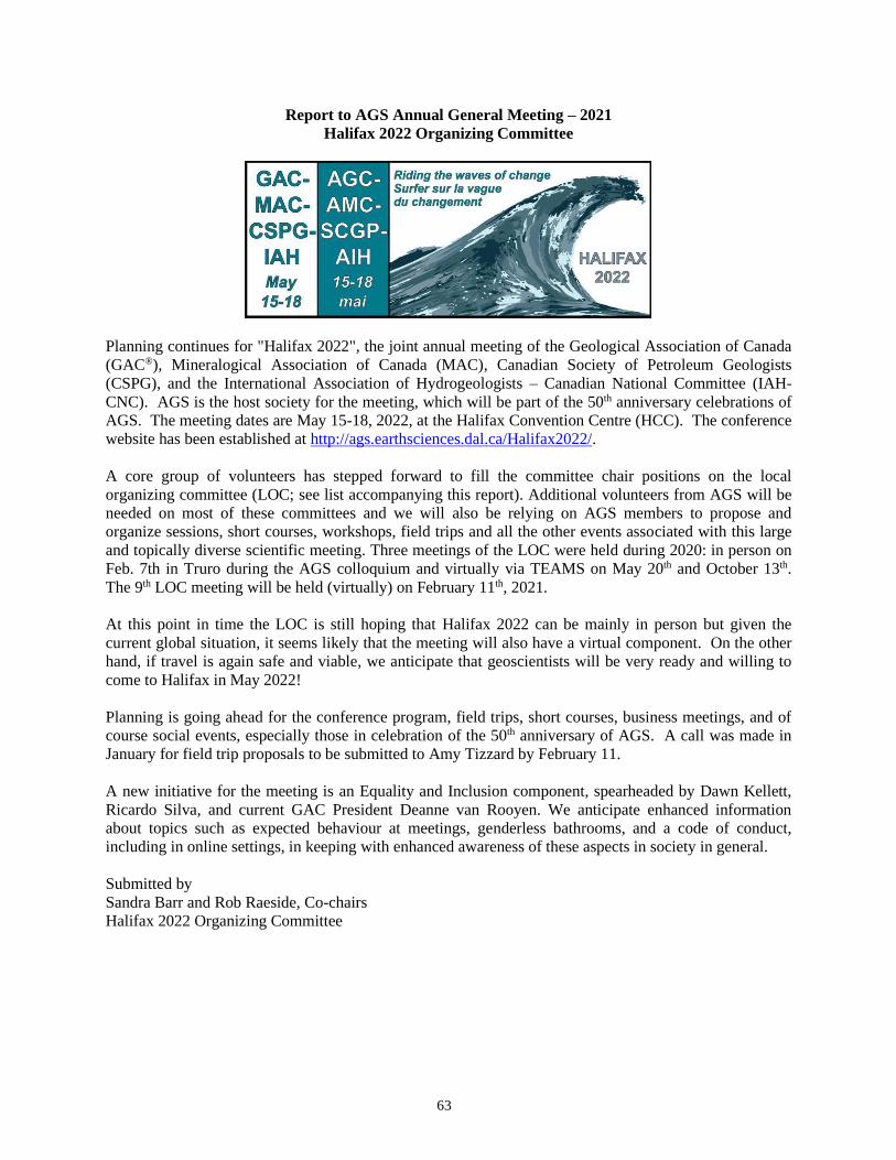
63
Report to AGS Annual General Meeting – 2021
Halifax 2022 Organizing Committee
Planning continues for "Halifax 2022", the joint annual meeting of the Geological Association of Canada
(GAC®), Mineralogical Association of Canada (MAC), Canadian Society of Petroleum Geologists
(CSPG), and the International Association of Hydrogeologists – Canadian National Committee (IAH-
CNC). AGS is the host society for the meeting, which will be part of the 50th anniversary celebrations of
AGS. The meeting dates are May 15-18, 2022, at the Halifax Convention Centre (HCC). The conference
website has been established at http://ags.earthsciences.dal.ca/Halifax2022/.
A core group of volunteers has stepped forward to fill the committee chair positions on the local
organizing committee (LOC; see list accompanying this report). Additional volunteers from AGS will be
needed on most of these committees and we will also be relying on AGS members to propose and
organize sessions, short courses, workshops, field trips and all the other events associated with this large
and topically diverse scientific meeting. Three meetings of the LOC were held during 2020: in person on
Feb. 7th in Truro during the AGS colloquium and virtually via TEAMS on May 20th and October 13th.
The 9th LOC meeting will be held (virtually) on February 11th, 2021.
At this point in time the LOC is still hoping that Halifax 2022 can be mainly in person but given the
current global situation, it seems likely that the meeting will also have a virtual component. On the other
hand, if travel is again safe and viable, we anticipate that geoscientists will be very ready and willing to
come to Halifax in May 2022!
Planning is going ahead for the conference program, field trips, short courses, business meetings, and of
course social events, especially those in celebration of the 50th anniversary of AGS. A call was made in
January for field trip proposals to be submitted to Amy Tizzard by February 11.
A new initiative for the meeting is an Equality and Inclusion component, spearheaded by Dawn Kellett,
Ricardo Silva, and current GAC President Deanne van Rooyen. We anticipate enhanced information
about topics such as expected behaviour at meetings, genderless bathrooms, and a code of conduct,
including in online settings, in keeping with enhanced awareness of these aspects in society in general.
Submitted by
Sandra Barr and Rob Raeside, Co-chairs
Halifax 2022 Organizing Committee
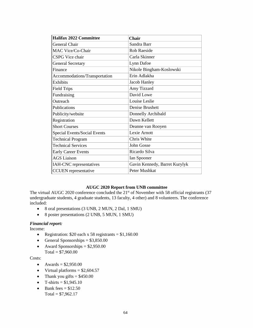
64
Halifax 2022 Committee Chair
General Chair Sandra Barr
MAC Vice/Co-Chair Rob Raeside
CSPG Vice chair Carla Skinner
General Secretary Lynn Dafoe
Finance Nikole Bingham-Koslowski
Accommodations/Transportation Erin Adlakha
Exhibits Jacob Hanley
Field Trips Amy Tizzard
Fundraising David Lowe
Outreach Louise Leslie
Publications Denise Brushett
Publicity/website Donnelly Archibald
Registration Dawn Kellett
Short Courses Deanne van Rooyen
Special Events/Social Events Lexie Arnott
Technical Program Chris White
Technical Services John Gosse
Early Career Events Ricardo Silva
AGS Liaison Ian Spooner
IAH-CNC representatives Gavin Kennedy, Barret Kurylyk
CCUEN representative Peter Mushkat
AUGC 2020 Report from UNB committee
The virtual AUGC 2020 conference concluded the 21st of November with 58 official registrants (37
undergraduate students, 4 graduate students, 13 faculty, 4 other) and 8 volunteers. The conference
included:
• 8 oral presentations (3 UNB, 2 MUN, 2 Dal, 1 SMU)
• 8 poster presentations (2 UNB, 5 MUN, 1 SMU)
Financial report:
Income:
• Registration: $20 each x 58 registrants = $1,160.00
• General Sponsorships = $3,850.00
• Award Sponsorships = $2,950.00
Total = $7,960.00
Costs:
• Awards = $2,950.00
• Virtual platforms = $2,604.57
• Thank you gifts = $450.00
• T-shirts = $1,945.10
• Bank fees = $12.50
Total = $7,962.17
65
Income - Costs = $7,960.00 - $7,962.17 = - $2.17 covered by the Science Atlantic Float
All remaining money has been sent to Science Atlantic and the bank account is now closed.
AUGC 2021:
AUGC 2021 will be hosted by SMU in 2021. We have been in contact with Josh Jackman and Aidan
Buyers, who will be organizing the conference. We have provided detailed advice regarding the various
aspects of conference planning in the Science Atlantic Conference in a Box. Our main advice is to start
early, as it can take a while to get replies and it will be less stressful. Our advice also included staying
organized as being in contact with so many people can get confusing.
Grace Jackson & Hannah Sharpe
AGS Colloquium 2021 Social Media Report
After surveying AGS members in the summer of 2020 with regards to their social media habits, the intent
was to get an idea of how various individuals spend their time on these platforms. Including which social
media sites members use, as well as the time of day they spend the most time using social media.
Since the survey was conducted there have been a number of ‘zoom series’ and traveling speaker series
presentations that have been promoted on both the AGS Facebook and Twitter Accounts. I also started
regularly posting content on both Facebook and Twitter, photos from years past in a series called
‘Throwback Thursday’ (#tbt).
Here are the analytics from social media posts over the past few months:
Facebook: Likes 915, Followers 992 (February 4, 2021)
Definitions:
• Reach: times people saw this post on Facebook. This includes those who do and do not follow the
AGS Facebook account
• Post clicks: times people clicked on the post to read/view it
• Reactions; including ‘likes’, comments and shares: times people directly engage with a post
#tbt Series Analytics (5 posts):
Reach: 1156 (231 average)
Post clicks: 24 (4.8 average)
Reactions: 70 (14 average)
Zoom Seminars & Speaker Series Analytics (9 posts)
Reach: 1775 (197 average)
Post clicks: 65 (7.2 average)
Reactions: 81 (9 average)
Twitter: Following 97, Followers 181 (February 4, 2021)
Definitions:
• Impressions: times people saw this Tweet on Twitter. This includes those who do and do not
follow the AGS Twitter account
• Total engagements: times people interacted with this Tweet
66
• Media engagements: number of clicks on your media counted across videos and images
• Likes: times people liked this Tweet
• Retweets: times people retweeted this Tweet
• Detail expands: times people viewed the details about this Tweet
• Profile clicks: number of clicks on your name, @handle, or profile photo
#tbt Series Analytics (7 photos):
Impressions: 1686 (241 average)
Total engagements: 109 (15.6 average)
Media engagements: 67 (9.6 average)
Likes: 16 (2.3 average)
Retweets: 4 (0.57 average)
Details expanded: 18 (2.6 average)
Profile clicks: 7 (1 average)
Zoom Seminars & Speaker Series (8 Posts):
Impressions: 3811 (476 average)
Total engagements: 102 (13 average)
Media engagements: 37 (4.6 average)
Likes: 21 (2.6 average)
Retweets: 8 (1 average)
Details expanded: 30 (3.8 average)
Profile clicks: 5 (0.63 average)
(Throwback Thursday) #tbt Facebook & Twitter Summary: What is not surprising is that posts with
higher quality imagery and human faces tend to get more overall engagements from users on Twitter and
Facebook. There have only been eight #tbt posts to date, and seven were analyzed for this report. The first
posts in this series have come at different times of day on Thursday. It’s difficult to say if time of day is a
factor at this point, but it will continue to be monitored as more posts are made in the coming months.
Based on the survey from Summer 2020 AGS tend to monitor their social media accounts throughout the
day. The goal for the next three months will be to increase overall impressions on Twitter. Retweeting
more content from other accounts is something I’m heavily considering as a way to boost online
interactions.
Zoom Seminars & Speaker Series, Facebook & Twitter Summary: Most of the Zoom webinar series
posts tend to have the similar, lower numbers when it comes to overall impressions and interactions. They
definitely would benefit from an added image to their posts so that they catch readers eyes. In the future I
will look at including imagery to the specific Zoom webinars in the future. Tim Fedak’s presentation on
“200 Years of Mineralogy and Contributions to Nova Scotia Geology” and John Calder’s presentations
on “Exploring Atlantic Canada’s UNESCO Global Geopark” tended to yield more responses and overall
interactions on Twitter than the webinar series. Again these posts benefited from imagery and an
embedded video link to Tim Fedak’s talk on YouTube.
Overall Conclusion: The main goal in the coming months is to address the points I have previously
mentioned. I would like to also add a series focusing on rocks, something along the lines of “Mineral
Monday’, where I would regularly upload photos to social media of interesting fossils, minerals and rocks
from across Atlantic Canada and beyond!
67
AGS Geoheritage Committee
Bringing public attention to the rich geoheritage of the Atlantic Provinces is in keeping with the central
tenets of the AGS. The Geoheritage Committee of the society was born during the past year 2020, and
like many other initiatives of that year, has been slow to take flight but is steadily growing. Presently, the
Committee comprises Rob Fensome, Jason Loxton, Jeff Poole and John Calder. The committee seeks
representation from New Brunswick and from Newfoundland and Labrador. Jeff Poole brings knowledge
of the construction and maintenance of Nova Scotia’s Geoheritage list and database, which will be helpful
to the AGS and to other jurisdictions interested in compiling geoheritage sites. John Calder
68
NOMINATION OF OFFICERS AND COUNCILLORS – February 2021
The following individuals have agreed to be nominated as new members or agreed to continue to serve on
council subject to ratification by the AGS membership.
* new member on Council
President Anne-Marie Ryan, Dalhousie University 1
Past President
Vice-President
Treasurer
Dave Lentz, University of New Brunswick
Deanne van Rooyen, Cape Breton University
Paul Batson, Timberlea, NS
2
3
4
Secretary Rob Raeside, Acadia University 5
Councillor Donnelly Archibald, St. Francis Xavier University 6
Councillor Lexie Arnott, Dalhousie University 7
Councillor Denise Brushett, NS Department of Energy and Mines 8
Councillor John Calder, St. Mary’s University 9
Councillor *Dewey Dunnington, Dept. of Fisheries & Oceans, BIO 10
Councillor Tim Fedak, Nova Scotia Museum 11
Councillor Martha Grantham, Stewiacke, NS 12
Councillor Alison Leitch, Memorial University 13
Councillor Ann Miller, Wolfville, NS 14
Councillor Catrina Russell, New Brunswick Museum 15
Councillor Ann Timmermans, University of New Brunswick 16
Councillor Grant Wach, Dalhousie University 17
Councillor Jim Walker, NB Dept. of Energy and Resource Development 18
Councillor Sheila Watters – GeoExplorations Inc. 19
Councillor Chris White, Nova Scotia Department of Energy and Mines 20
Student
Councillor *Alan Fernando Cardenas Vera, UNB (graduate student) 21
Student
Councillor *Josh Jackman & Aidan Buyers, SMU (undergraduate students) 22
Completion of term:
Bob Grantham
Dewey Dunnington completion of term as Grad student rep – continuing as Councillor
Hannah Sharp (UNB) & Grace Jackson (UNB)