280 Pretoria Street, Silverton, Protoria - Council for Geoscience
Upload
khangminh22Category
view
5download
0
FINAL REPORT
HYDROGEOLOGICAL BASELINE AND BORE COMPLETION REPORT TWIN BONANZA GOLD PROJECT, TANAMI DESERT, NORTHERN TERRITORY
Twin Bonanza Gold Project
REPORT NUMBER: AB0101-01-01 - Ver B
Prepared For
ABM Resources NL
October 2014
SAPROLITE PTY LTD (ACN 135 590 724) PO Box 2234 Ellenbrook WA 6069 52B Mornington Parkway Ellenbrook WA 6069 Ph.: +61 8 6296 7760 www.saprolite.com.au Fax: +61 8 6296 7762 [email protected]
Copies of Final Reports to:ABM Resources NL (2)
Saprolite Environmental (1)

Saprolite Pty LtdABN 43 135 590 724
PO Box 2234 Ellenbrook WA 606952B Mornington Parkway Ellenbrook WA 6069
Ph: (+61 8) 6296 7760 I Fax: (+61 8) 6296 7762 I Email: [email protected]
24 October 2014 Project No: AB0101-01-01
ABM Resources NL Level 1, 141 Broadway Nedlands WA 6009
Attention: Justin Robins – Environmental Manager
Dear Justin:
Subject: Hydrogeological Baseline & Bore Completion Report
Twin Bonanza Gold Project, Tanami Desert, Northern Territory We are pleased to provide ABM Resources NL with copies of the above final report as per the distribution list on the front cover. Included in each report is a CD-ROM that contains the report in electronic format in its entirety.
We thank you for the opportunity to work on this project and look forward to being of assistance in the future.
Should you have any queries about the report, or about any other matter please do not hesitate to contact us.
Yours faithfully
SAPROLITE ENVIRONMENTAL
Shaun Wimbridge Garth Richards Environmental Hydrogeologist Senior Principal Consultant Managing Director cc.
24 October 2014 Twin Bonanza Gold Project Hydrogeological Baseline and Bore Completion Report
ABM Resources NL
SAPROLITE ENVIRONMENTAL i
EXECUTIVE SUMMARY
ABM Resources NL (ABM) is a mineral exploration company developing several gold discoveries in the Central Desert region of the Northern Territory of Australia. ABM proposes to develop and operate the Twin Bonanza Gold Project (TBGP) in the Tanami Desert, approximately 527 km west of Tennant Creek, 750km north-west of Alice Springs, and 14 km east of the Northern Territory and Western Australia border, Figure 1.
The development of the proposed gold mine will be undertaken in a staged approach with the stage two phase of mining projected to process between 120,000 and 150,000 tonnes of ore per annum over a two year period. The stage three phase is projected to process between 200,000 and 300,000 tonnes of ore per annum. The expected mine life is estimated to be approximately 4 to 5 years with further operations dependent on the results of exploration.
The original Project had a water supply demand that will peak at 11L/s (950kL/d) when the project reaches its full production phase (stage three). This maximum rate was not expected until the 4th year of the project. However, as the excavated ore is to be processed through the Coyote processing plant within Western Australia, and the water supply requirement is anticipated to be met by the existing production bores during the mining phases of the project, with a projected water demand of up to 0.8L/s (69kL/d).
Saprolite Environmental (Saprolite) was engaged by ABM to provide hydrogeological consultation and professional services in the development of hydrogeological baseline information and water resource assessment for the Project. This follows on from a Water Management Plan (WMP) (SWC, 2013a) that was submitted by ABM to the Northern Territory, Environmental Protection Authority (NT EPA), which formed part of ABM’s submission of their Draft Environmental Impact Statement (EIS) to the Northern Territory Government (NT Govt). Subsequent to the EIS, supplementary submissions were provided to the NT Govt in response to written submissions received from the exhibition of the EIS, and further information was provided to stakeholders to support the previously lodged draft EIS.
Hydrogeological works were undertaken in order to address the comments made by stakeholders in ABM’s draft EIS (Comments 21 and 22), that culminates in this report.
These hydrogeological works included:
• The drilling and installation of 18 monitoring bores; • The drilling and installation of a replacement production bore at Strezza’s; • The collection of baseline water chemistry from 11 monitoring bores and 3 production bores where
groundwater was present within the bores; and • The test pumping and hydraulic analysis of the pre-existing production bores, Corsair Bore and
Wilson’s Bore and the new replacement bore, Strezza’s/Timmy’s Bore 2.
The above works provided sufficient information to provide:
a) an initial set of baseline results comprising physical and chemical parameters; b) a water resource assessment and recommended pumping yields to meet the project water
requirements in the short to medium term; and c) a review of the groundwater monitoring program with recommendations.
Recommendations • Recommended pumping depths and pumping rates are provided in Table 6.1, which are
conservative estimates for a 5-year continuous period, as follows
o Corsair Bore: 120m @ 1.3L/s o Wilson’s Bore: 75m @ 1L/s (intermittent use only) o Strezza’s/Timmy’s Bore 2: 20m @ 5L/s

24 October 2014 Twin Bonanza Gold Project Hydrogeological Baseline and Bore Completion Report
ABM Resources NL
SAPROLITE ENVIRONMENTAL ii
• The selection of suitably sized electro-submersible pumps should be undertaken using the advice of a pump engineer, or pump supplier, in liaison with a hydrogeologist.
• It is recommended that cooling shrouds be installed on all electro-submersible pumps, to force water flow over the pump motor to facilitate improved cooling.
• It is recommended that once bores are installed with suitably sized pumps, appropriate for the respective bore capacities, that careful monitoring of instantaneous yields, flow-meters, and water levels are maintained, and that regular (quarterly) reviews of the monitoring data and bore performance is undertaken by a hydrogeologist.
• It is recommended that a vegetation monitoring program be established to monitor any potential effects or impacts on the vegetation health from groundwater abstraction at Strezza’s/Timmy’s Bore 2.
• Should additional groundwater resources be required over and above the pumping capacity of the three existing production bores, then additional production bores could be located within the Strezza’s/Timmy’s Borefield area at a spacing of 1km from Strezza’s/Timmy’s Bore 2, along strike within the palaeovalley. A further groundwater exploration program utilising geophysical methods would be required to identify potential target sites; subject to heritage and regulatory approvals.
• The recommended groundwater monitoring program for the first 12 months of monitoring represents a nominal baseline period as presented on Table 7.1.
• A new procedural SOP document is recommended to be prepared in a new Sampling Measurement and Analysis Plan (SMAP) field based format, with the amendments and revisions as outlined in Section 7.
• A Drinking Water Quality Management Plan is recommended to be prepared and developed as outlined in Section 7.
• Monitoring bore M08A was reported to be blocked and not able to be sampled. It is recommended that M08A be cleaned out to remove any apparent blockage. If the blockage cannot be cleared it is possible that the casing has collapsed, and a replacement bore could be installed opportunistically when a drilling rig is next on site and prior to any on-site ore processing and associated tailings deposition.
• Monitoring bore M09 was unable to be airlift developed due to the airline becoming stuck in the bore during attempted airlifting. It is recommended that M09 be airlift development at a depth of 75% of the wet bore volume (i.e. at approx. 116mbgl) and not at the base of the bore. Airlift development of this bore could be undertaken opportunistically when a drilling rig is next on site and prior to any on-site ore processing and associated tailings deposition.
• The recommended period for the groundwater monitoring program (Table 7.1) to establish baseline groundwater conditions is 12 months. Following this period, the monitoring data is to be reviewed and assessed in detail and background levels set (as per the SOP) and trigger levels subsequently determined once sufficient background information data is collected, using statistical methods.
24 October 2014 Twin Bonanza Gold Project Hydrogeological Baseline and Bore Completion Report
ABM Resources NL
SAPROLITE ENVIRONMENTAL
TABLE OF CONTENTS
1. INTRODUCTION 1 2. OBJECTIVES AND SCOPE OF WORK 2
2.1 Scope of Work 2 2.2 Bore Locations 3
3. FIELD INVESTIGATIONS 4 3.1 Drilling Program 4 3.2 Baseline Testing 7 3.3 Water Sampling 9 3.4 Test Pumping 9
4. HYDRAULIC ANALYSIS 12 4.1 Estimated Pumping Yields 13
5. WATER CHEMISTRY 16 6. DISCUSSION 19
6.1 Water Resource Assessment Summary 19 6.2 Groundwater Dependent Ecosystem Review 20
7. GROUNDWATER MONITORING PROGRAM REVIEW 21 8. CONCLUSIONS AND RECOMMENDATIONS 25
8.1 Recommendations 25
9. REFERENCES 27 LIST OF TABLES, FIGURES AND APPENDICES
TABLES
Table 3.1 Monitoring Bore Drilling Completion Summary ....................... ................................................. 5 Table 3.2 Drilling/Airlifting Observations ................................................. ................................................. 6 Table 3.3 Standing Water Levels ............................................................. ................................................. 7 Table 3.4 EC Profiling Summary .............................................................. ................................................. 8 Table 3.5 Summary of Production Bore Details ...................................... ................................................. 9 Table 3.6 Summary of Test Pumping Results ......................................... .............................................. 10 Table 4.1 Summary of Hydraulic Analyses Results ................................ .............................................. 12 Table 4.2 Estimated Pumping Capacity – Corsair Bore ......................... .............................................. 13 Table 4.3 Estimated Pumping Capacity – Wilson’s Bore ....................... .............................................. 14 Table 4.4 Estimated Pumping Capacity – Strezza’s/Timmy’s Bore 2 .... .............................................. 15 Table 5.1 Water Quality Laboratory Analyses ........................................ .............................................. 17 Table 6.1 Recommended Pumping Rates .............................................. .............................................. 19 Table 7.1 Recommended Groundwater Monitoring Schedule - Baseline ............................................ 22
FIGURES
Figure 1 Regional Location .................................................................................................... AB0100-006 Figure 2 Bore Location Plan .................................................................................................. AB0100-001

24 October 2014 Twin Bonanza Gold Project Hydrogeological Baseline and Bore Completion Report
ABM Resources NL
SAPROLITE ENVIRONMENTAL
APPENDICES
Appendix A Glossary Appendix B Bore Completion Logs Appendix C Electrical Conductivity Profiles Appendix D1 Test Pumping Plots Appendix D2 Test Pumping Data Appendix E Analytical Laboratory Reports Appendix F Preliminary Review of Standard Operating Procedure for Groundwater Monitoring DOCUMENT REVISION HISTORY Revision Number
Status Revision Date
Revision Comments Primary Author
Reviewer Approved
A Draft 01/10/2014 Report for internal review S.Wimbridge G.Richards - A Draft 02/10/2014 Report issued for client review S.Wimbridge J.Robins G.Richards B Draft 24/10/2014 Client comments addressed S.Wimbridge J.Robins G.Richards B Final 24/10/2014 Report issued as final S.Wimbridge - G.Richards STATEMENT OF LIMITATIONS Aquifer materials and groundwater flow systems are a product of continuing natural and man- made processes and thus exhibit a variety of characteristics and properties that vary from place to place and can change with time. Geology/hydrogeology involves gathering and assimilating limited facts about these characteristics and properties in order to understand and predict the behaviour of the ground on a particular site under certain conditions. This report may contain such facts obtained by inspection, drilling, excavation, probing, sampling, testing or other means of investigation, particularly pumping and drawdown data. If so, they are directly relevant only to the groundwater system at the place where, and the time when the investigation was carried out. Any groundwater modelling predictions presented should not be regarded as matters of fact. This report and other reports referred to contain comments on works being carried out by others. Saprolite Environmental cannot and will not take responsibility for works carried out by others on site to date. We do not guarantee the performance of the project in any respect, only that our work and judgement meet the standard of care of our profession at this time. Any interpretation or recommendation given in this report shall be understood to be based on judgement and experience, not on greater knowledge of facts other than those reported. The interpretation and recommendations are therefore opinions provided for the Client's sole use in accordance with a specific brief. As such they do not necessarily address all aspects of the groundwater system on the subject site. © Saprolite Pty Ltd, 2014
This document may not be reproduced in part or whole by electronic, mechanical or chemical means, including photocopying, recording or any information storage system, without the express approval of Saprolite Pty Ltd and/or ABM Resources NL. Neither this document nor its contents may be referred to or quoted in any manner, report or other document without the express approval of Saprolite Pty Ltd and/or ABM Resources NL Additional copies and or enquiries about this document should be addressed to The Principal, Saprolite Environmental, PO Box 2234 Ellenbrook, WA, 6069 or by email to [email protected]

24 October 2014 Twin Bonanza Gold Project Hydrogeological Baseline and Bore Completion Report
ABM Resources NL
SAPROLITE ENVIRONMENTAL 1
1. INTRODUCTION
ABM Resources NL (ABM) is a mineral exploration company developing several gold discoveries in the Central Desert region of the Northern Territory of Australia. ABM proposes to develop and operate the Twin Bonanza Gold Project (TBGP) in the Tanami Desert, approximately 527 km west of Tennant Creek, 750km north-west of Alice Springs, and 14 km east of the Northern Territory and Western Australia border, Figure 1.
The development of the proposed gold mine will be undertaken in a staged approach with the stage two phase of mining projected to process between 120,000 and 150,000 tonnes of ore per annum over a two year period. The stage three phase projected to process between 200,000 and 300,000 tonnes of ore per annum. The expected mine life is estimated to be approximately 4 to 5 years with further operations dependent on the results of exploration.
Ore will be transported to the Coyote processing plant for the recovery of gold. Waste rock produced by the project will report to purpose designed waste rock dumps (ABM, 2014c).
Saprolite Environmental (Saprolite) was engaged by ABM to provide hydrogeological consultation and professional services in the development of hydrogeological baseline information and water resource assessment for the Project. This follows on from a Water Management Plan (WMP) (SWC, 2013a) that was submitted by ABM to the Northern Territory, Environmental Protection Authority (NT EPA), which formed part of ABM’s submission of their Draft Environmental Impact Statement (EIS) to the Northern Territory Government (NT Govt). Subsequent to the EIS, supplementary submissions were provided to the NT Govt in response to written submissions received from the exhibition of the EIS, and further information was provided to stakeholders to support the previously lodged draft EIS.
This report specifically addresses Comment Numbers 21 and 22 in the EIS assessment by the NT Govt, and the respective responses to the comments by ABM (EIS Supplement, ABM, 2014c). This report is intended to be incorporated into ABM’s future Mining Management Plan.
This report presents the results of the Hydrogeological Works Programme (Ref Supplement to Draft EIS - Appendix C – Hydrogeological Works Scope (Saprolite, 2014a)) including drilling, installation and completion of monitor bores and one production bore, test pumping, baseline testing, hydraulic analysis, water chemistry laboratory analysis, water resource assessment, review of the standard operating procedure for groundwater monitoring (Draft EIS – Appendix H (SWC, 2013b)), and presentation of findings and recommendations.
A glossary of units and terms is presented in Appendix A.

24 October 2014 Twin Bonanza Gold Project Hydrogeological Baseline and Bore Completion Report
ABM Resources NL
SAPROLITE ENVIRONMENTAL 2
2. OBJECTIVES AND SCOPE OF WORK
Comment 21 – ABM Response To assess the groundwater resource, ABM proposes to undertake testing of Timmy’s (once re- established), Corsair and Wilson’s bores to determine the potential of the groundwater resource.
The proposed investigations will include:
• Establishment of a monitoring bore network to assess both water quality and extraction across the operation (including the production bores).
• Pumping tests of the established and re‐established bores (Corsair, Wilson’s and Timmy’s)
• Collection of baseline water data for the purpose of ongoing monitoring.
• Determination of the aquifer properties and associated groundwater resource.
During this process the relevant government agencies will be consulted to ensure all programs meet agency requirements. Once completed, the findings and recommendations will be incorporated into the site water account and management plan for inclusion in the Mining Management Plan. Further details of scope and extent of work is provided in EIS Supplement - Appendix C (Saprolite, 2014a).
Note: The general outline of the scope of work is provided in Section 2.1.
Comment 22 – ABM Response (in part)
It is acknowledged that the completed assessment of the sustainability and viability of water resources is required as part of the Mining Management Plan. As detailed in the response to Comment 21, the on‐site assessment is proposed to expand upon the desktop work. To assess the groundwater resource and sustainability of that resource, ABM proposes to undertake testing of Timmy’s (Strezza’s) (once re‐established), Corsair, and Wilson’s bores. This on ground work will provide a better understanding of the hydraulic conductivity and the potential storage characteristics of the aquifers that may diverge from a normal recharge and discharge flow through system.
2.1 Scope of Work
A scope of work was developed that follows on from a proposed program initially tabled in the Draft EIS – Appendix F – WMP, (SWC, 2013a).
A Hydrogeological Works Program was implemented on site from 1 July 2014 to 5 August 2014 at the Twin Bonanza Gold Project that included:
• Drilling and completion of 18 monitoring bores (nominal casing size 50mmND).
• Drilling and completion of a replacement production bore at Strezza’s Bore (as the pre-existing bore had collapsed) for longer term water supply (nominal casing size 155mmND).
• Test pumping of three (3) production bores:
o Two (2) pre-existing, previously equipped production bores (Wilson’s Bore and Corsair Bore) to assess the existing resource capacity.
o One (1) replacement production bore at Strezza’s Bore to assess the longer term water resource capacity.
• Baseline testing of 18 monitoring bores and 3 production bores, including EC profiling, standing water level (SWL) measurements and groundwater sampling for laboratory analysis in those bores that returned with water.

24 October 2014 Twin Bonanza Gold Project Hydrogeological Baseline and Bore Completion Report
ABM Resources NL
SAPROLITE ENVIRONMENTAL 3
2.2 Bore Locations
Preliminary bore locations proposed in the WMP were revised, following structural and geological interpretation and optimisation for test pumping data collection (ABM, 2014a, ABM, 2014b and Saprolite, 2014b). The bore locations were also refined to ensure their positions were within the mining tenement ML29822. Bores that were located outside the mining tenement required a specific Section 19 access agreement with the Central Land Council (CLC). The final monitoring bore locations are summarized as follows:
• Four shallow monitor bores (M01-M04) on the western margin of the Plant Site, intended to intercept the primary potential contaminant pathways, down gradient from the site. These were to be installed in the surficial aquifer system.
• Five deep monitor bores (M05-M09), four encompassing the Plant Site enabling monitoring of potential contaminant movement in all directions and one (M07) central to the site (adjacent to the Plant and Concentrate Residual Dam).
• Three analogue monitor bores (A01-A03A), positioned north of the site in an area outside of the potential influence of site activity. The analogue bores will enable monitoring of background concentrations throughout mine life, providing a means of distinguishing measured changes in the primary monitoring bores (M01-M04) from natural fluctuations or variability. A01 and A02A were installed in the bedrock aquifer (deep and shallow respectively) and A03A was installed upstream in an inferred palaeovalley.
• Four monitor bores (BF01-BF04) within the palaeochannel in the vicinity of Strezza’s/ Timmy’s Bore redrill. These bores will be used primarily to monitor water levels within the palaeochannel aquifer in response to abstraction from Strezza’s/Timmy’s Bore 2. The monitoring bore network (BF01-BF04) was also intended to measure water level responses during test pumping, allowing for the delineation of palaeochannel aquifer characteristics and improved certainty of pumping sustainability.
• The original 1994 constructed Strezza’s Bore had collapsed. A redrill of Strezza’s Bore was undertaken, not only to provide a high quality source of water for the project but to monitor palaeochannel water quality down gradient from the mine site.
• Two additional monitor bores (M10A and M11) were located adjacent to the pre-existing production bores, Corsair Bore and Wilson’s Bore, respectively. These bores will be used primarily to monitor water levels in response to abstraction from their respective production bores, and were also intended to measure water level responses during test pumping, allowing for the aquifer parameters to be determined.

24 October 2014 Twin Bonanza Gold Project Hydrogeological Baseline and Bore Completion Report
ABM Resources NL
SAPROLITE ENVIRONMENTAL 4
3. FIELD INVESTIGATIONS
3.1 Drilling Program
Drilling commenced on 2 July 2014 and was completed on 17 July 2014. A total of 18 monitoring bores were installed and one replacement production bore. All work was completed by a drilling contractor, Topdrill Pty Ltd, under the supervision of ABM Geologists. Saprolite provided ABM Geologists with onsite support and technical direction at the commencement of drilling, followed by remote support and assistance with the technical specifications as required.
A technical scope of work for the drilling program was prepared by Saprolite (Saprolite, 2014c), which was provided to the drilling contractor and ABM Geologists. The drilling scope of work included technical bore specifications, typical bore designs for the monitoring bores and production bore, a drilling bill of materials for bore consumables and nominal drilling depths for each individual bore site.
The drilling of the holes was signed off by Greg Scanlon who holds the following licences; Australian Drilling Industry Association (ADIA) #304, Australian Drilling Industry Association (ADIA) Water Licence #112 and NT Water Act Licence #115.
The bedrock and surficial monitoring bores were drilled using Reverse Circulation (RC) method with a Schramm T685 drilling rig at a final diameter of 146mm (5 ¾ inch). The palaeochannel monitoring bores were drilled using mud rotary method with a Gemex 1500 drilling rig at a final diameter of 130mm (5 1/8 inch). The replacement production bore at Strezza’s was drilled using mud rotary method at an initial diameter (for the pilot hole) of 127mm (5 inch) and then reamed to a final diameter of 267mm (10 ½ inch).
The nominal bore depths were revised during the site works as information became available. The final depths were as follows:
• Plant Site Surficial (Shallow) Bores (M01-M04) – 36m. • Plant Site Bedrock (Deep) Bores (M05-M09) – initially 90m, but were extended to 132 to
144m based on the depth at which first water or initial flows were encountered. • Palaeochannel Bores (Strezza’s/Timmy’s) – 42m • Production Monitoring Bores – to be at similar depths as their associated production bore
o M11 – 150m (at Corsair Bore) o M10A – 90m (at Wilson’s Bore)
• Analogue Bores o Bedrock (Deep) Bore (A01); as per Plant Site bedrock bores. o Surficial (Shallow) Bore (A02A); as per Plant Site surficial bores. o Palaeochannel Bore (A03A) – 42m
All monitoring holes were successfully cased with 50mm nominal diameter (ND) PN12 μPVC. Each bore annulus was gravel packed with 1.6-3.2mm graded gravel from the base of the hole to above the slotted interval. All bore annuli were sealed above the slotted interval with bentonite clay. This was undertaken to inhibit the movement of groundwater (of potential differing quality) between surficial and fractured bedrock aquifers. Bores were backfilled to approximately 1mbgl and cement grouted to surface. Each bore was completed with a steel well head and cement plinth to protect the PVC stickup and prevent direct surface water infiltration.

24 October 2014 Twin Bonanza Gold Project Hydrogeological Baseline and Bore Completion Report
ABM Resources NL
SAPROLITE ENVIRONMENTAL 5
Strezza’s/Timmy’s Bore 2 was cased with 155mm ND PN12 μPVC, and the bore annulus was gravel packed from 39.9 metres below ground level (mbgl) to 4mbgl. Above the gravel pack the bore annulus was sealed with bentonite and cement grouted to the ground surface. The wellhead was completed with steel surface casing, steel well cap and cement plinth.
A summary of bore completion details is presented in Table 3.1. Detailed bore completion details are presented on bore completion logs, Appendix B.
Table 3.1 Monitoring Bore Drilling Completion Summary
Bore ID
Surveyed Coordinates (MGA)
Elevation Top of Casing
(mAHD)
*Stickup (magl)
Drilled Depth (mbgl)
Cased Depth (mbgl)
Slotted Interval
mEasting mNorthing From (mbgl)
To (mbgl)
A01 517368.82 7772533.07 446.85 0.67 114 114.00 42.00 114.00 A02A 517097.41 7771709.02 439.59 0.80 36 35.50 5.50 35.50 A03A 514320.39 7772049.89 426.77 0.75 42 41.20 5.20 41.20 M01 515447.91 7768606.26 442.50 0.82 36 35.15 5.15 35.15 M02 515114.96 7767679.21 443.29 0.44 36 35.35 5.35 35.35 M03 515118.54 7766392.16 445.09 0.87 36 35.30 5.30 35.30 M04 515524.10 7765687.81 443.90 0.91 36 35.40 5.40 35.40 M05 515416.48 7768521.32 442.61 0.66 132 130.60 40.60 130.60
M06A 515929.79 7765679.49 447.42 0.92 132 130.70 40.70 130.70 M07 516266.98 7767035.79 451.73 0.84 144 143.20 41.20 143.20
M08A 516769.86 7768536.27 451.31 0.91 138 137.30 41.30 137.30 M09 516951.77 7766088.20 452.33 0.86 132 131.00 41.00 131.00
M10A 513252.59 7767166.60 432.69 0.64 89.70 89.70 41.70 89.70 M11 516537.24 7770190.36 438.59 0.16 150 150.00 42.00 150.00
Strezza’s/Timmy’s Bore 2 509508.96 7764891.92 418.26 0.62 42 39.90 6.00 39.90
BF01 509819.97 7765909.34 418.51 0.51 42 41.20 5.20 41.20 BF02 509563.73 7765117.24 418.22 0.69 42 41.30 4.30 41.30
BF03A 509507.99 7764884.44 418.07 0.51 42 41.25 5.25 41.25 BF04 509452.79 7764695.71 418.23 0.53 42 41.15 5.15 41.15
*Stickup calculated (top of casing RL (mAHD) minus ground RL (mAHD)
During the drilling program groundwater occurrences and approximate yields were recorded in those bores drilled by RC method, although many of the bores were drilled dry (particularly the shallow surficial bores), Table 3.2. The approximate intersection and quantity of groundwater encountered could not be delineated in those bores drilled by mud rotary method.
Drilling of the plant site monitoring bores and analogue bores A01 and A02A intersected three major lithological units, siltstone, sandstone and intercalated siltstone and sandstone. The units have varying degrees of oxidisation, but were typically weathered to depth at around 70mbgl. The upper part of the sedimentary sequence is heavily weathered and overlain by a thin (<2m), extremely weathered, iron rich alluvium layer.
Minor groundwater was encountered within fractured sequences of sandstone and siltstone during drilling of the plant site and analogue (A01 and A02A) monitoring bores. Groundwater was typically intersected at depths greater than 90mbgl or not at all. Monitoring bores A01, M05 and M11 were somewhat of exceptions where more significant groundwater was encountered possibly indicating more considerable fracturing and connection at depth.

24 October 2014 Twin Bonanza Gold Project Hydrogeological Baseline and Bore Completion Report
ABM Resources NL
SAPROLITE ENVIRONMENTAL 6
Drilling of Strezza’s/Timmy’s Bore 2 intersected primarily calcrete, which has developed over porous and well sorted aeolian sand. There was a loss of circulation between 10 and 37mbgl, this was assumed to be due to the karstic nature of the calcrete, as there was little to no weight against the drill bit during drilling. Calcrete deposits are said to preferentially develop towards the centre of the main palaeochannel systems.
Drilling of the palaeochannel monitoring bores (A03, BF01, BF02, BF03A and BF04) intersected alluvial clay (pelite) at depth, overlain by intercalated sandstone, siltstone and pelite units. Chemical precipitate deposits, calcrete and silcrete were identified within upper parts of the profiles, with the most significant occurrence of calcrete at BF03A, which is adjacent to Strezza’s/Timmy’s Bore 2. Stratigraphically above the calcrete deposits was a thin (2m) stratum of extremely weathered iron rich alluvium, which typically contained silcrete at its base.
It is interpreted that a significant aquifer system exists within the Strezza’s/Timmy’s palaeochannel area and is bounded at its base by less hydraulically conductive pelitic sediments at approximately 23mbgl.
Following bore completion, the bores were developed by airlifting using HDPE airline and the drilling rig air compressor. The surficial/shallow monitoring bores (M01-M04) and analogue monitoring bores (A02A and A03A) were noted as dry and not bore developed. Monitoring bore M09 was recorded as having seepage during the drilling, but was unable to be developed as the HDPE airline became stuck in the bore during the process. Of the bores that were successfully developed by airlifting the majority were airlifted until clear of sediment/debris or at least until significant reductions in turbidity were observed. Indicative airlift yields were measured using a 90º v-notch weir for the palaeovalley bores, and timed bucket-fill method for bores drilled using RC method. Indicative airlift yields and bore development durations are presented in Table 3.2.
Table 3.2 Drilling/Airlifting Observations
Bore ID First Flow (mbgl) (whilst drilling)
Description of flow Bore Development Airlift
Duration (mins) Bore Development Indicative
Airlift Yields (L/s)# A01 114 Low 240 2.89
A02A No Flow NA Dry NA A03A Not distinguished* NA Dry NA M01 No Flow NA Dry NA M02 No Flow NA Dry NA M03 No Flow NA Dry NA M04 No Flow NA Dry NA M05 126 Low-mod 240 2.33
M06A No Flow NA 240 0.03 M07 No Flow NA 30^ 0.05
M08A 114 Low 240 0.15 M09 114 Seepage Dry NA
M10A NR NA 180 0.04 M11 90 Low 360 0.25
Strezza’s/Timmy’s Bore 2 Not distinguished* NA 720 8.40
BF01 Not distinguished* NA 90 0.22 BF02 Not distinguished* NA 210 0.21
BF03A Not distinguished* NA 180 1.30 BF04 Not distinguished* NA 180 0.21
*Groundwater intersection was not distinguished due to mud rotary drilling method. # recorded near the end of bore development. ^Bore dry after 30 minutes of airlifting.
24 October 2014 Twin Bonanza Gold Project Hydrogeological Baseline and Bore Completion Report
ABM Resources NL
SAPROLITE ENVIRONMENTAL 7
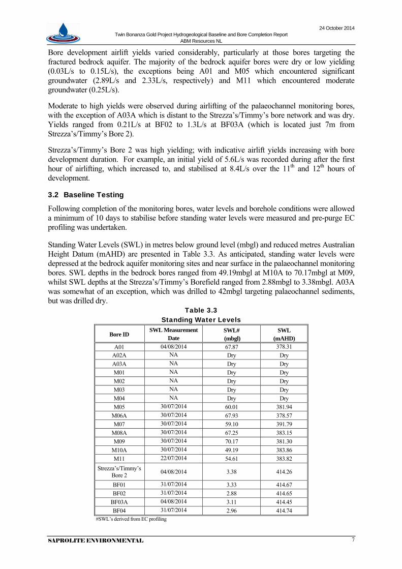
Bore development airlift yields varied considerably, particularly at those bores targeting the fractured bedrock aquifer. The majority of the bedrock aquifer bores were dry or low yielding (0.03L/s to 0.15L/s), the exceptions being A01 and M05 which encountered significant groundwater (2.89L/s and 2.33L/s, respectively) and M11 which encountered moderate groundwater (0.25L/s).
Moderate to high yields were observed during airlifting of the palaeochannel monitoring bores, with the exception of A03A which is distant to the Strezza’s/Timmy’s bore network and was dry. Yields ranged from 0.21L/s at BF02 to 1.3L/s at BF03A (which is located just 7m from Strezza’s/Timmy’s Bore 2).
Strezza’s/Timmy’s Bore 2 was high yielding; with indicative airlift yields increasing with bore development duration. For example, an initial yield of 5.6L/s was recorded during after the first hour of airlifting, which increased to, and stabilised at 8.4L/s over the 11th and 12th hours of development.
3.2 Baseline Testing
Following completion of the monitoring bores, water levels and borehole conditions were allowed a minimum of 10 days to stabilise before standing water levels were measured and pre-purge EC profiling was undertaken.
Standing Water Levels (SWL) in metres below ground level (mbgl) and reduced metres Australian Height Datum (mAHD) are presented in Table 3.3. As anticipated, standing water levels were depressed at the bedrock aquifer monitoring sites and near surface in the palaeochannel monitoring bores. SWL depths in the bedrock bores ranged from 49.19mbgl at M10A to 70.17mbgl at M09, whilst SWL depths at the Strezza’s/Timmy’s Borefield ranged from 2.88mbgl to 3.38mbgl. A03A was somewhat of an exception, which was drilled to 42mbgl targeting palaeochannel sediments, but was drilled dry.
Table 3.3 Standing Water Levels
Bore ID SWL Measurement
Date SWL# (mbgl)
SWL (mAHD)
A01 04/08/2014 67.87 378.31 A02A NA Dry Dry A03A NA Dry Dry M01 NA Dry Dry M02 NA Dry Dry M03 NA Dry Dry M04 NA Dry Dry M05 30/07/2014 60.01 381.94
M06A 30/07/2014 67.93 378.57 M07 30/07/2014 59.10 391.79
M08A 30/07/2014 67.25 383.15 M09 30/07/2014 70.17 381.30
M10A 30/07/2014 49.19 383.86 M11 22/07/2014 54.61 383.82
Strezza’s/Timmy’s Bore 2 04/08/2014 3.38 414.26
BF01 31/07/2014 3.33 414.67 BF02 31/07/2014 2.88 414.65
BF03A 04/08/2014 3.11 414.45 BF04 31/07/2014 2.96 414.74
#SWL’s derived from EC profiling
24 October 2014 Twin Bonanza Gold Project Hydrogeological Baseline and Bore Completion Report
ABM Resources NL
SAPROLITE ENVIRONMENTAL 8
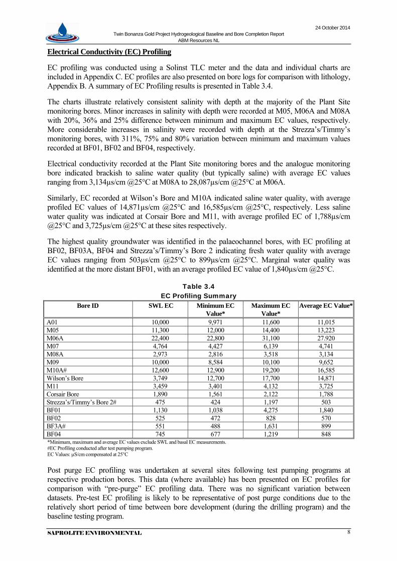
Electrical Conductivity (EC) Profiling
EC profiling was conducted using a Solinst TLC meter and the data and individual charts are included in Appendix C. EC profiles are also presented on bore logs for comparison with lithology, Appendix B. A summary of EC Profiling results is presented in Table 3.4.
The charts illustrate relatively consistent salinity with depth at the majority of the Plant Site monitoring bores. Minor increases in salinity with depth were recorded at M05, M06A and M08A with 20%, 36% and 25% difference between minimum and maximum EC values, respectively. More considerable increases in salinity were recorded with depth at the Strezza’s/Timmy’s monitoring bores, with 311%, 75% and 80% variation between minimum and maximum values recorded at BF01, BF02 and BF04, respectively.
Electrical conductivity recorded at the Plant Site monitoring bores and the analogue monitoring bore indicated brackish to saline water quality (but typically saline) with average EC values ranging from 3,134µs/cm @25°C at M08A to 28,087µs/cm @25°C at M06A.
Similarly, EC recorded at Wilson’s Bore and M10A indicated saline water quality, with average profiled EC values of 14,871µs/cm @25°C and 16,585µs/cm @25°C, respectively. Less saline water quality was indicated at Corsair Bore and M11, with average profiled EC of 1,788µs/cm @25°C and 3,725µs/cm @25°C at these sites respectively.
The highest quality groundwater was identified in the palaeochannel bores, with EC profiling at BF02, BF03A, BF04 and Strezza’s/Timmy’s Bore 2 indicating fresh water quality with average EC values ranging from 503µs/cm @25°C to 899µs/cm @25°C. Marginal water quality was identified at the more distant BF01, with an average profiled EC value of 1,840µs/cm @25°C.
Table 3.4 EC Profiling Summary
Bore ID SWL EC Minimum EC Value*
Maximum EC Value*
Average EC Value*
A01 10,000 9,971 11,600 11,015 M05 11,300 12,000 14,400 13,223 M06A 22,400 22,800 31,100 27.920 M07 4,764 4,427 6,139 4,741 M08A 2,973 2,816 3,518 3,134 M09 10,000 8,584 10,100 9,652 M10A# 12,600 12,900 19,200 16,585 Wilson’s Bore 3,749 12,700 17,700 14,871 M11 3,459 3,401 4,132 3,725 Corsair Bore 1,890 1,561 2,122 1,788 Strezza’s/Timmy’s Bore 2# 475 424 1,197 503 BF01 1,130 1,038 4,275 1,840 BF02 525 472 828 570 BF3A# 551 488 1,631 899 BF04 745 677 1,219 848 *Minimum, maximum and average EC values exclude SWL and basal EC measurements. #EC Profiling conducted after test pumping program. EC Values: µS/cm compensated at 25°C Post purge EC profiling was undertaken at several sites following test pumping programs at respective production bores. This data (where available) has been presented on EC profiles for comparison with “pre-purge” EC profiling data. There was no significant variation between datasets. Pre-test EC profiling is likely to be representative of post purge conditions due to the relatively short period of time between bore development (during the drilling program) and the baseline testing program.

24 October 2014 Twin Bonanza Gold Project Hydrogeological Baseline and Bore Completion Report
ABM Resources NL
SAPROLITE ENVIRONMENTAL 9
3.3 Water Sampling
The specific purging of bores prior to sampling was not undertaken. Instead the process of bore development after the bore completion provided sufficient purging to allow groundwater from the substrata to enter the bore column. This, combined with at least 10 days stabilisation period after bore development to allow the bores to ‘de-gas’ from the process of airlifting, was considered appropriate.
Water samples were collected during the baseline testing/test pumping program using 1L disposable bailers in those bores that had water in the bore column. Samples were successfully collected at all sites with the exception of:
• Monitoring bores: A02A, A03A, M01, M02, M03 and M04, which were all were dry at the time of sampling; and
• Monitoring Bore: M08A, which appeared to be blocked and could not be bailed.
The samples collected were largely free of suspended sediment, with the exception of M09.
Monitoring bore M09 contained significant grey suspended material and drilling foam. The bore was not developed following bore construction as the HDPE airline became stuck within the bore at the commencement of airlifting (as noted in Section 3.1). The drilling contractor also used drilling foam (Super Foam) to aid in the removal of the stuck airline. Following removal of the airline from the bore the drilling contractor did not reattempt bore development, as such purging was not undertaken prior to sampling. The drilling foam is biodegradable and components will breakdown over time; i.e. 50 to 90% after 2-3 weeks.
The analytical results of the water sampling are presented in Section 5.
3.4 Test Pumping
Test pumping was undertaken by Saprolite on the two pre-existing production bores and a newly completed production bore from 22 July 2014 to 2 August 2014. Tests included step drawdown, constant rate and recovery testing. A summary of bore completion details is presented in Table 3.5.
Table 3.5 Summary of Production Bore Details
Bore ID Cased Depth
(m)
Casing ID
(mm)
^Water Depth (mbgl)
Previously Reported Salinity (as TDS mg/L)
Salinity July/August 2014
(as TDS mg/L)
Submersible Test Pump
Test Pump Depth
(m)
Corsair Bore 150 150 54.86 2,140* 1,420 Grundfos SP8A-37 100
Wilson’s Bore 83 150 45.54 7,330* 7,840 Grundfos SP17-9 75
Strezza’s/ Timmy’s Bore 2 39.9 155 3.03 421# 318 Grundfos SP17-9 37
^Recorded July 2014, prior to commencement of test pumping *SWC WMP, 2013a #Strezza’s/ Bore (original)

24 October 2014 Twin Bonanza Gold Project Hydrogeological Baseline and Bore Completion Report
ABM Resources NL
SAPROLITE ENVIRONMENTAL 10
Test pumping of the three bores was conducted using either of two different 4-inch electro-submersible pumps, both fitted with cooling shrouds. The test pumping equipment was supplied by Western Irrigation Pty Ltd (on hire to Topdrill). Topdrill provided the genset and a pump supervisor, whom carried out the pump installation, maintenance and removal during the test pumping works.
Each pumping test required the submersible pumps to overcome differing amounts of hydraulic head; therefore different maximum pumping rates were achieved during preliminary pump tests. At Corsair Bore a maximum flow rate of 2.3L/s was achieved with a static water level (~55mbgl). At Wilson’s Bore a maximum flow rate of 2.9L/s was achieved with a static water level (~45mbgl). Whilst at Strezza’s/Timmy’s Bore 2 a maximum flow rate of 5.8L/s was achieved with a static water level (~4mbgl).
Step drawdown testing was conducted to determine the most suitable pumping rates for respective 48 hour constant rate tests. Each test consisted of four 100 (or 60) minute steps, starting from an initially low pumping rate, through two steps of progressively higher constant rates, ending with the maximum pumping rate (no back pressure on pump). The rates employed for each step test are summarized in Table 3.6.
Following step testing for Corsair Bore, a constant rate of 1.5L/s was selected. Although a maximum pumping rate of 2.3L/s was achieved during the preliminary test, a rate above 1.5L/s was anticipated to be unsustainable over 48 hours given increasing hydraulic head with drawdown and the limitations of the pump.
Following a review of step test data, a constant rate of 1.5L/s was selected for Wilson’s Bore. It was anticipated that a pumping rate above 1.5L/s would result in drawdown to the pump before the conclusion of 48 hours. During the constant rate test an impermeable boundary was identified, resulting in acceleration of drawdown at approximately 70mbgl, as such 1.5L/s could not be maintained and the constant rate was brought back to 1.2L/s and 1L/s progressively, with each “step” identifying an impermeable boundary.
At Strezza’s/Timmy’s Bore 2 a rate of 5L/s was selected, slightly less than the maximum pumping rate of 5.8L achieved during the preliminary test.
A summary of step test and constant rate test results is presented in Table 3.6.
Table 3.6 Summary of Test Pumping Results
Tested Bore
Dates Tested
Step Test Rates (L/s) [kL/d]
Drawdown in Pump Bore (m)
Constant Rate (L/s) [kL/d]
Final drawdown in Pump Bore (m)
Final Drawdown in Monitoring Bores (m)
Corsair Bore
22/07/14 to
25/07/14
1, 1.5, 1.75, 1.8 [86, 130, 151, 156]
60min steps
7.17 1.5 [130] 7.07 M11 (r=10m): 1.26
Wilson’s Bore
26/07/14 to
29/07/14
1, 1.5, 1.6 [86, 130, 138] 100min steps
23.78 1.1 [97] 24.03
M10A (r=10m): 9.73
Strezza’s/ Timmy’s Bore 2
31/07/14 to
03/08/14
2, 3, 4, 5.9 [173, 259, 346, 510]
60min steps
1.23 5.0 [432] 1.105
BF03A (r=7.3m): 0.385 BF01 (r=1064m): 0.020 BF02 (r=232m): 0.135 BF04 (r=204m): 0.110
24 October 2014 Twin Bonanza Gold Project Hydrogeological Baseline and Bore Completion Report
ABM Resources NL
SAPROLITE ENVIRONMENTAL 11
Recovery measurements were taken on cessation of the constant rate pumping test for 10 hours (Corsair) to the next morning (Wilson’s and Strezza’s/Timmy’s Bore 2). The percentage of recovery (i.e. recovery/total drawdown) in the pumped bores was: • 89% (residual drawdown 0.76m after 12hrs) in Corsair Bore • 84% (residual drawdown 3.7m after 24hrs) in Wilson’s Bore • 87% (residual drawdown 0.14m after 24hrs) in Strezza’s/Timmy’s Bore 2
The discharged water from test pumping bores was pumped via 50 to 100m lay flat, connected to wellhead infrastructure and discharged into an excavated containment pond, resulting in zero discharge to the environment.
24 October 2014 Twin Bonanza Gold Project Hydrogeological Baseline and Bore Completion Report
ABM Resources NL
SAPROLITE ENVIRONMENTAL 12
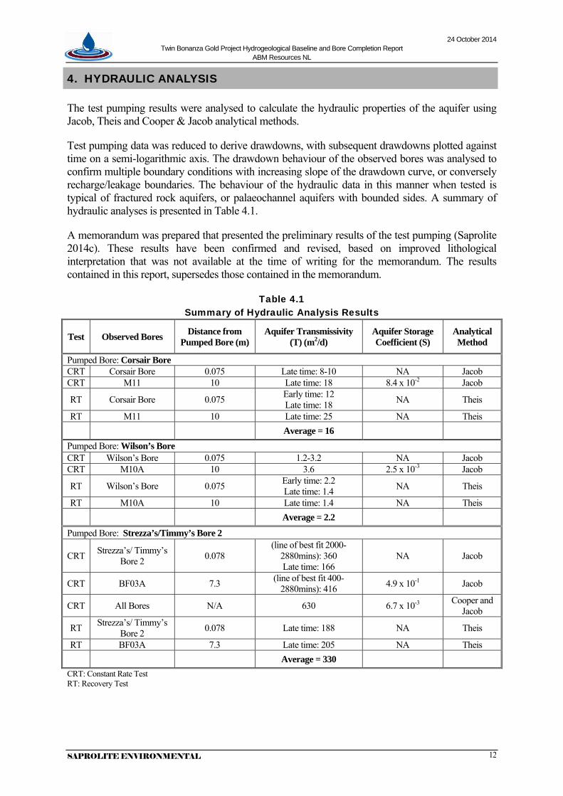
4. HYDRAULIC ANALYSIS
The test pumping results were analysed to calculate the hydraulic properties of the aquifer using Jacob, Theis and Cooper & Jacob analytical methods.
Test pumping data was reduced to derive drawdowns, with subsequent drawdowns plotted against time on a semi-logarithmic axis. The drawdown behaviour of the observed bores was analysed to confirm multiple boundary conditions with increasing slope of the drawdown curve, or conversely recharge/leakage boundaries. The behaviour of the hydraulic data in this manner when tested is typical of fractured rock aquifers, or palaeochannel aquifers with bounded sides. A summary of hydraulic analyses is presented in Table 4.1.
A memorandum was prepared that presented the preliminary results of the test pumping (Saprolite 2014c). These results have been confirmed and revised, based on improved lithological interpretation that was not available at the time of writing for the memorandum. The results contained in this report, supersedes those contained in the memorandum.
Table 4.1 Summary of Hydraulic Analysis Results
Test Observed Bores Distance from Pumped Bore (m)
Aquifer Transmissivity (T) (m2/d)
Aquifer Storage Coefficient (S)
Analytical Method
Pumped Bore: Corsair Bore CRT Corsair Bore 0.075 Late time: 8-10 NA Jacob CRT M11 10 Late time: 18 8.4 x 10⁻² Jacob
RT Corsair Bore 0.075 Early time: 12 Late time: 18 NA Theis
RT M11 10 Late time: 25 NA Theis Average = 16 Pumped Bore: Wilson’s Bore CRT Wilson’s Bore 0.075 1.2-3.2 NA Jacob CRT M10A 10 3.6 2.5 x 10⁻³ Jacob
RT Wilson’s Bore 0.075 Early time: 2.2 Late time: 1.4 NA Theis
RT M10A 10 Late time: 1.4 NA Theis Average = 2.2
Pumped Bore: Strezza’s/Timmy’s Bore 2
CRT Strezza’s/ Timmy’s Bore 2 0.078
(line of best fit 2000-2880mins): 360 Late time: 166
NA Jacob
CRT BF03A 7.3 (line of best fit 400-2880mins): 416 4.9 x 10⁻¹ Jacob
CRT All Bores N/A 630 6.7 x 10⁻³ Cooper and Jacob
RT Strezza’s/ Timmy’s Bore 2 0.078 Late time: 188 NA Theis
RT BF03A 7.3 Late time: 205 NA Theis Average = 330 CRT: Constant Rate Test RT: Recovery Test
24 October 2014 Twin Bonanza Gold Project Hydrogeological Baseline and Bore Completion Report
ABM Resources NL
SAPROLITE ENVIRONMENTAL 13
Corsair Bore The calculated transmissivities from all the analyses ranged from 8 to 25m2/d, and averages 16m2/d. The calculated hydraulic conductivity (K) value was 6.4 x 10⁻¹m/d based on the average transmissivity and an interpreted aquifer thickness of 25m; i.e. 90 to 115mbgl. Typical hydraulic conductivity (K) values for consolidated and fractured/friable sandstone rocks range from 10-3 to 1m/d (Driscoll, 1986). Therefore, the results obtained from analytical methods fall within the expected range for this type of aquifer.
Wilson’s Bore The calculated transmissivities from all the analyses ranged from 1.2 to 3.6m2/d, and averages 2.2m2/d. The calculated hydraulic conductivity (K) value was 1.8 x 10⁻¹m/d based on the average transmissivity and an interpreted aquifer thickness of 12m; i.e. 58 to 70mbgl. Typical hydraulic conductivity (K) values for friable sandstone rocks range from 10-3 to 1m/d (Driscoll, 1986). Therefore, the results obtained from analytical methods fall within the expected range for this type of aquifer.
Strezza’s/Timmy’s Bore 2 The calculated transmissivities from all the analyses ranged from 166 to 630m2/d, and averages 330m2/d. The calculated hydraulic conductivity (K) value was 17m/d based on the average transmissivity and an interpreted aquifer thickness of 19m; i.e. 4 to 23mbgl. Typical hydraulic conductivity (K) values for unconsolidated palaeochannel basal sands and karstic limestone range from 10-1 to 103m/d (Driscoll, 1986). Therefore, the results obtained from analytical methods fall within the expected range for this type of aquifer.
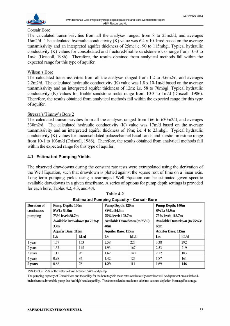
4.1 Estimated Pumping Yields
The observed drawdowns during the constant rate tests were extrapolated using the derivation of the Well Equation, such that drawdown is plotted against the square root of time on a linear axis. Long term pumping yields using a rearranged Well Equation can be estimated given specific available drawdowns in a given timeframe. A series of options for pump depth settings is provided for each bore, Tables 4.2, 4.3, and 4.4.
Table 4.2 Estimated Pumping Capacity – Corsair Bore
Duration of continuous pumping
Pump Depth: 100m SWL: 54.9m 75% level: 88.7m Available Drawdown (to 75%): 33m Aquifer Base: 115m
Pump Depth: 120m SWL: 54.9m 75% level: 103.7m Available Drawdown (to 75%): 48m Aquifer Base: 115m
Pump Depth: 140m SWL: 54.9m 75% level: 118.7m Available Drawdown (to 75%): 63m Aquifer Base: 115m
L/s kL/d L/s kL/d L/s kL/d 1 year 1.77 153 2.58 223 3.38 292 2 years 1.33 115 1.93 167 2.53 219 3 years 1.11 96 1.62 140 2.12 183 4 years 0.98 84 1.42 123 1.87 161 5 years 0.88 76 1.29 111 1.69 146
75% level is: 75% of the water column between SWL and pump The pumping capacity of Corsair Bore and the ability for the bore to yield these rates continuously over time will be dependent on a suitable 4-inch electro-submersible pump that has high head capability. The above calculations do not take into account depletion from aquifer storage.

24 October 2014 Twin Bonanza Gold Project Hydrogeological Baseline and Bore Completion Report
ABM Resources NL
SAPROLITE ENVIRONMENTAL 14
At a pump depth option of 140m, it is likely the water level would decline to the base of the interpreted aquifer and may result in declining yields at whatever rate is chosen for the corresponding duration.
A conservative approach would be to ensure the aquifer base is not reached, with the objective of keeping pumping water levels above the 75% aquifer thickness level; i.e. 108mbgl. This could then be achieved with the pump depth option of 120m at an appropriate pumping yield to suit the corresponding pumping duration.
Table 4.3 Estimated Pumping Capacity – Wilson’s Bore
Duration of continuous pumping
Pump Depth: 75m SWL: 45.0m 75% level: 67.5m Available Drawdown (to 75%): 22.5m Aquifer Base: 70m
Pump Depth: 80m SWL: 45.0m 78% level: 72m Available Drawdown (to 78%): 27m Aquifer Base 70m
L/s kL/d L/s kL/d 1 week 0.84 72 1.01 87 1 month 0.57 49 0.68 59 3 months 0.39 34 0.47 40 6 months 0.30 26 0.36 31 1 year 0.22 19 0.27 23 2 years 0.17 14 0.20 17 3 years 0.14 12 0.17 14 4 years 0.12 10 0.15 13 5 years 0.11 9 0.13 11 75/78% level is: 75-78% of the water column between SWL and pump
Wilson’s Bore should only be used intermittently and not on a continuous basis; for that reason if the bore is operated continuously at a rate of 1L/s, the bore would reach critical levels within 1 week, and would start to cavitate. It is recommended that this bore not be pumped at rates greater than 1L/s at any given time due to the significant drawdown that it induces.
If at a pump setting of 80m, the pump (with a cooling shroud) would be 4m off the bottom of the bore, and the 78% critical level would be 8m above the pump. It is recommended that pumping water levels do not fall below critical level (i.e. either 72m (78%) for a pump depth of 80m, or 67m (75%) for a pump depth of 75m; both scenarios result in a critical level that provides 8m available drawdown above the pump).
In relation to the interpreted aquifer interval and thickness, the 75% aquifer level is at 67mbgl and yields would decline as pumping water levels fall below this depth, as was observed during the constant rate test pumping. This depth also corresponds to the same critical level of 67m for the 75m pump depth option, as described above.

24 October 2014 Twin Bonanza Gold Project Hydrogeological Baseline and Bore Completion Report
ABM Resources NL
SAPROLITE ENVIRONMENTAL 15
Table 4.4 Estimated Pumping Capacity – Strezza’s/Timmy’s Bore 2
Duration of continuous pumping
Pump Depth: 20m SWL: 3.03m 75% level: 15m Available Drawdown (to 75%): 12m Aquifer Base: 23m
Pump Depth: 37m SWL: 3.03m 75% level: 28m Available Drawdown (to 75%): 25m Aquifer Base: 23m
L/s kL/d L/s kL/d 2 years 12.5 1,077 26.0 2,940 3 years 10.5 911 22.0 1,898 5 years 8.5 732 17.7 1,525 7 years 7.3 631 15.2 1,316 10 years 6.2 538 13.0 1,121 15 years 5.2 447 10.8 932 75% level is: 75% of the water column between SWL and pump.
At a pump depth option of 37m, it is likely the water level would decline to the base of the interpreted aquifer and may result in declining yields at whatever rate is chosen for the corresponding duration.
A conservative approach would be to ensure the water levels do not significantly drawdown. The bore should be operated such that the water levels relative to critical pump level stay well above 15m. This would also correspond with keeping water levels above the 75% aquifer depth level at 18m. This could then be achieved with the pump depth option of 20m at an appropriate pumping yield to suit the corresponding pumping duration.
The above calculations for Strezza’s/Timmy’s Bore 2 do not take into account the following:
- Depletion of storage within the localised area of the pumping bore - Contribution (or lack there-of) of recharge (direct and indirect) and leakage - The potential effect of Groundwater Dependent Ecosystems (GDE) in lowering the
groundwater table, given the presence of Eucalyptus trees within the palaeovalley area; although dominant vegetation species is spinifex.
- The effects of multiple boundaries, and change in transmissivity as water levels decline
- The construction of the bore is limited to only accommodating 4-inch electro-submersible pumps, and yields greater than 7-10L/s are likely not possible.
- Available storage or volume of groundwater within the aquifer system per unit km, which equates to:
o defined cross sectional area of palaeochannel (i.e. width and thickness) o application of 20% Specific Yield for palaeochannels o commandable storage is 60% of available storage
Taking into account volumetric storage, assuming a nominal palaeochannel width of 200m, assumed thickness of 19m, results in a conservative estimation of potential yield for Strezza’s/Timmy’s Bore 2 – being 5L/s (432kL/d) for 5 years.
If Strezza’s/Timmy’s Bore 2 is intended to be equipped it is recommended that that a suitable 4-inch electro-submersible pump (with cooling shroud) be installed at a depth of 20m, and that has the capacity to be pumped at rates between 5L/s (nominal) and 7L/s (peak).

24 October 2014 Twin Bonanza Gold Project Hydrogeological Baseline and Bore Completion Report
ABM Resources NL
SAPROLITE ENVIRONMENTAL 16
5. WATER CHEMISTRY
Water samples were collected at 14 sites and submitted to ALS Laboratories (NATA Certified Laboratory) for analysis. The analytical laboratory reports are presented, in their entirety, as Appendix E, and summarised in Table 5.1. ANZECC Livestock Watering Criteria (NWQMS 2000) guideline values have been included in the table for comparison purposes only.
Water quality laboratory analysis indicates saline water quality at the majority of sites located around the mining area, with the exceptions of Corsair Bore and its adjacent monitoring bore M11, where analysis indicated groundwater of brackish quality. The laboratory analysis for the water sampled at the Strezza’s/Timmy’s bore network indicated fresh to marginal water quality.
Water samples were slightly alkaline at all sites (except at M09) with pH values ranging from 7.49 to 7.96. The laboratory results indicate relatively high alkalinity (buffering capacity) as such groundwater may have the capacity to resist changes in pH that would make it more acidic.
Groundwater sampled at M09 was slightly acidic with a pH value of 6.02. During sampling of the bore, the smell of hydrogen sulphide was recorded. The presence of hydrogen sulphide often correlates with bores that have lower pH. The groundwater sample from M09 was found to contain very high concentrations of Total Organic Carbon (TOC) and Dissolved Organic Carbon (DOC). Correspondingly a high value for Chemical Oxygen Demand (COD) was determined, indicating significant organic pollutants.
Laboratory results were compared against ANZECC 2000 Livestock Watering Criteria (NWQMS, 2000) guideline values. Of the comparisons made sulphate appeared to be the most elevated, with sulphate concentrations at seven sites exceeding the ANZECC guideline value of 1,000mg/L. Sulphate concentrations within the Strezza’s/Timmy’s bore network were far lower, ranging from 16 to 133mg/L. Fluoride concentrations are also slightly elevated at several of the Plant Site monitoring bores.
Cyanide species and dissolved metals were found to be below criteria guideline values and for the most part, below Limits of Reporting (LOR).
Results for Total Petroleum Hydrocarbons (TPH) were typically near, or below LOR, with the exception of results recorded at M09 and Corsair Bore. At Corsair Bore the C15-C28 and C29-C36 hydrocarbon fractions were significantly elevated. It is recommended that further hydrocarbon analysis is undertaken at Corsair Bore, coincident with 6-monthly laboratory analysis to determine if this was an isolated event.
The laboratory was unable to complete the entire TPH analysis for samples collected at M09, as additives resulted in the formation of a foamy precipitate, and an accurate result could not be obtained. It is recommended that M09 is adequately purged before the next quarterly sampling event as hydrocarbons (and other contaminants) may be resultant from the drilling process and not naturally occurring.

24 October 2014 Twin Bonanza Gold Project Hydrogeological Baseline and Bore Completion Report
ABM Resources NL
SAPROLITE ENVIRONMENTAL 17
Table 5.1 Water Quality Laboratory Analyses
Uni
ts
A01
M05
M06
A
M07
M09
Stre
zza’
s/
Tim
my’
s Bor
e 2
BF0
1
BF0
2
BF0
3A
BF0
4
Wils
on’s
Bor
e
M01
0A
Cor
sair
Bor
e
M11
ANZECC Livestock Watering Criteria (NWQMS 2000)
General Parameters pH No units 7.73 7.94 7.51 7.49 6.02 7.74 7.67 7.65 7.88 7.87 7.96 7.49 7.6 7.71 6.5-8.5 EC (S/cm at 25°C) µS/cm at 25°C 13,100 13,900 29,400 7,640 12,600 477 1,330 579 516 792 12,000 15,100 2,300 3,150 - Total Dissolved Solids (TDS) mg/l 8,550 8,800 20,400 4,880 8,470 318 872 424 382 562 7,840 10,500 1,420 1,970 3,000 Total Alkalinity (CaCO3) mg/l 364 299 261 289 219 190 280 249 229 269 598 477 318 300 - Carbonate Alkalinity as CaCO3 mg/l <1 <1 <1 <1 <1 <1 <1 <1 <1 <1 <1 <1 <1 <1 Bicarbonate Alkalinity as CaCO3 mg/l 364 299 261 289 219 190 280 249 229 269 598 477 318 300 Ionic Balance Ratio 0.72 3.97 1.16 3.22 3.36 5.76 3.21 1.67 4.19 4.69 1.16 1.18 0.52 0.56 - Major Ions and Ligands Calcium (Ca2+) mg/l 254 357 737 474 474 25 79 44 31 41 272 430 109 135 1000 Potassium (K+) mg/l 159 135 234 83 130 34 42 28 36 35 199 218 38 47 - Magnesium (Mg2+) mg/l 407 480 1,160 337 460 19 44 31 22 31 363 516 90 116 - Sodium (Na+) mg/l 2,110 2,270 4,930 711 2,030 41 124 24 42 74 2,020 2,390 240 352 - Chloride (Cl-) mg/l 3,360 3,630 8,590 1,820 3,400 24 234 32 25 64 2,920 3,910 499 691 - Fluoride (F-) mg/l 1.9 5.8 7.3 4.4 2.8 1.8 1 1.1 1.7 2.5 1.1 0.7 0.6 0.6 2 Sulphur Species Sulphate (SO4
2-) mg/l 1,820 1,870 4,660 1,060 2,060 19 133 20 16 36 1,870 2,380 196 369 1000 Nutrients Nitrate (NO3- as N) mg/l 2.5 5.83 0.04 27 0.41 2.13 0.01 2.71 2.7 6.47 6.12 2.51 0.02 5.18 400 Ammonia (as N) mg/l 0.09 0.09 0.04 0.59 172 0.03 0.13 0.06 0.09 0.12 0.06 3.14 0.06 0.08 - Reactive Phosphorus as P mg/l <0.01 <0.01 0.02 0.1 66.1 0.64 <0.01 0.21 0.07 0.14 0.03 0.04 0.01 0.02 - Phosphorus (Total) mg/l <0.05 <0.05 0.36 <0.20 77.5 1.44 0.03 0.21 0.12 0.17 <0.05 0.07 0.05 0.08 - Total Kjeldahl Nitrogen (TKN as N) mg/l 0.7 2.1 1.4 9.4 225 0.8 1.1 1.1 0.8 1.9 1 8.8 0.4 0.8 - Chemical Oxygen Demand (COD) mg/l <40 122 110 56 15,000 <10 43 22 <10 <10 <40 85 30 14 - Carbon Total Organic Carbon (TOC) mg/l 4 8 5 15 4,670 4 18 8 3 4 6 30 10 3 - Dissolved Organic Carbon (DOC) mg/l 4 8 5 15 4,570 3 14 8 3 4 4 8 9 3 -

24 October 2014 Twin Bonanza Gold Project Hydrogeological Baseline and Bore Completion Report
ABM Resources NL
SAPROLITE ENVIRONMENTAL 18
Table 5.1 Water Quality Laboratory Analyses (Continued)
Uni
ts
A01
M05
M06
A
M07
M09
Stre
zza’
s/
Tim
my’
s B
ore
2
BF0
1
BF0
2
BF0
3A
BF0
4
Wils
on’s
Bor
e
M01
0A
Cor
sair
Bor
e
M11
ANZECC Livestock Watering Criteria
(NWQMS 2000)
Cyanide Free Cyanide (CN-) mg/L <0.004 <0.004 <0.004 <0.004 <0.004 <0.004 <0.004 <0.004 <0.004 <0.004 <0.004 <0.004 <0.004 <0.004 Weak Acid Dissociable (WAD) Cyanide (CN-) mg/L <0.004 <0.004 <0.004 <0.004 <0.004 <0.004 <0.004 <0.004 <0.004 <0.004 <0.004 <0.004 <0.004 <0.004
Total Cyanide (CN-) mg/L <0.004 <0.004 <0.004 <0.004 <0.004 <0.004 <0.004 <0.004 <0.004 <0.004 <0.004 <0.004 <0.004 <0.004 Metals - Dissolved Aluminium (Al) mg/L 0.02 0.02 <0.02 <0.01 0.36 <0.01 <0.01 <0.01 <0.01 <0.01 <0.01 0.01 <0.01 <0.01 5 Antimony (Sb) mg/L <0.001 <0.001 <0.002 <0.001 0.002 <0.001 <0.001 <0.001 <0.001 <0.001 <0.001 <0.001 0.002 <0.001 - Arsenic (As) mg/L <0.001 0.004 <0.002 0.092 0.243 0.003 0.001 0.003 0.002 0.003 0.002 <0.001 0.084 0.013 0.5 Barium (Ba) mg/L 0.034 0.028 0.047 0.057 0.055 0.137 0.23 0.222 0.24 0.29 0.017 0.068 0.041 0.031 - Beryllium (Be) mg/L <0.001 <0.001 <0.002 <0.001 <0.001 <0.001 <0.001 <0.001 <0.001 <0.001 <0.001 <0.001 <0.001 <0.001 - Boron (B) mg/L 1.3 1.44 0.24 0.7 0.97 0.18 0.2 0.1 0.18 0.26 1.31 1.16 0.61 0.65 5 Cadmium (Cd) mg/L <0.0001 <0.0001 <0.0002 <0.0001 0.001 <0.0001 <0.0001 <0.0001 <0.0001 <0.0001 <0.0001 <0.0001 <0.0001 <0.0001 0.01 Chromium (Cr) mg/L <0.001 <0.001 <0.002 <0.001 0.003 <0.001 <0.001 <0.001 <0.001 <0.001 0.011 0.003 <0.001 0.002 - Cobalt (Co) mg/L 0.003 0.001 0.008 0.037 0.037 <0.001 <0.001 <0.001 <0.001 <0.001 <0.001 0.004 <0.001 0.001 1 Copper (Cu) mg/L 0.014 0.009 0.015 0.005 0.03 0.001 0.001 0.001 0.001 0.001 0.006 0.012 <0.001 0.004 0.5 Lead (Pb) mg/L <0.001 <0.001 <0.002 <0.001 0.009 <0.001 <0.001 <0.001 <0.001 <0.001 <0.001 <0.001 <0.001 <0.001 0.1 Nickel (Ni) mg/L 0.005 0.003 0.007 0.008 0.062 <0.001 0.002 <0.001 0.002 <0.001 0.002 0.02 <0.001 0.004 1 Manganese (Mn) mg/L 0.077 0.106 1.32 0.877 1.93 0.001 0.186 0.003 0.002 <0.001 <0.001 0.126 0.042 0.123 - Selenium (Se) mg/L <0.01 <0.01 <0.02 0.01 0.02 <0.01 <0.01 <0.01 <0.01 <0.01 0.02 0.01 <0.01 <0.01 0.02 Uranium (U) mg/L 0.069 0.058 0.08 0.18 0.007 0.001 0.002 0.002 0.001 0.001 0.085 0.032 0.019 0.022 Vanadium (V) mg/L <0.01 <0.01 <0.02 <0.01 0.02 0.02 <0.01 0.02 0.02 0.02 <0.01 <0.01 <0.01 <0.01 Zinc (Zn) mg/L 0.045 0.045 0.166 1.33 2.54 0.205 0.024 0.028 0.029 0.017 0.021 0.024 0.014 0.084 20 Mercury (Hg) mg/L <0.0001 <0.0001 <0.0001 <0.0001 <0.0001 <0.0001 <0.0001 <0.0001 <0.0001 <0.0001 <0.0001 <0.0001 <0.0001 <0.0001 0.002 Total Petroleum Hydrocarbons (TPH) C6-C9 Fraction µg/L <20 <20 <20 <20 2,000 <20 290 <20 <20 <20 <20 <20 <20 <20 C10-C14 Fraction µg/L <50 100 60 180 NR <50 100 70 <50 <50 <50 <50 70 <50 C15- C28 Fraction µg/L <100 <100 210 360 NR <100 <100 170 <100 <100 <100 <100 1,040 <100 C29-C36 Fraction µg/L <50 60 110 390 NR <50 <50 130 <50 <50 <50 <50 1,410 <50
24 October 2014 Twin Bonanza Gold Project Hydrogeological Baseline and Bore Completion Report
ABM Resources NL
SAPROLITE ENVIRONMENTAL 19
6. DISCUSSION
6.1 Water Resource Assessment Summary
The Twin Bonanza Gold Project would have a water supply demand that will peak at 11L/s (950kL/d) when the project reaches its full production phase of 300,000 tonnes per annum and if onsite processing was to occur. However, as the excavated ore is to be processed through the Coyote processing plant within Western Australia, the water supply requirement is anticipated to be met by the existing production bores during the mining phases of the project, with a projected water demand of up to 0.8L/s (69kL/d).
Further to the hydraulic analysis of the test pumping results, the following presents a summary of pumping recommendations to satisfy the Project’s short to medium term water resource requirements, Table 6.1.
Table 6.1 Recommended Pumping Rates
Bore ID Pump Depth
(m)
Pump Yield# Comments L/s kL/d
Corsair Bore 120 1.3 111 High head pump required, could be pumped at higher pumping rates (2.5L/s) for peak demand/short periods
Wilson’s Bore 75 1.0 86 Intermittent pumping with frequent rest periods Strezza’s/Timmy’s Bore 2
20 5.0 432 Would have the capacity to be pumped at higher pumping rates (7L/s) for peak demand/short periods Careful monitoring would be required to review bore performance and assess potential impacts on vegetation health
# 5-year continuous pumping yields
The recommended pumping rates are conservative estimates based on the information available. It is considered the results obtained are Measured in terms of confidence level of water resource sustainability; definitions are summarised as follows:
o Measured – based on adequate data to provide basis for conclusive abstraction, including drilling results, test pumping, some initial base case modelling might have been undertaken.
o Probable – based on drilling results, test pumping, some initial base case modelling might have been undertaken, but improved certainty of sustainability; this includes a nominal 12-month period of monitoring water levels under and abstraction conditions, and reviewing bore/aquifer performance.
o Proven – all of the above plus calibrated numerical modelling, cost effective usage, and legal access including statutory allocation approval, and increasing status of commercial viability.
• The selection of suitably sized electro-submersible pumps should be undertaken using the advice of a pump engineer, or pump supplier, in liaison with a hydrogeologist.
• It is recommended that cooling shrouds be installed on all electro-submersible pumps, to force water flow over the pump motor to facilitate improved cooling.
• It is recommended that once bores are installed with suitably sized pumps, appropriate for the respective bore capacities, that careful monitoring of instantaneous yields, flow-meters, and water levels are maintained, and that regular (quarterly) reviews of the monitoring data and bore performance is undertaken by a hydrogeologist.
• It is recommended that a vegetation monitoring program be established to monitor any potential effects or impacts on the vegetation health from groundwater abstraction at Strezza’s/Timmy’s Bore 2.
24 October 2014 Twin Bonanza Gold Project Hydrogeological Baseline and Bore Completion Report
ABM Resources NL
SAPROLITE ENVIRONMENTAL 20
• Should additional groundwater resources be required over and above the pumping capacity of the three existing production bores, then additional production bores could be located within the Strezza’s/Timmy’s Borefield area at a spacing of 1km from Strezza’s/Timmy’s Bore 2, along strike within the palaeovalley. A further groundwater exploration program utilising geophysical methods would be required to identify potential target sites; subject to heritage and regulatory approvals.
6.2 Groundwater Dependent Ecosystem Review
A desktop assessment of the potential Groundwater Dependent Ecosystems (GDE) at the Twin Bonanza Gold Project was undertaken in March 2014, (Low Ecological Services (LES), 2014). This work followed on from comments made by NT EPA relating to the draft EIS (ABM, 2013). The NT EPA requested that a local assessment of the extent of Groundwater Dependent Ecosystems (GDEs) be completed, on the basis that within the palaeochannel areas, groundwater has been recorded at less than 10 metre below ground level.
Saprolite has reviewed this desktop assessment, and concurs with the conclusions made, as follows:
“It is unlikely that Groundwater Dependent Ecosystems are present within the palaeochannels west of the Twin Bonanza project area based on previous studies conducted in the Tanami region and the domination of spinifex in the palaeochannels. The presence of facultative phreatophytic species indicates that in extending periods of drier than average years, trees may utilise groundwater. It is not foreseen that the planned water extractions will negatively impact ecosystems but it is advised that a monitoring program be put in place to detect any change in vegetation condition.”(LES, 2014)
It should be noted that, whilst spinifex is dominant within the palaeochannel area, Saprolite personnel observed the presence of Eucalyptus trees within the Strezza’s/Timmy’s Borefield area during the test pumping program of July 2014.
Saprolite also supports the recommendations made in the desktop assessment (LES, 2014), as follows (in italics):
• Utilise multiple extraction bores positioned at least 1km apart to spread the cone of depression across the water table (refer to Section 6.1 of this report);
• Conduct monitoring of groundwater levels and groundwater quality (refer to Section 7 of this report); and,
• Conduct Tree Health surveys (refer to Section 6.1 of this report).
24 October 2014 Twin Bonanza Gold Project Hydrogeological Baseline and Bore Completion Report
ABM Resources NL
SAPROLITE ENVIRONMENTAL 21
7. GROUNDWATER MONITORING PROGRAM REVIEW
A Standard Operating Procedure (SOP) for Groundwater Monitoring was prepared by Soil Water Consultants (SWC, 2013b) for ABM. The SOP formed part of the Water Management Plan (SWC, 2013a), and was included in ABM’s submission of their draft EIS to the NT Govt.
The SOP was prepared as a generic type document with nominal bore conditions, with the preface that it is a “living document” that should be updated as and when required when new information and data becomes available.
A memorandum was prepared (Saprolite, 2014d) that presented an initial and preliminary review of the SOP based on the preliminary results and findings from the drilling and bore completion, and subsequent baseline testing and sampling. This review was to examine if any changes may be required to the SOP to reflect actual bore conditions and new information. The memorandum is presented in its entirety as Appendix F. A summary is presented as follows:
The major changes between the recommended groundwater monitoring program and that presented in the SOP relates primarily to monitoring frequency and parameters.
Frequency - change from monthly to:
- bi-monthly sampling (i.e. every two months) for plant site monitoring bores; - quarterly sampling for analogue monitoring bores; - quarterly water levels for water supply monitoring bores; - bi-monthly field water chemistry for production bores; and - 6-monthly sampling for production bores.
Parameters - reduction in field parameters; only pH and EC included - tailoring suites of analytes for specific areas - EC profiling of monitoring bores within water supply areas - reduction in cyanide species to WAD CN - elimination of microbiological sampling from production and monitoring bores, and
instead targeting microbiological testing at end user locations, post water treatment.
The objectives for monitoring are as follows: • early detection of contaminants entering the groundwater from mining and mineral processing
activities; • potential effects on aquifer and groundwater dependent ecosystems from groundwater
abstraction for water supply purposes; and • ensuring treated water supply is fit for human consumption.
Risk Assessment There is potential for the deterioration of groundwater quality from contaminants, spills, or seepage from waste storage facilities, or from over exploitation from water supply bores. Information and data collected from the recent hydrogeological investigations has provided sufficient information to assess the risk associated from the operations; a summary of the information is provided in Appendix F.
24 October 2014 Twin Bonanza Gold Project Hydrogeological Baseline and Bore Completion Report
ABM Resources NL
SAPROLITE ENVIRONMENTAL 22
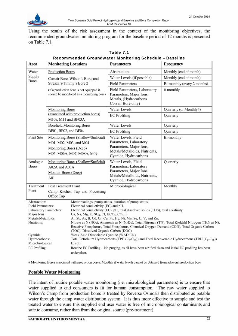
Using the results of the risk assessment in the context of the monitoring objectives, the recommended groundwater monitoring program for the baseline period of 12 months is presented on Table 7.1.
Table 7.1 Recommended Groundwater Monitoring Schedule – Baseline
Area Monitoring Locations Parameters Frequency
Water Supply Bores
Production Bores
Corsair Bore, Wilson’s Bore, and Strezza’s/Timmy’s Bore 2
(if a production bore is not equipped it should be monitored as a monitoring bore)
Abstraction Monthly (end of month) Water Levels (if possible) Monthly (end of month) Field Parameters Bi-monthly (every 2 months) Field Parameters, Laboratory Parameters, Major Ions, Metals, (Hydrocarbons Corsair Bore only)
6-monthly
Monitoring Bores (associated with production bores) M10a, M11 and BF03A
Water Levels Quarterly (or Monthly#) EC Profiling Quarterly
Borefield Monitoring Bores BF01, BF02, and BF04
Water Levels Quarterly EC Profiling Quarterly
Plant Site Monitoring Bores (Shallow/Surficial) M01, M02, M03, and M04 Monitoring Bores (Deep) M05, M06A, M07, M08A, M09
Water Levels, Field Parameters, Laboratory Parameters, Major Ions, Metals/Metalloids, Nutrients, Cyanide, Hydrocarbons
Bi-monthly
Analogue Bores
Monitoring Bores (Shallow/Surficial) A02A and A03A Monitor Bores (Deep) A01
Water Levels, Field Parameters, Laboratory Parameters, Major Ions, Metals/Metalloids, Nutrients, Cyanide, Hydrocarbons
Quarterly
Treatment Plant
Post Treatment Plant Camp Kitchen Tap and Processing Office Tap
Microbiological Monthly
Abstraction: Meter readings, pump status, duration of pump status. Field Parameters: Electrical conductivity (EC) and pH. Laboratory Parameters: Electrical conductivity (EC), pH, total dissolved solids (TDS), total alkalinity. Major Ions Ca, Na, Mg, K, SO4, Cl, HCO3, CO3, F Metals/Metalloids: Al, Sb, As, B, Cd, Cr, Cu, Pb, Hg, Ni, Mn, Se, U, V, and Zn, Nutrients: Nitrate as N (NO3), Ammonia as N (NH33), Total Nitrogen (TN), Total Kjeldahl Nitrogen (TKN as N),
Reactive Phosphorus, Total Phosphorus, Chemical Oxygen Demand (COD), Total Organic Carbon (TOC), Dissolved Organic Carbon (DOC)
Cyanide: Weak Acid Dissociable Cyanide (WAD CN) Hydrocarbons: Total Petroleum Hydrocarbons (TPH (C6-C36)) and Total Recoverable Hydrocarbons (TRH (C6-C40)) Microbiological: E. coli EC Profiling: Routine EC Profiling – No purging, as all have been airlifted clean and initial EC profiling has been
undertaken.
# Monitoring Bores associated with production bores: Monthly if water levels cannot be obtained from adjacent production bore
Potable Water Monitoring
The intent of routine potable water monitoring (i.e. microbiological parameters) is to ensure that water supplied to end consumers is fit for human consumption. The raw water supplied to Wilson’s Camp from production bores is treated by Reverse Osmosis then distributed as potable water through the camp water distribution system. It is thus more effective to sample and test the treated water to ensure this supplied end user water is free of microbiological contaminants and safe to consume, rather than from the original source (pre-treatment).
24 October 2014 Twin Bonanza Gold Project Hydrogeological Baseline and Bore Completion Report
ABM Resources NL
SAPROLITE ENVIRONMENTAL 23
Sampling and testing microbiological parameters from original source water (production bores) only need occur under certain circumstances; for example to investigate sources of contamination if results from camp testing return positive. However, there are a series of protocols to follow before this were to occur; such as retesting same end points, testing different end points, and testing pre-treatment. The circumstances when this would be particularly relevant is when any maintenance or work is being carried out on the water supply or water treatment system that could lead to contaminants entering the system.
In addition, microbiological sampling procedures are significantly different to that of other routine sampling, such as monitoring bores. Sterile conditions and protocols, and short holding times must be observed.
It is recommended that a Drinking Water Quality Management Plan be prepared, established and implemented to guide ABM in the correct procedure of collecting microbiological samples, what steps to take if positive results are returned, and reporting (internally and externally), Appendix F.
Bore Purging
Bore purging prior to sampling is considered necessary to ensure representative water samples are collected and that groundwater from the formation is introduced into the bore.
It is recommended that rather than stringently removing 4 to 6 bore volumes (as stated in the SOP and NT Advisory Note (DME, 2009)), an alternative approach be taken that could be considered more representative. That is, bores can be purged until pH, EC and Temperature measurements of the abstracted water stabilises to within 10% variation. This can be achieved with less than 2 bore volumes removed (based on practical experience). It is recommended at least the first 1 to 2 bore volumes from the bore column is removed to remove the stagnant water, and to allow sufficient natural groundwater enter the bore.
Alternatively, a low flow pumping/sampling system should be considered, providing the pump can be placed to the depth of inferred aquifer zone; i.e. 110 to 120mbgl.
A suitable purging/sampling pump should be considered that has the capability of the above criteria. For example, a Bennet Pump (high flow) or a Micropurge® (low flow) pumping system. Each system has advantages and disadvantages; comparisons, and individual brochures for each pump type are included in Appendix F.
Additional Monitoring Equipment
Specific field equipment will be required for the monitoring and sampling of groundwater monitoring points, including but not limited to:
Type of Equipment Model/Brand Example Water level meter (100m) Solinst 101 Multi-parameter water quality meter (pH, EC/TDS, Temp) (EC up to 199Ms/cm)
CyberScan PC300
Down hole EC Meter (150m) Solinst TLC Sampling equipment (to 120m) Micropurge® Low-Flow sampling system Field filtering equipment Nalgene filter flask, vacuum pump and filter papers or
obtained through the analytical laboratory
A complete list of equipment that would be required for the ongoing monitoring and sampling is recommended to be provided in a revised SOP, or new sampling and monitoring manual/document referred to as Sampling Measurement and Analysis Plan (SMAP).

24 October 2014 Twin Bonanza Gold Project Hydrogeological Baseline and Bore Completion Report
ABM Resources NL
SAPROLITE ENVIRONMENTAL 24
Revision to SOP for Groundwater Monitoring
The SOP will need to be revised, amended and tailored to reflect the site specific conditions, including the actual bores that were drilled, the initial baseline testing, and the hydrogeological conditions that were encountered. The changes to the SOP include, but not limited to:
• Addition of actual bore schedule and location plan
• New monitoring schedule with revised parameters and frequencies (as per Table 7.1 above)
• Bore purging considerations
• Additional and different sampling equipment that will be required
• Minor amendments and improvements throughout
• Removal of bottle washing sample bottles; as all sample bottles will be pre-treated
The new procedural document should be prepared that suits a field based practical program and set-out in a manner that field operators can easily follow. This can be in the format of a Sampling Measurement and Analysis Plan (SMAP). This also includes field based checklists, field data sheets, and chain of custodies for respective groundwater monitoring events that are either: monthly, bi-monthly or quarterly. The SMAP is a ground up (field based) document rather than a system downward driven document.
Recommendations
• A new procedural SOP document is recommended to be prepared in a new SMAP field based format, with the amendments and revisions as above.
• A Drinking Water Quality Management Plan is recommended to be prepared and developed as outlined above.
• Monitoring bore M08A was reported to be blocked (as mentioned in Section 3) and not able to be sampled. It is recommended that M08A be cleaned out to remove any apparent blockage. If the blockage cannot be cleared it is possible that the casing has collapsed, and a replacement bore could be installed opportunistically when a drilling rig is next on site and prior to any on-site ore processing and associated tailings deposition.
• Monitoring bore M09 was unable to be airlift developed due to the airline becoming stuck in the bore during attempted airlifting. It is recommended that M09 be airlift development at a depth of 75% of the wet bore volume (i.e. at approx. 116mbgl) and not at the base of the bore. Airlift development of this bore could be undertaken opportunistically when a drilling rig is next on site and prior to any on-site ore processing and associated tailings deposition.
• The recommended period for the above monitoring program to establish baseline groundwater conditions is 12 months. Following this period, the monitoring data is to be reviewed and assessed in detail and background levels set (as per the SOP) and trigger levels subsequently determined once sufficient background information data is collected, using statistical methods.

24 October 2014 Twin Bonanza Gold Project Hydrogeological Baseline and Bore Completion Report
ABM Resources NL
SAPROLITE ENVIRONMENTAL 25
8. CONCLUSIONS AND RECOMMENDATIONS
Hydrogeological works were undertaken in order to address the comments made by stakeholders in ABM’s draft EIS (Comments 21 and 22), that culminates in this report.
These hydrogeological works included:
• The drilling and installation of 18 monitoring bores;
• The drilling and installation of a replacement production bore at Strezza’s;
• The collection of baseline water chemistry from 11 monitoring bores and 3 production bores where groundwater was present within the bores; and
• The test pumping and hydraulic analysis of the pre-existing production bores, Corsair Bore and Wilson’s Bore and the new replacement bore Strezza’s/Timmy’s Bore 2.
The above works provided sufficient information to provide:
d) an initial set of baseline results comprising physical and chemical parameters;
e) a water resource assessment and recommended pumping yields to meet the project water requirements in the short to medium term; and
f) a review of the groundwater monitoring program with recommendations.
8.1 Recommendations
• Recommended pumping depths and pumping rates are provided in Table 6.1, which are conservative estimates for a 5-year continuous period, as follows
o Corsair Bore: 120m @ 1.3L/s o Wilson’s Bore: 75m @ 1L/s (intermittent use only) o Strezza’s/Timmy’s Bore 2: 20m @ 5L/s
• The selection of suitably sized electro-submersible pumps should be undertaken using the advice of a pump engineer, or pump supplier, in liaison with a hydrogeologist.
• It is recommended that cooling shrouds be installed on all electro-submersible pumps, to force water flow over the pump motor to facilitate improved cooling.
• It is recommended that once bores are installed with suitably sized pumps, appropriate for the respective bore capacities, that careful monitoring of instantaneous yields, flow-meters, and water levels are maintained, and that regular (quarterly) reviews of the monitoring data and bore performance is undertaken by a hydrogeologist.
• It is recommended that a vegetation monitoring program be established to monitor any potential effects or impacts on the vegetation health from groundwater abstraction at Strezza’s/Timmy’s Bore 2.
• Should additional groundwater resources be required over and above the pumping capacity of the three existing production bores, then additional production bores could be located within the Strezza’s/Timmy’s Borefield area at a spacing of 1km from Strezza’s/Timmy’s Bore 2, along strike within the palaeovalley. A further groundwater exploration program utilising geophysical methods would be required to identify potential target sites; subject to heritage and regulatory approvals.

24 October 2014 Twin Bonanza Gold Project Hydrogeological Baseline and Bore Completion Report
ABM Resources NL
SAPROLITE ENVIRONMENTAL 26
• The recommended groundwater monitoring program for the baseline period of 12 months is presented on Table 7.1
• A new procedural SOP document is recommended to be prepared in a new Sampling Measurement and Analysis Plan (SMAP) field based format, with the amendments and revisions as outlined in Section 7.
• A Drinking Water Quality Management Plan is recommended to be prepared and developed as outlined in Section 7.
• Monitoring bore M08A was reported to be blocked (as mentioned in Section 3) and not able to be sampled. It is recommended that M08A be cleaned out to remove any apparent blockage. If the blockage cannot be cleared it is possible that the casing has collapsed, and a replacement bore could be installed opportunistically when a drilling rig is next on site and prior to any on-site ore processing and associated tailings deposition.
• Monitoring bore M09 was unable to be airlift developed due to the airline becoming stuck in the bore during attempted airlifting. It is recommended that M09 be airlift development at a depth of 75% of the wet bore volume (i.e. at approx. 116mbgl) and not at the base of the bore. Airlift development of this bore could be undertaken opportunistically when a drilling rig is next on site and prior to any on-site ore processing and associated tailings deposition.
• The recommended period for the groundwater monitoring program (Table 7.1) to establish baseline groundwater conditions is 12 months. Following this period, the monitoring data is to be reviewed and assessed in detail and background levels set (as per the SOP) and trigger levels subsequently determined once sufficient background information data is collected, using statistical methods.
24 October 2014 Twin Bonanza Gold Project Hydrogeological Baseline and Bore Completion Report
ABM Resources NL
SAPROLITE ENVIRONMENTAL 27
9. REFERENCES
ABM Resources NL, 2013, Draft Environmental Impact Statement Twin Bonanza 1 Gold Mine, Rev 0, Dec 2013.
ABM Resources NL, 2014a, Structural and geological interpretation and assessment of Groundwater Monitoring Bore locations, Internal Memorandum by R. Richards, 31 Jan 2014 (included in ABM’s Supplemental EIS – Appendix E).
ABM Resources NL, 2014b, Addendum - Structural and geological interpretation and assessment of Groundwater Monitoring Bore locations, Internal Memorandum by P. Hill after R. Richards, 26 Mar 2014 (included in ABM’s Supplemental EIS – Appendix E).
ABM Resources NL, 2014c, Supplementary Environmental Impact Statement Twin Bonanza 1 Gold Mine, Rev 1, April 2014.
Australia New Zealand Environment and Conservation Council & Agriculture and Resource Management Council of Australia and New Zealand, 2000, National Water Quality Management Strategy, Australian and New Zealand Guidelines for Fresh and Marine Water Quality, October 2000.
Bell, J.G., Kilgour, P.L., English, P.M., Woodgate, M.F., Lewis, S. J., Wischussen J.D.H (compilers) 2012. WASANT Palaeovalley Map - Distribution of Palaeovalleys in Arid and Semi-arid WA-SA-NT (first edition), scale 1:4 500 000). Geoscience Australia Thematic Map (Geocat no. 73980).
Department of Mines & Energy, 2009, Methodology for the Sampling of Ground Waters, Advisory Note (Ref AA7-024), NT Govt., Mar 2009.
Domahidy, G. 1990. Hydrogeology of the Granites-Tanami mining region: Explanatory notes for 1:250,000 scale map. Northern Territory Power and Water Authority, Report 74/1990, 23p.
Driscoll, F.G., 1986, Groundwater and Wells (2nd ed.), Johnson Filtration Systems, Inc., St. Paul, Minnesota.
Earth Systems Consulting Pty Ltd, 2013, Preliminary Groundwater Resource Assessment For The Old Pirate Gold Project, Tanami Desert, Northern Territory, Rev1, Report for ABM Resources NL, June 2013, (included in ABM’s draft EIS – Appendix J).
EcOz Environmental Services, Flora and Fauna Report Dry Season, May 2013, Twin Bonanza Gold Project, Ver 1.0, Report for ABM Resources NL, August 2013, (included in ABM’s draft EIS – Appendix C).
English, P., Lewis, S., Bell, J., Wischusen, J., Woodgate, M., Bastrakov, E., Macphail, M., Kilgour.P., 2012, Water for Australia’s arid zone – identifying and assessing Australia’s palaeochannel groundwater resources: summary report, Waterlines report, National Water Commission, Canberra.
Environmental Protection Authority (NT), 2014, Assessment Report 74, Twin Bonanza Gold Mine ABM Resources NL, Northern Territory Government, May, 2014.
Freeze, R.A and Cherry, J.A., 1979, Groundwater, Prentice-Hall, Inc. Englewood Cliffs, New Jersey.
Kruseman, G.P. and N.A. de Ridder, 1994, Analysis and Evaluation of Pumping Test Data (2nd ed.), Publication 47, Intern. Inst. for Land Reclamation and Improvement, Wageningen, The Netherlands.
Low Ecological Services Pty Ltd, 2014, Desktop Assessment of the Potential Presence of Groundwater Dependent Ecosystems at the Twin Bonanza Project, Tanami Desert, Report for ABM Resources NL, March 2014.
Magee, J.W., 2009. Palaeochannel Groundwater Resources in Arid and Semi-Arid Australia – A Literature Review. Geoscience Australia Record 2009/03. 224 pp.
NHMRC, NRMMC, (2011), The Australian Drinking Water Guidelines – 6, National Water Quality Management Strategy;
NHMRC (2005), Drinking Water Guidelines: Community Water Planner – A tool for small communities to develop drinking water management plans www.nhmrc.gov.au/publications/synopses/eh39.htm
National Uniform Drillers Licensing Committee (NUDLC), 2012, Minimum Construction Requirements for Water Bores in Australia (3rd Ed.).
NT Department of Health, 2012, Environmental Health Guidelines for Private Water Supplies.
NT Department of Health, 2013, Environmental Health Fact Sheet No 414 – Private Water Supplies in Accommodation Businesses.
Saprolite Environmental, 2014a, Twin Bonanza Gold Project – Hydrogeological Works Scope, correspondence to ABM Resources NL, 31 March 2014, (included in ABM’s Supplemental EIS – Appendix C).
Saprolite Environmental, 2014b, ABM – TBGP - Monitor Bore Locations – Brief Assessment, email correspondence to ABM Resources NL, 16 April 2014.
Saprolite Environmental, 2014c, ABM Resources NL, Drilling Scope of Work for Twin Bonanza Gold Project, ver A,4 April 2014, prepared for ABM Resources NL.
Saprolite Environmental, 2014d, Twin Bonanza Gold Project – Test Pumping Production Bores – Preliminary Results, Memorandum to ABM Resources NL, 11 August 2014.
Saprolite Environmental, 2014e, Twin Bonanza Gold Project – Preliminary Review – Standard Operating Procedure for Groundwater Monitoring, Memorandum to ABM Resources NL, 27 August 2014.
SoilWater Consultants, 2013a, Water Management Plan (WMP) for the Twin Bonanza Gold Project – RevC2, Report for ABM Resources NL, December 2013, (included in ABM’s draft EIS – Appendix F).
SoilWater Consultants, 2013b, Standard Operating Procedure for Groundwater Monitoring for the Twin Bonanza Gold Project – RevC1, Report for ABM Resources NL, December 2013, (included in ABM’s draft EIS – Appendix H).

Twin Bonanza Gold Project Hydrogeological Baseline and Bore Completion Report
ABM Resources NL
SAPROLITE ENVIRONMENTAL
FIGURES

Lake MacKay
Lake Wills
Lake White
Lake Dennis
Tanami Road
Tanami R
oad
HallsCreek
G
reat
North
ern
Highway
Stu
rt
Cre
ek
LakeGregory
JiwaranpaOutstation
Carranya
TanamiDowns
Mangkala
Picininny BoreOutstation
Sturt Creek
Wungu FloraValley
Birrindudu Lul-tju
Parnta
Pinja
Mirridi
Puyurru
VaughanSprings
Wolfe Creek Meteorite
Crater
Wirrimanu (Balgo)
Mulan
Mindibungu(Billiluna)
Lajamanu
Gordon Downs
SupplejackDowns
Lake MacKayAboriginal Land Trust
YiningarraAboriginal Land Trust
Central DesertAboriginal Land Trust
MangkururrpaAboriginal Land Trust
Mala
AboriginalLand Trust
PurtaAboriginalLand Trust
YingualyalyaAboriginalLand Trust
Hooker CreekAboriginal Land
Trust
Mt. Frederick (No.2)Aboriginal Land Trust
Mount. FrederickAboriginal Land Trust
MountDooreen
BirrindudaWallamunga
InverwayBundaKi
Riv
e
WaveHill
Supplejack
ML29822
TWIN BONANZAGOLD PROJECT
Central AustraliaAboriginal ReserveMaruwa
AboriginalReserve
KearneyAboriginal Reserve
Wolfe CreekMeteorite Crater
National Park
Gordon DownsAboriginal
Reserve
Client: Project:
Figure No.
Plan No.A4
Date:
Checked: G.Richards
Approved: G.Richards
Author: G.R. / S.C.
ABM RESOURCES NLTWIN BONANZAGOLD PROJECT Scale: 1:2 000 000
400000mE
400000mE
500000mE
500000mE
600000mE
7600000mN 7600000mN
7700000mN 7700000mN
7800000mN 7800000mN
7900000mN
To Alice Springs
600000mE
Western Australia Northern Territory
1
AB0100-006REGIONAL LOCATION
Grid based on Transverse Mercator Projection
GDA 1994 MGA Zone 52
N
0
KilometresMAP GRID OF AUSTRALIA
100SCALE 1 : 2 000 000
Alice Springs
Katherine
Darwin
WA
SA
QLD
ABMResources
October 2014
Northern Territory
Legend
NT Pastoral Leases
Data Sourced from Northern Territory GovernmentDepartment of Lands, Planning and the Environment.
NT Aboriginal Land Trusts
WA Aboriginal Reserves
Location

EL 28322
ML29822
EL 28322
Section 19 Area
Section 19 Area
Section 19 A
rea
Plant
Pipeline
TWINBONANZA
Old Pirate
Golden Hind
Airstrip
Pip
elin
e
A3
Figure No.
Plan No.
Date:
Drawn: S.Coleman
Checked: G.Richards
Approved: G.Richards
Client:
Project:
Scale: 1:50 000
Author: G.Richards
507500mE
510000mE
510000mE
512500mE
512500mE
515000mE
515000mE
517500mE
517500mE
520000mE
520000mE
7762500mN 7762500mN
7765000mN 7765000mN
7767500mN 7767500mN
7770000mN 7770000mN
7772500mN 7772500mN
7775000mN 7775000mN
7777500mN 7777500mN
7780000mN 7780000mN
ABM RESOURCES NL
TWIN BONANZAGOLD PROJECT
A01
A02A
A03A
BF01
BF02
BF03A BF04
M01
M02
M03
M04
M05
M06A
M07
M08A
M09
M10A
M11
Wilson’s Bore
Corsair Bore
Strezza’s/Timmy’s Bore 2
Legend
AB0100-001 2
Grid based on Transverse Mercator Projection
GDA 1994 MGA Zone 52
N
SCALE 1 : 50 0000
KilometresMAP GRID OF AUSTRALIA
2.5
Production Bore
Analogue Monitor Bore
Plant Site Monitor Bore
Borefield and Production Monitor Bore
BORE LOCATION PLAN
October 2014

Twin Bonanza Gold Project Hydrogeological Baseline and Bore Completion Report
ABM Resources NL
SAPROLITE ENVIRONMENTAL
APPENDIX A
GLOSSARY - Units & Terms

Twin Bonanza Gold Project Hydrogeological Baseline and Bore Completion Report
ABM Resources NL
SAPROLITE ENVIRONMENTAL
GLOSSARY Units
km Kilometre
ha Hectare = 10,000m2
kL Kilolitre = 1m3
ML Megalitre = 1,000m3
GL Gigalitre = 1,000,000m3
MTPA Million Tonnes Per Annum
mg/L Milligrams per litre
Terms
Abstraction Pumping groundwater from an aquifer
Alluvium (alluvial) Detrital material transported by streams and rivers
Aquifer A geological formation or group of formations able to receive, store and transmit significant quantities of water
Basin A discrete Phanerozoic age (less than 545Ma) geological structure containing sedimentary and sometimes volcanic rocks and groundwater resources with porous, permeable formations
Bedrock General term for solid rock underlying unconsolidated materials
Bore Drilled small diameter well, usually lined with steel or plastic casing for the purpose of obtaining or monitoring groundwater
Brackish Water containing between 1,500 and 3,000 mg/L total dissolved solids (TDS), tasting slightly salty
Cavitation A phenomena of cavity formation, or formation and collapse, especially in regard to pumps, when the absolute pressure within the water reaches the vapour pressure causing the formation of vapour pockets
Colluvium (colluvial) Detrital material transported by gravity down slopes
Confined aquifer An aquifer constrained between upper and lower layers of low permeability
Dewatering Removal of free-draining water resulting in lowering the watertable and reduction of groundwater in storage
Drawdown The distance between the static water level and the surface of the cone of depression
Formation A lithological distinctive stratum or sequence of rocks deposited during a finite period and constituting a mappable unit
Fractured rock aquifer Crystalline rocks that yield economic supplies of groundwater from fractures or weathering profiles
Fresh Water containing less than 500mg/L TDS, and generally suitable for drinking
Groundwater Water occurring below the land surface in the saturated zone in pores and fissures, generally in motion and part of the hydrologic cycle
Hydraulic conductivity A measure of the rate at which water moves through a porous medium
Hydrogeology Science concerned with the study of groundwater occurrence and movement and its relation to the geological environment
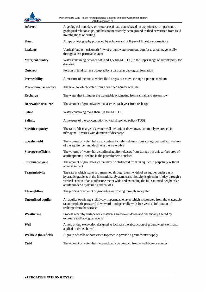
Twin Bonanza Gold Project Hydrogeological Baseline and Bore Completion Report
ABM Resources NL
SAPROLITE ENVIRONMENTAL
Inferred A geological boundary or resource estimate that is based on experience, comparisons to geological relationships, and has not necessarily been ground truthed or verified from field investigations or drilling.
Karst A type of topography produced by solution and collapse of limestone formations
Leakage Vertical (and or horizontal) flow of groundwater from one aquifer to another, generally through a less permeable layer
Marginal quality Water containing between 500 and 1,500mg/L TDS, in the upper range of acceptability for drinking
Outcrop Portion of land surface occupied by a particular geological formation
Permeability A measure of the rate at which fluid or gas can move through a porous medium
Potentiometric surface The level to which water from a confined aquifer will rise
Recharge The water that infiltrates the watertable originating from rainfall and streamflow
Renewable resources The amount of groundwater that accrues each year from recharge
Saline Water containing more than 3,000mg/L TDS
Salinity A measure of the concentration of total dissolved solids (TDS)
Specific capacity The rate of discharge of a water well per unit of drawdown, commonly expressed in m3/day/m. It varies with duration of discharge
Specific yield The volume of water that an unconfined aquifer releases from storage per unit surface area of the aquifer per unit decline in the watertable
Storage coefficient The volume of water that a confined aquifer releases from storage per unit surface area of aquifer per unit decline in the potentiometric surface
Sustainable yield The amount of groundwater that may be abstracted from an aquifer in perpetuity without adverse impact
Transmissivity The rate at which water is transmitted through a unit width of an aquifer under a unit hydraulic gradient; in the International System, transmissivity is given in m3/day through a vertical section of an aquifer one meter wide and extending the full saturated height of an aquifer under a hydraulic gradient of 1.
Throughflow The process or amount of groundwater flowing through an aquifer
Unconfined aquifer An aquifer overlying a relatively impermeable layer which is saturated from the watertable (at atmospheric pressure) downwards and generally with free vertical infiltration of recharge from the surface
Weathering Process whereby surface rock materials are broken down and chemically altered by exposure and biological agents
Well A hole or dug excavation designed to facilitate the abstraction of groundwater (term also applied to drilled bores)
Wellfield (borefield) A group of wells or bores used together to provide a groundwater supply
Yield The amount of water that can practically be pumped from a well/bore or aquifer
Twin Bonanza Gold Project Hydrogeological Baseline and Bore Completion Report
ABM Resources NL
SAPROLITE ENVIRONMENTAL
APPENDIX B
Bore Completion Logs

Bore No:Client: Operation:
Commenced:Completed:
Logged By:Drilled:
Static Water Level: Date:
Dep
th
Gra
phic
(mbg
l)
Log Well Completion
Diagram Notes
COMPOSITE WELL LOG
Geo
logy
Stra
ti-gr
aphy
SERVICESSAPROLITEENVIRONMENTAL
52B Mornington Parkway
ELLENBROOK, WA 6069
Phone: (08) 6296 7760Fax: (08) 6296 7762www.saprolite.com.au
Site:East (MGA):
SRP RL:North (MGA):
Method:Fluid:
Bit Record:Hole Purpose:
Lithological Description(uS/cm)
ConductivityElectrical
Well No: Sheet 1 of 2File Ref:
0
5
10
15
20
25
30
35
40
45
50
55
60
65
70
75
67.87mbgl 4/08/2014
146mm (5, 3/4")
4/07/2014
4/07/2014Top Drill
P.A./ S.W. Monitoring 446.85mAHD (Top Casing)7772533.07mN
517368.82mEAnalogue
ABM Resources NL Twin Bonanza Gold Project
A01
AirReverse Circulation (RC)
A01AB0101-01-01
Stickup 0.67magl
Cement Seal 0mbglto 1mbgl
Cement Plinth 0mbglto 0.2magl
Backfill 1mbgl to38mbgl
Bentonite Plug38mbgl to 39mbgl
Blank Casing from0.67magl to 42mbgl,50mm PN12 µPVC
SWL: 67.87mbgl
Bore Development,Indicative Airlift Yield:2.89L/s
ALLUVIUM: Red, heavily weathered, poorly sorted, Fe-rich, transportedmaterial
SANDSTONE: Brown, heavily weathered, medium grained sandstone
SILTSTONE: Brown, moderate weathering, siltstone and minor fine tomedium grained sandstone
SANDSTONE: Brown, moderate weathering, medium to coarse grainedsandstone
SANDSTONE: Brown, moderate weathering, fine grained sandstone andminor siltstone
SILTSTONE: Brown, moderate weathering, siltstone and minor fine tomedium grained sandstone
SANDSTONE: Brown, moderate weathering, medium to very coarse grainedsandstone
SANDSTONE: Brown, moderate weathering, fine grained sandstone andminor siltstone
SILTSTONE: Brown, moderate weathering, siltstone
SANDSTONE: Brown, moderate weathering, medium grained sandstone
SILTSTONE: Brown/red, heavily weathered, siltstone
SANDSTONE: Brown, moderate weathering, medium to very coarse grainedsandstone
SANDSTONE: Brown, moderate weathering, fine grained sandstone andminor siltstone
SILTSTONE: Brown, moderate weathering, siltstone
SANDSTONE: Brown, moderate weathering, coarse grained sandstone
SANDSTONE: Brown, moderate weathering, coarse grained sandstone andminor siltstone
SANDSTONE: Brown, moderate weathering, medium to very coarse grainedsandstone
SILTSTONE: Brown, moderate weathering, siltstone and minor mediumgrained sandstone
SANDSTONE: Brown, moderate weathering, medium to fine grainedsandstone
SANDSTONE: Brown, moderate weathering, coarse to very coarse grainedsandstone
SILTSTONE: Brown, moderate weathering, siltstone and minor fine grainedsandstone
SANDSTONE: Brown, moderate weathering, medium grained sandstone andminor siltstone
0 10000
20000
0 10000
20000
0 10000
20000

Bore No:Client: Operation:
Commenced:Completed:
Logged By:Drilled:
Static Water Level: Date:
Dep
th
Gra
phic
(mbg
l)
Log Well Completion
Diagram Notes
COMPOSITE WELL LOG
Geo
logy
Stra
ti-gr
aphy
SERVICESSAPROLITEENVIRONMENTAL
52B Mornington Parkway
ELLENBROOK, WA 6069
Phone: (08) 6296 7760Fax: (08) 6296 7762www.saprolite.com.au
Site:East (MGA):
SRP RL:North (MGA):
Method:Fluid:
Bit Record:Hole Purpose:
Lithological Description(uS/cm)
ConductivityElectrical
Well No: Sheet 2 of 2File Ref:
75
80
85
90
95
100
105
110
115
120
67.87mbgl 4/08/2014
146mm (5, 3/4")
4/07/2014
4/07/2014Top Drill
P.A./ S.W. Monitoring 446.85mAHD (Top Casing)7772533.07mN
517368.82mEAnalogue
ABM Resources NL Twin Bonanza Gold Project
A01
AirReverse Circulation (RC)
A01AB0101-01-01
Slotted Interval from42mbgl to 114mbgl,50mm PN12 µPVC -1mm transversemachine slotted
1.6 to 3.2mm GravelPack, 39mbgl to114mbgl
NB: Limit of ECProfiling at 100m
PVC End Cap
Total drilled depth114m
SILTSTONE: Brown, moderate weathering, siltstone
SANDSTONE: Brown, moderate weathering, medium grained sandstone
SILTSTONE: Pale purple, slightly weathered, siltstone
SILTSTONE: Pale purple, slightly weathered, siltstone and minor fine grainedsandstone
SANDSTONE: Pale purple, slightly weathered, fine grained sandstone
SILTSTONE: Grey, slightly weathered, siltstone with minor fine grainedsandstone
SANDSTONE: Grey/white, slightly weathered, medium grained sandstone
SANDSTONE: Brown, slightly weathered, medium to coarse grainedsandstone
SANDSTONE: Brown, slightly weathered, fine to medium grained sandstone
SANDSTONE: Brown, slightly weathered, fine grained sandstone and minorsiltstone
SILTSTONE: Brown, slightly weathered, siltstone and minor fine grainedsandstone
SANDSTONE: Brown, slightly weathered, fine grained sandstone and minorsiltstone
SANDSTONE: Brown, slightly weathered, fine to medium grained sandstone,trace quartz
SANDSTONE: Brown, slightly weathered, fine grained sandstone and minorsiltstone
SILTSTONE: Brown, slightly weathered, siltstone and minor fine grainedsandstone
SANDSTONE: Brown, slightly weathered, coarse grained sandstone
0 10000
20000
0 10000
20000

Bore No:Client: Operation:
Commenced:Completed:
Logged By:Drilled:
Static Water Level: Date:
Dep
th
Gra
phic
(mbg
l)
Log Well Completion
Diagram Notes
COMPOSITE WELL LOG
Geo
logy
Stra
ti-gr
aphy
SERVICESSAPROLITEENVIRONMENTAL
52B Mornington Parkway
ELLENBROOK, WA 6069
Phone: (08) 6296 7760Fax: (08) 6296 7762www.saprolite.com.au
Site:East (MGA):
SRP RL:North (MGA):
Method:Fluid:
Bit Record:Hole Purpose:
Lithological Description(uS/cm)
ConductivityElectrical
Well No: Sheet 1 of 1File Ref:
0
5
10
15
20
25
30
35
40
Dry NA
146mm (5, 3/4")
3/07/2014
3/07/2014Top Drill
P.A./ S.W. Monitoring 439.59mAHD (Top Casing)7771709.02mN
517097.41mEAnalogue
ABM Resources NL Twin Bonanza Gold Project
A02A
AirReverse Circulation (RC)
A02AAB0101-01-01
Stickup 0.80magl
Cement Seal 0mbglto 1mbgl
Cement Plinth 0mbglto 0.2magl
Backfill 1mbgl to2.5mbgl
Bentonite Plug2.5mbgl to 3.5mbgl
Blank Casing from0.80magl to 5.5mbgl,50mm PN12 µPVC
Slotted Interval from5.5mbgl to 35.5mbgl,50mm PN12 µPVC -1mm transversemachine slotted
1.6 to 3.2mm GravelPack, 3.5mbgl to35.5mbgl
PVC End Cap
Total drilled depth36m
SWL: Dry
Indicative Airlift Yield:Dry
ALLUVIUM: Red, coarse, heavily weathered, Fe-rich transported, material
SANDSTONE: Brown, heavily weathered fine grained sandstone
SANDSTONE: Brown, moderate weathering, medium grained sandstone
SILTSTONE: Brown/cream, moderate weathering, siltstone and minor finegrained sandstone
SANDSTONE: Brown/cream, moderate weathering, fine grained sandstoneand minor siltstone
SANDSTONE: Cream, moderate weathering, fine grained sandstone
SANDSTONE: Brown/cream, moderate weathering, fine grained sandstonewith minor siltstone
SANDSTONE: Cream, moderate weathering, medium grained sandstone withtrace siltstone
SANDSTONE: Cream, moderate weathering, medium grained sandstone
SANDSTONE: Cream, moderate weathering, medium grained sandstone
SILTSTONE: Cream, moderate weathering, siltstone
SANDSTONE: Cream, moderate weathering, medium grained sandstone andminor siltstone
SANDSTONE: Cream, moderate weathering, medium grained sandstone
SANDSTONE: Cream, moderate weathering, coarse grained sandstone
SANDSTONE: Brown/cream, moderate weathering, fine grained sandstoneand minor siltstone
SILTSTONE: Cream, moderate weathering, siltstone

Bore No:Client: Operation:
Commenced:Completed:
Logged By:Drilled:
Static Water Level: Date:
Dep
th
Gra
phic
(mbg
l)
Log Well Completion
Diagram Notes
COMPOSITE WELL LOG
Geo
logy
Stra
ti-gr
aphy
SERVICESSAPROLITEENVIRONMENTAL
52B Mornington Parkway
ELLENBROOK, WA 6069
Phone: (08) 6296 7760Fax: (08) 6296 7762www.saprolite.com.au
Site:East (MGA):
SRP RL:North (MGA):
Method:Fluid:
Bit Record:Hole Purpose:
Lithological Description(uS/cm)
ConductivityElectrical
Well No: Sheet 1 of 1File Ref:
0
5
10
15
20
25
30
35
40
45
Dry NA
130mm (5, 1/8")
17/07/2014
17/07/2014Top Drill
K.E./ S.W. Monitoring 426.77mAHD (Top Casing)7772049.89mN
514320.39mEAnalogue
ABM Resources NL Twin Bonanza Gold Project
A03A
Polymer MudMud Rotary - Normal Circ.
A03AAB0101-01-01
Stickup 0.75magl
Cement Seal 0mbglto 1mbgl
Cement Plinth 0mbglto 0.2magl
Backfill 1mbgl to3mbglBentonite Plug 3mbglto 4mbglBlank Casing from0.75magl to 5.2mbgl,50mm PN12 µPVC
Slotted Interval from5.2mbgl to 41.2mbgl,50mm PN12 µPVC -1mm transversemachine slotted
1.6 to 3.2mm GravelPack, 5.2mbgl to41.2mbgl
Fallback 41.2mbgl to42mbgl
Total drilled depth42m
SWL: Dry
Indicative Airlift Yield:Dry
PVC End Cap
ALLUVIUM: Red, heavily weathered, coarse, poorly sorted, Fe-rich,transported materials
SANDSTONE: Brown/red, heavily weathered, fine to medium grainedsandstone
SILCRETE: White/transparent, hard, conchoidal fracture, 100% silcrete
CALCRETE: White, moderate weathering, calcrete, minor sandstone andlateritic material, trace quartz
SANDSTONE: Red/grey, moderate weathering, medium grained sandstone
SANDSTONE: Red, heavily weathered, fine grained sandstone
SANDSTONE: Red, heavily weathered, fine grained sandstone and minorsilcrete
SANDSTONE: Red/grey, moderate weathering, fine to medium grainedsandstone
SILTSTONE: Grey/red, moderate weathering, siltstone and minor fine grainedsandstone
SILTSTONE: Grey/red, heavily weathered, siltstone and minor fine grainedsandstone
SILTSTONE: Grey/white, heavily weathered, siltstone and minor lateriticmaterial
SILTSTONE: Grey/white, moderate weathering, siltstone and minor lateriticmaterial
SILTSTONE: Red, moderate weathering, siltstone, trace sandstone andquartz

Bore No:Client: Operation:
Commenced:Completed:
Logged By:Drilled:
Static Water Level: Date:
Dep
th
Gra
phic
(mbg
l)
Log Well Completion
Diagram Notes
COMPOSITE WELL LOG
Geo
logy
Stra
ti-gr
aphy
SERVICESSAPROLITEENVIRONMENTAL
52B Mornington Parkway
ELLENBROOK, WA 6069
Phone: (08) 6296 7760Fax: (08) 6296 7762www.saprolite.com.au
Site:East (MGA):
SRP RL:North (MGA):
Method:Fluid:
Bit Record:Hole Purpose:
Lithological Description(uS/cm)
ConductivityElectrical
Well No: Sheet 1 of 1File Ref:
0
5
10
15
20
25
30
35
40
Dry NA
146mm (5, 3/4")
10/07/2014
10/07/2014Top Drill
P.A./ S.W. Monitoring 442.50mAHD (Top Casing)7768606.26mN
515447.91mEProcessing Area/ Plant Site
ABM Resources NL Twin Bonanza Gold Project
M01
AirReverse Circulation (RC)
M01AB0101-01-01
Stickup 0.82magl
Cement Seal 0mbglto 1mbgl
Cement Plinth 0mbglto 0.2magl
Backfill 1mbgl to3mbgl
Bentonite Plug 3mbglto 4mbgl
Blank Casing from0.82magl to5.15mbgl, 50mmPN12 µPVC
Slotted Interval from5.15mbgl to35.15mbgl, 50mmPN12 µPVC - 1mmtransverse machineslotted
1.6 to 3.2mm GravelPack, 4mbgl to35.15mbgl
Fallback 35.15mbglto 36mbgl
Total drilled depth36m
SWL: Dry
Indicative Airlift Yield:Drilled Dry
PVC End Cap
ALLUVIUM: Red, poorly sorted, heavily weathered, Fe-rich, transportedmaterials
SANDSTONE: Red/ grey, heavily weathered, medium grained sandstone
SANDSTONE: Red/ grey, moderate weathering, fine to medium grainedsandstone with trace to minor siltstone
SANDSTONE: Brown, moderate weathering, fine to medium grainedsandstone
SANDSTONE: Brown, moderate weathering, fine to medium grainedsandstone with trace to minor siltstone
SILTSTONE: Brown/pink, heavily weathered, siltstone
SILTSTONE: Brown, moderate weathering, siltstone with minor fine grainedsandstone
SANDSTONE: Brown, moderate weathering, fine to medium grainedsandstone with trace siltstone
SILTSTONE: Brown, moderate weathering, siltstone with minor fine grainedsandstone
SILTSTONE: Brown/pink, moderate weathering, siltstone
SILTSTONE: Brown, moderate weathering, siltstone with minor fine grainedsandstone
SANDSTONE: Brown, moderate weathering, fine grained sandstone withminor siltstone
SANDSTONE: Cream/brown, moderate weathering, medium grainedsandstone

Bore No:Client: Operation:
Commenced:Completed:
Logged By:Drilled:
Static Water Level: Date:
Dep
th
Gra
phic
(mbg
l)
Log Well Completion
Diagram Notes
COMPOSITE WELL LOG
Geo
logy
Stra
ti-gr
aphy
SERVICESSAPROLITEENVIRONMENTAL
52B Mornington Parkway
ELLENBROOK, WA 6069
Phone: (08) 6296 7760Fax: (08) 6296 7762www.saprolite.com.au
Site:East (MGA):
SRP RL:North (MGA):
Method:Fluid:
Bit Record:Hole Purpose:
Lithological Description(uS/cm)
ConductivityElectrical
Well No: Sheet 1 of 1File Ref:
0
5
10
15
20
25
30
35
40
Dry NA
146mm (5, 3/4")
10/07/2014
10/07/2014Top Drill
P.A./ S.W. Monitoring 443.29mAHD (Top Casing)7767679.21mN
515114.96mEProcessing Area/ Plant Site
ABM Resources NL Twin Bonanza Gold Project
M02
AirReverse Circulation (RC)
M02AB0101-01-01
Stickup 0.44magl
Cement Seal 0mbglto 1mbgl
Cement Plinth 0mbglto 0.2magl
Backfill 1mbgl to3mbgl
Bentonite Plug 3mbglto 4mbgl
Blank Casing from0.44magl to5.35mbgl, 50mmPN12 µPVC
Slotted Interval from5.35mbgl to35.35mbgl, 50mmPN12 µPVC - 1mmtransverse machineslotted
1.6 to 3.2mm GravelPack, 4mbgl to35.35mbgl
Fallback 35.35mbglto 36mbgl
Total drilled depth36m
SWL: Dry
Indicative Airlift Yield:Drilled Dry
PVC End Cap
ALLUVIUM: Red, poorly sorted, heavily weathered, Fe-rich, transportedmaterials
SANDSTONE: Red, heavily weathered, fine grained sandstone
SANDSTONE: Brown/red, moderate weathering, fine grained sandstone
SILTSTONE: Brown/grey, moderate weathering, siltstone
SANDSTONE: Brown, moderate weathering, fine to medium grainedsandstone and trace to minor siltstone
SILTSTONE: Brown, moderate weathering, siltstone
SANDSTONE: Brown, moderate weathering, fine grained sandstone andminor siltstone
SANDSTONE: Brown, moderate weathering, medium grained sandstone andminor quartz
SILTSTONE: Brown, moderate weathering, siltstone and minor quartz
QUARTZ: Primarily quartz vein, with minor siltstone
SANDSTONE: Brown, moderate weathering, fine to medium grainedsandstone
SANDSTONE: Brown, moderate weathering, fine to medium grainedsandstone and minor siltstone
SILTSTONE: Brown, moderate weathering, siltstone
SANDSTONE: Brown, moderate weathering, fine to medium grainedsandstone and minor siltstone
SILTSTONE: Brown, moderate weathering, siltstone
SANDSTONE: Brown, moderate weathering, coarse grained sandstone andtrace to minor quartz

Bore No:Client: Operation:
Commenced:Completed:
Logged By:Drilled:
Static Water Level: Date:
Dep
th
Gra
phic
(mbg
l)
Log Well Completion
Diagram Notes
COMPOSITE WELL LOG
Geo
logy
Stra
ti-gr
aphy
SERVICESSAPROLITEENVIRONMENTAL
52B Mornington Parkway
ELLENBROOK, WA 6069
Phone: (08) 6296 7760Fax: (08) 6296 7762www.saprolite.com.au
Site:East (MGA):
SRP RL:North (MGA):
Method:Fluid:
Bit Record:Hole Purpose:
Lithological Description(uS/cm)
ConductivityElectrical
Well No: Sheet 1 of 1File Ref:
0
5
10
15
20
25
30
35
40
Dry NA
146mm (5, 3/4")
10/07/2014
10/07/2014Top Drill
P.H./ S.W. Monitoring 445.09mAHD (Top Casing)7766392.16mN
515118.54mEProcessing Area/ Plant Site
ABM Resources NL Twin Bonanza Gold Project
M03
AirReverse Circulation (RC)
M03AB0101-01-01
Stickup 0.87magl
Cement Seal 0mbglto 1mbgl
Cement Plinth 0mbglto 0.2magl
Backfill 1mbgl to3mbgl
Bentonite Plug 3mbglto 4mbgl
Blank Casing from0.87magl to 5.3mbgl,50mm PN12 µPVC
Slotted Interval from5.3mbgl to 35.3mbgl,50mm PN12 µPVC -1mm transversemachine slotted
1.6 to 3.2mm GravelPack, 4mbgl to35.3mbgl
Fallback 35.3mbgl to36mbgl
Total drilled depth36m
SWL: Dry
Indicative Airlift Yield:Drilled Dry
PVC End Cap
ALLUVIUM: Red, poorly sorted, heavily weathered, Fe-rich, transportedmaterials
SANDSTONE: Red, heavily weathered, medium grained sandstone
SANDSTONE: Red/brown, moderate weathering, fine to medium grainedsandstone with trace to minor siltstone
SANDSTONE: Brown, moderate weathering, fine to medium grainedsandstone
SANDSTONE: Brown, moderate weathering, medium grained sandstone withminor siltstone
SANDSTONE: Brown, moderate weathering, fine grained sandstone
SANDSTONE: Brown, moderate weathering, fine grained sandstone withminor siltstone
SILTSTONE: Brown, heavily weathered, siltstone
SILTSTONE: Brown, moderate weathering, siltstone and minor fine grainedsandstone
SANDSTONE: Brown, moderate weathering, medium grained sandstone
SANDSTONE: Brown, moderate weathering, medium grained sandstone withminor siltstone
SILTSTONE: Brown, moderate weathering, siltstone with minor fine grainedsandstone
SILTSTONE: Pink/brown, moderate weathering, siltstone
SILTSTONE: Pink, moderate weathering, siltstone with minor fine grainedsandstone
SANDSTONE: Cream, moderate weathering, fine grained sandstone withminor siltstone
SANDSTONE: Cream, moderate weathering, medium grained sandstone

Bore No:Client: Operation:
Commenced:Completed:
Logged By:Drilled:
Static Water Level: Date:
Dep
th
Gra
phic
(mbg
l)
Log Well Completion
Diagram Notes
COMPOSITE WELL LOG
Geo
logy
Stra
ti-gr
aphy
SERVICESSAPROLITEENVIRONMENTAL
52B Mornington Parkway
ELLENBROOK, WA 6069
Phone: (08) 6296 7760Fax: (08) 6296 7762www.saprolite.com.au
Site:East (MGA):
SRP RL:North (MGA):
Method:Fluid:
Bit Record:Hole Purpose:
Lithological Description(uS/cm)
ConductivityElectrical
Well No: Sheet 1 of 1File Ref:
0
5
10
15
20
25
30
35
40
Dry NA
146mm (5, 3/4")
9/07/2014
9/07/2014Top Drill
K.E./ S.W. Monitoring 443.90mAHD (Top Casing)7765687.81mN
515524.10mEProcessing Area/ Plant Site
ABM Resources NL Twin Bonanza Gold Project
M04
AirReverse Circulation (RC)
M04AB0101-01-01
Stickup 0.91magl
Cement Seal 0mbglto 1mbgl
Cement Plinth 0mbglto 0.2magl
Backfill 1mbgl to3mbgl
Bentonite Plug 3mbglto 4mbgl
Blank Casing from0.91magl to 5.4mbgl,50mm PN12 µPVC
Slotted Interval from5.4mbgl to 35.4mbgl,50mm PN12 µPVC -1mm transversemachine slotted
1.6 to 3.2mm GravelPack, 4mbgl to35.4mbgl
Fallback 35.4mbgl to36mbgl
Total drilled depth36m
SWL: Dry
Indicative Airlift Yield:Drilled Dry
PVC End Cap
SILTSTONE: Red, moderate weathering, siltstone
SILTSTONE: Brown, moderate weathering, siltstone with minor fine grainedsandstone
SILTSTONE: Brown, moderate weathering, siltstone
SILTSTONE: Brown, moderate weathering, siltstone with minor very finegrained sandstone
SILTSTONE: Brown, moderate weathering, siltstone
SILTSTONE: Brown, moderate weathering, siltstone with minor very finegrained sandstone
SILTSTONE: Brown, moderate weathering, siltstone
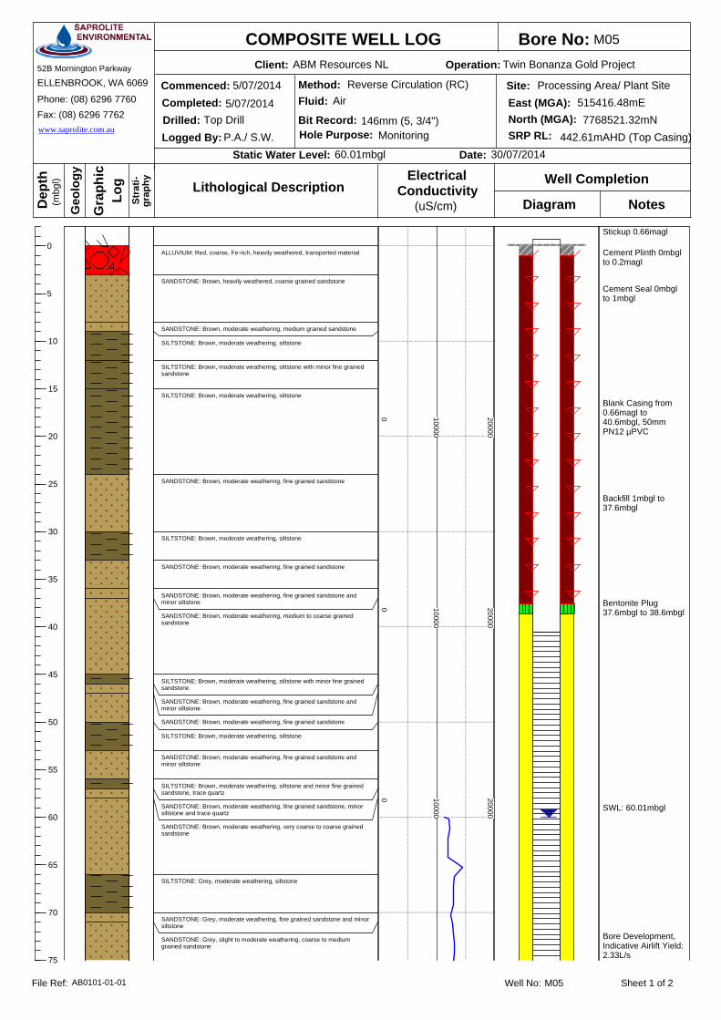
Bore No:Client: Operation:
Commenced:Completed:
Logged By:Drilled:
Static Water Level: Date:
Dep
th
Gra
phic
(mbg
l)
Log Well Completion
Diagram Notes
COMPOSITE WELL LOG
Geo
logy
Stra
ti-gr
aphy
SERVICESSAPROLITEENVIRONMENTAL
52B Mornington Parkway
ELLENBROOK, WA 6069
Phone: (08) 6296 7760Fax: (08) 6296 7762www.saprolite.com.au
Site:East (MGA):
SRP RL:North (MGA):
Method:Fluid:
Bit Record:Hole Purpose:
Lithological Description(uS/cm)
ConductivityElectrical
Well No: Sheet 1 of 2File Ref:
0
5
10
15
20
25
30
35
40
45
50
55
60
65
70
75
60.01mbgl 30/07/2014
146mm (5, 3/4")
5/07/2014
5/07/2014Top Drill
P.A./ S.W. Monitoring 442.61mAHD (Top Casing)7768521.32mN
515416.48mEProcessing Area/ Plant Site
ABM Resources NL Twin Bonanza Gold Project
M05
AirReverse Circulation (RC)
M05AB0101-01-01
Stickup 0.66magl
Cement Seal 0mbglto 1mbgl
Cement Plinth 0mbglto 0.2magl
Backfill 1mbgl to37.6mbgl
Bentonite Plug37.6mbgl to 38.6mbgl
Blank Casing from0.66magl to40.6mbgl, 50mmPN12 µPVC
SWL: 60.01mbgl
Bore Development,Indicative Airlift Yield:2.33L/s
ALLUVIUM: Red, coarse, Fe-rich, heavily weathered, transported material
SANDSTONE: Brown, heavily weathered, coarse grained sandstone
SANDSTONE: Brown, moderate weathering, medium grained sandstone
SILTSTONE: Brown, moderate weathering, siltstone
SILTSTONE: Brown, moderate weathering, siltstone with minor fine grainedsandstone
SILTSTONE: Brown, moderate weathering, siltstone
SANDSTONE: Brown, moderate weathering, fine grained sandstone
SILTSTONE: Brown, moderate weathering, siltstone
SANDSTONE: Brown, moderate weathering, fine grained sandstone
SANDSTONE: Brown, moderate weathering, fine grained sandstone andminor siltstone
SANDSTONE: Brown, moderate weathering, medium to coarse grainedsandstone
SILTSTONE: Brown, moderate weathering, siltstone with minor fine grainedsandstone
SANDSTONE: Brown, moderate weathering, fine grained sandstone andminor siltstone
SANDSTONE: Brown, moderate weathering, fine grained sandstone
SILTSTONE: Brown, moderate weathering, siltstone
SANDSTONE: Brown, moderate weathering, fine grained sandstone andminor siltstone
SILTSTONE: Brown, moderate weathering, siltstone and minor fine grainedsandstone, trace quartz
SANDSTONE: Brown, moderate weathering, fine grained sandstone, minorsiltstone and trace quartz
SANDSTONE: Brown, moderate weathering, very coarse to coarse grainedsandstone
SILTSTONE: Grey, moderate weathering, siltstone
SANDSTONE: Grey, moderate weathering, fine grained sandstone and minorsiltstone
SANDSTONE: Grey, slight to moderate weathering, coarse to mediumgrained sandstone
0 10000
20000
0 10000
20000
0 10000
20000

Bore No:Client: Operation:
Commenced:Completed:
Logged By:Drilled:
Static Water Level: Date:
Dep
th
Gra
phic
(mbg
l)
Log Well Completion
Diagram Notes
COMPOSITE WELL LOG
Geo
logy
Stra
ti-gr
aphy
SERVICESSAPROLITEENVIRONMENTAL
52B Mornington Parkway
ELLENBROOK, WA 6069
Phone: (08) 6296 7760Fax: (08) 6296 7762www.saprolite.com.au
Site:East (MGA):
SRP RL:North (MGA):
Method:Fluid:
Bit Record:Hole Purpose:
Lithological Description(uS/cm)
ConductivityElectrical
Well No: Sheet 2 of 2File Ref:
75
80
85
90
95
100
105
110
115
120
125
130
135
60.01mbgl 30/07/2014
146mm (5, 3/4")
5/07/2014
5/07/2014Top Drill
P.A./ S.W. Monitoring 442.61mAHD (Top Casing)7768521.32mN
515416.48mEProcessing Area/ Plant Site
ABM Resources NL Twin Bonanza Gold Project
M05
AirReverse Circulation (RC)
M05AB0101-01-01
Slotted Interval from40.6mbgl to130.6mbgl, 50mmPN12 µPVC - 1mmtransverse machineslotted
1.6 to 3.2mm GravelPack, 38.6mbgl to130.6mbgl
Fallback 130.6mbglto 132mbgl
Total drilled depth132m
PVC End Cap
NB: Limit of ECProfiling at 100m
SILTSTONE: Grey, slight weathering, siltstone and minor quartz
SILTSTONE: Grey, slight weathering, siltstone
SILTSTONE: Grey, slight weathering, siltstone and minor fine grainedsandstone
SILTSTONE: Grey, slight weathering, siltstone
SANDSTONE: Grey, slight weathering, medium grained sandstone
SILTSTONE: Grey, slight weathering, siltstone
SANDSTONE: Grey, slight weathering, fine grained sandstone
SANDSTONE: Grey, slight weathering, medium to coarse grained sandstone
SILTSTONE: Grey, slight weathering, siltstone and minor fine grainedsandstone
SILTSTONE: Grey, slight weathering, siltstone
SANDSTONE: Grey, slight weathering, fine grained sandstone and minorsiltstone
SILTSTONE: Grey, slight weathering, siltstone
SANDSTONE: Grey, slight weathering, fine grained sandstone
SANDSTONE: Grey, slight weathering, medium to coarse grained sandstone
0 10000
20000
0 10000
20000
0 10000
20000

Bore No:Client: Operation:
Commenced:Completed:
Logged By:Drilled:
Static Water Level: Date:
Dep
th
Gra
phic
(mbg
l)
Log Well Completion
Diagram Notes
COMPOSITE WELL LOG
Geo
logy
Stra
ti-gr
aphy
SERVICESSAPROLITEENVIRONMENTAL
52B Mornington Parkway
ELLENBROOK, WA 6069
Phone: (08) 6296 7760Fax: (08) 6296 7762www.saprolite.com.au
Site:East (MGA):
SRP RL:North (MGA):
Method:Fluid:
Bit Record:Hole Purpose:
Lithological Description(uS/cm)
ConductivityElectrical
Well No: Sheet 1 of 2File Ref:
0
5
10
15
20
25
30
35
40
45
50
55
60
65
70
75
67.93mbgl 30/07/2014
146mm (5, 3/4")
8/07/2014
8/07/2014Top Drill
K.E./ S.W. Monitoring 447.42mAHD (Top Casing)7765679.49mN
515929.79mEProcessing Area/ Plant Site
ABM Resources NL Twin Bonanza Gold Project
M06A
AirReverse Circulation (RC)
M06AAB0101-01-01
Stickup 0.92magl
Cement Seal 0mbglto 1mbgl
Cement Plinth 0mbglto 0.2magl
Backfill 1mbgl to37mbgl
Bentonite Plug37mbgl to 38mbgl
Blank Casing from0.92magl to40.7mbgl, 50mmPN12 µPVC
SWL: 67.93mbgl
Bore Development,Indicative Airlift Yield:0.03L/s
SILTSTONE: Red, highly weathered, ferruginous siltstone and minor fine grained sandstone
SILTSTONE: Red, moderate weathering, siltstone
SILTSTONE: Grey/ red, moderate weathering, siltstone
SILTSTONE: Grey, moderate weathering, siltstone
SILTSTONE: Grey, moderate weathering, siltstone and quartz 30-50%
SILTSTONE: Grey, moderate weathering, siltstone
SANDSTONE: Grey, moderate weathering, very fine grained sandstone and minor siltstone
SILTSTONE: Grey, moderate weathering, siltstone
SANDSTONE: Grey, moderate weathering, very fine grained sandstone and minor siltstone
SILTSTONE: Grey, moderate weathering, siltstone
QUARTZ: Red/grey, primarily quartz with moderately weathered siltstone
SILTSTONE: Red, highly weathered, siltstone
SILTSTONE: Grey, moderate weathering, siltstone
SILTSTONE: Grey, moderate weathering, siltstone and very fine grained sandstone 50%
SANDSTONE: Grey, very fine grained sandstone and minor siltstone
QUARTZ: Grey, primarily quartz, moderate weathering, minor siltstone and very fine grainedsandstone
SILTSTONE: Grey/red, moderate weathering, siltstone
SILTSTONE: Black, moderate weathering, siltstone and minor very fine grained sandstone
SANDSTONE: Black, moderate weathering, fine grained sandstone and quartz 50%
QUARTZ: Black, primarily quartz, minor fine grained sandstone and siltstone
SILTSTONE: Black, moderate weathering, siltstone
SANDSTONE: Black, moderate weathering, very fine grained sandstone and minor siltstone
0 20000
40000
0 20000
40000
0 20000
40000

Bore No:Client: Operation:
Commenced:Completed:
Logged By:Drilled:
Static Water Level: Date:
Dep
th
Gra
phic
(mbg
l)
Log Well Completion
Diagram Notes
COMPOSITE WELL LOG
Geo
logy
Stra
ti-gr
aphy
SERVICESSAPROLITEENVIRONMENTAL
52B Mornington Parkway
ELLENBROOK, WA 6069
Phone: (08) 6296 7760Fax: (08) 6296 7762www.saprolite.com.au
Site:East (MGA):
SRP RL:North (MGA):
Method:Fluid:
Bit Record:Hole Purpose:
Lithological Description(uS/cm)
ConductivityElectrical
Well No: Sheet 2 of 2File Ref:
75
80
85
90
95
100
105
110
115
120
125
130
135
67.93mbgl 30/07/2014
146mm (5, 3/4")
8/07/2014
8/07/2014Top Drill
K.E./ S.W. Monitoring 447.42mAHD (Top Casing)7765679.49mN
515929.79mEProcessing Area/ Plant Site
ABM Resources NL Twin Bonanza Gold Project
M06A
AirReverse Circulation (RC)
M06AAB0101-01-01
Slotted Interval from40.7mbgl to130.7mbgl, 50mmPN12 µPVC - 1mmtransverse machineslotted
1.6 to 3.2mm GravelPack, 38mbgl to130.7mbgl
Fallback 130.7mbglto 132mbgl
Total drilled depth132m
PVC End Cap
NB: Limit of ECProfiling at 100m
SILTSTONE: Black, moderate weathering, siltstone and very fine grained sandstone 10-50%
SILTSTONE: Black, moderate weathering, siltstone
SANDSTONE: Black, moderate weathering, fine grained sandstone and minor siltstone
SILTSTONE: Black, moderate weathering, siltstone and minor fine grained sandstone
SANDSTONE: Black, moderate weathering, fine grained sandstone and minor siltstone
SILTSTONE: Black, moderate weathering, siltstone and minor fine grained sandstone
SANDSTONE: Black, moderate weathering, fine grained sandstone and minor siltstone
SILTSTONE: Black, slightly weathered, siltstone
SILTSTONE: Black, fresh rock, siltstone
SANDSTONE: Black, fresh rock, fine grained sandstone and minor siltstone
SILTSTONE: Black, fresh rock, siltstone and minor fine grained sandstone
0 20000
40000
0 20000
40000
0 20000
40000
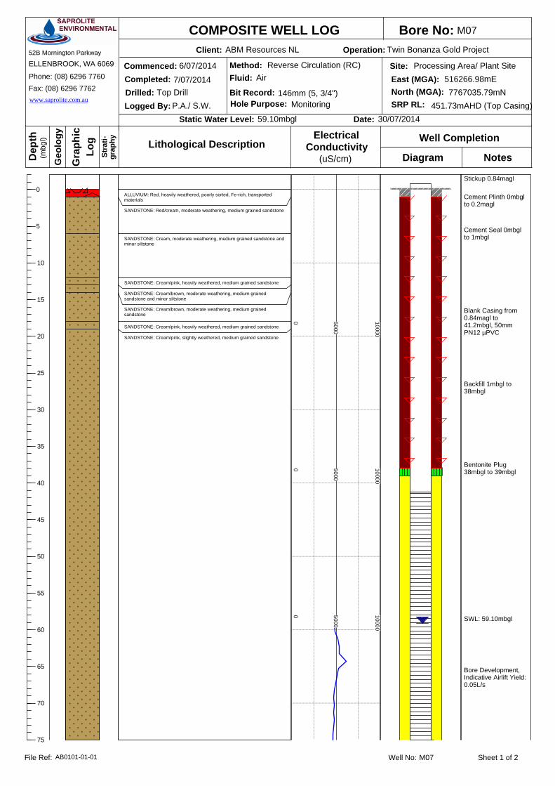
Bore No:Client: Operation:
Commenced:Completed:
Logged By:Drilled:
Static Water Level: Date:
Dep
th
Gra
phic
(mbg
l)
Log Well Completion
Diagram Notes
COMPOSITE WELL LOG
Geo
logy
Stra
ti-gr
aphy
SERVICESSAPROLITEENVIRONMENTAL
52B Mornington Parkway
ELLENBROOK, WA 6069
Phone: (08) 6296 7760Fax: (08) 6296 7762www.saprolite.com.au
Site:East (MGA):
SRP RL:North (MGA):
Method:Fluid:
Bit Record:Hole Purpose:
Lithological Description(uS/cm)
ConductivityElectrical
Well No: Sheet 1 of 2File Ref:
0
5
10
15
20
25
30
35
40
45
50
55
60
65
70
75
59.10mbgl 30/07/2014
146mm (5, 3/4")
6/07/2014
7/07/2014Top Drill
P.A./ S.W. Monitoring 451.73mAHD (Top Casing)7767035.79mN
516266.98mEProcessing Area/ Plant Site
ABM Resources NL Twin Bonanza Gold Project
M07
AirReverse Circulation (RC)
M07AB0101-01-01
Stickup 0.84magl
Cement Seal 0mbglto 1mbgl
Cement Plinth 0mbglto 0.2magl
Backfill 1mbgl to38mbgl
Bentonite Plug38mbgl to 39mbgl
Blank Casing from0.84magl to41.2mbgl, 50mmPN12 µPVC
SWL: 59.10mbgl
Bore Development,Indicative Airlift Yield:0.05L/s
ALLUVIUM: Red, heavily weathered, poorly sorted, Fe-rich, transportedmaterials
SANDSTONE: Red/cream, moderate weathering, medium grained sandstone
SANDSTONE: Cream, moderate weathering, medium grained sandstone andminor siltstone
SANDSTONE: Cream/pink, heavily weathered, medium grained sandstone
SANDSTONE: Cream/brown, moderate weathering, medium grainedsandstone and minor siltstone
SANDSTONE: Cream/brown, moderate weathering, medium grainedsandstone
SANDSTONE: Cream/pink, heavily weathered, medium grained sandstone
SANDSTONE: Cream/pink, slightly weathered, medium grained sandstone
0 5000
10000
0 5000
10000
0 5000
10000

Bore No:Client: Operation:
Commenced:Completed:
Logged By:Drilled:
Static Water Level: Date:
Dep
th
Gra
phic
(mbg
l)
Log Well Completion
Diagram Notes
COMPOSITE WELL LOG
Geo
logy
Stra
ti-gr
aphy
SERVICESSAPROLITEENVIRONMENTAL
52B Mornington Parkway
ELLENBROOK, WA 6069
Phone: (08) 6296 7760Fax: (08) 6296 7762www.saprolite.com.au
Site:East (MGA):
SRP RL:North (MGA):
Method:Fluid:
Bit Record:Hole Purpose:
Lithological Description(uS/cm)
ConductivityElectrical
Well No: Sheet 2 of 2File Ref:
75
80
85
90
95
100
105
110
115
120
125
130
135
140
145
150
59.10mbgl 30/07/2014
146mm (5, 3/4")
6/07/2014
7/07/2014Top Drill
P.A./ S.W. Monitoring 451.73mAHD (Top Casing)7767035.79mN
516266.98mEProcessing Area/ Plant Site
ABM Resources NL Twin Bonanza Gold Project
M07
AirReverse Circulation (RC)
M07AB0101-01-01
Slotted Interval from41.2mbgl to143.2mbgl, 50mmPN12 µPVC - 1mmtransverse machineslotted
1.6 to 3.2mm GravelPack, 39mbgl to143.2mbgl
Fallback 143.2mbglto 144mbgl
Total drilled depth144m
NB: Limit of ECProfiling at 100m
PVC End Cap
SANDSTONE: Cream/pale green, fresh rock, medium grained sandstone
SANDSTONE: Cream/pink, slightly weathered, medium grained sandstone
SANDSTONE: Cream/pale green, fresh rock, medium grained sandstone
SANDSTONE: Grey, fresh rock, fine grained sandstone
SANDSTONE: Pale green, fresh rock, medium grained sandstone
SANDSTONE: Pale green/ grey, fresh rock, medium grained sandstone andminor siltstone
SANDSTONE: Pale green, fresh rock, medium grained sandstone
SANDSTONE: Pale green/ grey, fresh rock, medium grained sandstone andminor siltstone
SANDSTONE: Pale green, fresh rock, medium grained sandstone
0 5000
10000
0 5000
10000
0 5000
10000
0 5000
10000
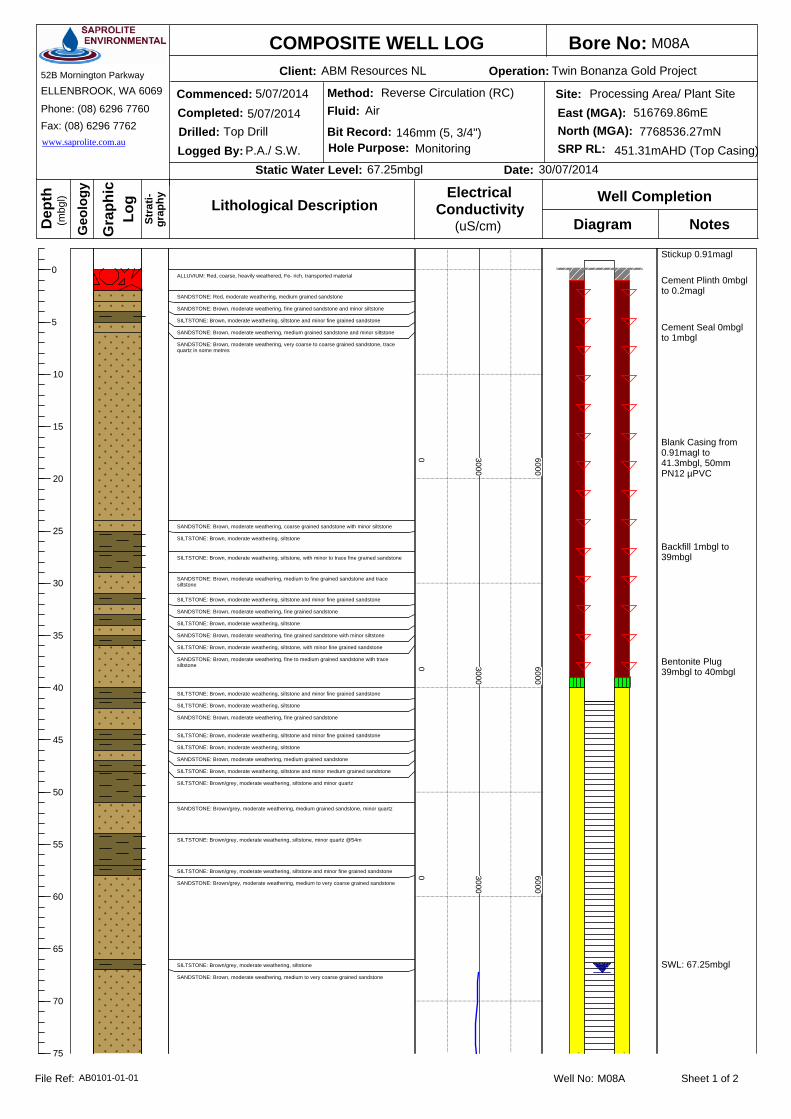
Bore No:Client: Operation:
Commenced:Completed:
Logged By:Drilled:
Static Water Level: Date:
Dep
th
Gra
phic
(mbg
l)
Log Well Completion
Diagram Notes
COMPOSITE WELL LOG
Geo
logy
Stra
ti-gr
aphy
SERVICESSAPROLITEENVIRONMENTAL
52B Mornington Parkway
ELLENBROOK, WA 6069
Phone: (08) 6296 7760Fax: (08) 6296 7762www.saprolite.com.au
Site:East (MGA):
SRP RL:North (MGA):
Method:Fluid:
Bit Record:Hole Purpose:
Lithological Description(uS/cm)
ConductivityElectrical
Well No: Sheet 1 of 2File Ref:
0
5
10
15
20
25
30
35
40
45
50
55
60
65
70
75
67.25mbgl 30/07/2014
146mm (5, 3/4")
5/07/2014
5/07/2014Top Drill
P.A./ S.W. Monitoring 451.31mAHD (Top Casing)7768536.27mN
516769.86mEProcessing Area/ Plant Site
ABM Resources NL Twin Bonanza Gold Project
M08A
AirReverse Circulation (RC)
M08AAB0101-01-01
Stickup 0.91magl
Cement Seal 0mbglto 1mbgl
Cement Plinth 0mbglto 0.2magl
Backfill 1mbgl to39mbgl
Bentonite Plug39mbgl to 40mbgl
Blank Casing from0.91magl to41.3mbgl, 50mmPN12 µPVC
SWL: 67.25mbgl
0 3000
6000
0 3000
6000
0 3000
6000
ALLUVIUM: Red, coarse, heavily weathered, Fe- rich, transported material
SANDSTONE: Red, moderate weathering, medium grained sandstone
SANDSTONE: Brown, moderate weathering, fine grained sandstone and minor siltstone
SILTSTONE: Brown, moderate weathering, siltstone and minor fine grained sandstone
SANDSTONE: Brown, moderate weathering, medium grained sandstone and minor siltstone
SANDSTONE: Brown, moderate weathering, very coarse to coarse grained sandstone, tracequartz in some metres
SANDSTONE: Brown, moderate weathering, coarse grained sandstone with minor siltstone
SILTSTONE: Brown, moderate weathering, siltstone
SILTSTONE: Brown, moderate weathering, siltstone, with minor to trace fine grained sandstone
SANDSTONE: Brown, moderate weathering, medium to fine grained sandstone and tracesiltstone
SILTSTONE: Brown, moderate weathering, siltstone and minor fine grained sandstone
SANDSTONE: Brown, moderate weathering, fine grained sandstone
SILTSTONE: Brown, moderate weathering, siltstone
SANDSTONE: Brown, moderate weathering, fine grained sandstone with minor siltstone
SILTSTONE: Brown, moderate weathering, siltstone, with minor fine grained sandstone
SANDSTONE: Brown, moderate weathering, fine to medium grained sandstone with tracesiltstone
SILTSTONE: Brown, moderate weathering, siltstone and minor fine grained sandstone
SILTSTONE: Brown, moderate weathering, siltstone
SANDSTONE: Brown, moderate weathering, fine grained sandstone
SILTSTONE: Brown, moderate weathering, siltstone and minor fine grained sandstone
SILTSTONE: Brown, moderate weathering, siltstone
SANDSTONE: Brown, moderate weathering, medium grained sandstone
SILTSTONE: Brown, moderate weathering, siltstone and minor medium grained sandstone
SILTSTONE: Brown/grey, moderate weathering, siltstone and minor quartz
SANDSTONE: Brown/grey, moderate weathering, medium grained sandstone, minor quartz
SILTSTONE: Brown/grey, moderate weathering, siltstone, minor quartz @54m
SILTSTONE: Brown/grey, moderate weathering, siltstone and minor fine grained sandstone
SANDSTONE: Brown/grey, moderate weathering, medium to very coarse grained sandstone
SILTSTONE: Brown/grey, moderate weathering, siltstone
SANDSTONE: Brown, moderate weathering, medium to very coarse grained sandstone

Bore No:Client: Operation:
Commenced:Completed:
Logged By:Drilled:
Static Water Level: Date:
Dep
th
Gra
phic
(mbg
l)
Log Well Completion
Diagram Notes
COMPOSITE WELL LOG
Geo
logy
Stra
ti-gr
aphy
SERVICESSAPROLITEENVIRONMENTAL
52B Mornington Parkway
ELLENBROOK, WA 6069
Phone: (08) 6296 7760Fax: (08) 6296 7762www.saprolite.com.au
Site:East (MGA):
SRP RL:North (MGA):
Method:Fluid:
Bit Record:Hole Purpose:
Lithological Description(uS/cm)
ConductivityElectrical
Well No: Sheet 2 of 2File Ref:
75
80
85
90
95
100
105
110
115
120
125
130
135
140
67.25mbgl 30/07/2014
146mm (5, 3/4")
5/07/2014
5/07/2014Top Drill
P.A./ S.W. Monitoring 451.31mAHD (Top Casing)7768536.27mN
516769.86mEProcessing Area/ Plant Site
ABM Resources NL Twin Bonanza Gold Project
M08A
AirReverse Circulation (RC)
M08AAB0101-01-01
Slotted Interval from41.3mbgl to137.3mbgl, 50mmPN12 µPVC - 1mmtransverse machineslotted
1.6 to 3.2mm GravelPack, 40mbgl to137.3mbgl
Fallback 137.3mbglto 138mbgl
Total drilled depth138m
Bore DevelopmentIndicative Airlift Yield:0.15L/s
PVC End Cap
NB: Limit of ECProfiling at 100m
0 3000
6000
0 3000
6000
0 3000
6000
SILTSTONE: Grey, slight weathering, siltstone
SANDSTONE: Brown, slight weathering, coarse to very coarse grained sandstone
SILTSTONE: Grey, slight weathering, siltstone
SANDSTONE: Brown, slight weathering, medium to very coarse grained sandstone
SILTSTONE: Grey, slight weathering, siltstone, minor gine grained sandstone
SANDSTONE: Grey, slight weathering, fine to medium grained sandstone
SANDSTONE: Grey, slight weathering, coarse grained sandstone, minor siltstone
SANDSTONE: Grey, slight weathering, fine to coarse grained sandstone
SANDSTONE: Grey, slight weathering, medium grained sandstone, minor siltstone
SANDSTONE: Grey, slight weathering, medium grained sandstone, minor quartz
SILTSTONE: Grey, slight weathering, siltstone, minor quartz
SANDSTONE: Grey, slight weathering, medium grained sandstone
SILTSTONE: Grey, slight weathering, siltstone, trace quartz
SANDSTONE: Grey, fresh rock, fine to coarse grained sandstone
SILTSTONE: Grey, fresh rock, siltstone, minor fine grained sandstone, trace quartz
SANDSTONE: Grey, fresh rock, fine grained sandstone
SILTSTONE: Grey, fresh rock, siltstone, minor quartz
SANDSTONE: Grey, fresh rock, fine to coarse grained sandstone, minor quartz @138m

Bore No:Client: Operation:
Commenced:Completed:
Logged By:Drilled:
Static Water Level: Date:
Dep
th
Gra
phic
(mbg
l)
Log Well Completion
Diagram Notes
COMPOSITE WELL LOG
Geo
logy
Stra
ti-gr
aphy
SERVICESSAPROLITEENVIRONMENTAL
52B Mornington Parkway
ELLENBROOK, WA 6069
Phone: (08) 6296 7760Fax: (08) 6296 7762www.saprolite.com.au
Site:East (MGA):
SRP RL:North (MGA):
Method:Fluid:
Bit Record:Hole Purpose:
Lithological Description(uS/cm)
ConductivityElectrical
Well No: Sheet 1 of 2File Ref:
0
5
10
15
20
25
30
35
40
45
50
55
60
65
70
75
70.17mbgl 30/07/2014
146mm (5, 3/4")
7/07/2014
7/07/2014Top Drill
P.A./ S.W. Monitoring 452.33mAHD (Top Casing)7766088.20mN
516951.77mEProcessing Area/ Plant Site
ABM Resources NL Twin Bonanza Gold Project
M09
AirReverse Circulation (RC)
M09AB0101-01-01
Stickup 0.86magl
Cement Seal 0mbglto 1mbgl
Cement Plinth 0mbglto 0.2magl
Backfill 1mbgl to36mbgl
Bentonite Plug36mbgl to 37mbgl
Blank Casing from0.86magl to 41mbgl,50mm PN12 µPVC
SWL: 70.17mbgl
Bore Development,Indicative Airlift Yield:NA
ALLUVIUM: Red, Heavily weathered, Fe-rich, transported materials
MOTTLED ZONE: Red/white, heavily weathered, fine to medium grained sandstone and lateriticmaterial
SANDSTONE: Cream, moderate weathering, medium grained sandstone
SANDSTONE: Cream, heavily weathered, fine grained sandstone
SANDSTONE: Cream/brown, moderate weathering, fine to medium grained sandstone
SANDSTONE: Cream/pale green, slightly weathered, medium grained sandstone
0 6000
12000
0 6000
12000
0 6000
12000

Bore No:Client: Operation:
Commenced:Completed:
Logged By:Drilled:
Static Water Level: Date:
Dep
th
Gra
phic
(mbg
l)
Log Well Completion
Diagram Notes
COMPOSITE WELL LOG
Geo
logy
Stra
ti-gr
aphy
SERVICESSAPROLITEENVIRONMENTAL
52B Mornington Parkway
ELLENBROOK, WA 6069
Phone: (08) 6296 7760Fax: (08) 6296 7762www.saprolite.com.au
Site:East (MGA):
SRP RL:North (MGA):
Method:Fluid:
Bit Record:Hole Purpose:
Lithological Description(uS/cm)
ConductivityElectrical
Well No: Sheet 2 of 2File Ref:
75
80
85
90
95
100
105
110
115
120
125
130
135
70.17mbgl 30/07/2014
146mm (5, 3/4")
7/07/2014
7/07/2014Top Drill
P.A./ S.W. Monitoring 452.33mAHD (Top Casing)7766088.20mN
516951.77mEProcessing Area/ Plant Site
ABM Resources NL Twin Bonanza Gold Project
M09
AirReverse Circulation (RC)
M09AB0101-01-01
Slotted Interval from41mbgl to 131mbgl,50mm PN12 µPVC -1mm transversemachine slotted
1.6 to 3.2mm GravelPack, 37mbgl to131mbgl
Fallback 131mbgl to132mbglTotal drilled depth132m
PVC End Cap
NB: Limit of ECProfiling at 100m
NB: BoreDevelopmentIncomplete
SANDSTONE: Pale green, slightly weathered, medium grained sandstone
SANDSTONE: Pale green/grey, slightly weathered, medium grained sandstone
SANDSTONE: Grey, slightly weathered, medium grained sandstone
SANDSTONE: Grey/ brown, slightly weathered, medium grained sandstone with minor siltstone
SANDSTONE: Grey/ brown, fresh rock, medium grained sandstone
SANDSTONE: Grey, fresh rock, coarse grained sandstone
SANDSTONE: Grey, fresh rock, very fine grained sandstone
SANDSTONE: Grey/ brown, fresh rock, coarse to medium grained sandstone
SANDSTONE: Grey/brown, fresh rock, fine grained sandstone
SANDSTONE: Grey/brown, fresh rock, medium grained sandstone
SANDSTONE: Grey/brown, fresh rock, medium grained sandstone with minor siltstone
SANDSTONE: Grey/brown, fresh rock, medium grained sandstone
SANDSTONE: Dark grey, fresh rock, fine grained sandstone with minor siltstone
SANDSTONE: Dark grey, fresh rock, medium grained sandstone
SANDSTONE: Dark grey, fresh rock, fine grained sandstone with minor siltstone
SANDSTONE: Dark grey, fresh rock, fine to medium grained sandstone
0 6000
12000
0 6000
12000
0 6000
12000
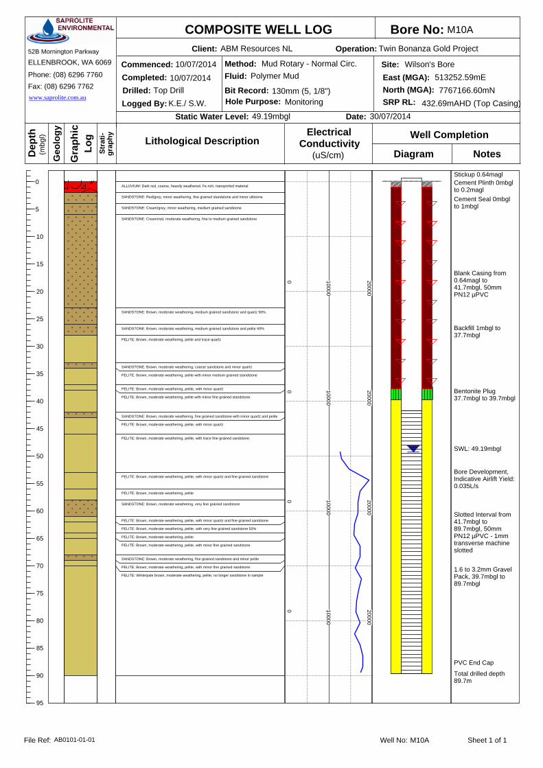
Bore No:Client: Operation:
Commenced:Completed:
Logged By:Drilled:
Static Water Level: Date:
Dep
th
Gra
phic
(mbg
l)
Log Well Completion
Diagram Notes
COMPOSITE WELL LOG
Geo
logy
Stra
ti-gr
aphy
SERVICESSAPROLITEENVIRONMENTAL
52B Mornington Parkway
ELLENBROOK, WA 6069
Phone: (08) 6296 7760Fax: (08) 6296 7762www.saprolite.com.au
Site:East (MGA):
SRP RL:North (MGA):
Method:Fluid:
Bit Record:Hole Purpose:
Lithological Description(uS/cm)
ConductivityElectrical
Well No: Sheet 1 of 1File Ref:
0
5
10
15
20
25
30
35
40
45
50
55
60
65
70
75
80
85
90
95
49.19mbgl 30/07/2014
130mm (5, 1/8")
10/07/2014
10/07/2014Top Drill
K.E./ S.W. Monitoring 432.69mAHD (Top Casing)7767166.60mN
513252.59mEWilson's Bore
ABM Resources NL Twin Bonanza Gold Project
M10A
Polymer MudMud Rotary - Normal Circ.
M10AAB0101-01-01
Stickup 0.64magl
Cement Seal 0mbglto 1mbgl
Cement Plinth 0mbglto 0.2magl
Backfill 1mbgl to37.7mbgl
Bentonite Plug37.7mbgl to 39.7mbgl
Blank Casing from0.64magl to41.7mbgl, 50mmPN12 µPVC
Slotted Interval from41.7mbgl to89.7mbgl, 50mmPN12 µPVC - 1mmtransverse machineslotted
1.6 to 3.2mm GravelPack, 39.7mbgl to89.7mbgl
Total drilled depth89.7m
SWL: 49.19mbgl
Bore Development,Indicative Airlift Yield:0.035L/s
PVC End Cap
ALLUVIUM: Dark red, coarse, heavily weathered, Fe-rich, transported material
SANDSTONE: Red/grey, minor weathering, fine grained standstone and minor siltstone
SANDSTONE: Cream/grey, minor weathering, medium grained sandstone
SANDSTONE: Cream/red, moderate weathering, fine to medium grained sandstone
SANDSTONE: Brown, moderate weathering, medium grained sandstone and quartz 50%.
SANDSTONE: Brown, moderate weathering, medium grained sandstone and pelite 50%
PELITE: Brown, moderate weathering, pelite and trace quartz
SANDSTONE: Brown, moderate weathering, coarse sandstone and minor quartz
PELITE: Brown, moderate weathering, pelite with minor medium grained standstone
PELITE: Brown, moderate weathering, pelite, with minor quartz
PELITE: Brown, moderate weathering, pelite with minor fine grained standstone
SANDSTONE: Brown, moderate weathering, fine grained sandstone with minor quartz and pelite
PELITE: Brown, moderate weathering, pelite, with minor quartz
PELITE: Brown, moderate weathering, pelite, with trace fine grained sandstone.
PELITE: Brown, moderate weathering, pelite, with minor quartz and fine grained sandstone
PELITE: Brown, moderate weathering, pelite
SANDSTONE: Brown, moderate weathering, very fine grained sandstone
PELITE: Brown, moderate weathering, pelite, with minor quartz and fine grained sandstone
PELITE: Brown, moderate weathering, pelite, with very fine grained sandstone 50%
PELITE: Brown, moderate weathering, pelite
PELITE: Brown, moderate weathering, pelite, with minor fine grained sandstone
SANDSTONE: Brown, moderate weathering, fine grained sandstone and minor pelite
PELITE: Brown, moderate weathering, pelite, with minor fine grained sandstone
PELITE: White/pale brown, moderate weathering, pelite, no longer sandstone in sample
0 10000
20000
0 10000
20000
0 10000
20000
0 10000
20000

Bore No:Client: Operation:
Commenced:Completed:
Logged By:Drilled:
Static Water Level: Date:
Dep
th
Gra
phic
(mbg
l)
Log Well Completion
Diagram Notes
COMPOSITE WELL LOG
Geo
logy
Stra
ti-gr
aphy
SERVICESSAPROLITEENVIRONMENTAL
52B Mornington Parkway
ELLENBROOK, WA 6069
Phone: (08) 6296 7760Fax: (08) 6296 7762www.saprolite.com.au
Site:East (MGA):
SRP RL:North (MGA):
Method:Fluid:
Bit Record:Hole Purpose:
Lithological Description(uS/cm)
ConductivityElectrical
Well No: Sheet 1 of 2File Ref:
0
5
10
15
20
25
30
35
40
45
50
55
60
65
70
75
54.61mbgl 22/07/2014
146mm (5, 3/4")
1/07/2014
1/07/2014Top Drill
J.I./ S.W. Monitoring 438.59mAHD (Top Casing)7770190.36mN
516537.24mECorsair Bore
ABM Resources NL Twin Bonanza Gold Project
M11
AirReverse Circulation (RC)
M11AB0101-01-01
Stickup 0.16magl
Cement Seal 0mbglto 1mbgl
Cement Plinth 0mbglto 0.2magl
Backfill 1mbgl to39mbgl
Bentonite Plug39mbgl to 40mbgl
Blank Casing from0.16magl to 42mbgl,50mm PN12 µPVC
SWL: 54.61mbgl
Bore Development,Indicative Airlift Yield:0.25L/s
ALLUVIUM: Red/brown, heavily weathered, poorly sorted, Fe-rich, transported materials
SANDSTONE: Brown, moderate weathering, medium grained sandstone, trace quartz
SILTSTONE: Brown, moderate weathering, siltstone and very fine grained sandstone
SANDSTONE: Brown, moderate weathering, medium grained sandstone
SILTSTONE: Brown, moderate weathering, siltstone and very fine grained sandstone
SANDSTONE: Brown, moderate weathering, medium grained sandstone and minor very finegrained sandstone
SANDSTONE: Brown, moderate weathering, medium grained sandstone
SILTSTONE: Cream/brown, moderate weathering, siltstone and trace quartz
SILTSTONE: Brown, moderate weathering, siltstone and minor quartz
SILTSTONE: Brown, moderate weathering, siltstone and trace quartz
SILTSTONE: Brown, moderate weathering, siltstone and minor quartz
SILTSTONE: Brown/cream, moderate weathering, siltstone and trace quartz
SANDSTONE: Brown, moderate weathering, fine to medium grained sandstone, trace to minorquartz
SILTSTONE: Brown/pale grey, moderate weathering, silstone, trace quartz
0 3000
6000
0 3000
6000
0 3000
6000

Bore No:Client: Operation:
Commenced:Completed:
Logged By:Drilled:
Static Water Level: Date:
Dep
th
Gra
phic
(mbg
l)
Log Well Completion
Diagram Notes
COMPOSITE WELL LOG
Geo
logy
Stra
ti-gr
aphy
SERVICESSAPROLITEENVIRONMENTAL
52B Mornington Parkway
ELLENBROOK, WA 6069
Phone: (08) 6296 7760Fax: (08) 6296 7762www.saprolite.com.au
Site:East (MGA):
SRP RL:North (MGA):
Method:Fluid:
Bit Record:Hole Purpose:
Lithological Description(uS/cm)
ConductivityElectrical
Well No: Sheet 2 of 2File Ref:
75
80
85
90
95
100
105
110
115
120
125
130
135
140
145
150
54.61mbgl 22/07/2014
146mm (5, 3/4")
1/07/2014
1/07/2014Top Drill
J.I./ S.W. Monitoring 438.59mAHD (Top Casing)7770190.36mN
516537.24mECorsair Bore
ABM Resources NL Twin Bonanza Gold Project
M11
AirReverse Circulation (RC)
M11AB0101-01-01
Slotted Interval from42mbgl to 150mbgl,50mm PN12 µPVC -1mm transversemachine slotted
1.6 to 3.2mm GravelPack, 40mbgl to150mbgl
NB: Limit of ECProfiling at 100m
Total drilled depth150m
PVC End Cap
SANDSTONE: Brown, moderate weathering, medium grained sandstone
SILTSTONE: Dark grey, moderate weathering, siltstone, trace quartz
SANDSTONE: Brown, moderate weathering, fine grained sandstone, trace quartz
SILTSTONE: Dark grey/cream brown, moderate weathering, siltstone, trace quartz
SANDSTONE: Brown, moderate weathering, medium grained sandstone, trace to minor quartz
SANDSTONE: Brown, moderate weathering, medium grained sandstone with trace siltstone
SANDSTONE: Brown, moderate weathering, medium grained sandstone with trace quartz
SANDSTONE: Dark grey/brown, moderate weathering, very fine to medium grained sandstone
SANDSTONE: Brown, moderate weathering, medium grained sandstone
SILTSTONE: Grey/brown, moderate weathering, siltstone
SANDSTONE: Brown/grey, moderate weathering, medium grained sandstone
SANDSTONE: Dark grey, moderate weathering, very fine grained sandstone
SANDSTONE: Dark grey, moderate weathering, fine grained sandstone, trace quartz
SANDSTONE: Dark grey, moderate weathering, medium to very coarse grained sandstone
SANDSTONE: Dark grey, moderate weathering, medium grained sandstone, minor quartz
0 3000
6000
0 3000
6000
0 3000
6000
0 3000
6000

Bore No:Client: Operation:
Commenced:Completed:
Logged By:Drilled:
Static Water Level: Date:
Dep
th
Gra
phic
(mbg
l)
Log Well Completion
Diagram Notes
COMPOSITE WELL LOG
Geo
logy
Stra
ti-gr
aphy
SERVICESSAPROLITEENVIRONMENTAL
52B Mornington Parkway
ELLENBROOK, WA 6069
Phone: (08) 6296 7760Fax: (08) 6296 7762www.saprolite.com.au
Site:East (MGA):
SRP RL:North (MGA):
Method:Fluid:
Bit Record:Hole Purpose:
Lithological Description(uS/cm)
ConductivityElectrical
Well No: Sheet 1 of 1File Ref:
0
5
10
15
20
25
30
35
40
45
3.38mbgl 4/08/2014
267mm (10.5")
5/07/2014
9/07/2014Top Drill
P.H./ S.W. Production 418.26mAHD (Top Casing)7764891.92mN
509508.96mEStrezza's/Timmy's
ABM Resources NL Twin Bonanza Gold Project
Strezza's/TB2
Polymer MudMud Rotary - Normal Circ.
Strezza's/TB2AB0101-01-01
Stickup 0.62magl
Cement Seal 0mbglto 3mbgl
Cement Plinth 0mbglto 0.2magl
Bentonite Plug 3mbglto 4mbgl
Blank Casing from0.62magl to 6mbgl,155mm PN12 µPVC
Slotted Interval from6mbgl to 39.9mbgl,155mm PN12 µPVC -1mm transversemachine slotted
1.6 to 3.2mm GravelPack, 6mbgl to39.9mbgl
Fallback 39.9mbgl to42mbglTotal drilled depth42m
SWL: 3.38mbgl
Bore Development,Indicative Airlift Yield8.4L/s
PVC End Cap
ALLUVIUM: Dark red, heavily weathered, coarse, Fe-rich transported materialwith ~10% silcrete
CALCRETE: Cream/brown, well developed calcrete over a transportedaeolian sand
CAVITY: No cutting returned, cavity, loss of circulation
CAVITY: Some circulation, but sample return limited to flocculated clays andpolymer
CALCRETE: Cream/brown, moderate weathering, calcrete developed overaeolian sand with approximately 20% lateritic material
0 2500
5000
0 2500
5000

Bore No:Client: Operation:
Commenced:Completed:
Logged By:Drilled:
Static Water Level: Date:
Dep
th
Gra
phic
(mbg
l)
Log Well Completion
Diagram Notes
COMPOSITE WELL LOG
Geo
logy
Stra
ti-gr
aphy
SERVICESSAPROLITEENVIRONMENTAL
52B Mornington Parkway
ELLENBROOK, WA 6069
Phone: (08) 6296 7760Fax: (08) 6296 7762www.saprolite.com.au
Site:East (MGA):
SRP RL:North (MGA):
Method:Fluid:
Bit Record:Hole Purpose:
Lithological Description(uS/cm)
ConductivityElectrical
Well No: Sheet 1 of 1File Ref:
0
5
10
15
20
25
30
35
40
45
3.33mbgl 31/07/2014
130mm (5, 1/8")
15/07/2014
15/07/2014Top Drill
K.E / S.W. Monitoring 418.51mAHD (Top Casing)7765909.34mN
509819.97mEStrezza's/Timmy's
ABM Resources NL Twin Bonanza Gold Project
BF01
Polymer MudMud Rotary - Normal Circ.
BF01AB0101-01-01
Stickup 0.51magl
Cement Seal 0mbglto 1mbgl
Cement Plinth 0mbglto 0.2magl
Backfill 1mbgl to3mbglBentonite Plug 3mbglto 4mbgl
Blank Casing from0.51magl to 5.2mbgl,50mm PN12 µPVC
Slotted Interval from5.2mbgl to 41.2mbgl,50mm PN12 µPVC -1mm transversemachine slotted
1.6 to 3.2mm GravelPack, 4mbgl to41.2mbgl
Fallback 41.2mbgl to42mbgl
PVC End Cap
Total drilled depth42m
SWL: 3.33mbgl
Bore Development,Indicative Airlift Yield0.22L/s
ALLUVIUM: Red, extremely weathered, poorly sorted, Fe-rich, transportedmaterials
CALCRETE: Red, extremely weathered, well developed calcrete, tracesilcrete
SANDSTONE: Red, extremely weathered, fine grained sandstone with minoralluvium and trace silcrete
SANDSTONE: Red, moderate weathering, fine grained sandstone with minorsiltstone and pelite
SANDSTONE: Pale grey, moderate weathering, fine grained sandstone withminor pelite and quartz
SANDSTONE: Pale grey, moderate weathering, fine grained sandstone withminor siltstone and pelite
PELITE: Pale grey, moderate weathering, pelite with minor very fine grainedsandstone
PELITE: Pale yellow, moderate weathering, pelite with trace very fine to finegrained sandstone
0 2500
5000
0 2500
5000

Bore No:Client: Operation:
Commenced:Completed:
Logged By:Drilled:
Static Water Level: Date:
Dep
th
Gra
phic
(mbg
l)
Log Well Completion
Diagram Notes
COMPOSITE WELL LOG
Geo
logy
Stra
ti-gr
aphy
SERVICESSAPROLITEENVIRONMENTAL
52B Mornington Parkway
ELLENBROOK, WA 6069
Phone: (08) 6296 7760Fax: (08) 6296 7762www.saprolite.com.au
Site:East (MGA):
SRP RL:North (MGA):
Method:Fluid:
Bit Record:Hole Purpose:
Lithological Description(uS/cm)
ConductivityElectrical
Well No: Sheet 1 of 1File Ref:
0
5
10
15
20
25
30
35
40
45
2.88mbgl 31/07/2014
130mm (5, 1/8")
14/07/2014
14/07/2014Top Drill
K.E. / S.W. Monitoring 418.22mAHD (Top Casing)7765117.24mN
509563.73mEStrezza's/ Timmy's
ABM Resources NL Twin Bonanza Gold Project
BF02
Polymer MudMud Rotary - Normal Circ.
BF02AB0101-01-01
Stickup 0.69magl
Cement Seal 0mbglto 1mbgl
Cement Plinth 0mbglto 0.2magl
Backfill 1mbgl to3mbglBentonite Plug 3mbglto 4mbgl
Blank Casing from0.69magl to 4.3mbgl,50mm PN12 µPVC
Slotted Interval from4.3mbgl to 41.3mbgl,50mm PN12 µPVC -1mm transversemachine slotted
1.6 to 3.2mm GravelPack, 4mbgl to41.3mbgl
Fallback 41.3mbgl to42mbglTotal drilled depth42m
SWL: 2.88mbgl
Bore Development,Indicative Airlift Yield0.21L/s
PVC End Cap
ALLUVIUM: Red, poorly sorted, heavily weathered, fe-rich, transportedmaterial
SILCRETE: White/transparent, hard, conchoidal fracture, 100% silcrete
CALCRETE: Cream/brown, heavily weathered, calcrete with minor silcrete
SANDSTONE: Brown, heavily weathered, fine grained sandstone with minorsiltstone and pelite
SILTSTONE: Pale grey, heavily weathered, siltstone with minor fine grainedsandstone and pelite
PELITE: Pale yellow, moderate weathering, pelite
PELITE: Pale yellow, moderate weathering, pelite with trace very coarsegrained sandstone
PELITE: Pale yellow, moderate weathering, pelite with minor very coarsegrained sandstone
PELITE: Pale yellow, moderate weathering, pelite with trace coarse to verycoarse grained sandstone
0 500
1000
0 500
1000

Bore No:Client: Operation:
Commenced:Completed:
Logged By:Drilled:
Static Water Level: Date:
Dep
th
Gra
phic
(mbg
l)
Log Well Completion
Diagram Notes
COMPOSITE WELL LOG
Geo
logy
Stra
ti-gr
aphy
SERVICESSAPROLITEENVIRONMENTAL
52B Mornington Parkway
ELLENBROOK, WA 6069
Phone: (08) 6296 7760Fax: (08) 6296 7762www.saprolite.com.au
Site:East (MGA):
SRP RL:North (MGA):
Method:Fluid:
Bit Record:Hole Purpose:
Lithological Description(uS/cm)
ConductivityElectrical
Well No: Sheet 1 of 1File Ref:
0
5
10
15
20
25
30
35
40
45
3.11mbgl 4/8/2014
130mm (5, 1/8")
12/07/2014
12/07/2014Top Drill
K.E. / S.W. Monitoring 418.07mAHD (Top Casing)7764884.44mN
509507.99mEStrezza's/ Timmy's
ABM Resources NL Twin Bonanza Gold Project
BF03A
Polymer MudMud Rotary - Normal Circ.
BF03AAB0101-01-01
Stickup 0.51magl
Cement Seal 0mbglto 1mbgl
Cement Plinth 0mbglto 0.2magl
Bentonite Plug 1mbglto 2mbgl
Blank Casing from0.51magl to5.25mbgl, 50mmPN12 µPVC
Slotted Interval from5.25mbgl to41.25mbgl, 50mmPN12 µPVC - 1mmtransverse machineslotted
1.6 to 3.2mm GravelPack, 2mbgl to41.25mbgl
Fallback 41.25mbglto 42mbglTotal drilled depth42m
SWL: 3.11mbgl
Bore Development,Indicative Airlift Yield1.3L/s
PVC End Cap
ALLUVIUM: Red, coarse, Fe-rich, transported material
CALCRETE: Cream/ brown, moderately weathered, well developed calcrete
CALCRETE: Cream/ brown, moderately weathered, calcrete with fine grainedsandstone 50%
SANDSTONE: Red, moderate weathering, fine grained sandstone
PELITE: Cream, moderate weathering, pelite
PELITE: Cream, moderate weathering, pelite with quartz 50%
CALCRETE: Brown, moderately weathered, well developed calcrete
PELITE: Cream, moderate weathering, pelite
SILTSTONE: Pale green, moderate weathering, siltstone with trace to minorvery fine grained sandstone
SANDSTONE: Pale green, moderate weathering, fine grained sandstone withminor siltstone
PELITE: Pale grey, moderate weathering, pelite with trace very fine grainedsandstone
PELITE: Pale grey, moderate weathering, pelite with minor very coarsegrained sandstone
PELITE: Pale grey, moderate weathering, pelite with trace very fine grainedsandstone
PELITE: Pale grey, moderate weathering, pelite with minor very coarsegrained sandstone
PELITE: Pale grey, moderate weathering, pelite with trace medium grainedsandstone
0 1500
3000
0 1500
3000
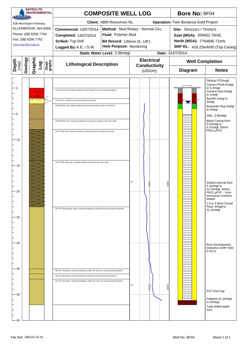
Bore No:Client: Operation:
Commenced:Completed:
Logged By:Drilled:
Static Water Level: Date:
Dep
th
Gra
phic
(mbg
l)
Log Well Completion
Diagram Notes
COMPOSITE WELL LOG
Geo
logy
Stra
ti-gr
aphy
SERVICESSAPROLITEENVIRONMENTAL
52B Mornington Parkway
ELLENBROOK, WA 6069
Phone: (08) 6296 7760Fax: (08) 6296 7762www.saprolite.com.au
Site:East (MGA):
SRP RL:North (MGA):
Method:Fluid:
Bit Record:Hole Purpose:
Lithological Description(uS/cm)
ConductivityElectrical
Well No: Sheet 1 of 1File Ref:
0
5
10
15
20
25
30
35
40
45
2.96mbgl 31/07/2014
130mm (5, 1/8")
13/07/2014
13/07/2014Top Drill
K.E. / S.W. Monitoring 418.23mAHD (Top Casing)7764695.71mN
509452.79mEStrezza's / Timmy's
ABM Resources NL Twin Bonanza Gold Project
BF04
Polymer MudMud Rotary - Normal Circ.
BF04AB0101-01-01
Stickup 0.53magl
Cement Seal 0mbglto 1mbgl
Cement Plinth 0mbglto 0.2magl
Bentonite Plug 3mbglto 4mbgl
Blank Casing from0.53magl to5.15mbgl, 50mmPN12 µPVC
Slotted Interval from5.15mbgl to41.15mbgl, 50mmPN12 µPVC - 1mmtransverse machineslotted1.6 to 3.2mm GravelPack, 4mbgl to41.15mbgl
Fallback 41.15mbglto 42mbgl
Backfill 1mbgl to3mbgl
Total drilled depth42m
SWL: 2.96mbgl
Bore Development,Indicative Airlift Yield0.21L/s
PVC End Cap
ALLUVIUM: Red, extremely weathered, poorly sorted, Fe-rich, transported material
CALCRETE: Cream/red, extremely weathered, calcrete
SANDSTONE: Red, highly weathered, fine grained sandstone with minor alluvium
SANDSTONE: Red, moderate weathering, fine grained sandstone with minor pelite
SILTSTONE: Red, moderate weathering, siltstone with minor pelite and calcrete
SILTSTONE: Pale grey, moderate weathering, siltstone with minor pelite
PELITE: Pale grey/pale yellow, moderate weathering, pelite with trace fine grained sandstone
PELITE: Pale yellow, moderate weathering, pelite with trace very coarse grained sandstone
PELITE: Pale yellow, moderate weathering, pelite with trace fine grained sandstone
PELITE: Pale yellow, moderate weathering, pelite with minor very coarse grained sandstone
0 1000
2000
0 1000
2000

Twin Bonanza Gold Project Hydrogeological Baseline and Bore Completion Report
ABM Resources NL
SAPROLITE ENVIRONMENTAL
APPENDIX C
Electrical Conductivity Profiles

Date: 30-Jul-14Site: Location: Slotted: 42-114 mbglSWL: 67.87 mbglStick Up: 0.67 maglEOH: 114.00 mbgl
Sample Depth (mbtoc)
Sample Depth (mbgl) EC (us/cm)
68.54 67.87 10000.0069.00 68.33 9994.0070.00 69.33 9971.0071.00 70.33 10000.0072.00 71.33 10000.0073.00 72.33 10200.0074.00 73.33 11200.0075.00 74.33 11300.0076.00 75.33 11400.0077.00 76.33 11100.0078.00 77.33 11100.0079.00 78.33 11200.0080.00 79.33 11400.0081.00 80.33 11400.0082.00 81.33 11300.0083.00 82.33 11200.0084.00 83.33 11100.0085.00 84.33 11000.0086.00 85.33 11100.0087.00 86.33 11400.0088.00 87.33 11600.0089.00 88.33 11100.0090.00 89.33 11100.00
91.00 90.33 11000.00
92.00 91.33 10900.00
93.00 92.33 11200.00
94.00 93.33 11300.00
95.00 94.33 11200.00
96.00 95.33 11200.00
97.00 96.33 11100.00
98.00 97.33 11200.00
99.00 98.33 11200.00
100.00 99.33 11500.00
PROJECT: TITLE:
DWG NUMBER
DATE: FIGURE: A4
CLIENT: ABM Resources NL PROJECT: Twin Bonanza Gold Project
A01EC PROFILE
Twin Bonanza Gold Project
20/08/2014 C1
Analogue
AB0101-01-02 EC ProfileG001 Monitoring Bore A01
50
60
70
80
90
100
110 0 2000
4000
6000
8000
10000
12000
14000
16000
18000
Dep
th (m
bgl)
EC at 25'C (uS/cm)
A01

Date: 30-Jul-14Site: Location: Slotted: 40.6-130.6 mbglSWL: 60.01 mbglStick Up: 0.66 maglEOH: 130.60 mbgl
Sample Depth (mbtoc)
Sample Depth (mbgl) EC (us/cm)
60.67 60.01 11300.0060.87 60.21 12100.0061.87 61.21 12300.0062.87 62.21 12000.0063.87 63.21 12000.0064.87 64.21 12000.0065.87 65.21 14400.0066.87 66.21 13000.0067.87 67.21 12800.0068.87 68.21 12900.0069.87 69.21 12800.0070.87 70.21 12400.0071.87 71.21 12700.0072.87 72.21 12900.0073.87 73.21 13100.0074.87 74.21 13100.0075.87 75.21 12900.0076.87 76.21 13200.0077.87 77.21 13700.0078.87 78.21 13500.0079.87 79.21 13700.0080.87 80.21 13700.0081.87 81.21 13800.00
82.87 82.21 13800.00
83.87 83.21 13800.00
84.87 84.21 13800.00
85.87 85.21 13800.00
86.87 86.21 14000.00
87.87 87.21 14100.00
88.87 88.21 14200.00
89.87 89.21 14200.00
90.87 90.21 14200.00
91.87 91.21 14400.00
92.87 92.21 14700.00
93.87 93.21 14700.00
94.87 94.21 14700.00
95.87 95.21 14600.00
96.87 96.21 14700.00
97.87 97.21 14300.00
98.87 98.21 14700.00
99.87 99.21 14800.00
PROJECT: TITLE:
DWG NUMBER
DATE: FIGURE: A4
CLIENT: ABM Resources NL PROJECT: Twin Bonanza Gold Project
20/08/2014 C2
Plant Site
AB0101-01-02 EC ProfileG002 Monitoring Bore M05
M05EC PROFILE
Twin Bonanza Gold Project
50
60
70
80
90
100
110 0 2000
4000
6000
8000
10000
12000
14000
16000
18000
Dep
th (m
bgl)
EC at 25'C (uS/cm)
M05

Date: 30-Jul-14Site: Location: Slotted: 40.7-130.7 mbglSWL: 67.93 mbglStick Up: 0.92 maglEOH: 130.70 mbgl
Sample Depth (mbtoc)
Sample Depth (mbgl) EC (us/cm)
68.85 67.93 22400.0069.98 69.06 22800.0070.98 70.06 22900.0071.98 71.06 22800.0072.98 72.06 23000.0073.98 73.06 23800.0074.98 74.06 26300.0075.98 75.06 25800.0076.98 76.06 26300.0077.98 77.06 26700.0078.98 78.06 27600.0079.98 79.06 27700.0080.98 80.06 28100.0081.98 81.06 27800.0082.98 82.06 27800.0083.98 83.06 28900.0084.98 84.06 28900.0085.98 85.06 29200.0086.98 86.06 29000.0087.98 87.06 29300.0088.98 88.06 29400.0089.98 89.06 29800.0090.98 90.06 30300.00
91.98 91.06 30600.00
92.98 92.06 30500.00
93.98 93.06 29500.00
94.98 94.06 30200.00
95.98 95.06 30400.00
96.98 96.06 30600.00
97.98 97.06 31100.00
98.98 98.06 30500.00
99.98 99.06 31300.00
PROJECT: TITLE:
DWG NUMBER
DATE: FIGURE: A4
CLIENT: ABM Resources NL PROJECT: Twin Bonanza Gold Project
20/08/2014 C3
Plant Site
AB0101-01-02 EC ProfileG003 Monitoring Bore M06A
M06AEC PROFILE
Twin Bonanza Gold Project
50
60
70
80
90
100
110 0 5000
10000
15000
20000
25000
30000
35000
40000
Dep
th (m
bgl)
EC at 25'C (uS/cm)
M06A

Date: 30-Jul-14Site: Location: Slotted: 41.2-143.2 mbglSWL: 59.10 mbglStick Up: 0.84 maglEOH: 143.20 mbgl
Sample Depth (mbtoc)
Sample Depth (mbgl) EC (us/cm)
59.94 59.10 4764.0061.09 60.25 4831.0062.09 61.25 5210.0063.09 62.25 5303.0064.09 63.25 5303.0065.09 64.25 6139.0066.09 65.25 5241.0067.09 66.25 5092.0068.09 67.25 4935.0069.09 68.25 4790.0070.09 69.25 4684.0071.09 70.25 4743.0072.09 71.25 4670.0073.09 72.25 4750.0074.09 73.25 4727.0075.09 74.25 4654.0076.09 75.25 4619.0077.09 76.25 4513.0078.09 77.25 4550.0079.09 78.25 4640.0080.09 79.25 4588.0081.09 80.25 4576.0082.09 81.25 4550.00
83.09 82.25 4604.00
84.09 83.25 4512.00
85.09 84.25 4589.00
86.09 85.25 4427.00
87.09 86.25 4444.00
88.09 87.25 4482.00
89.09 88.25 4455.00
90.09 89.25 4565.00
91.09 90.25 4526.00
92.09 91.25 4615.00
93.09 92.25 4631.00
94.09 93.25 4541.00
95.09 94.25 4641.00
96.09 95.25 4684.00
97.09 96.25 4700.00
98.09 97.25 4705.00
99.09 98.25 4662.00
100.09 99.25 4674.00
PROJECT: TITLE:
DWG NUMBER
DATE: FIGURE: A4
CLIENT: ABM Resources NL PROJECT: Twin Bonanza Gold Project
20/08/2014 C4
Plant Site
AB0101-01-02 EC ProfileG004 Monitoring Bore M07
M07EC PROFILE
Twin Bonanza Gold Project
50
60
70
80
90
100
110 0 1000
2000
3000
4000
5000
6000
7000
8000
9000
10000
Dep
th (m
bgl)
EC at 25'C (uS/cm)
M07

Date: 30-Jul-14Site: Location: Slotted: 41.3-137.3 mbglSWL: 67.25 mbglStick Up: 0.91 maglEOH: 137.30 mbgl
Sample Depth (mbtoc)
Sample Depth (mbgl) EC (us/cm)
68.16 67.25 2973.0069.03 68.12 2898.0070.03 69.12 2898.0071.03 70.12 2933.0072.03 71.12 2873.0073.03 72.12 2835.0074.03 73.12 2816.0075.03 74.12 2824.0078.03 77.12 2946.0079.03 78.12 2943.0080.03 79.12 3025.0081.03 80.12 3026.0082.03 81.12 2990.0083.03 82.12 3098.0084.03 83.12 3128.0085.03 84.12 3080.0086.03 85.12 3180.0087.03 86.12 3228.0088.03 87.12 3243.0089.03 88.12 3228.0090.03 89.12 3236.0091.03 90.12 3220.0092.03 91.12 3224.00
93.03 92.12 3315.00
94.03 93.12 3443.00
95.03 94.12 3381.00
96.03 95.12 3409.00
97.03 96.12 3426.00
98.03 97.12 3518.00
99.03 98.12 3513.00
100.03 99.12 3487.00
PROJECT: TITLE:
DWG NUMBER
DATE: FIGURE: A4
CLIENT: ABM Resources NL PROJECT: Twin Bonanza Gold Project
M08AEC PROFILE
Twin Bonanza Gold Project
20/08/2014 C5
Plant Site
AB0101-01-02 EC ProfileG005 Monitoring Bore M08A
50
60
70
80
90
100
110 0 1000
2000
3000
4000
5000
6000
7000
8000
9000
10000
Dep
th (m
bgl)
EC at 25'C (uS/cm)
M08A

Date: 30-Jul-14Site: Location: Slotted: 41-131 mbglSWL: 70.17 mbglStick Up: 0.86 maglEOH: 131.00 mbgl
Sample Depth (mbtoc)
Sample Depth (mbgl) EC (us/cm)
71.03 70.17 10000.0071.92 71.06 9590.0072.92 72.06 9488.0073.92 73.06 9489.0074.92 74.06 9435.0075.92 75.06 10100.0076.92 76.06 8858.0077.92 77.06 9143.0078.92 78.06 9390.0079.92 79.06 9555.0080.92 80.06 8584.0081.92 81.06 9605.0082.92 82.06 9590.0083.92 83.06 9613.0084.92 84.06 9692.0085.92 85.06 9721.0086.92 86.06 9849.0087.92 87.06 9799.0088.92 88.06 9678.0089.92 89.06 9719.0090.92 90.06 9832.0091.92 91.06 9844.0092.92 92.06 9863.00
93.92 93.06 9870.00
94.92 94.06 9966.00
95.92 95.06 9972.00
96.92 96.06 10000.00
97.92 97.06 10000.00
98.92 98.06 10000.00
99.92 99.06 10000.00
PROJECT: TITLE:
DWG NUMBER
DATE: FIGURE: A4
CLIENT: ABM Resources NL PROJECT: Twin Bonanza Gold Project
M09EC PROFILE
Twin Bonanza Gold Project
20/08/2014 C6
Plant Site
AB0101-01-02 EC ProfileG006 Monitoring Bore M09
50
60
70
80
90
100
110 0 1000
2000
3000
4000
5000
6000
7000
8000
9000
10000
11000
12000
Dep
th (m
bgl)
EC at 25'C (uS/cm)
M09

Date: 04-Aug-14Site: Location: Slotted: 41.7-89.7 mbglSWL: 49.19 mbglStick Up: 0.64 maglEOH: 89.95 mbgl
Sample Depth (mbtoc)
Sample Depth (mbgl) EC (us/cm)
49.83 49.19 1260051.07 50.43 1290053.07 52.43 1460055.07 54.43 1920057.07 56.43 1720059.07 58.43 1670061.07 60.43 1660063.07 62.43 1590065.07 64.43 1570067.07 66.43 1710069.07 68.43 1710071.07 70.43 1610073.07 72.43 1740075.07 74.43 1680077.07 76.43 1640079.07 78.43 1620081.07 80.43 1720083.07 82.43 1580085.07 84.43 1720087.07 86.43 1780089.07 88.43 1780090.02 89.38 17300
PROJECT: TITLE:
DWG NUMBER
DATE: FIGURE: A4
CLIENT: ABM Resources NL PROJECT: Twin Bonanza Gold Project
Post-Purge
Twin Bonanza Gold Project
M10AEC PROFILE
20/08/2014 C7
Wilson's Bore
AB0101-01-02 EC ProfileG007 Monitoring Bore M10A
40
50
60
70
80
90
100 0 5000
10000
15000
20000
25000
Dep
th (m
bgl)
EC at 25'C (uS/cm)
Post-Purge
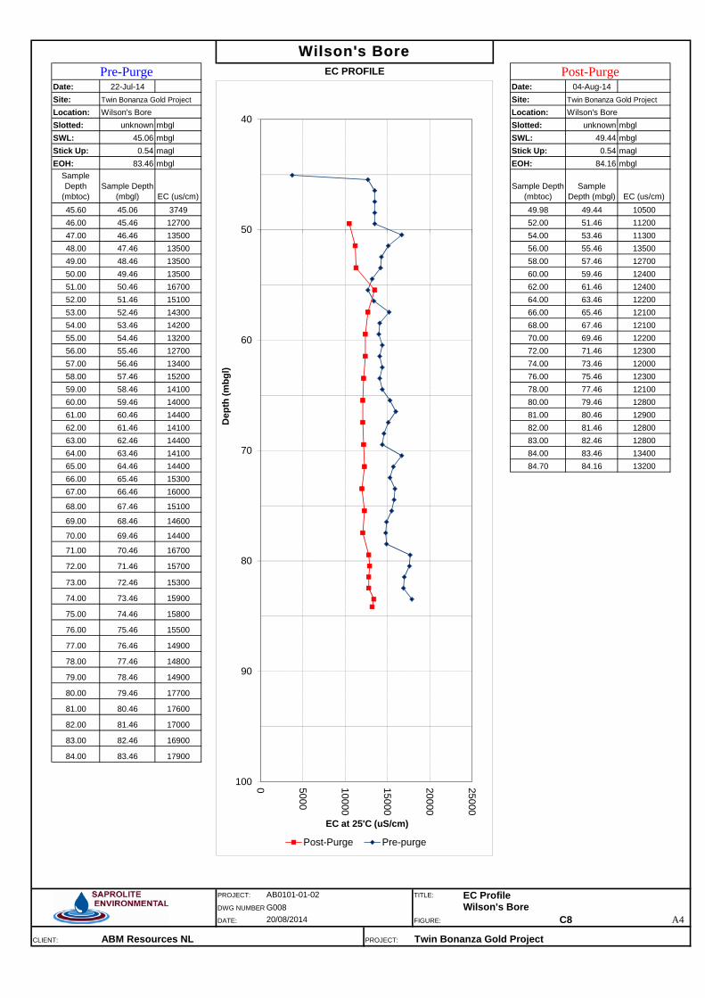
Date: 22-Jul-14 Date: 04-Aug-14Site: Site: Location: Location: Slotted: unknown mbgl Slotted: unknown mbglSWL: 45.06 mbgl SWL: 49.44 mbglStick Up: 0.54 magl Stick Up: 0.54 maglEOH: 83.46 mbgl EOH: 84.16 mbgl
Sample Depth
(mbtoc)Sample Depth
(mbgl) EC (us/cm)Sample Depth
(mbtoc)Sample
Depth (mbgl) EC (us/cm)45.60 45.06 3749 49.98 49.44 1050046.00 45.46 12700 52.00 51.46 1120047.00 46.46 13500 54.00 53.46 1130048.00 47.46 13500 56.00 55.46 1350049.00 48.46 13500 58.00 57.46 1270050.00 49.46 13500 60.00 59.46 1240051.00 50.46 16700 62.00 61.46 1240052.00 51.46 15100 64.00 63.46 1220053.00 52.46 14300 66.00 65.46 1210054.00 53.46 14200 68.00 67.46 1210055.00 54.46 13200 70.00 69.46 1220056.00 55.46 12700 72.00 71.46 1230057.00 56.46 13400 74.00 73.46 1200058.00 57.46 15200 76.00 75.46 1230059.00 58.46 14100 78.00 77.46 1210060.00 59.46 14000 80.00 79.46 1280061.00 60.46 14400 81.00 80.46 1290062.00 61.46 14100 82.00 81.46 1280063.00 62.46 14400 83.00 82.46 1280064.00 63.46 14100 84.00 83.46 1340065.00 64.46 14400 84.70 84.16 1320066.00 65.46 1530067.00 66.46 16000
68.00 67.46 15100
69.00 68.46 14600
70.00 69.46 14400
71.00 70.46 16700
72.00 71.46 15700
73.00 72.46 15300
74.00 73.46 15900
75.00 74.46 15800
76.00 75.46 15500
77.00 76.46 14900
78.00 77.46 14800
79.00 78.46 14900
80.00 79.46 17700
81.00 80.46 17600
82.00 81.46 17000
83.00 82.46 16900
84.00 83.46 17900
PROJECT: TITLE:
DWG NUMBER
DATE: FIGURE: A4
CLIENT: ABM Resources NL PROJECT: Twin Bonanza Gold Project
Wilson's BorePre-Purge EC PROFILE Post-Purge
Twin Bonanza Gold Project Twin Bonanza Gold Project
20/08/2014 C8
Wilson's Bore Wilson's Bore
AB0101-01-02 EC ProfileG008 Wilson's Bore
40
50
60
70
80
90
100 0 5000
10000
15000
20000
25000D
epth
(mbg
l)
EC at 25'C (uS/cm)
Post-Purge Pre-purge

Date: 22-Jul-14 Date: 04-Aug-14Site: Site: Location: Location: Slotted: 42-150 mbgl Slotted: 42-150 mbglSWL: 54.61 mbgl SWL: 54.78 mbglStick Up: 0.16 magl Stick Up: 0.16 maglEOH: 150.00 mbgl EOH: 150.00 mbgl
Sample Depth
(mbtoc)Sample Depth
(mbgl) EC (us/cm)Sample Depth
(mbtoc)Sample
Depth (mbgl) EC (us/cm)54.77 54.61 3459 54.94 54.78 233055.85 55.69 3427 55.85 55.69 212556.85 56.69 3408 56.85 56.69 212357.85 57.69 3401 57.85 57.69 209458.85 58.69 3432 58.85 58.69 208159.85 59.69 4031 59.85 59.69 212060.85 60.69 3868 60.85 60.69 217361.85 61.69 3740 61.85 61.69 208762.85 62.69 3694 62.85 62.69 220563.85 63.69 3708 63.85 63.69 211364.85 64.69 3768 64.85 64.69 212965.85 65.69 3853 65.85 65.69 213066.85 66.69 3738 66.85 66.69 213167.85 67.69 3715 67.85 67.69 210268.85 68.69 3603 68.85 68.69 220769.85 69.69 3710 69.85 69.69 207570.85 70.69 3513 70.85 70.69 200471.85 71.69 3579 71.85 71.69 202872.85 72.69 3557 72.85 72.69 197673.85 73.69 3459 73.85 73.69 187574.85 74.69 3500 74.85 74.69 191775.85 75.69 3472 75.85 75.69 193876.85 76.69 3533 76.85 76.69 1936
77.85 77.69 3567 77.85 77.69 1956
78.85 78.69 3482 78.85 78.69 1957
79.85 79.69 3543 79.85 79.69 1980
80.85 80.69 3559 80.85 80.69 1996
81.85 81.69 3474 81.85 81.69 1953
82.85 82.69 3561 82.85 82.69 1996
83.85 83.69 3773 83.85 83.69 2013
84.85 84.69 3832 84.85 84.69 2044
85.85 85.69 3886 85.85 85.69 2035
86.85 86.69 3879 86.85 86.69 1997
87.85 87.69 3796 87.85 87.69 2054
88.85 88.69 3887 88.85 88.69 2016
89.85 89.69 3927 89.85 89.69 2036
90.85 90.69 4083 90.85 90.69 2016
91.85 91.69 4098 91.85 91.69 2044
92.85 92.69 3933 92.85 92.69 2013
93.85 93.69 3852 93.85 93.69 2001
94.85 94.69 3933 94.85 94.69 1988
95.85 95.69 3880 95.85 95.69 1988
96.85 96.69 4132 96.85 96.69 2056
97.85 97.69 4083 97.85 97.69 2067
98.85 98.69 4032 98.85 98.69 2017
99.85 99.69 4033 99.85 99.69 2051
PROJECT: TITLE:
DWG NUMBER
DATE: FIGURE: A4
CLIENT: ABM Resources NL PROJECT: Twin Bonanza Gold Project
M11Pre-Purge EC PROFILE Post-Purge
Twin Bonanza Gold Project Twin Bonanza Gold Project
20/08/2014 C9
Corsair Bore Corsair Bore
AB0101-01-02 EC ProfileG009 Monitoring Bore M11
50
60
70
80
90
100 1000
1500
2000
2500
3000
3500
4000
4500
5000D
epth
(mbg
l)
EC at 25'C (uS/cm)
Pre-Purge Post-Purge

Date: 04-Aug-14Site: Location: Slotted: unknown mbglSWL: 55.01 mbglStick Up: 0.41 maglEOH: 150.00 mbgl
Sample Depth (mbtoc)
Sample Depth (mbgl) EC (us/cm)
55.42 55.01 189056.00 55.59 183557.00 56.59 181958.00 57.59 182459.00 58.59 180760.00 59.59 180461.00 60.59 170562.00 61.59 165063.00 62.59 165164.00 63.59 162665.00 64.59 161866.00 65.59 161867.00 66.59 161468.00 67.59 160669.00 68.59 160470.00 69.59 160671.00 70.59 160672.00 71.59 163173.00 72.59 160674.00 73.59 156175.00 74.59 157876.00 75.59 157877.00 76.59 1596
78.00 77.59 1595
79.00 78.59 1608
80.00 79.59 1627
81.00 80.59 1662
82.00 81.59 1673
83.00 82.59 1675
84.00 83.59 1693
85.00 84.59 1699
86.00 85.59 1798
87.00 86.59 2083
88.00 87.59 2081
89.00 88.59 2089
90.00 89.59 2070
91.00 90.59 2083
92.00 91.59 2122
93.00 92.59 2101
94.00 93.59 2083
95.00 94.59 2083
96.00 95.59 2084
97.00 96.59 2081
98.00 97.59 2078
99.00 98.59 2076
100.00 99.59 2076
PROJECT: TITLE:
DWG NUMBER
DATE: FIGURE: A4
CLIENT: ABM Resources NL PROJECT: Twin Bonanza Gold Project
Corsair BoreEC PROFILE Post-Purge
Twin Bonanza Gold Project
20/08/2014 C10
Corsair Bore
AB0101-01-02 EC ProfileG010 Corsair Bore
50
60
70
80
90
100 0 500
1000
1500
2000
2500
3000
3500
4000
Dep
th (m
bgl)
EC at 25'C (uS/cm)
Post-Purge

Date: 31-Jul-14 Date: 03-Aug-14Site: Site: Location: Location: Slotted: 5.2-41.2 mbgl Slotted: 5.2-41.2 mbglSWL: 3.33 mbgl SWL: 3.19 mbglStick Up: 0.51 magl Stick Up: 0.51 maglEOH: 40.65 mbgl EOH: 40.64 mbgl
Sample Depth
(mbtoc)Sample Depth
(mbgl) EC (us/cm)Sample Depth
(mbtoc)Sample
Depth (mbgl) EC (us/cm)3.84 3.33 1130 3.70 3.19 11154.01 3.50 1121 4.01 3.50 11645.01 4.50 1119 5.01 4.50 11866.01 5.50 1038 6.01 5.50 11957.01 6.50 1065 7.01 6.50 11438.01 7.50 1125 8.01 7.50 11709.01 8.50 1156 9.01 8.50 118810.01 9.50 1137 10.01 9.50 110011.01 10.50 1214 11.01 10.50 112012.01 11.50 1239 12.01 11.50 117213.01 12.50 1210 13.01 12.50 119814.01 13.50 1319 14.01 13.50 125515.01 14.50 1554 15.01 14.50 159516.01 15.50 1496 16.01 15.50 164217.01 16.50 1523 17.01 16.50 161118.01 17.50 1491 18.01 17.50 159519.01 18.50 1468 19.01 18.50 163020.01 19.50 1545 20.01 19.50 162321.01 20.50 1558 21.01 20.50 167022.01 21.50 1545 22.01 21.50 160423.01 22.50 1548 23.01 22.50 159024.01 23.50 1541 24.01 23.50 159025.01 24.50 1518 25.01 24.50 1666
26.01 25.50 1621 26.01 25.50 1796
27.01 26.50 1823 27.01 26.50 1850
28.01 27.50 1997 28.01 27.50 2036
29.01 28.50 2028 29.01 28.50 2167
30.01 29.50 2001 30.01 29.50 2100
31.01 30.50 2046 31.01 30.50 2124
32.01 31.50 2098 32.01 31.50 2158
33.01 32.50 2167 33.01 32.50 2232
34.01 33.50 2262 34.01 33.50 2254
35.01 34.50 2292 35.01 34.50 2422
36.01 35.50 2457 36.01 35.50 2568
37.01 36.50 2863 37.01 36.50 2796
38.01 37.50 2899 38.01 37.50 2762
39.01 38.50 3649 39.01 38.50 3622
40.01 39.50 3858 40.01 39.50 3899
41.01 40.50 4331 41.01 40.50 4275
41.16 40.65 2802 41.15 40.64 3322
PROJECT: TITLE:
DWG NUMBER
DATE: FIGURE: A4
CLIENT: ABM Resources NL PROJECT: Twin Bonanza Gold Project
Borefield Area Borefield Area
BF01Pre-Purge EC PROFILE Post-Purge
Twin Bonanza Gold Project Twin Bonanza Gold Project
AB0101-01-02 EC ProfileG011 Monitoring Bore BF0120/08/2014 C11
0
10
20
30
40
0 500
1000
1500
2000
2500
3000
3500
4000
4500
5000D
epth
(mbg
l)
EC at 25'C (uS/cm)
Pre-Purge Post-Purge
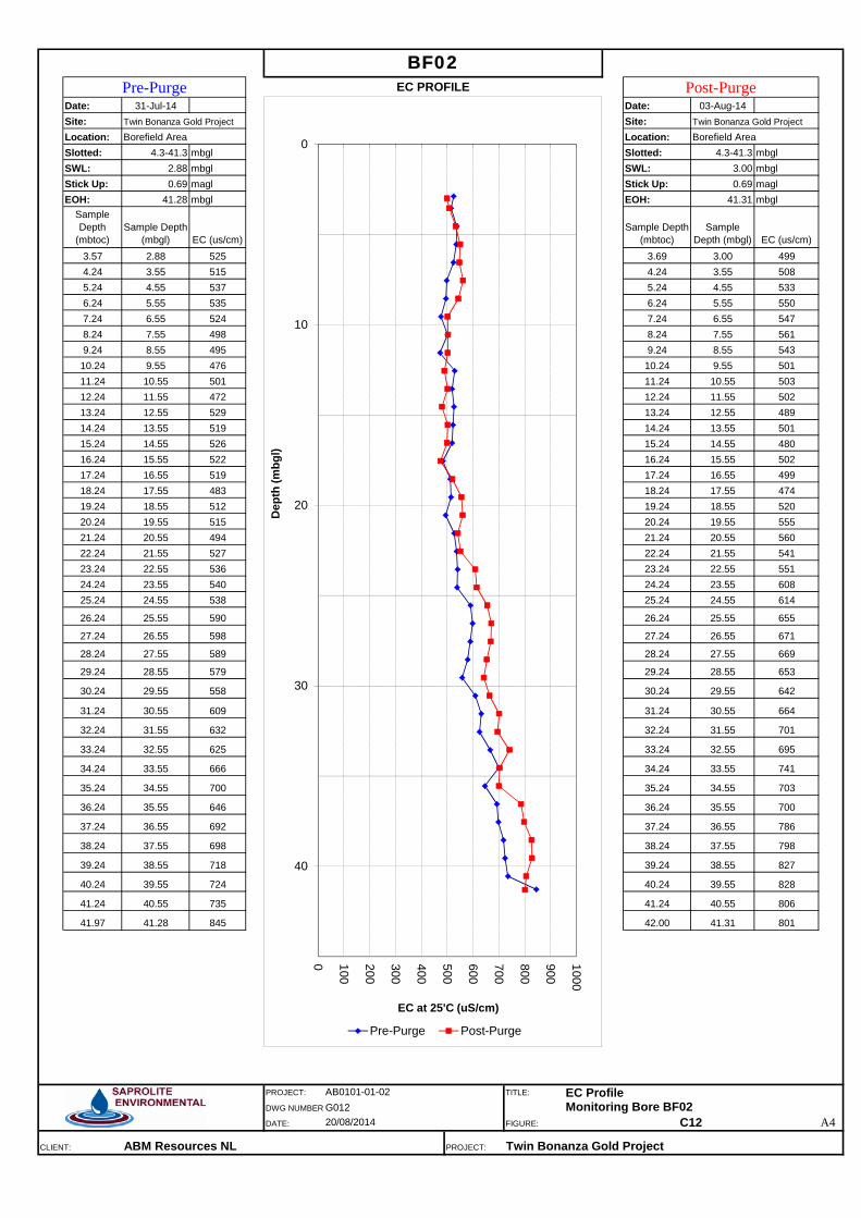
Date: 31-Jul-14 Date: 03-Aug-14Site: Site: Location: Location: Slotted: 4.3-41.3 mbgl Slotted: 4.3-41.3 mbglSWL: 2.88 mbgl SWL: 3.00 mbglStick Up: 0.69 magl Stick Up: 0.69 maglEOH: 41.28 mbgl EOH: 41.31 mbgl
Sample Depth
(mbtoc)Sample Depth
(mbgl) EC (us/cm)Sample Depth
(mbtoc)Sample
Depth (mbgl) EC (us/cm)3.57 2.88 525 3.69 3.00 4994.24 3.55 515 4.24 3.55 5085.24 4.55 537 5.24 4.55 5336.24 5.55 535 6.24 5.55 5507.24 6.55 524 7.24 6.55 5478.24 7.55 498 8.24 7.55 5619.24 8.55 495 9.24 8.55 54310.24 9.55 476 10.24 9.55 50111.24 10.55 501 11.24 10.55 50312.24 11.55 472 12.24 11.55 50213.24 12.55 529 13.24 12.55 48914.24 13.55 519 14.24 13.55 50115.24 14.55 526 15.24 14.55 48016.24 15.55 522 16.24 15.55 50217.24 16.55 519 17.24 16.55 49918.24 17.55 483 18.24 17.55 47419.24 18.55 512 19.24 18.55 52020.24 19.55 515 20.24 19.55 55521.24 20.55 494 21.24 20.55 56022.24 21.55 527 22.24 21.55 54123.24 22.55 536 23.24 22.55 55124.24 23.55 540 24.24 23.55 60825.24 24.55 538 25.24 24.55 614
26.24 25.55 590 26.24 25.55 655
27.24 26.55 598 27.24 26.55 671
28.24 27.55 589 28.24 27.55 669
29.24 28.55 579 29.24 28.55 653
30.24 29.55 558 30.24 29.55 642
31.24 30.55 609 31.24 30.55 664
32.24 31.55 632 32.24 31.55 701
33.24 32.55 625 33.24 32.55 695
34.24 33.55 666 34.24 33.55 741
35.24 34.55 700 35.24 34.55 703
36.24 35.55 646 36.24 35.55 700
37.24 36.55 692 37.24 36.55 786
38.24 37.55 698 38.24 37.55 798
39.24 38.55 718 39.24 38.55 827
40.24 39.55 724 40.24 39.55 828
41.24 40.55 735 41.24 40.55 806
41.97 41.28 845 42.00 41.31 801
PROJECT: TITLE:
DWG NUMBER
DATE: FIGURE: A4
CLIENT: ABM Resources NL PROJECT: Twin Bonanza Gold Project
BF02Pre-Purge EC PROFILE Post-Purge
Twin Bonanza Gold Project Twin Bonanza Gold Project
20/08/2014 C12
Borefield Area Borefield Area
AB0101-01-02 EC ProfileG012 Monitoring Bore BF02
0
10
20
30
40
0 100
200
300
400
500
600
700
800
900
1000D
epth
(mbg
l)
EC at 25'C (uS/cm)
Pre-Purge Post-Purge

Date: 04-Aug-14Site: Location: Slotted: 5.25-41.25 mbglSWL: 3.11 mbglStick Up: 0.51 maglEOH: 41.51 mbgl
Sample Depth (mbtoc)
Sample Depth (mbgl) EC (us/cm)
3.62 3.11 5514.20 3.69 5505.20 4.69 5336.20 5.69 5107.20 6.69 5458.20 7.69 5459.20 8.69 52410.20 9.69 52811.20 10.69 52712.20 11.69 48813.20 12.69 48814.20 13.69 51215.20 14.69 51916.20 15.69 54717.20 16.69 57118.20 17.69 63719.20 18.69 83220.20 19.69 89921.20 20.69 98322.20 21.69 100123.20 22.69 101524.20 23.69 100525.20 24.69 1017
26.20 25.69 1077
27.20 26.69 1037
28.20 27.69 1077
29.20 28.69 1055
30.20 29.69 1044
31.20 30.69 1116
32.20 31.69 1138
33.20 32.69 1136
34.20 33.69 1163
35.20 34.69 1125
36.20 35.69 1128
37.20 36.69 1291
38.20 37.69 1432
39.20 38.69 1426
40.20 39.69 1504
41.20 40.69 1631
42.02 41.51 2027
PROJECT: TITLE:
DWG NUMBER
DATE: FIGURE: A4
CLIENT: ABM Resources NL PROJECT: Twin Bonanza Gold Project
Post-Purge
Twin Bonanza Gold Project
BF03AEC PROFILE
20/08/2014 C13
Borefield Area
AB0101-01-02 EC ProfileG013 Monitoring Bore BF03A
0
10
20
30
40
0 250
500
750
1000
1250
1500
1750
2000
2250
2500
Dep
th (m
bgl)
EC at 25'C (uS/cm)
Post-Purge
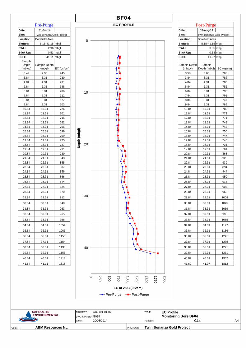
Date: 31-Jul-14 Date: 03-Aug-14Site: Site: Location: Location: Slotted: 5.15-41.15 mbgl Slotted: 5.15-41.15 mbglSWL: 2.96 mbgl SWL: 3.05 mbglStick Up: 0.53 magl Stick Up: 0.53 maglEOH: 41.11 mbgl EOH: 41.07 mbgl
Sample Depth
(mbtoc)Sample Depth
(mbgl) EC (us/cm)Sample Depth
(mbtoc)Sample
Depth (mbgl) EC (us/cm)3.49 2.96 745 3.58 3.05 7833.84 3.31 730 3.84 3.31 7824.84 4.31 731 4.84 4.31 7805.84 5.31 688 5.84 5.31 7556.84 6.31 706 6.84 6.31 7907.84 7.31 711 7.84 7.31 7918.84 8.31 677 8.84 8.31 7479.84 9.31 703 9.84 9.31 78610.84 10.31 726 10.84 10.31 78211.84 11.31 701 11.84 11.31 77212.84 12.31 715 12.84 12.31 77113.84 13.31 682 13.84 13.31 74814.84 14.31 706 14.84 14.31 74515.84 15.31 699 15.84 15.31 75516.84 16.31 709 16.84 16.31 74717.84 17.31 725 17.84 17.31 74618.84 18.31 727 18.84 18.31 73119.84 19.31 731 19.84 19.31 76120.84 20.31 730 20.84 20.31 86821.84 21.31 843 21.84 21.31 92322.84 22.31 855 22.84 22.31 93923.84 23.31 807 23.84 23.31 89424.84 24.31 856 24.84 24.31 944
25.84 25.31 866 25.84 25.31 950
26.84 26.31 844 26.84 26.31 913
27.84 27.31 824 27.84 27.31 905
28.84 28.31 870 28.84 28.31 968
29.84 29.31 912 29.84 29.31 1008
30.84 30.31 940 30.84 30.31 1045
31.84 31.31 963 31.84 31.31 1019
32.84 32.31 965 32.84 32.31 998
33.84 33.31 956 33.84 33.31 1055
34.84 34.31 1054 34.84 34.31 1127
35.84 35.31 1066 35.84 35.31 1186
36.84 36.31 1155 36.84 36.31 1241
37.84 37.31 1154 37.84 37.31 1275
38.84 38.31 1130 38.84 38.31 1221
39.84 39.31 1158 39.84 39.31 1261
40.84 40.31 1219 40.84 40.31 1362
41.64 41.11 1615 41.60 41.07 1812
PROJECT: TITLE:
DWG NUMBER
DATE: FIGURE: A4
CLIENT: ABM Resources NL PROJECT: Twin Bonanza Gold Project
BF04Pre-Purge EC PROFILE Post-Purge
Twin Bonanza Gold Project Twin Bonanza Gold Project
20/08/2014 C14
Borefield Area Borefield Area
AB0101-01-02 EC ProfileG014 Monitoring Bore BF04
0
10
20
30
40
0 250
500
750
1000
1250
1500
1750
2000D
epth
(mbg
l)
EC at 25'C (uS/cm)
Pre-Purge Post-Purge

Date: 04-Aug-14Site: Location: Slotted: 6-39.9 mbglSWL: 3.38 mbglStick Up: 0.62 maglEOH: 39.65 mbgl
Sample Depth (mbtoc)
Sample Depth (mbgl) EC (us/cm)
4.00 3.38 4754.09 3.47 4525.09 4.47 4876.09 5.47 4927.09 6.47 4938.09 7.47 4869.09 8.47 49110.09 9.47 48711.09 10.47 47312.09 11.47 47813.09 12.47 48014.09 13.47 45515.09 14.47 47516.09 15.47 54517.09 16.47 56218.09 17.47 52819.09 18.47 54920.09 19.47 56521.09 20.47 55222.09 21.47 54223.09 22.47 51024.09 23.47 49425.09 24.47 505
26.09 25.47 497
27.09 26.47 467
28.09 27.47 487
29.09 28.47 473
30.09 29.47 453
31.09 30.47 437
32.09 31.47 452
33.09 32.47 435
34.09 33.47 428
35.09 34.47 424
36.09 35.47 428
37.09 36.47 445
38.09 37.47 428
39.09 38.47 466
40.09 39.47 1197
40.27 39.65 3414
PROJECT: TITLE:
DWG NUMBER
DATE: FIGURE: A4
CLIENT: ABM Resources NL PROJECT: Twin Bonanza Gold Project
Strezza's/Timmy's Bore 2Post Purge
Twin Bonanza Gold Project
EC PROFILE
20/08/2014 C15
Borefield Area
AB0101-01-02 EC ProfileG015 Strezza's/Timmy's Bore 2
0
10
20
30
40
0 500
1000
1500
2000
2500
3000
3500
4000
Dep
th (m
bgl)
EC at 25'C (uS/cm)
Post Purge

Twin Bonanza Gold Project Hydrogeological Baseline and Bore Completion Report
ABM Resources NL
SAPROLITE ENVIRONMENTAL
APPENDIX D1
Test Pumping Plots
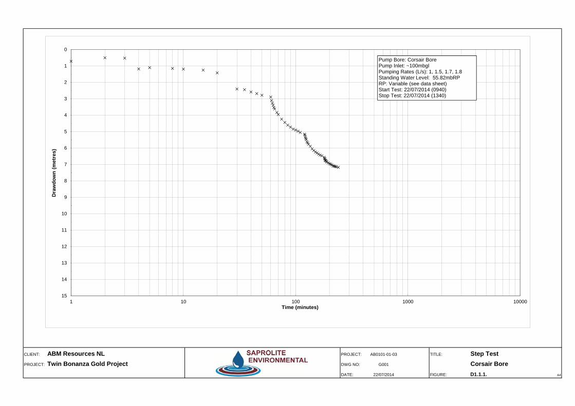
CLIENT: ABM Resources NL PROJECT: AB0101-01-03 TITLE: Step TestPROJECT: Twin Bonanza Gold Project DWG NO: G001 Corsair Bore
DATE: 22/07/2014 FIGURE: D1.1.1. A4
0
1
2
3
4
5
6
7
8
9
10
11
12
13
14
151 10 100 1000 10000
Dra
wdo
wn
(met
res)
Time (minutes)
Pump Bore: Corsair BorePump Inlet: ~100mbglPumping Rates (L/s): 1, 1.5, 1.7, 1.8 Standing Water Level: 55.82mbRPRP: Variable (see data sheet)Start Test: 22/07/2014 (0940)Stop Test: 22/07/2014 (1340)

CLIENT: ABM Resources NL PROJECT: AB0101-01-03 TITLE: Constant Rate TestPROJECT: Twin Bonanza Gold Project DWG NO: G002 Corsair Bore
DATE: 24-Jul-14 FIGURE: D1.1.2. A4
0.00
1.00
2.00
3.00
4.00
5.00
6.00
7.00
8.001 10 100 1000 10000
Dra
wdo
wn
(met
res)
Time (minutes)
Corsair Bore (r=0.075m, SWL=55.67mbRP)
M11 (r=10m, SWL=54.97mbRP)
Pump Bore: Corsair BorePump Inlet: ~100mbglAv.Pumping Rate: 1.5L/s (130KL/d)
Start Test: 23/07/2014 (0730hrs)Stop Test: 25/07/2014 (0730hrs)Duration of Test : 2880mins

CLIENT: ABM Resources NL PROJECT: AB0101-01-03 TITLE: Recovery TestPROJECT: Twin Bonanza Gold Project DWG NO: G005 Corsair Bore
DATE: 25-Jul-14 FIGURE: D1.1.3 A4
0
0.5
1
1.5
2
2.5
3
3.5
4
4.5
5
5.5
6
6.5
71 10 100 1000 10000
Res
idua
l Dra
wdo
wn
(met
res)
t/t'
Corsair Bore (r=0.075m, SWL=55.67mbRP)
M11 (r=10m, SWL=54.91mbRP)
Pump Bore: Corsair BorePump Inlet: ~100mbglAv.Pumping Rate: 1.5L/s (130KL/d)
Start Test: 23/07/2014 (0730hrs)Stop Test: 25/07/2014 (0730hrs)Duration of Test : 2880mins
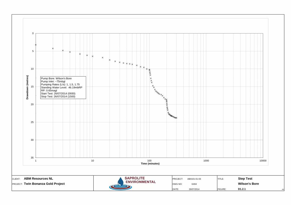
CLIENT: ABM Resources NL PROJECT: AB0101-01-03 TITLE: Step TestPROJECT: Twin Bonanza Gold Project DWG NO: G004 Wilson's Bore
DATE: 26/07/2014 FIGURE: D1.2.1 A4
0
5
10
15
20
25
30
351 10 100 1000 10000
Dra
wdo
wn
(met
res)
Time (minutes)
Pump Bore: Wilson's BorePump Inlet: ~75mbglPumping Rates (L/s): 1, 1.5, 1.75Standing Water Level: 46.19mbRPRP: 0.65maglStart Test: 26/07/2014 (0930)Stop Test: 26/07/2014 (1500)

CLIENT: ABM Resources NL PROJECT: AB0101-01-03 TITLE: Constant Rate TestPROJECT: Twin Bonanza Gold Project DWG NO: G006 Wilson's Bore
DATE: 29-Jul-14 FIGURE: D1.2.2 A4
0.00
5.00
10.00
15.00
20.00
25.00
30.001 10 100 1000 10000
Dra
wdo
wn
(met
res)
Time (minutes)
Wilson's Bore (r=0.075m, SWL=45.67mbRP)
M10A (r=10m, SWL=46.43mbRP)
Pump inlet
Pump Bore: Wilson's BorePump Inlet: ~75mbglAv.Pumping Rate: initial 1.5L/s (130kL/d); after 420mins reduced to 1.2L/s (104kL/d); after 440mins reduced to 1.0L/s (86kL/d)
Start Test: 27/07/2014 (0730hrs)Stop Test: 29/07/2014 (0730hrs)Duration of Test : 2880mins
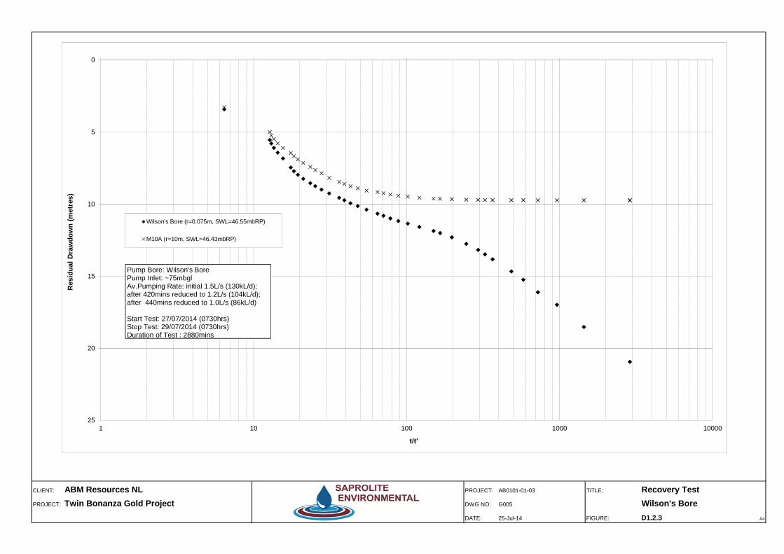
CLIENT: ABM Resources NL PROJECT: AB0101-01-03 TITLE: Recovery TestPROJECT: Twin Bonanza Gold Project DWG NO: G005 Wilson's Bore
DATE: 25-Jul-14 FIGURE: D1.2.3 A4
0
5
10
15
20
251 10 100 1000 10000
Res
idua
l Dra
wdo
wn
(met
res)
t/t'
Wilson's Bore (r=0.075m, SWL=46.55mbRP)
M10A (r=10m, SWL=46.43mbRP)
Pump Bore: Wilson's BorePump Inlet: ~75mbglAv.Pumping Rate: initial 1.5L/s (130kL/d); after 420mins reduced to 1.2L/s (104kL/d); after 440mins reduced to 1.0L/s (86kL/d)
Start Test: 27/07/2014 (0730hrs)Stop Test: 29/07/2014 (0730hrs)Duration of Test : 2880mins
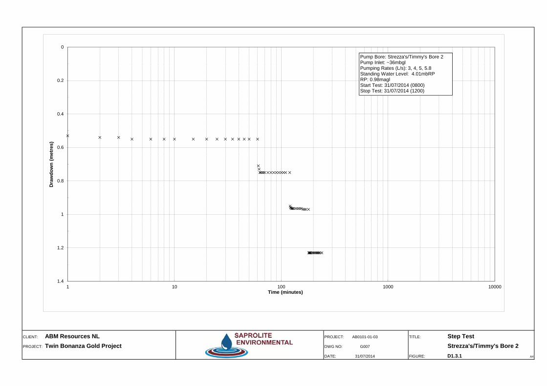
CLIENT: ABM Resources NL PROJECT: AB0101-01-03 TITLE: Step TestPROJECT: Twin Bonanza Gold Project DWG NO: G007 Strezza's/Timmy's Bore 2
DATE: 31/07/2014 FIGURE: D1.3.1 A4
0
0.2
0.4
0.6
0.8
1
1.2
1.41 10 100 1000 10000
Dra
wdo
wn
(met
res)
Time (minutes)
Pump Bore: Strezza's/Timmy's Bore 2 Pump Inlet: ~36mbglPumping Rates (L/s): 3, 4, 5, 5.8 Standing Water Level: 4.01mbRPRP: 0.98maglStart Test: 31/07/2014 (0800)Stop Test: 31/07/2014 (1200)

CLIENT: ABM Resources NL PROJECT: AB0101-01-03 TITLE: Constant Rate TestPROJECT: Twin Bonanza Gold Project DWG NO: G012 Strezza's/Timmy's Bore 2
DATE: 01-Aug-14 FIGURE: D1.3.2 A4
-0.100
0.000
0.100
0.200
0.300
0.400
0.500
0.600
0.700
0.800
0.900
1.000
1.100
1.200
1.300
1.400
1.5001 10 100 1000 10000
Dra
wdo
wn
(met
res)
Time (minutes)
Strezza's/Timmy's Bore 2 (r=0.78m, SWL=4.01mbRP)
BF03A (r=7.3m, SWL=3.30mbRP)
BF04 (r=204m, SWL=3.63mbRP)
BF02 (r=232m, SWL=3.33mbRP)
BF01 (r=1,064m, SWL=3.66mbRP)
Pump Bore: Strezza's/Timmy's Bore 2Pump Inlet: ~37mbglAv.Pumping Rate: 5L/s (432KL/d)
Start Test: 1/08/2014 (0730hrs)Stop Test: 3/08/2014 (0730hrs)Duration of Test : 2880mins
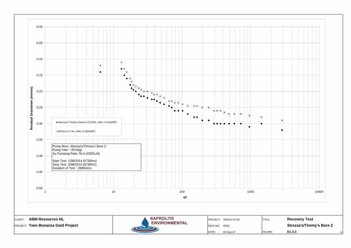
CLIENT: ABM Resources NL PROJECT: AB0101-01-03 TITLE: Recovery TestPROJECT: Twin Bonanza Gold Project DWG NO: G010 Strezza's/Timmy's Bore 2
DATE: 03-Aug-14 FIGURE: D1.3.3 A4
0.00
0.05
0.10
0.15
0.20
0.25
0.30
0.35
0.40
0.45
0.501 10 100 1000 10000
Res
idua
l Dra
wdo
wn
(met
res)
t/t'
Strezza's/ Timmy's Bore (r=0.078m, SWL=4.01mbRP)
BF03A (r=7.3m, SWL=3.30mbRP)
Pump Bore: Strezza's/Timmy's Bore 2Pump Inlet: ~37mbglAv.Pumping Rate: 5L/s (432KL/d)
Start Test: 1/08/2014 (0730hrs)Stop Test: 3/08/2014 (0730hrs)Duration of Test : 2880mins

Twin Bonanza Gold Project Hydrogeological Baseline and Bore Completion Report
ABM Resources NL
SAPROLITE ENVIRONMENTAL
APPENDIX D2
Test Pumping Data

PUMPING BORE/WELL No: Corsair Bore Date: 22/07/2014
Project No.: AB0101-01-03 Location: Twin Bonanza Gold Project
Static Water Level (m bRP) 55.82 Recorder's Name: S.W/R.HReference Point (m above plate) 0.55 Time: 9:36
Reference Point (m agl) 0.96 Document No.: D2.1.1Pump inlet depth (m bRP) ~100
Step #1 Pumping rate: ~1 (L/s) Step #3 Pumping rate: ~1.75 (L/s)Elapsed Time Water Level Drawdown Remarks Elapsed Time Water Level Drawdown Remarks
(mins) (m bRP) (m) (mins) (m bRP) (m)1 56.53 0.71 121 60.86 5.212 56.32 0.5 122 60.97 5.323 56.34 0.52 123 61.05 5.41 Dip tube slipped to 0.37m above plate4 57 1.18 124 61.12 5.485 56.92 1.1 126 61.26 5.628 56.97 1.15 128 61.32 5.68
10 57.01 1.19 130 61.41 5.7715 57.07 1.25 135 61.53 5.8920 57.24 1.42 140 61.68 6.05 Dip tube slipped to 0.36m above plate25 #N/A #N/A 145 61.78 6.1530 58.16 2.4 Dip tube slipped to 0.49m above plate 150 61.87 6.2435 58.2 2.44 155 61.93 6.340 58.34 2.58 160 62 6.3745 58.44 2.68 165 62.06 6.4350 58.54 2.78 171 62.1 6.4760 58.65 2.89 180 62.19 6.56
Step #2 Pumping rate: ~1.5 (L/s) Step #4 Pumping rate: ~1.8 (L/s)Elapsed Time Water Level Drawdown Remarks Elapsed Time Water Level Drawdown Remarks
(mins) (m bRP) (m) (mins) (m bRP) (m)61 58.86 3.1 181 62.26 6.6362 58.98 3.26 Dip tube slipped to 0.45m above plate 182 62.29 6.6663 59.11 3.39 183 62.35 6.73 Dip tube slipped to 0.35m above plate64 59.25 3.53 184 62.37 6.7565 59.34 3.62 186 62.39 6.7768 59.55 3.83 188 62.43 6.8170 59.66 3.96 Dip tube slipped to 0.43m above plate 190 62.47 6.8575 59.94 4.24 195 62.52 6.980 60.14 4.44 200 62.57 6.9585 60.29 4.6 Dip tube slipped to 0.42m above plate 205 62.6 6.9890 60.41 4.72 210 62.64 7.0295 60.53 4.84 215 62.7 7.08
100 60.59 4.9 220 62.71 7.1 Dip tube slipped to 0.34m above plate105 60.65 4.97 Dip tube slipped to 0.41m above plate 225 62.73 7.12110 60.72 5.05 Dip tube slipped to 0.40m above plate 230 62.75 7.14120 60.8 5.15 Dip tube slipped to 0.38m above plate 240 62.78 7.17
Reduced by: SW
STEP DRAWDOWN PUMPING TEST
SAPROLITE ENVIRONMENTAL
PUMPING BORE/WELL Date: 23/07/2014
Bore Name/No. Corsair Bore Project No: AB0101-01-03
Discharge Rate (kL/d or L/s)* 1.5L/s Time: 7:30
Static Water Level (m bRP) 55.67 Location: Twin Bonanza Gold Project
Reference Point (m agl) 0.77
Pump inlet depth (m bRP) ~100m OBSERVATION BORE No. M11
Static Water Level (m bRP) 54.91
Recorder's Name: SW/RH/GR Reference Point (m agl) 0.31
Document #: D2.1.2a Distance from pumping bore (m) ~10m
Time Elapsed Time Production Bore Data Observation Bore Data
(mins) Water Level Drawdown Remarks Water Level Drawdown
(m bRP) (m) (mbRP) (m)
7:30:00 0 55.67 0.00 FM (initial) 6799.0kL 54.91 0.00
0.5 58.42 2.75 - 54.93 0.02
1 58.46 2.79 Pressure Adjustment 54.93 0.02
1.5 57.97 2.30 - -
2 57.01 1.34 - 54.93 0.02
2.5 57.03 1.36 - -
3 57.09 1.42 - 54.94 0.03
4 57.18 1.51 90s/100L (1.1L/s) Pressure Adjustment 54.94 0.03
5 57.45 1.78 - 54.94 0.03
6 57.74 2.07 38s/50L (1.3L/s) Pressure Adjustment 54.95 0.04
7 57.54 1.87 33s/50L (1.5L/s) 54.96 0.05
8 58.08 2.41 33s/50L (1.5L/s) 54.96 0.05
9 58.18 2.51 33s/50L (1.5L/s) 54.97 0.06
10 58.30 2.63 34s/50L (1.5L/s) 54.98 0.07
12 58.53 2.86 33s/50L (1.5L/s) 54.99 0.08
14 58.70 3.03 33s/50L (1.5L/s) 55 0.09
16 58.88 3.21 - 55.01 0.10
18 59.01 3.34 34s/50L (1.5L/s) 55.02 0.11
20 59.15 3.48 - 55.04 0.13
25 59.43 3.76 67s/100L (1.5L/s) 55.07 0.16
30 59.69 4.02 67s/100L (1.5L/s) 55.09 0.18
35 59.85 4.18 68s/100L (1.5L/s) Pressure Adjustment 55.12 0.21
40 60.05 4.38 67s/100L (1.5L/s) 55.14 0.23
45 60.18 4.51 33s/50L (1.5L/s) 55.16 0.25
50 60.34 4.67 33s/50L (1.5L/s) 55.18 0.27
8:30 60 60.54 4.87 67s/100L (1.5L/s) FM=6804.1 55.22 0.31
70 60.68 5.01 68s/100L (1.5L/s) 55.26 0.35
80 60.78 5.11 69s/100L (1.4L/s) Pressure Adjustment 55.28 0.37
90 60.92 5.25 33s/50L (1.5L/s) 55.3 0.39
100 61.02 5.35 33s/50L (1.5L/s) 55.32 0.41
9:30 120 61.10 5.43 34s/50L (1.5L/s) 55.36 0.45
140 61.16 5.49 34s/50L (1.5L/s) 55.39 0.48
160 61.21 5.54 68s/100L (1.5L/s) 55.41 0.50
10:30 180 61.23 5.56 68s/100L (1.5L/s) Minor Pressure Adjustment 55.43 0.52
210 61.35 5.68 68s/100L (1.5L/s) 55.45 0.54
11:30 240 61.37 5.70 Rate " FM=6820.1 EC=3233µs/cm @32.7°C 55.47 0.56
270 61.39 5.72 68s/100L (1.5L/s) Minor Pressure Adjustment 55.48 0.57
12:30 300 61.40 5.73 67s/100L (1.5L/s) 55.49 0.58
13:30 360 61.53 5.86 67s/100L (1.5L/s) Minor Pressure Adjustment 55.51 0.60
14:30 420 61.57 5.90 66s/100L (1.5L/s) 55.53 0.62
15:30 480 61.70 6.03 66s/100L (1.5L/s) 55.55 0.64
16:30 540 61.78 6.11 Rate " FM=6846.6 EC=3363µs/cm @33.0°C 55.58 0.67
Reduced by: SW
CONSTANT RATE PUMPING TEST
SAPROLITE ENVIRONMENTAL

PUMPING BORE/WELL Date: 23/07/2014
Bore Name/No. Corsair Bore Project No: AB0101-01-03
Discharge Rate (kL/d or L/s)* 1.5L/s Time: 7:30
Static Water Level (m bRP) 55.67 Location: Twin Bonanza Gold Project
Reference Point (m agl) 0.77
Pump inlet depth (m bRP) ~100m OBSERVATION BORE No. M11
Static Water Level (m bRP) 54.91
Recorder's Name: SW/RH/GR Reference Point (m agl) 0.31
Document #: D2.1.2b Distance from pumping bore (m) ~10m
Time Elapsed Time Production Bore Data Observation Bore Data
(mins) Water Level Drawdown Remarks Water Level Drawdown
(m bRP) (m) (mbRP) (m)
17:30 600 61.8 6.13 - 55.60 0.69
18:30 660 61.78 6.11 67s/100L (1.5L/s) 55.62 0.71
19:45 735 61.86 6.19 - 55.66 0.75
20:30 780 61.89 6.22 67s/100L (1.5L/s) FM=6868.1kL 55.69 0.78
21:30 840 61.93 6.26 67s/100L (1.5L/s) EC= 3428µs/cm @ 30.6°C 55.71 0.80
22:30 900 61.96 6.29 67s/100L (1.5L/s) FM= 6878.8kL 55.73 0.82
0:00 990 62.01 6.34 67s/100L (1.5L/s) EC= 3454µs/cm @ 31.1°C 55.76 0.85
1:30 1080 62.04 6.37 67s/100L (1.5L/s) FM= 6894.7 55.77 0.86
3:00 1170 62.07 6.4 67s/100L (1.5L/s) EC= 3459µs/cm @ 30.5°C 55.79 0.88
4:30 1260 62.14 6.47 67s/100L (1.5L/s) FM=6910.8kL 55.81 0.90
6:00 1350 62.2 6.53 67s/100L (1.5L/s) EC= 3472µs/cm @ 30.6°C 55.84 0.93
7:30 1440 62.29 6.62 66s/100L (1.5L/s) FM= 6927.0kL 55.88 0.97
9:00 1530 62.37 6.7 66s/100L (1.5L/s) EC= 3474µs/cm @ 31.7°C 55.91 1.00
10:30 1620 62.39 6.72 66s/100L (1.5L/s) FM= 6943.3kL 55.94 1.03
12:00 1710 62.37 6.7 66s/100L (1.5L/s) EC= 3510µs/cm @ 32.9°C 55.95 1.04
13:30 1800 62.37 6.7 67s/100L (1.5L/s) FM=6959.6 55.95 1.04
15:00 1890 62.36 6.69 67s/100L EC= 3541µs/cm @ 32.4°C 55.95 1.04
16:30 1980 62.36 6.69 67s/100L (1.5L/s) FM= 6975.6 55.96 1.05
18:00 2070 62.36 6.69 67s/100L (1.5L/s) 3536µS/cm @ 32.1°C 55.98 1.07
19:30 2160 62.37 6.7 67s/100L (1.5L/s) FM= 6990.6 56.01 1.1
21:00 2250 62.43 6.76 67s/100L (1.5L/s) 3549µS/cm @ 30.4°C 56.05 1.14
22:30 2340 62.5 6.83 67s/100L (1.5L/s) FM= 7007.5 56.07 1.16
0:00 2430 62.54 6.87 67s/100L (1.5L/s) 3557µS/cm @ 29.6°C 56.09 1.18
1:30 2520 62.56 6.89 67s/100L (1.5L/s) FM= 7023.6 56.10 1.19
3:00 2610 62.59 6.92 67s/100L (1.5L/s) 3525µS/cm @ 29.5°C 56.11 1.2
4:30 2700 62.62 6.95 67s/100L (1.5L/s) FM= 7039.7 56.13 1.22
6:00 2790 62.68 7.01 67s/100L (1.5L/s) 3560µS/cm @ 29.1°C 56.16 1.25
7:30 2880 62.74 7.07 66s/100L (1.5L/s) FM= 7055.92 56.17 1.26
256.92kL total pumped
1.49L/s average
Reduced by: SW
CONSTANT RATE PUMPING TEST
SAPROLITE ENVIRONMENTAL

PUMPING BORE/WELL Date: 25-Jul-14
Bore Name/No. Corsair Bore Project No: AB0101-01-03
Discharge Rate (kL/d or L/s)* 1.5L/s Pumping Start Date/Time 23/07/2014 7:30 Time: 7:30
Pumping Duration (mins) 2880 Pumping Stop Date/Time 25/07/2014 7:30 Location: Twin Bonanza Gold Project
Static Water Level (m bRP) 55.67
Reference Point (m agl) 0.735
Pump inlet depth (m bRP) ~100 M11
Static Water Level (m bRP) 54.91
Recorder's Name: SW Reference Point (m agl) 0.31
Document #: D2.1.3 Distance from pumping bore (m) ~10m
*Delete as appropriate
Time (t') since Time (t) since Residual Observation Bore Data Observation Bore Data
Time pumping Water Level pumping started t / t' Drawdown Water Level Residual Water Level Residual
stopped (mins) (m) (min) (m) (m bRP) Drawdown (m) (m bRP) Drawdown (m)
7:30 0 62.73 2880 7.06 56.170 1.260
7:31 1 60.53 2881 2881.0 4.86 56.170 1.260
7:32 2 60.63 2883 1441.5 4.96 56.160 1.250
7:33 3 60.55 2886 962.0 4.88 56.160 1.250
7:34 4 60.38 2890 722.5 4.71 56.140 1.230
7:35 5 60.21 2895 579.0 4.54 56.135 1.225
7:36 6 60.06 2901 483.5 4.39 56.130 1.220
7:37 7 59.92 2908 415.4 4.25 56.125 1.215
7:38 8 59.75 2916 364.5 4.08 56.120 1.210
7:39 9 59.65 2925 325.0 3.98 56.110 1.200
7:40 10 59.48 2935 293.5 3.81 56.105 1.195
7:42 12 59.32 2947 245.6 3.65 56.095 1.185
7:45 15 59.04 2962 197.5 3.37 56.080 1.170
7:48 18 58.79 2980 165.6 3.12 56.060 1.150
7:50 20 58.66 3000 150.0 2.99 56.040 1.130
7:55 25 58.34 3025 121.0 2.67 56.010 1.100
8:00 30 58.1 3055 101.8 2.43 55.990 1.080
8:05 35 57.91 3090 88.3 2.24 55.960 1.050
8:10 40 57.76 3130 78.3 2.09 55.940 1.030
8:15 45 57.6 3175 70.6 1.93 55.920 1.010
8:20 50 57.5 3225 64.5 1.83 55.900 0.990
8:30 60 57.35 3285 54.8 1.68 55.890 0.980
8:40 70 57.22 3355 47.9 1.55 55.860 0.950
8:50 80 57.13 3435 42.9 1.46 55.830 0.920
9:00 90 57.06 3525 39.2 1.39 55.810 0.900
9:10 100 56.99 3625 36.3 1.32 55.795 0.885
9:30 120 56.92 3745 31.2 1.25 55.770 0.860
9:50 140 56.86 3885 27.8 1.19 55.740 0.830
10:10 160 56.81 4045 25.3 1.14 55.710 0.800
10:30 180 56.77 4225 23.5 1.1 55.700 0.790
11:00 210 56.74 4435 21.1 1.07 55.675 0.765
11:30 240 56.7 4675 19.5 1.03 55.660 0.75
12:00 270 56.66 4945 18.3 0.99 55.640 0.73
12:30 300 56.63 5245 17.5 0.96 55.625 0.715
13:30 360 56.58 5605 15.6 0.91 55.590 0.68
14:30 420 56.53 6025 14.3 0.86 55.560 0.65
15:30 480 56.49 6505 13.6 0.82 55.540 0.63
16:30 540 56.455 7045 13.0 0.785 55.520 0.61
17:30 600 56.425 7645 12.7 0.755 55.510 0.6
OBSERVATION BORE No.
RECOVERY TEST - CONSTANT RATE PUMPING TEST
SAPROLITE ENVIRONMENTAL
PUMPING BORE/WELL No: Wilson's Bore Date: 26/07/2014
Project No.: AB0101-01-03 Location: Twin Bonanza Gold Project
Static Water Level (m bRP) 46.19 Recorder's Name: S.W/R.HReference Point (m above plate) 0.235 Time: 0930
Reference Point (m agl) 0.65 Document No.: D2.2.1Pump inlet depth (m bRP) 75
Step #1 Pumping rate: 1 (L/s) Step #3 Pumping rate: ~1.75 (L/s)Elapsed Time Water Level Drawdown Remarks Elapsed Time Water Level Drawdown Remarks
(mins) (m bRP) (m) (mins) (m bRP) (m)1 49.41 3.22 201 65.15 18.962 50.43 4.24 202 65.47 19.283 51 4.81 203 65.98 19.794 51.44 5.25 204 66.40 20.216 52 5.81 206 66.96 20.778 52.37 6.18 208 67.35 21.16
10 52.65 6.46 210 67.78 21.5915 53.01 6.82 215 68.47 22.2820 53.67 7.48 220 68.85 22.66 Gate valve fully open25 54.07 7.88 225 68.98 22.79 1.75L/s30 54.33 8.14 230 69.10 22.91 1.7L/s35 54.53 8.34 235 69.25 23.06 1.6L/s40 54.69 8.5 240 69.34 23.15 1.6L/s45 54.78 8.59 245 69.43 23.24 1.6L/s50 54.9 8.71 250 69.48 23.29 1.6L/s60 55.2 9.01 260 69.61 23.42 1.6L/s70 55.59 9.4 270 69.75 23.56 1.6L/s80 55.75 9.56 280 69.89 23.7 1.6L/s90 56.21 10.02 290 69.96 23.77 1.6L/s
100 56.37 10.18 300 69.97 23.78 1.6L/s
Step #2 Pumping rate: 1.5 (L/s) Step #4 Pumping rate: 1.6 (L/s)Elapsed Time Water Level Drawdown Remarks Elapsed Time Water Level Drawdown Remarks
(mins) (m bRP) (m) (mins) (m bRP) (m)101 56.57 10.38 301102 57.07 10.88 302103 57.45 11.26 303 69.76 23.57104 57.93 11.74 304 69.6 23.41106 58.85 12.66 306 69.5 23.31108 59.49 13.3 308 69.48 23.29110 60.02 13.83 310 69.45 23.26115 60.93 14.74 315 69.42 23.23120 61.4 15.21 320 69.45 23.26125 62.01 15.82 325 69.51 23.32130 62.43 16.24 330 69.51 23.32135 62.66 16.47 335140 62.89 16.7 340145 63.06 16.87 345150 63.27 17.08 350161 63.43 17.24 360170 63.75 17.56 370180 64.27 18.08 380190 64.67 18.48 390200 64.82 18.63 400
Reduced by: SW
STEP DRAWDOWN PUMPING TEST
SAPROLITE ENVIRONMENTAL

PUMPING BORE/WELL Date: 27/07/2014
Bore Name/No. Wilson's Bore Project No: AB0101-01-03
Discharge Rate (kL/d or L/s)* 1.5L/s Time: 7:30
Static Water Level (m bRP) 45.67 Location: Twin Bonanza Gold Project
Reference Point (m agl) 0.65
Pump inlet depth (m bRP) ~75m OBSERVATION BORE No. M10A
Static Water Level (m bRP) 46.43
Recorder's Name: SW/RH Reference Point (m agl) 0.57
Document #: D2.2.2a Distance from pumping bore (m) ~10
Time Elapsed Time Production Bore Data Observation Bore Data
(mins) Water Level Drawdown Remarks Water Level Drawdown
(m bRP) (m) (mbRP) (m)
7:30:00 0 45.67 0.00 FM: 7086.83kL 46.43 0.00
0.5
1 46.55 0.88 Flow Rate 19s/50L (2.63L/s)
1.5
2 51.96 6.29
2.5
3 54.08 8.41 Flow Rate 33s/50L (1.52L/s)
4 54.49 8.82
5 Flow Rate 34s/50L (1.47L/s) 46.44 0.01
6 55.18 9.51
7 55.58 9.91
8 56.23 10.56
9 56.76 11.09
10 Flow Rate 32s/50L (1.56L/s) 46.51 0.08
12 57.70 12.03
14 58.09 12.42 46.57 0.14
16 58.48 12.81 46.62 0.19
18 58.78 13.11 46.66 0.23
20 59.04 13.37 Flow Rate 32s/50L (1.56L/s) 46.71 0.28
25 59.54 13.87 46.85 0.42
30 59.90 14.23 FM: 7089.65kL 47.04 0.61
35 60.28 14.61 Flow Rate 66s/100L (1.52L/s) 47.2 0.77
40 60.84 15.17 47.36 0.93
45 61.15 15.48 47.5 1.07
50 61.64 15.97 47.65 1.22
8:30 60 62.35 16.68 Flow Rate 67s/100L (1.49L/s) 47.93 1.50
70 62.79 17.12 48.21 1.78
80 63.02 17.35 48.49 2.06
90 63.69 18.02 48.73 2.30
101 64.24 18.57 49 2.57
9:30 120 64.57 18.90 Flow Rate 69s/100L (1.45L/s) 49.44 3.01
140 65.25 19.58 49.88 3.45
160 65.58 19.91 50.21 3.78
10:30 180 66.06 20.39 Flow Rate 70s/100L (1.43L/s); adjustment to 1.47L/s 50.55 4.12
210 66.60 20.93 1.41L/s ---adjustment to 1.49L/s 50.95 4.52
11:30 240 67.38 21.71 1.43L/s ---adjustment to 1.49L/s 51.34 4.91
270 68.01 22.34 1.43L/s ---adjustment to 1.49L/s 51.68 5.25
12:30 300 68.57 22.90 1.43L/s ---adjustment to 1.49L/s 51.97 5.54
13:30 360 69.81 24.14 EC 12.7mS/cm @25C; Temp 28.9C 52.54 6.11
14:30 420 71.55 25.88 at 390mins gate valve fully open (1.45L/s) 53.01 6.58
473 69.32 23.65 Rate reduced to 1.2L/s (adjustments 424-473mins)
474
475 69.20 23.53
476 53.37 6.94
477 69.05 23.38
478 69.00 23.33
479 68.96 23.29
15:30 480 68.92 23.25 Flow Rate 82s/100L (1.22L/s) 53.38 6.95
500 67.96 22.29 53.42 6.99
520 67.58 21.91 53.42 6.99
16:30 540 67.55 21.88 53.43 7.00
560 67.54 21.87 53.44 7.01
580 67.61 21.94 Flow Rate 83s/100L (1.20L/s) 53.45 7.02
Reduced by: SW
CONSTANT RATE PUMPING TEST
SAPROLITE ENVIRONMENTAL
PUMPING BORE/WELL Date: 27/07/2014
Bore Name/No. Wilson's Bore Project No: AB0101-01-03
Discharge Rate (kL/d or L/s)* 1.5L/s Time: 7:30
Static Water Level (m bRP) 45.67 Location: Twin Bonanza Gold Project
Reference Point (m agl) 0.65
Pump inlet depth (m bRP) ~75m OBSERVATION BORE No. M10A
Static Water Level (m bRP) 46.43
Recorder's Name: SW/RH Reference Point (m agl) 0.57
Document #: D2.2.2b Distance from pumping bore (m) ~10
Time Elapsed Time Elapsed Time Production Bore Data Observation Bore Data
(mins) (hr:min) Water Level Drawdown Remarks Water Level Drawdown
(m bRP) (m) (mbRP) (m)
17:30 600 10:00 67.57 21.90 Flow Rate 84s/100L (1.20L/s) 53.48 7.05
620 10:20 67.61 21.94 53.51 7.08
640 10:40 67.64 21.97 53.54 7.11
18:30 660 11:00 67.72 22.05 EC 12.7mS/cm @25C; Temp 30.5C 53.58 7.15
19:45 720 12:00 67.80 22.13 53.69 7.26
20:30 780 13:00 68.29 22.62 53.83 7.40
21:30 840 14:00 68.56 22.89 54.00 7.57
22:30 900 15:00 68.98 23.31 54.17 7.74
0:00 990 16:30 69.41 23.74 54.42 7.99
1:30 1080 18:00 69.68 24.01 54.64 8.21
3:00 1170 19:30 70.50 24.83 EC 12.4mS/cm @25C; Temp 30.1C 54.86 8.43
4:30 1260 21:00 71.55 25.88 55.09 8.66
6:00 1350 22:30 72.70 27.03 Flow Rate 84s/100L (1.20L/s) 55.34 8.91
6:50 1400 23:20 73.00 27.33
7:00 1410 23:30 71.90 26.23 Rate changed to 1L/s
7:10 1420 23:40 71.23 25.56
7:20 1430 23:50 70.15 24.48
7:30 1440 24:00 69.21 23.54 55.52 9.09
7:40 1450 24:10 69.45 23.78
7:50 1460 24:20 69.03 23.36
8:00 1470 24:30 68.47 22.80
8:10 1480 24:40 68.12 22.45
8:20 1490 24:50 67.93 22.26
8:30 1500 25:00 67.74 22.07
8:40 1510 25:10 67.61 21.94
9:00 1530 25:30 67.69 22.02 55.34 8.91
9:30 1560 26:00 67.42 21.75
10:00 1590 26:30 67.40 21.73
10:30 1620 27:00 67.26 21.59 55.19 8.76
11:00 1650 27:30 67.46 21.79
11:30 1680 28:00 67.46 21.79
12:00 1710 28:30 67.51 21.84 55.17 8.74
13:30 1800 30:00 67.63 21.96 55.20 8.77
15:00 1890 31:30 67.68 22.01 55.24 8.81
16:30 1980 33:00 67.76 22.09 55.28 8.85
18:00 2070 34:30 67.77 22.10 55.33 8.90
19:30 2160 36:00 67.83 22.16 EC 12.6mS/cm @25C; Temp 30.6C 55.37 8.94
21:00 2250 37:30 68.37 22.70 55.49 9.06
22:30 2340 39:00 68.46 22.79 55.60 9.17
0:00 2430 40:30 68.64 22.97 55.71 9.28
1:30 2520 42:00 68.79 23.12 55.81 9.38
3:00 2610 43:30 68.91 23.24 55.90 9.47
4:30 2700 45:00 69.02 23.35 55.97 9.54
6:00 2790 46:30 69.41 23.74 56.06 9.63
7:30 2880 48:00 69.70 24.03 EC 12.3mS/cm @25C; Temp 30.6C 56.16 9.73
FM: 7280.7kL
Total pumped: 193.87kL (average flow rate: 97kL/d)
Reduced by: SW
CONSTANT RATE PUMPING TEST
SAPROLITE ENVIRONMENTAL

PUMPING BORE/WELL Date: 29-Jul-14
Bore Name/No. Wilson's Bore Project No: AB0101-01-03
Discharge Rate (kL/d or L/s)* 1.5, 1.2, 1.0 L/s Pumping Start Date/Time 27/07/2014 7:30 Time: 7:30
Pumping Duration (mins) 2880 Pumping Stop Date/Time 29/07/2014 7:30 Location: Twin Bonanza Gold Project
Static Water Level (m bRP) 46.55
Reference Point (m agl) 0.65
Pump inlet depth (m bRP) ~75 M10A
Static Water Level (m bRP) 46.43
Recorder's Name: RH Reference Point (m agl) 0.57
Document #: NA Distance from pumping bore (m) ~10
*Delete as appropriate
Time (t') since Time (t) since Residual Observation Bore Data Observation Bore Data
Time pumping Water Level pumping started t / t' Drawdown Water Level Residual Water Level Residual
stopped (mins) (m) (min) (m) (m bRP) Drawdown (m) (m bRP) Drawdown (m)
7:30 0 69.7 2880 2880.0 23.15 56.220 9.730
7:31 1 67.49 2881 2881.0 20.94 56.220 9.730
7:32 2 65.07 2883 1441.5 18.52 56.220 9.730
7:33 3 63.53 2886 962.0 16.98 56.220 9.730
7:34 4 62.66 2890 722.5 16.11 56.220 9.730
7:35 5 61.79 2895 579.0 15.24 56.215 9.725
7:36 6 61.22 2901 483.5 14.67 56.210 9.720
7:37 7 2908 56.205 9.715
7:38 8 60.37 2916 364.5 13.82 56.205 9.715
7:39 9 60.03 2925 325.0 13.48 56.200 9.710
7:40 10 59.72 2935 293.5 13.17 56.195 9.705
7:42 12 59.3 2947 245.6 12.75 56.180 9.690
7:45 15 58.85 2962 197.5 12.3 56.150 9.660
7:48 18 58.56 2980 165.6 12.01 56.120 9.630
7:50 20 58.41 3000 150.0 11.86 56.100 9.610
7:55 25 58.13 3025 121.0 11.58 56.040 9.550
8:00 30 57.9 3055 101.8 11.35 55.960 9.470
8:05 35 57.72 3090 88.3 11.17 55.900 9.410
8:10 40 57.54 3130 78.3 10.99 55.820 9.330
8:15 45 57.36 3175 70.6 10.81 55.730 9.240
8:20 50 57.21 3225 64.5 10.66 55.650 9.160
8:30 60 56.93 3285 54.8 10.38 55.490 9.060
8:40 70 56.68 3355 47.9 10.13 55.330 8.900
8:50 80 56.49 3435 42.9 9.94 55.180 8.750
9:00 90 56.28 3525 39.2 9.73 55.030 8.600
9:10 100 56.11 3625 36.3 9.56 54.890 8.460
9:30 120 55.81 3745 31.2 9.26 54.610 8.180
9:50 140 55.54 3885 27.8 8.99 54.350 7.860
10:10 160 55.3 4045 25.3 8.75 54.120 7.630
10:30 180 55.09 4225 23.5 8.54 53.910 7.420
11:00 210 54.79 4435 21.1 8.24 53.630 7.140
11:30 240 54.51 4675 19.5 7.96 53.390 6.900
12:00 270 54.26 4945 18.3 7.71 53.160 6.670
12:30 300 54.01 5245 17.5 7.46 52.950 6.460
13:30 360 53.38 5605 15.6 6.83 52.590 6.100
14:30 420 52.98 6025 14.3 6.43 52.270 5.780
15:30 480 52.64 6505 13.6 6.09 51.980 5.490
16:30 540 52.34 7045 13.0 5.79 51.730 5.240
17:30 600 52.1 7645 12.7 5.55 51.490 5.000
7:00 1410 49.98 9055 6.4 3.43 49.780 3.290
OBSERVATION BORE No.
RECOVERY TEST - CONSTANT RATE PUMPING TEST
SAPROLITE ENVIRONMENTAL

PUMPING BORE/WELL No: Strezza's/Timmy's Bore 2 Date: 31/07/2014
Project No.: AB0101-01-03 Location: Twin Bonanza Gold Project
Static Water Level (m bRP) 4.01 Recorder's Name: S.W/R.HReference Point (m above plate) 0.21 Time: 8:00
Reference Point (m agl) 0.98 Document No.: D2.3.1Pump inlet depth (m bRP) ~36m
Step #1 Pumping rate: 3 (L/s) Step #3 Pumping rate: 5 (L/s)Elapsed Time Water Level Drawdown Remarks Elapsed Time Water Level Drawdown Remarks
(mins) (m bRP) (m) (mins) (m bRP) (m)1 4.54 0.53 30s/100L 121 4.96 0.95 20s/100L2 4.55 0.54 33s/100L 122 4.97 0.96 20s/100L3 4.55 0.54 33s/100L 123 4.97 0.96 20s/100L4 4.56 0.55 33s/100L 124 4.975 0.965 20s/100L6 4.56 0.55 33s/100L 126 4.975 0.965 20s/100L8 4.56 0.55 33s/100L 128 4.975 0.965 20s/100L
10 4.56 0.55 33s/100L 130 4.975 0.965 20s/100L15 4.56 0.55 33s/100L 135 4.975 0.965 20s/100L20 4.56 0.55 33s/100L 140 4.975 0.965 20s/100L25 4.56 0.55 33s/100L 145 4.975 0.965 20s/100L30 4.56 0.55 33s/100L 150 4.975 0.965 20s/100L35 4.56 0.55 33s/100L 155 4.975 0.965 20s/100L40 4.56 0.55 33s/100L 160 4.98 0.97 20s/100L45 4.56 0.55 33s/100L 165 4.98 0.97 20s/100L50 4.56 0.55 33s/100L 170 4.98 0.97 20s/100L60 4.56 0.55 33s/100L 180 4.98 0.97 20s/100L
Step #2 Pumping rate: 4 (L/s) Step #4 Pumping rate: Max 5.8L/s (L/s)Elapsed Time Water Level Drawdown Remarks Elapsed Time Water Level Drawdown Remarks
(mins) (m bRP) (m) (mins) (m bRP) (m)61 4.72 0.71 26s/100L 181 5.24 1.23 17s/100L62 4.74 0.73 26s/100L 182 5.24 1.23 17s/100L63 4.76 0.75 25s/100L 183 5.24 1.23 17s/100L64 4.76 0.75 25s/100L 184 5.24 1.23 17s/100L66 4.76 0.75 25s/100L 186 5.24 1.23 17s/100L68 4.76 0.75 25s/100L 188 5.24 1.23 17s/100L70 4.76 0.75 25s/100L 190 5.24 1.23 17s/100L75 4.76 0.75 25s/100L 195 5.24 1.23 17s/100L80 4.76 0.75 25s/100L 200 5.24 1.23 17s/100L85 4.76 0.75 25s/100L 205 5.24 1.23 17s/100L90 4.76 0.75 25s/100L 210 5.24 1.23 17s/100L95 4.76 0.75 25s/100L 215 5.24 1.23 17s/100L100 4.76 0.75 25s/100L 220 5.24 1.23 17s/100L105 4.76 0.75 25s/100L 225 5.24 1.23 17s/100L110 4.76 0.75 25s/100L 230 5.24 1.23 17s/100L120 4.76 0.75 25s/100L 240 5.24 1.23 17s/100L
Reduced by: SW
STEP DRAWDOWN PUMPING TEST
SAPROLITE ENVIRONMENTAL

PUMPING BORE/WELL Date: 1/08/2014
Bore Name/No.Strezza's/ Timmy's Bore 2 Project No: AB0101-01-03
Discharge Rate (kL/d or L/s)* 5L/s Time: 7:30
Static Water Level (m bRP) 4.01 Location: Twin Bonanza Gold Project
Reference Point (m agl) 0.98
Pump inlet depth (m bRP) 37 OBSERVATION BORE No. BF03A
Static Water Level (m bRP) 3.3
Recorder's Name: SW/RH Reference Point (m agl) 0.31
Document #: D2.3.2a Distance from pumping bore (m) 7.3
Time Elapsed Time Production Bore Data Observation Bore Data
(mins) Water Level Drawdown Remarks Water Level Drawdown
(m bRP) (m) (mbRP) (m)
7:30:00 0 4.010 0.000 FM: 20726.08kL
0.5
1 5.020 1.010 18s/100L [5.6L/s] - adjusted
1.5
2 4.900 0.890 19s/100L [5.26L/s] - adjusted
2.5
3 4.880 0.870 20s/100L (5L/s)
4 4.880 0.870 " 3.410 0.110
5 4.880 0.870 "
6 4.890 0.880 " 3.420 0.120
7 4.890 0.880 "
8 4.895 0.885 " 3.420 0.120
9 4.900 0.890 "
10 4.930 0.920 " 3.430 0.130
12 4.940 0.930 " 3.435 0.135
14 4.940 0.930 " 3.440 0.140
16 4.940 0.930 " 3.440 0.140
18 4.940 0.930 " 3.445 0.145
20 4.940 0.930 " 3.450 0.150
25 4.940 0.930 " 3.460 0.160
30 4.950 0.940 " 3.460 0.160
35 4.955 0.945 " 3.460 0.160
40 4.960 0.950 " 3.465 0.165
45 4.960 0.950 " 3.465 0.165
50 4.970 0.960 " 3.470 0.170
8:30 60 4.970 0.960 " 3.475 0.175
70 4.970 0.960 " 3.480 0.180
80 4.970 0.960 " 3.490 0.190
90 4.975 0.965 " 3.490 0.190
100 4.980 0.970 " 3.495 0.195
9:30 120 4.980 0.970 " 3.500 0.200
140 4.980 0.970 205s/kL [4.88L/s] (small adjustment) 3.510 0.210
160 5.000 0.990 203s/kL [4.93L/s] 3.525 0.225
10:30 180 5.000 0.990 203s/kL [4.93L/s] 3.530 0.230
210 5.000 0.990 203s/kL [4.93L/s] 3.530 0.230
11:30 240 5.000 0.990 204s/kL [4.90L/s] (small adjustment to 200kPA) 3.530 0.230
270 5.010 1.000 202s/kL [4.95L/s] 3.530 0.230
12:30 300 5.010 1.000 202s/kL 773µs/cm @25C; Temp 29.7°C 3.530 0.230
13:30 360 5.010 1.000 203s/kL (small adjustment) FM=20832.36 3.530 0.230
14:30 420 5.015 1.005 201s/kL [4.98L/s] 3.530 0.230
15:30 480 5.015 1.005 201s/kL 626µs/cm @ 25C; Temp 29.6°C 3.530 0.230
16:30 540 5.020 1.010 201s/kL FM=20886.0 3.535 0.235
Reduced by: SW
CONSTANT RATE PUMPING TEST
SAPROLITE ENVIRONMENTAL
PUMPING BORE/WELL Date: 1/08/2014
Bore Name/No.Strezza's/ Timmy's Bore 2 Project No: AB0101-01-03
Discharge Rate (kL/d or L/s)* 5L/s Time: 7:30
Static Water Level (m bRP) 4.01 Location: Twin Bonanza Gold Project
Reference Point (m agl) 0.98
Pump inlet depth (m bRP) 37 OBSERVATION BORE No. BF03A
Static Water Level (m bRP) 3.3
Recorder's Name: SW/RH Reference Point (m agl) 0.31
Document #: D2.3.2b Distance from pumping bore (m) 7.3
Time Elapsed Time Elapsed Time Production Bore Data Observation Bore Data
(mins) (hr:min) Water Level Drawdown Remarks Water Level Drawdown
(m bRP) (m) (mbRP) (m)
17:30 600 10:00 5.025 1.015 200s/kL 3.545 0.245
18:30 660 11:00 5.030 1.020 201/kL 531µs/cm @25C; Temp 29.1°C 3.560 0.260
20:00 750 12:30 5.050 1.040 201/kL 3.580 0.280
20:30 780 13:00 5.060 1.050 FM=20957.5 3.590 0.290
21:30 840 14:00 5.060 1.050 200s/kL 578µs/cm @25C; Temp 29.4°C 3.590 0.290
22:30 900 15:00 5.070 1.060 200s/kL 3.595 0.295
0:00 990 16:30 5.070 1.060 200s/kL 3.600 0.300
1:30 1080 18:00 5.070 1.060 200s/kL 542µs/cm @25C; Temp 28.1°C 3.600 0.300
3:00 1170 19:30 5.070 1.060 200s/kL FM=21074.2 3.600 0.300
4:30 1260 21:00 5.070 1.060 200s/kL 3.610 0.310
6:00 1350 22:30 5.080 1.070 200s/kL 513µs/cm @25C; Temp 28.1°C 3.615 0.315
7:30 1440 24:00 5.090 1.080 200s/kL FM=21155 3.630 0.330
9:00 1530 25:30 5.105 1.095 199s/kL (adjusted pressure up @8am, was 198s) 3.645 0.345
10:30 1620 27:00 5.110 1.100 199s/kL 475µs/cm @28.7°C 3.645 0.345
12:00 1710 28:30 5.110 1.100 200s/kL FM=21236.0 3.645 0.345
13:30 1800 30:00 5.100 1.090 200s/kL 3.640 0.340
15:00 1890 31:30 5.090 1.080 200s/kL 417µs/cm @25C; Temp 29.4°C 3.630 0.330
16:30 1980 33:00 5.090 1.080 201s/kL 3.630 0.330
18:00 2070 34:30 5.080 1.070 201s/kL FM=21343.6 3.630 0.330
19:50 2180 36:20 5.090 1.080 200s/kL 3.655 0.355
21:00 2250 37:30 5.090 1.080 200s/kL 399µS/cm @25C; Temp 28.2°C 3.670 0.370
22:30 2340 39:00 5.100 1.090 200s/kL 3.670 0.370
0:00 2430 40:30 5.100 1.090 200s/kL FM=21451.2 3.680 0.380
1:30 2520 42:00 5.100 1.090 200s/kL 407µS/cm @25C; Temp 27.7°C 3.670 0.370
3:00 2610 43:30 5.100 1.090 200s/kL 3.670 0.370
4:30 2700 45:00 5.100 1.090 200s/kL FM=21532.4 3.670 0.370
6:00 2790 46:30 5.110 1.100 200s/kL 409µS/cm @25C; Temp 26.7°C 3.675 0.375
7:30 2880 48:00 5.115 1.105 200s/kL 3.685 0.385
FINAL FM=21586.5kL
Total Pumped = 860.42kL (av 4.98L/s)
Reduced by: SW
CONSTANT RATE PUMPING TEST
SAPROLITE ENVIRONMENTAL

CONSTANT RATE PUMPING TEST
Observation Bore Data Sheet
PUMPING BORE/WELL No. Strezza's/Timmy's Bore 2 Date: 1/08/2014
Discharge Rate (kL/d or L/s)* 5L/s Project No: AB0101-01-03
Recorders Name: SW Time: 7:30
Document #: D2.3.2c Location: Twin Bonanza Gold Project
NOTE: SWL = Static Water Level (m bRP) RP = reference point (m agl) Dist. = linear distance from pumping bore
OBS BORE No. BF01 OBS BORE No. BF02 OBS BORE No. BF04 OBS BORE No.SWL 3.66 SWL 3.33 SWL 3.63 SWL
RP 0.5 RP 0.45 RP 0.69 RP
Dist. 1064 Dist. 232 Dist. 204 Dist.
Time Elapsed Water Level Drawdown Time Elapsed Water Level Drawdown Time Elapsed Water Level Drawdown Time Elapsed Water Level Drawdown
(mins) (m bRP) (m) (mins) (m bRP) (m) (mins) (m bRP) (m) (mins) (m bRP) (m)
7:31 1 3.660 0.000 7:31 1 3.660 0.000 7:31 1 3.660 0.000
10:48 198 3.660 0.000 10:00 150 3.360 0.030 9:40 130 3.650 0.020
14:24 414 3.660 0.000 11:05 215 3.365 0.035 11:00 210 3.660 0.030
16:15 525 3.620 -0.040 12:15 285 3.360 0.030 12:10 280 3.660 0.030
20:50 800 3.650 -0.010 13:50 380 3.350 0.020 13:40 370 3.650 0.020
0:22 1012 3.650 -0.010 16:10 520 3.350 0.020 16:05 515 3.640 0.010
4:52 1282 3.650 -0.010 17:50 620 3.350 0.020 17:40 610 3.640 0.010
8:25 1495 3.670 0.010 20:42 792 3.385 0.055 20:36 786 3.67 0.040
11:10 1660 3.675 0.015 0:15 1005 3.400 0.070 0:10 1000 3.68 0.050
14:10 1840 3.650 -0.010 4:47 1277 3.400 0.070 4:42 1272 3.68 0.050
17:10 2020 3.650 -0.010 8:10 1480 3.420 0.090 8:00 1470 3.700 0.070
21:19 2269 3.670 0.010 11:00 1650 3.435 0.105 10:55 1645 3.720 0.090
0:12 2442 3.680 0.020 14:05 1835 3.420 0.090 14:00 1830 3.700 0.070
4:50 2720 3.680 0.020 17:05 2015 3.415 0.085 17:00 2010 3.690 0.060
6:54 2844 3.680 0.020 21:13 2263 3.450 0.120 21:08 2258 3.730 0.100
0:07 2437 3.460 0.130 0:04 2434 3.740 0.110
4:44 2714 3.460 0.130 4:39 2709 3.730 0.100
7:00 2850 3.465 0.135 7:03 2853 3.740 0.110
Reduced by: SW
SAPROLITE ENVIRONMENTAL
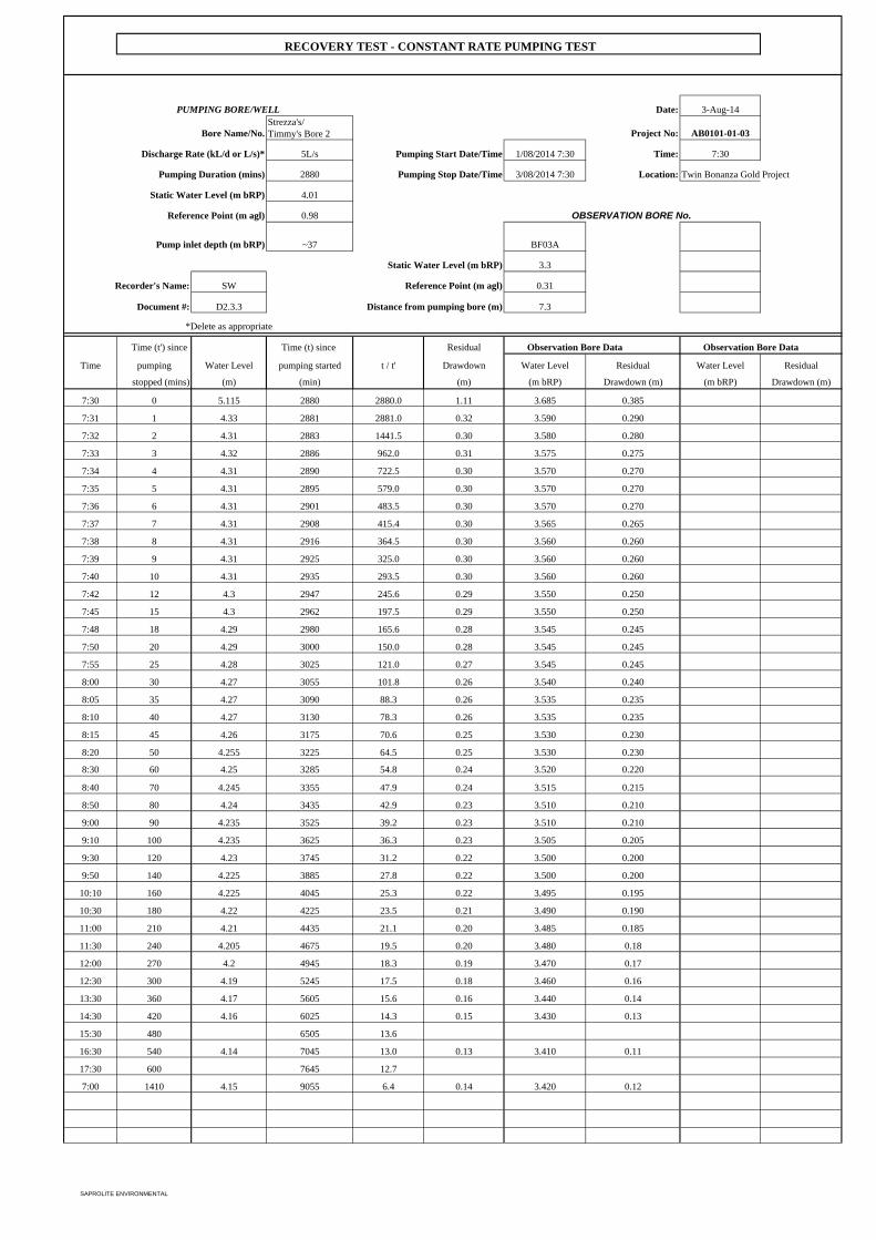
PUMPING BORE/WELL Date: 3-Aug-14
Bore Name/No.Strezza's/ Timmy's Bore 2 Project No: AB0101-01-03
Discharge Rate (kL/d or L/s)* 5L/s Pumping Start Date/Time 1/08/2014 7:30 Time: 7:30
Pumping Duration (mins) 2880 Pumping Stop Date/Time 3/08/2014 7:30 Location: Twin Bonanza Gold Project
Static Water Level (m bRP) 4.01
Reference Point (m agl) 0.98
Pump inlet depth (m bRP) ~37 BF03A
Static Water Level (m bRP) 3.3
Recorder's Name: SW Reference Point (m agl) 0.31
Document #: D2.3.3 Distance from pumping bore (m) 7.3
*Delete as appropriate
Time (t') since Time (t) since Residual Observation Bore Data Observation Bore Data
Time pumping Water Level pumping started t / t' Drawdown Water Level Residual Water Level Residual
stopped (mins) (m) (min) (m) (m bRP) Drawdown (m) (m bRP) Drawdown (m)
7:30 0 5.115 2880 2880.0 1.11 3.685 0.385
7:31 1 4.33 2881 2881.0 0.32 3.590 0.290
7:32 2 4.31 2883 1441.5 0.30 3.580 0.280
7:33 3 4.32 2886 962.0 0.31 3.575 0.275
7:34 4 4.31 2890 722.5 0.30 3.570 0.270
7:35 5 4.31 2895 579.0 0.30 3.570 0.270
7:36 6 4.31 2901 483.5 0.30 3.570 0.270
7:37 7 4.31 2908 415.4 0.30 3.565 0.265
7:38 8 4.31 2916 364.5 0.30 3.560 0.260
7:39 9 4.31 2925 325.0 0.30 3.560 0.260
7:40 10 4.31 2935 293.5 0.30 3.560 0.260
7:42 12 4.3 2947 245.6 0.29 3.550 0.250
7:45 15 4.3 2962 197.5 0.29 3.550 0.250
7:48 18 4.29 2980 165.6 0.28 3.545 0.245
7:50 20 4.29 3000 150.0 0.28 3.545 0.245
7:55 25 4.28 3025 121.0 0.27 3.545 0.245
8:00 30 4.27 3055 101.8 0.26 3.540 0.240
8:05 35 4.27 3090 88.3 0.26 3.535 0.235
8:10 40 4.27 3130 78.3 0.26 3.535 0.235
8:15 45 4.26 3175 70.6 0.25 3.530 0.230
8:20 50 4.255 3225 64.5 0.25 3.530 0.230
8:30 60 4.25 3285 54.8 0.24 3.520 0.220
8:40 70 4.245 3355 47.9 0.24 3.515 0.215
8:50 80 4.24 3435 42.9 0.23 3.510 0.210
9:00 90 4.235 3525 39.2 0.23 3.510 0.210
9:10 100 4.235 3625 36.3 0.23 3.505 0.205
9:30 120 4.23 3745 31.2 0.22 3.500 0.200
9:50 140 4.225 3885 27.8 0.22 3.500 0.200
10:10 160 4.225 4045 25.3 0.22 3.495 0.195
10:30 180 4.22 4225 23.5 0.21 3.490 0.190
11:00 210 4.21 4435 21.1 0.20 3.485 0.185
11:30 240 4.205 4675 19.5 0.20 3.480 0.18
12:00 270 4.2 4945 18.3 0.19 3.470 0.17
12:30 300 4.19 5245 17.5 0.18 3.460 0.16
13:30 360 4.17 5605 15.6 0.16 3.440 0.14
14:30 420 4.16 6025 14.3 0.15 3.430 0.13
15:30 480 6505 13.6
16:30 540 4.14 7045 13.0 0.13 3.410 0.11
17:30 600 7645 12.7
7:00 1410 4.15 9055 6.4 0.14 3.420 0.12
OBSERVATION BORE No.
RECOVERY TEST - CONSTANT RATE PUMPING TEST
SAPROLITE ENVIRONMENTAL
Twin Bonanza Gold Project Hydrogeological Baseline and Bore Completion Report
ABM Resources NL
SAPROLITE ENVIRONMENTAL
APPENDIX E
Analytical Laboratory Reports
False
7 7.00True Environmental
CERTIFICATE OF ANALYSISWork Order : EP1405966 Page : 1 of 7
:: LaboratoryClient Environmental Division PerthABM RESOURCES NL
: :ContactContact SHAUN WIMBRIDGE Scott James
:: AddressAddress level 1, 141 Broadway
Nedlands - Perth Perth Western Australia 6009
10 Hod Way Malaga WA Australia 6090
:: E-mailE-mail ---- [email protected]
:: TelephoneTelephone +61 08 9423 9777 +61-8-9209 7655
:: FacsimileFacsimile ---- +61-8-9209 7600
:Project TWIN BONANZA GOLD PROJECT QC Level : NEPM 2013 Schedule B(3) and ALS QCS3 requirement
:Order number ----
:C-O-C number ---- Date Samples Received : 31-JUL-2014
Sampler : RH Issue Date : 12-AUG-2014
Site : ----
4:No. of samples received
Quote number : EP/268/14 V4 4:No. of samples analysed
This report supersedes any previous report(s) with this reference. Results apply to the sample(s) as submitted. All pages of this report have been checked and approved for
release.
This Certificate of Analysis contains the following information:
l General Comments
l Analytical Results
l Surrogate Control Limits
NATA Accredited Laboratory 825
Accredited for compliance with
ISO/IEC 17025.
SignatoriesThis document has been electronically signed by the authorized signatories indicated below. Electronic signing has been
carried out in compliance with procedures specified in 21 CFR Part 11.
Signatories Accreditation CategoryPosition
Agnes Szilagyi Perth OrganicsSenior Organic Chemist
Canhuang Ke Perth InorganicsMetals Instrument Chemist
Chas Tucker Perth InorganicsSenior Inorganic Chemist
Di-An Dao Sydney Inorganics
Efua Wilson Perth InorganicsMetals Chemist
Rassem Ayoubi Perth OrganicsSenior Organic Chemist
Environmental Division Perth ABN 84 009 936 029 Part of the ALS Group An ALS Limited Company
Address 10 Hod Way Malaga WA Australia 6090 | PHONE +61-8-9209 7655 | Facsimile +61-8-9209 7600
2 of 7:Page
Work Order :
:Client
EP1405966
ABM RESOURCES NL
TWIN BONANZA GOLD PROJECT:Project
General Comments
The analytical procedures used by the Environmental Division have been developed from established internationally recognized procedures such as those published by the USEPA, APHA, AS and NEPM. In house
developed procedures are employed in the absence of documented standards or by client request.
Where moisture determination has been performed, results are reported on a dry weight basis.
Where a reported less than (<) result is higher than the LOR, this may be due to primary sample extract/digestate dilution and/or insufficient sample for analysis.
Where the LOR of a reported result differs from standard LOR, this may be due to high moisture content, insufficient sample (reduced weight employed) or matrix interference.
When sampling time information is not provided by the client, sampling dates are shown without a time component. In these instances, the time component has been assumed by the laboratory for processing purposes.
Where a result is required to meet compliance limits the associated uncertainty must be considered. Refer to the ALS Contact for details.
CAS Number = CAS registry number from database maintained by Chemical Abstracts Services. The Chemical Abstracts Service is a division of the American Chemical Society.
LOR = Limit of reporting
^ = This result is computed from individual analyte detections at or above the level of reporting
Key :
EG020: Metals LOR for particular sample(s) raised due to high TDS contentl
EK067G (Total Phosphorus): LOR raised due to possible sample matrix interference.l

3 of 7:Page
Work Order :
:Client
EP1405966
ABM RESOURCES NL
TWIN BONANZA GOLD PROJECT:Project
Analytical Results
----M07M09M06M05Client sample IDSub-Matrix: WATER (Matrix: WATER)
----30-JUL-2014 15:3030-JUL-2014 13:1030-JUL-2014 11:0030-JUL-2014 09:30Client sampling date / time
----EP1405966-004EP1405966-003EP1405966-002EP1405966-001UnitLORCAS NumberCompound
EA005P: pH by PC Titrator
pH Value 7.517.94 6.02 7.49 ----pH Unit0.01----
EA010P: Conductivity by PC Titrator
Electrical Conductivity @ 25°C 2940013900 12600 7640 ----µS/cm1----
EA015: Total Dissolved Solids
Total Dissolved Solids @180°C 204008800 8470 4880 ----mg/L10----
ED037P: Alkalinity by PC Titrator
Hydroxide Alkalinity as CaCO3 <1<1 <1 <1 ----mg/L1DMO-210-001
Carbonate Alkalinity as CaCO3 <1<1 <1 <1 ----mg/L13812-32-6
Bicarbonate Alkalinity as CaCO3 261299 219 289 ----mg/L171-52-3
Total Alkalinity as CaCO3 261299 219 289 ----mg/L1----
ED041G: Sulfate (Turbidimetric) as SO4 2- by DA
Sulfate as SO4 - Turbidimetric 46601870 2060 1060 ----mg/L114808-79-8
ED045G: Chloride Discrete analyser
Chloride 85903630 3400 1820 ----mg/L116887-00-6
ED093F: Dissolved Major Cations
Calcium 737357 474 474 ----mg/L17440-70-2
Magnesium 1160480 460 337 ----mg/L17439-95-4
Sodium 49302270 2030 711 ----mg/L17440-23-5
Potassium 234135 130 83 ----mg/L17440-09-7
EG020F: Dissolved Metals by ICP-MS
Aluminium <0.020.02 0.36 <0.01 ----mg/L0.017429-90-5
Antimony <0.002<0.001 0.002 <0.001 ----mg/L0.0017440-36-0
Arsenic <0.0020.004 0.243 0.092 ----mg/L0.0017440-38-2
Boron 0.241.44 0.97 0.70 ----mg/L0.057440-42-8
Barium 0.0470.028 0.055 0.057 ----mg/L0.0017440-39-3
Beryllium <0.002<0.001 <0.001 <0.001 ----mg/L0.0017440-41-7
Cadmium <0.0002<0.0001 0.0010 <0.0001 ----mg/L0.00017440-43-9
Cobalt 0.0080.001 0.037 0.037 ----mg/L0.0017440-48-4
Chromium <0.002<0.001 0.003 <0.001 ----mg/L0.0017440-47-3
Copper 0.0150.009 0.030 0.005 ----mg/L0.0017440-50-8
Manganese 1.320.106 1.93 0.877 ----mg/L0.0017439-96-5
Nickel 0.0070.003 0.062 0.008 ----mg/L0.0017440-02-0
Lead <0.002<0.001 0.009 <0.001 ----mg/L0.0017439-92-1

4 of 7:Page
Work Order :
:Client
EP1405966
ABM RESOURCES NL
TWIN BONANZA GOLD PROJECT:Project
Analytical Results
----M07M09M06M05Client sample IDSub-Matrix: WATER (Matrix: WATER)
----30-JUL-2014 15:3030-JUL-2014 13:1030-JUL-2014 11:0030-JUL-2014 09:30Client sampling date / time
----EP1405966-004EP1405966-003EP1405966-002EP1405966-001UnitLORCAS NumberCompound
EG020F: Dissolved Metals by ICP-MS - Continued
Selenium <0.02<0.01 0.02 0.01 ----mg/L0.017782-49-2
Vanadium <0.02<0.01 0.02 <0.01 ----mg/L0.017440-62-2
Zinc 0.1660.045 2.54 1.33 ----mg/L0.0057440-66-6
Uranium 0.0800.058 0.007 0.180 ----mg/L0.0017440-61-1
EG035F: Dissolved Mercury by FIMS
Mercury <0.0001<0.0001 <0.0001 <0.0001 ----mg/L0.00017439-97-6
EK025SF: Free CN by Segmented Flow Analyser
Free Cyanide <0.004<0.004 <0.004 <0.004 ----mg/L0.004----
EK026SF: Total CN by Segmented Flow Analyser
Total Cyanide <0.004<0.004 <0.004 <0.004 ----mg/L0.00457-12-5
EK028SF: Weak Acid Dissociable CN by Segmented Flow Analyser
Weak Acid Dissociable Cyanide <0.004<0.004 <0.004 <0.004 ----mg/L0.004----
EK040P: Fluoride by PC Titrator
Fluoride 7.35.8 2.8 4.4 ----mg/L0.116984-48-8
EK055G: Ammonia as N by Discrete Analyser
Ammonia as N 0.040.09 172 0.59 ----mg/L0.017664-41-7
EK057G: Nitrite as N by Discrete Analyser
Nitrite as N <0.010.04 <0.01 0.40 ----mg/L0.01----
EK058G: Nitrate as N by Discrete Analyser
Nitrate as N 0.045.83 0.41 27.0 ----mg/L0.0114797-55-8
EK059G: Nitrite plus Nitrate as N (NOx) by Discrete Analyser
Nitrite + Nitrate as N 0.045.68 0.41 27.4 ----mg/L0.01----
EK061G: Total Kjeldahl Nitrogen By Discrete Analyser
Total Kjeldahl Nitrogen as N 1.42.1 225 9.4 ----mg/L0.1----
EK062G: Total Nitrogen as N (TKN + NOx) by Discrete Analyser^ Total Nitrogen as N 1.411.5 225 36.8 ----mg/L0.1----
EK067G: Total Phosphorus as P by Discrete Analyser
Total Phosphorus as P 0.36<0.05 77.5 <0.20 ----mg/L0.01----
EK071G: Reactive Phosphorus as P by discrete analyser
Reactive Phosphorus as P 0.02<0.01 66.1 0.10 ----mg/L0.0114265-44-2
EN055: Ionic Balance
Total Anions 344147 143 79.2 ----meq/L0.01----
Total Cations 353160 153 84.4 ----meq/L0.01----

5 of 7:Page
Work Order :
:Client
EP1405966
ABM RESOURCES NL
TWIN BONANZA GOLD PROJECT:Project
Analytical Results
----M07M09M06M05Client sample IDSub-Matrix: WATER (Matrix: WATER)
----30-JUL-2014 15:3030-JUL-2014 13:1030-JUL-2014 11:0030-JUL-2014 09:30Client sampling date / time
----EP1405966-004EP1405966-003EP1405966-002EP1405966-001UnitLORCAS NumberCompound
EN055: Ionic Balance - Continued
Ionic Balance 1.163.97 3.36 3.22 ----%0.01----
EP002: Dissolved Organic Carbon (DOC)
Dissolved Organic Carbon 58 4570 15 ----mg/L1----
EP005: Total Organic Carbon (TOC)
Total Organic Carbon 58 4670 15 ----mg/L1----
EP026SP: Chemical Oxygen Demand (Spectrophotometric)
Chemical Oxygen Demand 110122 15000 56 ----mg/L10----
EP080/071: Total Petroleum Hydrocarbons
C6 - C9 Fraction <20<20 2000 <20 ----µg/L20----
C10 - C14 Fraction 60100 ---- 180 ----µg/L50----
C15 - C28 Fraction 210<100 ---- 360 ----µg/L100----
C29 - C36 Fraction 11060 ---- 390 ----µg/L50----
^ C10 - C36 Fraction (sum) 380160 ---- 930 ----µg/L50----
EP080/071: Total Recoverable Hydrocarbons - NEPM 2013
C6 - C10 Fraction <20<20 3580 <20 ----µg/L20C6_C10
^ C6 - C10 Fraction minus BTEX
(F1)
<20<20 3570 <20 ----µg/L20C6_C10-BTEX
>C10 - C16 Fraction <100<100 ---- 160 ----µg/L100>C10_C16
>C16 - C34 Fraction 280130 ---- 610 ----µg/L100----
>C34 - C40 Fraction 100<100 ---- 390 ----µg/L100----
^ >C10 - C40 Fraction (sum) 380130 ---- 1160 ----µg/L100----
^ >C10 - C16 Fraction minus Naphthalene
(F2)
<100<100 ---- 160 ----µg/L100----
EP080: BTEXN
Benzene <1<1 <1 <1 ----µg/L171-43-2
Toluene <2<2 14 <2 ----µg/L2108-88-3
Ethylbenzene <2<2 <2 <2 ----µg/L2100-41-4
meta- & para-Xylene <2<2 <2 <2 ----µg/L2108-38-3 106-42-3
ortho-Xylene <2<2 <2 <2 ----µg/L295-47-6
^ Total Xylenes <2<2 <2 <2 ----µg/L21330-20-7
^ Sum of BTEX <1<1 14 <1 ----µg/L1----
Naphthalene <5<5 <5 <5 ----µg/L591-20-3
EP080S: TPH(V)/BTEX Surrogates
1.2-Dichloroethane-D4 91.284.9 88.3 79.0 ----%0.117060-07-0
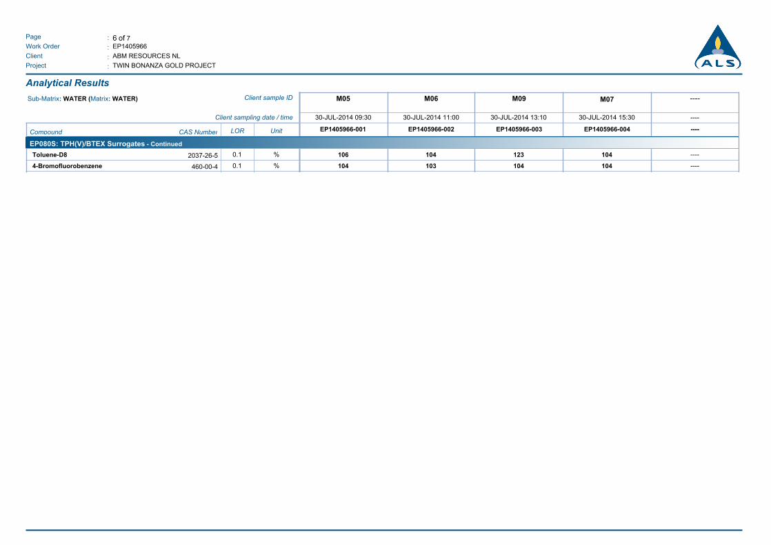
6 of 7:Page
Work Order :
:Client
EP1405966
ABM RESOURCES NL
TWIN BONANZA GOLD PROJECT:Project
Analytical Results
----M07M09M06M05Client sample IDSub-Matrix: WATER (Matrix: WATER)
----30-JUL-2014 15:3030-JUL-2014 13:1030-JUL-2014 11:0030-JUL-2014 09:30Client sampling date / time
----EP1405966-004EP1405966-003EP1405966-002EP1405966-001UnitLORCAS NumberCompound
EP080S: TPH(V)/BTEX Surrogates - Continued
Toluene-D8 104106 123 104 ----%0.12037-26-5
4-Bromofluorobenzene 103104 104 104 ----%0.1460-00-4

7 of 7:Page
Work Order :
:Client
EP1405966
ABM RESOURCES NL
TWIN BONANZA GOLD PROJECT:Project
Surrogate Control Limits
Recovery Limits (%)Sub-Matrix: WATER
Compound CAS Number Low High
EP080S: TPH(V)/BTEX Surrogates
1.2-Dichloroethane-D4 17060-07-0 60.5 141.2
Toluene-D8 2037-26-5 73.4 126
4-Bromofluorobenzene 460-00-4 59.6 125.3
False
8 8.00False Environmental
CERTIFICATE OF ANALYSISWork Order : EP1406069 Page : 1 of 11
:: LaboratoryClient Environmental Division PerthABM RESOURCES NL
: :ContactContact SHAUN WIMBRIDGE Scott James
:: AddressAddress level 1, 141 Broadway
Nedlands - Perth Perth Western Australia 6009
10 Hod Way Malaga WA Australia 6090
:: E-mailE-mail ---- [email protected]
:: TelephoneTelephone +61 08 9423 9777 +61-8-9209 7655
:: FacsimileFacsimile ---- +61-8-9209 7600
:Project TWIN BONANZA GOLD PROJECT QC Level : NEPM 2013 Schedule B(3) and ALS QCS3 requirement
:Order number ----
:C-O-C number ---- Date Samples Received : 05-AUG-2014
Sampler : R.H Issue Date : 15-AUG-2014
Site : ----
10:No. of samples received
Quote number : EP/268/14 V4 10:No. of samples analysed
This report supersedes any previous report(s) with this reference. Results apply to the sample(s) as submitted. All pages of this report have been checked and approved for
release.
This Certificate of Analysis contains the following information:
l General Comments
l Analytical Results
l Surrogate Control Limits
Environmental Division Perth ABN 84 009 936 029 Part of the ALS Group An ALS Limited Company
Address 10 Hod Way Malaga WA Australia 6090 | PHONE +61-8-9209 7655 | Facsimile +61-8-9209 7600

2 of 11:Page
Work Order :
:Client
EP1406069
ABM RESOURCES NL
TWIN BONANZA GOLD PROJECT:Project
General Comments
The analytical procedures used by the Environmental Division have been developed from established internationally recognized procedures such as those published by the USEPA, APHA, AS and NEPM. In house
developed procedures are employed in the absence of documented standards or by client request.
Where moisture determination has been performed, results are reported on a dry weight basis.
Where a reported less than (<) result is higher than the LOR, this may be due to primary sample extract/digestate dilution and/or insufficient sample for analysis.
Where the LOR of a reported result differs from standard LOR, this may be due to high moisture content, insufficient sample (reduced weight employed) or matrix interference.
When sampling time information is not provided by the client, sampling dates are shown without a time component. In these instances, the time component has been assumed by the laboratory for processing purposes.
Where a result is required to meet compliance limits the associated uncertainty must be considered. Refer to the ALS Contact for details.
CAS Number = CAS registry number from database maintained by Chemical Abstracts Services. The Chemical Abstracts Service is a division of the American Chemical Society.
LOR = Limit of reporting
^ = This result is computed from individual analyte detections at or above the level of reporting
Key :
EG020: Poor matrix spike recovery due to high TDS content.l
EG035F: Poor mercury matrix spike recovery due to high TDS content.l
LOR raised for COD due to sample matrix for various samplesl
MW006 is ALS's internal code and is equivalent to AS4276.7.l
MW006,estimate (~) is reported where there are many non-target colonies; the typical colonies may be masked by overgrowth of non-target organisms.l
This document has been electronically signed by the authorized signatories indicated below. Electronic signing has been carried out in
compliance with procedures specified in 21 CFR Part 11.
Signatories Accreditation CategoryPosition
Alini Goundar Senior Analyst Perth Microbiology
Ankit Joshi Inorganic Chemist Sydney Inorganics
Canhuang Ke Metals Instrument Chemist Perth Inorganics
Chas Tucker Senior Inorganic Chemist Perth Inorganics
Efua Wilson Metals Chemist Perth Inorganics
Rassem Ayoubi Senior Organic Chemist Perth Organics
NATA Accredited Laboratory 825
Accredited for compliance with
ISO/IEC 17025.
Signatories

3 of 11:Page
Work Order :
:Client
EP1406069
ABM RESOURCES NL
TWIN BONANZA GOLD PROJECT:Project
Analytical Results
Wilson's BoreBF04BF03ABF01Timmy's BoreClient sample IDSub-Matrix: WATER (Matrix: WATER)
04-AUG-2014 09:3004-AUG-2014 08:1504-AUG-2014 07:3004-AUG-2014 09:0004-AUG-2014 07:45Client sampling date / time
EP1406069-005EP1406069-004EP1406069-003EP1406069-002EP1406069-001UnitLORCAS NumberCompound
EA005P: pH by PC Titrator
pH Value 7.677.74 7.88 7.87 7.96pH Unit0.01----
EA010P: Conductivity by PC Titrator
Electrical Conductivity @ 25°C 1330477 516 792 12000µS/cm1----
EA015: Total Dissolved Solids
Total Dissolved Solids @180°C 872318 382 562 7840mg/L10----
ED037P: Alkalinity by PC Titrator
Hydroxide Alkalinity as CaCO3 <1<1 <1 <1 <1mg/L1DMO-210-001
Carbonate Alkalinity as CaCO3 <1<1 <1 <1 <1mg/L13812-32-6
Bicarbonate Alkalinity as CaCO3 280190 229 269 598mg/L171-52-3
Total Alkalinity as CaCO3 280190 229 269 598mg/L1----
ED041G: Sulfate (Turbidimetric) as SO4 2- by DA
Sulfate as SO4 - Turbidimetric 13319 16 36 1870mg/L114808-79-8
ED045G: Chloride Discrete analyser
Chloride 23424 25 64 2920mg/L116887-00-6
ED093F: Dissolved Major Cations
Calcium 7925 31 41 272mg/L17440-70-2
Magnesium 4419 22 31 363mg/L17439-95-4
Sodium 12441 42 74 2020mg/L17440-23-5
Potassium 4234 36 35 199mg/L17440-09-7
EG020F: Dissolved Metals by ICP-MS
Aluminium <0.01<0.01 <0.01 <0.01 <0.01mg/L0.017429-90-5
Antimony <0.001<0.001 <0.001 <0.001 <0.001mg/L0.0017440-36-0
Arsenic 0.0010.003 0.002 0.003 0.002mg/L0.0017440-38-2
Boron 0.200.18 0.18 0.26 1.31mg/L0.057440-42-8
Barium 0.2300.137 0.240 0.290 0.017mg/L0.0017440-39-3
Beryllium <0.001<0.001 <0.001 <0.001 <0.001mg/L0.0017440-41-7
Cadmium <0.0001<0.0001 <0.0001 <0.0001 <0.0001mg/L0.00017440-43-9
Cobalt <0.001<0.001 <0.001 <0.001 <0.001mg/L0.0017440-48-4
Chromium <0.001<0.001 <0.001 <0.001 0.011mg/L0.0017440-47-3
Copper 0.0010.001 0.001 0.001 0.006mg/L0.0017440-50-8
Manganese 0.1860.001 0.002 <0.001 <0.001mg/L0.0017439-96-5
Nickel 0.002<0.001 0.002 <0.001 0.002mg/L0.0017440-02-0
Lead <0.001<0.001 <0.001 <0.001 <0.001mg/L0.0017439-92-1

4 of 11:Page
Work Order :
:Client
EP1406069
ABM RESOURCES NL
TWIN BONANZA GOLD PROJECT:Project
Analytical Results
Wilson's BoreBF04BF03ABF01Timmy's BoreClient sample IDSub-Matrix: WATER (Matrix: WATER)
04-AUG-2014 09:3004-AUG-2014 08:1504-AUG-2014 07:3004-AUG-2014 09:0004-AUG-2014 07:45Client sampling date / time
EP1406069-005EP1406069-004EP1406069-003EP1406069-002EP1406069-001UnitLORCAS NumberCompound
EG020F: Dissolved Metals by ICP-MS - Continued
Selenium <0.01<0.01 <0.01 <0.01 0.02mg/L0.017782-49-2
Vanadium <0.010.02 0.02 0.02 <0.01mg/L0.017440-62-2
Zinc 0.0240.205 0.029 0.017 0.021mg/L0.0057440-66-6
Uranium 0.0020.001 0.001 0.001 0.085mg/L0.0017440-61-1
EG035F: Dissolved Mercury by FIMS
Mercury <0.0001<0.0001 <0.0001 <0.0001 <0.0001mg/L0.00017439-97-6
EK025SF: Free CN by Segmented Flow Analyser
Free Cyanide <0.004<0.004 <0.004 <0.004 <0.004mg/L0.004----
EK026SF: Total CN by Segmented Flow Analyser
Total Cyanide <0.004<0.004 <0.004 <0.004 <0.004mg/L0.00457-12-5
EK028SF: Weak Acid Dissociable CN by Segmented Flow Analyser
Weak Acid Dissociable Cyanide <0.004<0.004 <0.004 <0.004 <0.004mg/L0.004----
EK040P: Fluoride by PC Titrator
Fluoride 1.01.8 1.7 2.5 1.1mg/L0.116984-48-8
EK055G: Ammonia as N by Discrete Analyser
Ammonia as N 0.130.03 0.09 0.12 0.06mg/L0.017664-41-7
EK057G: Nitrite as N by Discrete Analyser
Nitrite as N 0.010.32 0.01 0.77 <0.01mg/L0.01----
EK058G: Nitrate as N by Discrete Analyser
Nitrate as N 0.012.13 2.70 6.47 6.12mg/L0.0114797-55-8
EK059G: Nitrite plus Nitrate as N (NOx) by Discrete Analyser
Nitrite + Nitrate as N 0.022.45 2.71 7.24 6.12mg/L0.01----
EK061G: Total Kjeldahl Nitrogen By Discrete Analyser
Total Kjeldahl Nitrogen as N 1.10.8 0.8 1.9 1.0mg/L0.1----
EK062G: Total Nitrogen as N (TKN + NOx) by Discrete Analyser^ Total Nitrogen as N 1.13.2 3.5 9.1 7.1mg/L0.1----
EK067G: Total Phosphorus as P by Discrete Analyser
Total Phosphorus as P 0.031.44 0.12 0.17 <0.05mg/L0.01----
EK071G: Reactive Phosphorus as P by discrete analyser
Reactive Phosphorus as P <0.010.64 0.07 0.14 0.03mg/L0.0114265-44-2
EN055: Ionic Balance
Total Anions 15.04.87 5.61 7.93 133meq/L0.01----
Total Cations 14.05.46 6.11 8.71 136meq/L0.01----

5 of 11:Page
Work Order :
:Client
EP1406069
ABM RESOURCES NL
TWIN BONANZA GOLD PROJECT:Project
Analytical Results
Wilson's BoreBF04BF03ABF01Timmy's BoreClient sample IDSub-Matrix: WATER (Matrix: WATER)
04-AUG-2014 09:3004-AUG-2014 08:1504-AUG-2014 07:3004-AUG-2014 09:0004-AUG-2014 07:45Client sampling date / time
EP1406069-005EP1406069-004EP1406069-003EP1406069-002EP1406069-001UnitLORCAS NumberCompound
EN055: Ionic Balance - Continued
Ionic Balance 3.215.76 4.19 4.69 1.16%0.01----
EP002: Dissolved Organic Carbon (DOC)
Dissolved Organic Carbon 143 3 4 4mg/L1----
EP005: Total Organic Carbon (TOC)
Total Organic Carbon 184 3 4 6mg/L1----
EP026SP: Chemical Oxygen Demand (Spectrophotometric)
Chemical Oxygen Demand 43<10 <10 <10 <40mg/L10----
EP080/071: Total Petroleum Hydrocarbons
C6 - C9 Fraction 290<20 <20 <20 <20µg/L20----
C10 - C14 Fraction 100<50 <50 <50 <50µg/L50----
C15 - C28 Fraction <100<100 <100 <100 <100µg/L100----
C29 - C36 Fraction <50<50 <50 <50 <50µg/L50----
^ C10 - C36 Fraction (sum) 100<50 <50 <50 <50µg/L50----
EP080/071: Total Recoverable Hydrocarbons - NEPM 2013
C6 - C10 Fraction 310<20 <20 <20 <20µg/L20C6_C10
^ C6 - C10 Fraction minus BTEX
(F1)
310<20 <20 <20 <20µg/L20C6_C10-BTEX
>C10 - C16 Fraction <100<100 <100 <100 <100µg/L100>C10_C16
>C16 - C34 Fraction <100<100 <100 <100 <100µg/L100----
>C34 - C40 Fraction <100<100 <100 <100 <100µg/L100----
^ >C10 - C40 Fraction (sum) <100<100 <100 <100 <100µg/L100----
^ >C10 - C16 Fraction minus Naphthalene
(F2)
<100<100 <100 <100 <100µg/L100----
EP080: BTEXN
Benzene <1<1 <1 <1 <1µg/L171-43-2
Toluene 4<2 <2 <2 <2µg/L2108-88-3
Ethylbenzene <2<2 <2 <2 <2µg/L2100-41-4
meta- & para-Xylene <2<2 <2 <2 <2µg/L2108-38-3 106-42-3
ortho-Xylene <2<2 <2 <2 <2µg/L295-47-6
^ Total Xylenes <2<2 <2 <2 <2µg/L21330-20-7
^ Sum of BTEX 4<1 <1 <1 <1µg/L1----
Naphthalene <5<5 <5 <5 <5µg/L591-20-3
MW006: Faecal Coliforms & E.coli by MF
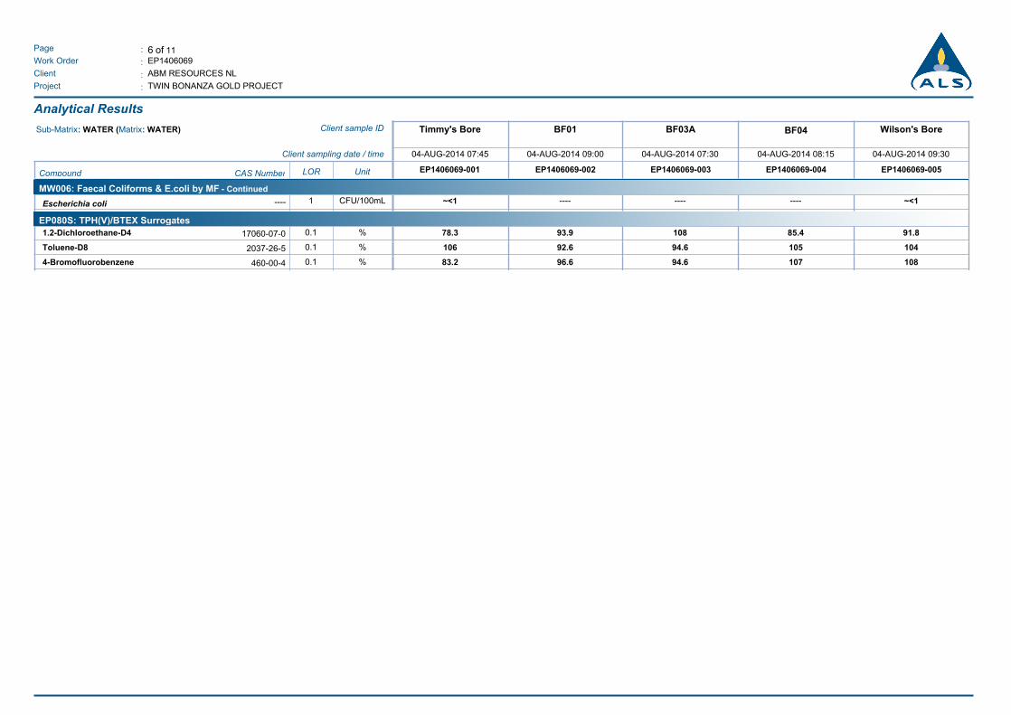
6 of 11:Page
Work Order :
:Client
EP1406069
ABM RESOURCES NL
TWIN BONANZA GOLD PROJECT:Project
Analytical Results
Wilson's BoreBF04BF03ABF01Timmy's BoreClient sample IDSub-Matrix: WATER (Matrix: WATER)
04-AUG-2014 09:3004-AUG-2014 08:1504-AUG-2014 07:3004-AUG-2014 09:0004-AUG-2014 07:45Client sampling date / time
EP1406069-005EP1406069-004EP1406069-003EP1406069-002EP1406069-001UnitLORCAS NumberCompound
MW006: Faecal Coliforms & E.coli by MF - Continued
Escherichia coli ----~<1 ---- ---- ~<1CFU/100mL1----
EP080S: TPH(V)/BTEX Surrogates
1.2-Dichloroethane-D4 93.978.3 108 85.4 91.8%0.117060-07-0
Toluene-D8 92.6106 94.6 105 104%0.12037-26-5
4-Bromofluorobenzene 96.683.2 94.6 107 108%0.1460-00-4

7 of 11:Page
Work Order :
:Client
EP1406069
ABM RESOURCES NL
TWIN BONANZA GOLD PROJECT:Project
Analytical Results
Corsair BoreBF02A01M11M10AClient sample IDSub-Matrix: WATER (Matrix: WATER)
04-AUG-2014 13:3004-AUG-2014 08:3004-AUG-2014 12:0004-AUG-2014 14:1004-AUG-2014 10:00Client sampling date / time
EP1406069-010EP1406069-009EP1406069-008EP1406069-007EP1406069-006UnitLORCAS NumberCompound
EA005P: pH by PC Titrator
pH Value 7.717.49 7.73 7.65 7.60pH Unit0.01----
EA010P: Conductivity by PC Titrator
Electrical Conductivity @ 25°C 315015100 13100 579 2300µS/cm1----
EA015: Total Dissolved Solids
Total Dissolved Solids @180°C 197010500 8550 424 1420mg/L10----
ED037P: Alkalinity by PC Titrator
Hydroxide Alkalinity as CaCO3 <1<1 <1 <1 <1mg/L1DMO-210-001
Carbonate Alkalinity as CaCO3 <1<1 <1 <1 <1mg/L13812-32-6
Bicarbonate Alkalinity as CaCO3 300477 364 249 318mg/L171-52-3
Total Alkalinity as CaCO3 300477 364 249 318mg/L1----
ED041G: Sulfate (Turbidimetric) as SO4 2- by DA
Sulfate as SO4 - Turbidimetric 3692380 1820 20 196mg/L114808-79-8
ED045G: Chloride Discrete analyser
Chloride 6913910 3360 32 499mg/L116887-00-6
ED093F: Dissolved Major Cations
Calcium 135430 254 44 109mg/L17440-70-2
Magnesium 116516 407 31 90mg/L17439-95-4
Sodium 3522390 2110 24 240mg/L17440-23-5
Potassium 47218 159 28 38mg/L17440-09-7
EG020F: Dissolved Metals by ICP-MS
Aluminium <0.010.01 0.02 <0.01 <0.01mg/L0.017429-90-5
Antimony <0.001<0.001 <0.001 <0.001 0.002mg/L0.0017440-36-0
Arsenic 0.013<0.001 <0.001 0.003 0.084mg/L0.0017440-38-2
Boron 0.651.16 1.30 0.10 0.61mg/L0.057440-42-8
Barium 0.0310.068 0.034 0.222 0.041mg/L0.0017440-39-3
Beryllium <0.001<0.001 <0.001 <0.001 <0.001mg/L0.0017440-41-7
Cadmium <0.0001<0.0001 <0.0001 <0.0001 <0.0001mg/L0.00017440-43-9
Cobalt 0.0010.004 0.003 <0.001 <0.001mg/L0.0017440-48-4
Chromium 0.0020.003 <0.001 <0.001 <0.001mg/L0.0017440-47-3
Copper 0.0040.012 0.014 0.001 <0.001mg/L0.0017440-50-8
Manganese 0.1230.126 0.077 0.003 0.042mg/L0.0017439-96-5
Nickel 0.0040.020 0.005 <0.001 <0.001mg/L0.0017440-02-0
Lead <0.001<0.001 <0.001 <0.001 <0.001mg/L0.0017439-92-1

8 of 11:Page
Work Order :
:Client
EP1406069
ABM RESOURCES NL
TWIN BONANZA GOLD PROJECT:Project
Analytical Results
Corsair BoreBF02A01M11M10AClient sample IDSub-Matrix: WATER (Matrix: WATER)
04-AUG-2014 13:3004-AUG-2014 08:3004-AUG-2014 12:0004-AUG-2014 14:1004-AUG-2014 10:00Client sampling date / time
EP1406069-010EP1406069-009EP1406069-008EP1406069-007EP1406069-006UnitLORCAS NumberCompound
EG020F: Dissolved Metals by ICP-MS - Continued
Selenium <0.010.01 <0.01 <0.01 <0.01mg/L0.017782-49-2
Vanadium <0.01<0.01 <0.01 0.02 <0.01mg/L0.017440-62-2
Zinc 0.0840.024 0.045 0.028 0.014mg/L0.0057440-66-6
Uranium 0.0220.032 0.069 0.002 0.019mg/L0.0017440-61-1
EG035F: Dissolved Mercury by FIMS
Mercury <0.0001<0.0001 <0.0001 <0.0001 <0.0001mg/L0.00017439-97-6
EK025SF: Free CN by Segmented Flow Analyser
Free Cyanide <0.004<0.004 <0.004 <0.004 <0.004mg/L0.004----
EK026SF: Total CN by Segmented Flow Analyser
Total Cyanide <0.004<0.004 <0.004 <0.004 <0.004mg/L0.00457-12-5
EK028SF: Weak Acid Dissociable CN by Segmented Flow Analyser
Weak Acid Dissociable Cyanide <0.004<0.004 <0.004 <0.004 <0.004mg/L0.004----
EK040P: Fluoride by PC Titrator
Fluoride 0.60.7 1.9 1.1 0.6mg/L0.116984-48-8
EK055G: Ammonia as N by Discrete Analyser
Ammonia as N 0.083.14 0.09 0.06 0.06mg/L0.017664-41-7
EK057G: Nitrite as N by Discrete Analyser
Nitrite as N 0.010.55 <0.01 0.04 <0.01mg/L0.01----
EK058G: Nitrate as N by Discrete Analyser
Nitrate as N 5.182.51 2.50 2.71 0.02mg/L0.0114797-55-8
EK059G: Nitrite plus Nitrate as N (NOx) by Discrete Analyser
Nitrite + Nitrate as N 5.193.06 2.50 2.75 0.02mg/L0.01----
EK061G: Total Kjeldahl Nitrogen By Discrete Analyser
Total Kjeldahl Nitrogen as N 0.88.8 0.7 1.1 0.4mg/L0.1----
EK062G: Total Nitrogen as N (TKN + NOx) by Discrete Analyser^ Total Nitrogen as N 6.011.9 3.2 3.8 0.4mg/L0.1----
EK067G: Total Phosphorus as P by Discrete Analyser
Total Phosphorus as P 0.080.07 <0.05 0.21 0.05mg/L0.01----
EK071G: Reactive Phosphorus as P by discrete analyser
Reactive Phosphorus as P 0.020.04 <0.01 0.21 0.01mg/L0.0114265-44-2
EN055: Ionic Balance
Total Anions 33.2169 140 6.29 24.5meq/L0.01----
Total Cations 32.8173 142 6.51 24.3meq/L0.01----

9 of 11:Page
Work Order :
:Client
EP1406069
ABM RESOURCES NL
TWIN BONANZA GOLD PROJECT:Project
Analytical Results
Corsair BoreBF02A01M11M10AClient sample IDSub-Matrix: WATER (Matrix: WATER)
04-AUG-2014 13:3004-AUG-2014 08:3004-AUG-2014 12:0004-AUG-2014 14:1004-AUG-2014 10:00Client sampling date / time
EP1406069-010EP1406069-009EP1406069-008EP1406069-007EP1406069-006UnitLORCAS NumberCompound
EN055: Ionic Balance - Continued
Ionic Balance 0.561.18 0.72 1.67 0.52%0.01----
EP002: Dissolved Organic Carbon (DOC)
Dissolved Organic Carbon 38 4 8 9mg/L1----
EP005: Total Organic Carbon (TOC)
Total Organic Carbon 330 4 8 10mg/L1----
EP026SP: Chemical Oxygen Demand (Spectrophotometric)
Chemical Oxygen Demand 1485 <40 22 30mg/L10----
EP080/071: Total Petroleum Hydrocarbons
C6 - C9 Fraction <20<20 <20 <20 <20µg/L20----
C10 - C14 Fraction <50<50 <50 70 70µg/L50----
C15 - C28 Fraction <100<100 <100 170 1040µg/L100----
C29 - C36 Fraction <50<50 <50 130 1410µg/L50----
^ C10 - C36 Fraction (sum) <50<50 <50 370 2520µg/L50----
EP080/071: Total Recoverable Hydrocarbons - NEPM 2013
C6 - C10 Fraction <20<20 <20 <20 <20µg/L20C6_C10
^ C6 - C10 Fraction minus BTEX
(F1)
<20<20 <20 <20 <20µg/L20C6_C10-BTEX
>C10 - C16 Fraction <100<100 <100 <100 170µg/L100>C10_C16
>C16 - C34 Fraction <100<100 <100 260 1880µg/L100----
>C34 - C40 Fraction <100<100 <100 <100 1400µg/L100----
^ >C10 - C40 Fraction (sum) <100<100 <100 260 3450µg/L100----
^ >C10 - C16 Fraction minus Naphthalene
(F2)
<100<100 <100 <100 170µg/L100----
EP080: BTEXN
Benzene <1<1 <1 <1 <1µg/L171-43-2
Toluene <2<2 <2 <2 <2µg/L2108-88-3
Ethylbenzene <2<2 <2 <2 <2µg/L2100-41-4
meta- & para-Xylene <2<2 <2 <2 <2µg/L2108-38-3 106-42-3
ortho-Xylene <2<2 <2 <2 <2µg/L295-47-6
^ Total Xylenes <2<2 <2 <2 <2µg/L21330-20-7
^ Sum of BTEX <1<1 <1 <1 <1µg/L1----
Naphthalene <5<5 <5 <5 <5µg/L591-20-3
MW006: Faecal Coliforms & E.coli by MF
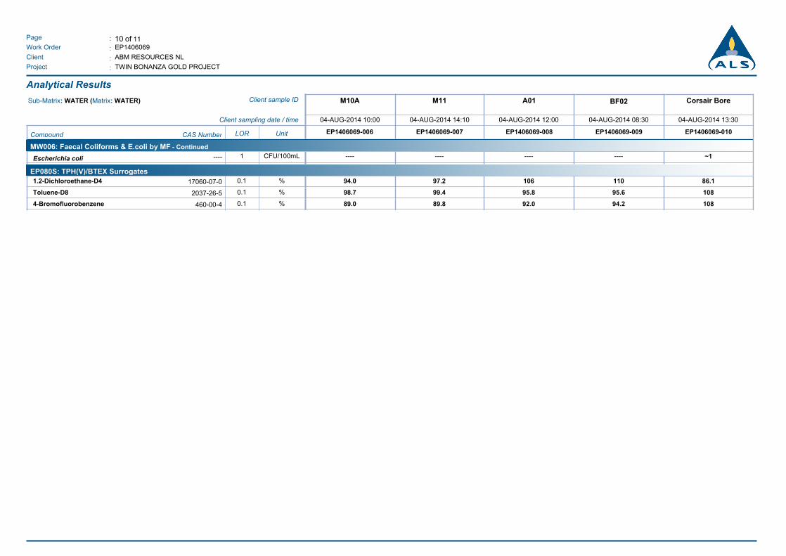
10 of 11:Page
Work Order :
:Client
EP1406069
ABM RESOURCES NL
TWIN BONANZA GOLD PROJECT:Project
Analytical Results
Corsair BoreBF02A01M11M10AClient sample IDSub-Matrix: WATER (Matrix: WATER)
04-AUG-2014 13:3004-AUG-2014 08:3004-AUG-2014 12:0004-AUG-2014 14:1004-AUG-2014 10:00Client sampling date / time
EP1406069-010EP1406069-009EP1406069-008EP1406069-007EP1406069-006UnitLORCAS NumberCompound
MW006: Faecal Coliforms & E.coli by MF - Continued
Escherichia coli -------- ---- ---- ~1CFU/100mL1----
EP080S: TPH(V)/BTEX Surrogates
1.2-Dichloroethane-D4 97.294.0 106 110 86.1%0.117060-07-0
Toluene-D8 99.498.7 95.8 95.6 108%0.12037-26-5
4-Bromofluorobenzene 89.889.0 92.0 94.2 108%0.1460-00-4

11 of 11:Page
Work Order :
:Client
EP1406069
ABM RESOURCES NL
TWIN BONANZA GOLD PROJECT:Project
Surrogate Control Limits
Recovery Limits (%)Sub-Matrix: WATER
Compound CAS Number Low High
EP080S: TPH(V)/BTEX Surrogates
1.2-Dichloroethane-D4 17060-07-0 60.5 141.2
Toluene-D8 2037-26-5 73.4 126
4-Bromofluorobenzene 460-00-4 59.6 125.3

Twin Bonanza Gold Project Hydrogeological Baseline and Bore Completion Report
ABM Resources NL
SAPROLITE ENVIRONMENTAL
APPENDIX F
Preliminary Review of Standard Operating Procedure for Groundwater Monitoring

Saprolite Pty LtdABN 43 135 590 724
PO Box 2234 Ellenbrook WA 606952B Mornington Parkway Ellenbrook WA 6069
Ph: (+61 8) 6296 7760 I Fax: (+61 8) 6296 7762 I Email: [email protected]
Memorandum
To: Justin Robins/Brad Valiukas Company: ABM Resources NL From: Garth Richards Date: 27 August 2014 cc: Shaun Wimbridge/Rob Hollis Job/PO No.: AB0101-01-01 Re: Twin Bonanza Gold Project – Preliminary Review – Standard Operating Procedure for Groundwater Monitoring
1. INTRODUCTION A Standard Operating Procedure (SOP) for Groundwater Monitoring was prepared by Soil Water Consultants (SWC, 2013) for ABM Resources NL (ABM), Twin Bonanza Gold Project (TBGP). The SOP formed part of the Water Management Plan for TBGP, (SWC, 2013), and was included in ABM’s submission for their Mining Management Plan to the Northern Territory Department of Mines and Energy.
The SOP was prepared as a generic type document with nominal bore conditions, with the preface that it is a “living document” that should be updated as and when required when new information and data becomes available.
A Hydrogeological Works Program that follows on from proposed monitor locations referenced within the SOP, was implemented at TBGP that included:
• Drilling/completion and baseline testing of 18 monitoring bores (nominal casing size 50mmND)
• Drilling/completion of a replacement production bore at Strezza’s/Timmy’s Bore (pre-existing bore collapsed) for longer term water supply (nominal casing size 155mmND).
• Test pumping three (3) production bores:
- Two (2) pre-existing, previously equipped production bores (Wilson’s Bore and Corsair Bore) to assess the existing pumping capacity.
- One (1) replacement production bore at Strezza’s/Timmy’s Bore to assess the longer term water resource capacity.
Site works was carried out from 1 July 2014 to 4 August 2014.
This memo presents an initial and preliminary review of the SOP based on the preliminary results and findings from the drilling and bore completion, and subsequent baseline testing and sampling, to examine if any changes may be required to the SOP to reflect actual bore conditions.
A detailed hydrogeological investigation and bore completion report is in preparation (at the time of writing) by Saprolite Environmental that presents all field investigation results and data, detailed analysis and discussion, and recommendations, including the recommended monitoring schedule.
2. COMMENTARY
It is noted that the SOP was prepared in accordance to the Northern Territory (NT) Department of Mines and Energy (DME) Advisory Note on the ‘Methodology for the Sampling of Ground Waters’ and with reference to the requirements of the Minerals Titles Act 2010, the Mining Management Act 2001, the appropriate Australian Standards (e.g. AS 5667.1:1998; 5667.4:1998; 5667.6:1998; and 5667.11:1998) and the Mine Site Water Management Handbook (Mineral Council of Australia, 1997).

Memorandum To Justin Robins/Brad Valiukas ABM Resources NL 27 August 2014 Page 2 of 9
TBGP - PRELIMINARY REVIEW OF SOP GROUNDWATER MONITORING - SAPROLITE MEMO - 27 AUG 2014\27 AUG 2014\GARTH RICHARDS:gr
The NT Advisory Note, states that “this advisory note is not intended to prescribe a methodology but to provide general principles for mine operators, who are encouraged to expand on the information provided in this document in the implementation of site specific methods.”
These referenced documents should be used as guidelines in the preparation a groundwater monitoring program, to ensure the following, but not limited to:
- Assist in the planning of a Sampling, Measuring and Analysis Program. - Provide a site specific set of measuring, sampling and analytical requirements, as well as generalised and
specific fieldwork procedures for the person(s) undertaking the sampling program. - Provide specific requirements for maintenance of the monitoring bores to ensure reliable monitoring data
can be obtained and that the bores remain intact, and in sound and satisfactory condition. - Provides documentary evidence as to what was planned and what is expected at the completion of the
program, as a component of a quality assurance philosophy in achieving sound defensible environmental data of integrity and accuracy.
The following sections within the SOP will require amendment:
2.1 BORE LOCATIONS
Following the completion of the drilling and bore construction program, including DGPS surveying of the bore locations, a new bore schedule will be required, together with a new bore location plan. This will be included in the Hydrogeological Report (draft in preparation, Saprolite, 2014).
2.2 SAMPLING FREQUENCY AND PARAMETERS TO BE MEASURED
The stated sampling frequency within the SOP is given as monthly, without any substantive explanation as to the basis.
It is considered that blanket monitoring/sampling of all production and monitoring bores on a monthly basis is not warranted, even for a baseline period of 12 months. This would be costly, and not necessarily provide any additional information if the sampling were reduced in frequency to:
- bi-monthly sampling (i.e. every two months) for plant site monitor bores; - quarterly sampling for analogue monitor bores; - quarterly water levels for water supply monitor bores; - monthly abstraction and water levels for production bores; - bi-monthly field water chemistry for production bores; and - 6-monthly sampling for production bores.
The sampling frequency and parameters to be measured should be on the basis as follows:
Objectives for monitoring:
• early detection of contaminants entering the groundwater from mining and mineral processing activities; • potential effects on aquifer and groundwater dependent ecosystems from groundwater abstraction for water
supply purposes; and • ensuring treated water supply is fit for human consumption.
Risk Assessment
There is potential for the deterioration of groundwater quality from contaminants, spills, or seepage from waste storage facilities, or from over exploitation from water supply bores. Information and data collected from the recent hydrogeological investigations has provided sufficient information to assess the risk associated from the operations; a summary of the information is provided below:

Memorandum To Justin Robins/Brad Valiukas ABM Resources NL 27 August 2014 Page 3 of 9
TBGP - PRELIMINARY REVIEW OF SOP GROUNDWATER MONITORING - SAPROLITE MEMO - 27 AUG 2014\27 AUG 2014\GARTH RICHARDS:gr
Plant site monitor bores
• Four (4) shallow bores drilled dry to 36m and completed as dry bores, and are considered to be in the unsaturated zone, and well above any aquifer.
• Five (5) deep bores were drilled to depths ranging from 132m to 144m, three bores encountered groundwater in fractured sandstone from 114m to 126m, and the other two bores were drilled dry. The standing water levels were measured in all deep monitor bores ranging in depths from 59 to 70m, and indicating seepage occurrence in formerly dry bores.
• The shallow surficial bores are designed for early detection into subsurface weathered and unsaturated strata from potential contaminants that may seep or migrate from the process area.
• The deeper bores have aquifer depths at greater than 110m, and are relatively low yielding. The aquifer is considered semi-confined, with potentiometric levels between 374mAHD and 393mAHD, some 50m above the reported aquifer depth.
• The likelihood of these deep low yielding aquifers being contaminated from mining activities is considered low, especially in light of the semi-confined nature of the aquifer; i.e. the deep aquifer is isolated by an overlying impermeable unit.
Water supply bores
• Four (4) monitor bores and a production bore were completed to depths ranging from 40 to 41m within a basal palaeochannel aquifer using mud rotary drilling techniques. The standing water levels ranged from 2.9 to 3.9mbgl.
• Two (2) monitor bores associated with production bores were completed; one at each pre-existing production bore (Corsair Bore and Wilson’s Bore) to respective depths of 150m and 90m. Groundwater was encountered at the Corsair monitor bore (M11) at 90m, with a standing water level of 55mbgl. Mud rotary drilling techniques were used in the drilling of the Wilson’s monitor bore (M10a); as such the depth of any groundwater intersection was not delineated, but the standing water level was 49mbgl.
• The water supply bores are spatially distant from the mine processing activities, and contamination of these aquifers is unlikely. - The palaeochannel bores are located 7km from the processing area, although are relatively shallow, are also
semi-confined, with an interpreted silcrete hardcap overlying the main aquifer that potentially isolates the main productive zone.
- The deep aquifer in Corsair’s Bore is also semi-confined, similar to the deep monitor bores at the Plant, and is equally unlikely to be contaminated from mining activities, in addition to being 3km upgradient from the Plant.
- Wilson’s Bore, is relatively low yielding, with an inferred limited storage aquifer at depths less than 90m. It is a semi-confined aquifer, and potentially isolated by overlying inferred less permeable units. The bore is also located 2.5km from the Plant. This bore is unlikely to be impacted from mining activities.
• Over exploitation of water supplies is a risk, which could impact aquifers, in terms of declining water levels, aquifer dewatering, long term bore performance, and potential effects on vegetation. Deleterious effects could be associated with increasing salinity, declining water levels and reduced pumping yields.
Analogue monitor bores
• One shallow bore drilled dry to 36m, and completed as a dry bore, and is considered to be in the unsaturated zone, and well above any aquifer.
• One deep bore drilled to 114m, and encountered groundwater/seepage in fractured sandstone at 102m. The standing water level was measured at a depth of 68mbgl.
• One mud rotary drilled bore was completed to a depth of 42m, within the upper catchment of the palaeovalley. This bore was completed as a dry bore.
• The analogue monitor bores are located in upstream/upgradient positions at some distance from the operations. The deep bore should provide suitable background and ambient groundwater conditions with respect to water chemistry. The shallow bore and the one in the palaeovalley, whilst currently dry, may eventually contain water from seepage.

Memorandum To Justin Robins/Brad Valiukas ABM Resources NL 27 August 2014 Page 4 of 9
TBGP - PRELIMINARY REVIEW OF SOP GROUNDWATER MONITORING - SAPROLITE MEMO - 27 AUG 2014\27 AUG 2014\GARTH RICHARDS:gr
The following table is a proposed revised monitoring schedule that includes parameters to be measured and frequency, subject to the monitoring objectives, as above:
Table 1 Proposed Monitoring Schedule – Baseline
Area Monitoring Locations Parameters Frequency
Water Supply Bores
Production Bores
Corsair Bore, Wilson’s Bore, and Strezza’s/Timmy’s Bore 2
(if a production bore is not equipped it should be monitored as a monitoring bore)
Abstraction Monthly (end of month) Water Levels (if possible) Monthly (end of month) Field Parameters Bi-monthly (every 2 months) Field Parameters, Laboratory Parameters, Major Ions, Metals
6-monthly
Monitor Bores (associated with production bores) M10a, M11 and BF03a
Water Levels Quarterly (or Monthly – see below)
EC Profiling Quarterly Borefield Monitor Bores BF01, BF02, and BF04
Water Levels Quarterly EC Profiling Quarterly
Plant Site Monitor Bores (Shallow/Surficial) M01, M02, M03, and M04
Monitor Bores (Deep) M05, M06a, M07, M08a, M09
Water Levels, Field Parameters, Laboratory Parameters, Major Ions, Metals/Metalloids, Nutrients, Cyanide, Hydrocarbons
Bi-monthly
Analogue Bores
Monitor Bores (Shallow/Surficial) A02 and A03
Monitor Bores (Deep) A01
Water Levels, Field Parameters, Laboratory Parameters, Major Ions, Metals/Metalloids, Nutrients, Cyanide, Hydrocarbons
Quarterly
Treatment Plant
Post Treatment Plant Camp Kitchen Tap and Processing Office Tap
Microbiological Monthly
Abstraction: Meter readings, pump status, duration of pump status. Field Parameters: Electrical conductivity (EC) and pH. Laboratory Parameters: Electrical conductivity (EC), pH, total dissolved solids (TDS), total alkalinity. Major Ions Ca, Na, Mg, K, SO4, Cl, HCO3, CO3, F Metals/Metalloids: Al, Sb, As, B, Cd, Cr, Cu, Pb, Hg, Ni, Mn, Se, U, V, and Zn, Nutrients: Nitrate as N (NO3), Ammonia as N (NH33), Total Nitrogen (TN), Total Kjeldahl Nitrogen (TKN as N),
Reactive Phosphorus, Total Phosphorus, Chemical Oxygen Demand (COD), Total Organic Carbon (TOC), Dissolved Organic Carbon (DOC)
Cyanide: Weak Acid Dissociable Cyanide (WAD CN) Hydrocarbons: Total Petroleum Hydrocarbons (TPH (C6-C36)) and Total Recoverable Hydrocarbons (TRH (C6-C40)) Microbiological: E. Coli EC Profiling: Routine EC Profiling – No purging, as all have been airlifted clean and initial EC profiling has been undertaken.
Explanatory notes in relation to elements of the monitoring schedule are as follows:
Monitoring Sites Explanatory Notes
Production Bores Water Levels – water levels may not be able to me measured from production bores equipped with pumps, as WL dip-tubes are not likely to be installed. Water levels should be measured from their adjacent monitor bore instead. If a production bore is not equipped it should be monitored in the same way as a monitor bore.
Water Chemistry – water chemistry is not likely to change significantly with time, and monthly sampling is not considered necessary. However, quarterly field pH and EC is a good indication of general water quality, and trends over time. A 6-monthly sampling event is suggested with analysis of major ions and metals only

Memorandum To Justin Robins/Brad Valiukas ABM Resources NL 27 August 2014 Page 5 of 9
TBGP - PRELIMINARY REVIEW OF SOP GROUNDWATER MONITORING - SAPROLITE MEMO - 27 AUG 2014\27 AUG 2014\GARTH RICHARDS:gr
Monitoring Sites Explanatory Notes
Production Bores and Treatment Plant
Microbiology – whilst the production bores may be utilised as a raw water source for ABM’s potable water supply following RO treatment; it would be more effective to sample and test the treated water to ensure that the potable water that is supplied (i.e. from within the camp distribution system) is free of microbiological contaminants and safe to consume.
It is recommended that a Drinking Water Quality Management Plan be prepared, established and implemented to guide ABM in the correct procedure of collecting microbiological samples, what steps to take if positive results are returned, and reporting (internally and externally). As a resource guide the following is referenced:
- NHMRC, NRMMC, (2011) The Australian Drinking Water Guidelines – 6, National Water Quality Management Strategy;
- NHMRC (2005), Drinking Water Guidelines: Community Water Planner – A tool for small communities to develop drinking water management plans www.nhmrc.gov.au/publications/synopses/eh39.htm
- NT Department of Health (2012), Environmental Health Guidelines for Private Water Supplies; and
- NT Department of Health (2013), Environmental Health Fact Sheet No 414 – Private Water Supplies in Accommodation Businesses.
Borefield Monitor Bores EC Profiling – the monitor bores within the palaeovalley, and adjacent to production bores should be EC profiled to monitor any deterioration of water quality within the aquifer. Downhole insitu measurements of electrical conductivity are the best indication of vertical stratification of water quality within bores, and as a result migration of natural saline groundwater (i.e. saline intrusion) from surrounding and underlying aquifers that may contain more saline groundwater. Should EC profiling indicate a change in insitu salinity in distant monitor bores, the operation of production bore(s) within the can be reviewed and rates adjusted if required.
Plant Site Monitor Bores Monitoring Frequency – Bi-monthly (every 2 months) monitoring/sampling frequency is recommended; reduced from monthly. Sampling more frequently is not necessarily going to add greater value or provide more information during a baseline period of 12 months. This will also reduce costs
Dry Bores – shallow/surficial bores that were drilled dry, and remained dry 2-weeks after completion may remain dry for some time. These bores should still be checked on a quarterly basis for the presence of water in the bores, by simply attempting to measure a water level, and comparing with the completed hole depth. Unless there is more than 1m of water in the end of the bore, it is recommended that only a downhole EC measurement be taken (using EC profile), as it is likely that the water might be turbid and silty, and not appropriate to sample.
Analogue Monitor Bores
Monitoring Frequency – Quarterly monitoring/sampling frequency is recommended; reduced from monthly. Sampling more frequently is not necessarily going to add greater value or provide more information during a baseline period of 12 months. This will also reduce costs
Dry Bores – see above
Plant Site Monitor Bores and Analogue Monitor Bores
Cyanide species – Weak acid dissociable Cyanide (WAD CN) is the best indication of contamination in groundwater from Cyanide.
All Sites Field Parameters – Recommended field parameters for water chemistry is pH and Electrical Conductivity (EC); the first is a measure of the acidity of the groundwater and EC is a measure of salinity. Dissolved Oxygen (DO) and Redox Potential (ORP) are not considered necessary within this hydrogeological environment and in the context of the project location not pertinent to the monitoring objectives.
All Sites Baseline Period – The recommended baseline period is 12 months, following which time the monitoring data should be reviewed/assessed in detail and background levels set (as per the SOP) and trigger levels subsequently determined once sufficient background information data is collected, using statistical methods.
Memorandum To Justin Robins/Brad Valiukas ABM Resources NL 27 August 2014 Page 6 of 9
TBGP - PRELIMINARY REVIEW OF SOP GROUNDWATER MONITORING - SAPROLITE MEMO - 27 AUG 2014\27 AUG 2014\GARTH RICHARDS:gr
2.3 BORE PURGING Bore purging prior to sampling is considered necessary to ensure representative water samples are collected, that sufficient water in the bore column is removed, and that groundwater from the formation is introduced into the bore.
The SOP and reference material state that at least 4-6 bore volumes should be purged from the bore prior to sampling. In practicality for deep bores this could be difficult in procuring a sampling pump that is capable of:
- purging groundwater deeper than 60-80m - sustaining flow rates with declining heads - purging bores that are inherently low yielding, given bores were drilled dry or had low flow rates while
drilling. - potential for the water within the bore to be silty (or sediment laden) and possibly turbid in some instances
(M08A and M09).
It is recommended that rather than stringently removing 4 to 6 bore volumes, an alternative approach be taken that could be considered more representative. That is, bores can be purged until pH, EC and Temperature measurements of the abstracted water stabilises to within 10% variation. This can be achieved with less than 2 bore volumes removed (based on practical experience). It is recommended at least the first 1 to 2 bore volumes from the bore column is removed to remove the stagnant water, and to allow sufficient natural groundwater enter the bore.
A suitable purging/sampling pump should be considered that has the capability of the above criteria. For example, a Bennet Pump (high flow) or a Micropurge® (low flow) pumping system. Each system has advantages and disadvantages; see section 5 for comparisons, and individual brochures for each pump are included as Appendix A.
It is recommended, that the Micropurge® Low-Flow sampling system is used in the case of ABM’s monitoring requirements, given that the Bennet pump may not be able to handle silty or sediment laden water.
3. CONCLUSIONS
In summary, the SOP will need to be revised, amended and tailored to reflect the site specific conditions, including the actual bores that were drilled, the initial baseline testing, and the hydrogeological conditions that were encountered. The changes to the SOP include:
- Addition of actual bore schedule and location plan - New monitoring schedule with revised parameters and frequencies - Bore purging considerations - Additional and different sampling equipment that will be required - Minor amendments and improvements throughout
The contents of this memo, and any other further commentary, following the detailed assessment of all data (including baseline chemistry data) from the hydrogeological works program, will be provided in the Hydrogeological Investigations report (draft in prep).
Following the completion of the Hydrogeological Investigations report, it is recommended:
• The SOP be rewritten (or a new document prepared) that includes the above changes, and to suit a field based practical program, for ease of use in the field for operators; and
• A Drinking Water Quality Management Plan is prepared and developed.
Should you have any queries please do not hesitate to contact the undersigned.
Yours faithfully SAPROLITE ENVIRONMENTAL Garth Richards Garth Richards Senior Principal Consultant Managing Director

Memorandum To Justin Robins/Brad Valiukas ABM Resources NL 27 August 2014 Page 7 of 9
TBGP - PRELIMINARY REVIEW OF SOP GROUNDWATER MONITORING - SAPROLITE MEMO - 27 AUG 2014\27 AUG 2014\GARTH RICHARDS:gr
4. STATEMENT OF LIMITATIONS
Aquifer materials and groundwater flow systems are a product of continuing natural and man- made processes and thus exhibit a variety of characteristics and properties that vary from place to place and can change with time. Geology/hydrogeology involves gathering and assimilating limited facts about these characteristics and properties in order to understand and predict the behaviour of the ground on a particular site under certain conditions. This report may contain such facts obtained by inspection, drilling, excavation, probing, sampling, testing or other means of investigation, particularly pumping and drawdown data. If so, they are directly relevant only to the groundwater system at the place where, and the time when the investigation was carried out. Any groundwater modelling predictions presented should not be regarded as matters of fact.
This report and other reports referred to contain comments on works being carried out by others. Saprolite Environmental cannot and will not take responsibility for works carried out by others on site to date. We do not guarantee the performance of the project in any respect, only that our work and judgement meet the standard of care of our profession at this time.
Any interpretation or recommendation given in this report shall be understood to be based on judgement and experience, not on greater knowledge of facts other than those reported. The interpretation and recommendations are therefore opinions provided for the Client's sole use in accordance with a specific brief. As such they do not necessarily address all aspects of the groundwater system on the subject site.

Memorandum To Justin Robins/Brad Valiukas ABM Resources NL 27 August 2014 Page 8 of 9
TBGP - PRELIMINARY REVIEW OF SOP GROUNDWATER MONITORING - SAPROLITE MEMO - 27 AUG 2014\27 AUG 2014\GARTH RICHARDS:gr
5. COMPARISON BETWEEN LOW FLOW AND HIGH FLOW PUMPING
Low Flow with the QED well wizard and MP10H controller versus High Flow Bennett Pump with variable pressure control
Option 1: Well Wizard Pump (Micropurge® Low Flow)
Advantages of this system:
• True low flow - no need to excavate multiple bore volumes, only interacts with a small amount of the bore column. Associated reduction in time required to sample and for sample to stabilize.
• Option of using drop tubes to pump from greater depths • Different housing materials available depending on the water matrix (i.e.: reduce corrosion and damage
potential per water source). • Extremely robust against silty/high sediment water • Minimal drawdown in bore column • No contact with the air to the sample (bladder system)
Disadvantages of this system:
• High Pressure can be required: 15psi + 1.5psi/m (eg. 150m head = 240psi) • High capital cost at the onset, recuperated over time with reduced labour • Requires a water level meter also (nominal drawdown is <10cm) • Requires a controller at surface to regulate pressure and water level, although adds to ease of use once a
good working system is in place. • Only used as Low Flow Pump - limited with flow rates, although no need to purge prior to sampling. • Time to sample can be significant in areas of low hydraulic conductivity
Option 2: Bennett Pump
Advantages of this system
• Can pump up to 300m (model 1800+) • Can be used as low flow (control pressure) as the water doesn’t come into contact with the air-source
(manual control) • Can also be used for purging (low rates roughly 3 – 4 litres per min) • Moderate air pressure required, increases with depth • Doesn’t require a controller at surface
Disadvantages of the system
• Contaminated waters of high silt/sediment could damage the internal works of the pump • May require excavation of 3-4 bore volumes (for compliance testing), which can be time consuming and
requires discharge of potentially large amounts of water. • Not automated and programmable as with the Well Wizard
Memorandum To Justin Robins/Brad Valiukas ABM Resources NL 27 August 2014 Page 9 of 9
TBGP - PRELIMINARY REVIEW OF SOP GROUNDWATER MONITORING - SAPROLITE MEMO - 27 AUG 2014\27 AUG 2014\GARTH RICHARDS:gr
APPENDIX A PUMP BROCHURES
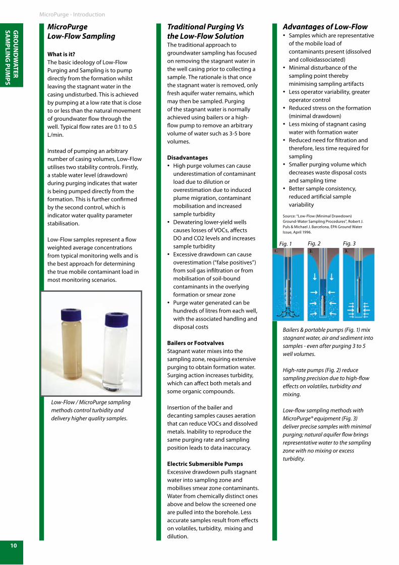
GRO
UN
DW
ATER SA
MPLIN
G PU
MPS
10
MicroPurgeLow-Flow Sampling
What is it?The basic ideology of Low-FlowPurging and Sampling is to pumpdirectly from the formation whilstleaving the stagnant water in thecasing undisturbed. This is achieved by pumping at a low rate that is close to or less than the natural movement of groundwater flow through the well. Typical flow rates are 0.1 to 0.5 L/min.
Instead of pumping an arbitrary number of casing volumes, Low-Flow utilises two stability controls. Firstly, a stable water level (drawdown) during purging indicates that water is being pumped directly from the formation. This is further confirmed by the second control, which is indicator water quality parameter stabilisation.
Low-Flow samples represent a flow weighted average concentrations from typical monitoring wells and is the best approach for determining the true mobile contaminant load in most monitoring scenarios.
Traditional Purging Vs the Low-Flow Solution The traditional approach to groundwater sampling has focused on removing the stagnant water inthe well casing prior to collecting asample. The rationale is that once the stagnant water is removed, only fresh aquifer water remains, which may then be sampled. Purging of the stagnant water is normally achieved using bailers or a high-flow pump to remove an arbitrary volume of water such as 3-5 bore volumes.
DisadvantagesHigh purge volumes can cause •underestimation of contaminant load due to dilution or overestimation due to induced plume migration, contaminant mobilisation and increased sample turbidityDewatering lower-yield wells •causes losses of VOCs, affects DO and CO2 levels and increases sample turbidityExcessive drawdown can cause •overestimation (“false positives”) from soil gas infiltration or from mobilisation of soil-bound contaminants in the overlying formation or smear zonePurge water generated can be •hundreds of litres from each well, with the associated handling and disposal costs
Bailers or FootvalvesStagnant water mixes into thesampling zone, requiring extensivepurging to obtain formation water.Surging action increases turbidity,which can affect both metals andsome organic compounds.
Insertion of the bailer and decanting samples causes aeration that can reduce VOCs and dissolved metals. Inability to reproduce the same purging rate and sampling position leads to data inaccuracy.
Electric Submersible PumpsExcessive drawdown pulls stagnantwater into sampling zone and mobilises smear zone contaminants.Water from chemically distinct ones above and below the screened one are pulled into the borehole. Less accurate samples result from effects on volatiles, turbidity, mixing and dilution.
Advantages of Low-FlowSamples which are representative •of the mobile load of contaminants present (dissolved and colloidassociated)Minimal disturbance of the •sampling point thereby minimising sampling artifactsLess operator variability, greater •operator controlReduced stress on the formation •(minimal drawdown)Less mixing of stagnant casing •water with formation waterReduced need for filtration and •therefore, less time required for samplingSmaller purging volume which •decreases waste disposal costs and sampling timeBetter sample consistency, •reduced artificial sample variability
Source: “Low-Flow (Minimal Drawdown)Ground-Water Sampling Procedures”, Robert J.Puls & Michael J. Barcelona, EPA Ground WaterIssue, April 1996.
Bailers & portable pumps (Fig. 1) mix stagnant water, air and sediment into samples - even after purging 3 to 5 well volumes.
High-rate pumps (Fig. 2) reduce sampling precision due to high-flow effects on volatiles, turbidity and mixing. Low-flow sampling methods withMicroPurge® equipment (Fig. 3) deliver precise samples with minimal purging; natural aquifer flow brings representative water to the sampling zone with no mixing or excess turbidity.
MicroPurge - Introduction
Low-Flow / MicroPurge sampling methods control turbidity and delivery higher quality samples.
Fig. 1 Fig. 2 Fig. 3
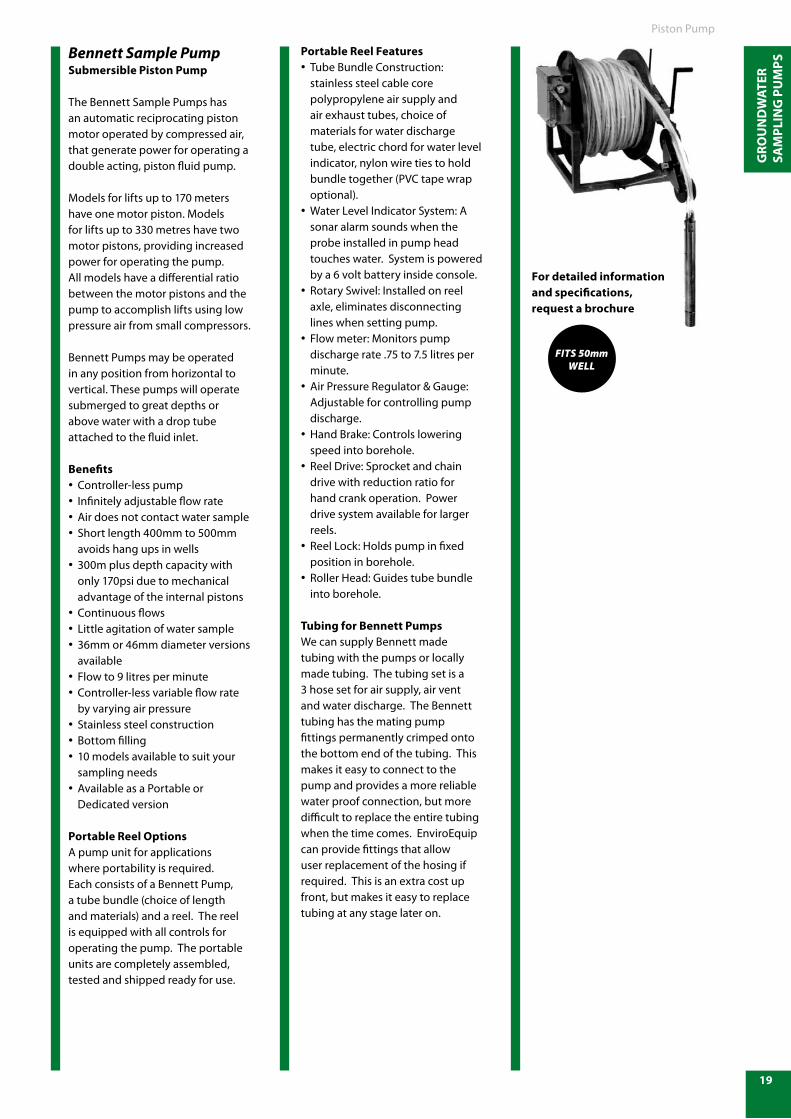
GRO
UN
DW
ATER
SA
MPL
ING
PU
MPS
19
Bennett Sample PumpSubmersible Piston Pump
The Bennett Sample Pumps has an automatic reciprocating piston motor operated by compressed air, that generate power for operating a double acting, piston fluid pump.
Models for lifts up to 170 meters have one motor piston. Models for lifts up to 330 metres have two motor pistons, providing increased power for operating the pump. All models have a differential ratio between the motor pistons and the pump to accomplish lifts using low pressure air from small compressors.
Bennett Pumps may be operated in any position from horizontal to vertical. These pumps will operate submerged to great depths or above water with a drop tube attached to the fluid inlet.
BenefitsController-less pump•Infinitely adjustable flow rate•Air does not contact water sample•Short length 400mm to 500mm •avoids hang ups in wells300m plus depth capacity with •only 170psi due to mechanical advantage of the internal pistonsContinuous flows•Little agitation of water sample•36mm or 46mm diameter versions •availableFlow to 9 litres per minute•Controller-less variable flow rate •by varying air pressureStainless steel construction•Bottom filling•10 models available to suit your •sampling needsAvailable as a Portable or •Dedicated version
Portable Reel OptionsA pump unit for applications where portability is required. Each consists of a Bennett Pump, a tube bundle (choice of length and materials) and a reel. The reel is equipped with all controls for operating the pump. The portable units are completely assembled, tested and shipped ready for use.
Portable Reel FeaturesTube Bundle Construction: •stainless steel cable core polypropylene air supply and air exhaust tubes, choice of materials for water discharge tube, electric chord for water level indicator, nylon wire ties to hold bundle together (PVC tape wrap optional).Water Level Indicator System: A •sonar alarm sounds when the probe installed in pump head touches water. System is powered by a 6 volt battery inside console.Rotary Swivel: Installed on reel •axle, eliminates disconnecting lines when setting pump.Flow meter: Monitors pump •discharge rate .75 to 7.5 litres per minute.Air Pressure Regulator & Gauge: •Adjustable for controlling pump discharge.Hand Brake: Controls lowering •speed into borehole.Reel Drive: Sprocket and chain •drive with reduction ratio for hand crank operation. Power drive system available for larger reels.Reel Lock: Holds pump in fixed •position in borehole.Roller Head: Guides tube bundle •into borehole.
Tubing for Bennett PumpsWe can supply Bennett made tubing with the pumps or locally made tubing. The tubing set is a 3 hose set for air supply, air vent and water discharge. The Bennett tubing has the mating pump fittings permanently crimped onto the bottom end of the tubing. This makes it easy to connect to the pump and provides a more reliable water proof connection, but more difficult to replace the entire tubing when the time comes. EnviroEquip can provide fittings that allow user replacement of the hosing if required. This is an extra cost up front, but makes it easy to replace tubing at any stage later on.
Fits 50mmWell
Piston Pump
For detailed information and specifications, request a brochure
Copyright © 2022 FDOKUMEN