Geoscience Research - Bioinfo Publications
7
38 Bioinfo Publications Geoscience Research Geoscience Research ISSN: 0976–9846 & E-ISSN: 0976–9854, Vol. 2, Issue 1, 2011, pp-38-44 Available online at http://www.bioinfo.in/contents.php?id=90 A STUDY OF URBANIZATION IN SATARA DISTRICT OF MAHARASHTRA BARAKADE A.J. 1 AND TODKARI G.U. 2 * 1 Department of Geography, Karmaveer Bhaurao Patil Maahidyalaya, Pandharpur, MS, India * 2 Department of Geography, Shri. Sant Damaji Mahavidyalaya, Mangalwedha, MS, India *Corresponding author. E-mail: [email protected] Received: July 26, 2011; Accepted: September 15, 2011 Abstract- In this paper has been made to analyze the urbanization in Satara district in Maharashtra. This study is based on secondary data have been collected from various published reports, District Statistical offices of the division and census office, Bombay. It occupies an area of 10,490 sq.km. and supports 28.09 lack of population in 2001 census with 15 towns and 1,739 villages. Administrative the district is divided in to eleven tahsils. Satara is the ‘Historical City’ is currently emerging as the largest educational center of certain cool stations, goods and services. In the recent decades, various offices have become the principal source of employment. A study on urbanization in Satara district revealed that in 70.45 percent Satara, Karad and Phaltan tahsils. Remaining population live 29.55 percent included other tahsils in urban centre. The Satara district urbanization has been studied with the help of various indicators such as urban population ratio, urban growth rate, urban density, average of urban centers, urbanization trend in Satara district, accessibility and urban concentration . The result of the studies are brought out through maps and diagrams. Keywords: Urbanization, Towns, Cities, Growth, Population Introduction It has been projected that 21 st century will be urban century with almost 60 percent of the world population living in urban areas, the highest share of population that ever lived in urban area (UN, 2008). This is mainly because, unlike previous centuries, current and future centuries are likely to experience a rapid shift in the nature of human activities from primary to non-primary, mainly due to changing resources base and environmental conditions and rapid progress in human endeavors in science, technology, management and development. Such a shift obviously enhances human affordability and capabilities to achieve an improved standard of living through better access to infrastructure and services. However, all these achievements are possible , provided rapid urbanization is managed in a sustainable way. Developing countries are characterized by high level of urbanization and some of them are in final stage of urbanization process and experiencing slowing down of urbanization due to host of factors (Brockerhoff,1999), (Brockerhoff and Brennam, 1998). A majority of the developing countries on the other hand started experiencing urbanization only since the middle of the 20 th century. The phenomenon of urbanization has its roots in the resource base of a region. In 1947 there were only 1 million population in India i.e. Calcutta, Mumbai and Chennai. During the last 62 years Indian has developed as the largest urban system in the world. Massive urban population of 1,028.7 million in 2001 census is spread over a large number of urban areas across the country. The 2001 census has recorded a total number of 5,161 towns and 384 agglomerations with increasing population in million plus cities. There was 18.8 percent of urban population in 1951 which has risen to 27.8 percent. India ranks second among the countries of the world in terms of population, which as per the 2001 census has been recorded at 1,028.7 million. Study Area The Satara district is situated in west part in Maharashtra state. This district consists eleven tahsils covering 1739 villages. The total area extent is of 10,480 sq. km. extending from 17 0 5’ to 18 0 11’ north latitudes and 73 0 33’ to 74 0 54’ east longitudes. This district is confined by Pune district to north, Solapur district to east, Sangli district to south and Ratanagiri district and Raigarh districts to west (Fig.1). Satara district has a typical landscapes due to variations in relief, climate and vegetation. The variation of relief ranges from the pinnacles and high plateau of the main Sahyadrians range having heights over 1200 meters above mean sea level to the subdued basin of Nira river with an average height of about 600 meters above mean sea level. The climate ranges from the rainiest in the Mahabaleshwar region which has an average annual rainfall of over 6000 mm to the driest in Man, Phaltan, Khandala and Khatav tahsils where the average annual rainfall is about 500 mm. Satara is predominately a rural district of the 23 inhabited places in
-
Upload
khangminh22 -
Category
Documents
-
view
0 -
download
0
Transcript of Geoscience Research - Bioinfo Publications

38 Bioinfo Publications
Geoscience Research Geoscience Research ISSN: 0976–9846 & E-ISSN: 0976–9854, Vol. 2, Issue 1, 2011, pp-38-44 Available online at http://www.bioinfo.in/contents.php?id=90
A STUDY OF URBANIZATION IN SATARA DISTRICT OF MAHARASHTRA BARAKADE A.J.1 AND TODKARI G.U.2 * 1Department of Geography, Karmaveer Bhaurao Patil Maahidyalaya, Pandharpur, MS, India * 2Department of Geography, Shri. Sant Damaji Mahavidyalaya, Mangalwedha, MS, India
*Corresponding author. E-mail: [email protected]
Received: July 26, 2011; Accepted: September 15, 2011 Abstract- In this paper has been made to analyze the urbanization in Satara district in Maharashtra. This study is based on secondary data have been collected from various published reports, District Statistical offices of the division and census office, Bombay. It occupies an area of 10,490 sq.km. and supports 28.09 lack of population in 2001 census with 15 towns and 1,739 villages. Administrative the district is divided in to eleven tahsils. Satara is the ‘Historical City’ is currently emerging as the largest educational center of certain cool stations, goods and services. In the recent decades, various offices have become the principal source of employment. A study on urbanization in Satara district revealed that in 70.45 percent Satara, Karad and Phaltan tahsils. Remaining population live 29.55 percent included other tahsils in urban centre. The Satara district urbanization has been studied with the help of various indicators such as urban population ratio, urban growth rate, urban density, average of urban centers, urbanization trend in Satara district, accessibility and urban concentration . The result of the studies are brought out through maps and diagrams. Keywords: Urbanization, Towns, Cities, Growth, Population Introduction It has been projected that 21st century will be urban century with almost 60 percent of the world population living in urban areas, the highest share of population that ever lived in urban area (UN, 2008). This is mainly because, unlike previous centuries, current and future centuries are likely to experience a rapid shift in the nature of human activities from primary to non-primary, mainly due to changing resources base and environmental conditions and rapid progress in human endeavors in science, technology, management and development. Such a shift obviously enhances human affordability and capabilities to achieve an improved standard of living through better access to infrastructure and services. However, all these achievements are possible , provided rapid urbanization is managed in a sustainable way. Developing countries are characterized by high level of urbanization and some of them are in final stage of urbanization process and experiencing slowing down of urbanization due to host of factors (Brockerhoff,1999), (Brockerhoff and Brennam, 1998). A majority of the developing countries on the other hand started experiencing urbanization only since the middle of the 20th century. The phenomenon of urbanization has its roots in the resource base of a region. In 1947 there were only 1 million population in India i.e. Calcutta, Mumbai and Chennai. During the last 62 years Indian has developed as the largest urban system in the world. Massive urban population of 1,028.7 million in 2001 census is spread
over a large number of urban areas across the country. The 2001 census has recorded a total number of 5,161 towns and 384 agglomerations with increasing population in million plus cities. There was 18.8 percent of urban population in 1951 which has risen to 27.8 percent. India ranks second among the countries of the world in terms of population, which as per the 2001 census has been recorded at 1,028.7 million. Study Area The Satara district is situated in west part in Maharashtra state. This district consists eleven tahsils covering 1739 villages. The total area extent is of 10,480 sq. km. extending from 170 5’ to 180 11’ north latitudes and 730 33’ to 740 54’ east longitudes. This district is confined by Pune district to north, Solapur district to east, Sangli district to south and Ratanagiri district and Raigarh districts to west (Fig.1). Satara district has a typical landscapes due to variations in relief, climate and vegetation. The variation of relief ranges from the pinnacles and high plateau of the main Sahyadrians range having heights over 1200 meters above mean sea level to the subdued basin of Nira river with an average height of about 600 meters above mean sea level. The climate ranges from the rainiest in the Mahabaleshwar region which has an average annual rainfall of over 6000 mm to the driest in Man, Phaltan, Khandala and Khatav tahsils where the average annual rainfall is about 500 mm. Satara is predominately a rural district of the 23 inhabited places in

A study of urbanization in Satara district of Maharashtra
39 Geoscience Research
ISSN: 0976–9846 & E-ISSN: 0976–9854, Vol. 2, Issue 1, 2011
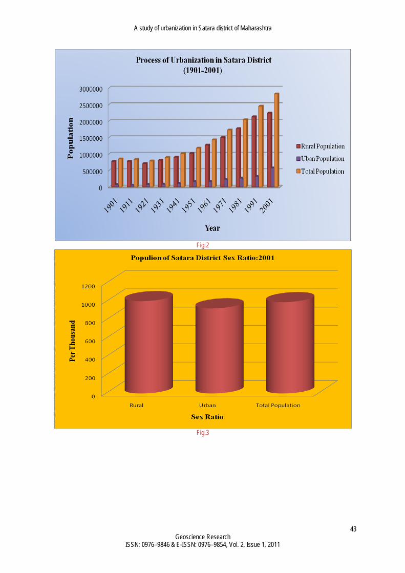
the district, 1739 are villages and 15 towns including the city of Satara. The distribution of the total district of population in the urban and rural areas is 3,98000 and 24,11000 respectively. It will try to trace pattern of urbanization, of Satara district. Objectives The present study has been undertaken with the following specific objectives. 1.To study the trends and degree of urbanization in Satara district. 2. To study the urban centers in the study region. Data Base And Methodology: Present paper is based on the secondary sources data mainly collected from District Census Handbooks, Socio-Economic Abstract etc. varies statistical techniques are used in the present paper. The percentage of urban population to total population has been calculated and index of urbanization. The simple growth of urban centers has been complied to study the decadal growth of urban population. The period from 1901 to 2001 is selected for the observation of trend and degree of urbanization changes. The result have been shown with the help of different graphs, tables and maps. History The present district Satara owes its administrative evolution to the several changes that took place, first during the British rule and subsequently during the post independence period till as late as the year 1960.The core of the district was supplied by the Satara principality after its lapse in the year 1848. Several boundary and subdivisions were later on made with the neighboring districts and with the lands of the neighboring Indian Princes with the merger of the Princes territories in 1947,the district was enlarged and divided in to North Satara and South Satara. In 1960, North Satara reverted to its original name Satara, South Satara being designated as Sangli district. The Satara district presently has 11 tehsils, 15 towns, 1739 villages, 23 inhabited places, 11 Panchayat Samitti, 8 Muncipalties and 1509 Grampanchayati. Trend of urbanization of Satara District Satara district shares most characteristics features of urbanization in the developing western Maharashtra state. Number of urban town has grown from 8 in 1901 to 15 in 2001. Number of population has increased from 7,36,337 in 1901 to 28,41, 816 in 2001. Where as number of population residing in urban areas has increased from 73,335 in 1991 to 5,89,400 in 2001 presented Table.1. This process of urbanization in Satara district is shown in Fig.2 reflects a gradual increasing trend of urbanization. Satara is at acceleration stage of the process of urbanization, According to 2001 census Table.2 in Satara district out of total population 28,18,816 about 5,79,400 live in urban areas and 22,39,416 live in rural areas. Sex ratio defined as
number of female per 1000 male for rural and urban and total Satara district are 1006,928 and 995 respectively. Since the new economic, educational, commercial and industrial polices were adopted in the Satara district, Satara has seen fast urban growth. Satara district is highly urbanized as 14% population lives in cities and 86% lives in rural areas. During 1911-1941 has 11 towns in Satara district. From 1951-2001 has 15 towns in Satara district. The graphical presented Fig.2 and.3. In Satara, Karad and Phaltan towns are three cities 70.45 percent live population and remaining 29.55 percent population included other town centers in Satara district. The degree of urbanization rural-urban ratio in percent given the information is presented in Table.3 and Fig. 4. The degree or level of urbanization is defined as relative number of people who live in urban areas. Percent urban [(U/P)* 100] and percent rural [(R/P)*100] and urban-rural ratio [(U/R)*100] are used to measure degree of urbanization. These are most commonly used for measuring degree of urbanization. It is clear that percent urban has increased from 8.63 percent in 1901 to 20.55 percent in 2001. Where as percent rural has shown gradual decrease from 91.37 percent to 79.45 percent over a century. Urban-rural ratio which is a simple index measuring number of urbanites for each rural person in an areal unit experiences an increasing trend during hundred years in the process of urbanization in Satara district. The urban-rural ratio for Satara district in 2001 turns out to be 25.86, measuring the against every 100 ruralites there are 25.86 in Satara district in 2001. Similar finding were noticed by process of urbanization (Sovani 1966) and it is at the acceleration stage of urbanization. These are presented graphically in the Fig.4. Urbanization is an indicator of the level of development of any region. Looking at urbanization in Satara district it is comparatively low as the level of development is low although the population of the district is increasing at the same rate. In 2001 39 percent of total population of Maharashtra was living in urban places but in Satara district it was only 20.55 percent. It means compared too urbanization of the State urbanization in the Satara district is low the percentage of urban population in Satara district is noted in Table.4. Urban Population in Satara District: 2001 As the Table.4 and Fig.5 shows below in 2001 Satara, Karad and Phaltan city all together 54.06 percent these three cities in Satara district. It clearly shows that urbanization has accelerated. The largest increase has taken place in the Satara city which increased in 2001 during these four decades The main reason behind this increase is the coming up of education district city, industrial activity, administrative offices and jobs created due to them. However, Wai city 7.81 percent, Mahswad 5.15 percent, Rahimatpur 4.16 percent, Mahabaleshwar 3.20 percent, Pachagani 3.34 percent and Kodoli 4.42 percent gradually increase of urban population. In Satara district the percentage of urbanization is very high because of the pressure of large municipalities centre Satara nearly half of the total population of the Satara,

Barakade AJ and Todkari GU
40 Bioinfo Publications
Karad and Phaltan cities. Satara city being the most important urban centre in the district, all development is concentrated here. The highest density of Karad city is per sq.km. 268 person and lowest density is per sq. km. 138 person Man tahsil. It may be observed that in 2001 there were only 15 cities in Satara district. The graduation of number of urban centers from lower population size Banwadi, Karanje, Khed, Patan, Shirval, Pachagani and Mahabaleshwar city. The medium population size Godoli,Kodoli, Rahimatpur and Mahswad city. However, in addition to factor of increase in number of large cities, the importance of a faster demographic growth, poverty induced (Premi, 2001) migration to urban informal sector should be taken into account in making urban structure top heavy. The graphical presented is Fig.5 Satara and Karad city is several times larger than other settlements of the and serves as political, economic, social, Industrial and educational hub of the entire city. Conclusion In order to plan for balanced and integrated development of the district and to control the growth of Satara, Karad and Phaltan are potential cities and towns should be developed to their optimum capacity. These growth centers should be developed not only to direct some of the population that would otherwise come to Satara, Karad and Phaltan as this process jeopardizes the planned growth but also helps other downs to grow in a planned way other towns should be characterized by being self contained, self sufficient. There should be minimum need or scope for communication with the main city for day to day activities. These should give all desired relief from growing congestion. References
[1] Breese G.(1969) Urbanization in Newly Developing countries prentice Hall, New Delhi.
[2] Brockerhoff M.and Brennam E.(1998) Population and Development Review, Vol. 24, No. 1 pp.75-114.
[3] Brockerhoff M.(1999) Population and Development Review, Vol. 255. No. 4, pp.757-778.
[4] Kundu A.(1994) :“Patterns of Urbanization with special Reference to small and medium Towns in India” in Chadha, G.K., Sectoral Issues in the Indian Economy., Har-Anand Publication, New Delhi.
[5] Kundu A. and Gupta S. (2000) Indian Council of Social Science Research, Manak Publications, New Delhi.
[6] Nayak P.R. (1962) “The Challenge of Urban growth to Indian Local Government” in Turner (ed.) India’s Urban Feature, University of California Press, Berkley.
[7] Pathak P. and Mehta D. (1995) Recent Trends in urbanization and Rual-Urban Migration in India: Same Explanations and Projetions, Urban India, Vol. 15 No.1, pp. 1-17.
[8] Premi M.K.(1991) “India’s Urban Scene and Its Future Implications”, Demography India, 20 (1).
[9] Registrar General (2001) Census of India, Emerging Trends of Urbanization in India, Occasional Paper No. 1 of 1993, Registrar General, New Delhi.
[10] Sovani N.V.(1966) Urbanization and Urban India, Asia Publishing House, Bombay.
[11] United Nations, World Rbanization Prospects: The 2005 Revision; Population Division, Department of Economic and Social Affairs, Working Paper No. ESA/ P/ Wpy 200, 2006.

41 Bioinfo Publications
Table 1-Volume and trend of urbanization in Satara District. Sr.No
Year Number of town
Villages Rural population
Urban population
Total population
1 1901 8 1335 776337 73335 849672 2 1911 11 1335 778637 56700 835337 3 1921 11 1331 711169 75267 786436 4 1931 11 1330 808393 86621 895014 5 1941 11 1333 902510 110702 1013212 6 1951 15 1152 1016677 160339 1177016 7 1961 15 1160 1271678 158427 1430105 8 1971 15 1167 1500119 227257 1727376 9 1981 15 1417 1769885 268792 2038677
10 1991 15 1547 217532 319840 2451372 11 2001 15 1739 2239416 579400 2818816
Source: Directorate of Economics and Statistics of Satara District.
Table 2-Population of Satara District by sex and residence:2001 Sr.No Satara District Male Female Total Population Sex ratio
1 Rural 1122804 1129612 2239416 1006 2 Urban 305589 283811 579400 928
Source: Directorate of Economics and Statistics of Satara District.
Table 4- Urban Town centers in Satara Disrict:2001 Sr.N
o City Male Female Total Population Share in Percent
1 Satara 55938 52110 108048 27.14 2 Karad 28198 27243 56161 14.11 3 Phaltan 25935 24865 50800 12.76 4 Wai 15894 15216 31110 7.81 5 Mahswad 10331 10169 20500 5.15 6 Rahimatpur 8426 8128 16554 4.16 7 Mahabaleshwar 7043 5694 12737 3.20 8 Pachagani 7534 5746 13280 3.34 9 Kodoli 8629 7787 16416 4.12
10 Patan 5977 5621 11598 2.91 11 Banwadi 2045 1897 3942 0.99 12 Shirval 6181 5655 11836 2.97 13 Khed 3552 3334 6886 1.73 14 Karanje Taraf Satara 11322 10182 21504 5.40 15 Godoli 8784 7965 16749 4.21 Total Population 206509 191612 398121 100.00
Source: Directorate of Economics and Statistics of Satara District Table 3-Index of Urbanization. (1901-2001)
Sr.No
Year Rural Population Percent Urban Population Percent Rural-Urban Ratio Percent
1 1901 91.37 8.63 9.44 2 1911 93.22 6.78 7.27 3 1921 90.43 9.57 10.58 4 1931 90.32 9.68 10.72 5 1941 89.07 10.93 12.27 6 1951 86.38 13.62 15.77 7 1961 88.92 10.08 11.34 8 1971 86.84 13.16 15.15 9 1981 86.81 13.19 15.19
10 1991 87.12 12.88 15.22 11 2001 79.45 20.55 25.86
Source: Complied By Researcher.

Barakade AJ and Todkari GU
42 Bioinfo Publications
A study of urbanization in Satara district of Maharashtra
43 Geoscience Research
ISSN: 0976–9846 & E-ISSN: 0976–9854, Vol. 2, Issue 1, 2011
Fig.2
Fig.3

Barakade AJ and Todkari GU
44 Bioinfo Publications
Fig.4
Fig.5