Primary school students’ spatial orientation strategies in an outdoor learning activity supported...
12
www.ijemst.com Primary School Students’ Spatial Orientation Strategies in an Outdoor Learning Activity Supported by Mobile Technologies Aihui Peng 1,2 , Håkan Sollervall 2 1 Southwest University 2 Linnaeus University To cite this article: Peng, A. & Sollervall, H. (2014). Primary school students’ spatial orientation strategies in an outdoor learning activity supported by mobile technologies. International Journal of Education in Mathematics, Science and Technology, 2(4), 246-256. This article may be used for research, teaching, and private study purposes. Any substantial or systematic reproduction, redistribution, reselling, loan, sub-licensing, systematic supply, or distribution in any form to anyone is expressly forbidden. Authors alone are responsible for the contents of their articles. The journal owns the copyright of the articles. The publisher shall not be liable for any loss, actions, claims, proceedings, demand, or costs or damages whatsoever or howsoever caused arising directly or indirectly in connection with or arising out of the use of the research material.
-
Upload
independent -
Category
Documents
-
view
1 -
download
0
Transcript of Primary school students’ spatial orientation strategies in an outdoor learning activity supported...

www.ijemst.com
Primary School Students’ Spatial
Orientation Strategies in an Outdoor
Learning Activity Supported by Mobile
Technologies
Aihui Peng
1,2, Håkan Sollervall
2
1Southwest University
2Linnaeus University
To cite this article:
Peng, A. & Sollervall, H. (2014). Primary school students’ spatial orientation strategies in an
outdoor learning activity supported by mobile technologies. International Journal of
Education in Mathematics, Science and Technology, 2(4), 246-256.
This article may be used for research, teaching, and private study purposes.
Any substantial or systematic reproduction, redistribution, reselling, loan, sub-licensing,
systematic supply, or distribution in any form to anyone is expressly forbidden.
Authors alone are responsible for the contents of their articles. The journal owns the
copyright of the articles.
The publisher shall not be liable for any loss, actions, claims, proceedings, demand, or
costs or damages whatsoever or howsoever caused arising directly or indirectly in
connection with or arising out of the use of the research material.

International Journal of Education in Mathematics, Science and Technology
Volume 2, Number 4, October 2014, Page 246-256 ISSN: 2147-611X
Primary School Students’ Spatial Orientation Strategies in an
Outdoor Learning Activity supported by Mobile Technologies
Aihui Peng1,2*
, Håkan Sollervall2
1Southwest University 2Linnaeus University
Abstract
Students’ different learning performance on mathematical problem solving across contexts has attracted a
number of researchers’ interest. The study investigates the spatial orientation ability of primary school students
in an outdoor situation, where six pairs of grade six students are asked to coordinate themselves physically in
terms of given distances with respect to two given points. Their spatial orientation performance is evaluated
quantitatively, in terms of the number of attempts needed to reach the target points, as well as qualitatively by
analyzing their strategies as described in their answers to a questionnaire. According to our findings the students
enjoy and perform remarkably well in the outdoor setting, an observation that leads us to suggest that engaging
students in outdoor activities may enhance their learning of mathematics.
Key words: Spatial orientation, Mobile technologies, Mathematical problem solving.
Introduction
The phenomenon of students’ different learning performance on mathematical problem solving across contexts
has attracted a number of researchers’ interest. In general, it is widely recognized that students perform better
when mathematics problems are presented in the context of real-world situations than when they are presented in
traditional school contexts. A seminal study in this area is Carraher, Carraher, and Schliemann’s (1985)
Mathematics in the Streets and in the Schools. In their study, young vendors (ages 9 to15 years) working in
Brazil performed better on problems presented in the shopping context than on the same problems presented
with mathematical symbols. There are continuous studies supporting these findings (Verschaffel and de Corte,
1997; Verschaffel, Greer, and de Corte, 2000; Koedinger and Nathan, 2004). Theories from different
perspectives have offered explanations for this phenomenon. For example, from a cognitive perspective, it is
hypothesized that students might benefit from contexts designed to activate real-world knowledge, whereas from
a non-cognitive perspective, according to McNeil, Uttal, Jarvin and Sternberg (2009), it is hypothesized that
students might become more motivated in the real-world situations. Furthermore, creating opportunities for
engaging in mathematical problem solving by making references to large-scale objects and moving around in the
outdoors is crucial for establishing understanding of spatial ideas in mathematics as opposed to just working with
visual ideas as expressed in textbooks (Bishop, 1980; Sollervall and Milrad, 2012).
Understanding how students’ real-world knowledge is activated in their learning processes is important in the
sense that this can aid mathematics teachers to look closely at how situations can be arranged to encourage
students to draw on this knowledge when solving mathematics problems in school. However, previous studies
(McNeil, Uttal, Jarvin, and Sternberg, 2009) have mainly focused on problems involving calculations. It is also
interesting to understand how students perform on other topics such as geometry and probability. Our study aims
to contribute to understand students’ spatial orientation strategies as they are challenged to coordinate
themselves with respect to objects during a real-world activity supported by mobile technologies. In the
following section, the notion of spatial orientation is presented and discussed in relation to mathematics
curriculum standards in several countries. The next section describes the research context and how the current
study was organized, followed by a section on methodological considerations regarding materials, tasks, and
procedure. Finally, the discussion section addresses the learning opportunities arising from arranging well-
* Corresponding Author: Aihui Peng, [email protected]
247
IJEMST (International Journal of Education in Mathematics, Science and Technology)
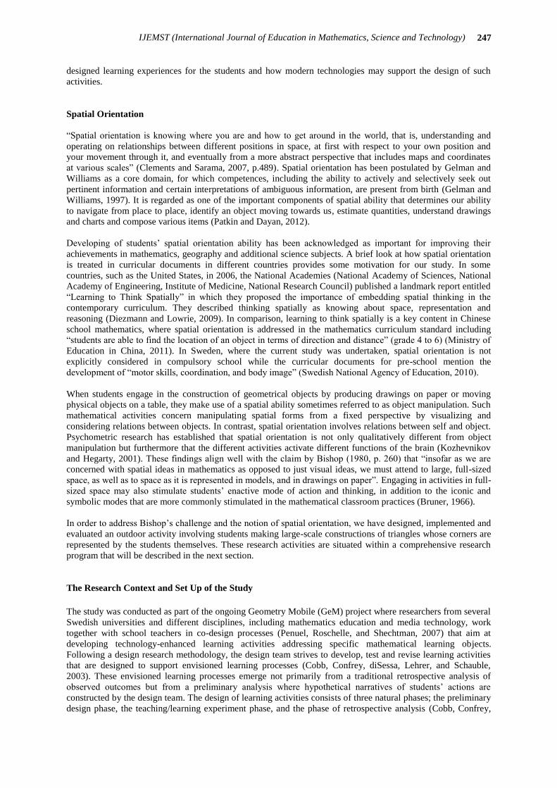
designed learning experiences for the students and how modern technologies may support the design of such
activities.
Spatial Orientation
“Spatial orientation is knowing where you are and how to get around in the world, that is, understanding and
operating on relationships between different positions in space, at first with respect to your own position and
your movement through it, and eventually from a more abstract perspective that includes maps and coordinates
at various scales” (Clements and Sarama, 2007, p.489). Spatial orientation has been postulated by Gelman and
Williams as a core domain, for which competences, including the ability to actively and selectively seek out
pertinent information and certain interpretations of ambiguous information, are present from birth (Gelman and
Williams, 1997). It is regarded as one of the important components of spatial ability that determines our ability
to navigate from place to place, identify an object moving towards us, estimate quantities, understand drawings
and charts and compose various items (Patkin and Dayan, 2012).
Developing of students’ spatial orientation ability has been acknowledged as important for improving their
achievements in mathematics, geography and additional science subjects. A brief look at how spatial orientation
is treated in curricular documents in different countries provides some motivation for our study. In some
countries, such as the United States, in 2006, the National Academies (National Academy of Sciences, National
Academy of Engineering, Institute of Medicine, National Research Council) published a landmark report entitled
“Learning to Think Spatially” in which they proposed the importance of embedding spatial thinking in the
contemporary curriculum. They described thinking spatially as knowing about space, representation and
reasoning (Diezmann and Lowrie, 2009). In comparison, learning to think spatially is a key content in Chinese
school mathematics, where spatial orientation is addressed in the mathematics curriculum standard including
“students are able to find the location of an object in terms of direction and distance” (grade 4 to 6) (Ministry of
Education in China, 2011). In Sweden, where the current study was undertaken, spatial orientation is not
explicitly considered in compulsory school while the curricular documents for pre-school mention the
development of “motor skills, coordination, and body image” (Swedish National Agency of Education, 2010).
When students engage in the construction of geometrical objects by producing drawings on paper or moving
physical objects on a table, they make use of a spatial ability sometimes referred to as object manipulation. Such
mathematical activities concern manipulating spatial forms from a fixed perspective by visualizing and
considering relations between objects. In contrast, spatial orientation involves relations between self and object.
Psychometric research has established that spatial orientation is not only qualitatively different from object
manipulation but furthermore that the different activities activate different functions of the brain (Kozhevnikov
and Hegarty, 2001). These findings align well with the claim by Bishop (1980, p. 260) that “insofar as we are
concerned with spatial ideas in mathematics as opposed to just visual ideas, we must attend to large, full-sized
space, as well as to space as it is represented in models, and in drawings on paper”. Engaging in activities in full-
sized space may also stimulate students’ enactive mode of action and thinking, in addition to the iconic and
symbolic modes that are more commonly stimulated in the mathematical classroom practices (Bruner, 1966).
In order to address Bishop’s challenge and the notion of spatial orientation, we have designed, implemented and
evaluated an outdoor activity involving students making large-scale constructions of triangles whose corners are
represented by the students themselves. These research activities are situated within a comprehensive research
program that will be described in the next section.
The Research Context and Set Up of the Study
The study was conducted as part of the ongoing Geometry Mobile (GeM) project where researchers from several
Swedish universities and different disciplines, including mathematics education and media technology, work
together with school teachers in co-design processes (Penuel, Roschelle, and Shechtman, 2007) that aim at
developing technology-enhanced learning activities addressing specific mathematical learning objects.
Following a design research methodology, the design team strives to develop, test and revise learning activities
that are designed to support envisioned learning processes (Cobb, Confrey, diSessa, Lehrer, and Schauble,
2003). These envisioned learning processes emerge not primarily from a traditional retrospective analysis of
observed outcomes but from a preliminary analysis where hypothetical narratives of students’ actions are
constructed by the design team. The design of learning activities consists of three natural phases; the preliminary
design phase, the teaching/learning experiment phase, and the phase of retrospective analysis (Cobb, Confrey,

248 Peng & Sollervall
diSessa, Lehrer, and Schauble, 2003). Several members of the current research team have previously
collaborated in similar projects involving outdoor mathematics supported by mobile technologies and interactive
visualization techniques (Sollervall, Nilsson, and Spikol, 2010; Nilsson, Sollervall, and Spikol, 2010; Sollervall,
Gil, Milrad, Peng, Petersson, Salavati, and Yau, 2011; Sollervall and Milrad, 2012).
For designing the activity in this study, team members in the project had organized several formal and informal
meetings to discuss the optimal learning activity to take place. A selection of available mobile technologies and
their didactical potential for the learning of mathematics were discussed, and a learning activity that put special
focus on spatial orientation was developed in the process. During a final meeting, all stakeholders expressed
great interest in the project and agreed that the presented activities could be motivating for the students. Before
the trial was conducted, two team members from the university went to the school twice, one to discuss with the
mathematics teachers and the principal to handle the logistics and practical arrangements, while the other team
member checked whether the mobile application would work well in the outdoor setting.
It was agreed that the outdoor activity would be implemented with 12 sixth grade students from one class of 20
students in a primary school located in a small city in a rural area in Southern Sweden. The mathematics teacher
selected the students based on several criteria. One student was considered to be clever in the classroom and the
teacher was curious to see if he would perform well also in the outdoor setting. Other students were selected
based on their ability to communicate and collaborate, which is important in the outdoor activity. For such
reasons, one autistic student was not selected. When asked if they wanted to try the activity, all the selected
students (8 boys and 4 girls) agreed to do it.
Research Questions
This study aims to achieve understanding of twelve grade six students’ spatial orientation strategies as they are
challenged to engage in a specifically designed collaborative problem solving activity in an outdoor setting. Our
research question reads as follows:
– What spatial orientation strategies do students in grade six utilize while engaging in a collaborative
problem solving activity in an outdoor setting?
Since our GeM project follows a design methodology where research and development is integrated in an
iterative design process, we will address the following issues in our discussion:
– How can the learning activity be improved to provide better learning opportunities for the students?
– How can our research methodology be improved to provide better insights into the students’ strategies?
The Outdoor Learning Activity
Our design methodology involved a preliminary design phase, a teaching experiment, and a reflective analysis
(Cobb, Confrey, diSessa, Lehrer, and Schauble, 2003). In this study, we will describe the teaching activity and
put focus on the reflective analysis of the students’ self-reported mathematical strategies for solving the tasks.
The activity was implemented on an open field (Figure 1, left pane) and was supported by a customized
technological application deployed on a mobile phone (Figure 1, right pane).
Figure 1. The setting of the activity (left pane) and the display of the mobile phone (right pane)

249
IJEMST (International Journal of Education in Mathematics, Science and Technology)
The customized application was prepared by the design team to meet specific design requirements for the
activity (Sollervall, Gil, Milrad, Peng, Petersson, Salavati and Yau, 2011). The two iconic markers on the display
– a triangle and a square – were visually aligned (left and right) with two corresponding physical markers on the
field (Figure 1). Directly below the markers the current distances to each marker were shown when so prompted
by the students (Figure 1, right pane). The prompt was chosen for two reasons: didactically, to make the students
focus their attention on the physical field rather than on the digital display; and technologically, because
continuous updating of distances was impossible due to time-delay involved in updating the GPS-values that
were needed to calculate distances. Furthermore, the prompting invited a gaming perspective as students are
challenged to minimize the number of prompts needed to reach the target point on the field. Although visual
references could have been provided on the digital display, this was avoided in order to put focus on spatial
orientation and not on visualization.
The activity involved a total of ten tasks, each with a target point located on the field. The target points were
chosen so that the students were challenged to move in different directions from a starting point located 46
meters from each standing marker (Figure 2, left pane). The starting point was marked with a sign “46 – 46” to
remind the students how far away it was located from each marker. One of the tasks involved finding a target
point located 42 meters from the triangle and 26 meters from the square (Figure 2, right pane).
Figure 2. Illustration of the starting point of all tasks (left pane) and the target point of one task (right pane)
(Please note that from the students’ perspective, the markers appear with the triangle to the left and the square to
the right.) The ten target points were distributed on the field to achieve variation between directions of
movement. The choice of locations for the target points was guided by a visual illustration (Figure 3) and
checked against the field (Figure 4). The corresponding distances to the standing markers are shown in Table 1,
left pane.
Figure 3. Diagram illustrating the task locations and their distances to each of the markers
Figure 4. Distribution of the task locations on the field
start
46 46
56
target
26 42
56
(meter)

250 Peng & Sollervall
Due to possible errors in students’ estimation of distances and errors due to inexact GPS-values, it was decided
that a maximum deviation of 2 meters would be considered acceptable. For example, the achieved measurement
“43-28” was accepted as successful for solving the task with the target point “42-26” (Figure 1, right pane).
The 12 students worked in six groups with two students and one mobile phone in each group. They worked
simultaneously on the field and the sequence of tasks was arranged differently for each group so that no two
groups would attempt to solve the same task at the same time. Except for student group number 6, the groups
managed to solve the tasks by using fewer attempts (Table 1, right pane) than expected by the researchers.
Groups 1, 2, and 4 performed exceptionally well with an average of only 2.3, 2.4, and 1.8 attempts per task.
Table 1. The distance to the standing markers (left pane) and the number of attempts (right pane)
The number of attempts needed to find the target point was calculated automatically by the customized
application that also supported the production of audio recordings by the students while they worked on the field.
The application also collected positioning information that was used to provide numerical and visual records
(Figure 5) that supported the students’ recall of strategies during the second day of the trial.
Point Attempt Distance
1 <83,51>
2 <82,45>
3 <82,42>
4 <89,45>
4 5 <85,44>
Figure 5. Numerical and visual records of the five attempts by group 2 to find target point 4
We will use excerpts of the numerical records in our analysis of the students’ spatial coordination strategies.
These records will be reported in the same format as they appeared during the study (Figure 5, left pane).
251
IJEMST (International Journal of Education in Mathematics, Science and Technology)
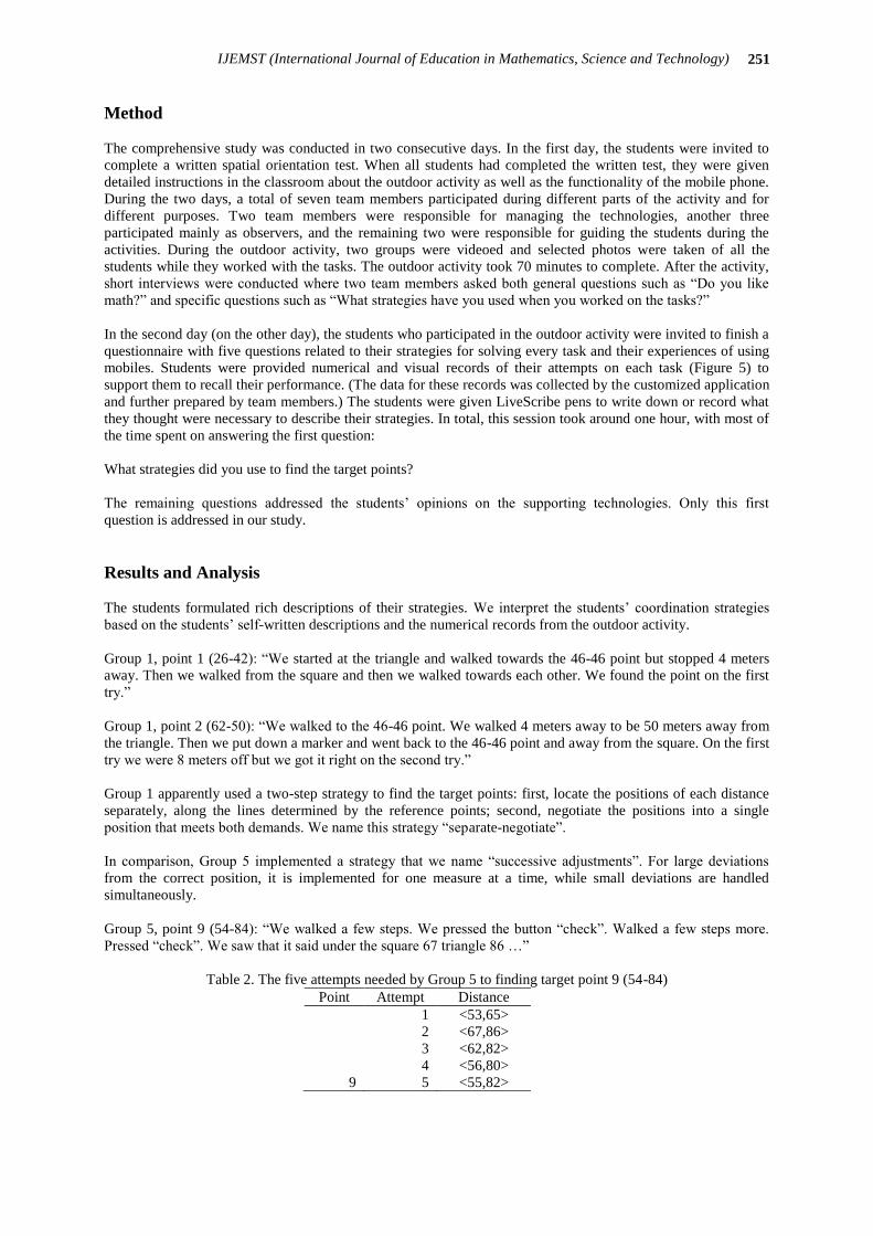
Method
The comprehensive study was conducted in two consecutive days. In the first day, the students were invited to
complete a written spatial orientation test. When all students had completed the written test, they were given
detailed instructions in the classroom about the outdoor activity as well as the functionality of the mobile phone.
During the two days, a total of seven team members participated during different parts of the activity and for
different purposes. Two team members were responsible for managing the technologies, another three
participated mainly as observers, and the remaining two were responsible for guiding the students during the
activities. During the outdoor activity, two groups were videoed and selected photos were taken of all the
students while they worked with the tasks. The outdoor activity took 70 minutes to complete. After the activity,
short interviews were conducted where two team members asked both general questions such as “Do you like
math?” and specific questions such as “What strategies have you used when you worked on the tasks?”
In the second day (on the other day), the students who participated in the outdoor activity were invited to finish a
questionnaire with five questions related to their strategies for solving every task and their experiences of using
mobiles. Students were provided numerical and visual records of their attempts on each task (Figure 5) to
support them to recall their performance. (The data for these records was collected by the customized application
and further prepared by team members.) The students were given LiveScribe pens to write down or record what
they thought were necessary to describe their strategies. In total, this session took around one hour, with most of
the time spent on answering the first question:
What strategies did you use to find the target points?
The remaining questions addressed the students’ opinions on the supporting technologies. Only this first
question is addressed in our study.
Results and Analysis
The students formulated rich descriptions of their strategies. We interpret the students’ coordination strategies
based on the students’ self-written descriptions and the numerical records from the outdoor activity.
Group 1, point 1 (26-42): “We started at the triangle and walked towards the 46-46 point but stopped 4 meters
away. Then we walked from the square and then we walked towards each other. We found the point on the first
try.”
Group 1, point 2 (62-50): “We walked to the 46-46 point. We walked 4 meters away to be 50 meters away from
the triangle. Then we put down a marker and went back to the 46-46 point and away from the square. On the first
try we were 8 meters off but we got it right on the second try.”
Group 1 apparently used a two-step strategy to find the target points: first, locate the positions of each distance
separately, along the lines determined by the reference points; second, negotiate the positions into a single
position that meets both demands. We name this strategy “separate-negotiate”.
In comparison, Group 5 implemented a strategy that we name “successive adjustments”. For large deviations
from the correct position, it is implemented for one measure at a time, while small deviations are handled
simultaneously.
Group 5, point 9 (54-84): “We walked a few steps. We pressed the button “check”. Walked a few steps more.
Pressed “check”. We saw that it said under the square 67 triangle 86 …”
Table 2. The five attempts needed by Group 5 to finding target point 9 (54-84)
Point Attempt Distance
1 <53,65>
2 <67,86>
3 <62,82>
4 <56,80>
9 5 <55,82>

252 Peng & Sollervall
The first shift from 53-65 to 67-86 is made with focus on achieving the second measure (65 to 86) while not
paying attention to the first measure. On the other hand, it seems plausible that the final (small) shift from 56-80
to 55-82 is aiming at simultaneously achieving both measures.
The target points 3 and 4 (46-28 and 86-46) were chosen with one distance each exactly the same as the
reference marker 46-46 for the purpose of stimulating a “circle strategy”, that is, changing one distance while
attempting to keep the other distance 46 meters.
Group 3, point 4 (86-46): “We were supposed to go to 86-46 so we walked along an arc from 46-46”.
The shift from the position 80-44 obtained in their first attempt to 80-47 in their second attempt may indicate
that the students, after their first try, are focused on adjusting only the second measure, that is, to get back on
track with respect to their circle strategy.
Regarding the best performing Group 4, we cannot say very much about their strategies due to their brief
account of strategies. However, we suspect that they managed to simultaneously adjust both distances.
Group 4, point 5 (42-56): “We started from 46-46 10 m away from square and 4 m closer triangle”.
They managed to move from 46-46 to 41-57 on their first attempt. Furthermore, their few extra attempts on other
target points are either very close to being correct or seem to be due to mistakenly pushing the button “check”.
Unfortunately, no follow up interview was held with this group.
In order to deepen our understanding of the strategies of all groups, we have interpreted our detailed numerical
records (Figure 5, left pane) by using the diagram in Figure 3.
Our findings indicate that Group 1 used the strategy “separate-negotiate” as well as “successive adjustments”,
the latter with focus on achieving one of the values as indicated in the following excerpt:
Table 3. The three attempts needed by Group 1 to finding target point 10 (38-22)
Point Attempt Distance
1 <34,23>
2 <39,18>
10 3 <37,22>
Their second attempt aims at achieving the first measure 38 of point 10 (38-22) while their third attempt puts
focus on achieving the second measure 22. The self-reported strategy “separate-negotiate” seems to be used in
their initial attempts and is followed up by “successive adjustments” in latter attempts. Our records indicate that
Group 2 has used similar strategies resulting in excellent first attempts for example 83-51 for point 4 (86-46).
For point 9 (54-84) their first attempt 68-86 is readily adjusted to 56-82.
Table 4. The two attempts needed by Group 2 to finding target point 9 (54-84)
Point Attempt Distance
1 <68,86>
9 2 <56,82>
In comparison, their latter attempts for point 4 may be interpreted as merely indicating lack of concentration.
Table 5. The five attempts needed by Group 2 to finding target point 4 (86-46)
Point Attempt Distance
1 <83,51>
2 <82,45>
3 <82,42>
4 <89,45>
4 5 <85,44>
Also Group 3 used the “successive adjustments” strategy, but with less precise initial attempts seemingly based
on a “farther-closer” strategy that did not consider the actual distances involved.

253
IJEMST (International Journal of Education in Mathematics, Science and Technology)
Table 6. The six attempts needed by Group 3 to finding target point 7 (28-72)
Point Attempt Distance
1 <26,51>
2 <47,75>
3 <34,64>
4 <26,69>
5 <26,69>
7 6 <30,74>
We note that both initial measures 26 and 51 go in the correct directions, as the students should move closer to
the triangle (from 46 to 28) and farther away from the square (from 46 to 72). However, it seems plausible that
they have not considered actual distances since their chosen position is only 5 meters away from the square
while the target is 21 meters away.
The few attempts needed for group 4 to find the target points are largely due to their sophisticated initial strategy
“separate-negotiate”. On one occasion they simply pressed the button twice, which caused an extra attempt to be
registered. We list their initial (true) attempts with respect to each target point in the table below. The precision
is impressive. They manage to find no less than four of the target points on their first attempts and another two
first attempts are just one meter off from being accepted as successful.
Table 7. The initial attempts of Group 4
Target point 26-42 62-50 46-28 86-46 42-56 74-38 28-72 50-36 54-84 38-22
Initial attempt 23-41 60-50 44-28 75-44 41-57 65-36 27-69 48-37 51-75 36-29
Total attempts 2 1 1 2 1 2 2 1 3 3
In comparison, the records from Group 5 indicate that they may have used the “farther-closer” strategy for their
initial attempts and the “successive adjustments” strategy for the latter attempts.
Table 8. The initial attempts of Group 5
Target point 26-42 62-50 46-28 86-46 42-56 74-38 28-72 50-36 54-84 38-22
Initial attempt 39-44 56-49 38-21 74-55 39-54 45-49 17-59 51-47 53-65 38-19
Total attempts - 4 3 4 4 - 4 4 5 7
Regarding target point 6 (74-38) their first attempt 45-49 may have been a random check, as their following
attempts 45-24 and 58-34 follow the “farther-closer” strategy. On occasion they seem to be moving around more
or less by random, for example regarding target point 10 (38-22) where their first initial attempt 38-19 is just 1
meter away from being successful but still need 7 attempts to finish the task.
Group 6 were initially not sure about what they were supposed to do. (They started at point 3.)
Group 6, point 3 (46-28): “We did not understand what we were supposed to do so we walked around randomly
and tested. After about 10 tries we started to understand and the last 6 tries we tested close to the correct point
and made it on 16 tries”.
Their last six attempts on point 3 and their seven attempts on point 4 (Table 9) indicate that they combined the
strategies “farther-closer” and “successive adjustments”, with small increments between the attempts.
Table 9. Attempts of Group 6 to find target points 3 (46-28) and 4 (86-46)
Point Attempt Distance Point Attempt Distance
11 <34,23> 1 <55,32>
12 <41,23> 2 <60,34>
13 <42,23> 3 <65,34>
14 <42,29> 4 <76,38>
15 <43,29> 5 <81,41>
3 16 <46,28> 6 <84,42>
4 7 <87,45>

254 Peng & Sollervall
In summary, we have identified four strategies that were implemented by the students during the outdoor
activity. The strategies separate-negotiate and farther-closer are mainly used for initial attempts, starting from the
point 46-46, while the circle strategy and successive adjustments are used also for latter attempts.
1. Separate-negotiate. The students determine two points on the field that each are supposed to fulfill
one of the two distance requirements. The locations of these points are negotiated to find a third
point that should fulfill both requirements.
2. Farther-closer. Compares current location with target points. The students attempt to move in a
direction reducing the differences of both values, without considering the actual differences.
3. Circle. If one of the values is correct, the students attempt to move along a circular arc in order to
achieve the second value while preserving the correct value.
4. Successive adjustments. Students react on the last obtained values and attempt to adjust either one
value or both values. If they are far away from the target point they tend to correct only one of the
values and if they are close they attempt to correct both values simultaneously.
Discussion
In this article, we have presented and analyzed the outcomes from an outdoor learning activity that was made
possible only through the support of mobile technologies. This innovative learning activity was designed within
a comprehensive research and development project, whose mission is to investigate mathematical learning
opportunities in technology-supported activities. We have reported our experiences from a first implementation
of a particular outdoor activity that was designed to challenge the students’ spatial coordination ability. Four
strategies have been identified that will be useful for guiding further development of the activity. Specifically,
these strategies will be helpful for designing follow-up classroom activities that will help the students connect
their outdoor experiences to school mathematics. For example, it would be reasonable to connect their
experiences to the classical Euclidean construction of a triangle with three given sides (Figure 6).
Figure 6. Euclidean construction of a triangle with three given sides
This construction could even be illustrated in the outdoors, by using two long ropes. The length of the three sides
AB, BC, and CD are given. In our case, the points B and C in Figure 6 could be represented by the triangle and
the square, while BA and CD could be represented by ropes that can be stretched out and moved along circular
arcs (A to E and D to E) until they meet at the point E.
We have already mentioned that we became impressed with the students’ performance on the field while
attempting to locate the ten target points. On the field, they were invited to construct and enact their own
strategies in a real-world setting. From a cognitive perspective, they were challenged to engage in large-scale
interaction with the environment in a manner that cannot be arranged in a regular classroom. In their written
reports the students express explicitly that the activity was fun (even “super fun!”) and that they enjoyed using
the mobile phones. Being outdoors and using mobile technologies are two factors that obviously motivated the
students, but we believe also that the ten tasks were perceived as meaningful and motivating.
Regarding further directions for research, our ambition is to compare students’ spatial coordination performance
in a classroom setting and in the outdoor activity. In previous studies (Sollervall, Nilsson, and Spikol, 2010;
Nilsson, Sollervall, and Spikol, 2010) we have experienced that there are students who perform significantly
better in mathematical outdoor activities than in similar classroom activities, and we suspect this may be the case
also regarding spatial coordination. Furthermore, we would like to compare the performance of students with
different backgrounds. The students who participated in our activity live and attend school in a rural area where
they have more opportunities for experiencing the outdoors than students who live in an urban area. We suspect

255
IJEMST (International Journal of Education in Mathematics, Science and Technology)
that students in an urban school may be just as motivated to engage in our activity and could possibly perform as
well as “our” students based on experiences such as playing soccer or riding bicycles. Furthermore, we are
considering exploring and comparing spatial coordination performance of children with different nationalities,
for convenience beginning with Sweden and China as such a study could be organized with respect to our
current research networks.
In retrospect, we feel that we need to improve our research methods particularly regarding data collection. For
example, it is unfortunate that we cannot gain a deeper understanding of the strategies used by Group 4. As our
numerical data shows (Table 7) these students manage to achieve a remarkable precision already in their first
attempts, but we are not able to describe their strategies for locating the target points. In future studies, we will
make sure to conduct follow-up interviews particularly with groups that demonstrate outstanding performance
during the activities. Regarding the current study, our ambition was initially to compare performance on a
written spatial orientation test with performance in the outdoor activity. However, we chose to abandon this
approach because of insufficient quality of the data that was actually collected. Such a comparison is
complicated by the fact that we let two students work together in the outdoor activity, making it hard to evaluate
and compare their individual performance. Since some of the currently identified outdoor strategies require two
students working together, we would like to keep it that way. From a learners’ perspective, it would simply not
be favorable to conduct the study with a single student in each group. Instead, we are currently considering
ability grouping of students in order for the indoor and outdoor tests to become more comparable.
Our ambition as researchers and teachers is to provide students with different kinds of learning experiences
particularly experiences that connect school mathematics with real-life experiences and modern technologies.
We consider the learning activity discussed in this article as a good example of an activity that challenges and
motivates students to learn mathematics in a meaningful social and physical context.
Acknowledgements
This study has been conducted under the GeM-project. The authors appreciate supports and contributions from
our team members: Marcelo Milrad, Didac Gil de La Iglesia, Oskar Pettersson, Sadaf Salavati, Jane Yau, and
Katrin Lindwall. Research presented in this article was partially supported by the Fundamental Research Funds
for the Central Universities (SWU1309216) at Southwest University. We are grateful to all the students, teachers
and school administrators for their participation in this project.
References
Bishop, A.J. (1980). Spatial abilities and mathematics education – a review. Educational Studies in Mathematics,
Vol. 11, pp. 257-269.
Bruner, J.S. (1966). Toward a Theory of Instruction. Harvard University Press.
Carraher, T.N., Carraher, D.W., & Schliemann, A.D. (1985). Mathematics in the streets and in schools. British
Journal of Developmental Psychology, Vol. 3, pp. 21-29.
Clements, D.H, & Sarama, J. (2007). Early childhood mathematics learning. In F.K. Lester Jr. (Ed.), Second
Handbook of Research on Mathematics Teaching and Learning, pp. 261-268. Charlotte, NC: Information
Age.
Cobb, P., Confrey, J., diSessa, A., Lehrer, R., & Schauble, L. (2003). Design experiments in educational
research. Educational Researcher, Vol. 32, No. 1, pp. 9-13.
Diezmann, C.M., & Lowrie, T. (2009). Primary students’ spatial visualization and spatial orientation: an
evidence base for instruction. Proceedings of the 33rd Conference of the International Group for the
Psychology of Mathematics Education, Vol. 2, pp. 417-424. Thessaloniki, Greece: PME.
Gelman, R., & Williams, E.M. (1997). Enabling constraints for cognitive development and learning: Domain
specificity and epigenesis. In D. Kuhn & R. Siegler (Eds.), Cognition, Perception, and Language, Vol. 2,
pp. 575-630. New York: Wiley.
Koedinger, K.R., & Nathan, M.J. (2004). The real story behind story problems: effects of representations on
quantitative reasoning. Journal of the Learning Sciences, Vol. 13, pp. 129-164.
Kozhevnikov, M., & Hegarty, M. (2001). A dissociation between object manipulation spatial ability and spatial
orientation ability. Memory & Cognition, Vol. 29, No. 5, pp. 745-756.
McNeil, N.M, Uttal, D.H., Jarvin, L., & Sternberg, R.J. (2009). Should you show me the money? Concrete
objects both hurt and help performance on mathematics problems. Learning and Instruction, Vol. 19, pp.
171-184.

256 Peng & Sollervall
Ministry of Education in China (2011). Mathematics curriculum standards for compulsory education. Beijing:
The People’s Education Press.
Nilsson, P., Sollervall, H., & Spikol, D. (2010). Mathematical learning processes supported by augmented
reality. Proceedings of the 34th Conference of the International Group for the Psychology of Mathematics
Education, Vol. 3, pp. 337-344. Belo Horizonte, Brazil: PME.
Patkin, D., & Dayan, E. (2012). The intelligence of observation: improving high school students’ spatial ability
by means of intervention unit. International Journal of Mathematical Education in Science and
Technology, Vol. 44, No. 2, pp. 179-195.
Penuel, W.R., Roschelle, J. and Shechtman, N. (2007). Designing formative assessment software with teachers:
An analysis of the co-design process. Research and Practice in Technology Enhanced Learning, Vol. 2, No.
2, pp. 51–74.
Sollervall, H., Nilsson, P., & Spikol, D. (2010). Augmented reality as support for designing a learning activity
concerning the mathematical concept of scale. Proceedings of the 7th Swedish Mathematics Education
Research Seminar, pp. 222-230. Stockholm, Sweden.
Sollervall, H., Gil, D., Milrad, M., Peng, A., Petersson, O., Salavati, S. & Yau, J. (2011) Designing with mobile
technologies for enacting the learning of geometry. Workshop Proceedings of the International Conference
on Computers in Education, pp. 305-312. Chiang Mai, Thailand.
Sollervall, H., & Milrad, M. (2012). Theoretical and methodological considerations regarding the design of
innovative mathematical learning activities with mobile technologies. International Journal of Mobile
Learning and Organisation, Vol. 6, No. 2, pp. 172-187.
Swedish National Agency of Education (2010). Curriculum for pre-school. Stockholm: Fritzes.
Verschaffel, L., & de Corte, E. (1997). Teaching realistic mathematical modelling and problem solving in the
elementary school. A teaching experiment with fifth graders. Journal for Research in Mathematics
Education, Vol. 28, pp. 577-601.
Verschaffel, L., Greer, B, & de Corte, E. (2000). Making Sense of Word Problems. Lisse: Swets & Zeitlinger.