trempealeau county - outdoor recreation plan
86
-
Upload
khangminh22 -
Category
Documents
-
view
1 -
download
0
Transcript of trempealeau county - outdoor recreation plan


TREMPEALEAU COUNTY OUTDOOR RECREATION PLAN


A Message From the Trempealeau County Economic Development & Tourism Coordinator
When the updates to Trempealeau County’s 2022-2026 Outdoor Recreation Plan were first being
considered early 2020, few could have predicted that the world was beginning to enter a global
pandemic. Though this pandemic would, and as this is being written is, affecting the everyday lives of
the citizens of Trempealeau County, it has also illustrated more than ever the importance of having
outdoor recreation opportunities available to the public. Citizens and visitors being able to get outdoors
has for many been a way that they have been able to cope with the stressors the pandemic has caused.
Outdoor recreation aids citizens' physical health, as well as the health of the economy, as high-quality
recreation opportunities attract visitors to Trempealeau County each year. Trempealeau County
recognizes the need for a comprehensive outdoor recreation plan. County, City, Village, and Town
officials as well as concerned citizens are aware of the need for local outdoor recreation facilities and
are also aware that the needs vary within the county and change with time. This plan is intended to
serve as a guide to the county and its municipal subdivisions in the development of specific recreation
programs and long-range objectives. The ideas, recommendations, and proposals found within this plan
are aimed at the continued preservation, acquisition, development, and improvements of the area’s
outdoor recreation facilities. It is local government’s responsibility to periodically further investigate
and seriously consider the recommendations cited within this plan that provide for the orderly growth,
development, and maintenance of the area’s outdoor recreation resources.
Rob Grover
Trempealeau County Economic Development & Tourism Coordinator

Acknowledgements
The preparation of the Trempealeau County Outdoor Recreation Plan has been a community effort that has been taken over the last year. Without a variety of groups, both civic and governmental, as well as the participation of the public, this 2022-2026 Trempealeau County Outdoor Recreation Plan could have not been accomplished. Trempealeau County would like to thank and acknowledge the following entities for their help and guidance during this process.
Mississippi River Regional Planning Commission
Trempealeau County Parks, Tourism, and Economic Development Committee
Trempealeau County Department of Land Management
Trempealeau County Land Records Department
Trempealeau County Board of Supervisors
Trempealeau County Department Information Technology
WTCO (Trempealeau County Community Television)
Associated Conservation Clubs of Trempealeau County
Trempealeau County’s Chamber and Business Organizations
The Citizens of Trempealeau County

Table of Contents A Message From the Trempealeau County Economic Development & Tourism Coordinator ...................... i
Acknowledgements ........................................................................................................................................ i
INTRODUCTION ............................................................................................................................................. 1
Outdoor Recreation in Trempealeau County ........................................................................................ 1
County Overview ................................................................................................................................... 4
The Landscape ....................................................................................................................................... 4
PROPERTY INVENTORY .................................................................................................................................. 5
Trempealeau County Owned Parks and Recreation ............................................................................. 5
County Fair Grounds ..................................................................................................................................... 6
Farm Progress Days Park ............................................................................................................................... 7
Pietrek Park ................................................................................................................................................... 8
Trempealeau Lots ....................................................................................................................................... 13
FEDERAL OUTDOOR RECREATION FACILITIES ............................................................................................. 14
Upper Mississippi River National Wildlife and Fish Refuge ................................................................ 14
Trempealeau National Wildlife Refuge ............................................................................................... 15
Lock and Dam 6 ................................................................................................................................... 16
STATE OUTDOOR RECREATIONAL FACILITIES ............................................................................................. 17
Buffalo River State Trail ...................................................................................................................... 17
Great River State Trail ......................................................................................................................... 18
Perrot State Park ................................................................................................................................. 19
State Wildlife Areas ............................................................................................................................. 20
State Fishery Areas .............................................................................................................................. 21
State Natural Areas ............................................................................................................................. 22
School Properties and Quasi-Public Facilities ..................................................................................... 26
RECREATIONAL DEMAND ............................................................................................................................ 27
Statewide ............................................................................................................................................ 27
Favorite Places to Visit Based on Public Input .................................................................................... 28
Statewide Needs ................................................................................................................................. 29
Travel Patterns .................................................................................................................................... 30
POPULATION, DEMOGRAPHICS, EDUCATION, & ECONOMY ...................................................................... 31
Population ........................................................................................................................................... 31
Population Projections: ....................................................................................................................... 31
Trempealeau County’s Age Distribution: ............................................................................................ 31

Household Income .............................................................................................................................. 32
Rural/Urban Distribution .................................................................................................................... 32
TOPOGRAPHY, WATER RESOURCES, & CLIMATE ........................................................................................ 34
County Overview ................................................................................................................................. 34
Landscape ........................................................................................................................................... 34
Climate and Extreme Weather............................................................................................................ 36
LOCAL PRIORITIES & OBJECTIVES ................................................................................................................ 37
Survey Results ..................................................................................................................................... 37
IMPLEMENTATION PRIORITIES ................................................................................................................... 42
PLANNING PROCESS .................................................................................................................................... 53
Summary of Previous Outdoor Recreation and Other Plans .............................................................. 53
APPENDIX A ................................................................................................................................................. 55
Grant Opportunities ............................................................................................................................ 55
APPENDIX B: MAPS ..................................................................................................................................... 59
Map B-1 Land Cover ............................................................................................................................ 59
Map B-2 Population ............................................................................................................................ 60
Map B-3 Scenic Routes........................................................................................................................ 61
Map B-4 Campgrounds ....................................................................................................................... 62
Map B-5 Golf Courses ......................................................................................................................... 63
Map B-6 Picnic Facilities and Highway Waysides................................................................................ 64
Map B-7 Bike Trails ............................................................................................................................. 65
Map B-8 ATV Routes ........................................................................................................................... 66
Map B-9 Wildlife Areas and Rod and Gun Clubs ................................................................................. 67
Map B-10 Recreational Water Activities ............................................................................................. 68
Map B-11 Trout Streams ..................................................................................................................... 69
Map B-12 Wildlife Areas ..................................................................................................................... 70
Map B-13 Canoe Landings................................................................................................................... 71
Map B-14 Snowmobile Trails .............................................................................................................. 72
Map B-15 Perrot State Park ................................................................................................................ 73
Map B-16 Perrot State Park Winter .................................................................................................... 74
Map B-17 Buffalo River State Trail ...................................................................................................... 75
Map B-18 Great River Road ................................................................................................................ 76
APPENDIX C: ADOPTION RESOLUTION ....................................................................................................... 77
1 Introduction
Crystal Lake in V. Strum
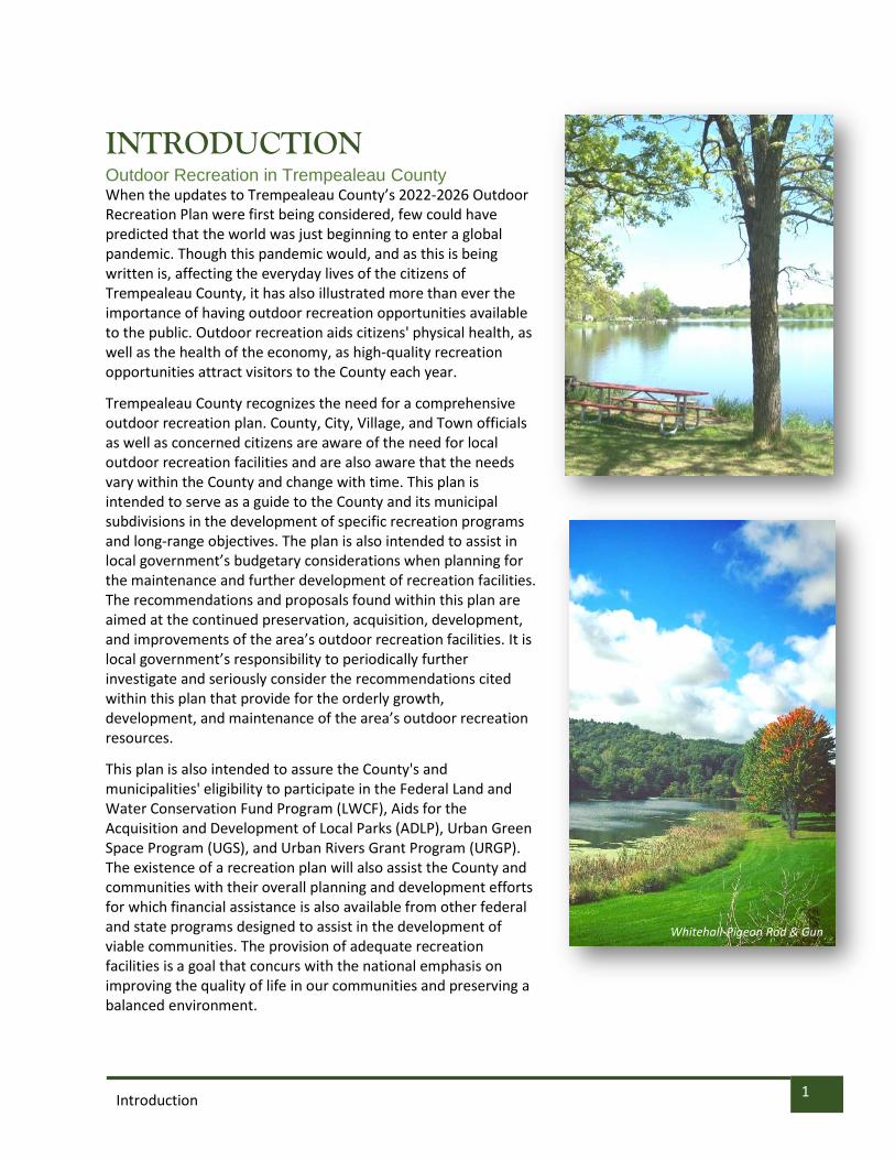
INTRODUCTION Outdoor Recreation in Trempealeau County When the updates to Trempealeau County’s 2022-2026 Outdoor Recreation Plan were first being considered, few could have predicted that the world was just beginning to enter a global pandemic. Though this pandemic would, and as this is being written is, affecting the everyday lives of the citizens of Trempealeau County, it has also illustrated more than ever the importance of having outdoor recreation opportunities available to the public. Outdoor recreation aids citizens' physical health, as well as the health of the economy, as high-quality recreation opportunities attract visitors to the County each year.
Trempealeau County recognizes the need for a comprehensive outdoor recreation plan. County, City, Village, and Town officials as well as concerned citizens are aware of the need for local outdoor recreation facilities and are also aware that the needs vary within the County and change with time. This plan is intended to serve as a guide to the County and its municipal subdivisions in the development of specific recreation programs and long-range objectives. The plan is also intended to assist in local government’s budgetary considerations when planning for the maintenance and further development of recreation facilities. The recommendations and proposals found within this plan are aimed at the continued preservation, acquisition, development, and improvements of the area’s outdoor recreation facilities. It is local government’s responsibility to periodically further investigate and seriously consider the recommendations cited within this plan that provide for the orderly growth, development, and maintenance of the area’s outdoor recreation resources.
This plan is also intended to assure the County's and municipalities' eligibility to participate in the Federal Land and Water Conservation Fund Program (LWCF), Aids for the Acquisition and Development of Local Parks (ADLP), Urban Green Space Program (UGS), and Urban Rivers Grant Program (URGP). The existence of a recreation plan will also assist the County and communities with their overall planning and development efforts for which financial assistance is also available from other federal and state programs designed to assist in the development of viable communities. The provision of adequate recreation facilities is a goal that concurs with the national emphasis on improving the quality of life in our communities and preserving a balanced environment.
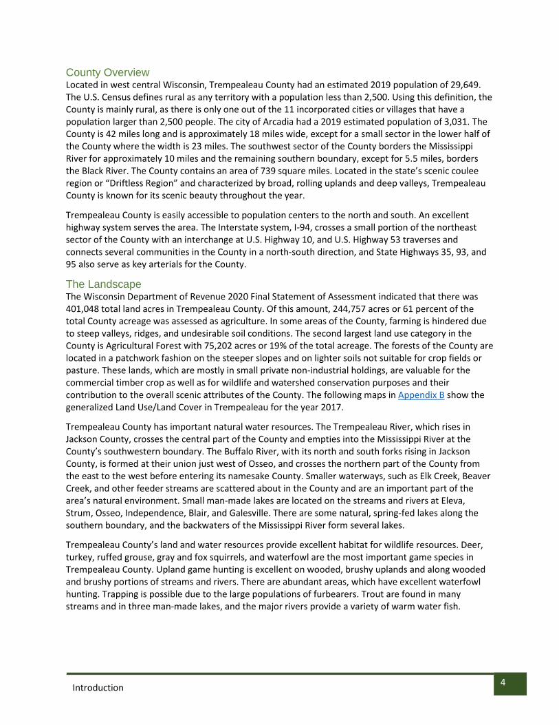
Whitehall-Pigeon Rod & Gun

2 Introduction

3 Introduction
PRIORITY AREAS: Trempealeau County’s objective in preparing this Outdoor Recreation Plan is twofold; the first is to provide an orderly framework for guiding future development of the County’s own recreation properties; and the second is to provide a single source document in which the individual community plans can be brought together to provide a County-wide overview of existing outdoor recreation facilities and opportunities and also to provide an opportunity to view the entire County for future planning purposes. For a complete list of action items for 2022-2026, please see page 42 for a comprehensive list of implementation priorities.
To accomplish this objective the following goals have been identified:
1. Maintain an outdoor recreation program that protects the natural environment and responds to the outdoor recreational needs of the residents and visitors of the County.
2. Formulate an action plan to meet the needs or public demands for outdoor recreation facilities in the County and municipalities.
3. Have a program that enables the County and municipalities to continually maintain and improve their recreation programs in a way that is economically feasible and environmentally sound.
4. Encourage the private sector to provide certain quality services and facilities for outdoor recreation purposes
5. Consider the impact on the local economy of the many visitors and tourists in the area who utilize the County and municipal outdoor recreation facilities.
6. Establish a policy of re-evaluating goals and objectives and project plans when necessary. 7. Maintain eligibility for Federal and State grant programs.
“The mission of the Trempealeau County Parks, Tourism, and Economic Development Committees is to continually explore and implement strategies to further develop
Trempealeau County as a leading place to live, work, and play. This will be accomplished by focusing on initiatives that both improve the economic lives and
provide opportunities for the development of new skills of our citizens, promotes and further develops our tourism assets, and honors and protects our rural character and
natural resources. We will also strive to further develop our Trempealeau County parks and lands in a way that provides youth with opportunities for both recreational
enjoyment and environmental education.”
4 Introduction
County Overview Located in west central Wisconsin, Trempealeau County had an estimated 2019 population of 29,649. The U.S. Census defines rural as any territory with a population less than 2,500. Using this definition, the County is mainly rural, as there is only one out of the 11 incorporated cities or villages that have a population larger than 2,500 people. The city of Arcadia had a 2019 estimated population of 3,031. The County is 42 miles long and is approximately 18 miles wide, except for a small sector in the lower half of the County where the width is 23 miles. The southwest sector of the County borders the Mississippi River for approximately 10 miles and the remaining southern boundary, except for 5.5 miles, borders the Black River. The County contains an area of 739 square miles. Located in the state’s scenic coulee region or “Driftless Region” and characterized by broad, rolling uplands and deep valleys, Trempealeau County is known for its scenic beauty throughout the year.
Trempealeau County is easily accessible to population centers to the north and south. An excellent highway system serves the area. The Interstate system, I-94, crosses a small portion of the northeast sector of the County with an interchange at U.S. Highway 10, and U.S. Highway 53 traverses and connects several communities in the County in a north-south direction, and State Highways 35, 93, and 95 also serve as key arterials for the County.
The Landscape The Wisconsin Department of Revenue 2020 Final Statement of Assessment indicated that there was 401,048 total land acres in Trempealeau County. Of this amount, 244,757 acres or 61 percent of the total County acreage was assessed as agriculture. In some areas of the County, farming is hindered due to steep valleys, ridges, and undesirable soil conditions. The second largest land use category in the County is Agricultural Forest with 75,202 acres or 19% of the total acreage. The forests of the County are located in a patchwork fashion on the steeper slopes and on lighter soils not suitable for crop fields or pasture. These lands, which are mostly in small private non-industrial holdings, are valuable for the commercial timber crop as well as for wildlife and watershed conservation purposes and their contribution to the overall scenic attributes of the County. The following maps in Appendix B show the generalized Land Use/Land Cover in Trempealeau for the year 2017.
Trempealeau County has important natural water resources. The Trempealeau River, which rises in Jackson County, crosses the central part of the County and empties into the Mississippi River at the County’s southwestern boundary. The Buffalo River, with its north and south forks rising in Jackson County, is formed at their union just west of Osseo, and crosses the northern part of the County from the east to the west before entering its namesake County. Smaller waterways, such as Elk Creek, Beaver Creek, and other feeder streams are scattered about in the County and are an important part of the area’s natural environment. Small man-made lakes are located on the streams and rivers at Eleva, Strum, Osseo, Independence, Blair, and Galesville. There are some natural, spring-fed lakes along the southern boundary, and the backwaters of the Mississippi River form several lakes.
Trempealeau County’s land and water resources provide excellent habitat for wildlife resources. Deer, turkey, ruffed grouse, gray and fox squirrels, and waterfowl are the most important game species in Trempealeau County. Upland game hunting is excellent on wooded, brushy uplands and along wooded and brushy portions of streams and rivers. There are abundant areas, which have excellent waterfowl hunting. Trapping is possible due to the large populations of furbearers. Trout are found in many streams and in three man-made lakes, and the major rivers provide a variety of warm water fish.

5 Property Inventory
PROPERTY INVENTORY Trempealeau County Owned Parks and Recreation The outdoor recreation industry is a vital part of the economy, nationwide and in Wisconsin. And as participation increases – an Outdoor Recreation Roundtable Survey found in May 2020 that 81% of Americans spent time outdoors since the onset of the COVID-19 pandemic, and 32.5% were participating in outdoor activities for the first time – “it will be increasingly important to support the industry and its partners in our backyard,” says Mary Monroe Brown, director of the Wisconsin Office of Outdoor Recreation. Therefore, the planning of outdoor recreation facilities is of utmost importance for the development of healthy and viable communities. Three important parts of recreation planning are: (1) Determine the demand for different types of outdoor recreation activity, (2) Inventory the existing facilities which accommodate the various types of outdoor recreation activity, and (3) Evaluate the existing facilities and determine the need for improvements or additions to meet the existing and anticipated recreational demand. What follows is an inventory of nature-based recreational activities available in Trempealeau County owned parks and properties. “Nature-based” is defined in the Wisconsin Statewide Comprehensive Outdoor Recreation Plan (SCORP) as “activities that are related to natural resources and where experiences are enhanced with higher quality natural habitats.”
Maps of outdoor recreation opportunities in Trempealeau County can be found in Appendix B.
Shelter
Playground Area Historic Marker ADA Accessible
Restrooms
Campground
RV Camping
Picnic Area
Leashed Pet Area
Boat Launch
Paddle Sports
Swimming Area
Fishing
Wildlife Viewing
Hunting
Night Sky Viewing
Foraging
ATV/UTV
Hiking
Biking
Snowshoeing
Horse Trails
Snowmobiling
INVENTORY LEGEND:
Scan the QR code to visit Trempealeau County’s online Tourism Web Map!

6 Property Inventory
County Fair Grounds 19780 Park Drive Galesville, Wisconsin The fairgrounds located in Galesville provide a unique facility for structured outdoor activities. Use of this facility for fairs, exhibitions, and other such events is expected to continue. With the evolving nature of the fair, Trempealeau County will work to partner with the Trempealeau County Agricultural Society, which oversees the fairgrounds, to find ways that the partnerships can be forged that will help the fairgrounds continue to thrive in its second century of operation. Focus will be put on ways the facilities can be enjoyed and utilized by the public.
County Fair Grounds

7 Property Inventory
Farm Progress Days Park W20410 WI-121 Whitehall, WI 54773 This ten-acre park is 2 ½ miles west of Whitehall on State Highway 121. It is adjacent to the Trempealeau County Health Care Center and County Farm. There is a softball diamond, two tennis courts, basketball court, volleyball court, seven picnic tables, a picnic shelter, running water, paved walking loop, a pit toilet, and a stocked fishing pond. Trempealeau County will work with the Trempealeau County Healthcare Center Board of Trustees, who oversee the park, to explore areas where we can partner together to provide outdoor recreation opportunities for the public.
Farm Progress Days Park

8 Property Inventory
Pietrek Park N31500 WI-93 Arcadia, WI 54612
Pietrek Park is 100-acre facility four miles north of Arcadia and five miles south of Independence on State Highway 93. It is located on the Trempealeau River. This park was designed for youth use. It has a kitchen and eating shelter with electricity and running water, and a primitive shelter with electric only. It also offers a newly constructed bathroom with flush toilets and showers, two pit toilets, 20 picnic tables, playground equipment, canoe landing/beach, observation deck along the Trempealeau River, wildlife area and nature trails. Shelter/kitchen renovation with an educational rain garden was completed in 2017.
Camping:
Pietrek Park currently has 19 camp sites that have electricity and water hook-ups in each individual site. There are an additional eight sites that provide electric only hook-up. Each of these sites contains a picnic table and fire ring. All sites consist of a mowed grassy area for parking RV’s, vehicles, and areas to pitch tents. The 19 sites with water and electric provide more of a private camping experience having shade trees and bushes creating screening between sites. The 8 electric only sites are located in an open setting with minimal screening from neighboring campers and little to no shade from the afternoon sun. There is also a camping overflow area which is used for large weekend events such as the local “Ashley for the Arts” festival. Combining all sites, including the overflow areas, the park has 69 sites. With proposed plans in place to begin development in the park, it is anticipated camping will become more popular. Park staff would like to see the overflow sites become regular use camp sites. There will need to be upgrades to the park to make this possible. The following upgrades will need to be completed…
• Install electrical to the 42 overflow sites which currently do not have electricity
• Install water to all 50 sites that don’t have water
• Potentially add up to 25 more sites
• Install new, gravel roads to all of the sites
• Install concrete pads in all of the sites
• Plant more screening (trees, bushes, etc.)
• Build new bathroom/shower facilities to comply with state campground regulations
Pietrek Park

9 Property Inventory
Kloss Shelter:
The Donald Kloss Shelter is the most used shelter at Pietrek Park with a newest edition recently added to the building on the east side. Inside, there is a kitchen/serving area, with tables, chairs, and counter space. The new part of the building consists of a dining area with eight picnic tables and five garage doors which can be opened for air flow. The shelter location is adjacent to the playground, the lower area walking trails, and the bathroom/shower facility. Needed improvements include:
• New flooring poured in the older part of the building
• Updated appliances and new tables/chairs
• Ceiling maintenance
• Indoor security cameras
(Exterior of the Donald Kloss Shelter at Joe Pietrek Jr. Memorial Park)

10 Property Inventory
Lower Shelter: The lower shelter, located near the group camping needs upgrades in order to become more attractive to people who want to rent shelters at Pietrek Park. Currently, the shelter has screens instead of windows with 4’x8’ plywood sheets covering the screen. The interior is not well lit and there are not any garage doors like the Kloss shelter. Recent improvements to the shelter include touching up the paint and new concrete flooring inside the building, replacing the previous plywood floor. The plans to improve this building are:
• Finish the outdoor concrete apron on the north and east sides of the building.
• Install three garage doors (north, east, and west sides)
• Insulate walls and ceiling
• Install car siding that is currently in the shed on walls and tin ceiling
• New lighting inside to brighten up the building
• Get power outlets suitable for the appliances in the building
See pictures of the Lower Shelter below….

11 Property Inventory
Security: Security cameras will need to be installed on the three main buildings that currently exist and on any new buildings that may be built. Right now, there are three external cameras on the Kloss shelter with plans to install cameras on the maintenance shed and the exterior of the bathroom/shower facility. These cameras will relay video/pictures through a wireless system to work cell phones. The goal is to eventually have a live stream going right to the Sheriff’s Department so surveillance will be real time. The maintenance shed is where all park tools, equipment, and machinery are stored. The shed is in a secluded part of the park and has been subject to break-ins twice in 2021 during the camping season. The park maintenance shed is in need of the following:
• Security cameras to monitor the perimeter of the area
• A secure door locking system
• Live stream cameras to county Sheriff department
• Access to live cameras via park staff cell phones
Group Camping Area: The group camping area consists of 5 group sites which are tent/small RV camping only. The park allows up to five tents in each site and there is no electric or water at these sites. Two of the group sites are located in the “upper” area of the campground and three sites are in the “lower” area of the park near the Trempealeau River. Due to being in an area which often floods, no development is proposed for this area of the park except for a potential concrete canoe/kayak landing near the beach area along the river. Park Check-In: Pietrek Park currently does not have a check-in or check-out area because there is no one on site to administer arrivals and departures. As the park begins to grow and develop, there will be a need to have staffing on site during the camping season and to monitor the entrance of the park. It is also assumed there will day use fees for the newly developed areas. Campground Host: In the past, Pietrek Park has had a seasonal employee act as the campground host. This has not been the case in recent years. As the park grows and expands, having a seasonal host on site will be important to answer questions and be there for the needs of the people camping at the park. Newly Acquired Land: Pietrek Park recently acquired over 6 acres of land that was graciously donated by the neighboring Schank family. This land will be developed with attractions in hopes of bringing in more people to the park for camping and day use. Right now, park staff is planning for max capacity in weekend campground use two years from now. Plans for the newly acquired land will be made after the land acquisition is finalized.

12 Property Inventory
Trail System: There is a walking trail system in the flood plain area of the park located in the northeast part on the west side of the river. The map below shows the locations of the trails with their respective names, and also shows the current and future boardwalk locations. The park has had four boardwalks installed in locations where water is standing in wet years. There are two more locations where boardwalks will be installed.

13 Property Inventory
Trempealeau Lots There are currently 18 County owned lots available for lease in the village of Trempealeau. These lots are leased from Mid-April to October 31st at a rate of $1,200/lot for the entire length of the season. Renters can renew their lease for the following season if they confirm they will keep it by September 15th of the current leasing season. Currently, the Trempealeau County Parks Department is having electricity installed in the preferred lots.
Trempealeau Lots

14 Property Inventory
FEDERAL OUTDOOR RECREATION FACILITIES Upper Mississippi River National Wildlife and Fish Refuge
The refuge is located in four states: Minnesota, Wisconsin, Iowa and Illinois along the Mississippi River. The Refuge was established in in 1924 as a refuge for fish, wildlife and plants and a breeding place for migratory birds. The refuge encompasses one of the largest blocks of floodplain habitat in the lower 48 states. Bordered by steep wooded bluffs that rise 100 to 600 feet above the river valley, the Mississippi River corridor and refuge offer scenic beauty and productive fish and wildlife habitat unmatched in the heart of America. The refuge covers just over 240,000 acres and extends 261 river miles from north to south at the confluence of the Chippewa River in Wisconsin to near Rock Island, Illinois. About 411 acres are within Trempealeau County, down river, or southeast, of the Village of Trempealeau, and include part of the “Trempealeau Lakes” complex of bottomland lakes, specifically Round Lake and Long Lake. Several islands in the Trempealeau County portion of Pools 6 and 7 are also part of this wildlife refuge.
Upper Mississippi River National Wildlife Refuge
Source: US FWS
Source: US FWS

15 Property Inventory
Trempealeau National Wildlife Refuge
The refuge was established by Executive Order in 1936 by President Franklin
D. Roosevelt as "a refuge and breeding ground for migratory birds and other
wildlife." The original refuge consisted of a 706.9-acre upland portion with
open areas of former hay, pasture, and croplands. An office and
maintenance shop complex was constructed in 1936, along with temporary
facilities for a Civilian Conservation Corps camp, which was located on
refuge lands until the advent of World War II.
For more than 40 years, the refuge remained small, despite several
attempts to purchase more than 5,000 acres of the surrounding Delta Fish
and Fur Farm, Inc. In 1975, Dairyland Power Cooperative acquired the entire
Delta Fish and Fur Farm. Dairyland wanted to construct a rail loop for a coal off-loading facility near their
power generating plant at Alma, Wisconsin. The land they would need for constructing the loop was
part of the Upper Mississippi River National Wildlife and Fish Refuge. As part of a land exchange,
Dairyland divested about 120 acres of the "Delta" and sold an additional 4,778 acres to the Service in
1979. This addition, plus other recent acquisitions, has brought Trempealeau National Wildlife Refuge to
its present 6,446 acres.
Trempealeau National Wildlife Refuge
Source: US FWS
Source: US FWS

16 Property Inventory
Lock and Dam 6
This Corps of Engineers navigation control structure divides Pool 6 from Pool 7. There is currently a visitor observation platform, public toilet, and visitor parking. In addition to visitors who observe the lock operations, fishing along the down river guide-wall is a popular activity. Lock and Dam 6 is in a bluff-lined valley on the Upper Mississippi River at Trempealeau. The project includes a lock, a dam with moveable gates, an earth dike and an overflow spillway. The Corps of Engineers originally placed the facility in operation in June 1936, as part of the Upper Mississippi River 9-foot channel project. Later in 1951, the Corps completed the upper guide wall extension. After more than 50 years of service the Corps undertook a major maintenance program to replace much of the operating equipment and to construct a new control building, which was completed in 1999 to ensure reliable service well into the future.
Lock and Dam 6

17 Property Inventory
STATE OUTDOOR RECREATIONAL FACILITIES Buffalo River State Trail
The Buffalo River State Trail gives east-west access across the northern edge of the County between Fairchild and Mondovi on another former Northwestern Railway right-of-way. The river, which lends its name to the trail, was named by early French explorers. They called it Riviere de Beeufs for the many bison that once inhabited the area. The surface of this trail is not as finished as the Great River Trail and many areas of old cinder ballast or sand blows suit this trail better for mountain bikes or hiking rather than the typical narrow tired touring type bicycle. Horseback riding is permitted on the Buffalo River State Trail between May 15 and October 31. ATVs are permitted on the Buffalo River State Trail between Mondovi and
Fairchild during May 15-October 31.

18 Property Inventory
Great River State Trail
Wisconsin is fortunate as a state to have the fine bicycle trail
system it has developed. It was one of the first states to
promote a “rails to trails” program. The Great River State Trail is
built on the former Chicago and Northwestern Railway right-of-
way between Onalaska and the Trempealeau Wildlife Refuge.
Within the refuge the trail is marked on other roads, with several side
trails and access to State Highway 35 at the north boundary of the refuge.
This trail, surfaced with fine, packed stone screenings, connects at its south end,
in La Crosse County, with the La Crosse River Trail, which leads to the Sparta-Elroy
Trail, and the Omaha Trail, to give a smooth surfaced virtually auto-free bike and
hiking trail from Trempealeau County to Reedsburg, one third of the distance across the state.
Bicycling Magazine calls Trempealeau County “cycling nirvana” and “the perfect getaway,” as it is
pastoral and known for its challenging climbs. “Trempealeau Trails” Bicycle Association has created 18
bike loops throughout the countryside and more information can be found at
http://www.tourdetremp.com/.

19 Property Inventory
Perrot State Park
This 1,434-acre State Park includes Trempealeau Mountain, a significant mass of tree clad earth and rock that rises 425 feet above the Mississippi River, with its base completely surrounded by water. Within the park there are Native American mounds believed to have been made by the Hopewell culture between 100 BC and 500 AD. Later works of the Archaic, Early Woodland, and Effigy Mound cultures also left evidence of their period on this bit of the earth. A popular feature of the park is the 520-foot Brady’s Bluff and its spectacular view of the river valley. The park has a staff naturalist in the summer, and in addition to hiking trails, boat access, shore fishing, and day use picnic areas, there are 97 campsites ranging from electrically equipped sites for camper vehicles to “primitive” sites for tent campers.
Perrot State Park

20 Property Inventory
State Wildlife Areas Trempealeau County has 6 State Wildlife Areas in the County. These wildlife management lands are owned by the state and are available for general public access. Wisconsin's Wildlife Areas provide a full range of traditional outdoor recreational uses. All the Wildlife Areas allow:
• Birding
• Cross country skiing (no designated trail)
• Fishing – trout
• Hiking (no designated trail)
• Hunting - especially noted for rabbits, squirrels, deer, turkey, ruffed grouse and pheasants (stocked annually)
• Trapping
• Wild edibles/gathering
• Wildlife viewing
Some wildlife areas also allow camping, bicycling, horseback riding, dog training, field trials (dog competition), and snowmobiling. Any restricted uses of wildlife areas will be designated with signs at the property. For safety, non-hunters should be aware that hunting season, especially deer season, is not the best time to be in these properties.
Borst Valley Wildlife Area The first land purchased in 1968 and officially established as a State Wildlife Management Area in 1979. Since the initial purchase the Borst Valley has grown to 1,343 acres. The property has been actively managed through land acquisition, timber harvesting, tree and shrub plantings, grassland plantings, establishment of hunter walking trails and wetland development.
Size: 1,343 acres, all state-owned Location: 7 miles northwest of Independence at intersection of CTH V and CTH W Principal Wildlife: Ruffed grouse, squirrels, deer, rabbits, turkeys, furbearers. Habitat: Upland hardwoods, Marsh, Grassland
Chimney Rock Wildlife Area The first land was purchased in 1959 to protect the wetland habitat that exists on the property. Since the initial purchase the Chimney Rock Wildlife Management Area has grown to 634 acres in size. The property has been actively managed through land acquisition, timber harvesting, tree and shrub plantings, grassland plantings, establishment of hunter walking trails and wetland development.
Size: 634 acres, all state-owned Location: 9 miles north of Independence. Access along CTH Y, 2 miles west of STH 93. Principal Wildlife: Ruffed grouse, squirrels, deer, rabbits, and turkeys. Habitat: Hardwood forest, Marsh, Grassland and some farmland.
Lakes Coulee Wildlife Area State acquisition on the Lakes Coulee Wildlife Area occurred in 1960 as part of the Scattered Wetlands Program. Since the initial purchase, the Lakes Coulee Wildlife Management Area has grown to 808 acres in size. The property has been actively managed through land acquisition, timber harvesting, tree and shrub plantings, grassland plantings, prescribed burning, establishment of hunter walking trails and

21 Property Inventory
wetland development. In addition to the hunting opportunities, the wildlife area is host to a Class III trout stream.
Size: 808 acres, all state-owned Location: 2 miles southwest of Blair on both sides of State highway 95. Principal Wildlife: Ruffed grouse, squirrels, deer, rabbits, and turkeys. Habitat: Marsh, timber farmland.
Tamarack Creek Wildlife Area Acquisition began in 1959 under the Scattered Wetlands Program. The property has since grown to 542 acres in size. Management on the property consists of boundary posting, parking area maintenance, prescribed burning, timber management and tree/shrub planting.
Size: 542 acres, all state-owned Location: 10 miles north of Trempealeau on west side of STH 93. Access on CTH F. Principal Wildlife: Turkeys, rabbits, squirrels, deer, ruffed grouse, great blue herons. Habitat: Upland hardwoods, Marsh, Bog, Grassland.
Tollefson Marsh Wildlife Area Tollefson Marsh Wildlife Area is a 120-acre property in Trempealeau County.
Size: 120 acres, all state-owned Location: 4 miles south of Osseo on east side of UTH 53. Principal Wildlife: Ruffed grouse, squirrels, deer, rabbits. Habitat: Marsh, Hardwood forest.
Vosse Coulee Wildlife Area Vosse Coulee Wildlife Area is a 123-acre property in Trempealeau County.
Size: 123 acres, all state-owned Location: 4 miles northeast of Blair and 2 miles north of STH 95 on CTH W. Principal Wildlife: Ruffed grouse, deer, furbearers, rabbits, and turkeys. Habitat: Marsh, upland forest.
State Fishery Areas The state's first land purchase for conservation occurred in 1876 when 40 acres were purchased south of Madison for the Nevin Fish Hatchery. More recently fishery projects that meet both habitat and public use need have broadened in scope to include lands adjacent to streams and lakes. These lands protect the watershed, and provide for compatible recreational uses such as hunting, hiking, and cross-country skiing. Fishery areas along streams, rivers, and lakes protect water quality by reducing erosion and run-off and improve habitat and fishing opportunities. Trempealeau County has 3 State Fishery Areas in the County.

22 Property Inventory
Buffalo River Fishery Area
Size: 1,290 acres, (840.5 state owned, 450.45 easement) Location: 6-8 miles west and east of Osseo along the Buffalo River. Scattered parcels. Recreation: Trout fishing, berry picking, hiking. Habitat: Stream, shrub marsh, upland forest.
Trempealeau Lakes Fishery Area
Size: 64 acres, all state-owned Location: 1 mile southeast of Village of Trempealeau. Access from STH 35. Recreation: Fishing, canoeing, pier for disabled fishing. Habitat: Lakes, marsh, forest, prairie. Marsh, timber farmland
Washington Coulee Fishery Area
Size: 87.6 acres, (69.6 state owned, 18 easement) Location: 3 miles east of Beaches Corners on CTH C, South of Washington Coulee Road 1 mile. Recreation: Trout fishing. Habitat: Stream, shrub marsh, upland forest.
State Natural Areas State Natural Areas (SNAs) are areas that are being preserved by the DNR to protect outstanding examples of Wisconsin's native landscape. The DNR has designated 687 State Natural Areas encompassing 406,000 acres in the State; Trempealeau County has nine of these designated sites within its boundaries. All nine are open to the public year-round unless otherwise noted at the State Natural Area site. The following are allowable and prohibited activities.
Allowable activities:
In general, the activities listed below are allowed on all DNR-owned SNA lands. Exceptions to this list of public uses, such as SNAs closed to hunting, are posted with signs on site.
• Hiking
• Fishing
• Cross country skiing
• Hunting
• Trapping
• Scientific research (permit remit required)
• Outdoor education
• Wild edibles
• Pets
• Wildlife viewing
Prohibited activities:
• Horseback riding
• Rock climbing
• Vehicles, including bicycles, ATVs, aircraft, and snowmobiles except on trails and roadways designated for their use

23 Property Inventory
• Collecting of animals, non-edible fungi, rocks, minerals, fossils, archaeological artifacts, soil, downed wood, or any other natural material, alive or dead. Collecting for scientific research requires a permit issued by the DNR
• Collecting of plants including seeds, roots or other non-edible parts of herbaceous plants such as wildflowers or grasses
• Camping and campfires
• Geocaching
Borst Valley Sedge Meadow Borst Valley Sedge Meadow a 20.21-acre meadow features a Driftless Area sedge meadow lying in the Sunshine Valley portion of the Borst Valley Wildlife Area. Numerous seeps help maintain this community and probably helped limit past grazing to extremely dry conditions. Site diversity is good especially for being within the Driftless Area where sedge meadows are relatively uncommon. Sedge species are abundant and include lake, water, fringed, inland, tussock, and wolf sedge. Other species present are bulblet water-hemlock, crested wood fern, cinnamon willowherb, boneset, bottled gentian, fowl manna grass, jewelweed, marsh vetchling, swamp candles, sensitive fern, marsh cinquefoil, cordgrass, marsh fern, and culver's root. Borst Valley Sedge Meadow is owned by the DNR and was designated a State Natural Area in 2010. Access to the meadow is from the intersection of Highways 93 and 121 in Independence, go north on 93 3.2 miles, then west on State Highway 121 3.7 miles, then north on County V 2 miles, then northwest on Engum Valley Road nearly 0.6 miles to a DNR parking area west of the road. Brady’s Bluff Prairie Brady’s Bluff Prairie a 20.65-acre prairie is located within Perrot State Park. Access to the prairie is from the intersection of STH 35 and Main Street in Trempealeau; go south on Main Street about two blocks, then west into Perrot State Park on South Park Road 2.6 miles to a parking lot west of the road. Access via the Brady's Bluff hiking trail. Brady's Bluff Prairie is a dry bluff prairie on a steep, southwest facing Mississippi River bluff that rises nearly 460 feet above the river. The bluff, composed of sandstone capped with Prairie du Chien dolomite, affords a spectacular view of the river valley from its summit. The prairie contains over 100 species of native Wisconsin plants. Some species are at or near their northeastern limit here. The prairie is also home to several rare plants. In addition, several rare animals are also harbored by the natural area including three butterflies: olive hairstreak, striped hairstreak, and columbine dusky wing along with the state threatened wing snaggletooth land snail. Brady's Bluff Prairie is owned by the DNR and was designated a State Natural Area in 1952. Buffalo River Trail Prairies Buffalo River Trail Prairies contains four high quality remnants located along the Buffalo River State Recreation Trail. Once an old railroad right-of-way near the meandering Buffalo River, the trail now harbors diverse stretches of prairie that were historically maintained by the unintentional fires sparked by passing railcars. The four prairie remnants stretch between Eleva and Osseo. One is located west of Eleva, two east of Strum and the largest --a five-mile stretch east of Osseo. The prairies contain numerous species with grasses including big and little blue-stem and Indian grass. Showy forbs include stiff goldenrod, prairie coreopsis, spiderwort, and flowering spurge. Buffalo River Trail Prairies is owned by the DNR and was designated a State Natural Area in 2002 and is 153 acres in size. Access is from the junction of I-94 and Highway 10 in Osseo, go east on 10 3.9 miles to a parking area on the north side of the highway. The largest section of prairie runs about 3 miles west and 2 miles east of the parking area. The other three natural area remnants are all accessible via the recreational trail.

24 Property Inventory
Chimney Rock Oak Savana Located on the north side of Hawkinson Valley within the Chimney Rock Wildlife Area is the 10.3-acre Chimney Rock Oak Savanna. This site features an exceptional oak opening with large diameter red oak, white oak, and bur oak dominating the canopy. The understory supports a high diversity of savanna indicator species. Species include Canada hawkweed, tall anemone, Kalm's brome, New Jersey tea, Virginia wild rye, showy tick-trefoil, early horse gentian, prairie alumroot, and lion's foot. Other plant species present are fringed puccoon, showy goldenrod, prairie violet, rockrose, prairie coreopsis, short's aster, and sky-blue aster. Chimney Rock Oak Savanna is owned by the DNR and was designated a State Natural Area in 2010. Access is from the intersection of County Highways D and V in Strum, go west on V 3.2 miles, then south on State Highway 93 6 miles, then west on Highway V 1.3 miles, then northwest on Hawkinson Valley Road nearly 1 mile to a DNR parking area. Great River Trail Prairies The 33-acre Great River Trail Prairies are located along the Great River State Trail in La Crosse and Trempealeau Counties. Access to the Prairies can be made from the junction of Third Street (STH 35) and Main Street in Trempealeau, go north on STH35 0.1 mile, then northwest on Park Road 1.4 miles to the intersection of West Prairie Road (just past the cemetery). Park along W. Prairie Road and walk east or west along the recreational trail into the State Natural Area. The Great River Trail Prairies features two very diverse sand prairie remnants located an old railroad right-of-way. Unintentional fires started by the sparks of passing locomotives helped maintain the prairies through time. Today, management such as brushing and prescribed burning helps sustain the prairies. It is one of the last remnants of the Trempealeau Prairie. The prairies also harbor a healthy population of the rare clustered poppy mallow. Great River Trail Prairies is owned by the DNR as part of the Great River State Trail and was designated a State Natural Area in 2002. Hawkinson Creek Wet Prairie Hawkinson Creek Wet Prairie features an exceptionally plant-rich prairie situated along a Driftless Area stream. This 11.79-acre wet prairie is located within the Chimney Rock Wildlife Area. The hydrology appears to still be intact and there are numerous seeps and rivulets throughout the area. Along with an abundance of saw-toothed sage, the site supports grasses including fringed brome, bluejoint grass, Canada wild rye, Upland wild timothy, and fowl manna grass. Forbs present include Canada anemone, swamp milkweed, shining aster, swamp thistle, common boneset, pale spiked lobelia, Michigan lily, spotted jewelweed, prairie alumroot, northern bedstraw, wild four o’clock, mountain mint, swamp betony, and swamp saxifrage. While this site has probably suffered past grazing, few comparable wetlands exist within the Driftless Area. Hawkinson Creek Wet Prairie is owned by the DNR and was designated a State Natural Area in 2010. Access if to the site is from the intersection of County Highways D and V in Strum, go west on V 3.2 miles, then south on State Highway 93 6 miles, then west and north on Highway V 1.7 miles to a DNR parking area. Tamarack Creek Bog The 130-acre Tamarack Creek Bog State Natural Area is located within the Tamarack Creek Wildlife Area. Access to the Bog is gained by going west on STH 35 1/2 mile, from the intersection of STH’s 93 and 35/54 in Centerville, then north on CTH F 6.6 miles. Park along the road and walk east into the site. To reach the northern unit, continue north on F 0.9 mile to a parking area on the west side of the road. Walk east into the site. The Tamarack Creek Bog consists of one of the largest tamarack swamps in the Driftless Area outside the Glacial Lake Wisconsin area. The swamp forest and open marsh occur along both sides of Tamarack Creek and its tributaries in a zone 0.25 to 0.5 mile wide and about 6 miles long. The occurrence of this large wetland complex in the ridge and coulee region may be a result of

25 Property Inventory
Tamarack Creek aggrading its stream bed when the Mississippi gorge was flooded with glacial melt waters. Numerous species typical of northern Wisconsin bogs are present including many orchids, balsam fir, Canada yew, yellow blue-bead-lily, American starflower, and several violets. Nesting birds are diverse and include the uncommon Bell's vireo (Vireo bellii). Many mouse and vole species support such predators as red fox and long-tailed weasels. The best area of tamaracks are in the northern unit. Poison sumac is abundant here. Tamarack Creek Bog is owned by the DNR and was designated a State Natural Area in 1968. Trempealeau Mountain Trempealeau Mountain is 90 acres is size and is located within Perrot State Park. Access to the area is from the intersection of State Highway 35 and Main Street in Trempealeau; go south on Main Street about two blocks, then west into Perrot State Park on South Park Road 2.6 miles to a boat launch west of the road. Access is by boat. Trempealeau Mountain is surrounded by the Mississippi and Trempealeau Rivers; the steep-sided Trempealeau Mountain is one of only three solid rock islands along the entire stretch of Mississippi River. Standing 425 feet high, the mountain was used as an early navigational device by steamboat captains and other river travelers. The mountain is mostly wooded with black and white oak and basswood. Red oaks are found on the southeast-facing hollow with large patches of interrupted ferns while sugar maple and basswood dominate on the cooler northeast facing slopes. On dry south-facing slopes are small patches of dry prairie. The mountain is rich in archeological features with numerous Native American mounds, burial sites, and habitation sites. The name Trempealeau comes from the French, “la montagne qui trempe à l’eau” meaning “the mountain whose foot is bathed in water”. Trempealeau Mountain is owned by the DNR, as part of Perrot State Park and was designated a State Natural Area in 2002. Vosse Coulee Vosse Coulee is a botanically rich site located along the eastern edge of the sandstone influenced Driftless Area. This 100-acre site is located within the Vosse Coulee Wildlife Area. The area harbors a diverse wet prairie, a small high quality dry prairie, an oak opening restoration site, and a high-quality mesic prairie undergoing restoration. Wet prairies now encompass less than 500 acres statewide and are of high conservation value while oak openings and mesic prairie have been nearly extirpated and require committed restoration efforts. Although common historically, mesic prairies are extremely rare today due their high productivity for agricultural use. The wet prairie supports numerous sedges and a good variety of showy forbs. Plants include Joe-pye weed, boneset, Michigan lily, swamp milkweed, culver's-root, cup plant, marsh bellflower, turtlehead, water-hemlock, swamp thistle, grass-leaved goldenrod, flowering spurge, ox-eye sunflower, bottle gentian, purple meadow-rue, golden Alexander, and cowbane. White meadowsweet is fairly common. Vosse Coulee Creek is Class 2 trout water, supporting both Brook and Brown trout. The stream is flanked by alders. A few small silver maple, cottonwoods, and box elder are also present. The creek is a tributary of the Trempealeau River, and both the stream and spring runs provide additional diversity to the site. Vosse Coulee is owned by the DNR and was designated a State Natural Area in 2010. Access is from the intersection of State Highway
Tamarack Creek Bog

26 Property Inventory
95 and County H north of Taylor, go west on 95 2.5 miles, then north on County W 2.1 miles. The site lies east and west of the road. Nature Conservancy The Wisconsin Chapter of the Nature Conservancy owns two small parcels in the County near Galesville, including the historic Decorah Peak. This private non-profit organization purchases land, which has unique environmental scientific value, or is habitat for rare or endangered species. The parcels are intended to protect resource values and are not intended as public recreation sites; however non-intrusive entry for nature study is permitted. These properties are subject to the same property taxes as any private property. Mississippi Valley Conservancy Trempealeau Lakes In 2009 MVC purchased the Trempealeau Lakes property with its half-mile of frontage on Second Lake that abuts the state’s Trempealeau Lakes State Fishery Area. In addition to the appeal of the chain of spring-fed lakes for fishing, the area is listed on the Great Wisconsin Nature and Birding Trail. The purchase by MVC increases this local protected habitat to 219 acres. The acquisition provides for fishing, swimming, canoeing and bird watching. The property is located south of State Highway 35 and the Great River State Trail, and is accessible from Lake Road, Pickerel Road, and Bass Road. Also nearby is access to the Upper Mississippi National Wildlife and Fish Refuge and its Long Lake Canoe Trail. The Great River State Bicycle Trail trailhead is nearby as well. The property is located entirely within the “Mississippi River- Large River Corridor,” identified by Wisconsin’s Wildlife Action Plan as being of “Continental Significance.” The area is available for public use.
School Properties and Quasi-Public Facilities Public School Districts are entities that are allowed to apply for Federal Land and Water Conservation Funds (LAWCON). The Osseo-Fairchild and Gale-Ettrick-Trempealeau school districts have school forests in the County, which are open to the general public for hiking and nature study. In addition, most schools have playground equipment that is available for use by the general public throughout the year. The Osseo Forest has an undeveloped access road and parking area for fishermen using the Buffalo River.
Several sportsmen clubs own land in the County, and some of these allow access by the general public, whereas others limit access, or at least give a preference, to members. Sportsmen’s clubs that are known to provide general access are Osseo Rod and Gun Club, which also includes an eight-acre fishing pond; Whitehall-Pigeon Rod and Gun Club; Elk Rod and Gun Club; the Dodge Sportsmen’s Club, which includes a small ox-bow lake and Trempealeau River access; and the Associated Conservation Clubs scattered parcels adjacent to the Trempealeau Wildlife Refuge. Other clubs, whose access policies are not known, include Arcadia Sportsmen Club, Blair Sportsmen’s Club, Ettrick Rod and Gun Club, and Trempealeau Archers. Before entering any of these Rod and Gun Club properties, even those known to permit public use, the user should determine entry policy from a club member. Some of the facilities may have gun or arrow firing ranges, and an unexpected visitor could create a safety problem.

27 Recreational Demand
RECREATIONAL DEMAND Statewide The planning of outdoor recreation facilities is of utmost importance for the development of healthy and viable communities. Three important parts of recreation planning are: (1) Determine the demand for several types of outdoor recreation activity, (2) Inventory the existing facilities which accommodate the various types of outdoor recreation activity, and (3) Evaluate the existing facilities and determine the need for improvements or additions to meet the existing and anticipated recreational demand.
According to the Outdoor Recreation Roundtable (https://recreationroundtable.org/impact/):
“The outdoor recreation industry does more than bring joy to millions of Americans: It helps drive our economy. In 2018, the Bureau of Economic Analysis (BEA) included outdoor recreation in its calculations of U.S. GDP for the very first time—a significant step that formally recognizes the critical role the industry plays in supporting economic growth in the United States. In addition, the BEA found that the outdoor recreation industry is growing rapidly, eclipsing the average increase in overall U.S. GDP. Outdoor recreation is also a major generator of quality American jobs in industries ranging from manufacturing to retail to tourism. These jobs can be found from coast to coast and play a critical role in the economic health of local and state economies.”
As we progress into a new century, events and issues that influence outdoor recreation in the future are changing. Issues, which will influence future outdoor recreation activities include:
• Land use patterns are shifting
• Ownership patterns in rural areas are changing
• Budgets for operation and maintenance of recreation resources are not expected to increase
In addition, the demographics of the County are shifting. The County’s median age increased 5.3 years since 1990. As people age, recreation activities they participate in may change. The changes in family structure (an increase in single parent families) also changes recreation choices.
28 Recreational Demand
POPULAR RECREATION ACTIVITIES IN WHICH
RESPONDENTS TO THE STATE SURVEY PARTICIPATE
Bicycling – paved trails
Bicycling – mountain biking, single track
Bicycling – winter/fat tire
Camping – tent
Canoeing/kayaking
Cross-country skiing/snowshoeing
Fishing – from a boat, canoe, or kayak
Fishing – from shore
Harvesting berries, mushrooms, etc.
Hiking, walking, running on trails
Swimming
Wildlife/bird watching
For guidance on the demand for recreational outdoor activities, a review of the Wisconsin Statewide Comprehensive Outdoor Recreation Plan (SCORP) 2019-2023 was conducted. During the development of SCORP, numerous Wisconsin residents were questioned as to how often they participate in various recreation activities. Data is collected at 8 regional levels; Trempealeau County lies in the Mississippi River Corridor. The box to the left indicates the most popular recreation activities in the State with activities bolded and italicized indicating the top activities in the Mississippi River Corridor Region.
Favorite Places to Visit Based on Public Input Of the people providing input, the majority (67%) selected the quality of trails as one of the top four most important factors in determining their favorite property to visit. This is expected, given that many respondents noted their participation in a variety of motorized and non-motorized activities. The following were the next three important factors to determine favorable places to visit:
1. Desire to be in a quiet place 2. Maps, signs, or information about the property 3. The quality of the habitat
Wisconsinites have historically participated in outdoor recreation at higher rates than the national average. The table to the left shows participation rates of Wisconsin residents for general groupings of nature-based recreation activities. For
comparison, 46% of Wisconsin residents participated in ball sports (golf, tennis, basketball, softball, baseball, soccer, and handball).
77% of respondents to the SCORP believe more outdoor recreational opportunities are needed in the Mississippi River Corridor Region. The opportunity that was most frequently selected as needed in the Mississippi River Corridor Region was more trails for hiking, walking, or running, which was selected by nearly half of respondents.
The Mississippi River Corridor Region is a unique setting lending itself well to various types of outdoor recreation. Trout fisherman are drawn from throughout the Midwest to the many streams draining to the Mississippi River. These same rivers attract paddlers and bluffs are attractive to mountain bikers. The area provides exceptional habitat for many game species, especially deer and turkey. The river is a migratory bird flyway which attracts waterfowl hunters during the fall migration as countless birds make their way south. The bluffs are also home to rare plant species and natural communities. With the abundance of nature, this area offers countless avenues to be explored.
Communities in this region are partnering with local citizen groups, raising funds, and developing parks, trails, and accesses to waterways, attracting visitors year-round. The Land and Water Conservation Fund Act (LWCF) was enacted by Congress in 1965 “to strengthen the health and vitality of the citizens of the United States” through outdoor recreation. From 1965 to 2017, Trempealeau County has been awarded $395,494 by LWCF and has been used for 22 projects.

29 Recreational Demand
According to Spending Potential Index, based on Esri forecast for 2020 and 2025, Trempealeau County residents spend more money per year on recreational vehicles and fees than the national average. These expenses are predominately on boats, trailers, campers, and RVs. The MPI (Market potential Index), which measures the likelihood of adult spending behaviors based on purchasing patterns, is another indicator used by Esri to predict spending patterns in a region from 2020 to 2025. Based on these projections, Trempealeau County residents participate approximately 50% more in freshwater fishing, rifle and shotgun hunting, and motorcycling than the national average.
Statewide Needs Based on the 2019-2023 SCORP, the Mississippi River Corridor Region rates recreational activities as high, medium, or low relative to needs of the region. The groupings are as follows:
Future Recreation Needs – High
Future Recreation Needs – Medium
Future Recreation Needs – Low
Bicycling – touring/road riding ATV/UTV riding Dog sledding/ skijoring
Bicycling – mountain/off road Bicycling – fat tire/snow Dog training
Bird or wildlife watching Fishing – lake from shore Dog Trialing
Camping – developed Fishing – ice fishing Geocaching
Camping – primitive Four-wheel vehicle driving Off-highway motorcycle riding
Canoeing or kayaking Horseback riding Rock climbing
Cross Country Skiing Horse cart driving Sailing, windsurfing, rowing, etc.
Dog Walking Hunting – migratory birds Snowmobiling
Fishing – lake from vessel Hunting – small game Scuba diving/snorkeling
Fishing – river from vessel Hunting – turkey Whitewater rafting
Fishing – stream or shore wading Motorboating (waterski, tubing)
Gather mushrooms, berries, etc. Swimming in lakes and rivers
Hiking, walking, trail running Target shooting – archery
Hunting – big game Target shooting – firearms
Nature photography Trapping
Nature based education programs
Picnicking
Snowshoeing
Visit a beach, beach walking

30 Recreational Demand
Travel Patterns Cambridge Systematics, Inc. partnered with the Mississippi River Regional Planning Commission (MRRPC) in 2020 to analyze travel patterns in our region. Based on this study, on a weekday in Trempealeau County there is an average of 20,000 trips per day from a home location to a non-work location. These non-work locations can relate to outdoor recreation and errands a typical family may take on a given day. On Saturdays this number jumps to an average of 26,500 trips and 22,000 on Sundays. Approximately 50% of these trips were over 10 miles in length. 25% of these trips were over 25 miles in length. The peak travel times were from 10 am to 3 pm on weekdays and weekends.
Saturday and Sunday Travel Patterns, 2020
Based on this sample analysis, we see a high proportion of individuals traveling to Trempealeau County residing in surrounding counties. Weekdays see the highest disbursement of visitors from surrounding areas for non-work-related travel. Sundays have the least disbursed number of visitors traveling to the County with a smaller area of origin.
The maps above show the location of origin for travelers that went to Trempealeau County on average on Weekdays, Saturdays, and Sundays in 2020.
31 Population, Demographics, Education, & Economics
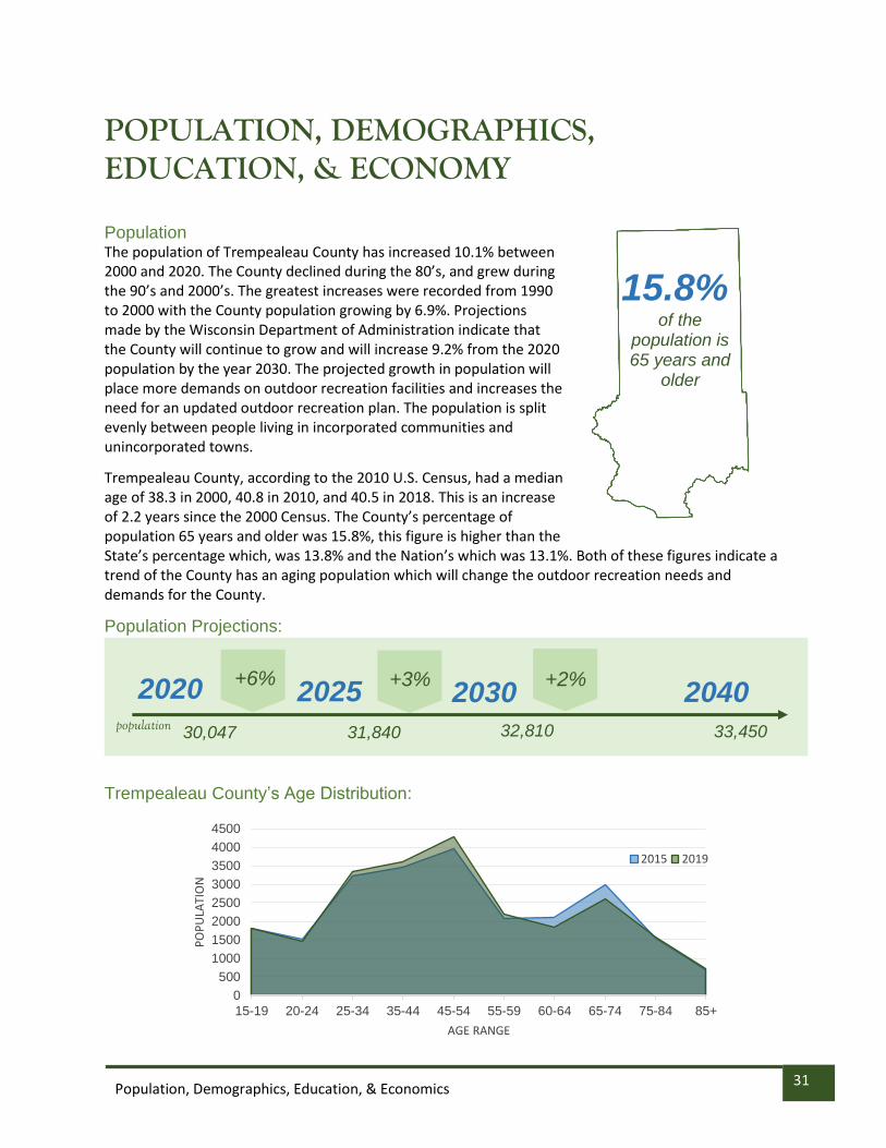
POPULATION, DEMOGRAPHICS, EDUCATION, & ECONOMY
Population The population of Trempealeau County has increased 10.1% between 2000 and 2020. The County declined during the 80’s, and grew during the 90’s and 2000’s. The greatest increases were recorded from 1990 to 2000 with the County population growing by 6.9%. Projections made by the Wisconsin Department of Administration indicate that the County will continue to grow and will increase 9.2% from the 2020 population by the year 2030. The projected growth in population will place more demands on outdoor recreation facilities and increases the need for an updated outdoor recreation plan. The population is split evenly between people living in incorporated communities and unincorporated towns.
Trempealeau County, according to the 2010 U.S. Census, had a median age of 38.3 in 2000, 40.8 in 2010, and 40.5 in 2018. This is an increase of 2.2 years since the 2000 Census. The County’s percentage of population 65 years and older was 15.8%, this figure is higher than the State’s percentage which, was 13.8% and the Nation’s which was 13.1%. Both of these figures indicate a trend of the County has an aging population which will change the outdoor recreation needs and demands for the County.
Population Projections:
Trempealeau County’s Age Distribution:
15.8% of the
population is 65 years and
older
2020 2025 2030 2040
+6% +3% +2%
30,047 31,840 32,810 33,450 population
0
500
1000
1500
2000
2500
3000
3500
4000
4500
15-19 20-24 25-34 35-44 45-54 55-59 60-64 65-74 75-84 85+
PO
PU
LATI
ON
AGE RANGE
2015 2019

32 Population, Demographics, Education, & Economics
Household Income According to the U.S. Census Bureau’s 2015-2019 American Community Survey 5-year estimate Trempealeau County’s median household income was $58,548. This amount is 5.2% lower than the state’s average of $61,747 and 6.1% lower than the National average of $62,843. The Town of Unity had the highest median household income at $76,250 and the City of Blair had the lowest at $45,417. Of the 26 Towns, Villages and Cities within the County 14 had a lower median household income than the County average and 12 had a higher income.
Rural/Urban Distribution According to the 2010 Census, Trempealeau County had 89.6% of its population living in rural areas and
10.4% living in urban clusters. This movement of people will have an impact on the access and number
of public lands for recreation purposes. The small lot urban dweller, whether it is a city of 2,000 or a
village of 200, does not have the capability to provide a myriad of extensive outdoor recreation
experiences on his or her own land and therefore is more dependent upon a public park system which
offers a broader range of outdoor opportunities including hunting, hiking, camping, and picnicking. As
more people move to the incorporated communities and rural areas and farms are sold off for
development, lands previously used for recreation are lost. Many rural residents can find extended
outdoor recreation experiences on their own land. Snowmobiling, cross-country skiing, hunting, hiking,
Manufacturing
Educational Services
Retail Trade
Agriculture and Forestry
1k 2k 3k 4k 5k
2019 Top Industries in Trempealeau County
PEOPLE IN WORKFORCE
TO
P I
ND
US
TR
IES
33 Population, Demographics, Education, & Economics
and scenery viewing can all be done on their own property and their dependence upon a government
sponsored recreation facility may be primarily for support of team sports like softball.
Trempealeau County is a rural County and farming is a major part of the landscape. The past 5 decades
has seen a decline in the number of farms and the number of acres in farming within the County. In
1970 there were 2,160 farms with a total of 431,000 acres in the County. By 2002 this number had
declined to 1,744 farms on only 367,830 acres. As of 2017, the number of farms further decreased to
1,229 on 329,916 acres. As discussed previously this decline in the number of acres on farms has a
detrimental effect on outdoor recreation.

34 Population, Demographics, Education, & Economics
Washington Coulee State Natural Area
TOPOGRAPHY, WATER RESOURCES, & CLIMATE
County Overview Located in west central Wisconsin, Trempealeau County had an estimated 2019 population of 29,649. The U.S. Census defines rural as any territory with a population less than 2,500. Using this definition, the County is mainly rural, as there is only one out of the 11 incorporated cities or villages that have a population larger than 2,500 people. The city of Arcadia had a 2019 estimated population of 3,031. The County is 42 miles long and is approximately 18 miles wide, except for a small sector in the lower half of the County where the width is 23 miles. The southwest sector of the County borders the Mississippi River for approximately 10 miles and the remaining southern boundary, except for 5.5 miles, borders the Black River. The County contains an area of 739 square miles. Located in the state’s scenic coulee region or “Driftless Region” and characterized by broad, rolling uplands and deep valleys, Trempealeau County is known for its scenic beauty throughout the year.
Trempealeau County is easily accessible to population centers to the north and south. An excellent highway system serves the area. The Interstate system, I-94, crosses a small portion of the northeast sector of the County with an interchange at U.S. Highway 10, and U.S. Highway 53 traverses and connects several communities in the County in a north-south direction, and State Highways 35, 93, and 95 also serve as key arterials for the County.
Landscape The Wisconsin Department of Revenue 2020 Final Statement of Assessment indicated that there was 401,048 total land acres in Trempealeau County. Of this amount, 244,757 acres or 61 percent of the total County acreage was assessed as agriculture. In some areas of the County, farming is hindered due to steep valleys, ridges, and undesirable soil conditions. The second largest land use category in the County is Agricultural Forest with 75,202 acres or 19% of the total acreage. The forests of the County are located in a patchwork fashion on the steeper slopes and on lighter soils not

35 Population, Demographics, Education, & Economics
Lake Henry - Blair
suitable for crop fields or pasture. These lands, which are mostly in small private non-industrial holdings, are valuable for the commercial timber crop as well as for wildlife and watershed conservation purposes and their contribution to the overall scenic attributes of the County.
Trempealeau County has important natural water resources. The Trempealeau River, which starts in Jackson County, crosses the central part of the County and empties into the Mississippi River at the County’s southwestern boundary. The Buffalo River, with its north and south forks in Jackson County, is formed at their union just west of Osseo, and crosses the northern part of the County from the east to the west before entering its namesake County. Smaller waterways, such as Elk Creek, Beaver Creek, and other feeder streams are scattered about in the County and are an important part of the area’s natural environment. Small man-made lakes are located on the streams and rivers at Eleva, Strum, Osseo, Independence, Blair, and Galesville. There are some natural, spring-fed lakes along the southern boundary, and the backwaters of the Mississippi River form several lakes.
Trempealeau County’s land and water resources provide excellent habitat for wildlife resources. Deer, turkey, ruffed grouse, gray and fox squirrels, and waterfowl are the most important game species in Trempealeau County. Upland game hunting is excellent on wooded, brushy uplands and along wooded and brushy portions of streams and rivers. There are abundant areas, which have excellent waterfowl hunting. Trapping is possible due to the large populations of furbearers. Trout are found in many streams and in three man-made lakes, and the major rivers provide a variety of warm water fish.
0102030405060708090
AV
ERA
GE
TEM
PER
ATU
RE
(◦F)
MONTH
Average High Average Low

36 Population, Demographics, Education, & Economics
Climate and Extreme Weather Outdoor recreation in Trempealeau County can be highly dependent on the season. Trempealeau County has seasonal variations in temperature and precipitation with changing weather patterns. The graphs below show annual precipitation data and monthly average temperatures from the National Weather Service for the Richmond Township Station. Changes in seasonal patterns leading to more extreme weather events are causing milder winters, hotter summers, and wetter springs. Snow cover is disappearing earlier in the spring causing snow covered areas to shrink in recent years. This early snowmelt can increase risks for flooding and shorten the winter sports season. It can also increase spring rain season leading to soggy ground, impacting trail areas and maintenance. An increase in 90 degree and above days increases the risk of heat-related illnesses while providing an environment favorable to vector-borne diseases carried by ticks and mosquitos. As Trempealeau County plans for future outdoor recreation needs, the effects of changing weather patterns will be taken into account to sustain local park systems for the future.
Source: usclimatedata.com

37 Local Priorities & Objectives
Lake Henry - Blair
1. How often do you use County Parks or outdoor facilities?
LOCAL PRIORITIES & OBJECTIVES Survey Results The County prepared a survey during the process of updating its Outdoor Recreation Plan. The survey was made available on the County’s website and shared on social media platforms hosted by Trempealeau County and Mississippi River Regional Planning Commission. A total of 290 responses were received and the results are shown below.
10%
36%
16%
26%
12%
Never
Not Often (Less than 6times per year)
Often (1-2 times permonth)
Sometimes (6-11 times peryear)
Very Often (1 or moretimes per week)
High Cliff City Park, Galesville
2. What are your top three outdoor recreation activities you participate in in Trempealeau County?
58%
Hiking/Walking
35%
Fishing
29%
Canoeing/ Kayking
27%
Wildlife Viewing
27%
Hunting
24%
Biking

38 Local Priorities & Objectives
0
20
40
60
80
100
120
1 - Not Satisfied 2 - SomewhatNot Satisfied
3 - Neutral 4 - SomewhatSatisfied
5 - Satisfied
3. If you feel you spend too little time in outdoor activities, what keeps you from spending more time?
4. The number of outdoor parks/facilities available in Trempealeau County
Please tell us how satisfied you are with the following…
5. The quality of outdoor parks/facilities available
I'm too busy with other activities
I don't have the right equipment for the activities I want to do
I don't have anyone to do these activities with
0
20
40
60
80
100
120
1 - Not Satisfied 2 - SomewhatNot Satisfied
3 - Neutral 4 - SomewhatSatisfied
5 - Satisfied

39 Local Priorities & Objectives
• I drive to EC to walk because we don’t have multi-surface surfaces in the Independence/Eleva area.
• New to area and don’t know where recreation spots are located!
• The bike trails need to be paved. I stop paying to use them because I would rather ride on the streets which is sad. Also, people walking dogs need to be fined if they don't clean up after them. I think anyone who uses the trails should have to pay, shouldn't matter if you are walking or riding a bike.
• Accessible for all abilities.
• Would like to see better maps of what is available in the area, especially for hiking trails, suggested canoe routes, etc.
• Not enough options locally, always traveling to other towns to participate in activities.
• I would like to see mountain biking trails put in the county. Currently I drive to Eau Claire or Clark Counties to ride Mountain Bike.
• I drive to EC to walk because we don’t have multi-surface surfaces in the Independence/Eleva area.
• Lack of county parks or outdoor activities, such as hiking, nearby.
• Not many walking trails near me or are too far to go in the evening.
6. The maintenance of outdoor parks/facilities available
0
20
40
60
80
100
1 - Not Satisfied 2 - SomewhatNot Satisfied
3 - Neutral 4 - SomewhatSatisfied
5 - Satisfied
7. Comments on the number, quality, and maintenance of parks available. *does not include all comments (available upon request)
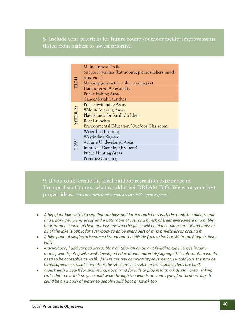
40 Local Priorities & Objectives
HIG
H
Multi-Purpose Trails Support Facilities (bathrooms, picnic shelters, snack bars, etc...) Mapping (interactive online and paper) Handicapped Accessibility Public Fishing Areas Canoe/Kayak Launches
ME
DIU
M Public Swimming Areas
Wildlife Viewing Areas Playgrounds for Small Children Boat Launches Environmental Education/Outdoor Classroom
LOW
Watershed Planning Wayfinding Signage Acquire Undeveloped Areas Improved Camping (RV, tent) Public Hunting Areas Primitive Camping
• A big giant lake with big smallmouth bass and largemouth bass with the panfish a playground and a park and picnic areas and a bathroom of course a bunch of trees everywhere and public boat ramp a couple of them not just one and the place will be highly taken care of and most or all of the lake is public for everybody to enjoy every part of it no private areas around it.
• A bike park. A singletrack course throughout the hillside (take a look at Whitetail Ridge in River Falls).
• A developed, handicapped accessible trail through an array of wildlife experiences (prairie, marsh, woods, etc.) with well-developed educational materials/signage (this information would need to be accessible as well). If there are any camping improvements, I would love them to be handicapped accessible - whether the sites are accessible or accessible cabins are built.
• A park with a beach for swimming, good sand for kids to play in with a kids play area. Hiking trails right next to it so you could walk through the woods or some type of natural setting. It could be on a body of water so people could boat or kayak too.
8. Include your priorities for future county/outdoor facility improvements (listed from highest to lowest priority).
9. If you could create the ideal outdoor recreation experience in Trempealeau County, what would it be? DREAM BIG! We want your best project ideas. *does not include all comments (available upon request)
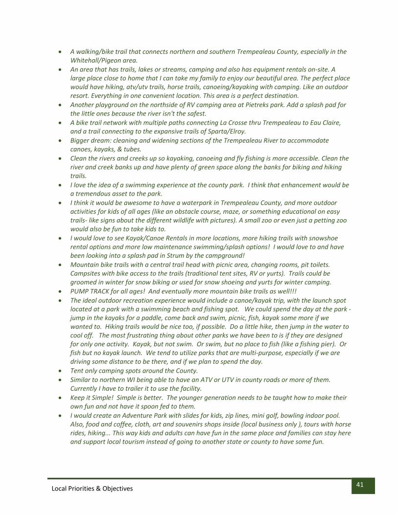
41 Local Priorities & Objectives
• A walking/bike trail that connects northern and southern Trempealeau County, especially in the Whitehall/Pigeon area.
• An area that has trails, lakes or streams, camping and also has equipment rentals on-site. A large place close to home that I can take my family to enjoy our beautiful area. The perfect place would have hiking, atv/utv trails, horse trails, canoeing/kayaking with camping. Like an outdoor resort. Everything in one convenient location. This area is a perfect destination.
• Another playground on the northside of RV camping area at Pietreks park. Add a splash pad for the little ones because the river isn't the safest.
• A bike trail network with multiple paths connecting La Crosse thru Trempealeau to Eau Claire, and a trail connecting to the expansive trails of Sparta/Elroy.
• Bigger dream: cleaning and widening sections of the Trempealeau River to accommodate canoes, kayaks, & tubes.
• Clean the rivers and creeks up so kayaking, canoeing and fly fishing is more accessible. Clean the river and creek banks up and have plenty of green space along the banks for biking and hiking trails.
• I love the idea of a swimming experience at the county park. I think that enhancement would be a tremendous asset to the park.
• I think it would be awesome to have a waterpark in Trempealeau County, and more outdoor activities for kids of all ages (like an obstacle course, maze, or something educational on easy trails- like signs about the different wildlife with pictures). A small zoo or even just a petting zoo would also be fun to take kids to.
• I would love to see Kayak/Canoe Rentals in more locations, more hiking trails with snowshoe rental options and more low maintenance swimming/splash options! I would love to and have been looking into a splash pad in Strum by the campground!
• Mountain bike trails with a central trail head with picnic area, changing rooms, pit toilets. Campsites with bike access to the trails (traditional tent sites, RV or yurts). Trails could be groomed in winter for snow biking or used for snow shoeing and yurts for winter camping.
• PUMP TRACK for all ages! And eventually more mountain bike trails as well!!!
• The ideal outdoor recreation experience would include a canoe/kayak trip, with the launch spot located at a park with a swimming beach and fishing spot. We could spend the day at the park - jump in the kayaks for a paddle, come back and swim, picnic, fish, kayak some more if we wanted to. Hiking trails would be nice too, if possible. Do a little hike, then jump in the water to cool off. The most frustrating thing about other parks we have been to is if they are designed for only one activity. Kayak, but not swim. Or swim, but no place to fish (like a fishing pier). Or fish but no kayak launch. We tend to utilize parks that are multi-purpose, especially if we are driving some distance to be there, and if we plan to spend the day.
• Tent only camping spots around the County.
• Similar to northern WI being able to have an ATV or UTV in county roads or more of them. Currently I have to trailer it to use the facility.
• Keep it Simple! Simple is better. The younger generation needs to be taught how to make their own fun and not have it spoon fed to them.
• I would create an Adventure Park with slides for kids, zip lines, mini golf, bowling indoor pool. Also, food and coffee, cloth, art and souvenirs shops inside (local business only ), tours with horse rides, hiking... This way kids and adults can have fun in the same place and families can stay here and support local tourism instead of going to another state or county to have some fun.

42 Local Priorities & Objectives
IMPLEMENTATION PRIORITIES
Trempealeau County’s Priorities, Objectives and Action Items for 2022-2026 These priorities, objectives, and action items were developed over a year long process of discussion and collaboration with diverse stakeholders of Trempealeau County. Priority has been given to projects that it is believed both have the ability to receive funding, having public support, and most importantly will improve the outdoor recreation opportunities of the citizens of Trempealeau County and encourage those from outside the County to discover what we have to offer. These objectives will focus on lands that Trempealeau County owns itself, and on ways that Trempealeau County can partner with municipalities, local, state, federal, and other government agencies partners to enhance outdoor recreation opportunities.
Project/Initiative HIGH PRIORITY
Description of Project/Initiative
Timeline Lead/s and First Steps
Partners Funding Sources
Implementation of Joe Pietrek Jr. Memorial Park and 3 Lakes Lots action plan which is in current development.
See Pietrek Park Action Plan.
2022 -Parks Director -Conduct Master Plan of Park with an Engineering Firm
-Parks Coordinator -Parks, Tourism and Economic Development Coordinator -PTED Committee -DLM Director -Village of Trempealeau -Inde. Elk Rod and Gun Club -City and Town of Arcadia
-Trempealeau County general fund -Private Donors -DNR Recreation Trails Program -ARPA Monies and Grant monies from various agencies -Research Further State and Federal Grants -Vehicle stickers
Create a Trempealeau County Outdoor Recreation Plan advisory work group whose members may include County residents from Associated Conservation Clubs on Trempealeau County, biking interests, canoeing/kayaking clubs, hiking organizations, ATV/UTV groups, and appropriate WDNR staff.
Establish the County Outdoor Recreation Plan advisory committee that meets at established intervals and evaluates the goals and progress towards implementing the outdoor recreation plan. Also, can suggest edits or updates to plan as needed.
2022-2023 -Economic Development & Tourism Coordinator speak with Associated Conservation Clubs of Trempealeau County to garner interest and recruit members.
-Associated Conservation Clubs of Trempealeau County -Other outdoor hunting and fishing groups -Local municipal officials -County snowmobile clubs -County residents from Associated Conservation Clubs on Trempealeau County -Trempealeau Trails Groups -Canoeing and kayaking clubs,
-General Fund for possible per diems

43 Local Priorities & Objectives
Project/Initiative HIGH PRIORITY
Description of Project/Initiative
Timeline Lead/s and First Steps
Partners Funding Sources
-Hiking organizations, ---ATV/UTV groups --Appropriate WDNR staff
Enhancing currently existing and creating new public canoe, kayak and boating launches and map distances between launches. Work to keep water ways open for navigation.
-Focus of opening up a navigable route on the Trempealeau River from the City of Blair to the Village of Trempealeau. -Assess where more kayak and canoe landings could be placed on the Trempealeau River, as well as other rivers in Trempealeau County. Work with conservation groups to take sections of the river to help maintain clearance.
2022-2023 -Economic Development & Tourism Coordinator -Look at current sites and see how they can be improved -Start mapping areas along the Trempealeau River where new launches could be placed.
-Associated Conservation Clubs of Trempealeau County -Other outdoor hunting and fishing groups -Local municipal officials -County snowmobile clubs
-DNR County Conservation aids -DNR Recreational Boating Facilities Program -DNR Federal Aid in Sport Fish Restoration -DNR Land and Water Conservation Fund (LWCF) -Municipal Funds - County ARPA Funds -Private Donations and Contributions from outdoor rec clubs
Closely examine and inventory Trempealeau County owned properties, how they are currently being used, and assess if there are outdoor recreation opportunities that could be developed or enhanced on them based on goals of Trempealeau County outdoor recreation plan.
Trempealeau County has various properties that are located throughout the County that are being used for variety of purposes. Because of the lack of public lands in the County, using these lands for outdoor recreation purposes will be examined.
2022-2023 - Economic Development & Tourism Coordinator -Develop a complete inventory of all Trempealeau County Lands working with Land Records, Register of Deeds, and appropriate committees.
-Parks Manager -Land Records Director -DLM Director -TCHCC Director -Land Records Director -Register of Deeds
-No funding needed for assessment.
Enhance currently existing and create new multi-purpose trails throughout Trempealeau County, with an emphasis on being able to connect segments of trails from different areas of the County and to connect different parks and outdoor recreation opportunities to each other. These include walking/hiking, snowmobile, ATV, biking, and other trails.
Multi-use trails are one the most widely used and most desired outdoor recreation opportunities in Trempealeau County. Enhancing the current trails that exist and finding new areas where trails could be developed. This can be done by assessing current trails and looking at areas within the County for potential trail development.
2022-2026 - Economic Development & Tourism Coordinator -Speak with groups that have jurisdiction over current trails in Trempealeau County and speak with them about their openness to enhance those trails.
-Parks Manager -DLM Director -TCHCC Director -Land Records Director -Municipal Officials -Associated Conservation Clubs of Trempealeau County -Trempealeau Trails Bicycling Association -Trempealeau
-DNR Terrain Vehicle (ATV) Program -DNR County Conservation Aids -DNR Recreational Trails Program -DNR Snowmobile Trail Aids -DNR Stewardship Local Assistance -DNR Land and Water Conservation Fund (LWCF) -County ARPA Funds -Transportation Assistance Program (TAP) Wisconsin Department of

44 Local Priorities & Objectives
Project/Initiative HIGH PRIORITY
Description of Project/Initiative
Timeline Lead/s and First Steps
Partners Funding Sources
County Snowmobile Clubs
Transportation
Continue to improve Trempealeau County’s online and physical mapping of outdoor recreation opportunities and distribute promotional materials for outdoor recreation and tourism. This includes further development and enhancement of the County tourism department.
Trempealeau County has dedicated much time and resources towards developing an interactive map of Trempealeau County tourism and outdoor recreation resources. Focus will be on making even more assets available on the map, and we will look at how the map can be both more user friendly and visually appealing. We will also evaluate other relevant services that should be on the website. Emphasis should be placed on also providing video experiences of tourism assets.
2022-2024 - Economic Development & Tourism Coordinator -Parks Manager -Land Records Director -Assess all maps that currently exist and discuss how they can be improved.
- Economic Development & Tourism Coordinator -Parks Manager -Land Records Director -WTCO -WI Dept of Tourism
-Trempealeau County general fund -Research other grants for this purpose
Protect and enhance the natural landscape, water quality and rural character of Trempealeau County for both the health of the land and our citizens to increase ecological tourism within Trempealeau County.
Trempealeau County thrives as an outdoor recreation destination because of the abundance of natural resources. It is essential that we protect our land and water and restore lands where possible. This will be done by implementing the Land and Water Plan, as well as continue to identify and restore bluff prairie properties.
2022-2026 -County Conservationist -DLM Director -Make work plans for implementation Trempealeau County Land and Water Plan.
-Economic Development & Tourism Coordinator -Parks Manager -DLM Director -County Conservationist -All DLM Staff -WI DNR
-DNR County Conservation Aids -US Fish and Wildlife Service -Wisconsin DNR
Enhancing the currently existing and creating new opportunities for the public to have access to public fishing opportunities.
-Promote the trout fishing streams we have and educate public about the existing easements. -Assess the current fishing docks and landings that exist and assess where more could be placed. -Focus on both water quality and fishing stock in our bodies of water.
2022-2026 - Economic Development & Tourism Coordinator
- Economic Development & Tourism Coordinator -Trout Unlimited Groups -County Conservation Clubs -Rod and Gun Clubs -WI DNR
-Federal Aid in Sport Fish Restoration -DNR Recreational Boating Facilities Program -US Fish and wildlife service.

45 Local Priorities & Objectives
Project/Initiative HIGH PRIORITY
Description of Project/Initiative
Timeline Lead/s and First Steps
Partners Funding Sources
Enhance our bike trail opportunities, both on paved roads and off road, by continuing to increase signage for current routes and establishing new ones.
-Assist “Trempealeau County Trails group” with further signing out 18 established routes. -Better mapping of routes on Trempealeau County Tourism page. -Assess where there could be areas on County and municipal owned properties where off road, “fat tire”, and dirt biking paths could be established.
2022-2026 -Economic Development & Tourism Coordinator -Trempealeau Trails Bicycle Association -Open up dialogue about what trails are done with signage, and what still needs to be accomplished -Establish ways to support Trempealeau Trails group when it comes to information it provides.
-Economic Development & Tourism Coordinator -Parks Coordinator -Trempealeau Trails Bicycle Association -Local Municipalities
-Transportation Assistance Program (TAP) Wisconsin Department of Transportation -Flyway Trail Group (Buffalo County)
Focusing on and strengthen local and regional partnerships to enhance our outdoor recreation opportunities.
-In addition to Outdoor Rec Plan Implementation Committee, we must inventory all of the organizations in Trempealeau County, surrounding counties, and at the local, state, and federal governmental level to establish partnerships to accomplish our outdoor recreation goals.
2022-2026 -PTED Coordinator -Assess all of our regional partners and our current relationship with them
THIS IS NOT AN EXHAUSTIVE LIST. -WI Great River Road -Neighboring Counties and Cities -County Rod & Gun Clubs/Outdoor Clubs -WI DNR -WI Dept of Tourism -Local Municipalities -MRRPC
-Funding bases on projects perused by regional partnerships -Focus on applying for grants with multiple stakeholders.
Continue collaboration between our Trempealeau County Snowmobile clubs to ensure a robust trail system is maintained.
-Maintain funding of Trempealeau County snowmobile coordinator that works with our snowmobile clubs
-Assess where there may be areas that need new trails that also help connect riders to county business establishments
2022-2026 -Trempealeau County Snowmobile Coordinator -Continue discussion with Trempealeau County snowmobile clubs.
-Trempealeau County Snowmobile Coordinator -Trempealeau County Snowmobile Clubs
-DNR Snowmobile Trail Aids

46 Local Priorities & Objectives
Project/Initiative HIGH PRIORITY
Description of Project/Initiative
Timeline Lead/s and First Steps
Partners Funding Sources
Encourage the further development of both on road, but even more so off-road ATV routes in Trempealeau County.
-Work with established ATV clubs to help spearhead opening of new road routes for ATV/UTVs. -Work with clubs to expand private trails and have conversations about areas where public off road trails could exist.
2022-2026 -PTED Coordinator
-Trempealeau County ATV Clubs -Trempealeau County Highway Dept -Local Municipalities
-DNR All-Terrain Vehicle (ATV) Program -ATV Enforcement Patrol -DNR Recreational Trails Program
Project/Initiative MEDIUM PRIORITY
Description of Project/Initiative
Timeline Lead and First Steps
Partners Funding Sources
Increase the resiliency of Trempealeau County tourism assets to weather the challenges of climate change
-Assess tourism assets that are particular vulnerable to effects of climate change. These include flooding, increased rains, shorter and less snow producing winters -Look at ways these assets can be better positioned to weather climate change.
2022-2026 -PTED Coordinator -County Conservationist -Parks Coordinator -Identify Tourism Assets along bodies of water that could be susceptible to flooding
-WI DNR -Local Municipalities
-County Conservation Aids -ARPA Funds -Research other funds sources
Improve handicap accessibility of Trempealeau County’s outdoor recreation opportunities.
-Assess which tourism assets are currently are handicapped accessible and which are not. -Asses which assets have the potential to become more handicap accessible; all will not -Evaluate all literature, mapping, websites, and social media to ensure they are handicap accessible as best as possible, and to ensure accessible activities are often highlighted.
2022-2023 -PTED Coordinator -Trempealeau County ADRC -Talk with ADRC about where they see opportunities and needs to tourism assets to be more handicap accessible. -Assess where the most feasible handicap accessibility tasks could be accomplished
-Trempealeau County ADRC -Access Ability Wisconsin
-Trempealeau County general fund monies -ARPA Fund Monies -Local Municipal Fund Monies
Increase the number of campsites within Trempealeau County.
-Assess the places on County owned lands where more camping sites, whether they be rustic or more established, could be placed.
-Better organize mapping of current campsites with listing of accommodations and
2022-2026 -PTED Coordinator -Parks Coordinator -Implement Pietrek Park and Trempealeau 3 Lakes Lots Plan
-PTED Coordinator -Parks Coordinator -Municipal Officials -TCHCC Director -WI DNR -Perrot Park -Rod and Gun
-DNR Stewardship Local Assistance Acquisition and Development of Local Parks Stewardship -County General Funds
-ARPA Funds

47 Local Priorities & Objectives
Project/Initiative HIGH PRIORITY
Description of Project/Initiative
Timeline Lead/s and First Steps
Partners Funding Sources
contact information to promote them, as well as pictures and videos.
Clubs
Encouraging the enhancement and maintenance of traditional playgrounds on our County and municipal parks.
-Many municipalities do not currently have long-term plans for their traditional playgrounds, we should work with them to change that -Trempealeau County should work to ensure that the playgrounds on its properties are in good condition, and if there are places where new playgrounds could be established on County land, this is studied.
2022-2025 -PTED Coordinator -Parks Coordinator -Work on parks -Have open conversations with different municipalities about future plans for their children’s park.
-Local Municipalities -Lions and Rod/Gun Clubs -Trempealeau County School Districts
-Trempealeau County general fund monies -School district funds -ARPA Funds -Research other local, state, and federal monies
Increase outdoor recreation/ environmental education for youth
-Reestablish the Environmental Camp at DLM that used to be held at Pietrek Park. -Reestablish and participate in the Soil Health competition that has traditionally been held. -Collaborate with County Schools, 4H groups, and other groups that work with children to utilize their expertise of DLM staff for environmental education.
2022-2024 -DLM Staff -Determine what program are viable to be brought back and what new ones could be implemented.
-DLM Staff -WI DNR -County School Districts -NFWS -UW Extension
-Trempealeau County general fund dollars -Possible DNR Grants
Encourage and work on the development of public swimming areas within the County
-Places to swim, such as splash pads, beaches, pools, and man-made ponds all should be considered for both County land and on municipal lands
2022-2025 -PTED Coordinator -Parks Coordinator -Assess where on county owned land new swimming opportunities could feasibly take place, such as beaches and manmade ponds.
-DNR Stewardship Local Assistance -DNR Land and Water Conservation Fund -County General Fund Monies -ARPA Monies
Conduct a historic assessment on Trempealeau County to identify areas of historical significance that should both be
-Partner with municipalities, historic societies, and culture groups to assess and compile a list of historically significant
2022-2024 -PTED Coordinator -County Historical Societies
-PTED Coordinator -County Historical Societies -WI Historical
-Cost and therefore funding TBD

48 Local Priorities & Objectives
Project/Initiative HIGH PRIORITY
Description of Project/Initiative
Timeline Lead/s and First Steps
Partners Funding Sources
preserved and that can encourage further knowledge of Trempealeau County’s History. (Including Architecture)
sites in Trempealeau County -Explore the best way to educate the public about these sites -Map sites out and place on Trempealeau County Tourism website.
Society -Ho Chunk Nation (BRF) -TRIP Group (Trempealeau)
Enhance our agricultural tourism options within Trempealeau County by encouraging entrepreneurism.
-Work with the DLM Department to ensure that we have a regulatory structure of zoning that allows the increased development of agricultural tourism. -Work with entrepreneurs to help them navigate starting an agricultural tourism business, or help current business diversify.
2022-2024 -DLM Director -PTED Coordinator -Zoning Officer
-DLM Director -PTED Coordinator -Zoning Officer -Local Chambers -WEDC -Other Business Organizations
-WEDC Grants
Project/Initiative LOW PRIORITY
Description of Project/Initiative
Timeline Lead and First Steps
Partners Funding Sources
Increase the number of horse trails and facilities within Trempealeau County
-Improve horse trail at Pietrek Park and work with horse groups for the expansion of Horse Trails in Trempealeau County.
2022-2023 -PTED Coordinator -Parks Coordinator -County “Horse Clubs” -Further investigate where there is a desire, both on County land and other locations for horse trails.
-PTED Coordinator -Parks Coordinator -County “Horse Clubs”
-Trempealeau County general fund -Private Donors -DNR Recreation Trails Program -ARPA Monies form various agencies -Research Further State and Federal Grants
Placing of Tourism Information in all County waysides.
-Look at which strategic waysides could have weather resistant tourism and outdoor recreation information placed in them.
2022-2023 -PTED Coordinator -Assess best wayside where information could be placed and consider what would be most useful in these locations.
-PTED Coordinator -Hwy Commissioner -DOT -Local Municipalities
-Trempealeau County general funds
Encourage the placement of more Trempealeau County lands in open hunting land and work Rod and Gun Clubs and other sporting groups to encourage more people
-Educate landowners on financial benefits of placing land in open hunting -Advertise to the public areas in Trempealeau County where hunting land is open to the
2022-2026 -PTED Coordinator -WI DNR
-PTED Coordinator -WI DNR -County Rod and Gun Clubs -County School Districts
-No associated costs

49 Local Priorities & Objectives
Project/Initiative HIGH PRIORITY
Description of Project/Initiative
Timeline Lead/s and First Steps
Partners Funding Sources
of all ages to consider getting into hunting and fishing
public -Work with Rod and Gun clubs to educate youth and others looking to try hunting
Encourage the maintenance and quality of our county golf courses
-Help promote our golf courses to the public, and work with them to see other ways the can use their properties for people to enjoy outdoor recreation
2022-2026 -PTED Coordinator -Private Golf Clubs Open Discussion on diversification
-PTED Coordinator -Private Golf Clubs
Private Funding
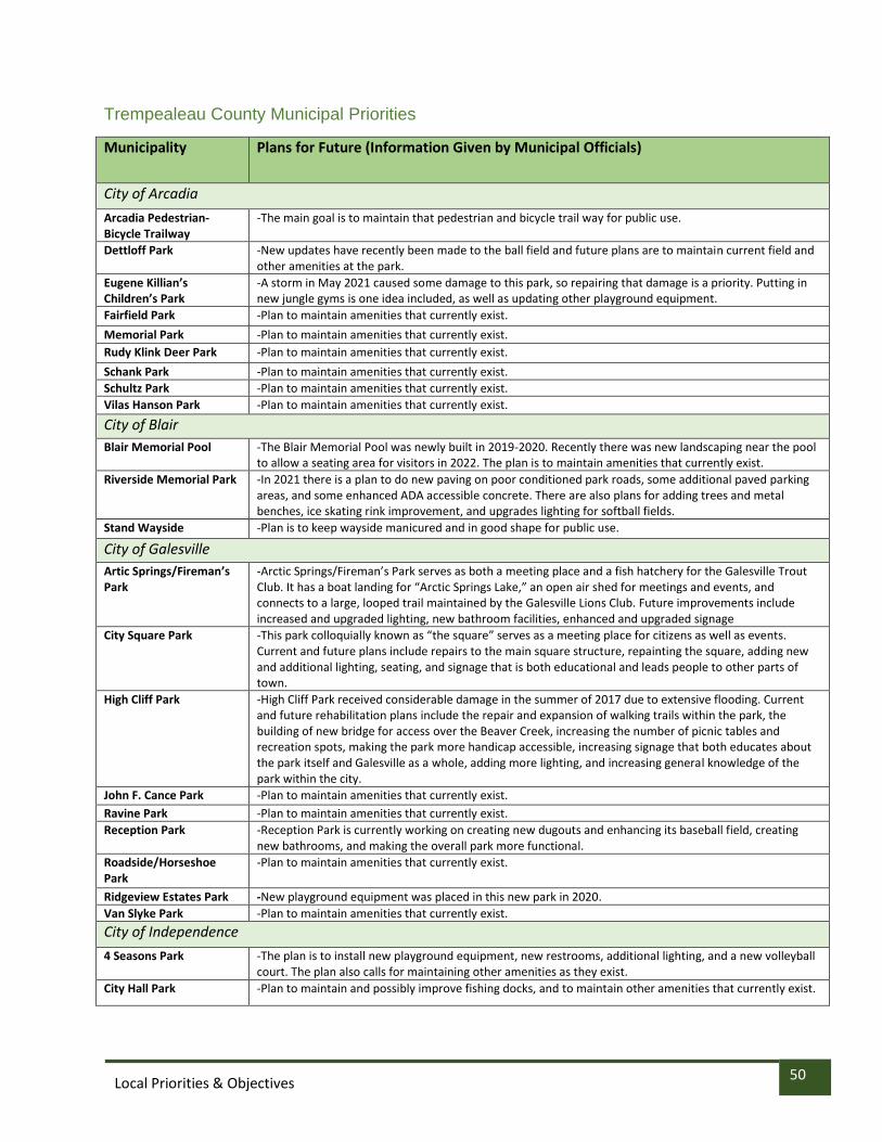
50 Local Priorities & Objectives
Trempealeau County Municipal Priorities
Municipality Plans for Future (Information Given by Municipal Officials)
City of Arcadia
Arcadia Pedestrian-Bicycle Trailway
-The main goal is to maintain that pedestrian and bicycle trail way for public use.
Dettloff Park -New updates have recently been made to the ball field and future plans are to maintain current field and other amenities at the park.
Eugene Killian’s Children’s Park
-A storm in May 2021 caused some damage to this park, so repairing that damage is a priority. Putting in new jungle gyms is one idea included, as well as updating other playground equipment.
Fairfield Park -Plan to maintain amenities that currently exist.
Memorial Park -Plan to maintain amenities that currently exist.
Rudy Klink Deer Park -Plan to maintain amenities that currently exist.
Schank Park -Plan to maintain amenities that currently exist.
Schultz Park -Plan to maintain amenities that currently exist.
Vilas Hanson Park -Plan to maintain amenities that currently exist.
City of Blair
Blair Memorial Pool -The Blair Memorial Pool was newly built in 2019-2020. Recently there was new landscaping near the pool to allow a seating area for visitors in 2022. The plan is to maintain amenities that currently exist.
Riverside Memorial Park -In 2021 there is a plan to do new paving on poor conditioned park roads, some additional paved parking areas, and some enhanced ADA accessible concrete. There are also plans for adding trees and metal benches, ice skating rink improvement, and upgrades lighting for softball fields.
Stand Wayside -Plan is to keep wayside manicured and in good shape for public use.
City of Galesville
Artic Springs/Fireman’s Park
-Arctic Springs/Fireman’s Park serves as both a meeting place and a fish hatchery for the Galesville Trout Club. It has a boat landing for “Arctic Springs Lake,” an open air shed for meetings and events, and connects to a large, looped trail maintained by the Galesville Lions Club. Future improvements include increased and upgraded lighting, new bathroom facilities, enhanced and upgraded signage
City Square Park -This park colloquially known as “the square” serves as a meeting place for citizens as well as events. Current and future plans include repairs to the main square structure, repainting the square, adding new and additional lighting, seating, and signage that is both educational and leads people to other parts of town.
High Cliff Park -High Cliff Park received considerable damage in the summer of 2017 due to extensive flooding. Current and future rehabilitation plans include the repair and expansion of walking trails within the park, the building of new bridge for access over the Beaver Creek, increasing the number of picnic tables and recreation spots, making the park more handicap accessible, increasing signage that both educates about the park itself and Galesville as a whole, adding more lighting, and increasing general knowledge of the park within the city.
John F. Cance Park -Plan to maintain amenities that currently exist.
Ravine Park -Plan to maintain amenities that currently exist.
Reception Park -Reception Park is currently working on creating new dugouts and enhancing its baseball field, creating new bathrooms, and making the overall park more functional.
Roadside/Horseshoe Park
-Plan to maintain amenities that currently exist.
Ridgeview Estates Park -New playground equipment was placed in this new park in 2020.
Van Slyke Park -Plan to maintain amenities that currently exist.
City of Independence
4 Seasons Park -The plan is to install new playground equipment, new restrooms, additional lighting, and a new volleyball court. The plan also calls for maintaining other amenities as they exist.
City Hall Park -Plan to maintain and possibly improve fishing docks, and to maintain other amenities that currently exist.

51 Local Priorities & Objectives
Island Park -Plan includes removing old equipment from 4-Seasons Park Island Park, and possibly add new equipment to park.
City of Osseo Central Park -The Central Park location completed our Band shell this spring and we are thinking about possibly doing
some type of night lights throughout the park like the bridge in downtown Eau Claire in either 2022 or 2023.
Osseo Municipal Swimming Pool
-Our tentative plans for 2022 are to install a new heater/ storage shed/ small children play area at the Osseo Swimming Pool.
Stoddard Park -The Osseo Commercial Club and Lions club are in talks to replace the playground equipment at Stoddard Park
Neighborhood Park -No new plans at this time
Possible Dog Part -In early discussions of a possible dog part in Osseo
City of Whitehall
City Hall Park -Plan to maintain amenities that currently exist.
Colonel Larson Park -Plan to maintain amenities that currently exist.
Fredrickson Park -Plan to maintain amenities that currently exist.
Melby Park -Plan to maintain amenities that currently exist.
Whitehall Aquatic Center -Plan to maintain amenities that currently exist.
Village of Eleva
Broiler Fest Grounds -Plan to maintain amenities that currently exist.
Eleva Lake Park -There is a plan to reroof the gazebo in the park. Future plans are to update the concession stand building.
Memorial Park -Plans include a new well and the new well house located at the parks. -If new well house is built in the park, a new Pavilion would have to be built.
Village of Ettrick
Game Time Park -Plan to maintain amenities that currently exist.
Municipal Park -Plan to maintain amenities that currently exist.
Village of Strum – Plans for the Village of Strum are still pending.
Crystal Lake Park
Rod and Gun Club Park
Spangberg Field
Viking Recreation Area
Woodland Park-North
Woodland Park-South
Walnut Park
Strum Community Trails
Village of Trempealeau
Boat Landing/Marina -sub leased to American Marina and no plans for improvement from Village -owned by Corp of Engineers, leased to Village
Central Park -change out wood chips -general maintenance of swings and equipment -update horseshoe pits -maintenance of gazebo
Sportsman’s Clubs and Land West of Duck Pond
-subleased to Sportsman’s Club -continue upkeep /maintenance of flag pole garden
Little Bluffs Mound Trail/Trempealeau Interpretive Path
-Friends of Little Bluff spear headed projects with archeologists Ernie and Danielle -Clearing trees down SE side (street side) of bluff and maintenance of trail -Educational signage
Swimming Pool Park -regular maintenance and upkeep of pool and playground -replacing pool deck furniture, ADA chair lift, in-pool platform, pool heater -repair of leaks, pool deck, locker room and lobby flooring resurfacing
Trempealeau Bike Park -plans for new pump track spear headed by private citizens located next to the swimming pool

52 Local Priorities & Objectives
Youth Sports Club -has been mostly maintained by Trempealeau Youth Sports Club, now G-E-T Youth Sports -upkeep and maintenance of storage buildings, concession stand, bathrooms, fields and lights
Parkland Complex development
-20 acres of land located on north end between King and 12th Streets -preferred concept completed in 2018 -plans to organize feasibly study for fundraising -projected estimation cost is $20 million - infrastructure, 2 ball fields, new pool or splash pad, recreation center and other amenities
Duck Pond -revitalizing Duck Pond - restoration of north bank with dimensional stone -benches, picnic tables, ADA ramp accessible dock (NASA), 3 fountains -dredging pond on regular basis

53 Local Priorities & Objectives
PLANNING PROCESS The Trempealeau County Outdoor Recreation Planning Committee worked with Mississippi River Regional Planning Commission (MRRPC) to develop this plan. Together they created a survey to solicit public input on outdoor recreation facilities and activities offered in Trempealeau County. These surveys were posted on MRRPC’s website, Trempealeau County Website, and local social media outlets.
Information from the survey was taken to develop local priorities and objectives for the future planning of Trempealeau County outdoor recreation facilities. The list of priorities and objectives will be referenced frequently by County staff to secure funding for projects. This plan will be reviewed and updated every 5 years to keep priorities and objectives current. Municipalities will be given the opportunity to update local municipal plans and adopt the County plan once the County planning process is completed.
Summary of Previous Outdoor Recreation and Other Plans
The following plans intersect with and have contributed to the Trempealeau County Outdoor Recreation Plan. The most recent County Outdoor Recreation Plan was completed in 2017, with updated inventory of County-owned land and infrastructure improvements. Unlike 2017 plan, the current version of the County Outdoor Recreation Plan does not include a descriptive inventory of activities based on land, water, developed, and undeveloped properties.
The following plans intersect with and have contributed to the Trempealeau County Comprehensive Outdoor Recreation Plan.
Trempealeau County Comprehensive Plan – 2019
The Trempealeau County included objectives and an action plan for natural resources. They are provided below:
Objective: Provide safe, clean, natural environment areas where the public can enjoy, and learn about the surrounding landscape
Objective: Maintain public and private lands that are safe, educational, and demonstrate unique Driftless landscape
• Action: Preserve existing wetlands, restore previous wetland areas, and limit wetland development
• Action: Assist landowners with identifying and eradicating and/or managing non-native species
• Action: Promote continuous restoration of bluff prairies
• Action: Continue an active Water Action Volunteer (WAV) program to keep citizens involved in water quality
• Action: Continue to maintain and update the Trempealeau County Outdoor Recreation Plan every five years
Trempealeau County Land and Water Resource Management Plan – 2016
The Trempealeau County included goals and an action plan for natural resources. They are provided below:
Goal 1: Protect and Enhance Water Resources of Trempealeau County

54 Local Priorities & Objectives
• Action: Enhance fish and other aquatic habitat by incorporating cold water and warm water fish habitat structures into the design of streambank and lake shore stabilization projects. In addition, continue to partner with the US Fish and Wildlife Service and Trout Unlimited on fish habitat and stream health improvement projects and field days.
Trempealeau County Hazard Mitigation Plan 2017-2021
In 2017, the Emergency Management Department updated the Hazard Mitigation Plan, which is a comprehensive assessment of natural and man-made disasters that could pose a threat to Trempealeau County. The assessment includes risks, emergency response plans, and strategies for mitigation, as well as an inventory of critical facilities and services in the County.
• Action: Encourage periodic cutting of Conservation Reserve Program (CRP) land per program requirements
• Action: Develop a high-water warning system for the Trempealeau River – reactivate a USGS river gage at Arcadia and install 6 new automated river gages and 5 new automated flow meters.
• Action: Investigate developing an inventory/prioritization of roads/road segments that have shoulders with slopes conducive to erosion and land/mud slides. The roads/road segments identified can be stabilized as funding becomes available.
• Action: Cooperate with the County in preparing timely releases that inform the public on actions and precautions they can take to minimize disruptions and losses.
• Action: Consider making improvements along the Trempealeau River to protect against flooding at municipal park and public golf course.
• Action: Develop and institute a program to educate residents about the risks associated with recreational fires.
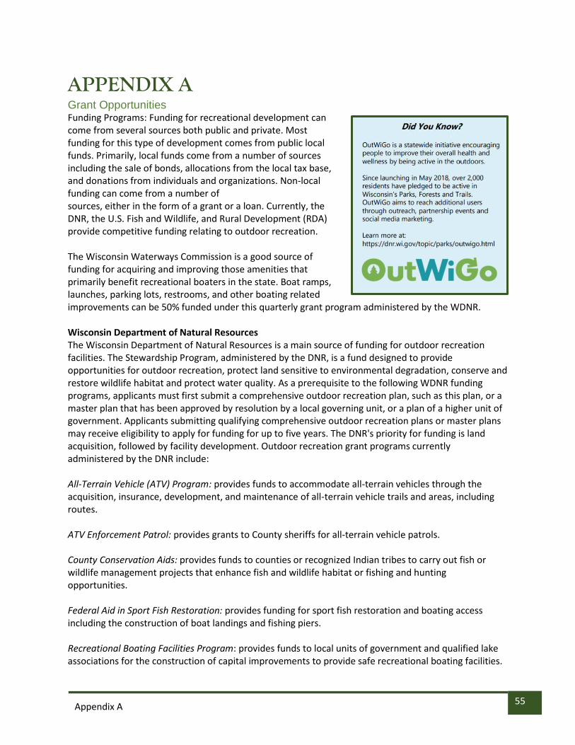
55 Appendix A
APPENDIX A Grant Opportunities Funding Programs: Funding for recreational development can come from several sources both public and private. Most funding for this type of development comes from public local funds. Primarily, local funds come from a number of sources including the sale of bonds, allocations from the local tax base, and donations from individuals and organizations. Non-local funding can come from a number of sources, either in the form of a grant or a loan. Currently, the DNR, the U.S. Fish and Wildlife, and Rural Development (RDA) provide competitive funding relating to outdoor recreation. The Wisconsin Waterways Commission is a good source of funding for acquiring and improving those amenities that primarily benefit recreational boaters in the state. Boat ramps, launches, parking lots, restrooms, and other boating related improvements can be 50% funded under this quarterly grant program administered by the WDNR. Wisconsin Department of Natural Resources The Wisconsin Department of Natural Resources is a main source of funding for outdoor recreation facilities. The Stewardship Program, administered by the DNR, is a fund designed to provide opportunities for outdoor recreation, protect land sensitive to environmental degradation, conserve and restore wildlife habitat and protect water quality. As a prerequisite to the following WDNR funding programs, applicants must first submit a comprehensive outdoor recreation plan, such as this plan, or a master plan that has been approved by resolution by a local governing unit, or a plan of a higher unit of government. Applicants submitting qualifying comprehensive outdoor recreation plans or master plans may receive eligibility to apply for funding for up to five years. The DNR's priority for funding is land acquisition, followed by facility development. Outdoor recreation grant programs currently administered by the DNR include: All-Terrain Vehicle (ATV) Program: provides funds to accommodate all-terrain vehicles through the acquisition, insurance, development, and maintenance of all-terrain vehicle trails and areas, including routes. ATV Enforcement Patrol: provides grants to County sheriffs for all-terrain vehicle patrols. County Conservation Aids: provides funds to counties or recognized Indian tribes to carry out fish or wildlife management projects that enhance fish and wildlife habitat or fishing and hunting opportunities. Federal Aid in Sport Fish Restoration: provides funding for sport fish restoration and boating access including the construction of boat landings and fishing piers. Recreational Boating Facilities Program: provides funds to local units of government and qualified lake associations for the construction of capital improvements to provide safe recreational boating facilities.

56 Appendix A
The program also provides financial assistance for feasibility studies related to the development of safe recreational boating facilities, purchase of aquatic weed harvesting equipment, purchase of navigation 58 aids, dredging of channels of waterways, and chemical treatment of Eurasian water milfoil. Recreational Trails Program: provides funds for motorized and non-motorized recreation trail rehabilitation, trail maintenance, trail development, and trail acquisition. Snowmobile Trail Aids: provide funds to maintain trail systems that provide passage through a County and connections with adjacent counties. County Snowmobile Enforcement Patrols: provide funds for County snowmobile patrols functioning as a law enforcement unit for the enforcement of Ch. 350, Wis. Stats. Stewardship Local Assistance - Acquisition and Development of Local Parks Stewardship: provides funding to acquire land, rights in land, and develop public outdoor recreation areas for nature-based outdoor recreation purposes. Stewardship Local Assistance - Urban Rivers Stewardship Local Assistance: provides funds for the acquisition of land in urban areas. Projects focus on providing access for the greatest number of potential users and providing the greatest opportunities for nature-based outdoor recreation. Stewardship Local Assistance - Urban Greenspace Stewardship Local Assistance: provides funds for the acquisition of land in and around urban areas. Projects focus on providing access for the greatest number of potential users and providing the greatest opportunities for nature-based outdoor recreation. Land and Water Conservation Fund (LWCF): provides financial assistance to state agencies, counties, villages, towns, school districts, cities, and Indian tribes for the acquisition and development of public outdoor recreation areas and facilities. The program provides up to 50 percent reimbursement grants for approved state and local projects. Competition for LWCF funds is on a statewide basis. Rural Development Administration (USDA - Rural Development) The USDA provides a loan program, which provides Community Facility Project Loans to applicants with areas of less than 20,000 people, for the purpose of constructing, enlarging, or improving community facilities for health care, public safety, or public services. These loans should be secured with bonds or notes pledging taxes, assessments, or revenues. There are many Rural Development programs that are different areas of community development that could provide loans, or possibly grants, if criteria are met for income and utility rates, for facilities in the communities that are smaller in size. Transportation Assistance Program (TAP) Wisconsin Department of Transportation This program provides funds for non-traditional projects within programs called the Safe Routes to School Program, Transportation Enhancements, and the Bicycle and Pedestrian Facilities Program. The TAP program provides up to 80 percent reimbursement grants for approved projects that target transportation-oriented pedestrian and bicycle planning and construction projects. Community Development Block Grant, Department of Administration

57 Appendix A
This program funds support infrastructure and facility projects for communities. Examples of eligible projects include improvements, repairs, or expansions of streets, drainage systems, water and sewer systems, sidewalks, and community centers.

Appendix B
58

Appendix B
59
APPENDIX B: MAPS Map B-1 Land Cover

Appendix B
60
Map B-2 Population

Appendix B
61
Map B-3 Scenic Routes

Appendix B
62
Map B-4 Campgrounds

Appendix B
63
Map B-5 Golf Courses
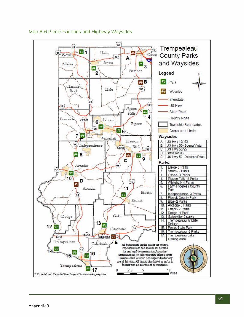
Appendix B
64
Map B-6 Picnic Facilities and Highway Waysides

Appendix B
65
Map B-7 Bike Trails

Appendix B
66
Map B-8 ATV Routes

Appendix B
67
Map B-9 Wildlife Areas and Rod and Gun Clubs

Appendix B
68
Map B-10 Recreational Water Activities

Appendix B
69
Map B-11 Trout Streams

Appendix B
70
Map B-12 Wildlife Areas

Appendix B
71
Map B-13 Canoe Landings

Appendix B
72
Map B-14 Snowmobile Trails
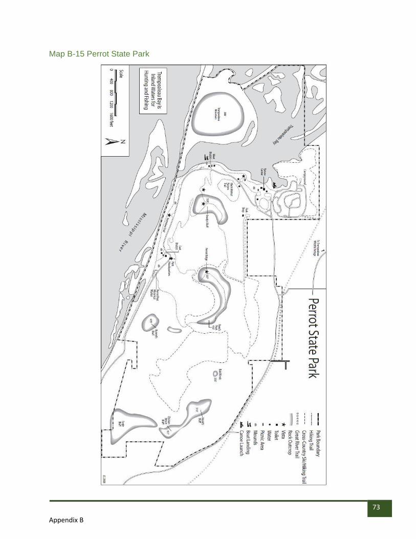
Appendix B
73
Map B-15 Perrot State Park

Appendix B
74
Map B-16 Perrot State Park Winter

Appendix B
75
Map B-17 Buffalo River State Trail

Appendix B
76
Map B-18 Great River Road

Appendix B
77
APPENDIX C: ADOPTION RESOLUTION
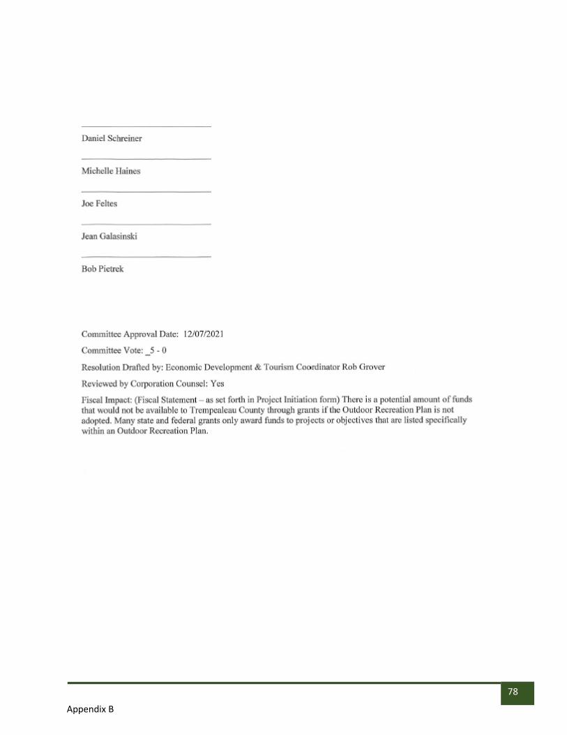
Appendix B
78