Talbot County Land Preservation, Parks and Recreation Plan ...
167
Talbot County Land Preservation, Parks and Recreation Plan 2017 Talbot County Department of Parks & Recreation
-
Upload
khangminh22 -
Category
Documents
-
view
1 -
download
0
Transcript of Talbot County Land Preservation, Parks and Recreation Plan ...

Talbot County
Land Preservation,
Parks and Recreation Plan
2017
Talbot County Department of Parks & Recreation

This Page Intentionally Left Blank

Talbot County Administration
Andy Hollis, County Manager
Jessica Morris, Assistant County Manager
Susan Moran, Secretary to County Council
Talbot County Council
Jennifer Williams, President
Corey Pack, Vice President
Dirck Bartlett
Chuck Callahan
Laura Price
Talbot County Park Advisory Board
Jeff Parks, Chairman
Jamie Lathan, Vice-Chairman
Kim Kearns
Jeff Richardson
Walter Chase, Sr.
Jeff Harrison
Dave Fisher
Kevin Shafer, Board of Education
Chuck Callahan, County Council
Andrew Hollis, County Manager
Preston Peper, Parks & Recreation Director
Adopted by Talbot County Council on October 9, 2018

This Page Intentionally Left Blank

Talbot County 2017 Plan
The Talbot County Land Preservation,
Parks and Recreation Plan will serve as a
guide for Talbot County Officials in the
acquisition, development and preservation
of recreation areas and open spaces within
the County. This Plan continues the long-
standing tradition of environment
protection and enhancement of natural
resources that has characterized previous
planning efforts in Talbot County. The
recreation element of the Plan also assures
that an appropriate level of parks and
recreational facilities are provided for
present and future Talbot County
residents. This Plan will also provide the
basic framework for coordination of
preservation and recreation efforts within
the incorporated towns for Talbot County.
The Talbot County Land Preservation,
Parks and Recreation Plan is the product of
a joint planning effort between the Talbot
County Department of Planning and
Permits and the Talbot County Department
of Parks and Recreation. This Plan satisfies
the State of Maryland mandate requiring
integration of local and State park plans and replaces the Talbot County Land Preservation, Parks
and Recreation Plan 2012 for Talbot County.
The Talbot County Parks and Recreation Advisory Board is also a key contributor to this updated
plan. Representatives to this board are local citizens who represent the five incorporated towns in
Talbot County as well as other rural villages. Throughout the year, this Advisory Board is active in
maintenance and programming issues, and also serves as the oversight committee regarding
Program Open Space.
Talbot County’s first Comprehensive Plan was adopted in 1973 and has been updated at regular
intervals. The 2016 Comprehensive Plan outlines goals, policies and implementation measures for
managing growth and development within the County and calls for guiding development toward
locations where public infrastructure such as roads, water, sewer, schools, police, and fire protection
is established or available. This includes the incorporated towns of Easton, St. Michaels, Oxford,
Trappe, and Queen Anne. Higher density development is allowed to occur in and around the towns
and, as a result, roughly fifty percent (50.3%) of the County’s total population is located within the
incorporated areas.
This policy of concentrated growth benefits Talbot County by allowing for better utilization of public
facilities, more efficient use of public services, limit urban sprawl, and conservation of the natural
resources and environmentally sensitive lands of the County.

Talbot County has currently over 30,000 acres of preserved properties in County, Local and State
Parks, School properties, private preserves and agricultural land preservations through such
programs as Rural Legacy and MALPF.
The goals of the Land Preservation, Parks and Recreation Plan are consistent with
related elements of the Talbot County Comprehensive Plan. The Comprehensive Plan
is specifically linked to the Land Preservation, Parks and Recreation Plan through
the following goal and policies:
Talbot County 2017 Goals
1. Provide an improved system of parks and recreation facilities based on residents needs.
2. Actively pursue the goals, objectives, and implementation recommendations adopted as part
of the Talbot County Land Preservation, Parks and Recreation Plan.
3. Periodically update the Land Preservation, Parks and Recreation Plan to keep the inventory
of parks and recreational facilities current, reassures demand in light of projected population
growth and identify new or alternative implementation recommendations for site and project
selection, land acquisition, facility development and preservation and conservation
programs.
4. Create a park with historical value to tell the story of one of Talbot County’s historic figures.
The park will be designed, constructed and maintained in conjunction with state, local and
private funding.
5. Develop a feasibility study as to the creation of a recreational bike trail from Easton to
Cordova area to Tuckahoe State Park utilizing the existing rail system. This trail will not only
be of recreational value, but also historic and eventually part of a state wide trail system.
6. Begin plans and development of a gymnasium expansion to the Community Center in Talbot
County to satisfy the needs of its residents and visitors.
7. Continue to provide an information program to include programs, opportunities, maps and
brochures that identify park location and facilities to insure that as many citizens as possible
are aware of the recreation open space opportunities that exist in the County.
Purposes of the Plan A 1969 State mandate required local jurisdictions within the State of Maryland to prepare a Land
Preservation, Parks and Recreation Plan. The Maryland Department of Planning and the
Department of Natural Resources will use these County Plans to provide the necessary framework
upon which to develop an integrated and coordinated approach to the provision or recreational
opportunities and resource protection measures in the State of Maryland.
Aside for its statewide significance, Talbot County’s Land Preservation, Parks and Recreation Plan
is of great local importance. The Program Open Space legislation requires a Land Preservation, Parks
and Recreation Plan every five (5) years and the preparation and approval of this Plan ensures that
Talbot County will continue to qualify for Program Open Space funds. However, of greatest
importance is the Plan’s intended purpose to serve as a guide for making decisions about places,
policies, and programs that will meet recreational, cultural and other quality of life needs of County
residents. The preservation of land along with the availability of recreational opportunities plays a
large role in the quality of life in any county. With the aid of this Plan, a cooperative effort between
the public and private sectors, and should leadership, the maintenance and enhancement of the
quality of life in Talbot County can be achieved. Realizing that these are our goals and objectives,

the following is included in our overall purposes:
Review goals and objectives of State and Local programs for three principal elements: parks and
recreation, agriculture, and natural resources;
Identify where these goals and objectives are essentially the same, where they are complementary
or mutually supportive, and where they different;
Evaluate the ability of implementation programs and funding sources for each element to achieve
related goals and objectives;
Identify desirable improvement to policies, plans, and funding, strategies, to better achieve goals
improve return on public investment;
Recommend to State and local legislatures, governing bodies and agencies changes needed to
overcome shortcomings, achieve goals, and ultimately ensure good return on public investment;
Identify the needs and priorities of current and future State and local population for outdoor
recreation;
Achieve legislative goals of State and local land preservation programs; and
Ensure that public investment in land preservation and recreation supports and is supported by
local comprehensive plans, associated implementation programs, State Planning Policy, and State
and local programs that influence land use and development.
Relationship to the comprehensive planning process
All elements of this Land Preservation, Parks and Recreation Plan include the designations, goals
and objectives of the County Comprehensive Plan. The last update to the Comprehensive Plan was
adopted in August of 2016. The Plan has been amended to include a Water Resources Element, a
Priority Preservation Areas element and is currently under complete revision. Clarity, consistency
and implementation are all in place to assist the County officials in their efforts going forward.

1-1
Chapter 1 Background
Comprehensive planning provides a process and a framework for anticipating change and its
implications. The process is built on a foundation constructed from the demographic, economic,
social, and natural resource factors driving change along with extensive citizen input. An assessment
of trends and changes, coupled with a thoughtful review of public policy, permits a clear-eyed review
of Talbot County’s progress and its areas in need of more work.
To accomplish this assessment, Chapter 1 provides a variety of information, which when linked with
the Plan’s citizen input yields an effective basis for the Plan’s recommendations. Specifically, this
chapter reviews important trends, projections, and planning assumptions that undergird the analysis
and policies in the succeeding chapters.
It is important to consult reliable baseline data in order to set goals and monitor progress. Trend
data provides a numerical benchmark to help determine if a plan is realistic and reasonable. Unless
otherwise noted, the U.S. Census Bureau and Maryland Department of Planning are the sources for
this chapter’s information. Maryland State Data Center (SDC) provides Census 2010 and other data
cited in the Maryland Statistical Handbook, found at www.mdp.state.md.us/msdc/.
The chapter begins with a look at population changes and then addresses housing, income,
employment and land use trends.
Demographics
Population
Figure 1-1 provides historic population data from 1950 through the last Census in 2010. Population
change affects the demand for public and private goods and services. Location and age distribution
have implications for the school system and other public infrastructure and services. The age and sex
composition also affects government services and the economy.
Figure 1-1 Population Change 1950—2010
Census Year Population Increase Percent Change Percent Annual
Change
1950 19,428
1960 21,578 2,150 11.1 1.11
1970 23,682 2,104 9.7 .97
1980 25,605 1,923 8.12 .81
1990 30,541 4,936 19.27 1.92
2000 33,812 3,271 10.7 1.07
2010 37,782 3,970 11.7 1.17
Average Annual Growth 1950—2010 1.175
Source: US Census Bureau
Talbot County’s population is estimated to be among the lowest in the state, at 37,782 persons
(Census, 2010). Between 1900 and 1950 Talbot County’s population remained almost unchanged at
under 20,000. The 1950s brought the opening of the first Chesapeake Bay Bridge marking the

1-2
beginning of increased County and regional growth.
Between 1950 and 2010, the population increased from 19,428 t0 37,782, an annual growth rate of
1.17 percent.
The first half of the last decade saw a 5 percent rise, followed by a less dramatic increase of just 3.1
percent from 2005 to 2010. This slower trend reflected changes in the housing market, availability of
credit and other consequences of the financially driven recession that began in 2008.
Geographic and Age Distribution
Like most rural areas, population growth in Talbot County is not evenly distributed. Figure 1-2
contains the distribution by jurisdiction for Talbot County’s municipalities. Easton has traditionally
been, and continues to be, the County’s population center. The population of Easton was 15,945
persons, or 43 percent of the County’s population, in the 2010 Census, and Easton has experienced
continuous growth through the years. However, the County’s other municipalities, with the exception
of Queen Anne, lost population. This, most likely, results from the increased portion of County
housing serving as second homes.
Easton is not only the commercial and business center of Talbot County, but also has the most
suitable land for development, supported by robust urban infrastructure and services. The County’s
other towns are either land locked, limited in sewer, road or other infrastructure capacity, or host
limited employment generators.
The 2010 median age in Talbot County rose to 47.4 years, up from 43.4 in the 2000 Census. Talbot
has the second highest median age among Maryland counties. The statewide median age was 38
years, with just 12.3 percent of the population age 65 or over. Locally, some 8,958 persons, or about
24 percent of the County population, were reported to be age 65 or over, as shown in Figure 1-3.
Talbot County’s relatively high median age is a function of a population that is aging in place, in-
migration of retirees and out-migration of younger people.
The Census’ American Community Survey reports that about one fifth of the County’s population is
less than 18 years of age. The total male and female population is somewhat evenly distributed
through all age groups up to the age of 45, where women become a slightly larger proportion of each
age group, as illustrated in Figure 1-4.
Figure 1-2 County and Municipal
Population Distribution, 2010
Talbot County Population 37,782
Total Municipal Population 18,796
Percent of County 49.7%
Easton 15,945
Oxford 651
Queen Anne (pt.) 94
St. Michaels 1,029
Trappe 1,077
Balance of County 18,986
Percent of County 50.3%
Figure 1-3 Census 2010 Age Comparisons, Maryland and Talbot County
2010 Total Population
Pop. 18 Yrs & Over
Pop. 65 Yrs & Over
Maryland 5,773,552 4,420,588 707,642
76.6% 12.3%
Talbot Co. 30,407 8,958
80.5% 23.7%
Median Age, All
Median Age, Male
Median Age, Female
Maryland 38.0 36.4 39.3
Talbot Co. 47.4 45.8 48.9

1-3
Figure 1-4 Population by Gender and Age, 2010
0 1,000 2,000 3,000
Under 5 years
5 to 9 years
10 to 14 years
15 to 19 years
20 to 24 years
25 to 29 years
30 to 34 years
35 to 39 years
40 to 44 years
45 to 49 years
50 to 54 years
55 to 59 years
60 to 64 years
65 to 69 years
70 to 74 years
75 to 79 years
80 to 84 years
85 years and over femalemale
Source: U.S. Census Bureau, 2005-2009 American Community Survey
Female
Male
Population Projections
Despite the present downturn in home sales and new
home construction, the Maryland Department of
Planning has predicted modest but steady growth for
Talbot County. The greatest component of growth
over the past few decades and expected through the
next several decades is domestic in-migration. In
recent periods deaths have outnumbered births in the
County (530 to 449 in the 2011 estimate), contrary to
the statewide trend of greater numbers of births
versus deaths.
Figure 1-5 contains historic and projected County
Census population and households from 1970 through
2010 and the Planning Data Service’s projections
through 2040.
Talbot County can expect modest population growth,
but a somewhat greater growth rate in the number of
households as the size of households continues to
decline.
In the 2005 Comprehensive Plan, it was estimated
that by 2030 the County’s population would grow to
38,950, reflecting an average annual growth rate of
about 0.5 percent per year (though some variability
from year to year can be expected). The 2010
projections used in this update continue to predict a
similar average annual growth rate of 1 percent or
less, over the next 30 year period, which represents a
substantially lower population growth rate than over
the past 30 years.
Figure 1-5 Historic and Projected Talbot County Population and Households, 1970 – 2040
1970 1980 1990 2000 2010 2020 2030 2040
Population 23,682 25,604 30,549 33,812 37,780 40,850 42,900 44,000
Growth Rate 8.1% 19.3% 10.7% 11.7% 8.1% 5% 2.6%
Households 7,914 9,934 12,677 14,307 16,150 18,000 19,275 19,800
Average Household Size 2.94 2.55 2.39 2.32 2.31 2.25 2.20 2.19
Source: Maryland Department of Planning, July 2014
Current and Projected Households
The growth in the number of households has been a steady trend over time. Between 1970 and 2000,
the household rate of increase was 80.8 percent, nearly twice the rate of population growth (42.8%)
over the same period.
The 2010 Census reports that 40 percent of all households consist of two persons and 28.3 percent

1-4
are single person households. In addition to small household size, there is a growing number of
nonfamily households — over 30 percent of all households in the County are nonfamily and almost
one fourth are single person households. Figure 1-4 shows population numbers and gender and age
brackets.
In summary, the demographic outlook indicates Talbot County will continue to become older on
average with greater number of retirees living in smaller households. The school-aged and prime
working age populations will remain relatively unchanged in terms of numbers, resulting in only
modest growth of the workforce. The implications for the economy, prosperity and livability of the
County will be considered in subsequent chapters of the Plan. The relationship between population,
growth and housing is outlined in the next section.
Housing
The U.S. Census American Community Survey (ACS) estimates that 19,618 housing units existed in
the County in 2012, including the incorporated towns. This figure is an increase of over 3,000 units
from the Census 2000 total of 16,500 units.
Countywide, 16,375 housing units, or over 80 percent of the County’s residences, are single-family
homes. This figure is about 10 percent higher than the statewide average for single family housing.
Multi-family housing is almost exclusively located in the municipalities. ACA data indicates that
Easton has the highest proportion of multi-family housing at 20 percent of all housing units. In
contrast, the villages and rural areas of the County are reported to have little to no multi-family
housing.
Of all housing units, just over 80 percent were occupied. In 2010, the percentage of vacant units rose
to 19.2 percent, from the 13.3 percent vacant reported in the 2000 Census. The majority of vacant
units were in the category of seasonal or occasional use, which includes guest homes and ‘second’
homes.
The Maryland Department of Planning reports that 2,953 new single family parcels were created
between 2000 and 2009. The number of new parcels created has increased every decade since the
1960s (see Figure 1-6).
Figure 1-6 also reveals an ebb and flow to residential development in the County over the past
seventy years. Using the Priority Funding Areas (PFAs) established in 1992 as a basis, new
construction has gravitated from the towns to suburban and rural development and gradually back to
the towns.
The percentage of new subdivision in urbanized areas in the 1940s was not achieved again until the
last decade, with nearly four times as many new lots created within PFAs, primarily in Easton. Over
the past few decades the proportion of subdivision in towns steadily increased from 47 percent in the
1980s, to 58 percent in the 1990s to over 70 percent in the 2000s.
Data from the Maryland Association of Realtors’ Metropolitan Regional Information System reveals
the demand for, and economic contributions of, single family housing in Talbot County.
Since the last planning period, both the number of sales and the median price for single family
homes declined in the recent recession. The number of sales fell by almost half and has yet to recover
in volume. Median sale prices made a corresponding though less severe decline and remain below
historic highs.

1-5
Figure 1-6 New Residential (Single Family) Parcels Created by Decade 1940 —2009
YEARS Total Inside
PFA Percent
Comment
Area Percent
Outside
PFA Percent
1940-49 585 421 71.97% 20 3.42% 144 24.62%
1950-59 1,102 777 70.51% 44 3.99% 281 25.50%
1960-69 1,025 457 44.59% 124 12.10% 444 43.32%
1970-79 1,796 782 43.54% 169 9.41% 845 47.05%
1980-89 2,307 1,085 47.03% 122 5.29% 1,100 47.68%
1990-99 2,465 1,426 57.85% 97 3.94% 942 38.22%
2000-09 2,953 2,118 71.72% 49 1.66% 786 26.62%
1940-2009 12,233 7,066 57.76% 625 5.11% 4,542 37.13%
Source: Maryland Department of Planning
These trends not only slowed new development in the County but impacted revenues as well.
Transfer taxes and real estate taxes are significant elements of the County budget and the
combination of fewer real estate transfers and lower sales values will continue to influence the
provision of community services. Figure 1-7 shows recent trends in home sales and the effect of the
recent economic downturn.
Future subdivision and development is likely to be centered in the towns for the foreseeable future,
due to a combination of State, County and municipal policies and growth management strategies.
Public utilities and infrastructure, zoning regulations and land preservation strategies are directed
towards a manageable pattern of growth across the County, with the majority occurring in the towns.
As housing is related to income, gross rent is a typical indication of housing affordability. The
American Community Survey reported that more than half of all renters countywide paid 30 percent
or more of their income for rent alone. Of all 2,030 renters in this category, 1,428 are reported to be

1-6
in Easton.
Such statistics for Talbot County should be viewed in a local context. For example, the greatest
proportions of renters paying high portions of their income for housing are in the waterfront
communities west of St Michaels. There, 62 percent of renters are likely short term and seasonal
vacationers rather than full time residents.
Income
Income is composed of salary or wages, self-employment income, and dividends or interest income.
Talbot has traditionally ranked among the highest median income counties in the state and generally
exceeds the national county average.
Median household income indicates the relative earnings of households and can be compared to
other jurisdictions. The 2014 Maryland Statistical Handbook reported the 2013 median household
income for the County at $57,525, compared to a statewide median of $72,482.
However, per capita income data reveal how income varies within households and among wage
earners. The same, Maryland Statistical Handbook, reports the County’s average individual income
for 2013 at $56,955; the third highest among Maryland counties and well over the state per capita
income of $50,149.
Other per capita income statistics tell another aspect of the story, showing Talbot County with only
modest gains in a statewide comparison. Talbot net per capita earnings fell by $1,332 between 2008
and 2013 (see Figure 1-8). This 2.3 percent drop in individual earnings is one of the largest declines
in the State.
The Handbook also reports that Talbot County’s poverty rate increased to 10.9 percent in 2013, a 3

1-7
percent increase from the 7.7 percent figure for 2006. This is somewhat greater than the statewide
poverty rate increase over the same period from 8 percent in 2006, to 10.2 percent in 2013. The
poverty threshold is not a single line, but a series of calculations based on family size and other
variables, determining whether the income of a household is adequate to meet basic needs.
Though the County may have a reputation as a haven for the well off, statistics depict a solidly
middle class, middle aged residential community. The latest American Community Survey five year
estimates reveal the following distribution of income among residents (see Figure 1-9) Over 47
percent of all households in the County had incomes between $50,000 and $149,999, while 7.9
percent of households in the survey data set reported incomes of less than $15,000.
Other statistics report that the largest
householder group (6,359 households) is
aged 45 to 64. Within that group, 18.5
percent fall in the $50,000 to $149,999
income bracket. The next largest group
consists of householders aged 65 years and
over. Of those 5,108 households (12.3%)
have incomes in the same middle bracket.
The demographic and income data above,
combined with the employment and land
use data below, can assist the County as it
manages community services and
programs. Income can predict revenues
and population trends help anticipate local
needs. While short-term economic
variability can be managed, long-term
changes could be problematic for public
service provision and so should be
monitored.
Employment
State agencies including the Maryland Department of Commerce track business and employment
data, provides annual updates and long-range projections. Their most recent Brief Economic Facts,
Talbot County, Maryland reports the following data:
The 2015 County civilian labor force was comprised of 19,239 persons. In the 16,852-person private
sector, Health Services employed the greatest number of people with over 2,000 jobs. Trade and
Transportation employed 3,286 persons, Leisure and Hospitality services employed 3,152, while
Manufacturing employed 1,104. The largest single employers in the County are the University of
Maryland Shore Regional Health (1,640 employees), Genesis Health Care (250 employees), Bayleigh
Chase (formerly William Hill Manor, 220 employees) and Wal-Mart (205 employees). All
governments combined employ 1,409 persons in Talbot County.
The December 2015 unemployment rate was approximately 5.1 percent compared to the state’s rate
of 4.7 percent. The Department of Commerce reports that Talbot County’s total civilian employment
in 2015 was 18,226 full and part time jobs. The Bureau of Economic Analysis reports that between
2008 and 2013 County employment fell by 1,204 full or part time jobs (approximately 4.1%). That
figure includes 670 jobs regained from the low point of 27,225 in 2010. Most Eastern Shore counties
Figure 1-9

1-8
except Worcester and Cecil experienced similar downturns in employment.
Other data on the County’s workforce from the Maryland Department of Planning indicate that just
over 38 percent of Talbot County workers live outside the County. In Figure 1-10 of the 8,060
persons entering the County for work, an estimated 3,327 live in Caroline County, 2,208 in
Dorchester County and 1,064 in Queen Anne's County. Smaller numbers come from as far as
Lancaster County, PA and Fairfax County, VA.
Somewhat fewer Talbot County residents work elsewhere, with an estimated 4,885 persons
commuting to other locations. The largest proportion (960) travel to Queen Anne’s County followed
by Anne Arundel County (738) and Caroline
County (697). A few County residents travel as
far as Philadelphia and Adams County, in
Pennsylvania.
Clearly, Talbot County is part of a regional
economy centered in, but not restricted to, the Eastern Shore. Workers commuting into the County
make possible a dynamic retail and service economy that serves the region. Residents who work
outside the County spend on housing, goods and services in their community. All will use County
infrastructure and facilities, along with the considerable number of tourists and visitors who visit or
pass through the County every year.
Employment and unemployment add to an already complex calculation of future demands for
County services. While job opportunities remain tight, Maryland statistical projections indicate that
younger workers are likely to continue to relocate outside the area. New residents replacing them will
invariably be older, perhaps more prosperous and most likely retired persons attracted by Talbot’s
combination of rural character and urbane attractions. They will be consumers of the retail,
hospitality and medical services that are already a large portion of the local economy.
Existing Land Use
Map 1-A (at the end of this chapter) depicts existing land uses. The geographic distribution of land
use/land cover in Talbot County illustrates that land use has remained relatively stable through the
past decade.
As the map illustrates, medium and high density residential development in the County remained
concentrated in the incorporated towns, while lower density residential development comprises the
majority of the residential use in the unincorporated areas.
The County's rural villages, as historical centers predating the automobile, formed small
concentrations of somewhat higher density development, along with the remnants of earlier
commercial and industrial uses.
In Figure 1-11 the Maryland Department of Planning estimates that 30,654 acres of Talbot County’s
171,657 acre land area could be classified as developed in 2010. By comparison in 2002, 27,987 acres
were classified as developed.
Within the category of developed land, commercial and industrial uses accounted for about 3,041
acres in 2010, up from 2,292 acres in 2002. Most commercial and industrial development in the
County is located in the incorporated towns, with some development in unincorporated areas along
routes U.S. Route 50 and MD 33.
The vast majority of land classified as resource land is in agricultural use. Agriculture occupied
95,662 acres in 2010, down from 97,739 acres in 2002. Forests, which are also agricultural
Figure 1-10 Inter-County Commuters
Commuting Into Commuting Out Of Net (In-Out)
8,060 4,885 3,175

1-9
resources, covered an additional 40,510 acres in 2010, 757 acres below the 2002 figure of 41,270.
The 2012 Census of Agriculture collects and reports farmland acreage using a different methodology
and reports that Talbot County had 119,481 acres in farmland.
Summary
Talbot remains by design one of Maryland’s sparsely populated rural counties, despite development
pressures brought on by regional trends and a growing number of individuals, retirees and small
families settling in the area. The County is projected to continue to age with little growth in its work
force. These trends have implications for the County’s communities, economy and land use.
Long-standing land use policies have protected farmland and open space from development and
retained the County’s rural character. Agriculture remains an important and viable industry in part
because fragmentation of farm landscapes has been discouraged.
Talbot is a comparatively prosperous County. Though some poverty exists, incomes of most residents
are adequate to meet their needs. Unemployment in the County is nearly equal to the State average.
Hospitality businesses, medical services, education and government are important employers.
The statistics outlined in this chapter suggest some challenges that will be discussed in subsequent
chapters. These range from protection of natural and historic resources, to the provision of public
services and amenities, to promoting a resilient economy. The economic downturn of the last few
years has impacted Talbot County less than some other areas but nevertheless has exposed some
vulnerability that should be considered.

1-10

1-11

1-12

1-13
1-14

1-15

1-16

1-17

1-18
1-19

2-1
Chapter 2 Recreation, Parks and Open Space
Talbot County 2017 Goals:
1. Provide an improved system of parks and recreation facilities based on residents needs.
2. Actively pursue the goals, objectives, and implementation recommendations adopted as part
of the Talbot County Land Preservation, Parks and Recreation Plan.
3. Periodically update the Land Preservation, Parks and Recreation Plan to keep the inventory
of parks and recreational facilities current, reassures demand in light of projected population
growth and identify new or alternative implementation recommendations for site and project
selection, land acquisition, facility development and preservation and conservation
programs.
4. Create a park with historical value to tell the story of one of Talbot County’s historic figures.
The park will be designed, constructed and maintained in conjunction with state, local and
private funding.
5. Develop a feasibility study as to the creation of a recreational bike trail from Easton to
Cordova area to Tuckahoe State Park utilizing the existing rail system. This trail will not only
be of recreational value, but also historic and eventually part of a state wide trail system.
6. Begin plans and development of a gymnasium expansion at the Community Center in Talbot
County to satisfy the needs of its residents and visitors.
7. Continue to provide an information program to include programs, opportunities, maps and
brochures that identify park location and facilities to insure that as many citizens as possible
are aware of the recreation open space opportunities that exist in the County.
Talbot County currently provides its residents with many opportunities to pursue recreational and
leisure activities. Some of these opportunities are available through a variety of recreation programs
offered by the County’s Department of Parks and Recreation while other opportunities exist in a
variety of parks ranging from large County-wide park facilities to small neighborhood play areas.
The continued development of parks and recreation facilities is necessary to accommodate a
changing population in the County.
State of Maryland 2017 Goals for Recreation, Parks, and Open Space
1. Make a variety of quality recreational environments and opportunities readily accessible to all of its citizens,
and thereby contribute to their physical and mental well-being.
2. Recognize and strategically use parks and recreation facilities as amenities to make communities, counties,
and the State more desirable places to live, work, play and visit.
3. Use State investment in parks, recreation and open space to complement and mutually support the broader
goals and objectives of local comprehensive/ master plans.
4. To the greatest degree feasible, ensure that recreational land and facilities for local populations are
conveniently located relative to population centers, are accessible without reliance on the automobile, and
help to protect natural open spaces and resources.
5. Complement infrastructure and other public investments and priorities in existing communities and areas
planned for growth through investment in neighborhood and community parks and facilities.
6. Continue to protect recreational open space and resource lands at a rate that equals or exceeds the rate that
land is developed at a statewide level.

2-2

2-3
In recent years, increased leisure time, a rise in the standard of living and a growing and increasingly
elderly population has contributed to changes in the demand for recreational sites and activities.
These changes in individual and community recreation needs should be considered in the planning
for parks, recreational facilities and programs.
The Land Preservation, Parks and Recreation Plan (LPPRP) contains a description of the State’s
recreation and open space classification and standards, an inventory of existing parks, open space
and recreational facilities, a demand analysis of park, recreation and open space needs, and plan and
implementation recommendations for meeting those needs.
County Parks and Recreation Department
The Department of Parks and Recreation is responsible for the administration and programming of
recreational facilities and activities for Talbot County. The Department maintains and schedules
activities at recreational facilities, participates in the preparation of a five year acquisition and
development plan which is required by the State of Maryland as a basis for program open space
funding. The Department is responsible for coordinating park, open space and recreational activities
between the County and the incorporated towns. The Department provides technical assistance and
encourages towns to participate in the local programming, acquisition, and development of
recreation facilities.
The Talbot County Parks and Recreation Advisory Board provides recommendations to the County
Council and the County Parks Department relating to plans and policies for public recreation, the
organization of recreation councils, the establishment of recreational programs and plans for the
acquisition of land for public recreation and open space. This Board includes appointees from both
the County and the incorporated towns. This advisory board is also involved with the administration,
long-range planning and policy direction for the Talbot County Community Center and Park System.
The Board is appointed by the County Council and recommends policies and administrative
guidelines, prepares annual reports and submits budget requests for these recreation facilities.
Trails and Walking Paths
The County recognizes the need and desire to continue the development of a trail system in and
around Talbot County, giving the residents and visitors a safe, structured means of exercise and
leisure. The town of Easton has established a very successful “Rails to Trails” system that bisects the
Town of Easton. This trail is popular to individuals and groups of walkers, runners and bikers. In
the past, Talbot County has been unsuccessful in acquiring several easements from local farmers and
property owners; however, with each purchase of land or when land is granted to the County the
possibilities of extending trails or adding trails is one of the top priorities. For example, the
development of the acquired Oxford property had a strong interest to construct a walking trail
around the perimeter that would be ADA compliant, giving the residents and visitors a walking
experience that is free from road traffic and on a safe surface. This also serves as an avenue to
extend trails from the Town Oxford to the Oxford Park in the future. Talbot County has established
and advertised six bike routes through both urban and rural areas. Talbot County has also been
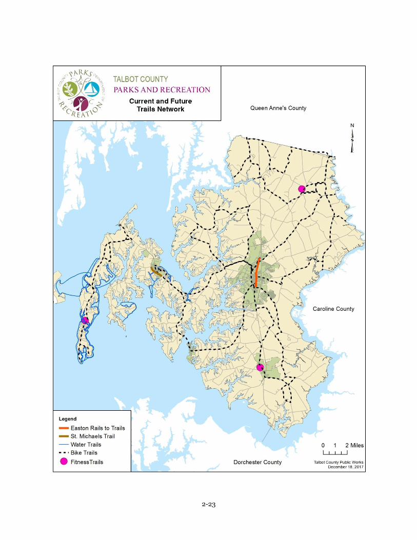
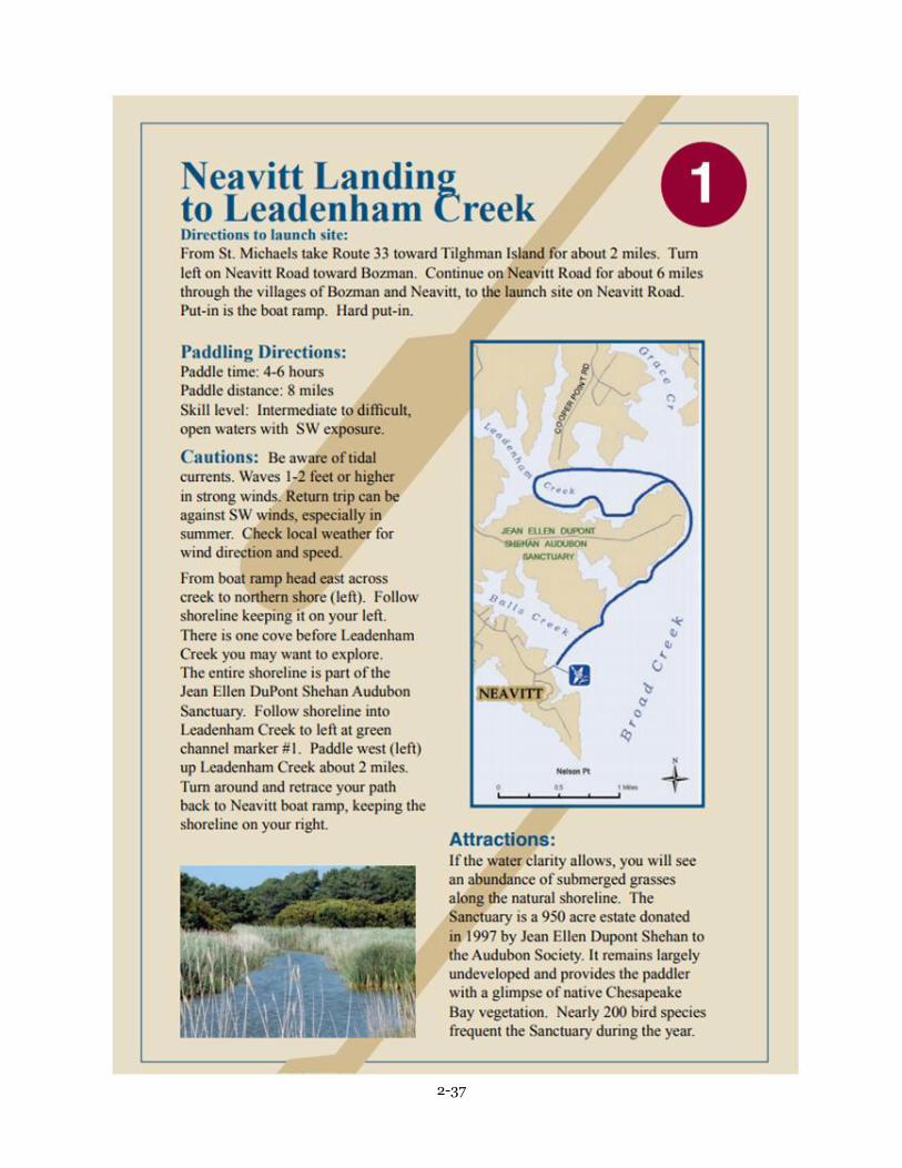
diligent in establishing a Water Trail system for use by canoes and kayaks. There are currently maps
available to residents and visitors for showing the routes for the trails and waterways in Talbot
County and they are shown at the end of this chapter. There has been strong interest in possible
construction of the abandoned rail system travelling from Easton through Cordova. This is being

2-4
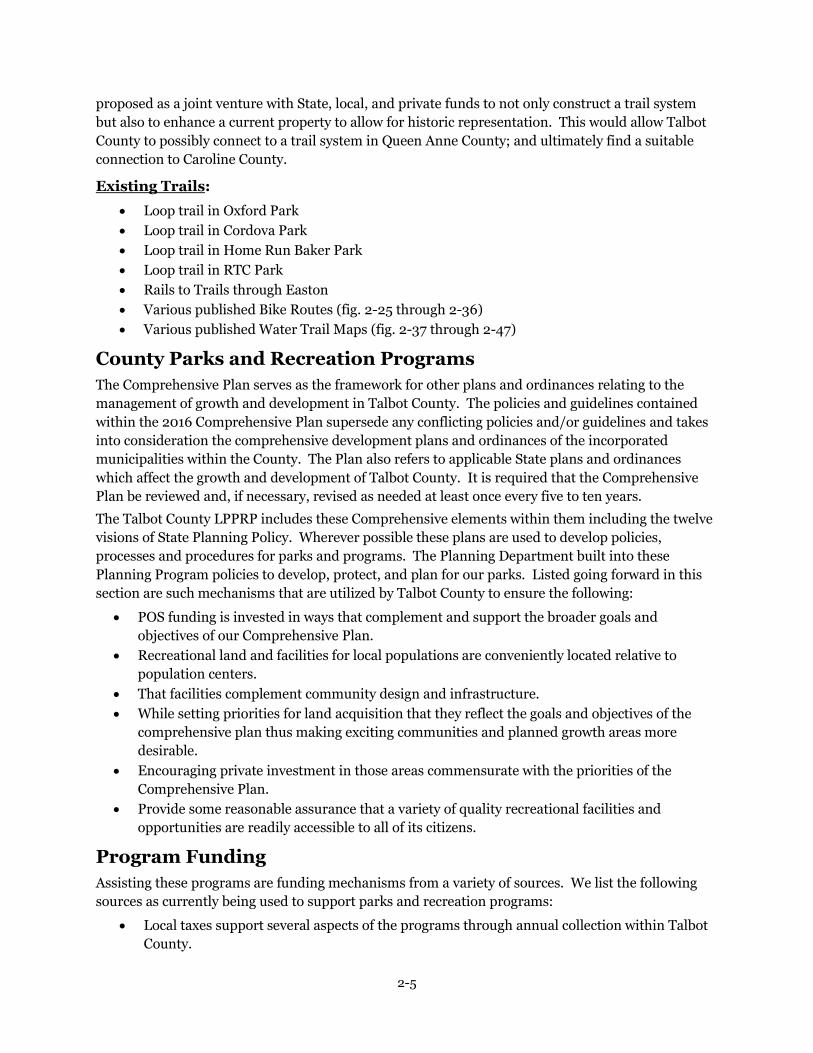
2-5
proposed as a joint venture with State, local, and private funds to not only construct a trail system
but also to enhance a current property to allow for historic representation. This would allow Talbot
County to possibly connect to a trail system in Queen Anne County; and ultimately find a suitable
connection to Caroline County.
Existing Trails:
Loop trail in Oxford Park
Loop trail in Cordova Park
Loop trail in Home Run Baker Park
Loop trail in RTC Park
Rails to Trails through Easton
Various published Bike Routes (fig. 2-25 through 2-36)
Various published Water Trail Maps (fig. 2-37 through 2-47)
County Parks and Recreation Programs
The Comprehensive Plan serves as the framework for other plans and ordinances relating to the
management of growth and development in Talbot County. The policies and guidelines contained
within the 2016 Comprehensive Plan supersede any conflicting policies and/or guidelines and takes
into consideration the comprehensive development plans and ordinances of the incorporated
municipalities within the County. The Plan also refers to applicable State plans and ordinances
which affect the growth and development of Talbot County. It is required that the Comprehensive
Plan be reviewed and, if necessary, revised as needed at least once every five to ten years.
The Talbot County LPPRP includes these Comprehensive elements within them including the twelve
visions of State Planning Policy. Wherever possible these plans are used to develop policies,
processes and procedures for parks and programs. The Planning Department built into these
Planning Program policies to develop, protect, and plan for our parks. Listed going forward in this
section are such mechanisms that are utilized by Talbot County to ensure the following:
POS funding is invested in ways that complement and support the broader goals and
objectives of our Comprehensive Plan.
Recreational land and facilities for local populations are conveniently located relative to
population centers.
That facilities complement community design and infrastructure.
While setting priorities for land acquisition that they reflect the goals and objectives of the
comprehensive plan thus making exciting communities and planned growth areas more
desirable.
Encouraging private investment in those areas commensurate with the priorities of the
Comprehensive Plan.
Provide some reasonable assurance that a variety of quality recreational facilities and
opportunities are readily accessible to all of its citizens.
Program Funding
Assisting these programs are funding mechanisms from a variety of sources. We list the following
sources as currently being used to support parks and recreation programs:
Local taxes support several aspects of the programs through annual collection within Talbot
County.

2-6
Private donations are made annually for specific or general programs within Talbot County
Parks and Recreation.
Local non-profit organizations make contributions with monies they fundraise, in kind
services, and volunteer efforts throughout the County.
Funding from Program Open Space in the form or grants is applied for annually based upon
availability through the State of Maryland. Infrastructure improvements for many of the
Talbot County Parks are funded through this mechanism each year.
Department of Natural Resources funding in the form of grants is applied for annually based
upon availability through the State of Maryland. These grants fund aspects of waterways,
landings, boat launches and waste management at each type of site.
Needs Analysis and County Priorities for Lands, Facilities, & Rehabilitation
In using the State standards to indicate what types of recreational facilities are needed Talbot County
conducted a needs assessment during 2013. This assessment provided information used to compare
our current programs with the needs for future programs. This assessment was specifically done to
look at the four critical areas of supply, demand, needs, and priorities. A summary is provided in the
following sections.
Supply: County Park Facilities
The major types of recreation areas that exist within Talbot County are:
1. State Lands
2. County parks
3. Municipal parks
4. Quasi-public/School parks
Supply Reports are provided on pages 2-16 and 2-17 for Talbot County facilities and municipal
properties.
State Lands
The State owns approximately 227 acres of recreation lands. The State Lands are: Black Walnut
Point NRMA, Bill Burton Fishing Pier State Park, Wye Oak State Park and Seth Demonstration
Forest.
County Parks
The residents and visitors to Talbot County have over 15 different park locations to enjoy for both
active and passive recreational opportunities. The two most active parks maintained by the County
are the Hog Neck Golf Course (255 acres) and the Talbot County Community Center (50 acres). Both
are located adjacent to Route 50 north of the Town of Easton. The public Golf Course facility
includes a 27-hole golf course, driving range, clubhouse, and picnic area. The County Community
Center provides indoor facilities for ice skating and ice hockey. Grounds adjacent to the Community
Center are improved with lighted outdoor fields to support baseball, lacrosse and soccer.
Municipal Parks
The Municipalities within Talbot County have over 124 acres of land committed to community parks
in many different locations. The parks range in size from pocket parks (1 acre) to more active parks
such as the newly completed RTC Park (50 acres); these parks are designed to serve residents within
one mile of their location.

2-7
Quasi-public/School Parks
Seven of the park sites are located at public schools providing for multiple use and efficient
maintenance of these facilities. Special parks in Talbot include existing natural areas, quasi-public
facilities and historic and cultural areas. Although special park facilities do not fall within standard
park classification systems, these areas are considered a very important part of Talbot’s inventory of
preservation and recreation lands. There are special park natural areas within the County totaling
approximately 2,383 acres which are devoted solely to land preservation and conservation, such as
the Knapp Foundation and the McManus Institute Nature Preserves. These special parks/ recreation
areas and facilities are identified in the Talbot LPPRP and include the Izaak Walton League property
with an archery range and picnic facilities, the Easton Club Golf Course, the Martingham Golf Course
which includes pool and tennis courts, Kronesburg Park picnic area, the Pickering Creek Audubon
Center, the former Jean Ellen DuPont Audubon Center, now Point Pleasant Farm, owned by Robert
Pascal and the Chesapeake Bay Maritime Museum. Talbot County is also supplemented by over
20,000 acres of preserved agricultural land.
LOCAL RECREATIONAL ACREAGE GOAL CALCULATION BY FACILITY CATEGORY
Talbot County Locally Owned/Usable State Owned Federally Owned
Recreation
Areas
570.14 acres – County Parks
124.05 acres – Municipal Parks
50.19 acres – Public Landings
48.04 acres – Board of Education
(60% of 80.06 acres)
792.42 Acres Total (100%)
0 acres (acres that are
state-owned do not meet
qualifier of 15 acres/1,000
persons in excess of 60
acres/1,000)
0 acres (acres that are
federal-owned do not meet
qualifier of 15 acres/1,000
persons in excess of 60
acres/1,000)
Resource
Area** 1345.64 acres None None
**Resource Areas are the Point Pleasant Farm and the Pickering Creek Audubon
Landings & Waterfront Access
Talbot County operates and maintains 28 landings surrounding the county. These landings are
important for both the economic aspect of the County but also for the recreation opportunity it
affords visitors and residents alike. These landings compose over 50 acres of protected land. (fig. on
page 2-16) Public landings in the County offer boat ramps, mooring facilities, fishing and crabbing
piers, picnic areas and parking facilities. Although public landings provide waterfront access
opportunity, most facilities are small in land area and limited in size. The County is working toward
selective and targeted improvement of waterfront access facilities.
Assessed and estimated needs for specific recreational activities
Recreational Facilities
General Statewide standards help indicate what types of recreational facilities are needed in the
county. The Maryland Department of Natural Resources utilized a public participation process in
2013 to encourage citizen involvement during the update of Maryland’s Land Preservation and
Recreation Plan. Statewide, the respondents of the telephone survey indicated the following most
popular
outdoor recreation activities:
Walking (75%);

2-8
Visiting historical sites (75%);
Picnicking (65%);
Visiting natural areas (59%);
Participation in outdoor special events (57%);
Visiting playgrounds (56%);
Swimming outdoors (55%).
In addition, a local survey was conducted in 2013 to supplement this information and public
meetings were held in 2016 in the Villages of Bellevue and Tilghman Island as part of master
planning for these historic waterfront communities.
Needs Assessment Survey
To ensure broad based citizens’ participation, a needs survey was conducted during March and April
2013 to find out the leisure needs of Talbot County citizens. The next survey will be conducted during
the 2018-19 season. The survey materials are shown on pages 2-48 through 2-53. The survey
summary and results are listed as follows:
The survey sample was available at the Talbot County Community Center and community
pools during all open hours. Out of the 3,000 surveys emailed and placed at the various
Talbot County locations, TCPR received a response from 471 (15.7%) of those surveys
distributed. Though TCPR feels this was a significant number of responses to the survey,
there is always opportunity to increase returns; a more aggressive survey will be completed in
the following plan.
The survey showed that 39 percent of respondents resided in the Town of Easton, 19 percent
resided in St. Michaels, 11 percent lived in Trappe, and 11 percent in Cordova.
The survey showed that 68 percent of respondents visited a Talbot County Park at least once
a week, 20 percent visited monthly and 5 percent visited one daily.
Respondents ranked the Talbot County Community Center as the most visited park in the
past year, second visited was Home Run Baker Park, and third was Perry Cabin Park. This
would be evident because these parks are the main hubs for sports programs in the County.
Respondents ranked the following as the most desired park facilities to be added or
developed: Multi-use trails, Indoor recreation facilities, Picnic structures and Outdoor
recreation facilities.
Respondents also included the following as suggestions for a 5 year plan: Indoor gym
addition, Indoor field house, Fitness center, Day care, Turf fields, more beaches and
permanent park restrooms.
Community Meetings
Community meetings were held in the Villages of Bellevue and Tilghman Island as part of Talbot
County receiving a Maryland Working Waterfront Enhancement Grant to support the protection and
revitalization of working waterfront communities and the retention of maritime-related businesses.
This grant also supported the exploration of opportunities for maritime heritage tourism, recreation,
natural resources conservation and hazard mitigation. The meetings were conducted in Bellevue
throughout July and August of 2016 while the meetings were conducted on Tilghman Island during
August 2016 and on October 21 and 22, 2016. The responses for these meetings are located on pages
2-54 through 2-97. Though held at two separate communities within the County, the responses were
quite similar in their desires for improvements to communities and parks. The results were:

2-9
Permanent restrooms
Walking trails
Sidewalks
More parking at parks and landings
Better roads/road maintenance
Construction of community center
The community meetings in 2016 echoed the survey from 2013 in that residents of Talbot County
want walking trails as the prominent priority. The County has completed 3 walking paths in the past
year and planning on a long term walking path proposal for the future to connect Easton and
Cordova and Lewistown Road Park. Permanent restrooms at parks are also deemed a high priority
by public opinion; however, based on cost and maintenance, this concept will have to be evaluated
more fully to determine the feasibility.
Summary of Surpluses and Deficiencies
Surpluses include baseball fields, outdoor athletic fields and landings. In the past five years, several
baseball facilities have been renovated to green space as organized baseball and softball have
diminished in Talbot County. Also, several green areas that had been dedicated use areas for such
activities as soccer, lacrosse and field hockey have not been scheduled for organized use and serve
predominantly as free green space for residents and visitors. Conversely, availability for indoor
facilities such as basketball, volleyball, indoor soccer have created a very challenging scheduling
issue in Talbot County as different user groups are all vying for the same facilities. As the population
continues to age, the need for more walking trails, passive parks and open green space will also
increase. This was a major reason for the construction of the Oxford Conservation Park in 2016, a
passive park with a focus on green space rather than active recreation. Graphs showing park and
water access locations throughout the County and the areas they serve provide a good indicator of
needs for these facilities. (Fig. 2-19 through 2-22) By utilizing a varying radius distance; one mile
for in town (Easton, St. Michaels) and a five mile for all other county locations to show any
deficiencies of facility. Talbot County has worked with, and will continue to work with, local
municipalities in order to obtain grants, state funding and federal resources to better their facilities
and parks.
Land Acquisition Priorities & Goals
Talbot County does not currently have any land acquisition goals. Based upon the park proximity
maps 2-19 through 2-21 and the current ratio of population to acreage, Talbot County is focused on
improving current properties such as Lewistown Road Park, Oxford Park and improvements to
existing recreation facilities. The areas north of Easton and St. Michaels were recently annexed into
the town limits and are predominantly agricultural; along with the areas in the south of the Town of
Easton. The County parks proximity radius shows a full coverage of Talbot County. However, with
any project or trail system proposals, acquisition of properties needing to make these possible would
be considered. An example would be the park at Lewistown Road and the proposed trail system to
that property from Easton. If easements were not possible, there may be a need to acquire properties
to ensure the completion of this future project, and those would be priorities under this plan.
Another possible acquisition is the property adjacent to Bellevue Landing/Park. In order to enlarge
the parking lot to enhance water access and the boating community, land will need to be acquired

2-10
near the park. However, in both these instances and any moving forward, easements from property
owners, especially with regards to the trail system, would be fully explored and prioritized prior to
acquisition planning.
Land Acquisition and Development
Establishing priorities for both acquisition and development of recreational facilities is extremely
important due to the limited sources available to the County for these purposes. State standards,
structured for urban and suburban jurisdictions, are not necessarily suitable for Talbot County. The
County’s predominantly rural setting, with extraordinary access to water and the large open space
areas due to agricultural land, critical areas and non-tidal wetlands laws lessens the perceived need
for large tracts of passive recreation areas. Acquisitions had recently been made for a passive park in
Oxford.
Partnership for Project Green Classrooms (formerly Children in Nature)
While Talbot County Parks and Recreation does not have a specific curriculum relating to support of
environmental literacy in the schools; we do involve classrooms in park construction and include
information sessions both during and after relating to the task. One example would be tree plantings
that are often done throughout the County, this offers a hands-on experience for students to learn
about trees, saplings, shrubs and how they increase the overall park experience from an aesthetic
standpoint and also provide health benefits. Another example are pollinator plantings and wildlife
habitat construction at Oxford Conservation Park. Students were involved in planting over 800
pollinators in gardens and creating turtle habitat in the park while learning the economic and health
benefits of butterfly and bee pollination and discussing the advantages to creating a home for marine
life in the wetlands area. Talbot County Parks and Recreation also partners with local entities to
market and enhance educational possibilities, such as the following groups:
Phillips Wharf – fishmobile, oyster education, summer camps, internships and school field
trips
Chesapeake Maritime Museum – offers tours and field trips to educate students and
adults on the history, culture and environment of the Chesapeake Bay
UMD Extension Office – through their 4H program, youth learn about agriculture,
gardening, nutrition, health and the environment and Chesapeake Bay
Pickering Creek Audubon Center – each year over 13,000 contacts are made in areas
such as Summer EcoCamp, Youth Conservation Club and school field trips while learning the
importance of local wetlands for wildlife, water quality, native plants, and as a natural
resource.
Accomplishments
Design and construction of a passive park in Oxford has been the crowning achievement for
the conclusion of the year, complete with walking trails, wildlife viewing, native plantings
and open to residents and visitors. This park serves the need for additional park property in
a location within Talbot County with no County owned property. It also goes to the desire for
more multi-purpose walking trails and passive green space. This park will be upgraded with
phase 2 coming in subsequent years adding additional trails, tree plantings, pollinator areas,
interpretive signage and wildlife habitat.
Also completed were facility upgrades that not only served to enhance user experience but
also safety and the environment. LED lighting was installed at the Community Center, both

2-11
inside and out, to upgrade older, expensive, high energy halogen bulbs. Walking trails were
paved at Cordova Park and Home Run Baker Park, offering a safer, smooth surface for
bikers, walkers and runners. A pavilion was placed at the Community Center, another aspect
requested in the survey for picnic structures. This serves not only as a picnic facility but also
a meeting place, designation area for many events such as Tour deCure, MS Society Bike
events, baseball/softball tournaments and summer camps.
Summary
Talbot County values its preserved natural resources and will continue to thrive to hold more
properties in preservation through easements, private donations and joint uses. While
acquisition is no longer a top priority, there is always a desire to obtain resources if the
opportunity presents itself for the good of another program or by obtaining easements from
property owners to enhance recreation facilities such as a bike path and trail. The main
focuses in the future is the exploration of the expansion at the community center to allow
residents and visitors more indoor recreation options and the feasibility of the rails to trails
system from Easton to Cordova while continuing the maintenance and improvement of
existing resources and facilities. Whether it is the addition to Oxford Conservation Park or
the replacement of aging playgrounds around the County; Talbot County will continue to
advertise its recreation opportunities and vast natural resources through an annual program
guide, bike trail maps, water trail maps, website and other marketing avenues while soliciting
input from the community through surveys and meetings.

2-12
CIP – Capital Improvement Plan
Project Location Description Cost Status
LED Lighting Easton Park Dev. $133,640.00 Completed
Pavilion Easton Park Dev. $42,528.86 Completed
Walking Trails Cordova & Trappe Park Dev. $120,336.80 Completed
Monument Sign Easton Park Dev. $63,950.00 Completed
Oxford Park Oxford Park Dev. $126,000 FY 2018
Golf Course Fence Easton Park Dev. $40,000 FY2018
Gym Expansion Easton Park Dev. $4,000,000 FY 2019
Playground Replacement
Easton—TCCC Park Dev. $75,000 FY 2020
Oxford Park Phase II Oxford Park Dev. $100,000 FY 2021
Lewistown Road Park Cordova Park Dev. $125,000 FY 2019
Rails to Trails Easton—Cordova Park Dev. $100,000 FY 2022

2-13
APPENDIX C
Outdoor Recreation Amenities: Field/Facility Based Recreation Amenities:
Site Name:Property
Size (Acres)
Outdoor Recreation
Area (acres):
Natural
Areas
Water
Access
Picnic
Facilities Trails
Hunting/
FishingOther
Field/Facility
Rec. Area (acres)
Sports
Fields
Playground/
Play StructureBasketball Tennis
Activity Building/
Recreation CenterNotes:
County Parks and Recreation
Bellevue Park 5 5 X X 5 X X
Back Creek Park 6.5 6.5 X X X 6.5 X
Carroll's Market 20 Agricultural
Claiborne Jetty 9.5 9.5 X 9.5
Cordova Park 7.5 7.5 X X 7.5 X X X X
Hog Neck Golf Course 255 255 X X 27 Hole Golf Course 255 27 Hole Golf Course
Home Run Baker Park 14 14 X X 14 X X
Lewistown Road Park 67 67 X X Passive Park 67
Neavitt Park 3.5 3.5 X 3.5 X X
Old Trappe Park 6.5 6.5 X 6.5
Oxford Conservation Park 87 87 X X Passive Park 87
Perry Cabin Park 11 11 X 11 X X
Sam Shores Park 1 1 1
Talbot County Community Center (Park) 50 50 X 50 X X Community Center
Recreation Center, meeting rooms,
Seasonal Ice Rink, Seasonal Curling
Rink, Multi-Purpose f ields for
Baseball/Softball/Soccer/Field
Hockey
Wittman Park 4.5 4.5 X 4.5 X X
Municipal Parks and Recreation
Bradley Park, St. Michaels 2 2 X 2 X
Causeway Park, Oxford 8.5 8.5 X X 8.5
Idlewild Park, Easton 11 11 X X 11 X X X
Moton Park, Easton 12 12 X 12 X X
Muskrat Park, St. Michaels 2 2 X X 2
Nace's Park, Trappe 1 1 X 1
North Easton Sports Complex, Easton 23 23 X 23 X X
Oxford Community Park, Oxford 6 6 X 6 X Community Center
Oxford Town Park, Oxford 2 2 X 2
RTC Park, Easton 58 58 X X Passive Park 58 X
Chesapeake YMCA 10 10 X 10 X X X Recreation Center
Chapel East Neighborhood Park, Easton 1 1 X 1 X
Golton Neighborhood Park, Easton 1 1 X 1 X
Lake View Neighborhood Park, Easton 1 1 X 1 X
Matthewstown Run Park, Easton 1.5 1.5 X 1.5 X
Mulberry Station Neighborhood Park,Easton 1 1 X 1 X
Waylands Neighborhood Park, Easton 1 1 X 1 X
State Parks
Black Walnut Point NRMA 58 58 X 58 X X
Visitors Center offers nature based
educational and interpretive
programs
Bill Burton Fishing Pier State Park 26 26 X X 26
Seth Demonstration Forest 125 125 X 125
Wye Oak State Park 29 29 X 29
Federal Parks
N/A
Quasi-Public Parks/Recreation Sites
Chapel Elementary School 11 11 X 11 X X X X
Dobson Elementary School 4 4 4 X
Easton Middle School 15 15 15 X
Easton High School 20 20 20 X
Mt. Pleasant Practice Fields 6.5 6.5 6.5
St. Michaels High School 20 20 20 X
Tilghman Elementary 4 4 4 X X X X
Totals: 1008.5 988.5 988.5
Acres Acres Acres
Talbot County LPPRP Inventory Spreadsheet
Parks and Recreation Inventory

2-14
Natural Resource Lands Inventory
Site Name: Property
Size (Acres)
Outdoor Recreation
Amenities (if any): Trails
Water
Access
Pickering Creek Audubon 377
Welcome Center,
Canoe/Kayak Launch,
Gardens, Pond X X
Point Pleasant Farm 950 X
Nature Conservancy - Otwell Woodland 95
Nature Conservancy - King's Creek 250
Nature Conservancy - Third Haven Woods 500
MOS - Mill Creek Sanctuary 156 Shelter/Picnic Tables X
Bolingbroke Park - Izaak Walton League 55 Nature Center X X
Totals: 2,383
acres
Preserved Agricultural Land
Inventory
Site Name:
Property
Size (Acres)Acres Preserved
Various - 71 property easements 10905 10905
Various 830 830
Conservation easements 14804 14804
Totals: 26,539
acres
Other
Bird watching, youth camps,
kayak/canoe, wetland,
hardwood forest
Important breeding grounds
Not open to public without
Brackish Marsh, only
No Amenities or parking
MET/ESLC
Protection Type
(ownership/
easement type)
MALPF
Rural Legacy

2-15

2-16

2-17

2-18

2-19

2-20

2-21

2-22
2-23

2-24

2-25

2-26

2-27

2-28

2-29

2-30

2-31

2-32

2-33

2-34

2-35

2-36
2-37

2-38

2-39

2-40

2-41

2-42

2-43

2-44

2-45

2-46
2-47

2-48
2013 LPPRP Parks and Recreation Survey Results – 471 received
Answer Choices Responses Easton 184 St. Michaels 89 Trappe 57 Cordova 47 Tilghman Island 28 Oxford 19 Neavitt 9 Wittman 7 Bozman 5 Royal Oak 5 Sherwood 4 Wye Mills 3 Not a resident of Talbot County 14
39%
2%
4% 10%
19%
12%
6%
1%
1%
1% 1%
1%
3%
Q1: Where do you live in Talbot County?
Easton
Neavitt
Oxford
Cordova
St. Michaels
Trappe
Tilghman Island
Royal Oak
Bozman
Wye Mills
Sherwood
Wittman
Not a resident

2-49
Answer Choices Responses Male 192 Female 279
Answer Choices Responses Under 25 18 26-54 382
55 or older 71
41%
59%
Q2: Gender?
Male
Female
4%
81%
15%
Q3: Age?
Under 25
26-54
55 or older

2-50
Answer Choices Responses Daily 26 Weekly 320 Monthly 94 Every other Month 14 3-6 visits/year 12 Yearly 3 Never 2
5%
68%
20%
3% 3%
1% 0%
Q4: How often do you and/or your family use a Talbot County Park?
Daily
Weekly
Monthly
Every Other Month
3-6 Visits/Year
Yearly
Never
2-51
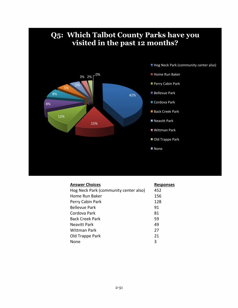
Answer Choices Responses Hog Neck Park (community center also) 452 Home Run Baker 156 Perry Cabin Park 128 Bellevue Park 91 Cordova Park 81 Back Creek Park 59 Neavitt Park 49 Wittman Park 27 Old Trappe Park 21 None 3
42%
15%
12%
8%
8%
5% 5%
3% 2% 0%
Q5: Which Talbot County Parks have you visited in the past 12 months?
Hog Neck Park (community center also)
Home Run Baker
Perry Cabin Park
Bellevue Park
Cordova Park
Back Creek Park
Neavitt Park
Wittman Park
Old Trappe Park
None

2-52
Survey question #6: What facilities, amenities or improvements would you like to see made to existing parks and recreation?
Better Parking
Increase Trails
Dredge Bay and create better fishing opportunities
Build a new and better skateboard park
Permanent restrooms at all parks, port o potties are gross!
Better bathrooms at ball fields
More parking areas at parks and landings
More winter activities
Fix sidewalks parks
Connect trails to others in the area
More restrooms in all areas
Better Park playgrounds
Needs pavilion and picnic area
Lights on Trails
More Signs for dog owners with bags for clean up
Fix playground at Home Run Baker, always wet
Very satisfied
Community clean-up days to clean up rec. areas
Install lights at parks
More Maps and brochures of rec. areas- so we know what’s available
Better maintenance of restrooms in the parks
Eliminate the ramp permits
More boat slips
Better landings for recreation boaters
Better walking surface at Cordova trail, grass growing throughout

2-53
Survey question #7: Are there any improvements, additions, developments that you would like for consideration for this five year plan?
County wide trail to connect bay bridge to Ocean City
Racquetball
Free activities
Sand volleyball
Outside movies
Outside concerts
None due to the economic situation at this time
Transportation available to get to all facilities
Outside skating rink
More moderate cost to serve moderate-income families
Large slide at Pools
Lower prices for children
More basketball courts
Tennis courts and swimming pool at Bellevue
Fix walking path at HRB, wash out every time it rains hard
Need more user-friendly areas
Publicize them, where they are and maintain them
Maintain and improve
Pools open before Memorial Day and past Labor Day
Indoor Pools
More/better beaches
Teen center
Need community involvement
Volleyball court
More outside activities
Gymnasium (existing are old and dirty)
Everything is fine, need nothing
Longer trails
Do something about Canadian geese overrunning parks!
Swimming pool is cold
Fitness center
Indoor turf arena so we don’t have to drive so far!
Synthetic turf fields outdoors for tournaments

2-54
Default Report
Bellevue Community Survey
September 9th 2016, 11:39 am EDT
Q1 - Please indicate the phrase that best describes your
relationship to the Village of Bellevue:
Answer % Count
Bellevue year-round resident 78.13% 25
Bellevue seasonal/part-time resident 9.38% 3
Frequent the Bellevue Community Park/Boat/Boat Launch 6.25% 2
Frequent the Oxford-Bellevue Ferry 0.00% 0
Other 6.25% 2
Total 100% 32

2-55
Q2 - In your opinion, what are the three most important things
that you enjoy about living and/or visiting the Village of
Bellevue?
Choice #1 Choice #2 Choice #3
It's laid back atmosphere friendly community
small village and its friendly atmosphere
access to public boat ramp
minimal outside intrusion
Laid back, quiet
This was a predominately black community similar to Oxford and St. Michaels
Location - including access to waterfront
Neighborhood - quiet, safe and friendly
Density - it's not!
Diverse village neighborhood community
Immediate access to walking and biking in beautiful countryside
Ease of water access for boating, fishing, kayaking, etc.
the quiet residential return of a well-cared-for rural community on the Eastern shore
family community beauty and tranquility of
the area easy walk to the ferry/park/landing
peaceful, beautiful place Bellevue neighbors access to water on our property - having ferry
close by
The kindness of its residents the beauty of the area
tranquility friendliness of neighbors sense of community
no crime quiet community Friendly community. Mostly family
It's small It's quiet It's peaceful
great neighbors quiet setting access to water
water access community excellent schools low crime rate
peace and quiet, friendly neighbors
public boat ramp access feeling of back in time
family community and everyone respects each other
beuty and tranquility of the area
easy walk to the ferry, park, landing.
Quiet village proximity to water low crime
no crime quiet not a lot of traffic
the view convenience centeral sewer
privacy within a small community
access to boat ramp minimal municipality intrusion

2-56
Privacy in a community setting
waterfront access at public marina
minimal municipality intrusion
small village people in the village the community church
Tred Avon Access/water oriented
interaction with entire diverse community
TRANQUILITY mixed with interaction with weekend visitors/ferry
passengers/boaters/weekend activity in general
great neighbors quiet setting access to water
peaceful, beautiful place Bellevue neighbors access to water on our property - having ferry
close by
that it is a small, contained village and not part of suburban-style sprawl
it's marine environment the quiet
Water access Park Ferry
Feeling of being safe water close to access the community of neighbors
Proximity to water quite community aspect

2-57
Q3 - In your opinion, what are the three things you would like to
see to make the Village of Bellevue a better community?
Choice #1 Choice #2 Choice #3
the roads that service the community need to be better maintained
storm water runoff
regular maintenance of storm water ditches
better roads, i.e. church street, orchard terrace
maintenance of village roads
More access to the landing as in later longer hours for fishing and overnight boaters.
The black population has decreased as the number of whites have exceeded the black residents
Lost the black culture
Access to affordable credit and/or grants for home ownership
Maybe public transportation improvements ... not sure if it is
available presently
Fixing the decrepit roads in the village
Dealing with derelixt houses, autos, boats, etc., which create a
feeling of neglect and diminish the charm and character of the
village
slower/enforced speed limit 20-25 mph entering/leaving the community. Speed needs to be posted leaving the landing as well as entering the village near Chris Berg's farm
Better road maintenance to include all streets
Regulations for propert property maintenance. Cars on blocks with
grass growing out of them etc., too many vehicles parked at one
residence permanently, trash/old appliances etc. piled up in yard
removal of deserted derelict houses
helping to fix "private" roads
keepings lots small to encourage the building of smaller homes that
already exist in the heart of Bellevue
underground electric wiring an expanded beach area at the
ferry dock getting onto Saint Michaels water
system
clean up abandonded properties resume county maintenance of
church hall lane and orchard terrace
Nothing - with change comes unnecessary drama. This is a nice retirement community. Mostly family
removal of derelict houses
community store to serve residents and ferry visitorys and cyclists
community center improvement of navigation in Tarr
creek
cleaner ditches on sides of roads fire hydrants county road maintenance
speed limity (30 mph) needs to be posted leaving landing.
regulations and enforcement for property maintenance. Cars on
blocks with grass growing out of
Too many vehicles parked at one residence. No multi-family
dwellings.

2-58
them.
sidewalks, street lights adding small convenience
store/bar/restaurant
community structure, pool, tennis courts added to parking area,
enhance basketball court resurface/repair cracks in concrete.
Much more parking area for boat launching
nothing - no higher tazes no high crime like community as is
regular cleanout of all ditches for storm runoff control
installation of fire hydrants for the village of Bellevue
roadway improvments
storm runoff control roadway (public) improvements better weekend access to the
marina
I think it's a great place to live as is
more community picnics community garden a "walk and bike path" throughout
village including dock and bike flow to/from ferry.
removal of derelict houses
removal of deserted, derelict houses
helping to fix "private" roads
keeping lots small to encourage the building of smaller homes that
already exist in the heart of Bellevue
that people make more of an effort to build a community
for the scale to remain the same and for small in-fill lots to be
developed over time
Clean park and beach We've seen condoms and
needles on beach and park
village establishment like Mom and Pop
safer bike lanes
Road maintenance remove vacent dwellings less delaware watermen

2-59
Q4 - In your opinion, what are the greatest threats to your
quality of life in the Village of Bellevue (Please list up to three
and explain):
Threat #1 Threat #2 Threat #3
Outside interests placing restrictions on what can be done within the community
CROWDED STREETS - ENCOURAGE MORE OFF
STREET PARKING
outside interference in community - taking away the asthetic beauty of a small community
Lack of fire hydrants "dry hydrants"
commercialization, attempts to urbanize and destroy our
village way of life
Over regulation Lack of listening and creative
problem solving when a county agency is involved.
Creeping gentrification.
Greater housing density - environmental and social threat
Loss of diversity by new development
Increased traffic
Aggressive driving and excessive speeding on Bellevue Road, which is a constant threat to families and children walking/biking to the park/waterfront and a major source of noise pollution
outdoor burning of trash/household waste, etc.
Any change to current residential zoning for underdeveloped areas
Introduction of commercial ventures - regardless of past
commercial activity within the village
Speeding traffic both from the village residents and watermen/contractors. We should be able to walk our dogs or walk with small children and not be threatened by huge speeding trucks
Project housing...totally against any affordable housing project
in the village, we all walnt to increase the value of our
property not pull it down.
people building "mansions" in town changing the historic atmosphere of this special place
vehicles speeding to ferry as well as lawn and construction
vehicles
people using huge amounts of fertiliers and weed killers
that find its way into Tarr Creek and the Tred Avon
Arsenic in the aquifer aboce acceptable levels
pollution of the rivers and bay agricultural pesticides on
surrounding lands
speculators loss of population over-gentrification of village
High crime - there is no crime here unnecessary traffic bringing all
walks of life into our community
Not knowing the history of the village and what it
means to famly that were born here
THE GRANT - we don't need outsiders telling us that we are going to change like it or not!
excessive speed of vehicles
no access to a community store for minor emergency needs - food, batteries, beverages on a hot day for cyclist

2-60
outsiders wanting to change our wonderful community
no fire hydrants scares me, WE NEED THEM
cost of insurance regulations by FEMA "commercialism"
Project housing - against any affordable housing project in village. We want to increase the value of our property.
General sense of embracing our village - needs everyone
working together (we don't have this today)
Way too much trash on beach - this is mostly from
tourists. Signs needed to remind them to clean up!
greatest threats are making no improvements. Keeping things as is will stagnate growth in community.
tourists, trespassing on private property
nothing
one of the neighbors
No fire hydrants on back streets - death by fire if not installed
Onerous Insurance regulations - involves obligations that
outway the advantages
outside interference into community - no more
privacy. Commercialization.
Onerous insurance regulations and outside interference into the community
People from outside telling me what's good for me. See question number 5.
Commercialization
Increased commercial activity within the village center - especially with any noise or odor
disrespectful motorists to/from ferry dock and into/out of
Poplar/Gates
Decreased level of nature at dock/park
excessive speed of vehicles
people building "mansions" in town changing the historic atmosphere of this special place.
vehicles speeding to ferry as well as lawn and construction
vehicles
people using huge amounts of fertilizers and week killers
that find its way into Tarr Creek and the Tred Avon
degradation of water quality in Tarr Creek and the Tred Avon
addition of artificial lights (streetlights)
closing St Lukes
Shoulder for bikers Cleaning of Bach and park
bikers - they are a driving hazard more accomodations for the
boat trailers
bikers

2-61
Q5 - In your opinion, are there any specific improvements or
amenities that would help to maintain or enhance your quality of
life in the Village of Bellevue? Please rank the following from 1 to
6 (1 being most important):
Question 1 2 3 4 5 6 Total
Better Maintained Streets
50.00% 13 23.08% 6 19.23% 5 7.69% 2 0.00% 0 0.00% 0 26
Community Center
9.09% 1 18.18% 2 18.18% 2 36.36% 4 18.18% 2 0.00% 0 11
Corner Store 42.86% 6 21.43% 3 28.57% 4 7.14% 1 0.00% 0 0.00% 0 14
Enhanced Community Policing
0.00% 0 0.00% 0 28.57% 2 14.29% 1 0.00% 0 57.14% 4 7
Sidewalks 0.00% 0 20.00% 2 0.00% 0 0.00% 0 50.00% 5 30.00% 3 10
Renovation of Vacant Dwellings
30.77% 8 42.31% 11 11.54% 3 7.69% 2 7.69% 2 0.00% 0 26

2-62
Q6 - Please list up to three additional improvements or amenities
that were not listed above as part of Question #5:
Improvement/Amenity#1 Improvement/Amenity#2 Improvement/Amenity#3
Ice machine for fishermen, Ice cream/refreshment stand for tourists
more parking for weekend recreational vehicles
walking path on currently owned county property for
residents to use the park area.
Restrooms at park maintained Running water at park Parking for public ramp - off
road
Work with local, wealthy landowners, to figure out how to loan money to locals for home improvements and c41reate affordable housing.
Actively support options for the youth. Support commercial growth
only when it can continuously employ locals. Develop a loan
program for accessory apartments do young and old can afford to stay
in the community.
Sit down in private with stakeholders so you can get
their opinions but prompt them on options and consequences.
Reduce speed limit on Poplar Lane... Current danger to children
Affordable Housing Access to waterfront for the
community with walking paths through property
Solution to the seasonal boat trailer parking problem; the overspill parking on the west side of Bellevue road is a constant hazard to bikers, walkers and other road users
Clean up the beach and in-shore water and maintain it as an
attractive, safe and clean environment for families, similar to
the Oxford beach with restrictions on off-the-leash dogs
better policing of trash on beack/park area & cans
dog waste bags refilled more timely
community center is not needed (we have park), sidewalks are not needed (we are rural and
don't want that town feel), NO AFFORDABLE HOUSING
Affordable housing community center only if its in the
Methodist church
Affordable housing underground electric wiring slightly expanded beach space,
public water access
Affordable housing. Limit types of commercial
development along waterfront
limit size of new construction to something in keeping with traditional scale of houses
more pole lights in the community
Better parking for boaters - or - close the landing - the congestion is ridiculous!
affordable housing running water at landing real restrooms at landing
pavement improves ramps local community store as already
mentioned, community center improvement of tar creek
navigation
public trash containers on end of island
medical emergency first aid station more public parking at marina
Better policing of beach/trash Dog waste bags refilled quicker
2-63
clean up
small bar/restaurant with light snacks, sandwiches, burgers, etc.
expansion of boatramp, more parking
street lights, better lighting of village
not anything else
clean up of properties
THESE ARE FORCED ANSWERS. I do not want public lights on streets, or sidewalks.
I do not want additional boat slips at several are not used now
Would like to see code enforcemtn on delinquent
owners rather than funds - public funds- provided for
cleanup.
Better parking at public marina better public restrooms (not
portable) better streets/improvements
Are these the things that are getting done? It looks pre-ordained
Housing is already affordable Maintain restrooms at landing
A "welcome to Bellevue" sign with large depictive map or indication of village to left
Speed control "respect the village" A website with history and
communication portal
affordable housting running water at ramp real restrooms at ramp
real rest rooms instead of porta potties (at ramp)
running water (at ramp) some sort of trash disposal out
on pier. There is often debris there.
more parking for boat trailers
more parking for watermen more boat slips for recreational
boaters

2-64
Q7 - Do you have any additional suggestions or
recommendations as to how to protect and enhance the
traditional working waterfront in Bellevue, or to improve the
overall quality of life in the village (Please explain):
Do you have any additional suggestions or recommendations as to how to prot...
I do not want sidewalks or street lights on Poplar Lane. This would encourage undesired foot traffic and loitering.
In my experience, there are young people who want to live in Bellevue. They can get moderate jobs in the county. However there is no place for them to live. You have the perfect tool to make this available, accessory apartments. However until the financing is available, the property owners have been educated and the financial and cultural benefits illustrated, it will not happen. And, you will get dead end proposals from agencies that have no options for small scale, village affordable housing.
Need better parking facilities and control of boats and trailers at the landing and park. Don't agree with plans for Tar Creek, especially if they plan to park barges there.
In the event of private development, save integrity of the church as center of community life; encourage solcialization with walking paths to park; need low density high quality designed houses and some affordably priced homes in community.
Essential to install traffic calming procedures (e.g. 20 mph speed limit) on Bellevue Road extending out to include the Ferry Neck road junction. Find ways to deal with the problem of trash being thrown out of vehicles both entering and leaving the village and ferry dock areas.
Need to carefully define "traditional working waterfront". For example: Proposed use described in brochure for a company to store large construction barges at a new pier for frequent transit in and out of Tarr Creek hardly seems "traditional" or in keeping with the character of the village. Also, commercial vehicles used to keep these barges supplied with construction materials may overtax the roads and challenge pedestrian safety.
Community work together to keep our area clean/tidy/safe. Community watch more active We have a nice village, but it can be better, we have to be mindful of each other and work to have the guests (waterman, contractors and tourists) be respectful of our village and residents. Speeding watermen/contractors are a huge nightmare on the last stretch of road from Ferry Neck Rd. to the ferry landing/back...this must be addressed...it is used as a raceway, needs to be 20-25 mph., not 30 mph...traffic goes 60+ mph to/from that corner and wont slow down even passing bikes/walkers...ridiculous!
(at the landing: Real restrooms instead of Porta-potties, Running water, some sort of trash disposal out on pier. There is often debris there) Bellevue is a historical community built on package plants, watermen commercial boating. I would like to see the down continue supporting that. Loud recreational boating does not support the history of this peaceful place of hard working people. The town is a treasure. I hope people can see that properties and quality of life will be worth more continuing in the ways of the past.
Expanded beach area. Road maintenance of ALL roads in Bellevue. NO sidewalks.
Promote efforts to encourage growth of natural grasses on bottom and banks of Tarr Creek. Open up parking on grass areas on busy boating weekends. Make dumpster accessible. Give thought to protecting waterfront from development. Incorporate Clay's hope state historic district as important aspect of views along Tarr Creek.
One waterfront is enough. Two waterfronts are not necessary.
Bellevue is a historically blue-collar community. It's creek should welcome appropriate commercial use - working craft not transient recreational boating!
health department approved swimming area near dock.
This "grant money" should provide and help improve life here for the community and watermen. NOT BE USED frivolously on "sidewalks and street lights". Public bathrooms at marina. Daily Maintenance at park and restrooms at marina - IF we get them - as needed. Do not WASTE the grant money on things

2-65
that will NOT benefit or help us. Listen to the people living and paying to live here. Public restrooms area must at the marina for public and waterman use. Get rid of porta potties - they stink! Please use this money to improve not change us into something we are not in favor of like tourist invading our privacy.
Community watch more active / Viligant. Way too much speeding through village. This needs urgent attention.
Sign depicting entering the village of Bellevue with small history notation. Add some tennis courts with water fountain. Volley ball courts with sand. Enhancement of basketball court. Community swimming pool with lifeguard during operation. Enhance beach area with new sand and overall improvements to make it more attractive for families to use. With new homes being built each year more people are moving into the village. Support for a small convenience store and or a small bar/restaurant is growing.
much more parking area for launching ramp for boat trailers and trucks.
Clean up old houses and maintain properties.
#5 - In my opinion this survey is for formality purposes only as the CAC already has in mind the improvements or amenities that are desired. Therefore, why do you ask our opinion when it will not matter because you have already manipulated the outcome of the answers to be exactly as the Citizens Advisory Committee wants to have. Better parking at public landing for weekend crabbers and fishing boats. Better public restrooms not porta-potties. Regular cleanup maintenance of Bellevue park, public restrooms with trash cans provided at end of island and landing areas. 1) I would like to see extended fencing between public and private properties to ensure safety for private residents. 2) I would like to have the Bellevue working waterfront plan citizen advisory committee listen and take into consideration that our community - the community of Bellevue - does not want to become a tourist town nor do we want to encourage outside traffic to peruse and loiter around our private RESIDENCES. This will also be encouraging additional out-of-state traffic which the citizens of the Bellevue community do not want or need! It has been duly no ted that the Citizens Advisory Committee (CAC) has been very selective as to whom they hand delivered the Bellevue community surveys. If you were not trying to manipulate answers for the CAC personal outcome, then why did the CAC overlook serveral property owners in the Bellevue Village when distributing these surveys? And why were the residents of OXFORD handed the Bellevue community surveys when all of this project applies ONLY to the waterfront of Bellevue?
Do not want sidewalks. Do not want street lights. Would like code enforcement on delinquent owners - not public funds to clean up.
Get rid of derelict boats in landing
Improved access for buyers. More watermen will come to seafood buyers. Speed/noise control in and out of village (loud pickup trucks). A few have EXTREME disrespect when driving to/from dock. Please increase communication efforts during this process. This form made it to me on Aug 9 evening. Also, no opportunity to nominate for the CAC (or volunteer).
Bellevue is a historically blue-collar community. It's creek should welcome appropriate commercial use - working craft not transient recreational boating.
Affordable housing. Community center only if it is at the Methodist church. Bellevue is a historical community built on package plants, watermen commercial boating. I would like to see the town continue supporting that. Loud recreational boating does not support the history of this peaceful place of hard working people. The town is a treasure. I hope people can see that properties and qualities of life will be worth more continuing in the ways of the past.
like the road-endings rights-of-ways in Oxford, it would be nice for the public to have even a small amount of access to at least sit on a bench or two at the end of Avonia La.
Enhancing the beach as they did in Oxford
Bikers do not understand that the speed limit on Bellevue road is 50 mph and that there is not shoulder. They often ride in clusters/groups, not single file, or further into the road than they should. It creates a very dangerous situation for everyone.

2-66
Default Report
Tilghman Community Survey
August 12th 2016, 9:07 am EDT
Q1 - Please indicate the phrase that best describes your
relationship to the Village Tilghman
Answer % Count
Tilghman year-round resident, work here 28.81% 34
Tilghman year-round resident, work elsewhere 22.88% 27
Tilghman year-round-resident, retired 27.97% 33
Tilghman seasonal/part-time resident 11.86% 14
Frequent one of the marinas in Tilghman 0.85% 1
Visitor 2.54% 3
Other 5.08% 6
Total 100% 118
2-67
Q2 - In your opinion, what are the three most important things
you enjoy about living and/or visiting the Village of Tilghman?
Choice #1 Choice #2 Choice #3
it remains generally underdeveloped Quiteness People
working water environment calm and quiet work ethic of local
workers
seafood harvesting heritage quiet scenery
Not incorporated - less government, already too much
small community watermen
quietness of the village talking with the watermen being near the water
Drugs
mickey mouse P+Z regulations a lot of which are a result of
assumptions from federal agencies that have no basis in
fact. Assumptions from bureaucrats never do
The natural beauty and being only 70 feet from the bay
the sense of community the peace and quiet
quietude water view and swimming friendly TI people
low population close knit community enjoying surrounding
nature
Community feel - support each other quietness - slower pace (not
city feel) - safety feel
Some of the new residents have been
wonderful to the community -
supportive
Sense of community/friendships relaxed lifestyle water-related activities
Most locals have a togetherness - caring the school - programs
uniqueness of island live in the neighborhood where
I work
relaxed and quiet atmosphere local history/culture/natural
beauty friendly, non-
pretentious people
1) Community cohesion - access to the boy and river system 2) Sewer system
3) EMS and the firehouse 4) waterman's museum
5) Phillips Wharf Environmental Center
6) Street Lighting
Small town atmosphere lack of "rules" as in SM and
Oxford
Peace and quiet It's being a working
watermen's community Sequestered without
being isolated
old fashioned close community small and peaceful
Hospitality School Fire Department
The small town, laid back and quaint atmosphere.
The friendly people. The absence of heavy
traffic and "city" sounds.

2-68
Close knit comminity Fire company Church
Water/active lifestyle Small/Close Community Services located in our
community
Water lifestye frendly community dont have to travel to
easton for services
Very few people Quiet Relaxing
Kayaking Biking Public peers
Quaint Safe Undeveloped
Independence Proximity to the water No city government
Quiet Water views Strong community
feeling
Everyone is like family Great school Perfect place to raise
kids
Quiet Friendly Close community
Quiet Good people Seafood
Sense of community Small town feel lack of traffic
Small town living Kind helpful people Boats and being on the
water
the community of watermen The small town locals that are
close knit
The water The amazing fresh seafood &
vegetables & fruits Quiet relaxed way of
life
The culture The people The history
'Small town America' community appeal the unique history And the
working watermen
Total immersion in thbay lifestyle, our new education center, pwec,
the watermans museum
history/family small town/community feel school/fire dept.
Water Small village feel People
Working watermans town Small population Water access
Safe place for children Close knit working fishing
community
The school Close community
small
sense of community little traffic quiet town
rural environment sense of community historic buildings
The great people the presence of the Chesapeake
Bay The life

2-69
small town living water oriented lifestyle quiet community
sidewalks live music allowed at
restaurants
adult education classes or recreation at
Tilghman school
its originality
working village atmosphere diversity (population,
socioeconomic, age range) Dogwood Harbor
peace and quiet nature and marshes, wildlife residents
Friendly people, close knit of people to help others in need
Keeping water employment alive
allowing watermen first priority at slips
Friendly locals Farmer's market (could be
expanded), food pantry Bank/Post Officem
"Library"
no traffic quiet nature
the quaintness
lack of crowding relaxed pace of life friendly community
access to the Bay slower pace of most residents community is a step
back in time
friendly water community
Friendly residents/working/retired/local/newcomers = diversity
walk to parks, restaurants, etc.
waterfront
natural beauty local charm slow pace
small town/rural ambiance natural environment and water
orientation tranquility
The watermen Close knit community casual life style which
is symbolic to Tilghman
Local residents hunting fishing
location by water quaintness water activities
(boating)
quaint atmosphere friendly people riding my bike
The people who are FROM Tilghman "Been Here's"
The sense of community The natural
environment
quiet and peaceful friendly people community spirit
small town / rural water access, environment Bucolic
low key/ quiet the people the water
The water water views water access
the natural beauty of the area access to bounty from the
watermen the lovely people in
community

2-70
the people the serenity the environment
cohesiveness of community interaction with all levels and
ages of residents courtesy in dealing
with others
small town sense of community safety
family home friends
quiet friendly
Outdoor/Water Environment Beauty of real working village Clean, quite,
Harrison's
Working Waterman's community small village / community
Workboats Hospitality of the
people
Friendly people Safe environment Beautiful outdoors
The Bay The Quiet The People
My beautiful home on the Bay The many species of birds that
I feed Activities on the water
The friendliness of the people The mix of "been heres" and
"come heres." The beauty of the
natural environment
Friendliness of people/ people help each other
24hr EMTs Seafood
Not crowded; low key Beautiful views of the water
The combination of a traditional community
and the presence of newcomers
The friendly village life Great natural beauty The charm of a
working watermen's community
Quiet and serenity Unique character of
watermen's village Native vegetation and
wildlife
Peaceful, unspoiled environment Friendly small town feel Lack of traffic and
congestion
The good-natured, hard working people Strong sense of community
Small Town atmosphere Quaint
Sense of community A working watermen's
community - a broad range of people
Water on all sides
Sense of community Working watermen culture Broad range of people
Beauty Serenity Residents
Being so close to the water Seeing the stars at night A peaceful place to live
The people Quiet Scale
Quality of life Beauty Community
Quiet Authentic - watermen; not DC
lawyers Vistas and wildlife

2-71
Quiet Laid back atmosphere
Quiet and peaceful Small Town feel Waterfront
Quietness Water Views Low Taxes
Existing charm, character and natural beauty
Knapps Narrows and Dogwood Harbor as working docks
The way it is
Quietness No traffic
Sense of community beautiful landscape less developed
Serenity Rural Composition Historical
homes/commercial buildings/church
Natural Environment Limited planned developments
like TOC No commercial activity in the residential areas
Access to authentic waterman's village culture and people
Living among like-minded individuals in a rural, setting
on the Bay
The calm, serene, low density environment The sense of community in
Fairbank and Tilghman Island in general
The number of activities available
(boating, fishing, crabbing, etc.)
Peace and quiet Community Spirit Safety-security
Nature/natural beauty Lack of traffic Lack of tourists
Preserving the "watermen" heritage Sense of Community
Fishing /crabbing village atmosphere slow pace places to eat and get
supplies

2-72
Q3 - In your opinion, what are three things you would like to see
to make the Village of Tilghman a better community?
Choice #1 Choice #2 Choice #3
More restaurants - Not fast food
Hardware store City trash collection
sidewalks tear down/fix up shanties, shacks, sheds less drugs + use
sidewalks bike path/walking trails arrest drug
addicts/dealers/thieves
dredge Narrows to help the tourist industry
dredge Dogwood and Tongers is necessary for watermen
serious drug problem
keep it like it is restrict building of new housing condos
etc
keep public dock public and restrict yachts from taking over
the waterman's place
get rid of the drug problem get rid of the mickey mouse P+Z
regulations and tell the feds to keep its money and leave Talbot County alone
A 25 mph speed limit through town with speed limit postings
Preserve the lawn infront of Harrisons Chesapeake House
more communication between long-term residents and part timers
less clinging to the "good old days" a little more openness to
innovation
encourage waterman's business
preserve it "as is" repair exisiting structures
Have concern about drug problem on Island
affordable housing
more economic prospertity for the existing businesses
more demand for businesses - if businesses are healthy there will be jobs
Stop letting the County Council make decisions like the cell tower
clean up drugs on island
Better ditching for drainage Sidewalks
any possiblity of a small public beach or a small public pool?
bring back the newsletter at the post office to keep people informed of
happenings
Increase the demand (e.g. Visitor industry)
Get rid of the trash collection process at Back Creek Park
Advertise - cooperate with Saint Michaels and MD Visitor
Jobs for young residents Library - health and wellness center
OPEN
Dredging the Narrows would bring business - resurfacing a
marina
Sidewalks Removal of the most egregious eyesores More focus on the school and
education in general. Better cell phone connectivity
clean up the drug activity stop developments - we are a farming
and waterman community help slow erosion
Stop letting newcomers change our island

2-73
Walkable sidewalks on one side of street.
More parks and green space. Street sighs more noticable and
bigger.
Do something about the drug problem
Cleaning up the drug problem/thefts/etc
Sidewalks for safety of our children Less zoning restrictions(more
businesses thus more jobs)
Clean up the drug problem, sherif Gamble is doing a great job
Less Zoning Restrictions, Have you been to the Delaware shore? very nice
Restrictions are hurting local business, get the cell tower
working
Less people moving here Same as above Same as above
Biking lane Side walk/ safe place to walk on side of
33 Fishing peer @
A sidewalk from the bridge to the school
Better maintenance of the park Lights at the park
Bring back drug store and fountain service
Restore abandoned businesses Clean up abandoned properties
More police presence Cleaner park County to make owners mow
lawn
Cell phone service Less drugs Sidewalks
Less druggies Litter cleanup Preserve the way of life
Major restaurants/inns operating properly
access to public transportation like other towns
proper policing
Less crackheads More opportunities for the kids A gym
Clean up the drugs and users that openly sell and deal and are continually let go
Stop holding our children from choosing to go to St. Michaels school
and having more social and educational experiences based on where we live
when children from all other schools are welcomed with open arms and we are
continually discriminated against based on where we reside.
Clean up the drugs
More press More visitor overnight accomodations Stores/shopping
Slow growth Limited development Expand outdoor activities
Continued efforts to encourage tourism revenue in a way that does not complete transform the community
Community gardens /food projects Do we need /want our village center more walker friendly?
Should we ha ve sidewalks????
continued support of Museum and preservation of culture
Outreach to children
Dog park General island cleanup
Sidewalks Environmental conservation Expanded history/museums
More activities for children Transportation options for children for
after school activities
More Police patrols and to clear out the drugs
2-74
more public access to waterfront (large park on water)
sidewalks bike riding lanes
better internet and cellular coverage
expanded emergency medical service
decrease (10%) non-permeable space to allow some expansion
of extisting homes and businesses
I'm very happy with it
More public areas, more walking/biking trails
Elimination of drugs some public transportation
walking/biking trails community health center
Less restrictions music allowed to pull in people
improve main street - underground drains and utilities
county improve its land holdings and make walking trails and sidewalk
leverage poplar island NOAA demonstration project to make
Tilghman an Eco Destination
speed limit - too many speeders in town
do away with drug activity allow music outside at restaurants sidewalks
Revitalize/paint existing houses rather than building new ones. More affordable housing
viable grocery store/opther shops without tourist prices...a "dollar store"
would be good. Place where you can buy local seafood - like Harrison Oyster Co.
used to be
transportation to doctor, shopping etc for people who
don't drive
cell phone service a full-service Tilghman Island Inn A first-class resort where
Harrison's now exists
Planning and Zoning should consider age of community and exisiting structures when reviewing plans for property upgrades
less crime more community involvement
sidewalks dredge the narrows to encourage sailing visitors
sidewalks Water access for visitors restaurants better
services and activities for youth and seniors
coordination of expansion of non-profit organizations
ecological experience tourism
Cleaner structures, yards, ditches and roads
Increased employment opportunities Strict law enforcement on drug
problem
I like Tilghman just the way it is today
Clean up broken down houses
cell phone tower that works clean up Knapps Narrows
a bike path cleaner recycling or maybe move it to a
less obvious place
Bring the library back
Staff the school wellness center for the elderly who can't drive up the road for
medications, blood pressure checks, flu shots, etc.
Better police presence to rid drugs

2-75
sidewalks on route 33
shields on security lights - enforce rule that lights must be downward facing or
shielded - problem especially in Knapps Narrows
street lighting on Camper Circle downward facing or lower
intensity
Safer paths for biking and walking
programs for youth, seniors experiential tourism/non-profit
organizations
safe walking/biking (sidewalk)
cell tower working good internet service ( all
portions of island)
give citations to load exhaust trucks
give citations to VHF radios on all night clean up the drug problems
ability to buy seafood on the island
no more growth
drug enforcement and rehab speed limit enforcement
easing of building code with cottages or businesses in need
of restoraction - i.e. parking, sprinklers, ditches and drainage
no more drugs limited growth - weekend
homes/business more use to school as a
community center
cell phone tower working
Make Harrison's more attractive/upgrade the visual experience - but the food is great
Leave the community alone
Better attitudes from come here's regarding Waterman's way of life
Drug prevention programs Adult education
Extend public sanitary sewer to all properties
Better cell phone coverage Address drug addiction
problem
Cell Phone Service Cleaning up Bay for watermen
Better management of places like Harrisons and Tilghman Island Inn
Clean up dilapidated residences More community activities
Sidewalks/safe biking on Route 33
A community center with library, health, exercise and meeting room
Police station substation here
Get rid of abandoned houses - vagrents squat in them
Sidewalks on Main Street
Infrastructure upgrades to enhance the walking around town
More effective use of school as a community center
Health care facility Bike path Tilghman Citizen's Council
More community gathering spaces
No development zones Bike trail winding through the
Island
Combat drug abuse Strong sense of individual core family
values - "family time together" and "involvement in kids lives"
Stopped cars, people, and dogs in the streets
Stop drug deals
Police or Sheriff presence Cell phone tower - need one for
emergencies

2-76
Zoning changes to promote infill and home rehabilitation; especially impervious area rules
Community support for kids and seniors
Make Main Street pedestrian and bicycle safe - eg. shoulders
Community center in school Better use of school stage for theater
and music Staff health office in school with
part-time nurse practitioner
Public swimming pool
I like it the way it is
Housing Codes Maintenance enforcement Sidewalks
Retain and support the watermen that live here
Sidewalks on main road More businesses
Sidewalks from bridge to church on Tilghman Island Road (similar to sidewalk at school)
Bike path on Tilghman Island Road Working cell tower for ATT
customers
Sidewalks through town along Route 33
More parking at water access areas More water access areas for
public use
Re-establishment of the Glendenning Planned Community School
Sidewalk in town Daily bus to St. Michaels Affordable apartments for
people who cannot afford a house
a police presence community beach better main road
Signs evidencing the boundaries of "Avalon"
Grants to historic property owners for historic preservation of their homes and
buildings.
Bike lanes and sidewalks No Confederate flags Less inbreeding among the old
families
Public access to water; there is really no easy way to launch a dog, a canoe or kayak
Regular surveillance of use of shoreline at BlackWalnut Point
Better public access to land past the Watch Tower on Black
Walnut Point
Less state and county interference
Less restriction on property development
Improved Knapp Narrows waterfront businesses (seafood
sales, restaurants, marinas)
Control of weekend rentals in residential areas
A shoulder on Main Street for pedestrians and bicyclists
Repair of County side roads
Jobs for young families
Support for residents (education, medical)
More job opportunities
keep the businesses strong keep the roadways clean keep the marinas clean

2-77
Q4 - In your opinion, what are the greatest threats to your
quality of life in the Village of Tilghman (Please list up to three
and explain)?
Threat #1 Threat #2 Threat #3
development Water quality Condition of the Bay
poverty pockets and drugs demise of watermen's industry future infusion of
aesthetically inconsistent development
low life people/addicts/thieves rundown houses and unkept yards
abandonded homes no cell service
lack of jobs for young families difficulty with endless rules preventing
you to do anything with your own property when it won't hurt the bay etc.
Tilghman on the Chesapeake expansion like this. Condominiums being built and people with financial means taking over and ruining the island with wanting sidewalks, bike lanes and on and on
Drugs - if you need an explanation you shouldn't have the job you do
Drugs P+Z regulations - ditto
"Threat #1" above
I hope we don't lose the watermen's culture
Laws that make it impossible to make a living on the water
Too much expansion
no/little awareness of trash along the roadsides
scary gun activity during hunting season
reckless driving with little consideration,
especially after dark
storm surge/drainage speeding vehicles litter
People who do not understand a WORKING waterman village and pose hardships by enacting laws on the waterman. A business has necessities, the waterman have materials and equipment for their businesses, need to keep it where they live (it is thier livlihood not vacation)
New residents changing the landscape and way of life that has always been
here
loss of full time residents loss of watermen loss of school, loss of
severn marine
People moving here and trying to change the island - why did they move here?
The school closing - help us keep it open
Fire Department - no leadership
Newcomers who purchase land in area and then make attempts to change way of life
Newcomers against fishing industry materials and don't want watermen to
have thier necessary equipment on property
The decline of the seafood business
loss of existing culture due to over-development that favors high end
Loss of ambience due to over commercialization

2-78
residences and their occupants
Rising water level Lack of policial voice on Talbot County
Council Losing Severn Marine
School closing and lack of library and wellness center
rising cost of living on the island lack of jobs
Poverty and drug traffic Demise of the water industry
erosion - loss of land crime rate on the rise due to drug
activity
nothing here for teenage children to do. Task is
wonderful for elementary children but middle and high school
aged children have nothing
People come here because they like the island, then they try to change it
Cell tower - didn't care of property owners on the surrounding property or
the park
Just don't care about the waterman and families
Condo's and mcmansions. Over development. Losing the "village" of
tighman and all that entails.
Drugs - who wants to raise kids there with the heroin problem?
The drug problem Street Safety Zoning restrictions(hard
to run a business)
Drugs, the criminals keep getting right back out of jail
We dont own our property, we just rent it. it takes way too much to build/add
on
Out of town/weekenders buying property,
CHANGING, then move away
Out of town people moving here Same as above Same as above
Trash/oil / being dumped into the waters
Lack of respect for natural beauty
Car speed/ along 33 through town , weather it a person who lives on
TI or a visitor
Development would diminish the small town feel
Increase in taxes Expansion of
commercial zoning
Come Here neighbors Northern Virginians New Yorkers
Poor state support of watermen
Drug runs and no police presence
Drugs Alcohol Theft
Outsiders- people move here to get away from the city but then they expect us to change for them. We are not the city dont expect us to change for you.
Drugs- drugs have been a problem in thw area not just Tilghman. It devalues
our properties and lessens our safety
herion addicts, the crime they create
electricity outages The 911 service is
frustrating and difficult to communicate with
Known druggies walking the streets late at night
Bad neighbors Phone tower that is
making reception worse

2-79
by being there unwired and will probably be
even worse once wired.
Limited educational access and opportunities with declining enrollment in the tilghman school and cutting of teachers and combining classrooms.
The persistent drug problems on the streets.
The lack of cell phone signal especially in
emergency situations.
Progress
The possible threat or decline of tourism as it relates to job and income loss
Decline of property value
Substance abuse/addiction and the
desparation of those who are struggling with this
Trying to make Tilghman into something it is not. It is a working waterman' village. It is not St. Michaels with all it's tee shirt shops and restaurants.
People who want to change Tilghman. Why do people love it for what it is,
then feel they need to change it.
Building/growth. Lossing the heritage
Lack of seafood industry. High overhead ie rent/ property value
Drugs. Significant drug prescence
Drug use, leading to crime increase
Drugs. Too many drug dealers and users in this area. The courts keep setting them free and allowing this to go on. When you have a drug dealer in a school zone that has all charges dismissed..NOT GOOD
pollution unmanaged growth
loss of the watermen's culture as the age and no one replaces them
changes in lawas tha tallow and promote short term rentals
lack of healthcare providers that force
people as they age to move closer to
healthcare.
bay pollution loss of identity as a community loss of connection to
roots/history
commercial expansion. The community would be different if we invited bigger retail expansion
the drug trade
loss of our school - oxford has no school and
it is a town of older, retired people. No
vibrancy.
drugs - there is a significant drug problem in the community which I believe leads to other crimes
Repeated efforts to close the school - it is essential to the community
newcomers trying to change everything need to go back where they came from
Failure to provide affordable housing for the poor/working poor
inordinate delays with permitting and requirements (watermans museum
marker 5)
corps not maintaining navigable waterways -
Knapps Narrows
mega homes being built that take away from the island charm especially in town in place of
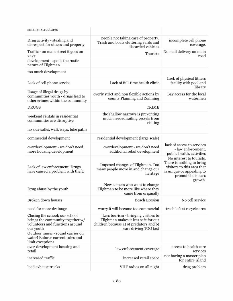
2-80
smaller structures
Drug activity - stealing and disrespect for others and property
people not taking care of property. Trash and boats cluttering yards and
discarded vehicles
incomplete cell phone coverage.
Traffic - on main street it goes on 24/7
Tourists No mail delivery on main
road
development - spoils the rustic nature of Tilghman
too much development
Lack of cell phone service Lack of full-time health clinic Lack of physical fitness
facility with pool and library
Usage of illegal drugs by communities youth - drugs lead to other crimes within the community
overly strict and non flexible actions by county Planning and Zonining
Bay access for the local watermen
DRUGS CRIME
weekend rentals in residential communities are disruptive
the shallow narrows is preventing much needed sailing vessels from
visiting
no sidewalks, walk ways, bike paths
commercial development residential development (large scale)
overdevelopment - we don't need more housing development
overdevelopment - we don't need additional retail development
lack of access to services - law enforcement,
public health, activities
Lack of law enforcement. Drugs have caused a problem with theft.
Imposed changes of Tilghman. Too many people move in and change our
heritage
No interest to tourists. There is nothing to bring
visitors to this area that is unique or appealing to
promote buisiness growth.
Drug abuse by the youth New comers who want to change
Tilghman to be more like where they came from originally
Broken down houses Beach Erosion No cell service
need for more drainage worry it will become too commercial trash left at recycle area
Closing the school; our school brings the community together w/ volunteers and functions around our youth
Less tourism - bringing visitors to Tilghman makes it less safe for our
children because a) of predators and b) cars driving TOO fast
Outdoor music - sound carries on water! Enforce current rules and limit exceptions
over-development housing and retail
law enforcement coverage access to health care
services
increased traffic increased retail space not having a master plan
for entire island
load exhaust trucks VHF radios on all night drug problem

2-81
the decline of watermen decrease in young families destruction of nature
and waterfront by wealthy and influential
use of drugs - brings on vandalism and stealing
more commercialism - who needs McDonald's , etc.
more residential development - want this
to be a waterman's community
excessive commercialism and tourism traffic
drug crimes (theft, public behavior) politicians helping fix
things not broken
drugs part-time residents outnumbering
locals because of cost of property
growth of business that develops waterfront so watermen lose docking
and places to store/work on equipment
cell phone tower
lack of facilities for the youth to keep them out of trouble
Possible failure of Harrison's - help them with the following: management, property master plan, clean up, visual upgrades
Development...too many expensive houses being built
Noisey tourists drinking and partying Too many yachts taking
over the knarrows
Lack of sanitary sewers for all properties, which endangers the ecosystem
Lack of adequate cell phone coverage, which could be dangerous in an
emergency situation
Illegal drug usage, which causes an increase in
crime
Calling Tilghman Island the awful 'Tilghman Village.' Cut it out!
Citizen Advisory Committees New businesses and new
development
Drugs on the Island Speeding on road through town down
to Black Walnut Point Residents don't support local businesses enough
Wetlands erosion Open culverts on Main Street Lack of opportunities for
young adults
Drugs and prostitution on the Island - I see drugs being sold out in the open
Part/vacation rental houses in residential blocks
Lack of docking slips for watermen
The willingness of many to let the community drift; little direction
Ongoing tension between "come-heres" and "been-heres"
If Harrison's continues to deteriorate as a
destination
More development
Part-time residents and visitors who don't contribute to community life and don't have any idea what its really like
to be here
Short-term rentals
The loss of Tilghman's historic character
Managing tourist traffic
Development - There is no capacity for lots of traffic or public services
Poverty - Many families need support services they are not recieving
Youth programs - Too many teens with nothing
to do
Apathy towards drugs and alcohol and its direct impact on family unity and core family values
Folks moving in trying to change it Folks not cleaning up after themselves Trash on
playgrounds/parks
Single lane road Drug dealers Hookers

2-82
Drug abuse Unkept and abandoned houses and
empty lots where houses once stood
Overtime, the Island gains more retirees that
displace the local people necessary to maintain a
village
Drug abuse Unkept and abandoned houses Improve sucessful cafes
and restaurants
More tourism Overbuilding/overdevelopment
Too much change Too many committees The watermen leaving
Newcomers that want to keep it as it is, but modify it to match their idea of what they perceived it to be.
Watermen moving out and giving up life on water
In-migration of the "DC crowd"
Commercialism Multi-story condos/apartments Too many zoning laws
Drug abuse among Island residents and the crime this abuse causes
Lack of public water access Dangerous walking or
riding bikes through town on Route 33
Sidewalks and/or bicycle lanes Housing Developments (especially
concerns area outside the village such as Grey Goose Farm)
Short-term rentals
Widening of roads Addition of sidewalks
Greatest threat is new people coming here and trying to change it! If they want to be like St. Michaels than move there!
Overpopulation Too many large homes Drug situation
knapps to shallow needs dredge better bulkheads development of open
land
Removing the historical name of the village of Avalon
Altering the historical aspects of Avalon buildings with modern offices
and stores.
Lack of good jobs for young people, who leave, resulting in an aging population on the Island.
Global warming resulting in flooded roads and continued erosion of the Island, and nothing being done to
address it.
Resistance to change on the part of the "from
heres" which handicaps their own ability for
future success.
lack of a year-round economy on the island
proposed inconsistent land uses e.g. turning a corn field into town houses
Too much runoff and usage of plant fertilizers
that pollute the bays
Property development restrictions Farmland developments Business closures or
failure
Neighbor who built 7 rental dwellings next door damaging street and increasing traffic, trash and trucks driving on my property because of poor access to her property.
TOC-type development Increased tourism Increased traffic

2-83
Drug use and trafficking - There are known hotspots that need to be addressed
Watermen way of life - It is not always financially supporting the community
as it has in years past. Is there a way that extraordinary wealth of knowledge
can be used to help residents?
Knapps Narrows shoaling keeping visitors away and hurting business
lawless attitude of some residents too much development

2-84
Q5 - In your opinion, are there any specific improvements or
amenities that would help to maintain or enhance your quality of
life in the Village of Tilghman? Please rank the following from 1
to 9 (1 being the most important):
Question 1 2 3 4 5 6 7 8 9 Total
Better Streets
1.45%
1 13.04%
9 8.70%
6 11.59%
8 11.59%
8 18.84%
13
10.14%
7 11.59%
8 13.04%
9 69
Better Cell Phone Service and Reception
41.38%
36
16.09%
14
18.39%
16
3.45%
3 2.30%
2 4.60%
4 5.75%
5 4.60%
4 3.45%
3 87
More Jobs
8.45%
6 19.72%
14
15.49%
11
19.72%
14
14.08%
10
9.86%
7 7.04%
5 4.23%
3 1.41
% 1 71
More Retail Stores
3.08%
2 3.08%
2 6.15%
4 7.69%
5 13.85%
9 13.85%
9 9.23%
6 23.08%
15
20.00%
13
65
Public Library
5.00%
4 7.50%
6 12.50
10
11.25%
9 16.25
13
12.50
10
13.75
11
10.00
8 11.25%
9 80

2-85
% % % % %
Retention of Elementary School
37.23%
35
21.28%
20
8.51%
8 8.51%
8 7.45%
7 6.38%
6 5.32%
5 2.13
% 2
3.19%
3 94
Sidewalks
18.67%
14
13.33%
10
18.67%
14
9.33%
7 6.67%
5 1.33%
1 8.00%
6 9.33%
7 14.6
7% 11
75
Wellness/Health Center
9.20%
8 17.24%
15
19.54%
17
11.49%
10
12.64%
11
8.05%
7 9.20%
8 10.34%
9 2.30%
2 87
Youth Sports Teams
2.33%
2 8.14%
7 13.95%
12
17.44%
15
11.63%
10
15.12%
13
11.63%
10
6.98%
6 12.79%
11
86

2-86
Q6 - Please list up to three additional improvements or amenities
that were not listed above in Question #6 that you would like to
see in Tilghman
Improvement/Amenity #1 Improvement/Amenity #2 Improvement/Amenity #3
Pharmacy Vetrinarian Increased sheriff presence
(has improved!)
Drugs are still here - bottom since Gamble took over
camera at recycle area to prosecute illegal dumping
bottom timing of bridge rod light
A resident cop
If tourists rent water sport equipment, teach them about osprey nests and how NOT to scare the birds
Dredging the narrows entrances
affordable housing for families
public computers signs for businesses and activities plant trees
More police coverage portable bathrooms
Ditching Public access to a beach
mosquito control walking trails protection and maintenance
of natural areas
Historical Markers (e.g. this is Bay Hundred)
Dredging the Narrows have police presence Get rid of red layout at the
bridge
vet pharmacy
Bathrooms Dog Park (Fence in portion of it) Keep the weeds at bay
Keeping and expanding green space.
Community Pool/Fitness center
trash drop of at the recycling station
WAY TOO MANY WHITE COUNTY PICK UP TRUCKS AT PARKS,
WASTE OF TAXES
I HAVE COUNTED OVER 15 TRUCKS CHECKING OUT THE PARKS IN ONE DAY
Bulk trash pick up 4 x a year Trash pick up
Police for the drugs Police for the theft Compitent postal workers
Adult exercise classes! Yoga, specifically
Post office open all day long More festivals or community
events
Public beach area Public pool Gym
Fitness and wellness center

2-87
Hotels
Litter/street clean up volunteers
Bus. Association/chamber Improved boat launches
Public transportation to get children to after school activities. Most parents have to work elsewhere and can't get their children to activities which are all also held elsewhere
Wider shoulders on the road to allow for walkers/bikers to safely use the
road without impeding the traffic
more public access to waterfront
public sewers for all areas of the island
grants for preserving history buildings
walking/hiking trails more public areas recycle pick up
walking / biking trails
a fence in the park seperating parking lot
state/county get rid of phragmites on thier land
loop walking trail at Black Walnut Point
Get NOAA to make Tilghman the administrative center for thier demo project
Restriction of boats to no more than 1 on property
restriction of trailer (module) in yards/extension cords
no trash or brush deposited on vacant lots
public transportation - both on island an dother
before and after school childcare -- questionable, there are very few children and will be fewer in the
future. Staffing and maintenance could be expensive. Maybe a senior
housing facility would be a better use.
Head start program
public access to water
Permanent restrooms at Dogwood Harbor
Permanent restrooms at Back Creek Park
more police presence
Sidewalks Water access parks
services and activities for active seniors
bettter utilization of facilities for activities - fire hall, school
more commercial boat dockage
Better internet service
Boardwalks and shops on Knapps Narrows
drainage on the smaller streets

2-88
Better restaurants cell tower activated
change street lights so more appropriate to residential areas - downward facing, don't shine into bedrooms
utilization of firehouse, school for activities
community garden to help food bank public restroom
good internet availability on entire island
protected natural resources
side streets need better maintainance
widen, drainage and resurfacing
ladder at boat ramp - safety at ramp
more police presence to deter drug use + dealing
cell phone service
Upgrade graphics signage at entry to island
Improve visual experience at Phillips Wharf
Upgrade landscape at entry
Better police patrol during weekends
Community center / public space available to hold classes / meetings
Public sanitary sewer for all properties
Hiking/biking trail
A couple of nice public ball fields and tennis courts
A public beach Ice cream stand in season
Enclosed culverts on Main Street Community center with meeting
facilities, health and wellness, exercise room, and library
Continue to expand after school programs, and meals
for kids during summers and vacation periods
Solar-powered street lights Police substation Better docking facilities
It's imperative that we retain our bank and the paramedics at the firehouse
More water sports Concerts and community events Guided tours
Better lighting through the Island Better services to beautify the Island
- garbage, trash
Better services to the poor - Food Bank and/or
community jobs
Visible law enforcement Family values and drug counseling to
those that need it
Police/Sheriff Station
Making Tilghman School more available to the community - eg basketball in winter and part-time medical facility, etc.
Fish and chips take out restaurant/cafe
Place to meet and drink coffee, etc.
Public pool Accessible beach and water area
A place to exercise (all ages)

2-89
Bike/pedestrian lanes with shared access signs, but no concrete sidewalks
Redevelopment and reuse of the Harrison's Chesapeake House
property
Completion of cell tower
Public beach for swimming access Restaurant for locals with reasonable
prices - similar to Sam's pizza in St. Michaels
Seafood market on Island
The fewer improvements the better
I'd like to see a fence at Back Creek Park along the parking lot so dogs can run off leash.
Affordable restaurant Public transportation to St. Michaels
Community center emphasis on our children 7 days a week
better speed inforcement satalite police station
Appropriate commercial businesses along Knapps Narrows
No sidewalks! It destroys rural character, and leads to
condemnation of private property
Development of Knapps Narrows so people can access water-based activities other than expensive sport fishing.
Fish Market Bike lanes
public kayak launch, something resembling a sandy beach accessible to residents w/o docks
attention to invasive species; plants especially
attention to abandoned buildings
Improvement of storm water management and function/appearance of roadside ditches
Quicker drawbridge operation Better effort to eliminate
littering
County-maintained street lighting Increase watermen slips at Dogwood
Harbor
Dredge Knapps Narrows and bring back vibrant boat visitors
Control draw bridge openings
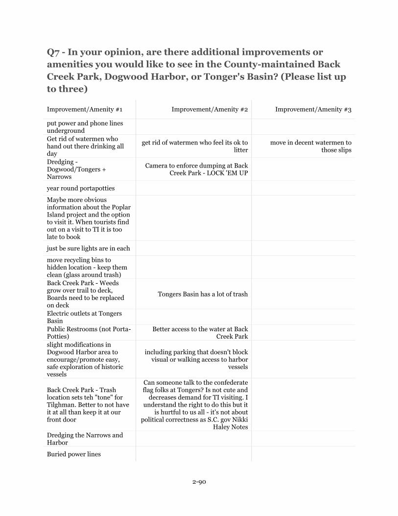
2-90
Q7 - In your opinion, are there additional improvements or
amenities you would like to see in the County-maintained Back
Creek Park, Dogwood Harbor, or Tonger's Basin? (Please list up
to three)
Improvement/Amenity #1 Improvement/Amenity #2 Improvement/Amenity #3
put power and phone lines underground
Get rid of watermen who hand out there drinking all day
get rid of watermen who feel its ok to litter
move in decent watermen to those slips
Dredging - Dogwood/Tongers + Narrows
Camera to enforce dumping at Back Creek Park - LOCK 'EM UP
year round portapotties
Maybe more obvious information about the Poplar Island project and the option to visit it. When tourists find out on a visit to TI it is too late to book
just be sure lights are in each
move recycling bins to hidden location - keep them clean (glass around trash)
Back Creek Park - Weeds grow over trail to deck, Boards need to be replaced on deck
Tongers Basin has a lot of trash
Electric outlets at Tongers Basin
Public Restrooms (not Porta-Potties)
Better access to the water at Back Creek Park
slight modifications in Dogwood Harbor area to encourage/promote easy, safe exploration of historic vessels
including parking that doesn't block visual or walking access to harbor
vessels
Back Creek Park - Trash location sets teh "tone" for Tilghman. Better to not have it at all than keep it at our front door
Can someone talk to the confederate flag folks at Tongers? Is not cute and
decreases demand for TI visiting. I understand the right to do this but it
is hurtful to us all - it's not about political correctness as S.C. gov Nikki
Haley Notes
Dredging the Narrows and Harbor
Buried power lines

2-91
Back Creek Park - maintained more (deck needs repairs, the walk is covered with weeds)
Trash around Tongers Basin
More lighting. More benches for people to enjoy
views.
More permanent tpye structures for bathrooms rather than port-
o-potties which detract from views and areas.
Trash dumpster at the recycling center at Back Creek Park(Lot of trash on ground)
Back Creek Park is Overgrown going up to the Look out
If we are paying the guys in the white county trucks. They sould actly do
work, not just ride around
I have seen them taking naps in the trucks at the parks,
Monitor& fine for litter Sitting benches/enhanced by flower
beds
New playground, the plastic coating has busted and metal is poking through
Switch to rubber chips at the playground
Plant fruit trees
Better launch ramp Fish cleaning station Rest room
Clean up parks Clean up basin
T.B. better parking Waterfountains/bathrooms Water acess B.C.P.
Fix the potholes in the driveway and parking lot
Concerts in the park Public Restrooms that were
maintained Kayak launch
Again clean up the drugs being sold and used in all of these locations.
Bike racks Possible covered seating area at the
dnd of dogwood harbor
Somehow better 'policing' if the dumpdters and general
iredponsible dumping ofvtrash thru pit our community
particularly at pur recycling bins at backcreek...pepple dump
household trash there all of the time, its horrible! our
Fully fenced Back Creek Park
Live stage
Would like to see the ball fields behind the school (which have a county sign) maintained
actually maintain it
spray park for ticks in summer
keeping recycling area clean

2-92
make sure the trash is picked up
some public transportation Additional sitting areas and
walking areas
more boat slips
fence in the park seperating parking lot
Back Creek Park access to Bay at the viewing platform
resurface blacktop at Dogwood and Tongers
electric hook up at Dogwood Harbor
Fuel sales at Dogwood Harbor - would cut down on traffic
public water access
remove recycling bins from Back Creek Park
cheaper water sports rental cheaper boat rentals, more
competition
well maintained public restroom
shade shelter at Dogwood Harbor Parks and recreation activities
maintenance of dockage additional dockage maintenance of boat ramp
Put up a fence with gate at Back Creek Park so children and pets can't run into parking lot and street
Trash in Back Creek Park needs to be emptied more often
Signs to not dump trash at recycle bins
Tilghman tourist info center and public restroom at Backcreek
Activity classes (kayaking, bird watching) at Backcreek
Small pool at Backcreek
no confederate flags at Tongers - insults visitors of all kinds
fence back of trash - signs about litter
mess is not compatible with child's park
better dog station service - bags, signs of pickup after pets, empty
waste
more trash cans for watermans use
Better visitor friendly graphics and interpretive program to better explain fishing industry in Tilghman
More trash recepticals at dogwood harbor and Tongers basin
Public toilet at tongers basin Cut tall brush Behind lookout
pier at back creek park
Water fountains
More slips Knapps Narrows needs to be dredged Removal of sunken boats in
Tonger's Basin
This should be up to the working watermen
Kayak rentals and/or lessons
Dogwood Harbor - Picnic tables and benches

2-93
Dogwood Harbor needs signs that say parking only with permit in places where you park your car and trailer
Better access to water at Back Creek Park - Clear area around steps and make a beach that you can sit on.
More parking for Dogwood Harbor
Clean up Tonger's Basin more frequently
Clean up Tonger's Basin Better water access at Back Creek
Park
Boat ramp maintenance
Kayak/paddle board rentals Tonger's Basin just looks like a dump
so anything would help there.
kayak, SUP, canoe rental and launch access
None None None
Kayak/paddle board rentals
Dogwood Harbor should have some more tourist type rental places to bring in revenue.

2-94
Q8 - Do you have any other suggestions or comments as to how
to protect and enhance the traditional working waterfront in
Tilghman, or to improve the overall quality of life in the village?
(Please explain)
Do you have any other suggestions or comments as to how to protect and enha...
We came here because we liked Tilghman. If it changes much, we would have a lot less interest in staying.
Install some common sense into Planning and Zoning. Example 1) adding a mooring piling to a 60+ year old pier became it was a few feet too close to the property line - what would it really hurt? 2) much too long to get permission for simple, no impact, changes! example 0 months for ok to add a pad for a home generator. WHY?
Growth needs to be limited. Tilghman is a fishing village and needs to remain so. Wealth cannot and should not dictate what is done on Tilghman. Tired of having wealthy people criticize native islanders and their lifestyle. What you have here are hard-working people that need to be left alone. This is not a luxury island. It is home to good people.
Just do everything to preserve our open land and fields and control any further building.
Complete transparency when changes have been proposed for the community. Some of the islands non-native residents who move here misspeak for the island and make statements that are false. Those who work here are trying to provide for families, not retired and looking for a vacation spot. Views that are often shared are not in favor of a working village. Daytime are not for the working men/people that are affected.
Signs allowed along roads to direct visitors to businesses; reduced parking and driveway requirements for new businesses; signage at entry and exit to St. Michaels indicating waterfront and heritage activities down the road on TI.
Continue to encourage collaboration or activities that bring together full time residents and part time residents - and people who have grown up on the island and those who choose to come here to live - don't want to lose that but rather enhance it!
One has to work on making this an attractive place for visitors and new residents if we are to have job created and more retail.
Have police presence - far from Easton and Saint Michaels
Retain the original "feel" or quaintness while still allowing for influx and growth - since the initial attraction was to the working water environment, that "look" needs to be preserved.
New people don't care about the natives and families of the island. Always want change - why did they move here? Retail can't come here - not enough business
My father was born on Tilghman and his family lived there for generations, with many Tilghman islanders still related to me living and working there. I would like to see the island, it's people, it's history, it's traditions and it's land kept from becoming another "st michaels". Which is no longer (in my opinion) the true waterman's village that it once was, where the people who worked in the viilage also lived in the village. Most who work in town can't afford to live in the town. Which is a total shame, and I fear Tilghman Island is headed that way.
The process of building our dreams has become way too difficult, The Tilghman watermans museum almost did not happen due to the County and State Restrictions, Philips wharf is having probles also. If the school closes it will be devastating to out community. We need Jobs, The future of Harrisons in Unknown and the other 3 resturants on tilghman have changed owners severl times in the last couple ouf years. STOP making it so difficult to open a business that serves our community.
Stopen building Housing Communities. Leave the place as it is
a great example of Controlled development / or enhancement Is continue education /dialogue with the county , ex. if a business is given a permit to establish in the village ,they also must enhance their

2-95
property( given business ) to the natural surroundings, thus giving back to the community.
Surveillance cameras or police presence in the night to deter theft
Drug, alcohol and theft are the biggest issues we face
I think many of my neighbors would benefit from the public busses making regular stops on Tilghman. It is very difficult for some to get to shopping and medical appointments.
There needs to be significant investment from the state as private investors do not exist here. Most watermans/seafood buyers do not have the capital to develop land and structures. A focus on education and next generation of aquaculture for young adults to sustain a healthy seafood population. This industry lacks ongoing education for its private workers.
preserve all the village names and identities
We all love Tilghman. Perhaps a bi-annual community meeting in which ways to continue to improve Tilghman can be discussed and assignments made.
Perhaps a "neighborhood watch" group to work in cooperation with law enforcement to minimize petty crimes (break-ins, burglaries, etc.)
It's great the way it is!
Make Tilghman a destination for ecology i.e. leverage poplar, NOAA + Phillips Wharf Environmental Center
Dredging Narrows, buildings in distress and need to be removed or remodeled, sidewalks to allow pedestrian walking.
There used to be a senior citizens group that met (weekly or monthly) at the church or firehouse that included lunch and various speakers. It is sorely missed. Upon reviewing my responses to this questionnaire, it appears that my goal is to run Tilghman for its citizens rather than for the tourists.
Those of us who live here bought here because we like the slow quaint place...unlike Easton and Saint Michaels.
Preserve zoning that discourages short-term rentals. Encourage family support activities for those with young children. The after school program at Tilghman Island elementary is a treasure and essential for the community.
Phillips Wharf Environmental Center - Seafood Market
limit construction of residential home and consider construction of necessary facilities to accommodate the increased population that reside in the area.
Bike path would be wonderful
No Sidewalks!
Public support for Phillips Wharf Environmental Center, Tilghman Waterman's Museum, and Tilghman Area Youth Association
Elementary school - open for youth/senior activities, mentoring, movie nights, arts programs, firehouse - emergency center during power outages, food classes/programs, exhibits, law enforcement center
limit jet ski use
No
fund Phillips Wharf - they protect the environment
Teach your children to respect the properties of others and to keep their environment clean.
If it is not broken - don't try to fix it! Tilghman is not broken or else folks would not be buying weekend homes

2-96
Traditional working waterfront are key words - watermen must have a place affordable to dock and carry out their livelihood - pots, bait, loading, unloading, etc... Maintaining the limited farmland is equally important w/o farms we have less food and diminished rural lifestyle.
Keep an outhouse year round at the park + basins
Start program to develop scatter site, small scale, affordable but compatible design for young watermen - housing - equipment lay down area.
Limit high rise buildings and condominiums. Preserve and provide more public free boat docking. Limit Airbnb rentals, provide noise ordinance against late night parties. Crackdown on known drug users.
I moved to Tilghman Island because I loved it just the way it is. Leave it alone!
Need more police presence. Close down drug house on Main Street
- Dredge Knapps Narrows more frequently so that it becomes a more user friendly thoroughfare - A concerted effort to save the wetlands and prevent further erosion.
Regulation of businesses that come in - i.e. no tourist traps. We want utilitarian businesses i.e fitness center, drug store, bowling alley, hardware store
My greatest fear is that if you keep developing Tilghman the way it sounds like you want it to you will end up with another St. Michaels on your hands. You will destroy Tilghman and the people who live here because of the way it is, people will no longer want to live here.
Closer working relationship between long-time residents and new residents
The challenge is that what makes it a charming village is also creating problems - especially for teens who are drinking alcohol and finding drugs for sale. Teen programs are essential. The Elementary School does an amazing job with after school care and summer camps, but as students age out there is nothing for them to do. This lack of programming and support creates an environment of crime and despair.
Create and install a large 'Welcome to Tilghman' sign at the entry to the Island. Re-establish the Tilghman Island newspaper. Most Important - We need young families, kids and working people.
Seafood market at PWEC. Bread baking company
Don't change it too much! It's beautiful!
More clarity on how and where commercial development is allowed in VC zone; Review regulations that affect watermen to assure they will always be part of Tilghman Island. They are its core.
Do not encourage development outside of "downtown" Tilghman. Place an historic overlay to regulate the size/appearence of new construction. Do not increase density between Tilghman and Easton along Route 33.
Knapps Narrows must be dredged!
I am adamantly opposed to either or both sidewalks and bicycle lanes on Tilghman (including and especially on Route 33). We are not St. Michaels! Bicyclists could end their trip on the other side of the bridge, or, if they cross, park their bikes at PWEC.
If people don't like the way it is they should move back where they come from! I own seven properties along Route 33 and I will not sign off for sidewalks on these properties.
more DNR involvement , dredging of the Knapps
Use Knapps Narrows properties for commercial seafood/boatyard and other water-related businesses.
Preserving the working waterfront is imperative, but I have no expertise to offer. I think that the "from here" population is falling further behind educationally and therefore socioeconomically. For the island to maintain its history and also prosper, this population needs significant training and workplace development. How you make that pallatable to them is a challenge.
Provide help to stop littering. Improve the drainage of storm water, especially on Barb Neck Rd at the top of Bar Neck Cove where the tidal water mixes with the old tailings from dredging done decades ago.

2-97
Keep village authentic, not a tourist trap like St. Michaels. Approach the State to stop closure of Rte 33 for St. Michaels events, greatly inconveniencing those who live below on the peninsula.
Need to attract young families with a better school and better jobs.
To bring in revenue - it needs to be made a 'destination.' What about making it a training area for athletes like Cambridge did for the Ironman? I'm not saying bringing in thousands of people that would ruin the island, but making it a place where athletes would come, stay, and train - it is a perfect launching place for something like bikers, runners, triathletes... Another thought is really developing PWEC and making it grow into a fantastic learning community about the Chesapeake Bay - the experts literally live right on the Island. Working museums, places for field trips for people to come to. The residents of the Island would really benefit from from resources being put back into the School. It has the space for a public library and a wellness center. That would be amazing for so many residents to have access to the internet and basic needs being met.
Dredge Knapps Narrows and help the town attract visitors thru various methods. Too many people think the world ends in St. Michaels. We need tourists to keep what little business is there open.
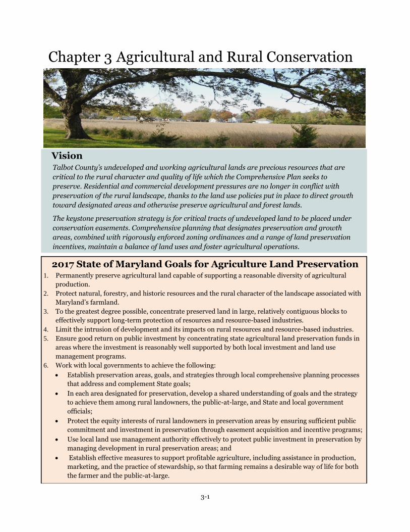
3-1
Chapter 3 Agricultural and Rural Conservation
Vision Talbot County’s undeveloped and working agricultural lands are precious resources that are
critical to the rural character and quality of life which the Comprehensive Plan seeks to
preserve. Residential and commercial development pressures are no longer in conflict with
preservation of the rural landscape, thanks to the land use policies put in place to direct growth
toward designated areas and otherwise preserve agricultural and forest lands.
The keystone preservation strategy is for critical tracts of undeveloped land to be placed under
conservation easements. Comprehensive planning that designates preservation and growth
areas, combined with rigorously enforced zoning ordinances and a range of land preservation
incentives, maintain a balance of land uses and foster agricultural operations.
2017 State of Maryland Goals for Agriculture Land Preservation 1. Permanently preserve agricultural land capable of supporting a reasonable diversity of agricultural
production.
2. Protect natural, forestry, and historic resources and the rural character of the landscape associated with
Maryland’s farmland.
3. To the greatest degree possible, concentrate preserved land in large, relatively contiguous blocks to
effectively support long-term protection of resources and resource-based industries.
4. Limit the intrusion of development and its impacts on rural resources and resource-based industries.
5. Ensure good return on public investment by concentrating state agricultural land preservation funds in
areas where the investment is reasonably well supported by both local investment and land use
management programs.
6. Work with local governments to achieve the following:
Establish preservation areas, goals, and strategies through local comprehensive planning processes
that address and complement State goals;
In each area designated for preservation, develop a shared understanding of goals and the strategy
to achieve them among rural landowners, the public-at-large, and State and local government
officials;
Protect the equity interests of rural landowners in preservation areas by ensuring sufficient public
commitment and investment in preservation through easement acquisition and incentive programs;
Use local land use management authority effectively to protect public investment in preservation by
managing development in rural preservation areas; and
Establish effective measures to support profitable agriculture, including assistance in production,
marketing, and the practice of stewardship, so that farming remains a desirable way of life for both
the farmer and the public-at-large.

3-2
Goal
Conserve Talbot County’s agricultural land base and preserve its rural character by directing growth
to existing population centers and securing permanent conservation easements in predominantly
rural areas.
Introduction
Agriculture is a significant part of Talbot County life, both as a major industry and as an important
contributor to the county’s distinctive character. Working farmland is a valuable and limited natural
resource that once developed, cannot be reclaimed for agricultural use.
Conservation of working land is an important component of support to the agricultural industry. In
spite of increasing development pressure on agricultural and open space lands, Talbot County
continues to derive benefit from conserving these elements of rural character.
In order to preserve agricultural land and open space, the County, in 1991, adopted a comprehensive
rezoning of rural and agricultural lands, reducing the density permitted in agricultural areas from
one dwelling unit per two acres.
Figure 3-1 Talbot County Farm Statistics, 1982-2012
Farm number and size 1982 1987 1992 1997 2002 2007 2012
Number of farms 350 280 250 240 288 305 328
Average size (acres) 342 389 423 457 367 357 364
Land in farms (acres) 119,684 109,032 109,108 109,572 105,729 109,002 119,481
Source: USDA Census of Agriculture
General Agricultural Land Use Policies
3.1 Agricultural and forestry activities are the primary and preferred land use activity in rural
areas of the county.
3.2 Agricultural and forestry activities should be conducted in accordance with best management
practices for soil and water conservation which are approved by the Natural Resources
Conservation Service.
3.3 Agriculturally-related commercial and industrial uses are permitted in the non-Critical areas
of the county, provided these uses can be compatible with surrounding land uses and do not
adversely impact environmentally sensitive areas.
3.4 Low density single-family residential construction is permitted in agricultural areas.
Development design standards for rural residential development should insure the conservation
of agricultural lands, open space, woodlands, environmentally sensitive areas and rural
character.
3.5 Rural landowners should be provided the opportunity to transfer development rights from a
property in order to maintain development equity and conserve agricultural lands and open
space.

3-3
MALPF Preserved Farm near Cordova
In its place, zoning now allows a variable density somewhat less than one unit per twenty acres on
most farmland. This density has been modified by SB236.
To maintain the commercial viability of agriculture, clustering of subdivided lots is generally
required. Code amendments passed in 2007 eliminated the opportunity to increase development
intensity through the use of Transferable Development Rights (TDRs).
To further protect agriculture as a land use activity, a Right to Farm ordinance was enacted in 2000,
stressing the County’s commitment to agriculture and helping to protect farmers from unwarranted
nuisance complaints.
The most current Census of Agriculture reports an increase in area and number of farms from 2002
to 2007, and again in 2012. New calculations bring numbers close to the farm acres from 1982. The
average farm size remains below the historic high in 1997.
Some of these fluctuations may be due to changes in the definition of farming operations or the way
census data were gathered. The period was also one of industry consolidation, followed by a recent
interest in the establishment of smaller specialty farms.
Changes in farmland acreage over the past 50 years are shown in Figure 3-1.
Existing Land Preservation Programs
MALPF
Founded in 1977, the Maryland Agricultural Land Preservation Foundation (MALPF) is one of the
oldest and most successful programs of its kind in the nation. The MALPF program is intended to
permanently protect farmland by offering landowners financial incentives to voluntarily sell
development rights. The Foundation’s purpose is to preserve sufficient agricultural land to maintain
a viable food and fiber production capacity for present and future citizens of Maryland. The program
is administered by the County and State in an equitable partnership.
Talbot County has a moderately successful MALPF program. Community participation has been
steadfast and increasing. Landowners have applied to establish easements on an increasing number
of farms in every application period. Each annual round of easement purchases has been highly
competitive, with only the highest quality farmland purchased in any year.
Presently, Talbot County’s MALPF holdings consist of 10,905 acres in 71 easements, with 11,003
acres on 88 properties vying for future
easement purchases. As a MALPF Certified
County, Talbot is qualified to retain a portion
of agricultural transfer taxes collected in the
county, to be reserved for land preservation.
The County has used, and intends to use, all
retained funds to purchase development
rights, supplement MALPF payments, or
promote the sale or purchase of easements.
Certification allows Talbot County to retain
2/3 of all agricultural transfer tax revenues
collected, for the sole purpose of purchasing
agricultural easements in the county.
Easement applications reached a record high

3-4
Talbot County Rural Landscape
in 2006, as State funds for land preservation peaked. Most of the decade was characterized by
dramatic increases in land value, and a corresponding increase in easement acquisition costs. The
net effect was a greater per-acre cost to purchase agricultural easements.
By 2008, land preservation in the County and State came to a halt, due to the economic recession
and its impact on tax revenues which fund the MALPF program. With little funds available to
purchase easements, progress in land preservation has slowed considerably.
In order to add predictability and a greater degree of local control, the County should pursue
additional sources of funding, both public
and private, to acquire conservation
easements.
Talbot County remains committed to
assisting local property owners who are
interested in participating in MALPF or
other local, regional, state and national
conservation programs. The County will
continue to work with the State to actively
encourage more farmers to participate in
MALPF and other programs.
Conservation Programs
Land Trusts
Non-profit land trusts play an invaluable role helping to protect the county’s rural and agricultural
landscape. Unlike MALPF, which purchases easements for cash, land trusts typically accept donated
easements in exchange for federal and State income tax credits and deductions.
Over one half of the land that is preserved from future subdivision and development in the county
has been protected (at no cost to the County) by two such organizations the Eastern Shore Land
Conservancy (ESLC) and the Maryland Environmental Trust (MET). These organizations craft
conservation easements that extinguish legal development rights and hold easements on preserved
lands. The easements are recognized as tax deductible donations. Property owners who wish to
voluntarily conserve land agree to deed restrictions that preserve farmland, forests, streams,
shorelines and other important resources.
As of this report, approximately 100 such easements protect about 15,000 acres of land within the
county. Most properties are in areas designated for limited development and environmental
conservation in County land preservation plans. The County should continue to support these
organizations with data sharing and other resources in their efforts to acquire conservation
easements.
Historically, the Chesapeake Bay Foundation and the Nature Conservancy have also acquired land or
easements to protect critical resources such as old growth forests and marshland. These sensitive
resources are valued habitat protection areas for threatened and endangered species and the
ecological diversity they preserve.
Rural Legacy and Program Open Space
The Agricultural Security Rural Legacy Area was developed by the Eastern Shore Land
Conservancy, in cooperation with Talbot and other Midshore counties, in order to preserve lands

3-5
MALPF Easement Outside Easton
bordering waterways such as the Tuckahoe River in the northeast corner of the county.
The Talbot portion on the Tuckahoe is part of an upper shore Agricultural Security Corridor,
established to help safeguard the Eastern Shore’s agricultural economy. The northeast quadrant of
the county is a hub of agricultural production and investment, stressing the importance of land
preservation. About 830 acres in the county have been preserved through Rural Legacy easements.
Future Rural Legacy Areas may provide for additional protection of farmland paralleling MD Route
404, in cooperation with Queen Anne’s County, in an effort to maintain the Corridor’s Rural
Character in spite of ongoing transportation system improvements.
DNR Lands
The Maryland Department of Natural Resources (DNR) manages several publicly owned parks and
protected sites in Talbot County. These 238 acres of public lands include Black Walnut Point Natural
Resource Management Area, Bill Burton Fishing Pier State Park, Wye Oak State Park and Seth
Demonstration Forest. The sites provide recreational water access, passive recreational opportunities
and natural resource services to local residents and visitors alike.
TDR Lands
Transfer of Development Rights (TDR) lands are properties that have participated in a County
managed TDR program and have sold or transferred development rights from one property to
another, preserving land as open space or agricultural lands. The County does not permit TDRs at
present.
Priority Preservation Areas
The Talbot County Department of Planning and
Zoning adopted a Priority Preservation Area (PPA)
plan as an element of the Comprehensive Plan, in
2009. The element was required for counties with
certified MALPF programs. The intent was to assure
that State funds were used in a strategic fashion to
meet local goals.
The Talbot County PPA encompasses approximately
83,000 acres and includes the majority of existing
MALPF easements and prospective properties, the
Tuckahoe Rural Legacy area, and several conservation
easements. The PPA is home to a high percentage of
local farm owner/operators. Farm operations are
diverse, ranging from grain and poultry, to
aquaculture, greenhouse and hydroponic growers,
wine grapes, artisan cheeses and specialty produce. The area hosts a variety of agricultural support
services including grain storage facilities, agricultural equipment dealers and a network of
specialized service providers.
The PPA also contains high concentrations of the most productive soils in the county and is capable
of supporting profitable agricultural and forestry enterprises. In 2004, Talbot County partnered with
The Conservation Fund to develop a Green Infrastructure Plan identifying and evaluating areas of
high natural resource and agricultural value. This research provided important background toward
establishing a viable priority area.

3-6
Virtually all land in the PPA is designated for agriculture in the County Zoning Ordinance.
Agricultural Conservation (AC) zoning predominates, with slightly more restrictive Rural
Conservation (RC) zoning in the Chesapeake Bay Critical Area. The County has no plans to extend
sewer or water into the PPA.
Almost all of the PPA has been designated Tier 4 in accordance with the Sustainable Growth and
Agricultural Preservation Act. Tier 4 is designated for limited development, and each parcel is
limited to seven new subdivisions, regardless of the acreage of the parent parcel. Zoning places other
constraints and restrictions on non-agricultural development activities in order to minimize conflicts
with agriculture.
Among the uses not permitted in the PPA are Auto Service Stations, Hospitals, Hotels, Manufacturing,
Nightclubs, Offices, Indoor Recreation Facilities, Major Retail and Solid Waste Disposal. Prohibiting
large or intensive non-residential development will minimize the threats of conflicting uses, heavy traffic
and the lure to take land out of agricultural production.
The County has worked to minimize constraints or restrictions on farm related activities by amending
zoning regulations to accommodate a range of contemporary uses. For example, farm markets, produce
stands, wholesale and retail greenhouses, fish and game hatcheries, and riding stables are all permitted
uses in agricultural areas.
The PPA is bound and bisected by major traffic and tourism routes to Maryland and Delaware beaches.
Despite the obvious attraction to develop these byways, non-agricultural development has been
restricted almost exclusively to the incorporated towns along the highways. Priority Preservation Area
goals are shown in Figure 3-2.
Figure 3-2 Talbot County Priority Preservation Area Goals
acres Farms (est.) % of farm land
Farm Land (Census of Agriculture, 2012) 119,481 328 100%
MALPF Preserved Land (2012) 10,905 71 10%
MALPF Eligible Land in PPA 70,000 488 64%
20 Year MALPF Preservation Goal 56,000 391 51%

3-7
Land Preservation Policies
3.6 The County should encourage rural property owners to participate in land preservation
easement programs offered by national, State, regional and local land trust organizations.
3.7 The County should work with local farmers and the Maryland Agricultural Land Preservation
Foundation to encourage the greatest possible participation in the program.
3.8 The County should monitor the effectiveness of current incentives designed to preserve
working farmland and open space by reviewing land use changes in the Rural Reserve planning
area.
3.9 The County should examine opportunities to create additional tax or other incentives to
preserve farmland.
3.10 The County will maintain a Priority Preservation Area program that specifies goals, an
implementation program, program evaluation, and program development strategy.
Also included in the PPA are the villages of Cordova, Bruceville, Ivytown, Williamsburg and Wye Mills,
which are emblematic of Talbot County’s agricultural heritage. For example, Wye Mills traces its roots to
the Colonial period when the extant grain mill was first established. Cordova’s history dates to the 20th
Century commodity-based agricultural boom and remains central to grain and poultry production.
There are approximately 4,130 parcels of record in the PPA. Of those, about 650 parcels are 50 acres or
greater; 488 of those MALPF-qualifying parcels are not yet preserved or enrolled in a preservation
program. The parcels that would qualify for the MALPF program amount to approximately 70,000 acres
of farm and forest land.
Talbot County has retained a ‘district’ registration system based on the former statewide
requirement, with a nonbinding 3 year program commitment. The Department of Planning and
Zoning encourages registration as a district to assure that a parcel meets program requirements
and that landowners are contacted during each application cycle.
Summary
If Talbot County continues to secure MALPF easements at its historic rate, it will take over 100 years
to reach agricultural land preservation goals. In order to achieve a 20-year preservation goal of
56,000 additional acres, easements would need to be acquired at a rate of 2,800 acres per year.
Adequate funding is the most significant impediment to achieving County preservation goals. Funds
are scarce at every possible level of source. Interest in land preservation has remained strong
through periods of scarce funding and episodes of extraordinary fluctuations in land and easement
values.
To the public, there is no apparent difference between permanently preserved land and other farm
property. Whether land remains in agriculture because commodity prices are high, or because the
demand for new housing is low, County policies appear to be working when new residential
subdivisions are not emerging on the landscape.
Talbot County is not unique in this respect. All Maryland counties face challenges and tradeoffs in
their efforts to manage land development while working cooperatively with landowners. As
development restrictions increase, the motivation for landowners to participate in preservation
programs diminishes.
State legislation establishing Priority Preservation Areas and limiting the number of subdivisions

3-8
allowable on septic systems have added greater focus to the goals of preserving viable agricultural
areas and limiting a pattern of sprawling development. The challenge for Talbot County is to
combine such regulations with policies that support farm families and businesses in their endeavors.
To a great extent, County policies have been working. A combination of ‘moderately protective’
zoning, land use priorities backed by incentives and regulations, and Right to Farm legislation all
serve to keep agriculture viable.
Thanks to Talbot County’s longstanding local traditions, affinity for a rural landscape, and a healthy
regional market for agricultural products, the motivation to preserve agricultural land and
agricultural industry remains strong.

3-9

3-10

4-1
Chapter 4 Natural Resource Conservation
Goals Conserve and protect Talbot County’s most valuable and attractive assets, its natural resources.
Maintain, in cooperation with the local municipalities, a safe and adequate water supply and
adequate amounts of wastewater treatment capacity.
Take steps to protect and restore water quality, and to meet water quality requirements in rivers
and streams.
Conserve major accessible mineral resource deposits for future extraction while safeguarding
the public by minimizing the environmental impacts of resource extraction and transport.
Establish and enforce programs and regulations to ensure preservation of natural resources,
provide tax, financial, and any other incentives for compliance while allowing for moderate
planned growth and development on existing lots or record.
Vision
Because our natural resources and sensitive areas are critical to the quality of life in Talbot
County and because significant components of our local economy depend upon clean and
abundant waters, the County takes the necessary steps to reduce runoff and other
pollutants into its waters. The means of enforcing these provisions are adequately funded,
and measurable, objective criteria for monitoring the success of our efforts are in place.
Groundwater and aquifers—as well as wetlands, rivers and bays — are aggressively
protected for the future. Measurable standards are in place to determine whether
development threatens to deteriorate our groundwater or reduce our aquifers to
unsustainable levels.
Thanks to adequate safeguards, sand and gravel extraction and closure of extraction sites
avoid environmental damage. Site recovery and conversion to ponds and wooded areas
controls runoff, helps maintain groundwater tables, beautifies the landscape and creates
opportunities for parks and recreational areas.
To ensure the adequacy of the infrastructure prior to any development, the County strives
to ensure that the cost of development is borne by the developer. Public infrastructure
capacities are based on peak, rather than average, load requirements.

4-2
State of Maryland 2017 Goals for Natural Resource Conservation
Identify, protect, and restore lands and waterways in Maryland that support important aquatic and
terrestrial natural resources and ecological functions, through combined use of the following techniques:
o Public land acquisition and stewardship;
o Private land conservation easements and stewardship practices through purchased or donated
easement programs;
o Local land use management plans and procedures that conserve natural resources and
environmentally sensitive areas and minimize impacts to resource lands when development
occurs;
o Support and incentives for resource-based economies that increase retention of forests, wetlands,
or agricultural lands;
o Avoidance of impact on natural resources by publicly funded infrastructure development projects;
and
o Appropriate mitigation response, commensurate with the value of the affected resource.
Focus conservation and restoration activities on priority areas, according to a strategic framework such
as the Targeted Ecological Areas (TEAs) in GreenPrint (which is not to be confused with the former
easement program also called GreenPrint).
Conserve and restore species of concern and important habitat types that fall outside the green
infrastructure (examples include: rock outcrops, karst systems, caves, shale barren communities,
grasslands, shore line beach and dune systems, mud flats, non-forested islands, etc.)
Develop a more comprehensive inventory of natural resource lands and environmentally sensitive areas
to assist State and local implementation programs.
Assess the combined ability of State and local programs to:
o Expand and connect forests, farmlands, and other natural lands as a network of contiguous green
infrastructure;
o Protect critical terrestrial and aquatic habitats, biological communities, and populations;
o Manage watersheds in ways that protect, conserve, and restore stream corridors, riparian forest
buffers, wetlands, floodplains, and aquifer recharge areas and their associated hydrologic and
water quality functions;
o Adopt coordinated land and watershed management strategies that recognize the critical links
between growth management and aquatic biodiversity and fisheries production; and
o Support a productive forestland base and forest resource industry, emphasizing the economic
viability of privately owned forestland.
Establish measureable objectives for natural resource conservation and an integrated State/local
strategy to achieve them through State and local implementation programs.
Introduction
Talbot County’s most notable feature is its proximity to the Chesapeake Bay and its 600 mile,
irregular shoreline. Bordered by the Chesapeake Bay to the west, the Choptank River to the south
and east, and the Tuckahoe River to the northeast, Talbot County is nearly surrounded by tidal
waters. Along its western edge, the county takes the form of numerous peninsulas, necks, coves and
creeks.
The County’s history is reflected in its landscape. The land and waterways are intertwined in a
unique mosaic of tidal waters, streams, farmlands, and forests, following settlement patterns dating
to pre-Colonial times. A scattered patchwork of farms, estates, villages, and towns grew from

4-3
Natural Resource Policies
4.1 The County shall maintain countywide policies for conservation and protection of natural and
cultural resources.
4.2 The County will enforce mandatory programs and regulations, and develop financial
incentives to insure preservation of natural resources.
4.3 Where required, the County shall call for evidence of federal and State environmental
permits as a condition of local development approval.
4.4 The County requires all new major subdivisions to submit an environmental impact
assessment prepared by a qualified professional as part of a development application. The
assessment must include all environmentally sensitive features on and adjacent to the site.
4.5 The County will maintain a Geographic Information System (GIS) inventory and map of
countywide natural resources to assist with resource preservation management.
4.6 The County should promote and encourage partnerships to maintain comprehensive baseline
data providing a measurable basis for pollution monitoring. Baseline data for air and water
quality should be tracked to measure progress on environmental quality indicators.
4.7 The County will maintain cooperative partnerships with State, federal and town government
agencies to address environmental problems as needed.
traditions long centered on farming, seafood and maritime industries.
This Plan references the 2010 Census counts and projections. It also incorporates the septic tier
system required by SB 236 into the Comprehensive Plan. New to this chapter are the recent State
requirements for a Water Resources Element in the Comprehensive Plan and the Total Maximum
Daily Load (TMDL) program.
The conservation and protection of sensitive natural resources transcends man-made boundaries.
Loss of forest land, polluted runoff coursing into local waters, loss of agricultural land, and
development in sensitive areas are all significant
issues countywide.
Uniquely, over one third of the county’s land area is
within the Chesapeake Bay Critical Area. The County’s
Critical Area program contains strict regulations for
the protection of these sensitive shoreline areas.
Floodplain regulations extend additional safeguards
within the 100-year floodplains.
Because sensitive areas are more vulnerable to
environmental degradation, future development
should be directed away from such areas and guided
toward areas where environmental impacts would be
less severe. All future development, regardless of
location, should be subject to minimum performance
standards for environmental protection and natural resource conservation.
The costs of resource restoration are far greater than those of resource conservation and protection.
The loss of natural resources must either be accepted or the costs must be borne by County taxpayers
to address the consequences of environmental degradation. The cost in tax dollars expended for

4-4
water quality remediation in the Chesapeake Bay is a case in point.
Environmental quality is one attribute that makes Talbot County an especially desirable place to live
and work. Efforts to conserve and protect natural resources yield long-term public benefits. The
intent of County environmental protection measures is not to stop growth or development, but to
ensure that development occurs without impairing the environmental sustainability of sensitive
areas.
Water Resources Element
Background
The Water Resources Element represents a policy framework for sustaining public drinking water
supplies and protecting the county’s waterways and riparian ecosystems by effectively managing
point and non-point source water pollution.
State Requirements for Water Resources Element
This Water Resources Element complies with the requirements of State law as modified by
Maryland House Bill 1141, passed in 2006. Among the
requirements addressed in this section are:
1. To identify drinking water and other water
resources that will be adequate for the needs of
existing and future development proposed in the
Plan’s land use element, considering available
data;
2. To identify suitable receiving waters and land
areas to meet stormwater management and
wastewater treatment and disposal needs of
existing and future development proposed in the
land use element of the plan, considering
available data provided by the Maryland
Department of the Environment (MDE);
3. To deliver the Plan for review by the Department
of the Environment to determine whether the
proposed Plan is consistent with the program
goals of the Department.
The original element was reviewed by MDE, and adopted by the Talbot County Council in December,
2010. It has been amended to include more recent data from the 2010 U.S. Census, along with
updated growth projections as described in Chapter 1 (Background).
The Water Resources Element incorporated in this Plan identifies opportunities to manage existing
water supplies, wastewater effluent, and stormwater runoff in a way that balances the needs of the
natural environment with the County’s land use plans, including the County’s municipalities. The
emphasis is to protect the local and regional ecosystem while ensuring clean drinking water for
future generations of County residents.
This Element takes a watershed-based approach to analyze the impact of future growth on Talbot
County’s water resources, particularly in relation to discharged nutrients.

4-5
Inter-jurisdictional Coordination
The County recognizes the importance of inter-jurisdictional water resources planning. This Plan
compiles, to the greatest degree possible, up-to-date statistics in order to coordinate water resources,
growth, and land use planning. Data from municipal plans were used for this assessment. Where
possible, Talbot County has also obtained data and information on water resources from adjoining
counties, in order to paint the fullest possible picture of future impacts to the Choptank, Wye, and
other rivers and streams that form Talbot County’s boundaries.
There are five incorporated municipalities in Talbot County. Residents and businesses of the
communities of Easton, Oxford, St. Michaels and Trappe receive public water and/or sewer service.
Queen Anne residents and businesses do not receive public water or sewer service. Municipalities
own and operate all of the public water systems in Talbot County. Easton, Oxford, and Trappe
operate their own wastewater treatment plants.
County Projections and Scenarios
This chapter uses countywide population projections by the Maryland Department of Planning
(MDP), referenced in Chapter 1. These projections indicate that the county population will reach
Figure 4-1 Projected Housing Unit Growth by Watershed, Through 2030
Watersheds 2007 Existing2
2007-2030 Growth
Increment 2030 Total
Eastern Bay 242 85 327
Lower Chesapeake Bay 5 0 5
Lower Choptank River
Easton1 5,224 1,141 6,365
Trappe1 368 116 484
St. Michaels1 327 5 332
Oxford 963 20 983
Remainder of Watershed 6,077 237 6,314
Miles River
Easton1 896 119 1,015
St. Michaels1 693 91 784
Remainder of Watershed 2,087 119 2,206
Tuckahoe Creek
Queen Anne 48 4 52
Remainder of Watershed 567 103 670
Upper Choptank River
Easton1 506 45 551
Trappe1 117 336 453
Remainder of Watershed 1,386 185 1,571
Wye River 677 156 833
Total 20,183 2,762 22,945
Notes: 1: Includes the portion of the municipality (including areas likely to be annexed, based on the Talbot County Water and Sewer Master Plan) that falls within this watershed. 2: Source: Maryland Property View 2007

4-6
approximately 42,900 by the year 2030, an increase of roughly 5,120
persons from the 2010 population of 37,782.
At the time the Water Resources Element was prepared in 2010, the County
and its municipalities had granted at least preliminary approval for more
than 5,500 housing units. Three thousand of these were planned by the
Town of Trappe. For the purposes of the following analysis, it is understood
that some of the approved units will not be built and occupied by 2030, nor
be occupied by full-time residents.
Though MDP conducted a Development Capacity Analysis in 2010
indicating that over 20,000 new housing units could be accommodated
under County zoning, subsequent actions have rendered such an outcome
less likely. For example, the Sustainable Growth and Agricultural
Preservation Act of 2012 (the septic tier system) has substantially limited
subdivision potential for large rural parcels.
Future Development Scenario
A single future development scenario, based on pre-2010 population projections, was developed for
the 2010 Water Resources Element in order to evaluate the sustainability of the County’s 2005
Comprehensive Plan.
The non-point source loading analysis continues to anticipate the use of septic denitrification
technologies to improve the quality of the County’s receiving waters. Also, plans are underway to
extend sewer to areas of failing septic systems and mapped communities and subdivisions in
environmentally sensitive areas, further reducing the amount of nitrogen and bacteria released into
rivers and the Chesapeake Bay.
Because water and sewer service is often measured in terms of equivalent dwelling units (EDU), the
Water Resources element uses housing units as the basis for its water, sewer and non-point source
pollution analyses.
Figure 4-1 shows the projected watershed-level distribution of housing units in the 2010 scenario.
Figure 4-2 Source Aquifers for Existing Public Water Systems, 2000
Water System¹ Source Aquifer (number of wells) Source Concerns / System Issues
Easton Aquia Greensand (1), Magothy (3), Upper Patapsco (2)
Elevated arsenic levels
Oxford Area Aquia Greensand (2) Elevated arsenic levels
St. Michaels Aquia Greensand (2) Elevated arsenic levels
Trappe1 Piney Point (2)
Claiborne Aquia Greensand (2) System size limitations, leakage. Elevated arsenic levels
Hyde Park Aquia Greensand (2), Federalsburg (1) Elevated arsenic levels
Martingham Aquia Greensand (2) Elevated arsenic levels
Sources: 2002 Talbot County Water and Sewer Master Plan; 2009 Trappe Comprehensive Plan (WRE); 2009 Easton Comprehensive Plan (WRE).
Notes:
1: Trappe also has groundwater allocations from the Matawan Aquifer, although there are no active production wells in this formation

4-7
Revised (2012) population estimates change the projections slightly: There were slightly fewer
households than estimated (19,577 rather than the 2007 estimate of 20,183). The number of
households projected in 2030 has also been revised from 22,866 to 22,945. However, the
assumption remains that about 70 percent of new housing units will be built in municipalities,
including those areas identified as the towns’ future growth areas.
The updated projections have not changed the core planning assumptions and so the scenario has
been altered little from the original.
Drinking Water Assessment
This section describes existing conditions and projected future demand for drinking water in Talbot
County.
Public Water Systems
Groundwater is the source of all public and private drinking water in Talbot. Groundwater quality in
the county is generally good. Elevated levels of naturally-occurring arsenic are known to be present
in some areas. Saltwater intrusion in the Aquia aquifer is a known problem in the region of the
Eastern Shore and may also be a special concern in the County's coastal areas. These issues are
discussed in more detail in the section below.
Figure 4-2 summarizes municipal and community water sources in the County. The Talbot County
Comprehensive Water and Sewerage Plan (CWSP) provides detailed information on county water
supply sources, existing and proposed water facilities, and schedules for improvements. The County
has a groundwater protection plan, and during the update process the County applied changes
in accordance with new federal water quality standards.
Approximately 9,600 dwelling units in Talbot County, and a considerable share of businesses,
receive drinking water from municipal and community water systems. The Towns of Easton, Oxford,
St. Michaels, and Trappe all operate municipal water systems. There are also private community
water systems in the communities of Claiborne, Martingham under the County’s jurisdiction, and
Hyde Park in the Town of Easton.
All of the major public water systems in the County have available system capacity to support
projected growth through 2030. Available source water supply is covered in the Issues and
Discussion section on the subsequent page.
Figure 4-3 Talbot County Groundwater Withdrawals by Use Category, 2007
Type of Withdrawal Total Withdrawals (MGD) Percent of County
Withdrawals Surface Water Groundwater Total
Industrial 0 0.88 0.88 11%
Livestock Watering 0.02 0.12 0.14 4%
Irrigation 0.69 1.35 2.04 14%
Residential self-supplied 0 1.61 1.61 26%
Public Supply 0 2.55 2.55 39%
Total .71 6.51 6.00 100%
Source: USGS MD-DE-DE Water Science Center http://md.water.usgs.gov/freshwater/withdrawals/

4-8
Other Water Use
All residential units and businesses in Talbot County not served by the public water systems rely on
individual or community wells. These wells are drilled in a variety of water-bearing formations,
particularly the Columbia (or surficial) aquifer, Miocene, Piney Point and Aquia aquifers. Although
not a precise representation of current water use, public water and private residential wells represent
almost two thirds of all water use in the County.
There were 329 active groundwater appropriation permits in Talbot County in 2002, drawing a daily
average of 6.4 million gallons per day (MGD). A complete summary, Hydrogeology of the Coastal Plain
Aquifer System in Queen Anne's and Talbot Counties, can be accessed at
http://www.mgs.md.gov/publications/report_pages/RI_72.html.
The remainder of this section discusses non-public water uses in greater detail.
Private Residential Wells
About 10,500 residential units in Talbot County rely on individual wells or (in a few cases) community
wells for drinking water supply, as do most businesses in rural areas. Private residential wells generally
draw water from the Piney Point aquifer in the western and southern portions of the county, and the
Aquia and Miocene aquifers in the central portion. Some older residences, particularly in the north and
east continue to draw from the Columbia aquifer.
The total projected new demand for public water systems includes the transfer of some homes and
businesses from private wells to public systems. These connections would add to the demand for public
water service but not to the overall withdrawals from aquifers.
Major Commercial and Industrial Users
Commercial and industrial activities outside of municipal systems account for approximately one-
fifth of all water used in Talbot County. The largest concentrations of such water use are found in
Cordova and in areas adjacent to Easton and Trappe. The majority of non-municipal
commercial/industrial water use is scattered throughout the county’s rural areas, typically along U.S.
50 and other major roads.
Agricultural Water Users
As is the case throughout the Eastern Shore, Talbot County’s farmers employ irrigation using both
surface water and groundwater. Irrigation is most frequently used in areas to the south and east of
Easton. Most surface water used for irrigation is drawn from Tuckahoe Creek. Groundwater for
irrigation is generally drawn from the surficial aquifer. Recent droughts and near-droughts have led
to an increased number of acres under irrigation since 2000, however usage is not consistent from
year to year. In the 2014 Farm Services Agency report, irrigation was available on approximately
4,660 acres of farmland.
Issues and Discussion – Water
Groundwater Recharge
Talbot County’s public and private water users draw drinking water from several major confined
aquifers, many of which are widely used throughout the region. The capacity of these confined
aquifers is increasingly strained by new development on the Delmarva Peninsula and west. (See
Figure 4-3, Talbot County Groundwater Withdrawals by Use Category, 2007.)
The U.S. Geological Society (USGS) reports that “withdrawals from Maryland Coastal Plain aquifers

4-9
Generalized areas where arsenic concentrations exceed 10 micrograms per liter in the Aquia (left) and
Piney Point (right) aquifers (shaded areas). Source: ARSENIC IN GROUND WATER IN THE COASTAL PLAIN
AQUIFERS OF MARYLAND by David D. Drummond and David W. Bolton, 2010.
Map 4-A
have caused ground-water levels in confined aquifers to decline by tens to hundreds of feet from
their original levels. Continued water-level declines could affect the long-term sustainability of
ground-water resources in agricultural areas of the Eastern Shore” (Sustainability of the Ground
Water Resources in the Atlantic Coastal Plain of Maryland. USGS Fact Sheet 2006-2009). In most
cases, the recharge areas for these aquifers extend to the Western Shore.
No comprehensive study exists of the water-bearing formations used by Talbot County residents and
businesses. While the County understands that its groundwater supplies are limited and declining,
there is no reliable measure of water supply against which to compare current and especially
projected water demands. Project-specific groundwater studies do not take into account the
cumulative impacts, on both sides of the Chesapeake Bay, of increasing demand on the Aquia and
other formations. Concentrations of arsenic in groundwater is a localized concern which is illustrated
in Map 4-A. MDE, the Maryland Geological Survey (MGS), and the U.S. Geological Survey (USGS)
have begun work on a Coastal Plain Aquifer Study, but that study remains incomplete. The County
should use the data and recommendations of the Coastal Plain Aquifer Study (once completed) to
shape its own water use policies and ordinances.
For purposes of this Plan, it is assumed that groundwater permits issued for public drinking water
systems by MDE reflect the maximum safe yield of the aquifer or aquifers used by that system.
However, the County also recognizes the need for the development of regional plans and policies to
protect our diminishing groundwater resources. To that end, the County will work with the State and
appropriate county governments to encourage the establishment of a multi-county organization to
better manage our major aquifers. Talbot County supports the commitment by the MGS and USGS to
complete the Coastal Plan Aquifer Study, followed by a management plan to steward our shared
water resources. Local resources are inadequate to the task. Implementation of a management plan
will require effective inter-jurisdictional coordination and management.

4-10
Groundwater Protection
In addition to these concerns about water supply in the Aquia, individual wells in the surficial aquifer
are at risk for elevated nitrate levels due to cross-contamination from failing or inadequate septic
systems or agricultural fertilizer.
The Talbot County Groundwater Protection Plan (GPP) was developed in 1987, and identifies areas
where septic systems may be allowed. The GPP establishes the design criteria and construction
requirements for all septic systems, and designates areas that require maximum protection of
shallow groundwater aquifers. The GPP is adopted as an appendix to the County’s Water and Sewer
Master Plan, and is enforced by the Talbot County Health Department.
Water Conservation
The County and its municipalities implement, through building codes, the Maryland Water
Conservation Plumbing Fixtures Act (MWCPFA), which requires that plumbing fixtures sold or
installed for new construction be designed to conserve water. In addition, the Water and Sewer
Master Plan enumerates several benefits of water conservation and encourages water conservation
as an official policy. The County and its municipalities actively encourage water conservation
through education and water use monitoring.
Potential New Water Supplies
To assure sustainability, the County and its municipalities should begin to investigate the limits of
existing source capacity and the feasibility of other drinking water sources, including different
aquifers and surface waters.
Although not widely used for water supply, the Matawan, Patapsco, and Upper and Lower Pawtuxet
formations are also under Talbot County, as described in Hydrogeology of the Coastal Plain Aquifer
System. The Town of Easton draws some of its water from the Matawan, while the other aquifers
listed above are not widely used for water supply.
More detailed investigation is necessary to determine whether these aquifers are of sufficient quality
to produce a reasonable quantity for human consumption. Also, the aquifers listed above also exist at
significantly greater depths than the Aquia and Piney Point, adding to the cost of wells.
Surface water impoundments are not currently used for drinking water in Talbot County.
Nevertheless, surface water cannot be ruled out as a potential new source and should be included in
any comprehensive study of new drinking water sources.
The County acknowledges however, that surface water is unlikely to be a preferred source. Though
the County has access to the Choptank and other moderate-sized rivers, preparing surface water for
public consumption can be costly and difficult. All of the County’s major rivers are impaired by
nutrients and several are also impaired by a variety of other pollutants, including biological material,
bacteria, and sediments.
To address concerns about water supplies, some Maryland counties have begun to investigate the
feasibility of withdrawing and treating brackish tidal waters for public water supplies. Though
desalinization technology necessary for such systems is expensive and energy-intensive, it should
also not be ruled out over the very long term.

4-11
Figure 4-4 Overview of Existing Wastewater Treatment Systems
Wastewater Treatment Plant
Discharge Location (Watershed)
Treatment Technology
Planned/Potential Upgrades or Expansions
Public Systems
Region V (Tilghman) Chesapeake Bay (Lower Chesapeake)
Lagoons Potential upgrade/expansion
Easton Upper Choptank River Enhanced Nutrient Removal (ENR)
Service to additional areas around Easton (see below)
Oxford Town Creek (Lower Choptank River)
Lagoons Potential phosphorus upgrade, relocated discharge point.
Trappe La Trappe Creek (Lower Choptank River)
Biological Nutrient Removal (BNR)
Likely upgrade/expansion of existing WWTP and/or construction of new WWTP.
Region II (St. Michaels) Miles River ENR None planned
Private/Community Systems
Hyde Park Onsite Bermed Infiltration Pond
Annexed and Connected to Easton WWTP.
Martingham Lagoons and spray irrigation
Flow permanently diverted to Region II WWTP.
Preserve at Wye Mills Onsite Spray Irrigation BNR None planned
Source: 2002 Talbot County Water and Sewer Master Plan, updates 2012, 2014.
Figure 4-5 Capacities and Projected Demands for Public Wastewater Systems
Region II (St.
Michaels)
Region V (Tilghman)
Easton4 Oxford Trappe
5
Current System Capacity
MGD 0.66 0.15 4.00 0.10 0.20
EDU 2,640 600 16,000 416 800
Current Average Daily Flow
MGD 0.37 0.09 2.65 0.09 0.15
EDU 1,460 368 10,596 360 582
Current Net Available Capacity
MGD 0.30 0.06 1.35 0.01 0.05
EDU 1,180 232 5,404 56 218
System Capacity, 20301
MGD 0.66 0.15 4.00 0.10 0.20
EDU 2,640 600 16,000 416 800
Total Projected New Demand, 2008-2030
MGD 0.16 0.06 0.39 <0.01 0.13
EDU 648 256 1,577 23 520
Total Demand, 2030 MGD 0.53 0.16 3.04 0.09 0.28
EDU 2,108 624 12,173 383 1,102
Net Available Capacity, 2030
MGD 0.13 (0.01) 0.96 < 0.01 (0.08)
EDU 532 (24) 3,827 33 (302)
Notes: 1: Incorporates all ongoing or planned capacity upgrades. 4: For Easton, 2007 Average Daily Flow includes existing flow, plus capacity committed to future development, based on the Town’s WRE. Future demand assumed that Hyde Park system will eventually be connected to the Easton WWTP. 5: Trappe future system capacity does not reflect conceptual system improvements as outlined in public sewer discussion.

4-12
Wastewater Assessment
This section describes existing conditions and projected future demand for public wastewater
treatment capacity in Talbot County.
Public and Community Sewer Systems
Wastewater systems in Talbot County are quite varied, ranging from individual systems with septic
systems, to innovative community systems, to municipal systems using mechanical equipment. All
Public systems are summarized in Figure 4-4. The Comprehensive Water and Sewer Plan (CWSP)
outlines the characteristics and capacities of the central and community wastewater treatment
collection and disposal systems within the County. The CWSP also details plans for expansions and
improvements at each of these facilities. The County has adopted a Shared-Facilities Ordinance
which allows for the expanded development of community-owned and operated wastewater disposal
systems and the creation of new types of systems serving more than one household.
County owned and operated facilities are:
Region II: located in St. Michaels, serving the Town of St. Michaels, the communities of Rio
Vista, Bentley Hay, and the villages of Newcomb, Royal Oak, Bellevue, Unionville, Tunis
Mills, and Copperville. The community system in Martingham, on the outskirts of St
Michaels, pumps effluent to Region II for processing.
Region V: located in and serving the Village of Tilghman and presently serving only that
community.
Public systems not owned and operated by the County include:
Easton’s municipal system, serving the largest proportion of county residents, has begun
processing effluent from the community system in Hyde Park, which has been annexed into
the Town.
The Towns of Oxford and Trappe operate municipal systems.
Also, the MEBA Engineering School operates a private community system.
More than half of all dwelling units in the county (over 13,500 EDUs), and a considerable share of
businesses, discharge wastewater to one of the county’s municipal or private wastewater treatment
plants (WWTP). Figure 4-5 shows existing and projected public sewer supplies, demands, surpluses
and deficits for these wastewater systems in 2030.
All of the county’s major public sewer systems have available capacity to support some additional
growth and development. The Region V plant may not have adequate capacity to accommodate
projected growth through 2030without system improvements.
The Town of Trappe’s municipal sewer system will not have adequate capacity to support projected
development, unless the proposed 540,000 gpd WWTP upgrade (and spray irrigation system) is
built to support the planned Lakeside development.
Private Septic Systems
The majority of residential properties in the county are served by individual on-site septic systems.
Permits for these systems are reviewed and approved by the Talbot County Health Department as an
agent of the Maryland Department of Environment. Soil and water table conditions generally
determine the suitability of sub-surface disposal systems. The County Groundwater Protection Plan
has delineated soils in the area mainly to the east of U.S. 50 as suitable for sub-surface discharge of
wastewater, except in areas with a high water table. The historic riverfront Town of Queen Anne is an

4-13
exception, with generally less suitable soils for on-site septic systems.
The groundwater protection plan has
designated most areas to the west of U.S. 50
as susceptible to sub-surface system failures
because of high water tables, low elevations,
and soils with low permeability.
Communities in this area are impacted by
failing septic systems, groundwater
infiltration or concentrations of small lots on
poorly drained soils; the communities
include the Villages of Williamsburg,
Sherwood, Wittman, McDaniel, Bozman,
Neavitt, Claiborne, Fairbank and Bar Neck.
The County will work to revise sewer
connection and allocation policies to
concentrate available capacity on addressing
existing failing or polluting septic systems in
villages, and allow for moderate planned
growth and development on existing lots of
record within established sewer
service areas.
Plans to extend sewer service to these areas
have been drafted while funding is being
pursued. Connecting communities to
effective wastewater treatment plants will
help achieve the County’s water quality
improvement and environmental health
objectives.
Nutrient Discharges
Nitrogen and phosphorus (more generally
referred to as nutrients) from wastewater
treatment plants (WWTPs), stormwater and
other non-point sources have been identified
as primary contributors to degraded water
quality in the Chesapeake Bay and its
tributaries. Through the Water Resource
Element, local governments are required by
the State to identify suitable receiving waters
for the discharge of additional stormwater
and wastewater.
The Total Maximum Daily Load (TMDL) is a
series of calculations required by the federal
Clean Water Act. A TMDL is the maximum load of pollutant that a water body can receive without
impairing its quality below water quality standards. The TMDL is typically expressed as separate
Figure 4-6 Approved TMDLs for Talbot County
Watersheds
Watershed Substance Approval
Date
Choptank (upper) Nitrogen 12/2010
Choptank (upper) Phosphorus 12/2010
Choptank (upper) Sediment 12/2010
Choptank (upper, segments) Fecal Coliform 11/2006
Choptank (lower) Nitrogen 12/2010
Choptank (lower) Phosphorus 12/2010
Choptank (lower) Sediment 12/2010
Choptank (lower. segments) Fecal Coliform 11/2006
Eastern Bay Nitrogen 12/2010
Eastern Bay Phosphorus 12/2010
Eastern Bay Sediment 12/2010
Miles River Nitrogen 12/2010
Miles River Phosphorus 12/2010
Miles River Sediment 12/2010
Miles River (segments) Fecal Coliform 09/2005,
09/2010
Tuckahoe Creek Nitrogen 12/2010
Tuckahoe Creek Phosphorus 12/2010
Tuckahoe Creek Sediment 12/2010
Tuckahoe Creek (segments) Fecal Coliform 11/2006
Wye River Nitrogen 12/2010
Wye River Phosphorus 12/2010
Wye River Sediment 12/2010
Wye River (segments) Fecal Coliform 11/2006
Source: MDE

4-14
discharge limits from point sources such as WWTPs, and non-point sources such as stormwater or
agricultural runoff.
Water bodies are classified as impaired when they are too polluted or otherwise degraded to support
their designated and existing uses. Like other waterways in the state, all of Talbot County's major
waters are classified as impaired for nutrients, sediments and in some areas fecal contamination, and
so by definition are not suitable receiving waters (see Figure 4-6). All counties are committed to
Watershed Improvement Plans (WIPs) under an agreement between the federal Environmental
Protection Agency (EPA) and the State of Maryland. The WIP, which maps a strategy for reducing
pollutants to meet the TMDL, is discussed in Section II C of this chapter.
Point Source Caps and Discharges
To address nutrient loads from point sources such as WWTPs, the State has established numerical
limits, expressed as pounds per year, on the amount of nitrogen and phosphorus that can be
discharged into the Bay and its tributaries. Point source caps for nitrogen and phosphorus have been
established for the Region II (St. Michaels) and Easton WWTPs. A phosphorous cap has been
established for the Trappe WWTP, and a nitrogen cap has been established for the Oxford WWTP.
Figure 4-7 lists nutrient caps as well as existing and projected future nutrient discharges for the
county’s major WWTPs. This summary assumes that by 2030, the Region V (Tilghman) and Oxford
WWTPs will both be upgraded to BNR, or biological nutrient removal technology.
A Region V plant upgrade would trigger the establishment of a nutrient cap for that facility. The
default cap for such minor facilities (those that discharge less than 0.5 million gallons per day) is
6,100 lbs/year of nitrogen and 457 lbs/year phosphorus. The Tilghman facility may need to go
beyond BNR or consider alternative effluent disposal methods to meet the phosphorus cap. A similar
situation may exist for the Oxford WWTP. The Trappe WWTP would be upgraded to enhanced
nutrient removal (ENR). Such upgrades will be necessary to support projected growth in Trappe. It
appears that even with ENR upgrades, the Trappe WWTP will not be able to meet the very stringent
phosphorus cap for La Trappe Creek, the WWTP’s current discharge point.
Figure 4-7 Nutrient Loads and Discharge Capacities for Public Wastewater Systems
Region II Region V Easton2 Oxford Trappe
Existing Nutrient Loads TN
1 5,000 5,000 23,800 4,900 4,900
TP1 603 1,700 2,400 1,600 183
Likely Nutrient Caps, 2030 TN 8,040 4,406 48,729 5,621 6,100
TP 603 457 3,655 457 183
Projected ADF, 2030 MGD 0.53 0.16 3.00 0.10 0.28
Assumed Treatment Technology, 2030 ENR BNR ENR BNR ENR
Estimated Nutrient Discharges, 2030 TN 4,810 3,794 27,415 2,330 1,328
TP 481 948 2,742 583 251
Remaining Discharge Capacity TN 3,230 612 21,314 3,291 4,772
TP 122 (491) 913 (126) (68)
Notes: 1: TN = Total Nitrogen (lbs/year); TP = Total Phosphorus (lbs/year) 2: Includes the Hyde Park system as connected to the Easton system.

4-15
Rural stormwater retrofit
demonstration
The Town may need to consider relocation of its outfall
pipe, or alternative effluent disposal methods.
The Region II (St. Michaels) and Easton WWTPs have
adequate nitrogen and phosphorus discharge capacity
to support projected growth through 2030 and beyond.
Alternative Wastewater Disposal
The application of treated wastewater effluent directly
to the soil allows nutrients to be naturally disposed of
by bacteria before the effluent reaches receiving
streams or groundwater. Spray irrigation is the most
common form of land application, although other
options such as drip irrigation or subsurface discharge
can also be considered.
Spray irrigation is already used as a disposal method for the Preserve at Wye Mills and may be
appropriate for larger public systems in addition to, or instead of, point source outfalls. Factors such
as slope, soil depth and granularity, water table depth and behavior, and buffers from streams and
developed areas are important in determining true suitability.
Beyond soil and water table characteristics, other important considerations for land application
include storage and seasonal restrictions. Land application systems typically require large storage
lagoons capable of holding several months’ worth of effluent. Land application is not permitted
during winter months when frozen soil prevents infiltration of the effluent, or during other months
when water tables rise, again preventing absorption.
Any future land application system would likely be paired with the nearby surface discharge to
maximize system capacity without exceeding nutrient caps or TMDLs.
Programmatic Assessment of Nonpoint Source Policies
This section characterizes the policies and procedures in place to manage non-point source pollution
in Talbot County.
Nonpoint sources of nutrient pollution include agricultural runoff, erosion and sediment from
development, stormwater runoff from roads, atmospheric deposition, and any other source other
than an outfall pipe. Non-point sources involve widely dispersed activities that are difficult to
measure. All non-point sources of pollution eventually reach the waters of the Chesapeake Bay unless
filtered or retained by some structural or nonstructural technique.
The Chesapeake Bay Program and other researchers report that statewide, agriculture is the largest
source of non-point nitrogen, phosphorus and sediment loads. Stormwater runoff from developed
land is also a significant contributor and has remained steady or increased over the past several
decades.
Nutrient reduction technologies for non-point source pollution, referred to as best management
practices (BMPs), include animal waste storage, agricultural nutrient management planning,
stormwater settling ponds, and erosion controls. Natural controls or “low-impact” development
techniques are extremely effective in reducing the amount of pollutants that reach waterways.
Woodlands and wetlands release fewer nutrients into the Bay than any other land uses. For these
reasons, forests, grasslands, and wetlands are critical to restoring and maintaining the health of the
aquatic environment.

4-16
Impervious Cover—Rural Residential
Septic Denitrification
Maryland law requires all new development on septic
systems to use best available technology (BAT) for
nitrogen removal, as defined by MDE. Septic system
repairs and replacements in the Critical Area must also
upgrade to a BAT system.
Strategies for non-point source improvements assume
that rural (i.e. not connected to a public sewer system)
residential and commercial development will use
denitrification units. Installation of denitrification
retrofits will continue at the pace of 100 per year
through 2030, contingent on the availability of Bay
Restoration Fund fees.
As of 2013, 314 residential and commercial septic
systems in Talbot County have been upgraded with
denitrification units. The County Department of Public
Works’ objective is to maximize use of the State’s Bay
Restoration Fund to continue such installations.
Stormwater
The 2000 Maryland Stormwater Design Manual, which is incorporated by reference into the Talbot
County Code, serves as the official guide for stormwater management principles and practices.
The 2007 Maryland Stormwater Management Act mandated substantial revision to the Stormwater
Design Manual. The most notable provision of the 2007 Act is the requirement that new
development use Environmental Site Design (ESD) techniques to the maximum extent possible,
which will ideally “maintain pre-development runoff characteristics” on the site. ESD emphasizes the
minimization and treatment of stormwater on each parcel through a variety of small-scale
techniques that mimic natural stormwater absorption and dispersal processes.
In January of 2012, the County amended its stormwater management ordinance to incorporate the
revision of the Maryland Stormwater Design Manual and other enhanced stormwater management
policies recommended by MDE, pursuant to the Stormwater Management Act of 2007.
County departments will coordinate activities in recognition of the following stormwater
management objectives:
a. Stormwater retrofits can help to reduce non-point source pollution, particularly in more
densely developed areas. The County strives to identify locations where retrofits could address
concentrations of non-point source pollution or help to protect environmentally sensitive
areas. Future retrofit funds and implementation activities should be targeted to these priority
areas.
b. Outside of towns and populated areas where pedestrian facilities are a priority, new roads in
the county should continue to be developed with open sections (i.e., without curb and gutter),
to better disperse stormwater.
c. Sedimentation and other impacts resulting from construction activity and increased
stormwater flows to streams and rivers from development are also a potential threat to water
quality. All new non-agricultural development with a disturbance greater than 5,000 sq. ft.
requires a sedimentation and erosion control plan.

4-17
Impervious Land Cover
Impervious surfaces create runoff that can cause stream bank erosion, sedimentation of streams, and
adverse effects on water quality and aquatic life. The amount of impervious surface in a watershed is
a key indicator of water quality.
Countywide, no more than three percent of all land is impervious. Even in Talbot County’s most
developed watersheds—the Miles River and Lower Choptank River—impervious surface coverage is
under five percent.
Under the land use and development scenarios considered here, most watersheds would experience
some increase in impervious coverage. While none of the county’s major watersheds would approach
ten percent impervious (the first tipping point with regard to water quality), some smaller sub-
watersheds, particularly in and around municipalities, may already approach or exceed such
thresholds. In these cases stormwater management retrofits can help reduce the impact of large
areas of impervious surface.
Figure 4-8 summarizes existing and potential impervious coverage in the county by watershed.
Figure 4-8 Existing and Projected Impervious Cover by Watershed, Through 2030
Watershed Total
Acreage1
Impervious Surface
Existing 2030
Acres Percent Acres Percent
Eastern Bay 2,870 55 1.9% 56 2.0%
Lower Chesapeake Bay 142 1 0.4% 1 0.4%
Lower Choptank River 68,521 3,157 4.6% 3,352 4.9%
Miles River 27,368 1,225 4.5% 1,256 4.6%
Tuckahoe Creek 15,583 209 1.3% 230 1.5%
Upper Choptank River 36,371 717 2.0% 810 2.2%
Wye River 20,811 271 1.3% 292 1.4%
Total 171,666 5,634 3.3% 5,997 3.5%
Notes: 1: Excludes areas of open water within County boundaries.
Total Maximum Daily Loads (TMDLs)
The federal Clean Water Act of 1972 required the estimation of the amount of pollutants that could be
assimilated by the waters of the United States. This requirement resulted in the creation of the TMDLs.
Each impaired water body is required to have a TMDL calculated for it, along with its current loading of
the pollutant of concern.
All of the State’s major watersheds are on the 303(d) list of impaired waters and so fall under the
Chesapeake Bay TMDL as well as a TMDL for each water body.
To address TMDLs, the State and its jurisdictions have prepared Watershed Implementation Plans.
These Plans contain goals for improvement by land use sector and a strategy for implementing Best
Management Practices to meet the TMDLs. Also, two-year milestones are established to produce short
term progress toward achievement of TMDLs.
Talbot County has produced its Watershed Implementation Plan which contains a scenario of currently
accepted best management practices that numerically achieve the improvement standards for the Bay
TMDL. This scenario will be refined as more cost effective Best Management Practices are vetted and
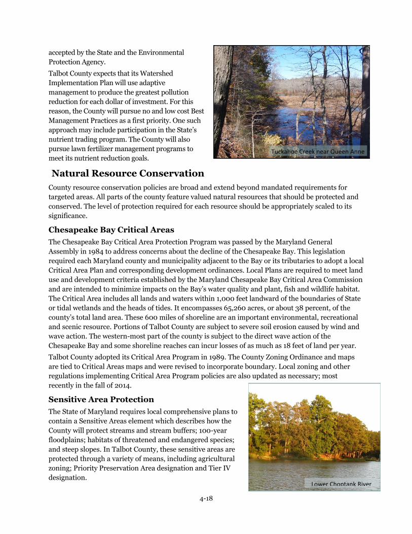
4-18
Tuckahoe Creek near Queen Anne
Lower Choptank River
accepted by the State and the Environmental
Protection Agency.
Talbot County expects that its Watershed
Implementation Plan will use adaptive
management to produce the greatest pollution
reduction for each dollar of investment. For this
reason, the County will pursue no and low cost Best
Management Practices as a first priority. One such
approach may include participation in the State’s
nutrient trading program. The County will also
pursue lawn fertilizer management programs to
meet its nutrient reduction goals.
Natural Resource Conservation
County resource conservation policies are broad and extend beyond mandated requirements for
targeted areas. All parts of the county feature valued natural resources that should be protected and
conserved. The level of protection required for each resource should be appropriately scaled to its
significance.
Chesapeake Bay Critical Areas
The Chesapeake Bay Critical Area Protection Program was passed by the Maryland General
Assembly in 1984 to address concerns about the decline of the Chesapeake Bay. This legislation
required each Maryland county and municipality adjacent to the Bay or its tributaries to adopt a local
Critical Area Plan and corresponding development ordinances. Local Plans are required to meet land
use and development criteria established by the Maryland Chesapeake Bay Critical Area Commission
and are intended to minimize impacts on the Bay’s water quality and plant, fish and wildlife habitat.
The Critical Area includes all lands and waters within 1,000 feet landward of the boundaries of State
or tidal wetlands and the heads of tides. It encompasses 65,260 acres, or about 38 percent, of the
county’s total land area. These 600 miles of shoreline are an important environmental, recreational
and scenic resource. Portions of Talbot County are subject to severe soil erosion caused by wind and
wave action. The western-most part of the county is subject to the direct wave action of the
Chesapeake Bay and some shoreline reaches can incur losses of as much as 18 feet of land per year.
Talbot County adopted its Critical Area Program in 1989. The County Zoning Ordinance and maps
are tied to Critical Areas maps and were revised to incorporate boundary. Local zoning and other
regulations implementing Critical Area Program policies are also updated as necessary; most
recently in the fall of 2014.
Sensitive Area Protection
The State of Maryland requires local comprehensive plans to
contain a Sensitive Areas element which describes how the
County will protect streams and stream buffers; 100-year
floodplains; habitats of threatened and endangered species;
and steep slopes. In Talbot County, these sensitive areas are
protected through a variety of means, including agricultural
zoning; Priority Preservation Area designation and Tier IV
designation.

4-19
Water Resource Policies
4.8 The County will continue to study groundwater resources and establish follow-up mechanisms
to monitor changes that may occur over time.
4.9 The County will encourage policies and programs that support reasonable water use.
4.10 The County’s building and land development codes will ensure that, per the International
Building Code (IBC), water conserving fixtures and appliances are required for all new development
and retrofits outside of public water systems.
4.11 The County will work with MDE, MGS, and USGS to complete the Coastal Plain Aquifer Study
and use the results of this Study to guide future decisions regarding groundwater withdrawals.
4.12 The County will work with MDE to identify new sources of drinking water, specifically by
evaluating the quality and quantity of water in the County’s deeper and less frequently used
aquifers.
4.13 The County should increase efforts to monitor the condition of county surface waters
including streams, rivers, and submerged aquatic plant resources.
4.14 The County will require properties with failing septic systems to be connected to sewer if that
service is available, or, if it is not, the property owner will be encouraged to install a “Best Available
Technology (BAT) septic system.
4.15 The County will work to identify and prioritize for connection to sewer systems, areas of
failing, inadequate and substandard septic systems and other non-point source pollution “hot
spots”, especially in coastal communities and subdivisions but not limited to villages and current
PFAs.
4.16 The County will continue to identify communities and subdivisions where failing, inadequate
and substandard septic systems or other public health concerns exist, and work to extend public
water and/or sewer service to existing lots of record within Tier III-B and Tier III-C.
4.17 The County should insure that privately owned and operated water and sewer facilities are
adequately maintained by requiring comprehensive and legally binding maintenance agreements
between system owners and users.
4.18 As wastewater treatment facilities are modified or upgraded, increased demand for sewer
treatment should be limited to the plant’s peak capacity at the most current State standards.
4.19 The County will encourage the establishment of a multi-county organization to manage our
major aquifers.
4.20 The County shall actively seek ways to implement the periodic inspection of septic systems, in
order to protect public health and environmental quality by correcting failing conditions.
4.21 The County shall work to provide sewer service to western villages, communities and
subdivisions mapped as Tier III-B and III-C for the purpose of protecting the health and safety of its
citizens through improvements in water quality. This extension of sewer service is not intended for
the purpose of supporting new development outside the boundaries of Tier III-B and III-C.
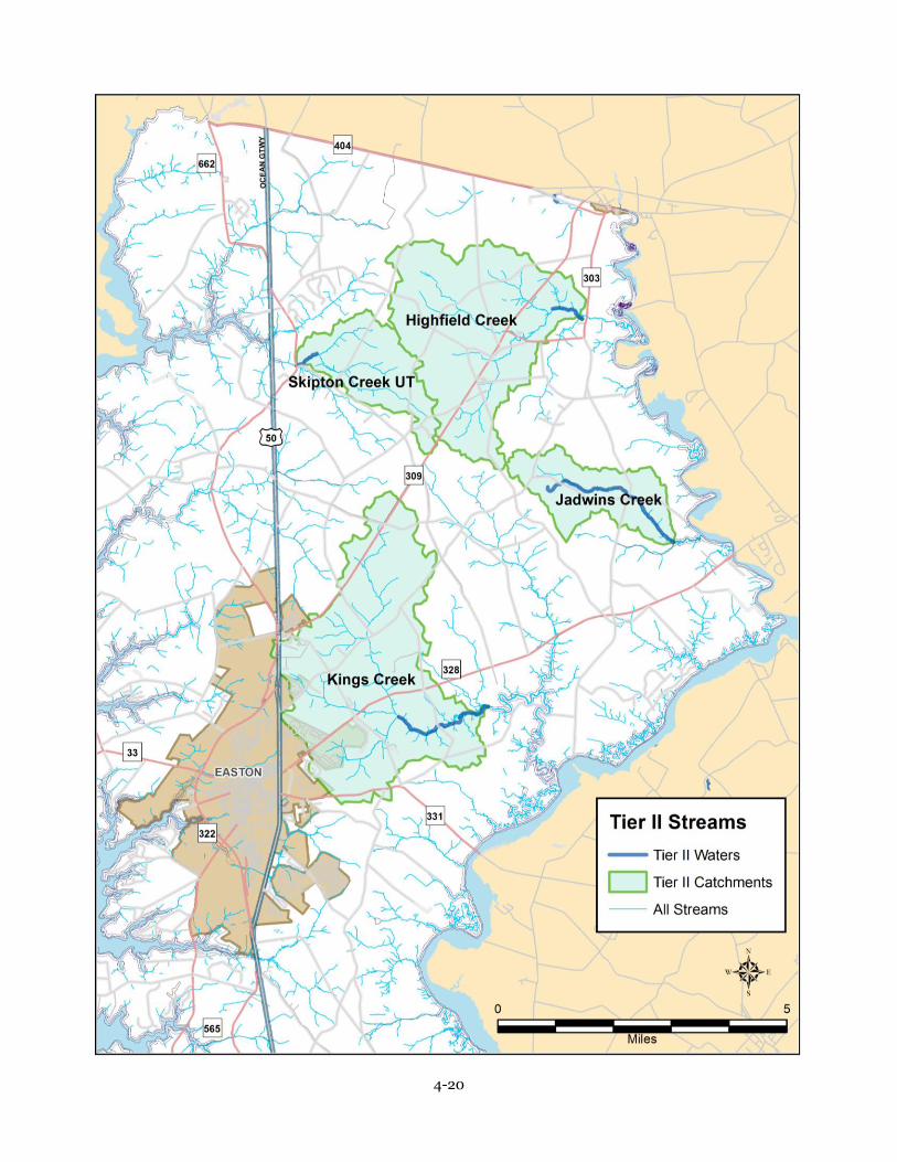
4-20

4-21
Rivers, Streams and Stream Buffers
County streams and their buffers are important resources supporting recreational fishing and
serving as spawning areas for commercial fish stock. Streams and their adjacent buffers are home to
countless species of animals and plants and transport valuable nutrients to rivers and creeks, and in
turn the Chesapeake Bay. The floodplains, wetlands, and wooded slopes along streams are important
parts of the stream ecosystem.
Stream buffers serve as protection zones and reduce sediment, nitrogen, phosphorus, and other
runoff pollutants by acting as a filter, thus minimizing stream damage. The effectiveness of buffers to
protect stream water quality is influenced by their width, the type of vegetation within the buffer, as
well as proper maintenance. Other aspects of buffer effectiveness include contiguous or nearby
slopes, soil erodibility, or the presence of adjacent wetlands or floodplains.
Buffers also provide habitat for wetland and upland plants which form the basis of healthy biological
communities. A wide variety of animals use the natural vegetation as travel corridors, for food and
for cover. A natural buffer system provides connections to support wildlife movement between
remaining patches of forest in the county.
Tributary stream buffers in the Critical Area must be at least 100 feet wide, and may be expanded
beyond that distance to include contiguous sensitive areas. For waterways outside the Critical Area,
the County requires a 100 foot natural buffer for perennial streams and a 50 foot natural buffer for
intermittent streams.
Maryland’s anti-degradation policy significantly limits new discharge permits that would degrade
water quality in Tier II (high quality) waters, as defined by the U.S. Environmental Protection
Agency (EPA).
Four stretches of Tier II waters have been identified in Talbot County; portions of Highfield Creek,
Jadwins Creek, Kings Creek, and Skipton Creek.
New nutrient discharges can be permitted in these areas, as long as they do not degrade existing
water quality below water quality standards. All development activities near these rivers and streams
are required to provide a natural buffer.
Floodplains
Certain areas of the County are subject to periodic flooding which pose risks to public health and
safety, and potential loss of property. Flood-related property damage is most often the result of
locating a dwelling or structure within a designated floodplain, or by constructing structures in a
floodplain to an inadequate elevation.
Two types of flooding occur within the County: riverine and coastal. Nontidal areas of the County are
subject to riverine flooding. In these areas, stream buffers will provide substantial protection to
nearby floodplain resources.
While protection of life and property is the initial basis for limiting development within floodplains,
it can also serve a variety of additional functions with important public benefits. Floodplains
moderate and store floodwaters, absorb wave energy, and reduce erosion and sedimentation.
Wetlands within floodplains help maintain water quality, recharge groundwater supplies, protect
fisheries, and provide habitat and natural corridors for wildlife.
Steep Slopes
Slopes precipitate movement of soil and pollutants when land disturbances occur. Control of erosion
potential is usually achieved through regulation of development on steep slopes because such areas

4-22
represent the greatest danger for accelerated soil loss and resultant sedimentation and stream
pollution.
Threatened and Endangered Species
As a basis for establishing habitat protection measures for threatened and endangered species in
Talbot County, this Plan defines habitat as ‘Areas which, due to their physical or biological features,
provide important elements for the maintenance, expansion, and long-term survival of threatened
and endangered species listed in COMAR 08.03.08. Such areas may include breeding, feeding,
resting, migratory, or overwintering areas.’
The key to protecting threatened and endangered species is protecting the habitat in which they exist.
The Maryland Nongame and Endangered Species Conservation Act provides definitions of threatened
and endangered species. Twelve animal and 32 plant species are considered to be rare, threatened, or
endangered in Talbot County, as of 2010. (Though the status of at least two species may have been
changed from endangered to threatened or rare, State regulations and documents have not been
revised to date, and the two species remain a conservation concern.) Habitat destruction and
degradation is estimated to threaten some 400 native Maryland species with extinction.
Maintenance of biological diversity today sustains future opportunities to advance healthcare and
provide a number of other societal benefits. Materials and chemicals produced by plants and animals
are potential storehouses for beneficial products. More than half of all medicines in use today can be
traced to wild organisms. Plant chemicals are the sole or major ingredients in 25 percent of all
prescriptions written in the United States each year. Likewise, agriculture depends on the development
of new varieties of crops, often created by cross-breeding strains with wild relatives of crop species, in
order to promote a desired trait.
Wetlands
Wetland areas are valuable natural resources for the ability to act as collectors and filters of excess
nutrients. Wetlands also reduce floodwater peaks by storing water and reducing velocity, serve as
groundwater discharge and recharge areas, improve water quality and provide food and habitat for fish
and wildlife. Wetlands are recreational and aesthetic resources as well.
Development activities in wetland areas are regulated by the U.S. Army Corps of Engineers and
Maryland Department of the Environment. Tidal wetlands are protected by a 100 foot natural buffer
and nontidal wetlands are protected by a 25 foot natural buffer. No development activities are
allowed within the wetlands or buffer areas without all required federal, State and County approvals
and permits, and compliance with all mitigation requirements.
Forest and Vegetation
Approximately 25 percent of the County is in forest cover. Forests are the ideal land use for
maintaining water quality because they generate low levels of pollutants while filtering pollutants
from both surface and subsurface flows. Trees serve as natural habitat for wildlife, and are important
to the carbon and oxygen cycle. Forest areas also provide a cooling effect and visual buffer in both
developed and undeveloped areas.
The Forest Conservation Act of 1991 was enacted to protect the forests of Maryland by making forest
conditions and character an integral part of the site planning process. The Act is regulated by the
Maryland Department of Natural Resources, but implemented and administered by local
governments. The Forest Conservation Chapter (73) of the Talbot County Code was most recently
amended in July, 2011 to conform to the most recent State legislation.

4-23
Regulations require that any person making an application for subdivision of a tract of land 40,000
square feet or greater, or disturbing more than 40,000 square feet of forest in conjunction with a
project plan, building permit or sediment and erosion control plan; must submit a Forest Stand
Delineation and Forest Conservation Plan to the Planning Department for review and approval.
Mitigation for forest removal and forest establishment are both required by the act under specified
circumstances.
Soils
Prime farmland is the foundation of the county’s agricultural industry, one of Talbot’s largest and
most valuable economic sectors. The importance of agriculture in the County’s economy and lifestyle
makes high quality soils an especially important resource which, once lost, cannot be reclaimed.
Therefore the County strives to maintain agriculture and the soil that supports farming.
Prime agricultural soils are those best suited for continuous agricultural use and account for
approximately 51 percent of the county’s soils. They are usually found in areas that are nearly level
and well drained and watered. The strategy for addressing conservation of this resource correlates
with policies in the agriculture chapter.
Generally, the soils of the eastern half of the county tend to be the best for both agriculture and
development. Many areas in the western part of the county contain soils that are poorly drained and
have a high water table, presenting severe limitations for development. However, notable pockets of
prime agricultural soils are located on the western peninsula between St. Michaels and Tilghman
Island.
Mineral Resources
The sand and gravel extraction industry in Talbot County provides basic raw materials for the
construction and paving industries and plays an important role in supporting local growth and
development. Talbot County’s mineral resources consist primarily of sand and to a lesser extent,
gravel.
Because geologic conditions dictate the location of economically recoverable mineral deposits,
opportunities to meet the future demand of the county’s construction industry will be controlled by
the availability of these deposits and future access to these deposits for construction industry use.
To be economical, sand and gravel must be mined close to where they will be used. According to
industry and regulatory agency sources, transportation costs quickly exceed the on-site cost of these
resources, with the price of sand and gravel roughly doubling every 25 to 40 additional miles the
material is transported.
Sand and gravel deposits are confined principally to two stratigraphic units that can be in excess of
25 feet thick. They are principally located east of U.S. 50 and are generally found on major stream
corridors, in areas where conservation of forests and farmlands are a key issue.
Deposits commonly vary in thickness and composition over short distances, so site investigations are
typically required to estimate reserves on a specific site. Based on estimates provided by the
Maryland Department of the Environment and various sand and gravel operators, annual production
has been in the range of 200,000 tons in recent years.
Mineral extraction is permitted by special exception in the Agricultural Conservation (AC),
Countryside Preservation (CP), Western Rural Conservation (WRC) and Rural
Conservation (RC) zoning districts. The County has enacted policies prohibiting mining activities
in the Critical Area and designated habitat protection areas. Proposals for new mining operations are

4-24
Natural Resources Policies
4.22 The County will continue to enforce regulations to implement the Talbot County Critical
Area Program.
4.23 The County will continue to enforce its floodplain regulations and development within the
100-year floodplain will be limited to minimize disturbance and protect life and property.
4.24 The County recognizes the importance of stream corridors as water quality buffers and
wildlife habitat and encourages their protection in an undisturbed state. The County should
continue to enforce buffer requirements for all tributary and intermittent streams in the County.
4.25 The County should continue to monitor shoreline erosion conditions and recommend
appropriate standards for shoreline stabilization and protection. Also, the County should adopt
legislation improving the effectiveness of shoreline buffers for all land uses when research and
science indicates such actions can improve buffer functions.
4.26 In order to reinforce existing regulatory protection programs, the County should maintain
and review protection measures for sensitive areas including streams and their buffers, 100-year
floodplains, steep slopes adjacent to streams and habitats of threatened and endangered species.
4.27 New development shall be restricted in sensitive areas and the protection and enhancement
of environmental resources should be ensured.
4.28 The County will recognize the interdependence of floodplains and preservation of sensitive
areas, wetlands, wildlife habitats, and stream corridors.
4.29 Forests and vegetation should be preserved in stream corridors to preserve the integrity of
associated waterways. The County should adopt legislation authorizing substantial fines and
penalties for clearing trees and vegetation in forest shoreline buffers. Any trees cut should be
replaced per County mitigation regulations.
4.30 The County will coordinate with federal and State agencies to preserve existing wetlands
where possible and to mitigate their destruction when necessary, in accordance with federal and
State Policy and goal of “no net loss” of wetlands.
4.31 The County should develop and enforce mandatory programs and regulations, as well as
financial incentives, to ensure preservation of natural resources.
4.32 All new development and redevelopment shall result in minimized pollutant loadings and
runoff through the implementation of sediment, stormwater and erosion control plans.
4.33 Forest and woodland resources should be conserved and replenished through tree
conservation, reforestation and compliance with the Maryland Forest Conservation Act.
Alternatives should be developed to avert tree planting on prime agricultural soils.
4.34 In development plans, maintaining natural topography, drainage ways and tree cover
should be a priority when determining the location of roads, placement of structures and site
improvements. Local regulations should be developed to ensure that the landscape is preserved
insofar as practical, by minimizing tree and soil removal.
4.35 The County shall coordinate with the Maryland Department of Natural Resources and the
U.S. Department of Interior in the protection of rare, threatened, and endangered species habitat
and shall take direct action when necessary to insure habitat protection. County zoning will direct
intense growth and development away from threatened and endangered species habitat and
maintain low density conservation zoning in areas where such habitats are identified.
4.36 The County should utilize open space and recreation planning efforts to pursue acquisition
and protection opportunities in sensitive areas.
4.37 Marina facilities should be required to comply with Maryland’s Clean Marina Initiative.

4-25
subject to site plan review for compliance with environmental protection regulations.
To ensure mining sites are restored to a usable state, appropriate action must be taken before,
during, and after extraction. Currently, the licensing process for an extraction permit requires
reclamation plans for any site mined. As part of the application process, the post-extraction intended
use of the property must be identified. The restoration plan should be consistent with the future land
use of the site.
The County recommends the following post-extraction uses:
1. Recreational land uses: parks and lakes
2. Forestry
3. Aquaculture
4. Residential Development
5. Disposal of non-toxic solid fill material, clean fill material, and inorganic solid fill material
originating from Talbot County.
Bonds are required to be posted to assure the availability of funds for reclamation should an operator
abandon the site. Restoration guidelines and regulations have been successful in ensuring the
remediation of sites where extraction has taken place since the licensing process was established.
Reclamation of abandoned extraction sites is also a concern. An initial step toward addressing
reclamation would be an inventory and evaluation to determine reclamation needs and the potential
for other land uses. Such an inventory could provide a basis for future targeting of priorities,
evaluating funding needs, and assessing opportunities to secure assistance for site reclamation.
Options for funding reclamation of abandoned sites include imposing a tax on mineral products, a
tax exemption, or a reduction or rebate for landowners who reclaim sites. Mining operations to date
have been limited in number and have not significantly impacted the County road system. However,
long-term mining utilization can cause increased damage to low-capacity roads by haulers' trucks
and disturbance to neighbors or travelers who use the same routes.
The County should continue to monitor levels of extraction activity and be prepared, should the need
arise, to seek legislation to allow imposition of a surcharge or tax on mineral products that would
generate revenue for a roadway maintenance or improvement fund. These funds could be directed
specifically to roads frequently used to haul mineral products, or pro-actively, to areas where the
County wishes to facilitate recovery of mineral deposits.
Summary
Talbot County’s 1990 Comprehensive Plan begins by characterizing the County's landscape as land
and waterways intertwined in a mosaic of tidal waters, streams, farmlands and forests with 600
miles of shoreline on the Chesapeake Bay and rivers. Even the first Comprehensive Plan — from 1973
— expresses the objectives to preserve the county’s natural assets, agricultural soils, wetlands and
wildlife habitats and waters. The strong affinity for the area’s natural resources informs the
conservation objectives outlined in each successive edition and is carried forward in this Plan.
Talbot County’s concerns have coincided with growing State concerns about natural resource
conservation, growth management and strategic planning. Significant legislation has been passed in
attempts to reverse past trends of resource degradation. Many of the laws and regulations dealing
with these concerns are reflected in this chapter, from Critical Areas legislation, septic tier
designation, water resources planning and the Total Maximum Daily Loads (TMDLs).
The County has consistently required that, in order to protect its resources as well as to meet State

4-26
Mineral Resources Policies
4.38 The County will maintain land use policies and regulations that discourage the preemption
of mineral extraction by other uses.
4.39 The County will provide adequate regulation and monitoring of mineral extraction
operations to ensure compliance with applicable permitting requirements, including those
established for reclamation or restoration of mineral sites.
4.40 The County will use appropriate methods to protect existing neighborhoods from the
impacts of extraction operations and the transportation of extracted resources.
4.41 The County will ensure that all available measures are taken to protect the natural
environment from all sources of pollution resulting from extraction activities.
4.42 The County will require post excavation uses for mined sites to be consistent with its plans
and regulations.
4.43 The County will require that any post excavation use of a quarry for rubble fill is limited to
product generated in Talbot County, and will provide opportunities for construction of rubble
recycling facilities in conjunction with extraction facilities.
4.44 The County will identify and use any programs that support reclamation or reforestation of
older or abandoned borrow pits or mined sites not subject or reclamation requirements.
requirements, all future development will be subject to minimum performance standards for
environmental protection and natural resource conservation. This approach has received an even
stronger mandate with the advent of the Bay TMDL. This Plan and this chapter in particular establish a
basis for such standards and an evaluation of the current state of natural resources.
The water resources element of this chapter is the most current and most comprehensive study of
drinking water, stormwater and wastewater management to date. It establishes the County’s pro-active
stance on managing the resources within its jurisdiction. The analysis indicates that:
1. The largest County wastewater facility uses the best available treatment technology and discharges
minimal quantities of nitrogen and phosphorus.
2. Drinking water, derived from private wells outside municipal areas, generally deliver water of good
quality in ample supply.
3. Water supplies and wastewater treatment capacity appear to be adequate to meet projected
population growth through the next 20 years or more.
4. Nonpoint source water pollution has been, and continues to be, a challenging and costly problem.
The strategies to address existing sources involve retrofits to existing infrastructure or utilities
arrayed throughout the County. Managing potential new non-point sources imposes additional
regulations on construction and development and implies long-term monitoring responsibilities on
the part of County government.
Critical Area regulations are a long-standing and complex group of development standards, restrictions
and offset that impact a significant proportion of rural residential property. Program accomplishments
are measured in acres of undeveloped land and numbers of trees planted or conserved, though the
ultimate goal of the program is more qualitative than quantitative. It is impossible to know the amount of
erosion that has not occurred or the amount of stormwater that has been absorbed to recharge water
tables. However, most will agree that the natural landscape has been preserved and enhanced through
compliance with the regulations.

4-27
Talbot County partnered with the Conservation Fund, State and federal agencies to develop a Green
Infrastructure Plan, published in 2004. The Conservation Fund analyzed protected land, land use,
acreage of undeveloped land and proximity to important natural resources to generate several focus areas
for natural resource protection. The recommendations are consulted when opportunities arise to
permanently preserve properties or to evaluate development proposals.
The Chesapeake Bay Total Maximum Daily Load, or Bay TMDL, attempts to consolidate all the point and
non-point source pollution strategies and Critical Area strategies into a series of Watershed
Implementation Plans (WIPs) for the State and each county.
Nutrient reduction goals for each county are divided into land use sectors, including agriculture, industry
and ‘urban’. The County’s responsibility to address non-point source pollution from the built
environment relates directly to the water resources analysis, the Watershed Implementation Plan and
other analytical tools developed by the State in recent years. These strategies are discussed in detail in the
County Watershed Implementation Plan recorded with the Maryland Department of the Environment.
These and other programs are all directed toward the goal of maintaining and protecting the natural
resources of Talbot County for the enjoyment, health and benefit of its current and future citizens. In
embracing these policies, Talbot County also affirms its contribution and commitment to regional
environmental quality.

4-28

4-29

6-1
Chapter 5 Historic and Cultural Preservation
Goal
Preserve and enhance Talbot County’s rich cultural and historic heritage.
Introduction
It is possible to experience Talbot County’s history through appreciation of its historic resources and
events. The early period of colonial settlement and subsequent eras are well represented in the
County’s historic architecture. These physical reminders of our history give depth and richness to the
County, to past events, and to people’s lives. Historic preservation enables this legacy to be protected
and remembered. It allows the past to be integrated with the present and reminds us that the old has
a useful place alongside the new.
Talbot County has maintained a longstanding interest in historic preservation. Many Talbot County
families can trace their roots to the earliest colonial settlements of the County. Private houses and
public buildings are often carefully restored. New uses are found for historic buildings that no longer
serve their original functions. A number of historic properties in the County have been designated or
preserved through private efforts, local Historic District zoning and designation on the National
Register of Historic Places.
Historic resource preservation is about much more than the protection of historic structures.
Historic resources are elements that are significant for their connection or linkage to events or
persons that were important in the past. The County’s history is reflected in archeology and cultural
Vision
Talbot County recognizes the importance of its historic resources. There are numerous groups
in the region dedicated to the preservation of historic and cultural heritage. Efforts to increase
public awareness of the importance of preserving the County’s past have been successful. The
County has an attractive program of local incentives to assist owners of historic properties to
enroll and rehabilitate their properties. Easement programs have also been successful in
protecting key historic resources throughout the County.

6-2
Longwoods Schoolhouse Historic
District
events and is present in sites and objects that
possess integrity of location, design, setting,
materials, workmanship or association.
In addition to preserving historic buildings and
places, county residents also have a strong interest
in preserving the cultural heritage of Talbot County
by preserving traditional lifestyles, like that of the
working waterman, whose heritage is threatened by
a changing environment. Talbot County’s traditions
have long centered on farming, the seafood and
maritime industries, and the many small rural
villages in the County. It is important that these
elements of cultural heritage be preserved as the
County grows.
Many private historic preservation organizations
play an important role in championing preservation
efforts. The Talbot County Agricultural Fair, Tilghman Island Day Festival, Waterfowl Festival,
Nace’s Day Parade in Trappe and the Tuckahoe Steam and Gas Association Show are only a few of
the many annual events and venues which honor the County’s heritage and signify the importance of
traditional cultural lifestyles to the people of Talbot County.
Talbot County Council and Historic Preservation
The Talbot County Council has long recognized the importance of protecting historic resources
within the county. In 1976, the Council passed the Talbot County Historic District Ordinance
empowering the Historic Preservation Commission to protect historic properties as a safeguard for
the heritage of the county.
The County Zoning Ordinance provides protection for historic properties by designating Historic
District Overlay Zones. A historic district can consist of an individual building and grounds or a
grouping of buildings.
Establishing local historic districts is entirely the product of local initiative. District controls are
created and administered by local citizens and local government.
Talbot County Historic Preservation Commission
The Talbot County Historic Preservation Commission (TCHPC) is made up of seven county residents
appointed by the Talbot County Council for three-year terms on the basis of qualifications in
architecture, history, or historic preservation, according to standards established by State and federal
programs. The Historic Preservation Commission receives part-time administrative and technical
assistance from the County Department of Planning and Zoning.
The Commission reviews properties of historic and architectural significance, selects historic
properties for nomination as local Historic Districts and reviews applications for changes to exterior
features within existing districts. The Commission is also involved in the nomination of County
properties to the National Register of Historic Places. As of 2015, the efforts of the Historic
Preservation Commission have resulted in the designation of twenty one County Historic Districts.
In addition, the Commission has undertaken several studies of historic properties and communities
throughout the County.

6-3
Orangery at Wye House Historic
District
Talbot County was approved as a Certified
Local Government (CLG) in 1987. Local
governments can participate in this program
when the State Historic Preservation Officer
certifies that the local government has
established its own historic preservation
commission and a program meeting federal
and State standards. The CLG Program was
established under the National Historic
Preservation Act of 1966, a nationwide
program of financial and technical assistance
to preserve historic properties — buildings,
structures, sites, neighborhoods and other
places of importance in the historical and cultural life of the nation.
Community Awareness and Education
Efforts should be made to increase local public awareness and education concerning the importance
of historic preservation and the functions and role of the Historic Preservation Commission through
use of print and electronic media.
Community interest in preservation is directly related to an understanding of the importance and
value of preserving our heritage.
Greater community awareness of the importance of historic preservation in the County could be
achieved in a number of ways:
1. In conjunction with National Historic Preservation Week each May, the Historic Preservation
Commission could sponsor local events geared toward recognition of Talbot County’s
commitment to preservation.
2. The TCHPC could more broadly publicize its role by reprising its annual awards program to
recognize local excellence in restoration of historic properties.
3. Community awareness of historic preservation could also be enhanced by providing all Historic
District property owners with a plaque for their properties which distinguishes them as historic
or architecturally significant places. Several owners purchased plaques when the offer was last
made by the Commission.
4. More historical markers identifying and describing historic sites and events within the County
would also serve to inform local residents and visitors of Talbot’s rich heritage.
5. Participation in State and national scenic byway improvements and programs may be an
opportunity to increase public education and awareness of historic resources.
Action Items
The following actions would support the Historic and Cultural Preservation Policies of this Plan.
1. The Talbot County Historic Preservation Commission (TCHPC) should be supported by a
planner trained and experienced in historic preservation, to support the efforts of the
Commission and to promote and support historic preservation programs.
2. The TCHPC should be consulted by the County‘s Technical Advisory Committee in the review of
subdivisions or site plans that may impact historic resources.
3. The TCHPC should work to identify other properties eligible for Historic District status by
updating the inventory of historic structures for the County, actively soliciting enrollment of

6-4
eligible structures, seeking financial or other incentives for owners establishing Historic
Districts, and reviewing permits for demolition or substantial alteration of identified structures.
4. The TCHPC should review the Talbot County Code in relation to the State model historic
preservation ordinance and evaluate whether modifications to local legislation are appropriate.
5. The TCHPC should explore implementation of local incentives for adaptive reuse of historic
properties.
6. The TCHPC should investigate and review other counties' preservation incentives to property
owners, with a goal of adopting a local incentive program.
Cooperation and Collaboration
There are many public and private groups in the County which support historic preservation. These
include the Historic Preservation Commissions of Talbot County, Easton, St. Michaels and Oxford;
Historic St. Michaels — Bay Hundred, Inc.; Historic Easton; and the Talbot County Historical
Society. Talbot County cooperates with the surrounding historic organizations as needed. It would be
fitting for these groups to meet on a regular basis to discuss common concerns, to maintain planning
cohesion among all entities with respect to inventories and actions, and to share in each other’s
successes.
In 2005, the Maryland Heritage Areas Authority granted certification to the Stories of the
Chesapeake Heritage Area. This Heritage Area offers a mechanism for coordinated and enhanced
heritage tourism by recognizing heritage sites in a four county area, including Talbot County.
Certification requires the Management Plan of the Stories of the Chesapeake Heritage Area to be
adopted in each county’s Comprehensive Plan. Talbot County recognizes and references the
Management Plan in order to further opportunities for heritage tourism and support economic
development. Talbot County also supports the goals of the Maryland Heritage Areas Program’s ten
year plan for its Heritage Areas.
The County should continue to actively support and encourage community events which focus on the
cultural heritage of the County. Museums and cultural events provide residents and visitors an
opportunity to learn about the traditional ways of life that are an important part of the County’s
heritage.
Summary
Talbot County established a Historic Preservation Commission almost forty years ago and created a
system of voluntary zoning overlays to designate Historic Districts. Since then, just twenty one of
arguably hundreds of historic structures in the County jurisdiction have been designated as Historic
Districts.
Education and collaboration are two important strategies to increase participation in the Historic
District program. However, additional property owner incentives are necessary in order to preserve
the remaining links to the County’s rich history.
Historic preservation is a challenge in any rural area. Historic resources are less visible than in towns
and cities and can be overlooked. Such resources are nevertheless significant elements of the area’s
rural and historic character that should be protected wherever possible.
The Historic Preservation Commission remains a valuable means of assisting homeowners and the
community to appreciate and protect its heritage.
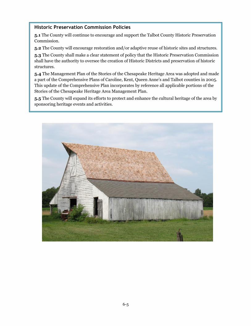
6-5
Historic Preservation Commission Policies
5.1 The County will continue to encourage and support the Talbot County Historic Preservation
Commission.
5.2 The County will encourage restoration and/or adaptive reuse of historic sites and structures.
5.3 The County shall make a clear statement of policy that the Historic Preservation Commission
shall have the authority to oversee the creation of Historic Districts and preservation of historic
structures.
5.4 The Management Plan of the Stories of the Chesapeake Heritage Area was adopted and made
a part of the Comprehensive Plans of Caroline, Kent, Queen Anne’s and Talbot counties in 2005.
This update of the Comprehensive Plan incorporates by reference all applicable portions of the
Stories of the Chesapeake Heritage Area Management Plan.
5.5 The County will expand its efforts to protect and enhance the cultural heritage of the area by
sponsoring heritage events and activities.