Preparatory Study for North East Road Network Connectivity ...
439
Ministry of Road Transport and Highways National Highways and Infrastructure Development Corporation Limited Japan International Cooperation Agency (JICA) Preparatory Study for North East Road Network Connectivity Improvement Project (Phase 2) Draft Final Report - NH40 - November 2016 PADECO Co., Ltd. Nippon Engineering Consultants Co., Ltd.
-
Upload
khangminh22 -
Category
Documents
-
view
0 -
download
0
Transcript of Preparatory Study for North East Road Network Connectivity ...

Ministry of Road Transport and Highways National Highways and Infrastructure Development Corporation Limited
Japan International Cooperation Agency (JICA)
Preparatory Study for North East Road Network Connectivity Improvement
Project (Phase 2)
Draft Final Report - NH40 -
November 2016
PADECO Co., Ltd.
Nippon Engineering Consultants Co., Ltd.

【Note】
The information related to bidding has been deleted.

Preparatory Study for North East Road Network Connectivity Improvement Project (Phase 2) Draft Final Report
- NH40 -
i
Table of Contents
CHAPTER 1 INTRODUCTION ........................................................................................ 1
1.1 Background of Study ........................................................................................... 1
1.2 Outline of the Project ........................................................................................... 2
1.3 Objectives of Study ............................................................................................. 3
CHAPTER 2 PRESENT CONDITION OF STUDY ROADS ............................................. 4
2.1 Present Status of Roads and Transport in Study Area.............................................. 4
2.1.1 National Highway Network in NE States ....................................................... 4
2.1.2 Transport Infrastructure Development Projects in NER ................................... 5
2.2 Present Status of National Highway Development ................................................. 5
2.2.1 Organizations Related to National Highway Development .............................. 5
2.2.2 Development Programs for National Highways .............................................. 7
2.2.3 Cross Border Connectivity Projects in NER ................................................. 12
2.2.4 On-going Road Projects in NER by International Cooperation ....................... 15
2.3 Socioeconomic Conditions ................................................................................. 24
2.3.1 Meghalaya ................................................................................................. 24
CHAPTER 3 MAJOR ISSUES OF STUDY ROADS ....................................................... 26
3.1 Study Approach ................................................................................................. 26
3.1.1 Implementation Planning and Costing Based on the Natural Conditions ......... 26
3.1.2 Best mix Design of Indian and Japanese Mountain Road Technology............. 26
3.1.3 Bridge Substructures for Strong River Flow and Work Period Constraint ....... 27
3.1.4 Study on Adaptable Japanese Technology .................................................... 27
3.1.5 Risk Analysis of EPC Contracts and Considerations about Procurement ......... 28
3.1.6 Traffic Demand Forecast for Road Network Connectivity in NER ................. 28
3.1.7 Supporting the Preparation of EIA and RAP Based on JICA Guidelines ......... 28
3.2 Major Issues of the DPR Design and Recommended Solutions ............................. 29
3.2.1 Notable Features of Design of NH40 (Shillong - Dawki) ............................... 29
3.2.2 Seven Bypass Alignments ........................................................................... 40
3.2.3 Road Design and Typical Cross Sections ...................................................... 43
3.2.4 Selection of Pavement Types ....................................................................... 45
3.2.5 Width of ROW ........................................................................................... 45
3.2.6 Measures to Minimize Construction Period .................................................. 46
3.2.7 Measures to Widen Cliff Road Sections ....................................................... 46
3.2.8 Measures to Protect Slopes.......................................................................... 47
3.2.9 Bridge Plan ................................................................................................ 48
CHAPTER 4 TRAFFIC SURVEY AND PROJECTIONS................................................ 50
4.1 General ............................................................................................................. 50
4.2 Study Road Network/Sections ............................................................................ 50
4.3 Existing Traffic Data and Analyses ..................................................................... 51
4.4 Traffic Survey ................................................................................................... 53
4.4.1 General ...................................................................................................... 53

Preparatory Study for North East Road Network Connectivity Improvement Project (Phase 2) Draft Final Report
- NH40 -
ii
4.4.2 Location of Survey ..................................................................................... 54
4.4.3 Vehicle Categorization ................................................................................ 54
4.4.4 OD zone .................................................................................................... 55
4.4.5 Traffic Survey Result .................................................................................. 56
4.5 Traffic Projections ............................................................................................. 57
4.5.1 Traffic Type ............................................................................................... 57
4.5.2 Methodology of Traffic Projection ............................................................... 57
4.5.3 Result of the Traffic Survey and Projection in the DPR ................................. 61
4.5.4 Traffic Projection Result ............................................................................. 63
CHAPTER 5 PRELIMINARY DESIGN OF NH40 (Shillong - Dawki) ............................ 67
5.1 Natural Condition Surveys ................................................................................. 67
5.1.1 Meteorological and Hydrological Surveys .................................................... 67
5.1.2 Topographical Survey ................................................................................. 78
5.1.3 Geographical Survey .................................................................................. 80
5.1.4 Road Inventory Survey ............................................................................... 92
5.1.5 Slope Inventory Survey............................................................................. 100
5.2 Preliminary Design .......................................................................................... 106
5.2.1 General .................................................................................................... 106
5.2.2 Road Geometric Design ............................................................................ 106
5.2.3 Bridge and Structure Design...................................................................... 117
5.2.4 Road Widening Design ............................................................................. 123
5.2.5 Slope Protection and Landslide Prevention Design ..................................... 127
5.2.6 Pavement Design...................................................................................... 133
5.2.7 Drainage Design....................................................................................... 140
5.2.8 Traffic Safety Facilities Plan ..................................................................... 168
5.2.9 Road Appurtenances Plan.......................................................................... 180
5.2.10 Preliminary Study of Bypass Routes .......................................................... 185
5.2.11 Monolith .................................................................................................. 192
5.2.12 Spoil Plan ................................................................................................ 198
5.3 Consideration of Climate Change Adaptation .................................................... 205
5.3.1 India’s Commitment to COP 21 ................................................................. 205
5.3.2 Greenhouse Gas Emissions of Road Development Projects ......................... 205
5.3.3 Measures Adapted for GOI’s Commitment for Climate Change ................... 206
CHAPTER 6 PRELIMINARY PROJECT COST ESTIMATESエラー! ブックマークが定義されていません。
6.1 Introduction ............................ エラー! ブックマークが定義されていません。
6.1.1 General Conditions of Cost Estimatesエラー! ブックマークが定義されていません。
6.2 Construction Package............... エラー! ブックマークが定義されていません。
6.3 Civil Work Cost ....................... エラー! ブックマークが定義されていません。
6.3.1 Preliminary Cost Estimate for Package 1エラー! ブックマークが定義されていません。
6.3.2 Preliminary Cost Estimate for Package 2エラー! ブックマークが定義されていません。
CHAPTER 7 ENVIRONMENTAL AND SOCIAL CONSIDERATIONS ....................... 209
7.1 Introduction .................................................................................................... 209
7.1.1 Background of the Project ......................................................................... 209
7.1.2 Purpose and Objectives of the Study .................................................... 209

Preparatory Study for North East Road Network Connectivity Improvement Project (Phase 2) Draft Final Report
- NH40 -
iii
7.1.3 Description of the Project.......................................................................... 210
7.2 Scope of the Study ........................................................................................... 212
7.2.1 Geographical Extent of the Impacts ........................................................... 212
7.2.2 Study Components of Natural Environment and Socio-economic
Environment ............................................................................................ 213
7.2.3 Legal Framework Related to the Project..................................................... 214
7.2.4 Resettlement ............................................................................................ 214
7.3 Baseline Data of the Natural and Socio-economic Environment .......................... 215
7.3.1 Natural Environment ................................................................................ 215
7.3.2 Living Environment and Pollution Control Measures .................................. 221
7.3.3 Socio-economic Environment.................................................................... 225
7.4 Legal Framework ............................................................................................ 231
7.4.1 Major Laws and Regulations Relevant to the Project................................... 231
7.4.2 JICA’s Guidelines for Environment and Social Considerations .................... 234
7.4.3 World Bank’s Environmental Safeguard Policy .......................................... 236
7.4.4 Safeguard Policy of Asian Development Bank ............................................ 237
7.4.5 Comparison of JICA/WB/ADB Guidelines and EIA Regulations of India .... 238
7.4.6 Central Level Institutions of India.............................................................. 241
7.4.7 State Level Institutions of Meghalaya State ................................................ 242
7.4.8 Requirements of Environmental/Forest Clearance....................................... 243
7.4.9 Other Environmental Clearance ................................................................. 243
7.4.10 Environmental, Emissions and Other Standards of India ............................. 244
7.5 Analysis of Alternatives ................................................................................... 248
7.5.1 Alternatives Subject to Analysis ................................................................ 248
7.5.2 Criteria for Analysis of the Alternatives ..................................................... 253
7.5.3 Result of the Analysis of Alternatives......................................................... 253
7.5.4 Weighted Average Analysis of the Alternatives ........................................... 256
7.5.5 Selection of the Alternatives ...................................................................... 257
7.6 Scoping Analysis and TOR ............................................................................... 259
7.6.1 Procedures of Scoping Analysis ................................................................ 259
7.6.2 Scoping Matrix: Preliminary Analysis of Environmental Impacts ................. 259
7.7 Anticipated Environmental Impacts .................................................................. 276
7.7.1 Environmental Impact Matrix of NH40 ...................................................... 276
7.7.2 Major Impacts on the Natural Environment ................................................ 278
7.7.3 Major Impacts on Living Environment....................................................... 296
7.7.4 Major Impacts on Social Environment ....................................................... 321
7.7.5 Others...................................................................................................... 331
7.8 Impact Analysis ............................................................................................... 331
7.9 Environmental Management and Monitoring Plan.............................................. 337
7.9.1 Environmental Management Plan .............................................................. 337
7.9.2 Environmental Monitoring Plan................................................................. 339
7.9.3 Organization of Environmental Management and Monitaring Plan............... 342
7.9.4 Outline of the Environmental Management and Monitoing Plan .................. 343
7.9.5 Monitoring Forms ................................................................................... 357
7.9.6 Budget for Environmental Management and Monitoring Plan...................... 360
7.10 Stakeholder Consultation ................................................................................. 363
7.11 Land Acquisition and Resettlement ................................................................... 365
Preparatory Study for North East Road Network Connectivity Improvement Project (Phase 2) Draft Final Report
- NH40 -
iv
7.11.1 Requirement for Land Acquisition and Resettlement ................................... 365
7.11.2 Legal Framework for Land Acquisition and Resettlement............................ 367
7.11.3 Scale and Scope of Land Acquisition and Resettlement ............................... 380
7.11.4 Compensation and Assistance Policy ......................................................... 395
7.11.5 Grievance Redress Mechanism .................................................................. 401
7.11.6 Institutional arrangements ......................................................................... 402
7.11.7 Resettlement Schedule .............................................................................. 404
7.11.8 Resettlement Budget and its Source ........................................................... 407
7.11.9 Monitoring and Evaluation........................................................................ 408
7.11.10 Stakeholder Consultation .......................................................................... 410
7.11.11 Indigenous People .................................................................................... 410
7.12 Stakeholders Consultation ................................................................................ 413
CHAPTER 7 CONCLUSIONS AND RECOMMENDATIONS ...................................... 420

Preparatory Study for North East Road Network Connectivity Improvement Project (Phase 2) Draft Final Report
- NH40 -
v
Figures
Figure 1-1: North-East States Annual Rainfall ........................................................................ 1 Figure 1-2: Project Locations ................................................................................................ 2 Figure 2-1: National Highway Network in NER ..................................................................... 4
Figure 2-2: NHAI Logo ........................................................................................................ 6 Figure 2-3: IAHE Logo ........................................................................................................ 6 Figure 2-4: NHIDCL Logo.................................................................................................... 6
Figure 2-5: IRC Logo ........................................................................................................... 6 Figure 2-6: National Highway Development Project (as of May 31, 2016) ............................... 9 Figure 2-7: Major Road Development Programs in North East Region................................... 10
Figure 2-8: Proposed National Expressway Network ............................................................ 12 Figure 2-9: Trilateral Highway Project ................................................................................. 13 Figure 2-10: Kaladan Multimodal Transit Transport Project .................................................. 14 Figure 2-11: National Waterway-2 Brahmaputra Project........................................................ 15 Figure 2-12: Location of Mizoram State Road Project I (WB) ............................................... 17 Figure 2-13: Location of Mizoram State Road Project II (WB) .............................................. 18 Figure 2-14: North Eastern State Roads Investment Program (Assam) ................................... 20 Figure 2-15: North Eastern State Road Investment Program (Meghalaya) .............................. 20 Figure 2-16: North Eastern State Roads Investment program (Manipur) ................................. 21 Figure 2-17: North Eastern State Roads Investment program (Tripura) ................................... 22 Figure 2-18: North Eastern State Roads Investment program (Mizoram) ................................ 23 Figure 3-1: Profile of NH40 ................................................................................................ 29
Figure 3-2: Bangladesh Viewed from Dawki ........................................................................ 29 Figure 3-3: Road Alignment and Condition (KP0.000 - KP15.000) ........................................ 30 Figure 3-4: Road Alignment and Condition (KP15.000 - KP35.000) ...................................... 31 Figure 3-5: Road Alignment and Condition (KP35.000 - KP55.000) ...................................... 32
Figure 3-6: Road Alignment and Condition (KP55.000 - KP71.500) ...................................... 33 Figure 3-7: B8 Dawki Bridge (KP73.00) and Dawki River .................................................... 34 Figure 3-8: KP0+000 - KP5+000......................................................................................... 35 Figure 3-9: KP5+000 - KP11+000 ....................................................................................... 35 Figure 3-10: KP11+000 - KP17+000 ................................................................................... 36 Figure 3-11: KP17+000 - KP23+000 ................................................................................... 36 Figure 3-12: KP23+000 - KP29+000 ................................................................................... 37 Figure 3-13: KP34+000 - KP39+000 ................................................................................... 37
Figure 3-14: KP39+000 - KP48+000 ................................................................................... 38 Figure 3-15: KP48+000 - KP53+000 ................................................................................... 38 Figure 3-16: KP53+000 - KP59+000 ................................................................................... 39
Figure 3-17: KP68+000 - KP71+000 ................................................................................... 39 Figure 3-18: Location Map of Seven Bypasses ..................................................................... 40 Figure 3-19: Proposed Alignments of Bypass #1 by JICA and DPR ....................................... 41 Figure 3-20: Comparison of Alignments of Bypass #6 and #7................................................ 42 Figure 3-21: Proposed Alignments by JICA and DPR ........................................................... 43 Figure 3-22: Discrepancies in Typical Cross Section between DPR and IRC .......................... 44
Figure 3-23: Typical Cross Sections Proposed by JICA ......................................................... 44 Figure 3-24: Pavement Structure Proposed by JICA Study Team ........................................... 45 Figure 3-25: Example of Adoption of Concrete Precast Method............................................. 46 Figure 3-26: Road Widening of Cliff Sections ...................................................................... 47
Figure 3-27: Cut Slope Design Based on JICA Geotechnical Survey ...................................... 48
Figure 4-1: Asian Highway 2 Network ................................................................................. 50 Figure 4-2: Photos of Dawki/Tamabil Border Crossing Point................................................. 51 Figure 4-3: Traffic Volume and Hourly Variation on NH40.................................................... 51
Figure 4-4: Traffic Volume Composition on NH40 ............................................................... 52

Preparatory Study for North East Road Network Connectivity Improvement Project (Phase 2) Draft Final Report
- NH40 -
vi
Figure 4-5: Location of Traffic Survey 1 .............................................................................. 54 Figure 4-6: Location of Traffic Survey 2 .............................................................................. 54 Figure 4-7: Traffic Survey Location and Sections in the DPR ................................................ 59
Figure 4-8: Bangladesh – India Protocol Route..................................................................... 64 Figure 4-9: Mineral Map of Meghalaya ............................................................................... 65 Figure 5-1: High & Low Temperatures (Delhi, Shillong)....................................................... 67 Figure 5-2: Rainfall (Delhi, Shillong) .................................................................................. 68 Figure 5-3: ISOPLUVAL Map with Project Location ............................................................ 69 Figure 5-4: Catchment Areas ............................................................................................... 70 Figure 5-5: Existing Longitudinal Profile of Target Road ...................................................... 78
Figure 5-6: Topographic Survey Area at Bypass No. 1 .......................................................... 79 Figure 5-7: Topographic Survey Area at Bypass No. 6 and No. 7 ........................................... 80 Figure 5-8: Topographical Map along NH40 ........................................................................ 80 Figure 5-9: NH40 Passing Through Steep Hilly Area ............................................................ 81 Figure 5-10: Geological Map of Meghalaya ......................................................................... 81 Figure 5-11: Geological Map and Longitudinal Section along NH40 (0-17km) ....................... 82
Figure 5-12: Geological Map and Longitudinal Section along NH40 (17-34km) ..................... 82 Figure 5-13: Geological Map and Longitudinal Section along NH40 (34-55km) ..................... 83 Figure 5-14: Geological Map and Longitudinal Section along NH40 (55km-end) ................... 83
Figure 5-15: Pictures of Shillong Group............................................................................... 84
Figure 5-16: Pictures of Creataceous-Tertiary Sediments....................................................... 85 Figure 5-17: Pictures of Mylliem Pluton (Granite) ................................................................ 85
Figure 5-18: Dauki Fault and Shillong Plateau ..................................................................... 86 Figure 5-19: Origin of Shillong Plateau and Dauki Fault ....................................................... 86
Figure 5-20: Results of Investigation Boring at Cut Slopes.................................................... 87 Figure 5-21: Geological Cross Section at KP 21430.............................................................. 87 Figure 5-22: Geological Cross Section at KP 29980.............................................................. 88
Figure 5-23: Geological Cross Section at KP 42840.............................................................. 88 Figure 5-24: Geological Cross Section at KP48+040 ............................................................ 89
Figure 5-25: Results of Investigation Boring at Dawki Bridge ............................................... 90
Figure 5-26: Geological Cross Section at TP68.72km and proposed Dawki Bridge ................. 91 Figure 5-27: Trace of Landslide on Left Bank of Dawki River............................................... 91 Figure 5-28: Definition of Road Width................................................................................. 92
Figure 5-29: Cross Drainage ............................................................................................... 93 Figure 5-30: Blocked Cross Drainage .................................................................................. 93
Figure 5-31: Catch Pit......................................................................................................... 94 Figure 5-32: Falling Works (17+700) ................................................................................... 94 Figure 5-33: Roadside Drain ............................................................................................... 95 Figure 5-34: Existing Pavement Width................................................................................. 96 Figure 5-35: Pavement Condition of Section A (Bypass #1 – Bypass #2)................................ 96 Figure 5-36: Pavement Condition of Section B (Bypass #2 - Bypass #3) ................................ 97 Figure 5-37: Pavement Condition of Section C (Bypass #3 - Bypass #4) ................................ 97
Figure 5-38: Pavement Condition of Section D (Bypass #4 - Bypass #5) ................................ 97 Figure 5-39: Pavement Condition of Section E (Bypass #5 - Bypass #6) ................................ 98 Figure 5-40: Different Types of Guardrails along NH40 ........................................................ 98 Figure 5-41: Different Types of Traffic Signs along NH40 .................................................... 99 Figure 5-42: Poor Visibility due to Fog (KP34+700) ............................................................. 99 Figure 5-43: Section of Frequent Fog................................................................................. 100 Figure 5-44: Broken-back Curves of NH40 (Guwahati-Shillong) ..........................................114 Figure 5-45: Typical Cross Section of Road ........................................................................115 Figure 5-46: Approach to Sight Distance in Curve ...............................................................116 Figure 5-47: Image of the Setback Distance When R=60m ...................................................117 Figure 5-48: Carriageway Configuration of Bridge ..............................................................118

Preparatory Study for North East Road Network Connectivity Improvement Project (Phase 2) Draft Final Report
- NH40 -
vii
Figure 5-49: Carriageway Configuration of Bridge ..............................................................118 Figure 5-50: General view of Dawki Bridge ....................................................................... 120 Figure 5-51: Plan for Temporary Works ............................................................................. 121
Figure 5-52: Plan for Construction Procedure ..................................................................... 121 Figure 5-53: Design of A Small Bridge .............................................................................. 123 Figure 5-54: Width of Two-lane Road ................................................................................ 123 Figure 5-55: Standard Widening Method of Two-lane Road ................................................ 124 Figure 5-56: Present Conditions of NH40 .......................................................................... 125 Figure 5-57: Cliff Section of Road and Quarries along NH40 .............................................. 127 Figure 5-58: Widening from 5 m to 11 m ........................................................................... 127
Figure 5-59: Distribution of Three Types of Rocks ............................................................. 128 Figure 5-60: Standard Slope Gradient ................................................................................ 130 Figure 5-61: Recommended Slope Protection Methods for Type A ...................................... 132 Figure 5-62: Recommended Slope Protection Methods for Type B ...................................... 132 Figure 5-63: Recommended Slope Protection Method for Type C ........................................ 132 Figure 5-64: Asphalt Pavement (Basic Form) ..................................................................... 134
Figure 5-65: As + Cement Improvement (1) ....................................................................... 134 Figure 5-66: As + Cement Improvement (2) ....................................................................... 135 Figure 5-67: As + Cement Pavement (1) ............................................................................ 135
Figure 5-68: As + Cement Pavement (2) ............................................................................ 136 Figure 5-69: Typical Cross-Section (General Part) .............................................................. 139 Figure 5-70: Typical Cross Section (Areas with Bedrock) ................................................... 140
Figure 5-71: Intervals of the Existing Conduits................................................................... 141 Figure 5-72: Minimum Diameter of Transversal Culvert ..................................................... 147
Figure 5-73: Catchment Area (1) ....................................................................................... 148 Figure 5-74: Catchment Area (2) ....................................................................................... 149 Figure 5-75: Catchment Area (3) ....................................................................................... 150
Figure 5-76: Catchment Area (4) ....................................................................................... 151 Figure 5-77: Catchment Area (5) ....................................................................................... 152 Figure 5-78: Sloping of the Transversal Conduit ................................................................. 165 Figure 5-79: Accumulated Earth in Drainage ...................................................................... 166 Figure 5-80: Mud Collection Function of Drainage Basin ................................................... 166 Figure 5-81: Cross Section of Side Ditch ........................................................................... 168
Figure 5-82: Image of Drainage Basin in Side Ditch ........................................................... 168
Figure 5-83: Existing Traffic Signs along NH40 ................................................................. 170
Figure 5-84: Examples of Different Types of Traffic Signs .................................................. 171 Figure 5-85: Arrangement of Directional Information Signs for a Junction ........................... 172 Figure 5-86: Center Line Marking for a Two Lane Road ..................................................... 174 Figure 5-87: Arrangement of Road Studs for Two Lane Road .............................................. 175 Figure 5-88: Arrangement of Curve Delineators for Two Lane Road .................................... 177 Figure 5-89: Proposed Safety Measures at KP25.60 (R=50 m) ............................................ 178 Figure 5-90: Proposed Safety Measures at KP60.40 (R=51 m) ............................................ 178 Figure 5-91: Proposed Safety Measures at KP47.27 (R=90 m) ............................................ 179 Figure 5-92: Proposed Safety Measures at KP30.17 (R=80 m) ............................................ 179
Figure 5-93: Kilometer Posts along NH40.......................................................................... 180 Figure 5-94: Bus Bay and Taxi Yard along NH40 ............................................................... 181
Figure 5-95: Bus Waiting Shelters along NH40 .................................................................. 181 Figure 5-96: Public Toilets along NH40 ............................................................................. 181 Figure 5-97: A View of Shillong Peak ................................................................................ 182 Figure 5-98: View Points along NH40 ............................................................................... 182 Figure 5-99: Mountain Scenery at Altitude of Around 1,400 m ............................................ 183 Figure 5-100: Mountain Scenery at Altitude of Around 1,800 m .......................................... 183 Figure 5-101: A Usage of Parking Space ............................................................................ 184

Preparatory Study for North East Road Network Connectivity Improvement Project (Phase 2) Draft Final Report
- NH40 -
viii
Figure 5-102: Landscape from the Existing Scenic Spot...................................................... 184 Figure 5-103: Positional Relation between the Existing Scenic Spot and Bypass ................... 184 Figure 5-104: Existing NH40 and Proposed Alignments of Bypass #1 ................................. 188
Figure 5-105: Existing NH40 and Proposed Alignment of Bypass #2 ................................... 188 Figure 5-106: Existing NH40 and Proposed Alignment of Bypass #3 ................................... 189 Figure 5-107: Existing NH40 and Proposed Alignment of Bypass #4 ................................... 189 Figure 5-108: Existing NH40 and Proposed Alignment of Bypass #5 ................................... 190 Figure 5-109: Existing NH40 and Propose Alignment of Bypass #6 and #7 .......................... 191 Figure 5-110: Proposed Alignments for Bypass #6 and #7 ................................................... 192 Figure 5-111: Monoliths ................................................................................................... 192
Figure 5-112: Monolith #1 (KP4+880)............................................................................... 193 Figure 5-113: Monolith #2 (KP5+790)............................................................................... 194 Figure 5-114: Monolith #3 (KP6+060)............................................................................... 194 Figure 5-115: Monolith #4 (KP8+140)............................................................................... 194 Figure 5-116: Monolith #5 (KP17+880) ............................................................................. 195 Figure 5-117: Monolith #6 (KP18+110) ............................................................................. 195
Figure 5-118: Monolith #7 (KP21+520) ............................................................................. 196 Figure 5-119: Monolith #8 (KP53+750) ............................................................................. 196 Figure 7-1: Location of the Project Area (NH40) ................................................................ 214
Figure 7-2: Profile of the Project Area ............................................................................... 214 Figure 7-3: Typical Cross Section of the Hillside Road of NH-40 ........................................ 215 Figure 7-4 Geographical Extent of the Environmental Study ............................................... 216
Figure 7-5: Precipitation and Temperatures of Meghalaya State ........................................... 219 Figure 7-6: Temperature Patterns of Meghalaya State ......................................................... 219
Figure 7-7: Rainfall Patterns of Meghalaya State ................................................................ 220 Figure 7-8: Windrose Diagram .......................................................................................... 220 Figure 7-9: Area under Slash and Burn agriculture in Meghalaya......................................... 221
Figure 7-10: Agricultural Land Use of the Project Area ....................................................... 222 Figure 7-11: Geological Map of Meghalaya State ............................................................... 223 Figure 7-12: Mineral Resources in Meghalaya State ........................................................... 224 Figure 7-13: Air Monitoring Result in Shillong, Meghalaya ................................................ 225 Figure 7-14: Air Monitoring Result in Dawki, Meghalaya ................................................... 226 Figure 7-15: Map of Meghalaya State ................................................................................ 229
Figure 7-16: Map of East Khashi Hills District ................................................................... 230
Figure 7-17: Map of Jaintia Hills District (currently East/ West Jaintia Hills) ....................... 231
Figure 7-18: Share of GSDP by Industries.......................................................................... 234 Figure 7-19: Environmental Clearance Process for Category A Projects ............................... 236 Figure 7-20: Bypass No.1-3 – DPR Design/ JICA Study Team Design ................................. 252 Figure 7-21: Bypass No.4 – DPR Design/ JICA Study Team Design .................................... 253 Figure 7-22: Bypass No.5 – DPR Design/ JICA Study Team Design .................................... 254 Figure 7-23: Bypass No.6-7 – DPR Design/ JICA Study Team Design ................................. 255 Figure 7-24: Environmental Impact Matrix ........................................................................ 281 Figure 7-25: Forest and Plant Distribution of The Project Area (0 km – 39.5 km) ............... 283 Figure 7-26: Forest and Plant Distribution of The Project Area (39.5 km – 71.5 km) .......... 284
Figure 7-27: Vulnerable Bird Species of the Project Area .................................................... 294 Figure 7-28: Vulnerable Bird Species of the Project Area .................................................... 296
Figure 7-29: Ambient Air Quality (PM 2.5) of the Project Area ........................................... 302 Figure 7-30: Ambient Air Quality (PM10) of the Project Area ............................................. 302 Figure 7-31: Ambient Air Quality (SO2) of the Project Area................................................ 303 Figure 7-32: Ambient Air Quality (NOX) of the Project Area .............................................. 303 Figure 7-33: Ambient Air Quality (Carbon Monoxide) of the Project Area ........................... 304 Figure 7-34: Ambient Noise Quality Results ...................................................................... 312 Figure 7-35: Noise Level Increase and Decrease by Distance .............................................. 318
Preparatory Study for North East Road Network Connectivity Improvement Project (Phase 2) Draft Final Report
- NH40 -
ix
Figure 7-36: Cause of Traffic Vibration.............................................................................. 320 Figure 7-37 : Location of Sacred Groves along NH40 .................................................. 328 Figure 7-38: Organization of Environmental Management and Monitoring Plan During the
Construction Period ......................................................................................... 347 Figure 7-39: Organization of Environmental Management and Monitoring Plan During the
Operation and Maintenance Period ................................................................... 347 Figure 7-40: Affected Villages (1) ..................................................................................... 388 Figure 7-41: Affected Villages (2) ..................................................................................... 389 Figure 7-42: Composition of Affected HHs ........................................................................ 390
Figure 7-43: Grievance Redress Mechanism ...................................................................... 407 Figure 7-44: Institutional arrangements.............................................................................. 409 Figure 7-45: Stakeholders/community Meetings ................................................................. 424 Figure 8-1: Organizational Chart of Parties Involved .......................................................... 425 Figure 8-2: Overall Implementation Schedule for NH40 ..................................................... 429 Figure 8-3: Anticipated Construction Program for NH40..................................................... 430 Figure 8-4: Shift of Procurement model in Highway Projects under NHDP .......................... 434
Figure 8-5: Selection Process under Single Stage 2 Envelope System .................................. 449
Tables
Table 1-1: Tentative Outline of the Project ............................................................................. 3
Table 2-1: Numbers and Lengths of National Highways in NE States ...................................... 5
Table 2-2: Categories and Lengths of Road Network of India .................................................. 7
Table 2-3: Present Status of NH Development Program 31st December, 2015 (km) ................... 7
Table 2-4: On-going Road Projects in NER .......................................................................... 15
Table 2-5: North Eastern States Roads Investment Program (ADB) ....................................... 19
Table 2-6: Area, Population and Social Indicators of NE States ............................................. 24
Table 2-7: GSDP and Share of GSDP by Industry ................................................................. 25
Table 3-1: Existing Bridge Conditions ................................................................................. 34
Table 3-2: Comparison of Alignment Proposals between JICA and DPR ................................ 43
Table 3-3: Width of ROW ................................................................................................... 46
Table 3-4: Bridge plan of DPR ............................................................................................ 49
Table 4-1: ADT of Shillong-Dawki in Phase 1 Study ............................................................ 52
Table 4-2: Traffic Volume Projection of Shillong-Dawki in Phase 1 Study.............................. 53
Table 4-3: Contents of Traffic Survey .................................................................................. 53
Table 4-4: Traffic Type and PCU ......................................................................................... 55
Table 4-5: OD Zone............................................................................................................ 55
Table 4-6: Period and Time of Traffic Survey ....................................................................... 56
Table 4-7: Traffic Counting Survey Result ........................................................................... 56
Table 4-8: Spatial Pattern by Vehicle Type on NH40 (At Dawki) ........................................... 57
Table 4-9: Traffic Type ....................................................................................................... 57
Table 4-10: Traffic Projection Methodology ......................................................................... 58
Table 4-11: Sections for Traffic Projection ........................................................................... 58
Table 4-12: Vehicle Registration Data in Meghalaya ............................................................. 60
Table 4-13: Economic Indicators ......................................................................................... 60
Table 4-14: Elasticity Value by Vehicle Type ........................................................................ 61
Table 4-15: Traffic Growth Rate Used for the Projection ....................................................... 61
Table 4-16: ADT in Number of Vehicles in the DPR ............................................................. 62
Table 4-17: ADT in PCU in the DPR ................................................................................... 62
Table 4-18: AADT in Number of Vehicles ............................................................................ 62
Table 4-19: AADT in PCU .................................................................................................. 63
Table 4-20: Result of Traffic Projection (in PCU) ................................................................. 63

Preparatory Study for North East Road Network Connectivity Improvement Project (Phase 2) Draft Final Report
- NH40 -
x
Table 4-21: OD Matrix for Passenger Traffic at Dawki.......................................................... 64
Table 4-22: Statistics of Coal and Limestone Exports............................................................ 65
Table 4-23: Results of Traffic Projection .............................................................................. 66
Table 4-24: Design Service Volume for Highways in PCU/Day ............................................. 66
Table 5-1: Rainfall Intensity along Project Road ................................................................... 69
Table 5-2: Number of Rainy Days ....................................................................................... 69
Table 5-3: Runoff Coefficient .............................................................................................. 70
Table 5-4: Discharge Summary ........................................................................................... 71
Table 5-5: Geology along NH40 between Shillong and Dawki .............................................. 84
Table 5-6: Location of Investigation Boring at Cutting .......................................................... 86
Table 5-7: Location of Investigation Boring at Dawki Bridge ................................................ 89
Table 5-8: Present Conditions of NH40 ................................................................................ 92
Table 5-9: Conditions of Existing Cut Slopes ..................................................................... 100
Table 5-10: Present Condition of Cut Slopes along NH40 ................................................... 101
Table 5-11: List of Proposed Cut Slopes Designed by DPR Consultant ................................ 104
Table 5-12: Recent Road Development Policies of India ..................................................... 106
Table 5-13: IRC Design Standards for Roads ..................................................................... 108
Table 5-14: Comparison of Geometric Standards between Japan and India ........................... 109
Table 5-15: Minimum Horizontal Curves (m) ...................................................................... 111
Table 5-16: Sight Distance Guidelines ................................................................................112
Table 5-17: Limiting Gradient ............................................................................................113
Table 5-18: Standard Values of Sight Distance.....................................................................115
Table 5-19: Curve Radius and Setback Distance ..................................................................116
Table 5-20: List of Major Design standards .........................................................................117
Table 5-21: Comparison of Structural Types ........................................................................119
Table 5-22: Bridge Plan of NH40 ...................................................................................... 122
Table 5-23: Present Conditions of NH40 ............................................................................ 126
Table 5-24: Location of Three Types of Rocks.................................................................... 128
Table 5-25: Conditions of Present Cut Slopes ..................................................................... 129
Table 5-26: Standard Gradient of Cut Slope ....................................................................... 129
Table 5-27: Total Area of Cut Slope Surfaces by Type of Rocks........................................... 130
Table 5-28: Problems on Cut Slopes .................................................................................. 131
Table 5-29: Design CBR in Each Section ........................................................................... 133
Table 5-30: Traffic Volume of Large Vehicles ..................................................................... 133
Table 5-31: Comparison of Pavement Structures (CBR 3%, Traffic = 20 msa) ...................... 137
Table 5-32: Comparison of Pavement Structures (CBR 5%, Traffic = 20 msa) ...................... 138
Table 5-33: Recommended Pavement Structure .................................................................. 139
Table 5-34: Work Types Adopted for the Existing Cross drainages ....................................... 141
Table 5-35: Work Types Adopted for the Planned Cross Drainages ...................................... 141
Table 5-36: Installation Intervals of the Planned Cross Drainages ........................................ 142
Table 5-37: Comparison of Possible Water Flow Volumes ................................................... 147
Table 5-38: Calculation Results of the Outflow Volume ...................................................... 153
Table 5-39: Examination of Drainage Capacity of the Planned Cross Drainages (1) .............. 160
Table 5-40: Relations between Drainage Gradient and Drainage Volume .............................. 165
Table 5-41: Drainage Volume on the Road Surface ............................................................. 167
Table 5-42: Possible Water Flow Volume of Inverted Trapezoid Side Ditch .......................... 167
Table 5-43: IRC Guidelines for Design of Traffic Safety Facilities ....................................... 169
Table 5-44: Major Intersections and Diversions .................................................................. 172
Table 5-45: Road Appurtenance Design Guidelines ............................................................ 180
Table 5-46: Minimum Horizontal Curves (m) ..................................................................... 185
Table 5-47: Locations with Sharp Horizontal Curvatures..................................................... 185
Table 5-48: Locations with Sharp Horizontal Curves in Reviewed DPR Design.................... 186
Table 5-49: Positional Relations with Monoliths and Possible Measures .............................. 197

Preparatory Study for North East Road Network Connectivity Improvement Project (Phase 2) Draft Final Report
- NH40 -
xi
Table 5-50: Volume of Cut and Fill .................................................................................... 200
Table 5-51: Volume of Quality Rock in Type A .................................................................. 201
Table 5-52: Soil rock classification of proposed cutting volume........................................... 201
Table 5-53: Volume of Spoil Per Sections........................................................................... 203
Table 5-54: Location and Capacity of Soil Bank Candidates ................................................ 204
Table 5-55: Typical GHG Emissions of Road Construction Project ...................................... 206
Table 6-1: Package Plan for NH40 Improvement Project ..................................................... 209
Table 6-2: Preliminary Cost Estimate for NH40 Package 1 .................................................. 210
Table 6-3: Preliminary Cost Estimate for NH40 Package 2 ...................................................211
Table 7-1: Precipitation in Meghalaya State ....................................................................... 218
Table 7-2: Land Use in Meghalaya State ............................................................................ 223
Table 7-3: Water Quality Monitoring Works of Meghalaya State.......................................... 225
Table 7-4: Air Quality Monitoring Works of Meghalaya State ............................................. 227
Table 7-5: Soil Contamination of Meghalaya State ............................................................. 228
Table 7-6: Demographic Profile of Meghalaya State ........................................................... 229
Table 7-7: Demographic Profile of East Khasi Hills District ................................................ 230
Table 7-8: Demographic Profile of West Jaintia Hills District .............................................. 232
Table 7-9: District-wise population and percentage of SC and ST ........................................ 232
Table 7-10: District-wise Scheduled Tribes ........................................................................ 233
Table 7-11: Comparison between JICA Guideline and Laws in India regarding EIA.............. 242
Table 7-12: Applicable Environmental Clearance ............................................................... 247
Table 7-13: Standards for Air Quality ................................................................................ 248
Table 7-14: Vehicle Emission Standard 1991 to Date .......................................................... 248
Table 7-15: Water Quality ................................................................................................. 249
Table 7-16: Fuel Quality ................................................................................................... 249
Table 7-17: Noise Standards for Diesel Generators ............................................................. 250
Table 7-18: Ambient Noise Standards ................................................................................ 251
Table 7-19: Criteria for the Evaluation of the Alternatives ................................................... 256
Table 7-20: Weighted Average Analysis of the Alternatives .................................................. 259
Table 7-21: Weighted Average Analysis of the Alternatives .................................................. 260
Table 7-22: Scoping Matrix of 4 Options ............................................................................ 263
Table 7-23: Scoping Matrix for the Two-lane Widening of NH40 (Bypass Inserting Option –
JICA Study Team’s Design).............................................................................. 264
Table 7-24: TOR of Natural and Socio-economic Environment Survey ................................ 271
Table 7-25: Secondary Data Collection .............................................................................. 279
Table 7-26: Major Tree Species in Meghalaya State ............................................................ 286
Table 7-27: General Tree Species ...................................................................................... 286
Table 7-28: Scrub Species ................................................................................................. 287
Table 7-29: Herb Species .................................................................................................. 288
Table 7-30: Grass Species ................................................................................................. 289
Table 7-31: Bamboo Species ............................................................................................. 290
Table 7-32: Orchid Species ............................................................................................... 290
Table 7-33: Bryophytes Species......................................................................................... 290
Table 7-34: Pteridophyte Species ....................................................................................... 291
Table 7-35: Mammalian Fauna .......................................................................................... 292
Table 7-36: Avi Fauna....................................................................................................... 292
Table 7-37: Reptilian Fauna .............................................................................................. 293
Table 7-38: Fishes (Pisces)................................................................................................ 293
Table 7-39: Causes of the Threats to the “Tawny-breasted Wren-babbler” ............................ 295
Table 7-40: Forest Areas Subject to Clearance by The Project ............................................. 298
Table 7-41: Greenhouse Gas Emission of Road Project ....................................................... 299
Table 7-42: Ambient Air Quality of the Project Area ........................................................... 301
Table 7-43: Water Quality of the Project Area: 0 km – 23 km .............................................. 304

Preparatory Study for North East Road Network Connectivity Improvement Project (Phase 2) Draft Final Report
- NH40 -
xii
Table 7-44: Water Quality of the Project Area: 23 km – 46 km ............................................ 306
Table 7-45: Water Quality of the Project Area: 46 km – 75 km ............................................ 307
Table 7-46: Soil Analysis of the Project Area...................................................................... 308
Table 7-47: Soil Analysis of the Project Area...................................................................... 309
Table 7-48: Soil Analysis of the Project Area...................................................................... 310
Table 7-49: Noise Levels along NH40 from Shillong to Dawki Road ....................................311
Table 7-50: Limit of Noise Pollution Associated with Vibration in Japan.............................. 313
Table 7-51: Vibration Range Causing Damages to the Structures ......................................... 314
Table 7-52: Projected Increase of Vehicular Emission(0km-8.56km) ............................... 315
Table 7-53: Projected Increase of Vehicular Emission(8.56km – 49.26km) ...................... 316
Table 7-54: Projected Increase of Vehicular Emission(49.26km – 81.26km) .................... 317
Table 7-55: Noise Limit Associated with the Complaint on Vibration................................... 319
Table 7-56: Typical Range of Structural Response .............................................................. 321
Table 7-57: Rules of the Disposal for Various Types of Waste.............................................. 323
Table 7-58: Adaption Measures for Climate Change in NH40.............................................. 324
Table 7-59: Summary of Households with their Structures Affected ..................................... 325
Table 7-60: Summary of Households of Lands Affected ...................................................... 325
Table 7-61: Sacred Groves in East Khasi Hills and Jaintia Hills........................................... 328
Table 7-62: List of Monoliths ............................................................................................ 330
Table 7-63: Health and Safety Measures ............................................................................ 332
Table 7-64: Scoping and Survey Result .............................................................................. 335
Table 7-65: Typical Noise Level Emanated by Construction Plants ...................................... 343
Table 7-66: Standard of Noise Level .................................................................................. 345
Table 7-67: Environmental Management Plan during the Construction Stage ....................... 348
Table 7-68: Environmental Management Plan During the Operation and Maintenace Period . 356
Table 7-69: Environmental Monitoring Plan During the Construction Period........................ 357
Table 7-70: Environmental Monitoring Plan During the Operation and Maintenance Period .. 360
Table 7-71: Environmental Clearance ................................................................................ 361
Table 7-72: Air Quality ..................................................................................................... 361
Table 7-73: Water Quality ................................................................................................. 361
Table 7-74: Solid Waste .................................................................................................... 362
Table 7-75: Noise and Vibration ........................................................................................ 362
Table 7-76: Odor .............................................................................................................. 362
Table 7-77: Bio-diversity .................................................................................................. 362
Table 7-78: Resettlement .................................................................................................. 362
Table 7-79: Livelihood of PAHs ........................................................................................ 363
Table 7-80: Compensatory Afforestation ............................................................................ 364
Table 7-81: Budget for EMP ............................................................................................. 365
Table 7-82: Summary of the 1st Round Meetings ................................................................ 367
Table 7-83: Summary of 2nd round consultations................................................................. 368
Table 7-84: Project Component and Area ........................................................................... 369
Table 7-85: Alternatives of Initial Design ........................................................................... 370
Table 7-86: Comparison between Initial Design and Bypass Inserting Option ....................... 370
Table 7-87: Width of ROW in option d............................................................................... 370
Table 7-88: Width of ROW ............................................................................................... 371
Table 7-89: Acts / Policies / Notifications & their relevance to the project ............................ 371
Table 7-90: Key gap between JICA and Indian Regulations ................................................. 377
Table 7-91: Details of PAHs .............................................................................................. 385
Table 7-92: Summary of the Survey................................................................................... 386
Table 7-93: Details of PAHs .............................................................................................. 387
Table 7-94: Composition of Affected HHs.......................................................................... 390
Table 7-95: Social category ............................................................................................... 391

Preparatory Study for North East Road Network Connectivity Improvement Project (Phase 2) Draft Final Report
- NH40 -
xiii
Table 7-96: Ethnic background .......................................................................................... 391
Table 7-97: Religious Breakdown...................................................................................... 391
Table 7-98: Ownership of Structure ................................................................................... 392
Table 7-99: Affected Structure Level ................................................................................. 392
Table 7-100: Affected Land ............................................................................................... 393
Table 7-101: Utilization of Affected Land .......................................................................... 394
Table 7-102: Affected Trees (1) ......................................................................................... 394
Table 7-103: Affected Trees (2) ......................................................................................... 395
Table 7-104: Affected Crops ............................................................................................. 395
Table 7-105: Education Level of PAPs ............................................................................... 396
Table 7-106: Literacy........................................................................................................ 396
Table 7-107: Occupation ................................................................................................... 397
Table 7-108: Number of employed members in PAHs ......................................................... 397
Table 7-109: Total monthly household income of H/H from all sources (INR/month).......... 398
Table 7-110: Average income of HHs (Rs/month) ............................................................... 398
Table 7-111: Land System ................................................................................................. 399
Table 7-112: Land System with Affected Houses ................................................................ 399
Table 7-113: Vulnerability................................................................................................. 399
Table 7-114: Compensation Policy .................................................................................... 400
Table 7-115: Entitlement Matrix ........................................................................................ 402
Table 7-116: Implementation Institute and their Roles......................................................... 408
Table 7-117: Resettlement Schedule .................................................................................. 410
Table 7-118: R&R Budget................................................................................................. 412
Table 7-119: Monitoring Form Design(Summary) .............................................................. 414
Table 7-120: Terms of Reference of the External Monitoring(design)................................... 415
Table 7-121: Definition of Indigenous People in WB OP.4.10.............................................. 416
Table 7-122: Village wise consultation profile .................................................................... 418
Table 7-123: Details of All Meetings ................................................................................. 419
Table 7-124: Participation details of 1st round consultations ................................................ 421
Table 7-125: Community Meetings and Focus Group Discussions (FGD) ............................ 421
Table 7-126: Details of All Meetings ................................................................................. 422
Table 8-1: Roles of Each Party .......................................................................................... 426
Table 8-2: Factors considered in Construction Program....................................................... 428
Table 8-3: Specialists and their roles .................................................................................. 431
Table 8-4: Responsibility and Roles of Contractor and Engineer during Defect Liability and
Maintenance Periods ........................................................................................ 432
Table 8-5: Grouping of comments made by International Assistant Agencies ........................ 435
Table 8-6: Comments on the Model EPC Contract made by various International Assistant
Agencies ......................................................................................................... 436
Table 8-7: Documents included in Bidding Document ........................................................ 449
Table 8-8: Schedules attached to Contract for NH44 - Jowai to Ratechhara (102 km) ............ 451
Table 8-9: Risk Allocation in different contract models ....................................................... 456
Table 8-10: Conceivable Risk and Mitigation Measure ....................................................... 457
Table 8-11: Involvement of Indian Consultant in the projects funded by International Assistant
Agencies (Number of Consultant) ..................................................................... 460
Table 8-12: Empanelment of Design Consultant ................................................................. 460
Table 8-13: Selection Process of Consultant ....................................................................... 461
Table 8-14: Participation of different contractors in NHDP (Number of Contractor) .............. 462
Table 8-15: Participation of different contractors for NHDP funded by International Assistant
Agencies (Number of Contractor) ..................................................................... 463
Table 8-16: Selection Process of Contractor ....................................................................... 464
Table 9-1: Road Length, Travel Speed, and Travel Time ..................................................... 466
Table 9-2: Unit Values of TTC by Vehicle Type, 2016 Prices ............................................... 467

Preparatory Study for North East Road Network Connectivity Improvement Project (Phase 2) Draft Final Report
- NH40 -
xiv
Table 9-3: Unit Values of VOC by Vehicle Type, 2016 Prices .............................................. 467
Table 9-4: Benefit and Cost Streams and EIRR................................................................... 468
Table 9-5: Sensitivity of EIRR .......................................................................................... 468
Table 10-1: Targeted Outcome for Study Road Section of NH40 ......................................... 471

Preparatory Study for North East Road Network Connectivity Improvement Project (Phase 2) Draft Final Report
- NH40 -
xv
List of Abbreviations and Acronyms
AADT Average Annual Daily Traffic
AC Asphalt Concrete
ADB Asian Development Bank
AH Asian Highway
BOT Build-Operate-Transfer
BRDB Border Roads Development Board
BRO Border Roads Organization
CAGR Compound Annual Growth Rate
CBR California Bearing Ratio
CC Cement Concrete
CPCB Central Pollution Control Board
CCEA Cabinet Committee on Economic Affairs
CRF Central Road Fund
CTCS Classified Traffic Count Survey
DBFO Design-Build-Finance-Operate
DBST Double Bituminous Surface Treatment
DPR Detailed Project Report
ESC Environment and Social Consideration
EIA Environmental Impact Assessment
EIRR Economic Internal Rates of Return
EMMP Environmental Mitigation and Monitoring Plan
EMP Environment Management Plan
EPC Engineering-Procurement-Construction
F/S Feasibility Study
GDP Gross Domestic Product
GHG Greenhouse Gas
GOI Government of India
GOJ Government of Japan
GQ Golden Quadrilateral
GSDP Gross State Domestic Product
GS Road General Staff Road (for defense requirements)
HFL High Flood Level
IAHE Indian Academy of Highway Engineers
ICB International Competitive Bidding
IEE Initial Environmental Examination
INR Indian Rupee
IPP Indigenous Peoples Plan
IRC Indian Road Congress
IRI International Roughness Index
ISC&EI Inter State Connectivity and Economic Importance
IWAI Inland Waterways Authority of India
IWT Inland Water Transport
Preparatory Study for North East Road Network Connectivity Improvement Project (Phase 2) Draft Final Report
- NH40 -
xvi
JICA Japan International Cooperation Agency
KP Kilo Post
LCV Light Commercial Vehicle
MDONER Ministry of Development of North Eastern Region
MDR Major District Road
MDB Multilateral Development Bank
MEA Ministry of External Affairs
MOEF Ministry of Environment and Forests
MOEFCC Ministry of Environment, Forests and Climate Change
MORTH Ministry of Road Transport and Highways
NE North-East
NEC North-East Council
NER North-Eastern Region
NH National Highway(s)
NHAI National Highways Authority of India
NHDP National Highways Development Project
NHIDCL National Highways and Infrastructure Development Corporation
NHIIP National Highway Interconnectivity Improvement Programme
NITHE National Institute for Training of Highway Engineers
NSDP Net State Domestic Product
OD Origin Destination
PAP Project Affected Person
PCI Per Capita Income
PCU Passenger Car Units
PHF Peak Hour Factor
PM Penetration Macadam
PPP Public-Private-Partnership
PWD Public Works Department
RAP Resettlement Action Plan
RO Regional Office
R&IPDP Resettlement and Indigenous People Development Plan
ROW Right of Way
RSI Roadside Interview
RSMP Road Sector Modernization Program
SARDP-NE Special Accelerated Road Development Programme for North-East
SBST Single Bituminous Surface Treatment
SDP State Domestic Production
SEIA Summary Environmental Impact Assessment
SEZ Special Economic Zone
SH State Highway
SIA Social Impact Assessment
SPCB State Pollution Control Board
ST Scheduled Tribe
STR Strategic Road
SVF Seasonal Variation Factors

Preparatory Study for North East Road Network Connectivity Improvement Project (Phase 2) Draft Final Report
- NH40 -
xvii
TA Technical Assistance
TOR Terms of Reference
TTC Travel Time Cost
UN ESCAP United Nations Economic and Social Commission for Asia and the Pacific
V/C Vehicle Capacity Ratio
VGF Viability Gap Funding
VOC Vehicle Operating Cost
WB World Bank
Preparatory Study for North East Road Network Connectivity Improvement Project (Phase 2) Draft Final Report
- NH40 -
1
CHAPTER 1 INTRODUCTION
1.1 Background of Study
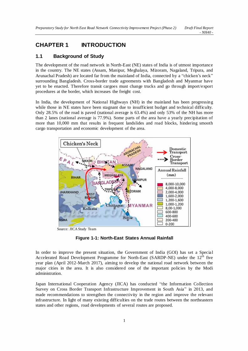
The development of the road network in North-East (NE) states of India is of utmost importance
in the country. The NE states (Assam, Manipur, Meghalaya, Mizoram, Nagaland, Tripura, and
Arunachal Pradesh) are located far from the mainland of India, connected by a “chicken’s neck”
surrounding Bangladesh. Cross-border trade agreements with Bangladesh and Myanmar have
yet to be enacted. Therefore transit cargoes must change trucks and go through import/export
procedures at the border, which increases the freight cost.
In India, the development of National Highways (NH) in the mainland has been progressing
while those in NE states have been stagnant due to insufficient budget and technical difficulty.
Only 28.5% of the road is paved (national average is 63.4%) and only 53% of the NH has more
than 2 lanes (national average is 77.9%). Some parts of the area have a yearly precipitation of
more than 10,000 mm that results in frequent landslides and road blocks, hindering smooth
cargo transportation and economic development of the area.
In order to improve the present situation, the Government of India (GOI) has set a Specia l
Accelerated Road Development Programme for North-East (SARDP-NE) under the 12th five
year plan (April 2012-March 2017), aiming to develop the national road network between the
major cities in the area. It is also considered one of the important policies by the Modi
administration.
Japan International Cooperation Agency (JICA) has conducted “the Information Collection
Survey on Cross Border Transport Infrastructure Improvement in South Asia” in 2013, and
made recommendations to strengthen the connectivity in the region and improve the relevant
infrastructure. In light of many existing difficulties on the trade routes between the northeastern
states and other regions, road developments of several routes are proposed.
Source: JICA Study Team
Figure 1-1: North-East States Annual Rainfall

Preparatory Study for North East Road Network Connectivity Improvement Project (Phase 2) Draft Final Report
- NH40 -
2
Under these circumstances, GOI has requested loan assistance to the Government of Japan
(GOJ) for improvement of eight existing roads (total length of 1,242 km), and rehabilitation of
two existing bridges, and one new bridge in the NE states. JICA conducted the Preparatory
Study for Road Network Improvement in NE States of India (hereinafter referred to as Phase 1)
including 1) prioritization of the proposed projects for Japanese ODA loans by analyzing the
current conditions, 2) collection and analysis of data for top two priority projects and review of
F/S conducted by India, and 3) examination of the top two priority projects as candidates for
Japanese Official Development Assistance (ODA) loans.
Nh54 and NH51 have been selected as the top two priority projects to conduct study. As the
result it was identified that NH54 contained sections that might suffer huge social environment
impact from the road expansion. Four bypassed for built-up sections with pavement
improvement (10 m width) for the existing sections have been proposed and the additional study
was conducted.
This preparatory study is a phase 2 (hereinafter referred to as Phase 2) following the Phase 1
targeting NH40 and Dhubri Bridge as the candidates to conduct a necessary study for loan
evaluation as Japanese ODA including project costs, implementation plan, maintenance and
operation structures, environmental and social considerations, etc.
It is expected that the first loan evaluation package will include NH54 and NH51, the second
NH54 bypasses and Nh40, to be followed with Dhubri Bridge.
1.2 Outline of the Project
The locations and outline of the Project are shown below.
Source: JICA Study Team
Figure 1-2: Project Locations

Preparatory Study for North East Road Network Connectivity Improvement Project (Phase 2) Draft Final Report
- NH40 -
3
Table 1-1: Tentative Outline of the Project
Project Name Road Network Improvement in North-East States of India (Phase 2) (hereinafter
referred to as “the Project”)
Project
Objectives
The Project aims at improving the road connectivity within the North-East region of India and with other areas by improving and constructing national highways
(including bridges) in the region, thereby contributing to the economic development in the region.
Project Overview
① Improvement of the national highway 40 (approx. 80km) between Shillong and
Dawki in Meghalaya
② Construction of a new bridge connecting Dhubri, Assam and Phulbari, Meghalaya (bridge length: approx. 10km, approaches: approx. 10km)
Project Area: North-East States of India
Counterpart (C/P) Agencies
Ministry of Road Transport and Highways (MoRTH) National Highways and Infrastructure Development Corporation Limited (NHIDCL)
Note: Phase 2 does not include construction of a new bridge connecting Dhubri, Assam and Phulbari, Meghalaya. Source: JICA Study Team
1.3 Objectives of Study
The objectives of the study are to develop a project plan including the project purpose and
outline, project costs, implementation plan, maintenance and operation structures,
environmental and social considerations, etc. This will provide the GOJ with the basis for loan
evaluation as Japanese Official Development Assistance (ODA), in response to the GOI’s loan
request.

Preparatory Study for North East Road Network Connectivity Improvement Project (Phase 2) Draft Final Report
- NH40 -
4
CHAPTER 2 PRESENT CONDITION OF STUDY ROADS
2.1 Present Status of Roads and Transport in Study Area
2.1.1 National Highway Network in NE States
The total length of NH in NE is 13,258 km and these are being developed and maintained by the
state Public Works Department (PWD), Border Roads Organization (BRO), National Highways
Authority of India (NHAI) and National Highways and Infrastructure Development Corporation
(NHIDCL) under the Ministry of Road Transport and Highways (MORTH). Of the total length
of 13,258 km, about 12,476 km is with the NHIDCL and respective state’s PWD. The remaining
length of 782 km is with NHAI. The Ministry has been paying special attention to the
development of NH in the North-East region (NER) and 10 % of the budget allocation is
earmarked for NER. The NH network mainly connects state capitals and major districts, as well
as the international cross border network as shown in Figure 2-1.
Source: Ministry of Development of North Eastern Region
Figure 2-1: National Highway Network in NER
The details of NH and their development and maintenance works taken up under various
schemes during the Fiscal Year 2014-15 in NER are as follows:
(i) Length under National Highway Development Project (NHDP) Phase-III 110 km
(ii) Length of NH, state roads under SARDP-NE, Phase A: 4,099 km, Phase B: 2,392 km,
Arunachal Pradesh package of Roads and Highways: 2,319 km
The current status of NH in each state in NE is shown in Table 2-1.

Preparatory Study for North East Road Network Connectivity Improvement Project (Phase 2) Draft Final Report
- NH40 -
5
Table 2-1: Numbers and Lengths of National Highways in NE States
No. Name of State National Highway No. Total Length (km)
1 Arunachal
Pradesh
52, 52A, 153, 229, 52B Ext, 37 Ext, 315 New, 713
New, 513 New, 313 New, 113 New, 713A New 2513.05
2 Assam
6 New, 31, 31B, 31C, 36, 37, 37A, 37E, 38, 39,
44, 51, 52, 52A, 52B, 53, 54, 61, 62, 117A New,
127B New, 127E New, 151, 152, 153, 154, 315A
New, 127C New, 127D New, 329 New, 427 New,
627 New, 702 New, 702B New, 702C New, 702D,
715A New
3811.67
3 Manipur
39, 53, 102 New, 102A New, 102B New, 102C
New, 129A New, 108A New, 129 New, 137 New,
137A New, 150, 155, 702A New
1545.74
4 Meghalaya 40, 44, 51, 62, 127B New 1204.36
5 Mizoram 6 New, 44A, 54, 54A, 54B, 102B New, 150, 154,
302 New, 306A New, 502A New 1381.00
6 Nagaland 36, 39, 61, 129 New, 150, 155, 702 New, 702A
New, 702B New, 702D 1150.09
7 Tripura 44, 44A, 108A, 208 New, 208A New, 108B New 805.0
Source: MORTH Annual Report 2015-16
2.1.2 Transport Infrastructure Development Projects in NER
The GOI has focused on time-bound completion of critical transport infrastructure of NER, viz.
road, rail, inland water transport (IWT), airport and air connectivity. Some of the critica l
ongoing projects are; (i) East West Corridor (Srinampur to Silchar), (ii) SARDP-NE, (iii)
Bogibeel Bridge, (iv) Railway gauge conversion (Lumding-Silchar and Rangia-Murkong selek),
(v) New railway lines (Jiribam-Tupul-Imphal), (vi) Airport hangers in the Lokapriya Gopinath
Bordoloi International Airport (Guwahati). The GOI has also proactively taken initiatives for
promoting linkages with other parts of the country and for close bilateral relations with the
neighboring countries and other South East Asian countries in pursuance of the ‘Act East
Policy’. Establishing closer ties between India and Bangladesh will also go a long way in
promoting peace and development in the NER.
2.2 Present Status of National Highway Development
2.2.1 Organizations Related to National Highway Development
(1) Ministry of Road Transport and Highways (MORTH)
The MORTH was formed in 2009 by bifurcating the erstwhile Ministry of Shipping, Road
Transport and highways into two independent Ministries. The MORTH encompasses
construction and maintenance of NH, administration of Motor Vehicles Act, 1988 and Central
Motor Vehicles Rules 1989, formation of broad policies relating to road transport,
environmental issues, automotive norms, fixation of use fee rate for use of NH, etc., in addition
to making arrangements for cross-border movement of vehicular traffic with neighboring
countries.

Preparatory Study for North East Road Network Connectivity Improvement Project (Phase 2) Draft Final Report
- NH40 -
6
(2) National Highways Authority of India (NHAI)
The NHAI was set up through an Act of Parliament, namely the National
Highways Authority of India Act, 1988. It is responsible for the
development, maintenance and management of NH entrusted to it by
MORTH and for matters related or incidental thereto. The NHAI became
operational in February, 1995. As on March 31, 2015, out of total 55,561
Km. of national highway that are planned to be developed/ upgraded by
NHAI, 32,620 Km. (excluding terminated contracts) of national highway have
been awarded, of which 23,866 Km. have been completed and 8,754 Km. are in progress.
Projects for 18,012 Km. is to be awarded in due course.
(3) Indian Academy of Highway Engineers (IAHE)
Indian Academy of Highway Engineers (IAHE) is a registered society
under the administrative control of MORTH. It changed the name from National Institute for Training of Highway Engineers (NITHE) in 2010. It
is a collaborative body of both central and state governments and was set
up in 1983 with the objective of fulfilling the long-felt need for training
of highway engineers in the country, both at the entry level and during the
service period. IAHE offers about 80 traiing cources for about 1,700
trainees on wide area s related to roads from planning, construction,
maintenance, quality control, road safety, contract management, ITS, etc. A new training
building and facilities were built in Noida, UP, on 1st October 2001. The training facilities
include an air-conditioned lecture hall, lecture rooms, a library, a conputor room, a materia l
testing training room, lodgings with a canteen and a leisure room, a faculty rooms, etc. IAHE
has been adding facilities according to the growing demand of training.
(4) National Highways & Infrastructure Development Corporation LTD (NHIDCL)
In February 2014, the Cabinet approved the set up and operation of a new
corporate entity under MORTH to exclusively carry out the task of
construction / up-grading / widening of NH in parts of the country, which
share international boundaries with neighboring countries so as to
promote regional connectivity with neighboring countries on a sustainable basis. An
approximate aggregate length of 10,000 kms has been identified to begin with for development
through this company. The company also proposes to improve road connectivity and efficiency
of the international trade corridor, by expanding about 500 KMs of roads in the North Bengal
and Northeastern region of India to enable efficient and safe transport regionally with other
South Asia Sub-regional economic Cooperation (SASEC) member countries. These projects are
being funded by ADB (Asian Development Bank).
(5) Indian Roads Congress (IRC)
Indian Roads Congress (IRC) is the apex body of road sector engineers
and professionals in India. IRC was formally registered as a society in
1937. IRC has more than five million associates (direct/indirect) and over
16,700 registered members comprising of engineers & professionals of all
Stakeholders of road sector. IRC have published Codes of Practices for
Specifications & Standards, Special Publications on Guidelines and
Manuals, publications on behalf of MORTH, and other informative
publications for road-related public organizations. In December 2015,
Source: NHAI
Figure 2-2: NHAI Logo
Source: IAHE
Figure 2-3:
IAHE Logo
Source: NHIDCL
Figure 2-4: NHIDCL Logo
Source: IRC
Figure 2-5: IRC
Logo

Preparatory Study for North East Road Network Connectivity Improvement Project (Phase 2) Draft Final Report
- NH40 -
7
IRC 76th Annual Session was held in Indore, which had about 2,000 people attendances from
public and private sector in the road industry.
2.2.2 Development Programs for National Highways
(1) Outline of Road Network in India
India has one of the largest road networks in the world with over 5,232,000 km of roads. It is
comprised of NH, expressways, state highways (SH), Major District Roads (MDR), Other
District Roads and Village Roads. Historically, investments in the transport sector have been
made by the Government. However, to encourage private sector participation, the Ministry has
laid down comprehensive policy guidelines for private sector participation in the development
of NH. Categories of roads and corresponding lengths of overall road network of India are
shown in Table 2-2.
Table 2-2: Categories and Lengths of Road Network of India
No. Category Length (km)
1 National highways / Expressways 100,475
2 State highways 148,256
3 Other Roads 4,983,579
Total 5,232,310
Source: MORTH Annual Report 2015-16
(2) Present Status of Each NH Development Programs
The MORTH has been entrusted with the responsibility of the development of road transport
and highways in general, and construction and maintenance of NH in particular. All roads other
than NH in the states fall within the jurisdiction of respective state governments. In order to
assist the state governments in the development of state roads, MORTH provides financia l
assistance out of the Central Road Fund (CRF) and Inter State Connectivity and Economic
Importance (ISC&EI) scheme. Besides National Highways Development Project (NHDP) and
National Highway Interconnectivity Improvement Programme (NHIIP), MORTH is
implementing SARDP-NE and Development of Roads in Left Wing Extremism (LWE) schemes,
which includes NH and state roads. The MORTH is also responsible for evolving standards and
specifications for roads and bridges in the country besides acting as a repository of technica l
information on roads and bridges. The present status of each NH development programs is
shown in Table 2-3 below.
Table 2-3: Present Status of NH Development Program 31st December, 2015 (km)
Program Name Total
Length Completed
Completed In 2015
NHDP 54,478 24,324 1233
I: GQ,EW-NS Corridors, Port Connectivity, Others 7,522 7,521 1
II: 4/6-laning North South-East West Corridor, Others 6,647 5,903 48
III: Upgrading, 4/6-laning 12,109 6,734 252
IV: 2-laning with Paved Shoulders 20,000 1,825 709
V: 6-laning of GQ and High Density Corridor 6,500 2,319 223

Preparatory Study for North East Road Network Connectivity Improvement Project (Phase 2) Draft Final Report
- NH40 -
8
VI: Expressways 1,000 0 0
VII: Ring Roads, Bypasses, Flyovers, Others 700 22 0
SARDP-NE 6,190 1,829 82
LWE 5,422 3,904 334
NHIIP 1,120 239 157
Source: MORTH Annual Report 2015-16
(3) National Highways Development Project (NHDP)
NHDP Phase I and II comprise of the development of NH to 4/6 lane standards. The
developments are (a) Golden Quadrilateral (GQ) connecting 4 major metropolitan cities viz.
Delhi-Mumbai-Chennai-Kolkata, (b) North South & East West Corridors (NS-EW) connecting
Srinagar to Kanyakumari and Silchar to Porbandar with a spur from Salem to Cochin, (c) Road
connectivity of major ports of the country to NH, and (d) Other NH stretches.
NHDP Phase I, which was approved by the Cabinet Committee on Economic Affairs (CCEA) in
December 2000 at an estimated cost of Rs. 303 million (1999 prices) comprises 5,846 km of
GQ, 981 km of NS-EW Corridor, 356 km of Port Connectivity and 315 km of other NH, a total
of 7,522 km. This was completed in 2015.
NHDP Phase II, which was approved in December 2003 at an estimated cost of Rs. 343 million,
comprises mostly NS-EW Corridor (6,151 km) and other NH of 486 km length, the total length
being 6,647 km. Out of the balance, 48 km was completed in 2015.
NHDP Phase III covers the 4-laning of 4,000 km of NH on Build-Operate-Transfer (BOT) basis
and was approved in March 2005. Additional sections have been added in the following years
and so far 12,109 km has been identified at an estimated cost of Rs. 806 million. By December
2015, 6,734 km of the 12,109 km has been four laned and an additional 3,313 km is under
implementation. During the year of 2015, 252 km has been completed.
NHDP Phase IV envisages upgrading of about 20,000 km of NH to 2-lane paved shoulder at an
estimated cost of Rs. 850 million. This phase was approved in July 2008. Out of the total,
13,203 km is entrusted to NHAI. A length of 1,825 km has already been four/two laned up to the
end of 2015 and 4,704 km is under implementation. During the year 2015, 709 km have been
completed.
NHDP Phase V comprises 6-laning of 6,500 km of existing 4-lane NH with approval in October
2006 at an estimated cost of Rs. 4,121 million. Six laning of 6,500 km includes 5,700 km of GQ
and 800 km of other stretches. Of the 6,500 km, a length of 2,319 km has already been 6-laned
by the end of 2015 and a length of 1,756 km is under implementation. During the year of 2015,
total length of 223 km has been completed.
NHDP Phase VI envisages development of 1,000 km of fully access-controlled expressways
under the Public Private Partnership (PPP) model following a Design-Build-Finance-Operate
(DBFO) approach. This phase was approved at an estimated cost of Rs. 1,668 million in
November 2006. It is planned that Rs. 900 million will come from private sector and the
balance Rs. 768 million will be government funding for bridging the viability gap as well as
meeting the cost of land acquisition, utility shifting, consultancy, etc.
NHDP Phase VII covers the construction of standalone ring roads, bypasses, grade separators,

Preparatory Study for North East Road Network Connectivity Improvement Project (Phase 2) Draft Final Report
- NH40 -
9
flyovers, elevated roads, tunnels, road over bridges, underpasses, service roads, etc., with a BOT
(Toll) model. This phase was approved in December 2007 at an estimated cost of Rs. 1,668
million.
Source: NHAI
Figure 2-6: National Highway Development Project (as of May 31, 2016)
(4) Special Accelerated Road Development Programme for the North Eastern Region (SARDP-NE)
SARDP-NE aims at improving road connectivity of district headquarters and remote places of
NER with state capitals. It envisages 2/4-laning of about 7,530 km of NH and 2-
laning/improvement of about 2,611 km of state roads. This will ensure the connectivity of 88
district headquarters in NE states to the nearest NH by at least a 2-lane road. The programme
has been divided into Phase A, Phase B, and Arunachal Pradesh Package of Roads and
Highways.

Preparatory Study for North East Road Network Connectivity Improvement Project (Phase 2) Draft Final Report
- NH40 -
10
Phase A is the improvement of 4,099 km of roads consisting of 3,014 km of NH and 1,085 km
of state roads at an estimated cost of Rs. 2,177 million. Out of 4,099 km, BRO, state PWD and
NHIDCL have been assigned with the development of 3,213 km of roads at an estimated cost of
Rs. 1,282 million. Of the remaining length of 886 km, 112 km is to be implemented by NHAI
on BOT (annuity) basis, 20 km by Arunachal Pradesh PWD and 752 km by NHIDCL. The
works are in various stages of progress and the likely date of completion for Phase A is March,
2017.
Phase B involves 2-laning of 2,392 km of NH and 2-laning/improvement of 1,331 km state
roads. Phase B is approved only for DPR preparation.
The Arunachal Pradesh Package of Roads and Highways covering 2,319 km (2,205 km NH and
114 km state/General Staff Roads (GS roads)) of road stretch was approved as part of SARDP-
NE on January, 2009. Out of this, 776 km has been approved for execution under BOT
(Annuity) basis and approval for tendering under EPC basis has been given for the remaining
1,543 km. By December 2015, works for a total length of 1,675 km at a cost of Rs. 1,529
million have been awarded. The remaining length of 644 km is either under estimate
examination or DPRs are under preparation.
(5) Development of Roads in Left Wing Extremism (LWE) Affected Areas
The GOI approved the Road Requirement Plan for the development of 1,126 km NH and 4,351
km State Roads (total 5,477 km) to 2-laning at a cost of Rs. 730 million in Left Wing
Extremism (LWE) affected 34 districts in the State of Andhra Pradesh, Bihar, Chhattisgarh,
Jharkhand, Madhya Pradesh, Maharashtra, Odisha and Uttar Pradesh for all-inclusive growth of
these areas.
Source: Ministry of Development of North Eastern Region (MDONER)
Figure 2-7: Major Road Development Programs in North East Region

Preparatory Study for North East Road Network Connectivity Improvement Project (Phase 2) Draft Final Report
- NH40 -
11
MORTH has set up the LWE Division under the Chief Engineer for sanctioning and
implementing the above programme through respective state PWD. The detailed estimates for
5,422 km have been sanctioned at an estimated cost of Rs. 859 million, out of which, works on
5,263 km length costing Rs. 701 million have been awarded. Development of 3,904 km has
been completed up to January, 2016 and the cumulative expenditure incurred so far is Rs. 540
million. The development of roads under the programme is scheduled to be completed by March,
2017 except for the works that are yet to be awarded.
(6) National Highways Interconnectivity Improvement Projects (NHIIP)
Rehabilitation and upgrading to 2-lane roads with paved shoulders of stretches of various NH in
the states of Bihar, Karnataka, Odisha, Rajasthan and West Bengal is being taken up with loan
assistance from the World Bank (WB) under Phase-I of NHIIP. Eleven stretches involving 15
civil works contracts comprising a total length of 1,120 km amounting to Rs. 519 million (WB
share is US$ 500 million) is envisaged in the programme. Cabinet approved the project in April,
2013. Target completion of the project is March, 2022.
The Project components include A: Road Improvement and Maintenance, B: Institutiona l
Development Component, and C: Road Safety. The loan is to be amortized in 18 years including
a 5 year grace period.
(7) National Expressway Network Plan
The study on the “Formation of Master Plan for Indian National Expressway Network” in 2009
highlighted the urgency of developing an expressway network in India in three phases by the
year 2022. The present NH system cannot cope with the current and anticipated traffic
requirements, as is already evident from the levels of congestion along the existing arterials. By
all indications, roads will continue to remain the backbone of the inland transportation system.
The study having considered the existing and already proposed expressway segments in
different state, revealed the need to construct 18,637 km of expressway network. The network
developed shall be both supplementary and complimentary to the existing arterial network
including the North - South and East - West Corridor and the GQ (beside the well-laid out
network of NH).
A project is considered viable for BOT with a threshold FIRR of 12%. Results of the financia l
analysis have been presented in the report. The need to provide 40% Viability Gap Funding
(VGF) for some segments and, the need to take up certain segments on annuity basis cannot be
discounted. The study has considered the funding options of VGF of 20% with 20 years of the
concession period as scenario I by adopting the Ministry’s toll rate (2008) for the purpose of
prioritization of expressway segments.
Financial analysis suggests that in order to be financially viable, a link must cater to Average
Annual Daily Traffic (AADT) of 25,000 passenger car units (PCU) under scenario I, while the
same would be 15,000 PCU under scenario II, which has VGF of 20% with 30 years of the
concession period. The expressways shall have at least 4 lane divided carriageway cross section.
The Right of Way (ROW) shall be a uniform 90 m. It will be a Toll Expressway Network with
toll rates as per the Ministry’s Guideline (2008).
The network shall be completed in 3 phases spanning up to 2022. In the first phase, 11 projects
covering 3,530 km are awarded by 2012. In the second phase (2013-17), 4,310 km will be
added. In the third phase (2018-22), another 4,310 will be added. The third phase may also see

Preparatory Study for North East Road Network Connectivity Improvement Project (Phase 2) Draft Final Report
- NH40 -
12
the development of an additional 5,226 km of expressways on the annuity model.
2.2.3 Cross Border Connectivity Projects in NER
(1) Trilateral Highway Project
India has been implementing several connectivity projects in Southeast Asia to strengthen the
ASEAN-India Strategic Partnership. Trilateral Highway is poised to create a new dynamic in
India’s multi-faceted ties with the region. With the new GOI focusing with renewed vigor on
spurring the economic uplift of India’s NE states, the gateway to ASEAN, enhanced
connectivity promises to bring new prosperity in this region. The ASEAN-India road
connectivity in the present form runs along Asian Highway (AH1) and the India-Myanmar-
Source: MORTH
Figure 2-8: Proposed National Expressway Network

Preparatory Study for North East Road Network Connectivity Improvement Project (Phase 2) Draft Final Report
- NH40 -
13
Thailand Trilateral Highway.
On the Trilateral Highway, the Tamu and Kalewa friendship road is being constructed with
India’s assistance (Figure 2-9). About 132 km has been completed and handed over to Myanmar.
Work on the other 28 km is under progress. India has also undertaken the task of
repair/upgradation of 71 bridges on the Tamu-Kalewa Friendship Road, and upgradation of the
120 km Kalewa-Yargyi road segment to highway standard, while Myanmar has agreed to
undertake upgradation of the Yargyi-Monywa stretch to highway standard by 2016.
This project would help in establishing trilateral connectivity from Moreh in India to Mae Sot in
Thailand via Myanmar. Separately, GOI had taken initiatives to prepare DPR for construction of
Chaungma-Yinmabin section (30 km); and upgradation from single lane to double lane of the
Yinmabin-Pale-Lingadaw section (50 km). India has also announced the extension of the
Trilateral Highway to Cambodia, Lao PDR and Vietnam.
Source: Ministry of External Affairs, GOI
Figure 2-9: Trilateral Highway Project
(2) Kaladan Multi Modal Transit Transport Project
The Kaladan Multi Modal Transit Transport Project was jointly identified by India and
Myanmar to create a multi-modal mode of transport for shipment of cargo from the eastern
ports of India to Myanmar as well as to the NE part of India through Myanmar. This project,
which will connect Sittwe Port in Myanmar to the India-Myanmar border, is expected to

Preparatory Study for North East Road Network Connectivity Improvement Project (Phase 2) Draft Final Report
- NH40 -
14
contribute to the economic development of the NE states of India, by opening up the sea route
for the products. It also provides a strategic link to the NE, thereby reducing pressure on the
Siliguri Corridor. Since the project is of political and strategic significance, the decisions were
made to execute it through India's grant assistance to Myanmar.
The Ministry of External Affairs (MEA), GOI entered into a Framework Agreement with the
Government of Myanmar in April 2008 to facilitate implementation of the project. As shown in
the figure below, the components of this project include (i) construction of an integrated port
and IWT terminal at Sittwe including dredging; (ii) development of navigational channel along
river Kaladan from Sittwe to Paletwa (158 km); (iii) construction of an IWT - Highway
transshipment terminal at Paletwa; and (iv) construction of six IWT barges (each 300 tonne
capacity) for transportation of cargo between Sittwe and Paletwa. The Framework Agreement
and two protocols (Protocol on Transit Transport and Protocol on Maintenance) were signed by
India and Myanmar on 2nd April 2008. A substantial portion of the construction of the
integrated Port and IWT jetty at Sittwe is complete. Construction work of IWT terminal at
Paletwa started in April 2013. The border to NH 54 (Lawngtlai) Road on the Indian side in
Mizoram is in progress.
Source: IWAI
Figure 2-10: Kaladan Multimodal Transit Transport Project
(3) National Waterway-2 Brahmaputra Project
Northeast India has many large and small rivers providing facilities for water transport,
especially in their plains sections. From the ancient period until roads were constructed, the
Brahmaputra and Barak rivers were commonly used as the medium of transport. Especially,
Brahmaputra is the life line of NER. It was declared as National Waterway-2 in 1988 for a
distance of 891 km from Dhubri to Sadia. Inland Waterways Authority of India (IWAI)
maintains the navigational channel at minimum 45 m width and 2.5 m depth, which is the

Preparatory Study for North East Road Network Connectivity Improvement Project (Phase 2) Draft Final Report
- NH40 -
15
standard for National Waterway-2.
Necessary aids for facilitating 24 hour navigation are maintained between Dhubri and Silghat
while day navigation marks are provided in further upper sections of the river. Termina l
facilities for loading and unloading of cargo are being maintained by IWAI at strategic locations
such as Dhubri, Jogighopa, Pandu, Silghat, Neamati and Dibrugarh. Pandu (Guwahati) is being
developed as a multi modal transport hub which can serve the entire NER. A permanent
terminal at Dhubri in Assam is under construction with all facilities as a first important termina l
on the Brahmaputra. It has been proposed to upgrade the existing temporary terminal at
Jogighopa to a bulk cargo handling terminal for products like Meghalaya coal, with rail
connectivity up to the terminal.
Source: MDONER
Figure 2-11: National Waterway-2 Brahmaputra Project
2.2.4 On-going Road Projects in NER by International Cooperation
There are several ongoing road projects in NER funded by international cooperation agencies as
shown in Table 2-4.
Table 2-4: On-going Road Projects in NER
International Donor Project Name
World Bank (WB) Assam State Road Project
World Bank (WB) Mizoram State Road Project I-II
Asian Development Bank (ADB) North Eastern States roads Investment Program
Source: JICA Study Team

Preparatory Study for North East Road Network Connectivity Improvement Project (Phase 2) Draft Final Report
- NH40 -
16
(1) Assam State Road Project (WB)
The project development objective is to enhance the road connectivity of Assam by assisting the
public works roads department to improve and effectively manage its road network. There are
three components to the project; (a) Improvement of priority sections of the secondary roads to
improve state connectivity and facilitate regional integration, (b) Road sector modernization and
performance enhancement to support implementation of the Road Sector Modernization
Program (RSMP) to carry forward and deepen various institutional development initiatives
already underway, (c) Road safety management to support the building of road safety
management capacity of related agencies through developing and implementing a multi-sector
road safety strategy.
(i) Approval Date (as of board presentation) : March 13, 2012
(ii) Closing Date : March 31, 2018
(iii) Total Project Cost : US$ 400.00 million
(2) Mizoram State Road Project I (WB)
The project's development objective is to improve the management and carrying capacity of the
Mizoram core state road network. The project comprises of six components; (a) Improvement
(widening and strengthening) of about 184 km SH, (b) Implementation of the Resettlement and
Indigenous People Development Plan (R&IPDP), Environmental Management Plan (EMP), and
land acquisition and utility relocation plan associated with the road improvement component,
(c) Rehabilitation and maintenance of about 520 km of state roads, (d) Design, supervision
and technical advisory services for civil works, (e) Institutional strengthening, including
equipment, TA, training, and pre-investment studies, (f) Road safety engineering interventions.
(i) Approval Date (as of board presentation): March 14, 2002
(ii) Closing Date: December 31, 2010
(iii) Total Project Cost: US$ 70.00 million

Preparatory Study for North East Road Network Connectivity Improvement Project (Phase 2) Draft Final Report
- NH40 -
17
Source: World Bank
Figure 2-12: Location of Mizoram State Road Project I (WB)

Preparatory Study for North East Road Network Connectivity Improvement Project (Phase 2) Draft Final Report
- NH40 -
18
(3) Mizoram State Road Project II (WB)
The objective of the Second Mizoram State Roads Regional Transport Connectivity Project is to
increase transport connectivity along regional trade corridors in Mizoram. There are three
components to the project; (a) Improvement of priority cross-border roads and trade-related
infrastructure including widening and strengthening of 91 km of road and preparation studies
for approximately 330 km of road, (b) Construction or improvement of trade-related
infrastructure along project roads including market structures and a truck stop, (c) Road sector
modernization and performance enhancement through institutional strengthening to support
gradual transformation of PWD into a modern road agency through implementation of a Road
Sector Modernization P lan, which will carry forward and deepen various institutiona l
development initiatives, introduced under the Mizoram State Road Project I.
(i) Approval Date (as of board presentation): June 12, 2014
(ii) Closing Date: October 31, 2020
(iii) Total Project Cost: US$ 107.00 million
Source: JICA Study Team Phase 1
Figure 2-13: Location of Mizoram State Road Project II (WB)
(4) North Eastern States Roads Investment Program (ADB)
The Condition Survey of Roads in NER was conducted in October 2005, which showed that
approximately 70% of roads in the region were in poor condition and barely 20% in serviceable
condition. Most SH and MDR were of inadequate width. The average travel speed on these
roads was found to be approximately 40 km/hour for light vehicles and about 25 km/ hour for

Preparatory Study for North East Road Network Connectivity Improvement Project (Phase 2) Draft Final Report
- NH40 -
19
trucks and buses.
GOI approached the Asian Development Bank (ADB) for assistance in its effort to improve the
condition of some of the most trafficked state highways and district roads in various states in
NER. The ADB approved a Project Preparatory Technical Assistance towards preparing a
Feasibility Study (F/S) for up-gradation and reconstruction of state highways and district roads
and institutional development and capacity building of state PWDs in NE states. Eventually, a
total length of 433.7 km of roads was selected for the proposed scheme covering the states of
Assam, Manipur, Meghalaya, Mizoram, Sikkim and Tripura.
(i) Approval Date (as of board presentation): May 19, 2011
(ii) Closing Date: May 31, 2016
(iii) Total Project Cost: US$ 298.2 million
Table 2-5: North Eastern States Roads Investment Program (ADB)
State Name of Road Length (km) Cost ( Rs. cr)
Assam Kalikuchi - Barpeta 58.5 169.94
Bilaspara - Fakiragram (NH-31) 16.2
Tamulpur - Paneri 43
292.57 Paneri - Udalguri 18.6
Major Bridges 1.3
Meghalaya Garobada - Dalu 93.4 196.82
Sikkim Meli - Nayabazar 9.5 95.39
Nayabazar - Namchi 19.7
Manipur Tupul - Kasom Khullen 93.2 277.01
Mizoram Serchhip - Buarpui 55 167.9
Tripura Udaipur - Melaghar 20.3 69.16
Source: MDONER

Preparatory Study for North East Road Network Connectivity Improvement Project (Phase 2) Draft Final Report
- NH40 -
20
Source: JICA Study Team Phase 1
Figure 2-14: North Eastern State Roads Investment Program (Assam)
Source: JICA Study Team Phase 1
Figure 2-15: North Eastern State Road Investment Program (Meghalaya)

Preparatory Study for North East Road Network Connectivity Improvement Project (Phase 2) Draft Final Report
- NH40 -
21
Source: JICA Study Team Phase 1
Figure 2-16: North Eastern State Roads Investment program (Manipur)

Preparatory Study for North East Road Network Connectivity Improvement Project (Phase 2) Draft Final Report
- NH40 -
22
Source: JICA Study Team Phase 1
Figure 2-17: North Eastern State Roads Investment program (Tripura)

Preparatory Study for North East Road Network Connectivity Improvement Project (Phase 2) Draft Final Report
- NH40 -
23
Source: JICA Study Team Phase 1
Figure 2-18: North Eastern State Roads Investment program (Mizoram)
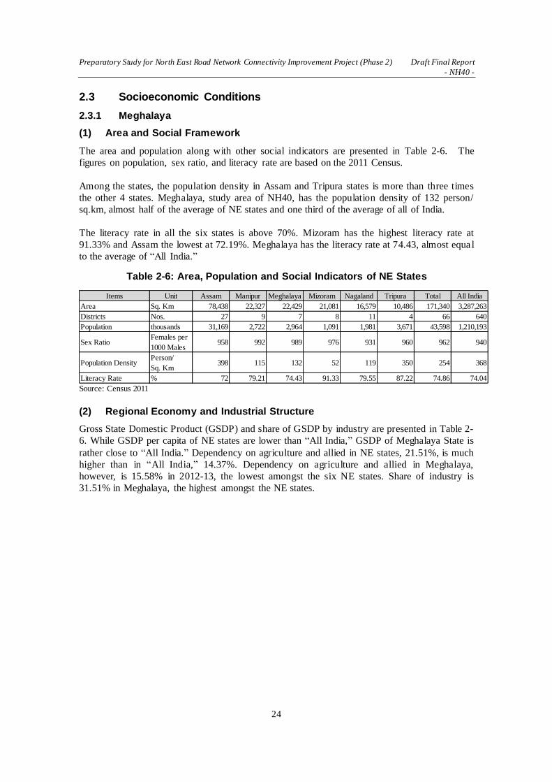
Preparatory Study for North East Road Network Connectivity Improvement Project (Phase 2) Draft Final Report
- NH40 -
24
2.3 Socioeconomic Conditions
2.3.1 Meghalaya
(1) Area and Social Framework
The area and population along with other social indicators are presented in Table 2-6. The
figures on population, sex ratio, and literacy rate are based on the 2011 Census.
Among the states, the population density in Assam and Tripura states is more than three times
the other 4 states. Meghalaya, study area of NH40, has the population density of 132 person/
sq.km, almost half of the average of NE states and one third of the average of all of India.
The literacy rate in all the six states is above 70%. Mizoram has the highest literacy rate at
91.33% and Assam the lowest at 72.19%. Meghalaya has the literacy rate at 74.43, almost equa l
to the average of “All India.”
Table 2-6: Area, Population and Social Indicators of NE States
Source: Census 2011
(2) Regional Economy and Industrial Structure
Gross State Domestic Product (GSDP) and share of GSDP by industry are presented in Table 2-
6. While GSDP per capita of NE states are lower than “All India,” GSDP of Meghalaya State is
rather close to “All India.” Dependency on agriculture and allied in NE states, 21.51%, is much
higher than in “All India,” 14.37%. Dependency on agriculture and allied in Meghalaya,
however, is 15.58% in 2012-13, the lowest amongst the six NE states. Share of industry is
31.51% in Meghalaya, the highest amongst the NE states.
Items Unit Assam Manipur Meghalaya Mizoram Nagaland Tripura Total All India
Area Sq. Km 78,438 22,327 22,429 21,081 16,579 10,486 171,340 3,287,263
Districts Nos. 27 9 7 8 11 4 66 640
Population thousands 31,169 2,722 2,964 1,091 1,981 3,671 43,598 1,210,193
Sex RatioFemales per
1000 Males958 992 989 976 931 960 962 940
Population DensityPerson/
Sq. Km398 115 132 52 119 350 254 368
Literacy Rate % 72 79.21 74.43 91.33 79.55 87.22 74.86 74.04

Preparatory Study for North East Road Network Connectivity Improvement Project (Phase 2) Draft Final Report
- NH40 -
25
Table 2-7: GSDP and Share of GSDP by Industry
Items Unit Assam Manipur Meghalaya Mizoram Nagaland Tripura Total All India
2012-13
Gross State
Domestic Product
(GSDP )*
Rs. Million 836,300 76,250 119,780 52,030 106,710 169,970 1,361,040 54,821,110
Population thousands 31,169 2,722 2,964 1,091 1,981 3,671 43,598 1,210,193
GSDP per capita* Rs 26,831 28,012 40,412 47,690 53,867 46,301 31,218 45,299
Agriculture and
Allied% 21.53 19.53 15.58 19.46 26.01 24.33 21.52 14.37
Agriculture % 18.01 15.4 11.74 14.13 20.22 17.32 17.25 12.26
Industry % 21.59 27.7 31.51 16.44 13.49 20.29 21.81 28.22
Mining % 5.32 5.5 0.22 0.12 1.69 3.98 2.11
Manufacturing % 7.61 0.6 6.69 1.58 1.74 4.62 6.07 16.28
Services % 56.88 52.77 52.91 64.09 60.51 55.37 56.67 57.42
2013-14
Gross State
Domestic Product
(GSDP)*
Rs. Million 885,370 N/A 134,650 N/A 113,670 N/A N/A 57,417,910
Population thousands 31,169 2,722 2,964 1,091 1,981 3,671 43,598 1,210,193
GSDP per capita* Rs 28,405 N/A 45,428 N/A 57,380 N/A N/A 47,445
Agriculture and
Allied% 21.27 N/A 14.56 N/A 25.39 N/A N/A 13.95
Agriculture % 17.77 N/A 11.1 N/A 19.78 N/A N/A 11.85
Industry % 21.27 N/A 31.37 N/A 13.64 N/A N/A 27.27
Mining % 5.13 N/A 4.96 N/A 0.11 N/A N/A 1.98
Manufacturing % 7.44 N/A 6.75 N/A 1.7 N/A N/A 15.76
Services % 57.47 N/A 54.07 N/A 60.97 N/A N/A 58.79
* at Constant 2004-05 Prices
Source: Planning Commission, Government of India

Preparatory Study for North East Road Network Connectivity Improvement Project (Phase 2) Draft Final Report
- NH40 -
26
CHAPTER 3 MAJOR ISSUES OF STUDY ROADS
3.1 Study Approach
3.1.1 Implementation Planning and Costing Based on the Natural Conditions
Since the Project road traverses rugged mountains with sharp curves, when terrain change
points and landslide prone slopes are observed, utmost care will be paid to grasp the
topographic changes as accurately as possible for adequate designing. Full field reconnaissance
will be conducted by videotaping with GPS data to check the details.
The JICA Study Team will contact the DPR consultant for coordination of the work after the
initial field reconnaissance and a review of the DPR. Consequently, the results will be
adequately incorporated into scheduling the project implementation and costing.
3.1.2 Best mix Design of Indian and Japanese Mountain Road Technology
(1) Road Design in Rugged Topography
When the application of the standard cross section involves large-scale cut-slope protections or
embankment retaining walls, the JICA Study Team will propose a practical design taking into
consideration the level of traffic demand and economy. The practical design includes reduced
cross sections, smaller horizontal curve radii for critical passes, separation of roadway in
extremely rugged terrain, etc.
(2) Landslide Disaster Countermeasures
After identifying landslide-prone locations, boring geological survey will be conducted for
stability analysis to analyze the cause and generation mechanism. With due considerations of the
slope gradient and greening, countermeasures will be designed. The JICA Study Team will
propose Japanese e technology with full respect to the Indian guidelines on landslide.1
(3) Road Safety Considerations
GOI has formulated National Road Safety Policy 2015 and has been grappling with traffic
accident reduction setting road safety as the highest priority of the nation. However, the death
toll is still increasing year by year due to rapid increase of the number of vehicles. Road traffic
deaths in India is featured as 28.2% took place on national highways, of which length accounts
for only 1.91% of the total road network and 53.7% took place on rural highways. There is no
need to stress the importance of road safety considerations for the design of the Project road.
The Indian manual2 published in 2015 directs engineers to provide full safety measures. The
JICA Study Team will propose a road design with road safety considerations.
(4) Aesthetic Design
Shillong is famous for its picturesque scenery and a summer resort on the highland. Since the
section between Shillong and Dawki of NH40 passes through highlands and mountains,
Viewpoints should be planned for road users to enjoy panoramic view at locations such as right
after crossing a mountain pass, where there awaits a grandeur view. It will enhance not only the
tourism resources of Meghalaya but also the economic value of NH40. Road alignment design
is crucial to aesthetic designing of the road. Beautiful natural landscapes of mountains and
1 IRC:SP-106-2015 Engineering Guidelines on Landslide Mitigation Measures for Indian Roads
2 IRC:SP:73-2015 Manual of Specifications & Standards for Two Laning of Highways with Paved Shoulder

Preparatory Study for North East Road Network Connectivity Improvement Project (Phase 2) Draft Final Report
- NH40 -
27
rivers should be effectively incorporated into road landscaping. It is important for creation of
comfortable landscape to minimize the damage to nature and the environment and to create
scenic harmony of the road and the surrounding terrain.
(5) Utilization of Precast Structures
It is the rainy season during May and October at the project site making field construction
works very hard. Shortening the field work is an effective way to avoid the influence of rain to
the construction. Field Assembly Precast Method for auxiliary structures such as box culverts
will be effective for reducing the period of field construction work. Many box culverts are
constructed on site in India taking a long construction period and stopping during rainy days,
while almost all are done by the Precast Method in Japan. Auxiliary structures will be fabricated
at the factory during the rainy season and transported piece by piece to the construction site to
assemble during the dry season. The JICA Study Team will conduct a survey on potentia l
casting yards and fabrication factories in the Project site.
(6) Utilization of Locally Available Materials
There are many boulder rocks in alluvial layers at the foot of mountains and road earthwork
often excavates a huge amount of boulder rocks. Japan, which has rugged topography and
complex geography, similar to the North-East states of India, has accumulated experiences in
how to utilize boulder stones for road embankment and has developed a method of Rock Mass
Embankment. India also has a rich experience in landslide mitigation measures. The JICA Study
Team will propose a hybrid technology combining Japanese and Indian experience after
thorough coordination with relevant organizations.
3.1.3 Bridge Substructures for Strong River Flow and Work Period Constraint
The project area experiences rainy season from May through October and the high water leve l
of the river makes construction works impossible to implement. The preferable location of
bridge will be selected considering both river width and strong water flow, which tends to
change not only the shape of river bed but also location of the channel. A pier type will be
selected against such river conditions. DPR will be reviewed and discussion with consultant
employed by the local government will be held to find the best solution.
The Bogibeel Bridge in northern Assam, longest road and railway combined bridge in India, is
under construction with caisson foundations in the Brahmaputra River. The caisson foundation
is considered one of the most suitable types for new bridges. The construction plan will be
examined to realize shorter construction period.
3.1.4 Study on Adaptable Japanese Technology
Countermeasures against landslide disasters measures are crucial for the Project road which
passes through mountains in the heavy rain region. The new bridge design needs carefu l
consideration and selection of foundation type and construction methods to cross the river with
a fast current during the rainy season. Some applicable Japanese technologies include landslide
disaster measures, high-performance pavement, bridge substructure and foundation, and new
construction materials.
The JICA Study Team will study applicability of Japanese technologies considering the loca l
conditions of geological features, inclination slopes, environmental features, the nature of the
river, etc., and communicate closely with relevant organizations to propose application of
Japanese technology.

Preparatory Study for North East Road Network Connectivity Improvement Project (Phase 2) Draft Final Report
- NH40 -
28
3.1.5 Risk Analysis of EPC Contracts and Considerations about Procurement
The JICA Study Team will discuss risks in the EPC contract for smooth implementation of the
Project. EPC contract is the mainstream for road development in India these days and the JICA
Study Team will follow Phase 1 for the preparation of contract documents clarifying the risk
allocations between clients and contractors because they are very different from either BOT,
which India has adopted so far, or FIDIC’s Redbook.
The EPC contract involves an enormous amount of documents that have to be submitted for
approval by clients. It may require many days for clients to approve especially in case the
absence of guidelines for checking items and criteria leads to claims by contractors.
3.1.6 Traffic Demand Forecast for Road Network Connectivity in NER
The Project road is an important trade route not only for traffic between Guwahati - Shillong -
Dawki but also for freight transport in a wide area on the South Asia being a part of Asian
Highway AH-1. Current traffic volume observed in Phase 1 is only about 2,000 vehicles per day
and 75% of them are passenger cars3.
When the cross-border trade agreement is concluded between India and Bangladesh, those
trucks currently using the long detour through the Chicken’s Neck from the Kolkata port may
transfer to the Chittagong port in Bangladesh. The JICA Study Team will verify the assumptions.
3.1.7 Supporting the Preparation of EIA and RAP Based on JICA Guidelines
EIA studies for road projects of this nature are exempted in environment-related regulations in
India. Evaluation of Category A (EIA level) on DPR in accordance with JICA Guidelines for
Environmental and Social Considerations (hereinafter referred to as “JICA Guidelines”),
however, has to be implemented considering the alignment passing through the area with a
wealth of biological resources.
Such supplemental EIA study is usually required since DPR is prepared purely from technica l
and economic viewpoints. While information disclosure (public consultations) required by JICA
Guidelines is unlikely to be implemented at DPR stage, the JICA Study Team will provide
necessary support for the implementing agency in order to hold public consultations for
information disclosure. Specifications on information disclosure are different between JICA
Guidelines and Environment Protection Act of India. At least two consultations, at scoping and
draft EIA stages are compulsory in JICA Guidelines, while consultation at disclosure of draft
EIA is stated in the guidelines of India. As above, the JICA Study Team would like to explain
the requirement for JICA-finance projects in terms of EIA study at the beginning of this study
for facilitating the understanding of the implementing agencies. Thus, their active involvement
in information disclosure is materialized and smoothly implemented.
Since it is expected that the relocation of more than 200 households and land acquisition are
required for the project, the JICA Study Team will study regulations and past examples about
land acquisition and relocations in India and will support a local execution agency to prepare
Resettlement Action Plan (RAP, commonly called Social Impact Assessment: SIA in India) in
compliance with local regulations and the JICA Guidelines requirements for smooth
implementation of a yen loan project.
3 The share of passenger cars is 20-40% in other roads in the Phase 1 survey

Preparatory Study for North East Road Network Connectivity Improvement Project (Phase 2) Draft Final Report
- NH40 -
29
3.2 Major Issues of the DPR Design and Recommended Solutions
3.2.1 Notable Features of Design of NH40 (Shillong - Dawki)
(1) Greatly Varying Altitude of the Road
The existing NH40 (Shillong - Dawki) stretches the total length of approximately 81.26 km. The
vertical alignment varies significantly starting at Shillong with the altitude of about 1500 m,
crossing the highest point at about 1,700 m and ending the lowest at only about 50 m. Since the
existing NH40 meanders with zigzags and sharp curves passing through mountains, the
alignment improvement of horizontal curves and bypasses to avoid built-up areas shortens the
total length approximately to 71.5 km.
Source: JICA Study Team
Figure 3-1: Profile of NH40
Partly due to this greatly varying altitude of NH40, the weather along the stretch is
unpredictable; the higher sections have
frequent dense fog, while lower sections
heavy rainfall, of which the annual tota l
reaches 10,000 mm. The lowest sections
sit neighboring on Bangladesh across the
Dawki River, where it boasts of beautifu l
and grandeur scenery attracting many
tourists both from India and Bangladesh.
The international border line goes along
the river, which has zones called “No
Man’s Land” between the border line and
lines on both side of 200 yards from the
border line. These zones restrict some
activities like a bridge construction.
Source: JICA Study Team
Figure 3-2: Bangladesh Viewed from Dawki

Preparatory Study for North East Road Network Connectivity Improvement Project (Phase 2) Draft Final Report
- NH40 -
30
(2) Features of the Road Section from KP0.000 to KP15.000
The project road starts at the intersection of NH40 and NH44, where Kilo Post (KP) is 0.000.
The first few kilometers are extremely congested since this is the single major highway entering
Shillong coming from the Dawki side. Bypass #1 is planned to improve the poor road alignment
using the land in 3-1/2 Mile owned by the Ministry of Defense. However, the detailed survey
identified that the land is mostly being owned by Ministry of Forest. Bypass #2 and #3 are
planned to detour two built-up areas, namely Ritmawniew and Mylliem.
Source: JICA Study Team
Figure 3-3: Road Alignment and Condition (KP0.000 - KP15.000)

Preparatory Study for North East Road Network Connectivity Improvement Project (Phase 2) Draft Final Report
- NH40 -
31
(3) Features of the Road Section from KP15.000 to KP35.000
The project road passes through the highest point of the route from KP23.000 km to KP25.000
km at the altitude of approximately 1,800 m. Massive and solid rock is exposed on the hill-side
slopes along the NH40 route. There are some quarries producing rock and aggregate along the
route. A few viewpoints are provided at widened shoulder areas. Bypass #4 is planned to detour
the built-up area of Laitlyngkot.
Source: JICA Study Team
Figure 3-4: Road Alignment and Condition (KP15.000 - KP35.000)

Preparatory Study for North East Road Network Connectivity Improvement Project (Phase 2) Draft Final Report
- NH40 -
32
(4) Features of the Road Section from KP35.000 to KP55.000
There are some view points with a refreshment house and a small souvenir shop along the route
before descending from the altitude of 1,600 m down to 1,000 m. Bypass #5 detours a relatively
large town of Pynursla and then the project road passes through relatively mild rolling terrain.
Source: JICA Study Team
Figure 3-5: Road Alignment and Condition (KP35.000 - KP55.000)
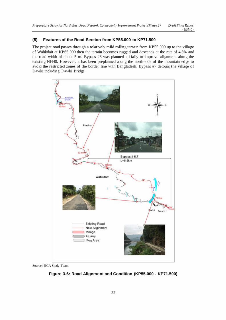
Preparatory Study for North East Road Network Connectivity Improvement Project (Phase 2) Draft Final Report
- NH40 -
33
(5) Features of the Road Section from KP55.000 to KP71.500
The project road passes through a relatively mild rolling terrain from KP55.000 up to the village
of Wahkdait at KP65.000 then the terrain becomes rugged and descends at the rate of 4.5% and
the road width of about 5 m. Bypass #6 was planned initially to improve alignment along the
existing NH40. However, it has been preplanned along the north-side of the mountain edge to
avoid the restricted zones of the border line with Bangladesh. Bypass #7 detours the village of
Dawki including Dawki Bridge.
Source: JICA Study Team
Figure 3-6: Road Alignment and Condition (KP55.000 - KP71.500)

Preparatory Study for North East Road Network Connectivity Improvement Project (Phase 2) Draft Final Report
- NH40 -
34
(6) Features of Bridges
There are several bridges on the project road as well as short culverts. The longest bridge is the
135 m-long Dawki Bridge crossing the narrowest section of Dawki River at about 500 m
upstream side from the river mouth. It is a suspension bridge constructed 85 years ago, in the
year of 1931 during the colonial time. Trucks carrying stones and aggregates frequently cross
the bridge. There is no appropriate detour to cross the river once the bridge is closed to traffic.
Although the importance of Dawki Bridge is undeniable the bridge has been one of the biggest
bottlenecks of the road section (NH40) due to its narrow carriageway of about 5 m and the
vehicle weight limit of 9 ton. Its surrounding area is scenic with steep rock cliffs and severa l
waterfalls on both sides of the river and rich forest, and attracts many domestic and foreign
tourists. The majority of traffic volume that passes Dawki Bridge is trucks carrying stones and
rocks to be exported from India to Bangladesh. It is obvious that the narrow carriageway and the
vehicle weight limit of the bridge results in a huge loss to the local economy and undermines the
economic development in the region.
The conditions of other bridges which will be used on the new road alignment are good. The
outline of these bridges is shown in Table 3-1. The results of visual inspections of bridges found
no major structural distress; however, many bridges do not have sufficient carriageway width to
meet the present geometric design standard.
Source: JICA Study Team
Figure 3-7: B8 Dawki Bridge (KP73.00) and Dawki River
Table 3-1: Existing Bridge Conditions
No. Location Type Length(m) Width(m) Soundness Measure
1 KP0.260km PC Box Girder 40 9.0 Good Widening
2 KP14.380km PC Girder 25 7.5 Good Widening
3 KP18.185km RC+PC+ RC Girder 46 7.5 Good Widening
5 KP23.300km PC Girder 26 7.5 Good Widening

Preparatory Study for North East Road Network Connectivity Improvement Project (Phase 2) Draft Final Report
- NH40 -
35
6 KP50.798km PC Girder 25 11.0 Good Rehabilitation
7 KP54.623 RC+PC+ RC Girder 52 7.5 Good Rehabilitation
8 KP73.810 Slab Bridge 10 7.5 Good Widening Source: JICA Study Team
Source: JICA Study Team
Figure 3-8: KP0+000 - KP5+000
Source: JICA Study Team
Figure 3-9: KP5+000 - KP11+000

Preparatory Study for North East Road Network Connectivity Improvement Project (Phase 2) Draft Final Report
- NH40 -
36
Source: JICA Study Team
Figure 3-10: KP11+000 - KP17+000
Source: JICA Stud Team
Figure 3-11: KP17+000 - KP23+000

Preparatory Study for North East Road Network Connectivity Improvement Project (Phase 2) Draft Final Report
- NH40 -
37
Source: JICA Study Team
Figure 3-12: KP23+000 - KP29+000
Source: JICA Study Team
Figure 3-13: KP34+000 - KP39+000

Preparatory Study for North East Road Network Connectivity Improvement Project (Phase 2) Draft Final Report
- NH40 -
38
Source: JICA Study Team
Figure 3-14: KP39+000 - KP48+000
Source: JICA Study Team
Figure 3-15: KP48+000 - KP53+000

Preparatory Study for North East Road Network Connectivity Improvement Project (Phase 2) Draft Final Report
- NH40 -
39
Source: JICA Study Team
Figure 3-16: KP53+000 - KP59+000
Source: JICA Study Team
Figure 3-17: KP68+000 - KP71+000

Preparatory Study for North East Road Network Connectivity Improvement Project (Phase 2) Draft Final Report
- NH40 -
40
3.2.2 Seven Bypass Alignments
The DPR plans seven bypasses to detour built-up areas and geometrically problematic areas.
Bypasses of #2 through #5 are to avoid the built-up areas and minimize the influence to the
local communities, whereas bypasses #1, #6 and #7 are to select new road alignment and
establish the road design as per the Indian Roads Congress (IRC) standards.
A review of those bypass alignments by JICA Study Team has revealed that bypass #1, #6 and
#7 have some issues. The JICA Study Team have discussed those issues NHIDCL, Meghalaya
State PWD, and DPR consultant and submitted recommendations described as follows.
Source: JICA Study Team
Figure 3-18: Location Map of Seven Bypasses
(1) Issue of Bypass #1 Alignment
The purpose of the Bypass #1 is to improve the poor alignment of the 3 1/2 Mile section of
NH40, where it does zigzag with large rising slopes resulting in slower vehicle running speed
and a lower traffic volume. However, the bypass alignment proposed by DPR contains the
following problems.
1. Although the design standards (IRC:SP:73-2015) published by Indian Roads Congress
(IRC) stipulates that the absolute minimum radius shall be 75 m, the radius of 60 m is used.
2. The alignment of the bypass passes through the central portion of the forest land, which,
according to the Meghalaya State PWD, is presumably owned by the neighboring Ministry
of Defense. Passing through the central portion of the land might hinder plans by the

Preparatory Study for North East Road Network Connectivity Improvement Project (Phase 2) Draft Final Report
- NH40 -
41
Ministry of Defense to construct defense facilities or alike in this land in future
consequently producing a concern of difficult negotiation of land acquisition.
The JICA Study Team proposed an alignment along the existing NH40 avoiding the centra l
portion of the forest land. However, a detailed survey of land owners conducted by the JICA
Study Team has revealed that the forest land is mostly owned by Ministry of Forest. In case of
Ministry of Forest, the possibility of flattening the forest and developing the land is very small
and hence almost no concern of land acquisition. The final alignment was proposed with an
improved radius described in 1.
Source: JICA Study Team
Figure 3-19: Proposed Alignments of Bypass #1 by JICA and DPR
(2) Issue of Bypass #6 and #7 Alignment
Bypass #6 and #7 are planned to improve the poor alignment of NH40 for the section that
descends steep rugged slopes. Dawki River flows along the bottom of that rugged topography
and there is a suspension bridge of a single track (bridge length 103 m) crossing the river, which
is used as an one-way alternating traffic bridge. There is another suspension bridge for
pedestrians behind the ridges of the mountain. This area is a popular tourist site using NH40 as
crowded parking spaces as well for the tourists.
DPR originally planned the alignments of bypass #6 and #7 along the existing NH40. A new
bridge crossing the Dawki River was planned with the bridge length of 230 m at the location of
about 240 m downstream from the existing bridge.
During the consultation with the Meghalaya State PWD by the JICA Study Team, it was found
out that the construction location of the new bridge proposed by DPR contained a problem.
There is the border line between India and Bangladesh at the place where the river width of the

Preparatory Study for North East Road Network Connectivity Improvement Project (Phase 2) Draft Final Report
- NH40 -
42
Dawki River widens, and the new bridge proposed by DPR is located 85 m away from the
border line. Areas 180 meter from the border line are designated as “No Man’s Land” and
prohibit activities like a bridge construction.
It was also found out that the Meghalaya State PWD had studied a bypass alignment in the past
and produced an alignment along the suspension bridge at the behind the mountain ridges
avoiding the border line (Figure 3-17).
Source: JICA Study Team
Figure 3-20: Comparison of Alignments of Bypass #6 and #7
The alignments of bypass #6 and #7 were reexamined to cope with the above stated problem.
The JICA Study Team decided to redesign the alignments along the route proposed by PWD
and carried out topographic and geotechnical survey. The topography is very steep and rugged
and there are many boulders accumulated on the bottom of the Dawki River. The traces of
landslide were also observed. The design of the bridge required considering these topographic
and geotechnical features.
JICA Study Team designed the bypass alignment based on the results of the surveys. The DPR
consultant also submitted their redesigned alignment and the both proposal were compared
(Figure 3-18). The strong points and weak points of the proposals are described below.

Preparatory Study for North East Road Network Connectivity Improvement Project (Phase 2) Draft Final Report
- NH40 -
43
Table 3-2: Comparison of Alignment Proposals between JICA and DPR
Strong Points of JICA Proposal Weak Points of JICA Proposal
Avoiding landslide-prone areas
The bypass length is about one thirds
(DPR 9,640m vs. JICA 6,160m)
Removing two hairpins
Piers are taller(DPR 30m vs. JICA
100m)
The cost of the bridge is slightly higher
Source: JICA Study Team
After the consultation with NHIDCL, the Meghalaya State PWD, and the DPR consultant, the
alignment proposed by the JICA Study Team as shown below has been selected as the final
alignment.
Source: JICA Study Team
Figure 3-21: Proposed Alignments by JICA and DPR
3.2.3 Road Design and Typical Cross Sections
The IRC standards and specifications for Two Laning of highways with paved Shoulder
(IRC:SP:73-2015 4) prescribe the geometric design and general features for two laning of
highways with paved shoulder and some important points applicable to NH40 are as follows.
Stretches passing through built-up areas shall normally be provided with 4-lane divided
carriageway
Where there are constraints of existing ROW width or difficulty in acquiring land along the
existing alignment in built-up areas, the Authority may decided for construction of a bypass
instead of 4-laning
The geometric design of the Project Highway shall conform to the standards set out in this
Section as a minimum
4 IRC:SP:73-2015 Manual of Specifications & Standards for Two Laning of Highways with Paved Shoulder

Preparatory Study for North East Road Network Connectivity Improvement Project (Phase 2) Draft Final Report
- NH40 -
44
The JICA Study Team pointed out discrepancies in cross sections between DPR and IRC:SP:73-
2015 and discussed them with NHIDCL and the DPR consultant. The discrepancies are as
follows.
① The width of the earthen shoulder of IRC is 1.0 m whereas that of DPR is 2.0 m
② The details of width of bridge standard cross section are not indicated
As the result of the consultation with NHIDCL and the DPR consultant, the cross sections
proposed by JICA Study Team as indicated below have been selected as the final.
Source: JICA Study Team
Figure 3-22: Discrepancies in Typical Cross Section between DPR and IRC
Source: JICA Study Team
Figure 3-23: Typical Cross Sections Proposed by JICA

Preparatory Study for North East Road Network Connectivity Improvement Project (Phase 2) Draft Final Report
- NH40 -
45
3.2.4 Selection of Pavement Types
Regarding the selection of pavement types, the IRC standards and specifications (IRC:SP:73-
2015) prescribe “The type of pavement to be provided shall be specified in Schedule ‘B’ of the
contract. If nothing is specified the Concessionaire may adopt any type (flexible/rigid) of
pavement structure for new construction and /or widening of existing carriageway.”
Generally speaking, the executable limits for mechanical implementation of concrete pavement
are smaller than 6% of longitudinal gradients and smaller than 100 m of horizontal curve radii,
whereas those of NH40 are 7% and 75 m respectively.
In consideration of the current policy of GOI to give priority to concrete pavement, combination
of cement-treated base and sub-base with bituminous surface layer as stipulated in IRC:37-2012 5is recommended by the JICA Study Team. This type of pavement has been successfully
adopted for a road in Meghalaya by an Indian contractor6.
Source: IRC:37:2012
Figure 3-24: Pavement Structure Proposed by JICA Study Team
3.2.5 Width of ROW
The IRC standards and specifications (IRC:SP:73-2015) stipulates “Two laning shall be
accommodated within the existing ROW to the extent possible. However, additional land, if
required for accommodating the two laning cross sections, improvement of geometrics,
realignment, junctions, bypasses etc., shall be acquired by the Authority. For bypasses, ROW
shall be 60 m.”
NHIDCL has set out a policy about land acquisition as that ROW for two laning of NH40
including the bypass sections shall be 30 m in principle. When acquiring ROW encounters
difficulties with social environmental impacts and other various reasons, the width shall be
flexible and adopt the options of 24 m for hilly sections with sharp curves, 20 m for built-up
sections, and as much width as required for high slope sections.
5 IRC:37-2012 Tentative Guidelines for the Design of Flexible Pavements
6 GR Infraprojects Ltd

Preparatory Study for North East Road Network Connectivity Improvement Project (Phase 2) Draft Final Report
- NH40 -
46
Table 3-3: Width of ROW
Two-laning including bypasses ROW (m)
General sections 30
Hilly sections with sharp curves 24
Built-up sections 20
High slope sections As much as required
Source: JICA Study Team
3.2.6 Measures to Minimize Construction Period
The Project Road region falls in a long period monsoon zone of May through October and the
Dawki area has an annual rainfall more than 10,000 mm. It is effective to carry out the
construction works efficiently to adopt the precast method for road appurtenances like box-
culverts. The precast method can also improve the quality control since the work is conducted
indoors.
The precast method for road appurtenances is nothing new in Japan and commonly used for
almost all road constructions. However, it is very seldom to find a company that produces road
appurtenances with the precast method and sells them in the Indian market. Some road
construction contractors have started to introduce the precast method by building their own
fabrication yards near their road construction project sites. The pictures in Figure 3-22 show a
sample of the precast method adopted for road construction site of NH40 in Meghalaya State.
The section between Shillong and Dawki of NH40 may encounter very limited working days
because of the heavy rainfall especially during the monsoon season. The precast method enables
the efficient construction work even during the monsoon season and completes the road earlier.
Source: JICA Study Team
Figure 3-25: Example of Adoption of Concrete Precast Method
3.2.7 Measures to Widen Cliff Road Sections
The IRC Guidelines for Geometric Design of Hill Roads (IRC:52-2001)7 and Hill Road Manual
(IRC:SP:48-1998) 8 set out the design principle as follows; “As a general rule, geometric
features of highway except cross-sectional elements do not lend themselves suitable for stage
construction. Particularly in the case of hill roads, improvement of features, like grade and
curvature at a later date can be very expensive and may sometimes be impossible. It is, therefore,
7 IRC: 52-2001 Recommendations about the Alignment Survey and Geometric Design of Hill Roads
8 IRC:SP:48-1998 Hill Road Manual

Preparatory Study for North East Road Network Connectivity Improvement Project (Phase 2) Draft Final Report
- NH40 -
47
necessary that ultimate geometric requirements of hill roads should be kept in view right in the
beginning.”
NH40 (Shillong-Dawki) passes through an areas which produce good quality aggregate for the
construction industry. There are many quarries and aggregate factories along the route. It can be
judged inductively from the situation of the existence of quarries that widening can be done
easily by flattening the hillside. Structures for valley-side widening can be removed by selecting
the road centerline on the hillside in designing road geometric alignment.
The general concept of the earthwork volume balancing is that an appropriate balancing of cut
and fill earth volume makes the cost of earthwork minimum. However, regarding the Project
Road NH40, even a larger cut earth volume than fill earth volume does not necessary lead to a
higher construction cost. Because the cut materials are being used for aggregate for construction
industry and the market exists nearby including the export to Bangladesh (1,000 truckloads
everyday).
Considering the above-stated facts, the road centerline shall principally be selected on hillside to
secure a space for road widening and remove structures for widening valley side.
Source: JICA Study Team
Figure 3-26: Road Widening of Cliff Sections
3.2.8 Measures to Protect Slopes
Regarding measures to protect slopes, the IRC manual for hill roads (IRC:SP:48-1998) states,
“A hill road is formed either by full cutting into the hill or part cut and part fill. Stability of
slopes, natural and man-made, is important for a hill road. Disturbance to slope can occur due to
erosion caused by rain-fall and run-off and consequent slides. Effective erosion contro l
measures protect slopes and prevent slides. The subject of slope stability and erosion control,
therefore, becomes very vial for control and prevention of landslides/slips.”
The JICA Study Team conducted geotechnical surveys with the objective of determining the
nature and strength characteristics of the material comprising the slope. Then the Study Team

Preparatory Study for North East Road Network Connectivity Improvement Project (Phase 2) Draft Final Report
- NH40 -
48
classified the entire stretch of the project Road into three types and proposed proper slope
gradients design respectively for hard rock (Type A), soft rock (Type B) and soil/weathered
rock (Type C) by conducting rock/soil properties test for cut-slope protection.
As for the protection of the surface of slope, Hydro-seeding is proposed for the soil/weathered
rock, whereas shotcrete is for rocks with well-developed joints and hard rock that is hard to cut
slope shape. Gabion structure is also proposed for slopes with water spring at slope toes.
Source: JICA Study Team
Figure 3-27: Cut Slope Design Based on JICA Geotechnical Survey
3.2.9 Bridge Plan
After the discussions between JICA Study team and DPR Consultant during the site survey, the
original bridge plan developed by the DPR Consultant has been revised. Although the detailed
bridge design drawings have not yet been finalized, the following issues are recommended to
improve the durability of bridges and to protect surrounding environment.
a) Improvement of skew angle
As new bridges on the new alignment are planned to cross the waterway to have angle made
between road and waterway, DPR proposes many skewed bridges and some of which have very
acute skew angles. In general, skewed bridges have disadvantage in the structure compared with
straight bridges and need additional reinforcement against torsional force. Much attention is
required during the placement of reinforcement bars especially at the corners of deck. It is
recommended that skewed bridge should be changed to straight bridges or acute skew angles
should be improved as much as possible to have nearly right angles. Although the straight
bridge needs longer bridge length than skewed bridge but it has a great advantage to realize
stable and durable structure and the increase of construction cost is within the acceptable level.

Preparatory Study for North East Road Network Connectivity Improvement Project (Phase 2) Draft Final Report
- NH40 -
49
b) Structural type for short construction period
As the bridge near the starting point in Shillong at KP 0.260 crossing the deep river carries
heavy traffic volume, planning of the new bridge to be constructed parallel to the existing bridge
should take into account the difficult construction conditions at the site. DPR selects the steel
truss which can avoid construction of piers in the deep river and can realize short construction
period.
However, taking into account easy maintenance in the dense growing plants around the bridge,
very limited land available for temporary work yard during construction, and minimum
disturbance to the heavy traffic volume, it is recommended that steel box girder should be
selected.
c) Minimum earthwork at construction site
The both sides of Dawki Bridge form steep slopes covered with dense forest and it is desirable
to reduce the size of area to be excavated for the construction of piers and abutments situated
along the slopes to secure the stability of the steep ground. By applying horizontally curved
road alignment and by extending bridge sections, minimum excavation of the steep slopes can
be achieved.
d) Prevention of muddy water flowing into waterway
The usage of well type foundation and usage of temporary steel sheet piles placed around the
excavation site is effective to prevent muddy water from flowing into waterway.
Table 3-4: Bridge plan of DPR
No. KP Type Length
(m)
New
Alignment
Measurements
1 0+000 Overpass 35 ○ New Construction
2 0+260 Bridge 40 Widening (New Construction)
3 12+673 Overpass 35 ○ New Construction
4 12+997 Bridge 34 ○ New Construction
5 13+794 Overpass 30 ○ New Construction
6 14+380 Bridge 25 Widening (New Construction)
7 18+185 Bridge 46 Widening (New Construction)
8 18+810 Bridge 25 ○ New Construction
9 23+300 Bridge 26 Widening (New Construction)
10 40+750 Bridge 30 ○ New Construction
11 43+690 Bridge 30 ○ New Construction
12 50+798 Bridge 25 Rehabilitation
13 54+623 Bridge 52 Rehabilitation
14 73+000 Bridge 340 ○ New Construction
15 73+810 Culvert 10 Widening Source: JICA Study Team

Preparatory Study for North East Road Network Connectivity Improvement Project (Phase 2) Draft Final Report
- NH40 -
50
CHAPTER 4 TRAFFIC SURVEY AND PROJECTIONS
4.1 General
Prior to the traffic volume projection of NH40, previous traffic survey results and analyses from
the Phase 1 Study were reviewed. Based on the results, additional traffic surveys were
conducted in May and June, 2016.
The DPR consultant also conducted traffic surveys at several locations along NH40, and its
results were also reviewed.
4.2 Study Road Network/Sections
The target road is NH40 from Shillong to Dawki in the Meghalaya State of India. This route is
part of Asian Highway 2 (AH 2) which runs 13,177 km from Indonesia to Iran.
Source: JICA Study Team
Figure 4-1: Asian Highway 2 Network
Shillong is the capital of Meghalaya, and Dawki is one of the border crossing points with
northern Bangladesh where rocks and gravel are exported by truck. The final report of “Data
Collection Survey on Transport Infrastructure Development for Regional Connectivity in and
around South Asia, March 2014” by JICA indicates that around 389,000 tons of bulk cargo was
being transported in a year through this crossing point.
According to the information obtained at the Dawki border office in April, 2016, around 1,000
trucks are crossing the border daily carrying mainly lime stones to Bangladesh. The border is
open from morning until evening daily, except for Sundays.

Preparatory Study for North East Road Network Connectivity Improvement Project (Phase 2) Draft Final Report
- NH40 -
51
Source: JICA Study Team
Figure 4-2: Photos of Dawki/Tamabil Border Crossing Point
4.3 Existing Traffic Data and Analyses
The Phase 1 study collected past traffic data on the Shillong – Dawki section from MORTH for
2005 and 2006. Additionally, they conducted a classified volume count survey as well as Origin-
Destination (OD) survey.
Classified volume count surveys were carried out on 19-26 Feb, 2015 at two locations along
NH40: Mylliem Nagar and Dawki. The survey data was analyzed to calculate the Average Daily
Traffic (ADT), by simply taking the average for the 7 days of traffic data. The traffic volume is
also presented by Passenger Car Unit (PCU) as per the factors in IRC 64-1990. Then the AADT
was calculated after applying seasonal correction factors.
The OD survey was conducted at the same location on 23 and 24 February (Monday and
Tuesday), 2015, respectively through Road Side Interview (RSI) method for 24 continuous
hours on a random sample basis. A sample of well above 20% was targeted for RSIs. Vehicles
were stopped with the help of local police and interviewed in accordance with the questionnaire.
The results of traffic analyses in Phase 1 are shown below.
Source: JICA Study Team Phase 1
Figure 4-3: Traffic Volume and Hourly Variation on NH40

Preparatory Study for North East Road Network Connectivity Improvement Project (Phase 2) Draft Final Report
- NH40 -
52
Source: JICA Study Team Phase 1
Figure 4-4: Traffic Volume Composition on NH40
Table 4-1: ADT of Shillong-Dawki in Phase 1 Study
Source: JICA Study Team Phase 1
Traffic growth was projected on the basis of historical trends using the elasticity approach. The
total traffic that is likely to patronize the improved road facility will comprise; i) normal traffic,
ii) generated or induced traffic, and iii) diverted traffic. Normal traffic is traffic currently using
the study road and will continue to grow even without the proposed improvement. A minimum
of 5% of normal traffic was considered as generated/induced traffic where sufficient road
capacity for at least 5 years after the improvement of road is expected. Diverted traffic was not
anticipated for the project road. The result of projection is shown below.
Section Unit 2W 3W Car BusMiniBus
Truck(2-
Axle)
Truck(3-
Axle)
Truck(4 to
6-Axle)
Truck(7 &moreAxle)
LCV BicycleAnimalvehicle
Agri.Tractor
sOthers Total
Veh. 180 0 3,829 30 36 608 0 0 0 737 0 0 0 16 5,436PCU 90 0 3,829 89 54 1,824 0 0 0 1,106 0 0 0 48 7,040Veh. 78 0 1,213 0 0 146 0 0 0 423 0 0 0 2 1,862PCU 39 0 1,213 0 0 438 0 0 0 635 0 0 0 6 2,331Veh. 78 0 1,213 0 0 146 0 0 0 423 0 0 0 2 1,862PCU 39 0 1,213 0 0 438 0 0 0 635 0 0 0 6 2,331Veh. 78 0 1,213 0 0 146 0 0 0 423 0 0 0 2 1,862PCU 39 0 1,213 0 0 438 0 0 0 635 0 0 0 6 2,331Veh. 78 0 1,213 0 0 146 0 0 0 423 0 0 0 2 1,862PCU 39 0 1,213 0 0 438 0 0 0 635 0 0 0 6 2,331
Km 0 -Km 28
Km 28-Km 43
Km 43-Km75
Km 75 -Km 82
Km 82 -Km 84

Preparatory Study for North East Road Network Connectivity Improvement Project (Phase 2) Draft Final Report
- NH40 -
53
Table 4-2: Traffic Volume Projection of Shillong-Dawki in Phase 1 Study
Source: JICA Study Team Phase 1
4.4 Traffic Survey
4.4.1 General
According to the results of traffic surveys from the Phase 1 study, only 2% of the total traffic on
NH40 are trucks as seen in エラー! 参照元が見つかりません。. However, considering the
information collected at the Dawki-Tamabil check-post that around 1,000 trucks are passing
through daily with limestone loaded, 2% seemed too little. In order to cross check the traffic
volume and vehicle composition, a traffic count survey and OD survey were conducted at
Dawki. In addition, there could be a possibility that a part of cargo traffic from Kolkata port to
Meghalaya through the chicken’s neck could divert to the route from Chittagong port in
Bangladesh through the Dawki border.
Considering the above, the traffic surveys were conducted at two points supplementing the
survey results of Phase 1 study to assess the following assumptions.
Assumption 1: The current low traffic volume (especially trucks) on NH40 is due to poor
drivability and load restriction at Dawki Bridge.
Assumption 2: There will be a shift of transport from the Kolkata port to the Chittagong
port after the cross border agreement is concluded between India and Bangladesh.
Table 4-3: Contents of Traffic Survey
Cross sectional traffic survey
Survey point 2
Survey day and time Continuous 7 days, 24 hours
Survey item Passing number of vehicles by hour, by class, by direction, etc.
Roadside Origin/Destination (OD)survey
Survey point 2
Survey duration and time 1 weekday, 16 hours (6:00 ~ 22:00)
Survey item By class, OD, purpose, weight, trip time, conversion possibility, etc.
Requirement Traffic police assistance Source: JICA Study Team
Section Unit 2020 2025 2030 2035Veh. 9248 14286 21441 30671PCU 11616 17467 25443 35835
No. of Lanes >2 >2 >2 >2Veh. 3195 4956 7477 10694PCU 3904 5901 8648 12208
No. of Lanes 2 2 2 2Veh. 3195 4956 7477 10694PCU 3904 5901 8648 12208
No. of Lanes 2 2 2>2
(mountainous part)Veh. 3195 4956 7477 10694PCU 3904 5901 8648 12208
No. of Lanes 2 2 2 2Veh. 3195 4956 7477 10694PCU 3904 5901 8648 12208
No. of Lanes 2 2 2 2
Km 28 -Km 43 ,Mountainous
Km 43 -Km75,Mountainous/
Rolling
Km 75 -Km 82 ,Mountainous
Km 82 -Km 84 ¸Mountainous
Km 0 -Km 28 ,Mountainous/
Rolling

Preparatory Study for North East Road Network Connectivity Improvement Project (Phase 2) Draft Final Report
- NH40 -
54
4.4.2 Location of Survey
The location of the traffic count and OD survey are shown below.
Source: JICA Study Team
Figure 4-5: Location of Traffic Survey 1
Source: JICA Study Team
Figure 4-6: Location of Traffic Survey 2
4.4.3 Vehicle Categorization
The vehicle categorization for the traffic surveys used as per IRC 64-1990, is shown below.
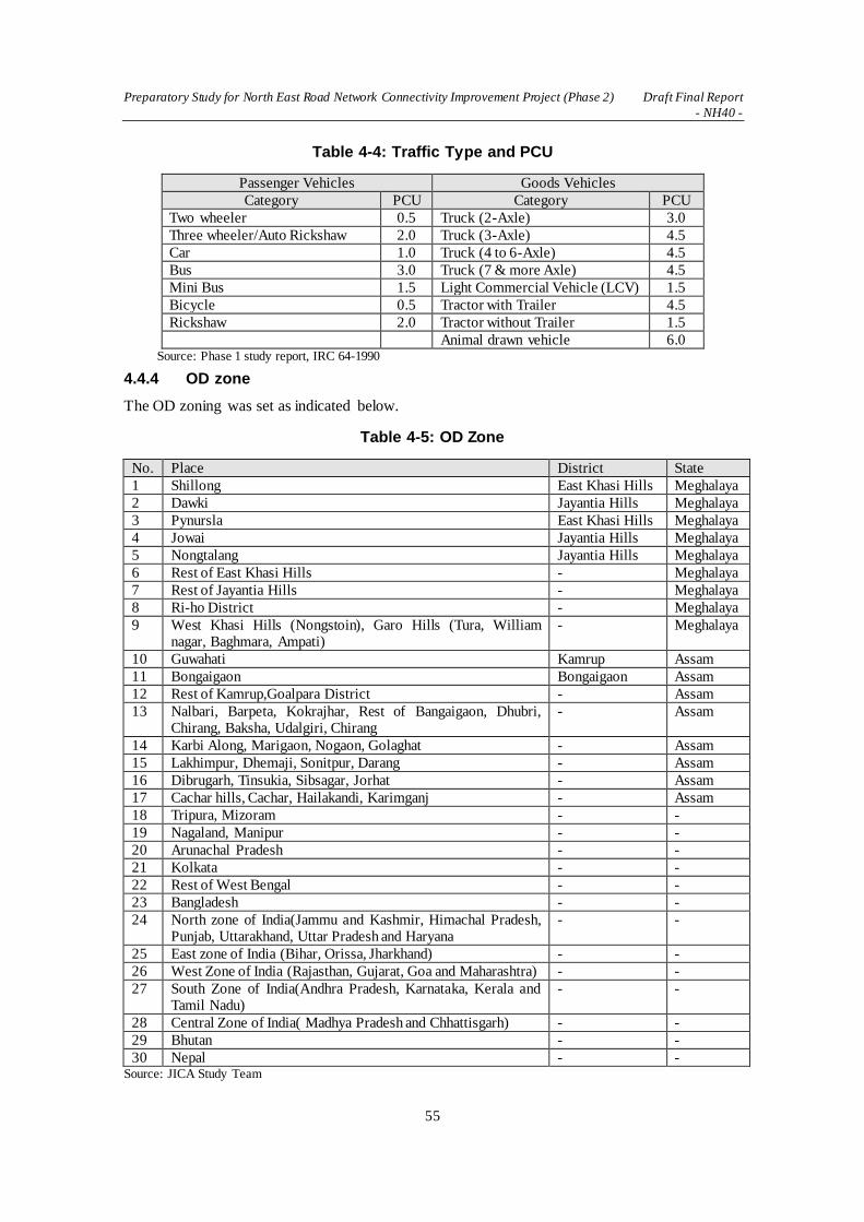
Preparatory Study for North East Road Network Connectivity Improvement Project (Phase 2) Draft Final Report
- NH40 -
55
Table 4-4: Traffic Type and PCU
Passenger Vehicles Goods Vehicles
Category PCU Category PCU
Two wheeler 0.5 Truck (2-Axle) 3.0
Three wheeler/Auto Rickshaw 2.0 Truck (3-Axle) 4.5
Car 1.0 Truck (4 to 6-Axle) 4.5
Bus 3.0 Truck (7 & more Axle) 4.5
Mini Bus 1.5 Light Commercial Vehicle (LCV) 1.5
Bicycle 0.5 Tractor with Trailer 4.5
Rickshaw 2.0 Tractor without Trailer 1.5
Animal drawn vehicle 6.0 Source: Phase 1 study report, IRC 64-1990
4.4.4 OD zone
The OD zoning was set as indicated below.
Table 4-5: OD Zone
No. Place District State
1 Shillong East Khasi Hills Meghalaya
2 Dawki Jayantia Hills Meghalaya
3 Pynursla East Khasi Hills Meghalaya
4 Jowai Jayantia Hills Meghalaya
5 Nongtalang Jayantia Hills Meghalaya
6 Rest of East Khasi Hills - Meghalaya
7 Rest of Jayantia Hills - Meghalaya
8 Ri-ho District - Meghalaya
9 West Khasi Hills (Nongstoin), Garo Hills (Tura, William nagar, Baghmara, Ampati)
- Meghalaya
10 Guwahati Kamrup Assam
11 Bongaigaon Bongaigaon Assam
12 Rest of Kamrup,Goalpara District - Assam
13 Nalbari, Barpeta, Kokrajhar, Rest of Bangaigaon, Dhubri, Chirang, Baksha, Udalgiri, Chirang
- Assam
14 Karbi Along, Marigaon, Nogaon, Golaghat - Assam
15 Lakhimpur, Dhemaji, Sonitpur, Darang - Assam
16 Dibrugarh, Tinsukia, Sibsagar, Jorhat - Assam
17 Cachar hills, Cachar, Hailakandi, Karimganj - Assam
18 Tripura, Mizoram - -
19 Nagaland, Manipur - -
20 Arunachal Pradesh - -
21 Kolkata - -
22 Rest of West Bengal - -
23 Bangladesh - -
24 North zone of India(Jammu and Kashmir, Himachal Pradesh, Punjab, Uttarakhand, Uttar Pradesh and Haryana
- -
25 East zone of India (Bihar, Orissa, Jharkhand) - -
26 West Zone of India (Rajasthan, Gujarat, Goa and Maharashtra) - -
27 South Zone of India(Andhra Pradesh, Karnataka, Kerala and Tamil Nadu)
- -
28 Central Zone of India( Madhya Pradesh and Chhattisgarh) - -
29 Bhutan - -
30 Nepal - - Source: JICA Study Team
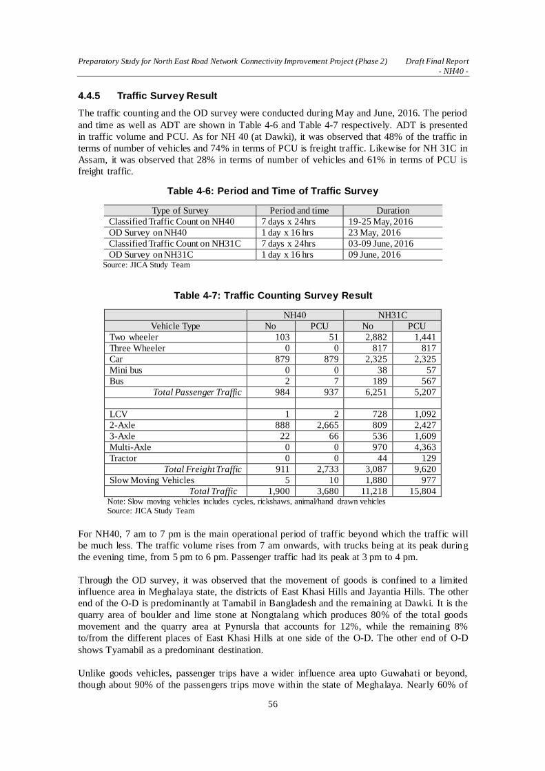
Preparatory Study for North East Road Network Connectivity Improvement Project (Phase 2) Draft Final Report
- NH40 -
56
4.4.5 Traffic Survey Result
The traffic counting and the OD survey were conducted during May and June, 2016. The period
and time as well as ADT are shown in Table 4-6 and Table 4-7 respectively. ADT is presented
in traffic volume and PCU. As for NH 40 (at Dawki), it was observed that 48% of the traffic in
terms of number of vehicles and 74% in terms of PCU is freight traffic. Likewise for NH 31C in
Assam, it was observed that 28% in terms of number of vehicles and 61% in terms of PCU is
freight traffic.
Table 4-6: Period and Time of Traffic Survey
Type of Survey Period and time Duration
Classified Traffic Count on NH40 7 days x 24hrs 19-25 May, 2016
OD Survey on NH40 1 day x 16 hrs 23 May, 2016
Classified Traffic Count on NH31C 7 days x 24hrs 03-09 June, 2016
OD Survey on NH31C 1 day x 16 hrs 09 June, 2016 Source: JICA Study Team
Table 4-7: Traffic Counting Survey Result
NH40 NH31C
Vehicle Type No PCU No PCU
Two wheeler 103 51 2,882 1,441
Three Wheeler 0 0 817 817
Car 879 879 2,325 2,325
Mini bus 0 0 38 57
Bus 2 7 189 567
Total Passenger Traffic 984 937 6,251 5,207
LCV 1 2 728 1,092
2-Axle 888 2,665 809 2,427
3-Axle 22 66 536 1,609
Multi-Axle 0 0 970 4,363
Tractor 0 0 44 129
Total Freight Traffic 911 2,733 3,087 9,620
Slow Moving Vehicles 5 10 1,880 977
Total Traffic 1,900 3,680 11,218 15,804 Note: Slow moving vehicles includes cycles, rickshaws, animal/hand drawn vehicles Source: JICA Study Team
For NH40, 7 am to 7 pm is the main operational period of traffic beyond which the traffic will
be much less. The traffic volume rises from 7 am onwards, with trucks being at its peak during
the evening time, from 5 pm to 6 pm. Passenger traffic had its peak at 3 pm to 4 pm.
Through the OD survey, it was observed that the movement of goods is confined to a limited
influence area in Meghalaya state, the districts of East Khasi Hills and Jayantia Hills. The other
end of the O-D is predominantly at Tamabil in Bangladesh and the remaining at Dawki. It is the
quarry area of boulder and lime stone at Nongtalang which produces 80% of the total goods
movement and the quarry area at Pynursla that accounts for 12%, while the remaining 8%
to/from the different places of East Khasi Hills at one side of the O-D. The other end of O-D
shows Tyamabil as a predominant destination.
Unlike goods vehicles, passenger trips have a wider influence area upto Guwahati or beyond,
though about 90% of the passengers trips move within the state of Meghalaya. Nearly 60% of

Preparatory Study for North East Road Network Connectivity Improvement Project (Phase 2) Draft Final Report
- NH40 -
57
trips are distributed over the East Khasi Hills including the state capital of Shillong. Shillong is
well connected by a network of roads to all important cities in the neighboring states and major
cities in the country. Shillong at their either end of 20% of passenger traffic. Pynursla is a town
in the middle of the Shillong-Dawki route and is also important for passenger traffic, as 25% of
passenger traffic has Pynursla at either end. The remaining is within Jayantiya Hills (Jowai, a
prominent destination) except for a very few to/from places of West Khasi Hills. Spatial pattern
by vehicle type is summarized below.
Table 4-8: Spatial Pattern by Vehicle Type on NH40 (At Dawki)
Spatial Pattern Freight traffic Passenger traffic
Within State boundaries of Meghalaya 5% 92%
Meghalaya-Assam 0% 8%
India-Bangladesh 95% 0%
Total 100% 100% Source: JICA Study Team
Observation on Assumptions
With regards to Assumption 1, it was found that the truck volume was more than what was
counted in the Phase 1 study. When NH40 is improved with the new Dawki Bridge, the traffic
volume is expected to increase as the economy and population grow. Also, large trucks will be
used more instead of the two-axle trucks that are widely used at the moment.
As for Assumption 2, it was observed that majority of the cargo traffic is moving within
Meghalaya state and/or between the Bangladesh border at Dawki-Tamabil. Therefore, it is
unlikely that a part of the cargo traffic will divert to the route from Chittagong port through
Dawki even after NH40 is improved.
4.5 Traffic Projections
4.5.1 Traffic Type
With respect to the traffic projection, types of traffic listed below will be assessed.
Table 4-9: Traffic Type
Type Definition
Normal Traffic Traffic which is currently using the target road and will continue to grow even without the proposed improvement
Induced Traffic Traffic newly generated by the road improvement (short-term)
Diverted Traffic Shifted traffic from parallel roads due to enhanced drivability by the road
improvement Source: JICA Study Team
4.5.2 Methodology of Traffic Projection
(1) Methodology
The DPR consultant conducted a more recent traffic survey in April, 2016, and the results were
used in analysing the traffic volume and conducting the traffic projection. The projection of
normal traffic is carried out in accordance with the method mentioned in IRC: 108, 1996, i.e. the
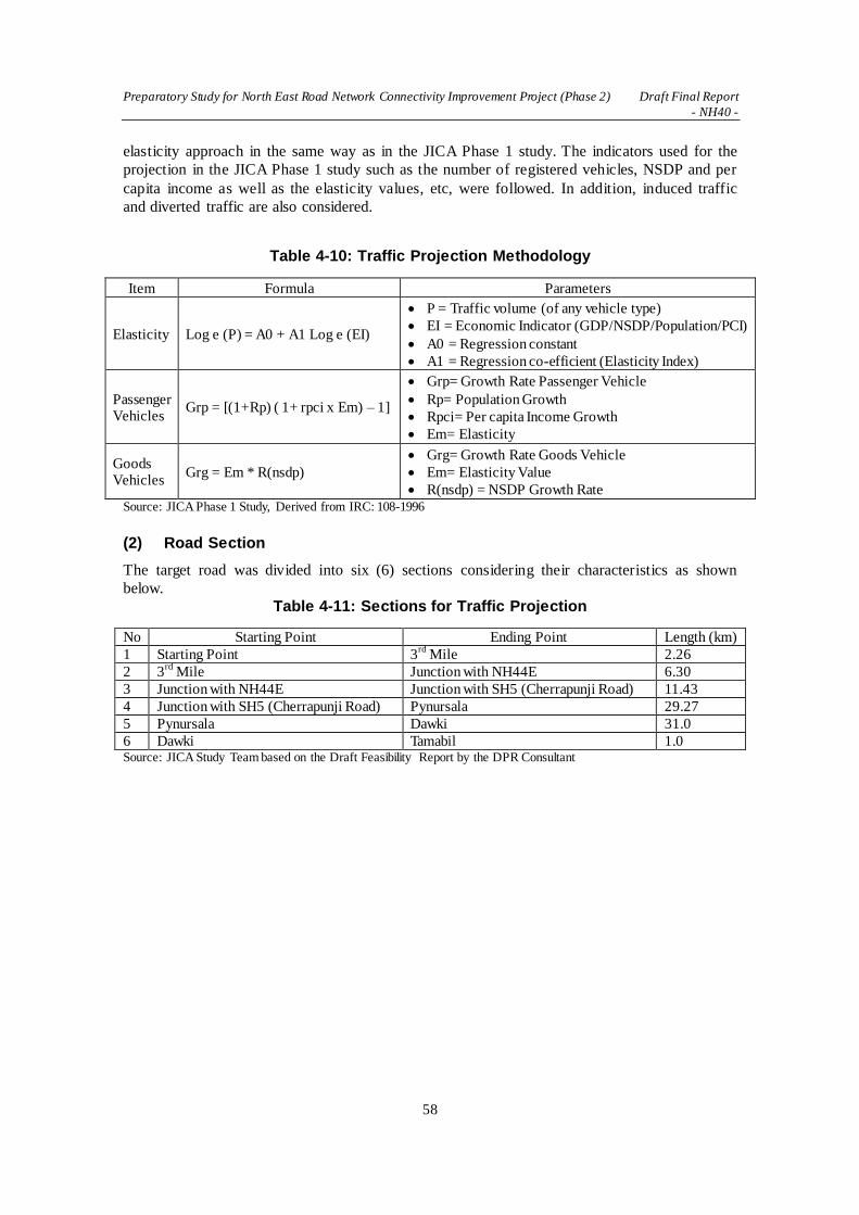
Preparatory Study for North East Road Network Connectivity Improvement Project (Phase 2) Draft Final Report
- NH40 -
58
elasticity approach in the same way as in the JICA Phase 1 study. The indicators used for the
projection in the JICA Phase 1 study such as the number of registered vehicles, NSDP and per
capita income as well as the elasticity values, etc, were followed. In addition, induced traffic
and diverted traffic are also considered.
Table 4-10: Traffic Projection Methodology
Item Formula Parameters
Elasticity Log e (P) = A0 + A1 Log e (EI)
P = Traffic volume (of any vehicle type)
EI = Economic Indicator (GDP/NSDP/Population/PCI)
A0 = Regression constant
A1 = Regression co-efficient (Elasticity Index)
Passenger Vehicles
Grp = [(1+Rp) ( 1+ rpci x Em) – 1]
Grp= Growth Rate Passenger Vehicle
Rp= Population Growth
Rpci= Per capita Income Growth
Em= Elasticity
Goods Vehicles
Grg = Em * R(nsdp)
Grg= Growth Rate Goods Vehicle
Em= Elasticity Value
R(nsdp) = NSDP Growth Rate Source: JICA Phase 1 Study, Derived from IRC: 108-1996
(2) Road Section
The target road was divided into six (6) sections considering their characteristics as shown
below.
Table 4-11: Sections for Traffic Projection
No Starting Point Ending Point Length (km)
1 Starting Point 3rd
Mile 2.26
2 3rd
Mile Junction with NH44E 6.30
3 Junction with NH44E Junction with SH5 (Cherrapunji Road) 11.43
4 Junction with SH5 (Cherrapunji Road) Pynursala 29.27
5 Pynursala Dawki 31.0
6 Dawki Tamabil 1.0 Source: JICA Study Team based on the Draft Feasibility Report by the DPR Consultant

Preparatory Study for North East Road Network Connectivity Improvement Project (Phase 2) Draft Final Report
- NH40 -
59
Source: Draft Feasibility Report by the DPR Consultant
Figure 4-7: Traffic Survey Location and Sections in the DPR
(3) Number of Registered vehicles
Vehicle registration data in Meghalaya state was used for determining the vehicle elasticity
because no previous traffic count data was available.

Preparatory Study for North East Road Network Connectivity Improvement Project (Phase 2) Draft Final Report
- NH40 -
60
Table 4-12: Vehicle Registration Data in Meghalaya
Year Two
Wheeler Autos
Rickshaw Cars/Jeep
Taxi Bus Truck LCV
2005 27,237 3,001 36,856 3,285 15,819 1,907
2006 31,008 3,569 42,083 3,497 17,060 2,565
2007 36,112 4,081 47,076 3,639 17,937 3,222
2008 40,953 4,433 51,637 3,779 18,572 3,781
2009 45,747 4,842 57,999 3,905 19,747 4,425
2010 51,709 5,348 64,916 4,008 21,372 4,955
2011 56,790 6,000 73,419 4,117 23,064 6,058
2012 65,712 6,744 81,615 4,326 25,451 7,210
CAGR (%) 12.36% 10.91% 11.22% 3.65% 6.46% 17.92% Source: JICA Phase 1 Study
(4) Economic Indicators
NDSP and per capita income in Meghalaya is summarized below. NSDP is used as an
independent variable for estimating the elasticity of the goods vehicles such as trucks and LCVs ,
while per capita income data was used for passenger vehicles such as cars, buses, and two-
wheelers.
Table 4-13: Economic Indicators
Year NSCP
(million INR) Per Capita Income
(INR)
2004-05 58,457 24,086
2005-06 63,028 25,642
2006-07 67,777 27,242
2007-08 69,909 27,764
2008-09 78,893 30,963
2009-10 83,964 32,569
2010-11 92,261 35,363
2011-12 102,988 34,217
Source: Ministry of Statistics & Programme Implementation, Government of India
(5) Elasticity
The projected elasticity value by vehicle types based on the JICA Phase 1 study is shown below.

Preparatory Study for North East Road Network Connectivity Improvement Project (Phase 2) Draft Final Report
- NH40 -
61
Table 4-14: Elasticity Value by Vehicle Type
Year/ Period 2005-14 2014-17 2017-20 2020-25 2025-30 2030<
NSDP Growth Rate (%) 7.82% 7.82% 7.04% 6.69% 6.35% 6.03%
Population Growth Rate (%) 3.06% 2.60% 2.21% 1.88% 1.59% 1.36%
Per Capita Income Growth Rate (%) 4.76% 5.19% 4.82% 4.82% 4.78% 4.71%
Elasticity of Per Capita Income
Two Wheeler: y=2.103x-10.98, R²=0.948 2.10 1.79 1.70 1.61 1.53 1.45
Auto Rickshaw: y=1.860x-10.70, R²=0.944 1.86 1.58 1.50 1.43 1.36 1.29
Cars/Jeep/Taxi: y=1.922x-8.862, R²=0.961 1.92 1.63 1.55 1.47 1.40 1.33
Bus: y =0.619x + 1.871, R²=0.93 0.62 0.68 0.75 0.83 0.78 0.74
Elasticity of NSDP
Truck: y =0.817x+0.703, R²=0.994 0.82 0.90 0.99 1.04 0.94 0.94
LCV: y =2.229x-16.78, R²=0.963 2.23 1.56 1.25 1.19 1.13 1.07 Source: JICA Phase 1 Study
(6) Traffic Growth Rate
The following growth which is the same as JICA study Phase 1, was used for the traffic
projection.
Table 4-15: Traffic Growth Rate Used for the Projection
Year/ Period 2005 - 14 2014 - 17 2017 -20 2020 - 25 2025-30 2030<
Two Wheeler 13.37% 14.70% 16.17% 16.98% 15.28% 8.29%
Autos Rickshaw 12.19% 11.02% 9.61% 8.88% 8.17% 7.50%
Cars / Jeep Taxi 12.48% 11.29% 9.85% 9.10% 8.38% 7.70%
Bus/Mini Bus 6.10% 6.23% 5.90% 5.92% 5.40% 4.91%
Truck (2-Axle) 6.41% 7.05% 6.98% 6.97% 5.96% 5.66%
Truck (3-Axle) 6.41% 7.05% 6.98% 6.97% 5.96% 5.66%
Truck (Multi-Axle) 6.41% 7.05% 6.98% 6.97% 5.96% 5.66%
LCV 17.44% 12.21% 8.79% 7.93% 7.16% 6.46% Source: JICA Phase 1 Study
4.5.3 Result of the Traffic Survey and Projection in the DPR
The results of the traffic survey and projection are summarized in the tables below. AADT can
be the base year (2016) traffic amount, however due to the non-availability of regular traffic
counts, data for previous years is derived on the basis of monthly fuel sales for the year 2014-15.
The fuel sales data have been collected from various stations in the project influence area to
calculate the seasonal variation.

Preparatory Study for North East Road Network Connectivity Improvement Project (Phase 2) Draft Final Report
- NH40 -
62
Table 4-16: ADT in Number of Vehicles in the DPR
Source: Draft Feasibility Report by the DPR Consultant
Table 4-17: ADT in PCU in the DPR
Source: Draft Feasibility Report by the DPR Consultant
Table 4-18: AADT in Number of Vehicles
Source: Draft Feasibility Report by the DPR Consultant
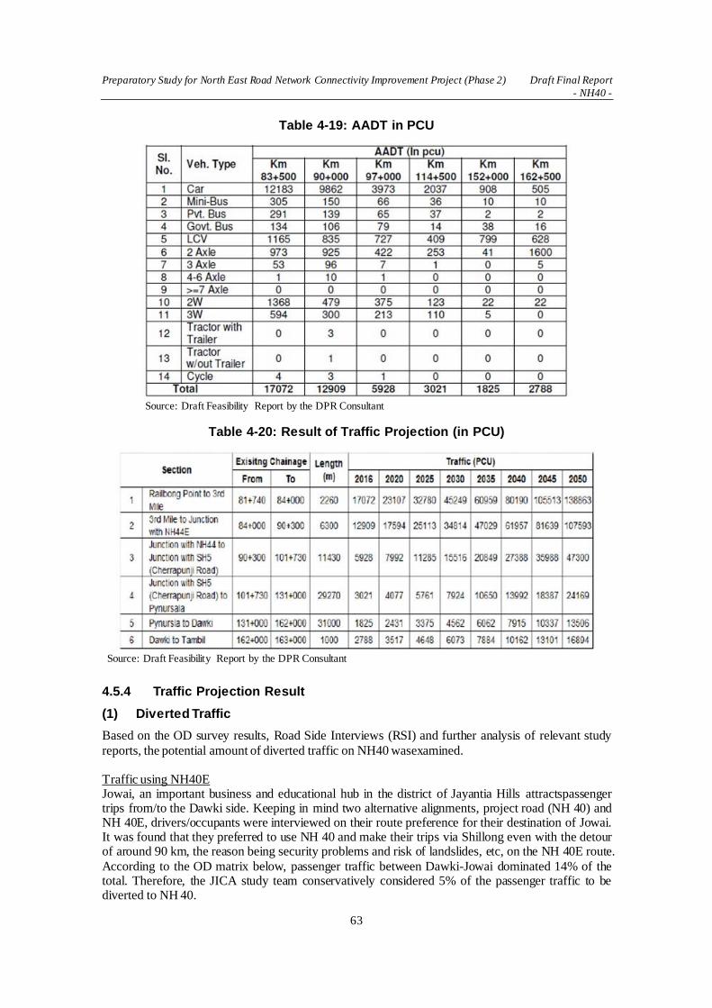
Preparatory Study for North East Road Network Connectivity Improvement Project (Phase 2) Draft Final Report
- NH40 -
63
Table 4-19: AADT in PCU
Source: Draft Feasibility Report by the DPR Consultant
Table 4-20: Result of Traffic Projection (in PCU)
Source: Draft Feasibility Report by the DPR Consultant
4.5.4 Traffic Projection Result
(1) Diverted Traffic
Based on the OD survey results, Road Side Interviews (RSI) and further analysis of relevant study
reports, the potential amount of diverted traffic on NH40 wasexamined. Traffic using NH40E Jowai, an important business and educational hub in the district of Jayantia Hills attractspassenger trips from/to the Dawki side. Keeping in mind two alternative alignments, project road (NH 40) and NH 40E, drivers/occupants were interviewed on their route preference for their destination of Jowai. It was found that they preferred to use NH 40 and make their trips via Shillong even with the detour of around 90 km, the reason being security problems and risk of landslides, etc, on the NH 40E route.
According to the OD matrix below, passenger traffic between Dawki-Jowai dominated 14% of the total. Therefore, the JICA study team conservatively considered 5% of the passenger traffic to be diverted to NH 40.

Preparatory Study for North East Road Network Connectivity Improvement Project (Phase 2) Draft Final Report
- NH40 -
64
Table 4-21: OD Matrix for Passenger Traffic at Dawki
Destination
1 2 3 4 5 6 7 9 10 15 Total
Ori
gin
1 0% 11% 0% 0% 0% 0% 0% 0% 0% 0% 11%
2 (Dawki) 8% 6% 13% 5% 1% 10% 3% 1% 2% 3% 52%
3 0% 13% 0% 0% 0% 0% 0% 0% 0% 0% 13%
4 (Jowai) 0% 3% 0% 0% 0% 0% 0% 0% 0% 0% 3%
5 0% 1% 0% 0% 0% 0% 0% 0% 0% 0% 1%
6 0% 15% 0% 0% 0% 0% 0% 0% 0% 0% 15%
7 (Rest of Jayantia
Hills) 0% 3% 0% 0% 0% 0% 0% 0% 0% 0% 3%
9 0% 0% 0% 0% 0% 0% 0% 0% 0% 0% 0%
10 0% 1% 0% 0% 0% 0% 0% 0% 0% 0% 1%
15 0% 1% 0% 0% 0% 0% 0% 0% 0% 0% 1%
Total 8% 54% 13% 5% 1% 10% 3% 1% 2% 3% 100% Source: JICA Study Team
Traffic coming from India via inland waterway through Bangladesh
Transportation of goods through the inland waterway of the Bangladesh-India protocol routes
has finally begun in June, 2016. There is a possibility that a part of those goods which had been
transported by land through the chicken’s neck could potentially use this route as an alternative.
However as mentioned previously, based on the findings from the OD survey, the majority of
cargo traffic on NH40 is moving within Meghalaya State and/or between Bangladesh border at
Dawki-Tamabil. Also at this stage, it is uncertain that this route will be used to transport cargoes
between India and Bangladesh through NH40 even after trade through the protocol route
becomes active. Taking these factors into consideration, this traffic was not considered in the
projection.
Source: Website of Bangladesh Inland Water Transport Authority (BIWTA)
Figure 4-8: Bangladesh – India Protocol Route

Preparatory Study for North East Road Network Connectivity Improvement Project (Phase 2) Draft Final Report
- NH40 -
65
(2) Induced Traffic
The state of Meghalaya has a large reserve of coal. According to the website of the Department
of Mining and Geology of the Government of Meghalaya, around 133 million tons are already
proved and current yearly production is about 5 million tons. An additional443 million tons are
estimated to be available.
Source: Website of Department of Mining and Geology, Government of Meghalaya
Figure 4-9: Mineral Map of Meghalaya
According to the guideline for transportation of coal in 2014 published by the Government of
Meghalaya, each 2-axle truck is permitted to transport only 9 tons.
The JICA study team has contacted the Director of Mineral Resources and obtained the
following statistics. Other stones and granite which are categorized as minor minerals are
administered by the state forest department and the statistics of these minerals could not be
obtained.
Table 4-22: Statistics of Coal and Limestone Exports
Export from Dawki to Bangladesh (ton)
No. of Trucks Average load (ton) per
truck
Year Coal Limestone Coal Limestone Coal Limestone
2011-2012 151,514 290,259 30,327 13,967 5 21
2012-2013 48,771 481,312 8,728 23,085 6 21
2013-2014 210,897 835,846 24,055 45,812 9 18
2014-2015 19,170 427,498 2,188 23,415 9 18
2015-2016 42,723 294,968 7,317 12,569 6 23 Source: Directorate of Mineral Resources, Shillong Meghalaya
From the above record, the export volume of coal is not stable and shows large fluctuations. It is
uncertain whether the export of coal will further increase through the border, therefore it was
not considered in the projection.

Preparatory Study for North East Road Network Connectivity Improvement Project (Phase 2) Draft Final Report
- NH40 -
66
(3) Traffic Projection Results
The traffic projection results by section are summarized below.
Table 4-23: Results of Traffic Projection
Sec. Km Year 2016 2020 2025 2030 2035
1 0-2.26km
Veh. no 17,822 23,341 32,383 43,131 46,800
PCU 17,916 23,464 32,554 43,359 57,099
Lane - 4 4 4 4
2 2.26-8.56km
Veh. no 12,807 16,733 23,271 30,955 40,817
PCU 13,540 17,733 24,602 32,769 43,153
Lane - 4 4 4 4
3 8.56-19.99km
Veh. no 5,935 7,773 10,784 14,363 18,915
PCU 6,219 8,145 11,300 15,051 19,820
Lane - 2 2 2 2
4 19.99-49.26km
Veh. no 2,925 3,831 5,315 7,079 9,322
PCU 3,163 4,143 5,747 7,655 10,081
Lane - 2 2 2 2
5 49.26-80.26km
Veh. no 1,596 2,090 2,900 3,863 5,087
PCU 1,915 2,508 3,480 4,635 6,103
Lane - 2 2 2 2
6 80.26-81.26km
Veh. no 1,588 2,080 2,885 3,843 5,061
PCU 2,923 3,823 5,311 7,074 9,316
Lane - 2 2 2 2 Source: The JICA study team
The capacity of 2-lane and 4-lane roads above were set as per the recently revised guidelines;
IRC SP 84-2014 and IRC SP 73-2015 as well as IRC 64-1900, which are summarized below. It
is recommended that LOS B should be adopted for major arterial routes, but LOS C could also
be adopted under certain circumstances. In this case, the traffic might experience congestion and
inconvenience during some of the peak hours. For LOS C, design service volume can be taken
as 40% higher than that for LOS B.
As for Section 6 between Dawki and Tambil (Bangladesh border), all vehicles stop at the check
post for clearances which are causing the congestion with long queues of vehicles parked
alongside the road. Therefore, it is recommended to make it a 4-lane to secure a parking lane.
Table 4-24: Design Service Volume for Highways in PCU/Day
No. of Lanes Terrain Level of Service B Level of Service C
2-lane with paved shoulders Rolling 13,000 18,200
Mountainous and steep 9,000 12,600
4-lane Plain and rolling 40,000 60,000
Mountainous and steep 20,000 30,000
Source: IRC

Preparatory Study for North East Road Network Connectivity Improvement Project (Phase 2) Draft Final Report
- NH40 -
67
CHAPTER 5 PRELIMINARY DESIGN OF NH40 (Shillong -
Dawki)
5.1 Natural Condition Surveys
5.1.1 Meteorological and Hydrological Surveys
(1) General
The project road stretches about KP81.26 km long, connecting Shillong, located at an altitude of
1,500 m to Dawki at an altitude of 50 m near the border with Bangladesh. The altitude goes up
from 1,500 m to 1,800 m traveling from the starting point to the KP25.00 km point, then comes
down to 1,500 m again at KP30.00 km and KP35.00 km. It continues to go down toward the
ending point of the project road.
At such a high altitude, the mean annual temperature is comparatively low at 21°C, but the
annual rainfall is over 2,000 mm. Drainage measures are especially important in road planning
for such a precipitous area with high rainfalls, and sufficient attention should be given to the
planning of road cross drainage as well as roadside drains. Drain facilities that smoothly lead
rainwater from the mountain side of the road to the downstream side will not only ensure road
safety but also protect the life of the local residents.
(2) Meteorological Condition
Figure 5-1 and 5-2 show annual temperature and rainfall. Shillong has a mild climate with the
highest temperature ranging from 15°C to 24°C and the lowest from 4°C to 18°C. The
temperature difference between Shillong and Delhi is very distinctive.
Source: JICA Study Team
Figure 5-1: High & Low Temperatures (Delhi, Shillong)
The annual rainfall is over 2,000 mm and there is a remarkable difference from Delhi. Rainfall
in the six months from May to October accounts for nearly 90% of the annual rainfall, which
speaks to the intensity of the rainfall in the period.

Preparatory Study for North East Road Network Connectivity Improvement Project (Phase 2) Draft Final Report
- NH40 -
68
Source: JICA Study Team
Figure 5-2: Rainfall (Delhi, Shillong)
(3) Hydrological Study
For drainage design, the rainfall and catchment area are set according to the local characteristics
and drainage discharge is calculated. Drainage structures shall be designed in accordance with
the calculated values. For drainage design, the calculation method specified in IRC shall be used.
IRC:SP:42-2014 Guidelines of Road Drainage and IRC:SP:13-2004 Guidelines for the Design
of Small Bridges and Culverts, were used as technical standards.
a) Calculation Method
Drainage discharge is calculated with a rational formula, using the critical intensity rainfall at
the peak hour.
Q=0.028×C×I×A
where Q: Drainage Discharge (m3/s)
C: Runoff Coefficient
I: Critical Intensity Rainfall (cm/hr) adjusted by reaching time
A: Catchment Area (ha)
Critical intensity rainfall is shown in the following formula.
Ic=F/T×((T+1)/(tc+1)), tc=(0.87×L3/H)0.385
where F: Rainfall Intensity (mm/h)
T: Duration of Storm (h)
tc: Time of Concentration (h)
L: Distance from the Critical Point to the Drainage Structure (km)
H: Fall in level from the Critical Point to the Drainage Structure (m)
b) Return Period
Return period is determined according to the type of structure and its length. If insufficient
drainage is likely to cause a serious impact on road traffic and surrounding areas, the return
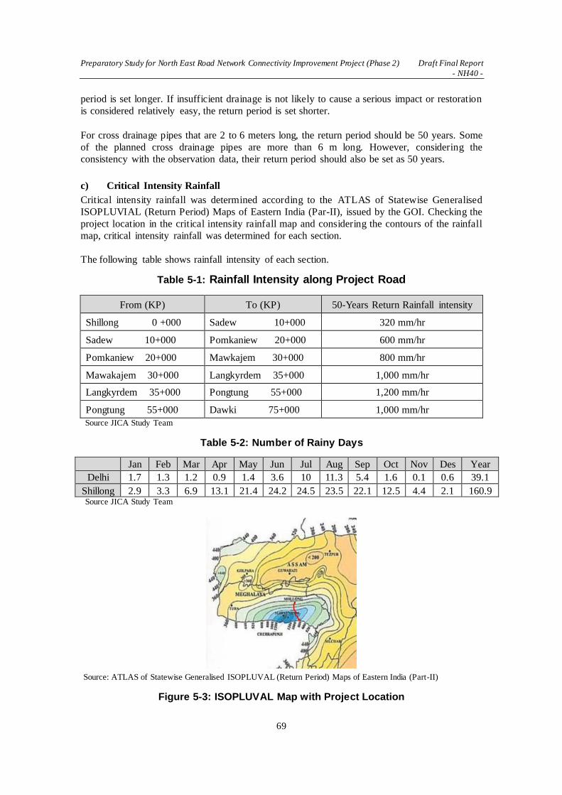
Preparatory Study for North East Road Network Connectivity Improvement Project (Phase 2) Draft Final Report
- NH40 -
69
period is set longer. If insufficient drainage is not likely to cause a serious impact or restoration
is considered relatively easy, the return period is set shorter.
For cross drainage pipes that are 2 to 6 meters long, the return period should be 50 years. Some
of the planned cross drainage pipes are more than 6 m long. However, considering the
consistency with the observation data, their return period should also be set as 50 years.
c) Critical Intensity Rainfall
Critical intensity rainfall was determined according to the ATLAS of Statewise Generalised
ISOPLUVIAL (Return Period) Maps of Eastern India (Par-II), issued by the GOI. Checking the
project location in the critical intensity rainfall map and considering the contours of the rainfall
map, critical intensity rainfall was determined for each section.
The following table shows rainfall intensity of each section.
Table 5-1: Rainfall Intensity along Project Road
From (KP) To (KP) 50-Years Return Rainfall intensity
Shillong 0 +000 Sadew 10+000 320 mm/hr
Sadew 10+000 Pomkaniew 20+000 600 mm/hr
Pomkaniew 20+000 Mawkajem 30+000 800 mm/hr
Mawakajem 30+000 Langkyrdem 35+000 1,000 mm/hr
Langkyrdem 35+000 Pongtung 55+000 1,200 mm/hr
Pongtung 55+000 Dawki 75+000 1,000 mm/hr
Source JICA Study Team
Table 5-2: Number of Rainy Days
Jan Feb Mar Apr May Jun Jul Aug Sep Oct Nov Des Year
Delhi 1.7 1.3 1.2 0.9 1.4 3.6 10 11.3 5.4 1.6 0.1 0.6 39.1
Shillong 2.9 3.3 6.9 13.1 21.4 24.2 24.5 23.5 22.1 12.5 4.4 2.1 160.9 Source JICA Study Team
: Source: ATLAS of Statewise Generalised ISOPLUVAL (Return Period) Maps of Eastern India (Part-II)
Figure 5-3: ISOPLUVAL Map with Project Location

Preparatory Study for North East Road Network Connectivity Improvement Project (Phase 2) Draft Final Report
- NH40 -
70
d) Runoff Coefficient
The project site is categorized as “Rock, steep but wooded 0.8” in IRC SP13. The area is a steep
mountainous area with rocky soil.
Table 5-3: Runoff Coefficient
Source: IRC:SP:13-2004
e) Catchment Areas
Based on a survey map and a topographic map, catchment areas where cross pipes and bridges
are located will be studied. Figure 5-4 shows a catchment area map.
Source: JICA Study Team
Figure 5-4: Catchment Areas
f) Results of Drainage Discharge Calculation
Table 5-4 lists the values of drainage discharge of each cross pipe and bridge calculated from
critical rainfall intensity, catchment area, etc.
For the calculation of drainage discharge, it is one catchment to each existing cross-drainage
nearby. In the 1.0m pipe where the capacity of stream flow is from 1.0m3/s to 3m3/s, there are

Preparatory Study for North East Road Network Connectivity Improvement Project (Phase 2) Draft Final Report
- NH40 -
71
some cross-drainages that exceed capacity. It is advisable to install more cross drainages for
bigger sections.
Table 5-4: Discharge Summary

Preparatory Study for North East Road Network Connectivity Improvement Project (Phase 2) Draft Final Report
- NH40 -
72

Preparatory Study for North East Road Network Connectivity Improvement Project (Phase 2) Draft Final Report
- NH40 -
73
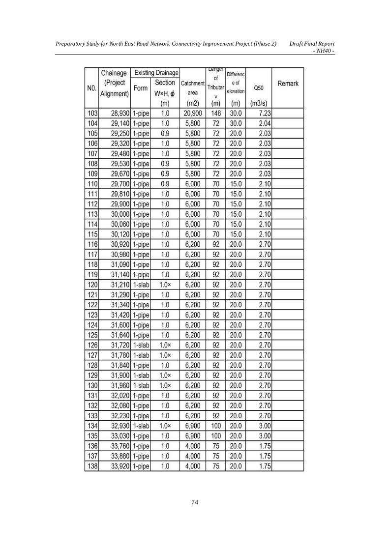
Preparatory Study for North East Road Network Connectivity Improvement Project (Phase 2) Draft Final Report
- NH40 -
74

Preparatory Study for North East Road Network Connectivity Improvement Project (Phase 2) Draft Final Report
- NH40 -
75

Preparatory Study for North East Road Network Connectivity Improvement Project (Phase 2) Draft Final Report
- NH40 -
76

Preparatory Study for North East Road Network Connectivity Improvement Project (Phase 2) Draft Final Report
- NH40 -
77

Preparatory Study for North East Road Network Connectivity Improvement Project (Phase 2) Draft Final Report
- NH40 -
78
Source: JICA Study Team
5.1.2 Topographical Survey
(1) General
Meghalaya State is also known as Meghalaya plateaus, and its topography comprises of
mountain and plateau regions. The altitude of these plateaus ranges from 150 m to nearly 2,000
m. The highest is in the plateaus of the central region such as Khasi Hills while the lowest is
that of the Garo Hills. The highest peak in Meghalaya State is Shillong Peak which is 1,961
m. The longitudinal profile of the target section is shown below.
Source: Phase 1 Study
Figure 5-5: Existing Longitudinal Profile of Target Road

Preparatory Study for North East Road Network Connectivity Improvement Project (Phase 2) Draft Final Report
- NH40 -
79
For road design including determining the optimal horizontal and longitudinal alignment, a
topographic survey was planned. As the DPR consultant had already conducted the detailed
topographic survey along NH40 and proposed seven bypasses including land usage and cross
sectional survey with intervals of less than 40 m, the additional topographic survey was only
conducted at sections where a different route alignment was proposed by the JICA Study Team.
(2) Location of Topographic Survey
After reviewing the route alignment proposed by the DPR consultant, the JICA Study Team has
identified possible alternative alignments at two bypass locations and conducted additiona l
topographic surveys. The areas of such surveys are shown below. At bypass No. 1, a 50 m strip
along the route proposed by the JICA Study Team (25 m from the center line to both sides) was
surveyed.
Source: JICA Study Team
Figure 5-6: Topographic Survey Area at Bypass No. 1
At bypass No. 6 and No. 7, the wide area on the northern side of the hill behind the existing
NH40 was surveyed in order to identify a suitable route alignment. In addition, a river cross
section survey was conducted at two sections in Dawki River for the bridge design.

Preparatory Study for North East Road Network Connectivity Improvement Project (Phase 2) Draft Final Report
- NH40 -
80
Source: JICA Study Team
Figure 5-7: Topographic Survey Area at Bypass No. 6 and No. 7
5.1.3 Geographical Survey
(1) Geographical Feature
NH40 extends approximately 80 km from the center of the west part of Shillong Plateau to the
south rim of Shillong Plateau. The Shillong Plateau is a plateau in eastern Meghalaya state,
northeastern India. The plateau's southern, northern and western ridges form the Garo, Khas i
and Jaintia Hills respectively. The elevation at the highest point of NH40 is about 1800 m above
sea level at KP23+000 from Shillong city (1470 m above sea level). NH40 gradually goes down
from the highest point towards Dawki (50 m above sea level). Itpasses through a steep hilly area
between KP2+000 to KP35+500, especially from KP29+500 to KP35+500, then goes on a
narrow ridge (Figure 5-8).
Source: JICA Study Team based on Google Maps and NASA SRTM3 Version 3
Figure 5-8: Topographical Map along NH40
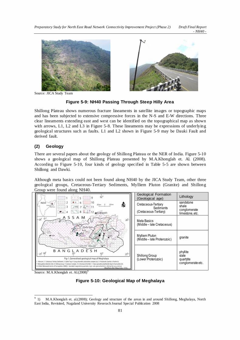
Preparatory Study for North East Road Network Connectivity Improvement Project (Phase 2) Draft Final Report
- NH40 -
81
Source: JICA Study Team
Figure 5-9: NH40 Passing Through Steep Hilly Area
Shillong Plateau shows numerous fracture lineaments in satellite images or topographic maps
and has been subjected to extensive compressive forces in the N-S and E-W directions. Three
clear lineaments extending east and west can be identified on the topographical map as shown
with arrows, L1, L2 and L3 in Figure 5-8. These lineaments may be expressions of underlying
geological structures such as faults. L1 and L2 shown in Figure 5-9 may be Dauki Fault and
derived fault.
(2) Geology
There are several papers about the geology of Shillong Plateau or the NER of India. Figure 5-10
shows a geological map of Shillong Plateau presented by M.A.Khonglah et. Al. (2008).
According to Figure 5-10, four kinds of geology specified in Table 5-5 are shown between
Shillong and Dawki.
Although meta basics could not been found along NH40 by the JICA Study Team, other three
geological groups, Cretaceous-Tertiary Sediments, Mylliem Pluton (Granite) and Shillong
Group were found along NH40.
Geological Formation (Geological age)
Lithology
Cretaceous-Tertiary Sediments
(Cretaceous-Tertiary)
sandstone shale conglomerate limestone, etc.
Meta Basics (Middle – late Cretaceous)
Mylliem Pluton (Middle – late Proterozoic)
granite
Shillong Group (Lower Proterozoic)
phyllite slate quartzite conglomerate etc.
Source: M.A.Khonglah et. Al.(2008)9
Figure 5-10: Geological Map of Meghalaya
9 1) M.A.Khonglah et. al.(2008); Geology and structure of the areas in and around Shillong, Meghalaya, North
East India, Revisited, Nagaland University Reserach Journal Special Publication 2008

Preparatory Study for North East Road Network Connectivity Improvement Project (Phase 2) Draft Final Report
- NH40 -
82
Figure 5-11 to 5-14 shows the distribution of geological material along NH40 between Shillong
and Dawki confirmed by the JICA Study Team, and Table 5-5 shows the geologica l
classification.
Source: JICA Study Team
Figure 5-11: Geological Map and Longitudinal Section along NH40 (0-17km)
Source: JICA Study Team
Figure 5-12: Geological Map and Longitudinal Section along NH40 (17-34km)

Preparatory Study for North East Road Network Connectivity Improvement Project (Phase 2) Draft Final Report
- NH40 -
83
Source: JICA Study Team
Figure 5-13: Geological Map and Longitudinal Section along NH40 (34-55km)
Source: JICA Study Team
Figure 5-14: Geological Map and Longitudinal Section along NH40 (55km-end)

Preparatory Study for North East Road Network Connectivity Improvement Project (Phase 2) Draft Final Report
- NH40 -
84
Table 5-5: Geology along NH40 between Shillong and Dawki
Geological Formation Material (Rocks) location (KP) length
Shillong Group of Rocks
Sandstone (Ss) 03+300 – 05+200
09+500 – 11+200
22+000 – 29+000
29+400 – 35+000
63+800 – 71+200
1,900m
1,700m
700m
5,600m
7,400m
Cretaceous-Tertiary
Sediments
Sandstone/
Tuffaceous Sandstone/ Conglomerate
(Cs) 00+000 – 03+300
05+200 – 09+500
21+300 – 22+000
29+000 – 29+400
35+000 – 63+800
71+200 -
3,300m
4,300m
700m
400m
28,800m
Mylliem Pluton (Granite) Granite (Mg) 11+200 – 21+300 10,100m Source: JICA Study Team
(3) Description of Geological Formations
a) Shillong Group of Rocks
Shillong Group of Rocks along NH40 consist of mainly sandstone, and mudstone, chert,
conglomerate can also be seen. According to the papers, the age of Shillong Group is
Proterozoic and is a very old formation, but it does not look so old along NH40. Most of the
rocks belonging to Shillong Group are very hard, but contains many cracks and joints.
KP85+000
KP33+400
KP24+670
Source: JICA Study Team
Figure 5-15: Pictures of Shillong Group
b) Creataceous-Tertiary Sediments
Cretaceous-Tertiary Sediments along NH40 covers the Shillong Group of Rocks, and forms the
flat plane in hilly areas such as the Pynursla town area. They consist of tuffaceous sandstone and
mudstone layers. Breccia and conglomerate also can be seen along NH40. The rocks which
compose Cretaceous-Tertiary Sediments are mostly soft rocks and they become softer with
weathering, making them vulnerable to erosion.

Preparatory Study for North East Road Network Connectivity Improvement Project (Phase 2) Draft Final Report
- NH40 -
85
KP46+880
KP58+800 km
In Pynursla
Source: JICA Study Team
Figure 5-16: Pictures of Creataceous-Tertiary Sediments
c) Mylliem Pluton (Granite)
Mylliem Pluton is a granite mass with about 10 km in diameter and intrudes into the Shillong
Group of Rocks. Granite seen along NH40 contains hard boulders which is 50 cm to 3 m in
diameter in a relatively soft granite matrix.
KP15+800
After KP20+000
Close-up image of fresh granite
Source: JICA Study Team
Figure 5-17: Pictures of Mylliem Pluton (Granite)
(4) Dauki Fault10
The Dauki fault is a major active fault along the southern boundary of the Shillong Plateau that
may be a source of destructive seismic hazards for the adjoining areas, including northeastern
Bangladesh. The Dauki fault separates the plateau from a -17 km thick tertiary section of recent
sediments in the Bengal basin to the south as shown in Figure 5-18. The fault may be a potentia l
zone for future earthquakes in NE India and Bangladesh. The 1897 Ms 8.0 Great Assam
earthquake which caused severe damage to the Assam region in India and Sylhet district in
Bangladesh was generated by the Dauki Fault.
L3 in Figure 5-8 and F3 in Figure 5-14 are the Dauki Fault, and L2 in Figure 5-8 and F2 in エ
ラー! 参照元が見つかりません。4 are derived faults from Dauki Fault.
10
The name of the fault, Dauki Fault may be derived from the town Dawki.

Preparatory Study for North East Road Network Connectivity Improvement Project (Phase 2) Draft Final Report
- NH40 -
86
Source: Mohammad Atikul Islam (2014)
11
Figure 5-18: Dauki Fault and Shillong Plateau
Source: Roger Bilham and Philip England (2001)
12
Figure 5-19: Origin of Shillong Plateau and Dauki Fault
(5) Soil Investigation at Cut Slopes
Four numbers of investigation borings, namely BH-C1, BH-C2, BH-C3 and BH-C4 were done
in order to investigate the geological / geotechnical condition at proposed cut slopes. The boring
works were done by BPC from 24 May 2016 to 9 June 2016. Borehole locations are shown in
Table 5-6.
Table 5-6: Location of Investigation Boring at Cutting
Borehole No. Coordinate KP Total Depth
BH-C1 E 383961
N 2815379 21+430 L 30m 20m
BH-C2 E 386542
N 2808884 29+980 R 35m 20m
BH-C3 E 390583
N 2800011 42+840 R 12m 20m
BH-C4 E 381845
N 2798160 48+040 R 46m 20m
Source: JICA Study Team
11
Mohammad Atikul Islam (2014); Indian-Burma Plate Boundary Fault, (http://plannerview.blogspot.jp/2014/03/indian-burman-plate-boundary-fault.html) 12
Roger Bilham and Philip England (2001); plateau 'pop-up' in the great 1897 Assam earthquake, Nature 410, 2001

Preparatory Study for North East Road Network Connectivity Improvement Project (Phase 2) Draft Final Report
- NH40 -
87
The final report of soil investigation works were submitted by BPC and attached to this report.
Figure 5-20 shows the results of investigation borings interpreted by the JICA Study Team
based on the final report submitted by BPC. The JICA Study Team also prepared the geologica l
cross sections as shown Figure 5-21 – 5-24.
Source: JICA Study Team
Figure 5-20: Results of Investigation Boring at Cut Slopes
KP 21430 (BH-C1)
Cuttings are proposed at both sides of the proposed road at this location. The left side of the cut
slope is about 30 m high. According to the boring result, reddish brown weathered sandstone of
which N-values are 7 and 10 are found 3 to 4m deep from the ground surface (about 1859 m
above sea level). Below the weathered sandstone, Cretaceous-Tertiary Sandstone (Cs) is found
until about 1840 m a.s.l. Cs is a soft rock and relatively hard when fresh. However, Cs is
capable of being slaked when exposed in the weather long time. Below 1840 m is Shillong
Group of Rocks (Ss) which is hard and tolerant to weathering but rich in cracks. Although
granite was found in the borehole, it is expected that it will not appear on cut slopes at this
location.
Location of Borehole
Geological Cross Section
Source: JICA Study Team
Figure 5-21: Geological Cross Section at KP 21430

Preparatory Study for North East Road Network Connectivity Improvement Project (Phase 2) Draft Final Report
- NH40 -
88
KP 29980 (BH-C2)
A high cut of about 30 m high is proposed on the right side of the road at this site. According to
the boring result, Ss were found at all the depth of the borehole. The rocks of Ss around this
place used as aggregate / gravel are very hard and tolerant to weathering, but many cracks were
found at around 20 – 50cm intervals. The cut slope requires special attention as there is danger
of rock falls due to the prevalence of cracks.
Source: JICA Study Team
Figure 5-22: Geological Cross Section at KP 29980
KP 42840 (BH-C3)
Cuttings are proposed on both sides of the proposed road at this location. The right side of the
cut slope is about 30 m high and left side about 10m high. According to the boring result,
reddish brown weathered sandstone is found 1 to 2 m deep from the ground surface. Below the
weathered sandstone, Cretaceous-Tertiary Sandstone (Cs) is found until about 1300 m a.s.l. Cs
is soft rock and relatively hard when fresh. However, Cs is capable of being slaked when
exposed in the weather long time. Below 1300 m is Shillong Group of Rocks (Ss) which is hard
and tolerant to weathering but rich in cracks.
Source: JICA Study Team
Figure 5-23: Geological Cross Section at KP 42840
KP 48040 (BH-C4)
Cuttings are proposed on both sides of the proposed road at this site. The left side of the cut
slope is about 30 m high. According to the boring result, surface soil or highly weathered rocks
were not found.

Preparatory Study for North East Road Network Connectivity Improvement Project (Phase 2) Draft Final Report
- NH40 -
89
Only Cretaceous-Tertiary Sandstone (Cs) would appear on cut slopes at this point, even though
Shillong Group of Rocks (Ss) were obtained in the borehole. Cs is soft rock and relatively hard
when fresh. However, Cs is capable of being slaked when exposed in the weather for a long
time.
Source: JICA Study Team
Figure 5-24: Geological Cross Section at KP48+040
(6) Soil Investigation at Dawki Bridge
Four investigation borings were done in order to investigate the geological / geotechnica l
condition at the proposed Dawki Bridge. The boring works were done by BPC from 09 July
2016 to 15 August 2016. Borehole locations are shown in Table 5-7.
Table 5-7: Location of Investigation Boring at Dawki Bridge
Borehole No. Coordinate Total Depth
BH-B1 E 401189
N 2787433 20m
BH-B2 E 401430
N 2787446 20m
BH-B3 E 401177
N 2786706 20m
BH-B4 E 401321
N 2786649 20m
The final report of soil investigation works were submitted by BPC and attached to this report.
Figure 5-25 shows the results of investigation borings interpreted by the JICA Study Team
based on the final report submitted by BPC. The JICA Study Team also prepared the geologica l
cross sections as shown Figure 5-26.

Preparatory Study for North East Road Network Connectivity Improvement Project (Phase 2) Draft Final Report
- NH40 -
90
Source: JICA Study Team
Figure 5-25: Results of Investigation Boring at Dawki Bridge
KP 68720 (BH-B1, BH-B2)
Two numbers of boring, namely BH-B1 and BH-B2 were done on an alignment of the Dawki
Bridge that was initially proposed. The alignment is now along a cross line at KP 68720 in the
final plan. The two borings were on the riverbed of Dauki River.
At BH-B1, Riverbed deposit (Rd) was found from the ground surface to the borehole bottom
(20 m deep), base rocks were not found. At BH-B2, Riverbed deposit (Rd) was found from the
ground surface to 18 m deep, and Shillong Group of Rocks (Ss) as base rocks was found below
18 m. Rd is the aggregate of various stones which are very hard. Ss is yellowish brown colored,
slightly weathered rock.
According to the study result by the JICA Study Team, traces of a landslide can be seen on the
left bank of the Dawki River along this alignment as shown in Figure 5-24. The landslide may
be surface failure of the slope and relatively shallow and debris are piled on the lower part of the
slope. Therefore the left bank slope could be unstable and it is not suitable for bridge
foundations.
Proposed Dawki Bridge (BH-B3, BH-B4)
Two numbers of boring, namely BH-B3 and BH-B4 along a proposed alignment of Dawki
Bridge were done on the riverbed of the Dauki River.
Riverbed deposit (Rd) was found at 9.0m deep at BH-3 and at 13.5m at BH-B4. Rd is the
aggregate of various stones which are very hard. Shillong Group of Rocks (Ss) as base rocks
was below Rd at both of the boreholes. Ss was purplish brown to dark grey, slightly weathered
rock.
Hard rocks are found on both sides of the river bank at the proposed Dawki Bridge, therefore
the slopes seem stable and are suitable for foundations of the bridge.
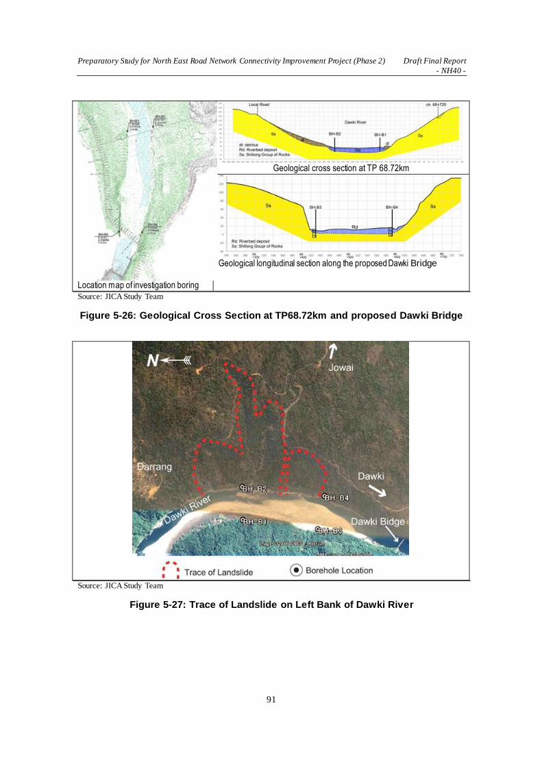
Preparatory Study for North East Road Network Connectivity Improvement Project (Phase 2) Draft Final Report
- NH40 -
91
Location map of investigation boring
Geological cross section at TP 68.72km
Geological longitudinal section along the proposed Dawki Bridge
Source: JICA Study Team
Figure 5-26: Geological Cross Section at TP68.72km and proposed Dawki Bridge
Source: JICA Study Team
Figure 5-27: Trace of Landslide on Left Bank of Dawki River
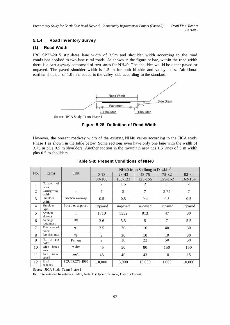
Preparatory Study for North East Road Network Connectivity Improvement Project (Phase 2) Draft Final Report
- NH40 -
92
5.1.4 Road Inventory Survey
(1) Road Width
IRC SP73-2015 stipulates lane width of 3.5m and shoulder width according to the road
conditions applied to two lane rural roads. As shown in the figure below, within the road width
there is a carriageway composed of two lanes for NH40. The shoulder would be either paved or
unpaved. The paved shoulder width is 1.5 m for both hillside and valley sides. Additiona l
earthen shoulder of 1.0 m is added to the valley side according to the standard.
Source: JICA Study Team Phase 1
Figure 5-28: Definition of Road Width
However, the present roadway width of the existing NH40 varies according to the JICA study
Phase 1 as shown in the table below. Some sections even have only one lane with the width of
3.75 m plus 0.5 m shoulders. Another section in the mountain area has 1.5 lanes of 5 m width
plus 0.5 m shoulders.
Table 5-8: Present Conditions of NH40
No. Items Unit NH40 from Shillong to Dawki *
1
0-18 28-43 43-75 75-82 82-84
80-108 108-123 123-155 155-162 162-164
1 Number of
lanes 2 1.5 2 1 2
2 Carriageway
width m 7 5 7 3.75 7
3 Shoulder
width
Section average 0.5 0.5 0.4 0.5 0.5
4 Shoulder
type Paved or unpaved unpaved unpaved unpaved unpaved unpaved
5 Average
altitude m 1710 1552 813 47 30
6 Average
roughness IRI 3.6 5.5 5 7 5.5
7 Total area of
cracks % 3.5 20 16 40 30
8 Raveled area % 2 30 10 10 30
9 No. of pot
holes Per km 2 10 22 50 50
10 Edge break
area m
2/km 45 50 80 150 150
11 Ave. travel
speed km/h 43 40 43 18 15
12 Road
capacity PCU:IRC73-1980 10,000 5,000 10,000 1,000 10,000
Source: JICA Study Team Phase 1
IRI: International Roughness Index, Note 1: (Upper: distance, lower: kilo-post)

Preparatory Study for North East Road Network Connectivity Improvement Project (Phase 2) Draft Final Report
- NH40 -
93
(2) Drainage
a) Cross Drainage
Currently, various types of cross drainage structures are installed according to the runoff
volume. The most common drain structure is a cross pipe and the second most common
structure is a small section box culvert. This is likely due to the fact that culvert pipes are
precast products and have high workability.
The scupper type drain is made by piling blocks to provide necessary cross-section area. There
are scuppers installed in some locations on the Dawki side, but their number is scarce. The
structure is shown in the figure below.
1-Pipe 2-Pipe 1-Box
D900, D1000
D900, D1000
500x500,
1-Box (Bigger) Scupper Scupper
2.0m x 2.0 m
(71.5 km)
IRC:SP:48-1998 Source: JICA Study Team
Figure 5-29: Cross Drainage
Some culvert pipes are filled with deposited sediment. Such deposition occurs where cross pipes
are surrounded with earth sediment and blockage is especially severe on the inlet side.
Half buried pipe Stagnated mud water
Source: JICA Study Team
Figure 5-30: Blocked Cross Drainage

Preparatory Study for North East Road Network Connectivity Improvement Project (Phase 2) Draft Final Report
- NH40 -
94
In planning of new construction and replacement of culvert pipes, measures to remove sediment
or to ensure its smooth flow to the downstream side should be included.
b) Catch Pit
Figure below (left) shows the standard structure of a cross pipe on the inlet side. The structure is
designed to handle rainwater flowing from the mountain and roadside drains. Currently, several
measures are taken to prevent blockage of the road’s culvert pipes caused by sediment
deposition.
To make maintenance easier, steps leading to the bottom of gullies have been installed to
monitor the condition of the pipes and structure as well as sediment deposition. For the
prevention of sediment inflow, walls are installed to prevent the inflow of sediment except
drainage water from roadside drains.
Standard Structure With steps With sidewall
KP31+000
KP11+500
KP23+500
Source: JICA study Team
Figure 5-31: Catch Pit
As the road passes through a high rainfall area, it is
assumed that a large amount of sediment flows in
as rainfall increases during the rainy season.
Therefore, installation of a catch pit as shown
above is considered effective in preventing
sediment from flowing into culvert pipes.
Creating a space to catch mud by deepening a
gully can also be an effective measure to allow for
more efficient maintenance work.
In case the outlet side of a culvert pipe is located
high above the ground, falling works are installed
as shown in the figure to the right. This is a
preferable structure to prevent scouring of the
existing ground and it is advisable to use it for the improvement and new construction of cross
pipes.
c) Roadside Drain
Although roadside drains are observed in most of the urban areas, there are some sections
without drains especially in the places where no houses exist nearby. Most roadside drains are
concrete drains or earth ditches. In cut earth sections of the road, these drains are installed as an
Source: JICA Study Team
Figure 5-32: Falling Works (17+700)

Preparatory Study for North East Road Network Connectivity Improvement Project (Phase 2) Draft Final Report
- NH40 -
95
integral part of retaining walls or slope protection works. In rare cases, slopes are excavated to
be used as roadside drains in areas with rocky soil.
Earth Ditch Concrete Drain
KP4+000
KP16+000
With Slope Protection Effective use of natural ground slopes
KP24+500
KP72+300
Source: JICA Study Team
Figure 5-33: Roadside Drain
Some of the sections with roadside concrete drains have sediment deposition. For easy
maintenance, it is advisable to install mud storage facilities at regular intervals.
(3) Pavement
The condition of the existing pavement has been checked. The following figure shows the
pavement width for the existing road width. The pavement width is about 5 m wide along the
entire route, except for the last section of about 10 km before the end point where it is less than
4 m. The pavement width is smaller than that of the planned road (10 m, 1.5+3.5+3.5+1.5)
along the entire route.
The total length of bypasses is about 29 km, and the total length of the sections of the existing
road that need widening, shown as A-E in the following chart, is about 46 km. A survey of the
existing pavement condition has been conducted for Sections A-E.

Preparatory Study for North East Road Network Connectivity Improvement Project (Phase 2) Draft Final Report
- NH40 -
96
Source: JICA Study Team
Figure 5-34: Existing Pavement Width
Below is the summary of the pavement condition survey results for the sections of the existing
road that need widening. As damage has spread widely, repair and replacement are deemed
necessary. In the sections of the existing road that need widening, the alignment of the existing
road is not always the same as that of the planned road, and the number of locations where
widening works will suffice is limited. Considering the state of deterioration, it is advisable to
remove the existing pavement and lay a new one instead.
Sections A, B and C
With alligator cracks widely spread, the overall bearing capacity of the base course and
subgrade is likely to have degraded. As the traffic volume is comparatively high near the
starting point, it is assumed that traffic load also has an impact.
Overall alligator cracks Alligator cracks on shoulders
KP6+000
KP7+700
Source: JICA Study Team
Figure 5-35: Pavement Condition of Section A (Bypass #1 – Bypass #2)
A B C D E
BP1 BP2,BP3 BP4 BP5 BP6,BP7

Preparatory Study for North East Road Network Connectivity Improvement Project (Phase 2) Draft Final Report
- NH40 -
97
Alligator cracks over entire surface
KP11+700
KP12+200
Source: JICA Study Team
Figure 5-36: Pavement Condition of Section B (Bypass #2 - Bypass #3)
Alligator cracks over entire surface Alligator cracks on shoulders
KP16+500
KP18+300
Source: JICA Study Team
Figure 5-37: Pavement Condition of Section C (Bypass #3 - Bypass #4)
Section D and E
Potholes caused by surface delamination are widespread. Probable causes include insufficient
compaction when asphalt was laid.
Filled potholes Alligator cracks and potholes
KP32+700
KP36+500
Source: JICA Study Team
Figure 5-38: Pavement Condition of Section D (Bypass #4 - Bypass #5)

Preparatory Study for North East Road Network Connectivity Improvement Project (Phase 2) Draft Final Report
- NH40 -
98
Filled potholes Potholes and alligator cracks
KP53.40 km
KP57.3 km
Source: JICA study Team
Figure 5-39: Pavement Condition of Section E (Bypass #5 - Bypass #6)
(4) Traffic Safety Apparatus
As there are many steep slopes, guardrails are installed on the valley side. Figure 5-40 shows
the types of guardrails used. Concrete blocks appear to be used often in scenic spots as they do
not hinder the view. Concrete walls are used in residential areas on the side of Shillong. In some
heavy fog-prone sections safety posts are used instead of or together with guardrails.
In planning guardrails, types of works should be selected according to the local characteristics
such as necessity of sidewalks, scenic spots and heavy fog-prone sections.
Concrete Painted Concrete Concrete Blocks
KP23+900
KP34+700
KP46+100
Concrete Wall Cable Delineator
KP2+100
KP2+700
KP33+800
Source: JICA Study Team
Figure 5-40: Different Types of Guardrails along NH40
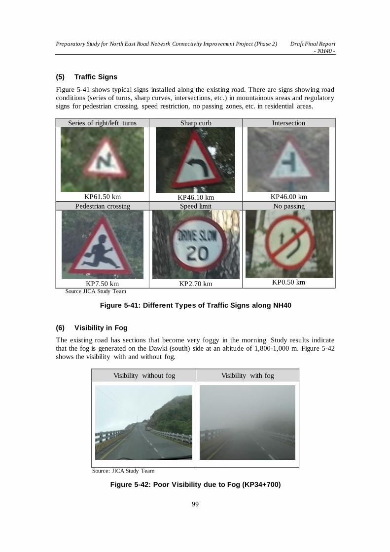
Preparatory Study for North East Road Network Connectivity Improvement Project (Phase 2) Draft Final Report
- NH40 -
99
(5) Traffic Signs
Figure 5-41 shows typical signs installed along the existing road. There are signs showing road
conditions (series of turns, sharp curves, intersections, etc.) in mountainous areas and regulatory
signs for pedestrian crossing, speed restriction, no passing zones, etc. in residential areas.
Series of right/left turns Sharp curb Intersection
KP61.50 km
KP46.10 km
KP46.00 km
Pedestrian crossing Speed limit No passing
KP7.50 km
KP2.70 km
KP0.50 km
Source JICA Study Team
Figure 5-41: Different Types of Traffic Signs along NH40
(6) Visibility in Fog
The existing road has sections that become very foggy in the morning. Study results indicate
that the fog is generated on the Dawki (south) side at an altitude of 1,800-1,000 m. Figure 5-42
shows the visibility with and without fog.
Visibility without fog Visibility with fog
Source: JICA Study Team
Figure 5-42: Poor Visibility due to Fog (KP34+700)

Preparatory Study for North East Road Network Connectivity Improvement Project (Phase 2) Draft Final Report
- NH40 -
100
With dense fog, forward visibility is very poor. Cars pass at reduced speed with the headlights
on or hazard lamps flashing. It is advisable to install more safety posts and install signs that
encourage drivers to turn headlights on.
Source JICA Study Team
Figure 5-43: Section of Frequent Fog
5.1.5 Slope Inventory Survey
(1) Present Condition of Cut Slopes
The JICA Study Team investigated the present condition of cut slopes, natural slopes and
streams. As a result, the Study Team did not find any slow mass movement which moves slowly
in a huge area. However, some small rock falls, small collapses and erosion are found. The table
below shows the result of the site investigations.
Table 5-9: Conditions of Existing Cut Slopes
Geology Present Cut Slopes Configurations Present Cut Slopes Conditions
Shillong Group of Rocks 1:0.5 without benches, without surface protection
Stable
Cretaceous-Tertiary Sediments 1:0.5 without benches, without surface protection
Surface erosion, rock falls, surface slide can be seen
Mylliem Pluton (Granite) 1:0.5 without benches, without surface protection
Stable, Hard boulders can be seen
Source: JICA Study Team
The followings are the explanation based on geological sections.

Preparatory Study for North East Road Network Connectivity Improvement Project (Phase 2) Draft Final Report
- NH40 -
101
Table 5-10: Present Condition of Cut Slopes along NH40
Location & geology
Description of Present Cut Slopes
Pictures of Present Condition
of Cut Slopes
1 KP0.0 – 3.3 (3.3 km) C-T Sediments Sandstone
(Cs)
Rocks are relatively hard and
slopes are stable in this section.
KP0+300
2 KP3.3 – 5.2 (1.9 km)
Shillong Group Sandstone
(Ss)
This section of Ss contains
Schist. Slope condition is not
clear because there are no high
slopes in this section. Rocks are
hard and strong.
KP3+500
3 KP5.2 – 9.5 (3.3 km)
C-T Sediments Sandstone
(Cs)
Rocks are relatively hard and
slopes are stable in this section.
KP9+300
4 KP9.5 – 11.2 (1.7 km)
Shillong Group Sandstone
(Ss)
Rocks are hard, and slopes are
stable. Near the start point,
rocks are weathered and
relatively soft.
KP9+000
5 KP11.2 – 21.3 (10.1 km)
Mylliem Pluton Granite
(Mg)
Granite is hard and stable.
Round hard boulders of granite
in relatively soft granite matrix
are often seen.
KP18+800

Preparatory Study for North East Road Network Connectivity Improvement Project (Phase 2) Draft Final Report
- NH40 -
102
Location & geology
Description of Present Cut Slopes
Pictures of Present Condition
of Cut Slopes
6 KP21.3 – 22.0 (0.7 km) C-T Sediments Sandstone
(Cs)
Slopes of Cs are stable, but are
easily eroded. Rocks are soft
and can be dug using a small
hammer.
KP21+500
7 KP22.0 – 29.0 (7.0 km)
Shillong Group Sandstone
(Ss)
Sandstone rocks are hard, and
slopes are stable.
KP24+850
8 KP29.0 – 29.4 (0.4 km) C-T Sediments Breccia
(Cs)
This place of Cs contains many
breccia. Slopes are stable, but
are easily eroded. Rocks are
soft and can be dug using a
small hammer.
KP28+500
9 KP29.4 – 35.0 (5.6 km)
Shillong Group Sandstone
(Ss)
Rocks contain siliceous
sandstone or chert, so rocks are
very hard. Although the cut
slopes are mostly stable, dense
cracks are seen in every cut
slope.
KP33+850
10 KP35.0 – 45.7 (10.7 km)
C-T Sediments Sandstone
(Cs)
This place of Cs is sandstone
mainly and contains
conglomerate and mudstone
layers. Rocks are soft and can
be dug using a small hammer.
Erosion and small collapse are
seen on most of slopes.
KP40+100
11 KP45.7 – 49.0 (3.3 km)
C-T Sediments Tuffaceous
Sandstone
(Cts)
Tuffaceous Sandstone contains
a lot of tuff (volcanic ash), and
is easy to soften by slaking.
1:1.5 of gradient of present cut
slopes without surface
protection seems stable, but
gully erosion, small rock fall
are seen at several cut slopes.

Preparatory Study for North East Road Network Connectivity Improvement Project (Phase 2) Draft Final Report
- NH40 -
103
Location & geology
Description of Present Cut Slopes
Pictures of Present Condition
of Cut Slopes
KP47+000
KP49+000
12 KP49.0 – 53.0 (4.0 km)
C-T Sediments Conglomerate
(Cc)
Rocks contain 5-20 cm
diameter of gravel. Relatively
soft and easily eroded.
KP53+500
13 KP53.0 – 63.8 (10.8 km)
C-T Sediments Sandstone
(Cs)
Rocks seem hard and slopes
seem stable, small gully can be
seen on the slopes.
KP63+800
14 KP63.8 – 71.2 (7.4 km)
Shillong Group Sandstone
(Ss)
Rocks are hard and the cut
slopes are stable. Neither
serious erosion nor rock fall
can be seen along the road.
KP69+300
15 KP71.2 - end C-T Sediments Sandstone
(Cs)
Details are not clear due to
small number of cut slopes. It
may be same condition of Cts.
KP71+500
Source: JICA Study Team
(2) Proposed High Cut Slopes
The design by Transys Consulting Pvt. Ltd proposes many high cut slopes as seen in Table 5-11
below. The configurations of all cut slopes are the same and with the following design.

Preparatory Study for North East Road Network Connectivity Improvement Project (Phase 2) Draft Final Report
- NH40 -
104
Gradient of cut slope: 1:1.5
Height of bench: 6 m
Width of bench: 1.5 m
Table 5-11: List of Proposed Cut Slopes Designed by DPR Consultant
(KP00 – 63+000)
from to right / left total length max. height* Geology*
1 2810 3080 r 270 16 Cs
2 3110 3320 r 210 30 Cs 3 3110 3320 l 210 32 Cs
4 13930 14030 l 100 20 Mg 5 13930 14020 r 90 15 Mg
6 14080 14150 l 70 15 Mg 7 14220 14310 r 90 16 Mg
8 14230 14300 l 70 24 Mg 9 17490 17560 l 70 17 Mg
10 17490 17570 r 80 17 Mg 11 17700 17830 r 130 16 Mg
12 17710 17830 l 120 26 Mg 13 17880 18130 l 250 21 Mg
14 17940 18080 r 140 19 Mg 15 18250 18420 r 170 40 Mg
16 18270 18410 l 140 40 Mg 17 19620 19760 l 140 16 Mg
18 20340 20460 r 120 17 Mg 19 20340 20460 l 120 17 Mg
20 21330 21580 l 250 20 Cs 21 21330 21580 r 250 18 Cs
22 21610 21700 r 90 15 Cs 23 22780 22930 r 150 15 Ss
24 23090 23220 r 130 30 Ss 25 23130 23200 l 70 25 Ss
26 23260 23400 r 140 22 Ss 27 23280 23380 l 100 17 Ss
28 24240 24430 r 190 25 Ss 29 24250 24410 l 160 23 Ss
30 24480 24620 r 140 29 Ss 31 24490 24590 l 100 23 Ss
32 24680 24890 r 210 25 Ss 33 24680 24850 l 170 24 Ss
34 25420 25570 r 150 19 Ss 35 25630 25820 r 190 20 Ss
36 25820 25930 r 110 32 Ss 37 25850 25920 l 70 20 Ss
38 26110 26210 r 100 26 Ss 39 26140 26190 l 50 22 Ss
40 26210 26380 r 170 33 Ss 41 26250 26330 l 80 19 Ss
42 26500 26770 r 270 36 Ss 43 27020 27140 r 120 23 Ss
44 27170 27310 r 140 17 Ss 45 27330 27640 r 310 30 Ss
46 27640 27850 r 210 31 Ss 47 29480 29880 r 400 21 Ss
48 29880 30220 r 340 54 Ss 49 29980 30210 l 230 48 Ss
50 30220 30580 r 360 23 Ss 51 30670 30830 l 160 23 Ss
52 30860 31160 l 300 24 Ss

Preparatory Study for North East Road Network Connectivity Improvement Project (Phase 2) Draft Final Report
- NH40 -
105
53 31190 31280 l 90 25 Ss
54 31280 31350 l 70 16 Ss 55 31350 31550 l 200 15 Ss
56 31550 31850 l 300 18 Ss 57 31850 32030 l 180 32 Ss
58 32300 32780 r 480 23 Ss 59 32510 32670 l 160 36 Ss
60 32550 32650 r 100 29 Ss 61 33480 33630 l 150 35 Ss
62 33740 33960 l 220 24 Ss 63 33760 33840 r 80 23 Ss
64 33970 34190 l 220 20 Ss 65 34190 34390 l 200 36 Ss
66 34200 34310 r 110 30 Ss 67 34700 34930 r 230 17 Ss
68 34880 34930 l 50 19 Ss 69 34970 35070 r 100 32 Ss
70 35100 35190 r 90 41 Cs 71 35100 35190 l 90 37 Cs
72 35190 35330 r 140 34 Cs 73 35210 35350 l 140 31 Cs
74 36460 36550 l 90 18 Cs 75 36820 36990 l 170 16 Cs
76 42150 42370 r 220 18 Cs 77 42200 42350 l 150 15 Cs
78 42420 42900 r 480 22 Cs 79 42910 43120 r 210 16 Cs
80 43600 43700 r 100 15 Cs 81 43850 44450 r 600 17 Cs
82 45330 45680 r 350 26 Cs 83 45340 45450 l 110 15 Cs
84 45520 45670 l 150 24 Cs 85 45840 46080 r 240 21 Cts
86 45920 46050 l 130 20 Cts 87 46250 46440 r 190 24 Cts
88 46650 46760 r 110 21 Cts 89 47040 47140 r 100 16 Cts
90 47200 47320 r 120 20 Cts 91 47220 47310 l 90 22 Cts
92 47870 47990 r 120 21 Cts 93 48120 48250 r 130 15 Cts
94 48320 48450 r 130 17 Cts 95 58880 59010 r 130 15 Cs
96 60100 60380 l 280 25 Cs 97 60120 60370 r 250 19 Cs
98 60460 60600 l 140 18 Cs 99 60600 60780 l 180 19 Cs
100 61740 61880 r 140 15 Cs
Source: JICA Study Team
Max.height: Maximum height at 7 m right / left side from the proposed center line
Geology: Ss: Shilling Group of Rocks, Mg: Granite of Mylliem Pluton, Cs: Sandstone of Cretaceous-
Tertiary Sediments, Cts: Tuffaceous Sandstone of Cretaceous-Tertiary Sediments

Preparatory Study for North East Road Network Connectivity Improvement Project (Phase 2) Draft Final Report
- NH40 -
106
5.2 Preliminary Design
5.2.1 General
Since the project road traverses mountains with sharp curves, changing points in the terrain and
landslide-prone slopes are carefully examined to grasp the topographic changes as accurately as
possible for adequate designing.
Full field reconnaissance is conducted by videotaping with GPS data to check the natura l
conditions for the preliminary designing. Since the DPR of the project road is still under
preparation, the JICA Study Team is in contact with the DPR consultant to coordinate the work
after the initial field reconnaissance.
The cost estimating will take into consideration the challenges of working in severe climate
conditions and remoteness of the project location such as construction being suspended due to
heavy rain during the rainy season, the availability of construction materials, and limited
availability of labor in the project region.
The JICA Study Team considers recent road development policies formulated by GOI as shown
in the table below. Recognizing India’s technical experience in road development in
mountainous regions, the JICA Study Team will integrate the best design components of both
Indian and Japanese expertise in road designing in areas of rugged topography, landslide
disaster countermeasures, road safety, and aesthetics.
Table 5-12: Recent Road Development Policies of India
Policies Outline
Cement Concrete
Pavement
In light of maintenance easiness, cement concrete (CC) pavement is preferred for all NH projects, and when the cost difference with asphalt concrete (AC) pavement is
less than 20%, CC pavement shall be adopted.
Green Highways (Plantation & Maintenance)
Policy-2015
To develop eco-friendly NH with participation of the community, farmers, NGOs, private sector, institutions, movement agencies and the Forest Department. The main objectives of planting along the highways are to enhance aesthetics of the project corridors and places of importance by planting selective ornamental trees,
landscaping and turfing with grass and ornamental shrubs.
Extensive
Guidelines Development
IRC published 24 new guidelines in 2015 that include Road Bridge Standard Specifications, Maintenance of Concrete and Bituminous Roads, Traffic forecast on Highways, Road Markings and Safety Barriers, Recycling of Bituminous Pavements, and Environment Management Plan.
Source: JICA Study Team
5.2.2 Road Geometric Design
(1) General
Geometric design of roads is strongly related to the positioning of the physical elements of the
roadway according to design standards and constraints. The basic objectives in geometric design
are to optimize efficiency and safety of traffic while minimizing cost and environmental damage.
Geometric design of roads also affects design requirements for achieving broader community
goals, which are providing access to employment, schools, businesses and residences, and
accommodating a range of travel needs. Once the geometry of the road is improved, transport
patterns of goods and passengers in the target region will change. Geometric design can be

Preparatory Study for North East Road Network Connectivity Improvement Project (Phase 2) Draft Final Report
- NH40 -
107
broken into three main parts: horizontal and vertical (profile) alignment and cross-section.
Combined, they provide a three-dimensional layout for a roadway.
Topography and land-use have a significant impact on highway location, geometrics, and in
determining the type of highway and its design speed. The existing NH40 runs through hilly and
mountainous areas, which affect the type of road to be designed to improve geometries and
strengthen the road structures to meet future demand.
The design of a highway should be based on traffic data for that highway. In selecting a road
design, design hourly volume is generally used to represent the traffic volume for the future.
The future traffic volume is based on the present traffic plus all traffic increases (traffic growth,
generated traffic and development traffic). On minor, low volume roads, average daily traffic
(ADT) is often sufficient. Current traffic volume of NH40 at Mylliem Nagar between Shillong
and Dawki is 3,200 to 4,200 vehicles/day based on the traffic count survey in 2015.13
The vehicle that should be used in the process of road design for normal operation is the largest
one that represents a significant percentage of the traffic on the road for the design year. For
most highways in the world, the design semitrailer combinations are used for the design process.
The application of this theory should be examined carefully to consider present conditions of
the area where the target road runs through.
(2) Design Speed
Design speed is a selected speed used to determine the various geometric design features of the
roadway. It is important to design facilities with all elements in balance, consistent with an
appropriate design speed. Design elements such as sight distance, vertical and horizonta l
alignment, lane and shoulder widths, roadside clearances, super-elevation, etc., are influenced
by design speed.
The selection of design speed for a given functionally-classified roadway is influenced primarily
by the character of terrain, economic considerations, extent of roadside development (i.e., urban
or rural), and highway type. The assumed design speed should be a logical one with respect to
the character of terrain and the type of roadway. Some geometric features of highway design,
such as super elevation rate, critical length of grade, horizontal curves, etc. , need to consider
average running speed on the roadway. It is preferable for the design speed to be uniform along
a given highway, but variations in terrain may make changes in speed unavoidable. Where this
is so, the design speed should not be changed abruptly, but in a gradual manner by introducing
successive sections of increasing/decreasing design speed so that the road users easily adapt to
the conditions of the road.
According to the standard by “IRCSP73-2015: Manual of Specifications & Standards for Two
Laning of Highways with Paved Shoulder”, ruling design speed for plain and rolling (up to 25%
cross slope of the ground) is 100 km/h and mountainous and steep (more than 25%) is 60 km/h.
Applicable minimum design speed of both terrains are 80 km/h and 40 km/h, respectively. For
designing NH40, which is considered as a rural two-lane road passing through mountainous and
steep terrain, appropriate design speed would be between 60 km/h and 40 km/h.
13
Preparatory Study for Road Network Improvement in North-East States of India, 2016, JICA

Preparatory Study for North East Road Network Connectivity Improvement Project (Phase 2) Draft Final Report
- NH40 -
108
(3) Design Standards
Roads are designed based on design guidelines and standards, which are adopted by state and
national authorities. Design guidelines take into account speed, vehicle type, slope, view
obstructions, and sight distance. With proper application of guidelines, along with good
engineering judgment, an engineer can design a roadway that is comfortable, safe, and
appealing to drivers.
Each country has its own standards based on the policy and topographic condit ions of the
country. Table 5-14 gives a comparison of the standards between Japan and IRC. Previously,
IRC:SP:73 “Manual of Standard & Specifications for Two Laning of State Highways on BOT
Basis” was first published in August 2007. The Project Preparation, Contract Management &
Quality Assurance Committee (G1) felt the necessity to revise this document and consulted a
sub-group which consisted of a group of experts to finalize a draft document to put before the
General Specifications & Standards Committee (GSS). After examination and approval of
several committees and the Council, the draft revision of IRC: SP:73 “Manual of Specifications
and Standards for Two Laning of Highways with Paved Shoulder” was approved in 2015. The
list of IRC design standards is shown in Table 5-13.
Table 5-13: IRC Design Standards for Roads
Code No. Title
IRC:37-2012 Tentative Guidelines for the Design of Flexible Pavements
IRC:52-2001 Recommendations about the Alignment Survey and Geometric Design of
Hill Roads
IRC:58-2011 Guidelines for Design of Plain Jointed Rigid Pavements for Highways
IRC:67-2012 Code of Practice for Road Signs
IRC:73-1980 Geometric Design Standards for Rural (nonurban) Highways
IRC:86-1983 Geometric Design Standards for Urban Roads in Plains
IRC:101-1988 Guidelines for Design of Continuously Reinforced Concrete Pavement with
Elastic Joints
IRC:SP:42-2014 Guidelines of Road Drainage
IRC:SP:48-1998 Hill Road Manual
IRC:SP:50-2013 Guidelines on Urban Drainage
IRC:SP:73-2015 Manual of Specifications & Standards for Two Laning of Highways with
Paved Shoulder
IRC:SP:84-2014 Manual of Specifications & Standards for Four Laning of Highways
Through Public Private Partnership
IRC:SP:88-2010 Manual on Road Safety Audit
IRC:SP:106-2015 Engineering Guidelines on Landslide Mitigation Measures for Indian
Roads Source: JICA Study Team

Preparatory Study for North East Road Network Connectivity Improvement Project (Phase 2) Draft Final Report
- NH40 -
109
Table 5-14: Comparison of Geometric Standards between Japan and India
Design Speed
(km/h) Horizontal Curves (m)
Min. length of
transition curves (m) Gradient (%) Min. radii of vertical curves (m)
Min. length of
vertical curves
Japan IRC Japan IRC Japan IRC Japan IRC Japan IRC Japan
(m)
IRC
Min. Abs. Min. Abs. Min. Abs. Min. Abs. Convex Concave
120 710 570 100 2 5 11,000 4,000 100
100 100 460 380 400 250 85 3 6 2.5 3.3 6,500 3,000 85
80 80 280 230 70 4 7 3,000 2,000 70
60 60 150 120 150 75 50 5 8 5 6 1.400 1,000 50
50 100 80 40 6 9 800 700 40
40 40 60 50 35 7 10 6 7 450 450 35
30 30 25 8 11 250 250 25
20 15 20 9 12 100 100 20 Source: JICA Study Team
Note: Min.= Minimum, Abs. = Absolute minimum Japan= Japan Road Association (Geometric design guide stipulated by by-law) IRC = Indian Road Congress (IRC:SP:73-2015: Manual of Specifications and Standards for Two Laning of Highways with Paved Shoulder)

Preparatory Study for North East Road Network Connectivity Improvement Project (Phase 2) Draft Final Report - NH40
110
a) Lane width
Generally, a lane width is selected according to the class of road. The IRC: SP73-2015 specifies
that the lane width of a rural two-lane road such as the NH40 is 3.5 m.
b) Shoulders
Wide, surfaced shoulders provide a suitable, all-weather area for stopped vehicles to be clear of the
travel lanes. Shoulders are of considerable value on high-speed facilities such as rural highways. In
addition to serving as emergency parking areas, shoulders lend lateral support to the travel lane
pavement structure, provide a maneuvering area, increase sight distance of horizontal curves, and
give drivers a sense of a safe, open roadway.
The IRC: SP73-2015 specifies shoulders for rural two-lane road with pavement in mountainous and
steep terrain. Width for the hillside is 1.5 m and for the valley side is a combination of 1.5 m paved
and 1.0 m earthen.
c) Super elevation
As a vehicle passes through a horizontal curve, centrifugal force is counter-balanced by the vehicle
weight due to roadway super-elevation and by the side friction between tires and surfacing as
shown in the following equation in metric:
e + f = V2/127 R
Where:
e = super elevation rate, %
f = side friction factor
V = vehicle speed, km/h
R = curve radius, m
There are practical limits to the rate of super-elevation. High rates create steering problems for
drivers traveling at lower speeds, particularly during icy or snowy conditions. On urban facilities,
lower maximum super-elevation rates may be employed since adjacent buildings, lower design
speeds, and frequent intersections are limiting factors.
Although maximum super-elevation is not commonly used on urban streets, if possible, maximum
super-elevation rates of 4 percent should be used. For urban freeways and all types of rural
highways, maximum rates of 6 to 8 percent are generally used.
The maximum super elevation allowed for the project road would be 7%, which is specified by
IRC: SP73-2015.
d) Horizontal curvature
There are a number of important considerations in achieving safe, smooth traffic flow, and
comfortable driving facilities. These principles are outlined below and are particularly applicable to
high-speed trunk facilities.
Flatter than minimum curvature for a certain design speed would be desirable where possible,
keeping the minimum guidelines for the most critical conditions.
Compound curves should be used with caution. Where compound curves are used, the radius
of the flatter curve should not be more than 50 percent greater than the radius of the sharper
curve for rural highway conditions.
Alignment consistency should be sought. Sharp curves should not follow tangents or a series
of flat curves. Sharp curves should be avoided on high, long fill areas.
Reverse curves on high-speed facilities should include an intervening tangent section of
sufficient length to provide adequate super-elevation transition between the curves.

Preparatory Study for North East Road Network Connectivity Improvement Project (Phase 2) Draft Final Report - NH40
111
Broken-back curves (two curves in the same direction connected with a short tangent) should
normally not be used. This type of curve is unexpected by drivers and is not aesthetically
pleasing.
Horizontal alignment and its associated design speed should be consistent with other design
features and topography.
The minimum radii of curves are important control values in designing for safe operation. Table
5-15 compares the newly updated standards (IRCSP73-2015) and previous ones (IRC52-2001) only
for the horizontal curvatures. The standard values in the previous one resemble the Japanese
standards.
Table 5-15: Minimum Horizontal Curves (m)
Class Topographic Features Ruling Minimum
Mountainous 25% - 60% 150(80) 75(50)
Steep More than 60% 150(50) 75(30)
Source: JICA Study Team Note
14
For designing NH40, which is considered as a rural two-lane road passing through mountainous and
steep terrain, the appropriate design speed would be between 60 km/h and 40 km/h. Standards for
the minimum horizontal curvature for 60km/h of both countries are the same, which is 150 m.
However, IRC specifies this minimum radius should apply to 40 km/h design speed whereas the
Japanese standard allows a much smaller radius (60 m) for the design speed of 40 km/h. Even the
absolute minimum of 75 m by IRC exceeds the Japanese minimum of 60 m. The application of
minimum radius, and even absolute minimum radius, may be difficult due to topographic
conditions along NH40.
Transition curves would be used for connecting straight, curves or combination of these. The
minimum length of transition curves would be determined from the two considerations as follows;
(i) The rate of changes of centrifugal acceleration should not cause discomfort to drivers, which
can then cause danger to traffic. Based on this consideration, the length of transition curves is
calculated by15:
Ls = 0.0215 V3/CR
Where, Ls = Length of transition curves in meters
V = Speed in km/h
R = Radius of circular curve in meters
C = 80/(75+V) (subject to a maximum of 0.8 and minimum of 0.5)
(ii) The rate of change of super elevation should not cause discomfort to travelers. The rate of
change should not be steeper than 1 in 60 in mountainous/steep terrain. The formula for the
minimum length of transition curves on this basis is calculated by:
Ls = 2.7V2/R
e) Sight distance
14 IRC:SP:73-2015: Manual of Specifications & Standards for Two Laning of Highways with Paved Shoulder. The
numbers in the parenthesis are taken from IRC52-2001: Recommendations about the Alignment Survey and Geometric
Design of Hill Roads. 15
Source: IRC:SP:73-2015: Manual of Specifications & Standards for Two Laning of Highways with Paved Shoulder

Preparatory Study for North East Road Network Connectivity Improvement Project (Phase 2) Draft Final Report - NH40
112
Visibility is one of the important requirements for safety and comfort on the road. This is
interpreted as sight distance, one of the several principal elements of design that are common to all
types of highways and streets. Of utmost importance in highway design is the arrangement of
geometric elements so that there is adequate sight distance for safe and efficient traffic movement.
(i) Stopping Sight Distance
Sight distance is the length of roadway ahead that is visible to the driver. The available sight
distance on a roadway should be sufficiently long to enable a vehicle traveling at or around the
design speed to stop before reaching a stationary object in its path.
Stopping sight distance is the sum of two distances: (a) the distance traversed by the vehicle from
the instant the driver recognizes an object necessitating a stop to the instant the brakes are applied;
and (b) the distance needed to stop the vehicle from when the instant brake application begins.
These are referred to as brake reaction distance and braking distance, respectively.
(ii) Decision Sight Distance
Decision sight distance is the distance required for a driver to detect an unexpected or otherwise
difficult-to-perceive information source, recognize the source, select an appropriate speed and path,
and initiate and complete the required maneuver safely and efficiently. Because decision sight
distance gives drivers additional margin for error and affords them sufficient length to maneuver
their vehicles at the same or reduced speed rather than to just stop, its values are substantially
greater than stopping sight distance.
(iii) Passing Sight Distance
Passing sight distance is applicable only in the design of two-lane roadways.
(iv) Intersection Sight Distance
A driver approaching an intersection should have an unobstructed view of the entire intersection
and an adequate view of the intersecting highway to be able to control the vehicle to avoid a
collision. When designing an intersection, the following factors should be taken into consideration:
Adequate sight distance should be provided along both highway approaches and across corners.
Gradients of intersecting highways should be as flat as what is practical on sections that are to
be used for storage of stopped vehicles.
Combination of vertical and horizontal curvature should allow adequate sight distance of the
intersection.
Traffic lanes should be clearly visible at all times.
Lane markings and signs should be clearly visible and understandable from a desired distance.
Sight distance criteria are provided for the following types of intersection controls:
Intersections with no control
Intersections with stop control on a minor road
Intersections with yield control on a minor road
Intersections with traffic signal control
IRC: SP73-2015 indicates that intermediate sight distance should be maintained throughout the
road sections for two-lane roads. Intermediate sight distance in IRC terms can be similarly
interpreted as decision sight distance mentioned above. However, IRC also recommends providing
passing sight distance as much as possible. For stretches where even intermediate sight distance is
not available, safe stopping sight distance should be provided as a minimum requirement. In
sections that do not provide passing sight distance, “no-overtaking” signs should be posted.
Table 5-16: Sight Distance Guidelines
Speed Stopping Intermediate Overtaking

Preparatory Study for North East Road Network Connectivity Improvement Project (Phase 2) Draft Final Report - NH40
113
Sight Distance Sight Distance Sight Distance
60 (km/h) 90 m 180 m 340 m
40 (km/h) 45 m 90 m 165 m Source: IRCSP73-2015: Manual of Specifications & Standards for Two Laning of Highways with Paved Shoulder
f) Profile (vertical alignment)
The two basic elements of vertical alignment are grade and vertical curves. The effects of rate and
length of grade are more clearly seen on the operating characteristics of trucks than on passenger
cars and thus may introduce undesirable speed differentials between the vehicle types. The term
“critical length of grade” is used to indicate the maximum length of a specified ascending gradient
upon which a loaded truck can operate without an unreasonable reduction in speed. Where critical
length of grade is exceeded for two-lane highways, climbing lanes should be considered.
Vertical curves provide gradual changes between tangents of different grades. The simp le parabola
is used in the highway profile design of vertical curves. The IRC specifies the maximum gradients
applied to the roadway design.
Table 5-17: Limiting Gradient
Nature of Terrain Ruling Gradient Limiting Gradient
Plain and rolling 2.5 % 3.3 %
Mountainous 5.0 % 6.0 %
Steep 6.0 % 7.0 % Source: IRC:SP:73-2015: Manual of Specifications & Standards for Two Laning of Highways with Paved Shoulder
Generally, a sag vertical curve should be long enough that the light beam distance is nearly the
same as the stopping sight distance. Accordingly, it is appropriate to use stopping sight distances
for different design speeds to establish sag vertical curve lengths wherever practical. For sag
vertical curves, drainage criteria and minimum curve lengths are established similarly to crest
vertical curves.
g) Broken-back Curve
The “broken-back” or “flat-back” arrangement of curves (with a short tangent between two curves
in the same direction) should be avoided except where very unusual topographical or right-of-way
conditions make other alternatives impractical. Except on circumferential highways, most drivers
do not expect successive curves to be in the same direction; the preponderance of successive curves
in opposite directions may develop a subconscious expectation among drivers that successive
curves in the same direction are unexpected. Broken-back alignments are also not pleasing in
appearance. Use of spiral transitions or compound curve alignments, in which there is some degree
of continuous super-elevation, is preferable for such situations. The term “broken-back” usually is
not applied when the connecting tangent is of considerable length. Even in this case, the alignment
may be unpleasant in appearance when both curves are clearly visible for some distance ahead.16
16
AASHTO. 2011. A policy on Geometric Design of Highways and Streets. 6th
Edition. Washington DC

Preparatory Study for North East Road Network Connectivity Improvement Project (Phase 2) Draft Final Report - NH40
114
Source: JICA Study Team
Figure 5-44: Broken-back Curves of NH40 (Guwahati-Shillong)
(4) Typical Cross Section
The IRC standards and specifications for two laning of highways with paved shoulder (IRC:SP:73-
201517) prescribe the geometric design and general features for two laning of highways with paved
shoulder. Some important points applicable to NH40 are as follows.
Stretches passing through built-up areas shall normally be provided with 4-lane divided
carriageway
Where there are constraints of existing ROW width or difficulty in acquiring land along the
existing alignment in built-up areas, the Authority may decided for construction of a bypass
instead of 4-laning
The geometric design of the project highway shall conform to the standards set out in this
section as a minimum
The JICA Study Team pointed out discrepancies in cross sections between DPR and IRC:SP:73-
2015 and discussed them with NHIDCL and the DPR consultant. The discrepancies are as follows.
① The width of the earthen shoulder of IRC is 1.0 m whereas that of DPR is 2.0 m
② The details of width of bridge standard cross section are not indicated
As the result of the consultation with NHIDCL and the DPR consultant, the cross sections proposed
by the JICA Study Team as indicated below have been confirmed as final.
17
IRC:SP:73-2015 Manual of Specifications & Standards for Two Laning of Highways with Paved Shoulder

Preparatory Study for North East Road Network Connectivity Improvement Project (Phase 2) Draft Final Report - NH40
115
Source: JICA Study Team
Figure 5-45: Typical Cross Section of Road
(5) Securing of Sight Distance
The road concerned is a route with the design speed of 60km/h. It passes through a mountainous
area and thus includes curve radius and longitudinal gradient, which satisfy prescribed values.
Moreover, the road must be designed to secure an appropriate sight distance for the visibility of
drivers. The road safety must be ensured particularly at high elevations, where fogging is frequent.
a) Prescribed Value of Sight Distance
The following table shows the values of sight distance set forth in India and Japan.
Table 5-18: Standard Values of Sight Distance
Design speed
(km/h)
IRC
(m)
JPN
(m)
Value adopted
(m)
80 120 110 120
60 90 75 90
40 45 40 45 Source: JICA Study Team
For the design speed of 60km/h, the sight distance (L) of 90m will be secured to satisfy both the
Indian and Japanese standard values. b) Securing of Sight Distance in Curve
An appropriate sight distance can be secured without problem in straight sections, but the line of
sight is blocked by obstacles (mountains, buildings and trees) in curves. Figure5-46 shows the
approach to sight distance in curves.

Preparatory Study for North East Road Network Connectivity Improvement Project (Phase 2) Draft Final Report - NH40
116
Dictance on the Alignment
TrafficLane
View Point
HSO
Sight Direction
Object Point
Obstacle
Radius
HSO:Horizontal Sight line Offset
Source: JICA Study Team
Figure 5-46: Approach to Sight Distance in Curve
As illustrated in Figure 5-46, certain space is needed inside a curve to secure an appropriate sight
distance. Any obstacles in such spaces must be removed. The distance necessary to secure such
space is called “Horizontal Sight line Offset (HSO)”.
On a mountainous road, the ground blocks the view of drivers, so the ground needs to be cut off in a
larger quantity than what is simply necessary for the width of the road.
1) Necessary Setback Distance by HSO
The distance of a setback is determined in accordance with Formula xxx-1.
HSO= R(1-cos(D/2R) Formula xxx-1
Table 5-19 shows set back distances of HSO. This is the sight distance necessary for the Project
road.
Table 5-19: Curve Radius and Setback Distance
Curve radius
(m)
Setback distance
(m)
Distance from the edge of road shoulder
(m)
50 19.0 13.0
60 16.1 10.1
70 14.0 8.0
75 13.1 7.1
80 12.4 6.4
90 11.1 5.1
100 10.0 4.0
110 9.1 3.1
120 8.4 2.4
130 7.8 1.8
140 7.2 1.2 Source: JICA Study Team
Note) The viewpoint and object point should be set at the center of the road lane, rather than the center of the road.
However the values above have been calculated with the starting and object points at the center of the road for simplicity.
For detailed design, it is desirable for the appropriate sight distance to be secured in reference to the

Preparatory Study for North East Road Network Connectivity Improvement Project (Phase 2) Draft Final Report - NH40
117
setback distances in the table. As an example, the following table shows a case where the curve
radius (R) is set at 80m and a setback is created.
Source: JICA Study Team
Figure 5-47: Image of the Setback Distance When R=60m
5.2.3 Bridge and Structure Design
(1) Design Standards
IRC 73-1980 is applied for the carriageway configuration of new bridges and box culverts. They
are designed in accordance with IRC design standards as much as applicable. Major IRC design
standards are listed in the table below.
Table 5-20: List of Major Design standards
Code No. Title
IRC:5-1998 Standard Specification & Code of Practice for Road Bridges,
Section -1 General Features of Design (Seventh Revision)
IRC:6-2014 Standard Specification & Code of Practice for Road Bridges,
Section -2 Loads & Stress (Revised Edition)
IRC:21-2000 Standard Specification & Code of Practice for Road Bridges,
Section -3 Cement Concrete Plain & Reinforced (Third Revision)
IRC:24-2010 Standard Specification & Code of Practice for Road Bridges,
Steel Road Bridges (Limit State Method) (Third Revision)
IRC:78-1980 Standard Specification & Code of Practice for Road Bridges,
Section -7 Foundation & Substructure (Revised Edition)
IRC:112-2011 Code of Practice on Concrete Road Bridges
IRC:SP:13-2004 Guidelines for the Design of Small Bridges and Culverts
MORTH Standard Plans for 3.0 m to 10.0 m Span Reinforced Cement Concrete Solid
Slab Structure with and without Footpaths for Highways, 1991
MORTH Standard Plans for Highway Bridges R.C.C. T-Beam & Slab Superstructure –
Span from 10 m to 24 m with 12 m width, 1991 Source: JICA Study Team
(2) Design Loads
Design loads and their combinations are determined in accordance with relevant IRC design
standards. Major load conditions are as follows:

Preparatory Study for North East Road Network Connectivity Improvement Project (Phase 2) Draft Final Report - NH40
118
Live load: Class 70R Loading (IRC 6)
Live load combination: One lane of Class 70R or two lanes of Class A (IRC 6)
Impact load: based on IRC 6
Temperature: +5 to +40 degrees (IRC 6)
Seismic load: Zone – V, Importance factor = 1.5 (IRC 6)
(3) Carriageway Configuration
Based on the provisions of IRC73-2015, the carriageway configuration for a new bridge which
carries 2-lane traffic lanes with sidewalks on both sides is 16 m. The example of a cross section of a
bridge is shown in Figure 5-48. The width of the culvert is 11 m according to IRC 73-2016.
Source: JICA Study Team
Figure 5-48: Carriageway Configuration of Bridge
The carriageway width of the new bridge which will be constructed parallel to the existing bridge
with insufficient carriageway is determined in accordance with IRC73-2015. The carriageway of
the new bridge to support two lanes and walkway on one side is 12.5 m.
Source: JICA Study Team
Figure 5-49: Carriageway Configuration of Bridge
(4) Dawki Bridge
The main span of the superstructure is 150m, with main piers located on both sides of the river. The
commonly applied structural types for this span are steel girder, PC girder and steel truss. Steel
girder and PC girder types are desirable to harmonize the bridge with the surrounding scenic

Preparatory Study for North East Road Network Connectivity Improvement Project (Phase 2) Draft Final Report - NH40
119
environment. Considering the poor road condition of NH40, transporting large blocks to construct
the steel bridge from a factory to the site is very difficult.
The high piers enable a reasonable design of the PC frame in which girder and piers are rigidly
connected without bearing supports on the piers. The PC frame is advantageous in its simplicity in
construction, durability, and ease of maintenance, and it can cope with the influence of the curve of
the horizontal road alignment.
Stable bearing layers are available at shallow positions from the ground surface, allowing the use of
direct foundations. However, open well foundations are applied for construction in the river or at
the slope which can reduce the size of area of excavation. Open wells can also prevent muddy water
from flowing into waterways during construction.
Because the approaches of the bridge are located along steep slopes, girder bridges are arranged for
the approaches to minimize the earthwork at the slopes. In order to prevent muddy water produced
during the construction of abutments and piers from flowing into the waterway, the usage of steel
sheet piles is effective to temporarily close the sites.
Table 5-21: Comparison of Structural Types
Steel Girder PC Frame Steel Truss
Span
Arrangement
80+150+80 80+150+80 80+150+80
Design Problem None None None
Construction Method
Cantilever Erection with Blocks
Cantilever Erection Cantilever Erection
Transport of Materials and
Machine
Transport of large blocks Transport of small size materials
Transport of long members
Maintenance Difficulty
Steel members gradually rust. Repair is relatively easy.
As girder and piers are fixed to each other the maintenance is easy.
Due to many steel members, rust is more of a problem than the steel
girder. Maintenance is difficult.
Construction Cost
Higher than PC Frame Most economical Highest
Construction Period
Short Short Long
Impact to Waterway
None None None
Conformity with
Environment
Slender and good Slender and good Massive and inferior
Source: JICA Study Team
The general view and plan of the construction procedure is shown below.

Preparatory Study for North East Road Network Connectivity Improvement Project (Phase 2) Draft Final Report - NH40
120
Source: JICA Study Team
Figure 5-50: General view of Dawki Bridge

Preparatory Study for North East Road Network Connectivity Improvement Project (Phase 2) Draft Final Report - NH40
121
Source: JICA Study Team
Figure 5-51: Plan for Temporary Works
Source: JICA Study Team
Figure 5-52: Plan for Construction Procedure

Preparatory Study for North East Road Network Connectivity Improvement Project (Phase 2) Draft Final Report - NH40
122
(5) Other Bridges
Because the longest span of other bridges is 35 m, the girder type which is simple in structure is the
most appropriate from both economic and construction viewpoints. Although both steel and
concrete structures are applicable, the present road passes mountainous areas with narrow road
width making it difficult to transport steel structures from the factory to the construction site. The
concrete girder option, for which main materials can be obtained locally, is reasonable.
The bridge situated near the starting point of Shillong is constructed parallel to the existing bridge.
Considering the difficulty of obtaining a work yard of an appropriate size at the approach, the need
to prioritize having a short construction period to minimize disturbance to the heaviest traff ic on the
project road, and difficulty of constructing intermediate piers in the deep valley, the steel box girder
bridge is planned.
It is suitable that the bridges of up to 10 m in length which cross the waterways are planned as
reinforced concrete slab bridges or box culverts. When box culverts are not economical for the deep
waterways, the application of slab bridges is reasonable.
The stable bearing layers are available at a shallow level from the ground surface and the direct
foundations are reasonable. If widening is needed to compensate for the insufficient carriageway of
the existing bridge, the new structure is designed beside the existing bridge. Appropriate space
between both substructures will be made to avoid negative influences on the existing structure
during the construction of the new structure.
Table 5-22: Bridge Plan of NH40
No. KP Structural Type Length
(m)
New
Alignment
Measurements
1 0+000 PC Box Girder 35 ○ New Construction
2 0+260 Steel Box Girder 40 Widening (New Construction)
3 12+673 PC Girder 35 ○ New Construction
4 12+997 RC Slab 34 ○ New Construction
5 13+794 PC Girder 30 ○ New Construction
6 14+380 PC Girder 25 Widening (New Construction)
7 18+185 RC;PC+RC
Girder
46 Widening (New Construction)
8 18+810 PC Girder 25 ○ New Construction
9 23+300 PC Girder 26 Widening (New Construction)
10 40+750 PC Girder 30 ○ New Construction
11 43+690 PC Girder 30 ○ New Construction
12 50+798 PC Girder 25 Rehabilitation
13 54+623 PC Girder 52 Rehabilitation
14 73+000 PC Frame Bridge 340 ○ New Construction
15 73+810 Culvert 10 Widening Source: JICA Study Team

Preparatory Study for North East Road Network Connectivity Improvement Project (Phase 2) Draft Final Report - NH40
123
Source: JICA Study Team
Figure 5-53: Design of A Small Bridge
5.2.4 Road Widening Design
Where the situation allows, both sides of the existing pavement would be widened by applying
basic principles of road widening design. However, there may be horizontal and vertical alignment
changes. Thus, the widening design for the existing NH40 improvement would be, in most cases,
on either side of the road depending on whether the design needs to realign to the center of the
roadway or not. In some cases, the widening methods would be dictated by the topography.
According to the design standard for mountainous and steep terrain, the total width of the two-lane
paved roadway with paved shoulders is 11 m as shown below.
Source: JICA Study Team
Figure 5-54: Width of Two-lane Road
Preparatory Study for North East Road Network Connectivity Improvement Project (Phase 2) Draft Final Report - NH40
124
The standard widening method to be applied to the sections such as KP43+000-75+000, where the
carriageway width is 7 m, would be as in the following figure.
Source: JICA Study Team
Figure 5-55: Standard Widening Method of Two-lane Road
As shown in Table 5-23, the existing NH40 has a wide range of roadway conditions, which require
different improvement measures. Furthermore, there are seven bypass routes to improve NH40
proposed by the DPR, which have been approved by NHIDCL in principle. One of the main reasons
is to avoid build-up areas, where the road goes through relatively mild terrain. The total proposed
length of the bypasses is about 30 km, which is 35% of the existing NH40 road section. However,
the study team pointed out some alignment issues with bypass #1, # 6 and #7, where realignment
studies have been done together with a topographic survey.

Preparatory Study for North East Road Network Connectivity Improvement Project (Phase 2) Draft Final Report - NH40
125
Narrow Roadway with Steep Ground Narrow Roadway with Deep Valley
Damaged Pavement Closeup of pavement Damage
Narrow Roadway of one lane Rock Cutting at a Quarry
Source: JICA Study Team
Figure 5-56: Present Conditions of NH40
Preparatory Study for North East Road Network Connectivity Improvement Project (Phase 2) Draft Final Report - NH40
126
Table 5-23: Present Conditions of NH40
No
.
Items Unit NH40 from Shillong to Dawki *
1
0-18 28-43 43-75 75-82 82-84
80-108 108-123 123-155 155-162 162-164
1 Number of
lanes 2 1.5 2 1 2
2 Carriageway width
m 7 5 7 3.75 7
3 Shoulder
width
Section
average 0.5 0.5 0.4 0.5 0.5
4 Shoulder
type
Paved or
unpaved unpaved unpaved unpaved unpaved unpaved
5 Average altitude
m 1710 1552 813 47 30
6 Average
roughness
IRI 3.6 5.5 5 7 5.5
7 Total area
of cracks % 3.5 20 16 40 30
8 Raveled area
% 2 30 10 10 30
9 No. of pot holes
Per km 2 10 22 50 50
10 Edge break
area
m2/km 45 50 80 150 150
11 Ave. travel speed
km/h 43 40 43 18 15
12 Road capacity
PCU:IRC73-1980
10,000 5,000 10,000 1,000 10,000
Source: JICA Study Team Phase 1
IRI: International Roughness Index
Note 1: (Upper: distance, lower: kilo-post)
Apart from the bypass route, it is technically and economically feasible to widen NH40 by cutting
the hill side rather than embankments or retaining walls of any kind on the valley side of the
existing road. The mountain where NH40 passes through in high altitude between Shillong and
Dawki is mainly composed of hard rocks. Cutting hard rocks in general is difficult and costly,
though it allows for the production of good quality rocks which can then be exported to neighboring
countries.

Preparatory Study for North East Road Network Connectivity Improvement Project (Phase 2) Draft Final Report - NH40
127
Narrow road overhanging rocks No space available on valley side
Quarry adjacent to road Large scale quarry
Source: JICA Study Team
Figure 5-57: Cliff Section of Road and Quarries along NH40
Source: JICA Study Team
Figure 5-58: Widening from 5 m to 11 m
5.2.5 Slope Protection and Landslide Prevention Design
(1) Rock Classification for Cut Slope
The rocks along NH40 can be classified into tree types of rocks, namely Type A, Type B and Type
C.
Type A is hard rocks of Shillong Group of Rocks
Type B is weathered Granite contains hard granite boulders.
Type C is soft rocks of Cretaceous-Tertiary Sediments consist of sandstone, shale and
conglomerate.

Preparatory Study for North East Road Network Connectivity Improvement Project (Phase 2) Draft Final Report - NH40
128
Locations of three types of rocks are shown on Table 5-24 and Figure 5-59.
Table 5-24: Location of Three Types of Rocks
Type of
Rock Geology Location (KP) Length
Type A Shillong Group (Ss)
03300 - 05200
09500 - 11200
22000 - 29000
29400 - 35000 63800 - 71200
1,900m
1,700m
700m
5,600m
7,400m
Type B Mylliem Pluton (Granite) (Mg) 11200 - 21300 10,100m
Type C Cretaceous-Tertiary Sediments
(Cs)
00000 - 03300
05200 - 09500
21300 - 22000
29000 - 29400
35000 - 63800 71200 -
3,300m
4,300m
700m
400m 28,800m
Source: JICA Study Team
Source: JICA Study Team
Figure 5-59: Distribution of Three Types of Rocks
(2) Cut Slopes Stabilization
The gradient of cut slopes that are present along NH40 is all the same and is 1: 0.5 (64 degree)
without bench. The present cut slopes in the Shillong Group (Type A) area seem to be stable as the
rocks are hard and neither rock fall nor slope failure can be seen in the area. Small scale slope
failures and rock falls can be seen in the cut slopes in the Cretaceous-Tertiary Sediments (Type C)
areas. The cut slopes in Mylliem Pluton (Granite) (Type B) area seem to be almost stable. However,
hard boulders in a relatively soft matrix resting on the surface of the cut slopes are frequently seen.

Preparatory Study for North East Road Network Connectivity Improvement Project (Phase 2) Draft Final Report - NH40
129
Table 5-25: Conditions of Present Cut Slopes
Type of Rock Geology
Present Cut Slopes Configurations
Present Cut Slopes Conditions
Type A Shillong Group 1:0.5 without benches, without surface protection
Stable
Type B Mylliem Pluton (Granite) 1:0.5 without benches, without surface protection
Stable,
Hard boulders can be seen.
Type C Cretaceous-Tertiary Sediments 1:0.5 without benches, without surface protection
Surface erosion, rock falls,
surface slide can be seen
Source: JICA Study Team
The cut slopes proposed by Transys Consulting Pvt. Ltd. in April 2016 are designed uniformly as
bellow.
Slope gradient 1:0.5
Height of bench 6 m
Width of bench 1.5 m
The proposed configuration of cut slopes would be stable in the Shillong Group of Rocks (Type A),
but several cut slopes in Cretaceous-Tertiary Sediments (Type C) areas and Mylliem Pluton (Type
B) areas would not be stable. The gradient of cut slopes in Cretaceous-Tertiary Sediments areas and
Mylliem Pluton area should be gentler as shown in Table below.
Table 5-26: Standard Gradient of Cut Slope
Type of Rock Geology Standard Gradient
Type A Shillong Group 1: 0.5 (64 degrees)
Type B Mylliem Pluton (Granite) 1: 0.8 (52 degrees)
Type C Cretaceous-Tertiary Sediments 1: 1.0 (45 degrees)
Source: JICA Study Team
The figure below shows the recommended gradient of cut slopes with 6 m high and 1.5 m wide
benches in accordance with geology.

Preparatory Study for North East Road Network Connectivity Improvement Project (Phase 2) Draft Final Report - NH40
130
Type A Type B Type C
Shillong Group Mylliem Pluton (Granite) Cretaceous-Tertiary Sediments
KP: 03300 - 05200
09500 - 11200
22000 - 29000
29400 - 35000
63800 - 71200
KP: 11200 - 21300
KP: 00000 - 03300
05200 - 09500
21300 - 22000
29000 - 29400
35000 - 63800
71200 -
Source: JICA Study Team
Figure 5-60: Standard Slope Gradient
Different weathering grade in a cut slope
In cases where highly weathered zones or soil exist in a cut slope, the slope gradient should be
gentler than the standard gradient. This may often be the case in granite areas.
(3) Total Area of Cut Slope Surfaces
The DPR consultant calculated the surface area of the proposed cut slopes for every 10 m section.
The table below shows the estimation of the area of the cut slope surfaces by rock types based on
the calculation. Total surface area of the cut slopes in Type A, Type B and Type C rock are 563,216
m2, 96,318 m2, 420,425 m2, respectively, and the total surface area of the cut slopes along NH40 is
1,079,959 m2.
Table 5-27: Total Area of Cut Slope Surfaces by Type of Rocks
KP Type A rock Type B rock Type C rock
00+000 – 03+300 48,738 m2
03+300 – 05+200 4,105 m2
05+200 – 09+500 11,182 m2
09+500 – 11+200 1,969 m2
11+200 – 21+300 96,318 m2
21+300 – 22+000 9,924 m2
22+000 – 29+000 170,553 m2
29+000 – 29+400 1,659 m2
29+400 – 35+000 161,633 m2
35+000 – 63+800 346,573 m2
63+800 – 71+200 224,956 m2
71+200 – 71+500 2,349 m2
Sub total 563,216 m2 96,318 m
2 420,425 m
2
Total 1,079,959 m2
Source: JICA Study Team

Preparatory Study for North East Road Network Connectivity Improvement Project (Phase 2) Draft Final Report - NH40
131
(4) Cut Slopes Requiring Extra Precautions and Counter measures
Even if the cut slopes are formed with proper gradients, it is still possible for cut slopes to have
problems such as surface erosion, small rock falls and small collapses. These problems on cut
slopes are often characterized by rock types as shown in the table below. With regards to the rocks
in the Shillong Group area, there are concerns about slope collapse because of abundant cracks, and
difficulty in adjusting the shape of slopes because of hard rocks. The rocks in the Cretaceous-
Tertiary Sediments areas have problems of slaking and erosion.
Table 5-28: Problems on Cut Slopes
Type of Rock
Geology Problems on Cut Slopes
Type A Shillong Group - Rock falls, small collapses because of well-developed
joints in rocks - Hard to adjust cut slope shape because of hard rocks
Type B Mylliem Pluton
(Granite) - Different weathering in a cut slope - Boulders in soft matrix in a cut slope
Type C Cretaceous-Tertiary
Sediments
- Slaking - Erosion by surface water
Source: JICA Study Team
Countermeasures
a) Rock fall, small collapse because of substantial cracks in rocks
Rocks in the Shillong Group consist of hard rocks but abundant cracks, therefore the cut slopes with
a gradient of 1:0.5 in crack-rich rocks can loosen and cause rock falls or collapses. Shotcrete may
be the best method to prevent loosening on the slope surface.
b) Hard to adjust the cut slope shape because of hard rocks
Some rocks in the Shillong Group may be too hard to cut to adjust the shape of the slope. In such
cases, it can be dealt with by cutting a slope without a bench and place shotcrete on the entire
surface of the cut slope.
c) Slaking and erosion
Rocks in Cretaceous-Tertiary Sediments are generally soft and sensitive to slaking, and are
susceptible to erosion. Accordingly, it is necessary to prevent slaking and water flow on the surface
of cut slopes using the following methods.
Prevention of water flow on slope surface: bench with drainage
Prevention of slaking: vegetation
It could be difficult to plant vegetation on the surface of a cut slope in Cretaceous-Tertiary
Sediments, since the rocks are acidic as they are tuffaceous. In order to plant vegetation on the
acidic rocks, hydroseeding that uses slurry of seed and mulch could be the best way.
On a cut slope in areas such as Cretaceous-Tertiary Sediments areas where the groundwater level is
high, water springs can be seen at the toe of the cut slope. This water spring would erode the bottom
of the cut slope and make the cut slope unstable. For such cut slopes, placing gabions at the toe of
the slopes is recommended to protect it from erosion.
(5) Recommendation for Cut Slopes along NH40
Figures below show the countermeasures to prevent the problems on cut slopes corresponding to
different types of grounds.

Preparatory Study for North East Road Network Connectivity Improvement Project (Phase 2) Draft Final Report - NH40
132
Type A
Standards Rocks with well-developed
joints Hard to adjust slope shape
because of hard rocks
Source: JICA Study Team
Figure 5-61: Recommended Slope Protection Methods for Type A
Type B Standard Different weathering stages
Source: JICA Study Team
Figure 5-62: Recommended Slope Protection Methods for Type B
Type C Standard (with vegetation) Water spring at slope toe
Source: JICA Study Team
Figure 5-63: Recommended Slope Protection Method for Type C

Preparatory Study for North East Road Network Connectivity Improvement Project (Phase 2) Draft Final Report - NH40
133
5.2.6 Pavement Design
For pavement design, some possible pavement structures are examined with CBR and traffic
volume of large vehicles as design conditions before the most appropriate pavement structure is
determined. In this survey, the pavement structure will be determined in consideration of these
design conditions, as well as the water level on the site and requests from NHIDCL. The MORTH
seeks long-term soundness of road pavements, instructing that concrete should be the first priority
to be used for national road pavements. When deciding on asphalt pavement, on the other hand,
design consultants are required to present the grounds for the decision such as climate and
geographical conditions.
NH40 has a maximum vertical grade of 7% and minimum curve radius of 75m, so the construction
work with a concrete pavement machine is not suitable, which is applicable to roads with the
maximum vertical grade of 6% and minimum curve radius of 100m (according to manuals of the
MLIT). From the perspective of operation and maintenance, on the other hand, the highway is in a
rainy region and concrete pavement is more advantageous.
In consideration of these design conditions, together with the groundwater level underneath the
road and information collected from a contractor which has undertaken construction work for
mountainous roads in the northeastern region, such as the Shillong Bypass construction, a pavement
structure that has advantages of both concrete and asphalt pavements has been selected.
(1) Design CBR
This survey has conducted CBR tests. The following table shows the survey results and design CBR
in each section.
Table 5-29: Design CBR in Each Section
Section (KP)
Design CBR (%)
Average CBR (%)
Min. CBR (%)
Max. CBR (%)
20-30 3%
3.72 3.50 3.94 30-40 4.63 4.63 5.45 40-50 4.85 4.10 5.60 50-60
5% 5.12 3.98 6.25
60-70 6.13 5.15 7.10 70-80 6.40 6.34 6.45
Source: JICA Study Team
Different design CBRs have been set before and after the 50km point: 3% on the side of the starting
point and 5% on the side of the ending point. The thickness of pavement will be determined in
accordance with these design CBRs.
(2) Traffic Volume of Large Vehicles
The traffic volume of large vehicles is expressed in terms of million standard axles (msa). In this
survey, however, the volume is based on msa calculated by the local consultant. The following table
shows the msa values of the target vehicle types.
Table 5-30: Traffic Volume of Large Vehicles
Type of Vehicle Adopted VDF Bus 1.30 LCV 1.73
2-Axle Truck 6.38 3-Axle Truck 8.31
Total 17.72 Source: JICA Study Team

Preparatory Study for North East Road Network Connectivity Improvement Project (Phase 2) Draft Final Report - NH40
134
For this route, 20 msa will be adopted.
(3) Standards for Pavement Design
According to Chapter 10 “Pavement Design” of IRC: 37-2012 (Tentative Guidelines for the Design
of Flexible Pavement), Indian standards for road pavements are classified into six types, including
the following five types. The pavement structures are classified as follows in terms of surface layer.
a) Structure consisting of granular base and granular subbase
Source: IRC37-2012
Figure 5-64: Asphalt Pavement (Basic Form)
b) Structure consisting of crushed stone bed for crack prevention, cement treated
cementitious base and cement treated cementitious subbase
Source: IRC37-2012
Figure 5-65: As + Cement Improvement (1)
c) Structure consisting of cement treated cementitious base and cemented subbase, and
SAMI interface

Preparatory Study for North East Road Network Connectivity Improvement Project (Phase 2) Draft Final Report - NH40
135
Source: IRC37-2012
Figure 5-66: As + Cement Improvement (2)
d) Structure consisting of reclaimed asphalt pavement (RAP) and cement roadbed of
250mm or more in thickness
Source: IRC37-2012
Figure 5-67: As + Cement Pavement (1)
e) Structure consisting of cement reinforced roadbed and crushed stone bed for crack
prevention

Preparatory Study for North East Road Network Connectivity Improvement Project (Phase 2) Draft Final Report - NH40
136
Source: IRC37-2012
Figure 5-68: As + Cement Pavement (2)
(4) Selection of Pavement
The pavement structures described above will be compared with one another. Since the values of
design CBR are different before and after KP50+000 as shown in the geological survey results, the
comparison results will be shown for CBR of 3% on the side of the starting point and 5% on the
side of the ending point, respectively, as shown in Table5-31 and Table 5-32.

Preparatory Study for North East Road Network Connectivity Improvement Project (Phase 2) Draft Final Report - NH40
137
Table 5-31: Comparison of Pavement Structures (CBR 3%, Traffic = 20 msa)
Item
(i) Asphalt Pavement (basic form)
10.1 Granular Base and Granular Sub- base
(ii) As + Cement Improvement (1)
10.2 Bituminous Pavements with Cemented Base and Cemented subbase with Crack Relief Interlayer of Aggregate
(iii) As + Cement Improvement (2)
10.3 Cemented Base and Cemented Subbase with SAMI at the Interface of Cemented Base and the Bituminous Layer
(iv) As + Cement Pavement (1) 10.4 Foamed Bitumen/Bitumen
Emulsion Treated RAP/Aggregates Over Cemented Sub-base
(v) As + Cement Pavement (2) 10.5 Cemented Base and
Granular Sub-base with Crack Relief Layer of Aggregate Interlayer Above the Cemented Base
(vi) As + Cement Pavement 10.6 Bituminous Surfacing with
Wet Mix Macadam Base and Cemented Sub-base
Structure
SDBC 40mm DBM 120mm Granular base 250mm Granular Sub-base 380mm Total = 790mm
SDBC 50mm Aggregate 100mm CT Base 120mm CT Sub-Base 250mm Total = 520mm
SDBC 50mm CT Base 180mm CT Sub-Base 250mm Total = 480mm
SDBC 40mm Treated RAP 200mm Cemented Sub-Base 200mm Total = 440mm
SDBC 50mm Aggregate 100mm Cemented Base 240mm Granular Sub Base 250mm Total = 640mm
SDBC 120mm DBM 150mm Cemented Sub-Base 300mm Total = 570mm
Traffic =20 msa, CBR = 3 % * The figures of the IRC standards do not show macadam (crushed stone) pavement, but the illustrations in the table contain macadam pavement.
Traffic = 100 msa, CBR = 8 % (Calculated values are used:
hypothetical values)
Features
・ The surface asphalt layer will be the general pavement.
・ Roadbed improvement will not be performed, so the overall layers are thicker than those of improved forms.
・ Cement treated layers will be applied to the base and subbase.
・ Cement treatment will reduce the thickness of the overall layers.
・ Cement treated layers will be applied to the base and subbase.
・ Coarse aggregate will not be used but waterproof layer will be laid under SDBC as a buffer.
・ Cement treatment will enable to reduce the thickness of the overall layers.
・ Reclaimed asphalt pavement (RAP) will be laid as intermediate layer.
・ Cement treatment will not be performed, but roadbed will be reinforced with cement.
・ Course aggregate will be used for upper roadbed on cemented base.
・ Cement treatment will not be performed, but roadbed will be reinforced with cement.
・ The asphalt pavement will be thicker by 120mm.
・ Cement treatment will not be performed, but roadbed will be reinforced with cement.
Assessment
・ The standards recommend pavement using cement treatment,but the effect of preventing pavement damage due to groundwater cannot be gained from cement treatment. ・ Pavements (i) to (iii) are common structures, so the construction is relatively easy and cheap. ・ Pavement (iv) is reinforced with cement and thus can have high strength and evenness. It also has the waterproof effect again st groundwater. However, the intermediate layer, RAP, is as thick as 170mm, and
prone to rutting and thus is not ideal. ・ Pavement (v) is reinforced with cement and thus can have high strength and evenness. It also has the waterproof effect agains t groundwater. According to contractors, it is possible to perform construction
work of cemented base in the steeply sloped chainage. ・ Pavement (vi) has a thick surface asphalt layer of 120mm and thus is prone to rutting and run-off of asphalt. ・ Cautions: India’s standards do not provide any guidelines on prime coat or tack coat in between layers . Care must be taken when detailed design is drawn up.
Normal Normal Normal No good Good No good
Source: JICA Study Team

Preparatory Study for North East Road Network Connectivity Improvement Project (Phase 2) Draft Final Report - NH40
138
Table 5-32: Comparison of Pavement Structures (CBR 5%, Traffic = 20 msa)
Item
(i) Asphalt Pavement (basic form)
10.1 Granular Base and Granular Sub- base
(ii) As + Cement Improvement (1)
10.2 Bituminous Pavements with Cemented Base and Cemented subbase with Crack Relief Interlayer of Aggregate
(iii) As + Cement Improvement (2)
10.3 Cemented Base and Cemented Subbase with SAMI at the Interface of Cemented Base and the Bituminous Layer
(iv) As + Cement Pavement (1) 10.4 Foamed Bitumen/Bitumen
Emulsion Treated RAP/Aggregates Over Cemented Sub-base
(v) As + Cement Pavement (2) 10.5 Cemented Base and
Granular Sub-base with Crack Relief Layer of Aggregate Interlayer Above the Cemented Base
(vi) As + Cement Pavement 10.6 Bituminous Surfacing with
Wet Mix Macadam Base and Cemented Sub-base
Structure
SDBC 40mm DBM 130mm Granular base 250mm Granular Sub-base 330mm Total = 750mm
SDBC 50mm Aggregate 100mm CT Base 110mm CT Sub-Base 250mm Total = 510mm
SDBC 50mm CT Base 170mm CT Sub-Base 250mm Total = 470mm
SDBC 40mm Treated RAP 150mm Cemented Sub-Base 200mm Total = 390mm
SDBC 50mm Aggregate 100mm Cemented Base 220mm Granular Sub Base 250mm Total = 620mm
SDBC 120mm DBM 150mm Cemented Sub-Base 300mm Total = 570mm
Traffic =20 msa, CBR = 5 % (The figures from the table are used: hypothetical values) * The figures of the IRC standards do not show macadam (crushed stone) pavement, but the illustrations in the table contain macadam pavement.
Traffic = 100 msa, CBR = 8 % (Calculated values are used:
hypothetical values)
Features
・ The surface asphalt layer will be the general pavement.
・ Roadbed improvement will not be performed, so the overall layers are thicker than those of improved forms.
・ Cement treated layers will be applied to the base and subbase.
・ Cement treatment will reduce the thickness of the overall layers.
・ Cement treated layers will be applied to the base and subbase.
・ Coarse aggregate will not be used but waterproof layer will be laid under SDBC as a buffer.
・ Cement treatment will reduce the thickness of the overall layers.
・Reclaimed asphalt pavement (RAP) will be laid as intermediate layer.
・Cement treatment will not be performed, but roadbed will be reinforced with cement.
・ Course aggregate will be used for upper roadbed on cemented base.
・ Cement treatment will not be performed, but roadbed will be reinforced with cement.
・ The asphalt pavement will be thicker by 120mm.
・ Cement treatment will not be performed, but roadbed will be reinforced with cement.
Assessment
・ The standards recommend pavement using cement treatment. But the effect of preventing pavement damage due to groundwater cannot be gained from cement treatment. ・ Pavements (i) to (iii) are common structures, so the construction is relatively easy and cheap. ・ Pavement (iv) is reinforced with cement and thus can have high strength and evenness. It also has the waterproof effect again st groundwater. However, the intermediate layer, RAP, is as thick as 170mm, and
prone to rutting and thus is not ideal. ・ Pavement (v) is reinforced with cement and thus can have high strength and evenness. It also has the waterproof effect against groundwat er. According to contractors, it is possible to perform construction
work of cemented base in the steeply sloped chainage. ・ Pavement (vi) has a thick surface asphalt layer of 120mm and thus is prone to rutting and run-off of asphalt. Cautions: India’s standards do not provide any guidelines on prime coat or tack coat in between layers . Care must be taken when detailed design is drawn up.
Normal Normal Normal No good Good No good
Source: JICA Study Team

Preparatory Study for North East Road Network Connectivity Improvement Project (Phase 2) Draft Final Report - NH40
139
Based on the comparison results, we recommend “(v) cement reinforced roadbed and crushed stone bed
for crack prevention”, which is very strong and is expected to have a waterproof effect.
Table 5-33: Recommended Pavement Structure
CBR=3% CBR=5%
SDBC 50mm
Aggregate 100mm
Cemented Base 240mm
Granular Sub Base 250mm
SDBC 50mm
Aggregate 100mm
Cemented Base 220mm
Granular Sub Base 250mm
Total 640mm Total 620mm Source: JICA Study Team
(5) Typical cross section
The following figure shows the typical cross section for CBR of 3%.
PA
VE
D
SH
OU
LD
ER
PA
VE
D
SH
OU
LD
ER
EA
RT
HE
RN
SH
OU
DE
R
DR
AIN
morethan50cm
1000
1500 3500 3500 1500 1000
100060005000
12000
2.5%
Granular Sub Base 250mm
Cemented Base 220mm
Agregate 100mm
SDBC 50mm
Source: JICA Study Team
Figure 5-69: Typical Cross-Section (General Part)
At areas where soil or rock material is cut out and the bedrock is located on the roadbed, it is expected
that the ground underneath the pavement will be hard and strong. In consideration of this and the
operability, we recommend that concrete roadbed should not be applied to such areas but unevenness
should be adjusted with crushed stone as described in the figure below.

Preparatory Study for North East Road Network Connectivity Improvement Project (Phase 2) Draft Final Report - NH40
140
PA
VE
D
SH
OU
LD
ER
PA
VE
D
SH
OU
LD
ER
EA
RT
HE
RN
SH
OU
DE
R
DR
AIN
morethan50cm
1000
1500 3500 3500 1500 1000
100060005000
12000
2.5%
Granular Sub Base 250mm
Cemented Base 220mm
Agregate 100mm
SDBC 50mm
1:5
Rock Mass
Source: JICA Study Team
Figure 5-70: Typical Cross Section (Areas with Bedrock)
5.2.7 Drainage Design
(1) Planning Policy for Drainage Design
For drainage design, the validity of existing designs will be examined in the following manner.
For the present and planned cross drainages, work types, installation intervals and other aspects will
be surveyed and compared, and features of each type will be sorted.
Areas requiring drainage will be specified, and confirmation will be made to see if the planned cross
drainage can handle the drainage volume.
The route of bypass No. 6, and No. 7 (64+500 and afterwards) has been changed based on the latest
proposal from JICA, and thus no drainage plan will be formulated. The survey team will set drainage
areas and calculate the drainage volumes, and recommend that these areas and volumes should be
reflected in detailed design and construction.
(2) State of the Existing Cross Drainages
The figure below shows the intervals of the exsting cross drainages in the previous plan. Transversal
conduits are installed at intervals of 130 m to 200 m, except for bypass sections.

Preparatory Study for North East Road Network Connectivity Improvement Project (Phase 2) Draft Final Report - NH40
141
Source: JICA Study Team
Figure 5-71: Intervals of the Existing Conduits
The existing conduits were constructed with three work types, of which culverts account for more than
80%.
Table 5-34: Work Types Adopted for the Existing Cross drainages
Work Type Locations Applied Ratio
1-Pipe 212 83%
2-Pipes 6 2%
1-Box 37 12% Source: JICA Study Team
(3) Planned Cross Drainage
The intervals, cross sections and work types of the cross drainages in the existing output drawings will be
confirmed.
a) Intervals of planned cross drainages
Planned cross drainages are installed at intervals of 200 m to 340 m, except for bypass sections. Table 5-
35 and 5-36 show the details of the installation intervals of the planned cross drainages. The planned
conduits will be constructed with four work types, of which box culverts account for more than 60%.
Table 5-35: Work Types Adopted for the Planned Cross Drainages
Work Type Locations Applied Ratio
1-Box 174 64%
1-Pipes 89 33%
Slab 8 3%
Total 271 100% Source: JICA Study Team

Preparatory Study for North East Road Network Connectivity Improvement Project (Phase 2) Draft Final Report - NH40
142
Table 5-36: Installation Intervals of the Planned Cross Drainages

Preparatory Study for North East Road Network Connectivity Improvement Project (Phase 2) Draft Final Report - NH40
143

Preparatory Study for North East Road Network Connectivity Improvement Project (Phase 2) Draft Final Report - NH40
144
Preparatory Study for North East Road Network Connectivity Improvement Project (Phase 2) Draft Final Report - NH40
145

Preparatory Study for North East Road Network Connectivity Improvement Project (Phase 2) Draft Final Report - NH40
146
Source: JICA Study Team
b) Adoption of Box Culvert
Comparing the present and planned drainage conduits, the latter has wider installation intervals and larger
inner sections. The plan adopts box culverts with a drainage function higher than that of the present
conduits.
In general, a box culvert has higher drainage capacity than a pipe culvert with the same cross-sectional
area. The table below shows a comparison of drainage capacities of a box culvert and pipe culvert with
the same cross-sectional area. The table suggests that a box culvert can handle 1.3 times more drainage
water than a pipe culvert with the same cross-sectional area can. This is because drainage water touches a
wider surface area with pipes and friction slows down the speed of water drainage, compared to culvert
boxes.

Preparatory Study for North East Road Network Connectivity Improvement Project (Phase 2) Draft Final Report - NH40
147
Table 5-37: Comparison of Possible Water Flow Volumes
Type and size Area
(m2)
Drainage gradient
(%)
Drainage volume
(m3/s)
1-Box 1700mmx1700mm 2.89 0.5
10.21 (1.3)
2-Pipe D1350mm 2.86 7.65 (1.0)
Source: JICA Study Team
c) Minimum Diameter of Culvert
The present transversal culverts are 900 mm and 1,000 mm in diameter. The planned culverts will be
1,200 mm in diameter. This is favorable because it complies with with RC: SP: 42-2014.
Source: IRC: SP: 42:2014
Figure 5-72: Minimum Diameter of Transversal Culvert
(4) Examination of Drainage Capacity of the Planned Cross Drainages
a) Examination of Outflow Volume
The outflow volume has been calculated at 271 points of the planned cross drainage in Sections 0+000 to
64+500, except bypass #6, and the drainage capacity of the conduits has been examined.
(i) The outflow volume for the catchment area to be covered by the planned cross drainage was
calculated (the present road and bypass sections).
(ii) The water flow volume which the planned cross drainages can handle was calculated in accordance
with the inner section of the conduits (drainage gradient: 1/1,000)
(iii) The above (i) and (ii) were compared.
The water flow volume of the planned cross drainage has been calculated with Manning’s formula.
Figures below show the catchment area of the planned cross drainages.

Preparatory Study for North East Road Network Connectivity Improvement Project (Phase 2) Draft Final Report - NH40
148
Source: JICA Study Team
Figure 5-73: Catchment Area (1)
Preparatory Study for North East Road Network Connectivity Improvement Project (Phase 2) Draft Final Report - NH40
149
Source: JICA Study Team
Figure 5-74: Catchment Area (2)

Preparatory Study for North East Road Network Connectivity Improvement Project (Phase 2) Draft Final Report - NH40
150
Source: JICA Study Team
Figure 5-75: Catchment Area (3)
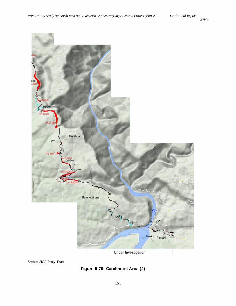
Preparatory Study for North East Road Network Connectivity Improvement Project (Phase 2) Draft Final Report - NH40
151
Source: JICA Study Team
Figure 5-76: Catchment Area (4)
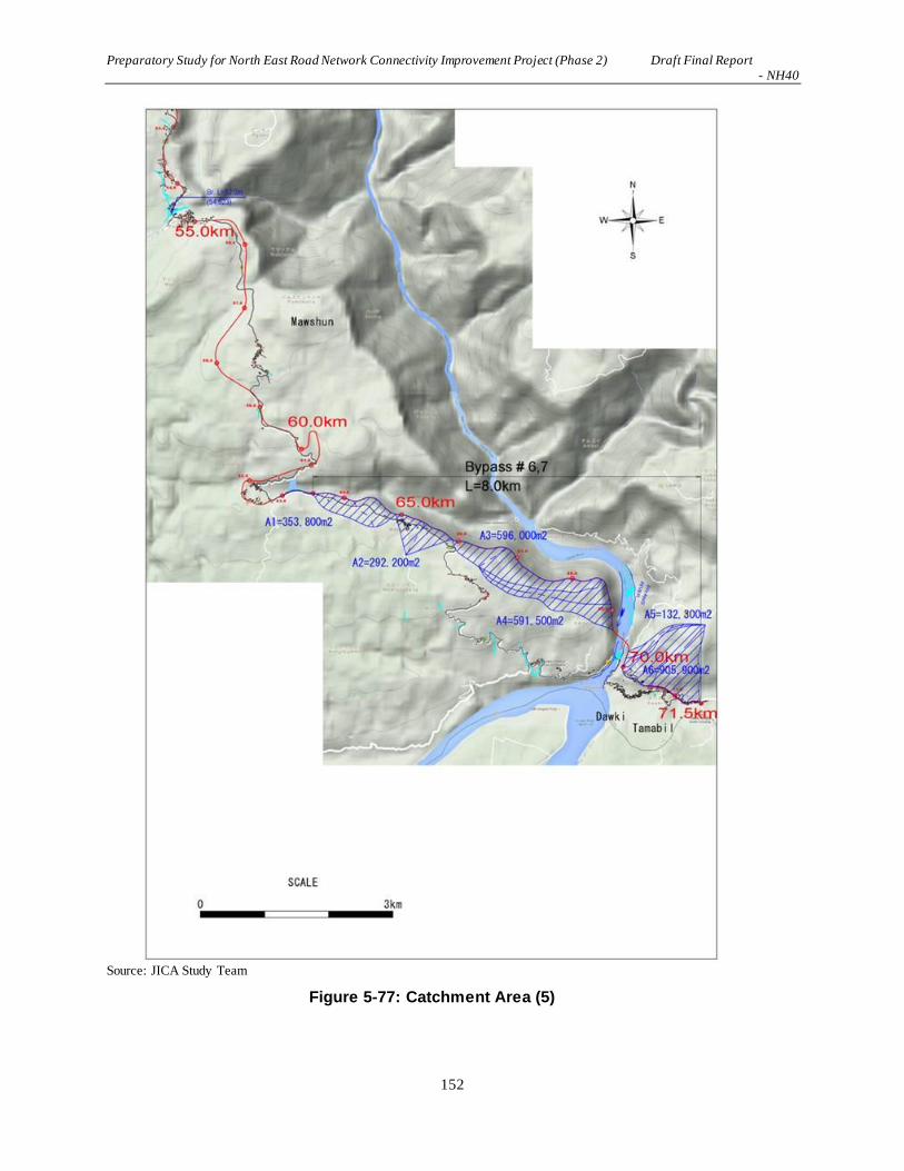
Preparatory Study for North East Road Network Connectivity Improvement Project (Phase 2) Draft Final Report - NH40
152
Source: JICA Study Team
Figure 5-77: Catchment Area (5)

Preparatory Study for North East Road Network Connectivity Improvement Project (Phase 2) Draft Final Report - NH40
153
The table below shows the calculation results of the outflow volume.
Table 5-38: Calculation Results of the Outflow Volume

Preparatory Study for North East Road Network Connectivity Improvement Project (Phase 2) Draft Final Report - NH40
154

Preparatory Study for North East Road Network Connectivity Improvement Project (Phase 2) Draft Final Report - NH40
155

Preparatory Study for North East Road Network Connectivity Improvement Project (Phase 2) Draft Final Report - NH40
156

Preparatory Study for North East Road Network Connectivity Improvement Project (Phase 2) Draft Final Report - NH40
157

Preparatory Study for North East Road Network Connectivity Improvement Project (Phase 2) Draft Final Report - NH40
158
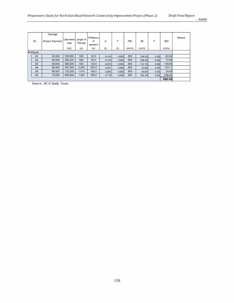
Preparatory Study for North East Road Network Connectivity Improvement Project (Phase 2) Draft Final Report - NH40
159
Source: JICA Study Team

Preparatory Study for North East Road Network Connectivity Improvement Project (Phase 2) Draft Final Report - NH40
160
The table below shows the examination results of the drainage capacity of the planned cross drainages.
Table 5-39: Examination of Drainage Capacity of the Planned Cross Drainages (1)
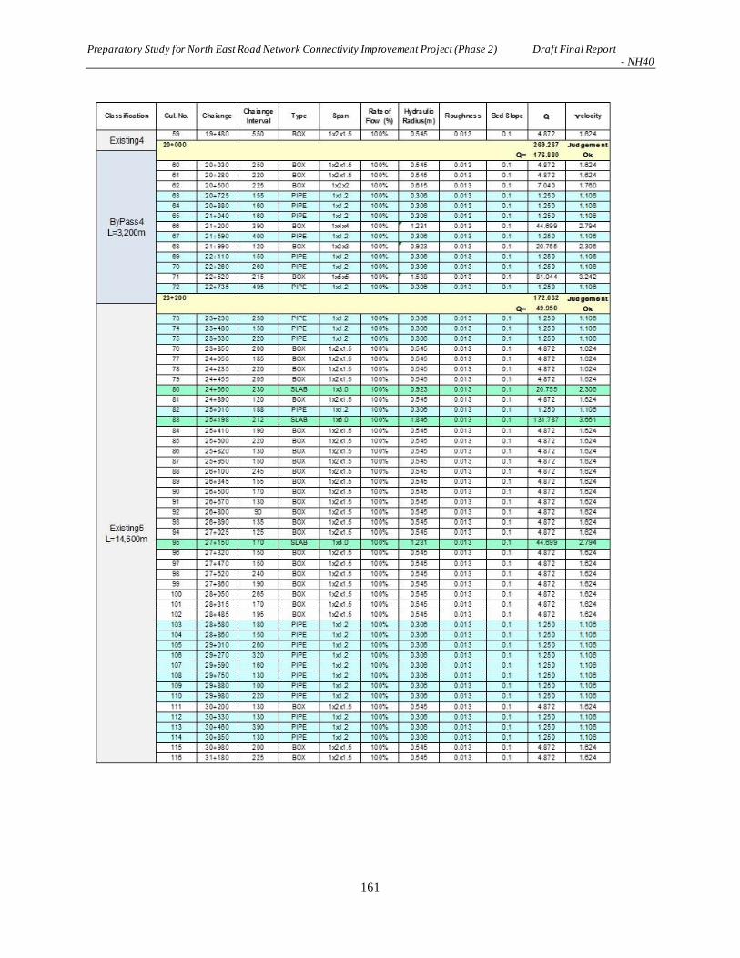
Preparatory Study for North East Road Network Connectivity Improvement Project (Phase 2) Draft Final Report - NH40
161

Preparatory Study for North East Road Network Connectivity Improvement Project (Phase 2) Draft Final Report - NH40
162
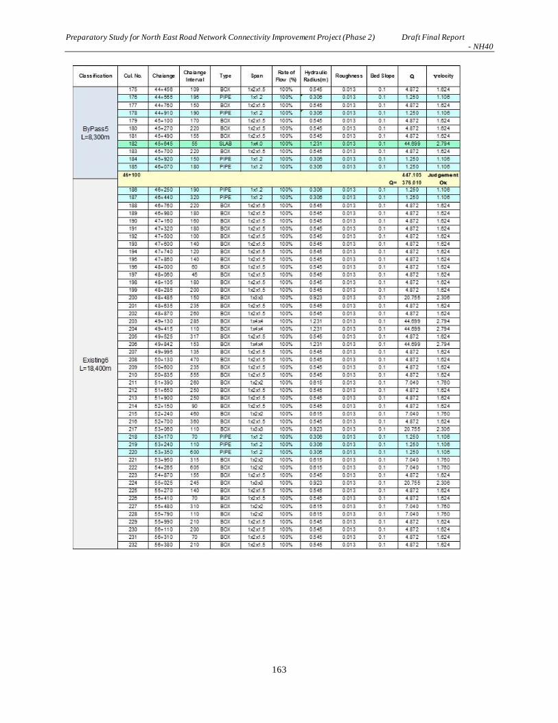
Preparatory Study for North East Road Network Connectivity Improvement Project (Phase 2) Draft Final Report - NH40
163

Preparatory Study for North East Road Network Connectivity Improvement Project (Phase 2) Draft Final Report - NH40
164
Source: JICA Study Team
The examination of the drainage capacity of the planned cross drainages found that the outflow volume
exceeds the permissible water flow volume of the conduits at the section (Existing 2) where the existing
route is expanded and the section with bypass #2. This suggests that the planned cross drainage must be
reviewed. It is also desirable to re-examine other sections with topographic maps with higher accuracy.
(5) Drainage Plan
a) Securing of Gradient for Drainage
To increase the drainage volume, the cross-sectional area needs to be increased. Sloping the conduits is
another way to do so. This section will outline the relation between the gradient of a conduit and drainage
volume, and the gradient appropriate for the improvement plan will be examined.
If a conduit has only a gentle gradient, earth, sand, and rubbish will accumulate in the conduit, lowering
the drainage volume. However, the construction of a steep conduit is complicated; therefore it is
important to set an appropriate gradient to ensure the necessary drainage volume is attained and to
maintain the conduit.
Table below shows the relations between the drainage gradient and volume.

Preparatory Study for North East Road Network Connectivity Improvement Project (Phase 2) Draft Final Report - NH40
165
Table 5-40: Relations between Drainage Gradient and Drainage Volume
Source: JICA Study Team
The table indicates that the drainage volume increases roughly by 10% as the gradient increased by 0.5%.
The survey team proposes as shown below that the difference in elevation at the inflow and outflow sides
should be set at 10-30cm and the gradient at a pitch of 10cm.
The plan and construction work will be made easier by limiting the bed height of the water course at
the inflow and outflow sides.
Construction work will be made less complicated by setting the height difference at around 10 cm.
i = 3% or less (the height difference is 30 cm) in consideration of the construction process.
The figure below shows the gradient of the conduits when the difference in elevation is set at 10 cm and
30cm, respectively. However, if the drainage gradient is determined in accordance with the ground height
at the inflow and outflow sides, it should conform to the ground height.
Source: JICA Study Team
Figure 5-78: Sloping of the Transversal Conduit
b) Mud collection by drainage basin

Preparatory Study for North East Road Network Connectivity Improvement Project (Phase 2) Draft Final Report - NH40
166
Currently, earth and sand has accumulated in some parts of the cross drainage, undermining the drainage
function of the conduits. To solve this problem, drainage basins should be installed along the cross
drainage in a manner that the bottom of these basins will be placed lower than the conduits by around 30
cm.
Source: JICA Study Team
Figure 5-79: Accumulated Earth in Drainage
Drainage basins placed along the cross drainage will maintain the drainage function of the conduits as
earth and sand settle in the basins. As earth and sand in the basins need to be removed regularly, stairs
will be installed so that maintenance workers can descend from the roadway to the basins. Such drainage
facilities with stairs take into consideration the operation and maintenance procedures.
Source: JICA Study Team
Figure 5-80: Mud Collection Function of Drainage Basin
c) Side ditch
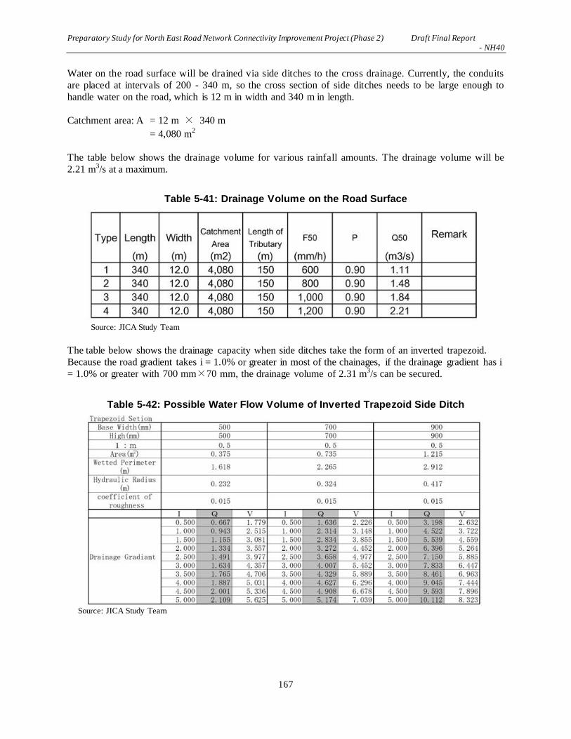
Preparatory Study for North East Road Network Connectivity Improvement Project (Phase 2) Draft Final Report - NH40
167
Water on the road surface will be drained via side ditches to the cross drainage. Currently, the conduits
are placed at intervals of 200 - 340 m, so the cross section of side ditches needs to be large enough to
handle water on the road, which is 12 m in width and 340 m in length.
Catchment area: A = 12 m × 340 m
= 4,080 m2
The table below shows the drainage volume for various rainfall amounts. The drainage volume will be
2.21 m3/s at a maximum.
Table 5-41: Drainage Volume on the Road Surface
Source: JICA Study Team
The table below shows the drainage capacity when side ditches take the form of an inverted trapezoid.
Because the road gradient takes i = 1.0% or greater in most of the chainages, if the drainage gradient has i
= 1.0% or greater with 700 mm×70 mm, the drainage volume of 2.31 m3/s can be secured.
Table 5-42: Possible Water Flow Volume of Inverted Trapezoid Side Ditch
Source: JICA Study Team
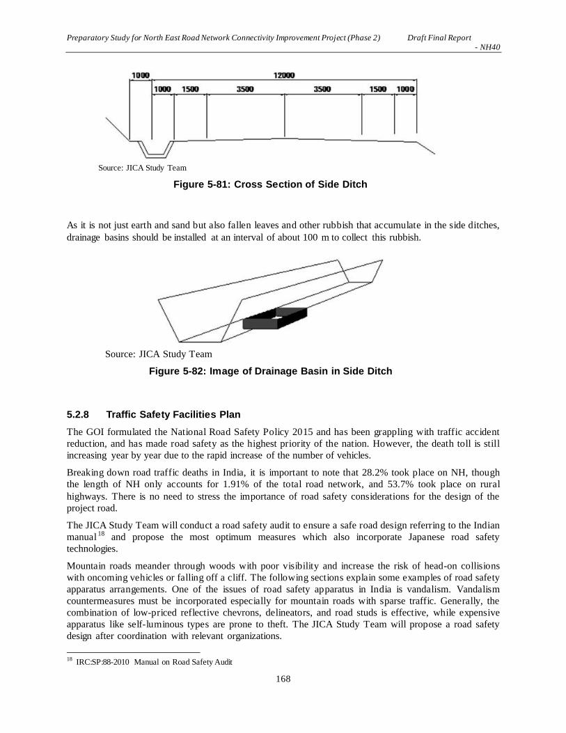
Preparatory Study for North East Road Network Connectivity Improvement Project (Phase 2) Draft Final Report - NH40
168
Source: JICA Study Team
Figure 5-81: Cross Section of Side Ditch
As it is not just earth and sand but also fallen leaves and other rubbish that accumulate in the side ditches,
drainage basins should be installed at an interval of about 100 m to collect this rubbish.
Source: JICA Study Team
Figure 5-82: Image of Drainage Basin in Side Ditch
5.2.8 Traffic Safety Facilities Plan
The GOI formulated the National Road Safety Policy 2015 and has been grappling with traffic accident
reduction, and has made road safety as the highest priority of the nation. However, the death toll is still
increasing year by year due to the rapid increase of the number of vehicles.
Breaking down road traffic deaths in India, it is important to note that 28.2% took place on NH, though
the length of NH only accounts for 1.91% of the total road network, and 53.7% took place on rural
highways. There is no need to stress the importance of road safety considerations for the design of the
project road.
The JICA Study Team will conduct a road safety audit to ensure a safe road design referring to the Indian
manual 18 and propose the most optimum measures which also incorporate Japanese road safety
technologies.
Mountain roads meander through woods with poor visibility and increase the risk of head-on collisions
with oncoming vehicles or falling off a cliff. The following sections explain some examples of road safety
apparatus arrangements. One of the issues of road safety apparatus in India is vandalism. Vandalism
countermeasures must be incorporated especially for mountain roads with sparse traffic. Generally, the
combination of low-priced reflective chevrons, delineators, and road studs is effective, while expensive
apparatus like self-luminous types are prone to theft. The JICA Study Team will propose a road safety
design after coordination with relevant organizations.
18
IRC:SP:88-2010 Manual on Road Safety Audit

Preparatory Study for North East Road Network Connectivity Improvement Project (Phase 2) Draft Final Report - NH40
169
(1) Basic principles
Road traffic safety measures refer to methods and measures for keeping people safe and preventing deaths
and serious injuries, and also protecting properties using the road network from damage. The users of a
road include drivers and passengers, cyclists, pedestrians and bus passengers. The objective of road safety
strategies focuses on the prevention of serious injuries and deaths in spite of human errors, and safe road
design provides a road environment that ensures vehicle speeds will be within reasonable limits which
mitigate risks of such injuries and deaths. One of the ways to make a road safe would be to design the
road geometry with consideration for all road users. Another way is to provide safety facilities along the
roadway wherever conflict points exist.
Traffic control devices, road safety devices, and roadside furniture which can be used to increase safety
on a road are things such as traffic signs, road markings, object markers, hazard markers, road studs,
delineators, safety barriers, pedestrian guardrails, boundary stones, km stones, etc. Guidelines given in
IRC include IRC:25, IRC:26, IRC:35, IRC:67, IRC:79, IRC:103, etc.19
Table 5-43: IRC Guidelines for Design of Traffic Safety Facilities
IRC Code Title
IRC:25-1967 Type Designs for Boundary Stones
IRC:26-1967 Type Design for 200-Meter Stones
IRC:35-1997 Code of Practice for Road Markings
IRC:67-2012 Code of Practice for Road Signs
IRC:79-1981 Recommended Practice for Road Delineators
IRC:103-1988 Guidelines for Pedestrian Facilities Source: JICA Study Team
(2) Traffic Signs
Traffic signs are often seen along the roadway to promote the safety and smooth flow of traffic. Every
road user should know the signs on the road and their meanings. They give advance information about
road conditions ahead, and also give orders, warning or guidance to drivers or riders. Drivers must look
out for them when on the road, as an advance warning sign of a sharp curve ahead together with a speed
limit or no overtaking sign would keep drivers and other road users safe.
Road signs in the Republic of India are similar to those used in some parts of the United Kingdom, except
that they are bilingual. Most urban roads and SH have signs in the state language and English. NH has
signs in the state language, Hindi and English as of 2012.
There are several kinds of road signs along the NH40 from Shillong to Dawki, however, most are poorly
maintained. Some of the signs are shown in the photos below.
19 Source: IRC:SP:73-2015: Manual of Specifications & Standards for Two Laning of Highways with Paved Shoulder

Preparatory Study for North East Road Network Connectivity Improvement Project (Phase 2) Draft Final Report - NH40
170
No overtaking Speed limit Right turn ahead
Pedestrian crossing Various signs in Village Information sign
Source: JICA Study Team
Figure 5-83: Existing Traffic Signs along NH40
Road signs are classified into three categories: regulatory signs, warning signs and information signs.
Regulatory signs are used to inform road users of certain rules and regulations to improve safety and
smooth flow of traffic. These include signs such as speed limits, no turns, stop or no parking, which give
notice of specific obligations, restrictions, and prohibitions for drivers to comply with.
Warning signs are used to caution the road users of the certain hazardous conditions on or alongside of
the road so that road users become cautious and take proper actions for maintaining safety in advance.
These signs include steep grades, sharp curves, falling rocks, narrow bridges, etc.
Information signs are used to provide information and to guide road users along the route. The
information could be names of places, directions to destinations, route distance to places so that drivers
can easily drive and safely travel with comfort. The following figures indicate regulatory, warning and
informative signs.

Preparatory Study for North East Road Network Connectivity Improvement Project (Phase 2) Draft Final Report - NH40
171
Regulatory Signs
(Cautionary) Warning Signs
Information Signs
Source: JICA Study Team based on IRC67-2012 Code of Practice for Road Signs
Figure 5-84: Examples of Different Types of Traffic Signs

Preparatory Study for North East Road Network Connectivity Improvement Project (Phase 2) Draft Final Report - NH40
172
The actual application of various signs along NH40 depends on the roadway conditions such as design
speed, horizontal and vertical alignment, roadway structures and other factors that determine the types
and numbers of signs. Among them, the number of information signs at the intersection (or diversions of
the road) according to the present design is summarized in the following table.
Table 5-44: Major Intersections and Diversions
Location Intersection Diversion & connection Remarks
0+580 T-shape Minor connections to local roads
0+740 T-shape Minor connections to local roads
1+240 T-shape Minor connections to local roads
2+000 T-shape Channelized T-shape intersection
3+500 T-shape Connection to a local road
5+250 4-leg intersection To Shillong Peak
6+860 Y-shape Entrance to a facility
7+380 T-intersection Connction to a local road
7+700 4-leg intersection To bypass #2
(minor to Elephant falls)
9+100 T-shape Next to a grade separated structure
10+470 Y-shape Bypass #2 merge
11+000 Y-shape Divert to a village road
11+150 Y-shape Divert to a village road
11+800 T-shape Connection to a village road
(two connections)
12+290 Y-shape NH40 and New Road, Bypass #3
13+340 T-shape Connection to a village road
14+300 Y-shape NH40 and New Road, Bypass #3
18+520 T-intersection Connection to NH40
19+850 T-intersection Connection to NH40
22+640 T-shape Connection to NH40
37+670 Y-shape Connection to Bypass #5
(connection to NH40)
43+350 4-leg intersection Connection to a rural road to
Shillong
Source: IRC:SP:73-2015
Figure 5-85: Arrangement of Directional Information Signs for a Junction

Preparatory Study for North East Road Network Connectivity Improvement Project (Phase 2) Draft Final Report - NH40
173
45+780 T-shape Connection to NH40
54+680 T-shape Connection to a local road
56+720 4-leg intersection Connection to NH40
58+710 T-shape Connection to NH40
62+290 4-leg intersection Connection to a local road
62+850 T-shape Connection to a local road
64+510 T-shape Connection to NH40
73+700 T-intersection Channelized T-shape intersection
to NH40(E)
75+120 T-intersection Channelized T-shape intersection
to NH40
Total number 11 (6 T-shape) 20
Five 4-leg intersections, 19 T-
shape intersections, and 7 Y-shape
intersections Source: JICA Study Team
Each four-leg intersection needs four information sign boards and four direction sign boards whereas T -
shape intersections and Y-shape intersections or diversions need three information sign boards and four
direction sign boards at each location. The total number of information sign boards is ninety-eight (5x4 +
26x3 = 98) and 124 (31x4) direction sign boards along NH40.
(3) Road Markings
Road markings are used as a means of controlling and guiding traffic. They are highly important on rural
roads and intersections as they promote road safety and facilitate smooth and harmonious flow of traffic
along guided paths of travel. They also supplement the messages conveyed by road signals and signs. In
some cases, they are used alone to convey certain regulations, information or warnings that cannot
otherwise be effectively made known to the road users. Road surface markings are the devices on a paved
road surface used to convey official information, provide guidance and information to drivers and
pedestrians. Uniformity of the markings is an important factor in minimizing confusion and uncertainty
about their meaning.
The main functions of road markings are to guide the safe and smooth flow of traffic such as a)
segregation of traffic, b) stop and go, c) give way instruction, d) overtaking or not, e) inter-vehicle
distance, f) parking zone or no parking, g) speed indication, h) direction, i) pedestrian crossing, and j)
type of vehicles allowed.
Road markings play a useful and important role in traffic management, and they should convey the
required information to the driver without distracting his attention from the carriageway. The marking
should be visible day and night, using clear and vivid colors with retro-reflective materials such as glass
beads. Usually the color white, either solid or dotted, is used for carriageway, edge and center-lines,
directions, and messages. Yellow is used for regulations or warnings to the driver. Some of the usage of
the markings for the rural roads is as follows:
a) Center line
The center line separates the opposing streams of traffic and facilitates their movements. Usually no
center line is provided for roads with a width of less than 5 m and for roads having more than four lanes
with the central verge. The center line may be marked with a single broken line, single solid line, double
broken line, or double solid line depending upon the road, traffic and regulations. A center line marking is
provided to demarcate the center of a carriageway and to separate traffic in opposite directions.

Preparatory Study for North East Road Network Connectivity Improvement Project (Phase 2) Draft Final Report - NH40
174
Source: IRC35-1997 Code of Practice for Road Markings
Figure 5-86: Center Line Marking for a Two Lane Road
The expected volume of the center line along NH40 would be the same as the total section length of two
lane portions of NH40 that is 66.3 km (75.00 – 8.7 kp) based on the character of the project, widening of
existing road and new construction of the road.
b) Traffic lane lines
The division of the carriageway into separate lanes for traffic traveling in the same direction on either side
of the center-line or median strip helps to promote travel in proper lanes and curb the meandering
tendency of the drivers, thereby promoting safety and ensuring maximum capacity. Traffic lane lines are
broken lines which permit lane changing with caution. The traffic lane lines shall normally be single
broken lines, with a width of 100 mm. Its use is basically for multilane roadways. The traffic lane line
would be applied to the section of four-lane road, which is 8.7 km.
c) Pavement edge lines (both sides)
Pavement edge lines are used to indicate the edges of carriageways which have no curbs. They serve as a
visual guidance for the drivers, indicating to them the limits within which the driver can safely drive.
They are especially useful during conditions of adverse weather and poor visibility. Normally the paved
shoulder is less strong compared with the main pavement, therefore the edge lines are used to promote
travel on the main pavement itself. Edge lines are in the form of a single continuous line placed at the
edge and outside of the carriageway. The expected volume of the edge line along NH40 would be the
same as the total section length of NH40 multiplied by two, which is 150 km.
d) Route direction arrows
In addition to the warning lines on approaches to intersections, directional arrows should be used to guide
drivers in advance towards the correct lane to be taken when approaching busy intersections, whether
signal controlled or not. Because of the low angle at which such markings are viewed, these must be
elongated in the direction of the traffic flow to provide adequate legibility to the driver. Normally four
arrows should be used in a sequence in each lane. The direction arrow nearest to the intersection should
be 15 m from the stop line or the entrance to the junction. The second arrow should be placed 15 m before
the first arrow and similarly for third and fourth arrow.
e) Word message
Word messages are sometimes used for alarming drivers of hazard sections together with signs and
warning boards.
f) No-overtaking marking
No passing zones are established on roads where there is no central median and traffic is allowed in both
directions and sight distance is not enough for overtaking. It may be marked by a solid yellow line along
the center or a double yellow line. In the case of a double yellow line, the left line may be a solid barrier
line, while the right line may be either a broken line or a solid line. These solid lines are also called

Preparatory Study for North East Road Network Connectivity Improvement Project (Phase 2) Draft Final Report - NH40
175
barrier lines. When a solid line is to the right of the broken line, the passing restriction shall apply only to
the opposing traffic.
(4) Road studs
The reflective pavement markers (road studs) should be installed to improve visibility during night and
wet weather conditions. Road studs should be the prismatic retro-reflective type conforming to ASTM
(American Society for Testing and Materials) D 4280.
There are alternative road studs to be used at locations such as hazard areas where normal road studs are
not so effective especially during foggy weather conditions. Solar road studs are flashing solar cell
powered, LED maintenance-free lighting devices to delineate road edges and center lines. Embedded in
the road surface, they are an electronic improvement to the traditional cateyes. The intense brightness of
the LEDs makes them easily visible at distances of about 900 m under favorable conditions.
Figure 5-42 shows NH40 in the high mountain area during normal and foggy conditions. The visibility
with fog is extremely low that markings, warning signs, together with road studs could provide a better
road environment under adverse weather conditions such as a fog.
Source: IRC:SP:73-2015 Manual of Specifications & Standards for Two Laning of Highways with Paved Shoulder
Figure 5-87: Arrangement of Road Studs for Two Lane Road
(5) Safety Barriers
Safety barriers, also known in North America as guard rails and in Britain as crash barriers, keep vehicles
within the roadway and prevent vehicles from colliding with dangerous obstacles such as boulders,
buildings, walls or large drains. Guard rails are also installed on the roadside to prevent errant vehicles
from traversing steep slopes, entering deep water, or jumping into a deep valley. Safety barriers are
installed within medians of divided highways to prevent errant vehicles from entering the opposing
carriageway of traffic and to help reduce head-on collisions.
A variety of guardrails are used along NH40 where steep hills and deep valleys are prevalent. It
necessitates the use of the rigid type guardrails of different shapes to prevent vehicles from running out of
the roadway. Figure 5-40 shows some of the examples of safety barriers.
While barriers are normally designed to minimize injury to vehicle occupants (driver and passengers),
injuries do occur in collisions with guard rails. They should only be installed where a collision with the

Preparatory Study for North East Road Network Connectivity Improvement Project (Phase 2) Draft Final Report - NH40
176
barriers is likely to be less severe than a collision with the hazard behind it. Where possible, it is
preferable to remove, relocate or modify a hazard, rather than shield it with a barrier. To provide safe
roadside conditions, hazardous elements such as fixed obstacles or steep slopes can be placed outside of
the clear zone20
in order to reduce or eliminate the need for roadside protection.
Common sites for installation of safety barrier includes, a) bridge ends, b) steep slopes near roadway
limits, c) at drainage crossings or culverts where steep or vertical drops are present, d) near large signs /
illumination poles or other roadside elements which may pose hazards, e) near deep valley locations, and
f) along a high embankment (above 3 m according to IRC).
Barriers are divided into three groups, based on the amount they deflect when struck by a vehicle and the
mechanism the barrier uses to resist the impact forces.
Flexible barriers include guard cables and weak post corrugated guide rail systems. These are referred to
as flexible barriers because they will deflect 1.6 m to 2.6 m (5.2 ft to 8.5 ft) when struck by a typical
passenger car or light truck. Impact energy is dissipated through tension in the rail elements, deformation
of the rail elements, posts, soil and vehicle bodywork, and friction between the rail and vehicle.
Semi-rigid barriers include the box beam guide rail and heavy post blocked out corrugated guide rail.
Impact energy is dissipated through deformation of the rail elements, posts, soil and vehicle bodywork,
and friction between the rail and vehicle. Box beam systems also spread the impact force over a number
of posts due to the stiffness of the steel tube.
Rigid barriers are usually constructed of reinforced concrete. A permanent concrete barrier will only
deflect a negligible amount when struck by a vehicle. Instead, the shape of a concrete barrier is designed
to redirect a vehicle into a path parallel to the barrier. This means they can be used to protect traffic from
hazards very close behind the barrier, and generally require very little maintenance. Impact energy is
dissipated through redirection and deformation of the vehicle itself. Jersey barriers also lift the vehicle as
the tires ride up on the angled lower section. The disadvantage is there is a higher likelihood of rollover
with a small car than the single slope or step barriers. Impact forces are resisted by a combination of the
rigidity and mass of the barrier. Deflection is usually negligible.
(6) Road Delineators
Road delineators are classified under three types, a) roadway indicators, b) hazard markers, and c) object
markers.21 Each of these serve a slightly different purpose.
Roadway indicators are intended to delineate the edges of the roadway so as to guide drivers through the
alignment ahead, particularly where it might be confusing for some reason. The objective of hazard
makers is to define obstructions like guard-rails and abutments adjacent to the carriageway, for instance at
culverts and bridges which are narrower than the roadway width at approaches. Object markers are used
to indicate hazards and obstructions within the vehicle flow path, for example channelizing islands close
to the intersections.
20 A lateral distance in which a motorist on a recoverable slope may travel outside of the roadway and return their vehicle safely
to the roadway. 21
IRC:79-1981 Recommended Practice for Road Delineators

Preparatory Study for North East Road Network Connectivity Improvement Project (Phase 2) Draft Final Report - NH40
177
Source: IRC:SP:73-2015
Figure 5-88: Arrangement of Curve Delineators for Two Lane Road
(7) Safety Measures for Hazardous Spots on NH40
Hazardous spots should employ a combination of signs, reflectors and warning boards to inform drivers
of dangerous spots such as a steep curve, gradient or environmental hazards. The existing NH40 is located
in the mountainous area on Shillong Plateau. The road is located at a very high altitude, between
approximately 1,500 m and 1,800 m for the first half (roughly 35 km) then starts to descend until it is at
less than 100 m elevation for the second half (roughly 45 km) as described in Table 5-23: Present
conditions of NH40. Naturally, the horizontal alignment is very difficult as well as vertical grade. A small
radius is used for the section in very steep mountainous areas.
The preliminary design was proposed in order to improve the alignment based on the current design
standard. However, there are some sections that do not comply with the newly proposed standard by IRC.
Those sections adopt previous standards as mentioned in the section 5.2.2 Road Geometric Design. In the
reviewed preliminary design there are 3 locations of 50m radius and 13 locations of less than 75m radius
(refer to Table 5-48: Locations with Sharp Horizontal Curves in Reviewed DPR Design) where special
measures are required together with a recommended posted speed limit of 40 km/h to promote safety of
traffic. Other sections where the radius of the curvature is less than 150 m are still considered relatively
sharp horizontal curves, and there is a need to inform and warn drivers of the road conditions ahead as
indicated in the Table 5-47: Location with Sharp Horizontal Curves.
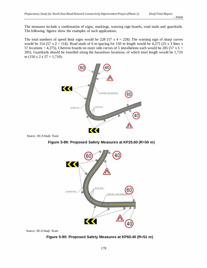
Preparatory Study for North East Road Network Connectivity Improvement Project (Phase 2) Draft Final Report - NH40
178
The measures include a combination of signs, markings, warning sign boards, road studs and guardrails.
The following figures show the examples of such applications.
The total numbers of speed limit signs would be 228 (57 x 4 = 228). The warning sign of sharp curves
would be 114 (57 x 2 = 114). Road studs of 6 m spacing for 150 m length would be 4,275 (25 x 3 lines x
57 locations = 4,275). Chevron boards on outer side curves of 5 installations each would be 285 (57 x 5 =
285). Guardrails should be installed along the hazardous locations, of which total length would be 1,710
m (150 x 2 x 57 = 1,710).
Source: JICA Study Team
Figure 5-89: Proposed Safety Measures at KP25.60 (R=50 m)
Source: JICA Study Team
Figure 5-90: Proposed Safety Measures at KP60.40 (R=51 m)

Preparatory Study for North East Road Network Connectivity Improvement Project (Phase 2) Draft Final Report - NH40
179
Source: JICA Study Team
Figure 5-91: Proposed Safety Measures at KP47.27 (R=90 m)
Source: JICA Study Team
Figure 5-92: Proposed Safety Measures at KP30.17 (R=80 m)

Preparatory Study for North East Road Network Connectivity Improvement Project (Phase 2) Draft Final Report - NH40
180
5.2.9 Road Appurtenances Plan
(1) Road Appurtenances Plan
Road appurtenances are miscellaneous facilities for road users to take a rest and obtain road-related
information as well as for road administrators to maintain their roads efficiently. In this study, considering
the road function of rural roads and usage of the target roads, facilities listed in Table 5-45 are discussed
for NH40.
Table 5-45: Road Appurtenance Design Guidelines
Type of Road Appurtenances Remarks/related codes
1 Kilometer posts (stone) IRC8-1980, IRC26-1967
2 Boundary stone IRC25
3 Bus bay IRC80-1981
4 Road amenity Public toilet Source: JICA Study Team
a) Kilometer Post
There are various locations of kilometer posts along NH 40. The photos shown are some of the kilometer
posts seen during site visit.
Source: JICA Study Team
Figure 5-93: Kilometer Posts along NH40
b) Boundary stone
Boundary stones are not found along NH40.
c) Bus bay
There are very few (1 or 2 services a day) regular bus services on NH40 between Shillong - Pynursla.
Residents of rural areas depend on small-size taxis as public transport. Taxis are cheap, convenient, and
provide better service than a regular bus. The taxi business attracts more passengers and creates
employment for drivers.
On the other hand, there are public bus services in the Shillong urban area using middle and small size
buses. Regular bus routes offer bus services of more than ten a day.
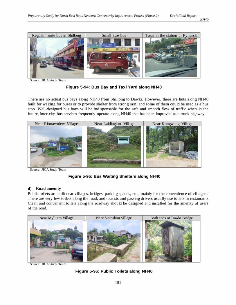
Preparatory Study for North East Road Network Connectivity Improvement Project (Phase 2) Draft Final Report - NH40
181
Regular route bus in Shillong Small size bus Taxis in the station in Pynursla
Source: JICA Study Team
Figure 5-94: Bus Bay and Taxi Yard along NH40
There are no actual bus bays along NH40 from Shillong to Dawki. However, there are huts along NH40
built for waiting for buses or to provide shelter from strong rain, and some of them could be used as a bus
stop. Well-designed bus bays will be indispensable for the safe and smooth flow of traffic when in the
future, inter-city bus services frequently operate along NH40 that has been improved as a trunk highway.
Near Ritmawniew Village Near Laitlingkot Village Near Kongwang Village
Source: JICA Study Team
Figure 5-95: Bus Waiting Shelters along NH40
d) Road amenity
Public toilets are built near villages, bridges, parking spaces, etc., mainly for the convenience of villagers.
There are very few toilets along the road, and tourists and passing drivers usually use toilets in restaurants.
Clean and convenient toilets along the roadway should be designed and installed for the amenity of users
of the road.
Near Mylliem Village Near Siatbakon Village Both ends of Dawki Bridge
Source: JICA Study Team
Figure 5-96: Public Toilets along NH40

Preparatory Study for North East Road Network Connectivity Improvement Project (Phase 2) Draft Final Report - NH40
182
(2) Tourist Facilities Plan
a) High Potential of Tourism with Picturesque Scenery
Shillong, a hill at an altitude of 1,400 m, is not just known as a summer resort place for people in India
but full of nature with many picturesque spots such as Shillong Peak and Elephant Falls.
The road concerned passes through mountainous areas at an altitude over 1,800 m, and has quite a few
spots that can command grandeur mountain scenery of Shillong District. Along the present road, there are
some scenic view spots with lookout platforms, to which drivers make a short visit for a rest.
Source: JICA Study Team
Figure 5-97: A View of Shillong Peak
b) Viewpoint
Road alignment design is crucial to the aesthetic design of the road. Beautiful natural landscapes of
mountains and rivers should be effectively incorporated into road landscaping. It is important to create
comfortable landscapes which minimize damage to nature and the environment and also to create scenic
harmony between the road and the surrounding terrain. Viewpoints should be planned for road users to
enjoy panoramic views at locations such as immediately after crossing a mountain pass where grandeur
scenery awaits, or, after turning a curve where there is a majestic mountain view.
Viewpoint 1 Viewpoint 2 Elephant Fall
Source: JICA Study Team
Figure 5-98: View Points along NH40
c) Mountain Scenery
NH40, starting at an altitude of 1,400m, includes many precipitous slopes and mountain scenery in the
distance, which is pleasing for the driver. In particular, the sections along the ridge of the mountain
command spectacular views of the mountainous areas, and many drivers pull off the road and enjoy

Preparatory Study for North East Road Network Connectivity Improvement Project (Phase 2) Draft Final Report - NH40
183
taking photographs.
Source: JICA Study Team
Figure 5-99: Mountain Scenery at Altitude of Around 1,400 m
Source: JICA Study Team
Figure 5-100: Mountain Scenery at Altitude of Around 1,800 m
d) Securing Parking Lots
Parking lots are needed for drivers to enjoy scenery, but needs earth cutting and filling, which is not
desirable for landscape conservation.
A possible idea is to take advantage of dead space created at the time when the present S-shaped curve is
renovated into a straight line. This will utilize dead space rather than require the planning of new space
for parking lots.

Preparatory Study for North East Road Network Connectivity Improvement Project (Phase 2) Draft Final Report - NH40
184
Source: JICA Study Team
Figure 5-101: A Usage of Parking Space
e) Handling of the Existing Scenic Spot
There is a rest area near Sta30+500, where people can eat and drink. The area was built also as a scenic
spot, and should be utilized as a tourist resource for the road. However, it is located in a short bypass
section, and thus is outside the planned road.
Source: JICA Study Team
Figure 5-102: Landscape from the Existing Scenic Spot
As shown in the figure below, the scenic spot will not be accessible from the starting point, where the
present roadbed is planned to be cut down and lowered. However, it is possible to make the scenic spot
accessible from the end point by creating an intersection. In this case, it is desirable to install guide signs
around the junction to give information regarding the scenic spot to drivers.
Source: JICA Study Team
Figure 5-103: Positional Relation between the Existing Scenic Spot and Bypass
Use as parking lot Use as parking lot
Existing Scenic Spot
TO Shillong
TO Dawki
Plan to construct
the cross road
Impossible to access
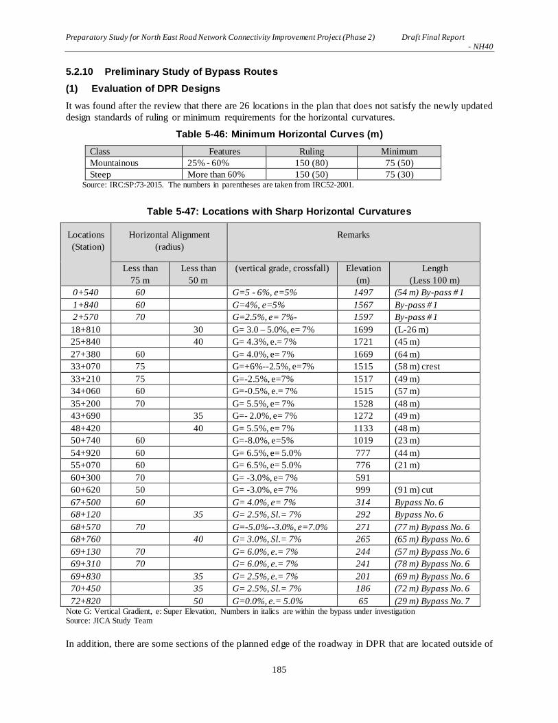
Preparatory Study for North East Road Network Connectivity Improvement Project (Phase 2) Draft Final Report - NH40
185
5.2.10 Preliminary Study of Bypass Routes
(1) Evaluation of DPR Designs
It was found after the review that there are 26 locations in the plan that does not satisfy the newly updated
design standards of ruling or minimum requirements for the horizontal curvatures.
Table 5-46: Minimum Horizontal Curves (m)
Class Features Ruling Minimum
Mountainous 25% - 60% 150 (80) 75 (50)
Steep More than 60% 150 (50) 75 (30) Source: IRC:SP:73-2015. The numbers in parentheses are taken from IRC52-2001.
Table 5-47: Locations with Sharp Horizontal Curvatures
Locations
(Station)
Horizontal Alignment
(radius)
Remarks
Less than
75 m
Less than
50 m
(vertical grade, crossfall) Elevation
(m)
Length
(Less 100 m)
0+540 60 G=5 - 6%, e=5% 1497 (54 m) By-pass # 1
1+840 60 G=4%, e=5% 1567 By-pass # 1
2+570 70 G=2.5%, e= 7%- 1597 By-pass # 1
18+810 30 G= 3.0 – 5.0%, e= 7% 1699 (L-26 m)
25+840 40 G= 4.3%, e.= 7% 1721 (45 m)
27+380 60 G= 4.0%, e= 7% 1669 (64 m)
33+070 75 G=+6%--2.5%, e=7% 1515 (58 m) crest
33+210 75 G=-2.5%, e=7% 1517 (49 m)
34+060 60 G=-0.5%, e.= 7% 1515 (57 m)
35+200 70 G= 5.5%, e= 7% 1528 (48 m)
43+690 35 G=- 2.0%, e= 7% 1272 (49 m)
48+420 40 G= 5.5%, e= 7% 1133 (48 m)
50+740 60 G=-8.0%, e=5% 1019 (23 m)
54+920 60 G= 6.5%, e= 5.0% 777 (44 m)
55+070 60 G= 6.5%, e= 5.0% 776 (21 m)
60+300 70 G= -3.0%, e= 7% 591
60+620 50 G= -3.0%, e= 7% 999 (91 m) cut
67+500 60 G= 4.0%, e= 7% 314 Bypass No. 6
68+120 35 G= 2.5%, Sl.= 7% 292 Bypass No. 6
68+570 70 G=-5.0%--3.0%, e=7.0% 271 (77 m) Bypass No. 6
68+760 40 G= 3.0%, Sl.= 7% 265 (65 m) Bypass No. 6
69+130 70 G= 6.0%, e.= 7% 244 (57 m) Bypass No. 6
69+310 70 G= 6.0%, e.= 7% 241 (78 m) Bypass No. 6
69+830 35 G= 2.5%, e.= 7% 201 (69 m) Bypass No. 6
70+450 35 G= 2.5%, Sl.= 7% 186 (72 m) Bypass No. 6
72+820 50 G=0.0%, e.= 5.0% 65 (29 m) Bypass No. 7 Note G: Vertical Gradient, e: Super Elevation, Numbers in italics are within the bypass under investigation Source: JICA Study Team
In addition, there are some sections of the planned edge of the roadway in DPR that are located outside of
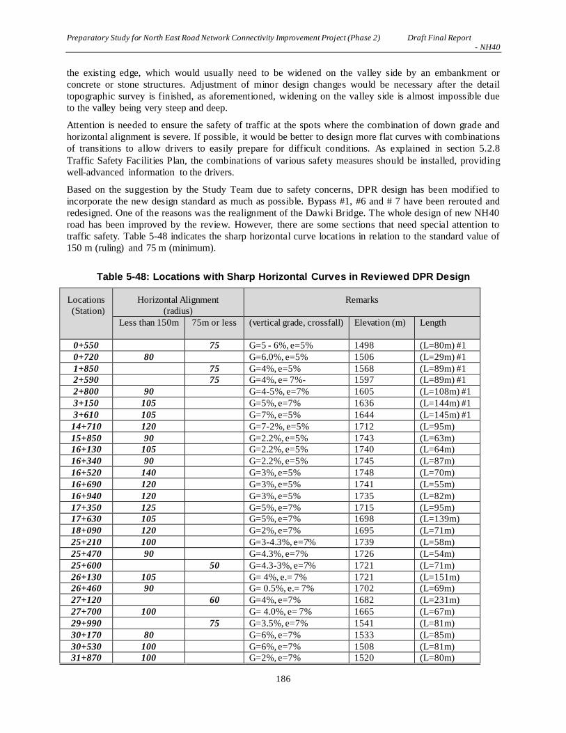
Preparatory Study for North East Road Network Connectivity Improvement Project (Phase 2) Draft Final Report - NH40
186
the existing edge, which would usually need to be widened on the valley side by an embankment or
concrete or stone structures. Adjustment of minor design changes would be necessary after the detail
topographic survey is finished, as aforementioned, widening on the valley side is almost impossible due
to the valley being very steep and deep.
Attention is needed to ensure the safety of traffic at the spots where the combination of down grade and
horizontal alignment is severe. If possible, it would be better to design more flat curves with combinations
of transitions to allow drivers to easily prepare for difficult conditions. As explained in section 5.2.8
Traffic Safety Facilities Plan, the combinations of various safety measures should be installed, providing
well-advanced information to the drivers.
Based on the suggestion by the Study Team due to safety concerns, DPR design has been modified to
incorporate the new design standard as much as possible. Bypass #1, #6 and # 7 have been rerouted and
redesigned. One of the reasons was the realignment of the Dawki Bridge. The whole design of new NH40
road has been improved by the review. However, there are some sections that need special attention to
traffic safety. Table 5-48 indicates the sharp horizontal curve locations in relation to the standard value of
150 m (ruling) and 75 m (minimum).
Table 5-48: Locations with Sharp Horizontal Curves in Reviewed DPR Design
Locations
(Station)
Horizontal Alignment
(radius)
Remarks
Less than 150m 75m or less (vertical grade, crossfall) Elevation (m) Length
0+550 75 G=5 - 6%, e=5% 1498 (L=80m) #1
0+720 80 G=6.0%, e=5% 1506 (L=29m) #1
1+850 75 G=4%, e=5% 1568 (L=89m) #1
2+590 75 G=4%, e= 7%- 1597 (L=89m) #1
2+800 90 G=4-5%, e=7% 1605 (L=108m) #1
3+150 105 G=5%, e=7% 1636 (L=144m) #1
3+610 105 G=7%, e=5% 1644 (L=145m) #1
14+710 120 G=7-2%, e=5% 1712 (L=95m)
15+850 90 G=2.2%, e=5% 1743 (L=63m)
16+130 105 G=2.2%, e=5% 1740 (L=64m)
16+340 90 G=2.2%, e=5% 1745 (L=87m)
16+520 140 G=3%, e=5% 1748 (L=70m)
16+690 120 G=3%, e=5% 1741 (L=55m)
16+940 120 G=3%, e=5% 1735 (L=82m)
17+350 125 G=5%, e=7% 1715 (L=95m)
17+630 105 G=5%, e=7% 1698 (L=139m)
18+090 120 G=2%, e=7% 1695 (L=71m)
25+210 100 G=3-4.3%, e=7% 1739 (L=58m)
25+470 90 G=4.3%, e=7% 1726 (L=54m)
25+600 50 G=4.3-3%, e=7% 1721 (L=71m)
26+130 105 G= 4%, e.= 7% 1721 (L=151m)
26+460 90 G= 0.5%, e.= 7% 1702 (L=69m)
27+120 60 G=4%, e=7% 1682 (L=231m)
27+700 100 G= 4.0%, e= 7% 1665 (L=67m)
29+990 75 G=3.5%, e=7% 1541 (L=81m)
30+170 80 G=6%, e=7% 1533 (L=85m)
30+530 100 G=6%, e=7% 1508 (L=81m)
31+870 100 G=2%, e=7% 1520 (L=80m)

Preparatory Study for North East Road Network Connectivity Improvement Project (Phase 2) Draft Final Report - NH40
187
32+830 75 G=+6%--2.5%, e=7% 1515 (L=58m)
32+970 75 G=-6%, e=7% 1517 (L=49m)
33+340 120 G=-2.8%, e=7% 1504 (L=47m)
33+470 120 G=-2.8%, e=7% 1502 (L=22m)
33+670 105 G=-2.8%--0.5%, e=7% 1497 (L=38m)
33+820 60 G=-0.5%, e.= 7% 1515 (L=66m)
33+970 105 G=-0.5%-+0.5%,
e=6.8%
1496 (L=42m) sag
34+800 90 G=5.5%, e=7% 1526 (L=61m)
34+960 70 G= 5.5%, e= 7% 1528 (L=48m)
35+080 100 G=5.5%, e=7% 1546 (L=34m)
35+340 120 G=5.5%--1.0%, e=7% 1555 (L=75m)
36+410 100 G=-1.9%--1%, e=7% 1540 (L=39m)
42+260 90 G=-5.0%, e=7% 1336 (L=111m)
43+400 50 G=- 2.0%, e= 7% 1272 (L=87m)
44+910 120 G=- 1.5%--3.5%, e= 7% 1265 (L=148m)
45+700 90 G=- 3.7%--5.0%, e= 7% 1228 (L=145m)
46+560 105 G=-5.0%--3.5%, e=7% 1180 (L=75m)
47+270 90 G=-2.7%, e=7% 1185 (L=86m)
48+070 50 G= 5.5%, e= 7% 1133 (L=70m)
48+500 105 G=-5.5%--1.0%, e=7% 1107 (L=93m)
50+370 60 G=-7.0%, e=5% 1019 (L=23m)
50+480 100 G=-0.0%, e=5% 1015 (L=29m)
54+180 105 G=-6.5%, e=5% 801 (L=144m)
54+530 60 G= 6.5%, e= 5.0% 777 (L=44m)
54+690 60 G= 0%, e= 5.0% 776 (L=20m)
60+050 85 G= 6.0%, e= 5% 589 (L=188m)
60+400 51 G= 2.4%, e= 7% 586 (L=100m) cut
62+090 90 G=-6.0%--2.4%, e=7% 473 (L=84m)
62+340 105 G= -2.40%, e= 7% 471 (L=97m)
Total 41 16
Source: JICA Study Team
(2) Alignment of Bypass #1
This section of the existing NH40 contains many sharp curves and zigzag alignments. The DPR plans for
a bypass to have a smooth alignment traversing the wood land. Since this wood land is the property of the
Ministry of Defense, the JICA Study Team is proposing to shift the alignment to follow the existing NH40
as much as possible to minimize building of the bypass into the property.

Preparatory Study for North East Road Network Connectivity Improvement Project (Phase 2) Draft Final Report - NH40
188
Source: JICA Study Team
Figure 5-104: Existing NH40 and Proposed Alignments of Bypass #1
(3) Alignment of Bypass #2
This section is from Sta. 7+600 to Sta. 10+600 (3.0 km), and is mainly composed of relatively gentle,
rolling terrain. The natural horizontal alignment of most of the section is within the ruling minimum of R
= 150 m. The vertical grade is also around 2% to 2.5% except one location at 10+500 has 4% to 4.5%
grade with a horizontal alignment of R = 200 m.
Source: JICA Study Team
Figure 5-105: Existing NH40 and Proposed Alignment of Bypass #2

Preparatory Study for North East Road Network Connectivity Improvement Project (Phase 2) Draft Final Report - NH40
189
(4) Alignment of Bypass #3
This section is from Sta. 12+200 to 14+400 (2.2 km), and is mainly composed of relatively gentle terrain
that is slightly steeper than Bypass #2. Its vertical grade is around 4% with a horizontal alignment of R =
150 m to 200 m.
Source: JICA Study Team
Figure 5-106: Existing NH40 and Proposed Alignment of Bypass #3
(5) Alignment of Bypass #4
This section runs from Sta. 20+000 to Sta. 23+200 (3.2 km), which is a section characterized mainly by
rolling and mountainous terrain. The vertical grade of the road is naturally slightly steeper than #2 and #3.
It is around 4% to 5% with a horizontal alignment of more than R = 150 m except one location of R = 90
m, with vertical grade of 4% at Sta. 20+130.
Source: JICA Study Team
Figure 5-107: Existing NH40 and Proposed Alignment of Bypass #4

Preparatory Study for North East Road Network Connectivity Improvement Project (Phase 2) Draft Final Report - NH40
190
(6) Alignment of Bypass #5
This section is in the mountainous terrain at an altitude between 1,500 m to 1,200 m. The bypass starts at
Sta. 37+800 and ends at Sta. 46+100 (8.3 km). Because of the mountain terrain, the maximum vertical
grade reaches around 5% with minimum radius of curvature around 90 m which is smaller than the new
ruling standard of 150 m for the design speed of 60 km/h. However there is one location where the
minimum radius of curvature is 50 m, which is smaller than the 75 m standard at the location of Sta.
43+400. Although the curve is very small, the vertical alignment remains relatively gentle at 2%.
Source: JICA Study Team
Figure 5-108: Existing NH40 and Proposed Alignment of Bypass #5
(7) Alignment of Bypass #6 and #7
The difficulty with this section is selecting a crossing location of the Dawki River. The existing bridge is
located about 200 m from the mouth of the river. DPR proposes an alignment near the mouth of the river.
However, the border with Bangladesh is close to the mouth of the river, which means there would be
some restrictions imposed on construction activities. The JICA Study Team is proposing an alignment to
be away from the border line.

Preparatory Study for North East Road Network Connectivity Improvement Project (Phase 2) Draft Final Report - NH40
191
Source: JICA Study Team
Figure 5-109: Existing NH40 and Propose Alignment of Bypass #6 and #7
The alignments of bypass #6 and #7 were reexamined to addressthe above stated problem. The JICA
Study Team decided to redesign the alignments along the route proposed by PWD and carried out
topographic and geotechnical surveys. The topography is very steep and rugged and there are many
boulders accumulated on the bottom of the Dawki River.Traces of a landslide were also observed. The
design of the bridge required considering these topographic and geotechnical features.
The JICA Study Team designed the bypass alignment based on the results of the surveys. The DPR
consultant also submitted their redesigned alignment and both proposals were reviewed. After the
consultation with NHIDCL, the Meghalaya State PWD, and the DPR consultant, the alignment proposed
by the JICA Study Team as shown below has been selected as the final alignment.

Preparatory Study for North East Road Network Connectivity Improvement Project (Phase 2) Draft Final Report - NH40
192
Source: JICA Study Team
Figure 5-110: Proposed Alignments for Bypass #6 and #7
5.2.11 Monolith
(1) Monolith
Monoliths are religious objects for local people, which are a combination of three or more stones standing
upright. Village people believe that they must not be moved for the sake of roads or any other
construction. This chapter outlines and clarifies the positional locations of these monoliths and the
planned road to confirm the impact of monoliths on the planned road.
Source: JICA Study Team
Figure 5-111: Monoliths

Preparatory Study for North East Road Network Connectivity Improvement Project (Phase 2) Draft Final Report - NH40
193
(2) Monoliths Having Impact on the Planned Road
The survey has confirmed seven monoliths that are adjacent to the planned road. Figures below outline
the positional relation of these monoliths and the planned road.
Source: JICA Study Team
Figure 5-112: Monolith #1 (KP4+880)
Source: JICA Study Team

Preparatory Study for North East Road Network Connectivity Improvement Project (Phase 2) Draft Final Report - NH40
194
Figure 5-113: Monolith #2 (KP5+790)
Source: JICA Study Team
Figure 5-114: Monolith #3 (KP6+060)
Source: JICA Study Team
Figure 5-115: Monolith #4 (KP8+140)

Preparatory Study for North East Road Network Connectivity Improvement Project (Phase 2) Draft Final Report - NH40
195
Source: JICA Study Team
Figure 5-116: Monolith #5 (KP17+880)
Source: JICA Study Team
Figure 5-117: Monolith #6 (KP18+110)

Preparatory Study for North East Road Network Connectivity Improvement Project (Phase 2) Draft Final Report - NH40
196
Source: JICA Study Team
Figure 5-118: Monolith #7 (KP21+520)
Source: JICA Study Team
Figure 5-119: Monolith #8 (KP53+750)

Preparatory Study for North East Road Network Connectivity Improvement Project (Phase 2) Draft Final Report - NH40
197
(3) Impact of Nearby Monoliths and Measures
The Survey Team has examined whether these nearby monoliths are within the width of the planned road,
and considered possible measures for each.
Table 5-49: Positional Relations with Monoliths and Possible Measures
Monolith No.
Survey Point No.
Positional relation with the planned road
Possible measures
Outside the road
Within the road
(i) Relocation of monoliths
(ii) Monolith to be included as part of the road facilities
(iii) Change in the road shape to avoid monolith
No.1 Around 4,880
○ -
There is no particular problem.
No.2 Around 5,790
- ○
○ It will be feasible if the consensus is gained from the local community.
○ The monolith will be placed on the central medians isolated from the roadway. This will reduce the impact of the monoliths, compared to Proposal (iii).
△ Measures will be taken to shift residential houses in the south of the road to the south by 10m. The change in the road shape will have a substantial impact.
No.3 Around 6,060
- ○
○ It will be feasible if the consensus is gained from the local community.
○ The monolith will be placed on the central medians isolated from the roadway. This will reduce the impact of the monolith, compared to Proposal (iii).
△ Measures will be taken to shift residential houses in the south of the road to the south by 10m. The change in the road shape will have a substantial impact.
No.4 Around 8,140
- ○
○ It will be feasible if the consensus is gained from the local community.
△ The monolith is located just on the edge of the road shoulder, so it is difficult to include it in the road facilities.
○ The road itself will be shifted to the north by 5m.
No.5 Around 17,880
○ - The monolith will remain in the premises but will
not conflict with the planned road. Further confirmation is required.
No.6 Around 18,110
○ -
There is no particular problem.
No.7 Around 21,520
-
○ ○
It will be △ No any
△ Measures will

Preparatory Study for North East Road Network Connectivity Improvement Project (Phase 2) Draft Final Report - NH40
198
feasible if the consensus is gained from the local community.
advantages. Because road level is lower than existing ground.
be taken to shift by 30m. The change in the road shape will have a substantial impact.
No.8 Around 53,750
- ○
○ It will be feasible if the consensus is gained from the local community. -> Result of hearing, relocation is available.
△ The monolith is located just on the edge of the road shoulder, so this does not have many advantages.
○ Measures will be taken to shift residential houses in the west of the road to the west by 5m. The change in the road shape will have a substantial impact.
Source: JICA Study Team
(4) Issues to Be Solved for Detailed Design
The survey has roughly confirmed the locations of monoliths and the planned road, and examined
possible measures. The following issues must be solved prior to the detailed design in the future.
The locations and areas of monoliths will be actually measured to clarify the positional relations with
and distance from the planned road.
The local people have consented to the relocation of the monoliths. The exact relocation points shall
be discussed further with the local people.
5.2.12 Spoil Plan
The volume of cut and fill along the proposed NH40 are estimated and spoil plan is studied as follows.
(1) Volume of Cut and Fill
In order to estimate the volume of cut and the necessary volume of fill material, the proposed NH40 is
separated into 26 sections every 5km or by rock types as shown in Table 5-1. Basically, excavated
material is used as material for fill in the same section.
The volume of “loosened excavated material” is obtained using the rate of change of excavate volume (L).
The following values are adopted as value of L which varies by rock type.
Rate of change of excavated material (L)
Type A (hard rocks): 1.8
Type B (medium hard rocks): 1.6
Type C (soft rocks): 1.5
Volume of “compacted material“ is obtained using the rate of change of compaction material (C). The
following values are adopted as value of C which varies with rock type.
Rate of change of compaction material (C)
Type A (hard rocks): 1.4
Type B (medium hard rocks): 1.3
Type C (soft rocks): 1.2

Preparatory Study for North East Road Network Connectivity Improvement Project (Phase 2) Draft Final Report - NH40
199
The results of estimation is shown in the following table.
However, the volume of cut is more than the volume of fill in most of the sections; the excavated material
for the fill volume is in short in Sections 2, 3, 4, 5, 6, 19 and 22.

Preparatory Study for North East Road Network Connectivity Improvement Project (Phase 2) Draft Final Report - NH40
200
Table 5-50: Volume of Cut and Fill
section
KP Rock type
Volume of cut
Volume of loosened excavated material
Volume of fill
Necessary Volume of material
for fill
Surplus
volume of
material
Shortage
volume for
fill
from to A A x L B B x C A x L - B x C (AxL-BxC)/C
m3 m3 m3 m3 m3 m3
1 0 3.3 C 500,671 751,006 128,339 154,006 597,000 -
2 3.3 5.0 A 44,901 80,821 75,113 105,158 (24,337) (17,384)
3 5.0 5.2 A 545 982 15,790 22,107 (21,125) (15,089)
4 5.2 9.5 C 43,040 64,561 124,401 149,281 (84,720) (70,600)
5 9.5 10.0 A 946 1,704 66,259 92,762 (91,059) (65,042)
6 10.0 11.2 A 8,015 14,427 43,272 60,581 (46,154) (32,967)
7 11.2 15.0 B 184,227 294,763 186,879 242,943 51,820 -
8 15.0 20.0 B 429,512 687,219 103,500 134,550 552,669 -
9 20.0 21.3 B 137,989 220,783 86,652 112,648 108,135 -
10 21.3 21.7 C 112,566 168,850 14,004 16,805 152,045 -
11 21.7 25.0 A 477,734 859,920 121,828 170,560 689,361 -
12 25.0 29.1 A 739,024 1,330,243 132,483 185,476 1,144,766 -
13 29.1 29.4 C 14,176 21,264 9,863 11,836 9,428 -
14 29.4 30.0 A 143,540 258,372 6,370 8,919 249,453 -
15 30.0 35.0 A 1,062,540 1,912,572 207,073 289,903 1,622,669 -
16 35.0 40.0 C 626,127 939,190 117,330 140,796 798,393 -
17 40.0 45.0 C 709,361 1,064,041 131,888 158,265 905,776 -
18 45.0 50.0 C 643,682 965,524 150,614 180,736 784,787 -
19 50.0 55.0 C 30,342 45,513 142,209 170,651 (125,138) (104,282)
20 55.0 60.0 C 240,946 361,419 172,486 206,984 154,435 -
21 60.0 63.8 C 430,946 646,420 144,927 173,912 472,507 -
22 63.8 65.0 A 21,146 38,062 57,437 80,411 (42,349) (30,249)
23 65.0 70.0 A 837,401 1,507,321 150,834 211,168 1,296,153 -
24 70.0 71.2 A 254,878 458,780 19,374 27,124 431,656 -
25 71.2 75.0 C 1,051,114 1,576,671 45,179 54,215 1,522,456 -
26 75.0 75.12 C 6,296 9,444 368 442 9,002
Total 8,751,664 14,279,869 2,454,475 3,162,240 11,117,629 (335,614) Source: JICA Study Team
(2) Supplement to Deficit in Fill
Excavated material is used in the same section from which it has been excavated, but the excavated
material within TP 0 – 10km can be used in 10 km areas. The surplus material in section 1 is to be used
for the total 267,395 m3 of shortage for fill in section 2, 3, 4, 5 and 6 (KP 3.3 – 11.2 km). The necessary
volume for fill in the sections is 320,874 m3 (267,395 m3 x 1.2). The surplus material in section 18 is to be
used for the shortage of 104,282 m3 of fill in section 19 (KP 50 – 55 km). The necessary volume for fill in
the sections is 125,138 m3 (104,282 m3 x 1.2). The surplus material in section 21 is to be used for the
shortage of 30,249 m3 of fill in section 22 (KP 63.8 – 65.0 km). The necessary volume for fill in the
sections is 36,299 m3 (30,249 m3 x 1.2).

Preparatory Study for North East Road Network Connectivity Improvement Project (Phase 2) Draft Final Report - NH40
201
(3) Usage of Quality Rock
Fresh rocks of Type A can be appropriate quality as aggregate / gravel, seeing that Type A rocks along
NH40 are being excavated as aggregate / gravel by private companies. It is recommended that the fresh
Type A rocks obtained by cutting in road construction should be used as aggregate / gravel.
In section 11, 12, 14, 15, 23 and 24, Type A rocks can be obtained as surplus material. Table 5-51 shows
the estimation of the volume of good quality rocks in the sections. The estimation is based on Table 5-52
which shows rate of soil / rock for every type of rocks estimated by the JICA Study Team. The
appropriate quality rocks of Type A are Rock A and Rock B in Table 5-52. As shown in Table 5-51, total
4,903,184 m3 of quality rocks may be obtained.
Table 5-51: Volume of Quality Rock in Type A
Section KP Rock
Type
Volume of excavated material
Volume of quality Rock
Rate of Quality Rock from to
11 21.7 25.0 A 689,361 654,893 95 %
12 25.0 29.1 A 1,144,766 1,087,528 95 %
14 29.4 30.0 A 249,453 236,980 95 %
15 30.0 35.0 A 1,622,669 1,541,535 95 %
23 65.0 70.0 A 1,296,153 1,036,923 80 %
24 70.0 71.2 A 431,656 345,325 80 %
Total 4,903,184 Source: JICA Study Team
Table 5-52: Soil rock classification of proposed cutting volume
Classification of soil/ rock is according to “Schedule of Rate - PWD Assam”
KP Rock
Type
Soil A Soil B Rock A Rock B Rock C Total
from to % % % % % %
0 3.3 C (Cs) 50 50 100
3.3 5.2 A (Ss) 80 20 100
5.2 9.5 C (Cs) 80 20 100
9.5 11.2 A (Ss) 15 85 100
11.2 21.3 B (Mg) 50 50 100
21.3 22.0 C (Cs) 5 95 100
22.0 29.0 A (Ss) 5 85 10 100
29.0 29.4 C (Cs) 10 90 100
29.4 35.0 A (Ss) 5 70 25 100
35.0 63.8 C (Cs) 25 75 100
63.8 71.2 A (Ss) 20 75 5 100
71.2 end C (Cs) 15 85 100 Source: JICA Study Team
* Soil / rock classification on “Schedule of Rate - PWD Assam”
Soil A Excavation in Hilly Area in Soil by Mechanical:
Excavation in soil in hilly area by mechanical means including cutting and trimming of
side slopes and disposing of excavated earth with all lifts and lead upto 1000 metres.
Soil B Excavation in Hilly Area in Soil by Manual:
Excavation in soil in hilly area by manual means including cutting and trimming of

Preparatory Study for North East Road Network Connectivity Improvement Project (Phase 2) Draft Final Report - NH40
202
side slopes and disposing of excavated earth with all lifts and lead upto 1000 metres
Rock A Excavation in Hilly Area in Ordinary Rock by Mechanical:
Excavation in hilly area in ordinary rock not requiring blasting by mechanical means
including cutting and trimming of slopes and disposal of cut material with all lift and
lead upto 1000 metres
Rock B Excavation in Hilly Areas in Hard Rock Requiring Blasting:
Excavation in hilly areas in hard rock requiring blasting, by mechanical means
including trimming of slopes and disposal of cut material with all lifts and lead upto
1000 metres.
Rock C Excavation in Hilly Areas in Hard Rock with controlled Blasting:
Excavation in hilly areas in hard rock with controlled blasting, by drilling, blasting and
breaking trimming of bottom and side slopes in accordance with requirement of lines,
grades and crossection and disposal of cut road within all lifts and lead upto 1000
metres.
(4) Volume of Spoil
The table shows the volume of spoil which is the material left over after subtracting the amounts of the
material used for fill and the material used as quality rocks from the surplus material.
The total volume of spoil is 6,569,466 m3.

Preparatory Study for North East Road Network Connectivity Improvement Project (Phase 2) Draft Final Report - NH40
203
Table 5-53: Volume of Spoil Per Sections
Sec-tion
KP Rock Type
Surplus volume of material &
necessary volume for fill
Volume of material used for fill in other
section
Volume of quality rock utilized for aggregate
Volume of spoil
from to m3 m3 m3 m3
1 0 3.3 C 597,000 (241,299) 355,701
2 3.3 5.0 A (17,384) -
3 5.0 5.2 A (15,089) -
4 5.2 9.5 C (70,600) -
5 9.5 10.0 A (65,042) -
6 10.0 11.2 A (32,967) -
7 11.2 15.0 B 51,820 51,820
8 15.0 20.0 B 552,669 552,669
9 20.0 21.3 B 108,135 108,135
10 21.3 21.7 C 152,045 152,045
11 21.7 25.0 A 689,361 (654,893) 34,468
12 25.0 29.1 A 1,144,766 (1,087,528) 57,238
13 29.1 29.4 C 9,428 9,428
14 29.4 30.0 A 249,453 (236,980) 12,473
15 30.0 35.0 A 1,622,669 (1,541,535) 81,133
16 35.0 40.0 C 798,393 798,393
17 40.0 45.0 C 905,776 905,776
18 45.0 50.0 C 784,787 (125,138) 909,925
19 50.0 55.0 C (104,282) -
20 55.0 60.0 C 154,435 154,435
21 60.0 63.8 C 472,507 (36,299) 508,806
22 63.8 65.0 A (30,249) -
23 65.0 70.0 A 1,296,153 (1,036,923) 259,231
24 70.0 71.2 A 431,656 (345,325) 86,331
25 71.2 75.0 C 1,522,456 1,522,456
26 75.0 75.12 C 9,002 9,002
Total 4,903,184 6,569,466 Source: JICA Study Team
(5) Spoil Bank Location
The JICA Study Team selected locations for spoil banks along NH40 based on the following conditions as
shown in Table 5-54.
- Locations should be close to NH40
- Topographically, small basins encircled by slopes or hills is recommended
- It should not be build-up areas nor in natural sanctuary areas.
- Formation of slopes formed by a spoil bank must be less than 30m in height, 1:2 (27 degree) in
gradient with berm every 6 m in height

Preparatory Study for North East Road Network Connectivity Improvement Project (Phase 2) Draft Final Report - NH40
204
Table 5-54: Location and Capacity of Soil Bank Candidates
Section KP
Volume of
spoil Location of candidate for spoil bank
Capacity of
spoil bank
from to m3 m3
1 0 3.3 355,701 2.3 km R500m 500,000
7 11.2 15.0 51,820 12.8 km R100m 80,000
8
15.0
20.0
552,669
15.87 -16.16 km
12.5 km
19.0 km
L
R120m
R
180,000
100,000
350,000
9 20.0 21.3 108,135 20.72 km LR 300,000
10 21.3 21.7 152,045 20.88 km LR
11 21.7 25.0 34,468 21.9 – 22.1 km L 100.000
12 25.0 29.1 57,238
28.2 km R 85,000 13 29.1 29.4 9,428
14 29.4 30.0 12,473
15 30.0 35.0 81,133 30.6 km L 100,000
16 35.0 40.0 798,393 27.85 km
38.8 – 39.1km
R
LR
100,000
700,000
17 40.0 45.0 905,776 44.76 km LR 1,100,000
18 45.0 50.0 909,925 45.7 km R 1200,000
20 55.0 60.0 154,435 56.85 km R 250,000
21 60.0 63.8 508,806 60.4 km LR 600,000
23 65.0 70.0 259,231 62.6 – 64.5 km L 315,000
24 70.0 71.2 86,331 70.7 km
end
R100m
L350m
500,000
1,150,000 25 71.2 75.0 1,522,456
26 75.0 75.125 9,002 Source: JICA Study Team
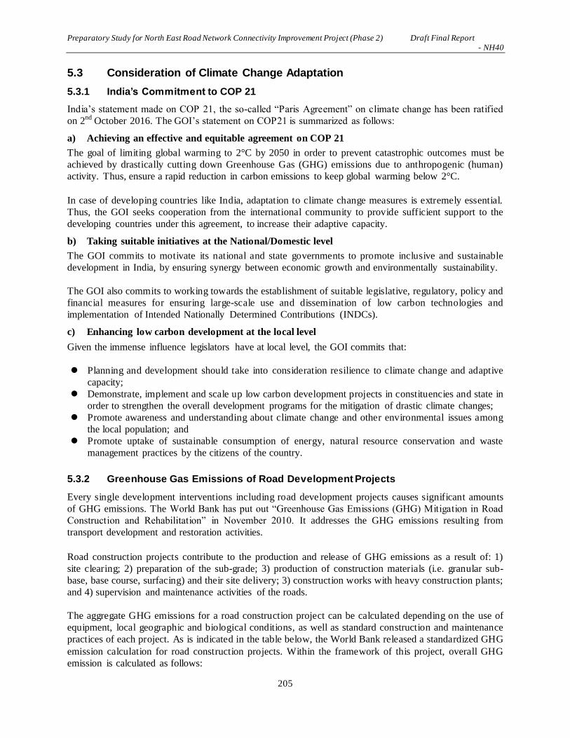
Preparatory Study for North East Road Network Connectivity Improvement Project (Phase 2) Draft Final Report - NH40
205
5.3 Consideration of Climate Change Adaptation
5.3.1 India’s Commitment to COP 21
India’s statement made on COP 21, the so-called “Paris Agreement” on climate change has been ratified
on 2nd October 2016. The GOI’s statement on COP21 is summarized as follows:
a) Achieving an effective and equitable agreement on COP 21
The goal of limiting global warming to 2°C by 2050 in order to prevent catastrophic outcomes must be
achieved by drastically cutting down Greenhouse Gas (GHG) emissions due to anthropogenic (human)
activity. Thus, ensure a rapid reduction in carbon emissions to keep global warming below 2°C.
In case of developing countries like India, adaptation to climate change measures is extremely essential.
Thus, the GOI seeks cooperation from the international community to provide sufficient support to the
developing countries under this agreement, to increase their adaptive capacity.
b) Taking suitable initiatives at the National/Domestic level
The GOI commits to motivate its national and state governments to promote inclusive and sustainable
development in India, by ensuring synergy between economic growth and environmentally sustainability.
The GOI also commits to working towards the establishment of suitable legislative, regulatory, policy and
financial measures for ensuring large-scale use and dissemination of low carbon technologies and
implementation of Intended Nationally Determined Contributions (INDCs).
c) Enhancing low carbon development at the local level
Given the immense influence legislators have at local level, the GOI commits that:
Planning and development should take into consideration resilience to climate change and adaptive
capacity;
Demonstrate, implement and scale up low carbon development projects in constituencies and state in
order to strengthen the overall development programs for the mitigation of drastic climate changes;
Promote awareness and understanding about climate change and other environmental issues among
the local population; and
Promote uptake of sustainable consumption of energy, natural resource conservation and waste
management practices by the citizens of the country.
5.3.2 Greenhouse Gas Emissions of Road Development Projects
Every single development interventions including road development projects causes significant amounts
of GHG emissions. The World Bank has put out “Greenhouse Gas Emissions (GHG) Mitigation in Road
Construction and Rehabilitation” in November 2010. It addresses the GHG emissions resulting from
transport development and restoration activities.
Road construction projects contribute to the production and release of GHG emissions as a result of: 1)
site clearing; 2) preparation of the sub-grade; 3) production of construction materials (i.e. granular sub-
base, base course, surfacing) and their site delivery; 3) construction works with heavy construction plants;
and 4) supervision and maintenance activities of the roads.
The aggregate GHG emissions for a road construction project can be calculated depending on the use of
equipment, local geographic and biological conditions, as well as standard construction and maintenance
practices of each project. As is indicated in the table below, the World Bank released a standardized GHG
emission calculation for road construction projects. Within the framework of this project, overall GHG
emission is calculated as follows:

Preparatory Study for North East Road Network Connectivity Improvement Project (Phase 2) Draft Final Report - NH40
206
794 (t CO2 eq./km) x 74.63 km = 59,256 t (CO2 eq.)
Table 5-55: Typical GHG Emissions of Road Construction Project
Source: “Greenhouse Gas Emissions Mitigation in Road Construction and Rehabilitation” 2010, WB
5.3.3 Measures Adapted for GOI’s Commitment for Climate Change
(1) Construction Industry and Practices
The construction industry related to road construction projects are generally dominated by local
contractors using substandard plants and equipment. These construction machineries are usually lacking
the capabilities to implement the latest construction methods and practices.
The involvement of foreign contractors, which could help promote technology transfer, has been limited
to projects of a large scale. Quality control or so-called “Kaizen” approaches are not widespread and
modernization of construction machineries is practically non-existent.
Procurement practices usually do not consider GHG emissions as a criterion for bids by looking into
whether a contractor has the plants and equipment to minimize emissions. Environmental management
policies, either governed by local regulations or by donor/MDBs guidelines, do not require GHG
monitoring during construction, however it would increase in the near future because of the world
commitment on COP 21. Thus the following is recommended:
a) Environmental Clearance of GOI should be developed so as to legitimize monitoring works of GHG
emissions during the construction period;
b) The contract agreement should clearly state that the construction plants and machineries are routinely
maintained in order to minimize GHG emissions; and
c) Environmental monitoring work of this project should include GHG emissions.
(2) Carbon Sequestration of Trees
Because 59,256 t (CO2 eq.) of GHG emission is expected to be generated by the implementation of the
project, tree planting as one of the project components should be carried out as follows:
1 ton of carbon = 3.666 tons of CO2
Where: Carbon dioxide (44) divided by the atomic mass of carbon (12).
125.5 metric tons of carbon per ha of forest x 3.666 tons of CO2 = 460.2 metric tons of CO2 per ha of
forest. Thus:
It is estimated that 1 ha of trees contains 125.5 metric tons of carbon22. Thus:
22 Sources of Carbon Sequestration Calculations as follows:
1) United States Department of Agriculture, Forest Service, Methods for Calculating Forest Ecosystem and Harvest Carbon with

Preparatory Study for North East Road Network Connectivity Improvement Project (Phase 2) Draft Final Report - NH40
207
59,356 t (CO2 eq.) / 460.2 metric tons of CO2 per ha = 128.98 ha of forest development
Therefore 10 ha/year of forest area developed over 13 years should compensate the GHG emissions made
by the implementation of the project.
(3) Compensatory Tree Planting for the Forest Areas Cleared for the Project
Within the framework of the global climate change measures, compensatory tree planting area should be
developed. The area for tree planting should generally be the same area of forest that was cleared as a
result of the bypasses inserted for the improvement of NH-40.
At present, approximately 231 ha of the total land area subject to acquisition, of which approximately 123
ha is forest. The rest are agricultural fields and residential areas. Thus, additional afforestation area of 123
ha for the compensation of the lost forest area should be allocated and carried out by Meghalaya State
Environment and Forest Department in order to successfully complete the project. Afforestation area
could be allocated in the grassland area where traditionally thrush-and-burn agriculture practice was
carried out.
Standard Estimates for United States Forest Types, 2006, http://www.treesearch.fs.fed.us/pubs/22954.
2) US Department of Agricu lture, Forest Service, Carbon Storage and Accumulation in United States Forest Ecosystems, 1992,
http://www.nrs.fs.fed.us/pubs/gtr/gtr_wo059.pdf.

Preparatory Study for North East Road Network Connectivity Improvement Project (Phase 2) Draft Final Report - NH40
208
【Note】
The information related to bidding has been deleted.

Preparatory Study for North East Road Network Connectivity Improvement Project (Phase 2) Draft Final Report - NH40
209
CHAPTER 6 ENVIRONMENTAL AND SOCIAL CONSIDERATIONS
6.1 Introduction
6.1.1 Background of the Project
In India, road is one of most important modes of ground transportation as it constitutes 85% of passenger
and 60% of freight transported in India. However, development of road network in mountainous regions
of Northeastern Region of India has been much worse than the rest of India. This is due to financial and
technical reasons. Thus Northeastern Region suffered greater economic disparity comparing to other areas
of India.
While 63.4% of the road in India has been paved, only 28.5% of the road in Northeastern Region is paved
out of which 53% of national highways are more than 2-lane road. This is because the Northeast Region
is located far from major part of India. Further, the roads leading to neighboring countries have been
underdeveloped due to security concerns.
Severe natural conditions of Northeastern Region featured by steep mountainous and prolonged monsoon
season have been obstacles to appropriate endeavor of road network. Acceleration of economic growth in
this part of the country has therefore been much delayed. The regional connectivity of the road network
should promote cross-border trade and commerce and help safeguard India’s international borders. This
would lead to a formation of more integrated and economically consolidated South and Southeast Asia. In
addition, there would be overall economic benefits for the local population and help integrate the
peripheral areas.
Approximate aggregate length of 10,000 km over the Northeastern Region has been identified to begin
with for development. The road network envisages creating customized and specialized skills in terms of
addressing issues like complexities of geographical terrains and addressing extensive coordination with
various central and state governments.
The Government of India (GOI) thus launched in recent years “Special Accelerated Road Development
Program for Northeastern Region” for which improvement of the road network is of great importance.
GOI committed in “Twelfth Five Years Plan (from April, 2012 to March, 2017)” that the improvement of
national highways in Northeastern Region should interconnect major cities within the region. Thus GOI
requested Government of Japan to provide assistance in developing 10 routes in Northeastern Region,
where NH54, NH51 and then NH40 were prioritized considering consistency with the upper plan, project
maturity, traffic demand, and EIRR as evaluation criteria.
6.1.2 Purpose and Objectives of the Study
As per India’s MOEFCC EIA Notification dated 14.09.2006 (as amended in August 2013), any highway
project falls under Category A is obliged to carry out EIA Study if the project entails:
1) New National Highways; and
2) Expansion of National Highways greater than 100 km involving additional right of way or land
acquisition greater than 40m on the existing alignments and 60m on re-alignments and bypasses.
On the other hand, the proposed expansion & widening of NH-40 does not involve additional land
acquisition beyond 30 m and its length of widening including inserting bypasses is less than 100 km i.e.
the Project is not a Category A project as defined in the EIA Notification of 2013 of India.

Preparatory Study for North East Road Network Connectivity Improvement Project (Phase 2) Draft Final Report - NH40
210
While DPR consultants in India undertook a preliminary environmental assessment during the preparation
of the DPR for NH-40, because of the project is funded by JICA, it has been classified as Category A as
per JICA’s Guidelines for the Environmental and Social Considerations i.e. the project requires a full EIA
study including SIA and RAP survey.
It is therefore JICA Study Team’s obligation to carry out EIA/SIA/RAP studies, which supplement the
environmental studies carried out by DPR consultants of India. Thereby additional requirements short of
JICA’s guidelines are fulfilled.
The EIA/SIA/RAP studies carried out by JICA Study Team aimed to:
- Review the environmental assessment undertaken as part of the DPR study;
- Identify gaps between Indian laws and regulations relating to the EIA study and JICA Guidelines
for Environmental and Social Considerations;
- Study the baseline of social and environmental conditions along the areas directly and indirectly
affected during design, construction operation and maintenance of the NH-40 widening project;
- Carry out environmental impact analysis with respect to the proposed project;
- Identify environmental issues that require further studies;
- Carry out analysis of alternatives including comparison with a “no project’ scenario;
- Develop cost effective measures for mitigating adverse environmental and social impacts and
enhancing positive aspects;
- Develop an Environmental Management Plan (EMP) for the mitigation of environmental impacts
and monitoring of the implementation of mitigation measures during the operat ion and
maintenance period;
Consult and inform the project affected persons (PAPs) and other stakeholders concerned with the project
to encourage their active participation.
6.1.3 Description of the Project
The Shillong-Dawki section of NH-40 stretches approximately over 71.5 km from the capital city of
Shillong, Meghalaya State, to the border town of Dawki located on the border between India and
Bangladesh. While Shillong is located on the plateau of 1,525 m above sea level, Dawki is on the plane of
35 m above sea level on the border area between India and Bangladesh. Thus NH-40 initially begins in
the highland area of 1,525 m, passing through approximately 1,800 m asl highland area and gradually go
down to 35 m asl as is shown in Figure 6-1 and Figure 7-2 エラー! 参照元が見つかりません。.
At present the road conditions of NH-40 is in good condition with footpath on both side of the road and
drainage system in places up to the area of Eastern Air Force Headquarters. The length is approximately 8
km from the starting point while this section is climbing the mountain slope to 1,800 m asl thereafter the
width of road, without road furniture, is maintained in general two lanes up to 61 km post climbing down
East Khasi Hills. The last 6-7 km section of NH-40 is particularly narrow without appropriate road
furniture causing traffic congestion going out to Bangladesh and coming into India. Thus improvement of
NH-40 with wide and appropriate road furniture appears to be urgently needed.

Preparatory Study for North East Road Network Connectivity Improvement Project (Phase 2) Draft Final Report - NH40
211
Source: JICA Study Team
Figure 6-1: Location of the Project Area (NH40)
Source: JICA Study Team
Figure 6-2: Profile of the Project Area
Meghalaya State
Bangladesh

Preparatory Study for North East Road Network Connectivity Improvement Project (Phase 2) Draft Final Report - NH40
212
As Figure 7-3 エラー! 参照元が見つかりません。 shows, the Right of Way (ROW) of the new NH-
40 has to be 30 m wide in general throughout the project area. In some places, ROW of 30 m wide would
not be able to maintain or not necessary to acquire additional land. Thus depending on the locations no
land acquisition takes place. Within the framework of the Project, urban and rural built-up areas,
mountain forest, grassland, limestone quarries are directly affected along the proposed bypasses &
parallel alignment, local built-up areas would be involved in the resettlement of the local residents. To
some extent, land acquisition for the bypasses would cause local farmers becoming landless depending on
the area of farming areas subject to land acquisition for ROW.
Source: JICA Study Team
Figure 6-3: Typical Cross Section of the Hillside Road of NH-40
6.2 Scope of the Study
6.2.1 Geographical Extent of the Impacts
As Figure 6-1 and Figure 6-2 show, the length of the project area is 71.5 km. Because of the Wildlife
Protection Law of India states, extent of impact area must be 5 km radius from the centerline of the road
construction project as per Figure 6-4.
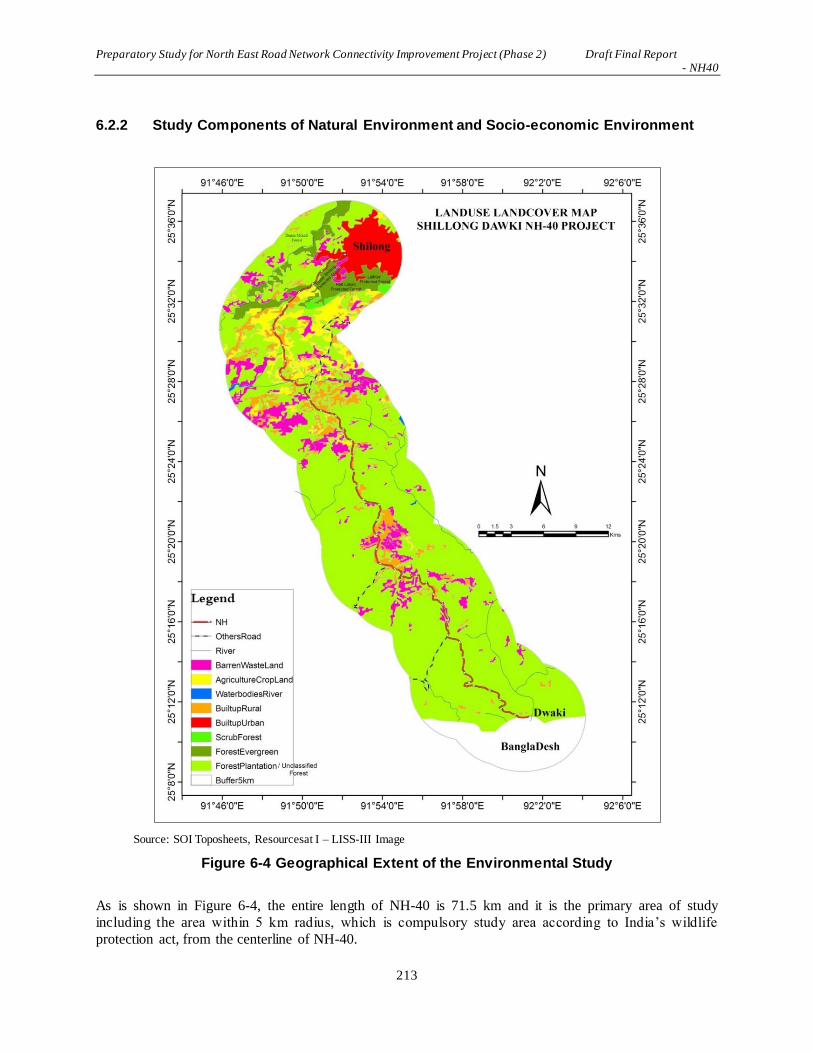
Preparatory Study for North East Road Network Connectivity Improvement Project (Phase 2) Draft Final Report - NH40
213
6.2.2 Study Components of Natural Environment and Socio-economic Environment
Source: SOI Toposheets, Resourcesat I – LISS-III Image
Figure 6-4 Geographical Extent of the Environmental Study
As is shown in Figure 6-4, the entire length of NH-40 is 71.5 km and it is the primary area of study
including the area within 5 km radius, which is compulsory study area according to India’s wildlife
protection act, from the centerline of NH-40.

Preparatory Study for North East Road Network Connectivity Improvement Project (Phase 2) Draft Final Report - NH40
214
While this project is a road improvement project of the existing NH-40, it involves 6 locations of
bypasses that are generally the new road construction works that a large area of forestland has to be
cleared. Thus environmental components subject to study are meteorology, geography and
geomorphology, geology, soil erosion, hydrology and groundwater, forest and plant biology, wildlife and
wildlife conservation areas, aesthetic value of land scape and natural disaster prone areas. For the
environmental pollution, air quality; water quality; soil; solid waste are all studied in terms of their effect
on the environment in conjunction with the implementation of the Project.
While main aim of this project is to improve NH-40, there are six bypasses subject to new construction in
the rural area including built-up area of human settlements, forested areas and agricultural fields. There
are impacts induced by the road construction project on the air quality, water, soil, solid waste, traffic
accidents, water rights, climate change, fauna and flora, public hygiene and safety, and involuntary
resettlement that are taking place within the scheduled tribal area of Kashi living on the East Kashi Hill of
Meghalaya State.
6.2.3 Legal Framework Related to the Project
Legal framework of the Government of India including those of Meghalaya State that depict impacts
induced to the environment and socio-economic conditions by the Project is widely studied. There are
JICA Guidelines as well as World Bank and ADB safeguard policies that have to be studied in relation to
the laws and regulations of the Government of India including those of Meghalaya State that are dealing
with scheduled tribe as minority of the country.
6.2.4 Resettlement
Because of the Project is taking place in its entirety within the territory of Khasi Tribe and a part in Jaintia
Tribe’s territory, who are two of the minority groups of India and that they are subject to resettlement,
study on the involuntary resettlement is important in terms of the successful implementation of the Project.
Thus, information dissemination on the Project’s plan through stakeholder dialogues, where resettlement
agreement has to reach among the project-affected households (PAHs).
Those who are subject to resettlement should be given ample supply of resettlement compensation,
employment opportunities and enhancement of livelihood, be it traditional or modern. On the hand, there
are a number of issues such as land and natural resource use of the tribal/clan areas, local tribal
organizations including social and NGO organizations, gender relationships, women in development,
child rights, cultural and traditional heritage, advantages and disadvantages on the interests of different
local groups, HIV/AIDS, direct and indirect impacts induced by the project implementation, cumulative
and intensifying impacts of the project otherwise improvement of economic conditions in the rural area as
a whole. These issues are studied as a whole in relation to the project implementation of 2-lane
improvement of NH-40.
Resettlement plan has to be drawn based on the laws and regulations of the Government of India. LARR
2013 is especially important act for drawing clear picture of resettlement action plan. However, JICA
Guidelines including World Bank’s Safeguard policy, such as OP4.12 Annex A and B should also be
referred to. Regarding the scheduled tribe of Khasi and Jaintia, elements of Indigenous People’s Plan
(IPP) has to be examined in resettlement plan. This has to be examined against the laws and regulations of
India in terms of its appropriateness comparing the safeguard policies of World Bank.
During the process of resettlement dialogue for agreement based on the World Bank’s policy on the
replacement basis for which lost asset has to be compensated, contents of further resettlement package of

Preparatory Study for North East Road Network Connectivity Improvement Project (Phase 2) Draft Final Report - NH40
215
enhancing livelihood and increasing opportunities for employment and other benefit has to be generally
agreed. PAHs will have to be supported in different way at the time of resettlement. In order to monitor
the livelihood of PAHs after resettlement, 3-5 years of monitoring works should be included in the
resettlement study for which every PAH is satisfied after the resettlement.
6.3 Baseline Data of the Natural and Socio-economic Environment
6.3.1 Natural Environment
(1) Climate
Meghalaya falls in the tropical monsoon climate zone, which varies from the western to eastern parts of
the state. Table 6-1 and Figure 6-5 show climatic conditions of Meghalaya state. The indicated
precipitation is the data recorded in Cherrapunji in Meghalaya, which is located approximately 10 km to
the west of NH40 and is where the world’s highest rainfall is recorded.
As is shown, almost all of the rainfall occurs in the period between April – October. It is also noteworthy
that the average number of hours the sun shines is incredibly low, at 12 hours a month. Because the state
is in a high altitude area, temperatures are cool compared to the flat areas of India. The data on the wind
speed and direction have been collected for Shillong from Indian Metrological Department (IMD) during
April to June, 2016.
Table 6-1: Precipitation in Meghalaya State
Source: http://www.meghalaya.climatemps.com/precipitation.php

Preparatory Study for North East Road Network Connectivity Improvement Project (Phase 2) Draft Final Report - NH40
216
Source: http://www.meghalaya.climatemps.com/precipitation.php
Figure 6-5: Precipitation and Temperatures of Meghalaya State
Figure 6-6 and Figure 6-7 show rainfall patters in Meghalaya. Because of the highland area in the eastern
half of Meghalaya state and monsoonal rainfall generally comes from the Bay of Bengal in the south, the
southern half of East Khasi Hill receives a significant amount of rainfall as shown above.
Source: http://www.meghalaya.climatemps.com/precipitation.php
Figure 6-6: Temperature Patterns of Meghalaya State

Preparatory Study for North East Road Network Connectivity Improvement Project (Phase 2) Draft Final Report - NH40
217
Source:http://www.meghalaya.climatemps.com/precipitation.php
Figure 6-7: Rainfall Patterns of Meghalaya State
Source: IMD
Figure 6-8: Windrose Diagram
(2) Land Use
Figure 6-9, Figure 6-10 and Table 6-2 show land use patterns of Meghalaya state. While relatively cool
temperatures are suitable for the dairy industry, there are no pastures and grazing areas in Meghalaya state.
Modern agricultural areas in Meghalaya state are on the rise at the cost of thick forested areas while in the
western half of Meghalaya state, slash and burn agriculture is still maintained as one of the major means
of growing staple foods.
There is not much slash and burn agriculture in the area along NH40. The East Khasi Hill District, where
most parts of NH40 goes through, accounts for 6.2 % of the slash and burn agricultural land of Meghalaya
state while in the western half of the state, slash and burn agriculture is still prominent.
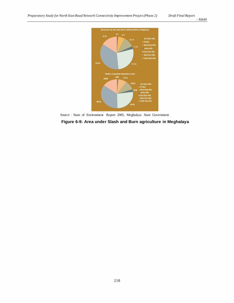
Preparatory Study for North East Road Network Connectivity Improvement Project (Phase 2) Draft Final Report - NH40
218
Source:State of Environment Report 2005, Meghalaya State Government
Figure 6-9: Area under Slash and Burn agriculture in Meghalaya

Preparatory Study for North East Road Network Connectivity Improvement Project (Phase 2) Draft Final Report - NH40
219
Source: JICA Study Team based on Meghalaya State Department of Agriculture
Figure 6-10: Agricultural Land Use of the Project Area

Preparatory Study for North East Road Network Connectivity Improvement Project (Phase 2) Draft Final Report - NH40
220
Table 6-2: Land Use in Meghalaya State
(3) Geography and Geology
The proposed alignment passes through the western area of East Khasi Hills and west to southern area of
Jaintia Hills District of Mehgalaya state. Topography of the state is mostly hilly with deep gorges and
ravines in the southern portion. The most important physiographic features of the area is the Shillong
Plateau interspersed with river valleys, then the sharp fall in the southern portion forming deep gorges and
ravines in Mawsynram and Shella-Bholaganj bordering Bangladesh.
The geology of Meghalaya consists of older and stable rock types, which are resistant to weathering,
mostly belonging to periods of Archean Genessic complex, Shillong Groups of rocks, Lower Gondwana
rocks, Sylhet Traps, and Cretaceos-Tertiary sediments. The layers of land surface in the project area
mainly comprises of Schist, Gneisses, Quartzite, sand stone, Shale, Lime, Stone, Granite, Granodiorite
and Pegmatite. The geological map of the Meghalaya is shown in Figure 6-11.
Source: Department of Mining & Geology, Government of Meghalaya
Figure 6-11: Geological Map of Meghalaya State
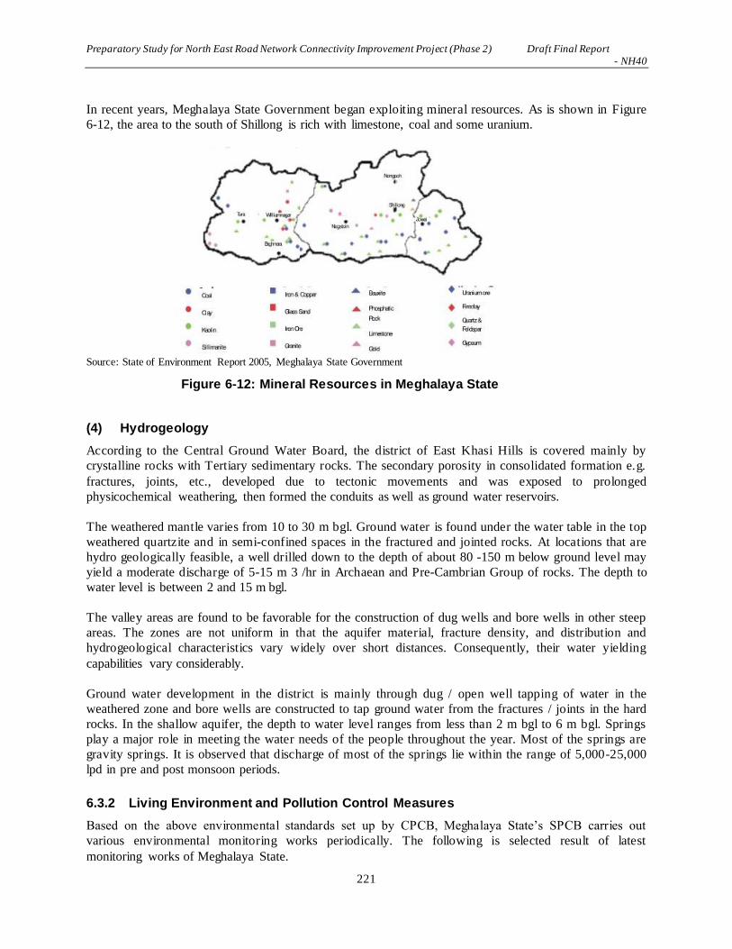
Preparatory Study for North East Road Network Connectivity Improvement Project (Phase 2) Draft Final Report - NH40
221
In recent years, Meghalaya State Government began exploiting mineral resources. As is shown in Figure
6-12, the area to the south of Shillong is rich with limestone, coal and some uranium.
Source: State of Environment Report 2005, Meghalaya State Government
Figure 6-12: Mineral Resources in Meghalaya State
(4) Hydrogeology
According to the Central Ground Water Board, the district of East Khasi Hills is covered mainly by
crystalline rocks with Tertiary sedimentary rocks. The secondary porosity in consolidated formation e.g.
fractures, joints, etc., developed due to tectonic movements and was exposed to prolonged
physicochemical weathering, then formed the conduits as well as ground water reservoirs.
The weathered mantle varies from 10 to 30 m bgl. Ground water is found under the water table in the top
weathered quartzite and in semi-confined spaces in the fractured and jointed rocks. At locations that are
hydro geologically feasible, a well drilled down to the depth of about 80 -150 m below ground level may
yield a moderate discharge of 5-15 m 3 /hr in Archaean and Pre-Cambrian Group of rocks. The depth to
water level is between 2 and 15 m bgl.
The valley areas are found to be favorable for the construction of dug wells and bore wells in other steep
areas. The zones are not uniform in that the aquifer material, fracture density, and distribution and
hydrogeological characteristics vary widely over short distances. Consequently, their water yielding
capabilities vary considerably.
Ground water development in the district is mainly through dug / open well tapping of water in the
weathered zone and bore wells are constructed to tap ground water from the fractures / joints in the hard
rocks. In the shallow aquifer, the depth to water level ranges from less than 2 m bgl to 6 m bgl. Springs
play a major role in meeting the water needs of the people throughout the year. Most of the springs are
gravity springs. It is observed that discharge of most of the springs lie within the range of 5,000-25,000
lpd in pre and post monsoon periods.
6.3.2 Living Environment and Pollution Control Measures
Based on the above environmental standards set up by CPCB, Meghalaya State’s SPCB carries out
various environmental monitoring works periodically. The following is selected result of latest
monitoring works of Meghalaya State.
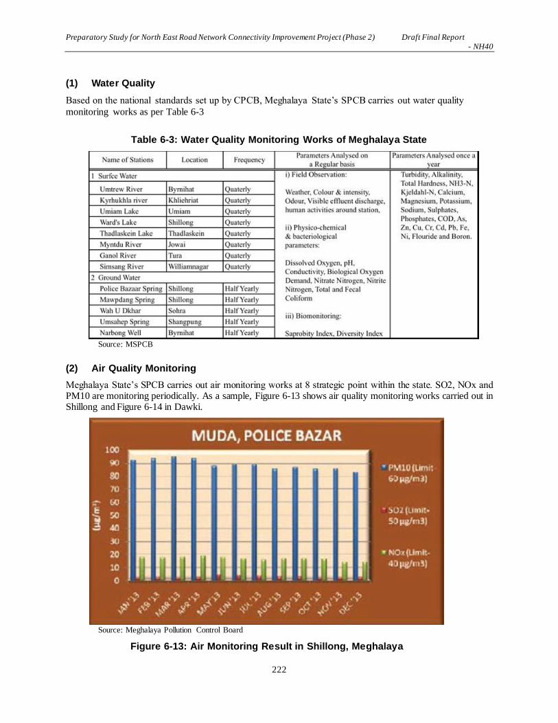
Preparatory Study for North East Road Network Connectivity Improvement Project (Phase 2) Draft Final Report - NH40
222
(1) Water Quality
Based on the national standards set up by CPCB, Meghalaya State’s SPCB carries out water quality
monitoring works as per Table 6-3
Table 6-3: Water Quality Monitoring Works of Meghalaya State
Source: MSPCB
(2) Air Quality Monitoring
Meghalaya State’s SPCB carries out air monitoring works at 8 strategic point within the state. SO2, NOx and PM10 are monitoring periodically. As a sample, Figure 6-13 shows air quality monitoring works carried out in Shillong and Figure 6-14 in Dawki.
Source: Meghalaya Pollution Control Board
Figure 6-13: Air Monitoring Result in Shillong, Meghalaya

Preparatory Study for North East Road Network Connectivity Improvement Project (Phase 2) Draft Final Report - NH40
223
Source: Meghalaya Pollution Control Board
Figure 6-14: Air Monitoring Result in Dawki, Meghalaya
(3) Vehicular Emission
Meghalaya State’s SPCB monitors vehicular emissions based on the standard set out by CPCB. One of
the standards of vehicular emission, Table 6-4 shows the number/percentage of vehicles in the state that
comply with the national standards for emission standards.

Preparatory Study for North East Road Network Connectivity Improvement Project (Phase 2) Draft Final Report - NH40
224
Table 6-4: Air Quality Monitoring Works of Meghalaya State
Source: Meghalaya Pollution Control Board
(4) Noise Monitoring
Meghalaya State’s SPCB monitors ambient noise within the city/built-up area before and during the
holiday and political events as loud speakers are generally used for political slogans etc. During the
national holiday of Deepawali Festival where a large number of fireworks are carried out, noise pollution
is also a major concern of the general public. There is no evidence monitored by Meghalaya State’s SPCB
on the diesel generators, vehicles, etc.
(5) Soil Contamination
Meghalaya State’s SPCB monitors heavy metals discharged into rivers within the state, which is
discharged from the public solid waste dump. Table 6-5 shows the result of the analysis of soil
components.

Preparatory Study for North East Road Network Connectivity Improvement Project (Phase 2) Draft Final Report - NH40
225
Table 6-5: Soil Contamination of Meghalaya State
Source: Meghalaya Pollution Control Board
6.3.3 Socio-economic Environment
(1) Population, Language and Religion
1) Meghalaya
Prior to 1970, this state was an integral part of undivided Assam, and the capital city Shillong was the
capital of Assam. On 2nd April 1970, Meghalaya was created as an autonomous state, and got the full-
fledged state status on January 21st 1972. The state of Meghalaya is bound on the north by Goalpara,
Kamrup, Nagoan and Karbi Anglong districts of Assam state, and on the east by the Districts of Cachar
and North Cachar Hills, also of the state of Assam. On the south and west sides of the state is Bangladesh.
The total area of the state is 22,429 square kilometers. The state is now divided into eleven administrative
districts. They are: (i) West Jaintia Hills District, (ii) East Jaintia Hills District, (iii) East Garo Hills
District, (iv) West Garo Hills, (v) North Garo Hills District, (vi) South Garo Hills District, (vii) South
West Garo Hills District, (viii) East Khasi Hills District, (ix) West Khasi Hills District, (x) South West
Khasi Hills District, and (xi) RiBhoi District. They are predominantly inhabited by the Khasi, the Jaintia
and the Garo people. Shillong is the state capital and also the district headquarters of East Khasi Hills
district and is situated at an altitude of 1,496 meters above sea level. The demographic profile of
Meghalaya is presented in Table 6-6.
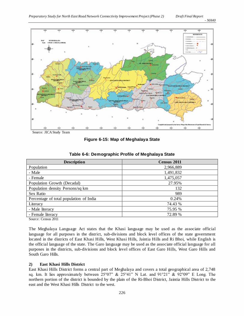
Preparatory Study for North East Road Network Connectivity Improvement Project (Phase 2) Draft Final Report - NH40
226
Source: JICA Study Team
Figure 6-15: Map of Meghalaya State
Table 6-6: Demographic Profile of Meghalaya State
Description Census 2011
Population 2,966,889
- Male 1,491,832
- Female 1,475,057
Population Growth (Decadal) 27.95%
Population density Persons/sq km 132
Sex Ratio 989
Percentage of total population of India 0.24%
Literacy 74.43 %
- Male literacy 75.95 %
- Female literacy 72.89 % Source: Census 2011
The Meghalaya Language Act states that the Khasi language may be used as the associate official
language for all purposes in the district, sub-divisions and block level offices of the state government
located in the districts of East Khasi Hills, West Khasi Hills, Jaintia Hills and Ri Bhoi, while English is
the official language of the state. The Garo language may be used as the associate official language for all
purposes in the districts, sub-divisions and block level offices of East Garo Hills, West Garo Hills and
South Garo Hills.
2) East Khasi Hills District East Khasi Hills District forms a central part of Meghalaya and covers a total geographical area of 2,748
sq. km. It lies approximately between 25°07” & 25°41” N Lat. and 91°21” & 92°09” E Long. The
northern portion of the district is bounded by the plain of the Ri-Bhoi District, Jaintia Hills District to the
east and the West Khasi Hills District to the west.

Preparatory Study for North East Road Network Connectivity Improvement Project (Phase 2) Draft Final Report - NH40
227
The East Khasi Hills District is mostly hilly with deep gorges and ravines on the southern portion. The
most important physiographic features of the district is the Shillong Plateau combined with the river
valley, and sharp falls in the southern portion forming deep gorges and ravine in Mawsynram and Shella-
Bholaganj bordering Bangladesh.
The headquarters of the district, Shillong, is connected by NH44 to Guwahati which is 103 km away and
to Silchar 240 km away. The nearest railhead and airport are situated at Guwahati. There is an airstrip
suitable for small aircrafts at Umroi which is 35 km from Shillong. The agricultural products and others
are transported by trucks, jeeps and tractors. Shillong is well-connected with other parts of the state by a
motorable road. Similarly, all the block headquarters in the district are also connected by roads. However,
the villages in the interior areas are poorly connected and transport services are inadequate. The
demographic profile of East Khasi Hills is presented in Table 6-7 エラー! 参照元が見つかりません。.
Source: JICA Study Team
Figure 6-16: Map of East Khashi Hills District
Table 6-7: Demographic Profile of East Khasi Hills District
Description 2011 Census
Population 825,922
- Male 410,749
- Female 415,173
Households 163,397
Population Density 301
Literacy 84.15 %
- Male Literacy 84.51%
- Female Literacy 83. %
No of CD Blocks 8
No of Villages 975
Source: Census 2011

Preparatory Study for North East Road Network Connectivity Improvement Project (Phase 2) Draft Final Report - NH40
228
3) West Jaintia Hills District
West Jaintia Hills District is one of the eleven districts of the state of Meghalaya. With the bifurcation of
the erstwhile Jaintia Hills District into East and West Jaintia Hills District, West Jaintia Hills District came
into existence on 31st July 2012 with its headquarters at Jowai. Jowai is the host of all the heads of
important governmental offices and establishments, educational institutions, hospitals, banking
institutions, etc. The total area of the district is 1693 sq. km. The district comprises of one civil sub-
division viz. Amlarem Civil Sub-Division and three community and rural development blocks viz.
Amlarem C&RD Block, Laskein C&RD Block and Thadlaskein C&RD Block with boundaries with
North Assam, South Bangladesh and East Jaintia Hills District, East Assam, and West – East Khasi Hills
District. The district has a total population of 272,185, of which 135,052 are males and 137,133 are
females. The density of the population is 160.69 per sq. km.
Source: JICA Study Team
Figure 6-17: Map of Jaintia Hills District (currently East/ West Jaintia Hills)

Preparatory Study for North East Road Network Connectivity Improvement Project (Phase 2) Draft Final Report - NH40
229
Table 6-8: Demographic Profile of West Jaintia Hills District
Description 2011 Census
Population 272,185
- Male 135,052
- Female 137,133
Households 45,272
Population Density 160
Literacy 63.12 %
- Male Literacy 58.51%
- Female Literacy 67.61. %
No of CD Blocks 3
No of Villages 331
Source: Census 2011 (Extracted data of CD Blocks currently belongs to West Jaintia Hills)
4) Project District population and percentage of SC and ST
The following Table 7-9 エラー! 参照元が見つかりません。 presents Scheduled Tribe (ST) and
Scheduled Caste (SC) population in the districts in which the project runs through.
Table 7-9: District-wise population and percentage of SC and ST
State /
district name
ST SC Others Total % ST % SC % others
Meghalaya 2,555,861 17,355 393,673 2,966,889 86.15 0.58 13.27
East Khasi
Hills
661,158 5 ,642 159,122 825,922 80.05 0.68 19.27
West Jaintia
Hills
257,941 844 13,400 272,185 94.77 0.31 4.92
Source: Census 2011 (Extracted data of CD Blocks currently belongs to West Jaintia Hills)
5) Scheduled Tribes in Project Districts
Of the population in East Khasi Hills, 80.05% are STs, of which 90.60% are Khasi or its ethno-
historically related tribes. In Jaintia Hills, 95.97% of the population is STs, of which 89.18% are Khasi,
Jaintia or its ethno-historically close tribes.

Preparatory Study for North East Road Network Connectivity Improvement Project (Phase 2) Draft Final Report - NH40
230
Table 6-10: District-wise Scheduled Tribes
State /
District
All
Scheduled
Tribes
Garo Hajong Khasi,
Jaintia,
Synteng,
Pnar,
War,
Bhoi,
Lyngngam
Koch Any
Kuki
Tribes
Mikir Raba,
Rava
Other
ST
Meghalaya 2,555,861 821,026 38,576 1,411,775 22,716 14,275 19,289 32,662 195,542
East Khasi
Hills
661,158 23,481 3,244 599,025 445 2,810 3,339 410 28,304
Jaintia Hills 376,099 488 20 335422 3 8807 1026 23 30,310
Source: Census 2011
Khasi / Jaintia Tribe
The term Khasi is applied to the group of matrilineal and Mon-Khmer speaking people who
contemporarily inhabit the Khasi Hills and Jaintia Hills districts of Meghalaya state. It is generally
considered by many Khasi sociologists that the Khasi Tribe consists of seven sub-tribes, hence the title
'Children of the Seven Huts': Khynriam, Pnar, Bhoi, War, Maram, Lyngngam and Diko. The Khynriam (or
Nongphlang) inhabit the uplands of the East Khasi Hills District; the Pnar or Syntengs live in the uplands
of Jaintia Hills. The Bhoi live in the lower hills to the north and north-east of the Khasi Hills and Jaintia
Hills towards the Brahmaputra valley. The War, usually divided into War-Jaintia in the south of the Jaintia
Hills and War-Khasi in the south of the Khasi Hills, live on the steep southern slopes leading to
Bangladesh. The Marams inhabit the uplands of the West Khasi Hills districts. The Lyngngam people who
inhabit the western parts of the Khasi Hills bordering the Garo Hills display linguistic and cultural
characteristics which show influences from both the Khasis to their east and the Garo people to the west.
The Jaintia tribe is in fact a sub-tribe of the Khasis; with time, the Jaintias was befitted as a major tribe,
because of their dominance in population and because of their inhabitance in a major part of the Khasi
Hills and the whole of Jaintia hills area of the state. They are also known as “Pnar”, they speak the Jaintia
language, which is different from the Khasi language.
The Khasi language is believed to be one of the very few surviving dialects of the Monkumer family of
languages in India. The Khasi language was essentially oral until the arrival of Christian missionaries.
Particularly significant in this regard was a Welsh evangelist, Thomas Jones, who transcribed the Khasi
language into the Roman script. While the main language for communication is in Khasi, the sub-tribes
have dialects of their own, and usually communicate in Khasi only when they are communicating with
another sub-tribe and with the major tribe, referred to as the “khynriam”.
The Khasi people form the majority of the population of the eastern part of Meghalaya, and are the state's
largest community. Though the majority of the 85.00 % Khasi populace have embraced Christianity, a
substantial minority of the Khasi people still follow and practice their age old indigenous religion, which
is known as "Ka Niam Khasi" and it is their belief that the rooster (U Syiar Khraw Jutang) is sacrificed as
a substitute for man, it being thought that the rooster "bears the sins of men and by its sacrifice, man will
obtain redemption.” A small number of Khasis, as a result of inter-community marriages, are also
Muslims. There is also a very small number of Khasi Hindus inhabiting the Jaintia Hills of Meghalaya, a
result of hundreds of years of exposure to the plains of Bengal and Assam.
The Khasis follow the matrilineal system of society. Here, the lineage of the tribe is traced through the
women. The children take the name of the mother and their children continue to do the same. Ancestral

Preparatory Study for North East Road Network Connectivity Improvement Project (Phase 2) Draft Final Report - NH40
231
property is passed down to the youngest daughter (ka Khatduh). If the Khatduh dies or marries a non
Khasi, or takes the name of her husband, these will be then passed to the daughter elder to the Khatduh.
Although the women in this society is given the ancestral property, it is the man, usually the eldest brother,
or the maternal uncle who decides on the management of the property. The husband is the bread earner
and makes the final decisions in matters of his immediate family, and also in his mother’s family as the
maternal uncle. The Khasis follow the matrilocal type of residence, where the man stays in the woman’s
house after marriage.
Garo Tribe In the RAP survey, it was observed that a few Garo people could be affected by the Project. The Garo, of
Tibeto-Burman origin, address themselves as A’chik or Mande. The Garo have a matrilineal society,
where the land can only be inherited through the women of the families. The traditional Garo religion
includes the belief of supernatural spirits called mite. They believed that these spirits lived in the jungle
and caused diseases. They also believed in important gods that overlooked the growth of the crops.
(2) Economy and Industrial Structure
Gross State Domestic Product (GSDP) of Meghalaya in 2013-2014 is Rs 210,450 million (Rs 134,650 at
constant 2004-05 prices), of which agriculture and forestry is 15.54%.
Agriculture,
11.74%
Forestry and other
relevant sectors,
3.80%
Mining &
Quarrying, 5.50%
Manufacturing,
6.69%
Other Industries,
19.32%
Services, 52.91%Agriculture
Forestry and other relavant sectors
Mining & Quarrying
Manufacturing
Other Industries
Services
Source: Planning Commission, Government of India
Figure 6-18: Share of GSDP by Industries
6.4 Legal Framework
6.4.1 Major Laws and Regulations Relevant to the Project
Within the framework of environmental laws of India, the Environmental Protection Act of 1986 and its
enforcement rights has been given to Ministry of Environment, Forest & Climate Change (MOEFCC). It
has overall authority for the administration and implementation of the EIA related policies, laws and
regulations, sustainable development and pollution control in India. MOEFCC identifies the need to enact
new laws and to issue amendment to the existing environmental legislations when required, in order to
continue to conserve and protect the environment in India. Central Pollution Control Board (CPCB) and
respective State Pollution Control Board (SPCB) implement the acts. At the state level, the Department of
the Environment and the Department of Forest of Meghalaya State perform a similar role to MOEFCC.
Preparatory Study for North East Road Network Connectivity Improvement Project (Phase 2) Draft Final Report - NH40
232
(1) The Environment (Protection) Act, 1986
The Environment (Protection) Act, 1986 is the umbrella legislation providing for the protection of
environment of India. Subject to the provisions of the Act, the Central Government has the power to take
all measures as it deems necessary or expedient for the purpose of protecting and improving the quality of
the environment and preventing, controlling and abating environmental pollution.
For the implementation of Environment (Protection) Rules, which has been formulated in 1986 provides
for various standards for emission and discharge of environmental pollutants (Schedule I to IV).
The central government has delegated the power vested on it under the section 5 of the Act to the State
Govt. of Meghalaya. This law is applicable to this project for environment protection in general.
(2) Notification on the Environmental Impact Assessment of Development Projects
Amendments have been made in 2006, 2009, 2012 and 2014. Expert Appraisal Committee or State Level
Expert Appraisal Committee are requested to establish and are given power to make recommendations for
decision making at central government level. Expert Appraisal Committee of the central government and
the State Level Expert Appraisal Committee are to meet once every month for screening, scoping and
appraisal of development projects.
Those projects intended to implement for national level of economic development as well as for the
project of each industrial sector in India are obliged to follow the guidelines of studying environmental
impacts. Elaborating environmental management and monitoring programs are also one of the obligations.

Preparatory Study for North East Road Network Connectivity Improvement Project (Phase 2) Draft Final Report - NH40
233
Source: Environmental Impact Assessment Guidance Manual for Highways, 2010
Figure 6-19: Environmental Clearance Process for Category A Projects
(3) Wildlife Protection Act 1972
Amendment was made in 1982, 1986, 1991, 1993, 2002, 2006 and 2013 in order to protect wildlife of
India. Code of conduct in terms of wildlife protection, trade of wildlife products, punishment for illegal
hunting etc. have been amended from time to time.

Preparatory Study for North East Road Network Connectivity Improvement Project (Phase 2) Draft Final Report - NH40
234
(4) The Forest (Conservation) Act, 1980 (amended in 1988)
The Forest (Conservation) Act, 1980 amended in 1988 pertains to the cases of diversion of the use of
forest area and felling of roadside trees and those in the plantation areas. Depending on the size of the
area subject to clearing, license for felling trees should be applied to which the level of governments
empowered for issue of permission differs depending on the type of forest clearance:
- If the area of forests subject to clearing exceeds 20ha (or, 10ha in the hilly area) then prior
permission of Central Government is required;
- If the area of forest clearance has a forest density of more than 40%, permission to undertake any
work is needed from the Central Government, irrespective of the area to be cleared;
- If the area of forest subject to clearing is between 5 to 20ha, the Regional Office of Chief
Conservator of Forests is empowered to approve; and
- If the area of forest subject to clearing is below or equal to 5ha, the State Government can issue
permission.
(5) The Water (Prevention and Control of Pollution) Act, 1974
The Water (prevention and Control of Pollution) Act, 1974 resulted in the establishment of the central and
state level Pollution Control Board (CPCB/SPCB). Their responsibilities include managing water quality
and effluent standards as well as monitoring water quality, prosecuting offenders and issuing licenses for
construction and operation of certain facilities.
(6) The Air (Prevention and Control of Pollution) Act, 1981
The CPCB and the SPCB are empowered to set air quality standards, monitor and prosecute offenders
under this Act. Powers have also been conferred to give instructions for ensuring standards for emission
from automobiles to concerned authority in charge of registration of motor vehicles under the Motor
Vehicles Act, 1939 (Act 4 of 1939).
(7) The Motor Vehicles Act, 1988
The Indian Motor Vehicles Act empowers the State Transport Authority to enforce standards for the
control of vehicular pollution and prevention of air pollution. The authority also checks emission
standards of registered vehicles, collects road taxes, and issues vehicular licenses. In August 1997, the
Pollution under Control Certificate (PUC) program was launched in order to control vehicular emissions
in all states of India.
(8) The Land Acquisition, Rehabilitation and Resettlement Act, 2013
The new “Rights to Fair Compensation and Transparency in Land Acquisition, Rehab ilitation and
Resettlement Act, 2013 (LARR 2013)” has replaced the Land Acquisition Act of 1894. It has so far
served as the basic policy document on which GOI passes resolution to acquire land for different projects
while it traditionally not allowed compensation on the replacement basis. The LARR 2013 came into
force on 1st January 2014 and Meghalaya States put the act into practice.
6.4.2 JICA’s Guidelines for Environment and Social Considerations
Application of JICA’s Guidelines for Environment and Social Considerations (ESCs) is required if a
project is funded by JICA. If a significantly adverse impact on the environment or society has been
identified during JICA-assisted project, the following has to be thoroughly considered and studied.

Preparatory Study for North East Road Network Connectivity Improvement Project (Phase 2) Draft Final Report - NH40
235
(1) ESCs are pre-requisite
a. JICA will take necessary measures to ensure that the appropriate ESC is given;
b. When JICA reviews a project proposal and finds that the project could cause negative impacts
on the environment or society, JICA advises the project proponents to provide appropriate ESC;
c. If the negative impact of the project cannot be avoided or mitigated to an acceptable level, JICA
will not support its implementation.
(2) Respect human rights
a. Development project should aim for fair distribution of its benefits and must not burden or
exclude certain stakeholders for the sake of others;
b. The project proponents must respect the rights of all people concerned, and pay special attention
to vulnerable social groups such as women, elderly, the poor, people with disabilities,
indigenous peoples, ethnic minorities, and other minority groups to ensure that they are
involved in decision-making processes and that they benefit from the project;
c. JICA’s ESC Guidelines defines ‘stakeholders’ as local residents including non- titleholders who
are affected by the project as well as local NGOs. By involving local stakeholders from the
early stage of the project, the project proponents can receive their inputs and plan appropriate
measures to address their concerns, avoid conflict, and achieve higher results with their support.
For this reason, the project proponents should conduct a series of consultations with local
stakeholders in an interactive and meaningful manner. During this process, appropriate
consideration must be given to socially vulnerable or different people such as women, children,
the elderly and ethnic minorities.
(3) Avoid adverse impacts
a. Priority should be given to the avoidance of adverse impacts on the environment or society
when a project is planned;
b. Minimization or mitigation of impacts should be considered only if avoidance is not feasible
and if the benefit of the project outweighs the cost of mitigation measures;
c. The project proponents must assess the environmental and social impacts at the earliest possible
stage of planning, and implement ESC measures in accordance with the ESC Guidelines 9.
(4) Information on ESC must be disclosed to the public
a. Information disclosure is key in ESC. Project proponents must proactively release relevant
information to the public;
b. Sharing information with a wide range of stakeholders from the early stage, the project
proponents can utilize their feedback to improve the plan/project. In addition, the project
proponents can ensure that unnecessary concerns and misunderstandings among the

Preparatory Study for North East Road Network Connectivity Improvement Project (Phase 2) Draft Final Report - NH40
236
stakeholders are ameliorated.
(5) Host country’s laws, standards, policies and plans
a. JICA-funded project must comply with the laws, standards, policies, and plans of the host
country;
b. If the standard set by the host country differs from the international standard, the project
proponents are advised to adopt international standard that better serves the purpose of attaining
a higher level of ESC.
(6) The World Bank’s Safeguard Policies
ESC in a JICA project must be in line with the World Bank’s Safeguard Policies including:
a) Operational Policy on Environmental Assessment (OP 4.01);
b) Natural Habitats (OP 4.04);
c) Involuntary Resettlement (OP 4.12);
d) Indigenous Peoples (OP 4.10), and other relevant policies.
6.4.3 World Bank’s Environmental Safeguard Policy
In respect of the Safe Guard Policies as listed above, the World Bank Performance Standards is imposed
on the borrowers in terms of the requirement on the environmental impact assessment and resettlement
action plan as guidelines for environmental study. It is compulsory requirement for financing economic
development projects that developing countries borrow fund from the World Bank. Major points of
concern of its Performance Standards are summarized as follows:
a. PS 1: Assessment and Management of Environmental and Social Risks and Impacts
Performance Standard 1 underscores the importance of managing environmental and socia l
performance throughout the life of the project.
b. PS 2: Labor and Working Conditions
The requirements labor and working conditions set out in part guided by a number of internationa l
conventions and instruments, including those of the International Labor Organization (ILO) and the
United Nations (UN).
c. PS 3: Resource Efficiency and Pollution Prevention
This Performance Standard outlines a project-level approach to resource efficiency and pollution
prevention and control in line with internationally disseminated technologies and practices. The
Performance Standard promotes the ability of private companies to adopt such technologies and
practices as far as their use is feasible in the context of a project that relies on commercially
available skills and resources.
d. PS 4: Community Health, Safety, and Security

Preparatory Study for North East Road Network Connectivity Improvement Project (Phase 2) Draft Final Report - NH40
237
Performance Standard 4 recognizes that project activities, equipment, and infrastructure can
increase community exposure to risks and impacts. In addition, communities that are already
subjected to impacts from climate change may also experience an acceleration and/or
intensification of impacts due to project activities. While acknowledging the public authorities’ role
in promoting the health, safety, and security of the public, this Performance Standard addresses the
client’s responsibility to avoid or minimize the risks and impacts to community health, safety, and
security that may arise from project related-activities, with particular attention to vulnerable groups.
e. PS 5: Land Acquisition and Involuntary Resettlement
Involuntary resettlement refers both to physical displacement (relocation or loss of shelter) and to
economic displacement as a result of project-related land acquisition and/or restrictions on land use.
However, where involuntary resettlement is unavoidable, it should be minimized and appropriate
measures to mitigate adverse impacts on displaced persons and host communities should be
carefully planned and implemented.
f. PS 6: Biodiversity Conservation and Sustainable Management of Natural Resources
This Performance Standard recognizes that protecting and conserving biodiversity, maintaining
ecosystem services, and sustainably management of the living natural resources are fundamental to
sustainable development. The requirements set out in this Performance Standard have been guided
by the Convention on Biological Diversity. This Performance Standard addresses how clients can
sustainably manage and mitigate impacts on biodiversity and ecosystem services throughout the
project’s lifecycle.
g. PS 7: Indigenous Peoples
Performance Standard 7 recognizes that Indigenous Peoples, as social groups with identities that
are distinct from mainstream groups in national societies.
h. PS 8: Cultural Heritage
Consistent with the Convention Concerning the Protection of the World Cultural and Natura l
Heritage, this Performance Standard aims to ensure that clients protect cultural heritage in the
course of their project activities.
6.4.4 Safeguard Policy of Asian Development Bank
(1) Latest Development of ADB Operations
The ADB’s Environment Policy mandates the consideration of environment in all aspects of ADB’s
operations. “Environment Policy and Operations Manual (OM) 20: Environmental Considerations in
ADB Operations” outline ADB’s environmental assessment procedures and requirements. In 2003, ADB
up-dated the old guidelines of 1993 and that the contents are summarized as follows:
a. Introduced check-list system of Rapid Environmental Assessment (REA) for determining the
environment category;
b. Introduction of Country Environmental Analysis (CEA) as a requirement in preparation of the
Country Strategy and Program (CSP);
c. Introduction of Strategic Environmental Assessment (SEA) as an optional tool for environmental
assessment for program loans, sector development program loans, and sector loans;
d. Establishing a new category FI for lending activities to financial intermediaries and other
intermediaries and outlining environmental assessment requirements to apply to this category;
e. Strengthening the requirements of Environmental Management Plans (EMP);
f. Recommending environmentally responsible procurement; and

Preparatory Study for North East Road Network Connectivity Improvement Project (Phase 2) Draft Final Report - NH40
238
g. Strengthening public consultation as in integral part of environmental assessment and
management.
(2) General Contents of EIA Study
a. Coordinate with government concerned and environment agencies;
b. Prepare a project description, define the study area, collect environmental baseline data, prepare
site maps, and other relevant maps for the study area;
c. Identify potential environmental impacts based on the information obtained on the proposed
project and the baseline environmental conditions of the study area;
d. Identify alternatives and analyze the environmental impacts of each alternative and propose
measure to avoid or prevent impacts;
e. Estimate the magnitudes of environmental impacts and assess the significance of the impacts;
f. Recommend environmental mitigation measures and estimate the mitigation costs;
g. Prepare an EMP to be implemented by the executing agency during project implementation,
operation and abandonment;
h. Prepare the EIA and SEIA reports;
i. Conduct public consultation and ensure information disclosure; and develop plans for public
consultation and information disclosure during project implementation;
j. Assess the executing agency’s capacity to undertake an environmental review of the
environmental assessment report and EMP recommendations, and recommend measures for
capacity building, if necessary; and
k. Ensure that the proposed project, with EIA and EMP implementation, conforms to the
Government and ADB environmental assessment requirements, policies and regulations.
l. Economic assessment should be carried out that includes i) costs and benefits of environmental
impacts; ii) costs, benefits, and cost effectiveness of mitigation measures; and iii) for
environmental impacts that have not been expressed in monetary values, a discussion of such
impacts, if possible in quantitative terms.
6.4.5 Comparison of JICA/WB/ADB Guidelines and EIA Regulations of India
JICA guidelines, World Bank and ADB Operational Manual and Environmental Safeguard policies,
procedures & practices described in the Section 9.3.7 to 9.3.9 are compared to the following Government
of India’s guidelines in order to find the differences and elaborate a way to fill in the gaps if any.
“Environmental Guidelines for Selected Infrastructure Projects”;
“Project Terms of Reference (TOR)”;
“Environmental guidelines for Road/Rail/Highway Projects”, Government of India, 1989
“Handbook of environmental procedures and guidelines”, 1994, Government of India
“Guidelines for Environmental Impact Assessment of Highway Projects” (IRC: 104-1988); and
The Environmental (Protection) Act, 1986 and a series of its amendments as follows:
S.O.695, [4/04/2011] - Amendment to EIA Notification, 2006,
S.O.156, [25/01/2012] - Amendment to EIA Notification, 2006,
S.O.945, [11/06/2007] - Environmental Impact Assessment Notification-2007,
S.O.948, [12/06/2007] - Environmental Impact Assessment Notification-2007,
S.O.1105, [4/07/2007] - Environmental Impact Assessment Notification-2007,
S.O.1134, [12/07/2007] - Environmental Impact Assessment Notification-2007,

Preparatory Study for North East Road Network Connectivity Improvement Project (Phase 2) Draft Final Report - NH40
239
S.O.1203, [23/07/2007] - Environmental Impact Assessment Notification-2007,
S.O.1735, [11/10/2007] - Environmental Impact Assessment Notification-2007,
S.O.1736, [11/10/2007] - Environmental Impact Assessment Notification-2007,
S.O.1737, [11/10/2007] - Environmental Impact Assessment Notification-2007,
S.O.2674, [17/11/2008] - Environmental Impact Assessment Notification-2008,
S.O.2244, [22/11/2008] - Environmental Impact Assessment Notification-2008,
S.O.195, [19/01/2009] - Environmental Impact Assessment Notification-2009,
S.O.3067, [01/12/2009] - Environmental Impact Assessment Notification-2009
S.O.1850, [14/08/2012] - Environmental Impact Assessement Notification, 2012
Based on the above, a study on the India’s laws and regulations comparing to JICA/WB/ADB Guide lines
is carried out in following stages:
The baseline environmental information in the study area viz., climate, physiographic features,
drainage, geology, flora, fauna, ambient air, water and noise and socio-economic conditions.
Reviews of literature, laws and guidelines and discussions with concerned agencies and
organizations, National / State Authorities and on-site;
Reconnaissance survey along with public consultation was during May 2016 to August 2016 and
processes of public consultation continued till the completion of study) to inform the people about
the project and collect the information / suggestions on environmental issues.
The monitoring network with regard to air, water, soil and noise pollution.
Assessment of the potential significant impacts and identification of the mitigative measures to
address impacts adequately.
Field observations including public consultation.
Screening, testing and monitoring of environmental factors like air, water, soil and the noise level.
Collection of secondary data from various departments.
Compilation, analysis and presentation of the report.
Table 6-11: Comparison between JICA Guideline and Laws in India regarding EIA
No. Items JICA Guideline Laws in India Principle for this Project
1 Requirement of
EIA
Environmental and social
surveys at the EIA level
(Category A projects)
Proposed projects likely to
have significant adverse
impacts on the environment
and society. Category A
includes projects in sensitive
sectors (ex. Roads, railways,
and bridges), projects that
have characteristics that are
liable to cause adverse
environmental impacts (ex.
Large-scale involuntary
resettlement), and projects
located in or near sensitive
Projects requiring EIA
(Category A projects) i) New National Highways ii) Expansion of National
Highways greater than 100 km
involving additional right of way or land acquisition greater than 40m on the existing
alignments and 60m on re-
alignments and bypasses.
Projects whose requirement of
EIA are judged by State level
Environment Impact
Assessment Authority
(Category B projects)
i) State Highway
EIA will be prepared as
category A in accordance
with JICA Guideline though
not required by Laws in India

Preparatory Study for North East Road Network Connectivity Improvement Project (Phase 2) Draft Final Report - NH40
240
No. Items JICA Guideline Laws in India Principle for this Project
areas.
IEE level (Category B
projects)
Projects whose potential
adverse impacts on the
environment and society are
less adverse than those of
Category A projects.
ii) State highway Expansion
projects in hilly terrain (above
1,000 m AMSL) and or
ecologically sensitive areas
2 Scope of Impacts
to Be Assessed
In addition to the direct and
immediate impacts of projects,
their derivative, secondary,
and cumulative impacts as
well as the impacts of projects
that are indivisible from the
project are also to be
examined and assessed to a
reasonable extent.
Factors which could lead to
environmental effects or the
potential for cumulative
impacts shall be identified.
Indirect impacts on the
avifauna of the area shall be
examined.
Derivative, secondary, and
cumulative impacts as well
as the impacts of projects that
are indivisible from the
project are also to be
examined
3 Stakeholder
meetings/ Public
consultation
Stakeholder meetings shall be
held at the stages of scoping
draft and report draft.
Public consultation shall be
conducted after submission of
draft report.
To hold Stakeholder
meetings at the stages of
scoping draft and report
draft.
4 Disclosure of EIA EIA reports are required to be
made available to the local
residents of the country in
which the project is to be
implemented. The EIA reports
are required to be available at
all times for perusal by project
stakeholders such as local
residents and copying must be
permitted.
MOEFCC shall display the
Summary of the draft EIA
report on its website, and also
make the full draft EIA
available for reference at a
notified place during normal
office hours in the Ministry at
Delhi.
To disclose EIA in
accordance with JICA
Guideline.
5 Certificate
regarding the
environment and
society
If the project requires a
certificate regarding the
environment and society other
than an EIA, indicate the title
of said certificate and confirm
the approval.
Forest Clearance will be
required.
The Contractor has to obtain
permits from MSPCB for
setting up hot-mix plants,
batching plants, etc., under the
Air and the Water Acts, whose
results shall be reported to the
Project proponents.
To confirm requirement of
permits in accordance with
laws in India.
6 Monitoring After projects begin, project
proponents etc. monitor
whether any unforeseeable
situations occur and whether
the performance and
effectiveness of mitigation
measures are consistent with
the assessment’s prediction.
They then take appropriate
measures based on the results
of such monitoring.
Project proponents are required
to submit environmental
management plan &
monitoring programme. It shall
be mandatory for the project
management to submit half-
yearly compliance reports in
respect of the stipulated prior
environmental clearance terms
and conditions
To implement environmental
monitoring in accordance
with laws in India.

Preparatory Study for North East Road Network Connectivity Improvement Project (Phase 2) Draft Final Report - NH40
241
No. Items JICA Guideline Laws in India Principle for this Project
In cases where sufficient
monitoring is deemed
essential, project proponents
etc. must ensure that project
plans include feasible
monitoring plans.
Project proponents etc. should
make efforts to make the
results of the monitoring
process available to local
project stakeholders.
Source: JICA Study Team
6.4.6 Central Level Institutions of India
(1) National Highway Authority of India
Widening of NH-40 has been initiated and is being carried out by National Highways and Infrastructure
Development Corporation Limited (NHIDCL), under the auspice of Ministry of Road Transport & Highways
(MORTH). Though the primary responsibility of the Project rests with the NHIDCL, there are various
institutions involved in the Project and their level of responsibilities in the project implementation are
different as follow:
National Highway Authority of India (NHAI) and Regional Offices (RO) under the Ministry of Road
Transport and Highway (MORTH) have promoted national highway development project and the Border
Roads Organization (BRO) under Border Roads Development Board (BRDB). National Highways and
Infrastructure Development Corporation (NHIDCL) was established for promoting development of
National Highways in North East and border areas of India, and started operation from 1st January 2015.
The National Highways Authority of India Act of 1988 established NHAI. It is the main nodal agency for
developing, managing and maintaining India’s network of national highways. It became an autonomous
body in 1995. NHAI maintains 70,934 Km of national highways and expressways across India.
NHIDCL started operation from 1st January 2015. Development of widening NH-40 has been promoted
by NHIDCL that it is a fully owned company of the Ministry of Road Transport & Highways of the
Government of India. Function of NHIDCL is to promote survey, design, build, operate, maintain and
upgrade of national highways and strategic road development including interconnecting roads in various
parts of the country including the area of international boundaries with the neighboring countries.
The company also proposes to improve road connectivity and efficiency of the international trade
corridors by expanding about 500 km of roads in the North Bengal and Northeastern Region of India.
(2) Ministry of Environment, Forests and Climate Change (MOEFCC)
The primary responsibility for administration and implementation of the Government of India’s (GOI)
policy with respect to environmental management, conservation, ecologically sustainable development
and pollution control rests with the Ministry of Environment Forests and Climate Change (MOEFCC).
Established in 1985, the MOEFCC is the agency primarily responsible for the review and approval of
EIAs pursuant to GOI legislation.
Preparatory Study for North East Road Network Connectivity Improvement Project (Phase 2) Draft Final Report - NH40
242
(3) Central Pollution Control Board (CPCB)
Statutory authority attached to MOEFCC, the main responsibilities of CPCB include the following:
a. Planning and implementing water and air pollution control programs;
b. Advising the central government on water and air pollution control programs;
c. Setting air and water standards; and
d. Coordinating the various State Pollution Control Boards.
The role of the CPCB for this Project will only be in an advisory capacity while the Project shall adhere to
the norms and standards set up by the Meghalaya State Pollution Control Board (MSPCB).
6.4.7 State Level Institutions of Meghalaya State
(1) Public Works Department
Public Works Department (PWD) of the State of Meghalaya is the premier agency of the state
government of Meghalaya engaged in planning, designing, construction and maintenance of the
government assets in the field of infrastructure development. Assets in infrastructure development include
roads, bridges, urban centers, footpaths, new capital complex, and airport. Assets in built environment
include hospitals, schools, colleges, technical institutes, police buildings, prisons, courts among others are
also part of PWD’s jurisdiction. PWD Meghalaya also sustains and preserves these assets through a
system of maintenance, which includes amongst others specialized services like rehabilitation works,
roads signage and aesthetic treatments like interiors, landscaping etc.
(2) MOEFCC Regional Offices
MOEFCC has set up regional offices that cover Northeastern Region including Meghalaya. It is located at
Shillong, Meghalaya. This office is responsible for collecting and furnishing information relating to EIA
of various projects in respect of pollution control measures, methodology and status, legal and
enforcement measures and environmental protection in special conservation areas such as wetlands,
mangroves and biological reserves.
(3) Meghalaya State Pollution Control Board (MSPCB)
MSPCB has the mandate for environmental management at the state level, with emphasis on air and water
quality. It is responsible for planning and executing state-level air and water initiatives, advising state
government on air, water and industry issues,establishing standards based on National Minimum
Standards,enforcing and monitoring of all activities within the state under the Air Act, the Water Act and
other relevant acts pertaining to pollution control.
MSPCB also conducts and organizes public hearings for projects as defined by the various Acts and as
stipulated by the amendment related to the EIA Act. It alsoIssues No-objection Certificates (NOC) on
the application of environment clearance for industrial development defined in such a way as to include
road projects’ quarrying etc., which usually related to water and soil contamination.
(4) Meghalaya State Forest Department
The Meghalaya State Forest Department is responsible for the protection and managing the forest areas in
the state that are designated for protection, conservation and production purposes. The Forest Department
works out according to the Forest Working Plans for the various forest divisions to manage and protect
the forest resources. These plans form the basis for managing the forest resources. It is responsible for
granting licenses for clearances of the forest areas that need to be cleared for various projects, according
to the provisions of the Forest (Conservation) Act, 1980.

Preparatory Study for North East Road Network Connectivity Improvement Project (Phase 2) Draft Final Report - NH40
243
They perform the functions similar to the MOEFCC at the state level but more specific to the forestry
activities including social forestry and production forestry development and licensing.
6.4.8 Requirements of Environmental/Forest Clearance
Environmental Clearance is not required for this project as per MoEFCC notification, 2013 however
forest clearance may be applicable as alignment is passing through forest area and forest land diversion
may be required. The permit for forest clearance is the most important clearance permit for the
implementation of the Project.
The application has to be processed by State Government as well as Central Government as follows:
1) Part 1 of the application is filled in by NHIDCL, the project proponent;
2) Part 2 will be cleared by the Forest Division of the East Khasi District of Meghalaya State;
3) Part 3 will have to be cleared by the State Environment and Forest Department;
4) Part 4 have to be cleared by the Nodal Officer under Forest Conservation Act; and
5) Part 5 will be the responsibility of the Secretary of Department of Environment and Forest,
Government of Meghalaya before forwarding the forest clearance application to the MoEFCC for
appraisal for issuing of the Forest Clearance Permit.
sal for issuing of the Forest Clearance Permit.
6.4.9 Other Environmental Clearance
General environmental clearances are subject to issue to the Contractor before the commencement of the
construction works as follows:
1) The Contractor has to obtain permits from MSPCB for sett ing up hot-mix plants, batching plants, etc.,
under the Air and the Water Acts;
2) Clearance from the State Department of Mining is required for establishing quarries;
3) Clearance from the Water resource department/Authorities is required for establishment of new tube-
wells/bore-holes in case they are required during construction work;
4) The provisions as laid down in the Factories Act, 1948, Labor Act, 1988 and the Building and Other
Construction Workers (Regulation of Employment and Conditions of Service) Act, 1996 with respect
to hygiene and health during the construction stage would apply for the project’s implementation
works; and
5) The provisions of the Hazardous Wastes (Management and Handling) Rules, 1989 and the Chemical
Accidents (Emergency Planning, Preparedness, and Response) Rules, 1996 may also be applied
during the construction and the operation period.
Table 6-12 shows a list of environmental clearance necessary to obtain for the project implementation.

Preparatory Study for North East Road Network Connectivity Improvement Project (Phase 2) Draft Final Report - NH40
244
Table 6-12: Applicable Environmental Clearance
Source: JICA Study Team
6.4.10 Environmental, Emissions and Other Standards of India
Based on the Acts and Rules as above, NPCB set up various environmental standards as follows:
1) National Ambient Air Quality Standards
2) Water Quality Criteria 3) Vehicular Exhaust 4) Auto Fuel Quality 5) Noise and Emission Limits for Diesel Engines for Generators 6) Noise Standards
Other than the above, there are a large number of environmental standards set up for each sector of
manufacturing industries. Since the Project is a road construction project widening the existing road as
well as a number of bypasses inserted in the built-up areas along NH-40. Thus during the construction

Preparatory Study for North East Road Network Connectivity Improvement Project (Phase 2) Draft Final Report - NH40
245
period, construction debris, soil contamination, pollution to air and water, noise and vibration are subject
to monitoring in order to maintain emissions and discharges within the standards set up by NPCB. During
the operation and maintenance period, increasing traffic could cause noise and vibration. However, the
standards on the disposal of construction debris, soil contamination and vibration that could have been
caused by the Project are not clearly defined. Following is a set of environmental standards the
Government of India has imposed to date.
Table 6-13: Standards for Air Quality
Source: Central Pollution Control Board, India
Table 6-14: Vehicle Emission Standard 1991 to Date
Source: Central Pollution Control Board, India Note: Bharat indicates Indian nomenclature of vehicular emission which is the same as Euro Stage.

Preparatory Study for North East Road Network Connectivity Improvement Project (Phase 2) Draft Final Report - NH40
246
Table 6-15: Water Quality
Source: Central Pollution Control Board, India
Table 6-16: Fuel Quality
Source: Central Pollution Control Board, India

Preparatory Study for North East Road Network Connectivity Improvement Project (Phase 2) Draft Final Report - NH40
247
Table 6-17: Noise Standards for Diesel Generators
Source: Central Pollution Control Board, India

Preparatory Study for North East Road Network Connectivity Improvement Project (Phase 2) Draft Final Report - NH40
248
Table 6-18: Ambient Noise Standards
Source: Central Pollution Control Board, India
6.5 Analysis of Alternatives
6.5.1 Alternatives Subject to Analysis
There are four options that must be considered in terms of impact mitigation measures as follows:
a. No-project Implemented Option
No project intervention is implemented, i.e. the present road continues to be used.
b. Widening Option:
The existing road is widened on both sides of the road. Where appropriate, mountain-side is
widened as geographical conditions makes it impossible to widen on the steep valley side.
c. Bypass Inserting Option – DPR Design:
A number of bypasses are inserted where built up areas have to be avoided to reduce the number
of PAPs based on the DPR design showing the original bypasses of the DPR design in blue
dashed line.

Preparatory Study for North East Road Network Connectivity Improvement Project (Phase 2) Draft Final Report - NH40
249
d. Bypass Inserting Option – JICA Study Team’s Design:
The JICA Study Team reviewed the DPR design and concluded that the alignment of bypass #1,
#6 and #7 are in need of re-designing. Basic concept behind the design of bypass #2 to #5 is that
they are designed to avoid built-up areas in order to reduce the number of PAPs. Thus, bypass #2
to #5 remain the same as the DPR design. Bypass No.6 and 7 have been put together in order to
improve geometric configuration as is shown in red line as per Figure 6-20 to Figure 6-23.
Dashed Blue Line:DPR Design、Solid Red Line:JICA Study Team’s Design
Source: JICA Study Team
Figure 6-20: Bypass No.1-3 – DPR Design/ JICA Study Team Design

Preparatory Study for North East Road Network Connectivity Improvement Project (Phase 2) Draft Final Report - NH40
250
Dashed Blue Line:DPR Design、Solid Red Line:JICA Study Team’s Design
Source: JICA Study Team
Figure 6-21: Bypass No.4 – DPR Design/ JICA Study Team Design

Preparatory Study for North East Road Network Connectivity Improvement Project (Phase 2) Draft Final Report - NH40
251
Dashed Blue Line:DPR Design、Solid Red Line:JICA Study Team’s Design Source: JICA Study Team
Figure 6-22: Bypass No.5 – DPR Design/ JICA Study Team Design
N
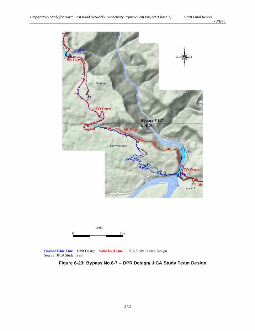
Preparatory Study for North East Road Network Connectivity Improvement Project (Phase 2) Draft Final Report - NH40
252
Dashed Blue Line:DPR Design、Solid Red Line:JICA Study Team’s Design Source: JICA Study Team
Figure 6-23: Bypass No.6-7 – DPR Design/ JICA Study Team Design

Preparatory Study for North East Road Network Connectivity Improvement Project (Phase 2) Draft Final Report - NH40
253
6.5.2 Criteria for Analysis of the Alternatives
Criteria to analyze the four scenarios are shown in エラー! 参照元が見つかりません。. These criteria
as per Table 6-19 are based on the most important factors for the road improvement project running
through Khasi Hills of Meghalaya State.
Table 6-19: Criteria for the Evaluation of the Alternatives
No. Alternative Models Criteria for Evaluation
1 No-project Implemented Option
Environmental Pollution - CO2 emissions increase/decrease - Noise and vibration increase/decrease - Health conditions improve/worsen
Socio-economic Conditions - Road accidents increase/decrease - Living standards improve/worsen - Impacts of resettlement - Impacts of land acquisition Natural Environment - Mountain slopes are stabilized/destabilized - Effects on ecological conditions
Road Conditions - Improvement of infrastructure for communication - Improvement of transportation of goods - Contribution to economic development of local/state economy
Others - Technical viability of the road construction - Expected benefits of the project in terms of socio-economic
conditions and natural environment (Is it worth implementing the project despite effects on the natural/social/economic conditions)
2 Road Widening Option (Entire section of NH40 is subject to road widening)
3 Bypass Insertion Option – DPR Design (Seven bypasses are inserted while widening of no bypass sections are implemented)
4 Modified Bypass Insertion Option –JICA Study Team’s Design (Bypass #6 has been modified)
Source: JICA Study Team
6.5.3 Result of the Analysis of Alternatives
(1) No-project Implemented Option
No-project Implemented Option is the scenario in which there is no project intervention on the existing
NH40. This option is assessed as follows:
a. Positive Impacts
- There will be no involuntary resettlements.
- No forest and agricultural areas will be lost to the road construction works.
- No construction works will cause significant traffic jams, dust emanation during the dry season
and muddy roads during rainy season.
- No significant impact will be caused to the near-by “Important Bird Area”.

Preparatory Study for North East Road Network Connectivity Improvement Project (Phase 2) Draft Final Report - NH40
254
b. Negative Impacts
- Transportation capacity is already saturated at the starting and ending points of the existing road.
The local businesses involved in the transportation of goods such as limestone exportation to
Bangladesh will not be able to expand if no NH40 widening project is implemented.
- Meghalaya State Government is trying to exploit local mineral resources including uranium. If
no project is carried out, the transportation of these mineral resources could not be effectively
done.
- Current traffic conditions around the villages along NH40 cause traffic jams and the function of
NH40 as one of the important trunk roads in Meghalaya State is lowered.
- Road accidents may increase as the number of vehicles increase without the road getting
widened.
- There will not be any improvements to the function of NH40 as one of the important trunk roads
in India for a long time.
(2) Widening of the Existing Road
The road widening option of NH40 is to widen the existing road and upgrade it as a two-lane road with
appropriate drainage, footpath and other ancillary road furniture. This option is assessed as follows:
a. Positive Impacts
- Transportation capacity that is already saturated could be eased.
- Local businesses involved in limestone exportation to Bangladesh and transportation of
agricultural products to Shillong will be able to expand if NH40 widening project is
implemented.
- Meghalaya State Government is trying to exploit local mineral resources including uranium and
the transportation of these mineral resources could be more efficient if NH40 widening project
is implemented.
- Current traffic conditions around the villages along NH40 causing traffic jams will be improved.
b. Negative Impacts
- There will be involuntary resettlement of approximately 850 local households.
- Forest area of approximately 140 ha will be lost to road construction.
- Construction works will cause significant traffic jams throughout the construction period, dust
during the dry season and muddy roads during the rainy season.
- Increase of traffic volume including heavy-load vehicles will increase the noise and vibration
levels along the built-up areas over time.
- Significant impact could be caused to the near-by “Important Bird Area”.
(3) Bypass Insertion Option – DPR Design
The bypass insertion option of NH40 is to widen the existing road and upgrade it to a two-lane road with
appropriate drainage, footpath and other ancillary road furniture. Where a concentration of population
along the road might be adversely affected, bypasses are inserted in order to reduce the number of
involuntary resettlements. This option is assessed as follows:
a. Positive Impacts
- It is positive for the local residents that traffic will be bypassing the built-up areas.
- Transportation capacity that is already saturated could be improved; i.e. local businesses such as
limestone exportation to Bangladesh will be able to expand if NH40 widening project is
implemented.

Preparatory Study for North East Road Network Connectivity Improvement Project (Phase 2) Draft Final Report - NH40
255
- Meghalaya State Government is trying to exploit local mineral resources including uranium and
the transportation of these mineral resources could be more efficient if NH40 widening project
is implemented.
b. Negative Impacts
- Involuntary resettlement of the local residents will be reduced to approximately 350 households
compared to 850 households in the case of the road widening option. However, this is still not
considered a positive impact of the project as a whole.
- Forest area of approximately 190 ha will be lost for bypasses and road construction.
- Construction works will cause significant traffic jams throughout the construction period, dust
during the dry season and muddy roads during the rainy season.
- Increase of traffic volume including heavy-load vehicles will cause noise and vibration along
the road while some traffic is diverted to bypasses.
- Current traffic congestion along the built-up areas of NH40 might not be reduced or increased in
the long term.
- Significant impact could be caused to the near-by “Important Bird Area”.
(4) Bypass Insertion Option – JICA Study Team’s Design
The bypass insertion option of NH40 based on the DPR design was reviewed in terms of the
configuration of bypasses at the end of the road approaching the border between India and Bangladesh.
This option involves widening of the existing road and upgrading it as a two-lane road with appropriate
drainage, footpath and other ancillary road furniture. Where a concentration of population along the road
might be adversely affected, bypasses are inserted the same as those of the DPR design in order to reduce
the number of involuntary resettlements. This option is assessed as follows:
a. Positive Impacts
- It is positive for the local residents that traffic will be bypassing the local built-up areas.
- Transportation capacity that is already saturated could be improved, i.e. the local businesses
such as limestone exportation to Bangladesh will be able to expand if NH40 widening project
is implemented.
- Meghalaya State Government is trying to exploit local mineral resources including uranium
and the transportation of these mineral resources could be efficient if the NH40 widening
project is implemented.
b. Negative Impacts
- Involuntary resettlement of the local residents will be reduced to approximately 300
households compared to 850 households in the case of the road widening option. However,
this is still not considered a positive impact of the project as a whole.
- Forest area of approximately 190 ha will be lost including areas around bypass #6-7 where
there is dense forest, and the road construction area.
- Construction works will cause significant traffic jams throughout the construction period, dust
during the dry season and muddy roads during the rainy season.
- Increase of traffic volume including heavy-load vehicles will cause noise and vibration along
the road while some traffic is diverted to bypasses.
- Current traffic congestion along the built-up areas of NH40 might not be reduced or increased
in the long term.
- The existing road section near the border which is narrow and has a deteriorated surface will
be left out of the project while the local population demands it to be renewed and up-graded.
- Significant impact could be caused to the near-by “Important Bird Area”.

Preparatory Study for North East Road Network Connectivity Improvement Project (Phase 2) Draft Final Report - NH40
256
6.5.4 Weighted Average Analysis of the Alternatives
Based on the above four alternatives, each alternative is evaluated using a weighted average analysis as
per Table 6-20. The evaluation parameters are items shaded in purple, i.e. each item is negatively or
positively affected as a result of the implementation of the project. The larger the value, the larger the
negative impacts on the socio-economic and natural environment.
On the other hand, the items that are shaded light-green are the factors that could improve in terms of the
local economy and society. For these items, the higher the value, the more meaningful benefits there are
of each alternative.
Table 6-20: Weighted Average Analysis of the Alternatives
Source: JICA Study Team

Preparatory Study for North East Road Network Connectivity Improvement Project (Phase 2) Draft Final Report - NH40
257
As shown above, the two “bypass insertion” options show a high value in the area shaded purple
compared to the “No-project Implemented Option”alternative. This means that the impacts on the
natural and socio-economic conditions are comparatively large for the bypass options. On the other hand,
comparing the values in the sections shaded green show that the “No-project Implemented Option”has a
lower value while the “bypass insertion” options show higher values. This indicates that there are more
socio-economic benefits that can be expected from the “bypass insertion” options. The findings from this
analysis suggests that JICA Study Team’s “modified bypass insertion option” is considered better in
terms of this weighted average analysis, and is presented in the following section.
6.5.5 Selection of the Alternatives
Based on the result of analysis as above, four alternatives have been assessed in terms of their advents and
disadvantages as per Table 6-21. As a result, “Bypass Insertion Option – JICA Review’s Design” was
relatievy advantageous as follows:
a. Entire length of the project area has been shortened as Bypass No. 6-7 is inserted;
b. Because of the short length of Bypass No.6-7, forest clearing is reduced;
c. Because of the insertion of Bypass No. 6-7, no resettlement is induced to this section; and
d. Because of the large scale bridge is constructed, esthetics of original landscape is lost while new
bridge could become one of the tourism sources of Dawki.
Table 6-21: Weighted Average Analysis of the Alternatives
Alternatives Zero-Option Widening the
Existing Road
Bypass Insertion
By DPR
Bypass Insertion by
JICA Study Team’s
Review
Outline of the Alternatives
No project implementation and the existing road is
continued to use
Based on IRC, 2-lane widening for the entire length is implemented
A number of bypasses are inserted in order to avoid built-up areas
Generally the same as DPR while Bypass No.6 -7 are significantly
improved
Scale of
Involuntary Resettlement
◎
No involuntary resettlement is involved i.e. the largest advantage
among others
×
Largest involuntary resettlement of approximately 850
households is involved.
〇
Involuntary
resettlement is
reduced to approximately 400 households.
〇
Involuntary resettlement
is reduced to 314
households
Impacts on the Natural
Environment
◎
There is no significant impacts caused to the natural environment
〇
There is a limited amount of impacts induced by the
Project to the natural environment
×
Bypasses will cause
significant impacts on the forested area
including wildlife and biological diversity as well as the agricultural areas.
×
Bypasses will cause
significant impacts on the forested area
including wildlife and biological diversity as well as the agricultural areas.
Pollution to Air Quality, Water Quality and Soil
△
No short-term impact.
However, present deterioration of the road conditions will lead to significant
traffic congestions, air pollution and other side effects caused by the increase of traffic.
〇
GHG as emission could
increase as traffic volume increased all along the
present road
◎
No air quality
deterioration in the built-up areas while GHG emission could increase as a whole
◎
No air quality
deterioration in the built-up areas while GHG emission could increase as a whole

Preparatory Study for North East Road Network Connectivity Improvement Project (Phase 2) Draft Final Report - NH40
258
Alternatives Zero-Option Widening the
Existing Road
Bypass Insertion
By DPR
Bypass Insertion by
JICA Study Team’s Review
Traffic Safety
×
Traffic safety could increase as no project
intervention is carried
out
〇
Widened road could allow speeding vehicles i.e.
noise and vibration could increase.
Traffic jam could increase at the built-up area.
◎
Bypasses could avoid built-up areas for any contact with human, bicycles and other
vehicles.
◎
Bypasses could avoid built-up areas for any contact with human, bicycles and other
vehicles.
Impacts on the
Socio-economic
Conditions
△
Natural disaster from
significant rainfall could cause shut-
down of the road net work that will cause
disruption of the economic activities.
〇
Increase of road width leads to increase of traffic and increase of economic
activities.
Traffic jam should increase at the built-up areas.
◎
Traffic flow avoiding
built-up area should cause to enhance
general economic activities.
◎
Traffic flow avoiding
built-up area should cause to enhance
general economic activities.
Cost of
the Project
N/A △
Land acquisition and
involuntary resettlement is the largest financial and
economic loss as well as
the social up- heaval.
Cost of construction works could be small
while narrow road area would cause additional construction arrange-
ment for traffic safety.
〇
Cost of involuntary
resettlement is small.
Shortening of the entire length of the project could reduce
cost of construction.
〇
Cost of involuntary
resettlement is smallest.
Shortening of the entire length of the project could reduce cost of
construction.
Land Acquisition
N/A △
Land acquisition and
involuntary resettlement is the largest financial and economic loss as well as the social up- heaval.
Border Area’s land acquisition is not possible.
×
Land acquisition is a part in the area of the Min. of Defense i.e. negotiation for land
acquisition takes time.
◎
Land acquisition is a
part in the area of the Min. of Defense i.e. negotiation for land acquisition takes time.
Ranking
4 3 2 1
Taking into the current road
conditions, NH-40’s role on the state economy, this option is not recommended.
Large-scale involuntary resettlement should be
avoided.
Cost of the project is largest among the alternatives.
Scale of involuntary resettlement is halved.
Land acquisition for
the agricultural areas and forest areas is the largest among other
options.
This option causes a largest economic impact as the same as
that of JICA Study Team’s Review Option.
Scale of involuntary resettlement is further
reduced than DPR Option.
Land acquisition for the agricultural areas and
forest areas is slightly
smaller than DPR Option.
This option causes a
largest economic impact as the same as that of DPR Option.
Legend: ◎-Highest 〇-Good but other alternatives are available △-Other alternatives are better ×-Should be avoided N/A-
Not applicable
Source:JICA Study Team

Preparatory Study for North East Road Network Connectivity Improvement Project (Phase 2) Draft Final Report - NH40
259
6.6 Scoping Analysis and TOR
6.6.1 Procedures of Scoping Analysis
Depending on the scale and nature of works during the various stages of the project, there are positive and
negative impacts to the natural and social environment. These impacts are different in the intensity, in the
spatial reach, and in whether it is irrevocable or temporary.
The scoping matrix as per エラー! 参照元が見つかりません。to Table 6-22 highlights anticipated
impacts that occur on various environmental and social components during the scoping stage of the
project. It is a generic scoping matrix that is applicable to development projects in general and has been
prepared based on the initial environmental assessment.
In terms of the impacts caused by the project to the natural environment, mountain slopes are cut at a
number of places while filling should also take place, therefore, soil erosion and changes to natural
drainage systems during the construction period will take place. At places where bypasses are created and
roadside widening takes place, significant amounts of forest areas are cleared. Agricultural fields are also
permanently put under the ROW of the project area.
The majority of population in Meghalaya is from the major tribes of the Khasis, the Jaintias and the Garos.
Besides the Khasis, Jaintia and Garos, the state has a host of other tribes that have resided in the state for
years and have ownership of land and legal residency. Such groups are the Mizo, Hmar, (Mikir, Rabha,),
Paitei, Meitei, etc. All these groups are groups from neighbouring states who migrated to Meghalaya and
have settled there for countless years. These groups continue to follow their own customs and traditions.
Agriculture is the mainstay of the people in the project region, which comprises almost 75% of the work
force. Apart from agriculture, other activities in the region are dairy, goat rearing, and piggery operations.
The project area represents mostly rural and some urban areas.
6.6.2 Scoping Matrix: Preliminary Analysis of Environmental Impacts
Depending on the scale and nature of works during the various stages of the project, there are positive and
negative impacts of the project in relation to the natural and social environment. These impacts are
different in intensity, continuity, cumulative nature, spatial reach, and whether it is permanent or
temporary.
The scoping matrices of four options as per エラー! 参照元が見つかりません。 Table 6-22 and
recommended option as per Table 6-23 highlight the anticipated impacts that may occur on various
environmental and social sectors during the scoping stage of the project. It is a generic scoping matrix that
is applicable to development projects in general and has been prepared based on the initial environmental
assessment.
Within each table, the abbreviations are as follows.
“A” denotes that severe/irrevocable impact is expected (+: Positive impact, -: Negative impact)
“B” denotes that significant impact is expected (+: Positive impact, -: Negative impact)
“C” denotes that the impact is unknown
“D” denotes that impact with little significance occurs (+: Positive impact, -: Negative impact)

Preparatory Study for North East Road Network Connectivity Improvement Project (Phase 2) Draft Final Report - NH40
260
Table 6-22: Scoping Matrix of 4 Options
Item
Scoping Analysis of the Anticipated Environmental Impacts
No-project Two-lane Widening Bypass Inserting Option
– DPR Design
Bypass Inserting Option
– JICA Study Team’s
Design
Pre-c
on
stru
cti
on
Co
nst
ru
cti
on
Sta
ge
Op
era
tio
n S
tag
e
Pre-c
on
stru
cti
on
Co
nst
ru
cti
on
Sta
ge
Op
era
tio
n S
tag
e
Pre-c
on
stru
cti
on
Co
nst
ru
cti
on
Sta
ge
Op
era
tio
n S
tag
e
Pre-c
on
stru
cti
on
Co
nst
ru
cti
on
Sta
ge
Op
era
tio
n S
tag
e
Natural Environment Climate/
Meteorological
Phenomena
D D D D D D D D D D D D
Topography D D D D B- D D B- D D B- D
Geology D D D D D D D D D D D D
Soil Erosion D D D D B- B-/B+ D B- B-/B+ D B- B-/B+
Hydrology D D D D C C D C C D C C
Groundwater D D D D D D D D D D D D
Forest/Flora D D D D A- C D A- C D A- B-
Eco-system/Bio-
diversity D D D D A- B- D A- A- D A- A-
Wildlife Reserve D D D D D D D D D D D D
Coastal Zone D D D D D D D D D D D D
Landscape D D D D C C D C C D C C
Natural
Disasters D D D D B- B+ D B- B+ D B- B+
Living Environment/Pollution Control Measures
Air Pollution D D D D B- B- D B- C D B- B-
Offensive Odor D D D D D D D D D D D D
Water Pollution D D D D B- C D B- C D B- B-
Bottom Sediment
Contamination D D D D C D D D D D D D
Soil Contamination D D D D C D D C D D C D
Ground Subsidence D D D D D D D D D D D D
Noise and
Vibration D D D D A- B- D A- C D A- C
Sunshine Obstruction D D D D D D D D D D D D
Wastes /
Hazardous Materials D D D D B- C D B- C D B- B-
Social Environment
Involuntary
Resettlement D D D A- D D A- D D A- D D
Land Use D D D B- B- B- A- A- A- A- A- A-
Utilization of Local
Resources D D D D A- D D A- D D A- D
General,
Regional
/ City Plans
D D B- D D B+ D D B+ D D B+
Social Institutions
and Local Decision-
making Institutions
D D D B- B- B- B- B- B- B- B- B-
Social Infrastructure
and Services D D B- B- B- B+ B- B- B+ B- B- B+
Local Economy and
Livelihood D D D A- A-/ B+ B+ A- A-/ B+ B+/B- A- A-/ B+ B+/B-
Unequal Distribution
of Benefit and D D B- A- A-/ B+ B-/ B+ A- A-/ B+ B-/ B+ A- A-/ B+ B-/ B+

Preparatory Study for North East Road Network Connectivity Improvement Project (Phase 2) Draft Final Report - NH40
261
Damage
Local Conflicts of
Interest D D B- C C C C C C C C C
Water Use, Water
Rights and
Communal Rights
D D D D D D D D D D D D
Cultural and
Historical Heritage D D D D D D D D D D D D
Religious Facilities D D D B- A- B- B- A- B- B- A- B-
Sensitive Facilities
(e.g. hospital, school,
precision machine
factory)
D D D A- A- D D A- D D A- D
Poor People D D B- A- A-/ B+ B+ A- A-/ B+ B+ A- A-/ B+ B+
Ethnic Minorities/
Indigenous People D D B- A- A- D A- A- D A- A- D
Gender D D D C C C C C C C C C
Children's Rights D D D C D C C D C C D C
Public Health
(sanitation and
infectious diseases)
D D B- D B- B- D B- B- D B- B-
Occupational Health
and Safety (OHS) D D D D B- B- D B- B- D B- B-
Others
Accidents D D D D B- B+/ B- D B- B+/ B- D B- B+/ B-
Climate Change D D D D B- B+/ B- D B- B+/ B- D B- B+/ B-
Source: JICA Study Team
Table 6-23: Scoping Matrix for the Two-lane Widening of NH40 (Bypass Inserting Option – JICA Study Team’s Design)
Item
Scoping Analysis of the Anticipated Environmental Impacts
Pre-c
on
stru
cti
on
Co
nst
ru
cti
on
Sta
ge
Op
era
tio
n S
tag
e
Rationale of the Impact Assessment
Natural Environment
1.1 Climate/ Meteorological Phenomena
D D D
P: No impact is expected.
C: Impacts on microclimate should occur but of negligible scale.
O: Impacts on microclimate should occur but of negligible scale.
1.2 Topography D B- D
P: No impact is expected.
C: Changes in topographic conditions over the project area takes place due to the need for cutting and filling work.
O: Topographic conditions should become stable after the completion of construction works, which include slope protection and stabilization.
1.3 Geology D D D
P: No impact is expected.
C: No impact is expected.
O: No impact is expected.
1.4 Soil Erosion D B- B-
P: No impact is expected.
C: Soil erosion occurs particularly during the construction period with monsoon rains.
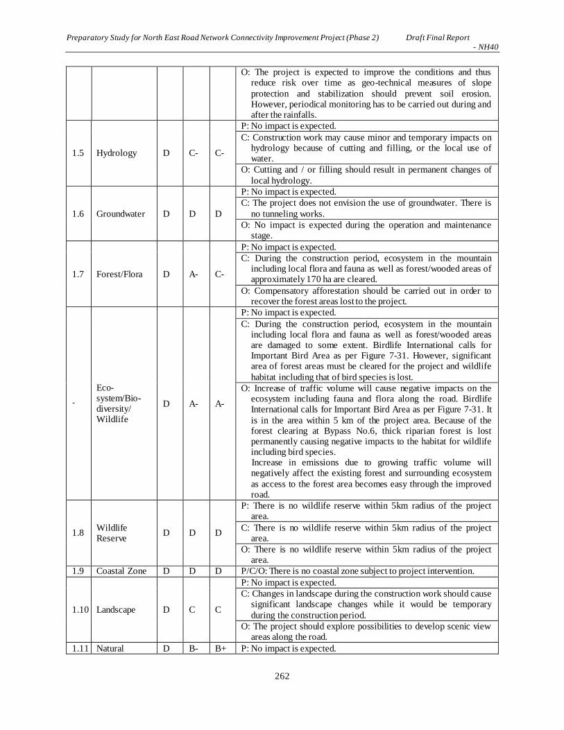
Preparatory Study for North East Road Network Connectivity Improvement Project (Phase 2) Draft Final Report - NH40
262
O: The project is expected to improve the conditions and thus reduce risk over time as geo-technical measures of slope
protection and stabilization should prevent soil erosion. However, periodical monitoring has to be carried out during and after the rainfalls.
1.5 Hydrology D C- C-
P: No impact is expected.
C: Construction work may cause minor and temporary impacts on hydrology because of cutting and filling, or the local use of water.
O: Cutting and / or filling should result in permanent changes of
local hydrology.
1.6 Groundwater D D D
P: No impact is expected.
C: The project does not envision the use of groundwater. There is
no tunneling works.
O: No impact is expected during the operation and maintenance stage.
1.7 Forest/Flora D A- C-
P: No impact is expected.
C: During the construction period, ecosystem in the mountain including local flora and fauna as well as forest/wooded areas of approximately 170 ha are cleared.
O: Compensatory afforestation should be carried out in order to recover the forest areas lost to the project.
-
Eco-system/Bio-diversity/ Wildlife
D A- A-
P: No impact is expected.
C: During the construction period, ecosystem in the mountain including local flora and fauna as well as forest/wooded areas are damaged to some extent. Birdlife International calls for Important Bird Area as per Figure 7-31. However, significant area of forest areas must be cleared for the project and wildlife
habitat including that of bird species is lost.
O: Increase of traffic volume will cause negative impacts on the ecosystem including fauna and flora along the road. Birdlife International calls for Important Bird Area as per Figure 7-31. It
is in the area within 5 km of the project area. Because of the forest clearing at Bypass No.6, thick riparian forest is lost permanently causing negative impacts to the habitat for wildlife including bird species. Increase in emissions due to growing traffic volume will negatively affect the existing forest and surrounding ecosystem
as access to the forest area becomes easy through the improved road.
1.8 Wildlife Reserve
D D D
P: There is no wildlife reserve within 5km radius of the project area.
C: There is no wildlife reserve within 5km radius of the project area.
O: There is no wildlife reserve within 5km radius of the project area.
1.9 Coastal Zone D D D P/C/O: There is no coastal zone subject to project intervention.
1.10 Landscape D C C
P: No impact is expected.
C: Changes in landscape during the construction work should cause significant landscape changes while it would be temporary
during the construction period.
O: The project should explore possibilities to develop scenic view areas along the road.
1.11 Natural D B- B+ P: No impact is expected.

Preparatory Study for North East Road Network Connectivity Improvement Project (Phase 2) Draft Final Report - NH40
263
Disasters C: Many areas of the project area are prone to landslides during the construction period.
O: Slope protection / stabilization measures and drainage are expected to significantly reduce the risk of natural disasters.
Pollution
2.1 Air
Pollution D B- B-
P: No impact is expected.
C: Some negative impacts are expected due to the operation of construction equipment and vehicles. One example is dust
incidental to earthwork especially during the dry season.
O: Air pollution is expected to increase due to increased traffic volume on the road.
2.2 Offensive Odor
D D D P/C/O: No impact is expected.
2.3 Water Pollution
D B- B-
P: No impact is expected.
C: Turbid water due to the earthworks, bridge pier construction work and wastewater effluents from construction workers’ camps / yards are expected to pollute the surrounding rivers / canals to some extent.
O: Some impacts on water quality in surrounding water bodies are
expected due to water discharge from road users and wastewater from maintenance activities.
2.4
Bottom Sediment Contamination
D D D
P: No impact is expected.
C: There is a possibility that rainwater will wash out construction materials such as cement, sand and other debris into the natural drainage. Contractors are instructed to provide silt trap at places where natural drainage is likely to be affected.
O: Some wastewater will be generated from maintenance activities along the road while the impacts on bottom sediment from the wastewater will be negligible.
2.5 Soil Contaminatio
n
D C D
P: No impact is expected.
C: Impacts on soil from deposition of pollutants from construction materials in the construction site are expected to be small. Since there is no major industrial activity along the road, it is unlikely that soil along the road is already polluted.
O: No impact is expected.
2.6 Ground Subsidence
D D D
P: No impact is expected.
C: No impact is expected.
O: No impact is expected.
2.7 Noise and Vibration
D A- B-
P: No impact is expected.
C: Noise and vibration generated by the operation of construction equipment and vehicles, although they are temporary. Construction schedule should take into account the location of schools, hospitals and religious facilities that require silence during parts of the day.
O: Noise and vibration level are likely to increase due to greater traffic volume along the road. Specific measures may be required to minimize impacts on schools, hospitals and religious facilities.
2.8 Sunshine Obstruction
D D D
P: No impact is expected.
C: No impact is expected.
O: No impact is expected.
2.9 Wastes / Hazardous Materials
D B- B-
P: No impact is expected.
C: Waste will be generated from construction workers’ camps. Waste generated from construction and demolition work may

Preparatory Study for North East Road Network Connectivity Improvement Project (Phase 2) Draft Final Report - NH40
264
include hazardous materials that must be treated before final disposal.
O: Waste will be generated from road users and workers of maintenance works.
Social Environment
3.1 Involuntary Resettlement
A- D D
P: Though bypasses are planned to avoid densely-populated areas, expansion of the existing road will result in involuntary resettlement of 30 households at maximum per village. The number of household to be resettled is estimated to be approximately 400.
C: Resettlement will be completed before construction begins and thus no resettlement is expected during operation.
O: No impact is expected, as relocation will be completed before
construction begins.
3.2 Land Use A- A- A-
P: Land acquisition and involuntary resettlement are likely to cause changes in the existing land use patterns.
C: Land usage, including cultivation, shifting cultivation, quarry, and agro-forestry, might be significantly affected at bypass sections. Land clearance for construction yards and workers’ camps is temporary.
O: Land usage will be permanently changed especially at bypass sections.
3.3 Utilization of Local Resources
D A- D
P: No impact is expected.
C: Mass-scale use of local resources such as sand and quarrying for the construction activities may make the materials scarce for their needs that exist locally.
O: No impact is expected as use of local resources is not expected during operation.
3.4
General,
Regional / City Plans
D D B+
P/C: No impact is expected.
O: Better infrastructure network may trigger an influx of outsiders and economic development in the region.
3.5
Social Institutions and Local Decision-
making Institutions
B- B- B- P/C/O: Land acquisition and involuntary resettlement are likely to
affect social institutions such as social capital and local decision-making institutions.
3.6
Social
Infrastructure and Services
B- B- B+
P: Communal facilities such as public hall may be affected by the project. Access to social infrastructure and services may be temporarily affected due to resettlement and land acquisition.
C: Access to social infrastructure and services may be temporarily affected due to construction of construction yard and accommodation for workers as well as traffic jams due to the operation of construction vehicles.
O: In the long term, the project is expected to improve access to social infrastructure and services by providing a better road network.
3.7
Local Economy and Livelihood
A- A- B+
P: Loss of income source and livelihood due to involuntary resettlement and change in land usage are expected to negatively affect the local economy and livelihood. Realignment of the bridge section can negatively affect rental boats, tea stalls and open stalls nearby the boat slip, though the affect will be relatively minor.
C: Loss of income source and livelihood due to involuntary

Preparatory Study for North East Road Network Connectivity Improvement Project (Phase 2) Draft Final Report - NH40
265
resettlement and change in land usage are expected to negatively affect the local economy and livelihood, especially cultivation,
quarry and agro-forestry. On the other hand, construction work will have a positive impact on the local economy by creating employment and business opportunities in the project area.
O: The project will have a positive impact on the local economy as an improved road network ensures a more stable supply of
essential goods and transport of cash crops. However, bypasses may negatively affect the business of shops and tea stalls in detoured villages, and business of rental boats, tea stalls and open stalls nearby the boat slip of the detoured bridge section. In the long-term, this will lead to regional economic development with more job and business opportunities.
Meanwhile, it is suggested that a proposal be made to village/district council to ensure that the improved infrastructure network will not lead to uncontrolled development and deforestation.
3.8
Unequal Distribution of Benefit and
Damage
A- A- B-
P: Land acquisition and involuntary resettlement will lead to unequal distribution of benefits and damage between those who are directly affected by the project and those who are not.
C: While resettling households and households whose livelihood depends on affected lands will bear much of the damage, others
may even enjoy benefits from new business opportunities created by construction work, resulting in the unequal distribution of benefits and damage.
O: People residing along the road may accrue greater benefits
compared to others, potentially increasing the rich-poor gap within the community. Over the long term, the project is expected to have a positive impact on the local economy through an improved road network.
3.9 Local Conflicts of Interest
C C C
P: Expectation for unequal distribution of benefits and damage may
trigger and / or intensify local conflicts of interest in the community.
C/O: Unequal distribution of benefits and damage may trigger and / or intensify local conflicts of interest in the community though
the impact is relatively minor.
3.10
Water Usage, Water Rights and
Communal Rights
D D D
P/C: Water usage of the affected households may be curtailed due to resettlement. However, rainwater is commonly used for both household and agricultural use in the region and thus, the impact will be minor, if any.
O: No impact is expected.
3.11 Cultural and Historical
Heritage
D D D P/C/O: The targeted roads do not traverse or run near major
cultural or historical heritage sites.
3.12 Religious Facilities
B- A- B-
P: A number of churches, several memorial stones and graves are located along the road. Several memorial stones are directly affected. Graves can be affected in private yards. The targeted roads do not traverse sacred groves of traditional religious
beliefs.
C: Roadside religious facilities may be affected by noise and vibration during construction and operation due to construction work and greater traffic volume.
O: Several memorial stones are directly affected, which requires appropriate protection or realignment of the route.

Preparatory Study for North East Road Network Connectivity Improvement Project (Phase 2) Draft Final Report - NH40
266
3.13
Sensitive Facilities
(e.g. hospital, school, precision machine factory)
D A- D
P: No impact is expected
C: Noise and vibration during construction work may affect schools, public health centers and other medical facilities.
O: No impact is expected as sufficient noise control measures will be implemented.
3.14 Poor People A- A- B+
P: Given the limited coping capacity of the poor, it is necessary to assess their vulnerability and develop appropriate mitigation measures.
C: The poor may bear a disproportionally higher burden due to
their limited capacity to cope, although they can benefit from employment opportunities during construction work.
P: In the long-term, economic development in the region is likely to benefit the poor, however, the poor may fail to benefit from the project due to the lack of skills and coping capacity.
3.15
Ethnic Minorities/
Indigenous People
A- A- D
P/C: East Khasi Hills and Jaintia Hills of Meghlaya State are home to tribal groups (Scheduled Tribe) with distinct languages and cultures. Preparation of RAP and livelihood restoration plan, therefore, must take this into account.
O: Resettlement will be completed before construction. Negative impacts shall be minimized by considering relocation places and livelihood restoration plans.
3.16 Gender C C C
P: Resettlement may affect gender-related work division such as cultivation, harvest and processing of crops.
C: Equal opportunity should be sought for employment during construction work. Prevailing social and cultural norms must be carefully studied to avoid gender-related conflicts. Project may
affect gender-related work division such as cultivation, harvest and processing of crops.
O: Project may affect gender-related work division such as cultivation, harvest and processing of crops.
3.17 Children's Rights
C D C
P: Though child labor is unlawful according to Article 24 of the Indian Constitution, the project may affect children who help their families with work at roadside shops and tea stalls.
C: Child labor is unlawful according to Article 24 of the Indian Constitution. Only adults are eligible for potential employment opportunities created by the project.
O: Though child labor is unlawful according to Article 24 of the Indian Constitution, the project may affect children who help
their families with work at roadside shops and tea stalls.
3.18
Public Health (sanitation and infectious
diseases)
D B- B-
P: No impact is expected.
C: Influx of construction workers is likely to increase health risks,
particularly that of STD / STI and HIV / AIDS. The risk of malaria should be properly managed in construction work in areas where malaria is prevalent.
O: An increase in traffic volume and road users may have negative
impacts on public health.
3.19
Occupational
Health and Safety (OHS)
D B- B-
P: No impact is expected.
C: Occupational health and safety of construction work should be
properly managed through adequate EMP.
O: Maintenance and repair work should take into account the occupational health and safety of the workers.
Others

Preparatory Study for North East Road Network Connectivity Improvement Project (Phase 2) Draft Final Report - NH40
267
4.1 Accidents D B- B+/ B-
P: No impact is expected.
C: Increased risk of accidents associated with construction activities is expected due to the operation of heavy equipment and vehicles. Special attention is required for construction in the foggy area.
O: Risks of accidents is expected to increase due to greater traffic volume and speed. Speed limits and use of headlight / hazard lights shall be required especially in the foggy area. Putting in place accident-prevention measures (such as mirrors at curves) will reduce the risk of accidents.
4.2 Climate Change
B- B- B+/ B-
P: No impact is expected.
C: The use of construction machines and operation of vehicles will result in an increase in GHG emissions, though the impact is small and short-term.
O: GHG emissions will increase due to an increase in traffic volume. The project is expected to improve the resilience of the road against climate change by factoring long-term climate change (changes / increase in precipitation etc.) into the road design.
Source: JICA Study Team
Note: P: Pre-Construction; C: Construction; and O: OperationPeriod A: Severe/irrevocable impact is expected (+: Positive impact, -: Negative impact) B: Significant impact is expected (+: Positive impact, -: Negative impact) C: Further study is required as impact is unknown D: Impact with little significance occurs
TOR of the Natural Environment and Socio-economic Survey is shown in Table 6-24.

Preparatory Study for North East Road Network Connectivity Improvement Project (Phase 2) Draft Final Report - NH40
268
Table 6-24: TOR of Natural and Socio-economic Environment Survey
Scoping
No. Survey Locations Methods and Duration
Items Subject to
Investigation
Method of Assessment and
Estimation of Impacts
Natural Environment
1.2 Geography/
Geomorphoogy Entire Project Area
Field survey, interview survey and map location study for the disaster-prone areas
Present conditions examined in may – July 2016
Areas subject to cut and fill slope createon
Assessment of the Impact: Based on the secondary data and field survey, impact areas are assessed. Estimation of the Impact: Qualitative analysis on the assessed impacts.
1.4 Soil Erosion Entire Project Area
Field survey, interview survey and map location study for the disaster-prone areas
Present conditions examined in may – July 2016
Areas subject to cut and fill slope createon
Assessment of the Impact: Based on the secondary data and field survey, impact areas are assessed. Estimation of the Impact: Qualitative analysis on the assessed impacts.
1.5 Hydrogegrahhy Entire Project Area
Field survey, interview survey and map location study for the disaster-prone areas
Present conditions examined in may – July 2016
Existing waterways such as rivers, streams and agricultural canals as well as sewerage channel
Assessment of the Impact: Based on the secondary data and field survey, impact areas are assessed. Estimation of the Impact: Qualitative analysis on the assessed impacts.
1.7 Ecosystem/Biological Diversity
NH-40: 4 locations
(approximately every 20km)
Field Survey
Document survey
Hearing Survey on manger of parks and experts.
Bird survey (hearing survey on NGO/ Experts, Field Survey)
Present conditions examined
Rare species, breeding colony, wetland, parks, pictures
Area of investing within the
5km of radious from the center of the alignment of NH-40.
Assessment of the Impact:
Based on the field observation and secondary data, baseline data are determined. Estimation of the Impact:Forest clearing areas and the rare species of wildlife including bird
species are analyzed qualitatively.

Preparatory Study for North East Road Network Connectivity Improvement Project (Phase 2) Draft Final Report - NH40
269
Scoping
No. Survey Locations Methods and Duration
Items Subject to
Investigation
Method of Assessment and
Estimation of Impacts
in may – July 2016
1.7 Wildlife Reserve/ Sancuary
NH-40: 4 locations (approximately every 20km)
Field Survey
Document survey
Hearing Survey on manger of parks and experts.
Bird survey (hearing survey on NGO/ Experts, Field Survey)
Present conditions examined
in may – July 2016
Exiting wildlife reserves adjacent to the project area
Assessment of the Impact:
Based on the field observation and secondary data, baseline data are determined.
Estimation of the Impact:Forest clearing areas and the rare species of wildlife including bird
species are analyzed qualitatively.
1.7 Wildlife/Plant
Distribution
NH-40: 4 locations
(approximately every 20km)
Field Survey
Document survey
Hearing Survey on manger of parks and experts.
Bird survey (hearing survey on NGO/ Experts, Field Survey)
Present conditions examined in may – July 2016
Rare species, breeding colony of wildlife, wetland, forest reserves and other areas based on the local knowledge on the plants and wilidlife.
Assessment of the Impact:
Based on the field observation and secondary data, baseline data are determined.
Estimation of the Impact:
Forest clearing areas and the rare species of wildlife including bird
species are analyzed qualitatively.
1.7 Forest
NH-40 : within ROW and trees which will be hindrance to construction
Hearing Survey, Filed Survey (counting of deforestation trees), review of documents
Present conditions examined in may – July 2016
Number, type, height, girth of trees, and forest areas subject to clearing for the Project.
Assessment of the Impact:
Based on the field observation and secondary data, baseline data are determined.
Estimation of the Impact:
Forest area clearing area (ha), number of trees subject to cutting are estimated
quantitatively as well as qualitatively.
1.10 Landscape Entire Project Area
Field survey and hearing survey along the project area
Field survey on the existing landscape and viewpoint areas
Assessment of the Impact: Based on the secondary data and field survey, impact areas are

Preparatory Study for North East Road Network Connectivity Improvement Project (Phase 2) Draft Final Report - NH40
270
Scoping
No. Survey Locations Methods and Duration
Items Subject to
Investigation
Method of Assessment and
Estimation of Impacts
Present conditions examined in may – July 2016
Investigation of the secondary data on the viewpoint construction works
assessed. Estimation of the Impact: Qualitative analysis on the assessed impacts based on the past incidents.
1.11 Natural Disaster Entire Prject Area
Field survey and hearing survey along the project area
Present conditions examined in may – July 2016
Field survey on the existing landscape and viewpoint areas
Areas subject to cut and fill slope createon
Assessment of the Impact: Based on the secondary data and field survey, impact areas are assessed. Estimation of the Impact: Qualitative analysis on the assessed impacts based on the past incidents.
Living Environment
2.1 Air Quality
NH-40: 9 locations (approximately every 10km)
Continuously 24 hours per location (1 weekday)
Accordance with environmental standard in India
Present conditions examined in May – July 2016
SPM, RPM, NOx
Assessment of the Impact: Baseline data obtained on site are compared against the Indian standard for quantitative analysis.
Estimation of the Impact:
General trend of increase of the traffic and vehicles are taken into account of CO2 increase is quantitatively analyzed.
2.3 Water Quality
NH-40: 9 locations (river crossing points and wells for approximately every 10km), )
According to the environmental standard in India
Present conditions examined in may – July 2016
Water temperature, odor, turbidity (NTU) 、 pH、 BOD5 、 COD 、 total suspended solids
Assessment of the Impact: Baseline data obtained on site are compared against the Indian standard of water by CPCB for quantitative analysis.
Estimation of the Impact:
Water use during the construction period and operation and maintenance
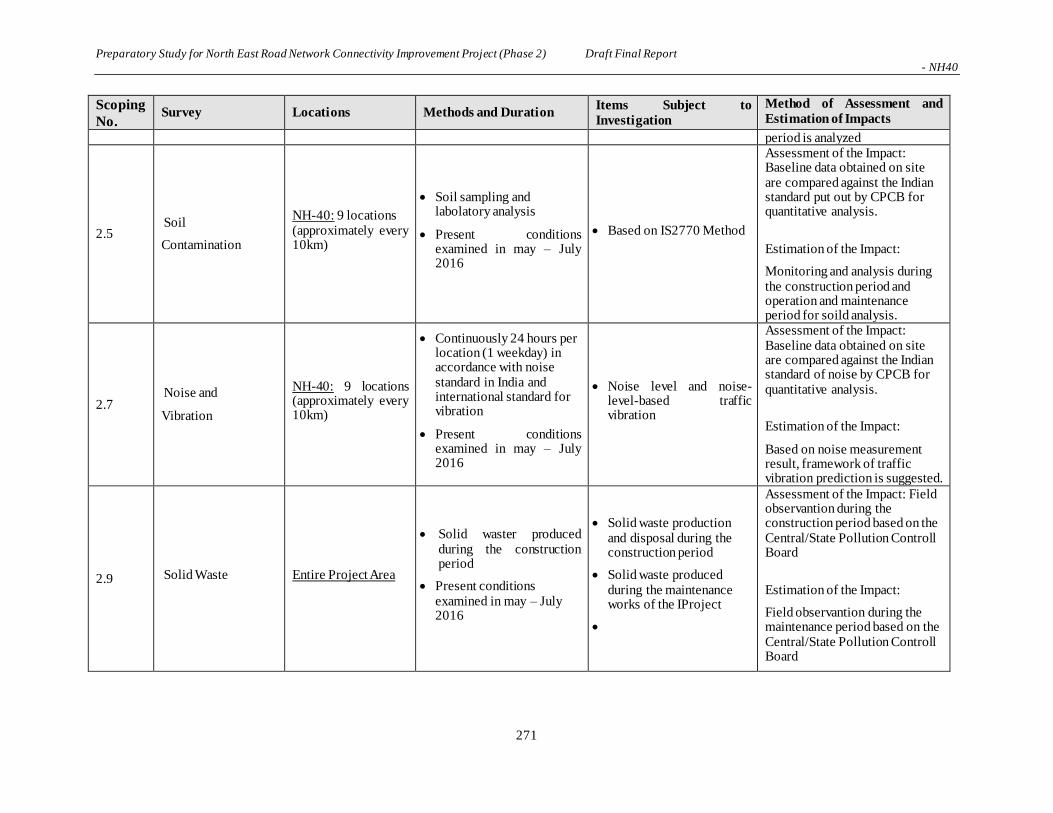
Preparatory Study for North East Road Network Connectivity Improvement Project (Phase 2) Draft Final Report - NH40
271
Scoping
No. Survey Locations Methods and Duration
Items Subject to
Investigation
Method of Assessment and
Estimation of Impacts
period is analyzed
2.5 Soil
Contamination
NH-40: 9 locations (approximately every 10km)
Soil sampling and labolatory analysis
Present conditions examined in may – July 2016
Based on IS2770 Method
Assessment of the Impact: Baseline data obtained on site are compared against the Indian standard put out by CPCB for quantitative analysis.
Estimation of the Impact:
Monitoring and analysis during the construction period and operation and maintenance period for soild analysis.
2.7 Noise and
Vibration
NH-40: 9 locations (approximately every 10km)
Continuously 24 hours per location (1 weekday) in accordance with noise standard in India and international standard for vibration
Present conditions examined in may – July 2016
Noise level and noise-level-based traffic vibration
Assessment of the Impact: Baseline data obtained on site are compared against the Indian standard of noise by CPCB for quantitative analysis.
Estimation of the Impact:
Based on noise measurement result, framework of traffic vibration prediction is suggested.
2.9 Solid Waste Entire Project Area
Solid waster produced during the construction period
Present conditions examined in may – July 2016
Solid waste production and disposal during the construction period
Solid waste produced during the maintenance works of the IProject
Assessment of the Impact: Field observantion during the construction period based on the Central/State Pollution Controll Board
Estimation of the Impact:
Field observantion during the maintenance period based on the Central/State Pollution Controll Board

Preparatory Study for North East Road Network Connectivity Improvement Project (Phase 2) Draft Final Report - NH40
272
Scoping
No. Survey Locations Methods and Duration
Items Subject to
Investigation
Method of Assessment and
Estimation of Impacts
Social Environment
3.1 Involuntary
Resettlement NH-40: within ROW
Census and inventory Interview Survey, Land property survey, Livelihood survey
Hearing Survey, Filed Survey
Focused Group Discussion
Census and inventory using questioners. Resettlement cost will be calculated based on the survey result.
- Estimate the number of
Involuntary resettlement affected
by ROW and evaluate the result
in quantitative by Census study.
- Evaluate affected land and
property of PAHs in quantitative
by survey.
- Evaluate socio-economic
situation in quantitate by survey.
3.2 Land Use NH-40: within ROW Hearing Survey, Filed
Survey Land utilization , Range of
Impact by project
Estimate the impact and evaluate the result in quantitative based on result of Field Survey, Review of Document and Similar Examples
3.3 Utilization of Local Resources
NH-40 : villages along
the proposed alignment
Hearing Survey, Filed Survey
Focused Group Discussion
Utilization of Resource, Industrial Structure
Estimate the impact based on result of Field Survey, Review of Document and Similar Examples
3.4
General, Regional / City Plans
NH-40 : villages along
the proposed alignment Hearing Survey, Filed
Survey Development of region,
City planning
Estimate the impact based on result of Hearing Survey, Review of Document and Similar Examples
3.5
Social Institutions and Local Decision- making Institutions
NH-40 : 100m from the
proposed alignment
Hearing Survey, Filed Survey
Focused Group Discussion
Social Institution, Decision –making institution, the relationship
Estimate the impact based on result of Field Survey, Review of Document and Similar Examples
3.6 Social Infrastructure and Services
NH-40 : villages along
the proposed alignment
Hearing Survey, Filed Survey
Focused Group Discussion
Name of Institution, distant from ROW, location, Accessibility
Estimate the impact based on information of water facility, sewage treatment facility, power distribution facility, telecommunication facility /public facilities(medical,

Preparatory Study for North East Road Network Connectivity Improvement Project (Phase 2) Draft Final Report - NH40
273
Scoping
No. Survey Locations Methods and Duration
Items Subject to
Investigation
Method of Assessment and
Estimation of Impacts
education, religious, culture)
3.7 Local Economy and Livelihood
NH-40 : villages along
the proposed alignment
Hearing Survey, Filed Survey
Focused Group Discussion
Economy situation, social structure, livelihood, situation of burn agriculture
Estimate the impact and based on result of Field Survey, Review of Document and Similar Examples
3.8
Unequal Distribution of Benefit and Damage
NH-40 : villages along
the proposed alignment
Hearing Survey, Filed Survey
Focused Group Discussion
Livelihood, PAPs, Utilization of Affected Land
Estimate the impact based on result of Field Survey, Review of Document and Similar Examples
3.9 Local Conflicts of Interest
NH-40 : villages along
the proposed alignment
Hearing Survey, Filed Survey
Focused Group Discussion
Livelihood, PAPs, Utilization of Affected Land, Social relationship
Estimate the impact based on result of Field Survey, Review of Document and Similar Examples
3.12 Religious Facilities NH-40 : 100m from the
proposed alignment
Hearing Survey, Filed Survey
Focused Group Discussion
Name of Institution, distant from ROW, location, local information, Photograph
Estimate the impact based on result of Field Survey, Review of Document and Similar Examples
3.13
Sensitive Facilities (e.g. hospital, school, precision machine factory)
NH-40 : 100m from the
proposed alignment
Hearing Survey, Filed Survey
Focused Group Discussion
Name of Institution, distant from ROW, location, local information, Photograph
Estimate the impact based on result of Field Survey, Review of Document and Similar Examples
3.14 Poor People NH-40 : villages along
the proposed alignment
Hearing Survey, Filed Survey
Focused Group Discussion
Social structures, traditional
livelihood, rehabilitation
policy considering the
above..
Estimate the impact based on result of Field Survey, Review of Document and Similar Examples
3.15 Minority/ Indigenous People
NH-40: villages directly affected by the proposed alignment
Hearing Survey, Filed Survey
Focused Group Discussion
Social structures, traditional
livelihood, rehabilitation
policy considering the
above..
Estimate the impact based on result of Field Survey, Review of Document and Similar Examples
3.16 Gender NH-40 : villages along
the proposed alignment Hearing Survey, Filed
Survey Social Structure,
Livelihood, Literacy,
Estimate the impact based on result of Field Survey, Review of
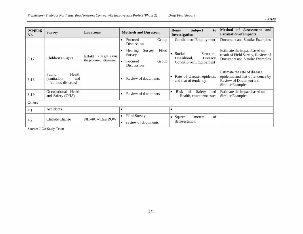
Preparatory Study for North East Road Network Connectivity Improvement Project (Phase 2) Draft Final Report - NH40
274
Scoping
No. Survey Locations Methods and Duration
Items Subject to
Investigation
Method of Assessment and
Estimation of Impacts
Focused Group Discussion
Condition of Employment Document and Similar Examples
3.17 Children's Rights NH-40 : villages along
the proposed alignment
Hearing Survey, Filed Survey
Focused Group Discussion
Social Structure, Livelihood, Literacy, Condition of Employment
Estimate the impact based on result of Field Survey, Review of Document and Similar Examples
3.18
Public Health (sanitation and infectious diseases)
Review of documents Rate of disease, epidemic
and that of tendency
Estimate the rate of disease, epidemic and that of tendency by Review of Document and Similar Examples
3.19 Occupational Health and Safety (OHS)
Review of documents Risk of Safety and
Health, countermeasure Estimate the impact based on Similar Examples
Others
4.1 Accidents
4.2 Climate Change NH-40: within ROW Filed Survey
review of documents
Square meters of deforestation
Source: JICA Study Team

Preparatory Study for North East Road Network Connectivity Improvement Project (Phase 2) Draft Final Report - NH40
275
(1) Primary Data Collection
1) Air Quality
Ambient air quality was monitored along the road at selected sites. The locations selected were those of
the city/town area, the market place and the rural areas. Entire stretch of the Project’s present road section
has been surveyed and screened are examined through NABL Accredited Laboratory. The air quality
parameters considered for the study include Particulate Matter10 (PM10), Particulate Matter 2.5 (PM2.5),
Nitrogen Oxides (NOx) Sulphur Di-oxide (SO2), and Carbon monoxide (CO).
a. Particulate Matters (PM10 & PM2.5)
PM10 and PM2.5 were monitored using a Respirable Dust sampler (RDS) and PM2.5 Sampler. A pre-
conditioned and weighted glass fiber filter papers are placed on top of the RDS/PM2.5 samplers. A
known quantity of the air was sucked through the filter paper in a prescribed sampling time. The flow
was noted from the manometer. The multiplication of time with rate gave the total quantity of air
passed through the filter paper. After sampling, the filter paper was removed, conditioned, and
weighed finally for getting the concentrations in ambient air.
b. Sulphur Di-Oxides (SO2)
A known quantity of the air was bubbled through impingers containing tetrachloromercurate. SO2,
formed a disulfiltomercurate complex, which gave a pinkish blue colour with p-rosaniline and
formaldehyde solution. The intensity of colour produced was proportional to concentration of sulphur
dioxide. The measurement was made by using spectrophotometer at the wavelength of 560 nm.
c. Nitrogen Di-Oxides (NOx)
A known quantity of air was passed through impingers containing sodium hydroxide-sodium arsenite
solution. The estimation of NOx was done colorimetrically using hydrogen peroxide, sulfanilamide,
NEDA, etc. The intensity of the colour was measured at 540 nm using a spectrophotometer.
d. Carbon Monoxide (CO)
FID based samplers are used to monitor the carbon monoxide levels.
2) Water Quality
Samples of ground water were collected from springs whereas samples of surface water were collected
from rivers. To assess the water Quality of the area samples were tested for physico-chemical parameters.
3) Soil Quality
The samples were collected from 60 m corridor of the road, at 5-15 cm depth. Besides studying their
particle size (sand/silt/clay ratio) they were monitored for physico-chemical parameters to assess the soil
quality of the area.
4) Noise Level
The noise level (Leq) was measured using noise meter at various sites along the entire stretch of road
during day (6.00 am to 10 pm) and night (10 pm to 6.00 am).
Preparatory Study for North East Road Network Connectivity Improvement Project (Phase 2) Draft Final Report - NH40
276
The noise levels is expressed as an equivalent noise level (Leq) which is the measurement duration of
sound pressure level as the averaging time. It is calculated as follows:
Leq = 10 Log10 [1n 10 Li/10]
Where the basis of Leq is calculated by using Li (not shown in the above formula) = Instantaneous sound
intensity level dB (A) and n = No. of observations
(2) Secondary Data Collection
1) Data Sources
The secondary data were collected from following sources:
Table 6-25: Secondary Data Collection
1. General information District Collector/Gazetteer Office
2. Meteorological data Indian Meteorological Department
3. Statistical data District Statistical Office
4. Irrigation and hydrogeology data Central Ground Water Board
5. General Land use and Cropping Pattern Asst. Director of Agriculture
6. Relief and slope Survey of India
7. Rocks and minerals Geological Survey of India
8. Industries District Industries Center
9. Maps and Topo sheets Survey of India
10. Forests/Wild life/Bio-diversity District Forest Office
11. Flora and Fauna District Forest Office
12. Archaeological Data Archaeological Survey of India Source: JICA Study Team
2) Analyses, Compilation and Preparation of Report
The data collected by survey teams were compiled. Along with the field monitoring studies and secondary
data, these were used to identify the environmental problem.
The following analyses were carried out based on compiled information:
a. The levels of environmental parameters were compared with the prescribed limits suggested by
Central Pollution Control Board (CPCB). This gave a clear idea that special attention is paid in
areas where the level of pollution is higher than desirable.
The mitigation measures have been suggested to reduce the adverse impacts due to the proposed widening
and detailed EMP have been prepared covering both the phases i.e. construction and operation of highway.
6.7 Anticipated Environmental Impacts
6.7.1 Environmental Impact Matrix of NH40
Based on the scoping results and initial assessment of alternative options, JICA Study Team’s two-lane
widening of NH40 was the selected option subject to further studies and analysis. This option had made
modifications to the bypass insertion option of DPR, carried out by NHIDCL’s consulting firm.
Anticipated environmental impacts are assessed as per Figure 6-24.

Preparatory Study for North East Road Network Connectivity Improvement Project (Phase 2) Draft Final Report - NH40
277
Table 10.1-xx Scoping Matrix on the Environment and Social Considerations
Two-lane widening of NH-40: JICA Study Team's Design
Cat
ego
ry
No.
Ov
eral
l E
val
uat
ion
on
th
e P
roje
ct
Su
rvey
/Stu
dy
on
th
e P
roje
ct
Info
rmat
ion
on
th
e P
roje
ct
Par
tici
pat
ion
to
th
e S
H M
eeti
ng
Lan
d A
cqu
isit
ion
an
d R
eset
tlem
ent
Cle
arin
g V
eget
atio
n/T
op
So
il f
or
Pre
par
atio
n o
f th
e C
on
stru
ctio
n
Wo
rks
Ear
th M
ov
ing
: C
utt
ing
an
d F
illi
ng
of
the
Co
nst
ruct
ion
Wo
rks
Pre
par
atio
n o
f th
e C
on
stru
ctio
n
Are
as,
Wo
rk C
amp
an
d
Mo
bil
izat
ion
of
Co
nst
ruct
ion
Pla
nts
and
Mat
eria
ls
Div
ersi
on
of
the
Ex
isti
ng
Ro
ad/B
yp
ass
Ro
ad C
on
stru
ctio
n
Wo
rks
Co
nst
ruct
ion
Wo
rks
for
Sid
ewal
ks
and
oth
er R
oad
Fu
rnit
ure
Em
anat
ion
of
Du
st,
No
ise
and
Vib
rati
on
Lo
cali
zed
Em
plo
ym
ent
Op
po
rtu
nit
ies
of
the
Co
nst
ruct
ion
Wo
rks
Lo
cali
zed
Bu
sin
ess
Op
po
rtu
nit
ies
Rel
ated
to
th
e C
on
stru
ctio
n W
ork
s
Imp
rov
emen
t o
f T
raff
ic C
on
ges
tio
ns
Imp
rov
emen
t o
f B
us
Bay
s an
d
Oth
er R
oad
Fac
ilit
ies
Imp
rov
emen
t o
f R
oad
Saf
ety
Imp
rov
emen
t o
f E
mp
loy
men
t
Op
po
rtu
nit
ies
Imp
rov
emen
t o
f R
oad
Tra
nsp
ort
-
ori
ente
d B
usi
nes
s
Imp
rov
emen
t o
f F
reig
ht-
ori
ente
d
Bu
sin
ess
1
B+ - - - A- - - - B- - - B+ - B+ - - A+ A+ -
B+ - - - B- - - - - - - - - B+ - - A+ A+ -
B+ - - - - - - - - - - B+/ - - B+ - - A+ A+ -
B+ - - - A- - - - - - - B+ - B+ - - A+ A+ -
2 - - - - B- - - - - - - - - - - - - -
3 A+ - - - B- - - - - - - - - A+ A+ - - - -
4 B+ - - - B- - - - - - - B+ - B+ - - A+ A+ -
5 - - - - B- - - - - - - - - - - - - - -
6
B+ - - - B- - - - - - - - - B+ - - - - -
B+/B- - - - B- - - - - - - - - B+ - - - - -
7 - - - - B- - - - - - - - - - - - - - -
8 - - - - - - - B- - - - - - - - - - - -
9 - - - - - - - - - - - - - - - - - - -
10 B+ - - - - - - - - - - - - B+/B- - A+ - - -
11 B- - - - A- B- B- - B- - - - - - - - - -
12 - - - - - - - - - - - - - - - - - - -
13 - - - - - - - - - - - - - - - - - - -
14 - - - - - C- to B- C- to B- C- to B- C- to B- C- to B- - - - - - - - - -
15 - - - - - B- B- B- B- B- - - - - - - - - -
16 - - - - - A- A- A- A- A- - - - - C+ to B+ - - - -
17 - - - - - - - - - - - - - - - - - - -
18 - - - - - C- C- C- C- C- - - - - - - - - -
19 - - - - - - - - - - - - - - - - - - -
20 - - - - - - - - - - - - - - - - - - -
21 - - - - - - - - - - - - - - - - - - -
22 - - - - - - - - - - - - - - - - - - -
23 - - - - - C- C- C- C- C- C- - - C- - - - - -
24 - - - - - C- C- C- C- C- C- - - C- - - - - -
25 - - - - - B- B- B- B- B- - - - - - - - - -
26 - - - - - - - - - - - - - - - - - - -
27 - - - - - B- B- B- B- B- B- - - - - - - - -
28 - - - - - C- C- C- C- C- C- - - C- - - - - -
29 - - - - - - - - - - - - - - - - - - -
30 - - - - - - - - - - - - - - - - - - -
31 - - - - - - - - - - - - - - - - - - -
"A+" indicates that there would be positive impact only and "A-" indicates that there would be negative impact only.
d. Ethnic Minority
b. Socially and Physically Disadvantaged
c. Women and Children
A - Significant changes expected; B - Relatively significant changes expected; C - Not significant but subject to further study; and D - No impact expected to occur
A+/A-, B+/B-, C+/C- indicates that there would be positive impact while negative impact could also occur. "-" indicates no impact takes place.
Effect on the Surface Water Body (River, Lakes, etc)
Geographical Conditions
Noise and Vibration
Geological Conditions
Effect on the Water Rights/Commons for Grazing etc.
Public Hygiene and Health Care of the Local Communities
Distribution of the Benefit of the Project
Effect on the Social and Cultural Events and Tradition
a. Industrial Areas
Legend:
Effect on the Local Economic Activities
Social Cohesion and Physical Continuity of the Local Communities
Local Road Transportation System
Effect on the Coastal Environment
Vulnerability/Resilience of the Society to Natural Disaster
Changes on the Land Use and the Landscape
b. Commercial and Busines Areas
Large Scale Ground Settlement
Oceanographic Changes
Effect on the Natural/Ecological Reserves and Sanctuaries
Localised Climatic Changes
Effect on the Global Warming Issues
Solid Waste and/or Industrial Discharge Management
Soil Erosion
Effects on the Ground Water
Post-construction Stage
Po
llu
tio
n
Faunal Ecology
Flora Ecology/Forest Area
Construction Stage
Emanating Odour
Pollution on the Water Bottom/Sludge and Its Effect on the Aquatic Life
Water Pollution
Soil Pollution
a. General
So
cial
En
vir
on
men
tN
atu
ral
En
vir
on
men
t
Air Pollution
Pre-construction Stage
Effects on the Livelihood of the Local Communities
Traffic Safety
Items of the Environment Subject to Negative/Positive Changes
Project Activities
Source: JICA Study Team
Figure 6-24: Environmental Impact Matrix

Preparatory Study for North East Road Network Connectivity Improvement Project (Phase 2) Draft Final Report - NH40
278
6.7.2 Major Impacts on the Natural Environment
(1) Survey Result
1) Flora of the Project Area
i) Secondary Sources of Flora in Meghalaya State
The forests of Meghalaya can be broadly grouped into tropical, subtropical and temperate types. The
Indian Institute of Remote Sensing has classified the vegetation of Meghalaya into tropical evergreen,
tropical semi-evergreen, tropical moist deciduous, subtropical broad leaved, subtropical pine and
temperate forest types, grasslands and savannas. The general vegetation pattern along NH40 is discussed
below. There are no sanctuaries, national parks, or biosphere reserves near the highway.
The temperate forests is found at 1,500 m and above, mostly along the southern slope of Khasi. The
annual rainfall in these areas ranges from 200-500 cm with a severe winter from November to March.
Ground frost is common during December and January. Subtropical pine forests have developed as a
stable secondary community on the disturbed evergreen and semi-evergreen subtropical broad-leaved
forest sites, which are seasonally dry and nutrient-poor. Such forests are found from Shillong to Mylliem,
Umatyngar upto Pynursla; covering bypasses #1 to #5.
Tropical forests are found up to an elevation of 1,200 m where average annual rainfall ranges between
100 and 250 cm. They may be evergreen, semi-evergreen and moist deciduous depending on the annual
rainfall. Mostly semi-evergreen and moist deciduous types of vegetation is observed closer to Dawki. The
common species of semi-evergreens are Careya arborea, Dillenia pentagyna and Callicarpa arborea
whereas Shorea robusta, Tectona grandis, Terminalia myriocarpa, Sterculia villosa, Logerstroemia flos-
reginae, Artocarpus gameziana, Tetrameles nudiflora, Lannea coromandelica, Salmalia malabarica
Erythrina stricta, Premna milliflora, Vitex peduncularis, Albizia lebbeck, Terminalia bellirica etc,
represent the moist deciduous types of vegetation.
Grasslands are not a climax type but are the result of the removal of the original forest cover. The rolling
grasslands covering large areas can be seen all along the NH40. Such grasslands are more frequent in the
temperate forests region.
ii) Method of Assessment
Floral / vegetation assessments were carried out through quadrate methods: for trees 10 m x 10 m, for
shrubs 5 m x 5 m and for herbs 1 m x 1 m square shaped quadrates were used. Quadrates were laid
randomly in the corridors on the upside and downside of the road. All species in the quadrates were
recorded and ecological parameters including density and frequency were calculated. Also, the Meghalaya
government records were referred to for the flora and fauna. Faunal species were recorded with visual
observation during site visits, and supplemented with secondary data from the Environment and Forest
Department as well as information from the local community. While impacts on the river and river
ecosystem are expected to be negligible, the aquatic ecosystem of Umngot River, the major river that
NH40 passes through, has been summarized based on a review of literature. The assessment of flora and
fauna along the NH40 was carried out in the month of May and June of 2016.
General distribution of forest areas and plants along the project area is shown in Figure 6-25 and Figure
6-26.
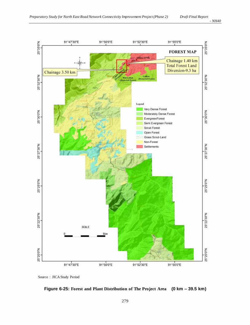
Preparatory Study for North East Road Network Connectivity Improvement Project (Phase 2) Draft Final Report - NH40
279
Source:JICA Study Period
Figure 6-25: Forest and Plant Distribution of The Project Area (0 km – 39.5 km)

Preparatory Study for North East Road Network Connectivity Improvement Project (Phase 2) Draft Final Report - NH40
280
Source:JICA Study Period
Figure 6-26: Forest and Plant Distribution of The Project Area (39.5 km – 71.5 km)
Preparatory Study for North East Road Network Connectivity Improvement Project (Phase 2) Draft Final Report - NH40
281
iii) Forest Species
The Forest and Environment Department of Meghalaya classified the forests in the state into six types. A
growing stock for each of the forest types which is defined below has been presented in the report. The
six forest types have been identified on the basis of economically important tree species.
a. Khasi Pine Forest Forest where Khasi pine constitutes more than 50% of the stand.
b. Teak Forest – Forest in which Teak trees constitute more than 20% of the stand.
c. Sal Forests Forest in which Sal trees constitute more than 20% of the stand.
d. Hardwood Mixed with Conifers – Forest where the Conifers and broadleaved tree species
exist in equal proportions.
e. Upland hardwood – Forest above 1000 m altitude with predominance of hardwood species.
f. Miscellaneous – Forest which does not belong to any of the above types.
iv) Plant Distribution of the Project Area
The following tables give a summary of the growing stock for each of the forests.
There are a number of forested areas known as the “Sacred Forest” in East Khasi Hill. A clan in the
project area generally forming a village owns each “Sacred Forest”. However, based on the hearing
survey, there is no “Sacred Forest” that is directly affected by the project.
The widening of NH40 involves the construction of a number of shortcuts in order to ease vehicle
movements and avoid traffic congestions. Where bypasses are inserted, built-up areas are avoided to
minimize unwanted resettlements. Due to these improvements of NH40, the existing flora and fauna
along the highway is assessed to see if protected species or any other important species are adversely
affected. Table 7-26 to Table 6-34 show the major plant species of Meghalaya state.

Preparatory Study for North East Road Network Connectivity Improvement Project (Phase 2) Draft Final Report - NH40
282
Table 6-26: Major Tree Species in Meghalaya State
Source: Forest and Environment Department, Government of Meghalaya
Table 6-27: General Tree Species
Sl. No. Scientific Name Family
1. Lannea coromandelica Anacardiaceae
2. Mangifera indica Anacardiaceae
3. Spondias piñata Anacardiaceae
4. Spondisas axillaris Anacardiaceae
5. Areca catechu Arecaceae
6. Caryota urens Arecaceae
7. Bombax ceiba Bombacaceae
8. Calophyllum polyanthium Clusiaceae

Preparatory Study for North East Road Network Connectivity Improvement Project (Phase 2) Draft Final Report - NH40
283
9. Anogeissus acuminata Combretaceae
10. Terminalia bellirica Combretaceae
11. Terminalia myriocarpa Combretaceae
12. Dillenia pentagyna Dilleniaceae
13. Shorea robusta Dipterocarpaceae
14. Glochidion arborescens Euphorbiaceae
15. Albizia chinensis Fabaceae
16. Albizia lebbeck Fabaceae
17. Albizia odoratissima Fabaceae
18. Albizia procera
Fabaceae
19. Bauhinia variegata Fabaceae
20. Erythrina arborescens Fabaceae
21. Erythrina stricta Fabaceae
22. Persea parviflora Lauraceae
23. Careya arborea Lecythidaceae
24. Logerstroemia parviflora Lythraceae
25. Melia azedarach Meliaceae
26. Artocarpus chaplasha Moraceae
27. Artocarpus gameziana Moraceae
28. Artocarpus heterophyllus
Moraceae
29. Ficus amplissima Moraceae
30. Ficus semicordata Moraceae
31. Morus laevigatus Moraceae
32. Syzygium grande Myrtaceae
33. Pinus kesiya Pinaceae
34. Podocarpus nerifolia Podocarpaceae
35. Neolamarckia cadamba Rubiaceae
36. Citrus grandis Rutaceae
37. Sterculia villosa Sterculiaceae
38. Callicarpa arborea Verbenaceae
39. Callicarpa tomentosa Verbenaceae
40. Premna milliflora Verbenaceae
41. Tectona grandis Verbenaceae
42. Vitex peduncularis Verbenaceae
Source: Forest and Environment Department, Government of Meghalaya

Preparatory Study for North East Road Network Connectivity Improvement Project (Phase 2) Draft Final Report - NH40
284
Table 6-28: Scrub Species
Sl. No. Scientific Name Family
1. Mimosa himalayana Fabaceae
2. Bauhinia acuminata Leguminosae
3. Ficus tinctoria Moraceae
4. Canthium gracillepes Rubiaceae
5. Glycosmis mauritiana Rutaceae
6. Brugmansia suaveolens Solanaceae
7. Solanum kurzii Solanaceae
8. Symplocos chinensis Symplocaceae
9. Daphne cannabina Thymelaeaceae
10. Clerodendron serratum Verbenaceae
11. Clerodendron viscosum Verbenaceae
12. Duranta plumerii Verbenaceae
13. Duranta repens Verbenaceae
14. Leea indica Vitaceae
Source: Forest and Environment Department, Government of Meghalaya
Table 6-29: Herb Species
Sl. No. Scientific Name Family
1. Adhatoda vasica Acanthaceae
2. Androgrophis wrightiana Acanthaceae
3. Justicia simplex Acanthaceae
4. Achyranthes aspera Amaranthaceae
5. Alternanthera sessilis Amaranthaceae
6. Amaranthus spinosus Amaranthaceae
7. Hydrocotyl javanica Apiaceae
8. Acorus calamus Araceae
9. Alocasia acuminate Araceae
10. Arisema tortuosum Araceae
11. Aegyratum conyzoides Asteraceae
12. Artemesia parviflora Asteraceae
13. Blumea heiracifolia Asteraceae
14. Eclipta prostrata Asteraceae
15. Mikania scandens Asteraceae
16. Xantihum strumarium Asteraceae
17. Sonchus aspera Asteraceae

Preparatory Study for North East Road Network Connectivity Improvement Project (Phase 2) Draft Final Report - NH40
285
18. Vernonia cineria Asteraceae
19. Chenopodium album Chenopodiaceae
20. Commelina paludosa Commelinaceae
21. Ipomoea linifolia Convolvulaceae
22. Ipomoea carnea Convolvulaceae
23. Euphorbia hirta Euphorbiacea
24. Phyllanhus fraternus Euphorbiaceae
25. Croton bonplandianum Euphorbiaeae
26. Cassia tora Fabaceae
27. Mucuna pruriens Fabaceae
28. Desmodium concenum Fabaceae
29. Flemingia involucrata Fabaceae
30. Anisomeles indica Lamiaceae
31. Hyptis suaveolens Lamiaceae
32. Leucas aspera Lamiaceae
33. Pogostemon benghalensis Lamiaceae
34. Polygonum barbatum Polygonaceae
35. Polygonum hydropiper Polygonaceae
36. Hedyotis auriculata Rubiaceae
37. Hedyotis diffusa Rubiaceae
38. Clerodendron nutans Verbenaceae
39. Phyla nodiflora Verbenaceae
40. Costus speciosus Zingiberaceae
41. Zingiber zerumbet Zingiberaceae
Source: Forest Department, field study and public consultation
Table 6-30: Grass Species
Sl. No. Scientific Name Family
1. Cyperus diffusus Cyperaceae
2. Cyperus distans Cyperaceae
3. Cyperus rotundus Cyperaceae
4. Fimbristylis dichotoma Cyperaceae
5. Kyllinga bulbosa Cyperaceae
6. Cynodon barberi Poaceae
7. Cynodon dactylon Poaceae
8. Eragrostis gangetica Poaceae
9. Eragrostis nutans Poaceae

Preparatory Study for North East Road Network Connectivity Improvement Project (Phase 2) Draft Final Report - NH40
286
10. Heteropogon contortus Poaceae
11. Ischaemum rugosum Poaceae
12. Oplismenus compositus Poaceae
13. Panicum notatum Poaceae
14. Panicum repens Poaceae
15. Thysanolaena maxima Poaceae
Source: Forest Department, field study and public consultation
Table 6-31: Bamboo Species
Sl. No. Scientific Name Family
1. Bambusa arundinacea Poaceae
2. Bambusa pallida
3. Bambusa tulda
4. Dendrocalamus strictus
Source: Forest Department, field study and public consultation
Table 6-32: Orchid Species
Sl. No. Scientific Name Family
1. Cymbidium elegans Orchidaceae
2. Dendrobium herbaceum
3. Habenaria commelinifolia
4. Nervilia prainiana
5. Vanda tessellata
Source: Forest Department, field study and public consultation
Table 6-33: Bryophytes Species
Sl. No. Scientific Name Taxonomic Category
1. Anthoceros fusiformis Anthocerotopsida
2. Anthoceros laevis Anthocerotopsida
3. Bryum apiculatum Bryopsida
4. Polytrichum xanthopilum Bryopsida
5. Riccia discolor Hepaticopsida
6. Riccia melanospora Hepaticopsida
7. Marchantia polymorpha Marchantia
Source: Forest Department, field study and public consultation

Preparatory Study for North East Road Network Connectivity Improvement Project (Phase 2) Draft Final Report - NH40
287
Table 6-34: Pteridophyte Species
Sl. No. Scientific Name Taxonomic Category
1. Adiantum caudatum Maiden Hair Fern
2. Adiantum pedatum Maiden Hair Fern
3. Azolla pinnata Aquatic fern
4. Botrychium virginianaum Moonwort fern
5. Drynaria mollis Polypodiaceae fern
6. Equisetum diffusum Horse tails
7. Equisetum sylvaticum Horse tails
8. Gleichenia linearis Wild fern
9. Lycopodium cernum Lycopodium
10. Marsilea hirsuta Aquatic fern
11. Marsilea minuta Aquatic
12. Ophioglossum nudicaule Ophioglossum nudicaule
13. Pteris cretica
14. Salvinia auriculata Aquatic fern
Source: Forest Department, field study and public consultation
2) Fauna of the Project Area
Table 6-35 to Table 6-38 shows common wildlife species known to exist in Meghalaya State. In the area
of East Khasi Hills as a whole, there is a number of wildlife known to exist such as Hoolock, Golden Cat,
Leopard Cat, Jungle Cat, Indian Civet, Binturong or Bear Cat, Himalayan Black Bear, Barking Deer and
Pangolin. However, there was no information from the local residents about observing any of them during
the past few decades.
A study and survey of birds (resident, migratory), land animals including mammals, reptiles and insects
and aquatic flora and fauna including fish species was undertaken during the study period. There are no
large game animals such as deer and hence there is no hunting of animals. None of the species observed
in the ROW is reported to be rare, endangered, endemic or threatened species. Though more than 110
mammal species are reported from the Meghalaya Forests, none is endemic to the state. There are no
national parks or sanctuaries or biosphere reserves or other protected areas within the study area.
As far as the larger vertebrates including carnivores and reptiles are concerned, the data is based mainly
on secondary sources corroborated by local residents. Birds have studied using binoculars and interactions
with local people. Fauna of Meghalaya (Volume I and II) published by the Zoological Society of India,
Meghalaya Flora and Fauna by the Directorate of Information and Public relations, Government of
Meghalaya, and published scientific reports have been used as references.
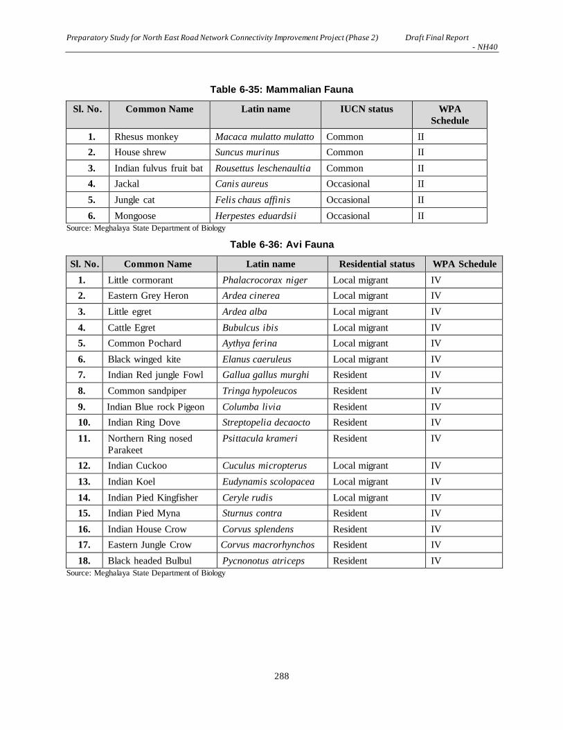
Preparatory Study for North East Road Network Connectivity Improvement Project (Phase 2) Draft Final Report - NH40
288
Table 6-35: Mammalian Fauna
Sl. No. Common Name Latin name IUCN status WPA
Schedule
1. Rhesus monkey Macaca mulatto mulatto Common II
2. House shrew Suncus murinus Common II
3. Indian fulvus fruit bat Rousettus leschenaultia Common II
4. Jackal Canis aureus Occasional II
5. Jungle cat Felis chaus affinis Occasional II
6. Mongoose Herpestes eduardsii Occasional II
Source: Meghalaya State Department of Biology
Table 6-36: Avi Fauna
Sl. No. Common Name Latin name Residential status WPA Schedule
1. Little cormorant Phalacrocorax niger Local migrant IV
2. Eastern Grey Heron Ardea cinerea Local migrant IV
3. Little egret Ardea alba Local migrant IV
4. Cattle Egret Bubulcus ibis Local migrant IV
5. Common Pochard Aythya ferina Local migrant IV
6. Black winged kite Elanus caeruleus Local migrant IV
7. Indian Red jungle Fowl Gallua gallus murghi Resident IV
8. Common sandpiper Tringa hypoleucos Resident IV
9. Indian Blue rock Pigeon Columba livia Resident IV
10. Indian Ring Dove Streptopelia decaocto Resident IV
11. Northern Ring nosed
Parakeet
Psittacula krameri Resident IV
12. Indian Cuckoo Cuculus micropterus Local migrant IV
13. Indian Koel Eudynamis scolopacea Local migrant IV
14. Indian Pied Kingfisher Ceryle rudis Local migrant IV
15. Indian Pied Myna Sturnus contra Resident IV
16. Indian House Crow Corvus splendens Resident IV
17. Eastern Jungle Crow Corvus macrorhynchos Resident IV
18. Black headed Bulbul Pycnonotus atriceps Resident IV
Source: Meghalaya State Department of Biology

Preparatory Study for North East Road Network Connectivity Improvement Project (Phase 2) Draft Final Report - NH40
289
Table 6-37: Reptilian Fauna
Sl. No. Common Name Latin name IUCN status WPA
Schedule
1. Garden Lizards Calotes versicolor Common IV
2. Lizards Gecko gecko Common II
3. House Gecko Hemidactylus brooki Common II
4. Common skink Mabuya craniata Common IV
5. Rat snake Ptyas korros Common II
6. Banded Krait Bungarus fasciatus Scarce II
7. Checkered keel-back Natrix piscator Occasional IV
Source: Meghalaya State Department of Biology
Table 6-38: Fishes (Pisces)
Sl. No. Latin name Common name Local name
(Khasi)
Status
1. Cirrhinus mrigala Mrigala Kha mirka Very common
2. Cyprinus carpio Carp Kha dkhar Very common
3. Labeo bata Major Carp Kha bah Common
4. Labio rohita Rohu Very common
5. Barilius barila Kha Ilong Common
6. Mystus vittatus Kha tynkriong Very Common
7. Anabas testudineus Kha Koi Scarce
8. Channa orientalis Dohthli Common
9. Puntius chola Climbing Perch Shalynni Common
Source: Meghalaya State Department of Biology
2) Wildlife Reserves/Sanctuaries
Environmental Information System (ENVIS)of India is sponsored by MOEFCC and in collaboration with
Birlife International, it has listed up a number of important wildlife areas including “Upper Shillong
Important Bird Area”, which is approximately 1,248 ha wide. As is shown in Figure 7-26, there is an
“Important Bird Area (IBA)” next to the project area.
Within the IBA, there is a protected forest administered by Meghalaya State Department of Environment
and Forestry. The area is 766 ha and within this forest Buass No.1 is inserted that it requires 9.3 ha of
forest land area subject to clearing.
There is no formally declared by the Government of India wildlife reserve or sanctuary.
3) Vulnerable Species of the Project Area
As is shown in Figure 7-27, Bird Life International (http://www.birdlife.org) reports that there is an
Important Bird Area of “Tawny-breasted Wren-babbler (Spelaeornis longicaudatus)” in Meghalaya state.
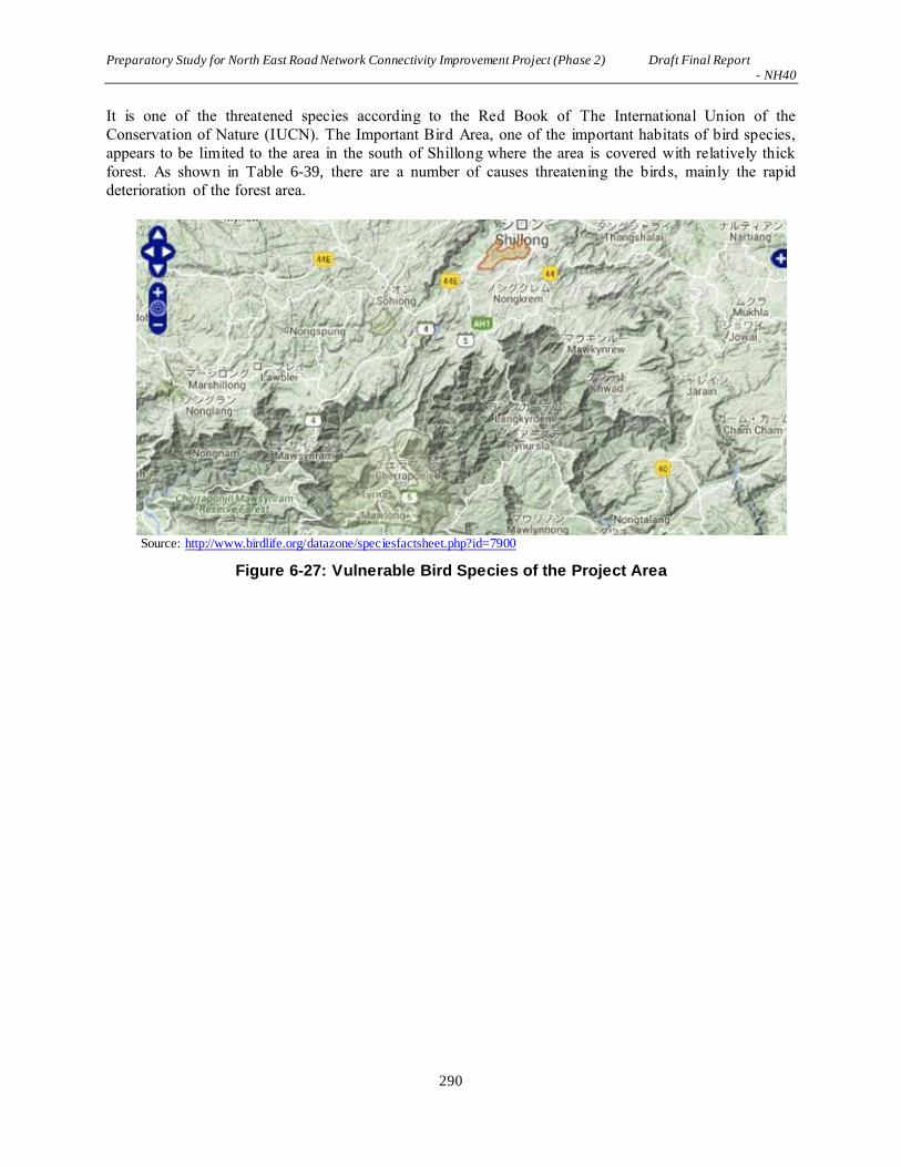
Preparatory Study for North East Road Network Connectivity Improvement Project (Phase 2) Draft Final Report - NH40
290
It is one of the threatened species according to the Red Book of The International Union of the
Conservation of Nature (IUCN). The Important Bird Area, one of the important habitats of bird species,
appears to be limited to the area in the south of Shillong where the area is covered with relatively thick
forest. As shown in Table 6-39, there are a number of causes threatening the birds, mainly the rapid
deterioration of the forest area.
Source: http://www.birdlife.org/datazone/speciesfactsheet.php?id=7900
Figure 6-27: Vulnerable Bird Species of the Project Area

Preparatory Study for North East Road Network Connectivity Improvement Project (Phase 2) Draft Final Report - NH40
291
Table 6-39: Causes of the Threats to the “Tawny-breasted Wren-babbler”
Source: http://www.birdlife.org/datazone/speciesfactsheet.php?id=7900
While Meghalaya state controls 4.4 % of the forest area in the state, local tribes control most of the forest
area. Because of the rapid deterioration of their habitat, logging has been ceased since 2009. Based on the
2016 observation of Bird Life International (http://www.birdlife.org), the current habitat of “Tawny-
breasted Wren-babbler (Spelaeornis longicaudatus)” along with other bird species appears to have been
concentrating in the area in the south of Meghalaya state as shown in Figure 7-28. The habitat spans over
NH40. Since transportation development appears to be causing habitat deterioration within 4 years as per
Table 6-39, the habitat of “Tawny-breasted Wren-babbler (Spelaeornis longicaudatus)” could
continuously be affected.

Preparatory Study for North East Road Network Connectivity Improvement Project (Phase 2) Draft Final Report - NH40
292
Source: http://www.birdlife.org/datazone/species/factsheet/22716137
Figure 6-28: Vulnerable Bird Species of the Project Area
(2) Anticipated impacts and Mitigation Measures
1) Geography/ Geomorphology
Impacts
There is no significant impact caused by the project for geographyc and/geomorphological changes.
However, a number of cut and fill slopes are created. Most of them are within the range of 5 m high at
locations where geometry of road alignment is improved. Some of the cut and fill can go up to 20 m high
at locations where bypass roads are inservet. At these places, permanent changes of geographic conditions
should take place.
Mitigation Measures
During the construction period, protection measures agains heavy rains should be provided as much as
possible in order to avoid soil erosion, natural disaster and deterioration of the cut and fill slopes.
Upon commencement of the operation and maintenance, slope protection measures should stabilize the
changed geographical conditions over time.
2) Hydrogeography
Impacts
During the construction period, temporary diversion or blockade of the rivers, streams or agricultural
canals are implemented in order to construct road and its structures such as bridges, culverts and side
ditches. Protection measures are always provided to these areas in order to avoid soil erosion, accidental
changes of topography as well as the natural disasters.

Preparatory Study for North East Road Network Connectivity Improvement Project (Phase 2) Draft Final Report - NH40
293
Mitigation Measures
While during the construction period, protection provided to each construction area should prevent any
accidents and unwanted changes of hydrogeography.
During the operation and maintenance period, not changes of hydrogeography takes place i.e. mitigation
measures is not necessary.
3) Ecological Conditions/Biological Diversity
Impacts
No significant wildlife species including bird species or plants and trees of any ecological values are
observed during the study period. On ther other hand, while the local residents are banned from logging
and shifting agriculture, the project has to clear relatively large area of forest. This should create some
questions on the socio-ecological issues.
Mitigation Measures
Afforestation program is carried out in order to rejuvenate the forest area lost for the project. Monitoring
of the ecologican conditions for elaboration of further mitigation measures should be carried out.
4) Climatic Conditions
Impacts
No significant climatic conditions should take place as a result of the implementation o the project.
However, because of the road construction project itself emit greenhouse gas, it causes to a certain extent
causes global changes of the climate.
Mitigation Measures
Afforestation program is carried out in order to help fighting to reduce atmospheric temperatures of
global warming. It aso rejuvenate the forest area lost for the project. Monitoring of the ecologican
conditions for elaboration of further mitigation measures should be carried out.
5) Soil Erosion
Impacts
There is no significant impact on the soil within the project area. However, as stated above, a number of
cut and fill slopes are created causing certain amount of soil erosion on each construction area. Most of
them are within the range of 5 m high at locations where geometry of road alignment is improved. Some
of the cut and fill can go up to 20 m high at locations where bypass roads are inservet. At these places,
permanent changes of geographic conditions should take place.
Mitigation Measures
During the construction period, protection measures agains heavy rains should be provided as much as
possible in order to avoid soil erosion, natural disaster and deterioration of the cut and fill slopes.
Upon commencement of the operation and maintenance, slope protection measures should stabilize the
changed geographical conditions over time.
6) Ground Water
Impacts
There is no contamination of grund water during the construction period as well as the operation and
maintenance period.

Preparatory Study for North East Road Network Connectivity Improvement Project (Phase 2) Draft Final Report - NH40
294
7) Forest
Impacts
In terms of the impacts on the natural environment, the most significant impacts caused by the project is
the permanent loss of 123 ha of the existing forest area as is shown in Table 6-40. The project area goes
through habitat of bird species such as “Tawny-breasted Wren-babbler (Spelaeornis longicaudatus)”, one
of the vulnerable species.
Bypass No.1 subject to inserting into the Meghalaya State’s protected forest has to clear 9.3 ha of forest
mainly of Kashi Pine forest. It is inside the “Upper Shillon Protected Forest. This is also an “Important
Bird Area”, which, as stated above, ENVIS Centre on Wildlife and Protected Area and Birdlife
International asserts that the area next to NH-40 on the northern slope of Khasi Hills is an “Important
Bird Area” for the indigenous birds including “Tawny-breasted Wren-babbler (Spelaeornis
longicaudatus)”. Thus it is the area most significantly affected by the Project.
Bypass No.6 has to cut through very thick riparian forest and approximately 35 ha of forest area has to be
cleared for the Project. This is also an important area of which such thick forest area would contribute to
function as carbon sequestration area for fighting against global warming.
The Government of India will thoroughly examine the area of forest subject to clearing and that it
demands to plant trees for which the area of afforestation should be the same as the forest area subject to
clearing. As is explained in the Section 7.3.5, Meghalaya State Forest Department examines the area of
forest subject to clearing while at the same time it designates the area of afforestation. By the same token,
it would be the measures to mitigate the loss of forest subject to clearing for the Project.
Table 6-40: Forest Areas Subject to Clearance by The Project
Source: JICA Study Team
Mitigation Measures
Because of the significant loss of forested area, the same area of afforestation program has to be carried
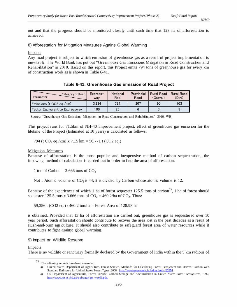
Preparatory Study for North East Road Network Connectivity Improvement Project (Phase 2) Draft Final Report - NH40
295
out and that the progress should be monitored closely until such time that 123 ha of afforestation is
achieved.
8) Afforestation for Mitigation Measures Agains Global Warming
Impacts
Any road project is subject to which emission of greenhouse gas as a result of project implementation is
inevitable. The World Bank has put out “Greenhouse Gas Emissions Mitigation in Road Construction and
Rehabilitation” in 2010. Based on this report, this Project emits 794 tons of greenhouse gas for every km
of construction work as is shown in Table 6-41.
Table 6-41: Greenhouse Gas Emission of Road Project
Source: “Greenhouse Gas Emissions Mitigation in Road Construction and Rehabilitation” 2010, WB
This project runs for 71.5km of NH-40 improvement project, effect of greenhouse gas emission for the
lifetime of the Project (Estimated at 10 years) is calculated as follows:
794 (t CO2 eq./km) x 71.5 km = 56,771 t (CO2 eq.)
Mitigation Measures
Because of afforestation is the most popular and inexpensive method of carbon sequestration, the
following method of calculation is carried out in order to find the area of afforestation.
1 ton of Carbon = 3.666 tons of CO2
Not:Atomic volume of CO2 is 44; it is divided by Carbon whose atomic volume is 12.
Because of the experiences of which 1 ha of forest sequester 125.5 tons of carbon23, 1 ha of forest should
sequester 125.5 tons x 3.666 tons of CO2 = 460.2/ha of CO2. Thus:
59,356 t (CO2 eq.) / 460.2 ton/ha = Forest Area of 128.98 ha
is obtained. Provided that 13 ha of afforestation are carried out, greenhouse gas is sequestered over 10
year period. Such afforestation should contribute to recover the area lost in the past decades as a result of
slush-and-burn agriculture. It should also contribute to safeguard forest area of water resources while it
contributes to fight against global warming.
9) Impact on Wildlife Reserve
Impacts
There is no wildlife or sanctuary formally declared by the Government of India within the 5 km radious of
23 The following reports have been consulted.
3) United States Department of Agriculture, Forest Service, Methods for Calcu lating Forest Ecosystem and Harvest Carbon with
Standard Estimates for United States Forest Types, 2006, http://www.treesearch.fs.fed.us/pubs/22954.
4) US Department of Agriculture, Forest Serv ice, Carbon Storage and Accumulation in United States Forest Ecosystems, 1992,
http://www.nrs.fs.fed.us/pubs/gtr/gtr_wo059.pdf.

Preparatory Study for North East Road Network Connectivity Improvement Project (Phase 2) Draft Final Report - NH40
296
the project area. However, ENVIS Centre on Wildlife and Protected Area and Birdlife International
jointly listed up a number of important bird areas. One of them is “Upper Shillong Important Bird Area”
that NH-40 borders a portion of the bird area. It is a habitat of a large number of indigenous birds
including “Tawny-breasted Wren-babbler (Spelaeornis longicaudatus)”, one of the vulnerable species
listed by IUCN as VU (vulnerable) species.
Within this area, Meghalaya State Department of Environment and Forest maintains “Upper Shillong
Protected Forest” of 766 ha, within which Bypass No.1 has to go through and 9.3 ha of protected forest
has to be cleared.
Mitigation Measures
Because of a large forested area is lost for ROW of the road construction project as well as the road
construction project as being one of the greenhouse gas emitter, compensatory afforestation program in
total of 253 ha should be considered as mitigation measures.
10) Impacts on Wildlife
Impacts
As is shown in Figure 7-31, Birdlife International asserts that an area on the north slope of Khasi Hills
that is facing Shillong City is an Important Bird Area (IBA). The area is to the east of NH-40 from 0 km
to 6 km post. IUCN declares that “Tawny-breasted Wren-babbler (Spelaeornis longicaudatus)” is
vulnerable species that are very likely to inhibit in the area. The Government of India does not officially
declare the area as wildlife or bird sanctuary. However, it appears to be ecologically sensitive area
adjacent to the project area.
As is shown in Figure 7-32, almost a half of southern region of Meghalaya State is the area of birdlife
including “Tawny-breasted Wren-babbler (Spelaeornis longicaudatus)”. The entire project area goes
through this birdlife area and a total of 123 ha of forested areas are subject to clearing.
11) Landscape
Impacts
While the landscape viewed along NH-40 itself remains intact, there are a number of landscape
viewpoints created for tourism purposes. These areas are generally “landscaped area” where parking
place, safety rails, teahouses, etc. During the construction period, these viewpoints are closed temporarily
for construction works.
Mitigation Measures
Viewpoints are generally closed during the construction period while in the operation and maintenance
period, all of the viewpoints are open for the general public.
6.7.3 Major Impacts on Living Environment
(1) Survey Results
1) Ambient air quality
Ambient air sampling was carried out during May – June 2016 at nine locations along the project area. The
results are presented in Table 6-42. Comparative charts for various ambient air quality parameters are
presented from Figure 7-29 to Figure 7-33. Measured values are 24 hour values. Thus, based on National
Ambient Air Quality Standard (NAAQS), tandard values of CO2: 80μg/m3, NOx: 80μg/m3, PM10: 100
μg/m3, PM2.5: 60μg/m3 have been compared with the measured values. As a result all of the measured
values of the project study is lower than the values of standard.

Preparatory Study for North East Road Network Connectivity Improvement Project (Phase 2) Draft Final Report - NH40
297
Table 6-42: Ambient Air Quality of the Project Area
Dwaki near PWD guest house (Latitude 250 11' 98.0" & Longitude 920 01' 11.4")
PM2.5,µg/m3 PM10,µg/m3 SO2 µg/m3 , NOx ,µg/m3 CO, µg/m3
Min 29.8 65.6 5.6 10.5 910
Max 44.5 90.8 7.8 14.4 1140
Average 38.1 81.0 6.7 11.8 1021.3
Pomshutia village (Latitude 250 12' 49.4" & Longitude 910 52' 46.5")
PM2.5,µg/m3 PM10,µg/m3 SO2 µg/m3 , NOx ,µg/m3 CO, µg/m3
Min 18.5 44.5 4.8 9.5 280
Max 22.8 60.8 7.7 12.8 440
Average 21.3 52.9 6.6 11.4 361.7
Nongshyrngan Village (Latitude 250 15' 29.4" & Longitude 910 56' 54.8")
PM2.5,µg/m3 PM10,µg/m3 SO2 µg/m3 , NOx ,µg/m3 CO, µg/m3
Min 20.5 46.4 5 9.4 430
Max 25.9 66.8 7.8 13.6 640
Average 23.2 53.7 6.7 11.7 546.7
Penursla Town (Latitude 250 18' 19.7" & Longitude 910 54' 39.3")
PM2.5,µg/m3 PM10,µg/m3 SO2 µg/m3 , NOx ,µg/m3 CO, µg/m3
Min 25.4 55.6 6.1 10.6 740
Max 35.6 80.6 8.8 15.5 990
Average 29.4 67.1 7.2 12.4 886.3
Wahlyngkhat School (Latitude 250 20' 11.1" & Longitude 910 53' 20.5")
PM2.5,µg/m3 PM10,µg/m3 SO2 µg/m3 , NOx ,µg/m3 CO, µg/m3
Min 20.5 47.6 5.8 9.6 480
Max 25.9 61.2 8.8 15.2 650
Average 23.2 53.6 7.0 12.2 593.3
Laitngkot Village (Latitude 250 26' 25.2" & Longitude 910 50' 47.9")
PM2.5,µg/m3 PM10,µg/m3 SO2 µg/m3 , NOx ,µg/m3 CO, µg/m3
Min 18.8 48.4 5.5 8.1 330
Max 25.5 64.8 8.1 10.5 560
Average 20.9 53.8 6.4 9.1 458.8
Umtyngar Village (Latitude 250 29' 37.8" & Longitude 910 49' 07.9")
PM2.5,µg/m3 PM10,µg/m3 SO2 µg/m3 , NOx ,µg/m3 CO, µg/m3
Min 18.3 50.3 5.2 10.2 450
Max 21.9 62.7 8.9 13.5 650
Average 20.3 55.6 7.0 11.7 583.3
Polum School (Latitude 250 31' 47.5"& Longitude 910 48' 38.8")
PM2.5,µg/m3 PM10,µg/m3 SO2 µg/m3 , NOx ,µg/m3 CO, µg/m3
Min 19.4 65.6 6 9.8 650
Max 27.8 85.2 8.4 14.6 990
Average 23.4 74.6 7.1 11.8 872.1
Rilban point (Latitude 250 34' 16.0"& Longitude 910 52' 07.4")
PM2.5,µg/m3 PM10,µg/m3 SO2 µg/m3 , NOx ,µg/m3 CO, µg/m3
Min 30.6 66.7 5.4 8.9 810
Max 42.5 95.6 8.8 15.2 1180
Average 37.9 83.1 6.9 12.1 989.2 Source: Field monitoring from May-June, 2016, JICA Study Team

Preparatory Study for North East Road Network Connectivity Improvement Project (Phase 2) Draft Final Report - NH40
298
Source: Field monitoring from May-June, 2016, JICA Study Team
Figure 6-29: Ambient Air Quality (PM 2.5) of the Project Area
Source: Field monitoring from May-June, 2016, JICA Study Team
Figure 6-30: Ambient Air Quality (PM10) of the Project Area
010203040506070
Co
nce
ntr
atio
n in
(µg/
m3
)
Ambient Air Monitoring Locations
Ambient Air Quality (PM 2.5) along NH40 from Shillong to Dawki Road
Min
Max
Average
020406080
100120
Co
nce
ntr
ati
on
in
(µg/
m3
)
Ambient Air Monitoring Locations
Ambient Air Quality (PM10) along NH40 from Shillong to Dawki Road
Min
Max
Average

Preparatory Study for North East Road Network Connectivity Improvement Project (Phase 2) Draft Final Report - NH40
299
Source: Field monitoring from May-June, 2016, JICA Study Team
Figure 6-31: Ambient Air Quality (SO2) of the Project Area
Source: Field monitoring from May-June, 2016, JICA Study Team
Figure 6-32: Ambient Air Quality (NOX) of the Project Area
0102030405060708090
Co
nce
ntr
atio
n in
(µg/
m3
)
Ambient Air Monitoring Locations
Ambient Air Quality (SO2) along NH40 from Shillong to Dawki Road
Min
Max
Average
0102030405060708090
Co
nce
ntr
atio
n in
(µg/
m3
)
Ambient Air Monitoring Locations
Ambient Air Quality (NOX) along NH40 from Shillong to Dawki Road
Min
Max
Average

Preparatory Study for North East Road Network Connectivity Improvement Project (Phase 2) Draft Final Report - NH40
300
Source: Field monitoring from May-June, 2016, JICA Study Team
Figure 6-33: Ambient Air Quality (Carbon Monoxide) of the Project Area
The Meghalaya Pollution Control Board periodically measures the air quality at Shillong (Police Bazar),
which is approximately 3 km to the east of the 0 km point of the project. The study team measured the
ambient air quality along the project area at 9 locations and the measured values are well within the limits
described in the standards set by CPCB.
2) Water Quality
There are no major pollution sources such as chemical factories, oil / coal burning thermal power
generators, etc., along the project area. Thus the water quality along NH40 is generally good. As a matter
of conducting a standardized environmental study, however, monitoring of the water quality has been
carried out at nine locations from May-June, 2016 in accordance to the Indian Standard Drinking Water
Specification – IS 10500: 1991. The results of water monitoring tests are presented in Table 6-43 to Table
6-45.
0500
10001500200025003000350040004500
Co
nce
ntr
atio
n in
(µg/
m3
)
Ambient Air Monitoring Locations
Ambient Air Quality (Carbon Monoxide) along NH40 from Shillong to Dawki Road
Min
Max
Average

Preparatory Study for North East Road Network Connectivity Improvement Project (Phase 2) Draft Final Report - NH40
301
Table 6-43: Water Quality of the Project Area: 0 km – 23 km
Source: Field monitoring from May-June, 2016, JICA Study Team

Preparatory Study for North East Road Network Connectivity Improvement Project (Phase 2) Draft Final Report - NH40
302
Table 6-44: Water Quality of the Project Area: 23 km – 46 km
Source: Field monitoring from May-June, 2016, JICA Study Team

Preparatory Study for North East Road Network Connectivity Improvement Project (Phase 2) Draft Final Report - NH40
303
Table 6-45: Water Quality of the Project Area: 46 km – 75 km
Source: Field monitoring from May-June, 2016, JICA Study Team
Water quality data measured by the Meghalaya Pollution Control Board (MPCB) is available for pH DO,
BOD and total coliform for various water bodies while the study team monitored other parameters along
the project area. In general, the coliform value were found to be on the high side in the case of surface
water and needs treatment before use as drinking water if so desired.

Preparatory Study for North East Road Network Connectivity Improvement Project (Phase 2) Draft Final Report - NH40
304
3) Soil Analysis
Analysis of the soil quality has been carried out at nine identified locations during May-June, 2016 in
accordance to the Indian Standard. Result of Soil monitoring are presented in Table 6-46 to Table 6-48 エ
ラー! 参照元が見つかりません。.
Table 6-46: Soil Analysis of the Project Area
Source: JICA Study Team

Preparatory Study for North East Road Network Connectivity Improvement Project (Phase 2) Draft Final Report - NH40
305
Table 6-47: Soil Analysis of the Project Area
Source: JICA Study Team

Preparatory Study for North East Road Network Connectivity Improvement Project (Phase 2) Draft Final Report - NH40
306
Table 6-48: Soil Analysis of the Project Area
Source: JICA Study Team
3) Noise Levels
Monitoring of noise levels was carried out at nine locations along the project area from May-June, 2016 at
the same time that the ambient air quality standard was carried out. The noise levels found along the
project area with reference to the Noise Standard of India 2000 are presented in Table 6-49 and the
location-wise comparative chart for noise levels are presented in Figure 6-34.

Preparatory Study for North East Road Network Connectivity Improvement Project (Phase 2) Draft Final Report - NH40
307
Table 6-49: Noise Levels along NH40 from Shillong to Dawki Road
No
Location
ZONE
Standard
(Leq, dB)
Observed value
(Leq, dB)
DAY NIGHT DAY NIGHT
1
Rilban point (Latitude 25
0 34
' 16.0
" &
Longitude 910 52
' 07.4
")
Commercial Zone
65 55 61.8 47.6
2
Polum School (Latitude 25
0 31
' 47.5
" &
Longitude 910 48
'38.8
")
Sensitive Zone
50 40 48.5 37.2
3
Utmyngar Village (Latitude 25
0 29
' 37.8s
& Longitude 910 49
'
07.9s)
Commercial Zone
65 55 58.4 36.4
4
Laitngkot Village
(Latitude 250 26
' 25.2
"
& Longitude 910 50
'
47.9")
Residential
Zone
55 45 52.6 38.5
5
Wahlyngkhat School (Latitude 25
0 20
'11.1
" &
Longitude 910 53
' 20.5
")
Sensitive Zone
50 40 47.5 36.2
6
Penursla Town (Latitude 25
0 18
' 19.7
" &
Longitude 910 54
' 39.3
")
Commercial Zone
65 55 62.4 53.6
7
Nongshyrngan Village (Latitude 25
015
'29.4
"&
Longitude 91056
'54.
")
Residential Zone
55 45 50.8 37.4
8
Pomshutia village (Latitude 25
0 12
' 49.4
"
& Longitude 910 52
'
46.5")
Commercial Zone
65 55 63.5 48.3
9
Dwaki near PWD guest
house (Latitude 250 11
'
98.0" & Longitude 92
0
01' 11.4
")
Residential
Zone
55 45 52.2 40.8
Source: Field monitoring from May-June, 2016, JICA Study Team
There is no regulation in India regarding vibrations for road projects. Therefore, data on vibration was not
measured and is not applicable to the project as excessively heavy vehicles are not expected to run along
the NH40.

Preparatory Study for North East Road Network Connectivity Improvement Project (Phase 2) Draft Final Report - NH40
308
Source: Field monitoring from May-June, 2016, JICA Study Team
Figure 6-34: Ambient Noise Quality Results
4) Traffic Vibration
The Government of India has adapted “ISO 4866: 1990 Mechanical vibration and shock-Vibration of
buildings-Guidelines for the measurement of vibrations and evaluation of their effects on buildings” as
Indian Standard.
Vibration is usually associated with noise. There is a noise emanation standard put out by CPCB while
there is no such standard of vibration. On the other hand, if there was a complaint on the vibration, the
current standard of noise in India could be used as an indicator of vibration, generally coming from the
on-going traffic in relation to the case of road construction project.
As is shown in Table 6-50, there is a standard of noise limit that the complaint could be made by the
general public in Japan. Thus this is the standard value for which traffic vibration has to be investigated if
the level of noise should exceed the indicated values.
Within the framework of the Project, traffic vibration as “Man-made Vibration” is in question. Most of
the structures receiving frequency range of 1 Hz - 150 Hz gets some sort of damages. In Table 6-50,
frequency and amplitude values that could cause damages to structures are shown. In the case of traffic
vibration, occurring frequencies are from 1 Hz to 80 Hz. Itself does not cause significant damages but
length of time of receiving such frequencies and amplitude as well as the conditions of road, geology and
the structure determines damages made to the structure.
In the countries adapting “ISO 4866: 1990” generally considers that structures are damaged when a few
millimeters per second of molecule vibration i.e. intensity of the vibration measured by frequency and
amplitude as well as other conditions. Thus, other than noise values, various parameters related to
vibration has to be investigated at the time of complaints made by the local residents.

Preparatory Study for North East Road Network Connectivity Improvement Project (Phase 2) Draft Final Report - NH40
309
Table 6-50: Limit of Noise Pollution Associated with Vibration in Japan
Source: http://www.city.toyohashi.lg.jp/4292.htm
In the ”International Journal of Advanced Technology in Engineering and Science (www.ijates.com),
Volume No.03, Issue No. 03, March 2015 ISSN (online): 2348–7550”, it explains that ”BS 5228-2:2009
“Code of practice for noise and vibration control on construction and open sites, Part 2: Vibration”
describes that the construction workers and residents should be protected from the noise emanated in the
open-air. It suggests that the control of construction noise should be reduced by various measures.
However, there is no “inexpensive” established method of noise barrier in order to protect construction
workers or the residents adjacent to the construction site.
In the case of NH-40 improvement project, local resident along the project area should feel vibration
during the construction period. During the operation and maintenance period, if heavy vehicles travel on
the road, there should be significant vibration. However, this should depend much on the local conditions
of geology, provided that the road surface is brand new and cause little vibration. Old structures without
modern vibration-resisting framework could also be the receptor of traffic vibration.
Thus based on the noise monitoring and public complaints, if there was any significant vibration causing
damages to structures, further monitoring on the 1) moving vehicles; 2) Conditions of the road surface, if
any; 3) investigation of geological conditions; and 4) Conditions of the foundation and structure of the
building subject to investigation. Table 6-51 shows Vibration Range Causing Damages to the Structures.

Preparatory Study for North East Road Network Connectivity Improvement Project (Phase 2) Draft Final Report - NH40
310
Table 6-51: Vibration Range Causing Damages to the Structures
Source: Indian Bureau of Standard

Preparatory Study for North East Road Network Connectivity Improvement Project (Phase 2) Draft Final Report - NH40
311
(2) Anticipated Impacts and Mitigation Measures
1) Air Quality
Impacts
Based on the US Environmental Protection Agency’s data (https://www.epa.gov/greenvehicles/
greenhouse-gas-emissions-typical-passenger-vehicle-0#pane-3) typical passenger car emit 4.7 tons/year
of CO2; Truck emit CO2 in general 6.0 tons/year.
On the other hand, based on the demand forecast of the project study, forecasted increase of the vehicles
(Table 4-24) should increase CO2 over time. Table 7-52,Table 6-53 show projected increase of CO2 at the
section from the intersection in Shillong to 8.56 km post i.e. the section with the highest projected increae
of vehicles on NH-40 while it is partly on the western border of “Upper Shillong Important Bird Area”.
As a result, the following is noted:
a. Section 1 - 2
PM2.5 Value in Section 1 exceeds the standard before the Year 2020 and for Section 2 by the Year 2020-2025;
PM10 Value in Section 1 exceeds already and for Section 2 by the Year 2020; SO2 Value in Section 1 exceeds by the Year 2035 as the value of the “Ecological Sensitive Area”
While for Section 2, the value exceeds the standard before the Year 2035. NOx Value in Section 1 and 2 exceeds the standard of the “Ecological Sensitive Area” before the
Year 2030-2035; CO Value in Section 1 and 2 exceeds the standard by the Year 2030-2035
Table 6-52: Projected Increase of Vehicular Emission(0km-8.56km)
Source: JICA Study Team

Preparatory Study for North East Road Network Connectivity Improvement Project (Phase 2) Draft Final Report - NH40
312
b. Section 3 - 4
Section 3 and 4 are in the moutaneous area where the increase of vehicles is relatively low. As a result of
projected increase of vehicles, increase of emission is projected as follows:
PM2.5 Value in Section 3 exceeds the standard by the Year 2025-2030 and for Section 4 by the
Year 2020-2025; PM10 Values in Section 3 and 4 exceeds abefore the Year 2020; SO2 Values in Section 3 and 4 do not exceeds standard of the “Residential Area” well after
the Year 2035; While for Section 2, the value exceeds the standard before the Year 2035.
NOx Values in Section 3 and 4 do not exceeds standard of the “Residential Area” well after the Year 2035;
CO Values in Section 3 and 4 do not exceeds standard of the “Residential Area” well after
the Year 2035;
Table 6-53: Projected Increase of Vehicular Emission(8.56km – 49.26km)
Source: JICA Study Team
c. Section 5 - 6
Section 5 and 6 are in the lowland area where the increase of vehicles is comparatively lower than other
sections. As a result of projected increase of vehicles, increase of emission is projected as follows:
PM2.5 Values in Section 5 and 6 exceeds standard of the “Residential Area” by the
Year 2020-2025; PM10 Values in Section 5 exceeds abefore the Year 2020; SO2 Values in Section 5 and 6 do not exceeds standard of the “Residential Area” well after
the Year 2035;

Preparatory Study for North East Road Network Connectivity Improvement Project (Phase 2) Draft Final Report - NH40
313
NOx Values in Section 5 and 6 do not exceeds standard of the “Residential Area” well after the Year 2035;
CO Values in Section 5 and 6 do not exceeds standard of the “Residential Area” well after the Year 2035 while the Section 6 could exceed the standard of “Residential Area” by the Year 2025-2030.
Table 6-54: Projected Increase of Vehicular Emission(49.26km – 81.26km)
Source: JICA Study Team
Mitigation Measures
During the construction period, construction plants should be equipped with mufflers on the exhaust pipe,
monitoring works of the vehicular emission, periodical maintenance of the construction plant should
reduce excessive emission.
The above projected increase of vehicular emission during the operation and maintenance period is in
need of further elaborated for acculacy. Thus, monitoring works during the operation and maintenance
period is inevitable.
2) Water
Impacts
Depending on the water sources, water quality during the construction period could temporarily
deteriorate. There will be no contamination of drinking water during the operation and maintenance
period.
Mitigation Measures
In oorder to avoid permanent contamination, fuel, oils and other foreignmatters should be strictly
administered for storage during the construction period. No mitigation measures are required during the
operation and maintenance period.

Preparatory Study for North East Road Network Connectivity Improvement Project (Phase 2) Draft Final Report - NH40
314
3) Bottom Sediment
Impacts
Bottom sediment in the rivers and streams as well as agricultural waterways could be blocked with
construction debris, or contaminated by fuel, oil and other foreign matters. Unless a large scale operation
is carried out for maintenance works during the operation and maintenance period, there will be no
siginificant impact induced by the Project.
Mitigation Measures
Strict prevention measreus for which construction works carried out in the vicinity of rivers and streams
as well as agricultural waterways provide silt trap and other measures.
4) Noise
Impacts
During the construction period, construction noise could be strongly felt by the local residnets in and
around built-up areas. In the forest area, construction noise has to scare wildlife including birds. While
wildlife including birds will not return to the original forest.
It is ideal to carry out construction works away from the residential areas. As is shown in Figure 6-35,
noise level is reduced by 6 dB at every 100 ft (30 m). Thus, source of noise at 85 dB emanated by diesel
generator, for instance, reduced to 79 dB as a person moves to a place 200 ft (60m) away from the source
of noise.
Source: https://www.faa.gov/air_traffic/nas/nynjphl_redesign/
Figure 6-35: Noise Level Increase and Decrease by Distance
During the operation and maintenance period, traffic noise is psychologically accepted in most cases uless
otherwise excessive noise and vibration is felt ashyspeed traffic including heavy vehicles emanate high
level of noise.
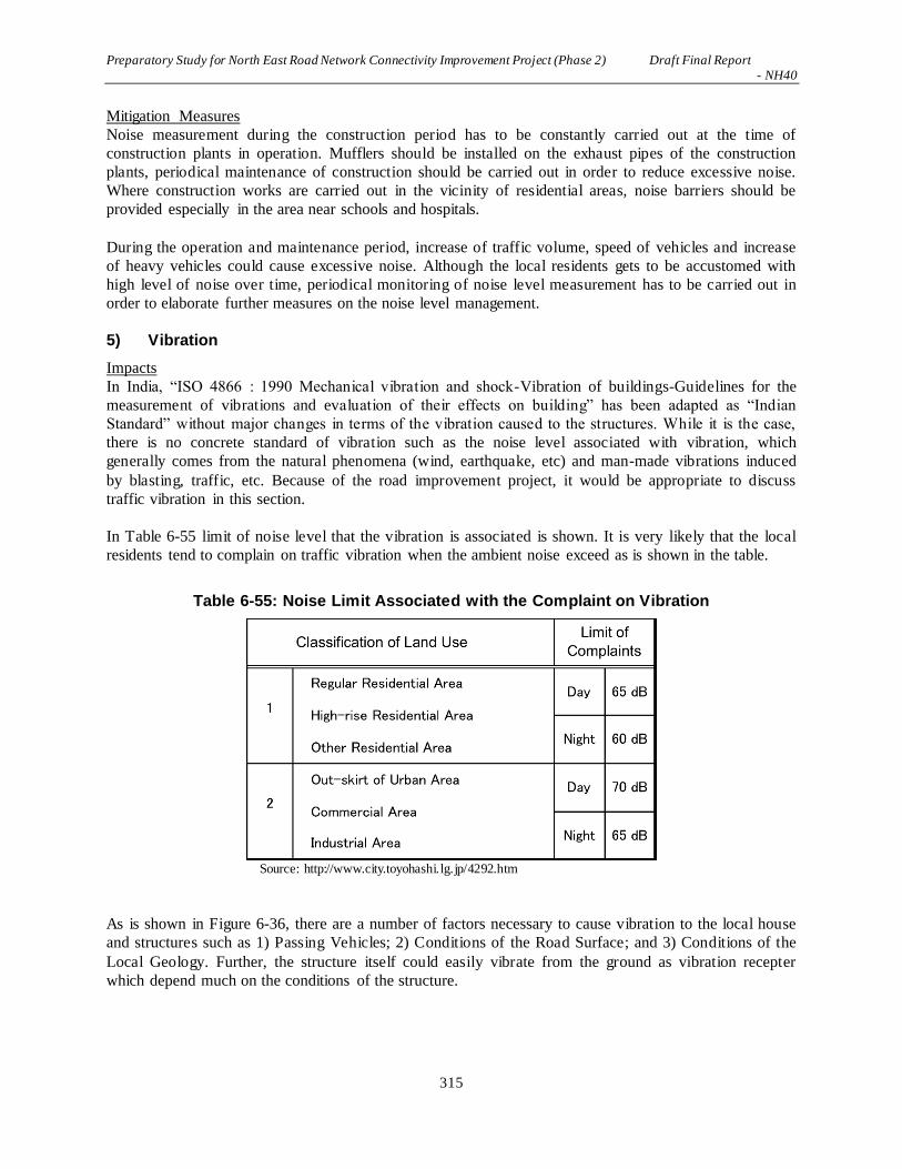
Preparatory Study for North East Road Network Connectivity Improvement Project (Phase 2) Draft Final Report - NH40
315
Mitigation Measures
Noise measurement during the construction period has to be constantly carried out at the time of
construction plants in operation. Mufflers should be installed on the exhaust pipes of the construction
plants, periodical maintenance of construction should be carried out in order to reduce excessive noise.
Where construction works are carried out in the vicinity of residential areas, noise barriers should be
provided especially in the area near schools and hospitals.
During the operation and maintenance period, increase of traffic volume, speed of vehicles and increase
of heavy vehicles could cause excessive noise. Although the local residents gets to be accustomed with
high level of noise over time, periodical monitoring of noise level measurement has to be carried out in
order to elaborate further measures on the noise level management.
5) Vibration
Impacts
In India, “ISO 4866 : 1990 Mechanical vibration and shock-Vibration of buildings-Guidelines for the
measurement of vibrations and evaluation of their effects on building” has been adapted as “Indian
Standard” without major changes in terms of the vibration caused to the structures. While it is the case,
there is no concrete standard of vibration such as the noise level associated with vibration, which
generally comes from the natural phenomena (wind, earthquake, etc) and man-made vibrations induced
by blasting, traffic, etc. Because of the road improvement project, it would be appropriate to discuss
traffic vibration in this section.
In Table 6-55 limit of noise level that the vibration is associated is shown. It is very likely that the local
residents tend to complain on traffic vibration when the ambient noise exceed as is shown in the table.
Table 6-55: Noise Limit Associated with the Complaint on Vibration
Source: http://www.city.toyohashi.lg.jp/4292.htm
As is shown in Figure 6-36, there are a number of factors necessary to cause vibration to the local house
and structures such as 1) Passing Vehicles; 2) Conditions of the Road Surface; and 3) Conditions of the
Local Geology. Further, the structure itself could easily vibrate from the ground as vibration recepter
which depend much on the conditions of the structure.

Preparatory Study for North East Road Network Connectivity Improvement Project (Phase 2) Draft Final Report - NH40
316
Source: http://www.crearia.co.jp/
Figure 6-36: Cause of Traffic Vibration
Depending on the country adapting “ISO 4866: 1990” as a standard of traffic vibration, the frequency
range of vibrations depends upon the distribution of spectral content over the frequency range of the
excitation and upon the mechanical response of the building. This pinpoints the spectral content as a most
important property of vibration input. For simplicity's sake, the International Standard of ISO 4866: 1990
deals with frequencies ranging from 0.1 Hz to 500 Hz that it covers the response of buildings of a wide
variety and building elements to excitation.
The reaction of buildings and building components to dynamic excitation depends upon response
characteristics. For example natural frequencies, mode shapes and modal damping as well as the spectral
content of the excitation should cause damages to the building. Cumulative effects should also be
considered, especially at high response level and long exposure times where fatigue damage is a
possibility. Table 6-56 shows typical range of structural response for various sources.

Preparatory Study for North East Road Network Connectivity Improvement Project (Phase 2) Draft Final Report - NH40
317
Table 6-56: Typical Range of Structural Response
Source: Indian Bureau of Standard
Preparatory Study for North East Road Network Connectivity Improvement Project (Phase 2) Draft Final Report - NH40
318
In the event if there were significant damages, road surface improvement and/or vibration measurement,
geological site investigation would have to be carried out in order to assess vibration receptor’s structural
damages. In order to carry out such investigation, it is obvious that the exceeding the noise level at the
location should become an indicator for investigation.
Mitigation Measures
As is described above, noise monitoring is an indicator of excessive vibration. Holding village meeting
before the commencement of the construction works is important for the increase of understanding among
the local residents. Interviewing the local residents during the construction period must be carried
periodically.
Continuous noise monitoring works should be carried out during the operation and maintenance period in
order to which values of noise level should be used as an important indicator.
6) Dust
Impacts
During the construction period, in the dry season, dust emanation from the construction area cou ld cause
public nuisance. During the rainy season, mud on the road could also cause public nuisance both against
pedestrians and traffic.
There will be no dust emanated during dry season and mud during the rainy season after the completion
of the construction works and that NH-40 is put into operation.
Mitigation Measures
The Contractor is requested to sprinkle water during the dry season within the construction area. During
the rainy season, mud barriers should be provided in order to prevent mud from sp illing over to the live
road and sidewalk.
There is no dust emanation or mud spillage during the operation and maintenance period.
7) Traffic Jam
Impacts
Because of the heavy traffic concentrating at the intersection in Shillong, 0 km post of the Project, heavy
traffic congestion is expected. In Dowki, road construction works should cause heavy traffic jam because
of the concentration of trucks transporting stone materials to Bangladesh.
No significant traffic jam should take place during the operation and maintenance period.
Mitigation Measures
The Contractor should provide a number of traffic guides, traffic barriers, signboards, color cones and
movable signais in order to maintain smooth flow of live traffic during the construction period.
No mitigation measures is required during the operation and maintenance period.

Preparatory Study for North East Road Network Connectivity Improvement Project (Phase 2) Draft Final Report - NH40
319
8) Solid Waste
Impacts
Various types of waste could be produced during the construction period ranging from oil, spare parts of
the construction plants including electrical parts, waste from workforce camp, removal of old structures,
etc. Based on the CPCB’s rules as per Table 6-57.
No significant amount of waste will be produced during the operation and maintenance period.
Table 6-57: Rules of the Disposal for Various Types of Waste
Municipal Solid Waste
(Management and
Handling) Rules, 2000
Basic rule of solid waste management CPCB put out for all the
municipalities of India. State government is requested to follow the
rules. It was amended on 29th March 2016 in order to manage
construction debris.
Hazardous and Other
Waste (Management and
Handling) Rules, 1989
Amended in 2000, 2003, and changed in 2008 including method of
disposal and transportation beyond state/international borders.
Further amendment was made in 2016 for utilization of hazardous
material.
Bio-medical Waste
(Management and
Handling) Rules, 1998
Amended in 2003 and further amended in March 2016 in order to
handle medical waste produced hospitals, veterinary institutions,
pathological laboratories, blood banks, etc.
Plastic Waste
(Management and
Handling) Rules, 1999
Amended in 2003 and further amended in 2016 in order to control
thick plastic materials.
e-Waste (Management
and Handling) Rules,
2001
Amended in 2016, it deals with disposal of all electrical waster
ranging from led-batteries, parts of electrical appliances in terms of
reuse and disposal.
Source: Central Pollution Control Board, India
Mitigation Measures
These various types of waste should be separated using boxes/cases for disposal and reuse during the
construction period. Depending on the type of waste, the Contractor should transport them to the locations
designated by the Meghalaya State Pollution Control Board.
Unless otherwise carried out a large operation of maintenance works, no significant waste will be
produced i.e. no mitigation measures is required during the operation and maintenance period.
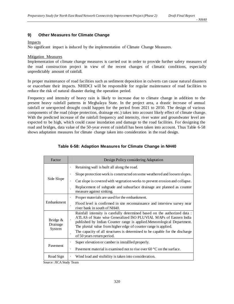
Preparatory Study for North East Road Network Connectivity Improvement Project (Phase 2) Draft Final Report - NH40
320
9) Other Measures for Climate Change
Impacts
No significant impact is induced by the implementation of Climate Change Measures.
Mitigation Measures
Implementation of climate change measures is carried out in order to provide further safety measures of
the road construction project in view of the recent changes of climatic conditions, especially
unpredictably amount of rainfall.
In proper maintenance of road facilities such as sediment deposition in culverts can cause natural disasters
or exacerbate their impacts. NHIDCI will be responsible for regular maintenance of road facilities to
reduce the risk of natural disaster during the operation period.
Frequency and intensity of heavy rain is likely to increase due to climate change in addition to the
present heavy rainfall patterns in Meghalaya State. In the project area, a drastic increase of annual
rainfall or unexpected drought could happen for the period from 2021 to 2050. The design of various
components of the road (slope protection, drainage etc.) takes into account likely effect of climate change.
With the predicted increase of the rainfall frequency and intensity, river water and groundwater level are
expected to be high, which could cause inundation and damage to the road facilities. For designing the
road and bridges, data value of the 50-year event of rainfall has been taken into account. Thus Table 6-58
shows adaptation measures for climate change taken into consideration in the road design.
Table 6-58: Adaption Measures for Climate Change in NH40
Factor Design Policy considering Adaptation
Side Slope
· Retaining wall is built all along the road.
· Slope protection work is constructed on some weathered and loosen slopes.
· Cut slope is covered with vegetation works to prevent erosion and collapse.
· Replacement of subgrade and subsurface drainage are planned as counter measure against sinking.
Embankment
· Proper materials are used for the embankment.
· Flood level is confirmed in site reconnaissance and interview survey near
river bank in south of NH40.
Bridge & Drainage System
·
Rainfall intensity is carefully determined based on the authorized data : ATLAS of State wise Generalized ISO PLUVIAL MAPs of Eastern India published by Indian Counter range is applied.Meteorological Department.
The pluvial value from higher edge of counter range is applied.
· The capacity of all structures is determined to be capable for the discharge of 50 years return period.
Pavement · Super elevation or camber is installled properly.
· Pavement material is examined not to rise over 60 °C on the surface.
Road Sign · Wind load and visibility is taken into consideration.
Source: JICA Study Team

Preparatory Study for North East Road Network Connectivity Improvement Project (Phase 2) Draft Final Report - NH40
321
6.7.4 Major Impacts on Social Environment
(1) Involuntary Resettlement
As per the preliminary ROW design, the project will affect 309 households (299 houses, 48 shops, 5
workshops and 1 other structures; some households overlap). The public structures including a school,
church, and resort etc., will only be partially affected in terms of land and not in terms of the building.
The total number of affected people is approximately 1,450, though some of the households will not be
subject to permanent resettlement.
Table 6-59: Summary of Households with their Structures Affected
Large Classification
Medium Classification Small Classification No. of HHs
Villages Under the Project 28 villages
HHs with their Structures Affected
Houses 299
Shops 48
Workshops 5
Other Buildings 1
Total※1 309
*1) 44 households are affected in terms of both house and shop. Source: JICA Study Team
Mitigation
Relocation sites shall be secured within same area as much as possible. Appropriate compensation and
rehabilitation shall be provided.
(2) Land Use
The project will lead to significant changes in land use especially at the bypass sections. Moreover, the
development of the resettlement sites to accommodate relocated households and the construction of spoil
banks is likely to cause changes in land use patterns, potentially affecting existing agricultural and
plantation activities.
For sections where NH40 passes through a community forest, jhum area and plantation, engineering
work should be scheduled in a way that minimizes the disruption of access to such areas by local people.
At the same time, proper management of effluent and soil erosion shall be carried out to avoid negative
impacts on such resources.
Table 6-60: Summary of Households of Lands Affected
Large Classification
Medium Classification Small Classification No. of HHs
Villages Under the Project
28 villages
Households of Lands Affected
Agricultural/open field 46
Stone and sand quarry 146
Betel nut Plantation owners 75
Total 135
Source: JICA Study Team
Mitigation
Relocation sites shall be secured within same area as much as possible. Appropriate compensation and
rehabilitation shall be provided.
Preparatory Study for North East Road Network Connectivity Improvement Project (Phase 2) Draft Final Report - NH40
322
(3) Utilization of Local Resources
This project shall use mass-scale of local resources such as sand and quarrying, in short term, may hinder
the ability of local purposes to utilize it for other purpose. After completion of construction, further influx
of outsiders and economic development may lead negative impact for local employment or business.
Mitigation
For construction material, actual utilization of local resources shall be considered. In designing livelihood
restoration plan, the impact mentioned above shall be examined.
(4) Social Institutions and Local Decision-Making Institutions
Meghalaya is a state predominantly inhabited by the Scheduled Tribes. The traditional leaders/headmen,
the Durbar Shnong and chieftains, must be involved in the decision-making process of the project from
the planning stages. Their support and influence can facilitate the smooth execution of the project, and
reduce impediments. The activities of RAP and rehabilitation and resettlement (R&R) should be built on
existing social institutions; the local people are the best guide and have the expertise to guide the project
based on their traditions and cultures. To minimize any potential disturbance and avoid the risk of
conflicts, however, the resettlement will be planned within the village where relocation takes place.
(5) General, Regional/City Plans
The project will create new opportunities for village and district-level development planning. In particular,
the construction of a spoil bank will create a large area of flat land where such surface space is a scarce
commodity. The development of a spoil bank, therefore, should be coordinated with the village/district’s
development plan so that the land will benefit the community. Similarly, the development of the
resettlement site should be coordinated with the village development plan to ensure proper supply of basic
utilities and integration of new sites with the existing village area.
(6) Social Infrastructure and Services
The Shillong-Dawki road is the connecting road not only to the people along the area, but is also the
connecting road that is being used every day by people from Shillong who go to their work/office in
various blocks and sub divisions. The road also serves as the connecting link for school and college-going
children in the periphery of Shillong (BP 1 and 2) who attend school in the main part of Shillong. The
construction period will affect the aforementioned activities greatly.
Proposed alignments shall not avoid the Health center at the end point Dawki, so that it will be necessary
to be resettled. Noise pollution is as shown in 7.7.3(2) 4).
Mitigation
In order to alleviate negative impact by access inhibition to social infrastructure and social service,
preparation must be made before implementation. Discussions and assistance can be taken with District
Authorities and link with the traffic police. Any construction activity that may require road blockade,
the community must be made aware at least 24 hours in advance.
Health center mentioned above shall be constructed in alternative place in advance of main project. PIU
shall pay the cost.
(7) Local Economy and Livelihood
One of the major outcomes from the project will be the increased business ventures and opportunities that

Preparatory Study for North East Road Network Connectivity Improvement Project (Phase 2) Draft Final Report - NH40
323
the area will be exposed to, and in terms of tourism, social events and increased trade and commerce with
neighboring villages and the state as a whole. The people along the project road especially towards the
end, are very enterprising and it is expected that they will take advantage of the project in a positive
manner.
While the project overall will have significant positive impacts on the local and regional economy, the
improved transport network may pose a risk to some groups, at least in the short and medium-term.
(8) Unequal Distribution of Benefits and Damages and Local Conflicts of Interest
Roadside locations offer critical advantages for local businesses (tea stalls, restaurants, petty shops).
Resettlement from the roadside to an inner part of the village may significantly undermine the viability of
these businesses, and therefore, business owners to be affected may be worse off compared with farmers
to be relocated. Likewise, the allocation of plots in the resettlement site may become a source of conflicts
among the affected households who wish to be relocated to more advantageous plots.
Mitigation
A sound arbitration and conflict resolution mechanism by local leaders should be in place for the smooth
implementation of RAP and R&R activities.
(9) Religious and Sensitive Facilities
Access to religious structures such as churches, temples, and mosques may be rendered difficult because
of the construction. People should not be stopped from attending their religious duties because of the
construction. The majority of the people in the project area are Christians, and they will go to church
every Sunday and other weekdays when necessary.
Mitigation
Access to these places must be built temporarily built for this matter. Noise pollution is as shown in 7.7.2
(5).
Sacred Groves
Sacred forests are an integral part of the Khasi culture and beliefs. Sacred forests are found in various
parts of the state, wherein clans, traditional heads/dorbar, declare a section of their forests as sacred and
revere as a place of sanctity. People who visit these forests are warned not to misuse or abuse the forest
creatures and vegetation. The sacred grove in Mawphlang is one such grove and is located near the
project road, a few kilometers away from Pomlum village. It is one of the largest and oldest sacred groves
in the state. The Mawphlang Sacred grove will not be affected by this project.
While “Raid Shabong Law Adong” in Wahpathew-urksew near Pynursla is located in a few hundred
meters west of the current road of NH40, Bypass 5 is designed in the east to current road and it shall not
disturb the forest. Moreover, while “Law Lyngdoh Mawshun” in Mawshun is located within 1 Km east of
current road of NH40, the alignment is designed in west to current road of proposed design, therefore, it
shall avoid it. Both are distant from proposed construction areas so that negative impact by drainage shall
not be expected.
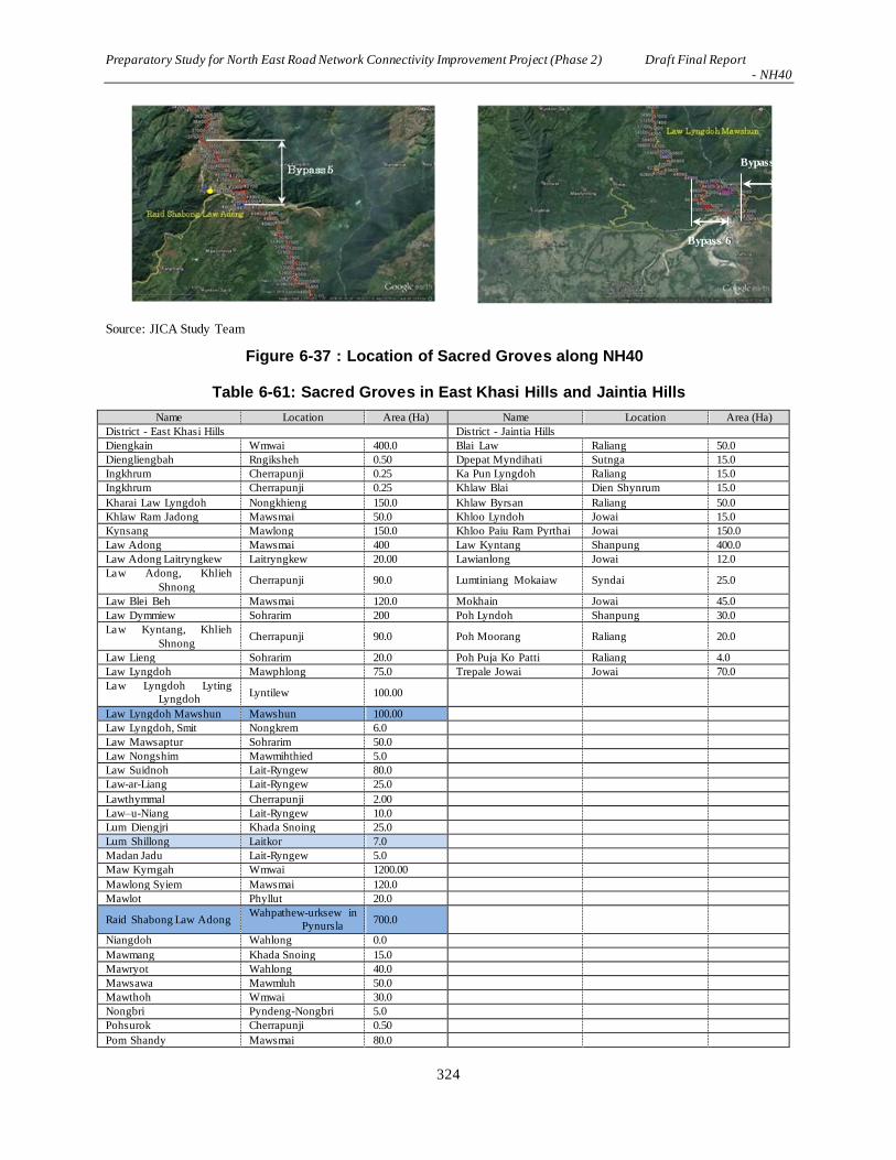
Preparatory Study for North East Road Network Connectivity Improvement Project (Phase 2) Draft Final Report - NH40
324
Table 6-61: Sacred Groves in East Khasi Hills and Jaintia Hills
Name Location Area (Ha) Name Location Area (Ha)
District - East Khasi Hills District - Jaintia Hills
Diengkain Wmwai 400.0 Blai Law Raliang 50.0
Diengliengbah Rngiksheh 0.50 Dpepat Myndihati Sutnga 15.0
Ingkhrum Cherrapunji 0.25 Ka Pun Lyngdoh Raliang 15.0
Ingkhrum Cherrapunji 0.25 Khlaw Blai Dien Shynrum 15.0
Kharai Law Lyngdoh Nongkhieng 150.0 Khlaw Byrsan Raliang 50.0
Khlaw Ram Jadong Mawsmai 50.0 Khloo Lyndoh Jowai 15.0
Kynsang Mawlong 150.0 Khloo Paiu Ram Pyrthai Jowai 150.0
Law Adong Mawsmai 400 Law Kyntang Shanpung 400.0
Law Adong Laitryngkew Laitryngkew 20.00 Lawianlong Jowai 12.0
Law Adong, Khlieh
Shnong Cherrapunji 90.0 Lumtiniang Mokaiaw Syndai 25.0
Law Blei Beh Mawsmai 120.0 Mokhain Jowai 45.0
Law Dymmiew Sohrarim 200 Poh Lyndoh Shanpung 30.0
Law Kyntang, Khlieh
Shnong Cherrapunji 90.0 Poh Moorang Raliang 20.0
Law Lieng Sohrarim 20.0 Poh Puja Ko Patti Raliang 4.0
Law Lyngdoh Mawphlong 75.0 Trepale Jowai Jowai 70.0
Law Lyngdoh Lyting
Lyngdoh Lyntilew 100.00
Law Lyngdoh Mawshun Mawshun 100.00
Law Lyngdoh, Smit Nongkrem 6.0
Law Mawsaptur Sohrarim 50.0
Law Nongshim Mawmihthied 5.0
Law Suidnoh Lait-Ryngew 80.0
Law-ar-Liang Lait-Ryngew 25.0
Lawthymmal Cherrapunji 2.00
Law–u-Niang Lait-Ryngew 10.0
Lum Diengjri Khada Snoing 25.0
Lum Shillong Laitkor 7.0
Madan Jadu Lait-Ryngew 5.0
Maw Kyrngah Wmwai 1200.00
Mawlong Syiem Mawsmai 120.0
Mawlot Phyllut 20.0
Raid Shabong Law Adong Wahpathew-urksew in
Pynursla 700.0
Niangdoh Wahlong 0.0
Mawmang Khada Snoing 15.0
Mawryot Wahlong 40.0
Mawsawa Mawmluh 50.0
Mawthoh Wmwai 30.0
Nongbri Pyndeng-Nongbri 5.0
Pohsurok Cherrapunji 0.50
Pom Shandy Mawsmai 80.0
Source: JICA Study Team
Figure 6-37 : Location of Sacred Groves along NH40
Bypass 7
Bypass 6
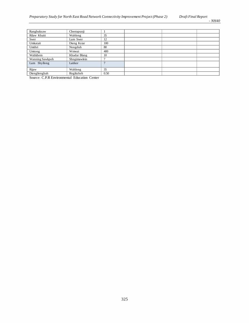
Preparatory Study for North East Road Network Connectivity Improvement Project (Phase 2) Draft Final Report - NH40
325
Rangbaksaw Cherrapunji 1
Rilaw Khaiti Wahlong 35
Swer Lum Swer 12
Umkatait Dieng Ksiar 100
Umthri Nongduh 80
Umtong Wmwai 400
Wahkhem Khadar Blang 10
Wanning Sawkpoh Shngimawlein 7
Lum Shyllong Laitkor 7
Rijaw Wahlong 35
Diengliengbah Rngiksheh 0.50
Source: C.P.R Environmental Education Center

Preparatory Study for North East Road Network Connectivity Improvement Project (Phase 2) Draft Final Report - NH40
326
Monoliths Monolith are traditional structures and are sacred to the Khasi people, especially those who still follow the indigenous religion. In the view of land
use, ROW and securement of slope, 7 Monoliths placed along the planning roads is difficult to avoid, so that it was confirmed whether it shall be
relocated or not.
Table 6-62: List of Monoliths
Sl. No. Distance from
starting point
(0.00 Km)
Side from
existing
road from
Shillong
Distance from
the center
point of the
existing road
Altitude Latitude Longitude Photographs of
Monolith
Monolith
location on
satellite image
GPS
Datum
Remarks Within
ROW
or not
If yes, feasibility of
relocation / protection
1 4.88km R.H.S 14 to 15
meters
1739 m 25˚33'
6.27" N
91˚50'
35.87" E
WGS 84 These monoliths are
memorial where the
ashes of the deceased
are deposited in
cairns.
Outside
of ROW Avoid
2 5.79 km R.H.S 6 meters 1783 m 25˚32'
46.72" N
91˚50'
14.87" E
As above As above Within ROW
May be in carriage way.
Located in land of State
government. Details
were already confirmed
and consulted by Block
Development Officer
3 6.06 km R.H.S 10 meters 1789 m 25˚32'
44.99" N
91˚50'
5.18" E
As above As above Within
ROW
May be in carriage way.
Located in land of State
government. Details
were already confirmed
and consulted by Block
Development Officer
4 8.14 km L.H.S 7 meters 1768 m 25˚32'
00.00" N
91˚49'
13.80" E
As above As above Within
ROW
Section excluded from
NH40.
5 17.88 km R.H.S 8 meters 1691 m 25˚27'
57.01" N
91˚49'
18.70" E
As above As above Within
ROW Relocation will be done
in consultation with the
local people as Monolith
does not belong to any
specific clan
6 18.11km R.H.S Median 1687 m 25˚27'
56.70" N
91˚49'
25.70" E
As above As above Outside
ROW
Avoid

Preparatory Study for North East Road Network Connectivity Improvement Project (Phase 2) Draft Final Report - NH40
327
Sl. No. Distance from
starting point
(0.00 Km)
Side from
existing
road from
Shillong
Distance from
the center
point of the
existing road
Altitude Latitude Longitude Photographs of
Monolith
Monolith
location on
satellite image
GPS
Datum
Remarks Within
ROW
or not
If yes, feasibility of
relocation / protection
7 21.3km - - 1839 m 25˚27'
0.40"N
91˚50
'45.68"E
Within
ROW May be under flyover.
Relocation were already
confirmed by land owner
and Block Development
Officer. Consensus and
ritual ceremony will be
examined by religious
group. .
8 53.75 km L.H.S 8 meters 830 m 25˚15'
29.48" N
91˚56'
54.93" E
As above As above Within
ROW Relocation will be done
in consultation with the
local people as Monolith
does not belong to any
specific clans.
Source: JICA Study Team

Preparatory Study for North East Road Network Connectivity Improvement Project (Phase 2) Draft Final Report - NH40
328
(10) Poor people
People from Below Poverty Line (BPL) or poor people in general must be considered when
planning and executing R&R activities and RAP. It is noted that poor people are less exposed to big
development projects and hence may feel intimidated and unable to voice concerns, grievances and
suggestions. Improvement of transportation system will lead acceleration of market competition
and accordingly it might expose a part of residents in short or medium-term. The project will make
the positive impact in whole, although in case the poor have difficulty to be involved in market
competition, their life may go worse furthermore.
Mitigation
Measures can be taken to ensure the poor are included into the project, and their grievances heard
and redressed. Allowance shall be offered for the vulnerable people and the skill development
shall be implemented in livelihood restoration plan.
(11) Indigenous People and Ethnic Minorities
The majority of Meghalayans are STs as per the Constitution of India. The majority of PAPs are
Khasi, with few Garo and Bengali. STs will not be excluded from this project, however, there
should be a conscious effort made to accommodate and include them in the decision-making and
grievance redress processes.
Mitigation
Fee, prior and informed consultation shall be required in accordance with World Bank OP4.10 and
social consent shall be confirmed. A rehabilitation policy will be elaborated considering traditional
livelihoods. Details are shown in 7.11.11.
(12) Public Health (sanitation and infectious diseases) and Occupational Health
and Safety (OHS)
The health and safety measures at the design, construction, and operation phases are outlined in
Table 6-63.
Table 6-63: Health and Safety Measures
Design Stage Health and Safety Measures
Geometric correction at critical curves Critical curves have been rectified to maintain the project design speed and
visibility. (IRC-86-1983 “ Geometric Design for Road in Plains”)
Construction Stage
Health hazards to workers due to
bad water and sanitation
At every workplace, good and sufficient potable water (as per Indian Standard
(IS) codes) supply shall be ensured to avoid water-borne diseases and to ensure
the health of workers. Adequate provision for drainage, sanitation, and waste
disposal shall be provided at workplaces. Preventive medical care shall be
provided to workers.
Health / social hazards, sexual
harassment to female workers
Segregation of male and female areas in the construction camp.
Preparatory Study for North East Road Network Connectivity Improvement Project (Phase 2) Draft Final Report - NH40
329
Hygiene at construction camps The contractor, during the progress of construction work will provide, erect and
maintain necessary (temporary) living accommodation and ancillary facilities for
workers that meet standards and scales approved by the resident engineer.
There shall be provided within the precincts of every workplace and
accommodation, latrines and urinals in an accessible place, as per standards set
by the Building and other Construction Workers (Regulation of Employment and
Conditions of Service) Act. Except in workplaces provided with water-flushed
latrines connected with a well-designed septic tank, all latrines shall be provided
with low cost ‘Twin Pit Latrine’ system. The pit can be closed after the
construction is over. There shall be adequate supply of water, close to latrines
and urinals.
All temporary accommodation shall be constructed and maintained in such a
fashion that uncontaminated water is available for drinking, cooking and
washing. The sewage system for the camp must be properly designed, built and
operated so that no health hazard occurs and no pollution to the air, ground or
adjacent watercourses takes place. Compliance with the relevant legislation must
be strictly adhered to. Garbage bins must be provided in the camp and regularly
emptied and the garbage disposed of in lined landfill sites. Construction camps
are to be situated away from vulnerable people and adequate health care is to be
provided for the work force.
On completion of the works, the whole of such temporary structures shall be
cleared away, all rubbish burnt, excreta or other disposal pits or trenches filled in
and effectively sealed off, and the entire site left clean and tidy, at the
contractor’s expense, to the entire satisfaction of the engineer.
Abandoned quarry will
accumulate water and act as a
breeding ground for disease
vectors.
Reclamation measures shall be adopted with garlands of trees around the
periphery. The quarry dust and waste shall be used for refilling. The remaining
portion shall be covered with trees. If the quarry site is porous, allow for
groundwater recharging.
Risk from operations The contractor is required to comply with all the precautions as required for the
safety of the workmen as far as those are applicable to this project. The contractor
shall supply all necessary safety appliances such as safety goggles, helmets, masks,
etc., to the workers and staff. The contractor must comply with all regulations
regarding safe scaffolding, ladders, working platforms, gangways, stairwells,
excavations, trenches and safe means of entry and egress.
Risk from electrical equipment Adequate precautions will be taken to prevent any danger from electrical
equipment. No material at any of the sites will be so stacked or placed as to
cause danger or inconvenience to any person or the public. All necessary fencing
and lights will be provided to protect the public. All machines to be used in the
construction will conform to the relevant IS codes, will be free from patent
defects, will be kept in good working order, will be regularly inspected and
properly maintained as per IS provisions and to the satisfaction of the engineer.
Risk at hazardous activity
All workers employed for mixing asphaltic material, cement, lime mortars,
concrete etc., will be provided with protective footwear and protective goggles.
Workers who are engaged in welding works, will be provided with welder’s
protective eye-shields. Stone-breakers will be provided with protective goggles
and clothing and will be seated at sufficiently safe intervals.
The use of any herbicide or other toxic chemicals shall be strictly in accordance with
the manufacturer’s instructions. The engineer shall be given at least 6 working day
notice of the proposed use of any herbicides or toxic chemicals. A register of all
herbicides and other toxic chemicals delivered to the site shall be kept and
maintained up to date by the contractor. The register shall include the trade name,
physical properties and characteristics, chemical ingredients, health and safety
hazard information, safe handling and storage procedures, and emergency and first
aid procedures for the product.

Preparatory Study for North East Road Network Connectivity Improvement Project (Phase 2) Draft Final Report - NH40
330
Risk of lead pollution No men below the age of 18 years and no women shall be employed for the work
of painting with products containing lead in any form. No paint containing lead
or lead products will be used except in the form of paste or readymade paint.
Face masks will be supplied for use by the workers when paint is applied in the
form of spray or a surface having lead paint is dry rubbed and scrapped.
Risk caused by force majeure All reasonable precautions will be taken to prevent danger of the workers and the
public from fire, flood, drowning, etc. All necessary steps will be taken for
prompt first aid treatment of all injuries likely to be sustained during the course
of work.
Risk from explosives Only if provided in the contract or ordered or authorized by the engineer, the
contractor shall use explosives.
The contractor shall at all times take every possible precaution and shall comply
with appropriate laws and regulations relating to the importation, handling,
transportation, storage and use of explosives and shall, at all times when engaged
in blasting operations, post sufficient warning flagmen, to the full satisfaction of
the engineer.
The contractor shall at all times liaison with and inform well in advance and obtain
such permission as is required from all government authorities, public bodies and
private parties concerned or affected or likely to be concerned or affected by blasting
operations.
Malaria risk The contractor shall, at their own expense, conform to all anti-malarial
instructions given to them by the engineer, including filling up any borrow pits
which may have been dug.
Operation Phase
Dwellers in settlements may rush
to highway and have an accident
Specially designed urban sections and footpath sections shall be constructed at the
necessary locations.
Vehicles parked in settlements
may narrow the carriageway Specially designed parking areas shall be made at the required locations.
Fast moving vehicles may
threaten safety in settlements Specially designed pedestrian crossings shall be constructed at required locations.
Accidents involving hazardous
materials The rules defined in Hazardous Waste Handling Act shall be followed.
Vehicles delivering hazardous substances shall be marked with appropriate signs.
In case of spillage, the report to relevant departments will be made and instructions
will be followed in implementing the contingency measures.
Other safety measures A traffic management plan shall be developed especially along congested locations.
Traffic control measures including speed limits will be enforced strictly. Further
growth of encroachment and squatting within ROW shall be discouraged.
Fences are recommended between the road and quarry places.
Source: JICA Study Team
(13) Water Usage, Water Rights, and Communal Rights
The Khasi tribal community inhabits the major segment of NH40 from Shillong to Dawki falling
within East Khasi Hills District, and in certain segments of NH40 falling within West Jaintia Hills
District, particularly around the proposed bypass #6 and 7, the Pnars or Jaintia tribes predominately
inhabit the area. Both the communities have maintained a close symbiotic relationship with the
environment since time immemorial and their ethno-cultural traits have been greatly influenced by
the natural surroundings. Like any other tribal group, the Khasis and Jaintias have a very close
affinity to nature, and the forest is an important component of nature that is intricately linked to
their daily lives.
Water sources are mostly located within forest and vegetation areas since trees and all varieties of
forest act as catchment for recharging the aquifers and replenishing ground water level, which then

Preparatory Study for North East Road Network Connectivity Improvement Project (Phase 2) Draft Final Report - NH40
331
provide water supply to natural springs and small rivulets. Traditional systems of conserving and
sustaining all such sources have been practiced for generations by both the tribes, and this tradition
continues even today.
6.7.5 Others
(1) Accidents
While implivement of curve can reduce traffic accident, increase of traffic volume and speed might
increase risk of accidents.
Mitigation
Traffic sign shall be installed. Sidewalk and pedestrican crossing will be required. Delineator
shall be utilized in fog area.
6.8 Impact Analysis
Comparison between scoping and survey result is as shown below.
Table 6-64: Scoping and Survey Result
Sl.
No.
Item
Impact Assessments of
Scoping
Impact Assessments
of Study
Result
Rationale of the Impact Assessment
Pre-c
on
stru
cti
on
Co
nst
ru
cti
on
Sta
ge
Op
era
tio
n S
tag
e
Pre-c
on
stru
cti
on
Co
nst
ru
cti
on
Sta
ge
Op
era
tio
n S
tag
e
Natural Environment
1.1 Climate/
Meteorological
Phenomena
D D D D D D P: No impact is expected.
C/O: A little influence occurs along the roadside
1.2 Topography D B- D D B- D P: No impact is expected.
C: Alteration of the topography (embankment / cut) on the
roadside cannot be avoided.
O: The modified terrain (including slope protection works)
will stabilize over the long term.
1.3 Geology D D D D D D P/C/O: No impact is expected.
1.4 Soil Erosion D B- B-
/
B
+
D B- B-
/
B
+
P: No impact is expected.
C: Sediment collapse and soil erosion are likely to occur.
O:The modified terrain (including slope protection works)
will stabilize over the long term.
1.5 Hydrology D C C D B- B- P: No impact is expected.。
C:The change of individual hydrological conditions is
caused by routing of surface water by construction and
embankment / cutting etc.
O:Fine hydrological conditions limited to individual areas
by the embankment/ cuts etc. are permanently altered.
1.6 Groundwater D D D D D D P/C/O: No impact is expected.

Preparatory Study for North East Road Network Connectivity Improvement Project (Phase 2) Draft Final Report - NH40
332
Sl.
No.
Item
Impact
Assessments of
Scoping
Impact
Assessments
of Study
Result
Rationale of the Impact Assessment
Pre-c
on
stru
cti
on
Co
nst
ru
cti
on
Sta
ge
Op
era
tio
n S
tag
e
Pre-c
on
stru
cti
on
Co
nst
ru
cti
on
Sta
ge
Op
era
tio
n S
tag
e
1.7 Ecosystem/Biod
iversity
Forest/Flora
D A- A- D A- A- P: No impact is expected.
C: Logging is inevitable in broad forest areas by the road
construction. The mountain ecosystem and biodiversity are
affected during the construction period. cutting of forest
areas as habitats of wild animals including birds is inevitable.
O: Road construction facilitates access to forest areas.
Therefore it makes it easier to hunt regardless of legal or
illegal.
Traffic volume increases and negative impact of ecosystem
cannot be avoided. The increase in traffic increases the
exhaust gas to existing forest areas. Plant trees in forested
forests then restore forests.
1.8 Wildlife
Reserve
D D
D D D
B- P: No impact is expected.
C: There is no animal reserve.
O: The increase in traffic increases the exhaust gas to
existing forest areas. Easier access to road construction
makes legitimate and illegal hunting easier.
1.9 Coastal Zone D D D D D D P/C/O: There are no affected coastal areas.
1.10 Landscape D C C D B- B
+
P: No impact is expected.
C:Damage to the landscape by the road construction work is
inevitable.
O: Landscape gets better after construction. Dawki bridge
will be new spot for scenery.
1.11 Natural
Disasters
D B- B
+
D B- B
+
P: No impact is expected.
C: Natural disasters such as slope collapse may be punished
depending on work during the construction period and
strong rain.
O: Stabilize the entire slope at completion by installing a
slope protector.
Living Environment/ Pollution
2.1
Air Pollution D B- B- D B- B- P: No impact is expected.
C: Air pollution and dust diffusion by construction heavy
equipment are inevitable.
O: Exhaust gas increases as traffic volume increases.
2.2 Offensive Odor D D D D D D P/C/O: No impact is expected.
2.3 Water Pollution D B- B- D B- B- P: No impact is expected.
C: In the vicinity of a river there is a possibility that water
quality of a river will be contaminated by the excavation
work etc. By the construction workers' camps, there is a
possibility that emissions will flow into rivers.
Groundwater contamination other than excavation work does
not occur.

Preparatory Study for North East Road Network Connectivity Improvement Project (Phase 2) Draft Final Report - NH40
333
Sl.
No.
Item
Impact
Assessments of
Scoping
Impact
Assessments
of Study
Result
Rationale of the Impact Assessment
Pre-c
on
stru
cti
on
Co
nst
ru
cti
on
Sta
ge
Op
era
tio
n S
tag
e
Pre-c
on
stru
cti
on
Co
nst
ru
cti
on
Sta
ge
Op
era
tio
n S
tag
e
O: The current flow path by the construction of the drainage
channel is changed.
2.4 Bottom
Sediment
Contamination
D D D D B- D P: No impact is expected.
C:Drainage by the construction machine washing etc. may
also Bottom sediment contamination.
O: This project does not emit sediment contaminants.
2.5 Soil
Contamination
D C D D B- D P: No impact is expected.
C: Drainage by the construction machine washing etc. may
also Soil contamination.
O: No impact is expected.
2.6 Ground
Subsidence
D D D D D D P/C/O: No impact is expected.
2.7 Noise/Vibration D A- B-
/
B
+
D A- B- P: No impact is expected.
C: Noise and vibration are generated by heavy equipment
for construction during operation.
Night work is not carried out near religious facilities, schools
and hospitals, etc.
It is mandatory to install mufflers in heavy machinery.
O: Noise and vibration may increase as traffic volume
increases.
2.8 Sunshine
Obstruction
D D D D D D P/C/O: No impact is expected.
2.9 Waters/Hazardo
us Materials
D B- B- D B- B- P: No impact is expected.
C: Construction waste is generated during construction.
However, they are processed by the end of the construction.
O: Waste is generated during maintenance work of the road,
but it does not have important influence on the natural
environment or social environment.
Social Environment
3.1 Involuntary
Resettlement
A- D D A- A- D P: Though bypasses are planned to avoid densely-populated
areas, the alignment still affect house structures of
approximately 300 HHs, of which 70% need to be resettled.
C: While resettlement will be completed before construction
begins, temporary resettlement will be required for
construction yard and worker’s accommodation.
O: Resettlement will be completed before construction
begins
3.2 Land Use A- A- A- A- A- A- P: Land acquisition and involuntary resettlement are likely to
cause changes in the existing land use patterns.
C: The bypass construction section affects existing cultivated
land or agriculture and forestry. Changes in land use
necessary for securing construction yards are short-term.
O: This project requires permanent modification of land use.
3.3 Utilization of D A- D D A- D P: No impact is expected.

Preparatory Study for North East Road Network Connectivity Improvement Project (Phase 2) Draft Final Report - NH40
334
Sl.
No.
Item
Impact
Assessments of
Scoping
Impact
Assessments
of Study
Result
Rationale of the Impact Assessment
Pre-c
on
stru
cti
on
Co
nst
ru
cti
on
Sta
ge
Op
era
tio
n S
tag
e
Pre-c
on
stru
cti
on
Co
nst
ru
cti
on
Sta
ge
Op
era
tio
n S
tag
e
Local Resources C: Procurement of large quantities of materials locally could
affect demand.
O: No impact by the project.
3.4 General,
Regional
/ City Plans
D D B
+
D D B
+
P/C: No impact is expected.
O: Improvement of the road transport network may bring
about the influx of residents from the outside and economic
development.
3.5 Social
Institutions and
Local Decision-
making
Institutions
B- B- B- D D D P/C/O: Resident relocation may affect existing social
organizations and regional decision making organizations.
3.6 Social
Infrastructure
and Services
B- B- B
+
B- B- B
+
P: Access to social infrastructure may be hindered due to
resettlement and land acquisition.
C: For improvement work, traffic congestion may occur and
access to social infrastructure may be hindered.
O: Improvement of road transport network contributes to
improvement of convenience.
3.7 Local Economy
and Livelihood
A- A-
/
B
+
B
+
A- A-
/B
+
B
+
P: Loss of income source and livelihood due to involuntary
resettlement and change in land usage are expected to
negatively affect the local economy and livelihood.
C: Construction work affects the lives and occupations of
local residents. On the other hand, the construction work
generates local employment and has a positive effect on the
economy.
O: Improvement of road transport network brings positive
effect on regional economy by improving convenience.
However, in the settlement of the bypass section, problems
arise in access.
3.8 Unequal
Distribution of
Benefit and
Damage
A- A-
/
B
+
B-
/
B
+
A- A-
/B
+
B-
/B
+
P: Land acquisition and involuntary resettlement will lead to
unequal distribution of benefits and damage between those
who are directly affected by the project and those who are
not.
C: Residents to be relocated are greatly affected. Meanwhile,
neighboring residents may benefit from creation of
employment opportunities by the construction work, and
deviation occurs.
O: There is a possibility that the uneven distribution of
benefits will expand between settlements on the roadside
after the widening and villages detoured by the bypass. It is
expected that uneven distribution of damage and benefits
will be resolved by long-term benefits of the whole area by
improving the road network.
3.9 Local Conflicts
of Interests
C C C C D D P: Conflict of interests may arise by the compensation
problems, and conflicts may occur.

Preparatory Study for North East Road Network Connectivity Improvement Project (Phase 2) Draft Final Report - NH40
335
Sl.
No.
Item
Impact
Assessments of
Scoping
Impact
Assessments
of Study
Result
Rationale of the Impact Assessment
Pre-c
on
stru
cti
on
Co
nst
ru
cti
on
Sta
ge
Op
era
tio
n S
tag
e
Pre-c
on
stru
cti
on
Co
nst
ru
cti
on
Sta
ge
Op
era
tio
n S
tag
e
C/O: Conflict of interests may arise by the compensation
problems, and conflicts may occur though relatively minor.
3.10 Water Usage,
Water Rights
and Communal
Rights
D D D
D D D
P/C: It does not change the mechanism of water use, the
impact of the project is small.
O: No impact by the project.
3.11 Cultural and
Historical
Heritage
D D D
C
+
D D D P/C/O: This road does not pass through a place with cultural
and historical heritage.
3.12 Religious
Facilities
B- A- D A- A- D P: A number of churches, several memorial stones and graves
are located along the road. Several memorial stones are
directly affected. Graves can be affected in private yards. The
targeted roads do not traverse sacred groves of traditional
religious beliefs.
C: Neighboring religious facilities and cemetery may be
affected by noise and vibration caused by construction.
O:Consideration should be taken not to have any influence
by the appropriate noise countermeasures.
3.13 Sensitive
Facilities (ex.
hospital, school,
precision
machine
factory)
D A- D A- A- D P: Relocation of one Public Health Center will be required.
School site will be partly affected.
C:Schools and clinics along the road are affected by noise,
vibration, and traffic congestion during construction.
O : Consideration shall be made for preventing noise
promelems.
3.14 Poor People A- A-
/
B
+
B
+
A- A-
/B
+
B-
/B
+
P: Given the limited coping capacity of the poor, it is
necessary to assess their vulnerability and develop
appropriate mitigation measures.
C: Poor people may be more affected by negative influences.
On the other hand, you can benefit from employment
opportunities that occur in your business.
P: In the long term, the economic development of the area
that the project produces is thought to have a positive effect
on the poor peoples.
3.15 Ethnic
Minorities/
Indigenous
People
A- A- D A- A- D P/C: Various specific schedules (Scheduled Tribes) live in
the Meghalaya state of the target area. IPP shall be prepared
with consideration of their unique culture and customs to
implement resident relocation and to formulate a recovery
plan for livelihood.
O: Resident relocation will be completed before construction
starts. Minimize the impact by considering relocation
destinations and developing a recovery plan for livelihoods.
3.16 Gender C C C D B
+/
B-
D
P: There is a possibility that resettlement and land acquisition
may influence the role sharing such as cultivation, harvesting
and processing. But the impact is limited.

Preparatory Study for North East Road Network Connectivity Improvement Project (Phase 2) Draft Final Report - NH40
336
Sl.
No.
Item
Impact
Assessments of
Scoping
Impact
Assessments
of Study
Result
Rationale of the Impact Assessment
Pre-c
on
stru
cti
on
Co
nst
ru
cti
on
Sta
ge
Op
era
tio
n S
tag
e
Pre-c
on
stru
cti
on
Co
nst
ru
cti
on
Sta
ge
Op
era
tio
n S
tag
e
C: In consideration of regional cultural and social norms,
employment opportunities are considered equally so that
gender-derived conflicts do not arise. This project may
influence role sharing such as cultivation, harvesting and
processing.
O: There is a possibility that this project may influence the
role sharing such as cultivation, harvesting and processing.
But the impact is limited.
3.17 Children's
Rights
C D C D D D P: Child labor is prohibited by the Indian Constitution.
Resettlement of residents and acquisition of land may affect
the role of children helping at shops along roadside though
impacts are minor.
C:Child labor is prohibited by the Indian Constitution. In
this project, we employ only adults and do construction
work.
O: Child labor is prohibited by the Indian Constitution.
Resettlement of residents and acquisition of land may affect
the role of children helping at shops along roadside though
impacts are minor.
3.18 Public Health
(sanitation and
infectious
diseases)
D B- B- D B- B- P: No impact is expected.
C:The inflow of construction workers from the outside is
expected to increase the risk of health, especially sexually
transmitted diseases. Meanwhile, countermeasures against
malaria are also necessary when constructing in areas where
malaria is occurring.
O:An increase in traffic volume has a negative impact on the
health of roadside people.
3.19 Occupational
Health and
Safety (OHS)
D B- B- D B- B- P: No impact is expected.
C:Hygiene at work site and health and safety of workers
need to be properly managed through implementation of
environmental management plan.
O:Consider thoroughly the hygiene and safety of workers in
charge of maintenance and repair work.
その他
4.1 Accidents D B- B
+/
B-
D B- B
+/
B-
P: No impact is expected.
C:The risk of traffic accidents caused by heavy machinery
and construction vehicles increases.
Pay particular attention to the construction site especially in
areas where thick fog occurs.
O:The accident risk increases due to an increase in traffic
volume and an increase in traffic speed.
Particular care needs to be taken in the dense fog area, such
as speed limit and thorough use of headlights / hazard lamps.
On the other hand, the risk is reduced by measures such as
installation of traffic safety signs and curved mirrors.

Preparatory Study for North East Road Network Connectivity Improvement Project (Phase 2) Draft Final Report - NH40
337
Sl.
No.
Item
Impact
Assessments of
Scoping
Impact
Assessments
of Study
Result
Rationale of the Impact Assessment
Pre-c
on
stru
cti
on
Co
nst
ru
cti
on
Sta
ge
Op
era
tio
n S
tag
e
Pre-c
on
stru
cti
on
Co
nst
ru
cti
on
Sta
ge
Op
era
tio
n S
tag
e
4.2 Climate Change B- B- B
+/
B-
B- B- B
+/
B-
P: CO2 emission and absorption/fixation will be lost due to
deforestation.
C:Greenhouse gas emissions are generated by construction
and heavy equipment emissions such as production and
laying of road materials.
O:As the number of vehicles using roads increases, the
emissions of greenhouse gases gradually increase. Note: C: Construction O: Operation A: Severe/irrevocable impact is expected (+: Positive impact, -: Negative impact) B: Significant impact is expected (+: Positive impact, -: Negative impact) C: Further study is required as impact is unknown D: Impact with little significance occurs Source: JICA Study Team
6.9 Environmental Management and Monitoring Plan
6.9.1 Environmental Management Plan
(1) Afforestation Program
Afforestion program for the loss of the existing forest of 123 ha, approximately 147,600 trees
should be carried out. Meghalaya State Department of Environment and Forest will identify the
area of afforestation and tree species at the time of the examination for forest clearance.
Further, because of the road construction project emit greenhouse gas, afforestation program in
order to sequester the amount of greenhouse gas. This is also a policy of the Government of India in
respect of “Paris Agreement” of COP 21 in terms of climate change measures. Thus approximately
131 ha including the greenhouse gas sequestration for the increase of vehicles, afforestation
program has to be carried out.
In total 254 ha of afforestation program is planned to carry out. These afforestation programs also
functions as habitat loss of the wildlife including bird species such as
(2) Prevention of Dust Emanation and Mud Spillage
Because of the dust emanatioin during the dry season and mud spillage during the rainy season, the
Contractor has to sprinkle water in the construction area during the dry season. Barriers and sand
bags should be provided during rainy season in order to prevent mud from spilling over to the road
and side walks.
Preparatory Study for North East Road Network Connectivity Improvement Project (Phase 2) Draft Final Report - NH40
338
(3) Prevention of Traffic Jam
In the construction area within Shilling, the Contractor should provide a number of traffic guides,
traffic barriers, signboards, color cones and movable signais in order to maintain smooth flow of
live traffic during the construction period.
In Dowki, the Contractor shouldalso provide a number of traffic guides, traffic barriers, signboards,
color cones and movable signais in order to maintain smooth flow of live traffic during the
construction period.
(4) Noise Levels
The Contractor shold provide various measures in order to lower the noise level during the
construction period as follows:
The plants and equipment used for construction will strictly conform to Central Pollution
Control Board (CPCB) noise standards. Vehicles, equipment and construction machinery
shall be monitored regularly with particular attention to silencers and mufflers to maintain
noise levels to a minimum.
Workers in the vicinity of high noise levels must wear earplugs, helmets and should be
engaged in diversified activities to prevent prolonged exposure to noise levels of more than
90dB(A).
In construction sites within 150 m of human settlements, noisy construction will be stopped
between 10 PM and 6 AM except for when laying the cement concrete pavement, for which
a lower working temperature is a requirement.
Noise barrier should be provided based on the measured values of noise level. Schools and
hospitals should be protected from the noise with a provision of noise barriers.
Near the sensitive receptors such as hospitals and schools, noise barriers such as earth,
concrete, wood, metal or double-glazing of windows for façade insulation shall be used.
Careful planning of machinery operation and scheduling of operations can reduce noise
levels. Use of equipment emitting noise not greater than 90 dB(A) for the eight-hour
operations shift and locating construction yards at a distance of at least 500 m from any
residential areas should be adhered to.
Use of noise shields on construction machinery and the provision of earplugs to the heavy
machine operators are some of the mitigation measures, which should be followed by the
contractors during the civil works.
Typical noise level emanated by the construction plant is shown in Table 6-65.
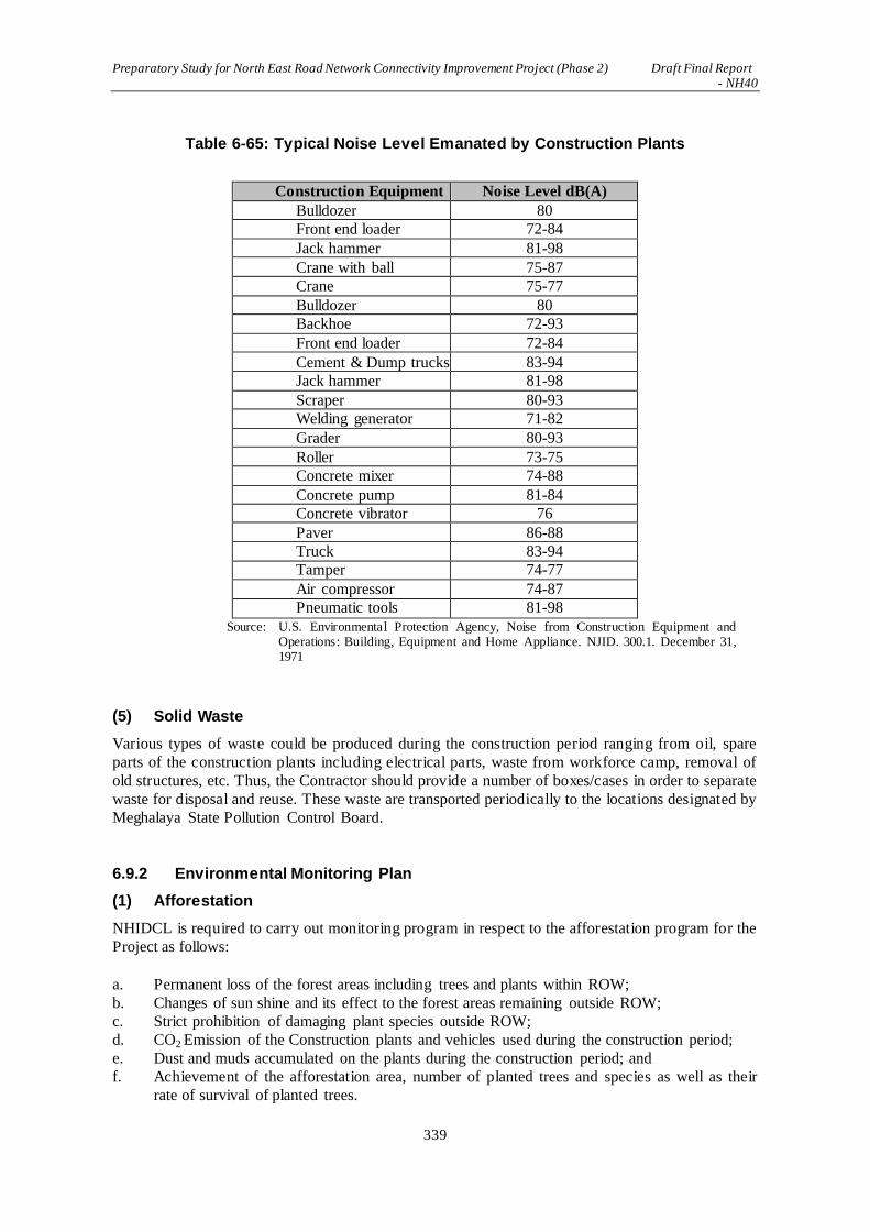
Preparatory Study for North East Road Network Connectivity Improvement Project (Phase 2) Draft Final Report - NH40
339
Table 6-65: Typical Noise Level Emanated by Construction Plants
Construction Equipment Noise Level dB(A)
Bulldozer 80 Front end loader 72-84
Jack hammer 81-98
Crane with ball 75-87
Crane 75-77
Bulldozer 80 Backhoe 72-93
Front end loader 72-84
Cement & Dump trucks 83-94 Jack hammer 81-98
Scraper 80-93 Welding generator 71-82
Grader 80-93
Roller 73-75 Concrete mixer 74-88
Concrete pump 81-84 Concrete vibrator 76
Paver 86-88 Truck 83-94 Tamper 74-77
Air compressor 74-87 Pneumatic tools 81-98
Source: U.S. Environmental Protection Agency, Noise from Construction Equipment and Operations: Building, Equipment and Home Appliance. NJID. 300.1. December 31, 1971
(5) Solid Waste
Various types of waste could be produced during the construction period ranging from oil, spare
parts of the construction plants including electrical parts, waste from workforce camp, removal of
old structures, etc. Thus, the Contractor should provide a number of boxes/cases in order to separate
waste for disposal and reuse. These waste are transported periodically to the locations designated by
Meghalaya State Pollution Control Board.
6.9.2 Environmental Monitoring Plan
(1) Afforestation
NHIDCL is required to carry out monitoring program in respect to the afforestation program for the
Project as follows:
a. Permanent loss of the forest areas including trees and plants within ROW;
b. Changes of sun shine and its effect to the forest areas remaining outside ROW;
c. Strict prohibition of damaging plant species outside ROW;
d. CO2 Emission of the Construction plants and vehicles used during the construction period;
e. Dust and muds accumulated on the plants during the construction period; and
f. Achievement of the afforestation area, number of planted trees and species as well as their
rate of survival of planted trees.

Preparatory Study for North East Road Network Connectivity Improvement Project (Phase 2) Draft Final Report - NH40
340
The afforestation program compensates permanent losses of forest species.
Wildlife including bird species should be monitored during the construction period as well as the
operation and maintenance period. These monitoring result should be used in order to elaborate
further environmental management plan.
(2) Illegal Logging and Poaching
Because of the access to forest area becomes easy as a result of road construction project, NHIDCL
is required to monitor illegal logging and poaching periodically during the operation and
maintenance period.
The project area goes through the habitat of bird species in the southern half of Meghalaya State. Its
first 6-7 km borders the “Upper Shillong Important Bird Area”. A number of bird species inhabit in
the area including “Tawny-breasted Wren-babbler (Spelaeornis longicaudatus)”.
Thus, the Contractors are requested to monitor the bird species during the construction period and
the result has to be reported to the Meghalaya State Department of Environment and Forest.
NHIDCL should carry out the same during the opratioin and maintenance period. Montoring result
should be reported periodicaly to the Meghalaya State Department of Environment and Forest.
(3) Monitoing on the Ecological and Biodiversity
Above monitoring program will cover the monitoring program for the ecological and biodiversity.
(4) Air Quality and CO2 Monitoring Works
Ambient air quality parameters recommended for monitoring road transportation developments are
PM10, PM 2.5, Carbon Monoxide (CO), Oxides of Nitrogen (NOX), Sulphur Dioxide (SO2) and
Lead (Pb) should be monitored based on the monitoring post in Shillong and Dowki established by
the Meghalaya State Pollution Control Board and NHIDCL shold prvide monitoring cost.
In the event that measured values of these locations showing excessively high values, further
monitong should be carried out in the mid point of the project area and/or strategic monitoing plan
should be elaborated for further environmental management plan.
(5) Noise and Vibration Level
The Contractor is requested to carry out noise monitoring works during the construction period.
Based on the baseline data obtained during the study period, further noise level monitoring works
should be carried out by NHIDCL during the operation and maintenance period. Monitoing timing
should be on the clear day of May to July period in order to match the measured timing of the
baseline data.
CPCB put out noise standard in the Year 2000 as per Table 6-66, exceeding the standard could mean
vibration is also causing some sort of problems to the near-by structures. Thus, the measured values
should be used as indicator of which traffic vibration is occurring.
In the event noise level is exceeding, interview survey should be carried out if any trobles are
occurring on the structures caused by traffic vibration. Further monitoing strategy should be
elaborated if near-by structures are receiving excessive traffic vibration.

Preparatory Study for North East Road Network Connectivity Improvement Project (Phase 2) Draft Final Report - NH40
341
Table 6-66: Standard of Noise Level
Note:
1. Day time shall mean from 6.00 a.m. to 10.00 p.m. 2. Night time shall mean from 10.00 p.m. to 6.00 a.m. 3. Silence zone is an area comprising not less than 100 m around hospitals, educational institutions, courts,
religious places or any other area which is declared as such by the competent authority.
4. Mixed categories of areas may be declared as one of the four above-mentioned categories by the competent authority.
* dB(A) Leq denotes the time weighted average of the level of sound in decibels on scale A which is rela 表 to
human hearing. A “decibel” is a unit in which noise is measured. “A”, in dB(A) Leq, denotes the frequency weighting in the measurement of noise and corresponds to frequency
response characteristics of the human ear.
Leq: It is an energy mean of the noise level over a specified period.
Source: Central Pollution Control Board, India
(6) Changes of Topography and Geographic Conditions
Cus and fill slopes are created during the construction period. Thus, monitoring works should be
carried out in order to avoid unwanted changes of topography such as slope gradient and natural
drainage system. The Contractor is to provide necessary protection works during the
implementation of cut and fill slope works.
Because of the vegetation along the project area including plants used for slope protection will
generally be rejuvenetaed over 7 years. Thus NHIDCL has to carry out periodical monitoring of
slope stabilization over 7 years.
Quarry areas developed for obtaining construction materials should be monitored periodically in
order to maintain slope gradient of cut slopes. Upon completion of the construction works,
deposited topsoil should be back-filled in order to reinstate the environmental conditions. All these
activities are subject to monitoring.
(7) Soil Erosion
As above, monitoring on the soil erosion is a part of the monitoing works for topographic and
geographical changes.
(8) Hydrogeography
During the construction period, natural drainage system such as rivers and streams as well as
agricultural waterways are subject to monitoring during heavy rains as well as after the rainfall
period in order to avoid blockage of water flow caused by the construction debris. Periodical
monitoinrg on the natural drainage should also be carried out.
(9) Monitoring on Natural Disaster
Natural disaster is associated with heavy rainfall in general. As explained above, monitoring works
Preparatory Study for North East Road Network Connectivity Improvement Project (Phase 2) Draft Final Report - NH40
342
on the topographic and geographic changes, soil erosion and hydrogeography shoud all cover the
monitoring of natural disaster which has to be carried out by NHIDCL. The way the Contractor is
providing appropriate measures to prevent natural disaster during the construction period are also
subject to monitoring by NHIDCL.
(10) Landscape
There is no significant impact on the changes of landscape. However, landscape viewpoints
established along the road could be temporarily closed or changed its configuration, parking area,
safety barriers, etc. These activeties should be closely monitored.
(11) Waste Management
Construction debris and other waste produced durin the construction period are subject to
separateon for disposal and reuse. These are subject to transportation by the Contractor to the
locateoins designated by SPCB. This activety is subject to monitoring in terms of compliance of the
waste management rule of India.
(12) Climate Change Measures
Construction works related to the climate change measures such as cut and fill slope protection,
bridges and culverts crossing over natural drainage system as well as agriculturel waterways and
other measures designed to cope with the excessive rainfall shoul all be subject to monitoring if
these are carried out as designed.
6.9.3 Organization of Environmental Management and Monitaring Plan
As is shown in Figure 6-38 and Figure 6-39, NHIDCL is the project implementation unit during the
construction period as well as the operation and maintenance period. It is thus responsible for
implementation of Environmental Management and Monitoring Plan. However, cost of monitoring
works during the construction period is a part of construction contract.
During the operation and maintenance period, air quality monitoring works in Shillong and Dowki
should be cost-wise responsibility of NHIDCL while actual measuring works could be entrusted to
SPCB. Other 7 points of air quality monitoring locations should be subject to further mon itoring
works in the event excessive monitoring values at Shillong and Dowki are observed.
Afforestation program should begin as soon as the construction work is over. Area of afforestation,
species of trees, rate of survival, achievement of afforestation, etc. should all be monitored. NGO
could be employed for staff training on the monitoring of wildlife including bird species as well as
to plant trees for 253 ha of afforestation area.
Meghalaya State Department of Environment and Forestry could play an important role for
guidance in respect of afforestation program. NHIDCL should therefore follow the guidance of
Meghalaya State Department of Environment and Forestry.

Preparatory Study for North East Road Network Connectivity Improvement Project (Phase 2) Draft Final Report - NH40
343
Source: JICA Study Team
Figure 6-38: Organization of Environmental Management and Monitoring Plan During the Construction Period
Source: JICA Study Team
Figure 6-39: Organization of Environmental Management and Monitoring Plan
During the Operation and Maintenance Period
6.9.4 Outline of the Environmental Management and Monitoing Plan
Based on the above EMP, a matrix of the EMP for the construction period is shown in Table 6-67
shows the outline of the Environmental Management Plan and Table 6-69 shows the out line of the
Environmental Monitoring Plan.

Preparatory Study for North East Road Network Connectivity Improvement Project (Phase 2) Draft Final Report - NH40
344
Table 6-67: Environmental Management Plan during the Construction Stage
Sl. No Environmental Impacts/Issues Mitigation Measures Location Time Frame Responsibility
Implementation Supervision Soil
C1 Soil Erosion in borrow pits The depth of borrow pits shall be restricted so that the sides of the excavation shall have a slope not steeper than 1:4, from the edge of the final section of the bank.
On approved locations of borrow pits
Construction Stage Contractor and Supervision Consultant
PIU
C2 Loss of top soil in borrow pits Agricultural fields or productive land shall be avoided for borrowing earth. If unavoidable, topsoil shall be preserved and used for tree plantation.
On approved locations of borrow pits
Construction Stage Contractor and Supervision Consultant
PIU
C3 Compaction of soil Construction equipment and vehicles shall be restricted to move only within a designated area to avoid compaction of productive soil.
Throughout the corridor Construction Stage Contractor and Supervision Consultant
PIU
C4 Soil erosion in embankments Pitching shall be done for slope stabilization as per the IRC guidelines.
At embankments Construction Stage Contractor and Supervision Consultant
PIU
C5 Contamination of soil from fuel and lubricants
Construction vehicles and equipment shall be operated and maintained in such a manner so that soil contamination from spillage shall be at a minimum.
Fuel storage shall only be done on wasteland and will be kept away from drainage channels and natural water bodies.
Near the workers’ camp and sites for the installation of construction machineries
Construction Stage
Contractor and Supervision Consultant
PIU
C6 Contamination of land from construction waste and quarry materials
Debris generated due to the dismantling of the existing pavement structure and the cutting of the hill side for the widening shall be suitably reused in the proposed construction, such as for fill materials for embankments.
Solid waste dump site identified and approved by SPCB or competent authority. Throughout the area.
Construction Stage
Contractor and Supervision Consultant
PIU

Preparatory Study for North East Road Network Connectivity Improvement Project (Phase 2) Draft Final Report - NH40
345
Sl. No Environmental Impacts/Issues Mitigation Measures Location Time Frame Responsibility
Implementation Supervision C7 Loss of top soil in land acquisition Topsoil shall be stripped, stored
and shall be laid on ground for landscaping purposes.
Throughout the area Construction Stage
Contractor and Supervision Consultant
PIU
Water
C8 Contamination of water by fuel / oil spillage from vehicles
Construction vehicles / equipment shall be operated and maintained in such a manner so as to avoid contamination of water bodies due to oil spillage.
Fuel storage shall only be done on wasteland and will be kept away from drainage channels and natural water bodies.
Near the workers’ camp and sites for the installation of construction machineries
Construction Stage
Contractor and Supervision Consultant
PIU
C9 Contamination of stagnant water body by fecal matters from workers’ camp
Camp shall not be allowed near any of the water bodies.
Proper sanitation facilities shall be provided.
Preapproved locations away from water bodies.
Construction Stage
Contractor and Supervision Consultant
PIU
C10 Deposition of dust in open wells near construction site
The mouth / opening of the well shall be covered with suitable material during any of the construction activities so as to prevent dust from entering the well.
All the wells along the project corridor
Construction Stage
Contractor and Supervision Consultant
PIU
C11 Using drinking water for construction purpose
The contractor shall make arrangements for water required for construction in such a way that water availability and supply to nearby community is unaffected.
Wastage of water shall be kept to a minimum during construction.
At respective planned construction sites
Construction Stage
Contractor and Supervision Consultant
PIU
C12 Hand pump close to road may get affected in widening
All the hand pumps shall be relocated to a suitable alternate place.
At the respective locations
Construction Stage
Contractor and Supervision Consultant
PIU
C13 Wells or water storage system may get affected in widening
Alternate arrangements will be made for all wells or water storage systems
At the respective locations
Construction Stage
Contractor and Supervision Consultant
PIU
C14 Altering flow of natural drains Drain shall be channelized with slope protection – Gabion Structure.
At the respective locations
Construction Stage
Contractor and Supervision Consultant
PIU

Preparatory Study for North East Road Network Connectivity Improvement Project (Phase 2) Draft Final Report - NH40
346
Sl. No Environmental Impacts/Issues Mitigation Measures Location Time Frame Responsibility
Implementation Supervision C15 Sanitation of waste disposal in
construction camps The construction of camps will be
done with sufficient buffer from any habitations.
At construction sites and camps, a sufficient number of latrines will be provided.
The sewage generated from the camps will be properly disposed of so that it does not affect water bodies.
Wherever workers’ camp is located
Construction Stage
Contractor and Supervision Consultant
PIU
Air
C16 Emission from construction vehicles and machinery
All vehicles, equipment and machinery shall be selected to meet recognized international and national standards for emissions and shall be maintained and operated in a manner that ensures relevant air, noise and discharge rules are followed.
Only unleaded petrol and low sulphur diesel or sulphur free diesel shall be used as fuel for vehicles, equipment and machinery.
Wherever the hot mix plant and batching plant is setup
Construction Stage
Contractor and Supervision Consultant
PIU
C17 Air pollution from various plants affecting settlements
The asphalt plants, crushers and batching plants shall not be sited less than 500 m in leeward direction from the nearest human settlement.
Locations near settlements
Construction Stage
Contractor and Supervision Consultant
PIU
C18 Air pollution may exceed the limits prescribed by the Central Pollution Control Board
Regular monitoring or air quality parameters during the construction period as envisaged in the EMP.
Locations given in EMP Construction Stage
Contractor and Supervision Consultant
PIU

Preparatory Study for North East Road Network Connectivity Improvement Project (Phase 2) Draft Final Report - NH40
347
Sl. No Environmental Impacts/Issues Mitigation Measures Location Time Frame Responsibility
Implementation Supervision C19 Vehicles will generate dust and
suspended particles The dust generated by vehicles on
site shall be arrested using a water tanker fitted with a sprinkler capable of applying water uniformly at a controllable rate of flow to variable widths of surface but without any flooding.
Wherever the plants are set up and sensitive locations as suggested in monitoring plan
Construction Stage
Contractor and Supervision Consultant
PIU
Noise C20 Noise levels from vehicles, asphalt
plants and equipment Vehicles and equipment used shall
be fitted with silencer. Any vehicle and machinery shall
be kept in good working order and engines turned off when not in use.
Regular monitoring of noise Parameters (Leq) during the construction period as envisaged in the EMP.
Construction of noise barriers in the form of walls at sensitive locations upon consultation with stakeholders.
Wherever the plants are setup
Construction Stage
Contractor and Supervision Consultant
PIU
Flora and Fauna C21 Tree cutting for widening •
•
•
Three trees shall replace each tree cut for the project. The engineer shall approve such felling only when the NHIDCL receives a “clearance” from the Forest Department applicable. Trees felled shall be replaced as per the compensatory afforestation criteria in accordance with the Forests (Conservation) Act, 1980.
Throughout the project area
Construction Stage
Contractor, Supervision Consultant, and Forest Department
PIU

Preparatory Study for North East Road Network Connectivity Improvement Project (Phase 2) Draft Final Report - NH40
348
Sl. No Environmental Impacts/Issues Mitigation Measures Location Time Frame Responsibility
Implementation Supervision C24 Damage or loss of important flora • During construction, at any point in
time, if rare / threatened / endangered flora species is found, it shall be conserved in a suitable manner in consultation with authorities.
Throughout the project area
Construction Stage
Contractor and Supervision Consultant
PIU
Health and Hygiene C25 Health hazard to workers due to bad
water and sanitation At every workplace, good and
sufficient potable water (as per IS 10500) supply shall be ensured to avoid water-borne diseases and to ensure the health of workers.
Adequate drainage, sanitation, and waste disposal shall be provided at workplaces.
Preventive medical care shall be provided to workers.
Wherever workers’ camp is setup
Construction Stage
Contractor and Supervision Consultant
PIU
C26 Health hazard to workers by various construction activities
Personal protective equipment shall be provided to workers as per the Factories Act.
Throughout the project area
Construction Stage
Contractor and Supervision Consultant
PIU
C27 Health / social hazard, sexual harassment to female workers
Segregation of male and female areas in workers’ camp.
Wherever workers’ camp is setup
Construction Stage
Contractor and Supervision Consultant
PIU
C28 Hygiene at construction camps On completion of the works, the whole of such temporary structures shall be cleared away, all rubbish burnt, excreta or other disposal pits or trenches filled in and effectively sealed off and the whole of the site left clean and tidy, at the contractor’s expense, to the satisfaction of the engineer.

Preparatory Study for North East Road Network Connectivity Improvement Project (Phase 2) Draft Final Report - NH40
349
Sl. No Environmental Impacts/Issues Mitigation Measures Location Time Frame Responsibility
Implementation Supervision C29 Abandoned quarry will accumulate
water and act as a breeding ground for disease vectors
Reclamation measures shall be adopted with garlands of trees around the periphery. The quarry dust and waste shall be used for refilling. The remaining portion should be covered with trees.
All quarry locations Construction Stage Contractor and Supervision Consultant
PIU
Safety
C30 Safety of vehicles plying on road while the construction activity is going on
Prior arrangement / traffic diversion for safe passage of vehicles shall be made with proper direction and signage at the construction site.
Detailed Traffic Control Plans shall be prepared and submitted to the site engineer / project director for approval 5 days prior to commencement of works on any section of the road.
The traffic control plans shall contain details of temporary diversions, details of arrangements for construction under traffic and details of traffic arrangement after cessation of work each day.
Throughout the project area
Construction stage Contractor and Supervision Consultant
PIU

Preparatory Study for North East Road Network Connectivity Improvement Project (Phase 2) Draft Final Report - NH40
350
Sl. No Environmental Impacts/Issues Mitigation Measures Location Time Frame Responsibility
Implementation Supervision C31 Risk from operations The contractor is required to
comply with all the precautions as required for the safety of the workmen as far as those are applicable to this contract.
The contractor shall supply all necessary safety appliances such as safety goggles, helmets, masks, etc., to the workers and staff. The contractor must comply with all regulations regarding safe scaffolding, ladders, working platforms, gangway, stairwells, excavations, trenches and safe means of entry and egress.
All construction sites Construction stage Contractor and Supervision Consultant
PIU
C33 First Aid At every workplace, a readily available first aid unit including an adequate supply of sterilized addressing material and appliances will be provided.
At the construction site / workers’ camp
Construction stage Contractor PIU
Disruption to Road Users

Preparatory Study for North East Road Network Connectivity Improvement Project (Phase 2) Draft Final Report - NH40
351
Sl. No Environmental Impacts/Issues Mitigation Measures Location Time Frame Responsibility
Implementation Supervision C34 Loss of access At all times, the contractor shall
provide safe and convenient passage for vehicles, pedestrians and livestock to and from side roads and property accesses connecting the project road. Work that affects the use of side roads and existing accesses shall not be undertaken without providing adequate provisions to the prior satisfaction of the engineer.
The works shall not interfere unnecessarily or improperly with the convenience of the public or the access to, use and occupation of public or private roads, and any other access footpaths to or of properties whether public or private.
Throughout the project area, particularly in built-up areas
During Construction Contractor PIU
Source: JICA Study Team

Preparatory Study for North East Road Network Connectivity Improvement Project (Phase 2) Draft Final Report - NH40
352
Table 6-68: Environmental Management Plan During the Operation and Maintenace Period
Sl.No Item Mitigation Measures Monitoirng Area
Organization Related to Environmenta Management Plan
Implementation
Organization
Responsible
Organization for
Implementation
and Cost Bearing
Cost of
Afforestation
(INR)
Compensatory Afforestation
O-01 Compensatory
Afforestation
Forest areas of 123ha lost to ROW of the Project
as well as 130 ha of afforestation for greenhouse
gas sequestration is carried out.
Area based on the
Monitoring Plan
and the guidance
of Meghalaya
State Department
of Forestry.
NHIDCL
Meghalaya State
Department of
Forestry.
NGO Groups
NHIDCL 60,720,000
Tree specie and the area of afforestation carried
out in area of shifting agriculture is based on the
guidance of Meghalaya State Department of
Forestry.
ditto ditto ditto -
Source: JICA Study Team
Note:O-01Denotes “ No. 1 of the Operation and Maintenance Period” Note1:Field works are assisted by Meghalaya State Department of Environment and Forest while cost implecation is the responsibility of NHIDCL.

Preparatory Study for North East Road Network Connectivity Improvement Project (Phase 2) Draft Final Report - NH40
353
Table 6-69: Environmental Monitoring Plan During the Construction Period
No. Item
(Unit)
Measured Value
during the Study
Period
(Max.)
Standard of
India
Cost
(INR)
Monitoirng
Location
Rewquency
and Timing
Method of
Monitoring
C-01: Air Quality
SO2 7.8 µg/m3
National
Ambient Air
Quality
Standard:
NAAQS
1,215,000
Shillong and
Dowki by
SPCB and
other 7
points are
subject to
further
elaboration
based on the
measured
values of
Shillong and
Dowki
Early
Monsoon
Period(May
– July
Based on National
Ambient Air
Quality Standard:
NAAQS
NO2 14.4 µg/m3 ditto Including
as above
ditto ditto ditto
CO 1,141 µg/m3 ditto ditto ditto ditto ditto
O2 - ditto ditto ditto ditto ditto
PM10 90.8 ditto ditto ditto ditto ditto
PM2.5 44.5 ditto ditto ditto ditto ditto
C-02: Water Quality
pH 7.15 Indian Standard
Drinking Water
270,000 Based on the
baseline data
Early
Monsoon
Indian Standard
Drinking Water

Preparatory Study for North East Road Network Connectivity Improvement Project (Phase 2) Draft Final Report - NH40
354
No. Item
(Unit)
Measured Value
during the Study
Period
(Max.)
Standard of
India
Cost
(INR)
Monitoirng
Location
Rewquency
and Timing
Method of
Monitoring
Specification –
IS 10500: 1991
location Period(May
– July
Specification – IS
10500: 1991
SS 7.5 ditto Including
as above
ditto ditto ditto
BOD/COD 7.0 ditto ditto ditto ditto ditto
DO 6.6 ditto ditto ditto ditto ditto
Total
Nitrogen
0.89 ditto ditto ditto ditto ditto
Total
Phosphorous
<0.01 ditto ditto ditto ditto ditto
Heavy
Metals
<0.01 ditto ditto ditto ditto ditto
Hydrocarbon/
Oil
<0.01 ditto ditto ditto ditto ditto
Phenol <0.01 ditto ditto ditto ditto ditto
Syanide BDL ditto ditto ditto ditto ditto
Temperatures OC ditto ditto ditto ditto ditto
C-03: Solid Waste
Reuse —
Municipal Solid
Waste Disposal
Rule (Amended
in 2016)
-
Entire
Construction
Area
Twice a
week
Observation
Dispose — ditto ditto ditto ditto ditto
C-04: Noise and Vibration

Preparatory Study for North East Road Network Connectivity Improvement Project (Phase 2) Draft Final Report - NH40
355
No. Item
(Unit)
Measured Value
during the Study
Period
(Max.)
Standard of
India
Cost
(INR)
Monitoirng
Location
Rewquency
and Timing
Method of
Monitoring
Noise Level 61.8 dB
Noise Standard
of India 2000
2,403,000 Based on the
Baseline
Data
Locations
Early
Monsoon
Period(May
– July
Noise Standard of
India 2000
Bibration —
Noise Standard
of India 2000
and ISO 4866 :
1990
Mechanical
vibration and
shock-Vibration
of buildings-
Guidelines for
the measurement
of vibrations and
evaluation of
their effects on
buildings
— — —
Noise Standard of
India 2000 and ISO
4866 : 1990
Mechanical
vibration and
shock-Vibration of
buildings-
Guidelines for the
measurement of
vibrations and
evaluation of their
effects on buildings
C-05: Plants and Wildlife Including Bird Species
Plants — —
Entire
Construction
Area
Any time at
each
construction
section
—
Wildlife and
Bird species — —
—
Source: JICA Study Team
Note:”C-01 denotes No.1 of the construction period. Cost of monitoring works during the construction period is included in the construction contract.

Preparatory Study for North East Road Network Connectivity Improvement Project (Phase 2) Draft Final Report - NH40
356
Table 6-70: Environmental Monitoring Plan During the Operation and Maintenance Period
No. Item Baseline Data Indian
Standard Cost (INR)
Monitoring Location
Frequency/Timing Method
O-01: Compensatory Afforestation
Afforestation — — 18,000,000
All
afforestation areas in Meghalaya State
Every 3 months
Area of afforestation, achievement, name of tree species, survival
rate of saplings
O-02:Others (Staff Training, Labolatory Test, Village meetings)
— — 1,800,000 At the commencement of monitoring
— —
Source: JICA Study Team Note:”O-01 denotes No.1 of the Operationa and Maintenance Period. Note1:Field works are assisted by Meghalaya State Department of Environment and Forest while cost implecation is the responsibility of NHIDCL.

Preparatory Study for North East Road Network Connectivity Improvement Project (Phase 2) Draft Final Report - NH40
357
6.9.5 Monitoring Forms
Table 6-71 to Table 6-80 indicates JICA’s standardized monitoring form. Monitoring works should
be carried out every six months unless otherwise specifically explained.
Table 6-71: Environmental Clearance
Monitoring Item Conditions During the Reporting Period
Response to State Department’s
Comments/Guidance for Obtaining
Environmental Clearance
Source: JICA Study Team
Table 6-72: Air Quality
Item
(Unit)
Measured
Value of
Baseline Data
(Max.)
Measured Value
of Monitoring
(Max. Value)
Indian
Standard
Referred
International
Standard
Remarks
(Location、
Frequency and
Method of
Measurement)
SO2 7.8 µg/m3 National
Ambient Air
Quality
Standard:
NAAQS
Baseline data
locations are
duplicated,
Measure at early
monsoon (May-
July), Based on
the National
Ambient Air
Quality Standard:
NAAQS
NO2 14.4 µg/m3
CO 1,141 µg/m3
O3 -
PM10/
PM2.5
90.8/44.5
Source: JICA Study Team
Table 6-73: Water Quality
Item (Unit) Measured
Value
Measured
Value
(Max. Value)
Indian
Standard
International
Standard
Remarks
(Location、
Frequency and
Method of
Measurement)
pH 7.15 Indian
Standard
Drinking
Water
Specification
m.
Monitoring
wo
Baseline data
locations are
duplicated,
Measure at
early monsoon
(May-July),
Based on the
Indian Standard
Drinking Water
Specification –
IS 10500: 1991
SS 7.5
BOD/COD 7.0
DO 6.6
Nitrogen 0.89
Phosphorus <0.01
Heavy Metal <0.01
Hydrocarbon/
Mineral Oil
<0.01
Phenol <0.01
Cyanide BDL
Temperatures OC Source: JICA Study Team

Preparatory Study for North East Road Network Connectivity Improvement Project (Phase 2) Draft Final Report - NH40
358
Table 6-74: Solid Waste
Monitoring Item Conditions During the Reporting Period
Reused Debris Urban Solid Waste (Management and Handling)
Rules, 2016
Disposed Debris Source: JICA Study Team
Table 6-75: Noise and Vibration
Item (Unit) Measured
Value
(Average)
Measured
Value
(Max. Value)
Indian
Standard
Referred
International
Standard
Remarks
(Location、
Frequency and
Method of
Measurement)
Noise Level 61.8 dB Noise
Standard of
India 2000
Baseline data
locations are
duplicated,
Measure at
early monsoon
(May-July),
Based on Noise
Standard of
India 2000
Vibration
Level
Source: JICA Study Team
Table 6-76: Odor
Monitoring Item/Parameter Conditions During the Reporting Period
Identification of the Source of Offensive Odor Location of the source/Emating extent of the
area
Source: JICA Study Team
Table 6-77: Bio-diversity
Monitoring Item/Parameter Conditions During the Reporting Period
Sample: Observation of Vulnerable Species
Name of the Species:
Location of the Observation Source: JICA Study Team
Table 6-78: Resettlement
Major items
of action
Specific action steps (sub-
items)
Progress in
quantity
Progress during
the month in %
Cumulative
Progress in %
1 Recruitment,
training and
deployment
Deployment of staff,
Training and mobilization
(MM)

Preparatory Study for North East Road Network Connectivity Improvement Project (Phase 2) Draft Final Report - NH40
359
2 Adopting the Land
Resettlement
Plan
Review of RP, Approval of RP
with corrections (%)
3 Socioeconomic
Survey
Field Survey and collection of
data, Data analysis and report
generation (%)
4 Valuation of
affected property
Collection of data (%)
5
Information
campaign
Distribute information
brochure(books)
Public consultation
meetings/FGD(frequency)
6 Relocation of
Project Affected
Persons
Payment of Transfer
Grant(No.of person)
7 Identification of Eps
Assigning ID numbers (No. of
Person)
8 Grievance Redress
Receiving complaints / claims
from EPs (No.of case)
9 Information Management/
Technical services
Finalization of resettlement
budget, Preparation of
information brochure,
Designing ID card (%)
10 Resettlement of
Project Affected
Persons.
Opening bank account
(No.of case)
Assist vulnerable EPs in
resettlement(No.of case)
11 Supervision and
Management
Supply of manpower
(MM)
12 Performance
Reporting
Inception / Monthly progress /
Draft final report (books)
Source: JICA Study Team
Table 6-79: Livelihood of PAHs
Monitoring Item/Parameters Conditions During the Reporting Period
Training for alternative livelihood/ livelihood
improvement
Socio-economic status after 5 years Source: JICA Study Team

Preparatory Study for North East Road Network Connectivity Improvement Project (Phase 2) Draft Final Report - NH40
360
Table 6-80: Compensatory Afforestation
No. Location of the Afforestation Area
(Name of the Village)
Afforestation
Area (ha) No. of Saplings Species of Trees
1
2
3
4
5
6
7 Source: JICA Study Team
Compensatory Afforestation is probably the most important activity within the framework of the
Project. As described above, approximately 123 ha of the existing forest is lost to the road project.
While at the same time implementation of the road project itself emit greenhouse gas and this is
compensated by planting trees over 130 ha of area as a measures for reducing the global warming
based on the “Paris Agreement” of COP 21. Thus the above monitoring form is suggested to add to
JICA Pro forma system of monitoring forms.
6.9.6 Budget for Environmental Management and Monitoring Plan
Based on the above EMP, the annual cost for implementation including the cost of monitoring is
estimated as per Table 6-81. Because of the damages made to the forest areas, the cost of tree
planting amounts to 79% of the total cost of the management and monitoring plan.
Based on the concept of “REDD+( http://www.wwf.or.jp/activities/nature/cat1248/redd/)”, donors
are encouraged to bear the cost of afforestation in order to safeguards forest areas as well as to
increase forested areas in order to compensate for the GHG emissions released as a result of project
implementation. Thus, afforestation should be considered as a sub-project of the NH40 2-lane
widening project.

Preparatory Study for North East Road Network Connectivity Improvement Project (Phase 2) Draft Final Report - NH40
361
Table 6-81: Budget for EMP
Item of EMP/Monitoring
Contents of EMP/Monitoring
Unit
Unit Price
Total Notes
(Rs) (Rs)
1. Monitoring
Air Quality The area in the vicinity of the construction plant
No. of Places
33,750 1,215,000
Assumption is made: one section stretches over 10km and monitoring is carried out at 5 locations.
Water Quality Carried out as per IS 10500 and IS 2296
No. of Places
5,000 270,000
Based on the monitoring plan, 9 monitoring locations for the construction period as well as for 3 years after the completion of construction.
Noise
Carry out as per CPCB Guideline 1989 at the construction area
No. of Places
89,000 2,403,000
Based on the monitoring plan, 9 monitoring locations for the construction period as well as for 3 years after the completion of construction.
Rare plant and wildlife species
Carry out for bio-diversity
No. 150,000 4,050,000
Once every 6 months during the construction period, and once a year for 3 years during the operation and maintenance period.
Sub-total (I) 7,938,000
2. Afforestation
Afforestation for 123 ha of what was lost for the project
Based on the Forest Conservation Act (1980)
No. 200 29,520,000 Sapling for 1,200 pieces/ha
Afforestation for carbon sequestration of the project
Based on the Paris Agreement of COP 21
No. 200 31,200,000 Sapling for 1,200 pieces/ha
Sub-total (II) 60,720,000
3. Personnel/Institutional Cost
Monitoring Team - Lump Sum
- 18,000,000 -
Staff training for NHIDCL
- Lump Sum
- 500,000 -
Laboratory Fee - Lump Sum
- 1,000,000 -

Preparatory Study for North East Road Network Connectivity Improvement Project (Phase 2) Draft Final Report - NH40
362
Item of EMP/Monitoring
Contents of EMP/Monitoring
Unit
Unit Price
Total Notes
(Rs) (Rs)
Stakeholder Meeting - Lump Sum
- 300,000 -
Sub-total (III) 19,800,000
Sub-total (I+II+III) 88,458,000
Contingency (10%) 8,845,800
Grand Total 977,303,400
Source: JICA Study Team

Preparatory Study for North East Road Network Connectivity Improvement Project (Phase 2) Draft Final Report - NH40
363
6.10 Stakeholder Consultation
The involvement of the communities in the project area is significant for project implementation in
terms of achieving transparency and democratic decision-making. People’s participation from the
planning stage is a vital ingredient for a project to be efficient and effective. This project has
ensured that communities along the project area are involved from the beginning; stakeholders
meetings were held at key venues of the project road.
The purpose of the stakeholder consultation was to inform people about the project, listen and
consider their issues and suggestions. Potential project-affected persons, local community, relevant
departments attended these consultations.
The details will be shown in “7.12 Stakeholders Consultation.”
(1) 1st Round Consultation with Communities
The consultations were informed through NGO and villages heads and followings are explained.
1) Outline and Purpose of the Project
2) Alignment, alternatives and reason of recommended alignment
3) Result of the scoping (anticipated positive and negative impact)
The summary of all the meetings are shown in Table 6-82.
Table 6-82: Summary of the 1st Round Meetings
Block Date Locatoin Method Attendees
Mylliem 11/6/16 Sanmer
secondary School
Meeting with Government Official,
Village council
34
Khatarshnong Laitkroh 16/6/16 PWD IB Laitlyngkot
Meeting with Government Official,
Village council
21
Khatarshnong Laitkroh (2nd) 25/6/16 Community hall Public Consultation 65
Pynursla (BP5) (1st) 10/6/16 PWD IB, Pynursla
Meeting with Government Official, Village council
7
Pynursla (north, BP5) (2nd) 9/7/16 Community hall Public Consultation 23
Pynursla (North) (3rd) 12/8/16 Urksew
Community Hall
Meeting with Government Official, Village council
26
Pynursla (North) (4th) 19/8/16 PWD IB Pynursla
Meeting with Government Official,
Village council
37
Pynursla (Middle) (1st) 9/7/16 Community
Hall
Public Consultation 50
Pynursla (Middle) (2nd) 13/7/16 Community
Hall
Public Consultation 23
Pynursla (South) 15/7/16 Community Hall Meeting with Government Official, Village council
45

Preparatory Study for North East Road Network Connectivity Improvement Project (Phase 2) Draft Final Report - NH40
364
Block Date Locatoin Method Attendees
Pynursla (South ・ BP6) /
Amlarem
19/8/16 Wahkdait
Community Hall
Public Consultation 45
Source: JICA Study Team
For the purposes of promoting information dissemination and community participation, several
community meetings were held after block-level consultations. A brief description about the project
highlighting the importance of consultations with likely project-affected persons, local community,
and other stakeholders was given. Design concepts (e.g. minimize surplus soil, install proper slope
protection) with preliminary alignments were also provided and explained. Expected benefits and
anticipated adverse impacts as well as the resettlement policy framework as per JICA Guidelines
for Environmental and Social Considerations were conveyed. The consultations were held in the
local language (Khasi) with assistance from a local person who helped in interpretation as well as
prepared transcripts. The proceedings of the consultations were audio recorded as part of the
documentation process.
(2) 2nd Round Consultation with Communities
The second round stakeholder meeting was informed through NGO, village heads and local
newspaper and held at 5th of November and 5th of December, 2016 to share the follows;
1) Outline and Purpose of the Project
2) Reason of recommended alignment
3) Result of Environmental Assessment (anticipated positive and negative impact, their analysis
and mitigation)
Table 6-83: Summary of 2nd round consultations
Block Date Locatoin Method Attendees
Mylliem, Khatarshnong Laitkroh,
Pynursla, Amlarem
5/11/16 Sanmer
secondary School
Meeting/ Consultation with
Government Official, Village council and PAHs
180
Pynursla/ Amlarem 5/12/16 Wahkdait
Community Hall
Meeting/ Consultation with Government Official, Village council and PAHs
150
Preparatory Study for North East Road Network Connectivity Improvement Project (Phase 2) Draft Final Report - NH40
365
6.11 Land Acquisition and Resettlement
6.11.1 Requirement for Land Acquisition and Resettlement
The Project is through 28 villages in East Khasi Hills District and West Jaintia Hills District of
Meghalaya State, and house structure of 299 households, 48 shops and land will be directly affected
by the project. The resettlement required for the project is necessary to be implemented by the
participation of Autonomous District Councils and the traditional village leaders in accordance with
Indian Laws and JICA Guideline. Resettlement Action Plan has been prepared in accordance with
JICA Guideline. Information disclosure was made through NGO and village heads, as well as
NHIDCL’s website and local newspapers. Considering the fact that 1/4 of affected persons are
without education, it was decided to translate RAP into Khasi language though official language in
Meghalaya is English.
The project is located entirely in East Khasi Hills District and West Jaintia Hills District of
Meghalaya State, inhabited by Khasi and Jaintia with a few Garo, deemed to be STs in the
Constitution of India. With reference to the World Bank’s Operational Policy 4.10, they are not
necessarily considered to be indigenous peoples; however, elements of an Indigenous People Plan
(IPP) are considered in RAP. Accordingly, a social assessment was undertaken to evaluate the
project’s potential positive and adverse effects on the Scheduled Tribes, and to examine project
alternatives where adverse effects may be significant.
(1) Project Component and Area
Project components which cause land acquisition and resettlement is as shown below.
Table 6-84: Project Component and Area
Project Name Road Network Improvement in North-East States of India (Phase 2) (hereinafter
referred to as “the project”)
Project
Overview
Improvement of the National Highway 40 (approx. 80 km) between Shillong and
Dawki in Meghalaya (excluding KM7+700 - KM9+100 section overlapping with
another project)
ROW 30 m (built-up area: 20 m)
Affected Area Widening and bypass section for the improvement
Source: JICA Study Team

Preparatory Study for North East Road Network Connectivity Improvement Project (Phase 2) Draft Final Report - NH40
366
(2) Alternatives of Initial Design
The following four options were analyzed in section “7.4.4 Analysis of Alternatives”.
Table 6-85: Alternatives of Initial Design
Option Outline HHs number
with their house
affected
a. No-project Implemented
Option
There is no project intervention, i.e. present
road continues to be used
0
b. Widening Option Narrow space of existing road is subject to
Road Widening and is to be high-standard two-
way highway with bus stops, ditch, drainage
ditch and pavement, etc.
Approx. 850
c. Bypass Inserting Option –
DPR Design
In DPR design by Indian government, seven
bypasses are inserted while widening of no
bypass sections are implemented.
Approx. 350
d. Bypass Inserting Option –
JICA Study Team’s Design
<recommended>
JICA Study Team reviewed DPR design and
concluded that Bypass No.6 and No.7 are
integrated to be six Bypass insertion options,
and made alignment less curves.
299
Source: JICA Study Team
(3) Method for Minimizing Resettlement
The Study Team reduced the Project Affected Households by half of those at option b. by 1)
reduction of ROW and 2) Bypasses.
1) Reduction of ROW
To minimize resettlement, ROW was reduced (option d.) from standard ROW in India (option b.).
Table 6-86: Comparison between Initial Design and Bypass Inserting Option
b. Initial Widening Option d. Bypass Inserting Option after Minimizing PAPs
The IRC standards and specifications (IRC:SP:73-2015) stipulates “Two laning shall be accommodated within the existing ROW to the extent possible. However, additional land, if required for
accommodating the two laning cross sections, improvement of geometrics, realignment, junctions, bypasses etc., shall be acquired by the Authority. For bypasses, ROW shall be 60 m.”
NHIDCL has set out a policy about land acquisition as that ROW for two laning of NH40 including the bypass sections shall be 30 m in principle. When acquiring ROW encounters difficulties with social
environmental impacts and other various reasons, the width shall be flexible and adopt the options of 24 m
for hilly sections with sharp curves, 20 m for built-
up sections, and as much width as required for
high slope sections. Source: JICA Study Team
Table 6-87: Width of ROW in option d.
Two-laning including bypasses ROW (m)
General sections 30
Hilly sections with sharp curves 24
Built-up sections 20
High slope sections As much as required
Source: JICA Study Team

Preparatory Study for North East Road Network Connectivity Improvement Project (Phase 2) Draft Final Report - NH40
367
2) Reduction by Bypasses
“d) Bypass Inserting Option – JICA Study Team’s Review of DPR” detoured densely-populated
villages like Ritmawniew, Mylliem, Laitlingkot and Pynursla by Bypass No. 2 - 5 , so that affected
houses is reduced approximately.
The IRC standards and specifications (IRC:SP:73-2015) stipulates “Two laning sha ll be
accommodated within the existing ROW to the extent possible. However, additional land, if
required for accommodating the two laning cross sections, improvement of geometrics, realignment,
junctions, bypasses etc., shall be acquired by the Authority. For bypasses, ROW shall be 60 m.”
NHIDCL has set out a policy about land acquisition as below. ROW for of NH40 including the
bypass sections shall be 30 m in principle. When acquiring ROW encounters difficulties with social
environmental impacts and other various reasons, the width shall be flexible and adopt the options
of 24 m for hilly sections with sharp curves, 20 m for built-up sections, and as much width as
required for high slope sections.
Table 6-88: Width of ROW
Two-laning including bypasses ROW (m)
General sections 30
Hilly sections with sharp curves 24
Built-up sections 20
High slope sections As much as required
Source: JICA Study Team
“c) Bypass Inserting Option - DPR” “d) Bypass Inserting Option – JICA Study Team’s Design” of
Table 6-85 detoured large scale villages of Ritmawniew, Mylliem, Laitlingkot and Pynursla by
Bypass 2 – 5 and reduced ROW to 20m in densely-populated area. This reduced affected houses
approximately by half, comparing with “b. Widening Option”.
6.11.2 Legal Framework for Land Acquisition and Resettlement
(1) Acts / Policies / Notifications for Land Acquisition and Resettlement
Development projects, such as those related to road improvement and widening are mandated to be
consistent with the existing Acts and policies of the respective national, state, local governments
and also the guidelines and policies of JICA. An outline of the various Acts and policies that are in
place in the country are as follows:
Table 6-89: Acts / Policies / Notifications & their relevance to the project
N
o
Acts/Policies/Notifications Relevance to the project
1 The Right to Fair Compensation
and Transparency in Land
Acquisition Rehabilitation and
Resettlement Act 2013 (LARR
2013)
This Act came into force on 1stJanuary 2014 and
extends to the whole of India except the state of
Jammu and Kashmir. The provisions of this Act
relating to land acquisition, compensation,
rehabilitation and resettlement, shall apply when the
appropriate government acquires land for its own use,
hold and control, including for public sector
undertakings and for public purposes.

Preparatory Study for North East Road Network Connectivity Improvement Project (Phase 2) Draft Final Report - NH40
368
2 Meghalaya Transfer of Land
(Regulation) Act, 1971.
It extends to the tribal areas within the state of
Meghalaya. The Act states that no land in Meghalaya
shall be transferred by a tribal to a non-tribal or by a
non-land tribal to another non-tribal except with the
prior sanction of the competent authority:
Provided that the government of Meghalaya may, from
time to time, by notification, prohibit any transfer of
land within such area or areas as may be specified in
the notification and there upon, the competent
authority shall not sanction any such transfer of land
under the provision of this Act, within such area or
areas.
This act is only applicable for land transfer mainly
from government to private companies, or between
private individuals and not applicable for land
acquisition by public sectors.
3 The United Khasi-Jaintia Hills
Autonomous District Council
(Management and Control of
Forests) Act 1958.
This act extends to the whole of the Khasi-Jaintia
autonomous districts.24 The Act describes the type of
forests that exist in Meghalaya, in terms of ownership
and management. The Act provides for the
maintenance, management and preservation of such
forests.
No Objection Certificate from the appropriate
Autonomous District Council is required for
acquisition of community land/forest in Khasi and
Jaintia Hills Districts in accordance with this Act.
4 The Scheduled Tribes and Other
Traditional Forest Dwellers
(Recognition of Forest Rights)
Act, 2006.
This Right recognizes and vests the forest rights and
occupation in forest lands in forest dwelling STs who
have been residing in such forests for generations but
whose rights cannot be recorded, and other traditional
forest dwellers who have been occupying the forest
land.
Since most of lands belong to private individuals or
communities in Meghalaya, the role of this act
applicable for government land is limited.
5 The National Tribal Policy 2006 Provides an environment conducive to the preservation
of traditional and customary systems and regime of
rights and concessions enjoyed by different ST
communities.
6 Right to Information Act 2005 Provides for citizens to have access to information
under the control of the public authorities, in order to
promote transparency and accountability in every
24
Sub-paragraph 20 of the Sixth Schedule to the Constitution of India.

Preparatory Study for North East Road Network Connectivity Improvement Project (Phase 2) Draft Final Report - NH40
369
public authority.
Source: JICA Study Team
1) Right to fair compensation and Transparency in Land Acquisition, Rehabilitation, and
Resettlement Act (LARR), 2013
The RFCTLARR 2013 was passed by the Parliament on September 5, 2013 and came into force on
January 1, 2014.
The objective of this Act is;
- to ensure, in consultation with institutions of local self-Governments and Gram Sabhas established
under the Constitution, a humane, participative, informed and transparent process for land
acquisition for industrialization, development of essential infrastructural facilities and
urbanization with the least disturbance to the owners of the land and other affected families.
- To provide just and fair compensation to the families whose land has been acquired or affected by
such acquisition.
- To make adequate provision for such affected persons and their rehabilitation and resettlement.
- To ensure that the cumulative outcome of compulsory acquisition should be that affected persons
become partners in development leading to an improvement in their post-acquisition social and
economic status and for matters connected therewith or incidental thereto.
The LARR Act 2013 was tried to be amended by the Right to Fair Compensation and
Transparency in Land Acquisition, Rehabilitation and Resettlement (Amendment) Ordinance Bills
three times - once in 2014 and then twice subsequently in 2015.
MORD order dated 28 August 2015 named as “Removal of Difficulties”, extended the provisions of
compensation and rehabilitation & resettlement to the 13 enactments under Schedule IV.
The LARR Act 2013 provision will apply when:
i. Government acquires land for its own use, hold and control for strategic purposes and
infrastructure development
ii. Government acquires land with the ultimate purpose to transfer it for the use of private
companies for stated public purpose (including PPP projects but other than state or national
highway projects)
iii. Government acquires land for immediate and declared use by private companies for public
purpose
In Meghalaya this Act was challenged on grounds that the State falls under the Sixth Schedule of
the Constitution, hence Land in the State belongs to individuals and not the Government.
Nevertheless, the provisions of this Act relating to land acquisition, compensation, rehabilitation
and resettlement, shall apply when the appropriate Government acquire land for its own use, hold
and control, including for public sector undertakings and for public purposes.
2) The United Khasi- Jaintia Hills Autonomous District Council (Management and Control of
Forests) Act 1958.
The Act applies to the Khasi-Jaintia Autonomous Districts and provides for the preservation and
management of the forests in the State based on the type of ownership, tradition/culture, and history
attached to it. The forests under this Act are classified into 8 types and each type of forest is
described for purpose of management and control. The Act also declares certain tress to be reserved
trees and restriction of felling of certain trees without the previous sanction of Chief Forest Officer
of the District Council or any Officer duly authorized by him in writing.
3) Meghalaya Transfer of Land (Regulation) Act, 1971
The main purpose of this Act is to retain and preserve the land belonging to the tribal people in the
State. This Act helps the people in Meghalaya to be in control of their land.

Preparatory Study for North East Road Network Connectivity Improvement Project (Phase 2) Draft Final Report - NH40
370
The Act provides that no land in Meghalaya shall be transferred by a tribal to a non-tribal or by a
non- tribal to another non-tribal except with the previous sanction of the competent authority:
Provided that the Government of Meghalaya may, from time to time, by notification, prohibit any
transfer of land with in such area or areas as may be specified in the notification and there upon, the
competent authority shall not sanction any such transfer of land under the provision of this Act,
within such area or areas.
For others, though there is no specific provision in the Act, traditional laws below exists in
Meghalaya state.
- Periodic Patta : Patta issued by State government for land acquisition with limited period.
Originally “The Assam Land and Revenue Regulation, 1886”, before separation of Meghalaya
from Assam
- Village Council Pass : Issued within the field of village council, function as right to use the
land conventionally
The owner of them is assessed for compensation as well as land owner regulated in LARR2013 in
Meghalaya.
4)The Scheduled Tribes and Other Traditional Forest Dwellers (Recognition of Forest Rights)
Act, 2006
This Right recognizes and vests the forest rights and occupation in forest lands in forest dwelling
Scheduled Tribes who have been residing in such forests prior to13/12/2005 for generations but
whose rights cannot be recorded, and other traditional forest dwellers who are in occupation of the
forest land for at least 3 generations (i.e. 75 years), and up to a maximum of 4 hectares. Such lands
are mostly inherited and are not transferable.
Since most of lands belong to private individuals or communities in Meghalaya, the role of this act
applicable for government land is limited.
5) National Tribal Policy 2006
The National Tribal Policy has the following objectives: Regulatory Protection:
Providing an environment conducive to the preservation of traditional and customary
systems and regime of rights and concessions enjoyed by different ST communities, and
reconciliation of modes of socio-economic development with these;
Preventing alienation of land owned by STs and restoring possession of wrongfully
alienated lands;
Protection and vesting of rights of STs on forest lands and other forest rights including
ownership over minor forest produce (MFP), minerals and water bodies through
appropriate legislations and conversion of all forest villages into revenue villages;
Providing a legislative frame for rehabilitation and resettlement in order to minimize
displacement, ensure that affected persons are partners in the growth in the zone of
influence, provide for compensation of social and opportunity cost in addition to market
value of the land and rights over common property resources - the concept of net present
value (NPV);
Empowerment of tribal communities to promote self-governance and self-rule as per the
provisions and spirit of the Panchayats (Extension to the Scheduled Areas) Act, 1996.
Protection of political right to ensure greater and active participation of tribals in political
bodies at all levels.
The National Tribal Policy 2006 outlines several new and continuing initiatives for accelerating the
pace of welfare and development of tribal areas in the country.

Preparatory Study for North East Road Network Connectivity Improvement Project (Phase 2) Draft Final Report - NH40
371
6) Right to Information Act 2005
The basic objective of the Right to Information Act is to empower the citizens, promote
transparency and accountability in the working of the Government. Right to Information Act 2005
mandates timely response to citizen requests for government information. It was enacted on 15 th
June 2005 and came into force on 12th October 2005. The Act extends to the whole of India except
Jammu and Kashmir and is non-applicable to Intelligence and Security organizations.
(2) JICA Guidelines for Environmental and Social Considerations
JICA’s Involuntary Resettlement Policy is as follows;
The key principle of JICA policies on involuntary resettlement is summarized below.
I. Involuntary resettlement and loss of means of livelihood are to be avoided when feasible by
exploring all viable alternatives.
II. When, population displacement is unavoidable, effective measures to minimize the impact and to compensate for losses should be taken.
III. People who must be resettled involuntarily and people whose means of livelihood will be hindered or
lost must be sufficiently compensated and supported, so that they can improve or at least restore their standard of living, income opportunities and production levels to pre-project levels.
IV. Compensation must be based on the full replacement cost as much as possible.
V. Compensation and other kinds of assistance must be provided prior to displacement.
VI. For projects that entail large-scale involuntary resettlement, resettlement action plans must be prepared and made available to the public. It is desirable that the resettlement action plan include elements laid out in the World Bank Safeguard Policy, OP 4.12, Annex A.
VII. In preparing a resettlement action plan, consultations must be held with the affected people and
their communities based on sufficient information made available to them in advance. When consultations are held, explanations must be given in a form, manner, and language that are understandable to the affected people.
VIII. Appropriate participation of affected people must be promoted in planning, implementation, and
monitoring of resettlement action plans.
IX. Appropriate and accessible grievance mechanisms must be established for the affected people and their communities.
Above principles are complemented by World Bank OP 4.12, since it is stated in JICA Guideline that “JICA
confirms that projects do not deviate significantly from the World Bank’s Safeguard Policies”. Additional key principle based on World Bank OP 4.12 is as follows.
X. Affected people are to be identified and recorded as early as possible in order to establish their eligibility through an initial baseline survey (including population census that serves as an eligibility cut-off
date, asset inventory, and socioeconomic survey), preferably at the project identification stage, to prevent a subsequent influx of encroachers or others who wish to take advantage of such benefits.
XI. Eligibility of Benefits include, the PAPs who have formal legal rights to land (including customary and traditional land rights recognized under law), the PAPs who do not have formal legal rights to land at
the time of census but have a claim to such land or assets and the PAPs who have no recognizable legal right to the land they are occupying.
XII. Preference should be given to land-based resettlement strategies for displaced persons whose livelihoods are land-based.
XIII. Provide support for the transition period between displacement and livelihood restoration.
XIV. Particular attention must be paid to the needs of the vulnerable groups among those displaced, especially those below the poverty line, landless, elderly, women and children, ethnic minorities etc.
In addition to the above core principles in the JICA policy, it also laid emphasis on a detailed resettlement
policy inclusive of all the above points; project specific resettlement plan; institutional framework for implementation; monitoring and evaluation mechanism; time schedule for implementation; and, detailed financial plan etc.
Key Gap between LARR 2013 and JICA Guidelines, Resettlement and Land Acquisition Policy
Applied to this Project
Table 6-90 summarizes key differences between the two sets of legal and policy frameworks i.e.
JICA policies and the existing Indian policies relevant to this project. The recommendations for
measures to plug the gaps and policy applied for this project are also given in the Table.

Preparatory Study for North East Road Network Connectivity Improvement Project (Phase 2) Draft Final Report - NH40
372
Table 6-90: Key gap between JICA and Indian Regulations
SL.
No.
JICA Guidelines (2010) Applicable Policy/Act
(LARR2013)
Gaps Between JICA’s Guidelines and LARR
2013
Proposed Gap Filling Measures
1 Involuntary resettlement
should be avoided
wherever possible.
Ensure minimum displacement of people,
minimum disturbance to the infrastructure, ecology
and minimum adverse impact on the individuals
affected. (Chapter II, 8 (2))
No
2 When population
displacement is unavoidable, effective measures to minimize impact and to compensate for losses should be taken.
Whenever the appropriate Government intends to
acquire land for a public purpose, it will carry out a Social Impact Assessment study in consultation with affected people. (Chapter II, 4 (1)) A Rehabilitation and Resettlement Scheme shall be prepared including the particulars of the rehabilitation and resettlement entitlements of each landowner and
landless whose livelihoods are primarily dependent on the lands being acquired and where resettlement of affected families is involved. (Chapter IV, 16 (2))
No
3 People who must be
settled involuntarily and
people whose means of
livelihood will be
hindered or lost must be
sufficiently compensated
and supported, so that
they can improve or at
least restore their
standard of living,
Adequate provisions for affected persons for their
rehabilitation and resettlement and for ensuring that
the cumulative outcome of compulsory acquisition
should be that affected persons become partners in
development leading to an improvement in their post-
acquisition social and economic status and for matters
connected therewith or incidental thereto.
(Preface)
LARR silent on compensation rights of non-
titleholders for loss of land (illegally occupied)
and structures. R&R benefits such as housing
improvement, development benefits, loss of
crops, trees transitional support, etc., to be
provided only if residing / drawing livelihood
for a continuous 3 year period in the area,
preceding the declaration of the ‘affected area’.
Assistance to be provided for non-
titleholders regardless of residing
period status.

Preparatory Study for North East Road Network Connectivity Improvement Project (Phase 2) Draft Final Report - NH40
373
SL.
No.
JICA Guidelines (2010) Applicable Policy/Act
(LARR2013)
Gaps Between JICA’s Guidelines and LARR
2013
Proposed Gap Filling Measures
income opportunities and
production levels to pre-
project levels.
4 Compensation must be
based on the full
replacement cost as
much as possible
[Land]
The Collector having determined the market value of
the land to be acquired shall calculate the total
amount of compensation to be paid to the land owner
by including all assets attached to the land. (Chapter
IV, 27)
The market value calculated shall be multiplied by a
factor to be specified in the First Schedule. (Chapter
IV, 26 (2)) Factor by which the market value is to be
multiplied in the case of rural areas is 1.00 (One) to
2.00 (Two) based on the distance of project from
urban area (First Schedule, Serial No. 2 )
In addition to the market value of the land as above
provided, the Authority shall in every case award a
solatium of one hundred per cent. over the total
compensation amount. (Chapter VIII, 69(3))
[Property]
The Collector in determining the market value of the
building and other immovable property or assets
attached to the land or building which are to be
acquired. (Chapter IV, 29 (1))
Solatium is equivalent to one hundred percent of
[Land]
Solatium for land regulated in LARR2013 is 2 –
4times that of market land value set by district
officer. It meets the replacement cost of World
Bank op.4.12 (market value of the land + the
cost of preparing the land to levels similar to
those of the affected land +tax).
[Property]
Twice as the market value of property. Though
this meets the replacement cost of World Bank
op.4.12(the market cost of the materials to build
a replacement structure + the cost of
transporting building materials to the
construction site + the cost of any labor and
contractors' fees + tax), price after
depreciation is usually applied in LARR 2013.
Compensation to be provided at full
replacement cost based on
prevailing market rates and
additional allowance

Preparatory Study for North East Road Network Connectivity Improvement Project (Phase 2) Draft Final Report - NH40
374
SL.
No.
JICA Guidelines (2010) Applicable Policy/Act
(LARR2013)
Gaps Between JICA’s Guidelines and LARR
2013
Proposed Gap Filling Measures
value of assets attached to land or building. (First
Schedule, Serial No. 5)
5 Compensation and other
kinds of assistance must
be provided prior to
displacement
Take possession of land after ensuring that full
payment of compensation as well as rehabilitation and
resettlement entitlements are paid or tendered to the
entitled persons. (Chapter V, 28(1))
No
6 For projects that entails
large-scale involuntary
resettlement,
resettlement action plans
must be prepared and
made available to the
public.
Whenever the appropriate Government intends to
acquire land for a public purpose, it shall consult the
concerned panchayat. Municipality or Municipal
Corporation, as the case may be, at village level or
ward level, in the affected area and carry out a Social
Impact Assessment study in consultation with them.
(Chapter II, 4(1))
No RAP to be prepared for this project.
7 In preparing a
resettlement action plan,
consultations must be
held with the affected
people and their
communities based on
sufficient information
made available to them
in advance.
The appropriate Government shall ensure that a
public hearing is held at the affected area, after giving
adequate publicity about the date, time and venue for
the public hearing, to ascertain the views of the
affected families to be recorded and included in the
Social Impact Assessment Report. (LARR 2013
chapter II, 5(1))
The appropriate Government shall ensure that the
Social Impact Assessment study report and the Social
Impact Management Plan are prepared and made
available in the local language to the Panchayat,
No

Preparatory Study for North East Road Network Connectivity Improvement Project (Phase 2) Draft Final Report - NH40
375
SL.
No.
JICA Guidelines (2010) Applicable Policy/Act
(LARR2013)
Gaps Between JICA’s Guidelines and LARR
2013
Proposed Gap Filling Measures
Municipality or Municipal Corporation, as the case
may be, and the offices of the District Collector, the
Sub-Divisional Magistrate and the Tehsil, and shall be
published in the affected areas' in such manner as may
be prescribed, and uploaded on the website of the
appropriate Government.
(chapter II, 6 (1))
7-2 When consultation are
held, explanations must
be given in a form,
manner, and language
that are understandable
to the affected people
Same as above No
8 Appropriate participation
of affected people must
be promoted in planning,
implementation, and
monitoring of
resettlement action plans
Same as above No
9 Appropriate and
accessible grievance
mechanism must be
established for the
affected people and their
communities
Any person interested in any land which has been
notified, as being required or likely to be required for
a public purpose, may within sixty days from the date
of the publication of the preliminary notification,
object to-
(a) the area and suitability of land proposed to be
No
INSERT LONG FORM OF GRM
(GRM) to be set up. Should be
accessible to PAHs to be constituted
at district level for issues around
land acquisition and R&R benefits.
Similar body to exist at state level

Preparatory Study for North East Road Network Connectivity Improvement Project (Phase 2) Draft Final Report - NH40
376
SL.
No.
JICA Guidelines (2010) Applicable Policy/Act
(LARR2013)
Gaps Between JICA’s Guidelines and LARR
2013
Proposed Gap Filling Measures
acquired;
(b) justification offered for public purpose;
(c) the findings of the Social Impact Assessment
response.
(chapter IV, 15)
for monitoring and supervision
R&R implementing NGO /
consultant to have presence in each
project-affected district and
facilitate and inform PAHs about
GRM and its processes.
10 Affected people are to be
identified and recorded
as early as possible in
order to establish their
eligibility through an
initial baseline survey
(including population
census that serves as an
eligibility cut-off date,
asset inventory, and
socio-economic survey),
preferably at the project
identification stage, to
prevent a subsequent
influx of encroachers or
others who wish to take
advantage of such
benefits.
The Social Impact Assessment study shall, amongst
other matters, include all the following, namely:
(a) assessment as to whether the proposed acquisition
serves public purpose;
(b) estimation of affected families and the number of
families among them likely to be displaced;
(c) extent of lands, public and private, houses,
settlements and other common properties likely to be
affected by the proposed acquisition;
(d) whether the extent of land proposed for
acquisition is the absolute bare minimum extent
needed for the project
(e).whether land acquisition at an alternate place has
been considered and found not feasible;
(f) study of social impacts of the project, and the
nature and cost of addressing them and the impact of
these costs on the overall costs of the project vis-a-vis
No

Preparatory Study for North East Road Network Connectivity Improvement Project (Phase 2) Draft Final Report - NH40
377
SL.
No.
JICA Guidelines (2010) Applicable Policy/Act
(LARR2013)
Gaps Between JICA’s Guidelines and LARR
2013
Proposed Gap Filling Measures
the benefits of the project.
(chapter II, 4 (2))
11 Eligibility of benefits
includes, the PAPs who
have formal legal rights
to land (including
customary and traditional
land rights recognized
under law), the PAPs
who do not have formal
legal rights to land at the
time of census but have a
claim to such land or
assets and the PAPs who
have no recognizable
legal right to the land
they are occupying
'affected family" includes
(i) a family whose land or other immovable property
has been acquired;
(ii) a family which does not own any land but a
member or members of such family may be
agricultural labours, tenants including any form of
tenancy or holding of usufruct right, sharecroppers or
artisans or who may be working in the affected area
for three years prior to the acquisition of the land,
whose primary source of livelihood stand affected by
the acquisition of land;
(iii) the Scheduled Tribes and other traditional forest
dwellers who have lost any of their forest rights
recognized under the Scheduled Tribes and Other
Traditional Forest Dwellers (Recognition of Forest
Right) Act, 2006 due to acquisition of land,
(iv) family whose primary source of livelihood for
three years prior to the acquisition of the land is
dependent on forests or water bodies and includes
gatherers of forest produce, hunters, fisher-folk and
boatmen and such livelihood is. affected due to
acquisition of land;
(v) a member of the family who has been assigned
Yes, non-titleholders if residing or drawing
livelihood for a period less than 3 years are not
eligible for R&R benefits
All non-titleholders (as identified
on date of census survey) will also
be eligible for R&R benefits

Preparatory Study for North East Road Network Connectivity Improvement Project (Phase 2) Draft Final Report - NH40
378
SL.
No.
JICA Guidelines (2010) Applicable Policy/Act
(LARR2013)
Gaps Between JICA’s Guidelines and LARR
2013
Proposed Gap Filling Measures
land by the State Government or the Central
Government under any of its schemes and such land
is under acquisition;
(vi) a family residing on any land in the urban areas
for preceding three years or more prior to the
acquisition of the land or whose primary source of
livelihood for three years prior to the acquisition of
the land is affected by the acquisition of such land.
(Chapter I, 3 (c) )
12 Preference should be
given to land-based
resettlement strategies
for displaced persons
whose livelihoods are
land-based.
Land for Land - In the case of irrigation project, as far
as possible and in lieu of compensation to be paid for
land acquired, each affected family owning
agricultural land in the affected area and whose land
has been acquired or lost. (The second schedule, 2)
No
13 Provide support for the
transition period
(between displacement
and livelihood
restoration)
Offer for Developed Land - In case the land is
acquired for urbanization purposes, twenty per cent.
of the developed land will be reserved and offered to
land owning project affected families, in proportion to
the area of their land acquired and at a price equal to
the cost of acquisition and the cost of development.
(The second schedule, 3)
Yes, no such benefits provision for non-
titleholder residing / drawing livelihood for a
period less than 3 years
Transition benefits to be provided
to non-titleholders (displaced and
livelihoods impacted) who have
been identified as per census survey

Preparatory Study for North East Road Network Connectivity Improvement Project (Phase 2) Draft Final Report - NH40
379
SL.
No.
JICA Guidelines (2010) Applicable Policy/Act
(LARR2013)
Gaps Between JICA’s Guidelines and LARR
2013
Proposed Gap Filling Measures
14 Particular attention must
be paid to the needs of
vulnerable groups among
those displaced,
especially those below
the poverty line, landless,
elderly, women and
children, ethnic
minorities, etc.
In case of a project involving land acquisition on
behalf of a Requiring Body which involves
involuntary displacement of the Scheduled Castes or
the Scheduled Tribes families, a Development Plan
shall be prepared (chapter V section 41 (4))
In case of land being acquired from the members of
the Scheduled Castes or the Scheduled Tribes, at least
one-third of the compensation amount due shall be
paid to the affected families initially as first
installment and the rest shall be paid after taking over
of the possession of the land. (chapter V section 41
(6))
The affected families of the Scheduled Tribes shall be
resettled preferably in the same Scheduled Area in a
compact block so that they can retain their ethnic,
linguistic and cultural identity. (chapter V section 41
(7))
No Special R&R assistance to the
SC/ST community.
Special attention to be made by the
R&R implementing NGO, the
vulnerable PAH / persons receive
R&R support as outlined for them
in the RAP.
Source: JICA study team
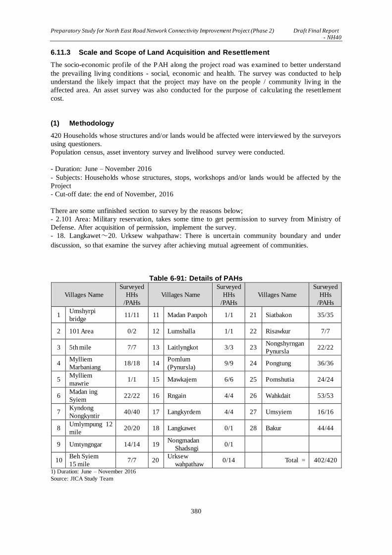
Preparatory Study for North East Road Network Connectivity Improvement Project (Phase 2) Draft Final Report - NH40
380
6.11.3 Scale and Scope of Land Acquisition and Resettlement
The socio-economic profile of the PAH along the project road was examined to better understand
the prevailing living conditions - social, economic and health. The survey was conducted to help
understand the likely impact that the project may have on the people / community living in the
affected area. An asset survey was also conducted for the purpose of calculating the resettlement
cost.
(1) Methodology
420 Households whose structures and/or lands would be affected were interviewed by the surveyors
using questioners.
Population census, asset inventory survey and livelihood survey were conducted.
- Duration: June – November 2016
- Subjects: Households whose structures, stops, workshops and/or lands would be affected by the
Project
- Cut-off date: the end of November, 2016
There are some unfinished section to survey by the reasons below;
- 2.101 Area: Military reservation, takes some time to get permission to survey from Ministry of
Defense. After acquisition of permission, implement the survey.
- 18. Langkawet~20. Urksew wahpathaw: There is uncertain community boundary and under
discussion, so that examine the survey after achieving mutual agreement of communities.
Table 6-91: Details of PAHs
Villages Name
Surveyed
HHs
/PAHs
Villages Name
Surveyed
HHs
/PAHs
Villages Name
Surveyed
HHs
/PAHs
1 Umshyrpi
bridge 11/11 11 Madan Panpoh 1/1 21 Siatbakon 35/35
2 101 Area 0/2 12 Lumshalla 1/1 22 Risawkur 7/7
3 5th mile 7/7 13 Laitlyngkot 3/3 23 Nongshyrngan
Pynursla 22/22
4 Mylliem
Marbaniang 18/18 14
Pomlum
(Pynursla) 9/9 24 Pongtung 36/36
5 Mylliem
mawrie 1/1 15 Mawkajem 6/6 25 Pomshutia 24/24
6 Madan ing
Syiem 22/22 16 Rngain 4/4 26 Wahkdait 53/53
7 Kyndong
Nongkyntir 40/40 17 Langkyrdem 4/4 27 Umsyiem 16/16
8 Umlympung 12
mile 20/20 18 Langkawet 0/1 28 Bakur 44/44
9 Umtyngngar 14/14 19 Nongmadan
Shadsngi 0/1
10 Beh Syiem
15 mile 7/7 20
Urksew
wahpathaw 0/14 Total = 402/420
1) Duration: June – November 2016
Source: JICA Study Team

Preparatory Study for North East Road Network Connectivity Improvement Project (Phase 2) Draft Final Report - NH40
381
(2) Population Census
Through population census, age, gender, composition of HHs, social category, ethnicity and
religion were surveyed.
A summary of the population census is shown below.
1) Summary of HHs
In 420 HHs, 309 HHs are with their structures affected, while 135 HHs are with their land affected
Table 6-92: Summary of the Survey
Villages Type of Affected Components Number of HHs
Villages
under
the
Project:
27
villages
Total HH with their
Structures Affected
Houses 299
Shops 48
Workshops 5
Structures 1
Total*1 309
Other land/ businesses Agricultural/open field 46
Stone and sand quarry 14
Betel nut Plantation owners 75
Total s 135
Total of PAHs *2 420
*1 44 HHs are with both houses and shops affected.
*2 24 HHs are with both structures and agricultural lands Source: JICA Study Team

Preparatory Study for North East Road Network Connectivity Improvement Project (Phase 2) Draft Final Report - NH40
382
Table 6-93: Details of PAHs
1) Number in ( ) under HHs with house affected presents 2 households living in same building (presents number of house).
Source: JICA Study Team
HHs with house
affected
(number of house
structure)
ShopWork-
shop
Other
Structur
e
Sub-total
(both
house/ shop
affected)
Agri-
culture
fields
Stone
quarry
Betel
nut
Plantati
ons
Sub-
total
1 Umshyrpi bridge 11 - - - 11 - - - - 11 11
(3)
2 101 Area 2 - - - 2 - - - - 2
Widening 2 3 5th
mile 7 7 - - 7 (7) - - - - 7 7
- Pomlum - - -
- Baniun - - -
(BP2
-Widening 3)4 Mylliem Marbaniang 1 2 1 4 8 6 14 18 18
Widening 3 5 Mylliem mawrie 1 - - - 1 1 - - 1 1 (1) 1
6 Madan ing Syiem 22 3 1 - 22 (4) 3 - - 3 22 (3) 22
(19)
(BP3
-Widening 4)7 Kyndong Nongkyntir 31 3 2 - 31 (5) 2 8 - 10 40 (1) 40
8 Umlympung 12 mile 17 3 1 - 20 (1) - - - - 20 20
9 Umtyngngar 14 9 - - 14 (9) 2 - - 2 14 (2) 14
10 Beh Syiem 15 mile 5 2 - - 7 6 - - 6 7 (6) 7
11 Madan Panpoh 1 - - - 1 1 - - 1 1 (1) 1
12 Lumshalla 1 - - - 1 1 - - 1 1 (1) 1
13 Laitlyngkot 3 1 - - 3 (1) - - - - 3 3
14 Pomlum (Pynursla) 8 3 - - 8 (3) - - - - 8 8
15 Mawkajem 6 2 - - 6 (2) - - - - 6 6
16 Rngain - 2 - 2 - 2 2
17 Langkyrdem 4 - - - 4 - - - - 4 4
18 Langkawet 1 - - - 1 - - - - 1
19 Nongmadan Shadsngi 1 - - - 1 - - - - 1
20 Urksew wahpathaw 14 - - - 14 - - - - 14
21 Siatbakon 35 5 - - 35 (5) 5 - - 5 35 (5) 35
(33) -
22 Risawkur 4 - - - 4 3 - - 3 7 7
23 Nongshyrngan Pynursla 22 - - - 22 2 - - 2 22 (2) 22
24 Pongtung 36 6 - - 36 (6) 2 - - 2 36 (2) 36
25 Pomshutia 24 - - 1 24 (1) - - - - 24 24
26 Wahkdait - 53 53 53 53
27 Umsyiem - - - - - - - 16 16 16 16
West Jaintia
HillsAmlarem after BP 6&7 28 Bakur 28 - - 28 10 - 6 16 44 44
TOTAL 299 48 5 1 309 44 46 14 75 135 420 24 402
(286)
BP 6&7
Pynursla
East Khasi
Hills
Sub-total
(Census
conducted)
Widening 6
BP 2
BP 3
Widening 4
BP 4
Khatarshnong
Laitkroh
Total
PAHs
Structure affected
PAHs
Widening 5
BP 5
BlockDistrict
Mylliem
Section
Widening 1
(both
structure
/land
affected)
Villages NameSl no
Land affected
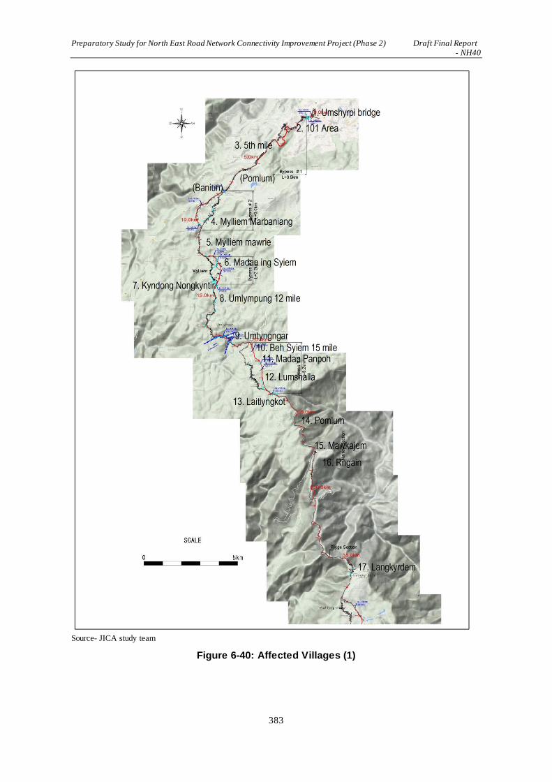
Preparatory Study for North East Road Network Connectivity Improvement Project (Phase 2) Draft Final Report - NH40
383
Source- JICA study team
Figure 6-40: Affected Villages (1)

Preparatory Study for North East Road Network Connectivity Improvement Project (Phase 2) Draft Final Report - NH40
384
Source- JICA study team
Figure 6-41: Affected Villages (2)

Preparatory Study for North East Road Network Connectivity Improvement Project (Phase 2) Draft Final Report - NH40
385
2) Population
Population of surveyed 402 HHs as of 30/11/2016 is 2,186 of which males are 48.4% and females
are 51.6%.
3) Composition of HHs
Average number of HHs member of surveyed 402 HHs as of 30/11/2016 is approximate 5.4 and
HHs over 8 member are 86 HHs, most numerous.
Table 6-94: Composition of Affected HHs
District Block single two three four five six seven More than
eight
Total
East
Khasi Hills
Mylliem 12 5 11 21 23 8 9 9 99
Khatarshno
ng Laitkroh
1 2 3 10 8 8 6 8 46
Pynursla 12 6 16 24 39 33 13 66 213
West Jaintia Hills
Amlarem 3 3 5 4 10 12 2 3 44
Total 28 16 35 59 80 61 30 86 402
(6.9%) (4.0%) (8.7%) (14.7%) (19.9%) (15.2%) (7.5%) (21.4%)
Source: JICA Study Team
Source: JICA Study Team
Figure 6-42: Composition of Affected HHs
3) Social category
The social category of the surveyed 402 HHs is shown for each block in Table 6-95. As
aforementioned in the district background, the majority of the PAPs belong to the ST (96.52%),
1.00% belong to the SC.
*For 402HHs surveyed as of 30/11/2016.
0
5
10
15
20
25
30
35
40
Single Two Three Four Five Six Seven More than
Eight
Mylliem Khatarshnong Laitkroh Pynursla Amlarem
(No. of HHs)

Preparatory Study for North East Road Network Connectivity Improvement Project (Phase 2) Draft Final Report - NH40
386
Table 6-95: Social category
District Block ST SC OBC Others Total
East Khasi Hills
Mylliem 89 1 0 9 99
Khatarshnong Laitkroh
44 2 0 0 46
Pynursla 211 1 0 1 213
West Jaintia Hills Amlarem 44 0 0 0 44
Total 388 4 0 10 402
(96.52%) (1.00%) (0.00%) (2.49%)
※ST:Scheduled Tribe SC:Scheduled Caste
OBC:Other Backward Class Others:Other Source: JICA Study Team
4) Ethnicity background
The ethnic background of the surveyed 402 HHs is shown for each block in Table 6-96. The graph
below indicates that the PAHs along the project road are mostly Khasi at 85.07%, and 10.95% are
from the Jaintia Tribe, 1.74 % are Nepalese, 0.50% are Garo and 0.25% are Bengalis.
*For 402 HHs surveyed as of 30/11/2016
Table 6-96: Ethnic background
District Block Khasi Jaintia Garo Nepali Bengali Others Total
East Khasi Hills
Mylliem 87 0 0 6 0 6 99
Khatarshnong
Laitkroh 44 0 1 1 0 0 46
Pynursla 211 0 1 0 1 0 213
West Jaintia Hills Amlarem 0 44 0 0 0 0 44
Total 342 44 2 7 1 6 402
(85.07%) (10.95%) (0.50%) (1.74%) (0.25%) (1.49%)
Source: JICA Study Team
5) Religion
The religious breakdown of the surveyed 402 HHs is shown block-wise in Table 6-97. The majority
of the PAPs are Christians at 74.63%, followed by 20.15% of the PAPs who follow the indigenous
religion known as the Niam Khasi. Finally, 2.99% are Hindus and 2.24 % are Buddhists.
*For 402 HHs surveyed at 30/11/2016
Table 6-97: Religious Breakdown
District Block Christian Buddhist Hindu Muslim Others Total
East Khasi Hills
Mylliem 83 0 12 0 4 99
Khatarshnong
Laitkroh 13 6 0 0 27 46
Pynursla 160 3 0 0 50 213
West Jaintia Hills Amlarem 44 0 0 0 0 44
Total 300 9 12 0 81 402
(74.63%) (2.24%) (2.99%) (0.00%) (20.15%)
Source: JICA Study Team
6) Cut-off Date
Cut-off date regarding resettlement of the Project is as follows.
- Cut-off date of the RAP: Completion date of census (30 November, 2016)

Preparatory Study for North East Road Network Connectivity Improvement Project (Phase 2) Draft Final Report - NH40
387
- SIA based on LARR 2013: Date of SIA notification from Revenue Department after approval of
DPR (the beginning of 2017)
7) Prevention of Influx after the Cut-off Date
For the purpose of preventing an influx of people into the project area after cut-off date, a list of
land owners will be prepared under the responsibility of the deputy commissioner of each district
before SIA.
8) Update of Census
The census will be updated by the SIA Unit appointed by the Revenue and Disaster Management
Department after approval of the DPR.
(3) Asset and Land Survey
1) Impact of Affected Households and Structures
Ownership of affected structure is as shown Table 6-98. The project will impact 298 households. Of
the 291 households that have completed the asset survey, 235 own their houses and 41 live in rented
houses.
Table 6-98: Ownership of Structure
(No. of House)
District Block Owned Rented No response Total
East Khasi Hills
Mylliem 47 27 2 76
Khatarshnong Laitkroh
40 5 1 46
Pynursla 124 5 12 141
West Jaintia Hills Amlarem 24 4 0 28
Total 235 41 15 291
(80.1%) (14.1%) (5.2%)
Source:JICA Study Team
Affected Structure Level is shown as in Table 6-99. Wooden Single storey is 77.37% and Tin is
11.68%.
Table 6-99: Affected Structure Level
(No. of HH)
District Block Single storey Single storey
RCC
Two storey
RCC Tin Total
East Khasi
Hills
Mylliem 51 8 0 7 66
Khatarshnon
g Laitkroh 42 1 2 0 45
Pynursla 112 10 0 13 135
West Jaintia Hills
Amlarem 7 7 2 12 28
Total 212 26 4 32 274
(77.37%) (9.49%) (1.46%) (11.68%)
Source:JICA Study Team

Preparatory Study for North East Road Network Connectivity Improvement Project (Phase 2) Draft Final Report - NH40
388
2) Impact on Land
Land use of the site of this project is as shown below;
Table 6-100: Affected Land
Village name Type of land Number of structure
Affected land Unit (m2)
1 Umshyrpi bridge Residential Area 3 700
2 101 Area Under Survey
3 5th mile Residential/ commercial Area 7 315
4 Mylliem Marbaniang
Stone quarry Residential/ commercial Area Agriculture field Fruits Garden
6 4 - -
1,250 1,200 1,800
250
5 Mylliem mawrie Residential Area - 800
6 Madan ing Syiem Residential/ commercial Area 19 1,140
7 Kyndong Nongkyntir
Agriculture field Sand quarry
Forest Residential/ commercial Area Petrol Pump
- 5
1 28 1
1,800 8,750
50 13,930
100
8 Umlympung 12 mile Residential Area 20 3,910
9 Umtyngngar Residential Area 14 5,250
10 Beh Syiem 15 mile Residential Area 7 30,250
11 Madan Panpoh Residential Area 1 2,200
12 Lumshalla Residential Area - -
13 Laitlyngkot Residential Area 3 123,000
14 Pomlum (Pynursla) Residential Area 8 650
15 Mawkajem Residential Area 6 430
16 Rngain Commercial Area 2 270
17 Langkyrdem Residential Area 4 500
18 Langkawet Under Survey
19 Nongmadan Shadsngi Under Survey
20 Urksew wahpathaw Under Survey
21 Siatbakon Residential/ commercial Area 32 4,840
22 Risawkur Residential Area Open space
4 -
6,050 8,650
23 Nongshyrngan Pynursla Residential Area Open space
4 -
3,120 400
24 Pongtung Forest Residential/ commercial Area
1 31
600 3,270
25 Pomshutia
Forest
Agriculture field Residential/ commercial Area
1
1 21
175
175 370
26 Whakdait Plantation - 180,330
27 Umsyiem Plantation - 148,530
28 Bakur Residential Area Plantation Agricultural Land
21 5,710 19,500 11,700
Source: JICA Study Team
Survey aforementioned does not provide enough information of community land. Trough site
survey, satellite photograph, and map of “Forest Flora” shown in Figure 7-24 and 7-25, composition
of 234.4ha of land affected by this project was estimated. The area consists of approximate 52.48%
of forest, 27.45% of agricultural land, 11.18% of residential area, 1.92% of military area and 1.86%
of sand and quarry site.

Preparatory Study for North East Road Network Connectivity Improvement Project (Phase 2) Draft Final Report - NH40
389
Table 6-101: Utilization of Affected Land
(m2)
District Block Forest
Area
Agricultural
Area
Residential
Area
Defense
Area Quarry
Other
Area Total
East Khasi Hills
Mylliem 207,040 48,726 40,840 45,120 1,500 38,900 382,126
Khatarshnong Laitkroh
42,103 155,337 32,450 0 30,000 0 259,890
Pynursla 974,631 430,580 170,945 0 12,000 80,984 1,669,140
West Jaintia
Hills Amlarem 6,810 9,000 17,930 0 0 0 33,740
Total 1,230,584 643,643 262,165 45,120 43,500 119,884 2,344,896
(52.48%) (27.45%) (11.18%) (1.92%) (1.86%) (5.11%)
※Except first half of Bypass 2 which is outside of project section
Source: JICA Study Team
3) Impact on Trees and Crops
The entire stretch of the project road has a large number of trees, vegetable and paddy fields. The
State Government Agriculture Department, Horticulture Department with their fields of vegetables,
flowers and fruits and tea, are all located along the project road. Towards the end of the project road,
starting from Wahlynkhat to Dawki, a series of Betel Nut plantation is seen along the project area.
Betel Nut trees are a major source of income for the people in this area. The widening and
improvement plan will be affecting these trees and the land. Approaches to restore the loss of the
trees is vital to reduce the adverse impact of the project.
Affected Trees is as shown in Table 6-102 while this does not provide enough information of trees
in community forest. Estimated tree number calculated by total square measure of affected forest
is as shown in Table 6-103.
Table 6-102: Affected Trees (1)
Village name Type Number
1 Umshyrpi bridge - 0
2 101 Area Under Survey
3 5th mile - 0
4 Mylliem Marbaniang Small tree Medium tree Fruit
1,475 15
5
5 Mylliem mawrie Plum tree 6
6 Madan ing Syiem - 0
7 Kyndong Nongkyntir Small tree Fruit
16 48
8 Umlympung 12 mile - 0
9 Umtyngngar Plum tree Fruit
7 4
10 Beh Syiem 15 mile - 0
11 Madan Panpoh - 0
12 Lumshalla Fruit 20
13 Laitlyngkot - 0
14 Pomlum (Pynursla) - 0
15 Mawkajem - 0
16 Rngain - 0
17 Langkyrdem - 0
18 Langkawet Under Survey
19 Nongmadan Shadsngi Under Survey

Preparatory Study for North East Road Network Connectivity Improvement Project (Phase 2) Draft Final Report - NH40
390
Village name Type Number
20 Urksew wahpathaw Under Survey
21 Siatbakon Small tree 10
22 Risawkur Pine tree 3
23 Nongshyrngan Pynursla Small tree 10
24 Pongtung Fruit 10
25 Pomshutia N/A
26 Wahkdait Small tree Medium tree
17,401 4,406
27 Umsyiem Small tree Medium tree
8,334 1,361
28 Bakur Betel nut 700 Source: JICA Study Team
Table 6-103: Affected Trees (2)
Type Number
1. Khasi Pine 6,400
2. Broad Leave Tree (Such as Teak etc.) 113,600
3. Betel Nut 23,500
4. Other Fruit bearing tree/Bamboos/Jack Fruit etc. 4,100
Total 147,600
Source: JICA Study Team
Affected Crops is as shown in Table 7-104.
Table 6-104: Affected Crops
Village name Type Number
1 Umshyrpi bridge - 0
2 101 Area Under Survey
3 5th mile - 0
4 Mylliem Marbaniang - 0
5 Mylliem mawrie - 0
6 Madan ing Syiem - 0
7 Kyndong Nongkyntir Paddy Vegetable
50,000 120,000
8 Umlympung 12 mile N/A
9 Umtyngngar Crop 20,000
10 Beh Syiem 15 mile - 0
11 Madan Panpoh - 0
12 Lumshalla Crop 20,000
13 Laitlyngkot - 0
14 Pomlum (Pynursla) - 0
15 Mawkajem - 0
16 Rngain - 0
17 Langkyrdem - 0
18 Langkawet Under Survey
19 Nongmadan Shadsngi Under Survey
20 Urksew wahpathaw Under Survey
21 Siatbakon Pumpkin Vegetable
20,000 120,000
22 Risawkur Crop 108,000
23 Nongshyrngan Pynursla Crop 20,000

Preparatory Study for North East Road Network Connectivity Improvement Project (Phase 2) Draft Final Report - NH40
391
Village name Type Number
24 Pongtung Crop 120,000
25 Pomshutia Crop -
26 Wahkdait Betel nut 6,370,000
27 Umsyiem Betel nut 4,050,000
28 Bakur Betel nut 1,982,000 Source: JICA Study Team
(4) Livelihood Survey
1) Education Level of PAPs
Education Level of PAPs is as shown in below.
Of the PAPs, 23.63% have had no education at all. About a quarter, 35.08%, have completed
elementary education, 25.27% have completed high elementary school, and only 6.22% have
completed high school. Only 1.49% of the PAPs have completed college or graduate school.
Table 6-105: Education Level of PAPs
District Block No
Education Completed
Primary
Completed
Upper Primary
Complete High School
Not
complet-ed college
Graduate or Higher
No response Total
East
Khasi Hills
Mylliem 16 15 41 13 3 4 7 99
Khatarshnong
Laitkroh 21 16 8 1 0 0 0 46
Pynursla 51 93 43 11 3 2 10 213
West Jaintia Hills
Amlarem 7 17 19 0 0 0 1 44
Total 95 141 111 25 6 6 18 402
(23.63% ) (35.08% ) (25.27% ) (6.22% ) (1.49% ) (1.49% ) (4.48% ) Source: JICA Study Team
2) Literacy
Table 6-106 below indicates Average Literacy of PAPs. As mentioned in 7.6.5 Baseline Data of
the Natural and Socio-economic Environment, average literacy of East Khasi Hills district is
84.15%, and that of West Jaintia Hills district is 63.12%, therefore Literacy of affected villages
indicate slightly higher than standard.
Table 6-106: Literacy
District Block Literacy Rate
Total Male Female
East Khasi Hills
Mylliem 86.52% 88.30% 84.30%
Khatarshnong Laitkroh
80.73% 78.87% 82.48%
Pynursla 85.06% 85.05% 85.06%
West Jaintia
Hills Amlarem 83.25% 89.38% 76.26%
Total 85.24% 86.30% 84.05%
Source: Census2011by JICA Study Team
2) Occupation
Table 6-107 below indicates that the majority (53.23%) of the PAPs are self-employed. Men and
women in the project area are more inclined to earn their livelihood through self-employment such
as running a shop (tea, groceries, vegetables etc), manage a sand or stone quarry, or provide private
transport for tourists, etc. There are 26.87% that earn their livelihood through agriculture, growing
vegetables in their own garden or a bigger land attached to their homes, 3.73% are in government
services and 1.49% are unskilled laborers.

Preparatory Study for North East Road Network Connectivity Improvement Project (Phase 2) Draft Final Report - NH40
392
Table 6-107: Occupation
Dist. Block
Agriculture
/ Allied Agriculture
Dairy
Household
/Cottage Industry
Self Employed
Skilled Profession
Unskilled Labor
Private Service
Gov. Service
Other/ No response
Total
East
Khasi Hills
Mylliem 9 0 0 65 2 0 0 11 12 99
Khatarshnong Laitkroh 11 1 2 22 1 0 0 1 8 46
Pynursla 69 1 2 103 0 6 3 3 26 213
West
Jaintia Hills
Amlarem 19 0 0 24 0 0 0 0 1 44
Total 103 2 4 214 3 6 3 15 47 402
(26.87%) (0.50%) (1.00%) (53.23%) (0.75%) (1.49%) (0.75%) (3.73%) (11.69%)
Source: JICA Study Team
4) Number of employed members in PAHs
Table 6-108 below indicates that number of employed members in a PAPs. Out of the total 402
PAHs surveyed, the total number of adults is 2,148, out of which 39.2% are employed and 16.5%
are unemployed, while 8.5% are involved in housework.
Table 6-108: Number of employed members in PAHs
District Block Employed Unemployed Housework Students Total
East Khasi Hills
Mylliem 128 48 41 127 344
Khatarshnong Laitkroh
88 37 10 88 223
Pynursla 299 145 62 271 777
West Jaintia Hills Amlarem 40 4 8 21 73
Total 555 234 121 507 2,148
(39.2%) (16.5%) (8.5%) (35.8%)
Source: JICA Study Team
3) Total monthly household income of HHs from all sources:
Table 6-109 below indicates the total monthly income of the PAH; Approximate 40% of the PAPs
have a monthly income that falls within Rs 3000/-11000. Majority is 11.94% within Rs 7000/- 9000
followed by 10.45% those earning between Rs 5000 to 7000. HHs below Poverty line is 10.7%
earning below Rs 5000/-. As shown in Table 6-110, average monthly income is Rs 12,400.

Preparatory Study for North East Road Network Connectivity Improvement Project (Phase 2) Draft Final Report - NH40
393
Table 6-109: Total monthly household income of H/H from all sources (INR/month)
Dist.t Block Below 1000
1001 -
3000
3001 -
5000
5001 -
7000
7001 -
9000
9001 -
11000
11000-
13000
13001-
15000
15001-
17000
17001-
19000
19001-
21000
above 21000
No res-ponse
Total
East
Khasi
Hills
Mylliem 0 0 4 10 13 8 2 1 3 0 7 21 30 99
Khatarshn
ong
Laitkroh
0 1 11 8 9 4 2 2 1 0 1 3 4 46
Pynursla 2 2 18 20 22 19 3 7 11 19 26 29 35 213
West
Jaintia
Hills
Amlarem 0 0 5 4 4 9 5 5 1 1 0 0 10 44
Total 2 3 38 42 48 40 12 15 16 20 34 53 79 402
(0.50) (0.75) (9.45) (10.45) (11.94) (9.95) (2.99) (3.73) (3.98) (4.98) (8.46) (13.18) (19.65) (100)
Source: JICA Study Team
Source: JICA Study Team
Table6-1: Total monthly household income of H/H from all source
Table 6-110: Average income of HHs (Rs/month)
District Block Average (Rs. / month)
East Khasi Hills
Mylliem 13,700
Khatarshnong Laitkroh 8,600
Pynursla 13,300
West Jaintia Hills Amlarem 9,700
Total Average 12,400 Source: JICA Study Team
(5) Land System
Land system is as shown in Table below.
Majority is 37.81% HHs of private land out of 402 HHs, followed by 34.33% of village council
pass 60HHs.
0
20
40
60
80
100(HHs)
(Rs/month)

Preparatory Study for North East Road Network Connectivity Improvement Project (Phase 2) Draft Final Report - NH40
394
Table 6-111: Land System
District Block
Private Land with Land
Settlement Certificates
Periodic
Patta
Home
Site
Village Council
Pass Others
No
response Total
East Khasi Hills
Mylliem 48 15 1 5 1 29 99
Khatarshnong Laitkroh
24 2 14 0 5 1 46
Pynursla 56 14 7 118 7 11 213
West Jaintia Hills
Amlarem 24 2 0 15 0 3 44
Total 152 33 22 138 13 44 402 (37.81%) (8.21%) (5.47%) (34.33%) (3.23%) (10.95%) Source: JICA Study Team
Table 7-112: Land System with Affected Houses
District Block
Private Land with Land Settlement Certificates
Periodic Patta
Home Site
Village
Council Pass
Others No
response Total
East
Khasi Hills
Mylliem 39 15 1 5 0 16 76
Khatarshnong
Laitkroh 24 2 14 0 5 1 46
Pynursla 56 2 7 59 7 10 141
West Jaintia Hills
Amlarem 24 1 0 0 0 3 28
Total 143 20 22 64 12 30 291
(49.14%) (6.87%) (7.56%) (21.99%) (4.12%) (10.31%) Source: JICA Study Team
- Periodic Patta : Patta issued by State government for land acquisition with limited period.
- Village Council Pass : Issued within the field of village council, function as right to use the
land conventionally
(6) Vulnerability
17.7% of HHs are headed by a female. 21.6% of HH are headed by the persons over 55 years old.
13.2% are BPL and 95.48% of the affected HHs are STs.
Table 6-113: Vulnerability
(HHs)
District Block Female HH HH above 55 Minority Below
Poverty Line
Total
Vulnerable
Total
HHs
East Khasi
Hills
Mylliem 36 20 6 5 51 99
Khatarshnong
Laitkroh 3 11 1 15 23 46
Pynursla 27 42 1 28 78 213
West Jaintia Hills
Amlarem 5 14 0 5 19 44
Total 71 87 8 53 171 402
(17.7%) (21.6%) (2.0%) (13.2%) (42.5%)
* There are HHs doubled in the table, so that total HHs and number of vulnerable do not correspond. Source: JICA Study Team

Preparatory Study for North East Road Network Connectivity Improvement Project (Phase 2) Draft Final Report - NH40
395
6.11.4 Compensation and Assistance Policy
(1) Objective of Policy Framework
The resettlement policy of the project is prepared according to the principles of the R& R policy of
the GOI and in line with requirements of JICA guidelines and policies. For ensuring compensation
with replacement cost, structure cost shall be compensated without depreciating.
Cut-off date and compensation policy is as shown below.
<Cut-off Date>
Completion date of census of JICA Study: End of November, 2016
SIA based on LARR 2013: Date of SIA notification from Revenue Department after approval of
DPR (the beginning of 2017)
<Compensation Policy>
In appreciating this verity, the policy framework for this project can realize the following:
Table 6-114: Compensation Policy
Item Contents
Fundamental
Items
Collate all the successful RAPs of similar projects in Meghalaya – (a).Road
upgradation (Shillong- Nongstoin- Tura) Project, 2 laning of Shillong
Nongstoin NG 44 and Nongstoin-Tura road under phase A of SARDP-NE.
(b). Jorabad-Shillong NH 40 road project (4 laning of Jorabad Shillong
section) under the SARDP-NE. and examine Specific measures according
latest law and JICA’s Guideline. Strengthen the capacity of the various
institutions relevant to the project especially those implementing the project
from the Government side, in terms of comprehension and practica l
execution of RAP and livelihood restoration.
Establish a grievance redressal Mechanism that will ensure that the issues of
project affected people are heard and addressed, resulting in a fair and
justified RAP. Child labour will not be involved.
Consideration
Level
The affected Community is involved from the initial phase; through
community and stakeholder meetings, FGDs, that informs the people about the
project and their views are noted. The consent of the community, especially
the PAPs is compulsory for initiation of the survey and the project at large.
When displacement in inevitable, people affected will be assisted in measures
that will better their current status of living without having to bear any cost.
Specific
measures
The property and asset (building, land, forest, products etc.) shall be
compensated as same or better than before resettlement.
The income of the PAPs must improve after resettlement by supporting
agricultural production and compensating income.
In case change of occupation, job training will be provided.
Payment of compensation and assistance to PAPs will be ensured before the
civil work of the project starts.
All land acquisition will be carried out after issuance of notifications for
harvesting of crops.
Women workers will be provided with gender friendly facilities on
project site, and be paid equal wages for equal volume of work.
Health Education focusing on HIV, STIs at the project sites, labour camps, will be compulsory when the civil work starts.
Source: JICA Study Team

Preparatory Study for North East Road Network Connectivity Improvement Project (Phase 2) Draft Final Report - NH40
396
(2) Rehabilitation Plan
The rehabilitation plan should consider the present socio-economic status of the PAPs. The survey
conducted captures this information and helps in formulating a plan that considers the peoples’
current way of life and how a new environment can better their standard of living. A key objective
of RAP is to enhance the livelihood of PAPs and ensure that their resettlement is not lowering their
quality of life. The rehabilitation plan is to be developed and implemented by the state government;
inputs and feedback from relevant stakeholder / communities must be incorporated in the plan
through a series of discussions and workshops. The plan should be outlined within the framework
of the policies and guidelines of JICA and the state / country policy.
The objectives of Rehabilitation Plan in this project is following;
- Agricultural Land affected by the project, PAPs working at sand and quarrying
- Residents whose occupation affected directly (resettlement) or indirectly (decreasing
income by construction of bypass) by the project.
Measure 1. Job Training
Purpose: - Train for earning by new occupation
Countermeasure: -Survey the applicants and their demand for new occupation.
-Based on possibility of project, market and advice from Experts, consider
contents of job training.
-Programs of seminar or practice for job training
-Provide the opportunity of job training
Measure 2. Provide and enhance the chance of Employment
Purpose: -Increase the production of existing agriculture and quarrying etc.
Countermeasure: -Based on survey of household livelihood and opinion of PAPs, consider
measures to provide and enhance.
-Consider according to expert’s advice based on possibility of project and
market
-Consider reduction of individual expense, such as leased land or group purchase
in case of land expansion
Measure 3. Financial Support
Purpose: -Better economic situation after resettlement
Countermeasure: -Establishment of Microfinance (Low / Non interest)
-Subsidy
Measure 4. Employment in short term
Purpose: -Make opportunity of short term employment in relocated place until getting stable
income by the main job.
Countermeasure: -Make opportunity of short term employment

Preparatory Study for North East Road Network Connectivity Improvement Project (Phase 2) Draft Final Report - NH40
397
Table 6-115: Entitlement Matrix Type of loss Occupant of
property
Unit of
Entitlement
Entitlement Details of Entitlement
1. Agricultural
Land
Titleholder
Periodic Patta
Holder/Tempo
rary Village
Pass Holder
Household Compensation at
Replacement
value and
Assistance
a) Land for land, if available. Or cash compensation for the land at replacement cost(*), which will be
determined by District Collector.
b) If the compensation amount is less than the replacement cost mentioned above, the difference
amount will be paid as Assistance.
c) If the residual land is unviable for agriculture, PAPs shall have the following three options:
Compensation for affected land and continue on the remaining unaffected plot of land; or
If eligible person surrenders the residual plot, then compensation and assistance given for the
entire plot of land; or
Replacement land, if so wished by eligible persons, subject to availability of land that is at least
equally productive.
d) Resettlement allowance of Rs. 50,000/- will be provided to those who do not get land for land,
irrespective of the size of land.
e) In case of severance of cultivable land, an additional grant of 10% shall be paid over and above the
amount paid for land acquisition.
Community Community Same as above a) Land for land, if available. Or cash compensation for the land at replacement cost, which will be determined by District Collector.
b) If the compensation amount is less than the replacement cost mentioned above, the difference amount will be paid as Assistance.
*Distribution of the compensation will be determined through consultation within the community.
2. Non-
Agricultural land
(Homestead,
Commercial and
others)
Titleholder
Periodic Patta
Holder/
Temporary
Village pass
Holder
Household Compensation
for structure at
Replacement
Cost plus
assistance
a) Land for land, if available. Or cash compensation for the land at replacement cost, which
will be determined by District Collector. b) If the compensation amount is less than the replacement cost mentioned above, the difference
amount will be paid as Assistance c) Resettlement allowance of Rs. 50,000/- will be provided irrespective of the size of land.

Preparatory Study for North East Road Network Connectivity Improvement Project (Phase 2) Draft Final Report - NH40
398
Type of loss Occupant of
property
Unit of
Entitlement
Entitlement Details of Entitlement
Community Community Same as above a) Land for land, if available. Or cash compensation for the land at replacement cost, which will be determined by District Collector.
b) If the compensation amount is less than the replacement cost mentioned above, the difference amount will be paid as Assistance.
*Distribution of the compensation will be determined through consultation within the community. 3. Loss of Crops Owner/
occupant Household Compensation a) Revenue Department or Special Committee to determine the current cost.
b) Four (4) months notice to harvest standing crops shall be given. However, if notice cannot be given then compensation for these crops shall be paid at market value
c) Subsistence Grant equivalent to Rs. 3000/- (MAW; Minimum Agriculture Wage) per month for 6 months.
Community Community Same as above a) Revenue Department or Special Committee to determine the current cost. b) Four (4) months notice to harvest standing crops shall be given. However, if notice cannot be
given then compensation for these crops shall be paid at market value *Distribution of the compensation will be determined through consultation within the community.
4. Loss of
Plants/trees
Owner/
occupant
Household Compensation Revenue Department or Special Committee to determine the current cost. For perennial fruit bearing
trees such as pineapples, jackfruits, Arecanutetc, average productivity of such trees will be taken as 20
years.
Community Community Same as above Revenue Department or Special Committee to determine the current cost. For perennial fruit bearing trees such as pineapples, jackfruits, Arecanutetc, average productivity of such trees will be taken as 20 years. *Distribution of the compensation will be determined through consultation within the community.
5. Loss of Cattle
shed, poultry
shed or any other
shed for domestic
animals
Owner/
Occupant
Household Compensation Rs.600 per m2
for thatched roof and Rs. 1000 per m2 for GCI sheet roof (to be paid as per
revised/latest available updated basic schedule of rates for buildings). In case of non-revision,
10%premium per year will be added to the latest rate available.

Preparatory Study for North East Road Network Connectivity Improvement Project (Phase 2) Draft Final Report - NH40
399
Type of loss Occupant of
property
Unit of
Entitlement
Entitlement Details of Entitlement
6. Loss of
Residence/
Commercial unit
Tenant Household Assistance a) The amount of deposit or advance paid by the tenant to the landlord or the remaining amount at the
time of expropriation (this will be deducted from the payment to the landlord)
b) Subsistence grant of Rs.3,000/-per month for a period of twelve (12) months from the date of
displacement
c) Lump sum shifting allowance of Rs. 15000/-
d) Resettlement allowance of Rs. 50,000/- will be provided irrespective of the size of land
7. Loss of Kiosk Owner/
Occupant
Household Assistance a) Lump sum shifting allowance of Rs.7500/-
b) Right to salvage materials from the existing structure
8. Loss of
employment
Wage earner Household Assistance a) Economic Rehabilitation Grant equivalent to twenty-five (25) days of Minimum Agricultural
Wages (MAW) per month for a period of three months.
b) Priority work opportunities in the project construction work
c) Rs.20000/- towards vocational/skill improvement as per choice.
9. Loss of
livelihood (losing
commercial unit .
losing
agricultural land
and with balance
land below MEH)
Titleholder/Pe
riodic Patta
holder/ Village
Pass holder
Household Assistance a) Priority work opportunities in the project construction works.
b) Rs. 20,000/- towards vocational skill improvement as per choice. The amount will cover daily
stipend equivalent to MAW for the duration of training and shall also cover costs towards boarding,
lodging, transportation, etc.
10. Additional
support to
vulnerable groups
Titleholder/Pe
riodic
Patta/Village
Pass holder
Household Assistance One time additional financial assistance of Rs.25000/- as Economic Rehabilitation Grant towards
income generation.
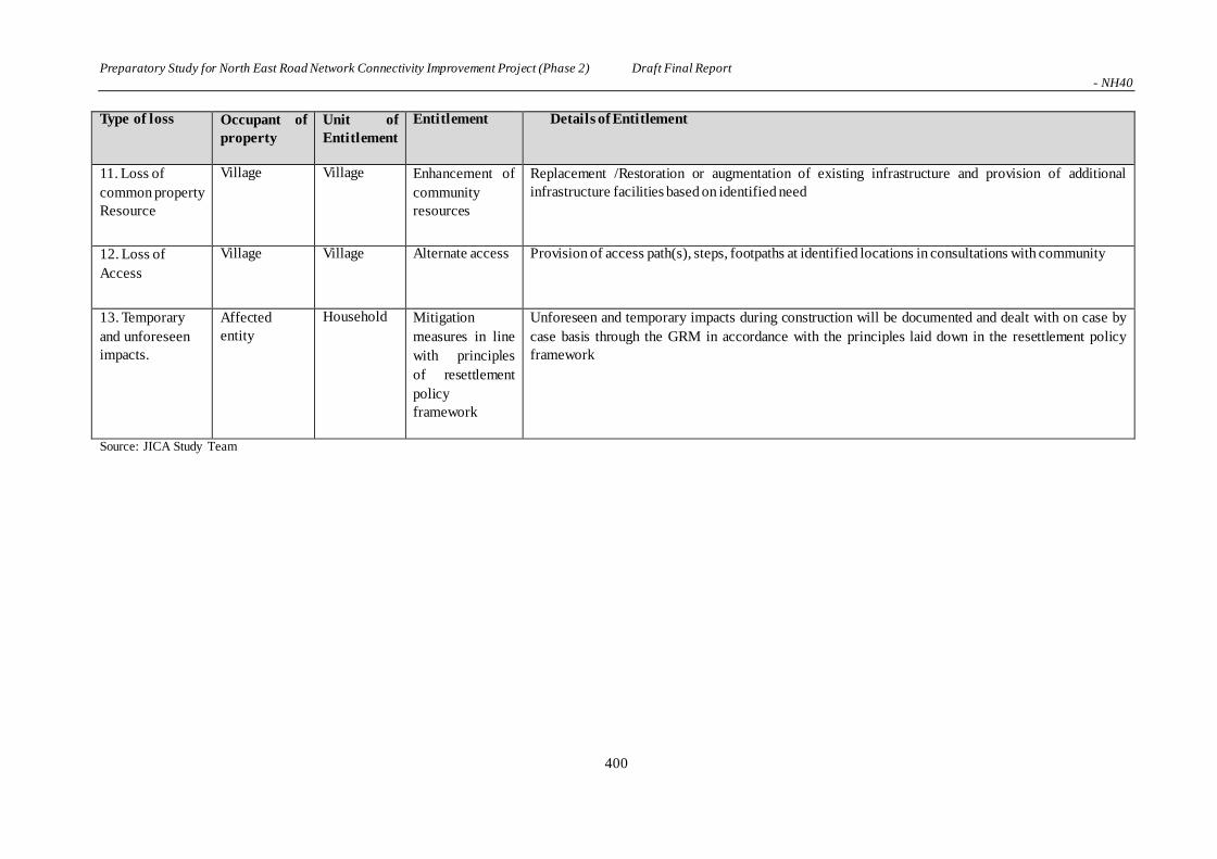
Preparatory Study for North East Road Network Connectivity Improvement Project (Phase 2) Draft Final Report - NH40
400
Type of loss Occupant of
property
Unit of
Entitlement
Entitlement Details of Entitlement
11. Loss of
common property
Resource
Village Village Enhancement of
community
resources
Replacement /Restoration or augmentation of existing infrastructure and provision of additional
infrastructure facilities based on identified need
12. Loss of
Access
Village Village Alternate access Provision of access path(s), steps, footpaths at identified locations in consultations with community
13. Temporary
and unforeseen
impacts.
Affected
entity
Household Mitigation
measures in line
with principles
of resettlement
policy
framework
Unforeseen and temporary impacts during construction will be documented and dealt with on case by
case basis through the GRM in accordance with the principles laid down in the resettlement policy
framework
Source: JICA Study Team

Preparatory Study for North East Road Network Connectivity Improvement Project (Phase 2) Draft Final Report - NH40
401
*Replacement cost
Referring to JICA project (Bengaluru Peripheral Ring Road Project) after implementation of
LARR2013, surmised as below;
・Land price
1. Market price decided by Deputy
Commissioner
2. Annual
Interest 12%
3. Rural are Multiplier
(x1.0-2.0、Figure x2.0)
4. 100% Solatium (Re-add the total of 1-3)
This meets the replacement cost of World Bank op.4.12 (market price + the cost of preparing the land to levels similar to those of the affected land +tax), so that land price calculated by LARR is applied.
・Structure Price
1. Standard price by State
Government
2. 100% Solatium
While this meets the replacement cost (market price of the materials to build a replacement structure + the cost of transporting building materials to the construction site + the cost of any labor and contractors' fees +tax) of World Bank op.4.12, LARR2013 usually applies the price of with depreciation. This project demand to apply the price without depreciation. In project of NH51(Tura-Dalu) of the State, State Revenue and Disaster Management Department issued the Request Letter of resettlement and land acquisition based on RAP to Deputy
Commissioner. Procedure like this is confirmed to be implemented for this project.
6.11.5 Grievance Redress Mechanism
In order to provide an accessible mechanism to the affected people, community and any
stakeholder(s) to raise their issues and grievances as well as concerns, a Grievance Redress
Mechanism (GRM) will be established within the project. The fundamental objectives of the GRM
are to resolve any land acquisition disputes in consultation with the aggrieved party to facilitate the
smooth implementation of the project.
Procedure and role of GRM is as shown below;
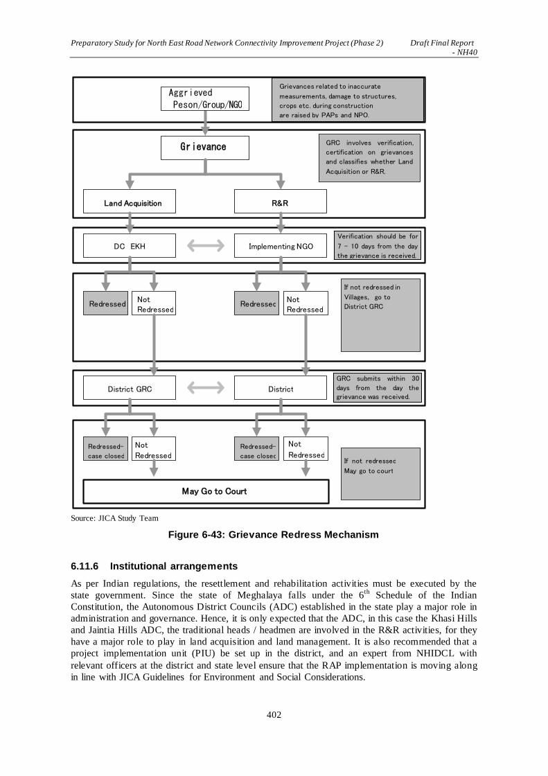
Preparatory Study for North East Road Network Connectivity Improvement Project (Phase 2) Draft Final Report - NH40
402
Source: JICA Study Team
Figure 6-43: Grievance Redress Mechanism
6.11.6 Institutional arrangements
As per Indian regulations, the resettlement and rehabilitation activities must be executed by the
state government. Since the state of Meghalaya falls under the 6th Schedule of the Indian
Constitution, the Autonomous District Councils (ADC) established in the state play a major role in
administration and governance. Hence, it is only expected that the ADC, in this case the Khasi Hills
and Jaintia Hills ADC, the traditional heads / headmen are involved in the R&R activities, for they
have a major role to play in land acquisition and land management. It is also recommended that a
project implementation unit (PIU) be set up in the district, and an expert from NHIDCL with
relevant officers at the district and state level ensure that the RAP implementation is moving along
in line with JICA Guidelines for Environment and Social Considerations.
If not redressed 、 May go to court
If not redressed in Villages, go to District GRC
Aggrieved
Peson/Group/NGO
Grievance
Land Acquisition R&R
DC EKH Implementing NGO
Redressed Not Redressed
Redressed Not Redressed
District GRC District
Redressed-
case closed
Not
Redressed Redressed-
case closed
Not
Redressed
May Go to Court
GRC involves verification,
certification on grievances
and classifies whether Land
Acquisition or R&R.
Grievances related to inaccurate
measurements, damage to structures,
crops etc. during construction
are raised by PAPs and NPO.
Verification should be for
7 – 10 days from the day
the grievance is received.
GRC submits within 30
days from the day the grievance was received.

Preparatory Study for North East Road Network Connectivity Improvement Project (Phase 2) Draft Final Report - NH40
403
Table 6-116: Implementation Institute and their Roles
Name Members and Roles
Central Level Institution
National Highways and
Infrastructure Development
Corporation Limited (NHIDCL)
Project Implementation Institution
State Government
Revenue and Disaster Management
Department
SIA : Notification of procedure for Land
Acquisition
Local Government
KHADC : Khasi Autonomous
District Council
Member of GRC
Issue No Objection Certificate
for Land Acquisition JHADC : Jaintia Autonomous
District Council
DC.EKH:Deputy Commissioner
of East Khashi Hills District
Have the responsibility of Land Acquisition,
Resettlement and Rehabilitation
DC.WJH:Deputy Commissioner
of West Jhaintia Hills Distict
Others
GRC : Grievance Redress
Committee
Consist of Deputy of NHIDCL, PWD, East Khasi
and West Jaintia for Grievance Redress.
Members are not less than 3 from different position.
PAP:project affected persons Representative of Project affected person, NGO
may be included.
Village Community Verification, Certification of Grievance
MIG : Meghalaya Institute of Governance
Implementation Institute of SIA
NGO : Non Governmenta l
Organization
Support PAPs, Function as a link between
Government and District Administration.
- Role as PAPs and Spokesperson of project
- Support NHIDCL to mitigate adverse impact for
project
- Interface between local communities and
NHIDCL
- As a link of NHIDCL, Government, and
Autonomous District Councils.
Source:JICA Study Team

Preparatory Study for North East Road Network Connectivity Improvement Project (Phase 2) Draft Final Report - NH40
404
NHIDCL:National Highways and Infrastructure Development Corporation Limited DC:Deputy Commissioner, MIG: Meghalaya Institute of Governance, BDO: Block Development Officer Source: JICA Study Team
Figure 6-44: Institutional arrangements
6.11.7 Resettlement Schedule
Resettlement Schedule is as shown below, and it is implemented in accordance with principal
activities as below.
Monitoring Committee
DC
Village Head
Village (Community, PAPs/PAHs)
MIG
External Monitoring Committee
Meghalaya State Government (Revenue Department)
R & R
Committee
NHIDCL/
Consultant/
NGO
NHIDCL Delhi
NHIDCL Shillong
BDO
NGO

Preparatory Study for North East Road Network Connectivity Improvement Project (Phase 2) Draft Final Report - NH40
405
Table 6-117: Resettlement Schedule Year 2017 2018 2019 Department
Quarter 1 2 3 4 1 2 3 4 1 2 3 4 Management
Implementation
Preparation
Completion of ROW drawings DC DC
Hiring NGO for RAP Preparation NHIDCL NGO
Verification and update RAP PWD MIG
Preparation of Rehabilitation Plan DC NGO
Submission of revised RAP to JICA DC NGO
RAP budget approval from Central Government NHIDCL DC
Disclosure of revised RAP Revenue Dep. Revenue Dep.
Establish Grievance Redress Mechanism DC ADC, NGO
Declaration of cut-off date (LA notification) Revenue Dep. Revenue Dep.
Preparation of resettlement sites DC R&R Committee
Implementation
Rehabilitation DC R&R Committee
Disbursement of compensation and assistance NHIDCL DC/ NGO
Physical displacement
Taking possession of acquired land
Handover of acquired land to
contractor
DC R&R Committee
Taking possession of acquired land DC R&R Committee
Handover of acquired land to contractor DC R&R Committee
Monitoring
Half-yearly report
Completion report
Revenue Dep. Monitor.Commit..
Completion report Revenue Dep. Monitor.Commit..
Road Construction Civil Works NHIDCL Contractor NHIDCL:National Highways and Infrastructure Development Corporation Limited
DC: Deputy Commissioner, ADC: Autonomous District Councils, R&R Committee: Rehabilitation and Resettlement Committee Source: JICA Study Team
Phase of Resettlement and Rehabilitation To summarize, the proposed R&R activities are divided in to three broad categories based on the
stages of work and process of implementation. The following are details of activities involved in
these three phases, i.e. Project Preparation Phase, Resettlement Plan (RP) Implementation phase,
Monitoring and Evaluation period:

Preparatory Study for North East Road Network Connectivity Improvement Project (Phase 2) Draft Final Report - NH40
406
(a) Project Preparation Phase
The major activities to be performed in this period include the establishment of PMU and
PIU at the project level.
Appointment of NGO and establishment of the GRC, etc.
The information campaign & community consultation will be a process initiated from this
stage and will go on till the end of the project. Information dissemination through
consultations, community meetings using brochures / leaflets that inform the community
about the resettlement policy, entitlements and any necessary information deemed relevant
for project effectiveness. The language of the dissemination must be in the regional
language.
(b) RP Implementation Phase
After the project preparation phase, the next stage is the implementation of RP which
includes issuing the compensation by the EA; payment of all eligible assistance; relocation
of PAPs; initiation of economic rehabilitation measures; site preparation for delivering the
site to contractors for construction, and finally starting civil work.
(c) Monitoring and Evaluation Period As mentioned earlier, internal monitoring will be the responsibility of the PMU, PIU and the
implementing NGO, and will start early during the project when the implementation of the RP
starts, and will continue till the complementation of the project. The independent monitoring and
evaluation will be the responsibility of an external agency to be hired for the project.
The R&R implementation schedule will follow the key activities below.
i. State government shall by notification appoint an officer not below the rank of joint
collector or additional collector or deputy collector or equivalent official of the Revenue
Department, to be the administrator for R&R for the project.
ii. The administrator for R&R, to enable him / her to function efficiently, will be provided
with such powers, duties and responsibilities as prescribed by the appropriate government.
He / she will also be provided with office infrastructure and be assisted by officers and staff
who shall be subordinate to him / her as the appropriate government may decide.
iii. The state government shall also appoint an officer of the rank of commissioner or secretary
for R&R who will be responsible for supervising the formulation of R&R schemes or plans
and the proper implementation of the same. He / She will also be responsible for the post –
implementation social audit.
iv. Under the chairmanship of the administrator of R&R, the state government shall constitute
a committee called the Rehabilitation and Resettlement Committee. The committee may
consist of members as per details provided by the RFCTLARR 2013 section vi clause 45
(2).
v. A notification regarding the project affected land will be published in the official gazette,
two daily newspapers, of which one is of the regional language, in the respective village
Dorbar office, the office of the district collector and the sub-divisional magistrate, uploaded
in the official website of the government and in the affected villages.
vi. Immediately after issuance of the notification, the ADC shall be informed of the
notification issued at a meeting called especially for the purpose.

Preparatory Study for North East Road Network Connectivity Improvement Project (Phase 2) Draft Final Report - NH40
407
vii. Appraisal of Social Impact Assessment Report by Expert Group. The appropriate
government will ensure that the SIA be evaluated by an expert group (consisting of
members as prescribed in the RFCTLARR 2013 chapter II Clause 7 (2).
viii. Update the list of PAP through the Detailed Measurement Survey DMC.
ix. Conduct a survey and undertake a census of the affected families - inventory of affected
properties and assets estimation.
6.11.8 Resettlement Budget and its Source
The resettlement budget takes account of compensation for affected land, structures, trees,
resettlement assistance, institutional cost, hiring of RAP implantation agency, contingency, HIV /
STI awareness activities, capacity building, external monitoring and evaluation consultants,
documentation and internal monitoring, and institutional costs.
Table 6-118: R&R Budget
Item Unit Unit Cost Quantity Total (Rs)
I. Compensation
Land (construction) ha 1,500,000 234.49 351,734,400
Land (surplus soil) 1,000,000 52.82 52,820,000
Rural area multiplier *the land price will be double for compensation
of rural area land as per LARR 2013 809,108,800
Structure Sq. m 34,500 81,690,000
Trees No. 258,900,000
Crops No. 683,226
Solatium *100% of compensation as per LARR 2013 1,150,382,026
Sub-Total (I) 2,300,764,052 2,282,258,000
II. Allowance
Moving allowance Household 50,000 307 15,350,000
Subsistence allowance Household 36,000 307 11,052,000
Assistance to vulnerable Household 25000 180 4,500,000
Training Household 20,000 307 6,140,000
Sub-Total (II) 37,042,000
III. Implementation
Expert fees Lump sum 7,000,000
Staff training Lump sum 1,000,000
External monitoring Lump sum 15,000,000
NGO Lump sum 2,000,000
Information disclosure Lump sum 1,000,000
Livelihood restoration Lump sum 10,000,000
Sub-Total (III) 36,000,000
Sub-Total (I+II+III) 2,373,806,052
Contingency (10%) 237,380,605
Total 2,611,186,657 Source: JICA Study Team

Preparatory Study for North East Road Network Connectivity Improvement Project (Phase 2) Draft Final Report - NH40
408
Funding for the resettlement budget will be secured by MORTH from the national budget based on
an application from NHIDCL. The budget will be transferred from MORTH to DC through
NHIDCL, and disbursed to entitled households / communities.
6.11.9 Monitoring and Evaluation
Monitoring and evaluation are critical for building a strong, evidence-based documentation
surrounding the project. It is also a tool for identifying and documenting successful programmes
and approaches and tracking common indicators across related projects. Monitoring and evaluation
forms the basis of understanding around the many multi-layered factors underlying a project. Since
this is a project which deals with infrastructure development and involuntary resettlement, it must
employ strong monitoring mechanisms all the more. RAP implementation issues can be resolved
more effectively when the project has a strong system of checks and balances, thereby resulting in
good management.
Evaluation allows the project to go through periodic assessments to examine impacts and
sustainability; it especially assists the project in attaining its achievement index, and in reviewing
its current approach and strategies to better the outcome of the project. Monitoring and evaluation
are tools that are indispensable in the RAP implementation, for it ensures the performance and
fulfillment of the project objectives.
The project can adopt two types of monitoring; internal monitoring and external monitoring and
evaluation.
Internal Monitoring: Internal monitoring will be carried out by the PIU, PWD with assistance from the RAP
implementation agency. The PIU and PWD will also engage an external agency (third party) to
undertake monitoring at different stages of the project, preferably biannually and evaluation at the
middle and end of the project. The monitoring and evaluation will consist of a desk review of
documentation and field-based work with focus group discussions with the community,
stakeholders and the implementation team.
The objectives of internal monitoring is:
(i) To measure progress against the RAP implementation plan.
(ii) Confirm if all entitlements agreed upon are delivered to PAPs.
(iii) Identify critical issues that stall the project, or that are hurting the people, and suggest
corrective actions.
(iv) Monitor the efficiency of the GRM. (v) Appraise the satisfaction of PAPs over the activities and implantation of the project.

Preparatory Study for North East Road Network Connectivity Improvement Project (Phase 2) Draft Final Report - NH40
409
Design of Monitoring Form is as shown below;
Table 6-119: Monitoring Form Design(Summary)
Major items
of action
Specific action steps (sub-
items)
Progress
in
quantity
Progress
during the
month in %
Cumulative
Progress
in %
1 Recruitment,
training and
deployment
Deployment of staff,
Training and mobilization
(MM)
2 Adopting the Land
Resettlement
Plan
Review of RP, Approval of RP
with corrections (%)
3 Socioeconomic
Survey
Field Survey and collection of
data, Data analysis and report
generation (%)
4 Valuation of
affected property
Collection of data (%)
5
Information
campaign
Distribute information
brochure(books)
Public consultation
meetings/FGD(frequency)
6 Relocation of
Project Affected
Persons
Payment of Transfer Grant(No.of
person)
7 Identification of Eps
Assigning ID numbers (No. of
Person)
8 Grievance Redress
Receiving complaints / claims
from EPs (No.of case)
9 Information
Management/
Technical services
Finalization of resettlement
budget, Preparation of information
brochure, Designing ID card (%)
10 Resettlement of
Project Affected
Persons.
Opening bank account
(No.of case)
Assist vulnerable EPs in
resettlement(No.of case)
11 Supervision and
Management
Supply of manpower
(MM)
12 Performance
Reporting
Inception / Monthly progress /
Draft final report (books)
Source:JICA Study Team
External Monitoring:
The fundamental objectives of external monitoring is as follows:
(i) To assess the overall compliance of RAP in the project.
(ii) To assess the extent of the livelihood restoration efforts of affected communities; to
assess whether their quality of life is enhanced.
(iii) To authenticate the measures taken for the restoration of livelihoods of affected communities.

Preparatory Study for North East Road Network Connectivity Improvement Project (Phase 2) Draft Final Report - NH40
410
Table 6-120: Terms of Reference of the External Monitoring(design)
Scope of Work
(1) To review and verify the progress in land acquisition/resettlement implementation of the
Project and whether they have been followed as provided in the RAP.
(2) Provide a summary of whether involuntary resettlement was implemented (a) in
accordance with the RAP, and (b) in accordance with the stated policy.
(3) Verify expenditure & adequacy of budget for resettlement activities.
(4) Describe any outstanding actions that are required to bring the resettlement activities in
line with RAP. Describe further mitigation measures needed to meet the needs of any
affected person or families judged and/or perceiving themselves to be worse off as a result
of the Project. Provide a timetable and define budget requirements for these supplementary
mitigation measures.
(5) Describe any lessons learned that might be useful in developing the new national
resettlement policy and legal/institutional framework for involuntary resettlement.
(6) To Identify, quantify, and qualify the types of conflicts and grievances reported and
resolved and assess whether the consultation and participation procedures followed in
accordance with the RAP.
(7) To identify the strengths and weaknesses of the land acquisition/resettlement objectives
and approaches, implementation strategies.
(8) Identification of the categories of impacts and evaluation of the quality and timeliness of
delivering entitlements (compensation and rehabilitation measures) for each category and
how the entitlements were used and their impact and adequacy to meet the specified
objectives of the plans. The quality and timeliness of delivering entitlements, and the
sufficiency of entitlements as per approved policy.
(9) To review the quality and suitability of the relocation sites from the perspective of the both
affected and host communities.
(10) Review results of internal monitoring and verify claims through sampling check at the field
level to assess whether land acquisition/resettlement objectives have been generally met.
Involve the affected people and community groups in assessing the impact of land
acquisition for monitoring and evaluation purposes.
(11) To monitor and assess the adequacy and effectiveness of the consultative process with
affected APs, particularly those vulnerable, including the adequacy and effectiveness of
grievance procedures and legal redress available to the affected parties, and dissemination
of information about these.
Source: JICA Study Team
6.11.10 Stakeholder Consultation
The purpose of the stakeholder consultation was to inform people about the project, listen and
consider their issues and suggestions. Details are summarized in “7.12 Stakeholders Consultation”.
6.11.11 Indigenous People
(1) Requirement of IPP survey
With reference to the World Bank’s Operational Policy 4.10, Scheduled Tribes in affected areas,
such as Khasi, Jaintia and Garo are not necessarily considered to be indigenous peoples while some
of the definition can be relevant.
Table 6-121: Definition of Indigenous People in WB OP.4.10

Preparatory Study for North East Road Network Connectivity Improvement Project (Phase 2) Draft Final Report - NH40
411
(a) self-identification as members of a distinct indigenous cultural group and recognition of this identity by
others (b) collective attachment to geographically distinct habitats or ancestral territories in the project area and
to the natural resources in these habitats and territories
(c) customary cultural, economic, social, or political institutions that are separate from those of the dominant society and culture; and
(d) an indigenous language, often different from the official language of the country or region. Source: World Bank OP. 4.10
Scheduled Tribes are majority in project site and besides possible to resettle in the same cultural
region, therefore it may not suppose the large impact threatening identity of their culture or
ethnicity. However, since this project is implemented by India Government, special consideration
must be necessary so as not to causing negative impact for culture and tradition of scheduled tribe.
In implementation of project, as well as respecting the right of tribal people for acquisition of land
and resource, consensus of the peoples must be secured by advanced free consultation with plenty
of information. In this project, level of direct or indirect impact for economy, society, culture
(cultural heritage) and environment for tribal people living in project area with collective
attachment shall be evaluated.
(2) Scope of Work
The social assessment to be undertaken covers the social structure, value system and their
assessment in relation to the potential positive and adverse effects, which will be specifically
addressed in the elements of IPP. These are not limited to but include the following:
Gathering of baseline information on the social structure, value system, demographics,
political characteristics including the clan system, the land and territories that they have
traditionally owned or customarily used or occupied, and the natural resources on which they
depend.
The customary rights of the tribal people, both individual and collective, pertaining to lands
or territories they traditionally owned, or customarily used or occupied, and where access to
natural resources is vital to the sustainability of their cultures and livelihoods.
The need to protect such lands and resources against illegal intrusion or encroachment by
others.
The cultural and spiritual values that the tribal peoples attribute to such lands and resources
such as the “Sacred Forest” and “Monolith” and others, if any.
Tribal peoples’ natural resources management practices and the long-term sustainability of
such practices.
Identification of the key project stakeholders and determination of potential adverse impacts
for analysis of the relative vulnerability of, and risks to, the affected Scheduled Tribes’
communities given their distinct circumstances and close ties to Khasi Hills and its natura l
resources, as well as their lack of access to opportunities relative to other social groups in
Meghalaya State of India.
Assessment, based on free, prior, and informed consultation, of the affected Scheduled Tribes’
communities and each clan within the project area of NH40, in terms of the potential adverse
and positive effects imposed on them by the project.
Identification and evaluation, based on free, prior, and informed consultation with the
affected Scheduled Tribes’ communities, of measures necessary to avoid adverse effects, or if

Preparatory Study for North East Road Network Connectivity Improvement Project (Phase 2) Draft Final Report - NH40
412
such measures are not feasible, identify measures to minimize, mitigate, or compensate for
such effects, and to ensure that the peoples receive culturally appropriate benefits under the
project.
Review or identify, on a scale appropriate to the project, the legal and institutional framework
applicable to the peoples.
In the project, for the possibility of community or tribe to be affected the negative impact by project
shall be evaluated by free, prior and informed consultation. Moreover, countermeasure for avoiding
negative impact, if it is difficult, measures to mitigate or alleviate the impact for appropriate
cultural benefit shall be formulated by advanced consultation.
(3) Traditional Livelihoods in Meghalaya State and Project Districts
Meghalaya is predominantly an agrarian economy. Agriculture and allied activities engage near ly
two-thirds of the total work force in Meghalaya. About 80% of the population depends entirely on
agriculture for their livelihood. Shifting cultivation and terrace agriculture are the major farming
systems practiced by the people in the state. Rice is the dominant food grain crop accounting for
over 80% of the food grain production in the state. Other important food grain crops are maize,
wheat and a few other cereals and pulses. Besides these are potato, ginger, turmeric, black pepper,
areca nut, bay-leaf, betel vine, mustard and rapeseed etc. that are some of the important cash crops.
In Meghalaya, land ownership pattern is followed, which means that the village land is communally
owned. Shifting cultivation is practiced in these lands and collection of forest products from the
forest for sustenance are the main livelihood activities whereas in privately-owned land, settled
agriculture is practiced and cash crop cultivation are the main activities.
The state of Meghalaya is endowed with large deposits of valuable mineral resources such as coal,
limestone, granite and clay which is also a source of livelihood for the people in this region. The
state of Meghalaya is blessed with abundant stone quarries from which stones of various quality
and size can be extracted, hence the process of quarrying which means that rock materials are
removed from the ground, either manually or mechanically. Among the different types of rocks are
sandstone, limestone, marble, granite and slate. Rocks maybe extracted from the hillocks or ground
in the form of solid blocks or slabs. Then these are crushed into pieces or broken by manual work.
Carrying livestock is also identified as one livelihood in Meghalaya which can promote self-
sustainability and gainful employment to the people of the state.
In Meghalaya non-timber forest products (NTFPs) and medicinal and aromatic plants (MAPs) have
become an important source of cash and subsistence income for poor people living near forests.
People in this region have traditionally been collecting different forest products from private forests
as well as community conserved forests.
(4) Public Consultation
The NGO - Tynrai Foundation conducted the first round of extensive consultations at the
community / village level in the project area during August and September 2016. Community level
consultations (FGDs and interviews) were held with targeted beneficiaries and the primary
stakeholders of the project in 6 villages across the 2 districts of project area. These consultation
included women, youth, BPL House Holds, Self Help Group members, and farmers. The
consultation meetings also involved tribal and other customary village leaders, and members of
village councils. The consultations were free, in the local language, and conducted with prior
information disseminated through the consultation team.

Preparatory Study for North East Road Network Connectivity Improvement Project (Phase 2) Draft Final Report - NH40
413
Table 6-122: Village wise consultation profile
Village Date/Time Location No. of Participant
(Male/Female)
MylliemRngi 06/9/2016 Community Hall of the Village 5
Male-1/ Female-4
Umlympung 06/09/2016
Community Hall of the Village 33
Male-11/ Female-22
Siatbakon 07/09/2016 Community Hall of the Village 33
Male-10/ Female-23
Nongshyrngan 07/09/2016
Community Hall of the Village 29
Male-12/ Female-17
Bakur 09/09/2016
Community Hall of the Village 18
Male-8/ Female-10
Mylliem Madan
Iing Syiem
10/09/2016
Community Hall of the Village 19
Male-2/ Female-17
Source: JICA Study Team
While consensus for the project was confirmed through the consultation, actual condition of less
adequate income by agriculture or self-owned business, malfunction of governmental program or
self-help group, and adverse accessibility to social / livelihood service or infrastructure caused by
lack of information and of literacy are indicated, and a strong demand and broad community
support for livelihood interventions are apparent.
(5) Livelihood Plan
Alternative plans for livelihood after resettlement shall be considered as below;
Achieving Agricultural Effiiency / Diversity by introducing new technology, diversity of rural
livelihood
Governmental Support for livelihood option
Temporary livelihood option for daily workers, in particular non-land owner in the region
Promoting local beekeeper
Training of Agricultural Products Industry
Training of embroidery and tailoring
These plans are necessary to be implemented as a part of R&R measure under responsibility of
Implementation facility cooperated by Block Developnment Officer and NGO.
6.12 Stakeholders Consultation
The involvement of the communities in the project area is significant for project implementation in
terms of achieving transparency and democratic decision-making. People’s participation from the
planning stage is a vital ingredient for a project to be efficient and effective. This project has
ensured that communities along the project area are involved from the beginning; stakeholders
meetings were held at key venues of the project road.
The purpose of the stakeholder consultation was to inform people about the project, listen and
consider their issues and suggestions. Potential project-affected persons, local community, relevant
departments attended these consultations.
(1) 1st Round Consultation
The consultations were informed through NGO and villages heads and followings are explained.
1) Outline and Purpose of the Project

Preparatory Study for North East Road Network Connectivity Improvement Project (Phase 2) Draft Final Report - NH40
414
2) Alignment, alternatives and reason of recommended alignment
3) Result of the scoping (anticipated positive and negative impact)
The details of 1st Round Consultation with Communities are summarized in Table 7-123 エラー!
参照元が見つかりません。.
Table 6-123: Details of All Meetings
Block Date Venue No of
parti-
cipants
Observations
Mylliem 11/6/16 Sanmer Secondary School
34 Village council members were very receptive and welcomed the project. As they were apprehensive on how the PAP
will respond, community meeting and FGD would be held for consensus building.
Khatarshnong Laitkroh(1) 16/6/16 PWD IB, Laitlyngkot
25 The village leaders present in the meeting unanimously agreed and welcomed the project. However, the village authority itself cannot decide on this matter, the
opinion of the village people especially those affected is required and a meeting with them is essential. Consultation with PAHs was held on 25 June.
Khatarshnong Laitkroh (2) 25/6/16 Community hall
65 Information about the project was received with many queries which were clarified.
PAPs supported the project and the survey to be conducted.
Pynursla (north) (1) 10/6/16 PWD IB, Pynursla
7 A few traditional heads who attended the meeting informed the team that a state study was conducted a few years back indicating a different alignment. They suggested the team organize another
meeting wherein potential project affected households can also be invited to discuss the project. Consultations were consciously held after 9 July, 12 and 19 August.
Pynursla (north)(2) 9/7/16 Community hall
30 Issues were raised: >Raid Nongkhlieng and Raid Shabong
(community lands that are affected) are the two raids whose boundary remains uncertain to this day. >There was opinion that the people had already agreed to the alignment put forward by the government for a proposed
by pass in 2009. Majority of the people present emphasized that the 2009 alignment should be followed. >Community suggested that this issue be resolved and made it clear that they are not against the construction of roads but that
the outstanding issues should be resolved first.
Pynursla (north) (3) 12/8/16 Urksew Community Hall
26 >Community must be aware of survey before it starts. >Owners of affected land should be

Preparatory Study for North East Road Network Connectivity Improvement Project (Phase 2) Draft Final Report - NH40
415
Block Date Venue No of
parti-
cipants
Observations
consulted. >Major part of the affected land belongs to 2 clans, the boundary issue between is yet
to be resolved. >Members of Clan Shabong requested for a meeting with their leader who was not present. > Meeting with all the clans in the BP5 affected area set for the 19th of Aug, at
PWD IB.
Pynursla (north)(4) 19/8/16 PWD IB Pynursla
37 >Presentation of the project, alignment, affected areas, benefits. > All the clan leaders were present. Except for one clan, all the other clans supported the project and the new alignment.
>Resolution - status quo, request for concerned authority to have dialogue with Clan Shabong.
Pynursla (middle) (1) 9/7/16 Community Hall
50 Local elders appreciated the meeting since this was the first time their consent, support and feedback was respected over a project.
However a number of issues from previous road projects of the government, related to the nonpayment of compensation, is pending. The people ask that these issues be resolved first, before the current project starts.
Pynursla (middle) (2) 13/7/16 Community
Hall
23 PAPs were briefed about the project,
presentation on alignments, activities that will take place, affected land and the process of surveys to be conducted. PAPs agreed to the survey and raised questions about the compensation and issues of rehabilitation. They suggest the
team sit with them again to discuss in detail. Clarified that FGDs will be held and they are also free to call anytime to clarify doubts.
Pynursla (south) 15/7/16 Community Hall
45 Villagers requested repair and maintenance of the existing road.
Pynursla (BP6) / Amlarem 19/8/16 Wahkdait Community
Hall
45 >Traditional leaders and land owners were present.
>Questions on compensation, duration of project, workers etc were raised and clarified. >Question on bypass #5 and the neglect of the existing road. >All leaders agreed to the survey to be
conducted. Final consensus will depend on 2 criteria- (i) Existing road is improved and maintained, (ii). Compensation package is agreed on with affected persons, both of which would be satisfied.
Source: JICA Study Team

Preparatory Study for North East Road Network Connectivity Improvement Project (Phase 2) Draft Final Report - NH40
416
Table 6-124: Participation details of 1st round consultations
CD Block/ Villages Date Total no of
participants
Representation
Govt Dorbar PAP
Mylliem 11/6/16 34 3 31
Khatarshnong Laitkroh(1) 16/6/16 21 3 18
Khatarshnong Laitkroh (2) 25/6/16 65 65
Pynursla (north) (1) 10/6/16 7 2 5
Pynursla (north)(2) 9/7/16 23 23
Pynursla (north)(3) 16/8/16 26 26
Pynursla (north)(4) 19/8/16 37 1 36
Pynursla (middle) (1) 9/7/16 50 2 48
Pynursla (middle) (2) 13/7/16 23 1 22
Pynursla (south) 15/7/16 45 45
Pynursla (BP6) / Amlarem 19/8/16 45 5 40
Source: JICA Study Team
For the purposes of promoting information dissemination and community participation, several
community meetings were held after block-level consultations. A brief description about the project,
highlighting the importance of consultations with likely project-affected persons, local community,
and other stakeholders was given. Design concepts (e.g. minimize surplus soil, install proper slope
protection) with preliminary alignments were also provided and explained. Expected benefits and
anticipated adverse impacts as well as the resettlement policy framework as per JICA Guidelines
for Environmental and Social Considerations were conveyed. The consultations were held in the
local language (Khasi) with assistance from a local person who helped in interpretation as well as
prepared transcripts. The proceedings of the consultations were audio recorded as part of the
documentation process.
Table 6-125: Community Meetings and Focus Group Discussions (FGD)
S.
No
Meeting Date No of attendees Area Coverage
1. Dorbar & Village elders 20/06/2016 6 Umlympung Village
(12 miles) to
Laitlyngkot Village
2. Soilyna Huts, Mylliem
Marbaniang up to the end of
Bypass 3, i.e. Mylliem
Kyndong Nongkyntir
21/06/2016 6 Expansion 3 to end of
Bypass #3
3. Expansion 2, i.e. 4 miles up to
the midpoint of Bypass 2
23/06/2016 7 Expansion 2 TO
Banuin
4. Bypass 2 i.e. Banuin Village 24/06/2016 7 Banuin Village Source: JICA Study Team
(2) 2nd Round Consultation with Communities
The second round stakeholder meeting was informed through NGO, village heads and local
newspaper and held at 5th of November and 5th of December, 2016 to share the follows;
1) Outline and Purpose of the Project
2) Reason of recommended alignment
3) Result of Environmental Assessment (anticipated positive and negative impact, their analysis
and mitigation)
As for RAP, the meetings were aiming at sharing the result of the socio economic survey and

Preparatory Study for North East Road Network Connectivity Improvement Project (Phase 2) Draft Final Report - NH40
417
discussing with PAPs on the comprehensive composition of resettlement and compensation. The
followings are main questions, which was responded in accordance with RAP report.
- compensation policy
- rehabilitation and livelihood improvement policy
- provision of alternative lands
Summary of the meeting is shown in Table 7-126
Table 6-126: Details of All Meetings
Block Date Venue No of
parti-
cipants
Observations
Mylliem/ Khatarshnong Laitkroh/ Pynursla/ Amlarem
5/11/16 Sanmer Secondary School
180 While there was concern about impact on paddy fields in BP3, it was explained that impact can be minimized by ensuring irrigation channel with box culvert and
agreed. A major concern of the people present from BP3 was the impact on the business establishments like restaurants etc located at Mylliem after the realignment of NH-40.
NHIDCL officials assured that there will be sufficient space available within proposed RoW for setting up temporary structures and relocate those affected. It was explained that an affected Public Health Center in Dawki will be rebuild
before land acquisition, and old structure will be demolished only after operation of new structure of the PHC.
Pynursla/ Amlarem 5/12/16 Wahkdait Community Hall
150 Explained existing road will be repaired at
the section of BP6&7.
Answering to question about compensation
policy, it was explained that it will follow
LARR 2013 and also JICA guideline in
case that the project is funded by JICA.
Answering to question about dumping on
roadside, it was explained that appropriate
locations would be selected not to disturb
residents.
Answering to determination of PAHs, it
was explained that it would be done
through joint inspection by Deputy
Commissioner and preparation of land
owners.
The economic benefits to the area was
highlighted including tourism potential
with a new bridge at Dawki. Attendees expressed their keenness that the project is started at the earliest.
Source: JICA Study Team

Preparatory Study for North East Road Network Connectivity Improvement Project (Phase 2) Draft Final Report - NH40
418
Umjapung 12th mile- PAPa Laitlyngkot- Traditional leaders
Urksew - Traditional leaders 12th mile PAPs and Traditional leaders
Consultation with Traditional Heads of clans in Pynursla
Source: JICA Study Team
Figure 6-45: Stakeholders/community Meetings

Preparatory Study for North East Road Network Connectivity Improvement Project (Phase 2) Draft Final Report - NH40
419
【Note】
The information related to bidding has been deleted.
Preparatory Study for North East Road Network Connectivity Improvement Project (Phase 2) Draft Final Report - NH40
420
CHAPTER 7 CONCLUSIONS AND RECOMMENDATIONS
(1) The Project is relevant and effective
As described in the previous chapter, the project has been appropriately modified based on the
proposals made by the JICA Study Team to address issues identified. The project also aligns with
upper level plans of the GOI and complies with overarching goals. Furthermore, the quantitative
and qualitative effectiveness has been adequately demonstrated. Thus the project is relevant and
effective.
(2) Necessity of Sustainable Technical Assistance for Mountainous Roads
The design and construction technology for mountainous roads in India is still under development
as they gain more expertise through various experiences and trials. Indian engineers including the
DPR consultant need to continue to expand their technical capacity. Japan has a wealth of
experience in working with mountainous roads and has accumulated significant knowledge and
expertise of design / construction / maintenance of mountainous roads. Although the JICA Study
Team carried out the preliminary design and guided the DPR consultant this time, it is necessary to
continue the technical assistance to have the knowledge transferred to people in India.
(3) Necessity of Technical Transfer in Operation and Maintenance
NHIDCL was established as a new entity under MORTH in February 2014 to take over the
responsibility of improving mountainous roads from BRO, NHAI, and state government PWD. The
main mission is construction / improvement / expansion of national highways in the regions
neighboring other countries and many of these roads are in mountainous areas. NHIDCL is still
young and must accumulate technical experience including knowledge regarding operation and
maintenance of mountainous roads. It is necessary to transfer technical knowledge of Japan to local
parties regarding the operation and maintenance of roads in mountains.