preparatory survey for the project for strengthening ...
182
16 - 077 CR ( 4 ) 1R PREPARATORY SURVEY FOR THE PROJECT FOR STRENGTHENING CONNECTIVITY OF INTERNATIONAL HIGHWAY IN MEKONG REGION FINAL REPORT PHASE-I SURVEY REPORT (FEASIBILITY STUDY) DECEMBER 2016 JAPAN INTERNATIONAL COOPERATION AGENCY ORIENTAL CONSULTANTS GLOBAL CO., LTD. INTERNATIONAL DEVELOPMENT CENTER OF JAPAN CTI ENGINEERING CO., LTD. NIPPON KOEI CO., LTD. MINISTRY OF CONSTRUCTION REPUBLIC OF THE UNION OF MYANMAR
-
Upload
khangminh22 -
Category
Documents
-
view
0 -
download
0
Transcript of preparatory survey for the project for strengthening ...

16-077CR(4)
1 R
PREPARATORY SURVEY FOR THE PROJECT FOR
STRENGTHENING CONNECTIVITY OF INTERNATIONAL HIGHWAY
IN MEKONG REGION
FINAL REPORT
PHASE-I SURVEY REPORT (FEASIBILITY STUDY)
DECEMBER 2016
JAPAN INTERNATIONAL COOPERATION AGENCY
ORIENTAL CONSULTANTS GLOBAL CO., LTD. INTERNATIONAL DEVELOPMENT CENTER OF JAPAN
CTI ENGINEERING CO., LTD. NIPPON KOEI CO., LTD.
MINISTRY OF CONSTRUCTION REPUBLIC OF THE UNION OF MYANMAR
Currency Equivalents USD 1.00 = MMK 1030.9 = JPY 120.4 (May 2015)
*MMK: Myanmar Kyat

Republic of the Union of Myanmar
Basic data of Myanmar Source: MOFA
Location map of the survey area
■Area Approximately 680,000km2 ■Population Approximately 51.41 million (Sep, 2014 (Provisional statistics by
Ministry of Immigration and Population,Myanmar))
■Capital Nay Pyi Taw ■Ethnicity Burmese (Approximately 70%)and Many other ethnic minorities ■Language Burmese ■Religion Buddhism (Approximately 90%), Christian, Muslim etc. ■Major industry Agriculture ■GDP per capita 1,113 USD (FY2012/13, IMF Estimate)■Economic growth 8.25% (FY2013/14, IMF Estimate) ■Inflation rate 6.3% (FY2013/14, IMF Estimate)
■Total trade (Central Statistical Organization (FY2013/14)) (1)Export:Approximately 11.2 billion USD (2)Import:Approximately 13.7 billion USD ■Major trading items (1)Export:Natural gas, beans, clothing, teak, etc. (2)Import:Machinery, essential oil, manufactured
goods, etc. ■Currency Kyat 1USD= 1,285Kyat (Rate of central
bank of Myanmar: Feb 2016) ■Japanese ODA (1)Loans: 98.344 billion JPY (2)Grant Aid: 18.189 billion JPY (3)Technical Cooperation: 7.050 billion JPY (FY2014: Loan and grant aid are based on E/N,technical cooperation is based on cost)
Target Route GMS East-West Economic Corridor GMS Southern Economic Corridor Asian Highway Route
Major city
Legend
Thailand
Laos
China
India
Myanmar
Bangladesh

Payagyi
Thaton
Eindu
Kawkareik
Myawaddy
Mawlamyine
Thanbuzayat
Payathonzu
Dawei
1
2
34
5
Mon State Kayin State
Bago Region
Hpaa-an
Ye
Project Location Map
Tanintharyi Region GMS EWEC
Mae Sot
BOT
BOT
BOT
MOC(Road improvement aid by ADB will be completed until March 2019)
Under Construction by Thailand (Planned to be completed by July2015)
MOC
BOT
MOC MOC
MOC
BOT
Mandalay
Yangon
Naypyitaw
500,000~
300,000~500,000
200,000~300,000
~200,000
L=58km
<Legend : Urban Population>
Kanchanaburi
・Under Construction by MOC and Private Com. ・F/S Planned by NEDA
Kyargalay
Bridge Location
Replacement of four bridges 2. Naung Lon Br.
3. Gyaing Kawkareik Br.
4. Gyaing Zathapyin Br.
5. Atran Br.

Perspective of the Project (Donthami Bridge)
Perspective of the Project (Donthami Bridge)

Perspective of the Project (Naung Lon Bridge)
Perspective of the Project (Naung Lon Bridge)

Perspective of the Project (Gyaing Kawkareik Bridge)
Perspective of the Project (Gyaing Kawkareik Bridge)

Perspective of the Project (Gyaing Zathapyin Bridge)
Perspective of the Project (Gyaing Zathapyin Bridge)

Perspective of the Project (Atran Bridge)
Perspective of the Project (Atran Bridge)
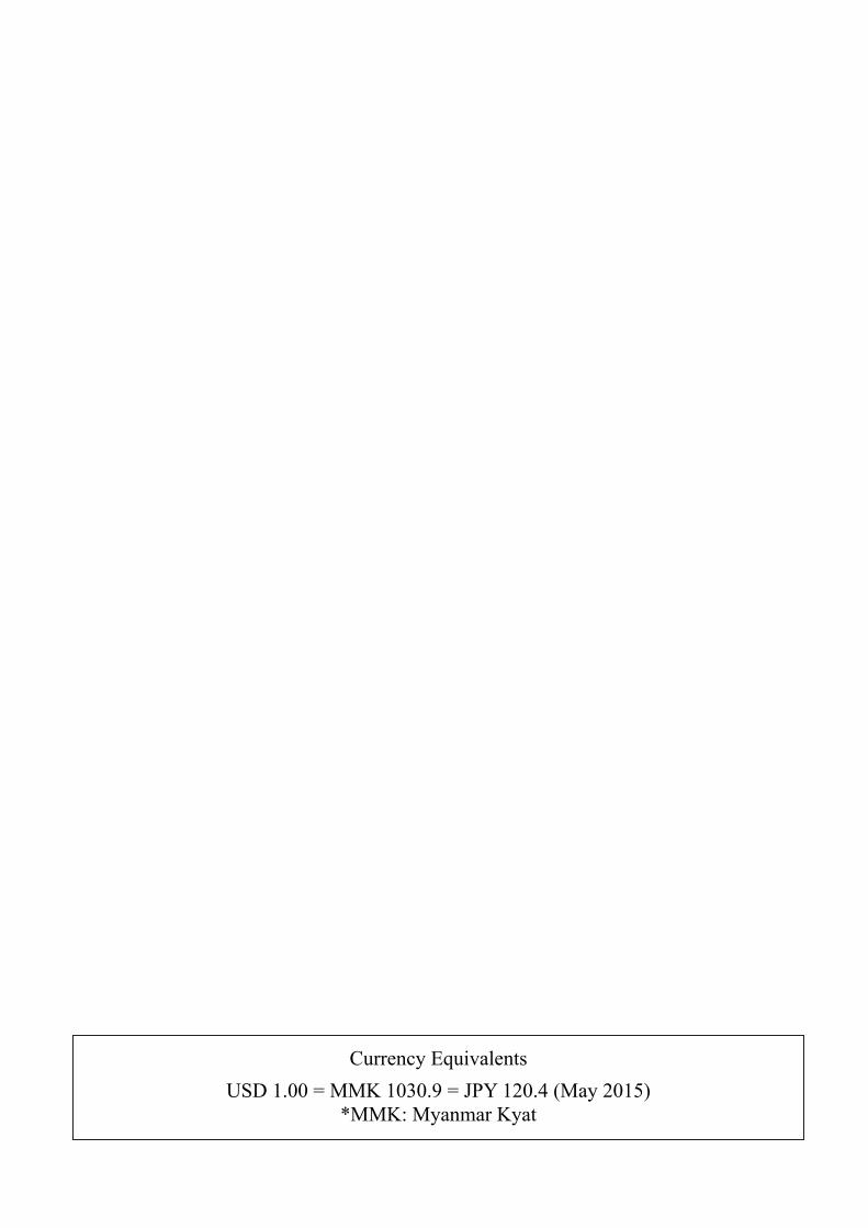
Perspective of the Project (Thaton Byapss)
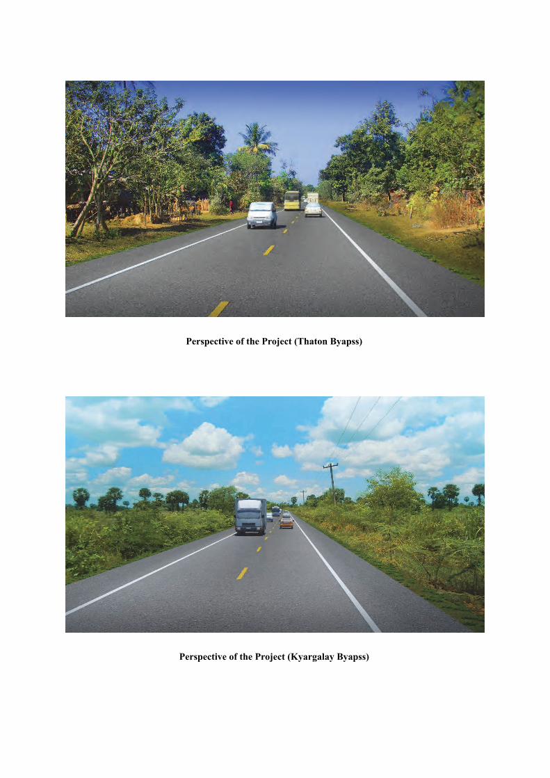
Perspective of the Project (Kyargalay Byapss)

Outline of the Project 1. Country: Republic of the Union of Myanmar
2. Project Name: Preparatory Survey for the Project for Strengthening Connectivity of International Highways in the Mekong Region
3. Execution Agency: Ministry of Construction (MOC)
4. Survey Objectives: The aim of the project is to collect information concerning the arterial roads located in south-eastern Myanmar
(Payagyi-Dawei Road, Eindu-Myawaddy Road, Thaton-Eindu Road, Mawlamyine-Eindu Road, and Thanbyuzayat-Hpayarthonesu Road (Three Pagoda Pass)) including site conditions, progress of existing projects, etc.
to extract project proposals expected to require implementation in the near future to select priority projects to conduct necessary procedures to determine the project’s suitability as a yen-loan
project including examining the outline, estimated project costs, the systems in place for project implementation, management, and operation and maintenance, as well as environmental and social considerations, etc.
5. Survey Contents: [Stage 1] Confirmation of project necessity and adequacy; decision of project scope
Collection and analysis of related documentation and data Site condition survey Selection of target routes
[Stage 2] Preliminary design; confirmation of project effects Natural condition survey Preliminary design Project cost estimation Project evaluation
[Stage 3] Prepare the report Prepare the preparatory survey report
6. Conclusions and Recommendations: (1) Conclusions
The Project is technically and economically feasible and environmentally sound. Hence, implementation of the Project is justified for the benefit of the national and its
people. The Project consists of the replacement of 4 bridges and the construction of 2 bypass
roads. The Project is divided into 2 sub-projects: improvement of EWEC towards Yangon
and improvement of EWEC towards Mawlamyine. Three types of bridges are to be constructed in the Project: Steel-I girder (2 bridges),
PC extradosed (2 bridges), Steel cable-stayed Bridge and PC-I girder bridges (Many). Thaton bypass shall be an asphalt-paved road running for approx. 29 km, beginning
at the existing road on the east side of the existing Donthami Bridge, and ending at north Don Wun on NR-8.
Kyargalay bypass shall be an asphalt-paved road running for approx. 25km,

beginning at the existing road leading to Gyaing Kawkareik Bridge, ending at the road leading to Gyaing Zathapyin Bridge.
(2) Recommendations Restructuring of MOC is under implementation as of May 2015 and the general
election is scheduled for November 2015. Therefore, coordination of priority and implementation schedule of each project is required.
Final adjustment with relevant projects such as the ADB-financed Eindu to Kawkareik Road Improvement Project shall be required in the detailed design.
It is desirable to implement transfer of advanced construction techniques (such as those used in Japan) to Myanmar through project execution, and MOC has expressed strong interest in the learning Japanese construction techniques. Thus, there discussions must be held to form and execute a meaningful specific training programme encompassing each stage of design and construction. As for the weathering steel, appropriateness should be determined in the detailed design stage.
In this study, preliminary design was performed in consideration of an inventory survey of existing utilities in the project area such as water pipes, telephone lines and electricity lines (which was conducted within the topographic survey). Relocation of existing utilities is expected to be carried out through Myanmar government funds. In the detailed design stage, a detailed study of existing utilities needs to be conducted, and support shall be required in order to coordinate with relevant agencies and develop a relocation plan based on the acquired information.
MOC hopes to complete the replacement of Gyaing Kawkareik Bridge as early as possible, so the schedule of works assumed in this study includes night-time construction work in order to shorten the construction period. Considering this, in the subsequent detailed design and implementation stages, measures for eliminating bottlenecks to shorten the construction time (while ensuring safety and quality) must be devised.
After receiving approval of the Environmental Impact Assessment (EIA) Report and Abbreviated Resettlement Action Plan Report (ARAP) from the Environmental Conservation Department (ECD) under Ministry of Environmental Conservation & Forest), these reports must be translated into Burmese and disclosed to project-affected persons and other residents for a period of more than one month.
Project-affected areas shall be indicated to project-affected persons prior to the detailed design phase. The approved RAP shall be updated based on requirements concluded through detailed design, and compensation and land acquisition must be performed before before construction begins.
The Project Proponent shall swiftly respond to claims and complaints from project-affected persons and other inhabitants in accordance with the grievance redress scheme given in the approved RAP, and shall endeavour to promote understanding of the project’s necessity.

Preparatory Survey for the Project for Strengthening Connectivity of International Highway in Mekong Region
Final Report Phase-I Survey Report (Feasibility Study)
S-1
Preparatory Survey for the Project for Strengthening the Connectivity Of the International Highway in the Mekong Region
EXECUTIVE SUMMERY
1. INTRODUCTION
1.1 Introduction
1.1.1 Survey Background
The Republic of the Union of Myanmar (hereinafter “Myanmar”) has been accelerating its high economic growth since the transition to democracy in March 2011. During this time, Myanmar requires infrastructure development of international standards before the integration of ASEAN in 2015.The Ministry of Construction (MOC) has been developing roads and bridges with its own budget and private funds, but the development has not reached remote areas due to budget limitations. Particularly in the southeastern part of the country where Myanmar is connected to Thailand, an economically close partner, road development is an urgent task. The major arterial roads in the southeastern part of Myanmar, including the East-West Economic Corridor and the Three Pagoda Pass from Tanbyuzayat to Hpayarthonesu connected to the border with Thailand, act as community roads for neighbouring residents in addition to functioning as arterial roads supporting wider-area traffic. In this connection, the high-speed passage of large cargo vehicles and long-distance buses on roads without shoulders and pavements coexisting with community traffic has been a large problem in terms of traffic safety, which has the potential to become more serious depending on the traffic demand increase in the future. While it is difficult for vehicles to travel on the Three Pagoda Pass during the rainy season, the road is expected to be developed into an international highway providing the shortest route between the Yangon Metropolitan Area and Bangkok. Further, Payagyi-Dawei Road is expected to be developed to connect the East-West Economic Corridor, Three Pagoda Pass, and Dawei in the south to the Yangon Metropolitan Area, which will also strengthen the connectivity between major Myanmar areas and Thailand. As discussed above, this Project requires renovation of priority sections, while taking future traffic demand into account and securing traffic safety.
1.1.2 Survey Objectives
The Project aims to collect information on site condition; progress of existing projects concerning the arterial roads located in the southeastern Part of Myanmar (Payagyi-Dawei, Eindu-Myawaddy , Thaton-Eindu, Mawlamyine-Eindu, Thanbyuzayat-Hpayarthonesu Road (Three Pagoda Pass)); to extract project proposals, which are expected to be implemented in the near future; to select priority projects and to conduct necessary surveys to examine the proposal as a yen-loan project, including the outline, estimated project costs, project implementation system, management, operation and maintenance system, environmental and social considerations, etc.
Preparatory Survey for the Project for Strengthening Connectivity of International Highway in Mekong Region
Final Report Phase-I Survey Report (Feasibility Study)

Preparatory Survey for the Project for Strengthening Connectivity of International Highway in Mekong Region Final Report Phase-I Survey Report (Feasibility Study)
S-2
1.1.3 Survey Area
Payagyi
Thaton
Eindu
Kawkareik
Myawaddy
Mawlamyine
Thanbuzayat
Payathonzu
Dawei
1
2
34
5
Mon State Kayin State
Bago Region
Hpa-An
Ye
Survey Location Map
Tanintharyi Region
1 2
3 4
GMS EWEC
Mae Sot BOT
BOT
BOT
MOC(ADB-DD on-going)
Under Construction by Thailand
MOC
BOT
MOC MOC
MOC
BOT
Mandalay
Yangon
Naypyitaw
Three Pagodas Pass
500,000~
300,000~500,000
200,000~300,000
~200,000
L=58km
<Legend Urban Population>
Kanchanaburi
・Under Construction by MOC and Private Com.・F/S Planned by NEDA
Kyargalay
Bridge Location
Route 2-2
Route 1-2
Route 1-1
Source: JICA Survey Team
Figure S 1.1.1 Survey Location Map
Preparatory Survey for the Project for Strengthening Connectivity of International Highway in Mekong Region Final Report Phase-I Survey Report (Feasibility Study)

Preparatory Survey for the Project for Strengthening Connectivity of International Highway in Mekong Region
Final Report Phase-I Survey Report (Feasibility Study)
S-3
Source:The Survey Program for the National Transport Development Plan
Figure S 2.1.1 Priority Five Corridor
A
B
CD
E
G
H
J
K
L
2. GENERAL UNDERSTANDING
2.1 The National Transport Development Plan in the Republic of the Union of Myanmar
This is the master plan for national transport development in Myanmar prepared by assistance of JICA in 2013 and is the origin of this survey. It is considered that investment in a variety of transportation sectors such as aviation, road, railway, port, and inland water transportation is necessary for sustainable economic development in Myanmar. In the Master Plan, the 2014 – 2020 year is proposed to focus on the development of key infrastructures. In Myanmar, there is no cross-sector transportation development plan. In addition, the quantitative analysis/evaluation has not been carried out for the long-term development plan or the project list formulated by each ministry.
Considering the above situation, in terms of selection and concentration, ten key corridors have been selected to be balanced with growth in urban and rural regions, and to be a basis for national land development. Moreover, five priority corridors, including the targeted roads in this survey, have been selected by the quantitative criteria such as future GRDP, traffic demand, investment effect. The plan will be soon endorsed and authorized by the Cabinet Approval, thus, road improvement in this survey corresponds to the National Transport Development Plan in Myanmar.
Five Priority Corridors A: Central North-South Corridor (Yangon- Naypyitaw – Mandalay) B: GMS East-West Corridor (Yangon–Thaton–Myawaddy/Mawlamyine–DaweiThree Pagoda
Pass) C: GMS Northern Corridor (Mandalay – Muse) H Delta Area Network K Western North-South Corridor (Yangon - Pyay – Magway)
2.2 Current Site Condition
2.2.1 Current Road and Bridge Condition for Survey Roads
(1) Payagyi – Dawei Section
1) Current Condition of Road
- Payagyi to Mawlamyine section has been developed to “Class-III” road in accordance with
Preparatory Survey for the Project for Strengthening Connectivity of International Highway in Mekong Region
Final Report Phase-I Survey Report (Feasibility Study)
Preparatory Survey for the Project for Strengthening Connectivity of International Highway in Mekong Region Final Report Phase-I Survey Report (Feasibility Study)
S-4
the ASEAN Highway Standards. The road surface is maintained to be in good condition since Shwe Than Lwin Highway Co., Ltd, a private company in Myanmar, is undertaking maintenance of the route under BOT contract.
- There are unpaved roads in the south section of Thanbyuzayat although road improvement has been undertaken by MOC. In particular, the road condition is still poor in the 10km section on the mountain area south of Ye.
- This route also passes several urban areas such as Kyaito, Thaton and Mawlamyine and is used as a community road by wayside residents, so that lots of pedestrians, bicycles, and motor bikes are using this road. Large vehicles are also running in large numbers. As the shoulder is not paved and the road has one lane for each way, it is dangerous for vehicles to overtake and pass the others.
2) Current Condition of Bridge
- No significant damage is observed on major bridges in this section. There is a sufficient load limit for heavy freight vehicles, thus, there is no current need for specific reconstruction or repair.
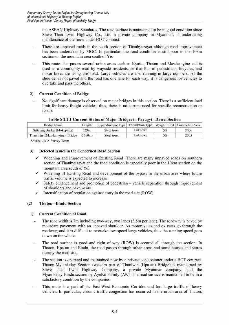
Table S 2.2.1 Current Status of Major Bridges in Payagyi –Dawei Section Bridge Name Length Superstructure Type Foundation Type Weight Limit Completion Year
Sittaung Bridge (Mokepalin) 729m Steel truss Unknown 60t 2006 Thanlwin(Mawlamyine)Bridge 3519m Steel truss Unknown 60t 2005 Source: JICA Survey Team
3) Detected Issues in the Concerned Road Section
Widening and Improvement of Existing Road (There are many unpaved roads on southern section of Thanbyuzayat and the road condition is especially poor in the 10km section on the mountain area south of Ye)
Widening of Existing Road and development of the bypass in the urban area where future traffic volume is expected to increase
Safety enhancement and promotion of pedestrian – vehicle separation through improvement of shoulders and pavements
Intensification of regulation against entry in the road site (ROW)
(2) Thaton –Eindu Section
1) Current Condition of Road
- The road width is 7m including two-way, two lanes (3.5m per lane). The roadway is paved by macadam pavement with an unpaved shoulder. As motorcycles and ox carts go through the roadway, and it is difficult to overtake low-speed large vehicles, thus the running speed goes down on the whole.
- The road surface is good and right of way (ROW) is secured all through the section. In Thaton, Hpa-an and Eindu, the road passes through urban areas and some houses and stores occupy the road site.
- The section is operated and maintained now by a private concessioner under a BOT contract. Thaton-Myainkalay Section (western part of Thanlwin (Hpa-an) Bridge) is maintained by Shwe Than Lwin Highway Company, a private Myanmar company, and the Myainkalay-Eindu section by AyeKo Family (AK). The road surface is maintained to be in a satisfactory condition by the companies.
- This route is a part of the East-West Economic Corridor and has large traffic of heavy vehicles. In particular, chronic traffic congestion has occurred in the urban area of Thaton,
Preparatory Survey for the Project for Strengthening Connectivity of International Highway in Mekong Region Final Report Phase-I Survey Report (Feasibility Study)

Preparatory Survey for the Project for Strengthening Connectivity of International Highway in Mekong Region
Final Report Phase-I Survey Report (Feasibility Study)
S-5
where a mixture of large-vehicle and regional traffic shows critical problems in terms of traffic safety. In this context, MOC has started a study for Thaton bypass plan since March, 2013, and established centre lines.
- To the north of the Thaton urban area, there is a rural road developed in 2010 by the Ministry of Progress of Border Areas, National Races & Development Affairs. Though partially surfaced with asphalt, this rural road has many unpaved sections and its road surface condition is poor. For the development of the Thaton bypass, it is considered appropriate to employ the measure of upgrading the main road.
2) Current Condition of Bridge
- On Donthami Bridge completed in 1982, no particular failure, except settlement behind the abutment, is observed in the current state, and the load limit is 50 tons. At present, there is no need for specific reconstruction or repair.
- On Thanlwin (Hpa-an) Bridge which consists of a steel truss bridge built in 1997 by MOC, no particular failure is observed in the current state, and the weight limit is 50 tons, enough to accommodate heavy freight traffic. At present, there is no need for specific reconstruction or repair.
- Naung Lon Bridge is an RC bridge built in the 1973, and the weight limit is only 20 tons. Critical damage to the bridge is observed, such as large deflection of the girder and settlement of piers. Considering the significant damage on the structure and insufficient in weight limitation, urgent reconstruction is needed.
Table S 2.2.2 Current Status of Major Bridges in Thaton – Eindu Section Bridge Name Length Superstructure Type Foundation Type Weight Limit Completion Year
Donthami Bridge 183m PC+RC --- 50t 1982 Thanlwin (Hpa-an) Bridge 686m Steel truss Bored pile 60t 1997
Naung Lon Bridge 115m RC(I Girder) Spread foundation 20t 1973 Source: JICA Survey Team
3) Detected Issues in the Concerned Road Section
Construction of a bypass in order to mitigate chronic traffic congestion and critical problems in terms of traffic safety in the urban areas
Safety enhancement and promotion of pedestrian – vehicle separation through improvement of shoulders and pavements
Widening of existing roads in accordance with future traffic demand Intensification of regulation against entry in the road site (ROW) Reconstruction of Naung Lon Bridge under severe damage
(3) Eindu –Myawaddy Section
1) Current Condition of Road
- The section of Eindu – Kawkareik with 80km length is supposed to be improved to “Class-II” according to ASEAN Highway Standards until March, 2019 by the project named ” TA-8330 MYA: GMS East-West Economic Corridor Eindu to Kawkareik Road Improvement” under ADB.
- Although the hilly and rough mountain road for about 40 km is limited to one-way traffic (switched for upbound and downbound day by day), the section has been greatly improved by the new bypass with the support of the Thai government, in which some part is under construction and will be completed by May, 2015. Although the design speed for the bypass is 50km/h and the bypass is a two-lane paved road with the total width of 10m, a steep vertical gradient of 12 % and continuous S curves are provided, which is not satisfied with the
Preparatory Survey for the Project for Strengthening Connectivity of International Highway in Mekong Region
Final Report Phase-I Survey Report (Feasibility Study)

Preparatory Survey for the Project for Strengthening Connectivity of International Highway in Mekong Region Final Report Phase-I Survey Report (Feasibility Study)
S-6
ASEAN Highway Standards since it passes through the mountain area. It is thus a concern that loaded trucks may have difficulties negotiating the road sections with steep gradients which can affect transport efficiency, and the road is vulnerable to natural environment such as rainfall since the safety measures (slope protection and drainage) are insufficient even after the completion of the bypass.
- Zathapyin- Kargalay Bypass (hereunder Kyargalay Bypass) is an unpaved 1.5 lane road except for in some urban areas and has difficulties on the route due to flooding during the rainy season. There are several bridges along the route, all of which are wooden temporary ones and broken, so that they must be reconstructed to permanent bridges (the same applies to the box and pipe culverts).
- It is considered that this route has a high potential for becoming a bypass road since it is the shortest route connecting Myawaddy to Mawlamyine, which is the third biggest city in Myanmar. In this context, road improvement of this section is expected.
2) Current Condition of Bridge
- Gyaing Kawkareik Bridge is a 365m long bailey suspension bridge over the Gyaing River, and has a weight limit of 24 tons, forcing heavy freight vehicles to divert toward the pontoon bridge upstream.
- This bridge is suffering from deterioration and the resultant excessive damage, such as the deterioration of the main cable, cracks on RC slabs for the approach bridge etc., all indicate that urgent measures, such as reconstruction, are necessary.
Table S 2.2.3 Current Status of Major Bridges in Eindu – Myawaddy Section Bridge Name Length Superstructure Type Foundation Type Weight Limit Completion Year
Gyaing Kawkareik Bridge 365m Suspension Bored pole 24t 1999 Source: JICA Survey Team
3) Detected Issues in the Concerned Road Section Road improvement to international highway in Kawkareik – Myawaddy section Being a mountain road, this section requires large-scale structures (retaining wall, long-span
bridges, and tunnels) for the improvement of the alignment. The considerable amount of the project costs will also be needed.
Elimination of road flooding and development of bypass by improvement of existing Kyargalay Bypass
Special land acquisition procedure in Kayin (Karen) State (necessity of coalition with KNU) Safety enhancement and promotion of pedestrians – vehicle separation through improvement
of shoulders and pavements Intensification of regulations against entry in the road site (ROW) Urgent reconstruction of Gyaing Kawkareik Bridge
(4) Eindu – Mawlamyine Section
1) Current Condition of Road
- For this section, the AyeKo Family concluded the concession agreement with MOC and is undertaking the operation and maintenance according to BOT.
- This is a 1.5-lane road of about 40 km in length, with an asphalted roadway. Since the shoulder is not paved, it is extremely dangerous in the case of overtaking and passing. The 20 ton weight limit at Gyaing Zathapyin Bridge and Atran Bridge diverts heavy freight exceeding 20 tons, travelling from Yangon and Myawaddy to Mawlamyine, toward Hpa-an and Thaton.
Preparatory Survey for the Project for Strengthening Connectivity of International Highway in Mekong Region Final Report Phase-I Survey Report (Feasibility Study)

Preparatory Survey for the Project for Strengthening Connectivity of International Highway in Mekong Region
Final Report Phase-I Survey Report (Feasibility Study)
S-7
2) Current Condition of Bridge
- Gyaing Zathapyin Bridge is a suspension bridge crossing the Gyaing River constructed in 1999 with material supply and technology aid from China. The 20 ton weight limit diverts heavy freight exceeding 20 tons travelling from Yangon and Myawaddy to Mawlamyine toward Thanlwin (Mawlamyine) Bridge (weight limit 60 tons) via Thaton. In addition, since the road is not paved, the 4cm gap of moulded steel is dangerous for two wheeled vehicles. (The tires might get caught in the grooves.) The ageing bridge prompted MOC to directly conduct repair work (repainting, cable sheath, and replacement of steel shapes over the bridge surface), which was completed in April 2013. Reconstruction to a permanent structure for both traffic safety and the ability to accept heavy vehicle traffic is urgently necessary.
- Atran Bridge is a cable-stayed bridge and was constructed in 1998 with material supply and technology aid from China. This bridge is also considered a temporary structure, due to its weight limit of 20 tons, and damaged moulded steel bridge surface. Like the Gyaing Zathapyin Bridge, the Atran Bridge is not paved but is instead covered by a moulded steel deck, making it dangerous for two wheeled vehicles to pass safely. Pier scoring has also been observed and is thought to be from a lack of vertical bearing capacity. Reconstruction is necessary.
Table S 2.2.4 Current Status of Major Bridges in Eindu – Mawlamyine Section Bridge Name Length Superstructure Type Foundation Type Weight Limit Completion Year
Gyaing (Zathapyin) Bridge 882m Suspension Bridge Bored pile 20t 1999 Atran Bridge 432m Cable-stayed bridge Bored pile 20t 1998
Source: JICA Survey Team
3) Detected Issues in the Concerned Road Section
As the Eindu – Mawlamyine road has not had the road profile determined by taking into account the high water level in the rainy season, flooding during the rainy season is a problem to be solved. As the road improvement requires raising the road profile, it is possible that the large amount of work costs similarly to the case of new construction may be required.
Urgent reconstruction of Gyaing Zathapyin Bridge and Atran Bridge which are bottle necks in the concerned section.
(5) Three Pagoda Pass (Thanbyuzayat—Hpayathonzu Section)
1) Current Condition
- The Three Pagoda Pass is 104km in length and is an unpaved 1.5 lane road at present so that it is quite difficult for vehicles to pass the route due to flooding. Thus, road improvement except pavement, box culverts, and small bridges less than 15m shall be completed by MOC and involved private contractors by April 2015.
- Although there are temporary bridges (bamboo/wooded) on the existing road, four wheeled vehicles are forced to enter rivers, possibly creating engine trouble
- Construction of bridges is an urgent matter since it is likely that this route is impassable in the rainy season even after the completion of earthwork. A feasibility study for road improvement has been carried out by the Neighbouring Countries Economic Development Cooperation Agency (NEDA) since it is considered that road improvement to an international highway is difficult to be completed by MOC due to the limitation of budget and lack of technical capacity in Myanmar.
Preparatory Survey for the Project for Strengthening Connectivity of International Highway in Mekong Region
Final Report Phase-I Survey Report (Feasibility Study)

Preparatory Survey for the Project for Strengthening Connectivity of International Highway in Mekong Region Final Report Phase-I Survey Report (Feasibility Study)
S-8
2) Detected Issues in the Concerned Road Section
Bridge construction (Unpassable sections) Road improvement to international highway level
3. TRAFFIC DEMAND FORECAST
3.1 Traffic Demand Forecast
3.1.1 Approach and Methodology of Traffic Demand Forecast in the Study
Basically, the same approach and methodology of the traffic demand forecast applied to the MYT-Plan is adopted for the traffic demand forecast in the Study, considering the following implications. First, the traffic demand forecast is carried out by 2030 (the target year of the MYT-Plan) and 2035 (the target year of the Study). Secondly, the OD matrix is calibrated by the Traffic Survey conducted in the Study. Thirdly, the modal share and route share models are newly developed, considering the sea and land transport of the EXIM cargo between Thailand and Myanmar, and the route share between the East West Economic Corridor and the newly improved Three Pagoda Pass.
3.1.2 Traffic Demand Forecast in the Study (Base Case)
(1) Projection of Future EXIM Cargo Volume between Thailand and Myanmar Assuming Myanmar’s GDP growth of 7% per annum until 2035 and using the elasticity GDP estimated, the commodity-wise import volume from Thailand to Myanmar is estimated to reach 28 million tons, with export volume from Myanmar to Thailand estimated to reach 17 million tons in total by 2035.
(2) Modal Share of EXIM Cargo between Thailand and Myanmar Customs data obtained from the Customs Department of Thailand showed 75% of the total import cargo from Thailand, and 56% of the total export cargo to Thailand was transported by sea in 2011. In order to estimate the modal share of the EXIM cargo between Thailand and Myanmar, the current and future zonal impedance (time and cost) is prepared based on the survey report prepared by Nippon Express (2013). The modal split model of the EXIM cargo between sea and land transport was developed assuming that most EXIM cargo is transported between the industrial zones in Ayutthaya and Yangon. Figure S 3.1.1 shows the difference of the generalized cost (time and cost) between sea and land transport, and the share of the sea transport by commodity.
Preparatory Survey for the Project for Strengthening Connectivity of International Highway in Mekong Region Final Report Phase-I Survey Report (Feasibility Study)

Preparatory Survey for the Project for Strengthening Connectivity of International Highway in Mekong Region
Final Report Phase-I Survey Report (Feasibility Study)
S-9
0%
20%
40%
60%
80%
100%
0.0 20.0 40.0 60.0 80.0 100.0
Mod
al S
hare
of S
ea T
rans
port
Total Land Cost - Total Sea Cost (USD/ton)
Source: JICA Survey Team
Figure S 3.1.1 Difference of Generalized Cost and Share of Sea Transport between Thailand and Myanmar
The following formula is adopted to estimate the modal share between sea and land transport.
bCseaClandTseaTlandLogaPseaLog ))()(()(
Subject to Psea (Share of Sea Transport), α (Time Value per ton), Tland/Tsea (Transport Time by Land/Sea Transport), Cland/Csea (Transport Cost by Land/Sea Transport), a/b (parameters)
Table S 3.1.1 shows the result of regression analysis of the above formula and parameters estimated through the analysis.
Table S 3.1.1 Result of Regression Analysis and Parameters Estimated R2 0.83
a 4.09(t=5.78) b -18.5 (t=-6.21)
Source: JICA Survey Team
Transport and trade facilitation between Thailand and Myanmar (Ayutthaya and Yangon) are expected to reduce transport cost (a reduction of 150 USD between Ayutthaya and Yangon) and transport time (a reduction of 35 hours). Assuming that sea transport service will remain the same, nearly 15% of the EXIM cargo volume is estimated to divert from sea to land transport due to the improvement of the road transport network and service.
As a result, 3.8 million tons (1,660 trucks per day1) in 2030, and 6.6 million tons (2,880 trucks per day) in 2035 are estimated to shift from sea to land transport due to the improvement of the road transport network and service between Thailand and Myanmar.
(3) Traffic Assignment and Projection of Traffic Volume The OD matrix is revised by adding the additional vehicular traffic diverted from sea transport to land transport (1,660 trucks per day in 2030 and 2,880 trucks per day in 2035). The revised OD
1 Based on the result of OD Interview Survey, the average loading volume of the truck is 8.8 tons. Operation of the trucking
service is assumed at 260 days per year.
Preparatory Survey for the Project for Strengthening Connectivity of International Highway in Mekong Region
Final Report Phase-I Survey Report (Feasibility Study)

Preparatory Survey for the Project for Strengthening Connectivity of International Highway in Mekong Region Final Report Phase-I Survey Report (Feasibility Study)
S-10
matrix is assigned to the future network2.
In order to estimate the route share between the East-West Economic Corridor and the Three Pagoda Pass, dummy links are added to the future road network (assuming that the 440km 4-lane road network between Ayutthaya and Mae Sot and the 350km 4-lane road network between Ayutthaya and Three Pagoda Pass cross border) and traffic generated from Myawaddy/Mae Sot is assigned to these dummy links.
The following table shows the projected traffic volume by the Project and the result of the traffic assignment.
Table S 3.1.2 Projected Traffic Volume by Project (Unit: PCU/day)
Year ①
Naung Lon Bridge
②Gyaing (Kawkareik)
Bridge
③Thaton Bypass
④Gyaing (Zathapyin)
Bridge
⑤Atran Bridge
⑥Kyargalay Bypass
2030 6,000 10,600 9,400 7,900 7,900 6,0002035 10,900 19,000 17,100 19,300 19,300 9,500-12,100
Source: JICA Survey Team
3.1.3 Traffic Demand Forecast in the Study (Base Case)
The following discussion analyses the future traffic demand on the EWEC, particularly that at Gyaing (Kawkareik) Bridge, setting several EWEC improvement scenarios.
(1) Pre-condition and Case Study of the Traffic Demand Forecast The following two different improvement scenarios of the EWEC are set:
2035 Scenario: Partial improvement scenario of the EWEC (the road section between Myawaddy and the intersection of Kyargalay Bypass is widened to a dual carriage way (four lanes in total).
2040 Scenario: Full improvement scenario of the EWEC (the entire road section between Myawaddy and Thaton is widened to a dual carriage way (four lanes in total).)
(2) Summary Result of the Traffic Demand Forecast under EWEC Improvement Case The following table shows the projected traffic volume by the Project and the results of the traffic assignment under EWEC Improvement Case.
Table S 3.1.3 Projected Traffic Volume by Project under EWEC Improvement Case (Unit: PCU/day)
Yeare ①Naung Lon Bridge
②Gyaing (Kawkareik)
Bridge
③Thaton Bypass
④Gyaing (Zathapyin)
Bridge
⑤Atran Bridge
⑥Kyargalay Bypass
2035 10,000 27,800 19,500 19,000 20,200 17,8002040 11,800 42,600 46,500 30,800 33,100 23,300
Source: JICA Survey Team
2 The road section under the BOT (between Payagyi and Mawlamyine) is assumed to be widened to four lanes and the
East-West Economic Corridor, Three Pagoda Pass and the road section between Mawlamyine and Dawei are to be improved to 2-lane roads.
Preparatory Survey for the Project for Strengthening Connectivity of International Highway in Mekong Region Final Report Phase-I Survey Report (Feasibility Study)

Preparatory Survey for the Project for Strengthening Connectivity of International Highway in Mekong Region
Final Report Phase-I Survey Report (Feasibility Study)
S-11
4. SELECTION OF PRIORITY PROJECTS
4.1 Selection of Priority Road Sections and Priority Projects
4.1.1 Listing of Potential Road Sections and Potential Road Improvement Projects
Sub-Project candidates have been identified from interviews with MOC and site surveys done by the JICA Survey Team, as seen in Table S 4.1.1.
Table S 4.1.1 Potential Road Sections and Potential Road Improvement Projects Road Section Sub-project
Route 1 Payagyi -Dawei Road Route 1-1 Payagyi-Mawlamyine ・Construction of a new bypass Route 1-2 Mawlamyine-Dawei ・Improvement of existing road
Route 2 Eindu – Myawaddy Road
Route 2-1 Eindu-Kawkareik ・Replacement of Gyaing Kawkareik Bridge Route 2-2 Kawkareik-Myawaddy ・Construction of tunnels (Thai Bypass Section)
Route 3 Thaton –Eindu Road ・Replacement of Naung Lon Bridge ・Thaton Bypass (New Bypass)
Route 4 Mawlamyine –Eindu Road ・Replacement of 2 bridges (Gyaing Zathapyin Bridge, Atran Bridge) ・Kyargalay Bypass
Route 5 Thanbyuzayat – Hpayathonzu Road(Three Pagodas Pass) ・Pavement & five bridges Source: JICA Survey Team
4.1.2 Selection Policy and Criteria Applied
(1) Selection Policy Priority sub-projects for preliminary design were selected in a series of discussions between MOC and the JICA Survey Team. The following two stage evaluation was applied for the sub-project selection;
First stage : Selection of priority road section
Second stage : Selection of priority sub-project
(2) Selection Criteria First stage Criteria
First stage selection criteria are 1) Road Category (Importance), 2) Traffic Demand (Year 2035), 3) Urgency, 4) Contribution to Local Economy and 5) Ownership and Administration.
Second Stage Criteria
Second stage selection criteria are 6) Environmental and Social Considerations, 7) MOC Priority and 8) possibility of technical transfer.
4.1.3 Selection of Priority Road Sections (First Stage)
Priority road sections were selected during a meeting with MOC from 15 - 16 of May. Results are shown in Table S 4.1.2. Route 1-1 was not selected as it has been improved using international highway standards. There is no significant damage or faults in the route since the addition of BOT administration. The comparison table is shown in Table S 4.1.3.
Preparatory Survey for the Project for Strengthening Connectivity of International Highway in Mekong Region
Final Report Phase-I Survey Report (Feasibility Study)

Preparatory Survey for the Project for Strengthening Connectivity of International Highway in Mekong Region Final Report Phase-I Survey Report (Feasibility Study)
S-12
Table S 4.1.2 Results for Selection of Priority Road Sections (First Stage) Road Section Evaluation
Route 1 Route 1-1 Payagyi-Mawlamyine × Route 1-2 Mawlamyine-Dawei ○
Route 2 Route 2-1 Eindu-Kawkareik ○ Route 2-2 Kawkareik-Myawaddy ○
Route 3 Thaton –Eindu Road ○ Route 4 Mawlamyine –Eindu Road ○ Route 5 Thanbyuzayat – Hpayathonzu Road ○
Legend ○: Selected ×: Not selected Source: JICA Survey Team
4.1.4 Selection of Priority Sub-Projects
Priority sub-projects were selected from the priority road sections selected during the meeting with MOC on 15 - 16 May. Note that some sub-projects were evaluated as the same sub-project in second stage selection because combining sub-projects should improve effectiveness. The comparison table for the selection of priority sub-projects is shown in Table S 4.1.4.
A : Replacement of two bridges
(Naung Lon Bridge / Gyaing Kawkareik Bridge) ⇒Sub-project 1 Improvement of EWEC (to Yangon) B : Thaton Bypass & Donthami Bridge
C : Replacement of 2 bridges (Gyaing Zathapyin Bridge / Atran Bridge) ⇒
Sub-project 2 Improvement of EWEC (to Mawlamyine) D : Kyargalay Bypass
Preparatory Survey for the Project for Strengthening Connectivity of International Highway in Mekong Region Final Report Phase-I Survey Report (Feasibility Study)

Preparatory Survey for the Project for Strengthening Connectivity of International Highway in M
ekong Region Final Report Phase-I Survey Report (Feasibility Study)
S-13
Table S 4.1.3 Selection of Priority Road Section
*1 Traffic Demand was updated in accordance with the result of the traffic demand forecast for EWEC Improvement Case afther the Fact Find Misson on December, 2014 Source: JICA Survey Team
・Payagyi~Thaton:AH1/EWEC・Thaton~Mawlamyine:AH112
A ・AH112 A ・AH1/ EWEC A ・AH1/ EWEC A ・AH1/ EWEC A ・EWEC A・International Highway(New)
B
2014yr(PCU)
3,000~5,800 1100 2500 2500 2200 1400 0
2035yr*1(PCU)
>37,400 6,900-11,500 9,900-27,800 23,700-28,400 10,000-22,100 6,000-20,200 6,700-10,100
• 2lane road paved withasphalt(only carriage way) androad condtion is good
・No botteleneck because weightlimitation on bridges is over 50t.
・Critical problem in terms oftraveling performance at 4sections(Kyaikto、Theinseik、Thaton、Yinnyein)due to a mixture oflarge vehicles and regional traffic.
C
・Mawlamyine-Thanbyuzayatsection improved to be 2lanepaved road (only carriageway)and road condtion is good.
• 1.5 lane unpaved road insouthern Thanbyuzayat,especialy road condition is poorin 10km secion on northmountain area of Tanintharyiregion.
A
• 1.5 lane with asphaltpenetration macadam damaged.
・Especially, Gyaing KawkareikBridge, temporal bailey bridge, isa critical bottleneck for heavyfreight vehicles due to its weightlimitation of 20t(Reconstructionis needed) A
• Kawkareik to Thin Gan NyiNaung section, traversing DawnaMountain, is 1-lane and bad roadcondition.
・The Kawkareik-Thin Gan NyiNaungBypass, will be completedby July 2015, has sections whichare not satisfied with the ASEANHighway Standard. Accordingly,road improvement may benecessary.
• Thin Gan Nyi Naung-Myawaddysection is 2-lane paved road androad condition is good(Aid byThailand)
A
• Almost section passesflat area and divertingtoward south side nearThanlwin river(Conecting toHpa-an Bypass)
• 2lane road paved withasphalt(only carriage way)and road condtion is good
・Naung Lon Bridge may beone of potentilal bottleneckssince the bridge has beendeteriorated.
B
• 1.5 lane with asphaltpenetration macadamdamaged in almost section.
・Gyaing Zathapyin Bridgeand Atran bridge, temporalbailey bridge, are criticalbottlenecks for heavyfreight vehicles due to theirweight limitation of 20t(Reconstruction isneeded)
A
• Unpaved and bad roadcondition, unconectivity inrainy season(Urgentpriority)
A
・The route connectingMawlamyine and Bago, which arecore cities on economic growth ofsouthern area(reffer MYT-Planand NCDP)
・The route encouraging commercewith Thailand
A
・The route connectingMawlamyine and Dawei, whichare core cities on economicgrowth of southern area(refferMYT-Plan and NCDP)
A
・The route connecting Thatonand Hpa-an, which have highpotential for industrial andagricultural development(refferMYT-Plan).
・The route encouragingcommerce with Thailand
B
・The route encouragingcommerce with Thailand
・The route connecting Thatonand Hpa-an, which have highpotential for industrial andagricultural development(refferMYT-Plan).
B
・The route encouragingcommerce with Thailand
・The route connectingThaton and Hpa-an, whichhave high potential forindustrial and agriculturaldevelopment(reffer MYT-Plan).
B
・The route encouragingdevelopment ofMawlamyine, which is corecities on economic growthof southern area(refferMYT-Plan and NCDP)
・The route encouragingcommerce with Thailand
A
・The route encouragingdevelopment ofMawlamyine, which is corecities on economic growthof southern area(refferMYT-Plan and NCDP)
・The route encouragingcommerce with Thailand
A
BOT(Bridge section directly controled
by MOC)B
MOC(Mawlamyine~Thanbyuzayat
Section is BOT)A
MOC( A part of section is under FS
by ADB)A
MOC(Under Constructon by Thai
Contractors)A
BOT(Bridge section directly
controled by MOC)B
BOT(Bridge section directly
controled by MOC)B
MOC(Subgrade is under
construction by MOC andprivate companies)
A
Length 200km 330km 70km 58km 60km
Route2-2 Kawkareik-Myawaddy
A A BA B A A
40km 102km
B(Selected)
A(Selected)
B(Selected)
・Direct control by MOC・High urgent priority (Resolution ofbottelneck bridge etc)・ADB aid planned
・Direct control by MOC・High traffic demand・Moderate priority
Route1 Payagyi~Dawei Road(app.530Km)
Route2 Eindu~Myawaddy Road(120Km)
Route1-1 Payagyi-Mawlamyine Route1-2 Mawlamyine-Dawei Route2-1 Eindu-Kawkareik
Route5 Thanbyuzayat~HpayathonzuRoad
(Three Pagodas Pass)(102Km)
3) Urgent need
1) Road Category (Importance)
Criteria/Route
4) Contribution to LocalEconomy
・Direct Control by MOC・Urgent priority depens onimprovement of otherinternational highways(EWEC、SEC)
・Controled by BOT・High urgent priority
・Controled by BOT・High urgent priority(Resolution of bottelneck bridgeetc)
A(Selected)
A(Selected)
Evaluation ・Controled by BOT・Low priority(Higher priority onimprovement of EWEC、Three PagodasPass and SEC)
C(Not Selected)
A(Selected)
・Direct control by MOC・High urgent priority
2) Traffic Demand
5) Administration for RoadDevelopment andManagement
Route3 Thaton~Eindu Road(60Km)
Route4 Mawlamyine~EinduRoad
(40Km)
Preparatory Survey for the Project for Strengthening Connectivity of International Highway in M
ekong Region Final Report Phase-I Survey Report (Feasibility Study)

Preparatory Survey for the Project for Strengthening Connectivity of International Highway in M
ekong Region Final Report Phase-I Survey Report (Feasibility Study)
S-14
New Road
Existing road
Bridge
Traffic Demand(2014)
Traffic Demand(2035)*1
Supposed Category Category B Category B Category B Category B Category A Category B(only pavement and bridges) Category A
Number of Affected housesINumber of involuntary
ressettlements)Less than 5 (Less than 30 people) 11 (Less than 200 people) None (Less than 200 people) N/A (assumued less than 200 people) N/A (assumued less than 200 people) Less than 30 (assumued less than 200 people) N/A (assumued more than 200 people)
ReasonBridge reconstruction and less than 200ressettlements
Less than 200 ressettlements under COI conceptBridge reconstruction and less than 200ressettlements
Upgrade of existing rolad(less than 100km),New construction(less than 5km), less than 200ressettlements
New tunnel construction(App.3km)Bridge reconstruction and pavement, less than200 ressettlements
New tunnel construction, improvement of existingroad (more than 100km) , so that assumuedressettlements is more than 200 people.
Remarkable concerns NoneNeed alignment avoideing Pagoda dense zone andmilitary accommodations
None None
・None of environmental and socialconsiderations has been studied in theconstruction of bypass between Myawaddy andKawkareik (App.28km) by Thailand
・If GOJ decide to provide financial assistancevia ODA with the current condtion(on-goingproject), the EIA might be required to conductincluding the scope of works for Thai bypasssection.include the responsibility between JICAand PW should be
None of crucial impact is expected for the EIA ofthe project even if GOJ decided to providefinancial assitance via ODA. However, PWconductes the current construction without anyenvironmental mitigation measure therefore itwould be subject to study in the EIA ifimplemented by GOJ.
It is assumed that total number of ressettlementsis more than 200 people due to 240km length.Number of ressettlements depends on design oftunnels and bridges in moutain area.
Very High A High(Minister of MOC) B High B High(PW) B Premature at present(MD of PW) C Very High(Minister of MOC) A High interest on the premise of SEC(PW) B
High Possiblility in technical transfer forfoundation and superstructure of large scaledbridge
ALow possiblity to apply Japanese technique due togeneral highway construction
BHigh Possiblility in technical transfer forfoundation and superstructure of large scaledbridge
ALow possiblity to apply Japanese technique due togeneral highway construction
BPossible utilization of sole Japanese technique dueto application of tunnel construction
ALow possiblity to apply Japanese technique due togeneral highway construction
B
Low possiblity to apply Japanese technique due togeneral highway construction. High Possiblility intechnical transfer in the case that construction oftunnel or large scaled bridge are necessary
B
A AHigher urgency and effectivess butmany outstanding issues to be solved
BUrgency and effectiveness relies onthe progress of SEC
BUrgency and effectiveness relies onthe progress of SEC
B
2-lane road construction (ASEAN Highway Class II)2.5Km
2-lane road improvement (ASEAN Highway Class II)22.5Km (Widening of existing road)
Replacement of 19 small bridges
Gyaing Zathapyin Br.:830m, Atran Br.:680m
- 2-lane tunnel construction (ASEAN Highway Class II)
CB
N/A (later 2015)
1,100 PCU
6,900 PCU
1.5 lane road improvement
N/A (later 2015)
Tunnel length App.3km App.240km
2-lane pavement (ASEAN Highway Class II)
- Rehabilitation of existing bridgesReplacement of 4 small bridges
Route5 Thanbyuzayat~Hpayathonzu Road
Plan F
Subproject 4
App.104km、4 bridges (less than 100m)
Three Pagodas PassConstruction of tunnels (Thai Bypass Section)
A
Replacement of 2 bridges( medium to large scale bridges/ASEAN Highway Class
II)
-
N/A (later 2015)
C
App.25Km
EWEC (to Mawlamyine)
Route2-1 Eindu~Kawkareik Road、Route4 Mawlamyine~Eindu Road
Plan D
Route4 Mawlamyine~Eindu Road
Plan C
F/S for FY2014
Route2-2 Kawkareik~Myawaddy Road
Plan E
Subproject 3
-
Contributuion to the development of South-East Region by connecting the linkbetween Mekong region and Mawlamyine(Realization of effectiveness byimplementation of both sub-projects on the same network)。
A
F/S for FY2014F/S for FY2014
Selection ofPriority Subproject
Evaluation of subproject
Traffic Demand
F/S for FY2014
A
Prospective year for L/A(Draft)
Contributuion to the development of South-East Region by connecting the linkbetween Mekong region and Mawlamyine(Realization of effectiveness byimplementation of both sub-projects on the same network)。
A
8) Possiblity for Technology Transfer
7) Priority in MOC
Project description
Replacement of 6 small bridges and Donthami Br.
Subproject
6) Environmental andSocial Considerations
-
19,500 PCU
Replacement of 2 bridges( medium to large scale bridges/ASEAN Highway Class
II)
-
2-lane road improvement (ASEAN Highway Class II)13.5Km (Widening of existing road)Description of Construction
Road length/Bridgelength Naung Lon Br.:150m, Gyaing Kawkareik Br.:760m
2,500 PCU
10,000, 27,800 PCU
-
EWEC (toYangon)
Route2-1 Eindu~Kawkareik Road、Route3 Thaton~Eindu Road
2-lane road construction (ASEAN Highway Class II)14.5Km
Plan A
Replacement of 2 bridges(Naung Lon Br., Gyaing Kawkareik Br.)
Route3 Thaton~Eindu Road
Plan B
App.28km/Donthami Br.:App.200m
Improvement of Southern Thanbyuzayat
Plan G
Subproject 5
Thaton Bypass+Replacement of Donthami Br.Replacement of 2 bridges
(Gyaing Zathapyin Br., Atran Br.)Kyargalay Bypass
Improvement of EWEC(Common)
Route1-2 Thanbyuzayat~Dawei Road
Subproject 2:Improvement of EWEC (to Mawlamyine)
Criteria/Route
-
6,700-10,100 PCU
1,400 PCU
19,000 - 20,200 PCU
-
14,500-17,800 PCU
2,500 PCU
23,700 PCU
Subproject 1:Improvement of EWEC (toYangon)
Table S 4.1.4 Selection of Priority Sub-project
*1 Traffic Demand was updated in accordance with the result of the traffic demand forecast for EWEC Improvement Case afther the Fact Find Misson on December, 2014 Source: JICA Survey Team
Preparatory Survey for the Project for Strengthening Connectivity of International Highway in M
ekong Region Final Report Phase-I Survey Report (Feasibility Study)

Preparatory Survey for the Project for Strengthening Connectivity of International Highway in Mekong Region
Final Report Phase-I Survey Report (Feasibility Study)
S-15
5. PRELIMINARY DESIGN ON PRIORITY PROJECTS
5.1 Preliminary Study for Four Bridges
5.1.1 Comparative Study of Bridge Crossing Point for Four Bridges
As a result of the study, the crossing points of most bridges were decided to be on the upstream side from the point of view to mitigate the influence to new bridges when the existing bridges fall down.
5.1.2 Study of Superstructure Type
(1) Main Bridge The types of the main bridges have been selected based on the engineering assessment of several criteria including span length, navigation clearance, structural stability, constructability, construction cost, maintenance, technical transfer (new technology in Myanmar) and aesthetic considerations. Comparison results are described below.
a) Naung Lon Bridge First selection The existing bridge is a continuous reinforced concrete girder bridge with a span length of approximately 12.5m. The navigation clearance is not specifically required. In addition, there are no special conditions for the river or the topography. Therefore, the following four alternatives were compared.
Alternative 1:PC-I girders (5@30m=150m)
Alternative 2:PC Box girders (4@40m=160m)
Alternative 3:Steel I girders (4@40m=160m)
Alternative 4:RC girders (10@15m=150m)
Second selection Through the multi-criteria evaluation, Alternative 3: Steel-I Girder Bridge is recommended primarily because it has the most reasonable construction cost and the shortest construction period.
b) Gyaing Kawkareik Bridge First selection The main span of existing bridge is 154m, and the required navigation clearance is 360 feet (110m) x 40 feet (12.2m). The river depth is more than 10m. Therefore, the following three alternatives were selected.
Alternative 1:PC extradosed bridge (Main bridge: 100m + 160m + 100m = 360m)
Alternative 2:PC box girder bridge (Main bridge: 90m + 130m + 90m = 310m)
Alternative 3:Steel box girder bridge with steel slab (Main bridge: 100m + 160m + 100m =360m)
Second selection Alternative 1: PC extradosed Bridge is recommended primarily because of its reasonable construction cost, its contribution to the landscape as a symbolic structure, and the advanced bridge techniques used in its construction.
Preparatory Survey for the Project for Strengthening Connectivity of International Highway in Mekong Region
Final Report Phase-I Survey Report (Feasibility Study)

Preparatory Survey for the Project for Strengthening Connectivity of International Highway in Mekong Region Final Report Phase-I Survey Report (Feasibility Study)
S-16
c) Gyaing Zathapyin Bridge First selection The main span of existing bridge is 457.20m (no piers within river width), the required navigation clearance is 400 feet (122m) x 40 feet (12.2m), and river depth is more than 15m. In addition, soil investigations by the JICA Survey Team observed limestone layer underlays at very shallow depth on river bed. With this investigation in mind, we decided to select several bridge types in which the construction of piers is not required in deep area in the river.
Alternative 1: Steel cable-stayed bridge (210m + 460m + 210m = 880m)
Alternative 2: Suspension bridge (210m + 460m + 210m = 880m)
Second selection Alternative 1: Steel Cable-stayed Bridge is recommended in consideration of its reasonable construction cost, its contribution to the landscape as a symbolic structure, and the advanced bridge techniques used in its construction.
d) Atran Bridge First selection The main span of the existing bridge is 182m, and the required navigation clearance is 400 feet (122m) x 40 feet (12.2m). The river depth is more than 15m. Therefore, the following four alternatives were nominated.
Alternative 1:PC extradosed bridge (Main bridge: 120m+190m+120m=430m)
Alternative 2:PC cable-stayed bridge (Main bridge: 120m+190m+120m=430m)
Alternative 3:PC box girder (Main bridge: 90m+130m+90m=310m)
Alternative 4:Steel box girder with steel slab (Main bridge: 120m + 190m + 120m = 430m)
Second selection Alternative 1: PC extradosed Bridge was chosen in consideration of its reasonable construction cost, its contribution to the landscape as a symbolic structure, and the advanced bridge techniques used in its construction.
e) Approach Bridge In order to maintain continuity with the main bridge, the cross section of the approach bridge is designed based on the cross-section of the main bridge. Therefore, the span length of the approach bridge is set to 40-60m in consideration of girder depth restrictions, economical factors and the introduction of advanced technology in Myanmar. As shown in the previous section, the main superstructure of Naung Lon Bridge is Steel I Girder, the superstructure of Gyaing Zathapyin Bridge is Steel Cable-Stayed, and the superstructures of Gyaing Kawkareik Bridge and Atran Bridge are both PC extradosed (concrete). Therefore, the following types for the approach bridges are selected to match with its main bridge.
Naung Lon Bridge : No approach bridge
Gyaing Kawkareik Bridge : Continuous PC Box Girder with 50m span
Gyaing Zathapyin Bridge : No approach bridge
Atran Bridge : Continuous PC Box Girder with 50m span
Preparatory Survey for the Project for Strengthening Connectivity of International Highway in Mekong Region Final Report Phase-I Survey Report (Feasibility Study)

Preparatory Survey for the Project for Strengthening Connectivity of International Highway in Mekong Region
Final Report Phase-I Survey Report (Feasibility Study)
S-17
5.1.3 Study of Foundation Type and Substructure Type
(1) Foundations within river The selection of foundation type in a river shall be carefully considered taking into account specific criteria and natural conditions:
The water depth for the proposed bridge sites Possibility of scouring (sufficient attention must be paid to scouring) Supporting load of foundation Depth of the supporting layer
Considering the above conditions, three foundation types, (1) Neumatic Caison (2) Cast-in-Place Concrete Pile (3) Steel Pipe Sheet Pile Foundation (SPSPF) were nominated for for Gyaing Kawkareik Bridge, Gyaing Zathapyin Bridge and Atran Bridge. As a result of the comparative studies on Gyaing Kawkareik Bridge (P5) and Gyaing Zathapyin Bridge (P1), SPSPF is recommended for the foundation type within a river because the construction period can be shortened since it does not need a temporary cofferdam and also it is superior to other alternatives in an economic aspect. The piers of Atran Bridge (P5 and P6) are expected to undergo a vertical load on its piers larger than that of Gyaing Kawkareik Bridge (P5) and smaller Gyaing Zathapyin Bridge (P1). Hence, the selection of its foundation type can be based on the results of these two evaluations.
CPCP (the most common foundation type in Myanmar) can be applied as the foundation type for Naung Lon Bridge since the expected loading force is relatively small. As a result of the comparative study, CPCP with 1000mm diameter was selected for the foundation type at Naung Lon Bridge.
(2) Foundations on land Cast-in-place concrete piled foundations (CPCP) were selected for the foundation types of the piers and abutments on land, due to their ease of constructability and procurement of materials/equipment as well as the experience in Myanmar. The diameter of the cast-in-place concrete pile at Gyaing Kawkareik Bridge was selected using a comparative analysis, and this selected pile diameter (1500mm) is also used for other land foundations.
5.2 Preliminary Study for Bypass
5.2.1 Route Comparative Study
(1) Thaton Bypass A comparative study for the alignment of Thaton Bypass was executed in consideration of technical issues, social impact, and safety issues.
- Routes B and C were selected over Route A in order to avoid involuntary resettlement, and
- Route C was selected over Route B in order to minimize land acquisition of paddy fields (present at one section where the route passes through a mountainside town).
Preparatory Survey for the Project for Strengthening Connectivity of International Highway in Mekong Region
Final Report Phase-I Survey Report (Feasibility Study)

Preparatory Survey for the Project for Strengthening Connectivity of International Highway in Mekong Region Final Report Phase-I Survey Report (Feasibility Study)
S-18
Table S 5.2.1 Route Comparison on Thaton Bypass Alternative Route A (Blue) Alternative Route B (Red), C (Green)*
Concept of Route Setting Mostly tracing the existing road as much as possible
Avoiding involuntary resettlement of residents
Length Thaton BP: 28.9km (existing road: 14.3km, new road: 14.6km)
Thaton BP: 29.0km (existing road: 8.6km, new road: 20.4km)
Affected Properties No. of Structures:34 structures (more than 200 re-settlers)
No. of Structures:17 structures (87 re-settlers)
Traffic Safety route across the community need to appropriate traffic control
Route away from the community safer than route A
Possibilities for future development
Ultimate widening of four lanes in future requires removal of many affected buildings.
Possible ultimate widening of four lanes does not require additional removal of building
Evaluation Not Recommended Recommended (Route C) * Route C is mostly the same as Route B route passing through mountain side to minimize land acquisition of paddy field
(one section). Source: JICA Survey Team
Source: JICA Survey Team
Figure S 5.2.1 Alternative Route Maps on Thaton Bypass
(2) Kyargalay Bypass A comparative study for the alignment of Kyargalay Bypass was executed in consideration of technical issues, social impact, and safety issues.
At the meeting with MOC on 7th of July, 2014, based on this study, B route was selected in order to avoid involuntary resettlement.
Table S 5.2.2 Route Comparison on Kyargalay Bypass Alternative Route A (Blue) Alternative Route B (Red)
Concept of Route Setting Tracing the existing road as much as possible
Avoiding involuntary resettlement of residents
Length 24.8km (existing road: 23.9km, new road: 0.9km)
24.5km (existing road: 21.4km, new road: 3.1km)
Affected Properties 21 structures + 57 structures (more than 200 re-settlers) 21 structures (104 re-settlers)
Traffic Safety - Route crosses the community - Requires appropriate traffic control
- Route away from the community - Safer than route A
Possibilities for future development
Eventual widening into four lanes would require removal of many buildings.
Eventual widening into four lanes would not require additional removal of buildings
Evaluation Not Recommended Recommended Source: JICA Survey Team
Preparatory Survey for the Project for Strengthening Connectivity of International Highway in Mekong Region Final Report Phase-I Survey Report (Feasibility Study)

Preparatory Survey for the Project for Strengthening Connectivity of International Highway in Mekong Region
Final Report Phase-I Survey Report (Feasibility Study)
S-19
Source: JICA Survey Team
Figure S 5.2.2 Alternative Route Maps on Kyargalay Bypass
5.2.2 Study of Superstructure Type
(1) Donthami Bridge For Donthami Bridge, a comparative study of superstructure type alternatives was conducted using the same criteria and evaluation method for the other four major bridges.
First selection The existing bridge is a continuous PC-I girder bridge with a span length of approximately 35m-40m. No navigation clearance is specifically required. However, the feasibility of construction of foundation in deep water was specifically taken into consideration. Therefore, the following four alternatives were nominated.
Alternative 1: Steel I girder (5@40m = 200m) [Two piers in the river]
Alternative 2: Steel Box girder (64@60m = 240m) [One pier in the river]
Alternative 3: PC Box girder (4@50m = 200m) [One pier in the river]
Alternative 4: Steel Box girder with Steel Plate Deck (60m + 90m + 60m = 210m) [No piers in the river]
Second selection Alternative 1: Steel-I Girder Bridge is recommended due to its reasonable construction cost.
(2) Small Bridges Along Bypass Small bridges are defined as those that must be planned along the proposed bypass at points where the bypass crosses existing creeks and rivers of width less than 30m, where there are no special condition of the river or the topography. The proposed span length for small bridges can be up to 30m.
The PC-I girders were selected for the superstructure type due to the ease of constructability and the ease of procurement of materials/equipment, as well as Myanmar’s plentiful experience in this type of construction.
5.2.3 Study of Foundation Type
(1) Donthami Bridge The selection of foundation type in the rivers shall be carefully considered taking into account specific criteria and natural conditions:
Preparatory Survey for the Project for Strengthening Connectivity of International Highway in Mekong Region
Final Report Phase-I Survey Report (Feasibility Study)

Preparatory Survey for the Project for Strengthening Connectivity of International Highway in Mekong Region Final Report Phase-I Survey Report (Feasibility Study)
S-20
The water depth for proposed bridge sites Possibility of scouring (sufficient attention must be paid to scouring) Supporting load of foundation Depth of the supporting layer
Considering the above conditions, four different foundation types such as Cast-in-Place Concrete Piles (CPCP), Steel Pipe Piles (SPP), Steel Pipe Sheet Piles (SPSP) and Concrete Caissons (CC) can be applied for the foundations of Donthami Bridge. However, SPSP and Caisson would not be reasonable due to the bridge scale. Hence, two foundation types (Cast-in-Place Concrete Pile, Steel Pipe Pile) can be compared.
As a result of the comparative study, steel pipe piled foundations were found to be economically reasonable.
(2) Small Bridge Along Bypass Cast-in-place concrete piled foundation (CPCP) was selected for the foundation type of “small bridges” due to CPCP’s constructability, the ease of procurement of required materials/equipment, and Myanmar’s ample experience in CPCP construction. The pile diameter selected for Naung Lon Bridge can also be applied in this case due to the similar scale of load.
5.3 Preliminary Design
As a result of preliminary design, superstructure type, substructure type, foundation type, bridge and road length were summarized below table.
Table S 5.3.1 Summery of Preliminary Design Results Project
Component Description
Naung Lon Bridge
Superstructure 4 span continuous steel plate girder bridge L = 160m Substructure Abutment: Invert T shaped x 2
Pier: Wall type x 3 Foundation Abutment: Piled foundation (φ1000)
Pier: Pile foundation (φ1000) Approach road Embankment structure (L=316m、L=284m)
Gyaing Kawkareik Bridge
Superstructure Main span: 3 span continuous PC extradosed bridge L = 360m Approach span: 4 span continuous PC girder bridge L = 200m (Left)
5 span continuous PC girder bridge L = 250m (right) Substructure Main tower: Two column type piers (RC)
Differential pier head: 2 Pier (Approach): Wall type x7 Abutment (Approach): Invert T shaped x 2
Foundation Main Tower: Steel Pipe Sheet Piled Foundation (φ1200) Differential pier head; Cast-in-place bored pile (φ1500) Abutment/ Pier (Approach): Cast-in-place bored pile (φ1500)
Approach road Embankment structure (L = 455m、L = 424m) Soft soil ground treatment
Vertical drain + Pre-loading method
Gyaing Zathapyin Bridge
Superstructure 3-span steel girder cable stated bridge L=880m Substructure Main tower: Two column type pier (RC)
Abutment (Approach): Invert T shaped x 2nos Foundation Main tower: Steel pipe sheet piled foundation (φ1200)
Abutment (Approach):Cast-in-place bored bile (φ1500) Approach road Embankment structure (L = 477m、L = 517m) Soft soil ground treatment
Vertical drain + Pre-loading method
Preparatory Survey for the Project for Strengthening Connectivity of International Highway in Mekong Region Final Report Phase-I Survey Report (Feasibility Study)

Preparatory Survey for the Project for Strengthening Connectivity of International Highway in Mekong Region
Final Report Phase-I Survey Report (Feasibility Study)
S-21
Atran Bridge Superstructure Main span:3 span continuous PC extradosed Bridge L = 430m Approach span: 3 span continuous PC girder bridge L = 150m (right)
4 span continuous PC girder bridge L=200m (left) Substructure Main tower: Two column type pier (RC)
Differential pier head type:2 Pier (Approach): wall type x 5 Abutment (Approach): Invert T shaped x 2
Foundation Main Tower: Steel Pipe Sheet Piled Foundation (φ1200) Differential pier head; Cast-in-place bored pile (φ1500) Abutment/ Pier (Approach): Cast-in-place bored pile (φ1500)
Approach road Embankment structure (L = 560.5m、L = 344.5m) Soft soil ground treatment
Vertical drain + Pre-loading method
Thaton Bypass (including Donthami Bridge)
Superstructure 5 span continuous steel plate girder bridge L=200m Substructure Abutment: Invert T shaped x 2
Pier: Wall type x 4 Foundation Abutment: Cast-in-place bored pile (φ1000)
Pier: Cast-in-place bored pile (φ1000) Road length L= Approximately 29.3 km Structure Box culvert × 65
Small bridge × 5 Donthami bridge L = 200m
Soft soil ground treatment
Vertical drain + Pre-loading method
Kyargalay Bypass
Road length L=Approximately 25km Structure Box culvert × 82
Small bridge × 8 Soft soil ground treatment
Vertical drain + Pre-loading method
Source: JICA Survey Team
6. CONSTRUCTION PLANNING
6.1 Construction Schedule
Myanmar is generally considered to have two clearly-definable seasons. The wet season lasts from June to October, and the dry season lasts from November to May. In the hydraulic survey, it is observed that the project areas are mostly submerged during the wet season due to the floods of adjacent rivers. Accordingly, the construction schedule is to be established such that, in principle, major works should be conducted in the dry season. However, superstructure works (including the construction of towers and the erection of girders) are to be conducted during wet season where possible in order to shorten the schedule.
The construction schedules for all major works are given from Figure S 6.1.1 to Figure S 6.1.6.
Period
Item Month
Rainy Season Dry Season Rainy Season Dry Season Rainy Season Dry Season
6 7 8 9 10 11
Rainy Season Dry Season Rainy Season Dry Season
1 2 3 4 5 34 3524 25 26 27 28 2918 19 20 21 22 2312 13 14 15 16 17 54
6 7 8 9
48 49 50 51 52 5342 43 44 45 46 4736 37 38 39 40 4130 31 32 33
10 11 12 1 2 34 5 6 7 8 910 11 12 1 2 3 2 34 5 6 7 8 910 11 12 1 2 34 5 6 7 8 9 10 11 124 5 6 7 8 910 11 12 1
P3
A2Fabrication
P1
P2
PreperationTemporary
Facilities
Construction Road・Alternative C
Plant
Substructure
A1
Approach Sec.
Soft Soil Treatment
Bridge Surface Work
Superstructure
Basic AssemblyErection
Deck Work
Slope Protection
Embankment
Cleaning & Demolition
Pavement Approach Sec.
Subsidiary Work
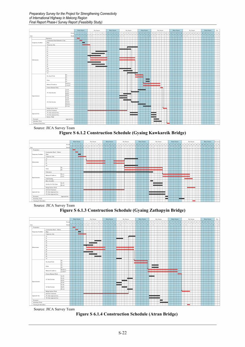
Source: JICA Survey Team
Figure S 6.1.1 Construction Schedule (Naung Lon Bridge)
Preparatory Survey for the Project for Strengthening Connectivity of International Highway in Mekong Region
Final Report Phase-I Survey Report (Feasibility Study)
Preparatory Survey for the Project for Strengthening Connectivity of International Highway in Mekong Region Final Report Phase-I Survey Report (Feasibility Study)
S-22
Period
Item Month
Rainy Season Dry Season Rainy Season Dry
6
Rainy Season Dry Season Rainy Season Dry Season Rainy Season Dry Season
4 5 67 8 9 10 11 121 2 3 4 5 67 8 9 10 11 12 8 9 10 11 121 2 3 4 5 67 8 9 10 11 12 71 2 3 4 5 67 8 9 10 11 121 2 3
Temporary Jetty
Substructure
A1
P3
P6
Preperation
Temporary Facilities
Construction Road/Alternative Canal
Plant
P4
P5
P1
P2
P10
P11
P8
P9
P7
PylonP5
P6
A2
Pier Head WorkP5P6
A2 Side Erection
P7-P8P8-P9P9-P10P10-P11P11-A2
A1 Side Erection
A1-P1P1-P2P2-P3P3-P4Superstructure
Balanced CantileverP4-P5-CtCt-P6-P7
Closure Element Work
A1 Side Approach Sec.Approach Sec.
Soft Soil Treatment
Bridge Surface Work
Cleaning & Demolition
Access Road
Pavement Approach Sec.
Subsidiary Work
A2 Side Approach Sec.
2 3 4 5 12 13 14 15 16 176 7 8 9 10 111 30 31 32 33 34 3524 25 26 27 28 2918 19 20 21 22 23 5448 49 50 51 52 5342 43 44 45 46 4736 37 38 39 40 41
Source: JICA Survey Team
Figure S 6.1.2 Construction Schedule (Gyaing Kawkareik Bridge)
Period
Item Month
Rainy Season Dry Season
6
Rainy Season Dry Season Rainy Season Dry Season Rainy Season Dry Season Rainy Season Dry Season
4 5 67 8 9 10 11 121 2 3 4 5 67 8 9 10 11 12 8 9 10 11 121 2 3 4 5 67 8 9 10 11 12 71 2 3 4 5 67 8 9 10 11 121 2 3
Temporary Jetty
Substructure
A1
A2
Preperation
Temporary Facilities
Construction Road・Alterna
Plant
Superstructure
PylonP1
P2
Fabrication
P1
P2
Erection for Side SpanA1-P1
P2-A2
Field Painting
Basic Assembly
Balanced CantileverP1-CtCt-P2
A1 Side Approach Sec.Approach Sec.Soft Soil Treatment
Bridge Surface Work
Cleaning & Demolition
Pavement Approach Sec.
Subsidiary Work
A2 Side Approach Sec.
9 10 11 12 13 141 2 3 4 5 6 7 8 27 28 29 30 31 3221 22 23 24 25 2615 16 17 18 19 20 51 52 53 5445 46 47 48 49 5039 40 41 42 43 4433 34 35 36 37 38
Source: JICA Survey Team
Figure S 6.1.3 Construction Schedule (Gyaing Zathapyin Bridge)
Period
Item Month
y
Rainy Season Dry Season Rainy Season Dry
6
Rainy Season Dry Season Rainy Season Dry Season Rainy Season Dry Season
7 8 9 10 11 121 2 3 4 5 67 8 9 10 11 12 1 2 3 4 5 67 8 9 10 11 121 2 3 4 5 6 7 8 9 10 11 121 2 3 4 5 67 8 9 10 11 12
Preperation
Temporary Facilities
Construction Road・Alterna
Plant
P1
P2
Temporary Jetty
Substructure
A1
P3
P6
P8
P9
P7
P4P5
PylonP5
P6
A2
Pier Head WorkP5
P6
A2 Side ErectionP7-P8P8-P9P9-A2
Bridge Surface Work
A1 Side Erection
A1-P1P1-P2P2-P3P3-P4
Balanced CantileverP4-P5-CtCt-P6-P7
Closure Element Work
A2 Side Approach Sec.
A1 Side Approach Sec.Approach Sec.Soft Soil Treatment
Superstructure
Cleaning & Demolition
Pavement
Subsidiary Work
12 13 14 15 16 176 7 8 9 10 111 2 3 4 5 30 31 32 33 34 3524 25 26 27 28 2918 19 20 21 22 23 5448 49 50 51 52 5342 43 44 45 46 4736 37 38 39 40 41
Source: JICA Survey Team
Figure S 6.1.4 Construction Schedule (Atran Bridge)
Preparatory Survey for the Project for Strengthening Connectivity of International Highway in Mekong Region Final Report Phase-I Survey Report (Feasibility Study)

Preparatory Survey for the Project for Strengthening Connectivity of International Highway in Mekong Region
Final Report Phase-I Survey Report (Feasibility Study)
S-23
Period
Item Month
1 2 3 4
Rainy Season Dry Season Rainy Season Dry Season Rainy Season Dry Season Rainy Season Dry Season
5 6 7 8 9 10
Rainy Season Dry Season
28 41 42 43 44 45 4635 36 3729 30 31 32 33 3423 24 25 26 2717 18 19 20 21 2211 12 13 14 15 16 5338 39 40 47 48 49 50 51 52
10 11 12 1 2 36 7 8 9 124 5 6 7 8 910 11 12 10 1112 1 2 34 5 6 7 8 910 11 12 1 2 1 2 34 5 6 7 8 910 1134 5 6 7 8 9
Bridge (2spans) L=60mx2nos
Bridge (3spans) L=90mx1nos
Donthami Bridge L=200m
Preperation
Temporary FacilitiesTemporary Road(inc. Tempora
Structure
Bridge (single span) L=15~30mx5nos
Pavement
Subsidiary Work
Cleaning & Demolition
Box Culvert 82nos
Earth Work
Soft Soil Treatment Behind Abutmen
Source: JICA Survey Team
Figure S 6.1.5 Construction Schedule (Thaton Bypass including Donthami Bridge)
Period
Item Month
Rainy Season Dry Season Rainy Season Dry Season Rainy Season Dry Season Rainy Season Dry Season
1 2 3 4 5 6
Rainy Season Dry Season
24 37 38 39 40 41 4231 32 3325 26 27 28 29 3019 20 21 22 2313 14 15 16 17 187 8 9 10 11 12 34 35 36 49 50 51 52 53 5443 44 45 46 47 48
7 8 9 10 11 126 7 8 9 10 11 121 2 3 4 5 6 7 8 9 10 11 121 2 3 4 5 6 7 8 9 10 11 121 2 3 4 5 6 7 8 9 10 11 121 2 3 4 5 6
Preperation
Temporary FacilitiesTemporary Road(inc. Tempora
Earth WorkSoft Soil Treatment Behind Abutment
Pavement
Structure
Bridge (single span) L=15~30m x 5nos
Bridge (2spans) L=60m x 2nos
Bridge (3spans) L=90m x 1nos
Box Culvert 82nos
Subsidiary WorkCleaning & Demolition Source: JICA Survey Team
Figure S 6.1.6 Construction Schedule (Kyargalay Bypass)
7. PROJECT COST ESTIMATES
7.1 Total Project Cost
Table S 7.1.1 Total Project Cost
Breakdown of Cost FC Portion(million USD) LC Portion(million USD) Total(million USD)
Total JICA Portion
MyanmarPortion Total JICA
PortionMyanmarPortion Total JICA
Portion MyanmarPortion
I. Civil Works 140.1 140.1 0.0 210.7 210.7 0.0 350.8 350.8 0.0
(1) Base Cost 138.7 138.7 0.0 197.7 197.7 0.0 336.4 336.4 0.0(2) Demolition of
existing bridges
0.0 0.0 0.0 13.0 13.0 0.0 13.0 13.0 0.0
(3) Dispute Board 1.4 1.4 0.0 0.0 0.0 0.0 1.4 1.4 0.0II. Relocation of
Existing Utilities
0.0 0.0 0.0 2.0 0.0 2.0 2.0 0.0 2.0
III. Price Escalation 11.7 11.7 0.0 53.3 52.9 0.4 65.0 64.5 0.4
IV. Physical Contingency 15.2 15.2 0.0 26.6 26.4 0.2 41.8 41.5 0.2
V. Consultant Service 28.8 28.8 0.0 14.1 14.1 0.0 42.9 42.9 0.0
IV. Land Acquisition 0.0 0.0 0.0 5.3 0.0 5.3 5.3 0.0 5.3
VII. Administration Cost 0.0 0.0 0.0 25.4 0.0 25.4 25.4 0.0 25.4
VIII. Commercial Tax 0.0 0.0 0.0 25.1 0.0 25.1 25.1 0.0 25.1
IX Import Tax 0.0 0.0 0.0 8.3 0.0 8.3 8.3 0.0 8.3X. Interest During
Construction 0.2 0.0 0.2 0.0 0.0 0.0 0.2 0.0 0.2
Total (I~X) 195.9 195.7 0.2 370.8 304.0 66.8 566.7 499.7 67.0
Source: JICA Survey Team
Preparatory Survey for the Project for Strengthening Connectivity of International Highway in Mekong Region
Final Report Phase-I Survey Report (Feasibility Study)

Preparatory Survey for the Project for Strengthening Connectivity of International Highway in Mekong Region Final Report Phase-I Survey Report (Feasibility Study)
S-24
8. OPERATION AND MAINTENANCE PLAN
8.1 Examination of Implementation Capacity of the Executing Agency
After completion of the Project, MOC under MOC is considered to take responsible for operation and maintenance of the project roads and bridges. Implementation capacity in MOC was examined based on the current situation.
- MOC has direct implemented design, construction, operation and maintenance for most of the roads and bridges in Myanmar. Accordingly, MOC has a certain degere of technical capacity regarding road development, thus, it is considered that MOC will be able to operate and maintain roads and bridges constructed in this Project if necessary technical assistance is provided by external experts. Necessary technical assistance is, for instance,; 1) Establishment of standards and manuals, 2) Development of systematic road and bridge inventory data base and 3) Improvement of maintenance capacity.
- With the progress of economic growth in Myanmar which brings a high demand for road development and the expansion of project volumes and duties on MOC, it is expected that various issues will emerge such as the enlargement of the organizations or the lack of engineers. In addition, for the projects funded by foreign countries, it is common to employ a private consultant and contractor which are independent from the government, therefore, the establishment and training of private companies is required to facilitate the road and bridge development.
- The road and bridge development should be secured considering the additional development for rapid traffic demand increase and the lack of funds. Therefore, it is necessary for MOC to strive to secure financial resources for increasing road assets in the near future. The application of a special road fund from fuel tax, road tax and vehicle tax is one of the possible measures to secure the required budget. However, as the high tax rate and imbalanced distribution of tax income could be a controversial issue among the tax payers, the application of a road special fund should be discussed in an appropriate manner. The second countermeasure is to utilize BOT scheme more widely. The current issues on the BOT scheme is that the contract provision and procurement processes are unclear and the contracts vary depending on the project. To facilitate the BOT for road and bridge development, BOT should be enacted and guidelines and manuals which regulate the procurement condition, obligations of the concessionaire and procurement method for construction and maintenance should be established.
8.2 Operation and Maintenance Plan for the Project
8.2.1 General
The project facilities located on ASEAN Highways and/or the East-West Economic Corridor should be maintained in sound conditions to sustain smooth and safe traffic flow. In general, bridges and roads are administered by the road/bridge management system which consists of:
Preparation of Inventory Data Inspection (Routine, Periodic, Non periodic / Emergency ) Rating and Prioritization based on inspection results for actual maintenance (Repair) work Records of other activities.
It is required to establish an optimal maintenance unit before the completion of the Project in Mon and Kayin States respectively. Tentatively the reference maintenance structure headed by a superintendent engineer in each Mon and Kayin State is proposed in Figure S 8.2.1. The staff of maintenance unit should be properly equipped with the knowledge and skills for bridge maintenance obtained through an appropriate training programme prior to the commencement of
Preparatory Survey for the Project for Strengthening Connectivity of International Highway in Mekong Region Final Report Phase-I Survey Report (Feasibility Study)

Preparatory Survey for the Project for Strengthening Connectivity of International Highway in Mekong Region
Final Report Phase-I Survey Report (Feasibility Study)
S-25
maintenance (Note that the employment of outsourced maintenance experts shall be required for the conduct of periodic maintenance of the bridge).
Source: JICA Survey Team
Figure S 8.2.1 Establishment of the Maintenance Structure after Completion of the Project (Reference only)
8.2.2 Operation and Maintenance Cost
Routine operation and maintenance, and maintenance item/interval/unit cost for periodic maintenance are shown in Table S 8.2.1. In the case that the maintenance duration is for 75 years, the total cost for operation and maintenance is estimated to be about 171 million USD (approximately 176 billion Kyat), the average cost to be about 2.2 million USD (approximately 2.3 billon Kyat). For intensive expenditure on the reconstruction of pavement etc., the maximum annual cost is estimated to be about 24.6 million USD (approximately 25.3 billion Kyat).
Overlap
【Member】 Bridge Engineer Inspector 1-3 Surveyor 1-3 Driver 1-2
【Inspection Tool】 ・ Inspection Sheet ・ Pen & marker ・ Stuff & tape ・ Binoculars ・ GPS, etc 【for Bridge】 ・ Crack scale ・ Rebound hammer ・ Ladder ・ Torch, etc
【Road Inspection】 ・ Crack ・ Pothole ・ Rutting ・ Debris of drainage 【Bridge Inspection】 ・ Crack ・ Water leak, lime flow ・ Peeling off, exposure of steel ・ floating ・ Depression/ hole out ・ Damage / corrosion of
member
【Member】 Bridge Engineer 1-2Foreman 1-2 (Worker 5-10) (Outsourced experts)
【Road Repair】 ・ Crack sealing ・ Patching ・ Leveling ・ Cleaning/ grass cutting ・ 【Bridge Repair】 ・ Crack sealing ・ Mortaring ・ Surface protection(Painting etc)
Repair Team
Inspection Team
【Materials】 ・ Ready mixed AC ・ Aggregate ・ Cement ・ Epoxy resin, etc 【Tools】 ・ Cone barricade ・ Ladder ・ Truck ・ Hammer, etc
・ Inspection record
/update ・ Evaluation of damage ・ Selection of repair ・ Repair record/ update
Instruct
Record attached with Photo
Report with photos
Instruct
Superintendent Engineer Reference
Preparatory Survey for the Project for Strengthening Connectivity of International Highway in Mekong Region
Final Report Phase-I Survey Report (Feasibility Study)

Preparatory Survey for the Project for Strengthening Connectivity of International Highway in Mekong Region Final Report Phase-I Survey Report (Feasibility Study)
S-26
Table S 8.2.1 Maintenance scenario and necessary amount of money in each frequency Units: USD
Item Frequency Naung Lon
Gyaing Kawkareik
Gyaing Zathapyin Atran Thaton BP Kyargalay
BPRoutine operation and maintenance Routine O&M (inc. repair of pavement) Every year 19,937 47,088 42,264 39,432 285,706 282,613 Periodic maintenance (Road) Reconstruction of Pavement 20 year - - - - 9,918,867 8,321,870 Periodic maintenance (Bridge) Periodic inspection 5 year 45,872 232,227 252,296 223,626 126,148 103,212 Reconstruction of Pavement 10 year 38,725 356,075 213,175 187,000 113,225 97,200 Replacement of water proof layer 10 year 97,122 893,036 534,643 468,996 283,968 243,778
Replacement of expansion joint 15 year 138,961 681,359 222,339 387,782 349,323 336,580
Repaint 30 year 134,924 - 580,580 - 168,655 -
Repair of deck 50 year 33,985 - - - 42,498 -
Repair of PC girder 20 year - 612,126 - 303,869 147,437 221,155 Replacement of PC Cable 75 year - 1,088,320 6,943,360 814,720 - -
Source: JICA Survey Team
9. IMPLEMENTATION PLAN
9.1 Implementation Organization
The JICA Survey Team recommended for the establishment of a Project Management Unit (PMU) under MOC in order to solely use and facilitate the smooth execution of the Project.
The PMU is responsible for the below works.
- Procurement of Consultant and Pre-Construction Services
- Detailed Design
- Land Acquisition and Relocation/Resettlement
- Construction Management
Preparatory Survey for the Project for Strengthening Connectivity of International Highway in Mekong Region Final Report Phase-I Survey Report (Feasibility Study)

Preparatory Survey for the Project for Strengthening Connectivity of International Highway in Mekong Region
Final Report Phase-I Survey Report (Feasibility Study)
S-27
Source: JICA Survey Team
Figure S 9.1.1 Proposed Organization Chart of the PMU (Draft)
Minister (MOC)
Minister (MOC)
Permanent Secretary
Director General (DOB, DOH)
Deputy Project Director (PMU)
Chief Engineer
Project Director (PMU)
Project Engineer (Technical)
Technical Officer
Project Engineer (Environmental)
Technical Officer
Project Engineer (Land Acquisition)
Technical Officer
Project Engineer (Resettlement)
Technical Officer
Assistant Land Acquisition
Officer
Assistant Resettlement
Officer
Project Accountant
Account Assistant
Administrative Officer
Management Assistance
Clerks
DOH Mon State
Additional Project Director
DOH Kayin State
Project Engineer (Safety)
Technical Officer
PMU
Preparatory Survey for the Project for Strengthening Connectivity of International Highway in Mekong Region
Final Report Phase-I Survey Report (Feasibility Study)

Preparatory Survey for the Project for Strengthening Connectivity of International Highway in M
ekong Region Final Report Phase-I Survey Report (Feasibility Study)
S-28
9.2 Im
plementation Schedule
The implem
entation schedule is shown in Figure S 9.2.1.
Figure S 9.2.1 Implementation Schedule
Month4 5 6 7 8 9 10 11 12 1 2 3 4 5 6 7 8 9 10 11 12 1 2 3 4 5 6 7 8 9 10 11 12 1 2 3 4 5 6 7 8 9 10 11 12 1 2 3 4 5 6 7 8 9 10 11 12 1 2 3 4 5 6 7 8 9 10 11 12 1 2 3 4 5 6 7 8 9 10 11 12 1 2 3 4 5 6 7 8 9 10 11 12 1 2 3 4 5 6 7 8 9 10 11 12 1 2 3
1
1
1 1 1 1 1 1 1 1 1 1 1 1
1 1 1 1 1 1 1 1 1 1 1 1 1 1 1 1 1 1 1 1 1 1 1 1 1 1 1 1 1 1 1 1 1 1 1 1 1 1 1 1 1 1 1 1 1 1 1 1 1 1 1 1 1 1 1 1 1 1 1 1 1 1 1 1 1 1 1 1 1 1 1 1 1 1 1 1 1 1 1 1 1 1 1
1 1 1 1 1 1 1 1 1 1 1 1 1 1 1 1
1 1 1 1 1 1 1 1 1 1 1 1 1 1 1
1 1 1 1 1
1 1 1
1 1 1
1 1 1 1
1
1 1
1 0.5
0.5
1 1 1 1 1 1 1 1 1 1 1 1 1 1 1 1 1 1 1 1 1 1 1 1 1 1 1 1 1 1 1 1 1 1 1 1 1 1 1 1 1 1 1 1 1 1 1 1 1 1 1 1 1 1 1 1 1
1 1 1 1 1 1 1 1 1 1 1 1 1 1 1 1 1 1 1 1 1 1 1 1 1 1 1 1 1 1 1 1 1 1 1 1 1 1 1 1 1 1 1 1 1 1 1 1 1 1 1 1 1 1 1 1 1
1 1 1 1 1 1 1 1 1 1 1 1 1 1 1 1 1 1 1 1 1 1 1 1 1 1 1 1 1 1 1 1 1 1 1
1 1 1 1 1 1 1 1 1 1 1 1 1 1 1 1 1 1
1 1 1 1 1 1 1 1 1 1 1 1 1 1 1 1 1 1 1 1 1 1 1 1 1 1 1 1 1 1 1 1 1
1 1 1 1 1 1 1 1 1 1 1 1 1 1 1 1 1 1 1 1 1 1 1 1 1 1 1 1 1 1 1 1 1 1 1 1 1 1 1 1 1 1 1 1 1
1 1 1 1 1 1 1 1 1 1 1 1
1 1 1 1 1 1 1 1 1 1 1 1 1 1 1 1 1 1 1 1 1 1 1 1 1 1 1 1 1 1 1 1 1 1 1 1 1 1 1 1 1 1 1 1 1
1 1 1 1 1 1 1 1 1 1 1 1 1 1 1 1 1 1 1 1 1 1 1 1 1 1 1 1 1 1 1 1 1 1 1 1 1 1 1 1 1 1 1
1 1 1 1 1 1 1 1 1 1 1 1 1 1 1 1 1 1 1 1 1 1 1 1 1 1 1 1 1 1 1 1 1 1 1 1 1 1 1 1 1 1 1 1 1
1 1 1 1 1 1 1 1 1 1 1 1
1 1 1 1 1 1 1 1 1 1 1 1
1 1 1 1 1 1 1 1 1 1 1 1 1 1 1 1 1 1 1 1 1 1 1 1 1 1 1 1 1 1 1 1 1 1 1 1 1 1
47
1 1 1 1 1 1 1 1 1 1 1 1 1 1 1 1 1 1 1 1 1 1 1 1 1 1 1 1 1 1 1 1 1 1 1 1 1 1 1 1 1 1 1 1 1 1 1
57
1 1 1 1 1 1 1 1 1 1 1 1 1 1 1 1 1 1 1 1 1 1 1 1 1 1 1 1 1 1 1 1 1 1 1 1 1 1 1 1 1 1 1 1 1 1 1 1 1 1 1 1 1 1 1 1 1
241 1 1 1 1 1 1 1 1 1 1 1 1 1 1 1 1 1 1 1 1 1 1 1
2020 2021 2022 20232015 2016 2017 2018 2019
0
Consulting Services 83
Detailed Design(16) 16
0
Pledge 1
Signing of Loan Agreement 1
Selection of Consultant for T/A and S/V 12
Tender Period 2
Tender Evaluation/ Consent by JICA 4
Clarification and Prior Approval of Contract by JICA 1
Tender Assistance(with P/Q)(15) 15
Preparation of P/Q, P/Q evaluation, JICA's Concurrence 5
Examination of Detailed Design & Tender Document 3
Construction Supervision (incl. Defect Liability Period)
57
0
Construction Works (incl. Defect Liability Period)
57
Prior Approval by Myanmar Government 2
Notification of Award 1
Signing of Contract / JICA's Concurrence 1
DonThami Bridge 33
Thaton Bypass 45
Removal of Gyaing Kawkareik Bridge* 12
Package01(to Yangon) 0
Gyaing Kawkareik Bridge 35
Naung Long Bridge 18
Kargalay Bypass 45
Removal of Gyaing Zathapyin Bridge and Atran Bridge* 12
Defects Liability Period 12
Package02(to Malwamyine) 0
Gyaing Zathapyin Bridge 45
Atran Bridge 43
0
* Defects Liability Period is unnecessary 0
0
Land Acquisition 11 12 12 3 0 0 0 0 038
Package01(To Yangon)
0 0 0
Package02(To Malwamyine)
0 0 0 9 12 12 12
9 12 12 12 2 0
12 0
Relocation of Existing Utilities*0 0 12 0 0 4 8 0 0
Defect Liability Period
Defect Liability Period
Preparatory Survey for the Project for Strengthening Connectivity of International Highway in M
ekong Region Final Report Phase-I Survey Report (Feasibility Study)

Preparatory Survey for the Project for Strengthening Connectivity of International Highway in Mekong Region
Final Report Phase-I Survey Report (Feasibility Study)
S-29
10. ECONOMIC ANALYSIS AND EVALUATION
10.1 Economic Analysis
10.1.1 Objective and Preconditions of Economic Analysis
Economic analyses of the projects are conducted in this chapter, in order to assess the contribution of the projects to the national economy. The Economic Internal Rate of Return (hereinafter referred to as EIRR) and Cost-Benefit Ratio (B/C) is employed as evaluation indicators, and these indicators are calculated from the annual benefit and cost of the projects with the discounted cash flow method.
Table S 10.1.1 shows the preconditions for the economic analysis of the Project. Items of investment cost such as taxes and price escalation are deleted from the financial prices in order to introduce economic cost. It is assumed that the standard Conversion Factor (SCF) which is used for transformation from financial cost to economic cost was set 0.97, which is applied in the “TA-8330 MYA: GMS East–West Economic Corridor Eindu to Kawkareik Road Improvement”3.
Table S 10.1.1 Preconditions for Economic Analysis Items Conditions Remarks
Project life 20 years after opening all bridges and bypass roads 2015–2040
Commencement of the Project: 2015 Opening year: 2019 (Naung Lon Bridge); 2020 (Gyaing Kawkareik Bridge); 2021 fiscal year (other bridges and bypass roads)
Exchange rate 1US dollar = 120.4 Japanese yen 1US dollar = 1,030.9Myanmar kyat –
Social discount rate 12% TA-8330 MYA: GMS East–West Economic Corridor Eindu to Kawkareik Road Improvement
Economic cost 97% of financial cost TA-8330 MYA: GMS East–West Economic Corridor Eindu to Kawkareik Road Improvement
Source: JICA Survey Team
10.1.2 Economic Benefit
Economic benefit of the Project consists of the saving of vehicle operating cost (VOC) and reduction of travel cost. The economic benefit of the Project will be listed in the cash flow table from 2019 when Naung Lon Bridge will be open to the public to 2040 which is 20th year of the opening of all bridges and bypass roads.
(1) Vehicle Operating Cost Vehicle operation cost includes the purchasing and maintenance cost of vehicles, fuel cost and insurance cost, etc.
In this analysis, VOC data of the “Feasibility Study of Economics, Engineering, and Environmental Impacts of the Four-Lane Highway Widening Project (Phase II), Route No. 12, Section Lom Sak – Consan Intersection”, which was conducted in 2010 because data for estimating the VOC of inter-city transportation was limited in Myanmar. The VOC data was used in the pre-feasibility study of the “Survey Program for the National Transport Development Plan”. The VOC figures are adjusted to the value in 2014 by use of the inflation rate of Thailand and exchanged into Japanese yen amounts. Data of VOC at 40 kilometres per hour in “flat roads” was utilized in order to calculate savings of VOC.
3 Hereinafter referred as “Eindu to Kawkareik Road Improvement Project”
Preparatory Survey for the Project for Strengthening Connectivity of International Highway in Mekong Region
Final Report Phase-I Survey Report (Feasibility Study)

Preparatory Survey for the Project for Strengthening Connectivity of International Highway in Mekong Region Final Report Phase-I Survey Report (Feasibility Study)
S-30
(2) Reduction of Travel Time Reduction of travel time is also a major part of economic benefit. The idea comes from the opportunity cost of working time. Thus, if the reduced time were used for working activity, the more value added is produced in a national economy.
Myanmar people’s average unit working revenue (working revenue per hour) is calculated from GDP per capita. According to IMF’s “World Economic Outlook Database, October 2014”, the estimated GDP per capita of Myanmar is USD 1,270 in 2014. The calculated hourly income is JPY21.2.
The Study Team also calculated the increase of the hourly income (real term) in accordance with Myanmar’s economic development. This methodology is the same as the pre-feasibility study of the “Survey Program for the National Transport Development Plan”.
10.1.3 Economic Cost
(1) Development cost Development cost consists of construction cost, consulting service, relocation of existing utilities, land acquisition and administration cost. These costs estimated in Chapter 8 are used for this economic analysis; however, taxes, price escalation, and contingency are eliminated. In addition, the local portion of the development cost is converted from the financial price to the economic price by use of the standard conversion factor (SCF, refer to Table S 10.1.1), in order to correct the distortion between the domestic price (price for non-tradable goods) and the international price (price for tradable goods).
(2) Maintenance cost Maintenance consists of regular maintenance and periodic maintenance. Periodic maintenance will be conducted every five years and regular maintenance will be conducted every year excluding the year of periodic maintenance.
Maintenance will start from 2019 at Naung Lon Bridge, from 2020 at Gyaing Kawkareik Bridge, and from 2021 fiscal year at other bridges and bypass roads. The total maintenance cost is converted to economic price multiplying by SCF.
10.1.4 Economic Evaluation of the Project
(1) Calculation of EIRR and Cost-Benefit Ratio Economic Internal Rates of Return (EIRR) of the projects which is calculated from annual net cash flow from 2015 to 2040 is 17.8%. The calculated EIRR exceeds 12%, which is commonly used for a benchmark of social discount rate in developing countries. Therefore, the Project is feasible from the point of national economic development.
The cost-benefit ratio calculated from the sum of discounted economic benefit divided by the sum of discounted economic cost is 1.90.
(2) Sensitivity Analysis Table S 10.1.2 shows results of sensitivity analysis. Increases in development cost and drop of economic benefit by 10% reduce EIRR by 1.0%. However, it maintains a high enough level. The impact of changes in annual and periodic maintenance costs on EIRR is limited.
Preparatory Survey for the Project for Strengthening Connectivity of International Highway in Mekong Region Final Report Phase-I Survey Report (Feasibility Study)

Preparatory Survey for the Project for Strengthening Connectivity of International Highway in Mekong Region
Final Report Phase-I Survey Report (Feasibility Study)
S-31
Table S 10.1.2 Results of Sensitivity Analysis Unit: Percent
Cases EIRR Base case 17.8 10% increase of development cost 16.9 10% increase of maintenance cost 17.8 10% reduction of economic benefit 16.8 Source: JICA Survey Team
10.2 Operation and Effect Indicators
Like other JICA funded road/bridge improvement projects in Myanmar and other countries, the traffic volume and travel time are set as operation and effect indicators for the Project, respectively.
Operation Indicator: Annual average daily traffic (vehicles/day and pcu/day),
Effect Indicator: Travel time (hours per vehicle)
Also, vehicle operating cost is set as a monitoring indicator for the Project.
Monitoring Indicator : Vehicle operating cost (Kyat per vehicle)
The operation, effect and monitoring indicators are prepared showing present performances in 2014 and targets in 2024, two years after starting operation. The following table summarizes operation and effect indicators of the Project.
Table S 10.2.1 Operation and Effect Indicators of the Project
Indicators Year
Sub-projects
Naung Lon Bridge
Gyaing Kawkareik
Bridge Atran Bridge
Gyaing Zathapyin
Bridge Kyargalay
Bypass
Thaton Bypass
and Don Tha Mi Bridge
Operation Indicators
Annual average daily traffic (vehicles/day) 1
2014 1,914 1,794 1,176 1,176 NA NA
2024 4,400 10,490 7,270 6,930 6,030 6,200
Annual average daily traffic (pcu/day) 1
2014 2,520 2,410 1,485 1,485 NA NA
2024 6,080 14,500 10,400 9,830 8,480 9,290
Effect Indicators
Travel time of vehicles excluding heavy vehicles (hours/vehicle)
2014 2.39 2 2.39 2 3.50 5
2024 2.04 2 1.36 4 2.91 5
Travel time of heavy vehicles (hours/vehicle)
2014 4.53 3 4.53 3 3.50 5
2024 2.04 3 1.36 4 2.91 5
Note 1: Refer to traffic volume in 2014 of Table 10.2.2. Annual average daily in 2024 is calculated from linear regression with traffic volume data in 2014 and 2035.
Note 2: Travel time is estimated for the road section between Kawkareik and Mawlamyain (both 2014 and 2024 figures are via Eindu route). 2014 travel time is estimated based on the travel speed survey report (issued in 2013) provided by Japanese forwarding company. 2024 travel time is estimated from traffic capacity–travel speed (QV) condition applied to “Survey Program for the National Transport Development Plan in Myanmar”.
Note 3: Travel time is estimated for the road section between Kawkareik and Mawlamyain (2014 figure is estimated via Thaton route and 2024 figure is via Eindu route). Other conditions are the same as Note 2.
Note 4: Travel time is estimated for the road section between Kawkareik and Mawlamyain (2024 figure is via Kyargalay Bypass route). Other conditions are the same as Note 2.
Note 5: Travel time is estimated for the road section between Kawkareik and the end point of Thaton Bypass (2014 figure is estimated via Thaton route and 2024 figure is via Thaton Bypass route). Other conditions are the same as Note 2.
Source: JICA Survey Team
Preparatory Survey for the Project for Strengthening Connectivity of International Highway in Mekong Region
Final Report Phase-I Survey Report (Feasibility Study)

Preparatory Survey for the Project for Strengthening Connectivity of International Highway in Mekong Region Final Report Phase-I Survey Report (Feasibility Study)
S-32
Table S 10.2.2 Traffic Volumes by Sub-Projects
Projects Naung Lon Bridge
Gyaing Kawkareik
Bridge
Thaton Bypass and
Don Tha Mi Bridge
Atran Bridge
Gyaing Zathapyin
Bridge Kyargalay
Bypass
2014 Passenger car 1,223 1,120 760 760 Bus 79 83 95 95 2 axle truck 375 331 296 296 3 axle truck 35 14 9 9 Heavy truck (more than 4 axle) 181 227 16 16
Articulated Truck 21 19 0 0 Total (vehicles) 1,914 1,794 0 1,176 1,176 0Total (pcu) 2,520 2,410 0 1,485 1,485 02035 Passenger car 4,540 12,260 7,210 7,080 6,860 7,260Bus 360 800 680 370 360 4602 axle truck (light truck) 150 1,200 300 1,500 1,420 1,0002 axle truck (medium truck) 400 1,970 960 2,260 2,120 1,560
3 axle truck 250 740 640 680 630 520Heavy truck (more than 4 axle) 930 1,980 2,090 1,350 1,210 1,200
Articulated Truck 500 1,100 1,140 730 650 670Total (vehicles) 7,130 20,050 13,020 13,970 13,250 12,670Total (pcu) 10,000 27,800 19,500 20,200 19,000 17,800Source: JICA Survey Team
11. ENVIRONMENTAL IMPACT ASSESSMENT
11.1 Outline of the Environmental Impact Assessment
In this chapter, an outline of necessary environmental activities in accordance with relevant Myanmar environmental laws and JICA Guidelines for Environmental and Social Considerations for prioritized projects which have been concluded between Myanmar and Japan Government are summarized. Detailed contents are explained in the two Environmental Impact Assessment (EIA) Reports which will be approved by the Myanmar side in May 2015.
11.2 Components of Prioritized Projects
Components of the discussed prioritized two Sub-Projects and packages are shown in the table.
Preparatory Survey for the Project for Strengthening Connectivity of International Highway in Mekong Region Final Report Phase-I Survey Report (Feasibility Study)
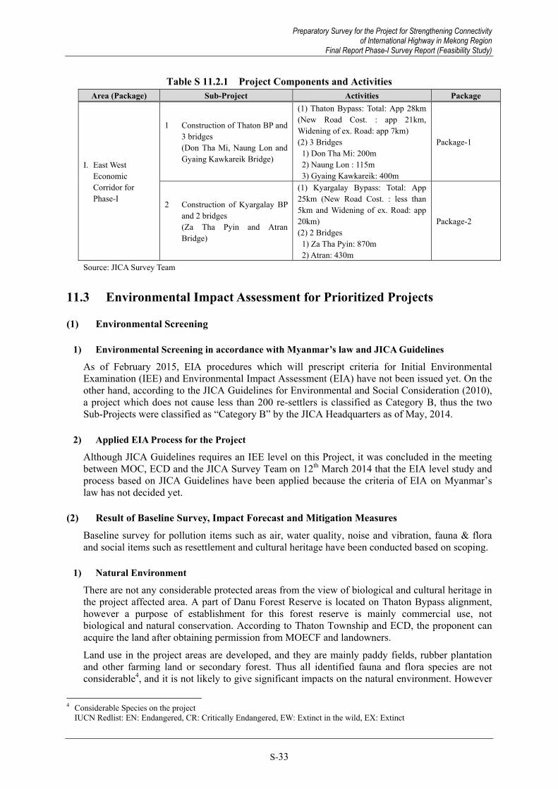
Preparatory Survey for the Project for Strengthening Connectivity of International Highway in Mekong Region
Final Report Phase-I Survey Report (Feasibility Study)
S-33
Table S 11.2.1 Project Components and Activities Area (Package) Sub-Project Activities Package
I. East West Economic Corridor for Phase-I
1 Construction of Thaton BP and 3 bridges (Don Tha Mi, Naung Lon and Gyaing Kawkareik Bridge)
(1) Thaton Bypass: Total: App 28km (New Road Cost. : app 21km, Widening of ex. Road: app 7km) (2) 3 Bridges 1) Don Tha Mi: 200m 2) Naung Lon : 115m 3) Gyaing Kawkareik: 400m
Package-1
2 Construction of Kyargalay BP and 2 bridges (Za Tha Pyin and Atran Bridge)
(1) Kyargalay Bypass: Total: App 25km (New Road Cost. : less than 5km and Widening of ex. Road: app 20km) (2) 2 Bridges 1) Za Tha Pyin: 870m 2) Atran: 430m
Package-2
Source: JICA Survey Team
11.3 Environmental Impact Assessment for Prioritized Projects
(1) Environmental Screening
1) Environmental Screening in accordance with Myanmar’s law and JICA Guidelines
As of February 2015, EIA procedures which will prescript criteria for Initial Environmental Examination (IEE) and Environmental Impact Assessment (EIA) have not been issued yet. On the other hand, according to the JICA Guidelines for Environmental and Social Consideration (2010), a project which does not cause less than 200 re-settlers is classified as Category B, thus the two Sub-Projects were classified as “Category B” by the JICA Headquarters as of May, 2014.
2) Applied EIA Process for the Project
Although JICA Guidelines requires an IEE level on this Project, it was concluded in the meeting between MOC, ECD and the JICA Survey Team on 12th March 2014 that the EIA level study and process based on JICA Guidelines have been applied because the criteria of EIA on Myanmar’s law has not decided yet.
(2) Result of Baseline Survey, Impact Forecast and Mitigation Measures Baseline survey for pollution items such as air, water quality, noise and vibration, fauna & flora and social items such as resettlement and cultural heritage have been conducted based on scoping.
1) Natural Environment
There are not any considerable protected areas from the view of biological and cultural heritage in the project affected area. A part of Danu Forest Reserve is located on Thaton Bypass alignment, however a purpose of establishment for this forest reserve is mainly commercial use, not biological and natural conservation. According to Thaton Township and ECD, the proponent can acquire the land after obtaining permission from MOECF and landowners.
Land use in the project areas are developed, and they are mainly paddy fields, rubber plantation and other farming land or secondary forest. Thus all identified fauna and flora species are not considerable4, and it is not likely to give significant impacts on the natural environment. However
4 Considerable Species on the project IUCN Redlist: EN: Endangered, CR: Critically Endangered, EW: Extinct in the wild, EX: Extinct
Preparatory Survey for the Project for Strengthening Connectivity of International Highway in Mekong Region
Final Report Phase-I Survey Report (Feasibility Study)

Preparatory Survey for the Project for Strengthening Connectivity of International Highway in Mekong Region Final Report Phase-I Survey Report (Feasibility Study)
S-34
some mitigation measures such as clarification of the development area and reduction of turbid water shall be planned in the Environmental Management Plan (EMP).
2) Pollution Items
According to baseline survey for air, water, noise and vibration, most of the data meets the standard level except for water quality.
During the construction of road and bridges, dust, turbid water, construction noise and vibration will be caused from construction activities and will affect the nearest residential areas. Especially construction of Gyaing Kawkareik in the night time may give a degree of impact on the nearest residential area.
After construction, adverse impacts on air, noise and vibration are predicted due to the increase of traffic volume. Hence, mitigation measures for noise & vibration and turbid water in the river shall be planned and implemented during construction. After construction, speed control less than 50km/h shall be conducted for the mitigation of noise and vibration levels in residential areas.
3) Social Environment
Main land use in the project areas are paddy fields, rubber tree plantations and swampy open space. However some residential areas are located along the existing road in the Thaton and Kyargalay bypass areas. Thus the widening of existing roads may cause resettlements on such areas. Although the alignment avoids residential areas, 96 re-settlers and 94 ha land acquisition are expected for Sub-Project 1, and 92 re-settlers and 14.5 ha land acquisition are expected for Sub-Project 2.
In the process for the preparation of the resettlement action plan (RAP), socialization meetings have been held under participation of project affected persons. In a series of meetings, the compensation policy and social assistance in accordance with Myanmar’s law and JICA Guidelines have been explained and understood without any objection from the participants.
With regard to cultural heritage, some pagodas and religious monuments are observed along the existing roads, however such facilities are not affected by the alignment.
(3) Environmental Monitoring Plan during and after construction Basically natural, pollution and social monitoring will be conducted at the same points where the baseline survey was conducted. Additionally an interview survey with inhabitants shall be done and additional mitigation measures will be considered based on the result of monitoring.
During construction, it is recommended to establish a “Bridge and Road Construction Committee” for the management of environmental issues. After construction, the project proponent should conduct environmental and social monitoring, and then such results should be reflected to other projects.
11.4 Local Stakeholder Meetings
State and local level stakeholder meetings on EIA scoping stage have been held in accordance with Myanmar’s draft EIA procedure and JICA Guidelines, and have formulated project basic consensus with all participants of the meetings. The meetings on stage of draft EIA and RAP have been held in March 2015 and consensus w about project implementation.
11.5 Schedule regarding EIA
An approval for EIA will be obtained from MOC and ECD by April and May 2015, and then the approved EIA report in Burmese will be disclosed to project affected persons at every township office for one month.
Preparatory Survey for the Project for Strengthening Connectivity of International Highway in Mekong Region Final Report Phase-I Survey Report (Feasibility Study)

Preparatory Survey for the Project for Strengthening Connectivity of International Highway in Mekong Region
Final Report Phase-I Survey Report (Feasibility Study)
S-35
With regard to the project schedule, the approved RAP will be updated after the detailed design and implemented land acquisition and compensation under monitoring.
11.6 Other Necessary Certificates
Approximately 0.7 million m3 material on Sub-Project 1 and 2.2 million m3 on Sub-Project 2 are required for embankment soil in accordance with design. Basically such material will be collected from surrounding existing registered quarries and borrow pits, however the following permissions shall be obtained when new quarry and borrow pits are developed during construction by the construction contractor in accordance with Myanmar’s law and donor’s environmental guidelines.
Township development committee permission (new borrow pits, quarry and sand & gravel extraction from rivers)
State Government permission (new borrow pits, quarry and sand & gravel extraction from river)s
ECD permission (new borrow pits, quarry and sand & gravel extraction from rivers) DWIG permission (sand & gravel extraction from rivers)
These necessary activities and permissions shall be obtained by the contractor during construction phase under MOC.
12. RESETTLEMENT AND ACTION PLAN
12.1 Basic concept for Resettlement Action Plan
This chapter shows the outline of Resettlement Action Plan (RAP) which was created in accordance with Myanmar’s related laws and regulations, the JICA Guidelines for Environmental and Social Considerations (April 2010) and the World Bank’s Safeguard Policy OP 4.12. The RAP reports including detailed contents are supposed to be accepted by the project affected persons (PAPs) and will be approved by the Myanmar side in May 2015.
As being referred to in Chapter 11, both Sub-Projects 1 and 2 are classified as Category B based on the definitions in the JICA Guidelines and WB OP 4.12 as well. Thus, the projects need an abbreviated RAP (A-RAP) through the results from the demographic and socio-economic census, loss of properties, computation of costs and budget for compensation and relocation.
12.2 Outline of Census and Socio-Economic Survey
Surveys regarding the inventory data of occupied land and assets of each household, land use and socio-economic condition of PAPs were conducted and the results are summarized in Table S 12.2.1.
Table S 12.2.1 Summary of Project Affected Impacts Item Sub-Project 1 Sub-Project 2
Survey Period 20 Sep 2014 to 13 Mar 2015 30 Sep 2014 to 4 Mar 2015 Total PAHs and PAPs 1,858 PAPs in 390 PAHs 1,109 PAPs in 223 PAHs Residential PAHs (PAPs) to be Relocated
96 PAPs in 15 PAHs 92 PAPs in 18 PAHs
Land Acquired (acre) 232 acres including: three for residence, 195 for rubber plantation and 34 for paddy land.
36 acres including: two for residence, one for rubber plantation and 33 for paddy land.
Crops and Trees Paddy: 1,486 baskets (31.1 tons) Trees:60,200 trees including 43,400 rubber trees, 13,900 of betel plants, etc.
Paddy: 1,360 baskets (28.4 tons) Trees: 590 trees including 320 of banana, 124 rubber trees, etc.
Fishery 127 PAHs 105 PAHs
Preparatory Survey for the Project for Strengthening Connectivity of International Highway in Mekong Region
Final Report Phase-I Survey Report (Feasibility Study)

Preparatory Survey for the Project for Strengthening Connectivity of International Highway in Mekong Region Final Report Phase-I Survey Report (Feasibility Study)
S-36
Note Thaton Bypass alignment passes over the land owned by MOI.
No indigenous peoples (IPs) are detected in the project area (based on WB OP 4.10)
Ethnic groups such KNU, DKBA etc are virtually ruling along the Kyargalay Bypass area.
No indigenous peoples (IPs) are detected in the project area (based on WB OP 4.10)
Source: JICA Survey Team
12.3 Policy and Legal Framework
Currently in Myanmar, there is no law stipulating land acquisition and resettlement comprehensively though the Land Acquisition Act in 1894 and the Farmland Law in 2012 are regarded as the major laws concerned. Regarding the items stipulated in the JICA Guidelines and WB OP 4.12 below, however, intensive assistance is essential for the MOC and related authorities in order to conduct fair compensation based on the relating laws and regulations in Myanmar.
Items on social consideration which are not clearly stipulated in Myanmar’s laws and regulations: Consideration of alternatives to minimize or mitigate the relocation; Restoration to livelihood, income and productivity levels before relocation; Compensation payment before relocation; Development of Resettlement Action Plan; Public consultation with PAPs during RAP development; Identification of PAPs in an earlier stage; and Assistance provision during relocation.
12.4 Compensation and Entitlement Matrix
Valuation for compensating loss of land and its derivative (crops, plants etc.) shall be in accordance with the relevant laws in Myanmar with support of the project policy. For dwellings and other structures, it shall be based on replacement cost to be computed. Income assistance shall also be necessary to PAPs in case the project adverse affects to such people. An inconvenience allowance shall be given to PAPs with severely affected structures, which require relocation and new construction. The entitlement matrix is a matrix to show systematically the relations of compensation and is shown in Table S 12.4.1.
Table S 12.4.1 Entitlement Matrix Type of Loss Application Entitled Person Assistance Policy
1. Land Partial or entire loss of land
Land owner/occupant or a person who has a recognizable right to claim to the land.
- Provide cash compensation in the current reacquisition price or land for land compensation at a place acceptable to PAPs if feasible.
2. Structures (Houses, Shops)
Partial or entire loss of structure
Owner/Tenant - For the entire affected structure, cash compensation to PAPs at a replacement cost which covers cost for materials, labour, and transport of materials.
- For partial affected structure, cash compensation for affected portion of the structure to be computed based on the replacement cost.
3. Community Structures (Rest house etc)
Partial or entire loss of structure
- Cash assistance at full replacement cost. If possible, new structure will be replaced by the project proponent which is similar to the former one.
4. Crops Loss of paddy and other crops
Owner of crops - Cash compensation for loss of paddy or other crops yield which is calculated based on the actual market price. Income restoration is paid equivalent to six times of annual earning to PAPs.
Preparatory Survey for the Project for Strengthening Connectivity of International Highway in Mekong Region Final Report Phase-I Survey Report (Feasibility Study)

Preparatory Survey for the Project for Strengthening Connectivity of International Highway in Mekong Region
Final Report Phase-I Survey Report (Feasibility Study)
S-37
Type of Loss Application Entitled Person Assistance Policy 5. Trees (i) Rubber trees Owner of trees - Cash compensation for loss of rubber trees is
calculated as age of rubber trees in the current market price.
- Income restoration is paid equivalent to six times of monthly earning to PAPs.
(ii) Others - Provide cash compensation for loss of trees atstandard unit cost
6. Fishery Impacts on fishing activity during construction time
Fisherman - Cash compensation for loss of fishing opportunity based on fish catches and current market price by fish type at each area during construction period.
7. Business Loss PAPs who lose income for any type of business.
- For PAPs for income loss from shops, cash assistance equivalent to six months income.
8. Vulnerable Allowance
Households headed by a woman¸ disabled person, elderly (over 61 years old), poor household below poverty line or household including a disabled person.
- One time cash assistance for each vulnerable household is paid (150,000 kyats)
Source: JICA Survey Team
12.5 Implementation Framework
MOC is the core responsible body for the resettlement action plan as the driving force of the Project. Besides MOC, the Ministry of Agriculture and Irrigation (MOAI) and the Ministry of Home Affairs (MOHA) shall be involved in order for managing land issues and compensation. Local authorities at state, township and village levels must be constituents as well. The organizations are to form a consortium chaired by MOC, so called the Resettlement Implementation Committee (RIC), to go ahead with the activities of the resettlement action plan in harmony with stakeholders.
12.6 Monitoring
Monitoring activity normally consists of internal and external monitoring. The main purpose of the monitoring activity is to ensure that all PAPs who lost their respective houses, land or other livelihood assets have been provided with sufficient compensation and assistance according to the policies and procedures which is described in the RAP. The external monitoring will be conducted periodically by an independent local/international External Monitoring Agent (EMA) for review and assessment regarding the achievement of the plan.
12.7 Consultation and Public Participation
JICA Guidelines require holding public consultations for a smooth decision making with the PAPs and stakeholders. PAPs must be fully informed at the earliest possible time. A series of the 1st consultation meetings was held in August 2014 at fourteen venues to open the outline of the Project and compensation policy and RAP activities. Through the meetings the Project got consensus and approval by the stakeholders and PAPs. The 2nd round of consultation meetings were conducted in March 2015 and the draft RAP was accepted.
12.8 Implementation Schedule
The abbreviated RAP for each Sub-Project was drafted and the 2nd public consultation meeting with PAPs was held in March 2015 in order to obtain consensus-building and approval on the results. The RAP was approved by the Myanmar side in April 2015. The RAP that is translated in Burmese is to be publicized for a certain period in order for the local people can understand the
Preparatory Survey for the Project for Strengthening Connectivity of International Highway in Mekong Region
Final Report Phase-I Survey Report (Feasibility Study)

Preparatory Survey for the Project for Strengthening Connectivity of International Highway in Mekong Region Final Report Phase-I Survey Report (Feasibility Study)
S-38
contents of the approved RAP. The RAP will be updated after the detailed design stage and land acquisition and compensation will be done by the project entity.
13. CONCLUSION AND RECOMMENDATIONS
13.1 Conclusion
13.1.1 Summary of the Project
Priority projects were selected based on the current condition, the progress of relevant projects etc., in a series of discussions with the related authorities. Preliminary design was conducted for the priority projects.
Table 13.1.1 Project Summary Component Summary Sub-Project 1: Improvement of EWEC (to Yangon) Naung Lon Bridge Bridge Length : 160m
Superstructure : Steel-I girder Substructure : Inverted T-shape abutment, Wall-type pier Foundation : Cast-in-place concrete pile Approach Road : Embankment structure (L = 316m / L = 284m)
1. Gyaing Kawkareik Bridge Bridge Length : 810m Superstructure : Extradosed (Main) / PC box girder (Approach) Substructure : Two column type tower, Wall type pier : Invert T shape abutment Foundation : Steel pipe sheet plied foundation : Cast in-place concrete pile Approach Road : Embankment structure (L = 455m / L = 424m) Demolition of the Existing Bridge : Existing structure above G.L
Thaton Bypass Road Length : 29.3km Structure : Box culvert x 65, Small bridge x 4, Donthami bridge (Donthami Bridge) Bridge Length : 200m Superstructure : Steel-I girder Substructure : Inverted T-shape abutment, Wall type pier Foundation : Cast-in-place concrete pile, Steel pipe pile
Sub-Project 2: Improvement of EWEC (to Mawlamyine) 1. Gyaing Zathapyin Bridge Bridge Length : 880m
Superstructure : Steel cable-stayed bridge Substructure : Two column type tower, Wall type pier : Inverted T-shape abutment Foundation : Steel pipe sheet plied foundation
: Cast in-place concrete pile Approach Road : Embankment structure (L = 477m / L = 517m) Demolition of the Existing Bridge : Existing structure above G.L
2. Atran Bridge Bridge Length : 780m Superstructure : Extradosed bridge (Main)/ /PC box girder (Approach) Substructure : Two column type tower, Wall type pier : Invert T shape abutment Foundation : Steel pipe sheet plied foundation : Cast in-place concrete pile Approach Road : Embankment structure (L = 560.5m / L = 344.5m) Demolition of the Existing Bridge : Existing structure above G.L
Kyargalay Road Length : 25.0km Structure : Box culvert x 82, Small bridge x 8
Source: JICA Survey Team
Preparatory Survey for the Project for Strengthening Connectivity of International Highway in Mekong Region Final Report Phase-I Survey Report (Feasibility Study)

Preparatory Survey for the Project for Strengthening Connectivity of International Highway in Mekong Region
Final Report Phase-I Survey Report (Feasibility Study)
S-39
13.1.2 Project Cost and Implementation Schedule
(1) Project Cost
・ Civil Works : $350.8 million (USD) ・ Consultant Fee : $42.9 million (USD) ・ Other : $173.0 million (USD) ・ Total Project Cost : $566.7 million (USD)
(2) Implementation Schedule
・ Selection of Consultant : May 2015 to April 2016 (12 months) ・ Detail Design : May 2016 to August 2017 (16 months) ・ Selection of Contractor : September 2017 to June 2018 (10 months) ・ Civil Works : July 2018 to March 2022 (57 months)
13.1.3 Environmental and Social Considerations
・ The Project is categorized as Category B in accordance with JICA Guidelines. ・ A general consensus about project components, area of influence and compensation for the
Project has been formulated through stakeholder meetings and public consultation meetings. ・ In the Project Area, it was confirmed that there are no environmental or social issues that
could impede execution of the project.
13.1.4 Economic Analysis and Evaluation
・ Economic Internal Rate of Return (EIRR) : 17.8% (for base case) ・ Benefit / Cost : 1.90
From the above study results, this project is considered to be feasible.
13.2 Recommendations
(1) Consistency with the projects of other donors
1) Asian Development Bank (ADB)
The ADB-financed Eindu to Kawkareik Road Improvement Project is related to the Project that we are dealing with, as Gyaing Kawkareik Bridge is included in this section. In the study, uniformity and/or consistency between the two projects must be ensured for basic design conditions such as road standards, configuration of road crossings, and the profile of the connecting point at Gyaing Kawkareik Bridge.
The ADB-financed project was in the Feasibility Study phase at last check, so the final adjustment shall be required through the exchange of information at the time of the detailed design. Similar procedures will be taken in the case that other associated projects are planned in or around the Project Area.
2) Government of Thailand
In the development of the East-West Economic Corridor (the target of the Project), two projects under the aid of the Thai Government are being conducted in parallel. One is the development of a bypass between Thin Gan Nyi Naung and Kawkareik, a one-lane section that passes over the Dawna Mountain. The other is the construction of a second international bridge crossing the
Preparatory Survey for the Project for Strengthening Connectivity of International Highway in Mekong Region
Final Report Phase-I Survey Report (Feasibility Study)

Preparatory Survey for the Project for Strengthening Connectivity of International Highway in Mekong Region Final Report Phase-I Survey Report (Feasibility Study)
S-40
Thaungyin River (which flows along the Thailand-Myanmar border) and border management facilities.
The bypass is almost completed as of June 2015, and service is expected to start in July 2015.
The second international bridge has passed the detailed design phase, and is now entering the construction phase. Currently, the capacity of the border management facility in Myawaddy is low, so the processing of cross-border traffic is limited. The completion of the second international bridge and border management facility shall enable smoother cross-border traffic. The impact on traffic volume through the completion of the border management facility must be considered as a project effect.
(2) Transfer of technology It is desirable to implement the transfer of advanced construction techniques (such as those used in Japan) to Myanmar through project execution, and MOC has expressed strong interest in the learning Japanese construction techniques. Thus, discussions must be held to form and execute a meaningful specific training programme encompassing each stage of design and construction. As for the weathering steel, appropriateness should be determined in the detailed design stage. Main items for technology transfer are as follows.
・ Design and construction of extradosed bridges ・ Design and construction of steel pipe sheet pile foundations ・ Soft ground stabilization method ・ Asphalt pavement technology ・ Weathering steel (applicability must be determined at the detailed design stage) ・ Bridge maintenance technology (including bridge inspections)
(3) Relocation of existing utilities In this study, a preliminary design was performed in consideration of an inventory survey of existing utilities in the Project Area such as water pipes, telephone lines and electricity lines (which was conducted within the topographic survey). Relocation of existing utilities is expected to be carried out through Myanmar government funds. In the detailed design stage, a detailed study of the existing utilities needs to be conducted, and support shall be required in order to coordinate with relevant agencies and develop a relocation plan based on the acquired information.
(4) Shortening of the construction period Targeting ASEAN integration in 2015, maintenance of international trunk roads is an urgent priority in Myanmar. In particular, the Myawaddy-Thaton section is a part of the ASEAN Highway and the Myawaddy- Kawkareik bypass section is expected to open entirely in May 2015. In addition, the construction of Eindu to Kawkareik Road Improvement project by ADB is scheduled to be completed in March 2019. Consequently, the traffic volume of the target route is expected to grow dramatically by the construction of these new routes.
MOC hopes to complete the replacement of Gyaing Kawkareik Bridge as early as possible, so the schedule of works assumed in this Study includes night-time construction work in order to shorten the construction period. Considering this, in the subsequent detailed design and implementation stages, measures for eliminating bottlenecks to shorten the construction time (while ensuring safety and quality) must be devised.
(5) Environmental and social considerations ・ After receiving approval of the Environmental Impact Assessment (EIA) Report and
Abbreviated Resettlement Action Plan Report (ARAP) from the Environmental Conservation Department (ECD) under the Ministry of Environmental Conservation &
Preparatory Survey for the Project for Strengthening Connectivity of International Highway in Mekong Region Final Report Phase-I Survey Report (Feasibility Study)

Preparatory Survey for the Project for Strengthening Connectivity of International Highway in Mekong Region
Final Report Phase-I Survey Report (Feasibility Study)
S-41
Forest, these reports must be translated into Burmese and disclosed to project-affected persons and other residents for a period of more than one month.
・ Project-affected areas shall be indicated to project-affected persons prior to the detailed design phase. The approved RAP shall be updated based on requirements concluded through detailed design, and compensation and land acquisition must be performed before construction begins.
・ The Project Proponent shall swiftly respond to claims and complaints from project-affected persons and other inhabitants in accordance with the grievance redress scheme given in the approved RAP, and shall endeavour to promote the understanding of the project’s necessity.
Preparatory Survey for the Project for Strengthening Connectivity of International Highway in Mekong Region
Final Report Phase-I Survey Report (Feasibility Study)
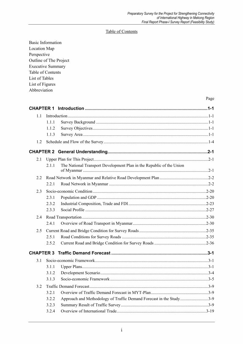
Preparatory Survey for the Project for Strengthening Connectivity of International Highway in Mekong Region
Final Report Phase-I Survey Report (Feasibility Study)
i
Table of Contents Basic Information Location Map Perspective Outline of The Project Executive Summary Table of Contents List of Tables List of Figures Abbreviation
Page
CHAPTER 1 Introduction .................................................................................................. 1-1 1.1 Introduction .................................................................................................................................. 1-1
1.1.1 Survey Background ........................................................................................................ 1-1 1.1.2 Survey Objectives ........................................................................................................... 1-1 1.1.3 Survey Area .................................................................................................................... 1-1
1.2 Schedule and Flow of the Survey ................................................................................................. 1-4
CHAPTER 2 General Understanding................................................................................ 2-1 2.1 Upper Plan for This Project .......................................................................................................... 2-1
2.1.1 The National Transport Development Plan in the Republic of the Union of Myanmar .................................................................................................................... 2-1
2.2 Road Network in Myanmar and Relative Road Development Plan ............................................. 2-2 2.2.1 Road Network in Myanmar ............................................................................................ 2-2
2.3 Socio-economic Condition ......................................................................................................... 2-20 2.3.1 Population and GDP ..................................................................................................... 2-20 2.3.2 Industrial Composition, Trade and FDI ........................................................................ 2-23 2.3.3 Social Profile ................................................................................................................ 2-27
2.4 Road Transportation ................................................................................................................... 2-30 2.4.1 Overview of Road Transport in Myanmar .................................................................... 2-30
2.5 Current Road and Bridge Condition for Survey Roads .............................................................. 2-35 2.5.1 Road Conditions for Survey Roads .............................................................................. 2-35 2.5.2 Current Road and Bridge Condition for Survey Roads ................................................ 2-36
CHAPTER 3 Traffic Demand Forecast ............................................................................. 3-1 3.1 Socio-economic Framework ......................................................................................................... 3-1
3.1.1 Upper Plans ..................................................................................................................... 3-1 3.1.2 Development Scenario .................................................................................................... 3-4 3.1.3 Socio-economic Framework ........................................................................................... 3-5
3.2 Traffic Demand Forecast .............................................................................................................. 3-9 3.2.1 Overview of Traffic Demand Forecast in MYT-Plan ..................................................... 3-9 3.2.2 Approach and Methodology of Traffic Demand Forecast in the Study .......................... 3-9 3.2.3 Summary Result of Traffic Survey ................................................................................. 3-9 3.2.4 Overview of International Trade ................................................................................... 3-19
Preparatory Survey for the Project for Strengthening Connectivity of International Highway in Mekong Region
Final Report Phase-I Survey Report (Feasibility Study)

Preparatory Survey for the Project for Strengthening Connectivity of International Highway in Mekong Region Final Report Phase-I Survey Report (Feasibility Study)
ii
3.2.5 Traffic Demand Forecast in the Study (Base Case) ...................................................... 3-25 3.2.6 Traffic Demand Forecast in the Study (EWEC Improvement Case) ............................ 3-34
3.3 Implications for EWEC Improvement ........................................................................................ 3-36
CHAPTER 4 Selection of Priority Projects ...................................................................... 4-1 4.1 Selection of Priority Road Sections and Priority Projects ............................................................ 4-1
4.1.1 Selection of Prioritized Candidate Sub-projects ............................................................. 4-1 4.1.2 Selection Policy and Criteria Applied ............................................................................ 4-6 4.1.3 Selection of Priority Road Sections (First Stage) ........................................................... 4-7 4.1.4 Selection of Priority Sub-projects ................................................................................... 4-9
CHAPTER 5 Natural Condition Surveys .......................................................................... 5-1 5.1 Natural Condition Surveys ........................................................................................................... 5-1
5.2 Topographic Survey ..................................................................................................................... 5-2 5.2.1 Data Acquisition (Aerial Photographs) ........................................................................... 5-2 5.2.2 Ground Surveys .............................................................................................................. 5-3 5.2.3 Digital Photogrammetric Mapping ................................................................................. 5-9
5.3 Geological Survey ...................................................................................................................... 5-12 5.3.1 Scope of Work .............................................................................................................. 5-12 5.3.2 Results of Survey .......................................................................................................... 5-14 5.3.3 Geotechnical Assessment ............................................................................................. 5-52
5.4 Hydrological Survey................................................................................................................... 5-56 5.4.1 Meteorological Conditions ........................................................................................... 5-56 5.4.2 Hydrological / Hydraulic Conditions ............................................................................ 5-66 5.4.3 Estimation of Probable Floods and Water Levels ......................................................... 5-77 5.4.4 Scour Estimation ........................................................................................................... 5-93 5.4.5 Hydrological Assessment of Proposed Bridges and Roads ........................................ 5-100
CHAPTER 6 Preliminary Design on Priority Projects ..................................................... 6-1 6.1 List of Sub-Projects and Structures for Preliminary Design ........................................................ 6-1
6.2 Design Criteria and Standards ...................................................................................................... 6-2 6.2.1 Design Criteria for Structural Design ............................................................................. 6-2 6.2.2 Design Standard for Road Design .................................................................................. 6-6
6.3 Preliminary Study for Four Bridges ............................................................................................. 6-7 6.3.1 Comparative Study of Bridge Crossing Point for Four Bridges ..................................... 6-7 6.3.2 Study of Superstructure Type ....................................................................................... 6-13 6.3.3 Study of Foundation Type and Substructure Type ....................................................... 6-25
6.4 Preliminary Design for Approach Road ..................................................................................... 6-32 6.4.1 Alignment Setting of Approach Roads ......................................................................... 6-32 6.4.2 Earth Work Design ....................................................................................................... 6-36 6.4.3 Pavement Design .......................................................................................................... 6-40 6.4.4 Drainage Design ........................................................................................................... 6-46 6.4.5 Traffic Safety Facilities ................................................................................................ 6-46
6.5 Preliminary Design for Bridges .................................................................................................. 6-46 6.5.1 Introduction .................................................................................................................. 6-46
Preparatory Survey for the Project for Strengthening Connectivity of International Highway in Mekong Region Final Report Phase-I Survey Report (Feasibility Study)

Preparatory Survey for the Project for Strengthening Connectivity of International Highway in Mekong Region
Final Report Phase-I Survey Report (Feasibility Study)
iii
6.5.2 Design of Superstructures ............................................................................................. 6-51 6.5.3 Design of Substructures and Foundations..................................................................... 6-56
6.6 Preliminary Study for Bypass ..................................................................................................... 6-61 6.6.1 Route Comparative Study ............................................................................................. 6-61
6.7 Preliminary Design for Thaton Bypass ...................................................................................... 6-71 6.7.1 Horizontal Alignment Design ....................................................................................... 6-71 6.7.2 Vertical Alignment Design ........................................................................................... 6-71 6.7.3 Pavement Design .......................................................................................................... 6-73 6.7.4 Drainage Design ........................................................................................................... 6-75 6.7.5 Traffic Safety Facilities ................................................................................................ 6-76 6.7.6 Bridge Design ............................................................................................................... 6-76
6.8 Preliminary Design for Kyargalay Bypass ................................................................................. 6-84 6.8.1 Horizontal Alignment Design ....................................................................................... 6-84 6.8.2 Vertical Alignment Design ........................................................................................... 6-84 6.8.3 Pavement Design .......................................................................................................... 6-86 6.8.4 Drainage Design ........................................................................................................... 6-88 6.8.5 Traffic Safety Facilities ................................................................................................ 6-89 6.8.6 Bridge Design ............................................................................................................... 6-89
Chapter 7 Construction Planning ...................................................................................... 7-1 7.1 Summary of Works ...................................................................................................................... 7-1
7.2 Construction Methodology ........................................................................................................... 7-2 7.2.1 Foundation ...................................................................................................................... 7-2 7.2.2 Substructure .................................................................................................................... 7-5 7.2.3 Superstructure ................................................................................................................. 7-6 7.2.4 Soft Soil Ground Treatment .......................................................................................... 7-11 7.2.5 Layout of Temporary Access Roads and Construction Yard ....................................... 7-12 7.2.6 Demolition of Existing Bridge ...................................................................................... 7-17
7.3 Construction Schedule ................................................................................................................ 7-20
7.4 Procurement Plan ....................................................................................................................... 7-30 7.4.1 Procurement Plan for Major Materials ......................................................................... 7-30 7.4.2 Procurement Plan for Major Equipment ....................................................................... 7-31 7.4.3 Source of Borrow Materials .......................................................................................... 7-31
CHAPTER 8 Project Cost Estimates ................................................................................ 8-1 8.1 Basic Concept ............................................................................................................................... 8-1
8.2 Condition for Cost Estimation ...................................................................................................... 8-1
8.3 Result of Cost Estimates ............................................................................................................... 8-1 8.3.1 Construction Cost (Base Cost) ........................................................................................ 8-1 8.3.2 Total Project Cost ........................................................................................................... 8-2
CHAPTER 9 Operation and Maintenance Plan ............................................................... 9-1 9.1 General Understanding of Operation and Maintenance System ................................................... 9-1
9.1.1 Execution Agency (Road Administration) ..................................................................... 9-1 9.1.2 Technical Capacity and Performance of the Implementation Agency ............................ 9-5
Preparatory Survey for the Project for Strengthening Connectivity of International Highway in Mekong Region
Final Report Phase-I Survey Report (Feasibility Study)

Preparatory Survey for the Project for Strengthening Connectivity of International Highway in Mekong Region Final Report Phase-I Survey Report (Feasibility Study)
iv
9.1.3 Finance and Budget ........................................................................................................ 9-9 9.1.4 Relevant Standards and Guidelines .............................................................................. 9-10
9.2 Examination of Implementation Capacity of the Executing Agency ......................................... 9-11
9.3 Operation and Maintenance Plan for the Project ........................................................................ 9-15 9.3.1 General.......................................................................................................................... 9-15 9.3.2 Inspection ...................................................................................................................... 9-15 9.3.3 Maintenance Works ...................................................................................................... 9-17 9.3.4 Operation and Maintenance Cost .................................................................................. 9-22
CHAPTER 10 Implementation Plan .................................................................................. 10-1 10.1 Implementation Organization ................................................................................................... 10-1
10.2 Implementation Schedule ......................................................................................................... 10-4
CHAPTER 11 Economic Analysis and Evaluation .......................................................... 11-1 11.1 Economic Analysis ................................................................................................................... 11-1
11.1.1 Objective and Preconditions of Economic Analysis ..................................................... 11-1 11.1.2 Economic Benefit ......................................................................................................... 11-2 11.1.3 Economic Cost .............................................................................................................. 11-4 11.1.4 Economic Evaluation of the Project ............................................................................. 11-6
11.2 Operation and Effect Indicators ................................................................................................ 11-8
CHAPTER 12 Environmental Impact Assessment .......................................................... 12-1 12.1 Candidate Sub-Projects ............................................................................................................ 12-1
12.2 Current Natural and Social Environmental Conditions ............................................................ 12-3 12.2.1 Land Use ....................................................................................................................... 12-3 12.2.2 Protected Areas ............................................................................................................. 12-3 12.2.3 Socio-Economic ............................................................................................................ 12-6
12.3 Environmental Legislation in Myanmar ................................................................................... 12-7 12.3.1 Environmental Policy, Strategy and Legal Framework ................................................ 12-7 12.3.2 Overarching Framework ............................................................................................... 12-7 12.3.3 Environmental Management Legislation ...................................................................... 12-7 12.3.4 Other Environmental Laws ......................................................................................... 12-10 12.3.5 Environmental Authorized Agency ............................................................................ 12-10
12.4 Environmental and Social Impact Assessment ....................................................................... 12-11 12.4.1 Project Component and Activities .............................................................................. 12-11 12.4.2 Analysis of Alternatives ............................................................................................. 12-11 12.4.3 Screening .................................................................................................................... 12-12 12.4.4 Scoping ....................................................................................................................... 12-12 12.4.5 Baseline Survey and Analysis Methodology .............................................................. 12-31 12.4.6 Summary of Baseline Survey and Forecast ................................................................ 12-38 12.4.7 Environmental Management Plan ............................................................................... 12-49 12.4.8 Environmental Monitoring Plan ................................................................................. 12-53
12.5 Monitoring Organization ........................................................................................................ 12-59
12.6 Stakeholder Meeting ............................................................................................................... 12-60
12.7 Schedule for the EIA Process ................................................................................................. 12-76
Preparatory Survey for the Project for Strengthening Connectivity of International Highway in Mekong Region Final Report Phase-I Survey Report (Feasibility Study)

Preparatory Survey for the Project for Strengthening Connectivity of International Highway in Mekong Region
Final Report Phase-I Survey Report (Feasibility Study)
v
12.8 Other Necessary Permissions ................................................................................................. 12-77
CHAPTER 13 Resettlement and Action Plan ................................................................... 13-1 13.1 Basic Condition for Categorization .......................................................................................... 13-1
13.2 Census and Socio-economic Survey ........................................................................................ 13-1
13.3 Summary of Project Affected Impacts in Sub-Project 1 .......................................................... 13-2 13.3.1 Summary of Impacts ..................................................................................................... 13-2 13.3.2 Survey Results .............................................................................................................. 13-7
13.4 Summary of Project Affected Impacts in Sub-Project 2 ........................................................ 13-12 13.4.1 Summary of Impacts ................................................................................................... 13-13 13.4.2 Survey Results ............................................................................................................ 13-17
13.5 Policy and Legal Framework ................................................................................................. 13-22 13.5.1 Relevant Laws and Regulations in Myanmar ............................................................. 13-22 13.5.2 Policies on Resettlement ............................................................................................. 13-23 13.5.3 Gap Analysis ............................................................................................................... 13-24 13.5.4 Cut-off Date for Entitlements ..................................................................................... 13-27
13.6 Compensation and Entitlement Matrix ................................................................................... 13-27 13.6.1 Compensation of Loss of Assets ................................................................................. 13-27 13.6.2 Coverage of Compensation ......................................................................................... 13-27
13.7 Impact on Vulnerable Groups and Sensitive Receptors ......................................................... 13-31 13.7.1 Vulnerable Groups ...................................................................................................... 13-31 13.7.2 Sensitive Receptors ..................................................................................................... 13-31
13.8 Basic Concept for Involuntary Resettlement and Land Acquisition ...................................... 13-32 13.8.1 Involuntary Resettlement ............................................................................................ 13-32 13.8.2 Land Acquisition ........................................................................................................ 13-32 13.8.3 Compensation Process ................................................................................................ 13-33
13.9 Implementation Framework ................................................................................................... 13-34
13.10 Grievance Redress Mechanism ............................................................................................ 13-35
13.11 Consultation an dPublic Participation .................................................................................. 13-36 13.11.1 1st Public Consultation Meeting ............................................................................... 13-37 13.11.2 2nd Public Consultation Meeting ............................................................................. 13-46
13.12 Monitoring Activity .............................................................................................................. 13-53 13.12.1 Internal Monitoring ................................................................................................... 13-53 13.12.2 External Monitoring .................................................................................................. 13-53
13.13 Cost and Financing ............................................................................................................... 13-55 13.13.1 Basic Calculation for Compensation Amount .......................................................... 13-56 13.13.2 RAP Implementation Budget .................................................................................... 13-56
13.14 Implementation Schedule ..................................................................................................... 13-58
CHAPTER 14 Conclusion and Recomendations ............................................................ 14-1 14.1 Conclusion ................................................................................................................................ 14-1
14.1.1 Summary of the Project ................................................................................................ 14-1 14.1.2 Project Cost and Implementation Schedule .................................................................. 14-2 14.1.3 Environmental and Social Considerations .................................................................... 14-2
Preparatory Survey for the Project for Strengthening Connectivity of International Highway in Mekong Region
Final Report Phase-I Survey Report (Feasibility Study)

Preparatory Survey for the Project for Strengthening Connectivity of International Highway in Mekong Region Final Report Phase-I Survey Report (Feasibility Study)
vi
14.1.4 Economic Analysis and Evaluation .............................................................................. 14-2
14.2 Recommendations .................................................................................................................... 14-2
Preparatory Survey for the Project for Strengthening Connectivity of International Highway in Mekong Region Final Report Phase-I Survey Report (Feasibility Study)

Preparatory Survey for the Project for Strengthening Connectivity of International Highway in Mekong Region
Final Report Phase-I Survey Report (Feasibility Study)
vii
List of Tables Page
Table 1.1.1 Potential Road Sections and Potential Road Improvement Projects ................................ 1-2 Table 2.2.1 Road Classification of Asian Highway ............................................................................ 2-4 Table 2.2.2 Length of ASEAN Highway Network ............................................................................. 2-5 Table 2.2.3 GMS Economic Corridor ................................................................................................. 2-8 Table 2.2.4 Length of Tri-partite Highways ....................................................................................... 2-9 Table 2.2.5 First Five Year Development Plan (2001-2006) ............................................................ 2-10 Table 2.2.6 Second Five Year Development Plan (2006-2011) ........................................................ 2-10 Table 2.2.7 Comparison of the Planned Value and Actual Value in the First and
Second Five Year Short Term Plans ............................................................................... 2-10 Table 2.2.8 Proposed Road Width and Surface Type for the Future Plan ......................................... 2-11 Table 2.2.9 Road Length and Cost for 30 year Development Plan ................................................... 2-11 Table 2.2.10 Third Five Year Development Plan (2011-2016) ........................................................... 2-12 Table 2.2.11 Forth Five Year Development Plan (2016-2021) ........................................................... 2-14 Table 2.2.12 Fifth Five Year Development Plan (2021-2026) ............................................................ 2-15 Table 2.2.13 Sixth Five Year Development Plan (2026-2031) ........................................................... 2-15 Table 2.2.14 Priority Road Projects .................................................................................................... 2-17 Table 2.2.15 Priority Bridge Projects ................................................................................................. 2-18 Table 2.2.16 Priority Bridge Rehabilitation Projects .......................................................................... 2-19 Table 2.3.1 Population by Regions and States in 2011 and 2012 ..................................................... 2-21 Table 2.3.2 GRDP in 2011 and 2012 ................................................................................................ 2-22 Table 2.3.3 Total Population and Urban Population by District in 2012 .......................................... 2-22 Table 2.3.4 GRDP and GRDP per Capita by Districts in 2012 ......................................................... 2-23 Table 2.3.5 Industrial Composition by Regions/States in 2011 ........................................................ 2-23 Table 2.3.6 Major Partners of Merchandise Export for Myanmar in 2010/11 .................................. 2-24 Table 2.3.7 Export Volume with Thailand in 2010/11 ...................................................................... 2-24 Table 2.3.8 Major Partners of Merchandise Import for Myanmar in 2010/11 .................................. 2-25 Table 2.3.9 Import Volume with Thailand in 2010/11 ...................................................................... 2-25 Table 2.3.10 Changes of Average Permitted Investment Amount ...................................................... 2-26 Table 2.3.11 Active FDI Project in the Study Area ............................................................................ 2-27 Table 2.3.12 Monthly Household Expenditure by Regions/States in 2006 ........................................ 2-27 Table 2.3.13 Change of Poverty Incidence between 2005 and 2010 .................................................. 2-28 Table 2.4.1 Number of Passengers by Transport Mode (million trips/year) ..................................... 2-30 Table 2.4.2 Number of Passenger Trip-Kilometre by Road and Rail
(million trip-kilometre/year) .......................................................................................... 2-30 Table 2.4.3 Average Trip-Kilometre by Road and Rail (trip kilometre/passenger) .......................... 2-30 Table 2.4.4 Freight Volume (Tonnage) by Transport Mode (million tons) ....................................... 2-31 Table 2.4.5 Freight Volume (Tonnage-kilometre) by Transport Mode
(million ton-kilometre) ................................................................................................ 2-31 Table 2.4.6 Average Freight Kilometre by Transport Mode (kilometre) .......................................... 2-31 Table 2.4.7 Number of Fixed Route Bus Operators (nos.) ............................................................... 2-32 Table 2.4.8 Number of Registered Buses by State and Region ........................................................ 2-32 Table 2.4.9 Number of Trucking Companies and Domestic Forwarders (nos.) ............................... 2-34 Table 2.4.10 Number of Registered Vehicles by Type (‘000 vehicles) ............................................... 2-34 Table 2.5.1 The Sections covered by the Survey .............................................................................. 2-35 Table 2.5.2 Current Status of Major Bridges in Payagyi –Dawei Section ........................................ 2-37 Table 2.5.3 Current Status of Major Bridges in Thaton – Eindu Section ......................................... 2-41
Preparatory Survey for the Project for Strengthening Connectivity of International Highway in Mekong Region
Final Report Phase-I Survey Report (Feasibility Study)

Preparatory Survey for the Project for Strengthening Connectivity of International Highway in Mekong Region Final Report Phase-I Survey Report (Feasibility Study)
viii
Table 2.5.4 Current Status of Major Bridges in Eindu – Myawaddy Section ................................... 2-46 Table 2.5.5 Current Status of Major Bridges in Eindu – Mawlamyine Section ............................... 2-49 Table 3.1.1 Five MCDV Strategies and Messages ............................................................................. 3-2 Table 3.1.2 Regional Comprehensive Development Plans of 3 Regions/States ................................. 3-2 Table 3.1.3 Four Centres Concept and 4-level Centres Hierarchy in the Study Area ......................... 3-5 Table 3.1.4 Population by region/state from 2012 to 2040 ................................................................. 3-6 Table 3.1.5 Population by District in the Survey Area from 2012 to 2040 ......................................... 3-6 Table 3.1.6 Urban Population by District in the Survey Area from 2012 to 2040 .............................. 3-7 Table 3.1.7 Projection of GRDP by Region/State until 2030 ............................................................. 3-7 Table 3.1.8 GRDP by District in the Study Area until 2030 ............................................................... 3-8 Table 3.2.1 Roadside Interview and Traffic Count Locations and Durations ................................... 3-10 Table 3.2.2 Summery of Traffic Analysis Zone ................................................................................ 3-11 Table 3.2.3 Traffic Volume by Vehicle Type (Vehicle/Day) ............................................................. 3-14 Table 3.2.4 Proportional Car OD at Theinzayat Toll Gate (percentage) ........................................... 3-14 Table 3.2.5 Proportional Car OD at Myawaddy Toll Gate (percentage) .......................................... 3-15 Table 3.2.6 Proportional Car OD at Mon-Tanintharyi Border (percentage) ..................................... 3-15 Table 3.2.7 Commodity Type carried by Sampled Trucks (percentage) ........................................... 3-18 Table 3.2.8 Commodity Type carried by Sampled Trucks ................................................................ 3-19 Table 3.2.9 2010 Import Volume to Myanmar .................................................................................. 3-20 Table 3.2.10 2010 Export Volume from Myanmar ............................................................................. 3-20 Table 3.2.11 Assigned Traffic Volume and Observed Traffic Volume ............................................... 3-25 Table 3.2.12 Elasticity of the Commodity-wise EXIM Cargo Volume against GDP ......................... 3-26 Table 3.2.13 Current and Future EXIM Cargo Volume between Thailand and Myanmar ................. 3-26 Table 3.2.14 Commodity-wise Share of EXIM Cargo between Thailand and Myanmar
by Sea Transport ............................................................................................................ 3-27 Table 3.2.15 Transport Cost between Thailand and Myanmar by Sea and Land Transport
(in case of transporting cargo from Ayutthaya to Yangon) ............................................ 3-28 Table 3.2.16 Transport Time between Thailand and Myanmar by Sea and Land Transport
(in case of transporting cargo from Ayutthaya to Yangon) ............................................ 3-28 Table 3.2.17 Commodity-wise Time Value of EXIM Cargo between Thailand and Myanmar .......... 3-29 Table 3.2.18 Result of Regression Analysis and Parameters Estimated ............................................. 3-29 Table 3.2.19 Commodity-wise Comparison of Actual Modal Share and Projected Modal
Share of Sea Transport between Thailand and Myanmar .............................................. 3-30 Table 3.2.20 Modal Share changed from Sea Transport to Land Transport by Road
Network Improvement and Transport Facilitation between Thailand and Myanmar .... 3-31 Table 3.2.21 Commodity-wise Future EXIM Cargo Volume shifted from Sea Transport
to Land Transport between Thailand and Myanmar ...................................................... 3-31 Table 3.2.22 Projected Traffic Volume by Project Route (Unit: PCU/day) ........................................ 3-32 Table 3.2.23 Projected Traffic Volume by Project (Unit: PCU/day)................................................... 3-32 Table 3.2.24 Projected Traffic Volume by Project Route under EWEC Improvement Case
(Unit: PCU/day) ............................................................................................................. 3-34 Table 3.2.25 Projected Traffic Volume by Project under EWEC Improvement Case
(Unit: PCU/day) ............................................................................................................. 3-34 Table 3.3.1 Comparison of investment for Gyaing Kawkareik Bridge ............................................ 3-37 Table 4.1.1 Results for Selection of Priority Road Sections (First Stage) .......................................... 4-7 Table 4.1.2 Selection of Priority Road Section ................................................................................... 4-8 Table 4.1.3 Selection of Priority Sub-project ................................................................................... 4-10 Table 5.1.1 List of natural condition surveys ..................................................................................... 5-2 Table 5.2.1 East West Economic Corridor Five (5) Bridge sites ........................................................ 5-3 Table 5.2.2 The execution area of surveying ...................................................................................... 5-4 Table 5.3.1 Location of survey area ................................................................................................. 5-12
Preparatory Survey for the Project for Strengthening Connectivity of International Highway in Mekong Region Final Report Phase-I Survey Report (Feasibility Study)

Preparatory Survey for the Project for Strengthening Connectivity of International Highway in Mekong Region
Final Report Phase-I Survey Report (Feasibility Study)
ix
Table 5.3.2 Soil Test Items and Quantity (Donthami Bridge) .......................................................... 5-16 Table 5.3.3 Soil Test Items and Quantity (Naung Lon Bridge) ........................................................ 5-20 Table 5.3.4 Soil Test Items and Quantity (Gyaing Kawkareik Bridge) ............................................ 5-24 Table 5.3.5 Soil Test Items and Quantity (Gyaing Zathapyin Bridge) ............................................. 5-28 Table 5.3.6 Soil Test Items and Quantity (Atran Bridge) ................................................................. 5-32 Table 5.3.7 Coordinates for Boreholes in Thaton Bypass ................................................................ 5-35 Table 5.3.8 Soil Test Items and Quantity (Thaton Bypass) .............................................................. 5-39 Table 5.3.9 Location of Boreholes (Kyargalay Bypass) ................................................................... 5-45 Table 5.3.10 Soil Test Items and Quantity (Kyargalay Bypass) ......................................................... 5-46 Table 5.3.11 CBR Test Results for Borrow Pit ................................................................................... 5-51 Table 5.3.12 CBR Test Results for Existing Road Shoulder .............................................................. 5-51 Table 5.3.13 Aggregate Test Result for Rock Sample taken from Quarry Site .................................. 5-51 Table 5.3.14 Soil Condition of Each Layer for Five (5) Bridge Site .................................................. 5-52 Table 5.3.15 Soil Condition of Each Layer for Thaton Bypass .......................................................... 5-53 Table 5.3.16 Soil Condition of Each Layer for Kyargalay Bypass ..................................................... 5-53 Table 5.4.1 Mean Monthly Maximum and Minimum Temperature (2004-2013) ............................ 5-56 Table 5.4.2 Mean Monthly Relative Humidity (2004-2013) ............................................................ 5-57 Table 5.4.3 Monthly Maximum Wind Speed (2004-2013) ............................................................... 5-58 Table 5.4.4 Mean Monthly Evapotranspiration (2004-2013) ........................................................... 5-58 Table 5.4.5 Mean Monthly Sunshine Hours (2004-2013) ................................................................ 5-59 Table 5.4.6 Mean Monthly Rainfall (2004-2013) ............................................................................. 5-61 Table 5.4.7 Fluctuation of Annual Rainfall (2004-2013).................................................................. 5-62 Table 5.4.8 Calculation Results of Probable Daily Rainfall at 7 Precipitation Stations ................... 5-63 Table 5.4.9 Calculation Results of IDF (Intensity-Duration-Frequency) at Thaton Station
for Thaton Bypass .......................................................................................................... 5-64 Table 5.4.10 Calculation Results of IDF (Intensity-Duration-Frequency) at Mawlamyine
Station for Kyargalay Bypass ........................................................................................ 5-65 Table 5.4.11 Flow Regime (2009-2013) at Belin of Belin River ....................................................... 5-66 Table 5.4.12 Flow Regime (2009-2013) at Hpan Station of Thanlwin River ..................................... 5-67 Table 5.4.13 Monthly Flow Pattern at Belin River (Belin) and Thanlwin River
(Hpaan) during 2009-2013............................................................................................. 5-68 Table 5.4.14 Catchment Areas at the Proposed Bridges ..................................................................... 5-69 Table 5.4.15 Major Floods in Past around Targeted Area (1997-2013) .............................................. 5-75 Table 5.4.16 Collection Data List for Annual Maximum Discharge .................................................. 5-77 Table 5.4.17 Probable Flood Calculation at Hpa-an and Belin Stations ............................................. 5-78 Table 5.4.18 Collection Data List for Annual Maximum Water Level ............................................... 5-79 Table 5.4.19 Probable Water Level Calculation at 3 Stations ............................................................. 5-79 Table 5.4.20 Hydrological Interview Survey Results ......................................................................... 5-81 Table 5.4.21 Probable Floods at Proposed Bridges ............................................................................ 5-82 Table 5.4.22 Probable High Water Level at Proposed Bridges and Road Structures ......................... 5-84 Table 5.4.23 Results of Hydraulic Analyses ....................................................................................... 5-88 Table 5.4.24 Results of Scour Estimation ........................................................................................... 5-99 Table 6.1.1 List of SubProjects in the Priority Project ....................................................................... 6-1 Table 6.1.2 The Bridges and Bypasses to be Designed ...................................................................... 6-1 Table 6.2.1 Unit Weights of Bridge Materials for Dead Load Calculation ......................................... 6-2 Table 6.2.2 List of Recent Earthquakes in Myanmar ......................................................................... 6-3 Table 6.2.3 Required Navigation Clearances on Each Bridge ............................................................ 6-5 Table 6.2.4 Geometric Design Standard ............................................................................................. 6-6 Table 6.3.1 Comparative Study for Bridge Crossing Points for Naung Lon Bridge
(Kayin State) .................................................................................................................... 6-9
Preparatory Survey for the Project for Strengthening Connectivity of International Highway in Mekong Region
Final Report Phase-I Survey Report (Feasibility Study)

Preparatory Survey for the Project for Strengthening Connectivity of International Highway in Mekong Region Final Report Phase-I Survey Report (Feasibility Study)
x
Table 6.3.2 Comparative Study for Bridge Crossing Points for Gyaing Kawkareik Bridge (Kayin State) .................................................................................................................. 6-10
Table 6.3.3 Comparative Study for Bridge Crossing Points for Gyaing Zathapyin Bridge (Mon-Kayin State) ......................................................................................................... 6-11
Table 6.3.4 Comparative Study for Bridge Crossing Points for Atran Bridge (Mon State) .................................................................................................................... 6-12
Table 6.3.5 Evaluation Criteria of Alternative Bridge Type ............................................................. 6-13 Table 6.3.6 Eligible Items for Each Evaluation Criterion ................................................................. 6-14 Table 6.3.7 Scoring System for Evaluation of Alternative Bridge Type ........................................... 6-14 Table 6.3.8 Bridge Type Selection for Naung Lon Bridge (1/2)....................................................... 6-18 Table 6.3.9 Bridge Type Selection for Naung Lon Bridge (2/2)....................................................... 6-19 Table 6.3.10 Bridge Type Selection for Gyaing Kawkareik Bridge (1/2) .......................................... 6-20 Table 6.3.11 Bridge Type Selection for Gyaing Kawkareik Bridge (2/2) .......................................... 6-21 Table 6.3.12 Bridge Type Selection for Gyaing Zathapyin Bridge .................................................... 6-22 Table 6.3.13 Bridge Type Selection for Atran Bridge (1/2) ................................................................ 6-23 Table 6.3.14 Bridge Type Selection for Atran Bridge (2/2) ................................................................ 6-24 Table 6.3.15 Applicable Foundation Types (inside River) for Gyaing Kawkareik Bridge,
Gyaing Zathapyin Bridge, Atran Bridge ........................................................................ 6-25 Table 6.3.16 General Comparison of Foundation Types inside River ................................................ 6-26 Table 6.3.17 Comparison of Foundation Types at Gyaing Kawkareik Bridge (P5) ........................... 6-28 Table 6.3.18 Comparison of Foundation Types at Gyaing Zathapyin Bridge (P1) ............................. 6-29 Table 6.3.19 Comparison of Diameter of Cast-in-place Concrete Pile at Naung Lon Bridge (P2) .... 6-30 Table 6.3.20 Comparison of Diameter of Cast-in-place Concrete Pile
at Gyaing Kawkareik Bridge (P10) ............................................................................... 6-31 Table 6.4.1 Maximum Embankment Height of four Bridges ........................................................... 6-36 Table 6.4.2 Comparison of Minimum proposed height and H.W.L. for Four bridges ...................... 6-37 Table 6.4.3 Thickness of Soft Soil on each projected site ................................................................ 6-37 Table 6.4.4 Comparison of Soft Soil Treatment Method .................................................................. 6-39 Table 6.4.5 Performance Period for Pavement Design on Each Bridge ........................................... 6-40 Table 6.4.6 Basic Design condition for pavement design ................................................................. 6-40 Table 6.4.7 Traffic Demand Volume Forecast for Four Bridges ....................................................... 6-41 Table 6.4.8 Traffic Volume for Pavement Design Period of Naung Lon Bridge .............................. 6-41 Table 6.4.9 Traffic Volume for Pavement Design Period of Gyaing Kawkareik Bridge .................. 6-42 Table 6.4.10 Traffic Volume for Pavement Design Period of Gyaing Zathapyin Bridge ................... 6-42 Table 6.4.11 Traffic Volume for Pavement Design Period of Atran Bridge ....................................... 6-43 Table 6.4.12 ESAL 18-kip for Naung Lon Bridge.............................................................................. 6-44 Table 6.4.13 ESAL 18-kip for Gyaing Kawkareik Bridge ................................................................. 6-44 Table 6.4.14 ESAL 18-kip for Gyaing Zathapyin Bridge ................................................................... 6-44 Table 6.4.15 ESAL 18-kip for Atran Bridge ....................................................................................... 6-44 Table 6.4.16 Design Structural Number (SN)..................................................................................... 6-45 Table 6.4.17 Structural Layer Thickness ............................................................................................ 6-45 Table 6.5.1 Recommended Superstructure Type for four bridges .................................................... 6-51 Table 6.6.1 Route Comparison ......................................................................................................... 6-61 Table 6.6.2 Route Comparison ......................................................................................................... 6-64 Table 6.6.3 Bridge Type Selection for Donthami Bridge (1/2) ......................................................... 6-67 Table 6.6.4 Bridge Type Selection for Donthami Bridge (2/2) ......................................................... 6-68 Table 6.6.5 Applicable Foundation Types (inside River) for Donthami Bridge ............................... 6-69 Table 6.6.6 Bridge Type Selection for Donthami Bridge (2/2) ......................................................... 6-70 Table 6.7.1 Performance Period for Pavement Design ..................................................................... 6-73 Table 6.7.2 Basic Design condition for pavement design ................................................................. 6-73
Preparatory Survey for the Project for Strengthening Connectivity of International Highway in Mekong Region Final Report Phase-I Survey Report (Feasibility Study)

Preparatory Survey for the Project for Strengthening Connectivity of International Highway in Mekong Region
Final Report Phase-I Survey Report (Feasibility Study)
xi
Table 6.7.3 Traffic Demand Volume Forecastfor Thaton BP ........................................................... 6-73 Table 6.7.4 Traffic Volume for Pavement Design Period of Thaton BP ........................................... 6-74 Table 6.7.5 ESAL 18-kip for Thaton BP .......................................................................................... 6-74 Table 6.7.6 Design Structural Number (SN)..................................................................................... 6-75 Table 6.7.7 Structural Layer Thickness ............................................................................................ 6-75 Table 6.8.1 Performance Period for Pavement Design ..................................................................... 6-86 Table 6.8.2 Basic Design condition for pavement design ................................................................. 6-86 Table 6.8.3 Traffic Demand Volume Forecast for Kyargalay BP ..................................................... 6-86 Table 6.8.4 Traffic Volume for Pavement Design Period of Kyargalay BP ..................................... 6-87 Table 6.8.5 ESAL 18-kip for Kyargalay BP ..................................................................................... 6-87 Table 6.8.6 Design Structural Number (SN)..................................................................................... 6-88 Table 6.8.7 Structural Layer Thickness ............................................................................................ 6-88 Table 7.1.1 Summary of Work Components ....................................................................................... 7-1 Table 7.2.1 Comparison of Cast In-place Bored Pile Methods .......................................................... 7-3 Table 7.2.2 Summary of Existing Bridge to be Removed ................................................................ 7-18 Table 7.4.1 Procurement Source for Major Materials ...................................................................... 7-30 Table 7.4.2 Procurement Source for Major Equipment .................................................................... 7-31 Table 8.2.1 Conditions for Cost Estimation (Draft) ........................................................................... 8-1 Table 8.3.1 Estimated Construction Cost (Base Cost) ........................................................................ 8-1 Table 8.3.2 Total Project Cost ............................................................................................................ 8-2 Table 9.1.1 BOT Project in Survey Area ............................................................................................ 9-3 Table 9.1.2 Sample of BOT Agreement .............................................................................................. 9-4 Table 9.1.3 Total Road Length in Myanmar (unit: km) ...................................................................... 9-5 Table 9.1.4 Total Length of Roads Operated by MOC (unit: km) ...................................................... 9-6 Table 9.1.5 Expressway from Yangon to Mandalay ........................................................................... 9-7 Table 9.1.6 Number of Bridges in Myanmar (more than 54m bridge length) .................................... 9-8 Table 9.1.7 Bridges on Major Rivers .................................................................................................. 9-9 Table 9.1.8 Planned Budget for Road and Bridge Development (Billion Kyat) .............................. 9-10 Table 9.1.9 Actual Budget for Road and Bridge Development (Billion Kyat) ................................. 9-10 Table 9.2.1 Expected Technical Assistance ...................................................................................... 9-11 Table 9.2.2 Characteristics of Project Implementation ..................................................................... 9-12 Table 9.2.3 Contents of regulations for outsourcing of road sector development ............................ 9-13 Table 9.3.1 Classification of Inspection Work .................................................................................. 9-16 Table 9.3.2 Items of Road Maintenance ........................................................................................... 9-19 Table 9.3.3 Necessary Resources for Routine Inspection ................................................................. 9-20 Table 9.3.4 Necessary Resources for Periodic Inspection ................................................................ 9-21 Table 9.3.5 Necessary Resources for Detailed Inspection ................................................................ 9-21 Table 9.3.6 Necessary Resources for Non-periodic / Emergency Inspection ................................... 9-21 Table 9.3.7 Summary of Type of Defects ......................................................................................... 9-22 Table 9.3.8 Maintenance scenario and necessary amount of money in each frequency ................... 9-23 Table 9.3.9 Operation and Maintenance Cost (75 years after opening) ............................................ 9-23 Table 10.2.1 Basic Assumptions for Implementation Schedule ......................................................... 10-4 Table 11.1.1 Preconditions for Economic Analysis ............................................................................ 11-1 Table 11.1.2 VOC by Vehicles Classification (US dollar per kilometre) ........................................... 11-2 Table 11.1.3 Changes of Income per Hour ......................................................................................... 11-3 Table 11.1.4 Number of Passengers per Vehicle ................................................................................ 11-3 Table 11.1.5 Change of vehicle-kilometres by vehicle class per day ................................................. 11-3 Table 11.1.6 Change of vehicle-hours by vehicle class per day ......................................................... 11-3 Table 11.1.7 Economic Benefit of the Project .................................................................................... 11-4
Preparatory Survey for the Project for Strengthening Connectivity of International Highway in Mekong Region
Final Report Phase-I Survey Report (Feasibility Study)

Preparatory Survey for the Project for Strengthening Connectivity of International Highway in Mekong Region Final Report Phase-I Survey Report (Feasibility Study)
xii
Table 11.1.8 Development Cost of the Project (Economic Price) ...................................................... 11-5 Table 11.1.9 Preliminary Development Cost of Expansion of the Section Kawkareik
– Intersection with Kyargalay Bypass (Economic Price) ............................................ 11-5 Table 11.1.10 Maintenance Cost of the Project (Financial Price) ........................................................ 11-6 Table 11.1.11 Maintenance Cost of Expansion of the Section Kawkareik
– Intersection with Kyargalay Bypass (Economic Price) .............................................. 11-6 Table 11.1.12 Cash Flow of the Project ................................................................................................ 11-7 Table 11.1.13 Results of Sensitivity Analysis ...................................................................................... 11-7 Table 11.2.1 Operation and Effect Indicators of the Project ............................................................... 11-8 Table 11.2.2 Monitoring Indicator of the Project ............................................................................... 11-9 Table 11.2.3 Traffic Volumes by Sub-projects ................................................................................... 11-9 Table 11.2.4 Calculation of Vehicle Operating Cost ........................................................................ 11-10 Table 11.2.5 Travel Speed by Road Type ......................................................................................... 11-10 Table 11.2.6 Road Capacity by Road Type ...................................................................................... 11-10 Table 11.2.7 Calculation of Average Travel Speed ........................................................................... 11-10 Table 12.1.1 Candidate Sub-Projects .................................................................................................. 12-1 Table 12.2.1 Outline of Danu Forest Reserve ..................................................................................... 12-5 Table 12.2.2 Socio-Economic Situation in the Project Area ............................................................... 12-6 Table 12.3.1 IEE and EIA Project List for Transportation Project on Draft EIA Rules ..................... 12-9 Table 12.3.2 Gaps between JICA Guidelines and Myanmar Legislation on EIA ............................... 12-9 Table 12.3.3 Other Related Environmental Laws and Regulations .................................................. 12-10 Table 12.4.1 Basic Fact and Information of the Project ................................................................... 12-11 Table 12.4.2 Scoping Matrix for Thaton Bypass with Donthami Bridge ......................................... 12-12 Table 12.4.3 Reasons for Scoping on Thaton Bypass with Donthami Bridge .................................. 12-13 Table 12.4.4 Scoping Matrix for Naung Lon Bridge ........................................................................ 12-16 Table 12.4.5 Reasons for Scoping on Naung Lon Bridge ................................................................ 12-17 Table 12.4.6 Scoping Matrix for Gyaing Kawkareik Bridge ............................................................ 12-19 Table 12.4.7 Reasons for Scoping on Gyaing Kawkareik Bridge .................................................... 12-20 Table 12.4.8 Scoping Matrix for Kyargalay Bypass ......................................................................... 12-22 Table 12.4.9 Reasons for Scoping on Kyargalay .............................................................................. 12-23 Table 12.4.10 Scoping Matrix for Zathapyin Bridge .......................................................................... 12-25 Table 12.4.11 Reasons for Scoping on Zathapyin Bridge .................................................................. 12-26 Table 12.4.12 Scoping Matrix for Atran Bridge ................................................................................. 12-28 Table 12.4.13 Reasons for Scoping on Atran Bridge .......................................................................... 12-29 Table 12.4.14 Baseline Survey and Analysis Methodology for the Thaton Bypass ........................... 12-31 Table 12.4.15 Baseline Survey and Analysis Methodology for the Three Bridges
(Donthami, Naung Lon and Gyaing Kawkareik Bridges) ........................................... 12-33 Table 12.4.16 Baseline Survey and Analysis Methodology for the Kyargalay Bypass ...................... 12-34 Table 12.4.17 Baseline Survey and Analysis Methodology for the Kyargalay Bypass
(Zathapyin and Atran Bridge) ...................................................................................... 12-36 Table 12.4.18 Result of Baseline and Forecast on Main Items for Sub-Project 1 .............................. 12-38 Table 12.4.19 Result of Baseline and Forecast on Main Items for Sub-Project 2 .............................. 12-42 Table 12.4.20 Summary of Baseline and Forecast Value (Air and Water)
for Sub-Projects 1 and 2 .............................................................................................. 12-46 Table 12.4.21 Summary of Baseline and Forecast Value (Noise and Vibration)
for Sub-Projects 1 and 2 ............................................................................................ 12-47 Table 12.4.22 Standard Values of Air Quality in Myanmar ................................................................ 12-48 Table 12.4.23 Standard Values of Noise Level ................................................................................... 12-48 Table 12.4.24 Standard Values of River Water Quality in Myanmar .................................................. 12-48 Table 12.4.25 General Environmental Management Plan (Sub-Project 1) ......................................... 12-49
Preparatory Survey for the Project for Strengthening Connectivity of International Highway in Mekong Region Final Report Phase-I Survey Report (Feasibility Study)

Preparatory Survey for the Project for Strengthening Connectivity of International Highway in Mekong Region
Final Report Phase-I Survey Report (Feasibility Study)
xiii
Table 12.4.26 General Environmental Management Plan (Sub-Project 2) ......................................... 12-51 Table 12.4.27 Environmental Monitoring Plan Pre and During Construction Phase
(Sub-Project 1) ............................................................................................................. 12-54 Table 12.4.28 Environmental Monitoring Survey Plan during Operation Phase
(Sub-Project 1) ............................................................................................................. 12-55 Table 12.4.29 Environmental Monitoring Plan Pre and During Construction Phase
(Sub-Project 2) ............................................................................................................. 12-56 Table 12.4.30 Environmental Monitoring Survey Plan during Operation Phase
(Sub-Project 2) ........................................................................................................... 12-58 Table 12.5.1 Environmental Management and Monitoring Organization ........................................ 12-59 Table 12.6.1 Schedule Stakeholder Meetings on EIA and abbreviated RAP ................................... 12-61 Table 12.6.2 Major Participants for State Level Meetings ............................................................... 12-62 Table 12.6.3 Major Opinions and Discussions on the State Level Meeting ..................................... 12-63 Table 12.6.4 Major Opinions and Discussions on the Local Stakeholder Meetings......................... 12-64 Table 12.6.5 Major Participants for State Level Meetings ............................................................... 12-69 Table 12.6.6 Major Opinions and Discussions on the State Level Meeting ..................................... 12-69 Table 12.6.7 Major Opinions and Discussions on the Local Stakeholder Meetings......................... 12-71 Table 12.7.1 EIA and abbreviated RAP Schedule (as of February 2015) ......................................... 12-76 Table 12.8.1 Draft Environmental Management Plan for New Development of Quarry
Sites and Borrow Pits ................................................................................................... 12-77 Table 12.8.2 Draft Environmental Management Plan for Sand and Gravel Extraction
from River .................................................................................................................... 12-81 Table 13.2.1 Summary of Survey Components and Methods ............................................................ 13-2 Table 13.3.1 Summary of Project Affected Households and Persons - Sub-Project 1........................ 13-3 Table 13.3.2 Summary of Lands to be Acquired under Proposed Alignment
- Sub-Project 1 ............................................................................................................... 13-4 Table 13.3.3 Inventory of Affected Crops - Sub-Project 1 ................................................................. 13-4 Table 13.3.4 Inventory of Affected Trees - Sub-Project 1 .................................................................. 13-4 Table 13.3.5 Inventory of Affected Structures - Sub-Project 1 ........................................................... 13-5 Table 13.3.6 Status of Affected Fishermen around Bridge Areas - Sub-Project 1 .............................. 13-5 Table 13.3.7 Total Number of Surveyed Households - Sub-project 1 ................................................ 13-7 Table 13.3.8 Ethnicity of PAHs - Sub-Project 1 ................................................................................. 13-7 Table 13.3.9 Religion of PAHs - Sub-Project 1 .................................................................................. 13-8 Table 13.3.10 Daily Languages Used by PAHs - Sub-Project 1 ........................................................... 13-8 Table 13.3.11 Education Level of Affected Household Heads - Sub-Project 1 .................................... 13-8 Table 13.3.12 Occupation of Affected Household Heads - Sub-project 1 ............................................ 13-9 Table 13.3.13 Distribution of PAHs by Sources of General Utilization of Water - Sub-Project 1 ....... 13-9 Table 13.3.14 Distribution of PAHs by Access to Electricity - Sub-Project 1 .................................... 13-10 Table 13.3.15 Distribution of PAPs by Attribution - Sub-Project 1 .................................................... 13-10 Table 13.3.16 Status of Household Assets - Sub-Project 1 ................................................................. 13-11 Table 13.3.17 Distribution of PAHs by Annual Income - Sub-Project 1 ............................................ 13-11 Table 13.3.18 Distribution of PAHs by Annual Expenditure - Sub-Project 1 .................................... 13-12 Table 13.3.19 Project Acceptability - Sub-Project 1 ........................................................................... 13-12 Table 13.4.1 Summary of Lands to be Acquired under Proposed Alignment - Sub-Project 2 ......... 13-13 Table 13.4.2 Summary of Project Affected Households and Persons - Sub-Project 2...................... 13-14 Table 13.4.3 Inventory of Affected Crops - Sub-Project 2 ............................................................... 13-15 Table 13.4.4 Inventory of Affected Trees - Sub-Project 2 ................................................................ 13-15 Table 13.4.5 Inventory of Affected Structures - Sub-Project 2 ......................................................... 13-15 Table 13.4.6 Status of Affected Fishermen around Bridges Areas - Sub-Project 2 .......................... 13-16 Table 13.4.7 Total Number of Surveyed Households - Sub-Project 2 .............................................. 13-17
Preparatory Survey for the Project for Strengthening Connectivity of International Highway in Mekong Region
Final Report Phase-I Survey Report (Feasibility Study)

Preparatory Survey for the Project for Strengthening Connectivity of International Highway in Mekong Region Final Report Phase-I Survey Report (Feasibility Study)
xiv
Table 13.4.8 Ethnicity of PAHs - Sub-Project 2 ............................................................................... 13-17 Table 13.4.9 Religion of PAHs - Sub-Project 2 ................................................................................ 13-17 Table 13.4.10 Daily Languages Used by PAHs - Sub-Project 2 ......................................................... 13-18 Table 13.4.11 Education Level of Affected Household Heads - Sub-Project 2 .................................. 13-18 Table 13.4.12 Occupation of Affected Household Heads - Sub-Project 2 .......................................... 13-18 Table 13.4.13 Distribution of PAHs by Sources of General Utilization of Water - Sub-Project 2 ..... 13-19 Table 13.4.14 Distribution of PAHs by Access to Electricity - Sub-Project 2 .................................... 13-19 Table 13.4.15 Distribution of PAPs by Attribution - Sub-Project 2 .................................................... 13-20 Table 13.4.16 Status of Household Assets - Sub-Project 2 ................................................................. 13-20 Table 13.4.17 Distribution of PAHs by Annual Income - Sub-Project 2 ............................................ 13-21 Table 13.4.18 Distribution of PAHs by Annual Expenditure - Sub-Project 2 .................................... 13-21 Table 13.4.19 Project Acceptability - Sub-Project 2 ........................................................................... 13-21 Table 13.5.1 Relevant Laws in Myanmar ......................................................................................... 13-22 Table 13.5.2 Comparisons between Laws in Myanmar and JICA Guidelines .................................. 13-25 Table 13.6.1 Entitlement Matrix ....................................................................................................... 13-29 Table 13.7.1 Number of Vulnerable People among PAHs ................................................................ 13-31 Table 13.8.1 Ranges of Market Prices for Land and Land Tax Assessment ..................................... 13-33 Table 13.8.2 Time Required for Land Acquisition in Infrastructure Projects in Myanmar .............. 13-33 Table 13.9.1 Roles of Organizations to Implement the Resettlement Action Plan ........................... 13-34 Table 13.11.1 Activities for Public Consultation Meetings ................................................................ 13-37 Table 13.11.2 Summary of 1st Public Consultation Meeting - Gyaing- Kawkareik Bridge .............. 13-37 Table 13.11.3 Summary of 1st Public Consultation Meeting - Naung Lon Bridge ............................ 13-38 Table 13.11.4 Summary of 1st Public Consultation Meeting - Thaton Bypass
(with Donthami Bridge) ............................................................................................... 13-38 Table 13.11.5 Summary of 1st Public Consultation Meeting - Gyaing-Zathapyin Bridge ................. 13-41 Table 13.11.6 Summary of 1st Public Consultation Meeting - Atran Bridge ..................................... 13-42 Table 13.11.7 Summary of 1st Public Consultation Meeting - Kyargalay Bypass ............................. 13-42 Table 13.11.8 Summary of 2nd Public Consultation Meeting - Gyaing- Kawkareik Bridge ............. 13-46 Table 13.11.9 Summary of 2nd Public Consultation Meeting – Naung Lon Bridge .......................... 13-47 Table 13.11.10 Summary of 2nd Public Consultation Meeting – Thaton Bypass
(with Donthami Bridge) ............................................................................................... 13-47 Table 13.11.11 Summary of 2nd Public Consultation Meeting - Gyaing- Zathapyin Bridge .............. 13-50 Table 13.11.12 Summary of 2nd Public Consultation Meeting – Atran Bridge ................................... 13-50 Table 13.11.13 Summary of 2nd Public Consultation Meeting – Kyargalay Bypass ........................... 13-51 Table 13.12.1 Monitoring Indicators and Variables ............................................................................ 13-54 Table 13.13.1 RAP Implementation Budget - Sub-Project 1 .............................................................. 13-56 Table 13.13.2 RAP Implementation Budget - Sub-Project 2 .............................................................. 13-57 Table 13.14.1 Implementation Schedule for the RAP Activities ........................................................ 13-58 Table 14.1.1 Project Summary ........................................................................................................... 14-1
Preparatory Survey for the Project for Strengthening Connectivity of International Highway in Mekong Region Final Report Phase-I Survey Report (Feasibility Study)

Preparatory Survey for the Project for Strengthening Connectivity of International Highway in Mekong Region
Final Report Phase-I Survey Report (Feasibility Study)
xv
List of Figures Page
Figure 1.1.1 Project Location Map ...................................................................................................... 1-2 Figure 1.1.2 Survey Location Map (Detailed) ..................................................................................... 1-3 Figure 1.2.1 Survey Schedule and Flow .............................................................................................. 1-4 Figure 2.1.1 Five Priority Corridors ..................................................................................................... 2-1 Figure 2.2.1 Location Map of International Highways in Southeastern Asia ...................................... 2-2 Figure 2.2.2 ASIAN Highway Route Map ........................................................................................... 2-3 Figure 2.2.3 Status of Asian Highway Network ................................................................................... 2-3 Figure 2.2.4 Asian Highway Route Map ............................................................................................. 2-4 Figure 2.2.5 ASEAN Highway Route Map.......................................................................................... 2-5 Figure 2.2.6 GMS Road Network ........................................................................................................ 2-7 Figure 2.2.7 GMS East West Economic Corridor ................................................................................ 2-8 Figure 2.2.8 Tri-partite Highway Route Map ....................................................................................... 2-9 Figure 2.2.9 Locations of Priority Road Projects ............................................................................... 2-17 Figure 2.2.10 Locations of Priority Bridge Projects ............................................................................ 2-18 Figure 2.2.11 Locations of Priority Bridge Rehabilitation Projects ..................................................... 2-19 Figure 2.3.1 National Population of Myanmar 1983–2012 ................................................................ 2-20 Figure 2.3.2 Development of Real GDP from 1998 to 2013 .............................................................. 2-21 Figure 2.3.3 Change of Poverty Incidence in 2005 and 2010 (Total) ................................................ 2-29 Figure 2.4.1 Myanmar’s Inter-city Bus Routes .................................................................................. 2-33 Figure 2.5.1 Location Map for this Survey ........................................................................................ 2-35 Figure 2.5.2 Payagyi – Dawei Section Location Map ........................................................................ 2-36 Figure 2.5.3 Current Road Condition for Payagyi – Dawei Section .................................................. 2-37 Figure 2.5.4 Current Condition of Major Bridges in Payagyi –Dawei Section.................................. 2-38 Figure 2.5.5 Thaton – Eindu Section Location Map .......................................................................... 2-39 Figure 2.5.6 Thaton Bypass Plan ....................................................................................................... 2-39 Figure 2.5.7 Current Road Condition for Thaton – Eindu Section .................................................... 2-40 Figure 2.5.8 Current Condition of Major Bridges in Thaton–Eindu Section ..................................... 2-42 Figure 2.5.9 Eindu–Myawaddy Section Location Map ..................................................................... 2-43 Figure 2.5.10 Typical Cross Section of Dawna Range Bypass ............................................................ 2-43 Figure 2.5.11 Road Construction Project by Thai Government (Kawkareik - Myawaddy Section) .... 2-43 Figure 2.5.12 Current Road Condition for Eindu – Myawaddy Section .............................................. 2-44 Figure 2.5.13 Zathapyin–Kargalay Bypass Plan .................................................................................. 2-45 Figure 2.5.14 Current Condition of Kargalay Bypass .......................................................................... 2-45 Figure 2.5.15 Current Condition of Major Bridges in Eindu – Myawaddy Section
(Gyaing Kawkareik Bridge) .......................................................................................... 2-46 Figure 2.5.16 Eindu – Mawlamyine Section Location Map ................................................................ 2-47 Figure 2.5.17 Current Road Condition for Eindu – Zathapyin Section ................................................ 2-48 Figure 2.5.18 Current Road Condition for Hpa-an – Zathapyin Section ............................................. 2-48 Figure 2.5.19 Current Condition of Major Bridges in the Eindu – Mawlamyine Section ................... 2-50 Figure 2.5.20 Thanbyuzayat—Hpayathonzu Section Location Map ................................................... 2-51 Figure 2.5.21 Current Condition for Thanbyuzayat—Hpayathonzu Section ....................................... 2-52 Figure 3.2.1 Roadside Interview and Traffic Count Locations .......................................................... 3-10 Figure 3.2.2 Traffic Analysis Zone .................................................................................................... 3-11 Figure 3.2.3 Traffic Volume by Vehicle Type .................................................................................... 3-13 Figure 3.2.4 Composition of Traffic Volume by Vehicle Type ........................................................... 3-14 Figure 3.2.5 Travel Time (by Vehicle Type) ...................................................................................... 3-17
Preparatory Survey for the Project for Strengthening Connectivity of International Highway in Mekong Region
Final Report Phase-I Survey Report (Feasibility Study)

Preparatory Survey for the Project for Strengthening Connectivity of International Highway in Mekong Region Final Report Phase-I Survey Report (Feasibility Study)
xvi
Figure 3.2.6 Travel Cost by Vehicle Type .......................................................................................... 3-18 Figure 3.2.7 Package Type carried by Sampled Trucks ..................................................................... 3-19 Figure 3.2.8 Myanmar EXIM to/from Thailand (by tonnage) ........................................................... 3-21 Figure 3.2.9 Myanmar EXIM to/from Thailand (by value) ............................................................... 3-21 Figure 3.2.10 2010 Import from Thailand by Import Route ................................................................ 3-22 Figure 3.2.11 2010 Export to Thailand by Export Route ..................................................................... 3-22 Figure 3.2.12 2010 Import from Thailand through Myawaddy/Mae Sot ............................................. 3-23 Figure 3.2.13 2010 Export to Thailand through Myawaddy/Mae Sot ................................................. 3-24 Figure 3.2.14 Difference of Generalized Cost and Share of Sea Transport between Thailand
and Myanmar ................................................................................................................. 3-28 Figure 3.2.15 Commodity-wise Comparison of Actual Modal Share and Projected Modal
Share of Sea Transport between Thailand and Myanmar .............................................. 3-30 Figure 3.2.16 Projected Traffic Volume by Project .............................................................................. 3-32 Figure 3.2.17 Result of Traffic Assignment (2030, Unit: 100 PCU) .................................................... 3-33 Figure 3.2.18 Result of Traffic Assignment (2035, Unit: 100 PCU) .................................................... 3-33 Figure 3.2.19 Projected Traffic Volume by Project under EWEC Improvement Case ........................ 3-35 Figure 3.2.20 Result of Traffic Assignment under EWEC Improvement Case
(2035, Unit: 100 PCU) ................................................................................................... 3-35 Figure 3.2.21 Result of Traffic Assignment under EWEC Improvement Case
(2040, Unit: 100 PCU) ................................................................................................... 3-36 Figure 3.3.1 Trend of Projected Traffic Volume at Gyaing (Kawkareik) Bridge ............................... 3-37 Figure 4.1.1 Location of Bottlenecked Bridges ................................................................................... 4-2 Figure 4.1.2 Location of Potential Bypass ........................................................................................... 4-3 Figure 4.1.3 Location Map of Potential Candidate Sub-projects ......................................................... 4-5 Figure 5.1.1 Position of Natural Condition Surveys ............................................................................ 5-1 Figure 5.2.1 Donthami Bridge ............................................................................................................. 5-6 Figure 5.2.2 Naung Lon Bridge ........................................................................................................... 5-7 Figure 5.2.3 Gyaing (Kawkareik) Bridge ............................................................................................ 5-7 Figure 5.2.4 Gyaing (Zathapyin) Bridge .............................................................................................. 5-8 Figure 5.2.5 Atran Bridge .................................................................................................................... 5-8 Figure 5.2.6 Thahton Bypass ............................................................................................................. 5-11 Figure 5.2.7 Kyargalay Bypass .......................................................................................................... 5-11 Figure 5.3.1 Location Map of Survey Area ........................................................................................ 5-12 Figure 5.3.2 Location of Boreholes (Donthami Bridge) .................................................................... 5-14 Figure 5.3.3 Soil Profile for Donthami Bridge Area .......................................................................... 5-15 Figure 5.3.4 Summary of Soil Test Results for the Donthami Bridge Area ....................................... 5-17 Figure 5.3.5 Location of Boreholes (Naung Lon Bridge) .................................................................. 5-18 Figure 5.3.6 Soil Profile for Naung Lon Bridge Area ........................................................................ 5-19 Figure 5.3.7 Summary of Soil Test Results for Naung Lon Bridge Area ........................................... 5-21 Figure 5.3.8 Loacation of Boreholes (Gyaing Kawkareiki Bridge) ................................................... 5-22 Figure 5.3.9 Soil Profile for Gyaing Kawkareiki Bridge Area ........................................................... 5-23 Figure 5.3.10 Summary of Soil Test Results for Gyaing Kawkareik Bridge Area ............................... 5-25 Figure 5.3.11 Location of Boreholes (Gyaing Zathapyin Bridge) ....................................................... 5-26 Figure 5.3.12 Soil Profile for Gyaing Zhatapyin Bridge Area ............................................................. 5-27 Figure 5.3.13 Summary of Soil Test Results for Gyaing Zhatapyin Bridge Area ................................ 5-29 Figure 5.3.14 Loacation of Boreholes (Atran Bridge) ......................................................................... 5-30 Figure 5.3.15 Soil Profile of Survey Area at Atran Bridge .................................................................. 5-31 Figure 5.3.16 Summary of Soil Test Results for Atran Bridge Area Area ........................................... 5-33 Figure 5.3.17 Location of Boreholes (Thaton Bypass) ........................................................................ 5-34 Figure 5.3.18 Location of Boreholes (Thaton Bypass / A portion) ...................................................... 5-34
Preparatory Survey for the Project for Strengthening Connectivity of International Highway in Mekong Region Final Report Phase-I Survey Report (Feasibility Study)

Preparatory Survey for the Project for Strengthening Connectivity of International Highway in Mekong Region
Final Report Phase-I Survey Report (Feasibility Study)
xvii
Figure 5.3.19 Location of Boreholes (Thaton Bypass / B portion) ...................................................... 5-35 Figure 5.3.20 Soil Profile in Thaton Bypass (BH-2) ............................................................................ 5-36 Figure 5.3.21 Soil Profile in Thaton Bypass (Section A-A’) ................................................................ 5-37 Figure 5.3.22 Soil Profile in Thaton Bypass (Section B-B’) ................................................................ 5-38 Figure 5.3.23 Summary of Soil Test Results for Thaton Bypass Area ................................................. 5-40 Figure 5.3.24 Location of Boreholes (Kyargalay Bypass) ................................................................... 5-41 Figure 5.3.25 Soil Profile of Kyargalay Bypass ( Section A – A' ) ...................................................... 5-42 Figure 5.3.26 Soil Profile of Kyargalay Bypass ( Section B – B' ) ...................................................... 5-43 Figure 5.3.27 Soil Profile of Kyargalay Bypass (Section C – C' ) .................................................... 5-44 Figure 5.3.28 Summary of Soil Test Results for Kyargaly Bypass Area ............................................. 5-47 Figure 5.3.29 Borrow Pit near Kawkareik and Eindu .......................................................................... 5-48 Figure 5.3.30 Borrow Pit near Thaton Bypass ..................................................................................... 5-49 Figure 5.3.31 Borrow Pit near Kyargalay Bypass ................................................................................ 5-49 Figure 5.3.32 Quarry near Zathapyin and Thaton ................................................................................ 5-49 Figure 5.3.33 Naung Lon and Kawkareik Bridge ................................................................................ 5-50 Figure 5.3.34 Zathapyin and Atran Bridge ........................................................................................... 5-50 Figure 5.4.1 Mean Monthly Maximum and Minimum Temperature (2004-2013) ............................ 5-56 Figure 5.4.2 Mean Monthly Relative Humidity (2004-2013) ............................................................ 5-57 Figure 5.4.3 Monthly Maximum Wind Speed (2004-2013) ............................................................... 5-58 Figure 5.4.4 Mean Monthly Evapotranspiration (2004-2013) ........................................................... 5-58 Figure 5.4.5 Mean Monthly Sunshine Hours (2004-2013) ................................................................ 5-59 Figure 5.4.6 Areal Distribution of Annual Rainfall in Southern Myanmar ........................................ 5-60 Figure 5.4.7 Mean Monthly Rainfall (2004-2013) ............................................................................. 5-61 Figure 5.4.8 Fluctuation of Annual Rainfall (2004-2013).................................................................. 5-61 Figure 5.4.9 Correlation of Probable Daily Rainfall at 7 Precipitation Stations ................................ 5-63 Figure 5.4.10 IDF (Intensity-Duration-Frequency) Curve at Thaton Station for Thaton Bypass ........ 5-64 Figure 5.4.11 IDF (Intensity-Duration-Frequency) Curve at Mawlamyine Station
for Kyargalay Bypass..................................................................................................... 5-65 Figure 5.4.12 Discharge-Duration Curve (2009-2013) at Belin of Belin River ................................... 5-67 Figure 5.4.13 Discharge-Duration Curve (2009-2013) at Hpaan of Thanlwin River .......................... 5-67 Figure 5.4.14 Monthly Flow Pattern at Belin River (Belin) and Thanlwin River
(Hpaan) during 2009-2013............................................................................................. 5-68 Figure 5.4.15 Catchment Area Map at the Proposed Bridges .............................................................. 5-70 Figure 5.4.16 Catchment Area Map at the Thaton Bypass Road ......................................................... 5-71 Figure 5.4.17 Catchment Area Map at the Kyargalay Bypass Road .................................................... 5-72 Figure 5.4.18 Tide Level of Elephant Point (Chart Diagram) .............................................................. 5-73 Figure 5.4.19 Fluctuation of Annual Astronomical Tide at Mawlamyine station (2005) ..................... 5-74 Figure 5.4.20 Fluctuatuon of (Astronomical) High Tide at Mawlamyine Station
(July-August 2005) ........................................................................................................ 5-74 Figure 5.4.21 Seasonal Fluctuatuon of (Observed) High – Mean - Low Water Level
at Hpa-an Station (1983-1992) ...................................................................................... 5-74 Figure 5.4.22 Inundation Hazard Areas based on Satellite Image at the time of
4-5 August 2013 Flood .................................................................................................. 5-76 Figure 5.4.23 Probable Flood Calculation at Hpa-an and Belin Stations ............................................. 5-78 Figure 5.4.24 Probable Water-level Calculation at 3 Stations .............................................................. 5-80 Figure 5.4.25 Hydrological Interview Survey Locations ..................................................................... 5-81 Figure 5.4.26 Correlation between the interviewed-historical-high-flood levels
and the distance to Mawlamyine Port from each interview location ............................. 5-83 Figure 5.4.27 Hydraulic Calculation Model at Donthami Bridge ........................................................ 5-85 Figure 5.4.28 Hydraulic Calculation Model at Naunglon Bridge ........................................................ 5-85
Preparatory Survey for the Project for Strengthening Connectivity of International Highway in Mekong Region
Final Report Phase-I Survey Report (Feasibility Study)

Preparatory Survey for the Project for Strengthening Connectivity of International Highway in Mekong Region Final Report Phase-I Survey Report (Feasibility Study)
xviii
Figure 5.4.29 Hydraulic Calculation Model at Gyaing Kawkareik Bridge .......................................... 5-86 Figure 5.4.30 Hydraulic Calculation Model at Gyaing Zarthabyin Bridge .......................................... 5-86 Figure 5.4.31 Hydraulic Calculation Model at Atran Bridge ............................................................... 5-86 Figure 5.4.32 Hydraulic Calculation Model at Bridge (km26+900) of Thaton Bypass ....................... 5-87 Figure 5.4.33 Hydraulic Calculation Model at Bridge (km21+300) of Kyargalay Bypass .................. 5-87 Figure 5.4.34 Hydraulic Cross-sectional profile of Donthami Bridge (Existing) ................................ 5-88 Figure 5.4.35 Hydraulic Cross-sectional profile of Donthami Bridge (New) ...................................... 5-89 Figure 5.4.36 Hydraulic Cross-sectional profile of Naunglon Bridge (Existing) ................................ 5-89 Figure 5.4.37 Hydraulic Cross-sectional profile of Naunglon Bridge (New) ...................................... 5-89 Figure 5.4.38 Hydraulic Cross-sectional profile of Gyaing Kawkareik Bridge (Existing) .................. 5-90 Figure 5.4.39 Hydraulic Cross-sectional profile of Gyaing Kawkareik Bridge (New) ........................ 5-90 Figure 5.4.40 Hydraulic Cross-sectional profile of Gyaing Zathapyin Bridge (Existing) ................... 5-90 Figure 5.4.41 Hydraulic Cross-sectional profile of Gyaing Zathapyin Bridge (New) ......................... 5-91 Figure 5.4.42 Hydraulic Cross-sectional profile of Atran Bridge (Existing) ....................................... 5-91 Figure 5.4.43 Hydraulic Cross-sectional profile of Atran Bridge (New) ............................................. 5-91 Figure 5.4.44 Hydraulic Cross-sectional profile of Km26+900 Bridge of Thaton Bypass (New) ....... 5-92 Figure 5.4.45 Hydraulic Cross-sectional profile of Km21+300 Bridge of
Kyargalay Bypass (New) ............................................................................................... 5-92 Figure 5.4.46 Simple Schematic Representation of Scour at a Cylindrical Pier .................................. 5-94 Figure 5.4.47 Schematic Diagram of Scour at Donthami Bridge (New) ............................................. 5-95 Figure 5.4.48 Schematic Diagram of Scour at Donthami Bridge (Existing) ........................................ 5-95 Figure 5.4.49 Schematic Diagram of Scour at Naunglon Bridge (New) .............................................. 5-95 Figure 5.4.50 Schematic Diagram of Scour at Naunglon Bridge (Existing) ........................................ 5-96 Figure 5.4.51 Schematic Diagram of Scour at Kawkareik Bridge (New) ............................................ 5-96 Figure 5.4.52 Schematic Diagram of Scour at Kawkareik Bridge (Existing) ...................................... 5-96 Figure 5.4.53 Schematic Diagram of Scour at Zarthabyin Bridge (New) ............................................ 5-97 Figure 5.4.54 Schematic Diagram of Scour at Zarthabyin Bridge (Existing) ...................................... 5-97 Figure 5.4.55 Schematic Diagram of Scour at Atran Bridge (New) .................................................... 5-97 Figure 5.4.56 Schematic Diagram of Scour at Atran Bridge (Existing) ............................................... 5-98 Figure 5.4.57 Schematic Diagram of Scour at Thaton (Km26+500) Bridge ....................................... 5-98 Figure 5.4.58 Schematic Diagram of Scour at Kyargalay (Km21+300) Bridge .................................. 5-98 Figure 6.2.1 Characteristics of Design Truck (HS20-44) ..................................................................... 6-2 Figure 6.2.2 Seismic Zone Map of Myanmar ...................................................................................... 6-4 Figure 6.2.3 Wind Speed(mph) and Direction at Mawlamyine ........................................................... 6-4 Figure 6.2.4 Temperature and Annual Precipitation at Mawlamyine ................................................... 6-5 Figure 6.2.5 Typical Cross Section for Earthwork Section Connecting to the Existing Road ............. 6-7 Figure 6.2.6 Typical Cross Section for Earthwork Section Approaching to Bridge ............................ 6-7 Figure 6.3.1 Bridge Composition ....................................................................................................... 6-13 Figure 6.3.2 Construction of Foundation inside River at Gyaing Zathapyin Bridge ......................... 6-16 Figure 6.3.3 Foundation Type of Existing Bridges ............................................................................ 6-26 Figure 6.4.1 Horizontal Alignment of Naung Lon Bridge ................................................................. 6-32 Figure 6.4.2 Vertical Alignment of Naung Lon Bridge ...................................................................... 6-33 Figure 6.4.3 Horizontal Alignment of Gyaing Kawkareik Bridge ..................................................... 6-33 Figure 6.4.4 Vertical Alignment of Gyaing Kawkareik Bridge .......................................................... 6-34 Figure 6.4.5 Horizontal Alignment of Gyaing Zathapyin Bridge ...................................................... 6-35 Figure 6.4.6 Vertical Alignment of Gyaing Zathapyin Bridge ........................................................... 6-35 Figure 6.4.7 Horizontal Alignment of Atran Bridge .......................................................................... 6-36 Figure 6.4.8 Vertical Alignment of Atran Bridge ............................................................................... 6-36 Figure 6.4.9 Expected Issues due to Soft Soil Layer ......................................................................... 6-38 Figure 6.5.1 General View of Naung Lon Bridge .............................................................................. 6-47
Preparatory Survey for the Project for Strengthening Connectivity of International Highway in Mekong Region Final Report Phase-I Survey Report (Feasibility Study)

Preparatory Survey for the Project for Strengthening Connectivity of International Highway in Mekong Region
Final Report Phase-I Survey Report (Feasibility Study)
xix
Figure 6.5.2 General View of Gyaing Kawkareik Bridge .................................................................. 6-48 Figure 6.5.3 General View of Gyaing Zathapyin Bridge ................................................................... 6-49 Figure 6.5.4 General View of Atran Bridge ....................................................................................... 6-50 Figure 6.5.5 Configurations of Steel I-Girder (Naung Lon Bridge) ................................................... 6-52 Figure 6.5.6 Configurations of Extradozed Bridge (Gyaing Kawkareik Bridge) .............................. 6-53 Figure 6.5.7 Configurations of Extradozed Bridge (Atran Bridge).................................................... 6-54 Figure 6.5.8 Configurations of Steel Cable Stayed Bridge(Gyaing Zathapyin Bridge) ..................... 6-55 Figure 6.5.9 Typical Shape of Substructure and Foundation for Naung Lon Bridge ......................... 6-56 Figure 6.5.10 Typical Shape of Substructure and Foundation for Approach Bridge
of Gyaing Kawkareik Bridge ......................................................................................... 6-56 Figure 6.5.11 Typical Shape of Substructure and Foundation for Main Bridge of Gyaing
Kawkareik Bridge .......................................................................................................... 6-57 Figure 6.5.12 Typical Shape of Substructure and Foundation for
Gyaing Zathapyin Bridge .............................................................................................. 6-58 Figure 6.5.13 Typical Shape of Substructure and Foundation for Approach Bridge
of Atran Bridge .............................................................................................................. 6-59 Figure 6.5.14 Typical Shape of Substructure and Foundation for Main Bridge of Atran Bridge ........ 6-60 Figure 6.6.1 Comparison of route for Thaton BP ............................................................................... 6-62 Figure 6.6.2 Modified Alignment to avoid Soda Factory ................................................................... 6-63 Figure 6.6.3 Comparison of route for Kargalay BP ........................................................................... 6-65 Figure 6.7.1 Proposed Height of Thaton Bypass................................................................................ 6-71 Figure 6.7.2 Horizontal Alignment of Thaton BP .............................................................................. 6-72 Figure 6.7.3 Drainage condition in case of flood ............................................................................... 6-75 Figure 6.7.4 General View of Donthami Bridge ................................................................................ 6-77 Figure 6.7.5 General View of No. 0+600 Bridge ............................................................................... 6-78 Figure 6.7.6 General View of No. 8+700 Bridge ............................................................................... 6-78 Figure 6.7.7 General View of No. 21+800 Bridge ............................................................................. 6-79 Figure 6.7.8 General View of No. 26+500 Bridge ............................................................................. 6-79 Figure 6.7.9 General View of No. 28+300 Bridge ............................................................................. 6-80 Figure 6.7.10 Configurations of Steel I-Girder (Donthami Bridge) ..................................................... 6-80 Figure 6.7.11 Configurations of PC I-Girder (Single Span Girder) ..................................................... 6-81 Figure 6.7.12 Configurations of PC I-Girder (Continuous Girder for Two Spans) .............................. 6-81 Figure 6.7.13 Configurations of PC I-Girder (Continuous Girder for Three Spans) ........................... 6-82 Figure 6.7.14 Typical Shape of Substructure and Foundation for Donthami Bridge ........................... 6-83 Figure 6.8.1 Proposed Height of Kyargalay BP ................................................................................. 6-84 Figure 6.8.2 Horizontal Alignment of Kyargalay BP ......................................................................... 6-85 Figure 6.8.3 Drainage condition in case of flood ............................................................................... 6-88 Figure 6.8.4 General View of No. 3+500 Bridge ............................................................................... 6-89 Figure 6.8.5 General View of No. 7+100 Bridge ............................................................................... 6-90 Figure 6.8.6 General View of No. 7+900 Bridge ............................................................................... 6-90 Figure 6.8.7 General View of No. 10+500 Bridge ............................................................................. 6-91 Figure 6.8.8 General View of No. 13+300 Bridge ............................................................................. 6-91 Figure 6.8.9 General View of No. 14+100 Bridge ............................................................................. 6-92 Figure 6.8.10 General View of No. 15+100 Bridge ............................................................................. 6-92 Figure 6.8.11 General View of No. 21+400 Bridge ............................................................................. 6-93 Figure 7.2.1 Construction Steps for Steel Pipe Sheet Pile Foundation ................................................ 7-4 Figure 7.2.2 Work Sequence of Pier Construction ............................................................................... 7-5 Figure 7.2.3 Self lifting formwork (Climbing Formwork) ................................................................... 7-6 Figure 7.2.4 Erection Works for Steel Plate Girder Bridge (Naung Lon Bridge) ................................ 7-6 Figure 7.2.5 Erection Works for Steel Plate Girder Bridge (Donthami Bridge) .................................. 7-6
Preparatory Survey for the Project for Strengthening Connectivity of International Highway in Mekong Region
Final Report Phase-I Survey Report (Feasibility Study)

Preparatory Survey for the Project for Strengthening Connectivity of International Highway in Mekong Region Final Report Phase-I Survey Report (Feasibility Study)
xx
Figure 7.2.6 Erection Steps for Extradosed Bridge .............................................................................. 7-8 Figure 7.2.7 Erection Steps for Cable Stayed Steel Girder Bridge .................................................... 7-10 Figure 7.2.8 Erection Method of PC Box Girder (All Staging Method) ............................................ 7-11 Figure 7.2.9 Construction Sequence of Vertical Drain Method ......................................................... 7-12 Figure 7.2.10 Layout of Temporary Access Road and Construction Yard (Naung Lon Bridge) .......... 7-12 Figure 7.2.11 Layout of Temporary Access Road and Construction Yard
(Gyaing Kawkareik Bridge) .......................................................................................... 7-13 Figure 7.2.12 Layout of Temporary Access Road and Construction Yard
(Gyaing Zathapyin Bridge) ............................................................................................ 7-13 Figure 7.2.13 Layout of Temporary Access Road and Construction Yard (Atran Bridge) ................... 7-14 Figure 7.2.14 Access Roads for Thaton Bypass ................................................................................... 7-14 Figure 7.2.15 Access Roads for Kyargalay Bypass ............................................................................. 7-15 Figure 7.2.16 Diversion of Existing Roads (Earth Works Section) ...................................................... 7-15 Figure 7.2.17 Diversion of Existing Roads (Bridge Works Section) ................................................... 7-16 Figure 7.2.18 Graphical Image for Gyaing Zathapyin Bridge(Without Demolition ............................ 7-17 Figure 7.2.19 Construction Sequence for Demolition of Existing Bridge (Suspension Bridge) .......... 7-19 Figure 7.2.20 Construction Sequence for Demolition of Existing Bridge
(Steel Cable Stayed Bridge) ........................................................................................... 7-19 Figure 7.3.1 Construction Schedule (Naung Lon Bridge) .................................................................. 7-21 Figure 7.3.2 Construction Schedule (Gyaing Kawkareik Bridge) ..................................................... 7-22 Figure 7.3.3 Construction Schedule (Gyaing Zathapyin Bridge) ....................................................... 7-23 Figure 7.3.4 Construction Schedule (Atran Bridge) .......................................................................... 7-24 Figure 7.3.5 Construction Schedule (Kyargalay Bypass) .................................................................. 7-25 Figure 7.3.6 Construction Schedule (Thaton Bypass including Donthami Bridge) ........................... 7-25 Figure 7.3.7 Construction Schedule (Donthami Bridge) .................................................................... 7-26 Figure 7.3.8 Demolition Work Schedule (Existing Gyaing Kawkareik Bridge) ................................ 7-27 Figure 7.3.9 Demolition Work Schedule (Existing Gyaing Zathapyin Bridge) ................................. 7-28 Figure 7.3.10 Demolition Work Schedule (Existing Atran Bridge) ..................................................... 7-29 Figure 9.1.1 Organization Chart of The Former Public Works Headquarters in Nay Pyi Taw ............ 9-2 Figure 9.1.2 Organization Chart of Ministry of Construction in Nay Pyi Taw .................................... 9-2 Figure 9.1.3 Organization Chart of Department of Highways ............................................................. 9-2 Figure 9.1.4 Organization Chart of Department of Bridge .................................................................. 9-3 Figure 9.1.5 BOT Project Location Map in Survey Area ..................................................................... 9-4 Figure 9.1.6 Problems in Yangon – Mandalay Expressway ................................................................. 9-7 Figure 9.1.7 Actual Budget for Road and Bridge Development ........................................................ 9-10 Figure 9.3.1 Procedure from Inspections to Maintenance (Repairs) .................................................. 9-15 Figure 9.3.2 Establishment of Maintenance Structure after Completion of the Project
(Reference only) ............................................................................................................ 9-20 Figure 10.1.1 Proposed Organization Chart of the PMU (Draft) ......................................................... 10-2 Figure 10.2.1 Implementation Schedule .............................................................................................. 10-5 Figure 12.1.1 Project Location Map .................................................................................................... 12-2 Figure 12.2.1 Land Use on the East-West Economic Corridor ............................................................ 12-3 Figure 12.2.2 Protected Areas in Myanmar .......................................................................................... 12-4 Figure 12.2.3 Protected Areas near the East-West Economic Corridor ................................................ 12-5 Figure 12.2.4 Location of Danu Forest Reserve .................................................................................. 12-6 Figure 12.5.1 Environmental Management and Monitoring Implementation Organization .............. 12-60 Figure 12.8.1 Existing Quarry Sites and Borrow Pits near Project Site ............................................. 12-79 Figure 12.8.2 Candidate Location of Sand and Gravel Extraction from Gyaing River ..................... 12-80 Figure 12.8.3 Photograph in the Candidate Location ......................................................................... 12-81 Figure 13.3.1 Fishing Area at Donthami Bridge .................................................................................. 13-6
Preparatory Survey for the Project for Strengthening Connectivity of International Highway in Mekong Region Final Report Phase-I Survey Report (Feasibility Study)

Preparatory Survey for the Project for Strengthening Connectivity of International Highway in Mekong Region
Final Report Phase-I Survey Report (Feasibility Study)
xxi
Figure 13.3.2 Fishing area at Naung Lon Bridge ................................................................................. 13-6 Figure 13.3.3 Fishing Area at Gyaing-Kawkareik Bridge .................................................................... 13-6 Figure 13.4.1 Fishing Area at Gyaing-Zathapyin Bridge ................................................................... 13-16 Figure 13.4.2 Fishing Area at Atran Bridge ....................................................................................... 13-16 Figure 13.9.1 Implementation Structure of Resettlement Action Plan ............................................... 13-35 Figure 13.10.1 Scheme for Grievance Redress Procedure (Proposal) ................................................. 13-36 Figure 13.11.1 Atmosphere during the 1st Consultation Meeting for Sub-Project 1 ........................... 13-41 Figure 13.11.2 Atmosphere during the 1st Consultation Meeting for Sub-Project 2 ........................... 13-46 Figure 13.11.3 Atmosphere during the 2nd Consultation Meeting for Sub-Project 1 .......................... 13-49 Figure 13.11.4 Atmosphere during the 2nd Consultation Meeting for Sub-Project 2 .......................... 13-53
Preparatory Survey for the Project for Strengthening Connectivity of International Highway in Mekong Region
Final Report Phase-I Survey Report (Feasibility Study)

Preparatory Survey for the Project for Strengthening Connectivity of International Highway in Mekong Region Final Report Phase-I Survey Report (Feasibility Study)
xxii
Abbreviations
AADT Annual Average Daily Traffic AASHTO American Association of State Highway and
Transportation Officials ADB Asian Development Bank AEC ASEAN Economic Community AH Asian Highway/ ASEAN Highway AHN ASEAN Highway Network AHWL Annual mean Highest-Flood Level AIDS Acquired Immune Deficiency Syndrome AK AyeKo family AMSL Above Mean Sea Level ARAP Abbreviated Resettlement Action Plan ASEAN Association of South East Asian Nations ASTM America Society for Testing and Materials B/C Cost-Benefit Ratio BIMSTEC Bengal Initiative for Multi‐Sectoral Technical and Economic Cooperation BOD Biochemical Oxygen Demand BOT Build-Operate-and-Transfer BP Bypass CBR California Bearing Ratio CC Concrete Caisson CCD Charge-Coupled Device CM Chief Minister CMP Cutting-Making-Packaging COD Cut-Off Date CPCP Cast in Place Concrete Pile CSO Central Statistical Office DCA Department of Civil Aviation D/D Detailed Design DHSHD the Department of Human Settlement and Housing Development DICA Department of Investment and Company
Administration DICD Department of Industrial Crops Development, MOAI DKBA Democratic Karen Benevolent Army DMH Department of Meteorology and Hydrology DOB Department of Bridge DOH Department of Highways DPD Deputy Project Director DWRIR Directorate of Water Resources and Improvement of
River systems ECD Environmental Conservation Department EIA Environmental Impact Assessment EIRR Economic Internal Rate of Return EMA External Monitoring Agent EMP Environmental Management Plan ERIA Economic Research Institute of ASEAN and East
Asia ESAL Equivalent Single Axle Load EU European Union EWEC East-West Economic Corridor EXIM Export and Import FC Foreign Currency FDI Foreign Direct Investment FESR Framework for Economic and Social Reform FF Fact Finding FHWA Federal Highway Administration FIDIC International Federation of Consulting Engineers FS Feasibility Study FSM Full Staging Method FTI Federation of Thai Industry GAD General Administration Department, MOHA
GDP Gross Domestic Product GIS Geographic Information System GMS Greater Mekong Subregion GMS-ECP GMS Economic Cooperation Program GOJ Government of Japan GOM Government of Myanmar GPS Global Positioning System GRDP Gross Regional Domestic Product GSP Generalized System of Preferences HFL Highest Flood Level HH Household Head HHWL Historical High Flood Levels HIV Human Immunodeficiency Virus HWL High Water Level ID Irrigation Department, MOAI IDF Intensity-Duration-Frequency IEE Initial Environmental Examination IFC International Finance Corporation IMA Internal Monitoring Agent IMF International Monetary Fund IP Indigenous Persons IUCN International Union for Conservation of Nature IWT Inland Water Transport JICA Japan International Cooperation Agency JICA GL JICA Guideline for Environmental and Social
Considerations JRA Japan Road Association JSHB Japanese Specifications for Highway Bridges JST JICA Survey Team KNU Karen National Union LC Local Currency LGU Local Government Unit LRFD Load and Resistance Factor Design LTIPP Workshop on Long Term Investment Promotion Plan MCDC Mandalay City Development Council MCDV Myanmar Comprehensive Development Vision MDB Multilateral Development Bank MDGs Millennium Development Goals MDY Mandalay MNPED Ministry of National Planning and Economic
Development MOAI Ministry of Agriculture and Irrigation MOC Ministry of Construction MOECAF Ministry of Environmental Conservation and
Forestry MOHA Ministry of Home Affairs MOI Ministry of Industry MORT Ministry of Rail Transportation MOT Minister of Transport MPA Myanmar Port Authority MR Myanmar Railways MSL Mean Sea Level MWL Mean Water Level MYT-Plan The National Transport Development Plan NATALA The Ministry for Progress of Border Areas and National Races and Development Affairs NCDC Nay Pyi Taw City Development Council NCDP National Comprehensive Development Plan NEDA Neighboring countries Economic Development
cooperation Agency NSDS National Sustainable Development Strategy NSPF National Spatial Planning Framework OD Origin-Destination
Preparatory Survey for the Project for Strengthening Connectivity of International Highway in Mekong Region Final Report Phase-I Survey Report (Feasibility Study)

Preparatory Survey for the Project for Strengthening Connectivity of International Highway in Mekong Region
Final Report Phase-I Survey Report (Feasibility Study)
xxiii
ODA Official Development Assistance O&M Operation &Maintenance OP Operational Policies PAHs Project Affected Households PAPs Project Affected Persons PC Pre stressed Concrete PCU Passenger Car Unit PD Project Director PFI Private Finance Initiative PHC Pretensioned spun High strength Concrete piles PMU Project Management Unit PRC People’s Republic of China PVD Prefabricated Vertical Drain PW Public Works PWD Public Works Department QV Traffic Capacity–Travel Speed RAP Resettlement Action/Land Acquisition Plan RBCC Road and Bridge Construction Committee RC Reinforced Concrete RCC Roller Compacted Concrete RIC Resettlement Implementation Committee ROW Right of Way RTAD Road Transport Administration Department SC Steel Composite piles SCF Standard Conversion Factor SEC South Economic Corridor SEZ Special Economic Zone SHM Stakeholder Meeting SIDA Swedish International Development cooperation
Agency SLRD Settlement and Land Records Department SLSC Standard Least Squares Criterion SN Structural Number SP Sub-Project SPP Steel Pipe Pile SPS Safeguard Policy Statement SPSP Steel Pipe Sheet Pile SPSPF Steel Pipe Sheet Pile Foundation SPT Standard Penetration Test SS Suspended Solid STD Sexually Transmitted Disease S/V Supervision T/A Tender Assistance TFR Total Fertility Rate TPD Transport Planning Department TSP TrisodiumPhosphate TTRs Transit Transport Routes UN United Nations UNDP United Nations Development Program UNESCAP United Nations Economic and Social Commission for
Asia and the Pacific UNHCR United Nations High Commissioner for Refugees UNICEF United Nations Children’s Fund UTM Universal Transverse Mercator UU Unconsolidated Undrained VOC Vehicle Operation Cost WB World Bank WGS World Geodetic System WHO World Health Organization YCDC Yangon City Development Council
Preparatory Survey for the Project for Strengthening Connectivity of International Highway in Mekong Region
Final Report Phase-I Survey Report (Feasibility Study)

Preparatory Survey for the Project for Strengthening Connectivity of International Highway in Mekong Region
Final Report Phase-I Survey Report (Feasibility Study)
1-1
1.1 Introduction
1.1.1 Survey Background
The Republic of the Union of Myanmar (hereinafter “Myanmar”) has been accelerating its high economic growth since the transition to democracy in March 2011. During this time, Myanmar requires infrastructure development in line with international standards before its integration into ASEAN in 2015. The Ministry of Construction (MOC) has been developing roads and bridges with its own budget and private funds, but the development has not reached remote areas due to budget limitations. Particularly in the southeast (where Myanmar borders Thailand, an economically close partner), road development in is an urgent task. The major arterial roads in southeastern Myanmar, including the East-West Economic Corridor and the Three Pagoda Pass from Tanbyuzayat to Hpayarthonesu connected to the border with Thailand, act as community roads for neighbouring residents in addition to functioning as arterial roads supporting wider-area traffic. In this connection, a high-speed passage of large cargo vehicles and long-distance buses on roads without shoulders and side walks coexisting with community traffic has been a large problem in terms of traffic safety, which has the potential to become more serious depending on the traffic demand increase in the future. While it is difficult for vehicles to travel on the Three Pagoda Pass during the rainy season, the road is expected to be developed into an international highway providing the shortest route between Yangon Metropolitan Area and Bangkok. Further, Payagyi-Dawei Road is expected to be developed to connect the East-West Economic Corridor, Three Pagoda Pass, and Dawei in the south to Yangon Metropolitan Area, which will also strengthen the connectivity between major Myanmar areas and Thailand. As discussed above, this Project requires renovation of priority sections, while taking future traffic demand into account and ensuring traffic safety.
1.1.2 Survey Objectives
The Project aims to collect information on site conditions; progress of existing projects concerning the arterial roads located in southeastern Myanmar (Payagyi-Dawei, Eindu-Myawaddy, Thaton-Eindu, Mawlamyine-Eindu, Thanbyuzayat-Hpayarthonesu Road (Three Pagoda Pass)); to extract project proposals (expected to be implemented in the near future); and to select priority projects and to conduct necessary surveys to examine the proposal as a yen-loan project, including the outline, estimated project costs, project implementation system, management, operation and maintenance system, environmental and social considerations, etc.
1.1.3 Survey Area
The survey area covers the southeastern part of Myanmar. The details of the Study are shown in Figure 1.1.1 and Figure 1.1.2.
CHAPTER 1 INTRODUCTION
Preparatory Survey for the Project for Strengthening Connectivity of International Highway in Mekong Region
Final Report Phase-I Survey Report (Feasibility Study)

Preparatory Survey for the Project for Strengthening Connectivity of International Highway in Mekong Region Final Report Phase-I Survey Report (Feasibility Study)
1-2
Table 1.1.1 Potential Road Sections and Potential Road Improvement Projects Road Section Length
Route 1 Payagyi – Dawei Road Route 1-1 Payagyi-Mawlamyine 200 km Route 1-2 Mawlamyine-Dawei 330 km
Route 2 Eindu – Myawaddy Road
Route 2-1 Eindu-Kawkareik 70 km Route 2-2 Kawkareik-Myawaddy 58 km
Route 3 Thaton – Eindu Road 66 km Route 4 Mawlamyine – Eindu Road 40 km Route 5 Thanbyuzayat – Hpayarthonesu Road (Three Pagodas Pass) 104 km
Source: JICA Survey Team
Source: JICA Survey Team
Figure 1.1.1 Project Location Map
Target Route
GMS East-West Economic Corridor
GMS Southern Economic Corridor
Asian Highway Route
Major city
Legend
Thailand
Laos
China
India
Myanmar
Bangladesh
Bangkok
Preparatory Survey for the Project for Strengthening Connectivity of International Highway in Mekong Region Final Report Phase-I Survey Report (Feasibility Study)

Preparatory Survey for the Project for Strengthening Connectivity of International Highway in Mekong Region
Final Report Phase-I Survey Report (Feasibility Study)
1-3
Payagyi
Thaton
Eindu
Kawkareik
Myawaddy
Mawlamyine
Thanbuzayat
Payathonzu
Dawei
1
2
34
5
Mon State Kayin State
Bago Region
Hpa-An
Ye
Survey Location Map
Tanintharyi Region
1 2
3 4
GMS EWEC
Mae Sot BOT
BOT
BOT
MOC(ADB-DD on-going)
Under Construction by Thailand
MOC
BOT
MOC MOC
MOC
BOT
Mandalay
Yangon
Naypyitaw
Three Pagodas Pass
500,000~
300,000~500,000
200,000~300,000
~200,000
L=58km
<Legend Urban Population>
Kanchanaburi
・Under Construction by MOC and Private Com.・F/S Planned by NEDA
Kyargalay
Bridge Location
Route 2-2
Route 1-2
Route 1-1
Source: JICA Survey Team
Figure 1.1.2 Survey Location Map (Detailed)
Preparatory Survey for the Project for Strengthening Connectivity of International Highway in Mekong Region
Final Report Phase-I Survey Report (Feasibility Study)

Preparatory Survey for the Project for Strengthening Connectivity of International Highway in Mekong Region Final Report Phase-I Survey Report (Feasibility Study)
1-4
1.2 Schedule and Flow of the Survey
Survey schedule and flow is summarized in Figure 1.2.1. The preparatory survey will be carried out in two phases:
1st Phase: Conduct Feasibility Study of priority projects selected by a series of mutual discussions with MOC
2nd Phase: Conduct Pre-Feasibility Study of potential priority projects selected by series of mutual discussions with MOC
Rep
ort
Apr
May
Jun
Jul
Aug
Sep
2016
Mar
Surv
ey it
ems
Dec Jan
Feb
Dec
Feb
Mar
Apr
May
Nov
Dec Jan
Feb
Mar
Apr
May
Jun
Jul
Dat
e of
surv
ey
Aug
Sep Oct
Nov
Aug
Sep Oct
NovJun
July
Jan
ICR PR1 DFR1ITR1
Dat
a co
llect
ion
and
site
in
vesi
gatio
n
Sele
ctio
n of
pr
iorit
y pr
ojec
ts2014 20152013
【1】
Survey on the natural conditions
【3】
【1】
Preliminay Study for potential projects
【2】
Preliminary design for
priority projects
【4】
Environmental and socialconsidarationsEIA & RAP Preperation and Approval
【5】 【6】Se
lect
ion
of
pote
ntia
l prio
rity
proj
ects
for
Pre-
F/S
DFR2FR
Phase-1 Phase-2
Source: JICA Survey Team
Figure 1.2.1 Survey Schedule and Flow
Preparatory Survey for the Project for Strengthening Connectivity of International Highway in Mekong Region Final Report Phase-I Survey Report (Feasibility Study)

Preparatory Survey for the Project for Strengthening Connectivity of International Highway in Mekong Region
Final Report Phase-I Survey Report (Feasibility Study)
2-1
Source: The Survey Program for the National Transport Development Plan
Figure 2.1.1 Five Priority Corridors
A
B
CD
E
G
H
J
K
L
2.1 Upper Plan for This Project
2.1.1 The National Transport Development Plan in the Republic of the Union of Myanmar
The master plan for national transport development in Myanmar was prepared with the assistance of JICA in 2013 and is the origin of this survey. It suggests that investment in a variety of transportation sectors such as aviation, road, railway, port, and inland water transportation is necessary for sustainable economic development in Myanmar. In the Master Plan, a focus on the development of key infrastructures is proposed for the 2014 – 2020 period. In Myanmar, there is no cross-sector transportation development plan. In addition, quantitative analysis/evaluation has not been carried out for the list of long-term development plans and projects formulated by the respective ministries.
Considering the above situation, in terms of selection and concentration, ten key corridors have been selected to be balanced with growth in urban and rural regions, and to be a basis for national land development. Moreover, five priority corridors, including the targeted roads in this survey, have been selected through quantitative criteria such as future GRDP, traffic demand, and investment effect. The plan will be soon endorsed and authorized by Cabinet Approval, and thus road improvement in this survey corresponds to the National Transport Development Plan in Myanmar.
Five Priority Corridors
A: Central North-South Corridor (Yangon – Naypyidaw – Mandalay) B: GMS East-West Corridor (Yangon – Thaton – Myawaddy/Mawlamyine – Dawei Three Pagoda Pass) C: GMS Northern Corridor (Mandalay – Muse) H: Delta Area Network K: Western North-South Corridor (Yangon – Pyay – Magway)
CHAPTER 2 GENERAL UNDERSTANDING
Preparatory Survey for the Project for Strengthening Connectivity of International Highway in Mekong Region
Final Report Phase-I Survey Report (Feasibility Study)

Preparatory Survey for the Project for Strengthening Connectivity of International Highway in Mekong Region Final Report Phase-I Survey Report (Feasibility Study)
2-2
2.2 Road Network in Myanmar and Relative Road Development Plan
2.2.1 Road Network in Myanmar
(1) General Myanmar is geographically located at the cross roads between east and west, north and south of the Asian Continent, and acts as a natural link between several Asian countries. It can function as a land-bridge connecting Southeast Asia and South Asia, as well as with China and beyond. Myanmar therefore has a great potential to become a regional ‘hub,’ offering major opportunities to neighbouring countries in the improvement of their regional transport linkages.
Through improved connectivity and access to international routes (including the Asian Highway, the ASEAN Highways, GMS Economic Corridor and Thai-Myanmar-India Tripartite Highways across Myanmar), MOC expects the development of these network segments to accelerate the country’s economic growth by encouraging international trade with neighbouring counties.
Source: The Economist (Website)
Figure 2.2.1 Location Map of International Highways in Southeastern Asia
Preparatory Survey for the Project for Strengthening Connectivity of International Highway in Mekong Region Final Report Phase-I Survey Report (Feasibility Study)

Preparatory Survey for the Project for Strengthening Connectivity of International Highway in Mekong Region
Final Report Phase-I Survey Report (Feasibility Study)
2-3
(2) International Highways Network in Myanmar
1) Asian Highways Asian Highways is the international highway network initially established by UNESCAP in 1959, with its approximately 140,000 km length of road networks covering 32 countries. The Asian Highway Network and status of the network in member countries are shown in Figure 2.2.2 and Figure 2.2.3.
Source: UNESCAP
Figure 2.2.2 ASIAN Highway Route Map
Primary12%
(15,657km)
Class I19%
(24,956km)
Class II41%
(52,437km)
Class III19%
(24,533km)
Below Class III
8%
Other1%(769km)
In member countries In Myanmar
Source: Prepared by JICA Survey Team based on UNESCAP Website
Figure 2.2.3 Status of Asian Highway Network5 5 According to the aggregate results for the status of the Asian Highway Network prepared by the Secretariat of UNESCAP,
three (3) routes for ASEAN Highway (AH111,112,123) in Myanmar are included in the results.
Primary0%
Class I7%
(320km) Class II13%
(575km)
Class III38%
(1,702km)
Below Class III
42%(1,928km)
Other0%
Preparatory Survey for the Project for Strengthening Connectivity of International Highway in Mekong Region
Final Report Phase-I Survey Report (Feasibility Study)
Preparatory Survey for the Project for Strengthening Connectivity of International Highway in Mekong Region Final Report Phase-I Survey Report (Feasibility Study)
2-4
Source: UNESCAPFigure 2.2.4 Asian Highway Route Map
(Myanmar)
Table 2.2.1 Road Classification of Asian Highway Classification Description Pavement Type
Primary Access-controlled motorway Asphalt or cement concrete Class-I 4 or more lanes highway Asphalt or cement concrete Class-II 2 lanes Asphalt or cement concrete Class-III 2 lanes (narrow) Double bituminous surface treatment Source: ASIAN HIGHWAY CLASSIFICATION AND DESIGN STANDARDS
The route number for the Asian Highways is designated by the one digit to three digits numbers with the capital letter “AH”. The number of 1 to 9 (one digit number ) are given to the main networks passing through ; 1) Southeast Asia, 2) East Asia and Northeast Asia, 3) South Asia and 4) North Asia, Central Asia and Southwest Asia). On the other hand, double digits and three digits number are given to the regional routes connecting several neighbour countries or national highways. Road classification is divided into four classes as shown in Table 2.2.1.
There are four Asian Highways passing through Myanmar: AH1, AH2, AH3 and AH14 linking the neighbouring countries of China, India and Thailand and providing access to Yangon Port as shown in Figure 2.2.4. As indicated in Figure 2.2.3, about 40% of Asian highways running through Myanmar are below Class-III in the Asian Highway Standard. Whereas, the section below Class-III is approximately 8% of whole the section of the Asian Highway Network, indicating that the sections in Myanmar has been behind the other members. Upgrading the Eindu to Myawaddy section, which is one of the targeted roads in the survey and a part of the Asian Highway, ASEAN Highway and GMS East West Economic Corridor, has been planned or implemented by other foreign donors.
2) ASEAN Highways ASEAN cooperation in roads aims to establish efficient, integrated, safe and environmentally sustainable regional land transport corridors linking all ASEAN Member States and countries beyond. The development of the ASEAN Highway Network (AHN) is a flagship land transport infrastructure for projects within ASEAN. The ASEAN Transport Ministers (ATM) adopted a plan to develop the AHN with the following time-frame at its fifth meeting in Ha Noi, Viet Nam in September 1999. The overall route configuration of the ASEAN Highway Network is shown in Figure 2.2.5. The highway network comprises 23 routes involving some 38,400km over ASEAN countries.
Stage 1: Network configuration and designation of national routes to be completed by 2000;
Stage 2: Installation of road signs at all designated routes, upgrading of all designated routes to at least Class III standards, construction of all missing links and the operationalization of all cross-border points by 2004;
Preparatory Survey for the Project for Strengthening Connectivity of International Highway in Mekong Region Final Report Phase-I Survey Report (Feasibility Study)

Preparatory Survey for the Project for Strengthening Connectivity of International Highway in Mekong Region
Final Report Phase-I Survey Report (Feasibility Study)
2-5
Stage 3: All designated routes to be upgraded to at least Class I standards and the upgrading of low traffic volume non-arterial routes to Class II standards would be acceptable by the year 2020.
Source: MOC
Figure 2.2.5 ASEAN Highway Route Map
There are seven routes within Myanmar designated as parts of the ASEAN Highway Network. These consist of four routes that coincide with the Asian Highway Network (AH1, AH2, AH3 and AH 14), and another three additional routes (AH 111, AH 112 and AH 123, with a total length of a further 1,525km). Therefore, the total length of ASEAN designated routes in Myanmar is 4,543km. AH111 connects AH2 and AH14 in Shan State, AH112 stretches from Thaton to Khon Loy along the coast of south Myanmar, and AH123 is located between Dawei and the Thai border (and is recognized as the Dawei Port Access Road). AH1 and AH112 pass through the project area.
Table 2.2.2 Length of ASEAN Highway Network
Route No. Section
Length (km) Total Prima
-ry Class
I Class
II Class
III Below Class
III
Missing
LinksAH 1 Tamu-Mandalay-Meiktila-Yangon-
Bago-Pahagyi- Thaton-Myawaddy 1,665 - 80 - 646 939 -
AH 2 Meiktila-Loilem-Kyaing Tong-Tachileik 807 - - - - 807 -AH 3 Mongla-Kengtung 93 - - - - 93 -AH 14 Mandalay-Thibaw-Muse 453 - 67 - 386 - -
AH 111 Thibaw-Loilem 239 - - - - 239 -AH 112 Thaton-Mawlamyine-Thanbyuzayat -
Ye-Dawei- Lehnya-Khamaukgyi, Lehnya-Khong Loy
1,145 - - - - 1,085 60
AH 123 Dawei-Maesamee Pass 141 - - - - - 141Total 4,543 - 147 - 1,032 3,163 201
Source: MOC
Preparatory Survey for the Project for Strengthening Connectivity of International Highway in Mekong Region
Final Report Phase-I Survey Report (Feasibility Study)

Preparatory Survey for the Project for Strengthening Connectivity of International Highway in Mekong Region Final Report Phase-I Survey Report (Feasibility Study)
2-6
Master Plan on ASEAN Connectivity The “Master Plan on ASEAN Connectivity” was adopted by the ASEAN Leaders at the 17th ASEAN Summit in October, 2010 (Hanoi, Vietnam), aiming to develop economic growth, to narrow development gaps, to promote integration within ASEAN and to realize an ASEAN Community by 2015 through enhancement of connectivity to get people, goods, and services closer together among internal and external partners.
In the Master Plan, specific strategies and key actions to enhance the ASEAN Highway Network (AHN) were designated, one of which is to upgrade “Class-II or III” sections with high traffic volume to “Class-I” (four-lanes asphalt pavement road) by 2020. In addition, fifteen prioritized projects were selected, one of which is completion of the ASEAN highway network missing links and upgrade of transit transport routes (TTRs) to Class-III. The prioritized projects are mostly planned in Myanmar, and include AH1 (Payagyi – Thaton – Myawaddy), which is targeted in this survey as shown in the list below.
Missing Links
Myanmar:AH112 Thaton – Mawlamyine – Lahnya – Khlong Loy (60km)
Myanmar:AH123 Dawei – Maesamepass (141km)
Upgrading of “Below Class-III’ TTRs
Lao PDR:AH12 Vientiane – Luang Prabang (393km)
Lao PDR:AH15 Ban Lao – Namphao (98km)
Myanmar:AH1 Tamu – MDY – Bago – Myawadi (781km)
Myanmar:AH2 Meikthila – Loilem – Kyaington – Tachikeik (593km)
Myanmar:AH3 Kyaington – Mongla (93km)
Preparatory Survey for the Project for Strengthening Connectivity of International Highway in Mekong Region Final Report Phase-I Survey Report (Feasibility Study)

Preparatory Survey for the Project for Strengthening Connectivity of International Highway in Mekong Region
Final Report Phase-I Survey Report (Feasibility Study)
2-7
3) GMS Corridor Networks
The GMS comprises Vietnam, Cambodia, Lao PDR, Myanmar, and Thailand, as well as Yunnan Province and Guangxi Zhuang autonomous region, (both part of the People’s Republic of China (PRC)). In 1992, with ADB assistance, the six countries entered into a programme of sub-regional economic cooperation, designed to enhance economic relations among the countries.
The resulting GMS Economic Cooperation Program (GMS-ECP) has contributed to the development of transport infrastructure to foster the exploitation and sharing of the regional resource base, and has promoted the freer flow of goods and people in the sub-region. It has also led to the international recognition of the sub-region as a major future growth area.
The 14th Ministerial Conference of GMS-ECP (held in Manila on June 19-21, 2007) endorsed the Mid-Term Review of the Greater Mekong Sub-region 10-Year Strategic Framework 2002 – 2012. Based on the map of GMS economic corridor, new economic corridors were added, and some parts of the original corridors were changed. Currently, five routes (North-South Economic Corridor, East-West Economic Corridor, Southern Economic Corridor, Northern Economic Corridor and Western Economic Corridor) pass through Myanmar, as shown in Figure 2.2.6.
Source: Asian Development Bank
Figure 2.2.6 GMS Road Network
Preparatory Survey for the Project for Strengthening Connectivity of International Highway in Mekong Region
Final Report Phase-I Survey Report (Feasibility Study)

Preparatory Survey for the Project for Strengthening Connectivity of International Highway in Mekong Region Final Report Phase-I Survey Report (Feasibility Study)
2-8
Table 2.2.3 GMS Economic Corridor Corridor name Section
North-South Corridor Kunming – Bangkok East-West Corridor Mawlamyine – Danang Southern Corridor Dawei – Quy Nhan/Vung Tau Northern Corridor Gangheng – Tamu Western Corridor Tamu – Malwamyine Central Corridor Kunming- Sihanoukville/Sattahip Eastern Corridor Kunming – Ho Chi Minh City
Southern Coastal Corridor Bangkok – Nam Can Northeastern Corridor Nanning – Bangkok – Lem Chabang
Source: MOC
GMS East West Economic Corridor The current road improvement of the GMS East – West Economic Corridor is shown in Figure 2.2.7. Most of the road sections in the EWEC are in good condition or are already being improved. For example, the ADB-funded GMS Highway Expansion Project, co-financed with the Thai Government, covers the upgrading of a 178km section of the EWEC within Thailand; this includes specifically, a 105km section of Highway No.12 running from Phitsanulok to Lom Sak that was completed by Nov of 2015. Also, JICA Grant Aid for the upgrading of a 58km road section in the Savannkahet Province of the Lao PDR and was completed in March of 2015. However, the remaining sections of the EWEC in Myanmar still need substantial improvement if they are to become part of a fully functioning transport corridor. The construction of a 28km length of bypass between Kawkareik and Myawaddy, funded by Thai Government was completed in August 2015, providing a new route to go around the Dawna mountain range. The bypass was completed with two full-width lanes and allows the continuous flow of traffic in both directions. In this respect, the road improvement to two lane asphalt paved road between Eindu and Kawkareik is planned to be completed in March 2019 with the aid by ADB.
ADB EWEC (NH12) Expansion ProjectPhitsanulok – Lom Sak L=105km Completed in Nov 2015
JICA EWEC (R9) ProjectDonheng – Phin L=58km Completed in Mar 2015
Thai assistance EWEC Project Mayawaddy – Kawkareik L=60km Completed in Aug 2015)
ADB GMS East-West Economic Corridor, Eindu to Kawkareik Road Improvement Project L = 80km Ongoing Imorovement (2lanes) Completion of Project : March, 2019
Source: Prepared by the JICA Survey Team based on the material obtained from ADB website
Figure 2.2.7 GMS East West Economic Corridor
Preparatory Survey for the Project for Strengthening Connectivity of International Highway in Mekong Region Final Report Phase-I Survey Report (Feasibility Study)
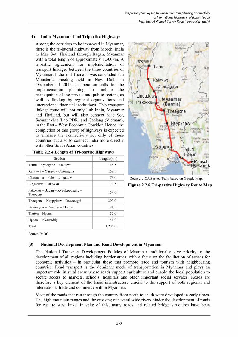
Preparatory Survey for the Project for Strengthening Connectivity of International Highway in Mekong Region
Final Report Phase-I Survey Report (Feasibility Study)
2-9
4) India-Myanmar-Thai Tripartite Highways Among the corridors to be improved in Myanmar, there is the tri-lateral highway from Moreh, India to Mae Sot, Thailand through Bagan, Myanmar with a total length of approximately 1,300km. A tripartite agreement for implementation of transport linkages between the three countries of Myanmar, India and Thailand was concluded at a Ministerial meeting held in New Delhi in December of 2012. Cooperation calls for the implementation planning to include the participation of the private and public sectors, as well as funding by regional organizations and international financial institutions. This transport linkage route will not only link India, Myanmar and Thailand, but will also connect Mae Sot, Savannakhet (Lao PDR) and OaNang (Vietnam), in the East – West Economic Corridor. Hence, the completion of this group of highways is expected to enhance the connectivity not only of those countries but also to connect India more directly with other South Asian countries.
Table 2.2.4 Length of Tri-partite Highways Section Length (km)
Tamu – Kyeegone – Kalaywa 145.5
Kalaywa – Yargyi – Chaungma 159.5
Chaungma – Pale – Lingadaw 73.0
Lingadaw – Pakokku 77.5
Pakokku – Bagan – Kyaukpadaung – Theegone 154.0
Theegone – Naypyitaw – Bawnatgyi 393.0
Bawnatgyi – Payagyi – Thaton 84.5
Thaton – Hpaan 52.0
Hpaan – Myawaddy 146.0
Total 1,285.0
Source: MOC
(3) National Development Plan and Road Development in Myanmar The National Transport Development Policies of Myanmar traditionally give priority to the development of all regions including border areas, with a focus on the facilitation of access for economic activities – in particular those that promote trade and tourism with neighbouring countries. Road transport is the dominant mode of transportation in Myanmar and plays an important role in rural areas where roads support agriculture and enable the local population to secure access to markets, schools, hospitals and other important social services. Roads are therefore a key element of the basic infrastructure crucial to the support of both regional and international trade and commerce within Myanmar.
Most of the roads that run through the country from north to south were developed in early times. The high mountain ranges and the crossing of several wide rivers hinder the development of roads for east to west links. In spite of this, many roads and related bridge structures have been
Source: JICA Survey Team based on Google Maps
Figure 2.2.8 Tri-partite Highway Route Map
Moreh
Maesot
Preparatory Survey for the Project for Strengthening Connectivity of International Highway in Mekong Region
Final Report Phase-I Survey Report (Feasibility Study)

Preparatory Survey for the Project for Strengthening Connectivity of International Highway in Mekong Region Final Report Phase-I Survey Report (Feasibility Study)
2-10
constructed since the late 1980s as part of the development of the national road network necessary to link all regions and ethnic groups.
The Ministry of Construction (MOC) has established a road network with a total length of approximately 22,000km (13,635 miles)6 by 1988. Even during the time of the State Peace and Development Council government, a road network with about 36,000km7 in length has been developed by the end of the fiscal year 2010-2011 by MOC based on the “Thirty Year Long Term Plan”.
1) National Road Development Plan (Thirty Year Long Term Plan) The MOC established a 30-year long-term road development plan in 2000, which is composed of six five-year short-term plans. The development plan stipulates the objectives for road development, the proposed road width and surface type and the project list to be implemented per short term plan, including the participation of private companies for road development, namely the BOT scheme.
Table 2.2.5 to Table 2.2.7 describe the planned value, the actual value and comparison between planned and actual value in the first and second five-year short term plans. At the end of March 2011, the road network with about 21,900km in length was developed and approximately 2,600km was greater the original plan. Especially, it was found that the sections of bituminous roadway (completed with a length of 17,600km) was greater than the original plan (about 7,700km) in the second five-year plan. It is considered that this achievement is due to cooperation with private companies under the BOT scheme.
Table 2.2.5 First Five Year Development Plan (2001-2006)
Project Type Length (Mile) Cost
(Billion Kyat)Concrete Earth Gravel Metalled8 Asphalt Total
Road improvement Ongoing projects Road Construction
- 197/6 654/3
1052/41009/0216/3
954/5890/513/4
866/1366/2
-
656/4223/0
-
3529/6 2686/5 884/2
28.80424.0822.381
Total 852/1 2277/7 1858/6 1232/3 879/4 7100/5 55.267
Source: MOC
Table 2.2.6 Second Five Year Development Plan (2006-2011)
Project Type Length (Mile) Cost
(Billion Kyat)Concrete Earth Gravel Metalled Asphalt Total
Road upgrading Ongoing projects Build new roads
- 363/0 640/0
849/41110/0
44/0
1612/51307/4
-
2327/21415/2
-
2703/51207/5
-
7502/0 5403/3 684/0
98.07444.6201.901
Total 1003/0 2003/4 2929/1 3742/4 3911/2 13589/3 144.595Source: MOC
Table 2.2.7 Comparison of the Planned Value and Actual Value in the First and Second Five Year Short Term Plans
Road Surface Type Plan(Mile) Actual Actual-Plan Asphalt 4790/6 10942/5 6151/7 Metalled 4974/7 4296/0 -678/7 Gravel 4787/7 3222/5 -1565/2 Earth 6136/4 3845/3 -2291/1
Total 20690/0 22306/5 +1616/5 Source: MOC
6 From the “30-year Long Term Plan” 7 Including road sections developed by BOT scheme 8 Metalled road is a hardened gravel road.
Preparatory Survey for the Project for Strengthening Connectivity of International Highway in Mekong Region Final Report Phase-I Survey Report (Feasibility Study)

Preparatory Survey for the Project for Strengthening Connectivity of International Highway in Mekong Region
Final Report Phase-I Survey Report (Feasibility Study)
2-11
After completion of the second five-year plan, the original 30-year plan had to be revised and modified as a result of political changes and in the interests of improving international relationships, the country’s general economic system and social welfare. The general objectives of the 30-year plan were revised to include the following aspects.
To upgrade connecting roads to ASEAN countries standards To upgrade Union Highways connecting regions and states
In the revised 30-year Long Term Plan, road width and pavement type are proposed in accordance with future traffic demand (Table 2.2.8) and phased project lists are provided as shown in Table 2.2.10 to Table 2.2.139.
In the third five-year short term plan, international highways are to be upgraded to two-lanes with asphalt pavement covering a length of about 9,100km, and union highways are also to be upgraded to single lane asphalt paved road with 8,900km in length including sections of new construction (1,700km).
In the fourth five-year short term plan, additional union highways (4,500km) will be developed as single lane asphalt paved roads.
In the fifth five-year short term plan, international connections will be upgraded into four-lane roads.
In the sixth five-year short term plan, main union highways (5,400km) will be developed as two-lane asphalt paved road.
The 30-Year plan should be properly revised and updated depending on the progress of road development and the changes of development policy.
Table 2.2.8 Proposed Road Width and Surface Type for the Future Plan Future Traffic Volume (vehicle/day) Proposed Width Surface Type
Less than 50 12 feet (3.6 meter)
Asphalt Concrete
50 to 200 16 feet (4.8 meter) 200 to 500 18 feet (5.4 meter) 500 to 1000 22 feet (6.6 meter)
1000 t o2500 24 feet (7.2 meter) 2000 to 5000 48 feet (14.4 meter)
More than 5000 72 feet (21.6 meter) Source: MOC
Table 2.2.9 Road Length and Cost for 30 year Development Plan Year Duration Road Type Length (Mile) Type of Work
3 2011-2016
International Highway 5667/0 Upgrading to 24 feet(2 lanes) asphalt pavement road
Union Highway 4482/5 Upgrading to 12 feet(1 lane) asphalt pavement road
New Road construction 1052/6 Construction of 12 feet(1 lane) asphalt pavement road
4 2016-2021 Union Highway 2772/1 Upgrading to 12 feet(1 lane) asphalt pavement road
5 2021-2026 International Highway 5970/0 Upgrading to 48 feet(4 lanes) asphalt pavement road
6 2026-2031 Union Highway 3323/5 Upgrading to 24 feet(2 lanes) asphalt pavement road
Source: MOC
9 There is no technical study results regarding future traffic demand in the 30-Year Long Term Plan
Preparatory Survey for the Project for Strengthening Connectivity of International Highway in Mekong Region
Final Report Phase-I Survey Report (Feasibility Study)
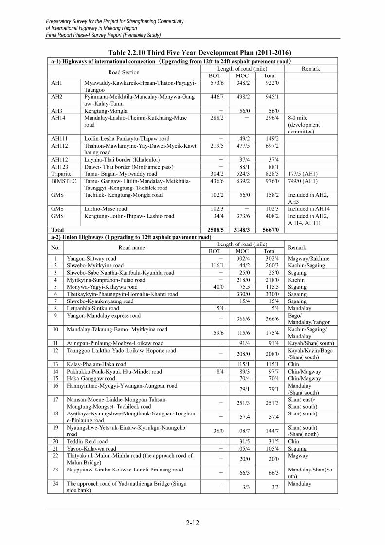
Preparatory Survey for the Project for Strengthening Connectivity of International Highway in Mekong Region Final Report Phase-I Survey Report (Feasibility Study)
2-12
Table 2.2.10 Third Five Year Development Plan (2011-2016) a-1) Highways of international connection(Upgrading from 12ft to 24ft asphalt pavement road)
Road Section Length of road (mile) RemarkBOT MOC Total
AH1 Myawaddy-Kawkareik-Hpaan-Thaton-Payagyi-Taungoo
573/6 348/2 922/0
AH2 Pyinmana-Meikhtila-Mandalay-Monywa-Gangaw -Kalay-Tamu
446/7 498/2 945/1
AH3 Kengtung-Mongla - 56/0 56/0 AH14 Mandalay-Lashio-Theinni-Kutkhaing-Muse
road 288/2 - 296/4 8-0 mile
(development committee)
AH111 Loilin-Lesha-Pankaytu-Thipaw road - 149/2 149/2 AH112 Thahton-Mawlamyine-Yay-Dawei-Myeik-Kawt
haung road 219/5 477/5 697/2
AH112 Laynha-Thai border (Khalonloi) - 37/4 37/4 AH123 Dawei- Thai border (Minthamee pass) - 88/1 88/1 Triparite Tamu- Bagan- Myawaddy road 304/2 524/3 828/5 177/5 (AH1) BIMSTEC Tamu- Gangaw- Htilin-Mandalay- Meikhtila-
Taunggyi -Kengtung- Tachilek road436/6 539/2 976/0 749/0 (AH1)
GMS Tachilek- Kengtung-Mongla road 102/2 56/0 158/2 Included in AH2, AH3
GMS Lashio-Muse road 102/3 - 102/3 Included in AH14GMS Kengtung-Loilin-Thipaw- Lashio road 34/4 373/6 408/2 Included in AH2,
AH14, AH111Total 2508/5 3148/3 5667/0 a-2) Union Highways (Upgrading to 12ft asphalt pavement road)
No. Road name Length of road (mile) Remark BOT MOC Total 1 Yangon-Sittway road - 302/4 302/4 Magway/Rakhine2 Shwebo-Myitkyina road 116/1 144/2 260/3 Kachin/Sagaing3 Shwebo-Sabe Nantha-Kantbalu-Kyunhla road - 25/0 25/0 Sagaing 4 Myitkyina-Sunprabon-Putao road - 218/0 218/0 Kachin 5 Monywa-Yagyi-Kalaywa road 40/0 75.5 115.5 Sagaing 6 Thetkaykyin-Phaungpyin-Homalin-Khanti road - 330/0 330/0 Sagaing 7 Shwebo-Kyaukmyaung road - 15/4 15/4 Sagaing 8 Letpanhla-Sintku road 5/4 - 5/4 Mandalay 9 Yangon-Mandalay express road
- 366/6 366/6 Bago/ Mandalay/Yangon
10 Mandalay-Takaung-Bamo- Myitkyina road 59/6 115/6 175/4 Kachin/Sagaing/ Mandalay
11 Aungpan-Pinlaung-Moebye-Loikaw road - 91/4 91/4 Kayah/Shan( south)12 Taunggoo-Laiktho-Yado-Loikaw-Hopone road
- 208/0 208/0 Kayah/Kayin/Bago/Shan( south)
13 Kalay-Phalam-Haka road - 115/1 115/1 Chin 14 Pakhukku-Pauk-Kyauk Htu-Mindet road 8/4 89/3 97/7 Chin/Magway15 Haka-Ganggaw road - 70/4 70/4 Chin/Magway16 Hanmyintmo-Myogyi-Ywangan-Aungpan road
- 79/1 79/1 Mandalay /Shan( south)
17 Namsan-Moene-Linkhe-Mongpan-Tahsan- Mongtung-Mongset- Tachileck road - 251/3 251/3 Shan( east)/
Shan( south) 18 Ayethaya-Nyaungshwe-Mongthauk-Nangpan-Tonghon
e-Pinlaung road - 57.4 57.4 Shan( south)
19 Nyaungshwe-Yetsauk-Eintaw-Kyaukgu-Naungcho road 36/0 108/7 144/7 Shan( south)
/Shan( north)20 Teddin-Reid road - 31/5 31/5 Chin 21 Yayoo-Kalaywa road - 105/4 105/4 Sagaing 22 Thityakauk-Malun-Minhla road (the approach road of
Malun Bridge) - 20/0 20/0 Magway
23 Naypyitaw-Kintha-Kokwae-Laneli-Pinlaung road - 66/3 66/3 Mandalay/Shan(So
uth) 24 The approach road of Yadanathienga Bridge (Singu
side bank) - 3/3 3/3 Mandalay
Preparatory Survey for the Project for Strengthening Connectivity of International Highway in Mekong Region Final Report Phase-I Survey Report (Feasibility Study)

Preparatory Survey for the Project for Strengthening Connectivity of International Highway in Mekong Region
Final Report Phase-I Survey Report (Feasibility Study)
2-13
25 Yangon-Kyaukphyu road (Taunggup-Maei-Kyaukphyu road) - 119/7 119/7 Rakhine/Yangon
26 Hinthada-Sonkone- Myanaung road - 65/2 65/2 Ayeyawady 27 Kyeinpainse-Setkaw-Danuphu-Zalun road 27/3 - 27/3 Ayeyawady 28 Phapon-Kamamaung road - 57/4 57/4 Kayin 29 Khamti-Sinthe-Lahe road - 54/0 54/0 Sagaing 30 Kyauktan-Kawlin-Wingyi-Pinlebu-Phaung Pyin road - 108/1 108/1 Sagaing 31 Twingne-Moemeik road
- 46/0 46/0 Mandalay/Shan(north)
32 Kentung-Mongkhat-Mongyan road - 73/0 73/0 Shan(East) 33 Lesha-Mongnaung-Mongshu-Mongkaung-Tanyang-M
ongye road - 113/0 113/0 Shan(South)/South(North)
34 Mongnaung-Mongsan road - 22/5 22/5 Shan(South) 35 Maubin-Yaykalay-Shwetaunghmaw-Kyaikpi-Mawlma
yingkyun road (including 7-mile Kyunhteik-Yondaungkyi-Taungbogyi road)
- 51/6 51/6 Ayeyawady
36 Mawlmayingkyun-Hlaingbon-Thitpoke-Kyunpauk-Pyinsalu road - 72/3 72/3 Ayeyawady
37 Laputta-Thingankyi- Pyinsalu road - 35/2 35/2 Ayeyawady 38 Laputta(Kyaukphyalay)-Thonkwa-Oaktwin-Hteiksun
road - 62/3 62/3 Ayeyawady
39 Bokalay-Kyeinchaung-Kadonkani road - 41/2 41/2 Ayeyawady 40 Bokalay-Setsan-Htawpaing-Amar road - 38/5 38/5 Ayeyawady 41 Phyapon- Kyunkadon-Dawnyein- Amar road - 51/5 51/5 Ayeyawady 42 Kyunkadon-Setsan road - 19/1 19/1 Ayeyawady 43 Pathein-Thaletkwa-Mawtinsyun road - 96/0 96/0 Ayeyawady 44 Bokalay- Mawlmayingkyun-Kyonemangay
–Wakhema-Myaungmya road - 66/0 66/0 Ayeyawady
45 Kali-Mongsan-Mongshu road - 68/0 68/0 Shan(South) 46 Namsang-Mansan road - 33/1 33/1 Shan(North) 47 Kanbalu detour road - 2/7 2/7 Sagaing Total 293/2 4189/3 4482/5 a-3) New Road Construction (Upgrading to 12ft asphalt pavement road )
No Road Name Length of road (mile) Remark BOT MOC Total 1 Kyaukse-Pyinoolwin-Moegoke road
- 132/6 132/6 Mandalya/Shan(North)
2 Minhla-Seinkanlant-Myochaung-Phado-Peinzaloke road - 89/6 89/6 Bago
3 Koebin- Thagara road - 96/3 96/3 Bago / Magway4 Katha-Sinkhan road - 65/0 65/0 Kachin/Sagaing5 Thilon-Tapaung-Pata-Nabu-Aukbote road - 54/2 54/2 Kayin 6 Mongpyin-Metmeng road - 73/0 73/0 Shan(East) 7 Mongpan-Monhta-Monhtaw road
- 65/0 65/0 Shan(East)/Shan(South)
8 Punnakyun-Yathedaung road - 22/6 22/6 Rakhine 9 Kyauktaw-Platwa road - 33/5 33/5 Chin/Rakhine
10 Myaypon-Kantha-Kapaing road - 8/6 8/6 Rakhine 11 Pauktaw-Minbya road - 20/6 20/6 Rakhine 12 Tale-Pacho-Kyainglet road - 37/0 37/0 Shan(East) 13 Kyutkhaing-Tamoenye-Monsee-Tapaa road - 66/0 66/0 Shan(North) 14 Thipaw-Panlon-Namhsan road - 48/4 48/4 Shan(North) 15 Mentong-Namhsan road - 37/0 37/0 Shan(North) 16 Pathein-Ngaputaw road - 21/0 21/0 Ayeyawady 17 Kyunhla-Chatthin-Kawlin road - 38/0 38/0 Sagaing 18 Sisnow- Yaynanma-Kyaukpon-Kantook road - 28/0 28/0 Magway 19 Moontaekhun-Kyitaung-Khawma-Naypyitaw ring
road - 22/0 22/0 Mandalay
20 Monywa-Kani-Minkin-Taungtwinchaung road - 93/2 93/2 Sagaing Total - 1052/6 1052/6
Source: MOC
Preparatory Survey for the Project for Strengthening Connectivity of International Highway in Mekong Region
Final Report Phase-I Survey Report (Feasibility Study)
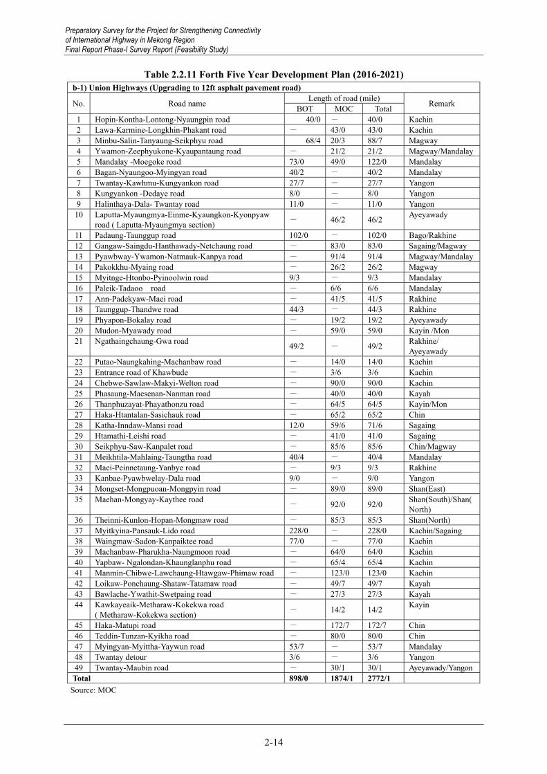
Preparatory Survey for the Project for Strengthening Connectivity of International Highway in Mekong Region Final Report Phase-I Survey Report (Feasibility Study)
2-14
Table 2.2.11 Forth Five Year Development Plan (2016-2021) b-1) Union Highways (Upgrading to 12ft asphalt pavement road)
No. Road name Length of road (mile) Remark BOT MOC Total 1 Hopin-Kontha-Lontong-Nyaungpin road 40/0 - 40/0 Kachin 2 Lawa-Karmine-Longkhin-Phakant road - 43/0 43/0 Kachin 3 Minbu-Salin-Tanyaung-Seikphyu road 68/4 20/3 88/7 Magway 4 Ywamon-Zeephyukone-Kyaupantaung road - 21/2 21/2 Magway/Mandalay5 Mandalay -Moegoke road 73/0 49/0 122/0 Mandalay 6 Bagan-Nyaungoo-Myingyan road 40/2 - 40/2 Mandalay 7 Twantay-Kawhmu-Kungyankon road 27/7 - 27/7 Yangon 8 Kungyankon -Dedaye road 8/0 - 8/0 Yangon 9 Halinthaya-Dala- Twantay road 11/0 - 11/0 Yangon
10 Laputta-Myaungmya-Einme-Kyaungkon-Kyonpyaw road ( Laputta-Myaungmya section) - 46/2 46/2 Ayeyawady
11 Padaung-Taunggup road 102/0 - 102/0 Bago/Rakhine 12 Gangaw-Saingdu-Hanthawady-Netchaung road - 83/0 83/0 Sagaing/Magway 13 Pyawbway-Ywamon-Natmauk-Kanpya road - 91/4 91/4 Magway/Mandalay14 Pakokkhu-Myaing road - 26/2 26/2 Magway 15 Myitnge-Htonbo-Pyinoolwin road 9/3 - 9/3 Mandalay 16 Paleik-Tadaoo road - 6/6 6/6 Mandalay 17 Ann-Padekyaw-Maei road - 41/5 41/5 Rakhine 18 Taunggup-Thandwe road 44/3 - 44/3 Rakhine 19 Phyapon-Bokalay road - 19/2 19/2 Ayeyawady 20 Mudon-Myawady road - 59/0 59/0 Kayin /Mon 21 Ngathaingchaung-Gwa road 49/2 - 49/2 Rakhine/
Ayeyawady 22 Putao-Naungkahing-Machanbaw road - 14/0 14/0 Kachin 23 Entrance road of Khawbude - 3/6 3/6 Kachin 24 Chebwe-Sawlaw-Makyi-Welton road - 90/0 90/0 Kachin 25 Phasaung-Maesenan-Nanman road - 40/0 40/0 Kayah 26 Thanphuzayat-Phayathonzu road - 64/5 64/5 Kayin/Mon 27 Haka-Htantalan-Sasichauk road - 65/2 65/2 Chin 28 Katha-Inndaw-Mansi road 12/0 59/6 71/6 Sagaing 29 Htamathi-Leishi road - 41/0 41/0 Sagaing 30 Seikphyu-Saw-Kanpalet road - 85/6 85/6 Chin/Magway 31 Meikhtila-Mahlaing-Taungtha road 40/4 - 40/4 Mandalay 32 Maei-Peinnetaung-Yanbye road - 9/3 9/3 Rakhine 33 Kanbae-Pyawbwelay-Dala road 9/0 - 9/0 Yangon 34 Mongset-Mongpuoan-Mongpyin road - 89/0 89/0 Shan(East) 35 Maehan-Mongyay-Kaythee road
- 92/0 92/0 Shan(South)/Shan(North)
36 Theinni-Kunlon-Hopan-Mongmaw road - 85/3 85/3 Shan(North) 37 Myitkyina-Pansauk-Lido road 228/0 - 228/0 Kachin/Sagaing 38 Waingmaw-Sadon-Kanpaiktee road 77/0 - 77/0 Kachin 39 Machanbaw-Pharukha-Naungmoon road - 64/0 64/0 Kachin 40 Yapbaw- Ngalondan-Khaunglanphu road - 65/4 65/4 Kachin 41 Manmin-Chibwe-Lawchaung-Htawgaw-Phimaw road - 123/0 123/0 Kachin 42 Loikaw-Ponchaung-Shataw-Tatamaw road - 49/7 49/7 Kayah 43 Bawlache-Ywathit-Swetpaing road - 27/3 27/3 Kayah 44 Kawkayeaik-Metharaw-Kokekwa road
( Metharaw-Kokekwa section) - 14/2 14/2 Kayin
45 Haka-Matupi road - 172/7 172/7 Chin 46 Teddin-Tunzan-Kyikha road - 80/0 80/0 Chin 47 Myingyan-Myittha-Yaywun road 53/7 - 53/7 Mandalay 48 Twantay detour 3/6 - 3/6 Yangon 49 Twantay-Maubin road - 30/1 30/1 Ayeyawady/YangonTotal 898/0 1874/1 2772/1
Source: MOC
Preparatory Survey for the Project for Strengthening Connectivity of International Highway in Mekong Region Final Report Phase-I Survey Report (Feasibility Study)

Preparatory Survey for the Project for Strengthening Connectivity of International Highway in Mekong Region
Final Report Phase-I Survey Report (Feasibility Study)
2-15
Table 2.2.12 Fifth Five Year Development Plan (2021-2026) c-1) Highways of international connection(Upgrading from 24ft to 48ft asphalt pavement road)
Road Section Length of road (mile) Remark BOT MOC Total
AH1 Myawaddy-Kawkareik-Hpaan-Thaton-Payagyi-Taungoo
573/6 348/2 922/0
AH2 Pyinmana-Meikhtila-Mandalay-Monywa-Gangaw -Kalay-Tamu
446/7 498/2 945/1
AH3 Kengtung-Mongla - 56/0 56/0 AH14 Mandalay-Lashio-Theinni-Kutkhaing-Muse
road 288/2 - 296/4 8-0 mile
(development committee)
AH111 Loilin-Lesha-Pankaytu-Thipaw road - 149/2 149/2 AH112 Thahton-Mawlamyine-Yay-Dawei-Myeik-Kawt
haung road 219/5 477/5 697/2
AH112 Laynha-Thai border (Khalonloi) - 37/4 37/4 AH123 Dawei- Thai border (Minthamee pass) - 88/1 88/1 Lido road Kanpaiktee-Sadon-Waimaw-Myitkyina-Pansau
k-Lido road 305/0 - 305/0
Triparite Tamu- Bagan- Myawaddy road 304/2 524/3 828/5 177/5 (AH1) BIMSTEC Tamu- Gangaw- Htilin-Mandalay- Meikhtila-
Taunggyi -Kengtung- Tachilek road 436/6 539/2 976/0 749/0 (AH1)
GMS Tachilek- Kengtung-Mongla road 102/2 56/0 158/2 Included in AH2, AH3
GMS Lashio-Muse road 102/3 - 102/3 Included in AH14 GMS Kengtung-Loilin-Thipaw- Lashio road 34/4 373/6 408/2 Included in AH2,
AH14, AH111 Total 2813/5 3148/3 5970/0
Source: MOC
Table 2.2.13 Sixth Five Year Development Plan (2026-2031) d-1) Union Highways (Upgrading to 24ft asphalt pavement road)
No. Road name Length of road (mile) Remark BOT MOC Total 1 Yangon-Sittway road - 302/4 302/4 Magway/Rakhine 2 Shwebo-Myitkyina road 116/1 144/2 260/3 Kachin/Sagaing 3 Monywa-Yagyi-Kalaywa road 40/0 75.5 115.5 Sagaing 4 Shwebo-Kyaukmyaung road - 15/4 15/4 Sagaing 5 Letpanhla-Sintku road 5/4 - 5/4 Mandalay 6 7 Mandalay-Takaung-Bamo- Myitkyina road 59/6 115/6 175/4 Kachin/Sagaing/
Mandalay 8 Aungpan-Pinlaung-Moebye-Loikaw road - 91/4 91/4 Kayah/Shan( south)9 Kalay-Phalam-Haka road - 115/1 115/1 Chin
10 11 Hanmyintmo-Myogyi-Ywangan-Aungpan road
- 79/1 79/1 Mandalay /Shan( south)
12 Namsan-Moene-Linkhe-Mongpan-Tahsan- Mongtung-Mongset- Tachileck road - 251/3 251/3 Shan( east)/
Shan( south) 13 Ayethaya-Nyaungshwe-Mongthauk-Nangpan-Tonghon
e-Pinlaung road - 57.4 57.4 Shan( south)
14 Nyaungshwe-Yetsauk-Eintaw-Kyaukgu-Naungcho road 36/0 108/7 144/7 Shan( south)
/Shan( north) 15 Theinni-Kunlon-Chinshwehaw road 66/0 - 66/0 Shan(North) 16 Tapa-Tashehtan-Lukkaing road - 12/0 12/0 Shan(North) 17 Mandalay-Moegoke-Moemeik-Mabein-Sioo road
(Konwut- Sioo section) - 88/6 88/6 Shan(North)
18 Mandalay-Lashio-Bamo- Myitkyina road 415/5 63/5 479/2 Kachin/Mandalay/Shan(North)
19 Monywa-Ayataw-Shwebo shortcut road - 44/0 44/0 Sagaing 20 Koepin-Sanmagyi-Thityakauk road 19/3 - 19/3 Magway 21 Thityakauk- =Malun-Minhla road (Malun bridge
approach road) - 20/0 20/0 Magway
Preparatory Survey for the Project for Strengthening Connectivity of International Highway in Mekong Region
Final Report Phase-I Survey Report (Feasibility Study)
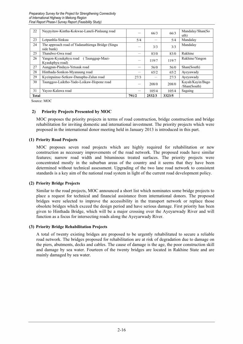
Preparatory Survey for the Project for Strengthening Connectivity of International Highway in Mekong Region Final Report Phase-I Survey Report (Feasibility Study)
2-16
22 Naypyitaw-Kintha-Kokwae-Laneli-Pinlaung road - 66/3 66/3 Mandalay/Shan(So
uth) 23 Letpanhla-Sinkuu 5/4 - 5/4 Mandalay 24 The approach road of Yadanathienga Bridge (Singu
side bank) - 3/3 3/3 Mandalay
25 Thandwe-Gwa road - 83/0 83/0 Rakhine 26 Yangon-Kyaukphyu road ( Taunggup-Maei-
Kyaukphyu road) - 119/7 119/7 Rakhine/Yangon
27 Aungpan-Pindaya-Yetsauk road - 56/0 56/0 Shan(South) 28 Hinthada-Sonkon-Myanaung road - 65/2 65/2 Ayeyawady 29 Kyeinpainse-Setkaw-Danuphu-Zalun road 27/3 - 27/3 Ayeyawady 30 Taunggoo-Laiktho-Yado-Loikaw-Hopone road
- 208/0 208/0 Kayah/Kayin/Bago/Shan(South)
31 Yayoo-Kalawa road - 105/4 105/4 Sagaing Total 791/2 2532/3 3323/5
Source: MOC
2) Priority Projects Presented by MOC MOC proposes the priority projects in terms of road construction, bridge construction and bridge rehabilitation for inviting domestic and international investment. The priority projects which were proposed in the international donor meeting held in January 2013 is introduced in this part.
(1) Priority Road Projects
MOC proposes seven road projects which are highly required for rehabilitation or new construction as necessary improvements of the road network. The proposed roads have similar features; narrow road width and bituminous treated surfaces. The priority projects were concentrated mostly in the suburban areas of the country and it seems that they have been determined without technical assessment. Upgrading of the two lane road network to consistent standards is a key aim of the national road system in light of the current road development policy.
(2) Priority Bridge Projects
Similar to the road projects, MOC announced a short list which nominates some bridge projects to place a request for technical and financial assistance from international donors. The proposed bridges were selected to improve the accessibility in the transport network or replace those obsolete bridges which exceed the design period and have serious damage. First priority has been given to Hinthada Bridge, which will be a major crossing over the Ayeyarwady River and will function as a focus for intersecting roads along the Ayeyarwady River.
(3) Priority Bridge Rehabilitation Projects
A total of twenty existing bridges are proposed to be urgently rehabilitated to secure a reliable road network. The bridges proposed for rehabilitation are at risk of degradation due to damage on the piers, abutments, decks and cables. The cause of damage is the age, the poor construction skill and damage by sea water. Fourteen of the twenty bridges are located in Rakhine State and are mainly damaged by sea water.
Preparatory Survey for the Project for Strengthening Connectivity of International Highway in Mekong Region Final Report Phase-I Survey Report (Feasibility Study)

Preparatory Survey for the Project for Strengthening Connectivity of International Highway in Mekong Region
Final Report Phase-I Survey Report (Feasibility Study)
2-17
Table 2.2.14 Priority Road Projects
Road Section Length (km)
Width of Paved Road (km) Unpaved Road Region/State12‘ 22‘ 24‘
1 Shwebo-Myitkyina 476 406 3 6 61 Kachin / Sagaing
2 Thanphyuzayat-Ye-Dawei- Myeik-Kawtaung 934 559 111 21 243 Mon /
Tanintharyi
3 Meiktila-Taunggyi-Loilem- Kengtung 677 439 82 156 ..
Mandalay / Shan(S) / Shan(N)
4 Minbu-Ann-Sittwe 477 367 5 6 99 Magway / Rakhine
5 Monywa-Pale-Gangaw- Kalaymyo 311 262 8.5 3 37.5 Sagaing /
Magway
6 Mandalay-Thabeikkyin- Tagaung-Bhamo 282 13 13 .. 56
Kachin / Sagaing / Mandalay
7 Monywa-Yargyi- Kalewa 186 186 Sagaing
Source: MOC
Source: JICA Survey Team
Figure 2.2.9 Locations of Priority Road Projects
Preparatory Survey for the Project for Strengthening Connectivity of International Highway in Mekong Region
Final Report Phase-I Survey Report (Feasibility Study)

Preparatory Survey for the Project for Strengthening Connectivity of International Highway in Mekong Region Final Report Phase-I Survey Report (Feasibility Study)
2-18
Table 2.2.15 Priority Bridge Projects Name of project State / Region Project Type Length (m)
1 Hinthada Bridge Ayeyarwaddy New construction 36202 Dala Bridge Yangon New construction 12103 Hlaing River Bridge Yangon New construction 12004 Bayinanung Bridge No.2 Yangon New construction 12005 New Goat twin Viaduct North Shan New construction 9106 Wataya Bridge Yangon New construction 5007 New Thakata Bridge Yangon Replacement 1908 Gyaing (Kawkareik) Bridge Kayin Replacement 4509 Tha Mouk Bridge Tanintharyi New construction 35010 Don Tha Mi Bridge Mon Replacement 21511 Chindwin (Kawlaywa) Bridge Sagaing New construction 60012 Thetkal Thoung Bridge Ayeyarwaddy New construction 76013 Thanlwin (Chaungsone) Bridge Mon New construction 60014 Chaungnitkwa Bridge Mon New construction 36015 Thanlwin (Tarsotpha) Bridge Kachin New construction 30516 Yaw Chaung (Yepyar) Bridge Magway Replacement 100017 Yaw Chaung (Ohn Taw) Bridge Magway Replacement 760
Source : MOC
Source: JICA Survey Team
Figure 2.2.10 Locations of Priority Bridge Projects
Preparatory Survey for the Project for Strengthening Connectivity of International Highway in Mekong Region Final Report Phase-I Survey Report (Feasibility Study)

Preparatory Survey for the Project for Strengthening Connectivity of International Highway in Mekong Region
Final Report Phase-I Survey Report (Feasibility Study)
2-19
Table 2.2.16 Priority Bridge Rehabilitation Projects Bridge name State/Region Bridge type Length (m) 1 Maubin Ayeyarweddy Steel truss 7092 Balaminhtin Kachin Steel truss 8063 Twantay Yangon steel suspension 10714 Pathein Ayeyarweddy steel suspension 6335 Myaungmya Ayeyarweddy Suspension 3816 Gyaing ( Zarthapyin) Mon Suspension 8707 Atran Mon Cable-stayed 4268 Maei Rakhine RC 2829 Kyaukkyipauk Rakhine Steel truss 90
10 Snarepauk Rakhine Steel truss 23711 Lonetawpauk Rakhine Steel truss 34712 Dedokepauk Rakhine Steel truss 17813 Tanthamagyi Rakhine Steel truss 16614 Thanthamachay Rakhine Steel truss 18015 Thazintanpauk Rakhine Steel truss 17816 Wanphite Rakhine Steel truss 24817 Minkyaung Rakhine Steel truss 81118 Yanmaung Rakhine Bailey 39019 Kisspanaddy Rakhine Steel truss 75420 Minchaung Rakhine Steel truss 601
Source: MOC
Source: JICA Survey Team
Figure 2.2.11 Locations of Priority Bridge Rehabilitation Projects
Preparatory Survey for the Project for Strengthening Connectivity of International Highway in Mekong Region
Final Report Phase-I Survey Report (Feasibility Study)

Preparatory Survey for the Project for Strengthening Connectivity of International Highway in Mekong Region Final Report Phase-I Survey Report (Feasibility Study)
2-20
2.3 Socio-economic Condition
2.3.1 Population and GDP
(1) National Socio-economic Development
A nation-wide census, “Myanmar Census 2014” was conducted for the first time in 30 years, between 30 March and 10 April. The provisional results of the census were published by the Ministry of Immigration and Population, Republic of the Union of Myanmar on 30 August 2014. The total population counted was 51.41 million people, which was about 10 million people less than the population conventionally estimated by international organizations. (The population in Myanmar had been estimated at around to be 61 million to 64 million by the International Monetary Fund (IMF) and the Asian Development Bank (ADB).) The final results of the census, including the distribution of population by religions, electrification rate and diffusion of consumer durables etc., was set to be published in May 2015.
0.0
10.0
20.0
30.0
40.0
50.0
60.0
70.0
1983
19
84
1985
19
86
1987
19
88
1989
19
90
1991
19
92
1993
19
94
1995
19
96
1997
19
98
1999
20
00
2001
20
02
2003
20
04
2005
20
06
2007
20
08
2009
20
10
2011
20
12
Population (million persons)
Year
Source: Myanmar Data CD-ROM 2010 and 2011 issued by Ministry of Planning and Finance
Figure 2.3.1 National Population of Myanmar 1983–2012
Figure 2.3.1 shows the national population of Myanmar estimated between 1983 and 2012. In 1983, the national population accounted for 34.13 million. After that, national population was estimated year by year. In 2012, the national population was estimated at 60.98 million.
Table 2.3.1 shows area and population changes of each region and state in 2011 and 2012. The Study Area (Kyain State, Mon State and Tanintharyi Region) occupies 13% in terms of area and 11% of in terms of population. The population density of the Study Area was 79.1 persons/km2, which is lower than the national average of 90.1 persons/km2.
Preparatory Survey for the Project for Strengthening Connectivity of International Highway in Mekong Region Final Report Phase-I Survey Report (Feasibility Study)

Preparatory Survey for the Project for Strengthening Connectivity of International Highway in Mekong Region
Final Report Phase-I Survey Report (Feasibility Study)
2-21
Table 2.3.1 Population by Regions and States in 2011 and 2012
Region/State Area (km2) Population (1000 persons)
2011 2012 Kachin State 89,042 1,598 1,616 Kayah State 11,732 360 365 Kayin State 30,383 1,836 1,855 Chin State 36,019 563 571 Sagaing Region 93,702 6,598 6,654 Tanintharyi Region 43,345 1,734 1,755 Bago Region 39,404 6,067 6,125 Magway Region 44,821 5,677 5,730 Mandalay Region 30,888 8,124 7,423 Mon State 12,297 3,165 3,193 Rakhine State 36,778 3,339 3,370 Yangon Region 10,277 7,097 7,170 Shan State 155,801 5,720 5,779 Ayeyarwaddy Region 35,032 7,353 8,205 Naypyitaw Council Territory 7,057 1,153 1,164 Total 676,577 60,384 60,976 Source: Area data was obtained from Ministry of National Planning and Economic
Development (MNPED); Population data was obtained from the Population Department, Ministry of Immigration and Population.
Economic data in Myanmar is even more inaccurate than population data. For example, GDP growth rate recorded more than 10% in 2000s, according to the government data. Real GDP measured with local currency has tripled in fifteen years, according to the World Economic Outlook Database (Figure 2.3.2). According to recent economic consultation reports by IMF, the accurate GDP growth rate was around 5% in the 2000s10, and the growth rates in recent years were 5.1% in 2009/10, 5.3% in 2010/11 and 5.9% in 2011/1211.
0.0
50.0
100.0
150.0
200.0
250.0
300.0
350.0
1998
19
99
2000
20
01
2002
20
03
2004
20
05
2006
20
07
2008
20
09
2010
20
11
2012
20
13
Real GDP (2000=100)
Year
Source: World Economic Outlook Database October 2013, IMF
Figure 2.3.2 Development of Real GDP from 1998 to 2013
Table 2.3.2 shows Gross Regional Domestic Product (GRDP) by state and region in 2011 and 2012. The 2011 data was presented by an official of MNPED at the 2nd workshop of Myanmar Comprehensive Development Vision (MCDV) in January 2013, and the 2012 data was estimated by the JICA Survey Team on “The Survey Program for The National Transport Development Plan.”
10 Figure 2 of Myanmar: Staff-Monitored Program (IMF Country Report No. 13/13), IMF, January 2013 11 2013 Article Iv Consultation And First Review Under The Staff-Monitored Program (IMF Country Report No. 13/250),
IMF, August 2013
Preparatory Survey for the Project for Strengthening Connectivity of International Highway in Mekong Region
Final Report Phase-I Survey Report (Feasibility Study)
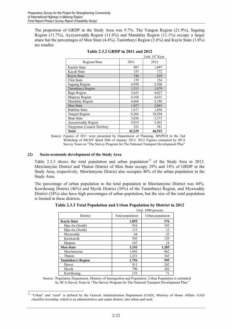
Preparatory Survey for the Project for Strengthening Connectivity of International Highway in Mekong Region Final Report Phase-I Survey Report (Feasibility Study)
2-22
The proportion of GRDP in the Study Area was 9.7%. The Yangon Region (21.9%), Sagaing Region (11.7%), Ayeyarwaddy Region (11.6%) and Mandalay Region (11.1%) occupy a larger share but the percentages of Mon State (4.4%), Tanintharyi Region (3.6%) and Kayin State (1.8%) are smaller.
Table 2.3.2 GRDP in 2011 and 2012 Unit: 109 Kyat
Regions/State 2011 2012 Kachin State 987 1,097 Kayah State 155 172 Kayin State 746 829 Chin State 139 154 Sagaing Region 4,958 5,508 Tanintharyi Region 1,511 1,679 Bago Region 3,625 4,027 Magway Region 4,168 4,631 Mandalay Region 4,668 5,186 Mon State 1,857 2,063 Rakhine State 1,671 1,856 Yangon Region 9,266 10,294 Shan State 3,036 3,373 Ayeyarwaddy Region 4,919 5,465 Naypyitaw Council Territory 523 581 Total 42,229 46,915
Source: Figures of 2011 were presented by Department of Planning, MNPED in the 2nd Workshop of MCDV dated 28th of January 2013. 2012 Figures estimated by JICA Survey Team on “The Survey Program for The National Transport Development Plan”
(2) Socio-economic development of the Study Area
Table 2.3.3 shows the total population and urban population12 of the Study Srea in 2012. Mawlamyine District and Thaton District of Mon State occupy 29% and 18% of GRDP in the Study Area, respectively. Mawlamyine District also occupies 40% of the urban population in the Study Area.
The percentage of urban population to the total population in Mawlamyine District was 44%. Kawthoung District (46%) and Myeik District (36%) of the Tanintharyi Region, and Myawaddy District (34%) also have high percentages of urban population, but the size of the total population is limited in these districts.
Table 2.3.3 Total Population and Urban Population by District in 2012 Unit: 1000 persons
District Total population Urban population Kayin State 1,855 376
Hpa-An (South) 916 195 Hpa-An (North) 113 12 Myawaddy 64 22 Kawkareik 595 129 Hpapun 167 18
Mon State 3,193 1,205 Mawlamyine 1,942 862 Thaton 1,251 343
Tanintharyi Region 1,756 595 Dawei 811 242 Myeik 790 282 Kawthoung 155 71
Source: Population Department, Ministry of Immigration and Population. Urban Population is estimated by JICA Survey Team in “The Survey Program for The National Transport Development Plan.”
12 “Urban” and “rural” is defined by the General Administration Department (GAD), Ministry of Home Affairs. GAD
classifies township, which is an administrative unit under district, into urban and rural.
Preparatory Survey for the Project for Strengthening Connectivity of International Highway in Mekong Region Final Report Phase-I Survey Report (Feasibility Study)

Preparatory Survey for the Project for Strengthening Connectivity of International Highway in Mekong Region
Final Report Phase-I Survey Report (Feasibility Study)
2-23
Table 2.3.4 shows GRDP and GRDP per capita by district in 2012. Mawlamyine (1,258 billion Kyat) had the highest GRDP by far in the Study Area. Thaton District (805 billion Kyat), and Dawei District (781 billion Kyat) and Myeik District of Tanintharyi Region are ranked 2nd, 3rd and 4th, respectively.
However, Mawlamyine District is ranked first in terms of GRDP per capita. GRDP per capita of the districts of the Tanintharyi Region accounted for around 950,000 Kyat, the highest level in the Study Area. The amount in Mawlamyine District and Thaton District were around 650,000 Kyat, and districts in Kayin State recorded district numbers between 380,000 and 450,000 Kyat, excluding the Myawaddy District.
Table 2.3.4 GRDP and GRDP per Capita by Districts in 2012 District GRDP (109 Kyat) GRDP per Capita (Kyat)
Kayin State 829 446,900 Hpa-An (South) 431 470,524 Hpa-An (North) 50 442,478 Myawaddy 41 640,625 Kawkareik 224 376,471 Hpapun 83 497,006
Mon State 2,063 646,101 Mawlamyine 1,258 647,786 Thaton 805 643,485
Tanintharyi Region 1,679 956,150 Dawei 781 963,009 Myeik 755 955,696 Kawthoung 143 922,581
Source: Estimation by JICA Survey Team on “The Survey Program for The National Transport Development Plan
2.3.2 Industrial Composition, Trade and FDI
(1) Industrial Composition
Table 2.3.5 shows the industrial composition of Myanmar and its regions/states. Proportions of the primary (agriculture and mining), secondary (manufacturing and construction, etc.) and tertiary (services) sectors are 35%, 27% and 38%, respectively. Percentages in Kayin State are 40%, 21% and 38%, in Mon State, 39%, 24% and 37%, and in Tanintharyi Region, 59%, 14% and 27%. Percentages of the secondary sector in the Study Area are lower than the national average by 3-13%; on the other hand, percentages of the primary sector are higher than the national average by 4- 24%. In particular, the share of the primary sector in Tanintharyi Region is estimated at 59%. Such estimation comes from commercially based agriculture, such as palm oil, natural rubber, etc.
Table 2.3.5 Industrial Composition by Regions/States in 2011 Region/State Primary Secondary Tertiary GRDP
Kachin State 434 215 338 987 Kayah State 76 25 54 155 Kayin State 301 159 286 746 Chin State 80 16 43 139 Sagaing Region 2,370 1,251 1,337 4,958 Tanintharyi Region 890 208 413 1,511 Bago Region 1,462 812 1,351 3,625 Magway Region 2,067 938 1,163 4,168 Mandalay Region 1,282 1,332 2,054 4,668 Mon State 724 447 686 1,857 Rakhine State 503 359 809 1,671 Yangon Region 680 4,378 4,207 9,266 Shan State 1,297 676 1,063 3,036 Ayeyarwaddy Region 2,408 636 1,875 4,919 Naypyitaw Council Territory 154 137 232 523 Total 14,728 11,589 15,911 42,229
Source: Presentation of Department of Planning, MNPED in the 2nd Workshop of MCDV dated 28th of January 2013
Preparatory Survey for the Project for Strengthening Connectivity of International Highway in Mekong Region
Final Report Phase-I Survey Report (Feasibility Study)

Preparatory Survey for the Project for Strengthening Connectivity of International Highway in Mekong Region Final Report Phase-I Survey Report (Feasibility Study)
2-24
(2) Trade
According to UN ComTrade, Myanmar’s exported merchandise was valued at 6,048 million USD in 2010/11. 47% of which (2,814 million USD) was exported to Thailand. Table 2.3.7 shows total export volume to Thailand and export volume at major national border crossing points (Mae Sot, Three Pagodas and Mae Sai) with Thailand. Mae Sot and Three Pagodas are along the target routes. Mae Sot is major route for almost all export goods excluding “Petroleum, Oil and Gas” and “Coal, Ore, Stone and Sand.” The Three Pagoda Pass is a route for transporting “Petroleum, Oil and Gas” by pipeline.
Table 2.3.6 Major Partners of Merchandise Export for Myanmar in 2010/11 Major Partners Export amount
(USD million) Share (%)
Thailand 2,814 42.7India 1,122 17.0China 966 14.7Japan 386 5.9Malaysia 229 3.5Korea 160 2.4Vietnam 103 1.6Singapore 82 1.3World 6,582 100.0Note: Export amounts above are reported from trade partners. Source: UN ComTrade
Table 2.3.7 Export Volume with Thailand in 2010/11
Export items (HS 2 digit)
Total Export Volume to Thailand Mae Sot Three Pagodas Mae Sai
Volume (ton) Share (%) Volume
(ton) Share (%) Volume (ton) Share (%) Volume
(ton) Share (%)Live Animal & Animal Products 5,688 100.0 4,949 87.0 498 8.8 241 4.2Fish and Aquatic Products 134,189 100.0 3,577 2.7 1 0.0 0 0.0Vegetable and Fruits 43,646 100.0 23,183 53.1 23 0.1 5,420 12.4Grain and Grain Products 945 100.0 24 2.5 0 0.0 21 2.2Other Agricultural Products 11,064 100.0 3,930 35.5 2,623 23.7 1,341 12.1Foodstuff, Beverage and Animal Food 4,784 100.0 0 0.0 0 0.0 0 0.0Petroleum, Oil and Gas 8,899,324 100.0 0 0.0 8,899,324 100.0 0 0.0Coal, Ore, Stone and Sand 66,618 100.0 2,784 4.2 1,200 1.8 59,555 89.4Cement, Construction Material (incl. steel�frame)
2 100.0 2 100.0 0 0.0 0 0.0
Fertilizer (incl. Urea) 1,428 100.0 1,419 99.4 9 0.6 0 0.0Garment, Textiles and fabric 2,554 100.0 56 2.2 103 4.0 46 1.8Wood and Wood Products 135,753 100.0 52,315 38.5 9,030 6.7 4,956 3.7Paper and Printed Matter 1,993 100.0 0 0.0 0 0.0 179 9.0Metal and Metal Products (excl. construction material)
3,147 100.0 344 10.9 0 0.0 159 5.1
Industrial Material, Chemicals 687 100.0 17 2.5 2 0.3 7 1.0Household articles, miscellaneous 3,733 100.0 3,599 96.4 133 3.6 1 0.0Machinery and Parts, Transportation 409 100.0 73 17.8 193 47.2 143 35.0
Note: Export of natural gas (Petroleum, Oil and Gas) is excluded in calculation of shares. Source: Total export volume is from UN ComTrade. Export volumes at 3 national borders are from Thai Customs web site.
Preparatory Survey for the Project for Strengthening Connectivity of International Highway in Mekong Region Final Report Phase-I Survey Report (Feasibility Study)

Preparatory Survey for the Project for Strengthening Connectivity of International Highway in Mekong Region
Final Report Phase-I Survey Report (Feasibility Study)
2-25
In the same year, Myanmar’s merchandise import value was 8,982 million USD. China was the largest import partner at 39% (3,476 million USD) followed by Thailand at 23% (2,072 million USD). Table 2.3.9 shows the total import volume to Thailand at major national border points (Mae Sot, Three Pagodas and Mae Sai) with Thailand. Mae Sot seems to be a major import as well as export route in terms of land transport, but the proportion of other transport routes, such as sea transport, seems to be larger than export.
Table 2.3.8 Major Partners of Merchandise Import for Myanmar in 2010/11 Major Partners Import amount
(USD million) Share (%)
China 3,476 38.4Thailand 2,073 22.9Singapore 1,159 12.8Korea 479 5.3Japan 262 2.9Malaysia 370 4.1Indonesia 284 3.1India 273 3.0World 9,040 100.0Note: Export amounts above are reported from trade partners. Source: UN ComTrade
Table 2.3.9 Import Volume with Thailand in 2010/11
Import items (HS 2 digit)
Total Export Volume to Thailand Mae Sot Three Pagodas Mae Sai
Volume (ton)
Share (%)
Volume(ton)
Share (%)
Volume(ton)
Share (%)
Volume (ton)
Share (%)
Live Animal & Animal Products 11,716 100.0 2,808 0.5 3,999 8.6 870 0.3
Fish and Aquatic Products 830 100.0 698 0.1 3 0.0 86 0.0
Vegetable and Fruits 18,253 100.0 5,398 0.9 36 0.1 3,779 1.2Grain and Grain Products 5,602 100.0 1,510 0.2 1,164 2.5 162 0.1
Other Agricultural Products 1,773 100.0 1,462 0.2 1 0.0 310 0.1
Foodstuff, Beverage and Animal Food 328,124 100.0 133,609 21.6 25,644 55.1 50,432 16.6
Petroleum, Oil and Gas 337,285 100.0 90,080 14.6 4,539 9.8 43,917 14.4Coal, Ore, Stone and Sand 63,681 100.0 4,013 0.6 64 0.1 11,575 3.8
Cement, Construction Material (incl. steel frame)
2,729,441 100.0 192,030 31.1 3,976 8.5 152,721 50.1
Fertilizer (incl. Urea) 21,556 100.0 601 0.1 0 0.0 308 0.1Garment, Textiles and fabric 31,213 100.0 23,195 3.8 188 0.4 3,266 1.1
Wood and Wood Products 3,647 100.0 877 0.1 0 0.0 735 0.2
Paper and Printed Matter 14,573 100.0 4,514 0.7 4 0.0 69 0.0
Metal and Metal Products (excl. construction material)
125,074 100.0 56,666 9.2 191 0.4 13,923 4.6
Industrial Material, Chemicals 191,469 100.0 53,346 8.6 4,900 10.5 12,804 4.2
Household articles, miscellaneous 23,394 100.0 16,455 2.7 482 1.0 2,427 0.8
Machinery and Parts, Transportation 39,267 100.0 30,750 5.0 1,353 2.9 7,164 2.4
Source: Total import volume is from UN ComTrade. Import volumes at 3 national borders are from Thai Customs.
Preparatory Survey for the Project for Strengthening Connectivity of International Highway in Mekong Region
Final Report Phase-I Survey Report (Feasibility Study)

Preparatory Survey for the Project for Strengthening Connectivity of International Highway in Mekong Region Final Report Phase-I Survey Report (Feasibility Study)
2-26
(3) Foreign Direct Investment
Most foreign direct investment (FDI) projects during the 2000s were by China and Thailand in the power and oil gas sectors. However, FDI approval trends have been changing in Myanmar since 2012/13. FDI in manufacturing, hotel, tourism and real estate sectors have been increasing. Table 2.2.10 shows such changes. The average permitted investment amount is almost the same in the agriculture sector, but the figures increase in manufacturing (17M USD to 1,310M USD), hotel and tourism (3M USD to 351M USD) and real estate (zero to 148M USD). On the other hand, the figures dropped in mining (208M USD to 11M USD), power (1,716M USD to 222M USD) and oil and gas (1,064 M USD to 155M USD).
Table 2.3.10 Changes of Average Permitted Investment Amount Unit: USD million
Sectors Average Permitted
Investment Amount from 2001/02 to 2011/12
Average Permitted Investment Amount from
2012/13 to 2013/14 Agriculture 13 13 Livestock & Fisheries 4 18 Mining 208 11 Manufacturing 17 1,310 Power 1,716 222 Oil and Gas 1,064 155 Construction 0 0 Transport & Communication 3 0 Hotel and Tourism 3 351 Real Estate 0 148 Industrial Estate 0 0 Other Services 0 10 Total 3,028 2,238 Note: Permitted investment amount in 2013/14 is estimated from an achievement until October. Source: Department of Investment and Company Administration (DICA)
Out of these changes, the most remarkable is investment in the manufacturing sector. Almost all investment in the manufacturing sector in 2012/13 has been garment contract manufacturing13. Major partners include China, Hong Kong, Japan and the Republic of Korea.
According to “Foreign Direct Investment Companies in Myanmar,” compiled by an economic research company in Myanmar, sixteen active FDI projects are identified in the Study Area as of April 2012. Table 2.3.11 shows a list of active projects. Out of sixteen projects, fourteen are located in the Tanintharyi Region, and the major sectors are hotel and tourism, livestock & fisheries and oil & gas.
13 In Myanmar, contract manufacturing is called CMP (cutting-making-packaging). Companies that conduct CMP business
receive exemptions from import tax for materials, if the company receives CMP permission from the Myanmar Investment Commission.
Preparatory Survey for the Project for Strengthening Connectivity of International Highway in Mekong Region Final Report Phase-I Survey Report (Feasibility Study)

Preparatory Survey for the Project for Strengthening Connectivity of International Highway in Mekong Region
Final Report Phase-I Survey Report (Feasibility Study)
2-27
Table 2.3.11 Active FDI Project in the Study Area Name of FDI Project Origin Country Sector FDI Amount Location
Myanmar Basin Island Resort Co Ltd (Suvana Bumi Hotel) Malaysia Hotel and Tourism 44.00 million USD Tanintharyi Region
Pearl Laguna Resort Hotel Group Thailand Hotel and Tourism 1.5 million USD Tanintharyi Region St. Luke’s Island Co Ltd Thailand Hotel and Tourism 3.50 million dollar Tanintharyi Region Victoria Entertainment Resort Club Ltd Singapore Hotel and Tourism 40.53 million USD Tanintharyi Region
The Hutgyi Dam Project China, Thailand Hydro Power 1 billion USD (281.22 million USD Sinohydro share) Kayin State
A.S.K Andaman Ltd (Myanmar) Malaysia Livestock & Fisheries 18.25 million USD Tanintharyi Region Myanmar Aquamargue Ltd (France Company) Singapore Livestock & Fisheries 6.1 million USD Tanintharyi Region
Myanmar Atlantic Co Ltd Australia Livestock & Fisheries 5.82 million USD Tanintharyi Region Myanmar Fisheries Int'l Joint Venture Ltd UK Livestock & Fisheries 10.00 million USD Tanintharyi Region
Myanmar Tasaki Co Ltd Japan Livestock & Fisheries 8.01 million USD Tanintharyi Region Italian-Thai International Co Ltd Thailand Manufacturing 521.00 million USD Kayin State Emerald Ray Company Thailand Mining Tanintharyi Region Dataran Isibumi Sdn Bhd (Malaysia) Malaysia Oil and Gas 61.80 million USD Tanintharyi Region
Petronas Carigali Myanmar (Hong Kong) Ltd · Malaysia Oil and Gas 342.5 million US4 ($44
million for the first phase) Tanintharyi Region
PTT Exploration and Production Public Co Ltd Thailand Oil and Gas 22.0 million USD for Block
M-7, M-11 Tanintharyi Region
Roundhay Ltd Malaysia Oil and Gas 3.17 million USD Tanintharyi Region Source: Foreign Direct Investment Companies in Myanmar, Myanmar Survey Research, 2010
The Industrial Estate at Hpa-An, which is developed by the Kyain State government was transferred to UHM Co., Ltd. The company constructed a factory for garment manufacturing and products are exported to Japan. The investments are classified as domestic investment, but the company’s activities are strongly related with foreign companies.
2.3.3 Social Profile
(1) Monthly Household Expenditure
Table 2.3.12 shows monthly household expenditure by region/state surveyed in the “Household Income and Expenditure Survey 2006.” In comparison with the national average monthly household expenditure (97,700 Kyat), Tanintharyi Region (1.44) and Kayin State (1.20) recorded higher total monthly expenditures. The total monthly expenditure of Mon State was 97% of the national average.
The national average of the percentage of food expenditure to the total expenditure was 70.8%. The Tanintharyi Region (66.1%) is lower than the national average, and the percentages of Kayin State (73.7%) and Mon State (73.5%) are higher than the national average.
Table 2.3.12 Monthly Household Expenditure by Regions/States in 2006
Unit: Kyat Region/ State Food Non-food Total
National Average 69,171 28,529 97,700 Kachin 78,920 36,594 115,513 Kayah 55,049 25,555 80,603 Kayin 86,194 30,798 116,993 Chin 54,578 20,273 74,851 Sagaing 71,648 26,919 98,566 Tanintharyi 92,914 47,675 140,589 Bago (East) 68,813 27,623 96,436 Bago (West) 57,770 23,492 81,261 Magway 64,354 25,151 89,505 Mandalay 70,442 29,446 99,888 Mon 69,963 25,186 95,150
Preparatory Survey for the Project for Strengthening Connectivity of International Highway in Mekong Region
Final Report Phase-I Survey Report (Feasibility Study)

Preparatory Survey for the Project for Strengthening Connectivity of International Highway in Mekong Region Final Report Phase-I Survey Report (Feasibility Study)
2-28
Region/ State Food Non-food Total Rakhine 72,805 26,799 99,605 Yangon 75,199 36,836 112,034 Shan (South) 72,367 31,885 104,252 Shan (North) 70,572 28,863 99,434 Shan (East) 75,073 41,936 117,009 Ayeyarwady 56,125 20,882 77,007 Source: Central Statistical Office (CSO)
(2) Poverty Incidence in “Integrated Household Living Condition Survey”
MNPED conducted the “Integrated Household Living Condition Survey” in cooperation with UNDP and Sida in 2005 and 2010, investigating items such as situation of poverty, demographic characteristics, the labour market, housing conditions and health and nutrition status.
18,660 households across all regions were selected though multiple-stage random sampling in the 2005 survey, and 343,130 households from 45 townships were selected in the 2010 survey.
The sampling households were divided into four groups by household income, and a “poor” reference group was selected, which was the second quartile (25%) of the consumption distribution, i.e. the bottom 25-50%. The poverty line was defined as the simple average consumption amount for the second quartile. Therefore, the poverty line in this survey is not absolute poverty but relative poverty. The poverty line per adult per year was set at 162,136 Kyat in the 2005 survey and 376,151 Kyat in the 2010 survey, and those people whose consumption amount is under these figures are defined as poor in this survey.
Table 2.3.13 and Figure 2.3.3 show the Poverty Incidence (generation of poverty population) by region/state. At the national level, the percentage of the population in poverty was 32.1% in 2005, with 21.5% in urban areas and 35.8% in rural areas. In 2010, these percentages had improved to 25.6%, 15.7% and 29.2%, respectively.
In Kayin State and Mon State, the Poverty Incidence is lower than the national average. However, the result may not be an accurate depiction, particularly in Kyain State where ethnic conflict ceased in January 2012. The Poverty Incidence of Tanintharyi Region is larger than the national average and the total Poverty Incidence and Rural Poverty Incidence had no significant change between the 2005 and 2010 surveys in the Study Area.
Table 2.3.13 Change of Poverty Incidence between 2005 and 2010 Region/State Urban Rural Total
2005 2010 2005 2010 2005 2010 Kachin 37.7 23.4 46.8 30.6 44.2 28.6 Kayah 26.1 2.3 38.2 16.3 33.6 11.4 Kayin 7.8 16.8 12.5 17.5 11.8 17.4 Chin 45.9 52.1 80.9 80.0 73.3 73.3 Sagaing 21.9 16.0 27.4 14.9 26.6 15.1 Tanintharyi 20.8 16.7 37.2 37.5 33.8 32.6 Bago 30.7 19.0 31.8 18.2 31.6 18.3 Magway 25.8 15.8 43.9 28.2 42.1 27.0 Mandalay 24.1 14.1 44.7 31.6 38.9 26.6 Mon 22.5 17.8 21.3 16.0 21.5 16.3 Rakhine 25.5 22.1 41.2 49.1 38.1 43.5 Yangon 14.4 11.9 17.4 28.7 15.1 16.1 Shan 31.0 14.1 50.5 39.2 46.1 33.1 Ayeyarwady 24.4 23.1 30.3 33.9 29.3 32.2 Union 21.5 15.7 35.8 29.2 32.1 25.6Source: Integrated Household Living Conditions Survey in Myanmar (2009–10) Poverty Profile,
UNDP and Sida, June 2010
Preparatory Survey for the Project for Strengthening Connectivity of International Highway in Mekong Region Final Report Phase-I Survey Report (Feasibility Study)

Preparatory Survey for the Project for Strengthening Connectivity of International Highway in Mekong Region
Final Report Phase-I Survey Report (Feasibility Study)
2-29
0.0
10.0
20.0
30.0
40.0
50.0
60.0
70.0
80.0
Kachin
Kayah
Kayin
Chin
Sagaing
Taninth
aryi
Bago
Magway
Mandala
y Mon
Rakhine
Yangon
Shan
Ayeyarw
aday
2005
2010
Source: Integrated Household Living Conditions Survey in Myanmar (2009–10) Poverty
Profile, UNDP and Sida, June 2010
Figure 2.3.3 Change of Poverty Incidence in 2005 and 2010 (Total)
Preparatory Survey for the Project for Strengthening Connectivity of International Highway in Mekong Region
Final Report Phase-I Survey Report (Feasibility Study)

Preparatory Survey for the Project for Strengthening Connectivity of International Highway in Mekong Region Final Report Phase-I Survey Report (Feasibility Study)
2-30
2.4 Road Transportation
2.4.1 Overview of Road Transport in Myanmar
(1) Passenger Demand by Transport Mode
Road transport, including buses and private cars, is the dominant passenger transportation mode in Myanmar, carrying over 90% of the domestic trips in the four-year period from 2008 to 2012. In 2012, road transport carried 92% of total passengers, followed by railway transport (5%) and inland water transport (3%). The modal split (in terms of percentage) had no significant change, and the actual figures in the number of passengers do not show any trend.
Table 2.4.1 Number of Passengers by Transport Mode14 (million trips/year) Mode 2008 2009 2010 2011 2012 Road 1,632 94% 1,166 92% 1,294 93% 1,233 93% 1,085 92%Rail 75 4% 72 6% 69 5% 67 5% 55 5%River 27 2% 27 2% 28 2% 23 2% 33 3%Air 1 0% 1 0% 1 0% 1 0% 2 0%Total 1,735 100% 1,267 100% 1,391 100% 1,325 100% 1,175 100%Source: TPD/RTAD, MR, IWT, DCA (http://www.ajtpweb.org/)
The following figure shows the number of road and rail passenger-kilometres between 2008 and 2011. In 2011, road transport carries 84% of total passenger kilometres while rail transport carries 16%. The number of passenger-kilometre by road transport tends to increase in recent years but that of rail passengers remains nearly same during the same period.
Table 2.4.2 Number of Passenger Trip-Kilometre by Road and Rail (million trip-kilometre/year)
Mode 2008 2009 2010 2011 Road 18,303 77% 26,215 83% 28,385 84% 28,389 84% Rail 5,482 23% 5,296 17% 5,336 16% 5,282 16% Total 23,785 100% 31,511 100% 33,721 100% 33,671 100% Source: TPD/RTAD, MR, IWT, DCA (http://www.ajtpweb.org/)
The following table shows the average trip-kilometre per passenger by road and rail transport between 2008 and 2011. In 2011, the average trip-kilometre by road user is estimated at 23 kilometres/passenger, while that by rail transport is at 79 kilometres/passenger, and which indicates the road transport accommodates relatively shorter distance trips while rail transport carries longer distance trips. The time-series trend shows the average of trip-kilometre by both road and rail transport tends to increase during the said period.
Table 2.4.3 Average Trip-Kilometre by Road and Rail (trip kilometre/passenger) Mode 2008 2009 2010 2011 Road 11 22 22 23Rail 73 73 78 79
Source: TPD/RTAD, MR, IWT, DCA (http://www.ajtpweb.org/)
14 The figure shows the number of domestic passengers who travelled and does not include international passengers.
According to MORT, the aggregation method and/or sample-based unit rate (e.g., average passenger volume) differs year by year and which contributes to distortions in annual passenger volume.
Preparatory Survey for the Project for Strengthening Connectivity of International Highway in Mekong Region Final Report Phase-I Survey Report (Feasibility Study)

Preparatory Survey for the Project for Strengthening Connectivity of International Highway in Mekong Region
Final Report Phase-I Survey Report (Feasibility Study)
2-31
As seen in above figures in passenger transport trends, considering the increase in passenger kilometre, modal share of the passenger transported, and increase in average trip kilometre, future passenger demand forecast and future modal share of passenger demand in this Study need to be estimated, utilizing the result of traffic demand forecast carried out in the Survey Program for the National Transport Development Plan (JICA, 2014).
(2) Freight Volume by Transport Mode
Similar to passenger transport, road transport is the dominant freight transportation mode, handling about 70-80% of total freight volume in the five-year period from 2008 to 2012. Looking at freight, road, railway and river transport are the major freight transport modes. Like passengers, road transport (truck) is dominant among all transport modes, and carries around 83% of the domestic freight by tonnage. Following road transport, railway (10% of the domestic freight) and inland water (7%) also carry considerable amounts of domestic cargo.
Table 2.4.4 Freight Volume (Tonnage) by Transport Mode15 (million tons) Mode 2008 2009 2010 2011 2012
Road 22,733 75% 30,474 79% 20,664 72% 22,532 75% 25,528 83%Rail 2,976 10% 3,236 8% 3,322 12% 3,576 12% 3,124 10%River 4,513 15% 4,733 12% 4,767 17% 3,997 13% 2,149 7%Air 1 0% 3 0% 1 0% 1 0% 1 0%Total 30,223 100% 38,446 100% 28,754 100% 30,106 100% 30,802 100%Source: TPD/RTAD, MR, IWT, MPA, DCA (http://www.ajtpweb.org/)
The following table shows domestic freight volume by tonnage-kilometre carried by different transport modes between 2008 and 2012. In 2012, road transport carried 64% of the domestic freight cargoes by tonnage-kilometres, followed by inland water transport (19%) and rail transport (17%). The total volume of domestic cargoes by tonnage-kilometre increases sharply since 2008.
Table 2.4.5 Freight Volume (Tonnage-kilometre) by Transport Mode (million ton-kilometre) Mode 2008 2009 2010 2011 2012
Road 1,128 55% 2,320 52% 2,206 47% 2,897 57% 3,854 64%Rail 905 45% 1,021 23% 1,085 23% 1,160 23% 1,041 17%River NA NA 1,092 25% 1,394 30% 999 20% 1,120 19%Air 0 0% 0 0% 0 0% 0 0% 2 0%Total 2,033 100% 4,434 100% 4,686 100% 5,056 100% 6,018 100%Source: TPD/RTAD, MR, IWT, MPA, DCA (http://www.ajtpweb.org/)
The following table shows the average freight kilometre carried by different transport mode between 2008 and 2012. In 2012, the average kilometre carried by road is estimated at 151 kilometres, while that by rail/inland water transport is at 333/521 kilometeres respectively, and which indicates the road transport accommodates relatively shorter distance freight trips while rail/inland water transport carries longer distance freight trips. The time-series trend shows the average of freight kilometre by road/inland water transport tends to increase during the said period, while that by rail transport remains nearly same.
Table 2.4.6 Average Freight Kilometre by Transport Mode (kilometre) Mode 2008 2009 2010 2011 2012 Road 50 76 107 129 151 Rail 304 315 327 324 333
River NA 231 292 250 521 Air 369 96 383 301 1,623
Source: TPD/RTAD, MR, IWT, MPA, DCA (http://www.ajtpweb.org/) 15 The figure shows the volume of domestic freight and does not include international freight volume.
Preparatory Survey for the Project for Strengthening Connectivity of International Highway in Mekong Region
Final Report Phase-I Survey Report (Feasibility Study)

Preparatory Survey for the Project for Strengthening Connectivity of International Highway in Mekong Region Final Report Phase-I Survey Report (Feasibility Study)
2-32
As seen in above figures in freight transport trends, considering the increase in freight ton kilometre, modal share of the freight transported, and increase in average freight kilometre, future freight demand forecast and future modal share of freight demand in this Study need to be estimated, utilizing the result of the traffic demand forecast carried out in the Survey Program for the National Transport Development Plan (JICA, 2014).
(3) Bus and Trucking Services
1) Bus Services Bus transport in Myanmar has been expanding in recent years. As discussed previously, both the number of registered buses and bus passengers are increasing year by year. Also, as Table 2.4.7 indicates, the number of registered bus operators increased between 2008 and 2012.
Table 2.4.7 Number of Fixed Route Bus Operators (nos.) 2008 2009 2010 2011 2012
Number of fixed route bus operators 1,129 1,184 1,184 1,651 1,815Source: TPD (http://www.ajtpweb.org/)
As of 2011, there are over 20,000 buses registered in Myanmar. The number of registered buses is distorted geographically, and more than half of the buses are registered in Yangon. Likewise, the number of buses per population also differs by region and state. Yangon shows 1.57 buses per 1,000 people, the largest number of buses per population among the States and Regions, whereas Chin and Kachin States show 0.05 buses per 1,000 people, the least number of buses per population. These figures imply that the public and private bus service and network is limited in less populated areas.
Table 2.4.8 Number of Registered Buses by State and Region
State/Region No. of Buses Registered (vehicle)
2012 Population (1000)
No. of Bus per 1000 people (vehicle/1000 people)
Yangon 11,240 7,170 1.57 Mandalay 3,639 8,587 0.42 Bago 594 6,125 0.10 Sagaing 1,449 6,654 0.22 Magway 650 5,730 0.11 Tanintharyi 280 1,755 0.16 Ayeyarwaddy 815 8,205 0.10 Shan 891 5,779 0.15 Mon 668 3,193 0.21 Kachin 88 1,616 0.05 Kayin 136 1,855 0.07 Rakhine 143 3,370 0.04 Chin 27 571 0.05 Kayah 63 365 0.17 Total 20,683 60,975 0.34 Source: JICA Survey Team, Based on RTAD
The busiest intercity bus routes are observed at Yangon–Naypyitaw (87 buses per day in both directions), Yangon–Mandalay (77 buses per day), Yangon–Mawlamyine (47 buses per day), Yangon–Hpa-an (45 buses per day), and Yangon–Hinthada (35 buses per day). The intercity bus service, originating from three major terminals, covers Myanmar nationwide. Intercity buses travel to all capital cities of the fourteen states and regions. Buses also travel to major cross border cities, including Myawaddy (six buses per day to/from Yangon), Muse (four buses to/from Yangon/Mandalay) and Tamu (five buses to/from Yangon/Mandalay).
Preparatory Survey for the Project for Strengthening Connectivity of International Highway in Mekong Region Final Report Phase-I Survey Report (Feasibility Study)

Preparatory Survey for the Project for Strengthening Connectivity of International Highway in Mekong Region
Final Report Phase-I Survey Report (Feasibility Study)
2-33
Source: TPD
Figure 2.4.1 Myanmar’s Inter-city Bus Routes
Preparatory Survey for the Project for Strengthening Connectivity of International Highway in Mekong Region
Final Report Phase-I Survey Report (Feasibility Study)

Preparatory Survey for the Project for Strengthening Connectivity of International Highway in Mekong Region Final Report Phase-I Survey Report (Feasibility Study)
2-34
2) Trucking Services Like bus transport, trucking transport in Myanmar has been expanding rapidly in recent years. As discussed in the previous section, both the number of registered trucks and freight volume transported by trucks have been increasing. Also, as the following table indicates that the number of trucking companies and domestic forwarders registered has increased between 2009 and 2013, with 801 trucking companies and 865 forwarders registered in 2013.
Trucking companies in Myanmar are considered small entrepreneurs (one owner one truck company) and trucking companies with more than 20 trucks are scarce. The service area of these trucking companies is limited to local distribution within their states and regions, and there is no single trucking company that provides a regular nationwide service.
Table 2.4.9 Number of Trucking Companies and Domestic Forwarders (nos.) 2009 2010 2011 2012 2013
Number of trucking companies 527 546 546 800 801 Number of domestic forwarders 716 734 734 849 865 Source: TPD (http://www.ajtpweb.org/)
In this regards, considering the increase in bus operators, geographical disparity in registered buses and operation of nation-wide fixed bus routes in recent years, future bus passenger demand and number of necessary buses need to be estimated, based on the result of the traffic demand forecast carried out in the Survey Program for the National Transport Development Plan (JICA, 2014). Likewise, considering an increase in truck operators, the future freight demand needs to be estimated based on the result of traffic demand forecast carried out in the Survey Program for the National Transport Development Plan (JICA, 2014)
(4) Registered Vehicles
The number of registered vehicles in Myanmar increases year by year, incrementally by around 400,000 vehicles p.a. Amongst them, road transport modes, including buses and trucks, increase constantly, amounting to around 60,000 trucks and 40,000 buses registered every year. The demand for both passenger buses and truck transport seems to be expanding in recent years. Between 2012 and 2013, the number of registered vehicles, particularly that of passenger cars, taxis and trucks, increased and the total number of registered vehicles reached 572,000 in 2013.
Table 2.4.10 Number of Registered Vehicles by Type (‘000 vehicles) Type 2009 2010 2011 2012 2013
Passenger Car 243 260 263 282 360 Taxi 27 28 28 41 56 Truck 60 64 67 71 111 Bus 20 21 20 20 21 Public Bus 25 28 27 23 24 Total 375 401 405 437 572 Source: RTAD (http://www.ajtpweb.org/)
Preparatory Survey for the Project for Strengthening Connectivity of International Highway in Mekong Region Final Report Phase-I Survey Report (Feasibility Study)
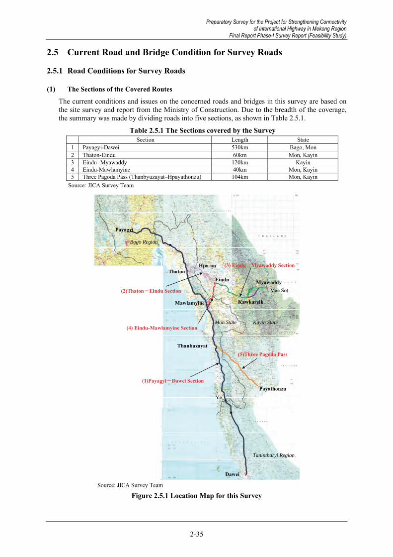
Preparatory Survey for the Project for Strengthening Connectivity of International Highway in Mekong Region
Final Report Phase-I Survey Report (Feasibility Study)
2-35
2.5 Current Road and Bridge Condition for Survey Roads
2.5.1 Road Conditions for Survey Roads
(1) The Sections of the Covered Routes
The current conditions and issues on the concerned roads and bridges in this survey are based on the site survey and report from the Ministry of Construction. Due to the breadth of the coverage, the summary was made by dividing roads into five sections, as shown in Table 2.5.1.
Table 2.5.1 The Sections covered by the Survey Section Length State 1 Payagyi-Dawei 530km Bago, Mon 2 Thaton-Eindu 60km Mon, Kayin 3 Eindu- Myawaddy 120km Kayin 4 Eindu-Mawlamyine 40km Mon, Kayin 5 Three Pagoda Pass (Thanbyuzayat–Hpayathonzu) 104km Mon, Kayin
Source: JICA Survey Team
Payagyi
ThatonEindu
Kawkareik
Myawaddy
Mawlamyine
Thanbuzayat
Payathonzu
Dawei
Mon State
Kayin State
Bago Region
Hpa-an -
Ye
Tanintharyi Region
Mae Sot
(5)Three Pagoda Pass
(1)Payagyi-Dawei Section
(3) Eindu-Myawaddy Section
(2)Thaton-Eindu Section
(4) Eindu-Mawlamyine Section
Source: JICA Survey Team
Figure 2.5.1 Location Map for this Survey
Preparatory Survey for the Project for Strengthening Connectivity of International Highway in Mekong Region
Final Report Phase-I Survey Report (Feasibility Study)

Preparatory Survey for the Project for Strengthening Connectivity of International Highway in Mekong Region Final Report Phase-I Survey Report (Feasibility Study)
2-36
2.5.2 Current Road and Bridge Condition for Survey Roads
(1) Payagyi – Dawei Section
1) Current Condition of Road This route is a part of the principal trunk road connecting the country’s largest city, Yangon, with Dawei. This route is also a route forming a part of the Asian Highway (AH1) and ASEAN Highway (AH112). The Payagyi to Mawlamyine section has been developed as a “Class-III” road in accordance with the ASEAN Highway Standards. The road surface is maintained to be in good condition as Shwe Than Lwin Highway Co., Ltd, a private company in Myanmar, is undertaking maintenance of the route under BOT contract.
Maintenance for the south section of Mawlamyine is undertaken by MOC. The road condition is in satisfactory condition in the section of Mawlamyine to Thanbyuzayat, but there are unpaved roads in the south section of Thanbyuzayat (although road improvement has been undertaken by MOC). In particular, road condition is still poor in the 10km section in the mountain area south of Ye.
This route also passes several urban areas such as Kyaito, Thaton and Mawlamyine and is used as a community road by wayside residents, and thus many pedestrians, bicycles, and motor bikes are using this road. Large vehicles are also running in large numbers. As the shoulder is not paved and the road has only one lane in each direction, it is dangerous for vehicles to overtake and pass each other.
Source: Google Map, JICA Survey Team
Figure 2.5.2 Payagyi – Dawei Section Location Map
Sittaung Bridge
Thanlwin (Hpa-an) Bridge
Preparatory Survey for the Project for Strengthening Connectivity of International Highway in Mekong Region Final Report Phase-I Survey Report (Feasibility Study)

Preparatory Survey for the Project for Strengthening Connectivity of International Highway in Mekong Region
Final Report Phase-I Survey Report (Feasibility Study)
2-37
Road surface condition is good. Road markings are installed as well. (Payagyi – Mawlamyine Section)
Toll gate (Toll is collected by BOT undertaken by Shwe Than Lwin Highway Co., Ltd)
Road surface condition (Mawlamyine – Thanbyuzayat Section)
Road surface condition (Thanbyuzayat – Dawei Section)
Source: JICA Survey Team
Figure 2.5.3 Current Road Condition for Payagyi – Dawei Section
2) Current Condition of Bridges This section has two major bridges as shown in Figure 2.5.2. No significant damage is observed on either bridge. There is sufficient load capacity for heavy freight vehicles, thus, there is no current need for specific reconstruction or repair.
Table 2.5.2 Current Status of Major Bridges in Payagyi –Dawei Section Bridge Name Length Superstructure Type Foundation Type Weight Limit Completion Year
Sittaung Bridge (Mokepalin) 729m Steel truss Unknown 60t 2006 Thanlwin (Mawlamyine) Bridge 3,519m Steel truss Unknown 60t 2005 Source: JICA Survey Team
Overall view of Sittaung Bridge (Mokepalin) Old bridge substructure is downstream of Sittaung Bridge
Preparatory Survey for the Project for Strengthening Connectivity of International Highway in Mekong Region
Final Report Phase-I Survey Report (Feasibility Study)

Preparatory Survey for the Project for Strengthening Connectivity of International Highway in Mekong Region Final Report Phase-I Survey Report (Feasibility Study)
2-38
Under girder view of Thanlwin (Hpa-an) Bridge Two-lane road and railway bridge (Thanlwin (Hpa-an) Bridge)
Source: JICA Survey Team
Figure 2.5.4 Current Condition of Major Bridges in Payagyi –Dawei Section
3) Detected Issues in the Concerned Road Section Issues related to the existing roads and bridges in the section concerned are as listed below: Widening and improvement of the existing road (There are many unpaved roads south of
Thanbyuzayat and the road condition is especially poor in the 10km section on the mountain area south of Ye)
Widening of existing road and development of the bypass in the urban areas where future traffic volume is expected to increase
Safety enhancement and promotion of pedestrian – vehicle separation through improvement of shoulders and pavements
(2) Thaton –Eindu Section
1) Current Condition of Road The section of about 60km between Thaton and Eindu through Mon and Kayin State borders and Hpa-an plays an important role as a component of the East-West Economic Corridor. The section passes through plains for the most part and crosses the Thanlwin River and the Donthami River on the way. In terms of alignment, a design speed of 60km/h is generally secured, and there are moderate curves and bends in the subsection before and behind Thanlwin Bridge and in urban areas. The road width is 7m including two-way, two lanes (3.5m per lane). The roadway is paved by macadam pavement with an unpaved shoulder. As motorcycles and oxcarts go through the roadway, and it is difficult to overtake low-speed large vehicles, and thus the running speed goes down on the whole. The road surface is good and the right of way (ROW) is secured all through the section. In Thaton, Hpa-an and Eindu, the road passes through the urban areas and some houses and stores occupy the road site.
The section is operated and maintained now by a private concessioner under a BOT contract. Thaton-Myainkalay Section (western part of Thanlwin (Hpa-an) Bridge) is maintained by Shwe Than Lwin Highway Company, a private Myanmar company, and the Myainkalay-Eindu section by AyeKo Family (AK). The road surface is maintained to be in a satisfactory condition by the companies.
On the other hand, Naung Lon-Kawkyaik Bypass has been developed as two-lane, macadam pavement road which can go to Thanlwin (Hpa-an) Bridge from Eindu without passing the city area of Hpa-an. This route is also operated and maintained by AyeKo Family (AK) by BOT, and mainly used by large vehicles.
Preparatory Survey for the Project for Strengthening Connectivity of International Highway in Mekong Region Final Report Phase-I Survey Report (Feasibility Study)

Preparatory Survey for the Project for Strengthening Connectivity of International Highway in Mekong Region
Final Report Phase-I Survey Report (Feasibility Study)
2-39
Source: Google Map, JICA Survey Team
Figure 2.5.5 Thaton – Eindu Section Location Map This route is a part of the East-West Economic Corridor and has large traffic of heavy vehicles. In particular, chronic traffic congestion has occurred in the urban area of Thaton, where a mixture of large-vehicle and regional traffic shows critical problems in terms of traffic safety. In this context, MOC has started a study for Thaton bypass plan since March, 2013, and established centre lines (two green routes in Figure 2.5.6). However, when the JICA Study Team for “the Survey Program for the National Transport Development Plan in the Republic of the Union of Myanmar” visited the site and proposed another route plan (the red routes in Figure 2.5.6), the MOC staff accompanying the visit reported the proposal to the Minister of MOC, and the proposed route was adopted. To the north of the Thaton urban area, there is a rural road which was developed in 2010 by the Ministry of Border Affairs. Though partially surfaced with asphalt, this rural road has many unpaved sections and its road surface condition is poor. For the development of the Thaton bypass, upgrading the main road is considered appropriate.
Source: The Survey Program for the National Transport Development Plan
Figure 2.5.6 Thaton Bypass Plan
Bypass Plan (Draft)
Eindu
Thaton
Donthami River
Thanlwin River
Thanlwin (Hpa-an) Bridge
Donthami Bridge
Naung Lon Bridge
Hpa-an
To Kawkareik
Baypass plan (MOC’s original plan)
Rural road constructed by NATARA
Thaton Township
To Mawlamyine
To Hpa-an
East-WestEconomic Corridor
To Yangon
Preparatory Survey for the Project for Strengthening Connectivity of International Highway in Mekong Region
Final Report Phase-I Survey Report (Feasibility Study)

Preparatory Survey for the Project for Strengthening Connectivity of International Highway in Mekong Region Final Report Phase-I Survey Report (Feasibility Study)
2-40
Road surface condition (Thaton–Hpa-an section) Road surface condition (Hpa-an–Eindu section)
Heavy freight traffics pass through Thaton city area Existing road in the north of Thaton city area
Rural road constructed by NATALA Source: JICA Survey Team
Figure 2.5.7 Current Road Condition for Thaton – Eindu Section
2) Current Condition of Bridge There are three major bridges in this section, as shown in Figure 2.5.5.
i) Donthami Bridge
This is a concrete girder bridge built on the boundary of Mon and Kayin States in 1982. In its current state, there are no particular faults other than settlement behind the abutment, and the load limit is 50 tons. At present, there is no need for specific reconstruction or repair. ii) Thanlwin (Hpa-an) Bridge This is a two-lane bridge built by MOC in 1997, which consists of a steel truss bridge for the five central spans, and a concrete girder bridge for the five spans on both ends. No particular failure is observed in its current state, and it has a weight limit is 50 tons (which is enough to accommodate
Preparatory Survey for the Project for Strengthening Connectivity of International Highway in Mekong Region Final Report Phase-I Survey Report (Feasibility Study)

Preparatory Survey for the Project for Strengthening Connectivity of International Highway in Mekong Region
Final Report Phase-I Survey Report (Feasibility Study)
2-41
heavy freight traffic). At present, there is no need for specific reconstruction or repair.
iii) Naung Lon Bridge This is an RC bridge built in 1973, and is less than 7m-wide. The weight limit is only 20 tons. Critical damage to the bridge is observed, such as a large deflection of the girder and settlement of piers, as shown in Figure 2.5.8. Considering the significant damage on the structure and insufficient load capacity, urgent reconstruction is needed.
Table 2.5.3 Current Status of Major Bridges in Thaton – Eindu Section Bridge Name Length Superstructure Type Foundation Type Weight Limit Completion Year
Donthami Bridge 183m PC+RC --- 50t 1982 Thanlwin (Hpa-an) Bridge 686m Steel truss Bored pile 60t 1997
Naung Lon Bridge 115m RC (I Girder) Spread foundation 20t 1973 Source: JICA Survey Team
Good road surface condition (Donthami Bridge)
No large-scale damage on either the superstructure or the substructure (Donthami Bridge)
No large-scale damage on either the superstructure or substructure. (Thanlwin (Hpa-an) Bridge)
Good road surface condition (Thanlwin (Hpa-an) Bridge)
Overall view (Naung Lon Bridge) Unevenness of road surface (Naung Lon Bridge)
Preparatory Survey for the Project for Strengthening Connectivity of International Highway in Mekong Region
Final Report Phase-I Survey Report (Feasibility Study)

Preparatory Survey for the Project for Strengthening Connectivity of International Highway in Mekong Region Final Report Phase-I Survey Report (Feasibility Study)
2-42
Large deflection of the superstructure (Naung Lon Bridge)
Settlement of Pier No.1 and 2 (Naung Lon Bridge)
Source: JICA Survey Team
Figure 2.5.8 Current Condition of Major Bridges in Thaton–Eindu Section
3) Detected Issues in the Concerned Road Section Issues related to the existing roads and bridges in the section concerned are as listed below: Construction of a bypass in order to mitigate chronic traffic congestion and critical problems
in terms of traffic safety in the urban area Safety enhancement and promotion of pedestrian-vehicle separation through improvement of
shoulders and pavements Widening of existing roads in accordance with future traffic demand Intensification of regulation against entry in the road site (ROW) Reconstruction of Naung Lon Bridge under severe damage
(3) Eindu –Myawaddy Section
1) Current Condition of Road This section is a cross border road with about 120km length connecting Eindu, Kawkareik, Dawna Moutain Range, Myawaddy which is located at the border with Thailand. In the section between Eindu to Kawkareik in which route runs through the flatland, the width of two-lane road is 7 metres (each 3.5m), the roadway section is provided with asphalt pavement (macadam pavement), but the shoulder is not paved. In terms of road alignment, a design speed 60km/h is generally secured and there are small curves and bends in the urban areas and some sections. There are a few houses along the entire road and ROW is basically assured, except in the urban areas of Eindu and Kawkareik where occupation of ROW by houses and shops is observed. The section of Eindu – Kawkareik with a length of 80km is supposed to be improved to “Class-II” according to ASEAN Highway Standards by March, 2019 under the project named ” TA-8330 MYA: GMS East-West Economic Corridor Eindu to Kawkareik Road Improvement” under ADB.
Although 40km of the hilly and rough mountain road is limited to one-way traffic (switching between upbound and downbound every day), the section has been greatly improved by the new bypass completed in August 2015 with the support of the Thai government. Although the design speed for the bypass is 50km/h and the bypass is a two-lane paved road with a total width of 10m, steep vertical gradient of 12% and continuous S curves are provided, it does not satisfy the ASEAN Highway Standards since it passes through the mountain area. It is thus a concern that loaded trucks may have difficulties negotiating the road sections with steep gradients which can affect transport efficiency, and the road is vulnerable to the natural environment such as rainfall since the safety measures (slope protection and drainage) are insufficient even after the completion of the bypass. It could take two to three years after the opening of this road to realize if the concerns are valid or not. At this stage, it would be better to identify possible measures to mitigate possible problems. In addition, there are many minorities in the Dawna Mountain Range where a special community has been formed.
Preparatory Survey for the Project for Strengthening Connectivity of International Highway in Mekong Region Final Report Phase-I Survey Report (Feasibility Study)

Preparatory Survey for the Project for Strengthening Connectivity of International Highway in Mekong Region
Final Report Phase-I Survey Report (Feasibility Study)
2-43
Source: Google Map, JICA Survey Team
Figure 2.5.9 Eindu–Myawaddy Section Location Map
Source: Presentation Material by DOH in Thailand
Figure 2.5.10 Typical Cross Section of Dawna Range Bypass
Source: Prepared by JICA Survey Team based on presentation Material by DOH in Thailand
Figure 2.5.11 Road Construction Project by Thai Government (Kawkareik - Myawaddy Section)
Eindu
Kawkareik
Myawaddy Gyaing Kawkareik Bridge
Thai – Myanmar Friendship Bridge
Zathapyin
Kargalay
Dawna Mountain Range
New Bypass (Completed in August 2015)
Road Improvement by ADB (completed until March, 2019)
Preparatory Survey for the Project for Strengthening Connectivity of International Highway in Mekong Region
Final Report Phase-I Survey Report (Feasibility Study)

Preparatory Survey for the Project for Strengthening Connectivity of International Highway in Mekong Region Final Report Phase-I Survey Report (Feasibility Study)
2-44
Road surface condition (Eindu – Kawkareik section) Existing road constructed following mountainous terrain (Dawna Mountain Range)
Dawna Range Bypass (taken in Feb, 2014)
Cutting condition in Dawna Range Bypass (taken in Feb, 2014)
Source: JICA Survey Team
Figure 2.5.12 Current Road Condition for Eindu – Myawaddy Section
As shown in Figure 2.5.9, there is a related road, called Zathapyin–Kargalay Bypaass (Kargalay Bypass), which branches from the East-West Corridor at a point 6km northwest away from the Gyaing Kawkareik Bridge and connects to Zathapyin. This is originally a route running parallel on the north side of the Gyaing River, which was developed by the Ministry of Border Affairs and completed in 2003. The administration of this road has already been transferred from the Ministry of Border Affairs to MOC. As compared with the existing route of Kyagale–Eindu–Zathapyin, this road can have the length shortened by about 33 km. This route is also an unpaved 1.5 lane road (except for some urban areas) and has been mainly used as a service road for roadside residents. Large vehicle traffic is not significant at present. There are traffic difficulties on the route due to flooding during the rainy season. MOC is, thus, implementing widening of the road, elevation, and bridge construction. There are several bridges along the route, all of which are temporary wooden ones and broken, so that they must be reconstructed into permanent bridges (the same applies to the box and pipe culverts). It is considered that this route has a high potential as a bypass road since it is the shortest route connecting Myawaddy to Mawlamyine (the third-largest city in Myanmar). In this context, road improvement of this section is expected.
Preparatory Survey for the Project for Strengthening Connectivity of International Highway in Mekong Region Final Report Phase-I Survey Report (Feasibility Study)

Preparatory Survey for the Project for Strengthening Connectivity of International Highway in Mekong Region
Final Report Phase-I Survey Report (Feasibility Study)
2-45
Source: MOC
Figure 2.5.13 Zathapyin–Kargalay Bypass Plan
Road surface condition (Unimproved section) Temporary bridge needed to be replaced
Road improvement section by MOC (taken in June, 2014)
Bridge under construction by MOC (taken in June, 2014)
Source: JICA Survey Team
Figure 2.5.14 Current Condition of Kargalay Bypass
Preparatory Survey for the Project for Strengthening Connectivity of International Highway in Mekong Region
Final Report Phase-I Survey Report (Feasibility Study)

Preparatory Survey for the Project for Strengthening Connectivity of International Highway in Mekong Region Final Report Phase-I Survey Report (Feasibility Study)
2-46
2) Current Condition of Bridge Gyaing Kawkareik Bridge is part of the GMS East-West Economic Corridor, shown in Figure 2.5.9. On the border between Thailand and Myanmar, there is a 420m long bridge, called the Thai-Myanmar Friendship Bridge constructed in 1997 with aid from Thailand. This bridge is under rehabilitation for the protruding pier foundations due to scoring by river flow. The bridge is not concerned in this survey because Thai contractors have conducted the rehabilitation.
Gyaing Kawkareik Bridge is a 365m long bailey suspension bridge over the Gyaing River, which was built independently by MOC with technical support and the provision of materials from China in 1999. The superstructure consists of simple steel member girders and moulded steel plate deck is applied to bridges surface instead of pavement. The navigation clearance is 12m high from the design high-water level, and 109m wide for the navigation of the navy's patrol boats. This bridge has a weight limit of 24 tons, diverting heavy freight vehicles toward the pontoon bridge upstream (completed in 2010).
This bridge is suffering from deterioration and excessive resultant damage, such as the deterioration of the main cable, cracks on RC slabs of the approach bridge etc. These all indicate that urgent measures, such as reconstruction, are necessary. In addition, settlement behind the abutment is significant, causing deformation of the approach bridge road surface. The main cable was repaired with mortar covering by MOC in 2012. However, this repairing method could lead to main cable corrosion by water inflating in mortar cracks. The removal of cable mortar is necessary to inspect inner corrosion.
Table 2.5.4 Current Status of Major Bridges in Eindu – Myawaddy Section Bridge Name Length Superstructure Type Foundation Type Weight Limit Completion Year
Gyaing Kawkareik Bridge 365m Suspension Bored pole 24t 1999 Source: JICA Survey Team
Overall View Bridge surface Settlement behind the abutment
Cracks on RC slab (Approach bridge) Mortar crack at main cable (corrosion) Mortar deficit around suspension member (corrosion)
Source: JICA Survey Team
Figure 2.5.15 Current Condition of Major Bridges in Eindu – Myawaddy Section (Gyaing Kawkareik Bridge)
Preparatory Survey for the Project for Strengthening Connectivity of International Highway in Mekong Region Final Report Phase-I Survey Report (Feasibility Study)

Preparatory Survey for the Project for Strengthening Connectivity of International Highway in Mekong Region
Final Report Phase-I Survey Report (Feasibility Study)
2-47
3) Detected Issues in the Concerned Road Section Issues related to the existing roads and bridges in the section concerned are as listed below: Road improvement into an international highway in the Kawkareik–Myawaddy section Being a mountain road, this section requires large-scale structures (retaining walls, long-span
bridges, and tunnels) for improvement of the alignment. Considerable project costs will be incurred.
Elimination of road flooding and development of bypass by improvement of existing Kargalay Bypass
Special land acquisition procedure in Kayin (Karen) State (necessity of coalition with KNU) Safety enhancement and promotion of pedestrian-vehicle separation through improvement of
shoulders and pavements Intensification of regulations against entry in the road site (ROW) Urgent reconstruction of Gyaing Kawkareik Bridge
(4) Eindu – Mawlamyine Section
1) Current Condition of Road For this section, the AyeKo Family concluded the concession agreement with MOC and is undertaking the operation and maintenance according to BOT. As the road passes through the flatland, there is almost no undulation while crossing the Gyaing and Atran Rivers. This is a 1.5-lane road of about 40 km in length, with an asphalted roadway. Since the shoulder is not paved, it is extremely dangerous in case of overtaking and passing. As compared with the road surface of other neighbourhood sections, this section has a poorly damaged surface, with remains of simple repair observed here and there. Flooding of the road surface during heavy rain in the wet season is considered the most significant cause of damage to the pavement. The 20 ton weight limit at Gyaing Zathapyin bridge and Atran bridge diverts heavy freight exceeding 20 tons, travelling from Yangon and Myawaddy to Mawlamyine, toward Hpa-an and Thaton as shown in Figure 2.5.16.
Source: Google Map, JICA Survey Team
Figure 2.5.16 Eindu – Mawlamyine Section Location Map
Gyaing(Zathapyin)Bridge (20tons weight limitation)
Eindu
Attaran Bridge (20 ton weight limitation)
Thanlwin Bridge
To Yangon
To Myawaddy
Route to Yangon or Myawaddy for over 30tons vehicles
Eindu – Mawlamyine Section
Hpa-an
Preparatory Survey for the Project for Strengthening Connectivity of International Highway in Mekong Region
Final Report Phase-I Survey Report (Feasibility Study)

Preparatory Survey for the Project for Strengthening Connectivity of International Highway in Mekong Region Final Report Phase-I Survey Report (Feasibility Study)
2-48
Road surface condition (Nearby Zathapyin) Source: JICA Survey Team
Figure 2.5.17 Current Road Condition for Eindu – Zathapyin Section
The road (about 35 km in length) connecting Hpa-an and Zathapyin runs parallel on the west side of this section. This road is the shortest route connecting Hpa-an and Mawlamyine. This is a two-lane asphalted (Macadam pavement) roadway. This road is similarly operated and maintained by the AyeKo Family in accordance with BOT. At present, the traffic volume is limited and the road surface is better than that of the Eindu – Zathapyin section.
Relatively good road surface condition of two-lane road Road maintenance by private company (BOT) Source: JICA Survey Team
Figure 2.5.18 Current Road Condition for Hpa-an – Zathapyin Section
2) Current Condition of Bridge In this section, there are two major bridges as shown in Figure 2.5.16.
i) Gyaing Zathapyin Bridge Gyaing Zathapyin Bridge is a suspension bridge crossing the Gyaing River constructed in 1999 with material supply and technology aid from China. The navigation clearance is approximately 12m high and 122m wide (according to MOC). This bridge is considered a temporary structure, due to its easy steel member girder and moulded steel deck design. The bridge has a 20 ton weight limit, so heavy freight vehicles exceeding this limitation travelling from Yangon/Myawaddy to Mawlamyine are diverted via Thaton towards Thanlwin (Mawlamyine) Bridge (which has a weight limit of 60 tons). In addition, since the road is not paved, the 4cm gap of moulded steel is dangerous for two-wheeled vehicles. (The tires might get caught in the grooves.) The bridge’s deterioration prompted MOC to directly conduct repair work (repainting, cable sheath, and replacement of steel shapes over the bridge surface), completed in April 2013. Reconstruction into
Preparatory Survey for the Project for Strengthening Connectivity of International Highway in Mekong Region Final Report Phase-I Survey Report (Feasibility Study)

Preparatory Survey for the Project for Strengthening Connectivity of International Highway in Mekong Region
Final Report Phase-I Survey Report (Feasibility Study)
2-49
a permanent structure is urgently needed for both traffic safety and the ability to accept heavy vehicle traffic.
ii) Atran Bridge Atran Bridge is a cable-stayed bridge and was constructed in 1998 with material supply and technology aid from China. The navigation clearance is approximately 12m high and 122m wide, according to information from MOC. This bridge is also considered a temporary structure, due to its weight limit of 20 tons, and the damaged moulded steel bridge surface, as shown in Figure 2.5.19. Like the Gyaing Zathapyin Bridge, the Atran Bridge is not paved but is instead covered by a moulded steel deck, making it dangerous for two wheeled vehicles to pass safely. Pier scoring has also been observed and is thought to be from a lack of vertical bearing capacity. Reconstruction is necessary.
Table 2.5.5 Current Status of Major Bridges in Eindu – Mawlamyine Section Bridge Name Length Superstructure Type Foundation Type Weight Limit Completion Year
Gyaing (Zathapyin) Bridge 882m Suspension Bridge Bored pile 20t 1999 Atran Bridge 432m Cable-stayed bridge Bored pile 20t 1998
Source: JICA Survey Team
Overall View(Gyaing Zathapyin Bridge) Deformation of moulded steel (Gyaing Zathapyin Bridge)
Settlement around the abutment (Gyaing Zathapyin Bridge)
Repaired main cable (Gyaing Zathapyin Bridge)
Deformation of moulded steel
(Atran Bridge) Repaired main cable (Atran Bridge)
Preparatory Survey for the Project for Strengthening Connectivity of International Highway in Mekong Region
Final Report Phase-I Survey Report (Feasibility Study)
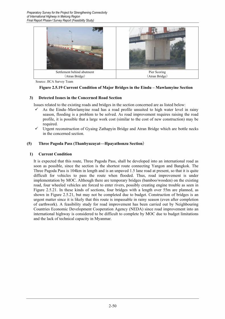
Preparatory Survey for the Project for Strengthening Connectivity of International Highway in Mekong Region Final Report Phase-I Survey Report (Feasibility Study)
2-50
Settlement behind abutment
(Atran Bridge) Pier Scoring
(Atran Bridge) Source: JICA Survey Team
Figure 2.5.19 Current Condition of Major Bridges in the Eindu – Mawlamyine Section
3) Detected Issues in the Concerned Road Section Issues related to the existing roads and bridges in the section concerned are as listed below: As the Eindu–Mawlamyine road has a road profile unsuited to high water level in rainy
season, flooding is a problem to be solved. As road improvement requires raising the road profile, it is possible that a large work cost (similar to the cost of new construction) may be required.
Urgent reconstruction of Gyaing Zathapyin Bridge and Atran Bridge which are bottle necks in the concerned section.
(5) Three Pagoda Pass (Thanbyuzayat—Hpayathonzu Section)
1) Current Condition It is expected that this route, Three Pagoda Pass, shall be developed into an international road as soon as possible, since the section is the shortest route connecting Yangon and Bangkok. The Three Pagoda Pass is 104km in length and is an unpaved 1.5 lane road at present, so that it is quite difficult for vehicles to pass the route when flooded. Thus, road improvement is under implementation by MOC. Although there are temporary bridges (bamboo/wooden) on the existing road, four wheeled vehicles are forced to enter rivers, possibly creating engine trouble as seen in Figure 2.5.21. In these kinds of sections, four bridges with a length over 55m are planned, as shown in Figure 2.5.21, but may not be completed due to budget. Construction of bridges is an urgent matter since it is likely that this route is impassable in rainy season (even after completion of earthwork). A feasibility study for road improvement has been carried out by Neighbouring Countries Economic Development Cooperation Agency (NEDA) since road improvement into an international highway is considered to be difficult to complete by MOC due to budget limitations and the lack of technical capacity in Myanmar.
Preparatory Survey for the Project for Strengthening Connectivity of International Highway in Mekong Region Final Report Phase-I Survey Report (Feasibility Study)

Preparatory Survey for the Project for Strengthening Connectivity of International Highway in Mekong Region
Final Report Phase-I Survey Report (Feasibility Study)
2-51
Ye
4
Mon State Kayin State
1(5)Three Pagoda Pass Thanbuzayat
2
3
Payathonzu
Source: JICA Survey Team
Figure 2.5.20 Thanbyuzayat—Hpayathonzu Section Location Map
Bridge NO.1 Bridge NO.2
Bridge NO.3 Bridge NO.4
Preparatory Survey for the Project for Strengthening Connectivity of International Highway in Mekong Region
Final Report Phase-I Survey Report (Feasibility Study)

Preparatory Survey for the Project for Strengthening Connectivity of International Highway in Mekong Region Final Report Phase-I Survey Report (Feasibility Study)
2-52
Crossing creek by vehicles Road improvement Source: JICA Survey Team
Figure 2.5.21 Current Condition for Thanbyuzayat—Hpayathonzu Section
2) Detected Issues in the Concerned Road Section Issues related to the existing roads and bridges in the section concerned are as listed below: Bridge construction (Impassable sections) Road improvement to international highway level
Preparatory Survey for the Project for Strengthening Connectivity of International Highway in Mekong Region Final Report Phase-I Survey Report (Feasibility Study)

Preparatory Survey for the Project for Strengthening Connectivity of International Highway in Mekong Region
Final Report Phase-I Survey Report (Feasibility Study)
3-1
3.1 Socio-economic Framework
3.1.1 Upper Plans
(1) National Socio-economic Development Plans Myanmar has attracted attention from all over the world as the country with the greatest development opportunities in Southeast Asia, due to the country’s accelerated economic and social reforms in 2010. The government is preparing a series of national development plans and intends to achieve further economic development.
(2) Framework for Economic and Social Reforms Framework for Economic and Social Reforms (FESR) was presented to development partners in January, 2013 during a donor meeting in Naypyitaw. The document is an essential policy tool for the government to realize both the short- and long-term potential of Myanmar. First, FESR provides a reform bridge linking the on-going government programs to the National Comprehensive Development Plan (NCDP). Next, FESR serves as a required reference for various entities of the government to develop more detailed sectoral and regional plans. Finally, FESR can serve as a guide for building lasting cooperation with development partners and international bodies to obtain mutual benefits.
FESR states that Myanmar’s vision is “to become a modern developed nation that meets the aspirations of its people for a better life; and to achieve greater integration with the international community by 2020,” and describes necessary reforms in economic policies and social systems.
(3) Five-Year Plan (2011-15) and National Comprehensive Development Plan Preparation of the first Five-Year Plan (2011-15) apparently has not been completed, and will be discussed in Parliament. Therefore, detailed plan contents are yet to be presented.
・ 7.9% of average GDP growth (Primary sector 3.2%, Secondary sector 11.1% and Tertiary sector 9.8%)
・ Structural change of industry share (from 36.4:26.0:37.6 in 2010/11 to 28.1:36.1:35.8 in 2015/16)
・ Project proposals (both of private and state projects) with financial resources (state budget, aids, loans, FDIs)
After the preparation of the first Five-Year Plan, the Ministry of National Planning and Economic Development (MNPED) will prepare medium- and long-term comprehensive NCDP plans. NCDP is prepared based on input from line ministries and local governments. In this sense, NCDP also received input from LTIPP, prepared by DICA.
CHAPTER 3 TRAFFIC DEMAND FORECAST
Preparatory Survey for the Project for Strengthening Connectivity of International Highway in Mekong Region
Final Report Phase-I Survey Report (Feasibility Study)
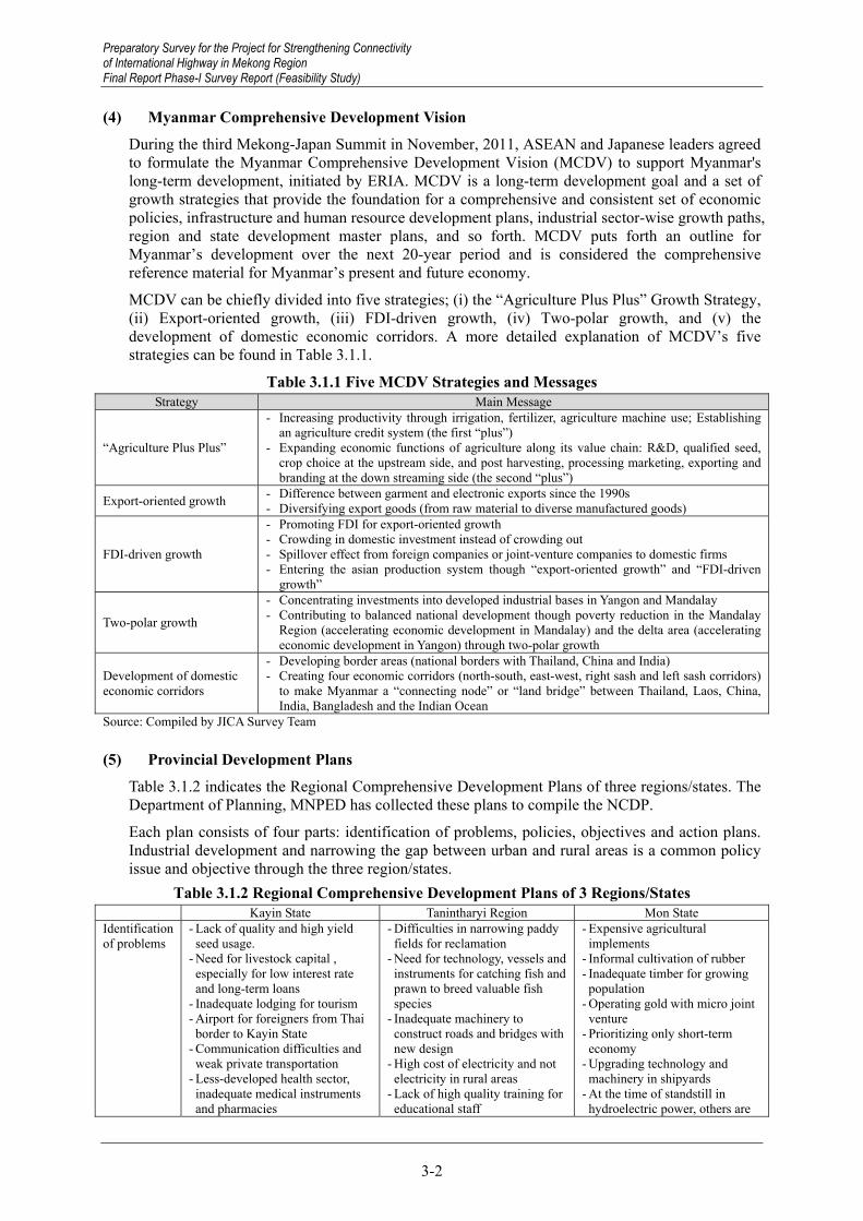
Preparatory Survey for the Project for Strengthening Connectivity of International Highway in Mekong Region Final Report Phase-I Survey Report (Feasibility Study)
3-2
(4) Myanmar Comprehensive Development Vision During the third Mekong-Japan Summit in November, 2011, ASEAN and Japanese leaders agreed to formulate the Myanmar Comprehensive Development Vision (MCDV) to support Myanmar's long-term development, initiated by ERIA. MCDV is a long-term development goal and a set of growth strategies that provide the foundation for a comprehensive and consistent set of economic policies, infrastructure and human resource development plans, industrial sector-wise growth paths, region and state development master plans, and so forth. MCDV puts forth an outline for Myanmar’s development over the next 20-year period and is considered the comprehensive reference material for Myanmar’s present and future economy.
MCDV can be chiefly divided into five strategies; (i) the “Agriculture Plus Plus” Growth Strategy, (ii) Export-oriented growth, (iii) FDI-driven growth, (iv) Two-polar growth, and (v) the development of domestic economic corridors. A more detailed explanation of MCDV’s five strategies can be found in Table 3.1.1.
Table 3.1.1 Five MCDV Strategies and Messages Strategy Main Message
“Agriculture Plus Plus”
- Increasing productivity through irrigation, fertilizer, agriculture machine use; Establishing an agriculture credit system (the first “plus”)
- Expanding economic functions of agriculture along its value chain: R&D, qualified seed, crop choice at the upstream side, and post harvesting, processing marketing, exporting and branding at the down streaming side (the second “plus”)
Export-oriented growth - Difference between garment and electronic exports since the 1990s - Diversifying export goods (from raw material to diverse manufactured goods)
FDI-driven growth
- Promoting FDI for export-oriented growth - Crowding in domestic investment instead of crowding out - Spillover effect from foreign companies or joint-venture companies to domestic firms - Entering the asian production system though “export-oriented growth” and “FDI-driven
growth”
Two-polar growth
- Concentrating investments into developed industrial bases in Yangon and Mandalay - Contributing to balanced national development though poverty reduction in the Mandalay
Region (accelerating economic development in Mandalay) and the delta area (accelerating economic development in Yangon) through two-polar growth
Development of domestic economic corridors
- Developing border areas (national borders with Thailand, China and India) - Creating four economic corridors (north-south, east-west, right sash and left sash corridors)
to make Myanmar a “connecting node” or “land bridge” between Thailand, Laos, China, India, Bangladesh and the Indian Ocean
Source: Compiled by JICA Survey Team
(5) Provincial Development Plans Table 3.1.2 indicates the Regional Comprehensive Development Plans of three regions/states. The Department of Planning, MNPED has collected these plans to compile the NCDP.
Each plan consists of four parts: identification of problems, policies, objectives and action plans. Industrial development and narrowing the gap between urban and rural areas is a common policy issue and objective through the three region/states.
Table 3.1.2 Regional Comprehensive Development Plans of 3 Regions/States Kayin State Tanintharyi Region Mon State
Identification of problems
- Lack of quality and high yield seed usage.
- Need for livestock capital , especially for low interest rate and long-term loans
- Inadequate lodging for tourism - Airport for foreigners from Thai border to Kayin State
- Communication difficulties and weak private transportation
- Less-developed health sector, inadequate medical instruments and pharmacies
- Difficulties in narrowing paddy fields for reclamation
- Need for technology, vessels and instruments for catching fish and prawn to breed valuable fish species
- Inadequate machinery to construct roads and bridges with new design
- High cost of electricity and not electricity in rural areas
- Lack of high quality training for educational staff
- Expensive agricultural implements
- Informal cultivation of rubber - Inadequate timber for growing population
- Operating gold with micro joint venture
- Prioritizing only short-term economy
- Upgrading technology and machinery in shipyards
- At the time of standstill in hydroelectric power, others are
Preparatory Survey for the Project for Strengthening Connectivity of International Highway in Mekong Region Final Report Phase-I Survey Report (Feasibility Study)

Preparatory Survey for the Project for Strengthening Connectivity of International Highway in Mekong Region
Final Report Phase-I Survey Report (Feasibility Study)
3-3
Kayin State Tanintharyi Region Mon State - Receiving health information in a timely manner
not produced more. - Overloaded express buses - Little education knowledge - Lack of emergency health care and complying health knowledge
Policies - Implement pacts laid down by state for prosperity, development of living standards and millennium development goals
- Implement AEC in 2015
- Sustain agricultural development towards industrialization and improve value-added products, emphasizing small and medium enterprise towards heavy industry
- Sustain agricultural development towards industrialization and improve job opportunities and ensuring health and education towards the flourishing of socio-economic.
Objectives - To maintain dam and tanks for effective cultivation use
- To effectively use vacant and virgin lands for land use right to farmers and economic development.
- To increase the production of meat, fish and eggs for more consumption by the people per year.
- To develop wood-based industries and produce less waste when using natural resources
- To narrow the gap between rural and urban development and create job opportunities by establishing industries
- To promote local and foreign investment in hotels and tourism
- To improve transportation (for improving socio-economic.)
- To electrify households, industrial zones and establishments
- To price communication services reasonably.
- To develop the economy through cross-border transit trade according to strategic geo location
- To develop human resources proficient in basic education and advanced technology to build peace and develop the nation.
- To get expected income for farmers by PPP in cultivation, processing, production of value-added goods.
- To maintain and manage the biodiversity of Lanpi Marine National Garden in the Kauth Thaung District
- To undertake the production, sales and distribution of electricity from the Ministry, national investors and foreign direct investment
To support rural development and alleviate poverty by acquiring technology
- To upgrade transportation services with a door-to-door system
- To improve telephone and internet usage in rural areas to 75% and 50%
- To donate to educational fields with the help of well-wishers
- To improve health standards
- To develop agricultural products and enhance finished goods
- To develop fishery production and reduce poverty
- To develop wood-based industry and reduce waste of natural resources
- To develop industry sector laid down by national objectives
- To cooperate with foreign and local investors for land development
- To implement ports in line with ASEAN standards
- To develop the health sector according to MDGs
- To protect national heritage
Action Plans - Use hybrid and high yield seeds to get a higher yield per acre
- Set up the development of a livestock village project with cooperation from Thailand in the Kyauk Lone Gyi livestock zone of Myawaddy township.
- Produce value-added products to develop the border area
- Encourage small and medium enterprises in import substitution and export promotion.
- Develop hotels and tourism without affecting the environment, especially the special conservation district around Zwe Ka Pin Mountain, Than Taung Gyi and the ancient caves that interest foreigners.
- Have Market Validity for rice and use high quality and hybrid seeds
Establish commercial livestock through foreign and local investments
- Develop Special Economic Zone- Implement new renewable energy projects
- Increase school enrolment with international organizations, local education funds and government
- Fulfil health care needs by expanding infrastructure, health care services and constructing a health department and hospital
- Have Market Validity for rice and use high quality and hybrid seeds
- Implement effective supervision in the livestock sector to obtain reliable data and increase production
- Produce wood and non-wood products to conserve the forest and reserved forest
- Expand mining areas by region - Maintain and repair Thahtone hydropower for more efficient production
- Fulfil transportation requirements to develop a modern nation
- Install Optical Fibre network connections around the state
Preparatory Survey for the Project for Strengthening Connectivity of International Highway in Mekong Region
Final Report Phase-I Survey Report (Feasibility Study)

Preparatory Survey for the Project for Strengthening Connectivity of International Highway in Mekong Region Final Report Phase-I Survey Report (Feasibility Study)
3-4
Kayin State Tanintharyi Region Mon State - Develop hydro power, coal electricity and other energy electricity with international cooperation.
- Improve trade by connecting industrial zones and commodity markets at the border trade area.
- Open a compacting school in accordance with increasing school enrolment.
- Give health information from television, journals and posters to locals through discussion
- Develop financing sector - Promote health sector development
- Endeavouring to come out private school systematically.
Source: Study on Regional Comprehensive Development Plans, Department of Planning, Ministry of National Planning and Economic Development, presentation at 2nd Workshop of Myanmar Comprehensive Development Vision, January 2013
(6) Regional Development Plan for Southeast Myanmar JICA conducted a Study titled “Preparatory Survey for The Integrated Regional Development for Ethnic Minorities in The South-East Myanmar” during February and July of 2013. The Study Area was in Mon and Kayin States.
In the Study, a basic strategy for the regional development of Southeastern Myanmar was established in reference to the problem factors. Problem factors included (1) security problems and a lack of mutual trust between governments and ethnic peoples; (2) the Union Government’s newly introduced localization policy has not been implemented locally; and (3) reflecting this, rich resources have not been effectively utilized due to inadequate environmental resource management. Therefore, the following components were proposed as part of the basic strategy.
Improve security conditions through sharing development and security-related information with all stakeholders to cultivate mutual trust,
Establish a mechanism for broad-based participation of all stakeholders in the development planning and implementation process, and
Promote alternative socio-economic activities that are less resource intensive and environmentally friendly, and combine traditional practices with modern technology.
The study for the regional development of Southeast Myanmar has the following vision:
Realization of a robust and resilient socio-economy adapting to a changing world and open to the global society supported by abundant natural resources, diverse economic activities and a rich cultural heritage.
The study also proposes a list of projects. The projects include: return and settlement support, an integrated regional development master plan and feasibility study for the Hpayathonzu to Thanbyuzayat road, water supply, roads and bridges, power supply, and industrial development.
3.1.2 Development Scenario
(1) Urban Development JICA Survey Team on “The Survey Program for The National Transport Development Plan” prepared the National Spatial Planning Framework (NSPF) after an analysis of national development plans, 71 towns identified by the Department of Human Settlements and Housing Development of the Ministry of Construction, industrial estate locations, and areas of cultivation land.
The survey team set four kinds of centres: National Centres, Regional Centres, Agro-industry Centres, and Special Function Centre. The survey team classified districts in which 71 towns belong into the four levels by criteria such as urban population in 2012, percentage of urban
Preparatory Survey for the Project for Strengthening Connectivity of International Highway in Mekong Region Final Report Phase-I Survey Report (Feasibility Study)

Preparatory Survey for the Project for Strengthening Connectivity of International Highway in Mekong Region
Final Report Phase-I Survey Report (Feasibility Study)
3-5
population in each district in 2012, district population in 2030 and population density of each district in 2030. The survey team also classified 71 towns into four kinds of centres by roles and functions of the towns such as administration/public service, industry and transportation service. Table 3.1.3 indicates the classification of seven towns in the Study Area.
Table 3.1.3 Four Centres Concept and 4-level Centres Hierarchy in the Study Area Centres 1st level 2nd level 3rd level 4th level
National Centres Yangon Mandalay Naypyitaw
- - -
Regional Centres Hpa-An Dawei Mawlamyine
- - -
Agro-industry Centres Thaton - - -
Special Function Centres - Myeik - Myawaddy Kawthoung
Source: Interim Report 1 of “The Survey Program for the National Transport Development Plan”
State/region capitals in the Study Area are classified as first-level Regional Centres. Thaton is classified as a first-level Agro-industry Centre. Myeik, Myawaddy and Kawthoung are classified as Special Function Centres.
(2) Economic Development Further assessment of natural and human resources and regional development plans is necessary but the JICA Survey Team has the following perspective on regional economic development:
Industrial Development: There are currently 380 factories located in Mae Sot, Tak Province, Thailand, 80% of which are engaged in the CMP industry with around 30,000 Burmese workers (according to the Federation of Thai Industry (FTI) Mae Sot Office). The wage level in Thailand is increasing and the European Union plans to terminate the Generalized System of Preferences (GSP) for Thailand in 2015. Considering the aforementioned factors, labour-intensive industry in Mae Sot and other areas of Thailand have the potential to move to southwestern Myanmar. Infrastructure development, including road and electricity networks, will be required for the move.
Connectivity with Thailand: Thailand is an important trade partner for Myanmar. Economic development and the formation of AEC in 2015 will increase both import and export volume. Southwest Myanmar connects Yangon with Bangkok. As indicated in Table 2.1.6 and Table 2.1.7, the East-West Economic Corridor is a major transport route with Thailand and the Three Pagodas Pass Road can also connect Yangon with Bangkok if the road network is improved.
Dawei Special Economic Zone: Development of the Dawei Special Economic Zone (SEZ) will influence regional economic development; however, it is expected that the resultant acceleration of development will take some time. In addition, the economic relationship between Dawei SEZ and other regions of Myanmar is unclear. It will depend on the SEZ development concept and what types of industries are promoted.
3.1.3 Socio-economic Framework
(1) Population Growth JICA Survey Team on “The Survey Program for The National Transport Development Plan” projected the national population until 2040. The Survey Team utilized a “comfort method,” and prepared three alternative population growth scenarios in accordance with the difference of diminishing Total Fertility Rate (TFR). The Survey Team selected the middle scenario, in which TFR drops from 2.31 in 2015 to 1.71 in 2040. Population in this scenario will amount to 73.80 million in 2040.
Preparatory Survey for the Project for Strengthening Connectivity of International Highway in Mekong Region
Final Report Phase-I Survey Report (Feasibility Study)

Preparatory Survey for the Project for Strengthening Connectivity of International Highway in Mekong Region Final Report Phase-I Survey Report (Feasibility Study)
3-6
Table 3.1.4 shows changes in region/state-wise population from 2012 to 2040. The Study Team distributed the population to regions/states, while considering migration due to regional economic development.
The table shows that the population of Kayin State will increase from 1.86 million in 2012 to 2.50 million in 2040. In Mon State, the population will increase from 3.19 million to 4.00 million and the population will increase from 1.76 million to 2.40 million in Tanintharyi Region. Percentages of region/state populations to the national population increase gradually in the three region/states.
Table 3.1.4 Population by region/state from 2012 to 2040 Unit: 1000 persons
Region/State 2012 2015 2020 2030 2040 Kachin State 1,616 1,721 1,820 1,935 1,973Kayah State 365 391 424 450 460Kayin State 1,855 1,986 2,151 2,401 2,496Chin State 571 597 630 656 666Sagaing Region 6,654 6,864 7,029 7,179 7,236Tanintharyi Region 1,755 1,886 2,051 2,301 2,396Bago Region 6,125 6,361 6,691 7,261 7,507Magway Region 5,730 5,914 6,013 6,113 6,151Mandalay Region 7,423 7,685 7,949 8,370 8,617Mon State 3,193 3,324 3,489 3,846 3,998Rakhine State 3,370 3,501 3,666 4,016 4,130Yangon Region 7,170 7,617 8,739 10,445 11,015Shan State 5,779 5,963 6,128 6,378 6,473Ayeyarwaddy 8,205 8,520 8,685 8,864 8,902Naypyitaw Council Territory 1,164 1,269 1,434 1,684 1,779Total 60,976 63,600 66,900 71,900 73,800Source: Population Department, Ministry of Immigration and Population (2012)
and JICA Survey Team on “The Survey Program for the National Transport Development Plan” Table 3.1.5 Population by District in the Survey Area from 2012 to 2040
Unit: 1000 persons District 2012 2015 2020 2030 2040
Kayin State 1,855 1,987 2,150 2,401 2,497 Hpa-An (South) 916 981 1,067 1,213 1,273Hpa-An (North) 113 121 129 130 130Myawaddy 64 69 99 122 132Kawkareik 595 637 667 744 774Hpapun 167 179 189 192 187
Mon State 3,193 3,324 3,489 3,846 3,998 Mawlamyine 1,942 2,022 2,114 2,231 2,119 Thaton 1,251 1,302 1,375 1,615 1,879
Tanintharyi Region 1,756 1,886 2,051 2,301 2,397 Dawei 811 871 954 1,105 1,318 Myeik 790 848 927 1,030 935 Kawthoung 155 167 170 166 144
Source: Population Department, Ministry of Immigration and Population (2012) and JICA Survey Team on “The Survey Program for the National Transport Development Plan”
Table 3.1.5 indicates population by districts in the Study Area. Rapid population growth is expected in Myawaddy District, Kayin State, Thaton District, Mon State and Dawei District, Tanintharyi Region. Table 3.1.6 shows the urban population change16 in the same period. The urban population of Mon State will increase from 55.4% in 2012 to 56.7% in 2040, and the increase will be greater in Thaton District. Myawaddy District, Kayin State and Dawei District, Tanintharyi Region will also experience rapid urban population growth.
16 General Administration Department, Ministry of Home Affairs classifies all townships in Myanmar into “urban” township
and “rural” township. The urban population in a district is the sum of the populations of urban townships in Table 3.1.6.
Preparatory Survey for the Project for Strengthening Connectivity of International Highway in Mekong Region Final Report Phase-I Survey Report (Feasibility Study)

Preparatory Survey for the Project for Strengthening Connectivity of International Highway in Mekong Region
Final Report Phase-I Survey Report (Feasibility Study)
3-7
Table 3.1.6 Urban Population by District in the Survey Area from 2012 to 2040 District 2012 2015 2020 2030 2040
Kayin State 376 431 492 600 683 Hpa-An (South) 195 225 260 324 369Hpa-An (North) 12 14 16 17 17Myawaddy 22 25 37 50 57Kawkareik 129 146 156 179 186Hpapun 18 21 24 25 24
Mon State 1,205 1,360 1,567 2,048 2,481 Mawlamyine 862 973 1,127 1,455 1,557 Thaton 343 387 440 593 924
Tanintharyi Region 595 685 800 1,026 1,209 Dawei 242 281 332 443 606 Myeik 282 325 385 498 526 Kawthoung 71 79 83 85 77
Source: Population Department, Ministry of Immigration and Population (2012) and JICA Survey Team on “The Survey Program for the National Transport Development Plan”
(2) Economic Development The JICA Survey Team on “The Survey Program for The National Transport Development Plan” also projected GDP growth until 2035. Observing the government’s economic growth target, experiences of other Asian countries and limited population growth prospect, the Study Team set the GDP growth rate from 2015 to 2035 at 7.2%. As a result, the National GDP in real terms will increase 3.4 times between 2012 and 2030, or from 46,915 billion Kyat to 160,498 billion Kyat .
Table 3.1.7 indicates GRDP changes by regions/states until 2030. The three region/states of the Study are projected to achieve more rapid economic growth than the national average and raise their GRDP share in the national GDP.
Table 3.1.7 Projection of GRDP by Region/State until 2030 Unit: billion Kyat
Region/State 2012 2015 2020 2030 Kachin State 1,097 1,317 1,858 3,467 Kayah State 172 227 345 667 Kayin State 829 1,033 1,503 3,583 Chin State 154 182 253 542 Sagaing Region 5,508 6,320 7,731 12,320 Tanintharyi Region 1,679 1,941 2,646 5,863 Bago Region 4,027 4,700 6,581 14,124 Magway Region 4,631 5,171 6,582 9,660 Mandalay Region 5,186 6,388 9,915 22,782 Mon State 2,063 2,502 3,560 7,580 Rakhine State 1,856 2,244 3,420 7,676 Yangon Region 10,294 13,710 21,705 47,162 Shan State 3,373 3,753 4,929 9,185 Ayeyarwaddy Region 5,465 6,267 7,772 12,597 Naypyitaw Concil Territory 581 810 1,280 3,290 Total 46,915 56,565 80,080 160,498 Source: JICA Survey Team on “The Survey Program for the National Transport Development Plan”
Table 3.1.8 indicates GRDP changes by district until 2030. Rapid economic development is expected in Myawaddy District (annual average economic growth rate from 2012 to 2030 will account for 11.0%), Hpa-An District (southern part, 9.1%), Thaton District (8.2%), Dawei District (7.9%) and Kawkareik District (7.8%). The proportion of GRDP in the Study Area will increase in these districts toward 2030.
Preparatory Survey for the Project for Strengthening Connectivity of International Highway in Mekong Region
Final Report Phase-I Survey Report (Feasibility Study)

Preparatory Survey for the Project for Strengthening Connectivity of International Highway in Mekong Region Final Report Phase-I Survey Report (Feasibility Study)
3-8
Table 3.1.8 GRDP by District in the Study Area until 2030 2012 2015 2020 2030
Kayin State 829 1,032 1,504 3,583 Hpa-An (South) 431 547 819 2,024 Hpa-An (North) 50 57 75 161 Myawaddy 41 46 83 215 Kawkareik 224 279 398 949 Hpapun 83 103 128 233
Mon State 2,063 2,502 3,560 7,580 Mawlamyine 1,258 1,514 2,100 4,245 Thaton 805 988 1,460 3,335
Tanintharyi Region 1,679 1,941 2,645 5,862 Dawei 781 922 1,296 3,049 Myeik 755 864 1,177 2,520 Kawthoung 143 155 172 293
Source: JICA Survey Team on “The Survey Program for the National Transport Development Plan”
Preparatory Survey for the Project for Strengthening Connectivity of International Highway in Mekong Region Final Report Phase-I Survey Report (Feasibility Study)

Preparatory Survey for the Project for Strengthening Connectivity of International Highway in Mekong Region
Final Report Phase-I Survey Report (Feasibility Study)
3-9
3.2 Traffic Demand Forecast
3.2.1 Overview of Traffic Demand Forecast in MYT-Plan
The comprehensive traffic demand forecast was practised in the JICA-supported Survey Program for The National Transport Development Plan (hereinafter referred to as the MYT-Plan). The conventional four-step traffic demand model was developed based on the result of traffic surveys (traffic count survey, roadside OD interview survey, terminal interview survey and transport operators survey) and secondary information, such as population and economic indicators.
During modelling in the traffic demand forecast, the Study Area (the whole country) was divided into 71 traffic analysis zones. A traffic generation and attraction model was developed with a formula encompassing the population and GRDP as explanatory factors. The traffic distribution model was developed by a gravity model with zonal impedances (time and cost) as explanatory factors.
The traffic demand forecast was carried out by the intermediate and target years of 2020 and 2030 in the MYT-Plan. The OD matrix was prepared by seven different types of vehicles (passenger car, bus, small 2-axle truck, large 2-axle truck, 3-axle truck, four and over axle truck and trailer). The future road network (free flow speed and traffic capacity) was developed, considering the number of lanes, topography and pavement type.
3.2.2 Approach and Methodology of Traffic Demand Forecast in the Study
Basically, the same approach and methodology of the traffic demand forecast applied to the MYT-Plan is adopted for the traffic demand forecast in the Study, considering the following implications. First, the traffic demand forecast is carried out by 2030 (the target year of the MYT-Plan) and 2035 (the target year of the Study) 17. Secondly, the OD matrix is calibrated by the Traffic Survey conducted in the Study. Thirdly, the modal share and route share models are newly developed, considering the sea and land transport of the EXIM cargo between Thailand and Myanmar, and the route share between the East West Economic Corridor (EWEC) and the newly improved Three Pagoda Pass.
3.2.3 Summary Result of Traffic Survey
(1) General Both Traffic Count Survey and Roadside Interview Survey were carried out at designated locations in the Study Area. The primary objective in carrying out the Roadside Interview Survey is to gather demographic information and trip information, such as origin-destination (OD) data. The Traffic Count Survey, carried out at the same locations as the Interview Survey, is used to estimate traffic volumes across different vehicle types. Results from these two surveys serve as the basis for forecasting future vehicular traffic demand. The survey locations are determined, considering the administrative boundaries of Mon, Kayin, Tanintharyi States/Region and project locations.
The Traffic Count Survey was carried out at nine different locations and the Roadside Interview Survey at three locations, as illustrated in the following tables and map. The Traffic Count Survey was conducted on weekdays between 17th February and 4 March, 2014 and the survey duration varied from 16 hours to 24 hours per location and 16-hour duration traffic surveys were conducted from 5:30am to 9:30pm18. Surveys with 24-hour duration began at 5:30 AM on the first day and end at 5:30 AM on the following day.
17 Generally, the 20th year is applied as the target year of economic infrastructure project, considering the design period of
traffic demand forecast, design and economic analysis. Accordingly, 2035 is set as a target year of the project. 18 The survey period of 16 hours is determined by the following reasons: i) To secure security in remote areas during the
survey implementation, ii) The 16-hours traffic survey can capture 80% of the 24-hours traffic based on the result of the traffic survey conducted by JICA-supported Survey Program for The National Transport Development Plan.
Preparatory Survey for the Project for Strengthening Connectivity of International Highway in Mekong Region
Final Report Phase-I Survey Report (Feasibility Study)

Preparatory Survey for the Project for Strengthening Connectivity of International Highway in Mekong Region Final Report Phase-I Survey Report (Feasibility Study)
3-10
Traffic Analysis Zone, applied for traffic survey and traffic demand forecast in the Study, is shown in Figure 3.2.2 and Table 3.2.2
Table 3.2.1 Roadside Interview and Traffic Count Locations and Durations Site # Road / Highway State / Division Traffic Counts Survey Duration Roadside Interview
1 Theinzayat (Theinzayat Toll Gate) Bago-Mon 24 hours 2 weekdays 10 hours
(07:30 – 17:30)
2 Bilin–Lagunpyo (Mon-Kayin Border) Mon-Kayin 16 hours
(05:30 – 21:30) 2 weekdays NA
3 Thaton – Hpa-an (Don Tha Mi Bridge) Mon 16 hours
(05:30 – 21:30) 2 weekdays NA
4 Mawlamyine (Mawlamyine Bridge) Mon 24 hours 2 weekdays NA
5 Mawlamyine–Eindu (Gyaing (Za Tha Pyin) Bridge)
Mon-Kayin 16 hours (05:30 – 21:30) 2 weekdays NA
6 Hpa-an–Eindu (Naung Lon Bridge) Kayin 16 hours
(05:30 – 21:30) 2 weekdays NA
7 Kawkareik Gyaing(Kawkareik) Br. Kayin 16 hours
(05:30 – 21:30) 2 weekdays NA
8 Myawaddy (Myawaddy Toll Gate) Kayin 16 hours
(05:00 – 21:00) 4 weekdays 10 hours (07:30 – 17:30)
9 Mon-Tanintharyi Border Mon-Tanintharyi 16 hours (05:30 – 21:30) 2 weekdays 10 hours
(07:30 – 17:30) Source: JICA Survey Team
Yangon
Myawaddy
Mawlamyine
Thanbyuzayat
Thaton
Bago
Kawkareik
EinduHpa an
Ye
Payathonzu
1
3
4
68
7
2
5
9
Source: JICA Survey Team
Figure 3.2.1 Roadside Interview and Traffic Count Locations
Preparatory Survey for the Project for Strengthening Connectivity of International Highway in Mekong Region Final Report Phase-I Survey Report (Feasibility Study)

Preparatory Survey for the Project for Strengthening Connectivity of International Highway in Mekong Region
Final Report Phase-I Survey Report (Feasibility Study)
3-11
Source: JICA Survey Team
Figure 3.2.2 Traffic Analysis Zone
Table 3.2.2 Summery of Traffic Analysis Zone Code State/Division/Province District
1 Kachin Myitkyina 2 Kachin Mohnyin 3 Kachin Bhamo 4 Kachin Puta-O 5 Kayah Loikaw 6 Kayah Bawlake
Preparatory Survey for the Project for Strengthening Connectivity of International Highway in Mekong Region
Final Report Phase-I Survey Report (Feasibility Study)

Preparatory Survey for the Project for Strengthening Connectivity of International Highway in Mekong Region Final Report Phase-I Survey Report (Feasibility Study)
3-12
7 Kayin Hpa-An South 8 Kayin Myawaddy 9 Kayin Kawkareik
10 Kayin Hpapun 11 Chin Falam 12 Chin Mindat 13 Sagaing Sagaing 14 Sagaing Shwebo 15 Sagaing Monywa 16 Sagaing Katha 17 Sagaing Kale 18 Sagaing Tamu 19 Sagaing Mawlaik 20 Sagaing Hkamti 21 Tanintharyi Dawei 22 Tanintharyi Myeik 23 Tanintharyi Kawthoung 24 Bago East Bago 25 Bago East Taungoo 26 Bago West Pyay 27 Bago West Thayarwady 28 Magway Magway 29 Magway Minbu 30 Magway Thayet 31 Magway Pakokku 32 Magway Gangaw 33 Mandalay Mandalay 34 Mandalay Pyinoolwin 35 Mandalay Kyaukse 36 Mandalay Myingyan 37 Mandalay Nyaung-U 38 Mandalay Yamethin 40 Mandalay Meiktila 39 Mandalay Nay Pyi Taw 41 Mon Mawlamyine 42 Mon Thaton 43 Rakhine Sittwe 44 Rakhine Maungdaw 45 Rakhine Kyaukpyu 46 Rakhine Thandwe 47 Yangon Yangon (North) 48 Yangon Yangon (East) 491 Yangon Yangon (Southeast) 492 Yangon Yangon (Southwest) 50 Yangon Yangon (West) 51 Shan (South) Taunggyi 52 Shan (South) Loilen 53 Shan (South) Langkho
Preparatory Survey for the Project for Strengthening Connectivity of International Highway in Mekong Region Final Report Phase-I Survey Report (Feasibility Study)

Preparatory Survey for the Project for Strengthening Connectivity of International Highway in Mekong Region
Final Report Phase-I Survey Report (Feasibility Study)
3-13
54 Shan (North) Lashio 59 Shan (North) Muse 55 Shan (North) Kyaukme 56 Shan (North) Kunlong 57 Shan (North) Laukkaing 58 Shan (North) Hopang 60 Shan (East) Kengtung 61 Shan (East) Monghsat 62 Shan (East) Tachileik 63 Shan (East) Monghpyak 64 Ayeyarwady Pathein 65 Ayeyarwady Hinthada 66 Ayeyarwady Myaungmya 67 Ayeyarwady Labutta 68 Ayeyarwady Maubin 69 Ayeyarwady Pyapon 70 Kayin Hpa-An North
Source: JICA Survey Team
(2) Daily Traffic Volume The 16-hour traffic is converted to the 24-hour daily traffic, using the 24/16 hour traffic conversion factor, prepared from the result of 24 hour traffic count survey. As seen in the following figure, the daily traffic volume varies among the survey locations and the busiest traffic is observed at Mawlamyine (Survey Location 4), exceeding 10,000 vehicles per day. Along the East-West Corridor, the traffic volume is observed non-significantly-different and ranges between 4,000 and 6,000 vehicles per day.
0 2,000 4,000 6,000 8,000 10,000 12,000
Location 1
Location 2
Location 3
Location 4
Location 5
Location 6
Location 7
Location 8
Location 9
Traffic Volume (No.)
Motocycle
Saloon
Pick-up
Van
Mini bus
Large bus
2-axle truck
3 axle truck
4 axle truck
Trailer
Source: JICA Survey Team
Figure 3.2.3 Traffic Volume by Vehicle Type
Like the traffic volume, the composition of the traffic varies between survey locations. More motorcycles were observed in both urban and remote areas, such as the Mon-Kayin Border (Location 2), Mawlamyine (Location 4) and Mon-Tanintharyi Border (Location 9), where motorcycles took up 65 to 75% of the traffic. Along other trunk roads in the Study Area, particularly the East-West Corridor, the heavy vehicles consisted of the larger share of the traffic and the share of the trucks/trailers reaches approximately 20% of the traffic.
Preparatory Survey for the Project for Strengthening Connectivity of International Highway in Mekong Region
Final Report Phase-I Survey Report (Feasibility Study)

Preparatory Survey for the Project for Strengthening Connectivity of International Highway in Mekong Region Final Report Phase-I Survey Report (Feasibility Study)
3-14
0% 10% 20% 30% 40% 50% 60% 70% 80% 90% 100%
Location 1
Location 2
Location 3
Location 4
Location 5
Location 6
Location 7
Location 8
Location 9
Traffic Volume (%)
Motocycle
Saloon
Pick-up
Van
Mini bus
Large bus
2-axle truck
3 axle truck
4 axle truck
Trailer
Source: JICA Survey Team
Figure 3.2.4 Composition of Traffic Volume by Vehicle Type
Table 3.2.3 Traffic Volume by Vehicle Type (Vehicle/Day) 19 Location Motocycle Saloon Pick-up Van Mini bus Large bus 2-axle truck 3 axle truck 4 axle truck Trailer Other Total Total (PCU)
Location 1 1,907 199 1,170 815 27 429 592 166 434 237 170 6,146 5,872Location 2 1,468 4 190 38 0 0 129 46 5 6 113 1,999 544Location 3 1,965 66 617 199 8 133 418 63 221 185 346 4,221 2,873Location 4 6,684 181 1,207 674 13 239 515 116 162 59 551 10,401 4,076Location 5 2,019 78 580 465 49 55 388 13 22 0 390 4,059 1,964Location 6 2,819 95 990 723 5 81 491 47 237 28 146 5,662 3,411Location 7 1,917 37 821 797 7 84 434 19 298 25 154 4,593 3,256Location 8 2,216 102 818 744 7 66 383 74 380 0 127 4,917 3,384Location 9 2,896 13 223 56 1 32 225 64 107 7 169 3,793 1,081 Source: JICA Survey Team
(3) Origin-Destination The trip patterns of the sampled vehicles differ between survey locations. The following tables show the origin and destination matrix by passenger car/bus/truck. At Theinzayat, more traffic to/from Yangon, Bago and Mone is observed and for instance, the traffic between Yangon and Mone consists of 35 to 50% of the traffic sampled during the survey at Theinzayat.
Table 3.2.4 Proportional Car OD at Theinzayat Toll Gate (percentage) Trucks Mon Bago Kayin Yangon Others Total
Mon 2 23 0 47 4 77 Bago 0 4 0 0 4 Kayin 0 15 4 19 Yangon 0 0 0 Others 0 0 Total 100
Passenger Cars Mon Bago Kayin Yangon Others Total
Mon 1 35 0 34 2 72 Bago 0 11 0 0 11
19 The following table shows conversion factors of the PCU (Passenger Car Unit). Note that motorbikes and other vehicles
are excluded from Passenger Car Unit since those two modes are considered as inner zonal traffic with shorter trip distance.
Vehicle type Saloon, Pick-up, Van Mini bus Large bus 2-axle truck 3-axle truck 4-axle truck Trailer
Conversion factor of
PCU 1.0 1.5 2.0 1.5 2.0 2.25 2.5
Preparatory Survey for the Project for Strengthening Connectivity of International Highway in Mekong Region Final Report Phase-I Survey Report (Feasibility Study)

Preparatory Survey for the Project for Strengthening Connectivity of International Highway in Mekong Region
Final Report Phase-I Survey Report (Feasibility Study)
3-15
Kayin 0 14 1 15 Yangon 0 2 2 Others 0 0 Total 100
Buses Mon Bago Kayin Yangon Others Total Mon 0 33 0 47 6 86 Bago 0 3 0 0 3 Kayin 0 6 3 8 Yangon 0 3 3 Others 0 0 Total 100 Source: JICA Survey Team
At Myawaddy, the inner-traffic within Kayin is observed to be dominant, with trips from 65% of sampled passenger cars and 47% of sampled trucks being contained within Kayin. Buses travelled longer than passenger cars and trucks and more bus traffic is observed between Kayin and Bago/Yangon during the interview survey at Myawaddy.
Table 3.2.5 Proportional Car OD at Myawaddy Toll Gate (percentage) Trucks Mon Bago Kayin Yangon Others Total
Mon 0 0 18 0 0 18 Bago 0 5 0 0 5 Kayin 47 23 7 77 Yangon 0 0 0 Others 0 0 Total 100
Passenger Cars Mon Bago Kayin Yangon Others Total
Mon 0 0 32 0 0 32 Bago 0 1 0 0 1 Kayin 65 2 0 67 Yangon 0 0 0 Others 0 0 Total 100
Buses Mon Bago Kayin Yangon Others Total
Mon 0 0 16 0 0 16 Bago 0 21 0 0 21 Kayin 16 47 0 63 Yangon 0 0 0 Others 0 0 Total 100 Source: JICA Survey Team
At the Mon-Tanintharyi border, as expected, most OD pairs are observed between Mon and Tanintharyi (74% of passenger cars, 56% of buses and 45% of trucks).
Table 3.2.6 Proportional Car OD at Mon-Tanintharyi Border (percentage) Trucks Mon Bago Kayin Tanintharyi Yangon Total
Mon 7 0 0 45 5 57 Bago 0 0 2 0 2 Kayin 0 7 0 7 Tanintharyi 0 33 33 Yangon 0 0 Total 100
Preparatory Survey for the Project for Strengthening Connectivity of International Highway in Mekong Region
Final Report Phase-I Survey Report (Feasibility Study)

Preparatory Survey for the Project for Strengthening Connectivity of International Highway in Mekong Region Final Report Phase-I Survey Report (Feasibility Study)
3-16
Passenger Cars Mon Bago Kayin Tanintharyi Yangon Total
Mon 0 0 0 74 0 74 Bago 0 0 2 0 2 Kayin 0 7 0 7 Tanintharyi 0 17 17 Yangon 0 0 Total 100
Buses Mon Bago Kayin Tanintharyi Yangon Total
Mon 0 0 0 56 0 56 Bago 0 0 0 0 0 Kayin 0 0 0 0 Tanintharyi 0 44 44 Yangon 0 0 Total 100
Source: JICA Survey Team
(4) Travel Time Travel time also differs between survey locations and vehicle type. Sampled passenger cars travel for an average of 5.6 hours per trip (4.1 hours at Theinzayat Toll Gate, 5.6 hours at Myawaddy Toll Gate and 10.2 hours at Mon- Tanintharyi Border). The sampled buses travelled for an average of 9.9 hours per trip (4.9 hours at Theinzayat Toll Gate, 14.2 hours at Myawaddy Toll Gate and 21.0 hours at the Mon-Tanintharyi Border). The sampled trucks travelled for an average of 14.3 hours per trip (10.5 hours at Theinzayat Toll Gate, 13.7 hours at Myawaddy Toll Gate and 21.5 hours at Mon- Tanintharyi Border). Clearly, the trucks have the longest trips, followed by buses and then passenger vehicles.
0% 20% 40% 60% 80% 100%
Theinzayat Toll Gate
Myawaddy Toll Gate
Mon- Tanintharyi Border
Travel Hours (Passenger Car)
0-5 hours
5-10 hours
10-15 hours
15-20 hours
20-25 hours
Over 25hours
0% 20% 40% 60% 80% 100%
Theinzayat Toll Gate
Myawaddy Toll Gate
Mon- Tanintharyi Border
Travel Hours (Bus)
0-5 hours
5-10 hours
10-15 hours
15-20 hours
20-25 hours
Over 25hours
Preparatory Survey for the Project for Strengthening Connectivity of International Highway in Mekong Region Final Report Phase-I Survey Report (Feasibility Study)

Preparatory Survey for the Project for Strengthening Connectivity of International Highway in Mekong Region
Final Report Phase-I Survey Report (Feasibility Study)
3-17
0% 20% 40% 60% 80% 100%
Theinzayat Toll Gate
Myawaddy Toll Gate
Mon- Tanintharyi Border
Travel Hours (Truck)
0-5 hours
5-10 hours
10-15 hours
15-20 hours
20-25 hours
Over 25hours
Source: JICA Survey Team
Figure 3.2.5 Travel Time (by Vehicle Type)
(5) Travel Cost Travel costs for passenger cars were 38,000 Kyat per trip on average (30,000 Kyat at Theinzayat Toll Gate, 38,000 Kyat at Myawaddy Toll Gate and 61,000 Kyat at Mon-Tanintharyi Border). For buses, the average cost was 90,000 Kyat per trip (48,000 Kyat at Theinzayat Toll Gate, 119,000 Kyat at Myawaddy Toll Gate and 192,000 Kyat at Mon-Tanintharyi Border). For trucks, the average travels costs were 220,000 Kyat per trip (169,000 Kyat at Theinzayat Toll Gate, 231,000 Kyat at Myawaddy Toll Gate and 251,000 Kyat at Mon-Tanintharyi Border). Trucks pay the most, followed by buses and then passenger vehicles. This is consistent with the previous observation about travel time.
0% 20% 40% 60% 80% 100%
Theinzayat Toll Gate
Myawaddy Toll Gate
Mon- Tanintharyi Border
Travel Cost (Passenger Car)
0-50,000 Kyat
50,000-100,000 Kyat
100,000-150,000 Kyat
150,000-200,000 Kyat
200,000-250,000 Kyat
Over 250,000 Kyat
0% 20% 40% 60% 80% 100%
Theinzayat Toll Gate
Myawaddy Toll Gate
Mon- Tanintharyi Border
Travel Cost (Bus)
0-50,000 Kyat
50,000-100,000 Kyat
100,000-150,000 Kyat
150,000-200,000 Kyat
200,000-250,000 Kyat
Over 250,000 Kyat
Preparatory Survey for the Project for Strengthening Connectivity of International Highway in Mekong Region
Final Report Phase-I Survey Report (Feasibility Study)

Preparatory Survey for the Project for Strengthening Connectivity of International Highway in Mekong Region Final Report Phase-I Survey Report (Feasibility Study)
3-18
0% 20% 40% 60% 80% 100%
Theinzayat Toll Gate
Myawaddy Toll Gate
Mon- Tanintharyi Border
Travel Cost (Truck)
0-100,000 Kyat
100,000-200,000 Kyat
200,000-300,000 Kyat
300,000-400,000 Kyat
400,000-500,000 Kyat
Over 500,000 Kyat
Source: JICA Survey Team
Figure 3.2.6 Travel Cost by Vehicle Type
(6) Commodity of the Truck In addition to trip information, truck drivers provided information about the commodities carried by their trucks. At Theinzayat, the most common commodity observed was construction materials at 21%, followed by stone/sand at 18%. At Myawaddy, imports from Thailand were the major commodities transported, and the sampled trucks carried foodstuff (14% of the samples), construction materials (11%) and household articles (7%). At Mon-Tanintharyi Border, the most common commodity was agricultural products at 19%, followed by foodstuff at 17%, wood (and wood products) at 12%, and then fish products at 10%.
Empty trucks are also observed frequently during the survey period and 21% of the sampled trucks at Theinzayat, 32% at Myawaddy, and 29% of the Mon-Taninthary Border are empty.
Table 3.2.7 Commodity Type carried by Sampled Trucks (percentage) Theinzayat
Toll Gate Myawaddy Toll Gate
Mon-Tanintharyi Border
1_Live Animal & Animal Products 2 1 0 2_Fish and Aquatic Products 0 1 10 3_Vegetable and Fruits 5 3 0 4_Grain and Grain Products 7 0 0 5_Other Agricultural Products 2 5 19 6_Foodstuff, Beverage and Animal Food 5 14 17 7_Petroleum, Oil and Gas 7 6 7 8_Coal, Ore, Stone and Sand 18 1 0 9_Cement, Construction Material 21 11 7 11_Garment, Textiles and fabric 0 2 0 12_Wood and Wood Products 2 0 12 13_Paper and Printed Matter 2 1 0 14_Metal and Metal Products 2 2 0 15_Industrial Material, Chemicals 0 1 0 16_Household articles, miscellaneous 0 7 0 17_Machinery and Parts, Transportation 5 14 0 18_Empty 21 32 29 Total 100 100 100 Source: JICA Survey Team
Preparatory Survey for the Project for Strengthening Connectivity of International Highway in Mekong Region Final Report Phase-I Survey Report (Feasibility Study)

Preparatory Survey for the Project for Strengthening Connectivity of International Highway in Mekong Region
Final Report Phase-I Survey Report (Feasibility Study)
3-19
(7) Loading Volume/Capacity of the Truck The truck drivers also provided the loading capacity of their trucks and loading volume carried by their trucks. 2-axle trucks were found to have an average loading capacity of 5.7 tons and to be carrying 3.9 tons. 3-axle trucks had an average capacity of 12.1 tons and carried 9.7 tons, whereas 4-or-more-axle trucks had an average capacity of 19.4 tons and carried an average of 13.5 tons. The loading volume/capacity ratio of these trucks ranges between 70 to 80%. However, the loading volume/capacity ratio of trailers was observed to be relatively small. During the survey, trailer trucks had an average loading capacity of 26.7 tons but carried an average of only 6.7 tons.
Table 3.2.8 Commodity Type carried by Sampled Trucks Loading Volume (Ton) Loading Capacity (Ton) Loading volume/capacity
2-axle truck 3.9 5.7 68% 3-axle truck 9.7 12.1 81% 4+-axle truck 13.5 19.4 69% Trailer truck 6.7 26.7 25% Source: JICA Survey Team
(8) Package Type of the Commodity Over 80% of the trucks surveyed carried their commodities in boxes and bags. Containerization (the world-wide trend for freight business) is not yet commonplace in the Study Area, with only 4% of the sampled trucks at Myawaddy using containers, and none of the sampled trucks in the other two survey areas using them.
0% 20% 40% 60% 80% 100%
Theinzayat Toll Gate
Myawaddy Toll Gate
Mon- Tanintharyi Border
Package Type (Truck)
Box, Case or Loose
Bag
Drum
Dry Bulk
Liquid Bulk
Container
Source: JICA Survey Team
Figure 3.2.7 Package Type carried by Sampled Trucks
3.2.4 Overview of International Trade
(1) EXIM in Myanmar In terms of tonnage, major import commodities in Myanmar include petroleum, construction materials, industrial materials (such as metal products and chemicals) and foodstuff. Myanmar’s total import volume reached over 9.2 million tons in 2010.
Myanmar’s major export commodity is natural gas, exported mainly to Thailand. Other export goods include raw materials (such as coal and ore), wood products and vegetables. Myanmar’s total export volume reached 19.1 million tons in 2010.
Preparatory Survey for the Project for Strengthening Connectivity of International Highway in Mekong Region
Final Report Phase-I Survey Report (Feasibility Study)

Preparatory Survey for the Project for Strengthening Connectivity of International Highway in Mekong Region Final Report Phase-I Survey Report (Feasibility Study)
3-20
Table 3.2.9 2010 Import Volume to Myanmar
Commodities Import (ton) Share
Petroleum, Oil and Gas 2,666,392 29%
Cement, Construction Material (incl. steel frames) 2,588,534 28%
Metal and Metal Products (excl. construction material) 1,069,031 12%
Industrial Material, Chemicals 765,393 8%
Foodstuff, Beverage and Animal Food 617,868 7%
Grain and Grain Products 437,234 5%
Machinery and Parts, Transportation 289,820 3%
Paper and Printed Matter 167,590 2%
Coal, Ore, Stone and Sand 161,706 2%
Garment, Textiles and fabric 139,011 2%
Household articles, miscellaneous 120,003 1%
Live Animal & Animal Products 96,076 1%
Fertilizer (incl. Urea) 91,427 1%
Wood and Wood Products 21,990 0%
Other Agricultural Products 8,725 0%
Vegetable and Fruits 387 0%
Fish and Aquatic Products 225 0%
Total 9,241,410 100% Source: UN ComTrade (prepared by JICA Survey Team)
Table 3.2.10 2010 Export Volume from Myanmar
Commodities Export (ton) Share Petroleum, Oil and Gas 11,159,772 58%
Coal, Ore, Stone and Sand 2,034,070 11%
Wood and Wood Products 1,881,029 10%
Vegetables and Fruits 1,842,003 10%
Grain and Grain Products 1,014,173 5%
Industrial Material, Chemicals 459,249 2%
Fish and Aquatic Products 378,849 2%
Other Agricultural Products 150,496 1%
Foodstuff, Beverage and Animal Food 83,496 0%
Garment, Textiles and fabric 29,667 0%
Paper and Printed Matter 24,133 0%
Live Animal & Animal Products 22,126 0%
Metal and Metal Products (excl. construction material) 16,188 0%
Household articles, miscellaneous 7,719 0%
Machinery and Parts, Transportation 173 0%
Cement, Construction Material (incl. steel frames) 55 0%
Fertilizer (incl. Urea) 0%
Total 19,103,197 100% Source: UN ComTrade (prepared by JICA Survey Team)
Preparatory Survey for the Project for Strengthening Connectivity of International Highway in Mekong Region Final Report Phase-I Survey Report (Feasibility Study)

Preparatory Survey for the Project for Strengthening Connectivity of International Highway in Mekong Region
Final Report Phase-I Survey Report (Feasibility Study)
3-21
(2) EXIM between Myanmar and Thailand Since the traffic network in the Study Area includes the East-West Economic Corridor, and the traffic in the area is affected by Myanmar-Thailand trade, the following discussion overviews the recent trade trends between these two countries. Looking at the EXIM volume between Myanmar and Thailand, the import volume from Thailand has drastically increased in terms of both tonnage and value. The import volume from Thailand was observed at 1.3 million tons in 2007, and increased by 32% p.a., reaching 3.5 million tons in 2011. Likewise, the import value from Thailand was 958 million USD in 2007 and increased to 2,840 million USD in 2011. On the other hand, export volume and value to Thailand remained stagnant during the same period.
02,0004,0006,0008,000
10,00012,000
2007 2008 2009 2010 2011
1,00
0 to
n
Export to Thai
Export to Thai (excluding petrol/gas)
Import from Thai
Source: UN ComTrade (prepared by JICA Survey Team)
Figure 3.2.8 Myanmar EXIM to/from Thailand (by tonnage)
0
1,000
2,000
3,000
4,000
2007 2008 2009 2010 2011
mill
ion
USD
Export to Thai
Export to Thai (excluding petrol/gas)
Import from Thai
Source: UN ComTrade (prepared by JICA Survey Team)
Figure 3.2.9 Myanmar EXIM to/from Thailand (by value)
(3) EXIM by Transport Route between Myanmar and Thailand The detailed EXIM data between Myanmar and Thailand was obtained from the Customs Department of Thailand. Data analysis implies that the majority of import goods from Thailand are transported by ship, but a considerable amount of import goods are also transported by land, especially by the East-West Corridor through Myawaddy/Mae Sot.
The import volume from Thailand totalled 3.9 million tons in 2010. 3.0 million tons (75%) of import goods were carried by ship while 0.6 million tons (16%) were transported though Myawaddy/Mae Sot. Major import goods from Thailand include construction materials (2.7
Preparatory Survey for the Project for Strengthening Connectivity of International Highway in Mekong Region
Final Report Phase-I Survey Report (Feasibility Study)

Preparatory Survey for the Project for Strengthening Connectivity of International Highway in Mekong Region Final Report Phase-I Survey Report (Feasibility Study)
3-22
megatons in 2010), petroleum (0.3 megatons) and foodstuff (0.3 megatons).
The dominant export to Thailand is natural gas (8.9 megatons in 2010). A pipeline near Three Pagoda Pass transports 100% of the natural gas. Other than natural gas, a minimal amount of exports goods were observed, including wood products (0.1 megatons in 2010) and fish products (0.1 megatons).
0 500,000 1,000,000 1,500,000 2,000,000 2,500,000 3,000,000
Live Animal & Animal ProductsFish and Aquatic Products
Vegetable and FruitsGrain and Grain Products
Other Agricultural ProductsFoodstuff, Beverage and Animal Food
Petroleum, Oil and GasCoal, Ore, Stone and Sand
Cement, Construction Material (incl. steel-frame)Fertilizer (incl. Urea)
Garment, Textiles and fabricWood and Wood ProductsPaper and Printed Matter
Metal and Metal Products (excl. construction material)Industrial Material, Chemicals
Household articles, miscellaneousMachinery and Parts, Transportation
Commodity (ton)
2010 Import from Thailand
Sea Mae Sot Mae Sai 3 Pagodas
Source: Customs Department of Thailand (prepared by JICA Survey Team)
Figure 3.2.10 2010 Import from Thailand by Import Route
0 500,000 1,000,000 1,500,000 2,000,000 2,500,000 3,000,000
Live Animal & Animal ProductsFish and Aquatic Products
Vegetable and FruitsGrain and Grain Products
Other Agricultural ProductsFoodstuff, Beverage and Animal Food
Petroleum, Oil and GasCoal, Ore, Stone and Sand
Cement, Construction Material (incl. steel-frame)Fertilizer (incl. Urea)
Garment, Textiles and fabricWood and Wood ProductsPaper and Printed Matter
Metal and Metal Products (excl. construction material)Industrial Material, Chemicals
Household articles, miscellaneousMachinery and Parts, Transportation
Commodity (ton)
2010 Export to Thailand
Sea Mae Sot Mae Sai 3 Pagodas
8,899,324
Source: Customs Department of Thailand (prepared by JICA Survey Team)
Figure 3.2.11 2010 Export to Thailand by Export Route
Preparatory Survey for the Project for Strengthening Connectivity of International Highway in Mekong Region Final Report Phase-I Survey Report (Feasibility Study)

Preparatory Survey for the Project for Strengthening Connectivity of International Highway in Mekong Region
Final Report Phase-I Survey Report (Feasibility Study)
3-23
(4) EXIM through Myawaddy/Mae Sot From the same customs data provided by the Customs Department of Thailand, the total amount of import goods from Thailand through Myawaddy/Mae Sot was observed at 618,000 tons in 2010. Major import goods from Thailand include construction materials (192,000 tons in 2010), foodstuff (134,000 tons), petroleum (90,000 tons), and metal products (57,000 tons). The average volume of the import commodity was 809 USD per ton.
Less export goods to Thailand are observed at Myawaddy/Mae Sot. The total amount of export goods reached 97,000 tons in 2010. Major export goods to Thailand include wood products (52,000 tons in 2010) and vegetables (23,000 tons).
Cement, Construction Material (incl. steel-frame),
192,030
Foodstuff, Beverage and Animal Food ,
133,609
Petroleum, Oil and Gas , 90,080
Metal and Metal Products (excl. construction
material), 56,666
Industrial Material, Chemicals , 53,346
Machinery and Parts,
Transportation, 30,750
Garment,
Textiles and
fabric, 23,195
Household articles,
miscellaneous , 16,455
Vegetable and Fruits , 5,398
Paper and Printed Matter ,
4,514
Coal, Ore, Stone and Sand, 4,013
Live Animal & Animal Products ,
2,808Other Agricultural Products , 1,773
Grain and Grain Products , 1,510
Wood and Wood Products , 877
Fish and Aquatic Products , 698
Import from Thailand through Mae Sot in 2010 (ton)
Source: Custom Department of Thailand (prepared by JICA Survey Team)
Figure 3.2.12 2010 Import from Thailand through Myawaddy/Mae Sot
Preparatory Survey for the Project for Strengthening Connectivity of International Highway in Mekong Region
Final Report Phase-I Survey Report (Feasibility Study)

Preparatory Survey for the Project for Strengthening Connectivity of International Highway in Mekong Region Final Report Phase-I Survey Report (Feasibility Study)
3-24
Wood and Wood Products , 52,315Vegetable and
Fruits , 23,183
Live Animal & Animal Products ,
5,688
Other Agricultural Products , 3,930
Household articles, miscellaneous ,
3,733
Fish and Aquatic Products , 3,577
Coal, Ore, Stone and Sand, 2,784
Fertilizer (incl. Urea) , 1,419
Metal and Metal Products (excl. construction
material), 344
Machinery and Parts,
Transportation, 73
Garment, Textiles and fabric, 56
Grain and Grain Products , 24 Industrial
Material, Chemicals , 17
Cement, Construction Material (incl. steel-frame), 2
Paper and Printed Matter , 0
Foodstuff, Beverage and Animal Food , 0
Export to Thailand through Mae Sot in 2010 (ton)
Source: Custom Department of Thailand (prepared by JICA Survey Team)
Figure 3.2.13 2010 Export to Thailand through Myawaddy/Mae Sot
Preparatory Survey for the Project for Strengthening Connectivity of International Highway in Mekong Region Final Report Phase-I Survey Report (Feasibility Study)
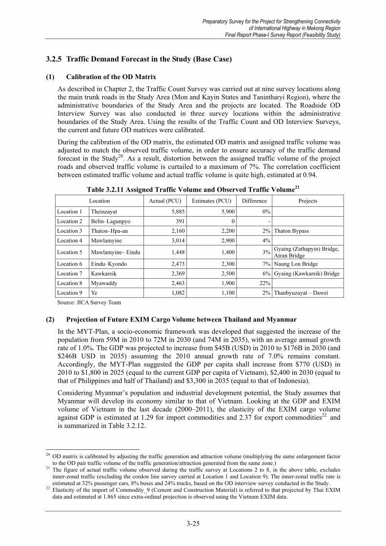
Preparatory Survey for the Project for Strengthening Connectivity of International Highway in Mekong Region
Final Report Phase-I Survey Report (Feasibility Study)
3-25
3.2.5 Traffic Demand Forecast in the Study (Base Case)
(1) Calibration of the OD Matrix As described in Chapter 2, the Traffic Count Survey was carried out at nine survey locations along the main trunk roads in the Study Area (Mon and Kayin States and Tanintharyi Region), where the administrative boundaries of the Study Area and the projects are located. The Roadside OD Interview Survey was also conducted in three survey locations within the administrative boundaries of the Study Area. Using the results of the Traffic Count and OD Interview Surveys, the current and future OD matrices were calibrated.
During the calibration of the OD matrix, the estimated OD matrix and assigned traffic volume was adjusted to match the observed traffic volume, in order to ensure accuracy of the traffic demand forecast in the Study20. As a result, distortion between the assigned traffic volume of the project roads and observed traffic volume is curtailed to a maximum of 7%. The correlation coefficient between estimated traffic volume and actual traffic volume is quite high, estimated at 0.94.
Table 3.2.11 Assigned Traffic Volume and Observed Traffic Volume21 Location Actual (PCU) Estimates (PCU) Difference Projects
Location 1 Theinzayat 5,885 5,900 0%Location 2 Belin–Lagunpyo 391 0 -Location 3 Thaton–Hpa-an 2,160 2,200 2% Thaton Bypass Location 4 Mawlamyine 3,014 2,900 4%
Location 5 Mawlamyine– Eindu 1,448 1,400 3% Gyaing (Zathapyin) Bridge, Atran Bridge
Location 6 Eindu–Kyondo 2,473 2,300 7% Naung Lon Bridge Location 7 Kawkareik 2,369 2,500 6% Gyaing (Kawkareik) BridgeLocation 8 Myawaddy 2,463 1,900 22% Location 9 Ye 1,082 1,100 2% Thanbyuzayat – Dawei Source: JICA Survey Team
(2) Projection of Future EXIM Cargo Volume between Thailand and Myanmar In the MYT-Plan, a socio-economic framework was developed that suggested the increase of the population from 59M in 2010 to 72M in 2030 (and 74M in 2035), with an average annual growth rate of 1.0%. The GDP was projected to increase from $45B (USD) in 2010 to $176B in 2030 (and $246B USD in 2035) assuming the 2010 annual growth rate of 7.0% remains constant. Accordingly, the MYT-Plan suggested the GDP per capita shall increase from $770 (USD) in 2010 to $1,800 in 2025 (equal to the current GDP per capita of Vietnam), $2,400 in 2030 (equal to that of Philippines and half of Thailand) and $3,300 in 2035 (equal to that of Indonesia).
Considering Myanmar’s population and industrial development potential, the Study assumes that Myanmar will develop its economy similar to that of Vietnam. Looking at the GDP and EXIM volume of Vietnam in the last decade (2000–2011), the elasticity of the EXIM cargo volume against GDP is estimated at 1.29 for import commodities and 2.37 for export commodities22 and is summarized in Table 3.2.12.
20 OD matrix is calibrated by adjusting the traffic generation and attraction volume (multiplying the same enlargement factor
to the OD pair traffic volume of the traffic generation/attraction generated from the same zone.) 21 The figure of actual traffic volume observed during the traffic survey at Locations 2 to 8, in the above table, excludes
inner-zonal traffic (excluding the cordon line survey carried at Location 1 and Location 9). The inner-zonal traffic rate is estimated at 32% passenger cars, 8% buses and 24% trucks, based on the OD interview survey conducted in the Study.
22 Elasticity of the import of Commodity_9 (Cement and Construction Material) is referred to that projected by Thai EXIM data and estimated at 1.865 since extra-ordinal projection is observed using the Vietnam EXIM data.
Preparatory Survey for the Project for Strengthening Connectivity of International Highway in Mekong Region
Final Report Phase-I Survey Report (Feasibility Study)

Preparatory Survey for the Project for Strengthening Connectivity of International Highway in Mekong Region Final Report Phase-I Survey Report (Feasibility Study)
3-26
Table 3.2.12 Elasticity of the Commodity-wise EXIM Cargo Volume against GDP
Import Export1_Live Animal & Animal Products 2.92 -0.562_Fish and Aquatic Products 1.36 -0.943_Vegetable and Fruits 2.62 0.084_Grain and Grain Products 1.48 1.805_Other Agricultural Products (ex. Plantation Product) 2.52 1.576_Foodstuff, Beverage and Animal Food 2.52 1.307_Petroleum, Oil and Gas 0.17 3.778_Coal, Ore, Stone and Sand 2.18 3.409_Cement, Construction Material (incl. steel‐frame) 1.87 2.1510_Fertilizer (incl. Urea) 0.10 2.5111_Garment, Textiles and fabric 1.25 1.2212_Wood and Wood Products 4.12 1.8313_Paper and Printed Matter 1.46 1.9214_Metal and Metal Products (excl. construction material) 1.80 3.0415_Industrial Material, Chemicals 1.49 1.7716_Household articles, miscellaneous 1.34 0.4417_Machinery and Parts, Transportation 0.67 1.50
Total 1.29 2.37Source: JICA Study Team
CommodityEXIM ton ‐GDP elasticity
(Constant Price 2005)
Assuming Myanmar’s GDP growth to be 7% p.a. until 2035 (the same growth rate applied to the MYT-Plan) and using the elasticity GDP estimated above, the commodity-wise import volume from Thailand to Myanmar is estimated to reach 28 million tons with an increase to 9% p.a. (GDP growth rate of 7.0% * 1.29), and the export volume from Myanmar to Thailand is estimated to reach 17 million tons with an increase to 17% p.a. (7% * 2.37) by 2035.
Table 3.2.13 Current and Future EXIM Cargo Volume between Thailand and Myanmar23
2011 Import 2030 Import 2035 Import Growth Rate 2011 Export 2030 Export 2035 Export Growth Rate1_Live Animal & Animal Products 15 250 496 16% 5 2 2 -5%2_Fish and Aquatic Products 1 2 3 5% 102 28 16 -7%3_Vegetable and Fruits 12 140 253 14% 25 28 23 0%4_Grain and Grain Products 6 18 23 6% 0 0 0 12%5_Other Agricultural Products (ex. Plantation Product) 1 16 27 13% 9 68 93 10%6_Foodstuff, Beverage and Animal Food 395 4,280 7,544 13% 4 18 23 8%7_Petroleum, Oil and Gas 388 240 199 -3% - - - -8_Coal, Ore, Stone and Sand 72 526 837 11% 107 6,074 14,443 23%9_Cement, Construction Material (incl. steel‐frame) 2,122 10,814 15,626 9% 0 0 0 14%10_Fertilizer (incl. Urea) 36 20 16 -3% 1 14 26 17%11_Garment, Textiles and fabric 36 86 103 5% 0 1 1 8%12_Wood and Wood Products 6 377 1,047 24% 179 1,751 2,617 12%13_Paper and Printed Matter 17 54 68 6% 3 30 46 12%14_Metal and Metal Products (excl. construction material) 118 556 787 8% 3 131 283 20%15_Industrial Material, Chemicals 206 674 867 6% 0 3 5 11%16_Household articles, miscellaneous 30 83 101 5% 1 1 1 2%17_Machinery and Parts, Transportation 52 62 61 1% 0 1 1 10%
Total 3,511 18,198 28,060 9% 439 8,151 17,581 17%Source: JICA Study Team
Commodity Myanmar-Thailand (Unit: '000 ton)
23 The export of Commodity_7 (Petroleum, Oil and Gas) is excluded from the analysis since the export of thenatural gas
from Myanmar to Thailand uses a pipeline as a transport mode and which will not change the transport mode in future.
Preparatory Survey for the Project for Strengthening Connectivity of International Highway in Mekong Region Final Report Phase-I Survey Report (Feasibility Study)
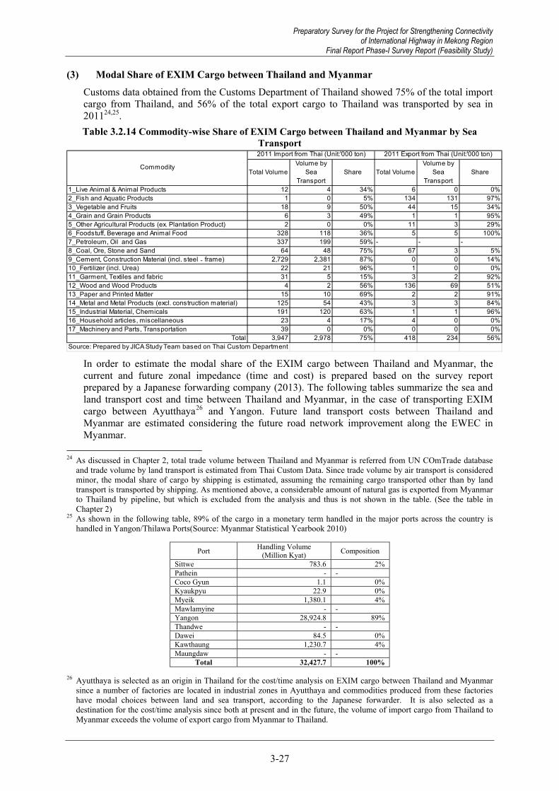
Preparatory Survey for the Project for Strengthening Connectivity of International Highway in Mekong Region
Final Report Phase-I Survey Report (Feasibility Study)
3-27
(3) Modal Share of EXIM Cargo between Thailand and Myanmar Customs data obtained from the Customs Department of Thailand showed 75% of the total import cargo from Thailand, and 56% of the total export cargo to Thailand was transported by sea in 201124,25. Table 3.2.14 Commodity-wise Share of EXIM Cargo between Thailand and Myanmar by Sea
Transport
Total VolumeVolume by
SeaTransport
Share Total VolumeVolume by
SeaTransport
Share
1_Live Animal & Animal Products 12 4 34% 6 0 0%2_Fish and Aquatic Products 1 0 5% 134 131 97%3_Vegetable and Fruits 18 9 50% 44 15 34%4_Grain and Grain Products 6 3 49% 1 1 95%5_Other Agricultural Products (ex. Plantation Product) 2 0 0% 11 3 29%6_Foodstuff, Beverage and Animal Food 328 118 36% 5 5 100%7_Petroleum, Oil and Gas 337 199 59% - - -8_Coal, Ore, Stone and Sand 64 48 75% 67 3 5%9_Cement, Construction Material (incl. steel‐frame) 2,729 2,381 87% 0 0 14%10_Fertilizer (incl. Urea) 22 21 96% 1 0 0%11_Garment, Textiles and fabric 31 5 15% 3 2 92%12_Wood and Wood Products 4 2 56% 136 69 51%13_Paper and Printed Matter 15 10 69% 2 2 91%14_Metal and Metal Products (excl. construction material) 125 54 43% 3 3 84%15_Industrial Material, Chemicals 191 120 63% 1 1 96%16_Household articles, miscellaneous 23 4 17% 4 0 0%17_Machinery and Parts, Transportation 39 0 0% 0 0 0%
Total 3,947 2,978 75% 418 234 56%Source: Prepared by JICA Study Team based on Thai Custom Department
Commodity
2011 Import from Thai (Unit:'000 ton) 2011 Export from Thai (Unit:'000 ton)
In order to estimate the modal share of the EXIM cargo between Thailand and Myanmar, the current and future zonal impedance (time and cost) is prepared based on the survey report prepared by a Japanese forwarding company (2013). The following tables summarize the sea and land transport cost and time between Thailand and Myanmar, in the case of transporting EXIM cargo between Ayutthaya26 and Yangon. Future land transport costs between Thailand and Myanmar are estimated considering the future road network improvement along the EWEC in Myanmar.
24 As discussed in Chapter 2, total trade volume between Thailand and Myanmar is referred from UN COmTrade database
and trade volume by land transport is estimated from Thai Custom Data. Since trade volume by air transport is considered minor, the modal share of cargo by shipping is estimated, assuming the remaining cargo transported other than by land transport is transported by shipping. As mentioned above, a considerable amount of natural gas is exported from Myanmar to Thailand by pipeline, but which is excluded from the analysis and thus is not shown in the table. (See the table in Chapter 2)
25 As shown in the following table, 89% of the cargo in a monetary term handled in the major ports across the country is handled in Yangon/Thilawa Ports(Source: Myanmar Statistical Yearbook 2010)
Port Handling Volume (Million Kyat) Composition
Sittwe 783.6 2%Pathein - -Coco Gyun 1.1 0%Kyaukpyu 22.9 0%Myeik 1,380.1 4%Mawlamyine - -Yangon 28,924.8 89%Thandwe - -Dawei 84.5 0%Kawthaung 1,230.7 4%Maungdaw - -
Total 32,427.7 100% 26 Ayutthaya is selected as an origin in Thailand for the cost/time analysis on EXIM cargo between Thailand and Myanmar
since a number of factories are located in industrial zones in Ayutthaya and commodities produced from these factories have modal choices between land and sea transport, according to the Japanese forwarder. It is also selected as a destination for the cost/time analysis since both at present and in the future, the volume of import cargo from Thailand to Myanmar exceeds the volume of export cargo from Myanmar to Thailand.
Preparatory Survey for the Project for Strengthening Connectivity of International Highway in Mekong Region
Final Report Phase-I Survey Report (Feasibility Study)

Preparatory Survey for the Project for Strengthening Connectivity of International Highway in Mekong Region Final Report Phase-I Survey Report (Feasibility Study)
3-28
Table 3.2.15 Transport Cost between Thailand and Myanmar by Sea and Land Transport27 (in case of transporting cargo from Ayutthaya to Yangon)
Current Future1. Transport Charge 400 2,000 2,0002. Customs Clearance 160 400 4003. Import License 200 300 3004. Documentation 2505. Transshipment 0 300 1506. Port Charge 60 - -7. Others 30 300 300
Total 1,100 3,300 3,150
Cost Item Sea Transport(USD)
Land Transport (USD)
Source: JICA Survey Team, based on the survey report provided by Japanese forwarding company
Table 3.2.16 Transport Time between Thailand and Myanmar by Sea and Land Transport28
(in case of transporting cargo from Ayutthaya to Yangon) Current Future Difference Note
Sea Transport 360.0 From Ayutthaya to Mae Sot 10.5 10.5 0.0 No changeDredge (From Ayutthaya to
Lenchabang)12.0 From Myawaddy to Yangon 16.1 11.0 5.1 Travel speed of 60 km/h due to
improvement of East West Corridor
Delivery (Yangon) 48.0 Waiting and TransshipmentTime 47.8 17.8 30.0
Reduction in Transshipment (2hours), One-way Operation (12hours), Waiting time (16 hours)
Export Clearance (Thailand) 24.0 Export Clearance (Thailand) 0.5 0.5 0.0 No changeImport Clearance (Myanmar) 72.0 Import Clearance (Myanmar) 5.4 5.4 0.0 No change
Total 516.0 Total 80.3 45.1 35.1
2. Customs Clearance 2. Customs Clearance
Sea Transport (Hour) Land Transport (Hour)
1. Transport 1. Transport
Source: JICA Survey Team, based on the survey report provided by a Japanese forwarding company
The modal split model of the EXIM cargo between sea and land transport was developed assuming that most EXIM cargo is transported between the industrial zones in Ayutthaya and Yangon. Figure 3.2.14 shows the difference of the generalized cost (time and cost) between sea and land transport, and the share of the sea transport by commodity.
0%
20%
40%
60%
80%
100%
0.0 20.0 40.0 60.0 80.0 100.0
Mod
al S
hare
of S
ea T
rans
port
Total Land Cost - Total Sea Cost (USD/ton)
Source: JICA Survey Team
Figure 3.2.14 Difference of Generalized Cost and Share of Sea Transport between Thailand and Myanmar
27 Current figure shown in the table indicates 2014 and the future figure is in 2035. 28 Current figure shown in the table indicates 2014 and the future figure is in 2035.
Preparatory Survey for the Project for Strengthening Connectivity of International Highway in Mekong Region Final Report Phase-I Survey Report (Feasibility Study)

Preparatory Survey for the Project for Strengthening Connectivity of International Highway in Mekong Region
Final Report Phase-I Survey Report (Feasibility Study)
3-29
The generalized cost of both sea and land transport is calculated by multiplying the time value of the cargo and travel time, and then adding the transport cost. The time value of the cargo is estimated by multiplying the cargo value and interest rate (i.e., cargo value*10% (borrowing interest rate at commercial banks in Myanmar)/365 days/24 hours).
Table 3.2.17 Commodity-wise Time Value of EXIM Cargo between
Thailand and Myanmar
Commodity Value(USD/Ton)
Time Value(USD/Hour/T
on)1_Live Animal & Animal Products 2,569 0.032_Fish and Aquatic Products 1,939 0.023_Vegetable and Fruits 727 0.014_Grain and Grain Products 1,315 0.025_Other Agricultural Products (ex. Plantation Product) 6,495 0.076_Foodstuff, Beverage and Animal Food 1,627 0.027_Petroleum, Oil and Gas 1,051 0.018_Coal, Ore, Stone and Sand 250 0.009_Cement, Construction Material (incl. steel‐frame) 77 0.0010_Fertilizer (incl. Urea) 467 0.0111_Garment, Textiles and fabric 6,189 0.0712_Wood and Wood Products 608 0.0113_Paper and Printed Matter 1,253 0.0114_Metal and Metal Products (excl. construction material) 1,361 0.0215_Industrial Material, Chemicals 1,710 0.0216_Household articles, miscellaneous 6,293 0.0717_Machinery and Parts, Transportation 11,117 0.13Source: Prepared by JICA Study Team based on Thai Custom Department
As seen in the above figure, a modal share of sea transport and cost difference between land and sea transport can be explained by applying an exponential function and therefore the following formula (log-function) is adopted to estimate the modal share between sea and land transport.
bCCTTLogaPLog sealandsealandsea ))()(()(
where Psea is the share of Sea Transport)
α is the Time Value per ton
Tland & Tsea are the Transport Times by Land & Sea
Cland & Csea are the Transport Costs by Land/Sea
a/b are additional parameters
Table 3.2.18 shows the result of regression analysis of the above formula and parameters estimated through the analysis. Both regression and t-value29 of the parameters suggest the modal split model of sea and land transport between Thailand and Myanmar can be judged adequate.
Table 3.2.18 Result of Regression Analysis and Parameters Estimated
R2 0.83 a 4.09(t=5.78) b -18.5 (t=-6.21)
Source: JICA Survey Team
29 When the t-value exceeds 1.96, the parameter is considered valid with 95% of accuracy.
Preparatory Survey for the Project for Strengthening Connectivity of International Highway in Mekong Region
Final Report Phase-I Survey Report (Feasibility Study)

Preparatory Survey for the Project for Strengthening Connectivity of International Highway in Mekong Region Final Report Phase-I Survey Report (Feasibility Study)
3-30
The following table and figure compares the actual modal share and projected modal share of the sea transport between Thailand and Myanmar by commodity.
Table 3.2.19 Commodity-wise Comparison of Actual Modal Share and Projected Modal
Share of Sea Transport between Thailand and Myanmar
CommodityActual ModalShare of Sea
Transport
EstimatedModal Share
of SeaTransport
1_Live Animal & Animal Products 34% 31%2_Fish and Aquatic Products 5% 37%3_Vegetable and Fruits 50% 52%4_Grain and Grain Products 49% 44%5_Other Agricultural Products (ex. Plantation Product) 0% 8%6_Foodstuff, Beverage and Animal Food 36% 41%7_Petroleum, Oil and Gas 59% 47%8_Coal, Ore, Stone and Sand 75% 59%9_Cement, Construction Material (incl. steel‐frame) 87% 61%10_Fertilizer (incl. Urea) 96% 55%11_Garment, Textiles and fabric 15% 9%12_Wood and Wood Products 56% 53%13_Paper and Printed Matter 69% 45%14_Metal and Metal Products (excl. construction material) 43% 44%15_Industrial Material, Chemicals 63% 40%16_Household articles, miscellaneous 17% 9%17_Machinery and Parts, Transportation 0% 1%Source: JICA Study Team
Source: JICA Survey Team
Figure 3.2.15 Commodity-wise Comparison of Actual Modal Share and Projected Modal Share of Sea Transport between Thailand and Myanmar
As shown in Table 3.2.19, both road network improvement of the EWEC, and transport and trade facilitation between Thailand and Myanmar (Ayutthaya and Yangon) are expected to reduce transport cost (a reduction of 150 USD between Ayutthaya and Yangon) and transport time (a reduction of 35 hours). Assuming that sea transport service will remain the same, a maximum of 15% of the EXIM cargo volume is estimated to be diverted from sea-based transport to land-based transport due to the improvement of the road transport network and services.
Preparatory Survey for the Project for Strengthening Connectivity of International Highway in Mekong Region Final Report Phase-I Survey Report (Feasibility Study)

Preparatory Survey for the Project for Strengthening Connectivity of International Highway in Mekong Region
Final Report Phase-I Survey Report (Feasibility Study)
3-31
Table 3.2.20 Modal Share changed from Sea Transport to Land Transport by Road Network Improvement and Transport Facilitation between Thailand and Myanmar30
Time Land -Time Sea(USD/ton)
Cost Land -Time Sea(USD/ton)
Total CostLand - Total
Cost Sea(USD/ton)
EstimatedModal Share
of SeaTransport
Time Land -Time Sea(USD/ton)
Cost Land -Time Sea(USD/ton)
Total CostLand - Total
Cost Sea(USD/ton)
EstimatedModal Share
of SeaTransport
1_Live Animal & Animal Products -12.8 81.5 68.7 31% -13.8 75.9 62.1 21% 10%2_Fish and Aquatic Products -9.6 81.5 71.8 37% -10.4 75.9 65.5 25% 12%3_Vegetable and Fruits -3.6 81.5 77.9 52% -3.9 75.9 72.0 38% 14%4_Grain and Grain Products -6.5 81.5 74.9 44% -7.1 75.9 68.9 31% 13%5_Other Agricultural Products (ex. Plantation Product) -32.3 81.5 49.2 8% -34.9 75.9 41.0 4% 4%6_Foodstuff, Beverage and Animal Food -8.1 81.5 73.4 41% -8.7 75.9 67.2 28% 12%7_Petroleum, Oil and Gas -5.2 81.5 76.3 47% -5.7 75.9 70.3 34% 13%8_Coal, Ore, Stone and Sand -1.2 81.5 80.2 59% -1.3 75.9 74.6 43% 15%9_Cement, Construction Material (incl. steel‐frame) -0.4 81.5 81.1 61% -0.4 75.9 75.5 46% 15%10_Fertilizer (incl. Urea) -2.3 81.5 79.2 55% -2.5 75.9 73.4 41% 15%11_Garment, Textiles and fabric -30.8 81.5 50.7 9% -33.3 75.9 42.7 4% 5%12_Wood and Wood Products -3.0 81.5 78.5 53% -3.3 75.9 72.7 39% 14%13_Paper and Printed Matter -6.2 81.5 75.2 45% -6.7 75.9 69.2 32% 13%14_Metal and Metal Products (excl. construction material) -6.8 81.5 74.7 44% -7.3 75.9 68.6 31% 13%15_Industrial Material, Chemicals -8.5 81.5 73.0 40% -9.2 75.9 66.7 28% 12%16_Household articles, miscellaneous -31.3 81.5 50.2 9% -33.8 75.9 42.1 4% 4%17_Machinery and Parts, Transportation -55.3 81.5 26.2 1% -59.8 75.9 16.2 0% 1%
ModalShare
changed toLand
Transport
Commodity
Present Future
Source: JICA Survey Team
As a result, 3.8 million tons (1,660 trucks per day31) in 2030, and 6.6 million tons (2,880 trucks per day) in 2035 are estimated to shift from sea to land transport due to the improvement of the road transport network and service between Thailand and Myanmar.
Table 3.2.21 Commodity-wise Future EXIM Cargo Volume shifted from Sea Transport to
Land Transport between Thailand and Myanmar
2030 EXIMVolume with
Thai('000ton)
2030 TradeVolume
shifted fromSea to Land
Trasnport('000ton)
2035 EXIMVolume with
Thai('000ton)
2035 TradeVolume
shifted fromSea to Land
Trasnport('000ton)
1_Live Animal & Animal Products 252 26 497 522_Fish and Aquatic Products 30 3 19 23_Vegetable and Fruits 167 24 276 394_Grain and Grain Products 18 2 23 35_Other Agricultural Products (ex. Plantation Product) 83 3 121 56_Foodstuff, Beverage and Animal Food 4,298 530 7,567 9337_Petroleum, Oil and Gas 240 32 199 278_Coal, Ore, Stone and Sand 6,601 999 15,281 2,3139_Cement, Construction Material (incl. steel‐frame) 10,814 1,675 15,626 2,42010_Fertilizer (incl. Urea) 34 5 42 611_Garment, Textiles and fabric 87 4 104 512_Wood and Wood Products 2,127 306 3,664 52813_Paper and Printed Matter 84 11 114 1514_Metal and Metal Products (excl. construction material) 688 88 1,070 13815_Industrial Material, Chemicals 677 82 872 10616_Household articles, miscellaneous 84 4 103 517_Machinery and Parts, Transportation 63 0 62 0
Total 26,349 3,797 45,641 6,596 Source: JICA Survey Team
(4) Traffic Assignment and Projection of Traffic Volume The OD matrix is revised by adding the additional vehicular traffic diverted from sea transport to land transport (1,660 trucks per day in 2030 and 2,880 trucks per day in 2035). The revised OD matrix is assigned to the future network32.
30 Current figure shown in the table indicates 2014 and the future figure is in 2035. 31 Based on the result of OD Interview Survey, the average loading volume of the truck is 8.8 tons. Operation of the trucking
service is assumed at 260 days per year. Thus, 3.8 million tons (diverted from sea to land transport in 2030)/8.8 tons/truck /260 working days = 1,660 trucks/day.
32 The road section under the BOT (between Payagyi and Mawlamyine) is assumed to be widened to 4 lanes and East-West Economic Corridor, Three Pagoda Pass and the road section between Mawlamyine and Dawei are to be improved to 2 lane roads.
Preparatory Survey for the Project for Strengthening Connectivity of International Highway in Mekong Region
Final Report Phase-I Survey Report (Feasibility Study)
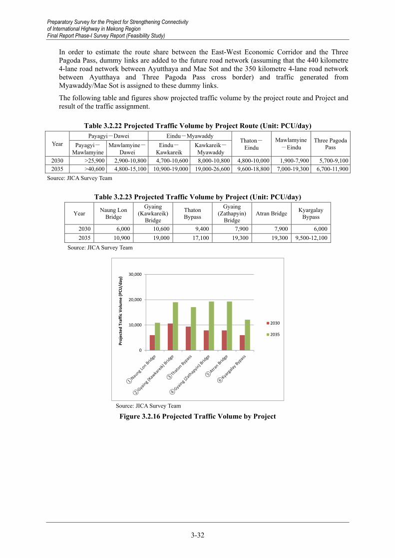
Preparatory Survey for the Project for Strengthening Connectivity of International Highway in Mekong Region Final Report Phase-I Survey Report (Feasibility Study)
3-32
In order to estimate the route share between the East-West Economic Corridor and the Three Pagoda Pass, dummy links are added to the future road network (assuming that the 440 kilometre 4-lane road network between Ayutthaya and Mae Sot and the 350 kilometre 4-lane road network between Ayutthaya and Three Pagoda Pass cross border) and traffic generated from Myawaddy/Mae Sot is assigned to these dummy links.
The following table and figures show projected traffic volume by the project route and Project and result of the traffic assignment.
Table 3.2.22 Projected Traffic Volume by Project Route (Unit: PCU/day)
Year Payagyi-Dawei Eindu-Myawaddy
Thaton-Eindu
Mawlamyine-Eindu
Three PagodaPass Payagyi-
Mawlamyine Mawlamyine-
Dawei Eindu-
Kawkareik Kawkareik-Myawaddy
2030 >25,900 2,900-10,800 4,700-10,600 8,000-10,800 4,800-10,000 1,900-7,900 5,700-9,1002035 >40,600 4,800-15,100 10,900-19,000 19,000-26,600 9,600-18,800 7,000-19,300 6,700-11,900
Source: JICA Survey Team
Table 3.2.23 Projected Traffic Volume by Project (Unit: PCU/day)
Year Naung Lon Bridge
Gyaing (Kawkareik)
Bridge
Thaton Bypass
Gyaing (Zathapyin)
Bridge Atran Bridge Kyargalay
Bypass
2030 6,000 10,600 9,400 7,900 7,900 6,0002035 10,900 19,000 17,100 19,300 19,300 9,500-12,100
Source: JICA Survey Team
0
10,000
20,000
30,000
Proj
ecte
d Tr
affic
Vol
ume
(PCU
/day
)
2030
2035
Source: JICA Survey Team
Figure 3.2.16 Projected Traffic Volume by Project
Preparatory Survey for the Project for Strengthening Connectivity of International Highway in Mekong Region Final Report Phase-I Survey Report (Feasibility Study)

Preparatory Survey for the Project for Strengthening Connectivity of International Highway in Mekong Region
Final Report Phase-I Survey Report (Feasibility Study)
3-33
Source: JICA Survey Team Note: The number in a circle in the figure shows the project number in the above table.
Figure 3.2.17 Result of Traffic Assignment (2030, Unit: 100 PCU)
Source: JICA Survey Team Note: The number in a circle in the figure shows the project number in the above table.
Figure 3.2.18 Result of Traffic Assignment (2035, Unit: 100 PCU)
To Payagyi
Myawaddy
Eindu Thaton
Mawlamyine
ToDawei
Kawkareik
Three Pagoda Pass
1
2
3
4 5 6
To Payagyi
Myawaddy
Eindu Thaton
Mawlamyine
ToDawei
Kawkareik
Three Pagoda Pass
1
2
3
4 5 6
Preparatory Survey for the Project for Strengthening Connectivity of International Highway in Mekong Region
Final Report Phase-I Survey Report (Feasibility Study)

Preparatory Survey for the Project for Strengthening Connectivity of International Highway in Mekong Region Final Report Phase-I Survey Report (Feasibility Study)
3-34
3.2.6 Traffic Demand Forecast in the Study (EWEC Improvement Case) During the Fact Finding Mission held in December, 2014, MOC requested the JICA Survey Team to examine the feasibility of widening Gyaing (Kawkareik) Bridge from 2-lanes to 4-lanes, considering the rapid increase of traffic demand along the EWEC, and the future road widening project on the East-West Economic Corridor (EWEC) as a pipeline project of MOC. Accordingly, the following discussion analyses the future traffic demand on the EWEC, particularly that at Gyaing (Kawkareik) Bridge, assuming several different EWEC improvement scenarios.
(1) Pre-condition and Case Study of the Traffic Demand Forecast The target year of the traffic demand forecast is set in Year 2035 and 2040, considering the improvement scenarios of the EWEC. The same 2035 vehicular OD matrix is utilized, prepared for the Base Case scenario discussed in the above section. The 2040 vehicular OD matrix is newly developed to examine this EWEC Improvement Case, applying the same growth rate of traffic between Year 2030 and Year 2035. Also, the future EXIM cargo between Thailand and Myanmar, and the diversion traffic from sea to land transport between Thailand and Myanmar are separately estimated. As a result of the analysis, the EXIM cargo of 11.8 million tons between Thailand and Myanmar, equivalent to 5,145 trucks per day, is estimated to shift from sea to land transport in 204033. (See the spreadsheets in Annex)
As suggested by MOC (and also supported by the traffic demand forecast), there is a rapid increase of the traffic demand observed on the EWEC. Particularly, the traffic demand on the road section between Myawaddy and Kawkareik, the eastern part of the EWEC (Myawaddy–Thaton Section), is projected to increase at a relatively higher growth rate than other sections. Accordingly, the following improvement scenario for the EWEC is assumed:
Partial improvement scenario of the EWEC
The road section between Myawaddy and the intersection of Kyargalay Bypass is widened to a dual carriage way (four lanes in total) in 2035. Note that the ongoing bypass construction at Myawaddy by the Thai Government is assumed to finish on schedule, and the road section between Myawaddy and Kawkareik is assumed to accommodate four lanes in total using the existing carriageway and the bypass.
(2) Summary Result of the Traffic Demand Forecast under EWEC Improvement Case The following table and figures show projected traffic volume by project route and results of the traffic assignment under EWEC Improvement Case. Table 3.2.24 Projected Traffic Volume by Project Route under EWEC Improvement Case
(Unit: PCU/day)
Year Payagyi-Dawei Eindu-Myawaddy
Thaton -Eindu Mawlamyine -Eindu
Three PagodaPass Payagyi-
Mawlamyine Mawlamyine -Dawei
Eindu- Kawkareik
Kawkareik -Myawaddy
2035 >37,400 5,900-11,500 9,900-27,800 23,700-28,400 10,000-22,100 6,000-20,200 6,700-10,100 2040 >66,000 7,700-29,000 13,900-42,600 38,500-46,100 11,700-50,200 11,700-33,100 13,100-27,400Source: JICA Survey Team
Table 3.2.25 Projected Traffic Volume by Project under EWEC Improvement Case (Unit: PCU/day)
Year Naung Lon Bridge
Gyaing (Kawkareik) Bridge Thaton Bypass Gyaing (Zathapyin)
Bridge Atran Bridge Kyargalay Bypass
2035 10,000 27,800 19,500 19,000 20,200 17,8002040 11,800 42,600 46,500 30,800 33,100 23,300Source: JICA Survey Team
33 The spreadsheet to estimate a total volume of EXIM cargo between Thailand and Myanmar and the volume of cargo
shifted from sea to land transport is available in the Annex. As a result of analysis, 11.8 million tons (diverted from sea to land transport in 2030)/8.8 tons/truck /260 working days = 5,145trucks/day are estimated to shift to land transport between Thailand and Myanmar.
Preparatory Survey for the Project for Strengthening Connectivity of International Highway in Mekong Region Final Report Phase-I Survey Report (Feasibility Study)

Preparatory Survey for the Project for Strengthening Connectivity of International Highway in Mekong Region
Final Report Phase-I Survey Report (Feasibility Study)
3-35
0
10,000
20,000
30,000
40,000
50,000
Proj
ecte
d Tr
affic
Vol
ume
(PCU
/day
)2035
2040
Source: JICA Survey Team
Figure 3.2.19 Projected Traffic Volume by Project under EWEC Improvement Case
Source: JICA Survey Team Note: The number in a circle in the figure shows the project number in the above table.
Figure 3.2.20 Result of Traffic Assignment under EWEC Improvement Case (2035, Unit: 100 PCU)
To Payagyi
Myawaddy
Eindu Thaton
Mawlamyine
ToDawei
Kawkareik
Three Pagoda Pass
1
2
3
4 5
6
Preparatory Survey for the Project for Strengthening Connectivity of International Highway in Mekong Region
Final Report Phase-I Survey Report (Feasibility Study)

Preparatory Survey for the Project for Strengthening Connectivity of International Highway in Mekong Region Final Report Phase-I Survey Report (Feasibility Study)
3-36
Source: JICA Survey Team Note: The number in a circle in the figure shows the project number in the above table.
Figure 3.2.21 Result of Traffic Assignment under EWEC Improvement Case (2040, Unit: 100 PCU)
3.3 Implications for EWEC Improvement
As per the following clarification, it was confirmed that the road section between Myawaddy and Kawkareik (diversion point of Kyagalay bypass) in the EWEC should be upgraded to four lanes by the Myanmar side by 2035.
1. In accordance with ASEAN Connectivity Master Plan in 2010 (See the details in Chapter 2), the ASEAN member countries, including GOM, agreed that all designated national routes should be upgraded to Class I or Primary Roads by the target year of 2020 (projected to be when significant traffic volume shall be observed).
2. MYT-Plan, which was developed with assistance from JICA and will be soon endorsed and authorized by Cabinet Approval, defines the upgrade and/or widening of EWEC as part of the pipeline projects by 2030.
3. The traffic demand forecast, conducted by the JICA Survey Team, finds the traffic demand along part of EWEC exceeds the traffic capacity of two lanes by 2035.
4. Along the EWEC in JICA’s Study Area, the increase of traffic demand along the section between Myawaddy and Kawkareik (diversion point of Kyagalay bypass) in particular is remarkable and is expected to exceed the 2-lane traffic capacity (30,000 PCU per day) and thereby the said section, given the first priority along the EWEC, should be widened by 2035, following the JICA traffic demand forecast.
To Payagyi
Myawaddy
Eindu Thaton
Mawlamyine
ToDawei
Kawkareik
Three Pagoda Pass
1
2
3
4 5
6
Preparatory Survey for the Project for Strengthening Connectivity of International Highway in Mekong Region Final Report Phase-I Survey Report (Feasibility Study)

Preparatory Survey for the Project for Strengthening Connectivity of International Highway in Mekong Region
Final Report Phase-I Survey Report (Feasibility Study)
3-37
20,000
25,000
30,000
35,000
40,000
45,000
2035 2036 2037 2038 2039 2040
Proj
ecte
d Tr
affic
Vol
ume
(PCU
/day
)
Year
2-Lane Road Capacity 30,000 PCU/day
Source: JICA Survey Team
Figure 3.3.1 Trend of Projected Traffic Volume at Gyaing (Kawkareik) Bridge
5. As mentioned above, it is recommended that Gyaing Kawkareik Bridge be widened to be four lanes by 2035. As shown in Table 3.3.1, widening of the bridge to four lanes is more reasonable economically than the construction of an additional 2-lane bridge by 2035, considering price escalation in the future.
Table 3.3.1 Comparison of investment for Gyaing Kawkareik Bridge
Alternative 1 Widening of Existing Bridge to 4 lanes
Alternative 2 Additional 2 lane Bridge Construction
Initial Cost 74 million USD 41.7 million USDCost for additional 2 lane bridge - 54.2 million USD*2
Operation and Maintenance Cost*1 0.83 million USD - Total 74.83 million USD 1.00) 95.9 million USD (1.28)*1 Maintenance cost until 2035 after completion. *2 Considering price escalation Source: JICA Survey Team
Preparatory Survey for the Project for Strengthening Connectivity of International Highway in Mekong Region
Final Report Phase-I Survey Report (Feasibility Study)

Preparatory Survey for the Project for Strengthening Connectivity of International Highway in Mekong Region Final Report Phase-I Survey Report (Feasibility Study)
3-38
Annex:
Table A-1 Current and Future EXIM Cargo Volume between Thailand and Myanmar
2011 Import 2035 Import 2040 Import Growth Rate 2011 Export 2035 Export 2040 Export Growth Rate1_Live Animal & Animal Products 15 496 956 16% 5 2 1 -5%2_Fish and Aquatic Products 1 3 3 5% 102 16 9 -7%3_Vegetable and Fruits 12 253 447 14% 25 23 19 0%4_Grain and Grain Products 6 23 29 6% 0 0 0 12%5_Other Agricultural Products (ex. Plantation Product) 1 27 47 13% 9 93 124 10%6_Foodstuff, Beverage and Animal Food 395 7,544 12,946 13% 4 23 28 8%7_Petroleum, Oil and Gas 388 199 161 -3% - - - -8_Coal, Ore, Stone and Sand 72 837 1,297 11% 107 14,443 33,239 23%9_Cement, Construction Material (incl. steel‐frame) 2,122 15,626 21,981 9% 0 0 0 14%10_Fertilizer (incl. Urea) 36 16 13 -3% 1 26 46 17%11_Garment, Textiles and fabric 36 103 119 5% 0 1 2 8%12_Wood and Wood Products 6 1,047 2,831 24% 179 2,617 3,787 12%13_Paper and Printed Matter 17 68 85 6% 3 46 68 12%14_Metal and Metal Products (excl. construction material) 118 787 1,085 8% 3 283 588 20%15_Industrial Material, Chemicals 206 867 1,086 6% 0 5 7 11%16_Household articles, miscellaneous 30 101 121 5% 1 1 1 2%17_Machinery and Parts, Transportation 52 61 58 1% 0 1 2 10%
Total 3,511 28,060 43,266 9% 439 17,581 37,922 17%
Commodity Myanmar-Thailand (Unit: '000 ton)
Source: JICA Survey Team
Table A-2 Modal Share changed from Sea Transport to Land Transport by Road Network
Improvement and Transport Facilitation between Thailand and Myanmar
Time Land -Time Sea(USD/ton)
Cost Land -Time Sea(USD/ton)
Total CostLand - Total
Cost Sea(USD/ton)
EstimatedModal Share
of SeaTransport
Time Land -Time Sea(USD/ton)
Cost Land -Time Sea(USD/ton)
Total CostLand - Total
Cost Sea(USD/ton)
EstimatedModal Share
of SeaTransport
1_Live Animal & Animal Products -12.8 81.5 68.7 31% -13.8 75.9 62.1 21% 10%2_Fish and Aquatic Products -9.6 81.5 71.8 37% -10.4 75.9 65.5 25% 12%3_Vegetable and Fruits -3.6 81.5 77.9 52% -3.9 75.9 72.0 38% 14%4_Grain and Grain Products -6.5 81.5 74.9 44% -7.1 75.9 68.9 31% 13%5_Other Agricultural Products (ex. Plantation Product) -32.3 81.5 49.2 8% -34.9 75.9 41.0 4% 4%6_Foodstuff, Beverage and Animal Food -8.1 81.5 73.4 41% -8.7 75.9 67.2 28% 12%7_Petroleum, Oil and Gas -5.2 81.5 76.3 47% -5.7 75.9 70.3 34% 13%8_Coal, Ore, Stone and Sand -1.2 81.5 80.2 59% -1.3 75.9 74.6 43% 15%9_Cement, Construction Material (incl. steel‐frame) -0.4 81.5 81.1 61% -0.4 75.9 75.5 46% 15%10_Fertilizer (incl. Urea) -2.3 81.5 79.2 55% -2.5 75.9 73.4 41% 15%11_Garment, Textiles and fabric -30.8 81.5 50.7 9% -33.3 75.9 42.7 4% 5%12_Wood and Wood Products -3.0 81.5 78.5 53% -3.3 75.9 72.7 39% 14%13_Paper and Printed Matter -6.2 81.5 75.2 45% -6.7 75.9 69.2 32% 13%14_Metal and Metal Products (excl. construction material) -6.8 81.5 74.7 44% -7.3 75.9 68.6 31% 13%15_Industrial Material, Chemicals -8.5 81.5 73.0 40% -9.2 75.9 66.7 28% 12%16_Household articles, miscellaneous -31.3 81.5 50.2 9% -33.8 75.9 42.1 4% 4%17_Machinery and Parts, Transportation -55.3 81.5 26.2 1% -59.8 75.9 16.2 0% 1%
Commodity
Present Future ModalShare
changed toLand
Transport
Source: JICA Survey Team
Preparatory Survey for the Project for Strengthening Connectivity of International Highway in Mekong Region Final Report Phase-I Survey Report (Feasibility Study)

Preparatory Survey for the Project for Strengthening Connectivity of International Highway in Mekong Region
Final Report Phase-I Survey Report (Feasibility Study)
3-39
Table A-3 Commodity-wise Future EXIM Cargo Volume shifted from Sea Transport to Land Transport between Thailand and Myanmar
2035 EXIMVolume with
Thai('000ton)
2035 TradeVolume
shifted fromSea to Land
Trasnport('000ton)
2040 EXIMVolume with
Thai('000ton)
2040 TradeVolume
shifted fromSea to Land
Trasnport('000ton)
1_Live Animal & Animal Products 497 52 957 1002_Fish and Aquatic Products 19 2 12 13_Vegetable and Fruits 276 39 466 664_Grain and Grain Products 23 3 29 45_Other Agricultural Products (ex. Plantation Product) 121 5 172 76_Foodstuff, Beverage and Animal Food 7,567 933 12,975 1,6007_Petroleum, Oil and Gas 199 27 161 228_Coal, Ore, Stone and Sand 15,281 2,313 34,536 5,2279_Cement, Construction Material (incl. steel‐frame) 15,626 2,420 21,981 3,40510_Fertilizer (incl. Urea) 42 6 59 911_Garment, Textiles and fabric 104 5 120 512_Wood and Wood Products 3,664 528 6,619 95313_Paper and Printed Matter 114 15 153 2014_Metal and Metal Products (excl. construction material) 1,070 138 1,673 21515_Industrial Material, Chemicals 872 106 1,093 13316_Household articles, miscellaneous 103 5 122 517_Machinery and Parts, Transportation 62 0 60 0
Total 45,641 6,596 81,188 11,773 Source: JICA Survey Team
Preparatory Survey for the Project for Strengthening Connectivity of International Highway in Mekong Region
Final Report Phase-I Survey Report (Feasibility Study)

Preparatory Survey for the Project for Strengthening Connectivity of International Highway in Mekong Region
Final Report Phase-I Survey Report (Feasibility Study)
4-1
4.1 Selection of Priority Road Sections and Priority Projects
4.1.1 Selection of Prioritized Candidate Sub-projects
In this chapter, considering the traffic demand forecasts, the surrounding situation and subjects for the development of each priority route in the Study Area which are provided in Chapter 2 and 3, the prioritized sub-projects are to be selected refer to the following key subjects.
1) Retrieve and improvement of road networks by resolving bottlenecked sections
There are several bottlenecked sections lowering both accessibility and traffic safety due to the narrow width of the road and malfunctioned crossing structures on international corridors and arterial roads linking between the major towns. It is highly expected to retrieve and improve the function of the road network by resolving the bottlenecked section and that would activate the economic situation and bring benefits into the region.
2) Improvement of traffic safety and correspondence to the future’s traffic demand
There are several potential sections where traffic volume are assumed to increase rapidly if the relevant road projects were developed. These road sections are currently used by the roadside communities for their life access. The improvement of road capacity may cause an unfavourable situation increasing the risk of traffic accidents by mixing in more heavy vehicles. In the future, if the traffic were increased as estimated in Chapter 3, the situation would be worse so that needs certain countermeasures, such as the construction of bypasses and widening the road width to ensure traffic safety.
3) Improvement to all-weather access roads
The southeast region of Myanmar has an average annual rainfall more than 6,000 mm therefore several road sections need to be closed during the rainy season. The closure of a road gives a high negative impact to economic activities so that improvement to all-weather access roads is very significant, and especially requires the urgent improvement of the vital links of the road network.
a) Retrieve and improvement of function of road network a-1) Replacement of Bottlenecked Bridges (Four Bridges)
As described in Chapter 2.3.1 and 3.1, Mawlamyine, the capital city of Mon state, should be the centre of the southeastern region of Myanmar considering the economic scale and number of people. Thaton, Dawei and Hpa-an follow after Mawlamyine in importance. Accordingly, the links between these major towns are very important to in order to keep the sustainable development of the economy in the southeast region. The road links between the major towns would indicate the order of priority of the road network. Especially, AH1 starting from Myawaddy
CHAPTER 4 SELECTION OF PRIORITY PROJECTS
Preparatory Survey for the Project for Strengthening Connectivity of International Highway in Mekong Region
Final Report Phase-I Survey Report (Feasibility Study)

Preparatory Survey for the Project for Strengthening Connectivity of International Highway in Mekong Region Final Report Phase-I Survey Report (Feasibility Study)
4-2
(border town with Thailand) to Yangon thru Hpa-an and Thaton and/or ending at Mawlamyine called as “GMS East West Economic Corridor (EWEC)” is a vital link which many donors are involved in giving financial assistance. For instance, a new bypass linking Thin Gan Nyi Naung and Kawkareik will be opened in July 2015 by financial support from Thailand. Also, the section between Eindu and Kawkareik will be improved to Class-II (a complete two lane asphalt pavement road) of the ASEAN Highway standards so that can be increasingly expected to develop the area along these road sections.
As the results of the site survey, it was revealed that the five existing bridges are currently bottlenecks for the road section among the project road as given in Fig. 4.1.1. Gyaing/ Kawkareik Brdige, Gyaing/ Zathapyin Bridge and Atran Bridge are obstacles for heavy weight vehicles since the weight limitation of 20t to 24t is applied to the section due to the structural defects. Rehabilitation/ replacement of the three bridges were proposed as priority projects in the international donor meeting held in January 2013 by MOC as described in 2.2.1 (3). Heavy freight vehicles over 20t can be actually pass at the Naung Lon Bridge though the section has a weight limitation of 20t since the bridge is located on the AH1, the main route connecting Myawaddy to Hpa-an. It is considered that the replacement of Naung Lon Bridge is necessary in order to avoid one of the potential bottlenecks since significant structural damage has been observed.
Thaton Hpa-an
Mawlamyine
Eindu
Kawkareik
Myawaddy
1st Friendship Bridge(Under Repair)
Gyaing Kawkareik Br. (Vehicles over 24t need
to be diverted to the pontoon bridge)
Atran Br. ( Controlled by 20t)
Gyaing Zathapyin Br. (Controlled by 20t)
LOCATION MAP
Typical Thaton-Hpa-an Road Section
Thaton Juntion
Beginning of Dawna Range Bypass Section at Kawkareik
Naun Long Bridge
Dawna Range Road Section
Gyaing (Kawkareik) Bridge
Pontoon Bridge
Typical Hpa-an – Eindu Road Section
Typical Eindu-Kawkareik Road Section
Myawaddy Road Section
Construction of Dawna Range Bypass Section (On-going)
Gyaing (Zathapyin) Bridge Atran Bridge Typical Eindu-Mawlamine Road
Section
Proposed Thaton Bypass L = 29km
Kyargalay Bypass L = 25km
Donthami Br.
Naung Lon Br. (Deterioration)
Thanlwin(Mawlamyine)Br
Thanlwin(Hpa-an)Br.
Road improvement to be 2-lane asphalt paved road with a aid by ADB(Completed by March
Source: JICA Survey Team
Figure 4.1.1 Location of Bottlenecked Bridges a-2) Road Improvement of the new bypass through the Dawna Mountain Range The Dawna Mountain Range section (Kawkareik- Thin Gan Nyi Naung ) has been greatly improved by the construction of a new bypass with financial support from the Thai government, which was fully opened in August 2015. Although the bypass is a two-lane paved road, in which some parts do not satisfy the ASEAN Highway Standards since it passes through the steep mountainous area. It is thus a concern that heavy freight trucks may have difficulties in negotiating the road sections with steep gradients which can affect transport efficiency and safety measures such as slope protection and drainage which are insufficient even after the completion of the bypass. Therefore, further improvement should be considered in order to retain/restore the service level as an
Preparatory Survey for the Project for Strengthening Connectivity of International Highway in Mekong Region Final Report Phase-I Survey Report (Feasibility Study)

Preparatory Survey for the Project for Strengthening Connectivity of International Highway in Mekong Region
Final Report Phase-I Survey Report (Feasibility Study)
4-3
international connection through the improvement of the road profile by the construction of bridges or tunnels. The necessity for improvement of the section should be carefully studied considering actual issues after opening.
b) Road Upgrading Corresponding to Future Traffic Demand b-1) Widening to 4-Lane Road (Payagyi – Mawlamyine Section)
It is expected that the future traffic demand will be greatly increased and to reach to more than 40,000 PCU in the section through Myawaddy, Mawlamyine and Payagyi as estimated in Chapter 3. The future traffic is supposed to result in social problems such as heavier traffic congestion and a lower level in traffic safety. Accordingly, the upgrading to a 4-lane paved road should be required to retain the function of the road network and obviate the social problems.
b-2) New Bypass Construction In the sections where widening to a 4-lane road is necessary in accordance with future traffic demand, there are some city areas without a sufficient ROW for the widening. In city areas, the mixture of large-vehicle and regional traffic shows the (potential) critical problems in terms of traffic safety and there are in total five locations (Payagyi, Kyaito, Theinseik, Thaton and Yinnyein) in the Payagyi – Mawlamyine section as seen in Figure 4.1.2. Therefore, new bypass construction should be proposed in the city areas in order to enhance the traffic safety by the separation of regional traffic and through traffic. Especially, in Thaton which has the second highest population of 350,000 in southeast Myanmar and is the junction of AH1 and AH112, the critical traffic issues are supposed to be realized along with the growth in traffic demand. The new bypass in Thaton can be necessary in consideration of the fact that MOC has planned the bypass construction as described in 2.5.5 (2). In addition, a new Donthami bridge needs to be constructed on the new bypass.
Source: Prepared by JICA Survey Team based on Google maps
Figure 4.1.2 Location of Potential Bypass
Payagyi
Mawlamyine
Kyaito
Theinseik
Thaton
Yinnyein
Town/Village with adequate ROW
Town/Village without adequate ROW
Preparatory Survey for the Project for Strengthening Connectivity of International Highway in Mekong Region
Final Report Phase-I Survey Report (Feasibility Study)

Preparatory Survey for the Project for Strengthening Connectivity of International Highway in Mekong Region Final Report Phase-I Survey Report (Feasibility Study)
4-4
b-3) Improvement of Kyargalay Bypass As mentioned above, there are two potential priority routes in southeast Myanmar, one is a part of AH1 from Myawaddy, the hub for trade with Thailand, to Yangon passing through Hpa-an and Thaton, and the other is a part of the GMS East-West Economic Corridor between Myawaddy to Mawlamyine which is the largest city in southeast Myanmar.
It is considered that the upgrading of Kyargalay Bypass is one of the remaining potential projects for the latter corridor. The existing bypass is a 1.5-lane unpaved road and is not an all-weather road because of flooding in the rainy season. As compared with the existing route of Kyagale–Eindu–Zathapyin, this road can shorten the travel length by about 33km. Considering the drastic growth in future traffic demand along the route to Yangon or Mawlamyine from Myawaddy in accordance with the completion of road improvements by other foreign donors, it is expected that the upgrading can mitigate traffic congestion and enhance transport efficiency.
b-4) Road Improvement of the Southern Thanbuzayat The road improvement of the section between Maylamyine and Dawei has lagged behind even though the route has been designated as a part of the ASEAN Highway Network. The Mawlamyine to Thanbuzayat section has been developed as a “Class-III” road in accordance with the ASEAN Highway Standards under the BOT scheme. On the other hand, there are unpaved sections in southern Thanbuzayat and the road condition is, in particular, poor in the 10km section in the mountain area south of Ye.
The future traffic in the section of Thanbuzayat and Dawei is estimated to be more than 10,000 PCU from the traffic demand forecast in Chapter 3. It is assumed that future traffic demand may be greater than expected if development of the Dawei SEZ is accelerated which has a great impact on the regional economy in southeast Myanmar. In addition, the improvement of the section between Thanbuzayat and Dawei was also proposed in the international donor meeting held in January 2013 by MOC.
Considering current/future situation as mentioned above, the section of Thanbuzayat and Dawei needs to be upgraded as a 2-lane paved road. In particular, the section of southern Ye has a potential need for technical assistance by foreign donors since the construction of large-scaled bridges/tunnels is assumed, which can be advanced technology for Myanmar.
c) Upgrading of Three Pagoda Pass (All-weather Road) The Three Pagoda Pass is the shortest link connecting Yangon with Bangkok that will be developed focused mainly on the boost of tourism for both countries. The road section in Thailand has already been improved into a complete 4-lane asphalt-paved road, therefore it is urgently required to improve the section in Myanmar.
The current road on the Myanmar side is a 1.5-lane unpaved road that is difficult to pass through during the rainy season. MOC has commenced the improvement works for the road bed with minor road structures by employing private contractors and would have been completed by April 2015. However, the construction was called off and has not been realized as an all-weather road yet due to the lack of budget for the construction of bridges (more than 50m in length). Therefore, the government searches for foreign investment necessary for the completion of a pass which can contribute to the economic development in southeast Myanmar and the return of refugees.
Figure 4.1.3 provides the location map of potential priority projects in the Survey Area. In the next section, the selection of a priority sub-project among the priority road sections is provided.
Preparatory Survey for the Project for Strengthening Connectivity of International Highway in Mekong Region Final Report Phase-I Survey Report (Feasibility Study)

Preparatory Survey for the Project for Strengthening Connectivity of International Highway in Mekong Region
Final Report Phase-I Survey Report (Feasibility Study)
4-5
Payagyi
Thaton
Eindu
Kawkareik
Myawaddy
Mawlamyine
Thanbuzayat
Payathonzu
Dawei
1
2
34
5
Mon State Kayin State
Bago Region
Hpaa-an
Ye
Project Location Map
Tanintharyi Region GMS EWEC
Mae Sot
BOT
BOT
BOT
MOC(Road improvement aid by ADB will be completed until March 2019)
Under Construction by Thailand (Planned to be completed by July2015)
MOC
BOT
MOC MOC
MOC
BOT
Mandalay
Yangon
Naypyitaw
500,000~
300,000~500,000
200,000~300,000
~200,000
L=58km
<Legend : Urban Population>
Kanchanaburi
・Under Construction by MOC and Private Com.・F/S Planned by NEDA
Kyargalay
Bridge Location
Replacement of four bridges 2. Naung Lon Br.
3. Gyaing Kawkareik Br.
4. Gyaing Zathapyin Br.
5. Atran Br.
Source: JICA Survey Team
Figure 4.1.3 Location Map of Potential Candidate Sub-projects
Preparatory Survey for the Project for Strengthening Connectivity of International Highway in Mekong Region
Final Report Phase-I Survey Report (Feasibility Study)

Preparatory Survey for the Project for Strengthening Connectivity of International Highway in Mekong Region Final Report Phase-I Survey Report (Feasibility Study)
4-6
4.1.2 Selection Policy and Criteria Applied
(1) Selection Policy Priority sub-projects for preliminary design were selected in a series of discussions between MOC and the JICA Survey Team. The following two stage evaluation was applied for the sub-project selection:
First stage : Selection of priority road section
Second stage : Selection of priority sub-project
In the first stage, the selection of a priority road section was conducted by qualitative criteria based on the current condition of roads and structures, and interviews with concerned authorities. In the second stage, priority sub-projects were evaluated by additional criteria.
(2) Selection Criteria First stage Criteria
First stage selection criteria are as follows. “A” describes the highest priority. 1) Road Category (Importance)
A: The route is categorized as an international highway, contributing to linkage with neighbouring countries, in which large growth in traffic volume is envisaged in the future. In particular, the road is categorized as Asian Highway or ASEAN Highway, or is included in Myanmar Master Plans.
B: The route is categorized as a major arterial road in Myanmar contributing to the improvement of accessibility among major cities, industrial areas and special economic zones.
C: The road other than those above
2) Traffic Demand (Year 2035) A: Over 20,000PCU B: 10,000PCU to 20,000PCU C: less than 10,000PCU
3) Urgency
A: The route has an insufficient road width and/or weight limitation and suffers from traffic congestion, creating bottlenecks. The road cannot act as an international highway due to ageing and poor alignment.
B: The route has an insufficient road width and/or weight limitation and suffers from traffic congestion, creating bottlenecks. The road cannot act as an arterial road due to ageing and poor alignment.
C: The route is in good condition and has a sufficient road width
4) Contribution to Local Economy A: Contributes to economic growth in the southern region and/or poor areas B: Contributes to economic growth in other regions C: N / A
5) Ownership and Administration
A: MOC B: BOT (including MOC section) C: BOT (All sections)
Preparatory Survey for the Project for Strengthening Connectivity of International Highway in Mekong Region Final Report Phase-I Survey Report (Feasibility Study)

Preparatory Survey for the Project for Strengthening Connectivity of International Highway in Mekong Region
Final Report Phase-I Survey Report (Feasibility Study)
4-7
Second Stage Criteria Second stage selection criteria are as follows. “A” describes the highest priority.
6) Environmental and Social Considerations
A: Category B (Number of involuntary resettlements is less than 200 people) B: Category B (Number of involuntary resettlements is less than 200 people & Remarkable Concerns in environmental and social considerations) C: Category A
7) MOC Priority
A: Very high B: High C: Moderate
8) Possibility for Technical Transfer A: Very high B: Moderate C: Low
4.1.3 Selection of Priority Road Sections (First Stage)
Priority road sections were selected using the criteria mentioned in Article 3.5.2 during a meeting with MOC from 15 - 16 of May 2014. Results are shown in Table 4.1.1. Route 1-1 was not selected as it has been improved using international highway standards. There is no significant damage or faults in the route since the addition of BOT administration.
A comparison table is shown in Table 4.1.2.
Table 4.1.1 Results for Selection of Priority Road Sections (First Stage) Road Section Evaluation
Route 1 Route 1-1 Payagyi-Mawlamyine × Route 1-2 Mawlamyine-Dawei ○
Route 2 Route 2-1 Eindu-Kawkareik ○ Route 2-2 Kawkareik-Myawaddy ○
Route 3 Thaton –Eindu Road ○ Route 4 Mawlamyine –Eindu Road ○ Route 5 Thanbyuzayat – Hpayathonzu Road ○
Legend ○: Selected ×: Not selected Source: JICA Survey Team
Preparatory Survey for the Project for Strengthening Connectivity of International Highway in Mekong Region
Final Report Phase-I Survey Report (Feasibility Study)

Preparatory Survey for the Project for Strengthening Connectivity of International Highway in M
ekong Region Final Report Phase-I Survey Report (Feasibility Study)
4-8
Table 4.1.2 Selection of Priority Road Section
*1 Traffic Demand was updated in accordance with the result of the traffic demand forecast for EWEC Improvement Case afther the Fact Find Misson on December, 2014 Source: JICA Survey Team
・Payagyi~Thaton:AH1/EWEC・Thaton~Mawlamyine:AH112
A ・AH112 A ・AH1/ EWEC A ・AH1/ EWEC A ・AH1/ EWEC A ・EWEC A・International Highway(New)
B
2014yr(PCU)
3,000~5,800 1100 2500 2500 2200 1400 0
2035yr*1(PCU)
>37,400 6,900-11,500 9,900-27,800 23,700-28,400 10,000-22,100 6,000-20,200 6,700-10,100
• 2lane road paved withasphalt(only carriage way) androad condtion is good
・No botteleneck because weightlimitation on bridges is over 50t.
・Critical problem in terms oftraveling performance at 4sections(Kyaikto、Theinseik、Thaton、Yinnyein)due to a mixture oflarge vehicles and regional traffic.
C
・Mawlamyine-Thanbyuzayatsection improved to be 2lanepaved road (only carriageway)and road condtion is good.
• 1.5 lane unpaved road insouthern Thanbyuzayat,especialy road condition is poorin 10km secion on northmountain area of Tanintharyiregion.
A
• 1.5 lane with asphaltpenetration macadam damaged.
・Especially, Gyaing KawkareikBridge, temporal bailey bridge, isa critical bottleneck for heavyfreight vehicles due to its weightlimitation of 20t(Reconstructionis needed) A
• Kawkareik to Thin Gan NyiNaung section, traversing DawnaMountain, is 1-lane and bad roadcondition.
・The Kawkareik-Thin Gan NyiNaungBypass, will be completedby July 2015, has sections whichare not satisfied with the ASEANHighway Standard. Accordingly,road improvement may benecessary.
• Thin Gan Nyi Naung-Myawaddysection is 2-lane paved road androad condition is good(Aid byThailand)
A
• Almost section passesflat area and divertingtoward south side nearThanlwin river(Conecting toHpa-an Bypass)
• 2lane road paved withasphalt(only carriage way)and road condtion is good
・Naung Lon Bridge may beone of potentilal bottleneckssince the bridge has beendeteriorated.
B
• 1.5 lane with asphaltpenetration macadamdamaged in almost section.
・Gyaing Zathapyin Bridgeand Atran bridge, temporalbailey bridge, are criticalbottlenecks for heavyfreight vehicles due to theirweight limitation of 20t(Reconstruction isneeded)
A
• Unpaved and bad roadcondition, unconectivity inrainy season(Urgentpriority)
A
・The route connectingMawlamyine and Bago, which arecore cities on economic growth ofsouthern area(reffer MYT-Planand NCDP)
・The route encouraging commercewith Thailand
A
・The route connectingMawlamyine and Dawei, whichare core cities on economicgrowth of southern area(refferMYT-Plan and NCDP)
A
・The route connecting Thatonand Hpa-an, which have highpotential for industrial andagricultural development(refferMYT-Plan).
・The route encouragingcommerce with Thailand
B
・The route encouragingcommerce with Thailand
・The route connecting Thatonand Hpa-an, which have highpotential for industrial andagricultural development(refferMYT-Plan).
B
・The route encouragingcommerce with Thailand
・The route connectingThaton and Hpa-an, whichhave high potential forindustrial and agriculturaldevelopment(reffer MYT-Plan).
B
・The route encouragingdevelopment ofMawlamyine, which is corecities on economic growthof southern area(refferMYT-Plan and NCDP)
・The route encouragingcommerce with Thailand
A
・The route encouragingdevelopment ofMawlamyine, which is corecities on economic growthof southern area(refferMYT-Plan and NCDP)
・The route encouragingcommerce with Thailand
A
BOT(Bridge section directly controled
by MOC)B
MOC(Mawlamyine~Thanbyuzayat
Section is BOT)A
MOC( A part of section is under FS
by ADB)A
MOC(Under Constructon by Thai
Contractors)A
BOT(Bridge section directly
controled by MOC)B
BOT(Bridge section directly
controled by MOC)B
MOC(Subgrade is under
construction by MOC andprivate companies)
A
Length 200km 330km 70km 58km 60km
Route2-2 Kawkareik-Myawaddy
A A BA B A A
40km 102km
B(Selected)
A(Selected)
B(Selected)
・Direct control by MOC・High urgent priority (Resolution ofbottelneck bridge etc)・ADB aid planned
・Direct control by MOC・High traffic demand・Moderate priority
Route1 Payagyi~Dawei Road(app.530Km)
Route2 Eindu~Myawaddy Road(120Km)
Route1-1 Payagyi-Mawlamyine Route1-2 Mawlamyine-Dawei Route2-1 Eindu-Kawkareik
Route5 Thanbyuzayat~HpayathonzuRoad
(Three Pagodas Pass)(102Km)
3) Urgent need
1) Road Category (Importance)
Criteria/Route
4) Contribution to LocalEconomy
・Direct Control by MOC・Urgent priority depens onimprovement of otherinternational highways(EWEC、SEC)
・Controled by BOT・High urgent priority
・Controled by BOT・High urgent priority(Resolution of bottelneck bridgeetc)
A(Selected)
A(Selected)
Evaluation ・Controled by BOT・Low priority(Higher priority onimprovement of EWEC、Three PagodasPass and SEC)
C(Not Selected)
A(Selected)
・Direct control by MOC・High urgent priority
2) Traffic Demand
5) Administration for RoadDevelopment andManagement
Route3 Thaton~Eindu Road(60Km)
Route4 Mawlamyine~EinduRoad
(40Km)
Preparatory Survey for the Project for Strengthening Connectivity of International Highway in M
ekong Region Final Report Phase-I Survey Report (Feasibility Study)

Preparatory Survey for the Project for Strengthening Connectivity of International Highway in Mekong Region
Final Report Phase-I Survey Report (Feasibility Study)
4-9
4.1.4 Selection of Priority Sub-projects
Priority sub-projects were selected from the priority road sections selected in Article 3.5.3 during the meeting with MOC on 15 - 16 May. Note that some sub-projects were evaluated as the same sub-project in the second stage selection because combining sub-projects should improve effectiveness.
A : Replacement of two bridges
(Naung Lon Bridge / Gyaing Kawkareik Bridge) ⇒Sub-project 1 Improvement of EWEC (to Yangon) B : Thaton Bypass & Donthami Bridge
C : Replacement of two bridges (Gyaing Zathapyin Bridge / Atran Bridge) ⇒
Sub-project 2 Improvement of EWEC (to Mawlamyine)D : Kyargalay Bypass
A comparison table for the selection of priority sub-projects is shown in Table 4.1.3.
Preparatory Survey for the Project for Strengthening Connectivity of International Highway in Mekong Region
Final Report Phase-I Survey Report (Feasibility Study)

Preparatory Survey for the Project for Strengthening Connectivity of International Highway in M
ekong Region Final Report Phase-I Survey Report (Feasibility Study)
4-10
New Road
Existing road
Bridge
Traffic Demand(2014)
Traffic Demand(2035)*1
Supposed Category Category B Category B Category B Category B Category A Category B(only pavement and bridges) Category A
Number of Affected housesINumber of involuntary
ressettlements)Less than 5 (Less than 30 people) 11 (Less than 200 people) None (Less than 200 people) N/A (assumued less than 200 people) N/A (assumued less than 200 people) Less than 30 (assumued less than 200 people) N/A (assumued more than 200 people)
ReasonBridge reconstruction and less than 200ressettlements
Less than 200 ressettlements under COI conceptBridge reconstruction and less than 200ressettlements
Upgrade of existing rolad(less than 100km),New construction(less than 5km), less than 200ressettlements
New tunnel construction(App.3km)Bridge reconstruction and pavement, less than200 ressettlements
New tunnel construction, improvement of existingroad (more than 100km) , so that assumuedressettlements is more than 200 people.
Remarkable concerns NoneNeed alignment avoideing Pagoda dense zone andmilitary accommodations
None None
・None of environmental and socialconsiderations has been studied in theconstruction of bypass between Myawaddy andKawkareik (App.28km) by Thailand
・If GOJ decide to provide financial assistancevia ODA with the current condtion(on-goingproject), the EIA might be required to conductincluding the scope of works for Thai bypasssection.include the responsibility between JICAand PW should be
None of crucial impact is expected for the EIA ofthe project even if GOJ decided to providefinancial assitance via ODA. However, PWconductes the current construction without anyenvironmental mitigation measure therefore itwould be subject to study in the EIA ifimplemented by GOJ.
It is assumed that total number of ressettlementsis more than 200 people due to 240km length.Number of ressettlements depends on design oftunnels and bridges in moutain area.
Very High A High(Minister of MOC) B High B High(PW) B Premature at present(MD of PW) C Very High(Minister of MOC) A High interest on the premise of SEC(PW) B
High Possiblility in technical transfer forfoundation and superstructure of large scaledbridge
ALow possiblity to apply Japanese technique due togeneral highway construction
BHigh Possiblility in technical transfer forfoundation and superstructure of large scaledbridge
ALow possiblity to apply Japanese technique due togeneral highway construction
BPossible utilization of sole Japanese technique dueto application of tunnel construction
ALow possiblity to apply Japanese technique due togeneral highway construction
B
Low possiblity to apply Japanese technique due togeneral highway construction. High Possiblility intechnical transfer in the case that construction oftunnel or large scaled bridge are necessary
B
A AHigher urgency and effectivess butmany outstanding issues to be solved
BUrgency and effectiveness relies onthe progress of SEC
BUrgency and effectiveness relies onthe progress of SEC
B
2-lane road construction (ASEAN Highway Class II)2.5Km
2-lane road improvement (ASEAN Highway Class II)22.5Km (Widening of existing road)
Replacement of 19 small bridges
Gyaing Zathapyin Br.:830m, Atran Br.:680m
- 2-lane tunnel construction (ASEAN Highway Class II)
CB
N/A (later 2015)
1,100 PCU
6,900 PCU
1.5 lane road improvement
N/A (later 2015)
Tunnel length App.3km App.240km
2-lane pavement (ASEAN Highway Class II)
- Rehabilitation of existing bridgesReplacement of 4 small bridges
Route5 Thanbyuzayat~Hpayathonzu Road
Plan F
Subproject 4
App.104km、4 bridges (less than 100m)
Three Pagodas PassConstruction of tunnels (Thai Bypass Section)
A
Replacement of 2 bridges( medium to large scale bridges/ASEAN Highway Class
II)
-
N/A (later 2015)
C
App.25Km
EWEC (to Mawlamyine)
Route2-1 Eindu~Kawkareik Road、Route4 Mawlamyine~Eindu Road
Plan D
Route4 Mawlamyine~Eindu Road
Plan C
F/S for FY2014
Route2-2 Kawkareik~Myawaddy Road
Plan E
Subproject 3
-
Contributuion to the development of South-East Region by connecting the linkbetween Mekong region and Mawlamyine(Realization of effectiveness byimplementation of both sub-projects on the same network)。
A
F/S for FY2014F/S for FY2014
Selection ofPriority Subproject
Evaluation of subproject
Traffic Demand
F/S for FY2014
A
Prospective year for L/A(Draft)
Contributuion to the development of South-East Region by connecting the linkbetween Mekong region and Mawlamyine(Realization of effectiveness byimplementation of both sub-projects on the same network)。
A
8) Possiblity for Technology Transfer
7) Priority in MOC
Project description
Replacement of 6 small bridges and Donthami Br.
Subproject
6) Environmental andSocial Considerations
-
19,500 PCU
Replacement of 2 bridges( medium to large scale bridges/ASEAN Highway Class
II)
-
2-lane road improvement (ASEAN Highway Class II)13.5Km (Widening of existing road)Description of Construction
Road length/Bridgelength Naung Lon Br.:150m, Gyaing Kawkareik Br.:760m
2,500 PCU
10,000, 27,800 PCU
-
EWEC (toYangon)
Route2-1 Eindu~Kawkareik Road、Route3 Thaton~Eindu Road
2-lane road construction (ASEAN Highway Class II)14.5Km
Plan A
Replacement of 2 bridges(Naung Lon Br., Gyaing Kawkareik Br.)
Route3 Thaton~Eindu Road
Plan B
App.28km/Donthami Br.:App.200m
Improvement of Southern Thanbyuzayat
Plan G
Subproject 5
Thaton Bypass+Replacement of Donthami Br.Replacement of 2 bridges
(Gyaing Zathapyin Br., Atran Br.)Kyargalay Bypass
Improvement of EWEC(Common)
Route1-2 Thanbyuzayat~Dawei Road
Subproject 2:Improvement of EWEC (to Mawlamyine)
Criteria/Route
-
6,700-10,100 PCU
1,400 PCU
19,000 - 20,200 PCU
-
14,500-17,800 PCU
2,500 PCU
23,700 PCU
Subproject 1:Improvement of EWEC (toYangon)
Table 4.1.3 Selection of Priority Sub-project
*1 Traffic Demand was updated in accordance with the result of the traffic demand forecast for EWEC Improvement Case afther the Fact Find Misson on December, 2014 Source: JICA Survey Team
Preparatory Survey for the Project for Strengthening Connectivity of International Highway in M
ekong Region Final Report Phase-I Survey Report (Feasibility Study)