ppendix - The District Department of Transportation - DC.gov
160
Section 106 Consultation and Cultural Resources Information E Appendix
-
Upload
khangminh22 -
Category
Documents
-
view
1 -
download
0
Transcript of ppendix - The District Department of Transportation - DC.gov

Section 106
Consultation
and
Cultural Resources
Information
E Appe
ndix


DC SHPO CORRESPONDENCE


GOVERNMENT OF THE DISTRICT OF COLUMBIA DEPARTMENT OF TRANSPORTATION
Infrastructure Project Management Administration
64 New York Avenue, NE, Washington, D.C. 20002
December 17, 2010 Mr. David Maloney District of Columbia Historic Preservation Office 2000 14th Street, NW, 4th Floor Washington, DC 20009 RE: Section 106 consultation for the Pennsylvania Avenue at Minnesota Intersection Project Dear Mr. Maloney: The District Department of Transportation (DDOT), in cooperation with the National Park Service (NPS) and Federal Highway Administration (FHWA), is preparing an Environmental Assessment (EA) in accordance with the National Environmental Policy Act (NEPA) for proposed changes to the intersection of Pennsylvania and Minnesota Avenues, SE. The project will consider effects to historic properties in accordance with the requirements of Section 106 of the National Historic Preservation Act (16 U.S.C. §470) and its implementing regulations, 36 CFR Part 800. The purpose of this letter is to formally initiate Section 106 consultation for the Pennsylvania and Minnesota Avenues Intersection Project. The proposed project was developed as part of the District of Columbia’s Great Streets Improvement Project. DDOT proposes to improve the traffic flow and pedestrian safety at the intersection by reconfiguring the road alignments and traffic patterns. The project also includes the 25th St SE intersection with Minnesota Avenues, the green space area designated as Twining Circle or L’Enfant Square, and two small side streets designated as L’Enfant Square SE. Proposed improvements will come in to, but not completely encompass, the intersection of Fairlawn Ave SE and Pennsylvania Ave SE. The project is located in existing DDOT and NPS right-of-way and would require a land exchange between DDOT and NPS. Elements of this EA will include documentation of the purpose and need, identification of sensitive environmental resources, development of context sensitive alternatives, evaluation of impacts to cultural, natural, and socio-economic resources, agency/stakeholder coordination, and public involvement. We will contact you shortly to set up meetings to discuss this project. If you have any additional questions or comments, please contact me. Thank you very much, and we look forward to working with you on this project. Sincerely, Luan Tran Project Engineer, IPMA 202-671-4649 Cc: Andrew Lewis, DCHPO; Austina Casey, DDOT; Mike Hicks, FHWA DC Division; Joel Gorder, NPS; Nancy Witherell, NCPC; David Levy, NCPC; Caroline Ellis, HNTB


GOVERNMENT OF THE DISTRICT OF COLUMBIA STATE HISTORIC PRESERVATION OFFICER
1100 4th Street, SW, Suite E650, Washington, DC 20024 Phone: 202-442-7600, Fax: 202-442-7638
April 8, 2011 Mr. Maduabuchi Udeh Team 4 Program Manager, IPMA District Department of Transportation 64 New York Avenue, NE Washington, DC 20006 RE: Area of Potential Effect; Pennsylvania and Minnesota Avenues, SE Intersection Improvements Dear Mr. Udeh: Thank you for contacting the DC State Historic Preservation Office (SHPO) regarding the above-referenced undertaking. We are writing in accordance with Section 106 of the National Historic Preservation Act (NHPA) and its implementing regulations, 36 CFR 800, to provide our initial comments regarding effects on historic properties. Since August 2010, staff from the DC SHPO has participated in a site visit and a meeting regarding the proposed intersection improvements project. Based upon the results of that earlier consultation and our review of the recently submitted project information, we concur that the Areas of Potential Effect (APE) are appropriate to adequately take into account the effects of the undertaking on historic properties. As you are aware, an APE has been defined for direct effects on architectural resources, for indirect effects on architectural resources, and for direct effects on archaeological resources (see attached). At this time, the only previously identified historic property within the APE is the Anacostia Historic District. Further identification and evaluation of historic properties may be necessary depending upon the selected alternative and the proposed scope of work. In order to continue the Section 106 process, please provide a list of parties that may be interested in participating as consulting parties and the additional information about the various alternatives that will be necessary to apply the criteria of adverse effect pursuant to 36 CFR 800.5(a). We look forward to working with you to provide further comments regarding effects on historic properties. In the meantime, please contact me at [email protected] or 202-442-8841 if you should have any questions or comments regarding the historic built environment. Questions or comments relating to archaeology should be directed to Ruth Trocolli at [email protected] or 202-442-8836. Thank you for providing this initial opportunity to review and comment. Sincerely,
C. Andrew Lewis Senior Historic Preservation Specialist DC State Historic Preservation Office 11-111

1100 4th Street, SW, Suite E650, Washington, DC 20024 Phone: 202-442-7600, Fax: 202-442-7638
Areas of Potential Effect Pennsylvania and Minnesota Avenues, SE Intersection Improvements April 8, 2011 Page 2

1100 4th Street, SW, Suite E650, Washington, DC 20024 Phone: 202-442-7600, Fax: 202-442-7638
Areas of Potential Effect Pennsylvania and Minnesota Avenues, SE Intersection Improvements April 8, 2011 Page 3

GOVERNMENT OF THE DISTRICT OF COLUMBIA STATE HISTORIC PRESERVATION OFFICER
1100 4th Street, SW, Suite E650, Washington, DC 20024 Phone: 202-442-7600, Fax: 202-442-7638
October 26, 2011 Mr. Giles Njumbe Acting Program Manager, DDOT /IPMA Program Manager Team 4 District Department of Transportation 55 M Street, SE Washington, DC 20003 RE: Additional Section 106 Comments on the Pennsylvania and Minnesota Avenues, SE Intersection
Improvements Project Dear Mr. Njumbe: Thank you for providing the DC State Historic Preservation Office (SHPO) with additional information regarding the above-referenced undertaking. We are writing in accordance with Section 106 of the National Historic Preservation Act (NHPA) and its implementing regulations, 36 CFR 800, to provide additional comments regarding effects on historic properties. Historic Built Environment: As pointed out in previous correspondence, DC SHPO staff has participated in several site visits and meetings to discuss this project in some detail. We also concurred with the proposed Areas of Potential Effects (APE) in April of this year and noted that the only previously identified historic property within the APE was the Anacostia Historic District. It was our intent to state that the Anacostia Park Historic District was the only previously identified historic property in the APE but, upon closer inspection, the boundaries of the Anacostia Park Historic District are not actually located in either the direct or indirect Areas of Potential Effect. Therefore, no previously identified historic properties are located in the APE. However, we have further evaluated the properties in the APE since our earlier letter and determined that three buildings are eligible for the National Register of Historic Places (National Register) for purposes of compliance with Section 106 for this project. These properties include the Morton’s Department Store Building at 2324 Pennsylvania Avenue, SE; the Highland Theater Building at 2523 Pennsylvania Avenue, SE; and the Little Tavern Building at 2537 Pennsylvania Avenue, SE. Despite the existence of three newly-identified historic properties, the general plans that DDOT has submitted for its “preferred” Modified Square Alternative continue to suggest that this project is likely to have “no adverse effect” on historic properties. Therefore, we do not believe that a separate assessment of effects report on architectural resources will be necessary. Instead, we will use the information that will be provided in the forthcoming Environmental Assessment (EA) to evaluate effects on the historic built environment. If any alternative other than the Modified Square is selected as the “preferred” alternative, additional assessment studies may be necessary for Section 106 purposes. If not, we look forward to receiving the EA and the formal determination of effect from FHWA/DDOT once they are prepared.

Mr. Giles Njumbe Additional Section 106 Comments on the Pennsylvania and Minnesota Avenues, SE Intersection Improvements Project October 26, 2011 Page 2
1100 4th Street, SW, Suite E650, Washington, DC 20024 Phone: 202-442-7600, Fax: 202-442-7638
Archaeology: We have also reviewed the study entitled Archaeological Assessment of Potential for the Proposed Pennsylvania Avenue and Minnesota Avenue Land Exchange and Intersection Improvements Project and we concur with recommendations that archaeological investigations are needed for this undertaking. However, we do not agree with the recommended strategy because it does not address all of our concerns regarding locations of potential archaeological resources. Additional comments and questions are included in a separate document. First, we believe that geoarchaeological coring is the appropriate first step for this parcel. It is a relatively cheap and cost effective method for determining whether intact soil columns are present in the project area needing subsequent archaeological testing. In some instances, it has shown that soils containing archaeological soil deposits are not present making additional testing unnecessary. Part of our concern is that a buried stream course is present in the APE and it is possible that early stream terraces remain to either side of the stream, as was the case recently at Pope Branch. These terraces have high prehistoric archaeological potential, so identification of whether they are present/ survive and have intact soils is the initial step, best done by a geoarchaeologist. Once geoarchaeological analysis of the APE is complete, areas having soils and deposits of archaeological interest (if any are present) can then be tested. This is our standard model for conducting archaeological investigations where documented filling has occurred. We suggest that geoarchaeological investigations be initiated for the not only the preferred alternative for this project, but for all the alternatives. This provides the information DDOT will need to make informed decisions on selection of a final alternative with regards to cultural resources, provide some wiggle room for the LOD to be adjusted. We suspect that the results of the geoarchaeological testing will demonstrate that intact archaeological deposits are not present in places, and thus, no future archaeological investigations would be needed in those locations, and DDOT could use them without any additional archaeological investigations. Locations where potential archaeological resources could be located could then be tested only if they would be impacted by construction. The table below presents a summary of our evaluations by area.
Area EAC/A Evaluation SHPO Evaluation Comment Northern Reservation
No testing Geoarchaeology needed
Verify lack of early prehistoric deposits
Southern Reservation
Shovel testing Geoarchaeology first
Verify lack of disturbance
New ROW Monitoring Geoarchaeology needed (can do through pavement)
Verify disturbance
Under roadbeds No testing No testing Presence of utilities, etc.

Mr. Giles Njumbe Additional Section 106 Comments on the Pennsylvania and Minnesota Avenues, SE Intersection Improvements Project October 26, 2011 Page 3
1100 4th Street, SW, Suite E650, Washington, DC 20024 Phone: 202-442-7600, Fax: 202-442-7638
The Northern Reservation area is shown as marsh on the 1888/1892 topo map. For that reason, it is possible it was a loci for prehistoric occupation during periods when the water table was lower. Geoarchaeological testing would verify presence/absence of occupation surfaces that may have been inundated when the water table rose. Geoarchaeological analysis at the Southern Reservation would define the undisturbed areas needing testing. In the areas of new ROW acquisition, portions of which are paved, geoarchaeological analysis would show presence/absence of deposits beneath the pavements and could obviate need for additional investigations. We agree with the analysis of the impacts that 20th century roadbed construction & utility placement have had on archaeological potential. The final paragraph on page 44 is unclear and imprecise – the discussion concerns the area north of Pennsylvania Ave. that is shown as marshy in 1888 and the adjacent stream valley. Along other incised and entrenched tributary stream valleys of the Anacostia River intact terraces have been identified by geoarchaeological testing. Consulting Parties: Finally, we have reviewed the list of parties that DDOT will be inviting to participate in the Section 106 process as consulting parties and we believe that it the list is sufficient to include all of the parties that are likely to have concerns about effects on historic properties. If necessary, this list can be revised based upon expressions of interest from other parties. Please contact me at [email protected] or 202-442-8841 if you should have any questions or comments regarding the historic built environment. Questions or comments relating to archaeology should be directed to Ruth Trocolli at [email protected] or 202-442-8836. Thank you for providing this additional opportunity to comment. Sincerely, C. Andrew Lewis Senior Historic Preservation Specialist DC State Historic Preservation Office 11-111

GOVERNMENT OF THE DISTRICT OF COLUMBIA STATE HISTORIC PRESERVATION OFFICE
1100 4th Street, SW, Suite 650-E, Washington, DC 20024 202-442-7600, fax 202-442-7638
DC STATE HISTORIC PRESERVATION OFFICE
SECTION 106 REVIEW FORM TO: Austina Casey, Environmental Policy Analyst, DDOT PROJECT NAME/DESCRIPTION: Reconfigure Intersection at Pennsylvania and Minnesota Avenues, SE, Twining Sq. PROJECT ADDRESS/LOCATION DESCRIPTION: : Pennsylvania & Minnesota Ave, SE,
Washington, D.C., Squares: 5553, 5556, 5559, 5560; Reservation 487 DC SHPO PROJECT NUMBER: 11-111 The DC State Historic Preservation Office (DC SHPO) has reviewed the above-referenced federal undertaking(s) in accordance with Section 106 of the National Historic Preservation Act and has determined that:
The proposed project will result in transfer of land from NPS to DC DOT for the purposes of reconfiguring the Twining Sq. intersection. An Environmental Assessment is in preparation and among the alternatives is a modified or revised square, which our analysis shows will not likely result in an adverse effect to the historic built environment if it becomes the preferred alternative. Reestablishment of the square as it was originally planned when the streets were laid out is most compatible historically and would not constitute an adverse effect on the built environment. Archaeological investigations started but are not yet complete. Phase IA study including geoarchaeological testing were completed in December 2012 and only one small area within Reservation 487 south of Pennsylvania Ave. was found to have archaeological potential and will need subsequent Phase IB/ II archaeological survey. The DC SHPO has issued a finding of Conditional No Adverse Effect for this undertaking with the following conditions: 1) Per Andrew Lewis letter to FHWA/ DDOT 10/26/2011, the alternative selected is the modified/ revised square that reestablishes most closely the original configuration of the streets and reservations (see letter attached); 2) Conduct Phase IB/ II/ archaeological testing of an area within Res. 487 near geoarchaeological boring # 4 where an intact historic surface was identified at approximately 0.7 feet below ground surface (see attached map); 3) Continued consultation with the SHPO on the project if there are any changes to the project footprint as the designs are finalized and for treatment of any NRHP-eligible archaeological resources identified during Phase IB/II testing; and 4) Completion of archaeological reporting
This project will have no effect on historic properties. No further DC SHPO review or comment will be necessary.
There are no historic properties that will be affected by this project. No further DC SHPO review or comment will be necessary.
This project will have no adverse effect on historic properties. No further DC SHPO review or comment will be necessary.
This project will have no adverse effect on historic properties conditioned upon fulfillment of the measures stipulated below.
Other Comments / Additional Comments (see below):

1100 4th Street, SW, Suite 650-E, Washington, DC 20024 202-442-7600, fax 202-442-7638
requirements for the project following District and federal guidelines, curation of resulting collections, records, images, and geospatial data. Should unanticipated archaeological discoveries be encountered during any activity associated with this undertaking please contact Dr. Trocolli at 202-442-8836 or [email protected]. BY: DATE: 17 April 2013 Ruth Trocolli, Ph.D. State Historic Preservation Office Archaeologist
Figure 1. The Twining Sq. project area shown overlaid on the 1892 USC&GS topo map. The black lines show the original outline of the Reservation 487, and the red lines the proposed modified square alternative. The numbered points show the locations of the geoarchaeological borings. Boring #4 is the location meriting further archaeological testing.

1
Casey, Austina (DDOT)
From: Lewis, Andrew (OP)
Sent: Monday, June 02, 2014 4:20 PM
To: Casey, Austina (DDOT); Trocolli, Ruth (OP)
Cc: Hameed, Faisal (DDOT)
Subject: RE: Preferred Alternative for Penn-Minn Project and Section 106
All:
Based upon a quick review of the illustration, I do not see any reason why implementing Alternative 2 would alter our
earlier determination of “no adverse effect” for the historic built environment. Once Ruth weighs in about archaeology,
we can determine the next steps – which should probably consist of a formal letter from FHWA to document the
revision and the final determination of effect, as appropriate.
C. Andrew Lewis
Senior Historic Preservation Specialist
DC State Historic Preservation Office
Office of Planning
1100 4th Street, SW
Suite E650
Washington, DC 20024
Phone: 202-442-8841
Fax: 202-442-7638
www.planning.dc.gov/hpo
From: Casey, Austina (DDOT)
Sent: Friday, May 23, 2014 3:39 PM To: Lewis, Andrew (OP); Trocolli, Ruth (OP)
Cc: Hameed, Faisal (DDOT)
Subject: RE: Preferred Alternative for Penn-Minn Project and Section 106
Hi Andrew and Ruth,
Here is the project brochure. We are going with Alternative 2 as our Preferred Alternative.
Please let me know if you have any questions.
Thanks,
-Tina
From: Casey, Austina (DDOT)
Sent: Wednesday, May 21, 2014 12:35 PM
To: Lewis, Andrew (OP); Trocolli, Ruth (OP) Cc: Khan, Saadat (DDOT)
Subject: RE: Preferred Alternative for Penn-Minn Project and Section 106
Thanks Andrew!
I look forward to hearing from you soon.

2
Take care!
From: Lewis, Andrew (OP)
Sent: Wednesday, May 21, 2014 12:31 PM To: Casey, Austina (DDOT); Trocolli, Ruth (OP)
Cc: Khan, Saadat (DDOT) Subject: RE: Preferred Alternative for Penn-Minn Project and Section 106
Hello Tina:
My schedule is very nearly booked over the next couple of weeks but I will coordinate with Ruth and get back to you
with some potential dates and times as soon as I can.
Hope all is well,
C. Andrew Lewis
Senior Historic Preservation Specialist
DC State Historic Preservation Office
Office of Planning
1100 4th Street, SW
Suite E650
Washington, DC 20024
Phone: 202-442-8841
Fax: 202-442-7638
www.planning.dc.gov/hpo
From: Casey, Austina (DDOT)
Sent: Tuesday, May 20, 2014 9:07 AM To: Trocolli, Ruth (OP); Lewis, Andrew (OP)
Cc: Khan, Saadat (DDOT)
Subject: Preferred Alternative for Penn-Minn Project and Section 106
Hello Ruth and Andrew,
Hope you are well. I am contacting you regarding the Pennsylvania Avenue/Minnesota Ave, SE. Intersection
Improvement Project. Based on extensive public outreach and following response from the public, as well as internal
DDOT discussions in the past several months, DDOT and FHWA selected the Build Alternative 2- Conventional
Intersection Alternative as the Preferred Alternative.
We had anticipated that Build Alternative 1 - Revised Square Alternative would be selected as the Preferred Alternative
for the Final EA based on previous public outreach and preferences when the 2007 Great Streets Framework Plan and
Great Streets Final Design Report for Pennsylvania Avenue, SE were prepared. To that end, DC SHPO had provided a
Conditional No Adverse Effect (see attached correspondences) for this project based on the assumption that Build
Alternative 1 - Revised Square Alternative would be selected as the Preferred Alternative.
I would like to meet with you to discuss further what the DC SHPO conditions/requirements based on these new
developments. Please let me know if you will be available:
Later this week –
Thursday 5/22, from 11am to noon or after 2:30pm
Friday 5/23, anytime

3
OR
Next week –
Tuesday 5/27, anytime
Hope to hear from you soon. Please let me know if you have any questions.
Thanks,
-Tina
Austina Casey
Environmental Policy Analyst
Project Development & Environment Division
Infrastructure Project Management Administration (IPMA)
55 M Street SE, Suite 500, Washington, DC 20003 office: 202.671.0494 │ cell: 202.391-8513 │ www.ddot.dc.gov


HISTORIC RESOURCE REPORT

[This page is left intentionally blank]

Historic Resources
EAC/Archaeology, Inc.
May 2013
Pennsylvania and Minnesota Avenues, SE Intersection Improvement Project
Environmental Assessment

PENNSYLVANIA AND MINNESOTA AVENUES, SE
TABLE OF CONTENTS
Page
Morton’s Department Store Building at 2324 Pennsylvania Avenue, SE .................................................... 1
The Highland Theater Building at 2523 Pennsylvania Avenue, SE ............................................................. 3
The Site of the Former Little Tavern Building at 2537 Pennsylvania Avenue, SE ...................................... 5

PENNSYLVANIA AND MINNESOTA AVENUES, SE
Morton’s Department Store Building at 2324 Pennsylvania Avenue, SE
The building formerly occupied by Morton’s Department Store at 2324 Pennsylvania Avenue SE, Washington, D.C., is a commercial Art Moderne building. The building is set in an urban location, within a residential and commercial area. There is a park across the street, and the sidewalks are spacious. The two-story main building is primarily stretcher course brick on the second level, stucco on the first level, and header course brick on the second story, at the curved corner abutting Pennsylvania Avenue and L’Enfant Square. The flat roof is capped with a cornice and dentils. At the corner of the building, the roof line exhibits a raised cornice with decorative molding. At the second level, at the corner of building, twenty recessed closed panes are located just above the entryway on the first floor. The entryway is covered with a canvas awning and contains two double one-pane glass doors. Panes of glass windows extend for almost the entire length of the Pennsylvania Avenue side of the building and are capped with awnings. The L’Enfant Square elevation has two smaller sets of glass windows, capped with awnings, close to the Pennsylvania Avenue intersection.
The accessory building, which is shown on historic maps as being present adjacent to the main building, but is a separate building nonetheless, does not have the same physical address as 2324 Pennsylvania Avenue SE, Washington, D.C. It does echo the form of 2324 Pennsylvania Avenue, but it has three stories. The building is stretcher bond brick masonry. The roof line of the façade again has a dentiled cornice, although the elevation facing L’Enfant Square does not. Four sets of recessed closed rectangle details are present at the third story level. Sixteen rectangle blocks are on either side, and two eight-rectangle blocks are located centrally. The entryway to the market located at this address is accessible by a ramp and is flanked by one-pane windows, similar to those of the main building. An awning stretches the length of the facade.
Mortimer Charles Lebowitz opened his first Morton’s Department store in 1933, at Seventh and D Streets NW, Washington, D.C. The stores and their services are remembered as non-discriminatory in an era of segregation (Washington Post 1997). Morton’s Department Stores were early manifestations of the discount department store. Advertising through bold signs, they touted cheap prices. Customers, African-American and white, were offered the same dressing rooms and bathrooms, while many contemporary retailers were afraid to lose white customers. The decline of the store can be attributed to the construction of the Metro and growth of the suburbs (Washington Post 1993). In the 1950s and 1960s, many African-American customers went across the river to shop at the 2324 Pennsylvania Avenue SE location. All stores closed in 1993.
Morton’s Department Store appears in the 1950 Baist Atlas, but not on the 1927 Sanborn Atlas (Baist 1950; Sanborn 1927). The property underwent a long chain of ownership, beginning in 1922 with the sale of the lot from R F Bradbury Incorporated to Samuel Taylor. The building was probably constructed during the ownership of Iris K. and Samuel Del Vecchio, following the transfer of ownership from Annie Mezzanotte. In 1994, just after all Morton’s Department Stores closed, Frank Morton deeded Morton’s Department Store to L’Enfant Square Associates (Washington DC Recorder of Deeds 2013). See Photo 1.
1 | P a g e

PENNSYLVANIA AND MINNESOTA AVENUES, SE
Photo 1. Morton’s Department Store Building
Source: Suzanne Stasiulatis, Photographer.
2 | P a g e

PENNSYLVANIA AND MINNESOTA AVENUES, SE
The Highland Theater Building at 2523 Pennsylvania Avenue, SE
The Highland Theater Building is an Art Moderne style theater located at 2523 Pennsylvania Avenue SE, Washington, D.C. The building is set in an urban neighborhood, with a park across high-traffic Pennsylvania Avenue. Several other one-story and two-story buildings are in the area. Wide, spacious sidewalks are present. The building has two stories, constructed of mostly common bond masonry. A simple, common bond, interior end chimney is present on the southeast elevation. Many decorative elements are present on the building. Eight vertical bands of header course brick, alternating in color, are placed above the theater awning, on a central parapet section of the façade. Flanking the parapet section are two lowered sections with three horizontal bands in alternating color, which continue into the adjacent elevations. In the center of these sections are eight vertical bands of stacked, header course bricks on edge. The entryway to the building is covered with a thick, flat-roofed awning with angled sides. Two glass entry doors are centrally placed below the awning. It appears that several other windows are present, but they have been closed up and covered with security fencing. The exposed foundation is masonry block. Tile cladding appears to be present and covering the brick masonry at the first floor level. This cladding is not apparent on the southeast elevation, where recessed brick is present. On the southeast elevation, there are two windows below the horizontal banding close to Pennsylvania Avenue. Two paired, six-over-six sash windows are at the second story level. The section of the southeast elevation with the banding and sash windows is slightly elevated above the rest of the unpainted, common bond brick building, indicating it could also have a parapet.
The Highland Theater was commissioned and maintained by Lloyd Wineland. It was designed by John Eberson and opened its doors in 1940 at 2523 Pennsylvania Avenue SE, Washington, D.C. The theater was located within the Hillcrest Community (Washington Syndicate 2011). It had a seating capacity of 600. The building footprint is present on the 1950 Baist Atlas, but not the 1921 Baist Atlas (Baist 1950; Baist 1921). According to deed records, the doors of the Highland Theater were opened in 1940. In 1946, the previous owner, Fairlawn Amusement Company, transferred the property to new ownership, the Highland Theatre Company. In 1969, ownership was placed with Henry Corp (DC Recorder of Deeds 2013). The theater closed in 1977, became a clothing store, and currently functions as Agape Cabbage Patch & Le Mae’s, a children’s daycare center. See Photo 2.
3 | P a g e

PENNSYLVANIA AND MINNESOTA AVENUES, SE
Photo 2. Highland Theater Building
Source: Suzanne Stasiulatis, Photographer.
4 | P a g e

PENNSYLVANIA AND MINNESOTA AVENUES, SE
The Site of the Former Little Tavern Building at 2537 Pennsylvania Avenue, SE
No extant property is currently located at 2537 Pennsylvania Avenue SE, Washington, D.C. The area is urban, but parks, spacious sidewalks, residences, and buildings exist in the immediate area. A black metal fence and gate is present across one-half of the Pennsylvania Avenue side of the lot. A chain link fence is located on the northwest side of the lot. A brick building is located at the southeast side of the lot. A few large trees are present and the pavement is uneven from demolition of the last building that stood on the lot, the 1948 Little Tavern #24 Building. See Photo 3.
Photo3. Site of Former Little Tavern Building
Source: Suzanne Stasiulatis, Photographer.
5 | P a g e

PENNSYLVANIA AND MINNESOTA AVENUES, SE
SOURCES
Baist, G. William. Baist’s Real Estate Atlas of Surveys of Washington, District of Columbia. Philadelphia, PA: G.W. Baist, 1921.
Baist, G. William. Baist’s Real Estate Atlas of Surveys of Washington, District of Columbia. Philadelphia, PA: G.W. Baist, 1950.
Chandler, Clay. “Little Tavern Shops are Sold,” The Washington Post, 19 August 1988.
“DC Historical Studies Conference Kicks Off Today, Runs Till Sunday,” Washington Syndicate, 3 November 2011. http://thewashingtonsyndicate.wordpress.com/tag/dc-history/.
Pearson, Richard. “Mortimer C. Lebowitz, Founder of Morton's Department Stores, Dies,” Washington Post, 2 February 1997.
Sanborn Fire Insurance Maps. Washington, D.C.: Sanborn Map Publishing Company, 1921.
Washington DC Recorder of Deeds. https://gov.propertyinfo.com/dc-washington/, 2013
Wheeler, Linda. “Shutting Window to History; Morton's to Close After 60 Years in Washington Area,” Washington Post, 13 December 1993.
6 | P a g e

INTERIM MANAGEMENT SUMMARY
FEBRUARY 2011


Interim Management Summary, Assessment of Archaeological Potential,
Pennsylvania at Minnesota Avenues Improvements Project.

1
Previously Report Archaeological Sites and Cultural Resources Studies Review of the DCHPO archaeological site files indicates that there are ten previously reported archaeological sites within the immediate project vicinity (within a half-mile distance). None of these sites are located within the project LOD, but one possible location for the Twining City site is less than 400 feet to the southwest of the defined APE. All ten of these reported sites represent prehistoric resources, although one (51SE003) is reported as Contact Period remains mixed with historic period materials. The best represented of these sites is probably 51SE015, a multi-component prehistoric site reported as located in the vicinity of the eastern end of the Sousa Bridge. The site itself was identified based on materials collected in the final decades of the 19 th century by John Bury, who recovered almost 800 prehistoric items including projectile points, ceramic sherds, ground stone tools, and stone pendants (Krakker n.d.). There have been no previous cultural resources studies of the present project area. Previous CRM studies in the vicinity have largely been concentrated along the Anacostia shore. Three projects have conducted studies which included consideration of the eastern Anacostia shore. One of these included archival research only, although it is an extensive archival study of the Anacostia Park area (Engineering Science 1989). The second project included both Phase I and Phase II investigations along the proposed alignment of road improvements under the Barney Circle project (Artemel et al. 1989 and Bromberg et al. 1990). Finally, the WSSC Anacostia Forcemain Project conducted archival and reconnaissance investigations (Hume 1975). Both of the later two projects identified prehistoric resources within their study limits.
Assessment of Potential for Prehistoric Archaeological Resources Review of published information about the settlement and subsistence patterns of prehistoric populations within the District and adjacent portions of Maryland and Virginia provides ample evidence of prehistoric utilization of the area, especially the Anacostia and Potomac valleys during the Archaic and Woodland Periods of prehistory. Some evidence is available of at least intermittent utilization of the area during the Paleoindian Period, but this evidence is sparse and largely consists of fluted points recovered as surface finds out of context. Given the accepted models of Archaic and Woodland subsistence and settlement, and the historically documented landscape of the project vicinity, it is logical to assume that the uplands of the project vicinity would have been utilized during both periods. It is almost certain that the floodplains and low terraces along the Anacostia were heavily utilized during the later Woodland Period. The commonly accepted predictive model for prehistoric sites utilized four factors: slope (less than 15%), soil type (well to moderately well-drained), distance to potable water (generally less than 200 meters), and availability of valued resources (such as high quality lithics and special faunal or botanical resources). These factors are examined and weighed against each other to define zones of high, medium, or low potential for prehistoric resources. Archaic subsistence and settlement patterns reflect utilization of an increasingly broad range of habitats and hence physical settings across time. Archaic populations did practice a settlement system which included larger aggregation base camps typically associated with particularly dense concentrations of food resources, such as fish runs, and seem statistically to favor river

2
terrace or floodplain locations in the Coastal Plain, especially at confluences of tributaries and major water ways. Woodland Period populations exhibited a strong preference for river terrace and floodplain settings, and Woodland period sites are well documented along the banks of both the Potomac and Anacostia Rivers in the vicinity of the District of Columbia. As the main settlements are anticipated to be associated with these floodplains, and smaller micro-group base camps with interior upland settings, it is anticipated that if Woodland Period archaeological resources are present within the APE they will consist of special use satellite sites associated with larger floodplain settlements. Currently, dense urban development has largely obscured both the original topography and the original surface drainage pattern. The 1975 District of Columbia Soil Survey indicates that the bulk of the Study LOD was classified as Urban land-Galestown complex soils, with Keyport-Urban land complex located in the northeast extension of the LOD and along the eastern side, with very small areas of Sassafras-Urban land complex and Christiana-Urban land complex to the south. All of the base soils noted in these classifications represent well drained or moderately well drained coastal soils. The best available depiction of pre-development conditions is found on the 1888 and 1892 USGS topographic sheets (identical). Based on these sources the Study LOD consisted of a combination of coastal flat in the south and low lying marsh to the north in a deeply cut and wide stream valley (Attachment A). The coastal flat appears to have ranged from roughly 55 feet amsl in the south and southeast to roughly 15 amsl in the extreme northwestern extension of the LOD. Most of this represents consistent but gradual slope towards the Anacostia to the northwest; the southern portion of Minnesota Avenue and 25th Street sit on an area originally composed of stronger slope leading up to one of a series of upland ridges and knolls south and east of the Study LOD. As an elevated area adjacent to shoreline, at the confluence of a major tributary, and overlooking marshes in at least the later period of prehistory, this coastal flat would have represented an extremely attractive prehistoric environment, and is classified as a high potential zone for prehistoric resources from all periods of prehistory. Present elevations are roughly equivalent to those reported in 1892, suggesting minimal filling of the coastal flat. The adjacent marshy area was roughly 65 meters wide at the depicted bases of the stream valley. The marsh itself is indicated as lying between sea level and 5 feet above sea level, and probably represents periodically inundated tidal marsh. The rise from the valley is quite steep in 1892, suggesting that even if this area was inundated late in the prehistoric period, it still represents a deeply cut and scoured environment, with a poor potential for surviving in situ prehistoric resources. This stream valley has almost completely disappeared from the modern landscape, with current elevations around 30 feet amsl, indicating early 20th century filling approaching 20 to 25 feet in this area.

3
Assessment of Potential for Historic Period Archaeological Resources
Predictive models for historic periods are rarely as rigorous as those developed for prehistoric sites. In part this is because few statistical studies have been conducted linking historic site location to specific variables, and in part because historic period site locations correlate with both ecological and cultural landscape variables. In rural settings, the placement of early roads and navigable waterways are a primary locational factor in the periods before the late eighteenth century. Additional important factors in historic site location include: proximity to resources of value in a market economy, proximity to transportation routes, and proximity to centers of commerce, government, or industry. Therefore, predictive models for historic period resources are generally built based on documentary resources, both primary and secondary. Historic maps are used to plot the location of older roads, and where possible, used to identify the location of historic structures and landscape features such as dams and mill ponds. In urban settings these predictive factors are of reduced value, as they apply nearly equally to all of the city’s fabric once the city is fully developed. As such, the current predictive model relies almost exclusively on historic map information. The earliest cartographic information available about historic development is the 1861 Boshcke map of the District of Columbia, and this suggests that the primary development in this area was the 19th Century antecedent to Minnesota Avenue, a more winding road cut along the same rough alignment as lower Minnesota Avenue and called Anacostia Road at the time. Also present is a single structure and a small orchard, within a larger parcel which is one of several belonging to a H. Naylor at the time (Attachment B). A second structure is indicated to the northwest of the LOD, but it is outside the APE. By 1879 the APE contains two structures: the Eliza Howard residence (the older house to the south of the road), and a newer house north of the road which is one of several belonging to Henry Naylor (Attachment C). Naylor also owned the house located just to the northwest outside the APE. The Alexandria Branch of the B & O Railroad has also been completed along the northwest of the LOD, in roughly the alignment of the railroad ROW present today. Both structures within the APE persisted through 1892, although the third structure outside the APE appears to have been removed prior to 1888. The 1888/1892 USGS topographic plates also indicate an orchard within the southwestern extension of the APE, and are the first to depict the Twining City subdivision (approved in 1888), although none of the street grid or lot division is depicted. The 1888/1892 topographic sheets also depict a proposed extension of Pennsylvania Avenue, but it is well north of the present location, and there is no indication of any intersection or formal square at the present location of the Twining /L’Enfant Square location. The 1903 Baist Real Estate Atlas is the first cartographic resource to depict the Twining Circle/L’Enfant Square alignment (Attachment D), and this source indicates both a true circle road alignment and a true square green space (illustration distortion is an artifact of the georeferencing process). Both nineteenth century farmsteads have been removed prior development of the square, as has the orchard. There is a single frame structure noted within the APE, at the intersection of Minnesota Avenue and Nicholson Street. A single 12” utility (probably water supply but possibly a sewer line) runs southeast done the center of Pennsylvania Avenue and turns to run southwest down the center of Minnesota Avenue.

4
By 1907 the interior road circle, and the perfect square has both been abandoned (suggesting the 1903 Atlas depict plans rather than existing conditions), and a configuration similar to the present appears to be in place (Attachment E). Development to the north and east of the APE appears to be non-existent, while the southwestern portion of the Twining City subdivision is slowly filling in. The only development visible within the APE is restricted to the south, where four structures facing Minnesota Avenue between Nicholson Street and Pennsylvania Avenue may extend into the APE, but it seems unlikely. Conditions in 1913 are similar to 1907, with the addition of a single structure in the northeast corner of the Pennsylvania and Minnesota Avenues intersection which may extend into the APE, and three new, larger, utilities alignments (Attachment F). By this time, both the northern and southern reservations appear to be present. A 1917 USGS map of Washington and its vicinity documents the addition of a structure in the southern portion of the APE, between Pennsylvania Avenue and the southern extension of 25th Street (Attachment G), but provides little detail. By 1921 there are two structures at that location (Attachment H), as well as significant reconfiguration of the utility alignments passing through the APE. The 1921 Baist Atlas is also the first to indicate actual green space within the reserves, although this is restricted to the southern reserve. NPS research indicates that the Twining/L’Enfant Square reserve was not transferred to federal jurisdiction by the DC City Commissioners until 1929 (Stevens 2007). The name “Twining Square” was officially adopted in 1933 (Stevens 2007). The reservations were reduced once in 1938, to provide street side parking (NPS-NCP Land Transfer Order 497), and again sometime between 1951 and 1956 to create the internal traffic lanes currently present (NPS-NCP Land Transfer Order 463). By 1954, the surrounding streets are almost completely developed, although the early 20 th century structures within the APE have all been removed, and all mid-twentieth century structures appear to have been outside (if adjacent) to the define APE. There has been another fairly significant realignment of utilities within the APE, and addition of a few new utility lines primarily beneath the Minnesota and Pennsylvania Avenue roadbeds (Attachment I). The 1954 Sanborn does not indicate the present configuration of internal traffic lanes, which must of have been implemented after this period. By 1969 most of the present roadbed configuration was established with the APE, although there appears to be significant differences in the size and configuration of median strips along Pennsylvania Avenue (Attachment J). The primary change noted within the APE is the proliferation of utilities. Most of the utilities appear to have been restrained to under the roadbeds, but the dense nature of these lines, and their location alongside older, abandoned utilities, suggests that areas under Pennsylvania Avenue and Minnesota Avenue will have little soil integrity. The presence of a 72” sewer cutting northwest to southeast through the northern reservation suggests at least one major disturbance has taken place in this area as well.
Summary of the Assessment of Potential for Defined Project APE and Recommendations for Further Treatment. The study area lends itself to four primary divisions based on the character of current conditions: the northern reservation (green space north of Pennsylvania Avenue); the southern reservation (bifurcated green space south of Pennsylvania Avenue); the area of new ROW acquisition (the

5
developed area south of Pennsylvania Avenue and East of Minnesota Avenue which spans 25th Street); and areas of roadbed. The Northern Reservation Overall, the northern reservation appears to have little potential for archaeological resources. Based on the most accurate detailed map available (the 1888/1892 topographic plate) the area north of Pennsylvania Avenue consisted primarily of marsh prior to infilling for the late 19th century development of the Twining City subdivision. This area is indicated in blue on Attachment K. This landform reconstruction should be tested against any available soil boring information, and if confirmed, no further cultural resources consideration in this area appears warranted. If soil boring information appears to contradict this interpretation, than it is recommended that a limited geomorphological study be instituted to identify the depth of fill and assess the potential for surviving prehistoric and historic land surfaces in this area. The Southern Reservation The southern reservation is considered a zone of high potential for prehistoric resources, as well as historic resources associated with a nineteenth century residence. Subsequent establishment of the right turn lane which bisects the reservation represents a substantial source of disturbance, but does not appear to have affected the entire reservation. Utility disturbance in this area appears to have been restricted to the early 20th century, and consisted of one or at most two alignments established prior to 1913, when excavation would have consisted of less destructive manual labor (Attachment L). By 1921, maps indicate a marked preference for utility placement under the adjacent street beds, which may have minimized disturbance in this area. The primary anticipated project impact under all alternatives except the Conventional Intersection Alternative will be to the smaller western portion of the southern reservation. Under the Conventional Intersection Alternative anticipated impact will be include the northern and eastern edges of the larger eastern portion and most of the smaller western portion of the southern reservation. Given the high potential for previously unidentified resources in southern reservation and the lack of archivally documented large scale disturbance beyond the traffic lane, EAC/A recommends Phase I survey investigations be conducted in this area. Soil profiles are not anticipated to be deep, which will permit the use of standard hand excavated STP sampling. It should also be noted that although archival documentation of disturbance has not been found, it is anticipated that the demolition of a nineteenth century structure in the early 20th century will have resulted in some soil disturbance, and it may prove that Phase I survey will identify only disturbed soils with mixed resources. Area of New ROW Acquisition This very small area consists primarily of the developed lot between 25th St and Pennsylvania Avenue (a gas station), and by default also includes the smaller sidewalk area between 25th St and Minnesota Avenue. Both areas are nearly completely paved at present. This reflects a zone of high potential for prehistoric resources, and historic resource associated both with the nineteenth century Naylor/Howard residence and with early twentieth century structures from the early development period of Twining City.

6
There is little documented disturbance in this area, but substantial disturbance can be inferred from the development sequence, starting with the construction of two structures between 1913 and 1921, and the subsequent demolition of both structures between 1921 and 1954. By 1954 a gas station had been constructed on the lot, complete with inferred underground storage tanks. The placement of the current main structure is consistent with the mid-20th century structure, but it is a reasonable expectation that the pump structure, mechanism, feed lines, and storage tanks have been replaced at least once during the last half of the twentieth century in order to comply with environmental regulations. As such, it seems quite unlikely that large areas of intact soil survive in this area. Impact to this area is anticipated under the Traffic Circle Alternative, and Large Square Alternative. If either of these alternatives is chosen, then review of any soil borings placed for geotechnical testing would be advised, and monitoring of construction may be appropriate. However, EAC/A does not believe that sufficient potential for intact resources exists to warrant paving removal and Phase I survey testing. Areas under Existing Roadbeds This includes the Pennsylvania and Minnesota Avenue roadbeds, and small connecting segments of 25th and 27th Streets, as well as the Twining/L’Enfant Square access roads (both internal and external). Most of these pass over areas of high potential, but archival documentation indicates that the Pennsylvania Avenue, Minnesota Avenue, and 25th Street roadbeds have all been substantially disturbed by the mid and late twentieth century preference for placing utilities under them. Three of the four Twining/L’Enfant Square access roads pass exclusively of areas considered to have little potential for intact resources due to prior stream scrubbing and erosion, and the final southern internal access road will be tested with the southern reservation area. No information about prior disturbance under 27th Street was found during the archival research, but as project impacts in this area would appear to be largely cosmetic changes to blend into the proposed new Pennsylvania Avenue configuration, no testing seems warranted at this location.
Summary of Recommendations for Further Treatment Further cultural resources investigation is recommended for one area: the southern reservation area. This area has been classified as having a high potential for prehistoric resources and historic resources associated with nineteenth century farmsteads and early twentieth century residential development of Twining City. Archival research found limited evidence of past disturbance. Therefore Phase I survey investigations of this small area are recommended prior to final design decisions and construction of the proposed improvements project. A second location, the area of new ROW acquisition south of Pennsylvania Avenue and East of Minnesota Avenue, may warrant archaeological monitoring if either the Traffic Circle or Large Square Alternatives are selected. Otherwise, impact to the area is anticipated and no further work is considered warranted. All other areas of the APE, including the northern reservations, are considered to have low potential for intact archaeological resources, either due to pre-development environmental conditions such as stream scouring and slope erosion, or due to dense later twentieth century utility placement.

ATTACHMENT A- APE CONDITIONS IN 1888/1892 (United States Geological Survey topographic plate)

ATTACHMENT B- APE CONDITIONS IN 1858 (Boschke 1861)

ATTACHMENT C- APE CONDITIONS IN 1878 (Hopkins 1879)

ATTACHMENT D- APE CONDITIONS IN 1903 (Baist 1903)

ATTACHMENT E- APE CONDITIONS IN 1907 (Baist 1907)

ATTACHMENT F- APE CONDITIONS IN 1913 (Baist 1913)

ATTACHMENT G- APE CONDITIONS IN 1917 (USGS 1917)

ATTACHMENT H- APE CONDITIONS IN 1921 (Baist 1921)

ATTACHMENT I- APE CONDITIONS IN 1954 (Sanborn 1954)

ATTACHMENT J- APE CONDITIONS IN 1969 (As Built Construction Plans courtesy of DDOT)

ATTACHMENT K- Zones of Archaeological Potential Within the APE

ATTACHMENT L- Utility Placement within the APE, Over Time

[This page is left intentionally blank]

ARCHAEOLOGICAL ASSESSMENT OF POTENTIAL
JULY 2011


Archaeological Assessment of Potential for the Proposed Pennsylvania Avenue and Minnesota Avenue
Land Exchange and Intersection Improvements Project
By Tery Harris, M.A.
Project Archaeologist
Elizabeth Comer Principal Investigator
Prepared for
HNTB Corporation 2900 South Quincy St., Ste. 200
Arlington, Virginia 22206.
and
The District Department of Transportation Infrastructure Project Management Administration
55 M Street SE, Suite 700 Washington DC 20003
Draft July 2011


i
Abstract
EAC/A conducted an archival review and historical research to assess the potential for the Area of Potential Effects-Direct (APE-Direct) to contain archaeological resources. Based on the reconstructed historic development of the APE, EAC/A finds the northern portion of the landscape to have been a poorly drained environment prior to urban development, and thus unlikely to contain archaeological resources from any period before the second decade of the twentieth century. The southern portion of the APE, however, represents a highly favored environment for prehistoric settlement, situated on both the wide shore of the Anacostia River and overlooking a tidal marsh area. Review of the DC Historic Preservation Office archaeological site files, and information supplied from the Smithsonian Institute‟s Museum of Natural History collection indicates that several prehistoric sites were reported in the general vicinity during the late nineteenth century and at least one Smithsonian collection was recovered from within or adjacent to the APE. Historically, there appears to have been settlement within the southern portion of the APE from at least the mid-nineteenth century. The APE was completely subdivided in the late nineteenth century, but not actively settled until the second and third decades of the twentieth century. Although the APE will certainly contain resources from the mid-and late twentieth century, these resources are considered too recent to represent potentially significant cultural resources. Between the early twentieth century and the present, much of the central APE, comprised of the Pennsylvania Avenue roadbed, has been deeply disturbed by buried utility placement and relocation. Redevelopment along Pennsylvania Avenue in the mid-to-late twentieth century has had a similar effect on most of the eastern and western portions of the APE. In final consideration, EAC/A finds that only one portion of the APE appears to retain potential for in situ archaeological deposits and features, consisting of the southern park reservation presently administered by the National Park Service (NPS). This area includes part of the acreage slated for transfer from NPS to the District of Columbia, and will be partially impacted by proposed intersection improvements under any of the four build alternatives under consideration. EAC/A recommends that a Phase I Identification Survey be conducted within this reservation in order to confirm or refute the presence of archaeological resources, and, if present, delineate their limits in order to evaluate project impact to them or allow redesign to avoid them.

ii
Table of Contents
Introduction ..................................................................................................................................... 1 Project Description.......................................................................................................................... 1 Project History ................................................................................................................................ 8 Description of the APE-Direct ........................................................................................................ 8 Soils and Geology ........................................................................................................................... 8 Previous Research ......................................................................................................................... 12 Prehistoric Context........................................................................................................................ 13
The Paleoindian Period ............................................................................................................. 13 The Archaic Period ................................................................................................................... 15
The Woodland Period ............................................................................................................... 17 The Contact Period ................................................................................................................... 18
Historic Context ............................................................................................................................ 20 Contact and Settlement Period (1570-1791) ............................................................................. 20 Early Federal Period (1790-1840) ............................................................................................ 21 The Federal Village Period (1840-1861) .................................................................................. 22 The Civil War (1861-1865) ...................................................................................................... 23 The Post War Boom (1865-1874) ............................................................................................. 24 The Federal District (1874-1930) ............................................................................................. 25 The Modern City (1930-Present) .............................................................................................. 26
Project Area Historic Development .............................................................................................. 27 Assessment of Archaeological Potential ....................................................................................... 43
Assessment of Potential for Prehistoric Archaeological Resources ......................................... 43 Assessment of Potential for Historic Period Archaeological Resources .................................. 46 Summary of the Assessment of Potential for Defined Project APE and Recommendations for Further Treatment. .................................................................................................................... 48 Summary of Recommendations for Further Treatment ............................................................ 51
References Cited ........................................................................................................................... 53 Appendix I: Qualifications of Investigators

iii
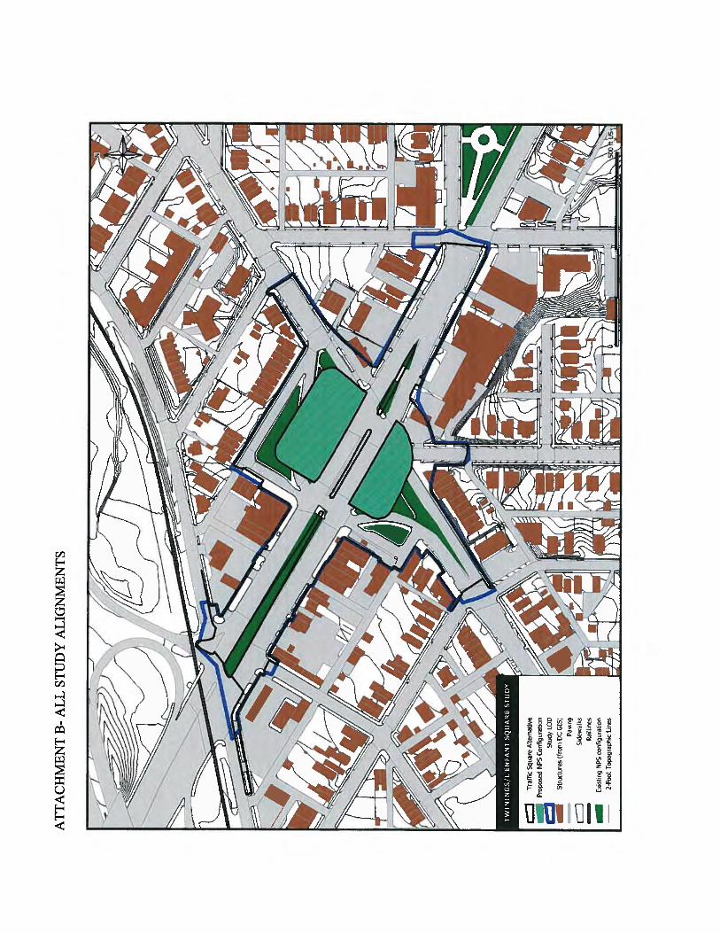
List of Figures
Figure 1. Project Location on the Washington East and Anacostia USGS 7.5 Minute Quadrangles. ................................................................................................................................... 2 Figure 2. Conventional Intersection Alternative ............................................................................ 3 Figure 3. Traffic Circle Alternative ............................................................................................... 4 Figure 4. Traffic Square Alternative .............................................................................................. 5 Figure 5. Modified Square Alternative (Recommended Alternative) ........................................... 6 Figure 6. Study LOD in Relation to All Alternatives .................................................................... 7 Figure 7. Commercial Development, Southside of Pennsylvania Avenue, looking southwest from 25th Street. ....................................................................................................................................... 9
Figure 8. Northern NPS Reservation, looking southeast from intersection of two L‟Enfant Square roadways ......................................................................................................................................... 9 Figure 9. Residential Development, west side of Minnesota Avenue, northern extension, looking southwest....................................................................................................................................... 10 Figure 10. Residential Development, northern L‟Enfant Square roadway, northside. Photograph taken facing east ............................................................................................................................ 10 Figure 11. Smith 1608 [1624] Map of Virginia. .......................................................................... 19 Figure 12. Early Land Grants (From Engineering Science 1989, Figure 5). ............................... 28 Figure 13. 1861 Boschke Topographic Map of the District of Columbia. .................................. 29 Figure 14. 1879 Hopkins Atlas of 15 Miles Around Washington Page 77. ................................. 31 Figure 15. 1892 edition, 1888 United States Coast and Geodetic Survey Topographic Sheets of the District of Columbia, Sheet 39. ............................................................................................... 32
Figure 16. 1903 Baist’s Real Estate Atlas of Surveys of Washington, District of Columbia Plate 34................................................................................................................................................... 33 Figure 17. 1907 Baist’s Real Estate Atlas of Surveys of Washington, District of Columbia Plate 18................................................................................................................................................... 34 Figure 18. 1913 Baist‟s Real Estate Atlas of Surveys of Washington, District of Columbia Plate 18................................................................................................................................................... 35 Figure 19. 1921 Baist‟s Real Estate Atlas of Surveys of Washington, District of Columbia Plate 18................................................................................................................................................... 36 Figure 20. 1949 Aerial Photograph of Washington, District of Columbia. .................................. 38 Figure 21. 1954 Baist’s Real Estate Atlas of Surveys of Washington, District of Columbia Plate 18................................................................................................................................................... 39
Figure 22. 1969 As-Built and Planned Improvements, Pennsylvania Avenue. ............................ 40 Figure 23. 1945 Photograph looking northwest across the southern portion of Reservation 487........................................................................................................................................................ 41
Figure 24. 1947 Photograph looking along Pennsylvania Avenue. ............................................. 42 Figure 25. 1947 View looking east along Pennsylvania Avenue ................................................ 42 Figure 26. Detail of APE conditions in 1881 (1892 USCGS edition). ......................................... 45 Figure 27. 1917 USGS Washington and vicinity, Maryland, District of Columbia, Virginia. ..... 47 Figure 28. Documented utility disturbances within the APE. ..................................................... 49
Figure 29. Future treatment recommendations, including provisional recommendations........... 52

1
Introduction EAC/A was contracted by HNTB and District Department of Transportation (DDOT) to prepare an assessment for the potential for intact archaeological resources within the delineated Area of Potential Effect for Direct Effects (APE-Direct) for proposed improvements to the Pennsylvania Avenue SE, Minnesota Avenue SE, and 25th Street SE intersection, in Southeast District of Columbia (Figure 1). The project also includes the green space area designated as Twining Circle (commonly called L‟Enfant Square), and two small side streets designated as L‟Enfant Square SE. Proposed improvements will come in to, but not completely encompass, the intersection of Fairlawn Ave SE and Pennsylvania Ave SE. This project will utilize federal funds from the Federal Highways Administration (FHWA) and the proposed improvements will also require an exchange of land between DDOT and the National Park Service (NPS). Both conditions make the project subject to the provisions of the National Environmental Policy Act of 1969 (NEPA), as well as the National Historic Preservation Act of 1966 (as amended) and related regulations (36CFR800). The project will be reviewed by the District of Columbia Historic Preservation Office (DC HPO) under Section 106. Prior to the proposed land exchange the FHWA and NPS have agreed to collaboratively prepare an Environmental Assessment (EA), in accordance with NEPA, with NPS as the lead agency and FHWA as the cooperating agency. The present Archaeological Assessment Study has been completed as part of that EA. All work conducted meets the Guidelines for Archaeological Investigations in the District of Columbia (D.C. Preservation League 1998).
Project Description DDOT proposes to improve the traffic flow and pedestrian safety at the intersection of Pennsylvania Avenue SE and Minnesota Avenue SE by reconfiguring the road alignments and traffic patterns at this major intersection. The project area is currently a mixture of residential rowhouses and commercial structures. A multi-story mixed-use condominium complex has been constructed recently along the Pennsylvania Avenue frontage. DDOT has specified development of five alternatives; a No Build alternative, a conventional intersection alternative, a traffic circle alternative, a traffic square alternative, and a modified square alternative (the current Recommended Alternative) (Figures 2 to 5). The Study Limit of Disturbance (LOD) has been developed using a composite of all proposed alternative, representing the widest possible LOD. Figure 6 delineated the proposed project LOD against all proposed build alternatives. Project activities which will result in ground disturbance include removal of existing pavement and sidewalks, construction of new traffic lanes and sidewalks, relocation of traffic control signals, street lights, landscaping and utilities. Direct impact to an existing structure is anticipated under two alternatives (the Traffic Circle Alternative and the Traffic Square Alternative).

2
Figure 1. Project Location on the Washington East and Anacostia USGS 7.5 Minute Quadrangles.

3
Figure 2. Conventional Intersection Alternative.

4
Figure 3. Traffic Circle Alternative.

5
Figure 4. Traffic Square Alternative.

6
Figure 5. Modified Square Alternative (Recommended Alternative).

7
Figure 6. Study LOD in Relation to All Alternatives.

8
Project History The Pennsylvania Avenue at Minnesota Avenue improvement project was initially conceived as part of the larger Pennsylvania Avenue Great Streets Initiative Project. The present area of study has been included in at least three previous planning studies, including the Pennsylvania Avenue, SE Transportation Study, the Middle Anacostia River Crossing Transportation Study, and the Bolan Smart Market Study for L‟Enfant Square. During this period, several alternative alignments for improvements to the intersection were considered in unpublished DDOT documentation, and the Traffic Circle, Traffic Square, and Conventional Intersection Alternatives were put out for public comment. These three alternatives were evaluated in the 2007 Revitalization of Pennsylvania Avenue, SE for the Great Streets Initiative Concept Design – Final Report (DDOT 2007). The current Recommended Alternative, the Modified Traffic Square, was subsequently developed from the alternative rated highest in that report, to address concerns about impact to private property outside the existing ROW.
Description of the APE-Direct A proposed APE-Direct was defined and submitted to the DC City Archaeologist on March 7, 2011 and approval was received April 8, 2011. The archaeological APE is restricted to the area of direct impact from proposed ground disturbing activities. The project has no known non-contiguous wet lands remediation or storage and staging areas for consideration. As such, the archaeological APE has been defined as the Study LOD, indicated in blue on Figure 6. The APE-Direct presently consists of a sloped streetscape, with the northern and southern extensions up Minnesota Avenue and the eastern extension up Pennsylvania Avenue rising in elevation, while the western extension has a very gentle slope down. Development is primarily commercial along Pennsylvania Avenue and the southern portion of Minnesota Avenue, while the northern extension of Minnesota Avenue and the other cross streets host residential development (Figures 7 to 10).
Soils and Geology The project area is located within the Coastal Plain physiographic province, although the Fall Line marking the transition into the Piedmont province is located in the western portion of the District of Columbia (Smith 1976). The Coastal Plain is characterized by unconsolidated interleaved deposits of gravel, sand, silt, and clay, with the surface soils of the specific project area vicinity formed in reworked river terrace deposits from the Pliocene and Pleistocene (Smith 1976). Soils within the APE have been recorded primarily as Urban land-Galestown complex, which is found in the western, central, and part of the northern sections of the APE (Smith 1976). The northern and eastern edges of the APE are reported as Keyport-Urban land complex. Small segments of Sassafras-Urban land complex and Christiana-Urban land complex are found along the southern edge of the APE. Urban land- Galestown complex represents areas where roughly 70 percent of the soil surface is covered with impervious surfaces, with smaller areas of graded and reworked Galestown series

9
Figure 7. Commercial Development, Southside of Pennsylvania Avenue, looking southwest from
25th Street.
Figure 8. Northern NPS Reservation, looking southeast from intersection of two L‟Enfant Square
roadways.

10
Figure 9. Residential Development, west side of Minnesota Avenue, northern extension, looking
southwest.
Figure 10. Residential Development, northern L‟Enfant Square roadway, northside. Photograph
taken facing east.

11
soils exposed. The 1976 District soil survey notes that roughly 5 percent of Urban land-Galestown mapping units are relatively undisturbed Galestown soils. Galestown soils developed out of old marine deposits of sand and found on uplands and terraces along the Coastal Plain. They are generally deep and somewhat excessively drained. The typical profile includes a thick two-layer A Horizon of loamy sand over a very thick, coarse loamy sand B Horizon. The substratum is generally more than three feet below the surface. Christiana series soils are deep, well drained soils formed in silty material deposited over older clay deposits (Smith 1976). They are generally found on well-dissected uplands, and within the APE are reported as part of the Christiana- Urban land complex, where roughly 40 percent of the area is covered with impervious surfaces, 20 percent consists of reworked or graded Christiana series soils, and 20 percent consists of relatively undisturbed Christiana series soils. The remaining 20 percent includes a mixture of associated soil series and areas of eroded Christian series soils where the clayey subsoil is exposed. The typical profile for Christiana series soils includes a thin silt loam A Horizon over a two-layer subsoil. In its upper layer, the subsoil is a heavy yellowish brown silt loam, but changes to a red silty clay within a foot of the surface. Keyport soils are generally deep, moderately well drained soil developed in silty material over older clay deposits. They are typically found in lower settings in the Coastal Uplands. Areas in the APE which are reported as Keyport- Urban land complex consists of strongly sloped areas where roughly 40 percent of the area is covered with impervious surfaces, 20 percent consists of reworked or graded Keyport series soils, and 20 percent consists of relatively undisturbed Keyport series soils. The remaining 20 percent includes a mixture of associated soil series and areas of severely eroded Keyport series soils where the grey clayey subsoil is exposed. The typical soil profile for Keyport series soils includes a thin silt loam A Horizon, and a thick, multi-layered subsoil which is dominated by clay within a foot of the surface due to erosion deflation. Sassasfras series soils are deep, well drained soils formed in marine sediments, and found on side slopes and ridges tops in upland settings (Smith 1976). Sassafras series soils reported within the APE are included in Sassafras- Urban land complex mapping units where roughly 40 percent of the mapping unit is impervious surfaces, 20 percent is disturbed Sassafras series soils, 20 percent is undisturbed Sassafras series soils, and 20 percent consists of associated soils types. Typical soil profiles in strongly sloped areas of Sassafras soils consists of a sandy loam A Horizon less than a foot thick, over a multi-layer subsoil which approached two feet in thickness. Subsoil grades from sandy loam to sandy clay loam and back. Based on the anticipated soil types in the APE, cultural deposits should be within the upper foot of the natural profile. However, given the development history of the project area, most of the APE is expected to represent completely or partially disturbed soil sequences.

12
Previous Research In August, 2010 EAC/A received information from the DC HPO City Archaeologist that there were no known sites within or adjacent to the APE-Direct, and no previous cultural resource studies which included the current APE (DC HPO, Personal Communication, August, 2010). The DC HPO does note two sites in the immediate vicinity: 51SE015 and temporary site designation P21. A cluster of six additional sites (one with two possible locations) is located on the east side of the Anacostia well north of the project, associated with the historic river shore and tributary streams, while two additional sites associated with the historic river shore are located well to the southwest. These eight sites (and one alternative location) range from roughly 170 feet outside the project APE to the researched limit of one mile outside the APE. All of these sites are listed as prehistoric resources. None have been subject to controlled testing. On-going research conducted by the DC HPO amended this finding in early March, 2011, noting that at least one Smithsonian collection attributed to Proudfit has been linked to the burrow pit associated with the extension of Pennsylvania Avenue at the east end of the Pennsylvania Avenue bridge, and therefore would have been within or adjacent to the current APE (Trocolli and Krakker, Personal Communication, March 4, 2011). Additional information about the W. Selby and the Armistad Peters collections is also being researched by the DC City Archaeologist, as these collections may also be from the project vicinity. Site 51SE015, located roughly 250 feet north of the APE, is officially listed as Unidentified Prehistoric, but the Bury collection in the Smithsonian‟s holdings includes Potomac Creek pottery sherds, some “leeched shell” tempered sherds, and a variety of project points suggesting at least a Late Archaic and Woodland Period occupation span. P21 (roughly 170 feet south of the APE) is a possible relocation of the Twining City (SE14) site as noted in Hume 1975, officially listed as Unidentified Prehistoric, but noted with Middle Archaic, Late Archaic, and Middle Woodland components. The Smithsonian Institute‟s Proudfit collection also includes materials reported as collected from the borrow pit for construction of the eastern extension of Pennsylvania Avenue (J. Krakker, Personal Communication, March 4, 2011). This collection (Accession No. 022631, Catalog No. 146563) consists of nearly one hundred pieces of lithic debitage and tools, as well as a small number of aboriginal ceramics. The collection includes multiple lithic materials but appears to be predominately quartz and quartzite. Tools include a number of general bifaces as well as stemmed points. No detailed catalog appears to be available for this collection. Two studies were conducted in the general project vicinity, both primarily along the Anacostia shore line. The first was a Phase I (Reconnaissance) conducted for the WSSC Anacostia Force Main (Hume 1975). Hume‟s study consisted of both surface reconnaissance and subsurface investigation. It also included extensive review of existing collections and collections documentation, some of which is no longer publicly available. The study area stretched from the pumping station just north of the District boundary in the Kenilworth area, south and west to the Blue Plains treatment plant, primarily following an alignment within Anacostia Park. The present project falls within Hume‟s Survey Area E, starting just south of the Pennsylvania Railroad bridge over the Anacostia and continuing to just east of the Douglas Bridge.

13
Although the full study identified 75 potentially reported artifact finds or concentrations, none were within the current proposed project APE. Nine of the concentrations identified by Hume‟s archival research fall within a one-mile radius of the present project APE. Hume grouped seven of these into what he refers to as “a single major collection area or site (Hume 1975:6)” stretching along the historic Anacostia shore line. Two of these sites (GWU 8 and 51SE003) were subsequently tested during Hume‟s survey, as they fell within or adjacent to the survey alignment. Hume‟s site GWU 8 (Bruce Powell 21) was described as a multi-component site, with late nineteenth-century foundation remains and unidentifiable prehistoric remains, possibly including oyster midden. The site was classified as potentially significant primary deposition, but does not appear to have been assigned an official trinomial designation. It was located within Anacostia Park, north of the Anacostia Freeway and more than 1,800‟ from the limits of the project APE. Site 51SE003 (Bruce Powell site 20), a contact period mixed component site, was re-plotted based on Hume‟s archival research, and then subject to surface examination during Hume‟s survey. Examination of open construction trenches during the survey determined the area was covered with up to 5 feet of demolition- debris laden fill, leading him to conclude the prehistoric site had been previously badly disturbed or destroyed. The second cultural resources study previously conducted in the project vicinity consisted of an archaeological and historical study of Anacostia Park on the south or east bank of the Anacostia River (Engineering Science 1989). This study was restricted to archival research. Based on that archival research, shore area along both shores of the Anacostia River was classified as high potential for prehistoric resources, including a possible Woodland village site. Historic settlement was more sporadic and consisted of several large land holdings whose main houses were generally located more inland. Additional studies conducted further from the current APE but in similar settings were associated with proposed improvements to Barney Circle (Artemel et al. 1989). The physical testing conducted during the Phase II study identified three potentially eligible prehistoric sites along the floodplain of the Anacostia River, adjacent to tributary stream confluences.
Prehistoric Context The period of history prior to sustained European contact is discussed below. By convention, this long span of human occupation is commonly divided into three broad periods: Paleoindian (12,000-7,500 B.C.), Archaic (7,500-1,000 B.C.), and Woodland (1,000 B.C.-A.D. 1608). The Archaic and Woodland Periods are commonly subdivided into Early, Middle, and Late subperiods. These temporal divisions are based on similarities in artifact types and technology. Diagnostic artifacts for each period are discussed below along with a broad discussion of regional settlement and subsistence patterns. The Paleoindian Period
In a recent review of Paleoindian research Boyd notes that a combination of advances in dating studies, paleoenvironmental reconstruction, and archaeological studies have all changed the

14
timelines currently hypothesized for the initial migrations and subsequent diffusion of human populations in the New World (Boyd 2003). Although still debated, dated Paleoindian components from recent studies have pushed back the span of recorded history along the eastern seaboard. These include sites like Saltville (44SM37) which may have produced culturally altered bone in deposits capped some 13,500 year ago; Cactus Hill (44SX202) which has produced features dating from roughly 16,000 years before present; and Brook Run (44CU122) which has produced hearth features dating from roughly 10,000 and 11,000 years before present. Recent discoveries such as these represent an early Pre-Clovis Paleoindian occupation of the eastern seaboard. Based on the Cactus Hill Pre-Clovis component, tool assemblages include prismatic blades and blade cores made from local fine grained lithic materials (McAvoy and McAvoy 1997, Johnson 1997). Boyd cites immunological evidence of utilization of musk ox, bison, deer, elk, and small mammals such as rabbits (Boyd 2003: 68). The initial human occupation of the region is generally thought to be concurrent with retreating glacial conditions and the emergence of a Holocene environment. A mosaic of deciduous, boreal, and grassland biomes with a uniformly cold climate characterized the late-glacial environment. The final stages of rapid Potomac down-cutting were active during this period, and sea levels were rising rapidly after the lows of the glacial periods. Human adaptation to the late Pleistocene/early Holocene environmental conditions involved small, mobile bands of hunter-gatherers with movements related to the exploitation of different localized environments and resources. Subsistence appears to have been largely focused on the hunting of not megafauna but rather large game, such as elk, caribou, and deer. The Piedmont-Coastal Plain interface (fall zone) is thought to have contained a wide variety of resources attractive to Paleoindian inhabitants, who utilized a variety of base camps, hunting sites, and quarry-related locations (Gardner 1989; Custer 1984:52-53). Paleoindian sites have been identified in all physiographic zones of the Potomac Valley and in the surrounding region. Cultural deposits at Meadowcroft Rockshelter in Pennsylvania have been dated to this era, although they have not been universally accepted (Adovasio 1976). Late Pleistocene cultural deposits have also been uncovered at Cactus Hill, Virginia (McAvoy and McAvoy 1997; Johnson 1997). Perhaps one of the most significant Paleoindian site on the Coastal Plain is the Higgins Site in Anne Arundel County, Maryland, where over a hundred Paleoindian stone tools were found (Dent 1995:170-171; Ebright 1992). Paleoindian activity in the Piedmont appears to have focused on quarrying quality materials for stone tools. Another rich Paleoindian site, in the Virginia Piedmont (Culpeper County), is the Brook Run Site (44CU122). This site is a quarrying site where jasper was extracted from a small exposed seam (VDOT 2001). The Thunderbird site complex is another significant locus of Paleoindian activity in northern Virginia (located in Front Royal, Warren County, VA). This site complex included a base camp and jasper workshop (44WR11), and a hunting camp (44WR50)(Gardner 1989). On the western side of the Potomac Fall zone is the Catoctin Creek Site. This site has a diverse Paleoindian assemblage and is situated at the mouth of perennial stream (Dent 1991). The Pierpoint site is located nearby, on the eastern bank of the Potomac, but as the site is know primarily through surface collection less information is currently available.

15
A factor influencing Paleoindian site identification in the region is the rise in sea level between 13,000 B.C. and 4,000 B.C. During this period, Holocene warming led to coastal and riverine inundation, flooding the lower reaches of the Susquehanna River and its tributaries and creating the Chesapeake Bay (Ebright 1992). It is currently believed that many coastal sites from the Paleoindian Period are inaccessible as they are off shore on the coastal shelf. Artifact assemblages associated with the Paleoindian Period include fluted points (most notably the Clovis and Dalton types) and a variety of non-diagnostic unifacial and bifacial stone tools (Dent 1995:170). Humphrey and Chambers note that three fluted points from the banks of the Anacostia and a fourth from northwest Washington were recovered during the late nineteenth century (Humphrey and Chambers 1977). Flanagan et al. subsequently reported that two were manufactured from non-local chert and one from locally available quartz (Flanagan et al. 1985). The Archaic Period
This culture period covers a great amount of time (7,500 to 1,000 B.C.) and covers very substantial cultural change. It is traditionally divided into three sub-periods: Early, Middle, and Late. Regional models link the shift from Paleoindian patterns into Early Archaic patterns with environmental changes during the Pleistocene to Holocene transition. Changes in technology and subsistence patterns are seen as directly reflecting adaptation to newly available resources. These represent a series of adaptations that were increasingly sedentary and focused on large rivers and major tributaries. Other, often smaller, sites located away from the main streams probably represent seasonal or other specialized activities. Increasing territoriality and regional diversity are reflected in the varieties of artifacts, especially projectile points, through the Early, Middle, and Late Archaic periods. Classical models see Early Archaic patterns as largely continuing the traditions of those from the Paleoindian Period (Gardner 1989; Custer 1990). Settlements expanded into more diverse environments, apparently utilizing a wider variety fish, game, and other plant food resources, such as nuts, berries, and roots (Johnson 1983, Custer 1990; Petraglia et al. 1993, Dent 1995:165-166). The appearance of corner-notched projectile points or knives (ca. 7,500-6,800 B.C.) is considered a marker of the Early Archaic period. Point types in the Early Archaic include the Hardaway, Palmer, and Kirk types, and bifurcate forms such as LeCroy (Custer 2000). The Middle Archaic Period is marked by a fully developed Holocene environment, one that was generally warm and moist (Gardner 1989). Oak/hemlock forests dominated during this period, and grasslands were much smaller in size (Gardner 1989). This is thought to have led to an expansion of the available food base and a broadening of human foraging patterns (Gardner 1989). The population appears to have expanded over larger geographic areas and to have become more sedentary, with a limited degree of territoriality (Custer 1984; Perlman 1981). The warm and wet climate may have dramatically influenced the western periphery of the Coastal Plain and the Eastern Piedmont. The increased rainfall during this period likely led to a rise in the water table (Custer 1984:63). Embayment of the lower Susquehanna drainage began

16
during this period, and gradually more riverine and estuarine environments developed. Custer reports that marshes expanded in the region during this period (Custer 1984:69-70). Gathering and processing of plant resources and fishing appear to have played increasingly important roles in subsistence systems throughout the Middle Archaic Period. This is reflected in an expansion of tool forms to include grinding stones, net-sinkers, mortars, pestles, axes, and adzes. Artifact assemblages from this period are diverse. In this region, assemblages may include Kirk Stemmed, bifurcates (several types), Stanley, Brewerton (several sub-types), Morrow Mountain (several types), Guilford, and Archaic triangles projectile points (Custer 2000; Katz 2000). Flanagan et al. report both Stanley and Marrow Mountian types in late nineteenth century collections from the Anacostia River vicinity (Flanagan et al. 1989). A variety of non-diagnostic unifacial and bifacial stone tools were also produced during this period. Groundstone tools became common during this period, including mortars and pestles (Dent 1995:170). The development of artifacts that are not easily portable, such as grinding stones and groundstone tools, supports the hypothesis that Archaic Period populations developed more sedentary settlement systems. The emerging settlement pattern included large base camps located along major drainage systems. Small procurement camps were typically situated in upland areas, possibly indicating the presence of social fusion/fission mechanisms, with small kin groups leaving larger base camps for seasonal exploitation of resources in other environmental niches (Gardner 1978; Custer 1984:67). The Late Archaic Period is marked by a greater emphasis on local resource exploitation. Settlement patterns tended to focus more along interior drainages of first-order streams (Mouer 1991; Steponaitis 1980). At least one researcher has suggested that the inherently linear nature of resource zones in such as system would motivate greater social interaction between groups (Mouer 1991:14). Regionally, evidence for permanent housing began to appear at this time (Griffin 1978:231). The establishment of extensive trade networks and the introduction of complex mortuary practices are also characteristics of this period. By the end of the Archaic Period, shallow estuarine zones were established along the Bay shores and lower tributaries, and intensive exploitation of the oyster began (Dent 1995:212). Fish were also intensively harvested during this period, including the use of fish weirs. Shell middens abound where indigenous people discarded oyster shells and other fish remains. Large base camps were established at the fall lines of major freshwater streams, where fish-spawning runs were most productive, and at saltwater estuaries for collecting oysters (Dent 1995:212). These camps represent seasonal fusion locations. Winter fission produced a pattern of “upland hollow” hunting and foraging camps located in the Piedmont interior (Johnson 1991 cited in Johnson 2001:82). Classically, researchers have classified the diverse tool assemblages of the Late Archaic Period into groups, or traditions, most notably the Laurentian and the Piedmont traditions. More recently researchers have interpreted differences in assemblages as functionally dictated, in addition to representing differences in cultural derivation or extra-regional stylistic influences.
17
Carved, lug-handled steatite bowls are one of the most distinctive artifacts types to be introduced to assemblages during the Late Archaic Period (Dent 1995:182-183). The use of the heavy steatite bowls also suggests increased sedentism (Dent 1995:213; Tuck 1978:38). Late Archaic Period projectile point types include Brewerton (first dating to the late Middle Archaic Period), Savannah River, Bare Island, Susquehanna Broadspears (and other broadspear types), Calvert, Hellgrammmite, Lamoka, Piscataway, Halifax, and Orient Fishtail types (Custer 2000). The flaked tool industry included small bifaces, drills, scrapers, and utilized flakes. Antler and bone tools have been recovered as well (Dent 1995:161,182). Flanagan et al. note that material from the Late Archaic represents a significant portion of the late nineteenth century local collections held by the Smithsonian Institute, and appears to provide evidence of dense Late Archaic occupation of the Anacostia River vicinity (Flanagan et al. 1989). Humprhey and Chambers report similar assemblages from southeast Washington along the Potomac River (Humphrey and Chambers 1977). The Woodland Period
An intensification of social structure and social hierarchy began during the Late Archaic Period and was expanded in the Woodland Periods (Dent 1995:218). Like the Archaic, the Woodland Period is usually divided into Early, Middle, and Late segments. The defining characteristic of the Woodland is the use of ceramics, which began circa 1000 B.C. Arguably as important was the cultivation of crops. Horticulture appears to have intensified after 300 B.C., accompanied by a less nomadic existence and a noted increase in population. The Early Woodland (1,000 B.C.–300 B.C.) and Middle Woodland Periods (300 B.C. –A.D. 1,000) were noted for the development of longer-term habitation sites, a gradual shift to the exploitation of cultigens, and the extensive use of a wide variety of environments and resources (Gardner 1982; Custer 1984; Johnson 1991). McNett and Gardner (1971) believe that there is increased population size and increased sedentism during the Early Woodland Period. Most researchers believe that there was a generally increase in social complexity and social interactions during the Middle Woodland Period (300 B.C. to A.D. 900). By the Middle Woodland Period, crop cultivation is evident in the archeological record. Crops such as maize and squashes arrived in the area from the vicinity of Mexico. Local plants like sunflower, goose foot, pigweed, and marsh elder were also domesticated (Humphrey and Chambers 1977:17). Various cultural changes occurred around A.D. 900, marking the beginning of the Late Woodland Period. The shifts include changes in settlement patterns (such as increased settlement size, and in some areas fortification of settlements) and a marked shift in subsistence patterns reflected in increased reliance on domesticated crops. Settlement patterns for the Late Woodland Period shifted to more commonly include permanent villages and hamlets. Floodplain locales were the favored locations for settlements, likely based on the availability of fertile bottomland soils. Smaller base camps and procurement sites were located in diverse settings and tended to have periods of multiple re-use (Custer 1986). Subsistence practices included the cultivation of foodstuffs, especially corn, beans, and squash. Diverse wild food sources were also utilized, including nuts, starchy tubers, amaranth, goosefoot, shellfish, fish, elk, bear, turkey, squirrel, duck, bobcat, raccoon, rabbit, skunk and wolf (Dent 1995).

18
Evidence of extended habitation sites is indicated by domestic features, such as the utilization of above-ground storage facilities, special warehouses and granaries, in addition to subterranean storage pits (Dent 1995:249). House structures commonly followed an oval-shaped pattern. The longhouse was another type of domestic structure that had interior partitions. Smaller house patterns have been found to range in size from about 5.5 to 9.0 meters in length and 4.0 to 5.0 meters in width (Dent 1995:249). Warfare between the local groups in the region is evident in the archeological record after A.D. 900 and particularly after A.D. 1200. Overlapping post molds and palisade lines at sites such as the Accokeek Creek and Potomac Creek sites indicate that the local indigenous groups frequently rebuilt and expanded their fortifications (Dent 1995: 250; Rountree and Davidson 1997:46). Projectile point diversity steadily decreased during the Woodland Period. Early Woodland Period projectile point types include: Adena, Calvert, Hellgrammite, Meadowood, Piscataway, and Rossville (Custer 2000; Kavanaugh 1983:49). Projectile points in use during the Middle Woodland Period included Piscataway and Rossville types, and Fox Creek points. In the Late Woodland Period, there was nearly exclusive use of triangular projectile points (also known as the Madison and Levanna types) (Custer 1986; Stewart 1990). Ceramic diversity expanded during the Woodland Period, with a number of design motifs apparently circulated through the Eastern Woodlands. The earliest ceramics in the region are Marcey Creek and Selden Island ware types, both steatite-tempered and resembling steatite bowls. Other ware types include Accokeek, Popes Creek, and Mockley ceramics (Early-to-Middle Woodland). Later ware types include Sheppard, Keyser, Rappahannock, and Potomac Creek wares (Late Woodland). Chipped–stone tool assemblages of the Woodland Period contain small bifaces, utilized flakes, drills, perforators, and scraping implements. Assemblages also include rough-stone or ground-stone artifacts such as grubbing tools, hammerstones, anvil stones, net sinkers, mortars, pestles, manos and metates (Dent 1995:228-229). Other artifacts typically found in the region are ground-stone celts and adzes, ground-slate pendants, gorgets, bone awls and projectile points manufactured from bone, antler, turkey spurs, stingray barbs, and shark‟s teeth (Dent 1995:228-229). The Contact Period
The first documented European contact in the region was the exploration of the Potomac River by Captain John Smith in 1608. He reportedly explored as far upstream as Little Falls. His voyage marked the beginning of English trading with indigenous peoples in the area, and his maps provide an essential picture of indigenous settlement at the time of European contact. Numerous villages were noted by Captain John Smith along the Potomac (Smith 1608 [1624], Figure 11). Several villages are indicated on the map in the Washington vicinity, including Namoraughquend, a settlement on the Virginia shore opposite Washington D.C. north of the mouth of the Anacostia (Smith 1612). Mooney also noted the small villages of Assaomeck in the Alexandria area and Namassingakent below Alexandria (Mooney 1889:260). The more

19
Figure 11. Smith 1608 [1624] Map of Virginia.
D.C. Vicinity
N

20
important villages in the region included Nacotchanck, Moyaons, and Tauxenent. The inhabitants of Nacotchanck are thought to be part of the Piscataway chiefdom while Moyaons was the chief village (Cissna 1990: 28). The village of Tauxenent was situated on the Virginia side of the river near the mouth of the Occoquan River. The village of Nacotchanck was located on the Maryland side of the Potomac, along the Anacostia, and has been variously placed around Giesboro Point, Poplar Point (Scisco 1955 and McCord 1957), and at the base of the Sousa Bridge (Mayre 1938). Proudfit probably more accurately described it as a diffuse settlement area stretching from Giesboro Point to a point just short of Bladensburg (Proudfit 1989:242). The Maryland based Piscatway were generally closely allied with the Powhatan Confederacy, sharing a common language stock (Algonquian). Some scholars dispute this interpretation, suggesting that the groups between the Rappahannock and Potomac rivers were instead relatively independent (Potter 1993:18-19). The early seventeenth century was marked by a series of conflicts between English settlers and the Powhatan Confederacy, with conflicts in 1609, and periodically from 1622 through 1632 (Cissna 1990: 30). Indian-European hostilities generally subsided in the middle of the 17th century when Indian treaties and reservations were offered, and European settlement spread. In contrast, conflict with the Susquehannocs of the northern Bay and between the Powhatan and Monacan confederacies dated to periods before permanent English settlement and continued through the later seventeenth century (Mooney 1889). Virginia established reservations in the 1650s. Maryland established a reservation for the Piscataway Indians and associated tribes slightly later in 1669 (Cissna 1990: 30). Most indigenous groups had migrated out the project vicinity by the early eighteenth century (Mooney 1889).
Historic Context The following summary of historical development within the District of Columbia is not intended to serve as a complete history of the City, but rather to provide some general context within which to understand the more specific project area history subsequently provided. Contact and Settlement Period (1570-1791)
The majority of the present day District of Columbia was originally settled as part of Maryland. When the Capital was formed in 1791, the bulk of the territory was carved out of Prince Georges County, while the western portions of the 10-mile square territory were pulled out of Montgomery County, Maryland and Fairfax County, Virginia. The territory west of the Potomac was returned to Virginia in 1847. European settlement of the study area dates to the mid-to-late seventeenth century, when early land patents were granted along the Potomac and Anacostia Rivers. Many early grants were speculative ventures, and physical settlement of the land delayed until tenant farmers took up smaller farms within the patents. Few towns were established in the region during the seventeenth and eighteenth centuries due to the dispersed nature of the plantation system settlement (Petraglia et al.1989). The warrant and patent system functioned to restrict access to lands to the very wealthy and influential classes, as the warrants required political influence and initial lump sums to obtain, and once patented, the grants required payment of an annual quit-rent. Sale or lease of smaller

21
tenancies helped defray the cost of the patent. Tenants were frequently required to make improvements under their lease, providing inexpensive but potentially lucrative enhancements for the patent holder (MacMasters and Hiebert 1976: 7-11, 14-18). Some of the earliest grants in the Washington vicinity were along the south side of the Anacostia: “Chichester” granted to John Meeks in 1664; “Greens Purchase” granted to Joseph Harrison (through Luke Green) in 1668; and “Aaron” granted to William Hutchinson (through John Adison) in 1687. Freidlander and LeeDecker note that the area to the northwest, across the river from the project intersection (south of 14th St and Virginia Avenue) was the location of the late seventeenth and eighteenth century Wheeler Ferry across the Anacostia (Freidlander and LeeDecker 1985: 11). This ferry was connected to Georgetown, Upper Marlboro, and Bladensburg by well established roads, making it an important hub in the early historical development of the area. Tobacco was the mainstay of the Tidewater and Potomac Regions throughout most of the seventeenth and eighteenth centuries. River Road and the Georgetown Pike provided inland transportation routes to the docks in Georgetown, and the Potomac River itself represented a primary transportation route for goods, south of Great Falls. In the project vicinity, the Anacostia provided access to the Potomac River and ready transportation of tobacco harvests to the port at Georgetown for international shipments. As practiced in the region, tobacco agriculture proved destructive to the soils, and soil depletion was a serious issue in the later eighteenth century. After a short period of inflated prices immediately after the Revolutionary War, the tobacco export market failed. Inland farming areas, especially in adjacent Montgomery and Fairfax Counties, turned to wheat and to a mixed agricultural system. Commercial and industrial development in the area was limited during this settlement period. Most commercial ventures were related to tobacco export, with other ventures primarily representing supporting services such as taverns along the major travel routes and small mills to process local agricultural produce. Mills served as important collection points in the rural agricultural economy, and as social gathering points. Quarries were another early industry. Early Federal Period (1790-1840)
In 1790 Congress authorized the creation of a seat of federal government not to exceed a ten-mile square area (100 square miles), to be located on the Potomac somewhere between the Eastern Branch (the Anacostia River) and the Conococheague River. The final selection of the location of this city was relegated to the President, and Washington announced the Eastern Branch location in January of 1791. Once announced, the site was surveyed by Andrew Ellicott using calculations derived by Benjamin Banneker, and Pierre L‟Enfant designed a baroque pattern of radial and orthogonal streets which also used the existing landscape to direct lines of sight and emphasize ceremonial spaces. Although the outer ten-mile District boundary had been marked with boundary stones, the City of Washington proper was restricted to a smaller area defined by Rock Creek, the Potomac, and the Anacostia on three sides, and by present day Florida Avenue (originally Boundary Street) on the fourth.

22
At the time of the survey, all of the smaller City of Washington was taken from territory within Prince George‟s County, Maryland. The existing population consisted of 20 households, representing 720 people (Plan of the City of Washington National Historic Landmark Nomination Draft 2000), including the surveyed but barely settled towns of Hamburg and Carrollsburg. Just outside the City, Georgetown to the northwest and Alexandria to the southwest, represented well established commercial interests. Initial sales of the City lots in late 1791 were disappointing, with only 35 lots sold. To help encourage sales, batches of lots were sold to investors (usually land speculators) at lower than intended prices (Green 1962). Additional settlement occurred in the decade between survey of the Capital district, and the installation of the federal government in 1800, with an estimated 372 inhabitable structures and a population of roughly 14,000 within the District in 1800 (Green 1972:20-21). Yet the much anticipated real estate market failed to materialize. Instead, speculators who did construct housing within their holdings found a rental market in government officials not yet prepared to subject their families to the isolation of social life in Washington, and who rented primarily as boarders. For much of the first three decades of Washington‟s development, the rentals formed a significant portion of the city‟s economic base. During this period, primary development was restricted to the city core, and the areas across the Anacostia River remained rural areas, supplying agricultural goods to the city‟s markets. During the first decades of Washington development, the Navy Yard on the Anacostia represented a substantial contributor to the economy of the city, and one of several areas of early development grew up around its location. It was one of the few areas inside the City of Washington which included commercial development, focused on services used by the Navy. It also included residential development housing Navy and Marine personnel, and non-military “mechanics” also working at the Navy Yard. Between 1805 and 1814 the Washington Navy Yard may have been the busiest economic center in the city (Green 1962, Washington Navy Yard Nomination Form 1975). Private industrial ventures remained largely small scale (Green 1972:35). By the end of the third decade of the nineteenth century, the City of Washington exhibited three areas of coherent development (see for instance, Tanner 1836): the central government core with associated commercial and residential areas; the area east and south of the Capital; and the area surrounding the Navy Yard. Despite early expectations, Washington continued to fill in towards the west and the Potomac rather than towards the Anacostia. Surrounding areas, such as the present project location, remained primarily rural. The Federal Village Period (1840-1861)
During the period between 1820 and 1840 the rate of population increase within the District seems to have held relatively static, just as the population increase within the City of Washington remained relatively stable throughout the first five decades at roughly 5,000 new inhabitants each decade (Green 1972: 21). After 1840 both the District and the City of Washington experienced more rapid population growth: Washington for instance grew by nearly 20,000 inhabitants in the decade between 1840 and 1850 alone (Green 1972:21). Commercial development also picked up speed, supported in part by the completion of long segments of the Chesapeake and Ohio Canal between Georgetown and Hancock in the previous decade. In addition to several flour mills

23
constructed along the canal in Georgetown, this period also witnessed the establishment of the Pioneer Cotton Company along the canal, and the adoption of steam power by a number of District industries and commercial ventures (Green 1972:157, 192). After 1847 the Navy Yard again represented a significant economic force within the city (Washington Navy Yard Nomination Form 1975). The early part of the period represented a period of notable economic prosperity (Green 1972). By the late 1850s the central city was densely developed (Boschke 1857). South of the Mall and east through the vicinity of the Navy Yard as far as 12th St SE most city squares were at least partially developed if not as densely as the area around the White House. However, development still exhibited a marked preference for the areas west of the Capital. The eastern edge of the City of Washington, and most of the eastern and southern portion of the District remained rural. These agricultural areas continued to produce garden crops suitable for the urban markets but also produced grains for the mills in Georgetown and Alexandria. This period was one of improvements to infrastructure. In the 1840s the City undertook some street improvements, even in the absence of federal aid (Green 1972:164). Water lines would follow a decade later; in the interim some wealthy citizens had private wells and lines installed (Green 1972: 202-203). After 1853, continuing improvements to the city streets also included the installation of gas lights along major routes and the installation of sewers (Green 1972:208). Although no map of the sewer and street improvements from this period was available for review, subsequent maps from the 1870s and 1880s make it clear that these improvements were restricted to the central areas of dense development; no sewer or water main extended beyond the 12th Street SE boundary. The Civil War (1861-1865)
On the eve of the Civil War, Washington stood as a city of some 61,000 inhabitants. By the summer of 1861, the nature of those inhabitants became more flexible, as southern officials and southern families left the District and new officials flooded in to handle the preparations and logistics of a nation at war. Troops in the District waxed and waned. And it was a population divided not just in loyalties to North or South, but also government opposed to resident (Green 1972:248-250). Much of the previously improved infrastructure suffered during this period, through both neglect and overloading. Street improvement ceased and maintenance was restricted to streets considered critical to government needs. Water pipes newly laid fell dry during some periods, as the feeder reservoirs ran dry, and the city‟s sewer system, always dependent on river or stream flow to remove waste at the end of the lines, was rapidly overloaded resulting in large fields of exposed waste which subsequently had to be carted outside the city limits (Green 1972: 254-257). Economic development suffered at first during the War, for although massive amounts of goods were passing through the Capital, little of it was being produced by Washington ventures except for the Navy Yard (Green 1972:244-245). By the second year of the War however, the demand for labor to handle commodities flowing through the Capital and build structures to house those

24
commodities, and a demand for services and real estate brought money back into the District economy (Green 1972:263). The Post War Boom (1865-1874)
The resolution of the Civil War brought forth a number of critical changes to the District of Columbia, including changes in the nature of her population as former slaves settled in the city; changes in her economy as the heavy market, service, and labor demands of the military and the government dropped precipitously; and changes to her form of government as a territorial government was adopted and then discarded. City officials also found themselves faced with the task of improving the city to provide services which inhabitants of more prosperous northern cities had come to accept as expected conveniences: mass transportation, paved and well-lit streets, decent education, and effective sanitation (Green 1972:293). By special census, the population in Washington in 1867 included roughly 74,000 whites and 32,000 “colored” (Green 1972:306), a relatively minor gain in white population but a roughly 225% gain in the African-American population. By 1870 these figures were up to 88,000 and 43,000 respectively. Many of these new residents were severely economically challenged, as many freedmen had few marketable skills. Much of the older population also found itself facing poverty as well, as prices rapidly inflating during the war years severely impacted low income and fixed income residents. It was during this period that Washington began to develop patterns of poverty and ghetto formation which would continue well into the twentieth century. Government expansion and construction helped offset lost markets during the late 1860s, especially the expanded role of the Printing Office and the Department of Agriculture (Green 1972:294). But production at the Navy Yard dropped after the War, remaining low until it was named as the center of ordnance manufacture for the Navy in the late 1880s. Real estate and private construction increased rapidly after completion of a massive city improvements program in the early 1870s. Washingtonians looked forward to an economic boom until a nationwide crash resulted in not only bank failures, but a failure of the District Government. In 1874, with the District on its way to $20,000,000 in debt, Congress opened a second inquiry into the District‟s finances and oversight. Little progress on repair and improvement to infrastructure was accomplished in the late 1860s. Despite Mayor Bowen‟s hope to utilize the large pool of labor available from the influx of freedmen to the District (and thereby also reducing the need for poor relief), actual improvement during his administration seems to have been restricted to carrying 9th Street down to the riverfront and laying 15 miles of sidewalk and four miles of sewer line (Green 1972:318). The 1870s were a vastly different story, as a massive program of improvements was instituted under Alexander “Boss” Shepherd. As with most improvement projects in the past, this program concentrated on the more densely developed central core of Washington, although plans to install combined storm and sewer drains did extend through Georgetown (Green 1972). Other than paving of all the main traffic arteries, little improvement was planned for the outlying areas. Despite strenuous opposition, staggering debts, and sometimes colossal ineptitude, many of these improvements were completed, and by 1873 new sewers had been laid, water mains extended, cement or brick sidewalks placed, and wooden, macadam or concrete paving covered the city‟s

25
roads (Green 1972: 354). However, none of these much needed improvements were extended across the Anacostia. Extension of streetcar routes to the north, west, and east encouraged development of new residential sections outside the historic city core. At the same time improvement programs were changing the physical nature of the city, the establishment of a Board of Health served to alleviate some of the other long standing problems in the city, impounding loose animals, calling for infilling of waste-laden tidal marshes along the Potomac, and condemning hundreds of buildings considered to be unsanitary. The Board had less success dealing with the growing “alley problem”, and this overcrowded, unsanitary, substandard housing would continue to serve the city‟s poorest residents in to the twentieth century. The Federal District (1874-1930)
Despite a national depression, declining real estate values in the city, increasing unemployment and poverty, Washington managed to carry through some its gain from the post war boom. City improvements begun under Shepherd were completed under Congressional oversight in the late 1870s, including completion of the sewer system, and replacement of the miles of the wooden road pavement which had quickly proven susceptible to rot (Green 1972:390). The Board of Health continued to make progress for several years, although by the late 1870s general resistance to its dictates had increased and in 1877 the Board found its budget halved by the Commissioners. In 1886 the Navy Yard was named as the center for ordnance manufacture, and production demands were exceeding its capabilities by 1900. As production work was shifted to private contractors, the Yard itself continued to employ skilled mechanics and craftsmen and became a center of research and development. The rest of the city‟s economy largely depended on service ventures and real estate (Green 1963:9, 12). Manufacturing was primarily small scale; the mills earlier seated in Georgetown largely shut down after the 1889 flood of the Potomac severely damaged the canal. Local production of building materials (closely associated with the real estate boom), breweries, and printing (both government and private) were the only large scale industries in the District during this period (Green 1963: 9-10, 27). Land speculation commonly took the form of residential building for sale, or more popularly, to rent (Green 1963:13-16). Such speculation occurred as both small scale and large scale ventures; successful government clerks might develop one or two lots and profit from the rental fees, while large concerns developed whole suburbs such as Chevy Chase. As most of this speculative development was aimed at the wealthy or at least comfortable inhabitants of the city, the less comfortable government workers, laborers, and mechanics found themselves facing a shortage of affordable housing. This in turn resulted in patterns of modest boarding houses, and movement of lower income families out of the developed city to areas across the Anacostia, north of Boundary Street, and east of the Capitol. It was during this period that Uniontown, first laid out in 1854 but largely undeveloped through the Civil War, experienced a building boom after the 1875 opening of horsecar service across the 11th St Bridge (Gillette 1988:99). The 1888-1890 construction of the Pennsylvania Avenue extension bridge provided similar motivation for the development of several late nineteenth century subdivisions in the project vicinity, including Twining (circa 1888) and Randal Highlands (early 1890s).

26
During this period the District population continued to grow sharply: 177,000 in 1880, 230,000 in 1890, 278,000 in 1900, 331,000 in 1910, and 437,000 in 1920. Unlikely many American cities in the period, comparatively little of that population increase represented African-American or immigrant populations (Green 1963:89). A significant peak near the end of the period was motivated by an influx of workers during the World War I period, with a District population of 525,000 reported in 1918 (Plan of the City of Washington Nomination Form 1994). The decade after World War I was a period of rapid development for suburban Washington, especially for the area south of the Anacostia River. Gillette notes that in 1920 roughly 7,000 residents lived in the Uniontown (now Anacostia), Randal Heights, and Barry Farm areas south of Pennsylvania Avenue. By 1930 this number had doubled (Gillette 1988:101). By the mid-twentieth century, the area had fully transformed from rural farmland to urban suburb. Changes to the District‟s physical structure during the early portion of this period were predictable outcomes of the real estate and construction boom. Expansion of the water and sewer system to the north is the most easily documented change beyond the addition of hundreds of new structures (DC Bureau of Public Works 1873, Green 1880). Some consideration of the long term consequence of new construction was apparent in legislation instructing that all new subdivision must conform to the existing plan of Washington Streets, but it was not until the 1901 Senate Park Commission that the government sought to enact procedures and controls to establish a basic plan for the future development the District. The McMillan Plan specifically aimed to preserve and enhance what the Commission saw as key elements of L‟Enfant‟s baroque city plan. Like many plans before, the McMillan Plan placed more focus on the central core of the City and the Potomac, although the Commission‟s recommendations did include filling of the extensive pollute tidal marshes along the Anacostia (Green 1963: 137-138). Few strictures for the continued development along the city‟s borders were incorporated in the Commission‟s recommendations beyond an insistence that future development should respect and if possible enhance the L‟Enfant Plan. The Modern City (1930-Present)
Mid-twentieth century developments included several notable changes which came to define modern life in the District: increasing racial segregation within the District; deterioration of older urban neighborhoods as new development focused on outlying suburbs both in Maryland and Virginia; the wholesale adoption of the automobile by the American public; world recognition of the United States as a world power; and a rapidly expanding government presence. Attempts to adapt to the repercussion of these developments have more or less continued to the present. Several national events during this period had noted physical effects on the District. The Great Depression gave birth to the New Deal, which in turn supplied the labor which reshaped the Mall into its a park like setting and landscaped many of the federal reservations throughout the city (Plan of the City of Washington Nomination Form 1994). That was quickly followed by the massive population spike which accompanied the World War II period (Green 1963). Dense population and rapidly expanding government interacted to result in removal of many government departments to the suburbs such as Arlington and Rockville, which in turn, due to

27
strong reliance on the automobile, led to street widening and straightening (Green 1963). The movement of both residential populations and government offices out of the City proper was the impetus behind development of plans for Washington‟s highways, including the Capital Beltway routed through the major suburban areas. During the late 1940s and the 1950s the District government attempted to address another problem within the District; the neglect and deterioration of the residential urban core, especially the segregated largely African American sections rife with alley housing. The urban redevelopment ideal in fact served to strengthen segregation, as the displaced homeowners of Southwest and Foggy Bottom could not afford the new housing in the City, and many were forced to relocate to outlying areas or suburbs (Green 1963). Subsequent work in the 1960s redeveloped corridors of ageing development along L‟Enfant‟s grand avenues. The effect of both these initiatives was particularly strong in the areas south of the Anacostia, as largely low-income populations displaced by urban redevelopment in southwest DC and highway construction in southeast DC came across the River and settled into Anacostia, Twining, Benning, and other southeastern suburbs. As displaced low-income primarily African-American populations moved in, many of the previously existing business and middle class residents moved out. The area lost almost 30% of its population between 1970 and 1980, and suffered from cuts to crucial government services and infrastructure maintenance (Gillette 1988:104). The area southeast of the Anacostia has subsequently been the focus of economic initiatives and redevelopment since the 1990s.
Project Area Historic Development The following present a narrative of the development history of the specific project vicinity, based on historic maps available for review. It is provided to document the basis on which the presence or absence of historic period archaeological resources are predicted within the APE for direct effects. Little specific information was found addressing the period prior to the mid-nineteenth century. Based on a reconstruction of early land grants prepared as part of an archival study prepared for adjacent Anacostia Park, the present project area appears to have been primarily within “Green‟s Purchase”, acquired by Luke Green in 1668 (Figure 12) (Engineering Science 1989: 18-19). Small portions of the APE crossed into “Ship‟s Landing” and “Aaron”. Although constructing a chain of title was not within the scope of this assessment, Green‟s Purchase was likely subdivided into smaller tenancies and periodically transferred, and subsequently sold off as smaller parcels in the late eighteenth and early nineteenth centuries. Unfortunately the available late eighteenth and early nineteenth century maps of the District of Columbia do not depict the area south of the Anacostia River. The first available cartographic source which depicted detail on the south side of the Anacostia River is Boschke‟s 1861 topographic map of Washington D.C. (Figure 13). Based on the features indicated on this map, the APE is largely surrounded by undeveloped or rural land, although there is what appears to be small structure and orchard present in the southern section of the APE, while a second structure was present outside the northwest APE extension.

28
Figure 12. Early Land Grants (From Engineering Science 1989, Figure 5).
Ship‟s Landing
Green‟s Purchase
Aaron
The Addition
Attwood‟s Purchase

29
Figure 13. 1861 Boschke Topographic Map of the District of Columbia.

30
There are five well developed and identified farm complexes in the wider vicinity, but the owner of the structure and orchard within the APE is not identified. Anacostia Road, a precursor to present day Minnesota Avenue, is also clearly well established by this date. The less detailed picture provided by the 1879 Hopkins Atlas of 15 Miles Around Washington suggests that the orchard property belonged to Elizabeth Howard, while the structure off the northwestern APE extension belongs to Henry Naylor, one of eight he is depicted as owning in the project vicinity. One of those eight is the additional structure, built along the Anacostia-Bladensburg Road between 1861 and 1879, now visible within the southern portion of the APE (Figure 14). Another important development in the project vicinity was the establishment of Alexandria Branch of the B&O Railroad alignment passing to the west of the APE. Additional detailed information available on the 1888 USCGS topographic sheets for the District of Columbia indicates that both mid-nineteenth century structures within the APE, and the Howard orchard, survived into the last part of the nineteenth century (Figure 15). This highly detailed and accurate map also indicates that the present project area included a deeply incised stream valley filled with marsh, and bordered by a sand dune or possibly elevated fill along the subsequent alignment of the Pennsylvania Avenue extension. During this period a new Pennsylvania Avenue bridge was under construction, and plans were underway to develop the area south of the proposed Pennsylvania Avenue extension as Twining City. Overall, the topographic sheets indicate minimal additional development in the area north of old Uniontown, and the immediate project vicinity remained rural, with large segments of woodland to the east. By 1903 the project vicinity is actively being developed as a suburb of the District, fully subdivided but only partially developed (Figure 16). The 1903 Baist Real Estate Atlas of Surveys of Washington indicates that neither of the mid-nineteenth century structures survived the extension of Pennsylvania Avenue and the development of the Twining City subdevelopment. This particular cartographic source appears to have been either poorly drafted or relied upon proposed street alignments rather than actually survey- georeferencing against the existing street grid resulting in significant distortion. However, several modern elements of the study LOD are present on this source. The most significant is the depict of L‟Enfant Circle, although it is indicated as a perfect square reservation with a circular road exchange within it, a configuration which is not supported by any other cartographic source reviewed during this study. Most of the present lot configuration is also present on this source. However, very few structures had been constructed prior to 1903, and those handful of primarily wooden structures was restricted to the area south and west of the project intersection. Only one structure, in Lot 1 of Square 5560 (shown as “5”), appears to fall within the present APE, and that may be an artifact of the georeferencing distortion. Based on the sequence of Baist Real Estate Atlases, subsequent development of the project vicinity was relatively slow but consistent (Figure 17 to Figure 19). Prior to 1913 development was only present south of the Pennsylvania Avenue, in 1913 a single structure was present along the north of Pennsylvania Avenue, and a small handful of frame structures had been completed along the south side of Burns Street on lots backing onto the square. Within the APE a brick structure had been constructed on Lot 24 of Square 553, which extends into the present APE. Additional structures appear within the APE in 1921, in the southeastern corner, on Lots 12 and 13 of Square 5579.

31
Figure 14. 1879 Hopkins Atlas of 15 Miles Around Washington Page 77.

32
Figure 15. 1892 edition, 1888 United States Coast and Geodetic Survey Topographic Sheets of the District of Columbia, Sheet 39.

33
Figure 16. 1903 Baist’s Real Estate Atlas of Surveys of Washington, District of Columbia Plate 34.
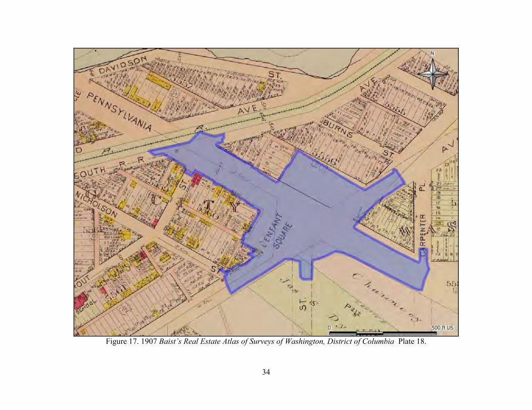
34
Figure 17. 1907 Baist’s Real Estate Atlas of Surveys of Washington, District of Columbia Plate 18.

35
Figure 18. 1913 Baist‟s Real Estate Atlas of Surveys of Washington, District of Columbia Plate 18.

36
Figure 19. 1921 Baist‟s Real Estate Atlas of Surveys of Washington, District of Columbia Plate 18

37
The Baist series also indicates that the parkland reservation was established early in the twentieth century as an irregular rectangle which remained stable into the 1940s. As can be expected, utilities within the APE multiplied during the early twentieth century. In 1903 a single 12” pipeline (probably a water line) is indicated passing down Pennsylvania Avenue and onto the southern portion of Minnesota Avenue. By 1913 a 20” and a 30” pipeline had also been established through the APE, with the main line passing under Pennsylvania Avenue and the smaller 20” pipeline following under the Minnesota Avenue roadbed. An unidentified 8” pipeline was also installed beneath the southern sidewalk along the western stretch of Pennsylvania Avenue. By 1921 two additional large pipelines had been installed, one passing through the northern NPS reservation, and the second running south under 25th St. Fewer mid-twentieth century cartographic resources were identified during the archival research. Aerial photographs from 1949, 1951, 1957, and 1963 were examined but provided little useful information about the interior of the APE beyond documenting the construction of access lanes within the reservation (Figure 20). Land transfer to and from the D.C. Commissioners modified the reservation space in 1938 (along the outer edges, Land Order 487), and again prior to 1949 to construct the internal access lanes (recorded in 1951, Land Order 463). A 1954 Baist map is available, but appears to have used an older base map, as the internal access lanes are not indicated on it (Figure 21). It does however suggest that redevelopment had already begun in the project vicinity, as the three early twentieth century frame structures on the south side of Burns Street had been removed to make room for a row of brick rowhouses. The structures previously present on either side of Pennsylvania Avenue east of Minnesota were also demolished in the mid-twentieth century, and service stations constructed in their place. Finally, a second utility line was installed under Pennsylvania Avenue east of Minnesota Avenue. The final archival information obtained for consideration consisted of 1969 As-Built plans for improvements along Pennsylvania Avenue within the APE (Figure 22). In addition to additional utility lines for underground telephone and electrical lines, the major mid-twentieth century addition consisted of a 72” sewer main which runs west along Pennsylvania Avenue up to the Minnesota Avenue intersection, and then passes northwest through the northern NPS reservation. Subsequent disturbance from the 1970s to present is more difficult to track, as few archival sources were readily available for review and most last 20th century maps do not identify specific building footprints. Aerial photographs suggest redevelopment of the northeastern corner of Fairlawn and Pennsylvania Avenue between 1957 and 1963, the northeast corner of the Pennsylvania Avenue and Minnesota Avenue sometime between 1963 and 1980, and the northeastern corner of Fairlawn and Pennsylvania Avenue was again redeveloped between 1963 and 1980. The northeastern corner of Fairlawn and Pennsylvania Avenue is outside but adjacent to the APE, but the redeveloped lot on the northeastern corner of Pennsylvania and Minnesota extends into the study LOD.

38
Figure 20. 1949 Aerial Photograph of Washington, District of Columbia.

39
Figure 21. 1954 Baist’s Real Estate Atlas of Surveys of Washington, District of Columbia Plate 18.

40
Figure 22. 1969 As-Built and Planned Improvements, Pennsylvania Avenue.

41
This archival review did not address landscape photographs during research, but did review a small number of historic photographs supplied by DDOT and by NPS. The NPS photographs were associated with the 1938 Land Order transferring the outer north and western portions of the reservation to the District Commissioners. These included copies of three photographs, two dated 1929, taken looking from Pennsylvania Avenue across each portion of the reservation. However, all copies are badly blurred and it is only possible to get a sense of open space to the north. The southern side appears wooded. DDOT provided three clear photographs from the mid 1940s. The oldest, dated 1945, captures the southern reservation, looking northwest from a point on Minnesota Avenue near the Nicholson Street intersection (Figure 23). Both portions of the reservation appear to be essentially devoid of trees. Construction work, possibly for utilities or sidewalk installation, is underway along Minnesota Avenue, and appears to consist of relatively shallow disturbance generating sizable spoil piles, implying a large surface area. The other two photographs, dated 1947 shows views east and west along Pennsylvania Avenue. Figure 24 is the view looking west along Pennsylvania Avenue, presumably from the roof or upper floors of a multi-story structure, looking across a tree-less reservation and commercial development on Pennsylvania Avenue. The front entrances of both Minnesota Avenue service stations are visible. Figure 25 is the corresponding view looking east along Pennsylvania Avenue from a point west of the Fairlawn intersection, again documenting the essentially commercial nature of development in this area. Neither portion of the reservation is visible in this photograph.
Figure 23. 1945 Photograph looking northwest across the southern portion of Reservation 487.
(Photograph courtesy of DDOT)

42
Figure 24. 1947 Photograph looking along Pennsylvania Avenue.
(Photograph courtesy of DDOT)
Figure 25. 1947 View looking east along Pennsylvania Avenue.
(Photograph courtesy of DDOT)

43
Assessment of Archaeological Potential Assessment of Potential for Prehistoric Archaeological Resources
Review of published information about the settlement and subsistence patterns of prehistoric populations within the District and adjacent portions of Maryland and Virginia provides ample evidence of prehistoric utilization of the area, especially the Anacostia and Potomac valleys during the Archaic and Woodland Periods of prehistory. Some evidence is available of at least intermittent utilization of the area during the Paleoindian Period, but this evidence is sparse and largely consists of fluted points recovered as surface finds out of context. Given the accepted models of Archaic and Woodland subsistence and settlement, and the historically documented landscape of the project vicinity, it is logical to assume that the uplands of the project vicinity would have been utilized during both periods. It is almost certain that the floodplains and low terraces along the Anacostia were heavily utilized during the later Woodland Period. The commonly accepted predictive model for prehistoric sites utilized four factors: slope (less than 15%), soil type (well to moderately well-drained), distance to potable water (generally less than 200 meters), and availability of valued resources (such as high quality lithics and special faunal or botanical resources). These factors are examined and weighed against each other to define zones of high, medium, or low potential for prehistoric resources. Archaic subsistence and settlement patterns reflect utilization of an increasingly broad range of habitats and hence physical settings across time. Archaic populations did practice a settlement system which included larger aggregation base camps typically associated with particularly dense concentrations of food resources, such as fish runs, and seem statistically to favor river terrace or floodplain locations in the Coastal Plain, especially at confluences of tributaries and major water ways. This model suggests that the present Study LOD would be one favored by Archaic populations for at least seasonal periods, and could be the setting of both small fission period camps or larger fussion period camps. Woodland Period populations exhibited a strong preference for river terrace and floodplain settings, and Woodland period sites are well documented along the banks of both the Potomac and Anacostia Rivers in the vicinity of the District of Columbia. The main settlements are anticipated to be associated with these floodplains, and past researchers have suggested that the eastern or southern shore of the Anacostia was the location of the Contact Period Nacotchanck settlement reported by John Smith. Smaller micro-group base camps were associated with interior upland settings. Given the essentially shoreline setting of the APE, and the recovery of large artifact collections in the vicinity by both Bury and Proudfit in the late nineteenth century, it is anticipated that Woodland Period archaeological resources are present within the APE, most likely representing small superimposed concentrations from the dispersed village patterns associated with larger floodplain settlements. Currently, dense urban development has largely obscured both the original topography and the original surface drainage pattern. The 1975 District of Columbia Soil Survey indicates that the bulk of the Study LOD was classified as Urban land-Galestown complex soils, with Keyport-Urban land complex located in the northeast extension of the LOD and along the eastern side, with very small areas of Sassafras-Urban land complex and Christiana-Urban land complex to

44
the south. All of the base soils noted in these classifications represent well drained or moderately well drained coastal soils. The best available depiction of pre-development conditions is found on the 1888/1892 USCGS topographic sheets (Figure 26). Based on this source the Study LOD consisted of a combination of coastal flat in the south and low lying marsh to the north in a deeply cut and wide stream valley. The standard USCGS chart symbolism indicates that the hatching present along the present Pennsylvania Avenue roadbed should represent sand dunes, but its use for areas of the nearby railroad embankment suggest that it may also represent fill embankments. The coastal flat appears to have ranged from roughly 55 feet amsl in the south and southeast to roughly 15 amsl in the extreme northwestern extension of the LOD. Most of this represents consistent but gradual slope towards the Anacostia to the northwest; the southern portion of Minnesota Avenue and 25th Street sit on an area originally composed of stronger slope leading up to one of a series of upland ridges and knolls south and east of the Study LOD. As an elevated area adjacent to shoreline, at the confluence of a major tributary, and overlooking marshes in at least the later period of prehistory, this coastal flat would have represented an extremely attractive prehistoric environment, and is classified as a high potential zone for prehistoric resources from all periods of prehistory. Present elevations are roughly equivalent to those reported in 1888, suggesting minimal filling of the coastal flat, except in the area of the former stream valley. The adjacent marshy area was roughly 65 meters wide at the depicted bases of the stream valley. The marsh itself is indicated as lying between sea level and 5 feet above sea level, and probably represents periodically inundated tidal marsh. The rise from the valley is quite steep in 1888, suggesting that even if this area was inundated late in the prehistoric period, it still represents a deeply cut and scoured environment, with a poor potential for surviving in situ prehistoric resources. This stream valley has almost completely disappeared from the modern landscape, with current elevations around 30 feet amsl, indicating early 20th century filling approaching 20 to 25 feet in this area.

45
Figure 26. Detail of APE conditions in 1881 (1892 USCGS edition).

46
Assessment of Potential for Historic Period Archaeological Resources
Predictive models for historic periods are rarely as rigorous as those developed for prehistoric sites. In part this is because few statistical studies have been conducted linking historic site location to specific variables, and in part because historic period site locations correlate with both ecological and cultural landscape variables. In rural settings, the placement of early roads and navigable waterways are a primary locational factor in the periods before the late eighteenth century. Additional important factors in historic site location include: proximity to resources of value in a market economy, proximity to transportation routes, and proximity to centers of commerce, government, or industry. Therefore, predictive models for historic period resources are generally built based on documentary resources, both primary and secondary. Historic maps are used to plot the location of older roads, and where possible, used to identify the location of historic structures and landscape features such as dams and mill ponds. In urban settings these predictive factors are of reduced value, as they apply nearly equally to all of the city‟s fabric once the city is fully developed. As such, the current predictive model relies almost exclusively on historic map information. The earliest cartographic information available about historic development is the 1861 Boshcke map of the District of Columbia, and this suggests that the primary development in this area was the 19th Century antecedent to Minnesota Avenue, a more winding road cut along the same rough alignment as lower Minnesota Avenue and called Anacostia Road at the time. Also present is a single structure and a small orchard. A second structure is indicated to the northwest of the LOD, but it is outside the APE. By 1879 the APE contains two structures: the Elizabeth Howard residence (the older house to the south of the road), and a newer house north of the road which is one of several belonging to Henry Naylor. Naylor also owned the house located just to the northwest outside the APE. Both structures within the APE persisted through 1888, although the third structure just outside the APE appears to have been removed prior to 1888. The 1903 Baist Real Estate Atlas indicates that both nineteenth century farmsteads had been removed prior to development of the project vicinity as part of Twining City. There is a single frame structure noted within the APE, at the intersection of Minnesota Avenue and Nicholson Street. A single 12” utility (probably water supply but possibly a sewer line) runs southeast down the center of Pennsylvania Avenue and turns to run southwest down the center of Minnesota Avenue. By 1907 a reservation configured similar to the present Reservation 487 appears to be in place. The only development visible within the APE is restricted to the south, where four structures facing Minnesota Avenue between Nicholson Street and Pennsylvania Avenue may extend into the APE, but it seems unlikely. Conditions in 1913 are similar to 1907, with the addition of a single structure in the northeast corner of the Pennsylvania and Minnesota Avenues intersection which may extend into the APE, and three new, larger, utilities alignments. A 1917 USGS map of Washington and its vicinity documents the addition of a structure in the southern portion of the APE, between Pennsylvania Avenue and the southern extension of 25th Street (Figure 27), but provides little detail. By 1921 there are two structures at that location

47
Figure 27. 1917 USGS Washington and vicinity, Maryland, District of Columbia, Virginia.

48
as well as significant reconfiguration of the utility alignments passing through the APE. The 1921 Baist Atlas is also the first to indicate actual green space within the reserves, although this is restricted to the southern reserve. NPS research indicates that the Twining/L‟Enfant Square reserve was not transferred to federal jurisdiction by the DC City Commissioners until 1929 (Stevens 2007). The name “Twining Square” was officially adopted in 1933 (Stevens 2007). The reservations were reduced once in 1938, to provide street side parking (NPS-NCP Land Transfer Order 497), and again sometime before 1949 to create the internal traffic lanes currently present (NPS-NCP Land Transfer Order 463, Figure 20). By 1954, the surrounding streets are almost completely developed, although the early twentieth century structures within the APE have all been removed, and all mid-twentieth century structures appear to have been outside (if adjacent) to the define APE. There has been another fairly significant realignment of utilities within the APE, and addition of a few new utility lines primarily beneath the Minnesota and Pennsylvania Avenue roadbeds. By 1969 most of the present roadbed configuration was established within the APE, although there appears to be significant differences in the size and configuration of median strips along Pennsylvania Avenue (Figure 22). The primary change noted within the APE is the proliferation of utilities. Most of the utilities appear to have been restrained to under the roadbeds, but the dense nature of these lines, and their location alongside older, abandoned utilities, suggests that areas under Pennsylvania Avenue and Minnesota Avenue will have little soil integrity (Figure 28). The presence of a 72” sewer cutting northwest to southeast through the northern reservation suggests at least one major disturbance has taken place in this area, in addition to deep fill added in the early twentieth century.
Summary of the Assessment of Potential for Defined Project APE and Recommendations for
Further Treatment.
The project APE lends itself to four primary divisions based on the character of current conditions: the northern reservation (green space north of Pennsylvania Avenue); the southern reservation (bifurcated green space south of Pennsylvania Avenue); the area of new ROW acquisition (the developed area south of Pennsylvania Avenue and East of Minnesota Avenue which spans 25th Street); and areas of roadbed. The Northern Reservation Overall, the northern reservation appears to have little potential for archaeological resources. Based on the most accurate detailed map available (the 1888/1892 topographic plate) the area north of Pennsylvania Avenue consisted primarily of marsh prior to infilling for the late nineteenth-early twentieth century development of the Twining City subdivision. Based on the 1888 topographic sheet, this stream valley was deeply cut suggesting removal of considerable amounts of soil and reflected a deep erosion environment prior to inundation. Once flooded, there is little likelihood of human occupation. As such, no further cultural resources consideration in this area appears warranted. If subsequent geotechnical information from soil borings appears to contradict this interpretation, then it is recommended that a limited geomorphological study be instituted to identify the depth of fill and assess the potential for surviving prehistoric and historic land surfaces in this area.

49
Figure 28. Documented utility disturbances within the APE.

50
The Southern Reservation The southern reservation is considered a zone of high potential for prehistoric resources, as well as historic resources associated with nineteenth century residences. Subsequent establishment of the right turn lane which bisects the reservation represents a substantial source of disturbance, but does not appear to have affected the entire reservation. Utility disturbance in this area appears to have been restricted to the early twentieth century, and consisted of one or at most two alignments established prior to 1913, when excavation would have consisted of less destructive manual labor. By 1921, maps indicate a marked preference for utility placement under the adjacent street beds, which may have minimized subsequent disturbance in this area. The primary anticipated project impact under all alternatives except the Conventional Intersection Alternative will be to the smaller western portion of the southern reservation. Under the Conventional Intersection Alternative anticipated impact will include the northern and eastern edges of the larger eastern portion and most of the smaller western portion of the southern reservation. Given the high potential for previously unidentified resources in the southern reservation and the lack of archivally documented large scale disturbance beyond the traffic lane, EAC/A recommends Phase I survey investigations be conducted in this area. Soil profiles are not anticipated to be deep, which will permit the use of standard hand excavated Shovel Test Pits (STP) sampling. It should also be noted that although archival documentation of disturbance has not been found, it is anticipated that the demolition of a nineteenth century structure in the early twentieth century will have resulted in some soil disturbance, and it may prove that Phase I survey will identify only disturbed soils with mixed resources. Area of New ROW Acquisition This very small area consists primarily of the developed lot between 25th St and Pennsylvania Avenue (a gas station), and by default also includes the smaller sidewalk area between 25th St and Minnesota Avenue. Both areas are nearly completely paved at present. This reflects a zone of high potential for prehistoric resources, and historic resource associated both with the nineteenth century Howard residence and with early twentieth century structures from the early development period of Twining City. There is little documented disturbance in this area, but substantial disturbance can be inferred from the development sequence, starting with the construction of two structures between 1913 and 1921, and the subsequent demolition of both structures between 1921 and 1954. By 1954 a gas station had been constructed on the lot, complete with inferred underground storage tanks. The placement of the current main structure is consistent with the mid-twentieth century structure, but it is a reasonable expectation that the pump structure, mechanism, feed lines, and storage tanks have been replaced at least once during the last half of the twentieth century in order to comply with environmental regulations. As such, it seems quite unlikely that large areas of intact soil survive in this area. Impact to this area is anticipated under the Traffic Circle Alternative, and Traffic Square Alternative. If either of these alternatives is chosen, then review of any soil borings placed for geotechnical testing would be advised, and monitoring of construction may be appropriate. However, EAC/A does not believe that sufficient potential for intact resources exists to warrant paving removal and Phase I survey testing.

51
Areas under Existing Roadbeds This includes the Pennsylvania and Minnesota Avenue roadbeds, and small connecting segments of 25th and 27th Streets, as well as the Twining/L‟Enfant Square access roads (both internal and external). Most of these pass over areas of high potential, but archival documentation indicates that the Pennsylvania Avenue, Minnesota Avenue, and 25th Street roadbeds have all been substantially disturbed by the mid and late twentieth century preference for placing utilities under them. Three of the four Twining/L‟Enfant Square access roads pass exclusively over areas considered to have little potential for intact resources due to prior stream scrubbing and erosion, and the final southern internal access road will be tested with the southern reservation area. No information about prior disturbance under 27th Street was found during the archival research, but as project impacts in this area would appear to be largely cosmetic changes to blend into the proposed new Pennsylvania Avenue configuration, no testing seems warranted at this location.
Summary of Recommendations for Further Treatment
Further cultural resources investigation is recommended for one area: the southern reservation area (Figure 29). This area has been classified as having a high potential for prehistoric resources and historic resources associated with nineteenth century farmsteads and early twentieth century residential development of Twining City. Archival research found limited evidence of past disturbance. Therefore Phase I survey investigations of this small area are recommended prior to final design decisions and construction of the proposed improvements project. A second location, the area of new ROW acquisition south of Pennsylvania Avenue and East of Minnesota Avenue, may warrant archaeological monitoring if either the Traffic Circle or Traffic Square Alternatives are selected. Otherwise, no impact to the area is anticipated and no further work is considered warranted. All other areas of the APE, including the northern reservations, are considered to have low potential for intact archaeological resources, either due to pre-development environmental conditions such as stream scouring and slope erosion, or due to dense later twentieth century utility placement.

52
Figure 29. Future treatment recommendations, including provisional recommendations.

53
References Cited Adovasio J., D. Gunn, J. Donahue and R. Stuckenrath 1977 “Meadowcroft Rockshelter: Retrospect 1976”. Pennsylvania Archaeologist 47(2-3): 1-93. Artemel, Janice, Elizabeth Crowell, Edward Flanagan, Francine Bromberg 1989 Barney Circle Phase II Archaeological Studies. Report to the Fleming Corporation and the De Leuw, Cather Professional Corporation, Washington, DC, from Engineering-Science, Inc., Washington, DC. Baist, George W. 1903, 1909, 1913, 1921, and 1954 Baist’s Real Estate Atlas of Surveys of Washington, District
of Columbia. G.W. Baist, Philadelphia, PA. In the collection of the Library of Congress, Map and Geography Reading Room. Also available at the American Memories web page of the Library of Congress (http://memory.loc.gov/ammem/index.html)
Board of Public Works, D.C. 1873 Exhibit Chart Showing Streets and Avenues, Cities of Washington and Georgetown, Improved Under the Board of Public Works, D.C. 1873. Sewers. J.F. Gedney, Washington, D.C. In the collection of the Library of Congress, Map and Geography Reading Room. Also available at http://hdl.loc.gov/loc.gmd/g3851n.ct001354. Boschke, Albert 1861 Topographic Map of the District of Columbia. McClelland, Blanchard, & Mohun, Washington, D.C. . In the collection of the Library of Congress, Map and Geography Reading Room. Also available at http://hdl.loc.gov/loc.gmd/g3850.cw0678500 Boyd, C. Clifford, Jr. 2003 “Paleoindian Research in Virginia and Beyond” Quarterly Bulletin of the
Archeological Society of Virginia 58(2):58-94. Cissna, Paul B. 1990 Historical and Archeological Study of the George Washington Memorial Parkway,
Arlington County, Virginia. Occasional Report #4, Regional Archeology Program, National Capital Region, National Park Service, Washington, D.C.
Custer, Jay F. 1984 Delaware Prehistoric Archaeology: An Ecological Approach. University of Delaware
Press, Newark. 1986 “Late Woodland Cultural Diversity in the Middle Atlantic: An Evolutionary
Perspective”. In Late Woodland Cultures of the Middle Atlantic Region, pp.143-168. J.F. Custer, ed. University of Delaware Press, Newark

54
1990 “Early and Middle Archaic Cultures of Virginia: Culture Change and Continuity.” In Early and Middle Archaic Research in Virginia, T. Reinhart and M. E. Hodges, eds. Archaeological Society of Virginia, Richmond, VA. Pp. 1-60.
2000 Classification Guide for Arrowheads and Spearpoints of Eastern Pennsylvania and the Central Middle Atlantic. Pennsylvania Historical and Museum Commission, Harrisburg.
DC HPO (District of Columbia Historic Preservation Office) 2010 Personal Communication. Email and attached report dated 9/21/2010 D.C. Preservation League 1998 Guidelines for Archaeological Investigations in the District of Columbia. District of Columbia
Department of Consumer and Regulatory Affairs, Historic Preservation Division and the District of Columbia Historic Review Board. Washington, District of Columbia.
DDOT (District Department of Transportation) 1945 Photograph of Twining Square. In the Collection of the District Department of
Transportation. 1947 Photographs of Pennsylvania Avenue SE and Minnesota Avenue SE. In the Collection of the
District Department of Transportation. 1969 Improvements of Various Streets and Intersections. As-Built construction blueprints, in the
Collection of the District Department of Transportation. 2005 Middle Anacostia Crossing Transportation Study Final Report June 2005. District
Department of Transportation, Washington, District of Columbia. 2007 Revitalization of Pennsylvania Avenue, SE for the Great Streets Initiative Concept Design
Final Report. District Department of Transportation, Washington, District of Columbia. Dent, Richard J. 1991 “Deep Time in the Potomac River Valley – Thoughts on Paleoindian Lifeways and
Revisionist Archeology” Archaeology of Eastern North America (19):23-41. 1995 Chesapeake Prehistory: Old Traditions, New Directions. Plenum Press, New York.
147. Ebright, Carol A. 1992 Early Native American Prehistory on the Maryland Western Shore: Archeological
Investigations at the Higgins Site. Maryland State Highway Administration, Project Planning Division, Archaeological Report Number 1. Maryland State Highway Administration, Baltimore, Maryland.
Engineering Sciences 1989 Anacostia Park from a Historical and Archaeological Perspective. Engineering Sciences, Washington, D.C. Friedlander, Amy and Charles LeeDecker 1985 Historical and Archaeological Assessment of Two Proposed Satellite Parking Lots, Squares 702 and 703, Washington, D.C. Prepared for Wallace, Roberts, and Todd, Philadelphia, PA. The Cultural Resource Group, Louis Berger Associates, Inc. Washington, D.C.

55
Gardner, William B. 1974 The Flint Run Paleo-Indian Complex: A Preliminary Report, 1971-73 Seasons.
Occasional Publication No. 1, Archeology Laboratory. The Catholic University of America. Washington, D.C.
1978 “Comparison of Ridge and Valley, Blue Ridge, Piedmont, and Coastal Plain Archaic Period Site Distributions: An Idealized Transect” Paper presented at the Annual Meeting of the American Anthropological Association, Washington, D.C.
1982 “Early and Middle Woodland in the Middle Atlantic: An Overview” in Practicing Environmental Archaeology: Methods and Interpretations, Roger Moeller, ed. Pp 53- 85. American Indian Archaeological Institute, Occasional Paper 3. Washington, CN
1989 “An Examination of Cultural Change in the Late Pleistocene and Early Holocene (Circa 9200-6800 B.C.)”. In J. M. Wittofski & T. R. Reinhart (Eds.), Paleoindian Research in Virginia: A Synthesis. Pp. 5-51. Richmond, VA: Archaeological Society of Virginia.
Gillette, Howard Jr 1988 Old Anacostia, Washington‟s First Suburb. In Washington at Home, Kathryn Schneider
Smith editor. Windsor Publications, Northridge, CA. Green, Constance M. 1962 Washington: Village and Capital, 1800-1878. Princeton University Press, Princeton, N.J. 1963 Washington: Capital City, 1879-1950. Princeton University Press, Princeton, N.J. Greene, F.V. 1880a City of Washington Statistical Maps. Map 7: Sewers. District of Columbia Commissioners, Washington D.C. In the collection of the Library of Congress, Map and Geography Reading Room. Also available at http://hdl.loc.gov/loc.gmd/g3851fm.gct00015 1880b City of Washington Statistical Maps. Map 6: WaterMains. District of Columbia Commissioners, Washington D.C. In the collection of the Library of Congress, Map and Geography Reading Room. Also available at http://hdl.loc.gov/loc.gmd/g3851fm.gct00015 Griffin, James B. 1978 The Midlands and Northeastern United States, in Ancient Native Americans. J. Jennings,
ed., pp. 221-280. W. H. Freeman, San Francisco, CA. Hopkins, G.M. 1879 Atlas of 15 Miles Around Washington, including the county of Montgomery, Maryland.
In the collection of the Library of Congress, Map and Geography Reading Room. Also available at http://hdl.loc.gov/loc.gmd/g3850m.gct00186 .
Hume, Gary W. 1975 Report on the Inventory and the Pre-construction Reconnaissance Survey of
Archeological Resources on and Near the Proposed 108" Anacostia Force Main from Prince Georges County, Maryland to Blue Plains Treatment Plant Across Lands

56
Administered By National Capital Parks, National Park Service, Within Washington Suburban Sanitary Commission Contract Areas B, C, D And E. George Washington University Department of Anthropology. Report prepared for the Washington Suburban Sanitary Commission and the Office of Cooperative Activities, National Capital Parks, National Park Service. On file with the District of Columbia Historic Preservation Office.
Humphrey, Robert L, and Mary Elizabeth Chambers 1977 Ancient Washington: American Indian Cultures of the Potomac Valley. George
Washington University Series, no. 6. George Washington University, Washington, DC.
Johnson, Michael F. 1983 “The Evolution of the Bifurcate Hunting System in the Interior Piedmont of Fairfax
County, Virginia” In Piedmont Archaeology: Recent Research and Results, J. Mark Wittkofski and Lyle E. Browning editors. Archaeological Society of Virginia Special Publication No. 10, Richmond VA.
1991 “Middle and Late Woodland Settlement Systems in the Interior Fall Zone of the Potomac Valley: Not a Live Oyster in Sight” North American Archaeologist 12(1):29-60.
1997 “Cactus Hill ‟96: Preliminary Block „A‟ Results Support McAvoy‟s Paleoindian and Pre-Fluted Point Sequence” Paper presented at the 1997 Middle Atlantic Archeological Conference. Ocean City, DE.
2001 “Gulf Branch (44AR5): Prehistoric Interaction at the Potomac River Fall Line” Quarterly Bulletin of the Archeological Society of Virginia 56(3):77-114.
Katz, Gregory M. 2000 Archaic Period Triangular Bifaces in the Middle Atlantic Region: Technological and
Functional Considerations. M.A. Thesis, Department of Anthropology, Temple University, Philadelphia, PA.
Kavanaugh, Maureen 1983 “Prehistoric Occupation of the Monocacy River Region”. In Piedmont Archaeology:
Recent Research and Results, J. Mark Wittkofski and Lyle E. Browning editors. Archaeological Society of Virginia Special Publication No. 10, Richmond VA..
McAvoy, Joseph M. and L.D. McAvoy 1997 Archeological Investigations of Site 44SX202, Cactus Hill, Sussex County,
Virginia. Survey and Planning Report Series No. 8. Virginia Department of Historic Resources, Richmond, VA.
McNett, Charles W. and William M. Gardner 1971 Shell Middens of the Potomac Coastal Plain. Proceedings of the Second Middle Atlantic Archaeological Conference, Washington, D.C.

57
MacCord, Howard 1957 “Archeology of the Anacostia Valley of Washington D.C. and Maryland” Journal of the Washington Academy of Sciences. Vol. 47, No. 12: 393-397. Mayre, William 1938 “The Anacostian Indian Fort” Maryland Historical Magazine Vol. 33, No. 2: 134-148. MacMaster, Richard and Ray E Hiebert 1976 A Grateful Remembrance: The Story of Montgomery County, Maryland. Rockville County Government. Rockville, MD. Mooney, James 1889 “Indian Tribes of the District Of Columbia.” In The Aborigines of the District of
Columbia and the Lower Potomac. Judd and Detweiler Printers, Washington D.C. Reprinted from The American Anthropologist, Vol. II, No. 3, 1889.
Mouer, L. Daniel 1991 The Formative Transition in Virginia. In Late Archaic and Early Woodland Research in
Virginia: A Synthesis, edited by Theodore R. Reinhart and Mary Ellen N. Hodges. Special Publication No. 23:1-88. Archaeological Society of Virginia, Richmond.
NPS (National Park Service) 1938 National Park Service Land Transfer Order 497. Dated July 18, 1938. On file with the
National Capital Region East office of the NPS, Washington, D.C. 1951 National Capital Parks Land Order 463. Twining Square and Center Parking. Dated
January 29, 1951. On file with the National Capital Region East office of the NPS, Washington, D.C.
Perlman, Stephen M. 1981 “Hunter-Gatherer Social Systems and James River Middle Archaic Lithic Utilization”
Quarterly Bulletin of the Archeological Society of Virginia (36)22-28. Petraglia, Michael, John Wingard, and Justin Patton 1989 Phase I Archaeological Testing at Jamestown on the Magothy, Anne Arundel County, Maryland. Engineering-Science Inc. Submitted to Mandrin Construction Co., Inc., Pasadena, MDPetraglia, Michael, Dennis Knepper, and Peter Glumac 1993 Prehistoric Occupations in the Piedmont: Archaeological Excavation in Faquier,
Prince William, and Loudoun Counties, Virginia. Engineering-Science, Inc. On file at the archives of the VDHR, Richmond, VA.
Plan of the City of Washington National Register Nomination Form 1994 on file with the DC HPO. Plan of the City of Washington Updated National Historic Landmark Nomination Draft 2000 on file with the DC HPO.

58
Potter, Stephen 1993 Commoners, Tribute, and Chiefs: the Development of Algonquian Culture in the Potomac Valley. University Press of Virginia, Charlottesville, VA. Proudfit, S.V. 1889 “Ancient Village Sites and Aboriginal Workshops in the District Of Columbia”. In The
Aborigines of the District of Columbia and the Lower Potomac. Judd and Detweiler Printers, Washington D.C. Reprinted from The American Anthropologist, Vol. II, No. 3, 1889.
1890 “A Collection of Stone Implements from the District of Columbia” Proceedings of United States National Museum. Vol XIII.
Rountree, Helen C. and Thomas E. Davidson 1997 Eastern Shore Indians of Virginia and Maryland. University Press of
Virginia, Charlottesville, Virginia.
Scisco, Louis 1955 “The Indian fort on the Anacostia River and review of the Anacostian tribal hstory in the District of Columbia”. Typescript in the Washingtonian Collection of the Library of the District of Columbia. Smith, Captain John 1608 [1612] Map of Virginia. William Hole, engraver. Available online at the Library of
Congress website, at http://hdl.loc.gov/loc.gmd/g3880.ct000377. Smith, Horace 1976 Soil Survey of District of Columbia. USDA Soil Conservation Service and the US
Department of the Interior, National Park Service. Smith, Karen Schneider 1988 Washington at Home, Kathryn Schneider Smith editor. Windsor Publications,
Northridge, CA. Steponaitis, Laurie C. 1980 A Survey of Artifact Collections from the Patuxent River Drainage, Maryland. Maryland
Historical Trust Monograph Series No. 1. Maryland Historical Trust, Crownsville, Maryland.
Stevens, Chris 2007 “Brief Chronology of Twining Square (Reservation 487 A,B,C, & D) and Reservation
336A, Southeast Washington D.C.” Limited distribution email communication and attachment dated 1/26/2007.
Stewart, R. Michael 1990 The Middle to Late Woodland Transition in the Lower/Middle Delaware Valley, in
North American Archaeologist, 11(3): 231-254.

59
Trocolli, Ruth and James Krakker 2011 Personal Communication. Interview and collections examination at the Smithsonian
Institute Collections Management Facility, Suitland, Maryland, May 4, 2011. USCGS (United States Coast and Geodetic Survey) 1888 District of Columbia, Topographic Sheet 39. 1892 edition. Engraved by Evans & Bartle
Wash. D.C.. Available online at the Library of Congress website, at http://hdl.loc.gov/loc.gmd/g3850m.gct00007 .
USGS (United States Geological Survey) 1917 Washington and vicinity, Maryland, District of Columbia, Virginia. Available online at
the Library of Congress website, at http://hdl.loc.gov/loc.gmd/g3851p.ct002128 . 1982 Anacostia, District of Columbia-Maryland, 7.5 Minute Quadrangle. Available on line
through the USGS at http://store.usgs.gov/ . 1982 Washington East, District of Columbia-Maryland, 7.5 Minute Quadrangle. Available on
line through the USGS at http://store.usgs.gov/ .

SPECIAL USE PERMIT


[This page is left intentionally blank]

GEOARCHAEOLOGICAL INERPRETATIONS
IN THE VICINITY OF PENNSYLVANIA AND MINNESOTA AVENUES
DECEMBER 2012


Geo-Sci Consultants, LLC 4410 Van Buren Street, University Park, Maryland 20782
tel: 301 277 3731 fax: 301 277 2147
GEOARCHAEOLOGICAL INTERPRETATIONS
IN THE VICINITY OF THE INTERSECTION OF
PENNSYLVANIA AND MINNESOTA AVENUES
IN THE ANACOSTIA SECTION
OF WASHINGTON, D.C.
Submitted to The EAC/Archaeology, Inc.
By Daniel P. Wagner, Ph.D.
Pedologist
December 14, 2012

Introduction The following is a discussion of pedological and geomorphological investigations in the area for planned improvements to the intersection of Pennsylvania and Minnesota Avenues located in the Anacostia section of Washington, D.C. The principal objectives of the study were to assess the soils and landscapes available to prehistoric populations, as well as the extent of historic impacts accrued since the initiation of European settlement over 300 years ago. Investigations were directed toward examinations and analyses of soil and geomorphic features for indications of landscape stability, buried surface levels, deposit types, and environmental conditions relating to human utilization of a landscape.
Field investigation of the project area was made on November 14, 2012, and entailed examinations of soils by means of Geo-probe borings. These were made at selected locations determined on the basis of historic mapping showing a wetland northeast of Pennsylvania Avenue and apparent uplands to the southwest. Three borings were made on each side of the road, and approximate locations of the borings are shown in Figure 1. Examined soil materials were described employing standard pedological designations for soil horizons, as well as standard descriptive terminology such as Munsell color notations and USDA soil textural classes. Logs for the borings are attached at the end of the report.
Physiology and Geology The project is situated within the Coastal Plain Physiographic Province within which all of eastern Washington, D.C. is contained. Geologically, this province is characterized by variously textured, unconsolidated sediments derived both from marine and fluvial sedimentary regimes as well as more recent alluviation in association with modern stream valleys and drainageways. In the study area the predominant geologic materials consist of stratified deposits of clay, sand and gravel laid down by an ancient deltaic system of the Lower Cretaceous period. Collectively, these deltaic deposits are designated as the Potomac Group of sediments. In addition to the natural complexity of Coastal Plain deposits, human activities have also greatly contributed to existing soil and landscape relationships. Of obvious significance for the study area are historic impacts related to urbanization. However, even before this a prolonged history of agriculture in the region would also have greatly impacted the area landscape. Widespread tillage-induced erosion would have variably deflated nearly all upland landscapes, and stream systems would have been subject both to increased rates of run off as well as choking contributions of recent alluvium derived from the eroded farmlands. These processes are likely to have greatly altered the former wetland northeast of Pennsylvania Avenue well before the eventual placement of fill that effectively obliterated all surface traces of it. Only the southern upland bears any
1

resemblance to the setting that prehistoric inhabitants would have known for thousands of years.
Figure 1. Boring locations and project area superimposed on an 1892 map.
Soils and Geomorphology
The findings of this study were in close accord with historic mapping, and original landscapes within the project area were indeed found to be distributed between both upland and alluvial positions. Hence, the desirable environmental setting of a well drained upland adjacent to a wetland was confirmed. The location was undoubtedly an attractive draw for generations of potential human occupations, thus offering enhanced prospects for cultural materials. Unfortunately, these prospects have, of course, been all but totally compromised by the severe landscape alterations.
Whereas the wetland north of Pennsylvania Avenue is deeply (11 to 15 ft) buried
by fill, a remnant of the original upland still forms the existing surface south of the road.
2

This upland has, however, suffered significant disturbances; and in two of the examinations here (Borings 5 and 6) episodes of grading had destroyed original surface horizons and even extended into lower subsoil horizons (Bt). Shallow fills of some historic interest overlie these truncated subsoils, but due to the Pleistocene antiquity of the regional uplands and no indications of later episodes of natural deposition, any prehistoric or even early historic cultural materials that may originally have been present would have been destroyed at these locations.
Elsewhere on the upland the degree of disturbance is not so definitive, and limited
areas may still have some potential for early cultural resources. This case is presented by the soil of Boring 4, which unlike those of Borings 5 and 6 may not have been as deeply graded. As indicated by the horizonation sequence of the plow zone (Ap) resting directly on the subsoil argillic horizon (Bt) with no intervening upper transitional subsoil horizons (ie. E or BE), there has been at least some soil loss even at this location. The loss could possibly be due to localized more shallow grading, but surface horizon is not obvious fill, and the amount of soil removal would also be compatible with that typically attributable to a past history of tillage (Figure 2). In the latter situation some compromise of context typical of plow zones would have occurred; however, cultural artifacts would still have been retained as lag deposits even as finer soil particles were lost to erosion.
Figure 2. The upland soil of Boring 4 has suffered some agricultural deflation or shallow grading, but is not as disturbed as those of two other examined locations. Grayer colors near the base of the core are due to drainage mottling. Soil drainage is, however, not sufficiently impeded to restrict occupation.
3

The wetland north of Pennsylvania Avenue likely provided a desirable spectrum of floral and faunal resources, but was far too poorly drained for occupation. Buried wetland surfaces were intercepted in each of the three borings made north of the road. These surfaces were mostly dark colored and varied in both texture as well as organic content (Figure 3). Comprised of recent alluvium almost surely accumulated subsequent to European settlement, the uppermost wetland sediments still testify to the very poor drainage typical of such settings, and saturated levels occurred within a foot or less of the buried surface at each location.
Figure 3. In Boring 1 the surface of the former wetland is marked by dark, viably orgainic deposits below the depth of 11.1 ft. The lowest increment of overlying fill at the depth of 9.7 ft is also darkly colored and contains coal, broken glass, and a fragment of rubber seal, probably that of a mason jar.
Oddly, depths to the wetland surface were not consistent and exhibited a range
too wide for a natural gradient. Although the deepest fill (15.2 ft) was found at the most downstream location of Boring 2, the increase of about 4 ft over the thickness at Boring 1 (11.1 ft) and even the 1.5 ft over that in Boring 3 (13.7 ft) are more suggestive of artificial disturbance than a natural slope. A wetland surface by definition would be essentially flat over so short a distance, and given the nearly level grade of the modern park surface the amount of depth variability should be considered inordinate.
4

Summary Upland and wetland environments originally characterized the project area, which almost everywhere has significant limitations for cultural resource potential. As would be expected in such an urban setting the upland south of Pennsylvania Avenue has been variably disturbed, and consequently although this ancient landscape would have been well suited for occupation, it has only very limited prospects for early cultural resources. Depending on when most of the grading was done later historic era deposits might still be of interest. Much too poorly drained for occupation, the wetland north of Pennsylvania Avenue would likely have been an attractive draw throughout the Holocene. Probably altered by a century or more of agricultural run off and then intentionally filled, the wetland identified on a historic map is still present, but now lies as much as 15 ft below the modern surface.
5

Descriptions for Core Borings
________________________________________________________________________
Depth (ft) Pedologic Horizon Characteristics (If Present) _______________________________________________________________________ Boring 1
0 - 9.7 Mixed earthen fill, mainly yellowish brown (10 YR 5/6) sandy clay loam and clay loam
9.7 - 11.1 Earthen fill, black (7.5YR 2.5/1) sandy loam; coal glass, and rubber (broken mason jar) truncated ~3 to 4 ft
11.1 - 11.9 Recent alluvium, black (10YR 2/1) sandy loam 11.9 - 12.3 Recent alluvium, light olive brown (2.5Y 5/3) fine
sandy loam 12.3 – 16.0+ No retrieval Boring 2
0 - 15.2 Mixed earthen fill, same as above 15.2 - 16.0+ Recent alluvium, dark grayish brown (2.5Y 4/2)
loamy sand; thin organic mat at surface; saturated
Boring 3
0 - 13.7 Mixed earthen fill, same as above 13.7 - 15.6 Recent alluvium, strong brown (7.5YR 5/6) and
yellowish brown (10YR 5/4) stratified sandy loam, sand and loamy sand
15.6 - 16.0+ Recent alluvium, grayish brown (2.5Y 5/2) silt loam; contains organic fibers; probable pre-Contact surface
Boring 4
0 - 0.7 Ap Dark brown (7.5YR 3/3) loam 0.7 - 1.4 Bt1 Yellowish red (5YR 4/6) clay loam 1.4 - 2.4 Bt2 Strong brown (7.5YR 5/6) heavy loam; common,
medium distinct mottles of brown (7.5YR 5/3) 2.4 - 4.0+ BC Brown (7.5YR 5/3) fine sandy loam; many,
medium distinct mottles of pinkish gray (7.5YR 6/2)
Boring 5
6

0 - 0.8 Ap Fill; dark brown (10YR 3/3) and dark yellowish
brown (10YR 4/4) loam 0.8 - 2.2 C Fill; mostly dark yellowish brown (10YR 4/6)
mixed sandy clay loam, loam, and silt loam 2.2 - 4.0+ 2Btb Yellowish red (5YR 4/6) clay loam; graded Boring 6
0 - 0.9 Ap Fill; dark brown (10YR 3/3) sandy loam 0.9 - 7.6 C Fill; mostly dark yellowish brown (10YR 4/6)
mixed loamy sand, sandy loam, and sand 7.6 - 8.0+ 2Btb Dark yellowish brown (10YR 4/6) loam to silt
loam; common, coarse distinct mottles of light brownish gray (10YR 6/2); graded
7