PP1- Monitoring land surfaces at SAFE using field and remote sensing data
27
Monitoring land surfaces at SAFE using field and remote sensing data Workshop, Science@SAFE 2014 Marion Pfeifer 1 , Robert Ewers 1
Transcript of PP1- Monitoring land surfaces at SAFE using field and remote sensing data

Monitoring land surfaces at SAFE using field and remote sensing data
Workshop, Science@SAFE 2014
Marion Pfeifer1, Robert Ewers1
Earth Observation At SAFE
Schedule for workshop:
Remotely sensed data currently available SlidesDetails on these data: structure, temporal, spatial coverage
Lab
Processing of the data SlidesHow we use the data at F.E.C. and what maps we produce
Slides + Lab
Vero’s forest quality metric SlidesRemotely sensed data and maps in the future Slides +
LabOnline accessible satellite products for land surface analyses
Slides
Question time: in and between
Earth Observation At SAFE
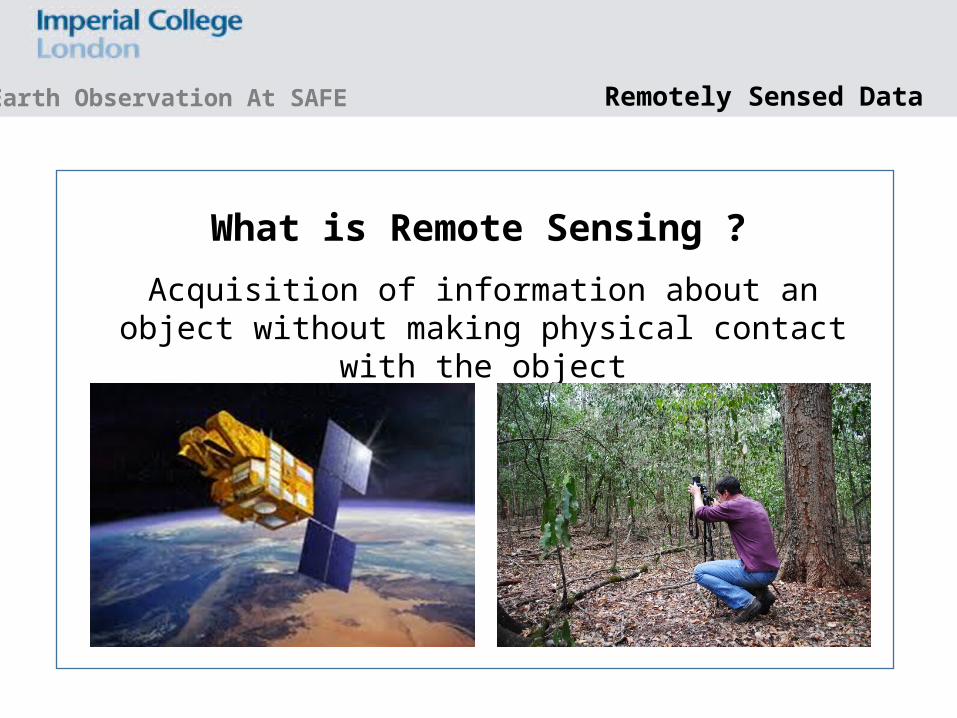
Acquisition of information about an object without making physical contact
with the object
What is Remote Sensing ?
Remotely Sensed Data

Earth Observation At SAFE
Record radiation that originates from a source outside the sensor and is reflected from the earth’s surface.
Passive Sensors
http://www.oneonta.edu/faculty/baumanpr/geosat2/RS-Introduction/RS-Introduction.html
Remotely Sensed Data

Earth Observation At SAFE
send out a signal (energy source from within sensor) and measure its backscatter from the surface.
Active Sensors
LIDAR Light detection and
ranging
RADARRadio detection and
ranging
Remotely Sensed Data
Earth Observation At SAFE
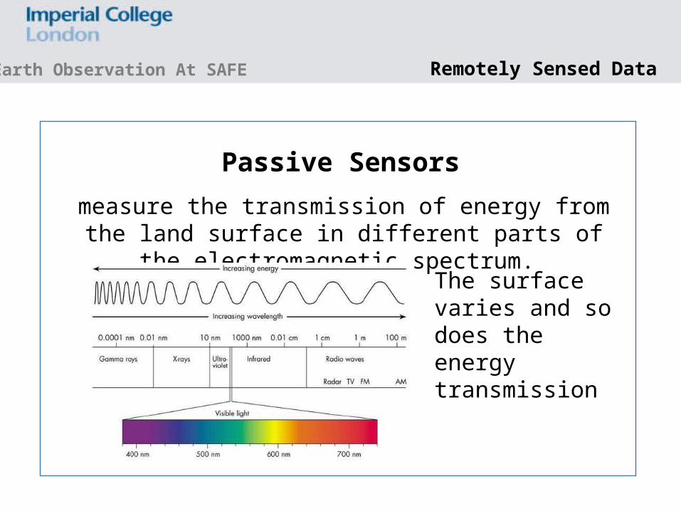
measure the transmission of energy from the land surface in different parts of
the electromagnetic spectrum.
Passive Sensors
The surface varies and so does the energy transmission
Remotely Sensed Data

Earth Observation At SAFE
BlueGreen
REDAbsorption by waterLandsat 7’s seven bands
Remotely Sensed Data

Shaw & Burke, 2003. Lincoln Laboratory Journal
Earth Observation At SAFE Remotely Sensed Data

Earth Observation At SAFE
The number of spectral bands in which the sensor can collect reflected
radiance.
Passive Sensors: spectral resolution
ASTER
Landsat TM
High: 16 < 220Medium: 3 - 15Low SR: < 3
Remotely Sensed Data

Earth Observation At SAFE
specifies the pixel size of satellite images covering the earth surface.
Passive Sensors: spatial resolution
Very High: < 1 m High: 1 - 10 m (SPOT, RapidEye)Medium: 10 - 30 m (SPOT, ASTER)Coarse: > 250 m (MODIS, AVHRR)
Effects of aggregation on canopy spatial information generated from a detailed 3D model of a savannah-type canopy
Remotely Sensed Data
Earth Observation At SAFE
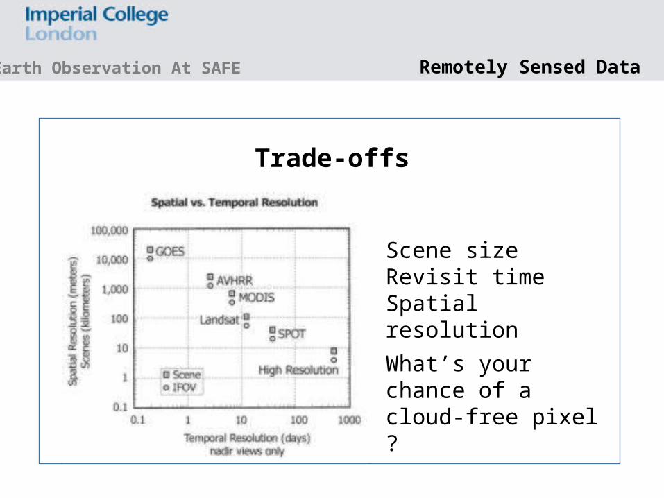
Trade-offs
Scene sizeRevisit timeSpatial resolutionWhat’s your chance of a cloud-free pixel ?
Remotely Sensed Data

Earth Observation At SAFE
RapidEye • five Earth Observation satellites, since 02/09• Sensor: RapidEye Earth Imaging System (REIS)• Image bands
Blue: 440 – 510 nmGreen: 520 – 590 nmRed: 630 – 685 nmRed Edge: 690 – 730 nmNear IR: 760 – 850 nm
• Resolution: 6.5 m (resampled to 5 m)• Capability for daily revisit to any point on earth
Satellite data at SAFE
Earth Observation At SAFE Satellite data at SAFE
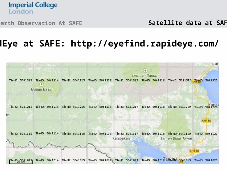
RapidEye at SAFE: http://eyefind.rapideye.com/

Earth Observation At SAFE Satellite data at SAFE
RapidEye at SAFE: ESA project N = 16, 04/12 to 01/13, Maliau: 4 images from same date

Earth Observation At SAFE Satellite data at SAFE
RapidEye at SAFE: ESA project
That’s pathetic ?
False Colour Composites

Earth Observation At SAFE Satellite data at SAFE
RapidEye at SAFE: ESA project
OG2 Upper part of F

Earth Observation At SAFE Satellite data at SAFE
RapidEye at SAFE: ESA project

Earth Observation At SAFE
SPOT 5 • Satellite with HRG sensor, since 05/02• Sensor: RapidEye Earth Imaging System (REIS)• Image bands
Green: 500 – 590 nmRed: 610 – 680 nmNear-IR: 780 – 890 nmShortwave-IR: 1580 – 1750 nmPAN: 480 – 710 nm
• Resolution: 10 m multispectral (pan-sharpened: 2.5 and 5 m)• Capability for 2-3 days revisit time
Satellite data at SAFE

Earth Observation At SAFE
SPOT 5
Satellite data at SAFE
BORNEO_SPOT1 to BORNEO_SPOT_4, 1 is 28/04/2009 and for all others: with some other years intermixed?, 2.5 m. Need offset and gain from originals though for calibration.
These are pan-sharpened images – the original ones are larger and at 10 m pixel resolution for multispectral data. SAFE_SP1 to SAFE_SP5.
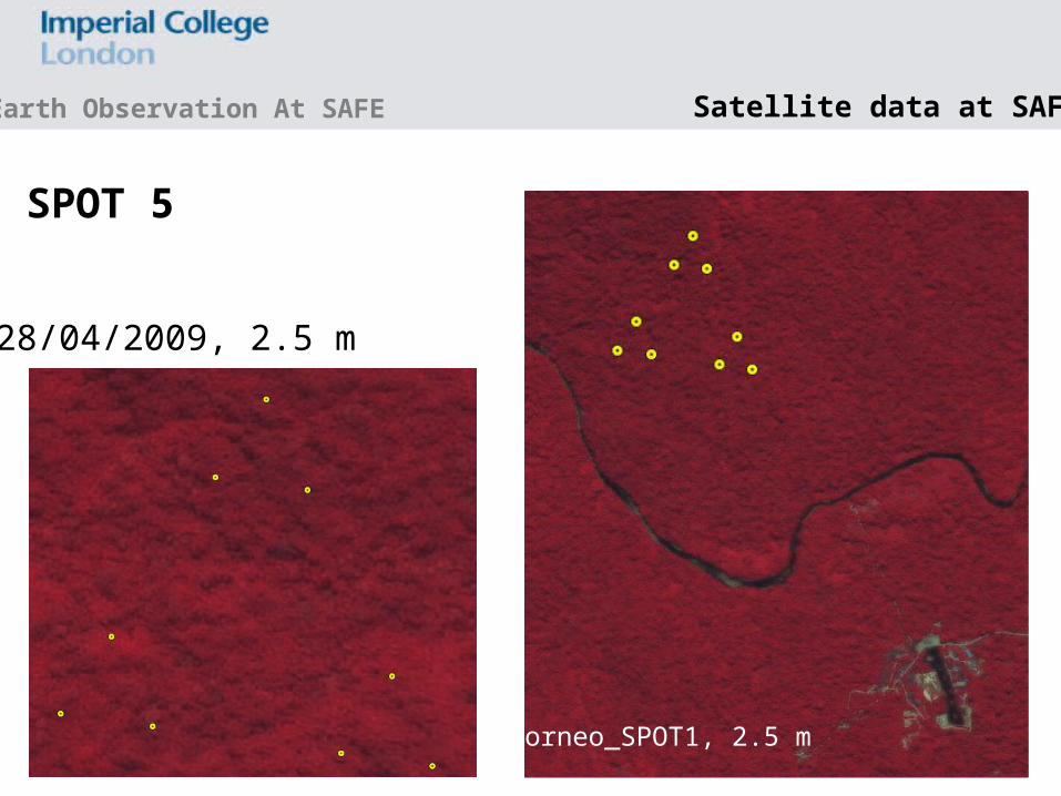
Borneo_SPOT1, 2.5 m
Earth Observation At SAFE Satellite data at SAFE
SPOT 5
28/04/2009, 2.5 m

SPOT 5SAFE_SP1 to SAFE_SP5,10 m, 2009 - 2011
28/04/2009
28/04/2009
20/08/2009
23/07/2011
29/08/2010
Earth Observation At SAFE Satellite data at SAFE
The PAN band is not in the database!
Earth Observation At SAFE Satellite data at SAFE
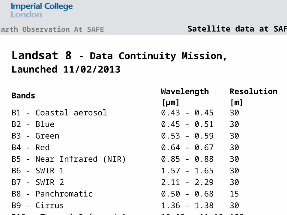
Landsat 8 - Data Continuity Mission, Launched 11/02/2013
Bands Wavelength [µm]
Resolution [m]
B1 - Coastal aerosol 0.43 - 0.45 30B2 - Blue 0.45 - 0.51 30B3 - Green 0.53 - 0.59 30B4 - Red 0.64 - 0.67 30B5 - Near Infrared (NIR) 0.85 - 0.88 30B6 - SWIR 1 1.57 - 1.65 30B7 - SWIR 2 2.11 - 2.29 30B8 - Panchromatic 0.50 - 0.68 15B9 - Cirrus 1.36 - 1.38 30B10 - Thermal Infrared 1 10.60 - 11.19 100B11 - Thermal Infrared 2 11.50 - 12.51 100

Earth Observation At SAFE
Landsat 8LS_03, 30 m (multispectral), 29/01/2014
Satellite data at SAFE

LS_04, 30 m, 10/11/2013
LS_02, 30 m, 25/08/2014
Earth Observation At SAFE
http://earthexplorer.usgs.gov/• GLS – for screened
and mosaicked images
• before 2013• Landsat Legacy for
post-2013
Satellite data at SAFE

Earth Observation At SAFE
PROBA CHRIS • Compact High Resolution Imaging Spectrometer
• Open as Generic Format – Hdf4 – BSQ in ENVI and clean using Hdf_Clean tool from ESA
• From 19 bands at 18 m to 63 bands at 63 m pixel resolution
Satellite data at SAFE
• Capability for 7 days revisit time

Thank you
Funding ERC, Sime Darby Foundation, European Space Agency
Earth Observation At SAFE