Possible deep lithospheric roots beneath South-Eastern Carpathians back-arc region
16
Acta Geod. Geoph. Hung., Vol. 45(3), pp. 340–355 (2010) DOI: 10.1556/AGeod.45.2010.3.8 POSSIBLE DEEP LITHOSPHERIC ROOTS BENEATH SOUTH-EASTERN CARPATHIANS BACK-ARC REGION C Neagoe, M Popa, M Diaconescu, M Radulian National Institute for Earth Physics, Bucharest-Magurele, Romania, e-mails: [email protected], [email protected], [email protected], [email protected] The Vrancea seismic region represents a unique case of well-defined and intense intermediate-depth earthquake activity as a consequence of specific geodynamic pro- cesses at the continental contact between East-European, Moesian and Intra-Alpine plates. Apart the subcrustal earthquakes generated in the Vrancea slab, the anal- ysis of seismicity puts into evidence two other clusters of subcrustal earthquakes (h> 50 km) toward the back-arc side of the SE Carpathians bend, one to the west (Sinaia), the other to the north-west (Bra¸ sov Depression) relative to the Vrancea seis- mic source. The hypocenters lay down between 50 to 105 km in Sinaia and between 50 and 136 km in Bra¸ sov Depression. The rate of seismic energy release is much lower (Mw ≤ 3.7 in Sinaia and Mw ≤ 3.1 in Bra¸ sov Depression) than for Vrancea activity. The seismicity pattern in the SE Carpathians back-arc region upper man- tle correlates well with the high-velocity structures depicted by seismic tomography investigations suggesting possible remnant deep lithospheric roots apart from the narrow well-defined slab generating Vrancea major earthquakes. The results outline significant lateral heterogeneities in the mantle and provide new data for incorporat- ing seismological, geotectonic and volcanological data in a unified modeling of the complex processes taking place in the study region. Keywords: alkalic magma; lithospheric root; mantle earthquakes; post-collisional mechanics Introduction The Vrancea seismic region represents a unique case of well-defined and intense intermediate-depth earthquake activity as a consequence of specific geodynamic pro- cesses at the continental contact between East-European, Moesian and Intra-Alpine plates. Despite the restraint focal volume, a couple of shocks with magnitude above 7 are generated each century. It is generally supposed that subcrustal earthquakes are focused but in a narrow lithosphere body going down beneath Vrancea and all other earthquakes are generated in the crustal domain (h< 60 km). Recent improvements of the Romania seismic network (Ionescu and Neagoe 2008, Neagoe and Ionescu 2009) and significant progress in quality of earthquake locations bring into evidence the fact that subcrustal events could be encountered over a larger area around Vrancea seismic nest: in the back-arc side of the South-Eastern (SE) 1217-8977/$ 20.00 c 2010 Akad´ emiai Kiad´ o, Budapest
-
Upload
independent -
Category
Documents
-
view
0 -
download
0
Transcript of Possible deep lithospheric roots beneath South-Eastern Carpathians back-arc region
Acta Geod. Geoph. Hung., Vol. 45(3), pp. 340–355 (2010)
DOI: 10.1556/AGeod.45.2010.3.8
POSSIBLE DEEP LITHOSPHERIC ROOTSBENEATH SOUTH-EASTERN CARPATHIANS
BACK-ARC REGION
C Neagoe, M Popa, M Diaconescu, M Radulian
National Institute for Earth Physics, Bucharest-Magurele, Romania,e-mails: [email protected], [email protected], [email protected], [email protected]
The Vrancea seismic region represents a unique case of well-defined and intenseintermediate-depth earthquake activity as a consequence of specific geodynamic pro-cesses at the continental contact between East-European, Moesian and Intra-Alpineplates. Apart the subcrustal earthquakes generated in the Vrancea slab, the anal-ysis of seismicity puts into evidence two other clusters of subcrustal earthquakes(h > 50 km) toward the back-arc side of the SE Carpathians bend, one to the west(Sinaia), the other to the north-west (Brasov Depression) relative to the Vrancea seis-mic source. The hypocenters lay down between 50 to 105 km in Sinaia and between50 and 136 km in Brasov Depression. The rate of seismic energy release is muchlower (Mw ≤ 3.7 in Sinaia and Mw ≤ 3.1 in Brasov Depression) than for Vranceaactivity. The seismicity pattern in the SE Carpathians back-arc region upper man-tle correlates well with the high-velocity structures depicted by seismic tomographyinvestigations suggesting possible remnant deep lithospheric roots apart from thenarrow well-defined slab generating Vrancea major earthquakes. The results outlinesignificant lateral heterogeneities in the mantle and provide new data for incorporat-ing seismological, geotectonic and volcanological data in a unified modeling of thecomplex processes taking place in the study region.
Keywords: alkalic magma; lithospheric root; mantle earthquakes; post-collisionalmechanics
Introduction
The Vrancea seismic region represents a unique case of well-defined and intenseintermediate-depth earthquake activity as a consequence of specific geodynamic pro-cesses at the continental contact between East-European, Moesian and Intra-Alpineplates. Despite the restraint focal volume, a couple of shocks with magnitude above7 are generated each century. It is generally supposed that subcrustal earthquakesare focused but in a narrow lithosphere body going down beneath Vrancea and allother earthquakes are generated in the crustal domain (h < 60 km).
Recent improvements of the Romania seismic network (Ionescu and Neagoe 2008,Neagoe and Ionescu 2009) and significant progress in quality of earthquake locationsbring into evidence the fact that subcrustal events could be encountered over a largerarea around Vrancea seismic nest: in the back-arc side of the South-Eastern (SE)
1217-8977/$ 20.00 c©2010 Akademiai Kiado, Budapest
LITHOSPHERIC ROOTS BENEATH SE CARPATHIANS 341
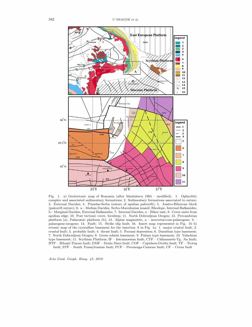
Carpathians corner (Sinaia region to the west and Brasov Depression to the north-west) and sporadically in the fore-arc region (along Intramoesian and Peceneaga-Camena faults) (Fig. 1).
However, the possibility to generate mantle earthquakes in such areas is stillopen to discussion. The few previous investigations suggesting possible subcrustalearthquakes in the fore-deep area of the SE Carpathians arc (Enescu and Enescu1998) and in the Southern Carpathians (Oncescu et al. 1989) are based on poor lo-cated data. Certainly, the focal depth accuracy is crucial to conclude on this matter.The present work provides new arguments and new well-constrained data in favorof the hypothesis of the existence of subcrustal earthquakes in the neighborhoodthe Vrancea seismogenic zone. An updated catalog of events is considered to thisaim and the seismicity pattern is discussed in terms of recent seismic tomographyresults and geodynamic modeling.
Geotectonic consideration
The study area is located in the back-arc area of the SE Carpathians corner, atthe intersection between Southern Carpathians, Eastern Carpathians and MoesianPlatform (Fig. 1).
Schematically we can say that the Southern Carpathians, between the Dambovitaand Olt valleys, are represented by the Supragetic Nappe, which has been overthrust on the Getic nappe during Middle Cretaceous (Berza et al. 1994).
The Moesian Platform represents a Precambrian block involved in the Epiher-cynian European Platforms and is composed by three different segments, boundedby the Intramoesian and Calimanesti-Tg. Jiu crustal fault, the Dobrudjean, theValachian and Danubian domains respectively. The Danubian domain is sepa-rated by Valachian domain by the Calimanesti-Tg. Jiu fault, a prolongation ofthe Timoc fault, basically a separation between platform type sedimentary depositsin the south from deformed metamorphosed ones in the north. The Valachian do-main is characterized by a large number of extended subvertical faults, mainly withN-S to NNW-SSE and E-W orientation, having a right lateral strike slip character(Matenco 1997).
The Intramoesian fault, which separates the Getic Depression from the EastCarpathians foreland area, represents an old crustal fault deep sealed, extendingnorthward of the Moesian Platform at least up to the Getic Nappe. Sporadic smallto moderate seismicity has been recorded along this fault with predominant rightlateral strike slip type focal mechanism.
The SE Carpathians represent the central part of the Outer Carpathians belt andstretch from North to the junction with the Southern Carpathians alongIntramoesian Fault. Schematically, the SE Carpathians are made up by a pile ofbasement nappes; crystalline rocks and sedimentary cover of Mesozoic age, overly-ing internal (such as Ceahlau nappe) and external (such as Tarcau, Subcarpathian)flysch/molase nappe system, the later units are trusted over the undeformed fore-land with its foredeep (Sandulescu 1984).
There are plenty of attempts to explain the geotectonics and geodynamics in
Acta Geod. Geoph. Hung. 45, 2010
342 C NEAGOE et al.
Fig. 1. a) Geotectonic map of Romania (after Sandulescu 1984 – modified). 1. Ophyoliticcomplex and associated sedimentary formations; 2. Sedimentary formations associated to suture;3. External Dacides; 4. Pinudus-Serba (suture of apulian paleorift); 5. Austro-Bihorean block(paleorift suture); 6. a – Median Dacides, Serbo-Macedonian massif, Rhodope, Internal Balkanides;b – Marginal Dacides, External Balkanides; 7. Internal Dacides, a – Bihor unit; 8. Cover units fromapulian edge; 10. Post tectonic cover, foredeep; 11. North Dobrudjean Orogen; 12. Precambrianplatform (a), Palaeozoic platform (b); 13. Alpine magmatite, a – neocretaccous-palaeogene; b –palaeogene-neogene; 14. Fault; 15. Strike slip fault; 16. Insert map represented in Fig. 1b b)ectonic map of the crystalline basement for the insertion A in Fig. 1a. 1. major crustal fault; 2.crustal fault; 3. probably fault; 4. thrust fault; 5. Focsani depression; 6. Danubian type basement;7. North Dobrudjean Orogen; 8. Green schists basement; 9. Palazu type basement; 10. Valachiantype basement; 11. Scythian Platform; IF – Intramoesian fault; CTF – Calimanesti-Tg. Jiu fault;BTF – Bibesti-Tinosu fault; DMF – Dealu Mare fault; COF – Capidava-Ovidiu fault; TF – Trotus
fault; STF – South Transylvanian fault; PCF – Peceneaga-Camena fault; CF – Cerna fault
Acta Geod. Geoph. Hung. 45, 2010
LITHOSPHERIC ROOTS BENEATH SE CARPATHIANS 343
the SE Carpathians region. All of them agree that after the convergence processbetween East European plate, Moesian plate and Intra-alpine Plate ceased around10 Ma, a decoupling process started first in the NW part and migrated toward S-SE(detachment and roll-back of the subducted oceanic lithospheric slab — Csontos1995, Mason et al. 1998, Seghedi et al. 1998, Linzer et al. 1998, or delamination ofthe lower part of the lithospheric mantle from the lower plate — Gırbacea 1997,Gırbacea and Frisch 1998).
An important element of the dynamics of lithospheric deformation of the systemin its post-collisional evolution is the volcanic activity. The break-off process wasaccompanied by magma generation (asthenosphere rises into the break-off-madehole — Mason et al. 1998). The magmatism started after the end of the majorcrustal shortening and displays a linear younging toward the progressive break-offof the subducted plate and is of short duration. The age-progressive volcanism alongthe East Carpathians is presumed to be caused by the progressive tearing of theslab. The Persani Mountains, located in the vicinity of the Brasov Depression (tothe north west), are the site of the most recently Na-alkali basaltic active volcanism(Panaiotu et al. 2004).
According to the modelling of Sperner et al. (2004) and Matenco et al. (1997),the lithosphere slab detachment in the SE Carpathians arc bend area started fromNW in sequential phases. The expectation based on these models is that an as-thenosphere inflow penetrated first to the northwestern part of the Vrancea seismicbody at depth beneath the Tisza-Dacia terranes within the Carpathian arc.
The analysis of the geochemical characteristics of the volcanic rocks generatedby the post-collisional Plio-Quaternary magmatism in the SE Carpathians and east-ern Pannonian Basin indicates contemporaneous generation of melts from differentmantle sources and/or a change in tectonic regime over a short period of time withmultiple sourcing events (Seghedi et al. 2010). Since the volcanic events are clearlyassociated to important tectonic events in the region, the only way to understandthe complex processes at subcrustal depth in the study area is to combine seis-mology, geotectonics and volcanology investigations. For the moment, we bringinto discussions only a few elements that we consider important to be consideredin order to explain the variety of structural features and types of magma at litho-spheric/asthenospheric depths in front of the Moesian plate and in the eastern partof the Pannonian Basin:
1. magmatic activity along SE Carpathians indicates a related subduction pro-cess (Mason et al. 1998);
2. the Pliocene-Quaternary evolution of the south-eastern part of the CarpathianPannonian area is characterized by two main geodynamic events: slab-pullsteepening and inversion tectonics (Seghedi et al. 2010);
3. the pronounced sinking of the slab into the asthenosphere created localizedconvection currents of asthenospheric material, as derived by numerical mod-eling of the thermal effects associated with its geometry (Ismail-Zadeh et al.2005);
Acta Geod. Geoph. Hung. 45, 2010
344 C NEAGOE et al.
4. the Moesian block was decoupled (tearing) from the European-Scythian Platealong the Trotus fault system during the late Miocene collision and the changein geodynamic mechanism in the front of Moesian domain changed the processof magma generation (Seghedi et al. 1998).
Seismicity patterns
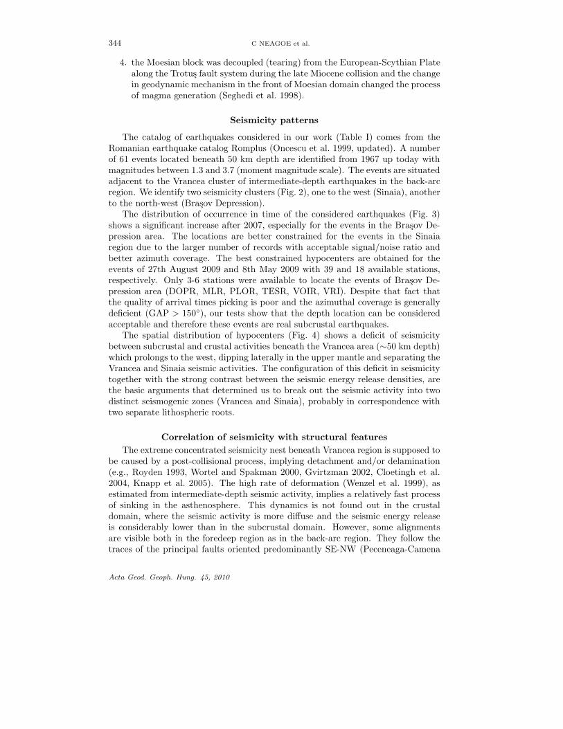
The catalog of earthquakes considered in our work (Table I) comes from theRomanian earthquake catalog Romplus (Oncescu et al. 1999, updated). A numberof 61 events located beneath 50 km depth are identified from 1967 up today withmagnitudes between 1.3 and 3.7 (moment magnitude scale). The events are situatedadjacent to the Vrancea cluster of intermediate-depth earthquakes in the back-arcregion. We identify two seismicity clusters (Fig. 2), one to the west (Sinaia), anotherto the north-west (Brasov Depression).
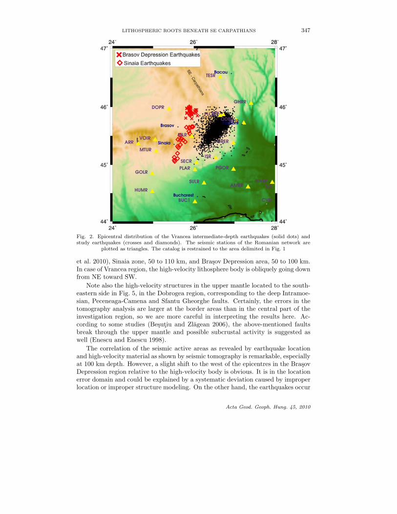
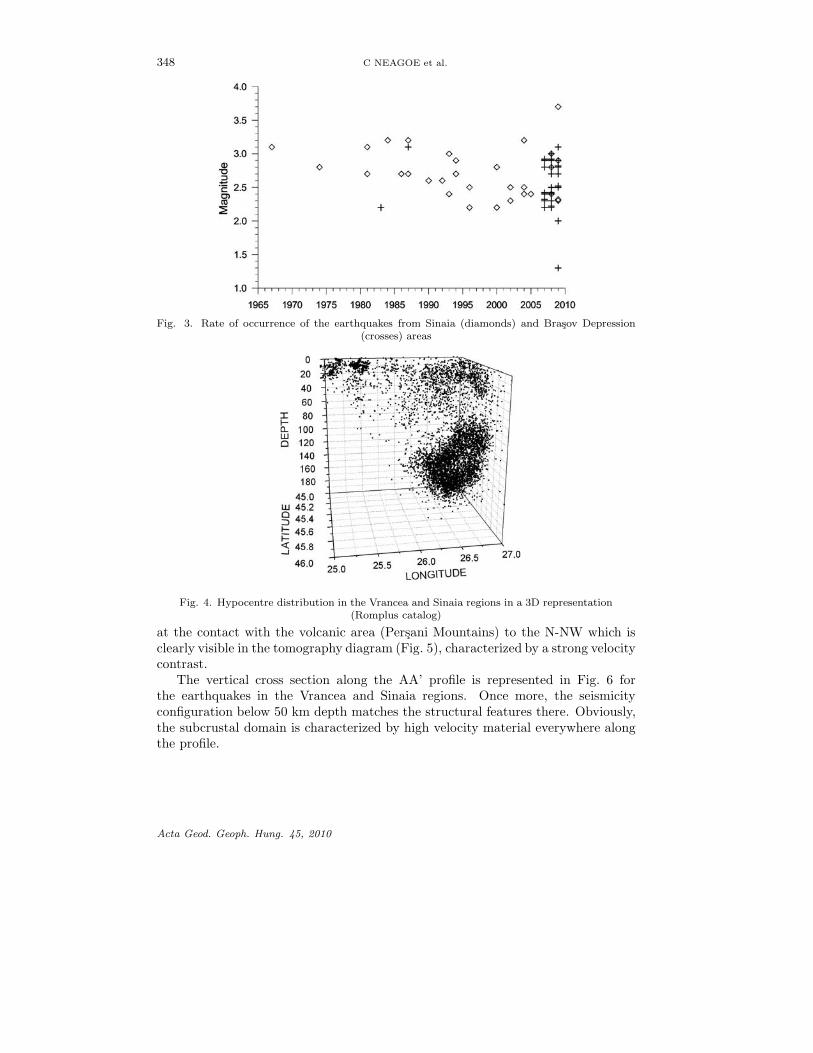
The distribution of occurrence in time of the considered earthquakes (Fig. 3)shows a significant increase after 2007, especially for the events in the Brasov De-pression area. The locations are better constrained for the events in the Sinaiaregion due to the larger number of records with acceptable signal/noise ratio andbetter azimuth coverage. The best constrained hypocenters are obtained for theevents of 27th August 2009 and 8th May 2009 with 39 and 18 available stations,respectively. Only 3-6 stations were available to locate the events of Brasov De-pression area (DOPR, MLR, PLOR, TESR, VOIR, VRI). Despite that fact thatthe quality of arrival times picking is poor and the azimuthal coverage is generallydeficient (GAP > 150◦), our tests show that the depth location can be consideredacceptable and therefore these events are real subcrustal earthquakes.
The spatial distribution of hypocenters (Fig. 4) shows a deficit of seismicitybetween subcrustal and crustal activities beneath the Vrancea area (∼50 km depth)which prolongs to the west, dipping laterally in the upper mantle and separating theVrancea and Sinaia seismic activities. The configuration of this deficit in seismicitytogether with the strong contrast between the seismic energy release densities, arethe basic arguments that determined us to break out the seismic activity into twodistinct seismogenic zones (Vrancea and Sinaia), probably in correspondence withtwo separate lithospheric roots.
Correlation of seismicity with structural featuresThe extreme concentrated seismicity nest beneath Vrancea region is supposed to
be caused by a post-collisional process, implying detachment and/or delamination(e.g., Royden 1993, Wortel and Spakman 2000, Gvirtzman 2002, Cloetingh et al.2004, Knapp et al. 2005). The high rate of deformation (Wenzel et al. 1999), asestimated from intermediate-depth seismic activity, implies a relatively fast processof sinking in the asthenosphere. This dynamics is not found out in the crustaldomain, where the seismic activity is more diffuse and the seismic energy releaseis considerably lower than in the subcrustal domain. However, some alignmentsare visible both in the foredeep region as in the back-arc region. They follow thetraces of the principal faults oriented predominantly SE-NW (Peceneaga-Camena
Acta Geod. Geoph. Hung. 45, 2010

LITHOSPHERIC ROOTS BENEATH SE CARPATHIANS 345
Table I. Catalog of the subcrustal earthquakes located in the back-arcarea of the SE Carpathians (Oncescu et al. 1999 – updated)
Date Time Lat. Lon. Depth Magnitudeyear/month/day hour:min:sec (◦N) (◦E) km
1967 03 05 18:54:21 45.28 25.95 64 3.11974 01 05 04:28:04 45.43 25.67 90 2.81981 03 14 17:11:00 45.20 25.60 100 3.11981 03 15 15:14:00 45.20 25.60 75 2.71983 02 01 06:53:07 45.93 26.02 85 2.21984 03 26 23:17:12 45.42 25.83 70 3.21985 02 01 06:35:45 45.20 25.40 50 2.81986 01 17 04:28:44 45.65 25.82 65 2.71987 02 05 13:28:11 45.27 25.99 82 3.21987 02 06 19:41:49 45.90 26.06 123 3.11987 07 24 01:45:27 45.34 25.88 70 2.71990 12 10 12:24:45 45.66 25.95 58 2.61992 02 12 11:47:41 45.13 25.52 73 2.61993 06 22 15:44:56 45.30 25.62 76 3.01993 07 14 13:42:16 45.65 25.89 60 2.41994 05 12 11:49:06 45.08 25.52 72 2.71994 08 12 11:26:50 45.06 25.53 73 2.91996 02 02 07:51:16 45.44 25.61 58 2.21996 12 30 20:41:21 45.43 25.74 57 2.52000 06 06 00:40:54 45.54 25.90 57 2.22000 11 21 05:31:38 45.40 25.79 56 2.82002 03 31 18:41:53 45.35 25.67 54 2.52002 10 06 14:58:07 45.51 25.66 59 2.32004 06 29 12:03:12 45.66 25.98 51 2.42004 09 07 15:50:44 45.45 25.70 55 2.52004 11 30 20:52:34 45.30 25.83 105 3.22005 05 20 12:18:34 45.58 25.88 93 2.42007 05 02 11:37:28 45.88 25.95 132 2.82007 05 16 12:36:21 45.98 25.83 55 2.32007 06 06 15:54:27 45.90 25.83 55 2.42007 06 24 12:54:48 45.93 25.91 79 2.42007 07 09 14:59:53 45.90 25.84 55 2.32007 07 24 12:17:12 45.89 26.00 118 2.92007 08 28 13:40:49 45.93 25.88 51 2.22007 10 16 11:10:27 45.91 25.92 111 2.92008 01 06 16:03:53 45.95 26.07 132 2.92008 05 10 21:44:47 45.85 26.09 86 2.52008 07 29 12:51:02 45.86 25.91 102 3.02008 08 08 11:53:58 45.98 25.93 104 2.92008 08 12 09:36:30 45.98 25.87 50 2.32008 09 03 12:34:31 45.66 25.97 90 2.82008 09 11 11:07:27 45.95 25.89 55 2.42008 09 16 11:08:40 45.95 26.04 97 2.72008 09 22 12:51:05 45.63 25.90 58 2.42008 09 29 12:01:44 45.95 26.05 75 2.82008 10 21 12:21:05 46.00 25.92 50 2.42008 11 04 12:48:34 45.97 25.83 54 2.22008 11 18 13:50:34 45.92 25.91 50 2.2
Acta Geod. Geoph. Hung. 45, 2010
346 C NEAGOE et al.
Table I. (contd.)
Date Time Lat. Lon. Depth Magnitudeyear/month/day hour:min:sec (◦N) (◦E) km
2009 02 18 11:38:34 45.80 25.95 55 2.52009 02 23 13:28:44 45.89 25.83 55 2.52009 03 10 12:35:35 45.92 26.05 88 2.92009 04 03 06:50:44 45.11 25.60 56 2.32009 05 08 08:44:32 45.32 25.60 100 2.92009 05 15 09:03:50 45.77 26.05 59 2.02009 06 15 08:36:10 45.92 25.91 102 2.82009 07 10 10:21:22 46.00 25.88 98 2.72009 08 05 10:20:30 45.74 25.93 120 1.32009 08 27 05:18:13 45.40 25.76 100 3.72009 09 09 08:28:29 45.81 25.80 102 2.82009 09 11 09:59:34 45.86 25.96 136 3.12009 11 10 04:00:00 45.36 25.62 60 2.3
fault, Intramoesian fault and Trotus fault) which delimit the Vrancea area to thenorth and south, as well as a perpendicular alignment along the contact betweenthe Focsani deep sedimentary basin and the Carpathians orogen (so-called RamnicuSarat seismic area). The last one is situated adjacently to the Vrancea region andoriented parallel to the SE Carpathians Arc bend (along a NE-SW direction at the).Although continuous seismicity is recorded here, with quite frequent earthquakesequences, there is no faulting trace visible at the Earth’s surface. Only small andmoderate earthquakes are reported in the SE Carpathians foredeep area (Mw < 5.5).
In the back-arc area there is a significant shallow seismic activity in the Sinaiaregion (Enescu et al. 1996). The most important earthquake sequence occurred onMay–June 1993 with 345 identified events (main shock of magnitude ML = 5.1)distributed along a NW-SE direction (along Sinaia fault).
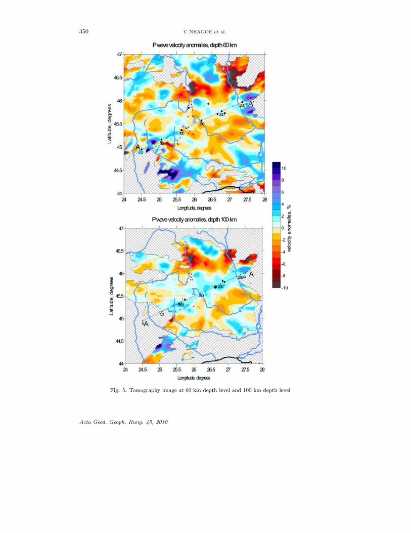
The new data set considered in the present study outlines besides the crustalearthquakes, two seismicity clusters in the upper mantle, beneath Sinaia region andin the Brasov Depression region. They correlate well with the presence of high-velocity material as shown by the seismic tomography determined using local dataand seem to indicate the presence of deep lithospheric roots in these areas. Twoslices at 60 km depth and 100 km depth of the P-wave anomaly are plotted inFig. 5. They are obtained by tomography inversion using the LOTOS-09 algorithmproposed by Koulakov (2009) for a data set of 1953 earthquakes occurred on theRomanian territory.
The tomography diagrams reveal predominant low-velocity structures (astheno-sphere) extended in the Moesian Platform, Moldavian Platform and TransylvanianBasin. They surround areas of higher P-wave velocity. Thus we can identify theepicentral areas of intermediate-depth earthquakes generated in the Vrancea region(around 46.5◦N latitude and 26.5◦E longitude), in the Sinaia region and BrasovDepression region. It is worth mentioning that the high-velocity anomaly charac-terizes the entire subcrustal domain beneath Vrancea zone, 60 to 170 km (Koulakov
Acta Geod. Geoph. Hung. 45, 2010
LITHOSPHERIC ROOTS BENEATH SE CARPATHIANS 347
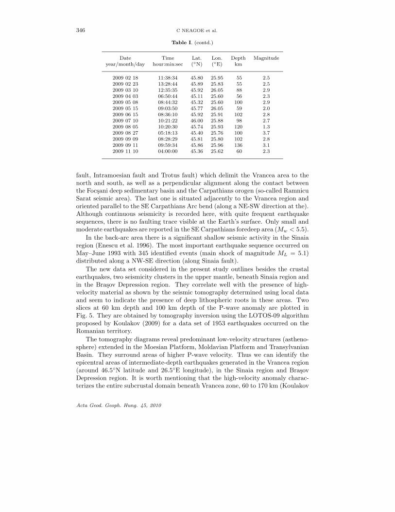
Fig. 2. Epicentral distribution of the Vrancea intermediate-depth earthquakes (solid dots) andstudy earthquakes (crosses and diamonds). The seismic stations of the Romanian network are
plotted as triangles. The catalog is restrained to the area delimited in Fig. 1
et al. 2010), Sinaia zone, 50 to 110 km, and Brasov Depression area, 50 to 100 km.In case of Vrancea region, the high-velocity lithosphere body is obliquely going downfrom NE toward SW.
Note also the high-velocity structures in the upper mantle located to the south-eastern side in Fig. 5, in the Dobrogea region, corresponding to the deep Intramoe-sian, Peceneaga-Camena and Sfantu Gheorghe faults. Certainly, the errors in thetomography analysis are larger at the border areas than in the central part of theinvestigation region, so we are more careful in interpreting the results here. Ac-cording to some studies (Besutiu and Zlagean 2006), the above-mentioned faultsbreak through the upper mantle and possible subcrustal activity is suggested aswell (Enescu and Enescu 1998).
The correlation of the seismic active areas as revealed by earthquake locationand high-velocity material as shown by seismic tomography is remarkable, especiallyat 100 km depth. However, a slight shift to the west of the epicentres in the BrasovDepression region relative to the high-velocity body is obvious. It is in the locationerror domain and could be explained by a systematic deviation caused by improperlocation or improper structure modeling. On the other hand, the earthquakes occur
Acta Geod. Geoph. Hung. 45, 2010
348 C NEAGOE et al.
Fig. 3. Rate of occurrence of the earthquakes from Sinaia (diamonds) and Brasov Depression(crosses) areas
Fig. 4. Hypocentre distribution in the Vrancea and Sinaia regions in a 3D representation(Romplus catalog)
at the contact with the volcanic area (Persani Mountains) to the N-NW which isclearly visible in the tomography diagram (Fig. 5), characterized by a strong velocitycontrast.
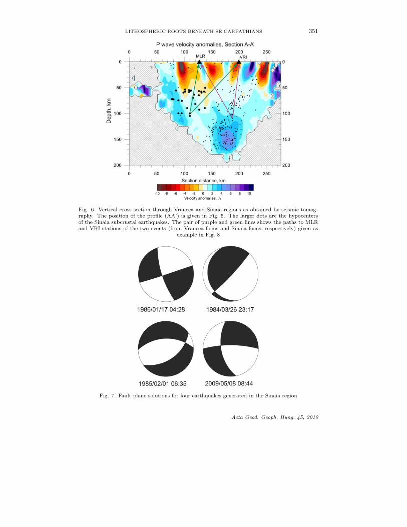
The vertical cross section along the AA’ profile is represented in Fig. 6 forthe earthquakes in the Vrancea and Sinaia regions. Once more, the seismicityconfiguration below 50 km depth matches the structural features there. Obviously,the subcrustal domain is characterized by high velocity material everywhere alongthe profile.
Acta Geod. Geoph. Hung. 45, 2010

LITHOSPHERIC ROOTS BENEATH SE CARPATHIANS 349
Geotectonic interpretation
The SE Carpathians arc bend represents a key area to understand the Carpatho-Pannonian system evolution. The complex geodynamic processes supposed to actas a consequence of the continental plates converging in this area let to the unusualsinking lithosphere beneath the Vrancea region. The high rate of deformation isconcentrated in an extreme, vertically developed high-velocity body, which is welldefined by seismicity configuration and seismic tomography modeling from localdata (Radulian et al. 2008, Koulakov et al. 2010). Other isolated seismicity clus-ters in the mantle are emphasized by the present analysis located in the southernbranch (beneath Sinaia area) and in the eastern branch (beneath Brasov Depressionarea) of the Carpathians. Although the subcrustal earthquakes generated in theseareas are of small magnitude and significantly less frequent as compared with thesubcrustal earthquakes in the Vrancea region, we assume they are genetically re-lated to the Vrancea earthquakes and reflect to a certain extent the post-collisionalprocesses that took place at the arc bend of the SE Carpathians (break-off and/ordelamination of the downgoing slab beneath Vrancea). They could be ascribed torelic lithospheric roots which are at present only poorly seismically activated.
To explain our results we adopt the multiple segmentation hypothesis of Sperner(1996): as the collision migrates toward SE and S, more and more segments are de-tached and sink into upper mantle. At present only one segment is still attached,beneath the Vrancea area. Similarly, in the model proposed by Matenco et al. (1997)a back stepping hypothesis is introduced with lateral migration of the plate bound-ary activity, possibly by slab detachment (Wortel and Spakman 1993), from theEast European platform to the Moesian platform. According to these approaches,the back-arc area of the SE Carpathians arc bend is highly fragmented in differ-ent lithospheric slices, with possible infiltration of ascending hot asthenosphericmaterial toward NW.
The few events for which we could determine the fault plane solutions in Sinaiaarea (Fig. 7) indicate an extensional regime with normal and strike-slip faulting incontrast with the compressional regime in the Vrancea slab with predominant re-verse faulting (e.g., Fuchs et al. 1979, Oncescu 1984). According to our preliminaryanalysis, the pulling down forces that are predominant in the Vrancea subcrustalbody are most probably missing in the Sinaia subcrustal body. We assume thatfrom geodynamical point of view, the forces in the second case indicate rather arebound process than a pulling down gravitational process.
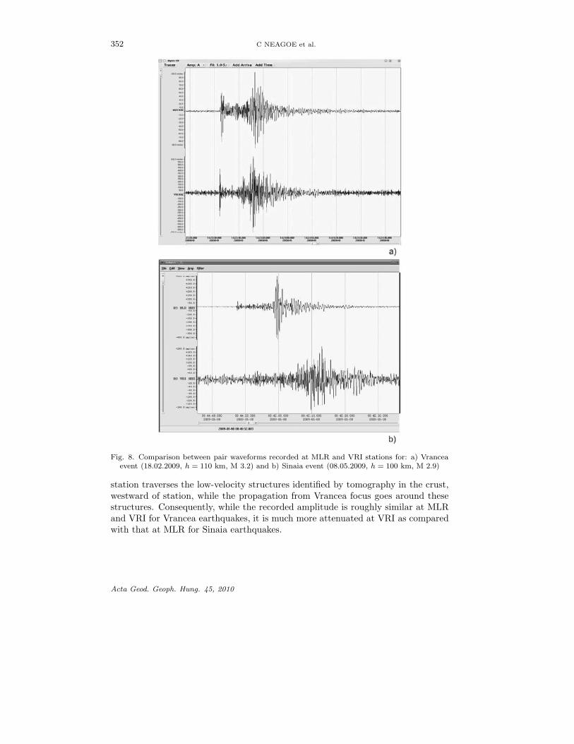
The differences in distribution of asthenosphere and lithosphere (continentalupper mantle and crust) can be qualitatively compared for waveforms after propa-gating along different paths from Vrancea and Sinaia events to the seismic stationsin the study region. For example, in Fig. 8, we compare the seismograms recordedat MLR and VRI stations from two typical events, one located beneath Vrancearegion, the other beneath Sinaia region. The approximate focus-site paths for thetwo events can be seen in Fig. 6. The wave propagation from Sinaia focus andVrancea focus to MLR station passes roughly through similar structures. The con-figuration is different for the VRI station: the propagation from Sinaia focus to VRI
Acta Geod. Geoph. Hung. 45, 2010
350 C NEAGOE et al.
Fig. 5. Tomography image at 60 km depth level and 100 km depth level
Acta Geod. Geoph. Hung. 45, 2010
LITHOSPHERIC ROOTS BENEATH SE CARPATHIANS 351
Fig. 6. Vertical cross section through Vrancea and Sinaia regions as obtained by seismic tomog-raphy. The position of the profile (AA’) is given in Fig. 5. The larger dots are the hypocentersof the Sinaia subcrustal earthquakes. The pair of purple and green lines shows the paths to MLRand VRI stations of the two events (from Vrancea focus and Sinaia focus, respectively) given as
example in Fig. 8
Fig. 7. Fault plane solutions for four earthquakes generated in the Sinaia region
Acta Geod. Geoph. Hung. 45, 2010
352 C NEAGOE et al.
Fig. 8. Comparison between pair waveforms recorded at MLR and VRI stations for: a) Vranceaevent (18.02.2009, h = 110 km, M 3.2) and b) Sinaia event (08.05.2009, h = 100 km, M 2.9)
station traverses the low-velocity structures identified by tomography in the crust,westward of station, while the propagation from Vrancea focus goes around thesestructures. Consequently, while the recorded amplitude is roughly similar at MLRand VRI for Vrancea earthquakes, it is much more attenuated at VRI as comparedwith that at MLR for Sinaia earthquakes.
Acta Geod. Geoph. Hung. 45, 2010
LITHOSPHERIC ROOTS BENEATH SE CARPATHIANS 353
Conclusions
The present study brings into light new seismicity data for the regions locatedin the back-arc side of the Vrancea seismic area. Two clusters of earthquakes areidentified at subcrustal depth, one located to the west from Vrancea (Sinaia), theother to the north-west from Vrancea (Brasov Depression). The hypocenters laydown between 50 to 105 km in Sinaia and between 50 and 136 km in Brasov De-pression. They are not notable as rate of seismic energy release (Mw ≤ 3.7 in Sinaiaand Mw ≤ 3.1 in Brasov Depression), but seem to outline significant heterogeneitiesin the mantle in correlation with tomography investigation and show significant as-pects that potentially provide tests for interpreting and modeling slab detachmentand subcontinental lithosphere processes.
Our preliminary results confirm the complex pattern and kinematics in the back-arc region of the SE Carpathians which affects not only the crustal domain, butthe upper mantle structure as well. Certainly, this snapshot is a consequence of theslab detachment and subcontinental delamination processes that took place at theSE Carpathians arc bend and all the accompanying effects.
The puzzling pattern of alternate sequences of asthenosphere and lithospherematerial (continental upper mantle and crust) in the study region with strong con-trasts developed on vertical direction as well as laterally, as indicate by tomographyimage and geomorphology, reflects contrasting processes: downgoing delaminationaccompanied by ascending asthenospheric inflow along the lateral slab tears. Theslab detachment and fragmentation in subsequent episodes was accompanied by as-cending inflows of asthenosphere creating this way a rather complicated structurein the back-arc side of the SE Carpathians, with alternate low-velocity and high-velocity bodies going down to subcrustal depth, apparent in seismicity pattern,seismic tomography image and magma composition. It results also in asymmetricfeatures related to attenuation of seismic waves (Popa et al. 2005, Russo et al. 2005),topography, seismicity and volcanism. The heterogeneous distribution of astheno-sphere beneath Vrancea and around possibly explains as well the rather chaoticdistribution of the anisotropy properties reported in this region (Popa et al. 2008).
The position of the subcrustal earthquake nest in the north-western part ofthe study region coincides with the contact region between Persani volcanic areaand Brasov Depression. The contact is clearly visible in the tomography image asshown in Fig. 5. Na-alkalic magmatism at the westernmost edge of the Brasov isdominantly derived from an asthenospheric source (Downes et al. 1995, Vaselli etal. 1995, Seghedi et al. 2004, 2005). Therefore, we assume that immediately to theN-NW from Brasov Depression a significant asthenospheric uprise is responsiblefor the magmatic activity in the southeastern edge of the volcanic arc in the innerCarpathians, and this probably induces somehow the subcrustal seismicity at thecontact with an assumed deep lithospheric root (cold lithosphere) beneath BrasovDepression.
The up-to-date seismicity pattern suggests an extension of the subcrustal seismicactivity from the cluster in the Brasov Depression toward N-NW, close and parallelto the South Harghita volcanic chain alignment. In a future work, we shall extend
Acta Geod. Geoph. Hung. 45, 2010
354 C NEAGOE et al.
our investigation to this area as well, in order to identify any interdependencebetween seismic configuration and recent volcanic activity configurations.
Our results are preliminary but may ultimately yield a strong test of slab de-tachment and continental lithosphere delamination hypotheses put forth to explainthe unusual seismicity and volcanism of the Carpathian arc. The monitoring ofseismicity around Vrancea area using high-dense seismic network, the refined lo-cations and tomography inversion provides a strong tool to constrain the complex3D distribution of lithosphere/asthenosphere contact, with alternating narrow coldlithosphere roots and hot asthenosphere uprisings.
Acknowledgements
The seismic tomography images are provided by B Zaharia. We benefited of fruitfuldiscussions with I Seghedi that have improved significantly the quality of the paper.
The work was supported the Romanian Ministry of Education and Research, Projects
No. 313/01.10.2007 and D11-025/14.10.2007.
References
Berza T, Balintoni I, Iancu V, Seghedi A, Hann H P 1994: Rom. J. Tect. Reg. Geol., 75,37–49.
Besutiu L, Zlagean L 2006: In: Geodynamics of the Balkan Peninsula – A Monograph.Sledzinski et al., eds, Reports on Geodesy, No. 5, 399–405.
Cloetingh S A P L, Burov E, Matenco L, Toussaint G, Bertotti G, Andriessen P A M,Wortel M J R, Spakman W 2004: Earth Planet. Sci. Lett., 218, 57–76.
Csontos L 1995: Acta Vulcanologica, 7 (2), 1–13.Downes H, Seghedi I, Szakacs A, Dobosi G, James D E, Vaselli O, Rigby I J, Ingram G A,
Rex D, Pecskay Z 1995: Lithos, 35, 65–81.Enescu D, Enescu B D 1998: Romanian Reports Phys., 50, 97–122.Enescu D, Popescu E, Radulian M 1996: Tectonophysics 261, 39–49.Fuchs K, Bonjer K-P, Bock G, Cornea I, Radu C, Enescu D, Jianu D, Nourescu A,
Merkler G, Moldoveanu T, Tudorache G 1979: Tectonophysics, 53, 225–247.Gırbacea R 1997: The Pliocene to recent tectonic evolution of the Eastern Carpathians
(Romania). Tuebinger Geowissenschaftliche Arbeiten: PhD thesisGırbacea R, Frisch W 1998: Geology, 26, 611–614.Gvirtzman Z 2002: Geology, 30, 51–54.Ionescu C, Neagoe C 2008: Acta Geod. Geoph. Hung. 43, 145–152.Ismail-Zadeh A, Mueller B, Schubert G 2005: Phys. Earth Planet. Int., 149, 81–98.Knapp J H, Knapp C C, Raileanu V, Matenco L, Mocanu V, Dinu C 2005: Tectonophysics,
410, 311–323.Koulakov I 2009: Bull. Seism. Soc. Amer., 99, No. 1, 194–214.Koulakov I, Zaharia B, Enescu B, Radulian M, Popa M, Parolai S, Zschau J 2010: Geochem.
Geophys. Geosyst., 11, Q03002.Linzer H-G, Frisch W, Zweigel P, Girbacea R, Hann H-P, Moser F 1998: Tectonophysics
297, 133–156.Mason P R D, Seghedi I, Szakacs A, Downes H 1998: Tectonophysics, 297, 157–176.Matenco L M 1997: Tectonic evolution of the outer Romanian Carpathians. PhD thesis,
Vrije Universiteit, Netherlands
Acta Geod. Geoph. Hung. 45, 2010

LITHOSPHERIC ROOTS BENEATH SE CARPATHIANS 355
Matenco L, Zoetemeijer R, Cloetingh S, Dinu C 1997: Tectonophysics, 282, 147–166.Neagoe C, Ionescu C 2009: Romanian Reports Phys., 61, 359–366.Oncescu M C 1984: Annales Geoph., 2, 23–27.Oncescu M C, Ardeleanu L, Popescu E 1989: In: Proceedings of 21th General Assembly
of ESC, Sofia, 278–283.Oncescu M C, Marza V I, Rizescu M, Popa M 1999: In: Vrancea Earthquakes: Tectonics,
Hazard and Risk Mitigation. F Wenzel, D Lungu, O Novak eds, Kluwer AcademicPublishers, Dordrecht, Netherlands, 43-47.
Panaiotu C G, Pecskay Z, Hambach U, Seghedi I, Panaiotu Itaya C E T, Orleanu M,Szakacs A 2004: Geologica Carpathica 55, 4, 333–339.
Popa M, Radulian M, Grecu B, Popescu E, Placinta A O 2005: Tectonophysics, 410,235–249.
Popa M, Radulian M, Panaiotu C, Borleanu F 2008: Tectonophysics, 462, 83–88.Radulian M, Popa M, Carbunar O F, Rogozea M 2008: Acta Geod. Geoph. Hung., 43,
163–173.Royden L H 1993: Tectonics, 12, 303–325.Russo R M, Mocanu V, Radulian M, Popa M, Bonjer K-P 2005: Earth Planet. Sci. Lett.,
237, 695–709.Sandulescu M 1984: Geotectonics of Romania (in Romanian). Technical Publishing House,
Bucharest, RomaniaSeghedi I, Balintoni I, Szakacs A 1998: Lithos, 45, 483–497.Seghedi I, Downes H, Vaselli O, Szakacs A, Balogh K, Pecskay Z 2004: Tectonophysics,
393, 43–62.Seghedi I, Downes H, Harangi S, Mason P R D, Pecskay Z 2005: Tectonophysics, 410,
485-499.Seghedi I, Matenco L, Downes H, Mason P R D, Szakacs A, Pecskay Z 2010: Tectonophysics
(in press)Sperner B 1996: Computer programs for kinematic analysis of brittle deformation struc-
tures and the Tertiary tectonic evolution of the Western Carpathians (Slovakia). PhDthesis, Tubingen University
Sperner B, Ioane D, Lillie R J 2004: Tectonophysics, 382, 51–84.Vaselli O, Downes H, Thirlwall M, Dobosi G, Coradossi N, Seghedi I, Szakacs A,
Vannucci R 1995: J. Petrol., 36, 23–53.Wenzel F, Lorenz F, Sperner B, Oncescu M C 1999: In: Vrancea Earthquakes: Tectonics,
Hazard and Risk Mitigation. F Wenzel, D Lungu, O Novak eds, Kluwer Acad.,Dordrecht, Netherlands, 15–26.
Wortel M J R, Spakman W 1993: Terra Nova, 5 (Abstr. suppl.), 97.Wortel M J R, Spakman W 2000: Science, 290, 1910–1917.
Acta Geod. Geoph. Hung. 45, 2010