Porter, R. J. and Gallois, R. W. 2008. Identifying fluvio–lacustrine intervals in thick playa-lake...
18
Identifying fluvio–lacustrine intervals in thick playa-lake successions: An integrated sedimentology and ichnology of arenaceous members in the mid–late Triassic Mercia Mudstone Group of south-west England, UK Richard J. Porter a, ⁎, Ramues W. Gallois b a Department of Earth Sciences, University of Bristol, Wills Memorial Building, Queen's Road, Bristol, BS8 1RJ, UK b Gallois Geological Consultancy, 92 Stoke Valley Road, Exeter, Devon, EX4 5ER, UK abstract article info Article history: Received 26 October 2006 Accepted 24 January 2008 Keywords: Lacustrine Red beds Sedimentology Trace fossils Triassic United Kingdom A complete Triassic succession is exposed in the cliffs of the Devon coast in south-west England, UK where it forms part of the Dorset & East Devon World Heritage Site. The upper part of the succession, the Middle to Late Triassic Mercia Mudstone Group, consists of c. 450 m of predominantly red mudstones and associated evaporites that were deposited in playa lakes in hot deserts. The Group has an extensive onshore and offshore outcrop and subcrop in the U.K. where it locally comprises over 3000 m of red beds with thick halites. The Devon coast section is the type for the Group and is the most complete exposure of the Keuper Marl facies in north-west Europe. In its middle part, the Dunscombe Mudstone Formation comprises a 25 to 40 m-thick laterally variable succession of green, purple and grey laminated mudstones with thin interbeds of calcareous siltstone/sandstone, and thicker beds of autobreccia related to gypsum/anhydrite and halite dissolution. It represents a fluvio–lacustrine and probably cooler climatic interval that is thought to have lasted, on the basis of palaeontological and magnetostratigraphic evidence, for most of the Carnian Stage (c. 12 Ma). Elsewhere in Europe the Carnian Stage is represented by fluvial deposits including the Esterienschichten and Schilfsandstein Formations in Germany. At the type section on the Devon coast the Dunscombe Mudstone includes a lenticular unit of bioturbated, predominantly fine-grained sandstone up to 4 m thick, the Lincombe Member, that has not been recorded in inland sections in the county. When traced northwards into Somerset, thin lenticular sandstones, the North Curry and Sutton Mallet Sandstone Members, are locally present at similar stratigraphical levels in the lower part of the Dunscombe Mudstone. A detailed analysis of the sedimentology of the three principal occurrences of these arenaceous units revealed 13 lithofacies and 6 ichnofabrics that suggest deposition in similar fluvio–lacustrine settings. Their palaeoenvironmental interpretation and correlation is more complex than previously thought. The Lincombe Member is interpreted as a geographically isolated sedimentary body that was deposited in a shallow, oxygenated freshwater lake. In Devon it passes upwards and laterally into lake-margin and lake delta-plain deposits. The North Curry Sandstone was deposited in a series of broad, shallow channels that crossed a low- relief topography. Laterally, along strike, the channel sands either pass into or terminate against more argillaceous lacustrine deposits. In contrast, the depositional environment of the Sutton Mallet Sandstone is interpreted as relatively small-scale channels with low flows and possible channel switching. Fluvio– lacustrine intervals are relatively common within playa-lake successions, but there are few published accounts of ancient examples that are sufficiently detailed to allow the complex interactions of these ephemeral shallow-water environments to be understood. The sedimentological and ichnological descriptions and analyses of the Triassic example presented here will be applicable to other fluvio– lacustrine sediments deposited in dryland environments. © 2008 Elsevier B.V. All rights reserved. 1. Introduction The Mercia Mudstone Group (Middle to Upper Triassic) is extensively exposed in the cliffs on the east Devon coast between Sidmouth and Axmouth (Fig. 1 , location 1) consists of c. 450 m of predominantly red mudstones and associated evaporates. This is the most complete exposure of the Keuper Marl facies in northwest Europe (Jeans, 1978) and is the UK type section for the Mercia Palaeogeography, Palaeoclimatology, Palaeoecology 270 (2008) 381–398 ⁎ Corresponding author. Present address: Shell International Exploration and Production B.V., Kessler Park 1, 2288 GS Rijswijk, The Netherlands. E-mail addresses: [email protected] (R.J. Porter), [email protected] (R.W. Gallois). 0031-0182/$ – see front matter © 2008 Elsevier B.V. All rights reserved. doi:10.1016/j.palaeo.2008.07.020 Contents lists available at ScienceDirect Palaeogeography, Palaeoclimatology, Palaeoecology journal homepage: www.elsevier.com/locate/palaeo
-
Upload
independent -
Category
Documents
-
view
1 -
download
0
Transcript of Porter, R. J. and Gallois, R. W. 2008. Identifying fluvio–lacustrine intervals in thick playa-lake...
Palaeogeography, Palaeoclimatology, Palaeoecology 270 (2008) 381–398
Contents lists available at ScienceDirect
Palaeogeography, Palaeoclimatology, Palaeoecology
j ourna l homepage: www.e lsev ie r.com/ locate /pa laeo
Identifying fluvio–lacustrine intervals in thick playa-lake successions: An integratedsedimentology and ichnology of arenaceous members in the mid–late Triassic MerciaMudstone Group of south-west England, UK
Richard J. Porter a,⁎, Ramues W. Gallois b
a Department of Earth Sciences, University of Bristol, Wills Memorial Building, Queen's Road, Bristol, BS8 1RJ, UKb Gallois Geological Consultancy, 92 Stoke Valley Road, Exeter, Devon, EX4 5ER, UK
⁎ Corresponding author. Present address: Shell InProduction B.V., Kessler Park 1, 2288 GS Rijswijk, The N
E-mail addresses: [email protected] (R.J. Port(R.W. Gallois).
0031-0182/$ – see front matter © 2008 Elsevier B.V. Aldoi:10.1016/j.palaeo.2008.07.020
a b s t r a c t
a r t i c l e i n f oArticle history:
A complete Triassic success Received 26 October 2006Accepted 24 January 2008Keywords:LacustrineRed bedsSedimentologyTrace fossilsTriassicUnited Kingdom
ion is exposed in the cliffs of the Devon coast in south-west England, UK where itforms part of the Dorset & East Devon World Heritage Site. The upper part of the succession, the Middle toLate Triassic Mercia Mudstone Group, consists of c. 450 m of predominantly red mudstones and associatedevaporites that were deposited in playa lakes in hot deserts. The Group has an extensive onshore andoffshore outcrop and subcrop in the U.K. where it locally comprises over 3000 m of red beds with thickhalites. The Devon coast section is the type for the Group and is the most complete exposure of the KeuperMarl facies in north-west Europe. In its middle part, the Dunscombe Mudstone Formation comprises a 25 to40 m-thick laterally variable succession of green, purple and grey laminated mudstones with thin interbedsof calcareous siltstone/sandstone, and thicker beds of autobreccia related to gypsum/anhydrite and halitedissolution. It represents a fluvio–lacustrine and probably cooler climatic interval that is thought to havelasted, on the basis of palaeontological and magnetostratigraphic evidence, for most of the Carnian Stage(c. 12 Ma). Elsewhere in Europe the Carnian Stage is represented by fluvial deposits including theEsterienschichten and Schilfsandstein Formations in Germany. At the type section on the Devon coast theDunscombe Mudstone includes a lenticular unit of bioturbated, predominantly fine-grained sandstone up to4 m thick, the Lincombe Member, that has not been recorded in inland sections in the county. When tracednorthwards into Somerset, thin lenticular sandstones, the North Curry and Sutton Mallet SandstoneMembers, are locally present at similar stratigraphical levels in the lower part of the Dunscombe Mudstone. Adetailed analysis of the sedimentology of the three principal occurrences of these arenaceous units revealed13 lithofacies and 6 ichnofabrics that suggest deposition in similar fluvio–lacustrine settings. Theirpalaeoenvironmental interpretation and correlation is more complex than previously thought. The LincombeMember is interpreted as a geographically isolated sedimentary body that was deposited in a shallow,oxygenated freshwater lake. In Devon it passes upwards and laterally into lake-margin and lake delta-plaindeposits. The North Curry Sandstone was deposited in a series of broad, shallow channels that crossed a low-relief topography. Laterally, along strike, the channel sands either pass into or terminate against moreargillaceous lacustrine deposits. In contrast, the depositional environment of the Sutton Mallet Sandstone isinterpreted as relatively small-scale channels with low flows and possible channel switching. Fluvio–lacustrine intervals are relatively common within playa-lake successions, but there are few publishedaccounts of ancient examples that are sufficiently detailed to allow the complex interactions of theseephemeral shallow-water environments to be understood. The sedimentological and ichnologicaldescriptions and analyses of the Triassic example presented here will be applicable to other fluvio–lacustrine sediments deposited in dryland environments.
© 2008 Elsevier B.V. All rights reserved.
ternational Exploration andetherlands.er), [email protected]
l rights reserved.
1. Introduction
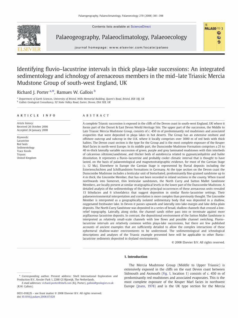
The Mercia Mudstone Group (Middle to Upper Triassic) isextensively exposed in the cliffs on the east Devon coast betweenSidmouth and Axmouth (Fig. 1, location 1) consists of c. 450 m ofpredominantly red mudstones and associated evaporates. This is themost complete exposure of the Keuper Marl facies in northwestEurope (Jeans, 1978) and is the UK type section for the Mercia
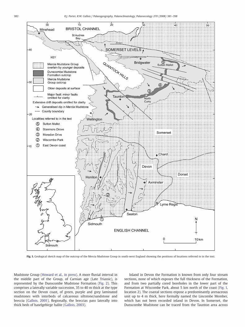
Fig. 1. Geological sketch map of the outcrop of the Mercia Mudstone Group in south-west England showing the positions of locations referred to in the text.
382 R.J. Porter, R.W. Gallois / Palaeogeography, Palaeoclimatology, Palaeoecology 270 (2008) 381–398
Mudstone Group (Howard et al., in press). A more fluvial interval inthe middle part of the Group, of Carnian age (Late Triassic), isrepresented by the Dunscombe Mudstone Formation (Fig. 2). Thiscomprises a laterally variable succession, 35 to 40 m thick at the typesection on the Devon coast, of green, purple and grey laminatedmudstones with interbeds of calcareous siltstone/sandstone andbreccia (Gallois, 2001), Regionally, the breccias pass laterally intothick beds of haselgebirge halite (Gallois, 2003).
Inland in Devon the Formation is known from only four streamsections, none of which exposes the full thickness of the Formation,and from two partially cored boreholes in the lower part of theFormation at Wiscombe Park, about 5 km north of the coast (Fig. 1,location 2). The coastal sections expose a predominantly arenaceousunit up to 4 m thick, here formally named the Lincombe Member,which has not been recorded inland in Devon. In Somerset, theDunscombe Mudstone can be traced from the Taunton area across
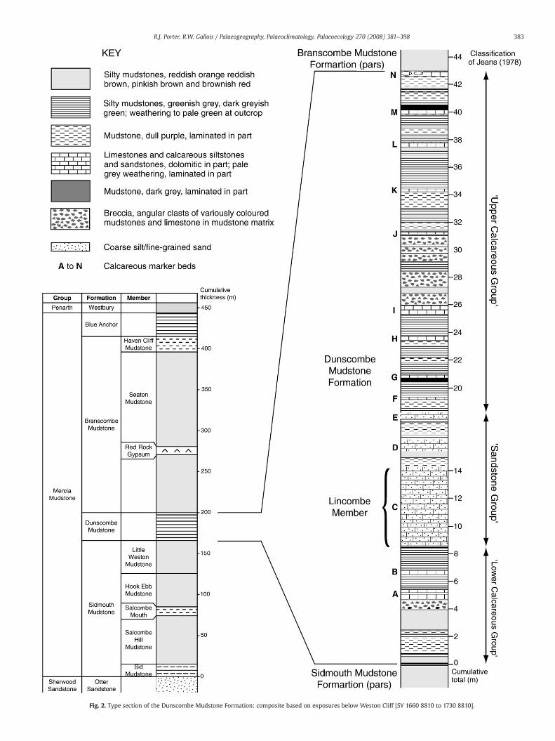
Fig. 2. Type section of the Dunscombe Mudstone Formation: composite based on exposures below Weston Cliff [SY 1660 8810 to 1730 8810].
383R.J. Porter, R.W. Gallois / Palaeogeography, Palaeoclimatology, Palaeoecology 270 (2008) 381–398
384 R.J. Porter, R.W. Gallois / Palaeogeography, Palaeoclimatology, Palaeoecology 270 (2008) 381–398
the Somerset Levels to the north coast via a series of separated,mostly fault-bounded outcrops. Arenaceous units are present in thelower part of the Formation in the Taunton, North Curry and SuttonMallet areas (Ussher, 1906, 1908) (Fig. 1, locations 3–5) at whatappear to be a similar stratigraphical level to that of the LincombeMember. Some of the sandstones in Somerset were formerly workedfor building stone and were once well exposed. In contrast to thebarren, relatively structureless red mudstones that make up the bulkof the Mercia Mudstone of the region, the sandstones contain a widerange of sedimentological features and a few fossils, and have inconsequence attracted more geological interest than the remainderof the Group.
In the first comprehensive description of the Keuper Marl exposedon the Devon cliffs, Jeans (1978) recorded a ‘Sandstone Group’ in thelower part of what is now the DunscombeMudstone (Fig. 2). In this herecorded glauconite sensu lato, Chondrites and other trace fossils, theconchostracan Euestheria, and palynomorphs that were attributed byWarrington (1971) and Fisher (1985) to the Carnian Stage. Warringtonet al. (1980) named the North Curry occurrences the North CurrySandstone Member (NCSM) and correlated them with the Arden andDane Hills Sandstone Members of the of the Mercia Mudstone of theEnglish Midlands. By analogy, the sandstone at Sutton Mallett isreferred to as a member in the present account (abbreviated toSMSM).
The depositional environments of the arenaceous units in theDunscombe Mudstone have been a matter of debate. Jeans (1978)suggested, largely on the basis of its mineralogy, that his ‘SandstoneGroup’ of the Devon coast (Fig. 2) was deposited in or close to anormal-salinity marine environment, and Fisher (1985) came to asimilar conclusion based on palynological analysis. At North Curry,Warrington and Williams (1984) concluded from a combination ofsedimentological and palaeontological evidence that the NCSM wasdeposited in a deltaic or estuarine environment similar to thatproposed by Wurster (1964) for the deposition of the TriassicSchilfsandstein of Germany. The present study (Porter, 2006) hasfocused on the integration of the sedimentology and ichnology of thearenaceous units in the Dunscombe Mudstone at outcrop in Devonand Somerset in order determine more precisely the environments inwhich they were deposited.
The depositional environments of all three arenaceous units areinterpreted here as oxygenated freshwater lakes that were fed bybroad, shallow channels in a low-relief topography.
Fig. 3. Geological sketch section of the cliffs adjacent to Weston Mouth
2. Study Areas
2.1. Devon
The DunscombeMudstone crops out intermittently over a distanceof about 2 km on the east Devon coast (Fig. 3). The sections are subjectto landslip and marine erosion as a result of which many of theexposures are relatively short lived. Nine sections in the arenaceouspart of the Formation between Higher Dunscombe Cliff [UK NationalGrid Reference SY 1540 8780] and Strangman's Cove [SY 1718 8795],seven of which are in situ, were recorded and analysed in 2003 to2005 (Figs. 4 and 5). In the absence of inland sections in the LincombeMember in Devon two partially cored boreholes, Wiscombe Park No.1[SY 1819 9382] and No. 2 [SY 1845 9273] located about 5 km north ofthe coast (Fig. 3), were also analysed (Gallois, 2005) and correlatedwith the coastal sections (Figs. 6 and 7).
The Dunscombe Mudstone succession at outcrop betweenDunscombe Higher Cliff and Strangman's Cove contains fourteencalcareously cemented beds (A to N in Fig. 2) that crop out as hard,pale weathering marker beds in the cliffs. Three of those in the lowerpart of the Formation (Beds C, D and E) are calcareous sandstonesthat equate with Jeans' (1978) ‘Sandstone Group’. These were chosenas the subject of the present study because they had been reportedby Warrington (1971), Jeans (1978) and J.E. Pollard (pers. comm.,2003) to contain trace fossils. Much of the study has been focussedon Bed C (the Lincombe Member), the thickest and most laterallyvariable of the three beds. The remaining calcareous beds (A, B and Eto N) are limestones and calcareous mudstones with little or no sandcontent.
All the in situ coastal sections are above wave action and almostpermanently coated with weathered material derived from the over-lying cliffs. Trench sections were dug and systematically cleaned withwater and a toothbrush to enable the sedimentary structures and tracefossils to be recorded and keyed into the full Dunscombe Mudstonesuccession. The logged sections were supplemented with additionaldescriptions and photomontages of the whole outcrop to enable thelateral facies changes and overall architecture to be illustrated.Additional data was obtained from fallen blocks at beach level, manyof which showed beautifully exposed sedimentary structures on theirsea-washed surfaces. Details of the individual exposures examined aregiven in Porter (2006). A selection ofmeasured sections in the LincombeMember, showing the marked thickening from west to east across the
showing the positions of measured sections referred to in the text.
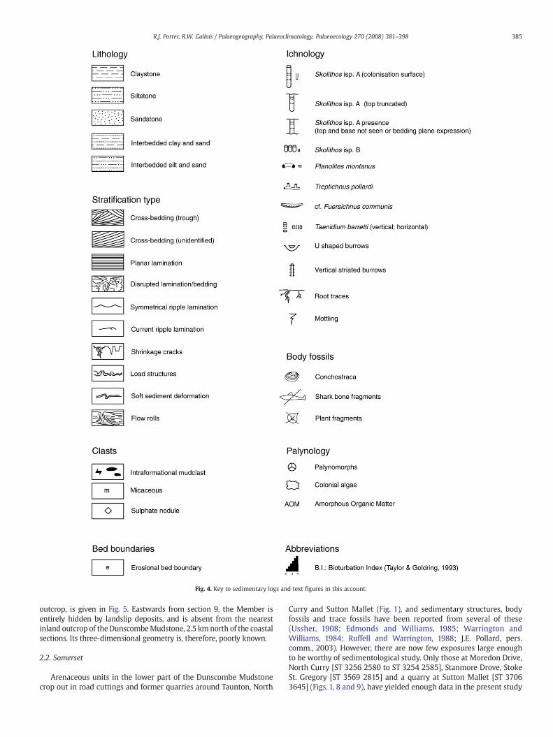
Fig. 4. Key to sedimentary logs and text figures in this account.
385R.J. Porter, R.W. Gallois / Palaeogeography, Palaeoclimatology, Palaeoecology 270 (2008) 381–398
outcrop, is given in Fig. 5. Eastwards from section 9, the Member isentirely hidden by landslip deposits, and is absent from the nearestinland outcrop of the DunscombeMudstone, 2.5 kmnorth of the coastalsections. Its three-dimensional geometry is, therefore, poorly known.
2.2. Somerset
Arenaceous units in the lower part of the Dunscombe Mudstonecrop out in road cuttings and former quarries around Taunton, North
Curry and Sutton Mallet (Fig. 1), and sedimentary structures, bodyfossils and trace fossils have been reported from several of these(Ussher, 1908; Edmonds and Williams, 1985; Warrington andWilliams, 1984; Ruffell and Warrington, 1988; J.E. Pollard, pers.comm., 2003). However, there are now few exposures large enoughto be worthy of sedimentological study. Only those at Moredon Drive,North Curry [ST 3256 2580 to ST 3254 2585], Stanmore Drove, StokeSt. Gregory [ST 3569 2815] and a quarry at Sutton Mallet [ST 37063645] (Figs. 1, 8 and 9), have yielded enough data in the present study

Fig. 5. Lateral variations in the Lincombe Member at and adjacent to the type section on the east Devon coast.
386 R.J. Porter, R.W. Gallois / Palaeogeography, Palaeoclimatology, Palaeoecology 270 (2008) 381–398
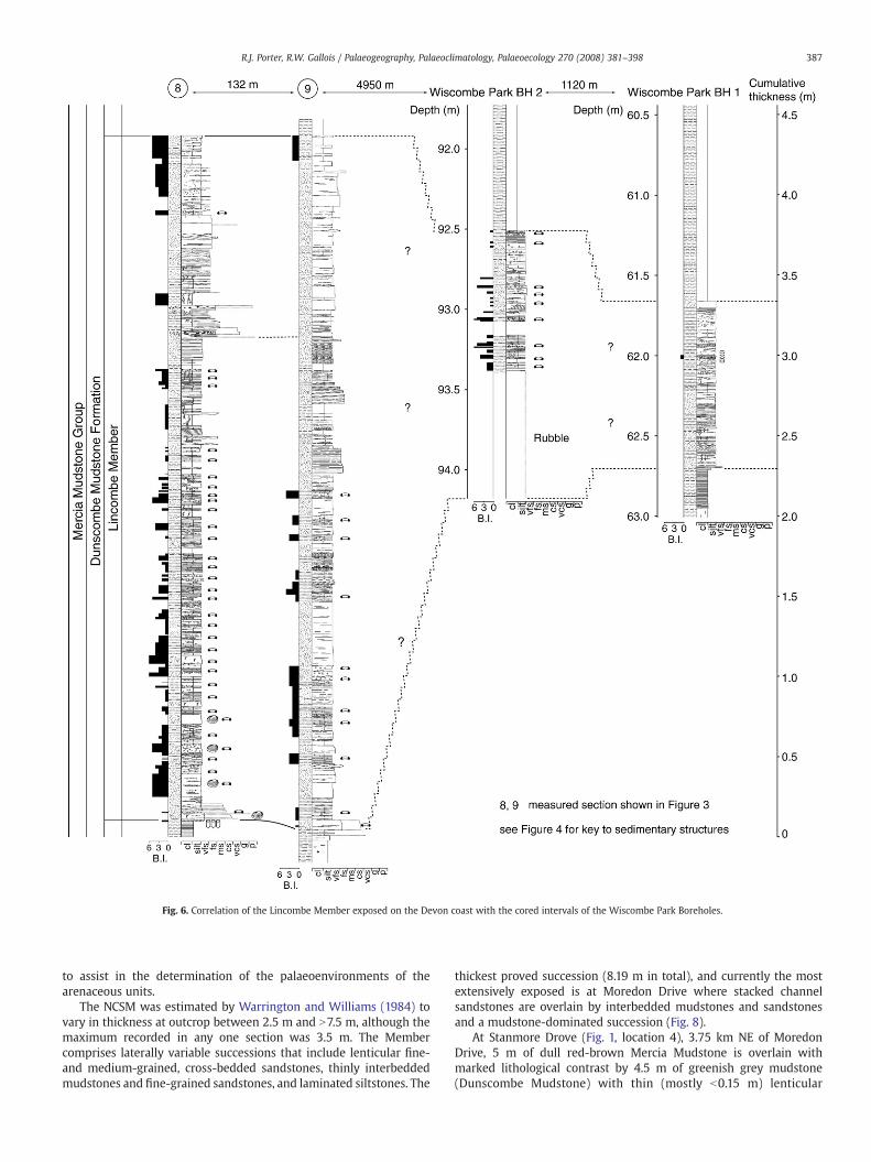
Fig. 6. Correlation of the Lincombe Member exposed on the Devon coast with the cored intervals of the Wiscombe Park Boreholes.
387R.J. Porter, R.W. Gallois / Palaeogeography, Palaeoclimatology, Palaeoecology 270 (2008) 381–398
to assist in the determination of the palaeoenvironments of thearenaceous units.
The NCSM was estimated by Warrington and Williams (1984) tovary in thickness at outcrop between 2.5 m and N7.5 m, although themaximum recorded in any one section was 3.5 m. The Membercomprises laterally variable successions that include lenticular fine-and medium-grained, cross-bedded sandstones, thinly interbeddedmudstones and fine-grained sandstones, and laminated siltstones. The
thickest proved succession (8.19 m in total), and currently the mostextensively exposed is at Moredon Drive where stacked channelsandstones are overlain by interbedded mudstones and sandstonesand a mudstone-dominated succession (Fig. 8).
At Stanmore Drove (Fig. 1, location 4), 3.75 km NE of MoredonDrive, 5 m of dull red-brown Mercia Mudstone is overlain withmarked lithological contrast by 4.5 m of greenish grey mudstone(Dunscombe Mudstone) with thin (mostly b0.15 m) lenticular
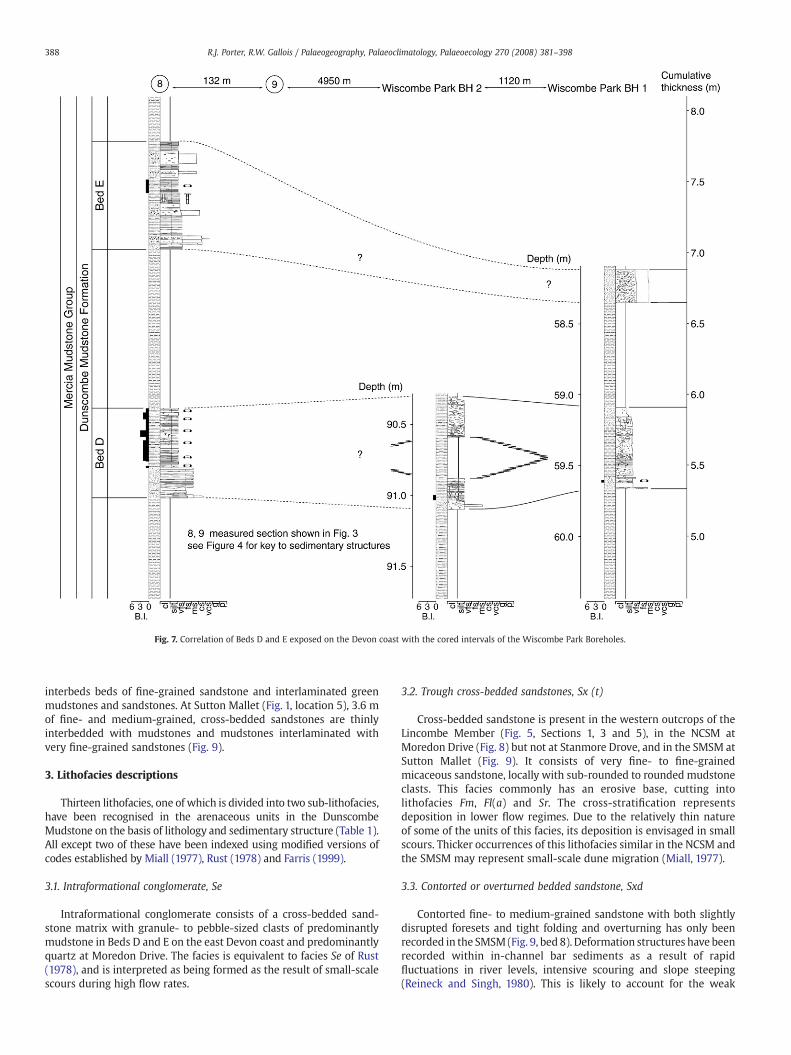
Fig. 7. Correlation of Beds D and E exposed on the Devon coast with the cored intervals of the Wiscombe Park Boreholes.
388 R.J. Porter, R.W. Gallois / Palaeogeography, Palaeoclimatology, Palaeoecology 270 (2008) 381–398
interbeds beds of fine-grained sandstone and interlaminated greenmudstones and sandstones. At Sutton Mallet (Fig. 1, location 5), 3.6 mof fine- and medium-grained, cross-bedded sandstones are thinlyinterbedded with mudstones and mudstones interlaminated withvery fine-grained sandstones (Fig. 9).
3. Lithofacies descriptions
Thirteen lithofacies, one of which is divided into two sub-lithofacies,have been recognised in the arenaceous units in the DunscombeMudstone on the basis of lithology and sedimentary structure (Table 1).All except two of these have been indexed using modified versions ofcodes established by Miall (1977), Rust (1978) and Farris (1999).
3.1. Intraformational conglomerate, Se
Intraformational conglomerate consists of a cross-bedded sand-stone matrix with granule- to pebble-sized clasts of predominantlymudstone in Beds D and E on the east Devon coast and predominantlyquartz at Moredon Drive. The facies is equivalent to facies Se of Rust(1978), and is interpreted as being formed as the result of small-scalescours during high flow rates.
3.2. Trough cross-bedded sandstones, Sx (t)
Cross-bedded sandstone is present in the western outcrops of theLincombe Member (Fig. 5, Sections 1, 3 and 5), in the NCSM atMoredon Drive (Fig. 8) but not at Stanmore Drove, and in the SMSM atSutton Mallet (Fig. 9). It consists of very fine- to fine-grainedmicaceous sandstone, locally with sub-rounded to rounded mudstoneclasts. This facies commonly has an erosive base, cutting intolithofacies Fm, Fl(a) and Sr. The cross-stratification representsdeposition in lower flow regimes. Due to the relatively thin natureof some of the units of this facies, its deposition is envisaged in smallscours. Thicker occurrences of this lithofacies similar in the NCSM andthe SMSM may represent small-scale dune migration (Miall, 1977).
3.3. Contorted or overturned bedded sandstone, Sxd
Contorted fine- to medium-grained sandstone with both slightlydisrupted foresets and tight folding and overturning has only beenrecorded in the SMSM (Fig. 9, bed 8). Deformation structures have beenrecorded within in-channel bar sediments as a result of rapidfluctuations in river levels, intensive scouring and slope steeping(Reineck and Singh, 1980). This is likely to account for the weak

Fig. 8. Sedimentary logs from Section 2 of the North Curry Sandstone at Moredon Drive, Somerset.
389R.J. Porter, R.W. Gallois / Palaeogeography, Palaeoclimatology, Palaeoecology 270 (2008) 381–398

Fig. 9. Quarry in the Sutton Mallett Sandstone Member, Sutton Mallett.
390 R.J. Porter, R.W. Gallois / Palaeogeography, Palaeoclimatology, Palaeoecology 270 (2008) 381–398
disruption to foresets. The strongly contorted units are likely to havebeen the result of increased bed shear during renewed or increasedflow and associated with overlying high flow stage sediments (Cole-man, 1969; Doe and Dott, 1980).
3.4. Horizontal to low-angle laminated sandstone, Sh
Horizontal to lowangle, laminated,well-sorted, very fine- tomedium-grained, calcareous sandstone constitutes a minor part of the LincombeMember, where it forms beds 0.05–0.1 m thick and is locally associatedwith scours. It has not been recorded from the NCSM and SMSM. Thisfacies is here interpreted as being formed either flood or under shalloworshallowing water conditions as the result of very low amplitude sandwaves (Miall, 1977). In this context, the presence of this facies is moreindicative of upper flow regime conditions during flood events.
3.5. Massive-bedded sandstone, Sm
Veryfine- tomedium-grained sandstonewith a fewmudstone clasts,but no discernible sedimentary structures, is present in the LincombeMember and bed E. Bed thicknesses range from0.05 to 0.15m. Itwas notrecorded in the NCSM or SMSM. This facies is interpreted as beingrapidly deposited during flood events (Bromley, 1991).
3.6. Asymmetrical ripple-cross laminated sandstone, Sr
Cross-laminated, very fine- to fine-grained sandstone withasymmetrical ripples forms lenticular bodies up to 20 m wide and0.03 to 0.30 m thick in the Lincombe Member, and up to 40 m wideand 0.5 m thick in the NCSM (Fig. 8, log 1). It constitutes only aminor part of the SMSM. Ripple cross-lamination has beensuggested as indicative of lower flow regime (Miall, 1977). Whereseen above mudstone-dominated facies it may suggest the initia-tion of a relatively short-lived increase in flow. Where presentabove Sx(t) Sh or Sm it may be interpreted as representative ofwaning flow, since Miall (1977) described this facies occurring in
very shallow water as the result of migrating ripples across barsurfaces.
3.7. Sandstone with minor mudstone partings, Smp
Very fine- to medium-grained micaceous sandstone withminor mudstone partings with bed thicknesses between 0.05and 0.3 m. Horizontal or wavy mudstone partings are present,some with desiccation or syneresis cracks. The lithofacies isinterpreted as representing fluctuating flow regimes, with mud-stone deposited during occasional intervals when water energiesdecreased.
3.8. Ripple and horizontal interbedded fines, Fl
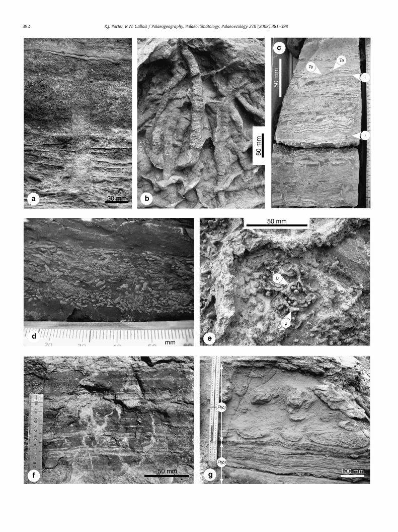
Ripple and horizontally-laminated mudstone, clayey siltstone andvery fine- to fine-grained sandstone in beds 0.1 to 0.5 m thick. Thefacies is divided into two subfacies that are gradational. One withmudstone and sandstone in roughly equal proportions (Fl(a)), theother with a sandstone–mudstone ratio of about 5:1 (Fl(b), Fig. 10g).These facies are suggestive of deposition under quiet water conditionswith fluctuating water depths. The dominance of horizontal inter-bedding and interlamination is suggestive of a lacustrine or overbankorigin. The occasional asymmetrical ripples are indicative of currentsin waning or low flow regimes. These facies have been described fromlagoons and shallow lakes, with lenticular bedding in particular beingdescribed from lake bottom in front of small developing deltas(Coleman, 1969).
3.9. Contorted interlaminated heterolithic fines, Fl(c)
This lithofacies, comprising interlaminated clayey silt and very fine-grained sandstone,was recorded in one section in theLincombeMember(Fig. 3, Section 7) where it occurs in units 0.1 to 0.4 m thick with 2 or 3flow–roll horizons separated by 0.04 to 0.15 m of strongly convolutedinterlaminations (Fig. 10g). The flow rolls are similar in morphology to
Table 1Summary lithofacies descriptions (codes modified from Miall, 1977; Rust, 1978; Farris,1999; ⁎ codes erected herein)
Code Lithology Sedimentary structure Interpretation Localities
Se Granule-mediumpebble extraclasts(mudclasts)+medium-verycoarse sand
Matrix supported,cross-bedded
Lag deposits andscour fill
D, E;NCSM
Sx(t) vf-f sand±intraclasts
Trough cross-bedding Small-scale scour orsmall-scale dunemigration, low flowregime
LiM; E;NCSM;SMSM
Sxd Fine–mediumsand
Disturbed wavyforesets, tight folding,overturning
Renewed high-stagechannel events
SMSM
Sh Very fine–mediumsand
Horizontal to very lowangle planarlamination
Upper flow regime,flood events
LiM
Sm Very fine–mediumsand
Structureless Upper flow regime,flood events
LiM; E;NCSM
Sr Very fine–finesand
Asymmetrical currentripples, isolated or intrains
Waning flow, lowflow regime
LiM; D;NCSM;SMSM
Smp⁎ Very fine–mediumsand
Thin mudstonepartings
Fluctuating flowregime
LiM; D;SMSM;LiM(WP)
Fl(a) Interlaminatedvery fine–finesand and clay/silt
Asymmetrical ripples,isolated or in trains;wavy and horizontallamination; sandstone:mudstone ratio equal;ripples common
Quiet water, waningflow; lacustrine andoverbank fines
LiM; D; E;NCSM;SMSM;LiM(WP)
Fl(b) Interlaminatedvery fine–finesand and clay/silt
As Fl(a) but withsandstone:mudstoneratio c. 5:1; ripples lesscommon
Quiet water, waningflow; lacustrine andoverbank fines
LiM; D;NCSM;SMSM:LiM(WP)
Fl(c) Interlaminatedvery fine–finesand and clay/silt
Sandstone:mudstoneratio even; flow rolls;contorted sediments
Sediment loadingresponding to rapiddeposition ofoverlying units inlakes
LiM
Fr Interbedded veryfine–mediumsand and clay
Rolling-grain wave-ripple tops; desiccationcracks; some syneresis
Deposition ofsuspended fines;waning stage flow orpools
LiM; LiM(WP)
Fm Clay, silt Massive, laminated inpart
Settling ofsuspended fines instanding water
LiM;NCSM; D;E; LiM(WP)
Spd Very fine sandand fine sand.
Calcareous root tracesand nodules
Caliché, immaturefloodplain/sheetdelta top
LiM; D
Fb⁎ Very fine sand,silt, clay.
Disrupted, brecciated;heavy desiccation;vortex wave ripples;micro-faulting;microbially boundlamination
Playa-margindeposits.
LiM(WP);D(WP); E(WP).
LiM, Lincombe Member, Devon coast; D, E, Beds D and E, Devon, coast; WP, WiscombePark Boreholes; NCSM, North Curry Sandstone Member, Moredon Drive ; SMSM, SuttonMallet Sandstone Member.
391R.J. Porter, R.W. Gallois / Palaeogeography, Palaeoclimatology, Palaeoecology 270 (2008) 381–398
those described by Sorauf (1964) and are likely to have been formed byrapid input of sediment fromapoint source. Similar lithofacies havebeenrecorded from depositional settings that include lacustrine palaeoenvir-onments (Picard and High, 1973 and references therein).
3.10. Interbedded symmetrical ripple and horizontally laminated fines, Fr
Interbedded symmetrical ripple and horizontally laminated finescomposed of interlaminated silt and very fine- to medium-grainedsandstone in beds 0.03 to 0.05 m thick. This facies has only beenrecorded at two localities in the LincombeMember. It is interpreted as
having been deposited in a waning stage flow environment in shallowwater, wherewind passing over the top of thewater produced rolling–grain–wave ripples. The formation of mudcracks was probably theresult of subaerial exposure and desiccation. This definition oflithofacies Fr differs from that of Miall (1977).
3.11. Mudstone, Fm
Red-brown, grey-green and dark grey mudstones, massive orlaminated, occur in beds 0.01 to 0.08m (mostly 0.01 to 0.03m) thick inthe Lincombe Member, and locally in the NCSM where the mudstonebeds are thicker. On the Devon coast the proportion of this faciesdecreases from bottom to top and from east to west. Miall (1977, p. 30)intended this facies to be representative of draped mudstones, butRust (1978, the definition used here) broadened it to include massivesandy mudstones and mudstones. Here it represents the settling offines from suspension in standing bodies of water during the waningstage of flows, possibly in abandoned channels. Thicker mudstonesprobably accumulated in standing water.
3.12. Undifferentiated carbonate-bearing paleosols, Spd
Pedoturbated, very fine-grained sandstone with diffuse horizons offine-grained sandstone in which visible sedimentary structures aregenerally absent. Beds 0.25 to 0.5m thick are present at the top of small,fining upward cycles at the top of the LincombeMember in Sections 7, 8and 9 (Fig. 3), but have not been recorded elsewhere. White hair-likeroot traces and millimetre scale nodules are locally present. This faciescompares well with that erected by Farris (1999) who interpreted it asthe product of moderately dry, immature floodplain settings.
3.13. Disrupted laminated sandstone and mudstone, Fb
Interlaminated very fine-grained sandstones and mudstones withdisrupted and brecciated fabrics and subtle fining upward trend occurin 0.2 to 0.6 m-thick beds in Beds D and E of the coastal sections and inthe Wiscombe Park boreholes (Fig. 10c). Mud cracks, elongatemudstone clasts, clay flakes, symmetrical vortex wave ripples,micro-faulting, possible microbial-bound sediment and granule-sized gypsum nodules are present at some levels (Fig. 10c). Eugsterand Hardie (1975) described a similar association as Mudstone Faciesand attributed themudcracks and brecciation to repeated wetting anddrying episodes in sediment-starved conditions. Smoot (1983, hisfacies DM1) concluded that the sand was deposited in rapidlydecelerating waters when it entered standing bodies of water andthat the wave ripples formed in deeper water as the result of windaction. Some of the brecciationwas presumed to be the result of sheetfloods traversing playa margins that soaked into the underlyingsediment and remobilised it to act like a mud flow.
4. Ichnofabrics
An ichnofabric comprises all aspects of the texture and internalstructure of a substrate that result from bioturbation and bioerosion atall scales (Ekdale and Bromley, 1983; Bromley and Ekdale, 1986). Todate ichnofabric analysis has mostly been applied to marinesediments (e.g. Taylor et al., 2003) and few detailed examples incontinental settings have been described, although Genise et al.(2004) has recently suggested methods of approaching the analysis ofpalaeosol ichnofabrics.
Six ichnofabrics have been identified within the Carnian arenac-eous units of southwest England. These have been characterised by a)the degree of bioturbation using the bioturbation indicies (BI; Taylorand Goldring, 1993) that aim to relate the bioturbation intensity to thepreservation of primary bedding features using a seven point scale, b)the constituent ichnotaxa, ichnodiversity and biogenic mottling c) the
392 R.J. Porter, R.W. Gallois / Palaeogeography, Palaeoclimatology, Palaeoecology 270 (2008) 381–398
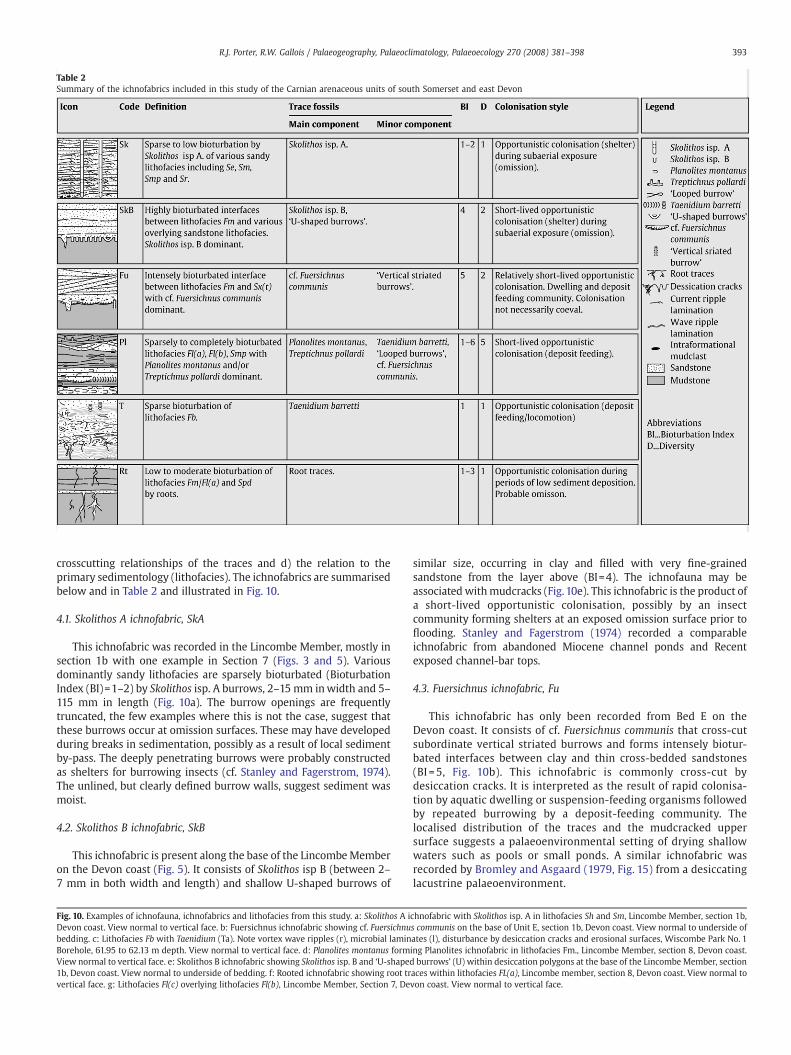
Table 2Summary of the ichnofabrics included in this study of the Carnian arenaceous units of south Somerset and east DevonTable 2Summary of the ichnofabrics included in this study of the Carnian arenaceous units of south Somerset and east Devon
393R.J. Porter, R.W. Gallois / Palaeogeography, Palaeoclimatology, Palaeoecology 270 (2008) 381–398
crosscutting relationships of the traces and d) the relation to theprimary sedimentology (lithofacies). The ichnofabrics are summarisedbelow and in Table 2 and illustrated in Fig. 10.
4.1. Skolithos A ichnofabric, SkA
This ichnofabric was recorded in the Lincombe Member, mostly insection 1b with one example in Section 7 (Figs. 3 and 5). Variousdominantly sandy lithofacies are sparsely bioturbated (BioturbationIndex (BI)=1–2) by Skolithos isp. A burrows, 2–15 mm inwidth and 5–115 mm in length (Fig. 10a). The burrow openings are frequentlytruncated, the few examples where this is not the case, suggest thatthese burrows occur at omission surfaces. These may have developedduring breaks in sedimentation, possibly as a result of local sedimentby-pass. The deeply penetrating burrows were probably constructedas shelters for burrowing insects (cf. Stanley and Fagerstrom, 1974).The unlined, but clearly defined burrow walls, suggest sediment wasmoist.
4.2. Skolithos B ichnofabric, SkB
This ichnofabric is present along the base of the LincombeMemberon the Devon coast (Fig. 5). It consists of Skolithos isp B (between 2–7 mm in both width and length) and shallow U-shaped burrows of
Fig. 10. Examples of ichnofauna, ichnofabrics and lithofacies from this study. a: Skolithos A iDevon coast. View normal to vertical face. b: Fuersichnus ichnofabric showing cf. Fuersichnubedding. c: Lithofacies Fb with Taenidium (Ta). Note vortex wave ripples (r), microbial laminBorehole, 61.95 to 62.13 m depth. View normal to vertical face. d: Planolites montanus formView normal to vertical face. e: Skolithos B ichnofabric showing Skolithos isp. B and ‘U-shaped1b, Devon coast. View normal to underside of bedding. f: Rooted ichnofabric showing root trvertical face. g: Lithofacies Fl(c) overlying lithofacies Fl(b), Lincombe Member, Section 7, De
similar size, occurring in clay and filled with very fine-grainedsandstone from the layer above (BI=4). The ichnofauna may beassociated withmudcracks (Fig. 10e). This ichnofabric is the product ofa short-lived opportunistic colonisation, possibly by an insectcommunity forming shelters at an exposed omission surface prior toflooding. Stanley and Fagerstrom (1974) recorded a comparableichnofabric from abandoned Miocene channel ponds and Recentexposed channel-bar tops.
4.3. Fuersichnus ichnofabric, Fu
This ichnofabric has only been recorded from Bed E on theDevon coast. It consists of cf. Fuersichnus communis that cross-cutsubordinate vertical striated burrows and forms intensely biotur-bated interfaces between clay and thin cross-bedded sandstones(BI =5, Fig. 10b). This ichnofabric is commonly cross-cut bydesiccation cracks. It is interpreted as the result of rapid colonisa-tion by aquatic dwelling or suspension-feeding organisms followedby repeated burrowing by a deposit-feeding community. Thelocalised distribution of the traces and the mudcracked uppersurface suggests a palaeoenvironmental setting of drying shallowwaters such as pools or small ponds. A similar ichnofabric wasrecorded by Bromley and Asgaard (1979, Fig. 15) from a desiccatinglacustrine palaeoenvironment.
chnofabric with Skolithos isp. A in lithofacies Sh and Sm, Lincombe Member, section 1b,s communis on the base of Unit E, section 1b, Devon coast. View normal to underside ofates (l), disturbance by desiccation cracks and erosional surfaces, Wiscombe Park No. 1ing Planolites ichnofabric in lithofacies Fm., Lincombe Member, section 8, Devon coast.burrows’ (U) within desiccation polygons at the base of the Lincombe Member, section
aces within lithofacies FL(a), Lincombe member, section 8, Devon coast. View normal tovon coast. View normal to vertical face.
Table 3Facies associations identified in this study
Code Association Mainlithofacies
Subordinatelithofacies
Ichnofabrics Localities
L Lacustrine Fl(a), Fl(b),Fm
Sr, Smp, Sh, Sm Pl, SkB LiM, WP
LM a Perennial lacustrinemargin
Fl(a), Fl(b),Fm
Sr, Smp, Sh, Sm Rt LiM
LM b Ephemeral (playa)margin
Fb Fm, Smp Pl, Ta WP
LD Lake delta Sr, Smp, Sm,Fm
Sh, Sx(t), Fl(a), Fr SkA, Rt LiM
CH Minor channel Se, Sr Sxd, Fl(a), Fl(b) Pl NCSMSMSM
FP Floodplain Fl(a), Fl(b), Fm, Sr Pl NCSMSD Sheet delta Se, Fl(a), Sm,
SmpFm, Fl(b), Spd, Sr Fu, SkA D, E
LiM, Lincombe Member, Devon coast; D, E, Beds D and E, Devon coast; WP, WiscombePark Boreholes; NCSM, North Curry Sandstone Member, Moredon Drive; SMSM, SuttonMallet Sandstone Member.
394 R.J. Porter, R.W. Gallois / Palaeogeography, Palaeoclimatology, Palaeoecology 270 (2008) 381–398
4.4. Planolites ichnofabric, Pl
The ichnofabric was recorded in the Lincombe Member in sections1a to 9 (Figs. 3 and 5), in Beds D and E on the Devon coast (Fig. 7), inthe Wiscombe Park No. 2 Borehole (Figs. 6 and 7), in the NCSM atGainsload Drove, and in the SMSM where it is rare. It is formed ofsparsely to completely bioturbated lithofacies Fl and Smp with Pla-nolites montanus and/or Treptichnus pollardi dominant (BI=1–6,Fig. 10d). Rare examples of Taenidium and ‘looped burrows’ may alsobe present. It occurs mainly within lithofacies Fl where bioturbationcommonly occurs along the interface between the mudstones andsandstone. The ichnofabric may occur either as individual burrowsdisrupting the primary interlamination, or may completely rework athin sandstone bed or lens (Fig. 10d). Bioturbation is most easilyobserved within this facies due to the contrast in sediment types. Thisichnofabric is interpreted as the product of short-lived opportunisticcolonisation by an infaunal deposit-feeding community. Similarichnofabrics have been recorded from Carboniferous lacustrine andcrevasse splay sediments (Pollard, 1988).
4.5. Taenidium ichnofabric, Ta
Only recorded in the Lincombe Member of the Wiscombe ParkBorehole No. 1 (Fig. 6, 62.0 m depth) this ichnofabric consists of sparsebioturbation of microbial laminites and thin, structureless very fine-grained sandstone by protrusive Taenidium barretti in lithofacies Fb(BI=1, Fig. 10c). Erosion surfaces truncate some burrows and otherscut across the same surfaces so it is not possible for colonisationsurfaces to be identified in examples of this ichnofabric. Thesedimentology suggests fluctuating water conditions and the burrowsmay, therefore, have formed under subaerial or subaqueous condi-tions. The ichnofabric indicates possible opportunistic colonisation ofa shallow water body or its margin. Similar Miocene ichnofabricscontaining the meniscate back-filled burrow, Beaconites filiformis havebeen recorded from marginal lacustrine deposits that periodicallydried out (Uchman and Álvaro, 2000).
4.6. Rooted ichnofabric, Rt
The ichnofabric consists of low to moderate bioturbation by rootswithin lithofacies Fm, Fl(a) and Fr. (BI=1–3, Fig. 10f). It has only beenrecorded in the LincombeMember (Fig. 5) where the root traces are 1–5 mm thick and infilled with the overlying sediment or withcarbonate. They are locally associated with desiccation cracks. Thelocalised distribution and lenticular nature of the ichnofabric suggestsformation on sub-aerially exposed abandoned channels or flood-plains, probably at times of low sediment input or possible subaerialexposure. The small size of the roots implies short colonisationperiods followed by re-flooding and the resumption of sedimentdeposition.
5. Facies associations
When considered in conjunction with their ichnofabrics, thelithofacies identified in the arenaceous units in the DunscombeMudstone enable six facies associations and two sub-associations tobe recognised. An ichnofacies assessment has also been made for eachassociation. All six represent deposition in shallow fluvio–lacustrineenvironments. They are summarised in Table 3.
5.1. Lacustrine association, L
This is the predominant association in the Lincombe Member, andwas recorded in the Wiscombe Park boreholes. The base of theassociation, marked by the SkB ichnofabric, marks the base of theLincombe Member (Figs. 5 and 6). The upper boundary is transitional
to the Lacustrine Margin association. Taken together, the predomi-nantly dark grey-green colour of the sediments, the scarcity ofdesiccation cracks, the Pl ichnofabric, and the presence of conchos-tracans and chlorococcalean alga indicate deposition in a low-energy,freshwater environment that remained permanently wet. A shallowlacustrine origin is preferred for this association, as it does not formpart of an overall fining-up sequence above channel sands, whichotherwise would suggest deposition as a result of channel abandon-ment. The dominance horizontal, mobile deposit-feeding burrowspresence of intervals in this association corresponds to that of theMermia ichnofacies. This characterises fine-grained sediments thatoccur in well-oxygenated, low-energy, permanently subaqueouszones of lacustrine and floodplain environments (Buatois andMángano, 1995, 2002). The presence of Skolithos isp A and U-shapedburrows at the base of the association are however, more representa-tive of the Scoyenia ichnofacies. This ichnofacies occurs in low-energydeposits periodically exposed to the air or periodically inundated, andintermediate between aquatic and non-aquatic environments (Freyet al., 1984; Buatois and Mángano, 1995).
5.2. Lacustrine margin association, LM
The facies association can be subdivided, mainly on the presence orabsence of lithofacies Fb and the relationship with the boundingassociations.
Perennial lacustrine margin (LMa) association, mainly lithofacies Fland Fm and Rt ichnofabric with some traces of Pl ichnofabric, ispresent in the middle part of the Lincombe Member. The transitionalbase is marked by an upward increase in rooted horizons (Fig. 5,Sections 5–8). The top of the association is sharply defined against theoverlying Lacustrine Delta association (Fig. 5). This association isbroadly interpreted as having been formed in a stable marginallacustrine environment. This is preferred over a floodplain interpreta-tion, as it does not form part of a broader fining-up package associatedwith channel sandstones. Increasing stability of the lake margin issuggested by an upward increase in the abundance of well-developedroot traces and associated desiccation. The dominance of roots in thisassociation with the sub-ordinate presence of Planolites is suggestiveof the Scoyenia ichnofacies.
Ephemeral (playa) margin/mudflat (LMb) association, dominated byFb lithofacies and at some levels wholly composed of it, is onlyrecorded in the Wiscombe Park boreholes (Figs. 6 and 7). The base ofthe association is marked by a rapid increase in grain size, and the topby a gradation into the overlying mudstones. The presence ofbrecciation suggests periods of exposure on a playa margin (Fig. 10c),with influxes of sand and silt during flooding periods. Comparablelithofacies have been interpreted as playa mudflats (Eugster and
395R.J. Porter, R.W. Gallois / Palaeogeography, Palaeoclimatology, Palaeoecology 270 (2008) 381–398
Hardie,1975; Smoot,1983), someofwhichwere colonised bymicrobialmats shortly after they were flooded (Eugster and Hardie, 1975).
5.3. Lacustrine delta, LD
This complex facies association juxtaposes sediments deposited indiffering flow regimes comparable to those described from distallacustrine delta plains by Frostick and Reid (1986) andmedial terminalsplay deposits (Lang et al., 2004). The association is only recorded atthe top of the Lincombe Member (Fig. 5), where it comprises finingupward packages 0.2 to 0.6 m thick capped by thin, rooted anddesiccated lithofacies Fm and Fl(a). The base of the association ismarked by a thin erosional lag deposit and an upward increase in grainsize (Fig. 5). The fine grain size suggests a relatively distal position inthe delta. Cross-bedded units and incision into the underlying bedsmark small channel distributaries; the local development of mud-stones mark the sites of small ponds on the delta top. The top of theassociation locally carries weakly developed soils, indicating sedimentbypass on parts of the delta plain (Fig. 5, section 8; Fig. 10f). Thepresence of both small pools containing a deposit-feeding ichnofaunaand larger domiciles thought to have been constructed duringsubaerial exposure suggests a mixedMermia and Scoyenia ichnofaciesfor this association.
5.4. Minor channel association, CH
In the NCSM and the SMSM this association consists of 0.5 to 0.9 mthick fining-upward packages, some with a granular lag deposit (Figs. 8and 9). Most are capped by lithofacies Fl or Fmwith comminuted plantfragments and minor bioturbation, but no pedoturbation or calicheformation. Erosion of previously deposited channels locally gives astacked appearance. Channelwidths are up to 30mwith channelswingsclearly observed. The presence of small-scale in-channel migratingdunes and thin argillaceous beds above channels are thought torepresent small channels that occur within a broader watercourse.
5.5. Floodplain association, FP
This association, which has only been identified in the NCSM atMoredon Drive, forms packages between 0.3 m and 1.30 m thick withno fining or coarsening upward trends. The predominance oflithofacies Fl(a) and Fl(b) is indicative of the quiet water associatedwith floodplain environments. The limited evidence of desiccationand the absence of root traces suggest deposition in a predominantlywet floodplain that was rarely sub-aerially exposed. The presence ofthin lenses of sandstone indicates overbank sediment input. Theoccurrence of Treptichnus and Planolites in this association issuggestive of assignment to the Mermia ichnofacies.
5.6. Sheet Delta association, SD
Beds D and E are characterised by fining upward units 0.70 to1.10 m thick, their bases mostly marked by a mudchip lag depositoverlain by lithofacies Smp or Sr. These units retain an approxi-mately constant thickness over the 2 km of the coastal outcrop. Theassociation is tentatively assigned to a sheet delta succession fed byflash-flood deposits entering a lake (Smoot and Lowenstein, 1991).Higher flow regimes, represented by lithofacies Se and associatedwith more proximal parts of the sheet delta, are sometimes cappedby relatively thin mudstones and may display Fu or Pl ichnofabricdevelopment and contain conchostracans. These sequences gradelaterally into thinner bedded units that become increasinglydominated by interlaminated heterolithics and the Pl ichnofabric.Brief periods of omission are suggested by the localised occurrenceof the SkA ichnofabric (Fig. 5, section 8; Fig. 7, Bed E). The tracefossil assemblages found within this association may be assigned
either to the Mermia or Scoyenia ichnofacies, depending onwhether the respective assemblage is dominated by a deposit-feeding ichnofauna or one dominated by vertical burrows inter-preted as domiciles.
6. Palaeontology
6.1. Macrofauna
Jeans (1978) recorded the conchostracan Euestheria in his ‘SandstoneGroup’, and Ussher (1908) and later authors recorded the same genus inthe NCSM. In a review of the fauna and flora of the NCSM, Warringtonand Williams (1984) noted remains indicative of terrestrial and aquaticenvironments including amphibians, reptiles and fish including sharks.Possible fragments of shark spine (M.J. Benton, pers. comm., 2006) havebeen found in Bed D of the Devon coast. In the present studyconchostracans, many of them well preserved, have been recorded insitu in the LincombeMember and Bed E inDevon (Fig. 3, sections 1–4, 7–9), in the NCSM and in the SMSM. Specimens of the conchostracanLaxitextella multireticulata (Reible) found in a loose block of LincombeMember (Fig. 3, section 6) by H. Kozur (pers. comm., 2004) wereidentifiedbyhimas indicative of the early Carnian L.multireticulataZoneof the Triassic in Germany (Kozur and Bachmann, 2005).
6.2. Palynology
The palynology of the exposed parts of the Dunscombe Mudstonein Devon and Somerset has been investigated by a number of workers(Warrington,1971;Warrington andWilliams,1984; Fisher,1985), all ofwhom concluded on the basis of the limited evidence available thatthe lithologies sampled were Carnian in age. A comprehensive suite ofsamples collected from the Devon type section of the Formationduring the present study was processed and palynologically analysedby G.A. Booth (Millennia Stratigraphic Consultants). In addition, thedeterminations made by M.J. Fisher in the 1980s (Fisher, 1985) werere-plotted against the revised measured section for the DunscombeMudstone, and the two sets of results were used to produce anintegrated palynology for the Formation.
The principal sampling points for the new analyses were sections 1aand 7 (Fig. 3), but only the latter yielded significant amounts of organicmatter or palynomorphs. Samples taken from directly below theLincombe Member contain abundant palynomorphs and a relativelyhigh abundance of amorphous organic matter, suggesting deposition ina quiet-water, anoxic environment. The palynomorph assemblagesindicate a late Ladinian to early–early Carnian age. Samples fromwithinthe lower part of the Lincombe Member are markedly different fromthosedirectly beneath themember. Theycontain fewspores, but are richin the colonial chlorococcalean alga Plaesiodictyon, a taxon indicative ofquiet, oxygenated, fresh or low-salinity water.
None of the samples collected from above the Lincombe Memberduring the present survey yielded any age-diagnostic results. How-ever, when the positions of Fisher's (1985) samples, all of which werebased on Jeans' (1978) accurate field logs, were plotted against theDunscombe Mudstone type section they supported Fisher's (1985)original conclusion that an older and younger palynomorph assem-blage was present, both Carnian in age. The older assemblage wasobtained from the lowest part of the Dunscombe Mudstone and thelower part of the Lincombe Member, and the younger assemblagefrom the upper part of the Lincombe Member and the overlying beds.
7. Summary and Conclusions
The sedimentological and ichnological results obtained in thepresent study indicate that the arenaceous members in the Dun-scombe Mudstone in south west England were deposited in compar-able non-marine settings in oxygenated freshwater lakes that were
396 R.J. Porter, R.W. Gallois / Palaeogeography, Palaeoclimatology, Palaeoecology 270 (2008) 381–398
fed by broad, shallow channels in a low-relief topography. The lateralvariability in the lithofacies and their limited areal extent combinedwith the scarcity of age-diagnostic palaeontological data, mean thatcorrelations between these units are tentative. There is good fieldevidence to show that sandstones are confined to the lowest quarter of
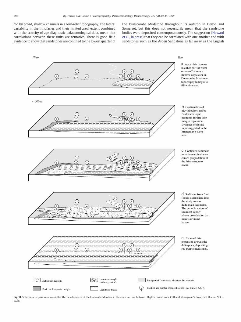
Fig. 11. Schematic depositional model for the development of the Lincombe Member in the cscale.
the Dunscombe Mudstone throughout its outcrop in Devon andSomerset, but this does not necessarily mean that the sandstonebodies were deposited contemporaneously. The suggestion (Howardet al., in press) that they can be correlated with one another and withsandstones such as the Arden Sandstone as far away as the English
oast section between Higher Dunscombe Cliff and Strangman's Cove, east Devon. Not to
397R.J. Porter, R.W. Gallois / Palaeogeography, Palaeoclimatology, Palaeoecology 270 (2008) 381–398
Midlands on the basis of lithology and presumed Carnian age shouldbe treated with caution.
The omission surface and rapid upward change from red-brown,gypsum-rich playa-lake mudstones to laminated green and greymudstones that defines the base of the Dunscombe Mudstone marksa sudden change to a wetter climate. This would have produced anevolving patchwork of shallow fluvial environments in which lacus-trine mudstones and lacustrine and sheet delta sands were depositedcontemporaneously.
In Devon, the LincombeMember was deposited in a geographicallyrestricted, shallow, oxygenated freshwater lake that passed up intolake delta-plain deposits (Fig. 11). At outcrop, the member thickenseastwards from 1.5 to 4.5 m (Fig. 5). At its base, an omission surfacewith Skolithos and ‘U-shaped burrows’ probably marks the initialexpansion of a shallow lake (Fig. 11a, b). Sediment from seasonal flooddischarges is likely to have spread out across the lake bottom. Themaximum extent of the lake in the coastal outcrops is marked by atransition to more marginal lacustrine conditions (Fig. 11c). Periodicflash floods, probably originating from outcrops of pre-Carboniferousrocks 50 to 80 km to the west and north west, spread out across thepreviously deposited sediments on which formed small pools(Fig.11d). Thesewere colonised by aquatic organisms, and sub-aeriallyexposed surfaces by insects and vegetation. The lacustrine delta wasreplaced by an expanding lake in which the deposition of red-brownmudstonesmarks the top of the LincombeMember (Fig.11e). It has notbeen recorded inland in Devon: the correlative beds in the WiscombePark boreholes do not include an arenaceous unit.
Beds D and E on the Devon coast are separated by playa-lakemudstones (Figs. 6 and 7). They represent sheet delta deposits thatcrossed a playa margin. They can be correlated with similar lithologiesin the lower part of the Dunscombe Mudstone in the Wiscombe Parkboreholes, 5 to 6 km from the coastal exposures. However, the laterallyvariable nature of the sediments and the nature of their interpreteddepositional environments suggest that they are unlikely to be reliablemarker beds over large distances.
The known distribution of sandstones in the Dunscombe Mud-stone in the Taunton, North Curry and Sutton Mallett areas is patchy,due partly to paucity of exposure and partly to the lenticular nature ofthe sandstone bodies (Figs. 5, 8 and 9). Almost all the exposuresrecorded in the literature have been in building-stone quarries in thethicker sandstone beds (e.g. Fig. 9). A few have been in road cuttings,most of which have proved predominantly argillaceous successions atthe same stratigraphical level as the sandstones. The depositionalenvironment of the North Curry and Sutton Mallet SandstoneMembers is interpreted here as a low-relief topography crossed bybroad, shallow channels that linked shallow, ephemeral lakes. The lackof pedogenic development within the NCSM suggests that theenvironment was predominantly wet. The contemporaneous pre-sence of outcrops of arenaceous Devonian rocks less than 20 kmwestof the Taunton–North Curry depositional area, in what are now theQuantock Hills, explains the higher proportion of coarser gradesediments in Somerset than in the correlative beds in Devon.
At Moredon Drive, the dominance of ripple laminated sandstones,thin trough-cross beds and the overall unit architecture of the NCSMsuggests that the channels were relatively small with generally lowflows (Fig. 8). The presence of fines on the channel tops suggestspossible channel switching and abandonment. Some of the thickersandstone units are thought to represent the lateral equivalent offloodplain deposits. At Gainsload Drove, 3.75 kmNE ofMoredon (Fig.1,location 4), the NCSM comprises mudstones with thin lenticularsandstones. This suggests that the channels seen at Moredon thinrapidly or terminate in a lacustrine depositional environment. Thetrace fossils and conchostraca recorded in the NCSM and theirrelationship to the sedimentology indicate deposition in freshwaterenvironments. Nineteenth century records of vertebrate remains thatwere presumed by Warrington andWilliams (1984) to have marine to
brackish-water affinities are now thought to represent a freshwaterfauna (M.J. Benton, pers. comm., 2005; G. Cuny, pers. comm., 2005).
The limited nature of the SMSM exposure makes palaeoenviron-mental interpretation tentative (Fig. 9). The presence of stackedchannel sandstones and the absence of thick floodplain depositssuggests that the overall palaeoenvironment was similar to that ofthe NCSM at Moredon Drive. The presence of conchostracans and amonospecific ichnofauna indicate a freshwater environment and, asat Moredon, the presence of channels overlain by thin argillaceousbeds indicates brief channel abandonment. Deformed bedding atSutton Mallett suggests that the discharge was periodic and variablein strength.
The present study has focused on the integration of thestratigraphy, sedimentology and ichnology of the arenaceous unitsin the Dunscombe Mudstone at outcrop in order determine theenvironments in which they were deposited. In doing so it hasshown that their palaeoenvironmental interpretation and correla-tion are more complex than previously thought. Sandstones thatwere presumed to have been deposited as continuous sheets in anestuarine or intertidal environment have been shown to representfluvio–lacustrine environments that were separated in space and,possibly, time.
In comparison with the marine realm, continental ichnology hasuntil relatively recently received little attention. This imbalance iscurrently being addressed by individual case studies and byrefinements to the definitions of ichnofacies in continental succes-sions (Buatois and Mángano, 2004 and references therein). Fluvio–lacustrine intervals are relatively common within playa-lake succes-sions, but there are few published accounts of ancient examples thatare sufficiently detailed to allow the complex interactions of theseephemeral shallow-water environments to be understood. Thesedimentological and ichnological descriptions and analyses of theTriassic example presented here will be applicable to other fluvio–lacustrine sediments deposited in dryland environments.
Acknowledgements
The research described here was suggested by the late RolandGoldring when collaborating with one of us (RJP) on Triassicichnology and with the other (RG) on Cretaceous bioturbatedsurfaces. His friendship and advice are greatly missed. The authorsare especially grateful to John Pollard who not only drew ourattention to the trace-fossil assemblages in the arenaceous units butwho also generously provided copies of his unpublished descriptionsof them. We are also grateful to Simon Braddy, Brian Williams andSue Marriot for their helpful editorial comments on an early draft ofthe paper, and to Mike Benton and Gilles Cuny for their comments onthe vertebrate remains. RJP was funded by a NERC (UK) studentship(NER/S/A/2002/10327) with a CASE award from Shell U.K. Explora-tion and Production whilst at the University of Bristol, UK.
References
Bromley, M.H., 1991. Variations in fluvial style as revealed by architectural elements,Kayenta Formation, Mesa Creek, Colorado, USA: evidence for both ephemeral andperennial fluvial processes. In: Miall, A.D., Tyler, N. (Eds.), The three-dimensionalarchitecture of terrigenous clastic sediments and its implications for hydrocarbondiscovery and recovery. Concepts in Sedimentology and Palaeontology, vol. 3.SEPM, pp. 94–102.
Bromley, R.G., Asgaard, U.,1979. Triassic freshwater ichnocoenoses from Carlsberg Fjord,East Greenland. Palaeogeography, Palaeoclimatology, Palaeoecology 28, 39–80.
Bromley, R.G., Ekdale, A.A., 1986. Composite ichnofabrics and tiering of burrows.Geological Magazine 123, 59–65.
Buatois, L.A., Mángano, M.G., 1995. The paleoenvironmental and paleoecologicalsignificance of the lacustrine Mermia ichnofacies: an archetypical subaqueousnonmarine trace fossil assemblage. Ichnos 4, 151–161.
Buatois, L.A., Mángano, M.G., 2002. Trace fossils from Carboniferous floodplain depositsin western Argentina: implications for ichnofacies models of continental environ-ments. Palaeogeography, Palaeoclimatology, Palaeoecology 183, 71–86.

398 R.J. Porter, R.W. Gallois / Palaeogeography, Palaeoclimatology, Palaeoecology 270 (2008) 381–398
Buatois, L.A., Mángano, M.G., 2004. Animal–substrate interactions in freshwaterenvironments: applications of ichnology in facies and sequence stratigraphicanalysis of fluvio–lacustrine successions. In: McIlroy, D. (Ed.), The application ofichnology to palaeoenvironmental and stratigraphic analysis. Geological Society ofLondon Special Publication, vol. 228, pp. 311–333.
Coleman, J.M., 1969. Brahmaputra River: channel processes and sedimentation.Sedimentary Geology 3, 129–239.
Doe, T.W., Dott Jr., R.H., 1980. Genetic significance of deformed cross bedding — withexamples from the Navajo and Weber sandstones of Utah. Journal of SedimentaryPetrology 50, 793–812.
Edmonds, E.A., Williams, B.J., 1985. Geology of the country around Taunton and theQuantock Hills. Memoir for 1:50 000 geological sheet 295 (England and Wales),British Geological Survey. HMSO, London.
Ekdale, A.A., Bromley, R.G., 1983. Trace fossils and ichnofabric in the Kjolby Gaard Marl,uppermost Cretaceous, Denmark. Bulletin of the Geological Society of Denmark 31,107–119.
Eugster, H.P., Hardie, L.A., 1975. Sedimentation in an Ancient Playa-Lake Complex: TheWilkins Peak Member of the Green River Formation of Wyoming. GeologicalSociety of America Bulletin 86, 319–334.
Farris, M.A., 1999. Palynomorph taphonomy in continental red-bed facies, UK WestMidlands and Central North Sea. PhD thesis, University of Keele, United Kingdom.
Fisher, M.J., 1985. Palynology of sedimentary cycles in theMerciaMudstone and PenarthGroups (Triassic) of southwest and central England. Pollen et Spores 27, 95–112.
Frey, R.W., Pemberton, S.G., Fagerstrom, J.A., 1984. Morphological, ethological, andenvironmental significance of the ichnogenera Scoyenia and Ancorichnus. Journal ofPaleontology 58, 511–528.
Frostick, L.E., Reid, I., 1986. Evolution and sedimentary character of lake deltas fed byephemeral rivers in the Turkana basin, northern Kenya. In: Frostick, L.E., Renaut, R.W.,Reid, I., Tiercelin, J.-J. (Eds.), Sedimentation in the African Rifts. Geological Society ofLondon Special Publication, vol. 25, pp. 113–125.
Gallois, R.W., 2001. The lithostratigraphy of the Mercia Mudstone Group (mid to lateTriassic) of the south Devon coast. Geoscience in South-West England 10, 195–204.
Gallois, R.W., 2003. The distribution of halite (rock-salt) in the Mercia Mudstone Group(mid to late Triassic) in south-west England. Geoscience in South-West England 10,383–389.
Gallois, R.W., 2005. The stratigraphy of the Mercia Mudstone Group succession (mid tolate Triassic) proved in the Wiscombe Park boreholes, Devon. British GeologicalSurvey Technical Report IR/05/143R.
Genise, J.F., Bellosi, E.S., Gonzalez, M.G., 2004. An approach to the description andinterpretation of ichnofabrics in palaeosols. In: McIlroy, D. (Ed.), The application ofichnology to palaeoenvironmental and stratigraphic analysis. Geological Society ofLondon Special Publication, vol. 228, pp. 355–382.
Howard, A.S., Warrington, G., Ambrose, K., Rees, J.G., in press. A formational frameworkfor the Mercia Mudstone Group (Triassic) of England and Wales. British GeologicalSurvey Research Report RR/08/004.
Jeans, C.V., 1978. The origin of the Triassic clay assemblages of Europe with specialreference to the Keuper Marl and Rhaetic of parts of England. PhilosophicalTransactions of the Royal Society of London. Series A 289, 549–639.
Kozur, H.W., Bachmann, G.H., 2005. Correlation of the Germanic Triassic with theinternational scale. Albertiana 32, 21–35.
Lang, S.C., Payenberg, T.H.D., Reilly, M.R.W., Hicks, T., Benson, J., Kassan, J., 2004. Modernanalogues for dryland sandy fluvio–lacustrine deltas and terminal splay reservoirs.Australian Petroleum Production and Exploration Association Journal 44, 329–356.
Miall, A.D., 1977. A review of the braided-river depositional environment. Earth ScienceReviews 13, 1–62.
Picard, M.D., High Jr., L.R., 1973. Sedimentary structures of ephemeral streams.Developments in Sedimentology, vol. 17. Elsevier, Amsterdam.
Pollard, J.E., 1988. Trace fossils in coal-bearing sequences. Journal of the GeologicalSociety of London 145, 339–350.
Porter, R.J. 2006. Ichnology and sedimentology of Triassic continental sequences:onshore and offshore UK. PhD thesis, University of Bristol, U. K.
Reineck, H.-E., Singh, I.B., 1980. Depositional sedimentary environments: with referenceto terrigenous clastics, 2nd Edit. Springer-Verlag, Berlin.
Ruffell, A., Warrington, G., 1988. An arenaceous member in the Mercia Mudstone Group(Triassic) west of Taunton, Somerset. Proceedings of the Ussher Society 7, 102–103.
Rust, B.R., 1978. Depositional models for braided alluvium. In: Miall, A.D. (Ed.), FluvialSedimentology, Memoirs of the Canadian Society of Petroleum Geologists, vol. 5,pp. 605–625.
Smoot, J.P., 1983. Depositional subenvironments in an arid closed basin; the WilkinsPeak Member of the Green River Formation (Eocene), Wyoming, U.S.A. Sedimen-tology 30, 801–827.
Smoot, J.P., Lowenstein, T.K., 1991. Depositional environments of non-marine evapo-rates. In: Melvin, J.L. (Ed.), Evaporites, Petroleum and Mineral Resources,Developments in Sedimentology, vol. 50, pp. 189–347.
Sorauf, J.E., 1964. Flow rolls of Upper Devonian rocks of south-central New York State.Journal of Sedimentary Petrology 35, 553–563.
Stanley, K.O., Fagerstrom, J.A., 1974. Miocene invertebrate trace fossils from a braidedriver environment, western Nebraska, USA. Palaeogeography, Palaeoclimatology,Palaeoecology 15, 63–82.
Taylor, A.M., Goldring, R.,1993. Description and analysis of bioturbation and ichnofabric.Journal of the Geological Society of London 150, 141–148.
Taylor, A., Goldring, R., Gowland, S., 2003. Analysis and application of ichnofabrics.Earth-Science Reviews 60, 227–259.
Uchman, A., Álvaro, J.J., 2000. Non-marine invertebrate trace fossils from the TertiaryCalatayud–Teruel basin, NE Spain. Revista Española de Paleontología 15, 203–218.
Ussher, W.A.E., 1906. The geology of the country between Wellington and Chard.Memoirs of the Geological Survey of England and Wales. HMSO, London.
Ussher, W.A.E., 1908. The geology of the Quantock Hills and of Taunton and Bridgewater.Memoir of the Geological Survey of Great Britain. HMSO, London.
Warrington, G., 1971. Palynology of the New Red Sandstone sequence of the southDevon coast. Proceedings of the Ussher Society 2, 307–314.
Warrington, G., Williams, B.J., 1984. The North Curry Sandstone Member (late Triassic)near Taunton, Somerset. Proceedings of the Ussher Society 6, 82–87.
Warrington, G., Audley-Charles, M.G., Elliott, R.E., Evans, W.B., Ivimey-Cook, H.C., Kent,P.E., Robinson, P.L., Shotton, F.W., Taylor, F.M., 1980. A correlation of Triassic rocks inthe British Isles. Geological Society of London Special Report No. 13.
Wurster, P., 1964. Geologie des Schilfsandsteins. Mitteilungen aus dem GeologischenStaatsinstitut in Hamburg 33, 1–140.