Ponte Vista at San Pedro Specific Plan
71
-
Upload
khangminh22 -
Category
Documents
-
view
0 -
download
0
Transcript of Ponte Vista at San Pedro Specific Plan


TABLE OF CONTENTS
Page Section 1. ESTABLISHMENT OF THE PONTE VISTA AT SAN PEDRO
SPECIFIC PLAN ................................................................................................................ 1
A. Authority and Scope ............................................................................................... 1
B. Subareas .................................................................................................................. 1
C. Specific Plan Overview, Purposes and Objectives ............................................... 12
1. Specific Plan Overview............................................................................. 12
2. Purposes and Objectives ........................................................................... 12
Section 2. DEFINITIONS ...................................................................................................... 13
Section 3. EXISTING CONDITIONS AND DEVELOPMENT OVERVIEW .................... 14
A. Wilmington-Harbor City and San Pedro Communities ........................................ 14
B. Existing Site Conditions ....................................................................................... 15
C. Project Description................................................................................................ 15
Section 4. RELATIONSHIP TO CITY LAND USE AND PLANNING REGULATIONS............................................................................................................... 15
A. Relationship to the General Plan........................................................................... 15
B. Consistency with the Community Plan ................................................................. 16
C. Relationship to the Los Angeles Municipal Code ................................................ 16
D. Applicability of the Specific Plan ......................................................................... 17
E. Relationship to CEQA .......................................................................................... 17
Section 5. LAND USE ........................................................................................................... 17
A. Permitted Uses ...................................................................................................... 17
1. Permitted Uses .......................................................................................... 17
2. Supplemental Regulations ........................................................................ 17
3. Additional Conditional Uses ..................................................................... 18

ii
B. Prohibited Uses ..................................................................................................... 18
C. Development Regulations ..................................................................................... 18
1. Maximum Permitted Development ........................................................... 18
2. Lot Area .................................................................................................... 19
3. Small Lot Subdivision............................................................................... 19
4. Residential Regulations ............................................................................ 19
D. Design Requirements ............................................................................................ 27
E. Determination of Compliance ............................................................................... 27
F. Relief from Development Regulations ................................................................. 27
G. Adjustment to Boundaries..................................................................................... 27
Section 6. Open Space, Pedestrian Linkages and Streetscape ............................................... 28
A. Subarea 7 ............................................................................................................... 28
B. Pedestrian Linkages .............................................................................................. 30
C. STREETSCAPE ................................................................................................... 30
1. Primary Access Roads .............................................................................. 30
2. Internal Streets and Driveways ................................................................. 30
3. Street Standards ........................................................................................ 30
4. Street Lighting .......................................................................................... 31
D. Landscape ............................................................................................................. 31
E. Entrances and Plazas ............................................................................................. 31
SECTION 7. TRANSPORTATION, CIRCULATION, AND BICYCLE AND RESIDENT PARKING .................................................................................................... 32
1. Required Transportation Improvements ................................................... 32
2. Implementation ......................................................................................... 32
3. Transportation Demand Management Regulations .................................. 33
B. Parking Regulations .............................................................................................. 33
iii
1. Residential Parking Space Requirements ................................................. 34
2. Alternative Requirements ......................................................................... 35
C. Bicycle Parking and Bicycle Circulation .............................................................. 35
D. Trail Standards ...................................................................................................... 35
Section 8. INFRASTRUCTURE AND UTILITIES .............................................................. 35
A. General .................................................................................................................. 35
B. Demolition/Site Preparation.................................................................................. 36
C. Retaining Walls ..................................................................................................... 36
D. Storm Drainage ..................................................................................................... 36
E. Sewer and Water System ...................................................................................... 37
F. Solid Waste ........................................................................................................... 38
G. Energy – Electricity and Natural Gas ................................................................... 38
SECTION 9. SIGNAGE AND LIGHTING ................................................................... 38
A. Monument/Identification Signs ............................................................................ 39
B. Signage for Vehicles ............................................................................................. 39
C. Signage for Pedestrians ......................................................................................... 39
D. Trail Signage ......................................................................................................... 39
E. Prohibited Signs .................................................................................................... 40
F. Lighting ................................................................................................................. 40
G. Amenities .............................................................................................................. 40
Section 10. SPECIFIC PLAN IMPLEMENTATION AND AMENDMENTS ...................... 40
A. Applicability of LAMC Section 11.5.7................................................................. 40
B. Other Specific Plan Provisions ............................................................................. 40
C. Project Determination ........................................................................................... 40
D. Project Permit Compliance ................................................................................... 41

iv
E. Conditions of Approval......................................................................................... 41
F. Exemption from Site Plan Review ........................................................................ 41
G. Fees ....................................................................................................................... 42
H. Subdivision Regulations ....................................................................................... 42
Section 11. DESIGN GUIDELINES ....................................................................................... 42
Section 12. ENVIRONMENTAL CONDITIONS .................................................................. 42
A. AESTHETICS....................................................................................................... 42
1. Project Design Features ............................................................................ 42
2. Mitigation Measures ................................................................................. 43
B. AIR QUALITY ..................................................................................................... 43
1. Project Design Features ............................................................................ 43
2. Mitigation Measures ................................................................................. 43
C. BIOLOGICAL RESOURCES .............................................................................. 43
1. Project Design Features ............................................................................ 43
2. Mitigation Measures ................................................................................. 44
D. CULTURAL RESOURCES ................................................................................. 45
1. Project Design Features ............................................................................ 45
2. Mitigation Measures ................................................................................. 46
E. GEOLOGY AND SOILS ..................................................................................... 47
1. Project Design Features ............................................................................ 47
2. Mitigation Measures ................................................................................. 47
F. GREENHOUSE GAS EMISSIONS ..................................................................... 47
1. Project Design Features ............................................................................ 47
2. Mitigation Measures ................................................................................. 48
G. HAZARDS AND HAZARDOUS MATERIALS ................................................ 48
v
1. Project Design Features ............................................................................ 48
2. Mitigation Measures ................................................................................. 48
H. HYDROLOGY AND WATER QUALITY .......................................................... 49
1. Project Design Features ............................................................................ 49
2. Mitigation Measures ................................................................................. 49
I. LAND USE AND PLANNING ............................................................................ 49
1. Project Design Features ............................................................................ 49
2. Mitigation Measures ................................................................................. 49
J. NOISE ................................................................................................................... 49
1. Project Design Features ............................................................................ 49
2. Mitigation Measures ................................................................................. 49
K. POPULATION AND HOUSING ......................................................................... 50
1. Project Design Features ............................................................................ 50
2. Mitigation Measures ................................................................................. 50
L. PUBLIC SERVICES – FIRE PROTECTION ...................................................... 50
1. Project Design Features ............................................................................ 50
2. Mitigation Measures ................................................................................. 51
M. PUBLIC SERVICES – POLICE PROTECTION ................................................ 51
1. Project Design Features ............................................................................ 51
2. Mitigation Measures ................................................................................. 51
N. PUBLIC SERVICES – SCHOOLS ...................................................................... 51
1. Project Design Features ............................................................................ 51
2. Mitigation Measures ................................................................................. 51
O. PUBLIC SERVICES – PARKS AND RECREATION........................................ 51
1. Project Design Features ............................................................................ 51

vi
2. Mitigation Measures ................................................................................. 52
P. PUBLIC SERVICES – LIBRARIES .................................................................... 52
1. Project Design Features ............................................................................ 52
2. Mitigation Measures ................................................................................. 52
Q. TRANSPORTATION AND TRAFFIC ................................................................ 52
1. Project Design Features ............................................................................ 52
2. Mitigation Measures ................................................................................. 53
R. UTILITIES AND SERVICE SYSTEMS - WATER ............................................ 58
1. Project Design Features ............................................................................ 58
2. Mitigation Measures ................................................................................. 59
S. UTILITIES AND SERVICE SYSTEMS - WASTEWATER .............................. 59
1. Project Design Features ............................................................................ 59
2. Mitigation Measures ................................................................................. 59
T. UTILITIES AND SERVICE SYSTEMS – SOLID WASTE ............................... 59
1. Project Design Features ............................................................................ 59
2. Mitigation Measures ................................................................................. 60
U. UTILITIES AND SERVICE SYSTEMS – ENERGY ......................................... 60
1. Project Design Features ............................................................................ 60
2. Mitigation Measures ................................................................................. 60
Section 13. GENERAL ............................................................................................................ 61
A. Time Limits ........................................................................................................... 61
B. Severability ........................................................................................................... 61
vii
LIST OF TABLES
Page
Table No. 1. Maximum Permitted Units by Subarea 18
Table No. 2 Illustrative Parking Plan 34
LIST OF EXHIBITS, ILLUSTRATIONS AND MAPS
Page
Figure I. Specific Plan Area 2
Figure II. Subarea Boundaries 3
Figures III-1 – III-6. Site Plan 4
Figure IV. Zoning Map 11
LIST OF APPENDICES
Appendix No. 1 Design Guidelines
Appendix No. 2 Streetscape Standards
Appendix No. 3 Retaining Wall Standards
Appendix No. 4 Traffic Study
Appendix No. 5 Infrastructure Plans and Programs
Appendix No. 6 Preliminary Grading Plan
Appendix No. 7 Mitigation and Monitoring Reporting Program
Appendix No. 8 Development Standards Summary Table

1
PONTE VISTA AT SAN PEDRO SPECIFIC PLAN
An ordinance establishing a Specific Plan, known as the Ponte Vista at San Pedro Specific Plan, for a portion of the Wilmington-Harbor City Community Plan area.
THE PEOPLE OF THE CITY OF LOS ANGELES DO ORDAIN AS FOLLOWS:
Section 1. ESTABLISHMENT OF THE PONTE VISTA AT SAN PEDRO SPECIFIC PLAN
A. Authority and Scope
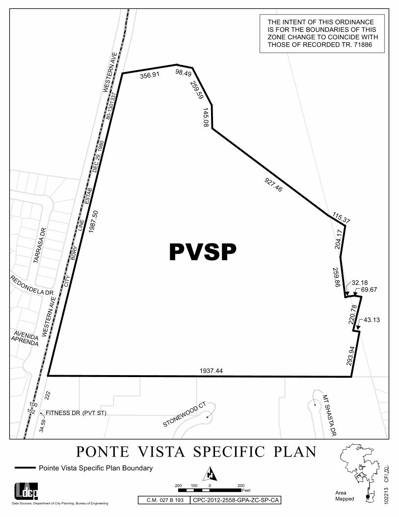
A Specific Plan is a regulatory land use ordinance that controls or provides a framework for the systematic implementation of the General Plan of the City of Los Angeles. Pursuant to Section 11.5.7 of the Los Angeles Municipal Code (LAMC), the City Council hereby establishes the Ponte Vista at San Pedro Specific Plan, which shall be applicable to that area comprising the approximately 61.5-acre site located at 26900 South Western Avenue in the City of Los Angles, bordered by the U.S. Navy’s Defense Fuel Support Point to the north, Mary Star of the Sea High School to the east, Fitness Drive and multi-family residential developments to the south, and Western Avenue (State Route 213) to the west. This area is referred to as the “Specific Plan area” and is depicted on Figure I. This Specific Plan serves as both a policy and regulatory document for the development of the Specific Plan area.
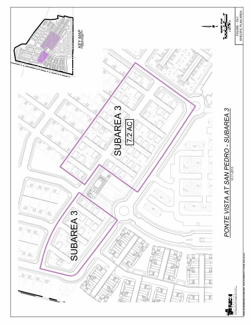
B. Subareas
In order to regulate the use of property as provided in this Specific Plan, the Specific Plan is divided into the following seven land use Subareas and Subarea classifications listed below. The location and boundaries of these Subareas are depicted in Figure II.
Subarea 1: Single-Family 1
Subarea 2: Single-Family 2
Subarea 3: Single-Family 3
Subarea 4: Townhomes
Subarea 5: Townhomes & Flats
Subarea 6: Flats
Subarea 7: Open Space/Recreation
The Site Plan, including proposed product types, for the Specific Plan area is depicted on Figure III-1. Site plan details for each residential Subarea are depicted on Figures III-2 through III-6. The Zoning Map is attached at Figure IV.


STONEWOOD CT
MT SH
ASTA DR
AVENIDAAPRENDA
REDONDELA DR
WES
TER
N A
VE
(PVT ST)FITNESS DR
TAR
RAS
A D
R
WES
TER
N A
VE
AreaMapped
O
Data Sources: Department of City Planning, Bureau of Engineering
222
CF/
1022
13
200 0 200100Feet
Pointe Vista Specific Plan Boundary
1937.44
293.
9422
0.78
1987
.50
356.91 98.49
259.59
927.46
115.37
204.
17
259.86
69.6732.18
43.13
PVSP
CPC-2012-2558-GPA-ZC-SP-CA027 B 193C.M.
CIT
Y
BD
RY
L
INE
E
STAB
D
EC 2
9, 1
980
34.5
9
145.08
THE INTENT OF THIS ORDINANCEIS FOR THE BOUNDARIES OF THISZONE CHANGE TO COINCIDE WITHTHOSE OF RECORDED TR. 71886
80-1
3013
37
100102
PONTE VISTA SPECIFIC PLAN

12
C. Specific Plan Overview, Purposes and Objectives
1. Specific Plan Overview
This Specific Plan provides the regulatory framework for the redevelopment of the Specific Plan area with up to 700 residential units, including a combination of single-family homes, townhomes, and flats. The Specific Plan will also include recreational facilities, parks, open space, and a trail along the perimeter of the Specific Plan area. Streets within the Specific Plan area will be private, with access to the Specific Plan area through two entrances from Western Avenue, at Green Hills Drive and at a new east-west road near the southerly boundary of the Project that would connect through the Specific Plan area to the Mary Star of the Sea High School campus to the east. The access road to the Mary Star of the Sea High School campus will be privately maintained, but publicly accessible.
2. Purposes and Objectives
The purposes and objectives of this Specific Plan are as follows:
• To provide regulatory controls and a framework for the development of that portion of the General Plan that relates to this geographic area and to provide for public needs, convenience and general welfare as the development of such area necessitates;
• To transform an abandoned former military housing site into a new community offering a range of housing types and price levels that provide a full range of choices for people of diverse ages, household sizes and incomes;
• To increase access to parks and open space;
• To implement the General Plan and the Wilmington-Harbor City Community Plan for the Specific Plan area;
• To provide much needed single-family and multiple-family housing to serve the housing needs of the City of Los Angeles;
• To enhance future commercial development of the Port of Los Angeles and the Port of Long Beach Harbor by providing necessary housing options adjacent to these major industrial uses;
• To guide development, including use, height, density, parking, landscaping, architectural design guidelines and other related factors to ensure compatible development with the community;
• To set forth principles, standards and general procedures to assure the orderly development of the Specific Plan area;
• To promote increased flexibility in the design of large sites in order to ensure a combination of residential uses with adequate open space;

13
• To provide design guidelines for review and approval of landscape and exterior of buildings and structures; and
• To implement procedures for compliance within the Specific Plan which will encourage functional and professional site planning and design practices, quality exterior design, and better appearance to improve the community.
Section 2. DEFINITIONS
Whenever the following terms are used in this Specific Plan, they shall be construed as defined in this Section 2 and the definitions of the terms set forth in this Section 2 shall supersede the definitions set forth in the LAMC including, without limitation, Section 12.03 of the LAMC. Words and phrases not defined here shall be construed as defined in Section 12.03 of the LAMC or pursuant to Section 12 of this Specific Plan.
Building Pad Elevation shall mean the building pad denoted in the preliminary grading plan (Appendix No. 6), as such plan may be finalized after its review by the Bureau of Engineering prior to the recordation of each final map unit within the Specific Plan Area. The Building Height Limitation established by this Specific Plan for a proposed building shall be measured from the Building Pad Elevation established for such building.
City shall mean the City of Los Angeles.
Community Plan shall mean the adopted Wilmington-Harbor City Community Plan, a part of the General Plan of the City of Los Angeles.
Dwelling Unit, Single-family shall mean construction, alteration or addition to a one-family dwelling or any accessory building, for which a building permit is required, on a lot located in whole or in part within the Specific Plan area.
Flats shall mean a multi-family residential product where all living space within a unit is enclosed within a single level.
Floor Area shall mean the total of the gross area of the floor surfaces within the exterior wall of the building, not including space devoted to stairwells, basement storage, required corridors, public restrooms, elevator shafts, light courts, vehicle parking and areas incident thereto, mechanical equipment incidental to the operation of such building, and covered public pedestrian circulation areas, including atriums, lobbies, plazas, patios, decks, arcades and similar areas, except such public circulation areas or portions thereof that are used solely for commercial purposes.
Height shall be measured as the vertical distance from ground level to the highest point of the roof. Penthouse or roof structures for the housing of elevators, stairways, tanks, ventilating fans or similar equipment required to operate and maintain the building, or fire or parapet walls, skylights, towers, steeples,
14
flagpoles, chimneys, smokestacks, wireless masts, water tanks, or similar structures, may be erected above the height limit specified for the Subarea in which the property is located, but no such penthouse or roof structure, or any other space above the height limit shall be allowed for the purpose of providing additional floor space.
LAMC shall mean the Municipal Code of the City of Los Angeles.
Project shall mean any building, structure or use of property which requires a building or use permit, excluding interior remodeling of any building which does not result in a change of use, an increase in floor area, an increase in the number of dwelling units or an increase in the occupant load.
Project Permit Compliance shall mean a permit issued pursuant to Section 10 of this Specific Plan.
Setback shall mean the distance from the face of a building, to another designated property line, excluding architectural features, roof eaves, patios, decks, or balconies projecting from the face of a building.
Specific Plan area shall mean that area shown within the heavy lines of the Zoning Map in this ordinance.
Subareas shall mean Subareas 1, 2, 3, 4, 5, 6 and 7 as described in Section 1.B of this Specific Plan.
Woonerf shall mean a thoroughfare type that is characterized by a narrow width. A woonerf is a living street where pedestrian and cyclist safety is promoted by use of shared spaces, traffic calming, low speed limits, and other similar measures.
Zoning Map shall mean the zoning map contained in this ordinance, attached as Figure IV.
Section 3. EXISTING CONDITIONS AND DEVELOPMENT OVERVIEW
A. Wilmington-Harbor City and San Pedro Communities
The Specific Plan area is situated in the far southern portion of the Los Angeles Basin, near Los Angeles Harbor. It is depicted within the Wilmington-Harbor City Community Plan (“Community Plan”), between the planning communities of Harbor Gateway, San Pedro, and the Port of Los Angeles, and adjacent to the cities of Torrance, Lomita, Rancho Palos Verdes, Carson, Long Beach and an unincorporated area of Los Angeles County. Immediately surrounding area includes established single-family neighborhoods and newer multiple-family uses, a memorial park, high school, and commercial land uses along Western Avenue.
The Specific Plan will redevelop an abandoned former military housing complex with high-quality residential, recreation, and open space uses compatible with nearby surrounding uses and planned development.

15
B. Existing Site Conditions
The Specific Plan area is the location of the former U.S. Navy San Pedro Housing complex, located approximately two miles north of downtown San Pedro and 1.5 miles northwest of the Port of Los Angeles. Abandoned homes and buildings from the prior use remain on the site.
The Specific Plan area is sloping, with elevation ranges from 101 feet to 249 feet above mean sea level (msl) sloping downward to the southeast. The highest area within the Specific Plan occurs along a steep cut slope that forms the Specific Plan’s northern boundary, adjacent to the Navy’s Defense Fuel Support Point. The Specific Plan area also includes significant fill. The U.S. Navy regraded the site and added fill to create building pads for roads and residential construction.
The federal government acquired ownership of the property within the Specific Plan area in 1942, when the property was undeveloped. In 1944, the government constructed a fire fighting training facility, which operated until 1950 and was demolished. The remaining area was utilized as a storage area for shipping containers from 1947 to 1962. The Navy constructed a residential community in approximately 1962 to house U.S. Navy personnel stationed at the Long Beach Naval Shipyard. The Navy housing facility was vacated and closed in 1999, and sold to private owners in 2005. The abandoned residential community still exists on the property within the Specific Plan area.
C. Project Description
The project includes demolition of the existing, abandoned structures and redevelopment of the Specific Plan area with up to 700 residential units, including a combination of single-family homes, townhomes, and flats. The Specific Plan will also include recreational facilities, parks, open space and a trail along the perimeter of the Specific Plan area. Streets within the Specific Plan area will be both private and publicly accessible, with access to the Specific Plan area through two entrances from Western Avenue, at Green Hills Drive and at a new east-west road near the southerly boundary of the Project that would connect through the Specific Plan area to the Mary Star of the Sea High School campus to the east
Section 4. RELATIONSHIP TO CITY LAND USE AND PLANNING REGULATIONS
A. Relationship to the General Plan
The General Plan is a comprehensive long-range policy document that guides the ultimate physical development of the City. The General Plan includes certain state mandated elements related to land use, circulation, housing, conservation, open space, noise, and safety. Whereas the General Plan is a broad policy document, a specific plan is a policy statement and implementation tool that is used to address a single project or planning area. A specific plan must be consistent with the General Plan by furthering the objectives and policies of the General Plan, and not obstruct their attainment, pursuant to California Government Code Section 65454.

16
This Specific Plan is consistent with the City’s General Plan. The City will administer the provisions of this Specific Plan in accordance with the City’s General Plan including the Wilmington Harbor City Community Plan.
This Specific Plan is consistent with the land use, housing, urban form and neighborhood design, open space and conservation, and transportation goals and objectives of the General Plan and Community Plan. The proposed residential densities are consistent with the Low, Low Medium I, and Low Medium II land use categories outlined in the Community Plan and the Specific Plan is an area in which includes single-family housing, multi-family housing, and parks and other community-oriented uses.
B. Consistency with the Community Plan
The Specific Plan area is regulated by the Community Plan, one of 35 community plans that comprise the Land Use Element of the General Plan. The Community Plan encourages development that provides for transition in scale, density and character of multiple-family housing and other uses adjacent to single-family homes, promotes rehabilitation of residential areas to improve quality of housing, encourages residential and mixed-use development along commercial corridors, and strives for development of more neighborhood parks to disperse recreational amenities throughout the Community Plan area.
This Specific Plan is a focused regulatory document that promotes these important goals of the Community Plan. The Specific Plan is consistent with both the Community Plan and General Plan and reflects unique constraints and opportunities of the Specific Plan area. The Specific Plan creates a regulatory framework that accounts for the special needs of the Specific Plan area and the surrounding community, and allows flexibility for adapting to future changes that could occur in public and private industries and markets.
C. Relationship to the Los Angeles Municipal Code
The regulations of this Specific Plan are in addition to those set forth in the planning zoning provisions of Chapter I of the Los Angeles Code (LAMC), as amended, and any other relevant ordinances, and do not convey any rights not otherwise granted under the provisions and procedures contained in the LAMC and other ordinances, except as provided for in this Specific Plan.
Whenever this Specific Plan contains provisions establishing regulations (including, but not limited to, standards such as densities, heights, floor area ratio, uses, yards, lot widths, lot area, building separations, setbacks, parking, open space and landscape requirements), different from, more restrictive or more permissive than would be allowed pursuant to Chapter I of the LAMC and the provisions of other portions of the LAMC specifically referenced below, this Specific Plan shall prevail and supersede the applicable provisions of that Code.
The procedures for the granting of Project Permit compliance, adjustments, modifications, exceptions, or interpretations to the requirements of this Specific Plan are set forth in Section 11.5.7 of the LAMC.

17
D. Applicability of the Specific Plan
Immediately upon the effective date of this Specific Plan, the rules and regulations established by this Specific Plan shall become applicable to this property within the Specific Plan area.
E. Relationship to CEQA
Pursuant to the California Environmental Quality Act (CEQA), the Ponte Vista Project Environmental Impact Report (EIR) was prepared for the Ponte Vista Project, which includes the implementation of this Specific Plan. The EIR (SCH No. 2010101082) identifies potential effects on the environment of the Ponte Vista Project and sets forth mitigation measures to reduce those impacts. The Mitigation Monitoring and Reporting Program is attached at Appendix No. 7. Further information regarding the required project design features and mitigation measures is provided at Section 12 of this Specific Plan.
Section 5. LAND USE
A. Permitted Uses
1. Permitted Uses
The Specific Plan area is comprised of seven Subareas as depicted on Figure II and described in Section 1.B of this Specific Plan. Residential land uses consistent with the maximum development limitations established in Table 1 of this Specific Plan, supportive land uses enumerated in Section 5.B, and open space/recreational land uses (including ancillary uses such as, but not limited to, community gardens, clubhouses, exercise equipment, trash receptacles, active recreational facilities, roads, trails, dog dropping receptacles and bag stations, and street furniture) are the “Permitted Uses” under this Specific Plan.
2. Supplemental Regulations
The following supplemental regulations will apply with respect to Permitted Uses:
• Proposed uses not listed in Section 5.A.1 above may be permitted upon determination by the Zoning Administrator pursuant to Section 12.21 A 2 of the LAMC that such uses are similar to and no more objectionable to the public welfare than the Permitted Uses provided herein. The City Planning Commission shall hear appeals on such Zoning Administrator interpretations. Upon approval thereof, such uses shall be deemed Permitted Uses for all purposes under this Specific Plan.
• Ancillary uses incidental to Permitted Uses and consistent with the purposes and objectives of this Specific Plan are Permitted Uses for all purposes under this Specific Plan.

18
3. Additional Conditional Uses
Any conditional uses listed in Section 12.24 of the LAMC that are not Permitted Uses under this Specific Plan shall be permitted when processed and approved in accordance with the procedures established in Section 12.24 of the LAMC.
B. Prohibited Uses
Commercial and industrial uses are prohibited within the Specific Plan area, with the exception of the following supportive uses within Subarea 7:
• Community-serving day care, as an accessory use within an improved recreational building;
• Community-serving commissary, as an accessory use within an improved recreational building; and
• Community-serving business center, as an accessory use within an improved recreational building.
C. Development Regulations
Development regulations for each residential Subarea are provided in this Section 5.C. Development regulations for Subarea 7 are provided in Section 6.A. A summary table of development regulations for each Subarea is provided at Appendix No. 8.
1. Maximum Permitted Development
Development of the Specific Plan area shall comply with the maximum permitted dwelling units per Subarea provided below in Table No. 1.
Table No. 1 Maximum Permitted Dwelling Units by Subarea
Subarea No.
Use Maximum Dwelling Units
DU/Acre Area (Gross Acres)
1 Single-Family 69 8 9.7 2 Single-Family 60 11 5.7 3 Single-Family 79 11 7.2 4 Townhomes 140 21 6.9 5 Townhomes & Flats 140 18 8.1 6 Flats 212 23 9.5 7 Open
Space/Recreation N/A N/A 14.3
TOTAL 700 11.4 (avg) 61.4

19
a. Residential Limitations
Notwithstanding the provisions of Sections 12.10 C 4 and 12.11 C 4 of the LAMC to the contrary, the total allowable dwelling units within the Specific Plan Area shall not exceed 700 dwelling units. The Specific Plan permits the maximum dwelling units per acre allocated to each zone in Table 1, as well as any product type that provides less dwelling units per acre and generates less traffic trips. Single-family housing is permitted in the entire Specific Plan area except for Open Space zones. Whenever a product type allowed and intended primarily for development one Subarea is developed in another Subarea as provided for in this Section, the Residential Regulations prescribed in Section 5.C.4 of the corresponding Subarea shall apply, except that the maximum dwelling units for each Subarea outlined in Table No. 1 shall not be exceeded.
A maximum of 212 residential units are permitted within Subarea 6, although only 188 units are currently proposed on the site plan. In order to provide additional housing within Subarea 6, exceeding the currently proposed 188 units but not more than 212 units, a new subdivision map shall be approved, but no Specific Plan Amendment shall be required.
b. Allocation of Development Rights
The total number of dwelling units and a current accounting of the cumulative totals of Floor Area utilized within each Subarea described in Section 5.C.1 of this Specific Plan shall be maintained by the Departments of City Planning and Building and Safety. Allocation of development rights to each lot within a subdivision shall be made at the time of subdivision, and prior to the recordation of Parcel Maps or Final Maps. Deed restrictions or covenants running with the land shall be recorded to limit development in accordance with such allocated development rights and in conformity with Section 6 of this Specific Plan.
2. Lot Area
Notwithstanding provisions of the LAMC to the contrary, the minimum lot area for any residential lot within the Specific Plan area shall be 1,800 square feet.
3. Small Lot Subdivision
In addition to any provisions of this Specific Plan and notwithstanding Paragraph 3.C above, the Specific Plan permits development in compliance with the City’s Small Lot Subdivision Ordinance (Ord. 176354) in Subareas 4, 5 and 6 only.
4. Residential Regulations
a. Subarea 1
Subject to the applicable limitations and provisions set forth in Sections 6, 7, 8 and 9 of this ordinance, the following requirements shall apply to all lots within Subarea 1 of the Specific Plan area.

20
i) Use
No building, structure or land shall be used and no building or structure shall be erected, structurally altered, enlarged or maintained except for the following uses:
• One-family dwellings;
• Parks, playgrounds, recreational or community centers, or other similar recreational or open space amenity, public or private; and
• Accessory buildings, including private garages, accessory living quarters, servants’ quarters, or recreation rooms, subject to the same limitations as are set forth in Section 12.08 A 7 of the LAMC.
ii) Height
No building or structure shall exceed two (2) stories or 30 feet in height.
iii) Density
The density shall be limited to a maximum of 8 dwelling units per gross acre and the total number of residential dwelling units in Subarea 1 shall be limited to 69 dwelling units.
iv) Product Type
Product Type 1 in the Design Guidelines is permitted in Subarea 1.
v) Lot Width
The minimum lot width for each lot within Subarea 1 shall be 20 feet.
vi) Setbacks
The yard setbacks within each lot within Subarea 1 shall be at least:
• Front: 8’ setback
• Side: 4’ setback
• Rear: 8’ setback
b. Subarea 2
Subject to the applicable limitations and provisions set forth in Sections 6, 7, 8 and 9 of this ordinance, the following requirements shall apply to all lots within Subarea 2 of the Specific Plan area.
i) Use

21
No building, structure or land shall be used and no building or structure shall be erected, structurally altered, enlarged or maintained except for the following uses:
• One-family dwellings;
• Parks, playgrounds, recreational or community centers, or other similar recreational or open space amenity, public or private; and
• Accessory buildings, including private garages, accessory living quarters, servants’ quarters, or recreation rooms, subject to the same limitations as are set forth in Section 12.08 A 7 of the LAMC.
ii) Height
No building or structure shall exceed three (3) stories or 30 feet in height.
iii) Density
The density shall be limited to a maximum of 11 dwelling units per gross acre and the total number of residential dwelling units in Subarea 2 shall be limited to 60 dwelling units.
iv) Product Types
Product Types 1 and 2 in the Design Guidelines are permitted in Subarea 2.
Notwithstanding the requirements of this Section 5.C.4.b, if Product Type 1 is developed within Subarea 2, then the Residential Regulations prescribed in Section 5.C.4.a for Subarea 1 shall apply, with the exception of density where Section 5.C.4.b.iii shall continue to apply.
v) Lot Width
The minimum lot width for each lot within Subarea 2 shall be 20 feet.
vi) Setbacks
The yard setbacks within each lot within Subarea 2 shall be at least:
• Front: 2’ setback
• Side: 4’ setback
• Rear: 5’ setback
c. Subarea 3
Subject to the applicable limitations and provisions set forth in Sections 6, 7, 8 and 9 of this ordinance, the following requirements shall apply to all lots within Subarea 3 of the Specific Plan area.

22
i) Use
No building, structure or land shall be used and no building or structure shall be erected, structurally altered, enlarged or maintained except for the following uses:
• One-family dwellings;
• Parks, playgrounds, recreational or community centers, or other similar recreational or open space amenity, public or private; and
• Accessory buildings, including private garages, accessory living quarters, servants’ quarters, or recreation rooms, subject to the same limitations as are set forth in Section 12.08 A 7 of the LAMC.
ii) Height
No building or structure shall exceed three (3) stories or 40 feet in height.
iii) Density
The density shall be limited to a maximum of 11 dwelling units per gross acre and the total number of residential dwelling units in Subarea 3 shall be limited to 79 dwelling units.
iv) Product Types
Product Types 1, 2 and 3 in the Design Guidelines are permitted in Subarea 3.
Notwithstanding the requirements of this Section 5.C.4.c:
• If Product Type 1 is developed within Subarea 3, then the Residential Regulations prescribed in Section 5.C.4.a for Subarea 1 shall apply, with the exception of density where Section 5.C.4.c.iii shall continue to apply.
• If Product Type 2 is developed within Subarea 3, then the Residential Regulations prescribed in Section 5.C.4.b for Subarea 2 shall apply, with the exception of density where Section 5.C.4.c.iii shall continue to apply.
v) Lot Width
The minimum lot width for each lot within Subarea 3 shall be 20 feet.
vi) Setbacks
The yard setbacks within each lot within Subarea 3 shall be at least:
• Front: 8’ setback
• Side: 4’ setback

23
• Rear: 2’ setback
d. Subarea 4
Subject to the applicable limitations and provisions set forth in Sections 6, 7, 8 and 9 of this ordinance, the following requirements shall apply to all lots within Subarea 4 of the Specific Plan area.
i) Use
No building, structure or land shall be used and no building or structure shall be erected, structurally altered, enlarged or maintained except for the following uses:
• Uses permitted in the Subareas 1, 2 and 3;
• Dwellings, one-family attached, two-family, multiple; and apartment houses and/or condominium units; and
• Parks, playgrounds, recreational or community centers, or other similar recreational or open space amenity, public or private.
ii) Height
No building or structure shall exceed three (3) stories or 35 feet in height.
iii) Density
The density shall be limited to a maximum of 21 dwelling units per gross acre and the total number of residential dwelling units in Subarea 4 shall be limited to 140 dwelling units.
iv) Product Types
Product Types 1, 2, 3, and 4 in the Design Guidelines are permitted in Subarea 4.
Notwithstanding the requirements of this Section 5.C.4.d:
• If Product Type 1 is developed within Subarea 4, then the Residential Regulations prescribed in Section 5.C.4.a for Subarea 1 shall apply, with the exception of density where Section 5.C.4.d.iii shall continue to apply.
• If Product Type 2 is developed within Subarea 4, then the Residential Regulations prescribed in Section 5.C.4.b for Subarea 2 shall apply, with the exception of density where Section 5.C.4.d.iii shall continue to apply.
• If Product Type 3 is developed within Subarea 4, then the Residential Regulations prescribed in Section 5.C.4.c for Subarea 3 shall apply, with the exception of density where Section 5.C.4.d.iii shall continue to apply.

24
v) Lot Width
The minimum lot width for each lot within Subarea 4 shall be 50 feet.
vi) Setbacks
The yard setbacks within each lot within Subarea 4 shall be at least:
• Front: 5’ setback
• Side: 4’ setback
• Rear: 0’ setback
e. Subarea 5
Subject to the applicable limitations and provisions set forth in Sections 6, 7, 8 and 9 of this ordinance, the following requirements shall apply to all lots within Subarea 5 of the Specific Plan area.
i) Use
No building, structure or land shall be used and no building or structure shall be erected, structurally altered, enlarged or maintained except for the following uses:
• Uses permitted in Subareas 1, 2, 3, and 4;
• Dwellings, one-family attached, two-family, multiple; and apartment houses and/or condominium units; and
• Parks, playgrounds, recreational or community centers, or other similar recreational or open space amenity, public or private.
ii) Height
No building or structure shall exceed four stories (4) stories or 48 feet in height.
iii) Density
The density shall be limited to a maximum of 18 dwelling units per gross acre and the total number of residential dwelling units in Subarea 5 shall be limited to 140 dwelling units.
iv) Product Types
Product Types 1, 2, 3, 4 and 5 in the Design Guidelines are permitted in Subarea 5.

25
Notwithstanding the requirements of this Section 5.C.4.e:
• If Product Type 1 is developed within Subarea 5, then the Residential Regulations prescribed in Section 5.C.4.a for Subarea 1 shall apply, with the exception of density where Section 5.C.4.e.iii shall continue to apply.
• If Product Type 2 is developed within Subarea 5, then the Residential Regulations prescribed in Section 5.C.4.b for Subarea 2 shall apply, with the exception of density where Section 5.C.4.e.iii shall continue to apply.
• If Product Type 3 is developed within Subarea 5, then the Residential Regulations prescribed in Section 5.C.4.c for Subarea 3 shall apply, with the exception of density where Section 5.C.4.e.iii shall continue to apply.
• If Product Type 4 is developed within Subarea 5, then the Residential Regulations prescribed in Section 5.C.4.d for Subarea 4 shall apply, with the exception of density where Section 5.C.4.3.e.iii shall continue to apply.
v) Lot Width
The minimum lot width for each lot within Subarea 5 shall be 50 feet.
vi) Setbacks
The yard setbacks within each lot within Subarea 5 shall be at least:
• Front: 5’ setback
• Side: 5’ setback
• Rear: 0’ setback
f. Subarea 6
Subject to the applicable limitations and provisions of Section 6, 7, 8 and 9 of this ordinance, the following requirements shall apply to all lots within Subarea 6 of the Specific Plan area
i) Use
No building, structure or land shall be used and no building or structure shall be erected, structurally altered, enlarged or maintained except for the following uses:
• Uses permitted in the Subareas 1, 2, 3, 4, and 5;
• Dwellings, one-family attached, two-family, multiple; and apartment houses and/or condominium units; and

26
• Parks, playgrounds, recreational or community centers, or other similar recreational or open space amenity, public or private.
ii) Height
No building or structure shall exceed four (4) stories or 55 feet in height.
iii) Density
The density shall be limited to a maximum of 23 dwelling units per gross acre and the total number of residential dwelling units in Subarea 6 shall be limited to 212 dwelling units.
iv) Product Types
Product Types 1, 2, 3, 4, 5, and 6 in the Design Guidelines are permitted in Subarea 6.
Notwithstanding the requirements of this Section 5.C.4.f:
• If Product Type 1 is developed within Subarea 6, then the Residential Regulations prescribed in Section 5.C.4.a for Subarea 1 shall apply, with the exception of density where Section 5.C.4.f.iii shall continue to apply.
• If Product Type 2 is developed within Subarea 6, then the Residential Regulations prescribed in Section 5.C.4.b for Subarea 2 shall apply, with the exception of density where Section 5.C.4.f.iii shall continue to apply.
• If Product Type 3 is developed within Subarea 6, then the Residential Regulations prescribed in Section 5.C.4.c for Subarea 3 shall apply, with the exception of density where Section 5.C.4.f.iii shall continue to apply.
• If Product Type 4 is developed within Subarea 6, then the Residential Regulations prescribed in Section 5.C.4.d for Subarea 4 shall apply, with the exception of density where Section 5.C.4.f.iii shall continue to apply.
• If Product Type 5 is developed within Subarea 6, then the Residential Regulations prescribed in Section 5.C.4.e for Subarea 5 shall apply, with the exception of density where Section 5.C.4.f.iii shall continue to apply.
v) Lot Width
The minimum lot width for each lot within Subarea 6 shall be 50 feet.
vi) Setbacks
The yard setbacks within each lot within Subarea 5 shall be at least:
• Front: 5’ setback
27
• Side: 5’ setback
• Rear: 0’ setback
D. Design Requirements
This Specific Plan includes detailed Design Guidelines provided at Appendix No. 1. The Design Guidelines provide standards to guide the visual and physical appearance of the residential development and pedestrian areas. People differ in their interpretation of what constitutes aesthetic design in particular circumstances, and flexibility should be permitted to encourage design innovations and changes in design standards over time. For these reasons, rigid adherence to each Design Guideline is not intended. Rather, it is intended that developments be evaluated for their conformance to the general intent of the applicable Design Guideline and to the Specific Plan objectives.
A variety of architectural styles and related building forms and details will be allowed within the Specific Plan area, with the goal of providing a cohesive string of distinct architectural influences that tie the community together yet allow for variety and individual expression. The following four architectural styles are permitted within the Specific Plan area: Mediterranean; Mediterranean Eclectic; Early California Modern; and California Modern. All Projects shall comply with the architectural site guidelines of the Design Guidelines.
E. Determination of Compliance
No building, structure or land within the Specific Plan area shall be used and no building or structure shall be erected, structurally altered, enlarged or maintained within the Specific Plan area without Project Permit Compliance approval as provided in said Section 10.E having been first obtained. The Project Permit Compliance approval process set forth in said Section 10.E may be provided concurrently with any subdivision proceeding involving the property for which Project Permit Compliance approval is requested.
F. Relief from Development Regulations
An application to modify or deviate from the development regulations in this Specific Plan shall be processed in accordance with the procedures for Project Permit Adjustments or for exceptions, amendments, or interpretations of this Specific Plan, as set forth in Section 10 of this Specific Plan and Sections 11.5.7 E and F of the LAMC.
G. Adjustment to Boundaries
The zone boundaries shown upon the Zoning Map in Figure IV of this Specific Plan are approximate and zone boundary interpretations or adjustments may be made as part of the Project Permit Compliance review and approval process under Section 10 of this Specific Plan when such zone boundary interpretations or adjustments meet the overall intent of the Specific Plan regarding location of land uses, and/or when necessary to ensure that such zone boundaries precisely coincide with future street, alley or lot lines.

28
Adjustments in the boundaries of the Subareas and of further components thereof that result in an increase or reduction of land area of any Subarea or component thereof of 15 percent or less of the land area shall be permitted by the Planning Director as a Specific Plan interpretation as set forth in Section 10.
Section 6. Open Space, Pedestrian Linkages and Streetscape
A. Subarea 7
The purpose of Subarea 7 is to limit uses to open space and recreational activities to provide amenities for the owners and tenants within the Specific Plan area, as well as the general public. All open areas (including any roof of any subterranean parking building or structure) not utilized for buildings, driveways, parking areas, recreational facilities, plazas, patios, decks or walks shall be landscaped.
a. Use
The following facilities, uses and activities are permitted within Subarea 7: parks, playgrounds, swimming pools and jacuzzis, paths and trails, open lawns, water features, drinking fountains, public art, exercise stations, athletic fields, picnic facilities, pedestrian amenities and features, landscape and landscape amenities, game courts, community gardens, recreational or community facilities, public or private, roads, infrastructure and equipment, community-serving commissary, day care and business centers as accessory uses within an improved recreational building, and similar uses as determined appropriate by the Director.
A park shall be provided within the dotted line boundary of Figure II depicted as Subarea 7A, prior to the issuance of the first residential certificate of occupancy for a Project. The park shall be designed in general accordance with one of the conceptual plans provided at Section 4 of the Design Guidelines. If the Planning Director determines during Project Permit Compliance review that the park design differs substantially from the conceptual plans provided in the Design Guidelines, the developer shall consult with the City Department of Recreation and Parks on an alternative park design acceptable to the Department of Recreation and Parks. The park shall be maintained by the property owners’ association and shall be accessible by the public in perpetuity, subject to reasonable rules and limitations that do not discriminate between project residents and the general public. As part of the Project Permit Compliance review, the owner or owners of the lot on which the park is to be provided and maintained shall record an agreement in the Office of the County Recorder of Los Angeles County, California, as a covenant running with the land for the benefit of the City of Los Angeles, providing that such owner or owners shall continue to provide and maintain the park as described in this Section 6A.a.
b. Height
No building or structure shall exceed three (3) stories or 40 feet in height.
c. Maximum Permitted Floor Area
The floor area ratio of each lot within Subarea 7 shall be limited to 3:1.

29
d. Setbacks
The yard setbacks within each lot within Subarea 7 shall be at least:
• Front: 5’ setback
• Side: 5’ setback
• Rear: 10’ setback
e. Transportation and Parking
No automobile parking shall be required for any uses located within Subarea 7.
f. Required Park and Recreation Space
At least one recreation center shall be provided as an amenity for project residents. Additional recreational centers may also be provided. In addition, at least three neighborhood pocket parks with a minimum area of 0.3 acres each shall be provided within the Specific Plan area. A perimeter trail shall be provided in general accordance with Landscape Design Guidelines in the Design Guidelines.
Required open space may be located at or above grade, or on rooftops. Parking areas, driveways and service facilities shall not qualify as open space, except to the extent provided for the parks themselves. Required open space may be provided in the form of courtyards, plazas, pedestrian paseos, trails, private setbacks, roof terraces, gardens, picnic areas, playgrounds, exercise areas, and sports related facilities (e.g. tennis courts, swimming pools, basketball courts) or other similar outdoor gathering places. Open space may be distributed throughout the Specific Plan area.
The park and recreation space and associated equipment and improvements required to be provided under this Section is hereby found to satisfy the requirements of Sections 17.12, 17.58, 12.21 G and 12.33 of the LAMC for the dedication of real property for park and recreational purposes, or for the payment of a fee in lieu thereof, in connection with the construction or development of any and all dwelling units in the Specific Plan area. Subdivision maps for residential or condominium purposes are hereby authorized to be recorded without any further compliance with Sections 17.12, 17.58, 12.21G or 12.33 of the LAMC.
g. No dedication required
Required open space need not be dedicated to the City as publicly owned property. Where not dedicated, the property owners’ association shall be responsible for the ownership and maintenance of the park and recreation space. The property owners’ association may impose reasonable regulations relating to open space and recreational amenities not dedicated to a public agency, including, but not limited to restricting hours of operation from dawn to dusk.

30
h. Implementation
Parks shall be developed, including construction and the provision of equipment and improvements, in general accordance with the open space plan in Sections 4.3 and 4.4 of the Design Guidelines, attached as Appendix No. 1. All park facilities shall be constructed prior to the issuance of the first residential certificate of occupancy for a Project. The Department of Recreation and Parks may approve adjustments to the open space plan in the Design Guidelines as necessary to achieve the intent of this Specific Plan. Neither a Specific Plan Exception nor a Specific Plan Amendment pursuant to Section 10 of this Specific Plan shall be required for an open space modification.
B. Pedestrian Linkages
The street network within the Specific Plan area shall accommodate all pedestrians walking through the Specific Plan area as shown on Walks and Trails diagram in the Design Guidelines. The street system in the Specific Plan area shall provide sidewalks in the dimensions provided in Appendix No. 2, Streetscape Standards. Streets and secondary connections within the Specific Plan area shall be treated with hardscape, landscape, lighting improvements and directional signs as described in Section 9 of this Specific Plan and Section 4 of the Design Guidelines.
C. STREETSCAPE
The Specific Plan street system will serve to separate the types of traffic by destination and minimize interference with the new residential uses. All streetscape improvements including landscaping and signage shall comply with Section 4 of the Design Guidelines. The Specific Plan will include two types of roadways: (i) primary access roads, and (ii) internal streets or driveways.
1. Primary Access Roads
The Specific Plan includes two primary access roads from Western Avenue. The northern primary access road crosses through a private gate and provides a loop to the recreational uses and northern residential uses. The southern primary access road provides direct access to Mary Star of the Sea High School across the Specific Plan area.
2. Internal Streets and Driveways
A number of roadways, consisting of private streets as well as community driveways, shall generally be developed as conceptually shown on Appendix No. 2, Streetscape Standards. Streets may be constructed in phases. Woonerfs are permitted within Subarea 2 of the Specific Plan, in general accordance with Section 2.0 and Section 4.0 of the Design Guidelines.
3. Street Standards
Additional standards for streets are provided in Appendix No. 2. The Street Standards in the Specific Plan shall supersede any street requirements of the LAMC.

31
4. Street Lighting
Any street lighting shall comply with the regulations of Section 17.08 of the LAMC. The Bureau of Street Lighting and Bureau of Engineering shall approve adjustments to the LAMC lighting requirements, as necessary to meet the intent of the Specific Plan.
D. Landscape
Sections 2 and 4 of the Design Guidelines provide conceptual details and guidance for the landscaping of streets, trails, parks, community entry points, the buffer area between the development and the property to the north of the Specific Plan area, and within each residential Subarea. Development within the Specific Plan area shall comply with the landscape design guidelines in Sections 2 and 4 of the Design Guidelines. Once installed, the property owners association shall be obligated to maintain landscaping on its property in substantial compliance with the Section 4 of the Design Guidelines.
E. Entrances and Plazas
Development within the Specific Plan area shall comply with Section 2 of the Design Guidelines, which provides details and guidance for development of the community entrances and plazas.
The primary entrance to the community shall be developed in general accordance with the monument entry, community drive, and community entry drive guidelines in Section 2 of the Design Guidelines. The primary gated entry point shall also comply with the following standards:
• Separate access lanes for residents and guests, where feasible;
• Provide turnaround capacity in front of the control entry gate;
• Separate pedestrian entry from the vehicular access gate;
• Pedestrian entrances shall be open to the general public, subject to reasonable rules and regulations of the property owners’ association including but not limited to dusk to dawn restrictions;
• Provide adequate stacking distance for cars waiting for admittance at entry gate;
• Provide clear, visible signage to accommodate residents, service deliveries and guests; and
• The gate shall be constructed from high quality metal, wrought iron or equivalent material and shall maintain visibility into the community.

32
• The gate shall not restrict public access to the park within Subarea 7A, to the perimeter trail and to the access road connecting Western Avenue to the Mary Star of the Sea High School.
A secondary access point to the Specific Plan shall be provided area along Western Avenue. The secondary access point shall be a monument court entry in general accordance with the Design Guidelines.
SECTION 7. TRANSPORTATION, CIRCULATION, AND BICYCLE AND RESIDENT PARKING
1. Required Transportation Improvements
The Specific Plan shall provide transportation improvements as required by the Mitigation Monitoring and Reporting Program provided at Appendix No. 7. The Specific Plan shall provide an access road to connect Western Avenue to the existing parking lot of the Mary Star of the Sea High School within the southern portion of the Specific Plan area.
2. Implementation
Prior to the issuance of a Project Permit Compliance approval for a Project, the LADOT, in consultation with the Director and the developer, shall assign traffic improvements, if any, to a Project.
Prior to the issuance of the first Project Permit Compliance approval for the first Project development under this Specific Plan, the developer shall submit a Traffic Mitigation Phasing Plan (TMPP) to the LADOT for approval. The Plan shall identify which improvements must be constructed in connection with individual development sites. LADOT, in consultation with the Director and the developer, may modify the approved TMPP, if he or she determines the TMPP to be impractical or infeasible, or if the Project is modified.
Prior to the issuance of a building permit for the project or any component thereof, the developer shall guarantee, to the satisfaction of the LADOT General Manager, the construction of any transportation improvements for such component of the project for which the developer is directly responsible. Prior to the issuance of a certificate of occupancy, the developer shall implement, or cause to be implemented, the required transportation improvements. If the LADOT General Manager determines that construction of any required transportation improvement is infeasible at the time the developer seeks a certificate of occupancy, then the developer shall pay the cost of or provide a suitable guarantee for the future implementation of the improvement to the satisfaction of the LADOT General Manager. Any guarantee required pursuant to this section may be satisfied by a letter of credit, surety bond or other suitable guarantee satisfactory to the LADOT General Manager.
Vehicular access to the proposed buildings from divided major or major arterials shall only be from intersecting public roadways or private roadways approved by the LADOT and the City Engineer.
33
Collector streets serving the proposed development shall intersect the arterial system within the Specific Plan area in a manner to facilitate the safe and efficient flow of traffic, as approved by the LADOT and the City Engineer.
3. Transportation Demand Management Regulations
Transportation Demand Management measures or incentives shall be utilized where feasible within the Specific Plan area. Transportation demand management measures or incentives shall be implemented as part of the Mitigation Monitoring and Reporting Program where applicable.
Transportation Demand Management measures may include, without limitation, the following types of measures:
• Parking locations
• Parking management measures
• Access and egress routes to transit
• Pedestrian and wayfinding signage
• Pedestrian circulation management
• Provision of bicycle racks to promote bicycle use
• Provision of electrical plug in locations for electrical vehicles
• Provision of supportive land uses such as day care or business center to reduce vehicle trips
The Specific Plan area is currently served by public transit and is immediately adjacent to a public transit route along Western Avenue. The project shall incorporate sidewalks on primary streets and shall provide a network of pathways throughout the Specific Plan area to create opportunities for residents to walk to local destinations and transit stops. The project will incorporate Design Standards, in Appendix No. 1, to improve landscaping and transit stops on Western Avenue.
B. Parking Regulations
The purpose of this Section is to provide regulatory standards pertaining to the off-street parking of motor vehicles. Except as provided in this Specific Plan, the provisions of Section 12.21 A 4 of the LAMC shall apply to property within the Specific Plan area.

34
1. Residential Parking Space Requirements
a. Dwelling Unit, Single-family and Multiple-family
• There shall be at least one (1) parking space provided for each dwelling unit with zero (0) or one (1) bedroom, which shall be covered.
• There shall be at least two (2) parking spaces provided for each dwelling unit with two (2) or more bedrooms, at least one of which shall be covered.
• There shall be .25 parking spaces per residential unit reserved for, and accessible to, visitors and guest. Guest parking may be uncovered and may be satisfied on private streets.
Up to 40 percent of all required parking spaces may be allotted for compact cars consistent with the provisions of the LAMC.
An illustrative parking plan for each Subarea is provided for informational purposes in Table 2 below. The parking plan is conceptual and may change over time as the Specific Plan area is developed.
Table No. 2 Illustrative Parking Plan
Subarea Dwelling Units (DU)
On-Site Parking Off-Site (Street) Parking
Total Parking
Slots
Parking Slots/DU
Garage Parking
Driveway Parking
Subarea 1 69 138 138 88 364 5.28
Subarea 2 60 120 0 28 148 2.47
Subarea 3 79 158 0 59 217 2.75
Subarea 4 140 280 0 35 315 2.25
Subarea 5 140 266 0 44 310 2.21
Subarea 6 188* 360 0 69 429 2.28
Subarea 7 0 0 30 74 104 N/A
Total 676 1,322 168 397 1,887 2.79
*The intent of the illustrative parking plan is to demonstrate conceptually the proposed parking per Subarea. These numbers are based on a design for a 676-unit project within the Specific Plan area. The parking plan is subject to change. Additional parking will be required in accordance with the parking ratios prescribed in this Specific Plan if additional units up to the maximum 700 units are developed.

35
2. Alternative Requirements
Notwithstanding any provision in the LAMC or this Specific Plan to the contrary, parking requirements may be reduced beyond those that would otherwise be required under the LAMC or this Specific Plan, if the Director of Planning finds, in connection with the review and approval of the Project Permit Compliance as provided in Section 10.E of this Specific Plan, that such reduction is justified based on substantial evidence, including, but not limited to, a parking demand analysis (demonstrating that parking needs for certain uses or combination of uses is less than the number of parking spaces which would otherwise be required for such uses) and/or measures (such as Transportation Demand Management programs) implemented or to be implemented by owners and/or tenants of the project covered by such Project Permit Compliance to reduce traffic to and from, and therefore parking requirements at, such project.
C. Bicycle Parking and Bicycle Circulation
The Specific Plan shall be accessible to and accommodating of bicycles. Bicycles shall share the road with vehicles and, where feasible, woonerfs and signage may be used to promote safety to bicyclists and pedestrians. Long-term bicycle parking will be accommodated in private garages for each dwelling unit. Short-term bicycle parking shall be provided for the multi-family housing developments and community recreation areas. Bicycle parking shall be provided in general accordance with Site Furnishing Diagram in the Design Guidelines.
D. Trail Standards
The Specific Plan includes a recreational trail surrounding the new community. The trail shall incorporate amenities, which may include exercise stations, benches, signage and lighting, landscaping, gardens, rest areas taking advantage of ocean views, and other similar improvements. The perimeter trail should be decomposed granite, or equivalent material. The perimeter trail is intended for recreational use and also for access for maintenance of community fencing, landscaping, and utilities. Portions of the perimeter trail will be within areas of steep terrain, where it may be structurally impracticable to construct the trail in accordance with the readily accessible standards for handicapped access. In these areas, consideration should be given to the addition of safety railings as appropriate and signage warning of steep terrain. Efforts should be made to provide amenities and, where feasible, view locations in portions of the trail where it would not be structurally impracticable to construct handicapped accessible facilities or where such construction would not alter the nature of the experience of the trail as a recreational and nature trail facility.
Section 8. INFRASTRUCTURE AND UTILITIES
A. General
Site development for the Project would consist of: (1) demolition and removal of existing improvements; (2) site grading, including grading for building pad sites, access, and other necessary improvements; (3) construction of the residential units, associated recreation amenities, storm drainage facilities, and access improvements; (4) installation of utilities (e.g., water lines, fire hydrants, and sewers); (5) construction of the public park and appurtenant structures; and (6) landscaping and streetscape improvements.

36
B. Demolition/Site Preparation
Demolition and Site Preparation. Export of demolition materials and organic spoil materials will be required to prepare the site for development.
Grading. Grading of the Specific Plan area to accommodate the proposed development has been designed to balance within the Specific Plan area. Movement of earth related to Projects within the boundaries of this Specific Plan shall be permitted regardless of lot lines. Project grading shall comply with the preliminary grading plan, attached as Appendix No. 6.
C. Retaining Walls
Except as provided herein, all new retaining walls shall comply with the following regulations.
• All retaining walls shall comply with the retaining wall design drawings, attached as Appendix No. 3.
• The provisions of this Specific Plan shall supersede any requirements for retaining walls in the LAMC.
• All freestanding retaining walls may be built on any lot with a maximum height for any single retaining wall of 25 feet, as measured from the top of the wall to the lower side of the adjacent ground elevation.
• Notwithstanding Sections 12.21 C 8 and 12.24 X 26 of the LAMC, multiple wall systems are permitted without restrictions on the number of walls.
• Guard rails required by Section 91.509 of the LAMC are not required if suitable alternative safety equipment is placed on top of the retaining walls. This safety equipment is exempt from the height limitation specified herein.
• Retaining walls are required within setbacks, open space and landscaping.
• Any retaining wall less than 3 feet in height is not subject to these requirements in Section 8.B.
• Appropriate screening shall be provided so that retaining walls are visually compatible with the hillside through methods such as wall façade treatments and landscaping.
D. Storm Drainage
The Specific Plan area includes an existing storm drain surface channel that crosses the southwestern corner of the Specific Plan Area. Development of the Specific Plan area will remove the surface channel and construct a subterranean drain by conveying the off-site stormwater runoff from the culvert at Western Avenue, and discharge the runoff to the City storm drain system at the present location on the Specific Plan’s southern boundary.

37
Supplemental drainage improvements (e.g. stormwater detention and/or stormwater bio swale amenities) may be approved as part of the Project Permit Compliance review in Section 10 of this Specific Plan, in conjunction with the development of the park in Subarea 7A.
Prior to the issuance of a grading permit, the owner must prepare a Storm Water Pollution Prevention Plan (“SWPPP”) and Standard Urban Storm Water Mitigation Plan, and would include Best Management Practices, including low impact development features, such as infiltration basins, trenches and planters, catch basin inserts and screens, vegetative swales or other vegetative entrapments, and/or storm drain inlet labeling. The SWPPP will also support limited use of small water cisterns to capture roof runoff for garden irrigation.
No final map for a Project shall be recorded within the Specific Plan Area unless and until a flood control plan for the entire Specific Plan area has been approved by the Los Angeles County Flood Control District.
E. Sewer and Water System
The Specific Plan area is within the City of Los Angeles, and is served by Los Angeles Department of Water and Power (“LADWP”) for water service, and by both the (i) Los Angeles Bureau of Sanitation, and (ii) the Los Angeles County Sewer District No. 5 (“LACSD”) for sewer service.
For water service, LADWP infrastructure near the Specific Plan area includes a 12-inch water line south of the Specific Plan area under Western Avenue that terminates at Avenida Aprenda, and a 49-inch supply line that runs along the southern boundary of the Specific Plan area in a 14-foot easement. The property owner shall replace the existing on-site water system with new water lines configured in a looped system that shall be maintained and supplied by LADWP via two connection points to the existing 12-inch LADWP water main under Western Avenue. The new on-site water system may consist of public lines within easements over the private streets. The 12-inch line shall be extended approximately 6,000 feet from the southerly boundary of the Specific Plan area to John Montgomery Drive to connect to the internal loop. All infrastructure improvements shall be built to LADWP and Los Angeles City Plumbing Code Standards.
For sewer service, the existing City wastewater system includes an 8-inch sewer main at the western terminus of Taper Avenue, approximately 20 feet east of the Specific Plan area. Projects within the Specific Plan area may discharge into a single connection point to the 8-inch sewer main at Taper Avenue and be conveyed to the Terminal Island Water Reclamation Plant. The City has approved a Sewer Capacity Availability Request, certifying that the City has adequate conveyance and treatment capacities to serve the Project.
The existing County wastewater system includes a sewer main within the Western Avenue right of way on the southwest corner of the Specific Plan area. Projects within the Specific Plan may discharge into a single connection point via a new sewer lateral connection. Connection to this sewer main in Western Avenue is an alternative for the Specific Plan project.
Any Project shall implement mandatory measures of the LA Green Building Code relating to water consumption, and shall comply with Ordinance No. 170,978 (Water

38
Management Ordinance) and Ordinance No. 180822, which imposes numerous water conservation measures in landscape, installation and maintenance.
F. Solid Waste
The Specific Plan area is served by the Sunshine Canyon City/County Landfill in Sylmar and the Chiquita Canyon Landfill, which have estimate remaining life of 22 years and 5 years, respectively. Several recycling facilities also are available to accept waste from the Specific Plan area, including the South Gate Transfer Station, Commerce Refuse-to-Energy Station, the Downy Area Recycling and Transfer Facility, and the Puente Hills Material Recovery Facility. All construction within the Specific Plan area shall comply with the City’s Construction and Demolition Waste Recycling Ordinance.
G. Energy – Electricity and Natural Gas
The Specific Plan area receives electricity from LADWP by a line located to the east of the Specific Plan area, and another line near the southwest corner of the Specific Plan area at Western Avenue and Fitness Drive. LADWP shall supply the entire Specific Plan area from the existing system. The Specific Plan area receives natural gas from the Southern California Gas Company, a subsidiary of Sempra Energy. All new utility lines shall be undergrounded.
All new buildings shall be designed to comply with Title 24, Part 6 of the California Code of Regulations (2005) energy requirements, and must also comply with the Los Angeles Green Building Code. All buildings must also provide future access space for an electrical solar system.
SECTION 9. SIGNAGE AND LIGHTING
Signs and other graphics are essential elements of the Ponte Vista community. Community signage shall have a coordinated design with organizational unity and an overall cohesive visual identity, establishing a brand for the community. Signage should be provided at all levels, from monuments and street signs to pedestrian way-finding signs, and should be an integrated part of the project’s architecture, landscape, and site furnishings.
Prior to the issuance of a Project Permit Compliance approval for a Project, the developer shall submit a sign program to the satisfaction of the Planning Director, which shall comply with the following standards:
• Signs shall be visible and legible;
• Signs shall be compatible with their surroundings and aesthetically attractive;
• Signs shall be appropriate to the type of activity to which they pertain;
• Signs shall be expressive of the identity of the Ponte Vista community and the individual Subarea; and

39
• Signs shall comply with this Section 9 of the Specific Plan and Section 2 of the Design Guidelines
Similarly, lighting is an important design element to add character and to enhance community themes and identity. Prior to the issuance of a Project Permit Compliance approval for a Project, the developer shall submit a lighting program to the satisfaction of the Planning Director, which shall comply with the standards provided in this Section 9 of the Specific Plan and Section 4 of the Design Guidelines.
A. Monument/Identification Signs
The Specific Plan shall include monument entry signs to announce arrival at the Ponte Vista community and other appropriate identification signs. All monument and identification signage shall be compatible with the surrounding physical and visual character of the project, and be sized in accordance with the Los Angeles Citywide Sign Ordinance. Monument signs shall not exceed 1.5 square feet per foot of street frontage and shall be less than 75 square feet of total sign face. All signs shall be of a size proportional to the area in which they are located and/or the building upon which they are placed. The primary monument entry sign shall be in general accordance with Section 2 of the Design Guidelines.
B. Signage for Vehicles
Directional signs shall be provided at each street intersection. Street signs may be single-faced or double-faced and shall be ground signs, legible, adequately repaired and maintained, and at all times visible to motorists and pedestrians. Appropriate lighting of street signs is allowed to ensure night-time visibility. Permissible materials include wood, aluminum, or equivalent material with a high-end appearance and a long, durable life. Such signage shall be included in the sign program to be approved by the Planning Director in accordance with this Section 9.
C. Signage for Pedestrians
Wayfinding signs shall be provided at appropriate intervals on pedestrian walkways to ensure adequate pedestrian circulation throughout the site. Such signage may be single-faced or double-faced and shall be legible, adequately repaired and maintained, and at all times visible to pedestrians. Appropriate lighting of street signs is allowed to ensure night-time visibility. Permissible materials include wood, aluminum, or equivalent material with a high-end appearance and a long, durable life. Such signage shall be included in the sign program to be approved by the Planning Director in accordance with this Section 9.
D. Trail Signage
Wayfinding signs shall be provided at appropriate intervals on the perimeter trail to ensure adequate pedestrian circulation. Such signage may be single-faced or double-faced and shall be legible, adequately repaired and maintained, and at all times visible to pedestrians. Permissible materials include wood, aluminum, or equivalent material with a high-end appearance and a long, durable life. Such signage shall be included in the sign program to be approved by the Planning Director in accordance with this Section 9.

40
E. Prohibited Signs
Off-site advertising billboards and supergraphics shall be prohibited within the Specific Plan area.
F. Lighting
Accordingly, the use of architectural lighting shall be encouraged for monument signs and architectural and landscape features. Lighting is also essential for safety and security. Lighting of streets and recreational facilities will be used appropriately to minimize visual nuisance and to maximize safety. Lighting of roadways shall be designed to enhance vehicular safety and pedestrian flows. Lighting should be concentrated at intersections and crosswalks. To ensure pedestrian safety, light fixtures shall be located at building entries and along walkways.
Lighting standards should blend in scale and character with buildings, sidewalks, streets, trails, and landscape and plaza areas. Lighting fixtures shall be designed to reflect the architectural character and be positioned to minimize glare or distraction for motorists and pedestrians. Lighting fixtures shall be in compliance with all state and local safety and illumination standards. Outdoor lighting should be energy-efficient and directed so as to prevent direct rays from reaching adjacent properties. All lighting shall comply with Section 4 of the Design Guidelines.
G. Amenities
Site furnishings and other amenities may be provided within open space and recreational areas, including the perimeter trail. Such amenities shall comply with the Permitted Uses of this Specific Plan and shall comply with Section 4 of the Design Guidelines.
Section 10. SPECIFIC PLAN IMPLEMENTATION AND AMENDMENTS
A. Applicability of LAMC Section 11.5.7
Requests for Project Permit Compliance, Project Permit Adjustment, or modification to a Project Permit Compliance with respect to a Project, or for an exception, amendment or interpretation of this Specific Plan with respect to a Project shall be made in accordance with the procedures set forth in Section 11.5.7 of the LAMC.
B. Other Specific Plan Provisions
For purposes of Section 11.5.7 J of the LAMC, the decision-making body will be the City Planning Commission and the Decision or Appeal Body will be the City Council.
C. Project Determination
No building permit shall be issued for any building, structure or other development of property, including any infrastructure or community facilities, unless a Project Permit Compliance for such development has been reviewed and approved by the Director of Planning in accordance with the specific plan procedures of Section 11.5.7 C of the LAMC. The foregoing

41
requirement shall not apply to grading of less than 50,000 cubic yards within the Specific Plan area, temporary uses, construction trailers, landscaping, or for remodeling, rehabilitation or repair work solely within the interior of a building or structure.
D. Project Permit Compliance
Except as otherwise set forth in this Section 10.E, no grading permit, foundation permit, building permit, use of land permit or permit for a change of use shall be issued for a Project unless a Project Permit Compliance application has been approved pursuant to the procedures set forth in this Section 10.
Issuance of a Project Permit Compliance shall require a finding that the Project is consistent with the development regulations set forth in this Specific Plan and/or any exception, amendment, or interpretation of this Specific Plan applicable thereto.
Whenever any ambiguity or uncertainty exists related to this Specific Plan or the application of this Specific Plan so that it is difficult to determine the precise application of these provisions, the Planning Director shall, upon application by an owner, application, operator or lessee, issue written interpretations on the requirements of the Specific Plan consistent with the purpose and intent of this Specific Plan. A request for an interpretation shall be filed pursuant to Section 11.5.7 H of the LAMC (Interpretations of Specific Plans).
Project Permit Compliance shall not be required for any construction for which a permit is required to comply with an order issued by the Department of Building and Safety to repair or replace an unsafe or substandard condition.
No Project Permit Compliance review or other action shall be required under this Specific Plan with respect to construction or modification of any building, improvement or structure or any change or relocation in use that is not a Project.
E. Conditions of Approval
In approving a Project Permit Compliance, the Director of Planning may impose conditions deemed necessary to ensure that the Project Permit Compliance will be in accord with the design standards set forth in Section 5 of this Specific Plan and may make such zone boundary interpretations or adjustments as may be necessary when such zone boundary interpretations or adjustments meet the overall intent of the Specific Plan regarding location of land uses, and/or to ensure that the affected zone boundaries precisely coincide with street, alley or lot lines.
F. Exemption from Site Plan Review
Notwithstanding any other provision of the LAMC, all development within the Specific Plan area shall be exempt from the regulations and requirements for Site Plan review (LAMC Section 16.05 et seq.). The Project Permit Compliance procedure required for all Projects within the Specific Plan is deemed to be an equivalent and appropriate procedure to ensure compliance with the provisions of the Specific Plan.

42
G. Fees
All application fees shall be in accordance with the LAMC.
H. Subdivision Regulations
The location for public and private streets shall be set forth on the Tentative Tract Map for the Specific Plan area. The phasing of construction shall be determined by the conditions of the Tentative Tract Map(s) for each Project within the Specific Plan area.
All streets, highways and alleys adjoining the subject area shall be dedicated and improved with streets, sewers and storm drain improvements to the satisfaction of the City Engineer.
Section 11. DESIGN GUIDELINES
This Specific Plan includes Design Guidelines applicable to the development of the Specific Plan project. The Design Guidelines are attached as Appendix No. 1. Any modification or amendment to the Design Guidelines shall be processed in accordance with the applicable procedures and standards set forth for exceptions in Sections 11.5.7 E and 11.5.7 F of the LAMC.
Section 12. ENVIRONMENTAL CONDITIONS
The following Environmental Conditions are part of Environmental Impact Report, ENV-2005-4516-EIR, SCH No. 2010101082. Included are Environmental Impact Mitigation Measures and Project Design Features, which are listed below. These conditions are part of the Mitigation Monitoring and Reporting Program provided at Appendix No.7. Any change to a mitigation measure or project design feature shall comply with CEQA.
A. AESTHETICS
1. Project Design Features
• The Project would be landscaped with 3,518 trees and would feature such pedestrian amenities as walking paths, benches, fountains, water features, distinctive light poles, and street signage, all of which would be incorporated in the master landscape and streetscape plan.
• Operation of the nighttime lights for the proposed recreational center and public park shall be limited to between the hours of 7:00 a.m. and 9:00 p.m.
• All lighting fixtures throughout the Proposed Project shall be directed toward the interior of the Project Site and shielded in order to avoid light spillover on neighboring residential uses. No exterior lighting fixture or standard shall be positioned at a greater height than the edge of the roof of the building to which it is affixed.

43
• The Project Applicant shall consult the City of Los Angeles Bureau of Street Services, Urban Forestry Division, prior to finalizing landscaping plans for the Project’s Western Avenue frontage. Final Project tree and landscaping plans shall be designed to avoid the blockage of views of the harbor area from the segment of Western Avenue adjacent to the northwestern portion of the Project Site.
2. Mitigation Measures
None
B. AIR QUALITY
1. Project Design Features
See Greenhouse Gas Emissions, below.
2. Mitigation Measures
AQ-1 The following equipment specifications shall be implemented for construction activity, consistent with recent SCAQMD recommendations. If these exact specifications cannot be feasibly attained, the Project Applicant shall include a comparable measure demonstrating an equivalent effectiveness at reducing construction related air quality emissions.
• Three excavators shall meet Tier 3 off-road emissions standards;
• One grader shall meet Tier 3 off-road emissions standards;
• Two scrapers shall meet Tier 3 off-road emissions standards; and
• Six rubber-tired dozers shall meet Tier 3 off-road emissions standards and Diesel Particulate Filters (DPF) Level 2.
AQ-2 The Project Applicant shall ensure that construction contractors use super-compliant architectural coatings as defined by the SCAQMD (VOC standard of less than ten grams per liter).
AQ-3 The Project shall provide electric outlets on residential balconies and common areas for electric barbeques to the extent that such uses are permitted on balconies and common areas per the Covenants, Conditions and Restrictions recorded for the property.
AQ-4 The Project shall use electric lawn mowers and leaf blowers, and electric or alternatively fueled sweepers with HEPA filters, for maintenance of the Project.
C. BIOLOGICAL RESOURCES
1. Project Design Features
• Following completion of grading, the proposed perimeter landscape area in the northern cut slope section of the Project Site (the area designated as “IO”, “CSS” and/or

44
“D/NNG/IO” along the shared site boundary with the DFSP on Figure IV.D-1) shall be re-vegetated with CSS habitat appropriated to the site at a minimum of a 2:1 ratio, using species collected from the vicinity of the site (e.g., San Pedro, Palos Verdes, etc.) under the supervision of a qualified biologist. This increased and enhanced CSS habitat would include native shrubs such as California sagebrush, deerweed, California buckwheat, and coast goldenbush. Native bunch grasses would include purple needlegrass and coast range melic. Post-planting mortality surveys shall be conducted by a qualified biologist to ensure that the CSS habitat is properly established.
• Prior to the start of demolition activities at the Project Site, the Project Applicant shall contract with a pest control/pest extermination company to perform a survey of potential rodent issues on the Project Site. This survey will consist of setting traps for a period of time to establish whether or not a rodent problem exists. If a rodent problem is found, remediation shall begin approximately one month prior to the start of any demolition.
2. Mitigation Measures
BIO-1 Potential impacts to nesting birds, migratory birds, and raptors shall be avoided either by scheduling grading, vegetation removal and demolition during the non-nesting period (August 30th through February 14th), or if this is not feasible, by conducting a pre-construction survey for raptor nests and avoiding disturbance of active nests. Provisions of the pre-construction survey and nest avoidance, if necessary, shall include the following:
• If grading or vegetation removal is scheduled during the active nesting period (February 15th through August 31st), a qualified wildlife biologist shall conduct a pre-construction raptor and nesting bird survey no more than 30 days prior to initiation of grading to provide confirmation on presence or absence of active nests in the vicinity.
• If active nests are encountered, species-specific measures shall be prepared by a qualified biologist in consultation with the CDFW and implemented to prevent abandonment of the active nest. At a minimum, grading in the vicinity of the nest shall be deferred until the young birds have fledged. A nest-setback zone of at least 300 feet for all raptors and 100 feet for loggerhead shrike and other non-raptors shall be established within which all construction-related disturbances shall be prohibited. The perimeter of the nest-setback zone shall be fenced or adequately demarcated with staked flagging at 20-foot intervals, and construction personnel restricted from the area.
• If permanent avoidance of the nest is not feasible, impacts shall be minimized by prohibiting disturbance within the nest-setback zone until a qualified biologist verifies that the birds have either a) not begun egg-laying and incubation, or b) that the juveniles from the nest are foraging independently and capable of independent survival at an earlier date.
• A survey report by the qualified biologist verifying that the young have fledged shall be submitted to the City prior to initiation of grading in any nest-setback zone.
BIO-2 Prior to issuance of a demolition or grading permit, the Project Applicant shall have a qualified biologist conduct Phase 3 entry surveys within the interior of all buildings at the
45
Project Site identified as having a high to moderate potential to provide bat roost habitat. These surveys shall involve accessing the attic and other areas (if warranted) to look for evidence of bats and utilizing heterodyne-style bat detectors to aid in the acoustic detection and identification of potentially roosting bats.
If bats or bat sign are not encountered during the Phase 3 surveys, the buildings shall be daylighted prior to demolition. Daylighting includes removal of substantial portions of the roof to create a well-lit, well-ventilated attic preventing bats from establishing in these buildings. Daylighting shall occur under the supervision of a qualified biologist at least 48 hours prior to building demolition. If bats are encountered during daylighting, all disturbance activities within the structure and within 200 feet shall be halted until: (a) the roost is vacated, or (b) a qualified biologist has coordinated with CDFW to develop alternative impact avoidance measures, up to and including bat removal.
If bats or bat sign are encountered during Phase 3 Surveys, the qualified biologists shall leave the building immediately to avoid further disturbance to roosting bats and conduct an emergence survey. Emergence surveys shall be conducted at dusk to determine where bats are exiting the building. Emergence surveys shall be conducted to determine the ingress/egress location, estimate the approximate number of bats using the roost, and identify the species occupying the roost using an ultrasonic bat detector. Demolition of occupied roosts shall be postponed until appropriate exclusion and mitigation measures have been determined in consultation with CDFW. Examples of exclusion measures include one-way barriers installed at the ingress/egress site that allow bats to exit the roost but not return.
BIO-3 Palm trees at the Project Site shall have the dead frond skirts removed between October 1 and March 31 before being felled to avoid impacts to roosting Southwestern Yellow Bats. A qualified arborist shall supervise removal of palm frond skirts in a systematic manner beginning with the top fronds and working towards the base of the tree. If bats are encountered during this process, trimming should halt and remain halted until (a) the roost is confirmed to have been vacated by a qualified biologist, or (b) a qualified biologist has coordinated with CDFW to develop alternative measures up to and including bat removal from the trees.
BIO-4 Prior to issuance of a grading permit, the Project Applicant shall enter into a Streambed Alteration Agreement or other documentation (satisfactory to CDFW) with CDFW to provide a 1:1 replacement of 0.86 acre of suitable streambed and associated riparian habitat either on-site as additional habitat creation, off-site either through habitat creation or purchase of credits in an approved mitigation bank in the Los Angeles Basin, or via a combination of these approaches.
D. CULTURAL RESOURCES
1. Project Design Features
None

46
2. Mitigation Measures
CULT-1 A qualified archaeologist shall be present to monitor all ground-disturbing activities associated with the Project.
CULT-2 Prior to initiation of ground-disturbing activities, the archaeological monitor shall conduct a brief awareness training session for the benefit of all construction workers and supervisory personnel. The training, which could be held in conjunction with the Project’s initial on-site safety meeting, shall explain the importance of and legal basis for the protection of significant archaeological resources. Each worker shall also learn the proper procedures to follow in the event that cultural resources or human remains/burials are uncovered during ground-disturbing activities. These procedures include work curtailment or redirection and the immediate contact of the site supervisor and the archaeological monitor. It is recommended that this worker education session include visual images of artifacts that might be found in the Project vicinity.
CULT-3 In the event that cultural resources are exposed during construction, work in the immediate vicinity of the find shall stop until a qualified archaeologist can evaluate the significance of the find. Construction activities may continue in other areas.
CULT-4 Prior to ground disturbance, the vertebrate fossils observed at locality JLD102210-02 (see Appendix IV.E-2) shall be collected. A bulk sample of the matrix (approximately 2,000 pounds) containing the invertebrate specimens shall also be collected and screened. Following matrix sampling, this area shall be closely monitored during construction grading to ensure the recovery of any additional scientifically significant fossil specimens.
CULT-5 Prior to ground disturbance, a qualified paleontologist shall be retained to produce a Paleontological Monitoring and Mitigation Plan for the Project and to supervise monitoring of construction excavations. Paleontological resource monitoring shall include inspection of exposed rock units during active excavations within sensitive geologic sediments. The monitor shall have authority to temporarily divert grading away from exposed fossils to professionally and efficiently recover the fossil specimens and collect associated data.
CULT-6 All Project-related ground disturbance that could potentially affect the San Pedro Sand and Palos Verdes Sand shall be monitored by a qualified paleontological monitor on a full-time basis. Part-time monitoring shall be conducted in all Project-related ground disturbances affecting younger Quaternary alluvium.
CULT-7 At each fossil locality, field data forms shall be used to record pertinent geologic data, stratigraphic sections shall be measured, and appropriate sediment samples shall be collected and submitted for analysis.
CULT-8 Recovered fossils shall be prepared to the point of curation, identified by qualified experts, listed in a database to facilitate analysis, and reposited in a designated paleontological curation facility.
CULT-9 The qualified paleontologist shall prepare a final monitoring and mitigation report to be filed with the City, the Project Applicant, and the repository.
47
E. GEOLOGY AND SOILS
1. Project Design Features
• The Project Applicant shall confer with the Navy and/or Defense Logistics Agency, as operators of the Defense Fuel Support Point (DFSP) facility, with respect to potential slope-stability-related impacts to the integrity of DFSP tanks, piping, and other infrastructure, during Project construction.
2. Mitigation Measures
GEO-1 A 50-foot wide structural setback zone shall be designated on each side of the interpreted centerline of the surface projection of Fault A (100-foot total width), as shown in Figure IV.F-4. No habitable structures shall be located within this setback zone.
F. GREENHOUSE GAS EMISSIONS
1. Project Design Features
• To the extent feasible, the Project Applicant shall implement the following voluntary measures found in the LA Green Building Code:
A4.106.2.3. Topsoil Protection (Tier 2 only). Topsoil shall be protected or saved for reuse as specified in this section.
Tier 2. The construction area shall be identified and delineated by fencing or flagging to limit construction activity to the construction area. Heavy equipment or vehicle traffic and material storage outside the construction area shall be limited to areas that are planned to be paved.
A4.106.7. Bicycle Parking. For multi-family dwellings, provide secure bicycle parking for 15 percent, rounded up to the next whole number, of the total number of bedrooms, with a minimum of one space.
A4.403.2. Reduction in Cement Use (Tier 1 only). As allowed by the Los Angeles Building Code, cement used in foundation mix design shall be reduced as follows:
Tier 1. Not less than a 20% reduction in cement use.
Note: Products commonly used to replace cement in concrete mix designs include, but are not limited to: 1. Fly ash; 2. Slag; 3. Silica fume; 4. Rice hull ash.
A4.405.4. Use of Building Materials From Renewable Sources. One or more of the following materials manufactured from rapidly renewable sources or agricultural by-products is used for a minimum of 2.5 percent of the total value, based on estimated cost of materials on the project:
1. Insulation;
48
2. Bamboo or cork;
3. Engineered wood products;
4. Agricultural based products; or
5. Solid wood products.
Note: The intent of this section is to utilize building materials and products which are typically harvested within a 10-year or shorter cycle.
A4.407.1. Drainage Around Foundations. Install non-required foundation and landscape drains which discharge to a dry well, sump, bioswale or other approved on-site location.
• The Project shall plant at least 3,188 net new trees on the Project Site (3,518 proposed trees minus the existing 331 trees to be removed).
2. Mitigation Measures
None
G. HAZARDS AND HAZARDOUS MATERIALS
1. Project Design Features
• Prior to the initial occupancy of any residential unit in the Project, the Project Applicant would submit an emergency response plan for approval by the Los Angeles Fire Department (LAFD). The emergency response plan will include but not be limited to the following: mapping of emergency exits, evacuation routes for vehicles and pedestrians, location of nearest hospitals, and fire departments. In developing the emergency response plan, the Project Applicant shall consult with the owners or occupants of neighboring properties, including but not limited to the U.S. Navy Defense Fuel Support Point (DFSP), the ConocoPhillips Refinery, Rancho LPG, the Port of Los Angeles, the City of Rancho Palos Verdes, and Mary Star of the Sea High School.
2. Mitigation Measures
HAZ-1 Hydrocarbon-impacted soils encountered during grading and excavation work at the Project Site shall be characterized. Any soils containing hydrocarbons at levels of concern shall be either remediated on-site prior to reuse or removed and disposed of in accordance with all applicable laws and regulations, including those promulgated by the California Department of Toxic Substances Control (DTSC). All necessary approvals shall be obtained from the lead enforcement agency including, but not limited to, the Los Angeles County Fire Department Health and Hazardous Materials Division.
HAZ-2 Prior to demolition activities, an investigation for asbestos containing materials (ACMs) shall be conducted and identified asbestos shall be abated in accordance with the South
49
Coast Air Quality Management District (SCAQMD)’s Rule 1403, as well as all other applicable City, state, and federal regulations.
HAZ-3 Prior to demolition activities, an investigation for lead-based paint (LBP) shall be conducted and identified LBP shall be abated in accordance with applicable City, State, and federal regulations. Construction workers shall be properly trained in lead-related construction in order to avoid exposure of such workers to lead-containing material.
H. HYDROLOGY AND WATER QUALITY
1. Project Design Features
• The Project would remove the existing structures and other improvements on the site, including the existing storm drain system that was constructed as part of the former Navy housing development in the center portion of the site.
• Design and construction of the Project would include, at a minimum, the types of low impact design and stormwater quantity and quality best management practices discussed in the remainder of this section, consistent with all applicable City requirements.
2. Mitigation Measures
None
I. LAND USE AND PLANNING
1. Project Design Features
None
2. Mitigation Measures
None
J. NOISE
1. Project Design Features
None
2. Mitigation Measures
NO-1 Noise and groundborne vibration construction activities whose specific location on the Project Site may be flexible (e.g., operation of compressors and generators, cement mixing, general truck idling) shall be conducted as far as possible from the nearest noise- and vibration-sensitive land uses.
NO-2 When possible, construction activities shall be scheduled so as to avoid operating several pieces of equipment simultaneously, which causes high noise levels.

50
NO-3 Flexible sound control curtains shall be placed around all drilling apparatuses, drill rigs, and jackhammers when in use.
NO-4 The Project contractor shall use power construction equipment fitted with the best available technology in noise shielding and muffling devices.
NO-5 Barriers such as plywood structures or flexible sound control curtains extending eight-feet high shall be erected around the Project Site boundary to minimize the amount of noise on the surrounding noise-sensitive receptors to the maximum extent feasible during construction.
NO-6 All construction truck traffic shall be restricted to truck routes approved by the City of Los Angeles Department of Building and Safety, which shall avoid residential areas and other sensitive receptors to the extent feasible. Prior to the commencement of construction at the Project Site, a meeting shall be held with appropriate representatives of the Cities of Rancho Palos Verdes, Torrance, and Lomita. The purpose of the meeting will be to designate truck routes for off-site load hauling vehicles and other construction-related vehicles.
NO-7 Two weeks prior to the commencement of construction at the Project Site, notification shall be provided to the immediate surrounding cities and off-site residential, school, and memorial park properties that discloses the construction schedule, including the various types of activities and equipment that would be occurring throughout the duration of the construction period.
NO-8 Equipment warm-up areas, water tanks, and equipment storage areas shall be located a minimum of 45 feet from abutting sensitive receptors.
K. POPULATION AND HOUSING
1. Project Design Features
None
2. Mitigation Measures
None
L. PUBLIC SERVICES – FIRE PROTECTION
1. Project Design Features
• Prior to the initial occupancy of any residential unit in the Project, the Project Applicant would submit an emergency response plan for approval by the Los Angeles Fire Department (LAFD). The emergency response plan will include but not be limited to the following: mapping of emergency exits, evacuation routes for vehicles and pedestrians, location of nearest hospitals, and fire departments. In developing the emergency response plan, the Project Applicant shall consult with neighboring land uses, including but not limited to the U.S. Navy Defense Fuel Support Point (DFSP), the ConocoPhillips

51
Refinery, Rancho LPG, the Port of Los Angeles, the City of Rancho Palos Verdes, and Mary Star of the Sea High School.
2. Mitigation Measures
None
M. PUBLIC SERVICES – POLICE PROTECTION
1. Project Design Features
• The Project Applicant shall secure the construction site with the installation of temporary fencing around the site to keep out unauthorized persons and shall provide for the deployment of private security guards to monitor and patrol the site on a 24-hour basis throughout the construction period.
2. Mitigation Measures
None
N. PUBLIC SERVICES – SCHOOLS
1. Project Design Features
None
2. Mitigation Measures
None
O. PUBLIC SERVICES – PARKS AND RECREATION
1. Project Design Features
• Approximately 39 percent (or 24 acres) of the Project’s post-development acreage would consist of landscaped common areas, open space, recreational amenities, and parks. These features of the Project are illustrated in Figures II-8 and II-9 in Section II, Project Description, of this Draft EIR.
• The Project would incorporate internal open space, parks, and recreational areas, including an approximately 2.42-acre public park in the southwestern portion of the site, a community clubhouse and pool/recreation area in the central portion of the site, and an open space and trail network within and around the perimeter of the Project Site, connecting to sidewalks on Western Avenue. Additional recreational amenities (e.g., pools and work-out rooms) would be distributed across the site.

52
2. Mitigation Measures
None
P. PUBLIC SERVICES – LIBRARIES
1. Project Design Features
None
2. Mitigation Measures
None
Q. TRANSPORTATION AND TRAFFIC
1. Project Design Features
The Project Design Features relating to transportation and traffic consist of the roadway and access improvements that would be constructed as part of the Project. These improvements are described in the Project Traffic Impact Study contained in Appendix IV.N-1 to the Draft EIR and are summarized below.
Project Roadway Improvements
The access scheme for the Proposed Project is displayed on Draft EIR Figure II-10 in Section II, Project Description. The Project would use the existing signalized intersections on Western Avenue adjacent to the Project Site for access (i.e., the Western Avenue intersections at Green Hills Drive and Avenida Aprenda). Brief descriptions of the Project Site access points are provided in the paragraphs below.
• Western Avenue/Green Hills Drive-Northerly Project Access
Vehicle access to the Project Site would be provided via the existing intersection on Western Avenue opposite Green Hills Drive near the northerly border of the Project Site. One lane would be provided for inbound Project traffic and two lanes would be provided for outbound Project traffic. As noted above, this intersection is currently traffic signal controlled. It is anticipated that full vehicular access (i.e., left-turn and right-turn ingress and egress turning movements) to and from the Project Site would continue to be provided at this intersection. As a Project feature, Western Avenue would be widened along the Project frontage to accommodate an additional lane on the northbound approach to the intersection to facilitate through movements and right-turn movements.
• Western Avenue/Avenida Aprenda-Southerly Project Access
Vehicle access to the Project Site would be provided via the existing intersection on Western Avenue opposite Avenida Aprenda near the southerly border of the Project Site. The southerly Project Site access also would provide primary access to the public park planned as

53
part of the Project. One lane would provide for inbound Project traffic, and two lanes would provide for outbound project traffic. The existing Western Avenue/Avenida Aprenda intersection is currently traffic signal controlled, and would provide full vehicular access (i.e., left-turn and right-turn ingress and egress turning movements) to and from Western Avenue. As a Project feature, Western Avenue would be widened along the Project frontage to accommodate an additional lane on the northbound approach to the intersection to facilitate through movements and right-turn movements. Vehicular access to the Mary Star of the Sea High School campus through the Project Site via the Western Avenue intersection at Avenida Aprenda is planned as part of the Project as a public benefit. Parents and students would access (i.e., ingress only) the campus via the Western Avenue/Avenida Aprenda intersection and continue to exit the campus via Taper Avenue.
In addition to the improvements noted in the paragraphs above, the following improvements to Western Avenue are proposed as Project features (and illustrated on Draft EIR Figure IV.N-7):
• Western Avenue along the Project Site frontage is proposed for dedication and improvement to provide a 46-foot half-street within a 56-foot half right-of-way. This improvement would allow for the striping of a third northbound through lane along Western Avenue adjacent to the Project Site.
• The existing John Montgomery Drive intersection along the east side of Western Avenue (i.e., between Green Hills Drive and Avenida Aprenda) would be closed.
• If acceptable to Caltrans, LADOT, and Metro, bus pullout lanes would be provided along the east side of Western Avenue north of Avenida Aprenda and north of Green Hills Drive. In the area of the bus pullout lanes, the dedication and improvement would be increased as needed (e.g., a 58-foot half-street on a 68-foot half right-of-way).
• The raised median on Western Avenue adjacent to the Project Site would be modified as needed to extend the length of left-turn pockets for southbound traffic turning left into the Project Site at Green Hills Drive and at Avenida Aprenda. Also, the existing left-turn pocket at the John Montgomery Drive intersection would be closed.
• If approved by Caltrans, LADOT, and the City of Rancho Palos Verdes, left-turn traffic signal phasing would be provided for Western Avenue traffic (northbound and southbound directions) at the Green Hills Drive and Avenida Aprenda intersections.
2. Mitigation Measures
TRANS-1 Prior to the generation of 451 PM peak hour trips at the site, the Project Applicant shall do the following:
a. Restripe the southbound approach and median islands on Crenshaw Boulevard at Pacific Coast Highway to accommodate a second left-turn lane; and
b. Modify the traffic signal to accommodate the installation of the second southbound left-turn lane.

54
TRANS-2 Prior to the generation of 301 PM peak hour trips at the site, the Project Applicant shall modify the existing traffic signal at the intersection of Crenshaw Boulevard and Palos Verdes Drive North to provide a northbound right-turn signal phase on Crenshaw Boulevard that would overlap with the westbound left-turn signal phase on Palos Verdes Drive North. To accommodate this signal phasing, U-turn movements on the westbound approach of Palos Verdes Drive North shall become prohibited.
TRANS-3 Prior to the generation of 151 PM peak hour trips at the site, the Project Applicant shall do the following:
a. Restripe the southbound approach on Western Avenue at Lomita Boulevard to accommodate installation of a right-turn only lane; and
b. Modify the existing traffic signal at Western Avenue and Lomita Boulevard to provide a southbound right-turn signal phase on Western Avenue that would overlap with the eastbound left-turn signal phase on Lomita Boulevard.
TRANS-4 Prior to the generation of 1 PM peak hour trip at the site, the Project Applicant shall do the following:
a. Modify the southbound approach on Western Avenue at Pacific Coast Highway to install a second left-turn lane and a third through lane; and
b. Modify the existing traffic signal at the intersection of Western Avenue and Pacific Coast Highway to accommodate the modification to the southbound approach.
TRANS-5 Prior to the generation of 1 PM peak hour trip at the site, the Project Applicant shall do the following:
a. Modify the westbound approach on Palos Verdes Drive North at Western Avenue to install a second left-turn lane;
b. Modify the existing median on Palos Verdes Drive North and the existing traffic signal at the intersection of Palos Verdes Drive North and Western Avenue to accommodate the modification to the westbound approach;
c. Modify the existing median and restripe the northbound approach on Western Avenue at Palos Verdes Drive North to install a right-turn only lane;
d. Restripe the southbound approach on Western Avenue at Palos Verdes Drive North to install a right-turn lane.
TRANS-6 Prior to the generation of 1 PM peak hour trip at the site, the Project Applicant shall install a traffic signal at the intersection of Western Avenue and Peninsula Verde Drive.
TRANS-7 Prior to the generation of 451 PM peak hour trips at the site, the Project Applicant shall install a traffic signal at the intersection of Western Avenue and Fitness Drive.

55
TRANS-8 Prior to the generation of 151 PM peak hour trips at the site, the Project Applicant shall do the following:
a. Modify the northbound approach on Western Avenue at Westmont Drive to install a right-turn only lane; and
b. Restripe the eastbound approach on Westmont Drive at Western Avenue to provide one left-turn lane.
TRANS-9 Prior to the generation of 301 PM peak hour trips at the site, the Project Applicant shall restripe the northbound approach on Western Avenue at Capitol Drive and modify the raised median to install a right-turn only lane.
TRANS-10 Prior to the generation of 451 PM peak hour trips at the site, the Project Applicant shall modify the existing traffic signal to provide a westbound right-turn signal phase on Summerland Avenue that would overlap with the southbound left-turn signal phase on Western Avenue at the Summerland Avenue intersection.
TRANS-11 Prior to the generation of 151 PM peak hour trips at the site, the Project Applicant shall widen the south side of Anaheim Street west of Vermont Avenue by approximately 12 feet to accommodate a 180-foot long turn pocket and install a right-turn only lane at the eastbound approach to the intersection.
TRANS-12 Prior to the generation of 151 PM peak hour trips at the site, the Project Applicant shall do the following:
a. Widen Gaffey Street north of Westmont Drive to accommodate installation of a right-turn only lane at the southbound approach to the intersection;
b. Relocate the existing southbound near-side Metro bus stop on Gaffey Street to the far side of the intersection (i.e., south of the intersection) where a full bus pad is to installed in the street;
c. Modify the existing traffic signal to provide a southbound right-turn signal phase on Gaffey Street that would overlap with the eastbound left-turn signal phase on Westmont Drive at the Gaffey Street intersection; and
d. Enhanced signage shall be provided as needed to guide the right-turn motorists from the eastbound Anaheim Street approach to Gaffey Street and Palos Verdes Drive North.
It is noted that the southbound approach on Gaffey Street can be modified to include continuation of the existing bicycle lane and the southbound right-turn only lane.
TRANS-13 Prior to the generation of 301 PM peak hour trips at the site, the Project Applicant shall do the following:
a. Restripe the southbound approach on Gaffey Street at Summerland Avenue to accommodate the installation of a right-turn only lane, and

56
b. Modify the existing traffic signal to provide a southbound right-turn signal phase on Gaffey Street that would overlap with the eastbound left-turn signal phase on Summerland Avenue at the Gaffey Street intersection.
TRANS-14 Prior to the generation of 451 PM peak hour trips at the site, the Project Applicant shall do the following:
a. Modify the westbound approach on Sepulveda Boulevard to accommodate the installation of a second left-turn lane at the Vermont Avenue intersection;
b. Remove the existing raised median island on Sepulveda Boulevard, east of Vermont Avenue, to accommodate installation of the second westbound left-turn lane; and
c. Modify the traffic signal to accommodate the installation of the second westbound left-turn lane.
TRANS-15 Prior to the generation of 301 PM peak hour trips at the site, the Project Applicant shall do the following:
a. Widen the north and south sides of Pacific Coast Highway east and west of Vermont Avenue to provide up to a 42-foot half roadway on the 50-foot half right-of-way;
b. Install a second left-turn lane at the westbound approach; and
c. Modify the existing traffic signal and roadway striping at the intersection as needed.
TRANS-16 Prior to the generation of 1 PM peak hour trip at the site, the Project Applicant shall do the following:
a. Modify the existing traffic signal at Figueroa Place/Anaheim Street to provide a southbound right-turn signal phase on Figueroa Place that would overlap with the eastbound left-turn and through phase sufficiently long enough to accommodate the southbound right-turn volumes; and
b. Install a new traffic signal at Figueroa Place/I-110 Southbound Off-ramp (north of Anaheim Street).
TRANS-17 Prior to the generation of 301 PM peak hour trips at the site, the Project Applicant shall do the following:
a. Modify the southbound approach on Figueroa Street at the Harbor Freeway Northbound On-ramp (north of Pacific Coast Highway) to accommodate the installation of a right-turn-only lane;
b. Adjust the median to accommodate the right-turn-only lane; and
c. Modify the traffic control equipment as needed.

57
TRANS-18 Prior to the generation of 301 PM peak hour trips at the site, the Project Applicant shall modify the westbound approach on Pacific Coast Highway at Figueroa Street to accommodate a fourth through lane.
TRANS-19 Prior to the generation of 1 PM peak hour trip at the site, the Project Applicant shall install a traffic signal at the Figueroa Street/Harbor Freeway Northbound On-ramp intersection (north of Anaheim Street). In addition, the existing roadway striping at the northbound approach to the intersection would be adjusted based on direction from LADOT.
TRANS-20 Prior to the generation of 301 PM peak hour trips at the site, the Project Applicant shall widen the westbound approach on Anaheim Street at Figueroa Street by approximately 10 feet to accommodate a 120-foot long turn pocket and install a right-turn-only lane.
TRANS-21 Prior to completion of the Project, the Project Applicant shall make a fair-share payment toward the installation of the County’s traffic signal synchronization system for the Normandie Avenue/Sepulveda Boulevard intersection.
TRANS-22 Prior to completion of the Project, the Project Applicant shall make a fair-share payment toward the following:
a. Modify the northbound approach on Normandie Avenue to accommodate the installation of a second left-turn lane at the Lomita Boulevard intersection; and
b. Remove the raised median island on Normandie Avenue, south of Lomita Boulevard, to accommodate the installation of the second northbound left-turn lane.
It is noted that the northbound approach on Normandie Avenue can be modified to include continuation of the existing bicycle lane and the second northbound left-turn lane.
TRANS-23 Prior to completion of the Project, the Project Applicant shall make a fair-share payment toward the following improvements:
a. Modify the northbound and southbound approaches on Vermont Avenue at Sepulveda Boulevard to accommodate the installation of a second right-turn only lane; and
b. Remove the existing raised median island on Vermont Avenue, south of Sepulveda Boulevard, and modify the existing raised median island on Vermont Avenue, north of the intersection, to accommodate the installation of the second right-turn lane.
TRANS-24 Prior to completion of the Project, the Project Applicant shall make a fair-share payment toward the following improvements:
a. Modify the eastbound approach on Lomita Boulevard, west of Vermont Avenue, to accommodate the installation of a second left-turn lane;
b. Remove the existing raised median island on Lomita Boulevard, west of Vermont Avenue, and modify the striping on the east leg of the intersection as needed; and

58
c. Modify the traffic signal to accommodate the installation of the second southbound left-turn lane.
TRANS-25 Prior to the issuance of Building Permits for each residential building within the Project, the Project Applicant shall perform, to the satisfaction of LADOT, a trip generation analysis for the units to be constructed. The results of these studies shall indicate which of the intersection improvements shown above in Mitigation Measures TRANS-1 through TRANS-20 must be operational prior to the occupancy of the subject residential units.
TRANS-26 The Project Applicant shall coordinate with local and regional transit operators, including Metro and LADOT, to develop and implement strategies to increase transit utilization by Project residents. These transportation demand management (TDM) strategies could include, but would not be limited to, providing bus schedules and transit route information to residents, providing bicycle racks and information regarding optimal bike routes to local destinations to residents, and a carpooling information exchange.
TRANS-27 In conjunction with the street widening of Western Avenue adjacent to the Project Site, the Applicant shall provide a bus turnout lane and bus stop facilities (shelter, bench and schedule information) at bus stops adjacent to the Site.
TRANS-28 The Project Applicant shall coordinate with LADOT to potentially extend the existing San Pedro DASH route northerly on Western Avenue to serve the Project Site. If deemed necessary, the Project Applicant shall provide appropriate turnaround facilities to allow the DASH vehicles to utilize the Project Site as an end point on the route.
R. UTILITIES AND SERVICE SYSTEMS - WATER
1. Project Design Features
In addition to compliance with the water-saving measures in the Green Building Code, the Project Applicant has agreed to incorporate additional water-saving features into the Project. The following Project Design Features relating to water consumption have been identified for the Proposed Project:
• The following water-saving features will be incorporated into the Project:
o Install waterless urinals for all common area facilities.
o Install no more than one showerhead per shower stall.
o Install and utilize only high-efficiency clothes washers (water factor of 6.0 or less) in the project, if proposed to be provided in either individual units and/or in a common laundry room(s).
o Install rotating sprinkler nozzles for landscape irrigation with usage rates of no more than 0.5 gallon per minute.
o Install a weather-based irrigation control system.

59
o Incorporate drought tolerant plants in overall landscaping plan to comprise at least 25% of total planting.
o Include drip/subsurface irrigation (micro-irrigation) and zoned irrigation within overall irrigation system.
o Provide the basic infrastructure within the Project Site plan for a dual “purple pipe” system for the eventual use of reclaimed water for landscape irrigation at the point such supply becomes available.
• The Project will comply with the best management practices contained in the Standard Urban Stormwater Mitigation Plan to be prepared per the requirements discussed in Section IV.I, Hydrology and Water Quality, of this Draft EIR, including the following as applicable:
o Provide infiltration basins, trenches, and planters;
o Provide catch basin inserts and screens;
o Provide vegetative swales or other vegetative entrapments to bio-filtrate runoff;
o Provide storm drain inlet labeling/stenciling; and
o Support limited use of small water cisterns/rain barrels to capture roof runoff for garden irrigation.
2. Mitigation Measures
UTIL-1 In the event of full or partial public street closures, the Project Applicant shall employ flagmen during the construction of new water lines, to facilitate the flow of traffic.
S. UTILITIES AND SERVICE SYSTEMS - WASTEWATER
1. Project Design Features
The Project would implement the additional water-saving features listed above under Utilities and Service Systems – Water. Implementation of these measures would also reduce the amount of wastewater generated by the Project.
2. Mitigation Measures
None
T. UTILITIES AND SERVICE SYSTEMS – SOLID WASTE
1. Project Design Features
In recognition of the importance of recycling, the Project would incorporate design features targeted at reducing the Project’s solid waste generation during construction as well as

60
during long-term operations. Specifically, the following design features would be implemented for the sole purpose of reducing solid waste generated by Project construction and operation:
• To the maximum extent feasible, recycle and salvage construction soil export and debris including concrete, asphalt, wood, drywall, metals, and other miscellaneous and composite materials.
• Recycling and compost bins are to be provided at appropriate locations to promote recycling of paper, metal, glass, and other recyclable materials.
2. Mitigation Measures
None
U. UTILITIES AND SERVICE SYSTEMS – ENERGY
1. Project Design Features
In addition to compliance with the energy-saving measures in the Green Building Code, the Project Applicant has agreed to incorporate additional energy-saving features into the Project. The following Project Design Features relating to energy consumption have been identified for the Proposed Project:
• Fluorescent and high-intensity-discharge (HID) lamps, which give the highest light output per watt of electricity consumed, wherever possible, including all parking lot lighting to reduce electricity consumption; reflectors to direct maximum levels of light to work surfaces;
• Photosensitive controls and dimmable electronic ballasts to maximize the use of natural daylight available and reduce artificial lighting load;
• Time-controlled interior and exterior public area lighting limited to those necessary for safety and security; and
• High efficiency mechanical equipment, including Seasonal Energy Efficiency Ratio (SEER) fan coil units (FCUs).
Additional energy conserving features of the Project are described above under Greenhouse Gas Emissions and Utilities and Service Systems – Water.
2. Mitigation Measures
None

61
Section 13. GENERAL
A. Time Limits
Any time limit established by this Specific Plan may be extended by mutual agreement between the developer and the Director of Planning, the Planning Commission or the City Council.
B. Severability
If any section, subsection, subdivision, paragraph, sentence, clause, or phrase in this Specific Plan is for any reason held to be unconstitutional or invalid or ineffective by any court of competent jurisdiction, such decision shall not affect the validity or effectiveness of the remaining portions of this Specific Plan or any part thereof. The Los Angeles City Council hereby declares that it would have passed each section, subsection, division, subdivision, paragraph, subparagraph, sentence, clause, or phrase thereof irrespective of the fact that any one or more sections, subsections, divisions, subdivisions, paragraphs, subparagraphs, sentences, clauses, or phrases be declared unconstitutional, invalid, or ineffective.

62
CREDITS, ACKNOWLEDGMENT AND PARTICIPANTS:
MAYOR Eric Garcetti, Mayor
Doane Liu, Deputy Mayor
CITY COUNCIL DISTRICT FIFTEEN Joe Buscaino, Councilperson Jenny Chavez, Chief of Staff Alison Becker, Planning Deputy
DEPARTMENT OF CITY PLANNING Executive Office Michael LoGrande, Director Alan Bell, Deputy Director Lisa Webber, Deputy Director City Planning Commission Renee Dake Wilson, Interim President Dana Perlman, Interim Vice President Camilla Eng George Hovaguimian Robert Lessin Marta Segura Project Staff Henry Chu Sergio Ibarra Jon Forman Simon Patsucha Dan Scott David Somers Erin Strelich
CONSULTANT TEAM CAJA Environmental Services, LLC Chris Joseph Rob Carnachan Kerrie Nicholson Ryan Luckert Seth Wulkan Parker Environmental Consultants Brett Pomeroy Glenn Lukos Associates Inc. Tony Bomkamp Teracor Resource Management Sam Reed Tim Searl Osborne Biological Consulting Kendall Osborne

63
AgResearch, Inc. Rudy Mattoni, Ph.D. WRA Environmental Consultants Rob Schell Jeff Dreier SWCA Environmental Consultants Samantha Murray John Dietler Kevin Hunt Jessica DeBusk, Project Manager Galvin Preservation Associates Teresa Grimes Group Delta Consultants, Inc. Steven Kolthoff Ying Liu Petra Geotechnical, Inc. Ted Wolfe Burnett & Young, Inc. Larry Burnett J. Byer Group, Inc. John Byer Winefield & Associates, LP Mike Cassidy BlueScape Environmental David Waymire James Westbrook Fuscoe Engineering John Olivier Andrew Willrodt Hamilton, Rabinovitz, and Alschuler Paul Silvern Linscott Law & Greenspan, Engineers David Shender, P.E. Robert Hidey Architects Jon Krueger, AIA TCA Architects Sandy Chung ValleyCrest Design Group Mark Carlos Cox, Castle & Nicholson David Waite Alex DeGood Lisa Patricio