PLANNING & URBAN DESIGN RATIONALE - 11 Yorkville
146
PREPARED FOR: 11 – 21 Y ORKVILLE P ARTNERS I NC . PLANNING & URBAN DESIGN RATIONALE 11–21 YORKVILLE AVENUE & 16–18 CUMBERLAND STREET CITY OF TORONTO 18 MARCH
-
Upload
khangminh22 -
Category
Documents
-
view
2 -
download
0
Transcript of PLANNING & URBAN DESIGN RATIONALE - 11 Yorkville

ISSUED / REVISED
Contractor must check and verify all dimensions on the job and report any discrepancies to the
architect before proceeding with the work.
This drawing shall not be used for construction purposes until signed by the consultant
responsible. This drawing, as an instrument of service, is provided by and is the property of
Sweeny & Co. Architects.
DRAWING NOT TO BE SCALED
DATE :
SCALE :
DRAWN :
CHECKED :
PROJ. No. :
DWG TITLE
PROJ. NAME
DWG No.
134 PETER STREET | SUITE 1601TORONTO, ONTARIO | M5V 2H2 | CANADAP: 416-971-6252 | F: 416-971-5420E: [email protected] | www.sweenyandco.com
OWNER
2018
-03-
21 6
:52:
56 P
MC
:\Use
rs\M
Osk
uee\
Doc
umen
ts\1
734_
11 Y
orkv
ille_C
entra
l_m
ahta
bEH
FF9.
rvt
A000
Cover Page
1734
2018.03.02
AG MO LLCR
Mixed-UseDevelopment11-21 Yorkville Avenue,16-18 Cumberland Street
11 Yorkville PartnersInc.
11 YORKVILLE AVENUEREZONING AND SPA APPLICATION
List of Drawings
A000 Cover PageA001 Development StatisticsA002 Development StatisticsA003 Zoning Gross Floor Area Bylaw 569-2013 Building AA004 Zoning Gross Floor Area Bylaw 569-2013 Building AA005 Zoning Gross Floor Area Bylaw 438-86 Building AA006 Zoning Gross Floor Area Bylaw 438-86 Building AA007 Zoning Gross Floor Area Building BA008 SurveyA100 Site PlanA101 P4 Floor PlanA102 P3 Floor PlanA103 P2 Floor PlanA104 P1 Floor PlanA105 Concourse Floor PlanA106 Ground Floor PlanA107 Ground Floor Mezzanine Floor PlanA108 Second Floor Retail PlanA109 3rd Floor Plan - AmenityA110 4th Floor Plan - AmenityA111 5th Floor Plan - Rental ReplacementA112 6th to 8th Floor Plan - Rental ReplacementA113 9th Floor PlanA114 10th to 17th - Typical Floor PlanA115 18th to 23rd - Typical Floor PlanA116 24th to 28th - Typical Floor PlanA117 29th Floor PlanA118 30th to 37th - Typical Floor PlanA119 38th to 59th - Typical Floor PlanA120 60th to 62th Floor Plan - Typical ResidentialA121 Mechanical Penthouse Floor PlanA122 Roof PlanA123 Building B - Floor PlansA201 Buidling SectionsA301 Building ElevationsA302 Building ElevationsA310 Coloured Elevation - North 1of2A311 Coloured Elevation - North 2of2
NOV 28,17 ISSUED FOR REVIEWJAN 16,18 ISSUED FOR REVIEWJAN 26,18 ISSUED FOR COORDINATIONMAR 02,18 ISSUED FOR COORDINATIONMAR 21,18 ISSUED FOR REVIEW
P R E PA R E D F O R :11–21 Yorkville Partners inc.
PLANNING& URBAN DESIGNRATIONALE
11–21 YORKVILLE AVENUE & 16–18 CUMBERLAND STREET
c i t Y o F t o r o n t o
18M a r c h

Job Number - 17 169
3 Church Street, Suite 200Toronto ONM5E 1M2T 416.947.9744F 416.947.0781www.bousfields.ca

PLANNING & URBAN DESIGN RATIONALE11-21 YORKVILLE AVENUE & 16-18 CUMBERLAND STREET i
Ta B L E O F c O N T E N T S[ 1 . 0 ] I N T R O D U C T I O N 1
[ 2 . 0 ] S I T E & S U R R O U N D I N G S 42 . 1 S U B J E C T S I T E 52 . 2 A D J A C E N T U S E S 92 . 3 A R E A C O N T E X T 1 62 . 4 T R A N S P O R T A T I O N C O N T E X T 1 7
[ 3 . 0 ] P R O P O S A L 2 03 . 1 D E S C R I P T I O N O F T H E P R O P O S A L 2 13 . 2 K E Y S T A T I S T I C S 2 63 . 3 R E Q U I R E D A P P R O V A L S 2 6
[ 4 . 0 ] P O L I C Y & R E G U L A T O R Y C O N T E X T 2 7
4 . 1 O V E R V I E W 2 84 . 2 P R O V I N C I A L P O L I C Y S T A T E M E N T 2 84 . 3 G R O W T H P L A N F O R T H E G R E A T E R G O L D E N
H O R S E S H O E ( 2 0 1 7 ) 2 94 . 4 T O R O N T O O F F I C I A L P L A N 3 14 . 5 O F F I C I A L P L A N A M E N D M E N T N O . 3 5 2 4 14 . 6 Z O N I N G 4 24 . 7 B L O O R - Y O R K V I L L E / N O R T H M I D T O W N U R B A N
D E S I G N G U I D E L I N E S 4 54 . 8 T A L L B U I L D I N G D E S I G N G U I D E L I N E S 4 74 . 9 Y O R K V I L L E – E A S T O F B A Y P L A N N I N G F R A M E W O R K 4 84 . 1 0 T O C O R E D O W N T O W N P L A N N I N G S T U D Y 4 94 . 1 1 G R O W I N G U P : P L A N N I N G F O R C H I L D R E N I N N E W
V E R T I C A L C O M M U N I T I E S 5 04 . 1 2 B L O O R - Y O R K V I L L E C I T Y - I N I T I A T E D P R O P O S E D
O F F I C I A L P L A N A M E N D M E N T 5 1
[ 5 . 0 ] P L A N N I N G & U R B A N D E S I G N A N A L Y S I S 5 2
5 . 1 I N T E N S I F I C A T I O N 5 35 . 2 L A N D U S E 5 45 . 3 H E I G H T , M A S S I N G A N D D E N S I T Y 5 45 . 4 B U I L T F O R M I M P A C T S 6 25 . 5 U R B A N D E S I G N 6 75 . 6 H E R I T A G E 7 05 . 7 H O U S I N G 7 05 . 8 T R A N S P O R T A T I O N 7 15 . 9 S E R V I C I N G 7 15 . 1 0 C O M M U N I T Y S E R V I C E S A N D F A C I L I T I E S 7 2
[ 6 . 0 ] C O N C L U S I O N 7 3
A P P E N D I X A: 75H O U S I N G I S S U E S R E P O R T 7 5
A P P E N D I X B: 94C O M M U N I T Y S E R V I C E S A N D F A C I L I T I E S S T U D Y 9 4
T O C


PLANNING & URBAN DESIGN RATIONALE11-21 YORKVILLE AVENUE & 16-18 CUMBERLAND STREET 1
[1.0]I N T R O D U C T I O N
SUBJECTSITE
2
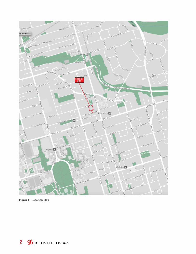
Figure 1 - Location Map

PLANNING & URBAN DESIGN RATIONALE11-21 YORKVILLE AVENUE & 16-18 CUMBERLAND STREET 3
This Planning and Urban Design Rationale report has been prepared in support of an application by 11 Yorkville Partners Inc. for an amendment to the City of Toronto Official Plan, as well as to City of Toronto Zoning By-law 438-86, as amended, and the new City-wide Zoning By-law 569-2013 in order to permit a mixed-use development on a 3,229-square metre site located on the south side of Yorkville Avenue, west of Yonge Street. The subject site is comprised of an assembly of properties and is municipally known as 11-25 Yorkville Avenue and 16-18 Cumberland Street (see Figure 1 – Location Map).
The proposed development contemplates a 62-storey mixed-use building (211.3 metres, including mechanical penthouse) fronting on Yorkville Avenue, together with a 2-storey commercial building fronting on Cumberland Street, with a total gross floor area of approximately 52,397 square metres, resulting in a density of 16.23 times the area of the lot. A total of 716 residential units are proposed, which will include 81 rental units to replace the rental units that currently exist on the site.
The existing east-west public laneway bisecting the subject site will be retained to provide access to the site, creating a “north parcel” (11-25 Yorkville Avenue) and a “south parcel” (16-18 Cumberland Street). Adjacent to the proposed development, the westerly portion of the north parcel, approximately 14.5 metres in width, will be dedicated as parkland and POPS space to expand the planned public parkette to the west. The public parkette will extend north-south from Yorkville Avenue to Cumberland Street.
This Planning and Urban Design Rationale report concludes that the proposed development is in keeping with the planning and urban design framework established by the Provincial Policy Statement, the Growth Plan for the Greater Golden Horseshoe and the City of Toronto Official Plan, the applicable urban design guidelines and the Yorkville – East of Bay Planning Framework.
From a land use perspective, the proposed redevelopment would implement the policy framework expressed in the Provincial Policy Statement, the Growth Plan for the Greater Golden Horseshoe and the Toronto Official Plan, all of which promote intensification of underutilized sites within built-up urban areas, particularly in locations that are well served by existing municipal infrastructure, including public transit. In this regard, the subject site is located in the Downtown, which has been identified as an Urban Growth Centre in the Growth Plan for the Greater Golden Horseshoe. Furthermore, the subject site is within walking distance of the Bloor-Yonge interchange subway station and the Bay subway station and is located close to a wide range of employment opportunities and urban amenities.
From a built form and urban design perspective, the proposal will create a high-quality addition to the Toronto skyline. The proposed building height and massing conform with the built form policies of the Official Plan and are substantially in keeping with the Bloor-Yorkville/North Midtown Urban Design Guidelines and the Yorkville – East of Bay Planning Framework, which identifies the site as a tall building location. The proposal will contribute to the achievement of the open space objectives of the Design Guidelines and the Planning Framework. The proposed tower will be well spaced from other existing and planned towers, and will not result in unacceptable built form impacts on surrounding properties, streets, parks or open spaces. Accordingly, it is our opinion that the proposal conforms with the built form and massing policies of the Official Plan and is generally in keeping with the relevant urban design guidelines.

4
[2.0]S I T E &
S U R R O U N D I N G S

PLANNING & URBAN DESIGN RATIONALE11-21 YORKVILLE AVENUE & 16-18 CUMBERLAND STREET 5
2.1 Subject SiteThe subject site is comprised of an assembly of properties, generally located on the south side of Yorkville Avenue and the north side of Cumberland Street, just west of Yonge Street, and is municipally known as 11-25 Yorkville Avenue and 16-18 Cumberland Street. The assembled site results in two parcels that are each generally rectangular in shape a “north parcel” and a “south parcel”). The total site area is approximately 3,229 square metres, with frontages of approximately 57.1 metres along Yorkville Avenue and 14.3 metres along Cumberland Street.
The subject site is bisected by the east-west portion of a public laneway, approximately 4.27 metres in width, which extends north to Yorkville Avenue along the easterly limit of the site, and currently connects to Cumberland Street to the west of the subject site, west of 32 Cumberland Street (see Figure 2 – Site Survey). The lane provides service and parking access to the properties fronting Yorkville Avenue and Cumberland Street, including those that form the subject site
ISSUED / REVISED
Contractor must check and verify all dimensions on the job and report any discrepancies to the
architect before proceeding with the work.
This drawing shall not be used for construction purposes until signed by the consultant
responsible. This drawing, as an instrument of service, is provided by and is the property of
Sweeny & Co. Architects.
DRAWING NOT TO BE SCALED
DATE :
SCALE :
DRAWN :
CHECKED :
PROJ. No. :
DWG TITLE
PROJ. NAME
DWG No.
134 PETER STREET | SUITE 1601TORONTO, ONTARIO | M5V 2H2 | CANADAP: 416-971-6252 | F: 416-971-5420E: [email protected] | www.sweenyandco.com
OWNER
2018
-03-
21 6
:53:
25 P
M
1 : 300
C:\U
sers
\MO
skue
e\D
ocum
ents
\173
4_11
Yor
kville
_Cen
tral_
mah
tabE
HFF
9.rv
t
A008
Survey
1734
2018.03.02
Mixed-UseDevelopment11-21 Yorkville Avenue,16-18 Cumberland Street
11 Yorkville PartnersInc.
NOV 28,17 ISSUED FOR REVIEWJAN 16,18 ISSUED FOR REVIEWJAN 26,18 ISSUED FOR COORDINATIONMAR 02,18 ISSUED FOR COORDINATIONMAR 21,18 ISSUED FOR REVIEW
Figure 2 - Site Survey

6
North-south laneway looking north from Cumberland Street to Yorkvile avenue
North-south laneway looking north to Yorkvile avenue from subject site
East-west laneway looking west from subject site

PLANNING & URBAN DESIGN RATIONALE11-21 YORKVILLE AVENUE & 16-18 CUMBERLAND STREET 7
11 Yorkville Avenue
17 Yorkville Avenue
The subject site is an assembly of 4 narrow properties fronting on Yorkville Avenue and 2 properties along Cumberland Street:
11 Yorkville Avenue: A 9-storey mixed-use building occupies the property, which includes a one-storey portion built to the edge of the lane, with the office building stepped back above. Commercial/office uses are located at grade and lower level, which include health and dental clinics (Dr. Bernstein Diet & Health Clinics, Dentistry on Yorkville, and Skin Vitality Medical Clinic) and office space. The remainder of the building is comprised of residential uses consisting of 71 residential rental units, with a separate entrance from Yorkville Avenue provided for the tenants.
17 Yorkville Avenue: The property is currently occupied by a 2½-storey converted dwelling used for office and commercial uses, which has been renovated and altered to accommodate residential uses on the third floor. The basement and two above-grade floors are occupied by a health and wellness clinic (Soul 7), a restaurant (Blu Ristorante) and office (the Gabor Group). The third floor contains 2 residential rental units, and a rooftop terrace is located on the roof of the building, overlooking Yorkville Avenue and the public laneway to the south.
19 Yorkville Avenue: The property is currently occupied by a 4-storey mixed-use building, including commercial uses on the ground level (Vitko Chiropractic + Massage Clinic) and basement level (Ricci Salon) and 2 residential rental units, with a separate entrance, occupying the balance of the building. The building was previously used in its entirety for commercial and office uses but was subsequently renovated to accommodate residential uses as well.
19 Yorkville Avenue

8
21-25 Yorkville Avenue: The property is currently occupied by a 3-storey mixed-use building with an exposed basement floor. The building contains commercial uses (Rest Nest, School of Makeup Art) and 6 residential rental units, all of which are currently vacant. The building has an outdoor terrace above the ground and second floors overlooking Yorkville Avenue. The building was also previously used for commercial and offices but was renovated to accommodate the residential rental units.
16 Cumberland Street: The property at 16 Cumberland Street is currently occupied by a vacant detached 2-storey commercial building, with an exposed walk-out basement floor.
18 Cumberland Street: A 2-storey vacant commercial building occupies the property. The building is adjoined to the building sited on 20 Cumberland Street.
In total, the site currently contains 81 residential rental units, 19 of which were vacant as of March 2018. The type, affordability and replacement analysis has been included in the Housing Issues Report, attached as Appendix A.
21-25 Yorkville Avenue
16 Cumberland Street
18 Cumberland Street

PLANNING & URBAN DESIGN RATIONALE11-21 YORKVILLE AVENUE & 16-18 CUMBERLAND STREET 9
North-south laneway looking south from Yorkville Avenue
1 Yorkville, under construction, looking southwest
1 Yorkville, under construction, looking southwest
Site of Eight Cumberland Condos, Yonge Street properties
2.2 adjacent UsesImmediately east of the subject site is a public laneway/walkway, approximately 3.86 metres in width, which extends south from Yorkville Avenue to the east-west lane bisecting the subject site. On the east side of the laneway, at the southwest corner of Yonge Street and Yorkville Avenue, is an approved 58-storey mixed use building currently under construction, known as 1 Yorkville (836-850 Yonge Street and 1-9A Yorkville Avenue). The development is comprised of a 3-storey podium base (with retained heritage building façades along Yonge Street) and a 55-storey tower above, resulting in an overall height of 183.2 metres (including mechanical penthouse). The tower element will be set back 12.5 metres from the centre line of the adjacent public laneway/walkway, which is to be widened. On the ground floor along the widened laneway/walkway, the building provides a vehicle pick-up/drop-off area in front of the residential lobby entrance, which will be screened by planter boxes.
Immediately south of 1 Yorkville site are five 3-storey mixed-use buildings, with retail/service commercial uses at grade, located at the northwest corner of Yonge Street and Cumberland Street (826-834 Yonge Street), as well as one- and 2-storey buildings at 2-8 Cumberland Street. City Council approved the rezoning of these properties for a 51-storey mixed-use building (Eight Cumberland Condos)

10
in April 2017. The Eight Cumberland development is comprised of a 3-storey podium base (with retained heritage building façades along Yonge Street and Cumberland Street) and a 48-storey tower above, resulting in an overall height of 170.5 metres (including mechanical penthouse).
Further east, on the east side of Yonge Street, is the 5-storey Toronto Reference Library (TRL), which is located between Asquith Avenue and Collier Street (789 Yonge Street). The TRL, designed by Raymond Moriyama, is one of the biggest libraries in the city and the largest public reference library in Canada. South of the TRL is a proposed 25-storey mixed-use building at the southeast corner of Yonge Street and Asquith Avenue (767-773 Yonge Street). The associated rezoning application has been appealed and is currently before the Ontario Municipal Board.
To the south of the subject site, along the Cumberland Street frontage, east of the subject site, is a 3-storey commercial building at 12 and 14 Cumberland Street. East of the commercial building and west of the Eight Cumberland Condos development is a private laneway/driveway connecting to the public laneway/walkway to the north. To the west of the subject site along Cumberland Street is a 3-storey building (20 Cumberland Street) and a 2-storey restaurant/bar with an outdoor rooftop patio at 22 Cumberland Street (The Pilot). West of the restaurant is a 2-storey office building (26-32 Cumberland Street) and the southerly terminus of the public laneway, both of which form part of an approved mixed-use development (The Residences of 33 Yorkville), as described below.
Site of Eight Cumberland Condos, Cumberland Street properties
Public Library
12 and 14 Cumberland Street
20 Cumberland Street and 18 Cumberland Street

PLANNING & URBAN DESIGN RATIONALE11-21 YORKVILLE AVENUE & 16-18 CUMBERLAND STREET 11
Further south, on the south side of Cumberland Street, is an L-shaped parcel municipally known as 2 Bloor Street West, which is currently developed with a 2-storey retail/commercial building (Cumberland Terrace) that extends along the south side of Cumberland Street, from Yonge Street to Bay Street, and a 34-storey office building at the northwest corner of Bloor and Yonge. There is a below-grade retail concourse connecting the site to the PATH system and to both the Yonge-Bloor and Bay subway stations.
A redevelopment proposal for 2 Bloor Street West was approved in 2010, which includes retention of the existing office building and the redevelopment of Cumberland Terrace to include two new residential towers (a 36-storey tower at the southwest corner of Yonge Street and Cumberland Street and 54-storey tower located mid-block along the south side of Cumberland Street). Along the Bloor Street West frontage, just west of the 2 Bloor West office tower, is the Holt Renfrew Centre, including the Holt Renfrew department store (50 Bloor Street West), which has zoning approval for a 71-storey mixed-use development.
22 Cumberland Street
26-32 Cumberland Street
Laneway
Cumberland Street looking west, 2 Bloor West on the left side
Holt Renfrew building, looking northwest from Bloor Street

12
East of the 2 Bloor West office tower, at the northeast corner of Yonge and Bloor Streets, is the Hudson’s Bay Centre which occupies the majority of the block bounded by Yonge Street, Bloor Street East, Park Road and Asquith Avenue. The complex includes a 34-storey office tower (2 Bloor Street East), a 41-storey hotel and apartment building (80 Bloor Street East) and a 32-storey condominium building (8 Park Road), The Bay department store and associated retail mall, and access to the TTC and an underground pedestrian network. South of the Hudson’s Bay Centre, at the southeast corner of the intersection, is ‘One Bloor’, a 76-storey mixed use development that is currently under construction and nearly complete. To the west of the ‘One Bloor’ building, at the southwest corner of the intersection, is a recently approved 82-storey mixed-use development known as ‘The One’ (1-11 Bloor Street West and 760-762 and 768-784 Yonge Street).
2 Bloor East
HBC Centre
One Bloor
The One, under construction

PLANNING & URBAN DESIGN RATIONALE11-21 YORKVILLE AVENUE & 16-18 CUMBERLAND STREET 13
Immediately west of the subject site, is a 2-storey commercial/office building with an enclosed structure on the roof (27-29 Yorkville Avenue). To the west of the 27-29 Yorkville is a 6-storey Toronto Parking Authority (TPA) parking garage (37 Yorkville Avenue and 50 Cumberland Street), which includes a 4-storey office building fronting the Cumberland Street frontage. These properties, together with the properties at 26-32 Cumberland Street, form part of a proposal that was approved by City Council in August 2014 for a mixed-use development comprised of two towers, 62 and 40 storeys in height (215 and 142.5 metres, respectively, including mechanical penthouse) with a 40-storey link between the towers. The development, known as the Residences of 33 Yorkville, also includes the relocation of the southern leg of the public laneway in order to accommodate the creation of a new stratified public parkette and walkway along the east side of the development.
The remainder of the block is occupied by two buildings: a 9-storey building at the southeast corner of Bay Street and Yorkville Avenue (1255 Bay Street); and a 10-storey office building at the northeast corner of Bay Street and Cumberland Street (1235 Bay Street).
27-29 Yorkville Avenue
50 Cumberland Street
Toronto Parking Authority (TPA) parking garage, along Yorkville Avenue
Toronto Parking Authority (TPA) parking garage
1235 Bay Street
14
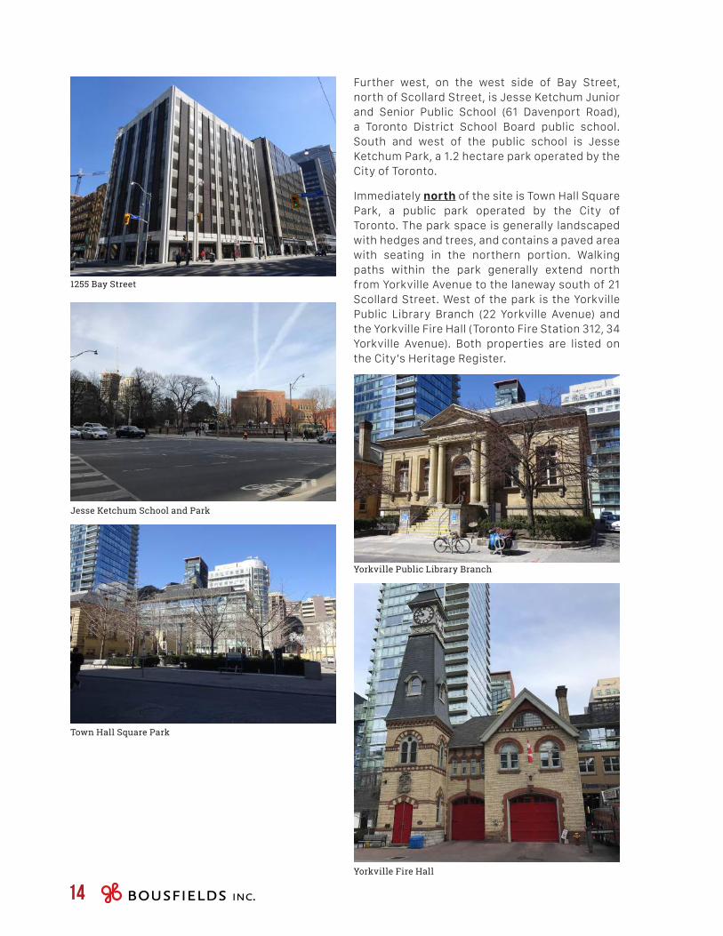
Further west, on the west side of Bay Street, north of Scollard Street, is Jesse Ketchum Junior and Senior Public School (61 Davenport Road), a Toronto District School Board public school. South and west of the public school is Jesse Ketchum Park, a 1.2 hectare park operated by the City of Toronto.
Immediately north of the site is Town Hall Square Park, a public park operated by the City of Toronto. The park space is generally landscaped with hedges and trees, and contains a paved area with seating in the northern portion. Walking paths within the park generally extend north from Yorkville Avenue to the laneway south of 21 Scollard Street. West of the park is the Yorkville Public Library Branch (22 Yorkville Avenue) and the Yorkville Fire Hall (Toronto Fire Station 312, 34 Yorkville Avenue). Both properties are listed on the City’s Heritage Register.
1255 Bay Street
Jesse Ketchum School and Park
Town Hall Square Park
Yorkville Fire Hall
Yorkville Public Library Branch

PLANNING & URBAN DESIGN RATIONALE11-21 YORKVILLE AVENUE & 16-18 CUMBERLAND STREET 15
60 Yorkville Avenue, Four Seasons Development
The Rose Garden
55 Scollard Street, Four Seasons Development
18 Yorkville Avenue
To the west of the Yorkville Fire Hall building, occupying the remainder of the block, is the Four Seasons Hotel and Residences, located on the east side of Bay Street between Yorkville Avenue and Scollard Street. The Four Seasons development includes a privately-owned public open space (The Rose Garden) adjacent to the Fire Hall, a 55-storey hotel/condominium tower at the northeast corner of Yorkville Avenue and Bay Street (60 Yorkville Avenue) and a 26-storey residential condominium tower along the south side of Scollard Street (55 Scollard Street).
Northeast of the subject site, at the northwest corner of Yonge Street and Yorkville Avenue, is a 36-storey mixed-use building at the northwest corner of Yonge Street and Yorkville Avenue and a 7-storey building along the Scollard Street frontage (18 Yorkville). The building is comprised primarily of residential condominium units, with retail and service uses at grade.
Further north are a number of existing and approved tower developments along Bay Street, Davenport Road and Church Street, including Bay + Scollard (approved; 41 storeys; 14-58 Scollard Street and 1315-1325 Bay Street), The Florian (25 storeys; 88 Davenport Road), The Yorkville (31 storeys; 32 Davenport Road) and Milan Condominiums (37 storeys; 825 Church Street).

16
2.3 area contextThe Bloor-Yorkville/North Midtown area is characterized by an existing and planned context of diverse high-rise, mid-rise and low-rise built forms.
M I D T O W NThe Midtown area is one of the most important mixed-use areas of the City, combining commercial, residential, high-end retail, entertainment, institutional and government uses. The Midtown area is generally centred on the east-west axis at Bloor Street West, with high-rise built buildings extending along the main north-south cross streets of Yonge Street, Bay Street and Avenue Road. The character of the Midtown area is that of a highly urban, mixed-use area which combines the amenity, scale and character of areas such as the University of Toronto, Queen’s Park, the Royal Ontario Museum, the Yorkville area, the Annex and the Bloor Street retail areas, with a mix of uses, intensities, high-rise scale and forms that are indicative of a major urban node.
Y O R K V I L L EThe built origins of Yorkville date to 1808 when the Red Lion Hotel was established near Yonge and Bloor Streets. In 1836, Sheriff William Jarvis and brewer Joseph Bloor laid out village lots on five adjoining farm lots northeast and northwest of the Yonge-Bloor intersection. The area evolved into a residential, working class and commuter suburb and the Village of Yorkville was incorporated in 1853. In a surge of urban growth, the portion of Yorkville west of Yonge Street was annexed to the City of Toronto in 1883. New services such as sidewalks and paved streets appeared, as did electric street railway service, and Bay Street was extended north from Bloor to meet Davenport. Vacant lots quickly filled, and new subdivisions appeared. Yorkville remained a predominantly residential neighbourhood until the 1960s, when it evolved into an upscale shopping district1.
Y O N G E S T R E E TThe Yonge Street corridor is a mixed commercial and residential street with varying heights.
1 Source: Bloor-Yorkville/North Midtown Urban Design Guidelines, pp. 24-25
Historically and iconically, Yonge Street is recognized as the most significant civic street in the City of Toronto. Following the introduction of the subway in the 1950s, a distinctive new pattern of transit-supportive high-rise residential and mixed-use nodes related to major subway stations developed along Yonge Street, consistent with its role as the major transit corridor in the City of Toronto.
A node of high-rise development emerged around the Bloor-Yonge subway station in the 1960s and 1970s, including 2 Bloor West (1973), the Hudson’s Bay Centre (1974) and the Manulife Centre (1974). Over the past decade, several new towers have been added to the node, including 18 Yorkville (2005), Uptown Condos (2011), Crystal Blu (2011), the new Four Seasons Hotel (2012), 1 Yorkville (currently under construction), 1 Bloor East (currently under construction) and The One (currently under construction).
B L O O R S T R E E TBloor Street is one of Toronto’s most prominent streets, and the segment between Avenue Road and Yonge Street is an internationally known shopping destination that evokes the name “Fifth Avenue North”. Between Church Street and Avenue Road, Bloor Street has recently undergone major renovations to improve the public realm, including widened granite sidewalks, public art, new lighting, street furnishings and landscaping. The massing of the built form along Bloor Street, between Jarvis Street and Spadina Road, creates a high-rise corridor, with numerous buildings over 25 storeys in height, ranging up to 50 storeys and above.

PLANNING & URBAN DESIGN RATIONALE11-21 YORKVILLE AVENUE & 16-18 CUMBERLAND STREET 17
AVEN
UE R
D
YONG
E ST
BAY
ST
DAVENPORT RD CHURCH ST
BLOOR ST W BLOOR ST E
YORKVILLE AVE
CUMBERLAND ST
SUBJECTSITE
Figure 3 - Surrounding Context Aerial
2.4 Transportation context
S T R E E T N E T W O R K Yonge Street is a two-way north-south Major Arterial street with a four-lane cross section and a 20 metre wide right-of-way. Pedestrian sidewalks and transit stops are provided on both sides of the street. On-street parking is generally prohibited.
Bloor Street is a two-way east-west Major Arterial street with a four-lane cross-section.
Wide pedestrian sidewalks are provided on both sides of the street. Parking is generally prohibited, with the exception of parking lay-bys in front of the Hudson’s Bay Centre and Holt Renfrew. As a result of the City’s Sustainable Transportation Initiatives Report (2007), the Yonge/Bloor intersection received a ‘Pedestrian Priority Phase’, also referred to as a “pedestrian scramble”. As a form of traffic management, pedestrian scrambles allow pedestrians to cross in all directions while vehicles are stopped. The pedestrian scramble is part of the City’s commitment to enhanced pedestrian safety and support alternative forms of transportation.

18
Yorkville Avenue is a two-way, two-lane Collector street that runs east-west between Yonge Street and Avenue Road. Between Bellair Street and Avenue Road, traffic is westbound only. Pedestrian sidewalks are provided on both sides of the street, and parking is prohibited. The right-of-way is 15.2 metres wide, with upgraded pavers along the travelled road surface.
Cumberland Street is a one-way, eastbound-only Collector street that runs from Avenue Road to Yonge Street. There is provision for on-street parking on the south side of the street.
A C T I V E T R A N S P O R T A T I O N N E T W O R K The subject site is located well served by the City of Toronto’s bicycle network. Bike lanes run north-south from the intersection of Bay Street and Yorkville Avenue along Davenport Road, Poplar Plains Road and Russell Hill Road to St. Clair Avenue West, and east-west along Davenport Road to Old Weston Road.
There are shared-lane markings (or “sharrows”) along Bloor Street between Avenue Road and Church Street, which indicate the ideal cyclist position in the lane and remind drivers to share the road. Separated bike lanes (or “cycle tracks”) exist west of Avenue Road, towards Shaw Street. This infrastructure was installed after the Bloor Street Bike Lane Pilot Project received Council approval in May 2016.
A Bike Share Toronto stand is located less than 100 metres of the subject site, at the northeast corner of Yonge Street and Yorkville Avenue. A total of 12 bike docks are available at this location.
P U B L I C T R A N S P O R T A T I O N The subject site is extremely well serviced by transit (see Figure 4 – Transit Network). The subject site is approximately 190 metres walking distance northeast of the Bloor-Yonge subway station2, an interchange station which provides access to both the Yonge-University-Spadina subway (Line 1) and the Bloor-Danforth subway (Line 2), which link to various other transit systems throughout Toronto and the Greater Toronto Area, including GO and Viva Transit services. The subject site is approximately 235 metres walking distance northeast of the Bay subway station on the Bloor-Danforth Subway Line3. Both subway stations can be accessed via the below-grade pedestrian walkway system.
The subject site is also serviced by the 97B Yonge bus route, which runs north-south along Yonge Street from Steeles Avenue to Queens Quay during peak periods from Monday to Friday. The site is in proximity to the 6B Bay bus route, which operates generally between Dupont Street/Davenport Road and Queens Quay East. The 320 Yonge Blue Night bus route provides overnight service between Queens Quay and Steeles Avenue, while the 300 Bloor-Danforth Blue Night route provides overnight service between Pearson International Airport and the intersection of Danforth Avenue and Danforth Road.
There is a transit stop on the north side of Yorkville Avenue opposite the subject site for the 6B Bay bus route.
2 Measured from 11 Yorkville Avenue to the Bloor-Yonge Station Subway Entrance on the east side of Yonge Street, north of Bloor Street
3 Measured from 25 Yorkville Avenue to the Bay Station Subway Entrance on the west side of Bay Street, north of Critchley Lane

PLANNING & URBAN DESIGN RATIONALE11-21 YORKVILLE AVENUE & 16-18 CUMBERLAND STREET 19
SUBJECTSITE
Figure 4 - Transit Network

20
[3.0]P R O P O S A L

PLANNING & URBAN DESIGN RATIONALE11-21 YORKVILLE AVENUE & 16-18 CUMBERLAND STREET 21
3.1 Description of the Proposal
The proposal consists of two buildings on the subject site: on the north parcel (i.e. north of the public laneway), a 62-storey residential/mixed-use development is proposed that includes a 2-storey podium building fronting Yorkville Avenue atop a 60-storey tower element;
DN
UP
UP
DN
DN
UP
UP
UP
City of Toronto GarbageImported
(c) 2016 Transoft Solutions, Inc. All rights reserved.City of Toronto GarbageImported
(c) 2016 Transoft Solutions, Inc. All rights reserved.
Cit y o f Toronto G
arbageIm
ported
MSUTAC-1999 (CA)
(c) 2016 Transoft Solut ions, Inc. All rights reserv ed.
MSU
TAC
-199
9 ( C
A)
MSUTAC-1999 (CA)
(c) 2016 Transoft Solut ions, Inc. All rights reserv ed.
509.9 m²5,489 SF
RETAIL 240.7 m²2,591 SF
RESIDENTIALLOBBY
TYPE G / B LOADING
13m x 4m x 6.1m(h)
LAN
EWAY
TYPE B / C LOADING
13m x 4m x 6.1m(h)
CONTROL MH
117.1 m²1,260 SF
RETAIL
258.2 m²2,779 SF
RETAIL
ALLOWANCE FOR NEW
PUBLIC LANEWAY
EXISTING LANE
MOVING ROOM
BICYCLEPKG
195 m²2,099 SF
RETAILURBAN ROOM
6199
EXISTING2-STOREY BUILDING
EXISTING3-STOREY BUILDING
RES
IDEN
TS
ENTR
ANC
E
RESIDENTS ENTRANCE
2000
30 0030 00
WID
E NIN
G60 00 L AN
E
CENTERLINE OF LANE
2
A201
1
A201116.10 116.15
115.82 115.79
116.25
115.84
116.25
115.87 115.83
116.25
FFE 116.25
115.88
116.01
115.85
116.00116.00116.01116.00116.00
FFE 116.25FFE 116.35
STAGING AREA 76 m²
FFE 116.25
TYPE C LOADING
116.10
FFE 116.10
116.25
116.17
116.18
116.00
116.03 116.08
116.07116.05116.01116.22116.26116.29
116.09
116.10
115.78115.78115.93115.93
116.10
CONTROL MH
CONTROL MH
METAL GRATE AIR SHAFT
METAL GRATE AIR SHAFT
PARK10521
POPS4000 12565
RES. OFFICE
CANOPY ABV
CANOPY ABV
ISSUED / REVISED
Contractor must check and verify all dimensions on the job and report any discrepancies to the
architect before proceeding with the work.
This drawing shall not be used for construction purposes until signed by the consultant
responsible. This drawing, as an instrument of service, is provided by and is the property of
Sweeny & Co. Architects.
DRAWING NOT TO BE SCALED
DATE :
SCALE :
DRAWN :
CHECKED :
PROJ. No. :
DWG TITLE
PROJ. NAME
DWG No.
134 PETER STREET | SUITE 1601TORONTO, ONTARIO | M5V 2H2 | CANADAP: 416-971-6252 | F: 416-971-5420E: [email protected] | www.sweenyandco.com
OWNER
2018
-03-
21 6
:53:
27 P
M
1 : 200
C:\U
sers
\MO
skue
e\D
ocum
ents
\173
4_11
Yor
kville
_Cen
tral_
mah
tabE
HFF
9.rv
t
A100
Site Plan
1734
2018.03.02
AuthorChecker
Mixed-UseDevelopment11-21 Yorkville Avenue,16-18 Cumberland Street
11 Yorkville PartnersInc.
JAN 16,18 ISSUED FOR REVIEWJAN 26,18 ISSUED FOR COORDINATIONMAR 02,18 ISSUED FOR COORDINATIONMAR 21,18 ISSUED FOR REVIEW
and, on the south parcel fronting Cumberland Street, a 2-storey commercial building. The redevelopment of the north parcel also includes the introduction of a stratified public park space on the westerly portion of the site (see Figure 5 – Site Plan).
Figure 5 - Site Plan

22
the base building is set back approximately 3.0 metres along the Yorkville Avenue frontage, approximately 4.4 metres along the laneway/walkway, and approximately 4.0 metres along the limit of the planned public park.
Along the Yorkville Avenue frontage and the planned public park, the ground floor will contain retail and service commercial uses, while the residential lobby entrance will be located along the east face of the building, accessed from the north-south laneway. A retail concourse level is located below grade, which includes access to a proposed underground pedestrian tunnel connection extending underneath the public park space and connecting to a planned underground pedestrian connection to the west at the approved building at 27-37 Yorkville Avenue. The second floor will be used for retail/service commercial purposes. In total, 3,809 square metres of retail gross floor area will be provided within the base building (and concourse level).
The design of the building contemplates a potential connection at the concourse level to a future underground pedestrian walkway system.
R E S I D E N T I A L T O W E RThe 60-storey residential tower element is positioned in the centre of the base building and oriented in a north-south direction. The tower is well articulated and designed to be reminiscent of Manhattan skyscrapers built in the mid-20th century, providing numerous stepbacks and indentations at the corners, as well as inset balconies, to break up the massing into smaller elements and to create a terraced massing that tapers upward to an elegant and slender top, resulting in a tower that retreats incrementally from the street level as the building gets taller.
The terraced design of the tower redistributes the massing to the middle of the building in order to: (1) free up the ground floor for open space uses; (2) provide a low-rise base building that provides a comfortable pedestrian scale along the laneway and public park; and (3) create a slender top that enhances the skyline.
Above the base building, the tower is set back approximately 6.1 metres from the east face, approximately 4.0 metres from the west face, and approximately 2.5 metres from the south face.
N O R T H P A R C E LThe 62-storey mixed-use building (Building A) will have a total gross floor area of approximately 51,443 square metres and a total of 716 units, of which 81 will be rental replacement units. The proposed building is designed to respond to the existing and planned immediate context, as well as the broader context, by improving and activating the public realm.
IIn this regard, west of the proposed mixed-use building, a 10.52 metre wide portion of the parcel will be dedicated to the City as parkland, with a total area of approximately 529 square metres, which will exceed the estimated 299.43 square metre parkland dedication requirement. The lands to be dedicated lands will be stratified in order to allow underground parking below grade. This dedication will allow for the expansion of the planned public parkette and walkway that was secured as part of the approval of the mixed-use development at 27-37 Yorkville Avenue and 26-32 and 50 Cumberland Street.
In the broader context, the building is similar in height to adjacent and nearby towers and would fit harmoniously with the stepping of heights away from the Bloor-Yonge intersection. The building provides a slender tower element that will enhance the City’s skyline.
B A S E B U I L D I N GThe 2-storey base building is approximately 13.0 metres in height (including a 7.0-metre high ground floor with mezzanine), resulting in a street wall condition that is similar in height to the heritage buildings on the north side of Yorkville Avenue (the Yorkville Fire Hall and the Yorkville Branch Library) and to the podium of the 1 Yorkville building to the east, which incorporates retained heritage façades. The 2-storey scale of the base building also provides an appropriate scale along the public laneway/walkway and along the planned public park. The base building will be treated with stone veneer, resulting in a distinguished building element that picks up cues from the Library building to the north.
The base building provides generous setbacks, resulting in widened public realm areas along the Yorkville Avenue frontage, the public laneway and the planned public park. In this regard,

PLANNING & URBAN DESIGN RATIONALE11-21 YORKVILLE AVENUE & 16-18 CUMBERLAND STREET 23
These stepbacks reinforce the low-rise scale of the base building along the laneway and public park. The north tower face is stepped back approximately 2.0 metres above the 9th floor, resulting in a street wall that is similar to the street wall condition established by the 10-storey base building of the adjacent development to the west at 27-37 Yorkville Avenue. The slender top of the tower emerges from the middle portion of the building through stepbacks provided above
the 17th floor on the west face, above the 23rd floor on the east face, and above the 29th floor on the north and south faces. The resulting floor plate sizes range between 768 square metres and 1,167 square metres, with an average floor plate size of approximately 870 square metres.
The exterior will be treated with glass and steel to further diminish the scale and appearance of the tower (see Figure 6 and 7 – Elevations).
Level 10
Level 27000
Level 313000
Level 418000
Level 523000
Level 626200
Level 729400
Level 832600
Level 935800
Level 1039400
Level 1142350
Level 1245300
Level 1348250
Level 1451200
Level 1554150
Level 1657100
Level 1760050
Level 1863650
Level 1966600
Level 2069550
Level 2172500
Level 2275450
Level 2378400
Level 2482000
Level 2584950
Level 2687900
Level 2790850
Level 2893800
Level 2996750
Level 30100350
Level 31104200
Level 32108050
Level 33111900
Level 34114850
Level 35117800
Level 1 Mezz3700
Roof Level202300
T.O MPH211300
Level 36120750
Level 37123700
Level 38126650
Level 39129600
Level 40132550
Level 41135500
Level 42138450
Level 43141400
Level 44144350
Level 45147300
Level 46150250
Level 47153200
Level 48156150
Level 49159100
Level 50162050
Level 51165000
Level 52167950
Level 53170900
Level 54173850
Level 55176800
Level 60192200
Level 61195450
FUTURE OPEN SPACELANEWAY
PRO
PER
TY L
INE
PRO
PER
TY L
INE
Level 62198700
Level 59188600
Level 58185650
Level 57182700
Level 56179750
-
---
-
---
-
---
Level 10
Level 27000
Level 313000
Level 418000
Level 523000
Level 626200
Level 729400
Level 832600
Level 935800
Level 1039400
Level 1142350
Level 1245300
Level 1348250
Level 1451200
Level 1554150
Level 1657100
Level 1760050
Level 1863650
Level 1966600
Level 2069550
Level 2172500
Level 2275450
Level 2378400
Level 2482000
Level 2584950
Level 2687900
Level 2790850
Level 2893800
Level 2996750
Level 30100350
Level 31104200
Level 32108050
Level 33111900
Level 34114850
Level 35117800
Level 1 Mezz3700
Roof Level202300
T.O MPH211300
Level 36120750
Level 37123700
Level 38126650
Level 39129600
Level 40132550
Level 41135500
Level 42138450
Level 43141400
Level 44144350
Level 45147300
Level 46150250
Level 47153200
Level 48156150
Level 49159100
Level 50162050
Level 51165000
Level 52167950
Level 53170900
Level 54173850
Level 55176800
Level 60192200
Level 61195450
EXISTING 3 STOREY BUILDING22 CUMBERLAND ST.
YORKVILLE AVE. CUMBERLAND ST.LANEWAY
PRO
PER
TY L
INE
PRO
PER
TY L
INE
Level 62198700
Level 59188600
Level 58185650
Level 57182700
Level 56179750
+ 116.35
+ 318.67
+ 327.6738113
12500
ISSUED / REVISED
Contractor must check and verify all dimensions on the job and report any discrepancies to the
architect before proceeding with the work.
This drawing shall not be used for construction purposes until signed by the consultant
responsible. This drawing, as an instrument of service, is provided by and is the property of
Sweeny & Co. Architects.
DRAWING NOT TO BE SCALED
DATE :
SCALE :
DRAWN :
CHECKED :
PROJ. No. :
DWG TITLE
PROJ. NAME
DWG No.
134 PETER STREET | SUITE 1601TORONTO, ONTARIO | M5V 2H2 | CANADAP: 416-971-6252 | F: 416-971-5420E: [email protected] | www.sweenyandco.com
OWNER
2018
-03-
21 6
:55:
16 P
M
1 : 600
C:\U
sers
\MO
skue
e\D
ocum
ents
\173
4_11
Yor
kville
_Cen
tral_
mah
tabE
HFF
9.rv
t
A301
Building Elevations
1734
2018.03.02
MOCR
Mixed-UseDevelopment11-21 Yorkville Avenue,16-18 Cumberland Street
11 Yorkville PartnersInc.
1 : 600A301North1
1 : 600A301West2
MATERIAL LEGEND
GL1 CAPLESS DOUBLE GLAZING W/ LOW-E COATINGGL2 CAPLESS DOUBLE GLAZING W/ ETCHED FRITGL3 CAPLESS DOUBLE GLAZING - CLEARGL4 GLASS GAURDS - CLEARGL5 DOUBLE GLAZING - BACK PAINTEDMA1 STONE VENEER-LIMESTONEMA2 STONE VENEER - GRANITEMT1 PERFORATED METAL - CLEAR ANODIZED ALUMINUMMT2 BRONZE PETINA METAL
NOV 28,17 ISSUED FOR REVIEWJAN 16,18 ISSUED FOR REVIEWJAN 26,18 ISSUED FOR COORDINATIONMAR 02,18 ISSUED FOR COORDINATIONMAR 21,18 ISSUED FOR REVIEW
Figure 6 - North and West Elevations

24
Level 10
Level 27000
Level 313000
Level 418000
Level 523000
Level 626200
Level 729400
Level 832600
Level 935800
Level 1039400
Level 1142350
Level 1245300
Level 1348250
Level 1451200
Level 1554150
Level 1657100
Level 1760050
Level 1863650
Level 1966600
Level 2069550
Level 2172500
Level 2275450
Level 2378400
Level 2482000
Level 2584950
Level 2687900
Level 2790850
Level 2893800
Level 2996750
Level 30100350
Level 31104200
Level 32108050
Level 33111900
Level 34114850
Level 35117800
Level 1 Mezz3700
Roof Level202300
T.O MPH211300
Level 36120750
Level 37123700
Level 38126650
Level 39129600
Level 40132550
Level 41135500
Level 42138450
Level 43141400
Level 44144350
Level 45147300
Level 46150250
Level 47153200
Level 48156150
Level 49159100
Level 50162050
Level 51165000
Level 52167950
Level 53170900
Level 54173850
Level 55176800
Level 60192200
Level 61195450
PRO
PER
TY L
INE
PRO
PER
TY L
INE
LANEWAYFUTURE OPEN SPACE
Level 62198700
Level 59188600
Level 58185650
Level 57182700
Level 56179750
Level 1 - Building B 0
Level 2 - Building B 6000
Level 3 - Building B 12000
Level 4 - Building B 18000
-
---
-
---
-
---
Level 10
Level 27000
Level 313000
Level 418000
Level 523000
Level 626200
Level 729400
Level 832600
Level 935800
Level 1039400
Level 1142350
Level 1245300
Level 1348250
Level 1451200
Level 1554150
Level 1657100
Level 1760050
Level 1863650
Level 1966600
Level 2069550
Level 2172500
Level 2275450
Level 2378400
Level 2482000
Level 2584950
Level 2687900
Level 2790850
Level 2893800
Level 2996750
Level 30100350
Level 31104200
Level 32108050
Level 33111900
Level 34114850
Level 35117800
Level 1 Mezz3700
Roof Level202300
T.O MPH211300
Level 36120750
Level 37123700
Level 38126650
Level 39129600
Level 40132550
Level 41135500
Level 42138450
Level 43141400
Level 44144350
Level 45147300
Level 46150250
Level 47153200
Level 48156150
Level 49159100
Level 50162050
Level 51165000
Level 52167950
Level 53170900
Level 54173850
Level 55176800
Level 60192200
Level 61195450
?
LANEWAYCUMBERLAND ST. YORKVILLE AVE.
PRO
PER
TY L
INE
PRO
PER
TY L
INE
EXISTING 2 STOREY BUILDING12 CUMBERLAND ST.
Level 62198700
Level 59188600
Level 58185650
Level 57182700
Level 56179750
ISSUED / REVISED
Contractor must check and verify all dimensions on the job and report any discrepancies to the
architect before proceeding with the work.
This drawing shall not be used for construction purposes until signed by the consultant
responsible. This drawing, as an instrument of service, is provided by and is the property of
Sweeny & Co. Architects.
DRAWING NOT TO BE SCALED
DATE :
SCALE :
DRAWN :
CHECKED :
PROJ. No. :
DWG TITLE
PROJ. NAME
DWG No.
134 PETER STREET | SUITE 1601TORONTO, ONTARIO | M5V 2H2 | CANADAP: 416-971-6252 | F: 416-971-5420E: [email protected] | www.sweenyandco.com
OWNER
2018
-03-
21 6
:55:
33 P
M
1 : 600
C:\U
sers
\MO
skue
e\D
ocum
ents
\173
4_11
Yor
kville
_Cen
tral_
mah
tabE
HFF
9.rv
t
A302
Building Elevations
1734
2018.03.02
LLCR
Mixed-UseDevelopment11-21 Yorkville Avenue,16-18 Cumberland Street
11 Yorkville PartnersInc.
1 : 600A302South1
1 : 600A302East2
MATERIAL LEGEND
GL1 CAPLESS DOUBLE GLAZING W/ LOW-E COATINGGL2 CAPLESS DOUBLE GLAZING W/ ETCHED FRITGL3 CAPLESS DOUBLE GLAZING - CLEARGL4 GLASS GAURDS - CLEARGL5 DOUBLE GLAZING - BACK PAINTEDMA1 STONE VENEER-LIMESTONEMA2 STONE VENEER - GRANITEMT1 PERFORATED METAL - CLEAR ANODIZED ALUMINUMMT2 BRONZE PETINA METAL
NOV 28,17 ISSUED FOR REVIEWJAN 16,18 ISSUED FOR REVIEWJAN 26,18 ISSUED FOR COORDINATIONMAR 02,18 ISSUED FOR COORDINATIONMAR 21,18 ISSUED FOR REVIEW
Figure 7 - South and East Elevations

PLANNING & URBAN DESIGN RATIONALE11-21 YORKVILLE AVENUE & 16-18 CUMBERLAND STREET 25
S O U T H P A R C E LA 2-storey commercial building (Building B) is proposed to replace the existing commercial buildings on the south parcel. The building will have a total non-residential gross floor area of 954 square metres, consisting of the basement, ground and second floors.
No parking is proposed for the building, while a Type ‘C’ loading space is provided.
The tower consists of residential uses, comprised of a total of 716 units, of which 81 are rental replacement units. Indoor amenity space is proposed on the 3rd and 4th floors. The indoor amenity space on the 3rd floor will provide access to outdoor amenity space in the form of a roof terrace on top of the 2-storey base building.
D W E L L I N G U N I T S A N D A M E N I T I E SThe proposed development comprises a total of 716 dwelling units, which is inclusive of the 81 rental replacement units. The proposed unit mix includes 61 bachelor units, 365 one-bedroom, 218 two-bedroom and 72 three-bedroom units. Approximately 40 percent of the units have two or more bedrooms and are suitable for larger households.
Two floors of indoor amenity space are proposed on Levels 3 and 4. Approximately 1,829.4 square metres of indoor amenity space is proposed. Programming of the amenity areas will be developed as the project moves through the rezoning and Site Plan Approval processes. On Level 3, the indoor amenity area is connected to an outdoor amenity terrace measuring approximately 716.8 square metres. The outdoor amenity space forms a wrap-around terrace that overlooks the proposed park to the west, as well as the public lanes to the south and east.
P A R K I N G , A C C E S S A N D C I R C U L A T I O NAccess to the proposed development will be provided by way of a two-way driveway from the laneway abutting the east property line. The laneway will serve as the primary access for vehicular parking and loading.
Two loading spaces are proposed to service the development, including one Type ‘B’/’C’ space and one Type ‘G’/’B’ space. The loading spaces will be located within the base building, and will be accessed via the adjacent laneway to the east.
A total of 235 vehicular parking spaces are proposed in a four-level underground parking garage. Additionally, the proposed development includes 727 bicycle parking spaces, all of which are located in secured rooms on the ground floor and concourse level, and within the underground garage.

26
3.2 Key StatisticsSite Area 3,229 m²
Floor Space Index* 16.23
Height 62 storeys (202.3 metres; 211.3 metres to MPH) 2 storeys (13 metres)
Gross Floor Area*Residential GFARetail GFA
52,397 m²47,634 m² (includes 4,281 m² for rental replacement GFA)4,763 m² (includes 954 square metres of GFA for commercial building)
Unit CountRental Replacement
71681
Unit MixBachelor1 bedroom2 bedroom3 bedroom
61 units 365 units 218 units 72 units
Loading Spaces 1 Type ‘B’/’C’ space 1 Type ‘G’/’B’ space1 Type ‘C’ space for commercial building
Vehicular Parking ResidentialVisitor Retail
235 spaces235 spaces0 spaces0 spaces
Bike Parking ResidentialVisitor Retail
727 spaces673 spaces43 spaces11 spaces
*Calculated based on the provisions of By-law 569-2013
3.3 required approvals In our opinion, the proposed development conforms with the City of Toronto Official Plan and, in particular, the proposed use, height and density are permitted by the applicable Mixed Use Areas designation. However, while the development generally conforms with the provisions of Site and Area Specific Policy 211, an Official Plan Amendment is required in order to permit a tall building outside of the Height Peak and Height Ridges.
The proposal requires an amendment to City of Toronto Zoning By-law 438-86, as amended, and to the new City-wide Zoning By-law 569-2013, in order to increase the permitted height and density, as well as to revise other development regulations as necessary to accommodate the proposal.

PLANNING & URBAN DESIGN RATIONALE11-21 YORKVILLE AVENUE & 16-18 CUMBERLAND STREET 27
[4.0]P O L I C Y &
R E G U L A T O R Y C O N T E X T

28
promotes appropriate development standards, which facilitate intensification, redevelopment and compact form, while avoiding or mitigating risks to public health and safety.
With respect to housing, Policy 1.4.3 requires provision to be made for an appropriate range of housing types and densities to meet projected requirements of current and future residents by, among other matters, facilitating all forms of residential intensification and redevelopment and promoting densities for new housing which efficiently use land, resources, infrastructure and public service facilities and support the use of active transportation and transit.
Policy 1.5.1 of the PPS promotes the development of healthy, active communities by planning public streets, spaces and facilities to be safe, meet the needs of pedestrians, foster social interaction and facilitate active transportation and community connectivity. The policy also promotes planning and providing for a full range and equitable distribution of publicly-accessible built and natural settings for recreation including facilities, parkland, public spaces, open space areas, and trails and linkages.
In addition, the efficient use of infrastructure (particularly transit) is a key element of provincial policy (Section 1.6.7). With respect to transportation systems, Policy 1.6.7.4 promotes a land use pattern, density and mix of uses that minimize the length and number of vehicle trips and support the current and future use of transit and active transportation.
Policy 1.7.1 of the PPS states that long-term prosperity should be supported by optimizing the use of land, resources, infrastructure and public service facilities, maintaining and enhancing the vitality and viability of downtowns and main streets, and encouraging a sense of place by promoting well-designed built form and cultural planning, and by conserving features that help define character, including built heritage resources.
With respect to energy conservation, air quality and climate change, Policy 1.8.1 requires that planning authorities support energy conservation and efficiency, improved air quality, reduced greenhouse gas emissions, and climate change
4.1 OverviewThe proposed redevelopment of the subject site is supportive of the policy directions set out in the Provincial Policy Statement, the Growth Plan for the Greater Golden Horseshoe and the City of Toronto Official Plan, all of which promote and encourage intensification within the built-up urban areas, particularly in proximity to higher order transit.
4.2 Provincial Policy Statement
The current Provincial Policy Statement (PPS) came into effect on April 30, 2014. The PPS provides policy direction on matters of Provincial interest related to land use planning and development. In accordance with Section 3(5) of the Planning Act, all land use planning decisions are required to be consistent with the PPS. In this regard, Policy 4.4 provides that the PPS “shall be read in its entirety and all relevant policies are to be applied to each situation”.
One of the key policy directions expressed in the PPS is to build strong communities by promoting efficient development and land use patterns. To that end, the PPS contains a number of policies that promote intensification, redevelopment and compact built form, particularly in areas well served by public transit.
In particular, Policy 1.1.1(a) and (b) provides that healthy, liveable and safe communities are to be sustained by promoting efficient development and land use patterns and accommodating an appropriate range and mix of residential, employment (including industrial and commercial), institutional, recreation, park and open space, and other uses.
Policy 1.1.3.2 of the PPS promotes densities and a mix of land uses, which efficiently use land, resources, infrastructure and public service facilities and are transit-supportive, where transit is planned, exists or may be developed. Policy 1.1.3.3 provides that planning authorities shall identify and promote opportunities for intensification and redevelopment, where this can be accommodated taking into account existing building stock or areas and the availability of suitable existing or planned infrastructure and public service facilities. In addition, Policy 1.1.3.4

PLANNING & URBAN DESIGN RATIONALE11-21 YORKVILLE AVENUE & 16-18 CUMBERLAND STREET 29
transportation and land use planning to achieve broader intensification objectives. As noted in the introductory text in Section 2.1:
“The Growth Plan, 2006 identified 25 urban growth centres and this Plan continues to recognize those urban growth centres as regional focal points for accommodating population and employment growth. The continued revitalization of urban growth centres as meeting places, locations for cultural facilities, public institutions, and major services and transit hubs with the potential to become more vibrant, mixed-use, transit-supportive communities is particularly important.”
The introductory text goes on to provide as follows:
“This Plan recognizes transit as a first priority for major transportation investments. It sets out a regional vision for transit, and seeks to align transit with growth by directing growth to major transit station areas and other strategic growth areas, including urban growth centres, and promoting transit investments in these areas … It is important that we maximize the benefits of land use planning as well as existing and future investments in infrastructure so that our communities are well-positioned to leverage economic change.”
The subject site would to be part of a “strategic growth area” pursuant to the Growth Plan (i.e. a focus for accommodating intensification and higher-density mixed uses in a more compact built form), given that the site is located within both the Downtown Toronto “urban growth centre”, and a “major transit station area”. “Strategic growth areas” include urban growth centres, major transit station areas, and other major opportunities that may include infill, redevelopment, brownfield sites, the expansion or conversion of existing buildings, or greyfields.
A “major transit station area” is defined by the Growth Plan as “the area including and around any existing or planned higher order transit station or stop within a settlement area […] Major transit station areas generally are defined as the area within an approximate 500 metre radius of a transit station, representing about a 10-minute walk”. In turn, “higher order transit” is defined as transit that generally operates in partially or
adaptation through land use and development patterns which: promote compact form and a structure of nodes and corridors; promote the use of active transportation and transit in and between residential, employment and other areas; and improve the mix of employment and housing uses to shorten commute journeys and decrease transportation congestion.
With respect to cultural heritage, Policy 2.6.1 indicates that significant built heritage resources and significant cultural heritage landscapes shall be conserved. In this regard, Policy 2.6.3 indicates that planning authorities shall not permit development and site alteration on adjacent lands to protected heritage property except where the proposed development and site alteration has been evaluated and it has been demonstrated that the heritage attributes of the protected heritage property will be conserved.
For the reasons set out in Section 5.1 of this report, it is our opinion that the proposal is consistent with the Provincial Policy Statement and, specifically, the policies relating to intensification and the efficient use of land and infrastructure.
4.3 Growth Plan for the Greater Golden horseshoe (2017)
The Growth Plan was updated in May 2017 and took effect on July 1, 2017, replacing the former Growth Plan (2006). All decisions made on or after this date in respect of the exercise of any authority that affects a planning matter will conform with the Growth Plan (2017) subject to any legislative or regulatory provisions providing otherwise.
The Growth Plan policies have been strengthened as they apply to the integration of land use and infrastructure planning, and the importance of “optimizing” the use of the land supply and infrastructure. In this respect, the Growth Plan has been revised by adding more detail about the objectives of a “complete community” and requiring minimum density targets for major transit station areas along priority transit corridors and existing subways.
The general framework in the Growth Plan (2017) seeks to reinforce the importance of integrating

30
Policy 2.2.2(4) requires municipalities to develop a strategy to achieve the minimum intensification target and intensification throughout delineated built-up areas, which will, among other things, encourage intensification generally to achieve the desired urban structure, identify the appropriate type and scale of development and transition of built form to adjacent areas, and identify strategic growth areas to support achievement of the intensification target and recognize them as a key focus for development.
Policy 2.2.3(1) provides that urban growth centres will be planned to accommodate and support the transit network at the regional scale and to accommodate significant population and employment growth. In this regard, Policy 2.2.3(2) requires that each urban growth centre in the City of Toronto will be planned to achieve a minimum density target of 400 residents and jobs combined per hectare by 2031.
Policy 2.2.4(2) requires the City of Toronto to delineate the boundaries of “major transit station areas” on priority transit corridors or subway lines “in a transit supportive manner that maximizes the size of the area and the number of potential transit users that are within walking distance of the station”. Policy 2.2.4(3)(a) goes on to require that “major transit station areas” on subway lines be planned for a minimum density target of 200 residents and jobs combined per hectare. Policy 2.2.4(6) states that, within major transit station areas on priority transit corridors or on subway lines, land uses and built form that would adversely affect the achievement of the minimum density targets will be prohibited.
Policy 2.2.4(9) provides that, within all “major transit station areas”, development will be supported, where appropriate, by:
• planning for a diverse mix of uses to support existing and planned transit service levels;
• providing alternative development standards, such as reduced parking standards; and
• prohibiting land uses and built form that would adversely affect the achievement of transit-supportive densities.
The Growth Plan (2017) includes a new Section 2.2.6 that deals with housing. Policy 2.2.6(1) requires municipalities to develop a housing
completely dedicated rights-of-way, outside of mixed traffic, and therefore can achieve levels of speed and reliability greater than mixed-traffic transit. Higher order transit can include heavy rail (such as subways and inter-city rail), light rail, and buses in dedicated rights-of-way. As discussed in Section 2.4 above, the subject site is located within approximately 190 metres of the Bloor-Yonge subway station.
Policy 2.2.1(2)(c) provides that, within settlement areas, growth will be focused in delineated built-up areas, strategic growth areas, locations with existing or planned transit (with a priority on higher order transit where it exists or is planned), and areas with existing or planned public service facilities. Policy 2.2.1(3)(c) directs municipalities to undertake integrated planning to manage forecasted growth to the horizon of this Plan, which will, among other things, provide direction for an urban form that will optimize infrastructure, particularly along transit and transportation corridors, to support the achievement of complete communities through a more compact built form.
In this respect, Schedule 3 of the Growth Plan forecasts a population of 3,190,000 and 1,660,000 jobs for the City of Toronto by 2031, increasing to 3,400,000 and 1,720,000, respectively, by 2041.
The recently released 2016 Census indicates that population growth in Toronto is continuing to fall short of the Growth Plan forecasts. At a point that is now midway through the 2001-2031 forecast period, the 2016 population of 2,731,571 (which would translate to an estimated population of 2,825,123, using the same undercount percentage as determined for the 2011 Census) is only 39.2% of the way toward achieving the population forecast of 3,190,000 by 2031.
Policy 2.2.1(4) states that applying the policies of the Growth Plan will support the achievement of complete communities that, among other things, feature a diverse mix of land uses, provide a diverse range and mix of housing options, expand convenient access to a range of transportation options, ensure the development of high quality compact built form and an attractive and vibrant public realm, and mitigate and adapt to climate change impacts and contribute towards the achievement of low-carbon communities.

PLANNING & URBAN DESIGN RATIONALE11-21 YORKVILLE AVENUE & 16-18 CUMBERLAND STREET 31
on investment and the efficiency and viability of existing and planned transit service levels, and increasing the capacity of existing transit systems to support strategic growth areas.
For the reasons outlined in Section 5.1 of this report, it is our opinion that the proposed development conforms with the Growth Plan and, in particular, the policies promoting growth and intensification within “urban growth centres” and “major transit station areas”.
4.4 Toronto Official Plan The Official Plan for the amalgamated City of Toronto was adopted on November 26, 2002 and was approved by the Ontario Municipal Board on July 6, 2006. Numerous amendments to the Official Plan have subsequently been approved, including amendments arising out of the Official Plan Review initiated in 2011.
G R O W T H M A N A G E M E N T P O L I C I E SChapter 2 (Shaping the City) outlines the City’s growth management strategy. It recognizes that:
“Toronto’s future is one of growth, of rebuilding, of reurbanizing and of regenerating the City within an existing urban structure that is not easy to change. Population growth is needed to support economic growth and social development within the City and to contribute to a better future for the Greater Toronto Area (GTA). A healthier Toronto will grow from a successful strategy to attract more residents and more jobs to the City.”
To that end, Policy 2.1(3), as amended by Official Plan Amendment No. 231, provides that Toronto is forecast to accommodate 3.19 million residents and 1.66 million jobs by the year 2031. The marginal note regarding Toronto’s growth prospects makes it clear that that these figures are neither targets nor maximums; they are minimums:
“The Greater Toronto Area … is forecast to grow by 2.7 million residents and 1.8 million jobs by the year 2031. The forecast allocates to Toronto 20 percent of the increase in population (537,000 additional residents)
strategy that, among other matters, supports the achievement of the minimum intensification and density targets in the Growth Plan and identifies a diverse range and mix of housing options and densities to meet projected needs of current and future residents. Notwithstanding Policy 1.4.1 of the PPS, Policy 2.2.6(2) states that, in preparing a housing strategy, municipalities will support the achievement of complete communities by: planning to accommodate forecasted growth; planning to achieve the minimum intensification and density targets; considering the range and mix of housing options and densities of the existing housing stock; and planning to diversify the overall housing stock across the municipality.
Generally, the infrastructure policies set out in Chapter 3 of the Growth Plan (2017) place an enhanced emphasis on the need to integrate land use planning and investment in both infrastructure and transportation. The introductory text in Section 3.1 states that:
“The infrastructure framework in this Plan requires that municipalities undertake an integrated approach to land use planning, infrastructure investments, and environmental protection to achieve the outcomes of the Plan. Co-ordination of these different dimensions of planning allows municipalities to identify the most cost-effective options for sustainably accommodating forecasted growth to the horizon of this Plan to support the achievement of complete communities. It is estimated that over 30 per cent of infrastructure capital costs, and 15 per cent of operating costs, could be saved by moving from lower density development to a more compact built form. This Plan is aligned with the Province’s approach to long-term infrastructure planning as enshrined in the Infrastructure for Jobs and Prosperity Act, 2015, which established mechanisms to encourage principled, evidence-based and strategic long-term infrastructure planning.”
Policies 3.2.3(1) and 3.2.3(2) state that public transit will be the first priority for transportation infrastructure planning and major transportation investments, and that decisions on transit planning and investment will be made according to a number of criteria including prioritizing areas with existing or planned higher residential or employment densities to optimize return

32
and 30 percent of the employment growth (544,000 additional jobs) … This Plan takes the current GTA forecast as a minimum expectation, especially in terms of population growth. The policy framework found here prepares the City to realize this growth, or even more, depending on the success of this Plan in creating dynamic transit oriented mixed use centres and corridors.” (Our emphasis.)
The growth management policies of the Official Plan direct growth to identified areas on Map 2 (Urban Structure), which include Centres, Avenues, Employment Districts and the Downtown and Central Waterfront, where transit services and other infrastructure are available. The subject site is identified as part of the Downtown and Central Waterfront (see Figure 8, Urban Structure).
In Chapter 2 (Shaping the City), one of the key policy directions is Integrating Land Use and Transportation (Section 2.2). The Plan states that:
“… future growth within Toronto will be steered to areas which are well served by transit, the existing road network and which have a number of properties with redevelopment potential. Generally, the growth areas are locations where good transit access can be provided along bus and streetcar routes and at rapid transit stations. Areas that can best accommodate this growth are shown on Map 2: Downtown, including the Central Waterfront, the Centres, the Avenues and the Employment Districts. A vibrant mix of residential and employment growth is seen for the Downtown and the Centres …” (Our emphasis.)
Green Space System
Downtown and Central Waterfront
Avenues
Centres
Not to Scale
LEGEND
Employment Areas
BLOOR
BAY
YO
NG
E
SUBJECTSITE
Figure 8 - Toronto Official Plan Map 2, Urban Structure

PLANNING & URBAN DESIGN RATIONALE11-21 YORKVILLE AVENUE & 16-18 CUMBERLAND STREET 33
Policy 2.2(2) provides that “growth will be directed to the Centres, Avenues, Employment Districts and the Downtown as shown on Map 2” and sets out a number of objectives that can be met by this strategy, including:
• using municipal land, infrastructure and services efficiently;
• concentrating jobs and people in areas well served by surface transit and rapid transit stations;
• promoting mixed use development to increase opportunities for living close to work and to encourage walking and cycling for local trips;
• offering opportunities for people of all means to be affordably housed;
• facilitating social interaction, public safety and cultural and economic activity;
• improving air quality and energy efficiency and reducing greenhouse gas emissions; and
• protecting neighbourhoods and green spaces from the effects of nearby development.
Under Section 2.2.1 (“Downtown: The Heart of Toronto”), the Plan recognizes that Downtown, with its dramatic skyline, is Toronto’s image to the world and to itself. It is the oldest, most dense and most complex part of the urban landscape, with a rich variety of building forms and activities.
The Plan notes that every home built within the Downtown offsets the need for in-bound commuting each day. Policy 2.2.1(1) provides that “Downtown will continue to evolve as a healthy and attractive place to live and work as new development that supports the reurbanization strategy and the goals for Downtown is attracted to the area.” In particular, the policies support development that builds upon the Downtown as the premier employment centre in the GTA and that provides a full range of housing opportunities for Downtown workers and reduces the demand for in-bound commuting.
The Plan notes that Downtown is increasingly seen as an attractive place to live and that new housing in the Downtown makes an important contribution to the economic health of the City. Policy 2.2.1(4) provides that “a full range of housing opportunities” will be encouraged through, among other things, residential intensification in the Mixed Use Areas of Downtown.
Map 4 (Higher Order Transit Corridors) and Map 5 (Surface Transit Priority Network) identify the existing TTC Subway and LRT Lines along Yonge Street and Bloor Street (see Figures 9 and 10 Higher Order Transit Corridor and Surface Transit Priority Network).
Section 2.4 “Bringing the City Together: A Progressive Agenda of Transportation Change” notes that:
“The transportation policies, maps and schedules of the Plan make provision for the protection and development of the City’s road, rapid transit and inter-regional rail networks. The Plan provides complementary policies to make more efficient use of this infrastructure and to increase opportunities for walking, cycling, and transit use and support the goal of reducing car dependency throughout the City.”
Following therefrom, Policy 2.4(4) states as follows:
“In targeted growth areas, planning for new development will be undertaken in the context of reducing auto dependency and the transportation demands and impacts of such new development assessed in terms of the broader social and environmental objectives of the Plan’s reurbanization strategy.”
Policy 2.4(7) further provides that, for sites in areas well served by transit (such as locations around rapid transit stations and along major transit routes), consideration will be given to establishing minimum density requirements (in addition to maximum density limits), establishing minimum and maximum parking requirements and limiting surface parking as a non-ancillary use. Furthermore, Policy 2.4(8)(a) directs that better use will be made of off-street parking by “encouraging the shared use of parking and developing parking standards for mixed use developments which reflect the potential for shared parking among uses that have different peaking characteristics”.

34
Not to Scale
Existing
GO Rail Lines
Expansion ElementsTransit Corridors
GO Rail Station
TTC Subway and LRT Lines
GO/TTC Interchange
LEGEND
BLOOR
BAY
YO
NG
E
SUBJECTSITE
Not to Scale
Existing
GO Rail Lines
Expansion ElementsTransit Priority Segments
TTC Subway and LRT Lines
LEGEND
BLOOR
BAY
YO
NG
E
SUBJECTSITE
Figure 9 - Toronto Official Plan Map 4, Higher Order Transit
Figure 10 - Toronto Official Plan Map 5, Surface Transit Priority Network

PLANNING & URBAN DESIGN RATIONALE11-21 YORKVILLE AVENUE & 16-18 CUMBERLAND STREET 35
Policy 3.1.1(14) speaks to the application of design measures that “promote pedestrian safety and security” to “streetscapes, parks, other public and private open spaces, and all new and renovated buildings”.
Policy 3.1.1(19) specifies that new parks and open spaces will be located and designed to achieve a number of objectives, including:
• connecting and extending, wherever possible, to existing parks, natural areas, and other open spaces such as school yards;
• providing a comfortable setting for community events as well as individual use;
• providing appropriate space and layout for recreational needs, including forms of productive recreation such as community gardening; and
• emphasizing and improving unique aspects of the community’s natural and human-made heritage.
B U I L T F O R M P O L I C I E SSection 3.1.2 of the Official Plan recognizes the importance of good urban design, not just as an aesthetic overlay, but also as an essential ingredient of city-building. It demands high quality architecture, landscape architecture and urban design, both within the public realm and within the privately developed built form. The Official Plan recognizes that, as intensification occurs in the Downtown and elsewhere throughout the City, there is an extraordinary opportunity to build the next generation of buildings and to create an image of Toronto that matches its status as one of the great cities of North America.
In putting forward policies to guide built form, the Plan notes that developments must be conceived not only in terms of the individual building site and program, but also in terms of how that building and site fit within the context of the neighbourhood and the City.
Policy 3.1.2(1) provides that new development will be located and organized to fit with its existing and/or planned context, and to frame and support adjacent streets, parks and open spaces. Relevant criteria include:
• generally locating buildings parallel to the street with a consistent front yard setback;
• locating main building entrances so that they are visible and directly accessible from the public sidewalk;
P U B L I C R E A L M P O L I C I E SSection 3.1.1 sets out policies applying to the public realm, including streets, parks, open spaces and public buildings. The public realm contributes to the creation of communities as well as promoting civic life and the built form attributes that make the City a world-class city.
Policy 3.1.1(5) states that City streets are significant public open spaces that connect people and places and support the development of communities that are sustainable, economically vibrant and complete. The policy encourages new and existing streets to incorporate a Complete Streets approach such that that they be designed to:
• balance the needs and priorities of various users and uses within the right-of-way;
• improve the quality and convenience of active transportation options by considering the needs of pedestrians, cyclists and public transit users;
• reflect differences in local context and character;
• provide building access and address and amenities such as view corridors, sky view and sunlight; and
• serve as community destinations and public gathering spaces.
Policy 3.1.1(6) states that the design of sidewalks and boulevards will provide safe, attractive, interesting and comfortable spaces for pedestrians through:
• the provision of well-designed and co-ordinated tree planting and landscaping, pedestrian-scale lighting, and quality street furnishings and decorative paving as part of street improvements; and
• the location and design of utilities within streets, within buildings or underground, in a manner that will minimize negative impacts on the natural pedestrian and visual environment and enable the planting and growth of trees to maturity.
Policy 3.1.1(13) specifies that universal physical access to publicly accessible spaces and buildings will be ensured through:
• creation of a connected network of streets, parks, and open spaces that are universally accessible, including sidewalks with unobstructed pathways and curb cuts at corners on all City streets;
• the requirement that plans for all new buildings and additions meet the City’s accessibility guidelines; and
• retrofitting over time all existing City-owned buildings that are open to the public and open spaces to make them universally accessible and encouraging the owners of private buildings and spaces to do likewise through public education and retrofit programs.

36
• providing ground floor uses that have views into and, where possible, access to adjacent streets; and
• preserving existing mature trees wherever possible and incorporating them into landscaping designs.
Policy 3.1.2(2) requires that new development locate and organize vehicle parking, vehicular access, service areas and utilities to minimize their impact on the property and on surrounding properties by, among other things:
• using shared service areas where possible within development block(s) including public and private lanes, driveways and service courts;
• consolidating and minimizing the width of driveways and curb cuts across the public sidewalk;
• integrating services and utility functions within buildings where possible;
• providing underground parking where appropriate; and
• limiting surface parking between the front face of a building and the public street or sidewalk.
Policy 3.1.2(3) sets out policies to ensure that new development will be massed and its exterior façade will be designed to fit harmoniously into its existing and/or planned context, and will limit its impact on neighbouring streets, parks, open spaces and properties by:
• massing new buildings to frame adjacent streets and open spaces in a way that respects the existing and/or planned street proportion;
• incorporating exterior design elements, their form, scale, proportion, pattern and materials, and their sustainable design, to influence the character, scale and appearance of the development;
• creating appropriate transitions in scale to neighbouring existing and/or planned buildings for the purpose of achieving the objectives of this Plan;
• providing for adequate light and privacy;
• adequately limiting any resulting shadowing of, and uncomfortable wind conditions on, neighbouring streets, properties and open spaces, having regard for the varied nature of such areas; and
• minimizing any additional shadowing and uncomfortable wind conditions on neighbouring parks as necessary to preserve their utility.
Policy 3.1.2(4) provides that new development will be massed to define the edges of streets, parks and open spaces at good proportion. Taller buildings will be located to ensure adequate access to sky view for the proposed and future use of these areas.
Policy 3.1.2(5) requires that new development provide amenity for adjacent streets and open spaces to make these areas attractive, interesting, comfortable and functional for pedestrians by providing, among other things:
• improvements to adjacent boulevards and sidewalks respecting sustainable design elements, including trees, shrubs, hedges, plantings or other ground cover, permeable paving materials, street furniture, curb ramps, waste and recycling containers, lighting and bicycle parking facilities;
• co-ordinated landscape improvements in setbacks to create attractive transitions from the private to public realms;
• weather protection such as canopies and awnings; and
• landscaped open space within the development site.
Policy 3.1.2(6) requires that every significant new multi-residential development provide indoor and outdoor amenity space for residents, giving each resident access to outdoor amenity spaces such as balconies, terraces, courtyards, rooftop gardens and other types of outdoor spaces.
Policy 3.1.3 of the Plan recognizes that tall buildings, when properly located and designed, can draw attention to the city structure, visually reinforcing our civic centres and other areas of civic importance. Given Toronto’s relatively flat topography, tall buildings can become important city landmarks when the quality of architecture and site design is emphasized. Accordingly, the policies specify that tall buildings come with larger civic responsibilities and obligations than other buildings.
Among other matters, Policy 3.1.3(1) specifies that the design of tall buildings should consist of a base to define and support the street edge at an appropriate scale, a shaft that is appropriately sized and oriented in relation to the base building and adjacent buildings, and a top that contributes to the character of the skyline and integrates rooftop mechanical systems.
Policy 3.1.3(2) requires that tall building proposals address key urban design considerations, including: meeting the built form principles of the Plan; demonstrating how the proposed building and site design will contribute to and reinforce the overall city structure; demonstrating how the

PLANNING & URBAN DESIGN RATIONALE11-21 YORKVILLE AVENUE & 16-18 CUMBERLAND STREET 37
proposed building and site design relate to the existing and/or planned context; and taking into account the relationship of the site to topography and other tall buildings.
L A N D U S E P O L I C I E SThe Land Use Plan (Map 18) designates the subject site as Mixed Use Areas (see Figure 11). The Mixed Use Areas designation permits a broad range of commercial, residential and institutional uses in single use or mixed-use buildings, as well as parks and open spaces and utilities. The Plan envisions that development in Mixed Use Areas will create a balance of high quality commercial, residential, institutional and open space uses that reduces automobile dependency and meets the needs of the local community and will provide for new jobs and homes for Toronto’s growing population on underutilized lands in the Downtown and elsewhere.
Policy 4.5(2) sets out a number of criteria for development within the Mixed Use Areas designation, including:
• locating and massing new buildings to provide a transition between areas of different development intensity and scale, through means such as
providing appropriate setbacks and/or a stepping down of heights, particularly towards lower scale Neighbourhoods;
• locating and massing new buildings so as to adequately limit shadow impacts on adjacent Neighbourhoods, particularly during the spring and fall equinoxes;
• locating and massing new buildings to frame the edges of streets and parks with good proportion and maintaining sunlight and comfortable wind conditions for pedestrians on adjacent streets, parks and open spaces;
• providing an attractive, comfortable and safe pedestrian environment;
• providing good site access and circulation and an adequate supply of parking for residents and visitors; and
• locating and screening service areas, ramps and garbage storage to minimize the impact on adjacent streets and residences.
The surrounding properties in all directions are designated as Mixed Use Areas. Northwest of the site, the Jesse Ketchum Junior and Senior Public School yard is designated as Parks, as is the Village of Yorkville Park to the southwest. The closest Neighbourhoods designated lands are to the east and northeast, on Collier Street and Park Road (referred to as the Asquith Collier Neighbourhood).
Figure 11 - Toronto Official Plan Map 18, Land Use Map
Not to Scale
LAND USE DESIGNATIONSNeighbourhoods
Mixed Use Areas
Regeneration Areas
Employment Areas
Utility Corridors
Institutional Areas
Apartment Neighbourhoods
Parks and Open Space AreasNatural AreasParksOther Open Space Areas(Including Golf Courses,Cemeteries, Public Utilities)
Railway Lines
Major Streets and HighwaysLocal Streets
Hydro Corridors
Special Study AreaSee Chapter 7, Site and AreaSpecific Policies 235, 236
SUBJECTSITE

38
(1-7 Yorkville Avenue, 826-850 Yonge Street and 2-6 Cumberland Street).
As a result, a Heritage Impact Assessment (HIA) has been prepared by GBCA Architects. A summary of the HIA has been included in Section 5.6 of this report.
H O U S I N G P O L I C I E SThe introductory text in Section 3.2.1 of the Plan notes that the current production of ownership housing, especially condominium apartments, is in abundant supply, however, a healthier balance is needed among high-rise ownership housing and other forms of housing, including purpose-built rental housing. The text goes on to state that policies, incentives and assistance are needed in order to respond to the City’s unmet housing needs, especially mid-range and affordable rental housing.
Policy 3.2.1(1) supports a full range of housing in terms of form, tenure and affordability, across the City and within neighbourhoods, to meet the current and future needs of residents and includes ownership and rental housing, while Policy 3.2.1(2) provides that new housing supply will be encouraged through intensification and infill that is consistent with the Plan. Policy 3.2.1(3) provides that investment in new rental housing, particularly affordable rental housing, will be encouraged by a co-ordinated effort from all levels of government through implementation of a range of strategies, including effective taxation, regulatory, administrative policies and incentives.
Policy 3.2.1(6) is applicable to the subject application given that the proposal involves the demolition of the existing buildings on the site that have rental units. In particular, Policy 3.2.1(6)(b) sets out conditions to be addressed in instances where new development is proposed that would result in the loss of 6 or more existing rental units, unless either:
• all of the rents at the time of application exceed “mid-range rents” (Policy 3.2.1(6)(a)); or
• the “supply and availability of rental housing in the City has returned to a healthy state and is able to meet the housing requirements of current and future residents” (Policy 3.2.1(6)(c)).
With respect to the first “pre-condition” set out in Policy 3.2.1(6)(a), the existing rents in the
H E R I T A G E P O L I C I E SHeritage conservation policies are included in Section 3.1.5 of the Official Plan. As amended by Official Plan Amendment No. 199 (approved by the Ontario Municipal Board on May 12, 2015), the Plan recognizes that the protection, wise use, and management of Toronto’s cultural heritage will integrate the significant achievements of our people, their history, our landmarks and our neighbourhoods into a shared sense of place and belonging for its inhabitants.
Policy 3.1.5(3) states that heritage properties of cultural value or interest, including Heritage Conservation Districts, will be protected by being designated under the Ontario Heritage Act and/or included on the Heritage Register.
Policy 3.1.5(5) provides that proposed development on or adjacent to a property on the Heritage Register will ensure that the integrity of the heritage property’s cultural heritage value and attributes will be retained. Policy 3.1.5(23) requires that a Heritage Impact Assessment will evaluate the impact of a proposed alteration to a property on the Heritage Register, and/or to properties adjacent to a property on the Heritage Register. As well, Policy 3.1.5(26) provides that new construction adjacent to a property on the Heritage Register will be designed to conserve the cultural values, attributes, and character of that property and to mitigate the visual and physical impact on it.
For the purposes of the heritage policies, the Official Plan defines “adjacent” as “those lands adjoining a property on the Heritage Register or lands that are directly across from and near to a property on the Heritage Register and separated by land used as a private or public road, highway, street, lane, trail, right-of-way, walkway, green space, park and/or easement, or an intersection of any of these; whose location has the potential to have an impact on a property on the heritage register ….”.
While the subject site is not a “listed” or “designated” property, it is in proximity to a number of properties that are included on the Heritage Register. Based on the foregoing, the following properties would potentially be considered to be “adjacent” to the subject site: 22 and 34 Yorkville Avenue to the north, 12 Cumberland Street to the south, and the properties fronting onto the west side of Yonge Street immediately east of the site

PLANNING & URBAN DESIGN RATIONALE11-21 YORKVILLE AVENUE & 16-18 CUMBERLAND STREET 39
urban region. The associated sidebar notes that Downtown Toronto’s retail concentration is the most important and largest in the entire GTA and that, at seven per cent of regional sales, the level of retail activity in the Downtown is “extraordinarily high” by North American standards. Toronto’s Downtown places third behind New York (Manhattan) at eleven percent and Downtown Chicago at nine percent.
I M P L E M E N T A T I O N P O L I C I E SPolicy 5.3.2(1) of the City of Toronto Official Plan provides that, while guidelines and plans express Council policy, they are not part of the Plan unless the Plan has been specifically amended to include them, and do not have the status of policies in the Official Plan adopted under the Planning Act. This policy is relevant with respect to the status of the urban design guidelines discussed in Sections 4.7 and 4.8 below.
S I T E A N D A R E A S P E C I F I C P O L I C Y N O . 2 1 1The site is subject to Site and Area Specific Policy 211, which applies to the Bloor-Yorkville/North Midtown Area, generally bounded by Avenue Road, Bloor Street, Sherbourne Street, Rosedale Valley Road, Yonge Street and the CPR rail line (see Figure 12). It sets out policies regarding the overall context, the character of specific areas, the public realm and urban design.
Context. Policy 211 recognizes that the Bloor-Yorkville/North Midtown area is composed of a broad mix of districts, with different intensities, scales and heights in a diversity of building forms. As the north edge of Downtown, it is to provide a transition in density and scale from the more intensive uses and development forms to the south.
Mixed Use Areas. Within the Mixed Use Areas designation, Policy 211 provides that the tallest buildings are to be located within the “Height Peak” in the vicinity of the Bloor/Yonge intersection and that building heights are to step down in descending “Height Ridges” along Yonge Street, Bloor Street and portions of Avenue Road. The subject site is located immediately west of such a “Height Ridge” and just northwest of the “Height Peak” (see Figure 13).
building do not all exceed “mid-range rents”. With respect to the second “pre-condition” set out in Policy 3.2.1(6)(c), the policy specifies that the determination is to be made by Council is based on a number of factors, including whether:
• rental housing in the City is showing “positive, sustained improvement”, demonstrated by significant net gains in the supply of rental housing;
• the overall rental apartment vacancy rate for the City has been at or above 3.0% for the preceding four consecutive surveys;
• the proposal may negatively affect the supply or availability of rental housing or rental housing subsectors (including affordable units, units suitable for families and housing for seniors, persons with special needs or students, either on a City-wide basis or within a geographic sub-area or neighbourhood); and
• all provisions of other applicable legislation and policies have been satisfied.
If neither of the two pre-conditions apply, Policy 3.2.1(6)(b) requires that the following matters be secured as a condition of any redevelopment:
• at least the same “number, size and type” of rental housing units are replaced and maintained with rents similar to those in effect at the time the redevelopment application is made;
• controls on the rents of replacement units for a period of at least 10 years (such that the rent at first occupancy is increased by not more than the Provincial Rent Increase Guideline or a similar guideline as may be approved by Council); and
• an acceptable tenant relocation and assistance plan.
The tenant relocation and assistance plan is to address:
• the right to return to occupy one of the replacement units at similar rents;
• the provision of alternative accommodation at similar rents; and
• other assistance to lessen hardship.
The applicable housing policies are addressed in the Housing Issues Report (see Appendix A) and summarized in Section 5.7 of this report.
R E T A I L P O L I C I E S Policy 3.5.3(1) provides that a strong and diverse retail sector will be promoted by permitting a broad range of shopping opportunities for local residents and employees in a variety of settings, and supporting specialty retailing opportunities that attract tourists and residents of the broader

40
SUBJECTSITE
*
SUBJECTSITE
*
Figure 12 - SASP 211, Map 1
Figure 13 - SASP 211, Map 2 - Height Peak

PLANNING & URBAN DESIGN RATIONALE11-21 YORKVILLE AVENUE & 16-18 CUMBERLAND STREET 41
The “Height Ridges” are intended to provide a transition in scale from the “Height Peak” and will be developed at a lesser height and physical scale than the “Height Peak” area and in a form compatible with adjacent areas. It is further intended that “height and density permissions generally diminish the further one gets from Bloor Street”.
Policy 211 provides further that development in Mixed Use Areas adjacent to or nearby “low-rise areas” will be designed to adequately limit shadow, wind and privacy impacts through distance separation and transitions in scale, including angular planes and step-downs in heights. The subject site is located south of a “low-rise area” that is shown conceptually on the north side of Yorkville Avenue in the vicinity of the Yorkville Branch Library and the Yorkville Fire Hall.
Areas of Special Identity. The site is located within the “Yonge/Yorkville Area of Special Identity”, which includes the lands generally north of Cumberland Street from Bay Street to the east side of Yonge Street. The applicable policies provide that development in Mixed Use Areas designations within Areas of Special Identity “will be strictly controlled to respect and reinforce the established character of these Areas of Special Identity”. New development will be contextually appropriate to the Areas’ individual settings and development patterns through building height, massing, setbacks, rooflines and profile architectural expression, as well as vehicle access and loading. Heritage buildings and features will be conserved and enhanced. Specifically within the Yonge/Yorkville Area of Special Identity, development is required to be compatible with the heritage buildings, protect views of the Fire Hall tower and minimize shadow impacts on Stollery Park.
Public Realm. The applicable policies that provide for the amenity of the public realm include:
• Additional shadowing and uncomfortable wind conditions on public spaces will be minimized as necessary.
• Additional short-term parking will be encouraged near retail areas.
• New development will provide high quality coordinated streetscape and open space improvements.
• Designated views of the Fire Hall tower shown on Map 1 (including the view looking west on Yorkville Avenue from Yonge Street) will be retained.
Urban Design. Policy 211 provides that, in order to assist in meeting the objectives of the Plan and area-specific policies, the Bloor-Yorkville/North Midtown Urban Design Guidelines are to be used to provide direction for reviewing development applications and are to be read in conjunction with the urban design policies of the Official Plan (see Section 4.7 below).
4.5 Official Plan amendment No. 352
On November 9, 2016, City Council adopted Official Plan Amendment No. 352 (OPA 352), which introduces Site and Area Specific Policy 517 (SASP 517) applying to the Downtown area, generally bounded by Bathurst Street, Lake Ontario, the Don River, Rosedale Valley Road and the CPR tracks. On the same date, City Council enacted By-law 1106-2016 to amend By-law 438-86 with respect to tall building setbacks in the “Toronto Downtown” area in order to implement OPA 352. A companion by-law, By-law 1107-2016, was enacted on the same date to amend By-law 569-2013. OPA 352, as well as By-laws 1106- 2016 and 1107-2016, have been appealed to the Ontario Municipal Board by numerous parties and are therefore not in force.
The purpose of SASP 517 is to provide direction for Downtown tall building development with respect to setbacks from the building face of the tower to adjacent lot lines and an adequate separation distance between towers. These directions are intended to ensure that individual tall buildings on a site and the cumulative effect of multiple tall buildings within a block contribute to building strong healthy communities by fitting in with the existing and/or planned context.
In particular, SASP 517 provides that the Zoning By-law will contain minimum numerical standards with respect to tall building setbacks and separation distances in order to achieve the following objectives:
• enhance the ability to provide a high-quality, comfortable public realm;
• protect development potential of other sites within the block;

42
The CR T3.0 C1.75 R3.0 zoning permits a total density of 3.0 times the lot area, with a maximum non-residential density of 1.75 times and a maximum residential density of 3.0 times. CR zones include the following setback standards:
• a minimum separation distance of 11 metres shall be maintained from a window of a dwelling unit (other than a kitchen or bathroom window) to the window of another dwelling unit (other than a kitchen or bathroom window) on the same lot; and
• a minimum separation distance of 5.5 metres shall be maintained from a window of a dwelling unit (other than a kitchen or bathroom window) to a wall, or a lot line that is not a street line or does not abut a public park.
The CR zone includes common outdoor space requirements applicable to non-residential and mixed-use buildings. Given that the subject site has two frontages that exceed 12 metres in length, the common outdoor space requirement is the lesser of: 3.0% of the non-residential gross floor area in the building or 9.0% of the total area of the lot. The CR zoning also prohibits the use of any portion of a lot beyond the main front wall of a building, at or above grade, for the purpose of parking.
A number of exceptions apply to the subject site.
The permissive exception in Section 12(1) 126, which applies to 16 Cumberland Street, permits the erection and use of split-level entrances to commercial establishments within the following areas, notwithstanding Section 8(3) PART XI (2).
The restrictive exception in Section 12(2) 132 prohibits a commercial parking garage and a private commercial garage, while Section 12(2) 259 requires that a minimum of 60 percent of the street frontages be used for street-related retail uses and service uses.
Site-Specific Zoning By-law 503-77, which applies to 18 Cumberland Street, was an amendment to the Former City of Toronto By-law No. 20623. It permits a retail store with a maximum non-residential gross floor area of 1.75 times the area of the lot.
C I T Y - W I D E Z O N I N G B Y - L A W 5 6 9 - 2 0 1 3The new City-wide Zoning By-law No. 569-2013 would zone the subject site CR 3.0 (c1.75; r3.0), with a maximum height of 18 metres (see Figures 16 and 17 – Zoning maps).
• provide access to sunlight on surrounding streets, parks, open spaces, school yards, and other public or civic properties;
• provide access to natural light and a reasonable level of privacy for occupants of tall buildings;
• provide pedestrian-level views of the sky between towers as experienced from adjacent streets, parks and open spaces, and views between towers for occupants of tall buildings; and
• limit the impacts of uncomfortable wind conditions on streets, parks, open spaces and surrounding properties.
In addition, SASP 517 sets out the following directions:
• sites that are unable to accommodate a tall building that can achieve the intent of the tall building setback policies are not considered suitable for tall building development;
• as building heights increase, greater lot line setbacks may be required from the tower to the lot line;
• base building height for tall building development will reinforce a pedestrian scale and respect the existing and/or planned streetwall height context of the block; and
• base buildings may require a setback at grade to achieve good street proportion, access to sunlight on sidewalks, parks and open spaces, wider sidewalks and streetscape elements and activities related to the uses at grade.
4.6 Zoning The in-force zoning by-law applying to the subject site is By-law 438-86, as amended, of the former City of Toronto. The new City-wide Zoning By-law No. 569-2013 was enacted by City Council on May 9, 2013; however, it was appealed to the Ontario Municipal Board in its entirety. While portions of the by-law have now been approved by the Board, it is not yet fully in force.
C I T Y O F T O R O N T O Z O N I N G B Y - L A W 4 3 8 - 8 6 Under Zoning By-law 438-86, as amended, the subject site is zoned CR T3.0 C1.75 R3.0, with a height limit of 18.0 metres (see Figures 14 and 15 – Zoning maps).
The CR zoning category is one of the three Mixed-Use Districts in the Zoning By-law (CR, MCR, and Q) and permits a wide range of uses including residential (including apartment buildings), community services, cultural and arts facilities, institutional uses, retail and service shops, workshops and studios, and office uses.

PLANNING & URBAN DESIGN RATIONALE11-21 YORKVILLE AVENUE & 16-18 CUMBERLAND STREET 43
SUBJECTSITE SUBJECT
SITE
Figure 14 - By-law 438-86 Zones Figure 15 - By-law 438-86 Heights
In addition, the entire site would be subject to Development Standard Set 1 (SS1). The portion of the site known as 11-25 Yorkville Avenue and 18 Cumberland Street would be subject to Exception CR 2401 (x2401), while 16 Cumberland Street would be subject to Exception CR 2190 (x2190). The entire subject site is located in Policy Area 1 (PA1).
A wide range of residential and non-residential uses are permitted in a CR Zone, including dwelling units in an apartment building or mixed-use building, offices, retail stores, personal service shops, eating establishments and financial institutions, among other uses. The total permitted floor space index (FSI) is 3.0 times the area of the lot, with a maximum FSI of 1.75 for non-residential uses of maximum FSI of 3.0 times for residential uses. The Development Standard Set 1 (SS1) provisions allow for the exclusion of pedestrian walkways from the calculation of gross floor area.
The CR zoning requires a minimum height of 4.5 metres for the first storey and also requires that non-residential uses on the first storey be located within 0.2 metres of the ground. Amenity space is required at a minimum rate of 4.0 square metres per unit, of which at least 2.0 square metres per unit is indoor amenity space. For non-residential gross floor area, the Development Standard Set 1 (SS1) provisions require outdoor amenity space equal to the lesser of 3.0% of the non-residential interior floor area or 9.0% of the area of the lot.
With respect to building setbacks, the Development Standard Set 1 (SS1) provisions require that at least 75% of the main wall of a building facing a front lot line be at or between the front lot line and a maximum of 3.0 metres from the front lot line and that, where the main wall of a building has windows or openings, the main wall must be set back at least 5.5 metres from a lot line that is not adjacent to a street or lane.

44
OR
CR 3.0 (c2.5;r3.0) SS1
CR 3.0(c1.75;
r3.0) SS1(x1937)
CR 3.0 (c1.75; r3.0)SS1 (x1943)
R (d2.0) (x686)
CR 4.0(c1.75;
r4.0) SS1(x2403)
CR 4.0(c1.75;
r4.0) SS1(x2403)
R (f5.0;d0.6)
R (f5.0;d1.0)
(x485)
CR 3.0(c2.5;
r3.0) SS1(x2271)
R (f5.0;d0.6)
(x892)
R (f7.5;d0.6)
R (f5.0;d1.0)
(x860)
CR 2.0(c1.5; r2.0)SS1 (x1209)
CR 2.0(c1.5; r2.0)SS1 (x1464)
CR 6.0(c4.5; r6.0)
SS1(x2475)
CR 3.0(c2.5; r3.0)SS1 (x2203)
CR 3.0(c1.75;r3.0) SS1(x2190)
CR 2.5(c2.0; r2.5)SS2 (x1507)
CR 4.0(c1.75;r4.0) SS2(x1520)
R (f5.0;d0.6) (x128)
CR 2.5 (c2.0; r2.5) SS2 (x1507)
CR 3.0(c2.5; r3.0) SS1(x2189)
CR 2.0 (c2.0; r2.0) SS1 (x1378)
CR 2.5(c2.0;r2.0) SS2(x1776)
CR 6.0(c4.5; r6.0)SS1 (x2489)
CR 3.0(c2.0; r3.0)
SS1(x2528)
R (f5.0; d1.0) (x703)
CR 3.0(c2.5;r3.0) SS1(x1387)
CR 2.0 (c1.5;r2.0) SS1
CR 3.0(c2.5;r3.0)SS1
CR 2.5(c2.0;r2.5) SS2(x1507)
CR 7.8(c4.5;r7.8)SS1(x2486)
CR 6.0(c4.5; r6.0)SS1 (x2489)
R (f5.0;d1.0)
(x701)
CR 2.5(c2.0; r2.0)SS2 (x1796)
CR 2.5(c2.0;r2.0)SS2(x1796)
CR 2.0(c1 .0;
r2.0) SS2(x2 379 )
CR 3.0(c2.5;
r3.0 ) SS1(x1209)
CR 3.0 (c2.5;r3.0) SS1(x2015)
R (d1.0)(x711)
CR 6.0(c4.5;
r6.0) SS1(x2456)
CR 6.0(c4.5;
r6.0) SS1(x1177)
CR 3.0 (c1.75;r3.0) SS1(x2206)
CR 2.0(c2.0;
r2.0 ) SS2(x2042)
CR 3.0(c2.5;
r3.0) SS1(x1939)
CR 3.0 (c2.0;r3.0) SS1(x1638)
CR 7.8(c4.5;
r7.8 ) SS1(x1517)
CR 2.0 (c1.0;r2.0) SS2(x2380)
R (d2.0)(x856)
CR 6.0(c4.5;
r6.0) SS1(x1477)
R (f5.0;d0.6)
CR 2.0(c1.5;
r2.0) SS1(x2349)
CR 7.8(c4.5;
r7.8) SS1(x1517)
CR 6.0(c4.5;
r6.0) SS1(x2489)
CR 3.0(c2.5;
r3.0) SS1(x2206)
CR 2.5(c2.0;
r2.0) SS2(x1776)
CR 3.0(c2.0;
r3.0) SS1(x2112)
CR 1.5(c1.5;
r1.5) SS1(x2427)
CR 3.0(c1.75;
r3.0) SS1(x2401)
O (x135)
OR
OR
OR
O
O (x209)
See FormerCity of Toronto
Bylaw No. 438-86
See Former City ofToronto Bylaw No. 438-8 6
See Former City ofToronto Bylaw No. 438-86
See Former City ofToronto Bylaw No. 438-86
See Former City ofToronto Bylaw No. 438-86
See Former City ofToronto Bylaw No. 438-86
See Former City ofToronto Bylaw No. 438-86
See Former City ofToronto Bylaw No. 438-86
DUPONT ST
YON
G E
ST
YO
NG
E ST
CHUR CH ST
BL OOR S T W
AVE
NU
ER
DAV
EN
UE
RD
BLOOR S T W
AYLMER AVE
DAVENPOR TRD
BL OOR S T E
BELMON T ST
BA
YS
T
DAVENPOR T RD
QU
EEN
SPA
RK
BED
FO
RD
RD
BED
FOR
D R
D
CRESCEN T RD
ROXBOROUGH ST E
BA
LMU
TO S
T
PAR
K R
D
YORKVILLE AVE
CUMBERLAND STASQUITH AVE
EVA RUHTRA ECNIRP
SCOLLARD ST
LOWTHER AVE
HILLSBORO AVE
PRIC E ST
PRICEFIELD RD
NORTH VIEW
TE
R
RA
TH
NE
LLY
AV
E
BERNARD AVE
CHESTNUT PK
EVA HGUOROBLRAM
SA
RA
H S
T
BERRYMA N ST
N EW ST
MC ALPINE ST
CR
OW
NS
LA
NE
QS RENEVIRCS
MC
MU
RR
ICH
ST
RA MSDE N PAR K RD
ALE
X M
EW
S
M ACPHERSON AVE
ROX BOROUGH S T W
GIBSON AVE
PEA R S AVE
CHICOR A AVE
EVA NOSREHPCAM
MO
LS
ON
ST
BAXTER S T
MC MAS TE R AVE
SULTAN ST
MA
YFA
IR M
EW
S
C TS MAHGNITTO
P EAR S AVE
S T
TH
OM
A S
ST
SEVERN ST
SID
NE
Y S
T
SH
ER
LO
C K
HO
LM
E S
WA
L K
HA
ZE
LTO
N A
VE
BE
LLA
IR S
T
CRITCHLE Y LANE
COLLIER ST
CLU
NY D
R
BISHOP ST
WEBSTER AV E
YO
RKVILLE PARK DRM
AR
LBO
ROUGH PL
BOSWELL AV E
RO
SEDAL EVA
LLE YR
D
ELGIN AVE
TRANBY AVE
HAYDEN ST
ROWANWOOD AVE
405
405
405
391 392 393
403 404
415 416 417
591 592
603 604
615 616
Zoning By-law
Maps must be read together with Zon ing By-law text
May 2013
Pages with ZoningCurrent Page
Ü0 50 100 Met ers
Map Sheet Boundary
Railway
Hydro Line
Zoning
River
Property Boundary
SUBJECTSITE
PRINCE A RTHUR AVE
SCOLLA RD S T
LOWTHER AVE
HILLSBORO AVE
PRIC E ST
PRICEFIELD RD
NORTH VIEW
TE
R
RA
TH
NE
LLY
AV
E
BERNARD AVE
CHESTNUT PK
MARLB OROUGH AVE
SA
RA
H S
T
BERRYMA N ST
N EW ST
MC ALPINE ST
CR
OW
NS
LA
NE
SCRIVE NER S Q
MC
MU
RR
ICH
ST
RA MSDE N PAR K RD
ALE
X M
EW
S
MACPHE RSON AVE
ROXBOROUGH S T W
GIBSON AVE
PEAR S AV E
CHICOR A AVE
MO
LSO
N S
T
BAXTER S T
MC MAS TE R AVE
GE
NO
AS
T
SULTA N ST
MA
YFA
IR M
EW
S
COTTINGHAM ST
PEAR S AVE
RODEN PL
S T
TH
OM
A S
ST
SEVERN ST
SID
NE
Y S
T
SH
ER
LO
C K
HO
LM
E S
WA
L K
HA
ZE
LTO
N A
VE
BE
LLA
IR S
T
CRITCHLE Y LA NE
COLLIER ST
FRICHO T AVE
CLU
NY D
R
BISHOP ST
WEBSTER AVE
YO
RKVILLE PARK DR
MA
RL B
OROUGH PL
BOSWELL AV E
ROSED
AL EVALLE Y
RD
ELGIN AVE
TRANBY AVE
HAYDEN ST
ROWANWOOD AVE
See Former City ofToronto Bylaw No. 438-86
See Former City ofToronto Bylaw No. 438-86
See Former City ofToronto Bylaw No. 438-86
See Former City ofToronto Bylaw No. 438-86
See Former City ofToronto Bylaw No. 438-86
See Former City ofToronto Bylaw No. 438-86
See Former City ofToronto Bylaw No. 438-86
See Former City ofToronto Bylaw No. 438-86
HT 46.0
HT 30.0
HT 14.0
HT 10.0
HT10.0
HT61.0
HT61.0
HT14.0
HT14.0
HT10.0
HT10.0
HT30.0
HT14.0
HT30.0
HT30.0
HT 12.0
HT 46.0
HT 18.0
HT 18.0
HT 12.0
BED
FOR
D R
D
CRESCENT RD
ROXBOROUGH ST E
BA
LMU
TO S
T
PAR
K R
D
YORKVILLE AVE
CUMBERLAND STASQUITH AVE
DUPONT ST
YON
G E
ST
YO
NG
E ST
CHUR CH ST
BL OOR S T W
AVE
NU
ER
DAV
EN
UE
RD
BLOOR S T W
AYLMER AVE
DAVENPOR TRD
BL OOR S T E
BELMON T ST
BA Y
ST
DAVENPOR T RD
QU
EE
N S
PAR
K
BED
FO
RD
RD
405
405
367 368
378 380 381
390 391 392 393
401 402 403 404
413 414 415 417
426 427 428 429 627 628 629
640
579 580
591 592
593
594
603 604 605 606
615 616 617
379
405Height Overlay Map
Maps mu st be read together with Zoning By-law text
May 2013
Pages withHeight AreasCurrent Page
Ü0 50 100 Met ers
Map Sheet Boundary
Railway
Hydro Line
Height Areas
River
Property Boundary
SUBJECTSITE
Figure 16 - By-law 569-2013 Zones Figure 17 - By-law 569-2013 Heights
Exceptions CR 2190 and CR 2401 both provide that Sections 12(2) 132, 12(2) 259 and 12(2) 304 of former City of Toronto By-law 438-86 continue to prevail, while Exception CR 2401 also provides that By-law 503-77 continues to apply to the lands known as 18 Cumberland Street. Exception CR 2190 also provides that the permitted uses on the lands are not subject to Clause 40.10.40.1 (2), which would otherwise require that non-residential uses on the first storey be located within 0.2 metres of the ground.
B Y - L A W S 1 1 0 6 - 2 0 1 6 A N D 1 1 0 7 - 2 0 1 6On November 9, 2016, City Council enacted By-laws 1106-2016 and 1107-2016 to amend By-laws 438-86 and 569-2013, respectively, with respect to tall building setbacks in the “Toronto Downtown” area. The by-laws are intended to implement Official Plan Amendment No. 352 (described in Section 4.5 above). By-laws 1106-
2016 and 1107-2016 have been appealed to the Ontario Municipal Board by numerous parties and therefore are not in force.
The by-laws includes the following provisions:
• a “tower” is defined as “the portions of a building which collectively enclose the entirety of a storey higher than 24.0 metres above grade”;
• a tower shall be no closer than:
○ 3.0 metres to a lot line abutting a street that is a public highway and 12.5 metres to the centre line of that street;
○ 12.5 metres to the centre line of an abutting public lane; and
○ 12.5 metres to a lot line having no abutting street or public lane;
• a tower shall be no closer than 25 metres to another tower on the same lot;
• if a line projected at a right angle from a main wall of a tower intercepts another main wall of the same tower, those main walls shall be separated by a minimum of 25.0 metres;

PLANNING & URBAN DESIGN RATIONALE11-21 YORKVILLE AVENUE & 16-18 CUMBERLAND STREET 45
• window projections, exterior stairs and access ramps attached to a tower are not permitted to encroach into the required setbacks or separation distances; and
• elements which are permitted to project into the required separation distances include balconies, canopies and awnings, exterior cladding, architectural features, eaves and mechanical equipment (each with a specified maximum projection).
4.7 Bloor-Yorkville/North Midtown Urban Design Guidelines
The Bloor-Yorkville/North Midtown Urban Design Guidelines (June 2004) were approved by Council in July 2004. They supersede older design guidelines for the North Midtown area and are intended to give guidance to improve the physical quality of the area and ensure that its special character is respected in terms of new development. However, the Guidelines emphasize that designs differing from the guidelines may be considered, subject to meeting the general intent and objectives of the Guidelines.
The main planning objectives of the Bloor-Yorkville/North Midtown Urban Design Guidelines include:
• enhancement of Areas of Special Identity;
• protection of low-rise, pedestrian-oriented mixed use areas and residential areas from adverse impacts of high-rise and commercial development;
• enhancement and protection of historic buildings;
• improvement of publicly accessible areas (streets and open spaces); and
• excellence in urban design, architecture and landscape in private developments.
L O C A T I O N A L C O N S I D E R A T I O N SThe site falls within the “Yonge-Yorkville Precinct”, which is addressed in Section 3.1.2 of the Guidelines. The Guidelines indicate that the library and fire hall on Yorkville Avenue should be considered the focal point of this precinct, and that new development along Yorkville Avenue should complement and enhance these structures. Special attention should be given to the design of new buildings adjacent to the fire hall and library to reflect existing cornice lines, roof lines, fenestration, floor levels and materials. New buildings should also be located
and designed to minimize overshadowing of Stollery Park by ensuring that a majority of the park is in sunlight at 9 a.m., noon and 3 p.m. on March 21/September 23.
The Guidelines provide that buildings on the north and south sides of Yorkville Avenue and north side of Cumberland Street should be developed within the building envelope as shown in Section 4.3.3. The Guidelines also indicate that there are opportunities to create pedestrian connections linking Cumberland Street, Yorkville Avenue, Scollard Street and Davenport Road.
The corner of Yonge Street and Yorkville Avenue is identified as a Sub-Area Gateway on Figure 5 (Precincts and Corridors).
V I E W S A N D K E Y S I T E S Section 3.4 identifies significant views that should be protected and reinforced, and where visual terminus treatments should be located (building entries, structural elements, banners and public art). On the Views and Key Sites map, the north-south laneway immediately east of 11 Yorkville is identified as a significant view axis that should be protected and reinforced, as is the view of the Yorkville Branch Library and the Yorkville Fire Hall from the southeast along Yorkville Avenue. Town Hall Square is identified as a “Visual Terminus Landscape Treatment”, which affords opportunities for public art and landscaping installation.
O P E N S P A C E N E T W O R K The Guidelines identify a range of opportunities to improve and expand the public network of parks, open spaces, pedestrian links, forecourts, courtyards, and the quality of the pedestrian environment along the existing road network. Key initiatives include:
• enhancing existing open spaces;
• providing additional mid-block pedestrian connections;
• expanding the unique courtyard theme throughout Yorkville, particularly in the Yonge-Yorkville precinct;
• enhancing streetscapes through tree planting, paving material, street furniture, landscape planters, lighting standards and public art;
• incorporating forecourts and sidewalk widening for sidewalk/street activities, such as cafes and spill-out retail;

46Figure 18 - By-law 569-2013 Heights
• creating a promenade along the north side of Yorkville Avenue between Yonge Street and Bay Street so as to reinforce the historic prominence of the library and fire hall tower;
• encouraging new developments to incorporate public squares and green spaces as part of their design, such as the creation of the Yonge-Yorkville Park at 18 Yorkville Avenue; and
• creating well designed open spaces which complement adjacent spaces.
In Section 3.5, Figure 10 (Open Space Network Plan) identifies a Pedestrian Mid-block Connection along the north-south laneway to the east of the site, linking Cumberland Street to Town Hall Square and Frank Stollery Parkette. A second north-south Mid-block Connection is identified on the west side of 21 Yorkville Avenue, utilizing the public lane to the south to create a linear connection between Cumberland Street and Yorkville Avenue.
S T R E E T C H A R A C T E R T Y P E SIn Section 3.7, the Guidelines characterize the Street Character Types based on the existing and anticipated patterns of pedestrian and vehicular traffic. The subject site fronts onto Yorkville Avenue and Cumberland Street, which are identified as Primary Pedestrian Streets.
“Primary Pedestrian Streets” should ensure pedestrian interest and comfort, however, they should also reinforce a vibrant street life with sidewalk cafes and “spill out” retail activities. Narrower retail frontages are desirable on these streets and signage should be appropriately scaled to the pedestrian.
B U I L T F O R M A N D B U I L D I N G H E I G H T SThe guidelines outline a hierarchy of built form, corresponding to three public realm scales: the pedestrian scale, the street wall scale and the urban scale. Built form guidelines are provided for each of these scales tailored to the Built Form Framework.
In this regard, both Yorkville Avenue and Cumberland Street are identified as having “Highly Animated Street Frontages”. The Guidelines require that the built form along these streets, where pedestrian traffic is greatest and the primary use at street level is retail/commercial,
respond to pedestrian traffic in terms of how it interfaces with the sidewalk, provides weather protection and visual interest. Moreover, these streets have been identified as “Low Rise at Street Edge”. The relevant provisions require the height at the street wall to be no more than 3 storeys, to reinforce the pedestrian scale of the existing street wall heights of the surrounding buildings. In addition, higher storeys are to be set back a minimum of 3 metres from the street edge.
The listed heritage buildings east of the subject site, along Yonge Street, and the Library and Fire Hall north of the subject site are identified as a “Character Area” and “Low Rise at Street Edge”.
The Guidelines identify the portions of Yorkville Avenue and Cumberland Street abutting the subject site as areas for terminus treatments.
The subject site is identified as being south of a “Low-rise Area” and immediately west of a “Height Ridge”. Properties within Height Ridges should have buildings that step down in height from the “Height Peak”, which is centralized around the Yonge/Bloor intersection. In light of this, it is identified that the north side of Yorkville Avenue (including Town Hall Square, the Yorkville Branch Library and the Yorkville Fire Hall), Frank Stollery Parkette and Jesse Ketchum Park/School as areas sensitive to building shadows.
Section 4.3.3 (Angular Planes) states that angular planes provide build-to envelopes to maintain and define the character of the street, ensure adequate access to sun and sky view, and govern relationships between adjacent differing built forms. Sections H and I of the Guidelines, illustrate the angular planes for the south side of Yorkville Avenue and the north side of Cumberland Street (between Bay Street and Yonge Street).
Section 4.3.4 outlines built form design criteria for high-rise buildings as follows:
“Point towers are generally the preferred form for high-rise building, in areas which can accommodate them, because they have a reduced negative impact on the streetscape. The shadow and visual impact is relatively less of an issue and in some cases point towers may be a preferred form to larger massed slab buildings.”

PLANNING & URBAN DESIGN RATIONALE11-21 YORKVILLE AVENUE & 16-18 CUMBERLAND STREET 47
Design criteria are set out for high-rise proposals as follows:
• Point towers should be placed on a podium that represents the scale of the street wall (3-6 storeys).
• The towers should maintain floor plate sizes to allow for slender towers that permit adequate sky views and minimize shadow impacts.
• The width of the point tower that fronts on a street should be slender to permit adequate sun penetration onto the public realm.
• The placement of the point towers should be staggered from adjacent towers with a 1:1:1 relationship between floor plate size and distance between buildings.
• Slab buildings may be permitted within the height ridges.
Section 4.4 sets out “Design and Architectural Quality” requirements, including the need for high-grade materials, particularly at street level, good building composition, an entrance with a “sense of arrival”, and mechanical penthouses that are integrated into the architectural treatment of the building. Rooftop gardens/terraces are encouraged and signage is to be carefully considered.
4.8 Tall Building Design Guidelines
On May 8, 2013, City Council adopted City-wide Tall Building Design Guidelines, which both replace the “Design Criteria for the Review of Tall Building Proposals” (HOK, 2006) and consolidate the Downtown Tall Building Guidelines, which were originally adopted by Council in July 2012.
As a result, all Downtown Guidelines with city-wide applicability have been integrated into the revised guidelines. Location-specific aspects of the Downtown Guidelines (particularly the Downtown Vision and the Tall Building Typologies) remain in effect as a consolidated, companion document known as “Downtown Tall Buildings: Vision and Supplementary Design Guidelines.” The City-wide Tall Building Design Guidelines are to be used in conjunction with these supplementary guidelines to evaluate all tall building development proposals falling within the Downtown study area boundary.
The document specifically notes that the guidelines are intended to “provide a degree of certainty and clarity of common interpretation.
However, as guidelines, they should be afforded some flexibility in application, particularly when looked at cumulatively”.
The City-wide Guidelines include sections related to site context, site organization, tall building design and pedestrian realm. Among other matters, the Guidelines recommend a minimum separation distance of 25 metres between towers (excluding balconies), a minimum setback of 12.5 metres from side and rear property lines or centre line of an abutting lane, and a maximum residential tower floor plate of 750 square metres (however, flexibility in the floor plate size may be considered for the tower, or a portion thereof, to accommodate modest increases from additional servicing and structural requirements for very tall buildings e.g. residential or mixed-use buildings greater than 50-60 storeys). A tower stepback of 3 metres is specified above the face of the base building, including balconies.
Within the Downtown Supplementary Design Guidelines, Map 1 (High Streets Map) identifies Yonge Street as a “Special Character Street” and Cumberland Street, between Bay Street and Yonge Street, as a “Secondary High Street”. Yorkville Avenue is not identified as a :High Street”. Secondary High Streets are mostly lined with residential apartment buildings on which tall buildings are also an appropriate form of development, but at a lower scale than High Street.
Map 2 (Downtown Vision Height Map) specifies a height range of 62-107 metres (20-35 storeys) for Yonge Street north of Bloor Street and 77-137 metres (25-45 storeys) for Bloor Street west of Yonge Street. The height range for Cumberland Street would generally be one-third lower than the height range applying to Bloor Street i.e. 53-92 metres (17-30 storeys).
Cumberland Street, between Bay Street and Yonge Street, is identified as having a Tower-Base Form or Residential Landscaped Setback Form typology on Map 3 High Streets Typologies Map. In the context of Secondary High Streets, a Tower-Base Form applies to tall buildings that have retail uses located at grade. It is noted that, along these street segments, the front face of the base building may be built to the front property line.

48
Map 4, Priority Retail Streets identifies Yorkville Avenue and Cumberland Street as “Priority Retail Streets”, along which at least 60% of the total building frontage should contain active retail uses (Supplementary Design Guideline #6).
Supplementary Design Guideline #2 requires that tall buildings be located and designed “to best mitigate all new net shadowing” of Jesse Ketchum Park, School Playground and Open Space, throughout the entire day for all seasons of the year. With respect to heritage, Supplementary Design Guideline #4 requires tall buildings to be located and designed to respect and complement the scale, character, form and setting of on-site and adjacent heritage properties. As well, within the Yonge Street Special Character Street area, Supplementary Design Guideline #7 specifies a tower stepback of 10 metres where there are no on-site heritage properties.
The relevant Design Guidelines are addressed in Section 5.5 of this report.
4.9 Yorkville – East of Bay Planning Framework
The Yorkville – East of Bay Planning Framework (the ‘Framework’) was adopted by City Council in August 2014. Although City Council directed City Planning staff to bring forward any required Official Plan Amendments arising from the policy review, no such proposed amendments have yet been brought forward to City Council. However, noted in Section 4.2 below, the Framework is being considered as part of the development of the Bloor-Yorkville City-Initiated Proposed Official Plan Amendment that is anticipated to commence in 2017/2018.
The lands governed by the Framework are those bounded by Davenport Road to the north, Yonge Street to the east, Bloor Street West to the south and Bay Street to the west.
In 2012, City Planning was directed by Council to review the area’s existing and planned built form context, pedestrian linkages, and policies and guidelines, in order to establish appropriate heights for the areas outside of the Height Peak, Height Ridges and Low-rise areas in Site and Area Specific Policy No. 211.
The goals of the Framework are to:
• create a mid-block Open Space Walkway System that provides two public north/south pedestrian connections at grade and includes open spaces;
• design the Yorkville – East of Bay Cross Streets to reflect their distinct characters; and
• ensure all existing, approved, proposed and future tall buildings are massed and designed to provide open space, maximize pedestrian comfort, minimize shadow and wind impacts, and protect privacy and sky view.
The Framework proposes a new mid-block linear walkway (‘Clock Tower Walkway’) within the boundaries of the subject site. The walkway would utilize the lands known as 21 Yorkville Avenue as the north-south connection between Yorkville Avenue and Cumberland Street. As per Section 4.1 of the Framework, the intention is to widen the proposed walkway associated with the approved development at 27-37 Yorkville Avenue and 26-32 and 50 Cumberland Street to create a larger public park and central open space for the area.
Section 4.3 classifies the cross-streets of the area, and outlines how new development can strengthen their identity. Cumberland Street has been identified as a “Pedestrian Shopping Street” and Yorkville Avenue as a “Civic Street”. As indicated in Section 4.3.2 of the Framework, the design of Yorkville Avenue is encouraged to maximize gathering opportunities for social interaction.
In addition to identifying the existing, approved and proposed tall buildings within the area, Section 5.0 of the Framework speaks to potential tall building sites. Section 5.4 of the Framework states that “tall buildings on these sites will be conditional upon landowners providing the open spaces that will complete the vision for the area”.
As it relates to the subject site, 11-25 Yorkville Avenue has been identified as a potential tall building site. The built form objectives for this parcel are outlined below:
• satisfy all rental housing replacement policies;
• possible tower must provide a minimum of 25 metre tower separation or greater to proposed tall building at Site Nos. 11 and 12 (i.e. 27-37 Yorkville Avenue and 1 Yorkville Avenue, respectively);
• provide publicly-accessible open space to the west, completing the transformation of the publicly accessible plaza and walkway into a single enlarged public park with seating and public art;

PLANNING & URBAN DESIGN RATIONALE11-21 YORKVILLE AVENUE & 16-18 CUMBERLAND STREET 49
• design tall building with no projecting balconies; and
• set back building and ground floor from Yorkville Avenue to provide for widened sidewalks and outdoor cafes.
The design objectives for the subject site, as outlined in the Yorkville – East of Bay Planning Framework, are addressed in the evaluation of the proposed development in Sections 5.3, and 5.4 and 5.5 of this report.
4.10 TOcore Downtown Planning Study
In 2014, in response to rapid growth and intensification of tall buildings within the downtown, the City initiated a study for the Downtown area as identified on Map 2 of the Official Plan. The intent is to implement a Secondary Plan for the Downtown area that addresses infrastructure needs as well as addressing built form criteria, including the location of tall buildings and tower separation.
The new Secondary Plan will update the Downtown planning framework to shape future growth and link growth to the provision of needed infrastructure investments to achieve the city-building vision and policies of Toronto’s Official Plan. A series of infrastructure strategies for office, transportation, parks and public realm, community services and facilities, and energy are in development as part of this review, along with a water infrastructure assessment.
On October 2, 2017, the Proposed Downtown Plan was considered by City Council, which adopted the following staff recommendations:
directing City Planning to use the TOcore Proposed Downtown Plan as a basis for stakeholder and public consultation;
• directing City Planning, in association with staff from the appropriate City Divisions, to undertake stakeholder and public consultation, including public open houses, roundtable meetings, and other public meetings as necessary on the proposed Downtown Plan; and
• directing City Planning to report back with a final Recommendations Report and an Official Plan Amendment on the Downtown Plan to a Spring 2018 meeting of Planning and Growth Management Committee.
The following maps and designations from the Proposed Downtown Plan (August 18, 2017) would be applicable to the subject site and lands in the vicinity:
• Map 2 (Areas of Focus for Growth): the subject site is identified as an Areas of Focus for Growth;
• Map 5 (Great Streets): Yonge Street and Bloor Street are identified as Great Streets;
• Map 6 (Park Districts): the subject site is located within the boundaries of the Ramsden Park – Yorkville park district;
• Map 11 (Mixed Use Areas): the subject site is designated as Mixed Use Area 1 – Growth;
• Map 13 (Priority Retail Streets): Yorkville Avenue, Cumberland Street, Yonge Street and Bloor Street are all identified as Priority Retail Streets;
• Map 14 (High Intensity Pedestrian Areas): the subject site is within one of the identified High Intensity Pedestrian Areas;
• Map 15 (Priority Cycling Routes): designates Yonge Street and Bloor Street as Priority Cycling Routes; and
Map 16 (Cultural Precinct and Cultural Corridors): designates Yonge Street and Bloor Street as Cultural Corridors.
The following policies from the Proposed Downtown Plan would be relevant for the proposed development.
Policy 4.1 provides that Downtown’s areas of focus for growth are illustrated on Map 2, and Policy 4.2 specifies that the areas of focus for growth are defined by those areas designated Mixed Use Areas 1, Mixed Use Areas 2, Mixed Use Areas 3, Regeneration Areas and Institutional Areas (“growth area designations”). It is noted that Policy 6.4.1 states that tall buildings will not be permitted on sites within Neighbourhoods, Mixed Use Areas 3 and Mixed Use Areas 4 designations.
Policies 6.10, 6.11 and 6.12 require setbacks for development within the growth area designations that will provide for public accessibility, adequate depth for tree planting, achieve a minimum distance of 6.0 metres from the curb to the building face and/or provide a reduced setback to ensure a continuous street wall where a strong, legible, historic character of street-oriented buildings exists.
In an effort to create comfortable microclimates, Policies 6.16 though 6.21 provide direction regarding the minimization of shadows on

50
sidewalks, parks, open spaces and surrounding streets, as well as ensuring that buildings are sited, massed and designed to reduce and mitigate wind impacts on the public realm. Specifically, Policy 6.17 provides that development will not cast net new shadow as measured from March 21st to September 21st from 10:18 a.m. to 4.18 p.m. on Parks and Open Spaces as indicated on Map 3, as amended from time to time. (The closest “sun protected parks and open space” to the subject site shown on Map 3 is Village of Yorkville Park, located approximately 245 metres to the southwest.)
The explanatory text in Section 8 provides that Mixed Use Areas will:
“… absorb most of the anticipated increase in office, retail and service employment, as well as the majority of new housing Downtown over the coming decades. As the intensity of development on small, infill sites increases and buildings get taller, more specific land use policies for the Mixed Use Areas will ensure that new development occurs in a manner that respects the local existing and planned context. Each area designated Mixed Use Areas has varied characteristics and constraints, and thus, the anticipated scale and intensity of growth and the scale of development will vary based on respect for local context.”
Policy 8.18, addressing building heights, provides that building heights, massing and scale of development will transition between each of the Mixed Use Areas, with Mixed Use Area 1 providing for the tallest buildings and stepping down through Mixed Use Areas 2 and 3 to low-scale buildings in Mixed Use Area 4.
It is proposed that Mixed Use Areas 1 contain areas with the greatest heights and largest proportion of non-residential uses. Policy 8.20 states that development within Mixed Use Areas 1 will include a diverse range of building typologies, including tall buildings, with height, scale and massing dependent on the site characteristics.
Policy 8.21 (including sub-policies 8.21.1 and 8.21.2) indicates that development within Mixed Use Areas 1 will achieve a high proportion of non-residential uses within new mixed use developments and a diverse range of non-residential uses.
Policy 8.22 provides that development within Mixed Use Areas 1 will limit residential dwelling units to floors above the 4th storey in any mixed use building.
4.11 Growing Up: Planning for children in New Vertical communities
In 2015, City Planning staff initiated a study entitled “Growing Up: Planning for Children in New Vertical Communities”. The study explored how new multi-unit residential buildings and “vertical neighbourhoods” can better accommodate the needs of households with children. A staff report summarizing the study process and draft guidelines were adopted by City Council at its meeting on July 5, 2017.
The draft guidelines will be applied in the evaluation of new and under review multi-unit residential development proposals, and will be used as part of ongoing consultations with the design and development industries through the approvals process, with a report back on any proposed modifications by the end of the first quarter in 2018. Staff will monitor implementation of the draft guidelines for a period of two years with a report back on the results in 2019.
Generally, the draft guidelines are structured at three scales: the neighbourhood, the building, and the dwelling unit. The objective of the draft guidelines is to ensure that developments deliver tangible outcomes to increase the liveability for larger households, including households with children.
At the neighbourhood scale, the draft guidelines focus on children’s experience in the city, promoting independent mobility, and access to parks, schools and community infrastructure. At the building scale, the draft guidelines seek to increase the number of larger units, encouraging the design of functional and flexible amenity and common spaces that supports residents’ interaction (e.g. creating a “critical mass” of larger units to attract large households, potentially concentrated at lower levels). At the unit scale, the draft guidelines focus on size and functionality to ensure that each dwelling unit provides the space for the social functions of larger households.

PLANNING & URBAN DESIGN RATIONALE11-21 YORKVILLE AVENUE & 16-18 CUMBERLAND STREET 51
Within the context of these guidelines, the term “large units” refers to “two and three bedroom units that comply with the design guidelines in this document”. Large units are intended to meet the needs of households with children, as well as multi-generational families, seniors, and groups of students and/or adults who live together.
Section 2.0 of the guidelines focuses on the design of new buildings. Topics covered in this section include building configuration, typology, design and construction, circulation areas and shared spaces, as well as storage and utility needs. Furthermore, Section 3.0 of the document includes guidelines for unit design.
4.12 Bloor-Yorkville city-Initiated Proposed Official Plan amendment
At its meeting on April 4, 2017, Toronto and East York Community Council directed City Planning Staff to prepare a new Site and Area Specific Policy (SASP) for the Bloor-Yorkville Area. The proposed SASP would be integrated into the proposed Downtown Secondary Plan, which was released in draft form in August 2017. The proposed boundaries for the Bloor-Yorkville SASP include the CPR railway to the north, Yonge Street/Rosedale Valley Road/Sherbourne Street to the east, Charles Street to the south and Avenue Road to the west.
The proposed SASP would build upon the existing policies, frameworks and guidelines to guide growth and change in the Bloor-Yorkville area. In addition to the Official Plan and Zoning By-law, the key policy and regulatory documents for Bloor-Yorkville Area include:
• TOcore (OPA 352, Zoning By-laws 1106-2016 and 1107-2016);
• the Tall Building Design Guidelines;
• the Bloor-Yorkville/North Midtown Urban Design Guidelines;
• heritage (properties and HCD guidelines);
• the Yorkville – East of Bay Planning Framework; and
• the Bloor-Yorkville/North Midtown: Planning Framework & Implementation Strategy.
According to the Planning Staff Preliminary Report (dated March 17, 2017), the proposed SASP would focus on three themes: (1) Character Areas, (2) Built Form and (3) Public Realm. These themes are intended to complement the Downtown Secondary Plan and corresponding strategy documents, which will respond to the physical and social infrastructure needs for this growing area.
Development of the new SASP would occur over the course of three phases, the first of which was slated to begin in 2017/2018. To date, the first phase has not yet commenced.

52
[5.0]P L A N N I N G &
U R B A N D E S I G N A N A L Y S I S

PLANNING & URBAN DESIGN RATIONALE11-21 YORKVILLE AVENUE & 16-18 CUMBERLAND STREET 53
nearby University of Toronto campus. Residential intensification on the subject site can also take advantage of the wide array of shops, services, restaurants and cultural and institutional facilities within the surrounding area, and in turn, can provide additional population-based support to those facilities and contribute to the revitalization and improvement of the immediate area.
Further, residential intensification on the subject site will support transit ridership, assist in reinforcing the role of the Downtown as a desirable living area, and allow residents to take advantage of the employment opportunities and services in the surrounding area. The retail commercial component will contribute to the creation of a mixed-use community and will help serve the shopping needs of the local population.
The explanatory text within Section 2.1 of the Official Plan notes that, by making better use of existing urban infrastructure and services before introducing new ones on the urban fringe, reurbanization helps to reduce demands on nature and improves the liveability of the urban region by: reducing the pace at which the countryside is urbanized; preserving high quality agricultural lands; reducing reliance on the private automobile; reducing greenhouse gas emissions; and reducing consumption of non-renewable resources.
As well, for the reasons set out above, it is our opinion that the permitted height and density in the existing in-force Zoning By-law 438-86 and the proposed City-wide Zoning By-law for the subject site are not consistent with the Provincial Policy Statement (2014) and do not conform with either the Growth Plan (2017) or the Official Plan (2006). In this regard, the CR T3.0 C1.75 R3.0 zoning is outdated and dates back to 1993, with the enactment of the CityPlan zoning by-law (By-law 425-93). The zoning pre-dates the PPS (1996), the Growth Plan (2006) and the new Toronto Official Plan (2006) and has not been updated to respond to the policy directions set out in the 2006 Official Plan and the 2017 Growth Plan, specifically with respect to the Downtown Toronto “urban growth centre” and “major transit station areas”.
5.1 IntensificationResidential/mixed-use intensification on the subject site is supportive of numerous policy directions articulated in the Provincial Policy Statement, the Growth Plan for the Greater Golden Horseshoe and the City of Toronto Official Plan, all of which support intensification on sites which are well served by municipal infrastructure, including higher order public transit.
The subject site is located within the Downtown, approximately 190 metres walking distance (a 2 to 3-minute walk) from the entrance to the Bloor-Yonge interchange subway station. Accordingly, the subject site is considered to be within an Urban Growth Centre and a major transit station area as defined in the Growth Plan. Urban Growth Centres are intended to support a mix of uses and increased residential and employment densities, while increased densities are promoted in major transit station areas to support the viability of existing and planned transit service levels.
The Official Plan expresses strong policy support for creating new jobs and homes on underutilized lands, which is intended to reduce automobile dependency and concentrate population and jobs in areas well served by transit. The current use of the subject site for a number of low-rise and mid-rise mixed-use buildings represents a significant underutilization of land and infrastructure within the Downtown and in proximity to two subway lines.
The optimization of density on the subject site is consistent with both good planning practice and overarching Provincial and City direction, subject to achieving appropriate built form relationships. As well, residential intensification will result in population growth that will contribute to the achievement of population forecasts in the Growth Plan and the Official Plan. Strong policy support is expressed in the Official Plan for new housing in the Downtown, which is intended to minimize in-bound commuting and provide homes for Downtown workers. The Official Plan specifically encourages residential intensification in Mixed Use Areas in the Downtown (Policy 2.2.1(4)).
Mixed-use intensification on the subject site will increase the Downtown population within walking distance of the major employment concentrations at Yonge/Bloor, Bay/Bloor and the

54
The objective of the Official Plan in intensifying Mixed Use Areas is that of reurbanization. It is anticipated that an increased number of residents will be able to live, work, and shop in the same area, giving people an opportunity to depend less on their cars and creating districts along transit routes that are animated, attractive and safe during the day and at night. The proposed retail uses at grade and on the mezzanine and concourse levels, together with the proposed residential uses, will contribute to the mix of uses and vibrancy of the Downtown Urban Growth Centre, by providing living opportunities within a walkable distance to both jobs and amenities.
5.3 height, Massing and Density
In our opinion, and as noted in Section 5.1 above, the site is an appropriate location for significant residential/mixed-use intensification in land use policy terms.
From a built form perspective, the subject site is a contextually appropriate location for a tall building given its size and site dimensions and its location within a node of existing and approved tall buildings, among the tallest in the city, which are clustered around the Yonge/Bloor intersection. In this respect, it is our opinion that the subject proposal satisfies the criteria established in Policy 3.1.3(2) of the Official Plan for the location of a tall building.
The proposed building height would be in keeping with the existing, approved and proposed built form context in the vicinity. As summarized in the table below, the proposed height of 62 storeys (211 metres) falls within the range of existing, approved and proposed heights in the surrounding area (see Figure 19 – Height Map).
Since 1993, in accordance with the currently applicable planning context, the City has approved site-specific amendments to the CR T3.0 C1.75 R3.0 and the CR T3.0 C2.5 R3.0 zoning in the area to permit a number of tall building intensification projects, including the Four Seasons Hotel and Private Residences (55 and 26 storeys, 10.8 FSI, 2006), the Residences of 33 Yorkville (62 and 40 storeys, 18.3 FSI, 2014), the 1 Yorkville development (58 storeys, 18.75 FSI, 2015) and Eight Cumberland (51 storeys, 20.7 FSI, 2017).
5.2 Land UseThe proposed mixed-use development conforms with the land use permissions in the Official Plan and the Zoning By-law, both of which permit a broad range of residential and commercial uses on the subject site. The Mixed Use Areas designation provides for a broad range of commercial, residential and institutional uses, in single use or mixed-use buildings, as well as parks and open space.
The proposal is for a mixed-use development comprised of an expanded public parkette and street-related retail uses, as well as residential uses. The proposed development will provide a mix of uses that achieves the objectives of the Plan’s Mixed Use Areas designation. The inclusion of retail/service uses on the ground and second floors buildings will contribute to the continued animation of the Yorkville Avenue and Cumberland Street frontages. Residential intensification will add population, which will promote transit ridership and support retail and service commercial facilities in the vicinity of the site.
In this regard, the proposed mix of uses implements the development criteria set out in Policy 4.5(2) of the Official Plan by creating a balance of high quality residential and commercial uses in a manner that reduces automobile dependency and meets the needs of the local community, creating an expanded public parkette that enhances the public realm, and providing for new homes for Toronto’s growing population on lands that are currently underutilized (given the surrounding built form context and proximity to transit infrastructure).

PLANNING & URBAN DESIGN RATIONALE11-21 YORKVILLE AVENUE & 16-18 CUMBERLAND STREET 55
Frank StolleryParkette
Asquith GreenPark
Town HallSquare
St. MarysStreet
Chu
rch
Stre
et
Victoria CollegeStudent Residence
VictoriaCollege
HaroldTownPark
RosedaleRavineLands
MilnetParkette
RosedaleRavineLands
RosedaleRavineLands
RosedaleRavineLands
Jarv
is S
treet
Mount
Charles St. E.
Bloor Street West
Park
Roa
d
Hayden Street
Plea
sant
Roa
d
May
fair
Mew
s
Cumberland StreetAsquith Avenue
Que
ens
Park
Village of Yorkville Park
Yorkville Avenue
Scollard Street Church Street
Collier Street
Davenport RoadJesse Ketchum Park
Bella
ir St
reet
Haz
elto
n Av
enue
ROM
Lowther Avenue
Prince Arthur Avenue
Aven
ue R
oad
Charles St. E.
Yong
e St
reet
Hayden Street
St. T
hom
as S
treet
Sultan St.
Balm
uto
Stre
et
Bloor Street East
Yong
e St
reet
St. P
auls
Sq.
Chu
rch
St.
Asquith Avenue
Rosedale Valley Road
Berryman StreetBoswel Avenue
Tranby Avenue
Bernard Avenue Belmont Street
Mc Alpine Street
Mc
Mur
rich
Stre
et
Frichot Avenue
Park Road
Aylm
er A
venu
e
Bishop Street
Webster Avenue
Park R
oad
Blackmore Street
New Street
Bay
Stre
et
Aven
ue R
oad
Belmont Parkette
3466***
7
32
5
2
17
153
7
10
12
8
9
18
12
18
25*
2 16
2
4
7
2
3
44
43
8
9
40**
3
717
8 36**
8
7
3
4
2
26
33
4
7**
10
7
2
14
6
1512
186
123
43
46
34
3
62**
48**
31
1
5
416
3
1
1515
6
5
1
4
7
191
1
3
12
4
11
82
2
3
3
3
3
3
3
2
1028
7**7**
2
15
4
2
7
3
15 183221
26162026
10
7
24
10
11
40*
559 368
8
4
18
3
3
3 34 3
37
77
31
58*
71** 41
9
4
13
41**
34
25***51**
51***
30***
11*
3**
3**20**
4***
17
14
16 4 209
2
8
426
9 8
416 16
920
44
15
5 10
3
25
49
Charles St. W.
20
34
16846
21
28
21
51
32
19
18
22 6
20
6145
9
20
26
162017
9
11
6
27
5632
22
11*23*
189
119
6
9*11*
55*
76
40**
47**
8
48
47
3***
3***51**
82*
29***3***
Rosedale Road
Pine Hill Road
Avondale Road9
9
Bay
Stre
et
6** 71 8
5
5
3
225
377
3
******
#
LEGEND
Under Construction
Approved/Not yet built
Proposed
1 - 4 storeys
5 - 14 storeys
15 - 30 storeys
31+ storeys
Subject Site
HEIGHT MAP
Parks
Number of storeys
Project No. 17169 March 2018
Figure 19 - Height Map

56
Table 1 – Existing, Approved and Proposed Heights
Storeys Height (in metres)
1 Bloor West (The One)* 82 3061 Bloor Street East (Great Gulf)* 76 25750 Bloor Street West (Holt Renfrew)** 71 23027-37 Yorkville Avenue (Residences of 33 Yorkville – North Tower)**
62 215
11-25 Yorkville Avenue (subject site)*** 62 21160 Yorkville Avenue (Four Seasons Hotel) 55 20450 St. Joseph Street (Tower 1) 55 18542 Charles Street East (Casa 2)* 56 1841 Yorkville Avenue* 58 18350 Charles Street East (Casa 3)* 55 180826-834 Yonge Street/2-8 Cumberland Street** 51 170.544 Charles Street West (Manulife Centre) 51 1662 Bloor West (Cumberland Tower)** 48 162101 Charles Street East (X2 Condos) 49 16135 Balmuto Street (Uptown) 48 160625 Yonge Street** 46 15668 and 70 Charles Street East abd 628-638 Church
Street**47 155
50 St. Joseph Street (Tower 2) 45 15545 Charles Street East (Chaz) 47 1512 Bloor Street West (office tower) 34 14948-58 Scollard Street and 1315-1325 Bay Street** 41 14750 Cumberland Street (Residences of 33 Yorkville – South Tower)**
40 142.5
28 Ted Rogers Way (Couture) 42 14133 Charles Street East (Casa) 46 138110 Charles Street East (X Condos) 44 13770 St. Mary Street** 40 1352 Bloor Street East (Hudson’s Bay Tower) 34 13433-45 Avenue Road*** 30 12890 Bloor Street East (Marriott Hotel) 41 12621 Avenue Road (The Cumberland)* 40 1252 Bloor Street West (Yonge Tower)** 36 12551 Scollard Street (Four Seasons Residences) 26 12175 St. Nicholas Street 35 11813 Balmuto Street (Crystal Blu) 34 114613 Yonge Street** 34 114837 Yonge Street (Milan) 37 1131 St. Thomas Street 28 1118 Park Road 32 10818 Yorkville Avenue 36 10732 Davenport Road (The Yorkville) 31 10621 Avenue Road (former Four Seasons Hotel) 31 10035 Hayden Street (Bloor Street Neighbourhood) 32 99
* Under Construction, ** Approved, *** Proposed
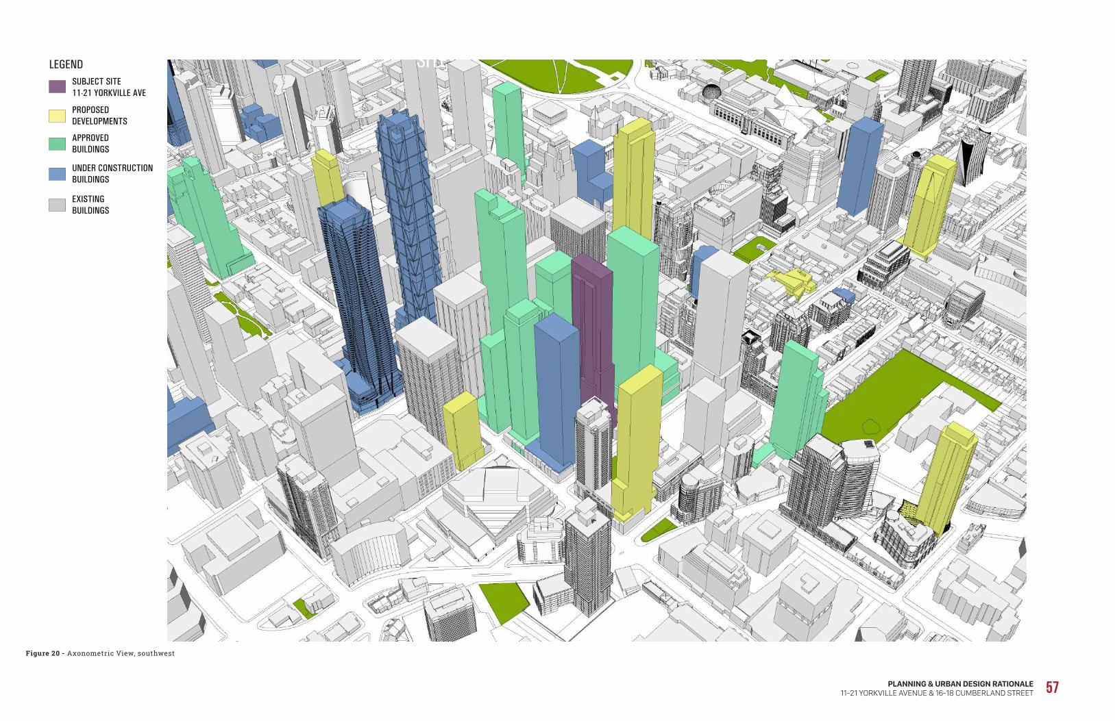
PLANNING & URBAN DESIGN RATIONALE11-21 YORKVILLE AVENUE & 16-18 CUMBERLAND STREET 57PERSPECTIVE VIEW SOUTHWEST
LEGENDSUBJECT SITE11-21 YORKVILLE AVE
PROPOSEDDEVELOPMENTS
UNDER CONSTRUCTION BUILDINGS
APPROVED BUILDINGS
EXISTINGBUILDINGS
SITE
Figure 20 - Axonometric View, southwest

58
In accordance with the approach outlined above, the City approved an Official Plan Amendment to permit tall buildings outside of the Height Peak and the Height Ridges on the 27-37 Yorkville site (OPA 276). However, for the 41-storey building at 48-58 Scollard Street/1315-1325 Bay Street (Site #14), only a rezoning was required.
As well, while identifying the site as a tall building site, the Planning Framework did not establish a specific height and explicitly stated that the height “cannot be projected at this time”. Accordingly, the appropriate height for a tall building on the subject site is to be determined through the consideration of this site-specific application.
In this regard, it is our opinion that the proposed height of 62 storeys (211.3 metres, including mechanical penthouse) is appropriate and desirable, given that it would fit harmoniously within the existing and planned height context and that it would have no unacceptable built form impacts.
In this regard, as described in both Site and Area Specific Policy 211 and the Bloor-Yorkville/North Midtown Urban Design Guidelines, heights are intended to follow a general pattern of decreasing with distance from the Yonge/Bloor Height Peak. The subject site is located within the first block north of the Height Peak and the proposed height is in keeping with a pattern of stepping down of heights from 306 metres within the height peak (1 Bloor Street West) to buildings with heights of 113 metres and 107 metres located further to the north within the Yonge Street Height Ridge (Milan and 18 Yorkville, respectively) and to buildings with heights of 204 metres and 147 metres further to the north within and beyond the Bay Street Height Ridge (the Four Seasons Hotel and 1315-1325 Bay Street, respectively).
The subject site is also located immediately adjacent to a number of recently approved developments with similar building heights, including the recently approved 62-storey (215 metre) mixed-use building to the immediate west at 27-37 Yorkville Avenue, the 1 Yorkville mixed-use building to the immediate east, which is currently under construction, at 58 storeys (183 metres), and the recently approved 51-storey (170.5 metre) mixed-use building to the immediate southeast (826-834 Yonge Street, 2-8 Cumberland Street).
From an urban structure perspective, the proposed tower height would fit within the general pattern of height in the Midtown area (see Figure 20, Axonometric View), which is explicitly recognized in both Site and Area Specific Policy 211 and the Bloor-Yorkville/North Midtown Urban Design Guidelines. In this regard, the tallest building heights are envisioned to be centred on the Bloor/Yonge intersection and extending north to Cumberland Street (i.e. the Height Peak), which includes existing and approved buildings up to 306 metres in height, while the building heights are to step down along the Height Ridges, which include existing and approved buildings up to 204 metres in height.
Furthermore, the location of a tall building on the subject site is supported by the recent Yorkville – East of Bay Planning Framework study, which identified the subject site as a potential tall building site, subject to meeting certain planning objectives and built form guidelines. Although the East of Bay lands include lands that are not located within either the Height Peak or the Height Ridges (which extend along Yonge Street and along Bay Street to just north of Yorkville Avenue), the Planning Framework identifies existing tall building locations within these lands (e.g. the 26-storey Four Seasons Residences at 55 Scollard Street and the 15-storey building at 40 Scollard Street), as well as approved tall building sites (the 62-storey and 40-storey towers at 27-37 Yorkville) and potential tall building sites (48-58 Scollard Street/1315-1325 Bay Street, identified as Site #14, and the subject site, identified as Site #15, 11-21 Yorkville Avenue).
The Planning Framework study notes that:
“Tall buildings on these sites will be conditional upon landowners providing the open spaces that will complete the vision for the area. These additional sites have been identified as potential opportunities, and depending on the proposal, an Official Plan Amendment may be required. The height of these tall buildings, while greater than 12 storeys, cannot be projected at this time. In particular, Site Nos. 14 and 15 are located outside of the Height Ridge and Height Peak in Area Specific Policy 211 in the Official Plan.” (Our emphasis.)

PLANNING & URBAN DESIGN RATIONALE11-21 YORKVILLE AVENUE & 16-18 CUMBERLAND STREET 59
As compared with 27-37 Yorkville Avenue, the subject site is located slightly closer to the Bloor-Yonge subway station and further from the shadow-sensitive areas to the northwest (Jesse Ketchum School and Park and the low-rise Yorkville Triangle Neighbourhood). As compared with 1 Yorkville and 8 Cumberland, the site is located somewhat further from the shadow-sensitive area associated with the Asquith Collier Neighbourhood to the east. Accordingly, a height similar to, or slightly greater than, the 215 metre height approved at 27-37 Yorkville Avenue would be appropriate for the subject site.
Based on a detailed analysis of the built form impacts associated with the proposed height, as set out in Section 5.4 below, it is our opinion that the resulting impacts are acceptable and satisfy the applicable Official Plan tests, particularly with respect to shadow impacts.
Finally, the development proposal satisfies all of the pre-conditions set out in the East of Bay Planning Framework to permit a tall building on the subject site:
• it will satisfy all rental housing replacement policies (see Section 5.7 below);
• as described in Section 5.4 below, the proposed tower will provide a minimum of 25 metre tower separation or greater to proposed tall building at Site Nos. 11 and 12 (i.e. 27-37 Yorkville Avenue and 1 Yorkville Avenue, respectively);
• as described in Section 5.5, the proposal will provide publicly-accessible open space to the west, completing the transformation of the publicly accessible plaza and walkway into a single enlarged public park with seating and public art;
• the building has been designed with no projecting balconies; and
• the building and ground floor have been set back from Yorkville Avenue to provide for widened
sidewalks and outdoor cafes.
For all of the foregoing reasons, it is our opinion that the proposed Official Plan Amendment to permit a tall building on the subject site and, specifically, to permit the proposed 211 metre height is appropriate.
In terms of massing, the building is designed to provide three main components, each of which respond to a different context: a low-scale base building; a sculpted middle portion (or shaft); and a slender top.
At 2 storeys in height, the base building responds to the street level and immediate heritage context by providing a comfortable pedestrian scale along the public laneway to the east and the new public park to the west, as well as providing an architectural expression that is similar in height to the neighbouring buildings, including the Yorkville Fire Hall, the Yorkville Branch Library and the podium of the 1 Yorkville building. This is achieved through the stepping of the tower element from base building along the east and west elevations with generous stepbacks to emphasize the base building, as well as through the use of materials in the base building (stone veneer) and the tower element (glass and metal).
Above the podium, the middle or shaft of the building fits into the surrounding context, which includes numerous tall buildings that are generally well separated from one another, while the upper portion of the building provides a more slender tower element that will contribute positively to the City’s skyline. As illustrated in Figure 21 (Massing Strategy), the intent of the design of the building is to transfer massing that would otherwise have been located in the podium building to the middle of the building. This creates an opportunity to free up the ground plane and provide for larger grade-related open spaces that will expand and enhance the public realm, including the widening of the public laneway/walkway to the east and the public sidewalk along Yorkville Avenue, as well as the expansion of the planned public parkette to the west.
The redistribution of massing to the middle of the building would result in minimal built form impacts, given that it will correspond to the massing of buildings in the broader context, which is comprised of taller buildings. The top of the building will rise above most of the buildings in the broader context, resulting in a slender and elegant expression that enhances the City’s skyline.
Furthermore, the tower element is well articulated. In addition to numerous stepbacks provided throughout, the corners are indented to further reduce the width of the tower, while the inclusion of inset balconies also breaks up the massing. The combination of stepbacks provided in the middle portion of the building and a more slender upper portion of the building not only allows for

60
Figure 21 - Massing Stradegy
DESIGN AND ARCHITECTURETYPICAL RESPONSE
»» Conventional Tower Massing
»» Podium Height based on recent approvals
»» 750 SQ.M floorplate above the podium
»» Heavy Podium would not be able to relate to village Civic buildings
»» Heavy Podium would not be able to relate to pedestrian scale of public realm and new park.
Client
Metropia Capital Developments RioCanProject
11 YorkvillePlanner
BousfieldsArchitect
Sweeny &Co ArchitectsLandscape Architect
Studio TLA 22CONTEMPORARY AND INFORMED DESIGN RESPONSEDESIGN AND ARCHITECTURE
Sculpting #1Integrating public realm objectives.Completion of Clocktower Walkway.Completion of Townhall Walkway
Sculpting #2Re-distribution of podium density throughout the tower.Maximize active frontages on 3 of 4 sides of the building.
Sculpting #3Creating cascading setbacksTaking cues from existing and planned context2-storey base to relate to human scale of surrounding public realm and historical civic buildings
Client
Metropia Capital Developments RioCanProject
11 YorkvillePlanner
BousfieldsArchitect
Sweeny &Co ArchitectsLandscape Architect
Studio TLA 23DESIGN AND ARCHITECTURE
PROPOSED DESIGN
»» Re-distribution of podium density throughout the tower.
»» Sculpting a strong and legible symmetry with clear proportions
»» Maintain and exceed Tall Building Guidelines Performance standards
Client
Metropia Capital Developments RioCanProject
11 YorkvillePlanner
BousfieldsArchitect
Sweeny &Co ArchitectsLandscape Architect
Studio TLA 24

PLANNING & URBAN DESIGN RATIONALE11-21 YORKVILLE AVENUE & 16-18 CUMBERLAND STREET 61
proposed building in a manner that enhances both the public realm and skyline, while achieving sufficient tower separation distances to adjacent approved and existing towers. In this regard, the massing achieves an appropriate balance between maintaining the heritage character of the streetscape, providing for an appropriate setback to the existing laneway/walkway to the east, providing for the creation of a widened public park and providing an elegant tower element to the Yonge-Bloor/Yorkville skyline.
In our opinion, the proposed density of 16.23 FSI is appropriate and desirable. Firstly, it is important and desirable from a planning policy perspective to optimize density on the site given its location within the Downtown Toronto Urban Growth Centre and its proximity to the Bloor-Yonge subway station.
Secondly, it is noted that the Official Plan does not generally include density limitations and specifically does not do so in the case of the subject site. The Official Plan provides that land use designations are generalized, leaving it to the Zoning By-law to “prescribe the precise numerical figures and land use permissions that will reflect the tremendous variety of communities across the City.”
Finally, the proposed density is less than the approved densities of adjacent developments, including 826-834 Yonge Street, 2-8 Cumberland Street (20.7 FSI), 1 Yorkville Avenue (18.75 FSI) and 27-37 Yorkville Avenue and 26-32/50 Cumberland Street (18.3 FSI).
Accordingly, it is reasonable to establish an appropriate density for the subject site based on site-specific built form, heritage, context and urban structure considerations, rather than on the basis of density numbers. In this regard, virtually all of the new towers that have been built within the Bloor-Yorkville/North Midtown area have required amendments to the Zoning By-law to increase the permitted density; in each case, the appropriate density was determined through a similar design-based evaluation.
That being said, it is noted that the proposed 16.23 FSI density is less than the approved densities of adjacent developments, including 8 Cumberland (20.7 FSI), 1 Yorkville Avenue (18.75 FSI) and 27-37 Yorkville Avenue (18.3 FSI).
sunlight penetration to the ground, but also, from the street level, creates the appearance of the massing diminishing into the sky.
The dimensions and siting of the proposed tower respond appropriately to the built form context and are generally in keeping with the City-wide Tall Building Design Guidelines and the Downtown Supplementary Design Guidelines, as well as the Yorkville – East of Bay Planning Framework. The proposed tower floor plate sizes range from 768 square metres to 1,167 square metres (with an average size of 870 square metres), with the larger floor plate sizes occupying the middle portion of the building, and the smaller floor plates occupying the upper portions of the tower element.
While the floor plate sizes are larger than the 750 square metre guideline in the Tall Building Design Guidelines, it is noted that the Guidelines permit flexibility to accommodate modest increases for buildings of 50-60 storeys or more. In this regard, there are a number of recent approvals in the immediate area that have tower floor plate sizes that are considerably larger than 750 square metres, including 27-37 Yorkville Avenue to the immediate west (896 square metres and 786 square metres, with a 78 square metre link building), 1 Bloor Street West (956 square metres), 1 Bloor Street East (918 square metres), 50 Bloor Street West (974 square metres) and 60 Yorkville Avenue (1,380 square metres up to Level 21 and 984 square metres above).
While the buildings at 1 Yorkville and 8 Cumberland have smaller tower floor plates (758 square metres and 622 square metres, respectively), they are located on much smaller sites (2,160 square metres and 1,416 square metres, respectively, versus 3,229 square metres for the subject site). As a result of the large site size, although the floor plate size exceeds the 750 square metre guideline, the tower element provides appropriate tower separation distances to the east and west, as detailed in Section 5.4 of this report, resulting in acceptable built form impacts.
Based on the foregoing, it is our opinion that the tower floor plate sizes appropriately allow for the redistribution of massing throughout the

62
rooms on the same site. For tower elements, the Tall Building Design Guidelines recommend a separation distance of 25 metres between tower faces on the same site and a tower setback of 12.5 metres from side and rear property lines or the centre line of an abutting lane, measured to the external walls of the building (i.e. balconies are permitted within the setback zone).
B a s e B u i l d i n g
The first two levels within the base building contain no residential units; therefore, there would be no LVP concerns.
T o w e r
Within the tower element, the 3rd and 4th floors are occupied by indoor amenity space, therefore, there will be no LVP concerns. For the balance of the tower, minimum setbacks are provided that are consistent with zoning standards and recommended guidelines, resulting in minimal LVP impacts onto adjacent properties.
Along Yorkville Avenue, given that the north side of the street consists of the Yorkville Fire Hall, the Yorkville Library and Town Hall Square, there would be no privacy and overlook concerns. With respect to sky view and sunlight penetration considerations, due to the combination of the 3.0 metre setback to the base buildings and the 2.0 metre stepbacks provided above the 9th and 30th floors, as well as the indentations of the corners of the tower, the proposal building provides access to sunlight for the buildings and open space on the north side of the street. Further, due to the orientation of the tower, the narrow face of the tower will result in minimal impacts in terms of sky view when looking north and south (see Figure 22, Skyline Cross-Section – North-South).
While the tower will have a wider profile looking east and west, it is our opinion that it will not add significant incremental massing to the skyline, given that the proposed tower is line with the approved 40-storey and 62-storey buildings (and 40-storey link component) to the immediate west, as well as the approved 58-storey and 51-storey buildings to the immediate east, resulting in minimal sky view impacts, as illustrated in Figure 22, Skyline Cross-Section – East-West.
5.4 Built Form ImpactsThe Official Plan development criteria applying to the Mixed Use Areas designation have a particular focus on potential built form impacts on adjacent lower-scale Neighbourhoods. In particular, Policy 4.5.2(c) requires buildings to be located and massed to provide a transition through means such as appropriate setbacks and/or a stepping down of heights towards lower scale Neighbourhoods, while Policy 4.5.2(d) requires buildings to be located and massed so as to adequately limit shadow impacts on adjacent Neighbourhoods.
In this respect, the closest Neighbourhoods designation is located approximately 195 metres to northeast of the subject site (on the north side of Collier Street, east of Church Street); however, it is developed with a 16-storey apartment building (66 Collier Street). The Neighbourhoods designation on the east side of Park Road, north of Asquith Avenue, which includes low-rise residential uses, is approximately 255 metres from the subject site while, to the northwest, the closest property designated Neighbourhoods (Jessie Ketchum Public School) is approximately 235 metres away.
In addition, Site and Area Specific Policy 211 provides that development in Mixed Use Areas adjacent to or nearby “low-rise areas” will be designed to adequately limit shadow, wind and privacy impacts through distance separation and transitions in scale, including angular planes and step-downs in heights; in the case of the subject site, the north side of Yorkville Avenue in the vicinity of the Yorkville Branch Library and the Yorkville Fire Hall is shown conceptually shown as a “low-rise area”.
L I G H T , V I E W, P R I V A C Y ( L V P )Light, view and privacy (LVP) impacts are generally addressed through a combination of spatial separation, orientation and mitigating measures between buildings.
In this regard, the underlying CR zoning standard in By-law 438-86 requires a setback of 5.5 metres from principal residential windows (i.e. windows other than bathroom or kitchen windows) to property lines that are not streets or lanes, and a separation distance of 11.0 metres between facing windows of principal residential

PLANNING & URBAN DESIGN RATIONALE11-21 YORKVILLE AVENUE & 16-18 CUMBERLAND STREET 63
Figure 22 - Skyline Cross-Section – North-South
BE
LLA
IRS
TRE
ET
BAY
STR
EE
T
YO
NG
ES
TRE
ET
PAR
KR
OA
D
1 BLOOR ST E78 STOREYS
771 YONGE ST25 STOREYS
2 BLOOR ST E34 STOREYS
1 YORKVILLE58 STOREYS
8 CUMBERLAND51 STOREYS
2 BLOOR ST W54 STOREYS
33 YORKVILLE62 STOREYS, 40 STOREYS
55 BLOOR ST W53 STOREYS
94 CUMBERLAND ST25 STOREYS
80 BLOOR ST W66 STOREYS
50 BLOOR ST W71 STOREYS
1 BLOOR ST W82 STOREYS
SUBJECT SITE11-21 YORKVILLE AVE
62 STOREYS
LEGENDSUBJECT SITE11-21 YORKVILLE AVE
PROPOSEDDEVELOPMENTS
UNDER CONSTRUCTION BUILDINGS
APPROVED BUILDINGS
EXISTINGBUILDINGS
SECTION 1 - ALONG YORKVILLE STREET LOOKING SOUTH

64
To the east, the lower levels of the tower are set back 13.5 metres from the centre line of the laneway, resulting in a tower separation distance of approximately 24.8 metres to the 1 Yorkville tower, generally in accordance with the recommended 25 metre guideline. An additional 1.8 metre stepback is provided above the 23rd floor, which provides an approximate 26.6 metre separation distance to the majority of the east face of the tower, with additional sunlight penetration onto the public laneway.
To the west, the minimum tower setback to the west property line is 18.9 metres, resulting in a tower separation distance of approximately 28.9 metres to the approved 33 Yorkville tower to the west, which is well in excess of the recommended guideline. Above the 17th floor, the tower is stepped back an additional 1.8 metres, providing increased sunlight penetration onto the planned public parkette, as well as an approximate 30.7 metre tower separation distance between the majority of the west tower face and the 33 Yorkville tower.
Furthermore, the setbacks and tower separation distances provided to the east and west are consistent with those set out in the Yorkville – East of Bay Planning Framework study undertaken by the City in 2014.
To the south, there would be no tower separation issues as there are no tall buildings on the adjacent properties, which currently consist of 2- and 3-storey buildings. The lands to the south of the proposed tower include the south portion of the subject site (i.e. 16 and 18 Cumberland Street), which is proposed to be redeveloped for a 2-storey commercial building. As a result, there will no LVP concerns between the two buildings proposed on the subject site. Flanking either side of the proposed 2-storey commercial building are two potential redevelopment sites (12-14 Cumberland Street and 20-22 Cumberland Street) that, in our opinion, would be limited to mid-rise development given the small site sizes (approximately 24.5 metres deep by 10.9 metres and 16.4 metres wide, respectively.
If either one of these potential sites were to be redeveloped with a mid-rise building, the minimum 5.5 metre setback of the proposed tower on the subject site to the centre line of the rear
laneway would be appropriate, and would result in an 11 metre separation distance. In the event that the south portion of the subject site were to be assembled with one or both the flanking sites, it is our opinion that the redevelopment potential of this assembly would still be limited to a mid-rise development due to the lack of depth of these properties and the inability to achieve a setback greater than 5.5 metres. As a result, the proposed setback of the tower to the south will allow for sufficient separation distance in keeping with the underlying CR zoning standard.
Based on the foregoing, it is our opinion that the separation distances between the proposed tower and the closest existing and approved towers would be appropriate and in keeping with the Tall Building Design Guidelines. The resulting separation will ensure that the tower will maintain adequate light and privacy for adjacent towers and adequate access to sky view. Further, given that the properties to the south are not likely to be developed for a tall building, the proposed tower setback to the south would be appropriate
C o m m e r c i a l B u i l d i n g
Given that the 2-storey commercial building proposed along Cumberland Street will have no residential uses, there will be no LVP concerns.
S H A D O W I M P A C TIn order to assess shadow impacts, a shadow study was undertaken by Bousfields Inc. for the proposed development at March 21st/September 21st and June 21st for each hour between 9:18 a.m. and 6:18 p.m. In this regard, the applicable Official Plan policies (Policies 3.1.2(3) and 4.5(2)(d)) focus on the spring and fall equinoxes and assign a particular importance to shadow impacts on low-rise Neighbourhoods designations and on parks.
With respect to the Neighbourhoods designation located to the east of the site, the study indicates that there would be no shadow impact at any time of day on June 21st, however, there would be some incremental shadow impacts at 5:18 p.m. on March 21st/September 21st. The very minor incremental shadow impact at 5:18 p.m. would fall on the sidewalks on Collier Street, as well as the front yard of 156 Collier Street. By 6:18 p.m., the shadow impact would move entirely off the Neighbourhoods designation. The maximum

PLANNING & URBAN DESIGN RATIONALE11-21 YORKVILLE AVENUE & 16-18 CUMBERLAND STREET 65
Figure 23 - Skyline Cross-Section – East-West
CH
AR
LES
STR
EE
T
BLO
OR
STR
EE
T
YO
RK
VIL
LEAV
EN
UE
SC
OLL
AR
DS
TRE
ET
DAV
EN
PO
RT
RO
AD
CU
MB
ER
LAN
DS
TRE
ET
LEGENDSUBJECT SITE11-21 YORKVILLE AVE
PROPOSEDDEVELOPMENTS
UNDER CONSTRUCTION BUILDINGS
APPROVED BUILDINGS
EXISTINGBUILDINGS
2 BLOOR ST W34 STOREYS
33 YORKVILLE62 STOREYS, 40 STOREYS
50 BLOOR ST W71 STOREYS
1 BLOOR ST W82 STOREYS
SUBJECT SITE11-21 YORKVILLE AVE
62 STOREYS
1 YORKVILLE58 STOREYS
60 YORKVILLE55 STOREYS
2 BLOOR ST W54 STOREYS
878 YONGE ST54 STOREYS
862 YONGE ST36 STOREYS
8 CUMBERLAND51 STOREYS
SECTION 2 - YONGE STREET LOOKING WEST

66
duration of shadowing in any location would be less than an hour.
There would also be a minor incremental shadow impact on Neighbourhoods designated properties along Hazelton Avenue, just south of Berryman Street, at 9:18 a.m.; however, the shadow would be entirely gone by 10:18 a.m. Based on the foregoing analysis, it is our opinion that the shadowing impact on the Neighbourhoods designation would be “adequately limited”, as required by the Official Plan.
The building will result in an incremental shadow impact on small portions of Davenport Road between 11:18 a.m. and 2:18 p.m. on March 21st/September 21st and on small portions of Collier Street at 5:18 p.m., as well as on portions of Yonge Street between 2:18 p.m. and 3:18 p.m. on March 21st/September 21st and at 3:18 p.m. on June 21st. To the north, the building will cast an incremental shadow on Town Hall Square between 1:18 p.m. and 2:18 p.m. on March 21st/September 21st and June 21st, and on the Yorkville Branch Library at 9:18 a.m. and on the Yorkville Fire Hall between 11:18 a.m. and 12:18 p.m. on September 21st. On June 21st, the Yorkville Fire Hall and the Yorkville Branch Library would experience incremental shadowing between 11:18 a.m. and 1:18 p.m. Based on the foregoing analysis, it is our opinion that the shadow impacts from the proposed development on adjacent streets, properties and open spaces would satisfy the Official Plan criterion of being “adequately limited” and would be acceptable having regard to the urban character of the surroundings, which includes numerous existing and planned tall buildings.
With respect to parks, the closest are Frank Stollery Parkette, located at the southwest corner of Yonge Street and Davenport Road, and Jesse Ketchum Park, located on the west side of Bay Street, north of Scollard Street. The shadow study shows that the proposed building would result in a minor incremental shadow impact on Frank Stollery Parkette at 1:18 p.m. on March 21st/September 21st and no impacts on June 21st, while there would be a minor incremental shadow impact on Jesse Ketchum Park and on the Jesse Ketchum School property at 10:18 a.m. on March 21st/September 21st. There would be no shadow impact on either park or school property at any time of day on June 21st.
In our opinion, the incremental impact on Frank Stollery Parkette is minor and acceptable having regard to all relevant planning and urban design considerations and satisfies the intent of Site and Area Specific Policy 211 to “minimize shadow impacts” on the parkette.
In the case of Jesse Ketchum Park and School, existing buildings, including the 55-storey Four Seasons Hotel and the 26-storey Four Seasons Residences at 55 Scollard Street, as well as the approved buildings including the 41-storey Bay + Scollard building, the 58-storey building at 1 Yorkville, the 51-storey 8 Cumberland building and the 62-storey Residences of 33 Yorkville building, will cast shadows across portions of Jesse Ketchum Park and School at 9:18 a.m., 10:18 a.m. and 11:18 a.m. on March 21st/September 21st. The siting of the proposed building on the subject site results in its shadow being largely subsumed within the shadow cast by these existing and approved buildings. At 10:18 a.m., the proposed building would cast an incremental shadow between the shadows cast by the recently approved Bay + Scollard building and the Four Seasons Hotel. The incremental shadow would leave well before 11:18 a.m.
While recognizing that the Downtown Supplementary Design Guidelines are guidelines only and have no statutory authority, it is our opinion that the siting and design of the proposed building is in keeping with the guideline direction to “best mitigate all new net shadowing” on Jesse Ketchum Park, School Playground and Open Space.
Furthermore, the proposed building will not cast any shadows on Village of Yorkville Park at any time of day on March 21st/September 21st and June 21st.
Based on the foregoing, it is our opinion that the incremental shadow impacts created by the proposed building would satisfy the Official Plan test of minimizing additional shadowing on neighbouring parks and would not negatively affect their utility.
W I N D I M P A C TA pedestrian level wind study was undertaken by Gradient Wind Engineering Inc. (GWE), which concludes that the wind conditions within and

PLANNING & URBAN DESIGN RATIONALE11-21 YORKVILLE AVENUE & 16-18 CUMBERLAND STREET 67
surrounding the study site will be acceptable for the intended pedestrian uses on a seasonal basis.
Regarding the pedestrian walkway along the west side of the development, wind conditions will be comfortable for sitting during the summer months, and for standing or better throughout the rest of the year. If specific seating areas will be used throughout the shoulder seasons of spring and autumn, then 1.6-metre-tall high-solidity wind screens or raised planters with coniferous plantings are recommended to be installed to the immediate north of any such areas.
Regarding the Level 3 outdoor amenity terrace, the majority of the space will be comfortable for sitting or more sedentary activities during the warmer months. If seating areas will be provided near the southeast corner of the terrace, GWE recommends increasing the height of the terrace perimeter guard and introducing a wraparound canopy.
Additionally, within the context of typical weather patterns, which exclude anomalous localized storm events such as tornadoes and downbursts, no areas over the study site were found to experience conditions too windy for walking, or that could be considered unsafe.
5.5 Urban DesignFrom an urban design perspective, the proposed redevelopment responds appropriately and sensitively to the existing built context and to the planned vision for the area as set out in the East of Bay Planning Framework.
In particular, the building will be set back 14.52 metres at grade, allowing for a park dedication of 10.52 metres in width along the west property line and POPS space of 4.0 metres in width. Together with the 6.7 metre setback to the adjacent building at 27-37 Yorkville Avenue, a public park/open space linkage would be created, with a width of 21.2 metres. In order to create a widened public realm, the building would also be set back 3.0 metres from Yorkville Avenue at the ground floor and approximately 4.4 metres from the west limit of the lane.
The 2-storey base building will result in an appropriate street proportion along Yorkville
Avenue, with active street-related retail and service commercial uses along the entirety of the street and public parkette frontages. The proposed tower has been stepped well back from the planned public park and laneway/walkway in order to visually emphasize the base building and minimize the visual impact of the tower on these areas.
At an urban scale, the proposed tower height, dimensions and siting result in comfortable tower separation distances and an appropriate transition in built form from the height peak at the Yonge/Bloor intersection. The siting of the building will allow for significant improvements to the pedestrian and vehicular circulation system, including the widening of the planned public parkette along the west limit of the site.
In our opinion, the proposal conforms with the applicable policies Official Plan regarding built form and urban design, including Policies 3.1.2(1), 3.1.2(2), 3.1.2(3), 3.1.2(4), 3.1.2(5), 3.1.2(6), 3.1.3(1) and 4.5(2), and Site and Area Specific Policy 211. In particular, the proposed design will:
• locate the base building parallel to Yorkville Avenue to maintain a strong street level relationship and consistency of building setbacks along the street frontage;
• provide grade-related uses (retail stores along the street and public parkette frontages) that will animate the pedestrian-level streetscape;
• locate the main entrance to the residential building off the north-south laneway/walkway, so as to maintain a retail frontage along Yorkville Avenuet;
• locate and screen service areas, ramps and garbage storage by internalizing all of these functions within the building;
• incorporate a base building that will frame the adjacent street and park with appropriate proportion;
• include massing and articulation of the tower element distinguished from the base building by use of materials and stepbacks;
• include distinctive architectural characteristics as part of the tower element that will contribute to the skyline;
• employ a slender point tower design;
• incorporate the mechanical penthouse into the design of the top of the building; and
• provide all parking underground.

68
The proposed is generally in keeping with the Bloor-Yorkville/North Midtown Urban Design Guidelines, while recognizing that they have effectively been amended in some respects by the Yorkville-East of Bay Planning Framework. In this regard, Planning Framework envisions a potential tall building on site with public realm enhancements, including a portion of a new park on the west end of the site, as well as the improvement of the laneway to the east for both vehicular and pedestrian circulation.
In our opinion, the design of the proposed development is generally in keeping the applicable guidelines set out in the City-wide Tall Building Design Guidelines and the Downtown Supplementary Design Guidelines, as set out below:
Guideline 1.3 – Fit and Transition in Scale. Ensure tall buildings fit within the existing or planned context and provide an appropriate transition in scale down to lower-scaled buildings, parks and open space.
• The building height provides for an appropriate transition in scale from the Height Peak at the Yonge/Bloor intersection to the 62-storey and 40-storey buildings to the west (33 Yorkville Avenue) and the 55-storey and 26-storey buildings located to the northwest (i.e. Four Seasons Hotel and Private Residences). The base building creates an appropriate proportion along the laneway and planned public parkette, and also relates to the Yorkville Branch Library and the Yorkville Fire Hall to the north of the site.
Guideline 1.4 – Sunlight and Sky View. Locate and design tall buildings to protect access to sunlight and sky view within the surrounding context of streets, parks, public and private open space, and other shadow sensitive areas.
• The siting and dimensions of the tower minimize incremental shadow impacts on parks (Frank Stollery Parkette and Jesse Ketchum Park and School) and maintain access to sky view. See Section 5.4 above.
Guideline 1.6 – Heritage Buildings and Heritage Conservation Districts. Locate and design tall buildings to respect and complement the scale, character, form and setting of on-site and adjacent heritage properties and Heritage Conservation Districts.
• The base building provides a scale along Yorkville Avenue that is complementary to the adjacent heritage buildings to the north and east. See Section 5.6 below.
Guideline 2.1 – Building Placement. Locate the base of tall buildings to frame the edges of streets, parks and open space, to fit harmoniously with the existing context, and to provide opportunities for high-quality landscaped open space on-site.
• The base building will appropriately frame the Yorkville Avenue frontage, as well as along the public laneway and planned public parkette.
Guideline 2.2 – Building Address and Entrances. Organize tall buildings to use existing or new public streets for address and building entrances. Ensure primary building entrances front onto public streets, are well-defined, clearly visible and universally accessible from the adjacent public sidewalk.
• The residential building entrance will be located off the proposed north-south laneway, which will connect directly to the Yorkville Avenue sidewalk. The use of mid-block connections is characteristic of the Yorkville area and allows the entire street frontage along Yorkville Avenue to be animated with retail/service commercial uses.
Guideline 2.3 – Site Servicing, Access and Parking. Locate “back-of-house” activities, such as loading, servicing, utilities and vehicle parking underground or within the building mass, away from the public realm and public view.
• All building services are located within the building or underground and are accessed from the north-south laneway.
Guideline 2.4 – Publicly Accessible Open Space. Provide grade-related, publicly accessible open space within the tall building site to complement, connect and extend the existing network of public streets, parks and open space.
• The proposed expansion of the planned public parkette along the west side of the building, together with the associated POPS, will provide a pedestrian connection through the site.
Guideline 3.1.1 – Base Building Scale and Height. Design the base building to fit harmoniously within the context of neighbouring building heights at the street and to respect the scale and proportion of adjacent streets, parks and public or private open space.
• The building will create an appropriate street proportion along Yorkville Avenue that relates to the various building heights, including the 10-storey base building to the west, as well as the Yorkville Branch Library and the Yorkville Fire Hall to the north of the site.

PLANNING & URBAN DESIGN RATIONALE11-21 YORKVILLE AVENUE & 16-18 CUMBERLAND STREET 69
Guideline 3.1.2 – Street Animation. Line the base building with active, grade-related uses to promote a safe and animated public realm.
• The entire street frontage along Yorkville Avenue will be animated with retail/service commercial uses.
Guideline 3.1.3 – First Floor Height. Provide a minimum first floor height of 4.5 metres, measured floor-to-floor from average grade.
• The first floor height will be 7.0 metres, which is greater than the 4.5 metre guideline.
Guideline 3.1.4 – Façade Articulation and Transparency. Articulate the base building with high-quality materials and design elements that fit with neighbouring buildings and contribute to a pedestrian scale. Provide clear, unobstructed views into and out from ground floor uses facing the public realm.
• The base building will provide a low-rise scale and be treated with materials that are in keeping with neighbouring buildings. The base building will have active retail uses with direct connections and views facing the public realm.
Guideline 3.1.5 – Public-Private Transition. Design the base building and adjacent set back to promote an appropriate level of visual and physical access and overlook, reflecting the nature of the building use at-grade.
• The base building will maintain visual and physical access and overlook. Setbacks are provided along public realm in order to increase these public zones.
Guideline 3.2.1 – Floor Plate Size and Shape. Limit the tower floor plate to 750 square metres or less per floor, including all built area within the building, but excluding balconies. Flexibility in the floor plate size may be considered for non-residential uses and for residential and mixed-use buildings that are greater than 50 to 60 storeys.
• The proposed tower floor plate sizes range between 768 square metres and 1,167 square metres, which is within the range of flexibility that may be considered pursuant to the guideline for tall buildings over 50 to 60 storeys in height. The floor plate size is addressed in greater detail in Section 5.3 above.
Guideline 3.2.2 – Tower Placement. Place towers away from streets, parks, open space and neighbouring properties to reduce visual and physical impacts of the tower and allow the base
building to be the primary defining element for the site and adjacent public realm. Step back the tower, including balconies, 3 metres or greater from the face of the base building along all street, park and open space frontages (including publicly accessible or private shared open space and rooftop amenity within the site). As an option within the stepback, up to one third of a point tower frontage along a street or open space may extend straight down to the ground.
• The tower will be stepped back 4 metres and 6.1 metres, from the base building along the west and east sides of the building, respectively. Along Yorkville Avenue, a 2.0-metre stepback is provided above the 9th floor.
Guideline 3.2.3 – Tower Separation. Set back tall building towers 12.5 metres or more from the side and rear property lines or the centre line of an abutting lane. Provide separation distance between towers on the same site of 25 metres or more, measured from the exterior walls of the buildings, excluding balconies.
• The tower will be set back 13.5 metres from centre line of existing laneway to the east, 18.9 metres to the west property line and 5.5 metres from the centre line of the existing lane to the south. The setback to the south is appropriate, for the reasons set out in Section 5.4 above.
Guideline 3.2.5 – Balconies. Design balconies to maximize usability, comfort and building performance, while minimizing negative impacts on the building mass, public realm and natural environment.
• Intermittent inset balconies are located on east and west sides of the building, with balcony depths ranging from 1.8 to 2.0 metres.
Guideline 3.3 – Tower Top. Design the top of tall buildings to make an appropriate contribution to the quality and character of the city skyline. Balance the use of decorative lighting with energy efficiency objectives, the protection of migratory birds and the management of artificial sky glow.
• The mechanical penthouse will be incorporated into the tower design.
Guideline 4.1 – Streetscape and Landscape Design. Provide high-quality, sustainable streetscape and landscape design between the tall building and adjacent streets, parks and open space.
• Landscaping is envisioned along the Yorkville Avenue and fronting the planned public parkette, including trees, lighting, and decorative paving.

70
Guideline 4.2 – Sidewalk Zone. Provide adequate space between the front of the building and adjacent street curbs to safely and comfortably accommodate pedestrian movement, streetscape elements and activities related to the uses at grade. Along the primary street frontages of a tall building site, secure a sidewalk zone of at least 6 metres, however, exceptions to the minimum 6 metre width may be considered when the extent of the tall building frontage or potential for future redevelopment on abutting sites does not support establishing a new setback pattern.
• The existing sidewalk zone along Yorkville Avenue is approximately 3.6 metres in width. To create a wider pedestrian zone, the main wall of the base building along Yorkville Avenue will be set back approximately 3.0 metres, while the corners will be setback 5.0 metres.
Guideline 4.3 – Pedestrian Level Wind Effects. Locate, orient and design tall buildings to promote air circulation and natural ventilation, yet minimize adverse wind conditions on streets, parks and open space, at building entrances, and in public and private outdoor amenity areas.
• This guideline will be addressed through the pedestrian level wind study by GWE. See Section 5.4 above.
Guideline 4.4 – Pedestrian Weather Protection. Ensure weather protection elements, such as overhangs and canopies, are well-integrated into building design, carefully designed and scaled to support the street, and positioned to maximize function and pedestrian comfort.
• The base building is set back allowing opportunities to include canopies and other weather protection measures.
Supplementary Guideline #2 – Sunlight and Sky View. Locate and design tall buildings to not cast new net shadows on parks and open spaces identified as “Signature Parks/Open Spaces” between 10:00 AM and 4:00 PM on September 21st and all other parks located within and adjacent to the Downtown between 12 Noon and 2:00 PM on September 21st. Locate and design tall buildings to best mitigate all new net shadowing of Jesse Ketchum Park, School Playground and Open Space throughout the entire day for all seasons of the year.
• See Section 5.4 above.
Supplementary Guideline #4 – Heritage Properties and Heritage Conservation Districts. Locate and design tall buildings to respect and complement the scale, character, form and setting of on-site and adjacent heritage properties.
• The combination of a 2-storey base building and the slender profile of the north face of the tower will complement, rather than visually compete with, the heritage architectural character of the heritage buildings to the north and east. See Section 5.6 below.
Supplementary Guideline #6 – Street Animation. At least 60 percent of the total building frontage along Priority Retail street segments will contain active retail uses.
• The entire building frontages along Yorkville Avenue (and along the planned public parkette) will contain active retail uses.
5.6 heritageA Heritage Impact Assessment has been prepared by GBCA Architects. The study concludes that there will be no impact on heritage value. The site does not contain any buildings deemed of heritage value and their removal will not reduce the character of the area. Adjacent heritage properties north of Yorkville Avenue are sited at prominent distances from the street and complemented with landscaped on their sides, which gives them an established stature in the area, which has been maintained with the addition of new high rise development in the immediate area. The new development will therefore not have any impact on this established character.
The new development is of its own time and place, is an appropriate addition to the current context of residential high rises and is designed in a manner that does not detract from, or impose on, the listed heritage buildings (the Fire Hall and the Public Library).
5.7 housingAs per Policy 3.2.1(1) of the Official Plan, the revised proposal contributes to a full range of housing in terms of both form and tenure. In this regard, the proposed development provides approximately 40 percent of the units to be two or more bedrooms, which are suitable for larger households.

PLANNING & URBAN DESIGN RATIONALE11-21 YORKVILLE AVENUE & 16-18 CUMBERLAND STREET 71
In conformity with Policy 3.2.1(2), the proposal ensures that the existing housing stock will be maintained, and the overall housing stock will be replenished through intensification and infill on site that is currently underutilized.
As well, a detailed Housing Issues Report addressing Policy 3.2.1(6) is attached as Appendix A, prepared in accordance with the terms of reference specified in the Toronto Development Guide.
In summary, as part of the proposed development, the existing 81 rental units on the subject site (54 bachelor units, 25 one-bedroom units, 1 two-bedroom unit and 1 three-bedroom unit) will be replaced with 81 rental replacement units on floors 5 through 8 of the new building, consisting of 46 bachelor units, 27 one-bedroom units, 4 two-bedroom units and 4 three-bedroom units.
It is our opinion that the proposed rental replacement proposal meets the intent of the housing policies of the Official Plan, in particular Policy 3.2.1(6). In this regard, the proposed development will replace the same number of rental units, at similar rent levels, with at least the same unit types.
5.8 TransportationA Traffic Impact Study was prepared by WSP Canada Group Limited. From a traffic perspective, the study concludes that the boundary road network under total future traffic conditions for the 2023 horizon can readily accommodate the traffic generated by the proposed development. The road network is expected to be minimally impacted by the development, with only slight changes in delays and v/c ratios at most study area intersections compared to future background conditions. Considering modal split, the site is expected to generate 87 to 148 trips during the studied peak hours.
A total of seven background developments were included in the future background analysis based on consultation with the City. These developments consist of a mix of residential and commercial uses. Due to the conservative assumptions made in the methodology used for the Synchro 9 software, some four-way stop-controlled intersections are expected to operate at lower levels of service with lower delays.
WSP believes that these issues are overstated in the analysis and will not occur under normal operating conditions.
In terms of alternative modes of transportation, the infrastructure around the site is equipped to accommodate an increase in cycling and pedestrian trips. In addition, the transit route network has enough capacity to accommodate the transit trips generated from the site.
From a transit perspective, the site is extremely well served by public transit with the Yonge-Bloor station located approximately 190 metres southeast of the site. This station provides access to both the Yonge-University and Bloor-Danforth subway lines as well as numerous bus routes that connect directly to most areas of the City. With the extensive transit services provided in the area, the transit trips generated by this development can be readily accommodated. Furthermore, the need for residents, tenants, visitors and patrons to use motor vehicles will be greatly reduced as well as the demand for the provision of on-site parking spaces.
In term of site access, site circulation for garbage vehicles, MSU’s, LSU’s and passenger vehicles were analyzed. The site can accommodate the circulation of all tested vehicles.
Finally, for parking, the study concludes that the proposed amount of motor vehicle parking for the development is appropriate based on the site location and access to transit plus pedestrian and cycling infrastructure.
5.9 ServicingA Functional Servicing Report was prepared by WSP Canada Group Limited.
From a sanitary sewage perspective, the report concludes that the existing 600 mm diameter combined sewer on Yorkville Avenue and the existing 300 mm diameter combined sewer in the laneway north of Building B both have sufficient capacity to convey the projected peak sanitary flows. Building A will discharge to the existing 600 mm combined sewer along Yorkville Avenue through one 200 mm diameter residential sanitary service connection and one 100 mm diameter commercial sanitary connection. Building B will discharge flow to the existing 300 mm combined

72
that are available within the Study Area, and to identify any priorities that should be considered in connection with the proposed development. The Study Area was generally defined by the CNR line to the north, Jarvis Street and Rosedale Valley Road to the east, Queen Street West to the south, and University Avenue and Bathurst Street to the west.
A number of development applications/approvals were assessed in order to determine the projected population increase for the local area. A total of 16 applications/recent approvals were reviewed, and the estimated population generated from these developments was approximately 10,590 persons. With the development included, the population figure increased to 11,815 persons. Considering that the applications/approvals are at various stages of the planning process, the increase in local population may occur incrementally. The impact on local community services and facilities cannot be determined at this time as the demographic make-up of this population is unknown. However, as noted in Section 4.0 of this report, the City has identified the Yonge/Yorkville area as a priority area for CS&F opportunities.
Next, an inventory of the adjacent community services and facilities was created. Bousfields staff looked at the programs, capacities and service gaps of publicly funded schools, child care facilities, libraries, parks and community centres. It was found that the the proposed development may not pose a significant strain on the community services and facilities in the Study Area. The TDSB and TCDSB schools serving the subject site may be able to enrol the elementary and secondary students produced by the development. With respect to child care, there is an existing service gap in the availability of Infant and Toddler spaces in the Study Area.
The potential impacts that the proposed development, in combination of the adjacent developments, may have on the local community services and facilities is unknown. The growth of the Downtown is recognized by the City, and policies and guidelines have been proposed to facilities new ways in which to expand and improve community service and facility creation, distribution and access in the Downtown area (see Section 3)).
sewer in the laneway north of the building via a 100 mm diameter sanitary service connection. The downstream combined sewers can adequately accommodate the proposed redevelopment. No downstream combined sewer improvements are required to service the proposed development.
In terms of water service, the report concludes that Building A will be serviced by two 200 mm diameter PVC fire connections into the existing 300 mm watermain on Yorkville Avenue. Each fire connection will have one 150 mm domestic branch. Building B will be serviced by one shared 150 mm diameter connection, which will connect to the existing 150 mm watermain on Cumberland Street.
Finally, in terms of stormwater management, WSP Canada Group Limited prepared a Stormwater Management Report, which concludes that for water balance, a sump volume of 11.53 m3
is provided at the base of a stormwater cistern in Building A for reuse purposes ensuring that the Wet Weather Flow Management Guidelines (WWFMG) Water Balance criteria are satisfied.
For water quantity, storage provided by stormwater cisterns in Building A and B will ensure that the peak offsite discharge rates to municipal storm sewers will be below the allowable maximum rate of 39.6 L/s defined in the WWFMG for all storms up to and including the 100-year event. The release rate from each cistern is controlled through the use of a 100 mm orifice tube from the proposed 165 m3 cistern in Building A and the use of a 3 inch (76 mm) SXH HydroBrake valve from the proposed 16 m3
stormwater cistern in Building B.
To enhance water quality treatment of 80% TSS removal, a Jellyfish Filtration system, model JF4-2-1 (or approved equivalent) is recommended to provide water quality treatment for Building A. For Building B, the majority of the area is new impervious roof, which is consider clean for the purpose of stormwater runoff quality.
5.10community Services and Facilities
A Community Services and Facilities (CS&F) report was prepared by Bousfields Inc. to provide a review of the community services and facilities that are available to residents in the vicinity of the subject site. The purpose of this report was to identify the range of existing resources

PLANNING & URBAN DESIGN RATIONALE11-21 YORKVILLE AVENUE & 16-18 CUMBERLAND STREET 73
[6.0]C O N C L U S I O N

74
The proposed redevelopment of the subject site will appropriately intensify an underutilized site and improve the streetscape along Yorkville Avenue, providing for improved vehicular and pedestrian links along the east limit of the site, accommodating a widened public parkette along the west limit of the site and creating an architecturally distinctive building that respects the surrounding context.
From a land use perspective, the proposal is supportive of numerous policy directions promoting intensification of underutilized sites within built-up urban areas, particularly in locations that are well served by existing municipal infrastructure, including public transit. The subject site is within 190 metres of the Bloor-Yonge subway station entrance and is located within a node of high-rise development clustered around the Bloor/Yonge intersection.
From an urban design perspective, the proposal will fit harmoniously with the existing and planned built form context in the vicinity of the Yonge Street and Bloor Street corridors, while providing for a transition from the heights within the Height Peak at Yonge/Bloor (up to 82 storeys approved) to the 55-storey building located to the northwest at Bay Street and Yorkville Avenue within the Height Ridge. The proposed design would result in a slender tower form with a base building that responds appropriately at the ground level. The proposed development conforms with the built form and massing policies of the Official Plan, and is generally in keeping with the relevant urban design guidelines.
In summary, it is our opinion that the proposal is an appropriate and desirable redevelopment of the site, and represents good planning and urban design.

18M A R C H
APPENDIX
HOUSING ISSUES
REPORT A

TABLE OF CONTENTS1.0 INTRODUCTION A1
2.0 SUBJECT SITE A3
3.0 PROPOSAL A4
4.0 RELEVANT PLANNING PROCESS AND OTHER APPLICATIONS A5
5.0 APPLICABLE POLICY AND REGULATORY CONTEXT A65.1 PROVINCIAL POLICIES A65.2 TORONTO OFFICIAL PLAN A7
6.0 ANALYSIS AND OPINION A86.1 RENTAL REPLACEMENT PROPOSAL A96.2 ANALYSIS OF UNIT NUMBER, SIZE AND TYPE A106.3 ANALYSIS OF UNIT AFFORDABILITY A126.4 AFFORDABILITY ANALYSIS FOR UNKNOWN VACANT
UNITS WITH UNKNOWN RENTS A146.5 TENANT RELOCATION AND ASSISTANCE A15
7.0 CONCLUSION A16

HOUSING ISSUES REPORT | 11-21 YORKVILLE AVENUE A1
1.0 INTRODUCTION
This Housing Issues report has been prepared in support of an application by 11 Yorkville Partners Inc. (the “Owners”), to amend the former City of Toronto Zoning By-law 438-86, as amended, and City of Toronto Zoning By-law 569-2013, as amended, with respect to land located on the south side of Yorkville Avenue, west of Yonge Street, municipally known as 11-25 Yorkville Avenue and 16 & 18 Cumberland Street (the “subject site”, see Figure 1). The Housing Issues Report examines the existing and rental replacement units for 11, 17, 19 and 21 Yorkville Avenue. The Cumberland Street properties were exclusively used as commercial/office spaces and did not contain residential rental units.
The proposed development contemplates a 62-storey (213 metres, including mechanical penthouse) residential, mixed-use development and a 2-storey commercial building on the subject site. The proposal will have an overall gross floor area of approximately 47,727.91 square metres, resulting in a density of 16.22 times the area of the lot. A total of 716 residential units will be provided, which will include the 81 replacement rental units that will replace what currently exists on the subject site.
Section 111 of the City of Toronto Act gives the City authority to protect rental housing in the city. In accordance with the provisions in that Section, the City of Toronto prohibits the demolition and conversion of any rental housing (on properties that contain six or more related units) unless a permit has been issued under Chapter 667 of the Municipal Code.
There are additional housing policies in the City of Toronto Official Plan (the “Official Plan”) which apply to this proposed development. In particular Policy 3.2.1(6) applies when more than six rental units will be removed, as part of a new development.
On behalf of 11 Yorkville Partners Inc., we are pleased to submit this Housing Issues Report, which addresses Section 111 of the City of Toronto Act and the Toronto Official Plan housing policies, as they apply to the proposed redevelopment of the subject site. In our opinion, the Proposal meets the applicable requirements.

A2
AVEN
UE R
D
YONG
E ST
BAY
ST
DAVENPORT RD CHURCH ST
BLOOR ST W BLOOR ST E
YORKVILLE AVE
CUMBERLAND ST
SUBJECTSITE
Figure 1 - Aerial Photo

HOUSING ISSUES REPORT | 11-21 YORKVILLE AVENUE A3
The subject site is comprised of an assembly of properties, generally located on the south side of Yorkville Avenue and the north side of Cumberland Street, just west of Yonge Street, and is municipally known as 11-25 Yorkville Avenue and 16-18 Cumberland Street. The assembled site is bisected by a public laneway, resulting in two parcels that are each generally rectangular in shape. The subject site and its surroundings is described in greater detail in our Planning and Urban Design Rationale report.
The existing mixed-use buildings containing rental units occupy the north parcel of the subject site fronting Yorkville Avenue, and each have separate residential entrances off Yorkville Avenue. A total of 81 residential rental units are provided in 4 buildings, as summarized in Table 1 below.
As noted in Section 2.1 of our Planning and Urban Design Rationale report, the 11 Yorkville building was built with purpose-built residential apartment units located above grade. However, the existing residential rental units in 17, 19 and 21 Yorkville Avenue were created after these buildings were originally built, through renovations and alterations over the years. As a result, the existing rental units in these buildings exemplify unconventional unit sizes and layouts.
Table 1 – 11, 17, 19 & 21 Yorkville Avenue, Unit Typology
Parking is currently provided for residents of 11 Yorkville Avenue, however, tenants pay for the spaces separately. Currently, 4 parking spaces are being rented out to tenants residing at 11 Yorkville Avenue, Parking is not available for the tenants within 17, 19 and 21 Yorkville Avenue.
2.0 SUBJECT SITE
Unit Type11 Yorkville
Avenue
17 Yorkville
Avenue
19 Yorkville
Avenue
21 Yorkville
Avenue
Bachelor 54 0 0 0
1-bedroom 16 1 2 6
2-bedroom 1 0 0 0
3-bedroom 0 1 0 0
TOTAL 71 2 2 6

A4
The proposal consists of two buildings on the subject site: the north parcel (i.e. north of the public laneway) proposes a 62-storey residential/mixed-use development that includes the rental replacement units; and a 2-storey commercial building on the south parcel fronting Cumberland Street. The 62-storey mixed-use building will have a total gross floor area of approximately 51,545.61 square metres and a total of 716 units, of which, 81 will be rental replacement units.
Within the mixed-use building, the first two levels (and concourse level) of the podium will contain retail and service commercial uses (approximately 381.7.7 square metres of retail gross floor area). Above the base building, the tower is comprised of residential uses, with a total of 716 units, of which, 81 are rental replacement units. The proposed unit mix includes 61 bachelor units, 365 one-bedroom, 218 two-bedroom and 72 three-bedroom units. Approximately 40 percent of the units have two or more bedrooms and are suitable for larger households. As previously mentioned, the existing 81 rental units will be replaced in the proposed mixed-use building either as the same unit type or larger. It is proposed that the rental replacement units will be located on Floors 5 to 8. Greater detail on the rental replacement strategy is discussed in Section 6.0 below.
Access to the condominium and rental replacement units will be from a residential lobby located in the ground floor of the podium. Entrances to the lobby are located off the public lane to the east, as well as through the urban room fronting onto Yorkville Avenue. An elevator shaft, located within the core of the building, provides access to the residential units above. Both the proposed condominium units and rental replacement units will utilize the same elevators.
Indoor amenity space is proposed on the 3rd and 4th floors. The indoor amenity space on the 3rd floor will provide access to outdoor amenity space in the form of a roof terrace on top of the 2-storey base building. Programming of the amenity floors has not yet been determined, and will be refined in more detail through Site Plan. The rental replacement units will have access to the proposed indoor and outdoor amenities included in the new development.
With respect to parking, a total of 235 vehicular parking spaces are proposed in a four-level underground parking garage. A total of 716 bicycle parking spaces have been included in the development, all of which are located in secured rooms within the ground floor, concourse, and underground garage.
Further details regarding the proposed development scheme, including the proposed landscape and amenity enhancements, is included in the Planning and Urban Design Rationale.
3.0 PROPOSAL

HOUSING ISSUES REPORT | 11-21 YORKVILLE AVENUE A5
4.0 RELEVANT PLANNING PROCESS AND APPLICATIONS
In our opinion, the proposed development conforms with the City of Toronto Official Plan and, in particular, the proposed use, height and density are permitted by the applicable Mixed Use Areas designation. However, while generally conforming to the provisions of Site and Area Specific Policy (SASP) 211, the subject site is not located in either the Height Peak or Height Ridges identified in SASP; accordingly, an Official Plan Amendment is required in order to permit a tall building outside of the Height Peak or Height Ridges.
The proposal requires an amendment to City of Toronto Zoning By-law 438-86, as amended, and to the new City-wide Zoning By-law 569-2013, in order to increase the permitted height and density, as well as to revise other development regulations as necessary to accommodate the proposal.
Also, the subject proposal requires a Request for Rental Demolition and Conversion application under Section 111 of the City of Toronto Act to be filed, which is being submitted.

A6
5.0 APPLICABLE POLICY AND REGULATORY CONTEXT
This Housing Issues Report outlines the applicable housing policy that applies to the proposal. Further policy detail is included in Section 4.0 of our Planning and Urban Design Rationale.
5.1 Provincial PoliciesThe 2014 PPS provides overall policy direction on matters of provincial interest relating to land use planning and development. The PPS is intended to promote efficient development and land use patterns to support strong communities, to protect the environment and public health and safety, and promote a strong economy. With respect to housing, Policy 1.4.3 of the PPS requires provision to be made for an appropriate range and mix of housing types and densities to meet projected requirements of current and future residents by, among other matters, permitting and facilitating all forms of residential intensification and redevelopment, promoting densities for new housing which efficiently use land, resources, infrastructure and public service facilities and support the use of alternative transportation modes and public transit.
The Growth Plan for the Greater Golden Horseshoe (the “Growth Plan”) came into effect on July 1, 2017 and any municipal decisions made after this date will need to conform with this new plan. The subject site is within a “strategic growth area” pursuant to the Growth Plan (i.e. a focus for accommodating intensification and higher-density mixed uses in a more compact built form), given that it is located within both the Downtown Toronto “urban growth centre”, and a “major transit station area”. “Strategic growth areas” include urban growth centres, major transit station areas, and other major opportunities that may include infill, redevelopment, brownfield sites, the expansion or conversion of existing buildings, or greyfields.
Section 2.2.6 of the new Growth Plan sets out the housing policies. Policy 2.2.6(1) directs municipalities to develop housing strategies that support the achievement of minimum intensification and density targets by identifying a diverse range and mix of housing options and densities, and establishing targets for affordable ownership housing and affordable rental housing (defined terms). Policy 2.2.6(2) provides that notwithstanding Policy 1.4.1 of the PPS, municipalities will support the achievement of complete communities by planning to accommodate forecasted growth, achieving the minimum intensification and density targets, considering a range and mix of housing options and densities, and planning to diversify overall housing stock across the municipality. In accordance with Policy 2.2.6(3), municipalities are to consider using available tools to require that multi-unit residential developments incorporate a mix of unit sizes to accommodate a diverse range of household sizes and incomes.

HOUSING ISSUES REPORT | 11-21 YORKVILLE AVENUE A7
5.2 Toronto Official PlanWith respect to the City of Toronto Official Plan, the Subject Site is designated Mixed Use on Land Use Map 18.
The Mixed Use Areas designation permits a broad range of commercial, residential and institutional uses in single use or mixed-use buildings, as well as parks and open spaces and utilities. The Plan envisions that development in Mixed Use Areas will create a balance of high quality commercial, residential, institutional and open space uses that reduces automobile dependency and meets the needs of the local community and will provide for new jobs and homes for Toronto’s growing population on underutilized lands in the Downtown and elsewhere.
Section 3.2.1 of the Official Plan contains the applicable housing policies.
• Policy 3.2.1(1) provides that a full range of housing in terms of form, tenure and affordability will be provided to meet the current and future needs of residents.
• Policy 3.2.1(2) indicates that the existing housing stock will be maintained and replenished and that new housing supply will be encouraged through intensification and infill that is consistent with the Official Plan.
• Policy 3.2.1(3) provides that investment in new rental housing, particularly affordable rental housing will be encouraged by a coordinated effort from all levels of government through implementation of a range of strategies.
• Policy 3.2.1(6) provides conditions of approval for new development that would remove all or part of a private building or related group of buildings and would result in the loss of six or more rental housing units. These conditions include:
- All of the rental housing units have rents that exceed mid-range rents at the time of the application; or
- The replacement and maintenance of at least the same number, size and type of rental housing units, with rents similar to those in effect at the time the redevelopment application is made;
- for a period of at least 10 years, rents for replacement units will be the rent at first occupancy increased annually by not more than the Provincial Rent Increase Guideline or a similar guideline as Council may approve from time to time; and
- an acceptable tenant relocation and assistance plan addressing the right to return to occupy one of the replacement units at similar rents, the provision of alternative accommodation at similar rents, and other assistance to lessen hardship.
As discussed in detail in Section 6.0 below, it is our opinion that the Proposal conforms to the applicable Official Plan housing policies.

A8
The proposal is supportive of the policy directions set out in the Provincial Policy Statement 2014, the Growth Plan for the Greater Golden 2017 and the City of Toronto Official Plan, by providing a range of housing types through intensification on an underutilized site within Downtown Toronto that is within walking distance of two subway stations.
The revised proposal is in keeping with Section 3.2.1 of the Official Plan. As per Policy 3.2.1(1), the revised proposal contributes to a full range of housing in terms of both form and tenure. In conformity with Policy 3.2.1(2), the proposal ensures that the existing housing stock will be maintained, and the overall housing stock will be replenished through intensification and infill on site that is currently underutilized. Further analysis on the proposal’s conformity with Policy 3.2.1(6) is set out below.
The development will add a significant number of high-quality units to the City’s stock, in a walkable neighbourhood, with outstanding transit accessibility. The proposal provides a range of unit types and sizes. Of which, approximately 10 percent of the proposed units will be three-bedroom units, therefore contributing to the rental unit options in Downtown locations for families. The units will have access to amenity space, as well as access to nearby retail opportunities and amenities.
As indicated above, Policy 3.2.1(6)(b) requires the provision of rental replacement units and a tenant relocation and assistance plan in instances where new development is proposed that would result in the loss of six or more existing rental units unless either:
• all the rents at the time of application exceed “mid-range rents”; or
• the “supply and availability of rental housing in the City has returned to a healthy state and is able to meet the housing requirements of current and future residents”.
As not all rents exceed mid-range rent and as the City has determined that the supply and availability of rental housing remains insufficient, the applicant is proposing to provide rental replacement housing as part of the redevelopment of the subject site, as well as develop a tenant relocation and assistance plan as set out below.
6.0 ANALYSIS AND OPINION

HOUSING ISSUES REPORT | 11-21 YORKVILLE AVENUE A9
6.1 Rental Replacement ProposalIt is our opinion that the proposal is consistent with the intent of the rental replacement policy in that it maintains and enhances the supply of rental housing in the City. Pursuant to Policy 3.2.1(6)(b)(i), the rental replacement policies require the replacement of the existing rental units with “at least the same number, size and type” of rental housing units. In considering the intent of this policy, it is observed that there is no definition of either “size” of “type”. However, based on a full reading of the Official Plan and an understanding of how the policy has been applied in the past, the terms should be understood as follows:
“Size” refers to the actual square footage of the units, but with reasonable allowances to take into consideration modern design efficiencies.
“Type” refers to the number of bedrooms, rather than to building form. In the definition of “affordable rents”, the Plan refers to “unit types (number of bedrooms)”.
Policy 3.2.1(6)(b)(ii) would establish certain requirements in terms of rents for the rental units. It would require the rents for the replacement units to be “similar to those in effect at the time the redevelopment application is made” and that, for a period of at least 10 years, the rents to be increased annually “by no more than the Provincial Rent Increase Guideline or a similar guideline as Council may approved from time to time” and a one-time increase of 4% for new construction.
The Owner is committed to replacing all existing units currently being rented for residential purposes that are going to be demolished. Based on the March 2018 rent rolls (submitted under a separate cover), 81 rental replacement units would be required. It is intended that through the Section 37 and 111 Agreements, these replacement units would be secured as rental for 20 years and maintained at similar rent levels in a range of unit types that closely approximate the existing rental units for 10 years. Any replacement unit vacated and re-rented within the 10 years of the date of initial occupancy would have an initial rent equal to the greater of the last rent charged for that unit or the then-current rent threshold.

A10
6.2 Analysis of Unit Number, Size and Type
The replacement units are proposed to be located on the fifth through eighth floors of the new building and have generally been provided as the same unit type, and in many instances have been replaced with a larger unit type. Many of the existing residential units will be replaced with a larger unit type, as the current functionality of the space is not entirely efficient. It is proposed that some of the existing bachelor units will be replaced with one-bedroom units, and many of the one-bedroom units will be replaced with two-bedroom and three-bedroom units. In our opinion, it is a desirable condition to increase the number of bedrooms available to returning tenants, while providing a broader mix of unit types, including a number of family-sized units. A summary has been included in Table 2 below.
Table 2 – Comparison of Existing and Proposed Rental Replacement Units, Unit Type
Unit Type Existing Proposed Replacement
Bachelor 54Forty-six (46): Bachelor Units
Eight (8): 1-bedroom Units
1-bedroom 25
Nineteen (19): 1-bedroom Units
Three (3): 2-bedroom Units
Three (3): 3-bedroom Units
2-bedroom 1 One (1): 2-bedroom Unit
3-bedroom 1 One (1): 3-bedroom Unit

HOUSING ISSUES REPORT | 11-21 YORKVILLE AVENUE A11
As illustrated by Table 3 below, while the overall floor area will generally be maintained (approximately 99.76%), recognizing the unique nature of the existing buildings at 17, 19 and 21 Yorkville Avenue, in that there is an atypical relationship between unit type and unit size (i.e. unconventional unit layouts due to the conversion of commercial space into residential units), some of the replacement units are proposed to be smaller than the existing units. In our opinion, this is appropriate given that these unconventional unit layouts and sizes are not replicable in a modern redevelopment project.
Table 3 – Comparison of Existing and Proposed Rental Replacement Units, Size
Unit TypeExisting Proposed
# of Units Average Size Average Size
Bachelor 54 371.3 sq. ft. 449.87 sq. ft.
1-bedroom 25 775.2 sq. ft. 653.48 sq. ft.
2-bedroom 1 911.0 sq. ft. 823.0 sq. ft.
3-bedroom 1 2,150.0 sq. ft. 937.0 sq. ft.
Total Units 81 81
Total Size 42,490.00 sq. ft. 42,390.00 sq. ft.
Deficit 0.24 % (100 sq. ft.)
As a result, it is our opinion that the proposed rental replacement proposal meets the requirements set out in Section 111 of the City of Toronto Act and Chapter 667 of the Municipal Code, as well as the intent of the housing policies set out in the Official Plan, specifically Policy 3.2.1.6(b). As such, does not require an Official Plan Amendment.
Moreover, there are additional spaces that the returning tenant will have access to, which they currently do not, including, common indoor and outdoor amenity spaces. Through the redevelopment of the site, there will be an increase in programmable amenity space.

A12
6.3 Analysis of Unit AffordabilityThe Official Plan defines “affordable rents” as housing where the total monthly shelter cost (gross monthly rent including utilities but excluding parking and cable television charges) is at or below one times the average City of Toronto rent, by unit type, as reported annually by the Canada Mortgage and Housing Corporation. “Mid-range rents” is housing where the total monthly shelter costs exceed affordable rents but fall below one and one-half times the average City of Toronto rent. “High-end rent” is housing above this threshold. The applicable 2018 rent limits by relevant unit type are included in Table 4.
Table 4 – 2018 Average Rent Thresholds
Unit Type Affordable Rent Mid-Range Rent
Bachelor $1,019.00 $1,528.50
1-bedroom apartment $1,202.00 $1,803.00
2-bedroom apartment $1,426.00 $2,139.00
3-bedroom apartment $1,595.00 $2,392.50
The current unit affordability analysis is provided under a separate cover. The analysis is based on the March 2018 rent rolls, and has also been provided under a separate cover. Additional amenities such as parking and locker storage are paid separately, and as such, this cost has not been added to the gross monthly rent. In terms of utilities, all hydro, water and heat costs are currently incorporated into the monthly rent paid by the tenants.
Within 11 Yorkville Avenue, 10 of the rental units were vacant during the month the rents were analyzed. In order to determine the affordability of these units, the analysis was based on the rent paid during the last month of occupancy. After determining the tenant’s last month of occupancy, the rent was analyzed based on the Average Rent Threshold year that the rent was paid. In total, 9 of the vacant rental units in 11 Yorkville Avenue were last occupied in 2017 and as such, the 2017 affordability thresholds were applied to those units.
A summary of the affordability analysis is set out in Tables 5a, 5b, 5c and 5d below. In total, there are 5 affordable units and 76 mid-range units within the existing buildings. As Policy 3.2.1(6)(a) applies for the subject site, all 81 rental units within the subject site will be retained for rental tenure.

HOUSING ISSUES REPORT | 11-21 YORKVILLE AVENUE A13
Table 5a – Summary of Rents in 11 Yorkville Avenue
Unit TypeAffordable Units Mid-Range Units High End Units
Vacant Occupied Vacant Occupied Vacant Occupied
Bachelor 1 4 8 41 0 0
1-bedroom 0 0 1 15 0 0
2-bedroom 0 0 0 1 0 0
3-bedroom 0 0 0 0 0 0
TOTAL 1 4 9 57 0 0
Table 5b – Summary of Rents in 17 Yorkville Avenue
Unit TypeAffordable Units Mid-Range Units High End Units
Vacant Occupied Vacant Occupied Vacant Occupied
Bachelor 0 0 0 0 0 0
1-bedroom 0 0 1* 0 0 0
2-bedroom 0 0 0 0 0 0
3-bedroom 0 0 1* 0 0 0
TOTAL 0 0 2 0 0 0
Table 5c – Summary of Rents in 19 Yorkville Avenue
Unit TypeAffordable Units Mid-Range Units High End Units
Vacant Occupied Vacant Occupied Vacant Occupied
Bachelor 0 0 0 0 0 0
1-bedroom 0 0 1* 1 0 0
2-bedroom 0 0 0 0 0 0
3-bedroom 0 0 0 0 0 0
TOTAL 0 0 1 1 0 0
Table 5d – Summary of Rents in 21 Yorkville Avenue
Unit TypeAffordable Units Mid-Range Units High End Units
Vacant Occupied Vacant Occupied Vacant Occupied
Bachelor 0 0 0 0 0 0
1-bedroom 0 0 6* 0 0 0
2-bedroom 0 0 0 0 0 0
3-bedroom 0 0 0 0 0 0
TOTAL 0 0 6 0 0 0
* indicates units that were vacant upon the Owner’s purchase of the buildings, and
were without historic rental information
A14
6.4 Affordability Analysis for Unknown Vacant Units with Unknown Rents
As illustrated in the Tables 5b, 5c and 5d, there are 9 vacant rental units, which the last rent paid is not known. In this regard, all of the rental units in the 17 and 21 Yorkville Avenue buildings, as well as a unit within the 19 Yorkville Avenue building and two units in the 11 Yorkville building were vacant upon the Owner’s purchase of the properties. Historic lease data was not available for these units, as a result, their affordability was determined based on an evaluation of the relationship between unit type and size, and an analysis of the rents for known units in 11 Yorkville Avenue and the occupied unit in 19 Yorkville Avenue.
As illustrated by the unit surveys for 17, 19 and 21 Yorkville Avenue, which are contained within a separate cover, the relationship between unit type, unit size and affordability would indicate that it is reasonable to classify these vacant units as mid-range. It is our opinion that since these vacant units are generally large 1-bedroom units with an average of over 1,200 square feet, they would be rented at a minimum mid-range affordability level. Another consideration is analysis of affordability classification in the units in 11 Yorkville and the one occupied unit in 19 Yorkville. Approximately 90 percent of the known units were rented at a mid-range affordability level.
Based on the foregoing, it is our opinion that classifying these unknown units as mid-range is reasonable.
HOUSING ISSUES REPORT | 11-21 YORKVILLE AVENUE A15
6.5 Tenant Relocation and AssistancePolicy 3.2.1(6)(b) also requires an acceptable tenant relocation and assistance plan, addressing the right to return to occupy one of the replacement units at “similar rents”, the provision of alternative accommodation at “similar rents” and “other assistance to lessen hardship”. No specific terms are set out for the tenant relocation and assistance plan and it is understood that such terms are intended to be negotiated on a development-by-development basis.
The Residential Tenancies Act, 2006 requires that, if notice of termination of a tenancy is given for the purpose of termination where the landlord requires possession of the rental unit in order to demolish it, the date of termination shall be at least 120 days from the day on which the notice is given. If a tenancy is terminated for the purpose of the demolition, the Act requires that the landlord shall either:
• compensate a tenant in an amount equal to three (3) months rent; OR
• offer the tenant another rental unit acceptable to the tenant.
The owner intends that a tenant relocation and assistance plan be negotiated with the City. Elements of the tenant relocation and assistance plan could include:
• an extended tenant notice period beyond the existing Residential Tenancies Act requirement;
• a construction management and phasing plan;
• a communications strategy, including notification to existing tenants of project milestones and contact information for project management and construction questions/concerns;
• tenant relocation assistance, including a right to return to the replacement rental units;
• tenant compensation, including additional compensation to tenants who either choose to move into a new unit or who choose to find new housing on their own; and
• additional assistance for special needs tenants.

A16
7.0 CONCLUSION
It is our opinion that the proposed rental replacement proposal meets the intent of the housing policies of the Official Plan, in particular, Policy 3.2.1.6(b). In this regard, the proposed development will replace the existing rental units with the same number of units with rents at similar rent levels (i.e. affordable or mid-range) and at least with the same mix of unit types, if not larger. The Owner will have ongoing discussions with the City and its tenants in order to secure an appropriate tenant relocation and assistance plan. Therefore, it is our opinion that an Official Plan Amendment is not required.
Based on the foregoing, it is our opinion that the application for rental housing demolition and conversion in accordance with Chapter 667 of the Municipal Code is appropriate and desirable and is consistent with Section 111 of the City of Toronto Act and, accordingly, should be approved.


COMMUNITY SERVICES &
FACILITIES STUDY
11-25 Yorkville Avenue, And 16-18 CumberlAnd StreetC I T Y O F T O R O N T O
P R E PA R E D F O R :11 YORkvIlle PaRTNeRs INC.

TA B L E O F C O N T E N T S[1.0] INTRODUCTION 1
1 . 1 O V E R V I E W 31 . 2 S T U D Y A R E A 31 . 3 M E T H O D O L O G Y 3
[2.0] DEMOGRAPHIC PROFILE 52 . 1 D E M O G R A P H I C A R E A B O U N D A R I E S 72 . 2 P O P U L A T I O N 72 . 3 F A M I LY C O M P O S I T I O N 82 . 4 H O U S I N G 92 . 5 S O C I O - E C O N O M I C C H A R A C T E R I S T I C S 1 02 . 6 I M M I G R A T I O N & D I V E R S I T Y 1 22 . 7 S U M M A R Y 1 3
[3.0] NEARBY DEVELOPMENT ACTIVITY 153 . 1 R E C E N T D E V E L O P M E N T A C T I V I T Y 1 63 . 2 A N A LY S I S 1 7
[4.0] DOWNTOWN PLAN: TOCORE 194 . 1 O V E R V I E W 2 04 . 2 T O C O R E C O M M U N I T Y S E R V I C E S & F A C I L I T I E S S T U D Y -
P H A S E O N E : T A K I N G S T O C K 2 04 . 3 T O C O R E P R O P O S A L S R E P O R T 2 04 . 4 P R O P O S E D D O W N T O W N P L A N , I N F R A S T R U C T U R E
S T R A T E G I E S 2 2
[5.0] COMMUNITY SERVICES & FACILITIES 255 . 1 S C H O O L S 2 65 . 2 C H I L D C A R E S E R V I C E S 2 75 . 3 P U B L I C L I B R A R I E S 2 95 . 5 P A R K S 3 25 . 6 H O S P I T A L S & E M E R G E N C Y S E R V I C E S 3 35 . 7 H U M A N S E R V I C E S 3 45 . 8 P L A C E S O F W O R S H I P 3 8
[6.0] CONCLUSION 41

COMMUNITY SERVICES & FACILITIES STUDY11-25 Yorkville Avenue & 16-18 Cumberland Street 1
[1.0] INTRODUCTION

BLOOR STREET
BA
THU
RST STR
EE
T
CN RAIL CORRIDOR
JAR
VIS STR
EET
QUEEN STREET
UN
IVER
SITY A
VEN
UE
BA
Y STR
EE
T
YON
GE STR
EET
DUPONT STREET
DAVENPORT RD500 M
SUBJECTSITE
ROSEDALE VALLEY ROAD
2
Figure 1 - Study Area

COMMUNITY SERVICES & FACILITIES STUDY11-25 Yorkville Avenue & 16-18 Cumberland Street 3
1.1 OverviewThis Community Services and Facilities report was prepared by Bousfields Inc. to provide a review of the community services and facilities that are available to residents in the vicinity of 11-25 Yorkville Avenue and 16-18 Cumberland Street in the City of Toronto (the “subject site”). Key services include publicly funded schools, child care facilities, libraries, parks and community centres. The purpose of this report is to identify the range of existing resources that are available within the Study Area, as defined below, and to identify any priorities that should be considered in connection with
the proposed development. The proposed development envisions a 62-storey high-rise mixed-use building containing 716 residential units on the subject site, (the “proposal”). The unit mix of this proposed development is as follows: 61 bachelor units, 365 one-bedroom units, 218 two-bedroom units and 72 three-bedroom units.
1.2 Study AreaThis report’s Study Area is generally defined by the CNR line to the north, Jarvis Street and Rosedale Valley Road to the east, Queen Street West to the south, and University Avenue and Bathurst Street to the west (see Figure 1). This Study Area is considered an approximation of the general distance residents may be willing to travel for services, in combination to conforming with the City of Toronto Neighbourhood boundaries used within Section 2 of this Report: Annex (95), Bay Street Corridor (76), and Church Yonge (75) Neighbourhoods (see Figure 2).
1.3 MethodologyThis report includes an inventory of key publicly funded services and facilities including, but not limited to, schools, child care facilities, community centres, parks and libraries. This information has been collected from a variety of sources including the City of Toronto’s website and other online resources. Data on enrolment, capacity, service boundaries and types of programs has been included where available. The demographic profile in Section 2 is based upon the Neighbourhood Profiles for Annex, Bay Street Corridor and Church-Yonge neighbourhoods as prepared by the City of Toronto. This profile includes data from the 2011 and 2016 Census, and the 2011 National Household Survey (NHS) as provided by Statistics Canada. Due to methodological issues with the NHS, data from this year should be considered to be approximate. In addition, the NHS is a separate
data source, and is not directly comparable to the Census.

4

COMMUNITY SERVICES & FACILITIES STUDY11-25 Yorkville Avenue & 16-18 Cumberland Street 5
[2.0] DEMOGRAPHIC PROFILE

6
Figure 2 - City of Toronto Neighbourhoods included in Demographic Profile - Bay St. Corridor, Church-Yonge Corridor, and the Annex
SUBJECTSITE

COMMUNITY SERVICES & FACILITIES STUDY11-25 Yorkville Avenue & 16-18 Cumberland Street 7
2.1 Demographic Area Boundaries The subject site is located within the Annex Neighbourhood (See Figure 2). However, as outlined above, the following demographic profile is based on the neighbourhoods that generally align with the Study Area boundaries. The City of Toronto Neighbourhood’s that generally conform to the Study Area include the Annex, Bay St. Corridor, and the Church-Yonge Corridor neighbourhoods (referred to as the “Demographic Area”). Therefore, this profile includes data from each of the neighbourhood profiles as published by the City of Toronto. With respect to methodology, the data for the Demographic Area was generated by amalgamating the collective City of Toronto Neighbourhood data sets to arrive at an average figure. It is noted that these are estimates, and have been calculated for the purposes of this report.
This Study Area profile includes data from the 2011 and the 2016 Censuses and the 2011 National Housing Survey (NHS). It is noted that information for each data set is not available for every Census year, and as such some subsections will include only the available and directly comparable data.
2.2 PopulationThe total population of the Demographic Area increased by approximately 15,295 residents between 2011 and 2016, which represents a 21 percent increase in population. Comparatively, the population of the City of Toronto as a whole increased by 4.5 percent between 2011 and 2016 (see Table 2 below).
In terms of age distribution, in 2016, the Demographic Area was primarily comprised of Working Age residents (53 percent), followed by Youth (18 percent). Combined, approximately 23 percent of the Demographic Area was over the age of 55. Furthermore, the proportion of the age groups within the Area remained relatively similar between 2011 and 2016.
Table 1 - Population by Age Group (2011 and 2016 Census)
Age Group
Annex
(2011)
Annex
(2016)
Bay St. Corridor
(2011)
Bay St.
Corridor (2016)
Church-Yonge
Corridor (2011)
Church-Yonge
Corridor (2016)
# % # % # % # % # % # %
Children (0-14) 2,200 8% 2,360 8% 1,370 7% 1,695 7% 1,100 4% 1,270 8%
Youth (15-24) 3,915 13% 3,750 12% 3,750 19% 6,860 27% 4,485 16% 5,060 16%
(Working Age
(25-54)14,750 51% 15,040 49% 10,885 56% 13,065 51% 17,445 62% 18,780 60%
Pre-Retirement
(55-64)3,495 12% 3,480 11% 1,525 8% 1,760 7% 2,730 10% 3,235 10%
Seniors (65+) 4,815 17% 5,880 19% 1,820 9% 2,435 9% 2,590 9% 3,015 10%
TOTAL 29,175 100% 30,510 100% 19,350 100% 25,815 100% 23,865 100% 31,360 100%

8
Table 2 - Population by Age Group (2011 and 2016 Census)
Age Group
Demographic Area
(2011)
Demographic Area
(2016)
Toronto
(2011)
Toronto
(2016)
# % # % # % # %
Children (0-14) 4,670 6% 5,325 6% 400,860 15% 398,135 15%
Youth (15-24) 12,150 17% 15,670 18% 333,510 13% 340,270 12%
(Working Age (25-
54)43,080 60% 46,885 53% 1,199,750 46% 1,229,555 45%
Pre-Retirement
(55-64)7,750 11% 8,475 10% 303,500 12% 336,670 12%
Seniors (65+) 9,225 13% 11,330 13% 377,440 14% 426,945 16%
TOTAL 72,390 100% 87,685 100% 2,615,060 100% 2,731,575 100%
2.3 Family CompositionOf the families living in the Demographic Area, more than 50 percent were living with children (see Table 4). The data indicates that families are predominantly 2 persons in size (72 percent), and that families of 4 or more persons made up 11 percent of the families.
In comparison to the City of Toronto, the Demographic had a higher proportion of families with children (53 versus 45 percent), and more families of 2 persons (72 versus 48 percent).
Table 3 - Census Families by Family Type & Size (2011 and 2016 Census)
Category
Annex
(2011)
Annex
(2016)
Bay St.
Corridor
(2011)
Bay St.
Corridor
(2016)
Church-Yonge
Corridor
(2011)
Church-Yonge
Corridor
(2016)
# % # % # % # % # % # %
Number of Census Families by Family Type
Total Number of
Census Families
6,125 100% 6,700 100% 4,045 100% 5,100 100% 5,130 100% 5,909 100%
Couples with
Children
1,825 30% 3,830 57% 1,125 28% 1,360 27% 3,570 70% 4,310 70%
Couples with no
Children
3,435 56% 1,975 29% 2,320 57% 2,950 58% 870 17% 1,020 17%
Lone Parent
Families
865 14% 895 14% 595 15% 790 15% 690 13% 759 13%
Number of Census Families by Size of Family
2 people 4,055 66% 4,475 67% 2,765 68% 3,550 70% 4,075 80% 4,680 79%
3 people 1,125 18% 1,195 18% 810 20% 965 19% 705 14% 850 14%
4 people 715 12% 805 12% 365 9% 485 10% 270 5% 280 5%
5 or more people 230 4% 215 3% 105 3% 105 2% 70 1% 90 2%

COMMUNITY SERVICES & FACILITIES STUDY11-25 Yorkville Avenue & 16-18 Cumberland Street 9
Table 4 - Census Families by Family Type & Size (2011 & 2016 Census)
Category
Demographic Area
(2011)
Demographic Area
(2016)
Toronto
(2016)
# % # % # %
Number of Census Families by Family Type
Total Number of Census
Families
15,300 100% 17,709 100% 718,755 100%
Couples with Children 6,520 43% 9,500 53% 316,070 45%
Couples with no Children 6,625 43% 5,945 34% 250,085 36%
Lone Parent Families 2,150 14% 2,444 14% 128,545 19%
Number of Census Families by Size of Family
2 people 10,895 71% 12,705 72% 344,110 48%
3 people 2,640 17% 3,010 17% 174,600 24%
4 people 1,350 9% 1,570 9% 143,250 20%
5 or more people 405 3% 410 2% 56,785 8%
As illustrated by Table 5 below, half of the Demographic Area over the age of 15 has never been married. Slightly more than one-quarter are married.
Table 5 - Marital Status for the Population over 15 years (2016 Census)
Marital Status
Annex
(2016)
Bay St. Corridor
(2016)
Church-Yonge
Corridor (2016)
Demographic Area
(2016)
Toronto
(2016)
# % # % # % # % %
Married 8,880 32% 7,005 29% 6,555 22% 22,440 27% 43%
Common Law 3,385 12% 2,305 10% 4,320 14% 10,010 12% 7%
Never Married 12,060 43% 12,810 53% 16,215 54% 41,085 50% 35%
Separated 550 2% 350 1% 645 2% 1,545 2% 3%
Divorced 1,885 7% 1,105 5% 1,755 6% 4,745 6% 7%
Widowed 1,380 5% 540 2% 580 2% 2,500 3% 5%
2.4 Housing As of 2016, the most common built form within the Demographic Area was Apartment Buildings greater than 5 storeys (81 percent), followed by Apartment Buildings less than 5 storeys (13 percent) (see Table 7). Low-rise dwellings (i.e. single-detached house, semi-detached house, row house and detached duplex) are less prevalent in the Area, accounting for 6 percent of the housing stock. The proportion of low-rise dwellings remained relatively static between 2011 and 2016. During this time, the proportion of Apartment Buildings greater than 5 storeys, in the Demographic Area increased 3 percent (78 to 81 percent). Similarly, the total number of dwellings increased by approximately 29.6 percent, or 13, 358 units.

10
Table 6 - Private Dwellings by Structure Type (2011 and 2016 Census)
Category
Annex
(2011)
Annex
(2016)
Bay St.
Corridor
(2011)
Bay St.
Corridor
(2016)
Church-
Yonge
Corridor
(2011)
Church-
Yonge
Corridor
(2016)
# % # % # %
Single-Detached House 4% 4% 0% 0% 0% 0%
Semi-Detached House 8% 7% 0% 0% 0% 0%
Row House 4% 4% 0% 0% 1% 1%
Apartment, Detached Duplex 3% 3% 0% 0% 0% 0%
Apartment building, <5 Storeys 32% 30% 3% 2% 8% 7%
Apartment Building, 5+ Storeys 49% 51% 97% 98% 90% 92%
Total Numbner of Private
Dwellings
15,545 18,109 11,395 18,436 18,230 21,983
Table 7 - Private Dwellings by Structure Type (2011 & 2016 Census)
Category
Demographic Area
(2011)
Demographic Area
(2016)
Toronto
(2016)
% % %
Single-Detached house 1% 1% 24%
Semi-Detached house 3% 2% 6%
Row house 2% 2% 6%
Apartment, detached duplex 1% 1% 4%
Apartment building, <5 Storeys 15% 13% 15%
Apartment building, 5+ Storeys 78% 81% 44%
Total Number of Private Dwellings 45,170 58,528 1,179,057
2 . 4 . 1 A V E R A G E H O U S E H O L D S I Z E Average household size for the Demographic Area has been determined by dividing the total population (Table 2) by the total number of private dwellings (Table 7). The
Based on this calculation, the Demographic Area had an average of approximately 1.5 persons per household in 2016. This is somewhat lower than the City of Toronto’s average household size in 2016, which was calculated at 2.3 persons per household.
2.5 Socio-Economic CharacteristicsIn terms of neighbourhood income levels, Table 8 below outlines the percentage of private households in each income level within the three neighbourhoods. “Household” refers to a person or group of persons who occupy the same dwelling. It may consist of a family with or without other non-family members. As household income levels were not accurately captured in the 2011 National Household Survey (NHS), this Table compares the values for 2006 and 2016. For the Demographic Area, the largest

COMMUNITY SERVICES & FACILITIES STUDY11-25 Yorkville Avenue & 16-18 Cumberland Street 11
household income level in 2016 were those earning more than $100,000 (28.6 percent), followed by those earning between $60,000-$99,000 (see Table 9).
Table 8 - Household Income (2016 and 2016 Census)
Income Level
Annex
(2006)
Annex
(2016)
Bay St.
Corridor
(2006)
Bay St.
Corridor
(2016)
Church-
Yonge
Corridor
(2006)
Church-
Yonge
Corridor
(2016)
% % % % % %
Under $10,000 9.2% 8.3% 14.3% 21.6% 17.4% 10.5%
$10,000-$19,999 10.6% 8.7% 8.6% 9.5% 15.1% 11.1%
$20,000-$39,000 19.6% 14% 18.5% 14.3% 15.4% 16%
$40,000-$59,999 15.5% 13.2% 17.4% 11.2% 15.9% 15%
$60,000-$99,999 19% 25.5% 22.6% 19.5% 19.7% 22.8%
$100,000 and over 26.1% 37.3% 18.6% 23.9% 16.4% 24.6%
The average After-Tax Household Income for the Demographic Area, according to the 2011 NHS data, was approximately $68,077.33 (see Table 9). This figure is slightly less ($2,867.67) than the City as a whole.
Table 9 - After-Tax Household Income (2011 NHS)
After-Tax Household Income Annex Bay St.
Corridor
Church-Yonge
Corridor
Demographic
Area
City of
Toronto
% % % % %
Average Household Income $85,786 $65,074 $53,372 $68,077.33 $70,945
Median Household Income $49,912 $44,614 $41,813 $45,446.33 $52,149
In order to measure the proportion of families and individuals that qualify as low income, the 2016 neighbourhood profiles include a Low Income Cut off (After Tax) value, which is a measure that reflects the ability of economic families (or persons not in economic families) to afford the necessities of food, shelter, and clothing. In Toronto, this value is set at $20,386 for individuals, and $38,544 for 4-person families. In the Demographic Area, , the proportion of the population earning below this measure in 2016 was 26.9 percent. In comparison, to the city as a whole, the proportion of the population earning below this measure in 2016 was 17.4 percent.
Although the median and average After-Tax Household (ATH) Income for the Annex neighbourhood and the City in 2016 has not yet been incorporated into the City’s neighbourhood profiles, it is noted that according to 2011 data, the Demographic Area had a significantly lower median After-Tax Household Income, and a slightly lower Median Household Income than the City as a whole. The median ATH income in the neighbourhood in 2011 was $35,446, while the average ATH income was $68,077 In 2006, these values were $49,372 for median ATH income, and $81,806 for average ATH income.
As 2016 data relating to education level and labour force has not yet been incorporated into Toronto’s neighbourhood profiles, these socio-economic indicators have been recorded from the 2011 NHS. In terms of education, approximately 85 percent of the Area has a post-secondary certificate,

12
diploma or degree (see Table 10). Less than 15 percent have either no certificate or achieved a high school diploma.
Table 10 - Highest Educational Attainment (2011 NHS)
Education Level Annex
Bay St.
Corridor
Church-Yonge
Corridor
Demographic
Area
City of
Toronto
% % % %
No Certificate 4% 2% 5% 3.67% 11%
High School 11% 9% 13% 11% 21%
Post-secondary certificate,
diploma, or degree85% 89% 82% 85.3% 69%
As of 2011, almost 70 percent of the population 15 years and older were participating in the labour force, and more than 60 percent of the population was employed. The unemployment rate in the Demographic Area (8 percent) was slightly lower than the City as a whole (see Table 11).
Table 11 - Labour Force Status (2011 NHS)
Labour Force StatusAnnex
Bay St.
Corridor
Church-Yonge
Corridor
Demographic
Area
City of
Toronto
% % % % %
Participation Rate 72% 64% 73% 69.67% 64%
Employment Rate 67% 58% 65% 63.3% 58%
Unemployment Rate 7% 9% 8% 8% 9%
2.6 Immigration & Diversity Table 12 indicates that more than half of the residents in the Demographic Area were born in Canada, which is approximately 6 percent higher than the City-wide average. The greatest percentage of immigrants immigrated before 2001 (22.7 percent). Further, the Demographic Area has a lower proportional percentage of visible minority residents (38.3 percent) than the City as a whole (49 percent).
Table 12 - Visible Minority % of Population & Period of Immigration (2011 NHS)
MeasureAnnex
Bay St.
Corridor
Church-Yonge
Corridor
Demographic
Area
City of
Toronto
% % % % %
Visible Minority as a
percentage of the population22% 55% 38% 38.3% 49%
Born in Canada 65% 44% 57% 55.3% 49%
Immigrants
Arrived before 2001 23% 23% 22% 22.7% 33%
Arrived between 2001- 2005 4% 7% 6% 5.7% 8%
Arrived between/w 2006-
20115% 12% 8% 8.3% 8%
Nonpermanent Residents 4% 14% 7% 8.3% 3%

COMMUNITY SERVICES & FACILITIES STUDY11-25 Yorkville Avenue & 16-18 Cumberland Street 13
2.7 SummaryThe following conclusions can be drawn from the analysis of the demographic information.
• The population of the Demographic Area grew 21 percent between 2011 and 2016, with the largest demographic age group being Working Age residents (53 percent);
• As of 2016, it was more common for families in the Demographic Area to be living with children (53 percent), and to be a family size of 2 people (72 percent);
• Within the Demographic Area, half of the residents had never been married, and an estimated 27 percent were married;
• In 2016, low-rise dwellings were less common in the Demographic Area than Apartments greater than 5 storeys (6 percent compared to 81 percent). There was an increase in the proportion of Apartments greater than 5 storeys between 2011 and 2016 and also during this time, the overall number of private dwellings increased 29.6 percent. Alternatively, the proportion of low-rise dwelling times remained relatively static between 2011 and 2016;
• The Average After-Tax income for the Demographic Area was reportedly $68,077.33, a figure that is slightly less than the City of Toronto average;
• According to the 2011 NHS data, the Demographic Area has a low unemployment rate, and almost 70 percent of the population participating in the labour force;
• In terms of education, approximately 85 percent of the Area has a post-secondary certificate, diploma or degree; and
• As of 2011, more than half of the residents in the Demographic Area were born in Canada and the greatest percentage of immigrants immigrated before 2001.

14

COMMUNITY SERVICES & FACILITIES STUDY11-25 Yorkville Avenue & 16-18 Cumberland Street 15
[3.0] NEARBY DEVELOPMENT
ACTIVITY

16
3.1 Recent Development ActivityTo further understand the development context of the area, this report looked at residential development applications and approvals surrounding the subject site. In recent years, this area of the City has experienced a notable increase in development activity. Table 13 below illustrates key aspects of the developments. As of March 2018, there were 16 development applications or approvals within the Study Area.
Typically, the estimated population is calculated by multiplying the total number of proposed/approved units by the average household size for the neighbourhood. However, the TOcore Proposals Report, which was published in November 2016, indicates that the average person-per-unit for the Downtown in 2011 is 1.71. As the surrounding proposals/approvals are located within the boundaries of the City’s Downtown, a multiplier of 1.71 was applied to estimate the population.
Table 13 - Recent Development Applications within the Study Area (City of Toronto)
Address Development Status By-Law Unit
Count
GFA (sq.
m.)
Height
(Storeys)
Estimated
Population
21 Avenue Road Under Construction1083-2013
1084-2013803 61,990 71 1,373
80 Bloor Street Under Review - 565 43,275 68 966
2 Bloor Street WestApproved,
Before OMB787-2010 536 79,650 54 917
1 Bloor Street West Under Construction - 430 82,164 82 735
1 Bloor Street East Built 1167-2008 612 81,000 78 1,047
50 Bloor Street West Approved - 600 101,232 71 1,026
100 Davenport Road OMB Appeal 1331-2008 (OMB) 53 18,042.92 39 91
34 Hazelton Avenue Built - 38 7,227 7 65
126 Hazelton Avenue Under Construction
1263-2016
1264-2016
1265-2016
21 5,662 9 36
48 Scollard Street Approved740-2017
741-2017112 21,750 41 192
874 Yonge Street OMB Appeal - 165 22,597 51 282
771 Yonge Street OMB Appeal - 136 13,597 48 233
140 Yorkville Avenue OMB Appeal - 74 21,766 30 127
1 Yorkville Avenue Under Construction
645-2015
646-2015
779-2015
577 40,600 58 987
2-8 Cumberland
StreetUnder Review - 371 29,356 51 634
50 Cumberland
StreetApproved
1049-2015
1050-20151,100 106,720 62 1,881
Total 6,193 10,590

COMMUNITY SERVICES & FACILITIES STUDY11-25 Yorkville Avenue & 16-18 Cumberland Street 17
When the same multiplier was applied to the proposed development, the estimated number of persons produced by the proposed development is 1,225. Therefore, the estimated population for the area, inclusive of the proposed development, is an estimated 11,815 persons.
3.2 AnalysisAs detailed in Table 14 below, of the 16 applications/approvals, 6 have either been built or are under construction, and 3 have been approved.
Table 14 - Estimated Population Increase by Development Status (City of Toronto)
Development Status # of
Developments
# of Units Estimated
Population
Approved 3 1,812 3,099
Under Construction/Built 6 2,481 3,249
Under Review/Before the OMB 7 1900 4,243
Total 16 6,193 10,590
Just over of the adjacent applications have been approved, or are under construction/ built (approximately 56 percent). As such, the population of the immediate area is expected to grow in the upcoming years. However, 7 applications (or approximately 44 percent), are still under review or before the OMB. Notwithstanding the above, it is our opinion that the projected population increase of 10,590 (excluding the proposed) may not occur all at once or within the immediate term. The applications that are under construction, or those in review, are at various stages of the development process. The time in which the buildings will be fully built, and residents will be occupying units will vary, therefore, creating a steady influx of new residents. The incremental population increase from these developments will contribute to the demand for the services and programs offered by the community services and facilities in these neighbourhoods.

18
COMMUNITY SERVICES & FACILITIES STUDY11-25 Yorkville Avenue & 16-18 Cumberland Street 19
[4.0] DOWNTOWN PLAN:
TOCORE

20
4 . 1 O V E R V I E WIn 2014, the City of Toronto began its comprehensive planning review of the downtown core, formally known as ‘TOcore’. The purpose of this exercise is to determine how future growth will be accommodated, shaped and managed in the core, as well as what physical and social infrastructure will be needed to ensure a healthy and livable downtown. The investigation will explore where this additional infrastructure will go, and how it will be secured by the City. The boundaries of TOcore are generally defined by the rail corridor and Rosedale Valley Road to the north, the Don River to the east, Lake Ontario to the south and Bathurst Street to the west. Two of the published reports, the Community Services and Facilities Phase 1 report and the Progress Report, are discussed in greater detail below.
4 . 2 T O C O R E C O M M U N I T Y S E R V I C E S & F A C I L I T I E S S T U D Y - P H A S E O N E : T A K I N G S T O C K
The draft TOcore Community Services & Facilities Study, Phase One - Taking Stock, was issued in March, 2016. The purpose of the CS&F study was to identify the service and facility needs and gaps in the 16 neighbourhoods comprising the Toronto’s Downtown core, and suggest the priorities and opportunities for securing facilities or facility improvements.
The two priorities that emerged from the study include, the need for affordable, appropriate and accessible space and the development of innovative partnerships and collaborations to meet the challenges of growth in the Downtown.
As a foundational report, the CS&F Study is intended to direct Staff to the areas that may require a more comprehensive planning analysis. The study highlights the emerging needs of those living within the Downtown core and the strategies being pursued to respond to growth. The study identifies a number of planned capital facilities in the Downtown, as well as future opportunity sites. There are no planned capital facilities within proximity to the subject site.
4 . 3 T O C O R E P R O P O S A L S R E P O R TThe ‘TOcore Proposals Report’ was released in November 2016. The report included a 128 proposed policy directions that are intended to contribute to the development of the Downtown Secondary Plan (draft). The proposed policies are sub-categorized including, but not limited to, “Shaping Land Use, Scale & Economy”, “Rebalancing Parks and Public Realm” and “Building for Livability”. The Proposals Report was presented to the Toronto East York Community Council on November 15, 2016. Shortly following during the Council meeting on December 13, 2016, Council authorized Planning Staff to start stakeholder and public consultation for the policy directions outlined in the report. Specifically, Chapter F of the report speaks to the City’s approach to achieving a more diverse range of programs and services for the downtown core as well as some of the findings from other reports
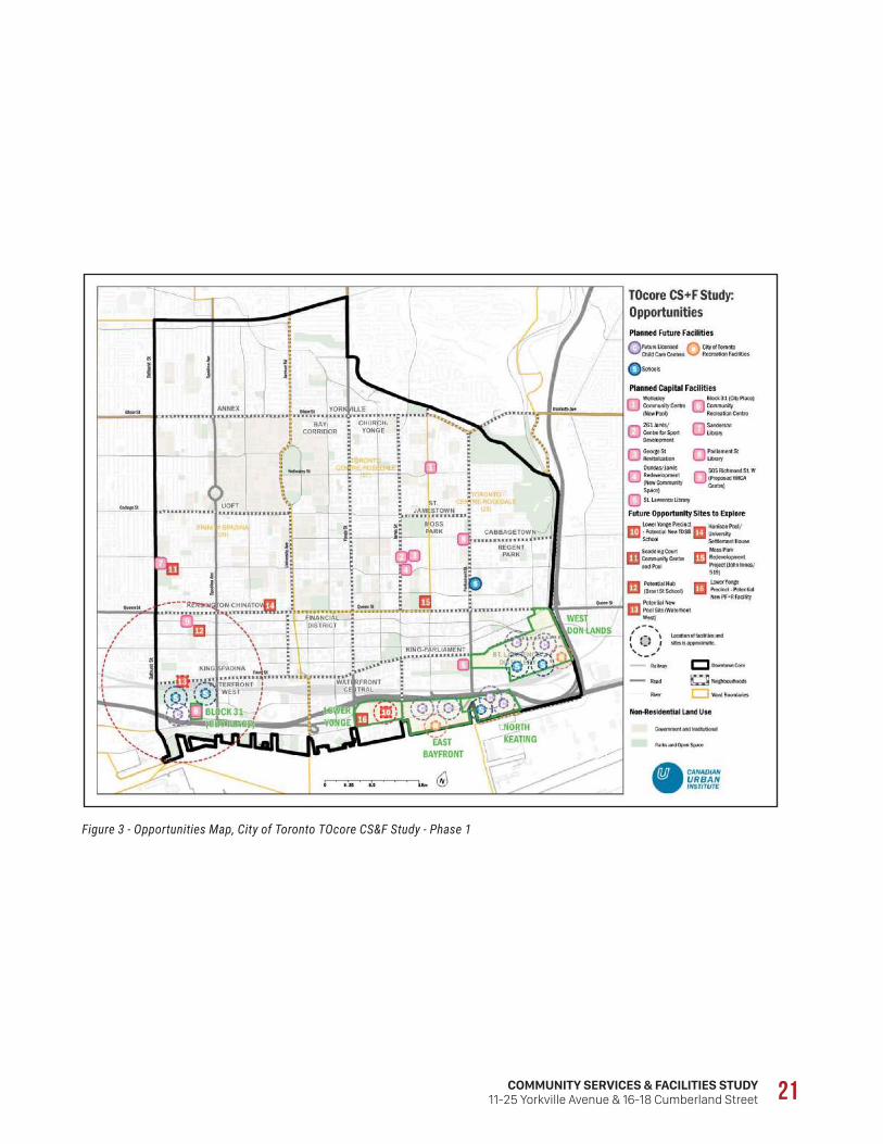
COMMUNITY SERVICES & FACILITIES STUDY11-25 Yorkville Avenue & 16-18 Cumberland Street 21
Figure 3 - Opportunities Map, City of Toronto TOcore CS&F Study - Phase 1

22
and subsequent public consultations.
The report indicates that the existing community services and facilities are being strained. The different service sectors (i.e. libraries, community recreation etc.) are constrained by land values, rent, and space availability and accessibility. As seen in Figure A4, the map from the Phase 1 report has been updated and modified. The City identified three areas that are priority areas for CS&F opportunities. These overlays encompass the Yorkville neighbourhood north of Bloor Street, the Bay Corridor, the Wellesley Church-Yonge neighbourhood and the King-Spadina neighbourhood. As it pertains to the Subject Site, it is within an identified CS&F opportunity area. The report recognizes the need for an improved framework for delivering and coordinating growth-related community services and facilities.
4 . 4 P R O P O S E D D O W N T O W N P L A N , I N F R A S T R U C T U R E S T R A T E G I E S
A total of five infrastructure-related strategies were released as part of the proposed Downtown Plan. According to the City of Toronto, the purpose of these Infrastructure Strategies is to:
• Set priorities for the infrastructure investment needed to support growth;
• Provide a vision, ideas and guidance for implementation; and
• Promote coordination among corporate and community partners throughout implementation.
Furthermore, the Infrastructure Strategies will,
• Identify infrastructure challenges facing a growing Downtown
• Recommend implementation strategies and actions,
• Advance related initiatives,
• Set timeframes, and
• Determine required investments.
The City has released summary documents that speak to the five Infrastructure Strategies. With regards to Community Services and Facilities, the summary indicates that the summary will identify the facilities required to deliver recreation, child care, libraries, schools and human services to communities and people of all ages and abilities; link the provision of these facilities and services to demographic change and the growing population of residents and workers in the Downtown; and support the goal of achieving complete communities Downtown that are healthy, liveable, safe and accessible.
The proposed Downtown Plan was released in draft in August 2017 and is currently undergoing consultation and review.

COMMUNITY SERVICES & FACILITIES STUDY11-25 Yorkville Avenue & 16-18 Cumberland Street 23
Figure 4 - Community Services and Facilities - Opportunities, City of Toronto TOcore Proposals Report, 2016

24

COMMUNITY SERVICES & FACILITIES STUDY11-25 Yorkville Avenue & 16-18 Cumberland Street 25
[5.0] COMMUNITY SERVICES &
FACILITIES

26
5.1 SchoolsTable 15 outlines the capacities, enrolments and utilization rates for schools within the catchment area for both the Toronto District School Board (TDSB) and Toronto Catholic District School Board (TCDSB). Contact with the School Boards was made in February 2018. In addition to school data, staff provided the yield factor/ pupil yield figures for the proposed development based on a total of 716 residential units.
Table 15 - TDSB and TCDSB Capacity and Enrolment
CapacityFull-Time
Enrolment
Utilization
RatePortables
Public Elementary School
Jesse Ketchum Jr & Sr PS 603 483 80.1% 1
Jarvis Collegiate Institute 1095 696 63.56% 0
Total 1698 1179 71.83% 1
Public Secondary School
Central Technical School 2931 1134.79 38.72% 0
Northern Secondary School 1785 1784.86 99.99% 0
Total 4716 29,19.65 69.35% 0
Catholic Elementary School
Our Lady of Lourdes (JK-8) 683 581 85.1% 0
Total 683 581 85.1% 0
Catholic Secondary School
St. Mary’s (9-12) 714 641 89.8% 0
St. Patrick Catholic (9-12) 1152 691 60.0% 0
Marshall McLuhan (9-12) 969 1059 109.1% 0
Total 2,835 2,389 84.3% 0
There are two public elementary schools serving the subject site; Jesse Ketchum Jr & Sr PS and Jarvis Collegiate Institute, both of which are operating under capacity (80.1 percent and 63.6%, respectively) and are able to accommodate additional students. With respect to secondary schools, there two serving the subject site; Central Technical School and Northern Secondary School. Where Central Technical School is operating 61.2 percent under capacity, Northern Secondary School is operating at full capacity and may not be able to accommodate additional students.
There is only one Catholic elementary school serving the subject site, operating at a utilization rate of approximately 85 percent. There are three secondary Catholic schools serving the subject site, two of which are under capacity (89.8 and 60 percent full). In contrast, the third Secondary School (Marshall McLuhan) is approximately 9 percent over capacity and may not be able to accommodate additional students.
5 . 1 . 1 P U P I L Y I E L DThe TDSB and TCDSB have provided the appropriate multipliers to calculate the additional pupil yields from the proposed 716 unit development.

COMMUNITY SERVICES & FACILITIES STUDY11-25 Yorkville Avenue & 16-18 Cumberland Street 27
P U P I L Y I E L D O F P R O P O S E D D E V E L O P M E N T - T D S B
Elementary: 6 pupils (Based on a pupil yield of 0.01)
Secondary: 6 pupils (Based on a pupil yield of 0.01)
Based on the enrolment figures provided by the TDSB, the 12 projected students generated from the proposed development could be accommodated at the schools serving the subject site. The 6 projected elementary-aged students could enrol at either Jesse Ketchum Junior and Senior Public School (120 available student spaces) or Jarvis Collegiate Institute (399 available student spaces).
Similarly, the estimated 6 secondary students could enrol at Central Technical School, as it was reported to have 1,796 available student spaces.
P U P I L Y I E L D O F P R O P O S E D D E V E L O P M E N T - T C D S B
Elementary: 8 pupils (Figure supplied by TCDSB)
Secondary: 4 pupil (Figure supplied by TCDSB)
The TCDSB anticipates 12 Catholic Students to be generated from the proposed development, all of which could be accommodated by the schools identified in Table 15. The 8 elementary-aged students could attend Our Lady of Lourdes Catholic Elementary School, which is operating approximately 15 percent below capacity. Likewise, the 4 secondary students could be accommodated at two of the three Secondary Catholic schools presented in Table 15. St. Mary’s was reported to have 73 student spaces available and St. Patrick Catholic was reported to have 461 available spaces.
In light of the conclusions drawn from the above analysis, it is noted that it has not been determined if potential students from this development will attend the schools listed in Table 15. This level of detail will occur later in the application review process, when the TDSB and TCDSB determine where prospective students will attend school. Furthermore, considering that school statistics change year by year, it is possible that by the time the proposed development is fully realized, capacity and available student spaces may change from what is reported in this CSF.
5.2 Child Care ServicesTable 16 provides a listing of City of Toronto child care services located within, or directly adjacent to, the Study Area, including overall capacity and reported vacancies. There are a total of 10 child care facilities, 7 of which provide subsidized spaces, if available. Child Care providers were called in February 2018.

28
Table 16 - Enrolment/Reported Vacancies within Study Area
Facility Enrolment / Reported Vacant
Fe
e S
ub
sid
y A
va
ila
ble
Infa
nt
(0 t
o 1
8 m
on
ths)
Tod
dle
r
(18
mo
nth
s to
2.5
ye
ars
)
Pre
-sc
ho
ol
(2.5
to
5 y
ea
rs)
Sc
ho
ol A
ge
(6 t
o 1
2 y
ea
rs)
Total
Annex Montessori School
427 Bloor St. W.*N
Capacity - 10 24 - 34
Vacancy - - - - 0
Dr. Eric Jackman Institute
of Child Study Laboratory
School Nursery
45 Walmer Rd.
N
Capacity - - 20 - 20
Vacancy- - 5 - 5
Friends Day Care Centre60 Lowther Ave.* Y
Capacity - - 24 - 24
Vacancy - - - - 0
Hestor How Day Care Centre100 Queen St. W. Y
Capacity 12 20 44 - 76
Vacancy - - - - 0
Jesse Ketchum Satellite Early Learning & Child Care Centre61 Davenport Rd.
Y
Capacity - - - 40 40
Vacancy- - - 4 4
Mothercraft: Toronto Eaton Centre14 Trinity Sq.
YCapacity 10 10 32 80 132
Vacancy
Queen’s Park Child Care Centre 900 Bay St.
YCapacity 10 30 40 - 80
Vacancy - - - 0
Ryerson Early Learning Centre *350 Victoria St.
YCapacity - 25 40 - 65
Vacancy - - - - 0
Taddle Creek Montessori School 39 Spadina Rd.
NCapacity - - - 84 84
Vacancy - - - - 0
University of Toronto Early Learning Centre - OISE 252 Bloor St. W.
YCapacity - 10 16 - 26
Vacancy - - - - 0
*Child care facility could not be reached, so zero spaces assumedTotal Capacity 581
Total Vacancy 9
There are a total of 581 child care spaces within and immediately adjacent to the Study Area. The distribution of those spaces are as follows: infant, 32 (5.5 percent); toddler, 105 (18 percent); pre-school, 240 (41 percent); and school age, 204 (35 percent). It is a notable gap that the area has less infant and toddler spaces than the other age groups.

COMMUNITY SERVICES & FACILITIES STUDY11-25 Yorkville Avenue & 16-18 Cumberland Street 29
As of Feburary 2018, there were a reported 9 child care spaces available, all of which were for the pre-school and school aged children. Child Care centres that had capacity for infants and toddlers were full, or could not be reached.
5 . 2 . 1 P R O J E C T E D C H I L D C A R E Y I E L DIt is estimated that the proposed 716 units may generate the demand for approximately 21 (20.8) child care spaces. This is based on a residential population increase of 1,074 people (716 units multiplied by 1.5, the average household size in the Study Area), of which 6 percent (or 64.5) would be “Children” as shown in the City of Toronto’s Neighbourhood profile (“Children are aged 0-14). The projected number of children is then multiplied by the women’s labour force participation rate in the Toronto CMA - 63.1 percent. A further multiplier of 50 percent is used to approximate the number of children needing care at a child care centre. This is the level of service standard set out by the City’s Children’s Services Division and is consistently applied to development applications.
5 . 2 . 2 A N A L Y S I SThe projected number of children generated from the proposed development requiring child care (21 children) may not be fully accommodated by the existing facilities serving the area. It is unknown at this time the age of those children, although the Study Area has a notable gap in the availability of Infant and Toddler spaces. As previously mentioned, the Study Area contains proportionally more spaces for pre-school and school aged children.
The above analysis was based on limited contact with child care facilities within the Study Area, as not all could be reached. As such, additional vacancies may become available during the review of this application.
5.3 Public LibrariesThere are three public libraries within the Study Area. A brief description of the services and programs offered at each location is provided below:
City Hall (Neighbourhood Branch)
Located at 100 Nathan Phillips Square, City Hall is open Monday through Friday from 10am to 6pm, and offers seating for 50. This branch features 9 computer work stations that are connected to the internet and include Microsoft Office, wi-fi, and equipment for persons with disabilities. Collections include:
• Audiobooks on CD
• Large print collection
• Small collection in Chinese, and French-Audit (DVDs Only)
Some of the programs and classes at the branch scheduled on a recurring basis in the upcoming months include: Family Time: Ready for Reading events, Children’s programs, and Book Clubs.

30
Spadina Road (Neighbourhood Branch)
Located at 10 Spadina Road, the Spadina Road branch is open Monday through Saturday and offers seating for 32. This branch features 4 computer work stations that are connected to the internet and include Microsoft Office, wi-fi, and equipment for persons with disabilities. Collections include:
• Audiobooks on CD
• Adult Literacy Material
• Special Collections:Native People’s Resource Collection
• Small collection in French-Audit (DVDs Only)
Some of the programs and classes at the branch scheduled on a recurring basis in the upcoming months include: Family Time: Ready for Reading
events, Children’s programs, and Book Clubs.
Toronto Reference Library
Located at 789 Yonge Street, The Toronto Reference Library is the largest public library in Toronto, and offers an extensive collection of material including different language, mapping, history, and news resources. Not only is there an extensive collection of material available of the Toronto Reference Library, there is also a large amount of equipment for persons with varying disabilities, providing assessibility and aid.
This location is open everyday, differing in hours between weekdays and weekends. From Monday through Friday, the library is open from 9am to 8:30pm, Saturdays from 9am to 5pm, and Sundays from 1:30pm to 5pm. Available at the Toronto Reference library, are 40 computer work stations that are connected to the internet, and equipped with Microsoft Office. Wifi is also available, along with seating for 1,250. This location can also be used as a meeting space for 15 people with a room available for reservation that is equipped with a flip chart stand, table and chairs, and a whiteboard.

COMMUNITY SERVICES & FACILITIES STUDY11-25 Yorkville Avenue & 16-18 Cumberland Street 31
5.4 RecreationAlthough there are no recreation centres located directly within the Study Area, noted in this report are the three Recreation centres that are within close proximity to the Study Area boundaries. Table 17 below summarizes these recreation centres.
Table 17 - Community Recreation Centres within Study Area
Location Facilities Services/Programs
Harrison Pool
15 Stephanie St.
• Dressing Room
• Indoor Pool
• Swimming
John Innes Community Recreation
150 Sherbourne St.
• Craft Room
• Dance Studio
• Fitness/Weight Room
• Games Room
• Gynasium
• Indoor Pool
• Kitchen
• Lounge
• Multipurpose Room
• Preschool
• Crafts
• Child Dance Classes,
• Cooking Classes
• Adult Fitness Classes
• Various Sports Programs
• Swimming classes
• Drop-In Sport and Fitness programs
• Drop-In Games Nights
Wellesley Community Centre
495 Sherbourne St.
• Fitness/Weight Room
• Kitchen
• Gynasium
• Lounge
• Multipurpose Room
• Arts/ Crafts
• Child/Youth Dance
• Early Child Music
• Adult Fitness Classes
• Youth Cooking Classes
• Various sports Programs
• Drop in Sport and Fitness programs
• Drop-in Games Night

32
5.5 ParksTable 18 below lists the parks and their available amenities within the Study Area.
Table 18 - Parks and Amenities within the Study Area (City of Toronto)
Off
-Le
as
h A
rea
Pla
yg
rou
nd
Sp
las
h P
ad
Bo
cc
e C
ou
rt
Wa
din
g P
oo
l
Ba
se
ba
ll D
iam
on
d
Dri
nk
ing
Fo
un
tain
Ten
nis
Pic
nic
Are
a
Are
a (
ha
)
Alexander Street Parkette X 0.14
Arena Gardens* X X 0.21
Barbara Hall Parks X X X X 0.71
Belmont Parkette 0.03
Bloor-Bedford Parkette* 0.04
Boswell Parkette* 0.01
East of Bay Park 0.41
Ed and Anne Mirvish Parkette 0.10
Frank Stollery Parkette 0.05
George Hislop Parkette X 0.24
Gwendolyn MacEwan Parkette 0.09
Huron Street Playground X X 0.21
James Canning Gardens X 0.15
Jay Macpherson Green 0.20
Jean Sibelius Square X X X 0.48
Jesse-Ketchum Park X 1.26
Joseph Burr Tyrell Park* X 1.12
Joseph Sheard Parkette 0.06
Larry Sefton Park X 0.33
Marlborough Place Parkette 0.14
McGill Parkette 0.20
Nathan Phillips Square X 5.15
Paul Kane House Parkette* 1.04
Paul Martel Park* 1.04
Queen’s Park 6.94
Ramsden Park X X X 5.54
Seaton Park 0.06
Sergeant Ryan Russell Parkette 0.22
Taddle Creek Park X 0.32
Town Hall Square 0.15
Vermont Square Park* X X X X X 1.14

COMMUNITY SERVICES & FACILITIES STUDY11-25 Yorkville Avenue & 16-18 Cumberland Street 33
Off
-Le
as
h A
rea
Pla
yg
rou
nd
Sp
las
h P
ad
Bo
cc
e C
ou
rt
Wa
din
g P
oo
l
Ba
se
ba
ll D
iam
on
d
Dri
nk
ing
Fo
un
tain
Ten
nis
Pic
nic
Are
a
Are
a (
ha
)
Village of Yorkville Park 0.36
Yonge Theatre Block Park 0.61
Total 28.75
* - The area of the park was calculated by Bousfields Inc. using Toronto Maps_v2 (www.toronto.ca)
X – Denotes the recreational facility and/or amenity.
Within the Study Area there a total of 33 parks and parkettes, of which 12 have at least a playground. Other amenities found within the parks inventory include drinking fountains, baseball diamonds, bocce courts, as well as off-leash and picnic areas.
5.6 Hospitals & Emergency ServicesWithin the Study Area, there are a total of 6 Hospitals. These hospitals include Holland Orthopaedic & Arthritic Centre, The Hospital for Sick Children (Sick Kid’s), the Salvation Army Toronto Grace Health Centre, St. Michael’s Hospital, Toronto General Hospital, and the Women’s College Hospital. A summary of each hospital is located below.
Holland Orthopaedic Centre at 43 Wellesley St E, is a branch of the Sunnybrook Health Sciences group of hospitals and specializes in orthopaedic, musculoskeletal and arthritic care and education. The centre’s major focus is on musculoskeletal injury, total joint replacement and major biological restoration.
The Hospital for Sick Children (Sick Kids) is located at 555 University Avenue. Affiliated with the University of Toronto, it is Canada’s most research-intensive hospital and the largest centre dedicated to improving children’s health in the country. As innovators in child health, Sick Kids improves the health of children by integrating care, research and teaching. In 2011/2012 Sick Kids saw more than 218,000 clinic, medical day care and diagnostic visits, nearly 63,000 emergency visits, and performed nearly 12,000 operating room cases
The Salvation Army Grace Health Centre, located at 650 Church St, is a 119-bed facility providing medically complex, specialized care and services to those individuals who require Complex Continuing Care, Post Acute Care Rehabilitation and Palliative Care.
St. Michael’s Hospital, located at 30 Bond Street, is a teaching and research hospital which also acts as downtown Toronto’s adult trauma centre, a hub for neurosurgery, complex cardiac and cardiovascular care, diabetes and osteoporosis care, minimally invasive surgery and care of the homeless and

34
disadvantaged. The hospital is fully affiliated with the University of Toronto, providing medical education to health-care professionals in more than 23 disciplines.
Toronto General Hospital (TGH), located at 200 Elizabeth Street, has numerous medical and surgical program specialties including heart disease, kidney disease, transplantation, eating disorders, tropical disease, women’s health, nephrology, immunodeficiency and psychiatry. The Emergency Department at TGH treats more than 26,000 patients each year.
Women’s College Hospital, located at 76 Grenville Street, advocates for the health of women, and improves healthcare options for all by developing, researching, teaching and delivering new treatments and models of integrated care. This hospital specialized in health care for women, with female specific programs such as osteoperosis, breast care, gynecology, prenatel and postpartum care, and women’s mental health.
In addition, there are also emergency services located within the Study Area include and includes Fire Stations 312, 314, and 344, Ambulance Service Station 45, and Police Service Station Headquarters.
5.7 Human ServicesAccording to the United Way and City of Toronto, there are 44 human service organizations operating within the Study Area. Table 19 outlines the title, type of services, and location of each of these human service organizations (some of which receive City funding).
Table 19 - Human Services located within the Study Area (City of Toronto)
Organization Address Service Category
416 Community Support
for Women
170 Bloor St. W. Suite 1006
Individual and group counselling for women 16 years and older dealing with both addiction and mental health issues
519 Community Centre 519 Church St. Multiservice centre offering social and recreation programs and group meetings for all ages
Aboriginal Housing
Support Centre
106 Edward St. Centre providing assistance in applying for social housing for Aboriginal residents, with priority given to Aboriginal persons with low or moderate incomes at risk of losing their housing
Big Brothers Big Sisters of
Toronto
61 Davenport Rd. Community-based mentoring program that matches youths with adult volunteer mentors to help the youth reach their potential
Canadian Centre for
Victims of Torture
194 Jarvis St.,
2nd Floor
Services include medical, mental health and social care as well as legal help, crisis intervention, interpretation and settlement services
Catholic Children’s Aid
Society
26 Maitland St. Child protection services for catholic children under 16 years and their families

COMMUNITY SERVICES & FACILITIES STUDY11-25 Yorkville Avenue & 16-18 Cumberland Street 35
Central Toronto Youth
Services
65 Wellesley St. E.
Suite 300
Mental health centre for youth 13-24 years with serious mental health illness (primarily psychotic disorders)
Children’s Aid Society of
Toronto
30 Isabella St. Family counselling and supervision, and child protection services for children 16 and under and their families
Community Living Toronto 20 Spadina Rd. Day programs, family support and other services for children, youth and adults with developmental disabilities
Corsage Project 25 Spadina Rd. For young women graduating from highs school with limited financial resources. Distributes donated formal gowns for high school prom
Covenant House Toronto 20 Gerrard St. E Non-profit registered charity offering youth aged 16-24 years residing in shelters job search strategies, and business clothing
Developmental Services
Ontario
2 Surrey Pl. Centre for adults 18 and older with a developmental disability who are not currently receiving development services
Elizabeth Fry Toronto 444 Yonge St., College Park
2nd Floor
A safe space for women to develop
skills and supports women who are,
have been, or are at risk of coming into
conflict with the law
Family Service Ontario 138 Pears Ave Non-profit, registered charity that
works with individuals and families
to achieve greater resilience and
stability in more just and supportive
communities
Fred Victor 210 Dundas St. W. Community mental health organization offering support services for persons 16 years and older with severe mental health problems and their families
Good Neighbour’s Club 170 Jarvis St. Drop in centre for men 50 years and over. Services include congregate meals, emergency clothing, shower and laundry facilities, hospital and home visiting, client intervention and assistance, counselling, and limited escort to medical appointments.
Hincks-Dellcrest Centre 440 Jarvis St. Mental health centre with in-home, outpatient and residential services for children, youth and their families. Also rural program, mobile family resource centre, and support for families with newborns or expecting a child
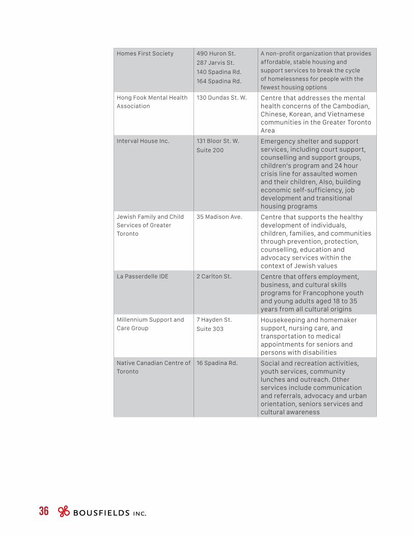
36
Homes First Society 490 Huron St.
287 Jarvis St.
140 Spadina Rd.
164 Spadina Rd.
A non-profit organization that provides
affordable, stable housing and
support services to break the cycle
of homelessness for people with the
fewest housing options
Hong Fook Mental Health
Association
130 Dundas St. W. Centre that addresses the mental health concerns of the Cambodian, Chinese, Korean, and Vietnamese communities in the Greater Toronto Area
Interval House Inc. 131 Bloor St. W.
Suite 200
Emergency shelter and support services, including court support, counselling and support groups, children’s program and 24 hour crisis line for assaulted women and their children, Also, building economic self-sufficiency, job development and transitional housing programs
Jewish Family and Child
Services of Greater
Toronto
35 Madison Ave. Centre that supports the healthy development of individuals, children, families, and communities through prevention, protection, counselling, education and advocacy services within the context of Jewish values
La Passerdelle IDE 2 Carlton St. Centre that offers employment, business, and cultural skills programs for Francophone youth and young adults aged 18 to 35 years from all cultural origins
Millennium Support and
Care Group
7 Hayden St.
Suite 303
Housekeeping and homemaker support, nursing care, and transportation to medical appointments for seniors and persons with disabilities
Native Canadian Centre of
Toronto
16 Spadina Rd. Social and recreation activities, youth services, community lunches and outreach. Other services include communication and referrals, advocacy and urban orientation, seniors services and cultural awareness

COMMUNITY SERVICES & FACILITIES STUDY11-25 Yorkville Avenue & 16-18 Cumberland Street 37
Native Child and Family
Services of Toronto
30 College St. Provides a range of services with a focus on children, youth and families for all self-declared Native people, including family violence treatment and prevention, individual an family counselling, caregiver and child program, teaching circles and traditional healing.
Ontario Institute for
Studies in Education of
the University of Toronto
252 Bloor St. W.
Room 7-296
Therapeutic services for adults, adolescents with interpersonal, emotional, or learning problems and children with learning and/or academic and/or social and emotional problems
Employment Ontario 625 Church St.
1st Floor
Support for new apprentices for persons 16 years or older with a minimum of Grade 10 education
Oolagen Youth Mental
Health
591 Huron St. Emotional counselling for young men and women 13-18 years who require residential treatment
Planned Parenthood of
Toronto
36B Prince Arthur Ave.
Community health centre providing primary and sexual health care services to youth 13 to 29 years.
Progress Place 576 Church St. Community -based psychosocial rehabilitation centre for adults aged 18-65 with significant mental health problems
Salvation Army 78 Admiral Rd.
160 Jarvis St.
Residential and day treatment centre assessment plus 9 week treatment program for women 18 years and older who are alcohol and chemical dependent including those using methodone
Social Planning Toronto 2 Carlton St.
Suite 1001
Conducts policy research and analysis to improve the quality of life of all residents of Toronto, focusing on the non-profit community services sector
St. Alban’s Boys and Girls
Club
843 Palmerston Ave. Social and recreation programs day camps, after school clubs, homework clubs, computer clubs, substance abuse prevention, leadership training, literacy
Toronto Community
Hostel
344 Bloor St. W.
Suite 402
191 Spadina Rd.,
Emergency shelter and settlement services for homeless singles, families and refugees

38
Toronto Drug Treatment
Court
60 Queen St. W. Non-violent adult offenders who are dependent on drugs and have charged with minor property crimes or prostitution
Toronto Mental Health and
Addiction Access Point
661 Yonge St. 4th Floor
Coordinated intake for intensive case management, assertive community treatment teams, early psychosis intervention, and supportive housing for individuals 14 years and older that live within the City of Toronto
Transition House Inc. 162 Madison Ave. Short term supportive residential centre for men 16 years and over coping with an addiction, including life skills, recreation and social programs
Trinity Square Cafe 10 Trinity Sq. A community-based recovery program through employability and interpersonal skills development offered to people 18 years and older living with mental illness
Turning Point Youth
Services
95 Wellesley St. E. Residential and nonresidential programs and services for youth 12-18 years with social, emotional, and behavioral difficulties, and their families
Yellow Brick Road Holistic
Center
258 Dupont St. Holistic health services specializing in Colonic hydrotherapy and detoxification
YMCA of Greater Toronto 20 Grosvenor St.
3rd Floor
YMCA branch that offers immigrant services for youth aged 13-24 years. Provides settlement information
Youth in Motion 20 Queen St. W.
suite 1000
Offers Motivational career and educational programs and mentorship programs for young women and men 16 to 30 years
Youthdale Treatment
Centre
227 Victoria St. Residential treatment centres in various locations for youth 12-18 years with motional, behavioral, and adjustment difficulties
YWCA Toronto 87 Elm St. Multiservice organization for all women, and girls, with programs in three areas - Girls and Family programs, Employment and training, housing and support
5.8 Places of WorshipThere are a total of 33 Places of Worship within the Study Area. As seen in Table 20, a majority of the facilities cater to the Christian Faith but there are locations for Catholic, Buddhist, Muslim, Bahai, and Hindu community members as well.

COMMUNITY SERVICES & FACILITIES STUDY11-25 Yorkville Avenue & 16-18 Cumberland Street 39
Table 20 - Places of Worship in the Study Area (City of Toronto)
Places of Worship Faith Address
Anglican Church House Christian 28 Ted Rogers Way
Anglican Church of Canada Christian 227 Bloor St. E.
Bloor St. United Church Christian 300 Bloor St. W.
Christian Science Committee Christian 204 St. George St.
Church of Messiah Christian 240 Avenue Rd.
Church of the Holy Trinity Christian 10 Trinity Sq.
Church of the Redeemer Christian 162 Bloor St. W.
Church Scientology Scientology 696 Yonge St.
Covenant Christian Church Christian 455 Huron St.
Dharma Friends Buddhist 177 Mutual St.
Downtown Mosque Muslim 100 Bond St.
First Church of Christ Christian 196 St. George St.
First Luteheran Church Christian 116 Bond St.
International Society for Hare
Krishn
Hindu 243 Avenue Rd.
The Islamic Centre Muslim 98 Bond St.
Metropolitan United Church Christian 56 Queen St. E.
Nalanda College of Buddhist
Studies
Buddhist 47 Queen’s Park Cres. E.
Nalandabodhi Toronto Study
Group
Buddhist 55 Maitland St.
New Apostolic Church Christian 407 Dupont St.
Sanctuary Christian 23 Charles St. E.
St. Alban the Martyr Christian 112 Howland Ave.
St. Andrew’s United Church Christian 117 Bloor St. E.
St. Basils Church Christian 50 St. Joseph St.
St. George’s Greek Orthodox
Church
Orthodox 115 Bond St.
St. Michael’s Roman Catholic Catholic 200 Church St.
Stone Church Pontecostal Christian 45A Davenport Rd.
Tengye Ling Tibetan Temple Buddhist 11 Madison Ave.
The Jesuits of Upper Canada Catholic 1323 Bay St.
Theravada Buddhist Community Buddhist 316 Dupont St.
Toronto Bahai Centre Bahai 288 Bloor St. W.
Toronto Christadelphians Christian 728 Church St.
Toronto Diamond Way Buddhist
Center
Buddhist 25 St. Nicholas St.
Toronto Monthly Meeting Christian 60 Lowther Ave.
Walmer Road Baptist Church Christian 38 Walmer Rd.

40

COMMUNITY SERVICES & FACILITIES STUDY11-25 Yorkville Avenue & 16-18 Cumberland Street 41
[6.0] CONCLUSION

42
Neighbourhood Demographics
The Demographic Area had a population of 87,685 in 2016. This figure is higher than what was reported for 2011, which represents a net population growth of 21 percent. With respect to demographics, Working Age residents accounted for the majority of the population (53 percent), and Couples with Children were the most common familial structure in the Area. Private households in the Neighbourhoods were commonly occupied by two persons. In 2016, the average household size in the Area was 1.5 persons, which is lower than the City of Toronto average.
Dwellings in the Area are mostly located in Apartments greater than 5 storeys (81 percent), followed by Apartments less than 5 storeys (13 percent). Low-rise built forms, which includes single-detached, semi-detached, row and detached duplexes, were less common in the Area (6 percent).
After-tax, households in the Demographic Area were earning approximately $68,077 in 2011, which is slightly lower than the City-wide figure. With respect to education, the vast marry of the Area has completed a post-secondary certificate, diploma or degree, and almost 70 percent of the Area (over the age of 15) is participating in the labour force. Lastly, in according to the 2011 Census, the majority of immigrants within the Demographic Area were born in Canada, or had arrived before 2001.
Nearby Development Activity
There were 16 proposed and/or approved developments within the area surrounding the subject site. Of those, 3 have been approved, 6 are under construction or built and 7 are under review by Staff or before the Ontario Municipal Board.
The estimated population generated from the proposed/approved developments was approximately 10,590 persons. This was determined by multiplying the total unit count by the average household size for the Downtown (1.71 persons). When the same multiplier was applied to the proposed development, the estimated number of residents was calculated to be 1,225 persons. It is important to note that as a preliminary calculation, total unit count was used and not unit type. As such, the estimated population for the immediate area, based on the developments listed in Table 13 is 11,815 persons.
Considering that the applications/approvals are at various stages of the planning process, the increase in local population may occur incrementally. It cannot be determined at this time the degree of impact these proposals / approvals may have on the local community services and facilities. The demographic make-up of this population is unknown, as is the number of residents which will require accommodation from either child care facilities or the school boards. However, the City has identified the Yonge/Yorkville area as a priority area for CS&F opportunities (see Section 4.0).
Community Services and Facilities
In terms of school accommodation, the projected 12 public school students that are expected to result from the proposed development can be accommodated at both the elementary and Secondary serving the subject

COMMUNITY SERVICES & FACILITIES STUDY11-25 Yorkville Avenue & 16-18 Cumberland Street 43
site. With respect to TCDSB schools, the projected 12 catholic school students expected to result from the proposed development may also be accommodated within the Catholic schools serving the Subject Site, with the exception of Marshall McLuhan Secondary School, which is currently over capacity by roughly 10 percent. It is important to note that these conclusions are based on the data provided by TDSB and TCSDB staff. The school boards will determined at a later date if students from the proposed development will/can attend the schools listed in this report.
There are a total of 10 childcare facilities within the Study Area, 7 of which provide subsidized spaces (if available). This development is expected to produce an estimated 21 children who may require childcare. Based on the information collected from the near-by child care providers, the projected demand could exceed the current available spaces of facilities within the Study Area. According to staff, there are currently a total of 9 vacancies, 5 in the pre-school and 4 in the school age cohorts.
The City Hall, Spadina Road and Toronto Reference Library public library branches are located within the boundaries of the Study Area. Each site has computer work stations (with Internet) and equipment for persons with disabilities. Since the Toronto Reference Library is one of the largest public libraries in Toronto, it offers an extensive collection of materials and has enough seating for 1,250 persons.
There are no recreation centres located directly within the Study Area, however, considering the site’s location, there are three community recreation centres that are operated by the City of Toronto just outside of the boundaries, the Harrison Pool, John Innes Community Recreation, and Wellesley Community Centre. Each location contains facilities and programs suitable for creative, sports and fitness, and child care uses.
There are a total of 33 parks and parkettes located within the Study Area, which totals approximately 28.75 hectares of green space. Popular park amenities that can be found in most of these parks include Playgrounds, Drinking Fountains, and Baseball Diamonds.
In terms of health care, there are a total of 6 hospitals located within the Study Area, of which, two specialize in particular disciplines (The Hospital for Sick Children (Sick Kid’s) and the Women’s College Hospital). In addition to the 6 hospitals, there are also emergency services including fire stations, ambulance service stations and the Police Service Headquarters.
There are a total of 43 human service providers that operate within the Study Area, some of which operating at multiple locations. Generally, these providers offered social, health, and employment services. There are a total of 34 Places of Worship, with most locations catering to the Christian Faith, but other locations offering service for Catholic, Buddhist, Muslim, Bahai, and Hindu communities.
Conclusion
Based on the existing community services and facilities summarized above, the proposed development may not pose a significant strain on the community services and facilities in the Study Area. The TDSB and TCDSB schools serving the subject site may be able to enrol the elementary and

44
secondary students produced by the development. With respect to child care, there is an existing service gap in the availability of Infant and Toddler spaces in the Study Area. Of the child care centres that could be reached, the available spaces were for pre-school and school aged children.
The potential impacts that the proposed development, in combination of the adjacent developments, may have on the local community services and facilities is unknown. The growth of the Downtown is recognized by the City, and policies and guidelines have been proposed to facilities new ways in which to expand and improve community service and facility creation, distribution and access in the Downtown area (see Section 3).

COMMUNITY SERVICES & FACILITIES STUDY | 11-25 Yorkville Avenue & 16-18 Cumberland Street 45
SCHOOLS
CHILD CARE SERVICES
LIBRARIES
RECREATION
PARKS
HOSPITALS
1. Jesse Ketchum Jr & Sr PS2. Jarvis Collegiate Institute3. Central Technical School4. Northern Secondary School5. Our Lady of Lourdes6. St. Mary’s7. St. Patrick Catholic8. Marshall McLuhan
1. Annex Montessori School2. Dr. Eric Jackman Institute of Child Study
Laboratory School Nursery3. Friends Day Care Centre4. Hestor How Day Care Centre5. Jesse Ketchum Satellite Early Learning &
Child Care Centre6. Mothercraft: Toronto Eaton Centre7. Queen’s Park Child Care Centre8. Ryerson Early Learning Centre 9. Taddle Creek Montessori School 10. University of Toronto Early Learning Centre
- OISE
1. City Hall2. Spadina Road3. Toronto Reference Library
1. Harrison Pool2. John Innes Community Recreation3. Wellesley Community Centre
1. Alexander Street Parkette2. Arena Gardens3. Barbara Hall Parks4. Belmont Parkette5. Bloor-Bedford Parkette6. Boswell Parkette7. East of Bay Park8. Ed and Anne Mirvish Parkette9. Frank Stollery Parkette10. George Hislop Parkette11. Gwendolyn MacEwan Parkette12. Huron Street Playground13. James Canning Gardens14. Jay Macpherson Green15. Jean Sibelius Square16. Jesse-Ketchum Park17. Joseph Burr Tyrell Park18. Joseph Sheard Parkette19. Larry Sefton Park20. Marlborough Place Parkette21. McGill Parkette22. Nathan Phillips Square23. Paul Kane House Parkette24. Paul Martel Park25. Queen’s Park26. Ramsden Park27. Seaton Park28. Sergeant Ryan Russell Parkette29. Taddle Creek Park30. Town Hall Square 31. Vermont Square Park32. Village of Yorkville Park33. Yonge Theatre Block Park
1. Holland Orthopaedic2. The Hospital for Sick Children3. The Salvation Army Grace Health Centre4. St. Michael’s Hospital5. Toronto General Hospital6. Women’s College Hospital
1. Anglican Church House2. Anglican Church of Canada3. Bloor St. United Church4. Christian Science Committee5. Church of Messiah6. Church of the Holy Trinity7. Church of the Redeemer8. Church Scientology9. Covenant Christian Church10. Dharma Friends11. Downtown Mosque12. First Church of Christ13. First Luteheran Church14. International Society for Hare Krishn15. The Islamic Centre16. Metropolitan United Church17. Nalanda College of Buddhist Studies18. Nalandabodhi Toronto Study Group19. New Apostolic Church20. Sanctuary21. St. Alban the Martyr22. St. Andrew’s United Church23. St. Basils Church24. St. George’s Greek Orthodox Church25. St. Michael’s Roman Catholic 26. Stone Church Pontecostal27. Tengye Ling Tibetan Temple28. The Jesuits of Upper Canada29. Theravada Buddhist Community30. Toronto Bahai Centre31. Toronto Christadelphians32. Toronto Diamond Way Buddhist Center33. Toronto Monthly Meeting34. Walmer Road Baptist Church
HUMAN SERVICES1. 416 Community Support for Women2. 519 Community Centre3. Aboriginal Housing Support Centre4. Big Brothres Big Sisters of Toronto5. Canadian Centre for Victims of Torture6. Catholic Children’s Aid Society7. Central Toronto Youth Services8. Children’s Aid Society of Toronto9. Community Living Toronto10. Corsage Project11. Covenant House Toronto12. Developmental Services Ontario13. Elizabeth Fry Toronto14. Family Service Ontario15. Fred Victor16. Good Neighbour’s Club17. Hincks-Dellcrest Centre18. Homes First Society19. Hong Fook Mental Health Association20. Interval House Inc. 21. Jewish Family and Child Services of Greater
Toronto22. La Passerdelle IDE23. Millenium Support and Care Group24. Native Canadian Centre of Toronto25. Native Child and Family Services of Toronto26. Ontario Institute for Studies in Education of
the University of Toronto27. Employment Ontario28. Oolagen Youth Mental Health29. Planned Parenthood of Toronto30. Progress Place31. Salvation Army32. Social Planning Toronto33. St. Alban’s Boys and Girls Club 34. Toronto Community Hostel35. Toronto Drug Treatment Court36. Toronto Mental Health and Addiction Access
Point37. Transition House Inc.38. Trinity Square Cafe39. Turning Point Youth Services40. Yellow Brick Road Holistic Center41. YMCA of Greater Toronto42. Youth in Motion43. Youthdale Treatement Centre44. YWCA Toronto
SURROUNDING DEVELOPMENTS1. 21 Avenue Road2. 80 Bloor Street3. 2 Bloor Street West4. 1 Bloor Street West5. 1 Bloor Street East6. 50 Bloor Street West7. 100 Davenport Road8. 34 Hazelton Avenue9. 126 Hazelton Avenue10. 48 Scollard Street11. 874 Yonge Street
12. 771 Yonge Street13. 140 Yorkville Avenue14. 1 Yorkville Avenue15. 2-8 Cumberland
Street16. 50 Cumberland
Street
PLACES OF WORSHIP
1.
2.
3.
1.
3.
2.
5.
4.
1.
4.8.
3.
6.
2.
5.
7.
1.
2.
3.
5.
9.10.
4.
6.
7.
8.
1.
22.
20.
7.
9.
32.
30.
12.
33.
31.
29.
27.
8.
23.
2.
26.28.
10.
11.
13.
18.
17.
15.
24.
4.
34.
5.
19.
21.
14.
6.
16.25.
3.
1.
23.
7.
11.
3.13.
10.
6.
20.
26.
16.
32.
25.
14.28.
5.
29.
12.
24.
17.
27.
15.
31.
8.
4.
30. 9.
2.
33.
18.
21.
19.
22.
1.
2.
3.
1.
28.37.
40.
20.
23.
21.
7.
8.
30.
27.
36.
9.
33.
24.
34.
10. 18.26.
29.
31.
14.
4.
3.19.
38.
42.35.
15.
2.
17.39.
5.
16.43.
6.
12.
44.
11.
13.
22.32.25.
41.
1.
8.
9.
10. 11.
12.13.
14.
15.16.
5.6. 3.
7.
2.
4.
*

46