
Urban Planning for City Leaders - A Handbook for Kenya
159
URBAN PLANNING FOR CITY LEADERS A HANDBOOK FOR KENYA
-
Upload
khangminh22 -
Category
Documents
-
view
1 -
download
0
Transcript of Urban Planning for City Leaders - A Handbook for Kenya

United Nations Human Settlements Programme | P.O. Box 30030, Nairobi 00100, Kenya Tel: +254-20 7623075 | [email protected] | www.unhabitat.org
HS/068/18 ISBN (Volume): 978-92-1-132812-7
Urban Planning for City Leaders - A handbook for Kenya is a valuable source of information, inspiration and ideas on urban planning that is designed for city leaders and decision makers at a critical moment in human history. Globally, it is predicted population growth over the next 50 years will have immense consequences for cities, particularly intermediate cities with populations of up to two million people. Developed countries will need to double the amount of urban space they have by 2050 to accommodate the expected numbers of people, whereas developing countries will need to expand their urban space by more than 300 per cent. By 2050, Kenya’s urban population is projected to reach 44 million people, which will be close to half (46 percent) of the total country population, from an estimated current urban population of 13.8 million people.
Most cities will simply not be able to cope with the impact of population growth and other issues if they do not start preparing for them now. This means planning, designing, financing and implementing strategies for sustainable urban development, which involves: land use and urban form, affordable housing, mobility, water supply, energy, waste management, social and economic development, parks and open spaces, environmental management, community amenities, safety, climate change mitigation and adaptation, urban governance and much more. This handbook is a start towards making those strategies. It focuses on the key role that proactive integrated urban planning can have in shaping the future of a city and it outlines practical ways to create and implement a vision for a city that will better prepare it to cope with growth and change.
The handbook includes several “how to” sections on key aspects of urban planning, answers many of the questions that leaders are frequently asked, and features numerous examples of cities where urban planning made a significant, positive transformation.
Urban Planning for city leaders a handbook for kenya

Republic of Kenya
URBAN PLANNING FOR CITY LEADERS A HANDBOOK FOR KENYA

Urban Planning for City Leaders: A Handbook for Kenya UN-Habitat Support to Sustainable Urban Development in Kenya
Copyright © United Nations Human Settlements Programme 2018
All rights reservedUnited Nations Human Settlements Programme (UN-Habitat)P. O. Box 30030, 00100 Nairobi GPO KenyaTel: 254-020-7623120 (Central Office)www.unhabitat.org
HS/068/18 ISBN (Volume): 978-92-1-132812-7
Disclaimer The designations employed and the presentation of the material in this publication do not imply the expression of any opinion whatsoever on the part of the Secretariat of the United Nations concerning the legal status of any country, territory, city or area or of its authorities, or concerning the delimitation of its frontiers of boundaries. Views expressed in this publication do not necessarily reflect those of the United Nations Human Settlements Programme, Cities Alliance, the United Nations, or its Member States.
Excerpts may be reproduced without authorization, on condition that the source is indicated.
Principal Authors: C. Baraka Mwau and Ivan ThungContributors (UN-Habitat): Rosina Hawkins, Jiacong Ang, Gianluca Crispi, Yoel Siegel, Sharmaarke AbdullahiContributors (Government of Kenya): Solomon Ambwere and Ronald McGillProject Manager: Yuka TeradaProject Technical Advisor: Klas GrothProject Coordinator: Laura PetrellaProject Coordination Support-Regional Office for Africa: Thomas Chiramba and Jeremiah OugoAdministrative Assistance: Maryann KithomeDesign and Layout: Andrew Ondoo
Cover design by the United Nations Human Settlements Programme based on illustrations and graphics from Shutterstock.com and UN-Habitat/Student Design Competition for Kenya’s Towns. Team members: Alessandro Frigerio, Alessandra Sammartino, Pietro Bergamini, Pietro Manara, Mariachiara Anelli, Kenalois Murakaru Kinyua.
URBAN PLANNING FOR CITY LEADERS A HANDBOOK FOR KENYAii

TABLE OF CONTENTS
TABLE OF CONTENTSLIST OF BOXES, FIGURES & TABLES . . . . . . . . . . . . . . . . . . . . . . . . . . . . . . . . . . . . . . . . . . . . . . . . . . . . . . . . . . . . . . . . . . . . IV
TERMS USED IN THIS HANDBOOK . . . . . . . . . . . . . . . . . . . . . . . . . . . . . . . . . . . . . . . . . . . . . . . . . . . . . . . . . . . . . . . . . . . . . VI
INTRODUCTION . . . . . . . . . . . . . . . . . . . . . . . . . . . . . . . . . . . . . . . . . . . . . . . . . . . . . . . . . . . . . . . . . . . . . . . . . . . . . . . . . . . . . VIIIBackground and rationale . . . . . . . . . . . . . . . . . . . . . . . . . . . . . . . . . . . . . . . . . . . . . . . . . . . . . . . . . . . . . . . . . . . . . . . . . . . . . . . .viiiPurpose of the handbook . . . . . . . . . . . . . . . . . . . . . . . . . . . . . . . . . . . . . . . . . . . . . . . . . . . . . . . . . . . . . . . . . . . . . . . . . . . . . . . . .viiiStructure of the handbook . . . . . . . . . . . . . . . . . . . . . . . . . . . . . . . . . . . . . . . . . . . . . . . . . . . . . . . . . . . . . . . . . . . . . . . . . . . . . . . . . x
PART I. IMPORTANCE OF PLANNING AND UNDERSTANDING A PLANNING PROCESS . . . . . . . . . . . . . . .03SECTION 1 . WHY URBAN PLANNING . . . . . . . . . . . . . . . . . . . . . . . . . . . . . . . . . . . . . . . . . . . . . . . . . . . . . . . . . . . . . . . . . . . 04Understand urbanization trends . . . . . . . . . . . . . . . . . . . . . . . . . . . . . . . . . . . . . . . . . . . . . . . . . . . . . . . . . . . . . . . . . . . . . . . . . . . 06Harness urban opportunities and address challenges . . . . . . . . . . . . . . . . . . . . . . . . . . . . . . . . . . . . . . . . . . . . . . . . . . . . . . . . . . . 09How planning ensures leaders achieve policy goals . . . . . . . . . . . . . . . . . . . . . . . . . . . . . . . . . . . . . . . . . . . . . . . . . . . . . . . . . . . . 10Planning to achieve sustainable development goals and the new urban agenda . . . . . . . . . . . . . . . . . . . . . . . . . . . . . . . . . . . . . . 12Major obstacles to effective urban planning . . . . . . . . . . . . . . . . . . . . . . . . . . . . . . . . . . . . . . . . . . . . . . . . . . . . . . . . . . . . . . . . . . 13Thinking implementation from the start . . . . . . . . . . . . . . . . . . . . . . . . . . . . . . . . . . . . . . . . . . . . . . . . . . . . . . . . . . . . . . . . . . . . . 14
SECTION 2 . INSTITUTIONS AND PLANNING CONTEXT . . . . . . . . . . . . . . . . . . . . . . . . . . . . . . . . . . . . . . . . . . . . . . . . . . . 16Planning functions . . . . . . . . . . . . . . . . . . . . . . . . . . . . . . . . . . . . . . . . . . . . . . . . . . . . . . . . . . . . . . . . . . . . . . . . . . . . . . . . . . . . . 18Plans are made at different scales . . . . . . . . . . . . . . . . . . . . . . . . . . . . . . . . . . . . . . . . . . . . . . . . . . . . . . . . . . . . . . . . . . . . . . . . . 24Planning for existing built-up areas and new development areas . . . . . . . . . . . . . . . . . . . . . . . . . . . . . . . . . . . . . . . . . . . . . . . . . . 29Planning for new development areas. . . . . . . . . . . . . . . . . . . . . . . . . . . . . . . . . . . . . . . . . . . . . . . . . . . . . . . . . . . . . . . . . . . . . . . . 41
SECTION 3 . PLAN PREPARATION . . . . . . . . . . . . . . . . . . . . . . . . . . . . . . . . . . . . . . . . . . . . . . . . . . . . . . . . . . . . . . . . . . . . . . 46Typical planning process . . . . . . . . . . . . . . . . . . . . . . . . . . . . . . . . . . . . . . . . . . . . . . . . . . . . . . . . . . . . . . . . . . . . . . . . . . . . . . . . . 48
SECTION 4 . CROSS-CUTTING ISSUES IN PLANNING . . . . . . . . . . . . . . . . . . . . . . . . . . . . . . . . . . . . . . . . . . . . . . . . . . . . . 78Urban planning and gender . . . . . . . . . . . . . . . . . . . . . . . . . . . . . . . . . . . . . . . . . . . . . . . . . . . . . . . . . . . . . . . . . . . . . . . . . . . . . . 80Urban planning and youth . . . . . . . . . . . . . . . . . . . . . . . . . . . . . . . . . . . . . . . . . . . . . . . . . . . . . . . . . . . . . . . . . . . . . . . . . . . . . . . . 81Urban planning and human rights . . . . . . . . . . . . . . . . . . . . . . . . . . . . . . . . . . . . . . . . . . . . . . . . . . . . . . . . . . . . . . . . . . . . . . . . . . 81Urban planning and climate change . . . . . . . . . . . . . . . . . . . . . . . . . . . . . . . . . . . . . . . . . . . . . . . . . . . . . . . . . . . . . . . . . . . . . . . . 82Urban planning and disaster management. . . . . . . . . . . . . . . . . . . . . . . . . . . . . . . . . . . . . . . . . . . . . . . . . . . . . . . . . . . . . . . . . . . . 83
PART II. PLANNING TO ADDRESS SPECIFIC URBAN DEVELOPMENT ISSUES . . . . . . . . . . . . . . . . . . . . . . .85INTRODUCTION . . . . . . . . . . . . . . . . . . . . . . . . . . . . . . . . . . . . . . . . . . . . . . . . . . . . . . . . . . . . . . . . . . . . . . . . . . . . . . . . . . . . . . 86
SECTION 1 . PLAN FOR IMPROVED INFRASTRUCTURE AND BASIC SERVICES . . . . . . . . . . . . . . . . . . . . . . . . . . . . . . . 88Plan for urban mobility . . . . . . . . . . . . . . . . . . . . . . . . . . . . . . . . . . . . . . . . . . . . . . . . . . . . . . . . . . . . . . . . . . . . . . . . . . . . . . . . . . 93Plan for water supply, sanitation services, and environmental management . . . . . . . . . . . . . . . . . . . . . . . . . . . . . . . . . . . . . . . . . 100Plan for energy needs . . . . . . . . . . . . . . . . . . . . . . . . . . . . . . . . . . . . . . . . . . . . . . . . . . . . . . . . . . . . . . . . . . . . . . . . . . . . . . . . . . 109Planning for telecommunications infrastructure . . . . . . . . . . . . . . . . . . . . . . . . . . . . . . . . . . . . . . . . . . . . . . . . . . . . . . . . . . . . . . 110
SECTION 2 . PLAN FOR THE REALIZATION OF AFFORDABLE HOUSING FOR ALL . . . . . . . . . . . . . . . . . . . . . . . . . . . . . 114
SECTION 3 . PLAN FOR SOCIAL INFRASTRUCTURE, PUBLIC SPACES AND SAFETY . . . . . . . . . . . . . . . . . . . . . . . . . . 124
SECTION 4 . PLAN FOR ECONOMIC DEVELOPMENT AND MUNICIPAL REVENUE GENERATION . . . . . . . . . . . . . . . 134
CONCLUSION . . . . . . . . . . . . . . . . . . . . . . . . . . . . . . . . . . . . . . . . . . . . . . . . . . . . . . . . . . . . . . . . . . . . . . . . . . . . . . . . . . . . . . . 142
BIBLIOGRAPHY . . . . . . . . . . . . . . . . . . . . . . . . . . . . . . . . . . . . . . . . . . . . . . . . . . . . . . . . . . . . . . . . . . . . . . . . . . . . . . . . . . . . . 143
iii

LiST OF BOXES, FiGURES & TABLES
LIST OF BOXESBox 1.1: The Role of the County Executive Committee in Urban Planning and Development . . . . . . . . . . . . . . . . . . . . . . . . . . . . . . . . . . . . . . . . . . . . . . . . . . . 9Box 1.2: Strengthen Urban-Rural Linkages . . . . . . . . . . . . . . . . . . . . . . . . . . . . . . . . . . . . . . . . . . . . . . . . . . . . . . . . . . . . . . . . . . . . . . . . . . . . . . . . . . . . . . . 10Box 2.1: International Agencies’ Involvement in Kenya’s Urban Planning and development sector . . . . . . . . . . . . . . . . . . . . . . . . . . . . . . . . . . . . . . . . . . . . . 23Box 2.2: The Private Sector in Urban Planning and Development. . . . . . . . . . . . . . . . . . . . . . . . . . . . . . . . . . . . . . . . . . . . . . . . . . . . . . . . . . . . . . . . . . . . . . . 22Box 2.3: Kenya vision 2030 . . . . . . . . . . . . . . . . . . . . . . . . . . . . . . . . . . . . . . . . . . . . . . . . . . . . . . . . . . . . . . . . . . . . . . . . . . . . . . . . . . . . . . . . . . . . . . . . . . . 26Box 2.4: Metropolitan Regional Planning. . . . . . . . . . . . . . . . . . . . . . . . . . . . . . . . . . . . . . . . . . . . . . . . . . . . . . . . . . . . . . . . . . . . . . . . . . . . . . . . . . . . . . . . . 27Box 2.5: Cape Town Densification Strategy . . . . . . . . . . . . . . . . . . . . . . . . . . . . . . . . . . . . . . . . . . . . . . . . . . . . . . . . . . . . . . . . . . . . . . . . . . . . . . . . . . . . . . . 31Box 2.6: Medinat Errahma, Casablanca City Without Slums Programme . . . . . . . . . . . . . . . . . . . . . . . . . . . . . . . . . . . . . . . . . . . . . . . . . . . . . . . . . . . . . . . . . 39Box 2.7: Planned City Extension in Ouagadougou, Burkina Faso . . . . . . . . . . . . . . . . . . . . . . . . . . . . . . . . . . . . . . . . . . . . . . . . . . . . . . . . . . . . . . . . . . . . . . . 44Box 3.1: Key questions to consider when demarcating a planning boundary . . . . . . . . . . . . . . . . . . . . . . . . . . . . . . . . . . . . . . . . . . . . . . . . . . . . . . . . . . . . . . 50Box 3.2: Pros and Cons of Outsourcing Plan development . . . . . . . . . . . . . . . . . . . . . . . . . . . . . . . . . . . . . . . . . . . . . . . . . . . . . . . . . . . . . . . . . . . . . . . . . . . . 51Box 3.3: Defining terms of reference for planning work. . . . . . . . . . . . . . . . . . . . . . . . . . . . . . . . . . . . . . . . . . . . . . . . . . . . . . . . . . . . . . . . . . . . . . . . . . . . . . 52Box 3.4: Checklist for getting started . . . . . . . . . . . . . . . . . . . . . . . . . . . . . . . . . . . . . . . . . . . . . . . . . . . . . . . . . . . . . . . . . . . . . . . . . . . . . . . . . . . . . . . . . . . 54Box 3.5: Backcasting for strategic integrated urban planning . . . . . . . . . . . . . . . . . . . . . . . . . . . . . . . . . . . . . . . . . . . . . . . . . . . . . . . . . . . . . . . . . . . . . . . . . 56Box 3.6: Links between the spatial development framework and the integrated urban development plan . . . . . . . . . . . . . . . . . . . . . . . . . . . . . . . . . . . . . . . . 58Box 3.7: Participatory plan making . . . . . . . . . . . . . . . . . . . . . . . . . . . . . . . . . . . . . . . . . . . . . . . . . . . . . . . . . . . . . . . . . . . . . . . . . . . . . . . . . . . . . . . . . . . . . 64Box 3.8: How to Engage Stakeholders in Plan Formulation . . . . . . . . . . . . . . . . . . . . . . . . . . . . . . . . . . . . . . . . . . . . . . . . . . . . . . . . . . . . . . . . . . . . . . . . . . . 65Box 3.9: Evaluation of draft plans for approval and process . . . . . . . . . . . . . . . . . . . . . . . . . . . . . . . . . . . . . . . . . . . . . . . . . . . . . . . . . . . . . . . . . . . . . . . . . . 68Box 3.10: Create an Efficient Development Management System . . . . . . . . . . . . . . . . . . . . . . . . . . . . . . . . . . . . . . . . . . . . . . . . . . . . . . . . . . . . . . . . . . . . . . 72Box 3.11: The Link between Development Management and Municipal Finance . . . . . . . . . . . . . . . . . . . . . . . . . . . . . . . . . . . . . . . . . . . . . . . . . . . . . . . . . . . 73Box 4.1: Kenya Constitution 2010, Bill of Rights: Rights and Fundamental Freedoms . . . . . . . . . . . . . . . . . . . . . . . . . . . . . . . . . . . . . . . . . . . . . . . . . . . . . . . 81Box 5.1: Car-free living: Vauban, Germany. . . . . . . . . . . . . . . . . . . . . . . . . . . . . . . . . . . . . . . . . . . . . . . . . . . . . . . . . . . . . . . . . . . . . . . . . . . . . . . . . . . . . . . . 94Box 5.2: Designing streets for people . . . . . . . . . . . . . . . . . . . . . . . . . . . . . . . . . . . . . . . . . . . . . . . . . . . . . . . . . . . . . . . . . . . . . . . . . . . . . . . . . . . . . . . . . . . 97Box 5.3: Integrating non-motorized trans port into transportation systems in Bogotá, Colombia . . . . . . . . . . . . . . . . . . . . . . . . . . . . . . . . . . . . . . . . . . . . . . . 98Box 5.4: Transit-oriented development . . . . . . . . . . . . . . . . . . . . . . . . . . . . . . . . . . . . . . . . . . . . . . . . . . . . . . . . . . . . . . . . . . . . . . . . . . . . . . . . . . . . . . . . . . 98Box 5.5: Policy Concerns for Provision of Urban Water and Sewerage Services . . . . . . . . . . . . . . . . . . . . . . . . . . . . . . . . . . . . . . . . . . . . . . . . . . . . . . . . . . .104Box 5.6: Ciudad Saludable, Peru . . . . . . . . . . . . . . . . . . . . . . . . . . . . . . . . . . . . . . . . . . . . . . . . . . . . . . . . . . . . . . . . . . . . . . . . . . . . . . . . . . . . . . . . . . . . . . .105Box 5.7: Criteria for a landfill location. . . . . . . . . . . . . . . . . . . . . . . . . . . . . . . . . . . . . . . . . . . . . . . . . . . . . . . . . . . . . . . . . . . . . . . . . . . . . . . . . . . . . . . . . . .105Box 5.8: Various Ways in Which Urban Authorities Play a Central Role in the Energy Picture . . . . . . . . . . . . . . . . . . . . . . . . . . . . . . . . . . . . . . . . . . . . . . . . .109Box 5.9: “Information City” Programme (Moscow, Russia) . . . . . . . . . . . . . . . . . . . . . . . . . . . . . . . . . . . . . . . . . . . . . . . . . . . . . . . . . . . . . . . . . . . . . . . . . . . .111Box 6.1: Cities Should Address Constraints on Affordable Housing . . . . . . . . . . . . . . . . . . . . . . . . . . . . . . . . . . . . . . . . . . . . . . . . . . . . . . . . . . . . . . . . . . . .117Box 7.1: Creating an Inventory of Public Spaces in Nairobi . . . . . . . . . . . . . . . . . . . . . . . . . . . . . . . . . . . . . . . . . . . . . . . . . . . . . . . . . . . . . . . . . . . . . . . . . . .128Box 7.2: Public Space Revitalization in Dandora, Nairobi. . . . . . . . . . . . . . . . . . . . . . . . . . . . . . . . . . . . . . . . . . . . . . . . . . . . . . . . . . . . . . . . . . . . . . . . . . . . .130Box 8.1: Local Economic Development Centre (San Miguel De Ibarra, Ecuador). . . . . . . . . . . . . . . . . . . . . . . . . . . . . . . . . . . . . . . . . . . . . . . . . . . . . . . . . . . .136Box 8.2: How Leaders can Assess Social Infrastructure Plans . . . . . . . . . . . . . . . . . . . . . . . . . . . . . . . . . . . . . . . . . . . . . . . . . . . . . . . . . . . . . . . . . . . . . . . . .130Box 8.3: Illustration of spatial distribution of economic development corridors and areas, City of Johannesburg . . . . . . . . . . . . . . . . . . . . . . . . . . . . . . . . . .137Box 8.4: UN-Habitat Support to Revenue Enhancement in Kiambu County, Kenya . . . . . . . . . . . . . . . . . . . . . . . . . . . . . . . . . . . . . . . . . . . . . . . . . . . . . . . . . .140
LIST OF FIGURESFigure 1.1: Structure of Kenya Municipal Programme . . . . . . . . . . . . . . . . . . . . . . . . . . . . . . . . . . . . . . . . . . . . . . . . . . . . . . . . . . . . . . . . . . . . . . . . . . . . . . . viiiFigure 1.2: Urbanization in Kenya 2010-2050. . . . . . . . . . . . . . . . . . . . . . . . . . . . . . . . . . . . . . . . . . . . . . . . . . . . . . . . . . . . . . . . . . . . . . . . . . . . . . . . . . . . . . . 6Figure 1.3: Population distribution of urban centres in Kenya . . . . . . . . . . . . . . . . . . . . . . . . . . . . . . . . . . . . . . . . . . . . . . . . . . . . . . . . . . . . . . . . . . . . . . . . . . 7Figure 1.4: Distribution of Urban Centres in Kenya . . . . . . . . . . . . . . . . . . . . . . . . . . . . . . . . . . . . . . . . . . . . . . . . . . . . . . . . . . . . . . . . . . . . . . . . . . . . . . . . . . 8Figure 1.5: A Typical Urban-Rural Transect in Kenya . . . . . . . . . . . . . . . . . . . . . . . . . . . . . . . . . . . . . . . . . . . . . . . . . . . . . . . . . . . . . . . . . . . . . . . . . . . . . . . . 10Figure 1.6: Infographic of the Sustainable Development Goals . . . . . . . . . . . . . . . . . . . . . . . . . . . . . . . . . . . . . . . . . . . . . . . . . . . . . . . . . . . . . . . . . . . . . . . . 12Figure 2.1: National-County Government institutional levels . . . . . . . . . . . . . . . . . . . . . . . . . . . . . . . . . . . . . . . . . . . . . . . . . . . . . . . . . . . . . . . . . . . . . . . . . . 19Figure 2.2: Policy and Legislative Framework for Spatial Planning in Kenya . . . . . . . . . . . . . . . . . . . . . . . . . . . . . . . . . . . . . . . . . . . . . . . . . . . . . . . . . . . . . . 21Figure 2.3: Public-Private Institutional Engagement in Urban Development . . . . . . . . . . . . . . . . . . . . . . . . . . . . . . . . . . . . . . . . . . . . . . . . . . . . . . . . . . . . . . . 22Figure 2.4: Illustration the different levels of spatial planning . . . . . . . . . . . . . . . . . . . . . . . . . . . . . . . . . . . . . . . . . . . . . . . . . . . . . . . . . . . . . . . . . . . . . . . . 25Figure 2.5: Planning and design is important for urban centres of all sizes . . . . . . . . . . . . . . . . . . . . . . . . . . . . . . . . . . . . . . . . . . . . . . . . . . . . . . . . . . . . . . . 24Figure 2.6: Illustration of a typical metropolitan scale of planning . . . . . . . . . . . . . . . . . . . . . . . . . . . . . . . . . . . . . . . . . . . . . . . . . . . . . . . . . . . . . . . . . . . . . 27Figure 2.7: Framework for City/Municipal planning in Kenya . . . . . . . . . . . . . . . . . . . . . . . . . . . . . . . . . . . . . . . . . . . . . . . . . . . . . . . . . . . . . . . . . . . . . . . . . . 28Figure 2.8: Kisumu Lakefront Development Concept Plan . . . . . . . . . . . . . . . . . . . . . . . . . . . . . . . . . . . . . . . . . . . . . . . . . . . . . . . . . . . . . . . . . . . . . . . . . . . . 29Figure 2.9: Supply and demand in land-use decisions . . . . . . . . . . . . . . . . . . . . . . . . . . . . . . . . . . . . . . . . . . . . . . . . . . . . . . . . . . . . . . . . . . . . . . . . . . . . . . . 30Figure 2.10: Street layer - Contrast of Planned versus Unplanned (Kisumu) . . . . . . . . . . . . . . . . . . . . . . . . . . . . . . . . . . . . . . . . . . . . . . . . . . . . . . . . . . . . . . . 32Figure 2.11: Conceptual approach to planning for existing built-up areas . . . . . . . . . . . . . . . . . . . . . . . . . . . . . . . . . . . . . . . . . . . . . . . . . . . . . . . . . . . . . . . . 33Figure 2.12: An Illustration of Typical Planning Issues Related to Existing Developments . . . . . . . . . . . . . . . . . . . . . . . . . . . . . . . . . . . . . . . . . . . . . . . . . . . . 34
URBAN PLANNING FOR CITY LEADERS A HANDBOOK FOR KENYAiv

INTRODUCTION
PART I: IMPORTANCE OF PLANNING AND UNDERSTANDING A PLANNING PROCESS
Figure 2.13: City-wide map-informal settlements . . . . . . . . . . . . . . . . . . . . . . . . . . . . . . . . . . . . . . . . . . . . . . . . . . . . . . . . . . . . . . . . . . . . . . . . . . . . . . . . . . 36Figure 2.14: Street Patterns in Informal Settlements, Nairobi, Kenya . . . . . . . . . . . . . . . . . . . . . . . . . . . . . . . . . . . . . . . . . . . . . . . . . . . . . . . . . . . . . . . . . . . 37Figure 2.15: Medinat Errahma neighborhood, Casablanca . . . . . . . . . . . . . . . . . . . . . . . . . . . . . . . . . . . . . . . . . . . . . . . . . . . . . . . . . . . . . . . . . . . . . . . . . . . . 39Figure 2.16: A framework for Citywide Strategy for Informal settlement . . . . . . . . . . . . . . . . . . . . . . . . . . . . . . . . . . . . . . . . . . . . . . . . . . . . . . . . . . . . . . . . 40Figure 2.17: Concept plan for Ningo-Prampram, Accra, Ghana. . . . . . . . . . . . . . . . . . . . . . . . . . . . . . . . . . . . . . . . . . . . . . . . . . . . . . . . . . . . . . . . . . . . . . . . . 42Figure 3.1: An Urban Plan Formulation Process . . . . . . . . . . . . . . . . . . . . . . . . . . . . . . . . . . . . . . . . . . . . . . . . . . . . . . . . . . . . . . . . . . . . . . . . . . . . . . . . . . . . 49Figure 3.2: Illustration of towns whose growth stretch across boundaries . . . . . . . . . . . . . . . . . . . . . . . . . . . . . . . . . . . . . . . . . . . . . . . . . . . . . . . . . . . . . . . 50Figure 3.3: A conceptual approach to integrated working in planning . . . . . . . . . . . . . . . . . . . . . . . . . . . . . . . . . . . . . . . . . . . . . . . . . . . . . . . . . . . . . . . . . . 53Figure 3.4: Typical outcomes of assessing of existing conditions. . . . . . . . . . . . . . . . . . . . . . . . . . . . . . . . . . . . . . . . . . . . . . . . . . . . . . . . . . . . . . . . . . . . . . . 55Figure 3.5: Backcasting method-application for visioning in urban planning processes . . . . . . . . . . . . . . . . . . . . . . . . . . . . . . . . . . . . . . . . . . . . . . . . . . . . . . 56Figure 3.6: The link between spatial development framework and integrated urban development planning in Counties . . . . . . . . . . . . . . . . . . . . . . . . . . . . . 58Figure 3.7: A typical Approach to Integrated Urban Development Planning . . . . . . . . . . . . . . . . . . . . . . . . . . . . . . . . . . . . . . . . . . . . . . . . . . . . . . . . . . . . . . . 59Figure 3.8: Concept plan for waterfront redevelopment in Likoni-Mama Ngina Drive, Mombasa . . . . . . . . . . . . . . . . . . . . . . . . . . . . . . . . . . . . . . . . . . . . . . . 60Figure 3.9: Illustration of the plan adoption/approval process . . . . . . . . . . . . . . . . . . . . . . . . . . . . . . . . . . . . . . . . . . . . . . . . . . . . . . . . . . . . . . . . . . . . . . . . 69Figure 3.10: UN-Habitat Three-Pronged Approach . . . . . . . . . . . . . . . . . . . . . . . . . . . . . . . . . . . . . . . . . . . . . . . . . . . . . . . . . . . . . . . . . . . . . . . . . . . . . . . . . . 71Figure 3.11: Capital Investment Planning. . . . . . . . . . . . . . . . . . . . . . . . . . . . . . . . . . . . . . . . . . . . . . . . . . . . . . . . . . . . . . . . . . . . . . . . . . . . . . . . . . . . . . . . . 73Figure 3.12: Examples of “core” PPP contract types. . . . . . . . . . . . . . . . . . . . . . . . . . . . . . . . . . . . . . . . . . . . . . . . . . . . . . . . . . . . . . . . . . . . . . . . . . . . . . . . . 74Figure 3.13: Urban Governance Framework for Plan Implementation . . . . . . . . . . . . . . . . . . . . . . . . . . . . . . . . . . . . . . . . . . . . . . . . . . . . . . . . . . . . . . . . . . . . 75Figure 3.14: Monitoring and Evaluation in Planning. . . . . . . . . . . . . . . . . . . . . . . . . . . . . . . . . . . . . . . . . . . . . . . . . . . . . . . . . . . . . . . . . . . . . . . . . . . . . . . . . 76Figure 3.15: Proposed Mombasa Land Use Plan. . . . . . . . . . . . . . . . . . . . . . . . . . . . . . . . . . . . . . . . . . . . . . . . . . . . . . . . . . . . . . . . . . . . . . . . . . . . . . . . . . . . 77Figure 5.1: Urban Governance Framework . . . . . . . . . . . . . . . . . . . . . . . . . . . . . . . . . . . . . . . . . . . . . . . . . . . . . . . . . . . . . . . . . . . . . . . . . . . . . . . . . . . . . . . . 90Figure 5.2: Institutional framework for infrastructure and service delivery in Kenya . . . . . . . . . . . . . . . . . . . . . . . . . . . . . . . . . . . . . . . . . . . . . . . . . . . . . . . . 91Figure 5.3: Levels of access to basic services in Kenya’s major towns . . . . . . . . . . . . . . . . . . . . . . . . . . . . . . . . . . . . . . . . . . . . . . . . . . . . . . . . . . . . . . . . . 92Figure 5.4: Four-stage urban infrastructure evolution . . . . . . . . . . . . . . . . . . . . . . . . . . . . . . . . . . . . . . . . . . . . . . . . . . . . . . . . . . . . . . . . . . . . . . . . . . . . . . . 92Figure 5.5: Illustration of a Typical Street Section . . . . . . . . . . . . . . . . . . . . . . . . . . . . . . . . . . . . . . . . . . . . . . . . . . . . . . . . . . . . . . . . . . . . . . . . . . . . . . . . . . 96Figure 5.6: Water sources in Mombasa . . . . . . . . . . . . . . . . . . . . . . . . . . . . . . . . . . . . . . . . . . . . . . . . . . . . . . . . . . . . . . . . . . . . . . . . . . . . . . . . . . . . . . . . . .100Figure 5.7: Access to Piped Water Source and Primary Water Used in Kenya’s Urban Areas . . . . . . . . . . . . . . . . . . . . . . . . . . . . . . . . . . . . . . . . . . . . . . . . . .101Figure 5.8: Water sector institutions in Kenya . . . . . . . . . . . . . . . . . . . . . . . . . . . . . . . . . . . . . . . . . . . . . . . . . . . . . . . . . . . . . . . . . . . . . . . . . . . . . . . . . . . .101Figure 5.9: Ndakaini Dam, Nairobi’s Main Water Source . . . . . . . . . . . . . . . . . . . . . . . . . . . . . . . . . . . . . . . . . . . . . . . . . . . . . . . . . . . . . . . . . . . . . . . . . . . . .103Figure 5.10: Site-responsive design. . . . . . . . . . . . . . . . . . . . . . . . . . . . . . . . . . . . . . . . . . . . . . . . . . . . . . . . . . . . . . . . . . . . . . . . . . . . . . . . . . . . . . . . . . . . .107Figure 5.11: Concept for Building Green Infrastructure green public spaces, and support ecosystem services in an urban area . . . . . . . . . . . . . . . . . . . . . . .108Figure 5.12: Illustration of how different landscape elements can be connected to provide attractive, . . . . . . . . . . . . . . . . . . . . . . . . . . . . . . . . . . . . . . . . .108Figure 5.13: Underground Utilities Placement Guidance . . . . . . . . . . . . . . . . . . . . . . . . . . . . . . . . . . . . . . . . . . . . . . . . . . . . . . . . . . . . . . . . . . . . . . . . . . . . .112Figure 6.1: Tassia Fedha Plotting Systems, Nairobi.. . . . . . . . . . . . . . . . . . . . . . . . . . . . . . . . . . . . . . . . . . . . . . . . . . . . . . . . . . . . . . . . . . . . . . . . . . . . . . . . .116Figure 6.2: Plotting system: Illustrations of typical plot layouts and their implications to housing development . . . . . . . . . . . . . . . . . . . . . . . . . . . . . . . . . . .118Figure 6.3: Illustration on plot mix-promote a variety of housing typologies in a given area . . . . . . . . . . . . . . . . . . . . . . . . . . . . . . . . . . . . . . . . . . . . . . . . . .118Figure 6.4: UN-Habitat 5 Principles of Neighborhood Design. . . . . . . . . . . . . . . . . . . . . . . . . . . . . . . . . . . . . . . . . . . . . . . . . . . . . . . . . . . . . . . . . . . . . . . . . .120Figure 6.5: Infill Housing Development of Neighbourhood Level . . . . . . . . . . . . . . . . . . . . . . . . . . . . . . . . . . . . . . . . . . . . . . . . . . . . . . . . . . . . . . . . . . . . . . .121Figure 6.6: Ngara Civil Servants’ Housing in Nairobi by Government [Before and After] . . . . . . . . . . . . . . . . . . . . . . . . . . . . . . . . . . . . . . . . . . . . . . . . . . . . .122Figure 7.1: Conceptual Framework for Maximizing the Public Space Dividend . . . . . . . . . . . . . . . . . . . . . . . . . . . . . . . . . . . . . . . . . . . . . . . . . . . . . . . . . . . . .126Figure 7.2 : Public Space the role of Local Governments . . . . . . . . . . . . . . . . . . . . . . . . . . . . . . . . . . . . . . . . . . . . . . . . . . . . . . . . . . . . . . . . . . . . . . . . . . . . .127Figure 7.3: Illustration of access through walking for different facilities . . . . . . . . . . . . . . . . . . . . . . . . . . . . . . . . . . . . . . . . . . . . . . . . . . . . . . . . . . . . . . . . .127Figure 7.4: Design visualization for proposed Naivasha Lakefront Public Space . . . . . . . . . . . . . . . . . . . . . . . . . . . . . . . . . . . . . . . . . . . . . . . . . . . . . . . . . . .129Figure 7.5: Skating activities in one of the Improved Space. . . . . . . . . . . . . . . . . . . . . . . . . . . . . . . . . . . . . . . . . . . . . . . . . . . . . . . . . . . . . . . . . . . . . . . . . . .130Figure 8.1: Cadastre Information . . . . . . . . . . . . . . . . . . . . . . . . . . . . . . . . . . . . . . . . . . . . . . . . . . . . . . . . . . . . . . . . . . . . . . . . . . . . . . . . . . . . . . . . . . . . . .139
LIST OF TABLESTable 5.1: Capacity and Infrastructure costs of Different Transport Systems . . . . . . . . . . . . . . . . . . . . . . . . . . . . . . . . . . . . . . . . . . . . . . . . . . . . . . . . . . . . . . 99Table 5.2: How Water Supply is linked to Spatial Structure. . . . . . . . . . . . . . . . . . . . . . . . . . . . . . . . . . . . . . . . . . . . . . . . . . . . . . . . . . . . . . . . . . . . . . . . . . .102Table 5.3: How waste management is linked to spatial structure . . . . . . . . . . . . . . . . . . . . . . . . . . . . . . . . . . . . . . . . . . . . . . . . . . . . . . . . . . . . . . . . . . . . . .106Table 5.4: How energy demand and supply is linked to spatial structure . . . . . . . . . . . . . . . . . . . . . . . . . . . . . . . . . . . . . . . . . . . . . . . . . . . . . . . . . . . . . . . . .109
v

PART I: IMPORTANCE OF PLANNING AND UNDERSTANDING A PLANNING PROCESS
FOREWORD Unplanned developments, informal settlements, uncoordinated and unplanned land use and infrastructure development, large infrastructure and housing deficits are among the greatest challenges that Kenya’s cities and towns face today. Despite the prevailing challenges, the country’s population is increasingly urbanizing. The United Nations, Department of Economic and Social Affairs, Population Division (2018) currently projects Kenya’s urban population as 27 per cent of the total population. This is equivalent to 13,772,000 people living in urban settlements of varying sizes. The country’s urban population is expected to reach half (50 per cent) of the total population in the year 2050. Given that Kenya is awaiting its largest share of urbanization to unfold, it is an opportunity to guide a sustainable urban transition. This will require urban management institutions with sufficient capacity to plan, implement, govern and manage this transition.
The year 2030 is the target for states to realize the seventeen Sustainable Development Goals. This is the same year that Kenya has planned to achieve its Vision 2030 for socio-economic development. Sustainable urban development will be at the core of realizing both. In line with this, is the implementation of the New Urban Agenda, which aims to readdress the way cities and human settlements are planned, financed, developed, governed and managed, recognizing sustainable urban and territorial development as essential to the achievement of sustainable development and prosperity for all.
Urban planning is one of the tools that can help governments: national, sub-national and local, to realize sustainable cities and human settlements. To do so, governments must have sufficient capacity to facilitate efficient urban planning. Such capacity is required at different levels of government and among the various actors, including leaders.
This handbook, drawing from UN-Habitat’s Urban Planning for City Leaders handbook, has been designed to empower Kenya’s leaders with planning knowledge. Leaders play a critical role in urban planning and are involved in decision-making processes that have significant implications for urban development outcomes. Yet too often, urban planning processes are hindered by communication challenges, including at times, disconnect between leaders and technical officers.
This handbook, therefore, offers practical advice and insights into how leaders can actively participate in urban planning and development processes in Kenya. By leaders gaining a better understanding of planning, they can make well-informed decisions and develop better engagement with planning processes, including having good communication with planners, communities and other stakeholders in the urban sector.
Ms. Maimunah Mohd Sharif United Nations Under-Secretary-General and Executive Director
URBAN PLANNING FOR CITY LEADERS A HANDBOOK FOR KENYAvi

INTRODUCTION
PART I: IMPORTANCE OF PLANNING AND UNDERSTANDING A PLANNING PROCESS
Kenya is rapidly urbanizing, with urban centres anticipated to play a critical role in the socio-economic transformation of the country. However, there are several obstacles to deal with including infrastructure and housing deficits, ineffective urban planning, weak urban economies, inadequate institutional capacities, and urban governance challenges.
Being an emerging middle-income economy, attaining sustainable urban development is not only important for the realization of Kenya’s Vision 2030, but it is also a vital undertaking towards the attainment of the Global Sustainable Development Goals and the New Urban Agenda.
For the country to harness the urban potential and achieve sustainable urban development, both national and county governments must work together in addressing the challenges facing cities and towns. Unplanned urban development has been a major constraint to sustainable urban development. To address this, several interventions are required including the need to strengthen urban planning capacity at different levels.
In the coming years, urban centres in Kenya are required to invest immensely in infrastructure and housing. To build right, urban planning is a vital tool for facilitating effective coordination of investments. Effective urban planning will enable urban authorities make well-informed decisions whose resultant investments are resource-effective and that go a long way in advancing inclusive well-being, strengthening economies and preparing cities and towns for future growth, among other benefits.
This handbook has been prepared, in collaboration with UN-Habitat, as an urban planning knowledge tool for leaders in the country. Across the counties, it is noted that growing secondary cities, medium-sized and small towns face additional challenges, especially the absence of established urban management institutions and urban development plans. As leaders in the counties embark on building the necessary institutions which include urban boards and committees, they are also expected to actively participate in urban development planning. This active participation requires a good understanding of urban planning.
Whereas specialized skills are needed at the technical level, leaders and policy makers also need to be conversant with the value created by good urban planning. It is no doubt that a common understanding will facilitate better engagement across technical, policy and leadership structures of the urban sector. The national government, in collaboration with development partners will continue to support counties in developing sufficient capacity to effectively and efficiently steer urban development on to a sustainability path, within the framework of devolved government system.
FOREWORD
Charles Hinga Mwaura,Principal Secretary,State Department for Housing, Urban Development and Public WorksRepublic of Kenya
vii

TERMS USED iN THiS HANDBOOK
Urban Form – is the physical characteristics of an urban center, including its shape, size, density, land use and configuration of settlements. Urban form can be considered at different scales: regional, urban, neighborhood, block and street. The configuration and delivery of urban infrastructure together with land use, distribution of urban functions and topography, collectively determines the efficiency of a settlement, and therefore it strongly influences urban form. Urban form evolves in response to social, economic, environmental, and planning and land management regimes, technological advancements, housing and transportation policies.
Density – the amount of people, buildings/built mass, or units in a given area (e.g. people per hectare or dwellings per hectare). Managing density is a critical factor in urban development. Guidelines on permitted Plot Ratio [PR] or Floor Area Ratio [FAR] is used in planning to ensure an area is developed to achieve a desired density. PR/FAR refers to the relationship between [ratio] total floor area and the size of the plot. For example, for a PR/FAR of 2.0, a plot of 100m2 can have a building with a floor area of 200m2. This can be achieved through varied design configurations, which are often specified in development control regulations and urban design policies. These include plot setbacks, building lines, plot coverage and building heights.
Densification – the increased use of land and space, horizontally and vertically, within existing developed areas and in new developments. Densification is marked by an increase in the number of buildings and building mass, units and/or population in the area.
Connectivity – the mobility network of an urban center. Good connectivity strengthens physical, social and virtual relationship between people, places and goods. Connectivity varies with scale, and involves different types of transport and mobility systems, including pedestrian and bicycles. At regional and national levels, connectivity could refer to railways and major roads linking production and consumption centres. At the city level, connectivity is closely related to mobility and the permeability of an area; increased connectivity implies decreased travel distances and enhanced accessibility. Connectivity at the neighborhood level involves the street network, including footpaths and cycle paths. Connectivity also involve how the urban fabric is conformed
and designed, e.g. depending on the grid and distribution of streets and public space.
Urban Compactness – promotes optimum use of resources by encouraging the agglomeration of goods and services. This benefits residents of an area as services are in close proximity to their homes and can be easily accessed. It is measured in terms of the population and building density of an area, and the concentration of urban functions, efficiency of land use, and infrastructure costs per capita/per built mass in that area. Mixed-use developments, public transit and high density within a municipality area are some of the clearest indicators of urban compactness.
Mixed Land Use – multiple and compatible uses of adjacent areas of land. The integration of residential, commercial, office and social amenities is an example of mixed land use. This reduces travel demand, enhances accessibility and promotes economic and social development.
Mixed Land Use – multiple and compatible uses of adjacent areas of land. The integration of residential, commercial, office and social amenities is an example of mixed land use. This reduces travel demand, enhances accessibility and promotes local economic development.
Urban Sprawl – the physical expansion of the built environment around an urban centre, in relation to the surrounding rural areas, farmlands or greenfields. It is considered the opposite of desirable compact urban development. Globally, the definition of urban sprawl varies, and is shaped by many factors including urban planning and design, land and housing markets, transportation networks and other reticulated infrastructure such as sewerage. Urban Sprawl has been associated with a range of costs including increased commuter travel, environmental management challenges and climate change, and inequity in access to jobs and markets, economic production and other opportunities.
Public space – all places publicly owned or of public use, accessible and enjoyable by all for free and without profit motive. This includes streets, open spaces and public facilities
URBAN PLANNING FOR CITY LEADERS A HANDBOOK FOR KENYAviii

TERMS USED IN THIS HANDBOOK
Pedestrian-Friendly – the extent to which an area is accessible and amenable to people moving on foot and on bicycles. Factors affecting walkability include street connectivity, land-use mix, residential density, presence of trees and vegetation, frequency and variety of buildings, entrances, sensations along street frontages and more.
Equality – involves systematic (re)distribution of the benefits of growth or development, with legal frameworks ensuring a ‘level playing field’ and institutions protecting the rights of the poor, minorities and vulnerable groups.
Social Mix – the presence of residents from different backgrounds and income levels in the same neighborhood. Social Mix is dependent on the availability of different housing options, determined by price, tenure type, residential typology, and availability diverse employment opportunities.
Urban Resilience – the capacity of individuals, communities, institutions, businesses and systems [e.g. infrastructure] within an urban area to adapt when exposed to hazards [e.g. floods, disease outbreaks, terror attacks], stresses [e.g. inefficient service delivery, high unemployment and slowed economic growth], or systemic change in order to maintain an acceptable level of functional organization.
Urban Governance – is how government engages various actors including the private sector, civil society to plan finance and manage cities and towns. It involves a range of actors and institutions, with their relationships being critical in determining what happens, and where, in the urban area. Effective urban governance requires appropriate policy and legal frameworks, efficient and relevant political decision making, managerial and administrative processes, and capable local institutions which respond to the citizens’ needs.
Inclusive Urban Planning – recognizes that every person has the right to participate in shaping the built environment, and benefit from urban development. The process of Inclusive Urban Planning promotes participation in planning and diversity in representation. The intended outcome is equitable access to services, jobs, opportunities, and civic and political life.
Informal Settlements – residential areas where:
1. Inhabitants have no security of tenure in the land or dwellings they inhabit, with modalities ranging from squatting to informal rental housing;
2. Neighborhoods usually lack, or are cut off from, basic services and city infrastructure; and
3. Housing may not comply with current planning and building regulations, and is often situated in geographically and environmentally hazardous areas.
Informal settlements can be a form of real estate speculation for all income levels of urban residents, affluent and poor. Slums are the most deprived and excluded form of informal settlements, and are characterized by poverty and large clusters of dilapidated housing. Slums are often located on hazardous urban land. In addition to tenure insecurity, slum dwellers lack formal access to basic infrastructure, services, public space and green areas. They are constantly exposed to eviction, disease and violence.
Urban-Rural Linkages – complementary functions and flows of people, natural resources, capital, goods, employment, ecosystem services, information and technology between rural, peri-urban and urban areas. It also encompasses addressing aspects of agriculture, where it should be noted that agricultural activities surrounding urban areas play a critical role in providing food to urban residents.
Geographic Information System [GIS] – a technology that enables decision makers and urban planners to visualize, question, analyze and understand relationships, patterns and trends in their environments. Decisions on public and private investments have a geographical dimension. When used by urban authorities, GIS has several benefits. These include simplified work practices, enhanced efficiency and revenue; improved inter-departmental communication; improved spatial information management and land administration; and better urban planning, management and decision-making.
iX

PART I: IMPORTANCE OF PLANNING AND UNDERSTANDING A PLANNING PROCESS
BACKGROUND AND RATIONALEUrbanization is transforming human settlement patterns in Kenya. Cities and towns are rapidly growing, which creates opportunities and challenges in equal measure. Several investments have been undertaken to address these challenges and ensure growth, socio-economic development and to ensure that sustainability is achieved.
The Kenya Municipal Programme (KMP) was a recent investment in the urban sector. It was funded mainly by a World Bank loan, with additional funding from Sida, and implemented by the national government. The KMP aimed to address issues of infrastructure development, institutional capacity and urban planning in Kenya’s major municipalities
UN-Habitat supported implementation of the KMP’s Participatory Strategic Urban Development Planning component. This was achieved in collaboration with Government of Kenya’s Urban Development Department (UDD). The programme strengthened urban planning capacity at the county level and increased awareness of good urban planning practices. The development of learning tools, such as this handbook, for leaders and policy makers involved in county-level urban planning and development was found to be a vital component of the programme. In order for counties to effectively undertake the mandated planning functions, leaders with a good understanding of urban planning are required.
There is need for tools to help leaders and county policy makers ensure the effective execution of planning mandates. County leaders often have diverse educational and or professional backgrounds. For many, understanding of urban planning and development tends to be limited.
This handbook has been designed as a tool for leaders, which will enhance their capacity to oversee urban planning and development in their regions.
PURPOSE OF THE HANDBOOKLeaders’ decisions on urban planning and development matters are more effective if they are provided with the relevant tools and knowledge. Better understanding of urban planning and development processes leads to better communication with planners, and facilitates better engagement with citizens and stakeholders.
The handbook primarily targets county leaders, including members of the county executive committee, advisors to county governments, chief officers, members of urban boards or town committees, city managers and town administrators, and members of county assembly. The handbook is also useful to technical managers in charge of county planning functions, and practitioners in both public and private sectors. It may also be used as a reference material for schools of urban planning in Kenya.
iNTRODUCTiON
Urbanization in Kenya 2010-2050
2017 (13 Million)
2030 (22 Million)
2050 (43 Million)45000
40000
35000
30000
25000
20000
15000
10000
5000
0
1950
1953
1956
1962
1965
1968
1971
1974
1977
1980
1983
1986
1989
1992
1995
1998
2001
2004
2007
2010
2013
2016
2022
2025
2028
2031
2034
2037
2040
2043
2046
2049
Year
Urba
n po
pula
tion(
000s
)
Proportion of Urban population by size category in 2009, Kenya
2000 - 9999 110
10000 - 99999 97
100000 - 999999 22
1 million and over 1
0 1000000 2000000 3000000 4000000 5000000
10000 - 99999 2000 - 9999100000 - 9999991million and over
Source: National Council for Population and Development, Kenya 2013
1 22 97 110No.
3109861 4617114 3665486 631109Share of Urban Population
COMPONENT 1: INSTITUTIONAL STRENGTHENING
COMPONENT 3: INVESTMENT IN INFRASTRUCTURE AND SERVICE DELIVERY
KENYAMUNICIPAL
PROGRAMME
COMPONENT 2: PARTICIPATORY STRATEGIC URBAN DEVELOPMENT PLANNING
COMPONENT 4: PROJECT MANAGEMENT, MONITORING AND EVALUATION
Adequate planning rules and regulations are a prerequisite to the design,production and management of efficient and equitable human settlements.
The quality of urban planning and design has a determining impact on thevalue generated by human settlements through efficient and equitable public space, streets and buildable areas.
Three-ProngedApproach
Urban Rules and Regulations
Urban Planning and Design
Municipal Finance
Efficient and transparent municipal finance systems are key to investments, maintenance and management of the city. They should ensure redistribution of benefits generated by urban endogenous development.
POLICY AND LEGISLATIVE FRAMEWORK FOR SPATIAL PLANNING IN KENYA
Constitution of Kenya[Chapter 5: Land and Environment], Fourth Schedule Functions of National and County Governments
Urban and Regional Planning Legislation Land Registration Act Lands Act Community Land Act
Enviromental Managementand Coordination Act
Kenya Vision 2030 National Spatial Plan
Environmental Management/ Policy Regulations Building Code
County Government Act
Part XI County Planning, County Integrated
1 . County- Level PlansA responsibility of County Planning Unit and Physical Planning Department, under oversight of County Executive Committee .◆ Develoment Plan (CIDP) - 5 Year Plan◆ County Sectoral Plans - 10 Year Plans based on CIDP◆ County Spatial Plan - 10 Year Spatial Development
Framework for the County
2 . City Level/ Municipal-Level PlansResponbility of City Board/ Town Committee, County Physical Planning Department .◆ Integrated Urbam Development Plan◆ City/Municipal Land Use Plans◆ City/Municipal Building and Zoning Plans◆ City/Urban Area Building and Zoning Plans◆ Location of Recreational Areas and Public Facilities
Physical Planning Act (Under Review)
1 . Regional Physical Development Plan2 . Local Physical Development Plans (LPDP)3 . Long-term, Short-term, renewal and redevel-opment plans
Examples of short term LPDPs:◆ Action Area Plans for comprehensive planning◆ Subject Plans (Sectoral plans) e .g . Transportation, Water supply and Sewerge◆ Advisory or Zoning Plans - subdivisions and density◆ Part Development Plans
Other Applicable Policies and Legislation
County By-Laws, Development Management and Regulation
Urban Areas and Cities Act of 2011
Part V - Integrated Development Planning
1 . Integrated Urban or City Development Plan (IUDP)◆ Plan is adopted by an urban board or committee
& submitted to County Assembly (be executive) for approval
◆ The Plan is reviewed annually◆ Term of office of a board member is 5 years
2 . Spatial Plan [Spatial Development Framework]◆ Long Term Plan (10 + Years)◆ Basis for IUDP
3 . Sector Plans
Other Relevant Policy National Urban Development Policy
ILLUSTRATION OF A TYPICAL METROPOLITAN SCALE OF PLANNING
Municipal Boundary Urban Core
Linear developmentsalong major
roads
Municipality
METROPOLITAN REGION
Urban Foot Print
LargeFarms
LargeFarms
Rural / Peri-Urban
Rural / Peri-Urban
Municipality Rural / Peri-Urban
River
River
Municipality
Main City
Levels of Planning in Kenya
National
Soci
o-Ec
onom
ic, T
opog
raph
y an
d En
viro
nmen
t, In
frast
ruct
ure
and
Serv
ices
, Hou
sing
Urban Structure Urban-Rural Structure
Regional and County Strategies
City / Municipal / Town Strategy
Kenya Vision 2030, National Spatial Plan, National Urban Development Plan
Spatial [Urban & Regional] Planning Policy & LegislationSustainable Urban Development Goals (SDGs) & New Urban Agenda
• Kenya Vision 2030• National Spatial Plan• National Urban
Development Policy• National Housing
Policy• National Infrastructure
Plans
Coor
dina
tion
and
Alig
nmen
t of P
lans
Public participation and coordination across Governments, Agencies, Departments, Private Sector and Other Key Actors
Detailed Planning
Regional/ Metropolitan
• Two or more Counties• Regional
Development Authorities
• Metropolitan Areas
County
• According to County Boundary
• [47] County Integrated Development Plaans
• [47] County Spatial Plans
• County Sector Plans [Infrastructure/ Housing]
• County Urban Policy
City / Municipal / Town
• Urban Development Planning [Integrated Urban Development Plans/ Spatial Development Frameworks]
• Urban Sector Plans• Urban Growth
Management Strategies
Urban District
• As designated in Spatial Development Framework [City-wide Plan]
• According to Designated Planning Units
• Demarcated Special Planning Area
• Renewal or Redevelopment Plans/ Informal Settlement Upgrading Plan
Local Area/Neighbourhood
• Local Action Area Plans• Neighbourhood Plans• Local Urban Design
Guidelines• Renewal &
Redevelopment / Informal Settlement Upgrading Plan
• Street & Open Public Spaces
• Social Amenities & Public Facilities
1
2
3
4
5
Figure 1 .1 Structure of Kenya Municipal Programme
URBAN PLANNiNG FOR CiTY LEADERS A HANDBOOK FOR KENYAX
Figure 1 .1 Structure of Kenya Municipal Programme
URBAN PLANNING FOR CITY LEADERS A HANDBOOK FOR KENYAX

INTRODUCTION
PART I: IMPORTANCE OF PLANNING AND UNDERSTANDING A PLANNING PROCESS
This handbook is tailored for Kenya’s urban context, and borrows from UN-Habitat’s Urban Planning for City Leaders Handbook (UPCL). In addition to metropolitan areas and the primary cities, the Kenyan urban context is characterized by many rapidly growing secondary cities. These medium or small towns offer increasing opportunities for social and economic development. But at the same time these urban centres face challenges. Under-developed infrastructure and services, unplanned developments and informal settlements, dysfunctional land and housing markets, environmental management challenges, and inadequate institutional capacity for urban planning and urban management are some of the reasons Kenyan cities and towns have for long been trapped in a state of under-development.
Leaders have a critical role in steering Kenya’s urbanization towards sustained economic productivity, social development and environmental sustainability. On that basis this handbook offers leaders an overview of the benefits of urban planning, and how urban planning is useful in attaining sustainable development. Leaders are equipped with principles, concepts and a basic understanding of how urban planning and development processes work. The handbook describes the role of leaders in urban planning, and outlines how they can be actively involved in planning processes.
Kisumu, Kenya. © Novemberdelta
Xi
Kisumu, Kenya. © Novemberdelta
Xi

PART I: IMPORTANCE OF PLANNING AND UNDERSTANDING A PLANNING PROCESS
STRUCTURE OF THE HANDBOOK
PART I: IMPORTANCE OF URBAN PLANNING AND UNDERSTANDING THE PROCESS
The first Part of this Handbook is designed to inform leaders of the importance of planning, to understand the institutional and urban context, and to equip them with basic knowledge of an urban planning process.
Section 1: Why Urban Planning Matters. This section describes the current state of urbanization trends and urban distribution in Kenya. The concept of urban-rural linkage is introduced, and is important given the country’s human settlement development context. Key opportunities and challenges of urbanization, and the benefits of urban planning are outlined.
Section 2: Institutions and planning context – This section provides information for leaders on institutional roles and responsibilities for planning, important planning issues and different scales of planning, and the urban context that planning responds to in Kenya’s cities and towns.
Section 3: Getting Involved in Plan Preparation - This section gives leaders a basic understanding of the typical planning process. This will enable successful facilitation and management of urban development plans, from formulation to implementation.
Section 4: Cross-cutting Issues in Planning – This section highlights important cross-cutting issues that must be considered during the planning process. These include gender and youth issues, human rights and climate change.
PART II: PLANNING TO ADDRESS SPECIFIC URBAN DEVELOPMENT ISSUES
The second part of the Handbook provides leaders with basic understanding of how urban planning can be used to address specific and thematic urban issues, but which needs to be analyzed and addressed through an integrated [cross-sectoral] approach. The contents of this second part are structured as follows:
Section 1: Plan for Improved Infrastructure and Basic Services
• Plan for Urban Mobility
• Plan for Water Supply, Sanitation Services and Environment Management
• Plan for Energy Needs
• Plan for Telecommunications Infrastructure
Section 2: Plan for the Realization of Affordable Housing for All
Section 3: Plan for Social Infrastructure, Public Spaces and Safety
Section 7: Plan for Economic Development and Revenue Generation
URBAN PLANNING FOR CITY LEADERS A HANDBOOK FOR KENYAXii

INTRODUCTION
PART I: IMPORTANCE OF PLANNING AND UNDERSTANDING A PLANNING PROCESS
INTRODUCTION
PART I: IMPORTANCE OF PLANNING AND UNDERSTANDING A PLANNING PROCESS
Mama Ngina street, Nairobi, Kenya © Magical Kenya.
01
Mama Ngina street, Nairobi, Kenya © Magical Kenya.
01

PART I: IMPORTANCE OF PLANNING AND UNDERSTANDING A PLANNING PROCESS

PART I: IMPORTANCE OF PLANNING AND UNDERSTANDING A PLANNING PROCESS
IMPORTANCE OF PLANNING AND UNDERSTANDING A PLANNING PROCESS
PART I
Section 1.
Section 4.
WHY URBAN PLANNING
CROSS-CUTTING ISSUES IN PLANNING
Section 2.
INSTITUTIONS AND PLANNING CONTEXT
Section 3.
PLAN PREPARATION

WHY URBAN PLANNINGWHY URBAN PLANNING
SECTION 1
URBAN PLANNING FOR CITY LEADERS A HANDBOOK FOR KENYA04 SECTION 1: WHY URBAN PLANNING
IMAGE: Malindi. © Digital Globe/Google Earth
05
SECTION 1
URBAN PLANNING FOR CITY LEADERS A HANDBOOK FOR KENYA04

SECTION 1: WHY URBAN PLANNINGSECTION 1: WHY URBAN PLANNING
IMAGE: Malindi. © Digital Globe/Google Earth
05
IMAGE: Malindi. © Digital Globe/Google Earth
05

PART I: IMPORTANCE OF PLANNING AND UNDERSTANDING A PLANNING PROCESS
Urbanization in Kenya has presented opportunities and challenges in equal measure. As Kenya’s population continues to grow, urban centres are accommodating an increasingly significant share of the population. This has necessitated the establishment of sound frameworks to guide sustainable urban development. Urban planning is an instrumental tool which leaders can use to address challenges, while also harnessing opportunities arising from urbanization. Urban planning, together with good urban governance and management, helps leaders to fulfill their mandate to create and implement plans which will enhance citizens’ quality of life. Good urban planning ensures good investment decisions are made. This leads to optimal use of public resources and accelerated development.
UNDERSTAND URBANIZATION TRENDS Kenya’s Urban Population is Increasing, but is not Evenly DistributedKenya’s urban population is projected to increase significantly in coming years. The current (2018) urban population is estimated at 27 percent (13. 8 million people) of the country’s total population. This is projected to reach 33.4 percent (22.4 million people) by the year 2030, when Kenya aims to achieve her Vision 2030. By 2050, the projected urban population will be 46 percent (44 million people), which will be almost half of the total country population. The current average annual rate of change of the urban population (urban growth rate) is 4.23 percent, with an average annual rate of change of the percentage of urban (urbanization rate) of 1.74 percent. This is according to the World Urbanization Prospects: The 2018 Revision, by Population Division of the United Nations.
The majority of Kenya’s urban centres are small towns and medium-sized cities. Analysis of the 2009 Kenya Population and Housing Census indicates that in that year, Nairobi was the only city with a population of over one million. By 2017, Mombasa was the only other city with a population greater than one million. Nairobi’s reported 2009 population was 3,138,369, with an annual growth rate of 4.39 per cent. In light of this, it was estimated that by 2014 the city’s population reached 4,232,100. Besides Nairobi and Mombasa, other major urban areas whose population in 2009 exceeded 250,000 people are: Nakuru, Kisumu and Eldoret.
Most of the urban population is distributed in centers with a population smaller than 100,000 people, according to the 2009 Census. The Urban Areas and Cities Act recognize a town of at least 2,000 residents as the smallest possible urban centre. The County must ensure that all such centers have development plans. These areas make up the largest share of Kenya’s urban population. The national government has already formulated the National Urban Development Policy and the National Spatial Plan as frameworks for addressing urbanization at the national level. Counties are required to scale-down the frameworks for implementation at the county level.
Note: Urban planning by size class of urban settlement and number of cities, 1990, 2018 and 2030. They grey area is a residual category that includes all urban settlements with a population of less than 300,000 inhabitants.
Source: UN Population Division 2018
Figure 1 .2 Urban population by size class of urban settlement
10 million or more
500,000 to 1 million
5 to 10 million
300,000 to 500,000
1 to 5 million
Below 300,000 (other urban centres combined)
1990 2018
Year
2030
20,000
15,000
10,000
5,000
0
Popu
latio
n (th
ousa
nds)
1 city
1 city
5 cities
3 cities
4 cities
2 cities
1 city1 city
Urban Population by size class of urban settlement
URBAN PLANNING FOR CITY LEADERS A HANDBOOK FOR KENYA06

SECTION 1: WHY URBAN PLANNING
PART I: IMPORTANCE OF PLANNING AND UNDERSTANDING A PLANNING PROCESS
Leaders need to ensure that their governments have updated data on urbanization. This will enable better policy and decision making, while balancing the needs of urban and rural settlements in their counties.
Most county leaders manage medium-sized and small towns. The distribution of urban centers of this size varies across the country. While Kenya is made up of 47 counties, most of the urban population is concentrated along the Northern Corridor. County leaders should take note of urbanization
trends and the distribution of urban centers in their counties. A clear understanding of the opportunities and challenges presented by each county’s urban context is vital, to successfully promote social and economic development and environmental sustainability. This should be considered during the formulation of County Spatial Plans (CSP), County Integrated Development Plans (CIDP) and Integrated Urban Development Plans (IUDP), which are ideal tools for guiding strategic urban investments at the county level.
Urban Centre Total Urban Population Core Urban Population Peri Urban Population % of total population
Kenya 12,023,570 9,090,412 2,933,158
Nairobi 3,109,861 3,109,861 0 25.9
Mombasa 925,137 905,627 19,510 7.7
Kisumu 383,444 254,016 129,428 3.2
Nakuru 367,183 343,395 23,788 3.1
Eldoret 312,351 247,500 64,851 2.6
Kikuyu 264,714 200,285 64,429 2.2
Ruiru 240,226 238,329 1,867 2.0
Kangundo-Tala 218,722 13,119 205,603 1.8
Naivasha 170,551 91,898 78,653 1.4
Thika 151,225 136,386 14,839 1.3
Machakos 150,467 40,819 109,648 1.3
Major Urban Centre in Kenya, 2009
Source: 2009 Kenya Population and Housing Census: Analytical Report on Urbanization
Figure 1 .3 Population distribution of urban centres in Kenya
Data Source: 2009 Kenya Population and Housing Census: Analytical Report on Urbanization
Above 250,0006 URBAN CENTRES
(NAIROBI, MOMBASA, KISUMU, NAKURU, ELDORET, KIKUYU)(Only Nairobi had a population
above 1 Million people in 2009)
50,000 to 249,999 41 URBAN CENTRES
10,000 to 49,999 73 URBAN CENTRES
5,000 to 9,999 58 URBAN CENTRES
2,000 to 4,999 make up 234,206 of the total
urban population
07

PART I: IMPORTANCE OF PLANNING AND UNDERSTANDING A PLANNING PROCESSPART I: IMPORTANCE OF PLANNING AND UNDERSTANDING A PLANNING PROCESS
!(
!(!(
!(
!(
!(
!(
!(
!(!(
!(
!(
!(!(
!(
!(
!(!(
!(
!(!(
!(!(
!(
!(
!(
!(!(
!(
!(!(
!(
!(
!(!(
!(!(
!(
!(
!(
!(!(
!(!( !(!(
!(!(
!(
!(!(
!(
!(
!(!(
!(!( !(
!(!(
!(!( !(
!(
!(
!(
!(
!(
!(!(
!(
!(
!(!(
!(
!(
!(!(
!(
!(!(
!(
!( !(
!(
!(!(
!(!(
!(!(
!(
!(
!(
!(!(
!(
!(
!( !(
!(
!(
!(!( !(
!(
!(
!(
!(
!(
!(
!(
!(
!(
!(!(
!(
!(
!(
!(
!(
!(
!(!(
!(
!(
!(!(
!(
!(
!(!(
!(
!(!(
!(!(
!(
!(
!(!(
!(
!(!(
!(
!(
!(
!(
!(
!(
!(
!(
!(!(
!(
!(
!(
!(
!(
!(
!(
!(
!(
!(
!(!(
!(
!(
!(!(
!(
!(
!(
!(
!(
!(
!(
!(!(
!(
!(
!(
!(
!(
!(
!(
!(
!(
!( !(
!(
!(
!(
!(!(
!(
!(
!(
!(
!(
!(
!(
!(
!(
!(
!(
!(
!(
!(
!(
!(
!(
!(!(!(
!(
!(
!(
!(
!(
!(
!(
!(
!(
!(
!(
!(
!(
!(
!(
!(
!(
!(
!(
!(!(
!(
!(
!(
!(
!(
!(
!(!(
!( !(
!(
!(
!(
!(
!(
!(
!(
!(
!(
!(
!(
!(
!(
!(
!(
!(
!(!(
!(
!(
!(
!(
!(
!(
!(
!(
!(
!(
!(
!(
!(
!(
!(
!(
!(
!(
!(
!(
!(
!(
!(
!(
!(
!(!(
!(
!(
!(
!(
!(
!(!(
!(
!(
!(
!(
!( !(
!(
!(
!(
!(
!(
!(
!(
!(
!(
!(
!(
!(!(!(!(!(!(
!(
!(
!(
!(
!(
!(
!(
!(
!(
!(
!(
!(
!(
!(
!(
!(
!(
!(
!(
!(
!(!(!(!(!(
!(!(!(
!(
!(
!(
!(
!(
!(!(
!(
!(
!(
!(!(!(
!(
!( !(
!(
!(
!(
!(
!(
!(
!(
!(
!(
!(!(
!(!(
!(
!(!(
!(
!(
!(
!(!(
!(
!(
!(
!(
!(
!(
!(
!(!(
!(!(
!(
!(
!(!(
!(
!(
!(
!(
!(
!(
!(
!(
!(
!(
!(
!(!(
!(
!(
!(
!(!(
!(
!(!(
!(!(
!(
!(
!(
!(
!(
!(
!(
!(
!(
!(
!(
!(
!(
!(
!(
!(!(
!(
!(
!(
!(
!(
!(
!(
!(
!(
!(
!(
!(
!(
!(
!(
!(
!(
!(
!(
!( !(
!(
!(
!( !(!(
!(
!(
!(
!(
!(
!(
!(
!(
!(
!(
!(
!(
!(
!(
!(
!(
!(
!(!(
!(
!(
!(
!(
!(
!(
!(
!(
!(
!(
!(
!(
!(
!(
!(!(
!(
!(
!(
!(
!(
!(
!(
!(
!(
!(
!(
!(
!(
!(
!(
!(
!(
!(
!(
!(
!(
!(
!(
!(!(!(
!(
!(
!(
!(!(
!(
!(!(
!(
!(
!(
!(
!(
!(
!(
!(!(!(
!(
!(
!(
!(
!(!(
!(
!(!(
!(
!(
!(
!(
!(
!(!(
!(!(
!(
!(
!(
!(
!(
!(
!(
!(
!(
!(
!(
!(
!(
!(
!(
!(
!(
!(!(
!(
!(!(
!(
!(
!(
!(
!(
!(
!(
!(
!(
!(
!(!(
!(
!(
!(
!( !(
!(
!(
!(
!(
!(
!(
!(
!(
!(
!(
!(
!(
!(
!(
!(
!(
!(
!(
!(
!(
!(
!(!(
!(
!(
!(
!(
!(
!(
!(
!(
!(
!(
!(
!(
!(
!(
!(
!(
!(
!(
!(!(
!(
!(
!(
Urban Distribution in Kenya
Z
0 50 100 150 20025 Kilometers
Source: Population Data: Kenya Population and Housing Census 2009Map: Baraka Mwau
!(
!(
!(
!(
!(
!(
!(
!(
!(
!(
!(
!(
!(
!(!(!(
!(
!(
!(!(
!(
!(
!(
!(
!(
!(!(
!(
!(!(
!(!(!(
!(
!(
!(
!(
!(
!(
!(!(
!(
!(
!(
!(
!(
!(
!(
!(
!(
!(
!(
!(
!(
!(
!(
!(
!(
!(!(
!(
!(
!(!(
!(
!(
!(
!(
!(
!(
!(
!(
!(
!(
!(
!(
!(
!(
!(
!(
!(
!(
!(
!(
!(
!(
!(
!(
!(
!(
!(
!(
!(
!(
!(
!(
!(
URBAN SIZE [Population 2009]!( 2,000-10,000
!( 10,001-50,000
!( 50,001-100,000
!( 100,001-200,000
!( 200,001-500,000
!( Above 500,000
!( Small Centres [Less than 2000]
Regional Roads
county
Uganda
SouthSudan
Ethiopia
Somalia
Tanzania
Indian Ocean
Mombasa
Kisumu
Mandera
Eldoret
Malindi
Garissa
Kakuma
Voi
Nakuru
MachakosCounty
Kajiado County
KiambuCounty
Lamu
Nairobi
LakeVictoria
Nairobi
Thika
Kitui
Nyeri
Marsabit
Lodwar
Moyale
Lake Turkana
Figure 1 .4 Distribution of Urban Centres in Kenya
International Boundary: Map No. 4187 Rev 3 United Nations December 2011 Disclaimer: The boundaries and names shown and the destinations used on this map do not imply official endorsement or acceptance by the United Nations
URBAN PLANNING FOR CITY LEADERS A HANDBOOK FOR KENYA08

SECTION 1: WHY URBAN PLANNING
PART I: IMPORTANCE OF PLANNING AND UNDERSTANDING A PLANNING PROCESS
HARNESS URBAN OPPORTUNITIES AND ADDRESS CHALLENGES County leaders and planners can guide urbanization in a socially, environmentally and economically sustainable way, due to relatively low levels of urbanization and the current existence of small, but growing, towns. Through good urban planning and policy, cities and towns in Kenya can avoid mistakes made in many other urbanizing contexts.
A lack of effective planning and management creates many challenges, such as increased urban poverty and socio-economic inequality. For instance, Kenya’s urbanization has resulted in relatively low per-capita income. Other challenges confronting Kenya’s cities and towns include severe infrastructure and affordable housing deficits, inefficient urban form and informal developments, distorted land and property markets, climate change and environmental degradation.
Urban planning is an important tool for city leaders to achieve sustainable development. It helps to formulate medium- and long-term objectives generate a collective vision and ensure rational organization of the resources to achieve it. Planning leverages municipal budgets, informing infrastructure and service investments and balancing the demand for growth with environmental protection. It also distributes economic development within a given area to reach social objectives, and creates a framework for collaboration between local governments, the private sector and the public at large.
Section 37 of County Government Act
“A county executive committee shall—
(a) Monitor the process of planning, formulation and adoption of the integrated development plan by a city or municipality within the county;
(b) Assist a city or municipality with the planning, formulation, adoption and review of its integrated development plan;
(c) Facilitate the coordination and alignment of integrated development plans of different cities or municipalities within the county and with the plans, strategies and programmes of national and county governments; and
(d) Take appropriate steps to resolve any disputes or differences in connection with the planning, formulation, adoption or review of an integrated development plan”
Box 1 .1 The Role of the County Executive Committee in Urban Planning and Development
Multi-family Housing developments in Kisumu © Baraka Mwau
09

PART I: IMPORTANCE OF PLANNING AND UNDERSTANDING A PLANNING PROCESSPART I: IMPORTANCE OF PLANNING AND UNDERSTANDING A PLANNING PROCESS
A Typical Urban-Rural Transect in Kenya
Urban CoreGeneral UrbanPeri - UrbanRural Settlements
Source Image: Transect Kericho, Digital Globe, Google EarthIllustration: Adapted from Stephens Planning and Design LLC
HOW PLANNING ENSURES LEADERS ACHIEVE POLICY GOALS
Planning Helps Leaders to Achieve Development Goals A plan that is well-embedded across sectors, in a system of national, county and local plans, helps to mobilize resources from different levels of government and guide coordinated investments. An urban plan embedded in a legal framework provides a predictable urban environment for the medium to long term perspective, ensuring the area will continue to attract investors, thus realizing local, regional and national goals.
Planning Enables Leaders to Build CredibilityExecuting planning processes with efficiency, transparency and a participatory approach helps build the credibility of a local government. Since plans are often made for the long term (up to 20 years), they continue over electoral cycles, making them less politically sensitive. This helps build investor confidence, making an area more attractive for investments. Participatory planning processes open channels of communication between citizens and government; improving engagement and creating lasting value.
Urbanization is re-shaping human settlements in Kenya . Through urbanization, opportunities to enhance development have been expanded. At the same time social, economic and environment challenges have emerged. Over recent years, there are two key trends that have emerged. First is the increasing rural-urban migration, and the second trend is the gradual transformation of rural lands on the edge of urban areas into peri-urban and urban land uses. Rural settlements have also transformed, with increased flows of capital, labor and goods, natural resources, and exchange of information between urban and rural areas.
A system of settlements has developed in Kenya, which connects city regions, intermediate cities, medium-sized towns, small towns, market centers and rural villages . Intermediate cities, medium-sized and small towns are fundamental in linking populations
in rural settlements with urban centres. These settlements strengthen economic opportunities by providing a market for rural-based economies and enhance access to basic services and technology, among other opportunities.
Leaders, policy makers and planners need to harness the benefits of urbanization across Kenya’s entire network of human settlements within and across counties . It is critical to promote integrated urban and territorial planning, where urban centers of different sizes are integrated with their hinterlands. The back-and-forth movement of people between urban and rural areas, and the social-cultural relations between the two should also be considered in planning and formulating county policy.
Figure 1 .5 A Typical Urban-Rural Transect in Kenya
Source Image: Transect Kericho, Digital Globe, Google Earth, llustration: Adapted from Stephens Planning and Design LLC
Box 1 .2 Strengthen Urban-Rural Linkages
URBAN PLANNING FOR CITY LEADERS A HANDBOOK FOR KENYA10

SECTION 1: WHY URBAN PLANNING
PART I: IMPORTANCE OF PLANNING AND UNDERSTANDING A PLANNING PROCESS
Planning Creates a Framework for Sustainable GrowthNatural population growth and increased rates of rural-urban migration have resulted in rapid growth of urban centres in Kenya. Planning has failed to match the pace of this growth, leading to informal settlements, segregated suburbs and degradation of the natural environment. With an evidence-based approach and scenario planning, urban planning can respond to increasing populations and create a framework for urban growth that ensures high quality of life for all citizens.
Planning Helps Leaders to Anticipate Future Challenges and Harness
Opportunities A well-planned city is a well-prepared city. Good planning anticipates tomorrow’s challenges, rather than reacting with costly ‘reversal’ and ‘corrective’ measures. For example, upgrading informal settlements, restructuring already occupied land, retrofitting built-up areas, or rehabilitating degraded natural environments are costly and politically challenging, making them difficult undertakings. In contrast, planning for efficient urban patterns can generate long-term value for current and future generations.
Planning Creates a Framework for Economic GrowthPlanning helps coordinate the distribution of economic activities. By investing in efficient systems and allocating sufficient space for infrastructure (such as electricity, water and sewage) a robust physical framework for economic growth can be is created. While inefficient street patterns can hinder the connectivity of an area, well-planned streets increase the value of local businesses. More efficient land-use in cities leads to a greater return on public investments. Planned areas are more attractive to investors, contributing to increased municipal revenue in the long term.
Planning Promotes Natural Resource Management and Prepares Urban
Centers for Climate Change Adaptation Planning can help achieve a balance between the preservation and economic use of natural resources. Urban planning can also help urban areas adapt to the impacts of climate change by increasing the resilience of vulnerable settlements to natural disasters, and by preventing development in locations likely to experience disasters or in areas that are instrumental for maintaining the ecological infrastructure in urban areas.These include wetlands, eroding coasts, steep areas prone to landslides etc. Mixed-use, compact cities with efficient transport links can reduce energy consumption and reduce emissions. Properly planned and managed urban developments can also contribute to a more healthy and recreational urban environment (air and noise pollution), which are of benefit for the inhabitants.
Planning Promotes Equitable and Inclusive DevelopmentGood urban planning provides a platform for diverse stakeholders to debate, negotiate pathways and build a common vision for urban development. This enhances good governance, sense of ownership and facilities. Unplanned cities often have a severe lack of housing options for the poor. In many Kenyan cities, this has led to social segregation and the development of informal settlements. Planning is an important tool to guide public investments, and to ensure fair distribution of the ensuing benefits.
Planning Helps Leaders to Make an Impact, Step by StepLocal leaders are elected to govern, manage and develop cities. Given the scale of the challenges cities face, it is unlikely that all desired improvements will be made immediately. Successful cities build momentum by tackling priority projects which are aligned with an overall vision. Planning identifies pressing issues and available resources, and ensures that initiatives are not redundant or going in different directions.
Planning is an institutional process for citizen participation The planning process is an opportunity for citizens to voice their aspirations for the city they want. Through participatory planning different actors and stakeholders, and individuals, groups and communities, are able to engage leaders and planning in shaping agenda for local and city-wide development.
11

PART I: IMPORTANCE OF PLANNING AND UNDERSTANDING A PLANNING PROCESS
PLANNING TO ACHIEVE SUSTAINABLE DEVELOPMENT GOALS AND THE NEW URBAN AGENDA New Urban Agenda – In October 2016, the United Nations Conference on Housing and Sustainable Urban Development (Habitat III) adopted a New Urban Agenda (NUA), which provides a global framework for achieving sustainable urban development. The role of leaders at different levels is recognized and emphasized in the NUA. The national government has embarked on developing a guiding framework on the localization of the NUA.
The NUA calls for planning approaches to be aligned with the attainment of global, national and local sustainability goals. In adopting the NUA, global leaders recognized the vital role of planning in achieving sustainable urban development. They made a commitment to “promote the development of urban spatial frameworks, including urban planning and design instruments that support sustainable management and use of natural resources and land, appropriate compactness and density, polycentrism, and mixed uses”.
Sustainable Development Goals – After the expiry of the Millennium Development Goals, UN Member States approved the 2030 Development Agenda, which includes a set of seventeen Sustainable Development Goals (SDGs). SDG 11 aims to make “cities and human settlements inclusive, safe, resilient and sustainable.” Some of the targets for SDG 11 include:
• By 2030, ensure access for all to adequate, safe and affordable housing and basic services and upgrade slums
• By 2030, provide access to safe, affordable, accessible and sustainable transport systems for all, improving road safety, notably by expanding public transport, with special attention to the needs of those in vulnerable situations, women, children, persons with disabilities and older persons.
• By 2030, enhance inclusive and sustainable urbanization and capacity for participatory, integrated and sustainable human settlement planning and management in all countries
Figure 1 .6 Infographic of the Sustainable Development Goals
URBAN PLANNING FOR CITY LEADERS A HANDBOOK FOR KENYA12
Figure 1 .6 Infographic of the Sustainable Development Goals
URBAN PLANNING FOR CITY LEADERS A HANDBOOK FOR KENYA12
SECTION 1: WHY URBAN PLANNING
PART I: IMPORTANCE OF PLANNING AND UNDERSTANDING A PLANNING PROCESS
MAJOR OBSTACLES TO EFFECTIVE URBAN PLANNING
UN-Habitat’s Urban Planning for City Leaders Handbook (of 2013) identifies five major obstacles to effective urban planning:
Myopic vision and lack of value-driven planning yields poor results, especially if plans do not outline the necessary steps to implementation. A collective vision, championed by leaders, is the basis of impactful planning.
Inability to identify core issues
Plans made by technical experts in isolation; plans using imported approaches that are not adapted to local conditions; and plans based on mechanical and detached assessments may be irrelevant to their context. Leaders must consider the practical application of all plans. Successful experiences show that innovative, relevant approaches can be conceived in cities in the developing world.
Inappropriate or outdated planning approaches and tools
Often cities lack the sufficient human resources to develop and implement plans. Developing such capacity within local planning departments, by using other agencies and engaging the community and interest groups, is the key to producing good plans.
Weak plan development and implementation capacity
A sound legal framework is indispensable for the implementation of urban plans. Many cities that have had major successes in planning also have progressive legislation, ensuring that plans are legally binding documents and include mechanisms for engaging stakeholders to ensure their successful compliance.
Legal frameworks that do not provide sufficient traction for plans
Plan implementation requires monitoring capacity, credible institutions and good urban governance. Lack of continuity due to political cycles, and uncommitted leaders who fail to assess the long-term negative consequences of overruling plans, can be major hurdles to success. Methods of implementing plans adapted to the local context must be built in from the start.
Plans that do not allow sufficient time for their implementation
• Strengthen efforts to protect and safeguard the world’s cultural and natural heritage
• By 2030, significantly reduce the number of deaths and the number of people affected and substantially decrease the direct economic losses relative to global gross domestic product caused by disasters, including water-related disasters, with a focus on protecting the poor and people in vulnerable situations
• By 2030, reduce the adverse per capita environmental impact of cities, including by paying special attention to air quality and municipal and other waste management
• By 2030, provide universal access to safe, inclusive and accessible, green and public spaces, in particular for women and children, older persons and persons with disabilities
The SDG 11 is explicitly addressed to cities and human settlements. In order to achieve these goals, leaders and other actors must find sustainable solutions to major urban issues of social and economic development, housing, infrastructure and services, and environmental management. However, leaders should note that addressing development challenges facing cities and human settlements will contribute towards achievement of the other goals, and create new opportunities. Urban planning is a decisive tool which will guide cities towards achieving this goal.
Local leaders are called to support urban planning approaches. These will enable the systematic implementation, in towns and cities, of programs and projects which will drive social, economic and environmental sustainability.
13

PART I: IMPORTANCE OF PLANNING AND UNDERSTANDING A PLANNING PROCESS
THINKING IMPLEMENTATION FROM THE START
Good planning is measured by the success and outcomes of its implementation. To become successful in implementing plans, leaders and planners should consider the following:
The planning system can be complex, time-consuming and expensive, featuring duplications and gaps. It can take long time to create comprehensive plans, which may be outdated before they are executed. Plans that overlook institutional, technical, and financial constraints may eventually need to be abandoned. Adopting a demand-driven approach by developing a pragmatic and modular framework can increase positive impacts during a plan’s implementation.
Make planning simpler
Responding to real, long-term needs, through concrete and well-phased action steps, ensures successful implementation and longevity of plans. Plans that lack vision, or do not respond to local realities are easily sidelined and forgotten when political agendas change. Choosing which key issues to address and which assets to develop amidst constraints and challenges is not easy. It requires insight and a capacity to ask the right questions.
Be strategic
Accountability is impossible without concrete roles, or targets and the resources needed to realize them. Lack of accountability makes goals unreachable.
Identify responsibilities and set performance indicators
Transformative projects require holistic thinking to overcome governance bottlenecks and fragmented implementation. Urban authorities that promote functional integration and teamwork enable formulation of urban development frameworks with mutually supportive sector policies. Designating a specific group responsible for strategic thinking and coordination, and institutionalizing inter-departmental cooperation and day-to-day work alignment may require systemic and behavioral change, but will ultimately prove more efficient.
Build inter-departmental teams
A plan approved by a city council is a legally-binding document. It is important to determine whether a local government will implement a plan alone, or rely on agreements with other levels of government or private partners.
Deal with the legal dimension early
It is critical to develop a clear assessment of lifecycle costs. Long-term costs associated with policy decisions are often overlooked, especially operation and maintenance (O&M) costs. In some cities, the latter can be heavy financial burdens. Planning decisions and their implementation also impact the revenue base. Sound management practices must be introduced to recover resources.
Calculate the plan capital and running costs and its impact on municipal revenue
Cities which reach out to stakeholders are able to set priorities which reflect real needs, thus increasing the impact of investments. If stakeholders are involved from the beginning, the likelihood of later opposition to proposals is reduced. A well-supported plan aligns a local agenda with that of other levels of government, and also enlists the private sector.
Obtain early support to increase the likelihood of a positive impact
Taxpayers’ money should be managed carefully and used transparently with accountability. The same principle should apply to plan implementation. A plan’s financial feasibility with dictate the phasing of programme components, and determine which will require funding from an external source. Evaluating results and making necessary policy adjustments then enables effective scaling-up.
Phase implementation in terms of space and resources
Source: Adapted from UN-Habitat (2013) Urban Planning for City Leaders
URBAN PLANNING FOR CITY LEADERS A HANDBOOK FOR KENYA14

SECTION 1: WHY URBAN PLANNING
PART I: IMPORTANCE OF PLANNING AND UNDERSTANDING A PLANNING PROCESS
SECTION 1: WHY URBAN PLANNING
PART I: IMPORTANCE OF PLANNING AND UNDERSTANDING A PLANNING PROCESS
Downtown Nairobi, Kenya © Julius Mwelu/UN-Habitat
15
Downtown Nairobi, Kenya © Julius Mwelu/UN-Habitat
15

PART I: IMPORTANCE OF PLANNING AND UNDERSTANDING A PLANNING PROCESS
INSTITUTIONS AND PLANNING CONTEXT
SECTION 2
PART I: IMPORTANCE OF PLANNING AND UNDERSTANDING A PLANNING PROCESS
INSTITUTIONS AND PLANNING CONTEXT
SECTION 2
URBAN PLANNING FOR CITY LEADERS A HANDBOOK FOR KENYA16 URBAN PLANNING FOR CITY LEADERS A HANDBOOK FOR KENYA16

PART I: IMPORTANCE OF PLANNING AND UNDERSTANDING A PLANNING PROCESS
SECTION 2: INSTITUTIONS AND PLANNING CONTEXT
PART I: IMPORTANCE OF PLANNING AND UNDERSTANDING A PLANNING PROCESS
SECTION 2: INSTITUTIONS AND PLANNING CONTEXT
IMAGE: Mombasa © Digital Globe/Google Earth
17
IMAGE: Mombasa © Digital Globe/Google Earth
PART I: IMPORTANCE OF PLANNING AND UNDERSTANDING A PLANNING PROCESS
INSTITUTIONS AND PLANNING CONTEXT
SECTION 2
URBAN PLANNING FOR CITY LEADERS A HANDBOOK FOR KENYA16 17

PART I: IMPORTANCE OF PLANNING AND UNDERSTANDING A PLANNING PROCESS
Plans guide urban development at different scales, to achieve diverse but related objectives. This section outlines planning functions, various responsibilities for planning authorities and leaders, and outlines the context that urban planning operates in Kenya. Institutional mandates for planning in Kenya are examined in relation urban planning at various scales. Important considerations for the planning of newly or already developed areas are discussed.
Leaders have a responsibility enhance the social, economic and environmental development of a city. Urban planning is one of the tools leaders can use in realizing sustainable development.
PLANNING FUNCTIONS According to the Kenyan Constitution, the state can regulate the use of any type of land, including private land.1 In Kenya, land is classified as either public, community or private-
1 Principles of land policy in Chapter 5. Article 66 (1) of the constitution gives the state with powers to regulate the use of any land; with the following passage: “The State may regulate the use of any land, or any interest in or right over any land, in the interest of defence, public safety, public order, public morality, public health, or land use planning.”
owned. Schedule Four of the constitution distributes planning functions across national and county governments. The National Land Commission is responsible for oversight, and is mandated to monitor land use planning throughout the country. However, leaders should take note that urban planning is undertaken within an environment where public sector, private sector, and civil society take varied and at times interrelated roles.
PUBLIC PLANNING AUTHORITIESAn efficient public planning authority is a requisite for good urban planning. Public planning authorities play critical roles in ensuring planning systems are efficient and fit-for-purpose. This includes plan formulation, enacting planning legislation, development regulations and other functions.
Planning functions are distributed across the two Kenya’s tiers of government – at national and county level – with provisions for coordination across the two levels. The constitution, County Governments Act and Urban Areas and Cities Act, prescribe planning functions at county level, including the types of plans that should be prepared, and their respective scope, scale, and objectives.
Team members: Alessandro Frigerio, Alessandra Sammartino, Pietro Bergamini, Pietro Manara, Mariachiara Anelli, Kenalois Murakaru KinyuaSource: UN-Habitat/Student Design Competition for Kenyan Towns
URBAN PLANNING FOR CITY LEADERS A HANDBOOK FOR KENYA18
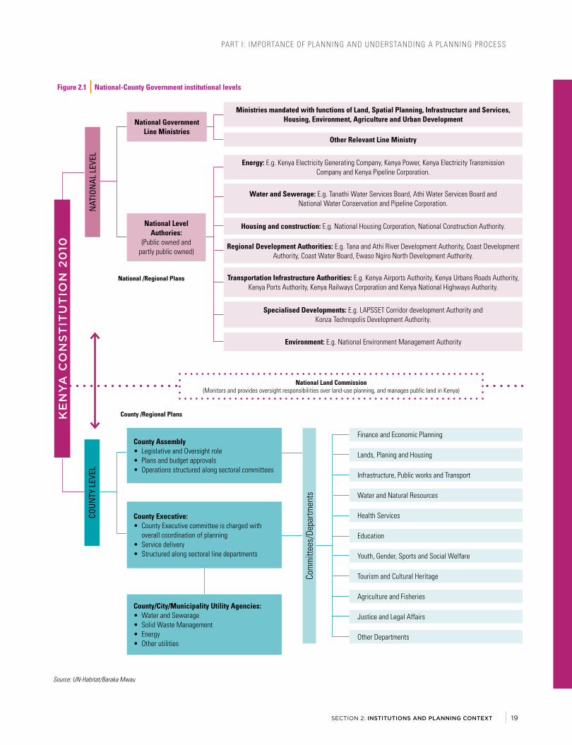
PART I: IMPORTANCE OF PLANNING AND UNDERSTANDING A PLANNING PROCESS
SECTION 2: INSTITUTIONS AND PLANNING CONTEXT
Figure 2 .1 National-County Government institutional levels
KE
NY
A C
ON
ST
ITU
TIO
N 2
010
NAT
ION
AL L
EVEL
National Government Line Ministries
Other Relevant Line Ministry
Ministries mandated with functions of Land, Spatial Planning, Infrastructure and Services, Housing, Environment, Agriculture and Urban Development
Energy: E.g. Kenya Electricity Generating Company, Kenya Power, Kenya Electricity Transmission Company and Kenya Pipeline Corporation.
Water and Sewerage: E.g. Tanathi Water Services Board, Athi Water Services Board and National Water Conservation and Pipeline Corporation.
Housing and construction: E.g. National Housing Corporation, National Construction Authority.
Regional Development Authorities: E.g. Tana and Athi River Development Authority, Coast Development Authority, Coast Water Board, Ewaso Ngiro North Development Authority.
Transportation Infrastructure Authorities: E.g. Kenya Airports Authority, Kenya Urbans Roads Authority, Kenya Ports Authority, Kenya Railways Corporation and Kenya National Highways Authority.
Specialised Developments: E.g. LAPSSET Corridor development Authority and Konza Technopolis Development Authority.
Environment: E.g. National Environment Management Authority
National Level Authories:
(Public owned and partly public owned)
National /Regional Plans
County /Regional Plans
COUN
TY L
EVEL
Com
mitt
ees/
Depa
rtmen
ts
County Assembly• Legislative and Oversight role• Plans and budget approvals• Operations structured along sectoral committees
County Executive:• County Executive committee is charged with
overall coordination of planning• Service delivery• Structured along sectoral line departments
County/City/Municipality Utility Agencies:• Water and Sewarage• Solid Waste Management• Energy• Other utilities
Lands, Planing and Housing
Finance and Economic Planning
Infrastructure, Public works and Transport
Water and Natural Resources
Health Services
Education
Youth, Gender, Sports and Social Welfare
Tourism and Cultural Heritage
Agriculture and Fisheries
Justice and Legal Affairs
Other Departments
National Land Commission (Monitors and provides oversight responsibilities over land-use planning, and manages public land in Kenya)
Source: UN-Habitat/Baraka Mwau
19

PART I: IMPORTANCE OF PLANNING AND UNDERSTANDING A PLANNING PROCESS
Planning authorities are envisaged to operate at different levels in the counties. The County Governments Act designates county departments and decentralized units as planning authorities in a county. There is an obligation to incorporate non-state actors in planning processes2. These departments and decentralized units are headed by leaders, whose responsibility includes managing and coordinating formulation and implementation of plans (including spatial plans). For planning in cities and towns, the Urban Areas and Cities Act designate urban boards and committees as planning authorities.
At the national government level, agencies such as departments and parastatal agencies within various ministries are tasked with urban planning and development functions. Regional development authorities (such as the Tana and Athi River Regional Development Authority, and Ewaso Ng’iro North Development Authority), execute various planning functions mainly at the regional scale.
Ensure county-specific legislation for urban and regional planning is enacted, within the legislative power granted by the constitution. In so doing, consistency and value-addition is ensured by avoiding ‘over legislating’ planning matters, as such often result in ineffective legislation; focused on ‘control’ rather than management of urban development.
Facilitate coordination of planning vertically (across different levels of government) and horizontally (between departments). For counties, coordination between the county executive and the county assembly is crucial. The county assembly exercise ‘reserved’ functions of legislation, plan approval and adoption.
Support formation of efficient public planning authorities. County Executive management has a responsibility to ensure planning authorities have access to financial resources, human capital, and facilities and equipment. Leaders must facilitate inter-department and inter-agency coordination; ensure development budgets are aligned to approved plans, and support formulation and enforcement of planning legislation. Political leaders (including Members of County Assemblies) should collaborate with leaders in the executive arm of government in policy and legislation. They are expected to provide useful oversight role, approve of budgets, plans, policies and legislation, and offer political leaders on spatial planning matters.
2 See County Governments Act, Sections 104. Obligation to plan by the county
Support in strengthening capacity of planning authorities. In the past, weak public planning authorities have contributed to current urban planning challenges not only in Kenya, but across the continent. A well-equipped planning authority is imperative for cities and towns that aspire to improve their development planning and service delivery. A reliable public planning authority should have internal capacity to efficiently formulate and implement plans, manage development, coordinate spatial development, and perform other planning functions on demand. Where reforms in public planning authorities and urban planning are required, leaders must be at the forefront in shaping the desired outcome.
Nakuru street scene. © Tom Kemp
URBAN PLANNING FOR CITY LEADERS A HANDBOOK FOR KENYA20
Nakuru street scene. © Tom Kemp
URBAN PLANNING FOR CITY LEADERS A HANDBOOK FOR KENYA20

PART I: IMPORTANCE OF PLANNING AND UNDERSTANDING A PLANNING PROCESS
SECTION 2: INSTITUTIONS AND PLANNING CONTEXT
PART I: IMPORTANCE OF PLANNING AND UNDERSTANDING A PLANNING PROCESS
SECTION 2: INSTITUTIONS AND PLANNING CONTEXT
Urb
aniza
tion
in K
enya
201
0-20
50
2017
(13
Mill
ion)
2030
(22
Mill
ion)
2050
(43
Mill
ion)
4500
0
4000
0
3500
0
3000
0
2500
0
2000
0
1500
0
1000
0
5000 0
1950
1953
1956
1962
1965
1968
1971
1974
1977
1980
1983
1986
1989
1992
1995
1998
2001
2004
2007
2010
2013
2016
2022
2025
2028
2031
2034
2037
2040
2043
2046
2049
Year
Urban population(000s)
Prop
ortio
n of
Urb
an p
opul
atio
n by
size
cat
egor
y in
200
9, K
enya
2000
- 99
9911
0
1000
0 - 9
9999
97
1000
00 -
9999
9922
1 m
illio
n an
d ov
er1
010
0000
020
0000
030
0000
040
0000
050
0000
0
1000
0 - 9
9999
2000
- 99
9910
0000
- 99
9999
1mill
ion
and
over
Sour
ce: N
atio
nal C
ounc
il fo
r Pop
ulat
ion
and
Deve
lopm
ent,
Keny
a 20
13
122
9711
0N
o.
3109
861
4617
114
3665
486
6311
09Sh
are
of U
rban
Pop
ulat
ion
COM
PON
ENT
1: IN
STIT
UTIO
NAL
STR
ENGT
HEN
ING
COM
PON
ENT
3: IN
VEST
MEN
T IN
INFR
ASTR
UCTU
RE A
ND
SERV
ICE
DELI
VERY
KEN
YAM
UNIC
IPAL
PROG
RAM
ME
COM
PON
ENT
2: P
ARTI
CIPA
TORY
STR
ATEG
IC U
RBAN
DE
VELO
PMEN
T PL
ANN
ING
COM
PON
ENT
4: P
ROJE
CT M
ANAG
EMEN
T,
MON
ITOR
ING
AND
EVAL
UATI
ON
Adeq
uate
pla
nnin
g ru
les
and
regu
latio
ns a
re a
pre
requ
isite
to th
e de
sign
,pr
oduc
tion
and
man
agem
ent o
f effi
cien
t and
equ
itabl
e hu
man
set
tlem
ents
.
The
qual
ity o
f ur
ban
plan
ning
and
des
ign
has
a de
term
inin
g im
pact
on
the
valu
e ge
nera
ted
by h
uman
set
tlem
ents
thro
ugh
effic
ient
and
equ
itabl
e pu
blic
spa
ce, s
treet
s an
d bu
ildab
le a
reas
.
Thre
e-Pr
onge
dAp
proa
ch
Urb
an R
ules
and
Reg
ulat
ions
Urb
an P
lann
ing
and
Des
ign
Mun
icip
al F
inan
ce
Effic
ient
and
tran
spar
ent m
unic
ipal
fina
nce
syst
ems
are
key
to in
vest
men
ts,
mai
nten
ance
and
man
agem
ent o
f the
city
. The
y sh
ould
ens
ure
redi
strib
utio
n of
be
nefit
s ge
nera
ted
by u
rban
end
ogen
ous
deve
lopm
ent.
POLI
CY A
ND
LEGI
SLAT
IVE
FRAM
EWOR
K FO
R S
PATI
AL P
LAN
NIN
G IN
KEN
YA
Cons
titut
ion
of K
enya
Chap
ter 5
: Lan
d an
d En
viro
nmen
t, Fo
urth
Sch
edul
e: F
unct
ions
of N
atio
nal a
nd C
ount
y Go
vern
men
ts
Urba
n an
d Re
gion
al P
lann
ing
Legi
slat
ion
Land
Reg
istra
tion
Act L
ands
Act
Co
mm
unity
Lan
d Ac
tEn
viro
men
tal M
anag
emen
tan
d Co
ordi
natio
n Ac
t
Keny
a Vi
sion
203
0N
atio
nal S
patia
l Pla
n
Envi
ronm
enta
l Man
agem
ent/
Polic
y Re
gula
tions
Build
ing
Code
Coun
ty G
over
nmen
t Act
Part
XI C
ount
y Pl
anni
ng, C
ount
y In
tegr
ated
1. C
ount
y- L
evel
Pla
nsA
resp
onsi
bilit
y of
Cou
nty
Plan
ning
Uni
t and
Phy
sica
l Pl
anni
ng D
epar
tmen
t, un
der o
vers
ight
of C
ount
yEx
ecut
ive
Com
mitt
ee.
◆ De
velo
men
t Pla
n (C
IDP)
- 5
Year
Pla
n◆
Coun
ty S
ecto
ral P
lans
- 10
Yea
r Pla
ns b
ased
on
CIDP
◆ Co
unty
Spa
tial P
lan
- 10
Year
Spa
tial D
evel
opm
ent
Fra
mew
ork
for t
he C
ount
y
2. C
ity L
evel
/ Mun
icip
al-L
evel
Pla
nsRe
spon
bilit
y of
City
Boa
rd/ T
own
Com
mitt
ee, C
ount
y Ph
ysic
al P
lann
ing
Depa
rtmen
t.◆
Inte
grat
ed U
rbam
Dev
elop
men
t Pla
n◆
City
/Mun
icip
al L
and
Use
Plan
s◆
City
/Mun
icip
al B
uild
ing
and
Zoni
ng P
lans
◆ Ci
ty/U
rban
Are
a Bu
ildin
g an
d Zo
ning
Pla
ns◆
Loca
tion
of R
ecre
atio
nal A
reas
and
Pub
lic F
acili
ties
Phys
ical
Pla
nnin
g Ac
t (U
nder
Rev
iew
)
1. R
egio
nal P
hysi
cal D
evel
opm
ent P
lan
2. L
ocal
Phy
sica
l Dev
elop
men
t Pla
ns (L
PDP)
3. L
ong-
term
, Sho
rt-te
rm, r
enew
al a
nd
re
deve
lopm
ent p
lans
Exam
ples
of s
hort
term
LPD
Ps:
◆ A
ctio
n Ar
ea P
lans
for c
ompr
ehen
sive
pla
nnin
g◆
Sub
ject
Pla
ns (S
ecto
ral p
lans
) e.g
. Tra
nspo
rtatio
n,W
ater
sup
ply
and
Sew
erge
◆
Adv
isor
y or
Zon
ing
Plan
s - s
ubdi
visi
ons
and
dens
ity◆
Par
t Dev
elop
men
t Pla
ns
Othe
r App
licab
le P
olic
ies
and
Legi
slat
ion
Coun
ty B
y-La
ws,
Dev
elop
men
t Man
agem
ent a
nd R
egul
atio
n
Urba
n Ar
eas
and
Citie
s Ac
t of 2
011
Part
V - I
nteg
rate
d De
velo
pmen
t Pla
nnin
g
1. In
tegr
ated
Urb
an o
r City
Dev
elop
men
t Pla
n
(IUD
P)
◆ P
lan
is a
dopt
ed b
y an
urb
an b
oard
or c
omm
ittee
&
sub
mitt
ed to
Cou
nty
Asse
mbl
y (b
e ex
ecut
ive)
fo
r app
rova
l ◆
The
Pla
n is
revi
ewed
ann
ually
◆ T
erm
of o
ffice
of a
boa
rd m
embe
r is
5 ye
ars
2. S
patia
l Pla
n [S
patia
l Dev
elop
men
t Fra
mew
ork]
◆ L
ong
Term
Pla
n (1
0 +
Year
s)◆
Bas
is fo
r IUD
P
3. S
ecto
r Pla
ns
Othe
r Rel
evan
t Pol
icy
Nat
iona
l Urb
an D
evel
opm
ent P
olic
y
ILLU
STRA
TION
OF
A TY
PICA
L M
ETRO
POLI
TAN
SCA
LE O
F PL
ANN
ING
Mun
icip
al B
ound
ary
Urba
n Co
reLine
ar
deve
lopm
ents
alon
g m
ajor
ro
ads
Mun
icip
ality
MET
ROPO
LITA
N R
EGIO
N
Urba
n Fo
ot P
rint
Larg
eFa
rms
Larg
eFa
rms
Rura
l /
Peri-
Urba
n
Rura
l /
Peri-
Urba
n
Mun
icip
ality
Rura
l /
Peri-
Urba
n
Rive
r
Rive
r
Mun
icip
ality
Mai
n Ci
ty
Leve
ls o
f Pla
nnin
g in
Ken
ya
Nat
iona
l
Socio-Economic, Topography and Environment, Infrastructure and Services, Housing
Urba
n St
ruct
ure
Urba
n-Ru
ral S
truct
ure
Regi
onal
and
Cou
nty
Stra
tegi
es
City
/ M
unic
ipal
/ To
wn
Stra
tegy
Keny
a Vi
sion
203
0, N
atio
nal S
patia
l Pla
n, N
atio
nal U
rban
Dev
elop
men
t Pla
n
Spat
ial [
Urba
n &
Reg
iona
l] Pl
anni
ng P
olic
y &
Leg
isla
tion
Sust
aina
ble
Urba
n De
velo
pmen
t Goa
ls (S
DGs)
& N
ew U
rban
Age
nda
• Ke
nya
Visi
on 2
030
• N
atio
nal S
patia
l Pla
n•
Nat
iona
l Urb
an
Deve
lopm
ent P
olic
y•
Nat
iona
l Hou
sing
Po
licy
• N
atio
nal I
nfra
stru
ctur
e Pl
ans
Coordination and Alignment of Plans
Publ
ic p
artic
ipat
ion
and
coor
dina
tion
acro
ss G
over
nmen
ts, A
genc
ies,
Dep
artm
ents
, Pri
vate
Sec
tor a
nd O
ther
Key
Act
ors
Deta
iled
Plan
ning
Regi
onal
/ M
etro
polit
an
• Tw
o or
mor
e Co
untie
s•
Regi
onal
De
velo
pmen
t Au
thor
ities
• M
etro
polit
an A
reas
Coun
ty
• Ac
cord
ing
to C
ount
y Bo
unda
ry•
[47]
Cou
nty
Inte
grat
ed
Deve
lopm
ent P
laan
s•
[47]
Cou
nty
Spat
ial
Plan
s•
Coun
ty S
ecto
r Pla
ns
[Infra
stru
ctur
e/
Hous
ing]
• Cou
nty
Urba
n Po
licy
City
/ M
unic
ipal
/ T
own
• Ur
ban
Deve
lopm
ent
Plan
ning
[Int
egra
ted
Urba
n De
velo
pmen
t Pl
ans/
Spa
tial
Deve
lopm
ent
Fram
ewor
ks]
• Ur
ban
Sect
or P
lans
• Ur
ban
Grow
th
Man
agem
ent S
trate
gies
Urba
n Di
stric
t•
As d
esig
nate
d in
Spa
tial
Deve
lopm
ent
Fram
ewor
k [C
ity-w
ide
Plan
]•
Acco
rdin
g to
Des
igna
ted
Plan
ning
Uni
ts•
Dem
arca
ted
Spec
ial
Plan
ning
Are
a•
Rene
wal
or
Rede
velo
pmen
t Pla
ns/
Info
rmal
Set
tlem
ent
Upgr
adin
g Pl
an
Loca
l Are
a/N
eigh
bour
hood
• Lo
cal A
ctio
n Ar
ea P
lans
• N
eigh
bour
hood
Pla
ns•
Loca
l Urb
an D
esig
n Gu
idel
ines
• Re
new
al &
Re
deve
lopm
ent /
In
form
al S
ettle
men
t Up
grad
ing
Plan
• St
reet
& O
pen
Publ
ic
Spac
es•
Soci
al A
men
ities
&
Publ
ic F
acili
ties
1
2
3
4
5
Figu
re 2
.2Po
licy
and
Legi
slat
ive
Fram
ewor
k fo
r Sp
atia
l Pla
nnin
g in
Ken
ya
Sour
ce: U
N-Ha
bita
t/Bar
akaM
wau
21
Figu
re 2
.2Po
licy
and
Legi
slat
ive
Fram
ewor
k fo
r Sp
atia
l Pla
nnin
g in
Ken
ya
Sour
ce: U
N-Ha
bita
t/Bar
akaM
wau
21

PART I: IMPORTANCE OF PLANNING AND UNDERSTANDING A PLANNING PROCESS
The role of the private sector in Kenya’s urban planning and development is significant . Following the implementation of the Structural Adjustment Programmes of 1980s, there was a shift towards government deregulation and an enablement approach which also influenced major shifts in urban planning practice and urban governance. The role of private sector has since increased. In contemporary urban development, private sector actors have increased their stake in decision making on matters related to land use planning, and the provision of public goods such as infrastructure, services and amenities. This can take place in several contexts, from large complexes within a neighborhood, large-scale land sub-divisions or even town-scale developments (as with Tatu City in Kiambu County).
Land owners and residents’ associations have increased their stake in urban planning decision making in major cities . Decisions made by developers and investors have significant bearing in planning decisions such as land use, infrastructure development, zoning and development control regulations.
Private sector consultancy firms are increasingly undertaking planning tasks that were traditionally a preserve of public sector planners . Private firms are involved in formulating entire city or town development plans, through contractual agreements with governments. In many cases, private contractors are supposed to follow the procedures and standards stipulated in public policy and regulations. However, in Kenya such procedures and standards are inadequate, and at times a public authority can approve new standards introduced and proposed by private contractors through outsourced planning processes.
Urban planning activities of the private sector are still governed by public legislation and regulations . Only public planning authorities have the mandate to make legally binding planning approvals . But where public planning authorities are weak, the private sector defines the outcomes of delegated planning functions. Here, the main catalysts for action are contractual arrangements, profit interests and other specific incentives. Presented with this reality, policy makers and leaders should find leverage in the interplay between the public and private sector planning forms, to achieve sustainable urban development.
Both policy and political implications associated with increasing privatization of urban planning must be addressed by leaders. These include:
• The impact of privatization of public goods and reduced public assets;
• Outcomes of weakened public planning authorities, and shifting public finance from public planning authorities to private contractors;
• Implications of profit interests of the private sector on the need to promote social equity in urban development;
• Addressing planning barriers and creating value for positive private sector involvement in planning.
Figure 2 .3 Public-Private Institutional Engagement in Urban Development
CITIZENS [EQUITY, SOCIO-ECONOMIC DEVELOPMENT]
INCLUSIVE URBAN DEVELOPMENT
REGULATORY FRAMEWORK & PARTNERSHIPS
GOVERNMENT [PUBLIC SECTOR]
• Provision of public goods (Includes: Housing infrastructure & Utilities)
• Policy and regulation• Support growth of business• Approval of plans, permissions
and permits .
PRIVATE SECTOR
• Engages in provision of public goods e .g . Housing, infrastructure & Utilities
• Investments (Profit-driven)• Generates tax revenues• Service provider to government
(e .g .Urban Planning, Engineering and Construction)
PUBLIC-PRIVATE ENGAGEMENTS IN: HOUSING, INFRASTRUCTURE AND
UTILITIES PROVISION
OUTSOURCING SERVICES [PROFESSIONAL SERVICES, PROJECT
MANAGEMENT, ETC .]
BUILT ENVIRONMENT
• Adaptation to climate change & sustainability• Productivity & effective Land Use
• Environmental sustainability
Box 2 .1 The Private Sector in Urban Planning and Development
Source: UN-Habitat/Baraka Mwau
URBAN PLANNING FOR CITY LEADERS A HANDBOOK FOR KENYA22

PART I: IMPORTANCE OF PLANNING AND UNDERSTANDING A PLANNING PROCESS
SECTION 2: INSTITUTIONS AND PLANNING CONTEXT
Kenya’s urban sector has witnessed significant involvement of international agencies, especially through funding of urban planning programmes and infrastructure investments. This involvement has been through joint agreements and partnerships with the Kenya government. The planning processes have been undertaken by international and local consulting firms.
Various UN Agencies have supported urban and regional planning work in the country. Recently, UN-Habitat supported the implementation of the Kenya Municipal Program (KMP) through capacity development activities related to urban planning, but also supported national government, Nairobi, Kisumu, Kilifi, Kiambu and Turkana Counties on various urban development interventions.
The KMP resulted in the formulation of Integrated Strategic Urban Development Plans for Mombasa, Kitui, Malindi, Embu, Machakos, Thika, Nakuru, Naivasha, Turbo/Soy/Jua-kali, Kakamega and Kericho towns. The program was financed through a World Bank loan to Government of Kenya, with additional funding from the Swedish International Cooperation Development Agency (Sida). A similar financial arrangement enabled the implementation of the Kenya Informal Settlements Improvement Programme (KISIP). The urban planning work for these programmes involves private consulting firms from foreign countries and Kenya.
The Japan International Cooperation Agency (JICA) recently financed the formulation of the Nairobi Integrated Urban Development Masterplan [NIUPLAN], the Mombasa Gate City Master Plan and the Masterplan for Development of Mombasa Special Economic Zone. Nairobi and Mombasa are the only cities in Kenya with a population exceeding one million people.
Agence Française de Développement (AFD) has financed the Kisumu Urban Project, which resulted in the Kisumu Integrated Strategic Urban Development Plan. The financial support has been extended to cover detailed planning for specified districts in the city.
The Embassy of Sweden in Kenya is funding the Kenya SymbioCity [Sustainable Urban Development in Kenya] programme. This programme is being implemented through a collaboration of The Council of Governors and the Swedish Association of Local Authorities and Regions (SALAR).
Figure 2 .3 Public-Private Institutional Engagement in Urban Development
Box 2 .1 International Agencies’ Involvement in Kenya’s Urban Planning and development sector
Infrastructure development © World Bank
23
Box 2 .1 International Agencies’ Involvement in Kenya’s Urban Planning and development sector
PART I: IMPORTANCE OF PLANNING AND UNDERSTANDING A PLANNING PROCESS
SECTION 2: INSTITUTIONS AND PLANNING CONTEXT
Kenya’s urban sector has witnessed significant involvement of international agencies, especially through funding of urban planning programmes and infrastructure investments. This involvement has been through joint agreements and partnerships with the Kenya government. The planning processes have been undertaken by international and local consulting firms.
Various UN Agencies have supported urban and regional planning work in the country. Recently, UN-Habitat supported the implementation of the Kenya Municipal Program (KMP) through capacity development activities related to urban planning, but also supported national government, Nairobi, Kisumu, Kilifi, Kiambu and Turkana Counties on various urban development interventions.
The KMP resulted in the formulation of Integrated Strategic Urban Development Plans for Mombasa, Kitui, Malindi, Embu, Machakos, Thika, Nakuru, Naivasha, Turbo/Soy/Jua-kali, Kakamega and Kericho towns. The program was financed through a World Bank loan to Government of Kenya, with additional funding from the Swedish International Cooperation Development Agency (Sida). A similar financial arrangement enabled the implementation of the Kenya Informal Settlements Improvement Programme (KISIP). The urban planning work for these programmes involves private consulting firms from foreign countries and Kenya.
The Japan International Cooperation Agency (JICA) recently financed the formulation of the Nairobi Integrated Urban Development Masterplan [NIUPLAN], the Mombasa Gate City Master Plan and the Masterplan for Development of Mombasa Special Economic Zone. Nairobi and Mombasa are the only cities in Kenya with a population exceeding one million people.
Agence Française de Développement (AFD) has financed the Kisumu Urban Project, which resulted in the Kisumu Integrated Strategic Urban Development Plan. The financial support has been extended to cover detailed planning for specified districts in the city.
The Embassy of Sweden in Kenya is funding the Kenya SymbioCity [Sustainable Urban Development in Kenya] programme. This programme is being implemented through a collaboration of The Council of Governors and the Swedish Association of Local Authorities and Regions (SALAR).
Figure 2 .3 Public-Private Institutional Engagement in Urban Development
Box 2 .1 International Agencies’ Involvement in Kenya’s Urban Planning and development sector
Infrastructure development © World Bank
23
Infrastructure development © World Bank
23

PART I: IMPORTANCE OF PLANNING AND UNDERSTANDING A PLANNING PROCESS
PLANS ARE MADE AT DIFFERENT SCALESSustainable urban development requires planning interventions at different levels. Different types of urban plans can be prepared at different scales; from neighborhood/local area, city/municipality, and city- region/metropolis to national level. Plans at these different scales have different implementation mechanisms and correspond to different institutional mandates.
The following planning scales are relevant in Kenya planning context: 1. National Planning; 2. Regional/Metropolitan Planning; 3. County Planning; 4. City/municipal Planning; 5. Urban District Planning; and 6. Neighborhood/Local Area Planning.
The scope and details of each type of a plan will be determined by the scale, purpose, and intended objectives of the planning intervention. It could be an integrated development plan or thematic-sectoral plan. For example, a general land use plan can be prepared for a metropolitan region, detailed at city or municipal level, and further scaled down-with more specific guidelines to urban district and local area planning. However, there are cross-cutting aspects, such as analysis of population and demography, economic development, and financing that influence the plans regardless of urban scale.
Promote coordination of planning across different levels of government. Leaders need to support planners, ensuring that plans are coordinated and aligned to one another. Failure to do so could lead to overlaps and duplications, and challenges in implementation. Planning authorities must ensure their processes are carefully analyzed before commencement, and that urban planning is initiated based on the relevant type of planning instrument responding to the urban scale, context and objective of the plan.
NATIONAL PLANNING Planning at the national level defines and addresses human settlements development issues at a country-wide scale. It informs the effective management of urbanization by defining a hierarchy of urban centres and agglomeration regions such as large urban regions, major cities and secondary cities, urban-rural development relations, and key infrastructure developments to support urban development at national level. Plans formulated at this scale provide the framework for regional and urban planning. They describe a nation’s vision for its urban future, and the national context of human settlements development. In Kenya, a 30-year National Spatial Plan has been developed (2015-2045), which will be a key reference for regional development plans, county spatial plans and others.
Figure 2 .4 Planning and design is important for urban centres of all sizes
City of Mombasa © Shutterstock A market centre, Chavakali © Baraka Mwau
URBAN PLANNING FOR CITY LEADERS A HANDBOOK FOR KENYA24

PART I: IMPORTANCE OF PLANNING AND UNDERSTANDING A PLANNING PROCESS
SECTION 2: INSTITUTIONS AND PLANNING CONTEXT
Leve
ls o
f Pla
nnin
g in
Ken
ya
Nat
iona
l
Socio-Economic, Topography and Environment, Infrastructure and Services, Housing
Urba
n St
ruct
ure
Urba
n-Ru
ral S
truct
ure
Regi
onal
and
Cou
nty
Stra
tegi
es
City
/ M
unic
ipal
/ To
wn
Stra
tegy
Nat
iona
l Eco
nom
ic S
trate
gies
e.g
. Ken
ya V
isio
n 20
30, N
atio
nal S
patia
l Pla
n, N
atio
nal U
rban
Dev
elop
men
t Pol
icy
Spat
ial [
Urba
n &
Reg
iona
l] Pl
anni
ng P
olic
y &
Leg
isla
tion
Inte
rnat
iona
l Dev
elop
men
t Fra
mew
orks
E.g
. Sus
tain
able
Urb
an D
evel
opm
ent G
oals
(SDG
s) &
New
Urb
an A
gend
a
• Ke
nya
Visi
on 2
030
• N
atio
nal S
patia
l Pla
n•
Nat
iona
l Urb
an
Deve
lopm
ent P
olic
y•
Nat
iona
l Hou
sing
Po
licy
• N
atio
nal I
nfra
stru
ctur
e Pl
ans
Coordination and Alignment of Plans
Publ
ic p
artic
ipat
ion
and
coor
dina
tion
acro
ss G
over
nmen
ts, A
genc
ies,
Dep
artm
ents
, Priv
ate
Sect
or a
nd O
ther
Key
Act
ors
Deta
iled
Plan
ning
Regi
onal
/ M
etro
polit
an
• Tw
o or
mor
e Co
untie
s•
Regi
onal
De
velo
pmen
t Au
thor
ities
• M
etro
polit
an A
reas
Coun
ty
• Ac
cord
ing
to C
ount
y Bo
unda
ry•
[47]
Cou
nty
Inte
grat
ed
Deve
lopm
ent P
laan
s•
[47]
Cou
nty
Spat
ial
Plan
s•
Coun
ty S
ecto
r Pla
ns
[Infra
stru
ctur
e/
Hous
ing]
• Cou
nty
Urba
n Po
licy
City
/ M
unic
ipal
/ T
own
• Ur
ban
Deve
lopm
ent
Plan
ning
[Int
egra
ted
Urba
n De
velo
pmen
t Pl
ans/
Spa
tial
Deve
lopm
ent
Fram
ewor
ks]
• Ur
ban
Sect
or P
lans
• Ur
ban
Grow
th
Man
agem
ent S
trate
gies
Urba
n Di
stric
t•
As d
esig
nate
d in
Spa
tial
Deve
lopm
ent
Fram
ewor
k [C
ity-w
ide
Plan
]•
Acco
rdin
g to
Des
igna
ted
Plan
ning
Uni
ts•
Dem
arca
ted
Spec
ial
Plan
ning
Are
a•
Rene
wal
or
Rede
velo
pmen
t Pla
ns/
Info
rmal
Set
tlem
ent
Upgr
adin
g Pl
an
Loca
l Are
a/N
eigh
bour
hood
• Lo
cal A
ctio
n Ar
ea P
lans
• N
eigh
bour
hood
Pla
ns•
Loca
l Urb
an D
esig
n Gu
idel
ines
• Re
new
al &
Re
deve
lopm
ent /
In
form
al S
ettle
men
t Up
grad
ing
Plan
• St
reet
& O
pen
Publ
ic
Spac
es•
Soci
al A
men
ities
&
Publ
ic F
acili
ties
1
2
3
4
5
ILL
US
TR
AT
ION
TH
E D
IFF
ER
EN
T L
EV
ELS
OF
SP
AT
IAL
PLA
NN
ING
Sour
ce: B
arak
a M
wau
/Jia
cong
Ang
/UN-
Habi
tat
Inte
rcou
nty
plan
ning
fo
r bor
der t
owns
Tow
ns o
n th
e in
tern
atio
nal b
orde
r
Cons
ider
atio
ns fo
r int
er-c
ount
y co
llabo
ratio
n on
ser
vice
del
iver
y an
d ur
ban
man
agem
ent
Inte
r-co
unty
co
llabo
ratio
n on
pla
nnin
g
Figu
re 2
.5Ill
ustr
atio
n th
e di
ffere
nt le
vels
of s
patia
l pla
nnin
g
Sour
ce: U
N-Ha
bita
t/Bar
akaM
wau
/Jia
cong
Ang
25

PART I: IMPORTANCE OF PLANNING AND UNDERSTANDING A PLANNING PROCESS
National agencies and county governments are key actors in implementing national plans and policies. National and County leaders must collaborate in both planning and coordination of investments of national significance if they are to successfully implement national urban policy. National urban policies are also developed at this scale, such as Kenya’s National Urban Development Policy and Vision 2030.
REGIONAL PLANNINGThe scope of regional planning spreads beyond individual governmental jurisdictions - county boundaries in the case of Kenya. Geographical areas defined as regional usually share natural resources (e.g. water catchment areas), urban footprints and social, economic and developmental characteristics. Regional plans identify strategic growth areas in cities and towns; areas for potential regional investment; and key flows and connections which require
development or strengthening. They also acknowledge the interconnectedness of regional human settlement systems, addressing urban-rural settlement relations, transportation links, and land use planning and infrastructure development. Regional planning provides a framework for county planning, and requires engagement with several governments, wider communities and stakeholders. Regional Development Authorities in Kenya such as The Tana and Athi Rivers Development Authority formulate regional development plans that cover more than one county, often with focus on land use and resource management. Metropolitan areas, such as the greater Nairobi region, require a combination of regional and lower-level planning, including city or municipal plans, district plans and local area plans. Sectoral plans are also made at this scale, such as a regional transportation plans, regional water supply plans and others.
In 2006 the Kenya government developed Kenya Vision 2030, a roadmap to transform Kenya into an industrializing middle-income economy country between the years 2008 to 2030. The vision is based on three pillars: social, economic and political. Urbanization cuts across these three pillars, making policies and projects important elements of the vision.
One of the implementation tools that the Vision 2030 uses is ‘flagship projects’. These are highly visible projects of key economic and social importance, working to benefit all Kenyans.
Some of the flagship projects correspond directly to urban planning. The Metropolitan and Investment Plans Initiative, for example, will require the preparation of metropolitan investment plans for eleven regions: Nairobi, Mombasa, Kisumu-Kakamega, Nakuru, Eldoret, Wajir, Garissa, Mandera, Kitui, Mwingi and Meru.
Large-scale infrastructure projects, which will improve connectivity in the wider network, directly affect lower-level planning efforts. Some of these are road-building projects (e.g. “Nairobi Missing Link Roads”, Thika Highway, and Northern Corridor etc.), railway infrastructure (Nairobi Commuter Railways and Standard Gauge Railway) and port infrastructure (expansion and new development of airports and seaports).
Some of these projects are conceptualized as economic corridors, for example the LAPSSET (Lamu Port Southern Sudan- Ethiopia Transport) corridor (Republic of Kenya, 2011).
Other sectors will also affect lower-level urban planning. For example, Vision 2030 envisages the construction of 560 new secondary schools to improve education nationally. Another flagship project involves establishing three resort cities along the Kenyan coast, in order to increase tourism. The vision also defines wildlife corridors to support existing migratory routes.
Smaller projects are defined for the medium-term (every 5 years) to support these flagship projects. The government has also made concerted efforts to improve governance and capacity. Vision 2030 emphasizes the importance of land administration, and aims to establish national spatial data infrastructure to track land-use patterns which will aid in the enforcement of land-use plans.
All these projects create a mandate for lower-level plans. In addition to adequate legal tools, financial tools and incentives, good communication between levels of government is required to ensure national ambitions are realized on the ground.
(Kenya Vision 2030 / popular version, 2007)
Box 2 .2 Kenya vision 2030
URBAN PLANNING FOR CITY LEADERS A HANDBOOK FOR KENYA26

PART I: IMPORTANCE OF PLANNING AND UNDERSTANDING A PLANNING PROCESS
SECTION 2: INSTITUTIONS AND PLANNING CONTEXT
Metropolitan Regional Planning is vital in regional areas dominated by a large urban centre. This type of plan defines the way in which a large urban region (including the core city, sub-centres, satellite towns and the immediate hinterland) is organized and developed as a functional system. Growth patterns in large urban regions tend to transcend administrative boundaries. Therefore, in order for a regional planning process to be effective, the planning area should be demarcated based on analyzed patterns of growth and engage all relevant governmental units, planning authorities and stakeholders in the region. Plans from the wider Nairobi and Mombasa urban regions are example of Metropolitan Regional Planning in Kenya.
Urbanization in Kenya 2010-2050
2017 (13 Million)
2030 (22 Million)
2050 (43 Million)45000
40000
35000
30000
25000
20000
15000
10000
5000
0
1950
1953
1956
1962
1965
1968
1971
1974
1977
1980
1983
1986
1989
1992
1995
1998
2001
2004
2007
2010
2013
2016
2022
2025
2028
2031
2034
2037
2040
2043
2046
2049
Year
Urba
n po
pula
tion(
000s
)
Proportion of Urban population by size category in 2009, Kenya
2000 - 9999 110
10000 - 99999 97
100000 - 999999 22
1 million and over 1
0 1000000 2000000 3000000 4000000 5000000
10000 - 99999 2000 - 9999100000 - 9999991million and over
Source: National Council for Population and Development, Kenya 2013
1 22 97 110No.
3109861 4617114 3665486 631109Share of Urban Population
COMPONENT 1: INSTITUTIONAL STRENGTHENING
COMPONENT 3: INVESTMENT IN INFRASTRUCTURE AND SERVICE DELIVERY
KENYAMUNICIPAL
PROGRAMME
COMPONENT 2: PARTICIPATORY STRATEGIC URBAN DEVELOPMENT PLANNING
COMPONENT 4: PROJECT MANAGEMENT, MONITORING AND EVALUATION
Adequate planning rules and regulations are a prerequisite to the design,production and management of efficient and equitable human settlements.
The quality of urban planning and design has a determining impact on thevalue generated by human settlements through efficient and equitable public space, streets and buildable areas.
Three-ProngedApproach
Urban Rules and Regulations
Urban Planning and Design
Municipal Finance
Efficient and transparent municipal finance systems are key to investments, maintenance and management of the city. They should ensure redistribution of benefits generated by urban endogenous development.
POLICY AND LEGISLATIVE FRAMEWORK FOR SPATIAL PLANNING IN KENYA
Constitution of Kenya[Chapter 5: Land and Environment], Fourth Schedule Functions of National and County Governments
Urban and Regional Planning Legislation Land Registration Act Lands Act Community Land Act
Enviromental Managementand Coordination Act
Kenya Vision 2030 National Spatial Plan
Environmental Management/ Policy Regulations Building Code
County Government Act
Part XI County Planning, County Integrated
1 . County- Level PlansA responsibility of County Planning Unit and Physical Planning Department, under oversight of County Executive Committee .◆ Develoment Plan (CIDP) - 5 Year Plan◆ County Sectoral Plans - 10 Year Plans based on CIDP◆ County Spatial Plan - 10 Year Spatial Development
Framework for the County
2 . City Level/ Municipal-Level PlansResponbility of City Board/ Town Committee, County Physical Planning Department .◆ Integrated Urbam Development Plan◆ City/Municipal Land Use Plans◆ City/Municipal Building and Zoning Plans◆ City/Urban Area Building and Zoning Plans◆ Location of Recreational Areas and Public Facilities
Physical Planning Act (Under Review)
1 . Regional Physical Development Plan2 . Local Physical Development Plans (LPDP)3 . Long-term, Short-term, renewal and redevel-opment plans
Examples of short term LPDPs:◆ Action Area Plans for comprehensive planning◆ Subject Plans (Sectoral plans) e .g . Transportation, Water supply and Sewerge◆ Advisory or Zoning Plans - subdivisions and density◆ Part Development Plans
Other Applicable Policies and Legislation
County By-Laws, Development Management and Regulation
Urban Areas and Cities Act of 2011
Part V - Integrated Development Planning
1 . Integrated Urban or City Development Plan (IUDP)◆ Plan is adopted by an urban board or committee
& submitted to County Assembly (be executive) for approval
◆ The Plan is reviewed annually◆ Term of office of a board member is 5 years
2 . Spatial Plan [Spatial Development Framework]◆ Long Term Plan (10 + Years)◆ Basis for IUDP
3 . Sector Plans
Other Relevant Policy National Urban Development Policy
ILLUSTRATION OF A TYPICAL METROPOLITAN SCALE OF PLANNING
Municipal Boundary Urban Core
Linear developmentsalong major
roads
Municipality
METROPOLITAN REGION
Urban Foot Print
LargeFarms
LargeFarms
Rural / Peri-Urban
Rural / Peri-Urban
Municipality Rural / Peri-Urban
River
River
Municipality
Main City
Levels of Planning in Kenya
National
Soci
o-Ec
onom
ic, T
opog
raph
y an
d En
viro
nmen
t, In
frast
ruct
ure
and
Serv
ices
, Hou
sing
Urban Structure Urban-Rural Structure
Regional and County Strategies
City / Municipal / Town Strategy
Kenya Vision 2030, National Spatial Plan, National Urban Development Plan
Spatial [Urban & Regional] Planning Policy & LegislationSustainable Urban Development Goals (SDGs) & New Urban Agenda
• Kenya Vision 2030• National Spatial Plan• National Urban
Development Policy• National Housing
Policy• National Infrastructure
Plans
Coor
dina
tion
and
Alig
nmen
t of P
lans
Public participation and coordination across Governments, Agencies, Departments, Private Sector and Other Key Actors
Detailed Planning
Regional/ Metropolitan
• Two or more Counties• Regional
Development Authorities
• Metropolitan Areas
County
• According to County Boundary
• [47] County Integrated Development Plaans
• [47] County Spatial Plans
• County Sector Plans [Infrastructure/ Housing]
• County Urban Policy
City / Municipal / Town
• Urban Development Planning [Integrated Urban Development Plans/ Spatial Development Frameworks]
• Urban Sector Plans• Urban Growth
Management Strategies
Urban District
• As designated in Spatial Development Framework [City-wide Plan]
• According to Designated Planning Units
• Demarcated Special Planning Area
• Renewal or Redevelopment Plans/ Informal Settlement Upgrading Plan
Local Area/Neighbourhood
• Local Action Area Plans• Neighbourhood Plans• Local Urban Design
Guidelines• Renewal &
Redevelopment / Informal Settlement Upgrading Plan
• Street & Open Public Spaces
• Social Amenities & Public Facilities
1
2
3
4
5
Box 2 .3 Metropolitan Regional Planning
Source: UN-Habitat/BarakaMwau/Jiacong Ang
Figure 2 .6 Illustration of a typical metropolitan scale of planning
27
Box 2 .3 Metropolitan Regional Planning
Source: UN-Habitat/BarakaMwau/Jiacong Ang
Figure 2 .6 Illustration of a typical metropolitan scale of planning
27

PART I: IMPORTANCE OF PLANNING AND UNDERSTANDING A PLANNING PROCESS
COUNTY PLANNINGCounty plans guide development at the county level and localize national and regional plans. They identify county land use and priorities for infrastructure investments and service delivery; strengthen links between cities and towns, growth centres and their hinterlands; and guide integrated county development and sustainable human settlement systems. The County Governments Act requires counties to develop county spatial plans, county integrated development plans, and county sector plans.
CITY AND MUNICIPAL PLANNINGCity and municipal planning guides urban development in cities and towns. This type of planning defines city and municipal land use and proposes a development vision for the city or town. Hence, the plan is also instrumental in defining character and identity, or, how to achieve this. The plan should thus be based on an analysis of the patterns of growth and typologies of the city which in turn provide the basis for defining architectural qualities and urban design guidelines. Its role is to define urban growth boundaries; designate areas for urban extension and strategic interventions; identify infrastructure and housing investments; determine key districts for further planning and investments, identify areas of renewal or infill; define areas for preservation out of historical and cultural values; identify and specify needs for various
urban functions and systems. Integrated Urban Development Plans and Urban Spatial Development Frameworks outlined in the Urban Areas and Cities Act are developed at this scale. City and municipal-level development plans could be further be formulated as sector plans to facilitate their effective implementation. Sector plans include mobility plans, water supply and sewerage plans, public space plans, and housing plans.
The Integrated Urban Development Plan (IUDP) and Spatial Development Framework (SDF) became key city-wide planning tools in Kenya after the enactment of the Urban Areas and Cities Act and County Governments Act. These comprehensive plans address urban spatial issues in a city or town. A Spatial Development Framework should be developed to guide formulation of an IUDP. There are other planning outputs related to the IUDP and SDF framework that can be developed, including:
• Urban Growth Management Strategy;
• Land use plan;
• Urban Extension Plan;
• Urban Infill and densification Plan;
• Urban Infrastructure Plan;
• Urban District Plan; and
• Local Area Plans.
Framework for Planning at City Level
Urban Spatial DevelopmentFramework (Long Term)
Regional Plans/ Policies County Plans/ Policies
Integrated Urban DevelopmentPlan (IUDP) [5 years]
■ Guides Public Engagement■ Effects Spatial Development Framework Implementation through Programmes/ Projects
Link with County Plans
Other Urban Strategies & Policies/ PlansE.g. Infrastructure Plans
IUDP Formulation Review/Ammendments - Annual Review
Implementation of IUDP
IUDP APPROVAL
Monitoring and Evaluation
Detailed Plans
City-Wide Approach to Addressing Informal Settlements
City-wide Development Plan, Special Planning to Address
Informal Settlements
informal settlements◆ GIS Enabled◆ By Aggregate Data◆ Spatial and Non-Spatial Data
Identify appropriate strategies and
implementation for existing informal
settlements
Local Level
District Level
City Level
GIS Enabled Database
One - off redevelopment (Phased)
Relocation & Resettlement
On-site/ In-Situ Incremental Improvement
Re-blocking
City-wide Informal Settlement Program/ Project◆ Link with City Department Plan and Budgets◆ Development Partnerships
Implementation, Monitoring and Evaluation Review of Strategies and Plans
Develop Policies on Informal Settlements- Existing settlements- Prevention of formulation of new informal settlements
Link strategies withcity-wide development
framework
OtherApproaches and Strategies
Develop a strategy to prevent formation of
new informal settlements
Urban Planning
Social and Economic Development Programs
URBAN GROWTH IN BORDER AREAS
Urban Core
Forest
Main Road
URBAN GROWTH / FOOTPRINT
COUNTY ADMINISTRATIVE BOUNDARY
Peri Urban
RIVER
Peri Urban
CountyBorder
County Border
Rural Settlements
[Need for Inter-County Collaboration in Urban Planning and Management, infrastructure development, governance, etc.]
INTEGRATED WORKING IN PLANNING
COORDINATION ACROSS THEMATIC GROUPS
ALL KEY TECHNICAL SUPPORT TEAM
Encoder, Writer, Mapper / Drafts-men, Staff / Researchers /
Assistants
Private Sector / Developers /Civil Society
Land use / Infrastructure / Housing
Social Development
Urban Planning Urban Engineering(Public Works)
THEMATIC WORKING GROUPS
Land and SurveyEnvironment
Finance and Economic
Development
Economic Development
Additional Groups
FLOW
OF
INFO
RMAT
ION
County Executive Committee, Senior Management of Departments, Urban Board/ Committee
Legal Department
TECHNICAL MANAGERS
SocialDevelopment
HousingDepartment
Other RelevantDepartment
INCEPTION [Preparing to commence Planning Process]
PLAN DEVELOPMENT PLAN APPROVAL AND ADOPTION IMPLEMENTATION PROCESS
■
■
Determine planning boundary■ Timeframe of plan■ Develop a Budget■ Set up a Planning Team [Integrated] ■ Commencement
■ Identify constraints to effective
implementation - commence a reform process
■ Set goals of objectives of the process
■ Identify & mobilise stakeholders
■ Access existing conditions
■ Visioning and concept development
■ Drafting of spatial proposals
■ Infrastructure proposals■ Costing and planning options
■ Assessment of policy and legal implications
Institutional DevelopmentPartnershipsInstitutional Reforms and Promoting good governance
■ ■
An Urban Plan Formulation Process [Preparedness for Implementation] Institutional Development [Preparedness for Implementation]
Implementation Framework:■ Policies & legislation proposals■ Guidelines (Institutional, Planning
and Design, Infrastructure, Land Management, etc.)
■ Capital Investment Framework
Complete Draft Plan Final Plan Link with municipal revenue & expenditure
Formulate Integrated Urban Development Plan(In Kenya this operationalises municipal budgets)
Involve stakeholders in monitoring/ evaluation review
Stakeholder Engagement
Monitoring and Evaluation, Plan Review
Series of Participatory Actions [Workshops, Charities, Social Media
Interactions, TV & Radio Sessions, Exhibitions, Competitions, Posters, Brochures, Etc.]
Inception Workshop Public Awareness
■
■ Plan Approval
■ Announcement and Communication
Public Hearing & Ammendments [If Necessary]
Town Hall Exhibition
Institutional Reforms and preparedness for Implementation
Integrated Zoning Scheme
Financial Plan and Financing Strategy
Priority Areas, Local Spatial Plans, Actions Plans
Integrated Infrastructure Plans
Policies & Regulations
■
Development management - Building Regulations, Planning & Construction permits, Enforcement e.t.c.
■ Growth Management StrategySustainability Policies
Review Previous Plans and Identify Factors Influencing their Implementation
Figure 2 .7 Framework for City/Municipal planning in Kenya
Source: UN-Habitat/BarakaMwau/Jiacong Ang
URBAN PLANNING FOR CITY LEADERS A HANDBOOK FOR KENYA28
Figure 2 .7 Framework for City/Municipal planning in Kenya
Source: UN-Habitat/BarakaMwau/Jiacong Ang
URBAN PLANNING FOR CITY LEADERS A HANDBOOK FOR KENYA28

PART I: IMPORTANCE OF PLANNING AND UNDERSTANDING A PLANNING PROCESS
SECTION 2: INSTITUTIONS AND PLANNING CONTEXT
URBAN DISTRICT PLANNINGThis scale of planning focuses on larger sections of a city or a town, referred to as urban districts. Urban District Plans guide the implementation of City-wide plans. They define projects and development guidelines on a district scale, and define policies for neighborhoods and local areas. Central Business District (CBD) plan is an example of a district plan. However, if an urban center is relatively small, such as a medium or small town in Kenya, this scale of planning may be not required. In this case, detailed local area planning is more useful.
LOCAL AREA AND NEIGHBORHOOD PLANNINGLocal Area and Neighborhood Planning focuses on a single neighborhood, local area or a part thereof. These plans interpret and localize city-wide and district planning. They can be statutory or non-statutory. They provide a detailed framework for development, including development control regulations; infrastructure provision; and land-use and urban design guidelines. Local area and neighborhood plans can also be developed as thematic (sectoral) plans to address a specific aspect of local development such as public space and amenities, mobility and basic services.
PLANNING FOR EXISTING BUILT-UP AREAS AND NEW DEVELOPMENT AREASSustainable urban development requires leaders and planners to address the needs of current and future generations. In Kenya’s urban context, planning both for already developed areas and strategic planning as well as detailed urban planning and design for the existing urban fabric and for new urban development is vital; thorough plans must be developed which ensure successful implementation. Interventions in both aspects help cities plan for current and future growth needs. They demand strong political, institutional and technical leadership. Urban planning offers leaders and planners specific tools for the implementation of such interventions, and there is a need to support planning authorities to attain the requisite capacity to offer their city a full-range of solutions; for both existing built-up areas and new development areas..
PLANNING FOR EXISTING BUILT-UP AREAS Before deciding to establish new areas for urban development, first assess and optimize the opportunities available within existing built-up areas. As urbanization increases in Kenya, many urban centres lack reference to approved plans or spatial development frameworks.
Figure 2 .8 Kisumu Lakefront Development Concept Plan
© UN-Habitat
29

PART I: IMPORTANCE OF PLANNING AND UNDERSTANDING A PLANNING PROCESS
Poor urban planning has undermined infrastructure and housing delivery in Kenya’s urban areas. Consequently, infrastructure and housing challenges have also undermined urban resilience. Informal land and housing markets, informal settlements, ineffective development control, underdeveloped infrastructure, inadequate public spaces, environmental degradation, and fragments of planned developments are some of the defining features of built-up areas in many towns in Kenya. Political leaders are particularly under pressure from the electorate to deliver programs which improve services and living conditions in informal settlements, and other areas with infrastructure and housing challenges.
Urban development should result in improved quality of life for urban dwellers in unplanned and underserviced areas. Possible plan-led interventions in built-up areas include:
1. Urban Infill Developments;2. Urban Densification or Redevelopment; 3. Brownfield Development; and 4. Urban Renewal and Informal Settlements Upgrading.
Infrastructure, housing and space improvements are tied to all these interventions, and the possible impacts of each must be specified in the city-wide plan. These require detailed planning prior to implementation, and if well designed and implemented, they enable cities to achieve development goals.
Although the various modes of interventions aims to make use of available resources as efficiently as possible and to meet pressing needs, at the same time it is useful to consider keeping some land reserves for future and strategic purposes, such as for mobility, amenities and transport related functions. Furthermore, renewal and infill interventions of especially larger areas, need to be planned
and designed taking into account the surrounding built environment as a way to capitalize on existing infrastructure, but also to ensure continuity, connectivity and coherence of the urban fabric.
Diverse stakeholders involved in these interventions often have vested interests – negotiations and consensus-building is required. In this case, leaders and technical teams should engage stakeholders throughout the planning and implementation phases. If stakeholder and political engagement is poorly executed, intended strategic interventions become ineffective.
City-wide urban development plans include specific strategies and approaches for existing built-up areas, but may also be addressed separately depending on context.
URBAN INFILL APPROACHThe Urban Infill Approach involves ‘filling in’ unused or under-utilized space in built-up areas, from small parcels of land to large plots the size of a neighborhood complex. Urban infill is an opportunity to increase capacity of land; introduce mixed-use development; improve land-use mix; and address the social development needs of an urban area such as affordable housing and amenities.
Successful urban infill projects respond to the needs of the surrounding neighborhood and its residents. An empty plot does not necessarily need to be filled with buildings; parks, squares, playgrounds and sport fields may be developed instead. Urban infill enables a city to cut spending in infrastructure by capitalizing on underutilized existing infrastructure and service networks.
Figure 2 .9 Supply and demand in land-use decisions
PART I: IMPORTANCE OF PLANNING AND UNDERSTANDING A PLANNING PROCESS
Poor urban planning has undermined infrastructure and housing delivery in Kenya’s urban areas. Consequently, infrastructure and housing challenges have also undermined urban resilience. Informal land and housing markets, informal settlements, ineffective development control, underdeveloped infrastructure, inadequate public spaces, environmental degradation, and fragments of planned developments are some of the defining features of built-up areas in many towns in Kenya. Political leaders are particularly under pressure from the electorate to deliver programs which improve services and living conditions in informal settlements, and other areas with infrastructure and housing challenges.
Urban development should result in improved quality of life for urban dwellers in unplanned and underserviced areas. Possible plan-led interventions in built-up areas include:
1. Urban Infill Developments;2. Urban Densification or Redevelopment; 3. Brownfield Development; and 4. Urban Renewal and Informal Settlements Upgrading.
Infrastructure, housing and space improvements are tied to all these interventions, and the possible impacts of each must be specified in the city-wide plan. These require detailed planning prior to implementation, and if well designed and implemented, they enable cities to achieve development goals.
Although the various modes of interventions aims to make use of available resources as efficiently as possible and to meet pressing needs, at the same time it is useful to consider keeping some land reserves for future and strategic purposes, such as for mobility, amenities and transport related functions. Furthermore, renewal and infill interventions of especially larger areas, need to be planned
and designed taking into account the surrounding built environment as a way to capitalize on existing infrastructure, but also to ensure continuity, connectivity and coherence of the urban fabric.
Diverse stakeholders involved in these interventions often have vested interests – negotiations and consensus-building is required. In this case, leaders and technical teams should engage stakeholders throughout the planning and implementation phases. If stakeholder and political engagement is poorly executed, intended strategic interventions become ineffective.
City-wide urban development plans include specific strategies and approaches for existing built-up areas, but may also be addressed separately depending on context.
URBAN INFILL APPROACHThe Urban Infill Approach involves ‘filling in’ unused or under-utilized space in built-up areas, from small parcels of land to large plots the size of a neighborhood complex. Urban infill is an opportunity to increase capacity of land; introduce mixed-use development; improve land-use mix; and address the social development needs of an urban area such as affordable housing and amenities.
Successful urban infill projects respond to the needs of the surrounding neighborhood and its residents. An empty plot does not necessarily need to be filled with buildings; parks, squares, playgrounds and sport fields may be developed instead. Urban infill enables a city to cut spending in infrastructure by capitalizing on underutilized existing infrastructure and service networks.
Figure 2 .9 Supply and demand in land-use decisionsFigure 2 .8 Supply and demand in land-use decisions
Demand for urban land from infrastructure Supply of urban land for infrastructure
Utilities
Institutional services
Leisure and recreational services
Residential
Industry
Commercial
What is at stake from land-use and spatial-planning decisions and the interaction between demand and supply?
Transport
Government land policy
Urban boundary area
Developed land % developable land
Developable % total land, topography
Protected land
Supply and demand in land-use decisions
Cities need to balance competing demands for land and to carefully consider geographical expansion
Source: Oxford Economics, Cities of OpportunitySource: Oxford Economics, Cities of OpportunitySource: Oxford Economics, Cities of Opportunity
URBAN PLANNING FOR CITY LEADERS A HANDBOOK FOR KENYA30
Source: Oxford Economics, Cities of Opportunity
URBAN PLANNING FOR CITY LEADERS A HANDBOOK FOR KENYA30

PART I: IMPORTANCE OF PLANNING AND UNDERSTANDING A PLANNING PROCESS
SECTION 2: INSTITUTIONS AND PLANNING CONTEXT
Cape Town is among the largest cities in South Africa. As the city continues to grow, numerous challenges have coupled the growth such as urban sprawl, reliance on the car, loss of prime agricultural land on the edges of the city, increased unit costs of providing infrastructure, and overall fragmented and low-density form of developments. Having considered this growth pattern as unsustainable, the City of Cape Town formulated a densification policy. The specific objectives of the policy are to:
• Ensure optimal and efficient use of infrastructure, services, facilities and land;
• Support the development of a viable public transport system and to improve levels of access to the city’s resources and amenities;
• Protect, manage and enhance the natural and built environment and significant cultural landscapes;
• Provide a framework and guidelines for the assessment of development proposals;
• Provide homeowners and property investors with a level of certainty regarding areas that will be targeted for various types of densification;
• Ensure that the scale and character (in terms of bulk, height and architectural styling) of higher-density areas are appropriate to the immediate context;
• Support the development of mixed land uses, providing for vitality, opportunities and integrated living environments;
• Cater for the trend of decreasing household sizes; and
• Contribute to place-making and the development of attractive and safe urban environments.
Graphic: Illustration of a densification scenario
Source: city of Cape Town (2012)
PART I: IMPORTANCE OF PLANNING AND UNDERSTANDING A PLANNING PROCESS
SECTION 2: INSTITUTIONS AND PLANNING CONTEXT
Leaders are instrumental in helping planners negotiate with stakeholders, and in designing appropriate incentives for private sector investments in urban infill developments.
DENSIFICATION APPROACHAfter many years of development, sections of a city may still have capacity to accommodate higher densities. By harnessing this capacity, a city prevents sprawl on the peripheries. In the case of well-connected eIf stakeholder engagement is inadequate or political engagement is week, strategic interventions become ineffective, higher density developments bring jobs closer to residents, reducing travel times. Higher residential densities can reduce the per capita cost of infrastructure such as roads and sewage.
In general, higher residential densities foster compact cities, leading to more efficient land use. Higher density can be achieved by redeveloping empty plots or building high rise developments on sites which previously had low-rise buildings.
If densification is not well-managed it can pose a burden on the existing infrastructure. Overly dense and poorly designed areas can become crowded and congested. When aiming to increase the density of an area, careful attention must be paid to the design, especially the quality and location of public space; and the road width and capacity.
Leaders should engage stakeholders, and support the creation of regulatory and financial incentives that will facilitate the successful implementation of densification strategies. For example, leaders can ensure policies are approved which change zoning ordinances to allow increased floor space and mixed-use developments in areas that used to be single-use and low-rise.
BROWNFIELD DEVELOPMENT APPROACHThe Brownfield Development Approach3 involves regenerating land previously used for industry or commerce to make it productive once again. Brownfields have usually been abandoned, idled or become underutilized due to their underlying environmental conditions or due to the fact that the industrial production has changed and modernized, or been relocated, opening up for a transformation to take place.One of the main challenges in brownfield development is the need to clean and reclaim contaminated and polluted land. This can be costly, as large industrial lands are owned by several partners and the rehabilitation process is regulated by environmental standards. Former industrial lands are often large, offering many possibilities for new large scale developments. Abandoned industrial sites, railway yards and decommissioned quarries are examples of brownfields in Kenya.
3 http://www.rudi.net/node/17127 http://www.sustainablecitiesinstitute.org/topics/land-use-and-planning/urban-in-
fill-and-brownfields-redevelopment
Cape Town is among the largest cities in South Africa. As the city continues to grow, numerous challenges have coupled the growth such as urban sprawl, reliance on the car, loss of prime agricultural land on the edges of the city, increased unit costs of providing infrastructure, and overall fragmented and low-density form of developments. Having considered this growth pattern as unsustainable, the City of Cape Town formulated a densification policy. The specific objectives of the policy are to:
• Ensure optimal and efficient use of infrastructure, services, facilities and land;
• Support the development of a viable public transport system and to improve levels of access to the city’s resources and amenities;
• Protect, manage and enhance the natural and built environment and significant cultural landscapes;
• Provide a framework and guidelines for the assessment of development proposals;
• Provide homeowners and property investors with a level of certainty regarding areas that will be targeted for various types of densification;
• Ensure that the scale and character (in terms of bulk, height and architectural styling) of higher-density areas are appropriate to the immediate context;
• Support the development of mixed land uses, providing for vitality, opportunities and integrated living environments;
• Cater for the trend of decreasing household sizes; and
• Contribute to place-making and the development of attractive and safe urban environments.
Graphic: Illustration of a densification scenario
Source: city of Cape Town (2012)
Box 2 .4 Cape Town Densification Strategy
BEFORE
AFTER
31
Leaders are instrumental in helping planners negotiate with stakeholders, and in designing appropriate incentives for private sector investments in urban infill developments.
DENSIFICATION APPROACHAfter many years of development, sections of a city may still have capacity to accommodate higher densities. By harnessing this capacity, a city prevents sprawl on the peripheries. In the case of well-connected eIf stakeholder engagement is inadequate or political engagement is week, strategic interventions become ineffective, higher density developments bring jobs closer to residents, reducing travel times. Higher residential densities can reduce the per capita cost of infrastructure such as roads and sewage.
In general, higher residential densities foster compact cities, leading to more efficient land use. Higher density can be achieved by redeveloping empty plots or building high rise developments on sites which previously had low-rise buildings.
If densification is not well-managed it can pose a burden on the existing infrastructure. Overly dense and poorly designed areas can become crowded and congested. When aiming to increase the density of an area, careful attention must be paid to the design, especially the quality and location of public space; and the road width and capacity.
Leaders should engage stakeholders, and support the creation of regulatory and financial incentives that will facilitate the successful implementation of densification strategies. For example, leaders can ensure policies are approved which change zoning ordinances to allow increased floor space and mixed-use developments in areas that used to be single-use and low-rise.
BROWNFIELD DEVELOPMENT APPROACHThe Brownfield Development Approach3 involves regenerating land previously used for industry or commerce to make it productive once again. Brownfields have usually been abandoned, idled or become underutilized due to their underlying environmental conditions or due to the fact that the industrial production has changed and modernized, or been relocated, opening up for a transformation to take place.One of the main challenges in brownfield development is the need to clean and reclaim contaminated and polluted land. This can be costly, as large industrial lands are owned by several partners and the rehabilitation process is regulated by environmental standards. Former industrial lands are often large, offering many possibilities for new large scale developments. Abandoned industrial sites, railway yards and decommissioned quarries are examples of brownfields in Kenya.
3 http://www.rudi.net/node/17127 http://www.sustainablecitiesinstitute.org/topics/land-use-and-planning/urban-in-
fill-and-brownfields-redevelopment
Box 2 .4 Cape Town Densification Strategy
BEFORE
AFTER
Source: City of Cape Town
31

PART I: IMPORTANCE OF PLANNING AND UNDERSTANDING A PLANNING PROCESS
Leaders play a critical role in the process: negotiating with property owners; communicating with investors; and ensuring appropriate policies, incentives, and public investments are tailored for brownfield development. Land reclamation requires additional expenditure. Therefore it is important to offer developers financial incentives, and regulatory frameworks that facilitate redevelopment while still offering value for money.
URBAN RENEWAL AND INFORMAL SETTLEMENTS UPGRADING APPROACH Leaders may notice sections of the city or town that have been previously planned but degenerated over time. Other areas may be informal settlements and slums, or private housing developments in poorly planned and under-serviced areas. In such cases, urban renewal interventions are required. Regeneration and strategic interventions for degenerated areas can help leaders address development challenges in old neighborhoods where buildings require
rehabilitation or infrastructure needs to be renewed or even introduced. Urban regeneration interventions are about more than physical improvement to buildings and infrastructure, as degraded neighborhoods often have social and economic challenges. Urban renewal can take the form of an area-based strategy (e.g. regeneration of a neighborhood, upgrading public spaces), or individual strategic interventions (e.g. transforming a street into a pedestrian zone, upgrading a park).
Informal settlements are particularly critical areas of intervention in most of Kenya’s urban areas. Informal settlements have emerged through different spatial factors such as illegal land occupations and squatting, unplanned urban expansion, or planned housing schemes that later degenerated through informal house extensions and infill developments, and poor service delivery. Other factors are socio-political, and socio-economic.
Source Image: Kisumu, Digital Globe, Google EarthIllustration: UN-Habitat, Jia Cong Ang
Street Pattern in Planned and Unplanned Areas, Kisumu, Kenya
Lake Victoria
Planned Area
Informal Settlements
Street
Figure 2 .9 Street layer - Contrast of Planned versus Unplanned (Kisumu)
Source Image: Kisumu, Digital Globe, Google EarthIllustration: UN-Habitat, Jia Cong Ang
Figure 2 .10 Street layer - Contrast of Planned versus Unplanned (Kisumu)
Source Image: Kisumu, Digital Globe, Google EarthIllustration: UN-Habitat, Jia Cong Ang
URBAN PLANNING FOR CITY LEADERS A HANDBOOK FOR KENYA32
Figure 2 .10 Street layer - Contrast of Planned versus Unplanned (Kisumu)
Source Image: Kisumu, Digital Globe, Google EarthIllustration: UN-Habitat, Jia Cong Ang
URBAN PLANNING FOR CITY LEADERS A HANDBOOK FOR KENYA32

PART I: IMPORTANCE OF PLANNING AND UNDERSTANDING A PLANNING PROCESS
SECTION 2: INSTITUTIONS AND PLANNING CONTEXT
PART I: IMPORTANCE OF PLANNING AND UNDERSTANDING A PLANNING PROCESS
SECTION 2: INSTITUTIONS AND PLANNING CONTEXT
Conceptual approach to planning for existing built-up areas
Urban Densification
Farming
River
Peri-UrbanAreas(Plan for Urban-Rural Interface)
Existing BuildingNew Building
Key
Potential for Extension
Informal Settlements(Upgrading/ Redevelopment)
Urban Infill
InformalSettlements
Former Industrial Activities (Brownfield Development)
Figure 2 .11 Conceptual approach to planning for existing built-up areas
Source: UN-Habitat/BarakaMwau/Jiacong Ang
Figure 2 .10 Street layer - Contrast of Planned versus Unplanned (Kisumu)
A concept plan for regeneration of a section of Kitui Town © Team members: Sun Quan, Chen Kai, Wang Yi, Muli Kimeu and Emmanuel LitunyaMuhammad Hasif Bin Ahmad, Reiner Khamala, Felix Archarachieved Source: UN-Habitat/Student Design Competition for Kenyan Towns
33
Figure 2 .11 Conceptual approach to planning for existing built-up areas
Source: UN-Habitat/BarakaMwau/Jiacong Ang
PART I: IMPORTANCE OF PLANNING AND UNDERSTANDING A PLANNING PROCESS
SECTION 2: INSTITUTIONS AND PLANNING CONTEXT
Conceptual approach to planning for existing built-up areas
Urban Densification
Farming
River
Peri-UrbanAreas(Plan for Urban-Rural Interface)
Existing BuildingNew Building
Key
Potential for Extension
Informal Settlements(Upgrading/ Redevelopment)
Urban Infill
InformalSettlements
Former Industrial Activities (Brownfield Development)
Figure 2 .11 Conceptual approach to planning for existing built-up areas
Source: UN-Habitat/BarakaMwau/Jiacong Ang
Figure 2 .10 Street layer - Contrast of Planned versus Unplanned (Kisumu)
A concept plan for regeneration of a section of Kitui Town © Team members: Sun Quan, Chen Kai, Wang Yi, Muli Kimeu and Emmanuel LitunyaMuhammad Hasif Bin Ahmad, Reiner Khamala, Felix Archarachieved Source: UN-Habitat/Student Design Competition for Kenyan Towns
33
A concept plan for regeneration of a section of Kitui Town © Team members: Sun Quan, Chen Kai, Wang Yi, Muli Kimeu and Emmanuel LitunyaMuhammad Hasif Bin Ahmad, Reiner Khamala, Felix Archarachieved Source: UN-Habitat/Student Design Competition for Kenyan Towns
33

PART I: IMPORTANCE OF PLANNING AND UNDERSTANDING A PLANNING PROCESSPART I: IMPORTANCE OF PLANNING AND UNDERSTANDING A PLANNING PROCESSFi
gure
2 .1
2A
n Ill
ustr
atio
n of
Typ
ical
Pla
nnin
g Is
sues
Rel
ated
to E
xist
ing
Dev
elop
men
ts
Sour
ce Im
age:
Sec
tion
of M
omba
sa,
Digi
tal G
lobe
, Goo
gle
Earth
. So
urce
: UN-
Habi
tat/B
arak
aMw
au/J
iaco
ng A
ng
Sect
ions
with
Und
evel
oped
Par
cel[s
] Du
e to
ad-
hoc
and
unco
ordi
nate
d na
ture
of u
rban
dev
elop
men
t in
man
y ci
ties
and
tow
ns in
Ken
ya, t
here
exi
sts
land
that
is y
et to
be
deve
lope
d . S
uch
land
s ca
n ex
ist
on th
e ed
ges
or e
ngul
fed
with
in th
e bu
ilt-u
p ar
eas .
The
se a
reas
requ
ire p
lann
ing
to
guid
e th
eir s
trate
gic
deve
lopm
ent w
ith c
onsi
dera
tions
to a
ppro
ache
s su
ch a
s in
-fill
deve
lopm
ents
, and
pla
nned
urb
an e
xten
sion
s .
Sect
ion
with
Pla
nned
Lay
out
The
area
dep
icts
a re
ason
ably
goo
d st
reet
layo
ut . B
ut o
ften,
suc
h ar
eas
coul
d be
lack
ing
prop
er in
frast
ruct
ure
and
serv
ices
. Add
ition
ally
, the
are
a co
uld
be p
osse
ssin
g hi
gh p
oten
tial
for d
ensi
ficat
ion .
In th
is c
ase,
det
aile
d pl
anni
ng is
requ
ired
to p
rovi
de a
fram
ewor
k fo
r stra
tegi
c im
prov
emen
t of t
he a
rea
and
its in
tegr
atio
n w
ith th
e ad
jace
nt a
reas
.
Sect
ion
Lack
ing
a Pl
anne
d St
reet
Lay
out
Usua
lly, s
uch
area
s ar
e ch
arac
teris
ed b
y sp
onta
neou
s or
info
rmal
de
velo
pmen
ts . T
hey
requ
ire p
lann
ing
to c
reat
e a
guid
ing
fram
ewor
k fo
r cre
atin
g a
prop
er s
treet
layo
ut, p
ublic
ope
n sp
aces
, and
in
frast
ruct
ure
and
build
ing
impr
ovem
ents
, and
oth
er a
spec
ts o
f sp
atia
l dev
elop
men
t .
Sect
ion
with
an
Indi
cativ
e Pl
anne
d La
yout
In
som
e ca
ses,
a m
ix o
f for
mal
and
info
rmal
pro
cess
es p
rodu
ces
a fo
rm o
f de
velo
pmen
t tha
t dep
icts
som
e pl
anni
ng in
terv
entio
ns. S
uch
area
s of
fer c
hanc
es
for i
mpr
ovem
ent t
hrou
gh in
tegr
ated
pla
nnin
g, w
ith fo
cus
on im
prov
ing
the
exis
ting
patte
rns.
URBAN PLANNING FOR CITY LEADERS A HANDBOOK FOR KENYA34
Figu
re 2
.12
An
Illus
trat
ion
of T
ypic
al P
lann
ing
Issu
es R
elat
ed to
Exi
stin
g D
evel
opm
ents
Sour
ce Im
age:
Sec
tion
of M
omba
sa,
Digi
tal G
lobe
, Goo
gle
Earth
. So
urce
: UN-
Habi
tat/B
arak
aMw
au/J
iaco
ng A
ng
Sect
ions
with
Und
evel
oped
Par
cel[s
] Du
e to
ad-
hoc
and
unco
ordi
nate
d na
ture
of u
rban
dev
elop
men
t in
man
y ci
ties
and
tow
ns in
Ken
ya, t
here
exi
sts
land
that
is y
et to
be
deve
lope
d . S
uch
land
s ca
n ex
ist
on th
e ed
ges
or e
ngul
fed
with
in th
e bu
ilt-u
p ar
eas .
The
se a
reas
requ
ire p
lann
ing
to
guid
e th
eir s
trate
gic
deve
lopm
ent w
ith c
onsi
dera
tions
to a
ppro
ache
s su
ch a
s in
-fill
deve
lopm
ents
, and
pla
nned
urb
an e
xten
sion
s .
Sect
ion
with
Pla
nned
Lay
out
The
area
dep
icts
a re
ason
ably
goo
d st
reet
layo
ut . B
ut o
ften,
suc
h ar
eas
coul
d be
lack
ing
prop
er in
frast
ruct
ure
and
serv
ices
. Add
ition
ally
, the
are
a co
uld
be p
osse
ssin
g hi
gh p
oten
tial
for d
ensi
ficat
ion .
In th
is c
ase,
det
aile
d pl
anni
ng is
requ
ired
to p
rovi
de a
fram
ewor
k fo
r stra
tegi
c im
prov
emen
t of t
he a
rea
and
its in
tegr
atio
n w
ith th
e ad
jace
nt a
reas
.
Sect
ion
Lack
ing
a Pl
anne
d St
reet
Lay
out
Usua
lly, s
uch
area
s ar
e ch
arac
teris
ed b
y sp
onta
neou
s or
info
rmal
de
velo
pmen
ts . T
hey
requ
ire p
lann
ing
to c
reat
e a
guid
ing
fram
ewor
k fo
r cre
atin
g a
prop
er s
treet
layo
ut, p
ublic
ope
n sp
aces
, and
in
frast
ruct
ure
and
build
ing
impr
ovem
ents
, and
oth
er a
spec
ts o
f sp
atia
l dev
elop
men
t .
Sect
ion
with
an
Indi
cativ
e Pl
anne
d La
yout
In
som
e ca
ses,
a m
ix o
f for
mal
and
info
rmal
pro
cess
es p
rodu
ces
a fo
rm o
f de
velo
pmen
t tha
t dep
icts
som
e pl
anni
ng in
terv
entio
ns. S
uch
area
s of
fer c
hanc
es
for i
mpr
ovem
ent t
hrou
gh in
tegr
ated
pla
nnin
g, w
ith fo
cus
on im
prov
ing
the
exis
ting
patte
rns.
URBAN PLANNING FOR CITY LEADERS A HANDBOOK FOR KENYA34

PART I: IMPORTANCE OF PLANNING AND UNDERSTANDING A PLANNING PROCESS
SECTION 2: INSTITUTIONS AND PLANNING CONTEXT
PART I: IMPORTANCE OF PLANNING AND UNDERSTANDING A PLANNING PROCESS
Figu
re 2
.12
An
Illus
trat
ion
of T
ypic
al P
lann
ing
Issu
es R
elat
ed to
Exi
stin
g D
evel
opm
ents
Sour
ce Im
age:
Sec
tion
of M
omba
sa,
Digi
tal G
lobe
, Goo
gle
Earth
. So
urce
: UN-
Habi
tat/B
arak
aMw
au/J
iaco
ng A
ng
Sect
ions
with
Und
evel
oped
Par
cel[s
] Du
e to
ad-
hoc
and
unco
ordi
nate
d na
ture
of u
rban
dev
elop
men
t in
man
y ci
ties
and
tow
ns in
Ken
ya, t
here
exi
sts
land
that
is y
et to
be
deve
lope
d . S
uch
land
s ca
n ex
ist
on th
e ed
ges
or e
ngul
fed
with
in th
e bu
ilt-u
p ar
eas .
The
se a
reas
requ
ire p
lann
ing
to
guid
e th
eir s
trate
gic
deve
lopm
ent w
ith c
onsi
dera
tions
to a
ppro
ache
s su
ch a
s in
-fill
deve
lopm
ents
, and
pla
nned
urb
an e
xten
sion
s .
Sect
ion
with
Pla
nned
Lay
out
The
area
dep
icts
a re
ason
ably
goo
d st
reet
layo
ut . B
ut o
ften,
suc
h ar
eas
coul
d be
lack
ing
prop
er in
frast
ruct
ure
and
serv
ices
. Add
ition
ally
, the
are
a co
uld
be p
osse
ssin
g hi
gh p
oten
tial
for d
ensi
ficat
ion .
In th
is c
ase,
det
aile
d pl
anni
ng is
requ
ired
to p
rovi
de a
fram
ewor
k fo
r stra
tegi
c im
prov
emen
t of t
he a
rea
and
its in
tegr
atio
n w
ith th
e ad
jace
nt a
reas
.
Sect
ion
Lack
ing
a Pl
anne
d St
reet
Lay
out
Usua
lly, s
uch
area
s ar
e ch
arac
teris
ed b
y sp
onta
neou
s or
info
rmal
de
velo
pmen
ts . T
hey
requ
ire p
lann
ing
to c
reat
e a
guid
ing
fram
ewor
k fo
r cre
atin
g a
prop
er s
treet
layo
ut, p
ublic
ope
n sp
aces
, and
in
frast
ruct
ure
and
build
ing
impr
ovem
ents
, and
oth
er a
spec
ts o
f sp
atia
l dev
elop
men
t .
Sect
ion
with
an
Indi
cativ
e Pl
anne
d La
yout
In
som
e ca
ses,
a m
ix o
f for
mal
and
info
rmal
pro
cess
es p
rodu
ces
a fo
rm o
f de
velo
pmen
t tha
t dep
icts
som
e pl
anni
ng in
terv
entio
ns. S
uch
area
s of
fer c
hanc
es
for i
mpr
ovem
ent t
hrou
gh in
tegr
ated
pla
nnin
g, w
ith fo
cus
on im
prov
ing
the
exis
ting
patte
rns.
URBAN PLANNING FOR CITY LEADERS A HANDBOOK FOR KENYA34
PART I: IMPORTANCE OF PLANNING AND UNDERSTANDING A PLANNING PROCESS
SECTION 2: INSTITUTIONS AND PLANNING CONTEXT
Engaging with informal settlements should be a key priority for leaders and planners in Kenya. In most urban centres in the country, the largest share of the population lives in informal settlements. These settlements offer a variety of functions, including housing, basic services, social services and amenities, and employment.
Make Informal Settlements Part of the CityIt is important for leaders to promote interventions which harness positive urban qualities in these areas, such as mixed-use, while at the same time integrating the areas in formal planning and urban management systems.
Planning practices that ignore or is not responsive to urban informality needs to be revised. The Kenya Constitution of 2010 (Article 43 (1) grants every citizen rights to Economic and Social rights, which includes adequate housing, and adequate water and sanitation. This compels leaders to adopt integrative interventions in slums and informal settlements.
Unrealistic urban plans and regulations lead to informality. Many informal settlements in Kenya’s towns and cities have emerged to fill the gap of access to affordable housing, which formal planning and housing markets failed to address. Informal settlements should recognized and planned as equal and productive parts of the city.
Coordinating land release for housing programmes, and informal settlement transformation through housing and infrastructure, can make space for lower income groups in towns and cities.
There is no ‘one-size fits all’ approach for planning and upgrading informal settlements. Each case must be analyzed independently, even within the same city or town. However, there are common underlying factors which a plan at city-wide scale should consider in developing strategies for informal settlements.
Understand the Underlying Conditions and Leverage OpportunitiesLand tenure: Structures could have been built on land with disputed, unconfirmed ownership status, or where there is a lack of clarity on tenure. Therefore, there is a need to identify and resolve land tenure problems to unlock land for long-term infrastructure and housing investments.
Population and Demography: Reliable population and demographic data does not exist for many informal settlements. Ensure that your city has up-to-date data on informal settlements, as well as the city at large to address issues holistically.
PLANNING INTERVENTIONS FOR INFORMAL SETTLEMENTSLikoni informal settlements, Mombasa © Digital Globe/ Google Earth
35

PART I: IMPORTANCE OF PLANNING AND UNDERSTANDING A PLANNING PROCESS
Figure 2 .13 City-wide map-informal settlements
Housing Arrangements: In Kenya many residents in informal settlements are tenants, living in high-density, crowded living conditions and constrained access to basic services. At times, informal settlements are located on land vulnerable to hazards and disasters. It is important to engage both tenants and structure owners in upgrading interventions.
Social Economic Conditions: Informal economic activities are often the main source of livelihoods, and socio-economic links are tightly connected to the local area itself and the rest of the city or town.
Develop inclusive policies and plans, and promote public investments programs that enhance spatial and economic integration of the informal economy. These could take the form of market upgrades, or construction of new markets and industrial facilities (‘jua kali centers’).
Infrastructure and Service Delivery Systems: The failure of public agencies to meet demand for infrastructure and services has resulted in privatization of service delivery systems, which are often informal, such as water, sanitation,
health care and education. Good planning should deliver affordable and adequate services, necessitating linkages between formal and informal service delivery systems.
Plan at a City-wide Scale Leaders should focus on city-wide interventions as an opportunity to strategically address informal settlements in a coordinated and integrated manner. Looking at individual settlements only, without considering the larger, city-wide scale, often leads to isolated successes. Any interventions will thus be at a smaller scale, and may not lead to lasting change. The first step in city-wide planning is profiling all settlements in a city. This ensures planned interventions are based on confirmed demographics, physical conditions and socio-economic levels. Settlement-specific challenges and opportunities can then be considered while rolling-out city-wide interventions.
Informal Settlements Mapping in Nairobi, Kenya © UN-Habitat Urban Planing and Design LAB
URBAN PLANNING FOR CITY LEADERS A HANDBOOK FOR KENYA36

PART I: IMPORTANCE OF PLANNING AND UNDERSTANDING A PLANNING PROCESS
SECTION 2: INSTITUTIONS AND PLANNING CONTEXT
Figure 2 .14 Street Patterns in Informal Settlements, Nairobi, Kenya
City-wide intervention for informal settlements must be integrated in the city’s formal urban development strategy, including the spatial development framework and its associated implementation programs. Leaders should consider general spatial policy approaches in their cities, such as on-site upgrading, redevelopment of informal settlement areas, relocation and resettlement.
On-Site Upgrading: This approach improves living conditions in an existing settlement without displacing the residents, by securing access to land and tenure security; incremental improvement of housing; infrastructure interventions and basic services; and socio-economic investments. One-off investments are often costly, but this approach helps leaders and planners to make incremental impacts in informal settlements.
Redevelopment: This approach involves the comprehensive transformation of informal settlements by developing plans and designs which reconfigure housing, infrastructure
and land-use; and ensure secure tenure. Key aims include increasing density, mixed-use developments, housing mix and ownership mix; as well as improved infrastructure and amenities. Several techniques are employed to secure land to for redevelopment, such as re-blocking and land readjustments. Redevelopment programs attract private sector investments to informal settlement programs, through joint ventures, land sharing and other incentives.
Relocation and Resettlement: Circumstances may compel a city to relocate residents living in informal settlements. A settlement could be located on an ecologically sensitive area that requires rehabilitation, an area prone to natural disasters, or be adjacent to areas with high-risk activities, such as gas depots. Relocating or resettling residents of these areas disrupts socio-economic dynamics, livelihoods and everyday life. Therefore, this approach should be the last resort-after a careful evaluation of other possible interventions.
PART I: IMPORTANCE OF PLANNING AND UNDERSTANDING A PLANNING PROCESS
SECTION 2: INSTITUTIONS AND PLANNING CONTEXT
Figure 2 .13 City-wide map-informal settlements
Figure 2 .14 Street Patterns in Informal Settlements, Nairobi, Kenya
City-wide intervention for informal settlements must be integrated in the city’s formal urban development strategy, including the spatial development framework and its associated implementation programs. Leaders should consider general spatial policy approaches in their cities, such as on-site upgrading, redevelopment of informal settlement areas, relocation and resettlement.
On-Site Upgrading: This approach improves living conditions in an existing settlement without displacing the residents, by securing access to land and tenure security; incremental improvement of housing; infrastructure interventions and basic services; and socio-economic investments. One-off investments are often costly, but this approach helps leaders and planners to make incremental impacts in informal settlements.
Redevelopment: This approach involves the comprehensive transformation of informal settlements by developing plans and designs which reconfigure housing, infrastructure
and land-use; and ensure secure tenure. Key aims include increasing density, mixed-use developments, housing mix and ownership mix; as well as improved infrastructure and amenities. Several techniques are employed to secure land to for redevelopment, such as re-blocking and land readjustments. Redevelopment programs attract private sector investments to informal settlement programs, through joint ventures, land sharing and other incentives.
Relocation and Resettlement: Circumstances may compel a city to relocate residents living in informal settlements. A settlement could be located on an ecologically sensitive area that requires rehabilitation, an area prone to natural disasters, or be adjacent to areas with high-risk activities, such as gas depots. Relocating or resettling residents of these areas disrupts socio-economic dynamics, livelihoods and everyday life. Therefore, this approach should be the last resort-after a careful evaluation of other possible interventions.
Street Patterns in Informal Settlements, Nairobi, Kenya
Chokaa, Nairobi
Mukuru, Nairobi
Informal Settlements with a defined street pattern offer cities a better starting point for incremental upgrading. Where reasonable space is allocated to streets, costs of installing utilities such as water and sewer are reduced. It is also easier to scale-up levels of accessibility where street space is more.
37
Informal Settlements with a defined street pattern offer cities a better starting point for incremental upgrading. Where reasonable space is allocated to streets, costs of installing utilities such as water and sewer are reduced. It is also easier to scale-up levels of accessibility where street space is more.
Source Images:Digital Globe, Google Earth. Illustrations: UN-Habitat/BarakaMwau/Jiacong Ang
37

PART I: IMPORTANCE OF PLANNING AND UNDERSTANDING A PLANNING PROCESS
Leaders should only consider this approach when there is no alternative, as poor execution of relocation and resettlement can result in violation of human rights. Measures should be taken to ensure relocation is justified, also communicated and agreed upon among involved parties. An assessment must be made on whether residents can be moved outside the settlement to a new location, or will be resettled elsewhere in the same settlement. If only part of a settlement is not affected and there is a suitable site in another area of the existing settlement, densification and redevelopment can be undertaken. Suitable locations for resettlement sites should be determined through the planning process. Relocated residents must have easy access to employment areas, amenities and services, and negative social impacts of relocation must be mitigated.
Prevent Formation of New Informal SettlementsIt is equally important to prevent the emergence of new informal settlements. Effective urban planning helps leaders to address the root causes of informal settlements. Planning and design regulations, spatial planning and infrastructure delivery influence how, where, type and quality of housing delivered. There are many strategies leaders can use to aid in this process:
• Make affordable, serviced land available – Increased supply of serviced land significantly reduces housing prices. Partner with private developers to reduce land and housing costs.
• Ensure areas with employment opportunities are accessible – Invest in a reliable public transport system, promote mixed-use developments to increase local opportunities, and enact labor laws which promote the
welfare of workers. It should be noted that a significant share of the labor force in informal settlements is formally employed, but is not paid enough to afford prevailing formal housing markets.
• Invest in affordable housing technologies – Review building codes to integrate new low-cost technologies. Support uptake of these technologies through incentives, and apply them in government-led housing developments.
• Review planning and construction regulations to enable delivery of good quality, affordable housing – This will attract private developers who will deliver better quality housing either for rent or purchase.
• Promote local economic development including integration of the informal sector – a significant share of informal settlements’ households derives income from the informal economy. Implementing programs that enhance productivity of the informal sector increases income levels. Overall, leaders need to work with stakeholders at the city-wide level to spur economic development, with a focus on increasing access to job opportunities for people in informal settlements and decent wages.
• Engage stakeholders to transform land markets – dysfunctional land markets distort housing prices and hinder good urban planning. For instance, informal land subdivisions often result in developments with poor spatial layouts and informal developments where development is uncontrolled.
Kibra,Soweto East Redevelopment. © Greg Scruggs
URBAN PLANNING FOR CITY LEADERS A HANDBOOK FOR KENYA38
Kibra,Soweto East Redevelopment. © Greg Scruggs
URBAN PLANNING FOR CITY LEADERS A HANDBOOK FOR KENYA38

PART I: IMPORTANCE OF PLANNING AND UNDERSTANDING A PLANNING PROCESS
SECTION 2: INSTITUTIONS AND PLANNING CONTEXT
Since the early 20th Century, Moroccan cities, especially Casablanca, experienced years of rapid urban growth because of massive rural-urban migration. Industrialization and modernization were accompanied by housing backlogs which led to the emergence of “bidonvilles” (slums) in many urban areas. After decades of unresponsive interventions, Morocco launched the “Cities without Slums” program in 2004 (Villes sans Bidonvilles, VsB). This became a national priority, aimed at alleviating urban poverty and preventing urban exclusion. The program was based on city-wide initiatives; shared responsibilities between the public and private sector; and, social housing intensification towards slum prevention.
Casablanca’s Medinat Errahma neighbourhood, located 4 kilometres from the city’s border, is one of the most successful case studies from the “Villes sans bidonvilles” program. The project was developed on the site of an existing slum. Two sectors of housing estates were constructed, with 3,000 and 3,500 new dwellings respectively. Each building has 3-4 storeys, with commercial spaces on the ground floor. The project area covers 62 hectares. The project was co-financed by the state, slum dwellers and private investors. The state provided slum-dwellers with loans undertook technical assessments and sold some areas of land. Slum-dwellers purchased land and met auto-construction costs. Private investors engaged contractors and invested in commercial spaces.
Box 2 .4 Medinat Errahma, Casablanca City Without Slums Programme
Figure 2 .14 Medinat Errahma neighborhood, Casablanca
Source Image: Digital Global/Google Earth
Source: ETH Studio Basel
Informal Settlements (Bidonvilleis)
BEFORE
Madinat Errahna was transformed through the ‘Villes Sans Bidonville’ a National Program for Informal settlements
AFTER (2016)
39

PART I: IMPORTANCE OF PLANNING AND UNDERSTANDING A PLANNING PROCESS
Figure 2 .15 A framework for Citywide Strategy for Informal settlement
Source: UN-Habitat/BarakaMwau/Jiacong Ang
PART I: IMPORTANCE OF PLANNING AND UNDERSTANDING A PLANNING PROCESS
Figure 2 .15 A framework for Citywide Strategy for Informal settlement
Source: UN-Habitat/BarakaMwau/Jiacong Ang
Framework for Planning at City Level
Urban Spatial DevelopmentFramework (Long Term)
Regional Plans/ Policies County Plans/ Policies
Integrated Urban DevelopmentPlan (IUDP) [5 years]
■ Guides Public Engagement■ Effects Spatial Development Framework Implementation through Programmes/ Projects
Link with County Plans
Other Urban Strategies & Policies/ PlansE.g. Infrastructure Plans
IUDP Formulation Review/Ammendments - Annual Review
Implementation of IUDP
IUDP APPROVAL
Monitoring and Evaluation
Detailed Plans
City-Wide Approach to Addressing Informal Settlements
City-wide Development Plan, Special Planning to Address
Informal Settlements
informal settlements◆ GIS Enabled◆ By Aggregate Data◆ Spatial and Non-Spatial Data
Identify appropriate strategies and
implementation for existing informal
settlements
Local Level
District Level
City Level
GIS Enabled Database
One - off redevelopment (Phased)
Relocation & Resettlement
On-site/ In-Situ Incremental Improvement
Re-blocking
City-wide Informal Settlement Program/ Project◆ Link with City Department Plan and Budgets◆ Development Partnerships
Implementation, Monitoring and Evaluation Review of Strategies and Plans
Develop Policies on Informal Settlements- Existing settlements- Prevention of formulation of new informal settlements
Link strategies withcity-wide development
framework
OtherApproaches and Strategies
Develop a strategy to prevent formation of
new informal settlements
Urban Planning
Social and Economic Development Programs
URBAN GROWTH IN BORDER AREAS
Urban Core
Forest
Main Road
URBAN GROWTH / FOOTPRINT
COUNTY ADMINISTRATIVE BOUNDARY
Peri Urban
RIVER
Peri Urban
CountyBorder
County Border
Rural Settlements
[Need for Inter-County Collaboration in Urban Planning and Management, infrastructure development, governance, etc.]
INTEGRATED WORKING IN PLANNING
COORDINATION ACROSS THEMATIC GROUPS
ALL KEY TECHNICAL SUPPORT TEAM
Encoder, Writer, Mapper / Drafts-men, Staff / Researchers /
Assistants
Private Sector / Developers /Civil Society
Land use / Infrastructure / Housing
Social Development
Urban Planning Urban Engineering(Public Works)
THEMATIC WORKING GROUPS
Land and SurveyEnvironment
Finance and Economic
Development
Economic Development
Additional Groups
FLOW
OF
INFO
RMAT
ION
County Executive Committee, Senior Management of Departments, Urban Board/ Committee
Legal Department
TECHNICAL MANAGERS
SocialDevelopment
HousingDepartment
Other RelevantDepartment
INCEPTION [Preparing to commence Planning Process]
PLAN DEVELOPMENT PLAN APPROVAL AND ADOPTION IMPLEMENTATION PROCESS
■
■
Determine planning boundary■ Timeframe of plan■ Develop a Budget■ Set up a Planning Team [Integrated] ■ Commencement
■ Identify constraints to effective
implementation - commence a reform process
■ Set goals of objectives of the process
■ Identify & mobilise stakeholders
■ Access existing conditions
■ Visioning and concept development
■ Drafting of spatial proposals
■ Infrastructure proposals■ Costing and planning options
■ Assessment of policy and legal implications
Institutional DevelopmentPartnershipsInstitutional Reforms and Promoting good governance
■ ■
An Urban Plan Formulation Process [Preparedness for Implementation] Institutional Development [Preparedness for Implementation]
Implementation Framework:■ Policies & legislation proposals■ Guidelines (Institutional, Planning
and Design, Infrastructure, Land Management, etc.)
■ Capital Investment Framework
Complete Draft Plan Final Plan Link with municipal revenue & expenditure
Formulate Integrated Urban Development Plan(In Kenya this operationalises municipal budgets)
Involve stakeholders in monitoring/ evaluation review
Stakeholder Engagement
Monitoring and Evaluation, Plan Review
Series of Participatory Actions [Workshops, Charities, Social Media
Interactions, TV & Radio Sessions, Exhibitions, Competitions, Posters, Brochures, Etc.]
Inception Workshop Public Awareness
■
■ Plan Approval
■ Announcement and Communication
Public Hearing & Ammendments [If Necessary]
Town Hall Exhibition
Institutional Reforms and preparedness for Implementation
Integrated Zoning Scheme
Financial Plan and Financing Strategy
Priority Areas, Local Spatial Plans, Actions Plans
Integrated Infrastructure Plans
Policies & Regulations
■
Development management - Building Regulations, Planning & Construction permits, Enforcement e.t.c.
■ Growth Management StrategySustainability Policies
Review Previous Plans and Identify Factors Influencing their Implementation
Slums in Nairobi, Kenya. © Cities Alliance
URBAN PLANNING FOR CITY LEADERS A HANDBOOK FOR KENYA40
Slums in Nairobi, Kenya. © Cities Alliance
URBAN PLANNING FOR CITY LEADERS A HANDBOOK FOR KENYA40

PART I: IMPORTANCE OF PLANNING AND UNDERSTANDING A PLANNING PROCESS
SECTION 2: INSTITUTIONS AND PLANNING CONTEXT
PLANNING FOR NEW DEVELOPMENT AREAS
Rapid urbanization in Kenya demands proactive and appropriate spatial strategies. Interventions are needed for both existing built-up areas and new development areas. Leaders and planners must be strategic in anticipating future growth, to avoid past mistakes and harness opportunities arising from urbanization. Small to medium sized towns and secondary cities continue to experience high population growth, with annual growth rates of up to 4 percent.4 As a result, their spatial coverage is increasing without adequate expansion strategies.
There are two approaches to anticipate urban growth: 1. Planned Urban Extensions, and 2. Planned New Town Developments (or settlements). Each of these approaches should be used where appropriate.
PLANNED URBAN EXTENSIONSPlanned urban extensions are for purposes of opening-up new development areas that are spatially linked to the existing city or town. Extensions must be inter-woven with the existing urban fabric, to facilitate good access to existing infrastructure, reduce risks of fragmentation, and strengthen the functional synergy between old and new areas. However, there is often insufficient appropriate vacant land in appropriate locations. Therefore, urban extensions often require land-use change and readjustments in existing layouts that are mainly an outcome of unplanned developments. These can be approved as numerous segments, depending on the context. If market conditions and the institutional environment are favorable, it is possible to identify sufficient land in a single locality.
Planned urban extension is a tool which enables leaders to better manage growing cities and towns. The current relatively low urbanization levels in Kenya is an opportunity to leapfrog to more sustainable urban development approaches, as growing urban areas prepare to meet demands of current and future populations.
In the past, Kenya used planned urban extensions to increase housing supply. In the 1970s, the Kenyan government designed schemes to provide serviced plots to targeted beneficiaries, mainly low-income residents, in response to the growing housing challenge. These included the Umoja and Dandora neighborhoods in Nairobi, and Makongeni in Thika. Then, Makongeni was conceptualized to accommodate 60 per cent of Thika’s projected growth, while Dandora was designed to cater to 5 per cent of Nairobi’s growth. The government implemented the schemes with support from external funders. For example, the World Bank supported the Dandora
4 State of African Cities 2014 (UN-Habitat, 2014)
scheme. Although the projects were not entirely successful as conceptualized, they marked an important step for Kenya’s planning system: concerted efforts towards planning and infrastructure investments opened-up new areas for urban development during this period5.
Successful urban extensions create sustainable urban forms. This entails the provision of robust urban functions, infrastructure and amenities that are well-located and delivered, including integration of technologies, and where new developments are integrated with the existing urban fabric and are built at an appropriate density.
Urban extensions offer cities an opportunity to ensure urban growth is well-planned, environmentally sustainable, captures land value and provides affordable housing. Developing on a large scale is often complex. Cities must assemble strong, multi-sectoral teams to plan and manage developments. Good project management is essential: housing, building and economic development programmes should be coordinated with provision of physical and social infrastructure. Furthermore, strong leadership is required to negotiate with land owners in the planned extension areas, and to engage the private sector and local communities.
City-wide spatial development frameworks plans can identify suitable locations for urban extensions. Thereafter, detailed plans with a clear rationale are required, outlining extension locations. These should be complemented by an implementation framework including phasing, urban design, development control provisions, land administration and management, infrastructure plans and financing plans.
PLANNING FOR NEW TOWN DEVELOPMENTS New town developments are deliberately planned to accommodate growing populations in a new location. They offer an opportunity to plan and design a suitable urban form, provide a mix of housing option including affordable housing, and implement suitable urban form, provide low-cost dwellings and implement technologies that promote sustainability. A plan for new town developments also entails land value capture mechanisms, which identify beneficiaries of the increased values, and delivery mechanisms; public, semi-public corporations or private developers.
New developments located far from existing urban centres can become inconvenient for new residents, generate traffic and often require significant investment in infrastructure and services. There is also a risk of promoting inequality and creating socio-economic enclaves that undermine equitable
5 UN-Habitat. (2006). Case study of sites and services schemes in Kenya: Lessons from Dandora and Thika. UN-Habitat: Nairobi.
41

PART I: IMPORTANCE OF PLANNING AND UNDERSTANDING A PLANNING PROCESS
urban development. New towns should therefore only be considered if other options are exhausted, and should be designed to be self-sufficient and sustainable, but also linked to the existing network of cities and towns and considered when access to public transport systems is guaranteed. Additionally, the proposal must provide feasible financing mechanisms that can sustain the implementation of the project without diverting critical public investments from pre-existing priorities.
Leaders should consider the following elements when developing new towns and city extensions in Kenya:
Choose the right location – In developing new settlement areas, it is best to opt for sites close to existing cities (city extension). Most cities have land that no longer serves its original purpose which can be re-developed. This strategy both protect arable land, decreases the cost of providing public transport and other services, and reduces commuting times.
Aim for High-Density settlements – This reduces the construction cost of social and physical infrastructure such as roads, electricity, telephone, water and sewerage systems. High-density developments also lower the per-capita cost for services, increasing their affordability. It also contributes to sustainable urban development, through public transport systems, green open areas and solid waste management. UN-Habitat recommends a minimum population of 15,000 people per km2 (150 people per hectare or 61 people per acre).
Improve connectivity – Urban areas should be connected to neighboring settlements and surrounding regions. Many Kenyan cities are poorly connected both internally and to their surroundings, resulting in congestion, poor access to jobs and economic activities and other issues. Good connectivity between new and existing urban areas benefits both, and fosters innovation in business, government and education. Improved physical, social and virtual connectivity within and between urban areas can be achieved by investing in efficient street networks, public transport and ICT systems. UN-Habitat recommends a minimum of 100 intersections per km2, with 30-35% space allocated to streets.
Invest and reserve areas for green and open spaces – Streets are public spaces which are often places for income generation. Good-quality public spaces such as squares, streets, markets, and green areas have proven value-addition for surrounding properties. Furthermore, active streets and ground floors also increase public safety, security and quality of life of residents.
Strive for mixed use and socially-mixed developments – Develop and implement policies and regulations which encourage social integration and mixed land use. These should offer an attractive and affordable spectrum of services, as well as housing and working opportunities for diverse demographics. Aim for mixed-use blocks and plots which promote easy access to a variety of services such as commercial facilities, recreational areas and other amenities.
Figure 2 .16 Concept plan for Ningo-Prampram, Accra, Ghana
Source: UN-Habitat/Lab
URBAN PLANNING FOR CITY LEADERS A HANDBOOK FOR KENYA42

PART I: IMPORTANCE OF PLANNING AND UNDERSTANDING A PLANNING PROCESS
SECTION 2: INSTITUTIONS AND PLANNING CONTEXT
UN-Habitat recommends that in every neighborhood at least 40 percent of floor space be allocated for economic use, and single-function blocks should cover less than 10 per cent of the land area in every neighborhood.
Ensure developments are inclusive – Well-designed participatory processes empower marginalized groups to voice their concerns, increasing the impact and reach of resulting plans. Participation should not be limited to the influential, but cover a wide range of stakeholders including the most vulnerable, including women, children, youth, persons with disabilities, the elderly, the poor, the landless, rural-urban migrants and indigenous communities.
Socially inclusive development should also include the informal sector. Informal settlements house a significant proportion of Kenya’s urban population, but are often considered a liability. This population includes a large labor force. This, and the lively economy in these areas, should therefore be seen as an asset. New development areas (e.g. new towns and planned city extensions) that include the informal sector can reap important benefits in terms of social cohesion, service delivery and employment opportunities.
Plan for climate change – Many urban areas are ill-equipped to deal with extreme weather events resulting from climate change. In many Kenyan urban areas, flood-water management is insufficient. In developing new areas, ecosystem services and ecological dynamics must be integrated at different scales. This can assist in reducing heat-island effect, protect local biodiversity and support the creation of multifunctional public green spaces such as wetlands for rainwater retention.
Consider Financing Implications – Implementing new town development plans requires substantial financial investments in infrastructure and basic services provision, land acquisition
(if necessary), housing and amenities, and other vital assets. It is critical for decision makers to undertake cost-benefit analyses of investment choices, identify sources and options for financing developments, and ensure long-term implications of these developments are well-understood. In some cases, authorities have diverted public funds to building new towns without adequate financial and cost-benefit analysis. This has caused financial problems, and resulted in developments that increase rather than solve urban problems.
Establish Project Management Capacity – Developments of this scale require adequate capacity and efficient project management. Ensure that there is sufficient capacity to deliver the plan on time, within budget and to a high quality.
Consider Urban Governance Implications – It is important to understand the implications of new development areas on urban governance structures. Creation of ‘special-purpose vehicles’ are often preferred to guide such developments. However, such entities need to be designed in a manner that they collaborate with local authority and other government agencies, and engage citizens and stakeholders.
Stakeholder participation is another important aspect of urban governance to consider when planning for new developments. Gathering opinions from a range of stakeholders creates a level playing field for discussion and negotiation, and ensures plans are developed to match actual demand. There are many forms of participation, beyond workshops and plenary meetings. For example, partnerships with investors and community organizations increase the chance of success as both parties have a vested interest in the success of the plan. Strategic stakeholders who should be involved at an early stage include: investors, future communities, indigenous communities’ institutions, and utility providers.
3D illustration of the Konza Technopolis City, A new city under construction in Kenya © Konza Technopolis Development Authority (KoTDA)
43

PART I: IMPORTANCE OF PLANNING AND UNDERSTANDING A PLANNING PROCESSPART I: IMPORTANCE OF PLANNING AND UNDERSTANDING A PLANNING PROCESS
Informal Settlements
City Extension Boundaries
Planned City Extension in Ouagadougou, Burkina Faso
In 1441, Ouagadougou was the capital of the Mossi Empire, and currently the capital city of Burkina Faso. By 1980s, many informal settlements had been established around the city center. When Thomas Sankara took power in 1983, a reform process resulted in among others, the nationalization of land. In 1984, the Reforme Agraire et Foncie’re (RAF) was established.
During 1984 -1990, the Lotissements Massifs operation of massive reparcellation of informal areas around the city centre was undertaken. This programme entailed planning, with a layout formulated to guide the extension, provision of lots, common infrastructure developed [in the initial stages], and followed by building construction. In the process, people received the right to obtain a lot (plot) to construct including previously disenfranchised households, which allowed them to own a house but not the land on which it is built.
Upon obtaining a lot, a person got permission to start construction no later than a year after they receive the land. Although infrastructure remains underdeveloped in the extension area, the preservation of the layout offers the municipality an opportunity to incrementally improve services, with lesser costs compared to a scenario where space for streets has to be acquired.
Source: UN-Habitat (2015)
A Setup of the Extension Area
“Lottisement Massifs”
Informal Settlements
1983
1987
1993
Tampouy Area
Source: Digital Globe, Google Earth
N22 Road
N3 Road
N4 Road
N5 RoadN6 Road
N1 Road
City Centre
Box 2 .5 Planned City Extension in Ouagadougou, Burkina Faso
URBAN PLANNING FOR CITY LEADERS A HANDBOOK FOR KENYA44
Box 2 .5 Planned City Extension in Ouagadougou, Burkina Faso
URBAN PLANNING FOR CITY LEADERS A HANDBOOK FOR KENYA44

PART I: IMPORTANCE OF PLANNING AND UNDERSTANDING A PLANNING PROCESS
SECTION 2: INSTITUTIONS AND PLANNING CONTEXT
PART I: IMPORTANCE OF PLANNING AND UNDERSTANDING A PLANNING PROCESS
SECTION 2: INSTITUTIONS AND PLANNING CONTEXT
Image of the capital city of Ouagadougou. © Francis Kéré
Image of Ouagadougou. © wikimedia.org
45
PART I: IMPORTANCE OF PLANNING AND UNDERSTANDING A PLANNING PROCESS
SECTION 2: INSTITUTIONS AND PLANNING CONTEXT
Image of the capital city of Ouagadougou. © Francis Kéré
Image of Ouagadougou. © wikimedia.org
45
Image of the capital city of Ouagadougou. © Francis Kéré
Image of Ouagadougou. © wikimedia.org
45

PLAN PREPARATION
SECTION 3
URBAN PLANNING FOR CITY LEADERS A HANDBOOK FOR KENYA46
PLAN PREPARATION
SECTION 3
URBAN PLANNING FOR CITY LEADERS A HANDBOOK FOR KENYA46

PART I: IMPORTANCE OF PLANNING AND UNDERSTANDING A PLANNING PROCESS
SECTION 3: PLAN PREPARATION
PART I: IMPORTANCE OF PLANNING AND UNDERSTANDING A PLANNING PROCESS
SECTION 3: PLAN PREPARATION
IMAGE: Kericho. © Digital Globe/Google Earth
47
IMAGE: Kericho. © Digital Globe/Google Earth
47

PART I: IMPORTANCE OF PLANNING AND UNDERSTANDING A PLANNING PROCESS
This section presents a simple, step-by-step overview of the urban planning process. It provides leaders with a basic understanding of a typical planning process which enables to successfully facilitate and manage the formulation and implementation of plans at the city and municipal scale in Kenya.
TYPICAL PLANNING PROCESSThe duration of plan formulation depends on the scale and complexity of the plan, the capacity of the team, and the effectiveness of the project management. It is recommended that the duration in preparation of plans is reasonable and not unnecessarily prolonged. The key milestones of a typical planning process can be categories into four main phases:
1. Inception; 2. Assessment and Plan Development; 3. Approval and Adoption; and 4. Implementation.
Planning is a continuous, iterative process which involves different activities running in parallel. Outcomes from the implementation of each plan inform the next plan, necessitating new processes which revisit core issues and incorporate lessons learnt from preceding planning activities. As a priority, leaders must strengthen public planning authorities to meet current and emerging planning needs.
Phase One: Getting Started1. Initiate the planning project2. Set-up a planning team and schedule planning activities3. Develop a time schedule and demarcate the planning
boundary
4. Decide on the type and time-frame of the plan, and set a preliminary vision and objectives
5. Develop a budget for the planning process and allocate resources
6. Request start of planning process and announce the commencement
Phase Two: Assessment and Plan Development7. Assess existing conditions8. Determine vision and draft the spatial development
framework9. Assess costing options
Phase Three: Approval and Adoption10. Hold a public hearing before draft plan approval11. Plan approval and adoption 12. Announcement and communication of the plan
Phase Four: Plan Implementation• Three-pronged approach• Build partnerships• Phase Implementation• How to know if you are making impact [Monitoring,
Evaluation and Review of plans]
Leaders should be actively engaged throughout the plan formulation and implementation:
• Provide leadership;• Clearly communicate the planning process to the public
and stakeholders;• Facilitate consultations and town hall discussions; and• Allocate adequate funds to support planning
activities.
URBAN PLANNING FOR CITY LEADERS A HANDBOOK FOR KENYA48 URBAN PLANNING FOR CITY LEADERS A HANDBOOK FOR KENYA48

PART I: IMPORTANCE OF PLANNING AND UNDERSTANDING A PLANNING PROCESS
SECTION 3: PLAN PREPARATION
PHASE ONE: GETTING STARTEDBefore planning commences, leaders must ensure the following:• The planning process has been initiated in the responsible
agency and a budget has been allocated;• A planning team, with a focal point, has been established
which has the required technical expertise; • The plan boundary and timeline have been determined
and agreed upon by key stakeholders; and• A public announcement about the plan has been made.
• The objectives of the plan, its goals and preliminary vision should be identified, discussed and agreed upon.
1 . Initiate the planning projectThis is a critical first step which will inform what direction the planning process takes. The planning authority should undertake a planning needs assessment at this stage.
The planning assessment should inform leaders on the following issues:• What geographical area does the plan cover
and why is it needed?• What are the key planning and development issues?• What experience and outcomes of previous planning
efforts can be applied to the current plan?• What financial and human resource capacity is
required to formulate and implement the plan?
• What external factors (opportunities and risks) might influence on the plan objectives and the process?
• Who are the key stakeholders needed for the successful implementation of the plan?
Figure 3 .1 An Urban Plan Formulation Process
Source: UN-Habitat/BarakaMwau/Ivan Thung
Framework for Planning at City Level
Urban Spatial DevelopmentFramework (Long Term)
Regional Plans/ Policies County Plans/ Policies
Integrated Urban DevelopmentPlan (IUDP) [5 years]
■ Guides Public Engagement■ Effects Spatial Development Framework Implementation through Programmes/ Projects
Link with County Plans
Other Urban Strategies & Policies/ PlansE.g. Infrastructure Plans
IUDP Formulation Review/Ammendments - Annual Review
Implementation of IUDP
IUDP APPROVAL
Monitoring and Evaluation
Detailed Plans
City-Wide Approach to Addressing Informal Settlements
City-wide Development Plan, Special Planning to Address
Informal Settlements
informal settlements◆ GIS Enabled◆ By Aggregate Data◆ Spatial and Non-Spatial Data
Identify appropriate strategies and
implementation for existing informal
settlements
Local Level
District Level
City Level
GIS Enabled Database
One - off redevelopment (Phased)
Relocation & Resettlement
On-site/ In-Situ Incremental Improvement
Re-blocking
City-wide Informal Settlement Program/ Project◆ Link with City Department Plan and Budgets◆ Development Partnerships
Implementation, Monitoring and Evaluation Review of Strategies and Plans
Develop Policies on Informal Settlements- Existing settlements- Prevention of formulation of new informal settlements
Link strategies withcity-wide development
framework
OtherApproaches and Strategies
Develop a strategy to prevent formation of
new informal settlements
Urban Planning
Social and Economic Development Programs
URBAN GROWTH IN BORDER AREAS
Urban Core
Forest
Main Road
URBAN GROWTH / FOOTPRINT
COUNTY ADMINISTRATIVE BOUNDARY
Peri Urban
RIVER
Peri Urban
CountyBorder
County Border
Rural Settlements
[Need for Inter-County Collaboration in Urban Planning and Management, infrastructure development, governance, etc.]
INTEGRATED WORKING IN PLANNING
COORDINATION ACROSS THEMATIC GROUPS
ALL KEY TECHNICAL SUPPORT TEAM
Encoder, Writer, Mapper / Drafts-men, Staff / Researchers /
Assistants
Private Sector / Developers /Civil Society
Land use / Infrastructure / Housing
Social Development
Urban Planning Urban Engineering(Public Works)
THEMATIC WORKING GROUPS
Land and SurveyEnvironment
Finance and Economic
Development
Economic Development
Additional Groups
FLOW
OF
INFO
RMAT
ION
County Executive Committee, Senior Management of Departments, Urban Board/ Committee
Legal Department
TECHNICAL MANAGERS
SocialDevelopment
HousingDepartment
Other RelevantDepartment
INCEPTION [Preparing to commence Planning Process]
PLAN DEVELOPMENT PLAN APPROVAL AND ADOPTION IMPLEMENTATION PROCESS
■
■
Determine planning boundary■ Timeframe of plan■ Develop a Budget■ Set up a Planning Team [Integrated] ■ Commencement
■ Identify constraints to effective
implementation - commence a reform process
■ Set goals of objectives of the process
■ Identify & mobilise stakeholders
■ Access existing conditions
■ Visioning and concept development
■ Drafting of spatial proposals
■ Infrastructure proposals■ Costing and planning options
■ Assessment of policy and legal implications
Institutional DevelopmentPartnershipsInstitutional Reforms and Promoting good governance
■ ■
An Urban Plan Formulation Process [Preparedness for Implementation] Institutional Development [Preparedness for Implementation]
Implementation Framework:■ Policies & legislation proposals■ Guidelines (Institutional, Planning
and Design, Infrastructure, Land Management, etc.)
■ Capital Investment Framework
Complete Draft Plan Final Plan Link with municipal revenue & expenditure
Formulate Integrated Urban Development Plan(In Kenya this operationalises municipal budgets)
Involve stakeholders in monitoring/ evaluation review
Stakeholder Engagement
Monitoring and Evaluation, Plan Review
Series of Participatory Actions [Workshops, Charities, Social Media
Interactions, TV & Radio Sessions, Exhibitions, Competitions, Posters, Brochures, Etc.]
Inception Workshop Public Awareness
■
■ Plan Approval
■ Announcement and Communication
Public Hearing & Ammendments [If Necessary]
Town Hall Exhibition
Institutional Reforms and preparedness for Implementation
Integrated Zoning Scheme
Financial Plan and Financing Strategy
Priority Areas, Local Spatial Plans, Actions Plans
Integrated Infrastructure Plans
Policies & Regulations
■
Development management - Building Regulations, Planning & Construction permits, Enforcement e.t.c.
■ Growth Management StrategySustainability Policies
Review Previous Plans and Identify Factors Influencing their Implementation
4949

PART I: IMPORTANCE OF PLANNING AND UNDERSTANDING A PLANNING PROCESS
After completing the assessment, make a public announcement to begin building public awareness. The announcement should be communicated across a variety of media, in a manner that engages with diverse stakeholders. Leaders must take a leading role in public engagement through the entire process. The preparation of a communication strategy for the entire process can provide guidance on “when”, “what”, “how”, and “to whom” to communicate and engage.
2 . Set-up a Planning Team and Schedule Planning Activities
Leaders at the executive level must ensure that a dedicated team within the planning authority is established. This should be an integrated team that includes representatives from the key line-departments (e.g. Physical Planning and Architecture, Housing, Finance, Economy, Social Development, Environment, Infrastructure and Engineering, Land Survey etc.), and should be coordinated by the planning authority as the focal point. Depending on the scale of planning, the team can be structured along sub-teams, to comprise a Planning Core Team and Technical Working Groups. The team should be organized and oriented on the process and expected outputs, with roles and responsibilities defined. Whether the plan is formulated by an internal team or by external consultants, it should be coordinated by the Planning Core Team.
• Will the Planning Boundary be used to define or review a municipal boundary?
• What is the population of the area?
• What growth trends exist (analyzed over a certain timeframe)?
• What political interests may influence boundary demarcation (e.g. indigenous community on the edge of town, large land holders)?
• Are there any issues that span across administrative boundaries, especially for urban centres whose spatial growth extends beyond administrative boundaries? This may be relevant, for example, for urban centres existing along trans-national boundaries, such as Moyale (Kenya and Ethiopia), Busia (Kenya and Uganda), and Namanga (Kenya and Tanzania).
• Does the planning boundary cover areas undergoing significant transformation (e.g. areas of high population density; extensive development; peri-urban development) which require plan guidance?
• What are the likely implications for infrastructure development and land-use?
• What is the land-tenure mix?
• What are the policy and legal implications?
• What capacity will be needed for plan implementation and urban management?
• What are the social and economic characteristics of the plan area?
• What are the emerging development opportunities and constraints?
Box 3 .1 Key questions to consider when demarcating a planning boundary
Source: UN-Habitat/BarakaMwau/Jiacong Ang
Framework for Planning at City Level
Urban Spatial DevelopmentFramework (Long Term)
Regional Plans/ Policies County Plans/ Policies
Integrated Urban DevelopmentPlan (IUDP) [5 years]
■ Guides Public Engagement■ Effects Spatial Development Framework Implementation through Programmes/ Projects
Link with County Plans
Other Urban Strategies & Policies/ PlansE .g . Infrastructure Plans
IUDP Formulation Review/Ammendments - Annual Review
Implementation of IUDP
IUDP APPROVAL
Monitoring and Evaluation
Detailed Plans
City-Wide Approach to Addressing Informal Settlements
City-wide Development Plan, Special Planning to Address
Informal Settlements
informal settlements◆ GIS Enabled◆ By Aggregate Data◆ Spatial and Non-Spatial Data
Identify appropriate strategies and
implementation for existing informal
settlements
Local Level
District Level
City Level
GIS Enabled Database
One - off redevelopment (Phased)
Relocation & Resettlement
On-site/ In-Situ Incremental Improvement
Re-blocking
City-wide Informal Settlement Program/ Project◆ Link with City Department Plan and Budgets◆ Development Partnerships
Implementation, Monitoring and Evaluation Review of Strategies and Plans
Develop Policies on Informal Settlements- Existing settlements- Prevention of formulation of new informal settlements
Link strategies withcity-wide development
framework
OtherApproaches and Strategies
Develop a strategy to prevent formation of
new informal settlements
Urban Planning
Social and Economic Development Programs
URBAN GROWTH IN BORDER AREAS
Urban Core
Forest
Main Road
URBAN GROWTH / FOOTPRINT
COUNTY ADMINISTRATIVE BOUNDARY
Peri Urban
RIVER
Peri Urban
CountyBorder
County Border
Rural Settlements
[Need for Inter-County Collaboration in Urban Planning and Management, infrastructure development, governance, etc .]
INTEGRATED WORKING IN PLANNING
COORDINATION ACROSS THEMATIC GROUPS
ALL KEY TECHNICAL SUPPORT TEAM
Encoder, Writer, Mapper / Drafts-men, Staff / Researchers /
Assistants
Private Sector / Developers /Civil Society
Land use / Infrastructure / Housing
Social Development
Urban Planning Urban Engineering(Public Works)
THEMATIC WORKING GROUPS
Land and SurveyEnvironment
Finance and Economic
Development
Economic Development
Additional Groups
FLOW
OF
INFO
RMAT
ION
County Executive Committee, Senior Management of Departments, Urban Board/ Committee
Legal Department
TECHNICAL MANAGERS
SocialDevelopment
HousingDepartment
Other RelevantDepartment
INCEPTION [Preparing to commence Planning Process]
PLAN DEVELOPMENT PLAN APPROVAL AND ADOPTION IMPLEMENTATION PROCESS
■
■
Determine planning boundary■ Timeframe of plan■ Develop a Budget■ Set up a Planning Team [Integrated] ■ Commencement
■ Identify constraints to effective
implementation - commence a reform process
■ Set goals of objectives of the process
■ Identify & mobilise stakeholders
■ Access existing conditions
■ Visioning and concept development
■ Drafting of spatial proposals
■ Infrastructure proposals■ Costing and planning options
■ Assessment of policy and legal implications
Institutional DevelopmentPartnershipsInstitutional Reforms and Promoting good governance
■ ■
An Urban Plan Formulation Process [Preparedness for Implementation] Institutional Development [Preparedness for Implementation]
Implementation Framework:■ Policies & legislation proposals■ Guidelines (Institutional, Planning
and Design, Infrastructure, Land Management, etc.)
■ Capital Investment Framework
Complete Draft Plan Final Plan Link with municipal revenue & expenditure
Formulate Integrated Urban Development Plan(In Kenya this operationalises municipal budgets)
Involve stakeholders in monitoring/ evaluation review
Stakeholder Engagement
Monitoring and Evaluation, Plan Review
Series of Participatory Actions [Workshops, Charities, Social Media
Interactions, TV & Radio Sessions, Exhibitions, Competitions, Posters, Brochures, Etc.]
Inception Workshop Public Awareness
■
■ Plan Approval
■ Announcement and Communication
Public Hearing & Ammendments [If Necessary]
Town Hall Exhibition
Institutional Reforms and preparedness for Implementation
Integrated Zoning Scheme
Financial Plan and Financing Strategy
Priority Areas, Local Spatial Plans, Actions Plans
Integrated Infrastructure Plans
Policies & Regulations
■
Development management - Building Regulations, Planning & Construction permits, Enforcement e.t.c.
■ Growth Management StrategySustainability Policies
Review Previous Plans and Identify Factors Influencing their Implementation
Figure 3 .2 Illustration of towns whose growth stretch across boundaries
The planning team should then develop a detailed schedule, which clearly indicates plan formulation commencement and completion dates, and sets an expected date for commencement of implementation. Key milestones and deliverables for respective activities and phases should also be clarified. Leaders should support the technical planning team with coordination, across government agencies and with external partners.
2 . Develop a time schedule and demarcate the planning boundary
The planning boundary determines the area in which the proposed plan, rules and regulations will take effect. A planning boundary can become a point of political contention; hence, leaders and planners must be open to consultations and prepared to engage stakeholders in deciding on the most appropriate planning boundary required.
URBAN PLANNING FOR CITY LEADERS A HANDBOOK FOR KENYA50

PART I: IMPORTANCE OF PLANNING AND UNDERSTANDING A PLANNING PROCESS
SECTION 3: PLAN PREPARATION
Demarcate the planning boundary with participation of stakeholders and in consultation with other governmental units. If urban growth has exceeded existing administrative boundaries, a combination of technical analysis, inter-county negotiations and stakeholder consultations are required to redraw administrative boundaries.
Map the key stakeholders, including: private businesses, farmers, institutions, local communities, county governments, urban boards, relevant national government institutions and agencies, utility providers and others.
Determine an appropriate timeframe for plan formulation. This timeframe should allow for sufficient stakeholder participation and ensure timely delivery without delays and prolonged planning time. Delays in plan formulation increase risks of less successful implementation of the plan.
Support planners to develop criteria for establishing planning boundaries. In defining planning boundaries consider the following elements: population and demographics6, densities and settlement patterns, economy, physical features and environment, politics and administrative consequences, social-cultural context, urban transformation and growth analysis, interdependence of people and economics, transportation networks and flows, financial viability and administrative capacity of the urban board, equity, fair distribution of growth benefits, and other relevant criteria.
3 . Decide on the type and time-frame of the plan, and set
a preliminary vision and objectives The needs assessment should identify the type of plan required, and an analysis of previous planning processes.
6 According to the Urban Areas and Cities Act, “a county government shall initiate an urban planning process for every settlement with a population of at least two thousand residents”.
Determine a suitable timeframe for the plan in a consultative manner, and communicate this to stakeholders. Spatial development frameworks for cities and municipalities are essentially formulated to cover a longer time horizon [more than 5 years]. Plans of 15-20 year timeframes are usually reviewed every 5 years.
Consider implications the timeframe may have on implementation. The Integrated Urban Development Plans are formulated alongside the spatial development plan, as the implementation plan and in Kenya, they are envisaged to cover 5 years [within a term of an urban board/committee], and reviewed annually.
4 . Develop a Budget for the Planning Process and Allocate Resources
Plan-making requires significant financial commitments from planning authorities and the other funding organizations. Effective budgeting is vital to ensure that financial resources are available when needed. Budgets should be based on the type of plan; its scope and details, required technical capacity, public participation costs, equipment and office supplies, transportation and project management costs.
Leaders should discuss the budget and availability of funds with technical managers. The technical manager should access the available financial resources based on the plan-making budget. If there is a deficit, a financing strategy to fill the gap is required. Build partnerships with stakeholders who are willing to co-finance the planning process.
Advantages Disadvantages
Skill Development If well-structured the contractual agreements can result in public officers gaining from advanced skills which were inexistent but available within private sector
Limited institutional knowledge In many cases, the urban development context and associated issues of a City, are better understood by the planners in public sector than the consultant . Hence a close collaboration between the two is essential .
New perspective An external consultant can give a new perspective on how to solve existing planning problems
Disincentives transformation from within Overreliance on outsourced planning services can undermine efforts to drive transformation within the authority/agency.
Expedited planning process Typically, planning processes are lengthy. Consultants bound by time schedules can deliver plans in relatively short time.
Undermines in-house capacity building Overreliance on consultants can undermine skill development of internal staff, in particular if little is done to fill the capacity gap.
Box 3 .3 Pros and Cons of Outsourcing Plan development
51

PART I: IMPORTANCE OF PLANNING AND UNDERSTANDING A PLANNING PROCESS
Procure external expertise if necessary, but prioritize building internal capacity. In Kenya, planning authorities can acquire such services through the legal provisions of the Public Procurement and Assets Disposal Act and the Physical Planning Act’s Physical Planning (Procurement of Physical Planning Services) Regulations, 2010. In procuring external expertise, Terms of Reference for the required planning services should be clearly articulated, outlining objectives and desired outcomes, and defining specific roles and responsibilities.
If external expertise is necessary, it is critical to appoint only reputable and well-qualified professionals with demonstrated experience in the field. The planning authority must structure contractual agreements in a manner which promotes capacity development and skill transfer between the consultant and the in-house team. If this is executed properly, internal capacity will be developed, both in terms of plan implementation and monitoring and evaluation. Although engaging well experienced planners is likely to cost more, the investment will be cost-efficient in the long run.
Invest in developing sufficient internal planning capacity. Plans are best implemented by the institutions that directly formulate them. It is the responsibility of the planning authority, not the consultant, to ensure that plan processes and outcomes are effective. Hence, the planning authority needs to be actively involved in the preparation of the plan, to identify risks and opportunities, and provide guidance in finalizing the plan proposal. Planning authorities need to develop planning expertise in different areas of specialization, including: regional planning, town planning, urban design, place-making, housing, community development, infrastructure planning, transportation planning, land-use planning, development control, economic development, environmental planning, planning law, urban renewal and historic preservation.
The quality of the Terms of Reference (ToR) is one of the key factors in ensuring successful planning outcomes. There must also be capacity to manage the execution of the ToR. Terms of Reference do not just apply to externally procured consultants, but should also be used for ‘in-house’ planning teams. A good ToR should be specific, detailed and manageable given the available resources, timeframe and institutional capacity.
Key elements of a ToR document for a Planning Process include:
• Introduction – specifies the nature of the planning services required.
• Purpose and Objectives – objectives of the planning process.
• Background and Context – overview of the planning process, development issues unfolding in the area, the institutional context, and a brief history of planning in the area.
• Planning Area/Study Area - The area (map, square unit of the area, coordinates etc.) to be covered in the plan, including clar-ifications on scales of planning (in case of multi-scale planning project), specific areas for specified types of plans required, topographical mapping coverage.
• Scope of the Services and Detailed Work Items – a detailed outline of the scope of the service required and the descrip-tion of the specific work item (including baseline survey and analysis, mapping, stakeholder consultations, specialized fields of analysis, integrated planning and design, capital investment planning etc.).
• Expected Deliverables – linked to the scope of services and work items. It precisely outlines what services and products will be delivered including the expected quality, standards and the relevant specifications of certain deliverables (including the format for presenting data, mapping outputs, plan outputs etc.).
• Constitution of Team and Expertise Required – the team compo-sition in terms of disciplines and training, practical experience and specializations.
• Methodology – a description of the structure of the planning process to be followed.
• Project Timeline and Reporting – an outline of the implementa-tion schedule, and the format of reporting expected.
• Contract/Project Value and Mode of Payment – it is important to develop a system of costing outsourced planning. If out-sourced, the contract price and mode of payments are defined. Where not outsourced, the budget and its disbursement framework are outlined.
• Plan Approval – outlines how the plan will approved by the planning authority and the role of the planning team.
• General Terms and Conditions, and Government Indemnity –defines contractual relations between the consultant and client, ownership of data, reports and maps produced during the process, revisions and alternations of agreements, termination and handover, disposition of facilities, audit and taxation.
Box 3 .4 Defining terms of reference for planning work
URBAN PLANNING FOR CITY LEADERS A HANDBOOK FOR KENYA52

PART I: IMPORTANCE OF PLANNING AND UNDERSTANDING A PLANNING PROCESS
SECTION 3: PLAN PREPARATION
PART I: IMPORTANCE OF PLANNING AND UNDERSTANDING A PLANNING PROCESS
SECTION 3: PLAN PREPARATION
Fram
ewor
k fo
r Pla
nnin
g at
City
Lev
el
Urba
n Sp
atia
l Dev
elop
men
tFr
amew
ork
(Lon
g Te
rm)
Regi
onal
Pla
ns/ P
olic
ies
Coun
ty P
lans
/ Pol
icie
s
Inte
grat
ed U
rban
Dev
elop
men
tPl
an (
IUDP
) [5
year
s]
■Gu
ides
Pub
lic E
ngag
emen
t■
Effe
cts
Spat
ial D
evel
opm
ent
Fram
ewor
k Im
plem
enta
tion
thro
ugh
Prog
ram
mes
/ Pro
ject
s
Link
with
Co
unty
Pla
ns
Othe
r Urb
an S
trate
gies
& P
olic
ies/
Pla
nsE .
g . In
frast
ruct
ure
Plan
sIU
DP F
orm
ulat
ion
Revi
ew/
Amm
endm
ents
- A
nnua
l Rev
iew
Impl
emen
tatio
n of
IUDP
IUDP
APP
ROVA
L
Mon
itorin
g an
d Ev
alua
tion
Deta
iled
Plan
s
City
-Wid
e Ap
proa
ch to
Add
ress
ing
Info
rmal
Set
tlem
ents
City
-wid
e De
velo
pmen
t Pla
n,
Spec
ial P
lann
ing
to A
ddre
ss
Info
rmal
Set
tlem
ents
info
rmal
set
tlem
ents
◆ GI
S En
able
d◆
By A
ggre
gate
Dat
a◆
Spat
ial a
nd N
on-S
patia
l Dat
a
Iden
tify
appr
opria
te
stra
tegi
es a
nd
impl
emen
tatio
n fo
r ex
istin
g in
form
al
settl
emen
ts
Loca
l Lev
el
Dist
rict L
evel
City
Lev
el
GIS
Enab
led
Data
base
One
- off
rede
velo
pmen
t (P
hase
d)Re
loca
tion
&
Rese
ttlem
ent
On-s
ite/ I
n-Si
tu
Incr
emen
tal
Impr
ovem
ent
Re-b
lock
ing
City
-wid
e In
form
al S
ettle
men
t Pro
gram
/ Pro
ject
◆ Li
nk w
ith C
ity D
epar
tmen
t Pla
n an
d Bu
dget
s◆
Deve
lopm
ent P
artn
ersh
ips
Impl
emen
tatio
n, M
onito
ring
and
Eval
uatio
n Re
view
of S
trate
gies
and
Pla
ns
Deve
lop
Polic
ies
on In
form
al S
ettle
men
ts- E
xist
ing
settl
emen
ts- P
reve
ntio
n of
form
ulat
ion
of n
ew in
form
al s
ettle
men
ts
Link
stra
tegi
es w
ithci
ty-w
ide
deve
lopm
ent
fram
ewor
k
Othe
rAp
proa
ches
and
St
rate
gies
Deve
lop
a st
rate
gy to
pr
even
t for
mat
ion
of
new
info
rmal
se
ttlem
ents
Urba
n Pl
anni
ng
Soci
al a
nd
Econ
omic
De
velo
pmen
t Pr
ogra
ms
URBA
N G
ROW
TH IN
BOR
DER
AREA
S
Urb
an C
ore
Fore
st
Main Road
URBA
N G
ROW
TH /
FOOT
PRIN
T
COUN
TY A
DMIN
ISTR
ATIV
E BO
UNDA
RY
Peri
Urb
an
RIVE
R
Peri
U
rban Co
unty
Bor
der
Coun
ty
Bor
der
Rura
l Se
ttlem
ents
[Nee
d fo
r Int
er-C
ount
y Co
llabo
ratio
n in
Urb
an P
lann
ing
and
Man
agem
ent,
infra
stru
ctur
e de
velo
pmen
t, go
vern
ance
, etc
.]
INTE
GRAT
ED W
ORKI
NG
IN P
LAN
NIN
G
COOR
DIN
ATIO
N A
CROS
S TH
EMAT
IC G
ROUP
S
ALL
KEY
TECH
NIC
AL S
UPPO
RT T
EAM
Enco
der,
Writ
er,
Map
per /
Dra
fts-m
en,
Staf
f / R
esea
rche
rs /
Assi
stan
ts
Priv
ate
Sect
or /
Deve
lope
rs /
Civi
l Soc
iety
Land
use
/ In
frast
ruct
ure
/ Ho
usin
gSo
cial
De
velo
pmen
t
Urba
n Pl
anni
ngUr
ban
Engi
neer
ing
(Pub
lic W
orks
)
THEM
ATIC
WOR
KIN
G GR
OUPS
Land
and
Sur
vey
Envi
ronm
ent
Fina
nce
and
Econ
omic
Deve
lopm
ent
Econ
omic
Dev
elop
men
tAd
ditio
nal
Grou
ps
FLOW OF INFORMATION
Coun
ty E
xecu
tive
Com
mitt
ee, S
enio
r Man
agem
ent o
f Dep
artm
ents
, Urb
an B
oard
/ Com
mitt
ee
Lega
l Dep
artm
ent
TECH
NIC
AL M
ANAG
ERS
Soci
alDe
velo
pmen
tHo
usin
gDe
partm
ent
Othe
r Rel
evan
tDe
partm
ent
INCE
PTIO
N
[Pre
parin
g to
com
men
ce P
lann
ing
Proc
ess]
PLA
N D
EVEL
OPM
ENT
PLA
N A
PPRO
VAL
AN
D A
DO
PTIO
NIM
PLEM
ENTA
TIO
N P
ROCE
SS
■■ Det
erm
ine
plan
ning
bou
ndar
y■
Tim
efra
me
of p
lan
■ De
velo
p a
Budg
et■
Set u
p a
Plan
ning
Team
[Int
egra
ted]
■ Co
mm
ence
men
t
■Ide
ntify
con
stra
ints
to e
ffect
ive
impl
emen
tatio
n - c
omm
ence
a
refo
rm p
roce
ss
■ Set
goa
ls o
f obj
ectiv
es o
f the
pro
cess
■ Ide
ntify
& m
obili
se s
take
hold
ers
■ Acc
ess
exis
ting
cond
ition
s
■ Vis
ioni
ng a
nd c
once
pt d
evel
opm
ent
■ Dra
fting
of s
patia
l pro
posa
ls
■ Inf
rast
ruct
ure
prop
osal
s■ C
ostin
g an
d pl
anni
ng o
ptio
ns
■ Ass
essm
ent o
f pol
icy
and
lega
l im
plic
atio
ns
Inst
itutio
nal D
evel
opm
ent
Partn
ersh
ips
Inst
itutio
nal R
efor
ms
and
Prom
otin
g go
od g
over
nanc
e
■ ■
An U
rban
Pla
n Fo
rmul
atio
n Pr
oces
s [P
repa
redn
ess
for I
mpl
emen
tatio
n] In
stitu
tiona
l Dev
elop
men
t [Pr
epar
edne
ss fo
r Im
plem
enta
tion]
Impl
emen
tatio
n Fr
amew
ork:
■ Pol
icie
s &
legi
slat
ion
prop
osal
s■ Gu
idel
ines
(Ins
titut
iona
l, Pl
anni
ng
and
Desi
gn, I
nfra
stru
ctur
e,
Land
Man
agem
ent,
etc.
)■ Ca
pita
l Inv
estm
ent F
ram
ewor
k
Com
plet
e Dr
aft P
lan
Fina
l Pla
n Li
nk w
ith m
unic
ipal
reve
nue
& e
xpen
ditu
re
Form
ulat
e In
tegr
ated
Urb
an D
evel
opm
ent P
lan
(In K
enya
this
ope
ratio
nalis
es m
unic
ipal
bud
gets
)
Invo
lve
stak
ehol
ders
in
mon
itorin
g/
eval
uatio
n re
view
Stak
ehol
der
Enga
gem
ent
Mon
itorin
g an
d Ev
alua
tion,
Pla
n Re
view
Serie
s of
Par
ticip
ator
y Ac
tions
[W
orks
hops
, Cha
ritie
s, S
ocia
l Med
ia
Inte
ract
ions
, TV
& R
adio
Ses
sion
s, E
xhib
ition
s,
Com
petit
ions
, Pos
ters
, Bro
chur
es, E
tc.]
Ince
ptio
n W
orks
hop
Publ
ic
Awar
enes
s
■ ■ Plan
App
rova
l■ An
noun
cem
ent a
nd C
omm
unic
atio
n
Publ
ic H
earin
g &
Am
men
dmen
ts
[If N
eces
sary
]
Tow
n Ha
ll Ex
hibi
tion
Inst
itutio
nal R
efor
ms
and
prep
ared
ness
for I
mpl
emen
tatio
n
Inte
grat
ed Z
onin
g Sc
hem
e
Fina
ncia
l Pla
n an
d Fi
nanc
ing
Stra
tegy
Prio
rity
Area
s, L
ocal
Spa
tial P
lans
, Ac
tions
Pla
ns
Inte
grat
ed In
frast
ruct
ure
Plan
s
Polic
ies
& R
egul
atio
ns
■
Deve
lopm
ent m
anag
emen
t -
Build
ing
Regu
latio
ns, P
lann
ing
&
Cons
truct
ion
perm
its, E
nfor
cem
ent e
.t.c.
■ Grow
th M
anag
emen
t Stra
tegy
Sust
aina
bilit
y Po
licie
s
Revi
ew P
revi
ous
Plan
s an
d Id
entif
y Fa
ctor
s In
fluen
cing
thei
r Im
plem
enta
tion
Figu
re 3
.3A
con
cept
ual a
ppro
ach
to in
tegr
ated
wor
king
in p
lann
ing
Sour
ce: U
N-Ha
bita
t/Bar
akaM
wau
/Jia
cong
Ang
53
Figu
re 3
.3A
con
cept
ual a
ppro
ach
to in
tegr
ated
wor
king
in p
lann
ing
Sour
ce: U
N-Ha
bita
t/Bar
akaM
wau
/Jia
cong
Ang
53

PART I: IMPORTANCE OF PLANNING AND UNDERSTANDING A PLANNING PROCESS
Allocate Resources for Digital Topographical Mapping and Cadastre Data/Property Information. Many cities and towns in Kenya lack updated spatial and land adminstration data. This includes outdated cadaster information and inadequate topographical and geo-referenced socio-economic data. Data and information constraint undermines effective decision making in plan formulation, and in measuring impact of the plan implementation. The use of GIS (Geographic Information Systems) should be incorporated into the planning process. For example, the design of the Kenya Municipal Programme Component 2 on urban planning ensured that digital topographical and cadaster mapping was undertaken to provide sufficient, up-to-date spatial data on physical conditions and land information for each respective planning area. This data was fundamentally useful in decision-making.
Support the use of GIS-based systems to manage data. In urban planning, the use of GIS enhances efficiency and productivity. County governments are mandated to develop a GIS-based database system. For a reliable GIS-based system, it is vital to allocate sufficient resources to acquire equipment, software and skilled personnel. Leaders should ensure these systems are established in their planning authorities. The data generated during assessment of existing conditions becomes critical in detailed sector planning, and in measuring impacts.
6 . Announce the commencement to start planning Inform the public, other government agencies and stakeholders, of the intention to commence the actual planning process. Early engagement is important. Under Kenyan law (PPA), this should at least entail an announcement in the local Gazette. However, for fair participation purposes this is insufficient: initiators should actively reach out to all stakeholders that will be affected by the plan, paying special attention to vulnerable and marginalized groups.
Facilitate capacity building for stakeholders. In order to elicit meaningful contributions from stakeholders, ensure that each party has a basic understanding of the issues and the planning process, as this will facilitate better engagement with the planners.
The preparation of a communication strategy is important, especially when engaging in larger and more complex development interventions. This strategy can be useful in both engaging and building capacity for stakeholders.
PHASE TWO: ASSESSMENT AND PLAN DEVELOPMENTThe outcome of phase one should be a plan that integrates three essential components of urban planning: an urban plan and design, rules and regulations, and a financial plan. During this phase, engage stakeholders to establish a vision for the desired outcomes from the planning process.
Planning is sometimes considered a linear process that starts with surveys and ends with approval. Although this indeed simplifies planning to a step-by-step process, plan formulation should be an iterative process that cycles through analysis, visioning, planning, design and costing several times to produce a thoroughly developed proposal.
7 . Know Your City, Assess Existing ConditionsA good plan relies on thorough understanding and assessment of the context. Leaders make better decisions if they understand the prevailing conditions. Without an adequate assessment, a plan can encounter later difficulties. The assessment of existing conditions may require a Digital Topographical Mapping, especially where spatial data is inadequate. The key output of this activity is an Existing Conditions Report, and a GIS database.
Involve the public and stakeholders in surveying existing conditions, to help them gain first-hand experience of the issues, opportunities and challenges in their localities. This is an opportunity to build ownership of the plan early in the process, as stakeholders can look forward to participating in formulating strategies and plan proposals and supporting their implementation.
Understand the population and demographic dynamics – Is the urban population growing or shrinking? Does the population come from nearby urban/rural areas, or from more remote areas (completely other towns)? Where can a growing population be accommodated, and how much land is required? Is there a housing backlog? Based on previous trends, how can urban planning respond to development needs?
Assess the readiness of the team to proceed to the next phase:
• Has a scoping study for the planning process been conducted?
• Have we agreed on the plan objectives, goals and antici-pated outcome?
• Is the Planning Boundary agreed and demarcated?
• Is the County/City technical committee in place?
• Has a technical team with adequate capacity been set-up?
• Has an intention to plan been announced?
• Have all stakeholders been identified?
Box 3 .6 Checklist for getting started
URBAN PLANNING FOR CITY LEADERS A HANDBOOK FOR KENYA54

PART I: IMPORTANCE OF PLANNING AND UNDERSTANDING A PLANNING PROCESS
SECTION 3: PLAN PREPARATION
Understand current land-use and urban form – The current ownership and land use situation determines where development is possible and where it is more difficult. Determine key urban functions (airport, library, hospital, etc.) and whether they will be sufficient to serve the current and future population.
Understand ownership and land-tenure – The current ownership situation determines where development is easier and where it is more difficult. Local authorities should determine which land is public and which is private, and the tenure situation of private land. These factors will determine land availability. At first, services can be provided on public land and to plan for city extensions. However, a plan should be restricted to public land. If necessary, expropriation of private land, and associated costs, can be explored.
Understand Growth Patterns – Cities tend to grow in a certain direction, for example close to economic centres or next to existing infrastructure. Analyzing recent growth patterns can show what makes land desirable –and help unlock underused areas.
Explore environmental conditions – Some of the environmental issues that should be mapped, including: Climate – influences water storage, agriculture, design of
street sections.
Ecological infrastructure - helps identify and define areas of ecological sensitivity to be preserved or enhanced.
Topography – buildable/ unbuildable areas, expected water flows etc.
Geology – Soil conditions determine where it is possible to build, and what land is suitable for agriculture.
Vegetation and wild-life – study of vegetation and wildlife can help designate areas for protection, recreation and tourism.
One result of this study will be designation of protected areas. Land that is not geographically suitable for development, such as swamps, flood plains, water courses or other environmentally sensitive areas or risky and inaccessible areas, can be maintained as open, green or natural areas.
Understand legal constraints – Some areas cannot be developed due to legal constraints. These include, but are not limited to, protected natural areas and heritage sites.
Understand the infrastructure and housing needs – Many cities and towns in Kenya are faced with constraints on infrastructure and housing delivery, and lack reliable data to inform decision-making. Planning for infrastructure and housing requires a clear understanding of existing conditions. This entails assessing access levels, quantifying deficits, and spatial identification of where the deficits manifest, etc.
Understand the Institutional Context – Effective planning requires effective facilitation. It is therefore important to assess institutional arrangements: strengths, weaknesses, opportunities and threats (SWOT). This includes understanding vertical and horizontal coordination practices.
8 . Engage Stakeholders in Visioning and Drafting the Plan
Create a shared vision and ensure vision statements are translated into spatial plans. Although the planning authority may have prepared a preliminary vision statement and goals for the project, a shared vision among stakeholders will direct and clarify the overall development guidelines. Its development is a joint process for leaders, planning authorities, and stakeholders including private sector, civil society, and other government agencies. The engagement results in a vision statement with realistic goals and objectives, and specific outcomes matched with indicators. Outcomes and indicators are based on varied criteria: social, economic, environmental or spatial. The indicators can also be used for monitoring and evaluation, during and after implementation.
Analysis of Existing Conditions
Aerial Photograph
Cadastre and Land Administration
Population and Demographics
Socio-Economic Analysis
Topography and Geological Conditions
Urban Form and Built Environment Characteristics
Land use and Urban Growth Patterns
Heritage and Conservation
Infrastructure and Utilities
Housing and Property Markets
Urban Mobility and Connectivity
Urban Economy and Finance
Ecosystem Analysis■ Climate Change Adaptation and Risk Reduction■ Forest & Vegetation Cover■ Waterfronts & Wetlands/ River Systems■ Biodiversity
THE LINK BETWEEN SPATIAL DEVELOPMENT FRAMEWORK AND INTEGRATED URBAN DEVELOPMENT PLAN
Integrated Urban DevelopmentPlans (5 Years)
Spatial Development Frameworks
(Long term (10+ Years)(15 - 20 Years - lifespan of bulk
infrastructure)
- Reviewed Annually- Corporate Plan
- Long term (10 + Years)- 5 - Year Mid-term Review
Basis for Detailed Spatial Plans Zoning Ordinals / Development Control PlansGuide for Investments
- Term of City/Municipal Board /Town Committee- New Board Committee after 5 Years
Review is linked to new
of Boards/ Committees
1STIUDP
2Y 3Y 4Y 5Y
5 Years (Review) 10 Years (Review/ New SDF) 15 Years (Review/ New SDF)SDF
1STIUDP
2NDIUDP
3RDIUDP
4THIUDP
Annual Review of IUDP
Timeframe for Spatial Development Framework (Urban Development Plans)
Continuity is important for transitionbetween electoral cycles
Electoral Cycle
(New Urban Board Committee)
* Planning Framework envisioned in County Governments Act of Urban Areas and Cities Acts of Kenya
Plan Approval and Adoption
Public Hearing
Urban Board/ Committeedecides on adoption of plan
plan is submitted to countyexecutive committee
County executive committeemake recommendations
County executive committee submitsplan to county assembly for approval
within 21 days by urban manager
within 30 days
Approved Plan
GIVE NOTICE OF ADOPTION OF PLAN TO THE PUBLIC
■ Provide Summary of Plan■ Provide opportunities for public to receive
copies and extracts of the plan
IMPLEMENTATION■ Coordinating Teams■ Build Partnerships■ Link Plan with Budgeting■ Monitoring & Evaluation■ Review Plan as Recommended
* The above process is derived from the Provision of Urban Areas and Cities Act, and County Government Actors 2012.
Final Draft Plan
Town Hall Exhibition of PlanRetain exhibition of approved plan
and implementation plans
With
in 1
4 da
ys
Capital Investment Planning
Legal Mandate - Services andresponsibilities required by law
Societal norms and expectations; Level of public wealth
Scope of local government services/ functions that requireproperty; Standards for service consumption/ provision
City Development Planning
◆ Urban planning: Spatial growth, development, and redevelopment
◆ City Development Strategy
Capital Investment Planning City budgeting, operating and capital
Asset management of government property and infrastructure . Needs for maintenance,
repair, asset replacement and expansion, and
Financial health of local government
Capital financing
Institutional Components of Effective Governance for Better Plan Implementation[Under Sub-section and Plan Implementation]
Source: Modified from UN-Habitat, 2015
URBAN GOVERNANCE
PUBLIC SECTOR CIVIL SOCIETY PRIVATE SECTOR
Monitoring & Evaluation Mechanisms
Integrated Infrastructure Plan [10 Years]
◆ Energy Plan
◆ Water Services Plan
◆ Integrated Waste Management Plan
◆ Social Infrastructure & Public Amenities
◆ Transportation Plan
◆ Planned Urban Design
Asset Management Plans & Life Cycle Plans
Integrated Urban Development Plan[5-Year Term of office for
Urban Boards/ Communities]
Growth Management Strategy
Priority Projects to Effect Spatial Transformation
[Captial Investment Planning]
Spatial Development Framework
◆ Land Use Plan
◆ Local Physical Development Plans (Detailed plans)
◆ Sector Plans
Rolling Institutional & Regulatory Reforms
Medium Term Income & Expenditure Framework
Figure 3 .4 Typical outcomes of assessing of existing conditions
Source: UN-Habitat/BarakaMwau/Jiacong Ang
55
Figure 3 .4 Typical outcomes of assessing of existing conditions
Source: UN-Habitat/BarakaMwau/Jiacong Ang
55

PART I: IMPORTANCE OF PLANNING AND UNDERSTANDING A PLANNING PROCESS
Cities and towns are complex systems which require highly strategic planning for sustainable development. Rapid urbanization in Kenya, changes in urban development, conflicting interests and technological changes, all demand planning which guide cities towards achiev-ing their long-terms visions, step-by-step. Developing a long-term vision involves defining critical actions in the short- and medium-term, which will lead to the attainment of that vision. This approach is referred to as backcasting. It is an alternative to the traditional model of forecasting, which involves projecting future scenarios based on past trends. For example, a city with high-energy demand, which aims to lower demand to achieve its energy efficiency targets, would need to take actions which reduce demand rather than using current levels of demand to forecast future energy needs. Backcasting thus helps cities and towns to assess sustainability targets against existing plans, policies and strategies. The approach involves taking the following steps:
• Identify problems, and envision the desired future scenario;
• Workings backwards, identify critical plans, policies and strategies required in the short-term, mid-term and long-term to achieve the vision. Flexibility is required;
• Set short- and medium-term targets linked to the development plan and budgets;
• Mobilize stakeholders and key actors required for the realization of set targets;
• Devise implementation and monitoring frameworks; and
• Undertake periodic policy reviews.
Box 3 .7 Backcasting for strategic integrated urban planning
Figure 3 .5 Backcasting method-application for visioning in urban planning processes
LONG-TERM GOAL
MILESTONE YEAR MILESTONE YEAR MILESTONE YEAR
PRESENT SITUATION
TIME (FUTURE)
SHORT-TERM [e.g 5years] MEDIUM -TERM [e.g 10years] LONG -TERM [e.g 15years]
ALTERNATIVE [RAPID-SLOW STRATEGY]
ACTION & STRATEGIES [ GOOD URBAN GOVERNANCE]
[SLOW-RAPID STRATEGY] ALTERNATIVE
DESIRED URBAN FUTURE [VISION]
IMPA
CT E
VALU
ATIO
N
[TAR
GETS
& IN
DICA
TORS
]
Source: UN-Habitat/Klas Groth/BarakaMwau
URBAN PLANNING FOR CITY LEADERS A HANDBOOK FOR KENYA56

PART I: IMPORTANCE OF PLANNING AND UNDERSTANDING A PLANNING PROCESS
SECTION 3: PLAN PREPARATION
Visioning does not end with a vision statement(s), but requires the technical team to translate it into particular policy directives, spatial proposals and development interventions (e.g. specific infrastructure projects), whose implementation is designed to facilitate the attainment of the broader vision and aspirations arising from the participatory process.
The plan should describe the strategic interventions, over the plan period, in order to realize the vision. These strategic interventions include addressing institutional and political constraints that could undermine the effective implementation of the urban plan. To achieve this, leaders must offer and mobilize the substantive political goodwill required.
The planning framework introduced by the Urban Areas and Cities Act and the County Governments Act, requires a combination of spatial Development Framework (SDF) or a Spatial Plan and Integrated Urban Development Plans (IUDP). The SDF is thus a vital outcome of spatial planning processes in the counties, as it guides the formulation of Integrated Urban Development Plans, and detailed spatial plans such as land use plans, local physical development plans [at local level], and sector plans such as infrastructure plans.
Prevailing Kenya’s planning practice envisages an integrated and strategic approach to spatial planning. For instance, the Kenya Municipal Programme, the Kisumu Urban Project, and planning processes funded by various counties recently resulted in formulation of Integrated Strategic Urban Development Plans [ISUDPs], which provide the Spatial Development Framework; land use plans and spatial strategies, sector plans and some with Capital Investment Plans.
Identify specific development strategies and appropriate spatial strategies, including alternative scenarios (if applicable). This will be presented in the spatial plan document. The plan document will provide policies and other supporting proposals, an implementation framework (including a capital investment plan), and a set of maps. A main plan map must be presented in a manner which is accessible to diverse stakeholders.
The visioning process leads to the formulation of concrete plan proposals. Derived from three key aspects:1. Outcome of the stakeholder visioning process;2. Policy Framework (national and county/local authority);
and3. Synthesis of the Existing conditions analysis.
Undertake participatory planning and design sessions to identify development and spatial strategies. Their development will require significant support from all stakeholders (government and non-government actors) during the implementation phase. Leaders should support the
technical team in mobilizing stakeholder participation in this critical phase of the planning process.
At city-wide level, the spatial plan is envisaged to be integrative; especially providing clarity and precise guidance on land use management, socio-economic development and infrastructure development. Actions must be phased strategically, but with flexibility. Note that urban areas are in state of change: growth patterns are not fixed, and technological advancements alter infrastructure configuration and delivery. This affects land use configuration, flows of people and goods, and leads to changing preferences for services, and changes how people interact in cities. Therefore, flexibility and being strategic in spatial planning is essential.
The spatial plan should convey the vision, goals and objectives of the Integrated Urban Development Plans (the corporate plan for the city or town). The framework presents the urban structure and development patterns of the municipality, including: built-up areas and urban growth limits, industrial areas, business districts, residential and mixed-use areas, public and open spaces, agricultural areas and major infrastructure developments. In addition, it presents a vision of the desired urban form, including overall land-use patterns and an indication of future developmental direction. This could indicate growth beyond the administrative boundaries of the county or municipality.
The plan provides direction on how to deploy capital investments through a Capital Investment Plan, which in turn informs Integrated Urban Development Plans. It also provides a framework for drafting local spatial plans, which give further details on land-use, development management, transportation management, housing and services, and describe how local economic development can be advanced.
The plan indicates existing and projected land and space requirements for a specified timeframe. It is important to consider various options based on variations in density, which is informed by Plot Ratios/Floor Area Ratios and plot coverage.
Promote cost-efficient infrastructure development, a compact development of relatively high density and mixed-use developments are recommended. Over the planning period, if the required land is smaller than the planning boundary, it is recommended to ‘contain’ growth within a specified area. In cases where additional land is required, strategic interventions to increase land supply will be needed, including options for densification of existing development, reclamation of land, land readjustment and appropriation. In both scenarios it is important to prioritize planned urban expansions where applicable.
57

PART I: IMPORTANCE OF PLANNING AND UNDERSTANDING A PLANNING PROCESS
Figu
re 3
.6Th
e lin
k be
twee
n sp
atia
l dev
elop
men
t fra
mew
ork
and
inte
grat
ed u
rban
dev
elop
men
t pla
nnin
g in
Cou
ntie
s
PART I: IMPORTANCE OF PLANNING AND UNDERSTANDING A PLANNING PROCESS
Figu
re 3
.6Th
e lin
k be
twee
n sp
atia
l dev
elop
men
t fra
mew
ork
and
inte
grat
ed u
rban
dev
elop
men
t pla
nnin
g in
Cou
ntie
s
Anal
ysis
of E
xist
ing
Cond
ition
s
Aeria
l Pho
togr
aph
Cada
stre
and
Lan
d Ad
min
istra
tion
Popu
latio
n an
d De
mog
raph
ics
Soci
o-Ec
onom
ic A
naly
sis
Topo
grap
hy a
nd G
eolo
gica
l Con
ditio
ns
Urba
n Fo
rm a
nd B
uilt
Envi
ronm
ent
Char
acte
ristic
s
Land
use
and
Urb
an G
row
th P
atte
rns
Herit
age
and
Cons
erva
tion
Infra
stru
ctur
e an
d Ut
ilitie
s
Hous
ing
and
Prop
erty
Mar
kets
Urba
n M
obili
ty a
nd C
onne
ctiv
ity
Urba
n Ec
onom
y an
d Fi
nanc
e
Ecos
yste
m A
naly
sis
■ Clim
ate
Chan
ge A
dapt
atio
n an
d Ri
sk R
educ
tion
■ For
est &
Veg
etat
ion
Cove
r■ W
ater
front
s &
Wet
land
s/ R
iver
Sys
tem
s■ B
iodi
vers
ity
THE
LIN
K BE
TWEE
N S
PATI
AL D
EVEL
OPM
ENT
FRAM
EWOR
K AN
D IN
TEGR
ATED
URB
AN D
EVEL
OPM
ENT
PLAN
Inte
grat
ed U
rban
Dev
elop
men
tPl
ans
(5 Y
ears
)
Spat
ial D
evel
opm
ent
Fram
ewor
ks
(Lon
g te
rm (1
0+ Y
ears
)(1
5 - 2
0 Ye
ars
- life
span
of b
ulk
infra
stru
ctur
e)
- Rev
iew
ed A
nnua
lly- C
orpo
rate
Pla
n- L
ong
term
(10
+ Ye
ars)
- 5 -
Year
Mid
-term
Rev
iew
Basi
s fo
r Det
aile
d Sp
atia
l Pla
ns
Zoni
ng O
rdin
als
/ Dev
elop
men
t Con
trol P
lans
Guid
e fo
r Inv
estm
ents
- Ter
m o
f City
/Mun
icip
al B
oard
/Tow
n Co
mm
ittee
- New
Boa
rd C
omm
ittee
afte
r 5 Y
ears
Revi
ew is
link
ed to
new
of B
oard
s/ C
omm
ittee
s
1ST
IUDP
2Y3Y
4Y5Y
5 Ye
ars
(Rev
iew
)10
Yea
rs (R
evie
w/ N
ew S
DF)
15 Y
ears
(Rev
iew
/ New
SDF
)SD
F
1ST
IUDP
2ND
IUDP
3RD
IUDP
4TH
IUDP
Annu
al R
evie
w o
f IUD
P
Tim
efra
me
for S
patia
l Dev
elop
men
t Fra
mew
ork
(Urb
an D
evel
opm
ent P
lans
)
Cont
inui
ty is
impo
rtant
for t
rans
ition
betw
een
elec
tora
l cyc
les
Elec
tora
l Cyc
le
(New
Urb
an B
oard
Com
mitt
ee)
* P
lann
ing
Fram
ewor
k en
visi
oned
in C
ount
y Go
vern
men
ts A
ct o
f Urb
an A
reas
and
Citi
es A
cts
of K
enya
Plan
App
rova
l and
Ado
ptio
n
Publ
ic H
earin
g
Urba
n Bo
ard/
Com
mitt
eede
cide
s on
ado
ptio
n of
pla
n
plan
is s
ubm
itted
to c
ount
yex
ecut
ive
com
mitt
ee
Coun
ty e
xecu
tive
com
mitt
eem
ake
reco
mm
enda
tions
Coun
ty e
xecu
tive
com
mitt
ee s
ubm
itspl
an to
cou
nty
asse
mbl
y fo
r app
rova
l
with
in 2
1 da
ys b
y ur
ban
man
ager
with
in 3
0 da
ys
Appr
oved
Pla
n
GIVE
NOT
ICE
OF A
DOPT
ION
OF
PLA
N T
O TH
E PU
BLIC
■ Pr
ovid
e Su
mm
ary
of P
lan
■ Pr
ovid
e op
portu
nitie
s fo
r pub
lic to
rece
ive
cop
ies
and
extra
cts
of th
e pl
an
IMPL
EMEN
TATI
ON■
Coor
dina
ting
Team
s■
Build
Par
tner
ship
s■
Link
Pla
n w
ith B
udge
ting
■ M
onito
ring
& E
valu
atio
n■
Revi
ew P
lan
as R
ecom
men
ded
* Th
e ab
ove
proc
ess
is d
eriv
ed fr
om th
e Pr
ovis
ion
of
Ur
ban
Area
s an
d Ci
ties
Act,
and
Coun
ty G
over
nmen
t
Acto
rs 2
012.
Fina
l Dra
ft Pl
an Tow
n Ha
ll Ex
hibi
tion
of P
lan
Reta
in e
xhib
ition
of a
ppro
ved
plan
an
d im
plem
enta
tion
plan
s
With in 14 days
Capi
tal I
nves
tmen
t Pla
nnin
g
Lega
l Man
date
- Se
rvic
es a
ndre
spon
sibi
litie
s re
quire
d by
law
So
ciet
al n
orm
s an
d ex
pect
atio
ns;
Leve
l of p
ublic
wea
lth
Scop
e of
loca
l gov
ernm
ent s
ervi
ces/
func
tions
that
requ
irepr
oper
ty; S
tand
ards
for s
ervi
ce c
onsu
mpt
ion/
pro
visi
on
City
Dev
elop
men
t Pla
nnin
g
◆ Ur
ban
plan
ning
: Spa
tial g
row
th,
dev
elop
men
t, an
d re
deve
lopm
ent
◆ Ci
ty D
evel
opm
ent S
trate
gy
Capi
tal I
nves
tmen
t Pla
nnin
gCi
ty b
udge
ting,
op
erat
ing
and
capi
tal
Asse
t man
agem
ent o
f gov
ernm
ent
prop
erty
and
infra
stru
ctur
e . N
eeds
for m
aint
enan
ce,
repa
ir, a
sset
repl
acem
ent a
nd e
xpan
sion
, and
Fina
ncia
l hea
lth o
f loc
al g
over
nmen
t
Capi
tal fi
nanc
ing
Inst
itutio
nal C
ompo
nent
s of
Effe
ctiv
e Go
vern
ance
for B
ette
r Pla
n Im
plem
enta
tion
[Und
er S
ub-s
ectio
n an
d Pl
an Im
plem
enta
tion]
Sour
ce: M
odifi
ed fr
om U
N-H
abita
t, 20
15
UR
BA
N G
OV
ER
NA
NC
E
PUBL
IC S
ECTO
RCI
VIL
SOCI
ETY
PRIV
ATE
SECT
OR
Mon
itori
ng &
Eva
luat
ion
Mec
hani
sms
Inte
grat
ed In
frast
ruct
ure
Plan
[1
0 Ye
ars]
◆ En
ergy
Pla
n
◆ W
ater
Ser
vice
s Pl
an
◆ In
tegr
ated
Was
te M
anag
emen
t Pla
n
◆ So
cial
Infra
stru
ctur
e &
Pub
lic A
men
ities
◆ Tr
ansp
orta
tion
Plan
◆ Pl
anne
d Ur
ban
Desi
gn
Asse
t Man
agem
ent P
lans
&
Life
Cyc
le P
lans
Inte
grat
ed U
rban
Dev
elop
men
t Pla
n[5
-Yea
r Ter
m o
f offi
ce fo
r Ur
ban
Boar
ds/ C
omm
uniti
es]
Grow
th M
anag
emen
t Stra
tegy
Prio
rity
Proj
ects
to E
ffect
Sp
atia
l Tra
nsfo
rmat
ion
[Cap
tial I
nves
tmen
t Pla
nnin
g]
Spat
ial D
evel
opm
ent F
ram
ewor
k
◆La
nd U
se P
lan
◆ Loc
al P
hysi
cal D
evel
opm
ent P
lans
(Det
aile
d pl
ans)
◆ Sec
tor P
lans
Rolli
ng In
stitu
tiona
l & R
egul
ator
y Re
form
s
Med
ium
Ter
m In
com
e &
Exp
endi
ture
Fra
mew
ork
Keny
a’s U
rban
Are
as a
nd C
ities
Act
(UAC
A) m
anda
tes
urba
n au
thor
ities
[urb
an b
oard
s or
com
mitt
ees]
to fo
rmul
ate
a fiv
e-ye
ar In
tegr
ated
Urb
an D
evel
opm
ent P
lan
(IUDP
), w
hich
is a
stra
tegi
c pl
anni
ng in
stru
men
t for
gui
ding
impl
emen
tatio
n of
spa
tial d
evel
opm
ent f
ram
ewor
ks, a
nd h
ence
, urb
an d
evel
opm
ent.
A Sp
atia
l Dev
elop
men
t Fra
mew
ork
(SDF
) is
key
com
pone
nt o
f the
IUDP
as
requ
ired
by th
e le
gisl
atio
n (U
ACA)
. The
SDF
is d
esig
ned
to in
form
the
form
ulat
ion
of a
n IU
DP, a
nd a
ddre
sses
a n
umbe
r of u
rban
dev
elop
men
t iss
ues
incl
udin
g ur
ban
form
and
stru
ctur
e; la
nd u
se
and
urba
n ed
ge; n
atur
al a
nd b
uilt
envi
ronm
ent i
nter
face
; spe
cial
pla
nnin
g/de
velo
pmen
t are
as; i
nfra
stru
ctur
e an
d ho
usin
g; m
obili
ty a
nd c
onne
ctiv
ity; l
ocal
eco
nom
ic d
evel
opm
ent a
nd th
e en
viro
n-m
ent.
It is
use
d to
det
erm
ine,
with
a s
patia
l dim
ensi
on, t
he c
apita
l exp
endi
ture
fram
ewor
k fo
r the
urb
an a
utho
rity.
It pr
ovid
es a
spa
tial d
imen
sion
to th
e IU
DP; i
ts s
trate
gies
and
prio
ritie
s.
Box
3 .8
Link
s be
twee
n th
e sp
atia
l dev
elop
men
t fra
mew
ork
and
the
inte
grat
ed u
rban
dev
elop
men
t pla
n
Sour
ce: U
N-Ha
bita
t/Bar
akaM
wau
URBAN PLANNING FOR CITY LEADERS A HANDBOOK FOR KENYA58

PART I: IMPORTANCE OF PLANNING AND UNDERSTANDING A PLANNING PROCESS
SECTION 3: PLAN PREPARATION
A spatial plan needs to allocate optimal land use and land use mix, and integrated with transport and infrastructure networks. Opportunities and constraints are considered, based on their respective locations. This entails cost-benefit analysis; leveraging density by identifying areas for infill developments, redevelopment and densification; renewal, upgrading and conservation; and suitable areas of planned urban extension assessing. The level of compatibility between difference land uses, and economic productivity, must be considered.
In city/municipal level, integrate projects of national and regional significance [e.g. roads and railways, pipelines, large/mass housing schemes etc.]. This will require consultations between national and county governments. If such projects are not factored in municipal/town level spatial development frameworks, they can significantly shift the plan and make it unresponsive to the purpose and objectives it was initially intended for use. Likewise, local plans can play the role of guiding national projects by designating the most optimal spaces for their implementation at local level, and ensuring that sufficient land is reserved, both in the short and long term perspective.
The city-wide spatial plan also sets the basis for sector plans and detailed spatial planning at lower levels (district and local area plans) making it a significant integration tool. It is important to define zoning ordinances, development control procedures and land-use planning principles for detailed planning, regulations on land subdivisions and change of use.
Local area planning units include strategic investment areas; areas for urban renewal; large recreational open spaces like parks, nodes and business districts; and urban extension areas.
Outputs leaders can look for in an urban spatial plan:
• Land-use management guidelines and development management: Includes clarity on land use [a land use plan], and how the city will management development e.g. through various regulations, zoning ordinance etc. It also entails guidelines on urban design principles for detailed planning processes.
• Social Development: This entails spatial and policy proposals for housing development; education and health care facilities; parks and open spaces; religious facilities and cemeteries; heritage sites; civic facilities and community centres etc. Required for each category: numbers; spatial requirements; and locations for delivery, during the planning period.
LOC
AL
STA
KE
HO
LD
ER
EN
GA
GE
ME
NT
SO
CIA
L, E
CO
NO
MIC
, EN
VIR
ON
ME
NTA
L S
US
TAIN
AB
ILIT
Y
DIS
TR
ICT
CIT
Y-W
IDE
INTEGRATED URBAN DEVELOPMENT PLAN (IUDP)
[SHORT-TERM:5YEARS]
CiTY-WiDE SOCiAL ECONOMiC AND POLiTiCAL OBJECTivES iMPLEMENTATiON OF SPATiAL DEvELOPMENT FRAMEWORK
SPATIAL DEVELOPMENT FRAMEWORK (SDF)
[CiTY/MUNiCiPAL SPATiAL PLAN - LONGTERM:10-15YEARS]
STATUS QUO/ DEvELOPMENT TRENDS
GROWTH DEvELOPMENT/ MANAGEMENT STRATEGiES
DEvELOPMENT STRATEGiES
LAND USE PLAN
POLiCiES & GUiDELiNES
CAPiTAL iNvESTMENT FRAMEWORK
DISTRICT SCALE PLANSDETAiL DESiGN/DEvELOPMENT REGULATiON
AND URBAN DESiGN GUiDELiNES iMPLEMENTATiON FRAMEWORK
NEIGHBORHOOD PLANS, ACTION AREA PLANS/ DETAILED PLANS
DETAiL DESiGN/DEvELOPMENT REGULATiON MOBiLiTY AND iNFRASTRUCTURE iMPLEMENTATiON FRAMEW ORK
DE
TAIL
STR
AT
EG
IC
Figure 3 .7 A typical Approach to Integrated Urban Development Planning
Source: UN-Habitat/BarakaMwau/Ivan Thung
59

PART I: IMPORTANCE OF PLANNING AND UNDERSTANDING A PLANNING PROCESS
• Local Economic Development: This includes spatial and policy proposals for industrial development; markets; commercial and office spaces; central business districts and others. During the planning period, spatial requirements and location must be clarified.
• Infrastructure Development and Environmental Management: This mainly entails the quantifiable description of infrastructure investments required; standards; spatial coverage shown etc. Critical infrastructure requirements for an urban center include water supply and sanitation systems; energy and telecommunications; and mobility infrastructure. The adaptability of these systems to technological changes should be carefully considered. Environmental aspects include the provision of green infrastructure; areas for environmental conservation; and the overall Environmental Management Framework for the plan. Climate change must be carefully considered within all aspects.
• Special planning and investment areas: These include areas such as informal settlements and inner-city areas for renewal; planned extensions; densification areas; and areas with unique development opportunities and/or challenges.
Proposals must be summarized and presented spatially as part of the plan Map. An integrated phasing framework should be developed to guide their delivery. Strategic programs and projects are then developed to support implementation of the spatial plan, as part of the implementation framework.
Before a spatial plan is finalized, it must be reviewed in a series of consultations with stakeholders. The finalized plan proposals should meet the goals and objectives previously set during the planning process. Leaders should ensure that concepts and draft proposals are generated by a participatory process.
Figure 3 .8 Concept plan for waterfront redevelopment in Likoni-Mama Ngina Drive, Mombasa
Team members: Zulaika Shaari, Ayesha Binti Ahmad Zawawi, Nur Attiya Binti Masrom, Nursaffrina Binti Ropiee, Azamuddin Bin Amran, Muhamad Rozaini Bin Mohd Rom, Muhammad Hasif Bin Ahmad, Reiner Khamala, Felix ArcharachievedSource: UN-Habitat/Student Design Competition for Kenyan Towns
URBAN PLANNING FOR CITY LEADERS A HANDBOOK FOR KENYA60

PART I: IMPORTANCE OF PLANNING AND UNDERSTANDING A PLANNING PROCESS
SECTION 3: PLAN PREPARATION
Likoni ferry crossing area in Mombasa © Baraka Mwau
Informal economic activities at Mama Ngina drive, Mombasa © Baraka Mwau
61

PART I: IMPORTANCE OF PLANNING AND UNDERSTANDING A PLANNING PROCESS
Make informed decisions on preferred urban spatial structure
Intensify the density of existing built-upareas through infill development and setting growth limits, which would need to be moved outwards at regular intervals to prevent land shortages. Intensifying density implies regenerating brownfields and replacing existing buildings with new ones that accommodate more people. Consolidating built-up areas needs regulations to preserve no-development zones and to control a trend towards the decline of density (of both people and buildings). This approach may be adequate for cities with strong enforcement capabilities and where population growth is relatively stable. A successful example is Portland’s Urban Growth Boundary in the United States.
Extend the city at the fringes of the built-uparea. Cities growing faster than 1-2 per cent per year need to ensure there is enough land to accommodate people and this could be at least twice the size of the existing land area.9 A city extension would border the existing footprint, and its infrastructure and transport systems would be fully integrated with it. The extended area may include urban services whose capacity has been calculated to also serve residents living in deprived districts in the existing city. Planning an extension requires vision and commitment.New York’s Manhattan Commissioners’ Plan of 1811 in the United States is one far-sighted extension plan.
Multiply nodes by building satellite townsthat might be associated with existing urban masses. Although they would be physically separated and at least partially independent administratively, economically and socially, satellite towns would be coordinated with the central city to capitalize on synergies and economies of scale. Satellite towns differ from suburbs in that they have their own sources of employment and services, which would also prevent them from becoming dormitories. Thisoption is suitable for fast-growing, large cities. The Comprehensive Plan of Shanghai 1999–2020 in China features nine satellites towns that absorb people who migrate from rural areas.
Intensification, extension, multiplication: three policy options to accommodate growth. To accommodate urban population growth, cities can either increase their current carrying capacity, expand their boundaries, create a spatial system with many new town centres, or use a combination of all these approaches. The choice is unique to each context and will be informed by population growth projections, land availability, topographic characteristics, cultural aspects, and the city’s ability to implement, including investment and enforcement capacity.
Source: UN-Habitat 2013
URBAN PLANNING FOR CITY LEADERS A HANDBOOK FOR KENYA62
Source: UN-Habitat 2013
URBAN PLANNING FOR CITY LEADERS A HANDBOOK FOR KENYA62

PART I: IMPORTANCE OF PLANNING AND UNDERSTANDING A PLANNING PROCESS
SECTION 3: PLAN PREPARATION
Estimating urban land needs in a model city
63

PART I: IMPORTANCE OF PLANNING AND UNDERSTANDING A PLANNING PROCESS
Be creative with stakeholder participation in plan formulation
Participation is the process in which stakeholders affected by an urban plan take part in its development. Active engagement with stakeholders is critical in all planning stages. Participation continues after the plan is formulated and during implementation. An urban plan is a living document, flexible and open to adjustments. This is vital to facilitate its implementation. However, participation cannot accommodate
the wishes and interests of every actor: a well-formed urban plan should articulate a vision for the common good of the city. Since approved plans are legal documents, participation in plan formulation and implementation enables negotiations and communication between public authorities and private citizens, facilitating a balance between the common good and private concerns.
Leaders have a responsibility to ensure that stakeholders actively participate in planning processes. This requires leaders to take lead in reaching out to stakeholders and ensuring planners sustain stakeholder engagement throughout plan formulation and implementation phases. It is vital to allocate sufficient budget to stakeholder engagement.
Participation contributes to efficient and effective planning, leads to equality in resource allocations, and empowers stakeholders and communities. It is therefore important for a planning process to identify key stakeholders and involve them throughout the planning and implementation process. Key stakeholders usually include: residents; civil society organizations including residents associations; developers and property owners; government agencies; the private sector; and local businesses, etc. Stakeholders should be spatially mapped to ensure that there is even representation across the planning area.
The design of participatory processes should address the following fundamental questions:
• Who should participate? Are the right stakeholders involved in planning?
• How can representatives of the community and stakeholders be accountable those they represent?
• How will the wishes of participants factor into the final decision?
• What are the most effective methods of participation in the project?
• What are the key issues subject for consultation and participation? This depends on the context, type and scope of the plan.
A number of participation tools are available. These include Focus Group Discussions (FGDs); consultative workshops; value-based messaging and outdoor message boards; flyers; competitions and events; community charrettes; visioning and scenario building; online portals; interactive digital platforms (e.g. online portals, blogs, social media platforms and print media and audio visual media), participatory data collection and mapping; transect walks; participatory budgeting; participatory impact assessments; and others.
A combination of these tools will expand room for participation and result in an inclusive planning process.
A successful planning process should allocate sufficient funds to participatory activities, and incentivize participation by ensuring that participants’ opinions count in final decisions. However, not all opinions can be counted for and incorporated in the plan as there might be contradictory opinions and or interests. It is therefore essential that the planning authority documents all opinions raised and justifies how the opinions are managed. This also contributes to a higher level of transparency in the process.
Kenya Legislation Provisions on Participation in Planning
Public participation in planning and development processes have been legislated in Kenya, drawing from the governance principles envisioned ion the Kenya Constitution of 2010. The County Governments Act and the Urban Areas and Cities Act provide legal reference for participatory process in the counties.
County Governments Act of 2012
• Part VIII has focus on Citizen Participation.
• Article 104 (4), states that it is the obligation of the county to develop plans, and in doing so promote public participation. Non-state actors should be incorporated in the planning processes by authorities.
• Article 106 (4) states that “county planning shall provide for citizen participation”.
• Article 115 specifically addresses “public participation in county planning”.
Urban Areas and Cities Act of 2011
• Article 5, 6: Criteria for classifying urban areas, and Section 11. Part of the criterion is for urban area conferment of status and principles of urban governance are to institutionalize active participation by residents in the management of its affairs.
• Article 21: Part of the powers of boards and municipalities is to “ensure participation of the residents in decision making, its activities and programmes”.
• Schedule 2: Rights of, and participation by residents in affairs of their city or urban area. This includes participation in urban plan making processes.
Box 3 .9 Participatory plan making
URBAN PLANNING FOR CITY LEADERS A HANDBOOK FOR KENYA64

PART I: IMPORTANCE OF PLANNING AND UNDERSTANDING A PLANNING PROCESS
SECTION 3: PLAN PREPARATION
Strategic taskforcesTaskforces that engage local actors in city-wide assessments can identify key strategic concerns and translate these into actionable plans. For example, community organizations can collaborate with technical experts on risk mapping exercises, identifying cost-effective actions by identifying safe areas and informing policy by recommending local materials for shelter construction.
Design charrettesA design charrettes is a meeting that can include public and private stakeholders, representatives of civil society, technical advisors and academics. These groups provide their input, which assists in setting the direction of a planning project. The debate will revolve around arguments related individual interests, technical opportunities and constraints, and political objectives. Local authorities can use a charrette to make informed, collaborative decisions in the planning process and provide a level playing field for negotiation and input in the plan.
Participatory budgetingParticipatory budgeting is a process that gives residents a voice in determining budget priorities. For example, residents vote in community-level assemblies on the priorities in their area (e.g. housing, education, street paving). Delegates then prioritize investments according to a set of criteria, weighted by the degree of support obtained by each request, and local authorities approve them. Participatory budgeting ensures that investments reflect the needs of communities, maximizing their impact.
Gender-sensitive and inclusive Focus Group DiscussionsFocus groups should be designed to accommodate gender diversity, and actively engage vulnerable communities. At times cultural practices may necessitate the establishment of focus groups from a particular group in the community. Planning should respond to the cultural context, to enhance effective participation.
Box 3 .10 How to Engage Stakeholders in Plan Formulation
Participatory Planning in Kitui, Kenya © Baraka Mwau
65
Participatory Planning in Kitui, Kenya © Baraka Mwau
65

PART I: IMPORTANCE OF PLANNING AND UNDERSTANDING A PLANNING PROCESS
9 . Costing planning optionsLeaders are often forced to make difficult decisions when allocating limited financial resources. Costing plan implementation is crucial. This involves validating cost assumptions; validating prioritization and phasing; evaluating the financial feasibility of projects; and rejecting unfeasible proposals.
A realistic resource mobilization plan, which fits within the current legal framework, should be developed. Alternatively, it could recommend legal reforms which leaders can initiate to facilitate better financing of the plan. This is further explained under the sub-section on Plan Implementation.
Costing details depend largely on the scale and complexity of the project, and the level of detail to which it is developed. It is important to involve stakeholders in costing exercises, for accountability and transparency, enhance opportunities for collaborations, and to manage expectations. As the plan becomes more detailed, further research into costings is recommended.
Cost of LandLand acquisition is often a difficult and contentious part of urban planning. Land is a fixed resource, and land speculation tends to complicate acquisition in places where rapid urbanization is expected. Many cities and towns in Kenya have limited public land, with most urban land under private ownership. A large portion of public land is controlled by state institutions (e.g. learning institutions) or corporations such as Kenya Railways.
Consider strategic ways of supplying land for investment, such as acquisition from private ownership through the stipulated legal mechanisms, and joint agreements that result in increased supply of land. For instance, in implementing strategies for increasing housing stock, cities can enter agreements with private land owners and developers to deliver specified developments (e.g. housing or industrial parks) on earmarked areas. This can be achieved at the targeted costs through a combination of various incentives such as tax exemptions or reductions; waivers on development control fees; reduced rates for access to municipal services, etc. In this way, cities will not incur costs of acquiring land and undertaking developments, but will still achieve the targets of the urban plan.
Enact policies and legislation that increases land supply for public goods, including development control rules and land sub-division regulations. For example, the effective enforcement of Kenya’s Physical Planning Act stipulates conditional approval of a private land subdivision scheme to include surrender of part of the land to the government for public good.
Implementation of a plan may also require land readjustment and redistribution, by which the city achieves the goal of the plan and land owners benefit from such as through increase values and attractiveness of the land.
Cost of Infrastructure and servicesResilient, reliable infrastructure and services are a vital requirement to realize a spatial development framework. With these, cities and towns can flourish. Before leaders prioritize infrastructure investments, it is important to ensure the benefits outweigh the costs.
Infrastructure construction © UNDP
URBAN PLANNING FOR CITY LEADERS A HANDBOOK FOR KENYA66
Infrastructure construction © UNDP
URBAN PLANNING FOR CITY LEADERS A HANDBOOK FOR KENYA66

PART I: IMPORTANCE OF PLANNING AND UNDERSTANDING A PLANNING PROCESS
SECTION 3: PLAN PREPARATION
In many contexts, costs are projected to be recoverable in the long-term. However, if the target beneficiaries cannot afford to fully repay these costs during the projected lifetime of the infrastructure, the benefits still outweigh the inability to directly recover full costs in many cases, if the right infrastructure choices are made. Leaders nevertheless have the mandate and the responsibility of ensuring universal access to basic services and decent housing. Therefore, it is important to identify innovate approaches to offset and reduce the costs of infrastructure development in sections of the city or town where residents cannot afford to pay market rates.
Capital Investment Planning [CIP] is used to identify alternative and feasible financing mechanisms, including evaluating possibilities of government, private sector, and international lending institutions such as development banks. Some of the mechanisms urban authorities can consider are issuing infrastructure bonds, development fees, public-private partnerships, and land-based financing mechanisms. The latter include measures such as recurring taxes on land, betterment charges and special assessments, developer exactions, land value increment taxes, sale/transfer of development rights, land leases and land sales, transfer taxes and stamp duties. Leaders should use CIP as the basis to allocate budget, to facilitate the city’s implementation of the plan.
Assessment of risks related to infrastructure investments must be undertaken. Potential risks include revenue risk, construction risk, operating risk, environmental risk, political and social risk, and currency risk (for loans in different currencies], among others. In determining cost, some of the key considerations are initial investment, infrastructure expansion, maintenance, and other related costs such as acquisition of right of ways, relocations, strengthening the capacity of the institutions in charge. Traditionally, new urban infrastructure has a twenty year lifespan. However, with technological advancement, more careful analysis on infrastructure choices is required, with inbuilt flexibility which enables cities to re-configure, retrofit or upgrade infrastructure as technologies advance. Information technology is a critical factor driving efficiency of infrastructure in cities and towns. Therefore, urban engineering should aim to adopt available, affordable and sustainable technologies.
Develop a Feasible Financing StrategyFew urban areas have adequate capacity to finance urban development priorities from their own revenue streams. Leaders and urban authorities should identify alternative sources of finance. This include borrowing, such as infrastructure loans from lending institutions. However, such loans often are tied to interests and other repayment conditions. The capital investment plan is supposed to
identify funding sources, accessible forms of finance, provide estimates of capital required, justification for the targeted projects, and a feasible repayment structure.
Leaders must consider affordable finance schemes that will not comprise the financial stability of the city/town during the projected repayment period. In general, costing is done as part of Capital Investment Planning (CIP) for the urban development plan. CIP outlines investments from the government, with emphasis on provision of municipal services, and may include private sector investments through public-private partnerships (PPP).
PHASE THREE: APPROVAL AND ADOPTIONUnapproved plans lack legal basis for their implementation. After the plan is developed, it must be approved and adopted to become a legal document. The process should include the following elements: the possibility of a public hearing on the finalized plan; approval and adoption by the relevant authorities; and an announcement of adoption. In Kenya’s context, approval of plans undertaken at the county level is governed by the Urban Areas and Cities Act 2011 and the County Governments Act of 2012. These two legislations mandated authorities within the county government to formulate and approve plans.
Before plans are approved and adopted, leaders and planners should hold a public hearing on the finalized plan The County Government Act of Kenya has specifically emphasized on the need for active citizen participation. For instance, Article 87 [b] of the Act states that citizens are granted: “reasonable access to the process of formulating and implementing policies, laws, and regulations, including the approval of development proposals, projects and budgets, the granting of permits and the establishment of specific performance standards’.
Seek consent from the relevant agencies. The functions of these agencies include oversight (e.g. National Land Commission); regulation of planning practices (e.g. physical planners registration board); or coordinating and undertaking high-level planning (e.g. national government departments, regional development authorities) or lower-level planning (e.g. ward administration); and utility management (e.g. Energy utilities, Water and Sanitation Utilities).
10 . Conduct a Public Hearing before Plan ApprovalMake the plan completion process public, and invite the public to scrutinize the final plan. To hold a public hearing, leaders need to constitute an Independent Review and Hearing Panel tasked with: 1. assessing the quality of the draft plan; 2. Assessing consistency with other plans; 3. conducting public hearings and taking stock of the recommendations.
67

PART I: IMPORTANCE OF PLANNING AND UNDERSTANDING A PLANNING PROCESS
Support the planners to prepare a public exhibition, and provide leadership in creating public awareness. This will require the use of different media such as posters, flyers, radio announcements, banners and social media. The exhibition is then followed by a committee hearing, and post-hearing activities. After the approval of the plan, retain the public exhibition throughout the plan period, combined with an inquiry desk and online access to simplified explanation of the plan.
During the public hearing, emerging issues are consolidated, the draft plan is refined and the final draft is submitted to the relevant authority for approval. This strengthens the participation process and promotes stakeholders’ sense of ownership of the plan, which is a key indicator of a successful plan.
11 . Plan Approval and Adoption Approval and adoption processes involve authorities at different institutional levels. Without their early involvement, the plan may face many setbacks.
In the case of an integrated urban development planning, the following approval and adoption process is mandated by law (the Urban Areas and Cities Act, 2011):
• After the public hearing process is completed, and the concerns of residents appropriately addressed, the urban board or committee decides on the adoption of the plan.
• Subsequently, a copy of the plan is submitted to the county executive committee within twenty-one days, by the urban manager or administrator.
• The county executive committee must consider the plan and make recommendations within thirty days.
• The county executive committee should then submit the plan to the County Assembly for approval. The Act has specified timeframes for the adoption process at the urban board/committee and county executive committee. However, it does not specify the timeframe for the approval phase at the county assembly.
• The process is complete when the County Assembly approves and adopts the plan.
Political leaders should actively participate in plan formulation. As representatives, they can identify local priorities for integration in the plan. If political leaders wait to demand inclusion of certain elements in the plan during approval process, approval is delayed and may never be given.
In the absence of urban boards or committees, the plan adoption process can be managed by the respective county planning authority in charge, such as the county physical planning department. Article 30 [1] [f] of the County Government Act of 2012, gives the County executive responsibility to “submit the county plans and policies to the county assembly for approval”.
Leaders, policy makers and decision makers should ensure the plan has addressed the set purpose and objectives. It is important to develop plan evaluation guidelines. This should be done by the planning authority or through other relevant authorities who are responsible for quality and standards, and oversight. Some common evaluation criteria for an urban development plan include:
• Options and alternatives presented for the plan;
• Public Feedback on the Draft Plan and demonstration of how this feedback was acted upon;
• Allocation of sufficient time for stakeholder participation, including an assessment of the efficiency of participation methods;
• Assessment of the relationship between the expected and draft output of the plan;
• Financial Feasibility of the plan (Capital Investment Planning);
• Policy and Legal feasibility of the Plan;
• Practicality of implementing the Plan in the institutional context;
• Environmental Impact of the Plan – depending on the scale of the plan, an Environmental Impact Assessment (EIA) or a Strategic Environmental Assessment (SEA) will be required;
• Social Impact of the Plan – Through a Social Impact Assessment (SIA), determined by the scale and scope of the plan; and
• Economic Benefits of the Plan – Through Economic Impact Assessment, the outcomes of which can be presented alongside the Capital Investment Plan for the respective urban plan.
The above elements can be used to develop a technical evaluation scoresheet to assess the quality of the plan. This informs discussions on approval of the plan. It is recommended that the planning authority undertake this evaluation independently. The outcome of the evaluation is equally important in informing potential institutional reforms which will facilitate successful implementation of the plan.
Box 3 .11 Evaluation of draft plans for approval and process
URBAN PLANNING FOR CITY LEADERS A HANDBOOK FOR KENYA68

PART I: IMPORTANCE OF PLANNING AND UNDERSTANDING A PLANNING PROCESS
SECTION 3: PLAN PREPARATION
12 . Announce and Communicate the planClear communication of the approved plan helps stakeholders to understand their responsibilities during implementation. By law, local authorities must do the following within fourteen days of the adoption of an integrated development plan:• Notify the public of the adoption of the plan;• Provide a summary of the plan; and• Make copies or extracts of the plan available to the public.
Urban plans can be lengthy, highly technical documents, which are difficult for lay-persons to understand. Leaders
should ensure that planning authorities create popular versions of the plan, and thematic extracts written in simple language with visuals which help affected stakeholders to understand what the plan means for them. WebGIS websites can also be developed to enable online access to plan documents and an opportunity to interact with the structure plan/land use plan without the technical GIS knowledge. Such systems operate on ordinary web browsers; hence, accessible to regular internet users.
Analysis of Existing Conditions
Aerial Photograph
Cadastre and Land Administration
Population and Demographics
Socio-Economic Analysis
Topography and Geological Conditions
Urban Form and Built Environment Characteristics
Land use and Urban Growth Patterns
Heritage and Conservation
Infrastructure and Utilities
Housing and Property Markets
Urban Mobility and Connectivity
Urban Economy and Finance
Ecosystem Analysis■ Climate Change Adaptation and Risk Reduction■ Forest & Vegetation Cover■ Waterfronts & Wetlands/ River Systems■ Biodiversity
THE LINK BETWEEN SPATIAL DEVELOPMENT FRAMEWORK AND INTEGRATED URBAN DEVELOPMENT PLAN
Integrated Urban DevelopmentPlans (5 Years)
Spatial Development Frameworks
(Long term (10+ Years)(15 - 20 Years - lifespan of bulk
infrastructure)
- Reviewed Annually- Corporate Plan
- Long term (10 + Years)- 5 - Year Mid-term Review
- Term of City/Municipal Board /Town Committee- New Board Committee after 5 Years
1STIUDP
2Y 3Y 4Y 5Y
5 Years (Review) 10 Years (Review/ New SDF) 15 Years (Review/ New SDF)SDF
1STIUDP
2NDIUDP
3RDIUDP
4THIUDP
Annual Review of IUDP
Timeframe for Spatial Development Framework (Urban Development Plans)
Continuity is important for transitionbetween electoral cycles
Electoral Cycle
(New Urban Board/Committee)
* This is the Planning Framework envisioned in Kenya’s County Governments Act and the Urban Areas and Cities Act
Plan Approval and Adoption
Public Hearing
Urban Board/ Committeedecides on adoption of plan
plan is submitted to countyexecutive committee
County executive committeemake recommendations
County executive committee submitsplan to county assembly for approval
within 21 days by urban manager
within 30 days
Approved Plan
ISSUE A PUBLIC NOTICE ON PLAN ADOPTION
■ Provide Summary of Plan■ Provide opportunities for public to receive copies and extracts of the plan
IMPLEMENTATION■ Coordinating Teams■ Build Partnerships■ Link Plan with Budgeting■ Monitoring & Evaluation■ Review Plan as Recommended
* This process is derived from the Provisions of Urban Areas and Cities Act, and County Government Actors 2012 .
Final Draft Plan
Town Hall Exhibition of PlanRetain exhibition of approved plan
and implementation plans
syad 41 ni htiW
Capital Investment Planning
Legal Mandate - Services andresponsibilities required by law
Societal norms and expectations; Level of public wealth
Scope of local government services/ functions that requireproperty; Standards for service consumption/ provision
City Development Planning
◆ Urban planning: Spatial growth, development, and redevelopment
◆ City Development Strategy
Capital Investment Planning City budgeting, operating and capital
Asset management of government property and infrastructure . Needs for maintenance,
repair, asset replacement and expansion, and
Financial health of local government
Capital financing
Institutional Components of Effective Governance for Better Plan Implementation[Under Sub-section and Plan Implementation]
Source: Modified from UN-Habitat, 2015
URBAN GOVERNANCE
PUBLIC SECTOR CIVIL SOCIETY PRIVATE SECTOR
Monitoring & Evaluation Mechanisms
Integrated Infrastructure Plan [10 Years]
◆ Energy Plan
◆ Water Services Plan
◆ Integrated Waste Management Plan
◆ Social Infrastructure & Public Amenities
◆ Transportation Plan
◆ Planned Urban Design
Asset Management Plans & Life Cycle Plans
Integrated Urban Development Plan[5-Year Term of office for
Urban Boards/ Communities]
Growth Management Strategy
Priority Projects to Effect Spatial Transformation
[Captial Investment Planning]
Spatial Development Framework
◆ Land Use Plan
◆ Local Physical Development Plans (Detailed plans)
◆ Sector Plans
Rolling Institutional & Regulatory Reforms
Medium Term Income & Expenditure Framework
Basis for Detailed/Local PlansZoning Ordinance / Development Management RegulationsGuide for Strategic City-Wide Investments
Review is linked to new IUDP [5Years, which is also the duration of term of
office for an Urban Board/ Committee]
Figure 3 .9 Illustration of the plan adoption/approval process
Source: UN-Habitat/BarakaMwau
69
Figure 3 .9 Illustration of the plan adoption/approval process
Source: UN-Habitat/BarakaMwau
69

PART I: IMPORTANCE OF PLANNING AND UNDERSTANDING A PLANNING PROCESS
PHASE FOUR: PLAN IMPLEMENTATION During the implementation phase, proposals are translated from paper to reality. This is the phase where leaders can create tangible impacts for the welfare of citizens. Plans take time and care to formulate, yet for various reasons many plans are never, or only partially, implemented. Implementation should be addressed from the start of the planning process. Political leadership; continuous monitoring, periodic adjustments; sufficient capacity at all levels; and sustainable financial mechanisms and technologies are all required to facilitate the implementation phase.
The Role of Leaders in Plan Implementation• Provide political goodwill to support implementation
of plans. Leaders make decisions that influence urban planning. Political leaders approve projects and budgets. Decisions that are contrary to approved plans undermine their implementation.
• Create room for transitions of power, with focus on continuity over electoral cycles. Often, electoral cycles and changes in political regimes affect the workflows. If priorities keep changing without reference to previous progress, plan implementation is undermined.
• Build partnerships and maintain support from stakeholders, throughout all implementation programs and projects. Create well-structured partnerships with citizens, community groups, the private sector, other levels of government, and other governments.
In Kenya, many cities and towns have encountered challenges in implementing plans. Kenyan leaders must address the following aspects that have previously undermined plan implementation: • Timely Approval of Plans – Including delays in plan
approval, or even complete lack of plan approval. If approval is delayed, programmed activities are also delayed, affecting budgets and weakening stakeholder support.
• Formulation of Appropriate Plans – Poor planning processes result in ineffective plans, even if they are approved. Key issues include lack of ownership among stakeholders, including within government departments; proposals that do not reflect reality; and plans lacking detailed implementation frameworks.
• Addressing the Financing Gap – Fiscal challenges, including under-financing of urban development. Funding options should be identified and secured well in advance during the process, to ensure a timely implementation of the plan, fully or in phases.
• Capacity of Planning Institutions – Insufficient institutional capacity to implement plans, whether planning was done internally or outsourced to external consultants and later handed back to planning authorities for approval and implementation.
• Urban Legislation – Inadequate legislative frameworks to govern plan implementation. This includes absence of specific regulations; restrictive rather than facilitative regulations; and weak powers for enforcement. Urban planning is only successful when legislation is supportive.
• Political Commitment – Insufficient political goodwill, including counterproductive political decisions that undermine the mandate of planning authorities.
• Public Awareness on Urban planning – Inadequate public awareness on urban planning, where planning has largely remained the preserve of technical professionals.
• Urban Governance – The failure of planning authorities to actively engage citizens in the development process undermines plan implementation.
Address internal management of plan implementation within government. Ensure planning is coordinated horizontally and vertically, and where necessary establish a plan implementation unit. This should comprise of line departments and key agencies such as utility companies, which in Kenya operate independently from government departments. Terms of reference, reporting structure and feedback mechanism are required to measure performance.
Some of the functions and responsibilities of this plan implementation unit include:• Coordinate and ensure budgets (including line
department budgets) are aligned with the approved plan;• Support urban managers and administrators, the urban
board or town committee or county government in mobilizing finance for plan implementation.
• Support the formulation and implementation of annual operational plans based on the phasing strategy for implementation.
• Coordinate the implementation of physical components of the plan, to ensure time and cost efficiency.
• Pay attention to monitoring and evaluation of implementation performance.
One of the key outputs of a good planning process is a feasible Plan Implementation Framework. A plan implementation framework responds to existing constraints that could undermine implementation by proposing interventions including any institutional modifications and capacity development required. It gives a detailed outlines of activities to be undertaken, including monitoring and evaluation, and the capital investment plan. The urban authority should mobilize the required capacity to effectively manage plan implementation, and continuously engage the public in progress review sessions.
Leaders should champion the necessary institutional reforms recommended by the Plan Implementation Framework.
URBAN PLANNING FOR CITY LEADERS A HANDBOOK FOR KENYA70

PART I: IMPORTANCE OF PLANNING AND UNDERSTANDING A PLANNING PROCESS
SECTION 3: PLAN PREPARATION
Three-pronged Approach as an Implementation StrategyAn implementable plan addresses three interlinked aspects: urban planning and design; urban rules and regulations; and municipal finance and financial planning. UN-Habitat refers this as the ‘three-pronged approach’.
Urban Plan and DesignUrban design and well-planned street patterns influence the character of a city and the quality of everyday life for its citizens. A team of urban planners, designers, infrastructure engineers, landscape architects and others are responsible for managing this, following guidelines from the spatial development framework.
Urban Law, Rules and RegulationsA plan should be developed with knowledge of the legal framework, context and constraints. If a plan neglects this aspect, it becomes vulnerable to legal challenges. If there are no legal provisions to guide appropriate acquisition of land or change of use, the designated land-use in a plan is likely to be challenged, in particular where existing interests – backed by property rights – are not in line with the vision of the plan. For instance, customary rights can be a point of contention as they may conflict with statutory rights. If this is not addressed early and appropriately it can significantly complicate implementation. Testing the legal viability early prevents costly adjustments later in the process. Therefore, a good plan report will adequately address the legal issues pertaining to its implementation.
Rules and regulations are important planning tools to guide the growth, use and form of an urban area. A development control system should provide a sound regulatory framework, including: procedures for obtaining building rights and permits; the regulation of public space; and building codes that regulate spatial qualities. In addition, some projects, such as land-readjustment, require laws on municipal or national level to enable their implementation. The plan can also accommodate/include specific urban regulations for the area it covers, for example related to land use, plot coverage and building rights. Such regulations (and design principles) must be aligned to the general regulatory framework, but function as complement for understanding and efficient implementation of the plan.
Municipal Finance and a financial plan The third component includes the financial plan. A plan that cannot be paid for cannot be implemented. It is therefore important to consider innovative mechanisms for funding and budgeting from the beginning, including plans to enhance municipal revenue, public-private partnerships, and access to external funding. Sometimes, a financial strategy requires a review of aspects of municipal finance practice, such as the capital investment budget, national or international fund transfers, taxation systems and lending capacity.
Urbanization in Kenya 2010-2050
2017 (13 Million)
2030 (22 Million)
2050 (43 Million)45000
40000
35000
30000
25000
20000
15000
10000
5000
0
1950
1953
1956
1962
1965
1968
1971
1974
1977
1980
1983
1986
1989
1992
1995
1998
2001
2004
2007
2010
2013
2016
2022
2025
2028
2031
2034
2037
2040
2043
2046
2049
Year
Urba
n po
pula
tion(
000s
)
Proportion of Urban population by size category in 2009, Kenya
2000 - 9999 110
10000 - 99999 97
100000 - 999999 22
1 million and over 1
0 1000000 2000000 3000000 4000000 5000000
10000 - 99999 2000 - 9999100000 - 9999991million and over
Source: National Council for Population and Development, Kenya 2013
1 22 97 110No.
3109861 4617114 3665486 631109Share of Urban Population
COMPONENT 1: INSTITUTIONAL STRENGTHENING
COMPONENT 3: INVESTMENT IN INFRASTRUCTURE AND SERVICE DELIVERY
KENYAMUNICIPAL
PROGRAMME
COMPONENT 2: PARTICIPATORY STRATEGIC URBAN DEVELOPMENT PLANNING
COMPONENT 4: PROJECT MANAGEMENT, MONITORING AND EVALUATION
Adequate planning rules and regulations are a prerequisite to the design,production and management of efficient and equitable human settlements.
The quality of urban planning and design has a determining impact on thevalue generated by human settlements through efficient and equitable public space, streets and buildable areas.
Three-ProngedApproach
Urban Rules and Regulations
Urban Planning and Design
Municipal Finance
Efficient and transparent municipal finance systems are key to investments, maintenance and management of the city. They should ensure redistribution of benefits generated by urban endogenous development.
POLICY AND LEGISLATIVE FRAMEWORK FOR SPATIAL PLANNING IN KENYA
Constitution of Kenya[Chapter 5: Land and Environment], Fourth Schedule Functions of National and County Governments
Urban and Regional Planning Legislation Land Registration Act Lands Act Community Land Act
Enviromental Managementand Coordination Act
Kenya Vision 2030 National Spatial Plan
Environmental Management/ Policy Regulations Building Code
County Government Act
Part XI County Planning, County Integrated
1 . County- Level PlansA responsibility of County Planning Unit and Physical Planning Department, under oversight of County Executive Committee .◆ Develoment Plan (CIDP) - 5 Year Plan◆ County Sectoral Plans - 10 Year Plans based on CIDP◆ County Spatial Plan - 10 Year Spatial Development
Framework for the County
2 . City Level/ Municipal-Level PlansResponbility of City Board/ Town Committee, County Physical Planning Department .◆ Integrated Urbam Development Plan◆ City/Municipal Land Use Plans◆ City/Municipal Building and Zoning Plans◆ City/Urban Area Building and Zoning Plans◆ Location of Recreational Areas and Public Facilities
Physical Planning Act (Under Review)
1 . Regional Physical Development Plan2 . Local Physical Development Plans (LPDP)3 . Long-term, Short-term, renewal and redevel-opment plans
Examples of short term LPDPs:◆ Action Area Plans for comprehensive planning◆ Subject Plans (Sectoral plans) e .g . Transportation, Water supply and Sewerge◆ Advisory or Zoning Plans - subdivisions and density◆ Part Development Plans
Other Applicable Policies and Legislation
County By-Laws, Development Management and Regulation
Urban Areas and Cities Act of 2011
Part V - Integrated Development Planning
1 . Integrated Urban or City Development Plan (IUDP)◆ Plan is adopted by an urban board or committee
& submitted to County Assembly (be executive) for approval
◆ The Plan is reviewed annually◆ Term of office of a board member is 5 years
2 . Spatial Plan [Spatial Development Framework]◆ Long Term Plan (10 + Years)◆ Basis for IUDP
3 . Sector Plans
Other Relevant Policy National Urban Development Policy
ILLUSTRATION OF A TYPICAL METROPOLITAN SCALE OF PLANNING
Municipal Boundary Urban Core
Linear developmentsalong major
roads
Municipality
METROPOLITAN REGION
Urban Foot Print
LargeFarms
LargeFarms
Rural / Peri-Urban
Rural / Peri-Urban
Municipality Rural / Peri-Urban
River
River
Municipality
Main City
Levels of Planning in Kenya
National
Soci
o-Ec
onom
ic, T
opog
raph
y an
d En
viro
nmen
t, In
frast
ruct
ure
and
Serv
ices
, Hou
sing
Urban Structure Urban-Rural Structure
Regional and County Strategies
City / Municipal / Town Strategy
Kenya Vision 2030, National Spatial Plan, National Urban Development Plan
Spatial [Urban & Regional] Planning Policy & LegislationSustainable Urban Development Goals (SDGs) & New Urban Agenda
• Kenya Vision 2030• National Spatial Plan• National Urban
Development Policy• National Housing
Policy• National Infrastructure
Plans
Coor
dina
tion
and
Alig
nmen
t of P
lans
Public participation and coordination across Governments, Agencies, Departments, Private Sector and Other Key Actors
Detailed Planning
Regional/ Metropolitan
• Two or more Counties• Regional
Development Authorities
• Metropolitan Areas
County
• According to County Boundary
• [47] County Integrated Development Plaans
• [47] County Spatial Plans
• County Sector Plans [Infrastructure/ Housing]
• County Urban Policy
City / Municipal / Town
• Urban Development Planning [Integrated Urban Development Plans/ Spatial Development Frameworks]
• Urban Sector Plans• Urban Growth
Management Strategies
Urban District
• As designated in Spatial Development Framework [City-wide Plan]
• According to Designated Planning Units
• Demarcated Special Planning Area
• Renewal or Redevelopment Plans/ Informal Settlement Upgrading Plan
Local Area/Neighbourhood
• Local Action Area Plans• Neighbourhood Plans• Local Urban Design
Guidelines• Renewal &
Redevelopment / Informal Settlement Upgrading Plan
• Street & Open Public Spaces
• Social Amenities & Public Facilities
1
2
3
4
5
Figure 3 .10 UN-Habitat Three-Pronged Approach
Source: UN-Habitat
71
Figure 3 .10 UN-Habitat Three-Pronged Approach
Source: UN-Habitat
71

PART I: IMPORTANCE OF PLANNING AND UNDERSTANDING A PLANNING PROCESS
Capital Investment PlanningCapital Investment Planning (CIP) is an example of an implementation tool which guides investment into capital assets (e.g. basic facilities, services and installations needed in the community). The capital investment plan outlines projects, both ongoing and proposed, which aim to achieve the objectives set-out in the vision. The capital investment plan should address budgetary allocations; land requirements; the implementing and financing agencies; and implementation timelines.
Different projects have varied impact on urban infrastructure. Therefore, when developing financial plans, consider cost recovery from expected revenue of the project over a reasonable period.
A clear link between the plan and municipal budgeting has to be institutionalized. In Kenya, the Integrated Urban Development Plan, which is aligned to the long-term spatial plan, and reviewed annually is supposed to inform all development financing in the urban area.
With increased involvement of a diversity of actors and transforma-tions in urban development, there is need for development control to shift from mere regulation towards development management, where the public planning authorities are compelled to engage in a more facilitative manner in regulating and enabling desirable urban development. This ensures that developments are aligned with policy and regulations, and improve the quality of the built environment, facilitates developers, and makes planning respond better to changing contexts. Approved plans, combined with specif-ic policies and regulations such as by-laws provide a critical basis for development management. It enables cities to better manage growth and balance competing needs in urban development.
It is important for an urban authority to have a system for assessing planning applications; approval and enforcement; and supporting developers and other actors in the delivery of the desired outcome. Good practices in development management involve integration of information technology tools including land information systems and GIS-Based systems. This is complemented by digital planning portals-open to the public. Digital systems for processing planning applications, embedded in a Geographic information System (GIS) have enabled many cities simplify and enhance efficiency of devel-opment management systems.
Effective development management is also subject to good urban governance. Development management in Kenya’s urban areas has been constrained by weak urban governance, characterized by
corrupt practices; lack of political support; inadequate stakeholder engagement; absence of formal/approved plans; ineffective zoning ordinances; poorly equipped and resourced development control units; and unreliable cadaster information.
Political leadership is critical to effective development manage-ment practice. Negative political interference following decisions made by planning authorities weakens development management. Political leaders should work closely with planners and engage stakeholders in development management issues.
Leaders should support development management by:
• Proving leadership; inspiring and managing officers in a way that facilitates their effective and efficient performance;
• Ensuring that officers are well resourced, financially and with skill development;
• Providing high-level support by coordinating planning at the highest levels of government and with elected leaders;
• Representing the interests of the planning authority to exter-nal partners such as the private sector;
• Facilitating capacity development in planning and develop-ment management, in collaboration with technical managers; and
• Overall, contributing to the achievement of visions, goals and objectives of planning authorities.
Box 3 .12 Create an Efficient Development Management System
URBAN PLANNING FOR CITY LEADERS A HANDBOOK FOR KENYA72

PART I: IMPORTANCE OF PLANNING AND UNDERSTANDING A PLANNING PROCESS
SECTION 3: PLAN PREPARATION
PART I: IMPORTANCE OF PLANNING AND UNDERSTANDING A PLANNING PROCESS
SECTION 3: PLAN PREPARATION
Analysis of Existing Conditions
Aerial Photograph
Cadastre and Land Administration
Population and Demographics
Socio-Economic Analysis
Topography and Geological Conditions
Urban Form and Built Environment Characteristics
Land use and Urban Growth Patterns
Heritage and Conservation
Infrastructure and Utilities
Housing and Property Markets
Urban Mobility and Connectivity
Urban Economy and Finance
Ecosystem Analysis■ Climate Change Adaptation and Risk Reduction■ Forest & Vegetation Cover■ Waterfronts & Wetlands/ River Systems■ Biodiversity
THE LINK BETWEEN SPATIAL DEVELOPMENT FRAMEWORK AND INTEGRATED URBAN DEVELOPMENT PLAN
Integrated Urban DevelopmentPlans (5 Years)
Spatial Development Frameworks
(Long term (10+ Years)(15 - 20 Years - lifespan of bulk
infrastructure)
- Reviewed Annually- Corporate Plan
- Long term (10 + Years)- 5 - Year Mid-term Review
- Term of City/Municipal Board /Town Committee- New Board Committee after 5 Years
1STIUDP
2Y 3Y 4Y 5Y
5 Years (Review) 10 Years (Review/ New SDF) 15 Years (Review/ New SDF)SDF
1STIUDP
2NDIUDP
3RDIUDP
4THIUDP
Annual Review of IUDP
Timeframe for Spatial Development Framework (Urban Development Plans)
Continuity is important for transitionbetween electoral cycles
Electoral Cycle
(New Urban Board/Committee)
* This is the Planning Framework envisioned in Kenya’s County Governments Act and the Urban Areas and Cities Act
Plan Approval and Adoption
Public Hearing
Urban Board/ Committeedecides on adoption of plan
plan is submitted to countyexecutive committee
County executive committeemake recommendations
County executive committee submitsplan to county assembly for approval
within 21 days by urban manager
within 30 days
Approved Plan
GIVE NOTICE OF ADOPTION OF PLAN TO THE PUBLIC
■ Provide Summary of Plan■ Provide opportunities for public to receive
copies and extracts of the plan
IMPLEMENTATION■ Coordinating Teams■ Build Partnerships■ Link Plan with Budgeting■ Monitoring & Evaluation■ Review Plan as Recommended
* The above process is derived from the Provision of Urban Areas and Cities Act, and County Government Actors 2012.
Final Draft Plan
Town Hall Exhibition of PlanRetain exhibition of approved plan
and implementation plans
syad 41 ni htiW
Capital Investment Planning
Legal Mandate - Services andresponsibilities required by law
Societal norms and expectations; Level of public wealth
Scope of local government services/ functions that requireproperty; Standards for service consumption/ provision
City Development Planning
◆ Urban planning: Spatial growth, development, and redevelopment
◆ City Development Strategy
Capital Investment Planning City budgeting, operating and capital
Asset management of government property and infrastructure. Needs for maintenance,
repair, asset replacement and expansion, and
Financial health of local government
Capital financing
Institutional Components of Effective Governance for Better Plan Implementation[Under Sub-section and Plan Implementation]
Source: Modified from UN-Habitat, 2015
URBAN GOVERNANCE
PUBLIC SECTOR CIVIL SOCIETY PRIVATE SECTOR
Monitoring & Evaluation Mechanisms
Integrated Infrastructure Plan [10 Years]
◆ Energy Plan
◆ Water Services Plan
◆ Integrated Waste Management Plan
◆ Social Infrastructure & Public Amenities
◆ Transportation Plan
◆ Planned Urban Design
Asset Management Plans & Life Cycle Plans
Integrated Urban Development Plan[5-Year Term of office for
Urban Boards/ Communities]
Growth Management Strategy
Priority Projects to Effect Spatial Transformation
[Captial Investment Planning]
Spatial Development Framework
◆ Land Use Plan
◆ Local Physical Development Plans (Detailed plans)
◆ Sector Plans
Rolling Institutional & Regulatory Reforms
Medium Term Income & Expenditure Framework
Basis for Detailed/Local PlansZoning Ordinance / Development Management RegulationsGuide for Strategic City-Wide Investments
Review is linked to new IUDP [5Years, which is also the duration of term of
office for an Urban Board/ Committee]
Source: World Bank
Figure 3 .11 Capital Investment Planning
Build Partnerships A significant share of urban investments is the outcome of decisions made by businesses, individuals, communities, and others. There must be buy-in and partnership from the private sector if plans are to be successfully implemented.
Partnering with other government agencies, the private sector, and civil society enhances urban governance. Partnerships enable stakeholders to participate in decision making and monitor continuity. Partnering with citizens and the private sector enables a city to reduce risks associated with certain planning decisions. Institutionalizing stakeholder participation enhances ownership of plans and supports their implementation.
Structure partnerships on issues of plan implementation – such as financing investment portfolio, development control and enforcement, policy making, and budgeting.
Besides enabling successful implementation of the plan, ef-fective development management is also designed to enhance revenue generation for the city or town. There are several land-based financing instruments linked with development management: recurring taxes on land, betterment charges and special assessments, developer exactions, land value increment taxes, sale/transfer of development rights, land leases and land sales, transfer taxes and stamp duties. Others tools include charging development fees, as conditions for approvals.
To be successful in these approaches, leaders must ensure that their city or town has reliable and up-to-date GIS-based land records (cadastral data). This requires ensuring planning authorities and the relevant line departments have sufficient resources to develop a GIS-based land information system and development control system.
Box 3 .13 The Link between Development Management and Municipal Finance
73

PART I: IMPORTANCE OF PLANNING AND UNDERSTANDING A PLANNING PROCESS
Create a sound institutional and legal framework to facilitate partnerships. In Kenya, the Public-Private Partnerships Act is the overarching legislation governing public private partnerships. The law provides for participation of the private sector in financing, construction, development, operation, and maintenance of government infrastructure or development projects, through concessions or other contractual arrangements. In some instances implementation of the plan may require creation of special purpose vehicles, municipal development corporations, local development corporation or other privatized-form of agency. In practice, these agencies are exempt from many of the statutory provisions that guide the operations and financial transactions conducted by municipalities. However, where the municipality has a financial relationship with the agency, there should be audit to ensure accountability and transparency in their operations.
Partner with other governments or urban authorities. For instance, if a city relies on water supplied from another governmental unit, engagement with that government is unavoidable. Inter-governmental partnerships can reduce costs, and ensure natural resources are managed and used sustainably. Inter-governmental or city partnerships also empower governments.
Phasing of ImplementationA long-term vision is essential. However, it is difficult to access necessary resources to meet developmental requirements and to precisely predict unforeseen opportunities and challenges which emerge during implementation. Cities and towns must therefore be strategic in their planning, by clearly phasing plan implementation. This means that long-term visions and plans should be flexible, to be reviewed and updated to match the prevailing environment
Figure 3 .12 Examples of “core” PPP contract types
Source: Adapted from PPIAF, Note 1: PPP Basics and Principles of a PPP Framework (Washington, PPIAF, 2012), p. 3.
Examples of “core” PPP contract types
Operations & Maintenance
• Contractor manages existing assets and provides service
• Responsible for managing opera-tions and maintenance expenditure
Lease
• Contractor takes over existing assets and provides service at contracted quality
• Receives revenues from user charges plus any subsidies, or less any lease fees
• Responsible for operations and mainte-nance expenditure
Build, Operate, Transfer (BOT)
• Contractor designs, builds and operates a new asset
• Receives payment from service user (may be govern-ment department or utility)
• -ment; ownership transferred on construction
Concession
• Contractor takes over existing assets and provides service at contracted quality
• Receives revenues from user charges plus any subsidies, or less any concession fees
• Responsible for operations, maintenance and capital expenditure
Build, Own, Operate, Transfer (BOOT)
• builds and operates a new asset
• Receives payment from service user (may be govern-ment department or utility)
• Asset transferred to govern-ment at contract end
Privatisation and regulation
Management contract
Construction contract
Service Contract
Turnkey contract
Licensing and regulation
PURE PUBLIC PURE PRIVATE
Exis
ting
Asse
tsN
ew A
sset
s Key:
Core PPP type
Other related agreements
Source: Adapted from PPIAF, Note 1: PPP Basics and Principles of a PPP Framework (Washington, PPIAF, 2012), p. 3.
URBAN PLANNING FOR CITY LEADERS A HANDBOOK FOR KENYA74
Source: Adapted from PPIAF, Note 1: PPP Basics and Principles of a PPP Framework (Washington, PPIAF, 2012), p. 3.
URBAN PLANNING FOR CITY LEADERS A HANDBOOK FOR KENYA74

PART I: IMPORTANCE OF PLANNING AND UNDERSTANDING A PLANNING PROCESS
SECTION 3: PLAN PREPARATION
Figure 3 .13 Urban Governance Framework for Plan Implementation
PART I: IMPORTANCE OF PLANNING AND UNDERSTANDING A PLANNING PROCESS
SECTION 3: PLAN PREPARATION
Figure 3 .13 Urban Governance Framework for Plan Implementation
Analysis of Existing Conditions
Aerial Photograph
Cadastre and Land Administration
Population and Demographics
Socio-Economic Analysis
Topography and Geological Conditions
Urban Form and Built Environment Characteristics
Land use and Urban Growth Patterns
Heritage and Conservation
Infrastructure and Utilities
Housing and Property Markets
Urban Mobility and Connectivity
Urban Economy and Finance
Ecosystem Analysis■ Climate Change Adaptation and Risk Reduction■ Forest & Vegetation Cover■ Waterfronts & Wetlands/ River Systems■ Biodiversity
THE LINK BETWEEN SPATIAL DEVELOPMENT FRAMEWORK AND INTEGRATED URBAN DEVELOPMENT PLAN
Integrated Urban DevelopmentPlans (5 Years)
Spatial Development Frameworks
(Long term (10+ Years)(15 - 20 Years - lifespan of bulk
infrastructure)
- Reviewed Annually- Corporate Plan
- Long term (10 + Years)- 5 - Year Mid-term Review
- Term of City/Municipal Board /Town Committee- New Board Committee after 5 Years
1STIUDP
2Y 3Y 4Y 5Y
5 Years (Review) 10 Years (Review/ New SDF) 15 Years (Review/ New SDF)SDF
1STIUDP
2NDIUDP
3RDIUDP
4THIUDP
Annual Review of IUDP
Timeframe for Spatial Development Framework (Urban Development Plans)
Continuity is important for transitionbetween electoral cycles
Electoral Cycle
(New Urban Board/Committee)
* This is the Planning Framework envisioned in Kenya’s County Governments Act and the Urban Areas and Cities Act
Plan Approval and Adoption
Public Hearing
Urban Board/ Committeedecides on adoption of plan
plan is submitted to countyexecutive committee
County executive committeemake recommendations
County executive committee submitsplan to county assembly for approval
within 21 days by urban manager
within 30 days
Approved Plan
GIVE NOTICE OF ADOPTION OF PLAN TO THE PUBLIC
■ Provide Summary of Plan■ Provide opportunities for public to receive
copies and extracts of the plan
IMPLEMENTATION■ Coordinating Teams■ Build Partnerships■ Link Plan with Budgeting■ Monitoring & Evaluation■ Review Plan as Recommended
* The above process is derived from the Provision of Urban Areas and Cities Act, and County Government Actors 2012.
Final Draft Plan
Town Hall Exhibition of PlanRetain exhibition of approved plan
and implementation plans
syad 41 ni htiW
Capital Investment Planning
Legal Mandate - Services andresponsibilities required by law
Societal norms and expectations; Level of public wealth
Scope of local government services/ functions that requireproperty; Standards for service consumption/ provision
City Development Planning
◆ Urban planning: Spatial growth, development, and redevelopment
◆ City Development Strategy
Capital Investment Planning City budgeting, operating and capital
Asset management of government property and infrastructure. Needs for maintenance,
repair, asset replacement and expansion, and
Financial health of local government
Capital financing
Institutional Components of Effective Governance for Better Plan Implementation[Under Sub-section and Plan Implementation]
Source: Modified from UN-Habitat, 2015
URBAN GOVERNANCE
PUBLIC SECTOR CIVIL SOCIETY PRIVATE SECTOR
Monitoring & Evaluation Mechanisms
Integrated Infrastructure Plan [10 Years]
◆ Energy Plan
◆ Water Services Plan
◆ Integrated Waste Management Plan
◆ Social Infrastructure & Public Amenities
◆ Transportation Plan
◆ Planned Urban Design
Asset Management Plans & Life Cycle Plans
Integrated Urban Development Plan[5-Year Term of office for
Urban Boards/ Communities]
Growth Management Strategy
Priority Projects to Effect Spatial Transformation
[Captial Investment Planning]
Spatial Development Framework
◆ Land Use Plan
◆ Local Physical Development Plans (Detailed plans)
◆ Sector Plans
Rolling Institutional & Regulatory Reforms
Medium Term Income & Expenditure Framework
Basis for Detailed/Local PlansZoning Ordinance / Development Management RegulationsGuide for Strategic City-Wide Investments
Review is linked to new IUDP [5Years, which is also the duration of term of
office for an Urban Board/ Committee]
as time progresses. A phasing plan breaks down the plan into a series of prioritized, feasible short-term, medium-term and long-term programs and projects. Phasing should match the projected growth trends of the plan.
Factors to consider in phasing plan implementation:• Individual projects should be prioritized and sequenced to
deliver strategic goals and objectives. For instance, most of Kenya’s cities and towns are currently experiencing a significant deficit in basic infrastructure and affordable housing, requiring significant investment of resources.
• Detailed planning and design for individual programs and projects is required.
• Availability of land and financing – the flow of finance over the planned period. Priority should given to immediate needs, e.g. basic infrastructure services.
• Physical and social Infrastructure – what is needed, when, at what scale, etc.
• Integration of various development proposals and activities e.g. basic services and housing.
• Requirements for early provision of infrastructure. For example, in redevelopment projects and in opening new areas of development as per the phasing of implementing a planned urban extension.
• Political and economic risks – political dynamics and the impact of electoral cycles, projections in economic situation and investor interests in planned projects.
Source: Modified from UN-Habitat, 2015
75

PART I: IMPORTANCE OF PLANNING AND UNDERSTANDING A PLANNING PROCESS
A good phasing strategy reinforces the preferred growth strategy envisioned in the Spatial Development Framework. Various instruments can be applied to ensure phasing responds to this growth strategy. For instance, delaying investments in extending municipal services to certain areas (e.g. urban peripheries) and giving preference to others may discourage developments in the areas with delayed services, while accelerating development in areas prioritized for servicing (e.g. expanding infrastructure capacity in the urban core to support higher densities]). This can be a useful tool for achieving higher densities in the urban core while reducing urban sprawl on the periphery.
How to Know if you are Making an Impact: Monitoring and EvaluationA monitoring and evaluation framework outlines the projects, expected outputs and outcomes, the means of achieving them, institutions involved and indicators of success. This is necessary to ensure that projects are adequately implemented and the intended outcomes are realized. In urban planning, monitoring and evaluation frameworks include quantitative and qualitative indicators to track progress in both planning processes and expected impacts or outcomes.
MonitoringMonitoring applies to both the plan formulation process and the implementation process, mostly through quantitative and qualitative indicators. Monitoring is done continuously throughout the planning process, providing data which informs periodic reviews.
Key considerations for leaders include:• Institutional arrangements for monitoring and evaluation;• Scheduling of monitoring and evaluation; and• Feedback mechanisms and use of the information.
Planning authorities should consider three forms of monitoring:• Implementation Monitoring – based on the phasing
and programming of activities in the implementation framework.
• Impact Monitoring – based on outcome indicators for implementation of the development and spatial strategies identified in the plan. This includes: spatial monitoring, environmental monitoring, population change monitoring, and social economic monitoring.
Figure 3 .14 Monitoring and Evaluation in Planning
PART I: IMPORTANCE OF PLANNING AND UNDERSTANDING A PLANNING PROCESS
A good phasing strategy reinforces the preferred growth strategy envisioned in the Spatial Development Framework. Various instruments can be applied to ensure phasing responds to this growth strategy. For instance, delaying investments in extending municipal services to certain areas (e.g. urban peripheries) and giving preference to others may discourage developments in the areas with delayed services, while accelerating development in areas prioritized for servicing (e.g. expanding infrastructure capacity in the urban core to support higher densities]). This can be a useful tool for achieving higher densities in the urban core while reducing urban sprawl on the periphery.
How to Know if you are Making an Impact: Monitoring and EvaluationA monitoring and evaluation framework outlines the projects, expected outputs and outcomes, the means of achieving them, institutions involved and indicators of success. This is necessary to ensure that projects are adequately implemented and the intended outcomes are realized. In urban planning, monitoring and evaluation frameworks include quantitative and qualitative indicators to track progress in both planning processes and expected impacts or outcomes.
MonitoringMonitoring applies to both the plan formulation process and the implementation process, mostly through quantitative and qualitative indicators. Monitoring is done continuously throughout the planning process, providing data which informs periodic reviews.
Key considerations for leaders include:• Institutional arrangements for monitoring and evaluation;• Scheduling of monitoring and evaluation; and• Feedback mechanisms and use of the information.
Planning authorities should consider three forms of monitoring:• Implementation Monitoring – based on the phasing
and programming of activities in the implementation framework.
• Impact Monitoring – based on outcome indicators for implementation of the development and spatial strategies identified in the plan. This includes: spatial monitoring, environmental monitoring, population change monitoring, and social economic monitoring.
Figure 3 .14 Monitoring and Evaluation in PlanningMonitoring and Evaluation in Planning
Post - PlanImplementation
Before PlanImplementation
Monitoring Monitoring Monitoring
Eval
uatio
n
Revi
ew o
f Pla
n
Eval
uatio
n
Revi
ew o
f Pla
n
15 Years10 Years5 Years2-3 Years
Conformance-based evaluations [Planned vs Actual Outcomes]Performance-based evaluations [Strategic Planning, Actors, Decisions and Outcomes]
Schedule, Evaluation based on Plan Implementation Timeline
Eval
uatio
n/ N
ew P
lann
ing
Perio
d
Urban Plan/ Spatial Development
Framework (SDF)
Plan Implementation Framework, e.g.:
- Integrated Urban Development Plans (IUDP)
- Infrastructure Investment Plan / Capital Investment Plan
- Development Management- Monitoring & Evaluation Plan- Growth Management Strategies
Monitoring andEvaluation Plan
Examples of Tools:- Annual Reports- Urban Scorecard/ Participatory
Approach- Work Plans/ Operational Plans- Surveys- GIS Mapping/ Spatial Information
Systems- Evaluation Reports- Infrastructure Assessment Reports
Monitoring & Evaluation [Indicators]
Source: UN-Habitat/BarakaMwau
URBAN PLANNING FOR CITY LEADERS A HANDBOOK FOR KENYA76
Source: UN-Habitat/BarakaMwau
URBAN PLANNING FOR CITY LEADERS A HANDBOOK FOR KENYA76

PART I: IMPORTANCE OF PLANNING AND UNDERSTANDING A PLANNING PROCESS
SECTION 3: PLAN PREPARATION
• Strategic Monitoring –focused on project management aspects of implementation, uncertainties, emerging issues, adaptation, the learning process, and capacity development.
Evaluation, Review and Adjustments of the PlanReview, evaluation and adjustments are important in guiding future management, coordination and partnerships. For practical purposes, most planning processes begin with incomplete information about initial conditions. It is likely that not all activities and outputs are produced as planned. Therefore, the implementation process often improves understanding about the feasibility of the plan. A periodic review ensures that assumptions about planning processes match the situation on the ground. If the review shows that some elements of the plan cannot be implemented in
their current form, it may be necessary to adjust the plan, or its objectives. The planning process should therefore be geared toward the achievement of results, rather than simply checking boxes.
At the end of the foreseen planning period (lifespan of the plan e.g. 10 years), a full evaluation report will elucidate lessons from the planning process and inform the next plan. Typically, the final evaluation involves external stakeholders. As many Kenyan towns face similar planning problems, creating city-to-city collaboration for evaluations can be fruitful. To enhance accountability and transparency, leaders should share monitoring and evaluation information with the public. A monitoring mechanism with indicators can be integrated in the yearly reviews of the Integrated Urban Development Plan.
Figure 3 .15 Proposed Mombasa Land Use Plan
Source: Republic of Kenya/County Government of Mombasa
77

PART I: IMPORTANCE OF PLANNING AND UNDERSTANDING A PLANNING PROCESSPART I: IMPORTANCE OF PLANNING AND UNDERSTANDING A PLANNING PROCESS
CROSS-CUTTING ISSUES IN PLANNING
SECTION 4
URBAN PLANNING FOR CITY LEADERS A HANDBOOK FOR KENYA78
CROSS-CUTTING ISSUES IN PLANNING
SECTION 4
URBAN PLANNING FOR CITY LEADERS A HANDBOOK FOR KENYA78

PART I: IMPORTANCE OF PLANNING AND UNDERSTANDING A PLANNING PROCESS
SECTION 4: CROSS-CUTTING ISSUES IN PLANNING
PART I: IMPORTANCE OF PLANNING AND UNDERSTANDING A PLANNING PROCESS
SECTION 4: CROSS-CUTTING ISSUES IN PLANNING
PHOTO: A team of municipal planners drafting a concept plan. © UN-Habitat
79
PHOTO: A team of municipal planners drafting a concept plan. © UN-Habitat
79

PART I: IMPORTANCE OF PLANNING AND UNDERSTANDING A PLANNING PROCESS
URBAN PLANNING AND GENDER Gender inequalities are evident in several aspects of urban development, including access to services and amenities; land and housing markets; labor markets; urban governance processes; administration; and various decision making processes affecting the well-being of communities. If not properly executed, urban planning can increase gender-based inequities. Women, men, youth and children tend to have varied needs, preferences, visions and priorities. This diversity must be considered during the development and implementation of urban plans. In urban planning, the ‘gender-lens’ should be applied in keeping with cultural contexts. In this case, it is essential to ensure a gender based planning team, also to identify aspects of urban planning and design related to gender, e.g. safety, security and recreation.
Support planning address issues based on data disaggregated by gender, age and location. This disaggregation should feature prominently describing the socio-economic issues such as poverty; inequality; income and expenditure; employment levels; housing; and services such as public transport, utilities and access to amenities.
Ensure participation is gender sensitive. Undertake active participatory sessions with the appropriate gender mix in their representation and where issues are approached in a manner which is sensitive to gender issues. Capturing the diversity and convergence of issues related to gender, and their subsequent integration in decision making, contributes to an urban plan which promotes inclusivity.
There are important cross-cutting issues that must be considered as part of a typical urban plan making process. As debates on planning for sustainable urban development evolve, contemporary urban planning has found it crucial to address: gender and youth issues, human rights and climate change.
Community planning workshop. © Urban Strategies
Streetscene in Kitui town. © Baraka Mwau
URBAN PLANNING FOR CITY LEADERS A HANDBOOK FOR KENYA80
Community planning workshop. © Urban Strategies
Streetscene in Kitui town. © Baraka Mwau
URBAN PLANNING FOR CITY LEADERS A HANDBOOK FOR KENYA80

PART I: IMPORTANCE OF PLANNING AND UNDERSTANDING A PLANNING PROCESS
SECTION 4: CROSS-CUTTING ISSUES IN PLANNING
Some of the rights and fundamental freedoms specified by the constitution, and which have significant impact on urban planning include:
1. Protection of right to property2. Environment-to have the environment protected for the benefit of present and future generations through legislative and other meas-
ures3. Economic and social rights-Every person has the right:
• to the highest attainable standard of health, which includes the right to health care services, including reproductive health care;• to accessible and adequate housing, and to reasonable standards of sanitation;• to be free from hunger, and to have adequate food of acceptable quality;• to clean and safe water in adequate quantities;• to social security; and• to education.
The constitution further specifies that “The State shall provide appropriate social security to persons who are unable to support themselves and their dependants.”
Source: Republic of Kenya. 2010. Constitution of Kenya
Box 4 .1 Kenya Constitution 2010, Bill of Rights: Rights and Fundamental Freedoms
URBAN PLANNING AND YOUTHIt is widely agreed that citizen participation is important for city governments to consider the needs, interests and knowledge of different stakeholders. However, too often youth are left out of this important decision-making process, leaving them socially and politically marginalized. Young people represent a significant and an increasing share of the global population. UN-Habitat estimates that 60 per cent of all urban dwellers will be under the age of 18 years by the year 2030. Urban authorities, therefore, need to do ensure that the voices of youth are well represented and considered in urban planning processes.
Youth participation in urban planning can improve outcomes for cities by bringing together young people with different perspectives, information, knowledge, skills, ideas, while creating a sense of belonging and collective ownership of their cities. Given their large number, youth involvement may also help produce policies with greater public acceptability and improve trust between the public and urban authorities.
URBAN PLANNING AND HUMAN RIGHTSCities, towns, and other forms of human settlements should offer residents a basic form of living conditions. Key among is access to affordable housing for all, and universal access to basic services. Urban planning plays a critical role in influencing how housing and basic services are delivered. In many contexts, including in Kenya, local authorities, devolved or decentralized forms of governments are charged with ensuring each citizen has access to basic services and adequate living conditions (See Box 4.1 –Kenya Constitution 2010 – Bill of Rights). Housing is a basic right;
on an international scale, the United Nations has recognized the right to housing in many documents that are binding to the signatory member states. Examples of these documents include: the Universal Declaration of Human Rights and the International Covenant on Economic, Social and Cultural Rights (the ICESCR); the International Convention on the Elimination of All Forms of Racial Discrimination; the Convention on the Elimination of All Forms of Discrimination against Women; and the Convention of the Rights of the Child.
Given there are different contexts, national and local governments tend to adopt different approaches on how to ensure universal access to basic services. Besides basic services and housing, there are other forms of rights which urban planning process encounter, such as rights related to land tenure and property. In that case, urban leaders should note that urban legislation, approved urban plans, and subsequent implementation can undermine or promote human rights in this context. For instance, while a plan may find it necessary to increase housing stock by undertaking urban renewal projects, the resultant impact could be increase in property values, triggering higher housing prices that are unaffordable for the pre-existing low-income residents. In other cases, especially where a human-rights approach lacks, plan proposals to develop major infrastructure could result in forced evictions. In this case, urban leaders should ensure that urban plan proposals with likely negative impacts are subjected to social impact assessment [with a ‘human rights-lens’] and a strategy developed to safeguard affected persons or communities during the implementation of such plans. Tools such as Resettlement Action Plans have been developed to guide implementation of urban projects that are likely to cause displacements.
81

PART I: IMPORTANCE OF PLANNING AND UNDERSTANDING A PLANNING PROCESS
Urban authorities are required to exercise their authority including that of urban planning in line with human rights provisions. This requires a fundamental paradigm shift in how various aspects of urban planning are conceptualized; for instance, there is need to focus on land use and not ‘zoning people’-the continued practice to designate residential areas based on income levels [e.g. high-income residential, middle-income residential, low-income residential] promotes segregation and spatial-economic inequalities in urban centers. Instead, focus should be on diversifying means through which urban households can access affordable and adequate housing-a universal access to housing, despite the existence of mixed income levels.
URBAN PLANNING AND CLIMATE CHANGE An effective planning system is essential for, and should contribute to delivering sustainable urban development. In contemporary times, urban planning requires addressing climate-change induced impacts. Urban planning has the potential to facilitate cities and towns achieve resilient development that reduce greenhouse gas emissions and prepares communities to adapt to climate change impacts such as extreme weather conditions, rise in sea levels, and other related threats. Urban planning should therefore facilitate governments in delivering development objectives in sync with environmental protection and ensuring that urban development is designed to enhance mitigation, adaptation and resilience to climate change, as well as to facilitate cities and towns develop green economies. It is therefore important to integrate climate-change aspects in planning processes, across all scales and spheres of urban planning [land use planning, transportation planning, water supply management, storm water management, waste management, building and construction codes, etc.].
Internationally, in 2015, United Nations member states ratified the 2030 Agenda for Sustainable Development, which identifies seventeen [17] Sustainable Development Goals. These Goals all apply to urban development, with Goal 11 specifically emphasizing on the need to “Make cities and human settlements inclusive, safe, resilient and sustainable”, and Goal 13 stresses on the need to “Take urgent action to combat climate change and its impacts”.
It is no doubt that effective urban planning systems will significantly contribute to the delivery of Agenda 2030. Earlier in 2006, during the World Planners Congress in Vancouver, Canada, a position paper on urban planning, the Vancouver Declaration was released identifying ten planning principles which create a foundation for climate planning. These ten principles are: Sustainability, Integrated, integrated with budgets, planning with partners, subsidiarity, market responsive, access to land, appropriate tools, pro-poor and inclusive, and cultural variation. At the national level, Kenya has integrated climate change mitigation and resilience in policy through the National Environment Policy of 2013, the National Climate Change Response Strategy of 2010 and the National Climate Change Action Plan 2013-2017, as well as through legislative provisions especially the Climate Change Act of 2016, the Environmental Management and Coordination Act and the Energy Act.
Strategic Environmental Assessment [SEA] is an ideal tool used to integrate climate change issues in decision-making. SEA should be used to gather evidence and engage local communities on issues related to land-use, climate and weather patterns and urban development, among other aspects. Other techniques include considerations to low-carbon development patterns, low-carbon and energy-efficient infrastructure, renewable and low-carbon energy, site-responsive designs, sustainable building materials, sustainable transport planning, etc.
Impacts of heavy rains in Mombasa © Right: Xinhua Photo/ Simbi Kusimba, Left: Tupo News
URBAN PLANNING FOR CITY LEADERS A HANDBOOK FOR KENYA82
Impacts of heavy rains in Mombasa © Right: Xinhua Photo/ Simbi Kusimba, Left: Tupo News
URBAN PLANNING FOR CITY LEADERS A HANDBOOK FOR KENYA82
PART I: IMPORTANCE OF PLANNING AND UNDERSTANDING A PLANNING PROCESS
SECTION 4: CROSS-CUTTING ISSUES IN PLANNING
Whilst it could be easy to legislate and integrate climate change in planning process, the success of effective action requires dedicated political and community leadership. Urban leaders thus have crucial role to play in promoting implementation of climate-change sensitive planning and development initiatives.
Addressing climate change in urban planning and design also brings opportunities to preserve and maintain ecological and green infrastructure in urban areas. In addition to mitigating impacts of climate change (e.g. flooding, heat waves), it also contributes to a more healthy urban environment (air and noise pollution), recreational functions etc. Such ecosystem services should be integrated in urban planning and design on both a strategic and detailed level.
URBAN PLANNING AND DISASTER MANAGEMENTDisasters are disruptive and costly. They can lead to loss of life and injury, property destruction, infrastructure destruction and their effects have economic burdens. A resilient city must plan and invest in disaster risk reduction and disaster response. It is however important to note that investing well in risk reduction is critical to minimizing impacts of disasters. Often, in developing countries such as Kenya, there is a tendency by authorities to allocate funds [insufficient] to disaster response, but with very negligible investments in risk reduction including prioritizing good urban planning. Their institutional arrangements [‘silo approach’] also tend to disadvantage an integrated approach to risk reduction measures. Meanwhile, the vulnerable such as residents of informal settlements are the worst affected when urban disasters strike.
Urban planning and design has a vital role in enhancing a city’s preparedness to disasters. Indeed, the urban planning function has a responsibility to ensure that urban growth and development does not jeopardize safety of residents and properties for current and future generations. In many Kenyan cities and towns, residents are often exposed to various risks and impacts related to both natural disaster [e.g. landslides, floods etc.], and human-induced disasters [fires, traffic accidents, pollution, collapse of sub-standard buildings etc.]. For instance, their inadequate drainage infrastructure systems coupled with poor or lack of planning often expose residents to floods during rainy seasons. In the large cities such as Nairobi, emergency response vehicle are usually delayed by traffic congestion and are unable to reach to certain places due to inadequate street space. Such instances can be addressed through, among other interventions, good urban planning and design.
Urban planning presents an opportunity to regulate land-use effectively. The built environment is sensitive and must therefore be adapted to likely occurrences of a multiplicity of hazards. Simple interventions such as effective development control, combined with adherence to good engineering standards can help a city ensure buildings are not constructed on unsafe areas, where natural hazards such as landslides, floods and earthquakes are highly susceptible. During emergencies, good connectivity enhances rapid response and thus reducing impacts of disasters such as fires. Additionally, it is important to ensure a city’s buildings are structurally fit to withstand shocks related to natural hazards such as earthquakes. These and other planning related interventions are critical in enhancing a city’s capacity for disaster management.
As a way of enhancing resilience, and capacity for disaster management, some of the interventions that leaders and planners need to achieve include:
• Incorporating risk assessment and vulnerability studies in assessing existing conditions, scenario projection such as flooding simulations, and formulating spatial development strategies that are informed by the outcomes of such studies.
• Engaging a multiplicity of stakeholders in risk assessment and subsequent formulation of strategies. This includes incorporating disaster managers and their agencies in urban planning processes.
• Land use plans to ensure that only safe land is available for development, followed by an effective development management system that ensures plans and regulations are adhered to.
• Allocating sufficient space to public spaces, streets and infrastructure rights of way, and ensuring such spaces are protected.
• Priority to upgrading infrastructure conditions and services in underserviced areas and vulnerable areas such as informal settlements.
• Investing in critical infrastructure systems such as adequate: water supply and sewerage systems, solid waste management, access roads and electricity.
• Developing a city information and awareness system.
• Building skill and financial capacity for post-disaster planning and reconstruction.
83

PART I: IMPORTANCE OF PLANNING AND UNDERSTANDING A PLANNING PROCESS

PART I: IMPORTANCE OF PLANNING AND UNDERSTANDING A PLANNING PROCESS
SECTION 4: CROSS-CUTTING ISSUES IN PLANNING
PLANNING TO ADDRESS SPECIFIC URBAN DEVELOPMENT ISSUES
PART II
Section 1. Section 2. Section 4.
Section 3.
PLAN FOR IMPROVED INFRASTRUCTURE AND BASIC SERVICES
PLAN FOR DELIVERY OF AFFORDABLE HOUSING FOR ALL
PLAN FOR ECONOMIC DEVELOPMENT AND MUNICIPAL REVENUE GENERATION
PLAN FOR SOCIAL INFRASTRUCTURE,PUBLIC SPACES AND SAFETY
• PLAN FOR URBAN MOBILITY
• PLAN FOR WATER SUPPLY, SANITATION SERVICES AND ENVIRONMENT MANAGEMENT
• PLAN FOR ENERGY NEEDS
• PLAN FOR TELECOMMUNICATIONS INFRASTRUCTURE
85

PART I: IMPORTANCE OF PLANNING AND UNDERSTANDING A PLANNING PROCESS
This second part of the handbook is designed to help leaders gain ideas for ‘How to’ address thematic urban development issues, but within an integrated planning framework. Implementing urban plans requires a series of interlinked activities that seek to improve social, economic and environmental conditions in the city. These interlinked activities are often operationalized through sector plans, derived from the overall spatial development framework. Sector plans [thematic focus areas] usually form chapters of the plan report. It is therefore important for leaders to have an understanding how each sector activities contribute to the overall framework of sustainable urban development.
In most cases, government activities are aligned to thematic departments. This has significant implications for budgeting and coordination of plan implementation. Where synergies are weak; ineffective coordination, leaders should facilitate integration. The implementation of the urban plan should be designed in a way that sectoral plans contribute to the larger impact of the plan.
Key thematic areas of focus include: urban mobility, housing, social infrastructure and public spaces, water and waste water management, green infrastructure and natural environment, energy and information communication technology, culture and heritage and economy.
Integrated urban planning requires that a number of key sectoral issues are considered simultaneously. In particular, recent planning approach in Kenya has been to link spatial planning and infrastructure through integrated urban development plans [e.g. Kenya Municipal Programme]. These key sectoral issues needs to be addressed in a way that they
build-up to the wider development vision, are coordinated in terms of their proposals and actual implementation. In Kenya, it is observed that infrastructure investments, short of referencing with urban development plans, have had major influence on emergent urban form –especially investments in roads and electricity distribution. This has facilitated different types of urban development; ranging from unplanned to semi-planned developments, and fragments of planned developments [in the form of Greenfields, redevelopment and renewals and in-fill developments].
A good plan guides a leader on how to provide residents, institutions and businesses with various types of infrastructure and services in the short-term, medium-term and long-term. During the planning process, it is recommended that an infrastructure and servicing strategy is prepared by competent practitioners, and which is appropriate to the needs of the planning area [to be prepared as an appendix to the plan]. It is fundamentally important for urban leaders to prioritize delivery of infrastructure, housing and amenities, as key determinants of quality of life and economic productivity in any given urban center. However, the delivery of infrastructure is capital intensive, and often, many urban authorities are unable to meet demand accordingly, which calls for sound planning, innovations in financing and management strategies for utilities and services.
Integrated infrastructure and land use planning, influences delivery of adequate housing and amenities. Affordable and adequate housing for all is imperative for sustainable urban development. This is extended to integrate provision of public space and amenities, and promotion of local economic development.
INTRODUCTION
URBAN PLANNING FOR CITY LEADERS A HANDBOOK FOR KENYA86

PART II : PLANNING TO ADDRESS SPECIFIC URBAN DEVELOPMENT ISSUES
SECTION 2: PLAN FOR BETTER HOUSING DELIVERY
PART II : PLANNING TO ADDRESS SPECIFIC URBAN DEVELOPMENT ISSUES
SECTION 2: PLAN FOR BETTER HOUSING DELIVERY
Construction of a brand new standard gauge railway (SGR) line from Mombasa to Nairobi. © Africa Business Magazine
87
Construction of a brand new standard gauge railway (SGR) line from Mombasa to Nairobi. © Africa Business Magazine
87

PART II : ADDRESSING SECTORAL ASPECTS OF PLANNINGPART II : ADDRESSING SECTORAL ASPECTS OF PLANNING
PLAN FOR IMPROVED INFRASTRUCTURE AND BASIC SERVICES
SECTION 1
URBAN PLANNING FOR CITY LEADERS A HANDBOOK FOR KENYA88
PLAN FOR IMPROVED INFRASTRUCTURE AND BASIC SERVICES
SECTION 1
URBAN PLANNING FOR CITY LEADERS A HANDBOOK FOR KENYA88

PART II : ADDRESSING SECTORAL ASPECTS OF PLANNING
SECTION 1: PLAN FOR IMPROVED INFRASTRUCTURE AND BASIC SERVICES
PART II : ADDRESSING SECTORAL ASPECTS OF PLANNING
SECTION 1: PLAN FOR IMPROVED INFRASTRUCTURE AND BASIC SERVICES
IMAGE: Ruai. © CNESAirbus, Google Earth
89
IMAGE: Ruai. © CNESAirbus, Google Earth
89

PART II : ADDRESSING SECTORAL ASPECTS OF PLANNING
Cities need infrastructure to make them work. Infrastructure improves quality of life and induces economic growth but inadequate and underperforming infrastructure reduces economic output and badly affects living conditions. The provision of a basic infrastructure for water, energy and waste management is fundamental to a thriving city and is urgently needed in rapidly developing cities. It requires substantial long-term investment to meet capital and maintenance costs, which cannot be met by municipalities alone. Urban planning is central in the deployment of infrastructure and infrastructure investment is a foremost influencer of urban form. Integrating infrastructure in urban plans is critical for optimizing investment and asset performance.
Support integrated approach to infrastructure delivery, with focus on delivery of infrastructure and basis services that are affordable in their initial capital investment and during their operation and maintenance, and are sustainable and meet the local demand.
Promote good governance. Integrated urban planning and delivery of basic services requires good urban governance. This entails governments engaging all key actors in spatial planning and budgetary decision making. Good urban governance entails leaders capable of coordinating and encouraging collaboration; vertically and horizontally in government, and with a variety of institutions, groups, communities and institutions beyond the government. Without appropriate coordination, it is difficult to achieve successful implementation of urban plans.
Figure 5 .1 Urban Governance Framework
PART II : ADDRESSING SECTORAL ASPECTS OF PLANNING
Cities need infrastructure to make them work. Infrastructure improves quality of life and induces economic growth but inadequate and underperforming infrastructure reduces economic output and badly affects living conditions. The provision of a basic infrastructure for water, energy and waste management is fundamental to a thriving city and is urgently needed in rapidly developing cities. It requires substantial long-term investment to meet capital and maintenance costs, which cannot be met by municipalities alone. Urban planning is central in the deployment of infrastructure and infrastructure investment is a foremost influencer of urban form. Integrating infrastructure in urban plans is critical for optimizing investment and asset performance.
Support integrated approach to infrastructure delivery, with focus on delivery of infrastructure and basis services that are affordable in their initial capital investment and during their operation and maintenance, and are sustainable and meet the local demand.
Promote good governance. Integrated urban planning and delivery of basic services requires cities to have good urban governance. This entails governments engaging all key actors in spatial planning and budgetary decision making. Good urban governance also requires leaders to coordinate and encourage collaboration vertically and horizontally in government, and with a variety of institutions, groups and firms beyond the government. Without appropriate coordination, it is difficult to achieve successful implementation of urban plans.
Figure 5 .1 Urban Governance Framework Urban Governance Framework
STATE GOVERNANCE
• National, Regional County• Governments• Urban Authorities• Policies & Regulations• Political Practices• Government Agencies
PRIVATE SECTOR[The Market]
• Firms [Local & International]• Formal/ Informal Enterprises
CIVIL SOCIETY
• Civil Society Organisations• Community Based Organisations• NGOs• Households• Groups & Individuals
• Utilities & Services• Professional Expertise
• Local Governance• Professional Expertise• Informality
• Informal Sector
Principles of Good Governance
Sustainability, Subsidiarity, Equity, Efficiency, Transparency & Accountability, Civil Engagement and Citizenship, Security
Source: Modified from UN-Habitat (2009).
URBAN PLANNING FOR CITY LEADERS A HANDBOOK FOR KENYA90
Source: Modified from UN-Habitat (2009).
URBAN PLANNING FOR CITY LEADERS A HANDBOOK FOR KENYA90

PART II : ADDRESSING SECTORAL ASPECTS OF PLANNING
SECTION 1: PLAN FOR IMPROVED INFRASTRUCTURE AND BASIC SERVICES
Figure 5 .2 Institutional framework for infrastructure and service delivery in Kenya
*The above institutional framework is subject to changes.
Source: UN-Habitat/BarakaMwau
PART II : ADDRESSING SECTORAL ASPECTS OF PLANNING
SECTION 1: PLAN FOR IMPROVED INFRASTRUCTURE AND BASIC SERVICES
Figure 5 .2 Institutional framework for infrastructure and service delivery in Kenya
*The above institutional framework is subject to changes.
Source: UN-Habitat/BarakaMwau
Inte
grat
ed P
lann
ing
[ Lan
d-Us
e Pl
anni
ng, I
nfra
stru
ctur
e De
velo
pmen
t and
Ser
vice
Pro
visi
on ]
Information & Telecommunication Technology/ Telecommunications
Energy
Water & Waste Management
Water & Sewerage Companies [Public Owned]
Water and Sewerage Companies [Private Owned]
Small Scale Providers & Individual Supply Provision
Solid Waste Management Services (Public & Private
Agencies)
Water Services Boards
Water Resources Management Authority
Water Services Trust Fund[Finances Water & Sanitation Services for vulnerable and
low income areas]
Landfills [Public or Privately Operated]
Generation Transmission Distribution
• Kenya Electricity Generating Company Ltd (KENGEN)• Geothermal Development Corporation (GDC)• Independent Power Producers (IPPs)
• Kenya Electricity Transmission Co. Ltd (KETRACO)• Rural Electrification Authority (REA)
Solar Institutional Home/ Building
Other Energy Sources [Solar Wind, Petroleum, Purified Petroleum Gas, Wood/ Charcoal]
[Mainly Private Sector Firms]
Service Provider Policy and Regulation
Communications Commissionof Kenya
Information and Communication Technology Authority
TRANSPORTATION INFRASTRUCTURE DELIVERY, SERVICES POLICY & REGULATIONS
GOVERNMENT
PRIVATE SECTOR
NATIONAL GOVERNMENT
• Ministry in charge of Transportation and related infrastructure• Spatial Planning Agency• Infrastructure/Services Authorities (Agencies)• Nairobi Metropolitan Area Transport Authority• Kenya Urban Roads Authority• Kenya Railways
Service provision (Public Transport, Logistics)
Delivery of infrastructure [PPPs, construction contracts from government]
COUNTY GOVERNMENT
• Ministries /Departments• County Agencies can be created under the county Governments Act
Service Provision
Micro-Grids
Electricty
Kenya’s Utility Sector Structure*
Policy and Regulation
Kenya Power Private Distribution Companies (Allowed by Energy Bill]County Utility Agency (County Court Act)
Nationa & County GovernmentsEnergy Regulatory Commission (Policies & Regulation)
Nationa & County GovernmentsNational Environment Management Authority(NEMA)
9191

PART II : ADDRESSING SECTORAL ASPECTS OF PLANNING
Create an appropriate institutional framework for delivery of infrastructure and basic services. It is important for leaders and planners to identify an efficient coordination framework across the numerous institutions tasked with various aspects of infrastructure and service delivery. Failure to effectively coordinate these institutions, and failure of implementing the necessary institutional reforms, if any, will significantly undermine efforts to successfully implement urban plans.
Improve infrastructure efficiency using spatial planning and consider technological change. Identify type of infrastructure and where it is needed. Combined with technology, spatial planning enables cities adopt the most appropriate infrastructure and service levels. Infrastructure delivery requires allocation of space, keeping in mind that with technological change, various types of infrastructure [such as telecommunication sector] have reduced their demand for physical space. Consideration of the disruptive nature of technology helps a city or town choose the most appropriate approach to configure infrastructure development.
Integrate land-use and infrastructure planning. Relatively higher densities have been found to reduce infrastructure costs, by limiting extends of physical networks and by optimizing on size of population served.
Figure 5 .4 Four-stage urban infrastructure evolution
Source: Cities of Opportunity
Basic housing
Water Market stalls
Waste and sewage
Hospitals
Roads, buses and taxis
SchoolsPowerNatural disaster risk management
Mass transit
Air, rail and sea connectivity
Commercial property
Technology
Education and research
Eco living
Green space
Environment
Culture
Leisure
SurvivalMinimal urban infrastructure to meet basic human survival needs such as running water and shelter.
Basic
Infrastructure to ensure more basic needs are met in terms of healthcare, primary and secondary education,transport connectivity within a city and to surrounding areas, and access to power for households and business.
AdvancedInfrastructure geared more towardimproving economic growth and productivity, competitiveness, andeconomic efficiency, including masstransit, commercial property, technology, global connectivity, advanceduniversity education and research,and enhanced natural-disaster riskmanagement, such as flood defenses,to prevent human suffering.
Quality of lifeInfrastructure targeting more advanced human needs to improve all aspectsof quality of life and sustainability,including elderly care, green space,leisure and cultural assets, and environmental infrastructure.
Reactive: Struggling tokeep pace with demand,and less attractive city inwhich to live, work, anddo business. Elderly
care
Source: Cities of Opportunity
Four-stage urban infrastructure evolution
Where are the Cities of Opportunity positioned today in the evolution of urban infrastructure and what will future infrastructure demands be?
Proactive: Setting thepace, ahead of the demand curve, and moreattractive city in whichto live, work, and dobusiness.
Figure 5 .3 Levels of access to basic services in Kenya’s major towns
PIPED WATER 21%
ELECTRICITY 75%
PRIVATE TOILET 23%
SEWAGE 37%
DRAINAGE 38%
GARBAGE 8%
STREET LIGHTING 31%
PHONE 90%
PUBLIC TRANSPORT 52%
GOOD ROADS 69%
All Areas Formal Areas Informal Areas
Source: World Bank, 2016
URBAN PLANNING FOR CITY LEADERS A HANDBOOK FOR KENYA92
Figure 5 .3 Levels of access to basic services in Kenya’s major towns
PART II : ADDRESSING SECTORAL ASPECTS OF PLANNING
Create an appropriate institutional framework for delivery of infrastructure and basic services. It is important for leaders and planners to identify an efficient coordination framework across the numerous institutions tasked with various aspects of infrastructure and service delivery. Failure to effectively coordinate these institutions, and failure of implementing the necessary institutional reforms, if any, will significantly undermine efforts to successfully implement urban plans.
Improve infrastructure efficiency using spatial planning and consider technological change. Identify type of infrastructure and where it is needed. Combined with technology, spatial planning enables cities adopt the most appropriate infrastructure and service levels. Infrastructure delivery requires allocation of space, keeping in mind that with technological change, various types of infrastructure [such as telecommunication sector] have reduced their demand for physical space. Consideration of the disruptive nature of technology helps a city or town choose the most appropriate approach to configure infrastructure development.
Integrate land-use and infrastructure planning. Relatively higher densities have been found to reduce infrastructure costs, by limiting extends of physical networks and by optimizing on size of population served.
Figure 5 .4 Four-stage urban infrastructure evolution
Source: Cities of Opportunity
Basic housing
Water Market stalls
Waste and sewage
Hospitals
Roads, buses and taxis
SchoolsPowerNatural disaster risk management
Mass transit
Air, rail and sea connectivity
Commercial property
Technology
Education and research
Eco living
Green space
Environment
Culture
Leisure
SurvivalMinimal urban infrastructure to meet basic human survival needs such as running water and shelter.
Basic
Infrastructure to ensure more basic needs are met in terms of healthcare, primary and secondary education,transport connectivity within a city and to surrounding areas, and access to power for households and business.
AdvancedInfrastructure geared more towardimproving economic growth and productivity, competitiveness, andeconomic efficiency, including masstransit, commercial property, technology, global connectivity, advanceduniversity education and research,and enhanced natural-disaster riskmanagement, such as flood defenses,to prevent human suffering.
Quality of lifeInfrastructure targeting more advanced human needs to improve all aspectsof quality of life and sustainability,including elderly care, green space,leisure and cultural assets, and environmental infrastructure.
Reactive: Struggling tokeep pace with demand,and less attractive city inwhich to live, work, anddo business. Elderly
care
Source: Cities of Opportunity
Four-stage urban infrastructure evolution
Where are the Cities of Opportunity positioned today in the evolution of urban infrastructure and what will future infrastructure demands be?
Proactive: Setting thepace, ahead of the demand curve, and moreattractive city in whichto live, work, and dobusiness.
Figure 5 .3 Levels of access to basic services in Kenya’s major towns
PIPED WATER 21%
ELECTRICITY 75%
PRIVATE TOILET 23%
SEWAGE 37%
DRAINAGE 38%
GARBAGE 8%
STREET LIGHTING 31%
PHONE 90%
PUBLIC TRANSPORT 52%
GOOD ROADS 69%
All Areas Formal Areas Informal Areas
Source: World Bank, 2016
URBAN PLANNING FOR CITY LEADERS A HANDBOOK FOR KENYA92
Source: World Bank, 2016
URBAN PLANNING FOR CITY LEADERS A HANDBOOK FOR KENYA92

PART II : ADDRESSING SECTORAL ASPECTS OF PLANNING
SECTION 1: PLAN FOR IMPROVED INFRASTRUCTURE AND BASIC SERVICES
Balance immediate and future demand. Currently, all Kenya cities and towns are facing significant infrastructure backlog, while at the same time confronted with the need to invest for rapidly growing urban populations. Particularly, informal settlements and low-income areas are the least underserviced, which will require prioritization and urgency to scale-up delivery. This will demand better sector coordination, partnerships, and innovative financing and construction approaches in infrastructure delivery.
Allocate sufficient budgets, mobilize external funding and carefully phase the delivery. Infrastructure investments are critical component of implementing spatial development frameworks. By ensuring that funds are available, leaders will significantly contribute towards successful implementation of urban plans.
PLAN FOR URBAN MOBILITYA functional city or town must have a reliable mobility system. This system effectively responds to travel patterns and demands, convenient, accessible, connected, economically sustainable, environmentally sustainable, and flexible and that evolves with emerging needs. This entails planning for appropriate urban form and sufficient infrastructure such as roads, railroads, bridges and tunnels, parking, bus rapid transit and urban rail systems, terminus and stations, street lighting, airports, seaports, canals and water transport infrastructure, dedicated lanes for Non-Motorized-Transportation [NMT] etc. as well as rolling stock for public transportation.
Support realization of Urban Mobility Plans [UMP] towards improving access and reducing growing congestion in Kenya’s cities and towns. The goal of a mobility plan is to achieve safe, efficient and convenient movement of persons and goods within the urban area, as well as to link the urban area with its hinterland or catchment, and other areas.
Integrate the informal transport services. In Kenya, walking and informal public transport services are the dominant modes of urban transportation. This informal transportation sector offer public transport services in most of the towns. This sector include: matatus [a mix of vehicles with varying capacities: buses, mini-buses and vans], motorcycles [boda bodas] and tuk-tuks, and bicycles. In spatial planning, it is important to address the space and infrastructure needs of these services, and how the connect with the city-wide network.
Urban mobility modes are not a ‘one-size-fits-all’, and their design need to consider scale; depending on the size and urban form of the given urban area, demand and travel patterns, and economic viability of sustaining specific modes, among other elements. It is therefore important to support development of an urban mobility system that best meets the needs of the specific town [local needs], with considerations to efficiency and sustainability. This requires context-dependent strategic decisions. For instance, most of the urban centers in Kenya are medium-sized and small towns. This variation in size demands different choices of public transport systems and require localized solutions in identifying the most appropriate mobility system.
Dar es Salaam’s Bus Rapid Transit system (BRT) © World Bank
93
Dar es Salaam’s Bus Rapid Transit system (BRT) © World Bank
93

PART II : ADDRESSING SECTORAL ASPECTS OF PLANNING
Vauban is a small community of 5500 inhabitants and 600 jobs, 4 kilometres south of the town centre of Freiburg (Germany). It was started in 1998 as ‘a sus tain able model district’ on the site of a former military base. Although the Vauban community itself is small, it is mixed with considerable levels of involvement of the local people in helping to decide priorities and alternatives (the Forum Vauban). The guiding mobility principle has been to try to reduce the use of the car, but giving residents the flexibility to use a car where necessary. This is matched by high-quality public transport, walking and cycling facilities.
Within Vauban, movement is mainly by foot and bicycle, and there is a tram link to Freiburg (2006). Cycling is the main mode of trans port for most trips and most activities, including commuting and shopping. The town is laid out linearly along the tracks so that all homes are within easy walking distance of a tram stop. The speed limit on the district’s main road is 30 kilometres per hour, while in the residential area cars should not drive faster than ‘walking speed’ (5 kilometres per hour). About 70 per cent of the households have chosen to live without a private car (2009), and the level of car ownership (and use) has continued to fall. In the past, more than half of all households owned a car, and among those who are now living car free, 81 per cent had previously owned one and 57 per cent gave up their cars on or immediately after moving to Vauban.
The trans port network in Vauban adopts a complex combination grid, with three types of streets: collector roads, local streets and pedestrian/bicycle paths. As indicated in the drawing, most local streets are crescents and cul-de-sacs. While they are discontinuous for cars, they connect to a network of pedestrian and bike paths that permeate the entire neigh bour hood. In addition, these paths go through or by open spaces adding to the enjoyment of the trip.
Further more, most of Vauban’s residential streets lack parking spaces. Vehicles are allowed to drive in these streets (at walking pace) to pick up and to deliver, but are not allowed to park, and enforcement is based on social consensus. Each year, households
are required to sign a declaration indicating whether they own a car. If they do, they must buy a space in one of the multi-storey car parks on the periphery (at an annual cost of €18,000 in 2008).
The implementation of the traffic concept in Vauban meant that new laws were needed to accommodate the current building regulations in the federal state of Baden-Württemberg. The Association for Car-free Living in Vauban (Verein für autofreies Wohnen) was founded as a legal body for the implementation of the concept. For those that want the occasional use of a car, the car sharing company Freiburger Auto Gemeinschaft offers cars for occasional use by residents of Vauban, and they are parked in the community car park. Those in the car-sharing scheme have access to the shared cars and they also receive a one-year free pass for all public transportation within Freiburg, as well as a 50 per cent reduction on every train ticket for one year.
Sources: Forum Vauban, 1999; Scheurer, 2001; Nobis, 2003; Melia, 2006 and 2010.
Box 5 .1 Car-free living: Vauban, Germany
Collector road
Circulation in Vauban
Local streets
Pedestrian/bike paths
Sources: Adapted from UN-Habitat (2013) Planning and Design for Sustainable Urban Mobility: Global Report on Human Settlements 2013
Consider implications of the preferred mobility system on air quality, energy consumption and greenhouse gas emissions. Infrastructure and urban form that facilitate increased travel demand results in comparatively high energy consumption [e.g. a city characterized by: low-density pattern, single-use zoning and investments in high speed motorways]. It is therefore important to reduce the need to travel by enhancing proximity through integrated land use and transportation planning, which also will have a positive impact on air quality, less noise pollution, less congestion and reduced greenhouse gas emissions.
Address travel needs for the urban poor and the low-income, the physically challenged and the aged, with considerations for gender dimension, public safety and aim to limit car-oriented transport.
Promote good circulation at all levels of the city. Circulation should be analyzed and planned at different urban scales; from the wider scale [city-wide] to the lowest unit [street level], and should be analyzed and designed concurrently with land use.
URBAN PLANNING FOR CITY LEADERS A HANDBOOK FOR KENYA94

PART II : ADDRESSING SECTORAL ASPECTS OF PLANNING
SECTION 1: PLAN FOR IMPROVED INFRASTRUCTURE AND BASIC SERVICES
Aim for an Efficient Street NetworkThe street is a structural element that shape urban structure. Different configurations of the street network results in varying urban structures such as grid structure, radial structure or circular structure [this is usually combined with a grid or radial pattern of street network]. A dense street network improves connectivity- this means residents have multiple options to reach a certain destination, which helps reduce, traffic congestion. In addition, good connectivity is generally associated with increased capacity for development of an area.
Lead in negotiating for greater street space in your city. In Kenya much of the existing urban development has happened without proper urban planning and design. This has resulted in cities and towns with poorly designed streets, a poorly connected street pattern characterized by missing links, and in many cases lacking a defined street hierarchy. In this context it is important for spatial planning to guide attainment of an appropriate street network for both existing built-up areas and future urban development.
Support planners in engaging developers and land owners to create adequate space for streets, including land re-adjustments and plot reorganization where land has not been developed but subdivision was poorly designed etc. This will require planners and leaders to actively engage the public, and will only succeed where good urban governance is nurtured. It should be noted that if urban authorities were to only purchase land for streets, achieving a well-connected street network would not be possible in many Kenya’s urban centres.
Adopt an Appropriate Street Design at Different Levels of the NetworkA good street network needs to be complemented by effective functioning of the street space. Landscaping elements such as trees, vegetation and grass cover helps create natural shading and cooling of the urban environment,
improves air quality and reduces noise pollution, reduces runoff volume and overall, helps in improving the daily life of residents. Achieving a vibrant street begins with an appropriate street design that enhances the public realm and responds to the local needs, both in the short-term and long-term. Promote streets designed for people, with a variety of users e.g. pedestrians, visitors, cyclists, transit riders, motorists, etc. as well as streets designed for place; making streets destinations: social and cultural places, public spaces and commercial spaces for both formal and informal commerce.
Support street design that enable walking and multiple modes of transport. Sufficient space needs to be reserved for non-motorized transport [walkways, bike lanes etc.], public transport and other motorized transport modes. Having the street visible [‘eyes on the street’] and in active use by many people generally increases its safety, makes streets attractive and encourages economic usage.
Good streets are designed to play an important environmental function. Landscaping elements such as trees and grass cover helps create natural shading, improves air quality, reduces runoff volume and overall, helps in improving the daily life of residents. At the same time, if a street incorporates adequately designed drainage, this will reduce rain-induced traffic congestion during wet seasons, and reduces damage to the roads on the medium and long term.
Harness the urban qualities created by urban informality. The informal economic sector has in many cases contributed to making streets vibrant in many cities and towns in Kenya. Although this has also brought various challenges such as congestion and conflicts among competing users, with appropriate street design, these challenges and opportunities can be addressed. Urban plans and urban design policies thus need to consider the local realities that dictate function of the street. In doing so, considerations should be accorded to the fact that streets are dynamic spaces; hence, they adapt over time.
Traffic congestion in Nairobi, Kenya. © UN-Habitat
95
Traffic congestion in Nairobi, Kenya. © UN-Habitat
95

PART II : ADDRESSING SECTORAL ASPECTS OF PLANNINGPART II : ADDRESSING SECTORAL ASPECTS OF PLANNING IL
LUST
RATI
ON O
F A
TYPI
CAL
STRE
ET S
ECTI
ON
PUBL
IC T
RAN
SIT
RIDE
S/ V
EHIC
ULAR
ROA
DCY
CLIS
TSPE
DEST
RIAN
BU
SIN
ESSE
SSi
mpl
e pe
rman
ent
mar
king
s cr
eate
de
dica
ted
bike
la
nes
mak
ing
mot
oris
t and
ve
hicu
lar
mov
emen
t mor
e pr
edic
tabl
e,
ther
efor
e sa
fer f
or
both
. Thi
s al
so
incr
ease
s th
e us
e of
bic
ycle
s ov
eral
l.
Havi
ng a
n ef
ficie
nt p
ublic
tran
spor
t sys
tem
enc
oura
ges
mor
e us
ers
to p
atro
nise
tram
s or
bus
ser
vice
s,
redu
cing
the
tota
l num
ber o
f car
s on
road
way
s.
Furth
erm
ore,
sep
arat
e la
nes
of c
ar tr
affic
in d
iffer
ent d
irect
ions
with
ade
quat
e tu
rnin
g la
nes
wou
ld
redu
ce th
e to
tal a
ccid
ent r
ate
and
car c
rash
es. T
his
prov
ides
turn
ing
vehi
cles
a re
fuge
from
thor
ough
tra
ffic
whi
le k
eepi
ng tr
affic
effi
cien
t.
Wea
ther
resi
stan
t bu
ildin
g-si
de
faci
litie
s ac
tivat
e pu
blic
ped
estri
an
spac
es a
nd
enco
urag
e ac
tiviti
es
and
buis
ness
es.
The
allo
wan
ce o
f in
form
al b
usin
esse
s fo
rms
a bi
g ne
twor
k of
the
econ
omy
in
Keny
a.
TICK
ET
BOOT
H
ACTI
VEFA
CADE
S AN
DSI
DEW
ALKS
Side
wal
ks s
houl
d be
sm
ooth
, wid
e, fe
el
safe
and
hav
e ap
prop
riate
tra
nsiti
ons
to th
e st
reet
, mak
ing
them
ea
sy to
wal
k or
use
w
heel
chai
rs o
n.
Intro
duci
ng s
hops
, co
mm
erci
al a
nd s
ocia
l se
rvic
es w
ill a
lso
prom
ote
grea
ter
activ
ity.
Stre
et tr
ees
and
land
scap
ing
slow
traf
fic, i
mpr
ove
aest
hetic
s of
the
road
way
, pr
ovid
e sh
ade,
and
cre
ate
a bu
ffer b
etw
een
cars
and
pe
ople
.
Prov
idin
g fo
r ade
quat
e ro
adsi
de s
pace
and
in
frast
ruct
ure
for c
ondu
its
can
allo
w fo
r les
s di
srup
tiven
ess
and
low
er
risks
of p
oten
tial p
robl
ems.
PREMISES
PREMISES
Stre
et tr
ees
and
land
scap
ing
slow
traf
fic, i
mpr
ove
aest
hetic
s of
the
road
way
, pr
ovid
e sh
ade,
and
cre
ate
a bu
ffer b
etw
een
cars
and
pe
ople
.
Prov
idin
g fo
r ade
quat
e ro
adsi
de s
pace
and
in
frast
ruct
ure
for c
ondu
its
can
allo
w fo
r les
s di
srup
tiven
ess
and
low
er
risks
of p
oten
tial p
robl
ems.
ACTI
VEFA
CADE
S AN
DSI
DEW
ALKS
Side
wal
ks s
houl
d be
sm
ooth
, wid
e, fe
el
safe
and
hav
e ap
prop
riate
tra
nsiti
ons
to th
e st
reet
, mak
ing
them
ea
sy to
wal
k or
use
w
heel
chai
rs o
n.
Intro
duci
ng s
hops
, co
mm
erci
al a
nd
soci
al s
ervi
ces
will
al
so p
rom
ote
grea
ter
activ
ity.
GREE
NER
Y AN
D IN
FRAS
TRUC
TURE
CO
NDU
ITS
GREE
NER
Y AN
D IN
FRAS
TRUC
TURE
CO
NDU
ITS
Figu
re 5
.5Ill
ustr
atio
n of
a T
ypic
al S
tree
t Sec
tion
Sour
ce: U
N-Ha
bita
t/Jia
cong
Ang
URBAN PLANNING FOR CITY LEADERS A HANDBOOK FOR KENYA96
Figu
re 5
.5Ill
ustr
atio
n of
a T
ypic
al S
tree
t Sec
tion
Sour
ce: U
N-Ha
bita
t/Jia
cong
Ang
URBAN PLANNING FOR CITY LEADERS A HANDBOOK FOR KENYA96

PART II : ADDRESSING SECTORAL ASPECTS OF PLANNING
SECTION 1: PLAN FOR IMPROVED INFRASTRUCTURE AND BASIC SERVICES
PART II : ADDRESSING SECTORAL ASPECTS OF PLANNING
SECTION 1: PLAN FOR IMPROVED INFRASTRUCTURE AND BASIC SERVICES
Box 5 .2 Designing streets for people
Source: Adapted from © National Association of City Transportation Officials. Global Street Design Guide (pp75)
Pedestrian Networks: Fine-grain pedestrian networks with a variety of pedestrian-priorty spaces support a walkable city. Continuos sidewalks that are free of obstructions, frequent at-grade crossings, and small blocks allow pedestrians to conveniently and safely reach their destinations. Interesting and permeable building edges designed with human scale in mind provide an engaging and enjoyable walking experience.
New Delhi, India. A narrow laneway provides a convenient shortcut between neighbourhoods.
São Paulo, Brazil . Parklets on a neighbourhood sidewalk provide a place to pause.
Paris, France. Wide sidewalks provide space for promenading and people watching.
97

PART II : ADDRESSING SECTORAL ASPECTS OF PLANNING
Link land use and Transport planning Decisions on transit networks, land-use and densities play a crucial role in determining development patterns, economic benefits and environmental sustainability. Therefore, cities need to integrate transport planning, land-use and development planning. There are several key urban planning aspects that are important in influencing a sustainable travel pattern in cities and towns such as: density, work-residence balance, mixed uses and land use mix, neighborhood design, street network, location of key facilities, and size of area.
Transit Oriented Development (TOD) is a planning approach through which public transport, infrastructure and spatial planning, financing and commerce are integrated. This brings people close to and services, and can significantly decrease dependency on private cars. Significantly, this
allows vulnerable groups to make a livelihood by making jobs more accessible. TOD requires a good match between a land-use plan and the transport plan, in which public transport nodes should be located close to high density mixed use areas. Good transit oriented developments allow residents to complete trips with multiple types of transport (bike, public transport, walking).
Prioritize Public TransportUnderstand the implications of transport options. Often, modelling traffic and hence plans for transport infrastructure has largely inclined towards accommodating the private car. However, quality urban development and connectivity is most importantly measured by how efficient a public transport system is and how non-motorized transport modes are integrated as supplements. A good public transport system aims to reduce the reliance on the private car and reduce congestion in city, while make transport affordable and efficient.
The term TOD refers to compact, mixed-use, pedestrian friendly development that is ‘oriented’, and not just adjacent to, urban rail and busway stations. Besides being the ‘jumping off’ point for catching a train or bus, TOD also serves other community purposes. In the Scandinavian model, TOD is characterized by a large civic square that functions as a community’s hub – a gathering place for public events, such as open-air concerts, farmers’ markets, public demonstrations and civic celebrations. Thus, TOD can serve both functional and symbolical purposes, as the centrepiece of communities. Experience shows that the Scandinavian approach to TOD designs can have significant benefits to communities such as: increasing public trans port ridership; providing mobility choices; increasing public safety; reducing air pollution and energy consumption rates; building social capital; and increasing commerce and economic activities.
Source: Curtis et al, 2009, citing Calthorpe, 1993.
Box 5 .3 Transit-oriented development
Sources: Adapted from UN-Habitat (2013) Planning and Design for Sustainable Urban Mobility: Global Report on Human Settlements 2013
Source: Curtis et al, 2009, citing Calthorpe, 1993.
Metro Underground 30–40 km/hSecondary Area
Residential
Public/Open Space
Core Commercial
Arterial
Transit Stop2000 Feet
During the administration of Mayor Enrique Peñalosa, Bogotá’s visionary goal was centred on liveability, social equity and reclamation of public space. To achieve this, the administration established policies in seven areas: institutional strengthening, restraining private car use, public space, public transport, nonmotorized transport, road maintenance and traffic management.
Large investment in infra struc ture for non-motorized and public trans port was justified by its impact on equality. Inclusive investments for all, such as bicycle lanes, pedestrian highways and the BRT system, demonstrated a commitment to public good over private ownership. Likewise, actions such as the removal of cars from sidewalks, car-free Sundays andestablishing a highway solely for Transmileno, exhibitedconsideration to those on low incomes who do not benefit from investment in motorized trans port infra struc ture. The theme of equality was a key driver in the devel op ment of a 357-kilometre long bicycle network (known as cicloruttas). The bicycle network was deliberately designed to run through lowincome and wealthy areas in order to promote integration and a sense that all citizens had an equal stake in city-wide development. These devel op ments acted as ‘social equalizers’, providing the poor with better trans port links and free leisure facilities. People supported the measures once they saw results, and Peñalosa left office with a record approval rating. Decisive leadership, political will and strong institutions were the critical factors contributing to success.
Source: Ardila and Menckhoff, 2002.
Box 5 .2 Integrating non-motorized trans port into transportation systems in Bogotá, Colombia
Sources: Adapted from UN-Habitat (2013) Planning and Design for Sustainable Urban Mobility: Global Report on Human Settlements 2013
URBAN PLANNING FOR CITY LEADERS A HANDBOOK FOR KENYA98

PART II : ADDRESSING SECTORAL ASPECTS OF PLANNING
SECTION 1: PLAN FOR IMPROVED INFRASTRUCTURE AND BASIC SERVICES
Promote Affordability and the Integration of Informal Networks in Public Transport Transformation Investments. Where there is inadequate provisions for public transport, and informally organized public transport often emerge, but without sufficient capacity and characterized by inefficiencies e.g. congestion, poor connectivity and unreliability. All cities and towns in Kenya rely on the informal public transport system, mainly the matatu. Interventions to improve the public transport system will have to engage with the informal transport sector-there are successful cases of this type of reforms and reorganization such as the development of the TransMilenio Bus Rapid Transit [BRT] System in Bogota, Columbia. Initially, the TransMilenio faced stiff resistance from existing informal public transport operators; however after series of engagements and integration of the operators as pertinent stakeholders in the planning and implementation of the bus system, this led to the success of the transformation.
Informal transportation in urban Kenya is closely linked with informal enterprises especially at the terminal facilities [stations and stops, pick-up and drop-off points etc.]. Therefore in transforming a city’s transportation sector, it’s important to consider integration of the informal enterprises associated with public transport. Well-designed integrative public transport terminal facilities can earn part of its investments back; create employment and revenue for operations and maintenance.
Other key elements to consider in designing an appropriate public transport system include:• Type of network and network integration;• Service type and how street design will accommodate the
preferred modes;
• Performance of the system with considerations to: coverage and reliability, accessibility and affordability, economic sustainability, environmental sustainability etc.
• Consider water transport - cities and towns with potential for inter-citywater transport services need to consider it as part of transportation.
Create an Appropriate Parking PolicyParking policy is an often underestimated but important component of infrastructure and transport planning. Without a good parking policy, roads can easily become congested with cars taking up space intended for open public spaces and for moving vehicular traffic. In particular, in areas generating high motor traffic volumes, such as commercial areas, parking guidelines should be connected with public transport services, and use regulations like parking fees to regulate demand for parking. Car park design needs to contribute positively to enhancing amenity, with good landscaping and design effects that minimizes their visual impact. Car parking is however difficult to design for where towns are rapidly growing, amid poor planning and rising preference for the car.
Direct travel demand to efficient transport options. Investing to discourage reliance on the private car is critical for rapidly growing cities and towns. Investing in an efficient public transport system, road pricing, parking management and circulation policies are geared at reducing car demand. With advancing technologies, cities are getting access to improved parking management.
Table 5 .1 Capacity and Infrastructure costs of Different Transport Systems
Transport infrastructure Capacity (pers/h/d) Capital costs (USD/km) Capital costs / capacity
Dual-lane highway 2,000 10m - 20m 5,000 - 10,000
Urban street (car use only) 800 2m - 5m 2,500 - 7,000
Bike path (2m) 3,500 100,000 30
Pedestrian walkway/pavement (2m) 4,500 100,000 20
Commuter Rail 20,000 - 40,000 40m - 80m 2,000
Metro Rail 20,000 - 70,000 40m - 350m 2,000 - 5,000
Light Rail 10,000 - 30,000 10m - 25m 800 - 1,000
Bus Rapid Transit 5,000 - 40,000 1m - 10m 200 - 250
Bus Lane 10,000 1m - 5m 300 - 500
Source: Rode and Gipp (2001), VTPI (2009), Wright (2002), Brillon (1994), UNEP
99

PART II : ADDRESSING SECTORAL ASPECTS OF PLANNING
PLAN FOR WATER SUPPLY, SANITATION SERVICES, AND ENVIRONMENTAL MANAGEMENT
PART II : ADDRESSING SECTORAL ASPECTS OF PLANNING
PLAN FOR WATER SUPPLY, SANITATION SERVICES, AND ENVIRONMENTAL MANAGEMENT
Water Sources of Mombasa
Water Sources from Mombasa
Tsavo East
Tana River Drainage Area
Athi River Drainage Area
MombasaCounty
Kilifi
Watamu
Malindi
Diani - Ukunda
Indian Ocean
Water Supply Sites for Mombasa
Other Important Water WithdrawalSites
Tanzania
Major RoadRiver
Drainage Areas
Water Pipelines
Water Bodies, Rivers, Other Features
Water Transmission [Indicative]
Marere WaterWorks
Baricho Intake
Mzima Springs
Voi
County Boundary
To Lunga-Lunga
To LamuTo Nairobi
To Taveta
Kwale
Taita-Taveta
Kilifi
Tsavo West
Figure 5 .6 Water sources in Mombasa
Water, sanitation and environmental management comprise critical elements of sustainable urban development. These elements are to be considered concurrently in plan making and decision making for improved service delivery. This entails considerations to a city’s: water resources, water demand and supply capacity, waste water management, storm water management, solid waste management and overall environmental management. In some cases, cities and towns have been unable to balance investments in water and sanitation; often leading to comparatively higher household access to improved water services against very low access to improved sanitation services.
Water Supply ServicesMany cities and towns in Kenya are in water scarce regions, and the bulk of their water supply is from water sources that are located outside local authority’s jurisdiction. Others draw their water from aquifers [ground water] that are under threat of pollution or not given time to sufficiently recharge. Surface water sources can be over extracted and polluted by industrial, agricultural or residential development activities, and their capacity to provide sufficient clean water is increasingly being threatened by climate change and environmental degradation in catchment areas.
Source: Adapted from World Resources Institute
URBAN PLANNING FOR CITY LEADERS A HANDBOOK FOR KENYA100

PART II : ADDRESSING SECTORAL ASPECTS OF PLANNING
SECTION 1: PLAN FOR IMPROVED INFRASTRUCTURE AND BASIC SERVICES
Support water services institution[s] to develop capacity to match demand. The demand for water in cities and towns continues to grow as population increases; rising unstainable water consumption patterns, and a general increase in urban growth. At the same time, many of the utilities in Kenya are currently struggling to cope with demand and manage high levels of non-revenue water, with a decreasing capacity to collect and treat waste water. To effectively meet goals set in water supply plans, leaders must first ensure that the responsible institution[s] has the requisite capacity to implement the plans i.e. to deliver the desired water services.
Ensure that water companies are actively involved in spatial planning. The reforms in Kenya’s Water Sector, through the Water Act of 2002, introduced water utilities companies that operate as ‘privatized institutions’. These utility companies are currently owned by the respective counties; hence, leaders in the counties have task to ensure that these utilities are actively involved in formulation of urban development plans-as the key actor for implementing water and related infrastructure services.
Figure 5 .7 Access to Piped Water Source and Primary Water Used in Kenya’s Urban Areas
Source: WorldBank 2015
10%Informal Areas
21%All
26%Formal Areas
Primary Water Source Used
Private Tap Shared Tap/ Neighbor Kiosk/Tanker Borehole Natural/Other
All 20% 37% 37% 4% 2%
Informal Areas 10% 25% 61% 4% 1%
Formal Areas 25% 43% 25% 4% 3%
Poor 12% 38% 42% 5% 3%
Non-poor 28% 36% 32% 3% 1%
Figure 5 .8 Water sector institutions in Kenya
Source: Adapted from World Resources Institute
Source: Adapted from Water Services Regulatory Board,- Impact Report No. 10
Figure 5.8: Institutional Framework under the Water Act 2016
Loca
l Lev
elRe
gion
al L
evel
Nat
iona
l Lev
el
Polic
y F
orm
ulat
ion
Regu
latio
nSe
rvic
e Pr
ovis
ion
Cons
umpt
ion,
Use
National Water Harvesting and Storage Authority (NWHSA) Water Tribunal Water Sector Trust Fund (WSTF)
Ministry of Water and Sanitation
Water ResourcesAuthority (WRA)
Water ServicesRegulatory Board (WASREB)
Basin Water ResourcesCommittee (BWRC)
Water Works Developement Agencies (WWDAs)
Consumers, Users
Water Resources User Associations (WRUAs) Water Services Providers (WSPs)
101

PART II : ADDRESSING SECTORAL ASPECTS OF PLANNING
Spatial planning and water supply plans needs to address issues of source, distribution, consumption and waste water management. Be a champion for water sensitive planning and design as this is likely to induce water consumption reduction; facilitate recycling of waste water for various uses, and creating multiple water supply options. Urban planning and design policies that minimize the amount of impervious surfaces help water infiltrate in the ground, recharging aquifers. Such policies are usually implemented through embracing techniques such as Water Sensitive Urban Design [WSUD] and Integrated Urban Water Management [IUWM].
Water distribution links closely with spatial planning. An urban water distribution network requires right of ways which at times can difficult to acquire especially where land or space has not been reserved initially and thus requires appropriation or compensated acquisitions. Further, an efficient urban pattern is necessary as it provides a good street network. Well-designed streets integrate right of ways for, and shapes networks of critical water and sanitation infrastructure reticulation. In addition, water supply infrastructure also requires land use allocation for construction of central facilities such as water treatment plants, pumping stations, storage tanks (reservoirs) etc. which needs to be considered during land-use planning and integrated with planning for urban engineering services. Further, it is important to note that urban sprawl or low density development patterns increase the per capita cost of water supply [ and many other networked infrastructure services], while higher density areas reduce the per capita costs of service delivery. Water management and future water use is also affected by land-
use, where commercial and industrial use is expected to lead to relatively higher water use. Therefore, water demand management should be integrated with land-use planning.
Adapt appropriate water governance tools such as water resources management regulations, together with planning tools to guide sustainable use of water resources. It also entails appropriate water pricing and water demand management through policies and regulations that promote diversification of water sources including rain water harvesting, re-use and recycling and installation of water-saving appliances and plumbing systems, which can reduce reliance on piped water from the mains supply. Pricing systems can be used to catalyze sustainable consumption behaviors among water users, such as using Increasing Block Tariffs where a basic block is defined and beyond that, the consumer pays higher per unit consumed as the volume consumed increases. However, it is fundamental for urban authorities to ensure that provision of water and sanitation services is equitable and results in universal access to these vital services. In doing so, this could necessitate urban leaders to introduce water subsidies, especially for the urban poor and disenfranchised communities. In Kenya’s cities and towns, the informal settlements and slums are highly under-serviced by public water and sanitation services and they often rely on comparatively costly informal services. These areas should be on top of priorities for provision of urban basic services.
Connect To: How
SOURCE
Land-use Protecting green open spaces prevents the contamination of river and underground water;Reducing impervious surfaces can increase infiltration and aquifer recharge;Water reservoir tanks consume land
Density Concentration of population reduces impervious cover and allows larger green areas to be protected
Buildings Harvesting
DISTRIBUTION
Land-use Different uses have a different demand; locating activities on upstream slopes increases distribution costs
Density Concentration of people reduces network length
Street/public space Availability of space to lay pipes reduces costs
Buildings Tall buildings may require additional pressure
TREATMENT
Land use Location of treatment plants need to be compatible with other uses;Underground treatment plants save land
Density Onsite treatment such as septic tanks can be a solution for dispersed patterns
Buildings Water recycling can begin at building level
Source: Adapted from H. Srinivas
Table 5 .2 How Water Supply is linked to Spatial Structure
URBAN PLANNING FOR CITY LEADERS A HANDBOOK FOR KENYA102

PART II : ADDRESSING SECTORAL ASPECTS OF PLANNING
SECTION 1: PLAN FOR IMPROVED INFRASTRUCTURE AND BASIC SERVICES
Waste Water ManagementOnly a relatively small fraction of the urban population in Kenya is served by a functional public sewer network. At the same time, only a few cities and towns have functional waste water treatment plants. The majority relies on on-site sanitation solutions. Without proper regulations and their enforcement, contamination of water sources and environmental pollution is possible, which can escalate risks of waterborne diseases in cities and towns.
Understand the status of waste water management and institutional capacity in the city. Identify the gaps, and strategies for addressing the deficit in coverage, and how to enhance services in the city. Increasing access to improved sanitation services is a critical capital undertaking required of urban authorities in Kenya, given the significant backlog in provision of sanitation services and increasing demand arising from rapid urbanization. Emphasis of integrated planning should therefore be on how an urban center will effectively manage waste water, including its collection, treatment and disposal.
As with water supply, spatial layout of an urban center has significant impact on provision of networked sanitation services especially sewerage. Through spatial planning cities can achieve density patterns that optimize investments for sewerage services. Through stimulating higher density developments, sewerage systems can also be made more affordable. Such planning is not restricted to the provision of conventional sewer system but it should provide a mix of
sustainable solutions that best serves the city or town. The demand for waste water management should be analyzed concurrently with urban growth projections, planned land-use patterns and demand for water services.
Advanced urban waste water management systems use recycling methods to produce water for a variety of uses, including for urban agriculture and landscaping. Industries are often large water consumers, and they can also “reuse” water for production purposes. Kenya’s cities and towns are located in primarily agricultural hinterland areas and by adopting such systems; it could not only promote food security and economic development, but also contribute to environmental sustainability. Sludge from waste water can be used for generation of energy.
Storm Water and DrainageUrbanization increases the coverage of paved space; where natural vegetation existed, it’s replaced with buildings and hard surfaces (tarmac, stones etc.), leaving just a fraction with permeable surface. Where urban planning and engineering is not done right, natural drains are obstructed or reconfigured reducing their efficiency. Furthermore, climate change makes peak rain events more frequent and more intense. In many Kenyan cities, this has already resulted in floods, damaging roads and houses, in particular in vulnerable areas. Urban planning policies should recognize these conditions, and set standards for water storage, drainage, and its maintenance accordingly.
Figure 5 .10 Ndakaini Dam, Nairobi’s Main Water Source
Source: Digital Globe/Google Earth
103
Source: Digital Globe/Google Earth
103

PART II : ADDRESSING SECTORAL ASPECTS OF PLANNING
Promote Sustainable Urban Drainage Systems [SUDs], which applies a range of techniques to manage surface water close to its source; hence, promoting development of urban green infrastructure and to reduce run-off. SUDs are used to retro-fit existing urban developments and in new developments. Such techniques include use of permeable pavements, infiltration trenches and basins, green roofs and retention of wetlands. Urban leaders should be aware that impervious surfaces, for example through stone [tiling], asphalt, or compressed earth reduces retention capacity while parks with large surfaces of grass, or open earth or water and permeable pavements increases this capacity. Planning policies should make sure that if absorption capacity is removed somewhere [e.g. grass areas are being tiled], it is added somewhere else [e.g. in the form of open water].
Undertake cost-benefit analysis and ecological performance to identify the type of system that best serves a city. Overall, separated and combined sewer systems are the two traditional systems that urban centres have been using, and recently there is use of partially separated systems. Combined sewers convey storm water/surface runoff and waste water together. Further, urban leaders can promote a range of urban design guidelines that aim at increasing retention capacity of developed areas and overall reduction of run-off.
Solid Waste ManagementEffective waste management is essential for healthy and competitive cities. Efficient waste management improves public health, as solid waste is one of the main carriers of infectious diseases. Population growth; economic development; industrialization; public habits; industries such as tourism; and the local climate are all increase the amount of solid waste an urban area produces. Yet many urban areas still lack an appropriate waste management system, compelling residents to opt for environmentally problematic solid waste disposal methods.
In planning for urban water and sewerage services, there are number of issues that urban leaders and decision makers need to give attention, including:
Current and future service needs, considering potential variations in growth projections;
• Implications of inter-basin water transfers; considering environmental protection and climate change, equity and resource sharing, etc. This requires cooperation on water and sewerage services, across administrative boundaries and areas of jurisdiction;
• Costing of infrastructure delivery vs. cost recovery, including consideration of revenue streams, expenditure on maintenance and expansion (life cycle planning). Inequalities and urban poverty, affordability, privatization issues must also be addressed;
• Supply vs. demand, and the progressive and timely delivery of last-mile connectivity towards universal access (service timeframes);
• Institutional capacity to deliver water and sewerage services, meeting demand;
• Regulations and enforcements related to water and sewerage services;
• Changes in community preferences and consumer behaviors; and
• Changes in technology.
Urban leaders should note that the scope of planning will determine how service needs are addressed during the urban planning process. For instance, at the strategic, city-wide planning level, the focus is on assessing service needs, determining strategies based on phases and links with the urban spatial plan. At the detailed planning level, the plan will provide detailed infrastructure investments, costs estimates, precise locations and designs, and a precise implementation schedule.
Box 5 .4 Policy Concerns for Provision of Urban Water and Sewerage Services
URBAN PLANNING FOR CITY LEADERS A HANDBOOK FOR KENYA104

PART II : ADDRESSING SECTORAL ASPECTS OF PLANNING
SECTION 1: PLAN FOR IMPROVED INFRASTRUCTURE AND BASIC SERVICES
Lead the city in formulating a realistic waste management policy that considers the financial capacity and cost-recovery methods, as well as the viability and effectiveness of various methods and technologies. In doing so, recognize the role of informal solid waste management operations. In many cases operations create hazardous, but the role of the informal sector in solid waste management cannot be ignored. Therefore, informal solid waste management operations should be integrated in municipal (city-wide) solid waste management plans and investments. This integration entails facilitating operations with a focus on work conditions; health and hygiene; equipment and facilities; income generation (employment); and formal recognition of previously informal operations (which are complementary to conventional municipal operations).
Globally, numerous countries and cities have delivered successful waste management initiatives. The city of Curitiba, Brazil had a recycling rate of 70 percent as of 1992. This is a good example of how municipalities in developing countries can engage informal solid waste management operations to create an effective and environmentally sound solid waste management system. Sweden also has a remarkable recycling rate. The country imports waste to recycle for energy production, demonstrating that it is possible to achieve environmental sustainability while enhancing economic productivity.
Ciudad Saludable (Healthy City), a non-profit organization headquartered in Peru has advocacy work that has contributed significantly to effective waste management in Peru and Latin America, including making waste management a top political priority in Peru. The organization empowers local waste-picker enterprises, and has since formalized over 6,500 waste-pickers who collect approximately 292,637 tons of recyclable material per year, with a market value of USD 18.5 million. Over 200 cit-ies have increased their recycling rates from 40 per cent to 80 per cent by integrating waste-pickers, making a direct impact on nine million people and saving two million trees per year. In addition, waste-pickers’ monthly incomes have doubled up to between USD 180 and USD 260 per month, and they are now entitled to health, pension and vacation benefits.
Source: Siemens/Stiftung. Ciudad Saludable. Accessed on 21/7/2017: https://www.empowering-people-network.siemens-stiftung.org/en/solutions/projects/ciudad-saludable/
UN-Habitat. 2013. Urban Planning for City Leaders. Nairobi. UN-Habitat. Pp 80
Box 5 .5 Ciudad Saludable, Peru
1. Located outside densely populated areas;
2. Within 10 km of an urban area;
3. Located between 0.2 and 10 km of a major road;
4. Not located within 1 km of surface water;
5. Avoid areas of groundwater vulnerability;
6. Not located within 500 m of a railway line;
7. Avoid areas of ecological value;
8. Not located within 500 m of sites of historic importance;
9. Avoid taking up fertile agricultural land; and
10. Be acceptable to the public.
Source: Baban, S.M.J. and Flannagan, J.82-Adpated from UPCL
Box 5 .6 Criteria for a landfill location
Informal Waste Recycler in Dandora Dumpsite, Nairobi © Micah Albert
105
Informal Waste Recycler in Dandora Dumpsite, Nairobi © Micah Albert
105

PART II : ADDRESSING SECTORAL ASPECTS OF PLANNING
Spatial planning helps cities develop an efficient solid waste management system. For example, updating cadastral information ensures cost recovery on waste management services through property-related tax.
Development control offers another method of successfully linking planning and solid waste management. As the size and location of waste handling sites determines costs and externalities, a forward-looking land-use plan — one that reserves appropriate space for transfer stations, landfills, recycling plants and related facilities – should be coupled with effective development control measures. Often the location of landfills and related facilities is highly contested and politicized, and thus urban leaders, planners, engineers and environmentalists should actively engage stakeholders
as they develop suitable solid waste management plans for their cities and towns. One way of building public confidence and support is by demonstrating efficiency in solid waste management.
Focus on reduction, reuse and recycling of waste (triple ‘R’). Raising awareness about the health and environmental benefits of waste management is an important component to achieve this. However, educational programs only work when the supportive waste management system is in order. Many areas still have gaps in service, including waste collection facilities in neighborhoods, public, recreation and commercial areas. Moreover, the willingness to segregate waste at household level highly depends on the perceived institutional capacity to process waste appropriately.
Connect To: How
Land-use • Preventing open dump sites• Selection of landfills sites taking into account buffer areas to protect land values and natural resources near them• Land management information and cadastres for cost recovery• Provision of space for composting and other recycling activities• Location of incineration plant
Density • Higher density, compact patterns yield lower collection costs
Infrastructure • Providing roads, energy and water to waste disposal and recycling facilities• Accessibility for waste collection
Buildings • Amount of waste generated in construction and future operation
Services to Buildings • Facilitating recycling services
Source: Adapted from H. Srinivas
Table 5 .3 How waste management is linked to spatial structure
PART II : ADDRESSING SECTORAL ASPECTS OF PLANNING
Spatial planning helps cities develop an efficient solid waste management system. For example, updating cadastral information ensures cost recovery on waste management services through property-related tax.
Development control offers another method of successfully linking planning and solid waste management. As the size and location of waste handling sites determines costs and externalities, a forward-looking land-use plan — one that reserves appropriate space for transfer stations, landfills, recycling plants and related facilities – should be coupled with effective development control measures. Often the location of landfills and related facilities is highly contested and politicized, and thus urban leaders, planners, engineers and environmentalists should actively engage stakeholders
as they develop suitable solid waste management plans for their cities and towns. One way of building public confidence and support is by demonstrating efficiency in solid waste management.
Focus on reduction, reuse and recycling of waste (triple ‘R’). Raising awareness about the health and environmental benefits of waste management is an important component to achieve this. However, educational programs only work when the supportive waste management system is in order. Many areas still have gaps in service, including waste collection facilities in neighborhoods, public, recreation and commercial areas. Moreover, the willingness to segregate waste at household level highly depends on the perceived institutional capacity to process waste appropriately.
Connect To: How
Land-use •Preventingopendumpsites•Selectionoflandfillssitestakingintoaccountbufferareastoprotectlandvaluesandnaturalresourcesnearthem•Landmanagementinformationandcadastresforcostrecovery•Provisionofspaceforcompostingandotherrecyclingactivities•Locationofincinerationplant
Density •Higherdensity,compactpatternsyieldlowercollectioncosts
Infrastructure •Providingroads,energyandwatertowastedisposalandrecyclingfacilities•Accessibilityforwastecollection
Buildings •Amountofwastegeneratedinconstructionandfutureoperation
Services to Buildings •Facilitatingrecyclingservices
Source: Adapted from H. Srinivas
Table 5 .3 How waste management is linked to spatial structure
Pneumatic waste disposal technology. © TomoNews Sci and Tech
URBAN PLANNING FOR CITY LEADERS A HANDBOOK FOR KENYA106
Pneumatic waste disposal technology. © TomoNews Sci and Tech
URBAN PLANNING FOR CITY LEADERS A HANDBOOK FOR KENYA106

PART II : ADDRESSING SECTORAL ASPECTS OF PLANNING
SECTION 1: PLAN FOR IMPROVED INFRASTRUCTURE AND BASIC SERVICES
Promote Environmental Management in Spatial PlanningUrban development has environmental implications. Urban plans and designs should guide development in a manner that promotes environmental management. There are various environmental planning tools such as Environmental Management Plans, Environmental Impact Assessment, Strategic Environmental Assessment, and others, which aim to mediate urban growth with environmental management. Besides these dedicated tools, integrated urban planning and design plays a critical role in advancing environmental management in cities and towns. For instance, a land use plan and its associated development control measures are supposed to delineate areas for development and areas where land-use is restricted due to environmental parameters.
Spatial plans and site designs should respond to the natural setting (‘design with nature’), by integrating urban development with ecological management. This will help to reduce negative environmental impacts that urban development can cause.
For effective functioning of restricted areas, specific regulations are developed, which specify the type of activities allowable. In many cases settlement development is strictly prohibited in those areas. Permissible activities will vary depending on restricted area type. For instance, a green open space could be used for outdoor recreational activities, with no form of durable construction allowed, while a geo-hazard area could only be used for scientific research and monitoring activities.
Figure 5 .11 Site-responsive design
PART II : ADDRESSING SECTORAL ASPECTS OF PLANNING
SECTION 1: PLAN FOR IMPROVED INFRASTRUCTURE AND BASIC SERVICES
Promote Environmental Management in Spatial PlanningUrban development has environmental implications. Urban plans and designs should guide development in a manner that promotes environmental management. There are various environmental planning tools such as Environmental Management Plans, Environmental Impact Assessment, Strategic Environmental Assessment, and others, which aim to mediate urban growth with environmental management. Besides these dedicated tools, integrated urban planning and design plays a critical role in advancing environmental management in cities and towns. For instance, a land use plan and its associated development control measures are supposed to delineate areas for development and areas where land-use is restricted due to environmental parameters.
Spatial plans and site designs should respond to the natural setting (‘design with nature’), by integrating urban development with ecological management. This will help to reduce negative environmental impacts that urban development can cause.
For effective functioning of restricted areas, specific regulations are developed, which specify the type of activities allowable. In many cases settlement development is strictly prohibited in those areas. Permissible activities will vary depending on restricted area type. For instance, a green open space could be used for outdoor recreational activities, with no form of durable construction allowed, while a geo-hazard area could only be used for scientific research and monitoring activities.
Figure 5 .11 Site-responsive design Utilising the Ecological Corridors as an Asset
Matatu stop
Supermarket
Restaurant
Agriculture
Early childhood development
Playground
Environmentalmanagement centre
Retention pond
Market spillover area
Vegetable market
Police station
Main healthcare centre
Park
Sports field
Football pitch
Volleyball pitch
Agriculture
Sport facilities
Small shop
Source © UN-Habitat/Jonathan Weaver
107
Source © UN-Habitat/Jonathan Weaver
107

PART II : ADDRESSING SECTORAL ASPECTS OF PLANNING
Support protection of ‘restricted land use’ areas, including wetlands, riparian corridors, green open spaces, indigenous or planted forests, very hilly areas, flood plains or areas with high susceptibility to storm surge, natural drains, geo-hazard areas (e.g. areas which are highly susceptible to landslides and mudslides), and climate change-induced disaster areas. Within an area classified as an urban municipality, there could be agricultural land uses. These areas should be classified as restricted land-use areas, with agriculture activities conserved using appropriate regulatory tools. Agriculture should be promoted as key land use that will contribute towards food security for the municipality.
Enable implementation of approved urban plans, with appropriate regulations for restricted land-uses or protected areas. For instance, in defining easements for water bodies a standard uniform distance [set-back] is usually legislated. This is often done at national level, but the local reality may necessitate modifications or exemptions (increase or reduction of the distance) to allocate the most appropriate easement in riparian reserves, coastlines and flood plains. In such cases, it is necessary to develop methods for analyzing risk areas depending on specific contexts.
Figure 5 .12 Concept for Building Green Infrastructure
Source: City of Philadelphia Water Department Infograhic© TNC/Eric Simek Sloniker
PART II : ADDRESSING SECTORAL ASPECTS OF PLANNING
Support protection of ‘restricted land use’ areas, including wetlands, riparian corridors, green open spaces, indigenous or planted forests, very hilly areas, flood plains or areas with high susceptibility to storm surge, natural drains, geo-hazard areas (e.g. areas which are highly susceptible to landslides and mudslides), and climate change-induced disaster areas. Within an area classified as an urban municipality, there could be agricultural land uses. These areas should be classified as restricted land-use areas, with agriculture activities conserved using appropriate regulatory tools. Agriculture should be promoted as key land use that will contribute towards food security for the municipality.
Enable implementation of approved urban plans, with appropriate regulations for restricted land-uses or protection areas. For instance, in defining easements for water bodies a standard uniform distance [set-back] is usually legislated. This is often done at national level, but the local reality may necessitate modifications or exemptions (increase or reduction of the distance) to allocate the most appropriate easement in riparian reserves, coastlines and flood plains. In such cases, it is necessary to develop methods for analyzing risk areas depending on specific contexts.
Figure 5 .12 Concept for Building Green Infrastructure
Source: City of Philadelphia Water Department Infograhic© TNC/Eric Simek Sloniker
Figure 5.15 Illustration of how different landscape elements can be connected to provide attractive,green public spaces, and support ecosystem services in an urban area.
Source: SKL International
Figure 5 .13
Illustration of how different landscape elements can be connected to provide attractive, green public spaces, and support ecosystem services in an urban area
Source: SKL International
URBAN PLANNING FOR CITY LEADERS A HANDBOOK FOR KENYA108
Figure 5 .13
Illustration of how different landscape elements can be connected to provide attractive, green public spaces, and support ecosystem services in an urban area
Source: SKL International
URBAN PLANNING FOR CITY LEADERS A HANDBOOK FOR KENYA108

PART II : ADDRESSING SECTORAL ASPECTS OF PLANNING
SECTION 1: PLAN FOR IMPROVED INFRASTRUCTURE AND BASIC SERVICES
PLAN FOR ENERGY NEEDSMuch of the world’s energy is consumed in cities and towns. Rapid urbanization in sub-Saharan Africa, including Kenya, has led to increased demand for energy. Meanwhile, threats of climate change have profound implications on how countries, cities and towns produce and use energy. In the recent past, countries and cities have pursued efficient and renewable energy policies and targets. In Kenya, energy needs have seldom received the focus they deserve in urban development planning. Cities and towns must understand their energy needs, and develop and implement strategies that result in efficient and sustainable energy consumption.
About 75% of urban households in Kenya’s major urban areas are connected to the national electricity grid, with households in informal areas having only 66% access, according to study by The World Bank -Kenya Urbanization Review of 2016. Most of these urban households use electricity for lighting and powering light home appliances, while charcoal, Liquefied Petroleum Gas (LPG) and paraffin are the main sources cooking energy for many urban households. This has significant implications on the environment, and on urban air quality.
Spatial planning decisions have significant influence on energy efficiency in cities and towns. For instance, a planning authority can introduce architectural and urban design standards which increase the number energy efficient buildings (including cross ventilation, orientation of the building) and urban patterns (walkable cities). In addition, local policies can promote the use of renewable energy by setting renewable energy targets which enables consumers to choose which type of renewable energy to implement.
In Kenya, through the Energy Act [No. 12 of 2016], Legal Notice No. 43, 2012, the government introduced The Energy (Solar Water Heating) Regulations, 2012. This regulation compels property owners to ensure that “all premises within the jurisdiction of a local authority with hot water requirements of a capacity exceeding one hundred liters per day shall install and use solar heating systems”.
Connect To: How
Land-use because different activities have different
• Land information in cadastres enables targeted energy audits demands; it also facilitates demand forecast• Mobility and energy consumption are positively correlated• Multi-polar patterns are best suited for decentralized energy production
Public space and green areas • Green areas reduce the heat island effect, energy demand for air conditioning, and heating
Density • Lower connection costs are achievable in denser settlements
Infrastructure • Over ground transmission lines (particularly high voltage) demand large amounts of land• Below grade lines are safer and improve the streetscape• Water supply and treatment can be highly energy intensive if pumping is required• Loop closing opportunities in biogas, waste to energy
Buildings • Orientation and design can substantially increase passive energy gains; facilitate active energy devices (for example roof orientation to the sun, etc.)
• Retrofitting as part of urban renewal• Energy profile of building to be included in costing and incentives for development
Source: Adapted from H. Srinivas
Table 5 .4 How energy demand and supply is linked to spatial structure
Local governments play a central role in the energy picture of their cities, in the following ways:
• They plan and manage city development and growth;
• They establish and enforce building codes and approve building plans;
• They are the primary providers of basic services such as water, waste management, street lighting and other related services;
• They are responsible for transport planning and management in a city;
• They are usually responsible for the distribution of electricity and for billing and may be responsible for some generation capacity;
• They are big energy users themselves – in their fleets and buildings;
• As they are major employers, they can directly influence their employees energy-use patterns; and
• They are engaged in significant procurement – of paper, fuel, building materials, light bulbs, vehicles etc.
Source: UN-Habitat
Box 5 .6 Various Ways in Which Urban Authorities Play a Central Role in the Energy Picture
109

PART II : ADDRESSING SECTORAL ASPECTS OF PLANNING
Land use plans that cause increased travel demand trigger higher energy consumption. Leaders should note that transport policies have an impact on energy consumption in cities. Policy can promote car sharing/pooling, create incentives for broader introduction of electric cars, enhance infrastructure for cyclists and pedestrians etc.
Promote energy-efficient urban transportation, with a focus on fuel types and consumption rates of fleets, travel efficiency and system efficiency. A dense urban structure with mixed use developments has high system efficiency. Promoting and investing in public and non-motorized modes of transport increases travel efficiency in an urban area. Urban leaders should therefore shift focus towards more-efficient modes. In terms of transportation, modern engineering has advanced by introducing new car concepts and more fuel efficient engines of different modes of transport.
From an urban design perspective, energy infrastructure such as electricity networks should be configured in a manner that enhances the visual character and amenity of neighborhoods, precincts, streets and public spaces.
Make energy affordable. Pricing electricity is a fundamental determinant of energy accessibility in cities. Well-targeted cross-subsidies for urban poor households can help increase affordability and access. There are various ways to ensure this, such as by making initial connection affordable and recovering costs through consumption billing, with a certain consumption block rated as basic, followed with increasing rates for additional consumption. Residents should be made aware of metering options, and how tariff structures work for pre-paid and post-paid meters. This public engagement is particularly important for urban poor, low-income and informal settlement neighborhoods, which are often the least connected, or cannot afford energy to meet their needs.
Invest in alternative energy sources. Cities are increasingly shifting from non-renewable energy sources to renewable energy sources such as solar and wind power, and diversifying sources by investing in innovative approaches such as recycling waste for energy. Although a reasonable share of Kenya’s electricity is generated from renewable sources such as geothermal and wind, many urban households still rely on charcoal, which has led to significant destruction of forest and natural vegetation cover, and also leading to health implications. Cities must work with all relevant stakeholders to develop sufficient energy, with a focus on renewable and sustainable energy systems.
Engage energy utilities and regulators in planning processes. In Kenya, leaders must ensure consultations are held with: Kenya Power Company (the dominant electricity distributor), KenGen, Geothermal Development Company, Kenya Electricity Transmission Company, and the Rural Electrification Authority. This ensures that the phasing and implementation activities of the city plan are synchronized with the plans of energy utilities and policies of regulators.
PLANNING FOR TELECOMMUNICATIONS INFRASTRUCTUREAdvances in technology have caused cities and towns to reconsider how telecommunications infrastructure is configured. In many urban centers, retrofitting of the urban fabric to accommodate modern telecommunications infrastructure is ongoing, through fiber-optic cabling and other means. On the other hand, the ‘tech revolution’ is facilitating reduction in reticulated line infrastructure in other urban centers.
Information Communication Technology (ICT) can alter patterns of interaction in cities, by influencing household preferences for business, work and residential locations. From a land-use perspective, tech-firms and the ICT sector tend to cluster together in one area. Therefore, urban land use and structure plans should promote localization advantages by allocating central areas where such incubation can develop. This facilitates complementary land-uses, and the development of necessary infrastructure and services.
As with energy infrastructure, it is important that telecommunications infrastructure enhances the visual character and amenity of urban locales. This requires the design of telecommunications infrastructure to have minimal impact on the streetscape (both built and natural environments). Underground cabling necessitates ongoing maintenance of good-quality street paving. In order to facilitate this, urban leaders should enact policies and legislative tools such as by-laws that guide how cabling is undertaken.
Engage both public and private sector actors in planning processes. In Kenya, telecommunications infrastructure and service provision is dominated by the private sector. Better engagement will result in improved delivery, where authorities guide the private firms through urban design regulations and share visions on how various urban systems can work in the future. The focus should be on how telecommunications infrastructure can support efficiency, reduce energy consumption and promote sustainable living.
URBAN PLANNING FOR CITY LEADERS A HANDBOOK FOR KENYA110

PART II : ADDRESSING SECTORAL ASPECTS OF PLANNING
SECTION 1: PLAN FOR IMPROVED INFRASTRUCTURE AND BASIC SERVICES
Box 5 .7 “Information City” Programme (Moscow, Russia)
This programme was launched in 2012 with the aim of improving the quality of citizens’ lives through the widespread use of ICTs. Three priorities were established for it:
1 . To create high-quality ICT infrastructure . A public-private collaboration has been used to implement programmes that improve 3G/4G coverage, broadband internet access in residential homes and the free Wi-Fi network in the city. This collaboration is done in a variety of formats: (a) The Municipal authorities contract business services including high contractual standards, which encourages the companies to develop their technical infrastructure and improve the quality of the services. For example, this is how the Moscow city government has provided a qualitative transition to the use of optical data networks in recent years. To date all the city’s social institutions and more than 80% of the population have access to high speed broadband. b) The operators create their own services for citizens and the municipal government helps them by providing the necessary data and experience, making administrative procedures easier. For example, by expanding 3G/4G coverage, the installation procedure of mobile communication stations in urban buildings has been considerably simplified for operators. At the moment 99% of the city’s area has 4G coverage and the level of penetration of mobile communications in Moscow is the second highest in the world.
2 . Ensure this infrastructure is available for all the citizens of Moscow, removing the digital divide by implementing various projects: 1) Free Wi-Fi in the city (2nd city in the world with most urban public areas covered); 2) Free electronic equipment (“Good Deed” project); 3) Free access to the network and to electronic communications devices in libraries and urban centres that provide public services.
3 . Helping people to acquire the necessary skills to use this infrastructure by providing free courses on basic IT and internet knowledge for senior citizens in various institutions, universities and schools. “New technologies school” for school children and teachers at 200 schools in Moscow.
The main result is achieving access to fast and stable internet (Moscow is the 4th city in the world in terms of internet traffic), at an affordable price (the cost of broadband is one of the lowest in the world) and with the opportunity to receive, if necessary, training on how to the use the internet and electronic devices.
Source: United Cities and Local Government (2017)
111111

PART II : ADDRESSING SECTORAL ASPECTS OF PLANNING
Figure 5 .14 Underground Utilities Placement Guidance
PART II : ADDRESSING SECTORAL ASPECTS OF PLANNING
Figure 5 .14 Underground Utilities Placement GuidanceFigure 5 .16 Underground Utilities Placement Guidance
Electric and ICT Conduits
0.15 m Reclaimed Water Main
0.15 m Potable Water Main
0.075 m Natural Gas
StormWater
0.55 m Chilled Water Main
0.15 mSanitary Sewer
0.3 m
Diagram showing utilities installed under the roadbed.
Electric and ICT Conduits
0.075 m Natural Gas
0.55 m Chilled Water Main
0.15 m Reclaimed Water Main 0.15 m Potable
Water Main
StormWater
0.15 mSanitary Sewer
0.3 m
Electric and ICT Conduits
Chilled Water Main
Reclaimed Water Main
Storm WaterSanitary Sewer
Underground Utilities Placement Guidance
Advantages• Reduces construction time• Land acquisition savings • Allows compact, walkable streets
Disadvantages• Repair may cause disruption to transit, cycle lanes, and traffic• Additional protection may be required due to continuous
traffic loading
Advantages• Prevents closure of traffic lanes during construction and repair
• Requires less protection due to lower traffic volume • May reduce need to acquire land for future roadway expansion
Disadvantages• Greater space requirement• Loss of pedestrian area during repair and maintenance
Advantages• Ease of access for servicing• No traffic impact during maintenance• Lower maintenance costs
Disadvantages• Significant capital costs required• Longer construction time • Compatibility between utilities must be considered• Flood measures required • Ventilation shafts required• Wet utilities should be kept separate from dry utilities
Option 1 Install Utilities in the Roadbed
Option 2 Install Utilities Adjacent to the Roadbed
Option 3 Install Utilities Within the Underground Corridor
Diagram showing utilities installed adjacent to roadbed.
Diagram showing utilities installed in an underground corridor.
Source-Adapted from Global Street Design GuideSource-Adapted from Global Street Design Guide
URBAN PLANNING FOR CITY LEADERS A HANDBOOK FOR KENYA112 URBAN PLANNING FOR CITY LEADERS A HANDBOOK FOR KENYA112

PART II : ADDRESSING SECTORAL ASPECTS OF PLANNING
SECTION 1: PLAN FOR IMPROVED INFRASTRUCTURE AND BASIC SERVICES
PART II : ADDRESSING SECTORAL ASPECTS OF PLANNING
SECTION 1: PLAN FOR IMPROVED INFRASTRUCTURE AND BASIC SERVICES
Green energy, Ngong Hills wind farm, Kenya. © My African Traveller
113
Green energy, Ngong Hills wind farm, Kenya. © My African Traveller
113

PART II : PLANNING TO ADDRESS SPECIFIC URBAN DEVELOPMENT ISSUESPART II : PLANNING TO ADDRESS SPECIFIC URBAN DEVELOPMENT ISSUES
PLAN FOR DELIVERY OF AFFORDABLE HOUSING FOR ALL
SECTION 2
URBAN PLANNING FOR CITY LEADERS A HANDBOOK FOR KENYA114
PART II : PLANNING TO ADDRESS SPECIFIC URBAN DEVELOPMENT ISSUES
SECTION 2: PLAN FOR BETTER HOUSING DELIVERY
IMAGE: Section of Embakasi Area, Nairobi. © Digital Globe/Google Earth
115
PLAN FOR DELIVERY OF AFFORDABLE HOUSING FOR ALL
SECTION 2
URBAN PLANNING FOR CITY LEADERS A HANDBOOK FOR KENYA114

PART II : PLANNING TO ADDRESS SPECIFIC URBAN DEVELOPMENT ISSUES
SECTION 2: PLAN FOR BETTER HOUSING DELIVERY
PART II : PLANNING TO ADDRESS SPECIFIC URBAN DEVELOPMENT ISSUES
SECTION 2: PLAN FOR BETTER HOUSING DELIVERY
IMAGE: Section of Embakasi Area, Nairobi. © Digital Globe/Google Earth
115
IMAGE: Section of Embakasi Area, Nairobi. © Digital Globe/Google Earth
115

PART II : PLANNING TO ADDRESS SPECIFIC URBAN DEVELOPMENT ISSUES
Area with planned street layout, and unplanned housing (Informal development)
Area with planned street layout, and planned housing development
Streets
Figure 6 .1 Tassia Fedha Plotting Systems, Nairobi .
Planning, if not well executed, adds to the housing challenge. An appropriate planning strategy facilitates delivery of adequate and affordable housing. Housing prices are increasingly ‘decoupled’ from income levels, and rising inequality and commodification of housing which mean that many people cannot afford conventional housing in Kenya’s cities and towns. To address this, leaders should engage the relevant stakeholders and create a more inclusive housing market.
Have a clear understanding of the city’s housing needs. A realistic housing target must be set out in the urban development plans at city-wide, local/district, and neighborhood levels. Plans should identify needs, and subsequently the housing mix and range of ownership/occupation that the city or town can sustain.
Aim for affordable housing. In many cases, severe housing shortages are brought by the inability of cities and towns to facilitate delivery of affordable and adequate housing, especially for the urban poor and low-income earners. The housing market and local economy are inherently linked. Housing provision in Kenya’s urban centres is mainly through the private sector, and the informal sub-sector which is the
dominant housing supply for the majority (mostly low-income and urban poor households). Urban leaders must actively engage different actors in the private sector, formal and informal, to accelerate equitable access to adequate housing.
In addressing housing, an urban plan should:
• Assess existing housing conditions and delivery systems, demand and supply and projected needs, taking population and demographic changes into account.
• Identify the mix of housing types required, the cost implications, and the various groups that require specific housing in the communities.
• Assess the capacity of the city/town to deliver affordable and adequate housing for all income groups, with emphasis on the capacity to deliver adequate low-cost housing.
• Analyze and understand the implications of prevailing land and housing markets vis-à-vis the local economy, to sustainable housing supply.
• Assess land availability, including potential for redevelopment, in-fill housing development and Greenfields.
Image © Digital Globe/Google Earth
URBAN PLANNING FOR CITY LEADERS A HANDBOOK FOR KENYA116

PART II : PLANNING TO ADDRESS SPECIFIC URBAN DEVELOPMENT ISSUES
SECTION 2: PLAN FOR BETTER HOUSING DELIVERY
High Cost of Land – Developers estimate that the price of a serviced plot constitutes up to 60% of development costs. Kenya’s property registration system is inefficient and contributes to the high cost of land. This leads to corruption and deters investors.
High Cost of Formal Construction – The cost of building materials varies significantly between the informal and formal housing markets. Material costs in the formal market are high, and the expense of constructing buildings of adequate standard is often increased by various tax policies. The inefficiency of the construc-tion market and the limited capacity of construction firms constrain the country’s ability to build housing on a large scale. So the task for the housing sector (private and perhaps public) is to identify solutions which are of adequate standard and quality but at the same time affordable.
Limited Access to Housing Finance – There are fewer than 20,000 mortgages in Kenya, as the mortgage market is inaccessible to lower income households. However, there is some progress in the micro-finance sector, where institutions provide loans (albeit at high interest rates).
Inappropriate Taxes and Regulations – Taxes and fees affect affordability, and thus determine whether properties are formally registered. The existing building code was passed in 1968 and is based on the British building codes of 1926 and 1948. It is limiting with regard to alternative construction technologies. A new build-ing code, promulgated in 2009, has yet to become law. Existing reg-ulations that protect tenants discourage landlords from providing
formal low-income rentals, including the Rent Restriction Act (Cap. 296) and the Landlord and Tenant Act, which provide protection for households with rents at or below KSh2,500 a month (a figure that applies to unregistered housing units in informal settlements).
Government Efforts to Address Constraints are Limited and Expensive – This includes the government’s housing budget, which does not reflect its constitutional commitment to adequate shelter. Informal settlement upgrades are costly and inefficient. The National Housing Corporation, a government parastatal, offers housing units that are not affordable for low- and moderate-income families: the majority of its properties are priced from KSh4.5 mil-lion (US$50,000) to KSh13 million (US$142,857). In 2009, the then Ministry of Housing unveiled incentives for developers to build at the lower end of the market, but these have proved unattractive to developers due to low profit margins and bureaucracy.
Private Sector and Civil Society Efforts to Address Con-straints are Effective but Small-Scale – The private sector is attempting to increase access to affordability with no government support. Small community savings and land-purchase programs have made housing accessible for lower-income people.
The 2012/2013 Kenya National Housing Survey highlighted several other constraints on affordable housing. These include high poverty levels, a shortage of planned and serviced land, general inefficien-cy of urban planning, and a shortage of accredited built environ-ment professionals.
Source: World Bank (2016), Republic of Kenya (2013)
Box 6 .1 Cities Should Address Constraints on Affordable Housing
At policy level, it is important for urban leaders and planners to address the following questions:
• What is the most appropriate system to deliver a range of housing types that respond to a variety of needs and preferences (including design preferences) in the city/town?
• What range of affordable housing options (housing diversity) are feasible in the city/town, including options for alternative building materials, incremental development, self-construction etc.?
• What measures need to be put in place to provide convenient access to a full range of social amenities, infrastructure and services that support adequate housing delivery?
• How will the city/town combine housing delivery with enhanced access to a full range of economic opportunities (including in the informal sector)?
• What land-use planning and urban investment decisions will accelerate housing delivery?
• How suitable are the current planning and building regulations, and what needs to be reviewed to facilitate
efficient delivery of adequate, affordable housing for all?• What institutional modifications are needed to enhance
efficient housing delivery, including engagement with informal land and housing markets, partnerships with stakeholders etc.?
• What housing finance models are most appropriate for the city/town?
An integrated approach to infrastructure, land-use and housing planning, and financing strategies is imperative for appropriate housing interventions. This is combined with adequate institutional capacity to provide quality infrastructure and services, at the required scale and timeframe to facilitate timely delivery. It is important to focus on quality of space and creation of neighborhoods, rather than merely emphasizing the number of housing units constructed. Urban planning and design plays a critical role in delivering quality living environments, by updating policies and regulations; undertaking participatory planning and good governance; introducing effective urban design elements, environmental conservation and quality public spaces; and coordinating land use and infrastructure development, etc.
117

PART II : PLANNING TO ADDRESS SPECIFIC URBAN DEVELOPMENT ISSUESPART II : PLANNING TO ADDRESS SPECIFIC URBAN DEVELOPMENT ISSUES
ILLUSTRATIONS OF TYPICAL PLOT LAYOUTS AND THEIR IMPLICATIONS TO HOUSING DEVELOPMENT
Plot shapes and sizes should be considered - Big plots can combine residential activities with small scale businesses, workshops or other economic activities that are welcomed in the neighbourhood.
Social HousingBlocks
Private Housing
Figure 6 .2 Plotting system: Illustrations of typical plot layouts and their implications to housing development
ILLUSTRATION ON PLOT MIX-PROMOTE A VARIETY OF HOUSING TYPOLOGIES IN A GIVEN AREA
Neighbourhood Plot Mix Option 2Neighbourhood Plot Mix Option 1
Medium-rise Apartments
High-rise Apartments
Terraced houses
Low-rise Apartments
Figure 6 .3 Illustration on plot mix-promote a variety of housing typologies in a given area
URBAN PLANNING FOR CITY LEADERS A HANDBOOK FOR KENYA118
Figure 6 .2 Plotting system: Illustrations of typical plot layouts and their implications to housing development
PART II : PLANNING TO ADDRESS SPECIFIC URBAN DEVELOPMENT ISSUES
ILLUSTRATIONS OF TYPICAL PLOT LAYOUTS AND THEIR IMPLICATIONS TO HOUSING DEVELOPMENT
Plot shapes and sizes should be considered - Big plots can combine residential activities with small scale businesses, workshops or other economic activities that are welcomed in the neighbourhood.
Social HousingBlocks
Private Housing
Figure 6 .2 Plotting system: Illustrations of typical plot layouts and their implications to housing development
ILLUSTRATION ON PLOT MIX-PROMOTE A VARIETY OF HOUSING TYPOLOGIES IN A GIVEN AREA
Neighbourhood Plot Mix Option 2Neighbourhood Plot Mix Option 1
Medium-rise Apartments
High-rise Apartments
Terraced houses
Low-rise Apartments
Figure 6 .3 Illustration on plot mix-promote a variety of housing typologies in a given area
URBAN PLANNING FOR CITY LEADERS A HANDBOOK FOR KENYA118
Figure 6 .3 Illustration on plot mix-promote a variety of housing typologies in a given area
Source: UN-Habitat/Jia Cong
Source: UN-Habitat/Jia Cong
URBAN PLANNING FOR CITY LEADERS A HANDBOOK FOR KENYA118

PART II : PLANNING TO ADDRESS SPECIFIC URBAN DEVELOPMENT ISSUES
SECTION 2: PLAN FOR BETTER HOUSING DELIVERY
Promote planning and design which provides serviced plots of appropriate size that are affordable to low-income households, and remove planning barriers. To achieve effective plotting system in urban areas, urban leaders must ensure that their planning authorities have adequate human resources and are supported by a sound legislative framework and tools. Ineffective urban planning results in poorly designed land sub-divisions, illegal or informal land subdivisions, allocations and conversion of use, unregulated urban development and urban fragmentation, among other elements that have undermined attainment of good housing delivery in most of Kenya’s cities and towns.
Provide incentives to developers willing to undertake specified low-cost housing developments. Private developers willing to invest in low-cost housing have often operated in an environment lacking appropriate institutional support from planning authorities. The private sector provides the bulk of urban housing in Kenya. Therefore, it is vital for urban authorities to engage the private sector in addressing the low-cost affordable-decent housing deficit.
Promote mixed-use developments, social-mix and typology-mix, public space and amenities, adequate basic services, energy efficiency, and appropriate densities. Housing delivery should be geared towards building urban communities. Design helps cities to foster a sense of local pride in housing delivery programmes. Varied housing needs, for singles, families and the elderly, should also be considered.
Use technology to advance housing delivery. Advancements in housing technology have offered cities more efficient tools to increase housing stock at relatively low costs, an increased scale and in shorter timeframes, delivering better quality buildings. Many cities are integrating information
communication technology (ICT), to make neighborhoods more livable, efficient and sustainable. For example, in Singapore, the Housing and Development Board (HDB), has developed a “Smart HDB Town Framework” with four dimensions: “Smart Planning, Smart Environment, Smart Estate, and Smart Living”.
Invest in public housing and build partnerships with the private sector and residents, to accelerate delivery of affordable housing. Leaders should support the establishment of an efficient housing agency, through which partnerships with the private sector and residents can be anchored.
Inspire leadership and inter-agency collaboration in housing delivery. The affordable housing challenge in Kenya demands strong and transformative leadership to overcome inherent obstacles. It also entails good coordination across agencies: planning authorities, housing agencies, infrastructure and utilities, financial institutions, builders and contractors, and other relevant agencies.
Housing delivery can apply various urban planning and land management approaches, including: • Greenfield Developments; • Infill Developments; and • Redevelopment and Densification.
The potential for these approaches should be identified during analysis of existing conditions, and thereafter integrated as part of the plan. These approaches can be combined, depending on the context and issues at hand.
A private sector housing project in Athi River, kenya. © Baraka Mwau
119

PART II : PLANNING TO ADDRESS SPECIFIC URBAN DEVELOPMENT ISSUES
Greenfield Housing Approach – this implies urban growth in new areas such as urban peripheries where land could be available at relatively low prices, and at the plot desired size (e.g. for large-scale housing developments). This approach requires careful planning and financing, with emphasis on spatial and functional integration, effective development control and land administration. If not planned well, this approach is likely to enhance urban sprawl, resulting in unsustainable conversion of land use and unnecessary diversion of infrastructure investments.
First consider in-fill development, redevelopment and densification options before investing in Greenfields. An example of this approach was the Site and Service Schemes of 1970s and 1980s e.g. the Dandora, Nairobi and the Makongeni schemes, which were intended to accommodate a fraction of their respective cities’ growth at the time.
Most Kenyan cities and towns are expanding through informal housing development in Greenfield areas. Despite their inadequate planning and design, rapid conversion of agricultural land into urban real estate, either through approved or unapproved subdivision schemes, continues to make new land available for housing. This is the factor driving urban sprawl in Kitengela, Athi-River, Ruiru and Juja areas in the wider Nairobi region. Planned urban extensions are recommended in contexts where Greenfield housing is suitable.
Use new sites as an opportunity to create new communities, and connect new communities with employment areas. The delivery of housing should be geared towards creating communities, and not just counting on the number of units delivered. This requires good neighborhood design, with a variety of housing options.
It is important for plans to be prepared in advance. This process should analyze current and future populations trends, not only in quantities but also in terms of demographic composition, identification of an approach to meet these trends- prepare plans for housing in advance. This not only to address the immediate need for housing, but also to increase the attractiveness of the city for investors, a place to live etc. The effort will also result in enhanced municipal revenues, as more investors enter the housing supply system.
Infill Housing Approach – Where vacant and underutilized land exists in built-up areas, it can be developed to increase housing supply. This helps an urban center to avoid urban sprawl, enhancing compact development, maximize use of existing infrastructure, and allowing residents to live in close proximity to their workplaces and existing amenities. At times, infill developments may require upgrading of infrastructure, to accommodate the additional population in the area. Such upgrades should be factored into the planning and costing of infill developments. Urban planners and designers should ensure that infill developments are well planned, are profitable for developers, and produce affordable housing if possible – such lands are of relatively high value, which may increase the cost of new units.
Adequate space for streets and public space inan efficient street network (Eg . 30-35% to the street 15-20% public space / 50 % plots; at least 18 km of street length; at least 80 crossings per km2)
Mixed land use(e .g . at least 40 percent of floor space allocatedto economic use; limited land-use specialization; single use blocks should cover less than 10% of any neighborhood)
Social Mix(e .g . 20-50% of residential area should be low cost housing; each tenure type should be not more than 50% of the total)
Adequate density(e .g . at least 15.000 people per km2 / 150 people/ha)
Connectivity(e .g . emphasis on walking distances and public transport)
PRINCIPLES5 LOCAL LEVEL
NEIGHBORHOOD LEVEL
CITY WIDE LEVEL
UN-Habitat Five Principles of Neighbourhooh Planning © UN-Habitat
Figure 6 .4 UN-Habitat 5 Principles of Neighborhood Design
Source: UN-Habitat Five Principles of Neighbourhood Planning
URBAN PLANNING FOR CITY LEADERS A HANDBOOK FOR KENYA120
Figure 6 .4 UN-Habitat 5 Principles of Neighborhood Design
Source: UN-Habitat Five Principles of Neighbourhood Planning
URBAN PLANNING FOR CITY LEADERS A HANDBOOK FOR KENYA120

PART II : PLANNING TO ADDRESS SPECIFIC URBAN DEVELOPMENT ISSUES
SECTION 2: PLAN FOR BETTER HOUSING DELIVERY
Figure 6 .5 Infill Housing Development of Neighbourhood Level
Komarock 2011
Komarock 2016
Redevelopment/Densification Housing Approach – This approach is similar to the infill housing approach, but redevelopment/densification offers greater opportunities for large-scale projects, and may involve change of land use, infrastructure expansion, and complete reorganization of the area through a renewal plan. In Kenya’s urban centres, large scale redevelopment/densification can be done in informal settlements and slums. This approach offers opportunities for densification and public-private partnerships in housing delivery. However, if not well conceptualized this approach could result in gentrification or displacement of relatively low-income families by those with higher incomes.
This approach also encompasses housing-led informal settlement upgrading. Housing is a major area of disenfranchisement for residents in informal settlements and slums. One of the key criteria for a good urban plan in Kenya’s urban context is how it addresses informal settlements and slums. Failure to provide precise, realistic and implementable interventions for informal settlements undermines the quality of the plan.
Essentially, urban leaders and other decision makers should note that success in any of these housing approaches is measured by how a development meets environmental, social and economic imperatives of sustainable urban development
121

PART II : PLANNING TO ADDRESS SPECIFIC URBAN DEVELOPMENT ISSUES
Figure 6 .6 Ngara Civil Servants’ Housing in Nairobi by Government [Before and After]
Ngara 2004
Ngara 2015
Low -Density (single family) Housing
Highrise (multi-family) Housing development
URBAN PLANNING FOR CITY LEADERS A HANDBOOK FOR KENYA122

PART II : PLANNING TO ADDRESS SPECIFIC URBAN DEVELOPMENT ISSUES
SECTION 2: PLAN FOR BETTER HOUSING DELIVERY
A housing project offering a variety of housing typologies with mixed density. © Baraka Mwau
123

PART II : PLANNING TO ADDRESS SPECIFIC URBAN DEVELOPMENT ISSUESPART II : PLANNING TO ADDRESS SPECIFIC URBAN DEVELOPMENT ISSUES
PLAN FOR SOCIAL INFRASTRUCTURE, PUBLIC SPACES AND SAFETY
SECTION 3:
URBAN PLANNING FOR CITY LEADERS A HANDBOOK FOR KENYA124
PLAN FOR SOCIAL INFRASTRUCTURE, PUBLIC SPACES AND SAFETY
SECTION 3:
URBAN PLANNING FOR CITY LEADERS A HANDBOOK FOR KENYA124

PART II : PLANNING TO ADDRESS SPECIFIC URBAN DEVELOPMENT ISSUES
SECTION 3: PLAN FOR SOCIAL INFRASTRUCTURE, PUBLIC SPACES AND SAFETY
PART II : PLANNING TO ADDRESS SPECIFIC URBAN DEVELOPMENT ISSUES
SECTION 3: PLAN FOR SOCIAL INFRASTRUCTURE, PUBLIC SPACES AND SAFETY
IMAGE: Uhuru Park, Nairobi. © Digital Globe/Google Earth
125
IMAGE: Uhuru Park, Nairobi. © Digital Globe/Google Earth
125

PART II : PLANNING TO ADDRESS SPECIFIC URBAN DEVELOPMENT ISSUES
Residents expect cities to offer good access to a variety of community services, amenities and public spaces. An integrated network of public open spaces has a significant impact on quality of life in neighborhoods. Public facilities should be accessible to residents, with considerations to location, adequacy and affordability. These include education and training facilities, health care facilities, public buildings including administration buildings, community libraries, cultural centres, social halls and markets, recreational facilities including green open spaces, children’s playgrounds and religious facilities. Urban leaders should ensure that, at different scales, these facilities and services are integrated in urban investment decisions through spatial planning.
Urban planning and design play an important role in guiding urban centres to effectively provide adequate social amenities and public spaces. The main relevant aspects of urban planning and design include: land-use mix and mixed developments; precincts and nodes (locating facilities in activity centres); site-responsive design and environmental management; a network of well-interconnected streets and mobility options; urban form with a network of public open spaces; housing diversity; and utility provision.
Kenya’s cities and towns provide social infrastructure and public space to varying degrees. The majority have not yet been able to provide satisfactory levels of service. Urban leaders should ensure that their authorities have inventories and guidelines to inform planning and standards for these facilities and services. In many cases, national and local governments provide standards and guidelines for the location and development of social infrastructure, especially education and health care facilities. Local guidelines should be harmonized with national guidelines.
Resolve the land and space constraint. Many cities and towns in Kenya face a severe shortage of public social infrastructure, owing to inefficient urban land governance. Cases of loss of public land initially designated for development of public facilities have been recorded in many towns. To accelerate and improve delivery of social infrastructure and amenities, leaders must engage stakeholders to quantify available land, recover lost land, and increase land availability for public facilities.
Figure 7 .1 Conceptual Framework for Maximizing the Public Space Dividend
CONCEPTUAL FRAMEWORK FOR MAXIMIZING THE PUBLIC SPACE DIVIDEND
IMPLEMENTED PUBLIC SPACE (regulate, build, maintain)
EXISTING PUBLICSPACE CHALLENGES
SOCIALBENEFITS
ECONOMICBENEFITS
ENVIRONMENTAL BENEFITS
Social inclusionPreservation of cultureSocial cohesionImproved wellnessImproved citizen equityetc.
Development promotionUrban renewalImproved revenueImproved infrastructureFiscal benefitsetc.
Mitigate climate changeHelp to build resilienceImprove urban environmentContribute to the protection of the biodiversityImprove the access to natural resourcesetc.
Develop localized policies
Implement
Research and analyse
UCLG PUBLIC SPACE POLICY FRAMEWORK
FOCAL AREAS
The more benefits that is realized in each sectorthe greater the public space dividend is for the city
CITY SPECIFICPUBLIC SPACE
POLICY
Source: United Cities & Local Governments (2016)
URBAN PLANNING FOR CITY LEADERS A HANDBOOK FOR KENYA126
Source: United Cities & Local Governments (2016)
URBAN PLANNING FOR CITY LEADERS A HANDBOOK FOR KENYA126

PART II : PLANNING TO ADDRESS SPECIFIC URBAN DEVELOPMENT ISSUES
SECTION 3: PLAN FOR SOCIAL INFRASTRUCTURE, PUBLIC SPACES AND SAFETY
Plan for local precincts or centres with a mix of functions and amenities. This requires local area/neighborhood planning to shape a vibrant local area which is attractive for commercial activities, where local economic and social development flourishes. In this context, informal markets are considered vital public spaces, aside from their economic role. Clustering and locating social facilities and commercial activities should ensure that traffic and movement is effectively managed, with emphasis on connectivity and public safety.
Create a hierarchy and system of social infrastructure and amenities across the city. Different facilities, amenities and services require varied catchment populations, and their accessibility through walking has varied distance provisions. Leaders should understand that these planning and design factors influence the type of facilities, and their distribution. They must then ensure that budgets for implementing these components of the urban plan are assigned as per guidance of the spatial plan. A good spatial plan will guide leaders to enhance equitable provision of social infrastructure and services. For instance, political leaders in the counties must consider how a spatial plan has distributed education facilities in the wards they represent. By analyzing the criteria used it should be clear why the plan recommends more facilities in one ward than another. This is an important step for leaders in engaging planners and communities, as a common understanding is critical for building political goodwill to implement this component of the plan.
Figure 7 .2 Public Space the role of Local Governments
FUNDER REGULATOR
IMPLEMENTER FACILITATOR
LOCALGOVERNMENTS
Fund for implementationand synchronize the efforts
to achieve the SDGs
Design, develop &implement
Avoid speculation of public spaces and collaborate with other spheres of government
Develop policies on public spaceDefend public space
Balance competing interests
Partner withcommunities
Learning andawareness onpublic space
Fund for operation and maintenance
Promote and regulate public private partnership
Promote the need for inclusive, safe and quality
public spaces
PUBLIC SPACE THE ROLE OF LOCAL GOVERNMENTS
Source: United Cities & Local Governments (2016)
Planning for Precincts/ Community Centre , Public Space & Social Infrastructure
800m
400m
Access Streets) (with walking and cycling)Main Neighbourhood Streets (with public transport)
800m400m 1200m
Keys
1200
m800m (10 Min Walk)Indicative Primary School/ Secondary SchoolPublic Open SpacesResidential zonesCommercial streetsBanksHealthcare Facilities
400m (5 Min Walk)Block level Neighbourhood CentresPublic Open Spaces/ Small ParkLocal Shops and MarketsEducation FacilityPublic Transport
400m
800m
400m
800m
Public Open Space
Figure 7 .3 Illustration of access through walking for different facilities
Source: UN-Habitat/Jia Cong
127
Source: United Cities & Local Governments (2016)
PART II : PLANNING TO ADDRESS SPECIFIC URBAN DEVELOPMENT ISSUES
SECTION 3: PLAN FOR SOCIAL INFRASTRUCTURE, PUBLIC SPACES AND SAFETY
Plan for local precincts or centres with a mix of functions and amenities. This requires local area/neighborhood planning to shape a vibrant local area which is attractive for commercial activities, where local economic and social development flourishes. In this context, informal markets are considered vital public spaces, aside from their economic role. Clustering and locating social facilities and commercial activities should ensure that traffic and movement is effectively managed, with emphasis on connectivity and public safety.
Create a hierarchy and system of social infrastructure and amenities across the city. Different facilities, amenities and services require varied catchment populations, and their accessibility through walking has varied distance provisions. Leaders should understand that these planning and design factors influence the type of facilities, and their distribution. They must then ensure that budgets for implementing these components of the urban plan are assigned as per guidance of the spatial plan. A good spatial plan will guide leaders to enhance equitable provision of social infrastructure and services. For instance, political leaders in the counties must consider how a spatial plan has distributed education facilities in the wards they represent. By analyzing the criteria used it should be clear why the plan recommends more facilities in one ward than another. This is an important step for leaders in engaging planners and communities, as a common understanding is critical for building political goodwill to implement this component of the plan.
Figure 7 .2 Public Space the role of Local Governments
FUNDER REGULATOR
IMPLEMENTER FACILITATOR
LOCALGOVERNMENTS
Fund for implementationand synchronize the efforts
to achieve the SDGs
Design, develop &implement
Avoid speculation of public spaces and collaborate with other spheres of government
Develop policies on public spaceDefend public space
Balance competing interests
Partner withcommunities
Learning andawareness onpublic space
Fund for operation and maintenance
Promote and regulate public private partnership
Promote the need for inclusive, safe and quality
public spaces
PUBLIC SPACE THE ROLE OF LOCAL GOVERNMENTS
Source: United Cities & Local Governments (2016)
Planning for Precincts/ Community Centre , Public Space & Social Infrastructure
800m
400m
Access Streets) (with walking and cycling)Main Neighbourhood Streets (with public transport)
800m400m 1200m
Keys
1200
m800m (10 Min Walk)Indicative Primary School/ Secondary SchoolPublic Open SpacesResidential zonesCommercial streetsBanksHealthcare Facilities
400m (5 Min Walk)Block level Neighbourhood CentresPublic Open Spaces/ Small ParkLocal Shops and MarketsEducation FacilityPublic Transport
400m
800m
400m
800m
Public Open Space
Figure 7 .3 Illustration of access through walking for different facilities
Source: UN-Habitat/Jia Cong
127
Figure 7 .3 Illustration of access through walking for different facilities
Source: UN-Habitat/Jia Cong
127

PART II : PLANNING TO ADDRESS SPECIFIC URBAN DEVELOPMENT ISSUES
Box 7 .1 Creating an Inventory of Public Spaces in Nairobi
A city-wide public space inventory provides an understanding of the supply, quality and distribution of public spaces, which are critical in formulating an appropriate city-wide strategy for public spaces. It may also be used as an input to the adaption and readjustment of policies for the protection, rehabilitation, maintenance and management of public spaces. The Nairobi City County and UN-Habitat collaborated to assess public spaces in the city with the aim of creating and inventory and a city-wide strategy for public spaces. The inventory revealed important issues such as land tenure, adequacy and distribution of public spaces, as well as estimates of catchment populations served by various public spaces.
Source: UN-Habitat (2017)
The boundaries and names shown and the designations used on this map do not imply official endorsement or acceptance by the United Nations.Creation date: 12 Sept 2016 Sources: Humanitarian Data Exchange, www.hdx.org, Nairobi City County
LEGEND
Per Capita Open Public Spaces
3.1M
3.9MPopulation as of
2016
6.9m2/capita
Population by 2030
4.3m2/capita6.3M
Population as of 2009
Machakos county
Kajiado county
Kiambu county
Data Collection Points
Resident Population (2016)
Nairobi Boundary
199773 - 203159
203160 - 220291
220292 - 231624
231625 - 245815
245816 - 256732
CUSTODIANSHIP AND SCALE OF PUBLIC SPACESNAIROBI CITYWIDE PUBLIC SPACE ASSESSMENT KENYA
NAIROBI
Langata209.9 Km2
197 GPS Points collected
Embakassi South17.6 Km2
37 GPS Points collected
Starehe16.9 Km2
216 GPS Points collected
Kibra12.3 Km2
309 GPS Points collected
Makadara12 Km2
908 GPS Points collected
Embakassi West9.7 Km2
254 GPS Points collected
Kamukunji8.8 Km2
107 GPS Points collected
Embakassi Central8.2 Km2
232 GPS Points collected
Ruaraka7.2 Km2
170 GPS Points collected
Embakassi North5.4 Km2
165 GPS Points collected
Mathare2.9 Km2
211 GPS Points collected
Dagoretti South24.5 Km2
239 GPS Points collected
Kasarani136.3 Km2
172 GPS Points collected
Embakasi East85.9 Km2
189 GPS Points collected
Westlands72.8 Km2
200 GPS Points collected
Roysambu48.1 Km2
272 GPS Points collected
Dagoretti North29.4 Km2
165 GPS Points collected
URBAN PLANNING FOR CITY LEADERS A HANDBOOK FOR KENYA128 URBAN PLANNING FOR CITY LEADERS A HANDBOOK FOR KENYA128

PART II : PLANNING TO ADDRESS SPECIFIC URBAN DEVELOPMENT ISSUES
SECTION 3: PLAN FOR SOCIAL INFRASTRUCTURE, PUBLIC SPACES AND SAFETY
Promote planning and governance that enhances inclusive access to beach areas and waterfront promenades. A city’s natural resources often offer opportunities for expanding green open spaces and recreational areas. Such resources include wetlands and riparian reserves, water bodies such as lakes, reservoirs and oceans. For instance, cities located in coastal area of Kenya have the opportunity to enhance public spaces and economic productivity by optimizing use of the ocean front. This is facilitated by appropriate and inclusive land use planning and design and planning regulations that limit privatization of beach fronts, and similar areas. Likewise, cities Kisumu, Nakuru and Naivasha, the lakes offer an opportunity for integrating lakefront public spaces with conservation, environmental management and economic productivity. Other smaller urban areas such Kitui have riparian and water reservoirs at the heart of their urban fabric. However, due to pollution and underdeveloped storm water and sanitation infrastructure, such resources are yet to benefit the towns fully. Thus, invest in environmental management and infrastructure development as a complementary strategy for enhances public spaces.
Embrace participatory processes in planning for social infrastructure and amenities. The beneficiary community should at the forefront when determining demand for these services: discovering their aspirations and preferences and
requirements for accessibility, may be viewed as a place-making opportunity. Particularly, local (Neighborhood) plans should address social infrastructure and public spaces in detail. Therefore, they should be formulated in a participatory planning and design framework.
Important Considerations for Planning Better Delivery of Social Infrastructure and Public Spaces: Create a hierarchy of facilities and their catchment areas. Public spaces play different roles according to their sizes and locations; hence they should be designed in a manner which creates a network across the different urban scales (i.e. City-wide, district scale, local/neighborhood scale, street scale);
• Enhance physical accessibility, placing priority on movement networks that facilitate easy access to social facilities, with options for both Motorized and Non-Motorized Transport modes.
• Enhance social and financial accessibility – develop an understanding of the social dynamics related to accessibility of various services and costs associated with accessing these facilities and services.
• Use Urban Design to enhance quality, community ownership, sense of community identity and pride, cultural heritage and a sense of place.
Source: Republic of Kenya (2016). Naivasha Draft ISUDP
Figure 7 .4 Design visualization for proposed Naivasha Lakefront Public Space
129
Figure 7 .4 Design visualization for proposed Naivasha Lakefront Public Space
129

PART II : PLANNING TO ADDRESS SPECIFIC URBAN DEVELOPMENT ISSUES
An integrated, community-led approach to planning and delivery of social infrastructure and public spaces is imperative for successful programmes aimed at enhancing provision of these facilities and services. Delivery of these facilities and services in isolation of the target beneficiary communities and other key stakeholders undermines their sustainability, and their critical role in building strong and resilient communities.
HOW TO IMPROVE URBAN SAFETYCities that flourish are safe. Today, cities are faced with multidimensional aspects of urban safety. Some like terrorism incidences escalate to disaster levels. Lack of safety has negative impacts on socio-economic development of the city. Crime increases risks of investments, and usually discourages investors. Residents need to feel safe; in their homes, streets and public spaces, work places, and when using public
transport and other spaces. Although causes of urban crime are varied; there is evidence that urban planning and design have a role to play in making cities safer.
Quantify the cost of crime in your City. Crime is a major barrier to socio-economic development. It deters inward investment, inhibits tourism and causes skilled people to leave, thus reducing the pool of qualified human capital; all of these have an impact on economic development. High robbery rates take a psychological toll on citizens, hampering their business spirit and lowering property values.
Work with Local Communities to Enhance Public Safety and Neighborhood Transformation. Lead urban authorities in engaging local communities to address crime and implement safety enhancement initiatives. Communities are key partners in addressing crime, and their engagement can be through community organizations, residents’ association, as well as youth groups-the youth in many cities are disproportionate offenders.
Box 7 .2 Public Space Revitalization in Dandora, Nairobi
Dandora, a relatively low income neighborhood in Nairobi, was initially planned as new settlement [an extension of Nairobi]. However, over the time the settlement has degenerated. For some time, the neighborhood was infamously known for its high crime rate. The city’s main dumpsite is also located in Dandora.
A youth group, the Mustard Seed project, set-up the initiative to engage local community in reclaiming underutilized open spaces [courtyards] as a strategy to eventually regenerate the entire neighborhood. UN-Habitat and other organizations of the ‘Making Cities Together’ project team joined the initiative. This resulted in a collaborative project involving participatory planning and design exercises and space improvement works, through active engagement with the residents, community groups, businesses and other actors.
The impact of the collaborative project contributed towards improved safety and enhanced social cohesion as revitalized courtyards and streets have provided space for increased social interactions, communal ownership and a sense of identity. Overall, as an ongoing process, this participatory initiative has stimulated greater impetus for transformation of Dandora to a better neighborhood.
Figure 7 .5 Skating activities in one of the Improved Space
Source: UN-Habitat/Cecilia Anderson/Joy Mutai
The following is a simplified checklist to ascertain how an in-tegrated urban plan or a sectoral plan for social infrastructure resonates with the needs of those in the planning area:
• Has an assessment and engagement been undertaken to identify residents’ needs? How has the drafted plan responded to these?
• Does the plan identify strategic priorities of the community? How will these be transformed into projects?
• Does the plan address existing gaps and inequalities in the provision of social infrastructure?
• Does the plan respond to projected demand for the plan period?
• Has the plan located specific areas where facilities will be developed? Are the locations central and matched with specified catchments?
• Are locations identified for investment in public infrastructure, integrated with access to public transport and Non-Motorised Transport, and other urban utilities (e.g. water and sanitation services, electricity etc.)?
• Does the plan propose clustered facilities offering a range of services, including providing spaces with multiple uses (integrated service delivery approach)?
• Do the proposed facilities consider gender issues, access for physically-challenged persons, cultural issues and public safety?
• Are the proposed social infrastructure and public spaces re-alistic in terms of affordability (capital and long-term main-tenance costs), usage levels and standards of services?
• Has the plan incorporated the provision of these facilities and services in the Implementation Plan and the Capital Investment Plan?
Box 8 .2 How Leaders can Assess Social Infrastructure Plans
URBAN PLANNING FOR CITY LEADERS A HANDBOOK FOR KENYA130

PART II : PLANNING TO ADDRESS SPECIFIC URBAN DEVELOPMENT ISSUES
SECTION 3: PLAN FOR SOCIAL INFRASTRUCTURE, PUBLIC SPACES AND SAFETY
Use urban planning to achieve equitable distribution of public resources. Although sources of crime are multidimensional, inequalities and marginalization are some of the factors contributing to crime in urban areas. Often, communities in slums and informal settlements are disenfranchised through limited access to economic opportunities, and under investments in basic services and social amenities. Improving access to economic opportunities and basic services can have a positive impact in the local communities. Overall, integration of the city residents is critical to building a resilient city that can progressively address safety issues.
Promote mixed-use developments. Leaders need to facilitate better engagement between planners, developers and communities towards realization of mixed-use developments. In many Kenyan cities and towns, mixed use developments are common. However, the perceptions as to what benefits mixed use offers are varied. This variation is related to nature of mixing uses. Local communities [neighborhoods] will often resist uses they perceive ‘nuisance’, such as those polluting the environment and that attracts users who are counter-productive to local public safety initiates. However, through careful planning and design combined with community planning processes, appropriate mix of uses can be achieved. Appropriate mix of uses has the advantages of attracting round-the-clock pedestrian activity which keeps streets vibrant, in the process providing passive surveillance.
Build neighborhoods around public space. One way of strengthening communities is through enhanced use of public spaces. A range of public spaces and facilities provide an opportunity for children, youth and elderly to interact; hence, building social cohesion.
Design transport infrastructure to enhance safety of users. Ensure that residents have easy access to transport services. Distance covered through walking to access public transport need to be appropriate, with design elements that enhance walkability and safety [e.g. lighting and clear views]. At public transport transit areas [e.g. bus and railway stations, stops and waiting areas] it is important to ensure there is no congestion, commuters are safely connected from one mode to the other, and business activities [including informal ones] are well integrated. Location of these facilities is also a determinant of safety. In designing public transport, such facilities need to be situated strategically, where there is people’s activities and convenient to access.
Mainstream gender issues in planning for public transport. This begins with understanding the needs of children, women and men in transport. Urban authorities should ensure that transportation services are safe to use any time of the day. This does not simply mean “women-only” services, but integrated safe public transport, while considering the special needs children and women have in relation to transportation. For instance, routes for public transport need to consider location of amenities such as education facilities and recreational parks. It also entails order in public transport, including systems of boarding. Often, inequalities persist in disorderly public transport systems. For instance, cases of sexual harassment on women have been reported by women in relation to use of matatus [Kenya’s informal public transport]. Other issues with gender implications include overcrowding, verbal harassment, unregulated fares, and ‘chaotic’ boarding that disadvantage women, children, the sickly and elderly.
Road users are often face safety risks related to design of roads. Pedestrians and cyclists account for a large share of fatalities reported in Kenya. For example, in the year 2015, the National Transport and Safety Agency (NTSA) reported that out of 3057 fatalities, 1344 victims were pedestrians. The other highest fatality was reported for motor cyclists (637 victims). This requires roads to be designed and constructed with adequate and safety provisions for pedestrians, cyclists and other users. Road design and construction that only caters for vehicles increases risks of fatalities as pedestrians are compelled to often compete for road space with motorists. Other design elements include providing adequate pedestrian crossing areas, and traffic calming features. This is implemented jointly with enforcement of traffic regulations.
Aim for well-designed public spaces and facilities. The sites for public open spaces such as recreational parks, and public facilities should well connected and accessible. Public open spaces need to be designed with safety in mind, provide surveillance mechanisms, and promote their optimum use to avoid such spaces being converted into unwanted uses. Combining public facilities and open spaces can help build greater ownership by users. For example, school play grounds can be converted into community use during weekends and on vacation periods.
131

PART II : PLANNING TO ADDRESS SPECIFIC URBAN DEVELOPMENT ISSUES
Urban design has the potential to promote safety in cities. Often, crime incidences occur in areas with fewer human activity, ‘isolated’ spots, vacant plots, poorly designed and maintained public spaces, or even in areas flanked with high blank walls. In many Kenyan cities and towns, building perimeter walls around homes is common; yet this has not entirely made neighborhoods safer.
Integrate Information Technology (IT) in Enhancing Urban Safety . Cities are increasing using information technology to improve urban safety. Technologies such as closed-circuit-television (CCTV) systems, data servers for central command control centres, communication monitoring system, cyber monitoring and integrated GIS-based tracking systems, among others have improved efficiency. It is however important to ensure that rights to privacy are upheld as urban authorities use IT infrastructure to enhance surveillance. Such surveillance systems should also be installed with stakeholder involvement.
Leaders need to note that decisions to invest in information technology systems should bear in mind that technology is changing fast. For instance, the shift from analog CCTV to Internet Protocol (IP) video surveillance technology is taking shape in the industry.
IT systems are effective where cities have adopted an integrated urban safety approach. Data and information relayed from IT surveillance require action from the relevant authorities, in the form of taking measures to enhance safety in various locations, incident-response mechanisms, community safety programmes, among other measures.
URBAN PLANNING FOR CITY LEADERS A HANDBOOK FOR KENYA132
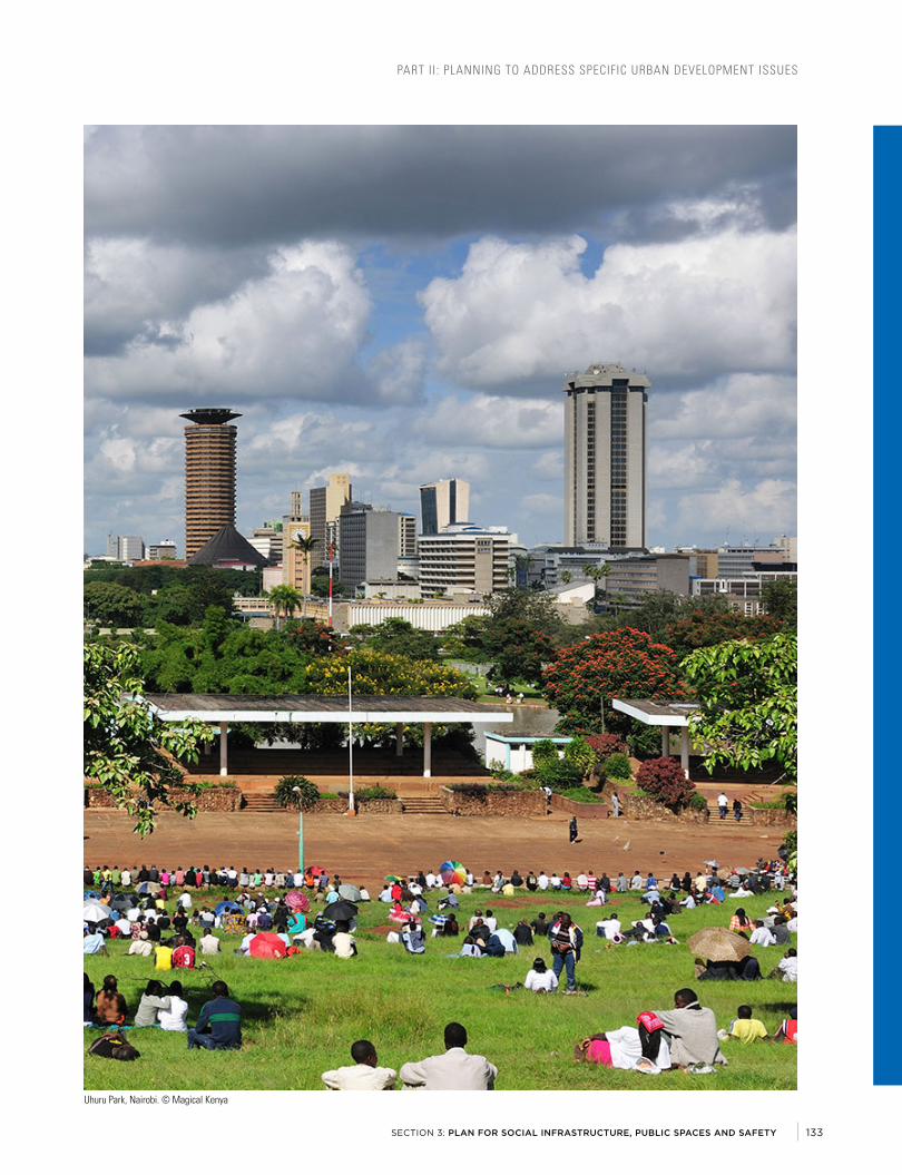
PART II : PLANNING TO ADDRESS SPECIFIC URBAN DEVELOPMENT ISSUES
SECTION 3: PLAN FOR SOCIAL INFRASTRUCTURE, PUBLIC SPACES AND SAFETY
PART II : PLANNING TO ADDRESS SPECIFIC URBAN DEVELOPMENT ISSUES
SECTION 3: PLAN FOR SOCIAL INFRASTRUCTURE, PUBLIC SPACES AND SAFETY
Uhuru Park, Nairobi. © Magical Kenya
133
Uhuru Park, Nairobi. © Magical Kenya
133

PART II : PLANNING TO ADDRESS SPECIFIC URBAN DEVELOPMENT ISSUESPART II : PLANNING TO ADDRESS SPECIFIC URBAN DEVELOPMENT ISSUES
PLAN FOR ECONOMIC DEVELOPMENT AND MUNICIPAL REVENUE GENERATION
SECTION 4:
URBAN PLANNING FOR CITY LEADERS A HANDBOOK FOR KENYA134
PLAN FOR ECONOMIC DEVELOPMENT AND MUNICIPAL REVENUE GENERATION
SECTION 4:
URBAN PLANNING FOR CITY LEADERS A HANDBOOK FOR KENYA134

PART II : PLANNING TO ADDRESS SPECIFIC URBAN DEVELOPMENT ISSUES
SECTION 4: PLAN FOR ECONOMIC DEVELOPMENT AND MUNICIPAL REVENUE GENERATION
PART II : PLANNING TO ADDRESS SPECIFIC URBAN DEVELOPMENT ISSUES
SECTION 4: PLAN FOR ECONOMIC DEVELOPMENT AND MUNICIPAL REVENUE GENERATION
IMAGE: Kibuye Market, Kisumu. © Digital Globe/Google Earth
135
IMAGE: Kibuye Market, Kisumu. © Digital Globe/Google Earth
135

PART II : PLANNING TO ADDRESS SPECIFIC URBAN DEVELOPMENT ISSUES
Land use plans should allocate sufficient space for commercial activities, office space, and industrial activities. The specific allocation of these land uses will depend on the type of activities. Where activities are compatible with residential function, mixed-use development and appropriate land-use mix should be achieved through neighborhood planning. Other activities may necessitate clustering to attain localization advantages. This requires urban planners, economists and other relevant professionals to work together to identify land use patterns which best facilitate economic development.
Support the city in formulating planning policies and regulations which create a favorable investment environment. The focus should be on developing an effective urban planning system, with simplified planning approval processes, enabling development control and building regulations.
Mobilize stakeholders to contribute to the city’s Economic Development Plan. This plan is a useful tool for implementing the economic objectives of the urban plan. The plan informs the stakeholders on how the urban authority intends to create a favorable investment environment; the policies and public investments that will facilitate this; and provides reassurance to residents and investors that engagement and facilitation will be continuous.
Promote both formal and informal sectors. The value of chain of formal and informal economic activities is interlinked, and there is proven interdependence between various formal and informal enterprises. For instance, in Kenya’s urban centres a significant share of the items sold in informal markets and by street vendors are sourced from formal enterprises, or originate from regulated manufacturers. It is common for an informal furniture workshop to supply finished items to a formal furniture showroom/outlet located somewhere in a Central Business District or a shopping mall.
Box 8 .1 Local Economic Development Centre (San Miguel De Ibarra, Ecuador)
The Centre seeks to invigorate the economy at the canton level (subdivision below province level), strengthening entrepreneurship in all its phases. To this end, the main actions undertaken have been to develop and implement various pre-incubation, incubation and acceleration programmes with enterprises in the canton. The key factors for success are the motivation, knowledge, commitment and loyalty of the participating parties.
The results obtained are as follows:
Source: United Cities and Local Governments (2017)
enterprises with innovative products
people trained
people are beneficiaries of the productive projects
businesses started up
people with business ideas
130 1,000
6,000
100
300
URBAN PLANNING FOR CITY LEADERS A HANDBOOK FOR KENYA136

PART II : PLANNING TO ADDRESS SPECIFIC URBAN DEVELOPMENT ISSUES
SECTION 4: PLAN FOR ECONOMIC DEVELOPMENT AND MUNICIPAL REVENUE GENERATION
Balance the benefits and costs of urbanization by providing various interventions to address urban poverty and inequality, enhancing job creation and income improvement. Planning can serve to escalate inequalities or to guide positive distribution of growth benefits. By formulating plans and policies that direct the significant share of public investments in development of services towards higher income residents, the inequality gap is widened and social sustainability is undermined. Actions which contribute to this include prioritizing extension of utilities to high-end shopping malls; gated upper and middle-income residential developments; constructing markets for majority small scale traders and
street vendors. Prioritizing these, at the expense of investing in improving access to affordable housing and improved water and sanitation to the low-income and urban poor, perpetuates inequality.
Mediate competing interests and promote public interest in policy formulation. It is critical to ensure a reasonable balance and equity consideration in how policies, regulations and public investments are undertaken. They should facilitate urban economic development, noting that urban inequalities and poverty pose a serious threat to sustainable urban development.
Box 8 .2 Illustration of spatial distribution of economic development corridors and areas, City of Johannesburg
Sources: Johannesburg Development Agency
Joburg Corridors of Freedom
The City of Johannesburg has embarked formulating spatial plans in line with Joburg 2040, the Growth Development Strategy, based on transport-orientated development. The outcomes are anticipated to offer the city various advantages including:
• The City will focus productive land use and economic activ-ities in areas where transport infrastructure – rail and road – are already present or being planned;
• The demand for private motor-ised transport will be reduced and the average trip length will be shortened;
• Public transport will become a viable alternative because residents will live in closer proximity to work, shopping and leisure opportunities;
• High-density housing will stimulate opportunities for the Small and Micro Enterprises sector and small-scale opera-tors in the informal economy.
137
Box 8 .2 Illustration of spatial distribution of economic development corridors and areas, City of Johannesburg
137

PART II : PLANNING TO ADDRESS SPECIFIC URBAN DEVELOPMENT ISSUES
Integrate Urban Markets and Street TradeThe informal economic sector absorbs the majority of Kenya’s urban labor force. According to the Kenya Economic Survey Report of 2017, the informal sector accounted for 89.7 percent of all the new jobs created in 2016. This has also been the trend in previous years. In urban areas, a significant share of informal sector employment takes place in urban markets and street vending/hawking. These spaces also double as public spaces, where residents of different social classes interact freely. This is a reality that urban leaders and planners cannot ignore, both during urban planning processes and in urban economic policy making processes.
Prioritize integration of informal economic activities. This can be achieved by allocating central places for markets of varying sizes, types and functionality (seasonal/temporal and regular), street design that integrates the needs of street vendors, neighborhood activity centres that accommodate informal economic activities, and through other methods. Spatial integration should be complemented by enabling economic and financial policies and urban legislation which promotes security of trading tenure and social security.
Integration also entails provision of necessary engineering services. This includes water and sewerage, well-paved streets, solid waste management services, electricity, and public transport facilities, in order to maintain appropriate levels of hygiene and to enhance productivity of the markets.
Integrating Informal Small Scale Industrial and Service Sub-SectorsInformal, small-scale industrial activities (e.g. furniture and metal works fabrication, agro-products packaging etc.), and the informal service sector activities (e.g. auto garages) are often ignored in urban planning and design processes. However, their economic significance in Kenya’s urban centres is evident. As in informal markets, small-scale manufacturing and the informal service sector offer alternative employment for many households that the formal wage sector has been unable to offer employment. Therefore, integration of these activities, both spatially through planning and design, and policy-wise, is important for strengthening economic generation in Kenya’s urban centres. These activities require adequate and well-located spaces that offer agglomeration advantages and easy access to markets. They should provide critical infrastructure including sheltered work spaces, electricity, water and toilet facilities, and convenient access to public transport.
Overall, planning for urban economic development requires addressing these issues at all levels of planning; from city-wide strategic level to neighborhood/local area plans.
PART II : PLANNING TO ADDRESS SPECIFIC URBAN DEVELOPMENT ISSUES
Integrate Urban Markets and Street TradeThe informal economic sector absorbs the majority of Kenya’s urban labor force. According to the Kenya Economic Survey Report of 2017, the informal sector accounted for 89.7 percent of all the new jobs created in 2016. This has also been the trend in previous years. In urban areas, a significant share of informal sector employment takes place in urban markets and street vending/hawking. These spaces also double as public spaces, where residents of different social classes interact freely. This is a reality that urban leaders and planners cannot ignore, both during urban planning processes and in urban economic policy making processes.
Support spatial planning to prioritize integration of informal economic activities. This can be achieved by allocating central places for markets of varying sizes, types and functionality (seasonal/temporal and regular), street design that integrates the needs of street vendors, neighborhood activity centres that accommodate informal economic activities, and through other methods. Spatial integration should be complemented by enabling economic and financial policies and urban legislation which promotes security of trading tenure and social security.
Integration also entails provision of necessary engineering services. This includes water and sewerage, well-paved streets, solid waste management services, electricity, and public transport facilities, in order to maintain appropriate levels of hygiene and to enhance productivity of the markets.
Integrating Informal Small Scale Industrial and Service Sub-SectorsInformal, small-scale industrial activities (e.g. furniture and metal works fabrication, agro-products packaging etc.), and the informal service sector activities (e.g. auto garages) are often ignored in urban planning and design processes. However, their economic significance in Kenya’s urban centres is evident. As in informal markets, small-scale manufacturing and the informal service sector offer alternative employment for many households that the formal wage sector has been unable to offer employment. Therefore, integration of these activities, both spatially through planning and design, and policy-wise, is important for strengthening economic generation in Kenya’s urban centres. These activities require adequate and well-located spaces that offer agglomeration advantages and easy access to markets. They should provide critical infrastructure including sheltered work spaces, electricity, water and toilet facilities, and convenient access to public transport.
Overall, planning for urban economic development requires addressing these issues at all levels of planning; from city-wide strategic level to neighborhood/local area plans.
Planned Food and Grocery Kiosks on Argwings Kodhek Road, Nairobi © Baraka Mwau
URBAN PLANNING FOR CITY LEADERS A HANDBOOK FOR KENYA138
Planned Food and Grocery Kiosks on Argwings Kodhek Road, Nairobi © Baraka Mwau
URBAN PLANNING FOR CITY LEADERS A HANDBOOK FOR KENYA138

PART II : PLANNING TO ADDRESS SPECIFIC URBAN DEVELOPMENT ISSUES
SECTION 4: PLAN FOR ECONOMIC DEVELOPMENT AND MUNICIPAL REVENUE GENERATION
HOW PLANNING CAN ENHANCE MUNICIPAL REVENUE GENERATIONInadequate finances make local governments unable to undertake the capital improvements needed to match urban growth. The challenge to deliver urban services for all while keeping taxes at a level that does not push out individuals and businesses highlights the importance to reach out to a variety of sources. In this setting, a city with strong urban planning and an engaged civil society and partners would be more capable to mobilize a resource base; it will be more investible than a city without direction. Capturing the value released from city extension and renewal is a way for local leaders to avail their cities of every opportunity to strengthen resources.
Consider all potential sources and formulate strategies to enhance revenueSuccessful implementation of development plans often require financing beyond the capacity of existing revenue streams. The redistribution of centrally collected revenues is often insufficient. Transfers from the national government include grants; local share of taxes collected by national (including Value Added Tax) and in some cases provincial authorities; and earmarked funds for specific projects. Transfers from the central to the local level are usually insufficient to provide adequate funding, and cities tend to rely on these transfers to bridge the gap between their revenue raising capacity and local expenditures. Ideally, central transfers should be made available to municipalities in time to allow them to prepare their budgets.
Kenya’s urban authorities are governed under county governments. In this case, transfers and grants from both national and county governments remain insufficient. Urban boards and committees will have to develop alternative revenue streams to fill the finance gap. These alternative revenue streams include taking measures to enhance revenue related to land and properties.
Increase Attraction in Investment through Urban PlanningTraditionally, property taxes and taxation on a city’s economic activities have dominated revenue streams. To enhance revenue related to properties and businesses, efficient urban planning and land administration systems are needed. One of the key benefits of spatial planning is to attract investments and build credibility. By having a plan, a city can show that it has an efficient and forward-looking system of governance, which is invaluable when competing for investment. It can be used to promote the city when seeking support from partners and funders, and leaders with an urban development framework to guide urbanization and promote economic growth can use it to:
• Facilitate the progressive creation of cadastral records. This includes registering all undocumented [informal] land subdivisions, land tenure regularization, and developing clear guidelines for subdivisions and ownership transfers.
• Market proof infrastructure needs.
• Prioritize strategic nodes and understand what incentives can be given. A spatial development framework formulation process helps a city identify these areas.
• Prepare market materials that communicate the local development vision, which can be used to attract investors’ long term attention. The Integrated Urban Development Plan-derived from the spatial plan- can be a useful tool in marketing a city’s investment vision.
• Create a framework of regional coordination to avoid competition becoming counterproductive among counties and municipalities. This can be formal, for instance through a regional development agency, or informal where jurisdictions meet on a regular basis to discuss needs and priorities.
Make use of Spatial Planning IncentivesCities need to be strategic and realistic in the use of incentives. Some of the spatial planning incentives include:
• Land consolidation into single-owner larger parcels to achieve critical mass for investor-led projects;
• Infrastructure improvements, including telecommunications, roads, water and sanitation, and accessibility to ports, airports and train stations;
• Industrial and business parks with appropriately priced serviced land, next to transport infrastructure and other specific needs of sought-after industries;
• A supply of affordable workspace for start-ups in targeted industries, encouraging clustering, synergies and innovation, and building centres for technical skills’ development.
Figure 8 .1 Cadastre Information
PART II : PLANNING TO ADDRESS SPECIFIC URBAN DEVELOPMENT ISSUES
SECTION 4: PLAN FOR ECONOMIC DEVELOPMENT AND MUNICIPAL REVENUE GENERATION
HOW PLANNING CAN ENHANCE MUNICIPAL REVENUE GENERATIONWithout adequate financial means local governments are unable to undertake the capital improvements needed to keep up with urban growth, let alone guide urban development. The challenge to deliver urban services for all while keeping taxes at a level that does not push out individuals and businesses highlights the importance to reach out to a variety of sources. In this setting, a city with strong urban planning and an engaged civil society and partners would be more capable to mobilize a resource base; it will be more investible than a city without direction. Capturing the value released from city extension and renewal is a way for local leaders to avail their cities of every opportunity to strengthen resources.
Consider all potential sources and formulate strategies to enhance revenueSuccessful implementation of development plans often require financing beyond the capacity of existing revenue streams. The redistribution of centrally collected revenues is often insufficient. Transfers from the national government include grants; local share of taxes collected by national (including Value Added Tax) and in some cases provincial authorities; and earmarked funds for specific projects. Transfers from the central to the local level are usually insufficient to provide adequate funding, and cities tend to rely on these transfers to bridge the gap between their revenue raising capacity and local expenditures. Ideally, central transfers should be made available to municipalities in time to allow them to prepare their budgets.
Kenya’s urban authorities are governed under county governments. In this case, transfers and grants from both national and county governments remain insufficient. Urban boards and committees will have to develop alternative revenue streams to fill the finance gap. These alternative revenue streams include taking measures to enhance revenue related to land and properties.
Increase Attraction in Investment through Urban PlanningTraditionally, property taxes and taxation on a city’s economic activities have dominated revenue streams. To enhance revenue related to properties and businesses, efficient urban planning and land administration systems are needed. One of the key benefits of spatial planning is to attract investments and build credibility. By having a plan, a city can show that it has an efficient and forward-looking system of governance, which is invaluable when competing for investment. It can be used to promote the city when seeking support from partners and funders, and leaders with an urban development framework to guide urbanization and promote economic growth can use it to:
• Facilitate the progressive creation of cadastral records. This includes registering all undocumented [informal] land subdivisions, land tenure regularization, and developing clear guidelines for subdivisions and ownership transfers.
• Market proof infrastructure needs.
• Prioritize strategic nodes and understand what incentives can be given. A spatial development framework formulation process helps a city identify these areas.
• Prepare market materials that communicate the local development vision, which can be used to attract investors’ long term attention. The Integrated Urban Development Plan-derived from the spatial plan- can be a useful tool in marketing a city’s investment vision.
• Create a framework of regional coordination to avoid competition becoming counterproductive among counties and municipalities. This can be formal, for instance through a regional development agency, or informal where jurisdictions meet on a regular basis to discuss needs and priorities.
Make use of Spatial Planning IncentivesCities need to be strategic and realistic in the use of incentives. Some of the spatial planning incentives include:
• Land consolidation into single-owner larger parcels to achieve critical mass for investor-led projects;
• Infrastructure improvements, including telecommunications, roads, water and sanitation, and accessibility to ports, airports and train stations;
• Industrial and business parks with appropriately priced serviced land, next to transport infrastructure and other specific needs of sought-after industries;
Figure 8 .1 Cadastre Information
Source: ESRI
139
Source: ESRI
139

PART II : PLANNING TO ADDRESS SPECIFIC URBAN DEVELOPMENT ISSUES
Ensure there is a comprehensive cadastre data. Most of Kenya’s cities and town lack updated and reliable cadastre data. Poor land administration and management, combined with informal land markets, have seen many cities and towns lack mechanism to effectively collect property-related revenues. As a starting point, leaders have to work with planners, land surveyors, financial officers and stakeholders in developing a comprehensive urban cadastre. Urban planning
processes also need to be geo-referenced and proposed land-use plans integrated with the cadastre. For example, the ISUDP process implemented by the KMP combined digital topographical mapping and cadastre collation with land use planning. Although unregistered land parcels were not captured in the cadastre layer, it gave the respective urban authorities a digitized database for updating. This is a process that will require great commitment from leaders and technical officers, engaging with land owners and stakeholders, in order to achieve a cadastre layer that reflect the reality on the ground. It will need a combination of tools including land readjustment, urban design guidelines, and land regularization policies.
Public land is a key asset. Urban authorities need to keep updated records of public land. Loss of public land, as either facilitated by poor urban planning or through illegal means has been a challenge to Kenya’s urban centres. If well utilized, public land can be useful in managing supply of urban land, leverage in joint ventures, installation of key facilities and amenities, and for enhancement of open public spaces. Land subdivision regulations [Physical Planning Act of Kenya] require private land owners to surrender part of the land to the municipality for public purpose. Having an efficient system of transferring and maintaining control over such land is imperative for increasing stock of public land.
A clear plan of investments and transparent public expenditures increase compliance. Collection of fees and other charges is much improved when residents can see how the money collected is used and when there is a clear link with locally significant improvements. Building clear mechanisms for deciding on public investments and allowing residents’ participation have resulted in greater compliance and better understanding of the significance of charges. To achieve this, leaders must embrace spatial planning, and support budget alignment with spatial development plans.
Use spatial development plans as basis for updating valuation rolls. Valuation rolls that are detached from spatial planning, often becomes obsolete tools for land value capture. While many cities and towns in Kenya have approved valuation rolls, they lack approved spatial development frameworks or zoning ordinances. Thus, land-related revenue remains largely untapped. It is also important to maintain and update data on frequent basis for the tool to remain useful and enhance efficiency in planning.
Kiambu County covers 2,543.5 Km², bordering Nairobi City County, with a projected population of 2 million in 2017. It is among the most rapidly urbanizing counties in the country. According to the 2009 Kenya Population and Housing Census, 61 percent of the county populations reside in urban areas, with four of the county’s major urban areas reported to have had a population exceeding 100,000 people [Ruiru-238,858; Kikuyu-233,231; Thika-136,917; Karuri-107,716].
Property values in Kiambu County are amongst the highest in East Africa. As a result of rapid urbanization and high property values, residential estates, industries, and businesses are increasingly converting agricultural lands to urban real estate. The county is within the wider Nairobi Metro region, the fasted urbanizing region of Kenya.
Working with the County, UN-Habitat undertook as scoping mission revenue streams and property values in the county. The team established that the county relied on the economi-cally weakest stratum of the population for revenue, while the potential of land-related revenue remained largely untapped. Among the key recommendations that emerged was the Simplification of the Land Tax Valuation Process and focus on asset development.
Subsequently the county has since established a digital portal for processing planning applications and building permits, demarcated “tax zones”, formulated a bill to facilitate infrastructure development , and adopted a policy for a) the establishment of a revolving fund for infrastructure develop-ment – revenues generated from development fees will kept in an account dedicated to develop infrastructure in the locations from which income was received; b) the establishment of a county development company whose prime mission is to trans-form county owned properties into income generating assets.
Credit: UN-Habitat. (2017). Supporting Revenue Enhancement in Kiambu County, Kenya. Urban Economy and Finance Branch. Discussion Paper No. 8. March 2017.
Box 8 .3 UN-Habitat Support to Revenue Enhancement in Kiambu County, Kenya
URBAN PLANNING FOR CITY LEADERS A HANDBOOK FOR KENYA140

PART II : PLANNING TO ADDRESS SPECIFIC URBAN DEVELOPMENT ISSUES
SECTION 4: PLAN FOR ECONOMIC DEVELOPMENT AND MUNICIPAL REVENUE GENERATION
CAPTURE VALUE FROM CITY EXTENSION AND RENEWAL
Understand how urban value can be capturedCounty governments, urban boards and committees, will need to deploy more land-based tools for revenue enhancement and methods of financing infrastructure and housing. Land value capture is one of the successful tools that several cities in the world have used.
Developers can be required to pay for infrastructure in new areas. As developers acquire development permits, they may be requested to pay for the cost of infrastructure for the area. They will in turn recover costs through land sales. The developer may be asked to build the infrastructure directly or pay its costs as part of the development license. This is widely used to meet city extension infrastructure needs. It requires clear planning regulation, delivery capacity by the infrastructure provider, and the capacity to link developer’s infrastructure to public systems, such as roads and trunk utility lines.
Land-value gain resulting from infrastructure projects can be taxed. “Betterment levies” are a one-time tax on the estimated land-value increase associated with transport and road construction and improvements projects, a rise typically of between 30 and 60 per cent. These levies are difficult to administer, however, if increases are estimated on a plot by plot basis and are better calculated by area or city-wide, depending on the investment programme.
Public land sales can capture the benefit of public investment. Land surrounding major urban motorway projects can be transferred to a private-public development corporation, which then borrows against the land as collateral, finances the construction and then sells the land. This allows municipalities to realize major infrastructure project with no financial loss. In China, the city of Changsha created a publicly-controlled Ring Road Corporation to build a USD 730 million motorway and the municipality transferred strips of land totaling 3,300 hectares on both sides of the road. Half of the motorway cost was financed by the transfer of leasing rights and the other half was financed through borrowing against the future anticipated value of improved land. In cities where land is privately owned, this method requires the public sector to first acquire it.
Selling development rights is an alternative to selling land. Development rights on a plot depend on the provision of the urban plan. They are introduced with the conversion of rural land to urban use, and vary depending on the plan. In some places, they involve the right to build at greater density; that is, adding additional floor space than would normally be allowed.
Excises on property appreciation can fund neighborhood improvement. “Linkages” charge developers a fee on projects above a maximum level of commercial floor area, payable over a period up to 12 years, to fund social projects in poorer neighborhoods. In Boston in the United States, the fee was used to subsidize the construction of affordable housing and to provide job training, with a requirement that 20 per cent of any linkage payment be reserved for use in the area surrounding the development project. Cuenca, Ecuador, launched a neighborhood improvement programme funded by property owners who were charged based on lot frontage. The funds were used to pay the engineers and builders of the public works.
141

PART II : PLANNING TO ADDRESS SPECIFIC URBAN DEVELOPMENT ISSUES
This handbook has demonstrated various ways through which leaders can engage more actively in urban planning processes. By presenting various interventions that urban planning offer to cities, the handbook becomes a useful resource for leaders. It is important for leaders to actively engage urban planners and other decision makers in shaping responsive policies, strategies and programs for urban development.
As Kenya continue to face rapid urbanization, there is need to focus on the opportunities and challenges in equal measure. Urban planning will help leaders and cities to build resilience, tap the opportunities and have a framework for dealing with the challenges. Currently, urban sector in Kenya faces demographic challenges, socio-spatial challenges, environmental challenges, economic challenges, as well as institutional challenges. This undermines efforts to unlock the potential of cities and towns in the country.
Delivering an effective planning process requires commitment from leaders, planners and other professions, and constant engagement with stakeholders. Urban planning is one of the useful tools for addressing the opportunities and challenges associated with contemporary urbanization. If leaders have a good understanding of how planning works; its benefits and related activities, cities and towns stand a good chance to achieve social, economic and environmental prosperity.
By committing to good urban governance, urban planning becomes more effective. Leaders are encouraged to prioritize building capable planning institutions, scaling-up engagement with stakeholders, and nurturing a responsive policy and legislative framework.
Good urban planning contributes to better management of urban growth to achieve inclusive cities. A good urban planning practice helps a city assign resources in an inclusive and equitable manner. Priority to providing basic services, affordable housing, employment opportunities and other advantages, to all, should guide the vision of leaders in urban planning.
Moving forward, leaders will need to play a more decisive role in shaping progressive policy directions. This includes supporting urban planning reforms, supporting enactment of effective institutional and regulatory frameworks for planning, expanding room for participation and partnerships, up-scaling investments in infrastructure and affordable housing, enhancing planning and institutional integration, and monitoring and evaluation of urban plans, and other interventions.
CONCLUSION
URBAN PLANNING FOR CITY LEADERS A HANDBOOK FOR KENYA142

PART II : PLANNING TO ADDRESS SPECIFIC URBAN DEVELOPMENT ISSUES
SECTION 4: PLAN FOR ECONOMIC DEVELOPMENT AND MUNICIPAL REVENUE GENERATION
Angel, S. (2011). Making room for a plane of cities, Policy Report Focus. Cambridge: Lincoln Institute of Land Policy.
Britton, N and Lindsay, J (1995). Integrating City Planning and Emergency Preparedness: Some of the Reasons Why. International Journal of Mass Emergencies and Disasters. March 1995, Vol.13, No.1, pp.93-106
Casey Furlong, Ryan Brotchie, Robert Considine, Greg Finlayson, Lachlan Guthrie (2017). Key concepts for Integrated Urban Water Management infrastructure planning: Lessons from Melbourne. Utilities Policy, Volume 45, Issue null, Pages 84-96
Casey Furlong, Saman De Silva, Lachlan Guthrie, Robert Considine (2016). Developing a water infrastructure planning framework for the complex modern planning environment. Utilities Policy, Volume 38, Issue null, Pages 1-10
Castanas, N., Yamtree, P.K., Sonthichai, Y.B., Batreau, Q. (2016). Leave no one behind: community-driven urban development in Thailand. IIED Working Paper. IIED, London.
Centre for Affordable Housing (n.d). Planning Mechanisms for Affordable Housing. Accessed online 04/12/2017: http://www.housing.nsw.gov.au/centre-for-affordable-housing/nsw-local-government-housing-kit/planning-mechanisms-for-affordable-housing
Centre for Affordable Housing Finance in Africa (2017). Landscapes of Investment. Regional Report-East African Community. Accessed online 04/12/2017: http://housingfinanceafrica.org/app/uploads/REGIONAL_REPORT-EAC-FINAL.pdf
Chmutina, Ksenia & Bosher, Lee & Ganor, Tamar. (2014). Role of urban design and planning in disaster risk reduction. Proceedings of the ICE - Urban Design and Planning. 167. 125-135. 10.1680/udap.13.00011.
CIRIA (2013). Water Sensitive Urban Design in the UK – Ideas for built environment practitioners. London: CIRIA.
Commission on Revenue Allocation (2013). Kenya County Fact Sheets: Second Edition.
Deutsche Gesellschaft für Internationale Zusammenarbeit (GIZ) (2012).Urban Transport and Energy Efficiency: A Sourcebook for Policy-makers in Developing Countries. Bonn: GIZ
Deutsche Gesellschaft für Internationale Zusammenarbeit (GIZ) (2012). Land Use Planning: Concept, Tools and Applications. Bonn: GIZ
Fainstein, S. and Servon, L. (2005): Gender and Planning. A Reader.
GIZ (2013). SIMPLE Trainers Toolkit. Module 11: Geographic Information System. Deutsche Gesellschaft f.r Internationale Zusammernarbeit (GIZ) GmbH
Global Water Partnership (2013). Integrated Urban Water Management: Toward Diversification and Sustainability. Accessed online 04/12/2017: www.gwp.org/globalassets/global/toolbox/publications/policy-briefs/13-integrated-urban-water-management-iuwm.-toward-diversification-and-sustainability.pdf
Government of India (n.d.). Guidelines for Slum-Free City Planning. Accessed online: http://moud.gov.in/upload/uploadfiles/files/3RAYGuidelinesSFCP.pdf
Kim, Julie, New Cities Foundation (2016). Handbook on Urban Infrastructure Finance. Accessed online: https://newcities.org/wp-content/uploads/2016/03/PDF-Handbook-on-Urban-Infrastructure-Finance-Julie-Kim.pdfb
Lincoln Institute of Land Policy (2009). Urban Planning Tools for Climate Change Mitigation. Cambrige: Lincoln Institute of Land Policy
Mckinsey&Company (2014).Tackling the World’s Affordable Housing Challenge. Accessed online 04/12/2017: https://www.mckinsey.com/global-themes/urbanization/tackling-the-worlds-affordable-housing-challenge
Mckinsey&Company (2016). Lions on the Move II: Realizing the Potential of Africa’s Economies. Accessed online 04/12/2017: https://www.mckinsey.com/global-themes/middle-east-and-africa/lions-on-the-move-realizing-the-potential-of-africas-economies
Mckinsey&Company (2017). Housing Affordability: A Supply-Side Tool Kit for Cities. Briefing Note Prepared for CityLab Paris, October 2017. Accessed online 04/12/2017: https://www.mckinsey.com/global-themes/meeting-societys-expectations/housing-affordability-a-supply-side-tool-kit-for-cities
National Association of City (2016). Global Street Design Guide. New York: Island Press
Neuman, M and Smith, S (2010). City Planning and Infrastructure: Once and Future Partners. Journal of Planning History 9(1) 21 –42
New Zealand Productivity Commission (2017). Better Urban Planning: Final Report. Wellington: New Zealand Productivity Commission
Next City (2010). Planning for the Next Generation of Internet Infrastructure. Accessed online 04/12/2017: https://nextcity.org/daily/entry/planning-for-the-next-generation-of-internet-infrastructure
BIBLIOGRAPHY
143

PART II : PLANNING TO ADDRESS SPECIFIC URBAN DEVELOPMENT ISSUES
pteg (2011). Integrated Land use and Transport Planning. Accessed online 04/12/2017: http://www.urbantransportgroup.org/system/files/20112706ptegThrivingCitiesReportforWebFINAL.pdf
PWC & Partnership of New York City (2013). Cities of Opportunity: Building the Future. Accessed online 04/12/2017: https://www.pwc.com/gx/en/capital-projects-infrastructure/publications/assets/pwc-cities-of-opportunity-building-the-future.pdf
Republic of Kenya (1996). Physical Planning Act. Nairobi: Government Printer
Republic of Kenya (2010). Constitution of Kenya. Nairobi: Government Printer
Republic of Kenya (2011). Urban Areas and Cities Act. Nairobi: Government Printer
Republic of Kenya (2012). County Governments Act of 2012. Nairobi: Government Printer
Republic of Kenya (2017). Urban Areas and Cities Act-Amendment Bill. Nairobi: Government Printer
Republic of Kenya (2017). Economic Survey 2017. Nairobi: Kenya National Bureau of Statistics
Republic of Kenya (2017). National Urban Development Policy: Sessional Paper No. 6 of 2016. Nairobi: Government Printer
Republic of South Africa (2014). SDF Guidelines: Final Draft. Accessed online 04/12/2017: www.ruraldevelopment.gov.za/phocadownload/spatial_Planning_Information/SDFG_Final%20Draft.pdf
Royal Town Planning Institute (2016). Urban Form and Sustainability. RTPI Research Briefing No. 9, March 2016.
State of Western Australia (2004). Guidelines for the Location, Siting and Design of Telecommunications Infrastructure. Accessed online 04/12/2017: https://www.planning.wa.gov.au/dop_pub_pdf/Telecommunications.pdf
Sweden. Se (2017). The Swedish Recycling Revolution. Accessed online 04/12/2017: https://sweden.se/nature/the-swedish-recycling-revolution/
Town and Country Planning Association (2007). Best Practice in Urban Extensions and New Settlements: A Report on Emerging Good Practice. London: TCPA
Town and Country Planning Association and the Special Project Partners (2016). Spatial Planning and Energy. London: Town and Country Planning Association
UN-Habitat (2003). The Challenge of Slums: Global Report on Human Settlements. Nairobi: UN-Habitat
UN-Habitat (2006). Innovative policies for the urban informal economy. Nairobi: UN-Habitat.
UN-Habitat (2007). Enhancing Urban Safety and Security: Global Report on Human Settlements. Nairobi: UN-Habitat
UN-Habitat (2009). Planning Sustainable Cities: Global Report on Human Settlements. Nairobi: UN-Habitat
UN-Habitat (2013). Planning and Design for Sustainable Urban Mobility: Global Report on Human Settlements. Nairobi: UN-Habitat
UN-Habitat (2013). Urban Planning for City Leaders. Nairobi: UN-Habitat
UN-Habitat (2014) Planning for Climate Change: A Strategic, Value-based Approach for Urban Planners. Nairobi: UN-Habitat
UN-Habitat (2015). Planned City Extensions: Analysis of Historical Examples. Nairobi: UN-Habitat
UN-Habitat (2015). UN-Habitat Support to Sustainable Urban Development in Kenya: Volume 1-Report on Capacity Building for County Governments under the Kenya Municipal Programme. Nairobi: UN-Habitat
UN-Habitat (2016). Housing at the Centre of Urban Policies. World Cities Report 2016. Accessed online 04/12/2017: https://unhabitat.org/wp-content/uploads/2014/03/WCR_Housing-at-the-Center-of-Urban-Policies-1.pdf
UN-Habitat (2016). UN-Habitat Support to Sustainable Urban Development in Kenya: Volume 3-Report on Student Design Competition in Kenya’s Towns. Nairobi: UN-Habitat
UN-Habitat (2016). UN-Habitat Support to Sustainable Urban Development in Kenya: Volume 4-Report on Capacity Building for Community Leaders. Nairobi: UN-Habitat
UN-Habitat (2016). UN-Habitat Support to Sustainable Urban Development in Kenya: Volume 2-Report on Capacity Building for County Governments under the Kenya Municipal Programme. Nairobi: UN-Habitat
United Nations (2015).Transforming our World: The 2030 Agenda for Sustainable Development. New York: United Nations United Nations (n.d). Sendai Framework for Disaster Risk Reduction 2015 - 2030. Geneva: United Nations Office of Disaster Risk Reduction
URBAN PLANNING FOR CITY LEADERS A HANDBOOK FOR KENYA144

PART II : PLANNING TO ADDRESS SPECIFIC URBAN DEVELOPMENT ISSUES
SECTION 4: PLAN FOR ECONOMIC DEVELOPMENT AND MUNICIPAL REVENUE GENERATION
United Nations (2017). New Urban Agenda. New York: United Nations
Urban Forum (2012). The Handy Guide to Planning. London: Urban Forum
Urban Land Institute (n.d). Mixed-Use Development 101: the Design of Mixed-Use Buildings.
Urban Learning (2017) Integrating energy in urban planning processes – insights from Amsterdam/Zaanstad, Berlin, Paris, Stockholm, Vienna, Warsaw and Zagreb. Synthesis report of Work Package 4- “Innovative governance solutions for integrative urban energy planning”. Accessed online 04/12/2017: http://www.urbanlearning.eu/fileadmin/user_upload/documents/D4-2_Synthesis-report_upgraded_processes_final_170807.pdf
USAID Kenya and East Africa (2016). Development of Kenya’s power sector 2015-2020. Nairobi : USAID
Western Australian Planning Commission (2015). Liveable Neighborhoods. Perth: Department of Planning
World Bank (2009). Urbanization and Growth. Washington D, C: World Bank
World Bank (2013). Planning, Connecting and Financing Cities-Now: Priorities for City Leaders. Washington, D.C: World Bank
World Bank (2016). Kenya Urbanization Review. Washington, D.C: World Bank
World Bank (2017). Africa’s Cities: Opening Doors to the World. Washington, D.C: World Bank
World Bank (n.d). Transmilenio Busway-Based Mass Transit, Bogotá, Colombia. Accessed online 04/12/2017: http://siteresources.worldbank.org/INTURBANTRANSPORT/Resources/Factsheet-TransMilenio.pdf
World Health Organization (2008). A Health City is an Active City: A Physical Activity Planning Guide. Geneva: World Health Organization
World Resources Institute (2017). Confronting the Urban Housing Crisis in the Global South: Adequate, Secure, and Affordable Housing. Working Paper. Towards a More Equal City. Accessed online 04/12/2017: http://www.wrirosscities.org/sites/default/files/Confronting%20the%20Urban%20Housing%20Crisis.pdf
World Resources Institute; Department of Resource Surveys and Remote Sensing, Ministry of Environment and Natural Resources, Kenya; Central Bureau of Statistics, Ministry of Planning and National Development, Kenya; and International Livestock Research Institute. 2007. Nature’s Benefits in Kenya, An Atlas of Ecosystems and Human Well-Being. Washington, DC and Nairobi: World Resources Institute.
145

United Nations Human Settlements Programme | P.O. Box 30030, Nairobi 00100, Kenya Tel: +254-20 7623075 | [email protected] | www.unhabitat.org
HS/068/18 ISBN (Volume): 978-92-1-132812-7
Urban Planning for City Leaders - A handbook for Kenya is a valuable source of information, inspiration and ideas on urban planning that is designed for city leaders and decision makers at a critical moment in human history. Globally, it is predicted population growth over the next 50 years will have immense consequences for cities, particularly intermediate cities with populations of up to two million people. Developed countries will need to double the amount of urban space they have by 2050 to accommodate the expected numbers of people, whereas developing countries will need to expand their urban space by more than 300 per cent. By 2050, Kenya’s urban population is projected to reach 44 million people, which will be close to half (46 percent) of the total country population, from an estimated current urban population of 13.8 million people.
Most cities will simply not be able to cope with the impact of population growth and other issues if they do not start preparing for them now. This means planning, designing, financing and implementing strategies for sustainable urban development, which involves: land use and urban form, affordable housing, mobility, water supply, energy, waste management, social and economic development, parks and open spaces, environmental management, community amenities, safety, climate change mitigation and adaptation, urban governance and much more. This handbook is a start towards making those strategies. It focuses on the key role that proactive integrated urban planning can have in shaping the future of a city and it outlines practical ways to create and implement a vision for a city that will better prepare it to cope with growth and change.
The handbook includes several “how to” sections on key aspects of urban planning, answers many of the questions that leaders are frequently asked, and features numerous examples of cities where urban planning made a significant, positive transformation.
Urban Planning for city leaders a handbook for kenya